Embed Size (px)
Citation preview
JOIDESJournal
Joint Oceanographic Institutions for Deep Earth SamplingJoint Oceanographic Institutions for Deep Earth Sampling
Vol. 25 No. 2-1999
Cool-water ‘Reefs’, Possible
Hydrogen Sulphide/Methane
Clathrates, and Brine
Circulation: Preliminary Results
of Leg 182 Drilling in the Great
Australian Bight
Exploring the Asian Monsoon
through Drilling in the South
China Sea: Leg 184
Drilling the Input to the Sub-
duction Factory: ODP Leg 185
Seismogenic Zone Deep Drilling
and Measurement: Report of the
Detailed Planning Group
Long Term Observatories Report
of Program Planning Group
On May 10, 1999 JOIDES became 35
years old. Not many people realize that
JOIDES pre-dates both the Deep Sea
Drilling Project and the Ocean Drilling
Program. It had its origins in a considera-
tion of what might be learned about the
history of the oceans from a series of shor-
ter holes sampling the sediments rather
than the single deep hole to penetrate
ocean crust to the Mohorovicic Disconti-
nuity (the MOHOLE) that had been pro-
posed in the late 1950’s.
Two individuals questioned the stra-
tegy of drilling a single hole – Maurice
Ewing of Columbia University’s Lamont
Geological Observatory and Cesare Emi-
liani of the University of Miami’s Insti-
tute of Marine Science. Both argued that
much could be learned about the history
of the Earth from the sediments overlying
the oceanic basement. It must be remem-
bered that in the 1960’s most geologists
thought that the ocean basins were
ancient and permanent features and that
a thick sediment column would include
all of the Phanerozoic and most of the
Precambrian. The fact that seismic sur-
veys carried out by Ewing’s group indica-
ted that the average thickness of sedi-
ments in the ocean basins was only about
500m was an unexplained peculiarity.
Drilling the sediments should reveal why
so little material had accumulated over
such a long time.
The impetus for drilling and coring at
many sites in the ocean was focused in a
proposal by Cesare Emiliani of the Uni-
versity of Miami to the US National
Science Foundation for “Project LOCO
(Long Cores)”, submitted in 1962. Ces-
are’s interest was primarily in the Ceno-
zoic history of the oceans – to learn more
about the cooling of deep ocean waters
and inception of glaciation. He formed a
LOCO advisory group of scientists from
major US oceanographic
institutions to help guide
the program.
Enthusiasm for the
idea of learning about
the history of the ocean
basins from its sediments
was such that four of the
major oceanographic
institutions, Miami,
Lamont, Scripps and
Woods Hole, agreed to
disband the LOCO committee and form
an advisory group which took the name
“JOIDES = Joint Oceanographic Institu-
tions for Deep Earth Sampling,” coined
by Roger Revelle, to develop an ocean
drilling program. The directors of the
four institutions were the members of the
Executive Committee and one scientist
from each institution formed the Plan-
ning Committee. The Executive Com-
mittee selected Lamont as the first opera-
tor institution and the Institute of Marine
Sciences in Miami as the first core reposi-
tory. The first series of sites (the “JOI-
DES holes”) were drilled by the DV
CALDRILL in 1965 on a transect across
the Blake Plateau off Jacksonville, Flo-
rida, funded by the National Science
Foundation. The tradition of a party of
shipboard scientists from a variety of
institutions was born during this project.
The University of Washington’s School of
Oceanography joined JOIDES in 1968.
The results of the drilling off Florida
were that successful and exciting that
JOIDES selected Scripps Institution of
Oceanography as the operating institution
and core repository for a second project,
titled “The Deep Sea Drilling Project”
intended to last 18 months, starting in
August 1968.
This mode of operation, with JOIDES
providing scientific advice, Scripps man-
aging the operations, and NSF funding
and monitoring the project was modified
in 1974 with expansion of the member-
ship of JOIDES to include organizations
in other countries as well as other US
institutions. International funding was
coordinated through the National Science
Foundation and JOI, Inc. was established
as a corporate entity to offer liability pro-
tection to the members of JOIDES.
For accounts of the fascinating early
history of the ocean drilling program see:
Emiliani, C. E. (1981): A new global geo-
logy; In: The Oceanic Lithosphere, Editor:
C. E. Emiliani, In the collection: The
Sea, Vol. 7, John Wiley and Sons. New
York, NY, United States. 1981, pp.
1685-1716.
Shor, E. N. (1985): A chronology from
Mohole to JOIDES In: Geologists and
ideas; a history of North American geology.
Editors: Drake, E. T., Jordan, W. M. In
the collection: Centennial special
volume. Geol. Soc. Amer., Boulder,
CO, pp. 391-399.
Winterer, E. L. (2000): Scientific Ocean
Drilling, from ASOC to COMPOST;
In: 50 Years of Ocean Discovery, National
Academy Press, Washington D.C., pp.
117-127.
JOIDES Journal2 Volume 25, no. 2
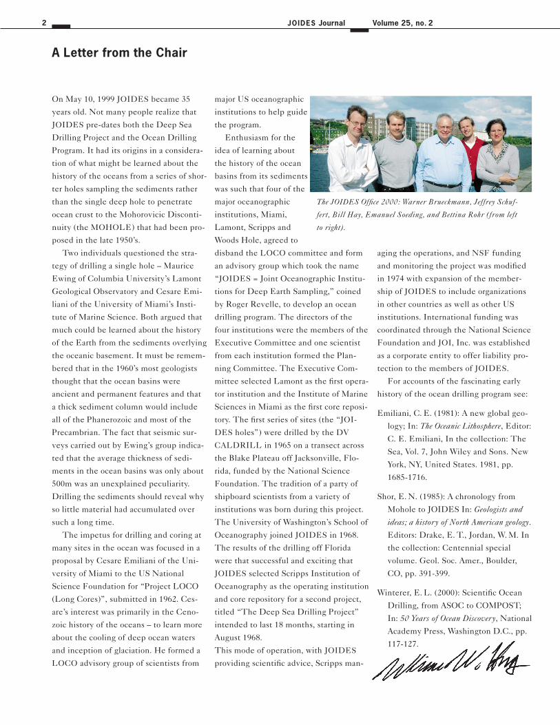
A Letter from the Chair
The JOIDES Office 2000: Warner Brueckmann, Jeffrey Schuf-
fert, Bill Hay, Emanuel Soeding, and Bettina Rohr (from left
to right).
In this issue
3
Cool-water ‘Reefs’, possible Hydrogen Sulphide/Methane Clathrates,
and Brine Circulation - Preliminary Results of Leg 182 Drilling
in the Great Australian Bight 4
Exploring the Asian Monsoon through drilling in the South China Sea 8
Drilling the Input to the Subduction Factory: ODP Leg 185 14
Seismogenic Zone Deep Drilling and Measurement:
Report of Detailed Planning Group 20
Long Term Observatories:
Report of Program Planning Group 23
Drydock Report 28
JOIDES Activities during 1999, IWG Support Office,
European Ocean Drilling Forum 29
Leg Reports
Panel Reports
Technology
Planning and
Announcements
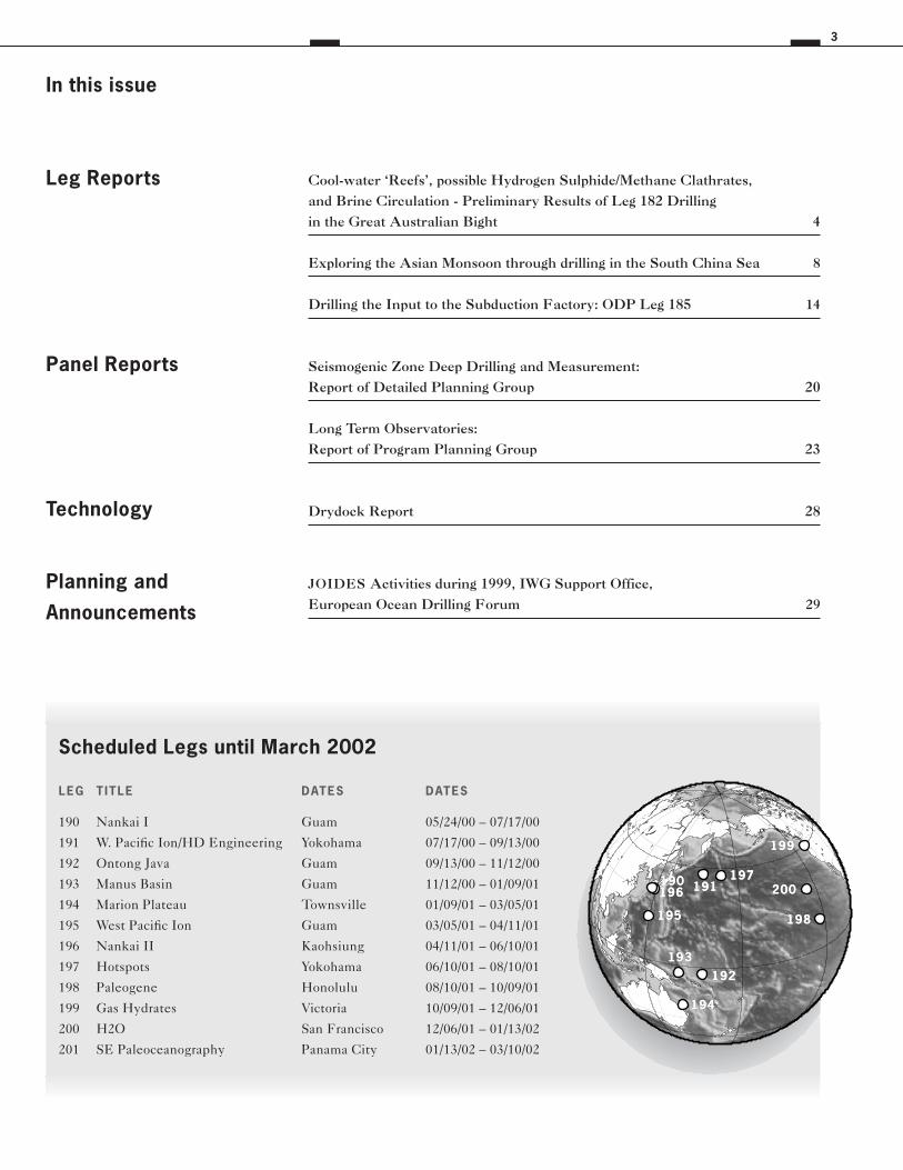
Scheduled Legs until March 2002
LEG T ITLE DATES DATES
190 Nankai I Guam 05/24/00 – 07/17/00
191 W. Pacific Ion/HD Engineering Yokohama 07/17/00 – 09/13/00
192 Ontong Java Guam 09/13/00 – 11/12/00
193 Manus Basin Guam 11/12/00 – 01/09/01
194 Marion Plateau Townsville 01/09/01 – 03/05/01
195 West Pacific Ion Guam 03/05/01 – 04/11/01
196 Nankai II Kaohsiung 04/11/01 – 06/10/01
197 Hotspots Yokohama 06/10/01 – 08/10/01
198 Paleogene Honolulu 08/10/01 – 10/09/01
199 Gas Hydrates Victoria 10/09/01 – 12/06/01
200 H2O San Francisco 12/06/01 – 01/13/02
201 SE Paleoceanography Panama City 01/13/02 – 03/10/02
199
191
192 193
194
195
196 197
198
200 190 191
192 193
194
195
196 197
199 199
198
200 190
JOIDES Journal4 Volume 25, no. 2
Leg 182 sailed from Wellington in early
December 1998 with a broad range of
scientific objectives — the first scientific
drilling expedition in the waters south of
Australia provided a great opportunity to
increase understanding of the depositio-
nal dynamics of cool-water carbonate
environments. The priority objectives to
be addressed at 10 sites in the western
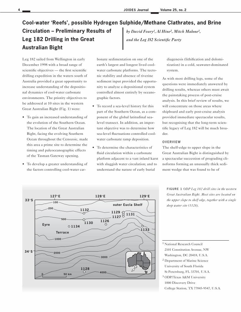
Great Australian Bight (Fig. 1) were:
• To gain an increased understanding of
the evolution of the Southern Ocean.
The location of the Great Australian
Bight, facing the evolving Southern
Ocean throughout the Cenozoic, made
this area a prime site to determine the
timing and paleoceanographic effects
of the Tasman Gateway opening.
• To develop a greater understanding of
the factors controlling cool-water car-
bonate sedimentation on one of the
earth’s largest and longest lived cool-
water carbonate platforms. The tecto-
nic stability and absence of riverine
sediment input provided the opportu-
nity to analyze a depositional system
controlled almost entirely by oceano-
graphic factors.
• To record a sea-level history for this
part of the Southern Ocean, as a com-
ponent of the global latitudinal sea-
level transect. In addition, an impor-
tant objective was to determine how
sea-level fluctuations controlled cool-
water carbonate ramp deposition.
• To determine the characteristics of
fluid circulation within a carbonate
platform adjacent to a vast inland karst
with sluggish water circulation; and to
understand the nature of early burial
diagenesis (lithification and dolomi-
tization) in a cold, seawater-dominated
system.
As with most drilling legs, some of the
questions were immediately answered by
drilling results, whereas others must await
the painstaking process of post-cruise
analysis. In this brief review of results, we
will concentrate on those areas where
shipboard and early post-cruise analysis
provided immediate spectacular results,
but recognising that the long-term scien-
tific legacy of Leg 182 will be much broa-
der.
OVERVIEW
The shelf-edge to upper slope in the
Great Australian Bight is distinguished by
a spectacular succession of prograding cli-
noforms forming an unusually thick sedi-
ment wedge that was found to be of
Cool-water ‘Reefs’, possible Hydrogen Sulphide/Methane Clathrates, and Brine
Circulation – Preliminary Results of
Leg 182 Drilling in the Great
Australian Bight
127°E 129°E128°E33°S
Eyre
Terrace
0 50 km4000
3000
200
100
11311127
1126
1128
1129
1130
11331134
1132
34°S 2000
outer Eucla Shelf
500
1000
F IGURE 1 ODP Leg 182 drill sites in the western
Great Australian Bight. Most sites are located on
the upper slope to shelf edge, together with a single
deep water site (1128).
by David Feary1, Al Hine2, Mitch Malone3,
and the Leg 182 Scientific Party
1 National Research Council
2101 Constitution Avenue, NW
Washington, DC 20418, U.S.A.
2 Department of Marine Science
University of South Florida
St Petersburg, FL 33701, U.S.A.
3 ODP/Texas A&M University
1000 Discovery Drive
College Station, TX 77845-9547, U.S.A.
Leg Reports 5
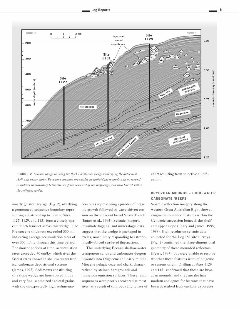
mostly Quaternary age (Fig. 2), overlying
a pronounced sequence boundary repre-
senting a hiatus of up to 12 m.y. Sites
1127, 1129, and 1131 form a closely-spa-
ced depth transect across this wedge. The
Pleistocene thickness exceeded 550 m,
indicating average accumulation rates of
over 300 m/my through this time period.
For shorter periods of time, accumulation
rates exceeded 40 cm/ky, which rival the
fastest rates known in shallow-water trop-
ical carbonate depositional systems
(James, 1997). Sediments constituting
this slope wedge are bioturbated muds
and very fine, sand-sized skeletal grains,
with the unexpectedly high sedimenta-
tion rates representing episodes of orga-
nic growth followed by wave-driven ero-
sion on the adjacent broad ‘shaved’ shelf
(James et al., 1994). Seismic imagery,
downhole logging, and mineralogic data
suggest that the wedge is packaged in
cycles, most likely responding to astrono-
mically-forced sea-level fluctuations.
The underlying Eocene shallow-water
terrigenous sands and carbonates deepen
upwards into Oligocene and early-middle
Miocene pelagic ooze and chalk, charac-
terized by stained hardgrounds and
numerous omission surfaces. These ramp
sequences were poorly recovered at most
sites, as a result of thin beds and lenses of
chert resulting from selective silicifi-
cation.
BRYOZOAN MOUNDS – COOL-WATER
CARBONATE ‘REEFS ’
Seismic reflection imagery along the
western Great Australian Bight showed
enigmatic mounded features within the
Cenozoic succession beneath the shelf
and upper slope (Feary and James, 1995;
1998). High resolution seismic data
collected for the Leg 182 site surveys
(Fig. 2) confirmed the three-dimensional
geometry of these mounded reflectors
(Feary, 1997), but were unable to resolve
whether these features were of biogenic
or current origin. Drilling at Sites 1129
and 1131 confirmed that these are bryo-
zoan mounds, and they are the first
modern analogues for features that have
been described from onshore exposures
1.00
1.25
0.75
0.50
0.25
Site1131
Site1127
Site1129
bryozoan
mound
complexes
0 2 km1
Pleistocene
early Miocene
400
500
600
700
200
300
mid
dle-la
te E
ocene
Oligocene
NORTHSOUTH
Mesozoic
siliciclastics
Pliocene
seco
nd
s (t
wo
-wa
y tr
ave
ltim
e)
middle-late
Miocene
wa
ter
de
pth
(m
ete
rs)
wa
ter
de
pth
(m
ete
rs)
wa
ter
de
pth
(m
ete
rs)
F IGURE 2 Seismic image showing the thick Pleistocene wedge underlying the outermost
shelf and upper slope. Bryozoan mounds are visible as individual mounds and as mound
complexes immediately below the sea-floor seaward of the shelf-edge, and also buried within
the sediment wedge.
JOIDES Journal6 Volume 25, no. 2
(e. g., Surlyk, 1997) and from many parts
of the geological record. The mounds
cored in the Great Australian Bight are
similar in geometry, scale, and general
composition to the ancient bryozoan-
dominated structures, and the late Qua-
ternary buildups are the first examples of
these long-lived reefs to be found in their
present original depositional setting. Seis-
mic data show that these build-ups have
been present, throughout most of the
Pleistocene, as a zone of linear mounds
up to 65 m high lying immediately sea-
ward of the shelf-edge (200–350 m below
sea-level) and extending more than 300
km across the western Great Australian
Bight. Individual mounds are up to 720 m
wide, and extend up to 10 km along
slope.
Cores from these mounds show that
they are composed of branching bryozoan
fronds and molluscs surrounded by mud,
and that individual mounds within
mound complexes are separated by mud
layers. The model presently being deve-
loped is of alternating mound growth and
quiescence phases, with upwelling along
the margin during sea-level lowstands
contributing to mound growth, followed
by cessation of mound growth and cover-
ing by mud during sea-level highstands.
If this model is correct, it raises the inter-
esting possibility of a global alternation in
the location of reef/mound growth, with
tropical reefs growing most strongly
during interglacials, and bryozoan
mounds developing during glacial
periods.
HYDROGEN SULPHIDE AND
METHANE GAS – FLUID
CIRCULATION AND CLATHRATES
Although fluid flow through the margin
was identified as a leg objective, there
was little expectation prior to drilling that
the results of fluid circulation within the
succession immediately underlying the
outer shelf and upper slope would prove
to be so dramatic. A ‘tongue’ of high sali-
nity fluid (up to 106 ‰) interacted with
high organic carbon concentrations within
the Pleistocene sediment wedge at the
modern outer edge of the continental
shelf to produce spectacularly high con-
centrations of methane (>700,000 ppm)
and hydrogen sulphide (>150,000 ppm)
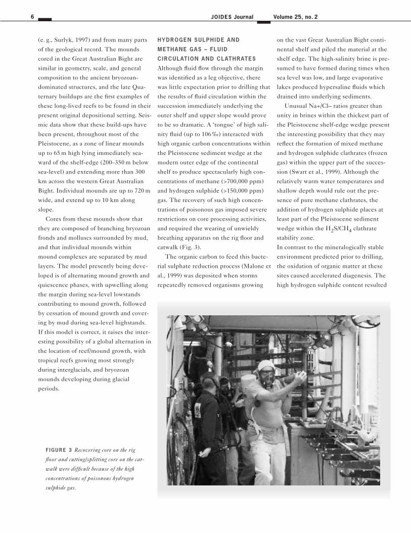
gas. The recovery of such high concen-
trations of poisonous gas imposed severe
restrictions on core processing activities,
and required the wearing of unwieldy
breathing apparatus on the rig floor and
catwalk (Fig. 3).
The organic carbon to feed this bacte-
rial sulphate reduction process (Malone et
al., 1999) was deposited when storms
repeatedly removed organisms growing
on the vast Great Australian Bight conti-
nental shelf and piled the material at the
shelf edge. The high-salinity brine is pre-
sumed to have formed during times when
sea level was low, and large evaporative
lakes produced hypersaline fluids which
drained into underlying sediments.
Unusual Na+/Cl– ratios greater than
unity in brines within the thickest part of
the Pleistocene shelf-edge wedge present
the interesting possibility that they may
reflect the formation of mixed methane
and hydrogen sulphide clathrates (frozen
gas) within the upper part of the succes-
sion (Swart et al., 1999). Although the
relatively warm water temperatures and
shallow depth would rule out the pre-
sence of pure methane clathrates, the
addition of hydrogen sulphide places at
least part of the Pleistocene sediment
wedge within the H2S/CH4 clathrate
stability zone.
In contrast to the mineralogically stable
environment predicted prior to drilling,
the oxidation of organic matter at these
sites caused accelerated diagenesis. The
high hydrogen sulphide content resulted
F IGURE 3 Recovering core on the rig
floor and cutting/splitting core on the cat-
walk were difficult because of the high
concentrations of poisonous hydrogen
sulphide gas.
Leg Reports 7
in decreased pH of pore fluids causing
dissolution of the least stable carbonate
minerals, and the increased alkalinity
resulting from sulphate reduction created
a thermodynamic regime favorable for the
formation of dolomite.
SOUTHERN OCEAN EVOLUTION
The sedimentary succession drilled at the
toe of slope (Site 1128 in ~3800 m water
depth), chronicles the change from early
Paleogene time, when a humid onshore
climate flushed large amounts of terrige-
nous clastic sediment into the deep sea,
to Neogene time when increasing conti-
nental aridity promoted mostly marine
carbonate deposition. Green Eocene sili-
ciclastic sands and silts that accumulated
largely below the CCD in a poorly oxyge-
nated, bathyal setting, become finer
grained upward with much of the deep-
water late Eocene represented by clay
deposition. Initiation of the contemporary
Southern Ocean circulation system, and
thus the modern global ocean, is signalled
by a gradual change to early Oligocene
brown clay and carbonate, as this part of
the seafloor became ventilated and the
CCD deepened. The deep-water Neo-
gene record is one of pink pelagic carbo-
nate ooze punctuated by white plankto-
nic foraminiferal turbidites. Early-middle
Miocene time is represented by a major
hiatus and sediment gravity flow deposits.
LEG 182 SHIPBOARD
SCIENTIF IC PARTY
David Feary and Al Hine, Co-Chief
Scientists; Mitch Malone, Staff Scientist;
Miriam Andres, Christian Betzler, Gregg
Brooks, Charlotte Brunner, Michael Ful-
ler, Ann Holbourn, Mads Huuse, Alex-
andra Isern, Noel James, Bryan Ladner,
Qianyu Li, Hideaki Machiyama, David
Mallinson, Hiroki Matsuda, Richard Mit-
terer, Roberto Molina-Garza, Cecile
Robin, Joellen Russell, Samir Shafik,
Toni Simo, Peter Smart, Guy Spence,
Finn Surlyk, Peter Swart, and Ulrich
Wortmann.
REFERENCES
Feary, D.A., and James, N.P., 1995. Ceno-
zoic biogenic mounds and buried Mio-
cene barrier reef on a predominantly
cool-water carbonate continental mar-
gin - Eucla Basin, western Great Aus-
tralian Bight. Geology, 23: 427–430.
Feary, D. A., and James, N. P., 1998. Seis-
mic stratigraphy and geological evolu-
tion of the Cenozoic, cool-water, Eucla
Platform, Great Australia Bight: Ameri-
can Association of Petroleum Geologists
Bulletin, 82: 792–816.
James, N. P., Boreen, T. D., Bone, Y.,
Feary, D. A., 1994. Holocene carbonate
sedimentation on the west Eucla
Shelf, Great Australian Bight: a shaved
shelf. Sedimentary Geology, 90: 161–177.
James, N. P., 1997. The cool-water carbo-
nate depositional realm. In James,
N. P., and Clarke, A. D. (eds), Cool-
water Carbonates: SEPM Spec. Pub. 56:
1–20.
Malone, M. J., Mitterer, R., Swart, P.,
Wortmann, U., Feary, D., Hine, A., and
the Leg 182 Science Party, 1999.
Simultaneous methanogenesis and sul-
phate reduction in carbonate-rich sedi-
ments, Great Australian Bight (ODP
Leg 182). (Abstract). Eos, Transactions,
AGU vol. 80 (46): F 539.
Surlyk, F., 1997. A cool-water carbonate
ramp with bryozoan mounds: Late
Cretaceous-Danian of the Danish
basin. In James, N. P., and Clarke,
A. D. (eds), Cool-water Carbonates:
SEPM Spec. Pub. 56: 293-308.
Swart, P. K., Wortmann, U., Mitterer, R.,
Malone, M., Feary, D., Hine, A., Mar-
tin, J., 1999. The origin of saline brines
with unusual Na+/Cl– ratios in the
continental margins of southern Aus-
tralia. (Abstract). Eos, Transactions,
AGU vol. 80 (46): F 539.
JOIDES Journal8 Volume 25, no. 2
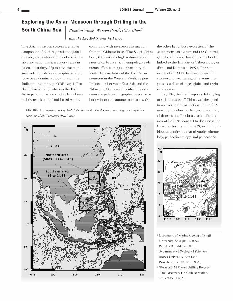
The Asian monsoon system is a major
component of both regional and global
climate, and understanding of its evolu-
tion and variations is a major theme in
paleoclimatology. Up to now, the mon-
soon-related paleoceanographic studies
have been dominated by those on the
Indian monsoon (e. g., ODP Leg 117 to
the Oman margin), whereas the East
Asian paleo-monsoon studies have been
mainly restricted to land-based works,
commonly with monsoon information
from the Chinese loess. The South China
Sea (SCS) with its high sedimentation
rates of carbonate-rich hemipelagic sedi-
ments offers a unique opportunity to
study the variability of the East Asian
monsoon in the Western Pacific region.
Its location between East Asia and the
“Maritime Continent” is ideal to docu-
ment the paleoceanographic response to
both winter and summer monsoons. On
the other hand, both evolution of the
Asian monsoon system and the Cenozoic
global cooling are thought to be closely
linked to the Himalayan-Tibetan orogen
(Prell and Kutzbach, 1997). The sedi-
ments of the SCS therefore record the
erosion and weathering of tectonic oro-
gens as well as changes global and regio-
nal climate.
Leg 184, the first deep-sea drilling leg
to visit the seas off China, was designed
to recover sediment sections in the SCS
to study the climate changes on a variety
of time scales. The broad scientific the-
mes of Leg 184 were (1) to document the
Cenozoic history of the SCS, including its
biostratigraphy, lithostratigraphy, chrono-
logy, paleoclimatology, and paleoceano-
Exploring the Asian Monsoon through Drilling in the
South China Sea
-20˚
-10˚
0˚
10˚
20˚
30˚
40˚ N
90˚E 100˚ 110˚ 120˚ 130˚ 140˚
LEG 184
BS
SCS
Southern area
(Sites 1144-1148)
(Site 1143)
Northern area
115°E 116° 117° 118° 119°17°
18°
19°
20°
21°
22°
23°N
500
Site 1144Site 1144Site 1145Site 1145Site 1146Site 1146
Site 1148Site 1148Site 1147Site 1147
10001000 Site 1144Site 1145Site 1146
Site 1148Site 1147
1000500500
20002000
25
00
3000
37003700
4000
100100
500500
2000
25
00
25
00
30003000
37003700
4000
200100100
500
2000
25
00
3000
3700
4000
200100
FIGURE 1 Locations of Leg 184 drill sites in the South China Sea. Figure at right is a
close-up of the “northern area” sites.
1 Laboratory of Marine Geology, Tongji
University, Shanghai, 200092,
Peoples Republic of China;
2 Department of Geological Sciences
Brown University, Box 1846
Providence, RI 02912, U. S. A.;
3 Texas A & M-Ocean Drilling Program
1000 Discovery Dr. College Station,
TX 77845, U. S. A.
Pinxian Wang1, Warren Prell2, Peter Blum3
and the Leg 184 Scientific Party
Leg Reports 9
graphy; (2) to reconstruct the evolution
and variability of the East Asian monsoon
during the late Cenozoic on millennial,
orbital and tectonic time scales; and (3) to
identify and better understand the links
among tectonic uplift, erosion and wea-
thering, hemipelagic deposition, and cli-
mate change, including the co-evolution
of the Asian monsoon and Neogene glo-
bal cooling.
Our expedition to the South China Sea
had all the ingredients of a good spy
novel, including exotic ports (Fremantle
and Hong Kong), international intrigue
(permission to drill), a solar eclipse,
threats of piracy, the Chinese New Year
(year of the Rabbit), a volcanic eruption
(Anak Krakatoa = child of Krakatoa) while
transiting the Sunda Strait, dangerous
shoals, an Equator crossing, and treasures
from the sea floor. All this and exciting
science too!
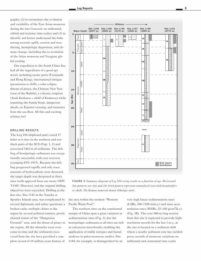
DRILL ING RESULTS
The Leg 184 shipboard party cored 17
holes at 6 sites in the northern and sou-
thern parts of the SCS (Figs. 1, 2) and
recovered 5463 m of sediment. The dril-
ling of hemipelagic sediments was excep-
tionally successful, with core recovery
averaging 83%–101%. Because the dril-
ling progressed rapidly and only trace
amounts of hydrocarbons were detected,
the target depth was deepened at three
sites (with approval from our trusty ODP-
TAMU Director), and the original drilling
objectives were exceeded. Drilling at the
first site, Site 1143 in the Nansha or
Spratley Islands area, was complicated by
several diplomatic and safety questions: a
broken radar, multiple claims to the
region by several political entities, poorly
charted waters of the “Dangerous
Grounds” area, and the threat of piracy in
the region. All the obstacles were over-
come in time and the sediments reco-
vered from the site have provided a com-
plete record of 10 million years history of
the area within the modern “Western
Pacific Warm Pool”.
The northern sites on the continental
margin of China span a great variation in
sedimentation rates (Fig. 3), but the
hemipelagic sediments at all sites are rich
in calcareous microfossils, enabling the
application of stable isotopes and faunal
analyses in paleo-monsoon studies. Site
1144, for example, is distinguished by its
very high linear sedimentation rates
(LSRs, 300–1100 m/m.y.) and mass accu-
mulation rates (MARs, 25–140 g/cm2/k.y.)
(Fig. 3B). The over 500-m long section
from this site is expected to provide high-
resolution records for the last 1 m.y., as
the site is located on a sediment drift
where a nearby sediment core has yielded
proxy records of monsoon variations on
millennial and centennial time scales
0
5
10
15
20
25
30
35
��@@��ÀÀ��@@��ÀÀ��yy����@@@@����ÀÀÀÀ����@@@@����ÀÀÀÀ����yyyy��@@��ÀÀ��@@��ÀÀ��yy
IAIBIC
Site 1144(2037 m)
Ple
ist.
Plio
cene
Mio
cene
Olig
ocen
eE
oc.
Ag
e (
Ma
)
uppe
rm
iddl
elo
wer
uppe
rlo
wer
uppe
rlo
wer
������
@@@@@@
������
ÀÀÀÀÀÀ
������
@@@@@@
������
ÀÀÀÀÀÀ
������
yyyyyy
I
Site 1147(3246 m)
����������
@@@@@@@@@@
����������
ÀÀÀÀÀÀÀÀÀÀ
����������
@@@@@@@@@@
����������
ÀÀÀÀÀÀÀÀÀÀ
����������
yyyyyyyyyy
������������
@@@@@@@@@@@@
������������
ÀÀÀÀÀÀÀÀÀÀÀÀ
������������
@@@@@@@@@@@@
������������
ÀÀÀÀÀÀÀÀÀÀÀÀ
������������
@@@@@@@@@@@@
������������
ÀÀÀÀÀÀÀÀÀÀÀÀ
������������
@@@@@@@@@@@@
������������
ÀÀÀÀÀÀÀÀÀÀÀÀ
������������
yyyyyyyyyyyy
������������������
@@@@@@@@@@@@@@@@@@
������������������
ÀÀÀÀÀÀÀÀÀÀÀÀÀÀÀÀÀÀ
������������������
@@@@@@@@@@@@@@@@@@
������������������
ÀÀÀÀÀÀÀÀÀÀÀÀÀÀÀÀÀÀ
������������������������������������
@@@@@@@@@@@@@@@@@@@@@@@@@@@@@@@@@@@@
������������������������������������
ÀÀÀÀÀÀÀÀÀÀÀÀÀÀÀÀÀÀÀÀÀÀÀÀÀÀÀÀÀÀÀÀÀÀÀÀ
������������������������������������
@@@@@@@@@@@@@@@@@@@@@@@@@@@@@@@@@@@@
������������������������������������
ÀÀÀÀÀÀÀÀÀÀÀÀÀÀÀÀÀÀÀÀÀÀÀÀÀÀÀÀÀÀÀÀÀÀÀÀ
������������������������������������
yyyyyyyyyyyyyyyyyyyyyyyyyyyyyyyyyyyy
��������������������������������������������
@@@@@@@@@@@@@@@@@@@@@@@@@@@@@@@@@@@@@@@@@@@@
��������������������������������������������
ÀÀÀÀÀÀÀÀÀÀÀÀÀÀÀÀÀÀÀÀÀÀÀÀÀÀÀÀÀÀÀÀÀÀÀÀÀÀÀÀÀÀÀÀ
��������������������������������������������
@@@@@@@@@@@@@@@@@@@@@@@@@@@@@@@@@@@@@@@@@@@@
��������������������������������������������
ÀÀÀÀÀÀÀÀÀÀÀÀÀÀÀÀÀÀÀÀÀÀÀÀÀÀÀÀÀÀÀÀÀÀÀÀÀÀÀÀÀÀÀÀ
������
@@@@@@
������
ÀÀÀÀÀÀ
������
@@@@@@
������
ÀÀÀÀÀÀ
������
yyyyyy
���������������
@@@@@@@@@@@@@@@
���������������
ÀÀÀÀÀÀÀÀÀÀÀÀÀÀÀ
���������������
@@@@@@@@@@@@@@@
���������������
ÀÀÀÀÀÀÀÀÀÀÀÀÀÀÀ
������������
@@@@@@@@@@@@
������������
ÀÀÀÀÀÀÀÀÀÀÀÀ
������������
@@@@@@@@@@@@
������������
ÀÀÀÀÀÀÀÀÀÀÀÀ
������������
yyyyyyyyyyyy
���������������������
@@@@@@@@@@@@@@@@@@@@@
���������������������
ÀÀÀÀÀÀÀÀÀÀÀÀÀÀÀÀÀÀÀÀÀ
���������������������
@@@@@@@@@@@@@@@@@@@@@
���������������������
ÀÀÀÀÀÀÀÀÀÀÀÀÀÀÀÀÀÀÀÀÀ������������
@@@@@@@@@@@@
������������
ÀÀÀÀÀÀÀÀÀÀÀÀ
������������
@@@@@@@@@@@@
������������
ÀÀÀÀÀÀÀÀÀÀÀÀ
������������
yyyyyyyyyyyy
������������������������
@@@@@@@@@@@@@@@@@@@@@@@@
������������������������
ÀÀÀÀÀÀÀÀÀÀÀÀÀÀÀÀÀÀÀÀÀÀÀÀ
������������������������
@@@@@@@@@@@@@@@@@@@@@@@@
������������������������
ÀÀÀÀÀÀÀÀÀÀÀÀÀÀÀÀÀÀÀÀÀÀÀÀ
IA
IB
IIA
IIB
III
IV
V
VI
����������������
@@@@@@@@@@@@@@@@
����������������
ÀÀÀÀÀÀÀÀÀÀÀÀÀÀÀÀ
����������������
@@@@@@@@@@@@@@@@
����������������
ÀÀÀÀÀÀÀÀÀÀÀÀÀÀÀÀ
����������������
yyyyyyyyyyyyyyyy
����������������������
@@@@@@@@@@@@@@@@@@@@@@
����������������������
ÀÀÀÀÀÀÀÀÀÀÀÀÀÀÀÀÀÀÀÀÀÀ
����������������������
@@@@@@@@@@@@@@@@@@@@@@
����������������������
ÀÀÀÀÀÀÀÀÀÀÀÀÀÀÀÀÀÀÀÀÀÀ
VII
Hiatus
Site 1148(3295 m)
IB
IA
��������������
@@@@@@@@@@@@@@
��������������
ÀÀÀÀÀÀÀÀÀÀÀÀÀÀ
��������������
@@@@@@@@@@@@@@
��������������
ÀÀÀÀÀÀÀÀÀÀÀÀÀÀ
��������������
yyyyyyyyyyyyyy
������������������
@@@@@@@@@@@@@@@@@@
������������������
ÀÀÀÀÀÀÀÀÀÀÀÀÀÀÀÀÀÀ
������������������
@@@@@@@@@@@@@@@@@@
������������������
ÀÀÀÀÀÀÀÀÀÀÀÀÀÀÀÀÀÀ
����������������������
@@@@@@@@@@@@@@@@@@@@@@
����������������������
ÀÀÀÀÀÀÀÀÀÀÀÀÀÀÀÀÀÀÀÀÀÀ
����������������������
@@@@@@@@@@@@@@@@@@@@@@
����������������������
ÀÀÀÀÀÀÀÀÀÀÀÀÀÀÀÀÀÀÀÀÀÀ
����������������������
yyyyyyyyyyyyyyyyyyyyyy
���������������������������������������������
@@@@@@@@@@@@@@@@@@@@@@@@@@@@@@@@@@@@@@@@@@@@@
���������������������������������������������
ÀÀÀÀÀÀÀÀÀÀÀÀÀÀÀÀÀÀÀÀÀÀÀÀÀÀÀÀÀÀÀÀÀÀÀÀÀÀÀÀÀÀÀÀÀ
���������������������������������������������
@@@@@@@@@@@@@@@@@@@@@@@@@@@@@@@@@@@@@@@@@@@@@
���������������������������������������������
ÀÀÀÀÀÀÀÀÀÀÀÀÀÀÀÀÀÀÀÀÀÀÀÀÀÀÀÀÀÀÀÀÀÀÀÀÀÀÀÀÀÀÀÀÀ
Site 1143(2772 m)Water Depth:
������������
@@@@@@@@@@@@
������������
ÀÀÀÀÀÀÀÀÀÀÀÀ
������������
@@@@@@@@@@@@
������������
ÀÀÀÀÀÀÀÀÀÀÀÀ
������������
yyyyyyyyyyyy
I
I IA
IIB
III
��������������������������������������������������������
@@@@@@@@@@@@@@@@@@@@@@@@@@@@@@@@@@@@@@@@@@@@@@@@@@@@@@@@
��������������������������������������������������������
ÀÀÀÀÀÀÀÀÀÀÀÀÀÀÀÀÀÀÀÀÀÀÀÀÀÀÀÀÀÀÀÀÀÀÀÀÀÀÀÀÀÀÀÀÀÀÀÀÀÀÀÀÀÀÀÀ
��������������������������������������������������������
@@@@@@@@@@@@@@@@@@@@@@@@@@@@@@@@@@@@@@@@@@@@@@@@@@@@@@@@
��������������������������������������������������������
ÀÀÀÀÀÀÀÀÀÀÀÀÀÀÀÀÀÀÀÀÀÀÀÀÀÀÀÀÀÀÀÀÀÀÀÀÀÀÀÀÀÀÀÀÀÀÀÀÀÀÀÀÀÀÀÀ
��������������������������������������������������������
yyyyyyyyyyyyyyyyyyyyyyyyyyyyyyyyyyyyyyyyyyyyyyyyyyyyyyyy
������������������������������������������������������������������������������������������������������������
@@@@@@@@@@@@@@@@@@@@@@@@@@@@@@@@@@@@@@@@@@@@@@@@@@@@@@@@@@@@@@@@@@@@@@@@@@@@@@@@@@@@@@@@@@@@@@@@@@@@@@@@@@@@
������������������������������������������������������������������������������������������������������������
ÀÀÀÀÀÀÀÀÀÀÀÀÀÀÀÀÀÀÀÀÀÀÀÀÀÀÀÀÀÀÀÀÀÀÀÀÀÀÀÀÀÀÀÀÀÀÀÀÀÀÀÀÀÀÀÀÀÀÀÀÀÀÀÀÀÀÀÀÀÀÀÀÀÀÀÀÀÀÀÀÀÀÀÀÀÀÀÀÀÀÀÀÀÀÀÀÀÀÀÀÀÀÀÀÀÀÀÀ
������������������������������������������������������������������������������������������������������������
@@@@@@@@@@@@@@@@@@@@@@@@@@@@@@@@@@@@@@@@@@@@@@@@@@@@@@@@@@@@@@@@@@@@@@@@@@@@@@@@@@@@@@@@@@@@@@@@@@@@@@@@@@@@
������������������������������������������������������������������������������������������������������������
ÀÀÀÀÀÀÀÀÀÀÀÀÀÀÀÀÀÀÀÀÀÀÀÀÀÀÀÀÀÀÀÀÀÀÀÀÀÀÀÀÀÀÀÀÀÀÀÀÀÀÀÀÀÀÀÀÀÀÀÀÀÀÀÀÀÀÀÀÀÀÀÀÀÀÀÀÀÀÀÀÀÀÀÀÀÀÀÀÀÀÀÀÀÀÀÀÀÀÀÀÀÀÀÀÀÀÀÀ
Site 1146(2092 m)
������������
@@@@@@@@@@@@
������������
ÀÀÀÀÀÀÀÀÀÀÀÀ
������������
@@@@@@@@@@@@
������������
ÀÀÀÀÀÀÀÀÀÀÀÀ
������������
yyyyyyyyyyyy
I
Site 1145(3176 m)
Grey layersdistribution
Offshore
F IGURE 2 Summary diagram of Leg 184 coring results as a function of age. Horizontal
line patterns are clay and silt; brick pattern represents nannofossil ooze with foraminifers
or chalk. The Roman numerals denote lithologic units.
JOIDES Journal10 Volume 25, no. 2
2772 m, bottom age 11 Ma) from the sou-
thern SCS (Fig. 3A) and Site 722 (water
depth 2028 m, bottom age 15 Ma) from
the Arabian Sea. The comparison of these
cores should help to identify potential
sources of common causality for the Asian
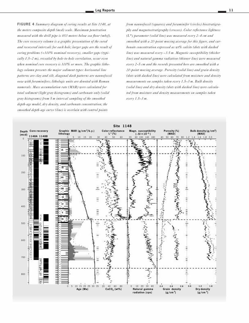
monsoon evolution. Site 1148 on the
lowermost northern slope of the SCS
(water depth 3295 m) recovered the lon-
gest section of the entire leg. Its 850-m
long sequence represents a 32-m.y.
record, which could be used to evaluate
models of the SCS continental margin
evolution and the impact of Himalayan-
Tibetan uplift on monsoon onset and
intensification.
ENVIRONMENTAL HISTORY
The 32-m.y. sequence of deep-sea sedi-
ments recovered during Leg 184 covers
almost the entire environmental history
of the SCS since its opening. Judging
from magnetic anomaly (C 11–C 5c) pat-
terns, the sea-floor spreading phase of the
SCS took place between 32 and 16 Ma
(Briais et al., 1993). The deep-water
nature of the microfauna from the lower
and middle Oligocene deposits (Site
1148, 32-27 Ma, 850-480 mcd) and the
lithology suggest that when sea-floor
spreading began, the basin was already
fairly deep, most probably an upper
bathyal environment formed during the
rifting stage in the early Paleogene. The
extremely high MAR (18.8 g/cm2/k.y.) in
the early Oligocene implies a focusing of
sediment flux into the newly opened nar-
row basin. This is in contrast to the Sea of
Japan where initial spreading at ~28 Ma
was accompanied by widespread non-
marine and “Green Tuff” deposition, and
bathyal water depth was reached only
after 23 Ma (Ingle, 1992).
The latest stage of the Oligocene pro-
duced drastic changes in sediment depo-
sition at Site 1148 (Fig. 4). The absence
of nannofossil zone NP 25 and some
planktonic foraminifer markers indicates
a deposition hiatus of ~3 m.y. (Figs. 2, 3A,
(Wang et al., 1999). Site 1146 (water
depth 2092 m), also from the northern
slope of the SCS, recovered an over 600 m
long section representing a 19-m.y.
record. This long-term record at orbital-
scale resolution (2 k.y.) will allow compa-
rison of East Asian monsoon variability
with orbital forcing, glacial forcing, and
internal feedback within the climate
system. In addition the record will pro-
vide a new set of constraints of the possi-
ble relationship between Tibetan Plateau
uplift, monsoon evolution, and global
cooling. The paleo-monsoon record at
Site 1146 will provide an appropriate
counterpart to Site 1143 (water depth
0 40 80
0 2 4 6 8 10
LSR (m/m.y.)
MAR (g/cm 2/k.y.)
Site 1143
0 500 1000
0 50 100 150
0
1
2
3
Ag
e (M
a)
LSR (m/m.y.)
MAR (g/cm 2/k.y.)
Site 1144
0 200
0 10 20 30 40
LSR (m/m.y.)
MAR (g/cm 2/k.y.)
Site 1146
0 100 200 300
0 10 20 30 40
LSR (m/m.y.)
MAR (g/cm 2/k.y.)
Site 1145
0 50 100
0 5 10 15 20
LSR (m/m.y.)
MAR (g/cm 2/k.y.)
Site 1147
0 20 40 60 80
0 5 10 15 20
LSR (m/m.y.)
MAR (g/cm 2/k.y.)
Site 1148
0 40 80 120
0 10 20 30
LSR (m/m.y.)
MAR (g/cm 2/k.y.)
Site 1146
LSR = 360 m/m.y.
0 40 80 120
0 10 20 30
LSR (m/m.y.)
MAR (g/cm 2/k.y.)
Site 1143
0 40 80 120
0 10 20 30 40
Hiatus
LSR (m/m.y.)
MAR (g/cm 2/k.y.)
Site 1148
Pleistocene
Pliocene
Upper
Miocene
MiddleMiocene
LowerMiocene
Oligocene
0
5
10
15
20
25
30
35
g(
)
A
B
FIGURE 3 Total (stippled histograms) and carbonate (solid histograms) mass accumula-
tion rates, and linear sedimentation rates (solid line), vs. age. A) Complete section for the
three deepest sites. B. Close-up for the last 3 m.y. at all Leg 184 sites.
Leg Reports 11
0
100
200
300
400
500
600
700
800
1148A 1148B
Depth(mcd)
Core recovery
0 5 10 15 20
0 5 10 15 20 25 30 35
MAR (g/cm 2/k.y.)
Age (Ma)
30 40 50 60
20 40 60 80
Color reflectanceL* (%)
CaCO3 (wt%)
20 60 100 140 180
0 10 20 30 40
Magn. susceptibility(~SI x 10 –5 )
Natural gammaradiation (cps)
1.2 1.4 1.6 1.8 2.0
0.6 1.2 1.8
Bulk density (g/cm3)(MAD)
Dry density(g/cm 3)
Site 1148
40 50 60 70 80
2.4 2.6 2.8
Porosity (%)(MAD)
Grain density(g/cm 3)
Graphiclithology
VI
IIB
IV
V
IIA
IB
IA
III
FIGURE 4 Summary diagram of coring results at Site 1148, at
the meters composite depth (mcd) scale. Maximum penetration
measured with the drill pipe is 853 meters below sea floor (mbsf).
The core recovery column is a graphic presentation of the cored
and recovered intervals for each hole; larger gaps are the result of
coring problems (<100% nominal recovery), smaller gaps (typi-
cally 0.5–2 m), revealed by hole-to-hole correlation, occur even
when nominal core recovery is 100% or more. The graphic litho-
logy column presents the major sediment types: horizontal line
patterns are clay and silt, diagonal dash patterns are nannofossil
ooze with foraminifers; lithologic units are denoted with Roman
numerals. Mass accumulation rate (MAR) were calculated for
total sediment (light gray histograms) and carbonate only (solid
gray histograms) from 5 m interval sampling of the smoothed
depth-age model, dry density, and carbonate concentration; the
smoothed depth-age curve (line) is overlain with control points
from nannofossil (squares) and foraminifer (circles) biostratigra-
phy and magnetostratigraphy (crosses). Color reflectance lightness
(L*) parameter (solid line) was measured every 2–4 cm and
smoothed with a 20-point moving average for this figure, and car-
bonate concentration expressed as wt% calcite (dots with dashed
line) was measured every ~3.5 m. Magnetic susceptibility (thicker
line) and natural gamma radiation (thinner line) were measured
every 2–5 cm and the records presented here are smoothed with a
20-point moving average. Porosity (solid line) and grain density
(dots with dashed line) were calculated from moisture and density
measurements on samples taken every 1.5–3 m. Bulk density
(solid line) and dry density (dots with dashed line) were calcula-
ted from moisture and density measurements on samples taken
every 1.5–3 m.

JOIDES Journal12 Volume 25, no. 2
4). This hiatus near the Oligocene/Mio-
cene boundary started at ~27 Ma, the
time that the spreading ridge of the SCS
basin is thought to have jumped south-
ward (Briais et al., 1993). The Oligocene-
Miocene transition represents one of the
most significant Cenozoic changes in the
tectonic and environmental history of the
SCS (Wang, 1990). During this period,
the sedimentary basins of the northern
SCS shelf are thought to have experien-
ced a transition from the rifting stage to
one of broad subsidence (Ru et al.,
1994).
The early Miocene (16.5–23.7 Ma) at
Sites 1146 and 1148 is represented by a
calcareous clay with an average carbonate
content of ~35 wt%. The total MARs for
this interval were three times lower than
in the Oligocene (Fig. 3A). During the
second stage of sea-floor spreading (27-16
Ma), the SCS basin became much broader
than in the Oligocene (Briais et al., 1993).
The early Miocene was also characterized
by an expansion of reef facies in the shal-
low waters of the western Pacific, inclu-
ding the Pearl River Mouth Basin (Wang,
1990). The relatively low carbonate accu-
mulation rate but high carbonate content
may be attributed to the more pelagic
environment of the larger SCS basin, the
lack of sediment focusing, and the wide
distribution of reef facies on the shelves.
The seafloor spreading phase of the
SCS basin stopped at magnetic Anomaly
C5c, or ~16 Ma, which is close to the
early/middle Miocene boundary. The
middle Miocene section (~16–11 Ma)
from the northern continental margin
(Sites 1148 and 1146) has relatively high
carbonate content (>30 wt%), only
slightly lower than the early Miocene but
much higher than the modern values
(<5% and ~20% at Sites 1148 and 1146,
respectively). Total accumulation rates
during the middle Miocene were 1.91
g/cm2/k.y. at Site 1148, slightly lower
than in the early Miocene and much
lower than at Site 1146 (~4.34 g/cm2/k.y.)
(Fig. 3A). Additional postcruise biostrati-
graphic control is needed to establish
whether the slower accumulation rates
are related to a change in tectonics or to
depositional hiatuses observed on the
northern shelf.
Upper Miocene sediments were reco-
vered in the northern (Sites 1146, 1148)
and southern SCS (Site 1143). One third
to one half of the mass of sediments from
northern and southern sites above the
modern lysocline (Sites 1146 and 1143) is
composed of carbonates (Fig. 3A). Site
1146 shows a significant increase in carbo-
nate accumulation rate from 1.35g/cm2/
k.y. in the middle Miocene to 1.88
g/cm2/k.y in the late Miocene, while total
accumulation rates decreased slightly. At
Site 1148, the increase in carbonate accu-
mulation from 0.52 to 0.72 g/cm2/k.y.
during that interval is also reflected in the
total accumulation rate. The larger con-
centration in terrigenous sediment as well
as the poor preservation of planktonic for-
aminifers at Site 1148 indicate a different
development compared to Site 1146 in
shallower water depth.
Despite the similar carbonate concen-
trations in upper Miocene sediments, the
accumulation rate at the southern Site
1143 is twice as high (~3.8 g/cm2/k.y.)
than at the northern Site 1146 (~1.9 g/
cm2/k.y.). The high carbonate accumula-
tion at tropical Site 1143 might be related
to the late Miocene to early Pliocene
“biogenic bloom” in the equatorial Pacific
(Berger et al., 1993; Farrell et al., 1995)
but also seems partly related to redeposi-
tion of adjacent sediments as evidenced
by the frequent turbidites and slumped
sediments in the lower section. The high
carbonate percentages in the Miocene
deposits from the northern sites imply a
low supply of terrigenous material from
the land that may be related to rising sea
levels during this interval. In general, the
high carbonate sediments throughout the
Miocene and the similarity between the
northern and southern sites suggest a
much more stable environment than
during the Pliocene-Pleistocene.
Leg 184 recovered Pliocene deposits at
four sites (1143, 1145, 1146, and 1148)
and Pleistocene sediments at all six sites,
although with substantially different
accumulation rates (Fig. 3B). At the sou-
thern Site 1143, both carbonate and non-
carbonate accumulation rates decreased
from the late Miocene to Pliocene (Fig.
3): carbonate from 2–4 to ~1 g/cm2/k.y.,
and non-carbonate from 3-4 to ~2 g/cm2/
k.y.. The decreasing trend continued to
the Pleistocene for carbonate, whereas
the non-carbonate rate increased again
after ~3 Ma, indicating some increased
supply of terrigenous material. On the
northern continental margin, Pliocene
accumulation rates remain at the late
Miocene level at Sites 1146 and 1148 but
with slightly lower rates in the deeper
Site 1148. Both sites exhibit a rapid
increase in LSR and non-carbonate depo-
sition that started at ~3 Ma. Site 1145
records only the past 3 m.y., but the non-
carbonate accumulation increases after
2.5 Ma. This apparently regional increase
in non-carbonate accumulation may be
evidence for an intensification of erosion
that is related to climate, sea-level, and/or
tectonic events. For example, Chinese
geologists report evidence for significant
uplift of the Tibetan Plateau at ~3 Ma
(e.g., Li et al., 1996), and the widespread
accumulation of loess in central China
started at ~2.4 Ma (e.g., Liu et al., 1985).
However, sea-level changes associated
with increased global glaciation may have
also contributed to transporting sedi-
ments to these continental margin sites.
Moreover, all the northern sites show an
increase in MAR in the late Pleistocene,
especially the last 0.26 m.y. (Fig. 3B).
The higher MAR is mainly the result of
increased supply of terrigenous material,
which might again be related to sea level
changes, as the northern shelf and the
coastal plains have recorded only the late
Pleistocene marine transgression.
Leg Reports 13
SUMMARY
Leg 184 recovered a sequence of hemipe-
lagic sediments that records the past 32
m.y. of environmental history of the SCS.
For the first time in the lower latitude
western Pacific, these cores provide a
high-resolution continuous record of rela-
tively carbonate-rich fine-grained sedi-
ments and a possibility of sea-land corre-
lation of the upper Cenozoic stratigraphy
for the region. The lithologies, microfos-
sils, and physical properties of the hemi-
pelagic sequence reveal significant
trends, abrupt changes and clear cyclici-
ties, which exhibit orbital-scale and finer
fluctuations in monsoon climate.
The Oligocene/Miocene boundary in
the northern SCS is marked by sedimen-
tary deformation, abrupt lithologic chan-
ges, and a stratigraphic hiatus. These
related features will help resolve the
nature and timing of one of the most
significant Cenozoic tectonic and climate
changes of the region.
Cores from all sites, both the northern
and southern SCS, have high carbonate
content during the Miocene and lower
Pliocene. The low terrigenous input and
partly high carbonate production resulted
in a sedimentary environment on the
northern slope similar to that near the
reef areas in the southern part of the sea
in the Miocene; accumulation rates,
however, are significantly different in the
northern and southern SCS after the Mio-
cene.
A general increase of non-carbonate
sediment accumulation after 2–3 Ma was
found at all drill sites; for the northern
sites, the increase has become even more
significant in the latter part of the last
million years. A site with exceptionally
high rates of hemipelagic fine-grained
sedimentation (Site 1144, ~500 m of sedi-
ment for the last 1 m.y.) offers a unique
opportunity for high-resolution paleoen-
vironmental studies at decadal scale.
LEG 184 SHIPBOARD
SCIENTIF IC PARTY
Pinxian Wang and Warren Prell, Co-Chief
Scientists; Peter Blum, Staff Scientist;
Eve Arnold, Christian Bühring, Min-Pen
Chen, Steven Clemens, Peter Clift, Chri-
stophe Colin, John Farrell, Matthew Hig-
ginson, Zhimin Jian, Wolfgang Kuhnt,
Carlo Laj, Christine Lauer, Joel Levent-
hal, Anchun Li, Qingmou Li, Jian Lin,
Katherine McIntyre, Conrado Miranda,
Stephen Nathan, Jih-Ping Shyu, Peter
Solheid, Xin Su, Federica Tamburini,
Alain Trentesaux, Luejiang Wang.
REFERENCES
Berger, W. H., Leckie, R. M., Janecek,
T. R., Stax, R., and Takayama, T.,
1993. Neogene carbonate sedimenta-
tion on Ontong Java Plateau: high-
lights and open questions. In Berger,
W. H., Kroenke, L.W., Mayer, L.A., et
al., Proc. ODP, Sci. Results, 130: College
Station, TX (Ocean Drilling Program),
p. 711–744.
Briais, A., Patriat, P., and Tapponnier, P.,
1993. Updated interpretation of mag-
netic anomalies and seafloor spreading
stages in the South China Sea: implica-
tions for the Tertiary tectonics of Sou-
theast Asia. J. Geophys. Res., v. 98,
p. 6299–6328.
Farrell, J. W., Raffi, I., Janecek, T. R.,
Murray, D. W., Levitan, M., Dadey,
K. A., Emeis, K.-C., Lyle, M., Flores,
J.-A., and Hoven, S., 1995. Late Neo-
gene sedimentation patterns in the
eastern equatorial Pacific. In Pisias,
N. G., Mayer, L. A., Janecek, T. R.,
Palmer-Julson, A., and van Andel,
T. H. (Eds.), Proc. ODP, Sci. Results,
138, College Station, TX (Ocean Dril-
ling Program), p.717-756.
Ingle, J. C., Jr., 1992. Subsidence of the
Japan Sea: stratigraphic evidence from
ODP sites and onshore section. In
Tamaki, K., Suyehiro, K., Allan, J.,
McWilliams, M., et al., Proc. ODP, Sci.
Results, 127/128, Pt. 2, College Station,
TX (Ocean Drilling Program),
p. 1197–1218.
Li, J., Fan, X., Ma, H., Zhu, Z., Pan, B.,
and Chan, H., 1996. Late Cenozoic
geomorphological evolution of upper
reach of Yellow River and uplift of
Tibetan Plateau. Sci. China, D 26,
p. 316–322 (in Chinese).
Liu, D., An, Z., Yuan, B., and Han, J.,
1985. The loess-paleosol sequence in
China and climate history. Episodes,
8, p. 21–28.
Prell, W. L., and Kutzbach, J. E., 1997.
The impact of Tibet-Himalayan eleva-
tion on the sensitivity of the monsoon
climate system to changes in solar
radiation. In Ruddiman, W. F. (Ed.),
Tectonic Uplift and Climate Change. New
York (Plenum), p.172-203.
Ru, K., Zhou, D., and Chen, H., 1994.
Basin evolution and hydrocarbon
potential of the northern South China
Sea. In Zhou, D., Liang, Y., Zeng, C.
(Eds.), Oceanology of China Seas, Klu-
wer, 2, p. 361–372.
Wang, L., Sarnthein, M., Erlenkeuser, H.,
Grimalt, J., Grootes, P., Heilig, S., Iva-
nova, E., Kienast, M., Pelejero, C., and
Pflaumann, U., 1999. East Asian mon-
soon climate during the late Pleisto-
cene: high-resolution sediment records
from the South China Sea. Marine Geo-
logy, v. 156, p. 245–284.
Wang, P., 1990. Neogene stratigraphy and
paleoenvironments of China. Palaeo-
geogr., Palaeoclimatol., Palaeoecol.,v. 77,
p. 315–334.
JOIDES Journal14 Volume 25, no. 2
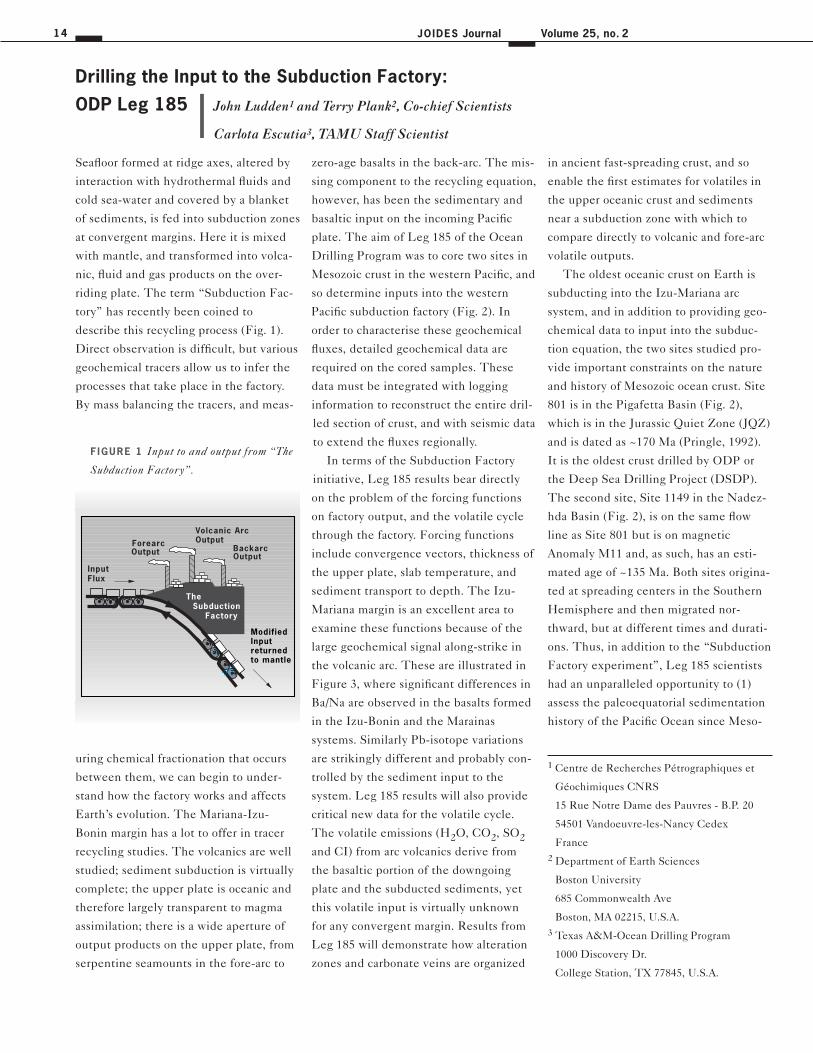
Seafloor formed at ridge axes, altered by
interaction with hydrothermal fluids and
cold sea-water and covered by a blanket
of sediments, is fed into subduction zones
at convergent margins. Here it is mixed
with mantle, and transformed into volca-
nic, fluid and gas products on the over-
riding plate. The term “Subduction Fac-
tory” has recently been coined to
describe this recycling process (Fig. 1).
Direct observation is difficult, but various
geochemical tracers allow us to infer the
processes that take place in the factory.
By mass balancing the tracers, and meas-
uring chemical fractionation that occurs
between them, we can begin to under-
stand how the factory works and affects
Earth’s evolution. The Mariana-Izu-
Bonin margin has a lot to offer in tracer
recycling studies. The volcanics are well
studied; sediment subduction is virtually
complete; the upper plate is oceanic and
therefore largely transparent to magma
assimilation; there is a wide aperture of
output products on the upper plate, from
serpentine seamounts in the fore-arc to
zero-age basalts in the back-arc. The mis-
sing component to the recycling equation,
however, has been the sedimentary and
basaltic input on the incoming Pacific
plate. The aim of Leg 185 of the Ocean
Drilling Program was to core two sites in
Mesozoic crust in the western Pacific, and
so determine inputs into the western
Pacific subduction factory (Fig. 2). In
order to characterise these geochemical
fluxes, detailed geochemical data are
required on the cored samples. These
data must be integrated with logging
information to reconstruct the entire dril-
led section of crust, and with seismic data
to extend the fluxes regionally.
In terms of the Subduction Factory
initiative, Leg 185 results bear directly
on the problem of the forcing functions
on factory output, and the volatile cycle
through the factory. Forcing functions
include convergence vectors, thickness of
the upper plate, slab temperature, and
sediment transport to depth. The Izu-
Mariana margin is an excellent area to
examine these functions because of the
large geochemical signal along-strike in
the volcanic arc. These are illustrated in
Figure 3, where significant differences in
Ba/Na are observed in the basalts formed
in the Izu-Bonin and the Marainas
systems. Similarly Pb-isotope variations
are strikingly different and probably con-
trolled by the sediment input to the
system. Leg 185 results will also provide
critical new data for the volatile cycle.
The volatile emissions (H2O, CO2, SO2
and CI) from arc volcanics derive from
the basaltic portion of the downgoing
plate and the subducted sediments, yet
this volatile input is virtually unknown
for any convergent margin. Results from
Leg 185 will demonstrate how alteration
zones and carbonate veins are organized
Drilling the Input to the Subduction Factory:
ODP Leg 185
Volcanic Arc Output
BackarcOutput
InputFlux
The Subduction Factory
ForearcOutput
ModifiedInput returned to mantle
F IGURE 1 Input to and output from “The
Subduction Factory”.
in ancient fast-spreading crust, and so
enable the first estimates for volatiles in
the upper oceanic crust and sediments
near a subduction zone with which to
compare directly to volcanic and fore-arc
volatile outputs.
The oldest oceanic crust on Earth is
subducting into the Izu-Mariana arc
system, and in addition to providing geo-
chemical data to input into the subduc-
tion equation, the two sites studied pro-
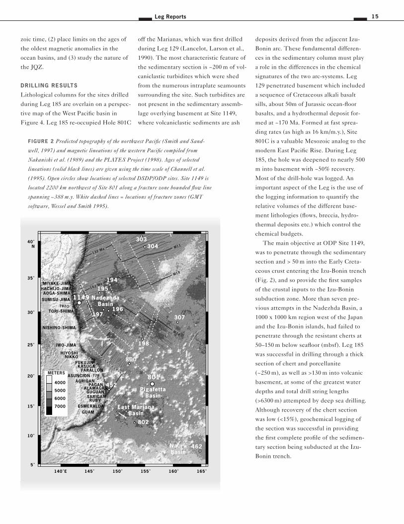
vide important constraints on the nature
and history of Mesozoic ocean crust. Site
801 is in the Pigafetta Basin (Fig. 2),
which is in the Jurassic Quiet Zone (JQZ)
and is dated as ~170 Ma (Pringle, 1992).
It is the oldest crust drilled by ODP or
the Deep Sea Drilling Project (DSDP).
The second site, Site 1149 in the Nadez-
hda Basin (Fig. 2), is on the same flow
line as Site 801 but is on magnetic
Anomaly M11 and, as such, has an esti-
mated age of ~135 Ma. Both sites origina-
ted at spreading centers in the Southern
Hemisphere and then migrated nor-
thward, but at different times and durati-
ons. Thus, in addition to the “Subduction
Factory experiment”, Leg 185 scientists
had an unparalleled opportunity to (1)
assess the paleoequatorial sedimentation
history of the Pacific Ocean since Meso-
John Ludden1 and Terry Plank2, Co-chief Scientists
Carlota Escutia3, TAMU Staff Scientist
1 Centre de Recherches Pétrographiques et
Géochimiques CNRS
15 Rue Notre Dame des Pauvres - B.P. 20
54501 Vandoeuvre-les-Nancy Cedex
France
2 Department of Earth Sciences
Boston University
685 Commonwealth Ave
Boston, MA 02215, U.S.A.
3 Texas A&M-Ocean Drilling Program
1000 Discovery Dr.
College Station, TX 77845, U.S.A.
Leg Reports 15
zoic time, (2) place limits on the ages of
the oldest magnetic anomalies in the
ocean basins, and (3) study the nature of
the JQZ.
DRILL ING RESULTS
Lithological columns for the sites drilled
during Leg 185 are overlain on a perspec-
tive map of the West Pacific basin in
Figure 4. Leg 185 re-occupied Hole 801C
off the Marianas, which was first drilled
during Leg 129 (Lancelot, Larson et al.,
1990). The most characteristic feature of
the sedimentary section is ~200 m of vol-
caniclastic turbidites which were shed
from the numerous intraplate seamounts
surrounding the site. Such turbidites are
not present in the sedimentary assemb-
lage overlying basement at Site 1149,
where volcaniclastic sediments are ash
deposits derived from the adjacent Izu-
Bonin arc. These fundamental differen-
ces in the sedimentary column must play
a role in the differences in the chemical
signatures of the two arc-systems. Leg
129 penetrated basement which included
a sequence of Cretaceous alkali basalt
sills, about 50m of Jurassic ocean-floor
basalts, and a hydrothermal deposit for-
med at ~170 Ma. Formed at fast sprea-
ding rates (as high as 16 km/m.y.), Site
801C is a valuable Mesozoic analog to the
modern East Pacific Rise. During Leg
185, the hole was deepened to nearly 500
m into basement with ~50% recovery.
Most of the drill-hole was logged. An
important aspect of the Leg is the use of
the logging information to quantify the
relative volumes of the different base-
ment lithologies (flows, breccia, hydro-
thermal deposits etc.) which control the
chemical budgets.
The main objective at ODP Site 1149,
was to penetrate through the sedimentary
section and > 50 m into the Early Creta-
ceous crust entering the Izu-Bonin trench
(Fig. 2), and so provide the first samples
of the crustal inputs to the Izu-Bonin
subduction zone. More than seven pre-
vious attempts in the Nadezhda Basin, a
1000 x 1000 km region west of the Japan
and the Izu-Bonin islands, had failed to
penetrate through the resistant cherts at
50–150 m below seafloor (mbsf). Leg 185
was successful in drilling through a thick
section of chert and porcellanite
(~250 m), as well as >130 m into volcanic
basement, at some of the greatest water
depths and total drill string lengths
(>6300 m) attempted by deep sea drilling.
Although recovery of the chert section
was low (<15%), geochemical logging of
the section was successful in providing
the first complete profile of the sedimen-
tary section being subducted at the Izu-
Bonin trench.
140˚E 145˚ 150˚ 155˚ 160˚ 165˚
5˚
10˚
15˚
20˚
25˚
30˚
35˚
40˚N
132 Ma
142 Ma
152 Ma
7000
6000
5000
4000
METERS
M11
M18
M24
778
ESMERALDARUBY
SARIGANGUGUAN
ALAMAGANPAGAN
AGRIGANASUNCION
FARALLONKASUGA
FUKUJINNIKKO
HIYOSHI
IWO-JIMA
NISHINO-SHIMA
782
TORI-SHIMA
SUMISU-JIMA
AOGA-SHIMAHACHIJO-JIMAMIYAKE-JIMA
GUAM
198
452
800
802
801
194
195
196197
304303
1149
462
307
NauruBasin
East MarianaBasin
PigafettaBasin
NadezhdaBasin
198
452
800
802
801
194
195
196197
304303
1149
462
307
NauruBasin
East MarianaBasin
PigafettaBasin
NadezhdaBasin
F IGURE 2 Predicted topography of the northwest Pacific (Smith and Sand-
well, 1997) and magnetic lineations of the western Pacific compiled from
Nakanishi et al. (1989) and the PLATES Project (1998). Ages of selected
lineations (solid black lines) are given using the time scale of Channell et al.
(1995). Open circles show locations of selected DSDP/ODP sites. Site 1149 is
located 2200 km northwest of Site 801 along a fracture zone bounded flow line
spanning ~388 m.y. White dashed lines = locations of fracture zones (GMT
software, Wessel and Smith 1995).
JOIDES Journal16 Volume 25, no. 2
SAMPLING STRATEGY FOR GEOCHE-
MICAL MASS-BALANCE STUDIES
Integration of the logging information
and the geochemical data is essential to
reconstructing the chemical fluxes con-
trolled by the altered upper oceanic crust
and overlying sediments. As the two sites
represent the first deep basement pene-
tration near a subduction zone they pro-
vide an unparalleled opportunity to eva-
luate geochemical fluxes to the Subduc-
tion Factory. For example, Figure 5
shows some of the initial results for the
basement section in Hole 801C presen-
ting logging results, volume % of vein
material, and the main lithological fea-
tures. Leg 185 was staffed with a large
number of geochemists and the success of
the Leg can only be evaluated when the
data become available. Nonetheless, the
sampling strategy was aimed at providing
the first comprehensive data suite for
8006004002000
20
40
60
80
100
120
140
Ba sediment flux (g/yr)
Ba
/Na
in
arc
ba
salt
s
R2 = 0.924
G
Al
J
TMex
Ant
Mar
802 800 801
Marianavolcanics
Izuvolcanics
Marianasedimentflux
400 mchert
Izu ?
Hole 129-801Caveragesediments
MORB������������������������������������������������������������������������������������������������������������������������
@@@@@@@@@@@@@@@@@@@@@@@@@@@@@@@@@@@@@@@@@@@@@@@@@@@@@@@@@@@@@@@@@@@@@@@@@@@@@@@@@@@@@@@@@@@@@@@@@@@@@@@@@@@@@@@@@@@@@@@@
������������������������������������������������������������������������������������������������������������������������
ÀÀÀÀÀÀÀÀÀÀÀÀÀÀÀÀÀÀÀÀÀÀÀÀÀÀÀÀÀÀÀÀÀÀÀÀÀÀÀÀÀÀÀÀÀÀÀÀÀÀÀÀÀÀÀÀÀÀÀÀÀÀÀÀÀÀÀÀÀÀÀÀÀÀÀÀÀÀÀÀÀÀÀÀÀÀÀÀÀÀÀÀÀÀÀÀÀÀÀÀÀÀÀÀÀÀÀÀÀÀÀÀÀÀÀÀÀÀÀÀ
������������������������������������������������������������������������������������������������������������������������
@@@@@@@@@@@@@@@@@@@@@@@@@@@@@@@@@@@@@@@@@@@@@@@@@@@@@@@@@@@@@@@@@@@@@@@@@@@@@@@@@@@@@@@@@@@@@@@@@@@@@@@@@@@@@@@@@@@@@@@@
������������������������������������������������������������������������������������������������������������������������
ÀÀÀÀÀÀÀÀÀÀÀÀÀÀÀÀÀÀÀÀÀÀÀÀÀÀÀÀÀÀÀÀÀÀÀÀÀÀÀÀÀÀÀÀÀÀÀÀÀÀÀÀÀÀÀÀÀÀÀÀÀÀÀÀÀÀÀÀÀÀÀÀÀÀÀÀÀÀÀÀÀÀÀÀÀÀÀÀÀÀÀÀÀÀÀÀÀÀÀÀÀÀÀÀÀÀÀÀÀÀÀÀÀÀÀÀÀÀÀÀ
20191817
37.0
37.5
38.0
38.5
39.0
39.5
206 Pb / 204 Pb
MarianaArc
PacificMORB
Izu-BoninArc
20
8P
b/
20
4P
b ?
? Hole 129-801Caverage
A B
altered oceanic basement and involved
scientists sharing common samples in
order to cover a complete spectrum of
analyses. This communal sampling stra-
tegy involved over 40 major and trace ele-
ments, as well as isotopes of Pb, Nd, Sr,
Os, Hf, Li, B, Be, Cl, S, Se, C, N, O and
H. Some samples having different
degrees of alteration will be mixed to pro-
vide “composites” which will serve as
geochemical reference samples in the
construction of global models for the
Geochemical Earth Reference Model
(GERM).
In addition to providing the samples
and logs required for the Subduction Fac-
tory experiment, Leg 185 made the follo-
wing important discoveries, which are
summarised below and developed further
in the Initial Reports volume (Plank,
Ludden, Escutia, and the Leg 185
Scientific Party).
OPUNCTUATED ALTERATION –
A CHARACTERIST IC OF
FAST-SPREADING CRUST?
In contrast to the decrease in oxidative
alteration that occurs with depth at other
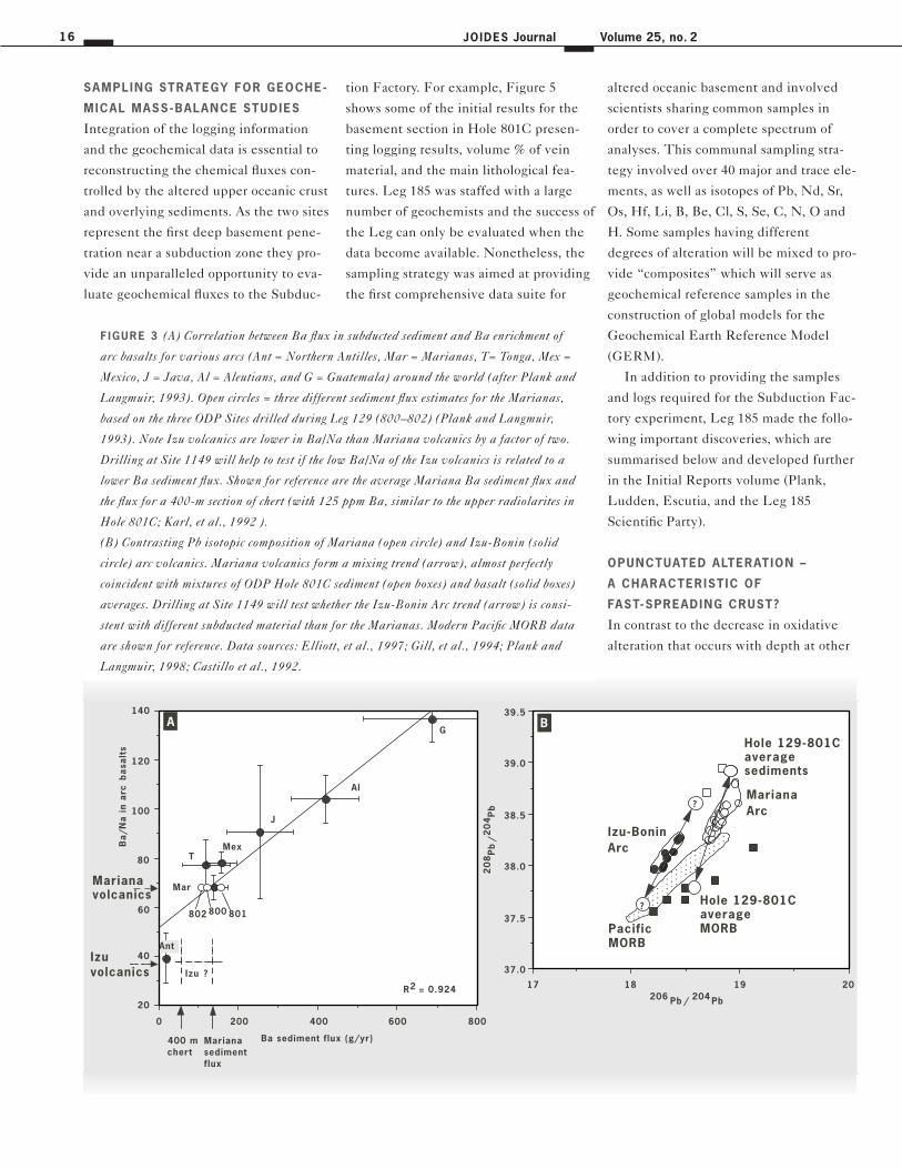
F IGURE 3 (A) Correlation between Ba flux in subducted sediment and Ba enrichment of
arc basalts for various arcs (Ant = Northern Antilles, Mar = Marianas, T= Tonga, Mex =
Mexico, J = Java, Al = Aleutians, and G = Guatemala) around the world (after Plank and
Langmuir, 1993). Open circles = three different sediment flux estimates for the Marianas,
based on the three ODP Sites drilled during Leg 129 (800–802) (Plank and Langmuir,
1993). Note Izu volcanics are lower in Ba/Na than Mariana volcanics by a factor of two.
Drilling at Site 1149 will help to test if the low Ba/Na of the Izu volcanics is related to a
lower Ba sediment flux. Shown for reference are the average Mariana Ba sediment flux and
the flux for a 400-m section of chert (with 125 ppm Ba, similar to the upper radiolarites in
Hole 801C; Karl, et al., 1992 ).
(B) Contrasting Pb isotopic composition of Mariana (open circle) and Izu-Bonin (solid
circle) arc volcanics. Mariana volcanics form a mixing trend (arrow), almost perfectly
coincident with mixtures of ODP Hole 801C sediment (open boxes) and basalt (solid boxes)
averages. Drilling at Site 1149 will test whether the Izu-Bonin Arc trend (arrow) is consi-
stent with different subducted material than for the Marianas. Modern Pacific MORB data
are shown for reference. Data sources: Elliott, et al., 1997; Gill, et al., 1994; Plank and
Langmuir, 1998; Castillo et al., 1992.

17Leg Reports
sites in the oceans, the MORB basement
at Site 801C is punctuated by discrete
zones of alteration between intervals of
minimally altered basalt (see Fig. 5).
These discrete zones occur adjacent to
ocherous, Fe-Si-rich, low temperature
hydrothermal deposits, and near breccia
deposits probably related to near-axis
faults. Away from these alteration zones,
fresh basaltic glass occurs abundantly,
demonstrating the spatially heteroge-
neous nature of seafloor alteration. Hole
801C is the only site to sample a
significant portion of Layer 2A in fast-
spreading crust, and so this organization
of alteration zones near hydrothermal
deposits and faults may be the hallmark
of fast spreading crust. In order to quan-
tify the visual descriptions, ground-truth
the logs, and determine the timing of
alteration events, a common set of sam-
ples of Site 801C basement lithologies
has been taken for all geochemical inve-
stigators.
CONTRASTING SEDIMENT INPUT
TO THE MARIANA AND IZU
SUBDUCTION ZONES
Having cored for the first time through
the entire sedimentary section subduc-
ting at the Izu-Bonin margin, Leg 185
enables comparison of the inputs to the
Mariana and Izu arcs. In contrast to the
East Mariana and Pigafetta Basin sedi-
ments subducting at the Marianas trench,
the Nadezhda Basin sediments lack a
mid-Cretaceous volcaniclastic section,
and contain more siliceous and carbonate-
rich biogenic material due to its longer
passage beneath zones of high biological
productivity. Shorebased geochemical
studies of communal samples will demon-
strate the extent to which these different
sedimentary histories can be traced to the
volcanic output from the two arc systems.
For example, does the sedimentary and
basaltic input on the in-coming plate pro-
vide suitable Pb isotope mixing end-
members for the Izu arc volcanics, or are
other mantle and upper plate sources
required? Does the extensive biogenic
section in the lower half of Site 1149,
which is highly depleted in alkali ele-
ments, contribute to the low alkali con-
tent of the Izu arc?
MESOZOIC AND CENOZOIC
PELAGIC SEQUENCES
The equatorial paleolatitude history of
Site 1149 during the mid-Cretaceous,
combined with a predictable subsidence
history, is ideal for testing variations in
the Cretaceous CCD. Site 1149 sedi-
ments also record a well-developed
metalliferous sedimentary profile, which
776778
452
199
801
800
782
1149
195
197
776778
452
199
801
800
782
1149
195
197
NISHINO-SHIMA
TORI-SHIMA
SUMISU-JIMA
AOGA-SHIMA
HACHIJO-JIMA
MIYAKE-JIMA
OSHIMA
140˚E
145˚
150˚
155˚
160˚
15˚
20˚
25˚
30˚N
GUAM
ESMERALDA
SAIPAN
RUBY
SARIGAN
GUGUAN
ALAMAGAN
PAGAN
AGRIGAN
ASUNCION
FARALLON
KASUGA
FUKUJIN
NIKKO
HIYOSHI
IWO-JIMA
Leg 129
Hole 1149D
MORB
Site 801B
ajo
cia
n-V
ala
ng
inia
n170 Ma
462
Dark brownpelagic clay
120
U.
Cre
t.
Brownradiolarite
318
Alkali basalt
64
Volcaniclasticturbidites
Brown chertand porcellanite
Alb
ian
Hydrothermal
936 mbsf
Site 1149 M11, 132 Ma
180
120
Ash anddiatomad.diatomad.clay
Dark brownpelagic clay
Rad. chertand zeoliteclay
Ash anddiatom/rad.clay
Dark brownpelagic clay
Rad. chertand zeoliteclay
410
Rad. chert andsiliceousnannofossilmarl
280
Basalt
Hole 1149A/B
307
272
440
MORBTholeiites
Leg 185
594
F IGURE 4 Perspective map of Izu
Mariana arcs and Leg 185 drilling sites,
Sites 801 and 1149. Predicted bathyme-
try based on satellite altimetry [Smith
and Sandwell (1997)] and GMT soft-
ware (Smith and Wessel, 1990).

JOIDES Journal18 Volume 25, no. 2
ble samples that record mid-ocean ridge
processes, mantle composition and
mantle temperature at a time preceding
the Cretaceous superplume event in the
Rapid Polarity Alternations during the
Jurassic Magnetic Quiet Zone.
Hole 801C Jurassic basement records
up to six geomagnetic reversals. Not only
are there several reversals, but some sec-
tions preserve gradual changes in the
magnetic field direction from one polarity
interval to the other. Thus igneous base-
ment at 801C was extruded at a time of
rapid polarity alternations of the geoma-
gnetic field. These data may provide an
explanation for the Jurassic “Quiet” zone
in a series of superposed flows with oppo-
site polarity, essentially canceling out one
another. The presence of fresh basaltic
glass at depth in 801C will also provide
suitable material for paleo-intensity stu-
dies, to test the hypothesis that the Juras-
sic Quiet Zone was a time of low geoma-
gnetic field intensity.
THE DEEP B IOSPHERE
Leg 185 was the first ODP leg to invest a
significant effort in equipping a microbio-
logy laboratory carrying out microbial
contaminant tests, and establishing tech-
niques for core handling biological sam-
ples. The initial results and the strategy
documents clearly the decreasing influ-
ence of hydrothermal plume precipitation
with distance from the ridge. Very high
sediment accumulation rates (~ 30 m/Ma)
and the mineral composition of the youn-
gest sediments suggest that Site 1149 was
in the reach of the Asian dust plumes
after the early Pleistocene. An extensive
Miocene to Pleistocene ash record preser-
ves a history of Izu-Bonin volcanism, and
represents a cannibalistic flux to the sub-
duction zone.
MESOZOIC PACIF IC BASALTIC GLASS
Fresh basaltic glass recovered from both
Sites 1149 and 801 provide pristine sam-
ples of the igneous liquid that forms
Mesozoic Pacific crust. These are valua-
������������������������������������������������������������������������������������������������������������������������������������������������������������������������������������������������������������
@@@@@@@@@@@@@@@@@@@@@@@@@@@@@@@@@@@@@@@@@@@@@@@@@@@@@@@@@@@@@@@@@@@@@@@@@@@@@@@@@@@@@@@@@@@@@@@@@@@@@@@@@@@@@@@@@@@@@@@@@@@@@@@@@@@@@@@@@@@@@@@@@@@@@@@@@@@@@@@@@@@@@@@@@@@@@@@@@@@@@@@@@@@@@@@@@@@@@@@@@@@@
������������������������������������������������������������������������������������������������������������������������������������������������������������������������������������������������������������
ÀÀÀÀÀÀÀÀÀÀÀÀÀÀÀÀÀÀÀÀÀÀÀÀÀÀÀÀÀÀÀÀÀÀÀÀÀÀÀÀÀÀÀÀÀÀÀÀÀÀÀÀÀÀÀÀÀÀÀÀÀÀÀÀÀÀÀÀÀÀÀÀÀÀÀÀÀÀÀÀÀÀÀÀÀÀÀÀÀÀÀÀÀÀÀÀÀÀÀÀÀÀÀÀÀÀÀÀÀÀÀÀÀÀÀÀÀÀÀÀÀÀÀÀÀÀÀÀÀÀÀÀÀÀÀÀÀÀÀÀÀÀÀÀÀÀÀÀÀÀÀÀÀÀÀÀÀÀÀÀÀÀÀÀÀÀÀÀÀÀÀÀÀÀÀÀÀÀÀÀÀÀÀÀÀÀÀÀÀÀÀÀÀÀÀÀÀÀÀÀÀÀÀÀ
������������������������������������������������������������������������������������������������������������������������������������������������������������������������������������������������������������
@@@@@@@@@@@@@@@@@@@@@@@@@@@@@@@@@@@@@@@@@@@@@@@@@@@@@@@@@@@@@@@@@@@@@@@@@@@@@@@@@@@@@@@@@@@@@@@@@@@@@@@@@@@@@@@@@@@@@@@@@@@@@@@@@@@@@@@@@@@@@@@@@@@@@@@@@@@@@@@@@@@@@@@@@@@@@@@@@@@@@@@@@@@@@@@@@@@@@@@@@@@@
������������������������������������������������������������������������������������������������������������������������������������������������������������������������������������������������������������
ÀÀÀÀÀÀÀÀÀÀÀÀÀÀÀÀÀÀÀÀÀÀÀÀÀÀÀÀÀÀÀÀÀÀÀÀÀÀÀÀÀÀÀÀÀÀÀÀÀÀÀÀÀÀÀÀÀÀÀÀÀÀÀÀÀÀÀÀÀÀÀÀÀÀÀÀÀÀÀÀÀÀÀÀÀÀÀÀÀÀÀÀÀÀÀÀÀÀÀÀÀÀÀÀÀÀÀÀÀÀÀÀÀÀÀÀÀÀÀÀÀÀÀÀÀÀÀÀÀÀÀÀÀÀÀÀÀÀÀÀÀÀÀÀÀÀÀÀÀÀÀÀÀÀÀÀÀÀÀÀÀÀÀÀÀÀÀÀÀÀÀÀÀÀÀÀÀÀÀÀÀÀÀÀÀÀÀÀÀÀÀÀÀÀÀÀÀÀÀÀÀÀÀÀ
500
520
540
560
580
600
620
640
660
680
700
720
740
760
780
800
820
840
860
880
900
920
1R2R3R4R5R6R7R
9R10R11R12R13R14R15R16R17R18R19R20R
22R23R24R25R26R27R28R29R30R31R32R33R34R35R36R37R38R39R40R41R42R43R44R45R46R47R48R49-52M49-52M
Rec
o-ve
ryDepth(mbsf) C
ore
HydrothermalUnit
V. Lower
VII. Breccia
VI. LowerMassive
Flows
II I . UpperMassive
Flows
VII I. LowerPil lows
andFlows
IV. UpperPil lows
andFlows
SequencesI . Alkal i
Basalt f lows
Caliperdeviation
(in)
Resistivity(Wm)
Total naturalgamma
(API unit)
Cooling unitthickness
(m)
Basement lithology
(%)
Vein width(mm)
Veins/meterAlteration halosin core(vol%)
10 15 20 10 100 0 40 80 0 5 10 15 50 10 0.0 0.5 1.0 250 50
�����������������������������������������������������������������������������������������������������������������������������������������������������������������������������������������������������������������������������������������������������
@@@@@@@@@@@@@@@@@@@@@@@@@@@@@@@@@@@@@@@@@@@@@@@@@@@@@@@@@@@@@@@@@@@@@@@@@@@@@@@@@@@@@@@@@@@@@@@@@@@@@@@@@@@@@@@@@@@@@@@@@@@@@@@@@@@@@@@@@@@@@@@@@@@@@@@@@@@@@@@@@@@@@@@@@@@@@@@@@@@@@@@@@@@@@@@@@@@@@@@@@@@@@@@@@@@@@@@@@@@@@@@@@@@@@@@@@@@@@@@@@@@@@
�����������������������������������������������������������������������������������������������������������������������������������������������������������������������������������������������������������������������������������������������������
ÀÀÀÀÀÀÀÀÀÀÀÀÀÀÀÀÀÀÀÀÀÀÀÀÀÀÀÀÀÀÀÀÀÀÀÀÀÀÀÀÀÀÀÀÀÀÀÀÀÀÀÀÀÀÀÀÀÀÀÀÀÀÀÀÀÀÀÀÀÀÀÀÀÀÀÀÀÀÀÀÀÀÀÀÀÀÀÀÀÀÀÀÀÀÀÀÀÀÀÀÀÀÀÀÀÀÀÀÀÀÀÀÀÀÀÀÀÀÀÀÀÀÀÀÀÀÀÀÀÀÀÀÀÀÀÀÀÀÀÀÀÀÀÀÀÀÀÀÀÀÀÀÀÀÀÀÀÀÀÀÀÀÀÀÀÀÀÀÀÀÀÀÀÀÀÀÀÀÀÀÀÀÀÀÀÀÀÀÀÀÀÀÀÀÀÀÀÀÀÀÀÀÀÀÀÀÀÀÀÀÀÀÀÀÀÀÀÀÀÀÀÀÀÀÀÀÀÀÀÀÀÀÀÀÀÀÀÀÀÀÀÀÀÀÀ
�����������������������������������������������������������������������������������������������������������������������������������������������������������������������������������������������������������������������������������������������������
������
������
�����
�����
������
������������
�����
����������
0 50 100
LEG
18
5LE
G 1
29
Hole 801C
IV.
��Flows
��Pillows/Flows
��������@@@@@@@@��������ÀÀÀÀÀÀÀÀ��������@@@@@@@@��������ÀÀÀÀÀÀÀÀ��������@@@@@@@@��������ÀÀÀÀÀÀÀÀ��������@@@@@@@@��������ÀÀÀÀÀÀÀÀ��������@@@@@@@@��������ÀÀÀÀÀÀÀÀ��������@@@@@@@@��������ÀÀÀÀÀÀÀÀ��������@@@@@@@@��������ÀÀÀÀÀÀÀÀ��������Pillows
������@@@@@@������ÀÀÀÀÀÀ������@@@@@@������ÀÀÀÀÀÀ������@@@@@@������ÀÀÀÀÀÀ������@@@@@@������ÀÀÀÀÀÀ������@@@@@@������ÀÀÀÀÀÀ������@@@@@@������ÀÀÀÀÀÀ������@@@@@@������ÀÀÀÀÀÀ������@@@@@@������ÀÀÀÀÀÀBreccia Sediment Hydrothermal
0.8 mm 20/m
I I . Upper Hydro-thermal Unit
F IGURE 5 Basement igneous stratigraphy,
logging results and alteration features
down-core for ODP Site 801C.
are described in Smith et al. (in press and
online). Contaminant tests using
perfluorocarbon and fluorescent micros-
phere tracers demonstrated that sedi-
ments cored with the APC showed less
susceptibility to contamination than RCB
coring. In fact, several APC core interiors
were entirely free of contaminants, and
both APC and RCB core interiors were
free of the microsphere tracers. These
tests, which demonstrate that biological
contamination can be assessed and sur-
mounted, pave the way for establishing
ODP as a new platform for microbiologi-
cal studies. Leg 185 samples are being
used to start culturing experiments in
various media at both atmospheric and in
situ pressure, and to begin shorebased
DNA extraction and community characte-
rization.
Several glass samples from Site 801C
show textural evidence for microbial alte-
ration and invite the intriguing question
of whether there is still microbiological
activity in 170 Ma volcanic basement (see
Fisk et al., 1999).
For more information see:
http://www-odp.tamu.edu/publications/
http://www.crpg.cnrs-nancy.fr/Science/
Leg185/
LEG 182 SHIPBOARD
SCIENTIF IC PARTY
John Ludden and Terry Plank, Co-chief
Scientists; Carlota Escutia, TAMU Staff
Scientist; Lewis Abrams, Jeffery Alt,
Robin Armstrong, Samantha Barr,
Annachiara Bartolini, Graeme Cairns,
Martin Fisk, Giles Guerin, Shelley Have-
man, Tetsuro Hirono, Jose Honnorez,
Katherine Kelley, Roger Larson, France-
sca Lozar, Richard Murray, Thomas
Pletsch, Robert Pockalny, Olivier Rouxel,
Angelika Schmidt, David Smith, Arthur
Spivack, Hubert Staudigel, Maureen Stei-
ner, Robert Valentine.
REFERENCES
Castillo, P. R., Floyd, P A., and France-
Lanord, C., 1992. Data Report: Sum-
mary of geochemical data for Leg 129
igneous rocks. In Larson, R.L., Lance-
lot, Y., et al., Proc. ODP, Sci. Results,
129: College Station, TX (Ocean Dril-
ling Program), 653-670.
Channell, J. E. T., Erba, E., Nakanishi,
M., and Tamaki, K., 1995. Late Juras-
sic-Early Cretaceous time scales and
oceanic magnetic anomaly block
models. In Berggren, W. A., Kent,
D. V., Aubry, M. P., Hardebol, J. (Eds.),
Geochronology, Time Scales and Global
Stratigraphic Correlations. SEPM Spec.
Pub., 54: 51–63.
Elliott, T., Plank, T., Zindler, A., White,
W., and Bourdon, B., 1997. Element
transport from subducted slab to volca-
nic front at the Mariana Arc, J. Geophys.
Res., 102: 14991–15019.
Fisk, M. and the Leg 185 Shipboard
Party (1999). New shipboard laboratory
may answer questions about deep bios-
phere. EOS, 80: 580.
Gill, J. B., Hiscott, R. N., and Vidal, P. H.,
1994. Turbidite geochemistry and evo-
lution of the Izu Bonin Arc and conti-
nents. Lithos, 33: 135–168.
Karl, S. M., Wandless, G. A. and Karpoff,
A. M. 1992. Sedimentological and geo-
chemical characteristics of Leg 129
siliceous deposits. In Larson, R.L.,
Lancelot, Y. et al., 129: Proc. ODP, Sci.
Results, 129: College station, TX
(Ocean Drilling Program), 31–79.
Lancelot, Y., Larson, R., et al., 1990. Proc.
ODP, Init. Repts., 129: College Station,
TX (Ocean Drilling Program).
Nakanishi, M., Tamaki, K., and
Kobayashi, K., 1988. Mesozoic mag-
netic anomaly lineations and seafloor
spreading history of the northwestern
Pacific, J. Geophys. Res., 94:15,
437–15,462.
Plank, T., Ludden, J., Escutia, C., et al.,
in press, Proc. ODP, Init. Repts. 185
[CD-ROM]. Available from: Ocean
Drilling Program, Texas A & M Uni-
versity, College Station, TX 77845-
9547, U.S.A.
Plank, T. and Langmuir, C. H., 1998. The
chemical composition of subducting
sediment: implications for the crust
and mantle. Chem. Geol.,145: 325–394.
Pringle, M. S., 1992. Radiometric ages of
basaltic basement recovered at Sites
800, 801, and 802, Leg 129, Western
Pacific Ocean. In Larson, R.L., Lance-
lot, Y. et al., 129: Proc. ODP, Sci.
Results, 129: College station, TX
(Ocean Drilling Program), 471–481.
Smith, D. C., A. J., Spivack, M. R., Fisk,
S. A., Haveman, H., Staudigel, H., and
ODP Leg 185 Shipboard Scientific
Party (In press). Tracer-based estima-
tes of drilling-induced microbial con-
tamination of deep sea crust. Geomicro-
biology Journal.
Smith, D. C., A. J., Spivack, M. R., Fisk,
S. A., Haveman, H., Staudigel, H., and
the Leg 185 Shipboard Scientific Party.
Methods for quatifying potential
microbial contamination during deep
ocean coring. ODP Tech. Note, in press
[online].
Smith, W. H. F., and Sandwell, D. T.,
1997. Global Sea Floor Topography
from Satellite Altimetry and Ship
Depth Surroundings. Science 277:
1956–1962.
Smith, W. H. F., and Wessel, P., 1990.
Gridding with continuous curvature
splines in tension. Geophysics, 55:
293–305.
Wessel, P. and Smith, W. H. F. 1995. New
version of the generic Mapping tools
released. EOS, 329.
Leg Reports 19
INTRODUCTION
Most of the worlds great earthquakes and
tsunamis are generated by rupture on the
“seismogenic zone” of subduction thrust
faults. An important project in future
scientific ocean drilling, especially of the
OD21 riser ship scientific program, is to
drill through and make detailed measure-
ments and recordings in the parts of sub-
duction thrust faults that generate great
earthquakes. The objectives are an
improved understanding of the physical
and chemical processes responsible for
earthquakes, and seismic hazard reduc-
tion for the very destructive great earth-
quakes that occur on these faults. Some
of the important questions are:
1. What controls the earthquake cycle of
elastic strain build-up and sudden
JOIDES Journal20 Volume 25, no. 2
Seismogenic Zone Deep Drilling and Measurement
Report of the Detailed Planning
Group
By R. D. Hyndman1, J. Ashi, K. Brown, P. Favali, P. Harjes,P. Huchon, M. Kastner, S. Kodaira, C. Moore, S. Peacock1,L. Ruff, E. Silver, M. Zoback
rupture: what are the stress, pore pres-
sure and chemical changes?
2. Are there specific changes of stress,
pore pressure, pore fluid chemistry or
other parameters with time, that
define increasing probability of great
earthquakes?
3. What controls the parts of subduction
thrusts that are seismic and aseismic,
especially the seaward updip and land-
ward downdip limits?
4. What is the nature of asperities on the
megathrust fault that are inferred to
be stronger and generate large earth-
quake slip compared to areas that may
have significant aseismic creep?
5. What is the nature of “tsunami earth-
quakes”? Why do some large slip
events have most stress release in the
seismic motion of great earthquakes,
whereas others have slower slip that
generates only moderate earthquakes
but large tsunamis?
The SEIZE (Seismogenic Zone Experi-
ment) Detailed Planning Group (DPG)
addressed mainly scientific questions,
but also considered the technical capabi-
lities required to meet the scientific
objectives and the possible technical
limitations to drilling and measurement.
THE RISER DRILLSHIP CAPABIL IT IES
Several previous workshops and reports
dealt with studies of the subduction seis-
mogenic zone in general (1, 3), and
scientific riser drilling (2). Important
relevant information also is found in the
proposal for drilling the San Andreas
Fault (4) and results from the German
KTB well. This DPG dealt primarily
with drilling by the OD 21 riser drill ship
in the Japan area, but shallower penetra-
tion drilling by the present JOIDES
Resolution and future non-riser drill
ships was also considered. Transects
across subduction zone margins including
deep riser holes and shallower non-riser
holes near the trench are needed to meet
the scientific objectives. A drill ship with
a riser that allows return circulation and
seals the hole during drilling is necessary
both for deep drilling and for extensive
downhole measurement and recording
Important capabilities in addition to the
greater hole depth that will be possible
1 Geological Survey of Canada, Pacific
Geoscience Centre
9860 W. Saanich Rd., P.O. Box 6000
Sidney, BC V8L 4B2, Canada
THE SEISMOGENIC ZONE DPG
Goal
To define a comprehensive study of an active seismogenic zone that will investigate the
physical and chemical processes that control earthquake nucleation and propagation.
This will include development of a coordinated drilling plan, and identification of drilling,
monitoring, technological, and site survey requirements. This study will be the first proj-
ect to be undertaken by IODP using the new riser drilling ship.
Mandate
To work with other appropriate international geoscience initiatives to:
• Define the detailed scientific objectives of drilling and monitoring an active seismogenic
zone.
• Develop a coordinated drilling strategy to complete the defined objectives that will
likely include an integrated program of non-rise and riser drilling.
• Identify potential geographic areas as targets for drilling that are in the vicinity of
Japan.
• Determine the site survey requirements both for deep drilling and to maximize the
scientific results from seismogenic zone drilling.
• Determine the drilling technologies/facilities, downhole measurements and sampling,
and long-term monitoring that will be required.
• Solicit proposals for experiments or investigative strategies that might be included.
Leg Reports 21
with the OD21-ship compared to the JOI-
DES Resolution are:
1. The increased hole stability made pos-
sible by circulation of drilling mud,
2. The balancing of formation pressure
with mud weight, especially where
overpressured,
3. The blowout preventer permitting dril-
ling in areas that may contain hydro-
carbons,
4. The continuous cuttings sample return,
and much higher quality core recovery,
5. The much higher quality of downhole
geophysical logs made possible by the
constant diameter (gauge) hole result-
ing from stabilization by drilling mud,
6. The access to the hole through large
diameter casing permiting use of larger
diameter logging tools, instruments
and experiments than have been pos-
sible using the JOIDES Resolution.
The OD 21 riser drill ship has a planned
initial capability of 2,500 m riser length,
to be extended in later development
phases, and a 10,000 m drill string. The
first OD21 drilling is to be in the Japan
area; initial study shows that most sites
around Japan where the water depths are
less than 2,500 m, require over 5 km
penetration to the seismogenic zone.
Such penetration involves potential tech-
nical difficulties and drilling times of
several years. However, several sites off
SW Japan (Nankai Trough) appear to
require less penetration although they
may have atypical structure. Careful
study is needed to find suitable sites
requiring the minimum penetration to
reach the seismogenic zone. The search
for the best initial site will require addi-
tional 2D and 3D multichannel and other
seismic data.
SCIENTIF IC REQUIREMENTS
FOR S ITE SELECTION
The DPG did not review in detail the
available site survey and previous studies
for the Japan region or other possible
sites globally. However, some of the
important site needs that were identified
are listed here:
1. A subduction zone where the tecto-
nics, structure, thermal regime, and
earthquakes are very well studied and
well known. Previous shallow drilling
of the subduction thrust and on the
continental slope in the area of the
proposed deep site would be essential.
The regions should be structurally
simple with an inferred decollement
that is fairly stable in position and
depth with time.
2. Shallow plate dip and shallow trench
such that the subduction thrust fault
can be reached by OD21 drilling in a
reasonable time, i.e., less than 5 km
penetration. This appears to require
sites where young oceanic plates are
being subducted. It is recognized that
young plates also imply high tempera-
tures and thus drilling and measure-
ment difficulties. In addition to the
greater drilling time and greater
potential for failure, deeper subduc-
tion thrusts can be less well characteri-
zed because of the decreased resolu-
tion of seismic and other signals with
depth.
3. Accretionary prism sediments are
expected to be readily penetrated by
the OD21 drilling. A low temperature
gradient (heat flow) is desirable by the
OD21 drilling.
4. The subduction thrust should be
accessible to non-riser drilling seaward
from the main deep riser site that
penetrates the seismogenic zone. The
2,500 m water depth limit does not
apply to non-riser drilling, but the
practical maximum penetration for
non-riser drilling is probably less than
2 km. At Nankai Trough (Site 808)
penetration of 1,300 m through the
décollement into basement was achie-
ved with some difficulty, and there
have been considerable drilling
difficulties experienced previously for
penetration greater than 1 km in
accretionary prisms.
Non-riser drilling of an out-of-
sequence thrust fault, connected to
the décollement and well imaged with
defined reflection polarity, is very
desirable.
5. A recent great earthquake within the
seismogenic zone that has been well
studied is needed to characterize the
seismogenic zone. A map of slip dis-
placement in the event is desirable.
Shorter earthquake return times
should mean a shorter time scale for
the changes associated with the great
earthquake cycle.
6. The subduction thrust should be well
imaged by multichannel seismic data,
especially in the area of the seismoge-
nic zone to be drilled. It is critical to
know the depth of the decollement,
and its thickness and reflection pola-
rity. Also the better the image of the
seismogenic zones the more readily
can the drilling data results and con-
clusions be extended laterally and to
other regions.
7. The locked part of the seismogenic
zone should be defined. This may be
achieved by, (a) determining the
updip and downdip limits of rupture
of past great earthquakes (seismic
modelling, aftershock distribution,
tsunami modelling), (b) analyzing the
distribution of intermediate size and
small earthquakes (especially with
thrust mechanisms) that define which
part of the thrust is seismic, (c) evalua-
tion of geodetic data (interseismic and
coseismic), both on land and if possi-
ble on the seafloor, that define the
locked zone and rupture zone. In a
few areas peninsulas allow land geode-
tic measurements sufficiently far sea-
ward to define the seaward as well as
landward limit of the locked zone.
JOIDES Journal22 Volume 25, no. 2
HAZARDS
The formation expected to be penetrated
off SW Japan is a young clastic accretion-
ary sedimentary prism. The main techni-
cal concerns for drilling the subduction
thrust and seismogenic zone are:
a. difficult formation conditions, i.e.,
unconsolidated unstable sediments,
high formation pressure, and high
temperatures;
b. storms, especially typhoons,
c. strong ocean currents, such as the
Kuroshiro current along most of the
Nankai Trough region.
Careful engineering design, and planning
are needed to deal with the typhoons and
strong currents. Additional thermal data
and modelling, geotechnical studies etc.
are needed to predict and design for the
formation conditions in a deep accretion-
ary prism borehole.
LONG TERM MONITORING
Although core and cutting sampling are
important to the SEIZE program, the
deep drilling should be considered pri-
marily as a method of access to the seis-
mogenic zone, allowing a wide range of
measurements and long-term recording.
The borehole is to become an observa-
tory. Many of the scientific objectives can
be achieved only through a comprehen-
sive and well prepared downhole meas-
urement and recording program.
The most important sampling, measure-
ment, and recording programs include:
1. geophysical and geological site charac-
terization studies,
2. measurements on core and cuttings,
3. analysis of fluid and gas samples,
4. downhole measurements,
5. long-term fault zone monitoring.
MANAGEMENT OF SEIZE DRILL ING
The planning and scientific operations
for long duration OD 21 programs will be
very different from the 2-month drilling
leg experience of ODP/DSDP. The DPG
recommends that an expert scientific
team be set up for each major OD21 pro-
gram such as SEIZE to develop detailed
scientific and operational plans, and to
carry through to the scientific program
onboard the ship during drilling and
measurement. The team should have
subgroups for each of the main scientific
components, including the required site
surveys and studies. The scientific team
must work closely with the JAMSTEC
drilling engineering and science groups
who are responsible for design, construc-
tion and operation of the OD21 drill
ship. The proposed scientific team need-
ed for a SEIZE drilling and measurement
program follows the 5 project elements
listed above. It may be appropriate to
have an initial competition for the most
qualified and most motivated participants
based upon proposals for each compo-
nent of the project. These proponents
then would prepare detailed science
plans for their part of the scientific pro-
gram. A small committee with represen-
tation from all of the components would
provide oversight to the science for the
whole SEIZE project. It is desirable for
the critical aspects of the project to be
funded together, including the most criti-
cal site surveys. Independent funding
should be only for site surveys, associa-
ted science, and those parts of the pro-
gram that are not essential to the overall
success of the project.
Further Information:
Full DPG-Report: http://www.joides.geo-
mar.de/files/seizerept.pdf
SEIZE Website:
http://www.soest.hawaii.edu/margins/SEI
ZE_sci_plan.html
1 The Seismogenic Zone Experiment
(SEIZE) Workshop, Waikoloa, Hawaii, June
3-6, 1997 (http://www.soest.hawaii.edu/mar
gins/SEIZE.html);
2 The International Conference on
Cooperative Ocean Riser Drilling
(CONCORD), Tokyo, Japan, 22-24, 1997
(http://www.jamstec.go.jp/jamstec/OD21/
CONCORD/state.html);
3 Costa Rica -–Nicaragua Seismogenic work-
shop report CriNiSEIZE;
4 Scientific Drilling into the San Andreas Fault
at Parkfield, CA: Project Overview and
Operational Plan
(http://pangea.Stanford.EDU/FZD/).
What are Detailed Planning Groups (DPG’s)
Detailed Planning Groups (DPGs) are short-lived planning groups that are created by SCI-
COM for more intensive study of certain aspects of planning that may arise. DPGs are
created by SCICOM with individual mandates that may be either scientifically or technolo-
gically based. DPGs provide written reports to SCICOM. Example tasks for DPGs include:
translating highly-ranked ODP science proposals into concrete drilling plans; advising on
regional and site surveys needed for future drilling; preparing drilling prospectuses which
synthesize all thematic and site survey input, etc.
Members of DPGs are chosen by SCICOM for their expertise and experience with
respect to the assigned DPG mandate. Each full member of ODP has the right of repre-
sentation. DPGs are disbanded once their task is completed.
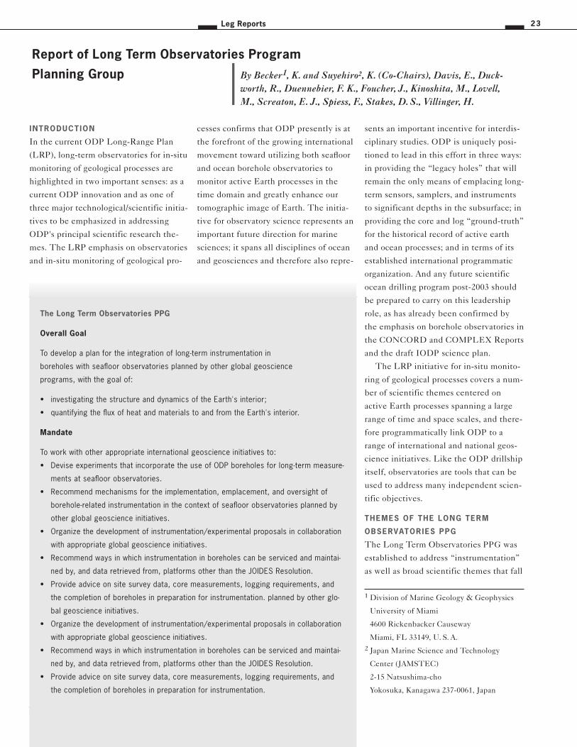
Leg Reports 23
INTRODUCTION
In the current ODP Long-Range Plan
(LRP), long-term observatories for in-situ
monitoring of geological processes are
highlighted in two important senses: as a
current ODP innovation and as one of
three major technological/scientific initia-
tives to be emphasized in addressing
ODP's principal scientific research the-
mes. The LRP emphasis on observatories
and in-situ monitoring of geological pro-
cesses confirms that ODP presently is at
the forefront of the growing international
movement toward utilizing both seafloor
and ocean borehole observatories to
monitor active Earth processes in the
time domain and greatly enhance our
tomographic image of Earth. The initia-
tive for observatory science represents an
important future direction for marine
sciences; it spans all disciplines of ocean
and geosciences and therefore also repre-
sents an important incentive for interdis-
ciplinary studies. ODP is uniquely posi-
tioned to lead in this effort in three ways:
in providing the “legacy holes” that will
remain the only means of emplacing long-
term sensors, samplers, and instruments
to significant depths in the subsurface; in
providing the core and log “ground-truth”
for the historical record of active earth
and ocean processes; and in terms of its
established international programmatic
organization. And any future scientific
ocean drilling program post-2003 should
be prepared to carry on this leadership
role, as has already been confirmed by
the emphasis on borehole observatories in
the CONCORD and COMPLEX Reports
and the draft IODP science plan.
The LRP initiative for in-situ monito-
ring of geological processes covers a num-
ber of scientific themes centered on
active Earth processes spanning a large
range of time and space scales, and there-
fore programmatically link ODP to a
range of international and national geos-
cience initiatives. Like the ODP drillship
itself, observatories are tools that can be
used to address many independent scien-
tific objectives.
THEMES OF THE LONG TERM
OBSERVATORIES PPG
The Long Term Observatories PPG was
established to address “instrumentation”
as well as broad scientific themes that fall
Report of Long Term Observatories Program
Planning Group By Becker1, K. and Suyehiro2, K. (Co-Chairs), Davis, E., Duck-worth, R., Duennebier, F. K., Foucher, J., Kinoshita, M., Lovell,M., Screaton, E. J., Spiess, F., Stakes, D. S., Villinger, H.
The Long Term Observatories PPG
Overall Goal
To develop a plan for the integration of long-term instrumentation in
boreholes with seafloor observatories planned by other global geoscience
programs, with the goal of:
• investigating the structure and dynamics of the Earth's interior;
• quantifying the flux of heat and materials to and from the Earth's interior.
Mandate
To work with other appropriate international geoscience initiatives to:
• Devise experiments that incorporate the use of ODP boreholes for long-term measure-
ments at seafloor observatories.
• Recommend mechanisms for the implementation, emplacement, and oversight of
borehole-related instrumentation in the context of seafloor observatories planned by
other global geoscience initiatives.
• Organize the development of instrumentation/experimental proposals in collaboration
with appropriate global geoscience initiatives.
• Recommend ways in which instrumentation in boreholes can be serviced and maintai-
ned by, and data retrieved from, platforms other than the JOIDES Resolution.
• Provide advice on site survey data, core measurements, logging requirements, and
the completion of boreholes in preparation for instrumentation. planned by other glo-
bal geoscience initiatives.
• Organize the development of instrumentation/experimental proposals in collaboration
with appropriate global geoscience initiatives.
• Recommend ways in which instrumentation in boreholes can be serviced and maintai-
ned by, and data retrieved from, platforms other than the JOIDES Resolution.
• Provide advice on site survey data, core measurements, logging requirements, and
the completion of boreholes in preparation for instrumentation.
1 Division of Marine Geology & Geophysics
University of Miami
4600 Rickenbacker Causeway
Miami, FL 33149, U. S. A.
2 Japan Marine Science and Technology
Center (JAMSTEC)
2-15 Natsushima-cho
Yokosuka, Kanagawa 237-0061, Japan
JOIDES Journal24 Volume 25, no. 2
within the mandates of both the Interior
and the Exterior Science Steering and
Evaluation Panels (SSEPs). Given that
our advice encompasses both technologi-
cal issues and scientific themes, it is
directed not only to the SSEPs and SCI-
COM, but in some cases to SciMP, SSP,
and OPCOM. The PPG worked with
appropriate “global geoscience initiati-
ves” including ION and InterRidge, and
national counterparts such as DEOS
(Deep Earth Observatories on the
Seafloor - US and UK), OSN (Ocean Seis-
mic Network - US), OHP (Ocean Hemis-
phere Project - Japan), and the various
national ridge-crest programs. There are
also strong national initiatives with less
developed international analogs (e.g., US
MARGINS and the fledgling “InterMAR-
GINS”) and other initiatives just barely
gearing up on scientific themes of endu-
ring interest, for which borehole observa-
tories could be a very important tool, e.g.,
a new ILP initiative on “Hydrogeology of
Oceanic Lithosphere. The PPG mem-
bership included strong links to nearly all
of these initiatives.
Although the PPG‘s life was limited to
three years some of the specific items in
its mandate could not be completed in
this short time line. Ongoing effort will
be required throughout the lifetime of
ODP, particularly as ”global geoscience
initiatives” interested in seafloor observa-
tories develop their plans.
OBJECTIVES OF LONG TERM
OBSERVATORIES
In the past decade there has been a grow-
ing movement on the part of many geos-
cience initiatives towards establishing
seafloor observatories, which include
borehole instrumentation. The case for
seafloor observatories is set out in a host
of international and national workshop
and committee reports dating from the
late 1980's through the 1990’s, including
the current ODP LRP. The geoscience
initiatives involved have separately set
out the intellectual justification and tech-
nological requirements for seafloor obser-
vatories; these generally apply to bore-
hole observatories, with special conside-
rations for the great value and particular
configurations of boreholes. We drew hea-
vily on the documents concerning obser-
vatories written by other geoscience
initiatives, particularly ION (Internatio-
nal Ocean Network) and the US planning
effort DEOS (Dynamics of Earth and
Ocean Systems).
The intellectual justification for
seafloor and borehole observatories stems
from the premise that Earth is a dynamic
system that can only be understood pro-
perly if studied in a process-oriented per-
spective with adequate sampling in both
spatial and temporal domains. Given that
the oceans cover 70% of the Earth's sur-
face, including the locations of the most
active plate boundaries, adequate spatial
and temporal sampling of the seafloor and
subseafloor formations is critical. Earth
processes occur over a wide range of tem-
poral and spatial scales and exhibit consi-
derable covariation and dynamic inter-
linkages extending to oceanographic and
atmospheric processes. While many of
these processes are fairly well characteriz-
ed in the static spatial domain, their
temporal behavior is poorly understood.
Investigation of the Earth as a dynamic
system will require an intellectual reori-
entation, with increasing emphasis on
long time-series measurements to under-
stand processes in the time domain and
complement the more traditional focus on
spatial mapping and sampling.
Understanding active Earth processes
and their importance to society “observa-
tory” science to study properties, parame-
ters, and processes over a variety of time
scales, and in some cases to conduct per-
turbation experiments. Given the range
of time/space scales involved, it has been
convenient (e. g., in the 1995 ION work-
What are Program Planning Groups (PPG’s)
Program Planning Groups (PPG) are small focused planning groups formed by SCICOM
when there is a need to develop drilling programs or technological strategies to achieve
the goals of the Long Range Plan. PPGs advise upon drilling/technology strategies and
proposals for major scientific objectives that are not adequately covered by existing dril-
ling strategies or proposals. Drilling proposals arising from PPG meetings must be sub-
mitted to the JOIDES Office by individual proponents or groups of proponents. PPGs also
foster communication between the ODP and other major geoscience initiatives. PPGs
report to the appropriate panel in the JOIDES Advisory Structure as directed by SCICOM.
Members of PPGs are focused groups of specialists and proponents, chosen by
SCICOM through consultation with the SSEPs and community programs. Each full mem-
ber of ODP has the right of representation. The number of PPGs is determined by SCI-
COM's need to fulfill the Long Range Plan objectives, subject to budgetary constraints.
The normal term length is three years, but can be renewed by SCICOM.
PPG – Final Reports
Since 1997 SCICOM has established nine Program Planning Groups (PPG) and one DPG
The PPG’s began to present their final reports and recommendations to SCICOM in 1999.
In this section summaries of these reports are given. The complete documents are avai-
lable on the JOIDES-website (http://www.joides.geomar.de) after ratification by SCICOM.

Leg Reports 25
shop report) to consider current and plan-
ned efforts on seafloor/borehole observa-
tories in two classes:
1. “Active Process” observatories located
where the particular systems are pre-
sently most active. The most obvious
examples are at plate boundaries: mid-
ocean ridges, the settings of possibly
the most complex interplay among tec-
tonic, magmatic, hydrothermal and
biological processes on Earth; and sub-
duction zones, settings of tectonic and
magmatic processes of great destruc-
tive impact on society. Given that
these plate tectonic boundaries occur
almost exclusively beneath the seas, a
seafloor/borehole observatory capabi-
lity is imperative scientifically and
societally.
2. “Global Network” observatories (e. g.,
seismic, geomagnetic), sited to com-
plete the global coverage necessary to
image the interior of the Earth utili-
zing unpredictable natural sources.
With 70% of the Earth’s surface under
the oceans, the global networks will
never be complete without seafloor
observatories.
This categorization is arbitrary, in that
there is a continuum of time scales of
Earth processes, all of which are “active”
in one sense or another. Nevertheless it
may be a useful classification in terms of
distinguishing observatories according to
whether temporal monitoring of specific
processes or better spatial resolution of
Earth structure is the key objective.
Although seafloor/borehole observato-
ries may differ in their specific scientific
objectives, they share many common
technological needs. These are primarily
related to the deployment and mainten-
ance of long-term monitoring equipment
in the remote and hostile seafloor envi-
ronment. The primary issues are those of
delivering long-term power to seafloor
instruments, providing a link for data
transmission from the seafloor to land,
preferably in near real-time, providing an
avenue for remote command and control
of seafloor instruments, and facilitating
deployment and retrieval of instruments
for repair or refurbishment. The LTO-
PPG mandate included considering these
issues, but it should be emphasized that
they are continuing issues that apply to
all seafloor observatories and are pre-
sently being extensively considered out-
side of JOIDES. For example, Japan has
made major investments in cabled obser-
vatories, and the US DEOS planning
effort has formulated plans for both cab-
led and buoyed seafloor observatories;
these are both viable options for linking
to borehole observatories for power and
data transmission and instrument control.
ODP’S CONTRIBUTIONS TO
OBSERVATORY SCIENCE
ODP provides three unique and essential
contributions that should ensure its conti-
nuing leadership role in the growing
movement for observatories on and
beneath the seafloor:
• “Legacy holes,” which represent the
only means available for emplacing
sensors and instruments deep within
subseafloor formations for truly in-situ
geological monitoring. This capability
is critical in understanding many geo-
logical processes; monitoring from the
seafloor is often not satisfactory.
• The cores and logs recovered from
ODP holes contain the record of active
geological processes in the past. The
combination of in-situ monitoring at
present plus the historical record in
the cores and logs can be very power-
ful in understanding Earth processes.
• In full fruition the initiative for sea-
floor observatories will be comparable
in financial scale and international
aspects to the ODP. In coordinating
and administering an international
seafloor observatory initiative, ODP
and JOIDES will be held up as the
prime model of a successful, long-
term, international scientific program.
More important, given its unique
scientific contributions, there is a real
opportunity for JOIDES, ODP and any
post-2003 drilling program to flourish
and play an even greater leadership
role in international geosciences as
seafloor observatory science grows in
significance.
It is no surprise that ODP has been active
in implementing borehole observatories
for at least a decade. JOIDES support for
observatory science can be traced back
much earlier, e.g., borehole seismometer
deployments during DSDP for periods of
months and time-series hydrologic meas-
urements made on DSDP/ODP revisits of
legacy holes like 395A and 504B. In the
1990's, ODP has provided strong support
for both “global network” and “active
processes” observatories, with two prime
examples: the legacy holes utilized and/or
specifically drilled for the ION/OSN glo-
bal seismic network and the 13 “CORK”
long-term hydrologic observatories instal-
led to date. ODP has recently installed a
third kind of observatory designed to
monitor processes at intermediate
time/space scales: the strainmeter/seiso-
mometer successfully deployed in the
Japan Trench during leg 186.
THE IMPORTANCE
OF LEGACY HOLES
Legacy holes are stable holes that can be
reentered for deepening or for experi-
mental use. These holes include some of
those with reentry cones and casing, and
could include bare rock holes that can be
reentered by a Control Vehicle or ROV.
The vast majority of DSDP/ODP holes
are non-reenterable single-bit holes; at
this time, there are only about 33 useful
legacy holes, virtually all of which are tra-
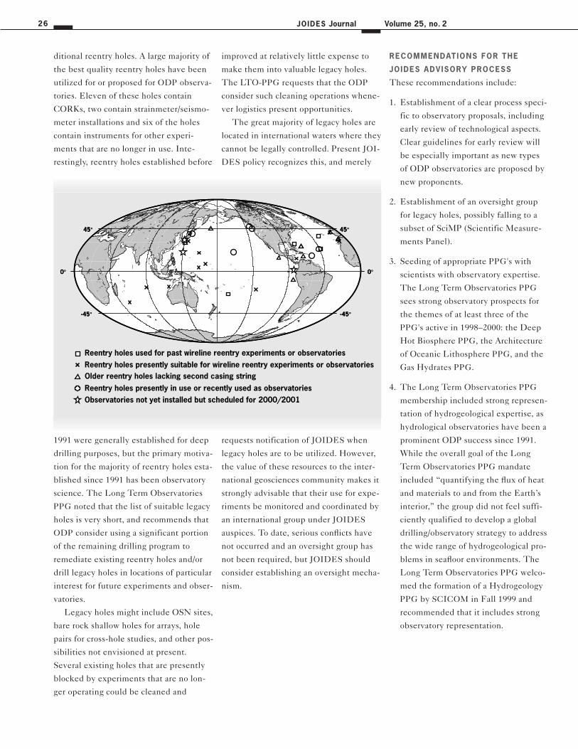
JOIDES Journal26 Volume 25, no. 2
ditional reentry holes. A large majority of
the best quality reentry holes have been
utilized for or proposed for ODP observa-
tories. Eleven of these holes contain
CORKs, two contain strainmeter/seismo-
meter installations and six of the holes
contain instruments for other experi-
ments that are no longer in use. Inte-
restingly, reentry holes established before
1991 were generally established for deep
drilling purposes, but the primary motiva-
tion for the majority of reentry holes esta-
blished since 1991 has been observatory
science. The Long Term Observatories
PPG noted that the list of suitable legacy
holes is very short, and recommends that
ODP consider using a significant portion
of the remaining drilling program to
remediate existing reentry holes and/or
drill legacy holes in locations of particular
interest for future experiments and obser-
vatories.
Legacy holes might include OSN sites,
bare rock shallow holes for arrays, hole
pairs for cross-hole studies, and other pos-
sibilities not envisioned at present.
Several existing holes that are presently
blocked by experiments that are no lon-
ger operating could be cleaned and
improved at relatively little expense to
make them into valuable legacy holes.
The LTO-PPG requests that the ODP
consider such cleaning operations whene-
ver logistics present opportunities.
The great majority of legacy holes are
located in international waters where they
cannot be legally controlled. Present JOI-
DES policy recognizes this, and merely
requests notification of JOIDES when
legacy holes are to be utilized. However,
the value of these resources to the inter-
national geosciences community makes it
strongly advisable that their use for expe-
riments be monitored and coordinated by
an international group under JOIDES
auspices. To date, serious conflicts have
not occurred and an oversight group has
not been required, but JOIDES should
consider establishing an oversight mecha-
nism.
RECOMMENDATIONS FOR THE
JOIDES ADVISORY PROCESS
These recommendations include:
1. Establishment of a clear process speci-
fic to observatory proposals, including
early review of technological aspects.
Clear guidelines for early review will
be especially important as new types
of ODP observatories are proposed by
new proponents.
2. Establishment of an oversight group
for legacy holes, possibly falling to a
subset of SciMP (Scientific Measure-
ments Panel).
3. Seeding of appropriate PPG's with
scientists with observatory expertise.
The Long Term Observatories PPG
sees strong observatory prospects for
the themes of at least three of the
PPG's active in 1998–2000: the Deep
Hot Biosphere PPG, the Architecture
of Oceanic Lithosphere PPG, and the
Gas Hydrates PPG.
4. The Long Term Observatories PPG
membership included strong represen-
tation of hydrogeological expertise, as
hydrological observatories have been a
prominent ODP success since 1991.
While the overall goal of the Long
Term Observatories PPG mandate
included “quantifying the flux of heat
and materials to and from the Earth’s
interior,” the group did not feel suffi-
ciently qualified to develop a global
drilling/observatory strategy to address
the wide range of hydrogeological pro-
blems in seafloor environments. The
Long Term Observatories PPG welco-
med the formation of a Hydrogeology
PPG by SCICOM in Fall 1999 and
recommended that it includes strong
observatory representation.
Reentry holes presently in use or recently used as observatories
Reentry holes used for past wireline reentry experiments or observatoriesReentry holes presently suitable for wireline reentry experiments or observatoriesOlder reentry holes lacking second casing string
-45° -45°
0° 0°
45° 45°
-45° -45°
0° 0°
45° 45°
Observatories not yet installed but scheduled for 2000/2001

CONCLUSIONS
In maintaining a strong commitment to
borehole observatories ODP (and IODP)
has an opportunity to strengthen its lea-
dership role in the growing global initia-
tive for seafloor observatory science. The
price for JOIDES to exercise a leadership
role in long-term monitoring is quite rea-
sonable, given that extensive third-party
funds are nearly always used for ODP
observatory science. Several examples
have followed a funding model in which
non-JOIDES funds are leveraged to sup-
port scientific instrument packages
emplaced in ODP observatory sites as
well as post-emplacement data recovery.
The total costs of these additional contri-
butions are comparable to the contribu-
tion from JOIDES. In this sense, observa-
tories represent a very cost-effective way
to extend impact of ODP science in a
time of level funding for ODP.
Specifically, continuing commitments
are required from JOIDES/ODP toward
1. establishing good reentry holes in
appropriate locations, and 2. providing
the engineering support for emplacement
of third-party instruments. The first
includes the commitment of costs and
drillship time for standard and new types
of reentry holes where appropriate. The
commitment required from JOIDES also
includes engineering development
toward hole completion (e.g., develop-
ment of hammer-in or drill-in casing
systems) in difficult drilling environ-
ments where active processes are of great
scientific interest. The second aspect
includes engineering support at ODP for
the seafloor and subseafloor hardware
required for the third-party instruments.
For example, in the initial CORK design
used for 1991–1997 deployments, ODP
provided the CORK “body” which sealed
the reentry cone and from which third-
party sensor strings were suspended. For
the strainmeters and broad-band seismo-
meters deployed in the Japan Trench
during Leg 186, ODP engineered the
system for deploying and cementing the
instrument package in place.
To summarize, the Long-Term Obser-
vatories PPG strongly recommends high
priority should be given to the following:
1. Commitment of drillship time and, in
most cases, cost of standard reentry
cone/casings at appropriate sites that
are well-justified in competitively
reviewed JOIDES proposals, e.g., ION
sites and other potential legacy holes.
2. Continued development of hole-com-
pletion technology for difficult drilling
environments where active processes
will require long-term monitoring.
3. Continued engineering development
support for installation of third-party
monitoring packages in observatory
holes.
Further Reading:
The Full Long Term Observatories PPG
Report from March 1999: http://www.joi-
des.geomar.de/panels/LTO_PPG.html
Note: Some sections were updated in this
article to cover the recent developments
during the last 14 months.
SEIZE DPG Report:
http://www.joides.geomar.de/panels/SEIZ
E.html
DEOS web site:
http://vertigo.rsmas.miami.edu/deos.html
(includes links to other observatory sites)
Leg Reports 27
Since 1985, when the JOIDES Resolu-
tion ventured on her first expedition in
the Gulf of Mexico, the ship has under-
gone three drydock periods for refurbish-
ment of both the ship and laboratory
equipment. However, never before has
more work been accomplished during a
drydock than the recent undertaking in
Singapore. The 58-day stay at the Keppel
Shipyard enabled ODP to improve the
safe and efficient working environment of
the JOIDES Resolution and upgrade the
ship's operational capabilities to better
achieve the objectives stated in ODP's
1996 Long Range Science Plan.
The activities that took place during
the stay in the Singapore shipyard can be
grouped into three categories. The first,
and by far the most extensive, includes
the repairs and upgrades of the ship and
its equipment. These activities were
necessary for the five year contract exten-
sion through FY2003 and were funded by
the National Science Foundation and
Overseas Drilling Limited (ODL), the
ship's operator. The second group of
activities were the repairs and upgrades
to the scientific infrastructure on board
the ship and these projects were suppor-
ted by the co-mingled funds of the Ocean
Drilling Program. The two major projects
in this category were the addition of the
new 7th level and the modification of the
core handling and description area on the
6th level. The third group of activities
were three major projects that were sche-
duled during the Singapore yard period
because they represented complex and
demanding installations that could be
best accommodated during an extended
period of time when the ship was out of
service. Two of the projects, the Active
Heave Compensation (AHC) system and
Rig Instrumentation, were carried out by
ODP. The goal of these two projects was
to enhance our ability to make hole and
recover better sections of core through
the utilization of new drilling technolo-
gies. The third project, the installation of
a synchronous generator, was carried out
by ODL. It is anticipated that this system
will significantly reduce fuel consumption
because the ship will operate more
efficiently.
One of the primary reasons this exten-
sive drydock succeeded was the dedica-
ted efforts of the many ODP staff mem-
bers that worked long and hard dismant-
ling and reassembling the JOIDES Reso-
lution. The ODP science community is
truly fortunate to have the dedicated
technicians, engineers and administrative
staff that so successfully worked together
to complete this challenging mission.
SHIP SAFETY, MAINTENANCE AND
UPGRADE ACTIV ITY
The first, and by far the most extensive,
drydock activities included repairs and
upgrades of the ship and its equipment to
ensure continued safety and maximum
performance during the upcoming ODP
expeditions. Some of these projects inclu-
ded the following:
• Refurbishment to the ship's hull, thru-
sters, thruster wells, tanks, propulsion
gear box, and rudder;
• Replacement of all sanitary piping wit-
hin the accommodations;
• Thoroughly inspection of the drilling
equipment;
• Installation of a new data management
system (DMS) to better regulate the
ship's power, ultimately reducing fuel
costs;
JOIDES Journal28 Volume 25, no. 2
• Installation of a new automatic station
keeping (ASK) system providing a dual
redundancy for maintaining station
under a greater range of environmental
conditions; and
• Installation of a new breathing system
in the core lab, the core handling cat-
walk area and the drill floor to facili-
tate safe handling of H2S-laden cores;
All of these projects were successfully
completed during the drydock period and
have greatly enhanced the ability of the
JOIDES Resolution to continue opera-
ting safely and efficiently in the high seas
through 2003.
SHIPBOARD LABORATORY
ENHANCEMENTS
One of the new science initiatives identi-
fied in ODP's Long Range Science Plan
was the establishment of microbiology
research during ODP cruises. Prior to Leg
184, a temporary microbiology van was
installed aboard the ship and this facility
was used extensively during Leg 185.
Because of the success of Leg 185 and on
the recommendations of the JOIDES
advisory community, a new laboratory
facility was installed on the 7th level that
includes wet and dry laboratories, a new
conference room, and enhancement to
the downhole measurements facility. This
additional space will allow the Program to
establish a permanent microbiology faci-
lity in the lab stack, as well as to
significantly enhance the Program's abi-
lity to implement the new generation of
downhole experiments.
Ocean Drilling Report –
Drydock Report By Aaron H. Woods1
1 Texas A&M-Ocean Drilling Program
1000 Discovery Dr. College Station,
TX 77845, U. S. A.
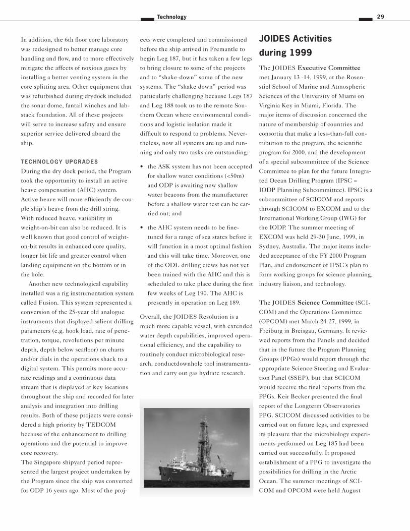
In addition, the 6th floor core laboratory
was redesigned to better manage core
handling and flow, and to more effectively
mitigate the affects of noxious gases by
installing a better venting system in the
core splitting area. Other equipment that
was refurbished during drydock included
the sonar dome, fantail winches and lab-
stack foundation. All of these projects
will serve to increase safety and ensure
superior service delivered aboard the
ship.
TECHNOLOGY UPGRADES
During the dry dock period, the Program
took the opportunity to install an active
heave compensation (AHC) system.
Active heave will more efficiently de-cou-
ple ship's heave from the drill string.
With reduced heave, variability in
weight-on-bit can also be reduced. It is
well known that good control of weight-
on-bit results in enhanced core quality,
longer bit life and greater control when
landing equipment on the bottom or in
the hole.
Another new technological capability
installed was a rig instrumentation system
called Fusion. This system represented a
conversion of the 25-year old analogue
instruments that displayed salient drilling
parameters (e.g. hook load, rate of pene-
tration, torque, revolutions per minute
depth, depth below seafloor) on charts
and/or dials in the operations shack to a
digital system. This permits more accu-
rate readings and a continuous data
stream that is displayed at key locations
throughout the ship and recorded for later
analysis and integration into drilling
results. Both of these projects were consi-
dered a high priority by TEDCOM
because of the enhancement to drilling
operations and the potential to improve
core recovery.
The Singapore shipyard period repre-
sented the largest project undertaken by
the Program since the ship was converted
for ODP 16 years ago. Most of the proj-
ects were completed and commissioned
before the ship arrived in Fremantle to
begin Leg 187, but it has taken a few legs
to bring closure to some of the projects
and to “shake-down” some of the new
systems. The “shake down” period was
particularly challenging because Legs 187
and Leg 188 took us to the remote Sou-
thern Ocean where environmental condi-
tions and logistic isolation made it
difficult to respond to problems. Never-
theless, now all systems are up and run-
ning and only two tasks are outstanding:
• the ASK system has not been accepted
for shallow water conditions (<50m)
and ODP is awaiting new shallow
water beacons from the manufacturer
before a shallow water test can be car-
ried out; and
• the AHC system needs to be fine-
tuned for a range of sea states before it
will function in a most optimal fashion
and this will take time. Moreover, one
of the ODL drilling crews has not yet
been trained with the AHC and this is
scheduled to take place during the first
few weeks of Leg 190. The AHC is
presently in operation on Leg 189.
Overall, the JOIDES Resolution is a
much more capable vessel, with extended
water depth capabilities, improved opera-
tional efficiency, and the capability to
routinely conduct microbiological rese-
arch, conductdownhole tool instrumenta-
tion and carry out gas hydrate research.
The JOIDES Executive Committee
met January 13 -14, 1999, at the Rosen-
stiel School of Marine and Atmospheric
Sciences of the University of Miami on
Virginia Key in Miami, Florida. The
major items of discussion concerned the
nature of membership of countries and
consortia that make a less-than-full con-
tribution to the program, the scientific
program for 2000, and the development
of a special subcommittee of the Science
Committee to plan for the future Integra-
ted Ocean Drilling Program (IPSC =
IODP Planning Subcommittee). IPSC is a
subcommittee of SCICOM and reports
through SCICOM to EXCOM and to the
International Working Group (IWG) for
the IODP. The summer meeting of
EXCOM was held 29-30 June, 1999, in
Sydney, Australia. The major items inclu-
ded acceptance of the FY 2000 Program
Plan, and endorsement of IPSC’s plan to
form working groups for science planning,
industry liaison, and technology.
The JOIDES Science Committee (SCI-
COM) and the Operations Committee
(OPCOM) met March 24-27, 1999, in
Freiburg in Breisgau, Germany. It revie-
wed reports from the Panels and decided
that in the future the Program Planning
Groups (PPGs) would report through the
appropriate Science Steering and Evalua-
tion Panel (SSEP), but that SCICOM
would receive the final reports from the
PPGs. Keir Becker presented the final
report of the Longterm Observatories
PPG. SCICOM discussed activities to be
carried out on future legs, and expressed
its pleasure that the microbiology experi-
ments performed on Leg 185 had been
carried out successfully. It proposed
establishment of a PPG to investigate the
possibilities for drilling in the Arctic
Ocean. The summer meetings of SCI-
COM and OPCOM were held August
Technology 29
JOIDES Activities
during 1999
16–19, 1999 on the campus of the Univer-
sity of California at Santa Cruz. It is du-
ring the summer meeting that SCICOM
ranks the proposals forwarded to it by the
Science Steering and Evaluation Panels.
This year there were 24 proposals to con-
sider for six legs of drilling. Members of
SCICOM make presentations on the pro-
posals in their area of expertise, and then
those members who do not have a conflict
of interest rank the proposals following
the procedure outlined in the “Guide to
the Ocean Drilling Program.” This year
we did something new: OPCOM took the
ranked list and developed three alterna-
tive ship tracks, each comprising sets of
highly ranked legs using data on drilling
and logging times, distances, and weather
conditions developed by the ODP Opera-
tor at Texas A & M and by the Borehole
Research Group at Lamont. These tracks
were then brought back to SCICOM on
the last day of the meeting, and a final
track and preliminary schedule were con-
structed.
The Technology and Engineering
Development Committee (TEDCOM)
met twice during the year, first in Vancou-
ver, Canada, during the COMPLEX Con-
ference, and then December 1–2, 1999 at
ODP TAMU headquarters in College
Station, Texas. TEDCOM members were
very interested to hear what scientists at
COMPLEX wanted to do. This was
valuable input in considering the deve-
lopment of new methods and techniques
in drilling and coring. At its December
meeting, the TEDCOM reviewed all of
the engineering development projects
currently underway at ODP.
The busiest JOIDES group was undoub-
tedly the IODP Planning Subcommit-
tee (IPSC). Its Chair, Ted Moore of the
University of Michigan, was selected by
EXCOM in January, and its potential
membership was explored and approved
by SCICOM in March. The Subcommit-
tee started off as an ad hoc working group
in order to have an organizational meeting
in Tokyo, Japan on April 22–23. Its first
formal meeting was after the COMPLEX
Conference in Vancouver on May 29–31,
with subsequent meetings in Copenha-
gen, Denmark (October 22–23), and San
Francisco (December 18–19). IPSC
organized and appointed a science plan-
ning working group which met in Zürich,
Switzerland early in November, and by
the end of the year had largely completed
the task of taking the CONCORD report,
the draft COMPLEX report, and other
documents to produce a draft science
plan for IODP. IPSC also established a
working group on technology, which is
investigating platforms, and a working
group on liaison with industry.
The Science Steering and Evaluation
Panels, Interior (ISSEP) and Environ-
ment (ESSEP), met twice during the
year, May 23–25 in Seattle, Washington,
and November 1–3 in Udine, Italy. They
considered ways in which the active pro-
posals in the system can be improved and
brought to the level of maturity so that
they can be forwarded to SCICOM for
consideration for scheduling. To under-
stand the level of activity in the SSEPs it
is important to realize that the JOIDES
Office received 33 new proposals in 1999,
and at the end of the year there are about
80 active proposals in the system.
The Scientific Measurements Panel
(SCIMP) met twice during the year,
January 19-20 in Houston, Texas, and
June 28-30 in Boulder, Colorado. In addi-
tion to considering the many aspects of
shipboard and shore-based measurements
and data handling, they helped IPSC con-
sider scientific equipment that will be
need for operations in the IODP.
The Site Survey Panel (SSP) met
February 9–11 in Fremantle, Australia
and July 19–21 at the SSP Office in
Lamont-Doherty Earth Observatory in
Palisades, New York. The Panel checks
the adequacy of site survey data for plan-
ning the drilling programs. SSP has expe-
rienced an increasingly heavy load of
work as the number of proposals forwar-
ded to SCICOM grows larger.
The Pollution Prevention and Safety
Panel (PPSP) met twice, April 12–14 in
San Antonio, Texas, and December 9–10
in San Francisco, California. The Panel
reviewed the drilling planned for forth-
coming legs through early 2001.
Many of the Program Planning Groups
(PPGs) were completing their work in
1999, preparing final reports that will be
reviewed by the SSEPs before being for-
warded on to SCICOM for acceptance.
The Extreme Climates and Enviro-
ments of the Paleogene and Cretaceous
PPG met in Burkheim, Germany March
25–27 and in Santa Cruz California
December 10–11. It has been developing
a focussed program for investigating
extreme conditions on the Earth prior to
the Miocene. The Gas Hydrates PPG
met at the Technical University in Berlin
where it was able to discuss development
of the HYACE (HYdrate Autoclave
Coring Equipment), intended to be used
on future gas hydrate legs.
The Scientific Drilling of Shallow
Water Systems PPG met September
24–25 in Aix-en-Provence, France, just
before the Conference on Paleoceanology
of Reefs and Carbonate Platforms: Mio-
cene to Modern.
The Deep Biosphere PPG met
December 18–19 in San Francisco, and
will be recommending ways of ensuring
ongoing investigations of the microbio-
logy of the sediments and rocks beneath
the sea floor.
The Seismogenic Zone Detailed Plan-
ning Group met twice, March 17–18 in
Tokyo and May 24–25 in Victoria, British
Columbia, Canada to complete its report
JOIDES Journal30 Volume 25, no. 2

on investigation of the seismogenic zone
in active margins via drilling. Its delibera-
tions will be especially important for the
early phases of the IODP.
IWG SUPPORT OFFICE ESTABLISHED
The International Working Group Sup-
port Office (IWGSO) was established on
November 30, 1999 by the Japan Marine
Science and Technology Center
(JAMSTEC) and Joint Oceanographic
Institutions, Inc. (JOI) under the
guidance of the Science and Technology
Agency (STA) and the National
Science Foundation (NSF).
The Support Office is an interim office
that was created to provide administra-
tive, clerical, and financial support for the
Integrated Ocean Drilling Program
(IODP) which is scheduled to begin in
2003. John Farrell and Masanori Shina-
nois are the Management Representati-
ves from JOI and JAMSTEC.
For more information on the status of
IODP planning activities please visit
the new IODP website:
http://www.iodp.org
Contact information:
IWG Support Office
1755 Massachusetts Av., NW Suite 700
Washington DC, 20036-2102 U.S.A.
phone: (202) 232 3900 x262
fax: (202) 232 3426
e-mail: [email protected]
EUROPEAN OCEAN DRILL ING FORUM
10–11 APRIL 2000, LA GRANDE
MOTTE, FRANCE
This was the third in the series of bien-
nial conference organised by the
European Ocean Drilling Community.
The event involved more than 150
scientists and included 75 posters and 25
oral presentations. The conference con-
centrated on four themes:
Earth’s changing climate
(Warm climates, sea-level change, climate
tectonic interactions).
Lithosphere factories and mantle
dynamics
(Creation of oceanic crust, hydrothermal
Systems, large igneous events, core-
mantle dynamics, the subduction factory).
The deep bioshere
(Studies of the biomass beneath the
ocean-floor).
Understanding continental margins
(Fluid flow, gas hydrates, seismic
hazards and resource potential).
The European Contribution to IODP
(Alternate platforms, shallow-water
drilling, Arctic drilling; enabling techno-
logies, shore-based laboratories).
These four scientific themes reflected the
general scientific goals of the IPSC
science plan and the speakers were asked
to emphasise the European dimension in
their research. In particular climate stu-
dies in the Arctic, high-resolution sam-
pling for climate change, methane hydra-
tes, and the hidden biosphere featured in
the ongoing and proposed research. The-
potential of the Mediterranean region for
seismogenic-zone studies, for example in
the Gulf of Corinth, and the study of ero-
sion and transport into the Indian ocean
and in sedimentary fans in the Mediterra-
nean were discussed. Two presentations,
one from Elf-Total-Fina and another
from Shell International, underlined the
need for collaborative research between
industry and the understanding of facies
models in deep-water depositional
environments.
The presentations included a summary
of the IPSC’s activities, including plans
for the Japanese Riser vessel and a US-
sponsored JR-replacement vessel. The
session on the European Contribution to
IODP discussed recommendations of the
European Science and Technology Advi-
sory Group on Ocean Drilling, including:
• refining scientific issues for IODP in
respect to Europe
• pursuing a technological model for
European contribution to IODP
• approaching EU funding for tasks
(sub-committees and technology)
• recommendation to European / natio-
nal funding agencies how they should
be involved with IODP.
The ECOD consortium will host the next
European Ocean Drilling Forum.
John Ludden, ODP-France
Planning and Announcements 31
The Joint Oceanographic Institutions, Inc. (JOI) is seeking a highly
qualified individual, with both significant scientific leadership,
advocacy, and organizational management skills and experience, to fill a
new position as both
President of JOI and Executive Director,
Ocean Drilling Programs (ODP)
Information on this position can be obtained from the JOI-website at
http://www.joi-odp.org/JOI/Employment/Employment.html.
Information related to all aspects of JOI’s activities can be reviewed
on the web site at http://www.joi-odp.org.
An application letter, including a complete CV and names of four
references, should be addressed to Director, Administration, Joint
Oceanographic Institutions, 1755 Massachusetts Avenue, N.W., Suite 800,
Washington, D.C. 20036-2102.
Review of applications is expected to begin immediately and continue until
the position is filled. JOI is an equal opportunity employer. This
advertisement supersedes and cancels those previously posted for the
Director, ODP position.

ODP CONTRACTORS
WEBSITE: www.oceandrilling.org
for all contractors
JOINT OCEANOGRAPHIC
INSTITUTIONS
Prime Contractor
Program Management
Public Affairs
JOIDES Journal distribution
1755 Massachusetts Ave.,
N. W., Suite 700
Washington DC 20036-2102, USA
Tel. (202) 232-39 00
Fax: (202) 462-87 54
JOIDES OFFICE
Science Planning and Policy
Proposal Submission
JOIDES Journal Articles
GEOMAR
Research Center for Marine Geosience
Wischhofstr. 1–3
D-24148 Kiel
Germany
Tel. 49 (431) 600-28 21
Fax: 49 (431) 600-29 47
ODP S ITE SURVEY DATA BANK
Submission of Site Survey Data
Site Survey Data Requests
Lamont-Doherty Earth Observatory
P. O. Box 1000, Rt. 9W
Palisades, NY 10964, USA
Tel. (845) 365-85 42
Fax: (845) 365-81 59
ODP-TAMU
Science Operations
ODP/DSDP Sample Requests
Leg Staffing, ODP Publications
Ocean Drilling Program
Texas A & M University
1000 Discovery Drive
College Station, TX 77845-9547, USA
Tel. (979) 845-84 80
Fax: (979) 845-10 26
ODP-LDEO
Wireline Logging Services
Logging Information
Logging Schools
Log-Data Requests
Borehole Research Group
Lamont-Doherty Earth Observatory
P. O. Box 1000, Rt. 9W
Palisades, NY 10964, USA
Tel. (845) 365-86 72
Fax: (845) 365-31 82
The JOIDES Journal is published and
distributed semi-annually by Joint
Oceanographic Institutions, Inc.,
Washington, DC for the Ocean Drilling
Program under the sponsorship of the
National Science Foundation and partici-
pating member countries. The material is
based upon research supported by the
National Science Foundation under
prime contract OCE-9308410.
The purpose of the JOIDES Journal is
to serve as a means of communication
among the JOIDES advisory structure,
the National Science Foundation, the
Ocean Drilling Program, JOI subcontrac-
tors thereunder, and interested earth
scientists. Any opinions, findings, conclu-
sions or recommendations expressed in
this publication are those of the author(s)
and do not necessarily reflect the views of
the National Science Foundation.
The information contained within the
JOIDES Journal is preliminary and privi-
leged and should not be cited or used
except within the JOIDES organization
or for purposes associated with ODP.
This journal should not be used as a
basis for other publications.
Editor: William W. Hay,
Emanuel Soeding
Design: Martin Wunderlich
Cover-photo: ODP – Roy Davis
Published semi-annually by the
JOIDES Office at
JOIDES Office
GEOMAR
Wischhofstr. 1–3
D-24148 Kiel
GERMANY
JOIDESJournal
LATEST NEWS:
A new JOIDES Directory is available
online from the JOIDES website. This
is a document compiled on demand
from our database. It contains contact
information for member-country offices
and panel members. The directory can
be edited and printed.
Download at
www.joides.geomar.de/directories