Embed Size (px)
Citation preview
Kakahai‘aNational Wildlife RefugeDraft Comprehensive Conservation Planand Environmental Assessment
U.S. Fish & Wildlife ServiceKakahai‘a National W
ildlife RefugeD
raft Com
prehensive Conservation P
lan and E
nvironmen
tal Assessm
ent
August 2011
U.S. Department of the InteriorU.S. Fish & Wildlife ServiceMaui National Wildlife Refuge ComplexMilepost 6 Mokulele HighwayKıhei, Hawai‘i 96753
Phone: 808/875 1582Fax: 808/875 2954
http://www.fws.gov
National Wildlife Refuge System Information1 800/344 WILD
August 2011
The mission of the U.S. Fish & Wildlife Serviceis working with others to conserve, protect, andenhance fish, wildlife, and plants and their habitatsfor the continuing benefit of the American people.
Front Cover Back Cover Inset Photos ‘Alae ke‘oke‘o Hunakai Kolea©Tom Dove ©Kanalu Chock Michael Silbernagle, USFWS
Koloa mapu ©Mike Walther
Ae‘o ©Tony Temple
A Vision of Conservation
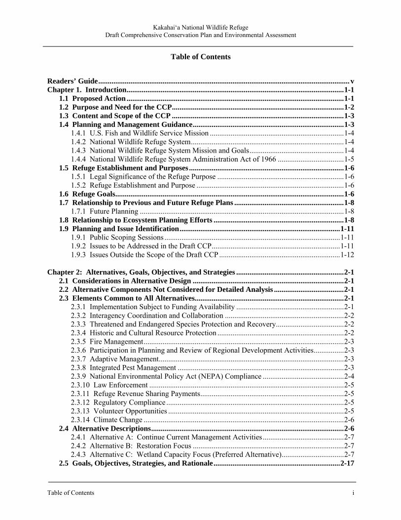
Koloa moha ©Dan Pancamo
Na ‘ike no keia mua akuHulali ka la ma luna o na wai o ka ‘aina palielie i piha i na mau‘u wai ‘oiwi e naue ana i ka pa ‘ana mai o ka makani aheahe o ke kopikala. Kokua keia mau luawai kai i na ‘alae ke‘oke‘o i ka malama ‘ana i ko lakou mau ‘ohana manu pihulu. Ma na lihi wai kai lepo ‘ukele e ‘o‘o aku ai “k‘ek, k‘ek, k‘ek” na ae‘o wawae ‘ula‘ula lo‘ihi i ka lakou mau manu pepe. Kipa mai na kamali‘i o Moloka‘i ka ‘Aina Ho‘omalu Holoholona Lohiu ‘o Kakahai‘a no ke a‘o ana aku e pili ana i ko lakou mau ho‘oilina a e ho‘iho‘i hou ho‘i i ka ea i ko lakou mau mo‘omeheu. Nanea ho‘i na malihini e ki‘ei ana i na ‘aina palielie me ko lakou mau nani kulohelohe mai na wahi nana holoholona i uhi ‘ia me kekahi pale huna, a e lawe pau ‘ana aku i ka nani palena ‘ole o na mea ola ‘o Hawai‘i kahiko.
Refuge VisionSunlight sparkles off the wetland waters, surrounded by native sedges dancing in the tropical breeze. The coastal freshwater ponds host a growing population of ‘alae ke‘oke‘o watching over their fuzzy broods. On the soft, muddy banks, beautiful ae‘o with long pink legs call “kip, kip, kip” to their chicks. The children of Moloka‘i come to Kakahai‘a National Wildlife Refuge to learn of their heritage and to give back to their culture. Visitors peer into the wetlands from a cloaked overlook to enjoy nature’s spectacle, catching a glimpse of the verdant splendor of old Hawai‘i.
Comprehensive Conservation Plans provide long-term guidance for management decisions and set forth goals, objectives, and strategies needed to accomplish refuge purposes and identify the U.S. Fish and Wildlife Service’s best estimates of future needs. These plans detail program planning levels that are sometimes substantially above current budget allocations, and as such, are primarily used for strategic planning and program prioritization purposes. The plans donot constitute a commitment for staffing increases, operational and maintenance increases,or funding for future land acquisition.

Kakahai‘a National Wildlife Refuge
Draft Comprehensive Conservation Plan and Environmental Assessment
Prepared by:
U.S. Fish and Wildlife Service Maui National Wildlife Refuge Complex Milepost 6 Mokulele Highway (Hwy. 311)
P.O. Box 1042 Kīhei, HI 96753
U.S. Fish and Wildlife Service Pacific Islands Planning Team
300 Ala Moana Boulevard, Room 5-231 Honolulu, Hawai‘i 96850
August 2011

Kakahai‘a National Wildlife Refuge Draft Comprehensive Conservation Plan and Environmental Assessment
Kakahai‘a National Wildlife Refuge Draft Comprehensive Conservation Plan and Environmental Assessment
Table of Contents i
Table of Contents
Readers’ Guide ..................................................................................................................................... v Chapter 1. Introduction ................................................................................................................... 1-1 1.1 Proposed Action ................................................................................................................... 1-1 1.2 Purpose and Need for the CCP ........................................................................................... 1-2 1.3 Content and Scope of the CCP ........................................................................................... 1-3 1.4 Planning and Management Guidance ................................................................................ 1-3 1.4.1 U.S. Fish and Wildlife Service Mission ....................................................................... 1-4 1.4.2 National Wildlife Refuge System ................................................................................. 1-4 1.4.3 National Wildlife Refuge System Mission and Goals .................................................. 1-4 1.4.4 National Wildlife Refuge System Administration Act of 1966 ................................... 1-5 1.5 Refuge Establishment and Purposes .................................................................................. 1-6 1.5.1 Legal Significance of the Refuge Purpose ................................................................... 1-6 1.5.2 Refuge Establishment and Purpose .............................................................................. 1-6 1.6 Refuge Goals ......................................................................................................................... 1-6 1.7 Relationship to Previous and Future Refuge Plans .......................................................... 1-8 1.7.1 Future Planning ............................................................................................................ 1-8 1.8 Relationship to Ecosystem Planning Efforts ..................................................................... 1-8 1.9 Planning and Issue Identification ..................................................................................... 1-11 1.9.1 Public Scoping Sessions ............................................................................................. 1-11 1.9.2 Issues to be Addressed in the Draft CCP .................................................................... 1-11 1.9.3 Issues Outside the Scope of the Draft CCP ................................................................ 1-12 Chapter 2: Alternatives, Goals, Objectives, and Strategies ......................................................... 2-1 2.1 Considerations in Alternative Design ................................................................................ 2-1 2.2 Alternative Components Not Considered for Detailed Analysis ..................................... 2-1 2.3 Elements Common to All Alternatives............................................................................... 2-1 2.3.1 Implementation Subject to Funding Availability ......................................................... 2-1 2.3.2 Interagency Coordination and Collaboration ............................................................... 2-2 2.3.3 Threatened and Endangered Species Protection and Recovery .................................... 2-2 2.3.4 Historic and Cultural Resource Protection ................................................................... 2-2 2.3.5 Fire Management .......................................................................................................... 2-3 2.3.6 Participation in Planning and Review of Regional Development Activities ................ 2-3 2.3.7 Adaptive Management .................................................................................................. 2-3 2.3.8 Integrated Pest Management ........................................................................................ 2-3 2.3.9 National Environmental Policy Act (NEPA) Compliance ........................................... 2-4 2.3.10 Law Enforcement ....................................................................................................... 2-5 2.3.11 Refuge Revenue Sharing Payments ............................................................................ 2-5 2.3.12 Regulatory Compliance .............................................................................................. 2-5 2.3.13 Volunteer Opportunities ............................................................................................. 2-5 2.3.14 Climate Change .......................................................................................................... 2-6 2.4 Alternative Descriptions ...................................................................................................... 2-6 2.4.1 Alternative A: Continue Current Management Activities ........................................... 2-7 2.4.2 Alternative B: Restoration Focus ................................................................................ 2-7 2.4.3 Alternative C: Wetland Capacity Focus (Preferred Alternative) ................................. 2-7 2.5 Goals, Objectives, Strategies, and Rationale ................................................................... 2-17

Kakahai‘a National Wildlife Refuge Draft Comprehensive Conservation Plan and Environmental Assessment
ii Table of Contents
2.5.1 Goal 1 ......................................................................................................................... 2-18 2.5.2 Goal 2 ......................................................................................................................... 2-22 2.5.3 Goal 3 ......................................................................................................................... 2-24 2.5.4 Goal 4 ......................................................................................................................... 2-25 2.5.5 Goal 5 ......................................................................................................................... 2-28 2.5.6 Goal 6 ......................................................................................................................... 2-30 Chapter 3. Physical Environment .................................................................................................. 3-1 3.1 Refuge Introduction ............................................................................................................. 3-1 3.2 Climate .................................................................................................................................. 3-1 3.2.1 Global Climate Change ................................................................................................ 3-3 3.2.2 Ecological Responses to Climate Change ..................................................................... 3-4 3.3 Geology and Soils ................................................................................................................. 3-5 3.4 Hydrology ............................................................................................................................. 3-6 3.5 Topography/Bathymetry ..................................................................................................... 3-9 3.6 Environmental Contaminants .......................................................................................... 3-10 3.7 Land Use ............................................................................................................................. 3-10 3.7.1 Previous Land Uses .................................................................................................... 3-10 Chapter 4: Refuge Biology and Habitat ......................................................................................... 4-1 4.1 Introduction .......................................................................................................................... 4-1 4.2 Biological Integrity Analysis ............................................................................................... 4-1 4.3 Conservation Target Selection and Analysis ..................................................................... 4-1 4.4 Wetland Habitats .................................................................................................................. 4-2 4.5 Coastal Dry Forest ............................................................................................................... 4-3
4.6 Coastal Beach Strand .......................................................................................................... 4-4 4.7 Endangered Hawaiian Waterbirds .................................................................................... 4-7 4.7.1 Ae‘o (Himantopus mexicanus knudseni) or Hawaiian Stilt .......................................... 4-7 4.7.2 ‘Alae ke‘oke‘o (Fulica alai) or Hawaiian Coot ........................................................... 4-7 4.8 Migratory Waterfowl .......................................................................................................... 4-8 4.9 Migratory Shorebirds .......................................................................................................... 4-8 4.10 Invasive Species .................................................................................................................. 4-9 4.10.1 Mammals .................................................................................................................... 4-9 4.10.2 Birds ......................................................................................................................... 4-11 4.10.3 Amphibians............................................................................................................... 4-11 4.10.4 Invertebrates ............................................................................................................. 4-12 4.10.5 Plants ........................................................................................................................ 4-12 4.11 Wildlife and Habitat Research and Monitoring Efforts .............................................. 4-14 Chapter 5. Refuge Facilities and Public Use Programs ................................................................ 5-1 5.1 Refuge Infrastructure and Administrative Facilities ....................................................... 5-1 5.1.1 Refuge Operations ........................................................................................................ 5-1 5.1.2 Maintenance Facilities .................................................................................................. 5-1 5.1.3 Dempster Windmill ...................................................................................................... 5-1 5.1.4 Roads ............................................................................................................................ 5-1 5.1.5 Constructed Ponds and Levees ..................................................................................... 5-2 5.1.6 Wells, Pumps, Water Distribution Lines, and Water Control Structure ....................... 5-2 5.1.7 Kamehameha V Highway Culvert ................................................................................ 5-2
Kakahai‘a National Wildlife Refuge Draft Comprehensive Conservation Plan and Environmental Assessment
Table of Contents iii
5.1.8 Fences and Gates .......................................................................................................... 5-3 5.2 Public Use ............................................................................................................................. 5-4 5.2.1 Special Use Permits ...................................................................................................... 5-4 5.2.2 Fishing and Picnicking ................................................................................................. 5-4 5.2.3 Wildlife Observation and Photography ........................................................................ 5-4 5.2.4 Environmental Education ............................................................................................. 5-5 5.2.5 Volunteers .................................................................................................................... 5-5 Chapter 6. Cultural Resources, Social, and Economic Environment ......................................... 6-1 6.1 Refuge Cultural Resources ................................................................................................. 6-1 6.1.1 Native Hawaiian Cultural History ................................................................................. 6-1 6.1.2 Euro-American Cultural History ................................................................................... 6-2 6.1.3 The Mahele, 1848-1851 ................................................................................................. 6-4 6.1.4 Post-1850s History ........................................................................................................ 6-4 6.1.5 Archaeological/Cultural Surveys ................................................................................... 6-6 6.1.6 Paleontological Resources ............................................................................................ 6-7 6.2 Social and Economic Setting ............................................................................................... 6-8 6.2.1 Population ...................................................................................................................... 6-8 6.2.2 Housing ......................................................................................................................... 6-9 6.2.3 Education ....................................................................................................................... 6-9 6.2.4 Economics ................................................................................................................... 6-10 Chapter 7. Environmental Effects Analysis .................................................................................. 7-1 7.1 Overview of Effects Analysis .............................................................................................. 7-1 7.2 Terminology ......................................................................................................................... 7-1 7.3 Summary of Management Action Effects at Kakahai‘a NWR ........................................ 7-2 7.4 Effects Analysis .................................................................................................................... 7-5 7.4.1 Integrated Pest Management ........................................................................................ 7-5 7.4.2 Effects of Predator Control .......................................................................................... 7-5 7.4.3 Effects of Predator Control to Nonnative Predators ..................................................... 7-7 7.4.4 Effects of Predator Control to Non-target Species ....................................................... 7-7 7.4.5 Effects of Wetland Restoration to Endangered Waterbirds .......................................... 7-7 7.4.6 Effects of Management Actions to Migratory Birds .................................................... 7-8 7.4.7 Effects of Management Actions to Restore Coastal Dry Forest Habitat ...................... 7-8 7.4.8 Effects of Management Actions on Coastal Strand Habitat ......................................... 7-9 7.4.9 Effects of Promoting Research and Scientific Assessments ........................................ 7-9 7.4.10 Effects to Water, Soils, and Air Quality ..................................................................... 7-9
7.4.11 Effects to Cultural and Historic Resources .............................................................. 7-10 7.4.12 Effects to Public Use and Access ............................................................................. 7-10 7.4.13 Effects to Local Economy ........................................................................................... 7-11 7.4.14 Environmental Justice................................................................................................. 7-11
7.5 Cumulative Effects Assessment ........................................................................................ 7-11 7.5.1 Cumulative Climate Change Effects on Water Resources.............................................. 7-12 7.5.2 Summary ..................................................................................................................... 7-12
Tables Table 2.1 Kakahai‘a National Wildlife Refuge Management Alternatives Summary ....................... 2-9 Table 3.1 Monthly streamflow data for Kawela Gulch ..................................................................... 3-8
Kakahai‘a National Wildlife Refuge Draft Comprehensive Conservation Plan and Environmental Assessment
iv Table of Contents
Table 3.2 Monthly streamflow data for Kaunakakai Gulch .............................................................. 3-8 Table 4.1 Conservation targets for the CCP ...................................................................................... 4-2 Table 6.1 Population figures for selected areas ................................................................................. 6-9 Table 6.2 Census Bureau estimated median and per capita income figures, 2009 ............................ 6-9 Table 7.1 CCP Alternatives Summary of Effects for Kakahai‘a NWR ............................................. 7-2 Figures Figure 1.1 Map of Main Hawaiian Islands ...................................................................................... 1-13 Figure 1.2 Map of Refuge Land Status & Boundary ....................................................................... 1-15 Figure 2.1 Map of Kakahai‘a National Wildlife Refuge Alternative A Habitat Management ........ 2-11 Figure 2.2 Map of Kakahai‘a National Wildlife Refuge Alternative B Habitat Management ........ 2-13 Figure 2.3 Map of Kakahai‘a National Wildlife Refuge Alternative C Habitat Management ........ 2-15 Figure 3.1 Annual cycle of average monthly precipitation (top) and total annual precipitation ............ 3-2 Figure 3.2 Annual cycle of average monthly temperature (top) and mean annual temperature ........ 3-3 Figure 3.3 Old Pond water levels, 2000-2010 .................................................................................... 3-7 Figure 3.4 Annual stream discharge at USGS streamflow gauge Halawa Stream, 1918-2009 .......... 3-9 Figure 4.1 Land Cover Types ............................................................................................................. 4-5 Appendices Appendix A: Kakahai‘a National Wildlife Refuge Species Lists ..................................................... A-1 Appendix B: Compatibility Determinations and Appropriate Uses Findings .................................. B-1 Appendix C: Plan Implementation and Costs ................................................................................... C-1 Appendix D: Wilderness Review for Kakahai‘a National Wildlife Refuge ..................................... D-1 Appendix E: Integrated Pest Management Program ......................................................................... E-1 Appendix F: Fire Management Plan 2004 ........................................................................................ F-1 Appendix G: Statement of Compliance ........................................................................................... G-1 Appendix H: Revenue Sharing ........................................................................................................ H-1 Appendix I: Literature Cited ............................................................................................................ I-1 Appendix J: Common Acronyms and Abbreviations ....................................................................... J-1
Note to Reviewers: Throughout the CCP document, all attempts have been made to use appropriate diacriticals related to the Hawaiian language (i.e., ‘okina and kahakō). However, places where diacriticals may not appear occur in the maps and literature cited. Due to limitations of the Geospatial Information System (GIS) software used for the maps developed in the plan, diacriticals were unable to be used where place names or legend text appear.
Readers’ Guide
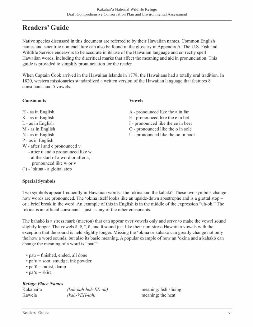
Native species discussed in this document are referred to by their Hawaiian names. Common Englishnames and scientific nomenclature can also be found in the glossary in Appendix A. The U.S. Fish andWildlife Service endeavors to be accurate in its use of the Hawaiian language and correctly spellHawaiian words, including the diacritical marks that affect the meaning and aid in pronunciation. Thisguide is provided to simplify pronunciation for the reader.
When Captain Cook arrived in the Hawaiian Islands in 1778, the Hawaiians had a totally oral tradition. In 1820, western missionaries standardized a written version of the Hawaiian language that features 8consonants and 5 vowels.
Special Symbols
Two symbols appear frequently in Hawaiian words: the ‘okina and the kahakō. These two symbols change how words are pronounced. The ‘okina itself looks like an upside-down apostrophe and is a glottal stop – or a brief break in the word. An example of this in English is in the middle of the expression “uh-oh.” The ‘okina is an official consonant – just as any of the other consonants.
The kahakō is a stress mark (macron) that can appear over vowels only and serve to make the vowel sound slightly longer. The vowels ā, ē, ī, ō, and ū sound just like their non-stress Hawaiian vowels with the exception that the sound is held slightly longer. Missing the ‘okina or kahakō can greatly change not only the how a word sounds, but also its basic meaning. A popular example of how an ‘okina and a kahakō can change the meaning of a word is “pau”:
• pau = finished, ended, all done• pa‘u = soot, smudge, ink powder• pa‘ū = moist, damp• pā‘ū = skirt
Refuge Place NamesKakahai‘a (kah-kah-hah-EE-ah) meaning: fish slicingKawela (kah-VEH-lah) meaning: the heat
Consonants
H - as in EnglishK - as in EnglishL - as in EnglishM - as in EnglishN - as in EnglishP - as in EnglishW - after i and e pronounced v - after u and o pronounced like w - at the start of a word or after a, pronounced like w or v(‘) - ‘okina - a glottal stop
Vowels
A - pronounced like the a in farE - pronounced like the e in betI - pronounced like the ee in beetO - pronounced like the o in soleU - pronounced like the oo in boot
Readers ’ Guide v
Kakahai‘a National Wildlife Refuge Draft Comprehensive Conservation Plan and Environmental Assessment
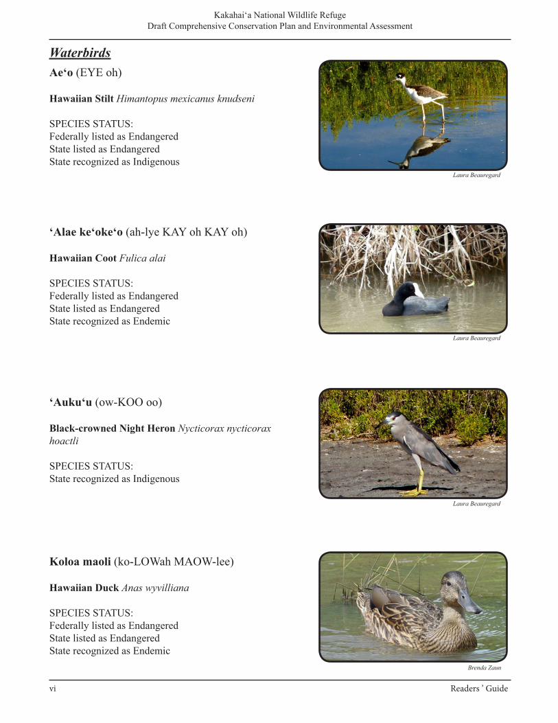
Ae‘o (EYE oh)
Hawaiian Stilt Himantopus mexicanus knudseni
SPECIES STATUS:Federally listed as EndangeredState listed as EndangeredState recognized as Indigenous
‘Alae ke‘oke‘o (ah-lye KAY oh KAY oh)
Hawaiian Coot Fulica alai
SPECIES STATUS:Federally listed as EndangeredState listed as EndangeredState recognized as Endemic
‘Auku‘u (ow-KOO oo)
Black-crowned Night Heron Nycticorax nycticorax hoactli
SPECIES STATUS:State recognized as Indigenous
Koloa maoli (ko-LOWah MAOW-lee)
Hawaiian Duck Anas wyvilliana
SPECIES STATUS:Federally listed as EndangeredState listed as EndangeredState recognized as Endemic
Waterbirds
Laura Beauregard
Laura Beauregard
Laura Beauregard
Brenda Zaun
Kakahai‘a National Wildlife Refuge Draft Comprehensive Conservation Plan and Environmental Assessment
vi Readers ’ Guide
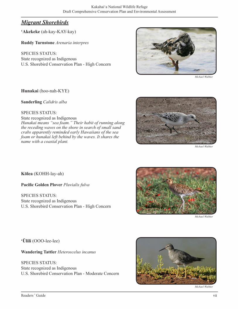
‘Akekeke (ah-kay-KAY-kay)
Ruddy Turnstone Arenaria interpres
SPECIES STATUS:State recognized as IndigenousU.S. Shorebird Conservation Plan - High Concern
Hunakai (hoo-nah-KYE)
Sanderling Calidris alba
SPECIES STATUS:State recognized as Indigenous Hunakai means “sea foam.” Their habit of running along the receding waves on the shore in search of small sand crabs apparently reminded early Hawaiians of the sea foam or hunakai left behind by the waves. It shares the name with a coastal plant.
Kōlea (KOHH-lay-ah)
Pacific Golden Plover Pluvialis fulva
SPECIES STATUS:State recognized as Indigenous U.S. Shorebird Conservation Plan - High Concern
‘Ūlili (OOO-lee-lee)
Wandering Tattler Heteroscelus incanus
SPECIES STATUS:State recognized as IndigenousU.S. Shorebird Conservation Plan - Moderate Concern
Migrant Shorebirds
Michael Walther
Michael Walther
Michael Walther
Michael Walther
Kakahai‘a National Wildlife Refuge Draft Comprehensive Conservation Plan and Environmental Assessment
Readers ’ Guide vii
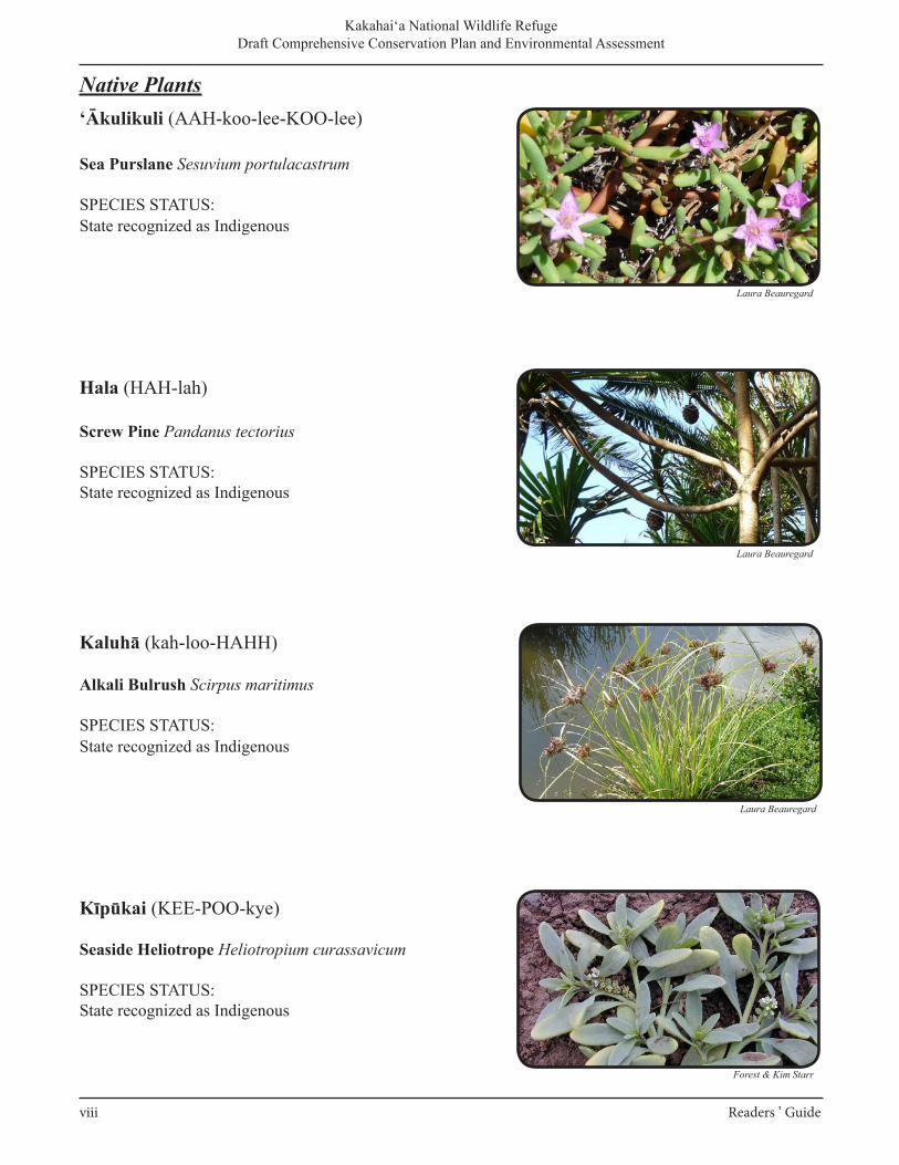
‘Ākulikuli (AAH-koo-lee-KOO-lee)
Sea Purslane Sesuvium portulacastrum
SPECIES STATUS:State recognized as Indigenous
Hala (HAH-lah)
Screw Pine Pandanus tectorius
SPECIES STATUS:State recognized as Indigenous
Kaluhā (kah-loo-HAHH)
Alkali Bulrush Scirpus maritimus
SPECIES STATUS:State recognized as Indigenous
Kīpūkai (KEE-POO-kye)
Seaside Heliotrope Heliotropium curassavicum
SPECIES STATUS:State recognized as Indigenous
Native Plants
viii Readers ’ Guide
Kakahai‘a National Wildlife Refuge Draft Comprehensive Conservation Plan and Environmental Assessment
Laura Beauregard
Forest & Kim Starr
Laura Beauregard
Laura Beauregard
Kakahai‘a National Wildlife Refuge Draft Comprehensive Conservation Plan and Environmental Assessment
_____________________________________________________________________________________ Chapter 1. Introduction and Background 1-1
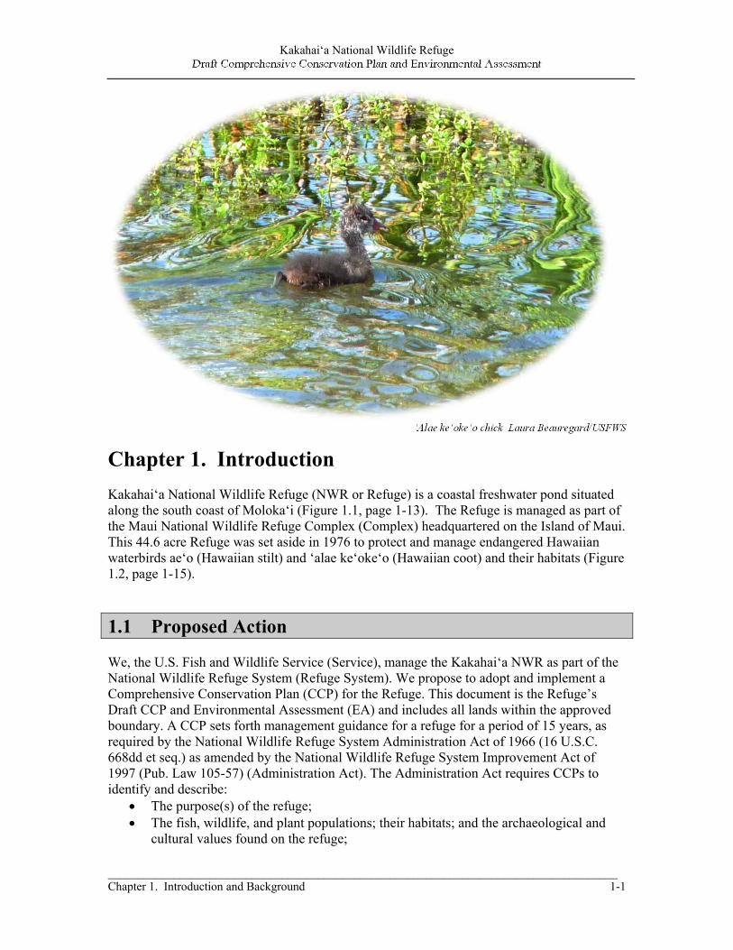
‘Alae ke‘oke‘o chick Laura Beauregard/USFWS
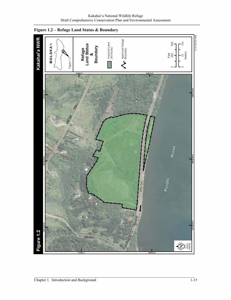
Chapter 1. Introduction Kakahai‘a National Wildlife Refuge (NWR or Refuge) is a coastal freshwater pond situated along the south coast of Moloka‘i (Figure 1.1, page 1-13). The Refuge is managed as part of the Maui National Wildlife Refuge Complex (Complex) headquartered on the Island of Maui. This 44.6 acre Refuge was set aside in 1976 to protect and manage endangered Hawaiian waterbirds ae‘o (Hawaiian stilt) and ‘alae ke‘oke‘o (Hawaiian coot) and their habitats (Figure 1.2, page 1-15).
1.1 Proposed Action We, the U.S. Fish and Wildlife Service (Service), manage the Kakahai‘a NWR as part of the National Wildlife Refuge System (Refuge System). We propose to adopt and implement a Comprehensive Conservation Plan (CCP) for the Refuge. This document is the Refuge’s Draft CCP and Environmental Assessment (EA) and includes all lands within the approved boundary. A CCP sets forth management guidance for a refuge for a period of 15 years, as required by the National Wildlife Refuge System Administration Act of 1966 (16 U.S.C. 668dd et seq.) as amended by the National Wildlife Refuge System Improvement Act of 1997 (Pub. Law 105-57) (Administration Act). The Administration Act requires CCPs to identify and describe:
The purpose(s) of the refuge; The fish, wildlife, and plant populations; their habitats; and the archaeological and
cultural values found on the refuge;

Kakahai‘a National Wildlife Refuge Draft Comprehensive Conservation Plan and Environmental Assessment
1-2 Chapter 1. Introduction and Background
Significant problems that may adversely affect wildlife populations and habitats and ways to correct or mitigate those problems;
Areas suitable for administrative sites or visitor facilities; and Opportunities for fish and wildlife-dependent recreation.
The Refuge System planning policy (Service Manual 602 FW 3) states the purpose of CCPs is to “describe the desired future conditions of a refuge and provide long-range guidance and management direction to achieve refuge purposes; help fulfill the National Wildlife Refuge System mission; maintain and, where appropriate, restore the ecological integrity of each refuge and the Refuge System; . . . and meet other mandates.” We have developed alternatives for managing Kakahai‘a NWR that address the major issues and relevant mandates identified in the CCP process and are consistent with principles of sound fish and wildlife management. Management options are consolidated into 3 alternatives with Alternative C identified as our preferred alternative. This alternative represents the best balanced approach for achieving the Refuge’s purposes, vision, and goals; contributing to the Refuge System mission; and addressing the relevant issues and mandates consistent with sound principles of fish and wildlife management. However, the selected alternative may be modified between the draft and final document depending upon comments received from the public or other agencies and organizations. The Regional Director for the Service’s Pacific Region will be the final decision-maker regarding the alternative that will be adopted for implementation. For details on the specific components and actions comprising the range of alternatives, see Chapter 2.
1.2 Purpose and Need for the CCP The purpose of the proposed CCP is to provide the Service, the Refuge System, partners, and citizens with a management plan for improving fish and wildlife habitat conditions and Refuge infrastructure, for wildlife and public use on Kakahai‘a NWR over the next 15 years. An approved CCP will ensure that the Service manages to achieve the Refuge purpose, vision, goals, and objectives to help fulfill the mission of the Refuge System. The CCP is needed for a variety of reasons. Primary among these is the need to establish improved habitat conditions on the Refuge’s wetland habitats, which are degraded by invasive plants and animals. The plan also recognizes and identifies threats to the endangered ae‘o and ‘alae ke‘oke‘o, including predation by nonnative mammals, limited water supply, and human disturbance. There is also a need to analyze Refuge public use programs for wildlife-dependent priority public uses and to determine what improvements or alterations should be made in the pursuit of a high-quality program (See Chapter 5 for more on priority public uses). Finally, there is a need to describe the steps that should be taken to better protect the habitats and wildlife through strategies to accomplish our goals.
Kakahai‘a National Wildlife Refuge Draft Comprehensive Conservation Plan and Environmental Assessment
_____________________________________________________________________________________ Chapter 1. Introduction and Background 1-3
1.3 Content and Scope of the Plan This Draft CCP/EA provides guidance for management of Refuge habitats and wildlife and administration of public uses on Refuge lands and waters. This CCP/EA is intended to comply with both the Administration Act and the National Environmental Policy Act (NEPA), as amended (42 U.S.C. 4321-4347). Information included in the CCP includes:
An overall vision for the Refuge, its establishment history and purpose, and its role in the local ecosystem (Chapter 1);
Management alternatives, goals, and objectives for specific conservation targets and visitor programs, as well as strategies for achieving the objectives (Chapter 2);
A description of the Refuge’s physical environment (Chapter 3); A description of conservation targets, condition, and trends on the Refuge and within
the local ecosystem, the key desired ecological conditions for sustaining the targets, and a short analysis of the threats to each conservation target (Chapter 4);
An overview of the Refuge’s visitor programs (Chapter 5); An account the Refuge’s facilities and other management considerations (Chapter 6); An analysis of the environmental effects associated with implementing the
management actions prescribed under the alternatives described (Chapter 7); A list of species known to occur on the Refuge CCP/EA (Appendix A); Evaluations of existing and proposed appropriate public and economic uses for
appropriateness and compatibility with the Refuge’s purpose (Appendix B); An Implementation Plan needed to support the alternatives considered (Appendix C); Wilderness Review (Appendix D); Integrated Pest Management (Appendix E); Fire Management Plan (Appendix F); Statement of Compliance (Appendix G); Revenue Sharing (Appendix H); Literature Cited (Appendix I); and Common Acronyms and Abbreviations (Appendix J).
1.4 Planning and Management Guidance The Service, an agency within the Department of the Interior, is the principal Federal agency responsible for conserving, protecting, and enhancing fish, wildlife, plants, and their habitats. Refuge management is guided by Federal laws, Executive orders, Service policies, and international treaties. Fundamental guidelines are found in the mission and goals of the Refuge System and the designated purposes of the Refuge as described in establishing legislation, Executive orders, or other documents establishing, authorizing, or expanding a refuge. Key concepts and guidance of the Refuge System derive from the Administration Act, the Refuge Recreation Act of 1962 (16 U.S.C. 460k-460k-4), as amended, Title 50 of the Code of Federal Regulations (CFR), and the Service Manual. The Administration Act is implemented through regulations covering the Refuge System, published in Title 50,
Kakahai‘a National Wildlife Refuge Draft Comprehensive Conservation Plan and Environmental Assessment
1-4 Chapter 1. Introduction and Background
subchapter C of the CFR. These regulations govern general administration of units of the Refuge System. 1.4.1 U.S. Fish and Wildlife Service Mission The mission of the Service is “working with others, to conserve, protect, and enhance fish and wildlife and their habitats for the continuing benefit of the American people.” National natural resources entrusted to the Service for conservation and protection include migratory birds, endangered and threatened species, interjurisdictional fish, wetlands, and certain marine mammals. The Service also manages national fish hatcheries, enforces Federal wildlife laws and international treaties on importing and exporting wildlife, assists with State and Territorial fish and wildlife programs, and helps other countries develop wildlife conservation programs.
1.4.2 National Wildlife Refuge System The Refuge System is the world’s largest network of public lands and waters set aside specifically for conserving wildlife and protecting ecosystems. From its inception in 1903, the Refuge System has grown to encompass over 550 national wildlife refuges in all 50 States, and waterfowl production areas in 10 States, covering more than 150 million acres of public lands and waters. More than 40 million visitors annually fish, hunt, observe and photograph wildlife, or participate in environmental education (EE) and interpretive activities on national wildlife refuges.
1.4.3 National Wildlife Refuge System Mission and Goals The mission of the Refuge System is “to administer a national network of lands and waters for the conservation, management, and, where appropriate, restoration of the fish, wildlife, and plant resources and their habitats within the United States for the benefit of present and future generations of Americans.” The goals of the Refuge System, as articulated in the Mission, Goals, and Purposes policy (601 FW 1), follow:
Conserve a diversity of fish, wildlife, and plants and their habitats, including species that are endangered or threatened with becoming endangered;
Develop and maintain a network of habitats for migratory birds, anadromous and interjurisdictional fish, and marine mammal populations that is strategically distributed and carefully managed to meet important life history needs of these species across their ranges;
Conserve those ecosystems, plant communities, wetlands of national or international significance, and landscapes and seascapes that are unique, rare, declining, or underrepresented in existing protection efforts;
Provide and enhance opportunities to participate in compatible wildlife-dependent recreation (hunting, fishing, wildlife observation and photography, and EE and interpretation); and
Foster understanding and instill appreciation of the diversity and interconnectedness of fish, wildlife, and plants and their habitats.
Kakahai‘a National Wildlife Refuge Draft Comprehensive Conservation Plan and Environmental Assessment
_____________________________________________________________________________________ Chapter 1. Introduction and Background 1-5
1.4.4 National Wildlife Refuge System Administration Act of 1966 Of all the laws governing activities on national wildlife refuges, the Administration Act exerts the greatest influence and included a unifying mission for all national wildlife refuges, a new process for determining compatible uses on refuges, and a requirement that each refuge will be managed under a CCP developed in an open public process. The Administration Act states that the Secretary shall provide for the conservation of fish, wildlife, plants, and their habitats within the Refuge System, and ensure that the biological integrity, diversity, and environmental health of the Refuge System are maintained. House Report 105–106 accompanying the Improvement Act states ‘‘…the fundamental mission of our System is wildlife conservation: wildlife and wildlife conservation must come first.’’ Biological integrity, diversity, and environmental health are critical components of wildlife conservation. As later made clear in the Biological Integrity, Diversity, and Environmental Health (BIDEH) policy (601 FW 3), “the highest measure of biological integrity, diversity, and environmental health is viewed as those intact and self-sustaining habitats and wildlife populations that existed during historic conditions.” Each refuge must be managed to fulfill the Refuge System mission as well as the specific purposes for which it was established. The Administration Act requires the Service to monitor the status and trends of fish, wildlife, and plants on every refuge. Additionally, six wildlife-dependent recreational uses are granted special consideration in the planning, management, establishment, and expansion of units of the Refuge System: hunting, fishing, wildlife observation and photography, and EE and interpretation. When determined compatible on a refuge-specific basis, these six uses assume priority status among all public uses of the refuge in question. The overarching goal is to enhance wildlife-dependent recreation opportunities and access to high-quality visitor experiences on refuges, while managing refuges to conserve fish, wildlife, plants, and their habitats. The Service is directed to make extra efforts to facilitate wildlife-dependent visitor opportunities. When preparing a CCP, refuge managers must evaluate all general public, recreational, and economic uses proposed or occurring on a refuge for appropriateness and compatibility. No refuge use may be allowed or continued unless it is determined to be appropriate and compatible. Generally, an appropriate use is one that contributes to fulfilling refuge purposes, the Refuge System mission, or goals and objectives described in an approved refuge management plan. A compatible use is defined as a use that, in the sound professional judgment of the refuge manager, will not materially interfere with or detract from the fulfillment of the mission of the Refuge System or the purpose(s) of the refuge. Current Appropriate Use Findings and Compatibility Determinations for existing and proposed uses for Kakahai‘a NWR are in Appendix B. The Administration Act also requires that, in addition to formally established guidance, the CCP must be developed with the participation of the public. Public comments play a role in identifying issues, guiding alternatives considered during development of the CCP, and selecting a preferred alternative. It is Service policy to develop CCPs in an open public process; the agency is committed to securing public input throughout the process.
Kakahai‘a National Wildlife Refuge Draft Comprehensive Conservation Plan and Environmental Assessment
1-6 Chapter 1. Introduction and Background
1.5 Refuge Establishment and Refuge Purpose
1.5.1 Legal Significance of the Refuge Purpose The purpose for which a Refuge was established or acquired is of key importance in Refuge planning. Purposes must form the foundation for planning and management decisions. The purpose(s) of a refuge are specified in or derived from the law, proclamation, Executive order, agreement, public land order, donation document, or administrative memorandum establishing, authorizing, or expanding a refuge, refuge unit, or refuge subunit. Unless the establishing law, order, or other document indicates otherwise, purposes dealing with the conservation, management, and restoration of fish, wildlife, plants, and the habitats on which they depend take precedence over other purposes in the management and administration of any unit. Where a refuge has multiple purposes related to fish, wildlife, and plant conservation, the more specific purpose will take precedence in instances of conflict. When an additional unit is acquired under an authority different from the authority used to establish the original unit, the addition takes on the purpose(s) of the original unit, but the original unit does not take on the purpose(s) of the newer addition. By law, Refuges are to be managed so as to achieve their purpose(s). When a conflict exists between the Refuge System mission and the purpose(s) of an individual refuge, the refuge purpose(s) supersedes the Refuge System mission.
1.5.2 Refuge Establishment and Purpose Kakahai‘a NWR was established in 1976 under the authority of the Endangered Species Act of 1973 (ESA). The Refuge was funded through the Land and Water Conservation Act of 1965. Refuge purposes are the driving force in the development of the refuge vision statements, goals, objectives, and strategies in the CCP and are critical to determining the appropriateness and compatibility of all existing and proposed refuge uses. Kakahai‘a NWR was established with the purpose “… to conserve (A) fish or wildlife which are listed as endangered species or threatened species, or (B) plants.”
1.6 Refuge Goals Goals and objectives are the unifying elements of successful refuge management. They identify and focus management priorities, resolve issues, and link to refuge purposes, Service policy, and the Refuge System mission. A CCP describes management actions that help bring a refuge closer to its vision. A vision broadly reflects refuge purposes, Refuge System mission and goals, other statutory requirements, and larger-scale plans as appropriate. Visitor services and wildlife/habitat management goals then define general targets in support of the vision, followed by objectives that direct efforts into incremental and measurable steps toward achieving those goals. Finally, strategies identify specific tools and actions to accomplish objectives. The Refuge vision statement is found on the inside front cover of this document. The following are our goals; their order does not imply any priority in this CCP.
Kakahai‘a National Wildlife Refuge Draft Comprehensive Conservation Plan and Environmental Assessment
_____________________________________________________________________________________ Chapter 1. Introduction and Background 1-7
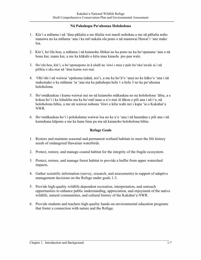
Nā Pahuhopu Pu‘uhonua Holoholona
1. Kīa‘i a mālama i nā ‘āina pālialia a me ālialia wai maoli nohokau a me nā pālialia noho manawa no ka mālama ‘ana i ka mō‘aukala ola pono o nā manuwai Hawai‘i ‘ane make loa.
2. Kīa‘i, ho‘ōla hou, a mālama i nā kaianoho lihikai no ka pono no ka ho‘opunana ‘ana o nā
honu kai, manu kai, a me ka kūkahi o kēia mau kaiaola pio pau wale. 3. Ho‘ola hou, kīa‘i, a ho‘oponopono in ā ululā‘au ʻoiwi i mea e pale ho‘oka‘awale ai i nā
pilikia o uka mai nā ‘āina kumu wai mai. 4. ‘Ohi‘ohi i nā waiwai ‘epekema (nānā, noi‘i, a me ka ho‘ā‘o ‘ana) no ke kāko‘o ‘ana i nā
makemake o ka mālama ‘ia ‘ana ma ka pahuhopu helu 1 a helu 3 no ka pu‘uhonua holoholona.
5. Ho‘omākaukau i kumu waiwai nui no nā kaianoho mākaukau no na holoholona ‘āhiu, a e
kokua ho‘i i ka lehulehu ma ka ho‘onā‘auao a a‘o mai iā lākou e pili ana i nā i‘a, nā holoholona hihiu, a me nā waiwai nohona ‘ōiwi o kēia wahi nei i kapa ‘ia o Kakahai‘a NWR.
6. Ho‘omākaukau ho‘i i polokalamu waiwai loa no ke a‘o ‘ana i nā haumāna e pili ana i nā
kumuhana kūpono a me ka hana lima pu ma nā kaianoho holoholona hihiu.
Refuge Goals 1. Restore and maintain seasonal and permanent wetland habitats to meet the life history
needs of endangered Hawaiian waterbirds.
2. Protect, restore, and manage coastal habitat for the integrity of the fragile ecosystem.
3. Protect, restore, and manage forest habitat to provide a buffer from upper watershed impacts.
4. Gather scientific information (survey, research, and assessments) in support of adaptive
management decisions on the Refuge under goals 1-3.
5. Provide high-quality wildlife-dependent recreation, interpretation, and outreach opportunities to enhance public understanding, appreciation, and enjoyment of the native wildlife, natural communities, and cultural history of the Kakahai‘a NWR.
6. Provide students and teachers high-quality hands-on environmental education programs
that foster a connection with nature and the Refuge.
Kakahai‘a National Wildlife Refuge Draft Comprehensive Conservation Plan and Environmental Assessment
1-8 Chapter 1. Introduction and Background
1.7 Relationship to Previous and Future Refuge Plans Planning has been a part of Refuge operations since their beginning. Although not all were conducted in a comprehensive fashion, or with public participation considered adequate today, a considerable number of plans were completed over the years to guide managers. Additional smaller “step-down” plans and management agreements (plans addressing one program or resource) will be developed for the Refuge in conjunction with the CCP. Current management plans include: Interim Management Plan - 2001 Wildland Fire Management Plan - 2004 Integrated Pest Management Plan - 2008 Refuge Safety Plan - 2010 Highly Pathogenic Avian Influenza Disease Contingency Plan - 2009 Avian Botulism Disease Contingency Plan - 2008 Emergency Preparedness Response Plan (updated annually) - 2011 Continuity of Operations Plan (updated annually) - 2011 Station Hazardous Communications Plan (updated annually) - 2011 1.7.1 Future planning The CCP will be revised every 15 years or earlier if monitoring and evaluation determine that changes are needed to achieve the Refuge purpose, vision, goals, or objectives. The CCP provides guidance in the form of goals, objectives, and strategies for Refuge programs areas but may lack some of the specifics needed for implementation. Step-down management plans will therefore be developed for individual program areas, as needed, following completion of the CCP. Step-down plans require appropriate NEPA compliance.
1.8 Relationship to Ecosystem Planning Efforts When developing a CCP, the Service considers the goals and objectives of existing national, regional, and ecosystem plans; State/Territorial fish and wildlife conservation plans; and other landscape-scale plans developed for the same watershed or ecosystem in which the refuge is located. To the extent possible, the CCP is expected to be consistent with these existing plans and assist in meeting their conservation goals and objectives (602 FW 3.3). This section summarizes some of the key plans that were reviewed by members of the planning team during CCP development. Hawai‘i’s Comprehensive Wildlife Conservation Strategy, 2005. With passage of the Commerce, Justice, and State Appropriations Act of 2001, Congress mandated each State and Territory to develop its own comprehensive wildlife conservation strategy. Hawai‘i’s Comprehensive Wildlife Conservation Strategy thoroughly reviews the status of the full range of the State’s native terrestrial and aquatic species, over 10,000 of which are found nowhere else on earth. Hawai‘i’s Species of Greatest Conservation Need include all native terrestrial animals, all endemic aquatic animals, additional indigenous aquatic animals identified as in need of conservation attention, a range of native plants identified as in need of conservation attention, and all identified endemic algae. This list includes: a terrestrial mammal (1), birds (77), terrestrial invertebrates (~5,000), freshwater fishes (5), freshwater invertebrates (12),
Kakahai‘a National Wildlife Refuge Draft Comprehensive Conservation Plan and Environmental Assessment
_____________________________________________________________________________________ Chapter 1. Introduction and Background 1-9
anchialine pond-associated fauna (20), marine mammals (26), marine reptiles (6), marine fishes (154), marine invertebrates (197), and flora (over 600). Details on all the listed wildlife taxa are provided in fact sheets that contain information for taxa, closely related groups of species, and species facing similar threats. Hawai‘i Nongame Management Program (Draft), 2000. The goal of the Hawai‘i Nongame Management Program is to manage, preserve and protect the native avifauna and their habitats for their intrinsic, recreational, scientific, and educational values and to provide opportunities for the residents and visitors to Hawai‘i to use and enjoy these resources. A major focus of the program is on management and recovery of endangered species, including projects to monitor, manage habitat, and recover populations and control of predators affecting endangered species. Other nongame projects include increased surveillance of non-native pests, construction of facilities and infrastructure to promote management or recreational opportunities to enjoy nongame resources, and maintenance of those facilities. Draft Revised Recovery Plan for Hawaiian Waterbirds, (Second Draft of Second Revision), May 2005. The ultimate goal of the recovery program is to restore and maintain multiple self-sustaining populations of Hawaiian waterbirds within their historic ranges. The recovery of the endangered waterbirds focuses on the following objectives:
Increasing population numbers to Statewide baseline levels (consistently stable or increasing with a minimum of 2,000 birds for each species);
Establishing multiple, self-sustaining breeding populations throughout each species’ historic range;
Establishing and protecting a network of both core and supporting wetlands that are managed as habitat suitable for waterbirds, including the maintenance of appropriate hydrological conditions and control of invasive nonnative plants;
For all four species, eliminating or controlling the threats posed by introduced predators, avian diseases, and contaminants; and
For the koloa maoli (Hawaiian duck), removing the threat of hybridization with feral mallards.
U.S. Pacific Islands Regional Shorebird Conservation Plan, 2004. Conservation and restoration of shorebird habitats is essential for the protection of endangered and declining shorebird populations. Wetlands, beach strand, coastal forests, and mangrove habitats are particularly vulnerable on Pacific islands due to increasing development pressures and already limited acreage. Monitoring and research needs include assessment of population sizes and trends; assessment of the timing and abundance of birds at key wintering and migration stopover sites; assessment of habitat use and requirements at wintering and migration areas; exploration of the geographic linkages between wintering, stopover, and breeding areas; and evaluation of habitat restoration and management techniques to meet the needs of resident and migratory species. Education and public outreach are critical components of this plan. Resource management agencies of Federal, Territorial, Commonwealth, and State governments will need to work together with military agencies, nongovernmental organizations, and the scientific community. On a larger scale, coordination at the international level will be key to the conservation of vulnerable species, both migratory and resident. Pacific Coast Joint Venture, Hawai‘i, 2006. This strategic plan for waterbirds and wetlands identifies management strategies for a diversity of resident and migratory species with
Kakahai‘a National Wildlife Refuge Draft Comprehensive Conservation Plan and Environmental Assessment
1-10 Chapter 1. Introduction and Background
varying life history requirements across multiple sites to fulfill archipelago-wide conservation goals to “protect, restore, increase, and enhance all types of wetlands, riparian habitats, and associated uplands throughout the Pacific Coast region to benefit birds, fish and other wildlife” (Henry 2006). To accomplish this goal, six strategies are employed: protection, restoration, enhancement and management advocacy, outreach, and research. Habitat goals for the Pacific Coast Joint Venture (PCJV) strategic conservation plan in Hawai‘i represent long ranging concepts that provide direction for conservation objectives and actions. They are based on the strategies identified by the PCJV and support goals identified by other avian conservation plans for Hawai‘i.
Moloka‘i Community Plan, 2001. One of nine community plans for the County of Maui describing planning goals, objectives, policies and implementation strategies to guide decision-making, this plan is currently under revision. It provides specific direction in addressing the goals, objectives and policies contained in the County’s General Plan, while recognizing the values and unique attributes of Moloka‘i in order to enhance the region's overall living environment. The environmental goal is to “Preserve, protect and manage Moloka‘i’s exceptional natural land and water resources to ensure that future generations may continue to enjoy and protect the island environment.” Many of the Moloka‘i Community Plan objectives apply to the Refuge, including:
Protect and encourage the restoration of native habitats through government and
private conservation, land management and educational programs. Restore the environmental integrity of Moloka‘i’s land resources through
development of a comprehensive reforestation program utilizing native species. Manage, protect and preserve shoreline dune formations throughout the planning
region. Manage, protect, and where appropriate, restore reef habitats, fish ponds and other coastal resources unique to the Island of Moloka‘i. Protect and manage coastal water quality through best management land treatment
practices. Recognize and preserve traditional access and uses of the environment to address
subsistence needs of the residents of Moloka‘i. Encourage the development of environmentally sensitive drainage master plans
which consider development opportunities and constraints in flood prone areas, stream channels and gulches.
Encourage alternative means of pest control in order to limit the use of chemical pesticides.
Require fire prevention and suppression strategies as a means of protecting and preserving Moloka‘i’s land and coastal water resources.
Promote the inclusion of environmental education within the curriculum at all educational levels to foster respect for Moloka‘i’s land, water and marine resources.
Kakahai‘a National Wildlife Refuge Draft Comprehensive Conservation Plan and Environmental Assessment
_____________________________________________________________________________________ Chapter 1. Introduction and Background 1-11
1.9 Planning and Issue Identification In September 2009, approximately 250 copies of Planning Update 1 were mailed and hand-distributed to interested individuals, local conservation groups, and research organizations; County, State, and Federal government agencies; and the Office of Hawaiian Affairs (OHA). Planning Update 1 described the planning process, Refuge purpose, and draft wildlife, habitat, and public use goals, and preliminary issues to be considered in the CCP. 1.9.1 Public Scoping Sessions The public scoping period for this CCP opened November 2009. A public meeting was held in Kaunakakai, Moloka‘i, on November 4, 2009. At the meeting, the Refuge staff explained the CCP planning process; the Refuge purposes, vision, and management; and preliminary management issues, concerns, and opportunities. We received written comments and answered questions that addressed a number of issues and concerns from residents. Planning Update 2 (mailed February 2010) summarized the comments we received and listed preliminary management issues we used to draft alternatives and refine goals and objectives. The core planning team evaluated the issues and the topics documented during scoping. Issues (defined as matters of controversy, dispute, or general concern over resource management activities, the environment, land uses, or public use activities) are important to the planning process to help identify topics to be addressed in the plan, pinpoint the types of information to gather, and help define alternatives for the plan. In Planning Update 3 (mailed March 2011), we described the three alternatives being considered with the preferred alternative identified. Concurrent with mailing, Planning Updates 1-3 were also posted on the Refuge website (http://www.fws.gov/Kakahaia). It is the Service’s responsibility to focus planning and the EA analysis on the major issues. Major issues typically suggest different actions or alternative solutions and are typically those within the Refuge’s jurisdiction which have a positive or negative effect on the resource. Major issues will influence the decisions proposed in the plan. Summaries of the issues identified to date follow. 1.9.2 Issues to be Addressed in the Draft CCP Restoration of the Wetlands: The primary purpose of the Refuge is to protect endangered waterbirds and restore their habitat. The continuous encroachment of pest plants, particularly California bulrush, has been a serious dilemma. Strategic planning is needed to efficiently remove and restore the wetlands and provide for endangered waterbirds and migratory species that once thrived. The Refuge will prepare a comprehensive Habitat Management Plan that will outline the restoration activities needed to remove and reconfigure Old Pond back to an open water pond that is naturally fed by springs. This work is likely to include deconstruction of the radial levees that were constructed in 1983; these levees pose a threat to the integrity of the pond by limiting water flow, capturing sediment, and are host to non-wetland vegetation. New Pond was intended to provide shallow water habitat for wading birds, primarily ae‘o; however, the original plan to receive water from Old Pond is not ideal and requires a separate
Kakahai‘a National Wildlife Refuge Draft Comprehensive Conservation Plan and Environmental Assessment
1-12 Chapter 1. Introduction and Background
source of water. Prior to construction of a water source, we need to identify the soil type and New Pond’s capability to hold water. Staff Presence on the Refuge and in the Community: Refuge staff, operation, and management of Kakahai‘a NWR are based at Keālia Pond NWR on Maui. A Maintenance Worker makes a day trip to Moloka‘i every other week to check on the property and perform work, primarily invasive plant control (fence line, New Pond). When the wetland is restored, the Refuge will need on-site staff or increased visits to maintain the wetlands and ensure the habitat does not revert to its existing condition. Strategic and efficient planning to restore Old Pond is necessary given the year-round growing season for California bulrush and natural source of underground springs. Wildlife and Habitat Resources: In the absence of quality habitat, endangered waterbirds are no longer present on the Refuge, except after heavy rains when water pools in New Pond for a short period of time (typically less than 1 week). The Service is concerned with threats posed to native habitats and wildlife at Kakahai‘a from invasive plants like California bulrush and pickleweed, and pest animals such as rats, Indian mongooses, and cats. Coastal erosion: The coastal property within the Refuge has undergone heavy erosion over the past decade. The reasons are unknown and emphasize the need to consult with coastal geologists and identify methods of securing the integrity of the coastal property without impacts to other adjacent areas. Refuge staff will seek partnerships to address effects of climate change. Information about unlawful removal of sand at the culvert adjacent to the Refuge road was revealed at the scoping meeting. Whether or not the removal is being performed by the State, County, or individuals, the Refuge will investigate this to ensure the proper information is distributed and install signs along the Refuge’s coastal property citing County ordnance. Visitor Services Activities: The absence of staff at Kakahai‘a NWR makes it difficult to allow public access on a daily basis and the Refuge will continue providing Special Use Permits (SUPs) to allow non-government educational organizations to provide school group access. Within the past number of years, these groups have decreased due to the absence of waterbirds. This Draft CCP/EA will evaluate different levels of public access when the wetlands are restored and endangered waterbirds are present, as well as other wildlife-dependent opportunities. 1.9.3 Issues Outside the Scope of the Draft CCP/EA Off-shore Fishing Activities: Fishing activities at Kakahai‘a Beach are not within the scope of this Draft CCP/EA as ocean-related opportunities and regulations fall within the jurisdiction of the State of Hawai‘i Division of Aquatic Resources (DAR) and Division of Conservation and Resource Enforcement (DOCARE). Kawela Stream: Although Kawela Stream has tributaries that enter the north side of the Refuge, it is located 0.2 miles west of the Refuge boundary and beyond the Refuge’s jurisdiction.

Kakahai‘a National Wildlife Refuge Draft Comprehensive Conservation Plan and Environmental Assessment
_____________________________________________________________________________________ Chapter 1. Introduction and Background 1-13
Figure 1.1 – Main Hawaiian Islands

Kakahai‘a National Wildlife Refuge Draft Comprehensive Conservation Plan and Environmental Assessment
1-14 Chapter 1. Introduction and Background
To preserve the quality of the map, this side was left blank intentionally.
Kakahai‘a National Wildlife Refuge Draft Comprehensive Conservation Plan and Environmental Assessment
_____________________________________________________________________________________ Chapter 1. Introduction and Background 1-15
Figure 1.2 – Refuge Land Status & Boundary

Kakahai‘a National Wildlife Refuge Draft Comprehensive Conservation Plan and Environmental Assessment
1-16 Chapter 1. Introduction and Background
To preserve the quality of the map, this side was left blank intentionally.
Kakahai‘a National Wildlife Refuge Draft Comprehensive Conservation Plan and Environmental Assessment
_____________________________________________________________________________________ Chapter 2. Alternatives, Goals, Objectives, and Strategies 2-1
Chapter 2. Alternatives, Goals, Objectives, and Strategies
2.1 Considerations in Alternative Design During development of the Draft CCP/EA alternatives presented in this chapter, the Service reviewed and considered a variety of resources, social, economic, and organizational aspects important for managing the Refuge. As is appropriate for a national wildlife refuge, resource considerations were fundamental in designing alternatives. House Report 105-106 accompanying the Improvement Act states “…the fundamental mission of our System is wildlife conservation: wildlife and wildlife conservation must come first.” The Service planning team reviewed and utilized available scientific information (reports and studies) to better understand ecosystem trends and the latest scientific recommendations for species and habitats. The team also met with staff from local, State and Federal agencies, and elected officials to ascertain priorities and problems as perceived by others. Refuge staff also met with Refuge users, non-profit groups, and community organizations to ensure their comments and ideas were considered during CCP development.
2.2 Alternative Components Not Considered for Detailed Analysis This Draft CCP/EA for Kakahai‘a NWR will not cover issues related to Kawela Stream, which is located 0.2 miles west of the Refuge boundary. Although this large stream has tributaries that enter the north side of the Refuge, the stream is beyond the Service’s jurisdiction. A suggestion was made at a scoping meeting to construct a brush dam (cut trees and bushes) at a narrow section of the gulch to slow down water, collect debris, and prevent erosion. Such a project is beyond the scope of this document and also results in impacts to jurisdictional waters of the U.S. Army Corps of Engineers (USACE).
2.3 Elements Common to All Alternatives All the alternatives contain some common features. To reduce the length and redundancy of the individual alternative descriptions, common elements are presented below. 2.3.1 Implementation Subject to Funding Availability Under each alternative, actions will be implemented over a period of 15 years as funding becomes available. Routine maintenance, repair, replacement, and improvement of existing facilities will continue, also dependent on funding. It is the intent of the Refuge that annual priorities would follow the final CCP guidelines, although funding initiatives, unforeseen management issues, and budgets may vary from year to year. The CCP will be reviewed annually and updated as necessary throughout its life.
Kakahai‘a National Wildlife Refuge Draft Comprehensive Conservation Plan and Environmental Assessment
2-2 Chapter 2. Alternatives, Goals, Objectives, and Strategies
2.3.2 Interagency Coordination and Collaboration Ecosystem planning efforts discussed in Chapter 1, Section 1.8, involve collaboration among Federal, State, and local agencies toward mutual goals. Under all alternatives, the Service will continue to maintain regular discussions and partnership with the Hawai‘i Department of Land and Natural Resources (DLNR). Topics for discussion continue to be the endangered waterbirds at Kakahai‘a NWR and surrounding private and public lands, and wildlife monitoring. 2.3.3 Threatened and Endangered Species Protection and Recovery Protection of threatened and endangered species is common across all alternatives. It is Service policy to give priority consideration to the protection, enhancement, and recovery of these species on national wildlife refuges. The protection of federally listed species mandated through Section 7 of the ESA, called "Interagency Cooperation," is the mechanism by which Federal agencies ensure the actions they take, including those they fund or authorize, do not jeopardize the existence of any listed species. To ensure adequate protection, the Refuge is required to review all activities, programs, and projects occurring on lands and waters of the Refuge to determine if they may affect listed species. If the determination is that an action may affect an endangered species, then the Refuge conducts a formal review, known as a consultation, to identify those effects and means to mitigate those effects. Consultation is being conducted concurrent with development of the CCP. 2.3.4 Historic and Cultural Resource Protection Cultural resources on Refuge lands receive protection and consideration in accordance with Federal cultural resources laws, Executive orders, and regulations, as well as policies and procedures established by the Department of the Interior (DOI) and the Service. Although the presence of cultural resources, including historic properties, does not preclude a Federal activity, the Refuge will seek to identify and protect cultural resources whenever possible. Refuge management actions will support the State of Hawai‘i’s vision statement “to promote the use and conservation of historic and cultural resources for the education, inspiration, pleasure and enrichment of the public in a spirit of stewardship and trusteeship for future generations” (State Historic Preservation Plan 2010-2014). The Native American Graves Protection and Repatriation Act (NAGPRA) is a Federal law passed in 1990 that provides a process for museums and Federal agencies to return certain Native American cultural items — human remains, funerary objects, sacred objects, or objects of cultural patrimony — to lineal descendants, and culturally affiliated Indian tribes and Native Hawaiian organizations. A Native Hawaiian organization includes any organization that: (a) serves and represents the interests of Native Hawaiians, (b) has as a primary and stated purpose of the provision of services to Native Hawaiians, and (c) has expertise in Native Hawaiian Affairs, and includes the Office of Hawaiian Affairs and Hui Malama i na Kupuna ‘o Hawai‘i Nei. The DOI has interpreted this definition to also include the Hawaiian island burial councils and various ‘ohana (extended families). During early planning of any projects, the Refuge will provide the Service’s Regional Historic Preservation Officer (RHPO) a description and location of all projects and activities that affect ground and structures, including project requests from third parties. Information will also include any alternatives being considered. The RHPO will analyze these undertakings for potential to affect historic properties and enter into consultation with the State Historic Preservation Division and other parties as appropriate. The Refuge will also ask the public and local government officials to identify any cultural resource impact concerns. This notification is generally done in conjunction with the review required by NEPA or Service regulations on compatibility of uses.
Kakahai‘a National Wildlife Refuge Draft Comprehensive Conservation Plan and Environmental Assessment
_____________________________________________________________________________________ Chapter 2. Alternatives, Goals, Objectives, and Strategies 2-3
2.3.5 Fire Management The suppression of wildfires and the use of prescribed or controlled fire are long-standing parts of resource protection, public safety, and habitat management on national wildlife refuges. The Fire Management Plan (Appendix F) provides detailed guidance for the suppression and use of prescribed fire. That plan's actions and effects are incorporated through reference in this CCP/EA. The plan outlines wildfire response and prescribed fire objectives, strategies, responsibilities, equipment and staffing; burn units; implementation; monitoring; and evaluation. 2.3.6 Participation in Planning and Review of Regional Development Activities The Service will actively participate in planning and studies for ongoing and future industrial and urban development, contamination, and other potential concerns that may affect the Refuge’s wildlife resources and habitats. The Service will continue to cultivate working relationships with pertinent State and Federal agencies to stay abreast of current and potential developments and will utilize effective outreach tools and technologies and EE as needed to raise awareness of the Refuge’s resources. The Refuge will participate in local community initiatives to protect, steward, and enhance natural landscapes and wildlife habitat. We will continue to identify and pursue new opportunities for land acquisition that will benefit Refuge purposes.
2.3.7 Adaptive Management Based upon 522 Departmental Manual (DM) 1 (Adaptive Management Implementation policy), Refuge staff shall utilize adaptive management for conserving, protecting, and, where appropriate, restoring lands and resources. Within 43 CFR 46.30, adaptive management is defined as a system of management practices based upon clearly identified outcomes, where monitoring evaluates whether management actions are achieving desired results (objectives). The recently published DOI Adaptive Management Technical Guide also defines adaptive management as a decision process that “promotes flexible decision making that can be adjusted in the face of uncertainties as outcomes from management actions and other events become better understood.” Adaptive management accounts for the fact that complete knowledge about fish, wildlife, plants, habitats, and the ecological processes supporting them may be lacking. The role of natural variability contributing to ecological resilience also is recognized as an important principle of adaptive management. It is not a “trial and error” process, but rather emphasizes learning while doing based upon available scientific information and best professional judgment considering site-specific biotic and abiotic factors on Refuge lands. Adaptive management results in effective monitoring and evaluation of the CCP. Part of measuring the success of and adaptively managing the Refuge also includes the formal 15-year revision of the CCP. The revision will be initiated by the Service and will involve many of the same steps as this Draft CCP, including comprehensive review of management plans and research; working closely with partners; and engaging the public. 2.3.8 Integrated Pest Management In accordance with DOI policy 517 DM 1 and Service policy 569 FW 1, an integrated pest management (IPM) approach will be utilized, where practicable, to eradicate, control, or contain pest and invasive species (herein collectively referred to as pests) on Refuge lands. The IPM would involve using methods based upon effectiveness, cost, and minimal ecological disruption, which
Kakahai‘a National Wildlife Refuge Draft Comprehensive Conservation Plan and Environmental Assessment
2-4 Chapter 2. Alternatives, Goals, Objectives, and Strategies
considers minimum potential effects to nontarget species and the Refuge environment. Pesticides may be used where physical, cultural, and biological methods or combinations thereof are impractical or incapable of providing adequate control, eradication, or containment. If a pesticide would be needed on Refuge lands, the most specific (selective) chemical available for the target species would be used unless considerations of persistence or other environmental and/or biotic hazards would preclude it. In accordance with 517 DM 1, pesticide usage would be further restricted because only pesticides registered with the Environmental Protection Agency (EPA) in full compliance with the Federal Insecticide, Fungicide, and Rodenticide Act and as provided in regulations, orders, or permits issued by EPA may be applied on lands and waters under Refuge jurisdiction. Environmental harm by pest species would refer to a biologically substantial decrease in environmental quality as indicated by a variety of potential factors, including declines in native species populations or communities, degraded habitat quality or long-term habitat loss, and/or altered ecological processes. Environmental harm may be a result of direct effects of pests on native species, including preying and feeding on them; causing or vectoring diseases; preventing them from reproducing or killing their young; outcompeting them for food, nutrients, light, nest sites, or other vital resources; or hybridizing with them so frequently that within a few generations, few if any truly native individuals remain. Environmental harm also can be the result of an indirect effect of pest species. For example, decreased waterfowl use may result from pest plant infestations reducing the availability and/or abundance of native wetland plants that provide forage during the winter. Throughout the life of the CCP, most proposed pesticide uses on Refuge lands would be evaluated for potential effects to Refuge biological resources and environmental quality. Pesticide uses with appropriate and practical best management practices (BMP) for habitat management as well as facilities maintenance would be approved for use on Refuge lands where there likely would be only minor, temporary, and localized effects to species and environmental quality based upon non-exceedance of threshold values in chemical profiles. However, pesticides may be used on Refuge lands where substantial effects to species and the environment are possible (exceed threshold values) in order to protect human health and safety (e.g., mosquito-borne disease). For more information on strategies related to control of pests, see Appendix E.
2.3.9 National Environmental Policy Act Compliance Since this EA and CCP are programmatic in many issue areas, it may not contain the necessary detail on every future action outlined to adequately present and evaluate all physical, biological, and socioeconomic impacts. For example, although the EA and CCP alternatives may show the proposed number and location of features such as fences, overlooks, and roads, the exact location, size, design, and other criteria related to these features would be determined at a later date depending on funding and implementation schedules. Another example is the various sub or “step-down” plans required for various management actions such as biological monitoring and predator control. Thus, before certain objectives or actions are implemented, a decision will be made in coordination with the Regional NEPA Coordinator on whether this EA was adequate for each specific construction, planning, or other action, or whether separate step-down NEPA compliance (categorical exclusion, EA, or an environmental impact statement) is needed.

Kakahai‘a National Wildlife Refuge Draft Comprehensive Conservation Plan and Environmental Assessment
_____________________________________________________________________________________ Chapter 2. Alternatives, Goals, Objectives, and Strategies 2-5
2.3.10 Law Enforcement Officers’ Responsibilities Fish and wildlife law enforcement issues on lands and waters of the Kakahai‘a NWR are under the jurisdiction of the Service Zone Officer based in Honolulu. The role of the Zone Officer is to conduct and document law enforcement incidents and coordinate and/or meet with all refuge project leaders, law enforcement supervisors, and refuge officers. The Hawaiian and Pacific Islands Zone Officer is highly mobile and is frequently deployed temporarily to various areas throughout the State of Hawai‘i and across the Pacific Region. The need for a dedicated Refuge Officer for the Complex has been identified in the Implementation Plan (Appendix C). Officers’ Authority The Zone and Refuge Officers are primarily responsible for enforcing refuge and wildlife laws, including but not limited to:
Administration Act; The Lacey Act; Archaeological Resource Protection Act; ESA; Migratory Bird Treaty Act; and Marine Mammal Protection Act.
Zone and Refuge Officers are also empowered to enforce all criminal laws, including traffic violations, drugs, and warrants for arrest as they relate to trespass, hunting, fishing, and the taking wildlife on Federal lands, and in some instances boating safety related to refuge lands and waters. Service Officers work joint patrols and coordinate with the DOCARE, Maui Police Department, and the Sheriff Division of the Hawai‘i Department of Public Safety.
2.3.11 Refuge Revenue Sharing Payments Annual payments to the County of Maui under the Refuge Revenue Sharing Program in lieu of property taxes will continue according to the established formula and subject to payments authorized by Congress. 2.3.12 Regulatory Compliance Activities under all alternatives requiring additional review, permits, and clearances (e.g., Section 106 of the National Historic Preservation Act, ESA Section 7 endangered species consultation, 401 water quality permits, etc.) will undergo appropriate review and obtain permits and/or clearances as needed. 2.3.13 Volunteer Opportunities Volunteer opportunities occur in all alternatives. These are recognized as components of the successful management of public lands and may become vital to the implementation of Refuge programs, plans, and projects, especially in times of declining budgets. Currently, the Refuge hosts intermittent volunteer projects with 40 volunteers.
Kakahai‘a National Wildlife Refuge Draft Comprehensive Conservation Plan and Environmental Assessment
2-6 Chapter 2. Alternatives, Goals, Objectives, and Strategies
2.3.14 Climate Change Climate change is expected to place enormous pressure on coastal refuges particularly vulnerable to sea level rise (SLR) resulting from melting glaciers and thermal expansion of oceans. Estimates by the Intergovernmental Panel on Climate Change (IPCC) project that global sea level will rise 0.6-2 feet by the end of the century. This threatens to erode shorelines, inundate low-lying areas, and contaminate freshwater resources through saltwater intrusion. Other impacts of climate change include species’ range shifts, phenological changes, decoupling of species assemblages, hydrological changes, and changes in disturbance regimes. Such impacts could result in dramatically different ecosystem compositions than currently exist on the refuges, and planning decisions will consider this issue. There is overwhelming scientific consensus that the earth’s climate is rapidly changing and that the primary cause of global warming is human-caused increases in greenhouse gas emissions. Much less is understood about the complex effects that a rapidly changing climate will have on ecosystems and wildlife. The Service is participating in the Pacific Islands Climate Change Cooperative (PICCC) to develop protocols for monitoring the status and trends of fish, wildlife, and plants in relation to climate changes. A collaborative program throughout the region will best equip stakeholders to discern changes in abundance or distribution of indicator species. Because regional data accumulation and analysis is requisite, we will coordinate efforts with other Federal agencies, State agencies, conservation organizations, universities, local landowners, and climate change scientists. Such coordinated studies and monitoring data benefit our understanding and appropriate response to changes throughout the region.
2.4 Alternatives Descriptions Each alternative describes a combination of habitat and visitor management strategies designed to achieve the Refuge purpose, goals, and vision. These alternatives provide different ways to address and respond to major public issues, management concerns, and opportunities identified during the planning process. All of the major issues, activities, and management concerns were evaluated and addressed for each alternative and are shown in the corresponding maps found in this chapter. A summary of the key differences between the alternatives is presented in Table 2.1 on page 2-9. These alternatives represent broad, thematic approaches to management of the Refuge, recognizing the latitude managers have within the framework of Refuge System laws and policy. The alternatives reflect direction in the Administration Act, Service policy for administration and management of refuges, and a host of ongoing conservation initiatives affecting the Hawaiian Islands. The alternatives were developed to address a suite of issues, and indeed are structured to track the issues, challenges, and opportunities presented in Chapter 1. As an integrated CCP and EA, the details of the alternatives are described in terms of the main components of a CCP, namely measurable objectives and strategies to achieve those objectives. Most importantly, these alternatives are designed to help Kakahai‘a NWR contribute to the mission of the Refuge System; meet the purposes for which the Refuge was established, and help achieve the Refuge vision, goals, and objectives. Stepdown plans for Habitat Restoration would be developed under Alternatives B and C.

Kakahai‘a National Wildlife Refuge Draft Comprehensive Conservation Plan and Environmental Assessment
_____________________________________________________________________________________ Chapter 2. Alternatives, Goals, Objectives, and Strategies 2-7
2.4.1 Alternative A: Continue Current Management Activities This alternative assumes no change in current management programs and is considered the base from which to compare the other alternatives. Under this alternative, Refuge management, consistent with available funding and staffing, would continue. No significant changes would be initiated by the Service. Wetland management at Kakahai‘a NWR has decreased significantly over the past 10 years due to limited staff and funding. Overgrowth of pest plants, including trees and shrubs on levees, has hindered efforts to manage the habitat on a small scale. Sedimentation from the upper watershed has resulted in a degraded wetland. Failure to provide adequate wetland habitat has resulted in an absence of waterbirds; thus, all predator control activities have been halted. Current management activities at Kakahai‘a are limited to herbicide and mechanical treatments to set back pest plant species at New Pond and along the fence line. Other management includes maintaining access to staff gages and piezometers; monitoring water levels; and replacing the perimeter fence, as funding permits. The Refuge is closed to visitors.
2.4.2 Alternative B: Restoration Focus This alternative will restore 10.5 acres of wetland habitat at Kakahai‘a NWR. Development of a water source for 5.5 acre New Pond would be accomplished with the construction of a well, installation of a pump and water distribution line, and repair of the electric panel. Depending on the capability of retaining and manipulating water level in the pond, this alternative is expected to create foraging and resting habitat for ae‘o and ‘alae ke‘oke‘o, and potential nesting habitat for ae‘o. Water would be used to set back vegetation; however, IPM treatments would continue to be performed during the dry months (October-December). Water level management in both ponds would also enhance invertebrate abundance. Removal of 5 acres of invasive vegetation would recreate open water habitat in Old Pond. Continuous pest plant management will be needed to discourage regrowth and allow re-establishment of native sedges. If feasible, the pond topography will be re-contoured in areas where California bulrush has been removed. This hemi-marsh will create foraging and nesting habitat for ‘alae ke‘oke‘o. Monitoring of waterbirds and predator control would resume, particularly during breeding season. The perimeter fence will be repaired or replaced to minimize some pest mammals (e.g., axis deer, pigs, dogs) but not all. This alternative includes a compilation of available data on the ecology of the wetlands and initiation of research to evaluate the geomorphology, hydrology, and elevation in preparation for a restoration design that would meet the needs of two focal species: ae‘o and ‘alae ke‘oke‘o. The Refuge will remain closed to the public except those authorized through an SUP for EE and interpretation. An earthen platform would be constructed along the road outside the fence for viewing opportunities. Volunteer work groups will be coordinated with staff visits from Maui. All earthmoving projects will be conducted in previously disturbed areas with a preexisting cultural resource clearance. 2.4.3 Alternative C: Wetland Capacity Focus (Preferred Alternative) This alternative would maximize wetland habitat with complete restoration of the 15-acre Old Pond and 5.5 acres of New Pond. Physical restoration of the Old Pond would include removal of California bulrush and other aggressive pest species, dredging accumulated sediment, reconfiguring bathymetry and radial levees, reconstructing perimeter levees, replacing the water control structure, and replacing the pump between the two ponds. Restoration of Old Pond would provide open water

Kakahai‘a National Wildlife Refuge Draft Comprehensive Conservation Plan and Environmental Assessment
2-8 Chapter 2. Alternatives, Goals, Objectives, and Strategies
and emergent habitat for breeding, foraging, and nesting ‘alae ke‘oke‘o with minimum supplemental water due to the presence of natural groundwater springs. This alternative includes a compilation of available data on the ecology of the wetlands and initiation of research to evaluate the geomorphology, hydrology, and elevation in preparation for a restoration design that would meet the needs of two focal species: ae‘o and ‘alae ke‘oke‘o. A new well, pump, water distribution line, and control outlet for New Pond would be constructed and existing levees would be reconstructed. The capability of flooding and dewatering the ponds will provide permanent and the seasonal habitat for ae‘o and ‘alae ke‘oke‘o, and indirectly benefit migratory waterbirds. All monitoring activities would resume with the presence of wetland function. A predator-proof fence would be installed to minimize or eliminate predators from entering the wetlands. The Service will work with Hawai‘i Department of Transportation (HDOT) on planning and design to modify the culvert passing under Kamehameha V Highway to allow water from the upper watershed and periodic dewatering of the wetlands to flow to the ocean naturally without blockage from sand. We will contract a comprehensive archaeological and cultural investigation for the Refuge and surrounding lands prior to expanding restoration efforts beyond previously disturbed lands. Maintaining the wetlands at Kakahai‘a NWR will require a regular on-site staff presence. The opportunities for visitors to engage in wildlife-dependent recreation may expand depending on staffing, and, at a minimum, a kiosk would be constructed on the earthen platform along the Refuge entrance road. Volunteer groups would be coordinated to assist staff with restoration and maintenance activities.
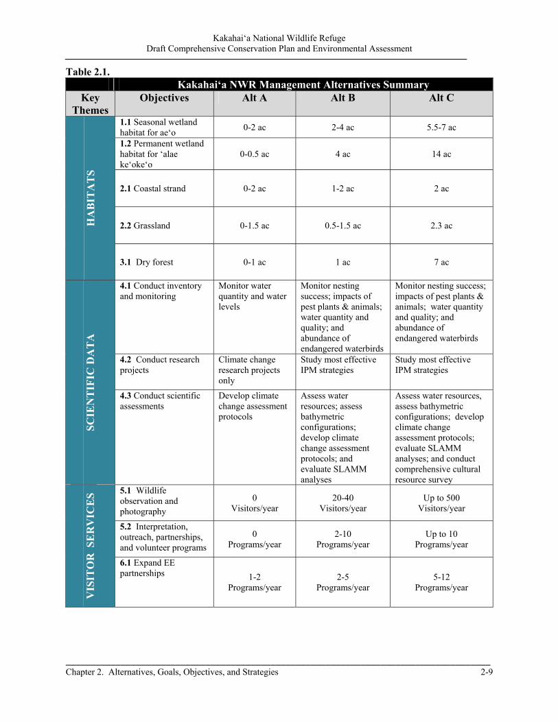
Kakahai‘a National Wildlife Refuge Draft Comprehensive Conservation Plan and Environmental Assessment
_____________________________________________________________________________________ Chapter 2. Alternatives, Goals, Objectives, and Strategies 2-9
Table 2.1. Kakahai‘a NWR Management Alternatives Summary
Key Themes
Objectives Alt A Alt B Alt C H
AB
ITA
TS
1.1 Seasonal wetland habitat for ae‘o
0-2 ac 2-4 ac 5.5-7 ac
1.2 Permanent wetland habitat for ‘alae ke‘oke‘o
0-0.5 ac 4 ac 14 ac
2.1 Coastal strand 0-2 ac 1-2 ac 2 ac
2.2 Grassland 0-1.5 ac 0.5-1.5 ac 2.3 ac
3.1 Dry forest 0-1 ac 1 ac 7 ac
SC
IEN
TIF
IC D
AT
A
4.1 Conduct inventory and monitoring
Monitor water quantity and water levels
Monitor nesting success; impacts of pest plants & animals; water quantity and quality; and abundance of endangered waterbirds
Monitor nesting success; impacts of pest plants & animals; water quantity and quality; and abundance of endangered waterbirds
4.2 Conduct research projects
Climate change research projects only
Study most effective IPM strategies
Study most effective IPM strategies
4.3 Conduct scientific assessments
Develop climate change assessment protocols
Assess water resources; assess bathymetric configurations; develop climate change assessment protocols; and evaluate SLAMM analyses
Assess water resources, assess bathymetric configurations; develop climate change assessment protocols; evaluate SLAMM analyses; and conduct comprehensive cultural resource survey
V
ISIT
OR
SE
RV
ICE
S 5.1 Wildlife observation and photography
0 Visitors/year
20-40 Visitors/year
Up to 500 Visitors/year
5.2 Interpretation, outreach, partnerships, and volunteer programs
0 Programs/year
2-10 Programs/year
Up to 10 Programs/year
6.1 Expand EE partnerships 1-2
Programs/year 2-5
Programs/year 5-12
Programs/year

Kakahai‘a National Wildlife Refuge Draft Comprehensive Conservation Plan and Environmental Assessment
2-10 Chapter 2. Alternatives, Goals, Objectives, and Strategies
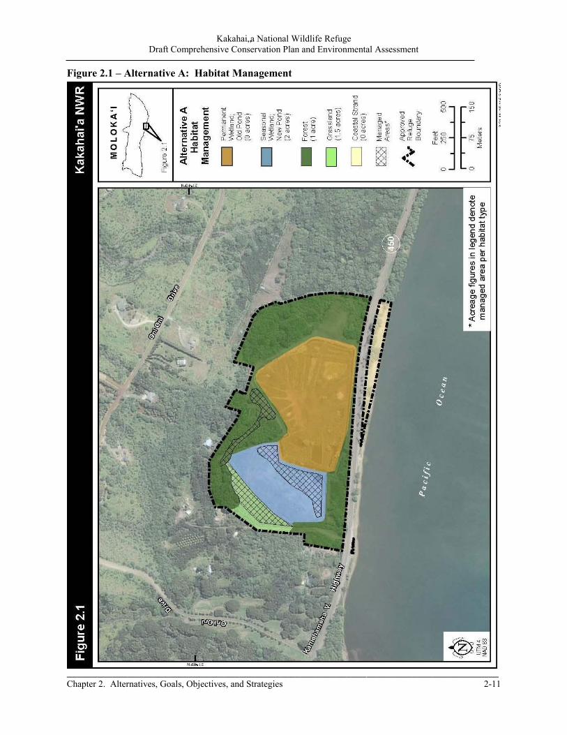
Kakahai„a National Wildlife Refuge Draft Comprehensive Conservation Plan and Environmental Assessment
_____________________________________________________________________________________ Chapter 2. Alternatives, Goals, Objectives, and Strategies 2-11
Figure 2.1 – Alternative A: Habitat Management

Kakahai„a National Wildlife Refuge Draft Comprehensive Conservation Plan and Environmental Assessment
2-12 Chapter 2. Alternatives, Goals, Objectives, and Strategies
To preserve the quality of the map, this side was left blank intentionally.

Kakahai„a National Wildlife Refuge Draft Comprehensive Conservation Plan and Environmental Assessment
_____________________________________________________________________________________ Chapter 2. Alternatives, Goals, Objectives, and Strategies 2-13
Figure 2.2 – Alternative B: Habitat Management

Kakahai„a National Wildlife Refuge Draft Comprehensive Conservation Plan and Environmental Assessment
2-14 Chapter 2. Alternatives, Goals, Objectives, and Strategies
To preserve the quality of the map, this side was left blank intentionally.
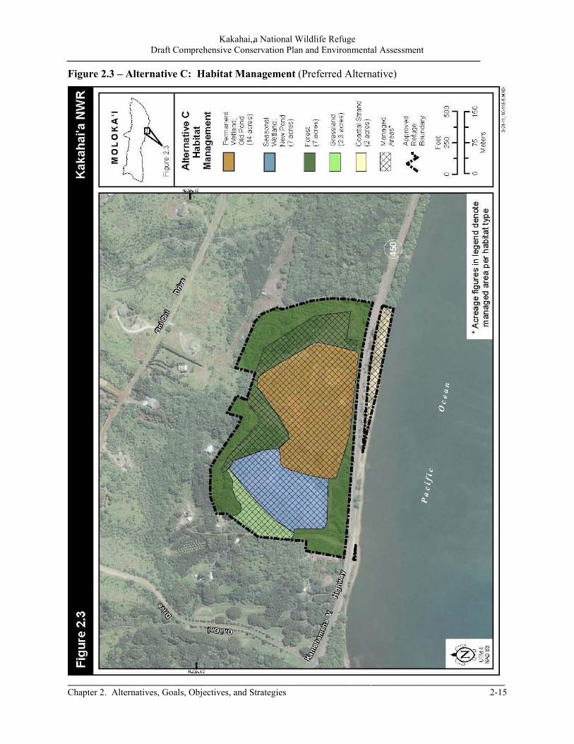
Kakahai„a National Wildlife Refuge Draft Comprehensive Conservation Plan and Environmental Assessment
_____________________________________________________________________________________ Chapter 2. Alternatives, Goals, Objectives, and Strategies 2-15
Figure 2.3 – Alternative C: Habitat Management (Preferred Alternative)

Kakahai‘a National Wildlife Refuge Draft Comprehensive Conservation Plan and Environmental Assessment
2-16 Chapter 2. Alternatives, Goals, Objectives, and Strategies
To preserve the quality of the map, this side was left blank intentionally.
Kakahai‘a National Wildlife Refuge Draft Comprehensive Conservation Plan and Environmental Assessment
_____________________________________________________________________________________ Chapter 2. Alternatives, Goals, Objectives, and Strategies 2-17
2.5 Goals, Objectives, Strategies, and Rationale Goals and objectives are the unifying elements for successful, adaptive refuge management. They identify and focus management priorities, resolve issues, and link to refuge purpose(s), Service policy, and the Refuge System mission. A CCP describes management actions that help bring a refuge closer to its vision. A vision broadly reflects the refuge purposes, Refuge System mission and goals, other statutory requirements, and larger-scale plans as appropriate. Goals then define general targets in support of the vision, followed by objectives that direct effort into incremental and measurable steps toward achieving those goals. Finally, strategies identify specific tools and actions to accomplish objectives. Unless specifically stated, all objectives are applicable throughout the life of this plan.
In the development of this Draft CCP/EA, the Service has provided effects analysis in Chapter 7. The effects analysis evaluates alternative sets of management actions derived from management goals, objectives, and implementation strategies. The goals for the Kakahai‘a NWR are presented on the following pages. Each goal is followed by one or more objectives that pertain to it. The goal order does not imply any priority in this Draft CCP/EA. Some objectives pertain to multiple goals and have simply been placed in the most reasonable spot. Similarly, some strategies pertain to multiple objectives and for clarity these strategies are listed under each relevant objective. Following the goals, objectives, and strategies, a brief rationale is provided. This rationale generally describes how management strategies will be implemented to achieve the intended objectives. The rationale may also, where necessary, discuss means to minimize potential impacts to nontarget species and habitats. It also provides further background information pertaining to the importance of an objective relative to legal mandates for managing units of the Refuge System, including refuge purpose, trust resource responsibilities (federally listed threatened and endangered species and migratory birds), and maintaining/restoring biological integrity, diversity, and environmental health.
‘Alae k‘eok‘eo nest USFWS
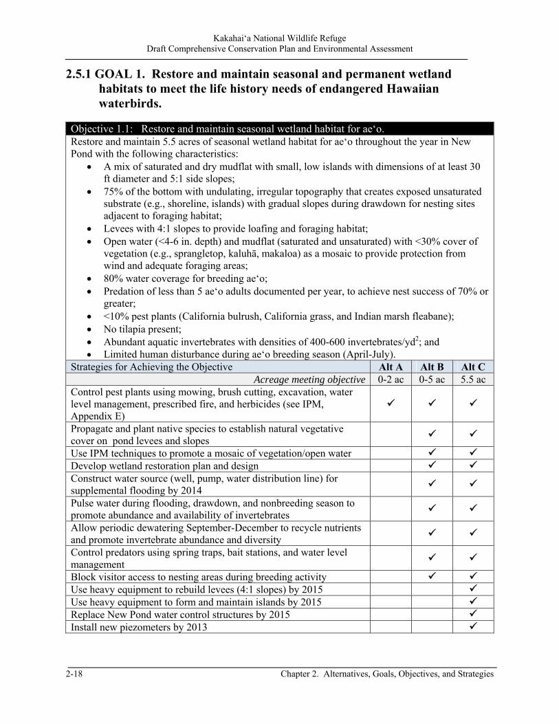
Kakahai‘a National Wildlife Refuge Draft Comprehensive Conservation Plan and Environmental Assessment
2-18 Chapter 2. Alternatives, Goals, Objectives, and Strategies
2.5.1 GOAL 1. Restore and maintain seasonal and permanent wetland habitats to meet the life history needs of endangered Hawaiian waterbirds.
Objective 1.1: Restore and maintain seasonal wetland habitat for ae‘o. Restore and maintain 5.5 acres of seasonal wetland habitat for ae‘o throughout the year in New Pond with the following characteristics:
A mix of saturated and dry mudflat with small, low islands with dimensions of at least 30 ft diameter and 5:1 side slopes;
75% of the bottom with undulating, irregular topography that creates exposed unsaturated substrate (e.g., shoreline, islands) with gradual slopes during drawdown for nesting sites adjacent to foraging habitat;
Levees with 4:1 slopes to provide loafing and foraging habitat; Open water (<4-6 in. depth) and mudflat (saturated and unsaturated) with <30% cover of
vegetation (e.g., sprangletop, kaluhā, makaloa) as a mosaic to provide protection from wind and adequate foraging areas;
80% water coverage for breeding ae‘o; Predation of less than 5 ae‘o adults documented per year, to achieve nest success of 70% or
greater; <10% pest plants (California bulrush, California grass, and Indian marsh fleabane); No tilapia present; Abundant aquatic invertebrates with densities of 400-600 invertebrates/yd2; and Limited human disturbance during ae‘o breeding season (April-July).
Strategies for Achieving the Objective Alt A Alt B Alt C Acreage meeting objective 0-2 ac 0-5 ac 5.5 ac
Control pest plants using mowing, brush cutting, excavation, water level management, prescribed fire, and herbicides (see IPM, Appendix E)
Propagate and plant native species to establish natural vegetative cover on pond levees and slopes
Use IPM techniques to promote a mosaic of vegetation/open water Develop wetland restoration plan and design Construct water source (well, pump, water distribution line) for supplemental flooding by 2014
Pulse water during flooding, drawdown, and nonbreeding season to promote abundance and availability of invertebrates
Allow periodic dewatering September-December to recycle nutrients and promote invertebrate abundance and diversity
Control predators using spring traps, bait stations, and water level management
Block visitor access to nesting areas during breeding activity Use heavy equipment to rebuild levees (4:1 slopes) by 2015 Use heavy equipment to form and maintain islands by 2015 Replace New Pond water control structures by 2015 Install new piezometers by 2013

Kakahai‘a National Wildlife Refuge Draft Comprehensive Conservation Plan and Environmental Assessment
_____________________________________________________________________________________ Chapter 2. Alternatives, Goals, Objectives, and Strategies 2-19
Strategies for Achieving the Objective Alt A Alt B Alt C Slow drawdown of water to eliminate fish and promote invertebrate/algal growth and plant response
Station employee (Maintenance Worker or Biologist) at Kakahai‘a NWR to oversee Refuge programs by 2014
Rationale Originally, New Pond was flooded from water pumped from Old Pond; however, the encroachment of California bulrush throughout Old Pond has resulted in an unavailability of water. Construction of a well and installation of a pump with electrical service is needed to provide forage, resting, and nesting habitat as well as use water level to control pest plants and promote invertebrate diversity and abundance. Ae‘o require different loafing and foraging habitats during the breeding and nonbreeding seasons. Recently hatched chicks (less than 14 days old) require shallow water of less than 2 inches to forage. During the remainder of the year, fledglings and adults can forage in water as deep as 6 inches. Seasonally regulating water depth stimulates germination of desirable and beneficial plant species, controls pest plants, and provides a variety of macroinvertebrates for young and adult ae‘o to feed upon, thereby creating and maintaining maximized production and carrying capacity of the wetlands. In addition to providing forage, seasonally regulated water depths provide a mosaic of open water and vegetation as microhabitat for thermoregulation. Dewatering the pond during nonbreeding season is beneficial for recycling nutrients and allowing staff to perform IPM (herbicide and mechanical treatment) before flooding. This drying cycle enhances soil aeration and invertebrate productivity. Invertebrates are the primary food source for waterbirds but labor intensive to monitor. Random sampling and subsampling of sieved invertebrates will provide densities of species composition and abundance, and response to IPM techniques.
Management techniques including, mowing, herbicide application, prescribed fire, rototilling and water level management are all techniques suitable for creating the desired mosaic of vegetation, open water, and mudflats. These practices also benefit a variety of other wetland-dependent species including ‘alae ke‘oke‘o, wintering waterfowl (dabbling ducks), and shorebirds. The pond would be flooded from a groundwater well or from Old Pond, and ocean water is not likely to inundate the pond. Declining water levels increase areas of suitable nesting habitat. Ae‘o breeding season drawdowns maximize the number of nests that an area can support. The target distance between nest site to vegetation and water is approximately 0-20 feet. These slow breeding season drawdown rates also stimulate ample numbers and diversity of invertebrates throughout the brood rearing period, allowing adults with broods to establish feeding territories and reduce inter-brood conflicts that can result in injury or death to young chicks.
Ae‘o are very easily disturbed during the nesting season. One behavior of the adult is to depart the nest when perceived danger is detected, leaving the nest, eggs, or young exposed to ground or avian predators and the weather. Eggs can also be destroyed by prolonged exposure to high temperature, wind chill, and rain, all of which occur frequently in Hawai‘i. Human disturbance must be minimized during the nesting period to reduce the risk of nest abandonment.
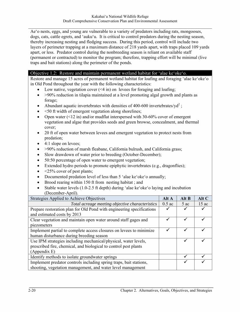
Kakahai‘a National Wildlife Refuge Draft Comprehensive Conservation Plan and Environmental Assessment
2-20 Chapter 2. Alternatives, Goals, Objectives, and Strategies
Ae‘o nests, eggs, and young are vulnerable to a variety of predators including rats, mongooses, dogs, cats, cattle egrets, and ‘auku‘u. It is critical to control predators during the nesting season, thereby increasing nesting and fledging success. During this period, control will include two layers of perimeter trapping at a maximum distance of 218 yards apart, with traps placed 109 yards apart, or less. Predator control during the nonbreeding season is reliant on available staff (permanent or contracted) to monitor the program; therefore, trapping effort will be minimal (live traps and bait stations) along the perimeter of the ponds.
Objective 1.2: Restore and maintain permanent wetland habitat for ‘alae ke‘oke‘o. Restore and manage 15 acres of permanent wetland habitat for loafing and foraging ‘alae ke‘oke‘o in Old Pond throughout the year with the following characteristics:
Low native, vegetation cover (<4 in) on levees for foraging and loafing; >90% reduction in tilapia maintained at a level promoting algal growth and plants as
forage; Abundant aquatic invertebrates with densities of 400-600 invertebrates/yd2 ; <50 ft width of emergent vegetation along shorelines; Open water (<12 in) and/or mudflat interspersed with 30-60% cover of emergent
vegetation and algae that provides seeds and green browse, concealment, and thermal cover;
20 ft of open water between levees and emergent vegetation to protect nests from predation;
4:1 slope on levees; >90% reduction of marsh fleabane, California bulrush, and California grass; Slow drawdown of water prior to breeding (October-December); 50:50 percentage of open water to emergent vegetation; Extended hydro periods to promote epiphytic invertebrates (e.g., dragonflies); <25% cover of pest plants; Documented predation level of less than 5 ‘alae ke‘oke‘o annually; Brood rearing within 150 ft from nesting habitat ; and Stable water levels (1.0-2.5 ft depth) during ‘alae ke‘oke‘o laying and incubation
(December-April). Strategies Applied to Achieve Objectives Alt A Alt B Alt C
Total acreage meeting objective characteristics 0.5 ac 5 ac 15 ac Prepare restoration plan for Old Pond with engineering specifications and estimated costs by 2013
Clear vegetation and maintain open water around staff gages and piezometers
Implement partial to complete access closures on levees to minimize human disturbance during breeding season
Use IPM strategies including mechanical/physical, water levels, prescribed fire, chemical, and biological to control pest plants (Appendix E)
Identify methods to isolate groundwater springs Implement predator controls including spring traps, bait stations, shooting, vegetation management, and water level management
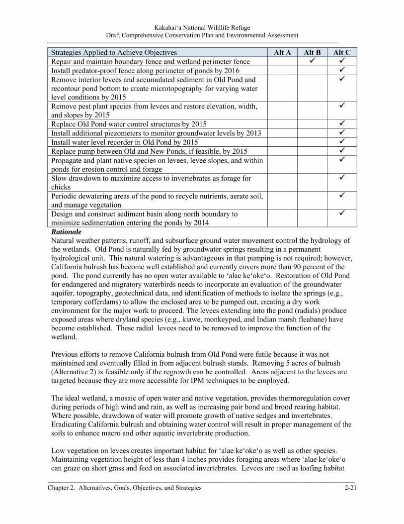
Kakahai‘a National Wildlife Refuge Draft Comprehensive Conservation Plan and Environmental Assessment
_____________________________________________________________________________________ Chapter 2. Alternatives, Goals, Objectives, and Strategies 2-21
Strategies Applied to Achieve Objectives Alt A Alt B Alt C Repair and maintain boundary fence and wetland perimeter fence Install predator-proof fence along perimeter of ponds by 2016 Remove interior levees and accumulated sediment in Old Pond and recontour pond bottom to create microtopography for varying water level conditions by 2015
Remove pest plant species from levees and restore elevation, width, and slopes by 2015
Replace Old Pond water control structures by 2015 Install additional piezometers to monitor groundwater levels by 2013 Install water level recorder in Old Pond by 2015 Replace pump between Old and New Ponds, if feasible, by 2015 Propagate and plant native species on levees, levee slopes, and within ponds for erosion control and forage
Slow drawdown to maximize access to invertebrates as forage for chicks
Periodic dewatering areas of the pond to recycle nutrients, aerate soil, and manage vegetation
Design and construct sediment basin along north boundary to minimize sedimentation entering the ponds by 2014
Rationale Natural weather patterns, runoff, and subsurface ground water movement control the hydrology of the wetlands. Old Pond is naturally fed by groundwater springs resulting in a permanent hydrological unit. This natural watering is advantageous in that pumping is not required; however, California bulrush has become well established and currently covers more than 90 percent of the pond. The pond currently has no open water available to ‘alae ke‘oke‘o. Restoration of Old Pond for endangered and migratory waterbirds needs to incorporate an evaluation of the groundwater aquifer, topography, geotechnical data, and identification of methods to isolate the springs (e.g., temporary cofferdams) to allow the enclosed area to be pumped out, creating a dry work environment for the major work to proceed. The levees extending into the pond (radials) produce exposed areas where dryland species (e.g., kiawe, monkeypod, and Indian marsh fleabane) have become established. These radial levees need to be removed to improve the function of the wetland. Previous efforts to remove California bulrush from Old Pond were futile because it was not maintained and eventually filled in from adjacent bulrush stands. Removing 5 acres of bulrush (Alternative 2) is feasible only if the regrowth can be controlled. Areas adjacent to the levees are targeted because they are more accessible for IPM techniques to be employed. The ideal wetland, a mosaic of open water and native vegetation, provides thermoregulation cover during periods of high wind and rain, as well as increasing pair bond and brood rearing habitat. Where possible, drawdown of water will promote growth of native sedges and invertebrates. Eradicating California bulrush and obtaining water control will result in proper management of the soils to enhance macro and other aquatic invertebrate production. Low vegetation on levees creates important habitat for ‘alae ke‘oke‘o as well as other species. Maintaining vegetation height of less than 4 inches provides foraging areas where ‘alae ke‘oke‘o can graze on short grass and feed on associated invertebrates. Levees are used as loafing habitat
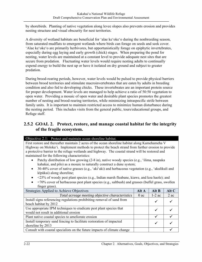
Kakahai‘a National Wildlife Refuge Draft Comprehensive Conservation Plan and Environmental Assessment
2-22 Chapter 2. Alternatives, Goals, Objectives, and Strategies
by shorebirds. Planting of native vegetation along levee slopes also prevents erosion and provides nesting structure and visual obscurity for nest territories. A diversity of wetland habitats are beneficial for ‘alae ke‘oke‘o during the nonbreeding season, from saturated mudflats to emergent wetlands where birds can forage on seeds and seek cover. ‘Alae ke‘oke‘o are primarily herbivores, but opportunistically forage on epiphytic invertebrates, especially during egg laying and early growth (chick) stages. When preparing the pond for nesting, water levels are maintained at a constant level to provide adequate nest sites that are secure from predation. Fluctuating water levels would require nesting adults to continually expend energy to build the nest up or have it isolated on dry ground and subject to greater predation. During brood-rearing periods, however, water levels would be pulsed to provide physical barriers between brood territories and stimulate macroinvertebrates that are eaten by adults in breeding condition and also fed to developing chicks. These invertebrates are an important protein source for proper development. Water levels are managed to help achieve a ratio of 50:50 vegetation to open water. Providing a mosaic of open water and desirable plant species promotes the greatest number of nesting and brood-rearing territories, while minimizing intraspecific strife between family units. It is important to maintain restricted access to minimize human disturbance during the nesting period. This includes visits from the general public, tours/educational groups, and Refuge staff.
2.5.2 GOAL 2. Protect, restore, and manage coastal habitat for the integrity
of the fragile ecosystem. Objective 2.1: Protect and maintain ocean shoreline habitat. First restore and thereafter maintain 2 acres of the ocean shoreline habitat along Kamehameha V Highway on Moloka‘i. Implement methods to protect the beach strand from further erosion to provide a protective barrier to the refuge wetlands and highway. The coastal strand will be restored and maintained for the following characteristics:
Patchy distribution of low growing (2-8 in), native woody species (e.g., ‘ilima, naupaka kahakai, and pilo) as a mosaic to naturally construct a dune system;
30-40% cover of native grasses (e.g., ‘aki‘aki) and herbaceous vegetation (e.g., ‘akulikuli and kīpūkai) along shoreline;
<25% of woody pest plant species (e.g., Indian marsh fleabane, kiawe, and koa haole); and <70% cover of herbaceous pest plant species (e.g., saltbush) and grasses (buffel grass, swollen
finger grass). Strategies Applied to Achieve Objectives Alt A Alt B Alt C
Total acreage meeting objective characteristics 0 ac 1-2 ac 2 ac Install signs referencing regulations prohibiting removal of sand from beach habitat by 2012
Use appropriate IPM techniques to eradicate pest plant species that would not result in additional erosion
Plant native coastal species to ameliorate erosion Install temporary sand fencing to facilitate restoration of impacted shoreline by 2013
Consult with coastal specialists on the future impacts of climate change
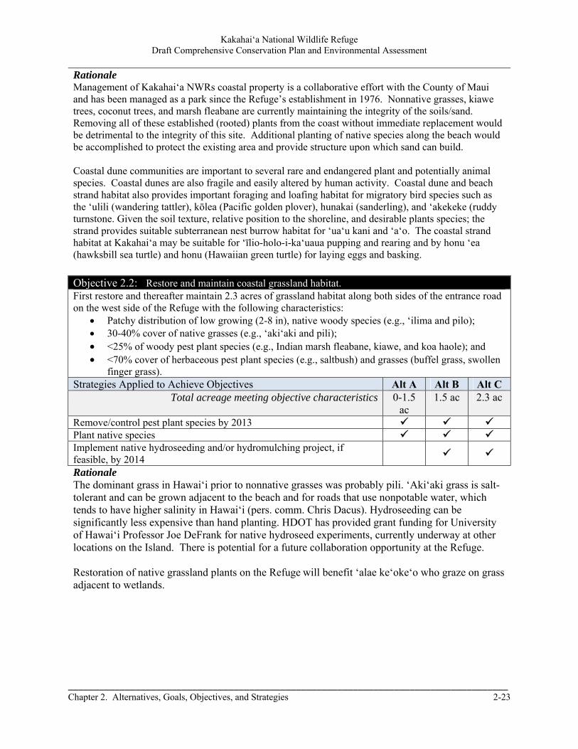
Kakahai‘a National Wildlife Refuge Draft Comprehensive Conservation Plan and Environmental Assessment
_____________________________________________________________________________________ Chapter 2. Alternatives, Goals, Objectives, and Strategies 2-23
Rationale Management of Kakahai‘a NWRs coastal property is a collaborative effort with the County of Maui and has been managed as a park since the Refuge’s establishment in 1976. Nonnative grasses, kiawe trees, coconut trees, and marsh fleabane are currently maintaining the integrity of the soils/sand. Removing all of these established (rooted) plants from the coast without immediate replacement would be detrimental to the integrity of this site. Additional planting of native species along the beach would be accomplished to protect the existing area and provide structure upon which sand can build. Coastal dune communities are important to several rare and endangered plant and potentially animal species. Coastal dunes are also fragile and easily altered by human activity. Coastal dune and beach strand habitat also provides important foraging and loafing habitat for migratory bird species such as the ‘ulili (wandering tattler), kōlea (Pacific golden plover), hunakai (sanderling), and ‘akekeke (ruddy turnstone. Given the soil texture, relative position to the shoreline, and desirable plants species; the strand provides suitable subterranean nest burrow habitat for ‘ua‘u kani and ‘a‘o. The coastal strand habitat at Kakahai‘a may be suitable for ‘īlio-holo-i-ka‘uaua pupping and rearing and by honu ‘ea (hawksbill sea turtle) and honu (Hawaiian green turtle) for laying eggs and basking.
Objective 2.2: Restore and maintain coastal grassland habitat. First restore and thereafter maintain 2.3 acres of grassland habitat along both sides of the entrance road on the west side of the Refuge with the following characteristics:
Patchy distribution of low growing (2-8 in), native woody species (e.g., ‘ilima and pilo); 30-40% cover of native grasses (e.g., ‘aki‘aki and pili); <25% of woody pest plant species (e.g., Indian marsh fleabane, kiawe, and koa haole); and <70% cover of herbaceous pest plant species (e.g., saltbush) and grasses (buffel grass, swollen
finger grass). Strategies Applied to Achieve Objectives Alt A Alt B Alt C
Total acreage meeting objective characteristics 0-1.5 ac
1.5 ac 2.3 ac
Remove/control pest plant species by 2013 Plant native species Implement native hydroseeding and/or hydromulching project, if feasible, by 2014
Rationale The dominant grass in Hawai‘i prior to nonnative grasses was probably pili. ‘Aki‘aki grass is salt-tolerant and can be grown adjacent to the beach and for roads that use nonpotable water, which tends to have higher salinity in Hawai‘i (pers. comm. Chris Dacus). Hydroseeding can be significantly less expensive than hand planting. HDOT has provided grant funding for University of Hawai‘i Professor Joe DeFrank for native hydroseed experiments, currently underway at other locations on the Island. There is potential for a future collaboration opportunity at the Refuge. Restoration of native grassland plants on the Refuge will benefit ‘alae ke‘oke‘o who graze on grass adjacent to wetlands.
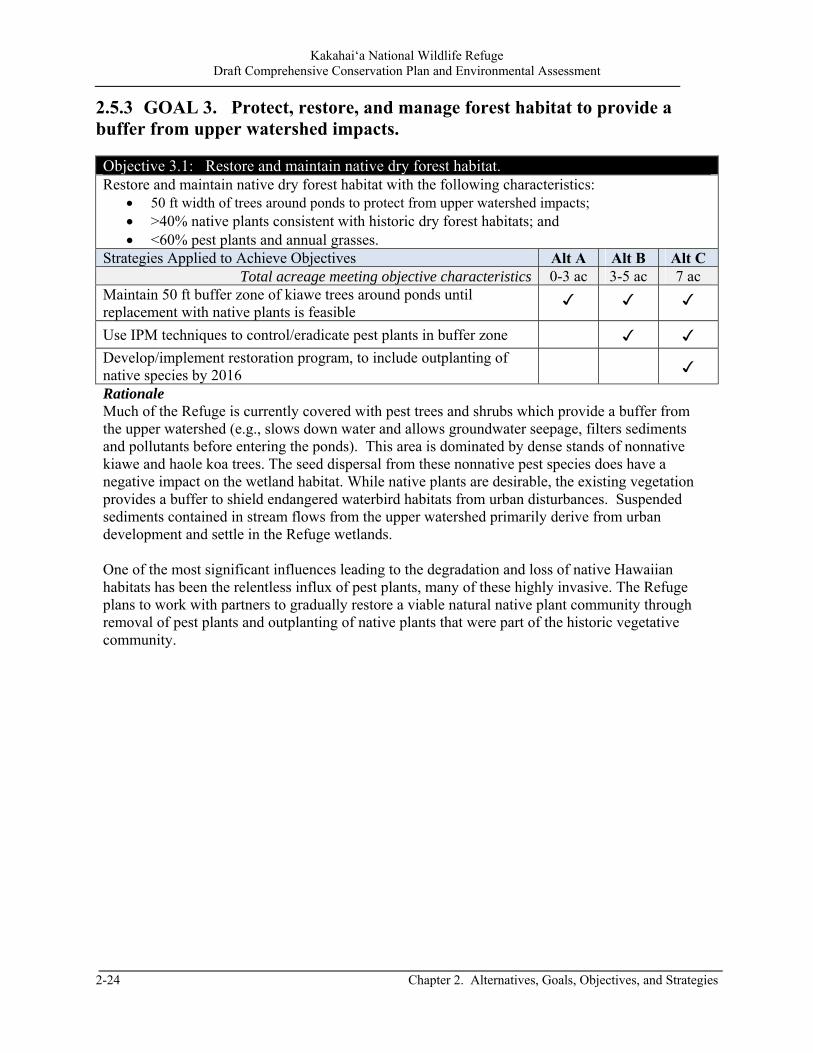
Kakahai‘a National Wildlife Refuge Draft Comprehensive Conservation Plan and Environmental Assessment
2-24 Chapter 2. Alternatives, Goals, Objectives, and Strategies
2.5.3 GOAL 3. Protect, restore, and manage forest habitat to provide a buffer from upper watershed impacts. Objective 3.1: Restore and maintain native dry forest habitat. Restore and maintain native dry forest habitat with the following characteristics:
50 ft width of trees around ponds to protect from upper watershed impacts; >40% native plants consistent with historic dry forest habitats; and <60% pest plants and annual grasses.
Strategies Applied to Achieve Objectives Alt A Alt B Alt C Total acreage meeting objective characteristics 0-3 ac 3-5 ac 7 ac
Maintain 50 ft buffer zone of kiawe trees around ponds until replacement with native plants is feasible
✓ ✓ ✓
Use IPM techniques to control/eradicate pest plants in buffer zone ✓ ✓
Develop/implement restoration program, to include outplanting of native species by 2016
✓
Rationale Much of the Refuge is currently covered with pest trees and shrubs which provide a buffer from the upper watershed (e.g., slows down water and allows groundwater seepage, filters sediments and pollutants before entering the ponds). This area is dominated by dense stands of nonnative kiawe and haole koa trees. The seed dispersal from these nonnative pest species does have a negative impact on the wetland habitat. While native plants are desirable, the existing vegetation provides a buffer to shield endangered waterbird habitats from urban disturbances. Suspended sediments contained in stream flows from the upper watershed primarily derive from urban development and settle in the Refuge wetlands. One of the most significant influences leading to the degradation and loss of native Hawaiian habitats has been the relentless influx of pest plants, many of these highly invasive. The Refuge plans to work with partners to gradually restore a viable natural native plant community through removal of pest plants and outplanting of native plants that were part of the historic vegetative community.
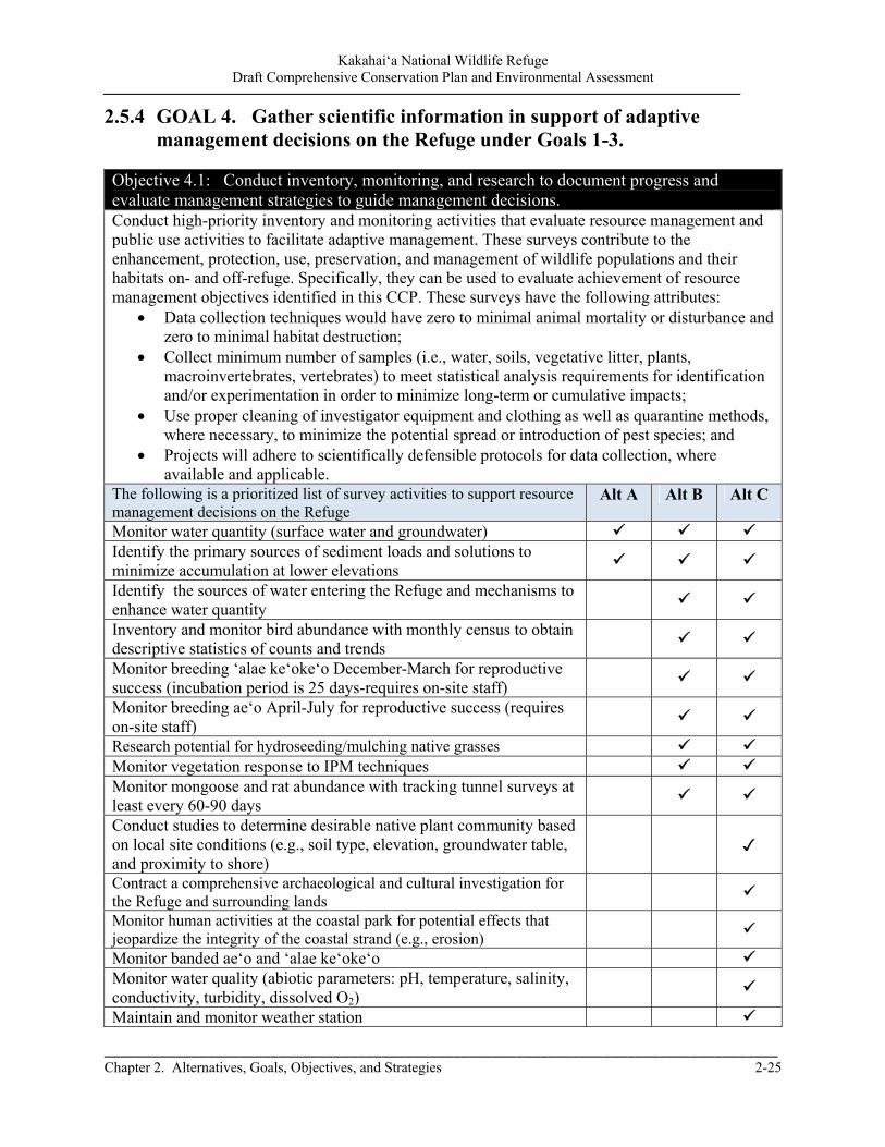
Kakahai‘a National Wildlife Refuge Draft Comprehensive Conservation Plan and Environmental Assessment
_____________________________________________________________________________________ Chapter 2. Alternatives, Goals, Objectives, and Strategies 2-25
2.5.4 GOAL 4. Gather scientific information in support of adaptive management decisions on the Refuge under Goals 1-3.
Objective 4.1: Conduct inventory, monitoring, and research to document progress and evaluate management strategies to guide management decisions. Conduct high-priority inventory and monitoring activities that evaluate resource management and public use activities to facilitate adaptive management. These surveys contribute to the enhancement, protection, use, preservation, and management of wildlife populations and their habitats on- and off-refuge. Specifically, they can be used to evaluate achievement of resource management objectives identified in this CCP. These surveys have the following attributes:
Data collection techniques would have zero to minimal animal mortality or disturbance and zero to minimal habitat destruction;
Collect minimum number of samples (i.e., water, soils, vegetative litter, plants, macroinvertebrates, vertebrates) to meet statistical analysis requirements for identification and/or experimentation in order to minimize long-term or cumulative impacts;
Use proper cleaning of investigator equipment and clothing as well as quarantine methods, where necessary, to minimize the potential spread or introduction of pest species; and
Projects will adhere to scientifically defensible protocols for data collection, where available and applicable.
The following is a prioritized list of survey activities to support resource management decisions on the Refuge
Alt A Alt B Alt C
Monitor water quantity (surface water and groundwater) Identify the primary sources of sediment loads and solutions to minimize accumulation at lower elevations
Identify the sources of water entering the Refuge and mechanisms to enhance water quantity
Inventory and monitor bird abundance with monthly census to obtain descriptive statistics of counts and trends
Monitor breeding ‘alae ke‘oke‘o December-March for reproductive success (incubation period is 25 days-requires on-site staff)
Monitor breeding ae‘o April-July for reproductive success (requires on-site staff)
Research potential for hydroseeding/mulching native grasses Monitor vegetation response to IPM techniques Monitor mongoose and rat abundance with tracking tunnel surveys at least every 60-90 days
Conduct studies to determine desirable native plant community based on local site conditions (e.g., soil type, elevation, groundwater table, and proximity to shore)
✓
Contract a comprehensive archaeological and cultural investigation for the Refuge and surrounding lands
Monitor human activities at the coastal park for potential effects that jeopardize the integrity of the coastal strand (e.g., erosion)
Monitor banded ae‘o and ‘alae ke‘oke‘o Monitor water quality (abiotic parameters: pH, temperature, salinity, conductivity, turbidity, dissolved O2)
Maintain and monitor weather station
Kakahai‘a National Wildlife Refuge Draft Comprehensive Conservation Plan and Environmental Assessment
2-26 Chapter 2. Alternatives, Goals, Objectives, and Strategies
Rationale The Administration Act requires us to ‘‘… monitor the status and trends of fish, wildlife, and plants in each refuge.’’ Surveys are used primarily to evaluate resource response to assess progress toward achieving Refuge management objectives derived from the Refuge System mission, refuge purpose(s), and maintenance of biological integrity, diversity, and environmental health. Determining resource status and evaluating progress toward achieving objectives is essential to implementing adaptive management on DOI lands as required by policy (522 DM 1). Specifically, results of surveys would be used to refine management strategies, where necessary, over time in order to achieve resource objectives. Surveys would provide the best available scientific information to promote transparent decisionmaking processes for resource management over time on Refuge lands. Inventory, monitoring, and research studies are essential to high-quality habitat and population management. Conducting censuses for endangered waterbirds and compiling data is critical to evaluate population status and measure progress towards goals. Similarly, other waterbird populations, habitat conditions and habitat management practices, including restoration efforts must be monitored to evaluate their status and effectiveness. Population trends can be used to evaluate habitat effectiveness and guide management actions. Refuges must collect site-specific information and conduct defensible research to provide information for devising, guiding and adapting management practices. Monitoring habitat conditions provides valuable support and sound decisionmaking as applied to Refuge resource management and also contributes to the Service’s ability to modify management practices (adaptive management). Applied research on the Refuge will help address management issues and questions, in theory, will result in improved management decisions on both the Refuge and on a regional basis. The Refuge has always maintained a close working relationship with several State and local agencies, and universities to advance the knowledge base of a variety of habitats and plant and wildlife species. Kakahai‘a NWR is bisected by Kamehameha V Highway resulting in a coastal area set apart from the wetlands. This area is not fenced and is accessible to the public. Use of this area includes: picnicking (currently two concrete picnic tables) and access to the ocean for kayaking and fishing. Human activities in the coastal area will be monitored to ensure the impacts are not detrimental to the habitat (e.g., erosion, vandalism).
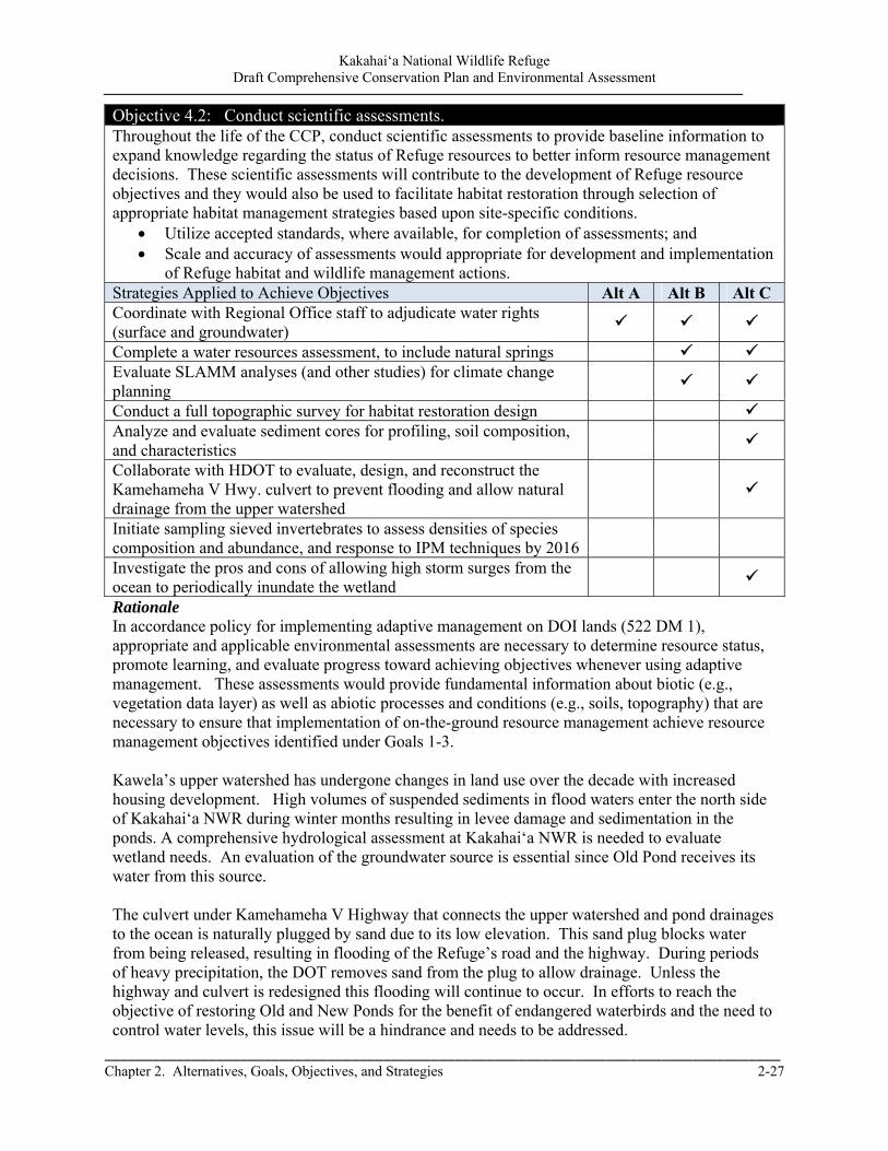
Kakahai‘a National Wildlife Refuge Draft Comprehensive Conservation Plan and Environmental Assessment
_____________________________________________________________________________________ Chapter 2. Alternatives, Goals, Objectives, and Strategies 2-27
Objective 4.2: Conduct scientific assessments. Throughout the life of the CCP, conduct scientific assessments to provide baseline information to expand knowledge regarding the status of Refuge resources to better inform resource management decisions. These scientific assessments will contribute to the development of Refuge resource objectives and they would also be used to facilitate habitat restoration through selection of appropriate habitat management strategies based upon site-specific conditions.
Utilize accepted standards, where available, for completion of assessments; and Scale and accuracy of assessments would appropriate for development and implementation
of Refuge habitat and wildlife management actions. Strategies Applied to Achieve Objectives Alt A Alt B Alt C Coordinate with Regional Office staff to adjudicate water rights (surface and groundwater)
Complete a water resources assessment, to include natural springs Evaluate SLAMM analyses (and other studies) for climate change planning
Conduct a full topographic survey for habitat restoration design Analyze and evaluate sediment cores for profiling, soil composition, and characteristics
Collaborate with HDOT to evaluate, design, and reconstruct the Kamehameha V Hwy. culvert to prevent flooding and allow natural drainage from the upper watershed
Initiate sampling sieved invertebrates to assess densities of species composition and abundance, and response to IPM techniques by 2016
Investigate the pros and cons of allowing high storm surges from the ocean to periodically inundate the wetland
Rationale In accordance policy for implementing adaptive management on DOI lands (522 DM 1), appropriate and applicable environmental assessments are necessary to determine resource status, promote learning, and evaluate progress toward achieving objectives whenever using adaptive management. These assessments would provide fundamental information about biotic (e.g., vegetation data layer) as well as abiotic processes and conditions (e.g., soils, topography) that are necessary to ensure that implementation of on-the-ground resource management achieve resource management objectives identified under Goals 1-3. Kawela’s upper watershed has undergone changes in land use over the decade with increased housing development. High volumes of suspended sediments in flood waters enter the north side of Kakahai‘a NWR during winter months resulting in levee damage and sedimentation in the ponds. A comprehensive hydrological assessment at Kakahai‘a NWR is needed to evaluate wetland needs. An evaluation of the groundwater source is essential since Old Pond receives its water from this source. The culvert under Kamehameha V Highway that connects the upper watershed and pond drainages to the ocean is naturally plugged by sand due to its low elevation. This sand plug blocks water from being released, resulting in flooding of the Refuge’s road and the highway. During periods of heavy precipitation, the DOT removes sand from the plug to allow drainage. Unless the highway and culvert is redesigned this flooding will continue to occur. In efforts to reach the objective of restoring Old and New Ponds for the benefit of endangered waterbirds and the need to control water levels, this issue will be a hindrance and needs to be addressed.
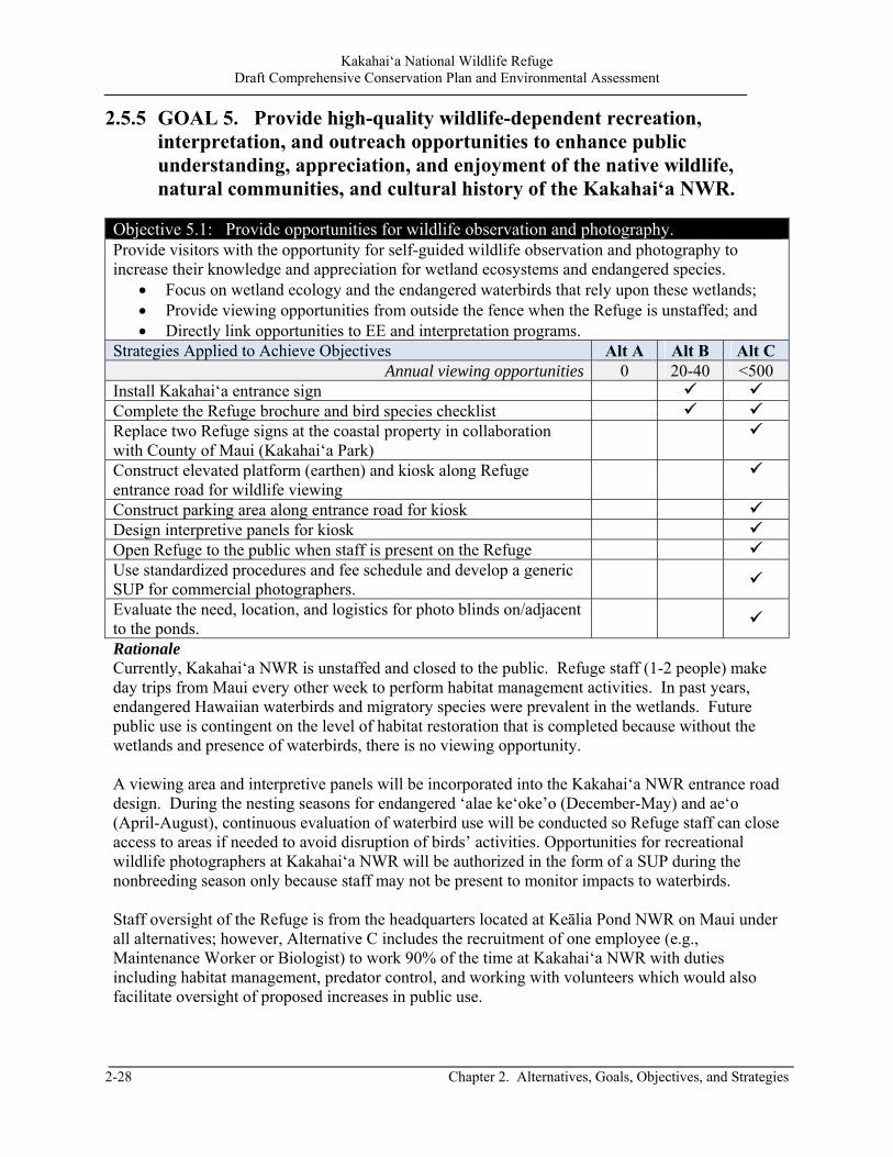
Kakahai‘a National Wildlife Refuge Draft Comprehensive Conservation Plan and Environmental Assessment
2-28 Chapter 2. Alternatives, Goals, Objectives, and Strategies
2.5.5 GOAL 5. Provide high-quality wildlife-dependent recreation, interpretation, and outreach opportunities to enhance public understanding, appreciation, and enjoyment of the native wildlife, natural communities, and cultural history of the Kakahai‘a NWR.
Objective 5.1: Provide opportunities for wildlife observation and photography. Provide visitors with the opportunity for self-guided wildlife observation and photography to increase their knowledge and appreciation for wetland ecosystems and endangered species.
Focus on wetland ecology and the endangered waterbirds that rely upon these wetlands; Provide viewing opportunities from outside the fence when the Refuge is unstaffed; and Directly link opportunities to EE and interpretation programs.
Strategies Applied to Achieve Objectives Alt A Alt B Alt C Annual viewing opportunities 0 20-40 <500
Install Kakahai‘a entrance sign Complete the Refuge brochure and bird species checklist Replace two Refuge signs at the coastal property in collaboration with County of Maui (Kakahai‘a Park)
Construct elevated platform (earthen) and kiosk along Refuge entrance road for wildlife viewing
Construct parking area along entrance road for kiosk Design interpretive panels for kiosk Open Refuge to the public when staff is present on the Refuge Use standardized procedures and fee schedule and develop a generic SUP for commercial photographers.
Evaluate the need, location, and logistics for photo blinds on/adjacent to the ponds.
Rationale Currently, Kakahai‘a NWR is unstaffed and closed to the public. Refuge staff (1-2 people) make day trips from Maui every other week to perform habitat management activities. In past years, endangered Hawaiian waterbirds and migratory species were prevalent in the wetlands. Future public use is contingent on the level of habitat restoration that is completed because without the wetlands and presence of waterbirds, there is no viewing opportunity. A viewing area and interpretive panels will be incorporated into the Kakahai‘a NWR entrance road design. During the nesting seasons for endangered ‘alae ke‘oke’o (December-May) and ae‘o (April-August), continuous evaluation of waterbird use will be conducted so Refuge staff can close access to areas if needed to avoid disruption of birds’ activities. Opportunities for recreational wildlife photographers at Kakahai‘a NWR will be authorized in the form of a SUP during the nonbreeding season only because staff may not be present to monitor impacts to waterbirds. Staff oversight of the Refuge is from the headquarters located at Keālia Pond NWR on Maui under all alternatives; however, Alternative C includes the recruitment of one employee (e.g., Maintenance Worker or Biologist) to work 90% of the time at Kakahai‘a NWR with duties including habitat management, predator control, and working with volunteers which would also facilitate oversight of proposed increases in public use.
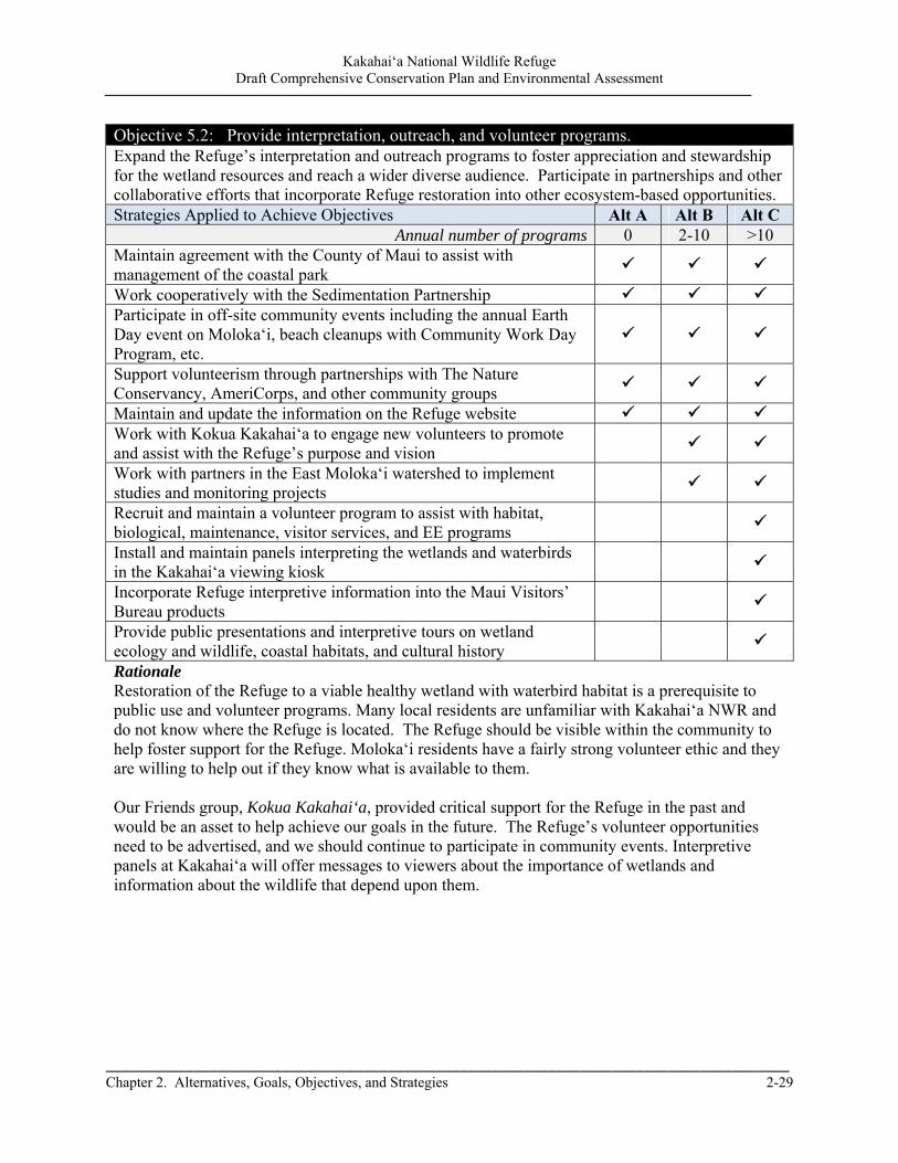
Kakahai‘a National Wildlife Refuge Draft Comprehensive Conservation Plan and Environmental Assessment
_____________________________________________________________________________________ Chapter 2. Alternatives, Goals, Objectives, and Strategies 2-29
Objective 5.2: Provide interpretation, outreach, and volunteer programs. Expand the Refuge’s interpretation and outreach programs to foster appreciation and stewardship for the wetland resources and reach a wider diverse audience. Participate in partnerships and other collaborative efforts that incorporate Refuge restoration into other ecosystem-based opportunities. Strategies Applied to Achieve Objectives Alt A Alt B Alt C
Annual number of programs 0 2-10 >10 Maintain agreement with the County of Maui to assist with management of the coastal park
Work cooperatively with the Sedimentation Partnership Participate in off-site community events including the annual Earth Day event on Moloka‘i, beach cleanups with Community Work Day Program, etc.
Support volunteerism through partnerships with The Nature Conservancy, AmeriCorps, and other community groups
Maintain and update the information on the Refuge website Work with Kokua Kakahai‘a to engage new volunteers to promote and assist with the Refuge’s purpose and vision
Work with partners in the East Moloka‘i watershed to implement studies and monitoring projects
Recruit and maintain a volunteer program to assist with habitat, biological, maintenance, visitor services, and EE programs
Install and maintain panels interpreting the wetlands and waterbirds in the Kakahai‘a viewing kiosk
Incorporate Refuge interpretive information into the Maui Visitors’ Bureau products
Provide public presentations and interpretive tours on wetland ecology and wildlife, coastal habitats, and cultural history
Rationale Restoration of the Refuge to a viable healthy wetland with waterbird habitat is a prerequisite to public use and volunteer programs. Many local residents are unfamiliar with Kakahai‘a NWR and do not know where the Refuge is located. The Refuge should be visible within the community to help foster support for the Refuge. Moloka‘i residents have a fairly strong volunteer ethic and they are willing to help out if they know what is available to them. Our Friends group, Kokua Kakahai‘a, provided critical support for the Refuge in the past and would be an asset to help achieve our goals in the future. The Refuge’s volunteer opportunities need to be advertised, and we should continue to participate in community events. Interpretive panels at Kakahai‘a will offer messages to viewers about the importance of wetlands and information about the wildlife that depend upon them.
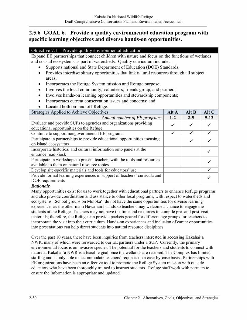
Kakahai‘a National Wildlife Refuge Draft Comprehensive Conservation Plan and Environmental Assessment
2-30 Chapter 2. Alternatives, Goals, Objectives, and Strategies
2.5.6 GOAL 6. Provide a quality environmental education program with specific learning objectives and diverse hands-on opportunities. Objective 7.1: Provide quality environmental education. Expand EE partnerships that connect children with nature and focus on the functions of wetlands and coastal ecosystems as part of watersheds. Quality curriculum includes:
Supports national and State Department of Education (DOE) Standards; Provides interdisciplinary opportunities that link natural resources through all subject
areas; Incorporates the Refuge System mission and Refuge purpose; Involves the local community, volunteers, friends group, and partners; Involves hands-on learning opportunities and stewardship components; Incorporates current conservation issues and concerns; and Located both on- and off-Refuge.
Strategies Applied to Achieve Objectives Alt A Alt B Alt C Annual number of EE programs 1-2 2-5 5-12
Evaluate and provide SUPs to agencies and organizations providing educational opportunities on the Refuge
Continue to support nongovernmental EE programs Participate in partnerships to provide educational opportunities focusing on island ecosystems
Incorporate historical and cultural information onto panels at the entrance road kiosk
Participate in workshops to present teachers with the tools and resources available to them on natural resource topics
Develop site-specific materials and tools for educators’ use Provide formal learning experiences in support of teachers’ curricula and DOE requirements
Rationale Many opportunities exist for us to work together with educational partners to enhance Refuge programs and also provide coordination and assistance to other local programs, with respect to watersheds and ecosystems. School groups on Moloka‘i do not have the same opportunities for diverse learning experiences as the other main Hawaiian Islands so teachers may welcome a chance to engage the students at the Refuge. Teachers may not have the time and resources to compile pre- and post-visit materials; therefore, the Refuge can provide packets geared for different age groups for teachers to incorporate the visit into their curriculum. Hands-on experiences and inclusion of career opportunities into presentations can help direct students into natural resource disciplines. Over the past 10 years, there have been inquiries from teachers interested in accessing Kakahai‘a NWR, many of which were forwarded to our EE partners under a SUP. Currently, the primary environmental focus is on invasive species. The potential for the teachers and students to connect with nature at Kakahai‘a NWR is a feasible goal once the wetlands are restored. The Complex has limited staffing and is only able to accommodate teachers’ requests on a case-by-case basis. Partnerships with EE organizations have been an effective tool to promote the Refuge System mission with outside educators who have been thoroughly trained to instruct students. Refuge staff work with partners to ensure the information is appropriate and updated.
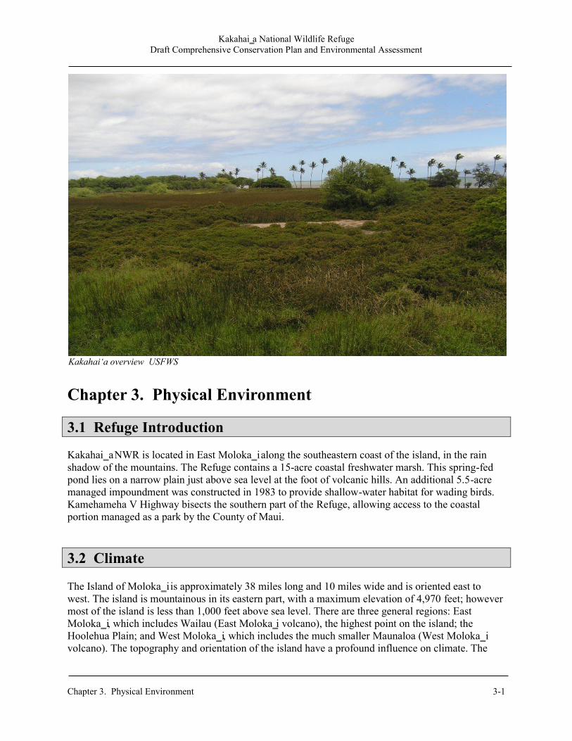
Kakahai‗a National Wildlife Refuge Draft Comprehensive Conservation Plan and Environmental Assessment
Chapter 3. Physical Environment 3-1
Chapter 3. Physical Environment 3.1 Refuge Introduction Kakahai‗a NWR is located in East Moloka‗i along the southeastern coast of the island, in the rain shadow of the mountains. The Refuge contains a 15-acre coastal freshwater marsh. This spring-fed pond lies on a narrow plain just above sea level at the foot of volcanic hills. An additional 5.5-acre managed impoundment was constructed in 1983 to provide shallow-water habitat for wading birds. Kamehameha V Highway bisects the southern part of the Refuge, allowing access to the coastal portion managed as a park by the County of Maui.
3.2 Climate The Island of Moloka‗i is approximately 38 miles long and 10 miles wide and is oriented east to west. The island is mountainous in its eastern part, with a maximum elevation of 4,970 feet; however most of the island is less than 1,000 feet above sea level. There are three general regions: East Moloka‗i, which includes Wailau (East Moloka‗i volcano), the highest point on the island; the Hoolehua Plain; and West Moloka‗i, which includes the much smaller Maunaloa (West Moloka‗i volcano). The topography and orientation of the island have a profound influence on climate. The
Kakahai‘a overview USFWS
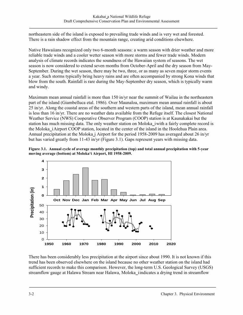
Kakahai‗a National Wildlife Refuge Draft Comprehensive Conservation Plan and Environmental Assessment
3-2 Chapter 3. Physical Environment
northeastern side of the island is exposed to prevailing trade winds and is very wet and forested. There is a rain shadow effect from the mountain range, creating arid conditions elsewhere. Native Hawaiians recognized only two 6-month seasons: a warm season with drier weather and more reliable trade winds and a cooler wetter season with more storms and fewer trade winds. Modern analysis of climate records indicates the soundness of the Hawaiian system of seasons. The wet season is now considered to extend seven months from October-April and the dry season from May-September. During the wet season, there may be two, three, or as many as seven major storm events a year. Such storms typically bring heavy rains and are often accompanied by strong Kona winds that blow from the south. Rainfall is rare during the May-September dry season, which is typically warm and windy. Maximum mean annual rainfall is more than 150 in/yr near the summit of Wailau in the northeastern part of the island (Giambelluca etal. 1986). Over Maunaloa, maximum mean annual rainfall is about 25 in/yr. Along the coastal areas of the southern and western parts of the island, mean annual rainfall is less than 16 in/yr. There are no weather data available from the Refuge itself. The closest National Weather Service (NWS) Cooperative Observer Program (COOP) station is at Kaunakakai but the station has much missing data. The only weather station on Moloka‗i with a fairly complete record is the Moloka‗i Airport COOP station, located in the center of the island in the Hoolehua Plain area. Annual precipitation at the Moloka‗i Airport for the period 1958-2009 has averaged about 26 in/yr but has varied greatly from 11-43 in/yr (Figure 3.1). Gaps represent years with missing data. Figure 3.1. Annual cycle of average monthly precipitation (top) and total annual precipitation with 5-year moving average (bottom) at Moloka‘i Airport, HI 1958-2009.
There has been considerably less precipitation at the airport since about 1990. It is not known if this trend has been observed elsewhere on the island because no other weather station on the island had sufficient records to make this comparison. However, the long-term U.S. Geological Survey (USGS) streamflow gauge at Halawa Stream near Halawa, Moloka‗i indicates a drying trend in streamflow
Oct Nov Dec Jan Feb Mar Apr May Jun Jul Aug Sep
Pre
cip
itat
ion
(in
)
0
1
2
3
4
1950 1960 1970 1980 1990 2000 2010 2020
0
10
20
30
40
50
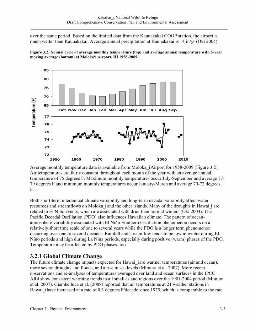
Kakahai‗a National Wildlife Refuge Draft Comprehensive Conservation Plan and Environmental Assessment
Chapter 3. Physical Environment 3-3
over the same period. Based on the limited data from the Kaunakakai COOP station, the airport is much wetter than Kaunakakai. Average annual precipitation at Kaunakakai is 14 in/yr (Oki 2004). Figure 3.2. Annual cycle of average monthly temperature (top) and average annual temperature with 5-year moving average (bottom) at Moloka‘i Airport, HI 1958-2009.
Average monthly temperature data is available from Moloka‗i Airport for 1958-2009 (Figure 3.2). Air temperatures are fairly constant throughout each month of the year with an average annual temperature of 75 degrees F. Maximum monthly temperatures occur July-September and average 77-79 degrees F and minimum monthly temperatures occur January-March and average 70-72 degrees F. Both short-term interannual climate variability and long-term decadal variability affect water resources and streamflows on Moloka‗i and the other islands. Many of the droughts in Hawai‗i are related to El Niño events, which are associated with drier than normal winters (Oki 2004). The Pacific Decadal Oscillation (PDO) also influences Hawaiian climate. The pattern of ocean-atmosphere variability associated with El Niño-Southern Oscillation phenomenon occurs on a relatively short time scale of one to several years while the PDO is a longer term phenomenon occurring over one to several decades. Rainfall and streamflow tends to be low in winter during El Niño periods and high during La Niña periods, especially during positive (warm) phases of the PDO. Temperature may be affected by PDO phases, too. 3.2.1 Global Climate Change The future climate change impacts expected for Hawai‗i are warmer temperatures (air and ocean), more severe droughts and floods, and a rise in sea levels (Mimura et al. 2007). More recent observations and re-analyses of temperatures averaged over land and ocean surfaces in the IPCC AR4 show consistent warming trends in all small-island regions over the 1901-2004 period (Mimura et al. 2007). Giambelluca et al. (2008) reported that air temperatures at 21 weather stations in Hawai‗i have increased at a rate of 0.3 degrees F/decade since 1975, which is comparable to the rate
1950 1960 1970 1980 1990 2000 2010
72
73
74
75
76
77
Oct Nov Dec Jan Feb Mar Apr May Jun Jul Aug Sep
Tem
per
atu
re (
F)
65
70
75
80
85
Kakahai‗a National Wildlife Refuge Draft Comprehensive Conservation Plan and Environmental Assessment
3-4 Chapter 3. Physical Environment
of increase in global temperatures. Rainfall intensity has reportedly increased 12 percent in Hawai‗i between 1958-2006 (Fletcher, 2010) but total rainfall has decreased about 15 percent over the last 20 years (Chu and Chen, 2005). These changes have and will continue to affect biologic and water resources on Moloka‗i and the other islands (Oki 2004). The low resolution of many global circulation models is problematic for representing Hawai‗i. The climate of Hawai‗i is strongly influenced by steep topography, aspect, and location but this information is not included in global climate models. Typically, the models represent the islands as a single grid cell or ignore the islands completely. Higher resolution regional climate models that consider the islands are becoming available. These models project increasing temperature and precipitation for the islands in the future, with an increase in extreme events such as floods and droughts. Temperatures for the North Pacific region are forecast to increase 0.9-1.1 degrees F from 2010-2039 relative to the 1961-1990 period (Mimura et al. 2007). Precipitation is forecast to change by -6.3 to +9.1 percent for the same region relative to the same period. Timm and Diaz (2009) were the first authors to evaluate global climate model performance for Hawai‗i and downscale climate scenarios for Hawaiian rainfall. Based on statistical downscaling of climate model output, they concluded that the most likely scenario for Hawai‗i is a 5–10 percent reduction of the wet-season precipitation and a 5 percent increase during the dry season, as a result of changes in the wind field. Future changes in precipitation are uncertain, in part, because they depend on how El Niño might change and this is unknown. Future changes in precipitation are less certain, in part, because they depend on how El Niño might change and this is unknown. Warmer air temperatures will increase water use and demand (evaporation and consumptive use), which will exacerbate water supply concerns and environmental stresses. A number of studies suggest that climate change could be a major factor in accentuating the current climate regimes and the changes from normal that come with ENSO events (Mimura et al. 2007).
The Service is supporting the development of regional Landscape Conservation Cooperatives that will integrate local climate models with models of climate-change responses by species, habitats, and ecosystems. The regional version of these Landscape Conservation Cooperatives is the Pacific Islands Climate Change Cooperative (PICCC), headquartered in Honolulu, Hawai‗i, but working across the Pacific. The PICCC was established in 2010 to assist those who manage native species, island ecosystems, and key cultural resources in adapting their management to climate change for the continuing benefit of the people of the Pacific Islands. The PICCC steering committee consists of more than 25 Federal, State, private, indigenous, and non-governmental conservation organizations and academic institutions, forming a cooperative partnership that determines the overall organizational vision, mission, and goals. 3.2.2 Ecological Responses to Climate Change Evidence suggests that recent climatic changes have affected a broad range of individual species and populations in both the marine and terrestrial environment. Organisms have responded by changes in phenology (timing of seasonal activities) and physiology; range and distribution; community composition and interaction; and ecosystem structure and dynamics. The reproductive physiology and population dynamics of amphibians and reptiles are highly influenced by environmental conditions such as temperature and humidity. For example, sea turtle sex is determined by the temperature of the nest environment; thus, higher temperatures could result in a higher female to male ratio. In addition, increases in atmospheric temperatures during seabird nesting seasons will also have an effect on seabirds and waterbirds (Duffy 1993, Walther et al. 2002, Baker et al. 2006).
Kakahai‗a National Wildlife Refuge Draft Comprehensive Conservation Plan and Environmental Assessment
Chapter 3. Physical Environment 3-5
Changes in ocean temperature, circulation, and storm surge due to climate change will impact seabird breeding and foraging. The ENSO has been shown to cause seabirds to abandon habitats, nest sites, and foraging areas for colder/warmer waters. Studies have found that nesting success is reduced for some species during this climatic event. Oceanographic changes associated with ENSO may also increase or decrease food supply for seabirds and subsequently impact populations that forage offshore. Shifts in marine temperature, salinity, turbidity, currents, depth, and nutrients will have an impact on seabird and water bird prey composition and availability. Although these potential changes may impact seabirds throughout the Hawaiian Islands, contrary evidence suggests that seabirds may have coped with and evolved around climatic changes in the past (Duffy 1993). Warming has also caused species to shift toward the poles or higher altitudes and changes in climatic conditions can alter community composition. For example, increases in nitrogen availability can favor those plant species that respond to nitrogen rises. Similarly, increases in CO2 levels can impact plant photosynthetic rates, decrease nutrient levels, and lower herbivore weights. Although there is uncertainty regarding these trajectories, it is probable that there will be ecological consequences (Vitousek 1994, Walther et al. 2002, Ehleringer et al. 2002). Climate change has the potential to influence two important ecological issues in the State of Hawai‗i: endangered species and pest species. The majority of U.S. endangered species are found in the State of Hawai‗i. Species declines have resulted from habitat loss, introduced diseases, and impacts from pest species. Changes in climate will add an additional threat to the survival of these species. For example, warmer night temperatures can increase the rate of respiration for native vegetation, resulting in greater competition from pest plants. Furthermore, climate change may enhance existing pest species issues because alterations in the environment may increase the dispersal ability of flora or fauna. Species response to climate change will depend on the life history, distribution, dispersal ability, and reproduction requirements of the species (DBEDT and DOH 1998, Middleton 2006, Giambelluca 2008).
3.3 Geology and Soils The Hawaiian Islands were created by a geologic hot spot underneath the surface of the earth. As the earth‘s crust has moved over this spot, magma has created new islands in the form of volcanoes. Iron-rich, quartz-poor rock flowed out of thousands of vents as highly fluid lava. The Island of Moloka‗i is the fifth largest of the Hawaiian Islands. The island was formed by volcanic activity at Wailau (elev. 4970 ft) and Maunaloa (elev. 1430 ft). The two volcanoes are connected by the Hoolehua Plain, created by lava flows from Wailau. Most of the island‘s population and development occurs in this area and along the south shore of the island. No perennial streams exist in the Hoolehua Plain, water is supplied from diverted streamflow from East Moloka‗i and from groundwater development. The exposed rocks of East Moloka‗i are classified as East Moloka‗i volcanics and Kalaupapa volcanics. Kaunakakai Stream flows over the East Moloka‗i volcanics, which is divided into two informal members—a lower member consisting of shield-stage tholeiitic, olivine-tholeiitic, and picritic-tholeiitic basalts and postshield-stage alkalic basalt; and an upper member consisting of postshield-stage mugearite and lesser amounts of hawaiite and trachyte (Langenheim and Clague 1987). The upper member forms a relatively thin (50-500ft thick) veneer over the lower member

Kakahai‗a National Wildlife Refuge Draft Comprehensive Conservation Plan and Environmental Assessment
3-6 Chapter 3. Physical Environment
(Stearns and Macdonald 1947). The northeastern part of Wailau contains numerous intrusive volcanic dikes, which form a dike complex and reduce bulk permeability of the rocks in the area. The volcanic rocks of West Moloka‗i are separated from the East Moloka‗i volcanics by an erosional surface that forms a hydrologic confining unit over the West Moloka‗i volcanics (Langenheim and Clague 1987).
3.4 Hydrology Precipitation is the source of all freshwater on Moloka‗i. The windward (northeast) side is wettest, due to the orographic lifting of moisture-laden northeasterly trade winds along the windward slope of Wailau. Maunaloa is considerably drier because it does not extend upward into the cloud-forming zone at higher altitudes. Most of the fresh groundwater on the island is in East Moloka‗i because of the higher precipitation in this area. Groundwater levels are highest in the mountainous interior parts of the island, particularly in the northeast, and lowest near the coast. Freshwater floats on top of saltwater near sea level within the more permeable lava flows on the flanks of the volcanoes (Shade 1997). Groundwater development is increasingly important to meet present and projected municipal and agricultural needs and has been concentrated in a few areas at lower elevations along the coast. Most of the groundwater withdrawn on Moloka‗i is from Kualapu‗u, the southeast coastal area, and the dike complex in the northeastern part of the island (Oki 2007). Several existing production wells have experienced rising salinity as a result of the declining water levels and a rising brackish-water transition zone caused by the cumulative effect of withdrawals. Any new groundwater development must be approved by the State Commission on Water Resource Management, and the State manages groundwater withdrawals from the aquifer through a permitting process. There are several existing groundwater wells in the vicinity of Kakahai‗a NWR. Stearns and Macdonald (1974) indicated that several streams on the southern slope of Wailau are perennial in their upper reaches but do not flow continuously to the coast because of seepage loss and evaporation. These streams are generally perennial where they flow over lavas of the upper member of the East Moloka‗i Volcanics and where water discharges from springs or drains swamps. Where streams flow over the more permeable lower member, surface water is more readily lost to infiltration. Kakahai‗a NWR is in the driest part of the island and is underlain by the Kawela groundwater aquifer (Shade 1997). The Refuge consists of two wetlands; Old Pond is a natural wetland and New Pond is a constructed wetland. For some years, New Pond was supplied with water by a pump from Old Pond. However, thick vegetation growth in Old Pond began to impede the movement of water, drying out the area around the supply pump, so this was discontinued. For most of the year, New Pond is now dry. Old Pond depends on groundwater in the form of natural spring discharge for its water supply. Occasional runoff from the surrounding hills is secondary source of water. Spring discharge into the pond is diffuse and can not be measured directly but we have regularly recorded groundwater levels in three piezometers on the Refuge since 2002. This is an indirect measurement of hydrologic conditions and spring discharge at the Refuge. The record of measurements is shown below (Figure

Kakahai‗a National Wildlife Refuge Draft Comprehensive Conservation Plan and Environmental Assessment
Chapter 3. Physical Environment 3-7
3.3). Gaps represent years with missing data. The less frequent measurements in P2 shown in recent years are because that piezometer has been dry more frequently recently. The record shows seasonal and annual variability but little long-term change in water levels. However, there is an increasing frequency of ―dry‖ measurements in one of the piezometers, P2, in recent years. These water level measurements are useful in terms of detecting changes and impacts to Refuge hydrology. As such, they should be continued. Figure 3.3 Old Pond water levels and groundwater levels, 2000-2010.
The record shows seasonal and annual variability but little long-term change in water levels. However, there is an increasing frequency of ―dry‖ measurements in one of the piezometers, P2, in recent years. These water level measurements are useful in terms of detecting changes and impacts to Refuge hydrology. As such, they should be continued. The closest streamflow gauge is the USGS gauge at Kawela Gulch. This site is located about 1,500 feet west of the Refuge at the mouth of Kawela Stream. The site elevation is 40 feet above sea level, the drainage area above the gauge is 5.3 square miles. The stream has been dry 60 percent of the time, based on daily flow records. The monthly flows are shown in Table 3.1. Flow is greater during the winter months in response to greater rainfall at this time of year. Another USGS streamflow gauge that is close to the Refuge is at Kaunakakai Gulch. The stream gauge site is located about 6 miles west of the Refuge and just north of the town of Kaunakakai at an elevation of 75 feet. Hydrologic conditions at this site are likely very similar to the Refuge, although the area is underlain by a different aquifer system (Shade 1997). Streamflow is sporadic and seasonal and most common during the wetter winter months in response to rainfall. The stream was estimated to be dry 91 percent of the time 2004-2006 (Oki 2007). No known diversions exist upstream from the gauging station. Oki (2007) reports that the stream becomes perennial further downstream near the coast, where it is hydraulically connected to the groundwater system.
0.0
0.5
1.0
1.5
2.0
2.5
3.0
Jun-00 Jun-02 Jun-04 Jun-06 Jun-08 Jun-10
Re
lati
ve
Ele
va
tio
n (
ft)
P1 (furthest east) P2 (north of P3, west of P1) P3 (near new SG) Old Pond water levels
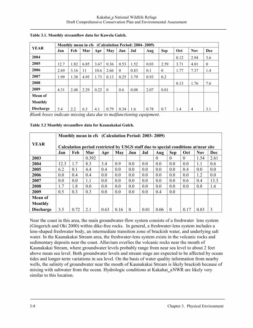
Kakahai‗a National Wildlife Refuge Draft Comprehensive Conservation Plan and Environmental Assessment
3-8 Chapter 3. Physical Environment
Table 3.1. Monthly streamflow data for Kawela Gulch.
YEAR Monthly mean in cfs (Calculation Period: 2004- 2009) Jan Feb Mar Apr May Jun Jul Aug Sep Oct Nov Dec
2004 0.12 2.94 3.6 2005 12.7 1.82 6.85 3.67 0.36 0.53 1.52 0.03 2.59 3.71 4.01 0 2006 2.69 3.16 11 10.6 2.66 0 0.83 0.1 0 1.77 7.37 1.4 2007 1.99 1.38 4.95 1.73 0.13 0.25 3.79 0.93 0.2 2008 0.13 1.76 7.6 2009 4.31 2.48 2.29 0.22 0 0.6 0.08 2.07 0.01 Mean of
5.4 2.2 6.3 4.1 0.79 0.34 1.6 0.78 0.7 1.4 4 3.1
Monthly Discharge
Blank boxes indicate missing data due to malfunctioning equipment. Table 3.2 Monthly streamflow data for Kaunakakai Gulch.
YEAR
Monthly mean in cfs (Calculation Period: 2003- 2009) Calculation period restricted by USGS staff due to special conditions at/near site Jan Feb Mar Apr May Jun Jul Aug Sep Oct Nov Dec
2003 0.392 0 0 0 1.54 2.61 2004 12.3 1.7 8.3 3.4 0.9 0.0 0.0 0.0 0.0 0.0 1.1 0.6 2005 6.2 0.1 4.4 0.4 0.0 0.0 0.0 0.0 0.0 0.4 0.0 0.0 2006 0.0 0.4 0.4 0.0 0.0 0.0 0.0 0.0 0.0 0.0 1.2 0.0 2007 0.0 0.0 1.1 0.0 0.0 0.0 0.0 0.0 0.0 0.6 0.4 13.3 2008 1.7 1.8 0.0 0.0 0.0 0.0 0.0 0.0 0.0 0.0 0.8 1.6 2009 0.5 0.3 0.3 0.0 0.0 0.0 0.0 0.4 0.0 Mean of
3.5 0.72 2.1 0.63 0.16 0 0.01 0.06 0 0.17 0.83 3 Monthly Discharge
Near the coast in this area, the main groundwater-flow system consists of a freshwater lens system (Gingerich and Oki 2000) within dike-free rocks. In general, a freshwater-lens system includes a lens-shaped freshwater body, an intermediate transition zone of brackish water, and underlying salt water. In the Kaunakakai Stream area, the freshwater-lens system exists in the volcanic rocks and sedimentary deposits near the coast. Alluvium overlies the volcanic rocks near the mouth of Kaunakakai Stream, where groundwater levels probably range from near sea level to about 2 feet above mean sea level. Both groundwater levels and stream stage are expected to be affected by ocean tides and longer-term variations in sea level. On the basis of water quality information from nearby wells, the salinity of groundwater near the mouth of Kaunakakai Stream is likely brackish because of mixing with saltwater from the ocean. Hydrologic conditions at Kakahai‗a NWR are likely very similar to this location.
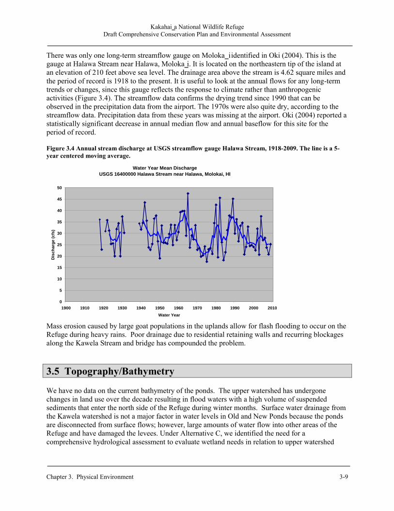
Kakahai‗a National Wildlife Refuge Draft Comprehensive Conservation Plan and Environmental Assessment
Chapter 3. Physical Environment 3-9
There was only one long-term streamflow gauge on Moloka‗i identified in Oki (2004). This is the gauge at Halawa Stream near Halawa, Moloka‗i. It is located on the northeastern tip of the island at an elevation of 210 feet above sea level. The drainage area above the stream is 4.62 square miles and the period of record is 1918 to the present. It is useful to look at the annual flows for any long-term trends or changes, since this gauge reflects the response to climate rather than anthropogenic activities (Figure 3.4). The streamflow data confirms the drying trend since 1990 that can be observed in the precipitation data from the airport. The 1970s were also quite dry, according to the streamflow data. Precipitation data from these years was missing at the airport. Oki (2004) reported a statistically significant decrease in annual median flow and annual baseflow for this site for the period of record. Figure 3.4 Annual stream discharge at USGS streamflow gauge Halawa Stream, 1918-2009. The line is a 5-year centered moving average.
Mass erosion caused by large goat populations in the uplands allow for flash flooding to occur on the Refuge during heavy rains. Poor drainage due to residential retaining walls and recurring blockages along the Kawela Stream and bridge has compounded the problem.
3.5 Topography/Bathymetry We have no data on the current bathymetry of the ponds. The upper watershed has undergone changes in land use over the decade resulting in flood waters with a high volume of suspended sediments that enter the north side of the Refuge during winter months. Surface water drainage from the Kawela watershed is not a major factor in water levels in Old and New Ponds because the ponds are disconnected from surface flows; however, large amounts of water flow into other areas of the Refuge and have damaged the levees. Under Alternative C, we identified the need for a comprehensive hydrological assessment to evaluate wetland needs in relation to upper watershed
Water Year Mean Discharge
USGS 16400000 Halawa Stream near Halawa, Molokai, HI
0
5
10
15
20
25
30
35
40
45
50
1900 1910 1920 1930 1940 1950 1960 1970 1980 1990 2000 2010
Water Year
Dis
ch
arg
e (
cfs
)
Kakahai‗a National Wildlife Refuge Draft Comprehensive Conservation Plan and Environmental Assessment
3-10 Chapter 3. Physical Environment
land-use changes. An evaluation of the groundwater source is essential as Old Pond receives its water from this source. 3.6 Environmental Contaminants The Maui Department of Water Supply (DWS) conducts annual testing of groundwater wells in the Kawela watershed. The most recent report is a review of testing conducted and compiled in 2009 for reporting in July 2010. The DWS tested for more than 100 substances in the water, including bacteria, pesticides and herbicides, asbestos, lead, copper, and petroleum products. The only measurable contaminant found was nitrate (as N) with the highest detection level of 0.31 ppm, well below the EPA allowable limit of 10.0 ppm. The typical source of this trace contaminant is from erosion of natural deposits. In summary, no sources of environmental contamination have been detected or are suspected of adversely affecting the Refuge (DWS 2010).
3.7 Land Use Immediately above and adjacent to the Kakahai‗a NWR is the residential development of Kawela Plantations which spans 6000 acres of former Moloka‗i Ranch agricultural land with 210 1-acre residential/agricultural lots. The makai (ocean-side) section of the Refuge is operated as Kakahai‗a Beach Park through a cooperative agreement with Maui County. Located just 5.5 miles east of the main city of Kaunakakai, the the park is used primarily for picnicking and shoreline fishing. 3.7.1 Previous Land Uses Moloka‗i was first settled in approximately 600 BCE. The first inhabitants settled on the eastern end and gradually migrated southwest. As agriculture developed, the landscape of Moloka‗i began to transform and has undergone alterations throughout its history of human settlement. Polynesian voyagers stocked their canoes with pigs, chickens, and dogs as well as specific crops necessary for colonization. The native lowland forests were cleared and replaced with Polynesian introductions of taro, sweet potato, yam, banana, sugarcane, breadfruit, and coconut. The land was modified with highly advanced farming practices that included irrigation from streams, terracing, mulching, and use of green manure. Slash and burn techniques were used to clear land for crops and to encourage the growth of pili grass used in house thatching (Roberts 2000, Ross 2011). Significant sections of the coastline were modified between 1000-1400 CE with the creation of over 50 coastal fishponds ranging in size from a few acres to several hundreds of acres across and 1-30 feet deep. Native Hawaiians used lava boulders and coral to build the semi-circular walls of the ponds which would keep the fish inside while allowing the sea water to ebb in and out. The fish from these ponds were only eaten by the ali‗i (chiefs and royalty). Both down-slope and along-shore sediment transport patterns were altered. Many of these fishponds formed catchment basins for sediments coming off the expanded terraces and agricultural lands (Roberts 2000, Hawaiianweb 2006).
Kakahai‗a National Wildlife Refuge Draft Comprehensive Conservation Plan and Environmental Assessment
Chapter 3. Physical Environment 3-11
Prior to the fishpond construction, it is likely that the marsh was located closer to the springs along the present inland margin of the pond. The marsh area was transformed to a fishpond by removing vegetation, such as ‗aka‗akai, excavating the pond to a specific depth, and using the mud to form an earthen berm surrounding the pond. A rock wall was constructed in areas where the earthen berm was not a sufficient barrier (Weisler 1983). A ditch, or ‗auwai kai, was built between the pond and the sea in order to permit the flow of seawater and young fish. This flow was regulated by a gate, or makaha (Summers 1964). Small fry were introduced to the pond including awa (milkfish), ‗ama‗ama (mullet), aholehole, and ‗o‗opu (gobies). Similar to other Hawaiian fishponds, the perimeter may have been planted with taro, sweet potato, sugarcane, or ti (Weisler 1983). Although small inland fishponds typically were owned by commoners (Summers 1964), Kakahai‗a may have been controlled by a chief (Weisler 1983). The thin sandy strip of land separating the pond from the sea suggests that the area was formerly a bay open to the sea (Estioko-Griffin 1987). Numerous rounded basalt boulders located along the strip of land, which are facilitating beach erosion, resemble boulders found in the Kawela Gulch stream course. Weisler (1983) suggests that due to the historic and current location of Kawela Stream, these boulders would not have been naturally deposited that far east, but were intentionally brought from the gulch in order to construct a seaward boundary for the pond. Thus, Kakahai‗a may have initially been a loko kuapa, a fishpond composed of a continuous stone wall connecting two protruding points along the shoreline, which has subsequently been buried due to sand accretion (Weisler 1983). The arrival of Europeans in the 1770s brought the the introduction of goats, horses, cattle, and sheep. Ellis (1827) was the first to provide a written description of the island and estimated the population not to exceed more than 3,000. In 1828, Reverends Green and Andrews, while on a tour of Moloka‗i, estimated that the population was 5,000 and that there were 1,000 houses, although only 700 houses were actually counted (Missionary Herald 1829). The Kawela ahupua‗a became part of King Kamehameha V‘s ranch in the 1850s and was used as grazing land for cattle. The Duke of Edinburgh had deer transported from Japan to Moloka‗i as a gift to Kamehameha V in 1870. The growing herds quickly increased and endemic plants quickly declined, leaving vast areas barren due to soil compaction that increased runoff and accelerated erosion (Roberts 2000). The Hawaiian Sugar Planters‘ Association leased the Kawela lands in 1928, constructed a quarantine station for imported experimental varieties of sugarcane, and planted cane on the alluvial flats which was immediately flooded by heavy rains. To mitigate future flooding, the Planters‘ relocated the stream to its present location by dozing boulders and river rocks in a straight line to the ocean. In 1935, the sugarcane fields were tilled-under and planted in mango trees, which remain today. Weisler and Kirch (1982) estimated that since 1880, the Kawela shoreline increased by 1 foot per year. Although some farmers remained on ancestral land east and west of Kawela Stream, upland residences gave way to Western-style habitation along the coast. In 1901, Kakahai‗a Pond was used to produce rice and several residences were established along the pond edges to facilitate cultivation (Weisler 1983, Shallenberger 1977). During this time, the pond was much larger, with surface water areas estimated at 31 acres. A 1940, USGS aerial (above) shows much of the pond in rice production, which continued until 1950, at which time the Yuen

Kakahai‗a National Wildlife Refuge Draft Comprehensive Conservation Plan and Environmental Assessment
3-12 Chapter 3. Physical Environment
family leased the pond from the McCorriston Trust and excavated the area to cultivate catfish and seabass. The surrounding area was used to raise pigs and produce kiawe charcoal until 1975. Five years later, the Kawela Plantation Development began construction on the upland ridges above the pond, further increasing siltation to the pond.
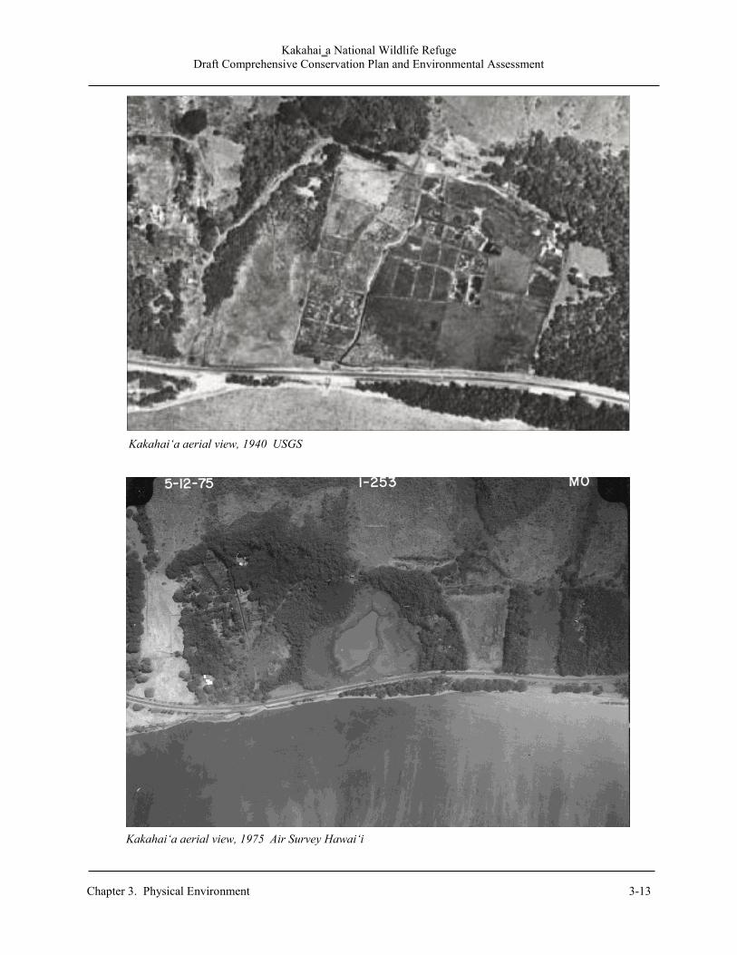
Kakahai‗a National Wildlife Refuge Draft Comprehensive Conservation Plan and Environmental Assessment
Chapter 3. Physical Environment 3-13
Kakahai‘a aerial view, 1975 Air Survey Hawai‘i
Kakahai‘a aerial view, 1940 USGS

Kakahai‗a National Wildlife Refuge Draft Comprehensive Conservation Plan and Environmental Assessment
3-14 Chapter 3. Physical Environment
Kakahai‘a National Wildlife Refuge Draft Comprehensive Conservation Plan and Environmental Assessment
______________________________________________________________________________________ Chapter 4 Refuge Biology and Habitat 4-1
Chapter 4. Refuge Biology and Habitat
4.1 Introduction This chapter addresses the biological resources and habitats on the Refuge. The chapter begins with a discussion of biological integrity. It then presents pertinent background information for each conservation target identified in the CCP. Land cover types are shown in Figure 4.1 (page 4-5).
4.2 Biological Integrity Analysis Kakahai‘a NWR is located within the Kawela watershed. The drainage basin has changed considerably due to agricultural activities. Cattle, deer, and goats have denuded much of Kawela and accelerated soil erosion along the lower elevations. Old Pond was once an inland freshwater fish pond and New Pond was created in 1983 to provide shallow water habitat for ae‘o. Currently, adjacent lands include agricultural and residential properties.
Little is known about the historic pristine coastal wetland vegetation due to conversion by early Hawaiians into fishponds and irrigated farmlands. A small number of native plants still occur at the Refuge, but their distribution before introduction of nonnative species is difficult to reconstruct. Recent vegetation changes have followed the creation of New Pond. Although wetland plant species initially thrived in the 1980s and 1990s, these plants died out as the pond lost water. Due to its dewatered condition since the early 2000s, the New Pond acreage is now dominated by dry upland pest species. The remaining vegetated wetlands of Old Pond are dominated by California bulrush with small stands of kaluha (alkali bulrush) and patches of ‘ākulikuli (sea purslane). The latter two species and kīpūkai (seaside heliotrope) are the only common native plants on the Refuge.
4.3 Conservation Target Selection and Analysis Endangered Hawaiian waterbirds, migratory birds, and their associated wetland habitat are the conservation targets of this plan (Table 4.1). They are consistent with the purpose of the Refuge, the Hawaiian waterbird recovery plan and the shorebird conservation plan. The objectives as described in Chapter 2 were developed based on desired outcomes, biological and abiotic factors as well as feasibility to meet those objectives (USFWS 2005, Engilis and Naughton 2004).
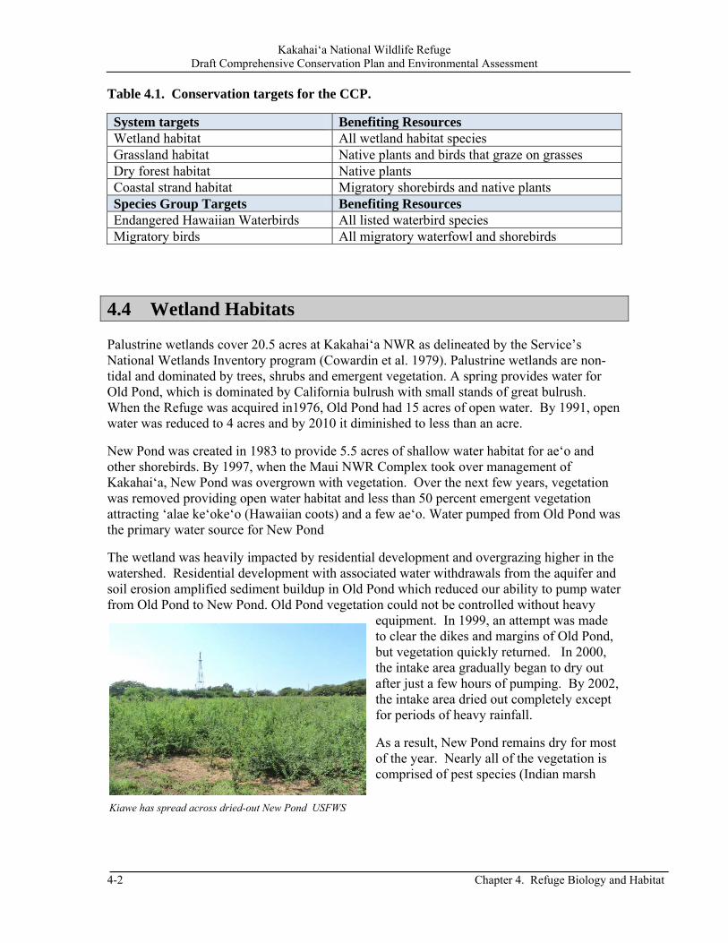
Kakahai‘a National Wildlife Refuge Draft Comprehensive Conservation Plan and Environmental Assessment
4-2 Chapter 4. Refuge Biology and Habitat
Table 4.1. Conservation targets for the CCP.
System targets Benefiting Resources Wetland habitat All wetland habitat species Grassland habitat Native plants and birds that graze on grasses Dry forest habitat Native plants Coastal strand habitat Migratory shorebirds and native plants Species Group Targets Benefiting Resources Endangered Hawaiian Waterbirds All listed waterbird species Migratory birds All migratory waterfowl and shorebirds
4.4 Wetland Habitats Palustrine wetlands cover 20.5 acres at Kakahai‘a NWR as delineated by the Service’s National Wetlands Inventory program (Cowardin et al. 1979). Palustrine wetlands are non-tidal and dominated by trees, shrubs and emergent vegetation. A spring provides water for Old Pond, which is dominated by California bulrush with small stands of great bulrush. When the Refuge was acquired in1976, Old Pond had 15 acres of open water. By 1991, open water was reduced to 4 acres and by 2010 it diminished to less than an acre.
New Pond was created in 1983 to provide 5.5 acres of shallow water habitat for ae‘o and other shorebirds. By 1997, when the Maui NWR Complex took over management of Kakahai‘a, New Pond was overgrown with vegetation. Over the next few years, vegetation was removed providing open water habitat and less than 50 percent emergent vegetation attracting ‘alae ke‘oke‘o (Hawaiian coots) and a few ae‘o. Water pumped from Old Pond was the primary water source for New Pond
The wetland was heavily impacted by residential development and overgrazing higher in the watershed. Residential development with associated water withdrawals from the aquifer and soil erosion amplified sediment buildup in Old Pond which reduced our ability to pump water from Old Pond to New Pond. Old Pond vegetation could not be controlled without heavy
equipment. In 1999, an attempt was made to clear the dikes and margins of Old Pond, but vegetation quickly returned. In 2000, the intake area gradually began to dry out after just a few hours of pumping. By 2002, the intake area dried out completely except for periods of heavy rainfall.
As a result, New Pond remains dry for most of the year. Nearly all of the vegetation is comprised of pest species (Indian marsh
Kiawe has spread across dried-out New Pond USFWS

Kakahai‘a National Wildlife Refuge Draft Comprehensive Conservation Plan and Environmental Assessment
______________________________________________________________________________________ Chapter 4 Refuge Biology and Habitat 4-3
fleabane, kiawe, swollen finger grass, and Australian saltbush). Kīpūkai is the only native species currently present in New Pond.
In the past, the Refuge provided year-round habitat for the endangered ‘alae ke‘oke‘o and ae‘o. A few migratory waterfowl and shorebirds also used the wetland. Currently, waterbirds occur only when heavy rainstorms replenish New Pond. ‘Ama‘ama (mullet), Oreochromis spp, Poecilia spp, and mosquitofish are found in Old Pond.
4.5 Coastal Dry Forest Dry forests cover 22.1 acres along the upland areas of the Refuge. The forest is species poor with most plants introduced since the 19th century. This habitat is dominated by nonnative kiawe and monkey pod with an understory of Indian marsh fleabane. The inland kiawe subtype occurs especially in dry areas on all of the main Hawaiian Islands usually below the 1,000 foot elevation. Most of the forest occurs to the north and east of the wetlands. Trees are 30-40 feet tall.
Much of this habitat had been cleared in 1999, but 70 percent has since grown back. A portion of the area north of New Pond is relatively open and typically with scattered trees about 10-15 feet tall. Floods that result in pools of standing water may kill upland vegetation that reduces water velocity allowing sediments and vegetative debris to settle out.
A variety of nonnative birds inhabit the dry coastal forest. Gray francolins commonly occur at the forest edge while passerines such as the white-rumped shama, northern cardinal, red-crested cardinal, and house finch are found in amongst the kiawe trees. Terrestrial pest mammals commonly observed include house mouse, Norway rat, black rat, dog, mongoose, cat, and axis deer.
Kiawe dominates the forest USFWS

Kakahai‘a National Wildlife Refuge Draft Comprehensive Conservation Plan and Environmental Assessment
4-4 Chapter 4. Refuge Biology and Habitat
4.6 Coastal Beach Strand Coastal beach strand covers 2.0 acres of the Refuge on the south side of Kamehameha V Highway. This habitat is dominated by nonnative grasses, coconut trees, and kiawe. Indian fleabane and milo also occur in this habitat. The entire shoreline has been affected by beach erosion with the west side more severely impacted. Few migratory birds inhabit the coastal strand. The beach provides foraging habitat for hunakai (sanderling) while the grassy area is used by kōlea (Pacific golden-plovers) and ‘akekeke (ruddy turnstone). Pest mammals present in this habitat include house mice, Norway rats, black rats, dogs, small Indian mongooses, and cats. Beach erosion that converts uplands to submerged lands with the associated sedimentation of adjacent reefs is a recognized threat to the coastal beach strand.
Kakahai‘a beach strand USFWS

Kakahai‘a National Wildlife Refuge Draft Comprehensive Conservation Plan and Environmental Assessment
______________________________________________________________________________________ Chapter 4 Refuge Biology and Habitat 4-5
Figure 4.1. Land Cover Types.

Kakahai‘a National Wildlife Refuge Draft Comprehensive Conservation Plan and Environmental Assessment
4-6 Chapter 4. Refuge Biology and Habitat
This page left blank to preserve the integrity of our map.

Kakahai‘a National Wildlife Refuge Draft Comprehensive Conservation Plan and Environmental Assessment
______________________________________________________________________________________ Chapter 4 Refuge Biology and Habitat 4-7
4.7 Endangered Hawaiian Waterbirds Kakahai‘a NWR was established to provide protected habitat for two of Hawai‘i’s endangered waterbirds, the ae‘o and ‘alae ke‘oke‘o. Statewide, the primary causes of their population decline include loss of wetland habitat, predation by introduced animals, altered hydrology, habitat alteration by invasive nonnative plants, and disease. In addition, environmental contaminants may also potentially threaten populations in certain areas. No critical habitat has been designated for any of Hawai‘i’s endangered waterbirds.
4.7.1 Ae‘o (Himantopus mexicanus knudseni) or Hawaiian Stilt The ae‘o is an endemic subspecies in the Hawaiian Islands, which is part of a superspecies complex of stilts found in various parts of the world.. The State population of this non-migratory shorebird fluctuates between 1,200-1,500 birds with a 5-year average of 1,350 birds. Refuge counts of up to 40 birds were observed in the early 1990s at New Pond. These counts were down to 20 in the late 1990s and now a few ae‘o are seen around the Refuge only after heavy rains (FWS 2005, Robinson et al. 1999). Ae‘o favor open wetland habitats with minimal vegetative cover and water depths less than 9.4 inches, as well as tidal mudflats. Due to the deeper water, they did not use Old Pond. Ae‘o nest April-August with nesting sites consisting of simple scrapes on low relief islands within or adjacent to
ponds. They tend to be opportunistic users of ephemeral wetlands to exploit seasonal abundance of food, feeding on small fish, crabs, polychaete worms, and insects. Ongoing threats to foraging and breeding birds on Refuge lands include predation by owls, mongooses, cats, rats, dogs, ‘auku‘u (black-crowned night-heron), cattle egrets, common mynas, ‘akekeke, and laughing gulls (Robinson et al. 1999, Rauzon and Drigot 2002). 4.7.2 ‘Alae ke‘oke‘o (Fulica alai) or Hawaiian Coot The ‘alae ke‘oke‘o is an endangered species endemic to all the main Hawaiian Islands except Kaho‘olawe. The State population has fluctuated between 2,000-4,000 birds. Nesting occurred around Old Pond in the late-1970s through the 1980s when there was open-water habitat. New Pond provided nesting and feeding habitat for a small number in the late 1990s with counts up to 50 birds. Only 2 ‘alae ke‘oke‘o are currently occasionally present year-round at the Refuge (Brisbin et al 2002, USFWS 2005).
Ae‘o pair © Brian Barker
‘Alae ke‘oke‘o Laura Beauregard/USFWS

Kakahai‘a National Wildlife Refuge Draft Comprehensive Conservation Plan and Environmental Assessment
4-8 Chapter 4. Refuge Biology and Habitat
‘Alae ke‘oke‘o are usually found on island coastal plains and prefer freshwater ponds or wetlands, brackish wetlands, and manmade impoundments. They prefer open water that is less than 12 inches deep for foraging and nesting habitat that has open water with emergent aquatic vegetation or heavy stands of grass. ‘Alae ke‘oke‘o feed on seeds and leaves of aquatic and terrestrial plants, freshwater snails, crustaceans, tadpoles of marine toads, small fish, and aquatic and terrestrial insects (Schwartz and Schwartz 1949, Brisbin et al. 2002). Nesting occured November-April during the late 1990s, with opportunistic nesting occurring year-round depending on rainfall. ‘Alae ke‘oke‘o will construct floating nests of aquatic vegetation, semi-floating nests attached to emergent vegetation, or in clumps of wetland vegetation. Cats, dogs, and mongooses are the main predators of ‘alae ke‘oke‘o. Other predators include ‘auku‘u, cattle egrets, and large fish. ‘Alae ke‘oke‘o are also susceptible to avian botulism outbreaks (Brisbin et al. 2002).
4.8 Migratory Waterfowl
Migratory waterfowl winter over in the Hawaiian Islands from September-May. They used the open waters of New Pond until it began to dry out in the late 1990s. Species recorded at the Refuge included koloa māpu (northern pintail), koloa mohā (Northern shoveler), green-winged teal, and koloa-mallard hybrids. Our observations through the 1990s noted migratory waterfowl were more prevalent during the winter months, with numbers exceeding 15 birds comprised of a few different species.
4.9 Migratory Shorebirds Shorebirds use mudflats and dikes in the wetlands and along the coastal strand area of Refuge during the winter months. Although their numbers have declined significantly due to lack of water, they are still seen after heavy rains at New Pond. Occasional sightings include the kōlea, ‘akekeke, hunakai, and ‘ūlili (wandering tattler). The only resident shorebird is the ae‘o.
‘Ūlili © Michael Walther
Koloa māpu © Tom Dove
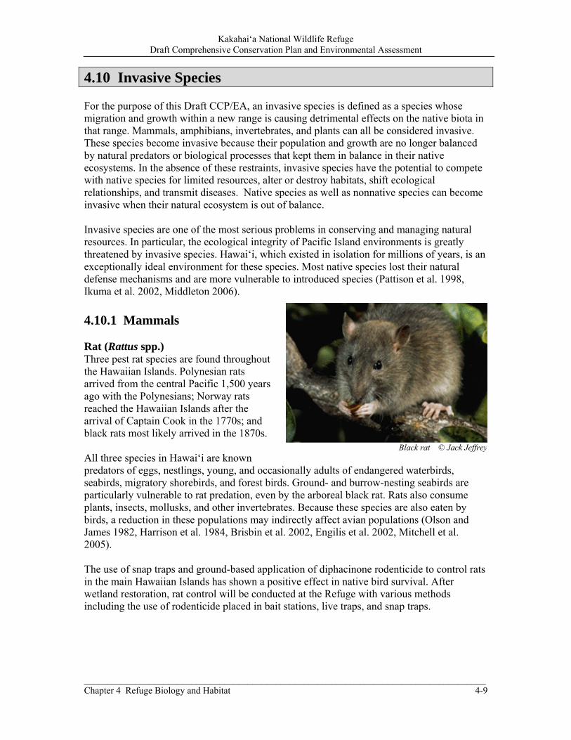
Kakahai‘a National Wildlife Refuge Draft Comprehensive Conservation Plan and Environmental Assessment
______________________________________________________________________________________ Chapter 4 Refuge Biology and Habitat 4-9
4.10 Invasive Species For the purpose of this Draft CCP/EA, an invasive species is defined as a species whose migration and growth within a new range is causing detrimental effects on the native biota in that range. Mammals, amphibians, invertebrates, and plants can all be considered invasive. These species become invasive because their population and growth are no longer balanced by natural predators or biological processes that kept them in balance in their native ecosystems. In the absence of these restraints, invasive species have the potential to compete with native species for limited resources, alter or destroy habitats, shift ecological relationships, and transmit diseases. Native species as well as nonnative species can become invasive when their natural ecosystem is out of balance. Invasive species are one of the most serious problems in conserving and managing natural resources. In particular, the ecological integrity of Pacific Island environments is greatly threatened by invasive species. Hawai‘i, which existed in isolation for millions of years, is an exceptionally ideal environment for these species. Most native species lost their natural defense mechanisms and are more vulnerable to introduced species (Pattison et al. 1998, Ikuma et al. 2002, Middleton 2006). 4.10.1 Mammals Rat (Rattus spp.) Three pest rat species are found throughout the Hawaiian Islands. Polynesian rats arrived from the central Pacific 1,500 years ago with the Polynesians; Norway rats reached the Hawaiian Islands after the arrival of Captain Cook in the 1770s; and black rats most likely arrived in the 1870s. All three species in Hawai‘i are known predators of eggs, nestlings, young, and occasionally adults of endangered waterbirds, seabirds, migratory shorebirds, and forest birds. Ground- and burrow-nesting seabirds are particularly vulnerable to rat predation, even by the arboreal black rat. Rats also consume plants, insects, mollusks, and other invertebrates. Because these species are also eaten by birds, a reduction in these populations may indirectly affect avian populations (Olson and James 1982, Harrison et al. 1984, Brisbin et al. 2002, Engilis et al. 2002, Mitchell et al. 2005). The use of snap traps and ground-based application of diphacinone rodenticide to control rats in the main Hawaiian Islands has shown a positive effect in native bird survival. After wetland restoration, rat control will be conducted at the Refuge with various methods including the use of rodenticide placed in bait stations, live traps, and snap traps.
Black rat © Jack Jeffrey
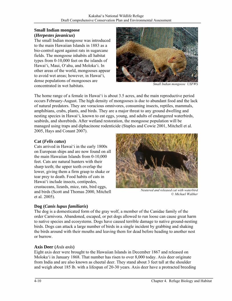
Kakahai‘a National Wildlife Refuge Draft Comprehensive Conservation Plan and Environmental Assessment
4-10 Chapter 4. Refuge Biology and Habitat
Neutered and released cat with waterbird © Michael Walther
Small Indian mongoose (Herpestes javanicus) The small Indian mongoose was introduced to the main Hawaiian Islands in 1883 as a bio-control agent against rats in sugarcane fields. The mongoose inhabits all habitat types from 0-10,000 feet on the islands of Hawai‘i, Maui, O‘ahu, and Moloka‘i. In other areas of the world, mongooses appear to avoid wet areas; however, in Hawai‘i, dense populations of mongooses are concentrated in wet habitats. The home range of a female in Hawai‘i is about 3.5 acres, and the main reproductive period occurs February-August. The high density of mongooses is due to abundant food and the lack of natural predators. They are voracious omnivores, consuming insects, reptiles, mammals, amphibians, crabs, plants, and birds. They are a major threat to any ground dwelling and nesting species in Hawai‘i, known to eat eggs, young, and adults of endangered waterbirds, seabirds, and shorebirds. After wetland restoration, the mongoose population will be managed using traps and diphacinone rodenticide (Staples and Cowie 2001, Mitchell et al. 2005, Hays and Conant 2007). Cat (Felis catus) Cats arrived in Hawai‘i in the early 1800s on European ships and are now found on all the main Hawaiian Islands from 0-10,000 feet. Cats are natural hunters with their sharp teeth; the upper teeth overlap the lower, giving them a firm grasp to shake or tear prey to death. Food habits of cats in Hawai‘i include insects, centipedes, crustaceans, lizards, mice, rats, bird eggs, and birds (Scott and Thomas 2000, Mitchell et al. 2005). Dog (Canis lupus familiaris) The dog is a domesticated form of the gray wolf, a member of the Canidae family of the order Carnivora. Abandoned, escaped, or pet dogs allowed to run loose can cause great harm to native species and ecosystems. Dogs have caused terrible damage to native ground-nesting birds. Dogs can attack a large number of birds in a single incident by grabbing and shaking the birds around with their mouths and leaving them for dead before heading to another nest or burrow. Axis Deer (Axis axis) Eight axis deer were brought to the Hawaiian Islands in December 1867 and released on Moloka‘i in January 1868. That number has risen to over 8,000 today. Axis deer originate from India and are also known as cheetal deer. They stand about 3 feet tall at the shoulder and weigh about 185 lb. with a lifespan of 20-30 years. Axis deer have a protracted breeding
Small Indian mongoose USFWS
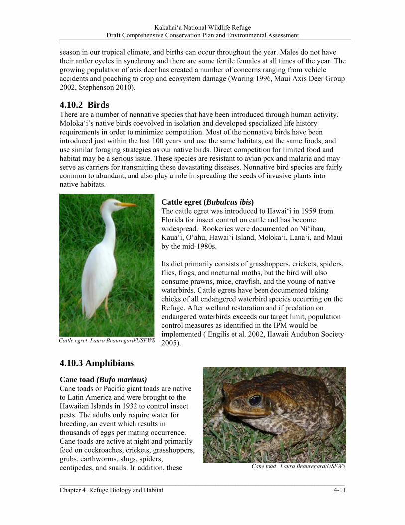
Kakahai‘a National Wildlife Refuge Draft Comprehensive Conservation Plan and Environmental Assessment
______________________________________________________________________________________ Chapter 4 Refuge Biology and Habitat 4-11
season in our tropical climate, and births can occur throughout the year. Males do not have their antler cycles in synchrony and there are some fertile females at all times of the year. The growing population of axis deer has created a number of concerns ranging from vehicle accidents and poaching to crop and ecosystem damage (Waring 1996, Maui Axis Deer Group 2002, Stephenson 2010).
4.10.2 Birds There are a number of nonnative species that have been introduced through human activity. Moloka‘i’s native birds coevolved in isolation and developed specialized life history requirements in order to minimize competition. Most of the nonnative birds have been introduced just within the last 100 years and use the same habitats, eat the same foods, and use similar foraging strategies as our native birds. Direct competition for limited food and habitat may be a serious issue. These species are resistant to avian pox and malaria and may serve as carriers for transmitting these devastating diseases. Nonnative bird species are fairly common to abundant, and also play a role in spreading the seeds of invasive plants into native habitats.
Cattle egret (Bubulcus ibis) The cattle egret was introduced to Hawai‘i in 1959 from Florida for insect control on cattle and has become widespread. Rookeries were documented on Ni‘ihau, Kaua‘i, O‘ahu, Hawai‘i Island, Moloka‘i, Lana‘i, and Maui by the mid-1980s. Its diet primarily consists of grasshoppers, crickets, spiders, flies, frogs, and nocturnal moths, but the bird will also consume prawns, mice, crayfish, and the young of native waterbirds. Cattle egrets have been documented taking chicks of all endangered waterbird species occurring on the Refuge. After wetland restoration and if predation on endangered waterbirds exceeds our target limit, population control measures as identified in the IPM would be implemented ( Engilis et al. 2002, Hawaii Audubon Society 2005).
4.10.3 Amphibians
Cane toad (Bufo marinus) Cane toads or Pacific giant toads are native to Latin America and were brought to the Hawaiian Islands in 1932 to control insect pests. The adults only require water for breeding, an event which results in thousands of eggs per mating occurrence. Cane toads are active at night and primarily feed on cockroaches, crickets, grasshoppers, grubs, earthworms, slugs, spiders, centipedes, and snails. In addition, these Cane toad Laura Beauregard/USFWS
Cattle egret Laura Beauregard/USFWS
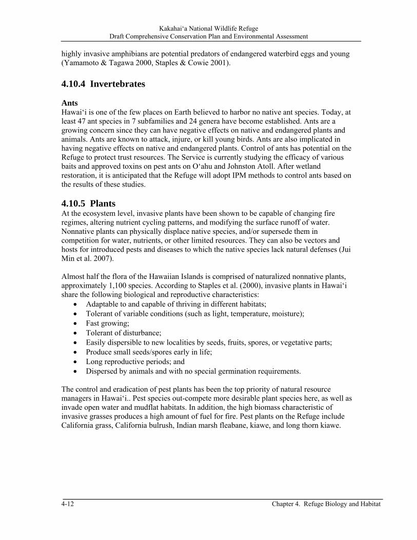
Kakahai‘a National Wildlife Refuge Draft Comprehensive Conservation Plan and Environmental Assessment
4-12 Chapter 4. Refuge Biology and Habitat
highly invasive amphibians are potential predators of endangered waterbird eggs and young (Yamamoto & Tagawa 2000, Staples & Cowie 2001). 4.10.4 Invertebrates Ants Hawai‘i is one of the few places on Earth believed to harbor no native ant species. Today, at least 47 ant species in 7 subfamilies and 24 genera have become established. Ants are a growing concern since they can have negative effects on native and endangered plants and animals. Ants are known to attack, injure, or kill young birds. Ants are also implicated in having negative effects on native and endangered plants. Control of ants has potential on the Refuge to protect trust resources. The Service is currently studying the efficacy of various baits and approved toxins on pest ants on O‘ahu and Johnston Atoll. After wetland restoration, it is anticipated that the Refuge will adopt IPM methods to control ants based on the results of these studies. 4.10.5 Plants At the ecosystem level, invasive plants have been shown to be capable of changing fire regimes, altering nutrient cycling patterns, and modifying the surface runoff of water. Nonnative plants can physically displace native species, and/or supersede them in competition for water, nutrients, or other limited resources. They can also be vectors and hosts for introduced pests and diseases to which the native species lack natural defenses (Jui Min et al. 2007). Almost half the flora of the Hawaiian Islands is comprised of naturalized nonnative plants, approximately 1,100 species. According to Staples et al. (2000), invasive plants in Hawai‘i share the following biological and reproductive characteristics:
Adaptable to and capable of thriving in different habitats; Tolerant of variable conditions (such as light, temperature, moisture); Fast growing; Tolerant of disturbance; Easily dispersible to new localities by seeds, fruits, spores, or vegetative parts; Produce small seeds/spores early in life; Long reproductive periods; and Dispersed by animals and with no special germination requirements.
The control and eradication of pest plants has been the top priority of natural resource managers in Hawai‘i.. Pest species out-compete more desirable plant species here, as well as invade open water and mudflat habitats. In addition, the high biomass characteristic of invasive grasses produces a high amount of fuel for fire. Pest plants on the Refuge include California grass, California bulrush, Indian marsh fleabane, kiawe, and long thorn kiawe.

Kakahai‘a National Wildlife Refuge Draft Comprehensive Conservation Plan and Environmental Assessment
______________________________________________________________________________________ Chapter 4 Refuge Biology and Habitat 4-13
California grass (Brachiaria mutica) California grass is a sprawling perennial with culms up to 19 feet long. Stolons and leaf sheaths are densely hairy. It is suspected to have originated in sub-Saharan Africa and occurs pantropically as a pasture grass and it well adapted to a wide range of soil conditions (sandy to clay). It tolerates moderate shade but prefers full sun (Cook et al. 2005). It grows prolifically in wetland habitats, but it can also withstand severe drought. In addition to displacing native plants, California grass alters and destroys aquatic environments, causing a reduction in bird habitat. The grass also interferes with stream flow and poses a nuisance to marine navigation when rafts of the grass float out to sea. The Hawai‘i-Pacific Weed Risk Assessment, conducted by the University of Hawai‘i and the U.S. Forest Service, identifies California grass as “documented to cause significant ecological or economic harm in Hawai‘i” (Stone et al. 1999, Motooka et al. 2003). Indian marsh fleabane (Pluchea indica) Indian fleabane is an erect shrub that grows up to 6.6 feet tall. It is native to temperate and tropical Asia, northern Australia, and is naturalized elsewhere. In Hawai‘i, it occurs in lowland, coastal habitats such as wetlands and fishponds (GRIN Online Database). Indian fleabane out-competes native sedges on the Refuge, reducing forage and nesting habitats for native birds. The understory and open areas of the coastal dry forest habitat are dominated by this pest species. It tends to harbor huge nests of paper wasps, which are a hazard to Refuge staff. The Refuge uses mechanical, chemical, and prescribed burning IPM techniques to control this pest species. California bulrush (Schoenoplectus californicus) California bulrush is a perennial sedge found in marshy areas from southern and western North America to South America. It has tall, thin, dark green stems which are usually triangular in cross-section and woolly, bristly tan or brown flowers in panicle inflorescences. It has characteristics common in the sedge family, such as creeping. It is intolerant of shade, but can spread rapidly by vegetative means (Wagner et al. 1999, NRCS 2008).
California grass Mike Silbernagle/USFWS
Indian marsh fleabane Mike Silbernagle/USFWS
California bulrush Mike Silbernagle/USFWS

Kakahai‘a National Wildlife Refuge Draft Comprehensive Conservation Plan and Environmental Assessment
4-14 Chapter 4. Refuge Biology and Habitat
Kiawe (Prosopis pallida) Kiawe is native to Peru, Colombia, and Ecuador. More than 150,000 acres of kiawe forests in Hawai‘i are descended from a single tree planted in 1828 by Father Bachelot, the first Catholic priest in the Hawaiian Islands. By 1840, progeny of the tree were already spreading to dry, leeward plains on all of the islands (Nelson and Wheeler 1963). Most kiawe have thorns with strong, 1 inch-long spines. It usually flowers January-March, but in years with wet summers it also flowers September-October. Kiawe overshadows native plants and deep taproots use all available water. Dense kiawe thickets have replaced native plants in the coastal dry forest at the Refuge.
Long thorn kiawe (Prosopis juliflora) Related to the common kiawe, long thorn kiawe differs in that it is sprawling in nature (rather than an upright tree), has a larger leaf structure and, most notably, thorns up to several inches long which are sharp enough to pierce vehicle tires. Long thorn kiawe has been known to hybridize with common kiawe. It has many seeds and grows rapidly, impeding access in New Pond with its sprawling branches and long sharp thorns. The Moloka‘i/Maui Invasive Species Committee has identified long thorn kiawe as a target pest species for removal. Our control options include hand pulling new shoots as soon as they have emerged and are large enough to grip. Cutting the plant at the base and treating with herbicide will effectively stop it from re-sprouting. Constant monitoring is needed to watch for new growth (MoMISC 2010).
4.11 Wildlife and Habitat Research and Monitoring Efforts A research project on wetland ecology has been conducted at Kakahai‘a NWR for the past several years. It included a study on nitrogen source tracking through wetland plants. It showed low values from wetlands on Moloka‘i and higher values at wetlands on O‘ahu and Maui. The higher values were attributed to more developed and densely populated watersheds (Bruland and MacKenzie 2010).
Kiawe thorns & seed pods © F & K Starr
Long thorn kiawe © F & K Starr
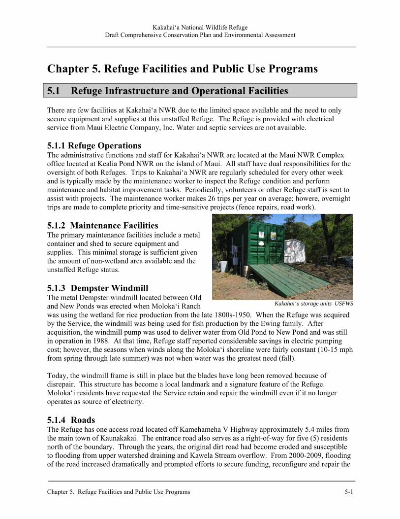
Kakahai‘a National Wildlife Refuge Draft Comprehensive Conservation Plan and Environmental Assessment
Chapter 5. Refuge Facilities and Public Use Programs 5-1
Chapter 5. Refuge Facilities and Public Use Programs
5.1 Refuge Infrastructure and Operational Facilities There are few facilities at Kakahai‘a NWR due to the limited space available and the need to only secure equipment and supplies at this unstaffed Refuge. The Refuge is provided with electrical service from Maui Electric Company, Inc. Water and septic services are not available.
5.1.1 Refuge Operations The administrative functions and staff for Kakahai‘a NWR are located at the Maui NWR Complex office located at Kealia Pond NWR on the island of Maui. All staff have dual responsibilities for the oversight of both Refuges. Trips to Kakahai‘a NWR are regularly scheduled for every other week and is typically made by the maintenance worker to inspect the Refuge condition and perform maintenance and habitat improvement tasks. Periodically, volunteers or other Refuge staff is sent to assist with projects. The maintenance worker makes 26 trips per year on average; howere, overnight trips are made to complete priority and time-sensitive projects (fence repairs, road work). 5.1.2 Maintenance Facilities The primary maintenance facilities include a metal container and shed to secure equipment and supplies. This minimal storage is sufficient given the amount of non-wetland area available and the unstaffed Refuge status. 5.1.3 Dempster Windmill The metal Dempster windmill located between Old and New Ponds was erected when Moloka‘i Ranch was using the wetland for rice production from the late 1800s-1950. When the Refuge was acquired by the Service, the windmill was being used for fish production by the Ewing family. After acquisition, the windmill pump was used to deliver water from Old Pond to New Pond and was still in operation in 1988. At that time, Refuge staff reported considerable savings in electric pumping cost; however, the seasons when winds along the Moloka‘i shoreline were fairly constant (10-15 mph from spring through late summer) was not when water was the greatest need (fall). Today, the windmill frame is still in place but the blades have long been removed because of disrepair. This structure has become a local landmark and a signature feature of the Refuge. Moloka‘i residents have requested the Service retain and repair the windmill even if it no longer operates as source of electricity. 5.1.4 Roads The Refuge has one access road located off Kamehameha V Highway approximately 5.4 miles from the main town of Kaunakakai. The entrance road also serves as a right-of-way for five (5) residents north of the boundary. Through the years, the original dirt road had become eroded and susceptible to flooding from upper watershed draining and Kawela Stream overflow. From 2000-2009, flooding of the road increased dramatically and prompted efforts to secure funding, reconfigure and repair the
Kakahai‘a storage units USFWS
Kakahai‘a National Wildlife Refuge Draft Comprehensive Conservation Plan and Environmental Assessment
5-2 Chapter 5. Refuge Facilities and Public Use Programs
road, and evaluate the flooding issue. In June 2010, the road was elevated and paved to allow safe, reliable access for staff and the adjacent neighbors. A slight modification to the road alignment allows for minimal parking for future wildlife observation from outside the fence. 5.1.5. Constructed Ponds and Levees Old Pond covers about 14 acres. The levees around the perimeter are currently eroded and impacted by invasive woody and annual plants making it impenetrable for access by foot. When this levee is reconstructed it will provide access for staff, visitors, and Refuge vehicles. In 1984, radial levees were constructed inside the pond; these levees will be removed to allow natural flooding and eliminate the high elevation inside the pond where invasive plant growth is an existing problem. The 5.5-acre New Pond was constructed in 1984 for shallow water habitat; however, the lack of water has greatly decreased its value to endangered waterbirds. The inner pond and perimeter levees are currently covered with pest plants, a majority of which is woody vegetation that impairs the integrity of the pond. The levees around this pond were accessible in the past and will continue to be used for EE and interpretation when restored. This pond is visible from the Refuge entrance road and would be a key area for wildlife observation and photography in the future. 5.1.6 Wells, Pumps, Water Distribution Lines, and Water Control Structures In 1984 (when New Pond was constructed), a water control structure was installed to connect both ponds and a pump located at the windmill was used to pump water from Old Pond into New Pond. This pump was in use until 2003; however, it is no longer functional because there is not enough water on the west side of Old Pond to pump into New Pond. At one time, the wind-driven pump was operational at all times of the year. Once the wetlands are restored, the Refuge would replace the pump to take advantage of the natural flooding from groundwater springs in Old Pond. Previous owners of the property had drilled modest wells, one of which has a coral lining above ground that is still visible. The Refuge will evaluate the feasibility of using these borings to install a casing and outfit it with a pump before drilling a new well. A new water supply is needed for New Pond to create and maintain shallow water habitat for endangered ae‘o and to help control pest plants. Old Pond has an old water control structure with a connection to the makai side via a culvert under Kamehameha V Highway. This structure is degraded and is intended to be removed and closed because the culvert is lower than the shoreline and covered with sand, preventing natural flow of water to the ocean. Both Old and New Ponds should have separate water control structures located at the lower elevation of each pond and connected to a ditch running along the south side of New Pond. This ditch intersects with the drainage ditch and culvert under the highway and exiting to the ocean. Currently, there are no water distribution lines dedicated to habitat management. The Refuge has initiated preliminary investigation into the re-establishment of an existing well or construction of a new well to provide an alternative water source for New Pond. The pump outfitted on this well would have water distribution lines, primarily to feed into New Pond but a valve to Old Pond would also be constructed to provide alternative flooding capabilities. 5.1.7. Kamehameha V Highway Culvert A concrete culvert under Kamehameha V Highway is located on the east side of the entrance road and provided drainage to the ocean. At the time of construction, the culvert may have been appropriate for drainage and situated at an elevation that allowed unimpeded flow to the ocean;

Kakahai‘a National Wildlife Refuge Draft Comprehensive Conservation Plan and Environmental Assessment
Chapter 5. Refuge Facilities and Public Use Programs 5-3
however, that is no longer the case. The existing elevation of the culvert is below the mean tide resulting in sand buildup in front of the opening and prevention of appropriate drainage. This condition is similar to other culverts along the southeastern shore of Moloka‘i causing occasional flooding of the highway and private property. During and after winter rains, HDOT uses heavy equipment to remove sand from culvert openings and plows sediment runoff from the highway. Unfortunately, once most water is drained, the culvert openings become plugged with sand with the next high tides. The flooding along the highway and entrance road at Kakahai‘a NWR has been an issue not only because of the culvert but also due to drainage problems at Kawela Bridge, approximately 0.3 miles west of the entrance road. Debris and sediment blocking water flow under the bridge results in overflow along the highway that eventually reaches the Refuge entrance road, adding water to an already flooded area. Although, the culverts are the responsibility of the State, the flooding is a Refuge issue that not only impacts staff access onto the Refuge but also impacts the five property owners who have a right of access along the Refuge road to their property. In 2004, the Service collaborated with the Federal Highway Administration to address flooding at the culvert with the intention of developing a design to resolve the sand blockage problem. The options were limited due to feasibility, collaboration with other agencies, and the potential impacts to areas further down the shoreline. The flooding issue is prevalent along the entire southeastern shoreline of Moloka‘i and is an issue that the Refuge will continue to investigate to develop solutions that are agreeable with all agencies and adjacent landowners. 5.1.8 Fences and Gates There are two fences at Kakahai‘a NWR. One fence encompasses both Old and New Ponds, coastal forest habitat, open grassland areas, and the maintenance area. Although in fairly good condition along the highway, along the eastern boundary it is susceptible to sediment buildup from runoff and erosion. It is also heavily impacted by axis deer and it requires periodic repairs. The portion of this fence that is parallel with the entrance road was replaced in 2010-11 when the Refuge entrance road was paved. The north side of the fence, along its entire length, is in need of replacement. A second fence used to be on the west and north sides of the Refuge road and provided a physical boundary with the neighboring private lands. Through the years, portions of this fence were removed due to disrepair and lack of funds to replace. Only small sections are remaining. The Refuge intends to replace this fence in its entirety throughout the length of the entrance road.
Damaged fence along the northern boundary USFWS
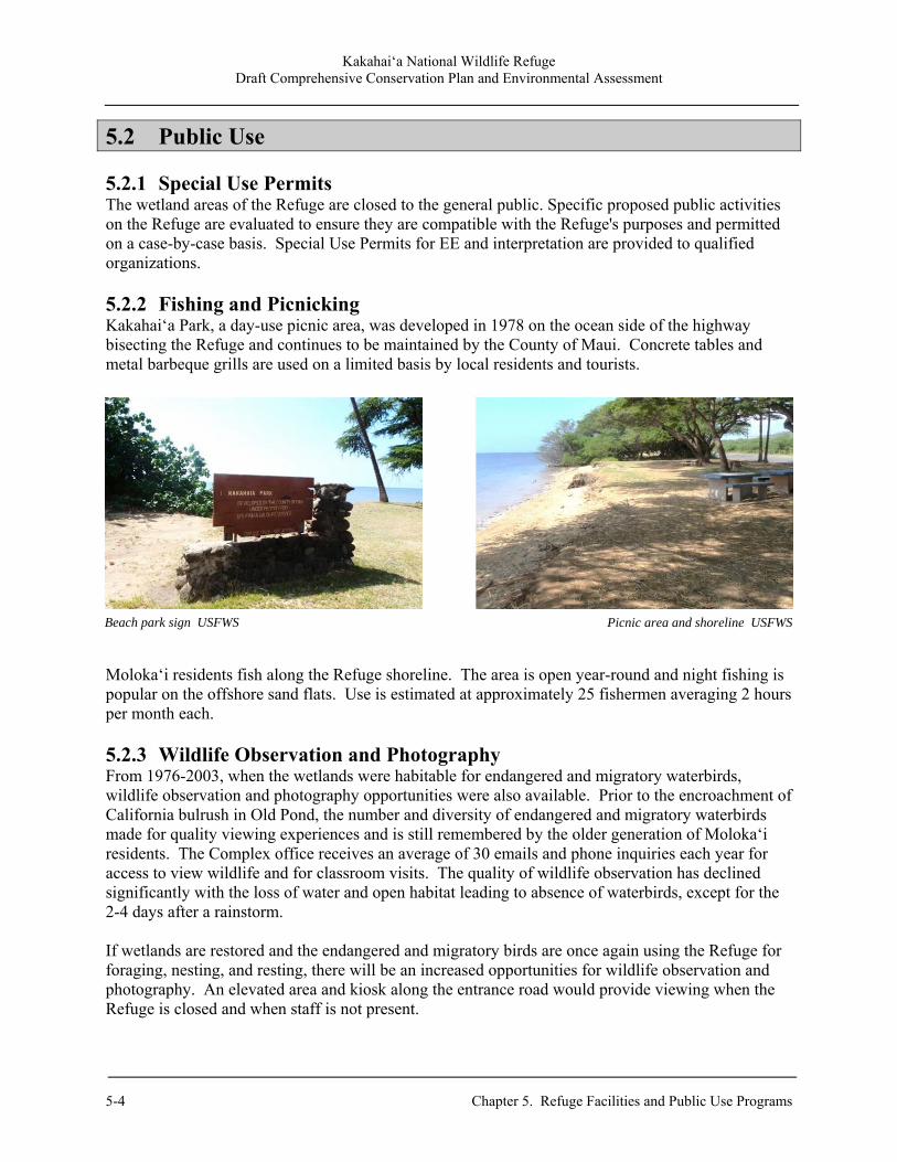
Kakahai‘a National Wildlife Refuge Draft Comprehensive Conservation Plan and Environmental Assessment
5-4 Chapter 5. Refuge Facilities and Public Use Programs
5.2 Public Use 5.2.1 Special Use Permits The wetland areas of the Refuge are closed to the general public. Specific proposed public activities on the Refuge are evaluated to ensure they are compatible with the Refuge's purposes and permitted on a case-by-case basis. Special Use Permits for EE and interpretation are provided to qualified organizations. 5.2.2 Fishing and Picnicking Kakahai‘a Park, a day-use picnic area, was developed in 1978 on the ocean side of the highway bisecting the Refuge and continues to be maintained by the County of Maui. Concrete tables and metal barbeque grills are used on a limited basis by local residents and tourists.
Moloka‘i residents fish along the Refuge shoreline. The area is open year-round and night fishing is popular on the offshore sand flats. Use is estimated at approximately 25 fishermen averaging 2 hours per month each. 5.2.3 Wildlife Observation and Photography From 1976-2003, when the wetlands were habitable for endangered and migratory waterbirds, wildlife observation and photography opportunities were also available. Prior to the encroachment of California bulrush in Old Pond, the number and diversity of endangered and migratory waterbirds made for quality viewing experiences and is still remembered by the older generation of Moloka‘i residents. The Complex office receives an average of 30 emails and phone inquiries each year for access to view wildlife and for classroom visits. The quality of wildlife observation has declined significantly with the loss of water and open habitat leading to absence of waterbirds, except for the 2-4 days after a rainstorm. If wetlands are restored and the endangered and migratory birds are once again using the Refuge for foraging, nesting, and resting, there will be an increased opportunities for wildlife observation and photography. An elevated area and kiosk along the entrance road would provide viewing when the Refuge is closed and when staff is not present.
Beach park sign USFWS Picnic area and shoreline USFWS
Kakahai‘a National Wildlife Refuge Draft Comprehensive Conservation Plan and Environmental Assessment
Chapter 5. Refuge Facilities and Public Use Programs 5-5
5.2.4 Environmental Education In past years, the Refuge hosted EE groups, primarily from the local community and schools, as a supplement to the teacher/leader’s in-class curriculum. The hands-on experiences were valuable for students with such limited access to wetland areas. Nēnē O Moloka‘i is a non-profit corporation created to establish and preserve wild nēnē on the island of Moloka‘i, while emphasizing education through community involvement. They currently have a SUP to access the Refuge and host school and other EE groups. The organization provides educational and volunteer opportunities to groups that include a well-rounded overview of the different types of wetland habitats on Moloka‘i with emphasis on the endangered waterbirds. With the addition of a new visitor services position for the Complex, Refuge-specific EE programs will be developed for local school groups of varying age levels. Volunteers would be recruited and trained to assist with the program. All EE programs will have a stewardship component where students would participate in a wetland restoration project. 5.2.5 Volunteers After the Refuge was established in 1976, residents on Moloka‘i formed the group Kokua Kakahai‘a to provide support for the Refuge and help define and develop goals for wetland restoration, bringing back the diversity of waterbirds at the Refuge, and develop a conceptual design that would include restoration by staff and community involvement. This group was instrumental in preparing by-laws and documents for the establishment of a Friends Group consisting of a core of 20 people. From 1998-2009, annual Kokua Kakahai‘a luncheons at the Moloka‘i Historical Museum were coordinated and funded by group leader Kenneth Fiske. These meetings were an opportunity for the Refuge Project Leader and group to gather and discuss Refuge issues and updates.

Kakahai‘a National Wildlife Refuge Draft Comprehensive Conservation Plan and Environmental Assessment
5-6 Chapter 5. Refuge Facilities and Public Use Programs
Kakahai‘a National Wildlife Refuge Draft Comprehensive Conservation Plan and Environmental Assessment
Chapter 6. Cultural Resources, Social, and Economic Environment 6-1
Chapter 6. Cultural Resources, Social, and Economic Environment
6.1 Refuge Cultural Resources The Service defines cultural resources as archaeological sites, historic places, objects of antiquity, cultural items, or traditional/religious values. This section provides a summary of the cultural and historic resources at Kakahai‘a NWR and the surrounding Kawela ahupua‘a. A discussion of the Native Hawaiian and Euro-American cultural history of the area is provided within the context of the broader history of Moloka‘i and the State of Hawai‘i. 6.1.1 Native Hawaiian Cultural History The early settlement history of the island is a subject of some debate. Some believe that the first Polynesians arrived in Hawai‘i around 100-300 BCE from the Marquesas and were followed by Tahitian settlers around 1100-1300 CE who conquered the original inhabitants. Others believe that there was only a single, extended period of settlement. Polynesians developed a new Hawaiian culture while maintaining much of the social and political structure of their homeland. Moloka‘i was originally divided into two main districts – Ko‘olau, which comprised the northeastern side, and Kona, which made up the remainder of the island. These districts were further divided into ahupua‘a, a wedge-shaped Hawaiian land unit that traditionally subdivided resources from the uplands to the shore. The ahupua‘a in the Kona district decreased in size toward the eastern portion of the island as the population became more concentrated. Summers (1971) states that the “surviving traditional history of Moloka‘i is fragmentary” since the island’s smaller size rendered it “not of major political importance.” In ancient times, Moloka‘i was also referred to as Pule-o‘o (effective prayer). This name was acquired because the small population could not compete with larger islands during war periods and therefore the ali‘i of Moloka‘i largely relied on prayer for safety (Handy and Handy 1972). The Kawela ahupua‘a, which means “the heat,” is an arid region on the southeastern portion of the island. Prehistoric use of Kawela is dated to approximately 1500 CE. During the 16th and 17th centuries, people used the coastal area of the Kawela ahupua‘a for fishing and aquaculture (Weisler 1983). The broad fringing reef offshore contained abundant shellfish, seaweed, and fish. A low sand dune midden located west of Kakahai‘a pond contains cultural remains of these groups including small scoop hearths with associated fishbone, marine and brackish-water mollusks, and crustaceans (Weisler 1983). In addition, Weisler and Kirch (1982) observed bone in the stratified layer from several bird species, including nēnē (Hawaiian goose), koloa mapū, pueo (Hawaiian short-eared owl), and ‘alae ke‘oke‘o. The presence of these particular species implies that marshlands were present in the area at that time. Permanent, large-scale occupation of the Kawela area began in the 18th century, as shown by the remains of a late pre-contact Hawaiian community. Residences were mostly concentrated along the ridgelines below the 115-foot contour. This elevation offered safety from flooding, exposure to the tradewinds, and allowed for high agricultural productivity along the Kawela Gulch and on the adjacent coastal flats (Weisler and Kirch 1982). Individual kauhale (housing complexes) within the

Kakahai‘a National Wildlife Refuge Draft Comprehensive Conservation Plan and Environmental Assessment
6-2 Chapter 6. Cultural Resources, Social, and Economic Environment
community contained from 6-35 architectural features constructed of stacked, dry-laid unmodified stone. A residential complex consisted of several structures ranging from pole-and-thatch houses to cooking shelters and craft areas. Despite limited water supply, Hawaiians used the well-drained soil of the Kawela Stream delta to cultivate sweet potatoes. Weisler and Kirch (1985) suggest that the two water ditches in the Kawela floodplain did not have continuous discharge and therefore the irrigation system probably only intermittently supported sweet potato plantings, but not wetland taro. Slash-and-burn agriculture for sweet potato cultivation was also conducted on land above the residences, at elevations greater than 147 feet (Weisler 1983). Early Hawaiians constructed one inland fishpond (Kakahai‘a) as well as four coastal fishponds (Kanoa, Kaoaini, and two unnamed ponds) in the Kawela region (Weisler and Kirch 1985). Fishponds, which were considered sacred due to their spiritual power, were an important element of Hawaiian social and cultural life (Farber 1997). The Kakahai‘a fishpond is located in the southeastern corner of the Kawela ahupua‘a. This small inland fishpond, or loko pu’uone, is a brackish pond connected to the sea by a ditch and fed by several flowing inland streams (Weisler 1983, Estioko-Griffin 1987). Radiocarbon dating suggests that the pond area was initially used by Hawaiians as early as 1500 CE; however, stata analysis shows that the area was probably not utilized as a fishpond until the early 1700s when more permanent settlement occurred in the adjacent uplands (Weisler 1983). In 1736, the final battle of a failed takeover by Kapi‘ioho o kalani, son of Kuali‘i, the chief of O‘ahu, and Alapainui from Hawai‘i Island, was fought on the plains of Kawela. Fornander (1880) wrote:
‘This famous battlefield may still be seen in the place described, where the bones of the slain are the sports of the winds that sweep over the sandy plain, and cover or uncover them, as the case may be. The numerical strength of the two opposing armies is not mentioned in the legends; but to judge from the multitude of bones and the number of skulls that are bleaching in the sun when a strong north wind has removed their sand covering, the numbers engaged on each side must have been reckoned by thousands.’
Weisler (1983) theorizes that use of the fishpond ceased in the early 1800s. This idea is supported by the presence of nonmarine mollusks in the upper stratigraphic layer. Although the species were not positively identified, two species (Thiara granifera and T. tuberculata) “not proven to be native in Hawai‘i” are present at Kakahai‘a and also found in other southern fishponds along the coast of Moloka`i (Weisler 1983). By 1851, the traditional system of fishponds throughout the Hawaiian Islands was largely abandoned (Farber 1997). 6.1.2 Euro-American Cultural History British explorer Captain James Cook is credited with being the first European to visit Hawai‘i in 1778 on the H.M.S. Resolution. There is some evidence that Spaniards, who first crossed the Pacific Ocean in 1522, also made landfall in Hawai‘i but they never correctly mapped or claimed credit for their accomplishment. The first interaction between residents of Moloka‘i and Europeans occurred in 1786 when Captain George Dixon anchored off the coast.The island was rarely visited by foreigners until the establishment of a Protestant mission in 1832 (Spalding 1983).
Kakahai‘a National Wildlife Refuge Draft Comprehensive Conservation Plan and Environmental Assessment
Chapter 6. Cultural Resources, Social, and Economic Environment 6-3
Contact with Europeans irrevocably changed the lives of Native Hawaiians. These contacts began a series of serious plagues for which they had no immunities. In time, the Native Hawaiian population would plummet from 300-500,000 in 1778 to only 30,000 by 1900. Moloka‘i experienced a smaller population decline after western contact compared to other Hawaiian islands which can be attributed to the minimal interaction with westerners and subsequent smaller percentage of disease transferral. Summers (1964) argued that the population decrease may have been attributed to natives leaving to larger islands in the archipelago. As trade and shipping brought Hawai‘i into contact with a wider world, it also enabled the acquisition of Western goods, including arms and ammunition. In 1795, Kamehameha I from the Island of Hawai‘i assembled the largest army the Hawaiian Islands had ever seen, with over 10,000 men and 1,200 war canoes, equipping them with European muskets and cannon. He established the Kingdom of Hawai‘i with the subjugation of the smaller independent chiefdoms of O‘ahu, Maui, Moloka‘i, Lāna‘i, Kaua‘i, and Ni‘ihau into one unified government over the period 1795-1810. On Moloka‘i, Kamehameha I landed his invading force near Kawela. It is estimated that his canoes stretched for over four miles. Local legends tell of ghost warriors (known as night marchers) still walking the ancient paths with their torches, talking and making noises on their way to battle (Crowe 2002). The defeated warriors took refuge at the pu‘uhonua in Kawela. A burial mound of the warriors killed in this battle is located in the eastern portion of the Kawela ahupua‘a (Summer 1971). Kamehameha made Lahaina, Maui, the new capital of the Kingdom of Hawai‘i. For nearly 5 decades, Lahaina served as the center of government. Although salt was an early island export, ‘iliahi (sandalwood) was the first major item of external trade. By 1805, ‘iliahi had begun to reach China, and by 1809 it was a regular trade commodity. In 1810 American merchants reached an agreement with Kamehameha for a monopoly on the ‘iliahi trade in exchange for a quarter of the profits. These merchants took a convoy of ‘iliahi ships to China in 1812, making a good profit on their sales. This agreement stood for only one shipment, though, and shortly thereafter the War of 1812 resulted in a British blockade of Hawai‘i for 2 years (Daws 1989). When trade resumed in 1814, King Kamehameha claimed the trees as his own in a near-monopoly and organized the cutting and transport of ‘iliahi under his public works program. A 75-foot long boat-shaped “lua na moku ‘iliahi” (sandalwood measuring pit) still remains in central Moloka‘i. A boat of foreign goods was bought by exchanging the amount of ‘iliahi that would fill the pit. This ‘iliahi trade had serious consequences on Hawaiian culture. The income encouraged the transition to a cash economy, the purchase of luxury goods and became the main source of revenue for the Hawaiian ali‘i. Kamehameha had established commercial trade and foreign business ventures as the best means of obtaining the luxury items and other goods (Gast and Conrad 1973). Kamehameha I's death in 1819 triggered a dramatic change in the social, political, and religious systems of the country. Members of the ali‘i had acquired many of the outward manners and dress of European civilization during the final years of Kamehameha's reign. His successor Liholiho (Kamehameha II) ended the kapu system and ordered the destruction of images and heiau throughout the Kingdom (Gast and Conrad 1973, Judd 1966). Kamehameha II fell into debt with ‘iliahi traders and by 1826, a general tax on the Hawaiian people was imposed to pay off some of the collective debt of the king and ali‘i. As logging continued, stands of ‘iliahi were harder to find. Fires were set in forested areas to detect the ‘iliahi trees by their sweet
Kakahai‘a National Wildlife Refuge Draft Comprehensive Conservation Plan and Environmental Assessment
6-4 Chapter 6. Cultural Resources, Social, and Economic Environment
scent. While mature trees could withstand the fire, the flames wiped out new seedlings. By 1830, the ‘iliahi trade had completely collapsed (Judd 1966). 6.1.3 The Mahele, 1848-1851 Among other things, foreigners speculating in Hawaiian commodities demanded private ownership of land to insure their investments. Influenced by these foreign investors, King Kamehameha III instigated the Great Mahele of 1848 and drastically altered the Hawaiian land system by redistributing land ownership between the kings, ali‘i, foreigners, and maka‘ainana (common people who were fishermen, craftsmen, and farmers). Once lands were made available and private ownership was instituted, the maka‘ainana were able to claim the plots on which they had been cultivating and living, if they had been made aware of the foreign procedures for Land Commission Awards (LCA). These claims could not include any previously cultivated or presently fallow land, stream fisheries or many other resources necessary for traditional survival (Kelly 1983, Kame‘eleihiwa 1992, Kirch and Sahlins 1992). This division transformed a vast majority of Moloka‘i into pastureland grazed by sheep and cattle (Spalding 1983). Furthermore, the division affected the social and cultural environment since individuals were allowed to own private property for the first time (Weisler and Kirch 1985, Farber 1997). Land claims to the Board of Commissioners in the Kawela ahupua‘a offer written records and insight into the historic land use during the mid-1800s. Claims were concentrated on the immediate area of the floodplain and delta (Weisler and Kirch 1985). In 1859, the two districts were abolished and the entire island was classified as the Moloka‘i district (Greene 1985). 6.1.4 Post-1850s History Moloka‘i achieved notoriety in 1865 when King Kamehameha V approved An Act to Prevent the Spread of Leprosy, instituting a century-long policy of forced segregation of persons afflicted with Hansen’s disease to a remote, fairly inaccessible finger of land on the north side of the Island. To the south, the Kalaupapa Peninsula was cut off from the rest of Moloka‘i by a sheer cliff about 2,000 feet high. Once the law passed, the government proceeded to purchase lands in the isolated Kalaupapa area and move the residents to other homes. The village of Kalawao became home to thousands of Hansen’s disease victims forcibly moved there from throughout the Kingdom. Father Damien deVeuster, a Catholic missionary priest from Belgium, arrived at Kalaupapa in 1873 and served the patients until his death in 1889 (he was canonized as a saint in 2009). The forced segregation policy continued until 1969 (NPS 2010). In the 1880s, George Trimble owned a parcel adjacent to Kakahai‘a Pond, and leased 50 acres nearby in the alluvial plain for the cultivation of sugarcane (Cooke 1949) for the Kamalo Sugar Mill (Judd 1936:10). Trimble would load his sugarcane onto a small flatbed barge and tow the cargo by draft animals along the shallow shoreline to the mill 5 miles east at Kamalo (Cooke 1949).

Kakahai‘a National Wildlife Refuge Draft Comprehensive Conservation Plan and Environmental Assessment
Chapter 6. Cultural Resources, Social, and Economic Environment 6-5
In 1897, the remaining Molokai holdings of the Bernice P. Bishop Estate were purchased by the newly formed Molokai Ranch and immediately its headquarters were built on the Kawela flats. A year later, the ranch formed the American Sugar Company, and leased all of its lands to the new corporation with the intent to establish a sugar plantation. The venture failed within a year, and efforts shifted towards the raising of cattle and sheep. The Kingdom of Hawai‘i lasted throughout most of the 19th century, when the expansion of the sugar industry meant increasing U.S. business and political involvement. Through the Reciprocity Treaty between the United States of America and the Hawaiian Kingdom of 1875, the United States obtained exclusive rights to Pearl Harbor in exchange for allowing Hawaiian sugar to enter the United States duty-free. In 1893, Queen Lili‘uokalani was deposed in a coup d'état led by American citizens supported by U.S. Marines. The sovereignty of the Kingdom of Hawai‘i was lost to a Provisional Government led by the conspirators, later briefly becoming the Republic of Hawaii [sic], before eventual annexation in 1898 as a U.S. territory (Greene 1985). The introduction of horses and cattle at the end of the 19th century spurred new ranching operations. Cattle hides, tallow, and meat became important commodities of local and international trade. In 1897, a group of businessmen purchased 70,000 acres on the western half of Moloka‘i and leased another 30,000 acres from the government to raise cattle, horses, mules, and sheep. They leased some of their property to Libby and Del Monte for pineapple cultivation between 1923 and 1985 (Cowan-Smith and Stone 1988). Beginning in the mid to late 1800s, changing land uses in the region resulted in significant landscape alterations. Vegetation removal by cattle, sheep, goats, and deer caused extensive erosion from upland areas, shoreline accretion, extension of the alluvial plain, and infilling the pond. Weisler and Kirch (1982) estimated that since 1880, the Kawela shoreline increased by 1 foot per year. Although some farmers remained on traditional land east and west of Kawela
Moloka‘i 1897, surveyed by W.D. Alexander and M.D. Monsarrat
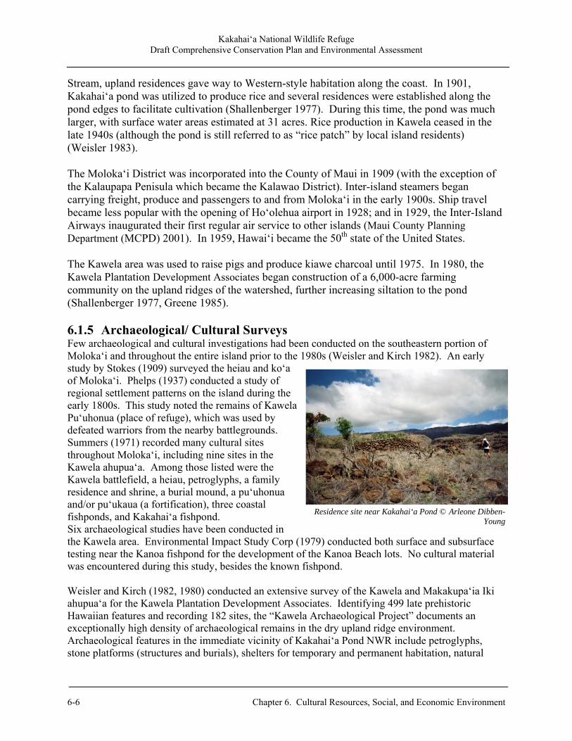
Kakahai‘a National Wildlife Refuge Draft Comprehensive Conservation Plan and Environmental Assessment
6-6 Chapter 6. Cultural Resources, Social, and Economic Environment
Stream, upland residences gave way to Western-style habitation along the coast. In 1901, Kakahai‘a pond was utilized to produce rice and several residences were established along the pond edges to facilitate cultivation (Shallenberger 1977). During this time, the pond was much larger, with surface water areas estimated at 31 acres. Rice production in Kawela ceased in the late 1940s (although the pond is still referred to as “rice patch” by local island residents) (Weisler 1983). The Moloka‘i District was incorporated into the County of Maui in 1909 (with the exception of the Kalaupapa Penisula which became the Kalawao District). Inter-island steamers began carrying freight, produce and passengers to and from Moloka‘i in the early 1900s. Ship travel became less popular with the opening of Ho‘olehua airport in 1928; and in 1929, the Inter-Island Airways inaugurated their first regular air service to other islands (Maui County Planning Department (MCPD) 2001). In 1959, Hawai‘i became the 50th state of the United States. The Kawela area was used to raise pigs and produce kiawe charcoal until 1975. In 1980, the Kawela Plantation Development Associates began construction of a 6,000-acre farming community on the upland ridges of the watershed, further increasing siltation to the pond (Shallenberger 1977, Greene 1985). 6.1.5 Archaeological/ Cultural Surveys Few archaeological and cultural investigations had been conducted on the southeastern portion of Moloka‘i and throughout the entire island prior to the 1980s (Weisler and Kirch 1982). An early study by Stokes (1909) surveyed the heiau and ko‘a of Moloka‘i. Phelps (1937) conducted a study of regional settlement patterns on the island during the early 1800s. This study noted the remains of Kawela Pu‘uhonua (place of refuge), which was used by defeated warriors from the nearby battlegrounds. Summers (1971) recorded many cultural sites throughout Moloka‘i, including nine sites in the Kawela ahupua‘a. Among those listed were the Kawela battlefield, a heiau, petroglyphs, a family residence and shrine, a burial mound, a pu‘uhonua and/or pu‘ukaua (a fortification), three coastal fishponds, and Kakahai‘a fishpond. Six archaeological studies have been conducted in the Kawela area. Environmental Impact Study Corp (1979) conducted both surface and subsurface testing near the Kanoa fishpond for the development of the Kanoa Beach lots. No cultural material was encountered during this study, besides the known fishpond. Weisler and Kirch (1982, 1980) conducted an extensive survey of the Kawela and Makakupa‘ia Iki ahupua‘a for the Kawela Plantation Development Associates. Identifying 499 late prehistoric Hawaiian features and recording 182 sites, the “Kawela Archaeological Project” documents an exceptionally high density of archaeological remains in the dry upland ridge environment. Archaeological features in the immediate vicinity of Kakahai‘a Pond NWR include petroglyphs, stone platforms (structures and burials), shelters for temporary and permanent habitation, natural
Residence site near Kakahai‘a Pond © Arleone Dibben-Young
Kakahai‘a National Wildlife Refuge Draft Comprehensive Conservation Plan and Environmental Assessment
Chapter 6. Cultural Resources, Social, and Economic Environment 6-7
cave shelters, agriculture terraces, a holua slide, and numerous religious shrines. The Kawela Complex is listed on both the National and Hawai‘i State Register of Historic Places (MCPD 1984). Weisler (1983, 1981a) also conducted a pedestrian surface survey and excavated 11 subsurface auger holes in two transects specifically for Kakahai‘a NWR. Besides the fishpond, no prehistoric sites were documented within the Refuge boundaries. Sedimentation from upland habitats and seasonal flooding of the pond area is suspected to have buried any potential resources (Weisler 1983). However, archaeologists at the State Historical Preservation Division stated that because Weisler’s (1983) report was drafted prior to current State standards, restoration work conducted on the Refuge property may require an additional archaeological inventory survey (Kirckendall pers. com.). Estioko-Griffin (1987) conducted an islandwide inventory of fishponds, listing Kakahai‘a as a loko pu‘uone (fishpond isolated from the ocean by a mound of sand). DHM Planning Inc. et al (1990) conducted an extensive Hawaiian fishpond study for the DLNR Historic Preservation Division. While this inventory also listed Kakahai‘a as a loko pu‘uone, it did not provide an in-depth study of the fishpond. Three recent sites, dated post-1940, were recorded during a Refuge boundary survey in 1975 and 1976 by R.M. Towill Corporation. Weisler (1983) revisited these locations and suggested they be avoided during any land modification on the Refuge. The historical sites include the following:
Abandoned Residence: An abandoned residence was found immediately east of the pond. The site includes a small, wood-frame house, a separate cookhouse, and a small shack; however, because the structures were demolished around 1976, only the foundation of a barbeque remains. Piggery and Charcoal Production: North of the abandoned house and east of the pond, is a piggery and charcoal manufacturing site. The 10 portable ovens noted during the 1976 boundary survey were removed prior to the 1983 survey, leaving only piles of small kiawe charcoal fragments. The ovens mostly likely burned kiawe into charcoal for export to Honolulu markets. The site also includes a 40 foot by 20 foot concrete foundation that has a pair of parallel troughs for feeding and watering pigs.
Residence and Piggery: In the northwest corner of Refuge, a residence, piggery, and well were documented. A narrow dirt road separates the well from the property and an earthen berm which probably created a pond for rice cultivation. The berm is bisected by a ditch from the well to the residence. Also observed at the site was a hand-carved wooden net float, as well as cans and bottles dated between 1943-1983.
6.1.6 Paleontological Resources Unless found in an archaeological context, “nonfossilized and fossilized paleontological specimens, or any portion or piece thereof,” are not considered archaeological resources (16 U.S.C. 470bb(1)). Paleontology resources include life forms that existed in prehistoric or geologic times, as represented by the fossils of plants, animals, and other organisms. Ziegler (2002) defines fossils as “biological remains, whether permineralized or not,” that were “deposited in the islands before the time of European Contact (1778 CE) and are not definitely components of prehistoric archaeological midden
Kakahai‘a National Wildlife Refuge Draft Comprehensive Conservation Plan and Environmental Assessment
6-8 Chapter 6. Cultural Resources, Social, and Economic Environment
(human food refuse and other cultural debris).” Paleontological fossils have been uncovered in a variety of sites throughout Hawai‘i, including sand dunes, sinkholes, lava tubes, and pond deposits (Ziegler 2002). Ziegler (2002) states that the only fossiliferous sites on the island of Moloka‘i are coastal sand dunes. The remains of several bird bone species dating back to 1500 CE were uncovered by Weisler (1983) at a low sand dune west of Kakahai‘a pond. Avifaunal species identified from prehistoric deposits within the dune include the koloa mapū and ‘alae ke‘oke‘o, which were probably confined to the marsh habitat, as well as nēnē and pueo, which may have utilized the surrounding grassy area. Because Rallidae birds prefer marshes, ponds, and lakes, Weisler (1983) believed that the presence of these bones implied that the area contained marshlands during and prior to 1500 CE. Prehistoric deposits within the dune also contained evidence of other bird species; however, Weisler (1983) concluded that these birds were not associated with the pond area. Although Weisler (1983) does not provide a thorough analysis of whether the avifaunal remains uncovered in the Kawela were considered cultural debris, his later critical review (1989) stated that nēnē bones found in the dune “may have been culturally deposited.” Auger holes excavated by Weisler (1983) showed that the pond layer (Stratum II), although predominantly composed of sand and silt, also consisted of nonmarine mollusks and seeds of the genus Spirpus. The nonmarine mollusks identified include Theodoxus neglectus, Tryonia protea, Thiara granifera, and Thiara tuberculata. The thickness of the nonmarine mollusk layer increases toward the pond area. In addition, the marine layer (Stratum III) of the most inland auger hole contained two chunks of coral (Porites sp.) at 10 feet below the surface dating between 1560-1875 BCE (Weisler 1983). 6.2 Social and Economic Setting This section discusses the social and economic environment surrounding the Kakahai‘a NWR, within the context of the island of Moloka‘i, the County of Maui, and the State of Hawai‘i. Kaunakakai, the island's major population and commercial center, is located about midway along the south coast. A major tourist destination area is located at Kaluakoi, on the western end of the island. There are small plantation communities of Maunaloa and Kualapu‘u in the central plain, as well as rural Hawaiian homestead settlements of Ho‘olehua and Kalamaula. There is also a settlement pattern along the southeast coast which becomes more rural and dispersed as it extends from Kaunakakai to Halawa Valley (MCPD 2001). 6.2.1 Population The 2010 Census data shows the population of Moloka‘i has decreased over the past decade with a decline from 7,404 to 7,345 since 2000. Much of the decline is attributed to Kalaupapa, where only about 18 patients remain in the Hansen’s disease settlement. Because Kalaupapa is located in Kalawao County, its census figures are not part of Maui County. Kaunakakai, which is located 5 miles east of the Refuge, is the main population and commercial center of Moloka‘i. Approximately 2,726 people resided in the 2.03 square miles of Kaunakakai in 2000. Data for 2010 shows a decrease to 2,603 (U.S. Census Bureau 2010).

Kakahai‘a National Wildlife Refuge Draft Comprehensive Conservation Plan and Environmental Assessment
Chapter 6. Cultural Resources, Social, and Economic Environment 6-9
Table 6.1. Population figures for selected areas.
Area Population (1990)
Population (2000)
Population (2010)
Moloka‘i Island 6,587 7,404 7,345 Kaunakakai 2,658 2,726 2,603 Maui County 100,374 128,094 154,834 Hawai‘i State 1,108,229 1,211,537 1,360,301
Source: U.S. Census Bureau 2010
6.2.2 Housing In Kaunakakai, the estimated median house or condo value in 2009 was $298,765 (it was $148,500 in 2000). The median family income for the Island of Moloka‘i in 2009 was $41,528. At 12 percent in January of 2011, Moloka‘i has the highest unemployment rate of all the Hawaiian Islands. The most recent income figures around the region of the Refuge are shown below in Table 6.2 (DBEDT 2010, Census 2010). Table 6.2. Census Bureau estimated median and per capita income figures, 2009.
Area Median Family Income
Per Capita Income
Kaunakakai $47,863 $20,112 Island of Moloka‘i $41,528 $20,126 Maui County $72,367 $29,121
Source: U.S. Census Bureau 2010 The Census Bureau estimated that Maui County residents paid an average of $24,204 per year in mortgage costs, consuming 42.04 percent of their income. The generally accepted definition of affordability is for a household to pay no more than 30 percent of its annual income on housing. Families who pay more than 30 percent of their income for housing are considered cost burdened and may have difficulty affording necessities such as food, clothing, transportation and medical care. The majority of Maui County residents are paying an unsustainably high percentage of their income toward housing (MCPD 2006, 2010). 6.2.3 Education The following schools are located on the island of Moloka‘i: one preschool, four public elementary schools, one private school grades K-8, one public intermediate school, one public high school, and one private school with preschool to high school students (Maui County Office of Economic Development 2005). In 2005, the Census Bureau estimated that 86.6 percent of County residents age 25 or older have graduated high school and 23.8 percent have a bachelor’s degree or higher. While the high school graduation rate of Maui County is slightly higher than that of the remainder of the United States, the percentage of residents with higher-level degrees is lower. The UH Maui College, Moloka‘i education center in Kaunakakai offers courses leading towards certificates and associate degrees in five primary majors: Liberal Arts, Agriculture and Natural
Kakahai‘a National Wildlife Refuge Draft Comprehensive Conservation Plan and Environmental Assessment
6-10 Chapter 6. Cultural Resources, Social, and Economic Environment
Resources, Business Careers, Human Services, and Allied Health/Nurse Aide Training. It also serves as a receive site for selected bachelors and masters degree programs from UH Mānoa, UH West O‘ahu, and UH Hilo via interactive television classes. Of the 225 students, 75 percent are of Native Hawaiian ancestry – the highest percentage of any campus in the UH system. 6.2.4 Economics Moloka‘i has Hawai‘i’s highest rate of residents – estimated at 30 percent – who rely at least in part on subsistence practices to feed themselves through farming, fishing, and hunting. Cattle ranching and farming, mostly on the central and western portions of the island, are currently the central components of the Island’s economy. Small-scale agricultural patches growing coffee beans, papaya, macadamia nuts, vegetables, and melons can be found scattered throughout Moloka‘i (Moloka‘i Community 2008). Since its collapse in the early 1980s, no large-scale agriculture has been able to replace the pineapple industry on Moloka‘i, which was historically the central element of the island’s economy. More recently, the agricultural industry, especially vegetable and melon farms, has been have adversely impacted by farming developments on O‘ahu. However, the MCPD reported that some growth in the sector has occurred from seed corn farming, aquaculture, and forestry. The Moloka‘i Ranch closure in 2008 devastated the community when it laid off more than 120 people, representing nearly the entire labor force of the island’s largest private employer at the time (MCPD 2010). Tourism does not generate significant income to the Moloka‘i economy as it does on the other Hawaiian Islands, the Hawai‘i Department of Business, Economic Development, and Tourism estimated that the number of visitors to the island in 2009, including domestic and international guests, was 48,339, down 29.8 percent compared to the previous year. The average daily census fell 22.2 percent to 647 visitors per day in 2009. Total visitor expenditures for the island in 2010 were estimated at only $2.5 million (DBEDT 2010).
Kakahai‘a National Wildlife Refuge Draft Comprehensive Conservation Plan and Environmental Assessment
Chapter 7. Environmental Effects Analysis 7-1
Chapter 7. Environmental Effects Analysis
7.1 Overview of Effects Analysis This effects analysis was developed by identifying resources associated with the physical, biological, and human environment identified in Chapters 3-5 of the Draft CCP/EA that may be impacted by the various alternative strategies presented in Chapter 2. The potential effects to those resources as a result of implementing the strategies described under each alternative were then assessed. This includes a brief discussion on potential impacts of climate change to Refuge resources. The information used in this Draft CCP/EA was obtained from relevant scientific literature, existing databases and inventories, consultations with other professionals, professional knowledge of resources based on field visits, and personal experience. Subheadings have been included to guide the reader in understanding which types of management strategies are likely to affect each resource as not all management strategies affect each resource. Cumulative impacts, including impacts to Refuge resources from reasonably foreseeable events and impacts resulting from interaction of Refuge actions with actions taking place outside the Refuge, are addressed in the final section of this chapter.
7.2 Terminology Effects were assessed for scope, scale, and intensity of impacts to resources. Effects may be identified further as beneficial or negative, as well as long-term or short-term.
Negligible. Resources will not be affected, or the effects will be at or near the lowest level of detection. Resource conditions will not change or will be so slight no measurable or perceptible consequence to a population, wildlife or plant community, recreation opportunity, visitor experience, or cultural resource will occur.
Minor. Effects will be detectable but localized, small, and of little consequence to a population, wildlife or plant community, recreation opportunity, visitor experience, or cultural resource. Mitigation, if needed to offset adverse effects, will be easily implemented and successful.
Intermediate. Effects will be readily detectable and localized, with measurable
consequences to a population, wildlife, or plant community, recreation opportunity, visitor experience, or cultural resource. Mitigation measures will be needed to offset adverse effects and will be extensive, moderately complicated to implement, and probably successful.
Major. Effects will be obvious and will result in substantial consequences to a population, wildlife or plant community, recreation opportunity, visitor experience, or cultural resource within the local area and region. Extensive mitigating measures may be needed to offset adverse effects and will be large scale in nature, very complicated to implement, and may not have a guaranteed probability of success. In some instances, major effects will include the irretrievable loss of the resource.
Kakahai‘a National Wildlife Refuge Draft Comprehensive Conservation Plan and Environmental Assessment
7-2 Chapter 7. Environmental Effects Analysis
Time and duration of effects have been defined as follows: Short-term. An effect that generally will last less than a year or season.
Long-term. A change in a resource or its condition that will last longer than a single year or
season.
Adverse effects to fish and wildlife species and habitats are considered significant if an action will result in a substantial change in the amount or quality of available habitat for a wildlife species. (For wintering waterfowl, migratory shorebirds or native resident wildlife, a substantial reduction in habitat resulting in a significant adverse impact will be defined as a reduction of 30 percent or more of the available acreage or 50 percent of the quality of habitat for these species within the Refuge; a significant beneficial impact will be defined as a 30 percent greater increase in the quantity or 50 percent increase in the quality of habitat for wintering waterfowl, migratory shorebirds or native resident wildlife). An action will result in a substantial adverse effect; either directly or through habitat modifications, on any Federal threatened, endangered, candidate, or special concern wildlife or fish species. This will also include species listed threatened or endangered by the State of Hawai‘i.
7.3 Summary of Management Action Effects at Kakahai‘a NWR A summary of the effects analysis is presented in Table 7.1. Current management (Alternative A) benefits wildlife and habitats; however, effects are described in terms of the change from current conditions. Therefore, Alternative A generally has negligible, if any, effects because little or no change to management programs occurs under this alternative. Effects from Alternative B and C are summarized in the table using the above definitions to describe the magnitude of change from the current condition. Table 7.1. CCP Alternatives Summary of Effects for Kakahai‘a NWR. EFFECTS TO WILDLIFE AND HABITAT Alternative A Alternative B Alternative C
Effects to endangered ae‘o and ‘alae ke‘oke‘o
Negligible. No change from current management. Degraded wetland does not provide suitable habitat.
Minor to intermediate long-term positive effect through reestablishment of suitable wetland habitat.
Minor to intermediate long-term positive effect through reestablishment of suitable wetland habitat.
Effects to shorebirds
Negligible. No change from current management.
Minor long-term positive effect with restored foraging and loafing area available.
Minor to intermediate long-term positive effect with increased foraging and loafing area available.
Effects to waterfowl
Negligible. No change from current management.
Minor long-term positive effects from wetland restoration.
Minor long-term positive effects from wetland restoration.
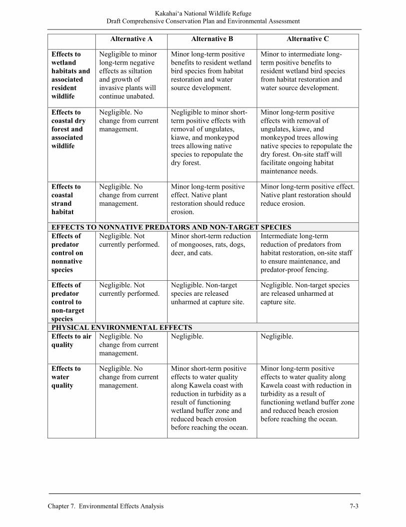
Kakahai‘a National Wildlife Refuge Draft Comprehensive Conservation Plan and Environmental Assessment
Chapter 7. Environmental Effects Analysis 7-3
Alternative A Alternative B Alternative C
Effects to wetland habitats and associated resident wildlife
Negligible to minor long-term negative effects as siltation and growth of invasive plants will continue unabated.
Minor long-term positive benefits to resident wetland bird species from habitat restoration and water source development.
Minor to intermediate long-term positive benefits to resident wetland bird species from habitat restoration and water source development.
Effects to coastal dry forest and associated wildlife
Negligible. No change from current management.
Negligible to minor short-term positive effects with removal of ungulates, kiawe, and monkeypod trees allowing native species to repopulate the dry forest.
Minor long-term positive effects with removal of ungulates, kiawe, and monkeypod trees allowing native species to repopulate the dry forest. On-site staff will facilitate ongoing habitat maintenance needs.
Effects to coastal strand habitat
Negligible. No change from current management.
Minor long-term positive effect. Native plant restoration should reduce erosion.
Minor long-term positive effect. Native plant restoration should reduce erosion.
EFFECTS TO NONNATIVE PREDATORS AND NON-TARGET SPECIES Effects of predator control on nonnative species
Negligible. Not currently performed.
Minor short-term reduction of mongooses, rats, dogs, deer, and cats.
Intermediate long-term reduction of predators from habitat restoration, on-site staff to ensure maintenance, and predator-proof fencing.
Effects of predator control to non-target species
Negligible. Not currently performed.
Negligible. Non-target species are released unharmed at capture site.
Negligible. Non-target species are released unharmed at capture site.
PHYSICAL ENVIRONMENTAL EFFECTS Effects to air quality
Negligible. No change from current management.
Negligible. Negligible.
Effects to water quality
Negligible. No change from current management.
Minor short-term positive effects to water quality along Kawela coast with reduction in turbidity as a result of functioning wetland buffer zone and reduced beach erosion before reaching the ocean.
Minor long-term positive effects to water quality along Kawela coast with reduction in turbidity as a result of functioning wetland buffer zone and reduced beach erosion before reaching the ocean.
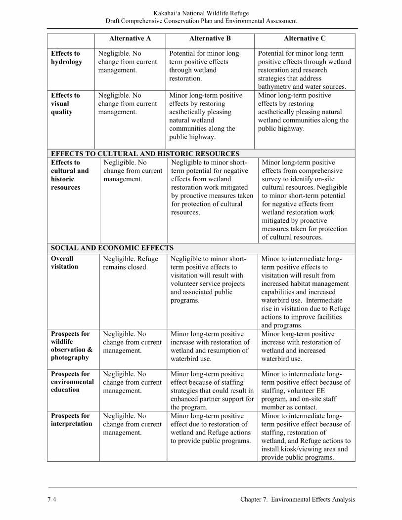
Kakahai‘a National Wildlife Refuge Draft Comprehensive Conservation Plan and Environmental Assessment
7-4 Chapter 7. Environmental Effects Analysis
Alternative A Alternative B Alternative C
Effects to hydrology
Negligible. No change from current management.
Potential for minor long-term positive effects through wetland restoration.
Potential for minor long-term positive effects through wetland restoration and research strategies that address bathymetry and water sources.
Effects to visual quality
Negligible. No change from current management.
Minor long-term positive effects by restoring aesthetically pleasing natural wetland communities along the public highway.
Minor long-term positive effects by restoring aesthetically pleasing natural wetland communities along the public highway.
EFFECTS TO CULTURAL AND HISTORIC RESOURCES Effects to cultural and historic resources
Negligible. No change from current management.
Negligible to minor short-term potential for negative effects from wetland restoration work mitigated by proactive measures taken for protection of cultural resources.
Minor long-term positive effects from comprehensive survey to identify on-site cultural resources. Negligible to minor short-term potential for negative effects from wetland restoration work mitigated by proactive measures taken for protection of cultural resources.
SOCIAL AND ECONOMIC EFFECTS Overall visitation
Negligible. Refuge remains closed.
Negligible to minor short-term positive effects to visitation will result with volunteer service projects and associated public programs.
Minor to intermediate long-term positive effects to visitation will result from increased habitat management capabilities and increased waterbird use. Intermediate rise in visitation due to Refuge actions to improve facilities and programs.
Prospects for wildlife observation & photography
Negligible. No change from current management.
Minor long-term positive increase with restoration of wetland and resumption of waterbird use.
Minor long-term positive increase with restoration of wetland and increased waterbird use.
Prospects for environmental education
Negligible. No change from current management.
Minor long-term positive effect because of staffing strategies that could result in enhanced partner support for the program.
Minor to intermediate long-term positive effect because of staffing, volunteer EE program, and on-site staff member as contact.
Prospects for interpretation
Negligible. No change from current management.
Minor long-term positive effect due to restoration of wetland and Refuge actions to provide public programs.
Minor to intermediate long-term positive effect because of staffing, restoration of wetland, and Refuge actions to install kiosk/viewing area and provide public programs.

Kakahai‘a National Wildlife Refuge Draft Comprehensive Conservation Plan and Environmental Assessment
Chapter 7. Environmental Effects Analysis 7-5
Alternative A Alternative B Alternative C
Effects to local economy
Negligible. No change from current management.
Minor short-term positive effect due to increased operational expenditures.
Minor long-term positive effect due to increased operational and visitor expenditures.
Effects to environmental justice
Negligible. No change from current management.
Negligible to minor long-term positive effects on human health and the social environment.
Negligible to minor long-term positive effects on human health and the social environment.
7.4 Effects Analysis The following analysis describes the anticipated effects of implementing the Refuge management strategies described in Chapter 2 on the physical, biological, and human environment. 7.4.1 Integrated Pest Management Potential effects to the biological and physical environment associated with the proposed site-, time-, and target-specific use of pesticides (Pesticide Use Proposals (PUPs)) on the refuge would be evaluated using scientific information and analyses documented in “Chemical Profiles” (see Appendix E). These profiles provide quantitative assessment/screening tools and threshold values to evaluate potential effects to species groups (birds, mammals, and fish) and environmental quality (water, soil, and air). Pesticide Use Proposals (including appropriate Best Management Practices) would be approved where the chemical profiles provide scientific evidence that potential impacts to refuge biological resources and its physical environment are likely to be only minor, temporary, or localized in nature. Along with the selective use of pesticides, PUPs would also describe other appropriate IPM strategies (biological, physical, mechanical, and cultural methods) to eradicate, control, or contain pest species in order to achieve resource management objectives. The term pest species refers to both plant and animal pests. The effects of these non-pesticide IPM strategies to address pest species on Refuge lands would be similar to those effects described elsewhere within this chapter, where they are discussed specifically as habitat management techniques to achieve resource management objectives on the Refuge. Based on scientific information and analyses documented in “Chemical Profiles”, pesticides allowed for use on Refuge lands would be of relatively low risk to non-target organisms as a result of low toxicity or short persistence in the environment. Thus, potential impacts to Refuge resources and neighboring natural resources from pesticide applications would be expected to be minor, temporary, or localized in nature. 7.4.2 Effects of Predator Control Predator controls were suspended at the Refuge when we had negligible suitable habitat for endangered species. With wetland restoration, predator management will be resumed to reduce depredation of endangered waterbirds. Control measures will include indirect, non-lethal and lethal techniques in addition to prevention measures that will have minimal effects on the human environment.

Kakahai‘a National Wildlife Refuge Draft Comprehensive Conservation Plan and Environmental Assessment
7-6 Chapter 7. Environmental Effects Analysis
Indirect Measures Indirect measures will include installation of a perimeter predator-proof fence (Alternative C). In the absence of this fence, dense vegetation will remain to discourage visitors from disturbing endangered waterbirds and nesting areas will be closed to access. Direct Measures A range of predator management equipment and methods will be used on the Refuge. All control management activities will be in compliance with Federal and State laws and regulations. Mongooses and rodents will be controlled by a combination of cage traps, lethal traps, and rodenticides. Direct control of cattle egrets will be with firearms. In rare instances a Timms ™ kill trap (a type of snap trap) or padded leg-hold trap will be used on cats that avoid cage traps. All cage traps will be checked every 48 hours or less. Trapping will occur seasonally just prior to the ae‘o nesting season through the end of the breeding/chick rearing period (April-September). Spot trapping may occur when signs of depredation of endangered species are observed outside the nesting season. Predator monitoring will occur throughout the year by direct observations, tracks, tracking tunnels, and trail cameras. Cage-trapped dogs and cats will be transported to a local animal shelter. Any cage trapped birds will be released at the trap site. Live trapped mongooses will the euthanized using approved humane methods. Except for nuisance pest species, all uninjured non-target species captured will be released near the site of capture or at a suitable location at the discretion the Refuge staff. Other Alternatives Considered Alternative methods for addressing predation of listed species on the Refuge were considered, including: non-lethal control only, indirect control only, and no predator management. The proposed predator management program combines direct actions to control predation along with indirect actions related to reduced disturbance and improved habitat quality. The Service believes this proposal represents the most effective and most humane alternative. A non-lethal method will be ineffective against rats. The Refuge attempted to live trap rats with no success. Cage traps have been used for mongooses in the past, but when New Zealand Department of Conservation (DOC) 250™ snap traps were paired with cage traps, nearly all mongooses were caught in the DOC traps. Thus, the Refuge will be increasing use of the DOC traps to remove mongooses. The Refuge has used indirect control by vegetation removal around nesting areas, but trapping results and reproductive success data shows that it is insufficient to meet predator control objectives. Use of predator fences will help, but budget constraints limit their acquisition and installation. In addition to cost for materials, a predator fence will require high maintenance cost to maintain the corridor clear of vegetation (debris from upper watershed sheetflows, fallen trees). Predators also need to be removed from the enclosed area. It may be practical in selected areas, but not all high-density nesting sites. The option of not performing predator control is not realistic with objectives to protect endangered waterbirds with the potential for increasing population numbers and delisting or removing them from endangered status. As evident at our other refuges, there is a several fold increase in endangered waterbird reproductive success in the predator control areas compared to unmanaged areas.
Kakahai‘a National Wildlife Refuge Draft Comprehensive Conservation Plan and Environmental Assessment
Chapter 7. Environmental Effects Analysis 7-7
The Recovery Plan for the Hawaiian waterbirds states that long-term predator management at nesting sites is needed. The Regional Shorebird Conservation Plan lists eradication or control of introduced predators among its management priorities. The Refuge predator control plan is intended to control species alien to Hawai‘i while native species would not be affected. Although predator management is a major component in the recovery of endangered Hawaiian waterbirds, recovery also requires management of a number of other factors including water, vegetation, pest plant species, and disease (Englis and Naughton 2004, USFWS 2005). 7.4.3 Effects of Predator Control to Nonnative Predators Alternative A: No predator management, negligible effects. Alternative B: Control efforts will resume as restored wetlands begin to attract waterbirds to the Refuge again. During the nesting seasons, control efforts will be conducted at areas with high nest densities. Indirect, non-lethal and lethal techniques will be used. Most cats and dogs will be controlled by cage traps and transported to an animal shelter. Other predators will be controlled by cage traps or humane lethal means. Short-term positive effects are anticipated with a minor localized reduction of mongooses, rats, dogs, deer, and cats. Alternative C: Predator control efforts will be expanded to high-density nesting areas created by wetland restoration. Perimeter trapping will be implemented. The ability to control water will restrict terrestrial predator habitats resulting in an intermediate long-term reduction in nonnative predators on the Refuge. 7.4.4 Effects of Predator Control to Non-target Species Non-target species include endangered waterbirds, ‘auku‘u, nonnative passerine birds, and francolins. Alternative A: No predator management, no effects. Alternative B: Rodenticides will be placed in tamper resistance bait boxes and the area posted with signs. No known non-target species mortalities have occurred from these baits. All uninjured non-target species captured will be released near the site of capture or at a suitable location at the discretion of the Refuge Manager. Effects to non-target species will be negligible. Alternative C: Predator control efforts will be expanded to high-density nesting areas created by wetland restoration. Perimeter trapping will be implemented. The effect to non-target species is not expected to change and will be negligible. 7.4.5 Effects of Wetland Restoration to Endangered Waterbirds Under current management (Alternative A), California bulrush covers more than 90 percent of Old Pond with no open water available to waterbirds and no water available to pump into New Pond. Restoration of Old Pond (Alternatives B and C) by removal of kiawe, monkeypod, and Indian marsh fleabane as well as some of the man-made levees will have the positive effect of providing the wetland habitat needed for endangered waterbirds to use the Refuge. Construction of a well and installation of a pump with electrical service will provide us the ability to use water level to control pest plants and promote aquatic invertebrate diversity and abundance.
Kakahai‘a National Wildlife Refuge Draft Comprehensive Conservation Plan and Environmental Assessment
7-8 Chapter 7. Environmental Effects Analysis
Alternative A: There will be limited endangered waterbird habitat (0-2 acres) occurring sporadically after heavy rains only. The continued absence of suitable habitat will continue to have minor adverse effects towards waterbird recovery on Moloka‘i. Alternative B: Habitat restoration in Old Pond will provide 4 acres of permanent high-quality wetland habitat for ‘alae ke‘oke‘o. A new well will provide the necessary water to provide up to 4 acres of seasonal wetland habitat in New Pond for ae‘o. This action will have long-term minor positive effects to endangered waterbirds. Alternative C: Increased habitat restoration and predator control will create higher quality ae‘o and ‘alae ke‘oke‘o habitat than Alternative B with 14 acres of permanent high-quality wetland habitat and 7 acres of seasonal wetland habitat. This action will have long-term minor to intermediate positive effects to endangered waterbirds. 7.4.6 Effects of Management Actions to Migratory Birds New Pond hosted migratory waterfowl and shorebirds from August-April before it dried out in the 1990s. Restoration efforts to provide wetland habitat for the benefit of endangered Hawaiian waterbirds will also provide resting and foraging habitat for migratory birds. Similar to native waterbirds, the presence of migratory species is dependent on the water level and distribution and each year can be very different from another. Shorebirds Alternative A: There will be limited habitat available along the coastline only (0-2 acres). Effects will be negligible. Alternative B: Shorebird habitat will improve on up to 2 acres of beach strand and levees. Minor long-term positive effects are anticipated due to restoration of the coastal area and wetland. Alternative C: Shorebird habitat will be greater than Alternative B. Increased habitat restoration and predator controls will create suitable habitat during the winters. Minor long-term positive effects are anticipated due to restoration of the coastal area and wetland. Waterfowl Alternative A: No habitat available to waterfowl so effects are negligible. Alternative B: Removal of 5 acres of pest vegetation would have negligible to minor short-term positive effects with restored open water habitat. Alternative C: Minor long-term positive effects are anticipated with restoration of Old Pond and the installation of predator-proof fencing. 7.4.7 Effects of Management Actions to Restore Coastal Dry Forest Habitat Low intensity management in the forest will include removal of pest plant and animal species, native plant restoration, and fencing. Alternative A: No management actions are planned under Alternative A.
Kakahai‘a National Wildlife Refuge Draft Comprehensive Conservation Plan and Environmental Assessment
Chapter 7. Environmental Effects Analysis 7-9
Alternative B: Implementation of Alternative B will result in negligible to minor short-tern positive effects with removal of ungulates, kiawe, and monkeypod trees allowing native species to repopulate the dry forest. Alternative C: Implementation of Alternative C will result in a minor long-term positive effect. Seven acres of coast dry forest will be restored with removal of ungulates, kiawe, and monkeypod trees allowing native species to repopulate the dry forest. On-site staff will facilitate ongoing habitat maintenance needs. 7.4.8 Effects of Management Actions on Coastal Strand Habitat Alternative A: No management actions are planned under Alternative A. Alternatives B and C: The habitat management strategies of Alternatives B and C are generally expected to provide minor to intermediate long-term benefits to 2 acres of coastal strand habitat and associated species. Low intensity management on beach will include native plant restoration, erosion control fencing, and spot treatment of pest plants. 7.4.9 Effects of Promoting Research and Scientific Assessments Being able to compare Refuge data with other local, regional, and even global data will help guide ecosystem management priorities for Refuge resources. It will also promote the Service’s ecosystem approach to resource management, as well as enhance worldwide scientific connection and understanding. Under all alternatives, effects of promoting management-related research and scientific assessment will have minor to moderate long-term positive impacts on the Service’s ability to effectively manage the Refuge, particularly after habitat restoration. An expected long-term beneficial effect on Refuge resources may occur under Alternatives B and C with the increased emphasis on specific areas of wildlife and habitat research through a collaborative approach. This strategy includes cooperative interagency or collaborative efforts with universities to perform research. 7.4.10 Effects to Water, Soils, and Air Quality Alternative A: There will be no change to management. Allowing deer and pigs continued access to the Refuge would contribute to soil erosion from compaction, especially along deer trails and because of browsing, which reduces vegetation that can provide soil stability. Alternatives B and C. Alternatives B and C indirectly contribute to a minor to intermediate beneficial impact to water quality because restoration efforts for the wetland and coastal area would reduce the long-term potential for soil erosion that could contribute to increased water turbidity and reduced water quality. We will minimize suspended sediment from collecting along the levees and entering into Old and New Ponds by creating and maintaining a sediment basin in coastal dry forest habitat. There will be better water circulation with removal of levees and pest plants. Removal of deer and pigs would decrease soil compaction in the dry forest and increase the quality and integrity of the soil. Negligible short-term effects from construction activities will be mitigated by timing during non-breeding seasons.
Kakahai‘a National Wildlife Refuge Draft Comprehensive Conservation Plan and Environmental Assessment
7-10 Chapter 7. Environmental Effects Analysis
7.4.11 Effects to Cultural and Historic Resources All alternatives assume a cultural resource survey would be conducted prior to implementing any ground-disturbing activity in order to avoid negative effects to cultural resources. Even with a survey, the presence of buried cultural deposits can never be predicted with certainty. If significant resources are discovered during management activities or at any other time, the project would be halted immediately until the site can be evaluated. Alternative A: There will be no change to management. Alternative B: Prior to implementing all ground-disturbing projects, the applicable cultural resource compliance investigation will be undertaken. If cultural resources are found, appropriate procedures and protocols will be followed to protect the cultural resources. The effects to cultural resources are anticipated to be negligible. Alternative C: Minor long-term positive effects are anticipated by identifying cultural resources present on the Refuge which will aid in protection of any resources found. Systematic efforts to survey and evaluate cultural resources in un-surveyed areas with high potential for archaeological materials would also benefit cultural resources. Enhancing the public’s understanding and appreciation of the natural and cultural resources through on- and off-Refuge interpretation and EE programs would result in beneficial effects to cultural resources. 7.4.12 Effects to Public Use and Access Minimizing disturbance to natural resources will be a critical factor in selecting locations for the interpretive kiosk and on-site public programs. Negligible short-term effects are expected because of the small footprint of the participants on any given day and the onsite guidance they will be provided. Long-term beneficial effects will be exposing students to opportunities to experience the outdoors and contribute to the knowledgebase of the Refuge. Through these experiences participants will gain a greater appreciation for nature, wild places, environmental processes, and potentially guide them into a science career. The Refuge will benefit from the information gained that will contribute to more effective management of the biotic and abiotic components of this rare coastal community. Alternative A: There will be no change to management. The Refuge would remain closed to the public except under special circumstances and needs, and only with an approved SUP. This includes research activities and interpretive tours with focus on applicable topics such as invasive species. Alternatives B: The Refuge would remain closed to the public; however, SUPs would be evaluated and approved for EE and volunteer opportunities. Up to 40 visitors a year will be accommodated in conjunction with volunteer service projects for a minor beneficial impact. Alternative C: Long-term beneficial effects to public access as well as wildlife observation and photography will be provided with the construction of an elevated viewing platform and kiosk, with an estimated visitation of up to 500. More EE and interpretation programs will be available. We will evaluate and implement more opportunities to give special interest individuals and groups (e.g., photographers) better viewing opportunities, increase volunteer opportunities, and develop hands-on EE curricula.
Kakahai‘a National Wildlife Refuge Draft Comprehensive Conservation Plan and Environmental Assessment
Chapter 7. Environmental Effects Analysis 7-11
7.4.13 Effects to Local Economy National wildlife refuges provide many services to people. A complete economic analysis of the Refuge System includes not only the value of all the forms of recreation enjoyed but also the payrolls of Refuge employees and the values of maintaining endangered species, preserving wetlands, educating future generations, and adding stability to our ecosystem. All of these services are of value to society, whether or not they result in some form of market transaction. Some people gain value simply from knowing that wild places and unique species still exist. Alternative A: There will be no change in management. Alternative B: With various habitat restoration projects, expenditures in the local community should have a corresponding increase for short-term minor beneficial effects. Alternative C: This alternative would have the greatest economic benefits because expenditures are expected to increase with various habitat restoration projects and implementation of additional and/or improved educational and interpretive programs. Refuge visitation and money spent in the community with an on-site employee is also expected to increase. 7.4.14 Environmental Justice The concept of environmental justice has been around since the early 1990s and arose from a need to ensure that negative environmental activities from industry or government projects will not endanger local communities. The EPA oversees environmental justice compliance and defines environmental justice as: “the fair treatment and meaningful involvement of all people regardless of race, color, national origin, or income with respect to the development, implementation, and enforcement of environmental laws, regulations, and policies” (USEPA 2010). Since CCP implementation of any of the alternatives is expected to result in negligible to generally positive effects on the human environment, there will be little risk of disproportionate negative effects to low income or minority groups. Therefore, negligible effects related to environmental justice are anticipated under all CCP alternatives.
7.5 Cumulative Effects Assessment Cumulative impacts are the overall, net effects on a resource that arise from multiple actions. Impacts can “accumulate” spatially, when different actions affect different areas of the same resources. They can also accumulate over the course of time, from actions in the past, the present, and the future. Occasionally, different actions counterbalance one another, partially canceling out each other’s effect on a resource. But more typically, multiple effects add up, with each additional action contributing an incremental impact on the resource. In addition, sometimes the overall effect is greater than merely the sum of the individual effects, such as when one more reduction in a population crosses a threshold of reproductive sustainability, and threatens to extinguish the population. A thorough analysis of impacts always considers their cumulative aspects, because actions do not take place in a vacuum; there are virtually always some other actions that have affected that resource in some way in the past, or are affecting it in the present, or will affect it in the reasonably foreseeable future. So any assessment of a specific action’s effects must in fact be made with
Kakahai‘a National Wildlife Refuge Draft Comprehensive Conservation Plan and Environmental Assessment
7-12 Chapter 7. Environmental Effects Analysis
consideration of what else has happened to that resource, what else is happening, or what else will likely happen to it. 7.5.1 Cumulative Climate Change Effects on Water Resources The impact of climate change on water resources is dependent on shifts in precipitation amounts, evaporation rates, storms, and events such as the ENSO. A trend toward ENSO patterns will impact sea levels, sea temperatures, rainfall amounts, evaporation rates, and the occurrence of hurricanes; however, the exact impact of climate change on water resources is difficult to predict due to spatial variability. On a global scale, mean precipitation is anticipated to increase. Current climate models project that tropical Pacific and high latitude areas will experience increasing precipitation amounts, while precipitation is likely to decrease in most subtropical regions. A current trend toward this increase is supported by lowered salinity levels in both the mid- and high-latitude oceanic waters. If the opposite effect takes place, decreasing precipitation or increasing evaporation will further stress meager surface and groundwater resources. Lack of rain could lower the amount of freshwater lens recharge and further decrease available water supplies. Reduced rainfall or increased evaporation will cause a corresponding increase in the demand for residential, commercial, or agricultural water (Giambelluca et al. 1996, Solomon et al. 2007, Parry et al. 2007). The impacts of climate change that may affect Moloka‘i include SLR, air and ocean temperature increases, ocean acidification, precipitation changes and more extreme events, increased water stress and water supply problems. By the end of the 21st century, sea levels are expected to rise 7-22 inches, relative to 1980-1999 levels (Mimura et al. 2007). Sea level rise is expected to exacerbate inundation, storm surge, erosion, and other coastal hazards. The impacts of climate change that may affect Moloka‘i include sea level rise, air and ocean temperature increases, ocean acidification, precipitation changes and more extreme events, increased water stress and water supply problems. Limited water supply and availability and increases in demand represent other climate-related threats to the refuge. Already, water supply is limited in many parts of the island, as described below. Warmer temperatures and more extreme droughts will increase demand for water in the future. Increased ground water withdrawals could affect wetland habitat at the Refuge. 7.5.2 Summary The Refuge staff is not aware of any past, present, or planned actions within the next 15 years that will result in a major cumulative impact when added to the Refuge’s proposed actions, as outlined in the proposed alternatives. The actions proposed by the Refuge in this CCP are expected to contribute negligible negative effects to cumulative impacts of any new residential development or agricultural operations. Restoration of the wetland, coastal dry forest, and coastal strand habitats is expected to have overall minor localized beneficial cumulative effects in reducing erosion and improving water quality. Recovery of endangered species must be coordinated on a broad regional scale to show progress. It is only through the cumulative efforts of many groups, conservation projects, and measures that we can effectively save these species. Research to close knowledge gaps which hinder efficient recovery projects should be encouraged, promoted and shared with all partners. Under Alternatives B and C, the cumulative effects of Service management of the Kakahai‘a NWR, in concert with other wetland habitats managed by other Federal, State, and County agencies, and non-profit conservation groups will have long-term beneficial effects towards the recovery of endangered waterbird species.
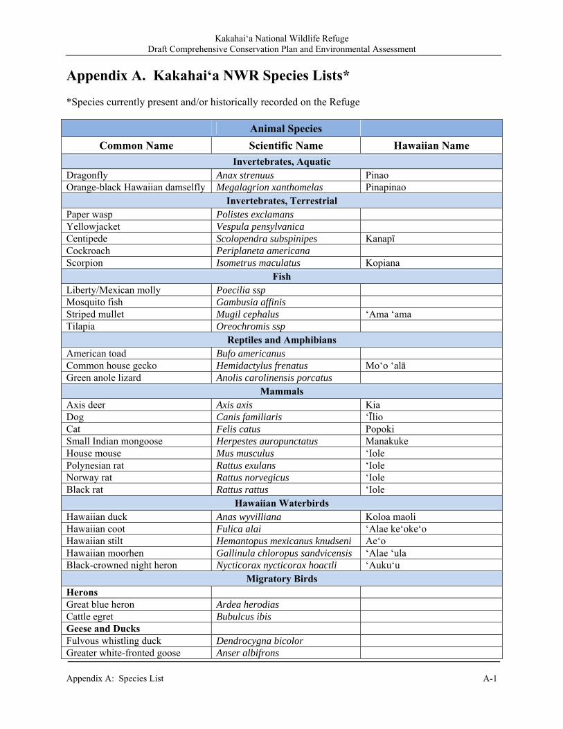
Kakahai‘a National Wildlife Refuge Draft Comprehensive Conservation Plan and Environmental Assessment
Appendix A: Species List A-1
Appendix A. Kakahai‘a NWR Species Lists* *Species currently present and/or historically recorded on the Refuge
Animal Species Common Name Scientific Name Hawaiian Name
Invertebrates, Aquatic Dragonfly Anax strenuus Pinao Orange-black Hawaiian damselfly Megalagrion xanthomelas Pinapinao
Invertebrates, Terrestrial Paper wasp Polistes exclamans Yellowjacket Vespula pensylvanica Centipede Scolopendra subspinipes Kanapī Cockroach Periplaneta americana Scorpion Isometrus maculatus Kopiana
Fish Liberty/Mexican molly Poecilia ssp Mosquito fish Gambusia affinis Striped mullet Mugil cephalus ‘Ama ‘ama Tilapia Oreochromis ssp
Reptiles and Amphibians American toad Bufo americanus Common house gecko Hemidactylus frenatus Mo‘o ‘alā Green anole lizard Anolis carolinensis porcatus
Mammals Axis deer Axis axis Kia Dog Canis familiaris ‘Īlio Cat Felis catus Popoki Small Indian mongoose Herpestes auropunctatus Manakuke House mouse Mus musculus ‘Iole Polynesian rat Rattus exulans ‘Iole Norway rat Rattus norvegicus ‘Iole Black rat Rattus rattus ‘Iole
Hawaiian Waterbirds Hawaiian duck Anas wyvilliana Koloa maoli Hawaiian coot Fulica alai ‘Alae ke‘oke‘o Hawaiian stilt Hemantopus mexicanus knudseni Ae‘o Hawaiian moorhen Gallinula chloropus sandvicensis ‘Alae ‘ula Black-crowned night heron Nycticorax nycticorax hoactli ‘Auku‘u
Migratory Birds Herons Great blue heron Ardea herodias Cattle egret Bubulcus ibis Geese and Ducks Fulvous whistling duck Dendrocygna bicolor Greater white-fronted goose Anser albifrons
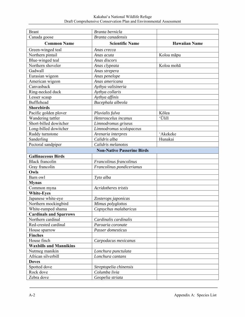
Kakahai‘a National Wildlife Refuge Draft Comprehensive Conservation Plan and Environmental Assessment
A-2 Appendix A: Species List
Brant Branta bernicla Canada goose Branta canadensis
Common Name Scientific Name Hawaiian Name Green-winged teal Anas crecca Northern pintail Anas acuta Koloa māpu Blue-winged teal Anas discors Northern shoveler Anas clypeata Koloa mohā Gadwall Anas strepera Eurasian wigeon Anas penelope American wigeon Anas americana Canvasback Aythya valisineria Ring-necked duck Aythya collaris Lesser scaup Aythya affinis Bufflehead Bucephala albeola Shorebirds Pacific golden plover Pluvialis fulva Kōlea Wandering tattler Heteroscelus incanus ‘Ūlilī Short-billed dowitcher Limnodromus griseus Long-billed dowitcher Limnodromus scolopaceus Ruddy turnstone Arenaria interpres ‘Akekeke Sanderling Calidris alba Hunakai Pectoral sandpiper Calidris melanotos
Non-Native Passerine Birds Gallinaceous Birds Black francolin Francolinus francolinus Gray francolin Francolinus pondicerianus Owls Barn owl Tyto alba Mynas Common myna Acridotheres tristis White-Eyes Japanese white-eye Zosterops japonicas Northern mockingbird Mimus polyglottos White-rumped shama Copsychus malabaricus Cardinals and Sparrows Northern cardinal Cardinalis cardinalis Red-crested cardinal Paroaria coronate House sparrow Passer domesticus Finches House finch Carpodacus mexicanus Waxbills and Mannikins Nutmeg manikin Lonchura punctulata African silverbill Lonchura cantans Doves Spotted dove Streptopelia chinensis Rock dove Columba livia Zebra dove Geopelia striata
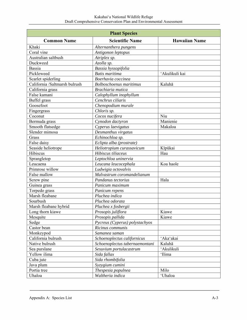
Kakahai‘a National Wildlife Refuge Draft Comprehensive Conservation Plan and Environmental Assessment
Appendix A: Species List A-3
Plant Species
Common Name Scientific Name Hawaiian Name Khaki Alternanthera pungens Coral vine Antigonon leptopus Australian saltbush Atriplex sp. Duckweed Azolla sp. Bassia Bassia hyssopifolia Pickleweed Batis maritima ‘Akulikuli kai Scarlet spiderling Boerhavia coccinea California /Saltmarsh bulrush Bolboschoenus maritimus Kaluhā California grass Brachiaria mutica False kamani Calophyllum inophyllum Buffel grass Cenchrus ciliaris Goosefoot Chenopodium murale Fingergrass Chloris sp. Coconut Cocos nucifera Niu Bermuda grass Cynodon dactyron Manienie Smooth flatsedge Cyperus laevigatus Makaloa Slender mimosa Desmanthus virgatus Grass Echinochloa sp. False daisy Eclipta alba (prostrate) Seaside heliotrope Heliotropium curassavicum Kīpūkai Hibiscus Hibiscus tiliaceus Hau Sprangletop Leptochloa uninervia Leucaena Leucana leucocephala Koa haole Primrose willow Ludwigia octovalvis False mallow Malvastrum coromandelianum Screw pine Pandanus tectorius Hala Guinea grass Panicum maximum Torpedo grass Panicum repens Marsh fleabane Pluchea indica Sourbush Pluchea odorata Marsh fleabane hybrid Pluchea x fosbergii Long thorn kiawe Prosopis juliflora Kiawe Mesquite Prosopis pallida Kiawe Sedge Pycreus (Cyperus) polystachyos Castor bean Ricinus communis Monkeypod Samanea saman California bulrush Schoenoplectus californicus ‘Aka‘akai Native bulrush Schoenoplectus tabernaemontani Kaluhā Sea purslane Sesuvium portulacastrum ‘Akulikuli Yellow ilima Sida fallax ‘Ilima Cuba jute Sida rhombifolia Java plum Syzygium cumini Portia tree Thespesia populnea Milo Uhaloa Waltheria indica ‘Uhaloa

Kakahai‘a National Wildlife Refuge Draft Comprehensive Conservation Plan and Environmental Assessment
A-4 Appendix A: Species List

Kakahai‘a National Wildlife Refuge Draft Comprehensive Conservation Plan and Environmental Assessment
Appendix B: Compatibility Determinations and Appropriate Use Findings B-1
Appendix B. Compatibility Determinations and Appropriate Use Findings
B.1 Introduction The compatibility determinations (CDs) developed during the CCP planning process evaluate uses projected to occur at the Kakahai‘a NWR over the next 15 years. The evaluation of funds needed for management and implementation of each use also assumes implementation as described in Chapter 2. Chapter 7 of the CCP/EA also contains analysis of the impacts of public uses to wildlife and habitats. That portion of the document is intended to be incorporated through reference into this set of CDs.
B.1.1 Uses Evaluated At This Time The following CDs are presented as draft in this Draft CCP/EA for public review and comment. Table B.1. Summary of Compatibility Determinations. Refuge Use Page Compatible? Year Due for
ReevaluationWildlife Observation, Photography, and
Interpretation B-5 Yes 2026
Environmental Education B-11 Yes 2026 Research, Scientific Collecting, and Surveys B-13 Yes 2021
B.1.2 Compatibility – Legal and Historical Context Compatibility is a tool refuge managers use to ensure that recreational and other uses do not interfere with wildlife conservation, the primary focus of refuges. Compatibility is not new to the Refuge System and dates back to 1918 as a concept. As policy, it has been used since 1962. The Refuge Recreation Act of 1962 directed the Secretary of the Interior to allow only those public uses of Refuge lands that were “compatible with the primary purposes for which the area was established.” Legally, Refuges outside of Alaska are closed to all public uses until officially opened. Regulations require that adequate funds be available for administration and protection of refuges before opening them to any public uses. However, wildlife-dependent recreational uses (hunting, fishing, wildlife observation and photography, environmental education (EE) and interpretation) are to receive enhanced consideration and cannot be rejected simply for lack of funding resources unless the refuge has made a concerted effort to seek out funds from all potential partners. Once found compatible, wildlife-dependent recreational uses are deemed the priority public uses at the refuge. If a proposed use is found not compatible, the refuge manager is legally precluded from approving it. Economic uses that are conducted by or authorized by the refuge also require CDs. Under compatibility policy, uses are defined as recreational, economic/commercial, or management use of a refuge by the public or a non-Refuge System entity. Uses generally providing an economic return (even if conducted for the purposes of habitat management) are also subject to CDs. The Service does not prepare CDs for uses when the Service does not have jurisdiction. For example, the Service may have limited jurisdiction over Refuge areas where property rights are vested by others;
Kakahai‘a National Wildlife Refuge Draft Comprehensive Conservation Plan and Environmental Assessment
B-2 Appendix B: Compatibility Determinations and Appropriate Use Findings
where legally binding agreements exist; or where there are treaty rights held by tribes. In addition, aircraft over-flights, emergency actions, some activities on navigable waters, and activities by other Federal agencies on “overlay Refuges” are exempt from the compatibility review process. New compatibility regulations were adopted by the Service in October 2000. The regulations require that a use must be compatible with both the Refuge System mission and the purpose(s) of the individual refuge. This standard helps to ensure consistency in application across the Refuge System. The Administration Act also requires that CDs be in writing and that the public have an opportunity to comment on use evaluations. The Refuge System mission emphasizes that the needs of fish, wildlife, and plants must be of primary consideration. The Administration Act defined a compatible use as one that “. . . in the sound professional judgment of the Director, will not materially interfere with or detract from the fulfillment of the mission of the System or the purposes of the Refuge.” Sound professional judgment is defined under the Administration Act as “. . . a finding, determination, or decision, that is consistent with principles of sound fish and wildlife management and administration, available science and resources . . .” Compatibility for wildlife-dependent uses may depend on the level or extent of a use. Court interpretations of the compatibility standard have found that compatibility is a biological standard and cannot be used to balance or weigh economic, political, or recreational interests against the primary purpose of the refuge (Defenders of Wildlife v. Andrus). The Service recognizes that CDs are complex. For this reason, refuge managers are required to consider “principles of sound fish and wildlife management” and “best available science” in making these determinations (House of Representatives Report 105-106). Evaluations of the existing uses on the Kakahai‘a NWR are based on the professional judgment of Refuge and planning personnel including observations of Refuge uses and reviews of relevant scientific literature. B.1.3 Appropriate Use Findings The Appropriate Refuge Uses Policy outlines the process that the Service uses to determine when general public uses on refuges may be considered. Priority public uses previously defined as wildlife-dependent uses (hunting, fishing, wildlife observation and photography and EE and interpretation) under the Administration Act are generally exempt from appropriate use review. Other exempt uses include situations where the Service does not have adequate jurisdiction to control the activity and refuge management activities. In essence, the Appropriate Use policy, 603 FW 1 (2006), provides refuge managers with a consistent procedure to first screen and then document decisions concerning a public use. When a use is determined to be appropriate, a refuge manager must then decide if the use is compatible before allowing it on a refuge. The policy also requires review of existing public uses. During the CCP process, the refuge manager evaluated all existing and proposed Refuge uses at Kakahai‘a NWR using the guidelines and criteria as outlined in the appropriate use policy. Using this process, and as documented on the following pages, the refuge manager determined the following uses are appropriate, and directed that a CD be completed for these uses: research, scientific collecting, and surveys. The refuge manager determined “Research, Scientific Collecting, and Surveys” uses are appropriate for the purposes of the Refuge system and Kakahai‘a NWR.

Kakahai‘a National Wildlife Refuge Draft Comprehensive Conservation Plan and Environmental Assessment
Appendix B: Compatibility Determinations and Appropriate Use Findings B-3
B.1.4 References Compatibility regulations, adopted by the Service in October 2000:
http://Refuges.fws.gov/policymakers/nwrpolicies.html Defenders of Wildlife v. Andrus (Ruby Lake Refuge I). 11 Envtl. Rptr. Case 2098 (D.D.C. 1978),
p. 873. Fish and Wildlife Service. 2011. Kakahai‘a National Wildlife Refuge: Draft Comprehensive
Conservation Plan and Environmental Assessment. House of Representatives Report 105-106
http://refuges.fws.gov/policyMakers/mandates/HR1420/part1.html

Kakahai‘a National Wildlife Refuge Draft Comprehensive Conservation Plan and Environmental Assessment
B-4 Appendix B: Compatibility Determinations and Appropriate Use Findings
Kakahai‘a National Wildlife Refuge Draft Comprehensive Conservation Plan and Environmental Assessment
Appendix B: Compatibility Determinations and Appropriate Use Findings B-5
B.2 Compatibility Determination for Wildlife Observation, Photography, and Interpretation
Refuge Name(s): Kakahai‘a National Wildlife Refuge
County and State: Maui County, Hawai‘i Establishing and Acquisition Authority(ies): Kakahai‘a NWR was established in 1976 under the authority of the:
Fish and Wildlife Coordination Act of 1956, as amended (16 U.S.C. 742a – 742j) Endangered Species Act of 1973, as amended (16 U.S.C. 1531-1544)
Refuge Purpose(s): “…to conserve (A) fish and wildlife which, are listed as endangered or threatened species… or (B)
Plants …” 16 U.S.C. 1534, Endangered Species Act of 1973. National Wildlife Refuge System Mission: “The mission of the National Wildlife Refuge System is to administer a national network of lands and waters for the conservation, management, and where appropriate, restoration of the fish, wildlife, and plant resources and their habitats within the United States for the benefit of present and future generations of Americans.” Description of Use(s): The National Wildlife Refuge System Administration Act of 1966 (16 U.S.C. 668dd-668ee), as amended by the National Wildlife Refuge System Improvement Act of 1997 identifies wildlife observation and photography among wildlife-dependent public uses which, when compatible with the purpose(s) of the refuge, are priority public uses and receive special consideration in planning for and management of the Refuge System. Wildlife observation, photography, and interpretation are non-consumptive, wildlife-dependent public uses with similar elements and so are considered together in this CD. Kakahai‘a NWR is unstaffed and not currently open to the public except for special events, under Special Use Permits (SUP), and individual group requests. Viewing of waterbirds and wetland habitats is accessible from the Refuge entrance road and from Old and New Pond levees. Wildlife observation opportunities are limited with the loss of water and open habitat leading to absence of waterbirds, except for the 2-4 days after a rainstorm. If wetlands are restored and the endangered and migratory birds are once again using the Refuge for foraging, nesting, and resting, there will be an increased opportunities for wildlife observation, photography, and interpretation. With the addition of on-site staff under our preferred managementalternative, construction of an elevated viewing platform and kiosk along the entrance road outside the fence has been proposed. Wildlife observation from the Refuge entrance road would provide year-round opportunities because it is not reliant on whether or not staff members are on-site or the
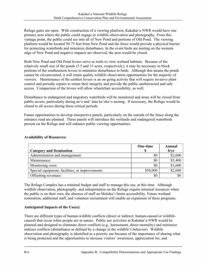
Kakahai‘a National Wildlife Refuge Draft Comprehensive Conservation Plan and Environmental Assessment
B-6 Appendix B: Compatibility Determinations and Appropriate Use Findings
Refuge gates are open. With construction of a viewing platform, Kakahai‘a NWR would have one primary area where the public could engage in wildlife observation and photography. From this vantage point, the public could see into all of New Pond and portions of Old Pond. The viewing platform would be located 50-75 feet from New Pond and the fence would provide a physical barrier for protecting waterbirds and minimize disturbance. In the event birds are nesting on the western edge of New Pond and negative impacts are observed, the area would be closed. Both New Pond and Old Pond levees serve as trails to view wetland habitats. Because of the relatively small size of the ponds (5.5 and 15 acres, respectively), it may be necessary to block portions of the southeastern levees to minimize disturbance to birds. Although this means the ponds cannot be circumvented, it will retain quality wildlife observation opportunities for the majority of viewers. Maintenance of the earthen levees is an on-going activity that will require invasive plant control and periodic repairs to retain their integrity and provide the public unobstructed and safe access. Compaction of the levees will allow wheelchair accessibility, as well. Disturbance to endangered and migratory waterbirds will be monitored and areas will be closed from public access, particularly during ae‘o and ‘alae ke‘oke‘o nesting. If necessary, the Refuge would be closed to all access during these critical periods. Future opportunities to develop interpretive panels, particularly on the outside of the fence along the entrance road are planned. These panels will introduce the wetlands and endangered waterbirds present on the Refuge and will enhance public viewing opportunities. Availability of Resources:
Category and Itemization One-time
$ Annual
$/yr Administration and management: $0 $2,600Maintenance: $0 $5,400Monitoring costs: $0 $3,600Special equipment, facilities, or improvements: $50,000 $2,600Offsetting revenues: $0 $0
The Refuge Complex has a minimal budget and staff to manage this use, at this time. Although wildlife observation, photography, and interpretation on the Refuge require minimal resources when the public is on their own, the absence of staff on Moloka‘i limits accessibility. Future wetland restoration, additional staff, and volunteer recruitment will enable an expansion of these programs. Anticipated Impacts of the Use(s): There are different types of human-wildlife conflicts (direct or indirect; human-caused or wildlife-caused) that occur when people are in nature. Public use activities at Kakahai‘a NWR would be planned and designed to eliminate direct conflicts (e.g., harassment, direct mortality) and minimize indirect conflicts (disturbance as defined by a change in the wildlife’s behavior). Wildlife observation and photography is identified as a priority use because of the importance of sharing what is being protected and the opportunities to increase visitors’ awareness, appreciation for, and
Kakahai‘a National Wildlife Refuge Draft Comprehensive Conservation Plan and Environmental Assessment
Appendix B: Compatibility Determinations and Appropriate Use Findings B-7
stewardship towards the natural resources. A balance needs to be attained in order for human activities to coexist with waterbird needs. This can be accomplished by minimizing activities and designing public use facilities that allow birds to engage in their natural behaviors. Human activities on unconfined trails may result in direct effects on wildlife through harassment, a form of disturbance that can cause physiological effects or varying levels of behavioral modifications (Smith and Hunt 1995). Various studies have shown that the severity of the effects depends upon the distance to the disturbance and its duration, frequency, predictability, and visibility to wildlife (Knight and Cole 1991). The variables found to have the greatest influence on wildlife behavior are: a) the distance from the animal to the disturbance and b) duration of the disturbance. In addition, the type of movement by people elicits different responses; for examples, birds show a greater flight response from a human moving quickly and unpredictably (erratic) than to humans moving slowly following a distinct path. Excessive human noises, especially with erratic behavior, are also a factor in bird disturbance by humans. Short-term impacts: Kakahai‘a NWR has been closed to the public except for special events and/or under SUP since its inception as a national wildlife refuge. If the wetland is restored and the endangered species return to the Refuge, the presence of people observing or photographing wildlife has potential to cause short-term disturbance to wildlife. Large non-wildlife-dependent groups are not the norm; however, if excessive disturbance is observed, the Refuge would close the area and mitigate through group education and interpretation. In order to minimize negative impacts to endangered waterbirds, it's important that the groups understand the causes of their endangerment, such as habitat loss and human disturbance. By explaining the negative consequences of disturbance, we strive to change the behavior and instill positive stewardship ethics. The potential impact of human activities to endangered waterbirds is well documented at Keālia Pond NWR on Maui where strategies to minimize those impacts are implemented. These same restrictions apply to Kakahai‘a NWR whereby areas are closed during critical periods in the waterbirds life history (e.g., nesting and brood rearing). New Pond and the adjacent grassland are open and unimpeded by vegetation allowing public to view birds from a distance without disturbance. Activities are limited to pedestrian access only. Vehicles and bikes are not allowed on the levees and pets (even on leashes) are not permitted. With additional on-island staff, the Refuge would be able to monitor public use, identify when birds are most susceptible to human disturbance, and implement measures to eliminate and/or minimize the human activities for the benefit of endangered waterbirds. Long-term impacts: Wildlife disturbance can be minimized when planning the restoration of wetlands or facilities. Refuge staff will evaluate potential disturbance in future planning and design of public use facilities such as the proposed viewing platform. During nesting season, trails are closed to public access to eliminate disturbance to waterbirds incubating eggs and rearing young. In the past, this closure has occurred during ‘alae ke‘oke‘o nesting period as needed; however, this is not necessary every year, likely due to the location of their nests (in emergent vegetation in the main pond) hidden from view. In addition, during brood rearing, the young have the capability of swimming into the vegetation away from people. In contrast, closures are more typical during ae‘o nesting season (May-June) because of the location of their nests (on the ground, adjacent to water) and the chicks’ limited ability to escape.

Kakahai‘a National Wildlife Refuge Draft Comprehensive Conservation Plan and Environmental Assessment
B-8 Appendix B: Compatibility Determinations and Appropriate Use Findings
Restoration of the ponds will be based on the needs of endangered waterbirds; therefore, specific planning and design of non-wetland areas will simultaneously occur to evaluate options for public access that minimizes impacts to waterbirds yet increases the quality of the viewing experiences. Areas outside of the perimeter levees for both ponds will be planted with native species to provide a barrier between the public and waterbirds. This natural blind will minimize disturbance to waterbirds and provide quality viewing opportunities by the public. A viewing platform along the entrance road will be designed to provide a higher vantage point for the viewing public but not at such a height that would minimize their exposure from the waterbirds’ vantage point. This type of planning is expected to minimize short- and long-term effects to waterbirds Refuge staff will continue to monitor public use activities and evaluate potential disturbance in future planning and design of public use facilities. Future planning will also include methods to provide a high-quality experience to the public. Cumulative impacts: The level and type of use from activities described in this CD is not expected to result in any significant cumulative impacts. Public Review and Comment: The period of public review began _________ and ended __________. Public review and comments were solicited in conjunction with release of the draft Kakahai‘a NWR draft CCP/ EA (2011) in order to comply with the National Environmental Policy Act and Service policy. This CD was released as integral part of the CCP and received the same level of public review and comments as the CCP, in accordance with Service planning policy. Determination: (check one below) Use is Not Compatible ✓ Use is Compatible With Following Stipulations Stipulations Necessary to Ensure Compatibility:
Visitors under SUP are required to stay on trails and designated paths throughout the year; Use of proposed viewing platform would be restricted to daylight hours only; and Pets are not allowed. Regulations and information will be available to the public through a Refuge brochure and
interpretive kiosk; Directional, informational, and interpretive signs will be available and maintained to help
educate the public on minimizing wildlife and habitat disturbance; and Human use levels will be monitored by Refuge staff during SUP programs, as well as
periodic site visits; and Temporary closure of trails will occur during waterbird nesting season, if necessary, to
eliminate disturbance.
Kakahai‘a National Wildlife Refuge Draft Comprehensive Conservation Plan and Environmental Assessment
Appendix B: Compatibility Determinations and Appropriate Use Findings B-9
Justification: Wildlife observation, photography, and interpretation are three of the six wildlife-dependent recreational uses of the Refuge System identified in the Administration Act as legitimate and appropriate priority general public uses. The six uses — hunting, fishing, wildlife observation and photography, and EE and interpretation — are to receive enhanced consideration in planning and management over all other general public uses of the Refuge System. Wildlife observation, photography, and interpretation receive enhanced consideration in the CCP process, and are considered priority public uses when determined compatible. Although these activities can result in disturbance to wildlife, these activities would occur on a small percentage of Refuge acres. The relatively limited number of individual plants and animals expected to be adversely affected will not cause wildlife populations to materially decline, the physiological condition and production of Refuge species will not be impaired, their behavior and normal activity patterns will not be altered dramatically, and their overall welfare will not be negatively impacted. Thus, allowing wildlife observation, photography, and interpretation to occur under the stipulations described above will not materially detract or interfere with the purpose for which the Refuge was established or the Refuge System mission. Wildlife observation, photography, and interpretation programs complement the Refuge purpose, vision, and goals, and help fulfill the mission of the Refuge System. Mandatory Reevaluation Date: June 2026 Mandatory 15-year reevaluation date (for wildlife-dependent public uses) Mandatory 10-year reevaluation date (for all uses other than wildlife-dependent public
uses) NEPA Compliance for Refuge Use Decision: (check one below) Categorical Exclusion without Environmental Action Statement Categorical Exclusion and Environmental Action Statement Environmental Assessment and Finding of No Significant Impact Environmental Impact Statement and Record of Decision
Kakahai‘a National Wildlife Refuge Draft Comprehensive Conservation Plan and Environmental Assessment
B-10 Appendix B: Compatibility Determinations and Appropriate Use Findings
Refuge Determination: Prepared by: Refuge Planner, Hawaiian and Pacific Islands NWRC ___
(Signature) (Date) Project Leader, Maui National Wildlife Refuge Complex Approval: ___
(Signature) (Date) Concurrence: Project Leader, Hawaiian and Pacific Islands NWRC ___
(Signature) (Date)
Regional Chief, National Wildlife Refuge System: ___ (Signature) (Date)

Kakahai‘a National Wildlife Refuge Draft Comprehensive Conservation Plan and Environmental Assessment
Appendix B: Compatibility Determinations and Appropriate Use Findings B-11
[blank]

Kakahai‘a National Wildlife Refuge Draft Comprehensive Conservation Plan and Environmental Assessment
B-12 Appendix B: Compatibility Determinations and Appropriate Use Findings
B.3 Compatibility Determination for Environmental Education Refuge Name(s): Kakahai‘a National Wildlife Refuge
County and State: Maui County, Hawai‘i Establishing and Acquisition Authority(ies): Kakahai‘a NWR was established in 1976 under the authority of the:
Fish and Wildlife Coordination Act of 1956, as amended (16 U.S.C. 742a – 742j) Endangered Species Act of 1973, as amended (16 U.S.C. 1531-1544)
Refuge Purpose(s): “…to conserve (A) fish and wildlife which, are listed as endangered or threatened species… or (B)
Plants …” 16 U.S.C. 1534, Endangered Species Act of 1973. National Wildlife Refuge System Mission: “The mission of the National Wildlife Refuge System is to administer a national network of lands and waters for the conservation, management, and where appropriate, restoration of the fish, wildlife, and plant resources and their habitats within the United States for the benefit of present and future generations of Americans.” Description of Use(s): The National Wildlife Refuge System Administration Act of 1966 (16 U.S.C. 668dd-668ee), as amended by the National Wildlife Refuge System Improvement Act of 1997 identifies environmental education and interpretation among wildlife-dependent public uses which, when compatible with the purpose(s) of the refuge, are priority public uses and receive special consideration in planning for and management of the Refuge System. Environmental education (EE) is a non-consumptive, wildlife-dependent public use. Environmental education programs at Kakahai‘a NWR are conducted by nongovernmental organizations (Nēnē O Moloka‘i, Maui Digital Bus) under a Special Use Permit (SUP). All outdoor classes are coordinated to not impact the Refuge’s management programs (e.g., maintenance). Nēnē O Moloka‘i is a non-profit corporation that emphasizes education through community involvement. They have a longstanding relationship with the Refuge and SUP approvals since 1997 to access the Refuge to host school and other EE groups. The organization provides educational and volunteer opportunities to groups that include a well-rounded overview of the different types of wetland habitats on Moloka‘i with emphasis on the endangered waterbirds. Learning activities include wetland ecology, biology, cultural history, and the life history of endangered waterbirds, as well as volunteer efforts. A majority of the organization’s participants are from the local community and although the number of students is less than 100 each year, the value in exposing students to Moloka‘i’s natural resources is invaluable.

Kakahai‘a National Wildlife Refuge Draft Comprehensive Conservation Plan and Environmental Assessment
Appendix B: Compatibility Determinations and Appropriate Use Findings B-13
As the Refuge currently has a degraded wetland without suitable habitat for endangered waterbirds, EE programs lately have been focusing on invasive species and how they impact wetlands. Kakahai‘a NWR is used as a comparison to functional wetlands on the Island such as ‘Ōhi‘apilo Pond Bird Sanctuary, Kaunakakai Wastewater Recalmation Facility, and Kōheo Wetland. The Maui Digital Bus is in the process of developing and implementing their program on Moloka‘i and once it is operational, the program is expected to reach more students. Both programs have quality EE programs that have shown to be successful on Maui. With the addition of a new visitor services manager for the Maui NWR Complex, Refuge-specific EE programs will be developed for local school groups of varying age levels. Volunteers would be recruited and trained to assist with the program. All EE programs will have a stewardship component where students would participate in a wetland restoration project. Availability of Resources:
Category and Itemization One-time
$ Annual
$/yr Administration and management: $0 $1,000Maintenance: $0 $900Materials: $0 $1,000Special equipment, facilities, or improvements: $0 $1,000Offsetting revenues: $0 $
Minimal costs of EE will be covered by Refuge visitor services funding provided in the annual Refuge budget. Anticipated Impacts of the Use(s): Short-term impacts: The number of school groups and students visiting the Refuge may vary from year to year but this variation is already considered in the guidelines and structure established for the program. There is a limit of 25 people per group and no more than 5 group visits are allowed annually, during the non-breeding season only. To date, the highest number of students to visit in one year was 35. A Refuge staff member or Refuge-approved volunteer docent accompanies each group under SUP to monitor the activity. The primary impacts come from temporary disturbance to individual animals (primarily birds) due to the presence and activity of the students as they are guided around the wetlands. The animals may flush, swim away, or seek cover and hide in vegetation. These impacts are mitigated by restricting the days, maximum number of students, and routes that EE activities take place. This allows the students to participate in the EE experience while causing temporary disturbance over the smallest area and to the fewest birds. Because we anticipate 5 visitor groups of no more than 25 people each will visit the Refuge over the course of the school year and EE groups will only be allowed access to designated levee trails during non-breeding seasons, wildlife will have ample quantities of sanctuary for feeding, breeding, and resting. Thus, allowing EE to occur under the described program will not result in any significant long-term impacts. Long-term impacts: The current, ongoing EE program covered by this CD will not cause any significant long-term impacts. The EE program is expected to increase with restoration of the
Kakahai‘a National Wildlife Refuge Draft Comprehensive Conservation Plan and Environmental Assessment
B-14 Appendix B: Compatibility Determinations and Appropriate Use Findings
wetlands, recruitment of a Visitor Services Manager, and development of a formal program designed to meet Hawai‘i Department of Education curriculum requirements. A thorough evaluation of the impacts to existing resources and capability of the site to withstand additional groups will be reviewed in a Visitor Services Plan within 5 years. Cumulative impacts: This EE program has been conducted in the current manner since 1997 and no cumulative impacts to wildlife resources on the Refuge have been observed or are anticipated. Public Review and Comment: The period of public review began _________ and ended __________. Public review and comments were solicited in conjunction with release of the draft CCP/EA (2011) in order to comply with the NEPA and Service policy. Determination: (check one below) Use is Not Compatible
✓ Use is Compatible with Following Stipulations
Stipulations Necessary to Ensure Compatibility: User stipulations:
Groups are required to stay on trails and designated paths throughout the year; Use is restricted to daylight hours only; and Groups are limited to 25, including students, chaperones, and teachers; Special Use Permits will only be issued during non-breeding seasons and when no nesting is
occurring; Use levels will be monitored by Refuge staff and/or approved volunteer docents; and Refuge staff periodically participates with the group to ensure compliance with Refuge’s
conditions and accuracy of information is maintained. Justification: Environmental education is one of the six wildlife-dependent recreational uses of the Refuge System as stated in the Administration Act of 1997. The six uses — hunting, fishing, wildlife observation and photography, and EE and interpretation — are to receive enhanced consideration in planning and management over all other general public uses of the Refuge System. Environmental education receives enhanced consideration in the CCP process, and is considered a priority public use when determined compatible. By limiting the size of groups, providing structured activities, and providing closed areas for wildlife away from human disturbance, this program would limit disturbance to wildlife. There is a sufficient amount of undisturbed habitat available to Refuge wildlife for escape and cover, and wildlife populations will find sufficient food resources and resting places. The relatively limited number of individual plants and animals expected to be adversely affected will not

Kakahai‘a National Wildlife Refuge Draft Comprehensive Conservation Plan and Environmental Assessment
Appendix B: Compatibility Determinations and Appropriate Use Findings B-15
cause wildlife populations to materially decline, the physiological condition and production of Refuge species will not be impaired, their behavior and normal activity patterns will not be altered dramatically, and their overall welfare will not be negatively impacted. Thus, allowing EE to occur under the stipulations described above will not materially detract or interfere with the purposes for which the Refuge was established or the Refuge System mission. Environmental education contributes to the mission of the Refuge System by providing wildlife-dependent educational benefits to visitors. Environmental education programs on Refuge lands are inherently valuable to the Service because they will enhance the public’s knowledge of the Refuge and its resources, and expand the number of visitors who engage in the Refuge’s conservation mission. Mandatory Reevaluation Date: (provide month and year for “allowed” uses only) June 2026 Mandatory 15-year reevaluation date (for wildlife-dependent public uses) Mandatory 10-year reevaluation date (for uses other than wildlife-dependent public uses) NEPA Compliance for Refuge Use Decision: (check one below) Categorical Exclusion without Environmental Action Statement Categorical Exclusion and Environmental Action Statement Environmental Assessment and Finding of No Significant Impact Environmental Impact Statement and Record of Decision

Kakahai‘a National Wildlife Refuge Draft Comprehensive Conservation Plan and Environmental Assessment
B-16 Appendix B: Compatibility Determinations and Appropriate Use Findings
Refuge Determination: Prepared by: Refuge Planner, Hawaiian and Pacific Islands NWRC ___
(Signature) (Date) Project Leader, Maui National Wildlife Refuge Complex Approval: ___
(Signature) (Date) Concurrence: Project Leader, Hawaiian and Pacific Islands NWRC ___
(Signature) (Date)
Regional Chief, National Wildlife Refuge System: ___ (Signature) (Date)
Kakahai‘a National Wildlife Refuge Draft Comprehensive Conservation Plan and Environmental Assessment
Appendix B: Compatibility Determinations and Appropriate Use Findings B-17
B.4 Compatibility Determination for Research, Scientific Collecting, and Surveys CD Terminology: Research: Planned, organized, and systematic investigation of a scientific nature. Scientific collecting: Gathering of Refuge natural resources or cultural artifacts for scientific purposes. Surveys: Scientific inventory or monitoring. Refuge Name(s): Kakahai‘a National Wildlife Refuge County and State: Maui County, Hawai‘i Establishing and Acquisition Authority(ies): Kakahai‘a NWR was established in 1976 under the authority of the:
Fish and Wildlife Coordination Act of 1956, as amended (16 U.S.C. 742a – 742j) Endangered Species Act of 1973, as amended (16 U.S.C. 1531-1544)
Refuge Purpose(s): “…to conserve (A) fish and wildlife which, are listed as endangered or threatened species… or (B)
Plants …” 16 U.S.C. 1534, Endangered Species Act of 1973. National Wildlife Refuge System Mission: “The mission of the National Wildlife Refuge System is to administer a national network of lands and waters for the conservation, management, and where appropriate, restoration of the fish, wildlife, and plant resources and their habitats within the United States for the benefit of present and future generations of Americans.” Description of Use(s): The Refuge staff receives periodic requests from non-Service entities (e.g., universities, State agencies, other Federal agencies, non-governmental organizations) to conduct research, scientific collecting, and surveys on Refuge lands. These project requests can involve a wide range of natural and cultural resources as well as public use management issues, including basic absence/presence surveys, collection of new species for identification, habitat use and life-history requirements for specific species/species groups, practical methods for habitat restoration, extent and severity of environmental contaminants, techniques to control or eradicate pest species, effects of climate change on environmental conditions and associated habitat/wildlife response, identification and analyses of paleontological specimens, modeling wildlife populations, and assessing response of habitat/wildlife to disturbance from public uses. Projects may be species-specific, Refuge-specific, or evaluate the relative contribution of the Refuge lands to larger landscapes (e.g., eco-region, region, flyway, national, international) issues and trends.
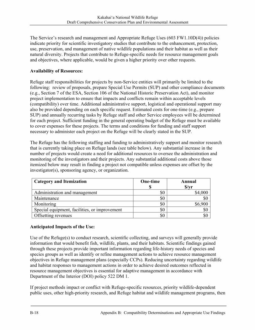
Kakahai‘a National Wildlife Refuge Draft Comprehensive Conservation Plan and Environmental Assessment
B-18 Appendix B: Compatibility Determinations and Appropriate Use Findings
The Service’s research and management and Appropriate Refuge Uses (603 FW1.10D(4)) policies indicate priority for scientific investigatory studies that contribute to the enhancement, protection, use, preservation, and management of native wildlife populations and their habitat as well as their natural diversity. Projects that contribute to Refuge-specific needs for resource management goals and objectives, where applicable, would be given a higher priority over other requests. Availability of Resources: Refuge staff responsibilities for projects by non-Service entities will primarily be limited to the following: review of proposals, prepare Special Use Permits (SUP) and other compliance documents (e.g., Section 7 of the ESA, Section 106 of the National Historic Preservation Act), and monitor project implementation to ensure that impacts and conflicts remain within acceptable levels (compatibility) over time. Additional administrative support, logistical and operational support may also be provided depending on each specific request. Estimated costs for one-time (e.g., prepare SUP) and annually recurring tasks by Refuge staff and other Service employees will be determined for each project. Sufficient funding in the general operating budget of the Refuge must be available to cover expenses for these projects. The terms and conditions for funding and staff support necessary to administer each project on the Refuge will be clearly stated in the SUP. The Refuge has the following staffing and funding to administratively support and monitor research that is currently taking place on Refuge lands (see table below). Any substantial increase in the number of projects would create a need for additional resources to oversee the administration and monitoring of the investigators and their projects. Any substantial additional costs above those itemized below may result in finding a project not compatible unless expenses are offset by the investigator(s), sponsoring agency, or organization.
Category and Itemization One-time $
Annual $/yr
Administration and management $0 $4,000Maintenance $0 $0Monitoring $0 $6,900Special equipment, facilities, or improvement $0 $0Offsetting revenues $0 $0
Anticipated Impacts of the Use: Use of the Refuge(s) to conduct research, scientific collecting, and surveys will generally provide information that would benefit fish, wildlife, plants, and their habitats. Scientific findings gained through these projects provide important information regarding life-history needs of species and species groups as well as identify or refine management actions to achieve resource management objectives in Refuge management plans (especially CCPs). Reducing uncertainty regarding wildlife and habitat responses to management actions in order to achieve desired outcomes reflected in resource management objectives is essential for adaptive management in accordance with Department of the Interior (DOI) policy 522 DM 1. If project methods impact or conflict with Refuge-specific resources, priority wildlife-dependent public uses, other high-priority research, and Refuge habitat and wildlife management programs, then

Kakahai‘a National Wildlife Refuge Draft Comprehensive Conservation Plan and Environmental Assessment
Appendix B: Compatibility Determinations and Appropriate Use Findings B-19
it must be clearly demonstrated that the scientific findings will contribute to resource management and that the project cannot be conducted off-Refuge for the project to be compatible. The investigator(s) must identify methods/strategies in advance required to eliminate or minimize the potential impact(s) and conflict(s). If unacceptable impacts cannot be avoided, then the project will not be compatible. Impacts would be project- and site-specific, where they will vary depending upon nature and scope of the field work. Data collection techniques will generally have minimal animal mortality or disturbance, habitat destruction, no introduction of contaminants, or no introduction of non-native species. In contrast, projects involving the collection of biotic samples (plants or animals) or requiring intensive ground-based data or sample collection will have short-term impacts. To reduce impacts, the minimum number of samples (e.g., water, soils, vegetative litter, plants, macroinvertebrates, vertebrates) will be collected for identification and/or experimentation and statistical analysis. Where possible, researchers would coordinate and share collections to reduce sampling needed for multiple projects.
Investigator(s) obtaining required State and Federal collecting permits will also ensure minimal impacts to fish, wildlife, plants, and their habitats. If, after incorporating the above strategies, the project results in long-term or cumulative effects, it will not be deemed compatible. A Section 7 consultation under the ESA will be required for activities that may affect a federally listed species and/or critical habitat. Only projects that have no effect or will result in not likely to adversely affect determinations will be considered compatible. Spread of pest plants and/or pathogens is possible from ground disturbance and/or transportation of project equipment and personnel, but it will be minimized or eliminated by requiring proper cleaning of investigator equipment and clothing as well as quarantine methods, where necessary. If after all practical measures are taken, an unacceptable spread of pest species is anticipated to occur, then the project will be found not compatible without a restoration or mitigation plan. Localized and temporary effects may occur from vegetation trampling, collecting of soil and plant samples, or trapping and handling of wildlife. Impacts may also occur from infrastructure necessary to support a project (e.g., permanent transects or plot markers, exclosure devices, monitoring equipment, solar panels to power unattended monitoring equipment). Some level of disturbance is expected with these projects, especially if investigator(s) enter areas closed to the public and collect samples or handle wildlife. However, wildlife disturbance (including altered behavior) will usually be localized and temporary in nature. Where long-term or cumulative unacceptable effects cannot be avoided, the project will not be found compatible. Project proposals will be reviewed by Refuge staff and others, as needed, to assess the potential impacts (short-term, long-term, and cumulative) relative to benefits of the investigation to Refuge management issues and understanding of natural systems. At least 6 months before initiation of field work (unless an exception is made by prior approval of the refuge manager), project investigator(s) must submit a detailed proposal. Project proposals will be reviewed by Refuge staff and others, as needed, to assess the potential impacts (short-term, long-term, and cumulative) relative to benefits of the investigation to Refuge management issues and understanding of natural systems. This assessment will form the primary basis for allowing or denying a specific project. Projects that result in unacceptable Refuge impacts will not be found compatible. If allowed and found compatible after approval, all projects also will be assessed during implementation to ensure impacts and conflicts remain within acceptable levels.

Kakahai‘a National Wildlife Refuge Draft Comprehensive Conservation Plan and Environmental Assessment
B-20 Appendix B: Compatibility Determinations and Appropriate Use Findings
If the proposal is approved, then the refuge manager will issue a SUP(s) with required stipulations (terms and conditions) of the project to avoid and/or minimize potential impacts to Refuge resources as well as conflicts with other public-use activities and Refuge field management operations. After approval, projects also are monitored during implementation to ensure impacts and conflicts remain within acceptable levels based upon documented stipulations. Projects that are not covered by the CCP will require additional NEPA documentation. Public Review and Comment: The period of public review began _________ and ended __________. Public review and comments were solicited in conjunction with release of the draft CCP/EA (2011) in order to comply with the NEPA and Service policy. Determination: (check one below) The use is not compatible.
✓ The use is compatible with the following stipulations.
Stipulations Necessary to Ensure Compatibility: Each project will require an SUP. Annual or other short-term SUPs are preferred; however, some permits will be a longer period, if needed, to allow completion of the project. All SUPs will have a definite termination date. Permit renewals will be subject to Refuge Manager review and approval based on timely submission of and content in progress reports, compliance with SUP stipulations, and required permits. Other stipulations and provisions would include the following:
Projects will adhere to scientifically defensible protocols for data collection, where available and applicable.
Investigators must possess appropriate and comply with conditions of State and Federal permits for their projects.
If unacceptable impacts to natural resources or conflicts arise or are documented by the Refuge staff, then the refuge manager can suspend, modify conditions of, or terminate an on-going project already permitted by SUP(s) on a Refuge.
Progress reports are required at least annually for multiple-year projects. Final reports are due 1 year after completion of the project unless negotiated otherwise with
the refuge manager. Continuation of existing projects will require approval by the refuge manager. The Refuge staff will be given the opportunity to review draft manuscript(s) from the project
before being submitted to a scientific journal(s) for consideration of publication. The Refuge staff will be provided with copies (including, but not limited to: reprints, videos,
and CDs) of all publications resulting from a Refuge project. The Refuge staff will be provided with copies of raw data (preferably electronic database
format) at the conclusion of the project.
Kakahai‘a National Wildlife Refuge Draft Comprehensive Conservation Plan and Environmental Assessment
Appendix B: Compatibility Determinations and Appropriate Use Findings B-21
Upon completion of the project or annually, all equipment and markers (unless required for long-term projects), must be removed and sites must restored to the refuge manager’s satisfaction. Conditions for clean-up and removal of equipment and physical markers will be stipulated in the SUP(s).
All samples collected on Refuge lands are the property of the Service even while in the possession of the investigator(s). Any future work with previously collected samples not clearly identified in the project proposal will require submission of a subsequent proposal for review and approval. In addition, a new SUP will be required for additional project work. For samples or specimens to be stored at other facilities (e.g., museums), a memorandum of understanding will be necessary.
Sampling equipment as well as investigator(s) clothing and vehicles (e.g., ATV, boats) will be thoroughly cleaned (free of dirt and plant material) before being allowed for use on Refuge lands and/or waters to prevent the introduction and/or spread of pests.
The Service, specific Refuge unit, names of Refuge staff and other Service personnel who supported or contributed to the project will be appropriately cited and acknowledged in all written and oral presentations resulting from projects on Refuge lands.
At any time, Refuge staff may accompany investigator(s) in the field. Investigator(s) and support staff will follow all Refuge-specific regulations that specify
access and travel on the Refuge. Justification: Research, scientific collecting, and surveys on Refuge lands are inherently valuable to the Service because they will expand scientific information available for resource management decisions. In addition, only projects that directly or indirectly contribute to the enhancement, protection, use, preservation, and management of Refuge wildlife populations and their habitats generally will be authorized on Refuge lands. In many cases, if it were not for the Refuge staff providing access to Refuge lands and waters along with some support, the research project would likely not occur and less scientific information would be available to the Service to aid in managing and conserving resources. By allowing the use to occur under the stipulations described above, it is anticipated that wildlife species that could be disturbed during the use would find sufficient food resources and resting places so their abundance and use will not be measurably lessened on the Refuge. Additionally, it is anticipated that monitoring, as needed, will prevent unacceptable or irreversible impacts to fish, wildlife, plants, and their habitats. The combination of stipulations identified above and conditions included in any SUP(s) will ensure that proposed projects contribute to the enhancement, protection, conservation, and management of native wildlife populations and their habitats on the Refuge. As a result, these projects will not materially interfere with or detract from fulfilling Refuge purpose(s); contributing to the mission of the Service and Refuge System; and maintaining the biological integrity, diversity, and environmental health of the Refuge.
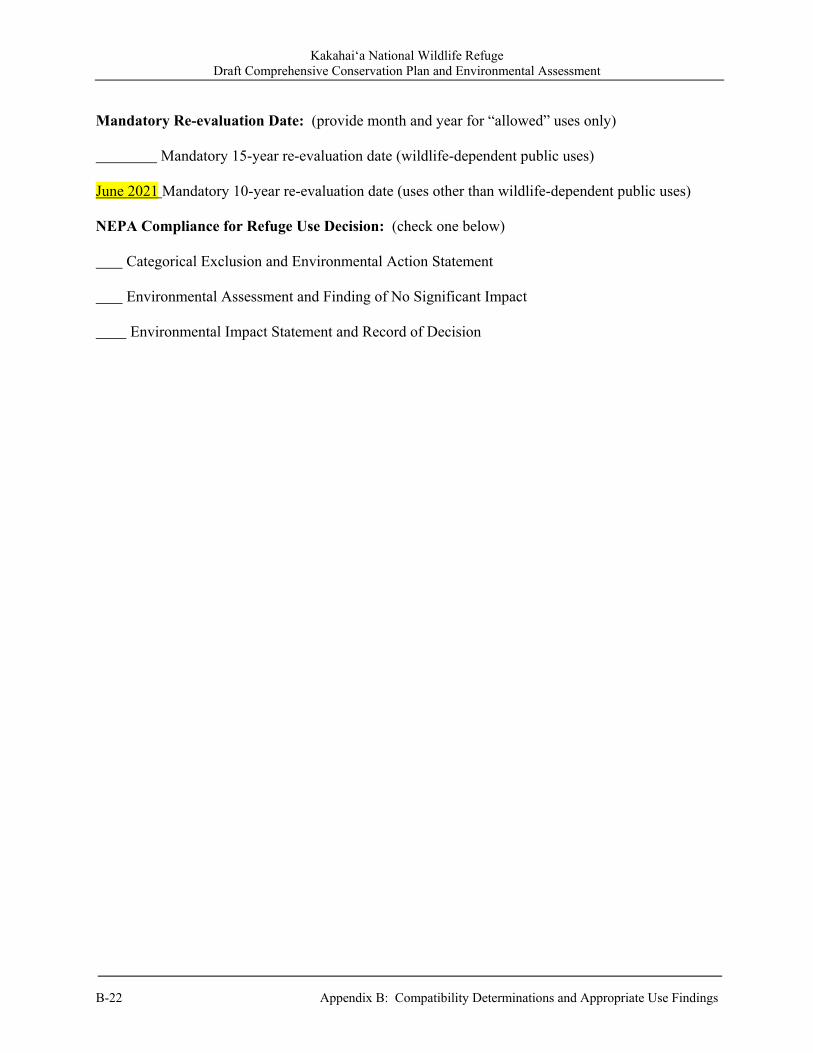
Kakahai‘a National Wildlife Refuge Draft Comprehensive Conservation Plan and Environmental Assessment
B-22 Appendix B: Compatibility Determinations and Appropriate Use Findings
Mandatory Re-evaluation Date: (provide month and year for “allowed” uses only) Mandatory 15-year re-evaluation date (wildlife-dependent public uses) June 2021 Mandatory 10-year re-evaluation date (uses other than wildlife-dependent public uses) NEPA Compliance for Refuge Use Decision: (check one below) Categorical Exclusion and Environmental Action Statement Environmental Assessment and Finding of No Significant Impact Environmental Impact Statement and Record of Decision
Kakahai‘a National Wildlife Refuge Draft Comprehensive Conservation Plan and Environmental Assessment
Appendix B: Compatibility Determinations and Appropriate Use Findings B-23
Refuge Determination: Prepared by: Refuge Planner, Hawaiian and Pacific Islands NWRC ___
(Signature) (Date) Project Leader, Maui National Wildlife Refuge Complex Approval: ___
(Signature) (Date) Concurrence: Project Leader, Hawaiian and Pacific Islands NWRC ___
(Signature) (Date)
Regional Chief, National Wildlife Refuge System: ___ (Signature) (Date)
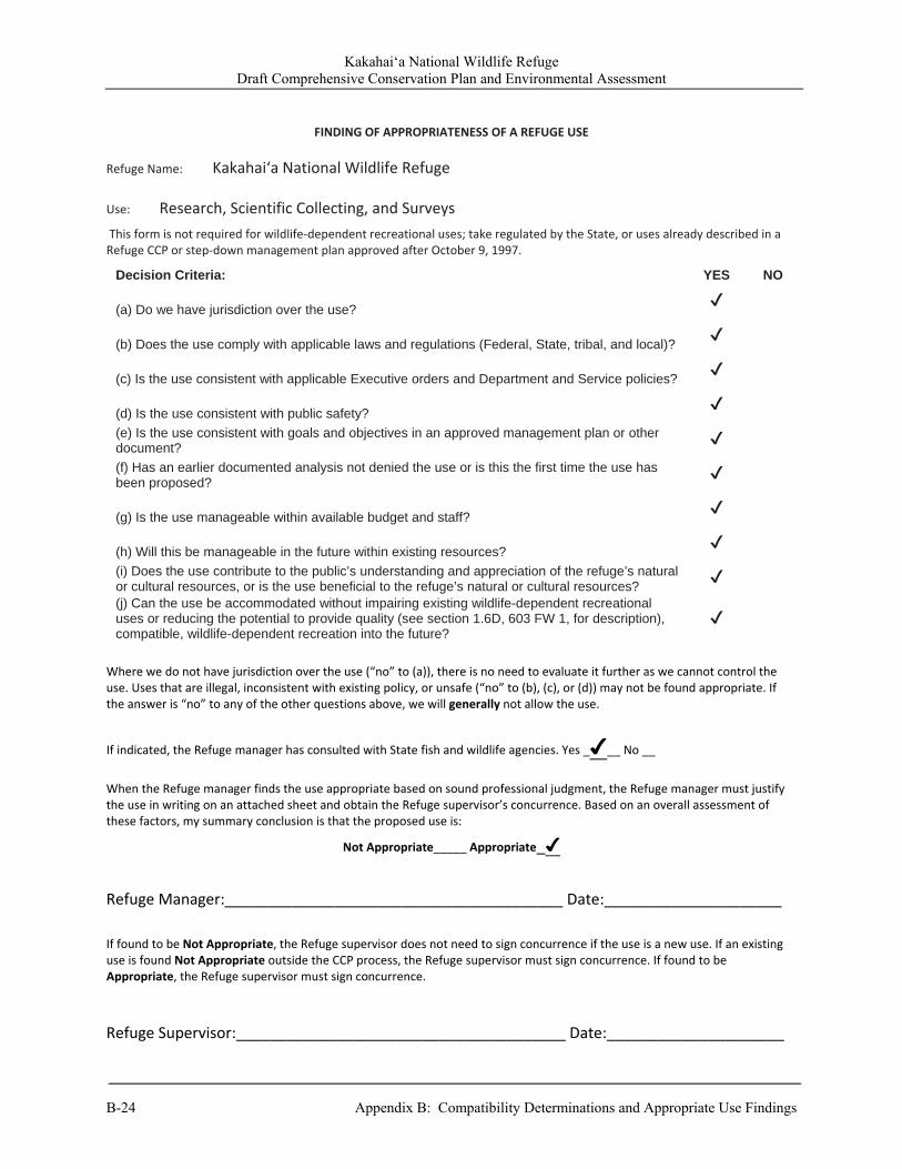
Kakahai‘a National Wildlife Refuge Draft Comprehensive Conservation Plan and Environmental Assessment
B-24 Appendix B: Compatibility Determinations and Appropriate Use Findings
FINDING OF APPROPRIATENESS OF A REFUGE USE
Refuge Name: Kakahai‘a National Wildlife Refuge
Use: Research, Scientific Collecting, and Surveys
This form is not required for wildlife‐dependent recreational uses; take regulated by the State, or uses already described in a Refuge CCP or step‐down management plan approved after October 9, 1997.
Where we do not have jurisdiction over the use (“no” to (a)), there is no need to evaluate it further as we cannot control the use. Uses that are illegal, inconsistent with existing policy, or unsafe (“no” to (b), (c), or (d)) may not be found appropriate. If the answer is “no” to any of the other questions above, we will generally not allow the use.
If indicated, the Refuge manager has consulted with State fish and wildlife agencies. Yes _✔__ No __
When the Refuge manager finds the use appropriate based on sound professional judgment, the Refuge manager must justify the use in writing on an attached sheet and obtain the Refuge supervisor’s concurrence. Based on an overall assessment of these factors, my summary conclusion is that the proposed use is:
Not Appropriate_____ Appropriate_✔
Refuge Manager:________________________________________ Date:_____________________
If found to be Not Appropriate, the Refuge supervisor does not need to sign concurrence if the use is a new use. If an existing use is found Not Appropriate outside the CCP process, the Refuge supervisor must sign concurrence. If found to be Appropriate, the Refuge supervisor must sign concurrence.
Refuge Supervisor:_______________________________________ Date:_____________________
Decision Criteria: YES NO
(a) Do we have jurisdiction over the use? ✔
(b) Does the use comply with applicable laws and regulations (Federal, State, tribal, and local)? ✔
(c) Is the use consistent with applicable Executive orders and Department and Service policies? ✔
(d) Is the use consistent with public safety? ✔
(e) Is the use consistent with goals and objectives in an approved management plan or other document?
✔
(f) Has an earlier documented analysis not denied the use or is this the first time the use has been proposed?
✔
(g) Is the use manageable within available budget and staff? ✔
(h) Will this be manageable in the future within existing resources? ✔
(i) Does the use contribute to the public’s understanding and appreciation of the refuge’s natural or cultural resources, or is the use beneficial to the refuge’s natural or cultural resources?
✔
(j) Can the use be accommodated without impairing existing wildlife-dependent recreational uses or reducing the potential to provide quality (see section 1.6D, 603 FW 1, for description), compatible, wildlife-dependent recreation into the future?
✔
Kakahai‘a National Wildlife Refuge Draft Comprehensive Conservation Plan and Environmental Assessment
Appendix B: Compatibility Determinations and Appropriate Use Findings B-25
FWS Form 3-2319
A compatibility determination is required before the use may be allowed. 02/06 Attachment 1: Appropriate Uses Justification Date: May 5, 2011 Refuge: Kakahai‘a National Wildlife Refuge (Refuge) Project: Research, Scientific Collecting, and Surveys Summary: The Refuge receives requests to conduct scientific research on Refuge lands and waters. Research applicants must submit a proposal that would outline: 1) objectives of the study; 2) justification for the study; 3) detailed methodology and schedule; 4) potential impacts on Refuge wildlife and/or habitat, including disturbance (short-term and long-term), injury, or mortality; 5) personnel required; 6) costs to Refuge, if any; and 7) end products (i.e., reports, publications). Research proposals would be reviewed by Refuge staff, Regional Office Branch of Refuge Biology, and others as appropriate prior to the Refuge issuing a SUP. Projects will not be open-ended, and, at a minimum, will be reviewed annually. For each of the findings listed on FWS Form 3-2319, a justification has been provided below: a. Do we have jurisdiction over the use? Some or all of the proposed activities would take place within Refuge boundaries. The Refuge has jurisdiction over those research projects that are sited within Refuge boundaries. b. Does the use comply with applicable laws and regulations (Federal, State, tribal, and local)? Proposed research activities should comply with all applicable laws and regulations. Any restrictions or qualifications that are required to comply with law and regulations would be specified in the SUP. The State of Hawai‘i DLNR was invited on two occasions to participate on core planning teams, but declined due to insufficient staffing. However, as this Appropriate Use Justification does not propose a significant deviation from the status quo, and no comments on this topic were received from the State during the comment period, we believe additional coordination is not necessary. c. Is the use consistent with applicable Executive orders and Department and Service policies? Through the review of individual projects, the Refuge would ensure that they are consistent with applicable policies, especially Research on Service Lands Policy (803 FW 1). d. Is the use consistent with public safety? Through individual project review, the Refuge will ensure that each project is consistent with public safety. If necessary, stipulations to ensure public safety will be included in the project’s SUP.
Kakahai‘a National Wildlife Refuge Draft Comprehensive Conservation Plan and Environmental Assessment
B-26 Appendix B: Compatibility Determinations and Appropriate Use Findings
e. Is the use consistent with goals and objectives in an approved management plan or other document? Research activities are approved in instances where they can provide meaningful data that may contribute to Refuge management and public appreciation of natural resources. f. Has an earlier documented analysis not denied the use or is this the first time the use has been proposed? Earlier documented analysis has approved the use and touted the benefits of research, scientific collecting, and surveys on national wildlife refuges. g. Is the use manageable within available budget and staff? The Refuge receives <10 requests per year for this activity, and it is manageable with available budget and staff. h. Will this be manageable in the future within existing resources? The proposed activity at current levels would be manageable in the future with the existing resources. i. Does the use contribute to the public’s understanding and appreciation of the Refuge’s natural or cultural resources, or is the use beneficial to the Refuge’s natural or cultural resources? The proposed use is beneficial to the Refuge’s natural and cultural resources because the types of research projects approved are those that have the distinct likelihood to help achieve Refuge purposes by providing information useful for the management of trust resources and may contribute to the public’s understanding and appreciation of natural and/or cultural resources. j. Can the use be accommodated without impairing existing wildlife-dependent recreational uses or reducing the potential to provide quality (see section 1.6D, 603 FW 1, for description), compatible, wildlife-dependent recreation into the future? The Refuge will ensure that the research activities will not impair existing or future wildlife-dependent recreational use of the Refuge during individual project review, prior to issuing a SUP for the project.
Kakahai‘a National Wildlife Refuge Draft Comprehensive Conservation Plan and Environmental Assessment
Appendix C: Plan Implementation and Costs C-1
Appendix C. Plan Implementation and Costs
C.1 Administration Kakahai‘a NWR is administered as part of the Maui National Wildlife Refuge Complex (Complex). The Complex also includes the Keālia Pond NWR comprised of a large natural wetland with associated flats, constructed ponds, and forested habitats on the south-central coast of Maui. The Complex office is located at Keālia Pond NWR and is where all administrative functions for Kakahai‘a originate. The current staff of five is stationed on Maui and has shared responsibilities for the operation and maintenance of Kakahai‘a NWR. The Service is currently in the process of establishing Molokini Islet as an overlay refuge unit of the Keālia Pond NWR that will also have oversight from the Complex office.
C.2 Staffing All staff positions share responsibilities and duties for two refuges, in addition to Molokini Islet Unit, once established; e.g., no staff is assigned or performs duties only on specific refuges within the Complex. Due to projected Complex-wide workload, priorities, Federal budget, logistics, and supervisory considerations, this arrangement is expected to continue. However, when more personnel are added to the Complex (e.g., a Maintenance Worker or Equipment Operator), staff may be assigned more specific duties on individual refuges. At a minimum, the Maintenance Worker makes trips every other week to check on the property and perform habitat and maintenance duties. Unfortunately, the only airline flying direct between Maui and Moloka‘i has limited flights and frequent delays or cancellations resulting in relatively short days to accomplish work. In addition, this limited number of days on Moloka‘i makes it difficult to coordinate community work projects. Periodically, the entire Refuge staff travel to Moloka‘i to assist with large projects (e.g., fence construction).
The Service’s National Staffing Model generated eight positions for the Complex, one of which would have primary responsibility for field work at Kakahai‘a NWR. The existing, core-funded staff is five. The additional staffing would provide increased capacity to conduct biological inventory and monitoring, and research; increased visitor opportunities; EE and interpretation of Refuge resources; collaborative efforts with other Federal, State, and County agencies in addition to non-government organizations; improved maintenance facilities; and increase invasive species control efforts for the benefit of endangered waterbirds. A new visitor center is currently under construction for Keālia Pond NWR. It was not planned when staffing models were finalized; therefore, the need for staff to operate and maintain the new building was not included. Increased staffing with specific responsibilities in the development of the visitor, volunteer, and education programs, and maintaining the new facility is necessary to provide quality customer service and ensure safe conditions for visitors. Although these staff would be stationed on Maui, their responsibilities would extend to the public use programs at Kakahai‘a NWR, including volunteer, EE, and interpretation programs.
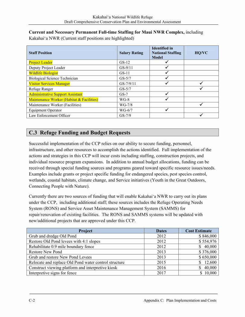
Kakahai‘a National Wildlife Refuge Draft Comprehensive Conservation Plan and Environmental Assessment
C-2 Appendix C: Plan Implementation and Costs
Current and Necessary Permanent Full-time Staffing for Maui NWR Complex, including Kakahai‘a NWR (Current staff positions are highlighted)
Staff Position Salary Rating Identified in National Staffing Model
HQ/VC
Project Leader GS-12
Deputy Project Leader GS-9/11 Wildlife Biologist GS-11 Biological Science Technician GS-5/7 Visitor Services Manager GS-7/9/11 Refuge Ranger GS-5/7 Administrative Support Assistant GS-7 Maintenance Worker (Habitat & Facilities) WG-8 Maintenance Worker (Facilities) WG-7/8 Equipment Operator WG-6/7
Law Enforcement Officer GS-7/9
C.3 Refuge Funding and Budget Requests Successful implementation of the CCP relies on our ability to secure funding, personnel, infrastructure, and other resources to accomplish the actions identified. Full implementation of the actions and strategies in this CCP will incur costs including staffing, construction projects, and individual resource program expansions. In addition to annual budget allocations, funding can be received through special funding sources and programs geared toward specific resource issues/needs. Examples include grants or project specific funding for endangered species, pest species control, wetlands, coastal habitats, climate change, and Service initiatives (Youth in the Great Outdoors, Connecting People with Nature).
Currently there are two sources of funding that will enable Kakahai‘a NWR to carry out its plans under the CCP, including additional staff; these sources includes the Refuge Operating Needs System (RONS) and Service Asset Maintenance Management System (SAMMS) for repair/renovation of existing facilities. The RONS and SAMMS systems will be updated with new/additional projects that are approved under this CCP.
Project Dates Cost Estimate Grub and dredge Old Pond 2012 $ 846,000Restore Old Pond levees with 4:1 slopes 2012 $ 554,976Rehabilitate 0.9 mile boundary fence 2012 $ 40,000Restore New Pond 2013 $ 376,000Grub and restore New Pond Levees 2013 $ 650,000Relocate and replace Old Pond water control structure 2015 $ 12,600Construct viewing platform and interpretive kiosk 2016 $ 40,000Interpretive signs for fence 2017 $ 10,000
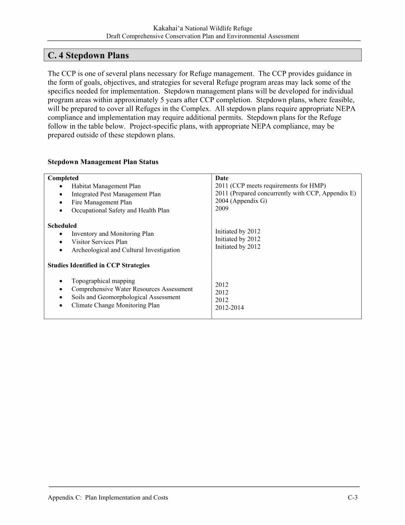
Kakahai‘a National Wildlife Refuge Draft Comprehensive Conservation Plan and Environmental Assessment
Appendix C: Plan Implementation and Costs C-3
C. 4 Stepdown Plans The CCP is one of several plans necessary for Refuge management. The CCP provides guidance in the form of goals, objectives, and strategies for several Refuge program areas may lack some of the specifics needed for implementation. Stepdown management plans will be developed for individual program areas within approximately 5 years after CCP completion. Stepdown plans, where feasible, will be prepared to cover all Refuges in the Complex. All stepdown plans require appropriate NEPA compliance and implementation may require additional permits. Stepdown plans for the Refuge follow in the table below. Project-specific plans, with appropriate NEPA compliance, may be prepared outside of these stepdown plans.
Stepdown Management Plan Status
Completed Habitat Management Plan Integrated Pest Management Plan Fire Management Plan Occupational Safety and Health Plan
Scheduled
Inventory and Monitoring Plan Visitor Services Plan Archeological and Cultural Investigation
Studies Identified in CCP Strategies
Topographical mapping Comprehensive Water Resources Assessment Soils and Geomorphological Assessment Climate Change Monitoring Plan
Date 2011 (CCP meets requirements for HMP) 2011 (Prepared concurrently with CCP, Appendix E) 2004 (Appendix G) 2009 Initiated by 2012 Initiated by 2012 Initiated by 2012 2012 2012 2012 2012-2014

Kakahai‘a National Wildlife Refuge Draft Comprehensive Conservation Plan and Environmental Assessment
C-4 Appendix C: Plan Implementation and Costs
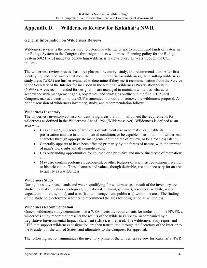
Kakahai‘a National Wildlife Refuge Draft Comprehensive Conservation Plan and Environmental Assessment
Appendix D: Wilderness Review D-1
Appendix D. Wilderness Review for Kakahai‘a NWR General Information on Wilderness Reviews Wilderness review is the process used to determine whether or not to recommend lands or waters in the Refuge System to the Congress for designation as wilderness. Planning policy for the Refuge System (602 FW 3) mandates conducting wilderness reviews every 15 years through the CCP process. The wilderness review process has three phases: inventory, study, and recommendation. After first identifying lands and waters that meet the minimum criteria for wilderness, the resulting wilderness study areas (WSA) are further evaluated to determine if they merit recommendation from the Service to the Secretary of the Interior for inclusion in the National Wilderness Preservation System (NWPS). Areas recommended for designation are managed to maintain wilderness character in accordance with management goals, objectives, and strategies outlined in the final CCP until Congress makes a decision or the CCP is amended to modify or remove the wilderness proposal. A brief discussion of wilderness inventory, study, and recommendation follows. Wilderness Inventory The wilderness inventory consists of identifying areas that minimally meet the requirements for wilderness as defined in the Wilderness Act of 1964 (Wilderness Act). Wilderness is defined as an area which:
Has at least 5,000 acres of land or is of sufficient size as to make practicable its preservation and use in an unimpaired condition, or be capable of restoration to wilderness character through appropriate management at the time of review, or be a roadless island;
Generally appears to have been affected primarily by the forces of nature, with the imprint of man’s work substantially unnoticeable;
Has outstanding opportunities for solitude or a primitive and unconfined type of recreation; and
May also contain ecological, geological, or other features of scientific, educational, scenic, or historic value. These features and values, though desirable, are not necessary for an area to qualify as a wilderness.
Wilderness Study During the study phase, lands and waters qualifying for wilderness as a result of the inventory are studied to analyze values (ecological, recreational, cultural, spiritual), resources (wildlife, water, vegetation, minerals, soils), and uses (habitat management, public use) within the area. The findings of the study help determine whether to recommend the area for designation as wilderness. Wilderness Recommendation Once a wilderness study determines that a WSA meets the requirements for inclusion in the NWPS, a wilderness study report that presents the results of the wilderness review, accompanied by a Legislative Environmental Impact Statement (LEIS), is prepared. The wilderness study report and LEIS that support wilderness designation are then transmitted through the Secretary of the Interior to the President of the United States, and ultimately to the Congress for approval. The following section summarizes the inventory phase of the wilderness review for Kakahai‘a NWR.
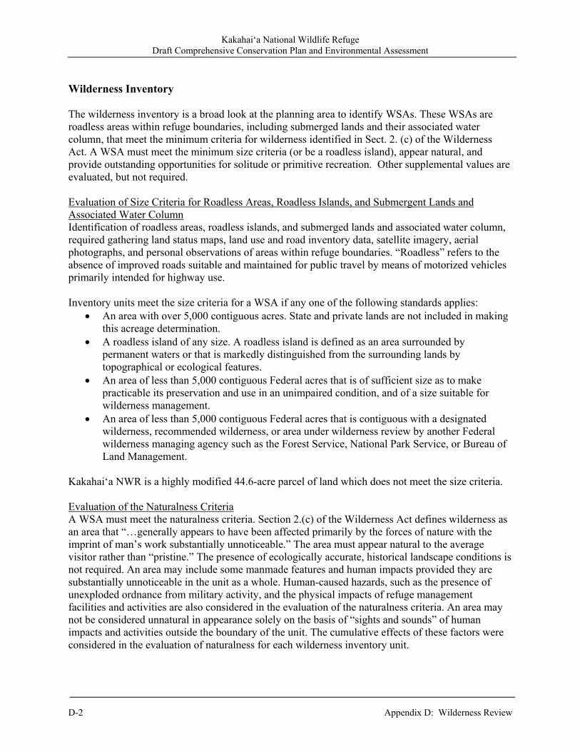
Kakahai‘a National Wildlife Refuge Draft Comprehensive Conservation Plan and Environmental Assessment
D-2 Appendix D: Wilderness Review
Wilderness Inventory The wilderness inventory is a broad look at the planning area to identify WSAs. These WSAs are roadless areas within refuge boundaries, including submerged lands and their associated water column, that meet the minimum criteria for wilderness identified in Sect. 2. (c) of the Wilderness Act. A WSA must meet the minimum size criteria (or be a roadless island), appear natural, and provide outstanding opportunities for solitude or primitive recreation. Other supplemental values are evaluated, but not required. Evaluation of Size Criteria for Roadless Areas, Roadless Islands, and Submergent Lands and Associated Water Column Identification of roadless areas, roadless islands, and submerged lands and associated water column, required gathering land status maps, land use and road inventory data, satellite imagery, aerial photographs, and personal observations of areas within refuge boundaries. “Roadless” refers to the absence of improved roads suitable and maintained for public travel by means of motorized vehicles primarily intended for highway use. Inventory units meet the size criteria for a WSA if any one of the following standards applies:
An area with over 5,000 contiguous acres. State and private lands are not included in making this acreage determination.
A roadless island of any size. A roadless island is defined as an area surrounded by permanent waters or that is markedly distinguished from the surrounding lands by topographical or ecological features.
An area of less than 5,000 contiguous Federal acres that is of sufficient size as to make practicable its preservation and use in an unimpaired condition, and of a size suitable for wilderness management.
An area of less than 5,000 contiguous Federal acres that is contiguous with a designated wilderness, recommended wilderness, or area under wilderness review by another Federal wilderness managing agency such as the Forest Service, National Park Service, or Bureau of Land Management.
Kakahai‘a NWR is a highly modified 44.6-acre parcel of land which does not meet the size criteria. Evaluation of the Naturalness Criteria A WSA must meet the naturalness criteria. Section 2.(c) of the Wilderness Act defines wilderness as an area that “…generally appears to have been affected primarily by the forces of nature with the imprint of man’s work substantially unnoticeable.” The area must appear natural to the average visitor rather than “pristine.” The presence of ecologically accurate, historical landscape conditions is not required. An area may include some manmade features and human impacts provided they are substantially unnoticeable in the unit as a whole. Human-caused hazards, such as the presence of unexploded ordnance from military activity, and the physical impacts of refuge management facilities and activities are also considered in the evaluation of the naturalness criteria. An area may not be considered unnatural in appearance solely on the basis of “sights and sounds” of human impacts and activities outside the boundary of the unit. The cumulative effects of these factors were considered in the evaluation of naturalness for each wilderness inventory unit.
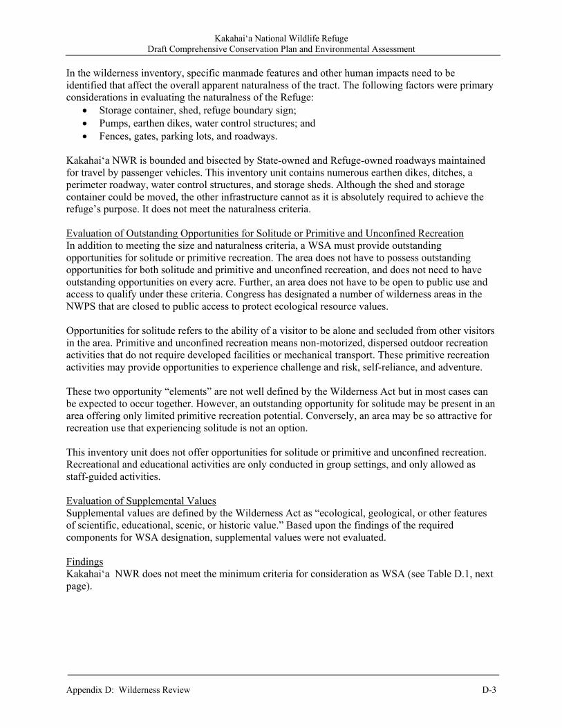
Kakahai‘a National Wildlife Refuge Draft Comprehensive Conservation Plan and Environmental Assessment
Appendix D: Wilderness Review D-3
In the wilderness inventory, specific manmade features and other human impacts need to be identified that affect the overall apparent naturalness of the tract. The following factors were primary considerations in evaluating the naturalness of the Refuge:
Storage container, shed, refuge boundary sign; Pumps, earthen dikes, water control structures; and Fences, gates, parking lots, and roadways.
Kakahai‘a NWR is bounded and bisected by State-owned and Refuge-owned roadways maintained for travel by passenger vehicles. This inventory unit contains numerous earthen dikes, ditches, a perimeter roadway, water control structures, and storage sheds. Although the shed and storage container could be moved, the other infrastructure cannot as it is absolutely required to achieve the refuge’s purpose. It does not meet the naturalness criteria. Evaluation of Outstanding Opportunities for Solitude or Primitive and Unconfined Recreation In addition to meeting the size and naturalness criteria, a WSA must provide outstanding opportunities for solitude or primitive recreation. The area does not have to possess outstanding opportunities for both solitude and primitive and unconfined recreation, and does not need to have outstanding opportunities on every acre. Further, an area does not have to be open to public use and access to qualify under these criteria. Congress has designated a number of wilderness areas in the NWPS that are closed to public access to protect ecological resource values. Opportunities for solitude refers to the ability of a visitor to be alone and secluded from other visitors in the area. Primitive and unconfined recreation means non-motorized, dispersed outdoor recreation activities that do not require developed facilities or mechanical transport. These primitive recreation activities may provide opportunities to experience challenge and risk, self-reliance, and adventure. These two opportunity “elements” are not well defined by the Wilderness Act but in most cases can be expected to occur together. However, an outstanding opportunity for solitude may be present in an area offering only limited primitive recreation potential. Conversely, an area may be so attractive for recreation use that experiencing solitude is not an option. This inventory unit does not offer opportunities for solitude or primitive and unconfined recreation. Recreational and educational activities are only conducted in group settings, and only allowed as staff-guided activities. Evaluation of Supplemental Values Supplemental values are defined by the Wilderness Act as “ecological, geological, or other features of scientific, educational, scenic, or historic value.” Based upon the findings of the required components for WSA designation, supplemental values were not evaluated. Findings Kakahai‘a NWR does not meet the minimum criteria for consideration as WSA (see Table D.1, next page).
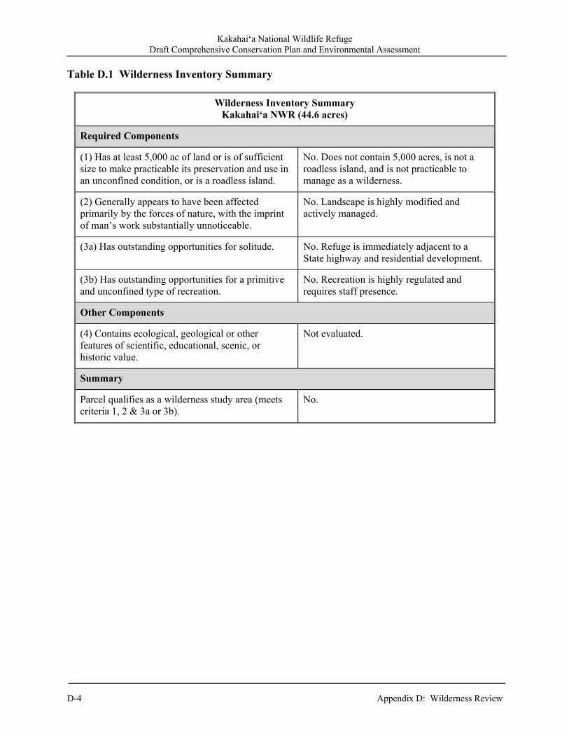
Kakahai‘a National Wildlife Refuge Draft Comprehensive Conservation Plan and Environmental Assessment
D-4 Appendix D: Wilderness Review
Table D.1 Wilderness Inventory Summary
Wilderness Inventory SummaryKakahai‘a NWR (44.6 acres)
Required Components
(1) Has at least 5,000 ac of land or is of sufficient size to make practicable its preservation and use in an unconfined condition, or is a roadless island.
No. Does not contain 5,000 acres, is not a roadless island, and is not practicable to manage as a wilderness.
(2) Generally appears to have been affected primarily by the forces of nature, with the imprint of man’s work substantially unnoticeable.
No. Landscape is highly modified and actively managed.
(3a) Has outstanding opportunities for solitude. No. Refuge is immediately adjacent to a State highway and residential development.
(3b) Has outstanding opportunities for a primitive and unconfined type of recreation.
No. Recreation is highly regulated and requires staff presence.
Other Components
(4) Contains ecological, geological or other features of scientific, educational, scenic, or historic value.
Not evaluated.
Summary
Parcel qualifies as a wilderness study area (meets criteria 1, 2 & 3a or 3b).
No.
Kakahai‘a National Wildlife Refuge Draft Comprehensive Conservation Plan and Environmental Assessment
Appendix E: Integrated Pest Management Program E-1
Appendix E. Integrated Pest Management Program, Kakahai‘a NWR
1.0 Background Integrated Pest Management (IPM) is an interdisciplinary approach utilizing methods to prevent, eliminate, contain, and/or control pest species in concert with other management activities on Refuge lands and waters to achieve wildlife and habitat management goals and objectives. The IPM is also a scientifically based, adaptive management process where available scientific information and best professional judgment of the Refuge staff as well as other resource experts would be used to identify and implement appropriate management strategies that can be modified and/or changed over time to ensure effective, site-specific management of pest species to achieve desired outcomes. In accordance with 43 CFR 46.145, adaptive management would be particularly relevant where long-term impacts may be uncertain and future monitoring would be needed to make adjustments in subsequent implementation decisions. After a tolerable pest population (threshold) is determined considering achievement of Refuge resource objectives and the ecology of pest species, one or more methods, or combinations thereof, are selected that are feasible, efficacious, and most protective of nontarget resources, including native species (fish, wildlife, and plants), and Service personnel, Service authorized agents, volunteers, and the public. Staff time and available funding will be considered when determining feasibility/practicality of various treatments. Our IPM techniques to address pests are presented as CCP strategies prescriptions (see Chapter 2 of this CCP) in an adaptive management context to achieve Refuge resource objectives. In order to satisfy requirements for IPM planning as identified in the Director’s Memo (dated September 9, 2004) entitled Integrated Pest Management Plans and Pesticide Use Proposals: Updates, Guidance, and an Online Database, the following elements of an IPM program have been incorporated into this CCP: Habitat and/or wildlife objectives that identify pest species and appropriate thresholds to indicate
the need for and successful implementation of IPM techniques; and Monitoring before and/or after treatment to assess progress toward achieving objectives including
pest thresholds. Where pesticides would be necessary to address pests, this Appendix provides a structured procedure to evaluate potential effects of proposed uses involving ground-based applications to Refuge biological resources and environmental quality in accordance with effects analyses presented in Chapter 7 (Effects Analysis) of this CCP. Only pesticide uses that likely would cause minor, temporary, or localized effects to Refuge biological resources and environmental quality with appropriate best management practices (BMPs), where necessary, would be allowed for use on the Refuge. This Appendix does not describe the more detailed process to evaluate potential effects associated with aerial applications of pesticides. Moreover, it does not address effects of mosquito control with pesticides (larvicides, pupacides, or adulticides) based upon identified human health threats and presence of disease-carrying mosquitoes in sufficient numbers from monitoring conducted on a Refuge. However, the basic framework to assess potential effects to Refuge biological resources and environmental quality from aerial application of pesticides or use of insecticides for mosquito management would be similar to the process described in this Appendix for ground-based treatments of other pesticides.

Kakahai‘a National Wildlife Refuge Draft Comprehensive Conservation Plan and Environmental Assessment
E-2 Appendix E: Integrated Pest Management Program
2.0 Pest Management Laws and Policies In accordance with 517 DM and 569 FW 1(Integrated Pest Management), plant, invertebrate, and vertebrate pests on units of the National Wildlife Refuge System can be controlled to assure balanced wildlife and fish populations in support of refuge-specific wildlife and habitat management objectives. Pest control on Federal (Refuge) lands and waters also is authorized under the following legal mandates:
National Wildlife Refuge System Administration Act of 1966, as amended (16 USC 668dd-668ee);
Plant Protection Act of 2000 (7 USC 7701 et seq.); Noxious Weed Control and Eradication Act of 2004 (7 USC 7781-7786, Subtitle E); Federal Insecticide, Fungicide, and Rodenticide Act of 1996 (7 USC 136-136y); National Invasive Species Act of 1996 (16 USC 4701); Nonindigenous Aquatic Nuisance Prevention and Control Act of 1990 (16 USC 4701); Food Quality Protection Act of 1996 (7 USC 136); Executive Order 13148, Section 601(a); Executive Order 13112; and Animal Damage Control Act of 1931 (7 USC 426-426c, 46 Stat. 1468). Pests are defined as “…living organisms that may interfere with the site-specific purposes, operations, or management objectives or that jeopardize human health or safety” from Department policy 517 DM 1 (Integrated Pest Management Policy). Similarly, 569 FW 1 defines pests as “…invasive plants and introduced or native organisms that may interfere with achieving our management goals and objectives on or off our lands, or that jeopardize human health or safety.” 517 DM 1 also defines an invasive species as “a species that is nonnative to the ecosystem under consideration and whose introduction causes or is likely to cause economic or environmental harm or harm to human health.” Throughout the remainder of this CCP, the terms pest and invasive species are used interchangeably because both can prevent/impede achievement of Refuge wildlife and habitat objectives and/or degrade environmental quality. In general, control of pests (vertebrate or invertebrate) on the Refuge would conserve and protect the nation’s fish, wildlife, and plant resources as well as maintain environmental quality. From 569 FW 1, animal or plant species, which are considered pests, may be managed if the following criteria are met: Threat to human health and well-being or private property, the acceptable level of damage by the
pest has been exceeded, or State or local government has designated the pest as noxious; Detrimental to resource objectives as specified in a Refuge resource management plan (e.g.,
comprehensive conservation plan, habitat management plan), if available; and Control would not conflict with attainment of resource objectives or the purposes for which the
Refuge was established. The specific justifications for pest management activities on the Refuge are the following: Protect human health and well-being; Prevent substantial damage to important to Refuge resources; Protect newly introduced or re-establish native species; Control nonnative (exotic) species in order to support existence for populations of native species;
Kakahai‘a National Wildlife Refuge Draft Comprehensive Conservation Plan and Environmental Assessment
Appendix E: Integrated Pest Management Program E-3
Prevent damage to private property; and Provide the public with quality, compatible wildlife-dependent recreational opportunities. In accordance with Service policy 620 FW 1 (Habitat Management Plans), there are additional management directives regarding invasive species found on the Refuge: “We are prohibited by Executive Order, law, and policy from authorizing, funding, or carrying
out actions that are likely to cause or promote the introduction or spread of invasive species in the United States or elsewhere.”
“Manage invasive species to improve or stabilize biotic communities to minimize unacceptable change to ecosystem structure and function and prevent new and expanded infestations of invasive species. Conduct Refuge habitat management activities to prevent, control, or eradicate invasive species...”
Animal species damaging/destroying Federal property and/or detrimental to the management program of a Refuge may be controlled as described in 50 CFR 31.14 (Official Animal Control Operations). Trespass and feral animals also may be controlled on Refuge lands. Based upon 50 CFR 28.43 (Destruction of Dogs and Cats), dogs and cats running at large on a national wildlife refuge and observed in the act of killing, injuring, harassing or molesting humans or wildlife may be disposed of in the interest of public safety and protection of the wildlife. Feral animals should be disposed by the most humane method(s) available and in accordance with relevant Service directives (including Executive Order 11643). Disposed wildlife specimens may be donated or loaned to public institutions. Donation or loans of resident wildlife species will only be made after securing State approval (50 CFR 30.11 [Donation and Loan of Wildlife Specimens]). Surplus wildlife specimens may be sold alive or butchered, dressed and processed subject to Federal and State laws and regulations (50 CFR 30.12 [Sale of Wildlife Specimens]). 3.0 Strategies To fully embrace IPM as identified in 569 FW 1, the following strategies, where applicable, would be carefully considered on the Refuge for each pest species:
Prevention. This would be the most effective and least expensive long-term management option for pests. It encompasses methods to prevent new introductions or the spread of the established pests to un-infested areas. It requires identifying potential routes of invasion to reduce the likelihood of infestation. Hazard Analysis and Critical Control Points (HACCP) planning can be used determine if current management activities on a Refuge may introduce and/or spread invasive species in order to identify appropriate BMPs for prevention. Prevention may include source reduction, using pathogen-free or weed-free seeds or fill; exclusion methods (e.g., barriers) and/or sanitation methods (e.g., wash stations) to prevent re-introductions by various mechanisms including vehicles and personnel. Because invasive species are frequently the first to establish newly disturbed sites, prevention would require a reporting mechanism for early detection of new pest occurrences with quick response to eliminate any new satellite pest populations. Prevention would require consideration of the scale and scope of land management activities that may promote pest establishment within un-infested areas or promote reproduction and spread of existing populations. Along with preventing initial introduction,

Kakahai‘a National Wildlife Refuge Draft Comprehensive Conservation Plan and Environmental Assessment
E-4 Appendix E: Integrated Pest Management Program
prevention would involve halting the spread of existing infestations to new sites (Mullin et al. 2000). The primary reason of prevention would be to keep pest-free lands or waters from becoming infested. Executive Order 11312 emphasizes the priority for prevention with respect to managing pests. The following would be methods to prevent the introduction and/or spread of pests on Refuge lands:
Before beginning ground-disturbing activities (e.g., disking, scraping), inventory and prioritize pest infestations in project operating areas and along access routes. Refuge staff would identify pest species on site or within reasonably expected potential invasion vicinity. Where possible, Refuge staff would begin project activities in un-infested areas before working in pest-infested areas.
Refuge staff would locate and use pest-free project staging areas. They would avoid or minimize travel through pest-infested areas, or restrict to those periods when spread of seed or propagules of invasive plants would be least likely.
Refuge staff would determine the need for, and when appropriate, identify sanitation sites where equipment can be cleaned of pests. Where possible, Refuge staff would clean equipment before entering lands at on-Refuge approved cleaning site(s). This practice does not pertain to vehicles traveling frequently in and out of the project area that will remain on roadways. Seeds and plant parts of pest plants would need to be collected, where practical. Refuge staff would remove mud, dirt, and plant parts from project equipment before moving it into a project area.
Refuge staff would clean all equipment, before leaving the project site, if operating in areas infested with pests. Refuge staff would determine the need for, and when appropriate, identify sanitation sites where equipment can be cleaned.
Refuge staffs, their authorized agents, and Refuge volunteers would, where possible, inspect, remove, and properly dispose of seed and parts of invasive plants found on their clothing and equipment. Proper disposal means bagging the seeds and plant parts and then properly discarding of them (e.g., incinerating).
Refuge staff would evaluate options, including closure, to restrict the traffic on sites with on-going restoration of desired vegetation. Refuge staff would revegetate disturbed soil (except travel ways on surfaced projects) to optimize plant establishment for each specific site. Revegetation may include topsoil replacement, planting, seeding, fertilization, liming, and weed-free mulching as necessary. Refuge staff would use native material, where appropriate and feasible. Refuge staff would use certified weed-free or weed-seed-free hay or straw where certified materials are reasonably available.
Refuge staff would provide information, training and appropriate pest identification materials to Refuge staffs, permit holders, and recreational visitors. Refuge staff would educate them about pest identification, biology, impacts, and effective prevention measures.
Refuge staff would inspect borrow material for invasive plants prior to use and transport onto and/or within Refuge lands.
Refuge staff would consider invasive plants in planning for road maintenance activities. Refuge staff would restrict off road travel to designated routes.
Kakahai‘a National Wildlife Refuge Draft Comprehensive Conservation Plan and Environmental Assessment
Appendix E: Integrated Pest Management Program E-5
The following would be methods to prevent the introduction and/or spread of pests into Refuge waters:
Refuge staff would inspect boats (including air boats), trailers, and other boating equipment and, where possible, remove any visible plants, animals, or mud before leaving any waters or boat launching facilities. Where possible, staff would drain water from motor, live well, bilge, and transom wells while on land before leaving the site.
If possible, Refuge staff would wash and dry boats, downriggers, anchors, nets, floors of boats, propellers, axles, trailers, and other boating equipment to kill pests not visible at the boat launch. These prevention methods to minimize/eliminate the introduction and/or spread of pests were taken verbatim or slightly modified from Appendix E of US Forest Service (2005).
Mechanical/Physical Methods. These methods would remove and destroy, disrupt the growth
of, or interfere with the reproduction of pest species. For plants species, these treatments can be accomplished by hand, hand tool (manual), or power tools (mechanical) and include pulling, grubbing, digging, tilling/disking, cutting, swathing, grinding, sheering, girdling, mowing, and mulching of the pest plants.
For animal species, Service employees or their authorized agents could use mechanical/physical methods (including trapping) to control pests as a refuge management activity. Based upon 50 CFR 31.2, trapping can be used on a refuge to reduce surplus wildlife populations for a “balanced conservation program” in accordance with Federal or State laws and regulations. In some cases, nonlethally trapped animals would be relocated to off-refuge sites with prior approval from the State.
Each of these tools would be efficacious to some degree and applicable to specific situations. In general, mechanical controls can effectively control annual and biennial pest plants. However, to control perennial plants, the root system has to be destroyed or it would resprout and continue to grow and develop. Mechanical controls are typically not capable of destroying a perennial plants root system. Although some mechanical tools (e.g., disking, plowing) may damage root systems, they may stimulate regrowth producing a denser plant population that may aid in the spread depending upon the target species. In addition, steep terrain and soil conditions would be major factors that can limit the use of many mechanical control methods. Some mechanical control methods (e.g., mowing), which would be used in combination with herbicides, can be a very effective technique to control perennial species. For example, mowing perennial plants followed sequentially by treating the plant regrowth with a systemic herbicide often would improve the efficacy of the herbicide compared to herbicide treatment only.
Cultural Methods. These methods would involve manipulating habitat to increase pest
mortality by reducing its suitability to the pest. Cultural methods would include water-level manipulation, , prescribed burning (facilitate revegetation, increase herbicide efficacy, and remove litter to assist in emergence of desirable species), planting or seeding desirable species to shade or out-compete invasive plants, applying fertilizer to enhance desirable vegetation, irrigation, and other habitat alterations.
Biological Control Agents. Classical biological control would involve the deliberate
introduction and management of natural enemies (parasites, predators, or pathogens) to reduce
Kakahai‘a National Wildlife Refuge Draft Comprehensive Conservation Plan and Environmental Assessment
E-6 Appendix E: Integrated Pest Management Program
pest populations. Many of the most ecologically or economically damaging pest species in the United States originated in foreign countries. These newly introduced pests, which are free from natural enemies found in their country or region of origin, may have a competitive advantage over cultivated and native species. This competitive advantage often allows introduced species to flourish, and they may cause widespread economic damage to crops or out compete and displace native vegetation. Once the introduced pest species population reaches a certain level, traditional methods of pest management may be cost prohibitive or impractical. Biological controls typically are used when these pest populations have become so widespread that eradication or effective control would be difficult or no longer practical.
Biological control has advantages as well as disadvantages. Benefits would include reducing pesticide usage, host specificity for target pests, long-term self-perpetuating control, low cost/acre, capacity for searching and locating hosts, synchronizing biological control agents to hosts’ life cycles, and the unlikelihood that hosts will develop resistance to agents. Disadvantages would include the following: limited availability of agents from their native lands, the dependence of control on target species density, slow rate at which control occurs, biotype matching, the difficulty and expense of conflicts over control of the target pest, and host specificity when host populations are low. A reduction in target species populations from biological controls is typically a slow process, and efficacy can be highly variable. It may not work well in a particular area although it does work well in other areas. Biological control agents would require specific environmental conditions to survive over time. Some of these conditions are understood; whereas, others are only partially understood or not at all. Biological control agents would not eradicate a target pest. When using biological control agents, residual levels of the target pest typically are expected; the agent population level or survival would be dependent upon the density of its host. After the pest population decreases, the population of the biological control agent would decrease correspondingly. This is a natural cycle. Some pest populations (e.g., invasive plants) would tend to persist for several years after a biological control agent becomes established due to seed reserves in the soil, inefficiencies in the agents search behavior, and the natural lag in population buildup of the agent.
The full range of pest groups potentially found on refuge lands and waters would include diseases, invertebrates (insects, mollusks), vertebrates and invasive plants (most common group). Often it is assumed that biological control would address many if not most of these pest problems. Introduced species without desirable close relatives in the United States would generally be selected as biological controls. Natural enemies that are restricted to one or a few closely related plants in their country of origin are targeted as biological controls (Center et al. 1997, Hasan and Ayres 1990).
The Hawai‘i Department of Agriculture (HDOA) has a highly successful bio-control program for the erythrina gall wasp which has resulted in the rebounding of the native wiliwili trees. In June 2010, HDOA began another biological control program that releases a tiny parasitic insect to control the stinging Nettle Caterpillar. The release of Brazilian scale to slow the growth rate and spread of strawberry guava has recently been proposed to give Hawai‘i’s native plants a chance for survival, protect the ability of the forests to provide water, and provide better protection for agricultural crops from the fruit flies that breed in the overabundance of strawberry guava fruit.

Kakahai‘a National Wildlife Refuge Draft Comprehensive Conservation Plan and Environmental Assessment
Appendix E: Integrated Pest Management Program E-7
Due to the success of Hawai‘i’s biocontrol programs, the State has become a leader in the world on the use of biological control to fight invasive pests.
Refuge staff would ensure introduced agents are approved by the applicable authorities. Except for a small number of formulated biological control products registered by EPA under FIFRA, most biological control agents are regulated by the U.S. Department of Agriculture (USDA)-Animal Plant Health Inspection Service, Plant Protection and Quarantine (APHIS-PPQ). State departments of agriculture and, in some cases, county agricultural commissioners or weed districts, have additional approval authority. Federal permits (USDA-APHIS-PPQ Form 526) are required to import biocontrol agents from another State. Form 526 may be obtained by writing: USDA-APHIS-PPQ Biological Assessment and Taxonomic Support 4700 River Road, Unit 113 Riverdale, MD 20737 or
through the internet at URL address: http://www.aphis.usda.gov/ppq/permits/bioligical/weedbio.html.
The Service strongly supports the development, and legal and responsible use of appropriate, safe, and effective biological control agents for nuisance and nonindigenous or pest species.
State and county agriculture departments may also be sources for biological control agents or they may have information about where biological control agents may be obtained. Commercial sources should have an Application and Permit to Move Live Plant Pests and Noxious Weeds (USDA-PPQ Form 226 USDA-APHIS-PPQ, Biological Assessment and Taxonomic Support, 4700 River Road, Unit 113, Riverdale, MD 20737) to release specific biological control agents in a State and/or county. Furthermore, certification regarding the biological control agent’s identity (genus, specific epithet, sub-species and variety) and purity (e.g., parasite free, pathogen free, and biotic and abiotic contaminants) should be specified in purchase orders. Biological control agents are subject to 569 FW 1. In addition, Refuge staff would follow the International Code of Best Practice for Classical Biological Control of Weeds (http://sric.ucdavis.edu/exotic /exotic.htm) as ratified by delegates to the X International Symposium on Biological Control of Weeds, Bozeman, MT, July 9, 1999. This code identifies the following:
Release only approved biological control agents, Use the most effective agents, Document releases, and Monitor for impact to the target pest, nontarget species and the environment.
Biological control agents formulated as pesticide products and registered by the EPA (e.g., Bti) are also subject to PUP review and approval (see below). A record of all releases would be maintained with date(s), location(s), and environmental conditions of the release site(s); the identity, quantity, and condition of the biological control

Kakahai‘a National Wildlife Refuge Draft Comprehensive Conservation Plan and Environmental Assessment
E-8 Appendix E: Integrated Pest Management Program
agents released; and other relevant data and comments such as weather conditions. Systematic monitoring to determine the establishment and effectiveness of the release is also recommended. NEPA documents regarding biological and other environmental effects of biological control agents prepared by another Federal agency, where the scope is relevant to evaluation of releases on Refuge lands, would be reviewed. Possible source agencies for such NEPA documents include the Bureau of Land Management (BLM), U.S. Forest Service, National Park Service, U.S. Department of Agriculture-Animal and Plant Health Inspection Service, and the military services. It might be appropriate to incorporate by reference parts or all of existing document(s) from the review. Incorporating by reference (43 CFR 46.135) is a technique used to avoid redundancies in analysis. It also can reduce the bulk of a Service NEPA document, which only must identify the documents that are incorporated by reference. In addition, relevant portions must be summarized in the Service NEPA document to the extent necessary to provide the decision maker and public with an understanding of relevance of the referenced material to the current analysis.
Pesticides. The selective use of pesticides would be based upon pest ecology (including mode of reproduction), the size and distribution of its populations, site-specific conditions (e.g., soils, topography), known efficacy under similar site conditions, and the capability to utilize BMPs to reduce/eliminate potential effects to nontarget species, sensitive habitats, and potential to contaminate surface and groundwater. All pesticide usage (pesticide, target species, application rate, and method of application) would comply with the applicable Federal (FIFRA) and State regulations pertaining to pesticide use, safety, storage, disposal, and reporting. Before pesticides can be used to eradicate, control, or contain pests on Refuge lands and waters, pesticide use proposals (PUPs) would be prepared and approved in accordance with 569 FW 1. PUP records would provide a detailed, time-, site-, and target-specific description of the proposed use of pesticides on Refuge. All PUPs would be created, approved or disapproved, and stored in the Pesticide Use Proposal System (PUPS), which is a centralized database only accessible on the Service’s intranet (https://systems.fws.gov/pups). Only Service employees would be authorized to access PUP records for a Refuge in this database. Application equipment would be selected to provide site-specific delivery to target pests while minimizing/eliminating direct or indirect (e.g., drift) exposure to nontarget areas and degradation of surface and groundwater quality. Where possible, target-specific equipment (e.g., backpack sprayer, wiper) would be used to treat target pests. Other target-specific equipment to apply pesticides would include soaked wicks or paint brushes for wiping vegetation and lances, hatchets, or syringes for direct injection into stems. Granular pesticides may be applied using seeders or other specialized dispensers. In contrast, aerial spraying (e.g., fixed wing or helicopter) would only be used where access is difficult (remoteness) and/or the size/distribution of infestations precludes practical use of ground-based methods.
Because repeated use of one pesticide may allow resistant organisms to survive and reproduce, multiple pesticides with variable modes of action would be considered for treatments on Refuge lands and waters. This is especially important if multiple applications within years and/or over a growing season likely would be necessary for habitat maintenance and restoration activities to achieve resource objectives. Integrated chemical and nonchemical controls also are highly effective, where practical, because pesticide resistant organisms can be removed from the site.
Kakahai‘a National Wildlife Refuge Draft Comprehensive Conservation Plan and Environmental Assessment
Appendix E: Integrated Pest Management Program E-9
Cost may not be the primary factor in selecting a pesticide for use on the Refuge. If the least expensive pesticide would potentially harm natural resources or people, then a different product would be selected, if available. The most efficacious pesticide available with the least potential to degrade environment quality (soils, surface water, and groundwater) as well as least potential effect to native species and communities of fish, wildlife, plants, and their habitats would be acceptable for use on Refuge lands in the context of an IPM approach.
Habitat restoration/maintenance. Restoration and/or proper maintenance of Refuge habitats associated with achieving wildlife and habitat objectives would be essential for long-term prevention, eradication, or control (at or below threshold levels) of pests. Promoting desirable plant communities through the manipulation of species composition, plant density, and growth rate is an essential component of invasive plant management (Masters et al. 1996, Masters and Shelly 2001, Brooks et al. 2004). The following three components of succession could be manipulated through habitat maintenance and restoration: site availability, species availability, and species performance (Cox and Anderson 2004). Although a single method (e.g., herbicide treatment) may eliminate or suppress pest species in the short term, the resulting gaps and bare soil create niches that are conducive to further invasion by the species and/or other invasive plants. On degraded sites where desirable species are absent or in low abundance, revegetation with native/desirable grasses, forbs, and legumes may be necessary to direct and accelerate plant community recovery, and achieve site-specific objectives in a reasonable time frame. The selection of appropriate species for revegetation would be dependent on a number of factors including resource objectives and site-specific, abiotic factors (e.g., soil texture, precipitation/temperature regimes, and shade conditions). Seed availability and cost, ease of establishment, seed production, and competitive ability also would be important considerations.
Predator Control. The predator management plan for Kakahai‘a NWR is implemented to reduce depredation of endangered waterbirds. Control measures would include indirect, non-lethal and lethal techniques in addition to prevention and direct control measures that would have minimal effects on the human environment.
Indirect Measures at Kakahai‘a NWR will include installation of a perimeter predator proof fence (Alternative C). In the absence of this fence, dense vegetation will remain to discourage visitors from disturbing endangered waterbirds and nesting areas will be temporarily closed to access. Cattle egret roost trees will be mechanically removed or treated with herbicides. Most cats and dogs will be removed by cage traps and transported to an animal shelter. Other predators (mongooses, rats) would be controlled by cage traps or humane lethal means. Control measures will minimize loss of non-target native wildlife. Except for nuisance alien species, all uninjured non-target species captured will be released near the site of capture or at a suitable location at the discretion of Refuge staff.
Most of Kakahai‘a NWR is closed to the public and posted. In public access areas (Kakahai‘a Beach Park), rodenticides would be placed in tamper-resistant bait boxes and the area signed. Egret control by firearms will occur when the Refuge is closed to the public. Direct Measures include a range of predator management equipment and methods . The preferred control method will be cage traps for dogs and cats. Mongooses and rodents will be controlled by a combination of cage traps, lethal traps, and rodenticides. Direct control of cattle
Kakahai‘a National Wildlife Refuge Draft Comprehensive Conservation Plan and Environmental Assessment
E-10 Appendix E: Integrated Pest Management Program
egrets would be with firearms. In rare instances, a Timms™ kill trap (a type of snap trap) or padded leghold trap would be used on cats that avoid cage traps. All cage traps will be checked every 48 hours or less. Except for continuous trapping (year-round) near the HQ/VC, trapping will occur seasonally just prior to the ae‘o nesting season through the end of the breeding/chick rearing period (April-September). Spot trapping may occur when signs of depredation of endangered species are observed outside the nesting season. Predator monitoring will occur throughout the year by direct observations, tracks, tracking tunnels, and trail cameras. Cage trapped dogs and cats will be transported to a local animal shelter. Any cage trapped birds will be released at the trap site. Live trapped mongooses will the euthanized using approved humane methods.
4.0 Priorities for Treatments The magnitude (number, distribution, and sizes of infestations) for pest problems is too extensive and beyond the available capital resources to effectively address during any single field season. To manage pests in Refuge, it would be essential to prioritize treatment of infestations. Highest priority treatments would be focused on early detection and rapid response to eliminate infestations of new pests, if possible. This would be especially important for aggressive pests potentially impacting species, species groups, communities, and/or habitats associated Refuge purpose(s), System resources of concern (federally listed species, migratory birds, selected marine mammals, and interjurisdictional fish), and native species for maintaining/restoring biological integrity, diversity, and environmental health. The next priority would be treating established pests that appear in one or more previously uninfested areas. Moody and Mack (1988) demonstrated through modeling that small, new outbreaks of invasive plants eventually would infest an area larger than the established, source population. They also found that control efforts focusing on the large, main infestation rather than the new, small satellites reduced the chances of overall success. The lowest priority would be treating large infestations (sometimes monotypic stands) of well-established pests. In this case, initial efforts would focus upon containment of the perimeter followed by work to control/eradicate the established infested area. If containment and/or control of a large infestation is not effective, then efforts would focus upon halting pest reproduction or managing source populations. Maxwell et al. (2009) found treating fewer populations that are sources represents an effective long-term strategy to reduce of total number of invasive populations and decreasing meta-population growth rates. Although State listed noxious weeds would always of high priority for management, other pest species known to cause substantial ecological impact would also be considered. For example, short-spined kiawe may not be listed by a State as noxious, but it can greatly alter fire regimes in the coastal dryland shrub habitat resulting in large monotypic stands that displace native bunch grasses, forbs, and shrubs. Pest control would likely require a multi-year commitment from Refuge staff. Essential to the long-term success of pest management would be pre- and post-treatment monitoring, assessment of the successes and failures of treatments, and development of new approaches when proposed methods do not achieve desired outcomes. 5.0 Best Management Practices (BMPs) Best Management Practices can minimize or eliminate possible effects associated with pesticide usage to nontarget species and/or sensitive habitats as well as degradation of water quality from drift, surface runoff, or leaching. Based upon the Department of the Interior Pesticide Use Policy (517 DM 1) and the Service Pest Management Policy and Responsibilities (30 AM 12), the use of
Kakahai‘a National Wildlife Refuge Draft Comprehensive Conservation Plan and Environmental Assessment
Appendix E: Integrated Pest Management Program E-11
applicable BMPs (where feasible) also would likely ensure that pesticide uses may not adversely affect federally listed species and/or their critical habitats through determinations made using the process described in 50 CFR part 402. The following are BMPs pertaining to mixing/handling and applying pesticides for all ground-based treatments of pesticides, which would be considered and utilized, where feasible, based upon target- and site-specific factors and time-specific environmental conditions. Although not listed below, the most important BMP to eliminate/reduce potential impacts to nontarget resources would be an IPM approach to prevent, control, eradicate, and contain pests. 5.1 Pesticide Handling and Mixing As a precaution against spilling, spray tanks would not be left unattended during filling. All pesticide containers would be triple rinsed and the rinsate would be used as water in the
sprayer tank and applied to treatment areas. All pesticide spray equipment would be properly cleaned. Where possible, rinsate would be used
as part of the make-up water in the sprayer tank and applied to treatment areas. Refuge staff would empty, triple rinsed pesticide containers that can be recycled at local
herbicide container collections. All unused pesticides would be properly discarded at a local “safe send” collection. Pesticides and pesticide containers would be lawfully stored, handled, and disposed of in
accordance with the label and in a manner safeguarding human health, fish, and wildlife and prevent soil and water contaminanation.
Refuge staff would consider the water quality parameters (e.g., pH, hardness) that are important to ensure greatest efficacy where specified on the pesticide label.
All pesticide spills would be addressed immediately using procedures identified in Refuge spill respond plan.
5.2 Applying Pesticides Pesticide treatments would only be conducted by or under the supervision of Service personnel
and non-Service applicators with the appropriate, State or BLM certification to safely and effectively conduct these activities on Refuge lands and waters.
Refuge staff would comply with all Federal, State, and local pesticide use laws and regulations as well as Service pesticide-related policies. For example, Refuge staff would use application equipment and apply rates for the specific pest(s) identified on the pesticide label as required under FIFRA.
Before each treatment season and prior to mixing or applying any product for the first time each season, all applicators would review the labels, MSDSs, and Pesticide Use Proposal (PUPs) for each pesticide, determining the target pest, appropriate mix rate(s), PPE, and other requirements listed on the pesticide label.
A 1’ no-spray buffer from the water’s edge would be used, where applicable, and it does not detrimentally influence effective control of pest species.
Use low impact herbicide application techniques (e.g., spot treatment, cut stump, oil basal, Thinvert system applications) rather than broadcast foliar applications (e.g., boom sprayer, other larger tank wand applications), where practical.
Use low volume rather than high volume foliar applications where low impact methods above are not feasible or practical, to maximize herbicide effectiveness and ensure correct and uniform application rates.
Applicators would use and adjust spray equipment to apply the coarsest droplet size spectrum

Kakahai‘a National Wildlife Refuge Draft Comprehensive Conservation Plan and Environmental Assessment
E-12 Appendix E: Integrated Pest Management Program
with optimal coverage of the target species while reducing drift. Applicators would use the largest droplet size that results in uniform coverage. Applicators would use drift reduction technologies such as low-drift nozzles, where possible. Where possible, spraying would occur during low (average<7mph and preferably 3-5 mph) and
consistent direction wind conditions with moderate temperatures (typically <85 oF). Where possible, applicators would avoid spraying during inversion conditions (often associated
with calm and very low wind conditions) that can cause large-scale herbicide drift to nontarget areas.
Equipment would be calibrated regularly to ensure that the proper rate of pesticide is applied to the target area or species.
Spray applications would be made at the lowest height for uniform coverage of target pests to minimize/eliminate potential drift.
If windy conditions frequently occur during afternoons, spraying (especially boom treatments) would typically be conducted during early morning hours.
Spray applications would not be conducted on days with >30% forecast for rain within 6 hours, except for pesticides that are rapidly rain fast (e.g., glyphosate in 1 hour) to minimize/eliminate potential runoff.
Where possible, applicators would use drift retardant adjuvants during spray applications, especially adjacent to sensitive areas.
Where possible, applicators would use a nontoxic dye to aid in identifying target area treated as well as potential over spray or drift. A dye can also aid in detecting equipment leaks. If a leak is discovered, the application would be stopped until repairs can be made to the sprayer.
For pesticide uses associated with facilities management, buffers, as appropriate, would be used to protect sensitive habitats, especially wetlands and other aquatic habitats.
When drift cannot be sufficiently reduced through altering equipment set up and application techniques, buffer zones may be identified to protect sensitive areas downwind of applications. Refuge staff would only apply adjacent to sensitive areas when the wind is blowing the opposite direction.
Applicators would utilize scouting for early detection of pests to eliminate unnecessary pesticide applications.
Refuge staff would consider timing of application so native plants are protected (e.g., senescence) while effectively treating invasive plants.
Rinsate from cleaning spray equipment after application would be recaptured and reused or applied to an appropriate pest plant infestation.
Application equipment (e.g., sprayer, ATV, tractor) would be thoroughly cleaned and PPE would be removed/disposed of on-site by applicators after treatments to eliminate the potential spread of pests to un-infested areas.
6.0 Safety 6.1 Personal Protective Equipment All applicators would wear the specific personal protective equipment (PPE) identified on the pesticide label. The appropriate PPE will be worn at all times during handling, mixing, and applying. PPE can include the following: disposable (e.g., Tyvek) or laundered coveralls; gloves (latex, rubber, or nitrile); rubber boots; and/or an NIOSH-approved respirator. Because exposure to concentrated product is usually greatest during mixing, extra care should be taken while preparing pesticide solutions. Persons mixing these solutions can be best protected if they wear long gloves, an
Kakahai‘a National Wildlife Refuge Draft Comprehensive Conservation Plan and Environmental Assessment
Appendix E: Integrated Pest Management Program E-13
apron, footwear, and a face shield. Coveralls and other protective clothing used during an application would be laundered separately from other laundry items. Transporting, storing, handling, mixing and disposing of pesticide containers will be consistent with label requirements, EPA and OSHA requirements, and Service policy. If a respirator is necessary for a pesticide use, then the following requirements would be met in accordance with Service safety policy: a written Respirator Program, fit testing, physical examination (including pulmonary function and blood work for contaminants), and proper storage of the respirator. 6.2 Notification The restricted entry interval (REI) is the time period required after the application at which point someone may safely enter a treated area without PPE. Refuge staff, authorized management agents of the Service, volunteers, and members of the public who could be in or near a pesticide treated area within the stated re-entry time period on the label would be notified about treatment areas. Posting would occur at any site where individuals might inadvertently become exposed to a pesticide during other activities on the Refuge. Where required by the label and/or State-specific regulations, sites would also be posted on its perimeter and at other likely locations of entry. Refuge staff would also notify appropriate private property owners of an intended application, including any private individuals have requested notification. Special efforts would be made to contact nearby individuals who are beekeepers or who have expressed chemical sensitivities. 6.3 Medical Surveillance Medical surveillance may be required for Service personnel and approved volunteers who mix, apply, and/or monitor use of pesticides (see 242 FW 7 [Pesticide Users] and 242 FW 4 [Medical Surveillance]). In accordance with 242 FW 7.12A, Service personnel would be medically monitoring if 1 or more of the following criteria is met: exposed or may be exposed to concentrations at or above the published permissible exposure limits or threshold limit values (see 242 FW 4); use pesticides in a manner considered “frequent pesticide use”; or use pesticides in a manner that requires a respirator (see 242 FW 14 for respirator use requirements). In 242 FW7.7A, “Frequent Pesticide Use” means when a person applying pesticide handles, mixes, or applies pesticides, with a Health Hazard rating of 3 or higher, for 8 or more hours in any week or 16 or more hours in any 30-day period.” Under some circumstances, individuals may be medically monitored who use pesticides infrequently (see section 7.7), experience an acute exposure (sudden, short term), or use pesticides with a health hazard ranking of 1 or 2. This decision would consider the individual’s health and fitness level, the pesticide’s specific health risks, and the potential risks from other pesticide-related activities. Refuge cooperators and other authorized agents (e.g., State and County employees) would be responsible for their own medical monitoring needs and costs. Standard examinations (at Refuge expense) of appropriate Refuge staff would be provided by the nearest certified occupational health and safety physician as determined by Federal Occupational Health. 6.4 Certification and Supervision of Pesticide Applicators Appropriate Refuge staff or approved volunteers handling, mixing, and/or applying or directly supervising others engaged in pesticide use activities would be trained and State or federally licensed
Kakahai‘a National Wildlife Refuge Draft Comprehensive Conservation Plan and Environmental Assessment
E-14 Appendix E: Integrated Pest Management Program
to apply pesticides to Refuge lands or waters. In accordance with 242 FW7.18A and 569 FW 1, certification is required to apply restricted use pesticides based upon EPA regulations. For safety reasons, all individuals participating in pest management activities with general use pesticides also are encouraged to attend appropriate training or acquire pesticide applicator certification. The certification requirement would be for a commercial or private applicator depending upon the State. New staff unfamiliar with proper procedures for storing, mixing, handling, applying, and disposing of herbicides and containers would receive orientation and training before handling or using any products. Documentation of training would be kept in the files at the Refuge office. 6.5 Record Keeping 6.5.1 Labels and material safety data sheets Pesticide labels and material safety data sheets (MSDSs) would be maintained at the Refuge shop and laminated copies in the mixing area. These documents also would be carried by field applicators, where possible. A written reference (e.g., note pad, chalk board, dry erase board) for each tank to be mixed would be kept in the mixing area for quick reference while mixing is in progress. In addition, approved PUPs stored in the PUPS database typically contain website links (URLs) to pesticide labels and MSDSs. 6.5.2 Pesticide use proposals (PUPs) A PUP would be prepared for each proposed pesticide use associated with annual pest management on Refuge lands and waters. A PUP would include specific information about the proposed pesticide use including the common and chemical names of the pesticide(s), target pest species, size and location of treatment site(s), application rate(s) and method(s), and federally listed species determinations, where applicable. In accordance with 30 AM 12 and 7 RM 14, PUPs would be required for the following: Uses of pesticides on lands and facilities owned or managed by the Service, including properties
managed by Service personnel as a result of the Food Security Act of 1985; Service projects by non-Service personnel on Service owned or controlled lands and facilities and
other pest management activities that would be conducted by Service personnel; and Where the Service would be responsible or provides funds for pest management identified in
protective covenants, easements, contracts, or agreements off Service lands. In accordance with Service guidelines (Director’s memo [December 12, 2007]), Refuge staff may receive up to 5-year approvals for Washington Office and field reviewed proposed pesticide uses based upon meeting identified criteria including an approved IPM plan, where necessary (see http://www.fws.gov/contaminants/Issues/IPM.cfm). For a refuge, an IPM plan (requirements described herein) can be completed independently or in association with a CCP or HMP if IPM strategies and potential environmental effects are adequately addressed within appropriate NEPA documentation. PUPs would be created, approved or disapproved, and stored as records in the Pesticide Use Proposal System (PUPS), which is centralized database on the Service’s intranet (https://systems.fws.gov/pups). Only Service employees can access PUP records in this database.
Kakahai‘a National Wildlife Refuge Draft Comprehensive Conservation Plan and Environmental Assessment
Appendix E: Integrated Pest Management Program E-15
6.5.3 Pesticide usage In accordance with 569 FW 1, the Refuge Project Leader would be required to maintain records of all pesticides annually applied on lands or waters under Refuge jurisdiction. This would encompass pesticides applied by other Federal agencies, State and county governments, nongovernment applicators including cooperators and their pest management service providers with Service permission. For clarification, pesticide means all insecticides, insect and plant growth regulators, dessicants, herbicides, fungicides, rodenticides, acaricides, nematicides, fumigants, avicides, and piscicides. The following usage information can be reported for approved PUPs in the PUPS database: Pesticide trade name(s) Active ingredient(s) Total acres treated Total amount of pesticides used (lbs or gallons) Total amount of active ingredient(s) used (lbs) Target pest(s) Efficacy (% control) To determine whether treatments are efficacious (eradicating, controlling, or containing the target pest) and achieving resource objectives, habitat and/or wildlife response would be monitored both pre- and post-treatment, where possible. Considering available annual funding and staffing, appropriate monitoring data regarding characteristics (attributes) of pest infestations (e.g., area, perimeter, degree of infestation-density, % cover, density) as well as habitat and/or wildlife response to treatments may be collected and stored in a relational database (e.g., Refuge Habitat Management Database), preferably a geo-referenced data management system (e.g., Refuge Lands GIS [RLGIS]) to facilitate data analyses and subsequent reporting. In accordance with adaptive management, data analysis and interpretation would allow treatments to be modified or changed over time, as necessary, to achieve resource objectives considering site-specific conditions in conjunction with habitat and/or wildlife responses. Monitoring could also identify short- and long-term impacts to natural resources and environmental quality associated with IPM treatments in accordance with adaptive management principles identified in 43 CFR 46.145.
7.0 Evaluating Pesticide Use Proposals Pesticides would only be used on Refuge lands for habitat management as well as facilities maintenance after approval of a PUP. In general, proposed pesticide uses on Refuge lands would only be approved where there would likely be minor, temporary, or localized effects to fish and wildlife species as well as minimal potential to degrade environmental quality. Potential effects to listed and nonlisted species would be evaluated with quantitative ecological risk assessments and other screening measures. Potential effects to environmental quality would be based upon pesticide characteristics of environmental fate (water solubility, soil mobility, soil persistence, and volatilization) and other quantitative screening tools. Ecological risk assessments as well as characteristics of environmental fate and potential to degrade environmental quality for pesticides would be documented in Chemical Profiles (see Section 7.5). These profiles would include threshold values for quantitative measures of ecological risk assessments and screening tools for environmental fate that represent minimal potential effects to species and environmental quality. In general, only pesticide uses with appropriate BMPs (see Section 4.0) for habitat management and facilities maintenance on Refuge lands that would potentially have minor, temporary, or localized effects on Refuge biological and environmental quality (threshold values not exceeded) would be approved.
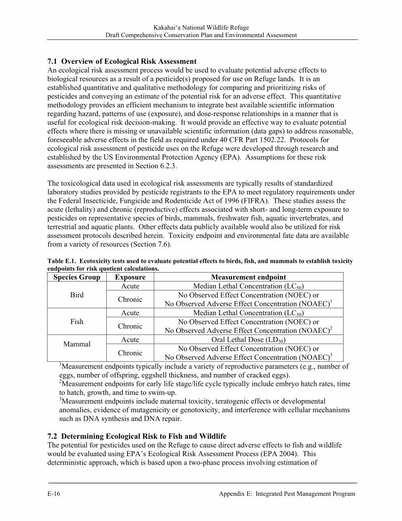
Kakahai‘a National Wildlife Refuge Draft Comprehensive Conservation Plan and Environmental Assessment
E-16 Appendix E: Integrated Pest Management Program
7.1 Overview of Ecological Risk Assessment An ecological risk assessment process would be used to evaluate potential adverse effects to biological resources as a result of a pesticide(s) proposed for use on Refuge lands. It is an established quantitative and qualitative methodology for comparing and prioritizing risks of pesticides and conveying an estimate of the potential risk for an adverse effect. This quantitative methodology provides an efficient mechanism to integrate best available scientific information regarding hazard, patterns of use (exposure), and dose-response relationships in a manner that is useful for ecological risk decision-making. It would provide an effective way to evaluate potential effects where there is missing or unavailable scientific information (data gaps) to address reasonable, foreseeable adverse effects in the field as required under 40 CFR Part 1502.22. Protocols for ecological risk assessment of pesticide uses on the Refuge were developed through research and established by the US Environmental Protection Agency (EPA). Assumptions for these risk assessments are presented in Section 6.2.3. The toxicological data used in ecological risk assessments are typically results of standardized laboratory studies provided by pesticide registrants to the EPA to meet regulatory requirements under the Federal Insecticide, Fungicide and Rodenticide Act of 1996 (FIFRA). These studies assess the acute (lethality) and chronic (reproductive) effects associated with short- and long-term exposure to pesticides on representative species of birds, mammals, freshwater fish, aquatic invertebrates, and terrestrial and aquatic plants. Other effects data publicly available would also be utilized for risk assessment protocols described herein. Toxicity endpoint and environmental fate data are available from a variety of resources (Section 7.6). Table E.1. Ecotoxicity tests used to evaluate potential effects to birds, fish, and mammals to establish toxicity endpoints for risk quotient calculations.
Species Group Exposure Measurement endpoint
Bird Acute Median Lethal Concentration (LC50)
Chronic No Observed Effect Concentration (NOEC) or
No Observed Adverse Effect Concentration (NOAEC)1
Fish Acute Median Lethal Concentration (LC50)
Chronic No Observed Effect Concentration (NOEC) or
No Observed Adverse Effect Concentration (NOAEC)2
Mammal
Acute Oral Lethal Dose (LD50)
Chronic No Observed Effect Concentration (NOEC) or
No Observed Adverse Effect Concentration (NOAEC)3 1Measurement endpoints typically include a variety of reproductive parameters (e.g., number of eggs, number of offspring, eggshell thickness, and number of cracked eggs). 2Measurement endpoints for early life stage/life cycle typically include embryo hatch rates, time to hatch, growth, and time to swim-up. 3Measurement endpoints include maternal toxicity, teratogenic effects or developmental anomalies, evidence of mutagenicity or genotoxicity, and interference with cellular mechanisms such as DNA synthesis and DNA repair.
7.2 Determining Ecological Risk to Fish and Wildlife The potential for pesticides used on the Refuge to cause direct adverse effects to fish and wildlife would be evaluated using EPA’s Ecological Risk Assessment Process (EPA 2004). This deterministic approach, which is based upon a two-phase process involving estimation of
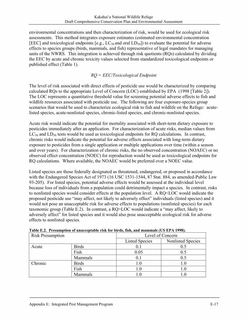
Kakahai‘a National Wildlife Refuge Draft Comprehensive Conservation Plan and Environmental Assessment
Appendix E: Integrated Pest Management Program E-17
environmental concentrations and then characterization of risk, would be used for ecological risk assessments. This method integrates exposure estimates (estimated environmental concentration [EEC] and toxicological endpoints [e.g., LC50 and oral LD50]) to evaluate the potential for adverse effects to species groups (birds, mammals, and fish) representative of legal mandates for managing units of the NWRS. This integration is achieved through risk quotients (RQs) calculated by dividing the EEC by acute and chronic toxicity values selected from standardized toxicological endpoints or published effect (Table 1).
RQ = EEC/Toxicological Endpoint
The level of risk associated with direct effects of pesticide use would be characterized by comparing calculated RQs to the appropriate Level of Concern (LOC) established by EPA (1998 [Table 2]). The LOC represents a quantitative threshold value for screening potential adverse effects to fish and wildlife resources associated with pesticide use. The following are four exposure-species group scenarios that would be used to characterize ecological risk to fish and wildlife on the Refuge: acute-listed species, acute-nonlisted species, chronic-listed species, and chronic-nonlisted species. Acute risk would indicate the potential for mortality associated with short-term dietary exposure to pesticides immediately after an application. For characterization of acute risks, median values from LC50 and LD50 tests would be used as toxicological endpoints for RQ calculations. In contrast, chronic risks would indicate the potential for adverse effects associated with long-term dietary exposure to pesticides from a single application or multiple applications over time (within a season and over years). For characterization of chronic risks, the no observed concentration (NOAEC) or no observed effect concentration (NOEC) for reproduction would be used as toxicological endpoints for RQ calculations. Where available, the NOAEC would be preferred over a NOEC value. Listed species are those federally designated as threatened, endangered, or proposed in accordance with the Endangered Species Act of 1973 (16 USC 1531-1544, 87 Stat. 884, as amended-Public Law 93-205). For listed species, potential adverse effects would be assessed at the individual level because loss of individuals from a population could detrimentally impact a species. In contrast, risks to nonlisted species would consider effects at the population level. A RQ<LOC would indicate the proposed pesticide use “may affect, not likely to adversely effect” individuals (listed species) and it would not pose an unacceptable risk for adverse effects to populations (nonlisted species) for each taxonomic group (Table E.2). In contrast, a RQ>LOC would indicate a “may affect, likely to adversely affect” for listed species and it would also pose unacceptable ecological risk for adverse effects to nonlisted species. Table E.2. Presumption of unacceptable risk for birds, fish, and mammals (US EPA 1998). Risk Presumption Level of Concern
Listed Species Nonlisted Species Acute Birds 0.1 0.5
Fish 0.05 0.5 Mammals 0.1 0.5
Chronic Birds 1.0 1.0 Fish 1.0 1.0 Mammals 1.0 1.0
Kakahai‘a National Wildlife Refuge Draft Comprehensive Conservation Plan and Environmental Assessment
E-18 Appendix E: Integrated Pest Management Program
7.2.1 Environmental exposure Following release into the environment through application, pesticides would experience several different routes of environmental fate. Pesticides which would be sprayed can move through the air (e.g., particle or vapor drift) and may eventually end up in other parts of the environment such as nontarget vegetation, soil, or water. Pesticides applied directly to the soil may be washed off the soil into nearby bodies of surface water (e.g., surface runoff) or may percolate through the soil to lower soil layers and groundwater (e.g., leaching) (Baker and Miller 1999, Pope et. al. 1999, Butler et. al. 1998, Ramsay et. al. 1995, EXTOXNET 1993a). Pesticides which would be injected into the soil may also be subject to the latter two fates. The aforementioned possibilities are by no means complete, but it does indicate movement of pesticides in the environment is very complex with transfers occurring continually among different environmental compartments. In some cases, these exchanges occur not only between areas that are close together, but it also may involve transportation of pesticides over long distances (Barry 2004, Woods 2004). 7.2.1.1 Terrestrial exposure The estimated environmental concentration (ECC) for exposure to terrestrial wildlife would be quantified using an EPA screening-level approach (EPA 2004). This screening-level approach is not affected by product formulation because it evaluates pesticide active ingredient(s). This approach would vary depending upon the proposed pesticide application method: spray or granular. 7.2.1.1.1 Terrestrial-spray application For spray applications, exposure would be determined using the Kanaga nomogram method (EPA 2005a, EPA 2004, Pfleeger et al. 1996) through the EPA’s Terrestrial Residue Exposure model (T-REX) version 1.2.3 (EPA 2005b). To estimate the maximum (initial) pesticide residue on short grass (<8”m tall) as a general food item category for terrestrial vertebrate species, T-REX input variables would include the following from the pesticide label: maximum pesticide application rate (pounds active ingredient [acid equivalent]/acre) and pesticide half-life (days) in soil. Although there are other food item categories (tall grasses; broadleaf plants and small insects; and fruits, pods, seeds and large insects), short grass was selected because it would yield maximum EECs (240 ppm per lb ai/acre) for worse-case risk assessments. Short grass is not representative of forage for carnivorous species (e.g., raptors), but it would characterize the maximum potential exposure through the diet of avian and mammalian prey items. Consequently, this approach would provide a conservative screening tool for pesticides that do not biomagnify. For RQ calculations in T-REX, the model would require the weight of surrogate species and Mineau scaling factors (Mineau et. al. 1996). Body weights of bobwhite quail and mallard are included in T-REX by default, but body weights of other organisms (Table e.3) would be entered manually. The Mineau scaling factor accounts for small-bodied bird species that may be more sensitive to pesticide exposure than would be predicted only by body weight. Mineau scaling factors would be entered manually with values ranging from 1 to 1.55 that are unique to a particular pesticide or group of pesticides. If specific information to select a scaling factor is not available, then a value of 1.15 would be used as a default. Alternatively, zero would be entered if it is known that body weight does not influence toxicity of pesticide(s) being assessed. The upper bound estimate output from the T-REX Kanaga nomogram would be used as an EEC for calculation of RQs. This approach would yield a conservative estimate of ecological risk.
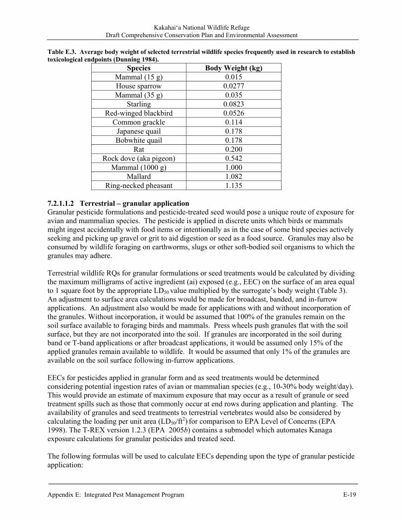
Kakahai‘a National Wildlife Refuge Draft Comprehensive Conservation Plan and Environmental Assessment
Appendix E: Integrated Pest Management Program E-19
Table E.3. Average body weight of selected terrestrial wildlife species frequently used in research to establish toxicological endpoints (Dunning 1984).
Species Body Weight (kg) Mammal (15 g) 0.015 House sparrow 0.0277 Mammal (35 g) 0.035
Starling 0.0823 Red-winged blackbird 0.0526
Common grackle 0.114 Japanese quail 0.178 Bobwhite quail 0.178
Rat 0.200 Rock dove (aka pigeon) 0.542
Mammal (1000 g) 1.000 Mallard 1.082
Ring-necked pheasant 1.135 7.2.1.1.2 Terrestrial – granular application Granular pesticide formulations and pesticide-treated seed would pose a unique route of exposure for avian and mammalian species. The pesticide is applied in discrete units which birds or mammals might ingest accidentally with food items or intentionally as in the case of some bird species actively seeking and picking up gravel or grit to aid digestion or seed as a food source. Granules may also be consumed by wildlife foraging on earthworms, slugs or other soft-bodied soil organisms to which the granules may adhere. Terrestrial wildlife RQs for granular formulations or seed treatments would be calculated by dividing the maximum milligrams of active ingredient (ai) exposed (e.g., EEC) on the surface of an area equal to 1 square foot by the appropriate LD50
value multiplied by the surrogate’s body weight (Table 3).
An adjustment to surface area calculations would be made for broadcast, banded, and in-furrow applications. An adjustment also would be made for applications with and without incorporation of the granules. Without incorporation, it would be assumed that 100% of the granules remain on the soil surface available to foraging birds and mammals. Press wheels push granules flat with the soil surface, but they are not incorporated into the soil. If granules are incorporated in the soil during band or T-band applications or after broadcast applications, it would be assumed only 15% of the applied granules remain available to wildlife. It would be assumed that only 1% of the granules are available on the soil surface following in-furrow applications. EECs for pesticides applied in granular form and as seed treatments would be determined considering potential ingestion rates of avian or mammalian species (e.g., 10-30% body weight/day). This would provide an estimate of maximum exposure that may occur as a result of granule or seed treatment spills such as those that commonly occur at end rows during application and planting. The availability of granules and seed treatments to terrestrial vertebrates would also be considered by calculating the loading per unit area (LD50/ft
2) for comparison to EPA Level of Concerns (EPA
1998). The T-REX version 1.2.3 (EPA 2005b) contains a submodel which automates Kanaga exposure calculations for granular pesticides and treated seed. The following formulas will be used to calculate EECs depending upon the type of granular pesticide application:
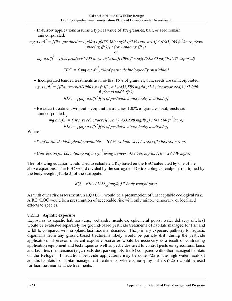
Kakahai‘a National Wildlife Refuge Draft Comprehensive Conservation Plan and Environmental Assessment
E-20 Appendix E: Integrated Pest Management Program
• In-furrow applications assume a typical value of 1% granules, bait, or seed remain unincorporated.
mg a.i./ft.2 = [(lbs. product/acre)(% a.i.)(453,580 mg/lbs)(1% exposed))] / {[(43,560 ft.
2/acre)/(row
spacing (ft.))] / (row spacing (ft.)} or
mg a.i./ft2 = [(lbs product/1000 ft. row)(% a.i.)(1000 ft row)(453,580 mg/lb.)(1% exposed)
EEC = [(mg a.i./ft.2)(% of pesticide biologically available)]
Incorporated banded treatments assume that 15% of granules, bait, seeds are unincorporated.
mg a.i./ft.2 = [(lbs. product/1000 row ft.)(% a.i.)(453,580 mg/lb.)(1-% incorporated)] / (1,000
ft.)(band width (ft.))
EEC = [(mg a.i./ft.2)(% of pesticide biologically available)]
• Broadcast treatment without incorporation assumes 100% of granules, bait, seeds are
unincorporated.
mg a.i./ft.2 = [(lbs. product/acre)(% a.i.)(453,590 mg/lb.)] / (43,560 ft.
2/acre)
EEC = [(mg a.i./ft.2)(% of pesticide biologically available)]
Where:
• % of pesticide biologically available = 100% without species specific ingestion rates
• Conversion for calculating mg a.i./ft.2 using ounces: 453,580 mg/lb. /16 = 28,349 mg/oz.
The following equation would used to calculate a RQ based on the EEC calculated by one of the above equations. The EEC would divided by the surrogate LD50
toxicological endpoint multiplied by
the body weight (Table 3) of the surrogate.
RQ = EEC / [LD50
(mg/kg) * body weight (kg)]
As with other risk assessments, a RQ>LOC would be a presumption of unacceptable ecological risk. A RQ<LOC would be a presumption of acceptable risk with only minor, temporary, or localized effects to species. 7.2.1.2 Aquatic exposure Exposures to aquatic habitats (e.g., wetlands, meadows, ephemeral pools, water delivery ditches) would be evaluated separately for ground-based pesticide treatments of habitats managed for fish and wildlife compared with cropland/facilities maintenance. The primary exposure pathway for aquatic organisms from any ground-based treatments likely would be particle drift during the pesticide application. However, different exposure scenarios would be necessary as a result of contrasting application equipment and techniques as well as pesticides used to control pests on agricultural lands and facilities maintenance (e.g., roadsides, parking lots, trails) compared with other managed habitats on the Refuge. In addition, pesticide applications may be done <25’of the high water mark of aquatic habitats for habitat management treatments; whereas, no-spray buffers (≥25’) would be used for facilities maintenance treatments.
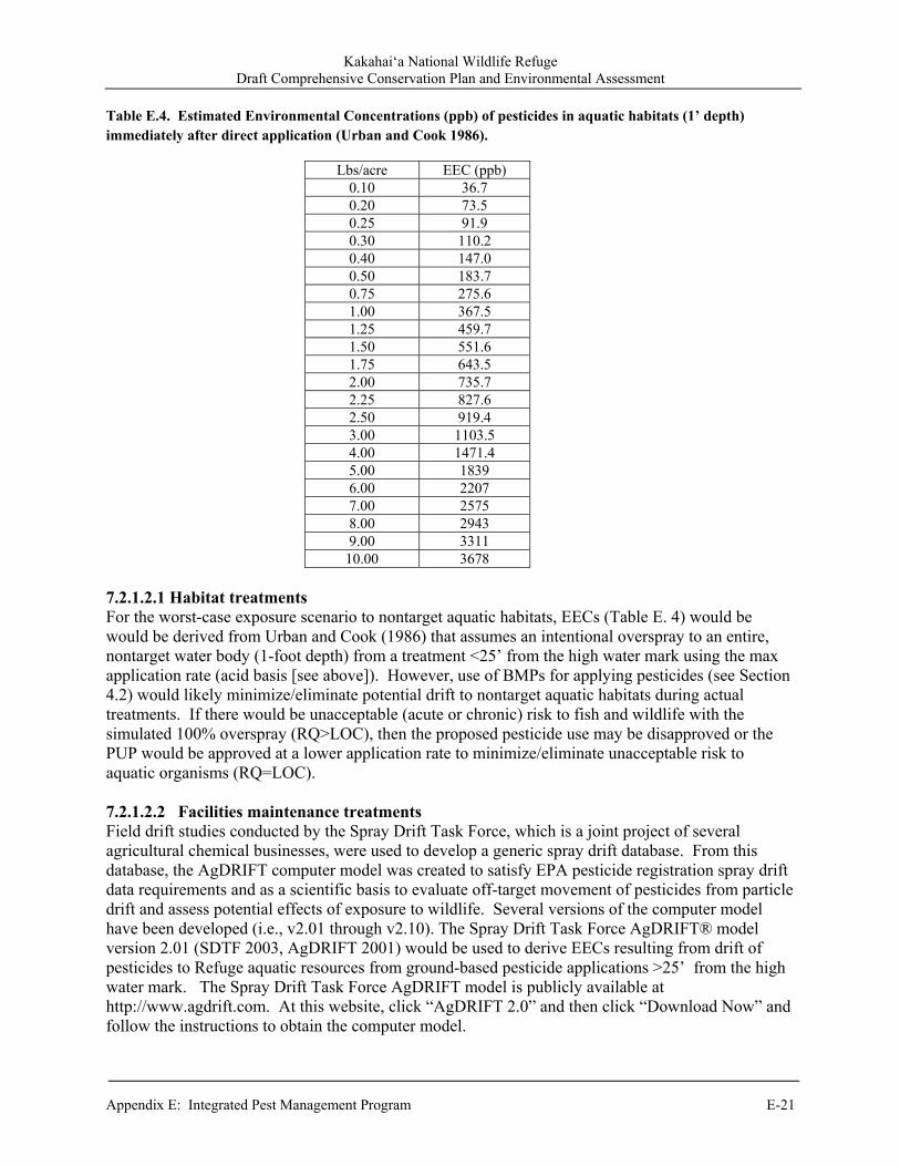
Kakahai‘a National Wildlife Refuge Draft Comprehensive Conservation Plan and Environmental Assessment
Appendix E: Integrated Pest Management Program E-21
Table E.4. Estimated Environmental Concentrations (ppb) of pesticides in aquatic habitats (1’ depth) immediately after direct application (Urban and Cook 1986).
Lbs/acre EEC (ppb) 0.10 36.7 0.20 73.5 0.25 91.9 0.30 110.2 0.40 147.0 0.50 183.7 0.75 275.6 1.00 367.5 1.25 459.7 1.50 551.6 1.75 643.5 2.00 735.7 2.25 827.6 2.50 919.4 3.00 1103.5 4.00 1471.4 5.00 1839 6.00 2207 7.00 2575 8.00 2943 9.00 3311
10.00 3678 7.2.1.2.1 Habitat treatments For the worst-case exposure scenario to nontarget aquatic habitats, EECs (Table E. 4) would be would be derived from Urban and Cook (1986) that assumes an intentional overspray to an entire, nontarget water body (1-foot depth) from a treatment <25’ from the high water mark using the max application rate (acid basis [see above]). However, use of BMPs for applying pesticides (see Section 4.2) would likely minimize/eliminate potential drift to nontarget aquatic habitats during actual treatments. If there would be unacceptable (acute or chronic) risk to fish and wildlife with the simulated 100% overspray (RQ>LOC), then the proposed pesticide use may be disapproved or the PUP would be approved at a lower application rate to minimize/eliminate unacceptable risk to aquatic organisms (RQ=LOC). 7.2.1.2.2 Facilities maintenance treatments Field drift studies conducted by the Spray Drift Task Force, which is a joint project of several agricultural chemical businesses, were used to develop a generic spray drift database. From this database, the AgDRIFT computer model was created to satisfy EPA pesticide registration spray drift data requirements and as a scientific basis to evaluate off-target movement of pesticides from particle drift and assess potential effects of exposure to wildlife. Several versions of the computer model have been developed (i.e., v2.01 through v2.10). The Spray Drift Task Force AgDRIFT® model version 2.01 (SDTF 2003, AgDRIFT 2001) would be used to derive EECs resulting from drift of pesticides to Refuge aquatic resources from ground-based pesticide applications >25’ from the high water mark. The Spray Drift Task Force AgDRIFT model is publicly available at http://www.agdrift.com. At this website, click “AgDRIFT 2.0” and then click “Download Now” and follow the instructions to obtain the computer model.
Kakahai‘a National Wildlife Refuge Draft Comprehensive Conservation Plan and Environmental Assessment
E-22 Appendix E: Integrated Pest Management Program
The AgDRIFT model is composed of submodels called tiers. Tier I Ground submodel would be used to assess ground-based applications of pesticides. Tier outputs (EECs) would be calculated with AgDRIFT using the following input variables: max application rate (acid basis [see above]), low boom (20”), fine to medium droplet size, EPA-defined wetland, and a ≥25-foot distance (buffer) from treated area to water. 7.2.2 Use of information on effects of biological control agents, pesticides, degradates, and adjuvants NEPA documents regarding biological and other environmental effects of biological control agents, pesticides, degradates, and adjuvants prepared by another Federal agency, where the scope would be relevant to evaluation of effects from pesticide uses on Refuge lands, would be reviewed. Possible source agencies for such NEPA documents would include the BLM , US Forest Service, National Park Service, US Department of Agriculture-Animal and Plant Health Inspection Service, and the military services. It might be appropriate to incorporate by reference parts or all of existing document(s). Incorporating by reference (40 CFR 1502.21) is a technique used to avoid redundancies in analysis. It also would reduce the bulk of a Service NEPA document, which only would identify the documents that are incorporated by reference. In addition, relevant portions would be summarized in the Service NEPA document to the extent necessary to provide the decision maker and public with an understanding of relevance of the referenced material to the current analysis. In accordance with the requirements set forth in 43 CFR 46.135, the Service would specifically incorporate through reference ecological risk assessments prepared by the US Forest Service (http://www.fs.fed.us/r6/invasiveplant-eis/Risk-Assessments/Herbicides-Analyzed-InvPlant-EIS.htm) and BLM (http://www.blm.gov/wo/st/en/prog/more/veg_eis.html). These risk assessments and associated documentation also are available in total with the administrative record for the Final Environmental Impact Statement entitled Pacific Northwest Region Invasive Plant Program – Preventing and Managing Invasive Plants (US Forest Service 2005) and Vegetation Treatments Using Herbicides on Bureau of Land Management Lands in 17 Western States Programmatic EIS (PEIS) (BLM 2007). In accordance with 43 CFR 46.120(d), use of existing NEPA documents by supplementing, tiering to, incorporating by reference, or adopting previous NEPA environmental analyses would avoid redundancy and unnecessary paperwork. As a basis for completing “Chemical Profiles” for approving or disapproving PUPs, ecological risk assessments for the following herbicide and adjuvant uses prepared by the USFS would be incorporated by reference: 2,4-D Chlorosulfuron Clopyralid Dicamba Glyphosate Imazapic Imazapyr
Metsulfuron methyl Picloram Sethoxydim Sulfometuron methyl Triclopyr Nonylphenol polyethylate (NPE) based
surfactants
Kakahai‘a National Wildlife Refuge Draft Comprehensive Conservation Plan and Environmental Assessment
Appendix E: Integrated Pest Management Program E-23
As a basis for completing “Chemical Profiles” for approving or disapproving Refuge PUPs, ecological risk assessments for the following herbicide uses as well as evaluation of risks associated with pesticide degradates and adjuvants prepared by the BLM would be incorporated by reference: Bromacil Chlorsulfuron Diflufenzopyr Diquat Diuron Fluridone Imazapic Overdrive (diflufenzopyr and dicamba) Sulfometuron methyl Tebuthiuron Pesticide degradates and adjuvants (Appendix D – Evaluation of risks from degradates,
polyoxyethylene-amine (POEA) and R-11, and endocrine disrupting chemicals) 7.2.3 Assumptions for ecological risk assessments There are a number of assumptions involved with the ecological risk assessment process for terrestrial and aquatic organisms associated with utilization of the EPA ’s (2004) process. These assumptions may be risk neutral or may lead to an over- or under-estimation of risk from pesticide exposure depending upon site-specific conditions. The following describes these assumptions, their application to the conditions typically encountered, and whether or not they may lead to recommendations that are risk neutral, underestimate, or overestimate ecological risk from potential pesticide exposure. Indirect effects would not be evaluated by ecological risk assessments. These effects include the
mechanisms of indirect exposure to pesticides: consuming prey items (fish, birds, or small mammals), reductions in the availability of prey items, and disturbance associated with pesticide application activities.
Exposure to a pesticide product can be assessed based upon the active ingredient. However, exposure to a chemical mixture (pesticide formulation) may result in effects that are similar or substantially different compared to only the active ingredient. Nontarget organisms may be exposed directly to the pesticide formulation or only various constituents of the formulation as they dissipate and partition in the environment. If toxicological information for both the active ingredient and formulated product are available, then data representing the greatest potential toxicity would be selected for use in the risk assessment process (EPA 2004). As a result, this conservative approach may lead to an overestimation of risk characterization from pesticide exposure.
Because toxicity tests with listed or candidate species or closely related species are not available, data for surrogate species would be most often used for risk assessments. Specifically, bobwhite quail and mallard duck are the most frequently used surrogates for evaluating potential toxicity to federally listed avian species. Bluegill sunfish, rainbow trout, and fathead minnow are the most common surrogates for evaluating toxicity for freshwater fishes. However, sheep’s head minnow can be an appropriate surrogate marine species for coastal environments. Rats and mice are the most common surrogates for evaluating toxicity for mammals. Interspecies sensitivity is a major source of uncertainty in pesticide assessments. As a result of this uncertainty, data is selected for the most sensitive species tested within a taxonomic group (birds, fish, and mammals) given the quality of the data is acceptable. If additional toxicity data for more species of organisms in a
Kakahai‘a National Wildlife Refuge Draft Comprehensive Conservation Plan and Environmental Assessment
E-24 Appendix E: Integrated Pest Management Program
particular group are available, the selected data will not be limited to the species previously listed as common surrogates.
The Kanaga nomogram outputs maximum EEC values that may be used to calculate an average daily concentration over a specified interval of time, which is referred to as a time-weighted-average (TWA). The maximum EEC would be selected as the exposure input for both acute and chronic risk assessments in the screening-level evaluations. The initial or maximum EEC derived from the Kanaga nomogram represents the maximum expected instantaneous or acute exposure to a pesticide. Acute toxicity endpoints are determined using a single exposure to a known pesticide concentration typically for 48 to 96 hours. This value is assumed to represent ecological risk from acute exposure to a pesticide. On the other hand, chronic risk to pesticide exposure is a function of pesticide concentration and duration of exposure to the pesticide. An organism’s response to chronic pesticide exposure may result from either the concentration of the pesticide, length of exposure, or some combination of both factors. Standardized tests for chronic toxicity typically involve exposing an organism to several different pesticide concentrations for a specified length of time (days, weeks, months, years or generations). For example, avian reproduction tests include a 10-week exposure phase. Because a single length of time is used in the test, time response data is usually not available for inclusion into risk assessments. Without time response data it is difficult to determine the concentration which elicited a toxicological response.
Using maximum EECs for chronic risk estimates may result in an overestimate of risk, particularly for compounds that dissipate rapidly. Conversely, using TWAs for chronic risk estimates may underestimate risk if it is the concentration rather than the duration of exposure that is primarily responsible for the observed adverse effect. The maximum EEC would be used for chronic risk assessments although it may result in an overestimate of risk. TWAs may be used for chronic risk assessments, but they will be applied judiciously considering the potential for an underestimate or overestimate of risk. For example, the number of days exposure exceeds a Level of Concern may influence the suitability of a pesticide use. The greater the number of days the EEC exceeds the Level of Concern translates into greater the ecological risk. This is a qualitative assessment, and is subject to reviewer’s expertise in ecological risk assessment and tolerance for risk.
The length of time used to calculate the TWA can have a substantial effect on the exposure estimates and there is no standard method for determining the appropriate duration for this estimate. The T-REX model assumes a 21-week exposure period, which is equivalent to avian reproductive studies designed to establish a steady-state concentration for bioaccumulative compounds. However, this does not necessarily define the true exposure duration needed to elicit a toxicological response. Pesticides, which do not bioaccumulate, may achieve a steady-state concentration earlier than 21 weeks. The duration of time for calculating TWAs will require justification and it will not exceed the duration of exposure in the chronic toxicity test (approximately 70 days for the standard avian reproduction study). An alternative to using the duration of the chronic toxicity study is to base the TWA on the application interval. In this case, increasing the application interval would suppress both the estimated peak pesticide concentration and the TWA. Another alternative to using TWAs would be to consider the number of days that a chemical is predicted to exceed the LOC.
Pesticide dissipation is assumed to be first-order in the absence of data suggesting alternative dissipation patterns such as bi-phasic. Field dissipation data would generally be the most pertinent for assessing exposure in terrestrial species that forage on vegetation. However, this data is often not available and it can be misleading particularly if the compound is prone to “wash-off”. Soil half-life is the most common degradation data available. Dissipation or
Kakahai‘a National Wildlife Refuge Draft Comprehensive Conservation Plan and Environmental Assessment
Appendix E: Integrated Pest Management Program E-25
degradation data that would reflect the environmental conditions typical of Refuge lands would be utilized, if available.
For species found in the water column, it would be assumed that the greatest bioavailable fraction of the pesticide active ingredient in surface waters is freely dissolved in the water column.
Actual habitat requirements of any particular terrestrial species are not considered, and it is assumed that species exclusively and permanently occupy the treated area, or adjacent areas receiving pesticide at rates commensurate with the treatment rate. This assumption would produce a maximum estimate of exposure for risk characterization. This assumption would likely lead to an overestimation of exposure for species that do not permanently and exclusively occupy the treated area (EPA 2004).
Exposure through incidental ingestion of pesticide contaminated soil is not considered in the EPA risk assessment protocols. Research suggests <15% of the diet can consist of incidentally ingested soil depending upon species and feeding strategy (Beyer et al. 1994). An assessment of pesticide concentrations in soil compared to food item categories in the Kanaga nomogram indicates incidental soil ingestion will not likely increase dietary exposure to pesticides. Inclusion of soil into the diet would effectively reduce the overall dietary concentration compared to the present assumption that the entire diet consists a contaminated food source (Fletcher et al. 1994). An exception to this may be soil-applied pesticides in which exposure from incidental ingestion of soil may increase. Potential for pesticide exposure under this assumption may be underestimated for soil-applied pesticides and overestimated for foliar-applied pesticides. The concentration of a pesticide in soil would likely be less than predicted on food items.
Exposure through inhalation of pesticides is not considered in the EPA risk assessment protocols. Such exposure may occur through three potential sources: spray material in droplet form at time of application, vapor phase with the pesticide volatilizing from treated surfaces, and airborne particulates (soil, vegetative matter, and pesticide dusts). The EPA (1990) reported exposure from inhaling spray droplets at the time of application is not an appreciable route of exposure for birds. According to research on mallards and bobwhite quail, respirable particle size (particles reaching the lung) in birds is limited to maximum diameter of 2 to 5 microns. The spray droplet spectra covering the majority of pesticide application scenarios indicate that less than 1% of the applied material is within the respirable particle size. This route of exposure is further limited because the permissible spray drop size distribution for ground pesticide applications is restricted to ASAE medium or coarser drop size distribution.
Inhalation of a pesticide in the vapor phase may be another source of exposure for some pesticides under certain conditions. This mechanism of exposure to pesticides occurs post application and it would pertain to those pesticides with a high vapor pressure. The EPA is currently evaluating protocols for modeling inhalation exposure from pesticides including near-field and near-ground air concentrations based upon equilibrium and kinetics-based models. Risk characterization for exposure with this mechanism is unavailable.
The effect from exposure to dusts contaminated with the pesticide cannot be assessed generically as partitioning issues related to application site soils and chemical properties of the applied pesticides render the exposure potential from this route highly situation specific.
Dermal exposure may occur through three potential sources: direct application of spray to terrestrial wildlife in the treated area or within the drift footprint, incidental contact with contaminated vegetation, or contact with contaminated water or soil. Interception of spray and incidental contact with treated substrates may pose risk to avian wildlife (Driver et al. 1991). However, available research related to wildlife dermal contact with pesticides is extremely limited, except dermal toxicity values are common for some mammals used as human surrogates (rats and mice). The EPA is currently evaluating protocols for modeling dermal exposure. Risk
Kakahai‘a National Wildlife Refuge Draft Comprehensive Conservation Plan and Environmental Assessment
E-26 Appendix E: Integrated Pest Management Program
characterization may be underestimated for this route of exposure, particularly with high risk pesticides such as some organophosphates or carbamate insecticides. If protocols are established by the EPA for assessing dermal exposure to pesticides, they will be considered for incorporation into pesticide assessment protocols.
Exposure to a pesticide may occur from consuming surface water, dew or other water on treated surfaces. Water soluble pesticides have potential to dissolve in surface runoff and puddles in a treated area may contain pesticide residues. Similarly, pesticides with lower organic carbon partitioning characteristics and higher solubility in water have a greater potential to dissolve in dew and other water associated with plant surfaces. Estimating the extent to which such pesticide loadings to drinking water occurs is complex and would depend upon the partitioning characteristics of the active ingredient, soils types in the treatment area, and the meteorology of the treatment area. In addition, the use of various water sources by wildlife is highly species-specific. Currently, risk characterization for this exposure mechanism is not available. The EPA is actively developing protocols to quantify drinking water exposures from puddles and dew. If and when protocols are formally established by the EPA for assessing exposure to pesticides through drinking water, these protocols will be incorporated into pesticide risk assessment protocols.
Risk assessments are based upon the assumption that the entire treatment area would be subject to pesticide application at the rates specified on the label. In most cases, there is potential for uneven application of pesticides through such plausible incidents such as changes in calibration of application equipment, spillage, and localized releases at specific areas in or near the treated field that are associated with mixing and handling and application equipment as well as applicator skill. Inappropriate use of pesticides and the occurrence of spills represent a potential underestimate of risk. It is likely not an important factor for risk characterization. All pesticide applicators are required to be certified by the State in which they apply pesticides. Certification training includes the safe storage, transport, handling, and mixing of pesticides, equipment calibration and proper application with annual continuing education.
The EPA relies on Fletcher (1994) for setting the assumed pesticide residues in wildlife dietary items. The EPA (2004) “believes that these residue assumptions reflect a realistic upper-bound residue estimate, although the degree to which this assumption reflects a specific percentile estimate is difficult to quantify”. Fletcher’s (1994) research suggests that the pesticide active ingredient residue assumptions used by the EPA represent a 95th
percentile estimate. However,
research conducted by Pfleeger et al. (1996) indicates EPA residue assumptions for short grass was not exceeded. Baehr and Habig (2000) compared EPA residue assumptions with distributions of measured pesticide residues for the EPA’s UTAB database. Overall residue selection level will tend to overestimate risk characterization. This is particularly evident when wildlife individuals are likely to have selected a variety of food items acquired from multiple locations. Some food items may be contaminated with pesticide residues whereas others are not contaminated. However, it is important to recognize differences in species feeding behavior. Some species may consume whole above-ground plant material, but others will preferentially select different plant structures. Also, species may preferentially select a food item although multiple food items may be present. Without species specific knowledge regarding foraging behavior characterizing ecological risk other than in general terms is not possible.
Acute and chronic risk assessments rely on comparisons of wildlife dietary residues with LC50 or
NOEC values expressed as concentrations of pesticides in laboratory feed. These comparisons assume that ingestion of food items in the field occurs at rates commensurate with those in the laboratory. Although the screening assessment process adjusts dry-weight estimates of food intake to reflect the increased mass in fresh-weight wildlife food intake estimates, it does not
Kakahai‘a National Wildlife Refuge Draft Comprehensive Conservation Plan and Environmental Assessment
Appendix E: Integrated Pest Management Program E-27
allow for gross energy and assimilative efficiency differences between wildlife food items and laboratory feed. Differences in assimilative efficiency between laboratory and wild diets suggest that current screening assessment methods are not accounting for a potentially important aspect of food requirements.
There are several other assumptions that can affect nontarget species not considered in the risk assessment process. These include possible additive or synergistic effects from applying two or more pesticides or additives in a single application, co-location of pesticides in the environment, cumulative effects from pesticides with the same mode of action, effects of multiple stressors (e.g., combination of pesticide exposure, adverse abiotic and biotic factors) and behavioral changes induced by exposure to a pesticide. These factors may exist at some level contributing to adverse affects to nontarget species, but they are usually characterized in the published literature in only a general manner limiting their value in the risk assessment process.
It is assumed that aquatic species exclusively and permanently occupy the water body being assessed. Actual habitat requirements of aquatic species are not considered. With the possible exception of scenarios where pesticides are directly applied to water, it is assumed that no habitat use considerations specific for any species would place the organisms in closer proximity to pesticide use sites. This assumption produces a maximum estimate of exposure or risk characterization. It would likely be realistic for many aquatic species that may be found in aquatic habitats within or in close proximity to treated terrestrial habitats. However, the spatial distribution of wildlife is usually not random because wildlife distributions are often related to habitat requirements of species. Clumped distributions of wildlife may result in an under- or over-estimation of risk depending upon where the initial pesticide concentration occurs relative to the species or species habitat.
For species found in the water column, it would be assumed that the greatest bioavailable fraction of the pesticide active ingredient in surface waters is freely dissolved in the water column. Additional chemical exposure from materials associated with suspended solids or food items is not considered because partitioning onto sediments likely is minimal. Adsorption and bioconcentration occurs at lower levels for many newer pesticides compared with older more persistent bioaccumulative compounds. Pesticides with RQs close to the listed species level of concern, the potential for additional exposure from these routes may be a limitation of risk assessments, where potential pesticide exposure or risk may be underestimated.
Mass transport losses of pesticide from a water body (except for losses by volatilization, degradation and sediment partitioning) would not be considered for ecological risk assessment. The water body would be assumed to capture all pesticide active ingredients entering as runoff, drift, and adsorbed to eroded soil particles. It would also be assumed that pesticide active ingredient is not lost from the water body by overtopping or flow-through, nor is concentration reduced by dilution. In total, these assumptions would lead to a near maximum possible water-borne concentration. However, this assumption would not account for potential to concentrate pesticide through the evaporative loss. This limitation may have the greatest impact on water bodies with high surface-to-volume ratios such as ephemeral wetlands, where evaporative losses are accentuated and applied pesticides have low rates of degradation and volatilization.
For acute risk assessments, there would be no averaging time for exposure. An instantaneous peak concentration would be assumed, where instantaneous exposure is sufficient in duration to elicit acute effects comparable to those observed over more protracted exposure periods (typically 48 to 96 hours) tested in the laboratory. In the absence of data regarding time-to-toxic event, analyses and latent responses to instantaneous exposure, risk would likely be overestimated.
Kakahai‘a National Wildlife Refuge Draft Comprehensive Conservation Plan and Environmental Assessment
E-28 Appendix E: Integrated Pest Management Program
For chronic exposure risk assessments, the averaging times considered for exposure are commensurate with the duration of invertebrate life-cycle or fish-early life stage tests (e.g., 21-28 days and 56-60 days, respectively). Response profiles (time to effect and latency of effect) to pesticides likely vary widely with mode of action and species and should be evaluated on a case-by-case basis as available data allow. Nevertheless, because the EPA relies on chronic exposure toxicity endpoints based on a finding of no observed effect, the potential for any latent toxicity effects or averaging time assumptions to alter the results of an acceptable chronic risk assessment prediction is limited. The extent to which duration of exposure from water-borne concentrations overestimate or underestimate actual exposure depends on several factors. These include the following: localized meteorological conditions, runoff characteristics of the watershed (e.g., soils, topography), the hydrological characteristics of receiving waters, environmental fate of the pesticide active ingredient, and the method of pesticide application. It should also be understood that chronic effects studies are performed using a method that holds water concentration in a steady state. This method is not likely to reflect conditions associated with pesticide runoff. Pesticide concentrations in the field increase and decrease in surface water on a cycle influenced by rainfall, pesticide use patterns, and degradation rates. As a result of the dependency of this assumption on several undefined variables, risk associated with chronic exposure may in some situations underestimate risk and overestimate risk in others.
There are several other factors that can affect nontarget species not considered in the risk assessment process. These would include the following: possible additive or synergistic effects from applying two or more pesticides or additives in a single application, co-location of pesticides in the environment, cumulative effects from pesticides with the same mode of action, effects of multiple stressors (e.g., combination of pesticide exposure, adverse abiotic [not pesticides] and biotic factors), and sub-lethal effects such as behavioral changes induced by exposure to a pesticide. These factors may exist at some level contributing to adverse affects to nontarget species, but they are not routinely assessed by regulatory agencies. Therefore, information on the factors is not extensive limiting their value for the risk assessment process. As this type of information becomes available, it would be included, either quantitatively or qualitatively, in this risk assessment process.
EPA is required by the Food Quality Protection Act to assess the cumulative risks of pesticides that share common mechanisms of toxicity, or act the same within an organism. Currently, EPA has identified four groups of pesticides that have a common mechanism of toxicity requiring cumulative risk assessments. These four groups are: the organophosphate insecticides, N-methyl carbamate insecticides, triazine herbicides, and chloroacetanilide herbicides.
7.3 Pesticide Mixtures and Degradates Pesticide products are usually a formulation of several components generally categorized as active ingredients and inert or other ingredients. The term active ingredient is defined by the FIFRA as preventing, destroying, repelling, or mitigating the effects of a pest, or it is a plant regulator, defoliant, desiccant, or nitrogen stabilizer. In accordance with FIFRA, the active ingredient(s) must be identified by name(s) on the pesticide label along with its relative composition expressed in percentage(s) by weight. In contrast, inert ingredient(s) are not intended to affect a target pest. Their role in the pesticide formulation is to act as a solvent (keep the active ingredient is a liquid phase), an emulsifying or suspending agent (keep the active ingredient from separating out of solution), or a carrier such as clay in which the active ingredient is impregnated on the clay particle in dry formulations. For example, if isopropyl alcohol would be used as a solvent in a pesticide formulation, then it would be considered an inert ingredient. FIFRA only requires that inert ingredients identified as hazardous and associated percent composition, and the total percentage of
Kakahai‘a National Wildlife Refuge Draft Comprehensive Conservation Plan and Environmental Assessment
Appendix E: Integrated Pest Management Program E-29
all inert ingredients must be declared on a product label. Inert ingredients that are not classified as hazardous are not required to be identified. The EPA (September 1997) issued Pesticide Regulation Notice 97-6 which encouraged manufacturers, formulators, producers, and registrants of pesticide products to voluntarily substitute the term “other ingredients” for “inert ingredients” in the ingredient statement. This change recognized that all components in a pesticide formulation potentially could elicit or contribute to an adverse effect on nontarget organisms and, therefore, are not necessarily inert. Whether referred to as “inerts” or “other ingredients,” these constituents within a pesticide product have the potential to affect species or environmental quality. The EPA categorizes regulated inert ingredients into the following four lists (http://www.epa.gov/opprd001/inerts/index.html): • List 1 – Inert Ingredients of Toxicological Concern • List 2 – Potentially Toxic Inert Ingredients • List 3 – Inerts of Unknown Toxicity • List 4 – Inerts of Minimal Toxicity Several of the List 4 compounds are naturally-occurring earthen materials (e.g., clay materials, simple salts) that would not elicit toxicological response at applied concentrations. However, some of the inerts (particularly the List 3 compounds and unlisted compounds) may have moderate to high potential toxicity to aquatic species based on MSDSs or published data. Comprehensively assessing potential effects to nontarget fish, wildlife, plants, and/or their habitats from pesticide use is a complex task. It would be preferable to assess the cumulative effects from exposure to the active ingredient, its degradates, and inert ingredients as well as other active ingredients in the spray mixture. However, it would only be feasible to conduct deterministic risk assessments for each component in the spray mixture singly. Limited scientific information is available regarding ecological effects (additive or synergistic) from chemical mixtures that typically rely upon broadly encompassing assumptions. For example, the US Forest Service (2005) found that mixtures of pesticides used in land (forest) management likely would not cause additive or synergistic effects to nontarget species based upon a review of scientific literature regarding toxicological effects and interactions of agricultural chemicals (ATSDR 2004). Moreover, information on inert ingredients, adjuvants, and degradates is often limited by the availability of and access to reliable toxicological data for these constituents. Toxicological information regarding “other ingredients” may be available from sources such as the following: • TOMES (a proprietary toxicological database including EPA’s IRIS, the Hazardous Substance
Data Bank, the Registry of Toxic Effects of Chemical Substances [RTECS]). • EPA’s ECOTOX database, which includes AQUIRE (a database containing scientific papers
published on the toxic effects of chemicals to aquatic organisms). • TOXLINE (a literature searching tool). • Material Safety Data Sheets (MSDSs) from pesticide suppliers. • Other sources such as the Farm Chemicals Handbook. Because there is a lack of specific inert toxicological data, inert(s) in a pesticide may cause adverse ecological effects. However, inert ingredients typically represent only a small percentage of the pesticide spray mixture, and it would be assumed that negligible effects would be expected to result from inert ingredient(s).
Kakahai‘a National Wildlife Refuge Draft Comprehensive Conservation Plan and Environmental Assessment
E-30 Appendix E: Integrated Pest Management Program
Although the potential effects of degradates should be considered when selecting a pesticide, it is beyond the scope of this assessment process to consider all possible breakdown chemicals of the various product formulations containing an active ingredient. Degradates may be more or less mobile and more or less hazardous in the environment than their parent pesticides (Battaglin et al. 2003). Differences in environmental behavior (e.g., mobility) and toxicity between parent pesticides and degradates would make assessing potential degradate effects extremely difficult. For example, a less toxic and more mobile, bioaccumulative, or persistent degradate may have potentially greater effects on species and/or degrade environmental quality. The lack of data on the toxicity of degradates for many pesticides would represent a source of uncertainty for assessing risk. An EPA-approved label specifies whether a product can be mixed with one or more pesticides. Without product-specific toxicological data, it would not possible to quantify the potential effects of these mixtures. In addition, a quantitative analysis could only be conducted if reliable scientific information allowed a determination of whether the joint action of a mixture would be additive, synergistic, or antagonistic. Such information would not likely exist unless the mode of action would be common among the chemicals and receptors. Moreover, the composition of and exposure to mixtures would be highly site- and/or time-specific and, therefore, it would be nearly impossible to assess potential effects to species and environmental quality. To minimize or eliminate potential negative effects associated with applying two or more pesticides as a mixture, the use would be conducted in accordance with the labeling requirements. Labels for two or more pesticides applied as a mixture should be completely reviewed, where products with the least potential for negative effects would be selected for use on the Refuge. This is especially relevant when a mixture would be applied in a manner that may already have the potential for an effect(s) associated with an individual pesticide (e.g., runoff to ponds in sandy watersheds). Use of a tank mix under these conditions would increase the level of uncertainty in terms of risk to species or potential to degrade environmental quality. Adjuvants generally function to enhance or prolong the activity of pesticide. For terrestrial herbicides, adjuvants aid in the absorption into plant tissue. Adjuvant is a broad term that generally applies to surfactants, selected oils, anti-foaming agents, buffering compounds, drift control agents, compatibility agents, stickers, and spreaders. Adjuvants are not under the same registration requirements as pesticides and the EPA does not register or approve the labeling of spray adjuvants. Individual pesticide labels identify types of adjuvants approved for use with it. In general, adjuvants compose a relatively small portion of the volume of pesticides applied. Selection of adjuvants with limited toxicity and low volumes would be recommended to reduce the potential for the adjuvant to influence the toxicity of the pesticide. 7.4 Determining Effects to Soil and Water Quality The approval process for pesticide uses would consider potential to degrade water quality on and off Refuge lands. A pesticide can only affect water quality through movement away from the treatment site. After application, pesticide mobilization can be characterized by one or more of the following (Kerle et al. 1996): Attach (sorb) to soil, vegetation, or other surfaces and remain at or near the treated area; Attach to soil and move off-site through erosion from run-off or wind; Dissolve in water that can be subjected to run-off or leaching.
Kakahai‘a National Wildlife Refuge Draft Comprehensive Conservation Plan and Environmental Assessment
Appendix E: Integrated Pest Management Program E-31
As an initial screening tool, selected chemical characteristics and rating criteria for a pesticide can be evaluated to assess potential to enter ground and/or surface waters. These would include the following: persistence, sorption coefficient (Koc), groundwater ubiquity score (GUS), and solubility. Persistence, which is expressed as half-life (t½), represents the length of time required for 50% of the deposited pesticide to degrade (completely or partially). Persistence in the soil can be categorized as the following: nonpersistent <30 days, moderately persistent = 30 to 100 days, and persistent >100 days (Kerle et. al. 1996). Half-life data is usually available for aquatic and terrestrial environments. Another measure of pesticide persistence is dissipation time (DT50). It represents the time required for 50% of the deposited pesticide to degrade and move from a treated site; whereas, half-life describes the rate for degradation only. As for half-life, units of dissipation time are usually expressed in days. Field or foliar dissipation time is the preferred data for use to estimate pesticide concentrations in the environment. However, soil half-life is the most common persistence data cited in published literature. If field or foliar dissipation data is not available, soil half-life data may be used. The average or representative half-life value of most important degradation mechanism will be selected for quantitative analysis for both terrestrial and aquatic environments. Mobility of a pesticide is a function of how strongly it is adsorbed to soil particles and organic matter, its solubility in water, and its persistence in the environment. Pesticides strongly adsorbed to soil particles, relatively insoluble in water, and not environmentally persistent would be less likely to move across the soil surface into surface waters or to leach through the soil profile and contaminate groundwater. Conversely, pesticides that are not strongly adsorbed to soil particles, are highly water soluble, and are persistent in the environment would have greater potential to move from the application site (off-site movement). The degree of pesticide adsorption to soil particles and organic matter (Kerle et. al. 1996) is expressed as the soil adsorption coefficient (Koc). The soil adsorption coefficient is measured as micrograms of pesticide per gram of soil (μg/g) that can range from near zero to the thousands. Pesticides with higher Koc values are strongly sorbed to soil and, therefore, would be less subject to movement. Water solubility describes the amount of pesticide that will dissolve in a known quantity of water. The water solubility of a pesticide is expressed as milligrams of pesticide dissolved in a liter of water (mg/l or ppm). Pesticide with solubility <0.1 ppm are virtually insoluble in water, 100-1000 ppm are moderately soluble, and >10,000 ppm highly soluble (US Geological Survey 2000). As pesticide solubility increases, there would be greater potential for off-site movement. The Groundwater Ubiquity Score (GUS) is a quantitative screening tool to estimate a pesticide’s potential to move in the environment. It utilizes soil persistence and adsorption coefficients in the following formula.
GUS = log10 (t½) x [4 - log10 (Koc)] The potential pesticide movement rating would be based upon its GUS value. Pesticides with a GUS <0.1 would considered to have an extremely low potential to move toward groundwater. Values of 1.0-2.0 would be low, 2.0-3.0 would be moderate, 3.0-4.0 would be high, and >4.0 would have a very high potential to move toward groundwater.
Kakahai‘a National Wildlife Refuge Draft Comprehensive Conservation Plan and Environmental Assessment
E-32 Appendix E: Integrated Pest Management Program
Water solubility describes the amount of pesticide dissolving in a specific quantity of water, where it is usually measured as mg/l or parts per million (ppm). Solubility is useful as a comparative measure because pesticides with higher values are more likely to move by run-off or leaching. GUS, water solubility, t½, and Koc values are available for selected pesticides from the OSU Extension Pesticide Properties Database at http://npic.orst.edu/ppdmove.htm. Many of the values in this database were derived from the SCS/ARS/CES Pesticide Properties Database for Environmental Decision Making (Wauchope et al. 1992). Soil properties influence the fate of pesticides in the environment. The following six properties are mostly likely to affect pesticide degradation and the potential for pesticides to move off-site by leaching (vertical movement through the soil) or runoff (lateral movement across the soil surface). Permeability is the rate of water movement vertically through the soil. It is affected by soil
texture and structure. Coarse textured soils (e.g., high sand content) have a larger pore size and they are generally more permeable than fine textured soils (i.e., high clay content). The more permeable soils would have a greater potential for pesticides to move vertically down through the soil profile. Soil permeability rates (inches/hour) are usually available in county soil survey reports.
Soil texture describes the relative percentage of sand, silt, and clay. In general, greater clay content with smaller the pore size would lower the likelihood and rate water that would move through the soil profile. Clay also serves to adsorb (bind) pesticides to soil particles. Soils with high clay content would adsorb more pesticide than soils with relatively low clay content. In contrast, sandy soils with coarser texture and lower water holding capacity would have a greater potential for water to leach through them.
Soil structure describes soil aggregation. Soils with a well developed soil structure have looser, more aggregated, structure that would be less likely to be compacted. Both characteristics would allow for less restricted flow of water through the soil profile resulting in greater infiltration.
Organic matter would be the single most important factor affecting pesticide adsorption in soils. Many pesticides are adsorbed to organic matter which would reduce their rate of downward movement through the soil profile. Also, soils high in organic matter would tend to hold more water, which may make less water available for leaching.
Soil moisture affects how fast water would move through the soil. If soils are already wet or saturated before rainfall or irrigation, excess moisture would runoff rather than infiltrate into the soil profile. Soil moisture also would influence microbial and chemical activity in soil, which effects pesticide degradation.
Soil pH would influence chemical reactions that occur in the soil which in turn determines whether or not a pesticide will degrade, rate of degradation, and, in some instances, which degradation products are produced.
Based upon the aforementioned properties, soils most vulnerable to groundwater contamination would be sandy soils with low organic matter. In contrast, the least vulnerable soils would be well-drained clayey soils with high organic matter. Consequently, pesticides with the lowest potential for movement in conjunction with appropriate best management practices (see below) would be used in an IPM framework to treat pests while minimizing effects to nontarget biota and protecting environmental quality. Along with soil properties, the potential for a pesticide to affect water quality through run-off and leaching would consider site-specific environmental and abiotic conditions including rainfall, water table conditions, and topography (Huddleston 1996).
Kakahai‘a National Wildlife Refuge Draft Comprehensive Conservation Plan and Environmental Assessment
Appendix E: Integrated Pest Management Program E-33
Water is necessary to separate pesticides from soil. This can occur in two basic ways. Pesticides that are soluble move easily with runoff water. Pesticide-laden soil particles can be dislodged and transported from the application site in runoff. The concentration of pesticides in the surface runoff would be greatest for the first runoff event following treatment. The rainfall intensity and route of water infiltration into soil, to a large extent, determine pesticide concentrations and losses in surface runoff. The timing of the rainfall after application also would have an effect. Rainfall interacts with pesticides at a shallow soil depth (¼ to ½ inch), which is called the mixing zone (Baker and Miller 1999). The pesticide/water mixture in the mixing zone would tend to leach down into the soil or runoff depending upon how quickly the soil surface becomes saturated and how rapidly water can infiltrate into the soil. Leaching would decrease the amount of pesticide available near the soil surface (mixing zone) to runoff during the initial rainfall event following application and subsequent rainfall events.
Terrain slope would affect the potential for surface runoff and the intensity of runoff. Steeper slopes would have greater potential for runoff following a rainfall event. In contrast, soils that are relatively flat would have little potential for runoff, except during intense rainfall events. In addition, soils in lower areas would be more susceptible to leaching as a result of receiving excessive water from surrounding higher elevations.
Depth to groundwater would be an important factor affecting the potential for pesticides to leach into groundwater. If the distance from the soil surface to the top of the water table is shallow, pesticides would have less distance to travel to reach groundwater. Shallower water tables that persist for longer periods would be more likely to experience groundwater contamination. Soil survey reports are available for individual counties. These reports provide data in tabular format regarding the water table depths and the months during which it is persists. In some situations, a hard pan exists above the water table that would prevent pesticide contamination from leaching.
7.5 Determining Effects to Air Quality Pesticides may volatilize from soil and plant surfaces and move from the treated area into the atmosphere. The potential for a pesticide to volatilize is determined by the pesticide’s vapor pressure which would be affected by temperature, sorption, soil moisture, and the pesticide’s water solubility. Vapor pressure is often expressed in mm Hg. To make these numbers easier to compare, vapor pressure may be expressed in exponent form (I x 10-7), where I represents a vapor pressure index. In general, pesticides with I<10 would have a low potential to volatilize; whereas, pesticides with I>1,000 would have a high potential to volatilize (Oregon State University 1996). Vapor pressure values for pesticides are usually available in the pesticide product MSDS or the USDA Agricultural Research Service (ARS) pesticide database. 7.6 Preparing a Chemical Profile The following instructions would be used by Service personnel to complete Chemical Profiles for pesticides. Specifically, profiles would be prepared for pesticide active ingredients (e.g., glyphosate, imazapic) that would be contained in one or more trade name products that are registered and labeled with EPA. All information fields under each category (e.g., Toxicological Endpoints, Environmental Fate) would be completed for a Chemical Profile. If no information is available for a specific field, then “No data is available in references” would be recorded in the profile. Available scientific information would be used to complete Chemical Profiles. Each entry of scientific information would be shown with applicable references. Completed Chemical Profiles would provide a structured decision-making process utilizing quantitative assessment/screening tools with threshold values (where appropriate) that would be used
Kakahai‘a National Wildlife Refuge Draft Comprehensive Conservation Plan and Environmental Assessment
E-34 Appendix E: Integrated Pest Management Program
to evaluate potential biological and other environmental effects to Refuge resources. For ecological risk assessments presented in these profiles, the “worst-case scenario” would be evaluated to determine whether a pesticide could be approved for use considering the maximum single application rate specified on pesticide labels for habitat management and croplands/facilities maintenance treatments pertaining to Refuges. Where the “worst-case scenario” likely would only result in minor, temporary, and localized effects to listed and nonlisted species with appropriate BMPs (see Section 5.0), the proposed pesticide’s use in a PUP would have a scientific basis for approval under any application rate specified on the label that is at or below rates evaluated in a Chemical Profile. In some cases, the Chemical Profile would include a lower application rate than the maximum labeled rate in order to protect Refuge resources. As necessary, Chemical Profiles would be periodically updated with new scientific information or as pesticides with the same active ingredient are proposed for use on the Refuge in PUPs. Throughout this section, threshold values (to prevent or minimize potential biological and environmental effects) would be clearly identified for specific information presented in a completed Chemical Profile. Comparison with these threshold values provides an explicit scientific basis to approve or disapprove PUPs for habitat management and cropland/facilities maintenance on Refuge lands. In general, PUPs would be approved for pesticides with Chemical Profiles where there would be no exceedances of threshold values. However, BMPs are identified for some screening tools that would minimize/eliminate potential effects (exceedance of the threshold value) as a basis for approving PUPs. Date: Service personnel would record the date when the Chemical Profile is completed or updated. Chemical Profiles (e.g., currently approved pesticide use patterns) would be periodically reviewed and updated, as necessary. The most recent review date would be recorded on a profile to document when it was last updated. Trade Name(s): Service personnel would accurately and completely record the trade name(s) from the pesticide label, which includes a suffix that describes the formulation (e.g., WP, DG, EC, L, SP, I, II or 64). The suffix often distinguishes a specific product among several pesticides with the same active ingredient. Service personnel would record a trade name for each pesticide product with the same active ingredient. Common chemical name(s): Service personnel would record the common name(s) listed on the pesticide label or material safety data sheet (MSDS) for an active ingredient. The common name of a pesticide is listed as the active ingredient on the title page of the product label immediately following the trade name, and the MSDS, Section 2: Composition/ Information on Ingredients. A Chemical Profile is completed for each active ingredient. Pesticide Type: Service personnel would record the type of pesticide for an active ingredient as one of the following: herbicide, dessicant, fungicide, fumigant, growth regulator, insecticide, pisicide, or rodenticide. EPA Registration Number(s): This number (EPA Reg. No.) appears on the title page of the label and MSDS, Section 1: Chemical Product and Company Description. It is not the EPA Establishment Number that is usually located near it. Service personnel would record the EPA Reg. No. for each trade name product with an active ingredient based upon PUPs.
Kakahai‘a National Wildlife Refuge Draft Comprehensive Conservation Plan and Environmental Assessment
Appendix E: Integrated Pest Management Program E-35
Pesticide Class: Service personnel would list the general chemical class for the pesticide (active ingredient). For example, malathion is an organophosphate and carbaryl is a carbamate. CAS (Chemical Abstract Service) Number: This number is often located in the second section (Composition/Information on Ingredients) of the MSDS. The MSDS table listing components usually contains this number immediately prior to or following the % composition. Other Ingredients: From the most recent MSDS for the proposed pesticide product(s), Service personnel would include any chemicals in the pesticide formulation not listed as an active ingredient that are described as toxic or hazardous, or regulated under the Superfund Amendments and Reauthorization Act (SARA), Comprehensive Environmental Response, Compensation, and Liability Act (CERCLA), Toxic Substances Control Act (TSCA), Occupational Safety and Health Administration (OSHA), State Right-to-Know, or other listed authorities. These are usually found in MSDS sections titled “Hazardous Identifications”, “Exposure Control/Personal Protection”, and “Regulatory Information”. If concentrations of other ingredients are available for any compounds identified as toxic or hazardous, then Service personnel would record this information in the Chemical Profile by trade name. MSDS(s) may be obtained from the manufacturer, manufacturer’s website or from an on-line database maintained by Crop Data Management Systems, Inc. (see list below). Toxicological Endpoints Toxicological endpoint data would be collected for acute and chronic tests with mammals, birds, and fish. Data would be recorded for species available in the scientific literature. If no data are found for a particular taxonomic group, then “No data available is references” would be recorded as the data entry. Throughout the Chemical Profile, references (including toxicological endpoint data) would be cited using parentheses (#) following the recorded data. Mammalian LD50: For test species in the scientific literature, Service personnel would record available data for oral lethal dose (LD50) in mg/kg-bw (body weight) or ppm-bw. Most common test species in scientific literature are the rat and mouse. The lowest LD50 value found for a rat would be used as a toxicological endpoint for dose-based RQ calculations to assess acute risk to mammals (see Table 1 in Section 7.1). Mammalian LC50: For test species in the scientific literature, Service personnel would record available data for dietary lethal concentration (LC50) as reported (e.g., mg/kg-diet or ppm-diet). Most common test species in scientific literature are the rat and mouse. The lowest LC50 value found for a rat would be used as a toxicological endpoint for diet-based RQ calculations to assess acute risk (see Table 1 in Section 7.1). Mammalian Reproduction: For test species listed in the scientific literature, Service personnel would record the test results (e.g., Lowest Observed Effect Concentration [LOEC], Lowest Observed Effect Level [LOEL], No Observed Adverse Effect Level [NOAEL], No Observed Adverse Effect Concentration [NOAEC]) in mg/kg-bw or mg/kg-diet for reproductive test procedure(s) (e.g., generational studies [preferred], fertility, new born weight). Most common test species available in scientific literature are rats and mice. The lowest NOEC, NOAEC, NOEL, or NOAEL test results found for a rat would be used as a toxicological endpoint for RQ calculations to assess chronic risk (see Table 1 in Section 7.1).

Kakahai‘a National Wildlife Refuge Draft Comprehensive Conservation Plan and Environmental Assessment
E-36 Appendix E: Integrated Pest Management Program
Avian LD50: For test species available in the scientific literature, Service personnel would record values for oral lethal dose (LD50) in mg/kg-bw or ppm-bw. Most common test species available in scientific literature are the bobwhite quail and mallard. The lowest LD50 value found for an avian species would be used as a toxicological endpoint for dose-based RQ calculations to assess acute risk (see Table 1 in Section 7.1). Avian LC50: For test species available in the scientific literature, Service personnel would record values for dietary lethal concentration (LC50) as reported (e.g., mg/kg-diet or ppm-diet). Most common test species available in scientific literature are the bobwhite quail and mallard. The lowest LC50 value found for an avian species would be used as a toxicological endpoint for dietary-based RQ calculations to assess acute risk (see Table 1 in Section 7.1). Avian Reproduction: For test species available in the scientific literature, Service personnel would record test results (e.g., LOEC, LOEL, NOAEC, NOAEL) in mg/kg-bw or mg/kg-diet consumed for reproductive test procedure(s) (e.g., early life cycle, reproductive). Most common test species available in scientific literature are the bobwhite quail and mallard. The lowest NOEC, NOAEC, NOEL, or NOAEL test results found for an avian species would be used as a toxicological endpoint for RQ calculations to assess chronic risk (see Table 1 in Section 7.1). Fish LC50: For test freshwater or marine species listed in the scientific literature, Service personnel would record a LC50 in ppm or mg/L. Most common test species available in the scientific literature are the bluegill, rainbow trout, and fathead minnow (marine). Test results for many game species may also be available. The lowest LC50 value found for a freshwater fish species would be used as a toxicological endpoint for RQ calculations to assess acute risk (see Table 1 in Section 7.1). Fish Early Life Stage (ELS)/Life Cycle: For test freshwater or marine species available in the scientific literature, Service personnel would record test results (e.g., LOEC, NOAEL, NOAEC, LOAEC) in ppm for test procedure(s) (e.g., early life cycle, life cycle). Most common test species available in the scientific literature are bluegill, rainbow trout, and fathead minnow. Test results for other game species may also be available. The lowest test value found for a fish species (preferably freshwater) would be used as a toxicological endpoint for RQ calculations to assess chronic risk (see Table 1 in Section 7.1). Other: For test invertebrate as well as nonvascular and vascular plant species available in the scientific literature, Service personnel would record LC50, LD50, LOEC, LOEL, NOAEC, NOAEL, or EC50 (environmental concentration) values in ppm or mg/L. Most common test invertebrate species available in scientific literature are the honey bee and the water flea (Daphnia magna). Green algae (Selenastrum capricornutum) and pondweed (Lemna minor) are frequently available test species for aquatic nonvascular and vascular plants, respectively. Ecological Incident Reports: After a site has been treated with pesticide(s), wildlife may be exposed to these chemical(s). When exposure is high relative to the toxicity of the pesticides, wildlife may be killed or visibly harmed (incapacitated). Such events are called ecological incidents. The EPA maintains a database (Ecological Incident Information System) of ecological incidents. This database stores information extracted from incident reports submitted by various Federal and State agencies and nongovernment organizations. Information included in an incident report is date and location of the incident, type and magnitude of affects observed in various species, use(s) of
Kakahai‘a National Wildlife Refuge Draft Comprehensive Conservation Plan and Environmental Assessment
Appendix E: Integrated Pest Management Program E-37
pesticides known or suspected of contributing to the incident, and results of any chemical residue and cholinesterase activity analyses conducted during the investigation. Incident reports can play an important role in evaluating the effects of pesticides by supplementing quantitative risk assessments. All incident reports for pesticide(s) with the active ingredient and associated information would be recorded. Environmental Fate Water Solubility: Service personnel would record values for water solubility (Sw), which describes the amount of pesticide that dissolves in a known quantity of water. Sw is expressed as mg/L (ppm). Pesticide Sw values would be categorized as one of the following: insoluble <0.1 ppm, moderately soluble = 100 to 1000 ppm, highly soluble >10,000 ppm (US Geological Survey 2000). As pesticide Sw increases, there would be greater potential to degrade water quality through run-off and leaching. Sw would be used to evaluate potential for bioaccumulation in aquatic species [see Octanol-Water Partition Coefficient (Kow) below]. Soil Mobility: Service personnel would record available values for soil adsorption coefficient (Koc [μg/g]). It provides a measure of a chemical's mobility and leaching potential in soil. Koc values are directly proportional to organic content, clay content, and surface area of the soil. Koc data for a pesticide may be available for a variety of soil types (e.g., clay, loam, sand). Koc values would be used in evaluating the potential to degrade groundwater by leaching (see Potential to Move to Groundwater below). Soil Persistence: Service personnel would record values for soil half-life (t½), which represents the length of time (days) required for 50% of the deposited pesticide to degrade (completely or partially) in the soil. Based upon the t½ value, soil persistence would be categorized as one of the following: nonpersistent <30 days, moderately persistent = 30 to 100 days, and persistent >100 days (Kerle et. al. 1996). Threshold for Approving PUPs: If soil t½ ≤100 days, then a PUP would be approved without additional BMPs to protect water quality. If soil t½ >100 days, then a PUP would only be approved with additional BMPs specifically to protect water quality. One or more BMPs such as the following would be included in the Specific Best Management Practices section to minimize potential surface run-off and leaching that can degrade water quality: Do not exceed one application per site per year. Do not use on coarse-textured soils where the ground water table is <10’ and average annual
precipitation >12”. Do not use on steep slopes if substantial rainfall is expected within 24 hours or ground is
saturated. Along with Koc, soil t½ values would be used in evaluating the potential to degrade groundwater by leaching (see Potential to Move to Groundwater below).
Kakahai‘a National Wildlife Refuge Draft Comprehensive Conservation Plan and Environmental Assessment
E-38 Appendix E: Integrated Pest Management Program
Soil Dissipation: Dissipation time (DT50) represents the time required for 50% of the deposited pesticide to degrade and move from a treated site; whereas, soil t½ describes the rate for degradation only. As for t½, units of dissipation time are usually expressed in days. Field dissipation time would be the preferred data for use to estimate pesticide concentrations in the environment because it is based upon field studies compared to soil t½, which is derived in a laboratory. However, soil t½ is the most common persistence data available in the published literature. If field dissipation data is not available, soil half-life data would be used in a Chemical Profile. The average or representative half-life value of most important degradation mechanism would be selected for quantitative analysis for both terrestrial and aquatic environments. Based upon the DT50 value, environmental persistence in the soil also would be categorized as one of the following: nonpersistent <30 days, moderately persistent = 30-100 days, and persistent >100 days. Threshold for Approving PUPs: If soil DT50 ≤100 days, then a PUP would be approved without additional BMPs to protect water quality. If soil DT50 >100 days, then a PUP would only be approved with additional BMPs specifically to protect water quality. One or more BMPs such as the following would be included in the Specific Best Management Practices section to minimize potential surface run-off and leaching that can degrade water quality: Do not exceed one application per site per year. Do not use on coarse-textured soils where the ground water table is <10’ and average annual
precipitation >12”. Do not use on steep slopes if substantial rainfall is expected within 24 hours or ground is
saturated. Along with Koc, soil DT50 values (preferred over soil t½) would be used in evaluating the potential to degrade groundwater by leaching (see Potential to Move to Groundwater below), if available. Aquatic Persistence: Service personnel would record values for aquatic t½, which represents the length of time required for 50% of the deposited pesticide to degrade (completely or partially) in water. Based upon the t½ value, aquatic persistence would be categorized as one of the following: nonpersistent <30 days, moderately persistent = 30 to 100 days, and persistent >100 days (Kerle et. al. 1996). Threshold for Approving PUPs: If aquatic t½ ≤100 days, then a PUP would be approved without additional BMPs to protect water quality. If aquatic t½ >100 days, then a PUP would only be approved with additional BMPs specifically to protect water quality. One or more BMPs such as the following would be included in the Specific Best Management Practices section to minimize potential surface run-off and leaching that can degrade water quality: Do not exceed one application per site per year. Do not use on coarse-textured soils where the ground water table is <10’ and average annual
precipitation >12”.
Kakahai‘a National Wildlife Refuge Draft Comprehensive Conservation Plan and Environmental Assessment
Appendix E: Integrated Pest Management Program E-39
Do not use on steep slopes if substantial rainfall is expected within 24 hours or ground is saturated.
Aquatic Dissipation: Dissipation time (DT50) represents the time required for 50% of the deposited pesticide to degrade or move (dissipate); whereas, aquatic t½ describes the rate for degradation only. As for t½, units of dissipation time are usually expressed in days. Based upon the DT50 value, environmental persistence in aquatic habitats also would be categorized as one of the following: nonpersistent <30 days, moderately persistent = 30 to 100 days, and persistent >100 days. Threshold for Approving PUPs: If aquatic DT50 ≤100 days, then a PUP would be approved without additional BMPs to protect water quality. If aquatic DT50 >100 days, then a PUP would only be approved with additional BMPs specifically to protect water quality. One or more BMPs such as the following would be included in the Specific Best Management Practices section to minimize potential surface run-off and leaching that can degrade water quality: Do not exceed one application per site per year. Do not use on coarse-textured soils where the ground water table is <10’ and average annual
precipitation >12”. Do not use on steep slopes if substantial rainfall is expected within 24 hours or ground is
saturated. Potential to Move to Groundwater: Groundwater Ubiquity Score (GUS) = log10(soil t ½) x [4 – log10(Koc)]. If a DT50 value is available, it would be used rather than a t ½ value to calculate a GUS score. Based upon the GUS value, the potential to move toward groundwater would be recorded as one of the following categories: extremely low potential<1.0, low - 1.0 to 2.0, moderate - 2.0 to 3.0, high - 3.0 to 4.0, or very high>4.0. Threshold for Approving PUPs: If GUS ≤4.0, then a PUP would be approved without additional BMPs to protect water quality. If GUS >4.0, then a PUP would only be approved with additional BMPs specifically to protect water quality. One or more BMPs such as the following would be included in the Specific Best Management Practices section to minimize potential surface run-off and leaching that can degrade water quality: Do not exceed one application per site per year. Do not use on coarse-textured soils where the ground water table is <10’ and average annual
precipitation >12”. Do not use on steep slopes if substantial rainfall is expected within 24 hours or ground is
saturated. Volatilization: Pesticides may volatilize (evaporate) from soil and plant surfaces and move off-target into the atmosphere. The potential for a pesticide to volatilize is a function of its vapor pressure that is affected by temperature, sorption, soil moisture, and the pesticide’s water solubility. Vapor pressure is often expressed in mm Hg. To make these values easier to compare, vapor pressure would be recorded by Service personnel in exponential form (I x 10-7), where I represents a vapor

Kakahai‘a National Wildlife Refuge Draft Comprehensive Conservation Plan and Environmental Assessment
E-40 Appendix E: Integrated Pest Management Program
pressure index. In general, pesticides with I<10 would have low potential to volatilize; whereas, pesticides with I >1,000 would have a high potential to volatilize (Oregon State University 1996). Vapor pressure values for pesticides are usually available in the pesticide product MSDS or the USDA Agricultural Research Service (ARS) pesticide database (see References). Threshold for Approving PUPs: If I ≤1000, then a PUP would be approved without additional BMPs to minimize drift and protect air quality. If I >1000, then a PUP would only be approved with additional BMPs specifically to minimize drift and protect air quality. One or more BMPs such as the following would be included in the Specific Best Management Practices section to reduce volatilization and potential to drift and degrade air quality: Do not treat when wind velocities are <2 or >10 mph with existing or potential inversion
conditions. Apply the large-diameter droplets possible for spray treatments. Avoid spraying when air temperatures >85oF. Use the lowest spray height possible above target canopy. Where identified on the pesticide label, soil incorporate pesticide as soon as possible during or
after application. Octanol-Water Partition Coefficient (Kow): The octanol-water partition coefficient (Kow) is the concentration of a pesticide in octanol and water at equilibrium at a specific temperature. Because octanol is an organic solvent, it is considered a surrogate for natural organic matter. Therefore, Kow would be used to assess potential for a pesticide to bioaccumulate in tissues of aquatic species (e.g., fish). If Kow >1000 or Sw<1 mg/L AND soil t½>30 days, then there would be high potential for a pesticide to bioaccumulate in aquatic species such as fish (US Geological Survey 2000). Threshold for Approving PUPs: If there is not a high potential for a pesticide to bioaccumulate in aquatic species, then the PUP would be approved. If there is a high potential to bioaccumulate in aquatic species (Kow>1000 or Sw<1 mg/L AND soil t½>30 days), then the PUP would not approved, except under unusual circumstances where approval would only be granted by the Washington Office. Bioaccumulation/Bioconcentration: The physiological process where pesticide concentrations in tissue would increase in biota because they are taken and stored at a faster rate than they are metabolized or excreted. The potential for bioaccumulation would be evaluated through bioaccumulation factors (BAFs) or bioconcentration factors (BCFs). Based upon BAF or BCF values, the potential to bioaccumulate would be recorded as one of the following: low – 0 to 300, moderate – 300 to 1000, or high >1000 (Calabrese and Baldwin 1993).

Kakahai‘a National Wildlife Refuge Draft Comprehensive Conservation Plan and Environmental Assessment
Appendix E: Integrated Pest Management Program E-41
Threshold for Approving PUPs: If BAF or BCF≤1000, then a PUP would be approved without additional BMPs. If BAF or BCF>1000, then a PUP would not approved, except under unusual circumstances where approval would only be granted by the Washington Office. Worst-Case Ecological Risk Assessment Max Application Rates (acid equivalent): Service personnel would record the highest application rate of an active ingredient (ae basis) for habitat management and cropland/facilities maintenance treatments in this data field of a Chemical Profile. These rates can be found in Table CP.1 under the column heading “Max Product Rate – Single Application (lbs/acre – AI on acid equiv basis)”. This table would be prepared for a chemical profile from information specified in labels for trade name products identified in PUPs. If these data are not available in pesticide labels, then write “NS” for “not specified on label” in this table. EECs: An estimated environmental concentration (ECC) represents potential exposure to fish and wildlife (birds and mammals) from using a pesticide. EECs would be derived by Service personnel using an EPA screening-level approach (EPA 2004). For each max application rate [see description under Max Application Rates (acid equivalent)], Service personnel would record 2 EEC values in a Chemical Profile; these would represent the worst-case terrestrial and aquatic exposures for habitat management and croplands/facilities maintenance treatments. For terrestrial and aquatic EEC calculations, see description for data entry under Presumption of Unacceptable Risk/Risk Quotients, which is the next field for a Chemical Profile. Presumption of Unacceptable Risk/Risk Quotients: Service personnel would calculate and record acute and chronic risk quotients (RQs) for birds, mammals, and fish using the provided tabular formats for habitat management and/or cropland/facilities maintenance treatments. RQs recorded in a Chemical Profile would represent the worst-case assessment for ecological risk. See Section 7.2 for discussion regarding the calculations of RQs. For aquatic assessments associated with habitat management treatments, RQ calculations would be based upon selected acute and chronic toxicological endpoints for fish and the EEC would be derived from Urban and Cook (1986) assuming 100% overspray to an entire 1-foot deep water body using the max application rate (ae basis [see above]). For aquatic assessments associated with cropland/facilities maintenance treatments, RQ calculations would be done by Service personnel based upon selected acute and chronic toxicological endpoints for fish and an EEC would be derived from the aquatic assessment in AgDRIFT® model version 2.01 under Tier I ground-based application with the following input variables: max application rate (acid basis [see above]), low boom (20”), fine to medium/coarse droplet size, 20 swaths, EPA-defined wetland, and 25-foot distance (buffer) from treated area to water. See Section 7.2.1.2 for more details regarding the calculation of EECs for aquatic habitats for habitat management and cropland/facilities maintenance treatments. For terrestrial avian and mammalian assessments, RQ calculations would be done by Service personnel based upon dietary exposure, where the “short grass” food item category would represent

Kakahai‘a National Wildlife Refuge Draft Comprehensive Conservation Plan and Environmental Assessment
E-42 Appendix E: Integrated Pest Management Program
the worst-case scenario. For terrestrial spray applications associated with habitat management and cropland/facilities maintenance treatments, exposure (EECs and RQs) would be determined using the Kanaga nomogram method through the EPA’s Terrestrial Residue Exposure model (T-REX) version 1.2.3. T-REX input variables would include the following: max application rate (acid basis [see above]) and pesticide half-life (days) in soil to estimate the initial, maximum pesticide residue concentration on general food items for terrestrial vertebrate species in short (<20 cm tall) grass. For granular pesticide formulations and pesticide-treated seed with a unique route of exposure for terrestrial avian and mammalian wildlife, see Section 7.2.1.1.2 for the procedure that would be used to calculate RQs. All calculated RQs in both tables would be compared with Levels of Concern (LOCs) established by EPA (see Table 2 in Section 7.2). If a calculated RQ exceeds an established LOC value (in brackets inside the table), then there would be a potential for an acute or chronic effect (unacceptable risk) to federally listed (T&E) species and nonlisted species. See Section 7.2 for detailed descriptions of acute and chronic RQ calculations and comparison to LOCs to assess risk. Threshold for approving PUPs: If RQs≤LOCs, then a PUP would be approved without additional BMPs. If RQs>LOCs, then a PUP would only be approved with additional BMPs specifically to minimize exposure (ecological risk) to bird, mammal, and/or fish species. One or more BMPs such as the following would be included in the Specific Best Management Practices section to reduce potential risk to nonlisted or listed species: Lower application rate and/or fewer number of applications so RQs≤LOCs For aquatic assessments (fish) associated with cropland/facilities maintenance, increase the
buffer distance beyond 25’ so RQs≤LOCs. Justification for Use: Service personnel would describe the reason for using the pesticide based control of specific pests or groups of pests. In most cases, the pesticide label will provide the appropriate information regarding control of pests to describe in the section. Specific Best Management Practices: Service personnel would record specific BMPs necessary to minimize or eliminate potential effects to nontarget species and/or degradation of environmental quality from drift, surface runoff, or leaching. These BMPs would be based upon scientific information documented in previous data fields of a Chemical Profile. Where necessary and feasible, these specific practices would be included in PUPs as a basis for approval. If there are no specific BMPs that are appropriate, then Service personnel would describe why the potential effects to Refuge resources and/or degradation of environmental quality is outweighed by the overall resource benefit(s) from the proposed pesticide use in the BMP section of the PUP. See Section 4.0 of this document for a complete list of BMPs associated with mixing and applying pesticides appropriate for all PUPs with ground-based treatments that would be additive to any necessary, chemical-specific BMPs. References: Service personnel would record scientific resources used to provide data/information for a chemical profile. Use the number sequence to uniquely reference data in a chemical profile.

Kakahai‘a National Wildlife Refuge Draft Comprehensive Conservation Plan and Environmental Assessment
Appendix E: Integrated Pest Management Program E-43
The following on-line data resources are readily available for toxicological endpoint and environmental fate data for pesticides: 1. California Product/Label Database. Department of Pesticide Regulation, California
Environmental Protection Agency. (http://www.cdpr.ca.gov/docs/label/labelque.htm#regprods) 2. ECOTOX database. Office of Pesticide Programs, EPA , Washington, DC.
(http://cfpub.epa.gov/ecotox/) 3. Extension Toxicology Network (EXTOXNET) Pesticide Information Profiles. Cooperative effort
of University of California-Davis, Oregon State University, Michigan State University, Cornell University and University of Idaho through Oregon State University, Corvallis, Oregon. (http://extoxnet.orst.edu/pips/ghindex.html)
4. FAO specifications and evaluations for plant protection products. Pesticide Management Unit,
Plant Protection Services, Food and Agriculture Organization, United Nations. (http://www.fao.org/WAICENT/FAOINFO/AGRICULT/AGP/AGPP/Pesticid/)
5. Human health and ecological risk assessments. Pesticide Management and Coordination, Forest
Health Protection, US Department of Agriculture, US Forest Service. (http://www.fs.fed.us/foresthealth/pesticide/risk.htm)
6. Pesticide Chemical Fact Sheets. Clemson University Pesticide Information Center.
(http://entweb.clemson.edu/pesticid/Document/Labels/factshee.htm) 7. Pesticide Fact Sheets. Published by Information Ventures, Inc. for BLM , Dept. of Interior;
Bonneville Power Administration, U.S. Dept. of Energy; and Forest Service, US Department of Agriculture. (http://infoventures.com/e-hlth/pesticide/pest-fac.html)
8. Pesticide Fact Sheets. National Pesticide Information Center. (http://npic.orst.edu/npicfact.htm) 9. Pesticide Fate Database. US Environmental Protection Agency, Washington, DC.
(http://cfpub.epa.gov/pfate/home.cfm). 10. Pesticide product labels and material safety data sheets. Crop Data Management Systems, Inc.
(CDMS) (http://www.cdms.net/pfa/LUpdateMsg.asp) or multiple websites maintained by agrichemical companies.
11. Registered Pesticide Products (Oregon database). Oregon Department of Agriculture.
(http://www.oda.state.or.us/dbs/pest_products/search.lasso) 12. Regulatory notes. Pest Management Regulatory Agency, Health Canada, Ontario, Canada.
(http://www.hc-sc.gc.ca/pmra-arla/) 13. Reptile and Amphibian Toxicology Literature. Canadian Wildlife Service, Environment Canada,
Ontario, Canada. (http://www.cws-scf.ec.gc.ca/nwrc-cnrf/ratl/index_e.cfm)
Kakahai‘a National Wildlife Refuge Draft Comprehensive Conservation Plan and Environmental Assessment
E-44 Appendix E: Integrated Pest Management Program
14. Specific Chemical Fact Sheet – New Active Ingredients, Biopesticide Fact Sheet and Registration Fact Sheet. U.S Environmental Protection Agency, Washington, DC. (http://www.epa.gov/pestidides/factsheets/chemical_fs.htm)
15. Weed Control Methods Handbook: Tools and Techniques for Use in Natural Areas. The Invasive
Species Initiative. The Nature Conservancy. (http://tnsweeds.ucdavis.edu/handbook.html) 16. Wildlife Contaminants Online. US Geological Survey, Department of Interior, Washington, D.C.
(http://www.pwrc.usgs.gov/contaminants-online/) 17. One-liner database. 2000. EPA , Office of Pesticide Programs, Washington, D.C.
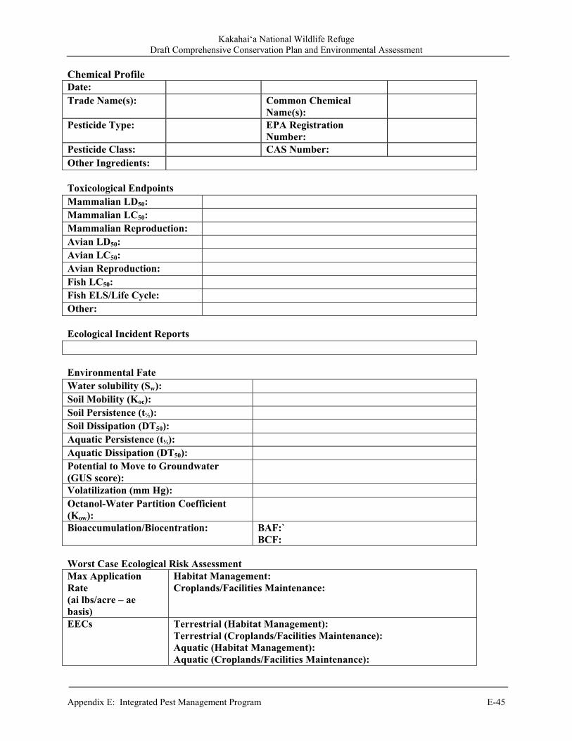
Kakahai‘a National Wildlife Refuge Draft Comprehensive Conservation Plan and Environmental Assessment
Appendix E: Integrated Pest Management Program E-45
Chemical Profile Date: Trade Name(s): Common Chemical
Name(s):
Pesticide Type: EPA Registration Number:
Pesticide Class: CAS Number: Other Ingredients: Toxicological Endpoints Mammalian LD50: Mammalian LC50: Mammalian Reproduction: Avian LD50: Avian LC50: Avian Reproduction: Fish LC50: Fish ELS/Life Cycle: Other: Ecological Incident Reports Environmental Fate Water solubility (Sw): Soil Mobility (Koc): Soil Persistence (t½): Soil Dissipation (DT50): Aquatic Persistence (t½): Aquatic Dissipation (DT50): Potential to Move to Groundwater (GUS score):
Volatilization (mm Hg): Octanol-Water Partition Coefficient (Kow):
Bioaccumulation/Biocentration: BAF:`BCF:
Worst Case Ecological Risk AssessmentMax Application Rate (ai lbs/acre – ae basis)
Habitat Management:Croplands/Facilities Maintenance:
EECs Terrestrial (Habitat Management):Terrestrial (Croplands/Facilities Maintenance): Aquatic (Habitat Management): Aquatic (Croplands/Facilities Maintenance):

Kakahai‘a National Wildlife Refuge Draft Comprehensive Conservation Plan and Environmental Assessment
E-46 Appendix E: Integrated Pest Management Program
Habitat Management Treatments: Presumption of Unacceptable Risk Risk Quotient (RQ)
Listed (T&E) Species
Nonlisted Species
Acute Birds [0.1] [0.5] Mammals [0.1] [0.5] Fish [0.05] [0.5]
Chronic Birds [1] [1] Mammals [1] [1] Fish [1] [1]
Cropland/Facilities Maintenance Treatments: Presumption of Unacceptable Risk Risk Quotient (RQ)
Listed (T&E) Species Nonlisted Species
Acute Birds [0.1] [0.5] Mammals [0.1] [0.5] Fish [0.05] [0.5]
Chronic Birds [1] [1] Mammals [1] [1] Fish [1] [1]
Justification for Use: Specific Best Management Practices (BMPs):
References: Table CP.1 Pesticide Name
Trade Namea
Treatment Typeb
Max Product Rate – Single Application (lbs/acre or
gal/acre)
Max Product Rate -Single Application
(lbs/acre - AI on acid equiv
basis)
Max Number of
Applications Per Season
Max Product Rate Per Season (lbs/acre/season
or gal/acre/season)
Minimum Time
Between Applications
(Days)
aFrom each label for a pesticide identified in pesticide use proposals (PUPs), Service personnel would record application information associated with possible/known uses on Service lands. bTreatment type: H – habitat management or CF – cropland/facilities maintenance. If a pesticide is labeled for both types of treatments (uses), then record separate data for H and CF applications.

Kakahai‘a National Wildlife Refuge Draft Comprehensive Conservation Plan and Environmental Assessment
Appendix E: Integrated Pest Management Program E-47
7.7 References AgDrift 2001. A user’s guide for AgDrift 2.04: a tiered approach for the assessment of spray drift of
pesticides. Spray Drift Task Force, PO Box 509, Macon, Missouri. ATSDR (Agency for Toxic Substances and Disease Registry) US Department of Health and Human
Services. 2004. Guidance Manual for the Assessment of Joint Toxic Action of Chemical Mixtures. US Department of Health and Human Services, Public Health Service, ATSDR, Division of Toxicology. 62 pages plus Appendices.
Baehr, C.H., and C. Habig. 2000. Statistical evaluation of the UTAB database for use in terrestrial
nontarget organism risk assessment. 10th Symposium on Environmental Toxicology and Risk Assessment, American Society of Testing and Materials.
Baker, J. and G. Miller. 1999. Understanding and reducing pesticide losses. Extension Publication
PM 1495, Iowa State University Extension, Ames, Iowa. 6 pages. Barry, T. 2004. Characterization of propanil prune foliage residues as related to propanil use patterns
in the Sacramento Valley, CA. Proceedings of the International Conference on Pesticide Application for Drift Management. Waikoloa, HI. 15 pages.
Battaglin, W.A., E.M. Thurman, S.J. Kalkhoff, and S.D. Porter. 2003. Herbicides and
Transformation Products in Surface Waters of the Midwestern United States. Journal of the American Water Resources Association (JAWRA) 39(4):743-756.
Beyer, W.N., E.E. Connor, S. Gerould. 1994. Estimates of soil ingestion by wildlife. Journal of
Wildlife Management 58:375-382. Brooks, M.L., D'Antonio, C.M., Richardson, D.M., Grace, J.B., Keeley, J.E. and others. 2004.
Effects of invasive alien plants on fire regimes. BioScience 54:77-88. BLM . 2007. Vegetation treatments using herbicides on BLM Lands in 17 western states
Programmatic EIS (PEIS). Washington Office, BLM . Butler, T., W. Martinkovic, and O.N. Nesheim. 1998. Factors influencing pesticide movement to
ground water. Extension Publication PI-2, University of Florida, Cooperative Extension Service, Gainesville, FL. 4 pages.
Calabrese, E.J. and L.A. Baldwin. 1993. Performing Ecological Risk Assessments. Lewis
Publishers, Chelsea, MI. Center, T.D., Frank, J.H., and Dray Jr., F.A. 1997. Biological Control. Strangers in Paradise: Impact
and Management of Nonindigenous Species in Florida. P.245-263. Cox, R.D., and V.J. Anderson. 2004. Increasing native diversity of cheatgrass-dominated rangeland
through assisted succession. Journal of Range Management 57:203-210.
Kakahai‘a National Wildlife Refuge Draft Comprehensive Conservation Plan and Environmental Assessment
E-48 Appendix E: Integrated Pest Management Program
Coombs, E.M., J.K Clark, G.L. Piper, and A.F. Cofrancesco Jr. 2004. Biological control of invasive plants in the United States. Oregon State University Press, Corvallis, 467 pages.
Driver, C.J., M.W. Ligotke, P. Van Voris, B.D. McVeety, B.J. Greenspan, and D.B. Brown. 1991.
Routes of uptake and their relative contribution to the toxicologic response of northern bobwhite (Colinus virginianus) to an organophosphate pesticide. Environmental Toxicology and Chemistry 10:21-33.
Dunning, J.B. 1984. Body weights of 686 species of North American birds. Western Bird Banding
Association. Monograph No. 1. EXTOXNET. 1993a. Movement of pesticides in the environment. Pesticide Information Project of
Cooperative Extension Offices of Cornell University, Oregon State University, University of Idaho, University of California – Davis, and the Institute for Environmental Toxicology, Michigan State University. 4 pages.
Fletcher, J.S., J.E. Nellessen, and T.G. Pfleeger. 1994. Literature review and evaluation of the EPA
food-chain (Kenaga) nomogram, and instrument for estimating pesticide residue on plants. Environmental Toxicology and Chemistry 13:1381-1391.
Hasan, S. and P.G. Ayres. 1990. The control of weeds through fungi: principles and
prospects. Tansley Review 23:201-222. Huddleston, J.H. 1996. How soil properties affect groundwater vulnerability to pesticide
contamination. EM 8559. Oregon State University Extension Service. 4 pages. Kerle, E.A., J.J. Jenkins, P.A. Vogue. 1996. Understanding pesticide persistence and mobility for
groundwater and surface water protection. EM 8561. Oregon State University Extension Service. 8 pages.
Masters, R.A, and R.L. Sheley. 2001. Invited synthesis paper: principles and practices for managing
rangeland invasive plants. Journal of Range Manage 54:502-517. Masters, R.A., S.J. Nissen, R.E. Gaussoin, D.D. Beran, and R.N. Stougaard. 1996. Imidazolinone
herbicides improve restoration of Great Plains grasslands. Weed Technology 10:392-403. Maxwell, B.D., E. Lehnhoff, L.J. Rew. 2009. The rationale for monitoring invasive plant
populations as a crucial step for management. Invasive Plant Science and Management 2:1-9.
Mineau, P., B.T. Collins, and A. Baril. 1996. On the use of scaling factors to improve interspecies
extrapolation to acute toxicity in birds. Regulatory Toxicology and Pharmacology 24:24-29. Moody, M.E., and R.N. Mack. 1988. Controlling the spread of plant invasions: the importance of
nascent foci. Journal of Applied Ecology 25:1009-1021. Morse, L.E., J.M. Randall, N. Benton, R. Hiebert, and S. Lu. 2004. An Invasive Species Assessment
Protocol: NatureServe.
Kakahai‘a National Wildlife Refuge Draft Comprehensive Conservation Plan and Environmental Assessment
Appendix E: Integrated Pest Management Program E-49
Mullin, B.H., L.W. Anderson, J.M. DiTomaso, R.E. Eplee, and K.D. Getsinger. 2000. Invasive Plant Species. Issue Paper (13):1-18.
Oregon State University. 1996. EXTOXNET-Extension Toxicology Network, Pesticide Information
Profiles. Oregon State University, Corvallis, Oregon. Pfleeger, T.G., A. Fong, R. Hayes, H. Ratsch, C. Wickliff. 1996. Field evaluation of the EPA
(Kanaga) nomogram, a method for estimating wildlife exposure to pesticide residues on plants. Environmental Toxicology and Chemistry 15:535-543.
Pope, R., J. DeWitt, and J. Ellerhoff. 1999. Pesticide movement: what farmers need to know.
Extension Publication PAT 36, Iowa State University Extension, Ames, Iowa and Iowa Department of Agriculture and Land Stewardship, Des Moines, Iowa. 6 pages.
Ramsay, C.A., G.C. Craig, and C.B. McConnell. 1995. Clean water for Washington – protecting
groundwater from pesticide contamination. Extension Publication EB1644, Washington State University Extension, Pullman, Washington. 12 pages.
SDTF 2003 Spray Drift Task Force. 2003. A summary of chemigation application studies. Spray
Drift Task Force, Macon, Missouri. Teske, M.E., S.L. Bird, D.M. Esterly, S.L. Ray, S.G. and Perry. 1997. A User's Guide for
AgDRIFTTM 1.0: A Tiered Approach for the Assessment of Spray Drift of Pesticides, Technical Note No. 95-10, CDI, Princeton, New Jersey.
Teske, M.E., S.L. Bird, D.M. Esterly, T.B. Curbishley, S.L. Ray, and S.G. Perry. 2002.
AgDRIFT®: a model for estimating near-field spray drift from aerial applications. Environmental Toxicology and Chemistry 21: 659-671.
Urban, D.J and N.J. Cook. 1986. Ecological risk assessment. EPA 540/9-85-001. EPA , Office of
Pesticide Programs, Washington D.C. 94 pages. EPA . 1990. Laboratory Test Methods of Exposure to Microbial Pest Control Agents by the
Respiratory Route to Nontarget Avian Species. Environmental Research Laboratory, Corvallis, OR. EPA/600/3-90/070.
EPA . 1998. A Comparative Analysis of Ecological Risks from Pesticides and Their Uses:
Background, Methodology & Case Study. Environmental Fate & Effects Division, Office of Pesticide Programs, U.S. Environmental Protection Agency, Washington, D.C. 105 pages.
EPA . 2004. Overview of the ecological risk assessment process in the Office of Pesticide
Programs, EPA : endangered and threatened species effects determinations, Office of Pesticide Programs, Washington, DC. 101 pages.
EPA . 2005a. Technical overview of ecological risk assessment risk characterization; Approaches
for evaluating exposure; Granular, bait, and treated seed applications. EPA , Office of Pesticide Programs, Washington, DC. http://www.epa.gov/oppefed1/ecorisk_ders/toera_analysis_exp.htm.
Kakahai‘a National Wildlife Refuge Draft Comprehensive Conservation Plan and Environmental Assessment
E-50 Appendix E: Integrated Pest Management Program
EPA . 2005b. User’s Guide TREX v1.2.3. EPA , Office of Pesticide Programs, Washington, DC.
22 pages. http://www.epa.gov/oppefed1/models/terrestrial/trex_usersguide.htm. U.S. Geological Survey. 2000. Pesticides in stream sediment and aquatic biota – current
understanding of distribution and major influences. USGS Fact Sheet 092-00, US Geological Survey, Sacramento, California. 4 pages.
U.S. Forest Service. 2005. Pacific Northwest Region Invasive Plant Program
Preventing and Managing Invasive Plants Final Environmental Impact Statement. 359 pages. Wauchope, R.D., T.M. Buttler, A.G. Hornsby, P.M. Augustijn-Beckers, and J.P. Burt. 1992. The
SCS/ARS/CES pesticide properties database for environmental decision making. Reviews of Environmental Contamination and Toxicology 123:1-155.
Woods, N. 2004. Australian developments in spray drift management. Proceedings of the
International Conference on Pesticide Application for Drift Management, Waikoloa, HI. 8 pages.
Appendix F.
WILDLAND FIRE MANAGEMENT PLAN
KAKAHAI‘A NATIONAL WILDLIFE REFUGE
2004

2004 WILDLAND FIRE MANAGEMENT PLAN
KAKAHAI‘A NATIONAL WILDLIFE REFUGE Prepared:
Glynnis L. Nakai, Refuge Manager Date Maui National Wildlife Refuge Complex
Concurred:
Jerry Leinecke, Project Leader Date Hawaiian and Pacific Islands National Wildlife Refuge Complex
Concurred:
Pamela Ensley, Regional Fire Management Coordinator Date Pacific Region, U.S. Fish and Wildlife Service
Approved:
David B. Allen, Regional Director Date Pacific Region, U.S. Fish and Wildlife Service
iii
TABLE OF CONTENTS
LIST OF FIGURES .................................................................................................................................... v LIST OF TABLES ...................................................................................................................................... v INTRODUCTION ....................................................................................................................................... 1 COMPLIANCE WITH USFWS POLICY ............................................................................................... 2
Refuge Purpose ................................................................................................................................ 2 Refuge Goals .................................................................................................................................... 2
FIRE MANAGEMENT OBJECTIVES .................................................................................................... 4 DESCRIPTION OF REFUGE ................................................................................................................... 5
General Description ......................................................................................................................... 5 Climate 5 Vegetation ........................................................................................................................................ 5 Fish and Wildlife ............................................................................................................................. 5 Threatened and Endangered Species................................................................................................ 6 Cultural Resources ........................................................................................................................... 6 Physical Resources........................................................................................................................... 6 Structures and Facilities ................................................................................................................... 7 Public Access ................................................................................................................................... 7
WILDLAND FIRE MANAGEMENT SITUATION ............................................................................... 9 Historic Role of Fire ........................................................................................................................ 9
Pre-settlement Fires ............................................................................................................ 9 Post-settlement Fire History ............................................................................................... 9 Prescribed Fire History ....................................................................................................... 9
Responsibilities ................................................................................................................................ 9 Refuge Manager .................................................................................................................. 9 Biologist ............................................................................................................................ 10 Zone Fire Management Officer ........................................................................................ 10 Incident Commander ......................................................................................................... 10 Resource Advisor .............................................................................................................. 10
Interagency Operations .................................................................................................................. 11 Protection of Sensitive Resources .................................................................................................. 12
WILDLAND FIRE SUPPRESSION ACTIVITIES ............................................................................... 14 Fire Management Strategies .......................................................................................................... 14 Preparedness .................................................................................................................................. 14
Historical Weather Analysis ............................................................................................. 14 Fire Prevention .................................................................................................................. 15 Hazard Reduction for Structure Protection ....................................................................... 15 Staffing Priority Levels ..................................................................................................... 15 Training ............................................................................................................................. 15 Supplies and Equipment ................................................................................................... 16
Detection ........................................................................................................................................ 16 Communications ............................................................................................................................ 16 Pre-Attack Plan .............................................................................................................................. 16

iv
Fire Management Units.................................................................................................................. 16 Fuels and Fire Behavior ................................................................................................................. 16
Fuel Types and Fire Behavior ........................................................................................... 16 Fire Effects ........................................................................................................................ 18
Suppression Tactics ....................................................................................................................... 18 Suppression Conditions .................................................................................................... 18 Wildland Fire Situation Analysis ...................................................................................... 19 Aircraft Operations ........................................................................................................... 20
Burned Area Emergency Stabilization and Rehabilitation ............................................................ 20 Policy and Implementation Guidance ............................................................................... 20 Compliance ....................................................................................................................... 20
Required Reporting ........................................................................................................................ 20 Fire Investigation ........................................................................................................................... 20
HAZARD FUEL REDUCTION .............................................................................................................. 22 Hazard Fuel Reduction Strategies .................................................................................................. 22 Pile Burning Guidelines ................................................................................................................. 22
Pile Burn Plan ................................................................................................................... 22 Pile Burning Strategies and Personnel .............................................................................. 23 Monitoring and Evaluation ............................................................................................... 23 Required Reports .............................................................................................................. 24
AIR QUALITY / SMOKE MANAGEMENT GUIDELINES .............................................................. 25 FIRE RESEARCH .................................................................................................................................... 25 PUBLIC SAFETY ..................................................................................................................................... 26 PUBLIC INFORMATION AND EDUCATION .................................................................................... 26 FIRE CRITIQUES AND ANNUAL PLAN REVIEW .......................................................................... 27
Fire Critiques ................................................................................................................................. 27 Annual Fire Summary Report ........................................................................................................ 27 Annual Fire Management Plan Review ......................................................................................... 27
CONSULTATION AND COORDINATION ......................................................................................... 27 APPENDICES ........................................................................................................................................... 28
Appendix A: References Cited .................................................................................................. 28 Appendix B: Definitions ........................................................................................................... 29 Appendix C: Fire Dispatch Plan ................................................................................................ 32 Appendix D: NEPA Compliance ............................................................................................... 36 Appendix E: ESA Section 7 Compliance .................................................................................. 38 Appendix F: Request for Cultural Resource Compliance ......................................................... 41 Appendix G: Interagency Agreements ...................................................................................... 43 Appendix H: Pile Burn Plan Template ...................................................................................... 44 Appendix I: Delegation of Authority ....................................................................................... 53 Appendix J: Wildland Fire Situation Analysis ......................................................................... 54

v
LIST OF FIGURES
Figure 1. Kakahaia National Wildlife Refuge.............................................................................................. 8 Figure 2. Fire Response Zones for the Island of Molokai........................................................................... 12
LIST OF TABLES Table 1. Threatened and Endangered Species found at Kakahaia NWR ..................................................... 6 Table 2. Habitat types and fuel models on Kakahaia NWR ...................................................................... 17 Table 3. Backing fire behavior predictions for Kakahaia NWR in Fuel Models 1 and 3 .......................... 17 Table 4. Kakahaia NWR Wildland Fire Suppression Guidelines. ............................................................. 19 Table 5. Maui National Wildlife Refuge Complex Staff. .......................................................................... 35 Table 6. Landowners adjacent to Kakahaia NWR ..................................................................................... 35
1
INTRODUCTION This document will establish a Fire Management Plan for Kahahaia National Wildlife Refuge (NWR), of the Maui NWR Complex. This plan will meet the requirements of the National Environmental Policy Act (NEPA), the Endangered Species Act (ESA) and the National Historic Preservation Act (NHPA). Compliance with NEPA was met through a Categorical Exclusion and associated Environmental Action Statement (Appendix D). For ESA Section 7 compliance, informal consultation with Ecological Services led to a “May Affect, Not Likely to Adversely Affect” determination (Appendix E). Compliance with the NHPA will be accomplished at the project level through submission of a Request for Cultural Resources Compliance form (Appendix F) to the Regional Archaeologist. This plan is written as an operational guide for managing the refuge’s wildland fire and prescribed fire programs. It defines levels of protection needed to provide for safety, protect facilities and resources, and restore and perpetuate natural processes, given current understanding of the complex relationships in natural ecosystems. It is written to comply with a service-wide requirement that refuges with burnable vegetation develop a fire management plan (620 DM 1). This plan will outline a program of suppression of all wildland fires and pile burning (as a limited form of prescribed fire). These piles will be generated from habitat enhancement and maintenance activities covered within the refuge’s ESA compliance documentation. There is no dedicated fire management staff on the refuge. Fire Management oversight is provided by the Regional Office located in Portland. Day-to-day fire management responsibilities are provided by the Refuge Manager located onsite. Suppression of wildland and structural fires on the refuge will be provided by Maui County Fire Department, Keonakakai Station, based on County of Maui emergency policy.
2
COMPLIANCE WITH USFWS POLICY Kakahaia National Wildlife Refuge was established in 1976 to provide habitat for endangered Hawaiian waterbirds, and migratory waterfowl and shorebirds. The endangered resident species on the 44.6-acre wetland include the Hawaiian stilt (Himantopus mexicanus knudseni), Hawaiian coot (Fulica alai), and possibly the Hawaiian duck (Anas wyvilliana). This plan meets NEPA / NHPA compliance and will be implemented in cooperation with the Endangered Species Act of 1973, as amended, and will take appropriate action to identify and protect from adverse effects on any rare, threatened, or endangered species. Compliance with NEPA was met through a Categorical Exclusion and associated Environmental Action Statement (Appendix D). For ESA Section 7 compliance, informal consultation with Ecological Services led to May Affect, Not Likely to Adversely Affect determination (Appendix E). Compliance with the NHPA will be accomplished at the project level through submission of a Request for Cultural Resources Compliance form (Appendix F) to the Regional Archaeologist. At this time, no Master Plan or Comprehensive Conservation Plan (CCP) exists for the Refuge. Development of a CCP for the entire complex is scheduled to begin in 2006. The Refuge purpose and goals can be found in the Maui National Wildlife Refuge Complex’s Refuge Management Information System, and are as follows: REFUGE PURPOSE
“to conserve (A) fish or wildlife which are listed as endangered species or threatened species...or (B) plants.” 16 U.S.C. § 1534 (Endangered Species Act of 1973).
REFUGE GOALS
Endangered Species: Promote the conservation of endangered species, especially native Hawaiian coot and Hawaiian stilt through healthy functioning of this wetland floodplain.
Habitat: Optimize water levels for maximum habitat size and value for endangered, resident,
and migrating waterfowl and shorebirds while reducing the growth and reproduction of problematical exotic species.
Visitor Use: Expand understanding and appreciation of the environment through wildlife-
oriented educational opportunities. Provide opportunities for quality, wildlife-dependent recreation, education, and research to enhance public appreciation, understanding, and enjoyment of refuge wildlife and habitats.
Habitat Restoration: Restore and maintain the diversity and abundance of native species
naturally occurring on the Refuge. Authority and guidance for implementing this plan are found in:
Protection Act of September 20, 1922 (42 Stat. 857; 16 U.S.C.594): authorizes the Secretary of the Interior to protect from fire, lands under the jurisdiction of the Department directly or in cooperation with other Federal agencies, states, or owners of timber.
Economy Act of June 30, 1932: authorizes contracts for services with other Federal agencies. Reciprocal Fire Protection Act of May 27, 1955 (69 Stat. 66, 67; 42 U.S.C. 1856, 1856a and b):
authorizes reciprocal fire protection agreements with any fire organization for mutual aid with or without reimbursement and allows for emergency assistance in the vicinity of agency lands in suppressing fires when no agreement exists.

3
Disaster Relief Act of May 22, 1974 (88 Stat. 143; 42 U.S.C. 5121): authorizes Federal agencies to assist state and local governments during emergency or major disaster by direction of the President.
National Wildlife Refuge System Administrative Act of 1966 as amended by the National Wildlife Refuge System Improvement Act of 1997, 16 U.S.C. 668dd et seq.: defines the National Wildlife Refuge System as including wildlife refuges, areas for the protection and conservation of fish and wildlife which are threatened with extinction, wildlife ranges, game ranges, wildlife management areas and waterfowl production areas. It also establishes a conservation mission for the Refuge System, defines guiding principles and directs the Secretary of the Interior to ensure that biological integrity and environmental health of the system are maintained and that growth of the system supports the mission.
Federal Fire Prevention and Control Act of October 29, 1974 (88 Stat. 1535; 15 U.S.C.2201): provides for reimbursement to state or local fire services for costs of firefighting on federal property.
Wildfire Suppression Assistance Act of 1989. (Pub.L. 100-428, as amended by Pub.L 101- 11, April 7, 1989).
Departmental Manual (Interior), Part 620 DM, Chapter 1, Wildland Fire Management: General Policy and Procedures (April 10, 1998): defines Department of Interior fire management policies.
Service Manual, Part 621, Fire Management (February 7, 2000): defines U.S. Fish and Wildlife Service fire management policies.
National Environmental Policy Act of 1969: regulations implementing the National Environmental Policy Act (NEPA) encourages the combination of environmental comments with other agency documents to reduce duplication and paperwork (40 CFR 1500.4(o) and 1506.4).
Clean Air Act (42 United State Code (USO) 7401 et seq.): requires states to attain and maintain the national ambient air quality standards adopted to protect health and welfare. This encourages states to implement smoke management programs to mitigate the public health and welfare impacts of Wildland and prescribed fires managed for resource benefit.
Endangered Species Act of 1973. U.S. Fish & Wildlife Service Fire Management Handbook.
The authority for funding (normal fire year programming) and all emergency fire accounts is found in the following authorities:
Section 102 of the General Provisions of the Department of Interior's annual Appropriations Bill provides the authority under which appropriated monies can be expended or transferred to fund expenditures arising from the emergency prevention and suppression of wildland fire.
P.L. 101-121, Department of the Interior and Related Agencies Appropriation Act of 1990, established the funding mechanism for normal year expenditures of funds for fire management purposes.
31 US Code 665(E)(1)(B) provides the authority to exceed appropriations due to wildland fire management activities involving the safety of human life and protection of property.
Authorities for procurement and administrative activities necessary to support wildland fire suppression missions are contained in the Interagency Fire Business Management Handbook.

4
FIRE MANAGEMENT OBJECTIVES The overall objective for fire management on Kakahaia NWR is to promote a program to provide for firefighter and public safety, reduce the incidence of human-caused fires, and ensure appropriate suppression response capability to meet expected wildland fire complexity. Specific fire management objectives are:
Promote a fire management program and control all wildland fires. Provide for the protection of life, property, and resources from wildland fires at costs
commensurate with resource values at risk. Use appropriate suppression tactics and strategies that minimize long-term impacts of suppression
actions. Use pile burning to safely and efficiently remove debris from resource management activities and
reduce hazardous fuels.
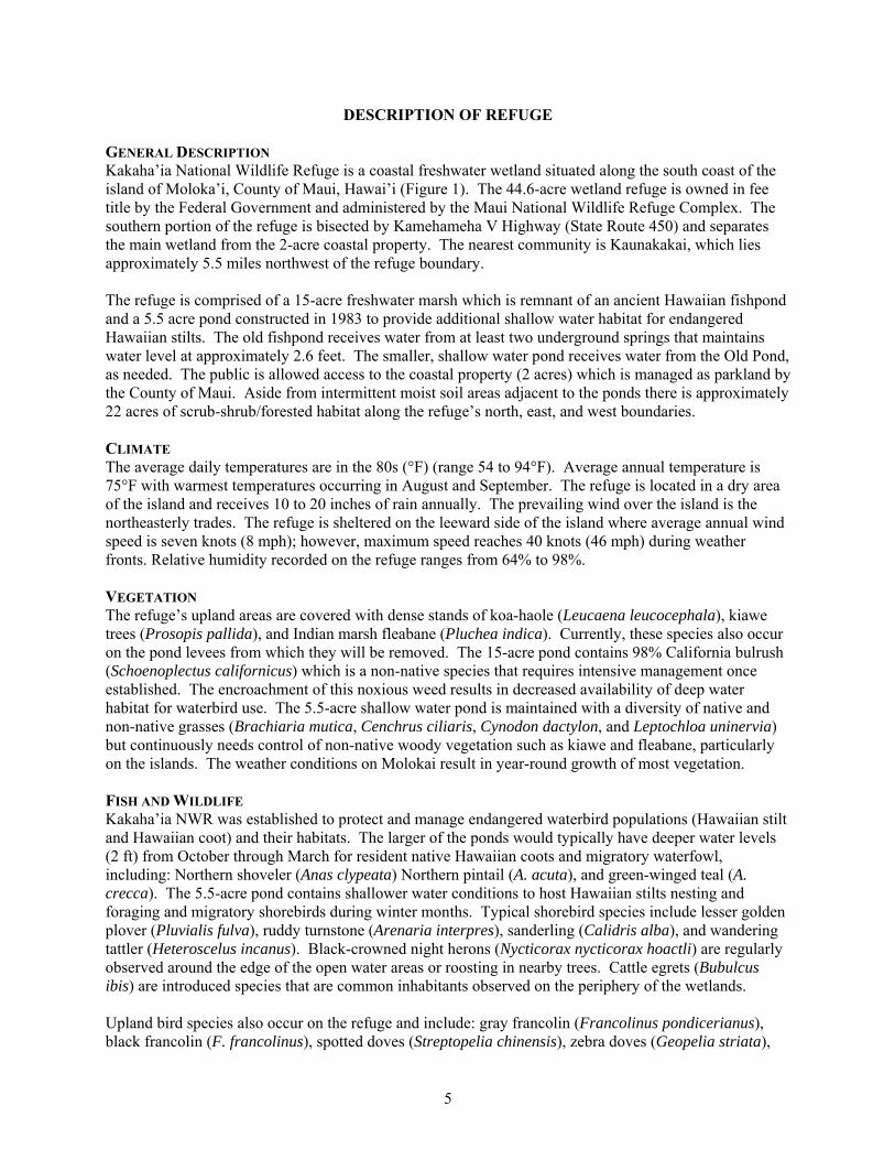
5
DESCRIPTION OF REFUGE GENERAL DESCRIPTION Kakaha’ia National Wildlife Refuge is a coastal freshwater wetland situated along the south coast of the island of Moloka’i, County of Maui, Hawai’i (Figure 1). The 44.6-acre wetland refuge is owned in fee title by the Federal Government and administered by the Maui National Wildlife Refuge Complex. The southern portion of the refuge is bisected by Kamehameha V Highway (State Route 450) and separates the main wetland from the 2-acre coastal property. The nearest community is Kaunakakai, which lies approximately 5.5 miles northwest of the refuge boundary. The refuge is comprised of a 15-acre freshwater marsh which is remnant of an ancient Hawaiian fishpond and a 5.5 acre pond constructed in 1983 to provide additional shallow water habitat for endangered Hawaiian stilts. The old fishpond receives water from at least two underground springs that maintains water level at approximately 2.6 feet. The smaller, shallow water pond receives water from the Old Pond, as needed. The public is allowed access to the coastal property (2 acres) which is managed as parkland by the County of Maui. Aside from intermittent moist soil areas adjacent to the ponds there is approximately 22 acres of scrub-shrub/forested habitat along the refuge’s north, east, and west boundaries. CLIMATE The average daily temperatures are in the 80s (°F) (range 54 to 94°F). Average annual temperature is 75°F with warmest temperatures occurring in August and September. The refuge is located in a dry area of the island and receives 10 to 20 inches of rain annually. The prevailing wind over the island is the northeasterly trades. The refuge is sheltered on the leeward side of the island where average annual wind speed is seven knots (8 mph); however, maximum speed reaches 40 knots (46 mph) during weather fronts. Relative humidity recorded on the refuge ranges from 64% to 98%. VEGETATION The refuge’s upland areas are covered with dense stands of koa-haole (Leucaena leucocephala), kiawe trees (Prosopis pallida), and Indian marsh fleabane (Pluchea indica). Currently, these species also occur on the pond levees from which they will be removed. The 15-acre pond contains 98% California bulrush (Schoenoplectus californicus) which is a non-native species that requires intensive management once established. The encroachment of this noxious weed results in decreased availability of deep water habitat for waterbird use. The 5.5-acre shallow water pond is maintained with a diversity of native and non-native grasses (Brachiaria mutica, Cenchrus ciliaris, Cynodon dactylon, and Leptochloa uninervia) but continuously needs control of non-native woody vegetation such as kiawe and fleabane, particularly on the islands. The weather conditions on Molokai result in year-round growth of most vegetation. FISH AND WILDLIFE Kakaha’ia NWR was established to protect and manage endangered waterbird populations (Hawaiian stilt and Hawaiian coot) and their habitats. The larger of the ponds would typically have deeper water levels (2 ft) from October through March for resident native Hawaiian coots and migratory waterfowl, including: Northern shoveler (Anas clypeata) Northern pintail (A. acuta), and green-winged teal (A. crecca). The 5.5-acre pond contains shallower water conditions to host Hawaiian stilts nesting and foraging and migratory shorebirds during winter months. Typical shorebird species include lesser golden plover (Pluvialis fulva), ruddy turnstone (Arenaria interpres), sanderling (Calidris alba), and wandering tattler (Heteroscelus incanus). Black-crowned night herons (Nycticorax nycticorax hoactli) are regularly observed around the edge of the open water areas or roosting in nearby trees. Cattle egrets (Bubulcus ibis) are introduced species that are common inhabitants observed on the periphery of the wetlands. Upland bird species also occur on the refuge and include: gray francolin (Francolinus pondicerianus), black francolin (F. francolinus), spotted doves (Streptopelia chinensis), zebra doves (Geopelia striata),
6
common myna (Acridotheres tristis), Northern cardinal (Cardinalis cardinalis), and house finch (Carpodacus mexicanus). Mammals found on the refuge are all non-native and include black rat (Rattus rattus), Norwegian rat, feral cats, and mongoose, all of which are controlled to protect endangered waterbirds. Introduced Axis deer frequent the refuge (tracks observed) in the thick kiawe forest. THREATENED AND ENDANGERED SPECIES Endangered waterbirds occur in both Old and New Ponds depending upon water level. Hawaiian coots prefer water depth less than 18 inches and will also occur along the water edges in moist soil areas. Nests are built in emergent vegetation from December through March if water level remains constant. Hawaiian stilts are waders and prefer water no more than approximately seven inches in depth. The stilts nest on the ground adjacent to water and vegetation. Typically, this occurs from April through August. A majority of the foraging and nesting areas for stilts occurs in New Pond which has variable topography for nesting islands when water level is low. The critical nesting period for both endangered waterbirds is from December through August. Hawaiian ducks possibly use the refuge, but identification has been difficult due to hybridization. A majority of the vegetation present on the refuge is non-native, invasive species; there are no threatened or endangered plant species recorded. The refuge does not contain designated Critical Habitat or portions thereof. Table 1. Threatened and Endangered Species found at Kakahaia NWR.
Common Name Scientific Name Federal Status
Hawaiian Coot Fulica alai Endangered
Hawaiian Stilt Himantopus mexicanus knudseni Endangered
Hawaiian Duck Anas wyvilliana Endangered CULTURAL RESOURCES The Service has not conducted a comprehensive archaeological survey on the refuge. Site-specific surveys will be conducted prior to any land-altering activities on the refuge. The larger pond, “Old Pond”, is an Hawaiian fishpond and may be eligible for listing; however, the pond has not yet undergone a comprehensive cultural assessment and has not been designated an historic site. PHYSICAL RESOURCES Elevation of Kakahaia National Wildlife Refuge ranges from sea level to approximately 10 feet. The soils are poorly drained, except for most of the upland areas. During periods of heavy rain, erosion from the upper watershed has delivered large amounts of soil to the northern (upper) edges of the wetlands and will, with time, promote increased sedimentation into the larger pond due to the large stand of bulrush.

7
STRUCTURES AND FACILITIES Kakahaia NWR is an unstaffed refuge which is visited twice a month to census birds, perform light maintenance duties and to check water conditions. Limited presence at the site results in minimal structures and facilities. To secure property there is one metal storage container (20 ft x 12 ft) and pre-fabricated shed. Other structures include a windmill between the ponds, a submersible pump to draw water from Old to New Pond, and various hydrological staff gages and piezometers. The staff has one refuge vehicle which is parked at the Hoolehua airport between visits. An electric line is buried within the north levee of New Pond and extends from the entrance road to the maintenance area and ends at the windmill pump. PUBLIC ACCESS Kakahaia NWR is an un-staffed refuge and has limited public access, except to the coastal property (2 acres) across Kamehameha V Highway which is not fenced. Refuge staff performs maintenance and restoration activities twice per month. Environmental education and public access is limited to pre-arranged days when appropriate staff are available to travel for the day.
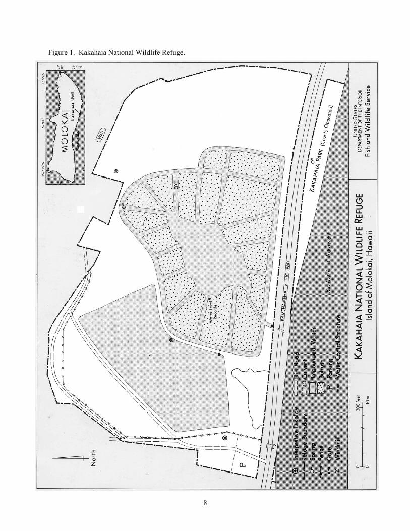
8
Figure 1. Kakahaia National Wildlife Refuge.
9
WILDLAND FIRE MANAGEMENT SITUATION HISTORIC ROLE OF FIRE Historic natural fires on Moloka’i have been limited to volcanic eruptions and lightning and are very infrequent. In general the native vegetation is not well adapted to fire disturbances. Non-native (invasive) species typically colonize burned areas to the exclusion of native species. Pre-settlement Fires There is no clear indication that fire was an integral part of the native ecosystem. There are no records indicating fire frequency prior to settlement, although rare fire events likely occurred as a result of volcanic activity and lightning. Post-settlement Fire History No wildland fires are known to have occurred on the Refuge. The grassy slope inland of the refuge experienced some small wildfires prior to 1984. In 1980, a human-caused wildfire occurred one mile west of the refuge and quickly spread through the dryland vegetation. In 1988, an extensive fire (9,500 acres) occurred through an open kiawe grassland eight miles to the west. Throughout the state, fire season is considered by the Hawaii Department of Forestry and Wildlife (DOFAW) to occur during a three-month period in late summer. However, given the extreme variability of weather in Hawaii, fires may occur at any time during the year. There is no clearly-defined fire season for the refuge. Prescribed Fire History There is no history of prescribed fire use on the refuge. Pile burning will occur in September after endangered waterbird breeding season and before winter rains. RESPONSIBILITIES Kakahaia NWR does not have a dedicated fire management organization. The Project Leader and Refuge Manager are responsible for planning and implementing the fire management program on the Refuge. Staff from the Regional Office in Portland will act as the Zone Fire Management Officer (FMO), and are responsible for fire management program oversight. The Project Leader will assign fire management responsibilities as collateral duties to staff who possess appropriate training, experience, and incident qualifications. Preparedness planning and work is accomplished by Refuge staff in accordance with national and regional fire management direction under guidance from the Regional Office. Emergency fire management actions will be handled by Refuge staff according to training and incident qualifications. The Regional Office will be immediately notified of all emergency actions. Additional information and direction is included in the Fire Dispatch Plan (Appendix C). Refuge Manager
Is responsible for implementation of all fire management activities within the Refuge and will ensure compliance with Department and Service policies.
Selects the appropriate management responses to wildland fires. Approves any Pile Burn Plan. Coordinates Complex programs to ensure personnel and equipment are made available and
utilized for fire management activities. Ensures that the fire management program is considered during refuge-related planning and
project implementation. Acts as the primary Resource Advisor during fire management planning and operations. Coordinates with cooperators to ensure adequate resources are available for fire operational
needs.
10
Biologist Coordinates through Project Leader to provide biological input for the fire program. Participates, as requested in fire suppression and rehabilitation projects according to level of
training and qualifications. May act as primary Refuge Resource Advisor for the Project Leader.
Zone Fire Management Officer
Responsible for all fire-related planning for the Refuge. Solicits program input from the Project Leader and Biologist. Coordinates fire related training. Coordinates with cooperators to ensure adequate resources are available for fire operational
needs. Is responsible for preparation of fire reports following the suppression of wildland fires. Prepares an annual report detailing fire activities undertaken in each calendar year. This report
will serve as a post-year’s fire management activities review, as well as provide documentation for development of a comprehensive fire history record for the Complex.
Submits budget requests and monitors FIREBASE funds. Maintains records for all personnel involved in related activities, detailing each individual's
qualifications and certifications for such activities. Incident Commander Incident Commanders (ICs) of any level use strategies and tactics as directed by the Project Leader and WFSA where applicable to implement selected objectives on a particular incident. A specific Limited Delegation of Authority (Appendix I) will be provided to each Incident Commander prior to assuming responsibility for an incident. Major duties of the Incident Commander are given in the National Wildfire Coordinating Group (NWCG) Fireline Handbook, including:
Brief subordinates, direct their actions, and provide work tools. Ensure that safety standards identified in the Fire Orders, the Watch Out Situations, and agency
policies are followed at all times. Personally scout and communicate with others to be knowledgeable of fire conditions, fire
weather, tactical progress, safety concerns and hazards, condition of personnel, and needs for additional resources.
Order resources to implement the management objectives for the fire. Inform appropriate dispatch of current situation and expected needs. Coordinate mobilization and demobilization with dispatch and the Zone FMO. Perform administrative duties, i.e., approving work hours, completing fire reports for command
period, maintaining property accountability, providing or obtaining medical treatment, and evaluating performance of subordinates.
Assure aviation safety is maintained to the highest standards. Resource Advisor The Resource Advisor (RA) is a technical specialist appointed by the Agency Administrator and reports to the IC or designee and provides guidance for natural and cultural resource protection from suppression operations. The RA provides input to the IC in the development of fire suppression strategies and tactics to minimize or mitigate the expected impacts of fire and fire and fire suppression actions upon natural and cultural resources. The RA also provides input required for the development of rehabilitation plans. Resource Advisor responsibilities include (NWCG 1996):
Provides analysis, information, and advice to fire managers for areas of concern, including critical watersheds, riparian areas, fisheries, and water sources; threatened or endangered species;
11
prehistoric and historic archaeological sites and cultural landscapes; fuel breaks B locations and specifications; urban interface impact B structures and improvements; and hazardous materials
Assists the planning function in developing fire maps and identifying areas of concern Determines environmental restrictions commensurate with FMP resource protection in the fire
area Provides recommendations to fire management personnel and agency administrators for fire
suppression rehabilitation needs Documents potential and actual suppression/fire-related resource impacts and the rationale for
protection of priority areas Provides resource information to local initial attack ICs, dispatchers, or other fire personnel
during pre-season training and planning meetings. INTERAGENCY OPERATIONS Maui County Fire Department (Keonakakai Station) will provide initial attack response to wildland and structural fires on the refuge (Figure 2). If qualified resources are not available, resources will be ordered through proper dispatch procedures (Appendix C). The Hawaii Department of Fish and Wildlife (DOFAW) would be able to respond to fires in the white areas of the figure below only under specific conditions (i.e., extreme threats to public safety, local resources fully committed, extreme fire behavior, etc.). In this case, the request for assistance must come from the County Fire Department through the County Civil Defense to State Civil Defense. No formal cooperative agreements exist with these agencies. When they are developed, they will be added to Appendix G. Kealia Pond will use the Incident Command System (ICS) as a guide for fireline organization. Qualifications for individuals are per DOI Wildland Fire Qualifications and Certification System, part of NIIMS and the National Wildland Fire Coordination Group (NWCG) Prescribed Fire Qualification Guide. Depending on fire complexity, some positions may be filled by the same person.

12
Kakahaia NWR
Figure 2. Fire Response Zones for the Island of Molokai. PROTECTION OF SENSITIVE RESOURCES Resource Advisors will be required for all wildland fires on the refuge. The advisor will work with the suppression resources to limit environmental impact. The Regional Archaeologist will work with fire staff, Project Leaders, and Incident Commanders to ensure that cultural resources are protected from fire and fire management activities. The “Request For Cultural Resource Compliance” (RCRC) form (Appendix F) will be used to inform the Regional Archaeologist of impending activities, thereby meeting the regulations and directions governing the protection of cultural resources as outlined in Departmental Manual Part 519, National Historic Preservation Act (NHPA) of 1966, Code of Federal Regulations (36CFR800), the Archaeological Resources Protection Act of 1979, as amended, and the Archaeological and Historic Preservation Act of 1974. The NHPA Section 106 clearance will be followed for any fire management activity that may affect historic properties (cultural resources listed or eligible for listing on the National Register of Historic Places). Impacts to archaeological resources by fire resources vary. The four basic sources of damage are (1) fire intensity, (2) duration of heat, (3) heat penetration into soil, and (4) suppression actions. Of the four, the most significant threat is from equipment during line construction for prescribed fires or wildfire holding actions (Anderson 1983).
13
The following actions will be taken to protect archaeological and cultural resources: Wildland Fires
Minimum impact fire suppression tactics will be used to the fullest extent possible. The Resource Advisor will inform fire suppression personnel of any areas with cultural resources.
The Resource Advisor should contact the Regional Archaeologist for more detailed information. Foam use will be minimized in areas known to harbor surface artifacts. Mechanized equipment should not be used in areas of known cultural significance. The location of any sites discovered as the result of fire management activities will be reported to
the Regional Archaeologist. Rehabilitation plans will address cultural resources impacts and will be submitted to the Regional
Archaeologist using the RCRC. Pile Burns
The refuge fire staff will submit a completed RCRC to the Regional Archaeologist as soon as the burn area is identified (i.e., as soon as feasible).
Upon receipt of the RCRC, the Regional Archaeologist will be responsible for consulting with the Zone FMO and evaluating the potential for adverse impacts to cultural resources.
When necessary, the Regional Archaeologist will coordinate with the State Historic Preservation Officer (SHPO). The SHPO has 30 days to respond. The Refuge will consider all SHPO recommendations.
Mechanized equipment should not be used in areas of known cultural significance. The location of any sites discovered as the result of fire management activities will be reported to
the Regional Archaeologist.
14
WILDLAND FIRE SUPPRESSION ACTIVITIES Fire program management describes the operational procedures necessary to implement fire management at Kakahaia NWR. Program management includes fire prevention, preparedness, emergency preparedness, fire behavior predictions, fire detection, minimum impact fire suppression, minimum impact rehabilitation, and documentation. All fires not classified as prescribed fires are wildland fires and will be appropriately suppressed. Maui County will provide wildland fire suppression resources under most circumstances. Most suppression activities will necessitate the use of heavy equipment to create firebreaks or allow the fire to burn to the water. There is no clearly defined fire season for the refuge and records show that fires may occur at any during the year. FIRE MANAGEMENT STRATEGIES Although resource impacts of suppression alternatives must always be considered in selecting a fire management strategy, managing fire for resource benefit is not authorized on this refuge. Appropriate suppression action will be taken to provide for firefighter safety, public safety, and protection of resources. Critical protection areas, including all refuge structures and facilities, will receive priority consideration in fire control planning efforts. In all cases, the primary concerns of fire suppression personnel will be safety. If needed, all individuals not involved in the suppression effort will be evacuated. Suppression strategies should be applied so that the equipment and tools used to meet the desired objectives are those that inflict the least impacts upon the natural and cultural resources. Minimum impact suppression tactics (MIST) will be employed to protect all resources. Natural and artificial barriers will be used as much as possible for containment. When necessary, fire line construction will be conducted in such a way as to minimize long-term impacts to resources. Sites impacted by fire suppression activities or by the fire will be rehabilitated as necessary, based on an approved course of action for each incident. Specific wildland fire management and suppression strategies for Kakahaia NWR are:
All wildland fires will be controlled using the appropriate suppression strategy which considers safety, property, natural and cultural resources, and economics.
Mechanical treatment will be used to reduce hazardous fuels around structures and improvements.
PREPAREDNESS Preparedness is the work accomplished prior to fire occurrence to ensure that the appropriate response, as directed by the Fire Management Plan, can be carried out. Preparedness activities include: budget planning, equipment acquisition, equipment maintenance, dispatch (initial attack, extended, and expanded), equipment inventory, personnel qualifications, and training. The preparedness objective is to have a well trained and equipped fire management organization to manage all fire situations within the monument. Preparedness efforts are to be accomplished in the time frames outside the normal fire season dates. Historical Weather Analysis There is no clearly defined fire season for the refuge and records show that fires may occur at any during the year.
15
General fire weather information can be obtained through the National Oceanic and Air Administration (NOAA) at fire.boi.noaa.gov. Kakahaia NWR is located in the area serviced by the National Weather Service (NWS) office in Honolulu, Hawaii. The Fire Weather section of the Honolulu NWS website, www.prh.noaa.gov/hnl/pages/firewx.php, contains zone maps, fire weather forecasts, and instructions for requesting a spot weather forecast. The refuge falls within the Molokai Leeward (013) Fire Weather Zone. Fire Prevention An active fire prevention program will be conducted, as needed, in conjunction with other agencies to protect human life and property, and prevent damage to cultural resources or physical facilities. A program of internal and external education regarding potential fire danger may be implemented. Visitor contacts, bulletin board materials, handouts and interpretive programs can be utilized to increase visitor and neighbor awareness of fire hazards. During periods of extreme or prolonged fire danger area closures or emergency restrictions regarding refuge operations may become necessary. Such restrictions, when imposed, will usually be consistent with those implemented by cooperators. Hazard Reduction for Structure Protection Hazard reduction is conducted to prevent wildland fires from spreading onto structures owned by the FWS and adjacent structures. Vegetation around structures (metal container and shed) is cleared a minimum of two feet. Currently, this vegetation must be hauled to the dump for removal. Non-FWS structures include privately-owned residences (seven) located along all but the south boundary. Staffing Priority Levels No dedicated fire staff exists on the refuge. If drought conditions require additional fire preparedness and funding, addition qualified fire personnel may be assigned to the refuge. Training Departmental policy requires that all personnel engaged in suppression and prescribed fire duties meet the standards set by the National Wildfire Coordinating Group (NWCG), in addition to Service-specific standards. Kakahaia NWR will conform strictly to the requirements of the wildland fire management qualification and certification system and USFWS guidelines. Basic wildland fire training refreshers are offered annually for red-carded firefighters through surrounding agencies, and records are kept in a centralized database. Additional training is available from surrounding agencies in pump and engine operation, power saws, firefighter safety, fire weather and fire behavior, helicopter safety and prescribed fire objectives and activities. On-the-job training is encouraged and will be conducted at the field level. Whenever appropriate, the use of fire qualification task books will be used to document fire experience of trainees. The Zone FMO will coordinate fire training needs with those of other nearby refuges, cooperating agencies, and the Regional Office. The refuge supports the development of individual Incident Command System (ICS) overhead personnel from among qualified and experienced refuge staff for assignment to overhead teams at the local, regional, and national level. Fire suppression is an arduous duty. On pile burns, personnel may be required to shift from implementation and/or monitoring activities to suppression. Poor physical condition of crew members can endanger safety and lives during critical situations. Personnel performing fire management duties
16
will maintain a high level of physical fitness. This requires successful completion of a fitness pack test. Personnel must complete a three mile hike with a 45 pound pack in less than 45 minutes. Employees participating in any wildland fire activities on Fish and Wildlife Service or cooperators= lands will meet fitness requirements established in PMS 310-1, except where Service-specific fitness requirements apply. Supplies and Equipment Currently, the refuge does not possess any fire equipment or maintain a fire cache. Equipment and supplies are available through the interagency cache system. DETECTION Fires are generally reported by the public to the Maui County Fire Department. The Fire Department notifies refuge staff of any suppression operations on the refuge. COMMUNICATIONS Currently, refuge communications are limited to telephones (Appendix C). No personnel will be on-site at a wildland fire without direct communications with the suppression resources. PRE-ATTACK PLAN Upon discovery of a fire, all subsequent actions will be based on the following:
The Incident Commander (IC) will locate, size-up, and coordinate suppression actions. The IC will complete the pre-attack planning checklist.
Provide for public safety. Considering the current and predicted fire conditions, the Incident Commander will assess the
need for additional suppression resources and estimate the final size of the fire. The potential for spread outside of the refuge should be predicted, as well as the total suppression force required to initiate effective containment action at the beginning of each burning period.
The Incident Commander will assess the need for law enforcement personnel for traffic control, investigations, evacuations, etc., and make the request to the FMO.
Document decisions and complete the fire report (DI-1202). Should a wildland fire move into an extended attack a Delegation of Authority will be invoked.
Once a Delegation of Authority has been authorized the Incident Commander will make the final decisions pertaining to the fire. A copy of the Delegation of Authority is in Appendix ?.
FIRE MANAGEMENT UNITS Fire Management Units (FMUs) are areas on a refuge which have common wildland fire management objectives and strategies, are manageable units from a wildland fire standpoint, and can be based on natural or man-made fuel breaks. Kakahaia NWR will be managed as a single FMU. Due to staff limitations, relatively small land management parcels, long response times, valuable resources, and values at risk on neighboring lands, this plan does not authorize managing wildland fire for resource benefit. Wildland fires will be suppressed using the appropriate suppression response. Pile burning, as a limited form of prescribed burning, will be used to reduce hazardous fuels and to meet resource management objectives. FUELS AND FIRE BEHAVIOR Fuel Types and Fire Behavior There are two general fuel types on the refuge. These fuel types correspond to Anderson’s (1982) Fuel Models 3 and 6 (Table 2). These types of fuels promote rapid spread and flame heights that may exceed 20 feet, thus causing control problems. Steady trade winds help promote rapid fire growth.
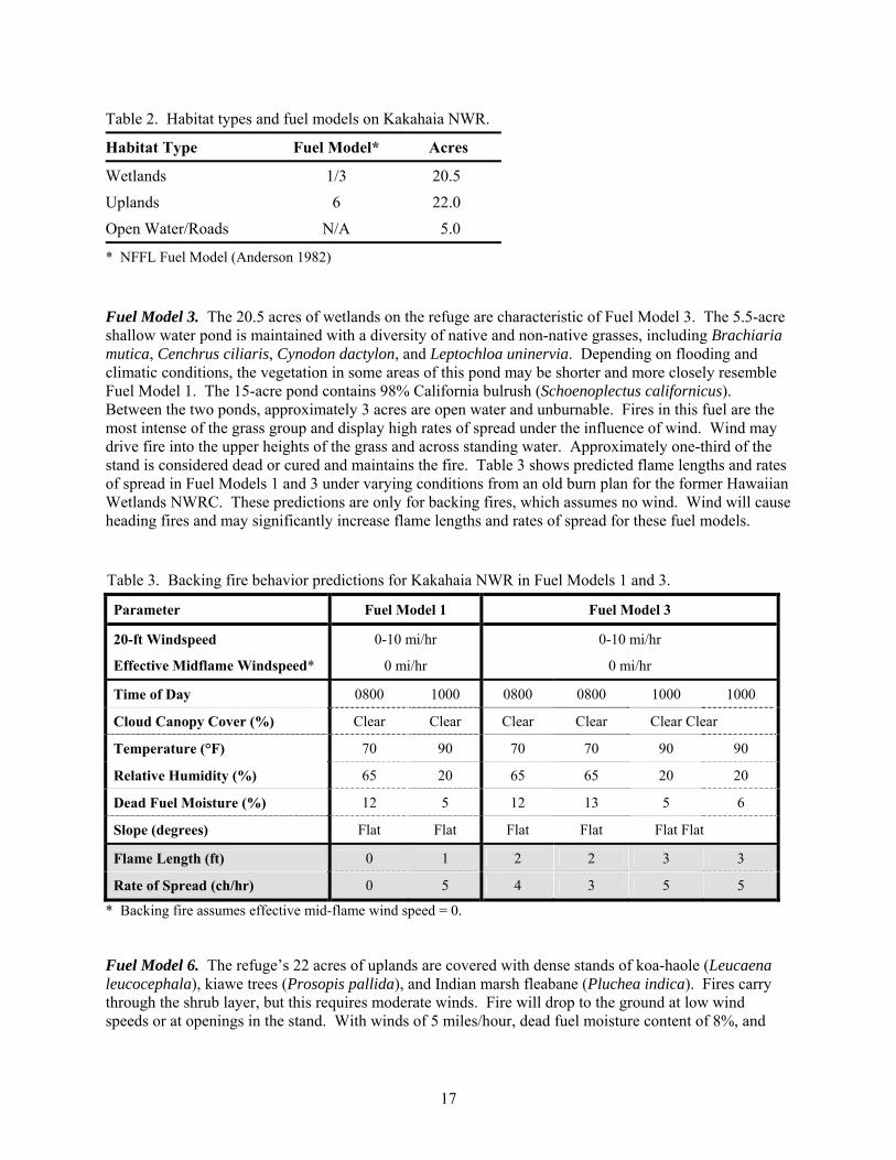
17
Table 2. Habitat types and fuel models on Kakahaia NWR.
Habitat Type Fuel Model* Acres
Wetlands 1/3 20.5 Uplands 6 22.0 Open Water/Roads N/A 5.0
* NFFL Fuel Model (Anderson 1982) Fuel Model 3. The 20.5 acres of wetlands on the refuge are characteristic of Fuel Model 3. The 5.5-acre shallow water pond is maintained with a diversity of native and non-native grasses, including Brachiaria mutica, Cenchrus ciliaris, Cynodon dactylon, and Leptochloa uninervia. Depending on flooding and climatic conditions, the vegetation in some areas of this pond may be shorter and more closely resemble Fuel Model 1. The 15-acre pond contains 98% California bulrush (Schoenoplectus californicus). Between the two ponds, approximately 3 acres are open water and unburnable. Fires in this fuel are the most intense of the grass group and display high rates of spread under the influence of wind. Wind may drive fire into the upper heights of the grass and across standing water. Approximately one-third of the stand is considered dead or cured and maintains the fire. Table 3 shows predicted flame lengths and rates of spread in Fuel Models 1 and 3 under varying conditions from an old burn plan for the former Hawaiian Wetlands NWRC. These predictions are only for backing fires, which assumes no wind. Wind will cause heading fires and may significantly increase flame lengths and rates of spread for these fuel models. Table 3. Backing fire behavior predictions for Kakahaia NWR in Fuel Models 1 and 3.
Parameter Fuel Model 1 Fuel Model 3
20-ft Windspeed 0-10 mi/hr 0-10 mi/hr
Effective Midflame Windspeed* 0 mi/hr 0 mi/hr
Time of Day 0800 1000 0800 0800 1000 1000
Cloud Canopy Cover (%) Clear Clear Clear Clear Clear Clear
Temperature (°F) 70 90 70 70 90 90
Relative Humidity (%) 65 20 65 65 20 20
Dead Fuel Moisture (%) 12 5 12 13 5 6
Slope (degrees) Flat Flat Flat Flat Flat Flat
Flame Length (ft) 0 1 2 2 3 3
Rate of Spread (ch/hr) 0 5 4 3 5 5
* Backing fire assumes effective mid-flame wind speed = 0. Fuel Model 6. The refuge’s 22 acres of uplands are covered with dense stands of koa-haole (Leucaena leucocephala), kiawe trees (Prosopis pallida), and Indian marsh fleabane (Pluchea indica). Fires carry through the shrub layer, but this requires moderate winds. Fire will drop to the ground at low wind speeds or at openings in the stand. With winds of 5 miles/hour, dead fuel moisture content of 8%, and
18
live fuel moisture content of 100%, predicted flame length is 6 feet, and rate of spread is 32 chains/hour (Anderson 1982). Fire Effects Fire can promote non-native species, but can be an effective management tool to reduce the density and complexity of these species and enhance endangered waterbird habitat. If a wildland fire were to occur on the refuge, other than short-term impacts, no negative ecological impacts would be anticipated from either suppression methods or the fire itself. A fire during peak Hawaiian stilt or coot nesting could account for some nesting failure; however, the benefits to waterbirds of reducing coverage by rank stands of non-native species would outweigh any immediate negative effects. The ecological effect of the 1980 fire near the refuge was limited to minor erosion problems. Native vegetation quickly re-established within 6 months. SUPPRESSION TACTICS Suppression involves a wide range of possible tactics from the initial attack to final control. To this end, all wildland fires will be suppressed in a safe, aggressive, and cost-effective manner to produce efficient action with minimal resource damage and limit smoke impacts to local communities. Typically, initial attack suppression actions are conducted by the Maui County Fire Department. All fires will be assessed by the initial on-scene Incident Commander and attacked using minimum impact fire suppression tactics for the Refuge. Roads and natural barriers will be used as much as possible to reduce fireline construction. Fireline and mop-up through riparian areas should consider long-term damage to vegetation. Unnecessary cutting and bucking should be replaced with alternative actions whenever possible. Where wildland fires cross roads, the burned area adjacent to the road should be mopped up and dangerous snags felled. A Resource Advisor should be assigned to the incident from the beginning to assist with on-the-ground tactical decisions and to document rehabilitation needs. There will be only one Incident Commander who will be responsible to the Refuge Project Leader. The Incident Commander will designate all overhead positions on fires requiring extended attack. Reference should be made to a Delegation of Authority (Appendix G). Suppression Conditions A full suppression alternative was selected for this refuge which requires containment and control of all wildland fires. Wildland fires will not be managed to achieve resource objectives, although impacts to resources may be considered in selecting suppression strategies. Suppression guidelines and restrictions (Table 4) were developed for this refuge to protect natural and cultural resources. These guidelines will be discussed annually with Maui County Fire Department to ensure their compliance. The Refuge Manager should review these guidelines annually and document any changes. A Resource Advisor will be used to ensure impacts to natural and cultural resources are minimized. The use of heavy, ground-disturbing equipment (including bulldozers) is prohibited for normal fire suppression operations. The use of foams and retardants is also prohibited due to the presence of endangered waterbirds and extensive wetlands. Off-road travel and firelines constructed with hand tools and/or chainsaws must be approved by the Resource Advisor at all times. Low-flying aircraft and helicopter water drops must be approved by the Resource Advisor from December through August; the Incident Commander has approval authority all other times. Hose lays from engines must be approved by the Resource Advisor from April through August due to the presence of nesting endangered waterbirds; the Incident Commander has approval authority all other times.
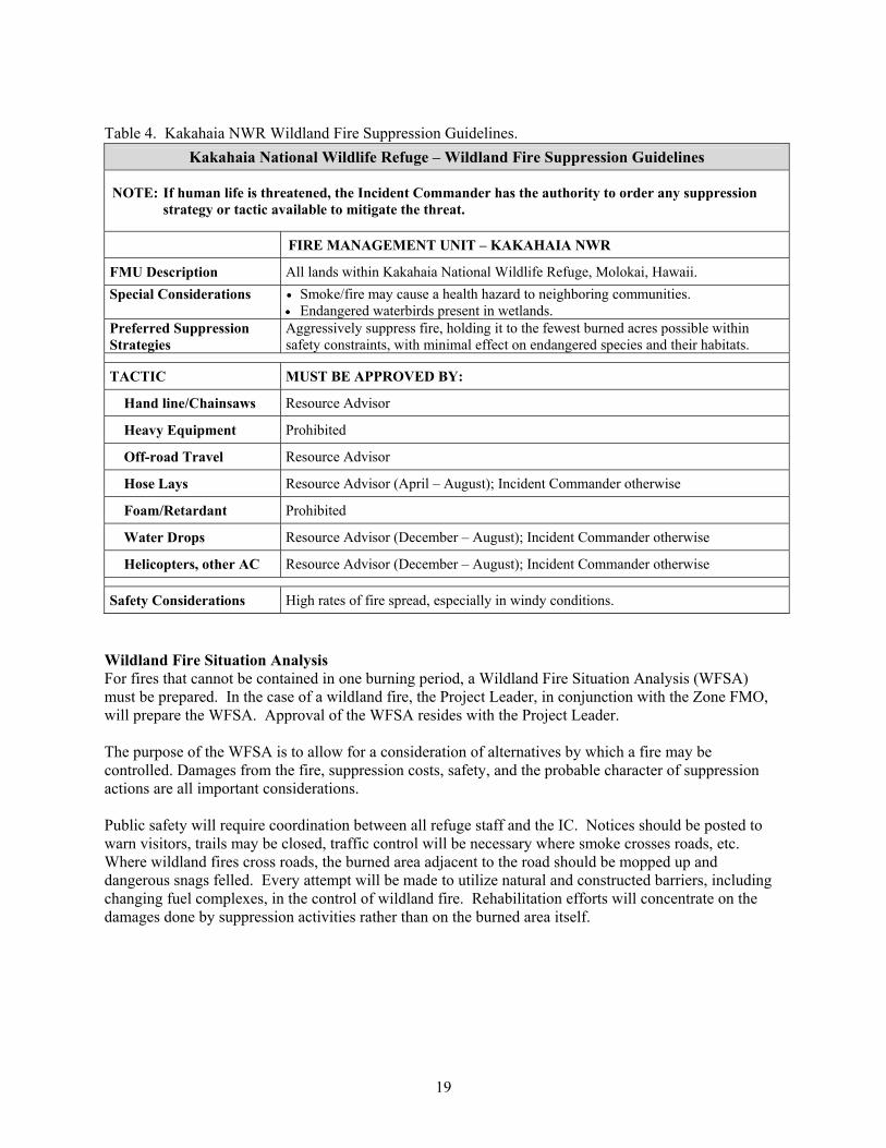
19
Table 4. Kakahaia NWR Wildland Fire Suppression Guidelines.
Kakahaia National Wildlife Refuge – Wildland Fire Suppression Guidelines
NOTE: If human life is threatened, the Incident Commander has the authority to order any suppression strategy or tactic available to mitigate the threat.
FIRE MANAGEMENT UNIT – KAKAHAIA NWR
FMU Description All lands within Kakahaia National Wildlife Refuge, Molokai, Hawaii. Special Considerations Smoke/fire may cause a health hazard to neighboring communities.
Endangered waterbirds present in wetlands. Preferred Suppression Strategies
Aggressively suppress fire, holding it to the fewest burned acres possible within safety constraints, with minimal effect on endangered species and their habitats.
TACTIC MUST BE APPROVED BY:
Hand line/Chainsaws Resource Advisor
Heavy Equipment Prohibited
Off-road Travel Resource Advisor
Hose Lays Resource Advisor (April – August); Incident Commander otherwise
Foam/Retardant Prohibited
Water Drops Resource Advisor (December – August); Incident Commander otherwise
Helicopters, other AC Resource Advisor (December – August); Incident Commander otherwise
Safety Considerations High rates of fire spread, especially in windy conditions. Wildland Fire Situation Analysis For fires that cannot be contained in one burning period, a Wildland Fire Situation Analysis (WFSA) must be prepared. In the case of a wildland fire, the Project Leader, in conjunction with the Zone FMO, will prepare the WFSA. Approval of the WFSA resides with the Project Leader. The purpose of the WFSA is to allow for a consideration of alternatives by which a fire may be controlled. Damages from the fire, suppression costs, safety, and the probable character of suppression actions are all important considerations. Public safety will require coordination between all refuge staff and the IC. Notices should be posted to warn visitors, trails may be closed, traffic control will be necessary where smoke crosses roads, etc. Where wildland fires cross roads, the burned area adjacent to the road should be mopped up and dangerous snags felled. Every attempt will be made to utilize natural and constructed barriers, including changing fuel complexes, in the control of wildland fire. Rehabilitation efforts will concentrate on the damages done by suppression activities rather than on the burned area itself.
20
Aircraft Operations Aircraft may be used in all phases of fire management operations. All aircraft must be Office of Aircraft Services (OAS) or Forest Service approved. An OAS Aviation Policy Department Manual will be provided by OAS. As in all fire management activities, safety is the primary consideration. Qualified aviation personnel will be assigned to all flight operations. Helicopters may be used for reconnaissance, bucket drops and transportation of personnel and equipment. Natural helispots and parking lots are readily available in most cases. Clearing for new helispots should be avoided where possible. Improved helispots will be rehabilitated following the fire. BURNED AREA EMERGENCY STABILIZATION AND REHABILITATION There are three methods of repairing damage caused by wildland fires and wildland fire suppression activities – emergency stabilization, rehabilitation, and fire suppression activity damage repair. Policy and Implementation Guidance Departmental policy for emergency stabilization and rehabilitation (ESR) on Service lands following wildland fire, including objectives, implementation, plan submittal, monitoring, and funding, is found in the Department Manual (620 DM 3). Service ESR supplemental policy can be found in the Service Manual (095 FW 3.9), with policy implementation guidance provided in Chapter 5 of the FWS Fire Management Handbook. More detailed guidance for can be found in the Interagency Burned Area Emergency Stabilization and Rehabilitation Handbook (2002) and Technical Reference (2002). The Service maintains an internet web site (http://fire.fws.gov/ifcc/rehab/) that provides access to these and several other guidance documents. Any treatment or activity will have an approved plan developed prior to implementation. Monitoring specifications will be included in the plan for each treatment or activity. Emergency stabilization and rehabilitation treatments and activities will be written in separate plans. The Project Leader, Biologist, and FMO will review all plans. The final plans will be submitted to the Region for review prior to submission to the Washington Office. Compliance Implementation activities will be conducted in a manner that is compatible with long-term goals and approved land management plans (e.g., Comprehensive Conservation Plan, Habitat Management Plan, Fire Management Plan), in compliance with applicable law and policy, including the National Environmental Policy Act, Endangered Species Act, Clean Water Act, and National Historic Preservation Act. REQUIRED REPORTING The IC will be responsible for documenting decisions and completing the fire report (e.g., ICS-214, DI-1202). The Zone FMO will be responsible for any additional required reports. FIRE INVESTIGATION Fire management personnel will attempt to locate and protect the probable point of origin and record pertinent information required to determine fire cause. They will be alert for possible evidence, protect the scene and report findings to the fireline supervisor. Prompt and efficient investigation of all suspicious fires will be carried out. However, fire management personnel should not question suspects or pursue the fire investigation unless they are currently Law Enforcement Commission qualified.

21
Personnel and services of other agencies may be utilized to investigate wildland fire arson or fire incidents involving structures. All fire investigations should follow the guidelines outlined in the Fire Management Handbook (2004).
22
HAZARD FUEL REDUCTION Hazard fuel is vegetation which presents a risk of ignition and sustaining spread of a wildland fire in relationship to a threat to some value. Hazard fuel reduction is both a fire prevention activity and a wildland fire protection measure. The objectives of this activity are:
Reduce the hazard risk to service structures and facilities from an approaching wildland fire. Reduce the risk of fire spreading to the wildland from a fire originating in a Service owned
structure or facility. Provide defensible space and safety to personnel at those facilities during a wildland fire. Meet federal, state and local fire hazard reduction ordinances.
HAZARD FUEL REDUCTION STRATEGIES Strategies include mechanical treatment of the hazard fuels and the debris disposal. Mechanical treatment is accomplished using minimal maintenance procedures (herbicide treatment, mowing). Clearing of vegetation is primarily for wetland enhancement/restoration and to provide vehicle access to remote areas of the refuge. Vegetation clearing associated with habitat restoration occurs during summer months when water levels are low and ponds are accessible. Debris would be piled within the ponds and burned in September. These areas are open and do not have upper canopies. Trimming around the structures is completed to provide a minimum two-foot buffer. Clearing of upland vegetation was performed in 1999 to open up habitat; however, much of the vegetation (trees) has filled in. Since then, clearing of upland vegetation has not been performed. Debris must be disposed of to complete the mitigation of the hazard. Debris disposal may be accomplished by scattering, chipping or pile burning. The quantity of vegetation, diameter size, crew availability, and logistical support will dictate the method used. If scattering of cut vegetation is used, an evaluation of the overall fuel loading needs to be considered so as to not add to the hazard fuel problem. PILE BURNING GUIDELINES When planning to dispose of debris by pile burning, specific guidelines must be followed in order to provide for safety and reduce the escape potential. General guidelines for pile burning are the same as for prescribed burning. Service guidelines are found in the FWS Fire Management Handbook, Section 2. This section of the Fire Management Plan is for the purpose of outlining the steps to take when conducting pile burning only. No prescribed burning of standing vegetation will be conducted. References to a burn plan and burn boss are only for the purpose of pile burning. Pile burning will be used to dispose of cut vegetation resulting from refuge activities such as annual hazard reduction around structures. Limbs and branches of overhanging trees and brush will annually need to be trimmed back. At times trees may have been blown down during storms which will require debris removal. The most economical and expedient method is through burning of the piled vegetation on site. Pile burning is typically rated as complexity level 3 due to the low risk of escape, limited control forces, and time of year conducted. Safety concerns are still present even at the low complexity level. Careful consideration must be given to smoke management, escape potential and resource benefit when planning and rating the pile burn. The complexity of each pile burn would be evaluated using the NWCG Prescribed Fire Complexity Rating System Guide. Pile Burn Plan A Burn Boss will conduct a field reconnaissance of the proposed pile burn location with the Refuge Manager to discuss objectives, special concerns, and gather all necessary information to write the burn plan. After completing the reconnaissance, a qualified Burn Boss will write the Pile Burn Plan.
23
All pile burning will have a Pile Burn Plan. The Pile Burn Plan is a site-specific action plan describing the purpose, objectives, prescription, and operational procedures needed to prepare and safely conduct the burn. The project area, objectives, and constraints will be clearly outlined. No piles will be ignited unless all prescriptions of the plan are met. Fires not within those parameters will be suppressed. Pile Burn Plans will follow the format found in the FWS Fire Management Handbook, Section 2.2. Pile burning is considered a complexity level 3 prescribed burn (in most cases) and should use the plan format contained in Appendix C. Each burn plan will be reviewed by the Project Leader, Refuge Manager, Refuge Biologist, Zone FMO, and Burn Boss. The Project Leader has the authority to approve the burn plan. The Pile Burn Plan requires the following items to be completed prior to ignition:
Contingency plan Complexity analysis Review and approval signatures Go/no go checklist Spot weather forecast
Pile Burning Strategies and Personnel Pile burning will only be executed by qualified personnel. Pile burning requires a qualified Burn Boss. The Burn Boss will fill all required positions to conduct the burn with qualified personnel. All positions listed in the burn plan must be available for the duration of the pile burn or it will not be initiated. Weather and fuel moisture conditions must be monitored closely in the project area to determine when the prescription criteria are met. A belt weather kit may also be utilized to augment monitoring. When pertinent prescription criteria are within the acceptable range, the Burn Boss will select an ignition time based on current and predicted weather forecasts. A thorough briefing will be given by the Burn Boss on the day of the burn and specific assignments and placement of personnel will be discussed. An updated spot weather forecast will be obtained on the day of ignition and all prescription elements will be re-checked to determine if all elements are still within the approved ranges. If all prescription elements are met, a test fire will be ignited to determine on-site fire behavior conditions as affected by current weather. If conditions are not satisfactory, the test fire will be suppressed and the burn will be rescheduled. If conditions are satisfactory, the burn will continue as planned. Maui County Fire Department will be made aware of any planned burn. If the burn pile escapes the predetermined burn area, all further ignition will be halted except as needed for suppression efforts. Suppression efforts will be initiated, as discussed in the pre-burn briefing. The Zone FMO will be notified immediately of any control actions on a prescribed burn. If the burn exceeds the initial suppression efforts, the burn will be declared a wildland fire and suppressed using guidelines established in the burn plan. A WFSA will be completed and additional personnel and resources ordered as determined by the Incident Commander. If the fire continues to burn out of control, additional resources based on the contingency plan will be called from the local cooperating agencies via the servicing dispatch. A management overhead team may be requested to assume command of the fire if necessary. Each Pile Burn Plan will detail the contingency plan with identified resources for suppression. This plan will serve as the incident action plan during the initial attack phase of an escape. Monitoring and Evaluation During pile burns, monitoring can serve as a precursor to invoking suppression action by determining if the burn is in prescription, assessing its overall potential, and determining the effects of the pile burn. Pile burning does not usually require extensive monitoring. Weather, fire behavior, and smoke

24
management are elements that require monitoring. The Burn Boss will assume responsibility for coordinating and implementing this section. Personnel may be assigned specific tasks such as weather monitoring to document these elements and keep the Burn Boss informed of conditions. Special situations or projects may dictate more extensive monitoring and evaluation. Required Reports All forms will be completed as outlined by the Pile Burn Plan. Accomplishments, costs, fire report (DI-1202), weather data, and first order fire effects monitoring are the responsibility of the Burn Boss. The Burn Boss may prepare a final report on the project for the Refuge Manager as requested. Information should include a narrative of the burn operation, a determination of whether objectives were met, weather and fire behavior data, number of work hours, and final cost of the burn.
25
AIR QUALITY / SMOKE MANAGEMENT GUIDELINES An annual burn permit is required by the State of Hawaii, Department of Health for each prescribed burn. This permit process evaluates the burn in relation to emissions and local air quality standards. Typically, smoke from fires does not significantly affect air quality standards. The Refuge is required to report the schedule of each burn to the Department of Health and is also required to follow permit conditions provided by the Department of Health that are designed to minimize effects on air quality. These conditions include a specified time period when burns are permitted and attention to not burning on specified “no-burn” days for specified islands as provided on or before 1600 hr by radio broadcast through the National Weather Service, or other appropriate means, applicable for the succeeding day. The State of Hawaii, Department of Health, Agricultural Burn Permit along with an approved Prescribed Burn Plan for the refuge are maintained in the Refuge Complex office. The Agricultural Burn Permit must be renewed annually and in possession at the burn site while burning.
FIRE RESEARCH There are no ongoing fire research projects at Kakaha’ia NWR.
26
PUBLIC SAFETY Kakahaia NWR is dedicated to ensuring the safety of each visitor and to all residents and property adjacent to the refuge's boundary. The refuge will be closed to the public during suppression and possibly during pile burn activities. Areas of fire activity may be clearly signed at the refuge entrance gate. Residents adjacent to the refuge (Appendix C, Table 6) will be notified in advance of any pile burn and if any fire poses a threat to burn outside the refuge boundaries. During pile burns at least one burn team member will have first aid training. A first aid kit will be on-site for prescribed burns as well as wildland fires. The local police, fire, and emergency medical services will be notified prior to the ignition. They will also be notified of the location of any wildland fires.
PUBLIC INFORMATION AND EDUCATION Educating the public on the value of fire as a natural process is important to increasing public understanding and support for the fire management program. The refuge will use the most appropriate and effective means to explain the overall fire and smoke management program. This may include supplemental handouts, signing, personal contacts, auto tour routes, or media releases. When deemed necessary, interpretive presentations will address the fire management program and explain the role of fire in the environment. The public information program will be developed as follows:
The fire management program may be incorporated into visitor contacts. Particular attention will be given when fires are conspicuous from roads or visitor use areas.
News releases will be distributed to the media as appropriate. The public information outlets of neighboring and cooperating agencies and the regional office
will be provided with all fire management information. The fire management program will be discussed in informal talks with all employees , volunteers,
residents, and neighbors. As outlined in the prevention section, emergency closures or restrictions may become necessary during periods of extreme or extended fire danger.
27
FIRE CRITIQUES AND ANNUAL PLAN REVIEW FIRE CRITIQUES Fire reviews will be documented and filed with the final fire report. The Refuge Manager will retain a copy for the refuge files. ANNUAL FIRE SUMMARY REPORT The Refuge Manager will be responsible for completing an annual fire summary report. The report will contain the number of fires by type, acres burned by fuel type, cost summary (pile burns and wildland fires), personnel utilized, and fire effects. ANNUAL FIRE MANAGEMENT PLAN REVIEW The Fire Management Plan will be reviewed annually. Necessary updates or changes will be accomplished prior to the next fire season. Any additions, deletions, or changes will be reviewed by the Project Leader to determine if such alterations warrant a re-approval of the plan.
CONSULTATION AND COORDINATION The following agencies, organizations and/or individuals were consulted in preparing this plan.
Bruce Babb, Wildland/Urban Interface Coordinator, Pacific Region, USFWS, Portland, OR. Forrest Cameron, Refuge Supervisor, USFWS, Portland, OR. Jerry Leinecke, Project Leader, Hawaii/Pacific Islands NWR Complex, Honolulu, HI. Amanda McAdams, (former) Fire Ecologist, Pacific Region, USFWS, Portland, OR. Mike Nishimoto, Wildlife Biologist, Maui NWR Complex, Kihei, HI. James Roberts, Fire Planner, Pacific Region, USFWS, Portland, OR. Roger Spaulding, Fire Management Officer, Pacific Region, USFWS, Portland, OR. Linda Watters, Assistant Refuge Supervisor, USFWS, Portland, OR.

28
APPENDICES APPENDIX A: REFERENCES CITED Anderson, H.E. 1983. Aids to determining fuel models for estimating fire behavior. USDA Forest
Service General Technical Report INT-122, 22p. Armstrong, R.W. and J.A. Bier. 1983. Atlas of Hawaii. Second Edition. University of Hawaii Press.
Honolulu, Hawaii. National Wildfire Coordinating Group. 1996. Resource advisor=s guide for wildland fire. PMS 313/
NFES 1831. Pratt, H.D., P.L. Bruner, and D.G. Berrett. 1987. The Birds of Hawaii and the tropical Pacific. Princeton
University Press, Princeton, New Jersey. U.S. Department of the Interior. 1997. Department Manual. Washington, D.C. U.S. Fish and Wildlife Service. 1975. Kakahaia National Wildlife Refuge: Final Environmental
Assessment. U.S. Department of the Interior. Honolulu, Hawaii. U.S. Fish and Wildlife Service. 1991. Kakaha’ia National Wildlife Refuge, Annual Narrative.
29
APPENDIX B: DEFINITIONS Agency Administrator. The appropriate level manager having organizational responsibility for management of an administrative unit. May include Director, State Director, District Manager or Field Manager (BLM); Director, Regional Director, Complex Manager or Project Leader (FWS); Director, Regional Director, Park Superintendent, or Unit Manager (NPS), or Director, Office of Trust Responsibility, Area Director, or Superintendent (BIA). Appropriate Management Action. Specific actions taken to implement a management strategy. Appropriate Management Response. Specific actions taken in response to a wildland fire to implement protection and fire use objectives. Appropriate Management Strategy. A plan or direction selected by an agency administrator which guides wildland fire management actions intended to meet protection and fire use objectives. Appropriate Suppression. Selecting and implementing a prudent suppression option to avoid unacceptable impacts and provide for cost-effective action. Bureau. Bureaus, offices or services of the Department. Class of Fire (as to size of wildland fires). Class A - 3 acre or less. Class B - more than 3 but less than 10 acres. Class C - 10 acres to 100 acres. Class D - 100 to 300 acres. Class E - 300 to 1,000 acres. Class F - 1,000 to 5,000 acres. Class G - 5,000 acres or more. Emergency Fire Rehabilitation/Burned Area Emergency Rehabilitation (EFR/BAER). Emergency actions taken during or after wildland fire to stabilize and prevent unacceptable resource degradation or to minimize threats to life or property resulting from the fire. The scope of EFR/BAER projects are unplanned and unpredictable requiring funding on short notice. Energy Release Component (ERC). A number related to the available energy (BTU) per unit area (square foot) within the flaming front at the head of a fire. It is generated by the National Fire Danger Rating System, a computer model of fire weather and its effect on fuels. The ERC incorporates thousand hour dead fuel moistures and live fuel moistures; day to day variations are caused by changes in the moisture content of the various fuel classes. The ERC is derived from predictions of (1) the rate of heat release per unit area during flaming combustion and (2) the duration of flaming. Extended Attack. A fire on which initial attack forces are reinforced by additional forces. Fire Suppression Activity Damage. The damage to lands, resources and facilities directly attributable to the fire suppression effort or activities, including: dozer lines, camps and staging areas, facilities (fences, buildings, bridges, etc.), handlines, and roads. Fire Effects. Any consequences to the vegetation or the environment resulting from fire, whether neutral, detrimental, or beneficial.
30
Fire Intensity. The amount of heat produced by a fire. Usually compared by reference to the length of the flames. Fire Management. All activities related to the prudent management of people and equipment to prevent or suppress wildland fire and to use fire under prescribed conditions to achieve land and resource management objectives. Fire Management Plan. A strategic plan that defines a program to manage wildland and prescribed fires and documents the Fire Management Program in the approved land use plan. The plan is supplemented by operational procedures such as preparedness plans, preplanned dispatch plans, prescribed fire plans and prevention plans. Fire Prescription. A written direction for the use of fire to treat a specific piece of land, including limits and conditions of temperature, humidity, wind direction and speed, fuel moisture, soil moisture, etc., under which a fire will be allowed to burn, generally expressed as acceptable range of the various fire-related indices, and the limit of the area to be burned. Fuels. Materials that are burned in a fire; primarily grass, surface litter, duff, logs, stumps, brush, foliage, and live trees. Fuel Loadings. Amount of burnable fuel on a site, usually given as tons/acre. Hazard Fuels. Those vegetative fuels which, when ignited, threaten public safety, structures and facilities, cultural resources, natural resources, natural processes, or to permit the spread of wildland fires across administrative boundaries except as authorized by agreement. Initial Attack. An aggressive suppression action consistent with firefighter and public safety and values to be protected. Maintenance Burn. A fire set by agency personnel to remove debris; i.e., leaves from drainage ditches or cuttings from tree pruning. Such a fire does not have a resource management objective. Natural Fire. A fire of natural origin, caused by lightning or volcanic activity. NFDRS Fuel Model. One of 20 mathematical models used by the National Fire Danger Rating System to predict fire danger. The models were developed by the U.S. Forest Service and are general in nature rather than site-specific. NFFL Fuel Model. One of 13 mathematical models used to predict fire behavior within the conditions of their validity. The models were developed by US Forest Service personnel at the Northern Forest Fire Laboratory, Missoula, Montana. Prescription. Measurable criteria which guide selection of appropriate management response and actions. Prescription criteria may include safety, public health, environmental, geographic, administrative, social, or legal considerations. Prescribed Fire. A fire ignited by agency personnel in accord with an approved plan and under prescribed conditions, designed to achieve measurable resource management objectives. Such a fire is designed to produce the intensities and rates of spread needed to achieve one or more planned benefits to natural resources as defined in objectives. Its purpose is to employ fire scientifically to realize maximize net benefits at minimum impact and acceptable cost. A written, approved prescribed fire plan must exist
31
and NEPA requirements must be met prior to ignition. NEPA requirements can be met at the land use or fire management planning level. Preparedness. Actions taken seasonally in preparation to suppress wildland fires, consisting of hiring and training personnel, making ready vehicles, equipment, and facilities, acquiring supplies, and updating agreements and contracts. Prevention. Activities directed at reducing the number or the intensity of fires that occur, primarily by reducing the risk of human-caused fires. Rehabilitation. Actions to (1) limit the adverse effects of suppression on soils, watershed, or other values, or (2) to mitigate adverse effects of a wildland fire on the vegetation-soil complex, watershed, and other damages. Suppression. A management action intended to protect identified values from a fire, extinguish a fire, or alter a fire's direction of spread. Unplanned Ignition. A natural fire that is permitted to burn under specific conditions, in certain locations, to achieve defined resource objectives. Wildfire. An unwanted wildland fire. Wildland Fire. Any non-structure fire, other than prescribed fire, that occurs in the wildland. Wildland Fire Situation Analysis (WFSA). A decision-making process that evaluates alternative management strategies against selected safety, environmental, social, economical, political, and resource management objectives as selection criteria. Wildland/Urban Interface Fire. A wildland fire that threatens or involves structures.

32
APPENDIX C: FIRE DISPATCH PLAN
2004 Fire Dispatch Plan Kakahaia National Wildlife Refuge
FIRE SIZE-UP Use the following or the card, pocket guide, fireline handbook or red book guides. Reporting party’s name and phone number: Time discovered: Location of smoke or fire (plot on map; legal description): Fire Behavior: Smoldering Creeping Running Crowning Spotting Estimated size (acres): Spot 1/4-1/2 1/2-3/4 1 1-5 5+ Wind (midflame speed & direction): Dry Bulb Temperature (°F): Relative Humidity (%): Fuel Type: Grass Brush Timber Slash Adjacent Fuels: Grass Brush Timber Slash Aspect: Percent Slope: Additional Resources Needed: Special Considerations:
33
NOTIFICATION Upon report of a wildland fire, follow these procedures:
1. Call Maui County Fire Department (911) – request response, ambulance if necessary, traffic control.
2. Notify Refuge Manager/Resource Advisor, Glynnis Nakai, at the Refuge Office (808-875-1582),
residence (808-878-3269), or cell phone (808-281-9698). Assignments will be made at this time to notify other personnel and agencies.
3. Notify other Refuge personnel at the Refuge Office (808-875-1582) or at their residence:
Mike Nishimoto, Wildlife Biologist/Resource Advisor Residence: (808) 873-9315 Cell: (808) 870-6461 Calvin Willis, Maintenance Worker Residence: (808) 873-0070 Cell: (808) 870-6450 Pat Savino, Admin. Support Asst. Residence: (808) 878-2880 Nicole Davis, Biological Technician Residence: (808) 875-0099
4. Notify Project Leader, Jerry Leinecke, at the Hawaiian and Pacific Islands NWRC Office in Honolulu (808-792-9540) or at his residence (808-395-6227).
5. Contact one of the following Regional FWS Duty Officers:
Pam Ensley – Regional Fire Management Coordinator Work: (503) 231-6174 Cell: (503) 781-7978 Home: (360) 835-7004 Roger Spaulding – Regional Fire Management Officer Work: (503) 231-6175 Cell: (503) 816-7054 (vacant) – Regional Prescribed Fire Specialist Work: (503) 231-2075 Cell: Bruce Babb – Fire Management Specialist/Regional WUI Coordinator Work: (503) 231-6234 Cell: (503) 703-5823
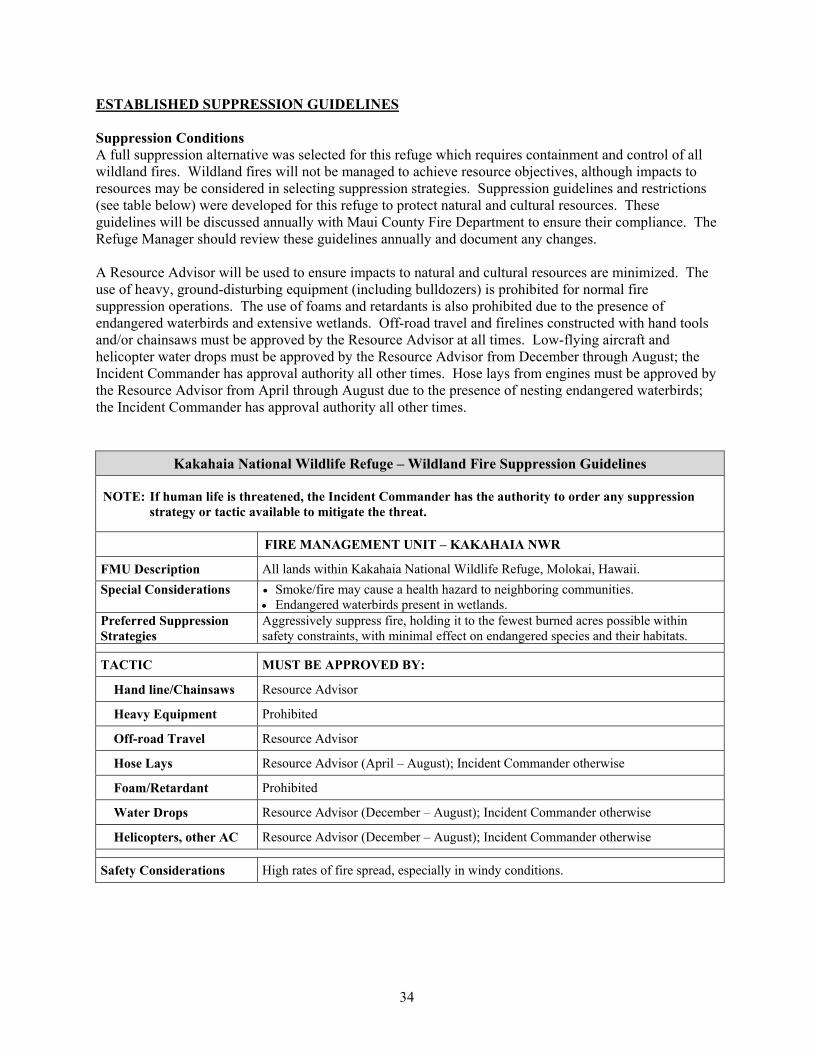
34
ESTABLISHED SUPPRESSION GUIDELINES Suppression Conditions A full suppression alternative was selected for this refuge which requires containment and control of all wildland fires. Wildland fires will not be managed to achieve resource objectives, although impacts to resources may be considered in selecting suppression strategies. Suppression guidelines and restrictions (see table below) were developed for this refuge to protect natural and cultural resources. These guidelines will be discussed annually with Maui County Fire Department to ensure their compliance. The Refuge Manager should review these guidelines annually and document any changes. A Resource Advisor will be used to ensure impacts to natural and cultural resources are minimized. The use of heavy, ground-disturbing equipment (including bulldozers) is prohibited for normal fire suppression operations. The use of foams and retardants is also prohibited due to the presence of endangered waterbirds and extensive wetlands. Off-road travel and firelines constructed with hand tools and/or chainsaws must be approved by the Resource Advisor at all times. Low-flying aircraft and helicopter water drops must be approved by the Resource Advisor from December through August; the Incident Commander has approval authority all other times. Hose lays from engines must be approved by the Resource Advisor from April through August due to the presence of nesting endangered waterbirds; the Incident Commander has approval authority all other times.
Kakahaia National Wildlife Refuge – Wildland Fire Suppression Guidelines
NOTE: If human life is threatened, the Incident Commander has the authority to order any suppression strategy or tactic available to mitigate the threat.
FIRE MANAGEMENT UNIT – KAKAHAIA NWR
FMU Description All lands within Kakahaia National Wildlife Refuge, Molokai, Hawaii. Special Considerations Smoke/fire may cause a health hazard to neighboring communities.
Endangered waterbirds present in wetlands. Preferred Suppression Strategies
Aggressively suppress fire, holding it to the fewest burned acres possible within safety constraints, with minimal effect on endangered species and their habitats.
TACTIC MUST BE APPROVED BY:
Hand line/Chainsaws Resource Advisor
Heavy Equipment Prohibited
Off-road Travel Resource Advisor
Hose Lays Resource Advisor (April – August); Incident Commander otherwise
Foam/Retardant Prohibited
Water Drops Resource Advisor (December – August); Incident Commander otherwise
Helicopters, other AC Resource Advisor (December – August); Incident Commander otherwise
Safety Considerations High rates of fire spread, especially in windy conditions.

35
COMMUNICATIONS Currently, refuge communications are limited to telephones. No personnel will be on-site at a wildland fire without direct communications with the suppression resources. CONTACT LIST
Table 5. Maui National Wildlife Refuge Complex Staff.
Maui NWRC P.O. Box 1042 (Mile 6 Mokulele Hwy.) Kihei, HI 96753
Phone: (808) 875-1582 Fax: (808) 875-2945
Glynnis Nakai Refuge Complex Manager
95 Mano Drive Kula, HI 96790
Work: (808) 792-9548 Cell: (808) 753-0627 Home: (808) 395-6227
Michael Nishimoto Wildlife Biologist
Kihei, HI Work: (808) 875-1582 Cell: (808) 870-6461 Home: (808) 873-9315
Calvin Willis Maintenance Worker
Kihei, HI Work: (541) 867-4550 Cell: (808) 870-6450 Home:
Patricia Savino Administrative Officer
Kihei, HI Work: (808) 875-1582 Home: (808) 878-2880
Nicole Davis Biological Science Technician
Kihei, HI Work: (808) 875-7258 Cell: (808) 870-6457 Home: (808) 875-0099
ADJACENT LANDOWNERS Table 6. Landowners adjacent to Kakahaia NWR.
Landowner Address Phone Number
Claude Sutcliffe and Brigid Mulloy P.O. Box 280, Kaunakakai, HI 96748 (808 553-3380) Melvin Perrells P.O. Box 651, Kaunakakai, HI 96748 (808 553-3442) Beth and Bob Johnson 104 Onioni Place, Kaunakakai, HI 96748 (808 553-5228) Edwin and Diane Medeiros 249 Kamehameha V Hwy., Kaunakakai, HI 96748 (808 553-5702) Gene and Carolyn Anderson P.O. Box 1748, Kaunakakai, HI 96748 (808 553-5563)
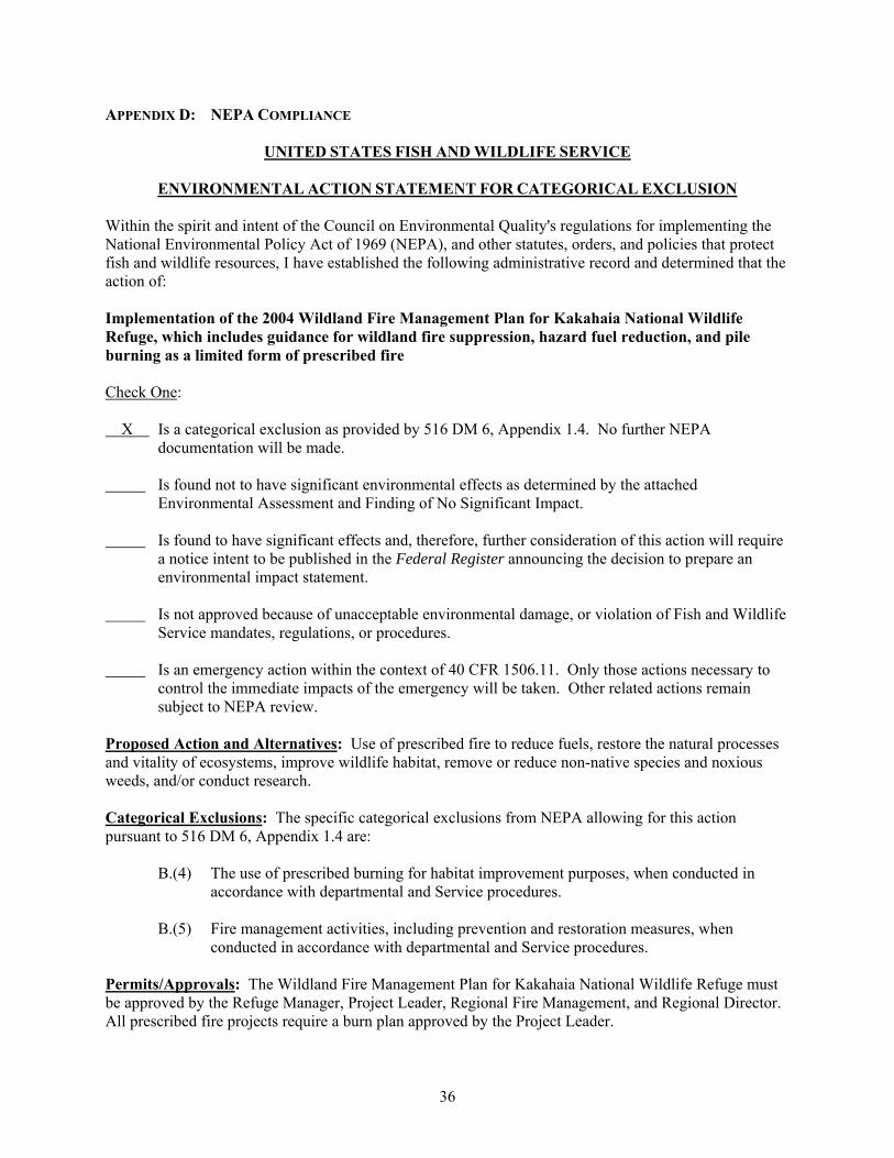
36
APPENDIX D: NEPA COMPLIANCE
UNITED STATES FISH AND WILDLIFE SERVICE
ENVIRONMENTAL ACTION STATEMENT FOR CATEGORICAL EXCLUSION Within the spirit and intent of the Council on Environmental Quality's regulations for implementing the National Environmental Policy Act of 1969 (NEPA), and other statutes, orders, and policies that protect fish and wildlife resources, I have established the following administrative record and determined that the action of: Implementation of the 2004 Wildland Fire Management Plan for Kakahaia National Wildlife Refuge, which includes guidance for wildland fire suppression, hazard fuel reduction, and pile burning as a limited form of prescribed fire Check One: X Is a categorical exclusion as provided by 516 DM 6, Appendix 1.4. No further NEPA
documentation will be made. Is found not to have significant environmental effects as determined by the attached
Environmental Assessment and Finding of No Significant Impact. Is found to have significant effects and, therefore, further consideration of this action will require
a notice intent to be published in the Federal Register announcing the decision to prepare an environmental impact statement.
Is not approved because of unacceptable environmental damage, or violation of Fish and Wildlife
Service mandates, regulations, or procedures. Is an emergency action within the context of 40 CFR 1506.11. Only those actions necessary to
control the immediate impacts of the emergency will be taken. Other related actions remain subject to NEPA review.
Proposed Action and Alternatives: Use of prescribed fire to reduce fuels, restore the natural processes and vitality of ecosystems, improve wildlife habitat, remove or reduce non-native species and noxious weeds, and/or conduct research. Categorical Exclusions: The specific categorical exclusions from NEPA allowing for this action pursuant to 516 DM 6, Appendix 1.4 are:
B.(4) The use of prescribed burning for habitat improvement purposes, when conducted in accordance with departmental and Service procedures.
B.(5) Fire management activities, including prevention and restoration measures, when
conducted in accordance with departmental and Service procedures. Permits/Approvals: The Wildland Fire Management Plan for Kakahaia National Wildlife Refuge must be approved by the Refuge Manager, Project Leader, Regional Fire Management, and Regional Director. All prescribed fire projects require a burn plan approved by the Project Leader.

37
Public Involvement/Interagency Coordination: Maui County Fire Department Keonakakai Station is notified prior to any prescribed burning. Supporting Documents:
2004 Wildland Fire Management Plan for Kakahaia National Wildlife Refuge. ESA Section 7 Biological Evaluation for pile and debris burning for refuges within the Maui
National Wildlife Refuge Complex (Kealia Pond NWR and Kakahaia NWR) (Appendix E of this FMP).
Signature Approval: Jerry Leinecke, Project Leader Date Hawaiian and Pacific Islands National Wildlife Refuge Complex

38
APPENDIX E: ESA SECTION 7 COMPLIANCE
INTRA-SERVICE SECTION 7 BIOLOGICAL EVALUATION
Pile and Debris Burning for refuges within the Maui National Wildlife Refuge Complex (Kealia Pond NWR and Kakahaia NWR)
Originating Person: Glynnis Nakai
Telephone Number: (808) 875-1582
Date: July 13, 2003
I. Region: Pacific (Region 1), Portland Oregon. II. Service Activity:
Pile and debris burning as a marsh vegetation management technique at Kealia Pond National Wildlife Refuge on Maui and Kakahaia National Wildlife Refuge on Molokai.
III. Pertinent Species and Habitat:
A. Listed species and/or their critical habitat within the action area: Hawaiian coot (Fulica alai) – Endangered Hawaiian stilt (Himantopus mexicanus knudseni) – Endangered
B. Proposed species and/or proposed critical habitat within the action area: NONE
C. Candidate species within the action area: NONE IV. Geographic area or station name and action:
Refuges of this Complex are located in the state of Hawaii, County of Maui: Kealia Pond NWR on the island of Maui and Kakahaia NWR on the island of Molokai. Pile and debris burning to control and remove non-native vegetation in wetland marsh and mudflats.
V. Location (attach map): A. County and State: Maui County, State of Hawai’i B. Distance (miles) and direction to nearest town: Ma’alaea is 1.5 miles southwest of Kealia Pond NWR Kaunakakai is approximately 5.5 miles northeast of Kakahaia NWR. VI. Action Objectives:

39
Pile and debris burning will be conducted on these wetland refuges as a means of controlling noxious and exotic vegetation that interferes with nesting and maintenance of endangered and migratory waterbirds. Control of the establishment and spread of these species is required to provide secure, viable, adequate habitat for endangered waterbirds, migratory waterfowl and shorebirds. Specific goals include: providing open water areas interspersed with escape, nesting, and maintenance cover; limiting predator cover and access; providing mudflat areas for nesting (Hawaiian stilts) and feeding; and promotion of desirable wetland plant species with water areas for Hawaiian coot nesting and maintenance.
VII. Explanation of Impacts of Action:
This action will result in enhanced wetlands for endangered and other species using the refuge. Undesirable plant species will be controlled encouraging growth of more beneficial species. Dense predator concealment cover will be reduced making it more difficult for predators to prey on endangered species and allow waterbirds to detect predators at a greater distance, reducing predation. Increased habitat for a diversity of species, both resident and migratory, will be made available. The ratio of open water to vegetation will be altered to provide additional habitat diversity within the wetlands. All burns will be conducted outside major endangered species nesting seasons. Burns will normally be conducted between August and October. Burns will not be initiated when pre-fledgling birds are present. A check of each burn site will be made to determine the presence of waterbirds, young, and/or nests. If any of the above are discovered, no burning in that area of the wetlands will be undertaken. To provide necessary foraging habitat while burning, not all areas will be drawn down or dry at the same time. Wetland habitat on the refuge will continue to be provided for endangered and other waterbirds to utilize until worked ponds are re-flooded.
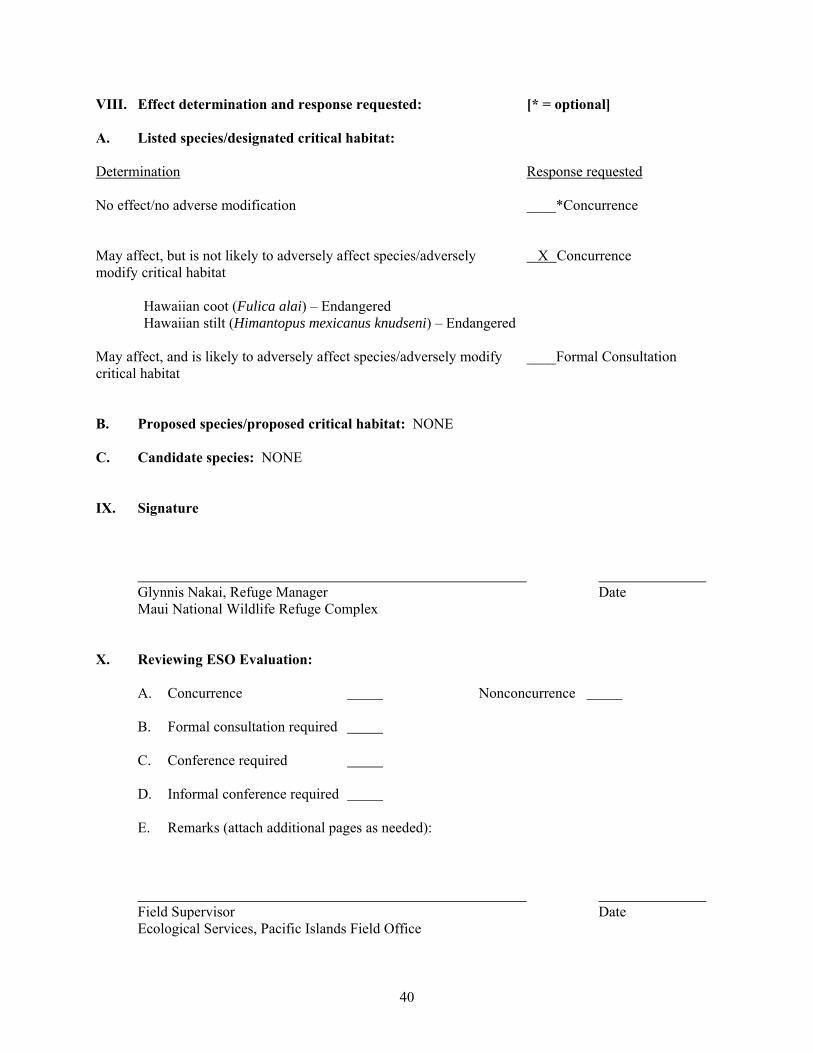
40
VIII. Effect determination and response requested: [* = optional] A. Listed species/designated critical habitat: Determination Response requested No effect/no adverse modification ____*Concurrence May affect, but is not likely to adversely affect species/adversely X Concurrence modify critical habitat Hawaiian coot (Fulica alai) – Endangered Hawaiian stilt (Himantopus mexicanus knudseni) – Endangered May affect, and is likely to adversely affect species/adversely modify ____Formal Consultation critical habitat B. Proposed species/proposed critical habitat: NONE C. Candidate species: NONE IX. Signature Glynnis Nakai, Refuge Manager Date Maui National Wildlife Refuge Complex X. Reviewing ESO Evaluation: A. Concurrence Nonconcurrence B. Formal consultation required C. Conference required D. Informal conference required E. Remarks (attach additional pages as needed): Field Supervisor Date Ecological Services, Pacific Islands Field Office

41
APPENDIX F: REQUEST FOR CULTURAL RESOURCE COMPLIANCE REQUEST FOR CULTURAL RESOURCE COMPLIANCE
Project Name: USFWS Unit: Org Code: Ecoregion: (By ARD; CBE, IPE, KCE, NCE)
Program: (Partners, WSECP, Refuges, Hatcheries, Jobs, Federal Aid, Other)
Location: County: State: (nearest town)
Township(s): Range(s): Section(s): Meridian: 7.5’ USGS Quad(s): (Name, Date)
Project acres or linear meters/feet: Date you want to start the project: Date of this request: USFWS Contact: Phone: Address: Fax: Directions to project (if not obvious): Attach to this form:
A project (sketch) map showing the Area of Potential Effect with locations of specific ground altering activities (required). A photocopy of the USGS quad clearly marking the project area (required). A photocopy of an air photo showing the project may be attached (if available).
Return form and direct questions to:
USFWS Region 1 Cultural Resources Team c/o Tualatin River NWR 20555 SW Gerda Lane Sherwood, OR 97140 Phone: (503) 625-4377 Fax: (503) 625-4887
NHPA COMPLIANCE Appendix Item of the Programmatic Agreement applies. 36CFR800.4 to 800.6 applies. Cultural Resources Team Date
42
The Undertaking: Describe the proposed project and means to facilitate it (e.g., provide funds to revegetate 1 mile of riparian habitat, restore 250 acres of seasonal wetlands, and construct a 5-acre permanent pond). How is the project designed (e.g., install 2 miles of fence and create approximately 25 feet of 3 foot high check dam)? Area of Potential Effect: Describe where disturbance of the ground will occur. What are the dimensions of the area to be disturbed? How deep will you excavate? How long is the ditch, fence, etc? Where will fill be obtained? Where will spoil be dumped? What tools or equipment will be used? Are you replacing or repairing a structure? Are you moving dirt in a relatively undisturbed area? Will the project reach below or beyond the limits of prior land disturbance? Differentiate between areas slated for earth movement versus areas to be inundated only. Is the area to be inundated different from the area inundated today, in the recent past, or under natural conditions? Provide acres and/or linear meters or feet for all elements of the undertaking. Environmental Setting: Describe the environmental setting of the Area of Potential Effect. A) What was the natural habitat prior to modifications, reclamation, agriculture, settlement? B) What is the land-use history? When was it first settled, modified? How deep has it been cultivated? Grazed? etc. C) What is the land-use and habitat today? What natural agents (e.g., sedimentation, or vegetation) or cultural agents (e.g., cultivation) might affect the ability to discover cultural resources? D) Do you (or does anybody else) know of cultural resources in or near the project area?

43
APPENDIX G: INTERAGENCY AGREEMENTS No interagency agreements have been developed. When completed, they will be added here.
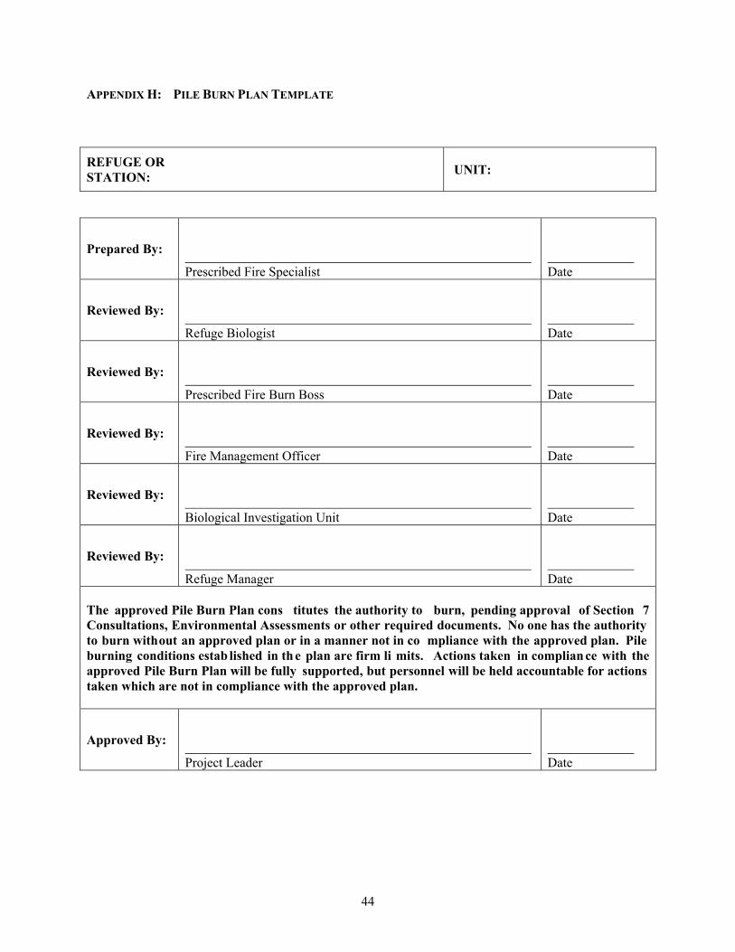
44
APPENDIX H: PILE BURN PLAN TEMPLATE
REFUGE OR STATION: UNIT:
Prepared By:
Prescribed Fire Specialist
Date
Reviewed By:
Refuge Biologist
Date
Reviewed By:
Prescribed Fire Burn Boss
Date
Reviewed By:
Fire Management Officer
Date
Reviewed By:
Biological Investigation Unit
Date
Reviewed By:
Refuge Manager
Date
The approved Pile Burn Plan cons titutes the authority to burn, pending approval of Section 7 Consultations, Environmental Assessments or other required documents. No one has the authority to burn without an approved plan or in a manner not in co mpliance with the approved plan. Pile burning conditions estab lished in the plan are firm li mits. Actions taken in compliance with the approved Pile Burn Plan will be fully supported, but personnel will be held accountable for actions taken which are not in compliance with the approved plan.
Approved By:
Project Leader
Date
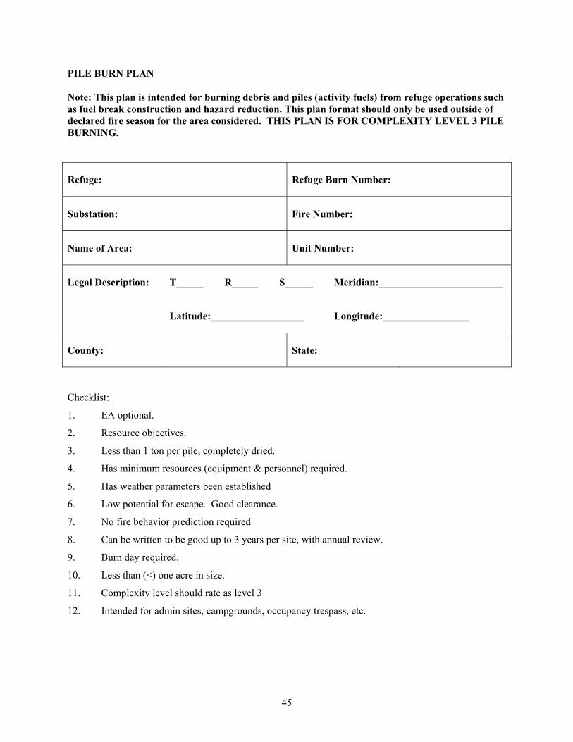
45
PILE BURN PLAN Note: This plan is intended for burning debris and piles (activity fuels) from refuge operations such as fuel break construction and hazard reduction. This plan format should only be used outside of declared fire season for the area considered. THIS PLAN IS FOR COMPLEXITY LEVEL 3 PILE BURNING.
Refuge: Refuge Burn Number:
Substation: Fire Number:
Name of Area: Unit Number:
Legal Description: T R S Meridian:
Latitude: Longitude:
County: State:
Checklist:
1. EA optional.
2. Resource objectives.
3. Less than 1 ton per pile, completely dried.
4. Has minimum resources (equipment & personnel) required.
5. Has weather parameters been established
6. Low potential for escape. Good clearance.
7. No fire behavior prediction required
8. Can be written to be good up to 3 years per site, with annual review.
9. Burn day required.
10. Less than (<) one acre in size.
11. Complexity level should rate as level 3
12. Intended for admin sites, campgrounds, occupancy trespass, etc.

46
Environmental Assessment Met (where documented): Estimated Cost: 1202: Funding Code: Project Area Description (Attach Map of Burn Area) Burn Objectives: Number, Species, and Size of Piles: Adjacent Fuel Description:
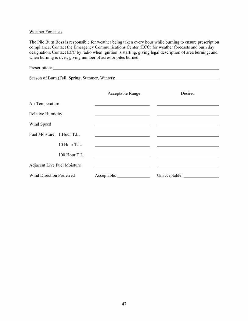
47
Weather Forecasts The Pile Burn Boss is responsible for weather being taken every hour while burning to ensure prescription compliance. Contact the Emergency Communications Center (ECC) for weather forecasts and burn day designation. Contact ECC by radio when ignition is starting, giving legal description of area burning; and when burning is over, giving number of acres or piles burned. Prescription: Season of Burn (Fall, Spring, Summer, Winter): Acceptable Range Desired Air Temperature Relative Humidity Wind Speed Fuel Moisture 1 Hour T.L. 10 Hour T.L. 100 Hour T.L. Adjacent Live Fuel Moisture Wind Direction Preferred Acceptable: Unacceptable:

48
Smoke Management Permitting Agency: Total Tons Per Acre Emissions: Distance and Direction from Smoke Sensitive Area(s): Necessary Transport Wind Direction(s): Visibility Hazard(s) (i.e., roads, airports, etc.): Actions to Reduce Visibility Hazard(s): Can Residual Smoke Be a Problem? Other Considerations: Special Constraint(s)/Consideration(s):

49
Firing Technique: Holding Force Instructions: Mop Up Instructions
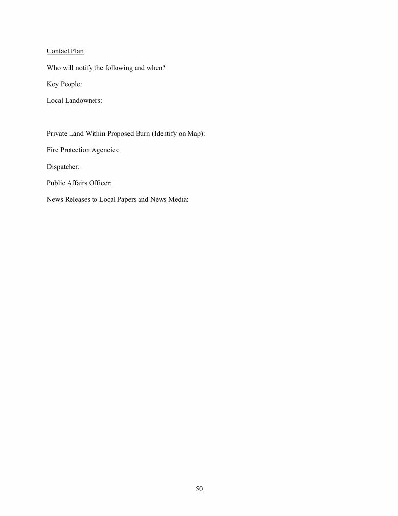
50
Contact Plan Who will notify the following and when? Key People: Local Landowners: Private Land Within Proposed Burn (Identify on Map): Fire Protection Agencies: Dispatcher: Public Affairs Officer: News Releases to Local Papers and News Media:
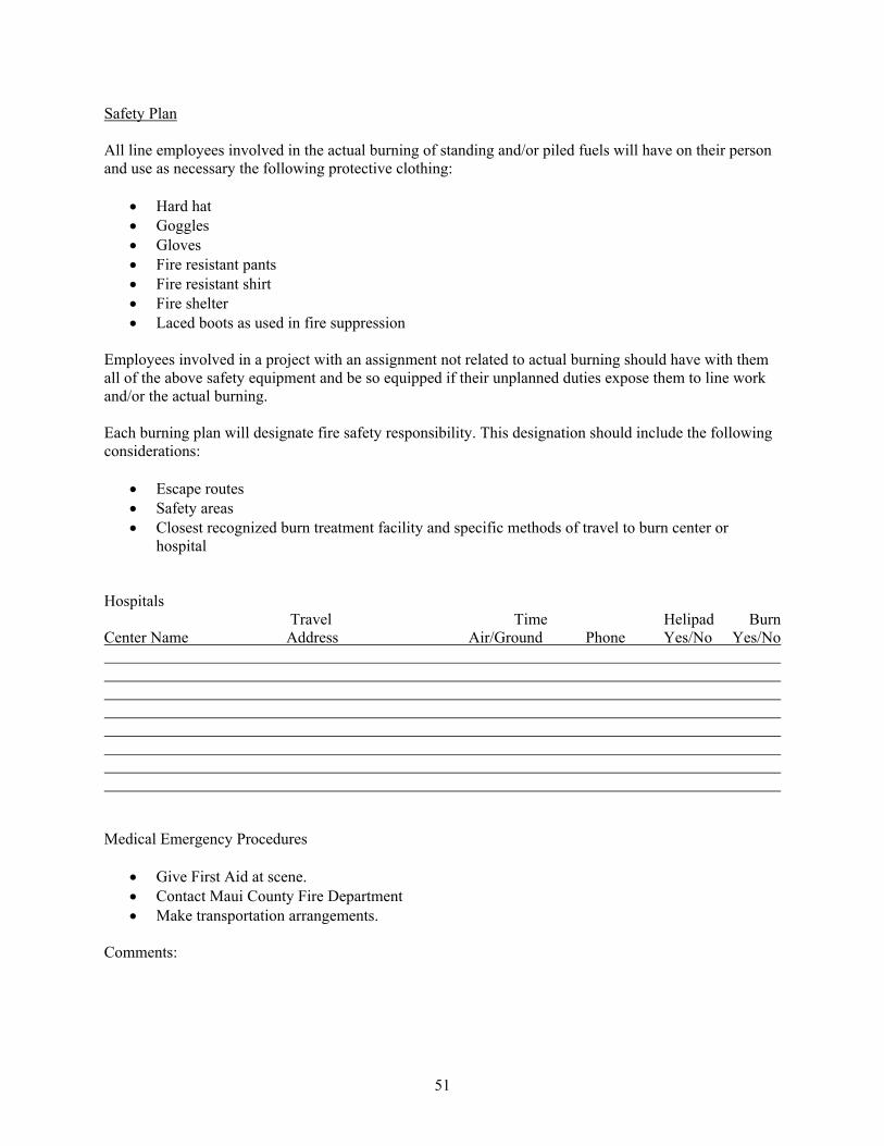
51
Safety Plan All line employees involved in the actual burning of standing and/or piled fuels will have on their person and use as necessary the following protective clothing:
Hard hat Goggles Gloves Fire resistant pants Fire resistant shirt Fire shelter Laced boots as used in fire suppression
Employees involved in a project with an assignment not related to actual burning should have with them all of the above safety equipment and be so equipped if their unplanned duties expose them to line work and/or the actual burning. Each burning plan will designate fire safety responsibility. This designation should include the following considerations:
Escape routes Safety areas Closest recognized burn treatment facility and specific methods of travel to burn center or
hospital Hospitals Travel Time Helipad Burn Center Name Address Air/Ground Phone Yes/No Yes/No Medical Emergency Procedures
Give First Aid at scene. Contact Maui County Fire Department Make transportation arrangements.
Comments:
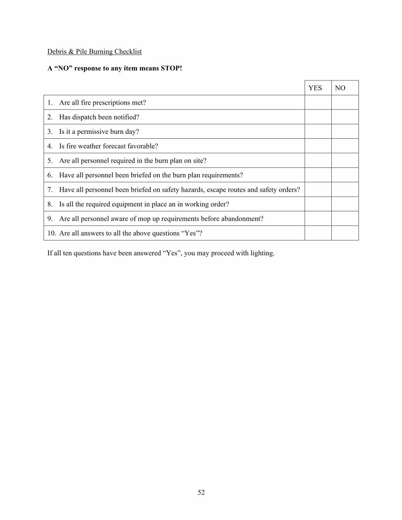
52
Debris & Pile Burning Checklist A “NO” response to any item means STOP! YES NO
1. Are all fire prescriptions met?
2. Has dispatch been notified?
3. Is it a permissive burn day?
4. Is fire weather forecast favorable?
5. Are all personnel required in the burn plan on site?
6. Have all personnel been briefed on the burn plan requirements?
7. Have all personnel been briefed on safety hazards, escape routes and safety orders?
8. Is all the required equipment in place an in working order?
9. Are all personnel aware of mop up requirements before abandonment?
10. Are all answers to all the above questions “Yes”? If all ten questions have been answered “Yes”, you may proceed with lighting.
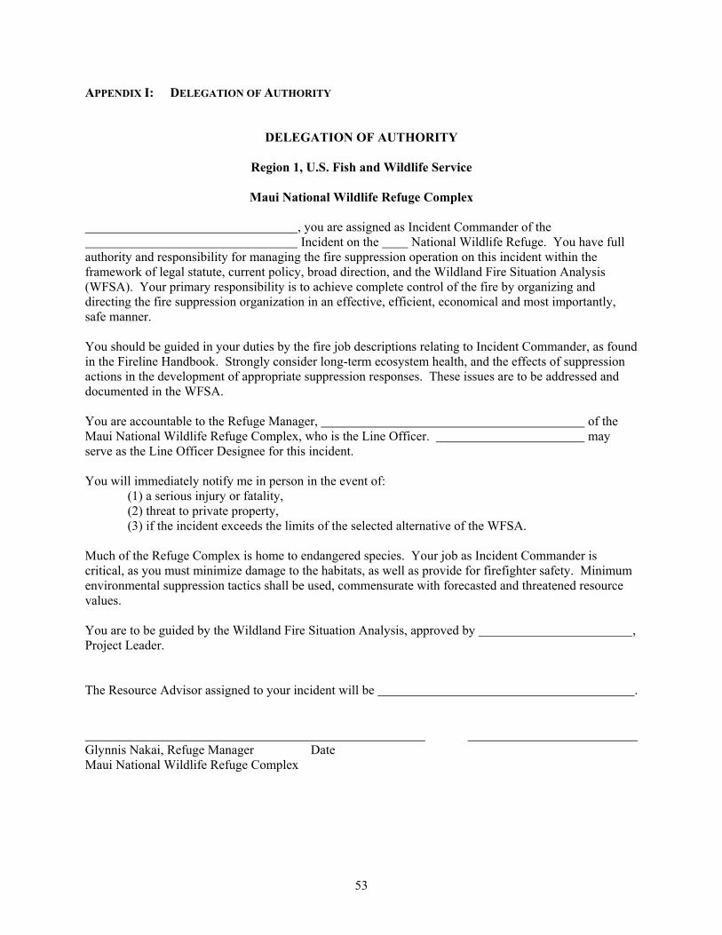
53
APPENDIX I: DELEGATION OF AUTHORITY
DELEGATION OF AUTHORITY
Region 1, U.S. Fish and Wildlife Service
Maui National Wildlife Refuge Complex , you are assigned as Incident Commander of the Incident on the National Wildlife Refuge. You have full authority and responsibility for managing the fire suppression operation on this incident within the framework of legal statute, current policy, broad direction, and the Wildland Fire Situation Analysis (WFSA). Your primary responsibility is to achieve complete control of the fire by organizing and directing the fire suppression organization in an effective, efficient, economical and most importantly, safe manner. You should be guided in your duties by the fire job descriptions relating to Incident Commander, as found in the Fireline Handbook. Strongly consider long-term ecosystem health, and the effects of suppression actions in the development of appropriate suppression responses. These issues are to be addressed and documented in the WFSA. You are accountable to the Refuge Manager, of the Maui National Wildlife Refuge Complex, who is the Line Officer. may serve as the Line Officer Designee for this incident. You will immediately notify me in person in the event of:
(1) a serious injury or fatality, (2) threat to private property, (3) if the incident exceeds the limits of the selected alternative of the WFSA.
Much of the Refuge Complex is home to endangered species. Your job as Incident Commander is critical, as you must minimize damage to the habitats, as well as provide for firefighter safety. Minimum environmental suppression tactics shall be used, commensurate with forecasted and threatened resource values. You are to be guided by the Wildland Fire Situation Analysis, approved by , Project Leader. The Resource Advisor assigned to your incident will be . Glynnis Nakai, Refuge Manager Date Maui National Wildlife Refuge Complex
54
APPENDIX J: WILDLAND FIRE SITUATION ANALYSIS
WILDLAND FIRE
SITUATION ANALYSIS Incident Name: Jurisdiction: Date and Time Completed:
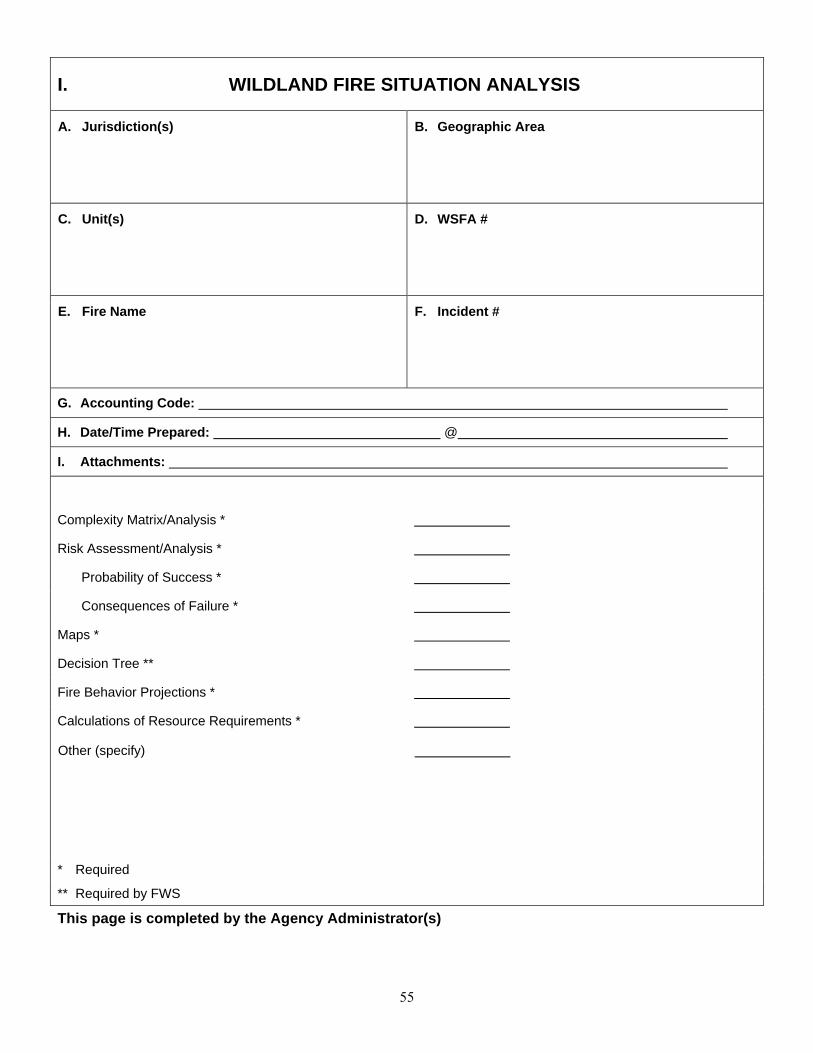
55
I. WILDLAND FIRE SITUATION ANALYSIS
A. Jurisdiction(s)
B. Geographic Area
C. Unit(s)
D. WSFA #
E. Fire Name
F. Incident #
G. Accounting Code:
H. Date/Time Prepared: @
I. Attachments:
Complexity Matrix/Analysis *
Risk Assessment/Analysis *
Probability of Success *
Consequences of Failure *
Maps *
Decision Tree **
Fire Behavior Projections *
Calculations of Resource Requirements *
Other (specify)
* Required
** Required by FWS
This page is completed by the Agency Administrator(s)

56
II. OBJECTIVES AND CONSTRAINTS
A. Objectives (must be specific and measurable)
1. Safety
- Public
- Firefighter
2. Economic
3. Environmental
4. Social
5. Other
B. Constraints
This page is completed by the Agency Administrator(s)
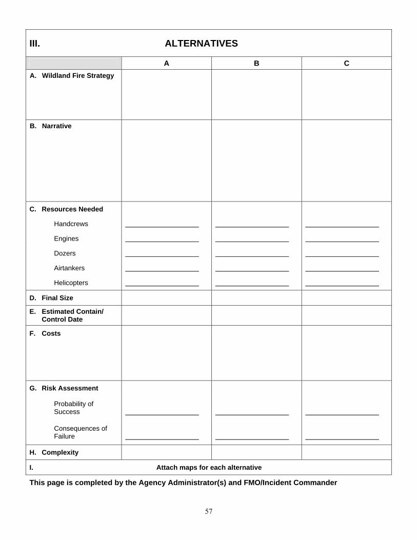
57
III. ALTERNATIVES
A B C
A. Wildland Fire Strategy
B. Narrative
C. Resources Needed
Handcrews
Engines
Dozers
Airtankers
Helicopters
D. Final Size
E. Estimated Contain/ Control Date
F. Costs
G. Risk Assessment
Probability of Success
Consequences of Failure
H. Complexity
I. Attach maps for each alternative
This page is completed by the Agency Administrator(s) and FMO/Incident Commander
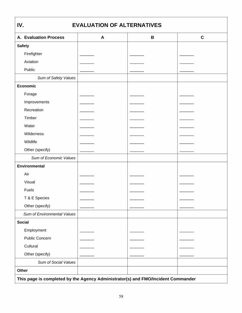
58
IV. EVALUATION OF ALTERNATIVES
A. Evaluation Process A B C
Safety
Firefighter
Aviation
Public
Sum of Safety Values
Economic
Forage
Improvements
Recreation
Timber
Water
Wilderness
Wildlife
Other (specify)
Sum of Economic Values
Environmental
Air
Visual
Fuels
T & E Species
Other (specify)
Sum of Environmental Values
Social
Employment
Public Concern
Cultural
Other (specify)
Sum of Social Values
Other
This page is completed by the Agency Administrator(s) and FMO/Incident Commander

59
V. ANALYSIS SUMMARY
Alternatives A B C
A. Compliance with Objectives
Safety
Economic
Environmental
Social
Other (specify)
B. Pertinent Data
Final Fire Size
Complexity
Suppression Cost
Resource Values
Probability of Success
Consequences of Failure
C. External/Internal Influences
National & Geographic Preparedness Level:
Incident Priority:
Resource Availability:
Weather Forecast (long range):
Fire Behavior Projections:
This page is completed by the Agency Administrator(s) and FMO/Incident Commander

60
VI. DECISION
The Selected Alternative is:
Rationale:
Agency Administrator’s Signature
Date/Time
This page is completed by the Agency Administrator(s) or designate
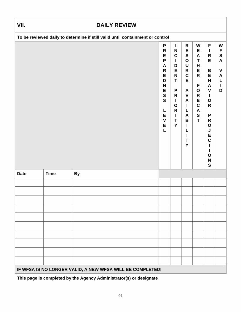
61
VII. DAILY REVIEW
To be reviewed daily to determine if still valid until containment or control
P R E P A R E D N E S S
L E V E L
I N C I D E N T
P R I O R I T Y
R E S O U R C E
A V A I L A B I L I T Y
W E A T H E R
F O R E C A S T
F I R E
B E H A V I O R
P R O J E C T I O N S
W F S A
V A L I D
Date Time By
IF WFSA IS NO LONGER VALID, A NEW WFSA WILL BE COMPLETED!
This page is completed by the Agency Administrator(s) or designate

62
VIII. FINAL REVIEW
The elements of the selected alternative were met on:
Date
Time
By: Agency Administrator(s)

63
INSTRUCTIONS Section I. WFSA Information Page A. Jurisdiction(s): Assign the agency or agencies that have or could have fire protection responsibility,
e.g., USFWS, BLM, etc. B. Geographic Area: Assign the recognized "Geographic Coordination Area" the fire is located in, e.g.,
Northwest, Northern Rockies, etc. C. Unit(s): Designate the local administrative unit(s), e.g., Hart Mountain Refuge Area, Flathead Indian
Reservation, etc. D. WFSA #: Identify the number assigned to the most recent WFSA for this fire. E. Fire Name: Self-explanatory. F. Incident #: Identify the incident number assigned to the fire. G. Accounting Code: Insert the local unit's accounting code. H. Date/Time Prepared: Self-explanatory. I. Attachments: Check here to designate items used to complete the WFSA. "Other could include data or
models used in the development of the WFSA. Briefly describe the "other" items used. Section II. Objectives and Constraints A. Objectives: Specify objectives that must be considered in the development of alternatives. Safety
objectives for firefighter, aviation, and public must receive the highest priority. Suppression objectives must relate to resource management objectives in the unit resource management plan.
Economic objectives could include closure of all or portions of an area, thus impacting the public, or impacts to transportation, communication, and resource values. Environmental objectives could include management objectives for airshed, water quality, wildlife, etc. Social objectives could include any local attitudes toward fire or smoke that might affect decisions on the fire. Other objectives might include legal or administrative constraints which would have to be considered in the analysis of the fire situation, such as the need to keep the fire off other agency lands, etc.
B. Constraints: List constraints on wildland fire action. These could include constraints to designated
wilderness, wilderness study areas, environmentally or culturally sensitive areas, irreparable damage to resources or smoke management/air quality concerns. Economic constraints, such as public and agency cost, could be considered here.

64
Section III. Alternatives A. Wildland Fire Management Strategy: Briefly describe the general wildland fire strategies for each
alternative. Alternatives must meet resource management plan objectives. B. Narrative: Briefly describe each alternative with geographic names, locations, etc., that would be used
when implementing a wildland fire strategy. For example: "Contain within the Starvation Meadows' watershed by the first burning period."
C. Resources Needed: Resources described must be reasonable to accomplish the tasks described in
Section III.B. It is critical to also look at the reality of the availability of these needed resources. D. Final Fire Size: Estimated final fire size for each alternative at time of containment. E. Estimated Contain/Control Date: Estimates of each alternative shall be made based on predicted
weather, fire behavior, resource availability, and the effects of suppression efforts. F. Cost: Estimate all incident costs for each alternative. Consider mop-up, rehabilitation, and other costs
as necessary. G. Risk Assessment - Probability of Success/Consequences of Failure: Describe probability as a
percentage and list associated consequences for success and failure. Develop this information from models, practical experience, or other acceptable means. Consequences described will include fire size, days to contain, days to control, costs, and other information such as park closures and effect on critical habitat. Include fire behavior and long-term fire weather forecasts to derive this information.
H. Complexity: Assign the complexity rating calculated in "Fire Complexity Analysis" for each alternative,
e.g., Type II, Type I. I. A map for each alternative should be prepared. The map will be based on the "Probability of
Success/Consequences of Failure" and include other relative information. Section IV. Evaluation of Alternatives A. Evaluation Process: Conduct an analysis for each element of each objective and each alternative.
Objectives shall match those identified in Section II.A. Use the best estimates available and quantify whenever possible. Provide ratings for each alternative and corresponding objective element. Fire effects may be negative, cause no change, or may be positive. Examples are: 1) a system which employs a "-" for negative effect, a "0" for no change, and a "+" for positive effect; 2) a system which uses a numeric factor for importance of the consideration (soils, watershed, political, etc.) and assigns values (such as -1 to +1, - 100 to +100, etc.) to each consideration, then arrives at a weighted average. If you have the ability to estimate dollar amounts for natural resource and cultural values, this data is preferred. Use those methods which are most useful to managers and most appropriate for the situation and agency. To be able to evaluate positive fire effects, the area must be included in the resource management plan and consistent with prescriptions and objectives of the Fire Management Plan.
Sum of Economic Values: Calculate for each element the net effect of the rating system used for each alternative. This could include the balance of pluses (+) and minuses (-), numerical rating (-3 and +3), or natural and cultural resource values in dollar amounts. (Again, resource benefits may be used as part of the analysis process when the wildland fire is within a prescription consistent with approved Fire Management Plans and in support of the unit's Resource Management Plan.)
65
Section V. Analysis Summary A. Compliance with Objectives: Prepare narratives that summarize each alternative's effectiveness in
meeting each objective. Alternatives that do not comply with objectives are not acceptable. Narrative could be based on effectiveness and efficiency. For example: "most effective and least efficient," "least effective and most efficient," or "effective and efficient." Or answers could be based on a two-tiered rating system such as "complies with objective" and "fully complies with or exceeds objective." Use a system that best fits the manager's needs.
B. Pertinent Data: Data for this Section has already been presented, and is duplicated here to help the
Agency Administrator(s) confirm their selection of an alternative. Final Fire Size is displayed in Section III.D. Complexity is calculated in the attachments and displayed in Section III.H. Costs are displayed on page 4. Probability of Success/Consequences of Failure is calculated in the attachments and displayed in Section III.G.
C. External and Internal Influences: Assign information and data occurring at the time the WFSA is signed.
Identify the Preparedness Index (1 through 5) for the National and Geographic levels. If available, indicate the Incident Priority assigned by the MAC Group. Designate the Resource Availability status. This information is available at the Geographic Coordination Center, and is needed to select a viable alternative. Designate "yes," indicating an up-to-date weather forecast has been provided to, and used by, the Agency Administrator(s) to evaluate each alternative. Assign information to the "Other" category as needed by the Agency Administrator(s).
Section IV. Decision Identify the alternative selected. Must have clear and concise rationale for the decision, and a signature with date and time. Agency Administrator(s) is mandatory. Section VII. Daily Review The date, time, and signature of reviewing officials are reported in each column for each day of the incident. The status of Preparedness Level, Incident Priority, Resource Availability, Weather Forecast, and WFSA validity is completed for each day reviewed. Ratings for the Preparedness Level, Incident Priority, Resource Availability, Fire Behavior, and Weather Forecast are addressed in Section V.C. Assign a “yes” under "WFSA Valid" to continue use of this WFSA. A "no" indicates this WFSA is no longer valid and another WFSA must be prepared or the original revised. Section VIII. Final Review This Section is completed by the Agency Administrator(s). A signature, date, and time are provided once all conditions of the WFSA are met.

66
A GUIDE FOR ASSESSING FIRE COMPLEXITY The following questions are presented as a guide to assist the Agency Administrator(s) and staff in analyzing the complexity or predicted complexity of a wildland fire situation. Because of the time required to assemble or move an Incident Management Team to wildland fire, this checklist should be completed when a wildland fire escapes initial attack and be kept as a part of the fire records. This document is prepared concurrently with the preparation of (and attached to) a new or revised Wildland Fire Situation Analysis. It must be emphasized this analysis should, where possible, be based on predictions to allow adequate time for assembling and transporting the ordered resources. Use of the Guide: 1. Analyze each element and check the response "yes" or "no." 2. If positive responses exceed, or are equal to, negative responses within any primary factor (A
through G), the primary factor should be considered as a positive response. 3. If any three of the primary factors (A through G) are positive responses, this indicates the fire
situation is, or is predicted to be, Type I. 4. Factor H should be considered after all the above steps. If more than two of these items are
answered "yes," and three or more of the other primary factors are positive responses, a Type I team should be considered. If the composites of H are negative, and there are fewer than three positive responses in the primary factors (A-G), a Type II team should be considered. If the answers to all questions in H are negative, it may be advisable to allow the existing overhead to continue action on the fire.
GLOSSARY OF TERMS Potential for blow-up conditions - Any combination of fuels, weather, and topography excessively endangering personnel. Rate or endangered species - Threat to habitat of such species or, in the case of flora, threat to the species itself. Smoke management - Any situation which creates a significant public response, such as smoke in a metropolitan area or visual pollution in high-use scenic areas. Extended exposure to unusually hazardous line conditions - Extended burnout or backfire situations, rock slide, cliffs, extremely steep terrain, abnormal fuel situation such as frost killed foliage, etc. Disputed fire management responsibility - Any wildland fire where responsibility for management is not agreed upon due to lack of agreements or different interpretations, etc. Disputed fire policy - Differing fire policies between suppression agencies when the fire involves multiple ownership is an example. Pre-existing controversies - These may or may not be fire management related. Any controversy drawing public attention to an area may present unusual problems to the fire overhead and local management. Have overhead overextended themselves mentally or physically - This is a critical item that requires judgment by the responsible agency. It is difficult to write guidelines for this judgment because of the wide differences between individuals. If, however, the Agency Administrator feels the existing overhead cannot continue to function efficiently and take safe and aggressive action due to mental or physical reasons, assistance is mandatory.
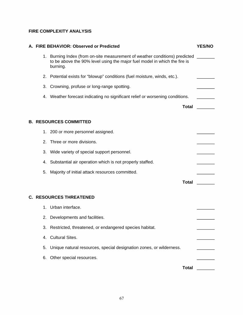
67
FIRE COMPLEXITY ANALYSIS A. FIRE BEHAVIOR: Observed or Predicted YES/NO 1. Burning Index (from on-site measurement of weather conditions) predicted to be above the 90% level using the major fuel model in which the fire is burning. 2. Potential exists for “blowup” conditions (fuel moisture, winds, etc.). 3. Crowning, profuse or long-range spotting. 4. Weather forecast indicating no significant relief or worsening conditions. Total B. RESOURCES COMMITTED 1. 200 or more personnel assigned. 2. Three or more divisions. 3. Wide variety of special support personnel. 4. Substantial air operation which is not properly staffed. 5. Majority of initial attack resources committed. Total C. RESOURCES THREATENED 1. Urban interface. 2. Developments and facilities. 3. Restricted, threatened, or endangered species habitat. 4. Cultural Sites. 5. Unique natural resources, special designation zones, or wilderness. 6. Other special resources. Total
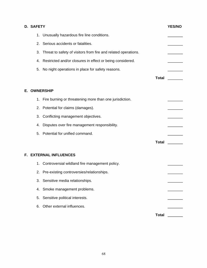
68
D. SAFETY YES/NO 1. Unusually hazardous fire line conditions. 2. Serious accidents or fatalities. 3. Threat to safety of visitors from fire and related operations. 4. Restricted and/or closures in effect or being considered. 5. No night operations in place for safety reasons. Total E. OWNERSHIP 1. Fire burning or threatening more than one jurisdiction. 2. Potential for claims (damages). 3. Conflicting management objectives. 4. Disputes over fire management responsibility. 5. Potential for unified command. Total F. EXTERNAL INFLUENCES 1. Controversial wildland fire management policy. 2. Pre-existing controversies/relationships. 3. Sensitive media relationships. 4. Smoke management problems. 5. Sensitive political interests. 6. Other external influences. Total
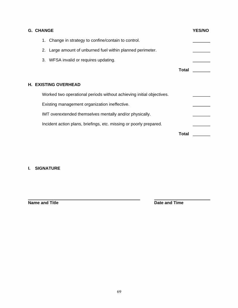
69
G. CHANGE YES/NO 1. Change in strategy to confine/contain to control. 2. Large amount of unburned fuel within planned perimeter. 3. WFSA invalid or requires updating. Total H. EXISTING OVERHEAD Worked two operational periods without achieving initial objectives. Existing management organization ineffective. IMT overextended themselves mentally and/or physically. Incident action plans, briefings, etc. missing or poorly prepared. Total I. SIGNATURE Name and Title Date and Time

Kakahai‘a National Wildlife Refuge Draft Comprehensive Conservation Plan and Environmental Assessment
Appendix G. Statement of Compliance G-1
Appendix G. STATEMENT OF COMPLIANCE for Implementation of the
Kakahai‘a National Wildlife Refuge, Maui County, Hawai‘i Comprehensive Conservation Plan
The following Executive orders and legislative acts have been reviewed as they apply to implementation of the Kakahai‘a NWR CCP. National Environmental Policy Act (1969). The planning process has been conducted in accordance with NEPA Implementing Procedures, Department of the Interior and Service procedures, and has been performed in coordination with the affected public. The CCP is programmatic in many respects and specific details of certain projects and actions cannot be determined until a later date depending on funding and implementation schedules. Certain projects or actions may require additional NEPA compliance. National Historic Preservation Act (1966). The implementation of the CCP should not affect cultural resources. The proposed action does not meet the criteria of an effect or adverse effect as an undertaking defined in 36 CFR 800.9 and 614 FW 2. The Service will comply with the National Historic Preservation Act if any management actions have the potential to affect any historic properties which may be present. Executive Order 12372. Intergovernmental Review. Coordination and consultation with affected Tribal, local, and State governments, other Federal agencies, and the landowners has been completed through personal contact by Service planners, refuge managers, and supervisors. Executive Order 12898. Federal Actions to Address Environmental Justice in Minority and Low-Income Populations. All Federal actions must address and identify, as appropriate, disproportionally high and adverse human health or environmental effects of its programs, policies, and activities on minority populations, low-income populations, and Indian Tribes in the United States. The CCP was evaluated and no adverse human health or environmental effects were identified for minority or low-income populations, Indian Tribes, or anyone else. Wilderness Preservation Act of 1964. The Service has evaluated the suitability of the Refuge for wilderness designation and determined it does not qualify. National Wildlife Administration Act of 1966, as amended by the National Wildlife Refuge System Improvement Act of 1997 (16 U.S.C. 668dd-668ee). Appropriate Use findings and Compatibility Determinations have been prepared for the following uses: Wildlife Observation, Interpretation and Photography; Environmental Education; and Research. Executive Order 13186. Responsibilities of Federal Agencies to Protect Migratory Birds. The CCP is consistent with Executive Order 13186 because the CCP and NEPA analyses evaluate the effects of agency actions on migratory birds.

Keālia Pond National Wildlife Refuge Draft Comprehensive Conservation Plan and Environmental Assessment
G-2 Appendix G. Statement of Compliance
Endangered Species Act of 1973. The Service will conduct consultations under Section 7 of the ESA for any refuge management program actions that have the potential to affect listed species. Coastal Zone Management Act, Section 307. Section 307(c)(1) of the Coastal Zone Management Act of 1972, as amended, requires each Federal agency conducting or supporting activities directly affecting the coastal zone, to conduct or support those activities in a manner which is, to the maximum extent practicable, consistent with approved state coastal management programs. The CCP is consistent with Coastal Zone Management Act because CCP implementation would protect the coastal zone from adverse impacts as a result of modification or destruction. Executive Order 11990. Protection of Wetlands. The CCP is consistent with Executive Order 11990 because CCP implementation would protect and enhance existing wetlands. Executive Order 11988. Floodplain Management. Under this order Federal agencies "shall take action to reduce the risk of flood loss, to minimize the impact of floods on human safety, health and welfare, and to restore and preserve the natural and beneficial values served by flood plains." The CCP is consistent with Executive Order 11988 because CCP implementation would protect floodplains from adverse impacts as a result of modification or destruction. Integrated Pest Management (IPM), 517 DM 1 and 569 FW 1 In accordance with 517 DM 1, an integrated pest management (IPM) approach has been adopted to eradicate, control, or contain pest and invasive species on the refuge. In accordance with 517 DM 1, only pesticides registered with the USEPA in full compliance with FIFRA and as provided in regulations, orders, or permits issued by USEPA may be applied on lands and waters under Refuge jurisdiction. _______________________________ _________________________ Chief, Division of Refuge Planning Date
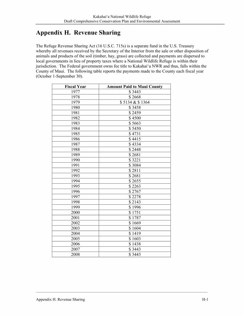
Kakahai‘a National Wildlife Refuge Draft Comprehensive Conservation Plan and Environmental Assessment
______________________________________________________________________________________ Appendix H. Revenue Sharing H-1
Appendix H. Revenue Sharing The Refuge Revenue Sharing Act (16 U.S.C. 715s) is a separate fund in the U.S. Treasury whereby all revenues received by the Secretary of the Interior from the sale or other disposition of animals and products of the soil (timber, hay, grass) are collected and payments are dispersed to local governments in lieu of property taxes where a National Wildlife Refuge is within their jurisdiction. The Federal government owns fee title to Kakahai‘a NWR and thus, falls within the County of Maui. The following table reports the payments made to the County each fiscal year (October 1-September 30).
Fiscal Year Amount Paid to Maui County 1977 $ 3443 1978 $ 2668 1979 $ 5134 & $ 1364 1980 $ 3458 1981 $ 2459 1982 $ 4500 1983 $ 5663 1984 $ 5450 1985 $ 4731 1986 $ 4415 1987 $ 4334 1988 $ 2448 1989 $ 2681 1990 $ 3221 1991 $ 3084 1992 $ 2811 1993 $ 2681 1994 $ 2655 1995 $ 2263 1996 $ 2767 1997 $ 2278 1998 $ 2143 1999 $ 1996 2000 $ 1751 2001 $ 1787 2002 $ 1669 2003 $ 1604 2004 $ 1419 2005 $ 1603 2006 $ 1438 2007 $ 3443 2008 $ 3443

Kakahai‘a National Wildlife Refuge Draft Comprehensive Conservation Plan and Environmental Assessment
______________________________________________________________________________________ Appendix H. Revenue Sharing H-1
Kakahi‘a National Wildlife Refuge Draft Comprehensive Conservation Plan and Environmental Assessment
Appendix I: Literature Cited I-1
Appendix I: Literature Cited Arakawa, L. 2008. Isle temperatures are rising. Honolulu Advertiser. March 28, 2008. Baker, J.D., C.L. Littnan, and D.W. Johnston. 2006. Potential effects of sea level rise on the terrestrial habitats of endangered and endemic megafauna in the Northwestern Hawaiian Islands. Endangered Species Research 4:1-10. Balazs, G.H. 1991. Current status of fibropapillomas in the Hawaiian green turtle, Chelonia mydas. In: G.H. Balazs and S.G. Pooley (Eds.), Research plan for marine turtle fibropapilloma, December 4-6, 1990, Honolulu, Hawai‘i, p. 47-57. U.S. Dep. Commer., NOAA Tech. Memo. Bateson, G. 1972. Steps to an ecology of mind: collected essays in Anthropology, Psychiatry, Evolution, and Epistemology. London: Chandler. Berger, A.J. 1972. Hawaiian birdlife. Univ. Press Hawai‘i , Honolulu. 270 pp. Blossey, B. and R. Notzold. 1995. Evolution of increased competitive ability in invasive non-indigenous plants: a hypothesis. Journal of Ecology 83:887-889. Brisbin, I.L., Jr., H.D. Pratt, and T.B. Mowbray. 2002. American Coot (Fulica Americana) and Hawaiian Coot (Fulica alai). The Birds of North America, No. 697. (A. Poole and F. Gill, eds.). Philadelphia, PA. Brown, S., C. Hickey, and B. Harrington, eds. 2000. The U.S. Shorebird Conservation Plan. Manomet Center for Conservation Sciences, Manomet, MA. 60pp. Bruland, Gregory L. and Richard A. MacKenzie. 2010. Nitrogen source tracking with δ15 N content of coastal wetland plants in Hawai‘i . Journal of Environmental Quality 39: 409-419. Buddemeier, R.W., J.A. Kleypas, and R.B. Aronson. 2004. Coral Reefs and Global Climate Change: Potential Contributions of Climate Change to Stresses on Coral Reef Ecosystems. Pew Centre for Global Climate Change: Arlington, VA. Burney, L. P., and Burney, D. A. (2003). Charcoal stratigraphies for Kaua‘i and the timing of human arrival. Pacific Science 57(2): 211–226 Cabin, R. J., Weller, S. G., Lorence, D. H., Flynn, T. W., Sakai, A. K., Sandquist, D. & Hadway, L. J. 2000. Effects of long-term ungulate exclusion and recent alien species control on the preservation and restoration of a Hawaiian tropical dry forest. Conservation Biology. 14: 439-453. Caccamise, D. J., II, M. A. Merrifield, M. Bevis, J. Foster, Y. L. Firing, M. S. Schenewerk, F. W. Taylor, and D. A. Thomas. 2005. Sea level rise at Honolulu and Hilo, Hawai‘i: GPS estimates of differential land motion, Geophys. Res. Lett. 32, L03607.
Kakahi‘a National Wildlife Refuge Draft Comprehensive Conservation Plan and Environmental Assessment
I-2 Appendix I: Literature Cited
Carter, L.M., E.Shea, M.Hamnett, C.Anderson, G. Dolcemascolo, C.Guard, M. Taylor,T. Barnston,Y. He, M. Larsen, L. Loope, L. Malone, G. Meehl. 2001. Potential Consequences of Climate Variability and Change for the U.S.-Affiliated Islands of the Pacific and Caribbean. pp. 315-349. In Climate Change Impacts on the United States: The Potential Consequences of Climate Variability and Change. National Assessment Synthesis Team, US Global Change Research Program. Cambridge University Press: Cambridge, UK. Carver, E. and J. Caudill. 2007. Banking on Nature 2006: The Economic Benefits to Local Communities of National Wildlife Refuge Visitation. Division of Economics, U.S. Fish and Wildlife. Washington, DC. Chardine , J.W. and R.D. Morris. 1996. Brown noddy (Anous stolidus). In The Birds of North America, No. 220 (Poole A, Gill F, editors.). Philadelphia, (PA): The Academy of Natural Sciences; and Washington DC: The American Ornithologists' Union. Chinen, Jon. 1961. Original Land Titles in Hawai‘i. Library of Congress Catalogue Card No. 61-17314. Chu, P.S. and H. Chen. 2005. Interannual and interdecadal rainfall variations in the Hawaiian Islands. Journal of Climate 18:4796:-4813. Cobb, K.M., C. Charles, H. Cheng, R. Edwards. 2003. El Niño/Southern Oscillation and tropical Pacific climate during the last millennium. Nature. Vol. 424, No. 6946, pp. 271-276 (17 July 2003). Cooke, G.P. 1949. Mooleleo o Moloka‘i. Honolulu Star-Bulletin. Honolulu, Territory of Hawai‘i. Commission of Public Lands. 1929. Indices of Awards made by the Board of Commissioners to Quiet Land Titles in the Hawaiian Islands. Star-Bulletin Press. Honolulu, Territory of Hawai‘i. Cowardin, L.M., V. Carter, F.C. Golet, and E.T. LaRoe. 1979. Classification of wetlands and deepwater habitats in the United States. U.S. Fish and Wildlife Service. FWS/OBS-79/31. Cuddihy, L.W and C.P. Stone. 1994. Summary of Vegetation Alteration in the Hawaiian Islands. Pp. 467-472. in E. Alison Kay (editor). A Natural History of the Hawaiian Islands. University of Hawai‘i Press: Honolulu. HI. Davis, W.E., Jr. 1993. Black-crowned Night-heron (Nycticorax nycticorax). The Birds of North America, No. 74. (A. Poole and F. Gill, eds.). The Birds of North America, Inc., Philadelphia, PA. Daws, G. 1989. Shoal of time: A history of the Hawaiian islands. Honolulu, HI: University of Hawai‘i Press. Honolulu, HI. DBEDT and DOH (Hawai‘i Department of Business, Economic Development & Tourism and Department of Health). 1998. Hawai‘i climate change action plan. Available at: http://Hawai‘i.gov/dbedt/info/energy/publications/ccap.pdf. Accessed January 20, 2010.
DBEDT. 2005. Annual Visitor Research Report. Honolulu HI.

Kakahi‘a National Wildlife Refuge Draft Comprehensive Conservation Plan and Environmental Assessment
Appendix I: Literature Cited I-3
DBEDT. 2007. State of Hawai‘i Facts. Available at: http://hawaii.gov/dbedt/info/economic/library. Accessed January 8, 2008. DBEDT. 2009. 2008 State of Hawai‘i Data Book. Available at: http://www.hawaii.gov/dbedt/info/economic/databook/db2008/. Accessed July 16, 2009. DBEDT. 2010. 2009 State of Hawai‘i Data Book. Available at: http://www.hawaii.gov/dbedt/info/economic/databook/db2009/. Accessed January 19, 2010. Division of State Parks (DLNR). 2008. Hawai‘i State Comprehensive Outdoor Recreation Plan 2008 (update). Honolulu, HI. DLNR (Hawai‘i Department of Land and Natural Resources). 1999. Hawai‘i Coastal Erosion Management Plan. Honolulu, HI. DLNR. 1993. “Fishponds of Hawai‘i.” Honolulu, HI. Dorrance, William H. and Morgan, Francis S. 2000. Sugar Islands: The 165-Year Story of Sugar
in Hawai‘i (First ed.), Mutual Publishing .Honolulu, HI. Duffy, D. C. 1993. Stalking the Southern Oscillation: Environmental uncertainty, climate change, and North Pacific seabirds. Ottawa, Canada. Ehleringer, J.R., Cerling, T.E., Dearing, M.D., 2002. Atmospheric CO2 as a global driver influencing plant–animal interactions. Integ. Comp. Biol. 42, 424–430. Elliott, M.E and E.M. Hall.1977 Wetlands and Wetland Vegetation of Hawai‘i. Prepared for the United States Army Corps of Engineers, Pacific Ocean Division, Fort Shafter, HI. Ellis, W.E. 1827. Narrative of a tour through Hawai‘i, or Owhyhee with observations on the natural history of the Sandwich Islands and remarks on the manners, customs, traditions, history, and language of their inhabitants. H. Fisher, Son, and P. Jackson. London. Engilis, A., Jr., K. J. Uyehara, and J. G. Giffin. 2002. Hawaiian Duck (Anas wyvilliana). The Birds of North America. Number 694. Engilis, A., Jr., and M. Naughton. 2004. U.S. Pacific Islands Regional Shorebird Conservation Plan. U.S. Shorebird Conservation Plan. U.S. Department of the Interior, Fish and Wildlife Service. Portland, OR. Engilis, A., Jr., and T.K. Pratt. 1993. Status and population trends of Hawai‘i’s native waterbirds, 1977-1987. Wilson Bulletin 105:142-158. EPA (U.S. Environmental Protection Agency). 1998. Climate Change and Hawai‘i. Report no. EPA 236-F-98-007e. Environmental Protection Agency, Office of Policy, Planning and Evaluation. Washington, D.C.
Kakahi‘a National Wildlife Refuge Draft Comprehensive Conservation Plan and Environmental Assessment
I-4 Appendix I: Literature Cited
EPA. 2010. Environmental justice. Available at: http://www.epa.gov/compliance/environmentaljustice/index.html. Accessed July 2010.
Erickson, T.A and C.F. Puttock. 2006. Hawaiʻi Wetland Field Guide: An ecological and identification guide to wetlands and wetland plants of the Hawaiian Islands. U.S. Environmental Protection Agency. Felker, P. 1981. Uses of tree legumes in semiarid regions. Econ. Bot. 35(2):174-186 Fletcher, C. 2010. Hawai‘i’s Changing Climate. Briefing Sheet, 2010. Center for Island Climate Adaptation and Policy. University of Hawai‘i, Honolulu, HI. Fletcher III, C. H., E.E. Grossman, B.M. Richmond, and A.E. Gibbs. 2002. Atlas of Natural Hazards in the Hawaiian Coastal Zone. U.S. Geological Survey. U.S. Government Printing Office: Denver, CO. Foote, D.E., E.L. Hill, S. Nakamura, and F. Stephens. 1972. Soil Survey of the Islands of Kaua‘i, O‘ahu, Maui, Moloka‘i, and Lana‘i, State of Hawai‘i. U. S. Department of Agriculture, Soil Conservation Service. Fornander, A. 1880. An account of the Polynesian race its origin and migrations and the ancient history of the Hawaiian people to the times of Kamehameha I. Vol II. Trubner & Co. Ludgate Hill. London. Fornander, Abraham. 1969. Account of the Polynesian Race: Its Origins and Migrations. Charles E. Tuttle, Co., Tokyo.
Gardner, Emily. 1996. Hawai‘i's Marine Wildlife: Whales, Dolphins, Turtles, and Seals, A Course of Study. Earthtrust and the Hawai‘i State Department of Education.
Government Accountability Office (GAO). 2007. Climate Change: Agencies Should Develop Guidance for Addressing the Effects on Federal Land and Water Resources. Report to Congressional Requesters. Germplasm Resources Information Network (GRIN) on-line data base. http://www.ars-grin.gov/. Giambelluca, Tom. Recent Historical Temperature and Trade-Wind Inversion Variations in Hawai‘i. Presented at the Forum on Climate Change in Hawai‘i, March 2008, in Honolulu, Hawai‘i. Giambelluca, T.W., H.F. Diaz, and M.S.A. Luke. 2008. Secular temperature changes in Hawaii. Geophysical Research Letters 35, L12702, doi:10.1029/2008GL034377
Giambelluca, T. W., M. A. Nullet, and T. A. Schroeder. 1986. Rainfall atlas of Hawai‘i, Rep. R76, Dep. of Land and Nat. Resour., Honolulu, HI.
Gingerich, S.B., and D.S. Oki, 2000. Ground water in Hawaii: U.S. Geological Survey Fact Sheet 126–00, 6 p.
Kakahi‘a National Wildlife Refuge Draft Comprehensive Conservation Plan and Environmental Assessment
Appendix I: Literature Cited I-5
Handy, E.S.C. 1940. The Hawaiian Planter, Vol. I: His Plants, Methods, and Areas of Cultivation. Bernice P. Bishop Museum Bulletin 161. Bishop Museum Press: Honolulu, HI.
Handy, E.S.C. and E.G. Handy. 1972. Native Planters in Old Hawai‘i . Bernice P. Bishop Museum Bulletin 233. Bishop Museum Press: Honolulu, HI.
Haselwood, E.L. and R.T. Hirano. 1983. Handbook of Hawaiian weeds. University of Hawai‘i Press. Honolulu, Hawai‘i. Hawai‘i Audubon Society. 2005. Hawai‘i’s Birds: 6th Edition. Island Heritage: Waipahu: Hawai‘i. Hays, W.S.T. and S. Conant. 2007. Biology and impacts of Pacific Island invasive species. 1. A worldwide review of effects of the small Indian mongoose, Herpestes javanicus (Carnivora : Herpestidae). Pacific Science 61(1):3-16.
Henry, A. 2006. Pacific Coast Joint Venture Hawai‘i: Strategic Plan for Wetland Conservation in Hawai‘i. Ducks Unlimited, Inc. 101pp.
Herbst, L. H. 1994. Fibropapillomatosis of marine turtles. Annu. Rev. Fish Dis. 4:389-425. Ikuma, E.K., D. Sugano, and J.K. Mardfin. 2002. Filling the gaps in the fight against invasive species. Honolulu, HI: Legislative Reference Bureau. IPCC. 2007. Climate Change 2007: Synthesis Report. Contribution of Working Groups I, II and III to the Fourth Assessment Report of the Intergovernmental Panel on Climate Change [Core Writing Team, Pachauri, R.K and Reisinger, A. (eds.)]. Judd, G.P. IV. 1936. Puleoo the story of Moloka‘i. Porter Printing Co. Honolulu, Territory of Hawai‘i.
Judd, Laura Fish. 1966. Honolulu: Sketches of Life in the Hawaiian Islands from 1828 to 1861. Edited by Dale L. Morgan. R.R. Donnelley & Sons, Chicago, IL.
Juvik, S. P. and J. O. Juvik (eds.) 1998. Atlas of Hawai‘i. Third edition. University of Hawai‘i Press. Honolulu.
Ka‘aiakamanu , Rev. Kaluna M. 2003. Native Hawaiian Medicine--Volume III. First People’s Productions. Honolulu, HI. Kamehameha Schools. 2011. Life in early Hawai‘i: the Ahupua‘a. Kamehameha Schools. Honolulu, HI. Kame‘eleihiwa, Lilikalani. 1992. Native Land and Foreign Desires: Pehea E Pono Ai? Bishop Museum Press. Honolulu, HI. Kikuchi, W.K. 1973. Hawaiian Aquaculture System. Department of Anthropology. University of Arizona. Unpublished dissertation.

Kakahi‘a National Wildlife Refuge Draft Comprehensive Conservation Plan and Environmental Assessment
I-6 Appendix I: Literature Cited
Kimura, B.Y. and K.M. Nagata. 1980. Hawai‘i’s Vanishing Flora. The Oriental Publishing Co.: Honolulu, Hi. Kirch, P.V. 1982. The impact of the prehistoric Polynesians on the Hawaiian ecosystem. Pacific Science 36:1–14. Kirch, P.V. 1985. Feathered gods and fishhooks: an introduction to Hawaiian Archaeology and prehistory. Kirch, Patrick V. and Marshall Sahlins. 1992. Anahulu. Vol. 1 and 2. University of Chicago Press. Chicago, IL. Kushlan, J.A., M.J. Steinkamp, K.C. Parsons, J. Capp, M.A. Cruz, M. Coulter, I. Davidson, L. Dickson, N. Edelson, R. Elliot, R.M. Erwin, S. Hatch, S. Kress, R. Milko, S. Miller, K. Mills, R. Paul, R. Phillips, J. E. Saliva, B. Sydeman, J. Trapp, J. Wheeler, and K. Wohl. 2002. Waterbird Conservation for the Americas: The North American Waterbird Conservation Plan, Version 1. Waterbird Conservation for the Americas, Washington, DC. Kuykendall, Ralph, S. 1967. The Hawaiian Kingdom: 1778-1854, Foundation and Transformation. Vol. I. University of Hawai‘i Press (Reprint edition). Honolulu, HI. Langenheim, V.A.M., and D.A. Clague, 1987. The Hawaiian-Emperor volcanic chain, part II, stratigraphic framework of volcanic rocks of the Hawaiian Islands, chap. 1 of Decker, R.W., Wright, T.L., and Stauffer, P.H., eds., Volcanism in Hawaii: U.S. Geological Survey Professional Paper 1350, v. 1, p. 55–84. Lau, L.S. and J.F. Mink. 2006. Hydrology of the Hawaiian Islands. University of Hawai‘i Press, Honolulu, HI. Lewis, W.M. 1987. Tropical limnology. Annual Review of Ecology and Systematics 18:159-184. Lewis, W.M. 1996. Tropical lakes: How latitude makes a difference. In Perspectives in Tropical Limnology Eds Schiemer, F. and K.T. Boland. SPB Academic Publishing/The Netherlands. Lindgren, W. 1903. The water resources of Moloka‘i, Hawaiian Islands. Water supply and irrigation paper No. 77. Series 0, underground waters, 19. USGS. Government printing office. Washington. Loope, L.L., and D. Mueller-Dombois. 1989. Characteristics of invaded islands, p.257-280. In Biological Invasions: A Global Perspective. Edited by J. A. Drake, H. A. Mooney, F. D. Castri, R. H. Grooves, F. J. Kruger, M. Rejmanek, and M. Williamson. John Wiley and Sons. Chichester, UK. Macdonald, G.A. and A.T. Abbott. 1970. Volcanoes in the Sea. University of Hawai‘i Press, Honolulu, HI. Maui Axis Deer Group. 2002. Initial Findings and Recommendations for a Maui Deer Management Plan, developed by the subcommittee of Public Information and Deer Management Planning. Maui County Office of Economic Development. 2009. Maui County Data Book 2008. Hawai‘i Small Business Development Center Network. 248 pp.

Kakahi‘a National Wildlife Refuge Draft Comprehensive Conservation Plan and Environmental Assessment
Appendix I: Literature Cited I-7
Mayer, Tim, Mike Nishimoto and Glynnis Nakai. 2008. The relationship between midge, fish and biotic factors at Keālia Pond NWR. Unpubl. Admin Rep. U.S. Fish & Wildlife Service, Portland, Oregon. McCarthy, J.J, F. Osvaldo, F. Canziani, N.A. Leary, D.J. Dokken, and K.S. White. 2001. Climate change 2001: impacts, adaptation, and vulnerability. Contribution of working group II to the third assessment report of the Intergovernmental Panel on Climate Change. Cambridge University Press, UK. McKeown, S. 1996. A field guide to reptiles and amphibians in the Hawaiian Islands. Diamond Head Publishing, Inc., Los Osos, CA. Megyesi JL, O’Daniel DL. 1997. Bulwer’s petrel (Bulweria bulwerii). In The Birds of North America, No. 281 (Poole A, Gill F, editors.). Philadelphia, (PA): The Academy of Natural Sciences; and Washington DC: The American Ornithologists' Union. Menzies, A. 1920. Hawai‘i Nei 128 years ago. Honolulu, Territory of Hawai‘i. Meyer, C.S. 1982. Meyer and Moloka‘i. Graphic-Agri Business. pp 130-131. Michener, W.K., E.R. Blood, K.L. Bildstein, M.M. Brinson, and L.R. Gardner. 1997. Climate Change, Hurricanes and Tropical Storms, and Rising Sea Level in Coastal Wetlands. Ecological Applications Vol. 7(3):770-801. Middleton, B.A. 2006. Invasive Species and Climate Change. U.S. Geological Survey Open-File Report 2006-1153. Miller, J.A., R.L. Whitehead, D.S. Oki, S.B. Gingerich, and P.G. Olcott. 1999. Ground water atlas of the United States. Segment 13, Alaska, Hawai‘i, Puerto Rico, and the U.S. Virgin Islands. U.S. Geological Survey. Mimura, N., L. Nurse, R.F. McLean, J. Agard, L. Briguglio, P. Lefale, R. Payet and G. Sem, 2007: Small islands. Climate Change 2007: Impacts, Adaptation and Vulnerability. Contribution of Working Group II to the Fourth Assessment Report of the Intergovernmental Panel on Climate Change, M.L. Parry, O.F. Canziani, J.P. Palutikof, P.J. van der Linden and C.E. Hanson, Eds., Cambridge University Press, Cambridge, UK, 687-716. Missionary Herald. 1829. Sandwich Islands, tour around Morokai [Moloka‘i]. Vol. 25 No. 9. p 274. Mitchell, C., C. Ogura, D.W. Meadows, A. Kane, L. Strommer, S. Fretz, D. Leonard, and A. McClung. 2005. Hawai‘i’s Comprehensive Wildlife Conservation Strategy. Department of Land and Natural Resources. Honolulu, HI. Mitsch, W.J. and J.G. Gosselink. 1993. Wetlands, Second Edition. New York: Van Nostrand Rinhold Moore, J.G. 1964. Giant submarine landsides on the Hawaiian Ridge. United States Geological Survey Professional Paper 501-D:95-98.

Kakahi‘a National Wildlife Refuge Draft Comprehensive Conservation Plan and Environmental Assessment
I-8 Appendix I: Literature Cited
Motooka, P., L. Castro, D. Nelson, G. Nagai, and L. Ching. 2003. Weeds of Hawai‘i’s Pastures and Natural Areas; An Identification and Management Guide. College of Tropical Agriculture and Human Resources, University of Hawai‘i at Manoa. Mueller-Dombois, D. and F.R. Fosberg. 1998. Vegetation of the Tropical Pacific Islands. Springer Press, New York. Nakiboglu, S.M., K. Lambeck, and P. Aharon. 1983. Post-glacial sealevels in the Pacific: implications with respect to deglaciation regime and local tectonics. Tectonophys. 91: 335-358. Nelson, R. E., and P. R. Wheeler. 1963. Forest Resources of Hawai‘i-1961. USDA Forest Service, Pacific Southwest Forest and Range Experiment Station in cooperation with the Hawai‘i Department of Land and Natural Resources, Division of Forestry. Berkeley, CA, and Honolulu, HI. NOAA. 2002. Climatography of the United States No. 81 Monthly Station Normals of Temperature, Precipitation, and Heating and Cooling Degree Days, 1971 – 2000, 51 Hawai‘i. National Climatic Data Center Asheville, North Carolina. Noye, B.J and M.P. Grzechnik. 2001. Sea level changes and their effects. World Scientific Publishing, Singapore. NRCS (Natural Resources Conservation Service). 2008. California bulrush. Plant Fact Sheet. Prepared By: Richard H. Neill 27 Feb 2007. OECD (Organization for Economic Cooperation and Development). 1982. Eutrophication of waters-monitoring, assessment, and control. Synth. Rep. from the OECD Coop. Programme Eutroph . OECD Publications. Washington. D.C. Oki, D.S. 2004. Trends in streamflow characteristics at long-term gaging stations, Hawai‘i. Scientific Resources Investigations 2004-5080, U.S. Geologic Survey, Reston, Virginia. Oki, D.S., 2007. Effects of ground-water withdrawal on Kaunakakai Stream environmental restoration plan, Moloka‘i, Hawai‘i: U.S. Geological Survey Scientific Investigations Report 2007—5128, 25 p. OPIC (Overseas Private Investment Corporation). 2000. Annual Report. Olson, S.L., and H.F. James. 1982. Prodromus of the fossil avifauna of the Hawaiian Islands. Smithsonian Contributions to Zoology 365:1-59. Overseas Private Investment Corporation (OPIC). 2000. “Climate Change: Assessing Our Actions.” Washington, D.C. Parry, M.L., O.F. Canziani, J.P. Palutikof, P.J. van der Linden and C.E. Hanson. 2007. Climate Change 2007: Impacts, Adaptation and Vulnerability. Contribution of Working Group II to the Fourth Assessment Report of the Intergovernmental Panel on Climate Change. Cambridge University Press, Cambridge, UK. 976pp. Paton, W.C., D.P. Fellows, and P.Q. Tomich. 1986. Distribution of Cattle Egret Roosts in Hawai‘i With Notes on the Problems Egrets Pose to Airports. ‘Elepaio 46:143-147.
Kakahi‘a National Wildlife Refuge Draft Comprehensive Conservation Plan and Environmental Assessment
Appendix I: Literature Cited I-9
Pattison, R.R., G. Goldstein, and A. Ares. 1998. Growth, biomass allocation and photosynthesis of invasive and native Hawaiian rainforest species. Oecologia 117(4):449-459. Pau, S., T.W. Gillespie, and J.P. Price. 2009. Natural history, biogeography, and endangerment of Hawaiian dry forest trees. Biodiversity and Conservation 18:3167-3182. Perrine, Doug, 2003. Sea Turtles of the World, Voyager Press Inc, Stillwater, MN Pukui, M.K., S.H. Elbert, and E.K. Mookini. 1974. Place names of Hawai‘i. Revised. University Press of Hawai‘i. Honolulu, HI. Pyle, R.L., and P. Pyle. 2009. The Birds of the Hawaiian Islands: Occurrence, History, Distribution, and Status. B.P. Bishop Museum, Honolulu, HI, U.S.A. Version 1 (31 December 2009) Rauzon, M.J., and D.C. Drigot. 2002. Red mangrove eradication and pickleweed control in a Hawaiian wetland, waterbird responses, and lesions learned. Pp. 240-248 in Veitch, C. R., and M. N. Clout (eds.). Turning the tide: the eradication of invasive species. IUCN SSC Invasive Species Specialist Group. IUCN, Gland, Switzerland and Cambridge, UK. Rauzon, M.J., D. Drigot, and L. Tanino. 2004. Cattle Egret and Black-crowned Night-heron observations associated with mangrove removal at Nu`upia Ponds WMA Kane`ohe Bay, Marine Corps Base Hawai`i in 1996-2000. `Elepaio 64(41):43-47. Reynolds, C.S. 1984. The Ecology of Freshwater Algae. Cambridge University Press, New York, NY. Robinson, J.A., J.M. Reed, J.P. Skorupa, and L.W. Oring. 1999. Black-necked Stilt (Himantopus mexicanus). In The Birds of North America, No. 449. (A. Poole and F. Gill, eds.). The Birds of North America, Inc., Philadelphia, PA. Scott, Susan and CraigThomas. 2000. Pests of Paradise: First Aid and Medical Treatment of Injuries from Hawai‘i's Animals. University of Hawai‘i Press. Honolulu, HI. Shade, P.J., 1997. Water budget for the island of Moloka‘i, Hawai‘i: U.S. Geological Survey Water-Resources Investigations Report 97–4155, 20 p. Shallenberger, R.J. 1977. An Ornithological Survey of Hawaiian Wetlands. Ahuimanu Productions. Prepared for U.S. Army Corps of Engineers. Honolulu, HI. 406 pp. Smith, N.M. 2002. Weeds of the wet/dry tropics of Australia - a field guide. Environment Centre NT, Inc. 112 pp. Smucker, T.D., G.D. Lindsey, S.M. Mosher. 2000. Home range and diet of feral cats in Hawai‘i forests. Pacific Conservation Biology 6: 229-237. Snetsinger, T.J., S.G. Fancy, J.C. Simon, and J.D. Jacobi. 1994. Diets of owls and feral cats in Hawai‘i. `Elepaio 54:47-50.

Kakahi‘a National Wildlife Refuge Draft Comprehensive Conservation Plan and Environmental Assessment
I-10 Appendix I: Literature Cited
Solomon, S., D. Qin, M. Manning, Z. Chen, M. Marquis, K.B. Averyt, M. Tignor and H.L. Miller. 2007. Climate Change 2007: The Physical Science Basis. Contribution of Working Group I to the Fourth Assessment Report of the Intergovernmental Panel on Climate Change. Cambridge University Press, Cambridge, United Kingdom and New York, NY, USA. Staples, G.W., and R.H. Cowie (eds.). 2001. Hawai‘i’s invasive species. Bishop Museum Press: Honolulu, HI. Stearns, H. T. 1966. Geology of the State of Hawai‘i. Pacific Books. Palo Alto, CA. Stearns, H.T., and G.A. Macdonald. 1974. Geology and ground-water resources of the Island of Moloka‘i, Hawai‘i. Bulletin 11. USGS. Honolulu, Hawai‘i. Summers, C.C. 1971. Molokai a site survey. Bernice P. Bishop Museum. Pacific Anthropological Records No. 14. Honolulu, Hawai‘i. Stone, C. P., and J. O. Keith. 1987. Control of feral ungulates and small mammals in Hawai‘i’s national parks: research and management strategies. Pages 277–287 in C. G. J. Richards and T. Y. Ku, editors. Control of mammal pests. Taylor and Francis, London, England, and New York and Philadelphia, USA. Stone, Charles P., Clifford W. Smith, and J. Timothy Tunison (eds.) . 1992. Alien plant invasions in native ecosystems of Hawai‘i: Management and research. Honolulu: University of Hawai‘i Cooperative National Park Resources Studies Unit. ISBN: 0-8248-1474-6. Tabata , Raymond S. 1980. The Native Coastal Plants of Hawai‘i.Sea Grant Marine Advisory Program. UH at Mānoa. Honolulu, HI. TenBruggencate, J. 2007. Floods, hotter climate in Isles likely by 2090. Honolulu Advertiser. February 25, 2007. Timm, Oliver. Statistical Projection of Global Climate Change Scenarios onto Hawaiian Rainfall. Presented at the Forum on Climate Change in Hawai‘i, March 26, 2008 in Honolulu, Hawai‘i. Timm, O. and H.F. Diaz. 2009. Synoptic-Statistical Approach to Regional Downscaling of IPCC Twenty-First-Century Climate Projections: Seasonal Rainfall over the Hawaiian Islands. Journal of Climate 22: 4261-4280, doi: 10.1175/2009JCLI2833.1 Tobin, M.E. and R.T. Sugihara. 1992. Abundance and habitat relationships of rats in Hawaiian sugar cane fields. Journal of Wildlife Management 56(4):816-822. Tolleson, D., D. Rollins, W. Pinchak, M. Ivy, and A. Hierman. 1993. Impact of feral hogs on ground-nesting gamebirds. Pages 76–83 in C. W. Hanselka and J. F. Cadenhead, editors. Feral swine: A compendium for resource managers. Texas Agricultural Extension Service, Kerrville, Texas, USA. Tomich, P.Q. 1986. Mammals in Hawai`i. Bishop Museum Press: Honolulu, HI.
Kakahi‘a National Wildlife Refuge Draft Comprehensive Conservation Plan and Environmental Assessment
Appendix I: Literature Cited I-11
Tropical Forages. 2005. Online Database. Available at: http://www.tropicalforages.info/key/Forages/Media/Html. Accessed on March 17, 2008. Turcotte, D. L.and B.D. Malamud, 2009. Temperature trends at the Mauna Loa Observatory, Hawai‘i: A direct measurement of global warming? American Geophysical Union, Fall Meeting 2009, abstract #GC13A-0727. U.S. Census Bureau (Census). 2010. Population Division. Available at: http://www.census.gov/popest/estimates.php. U.S. Department of Agriculture (USDA), ARS, National Genetic Resources Program. Germplasm Resources Information Network -(GRIN) [Online Database]. National Germplasm Resources Laboratory, Beltsville, Maryland. U.S. Department of the Interior, Fish and Wildlife Service, and U.S. Department of Commerce, U.S. Census Bureau. 2006 National Survey of Fishing, Hunting, and Wildlife-Associated Recreation: Hawai‘i. Washington, D.C. USFWS. 1996. Pacific Islands Ecoregion Coastal Ecosystem Program Proposal. Pacific Islands Ecoregion. Honolulu, HI. USFWS 1999. Recovery Plan for Multi-Island Plants. U.S. Fish and Wildlife Service, Portland, OR. USFWS 2005. Draft revised recovery plan for Hawaiian waterbirds, second draft of second revision. U.S. Fish and Wildlife Service, Portland, OR. USGS (U.S. Geologic Survey). 2007. Avian Botulism. http://www.nwhc.usgs.gov/disease_information/avian_botulism/ University of Hawai‘i (UH), Sea Grant College Program. 2006. Natural Hazard Considerations for Purchasing Coastal Real Estate in Hawai‘i: A Practical Guide of Common Questions and Answers. UH, School of Ocean and Earth Science and Technology. 2010. Annual Report from the Hawai‘i Natural Energy Institute. HRS 304A-1891. Uyehara, K. J., A. Engilis, Jr., and M. Reynolds. 2007. Hawaiian duck’s future threatened by feral Mallards. U.S. Geological Survey Fact Sheet 2007-3047. Uyehara, K. J., A. Engilis, Jr., and B. Duggar. 2008. Wetland Features That Influence Occupancy by the Endangered Hawaiian Duck. The Wilson Journal of Ornithology 120(2):311–319. Vitousek, Peter M. 1994. Beyond Global Warming: Ecology and Global Change. Ecology 75(7): 1861–1876. Vogt, G. 1979. Adverse effects of recreation on sand dunes: a problem for coastal zone management. Coastal Zone Management Journal. 6(1):37-68.
Kakahi‘a National Wildlife Refuge Draft Comprehensive Conservation Plan and Environmental Assessment
I-12 Appendix I: Literature Cited
Wagner, Warren L. and Herbst, Derral R. 1995. Contributions to the Flora of Hawai‘i. IV. Bishop Museum Occasional Papers. 42:13-27. Honolulu, HI. Wagner, W.L., D.R. Herbst, and S.H. Sohmer. 1999. Manual of the flowering plants of Hawai‘i , Revised edition. 2 vols, Bishop Museum Special Publication 97. University of Hawai‘i Press and Bishop Museum Press: Honolulu, HI. Walker, R. 2010. Stealing with Tools. `Elepaio 70:44-47. Walther, G. R., Post, E.; Convey, P.; Menzel, A.; Parmesan, C.; Beebee, T.J.C.; Fromentin, J-M.; Hoegh-Guidberg, O.; Bairlein, F. 2002. Ecological responses to recent climate change. Nature. 416: 389-395. Walther, Michael. 2004. A Guide to Hawai‘i’s Coastal Plants. Mutual Publishing. Honolulu, HI. Weisler, M. and P.V. Kirch. 1982. The archaeological resources of Kawela, Moloka‘i: their nature, significance, and management. Bernice P. Bishop Museum. Honolulu, Hawai‘i. Unpublished. Wilcox, C. 1996. Sugar Water: Hawai‘i’s Plantation Ditches. University of Hawai’i Press, Honolulu, HI. Winter, L. 2003. Popoki and Hawai‘i’s Native Birds. ‘Elepaio 63:43-46. Wood, G. W., and R. H. Barrett. 1979. Status of the wild pig in the United States. Wildlife Society Bulletin 36:237–246. WWF (World Wildlife Fund). 2010. Terrestrial Ecoregions. Available at: http://www.worldwildlife.org/science/ecoregions/item1267.html. Accessed January 19, 2011. Yamamoto, Mike N. & Annette W. Tagawa. 2000. Hawai‘i’s native & exotic freshwater animals. Mutual Publishing. Honolulu, HI.
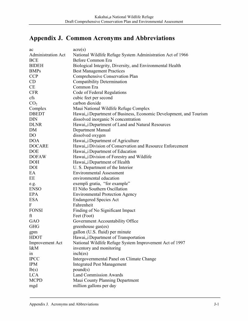
Kakahai„a National Wildlife Refuge Draft Comprehensive Conservation Plan and Environmental Assessment
Appendix J. Acronyms and Abbreviations J-1
Appendix J. Common Acronyms and Abbreviations
ac acre(s) Administration Act National Wildlife Refuge System Administration Act of 1966 BCE Before Common Era BIDEH Biological Integrity, Diversity, and Environmental Health BMPs Best Management Practices CCP Comprehensive Conservation Plan CD Compatibility Determination CE Common Era CFR Code of Federal Regulations cfs cubic feet per second CO2 carbon dioxide Complex Maui National Wildlife Refuge Complex DBEDT Hawai„i Department of Business, Economic Development, and Tourism DIN dissolved inorganic N concentration DLNR Hawai„i Department of Land and Natural Resources DM Department Manual DO dissolved oxygen DOA Hawai„i Department of Agriculture DOCARE Hawai„i Division of Conservation and Resource Enforcement DOE Hawai„i Department of Education DOFAW Hawai„i Division of Forestry and Wildlife DOH Hawai„i Department of Health DOI U. S. Department of the Interior EA Environmental Assessment EE environmental education e.g. exempli gratia, “for example” ENSO El Niño Southern Oscillation EPA Environmental Protection Agency ESA Endangered Species Act F Fahrenheit FONSI Finding of No Significant Impact ft Feet (Foot) GAO Government Accountability Office GHG greenhouse gas(es) gpm gallon (U.S. fluid) per minute HDOT Hawai„i Department of Transportation Improvement Act National Wildlife Refuge System Improvement Act of 1997 I&M inventory and monitoring in inch(es) IPCC Intergovernmental Panel on Climate Change IPM Integrated Pest Management lb(s) pound(s) LCA Land Commission Awards MCPD Maui County Planning Department mgd million gallons per day
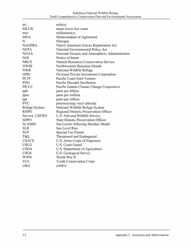
Kakahai„a National Wildlife Refuge Draft Comprehensive Conservation Plan and Environmental Assessment
J-2 Appendix J. Acronyms and Abbreviations
mi mile(s) MLLW mean lower low water mm millimeter(s) MOA Memorandum of Agreement N Nitrogen NAGPRA Native American Graves Repatriation Act NEPA National Environmental Policy Act NOAA National Oceanic and Atmospheric Administration NOI Notice of Intent NRCS Natural Resources Conservation Service NWHI Northwestern Hawaiian Islands NWR National Wildlife Refuge OPIC Overseas Private Investment Corporation PCJV Pacific Coast Joint Venture PDO Pacific Decadal Oscillation PICCC Pacific Islands Climate Change Cooperative ppb parts per billion ppm parts per million ppt parts per trillion PVC polymerizing vinyl chloride Refuge System National Wildlife Refuge System RHPO Regional Historic Preservation Officer Service, USFWS U.S. Fish and Wildlife Service SHPO State Historic Preservation Officer SLAMM Sea Levels Affecting Marshes Model SLR Sea Level Rise SUP Special Use Permit T&E Threatened and Endangered USACE U.S. Army Corps of Engineers USCG U.S. Coast Guard USDA U.S. Department of Agriculture USGS U.S. Geological Survey WWII World War II YCC Youth Conservation Corps yd(s) yard(s)

Kakahai‘aNational Wildlife RefugeDraft Comprehensive Conservation Planand Environmental Assessment
U.S. Fish & Wildlife ServiceKakahai‘a National W
ildlife RefugeD
raft Com
prehensive Conservation P
lan and E
nvironmen
tal Assessm
ent
August 2011
U.S. Department of the InteriorU.S. Fish & Wildlife ServiceMaui National Wildlife Refuge ComplexMilepost 6 Mokulele HighwayKıhei, Hawai‘i 96753
Phone: 808/875 1582Fax: 808/875 2954
http://www.fws.gov
National Wildlife Refuge System Information1 800/344 WILD
August 2011
The mission of the U.S. Fish & Wildlife Serviceis working with others to conserve, protect, andenhance fish, wildlife, and plants and their habitatsfor the continuing benefit of the American people.
Front Cover Back Cover Inset Photos ‘Alae ke‘oke‘o Hunakai Kolea©Tom Dove ©Kanalu Chock Michael Silbernagle, USFWS
Koloa mapu ©Mike Walther
Ae‘o ©Tony Temple