Embed Size (px)
Citation preview
HanaleiNational Wildlife RefugeWetlands Management and Waterbird Conservation Plan
U.S. Fish & Wildlife Service

WETLANDS MANAGEMENT AND WATERBIRD CONSERVATION PLAN Hanalei National Wildlife Refuge
HAWAI’I
FEBRUARY 2021
Prepared by
U.S. Fish and Wildlife Service - Pacific Region 911 NE 11th Avenue Portland, Oregon 97232
and
Hanalei National Wildlife Refuge Kaua‘i National Wildlife Refuge Complex P.O. Box 1128 Kīlauea, Hawai‘i 96754

Hanalei National Wildlife Refuge Wetlands Management and Waterbird Conservation Plan
This page intentionally left blank
Hanalei National Wildlife Refuge Wetlands Management and Waterbird Conservation Plan
Finding of No Significant Impact i
FINDING OF NO SIGNIFICANT IMPACT Finding of No Significant Impact (FONSI)
for the Hanalei National Wildlife Refuge Wetlands Management and Waterbird Conservation Plan
EA: August 2020 FONSI: February 2021
The U.S. Fish and Wildlife Service (Service) has completed a Wetlands Management and Waterbird Conservation Plan (WMWCP) and Environmental Assessment (EA) for Hanalei National Wildlife Refuge (Refuge or NWR).
The WMWCP describes the processes and procedures needed to achieve Hanalei NWR’s management objectives, including those related to threatened and endangered (T&E) Hawaiian waterbird conservation, for approximately 480 acres of rotational managed wetland (moist-soil) units, lo‘i kalo (wetland taro [Colocasia esculenta] fields), ditches and dikes, fallow, riparian habitat, and associated uplands. The EA for the WMWCP describes two alternatives: no-action (current management) and action (preferred). The preferred alternative (implementation of the WMWCP) addresses management on the Refuge to: (1) promote and provide habitat for the life stages of the T&E species for which the Refuge was established (Endangered Species Conservation Act of 1969, 16 United States Code [U.S.C] 668aa; Statute 275); (2) reduce loss of T&E species due to predation, competition, or hybridization with non-native species; (3) reduce the loss of T&E species due to disease; and (4) ensure that the Refuge’s farming and grazing programs are compatible with the Refuge’s purpose of recovering T&E species and in compliance with the applicable laws, regulations, and policies of the Service (e.g., Appropriate Refuge Uses, 603 U.S. Fish and Wildlife Service Manual [FW] 1; Compatibility, 603 FW 2; and Cooperative Agricultural Use [CAU], 620 FW 2).
Features Common to All Alternatives
Hanalei NWR resource management priorities derive from the National Wildlife Refuge System mission (601 FW 1), the Refuge purpose, Resources of Concern, and the policy to maintain biological integrity, diversity, and environmental health of the Refuge System (601 FW 3). Priority Resources of Concern identified for Hanalei NWR include the endangered koloa maoli (Hawaiian duck, Anas wyvilliana), ʻalae keʻokeʻo (Hawaiian coot, Fulica alai), ʻalae ʻula (Hawaiian common gallinule, Gallinula galeata sandvicensis), and aeʻo (Hawaiian stilt, Himantopus mexicanus knudseni); and the threatened nēnē (Hawaiian goose, Branta sandvicensis).
Features common to both alternatives include: the use of adaptive management to evaluate success and allow flexible decision making; avian botulism surveillance and control; transitioning to a cooperative agricultural agreement (CAA) program for cooperative kalo farming, instead of the current general use Special Use Permit (SUP) system to align with updated policy and requirements for farming on NWRs, which would allow for permit terms of up to five years, subject to compliance; meeting CAU policy requirements of providing an open, transparent and competitive process for CAAs on the Refuge; working cooperatively with kalo farmers to conduct a cost-sharing and fair market value study to support implementing CAAs; cultural and historic resource protection and National Historic Preservation Act of 1966 (NHPA) Section 106 compliance; using an integrated pest management (IPM) approach to management of invasive, non-native, or detrimental species;
Hanalei National Wildlife Refuge Wetlands Management and Waterbird Conservation Plan
ii Finding of No Significant Impact
continuing feral mallard and mallard/koloa hybrid removal; fish screening; continuing inventory, monitoring, and research pertinent to reviewing management actions; seeking, establishing, and maintaining partnerships to meet Refuge and Refuge System purposes and goals; and implementation subject to funding availability. These features are described in greater detail within Section 2.1 of the EA (USFWS 2020).
Alternatives Considered
Alternative A (Current Management): Alternative A assumes little to no change in current management programs, based on pre-existing initiatives at the Refuge, and also includes actions common to all alternatives, identified in the above section. Currently, the Refuge provides a mosaic of approximately 213 acres of rotational managed wetland (moist-soil) units (also referred to in this document as wetland management units [WMUs]) and lo‘i kalo (ponds for wetland kalo that are enclosed by earthen banks) for T&E waterbirds, as part of a statewide effort to implement the Hawaiian Waterbird and draft Nēnē Recovery Plans (USFWS 2004; USFWS 2011). Of the 213 acres, the Service currently manages 89 acres as WMUs (not including dikes and ditches). In addition to these managed wetland units, there are currently approximately 124 acres in lo‘i kalo of various crop stages and rotations at any point in time, including wet or dry fallows. A total of 160 acres is permitted for kalo farming, which includes associated dikes and ditches.
Under Alternative A, the Service would continue current management practices which include, but are not limited to, monitoring and managing protected bird species and associated habitats; coordinating, permitting, and overseeing kalo farming operations by permittees in the Refuge which provide habitat for protected bird species; maintaining 85 acres of in-use dikes and ditches; managing irrigation systems; providing law enforcement protection; and managing limited public uses and volunteer programs. Working with partners and stakeholders, 2–5 acres of hau (Hibiscus tiliaceus) would be removed per year in priority areas to improve riparian habitat.
In WMUs, moist-soil management involves the manipulation of soils, hydrology, and vegetation to mimic the natural dynamics of seasonally flooded natural wetlands. Techniques such as mowing, disking, tilling, and water level management would be used to control pest species, provide forage, and create suitable habitat structure including a mosaic of native and naturalized beneficial plants. Water level management would continue to be used to provide suitable habitat and prevent disease outbreaks such as avian botulism. Measures to minimize adverse impacts to T&E waterbirds include a nest/brood search with an established protocol prior to implementing habitat maintenance.
The Service would continue to permit kalo farming, and associated residences and farm facilities that support kalo farming. Farming permittees are required through their permit to pay a fee of $25 per cultivated acre. If a kalo farming permittee has an existing residence on the Refuge, then only the permittee and their immediate family (legal parents, spouse, children) may reside in the residence. Use of Refuge lands for permittee-owned residences, storage sheds, and other facilities would not be allowed in situations where associated kalo farming CAAs are terminated.
The provision of T&E waterbird habitat and conservation is a primary stipulation for being able to farm kalo on the Refuge. Requirements include minimum wet fallow periods of 30 days followed by an optional dry fallow period of <180 days post-harvest. Any nest of T&E species must be reported within 48 hours of discovery. During harvest, a minimum three-foot radius unharvested vegetation buffer must be maintained around T&E waterbird nests until waterbirds have fledged or leave the lo‘i of their own accord. Each permittee must provide the Refuge with logs of the dates and locations of
Hanalei National Wildlife Refuge Wetlands Management and Waterbird Conservation Plan
Finding of No Significant Impact iii
wet and dry fallow periods, herbicide and fertilizer usage, and ditch and road maintenance. The Refuge, along with the farmers, Natural Resources Conservation Service (NRCS), and other partners would continue to work together to develop best management practices (BMPs) for kalo farming.
Kalo farming permittees are required to participate in all relevant aspects of the Avian Botulism Prevention and Response Protocol; if patches of kalo are deemed as botulism outbreak hotspots, the permittee must work with Refuge staff to make any environmental or management changes requested. Permittees are required to report sick or dead birds within 24 hours of discovery. Permittees would be encouraged to attend regular botulism coordination meetings and cooperate with any IPM, monitoring, research, or infrastructure projects that are being conducted on the Refuge.
Alternative B (Proposed Action): The chief distinction of this alternative from Alternative A is increased protection and management of biological resources. This alternative also includes actions common to all alternatives, identified in the above section.
Under Alternative B, the Service would provide a mosaic of approximately 209–249 acres of wetland habitat (WMUs and lo‘i kalo) for foraging, loafing, and breeding T&E waterbirds throughout the year. Assignment of areas for WMUs; lo‘i kalo (via CAA); lands rested for farming, conservation, and/or watershed benefits (i.e., fallow or non-actively managed lands); or riparian and upland habitat (e.g., nēnē breeding or foraging habitat or koloa maoli nesting habitat) would involve use of a decision flowchart and be re-evaluated periodically using adaptive management. An additional 3–18 acres of WMUs would be restored and managed as part of the above 209–249 acres. Mowing and use of prescriptive seasonal livestock grazing, without compromising water quality or riparian habitat, would enhance grasslands habitat for nēnē on approximately 14–24 new acres. In addition, approximately 21 acres would be enhanced as koloa maoli nesting habitat. Dikes and ditches would be managed under BMPs to improve waterbird habitat and water quality. Hau bush management would be the same as Alternative A.
Kalo farming management would be the same as Alternative A with the following changes. No new farm residences would be authorized and at least one permit holder must live in the residence on the Refuge. The size of permittee use areas would be delimited and specified within CAAs. Specific strategies under Alternative B to improve waterbird habitat in lo‘i kalo include: enhancement of vegetation structure during all crop stages by not intensively clearing selected non-kalo plant species that are beneficial to birds; maintaining a minimum 6-foot radius unharvested vegetation buffer around T&E waterbird nests or broods and coordinating with Refuge staff on additional protective measures, as needed; reducing the number of drawdowns when nests or broods are present; protecting nests on a dike or in dry fallow lo‘i; and managing suitable plant cover on dikes and ditches to provide food, cover, and nesting material. The amount of time stipulated for permittees to report T&E waterbird nests or broods to Refuge staff would be reduced from 48 to 24 hours. Logs required to be submitted to the Refuge would be the same as Alternative A; however, the Service would also work with the NRCS and kalo farming permittees to develop and implement fertilizer and herbicide management plans.
Kalo farming permittees would be required to participate in the Avian Botulism Prevention and Response protocol as a part of their CAA. For example, in botulism-prone areas, permittees would have to implement BMPs which include infrastructure reconfiguration and coordination with the Refuge to provide either wet or dry fallow, as requested, to stem outbreaks. The Service would work with kalo farming permittees and other partners (e.g., NRCS) to continue to develop, implement, and
Hanalei National Wildlife Refuge Wetlands Management and Waterbird Conservation Plan
iv Finding of No Significant Impact
monitor the effectiveness of BMPs to improve water quality and flow and reduce the number and severity of avian botulism outbreaks that can cause sickness and mortality.
Alternative B would establish a compliance monitoring system that is reviewed and updated annually and increase coordination with Refuge kalo farming permittees. Within three years of WMWCP completion, the Refuge would develop incentives for permittees to encourage more sustainable and wildlife-friendly farming practices.
Comparison of Effects across Alternatives
Alternative A (Current Management): Overall, continuation of current management under Alternative A would result in negligible to minor long-term benefits to Refuge wetlands and associated native species. However, compared to Alternative B, this alternative would provide fewer acres of wetland habitat that meets all life history needs of T&E waterbirds. Lo‘i kalo would continue to provide for some life history needs of T&E waterbirds, but to a lesser degree compared with Alternative B. Implementation of Alternative A would result in less vegetative cover for nests and young and less available food resources (both non-kalo plants and invertebrates) compared to Alternative B. Factors involved in failure (e.g., depredation) of T&E waterbird nests are complex; however, the nest buffer size of three-feet is inadequate and depredation rates of nests are likely to remain similar to current levels and be higher than under Alternative B. Water quality and flow, and therefore the frequency and severity of avian botulism outbreaks, is expected to remain similar to the present baseline. Existing water quality issues (e.g. sedimentation and nutrient enrichment of receiving waters) would be expected to continue, similar to current levels.
Under Alternative A, effects to opportunities for wildlife-dependent recreation, cultural resources, and environmental justice would be negligible. Implementation of this alternative would have a negligible change to economic impacts on kalo farming permittees since the requirements for farming on the Refuge and the associated economic impacts of those requirements would remain similar to the current condition. Economic benefits to kalo farming permittees would remain similar to existing conditions. Refuge staffing would likely not increase over current levels. Overall, the proposed action would be beneficial to Kauai’s economy, but the effect would be negligible because Refuge staffing, purchases, and economic output (from kalo farming) represent a tiny fraction of the total jobs and economic output.
Alternative B (Proposed Action): Overall, implementation of Alternative B would result in minor to intermediate long-term benefits to Refuge wetlands and associated native species.
Due to restoration of 3–18 acres, more habitat would be available in WMUs, which provide for all life history needs of T&E Hawaiian waterbirds. Minimal water level fluctuations would occur in these wetlands during peak nesting periods, thereby minimizing nest losses. A transparent decision-making framework would be used to assign wetlands for rotational management, lo‘i kalo, or other habitat, thereby maximizing utilization of available habitat, and increasing efficient use of water resources. Lo‘i kalo would have enhanced vegetation structure and composition, resulting in increased availability of nesting and foraging habitat (e.g., increased availability of non-kalo plants for both food and cover and increased invertebrate production). An increase in water availability, combined with improved vegetation cover (larger nest buffers and allowing non-kalo plants in lo‘i), and decrease in water level manipulation during nesting and incubation would reduce nest depredation and disturbance.
Hanalei National Wildlife Refuge Wetlands Management and Waterbird Conservation Plan
Finding of No Significant Impact v
Water level control (ability to drawdown and inundate wetlands manually) through the use of water control structures helps to quickly respond to avian botulism outbreaks by maintaining circulation and the ability to change hydrological conditions to arrest disease cycles. Improved water quality (e.g., cooler water temperatures, higher dissolved oxygen levels) through the use of BMPs would reduce the potential for and severity of botulism outbreaks. There would be reduced pesticide and fertilizer use in Alternative B compared to Alternative A, with consequent improvement in water quality. This, combined with implementation of avian botulism protocol BMPs in the short to medium term, would be likely to reduce the frequency and severity of avian botulism outbreaks compared to Alternative A. Reducing T&E waterbird mortality from botulism would further add to recovery of these imperiled species.
For Alternative B, there would be reduced depredation of T&E waterbirds, young, and nests by feral cats and other pest vertebrates due to changes in water and vegetation management and improved coordination with permittees. Improved compliance with permit stipulations due to implementation of a compliance monitoring system would result in reduced disturbance of waterbirds, with a consequent reduction of nest abandonment and increased reproductive success, and improved habitat quality. Research into the effectiveness of nest buffer size would be initiated, leading to better understanding of factors related to nest/fledging success, which may improve nest and fledging success in the long term.
Reduced pesticide and fertilizer use under Alternative B, as a result of implementing fertilizer and herbicide management plans, alternative methods for soil amendment and fertilizer type and application, and increased compliance with permit terms would result in lower inputs of sediments, nutrients, fecal bacteria (e.g., humans, ungulates), and other contaminants into receiving waters, with minor, positive effects to water quality in the lower reach of the Hanalei River. Development and implementation of a water quality and flow monitoring program and working with partners to implement a community-based watershed management and aquatic resources management plan would ensure that water quality issues are promptly identified and addressed.
Effects to opportunities for wildlife-dependent recreation, cultural resources, and environmental justice would be negligible. Implementation of Alternative B would have slightly greater economic impacts on kalo farming permittees than under Alternative A due to the additional farming stipulations and management services required to ensure compatibility of farming in the Refuge to allow its continuation. Total annual costs to kalo farming permittees for the production of kalo (i.e., growing, harvesting, and managing) under Alternative B would be slightly greater than the total annual costs to kalo farming permittees under Alternative A. However, economic benefits to kalo farming permittees would remain similar to existing conditions due to additional benefits to the farmers under implementation of Alternative B. Refuge staffing would increase over current levels. Overall, the proposed action would be beneficial to Kauai’s economy, but the effect would be negligible because Refuge staffing, purchases, and economic output (from kalo farming) represent a tiny fraction of the total jobs and economic output.
Public Involvement
The Service incorporated a variety of public involvement techniques in developing and reviewing the WMWCP and EA. This included direct outreach to Federal, State and County agencies, non-governmental organizations, and individuals; media releases; and public meetings. The Service released the Draft WMWCP and EA for a 32-day public review and comment period starting August 12, 2020 and ending September 12, 2020. On September 21, 2020, the Service announced a 15-day
Hanalei National Wildlife Refuge Wetlands Management and Waterbird Conservation Plan
vi Finding of No Significant Impact
extension of the review and comment period to October 5, 2020. During the combined 47-day public review and comment period, the Service hosted two virtual public meetings, both on August 26, 2020, as well as additional outreach meetings including those with kalo farmers on August 27 and October 1, 2020. Recordings of the virtual public meetings were made available on the Refuge’s website. The Service prepared responses to all substantive comments, which are included in Appendix F of the final plan.
Selection of Management Alternative
Based on our review and analysis in the EA and the comments received during the public review of the draft WMWCP and EA, we selected a slightly revised Alternative B for implementation. Modifications to Alternative B included revising and restructuring the habitat management decision flowchart to accommodate stakeholder coordination and input; cultural and historic considerations; logistics; compliance; and other factors. Additionally, we modified strategies to increase the protection of T&E waterbird nests or broods within kalo farms. We also made corrections, clarifications, and provided further information on avian botulism and Refuge waterbird use, population counts, and trends. These changes, described in further detail within Appendix F of the WMWCP, would not represent implementation of a substantially different action than that analyzed in the EA or give rise to new impacts not considered in the EA.
Compared with both baseline conditions and Alternative A, there would be more opportunities under Alternative B for T&E waterbirds to survive and reproduce and establish self-sustaining populations, thus assisting with their recovery. Implementing the selected alternative will have no significant impacts on the environmental resources identified in the EA.
Conclusions
The U.S. Fish and Wildlife Service has prepared this Finding of No Significant Impact (FONSI) in satisfaction of requirements of the National Environmental Policy Act of 1969 (NEPA). This FONSI documents the decision of the Service to enact the Hanalei National Wildlife Refuge Wetlands Management and Waterbird Conservation Plan.
This FONSI was prepared for an action that is not without precedent and would not normally require development of an environmental impact statement. Similar actions have been carried out elsewhere without significantly affecting the quality of the human environment.
Based on review and evaluation of the information contained in the EA, I have determined that implementing Alternative B will not constitute a major Federal action significantly affecting the quality of the human environment within the meaning of section 102(2)(C) of NEPA. Accordingly, preparation of an environmental impact statement for the proposed action is not required.
This Finding of No Significant Impact, responses to comments, and supporting references are available for public review at the Kaua‘i National Wildlife Refuge Complex, Kīlauea Road, Kīlauea, HI 96754. These documents can also be found on the Internet at http://www.fws.gov/refuge/hanalei/. Interested and affected parties are being notified of our decision.
Hanalei National Wildlife Refuge Wetlands Management and Waterbird Conservation Plan
Finding of No Significant Impact vii
________________________________________ ________________
Regional Chief, National Wildlife Refuge System Date
Note to the reader: The revised Council on Environmental Quality (CEQ) NEPA regulations became effective on September 14, 2020 and applies only to NEPA documents that commenced on or after that date. Because the Service commenced work on the EA prior to September 14, 2020, the revised regulations do not apply.
References
USFWS (U.S. Fish and Wildlife Service). 2004. Draft Revised Recovery Plan for the Nēnē or Hawaiian Goose (Branta sandvicensis). Portland, OR: U.S. Department of the Interior, Fish and Wildlife Service. https://ecos.fws.gov/docs/recovery_plan/040924a.pdf.
USFWS. 2011. Recovery Plan for Hawaiian Waterbirds, Second Revision. Portland, OR: U.S. Department of the Interior, Fish and Wildlife Service. https://ecos.fws.gov/docs/recovery_plan/Hawaiian Waterbirds RP 2nd Revision.pdf.
USFWS. 2020. Environmental Assessment for the Draft Wetlands Management and Waterbird Conservation Plan. Portland, OR and Kīlauea, HI: U.S. Department of the Interior, Fish and Wildlife Service. https://www.fws.gov/uploadedFiles/Region_1/NWRS/Zone_1/Kauai_Complex/Hanalei/Images/Hanalei%20NWR%20EA%20for%20Draft%20WMWCP%202020.pdf.
Hanalei National Wildlife Refuge Wetlands Management and Waterbird Conservation Plan
viii Finding of No Significant Impact
This page intentionally left blank
Hanalei National Wildlife Refuge Wetlands Management and Waterbird Conservation Plan
Table of Contents ix
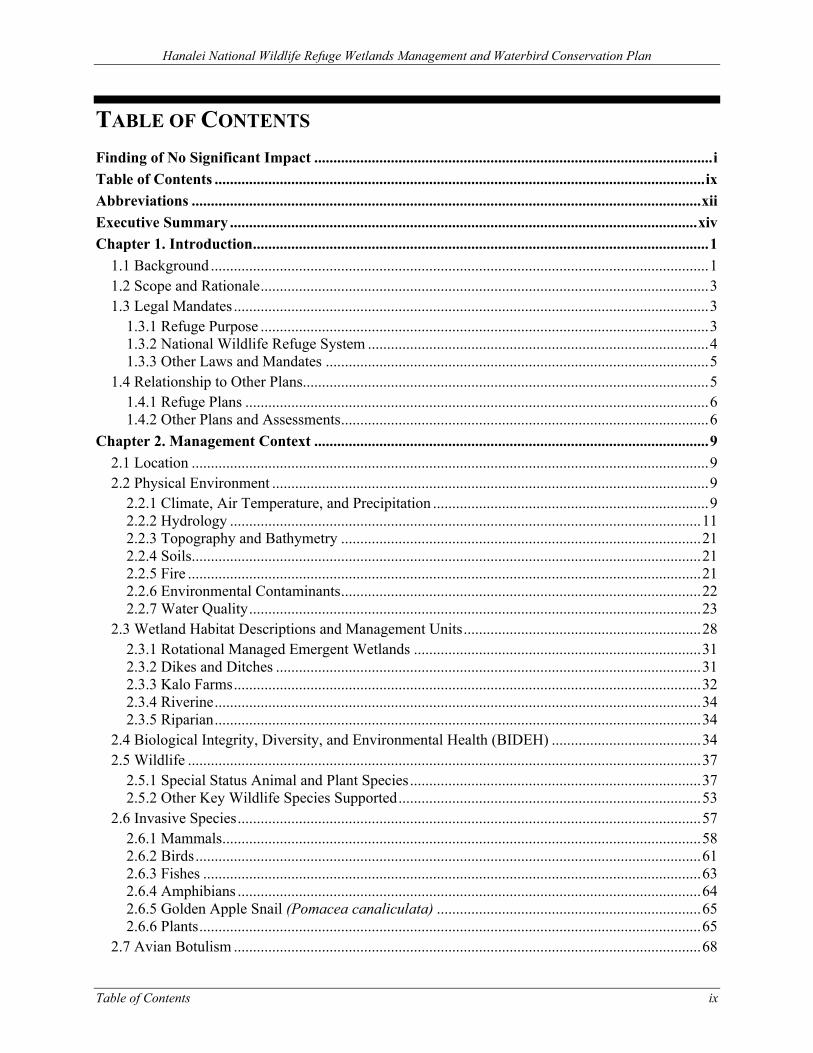
TABLE OF CONTENTS Finding of No Significant Impact ........................................................................................................ i Table of Contents ................................................................................................................................ ix Abbreviations ..................................................................................................................................... xii Executive Summary .......................................................................................................................... xiv Chapter 1. Introduction ....................................................................................................................... 1
1.1 Background .................................................................................................................................. 1 1.2 Scope and Rationale ..................................................................................................................... 3 1.3 Legal Mandates ............................................................................................................................ 3
1.3.1 Refuge Purpose ..................................................................................................................... 3 1.3.2 National Wildlife Refuge System ......................................................................................... 4 1.3.3 Other Laws and Mandates .................................................................................................... 5
1.4 Relationship to Other Plans.......................................................................................................... 5 1.4.1 Refuge Plans ......................................................................................................................... 6 1.4.2 Other Plans and Assessments ................................................................................................ 6
Chapter 2. Management Context ....................................................................................................... 9 2.1 Location ....................................................................................................................................... 9 2.2 Physical Environment .................................................................................................................. 9
2.2.1 Climate, Air Temperature, and Precipitation ........................................................................ 9 2.2.2 Hydrology ........................................................................................................................... 11 2.2.3 Topography and Bathymetry .............................................................................................. 21 2.2.4 Soils ..................................................................................................................................... 21 2.2.5 Fire ...................................................................................................................................... 21 2.2.6 Environmental Contaminants .............................................................................................. 22 2.2.7 Water Quality ...................................................................................................................... 23
2.3 Wetland Habitat Descriptions and Management Units .............................................................. 28 2.3.1 Rotational Managed Emergent Wetlands ........................................................................... 31 2.3.2 Dikes and Ditches ............................................................................................................... 31 2.3.3 Kalo Farms .......................................................................................................................... 32 2.3.4 Riverine ............................................................................................................................... 34 2.3.5 Riparian ............................................................................................................................... 34
2.4 Biological Integrity, Diversity, and Environmental Health (BIDEH) ....................................... 34 2.5 Wildlife ...................................................................................................................................... 37
2.5.1 Special Status Animal and Plant Species ............................................................................ 37 2.5.2 Other Key Wildlife Species Supported ............................................................................... 53
2.6 Invasive Species ......................................................................................................................... 57 2.6.1 Mammals ............................................................................................................................. 58 2.6.2 Birds .................................................................................................................................... 61 2.6.3 Fishes .................................................................................................................................. 63 2.6.4 Amphibians ......................................................................................................................... 64 2.6.5 Golden Apple Snail (Pomacea canaliculata) ..................................................................... 65 2.6.6 Plants ................................................................................................................................... 65
2.7 Avian Botulism .......................................................................................................................... 68
Hanalei National Wildlife Refuge Wetlands Management and Waterbird Conservation Plan
x Table of Contents
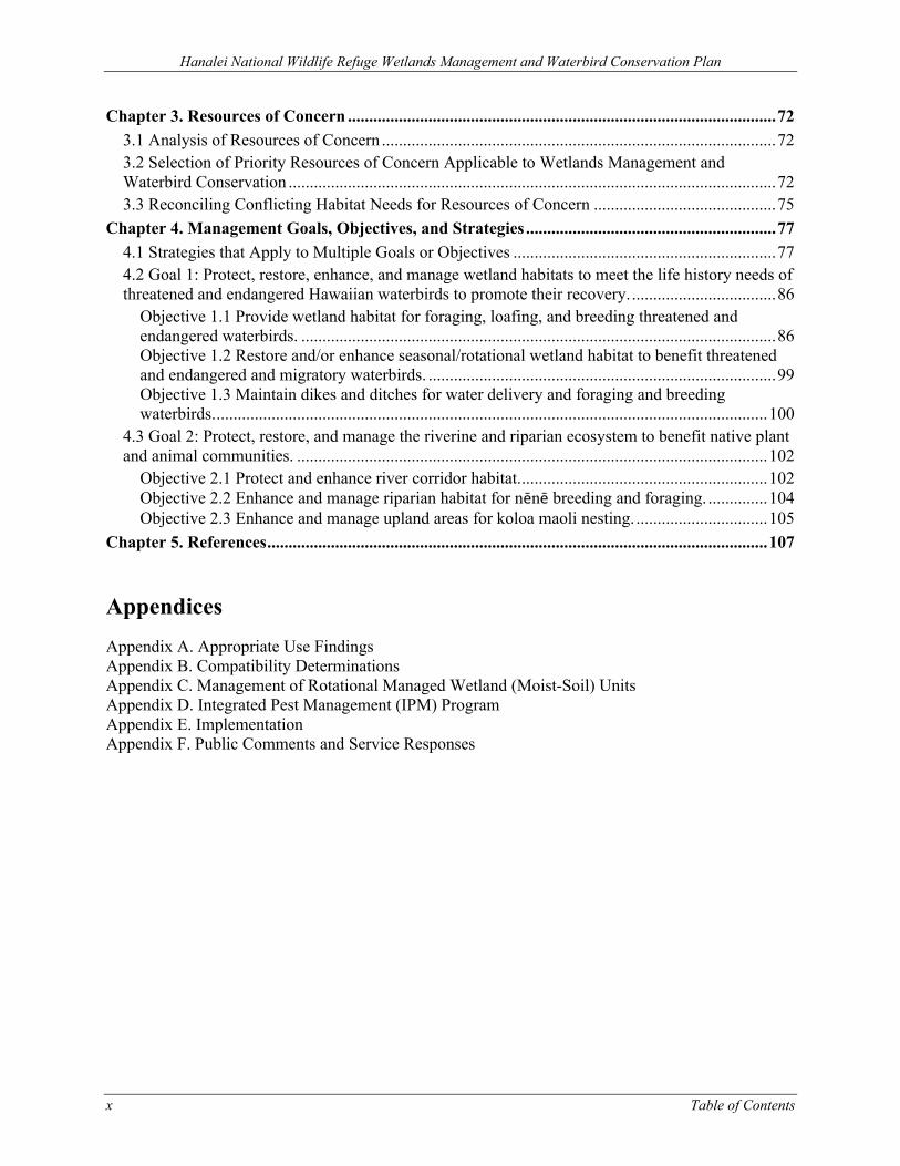
Chapter 3. Resources of Concern ..................................................................................................... 72 3.1 Analysis of Resources of Concern ............................................................................................. 72 3.2 Selection of Priority Resources of Concern Applicable to Wetlands Management and Waterbird Conservation ................................................................................................................... 72 3.3 Reconciling Conflicting Habitat Needs for Resources of Concern ........................................... 75
Chapter 4. Management Goals, Objectives, and Strategies ........................................................... 77 4.1 Strategies that Apply to Multiple Goals or Objectives .............................................................. 77 4.2 Goal 1: Protect, restore, enhance, and manage wetland habitats to meet the life history needs of threatened and endangered Hawaiian waterbirds to promote their recovery. .................................. 86
Objective 1.1 Provide wetland habitat for foraging, loafing, and breeding threatened and endangered waterbirds. ................................................................................................................ 86 Objective 1.2 Restore and/or enhance seasonal/rotational wetland habitat to benefit threatened and endangered and migratory waterbirds. .................................................................................. 99 Objective 1.3 Maintain dikes and ditches for water delivery and foraging and breeding waterbirds. .................................................................................................................................. 100
4.3 Goal 2: Protect, restore, and manage the riverine and riparian ecosystem to benefit native plant and animal communities. ............................................................................................................... 102
Objective 2.1 Protect and enhance river corridor habitat. .......................................................... 102 Objective 2.2 Enhance and manage riparian habitat for nēnē breeding and foraging. .............. 104 Objective 2.3 Enhance and manage upland areas for koloa maoli nesting. ............................... 105
Chapter 5. References ...................................................................................................................... 107
Appendices Appendix A. Appropriate Use Findings Appendix B. Compatibility Determinations Appendix C. Management of Rotational Managed Wetland (Moist-Soil) Units Appendix D. Integrated Pest Management (IPM) Program Appendix E. Implementation Appendix F. Public Comments and Service Responses
Hanalei National Wildlife Refuge Wetlands Management and Waterbird Conservation Plan
Table of Contents xi
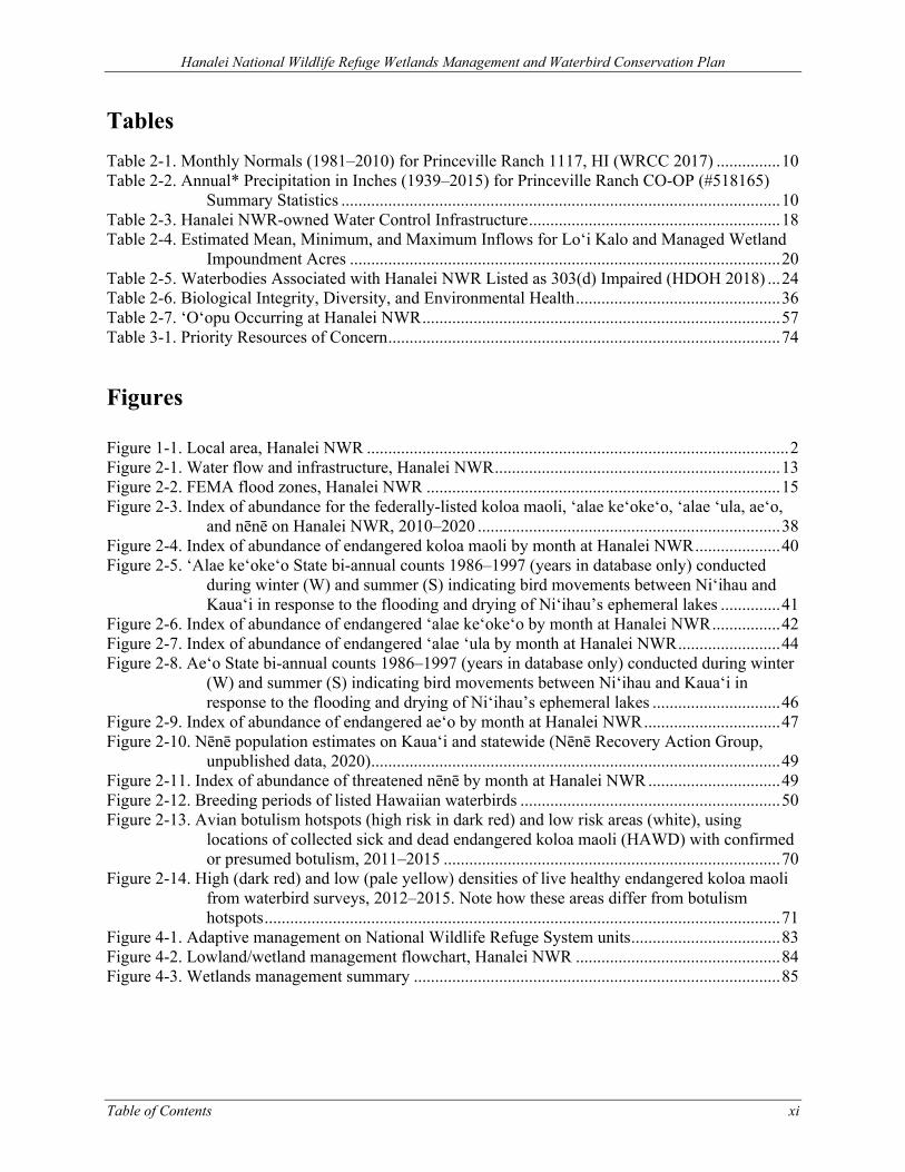
Tables Table 2-1. Monthly Normals (1981–2010) for Princeville Ranch 1117, HI (WRCC 2017) ............... 10 Table 2-2. Annual* Precipitation in Inches (1939–2015) for Princeville Ranch CO-OP (#518165)
Summary Statistics ....................................................................................................... 10 Table 2-3. Hanalei NWR-owned Water Control Infrastructure ........................................................... 18 Table 2-4. Estimated Mean, Minimum, and Maximum Inflows for Lo‘i Kalo and Managed Wetland
Impoundment Acres ..................................................................................................... 20 Table 2-5. Waterbodies Associated with Hanalei NWR Listed as 303(d) Impaired (HDOH 2018) ... 24 Table 2-6. Biological Integrity, Diversity, and Environmental Health ................................................ 36 Table 2-7. ‘O‘opu Occurring at Hanalei NWR .................................................................................... 57 Table 3-1. Priority Resources of Concern ............................................................................................ 74
Figures Figure 1-1. Local area, Hanalei NWR ................................................................................................... 2 Figure 2-1. Water flow and infrastructure, Hanalei NWR ................................................................... 13 Figure 2-2. FEMA flood zones, Hanalei NWR ................................................................................... 15 Figure 2-3. Index of abundance for the federally-listed koloa maoli, ‘alae ke‘oke‘o, ‘alae ‘ula, ae‘o,
and nēnē on Hanalei NWR, 2010–2020 ....................................................................... 38 Figure 2-4. Index of abundance of endangered koloa maoli by month at Hanalei NWR .................... 40 Figure 2-5. ‘Alae ke‘oke‘o State bi-annual counts 1986–1997 (years in database only) conducted
during winter (W) and summer (S) indicating bird movements between Ni‘ihau and Kaua‘i in response to the flooding and drying of Ni‘ihau’s ephemeral lakes .............. 41
Figure 2-6. Index of abundance of endangered ‘alae ke‘oke‘o by month at Hanalei NWR ................ 42 Figure 2-7. Index of abundance of endangered ‘alae ‘ula by month at Hanalei NWR ........................ 44 Figure 2-8. Ae‘o State bi-annual counts 1986–1997 (years in database only) conducted during winter
(W) and summer (S) indicating bird movements between Ni‘ihau and Kaua‘i in response to the flooding and drying of Ni‘ihau’s ephemeral lakes .............................. 46
Figure 2-9. Index of abundance of endangered ae‘o by month at Hanalei NWR ................................ 47 Figure 2-10. Nēnē population estimates on Kaua‘i and statewide (Nēnē Recovery Action Group,
unpublished data, 2020) ................................................................................................ 49 Figure 2-11. Index of abundance of threatened nēnē by month at Hanalei NWR ............................... 49 Figure 2-12. Breeding periods of listed Hawaiian waterbirds ............................................................. 50 Figure 2-13. Avian botulism hotspots (high risk in dark red) and low risk areas (white), using
locations of collected sick and dead endangered koloa maoli (HAWD) with confirmed or presumed botulism, 2011–2015 ............................................................................... 70
Figure 2-14. High (dark red) and low (pale yellow) densities of live healthy endangered koloa maoli from waterbird surveys, 2012–2015. Note how these areas differ from botulism hotspots ......................................................................................................................... 71
Figure 4-1. Adaptive management on National Wildlife Refuge System units ................................... 83 Figure 4-2. Lowland/wetland management flowchart, Hanalei NWR ................................................ 84 Figure 4-3. Wetlands management summary ...................................................................................... 85
Hanalei National Wildlife Refuge Wetlands Management and Waterbird Conservation Plan
xii Abbreviations
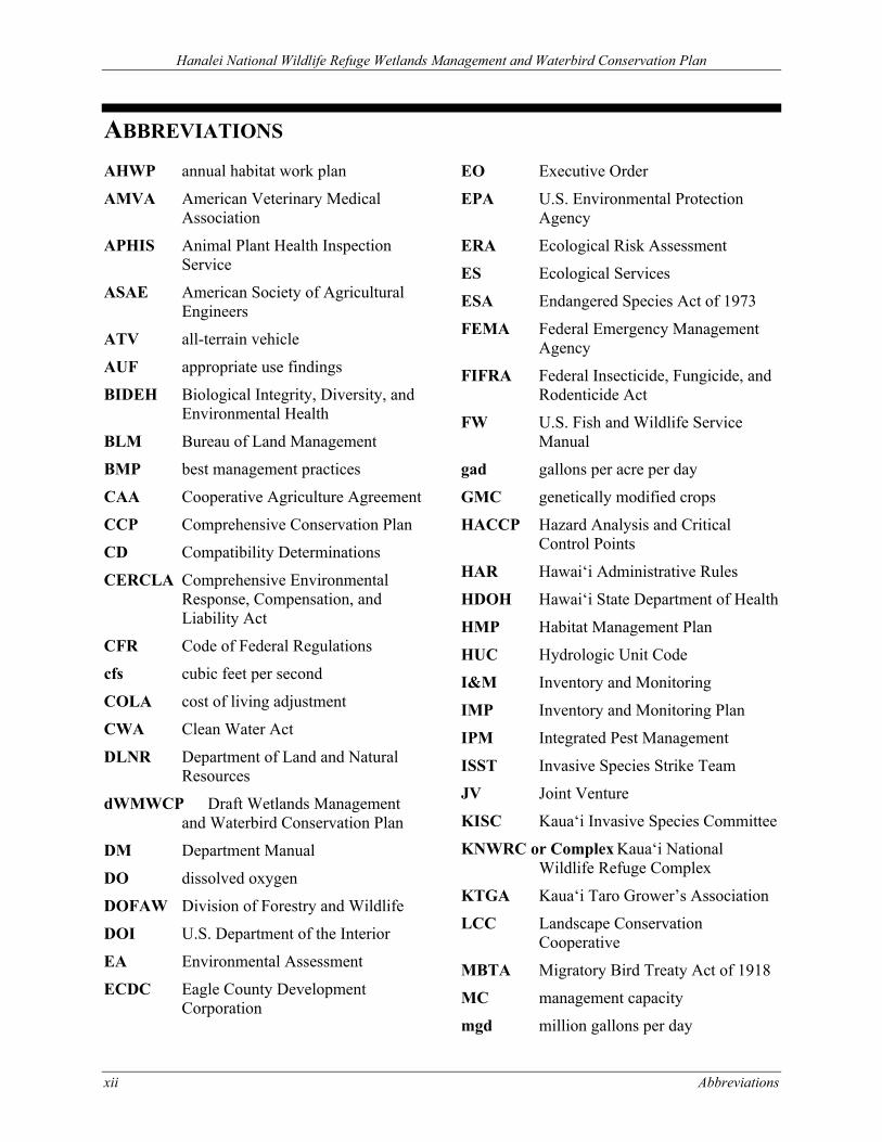
ABBREVIATIONS
AHWP annual habitat work plan
AMVA American Veterinary Medical Association
APHIS Animal Plant Health Inspection Service
ASAE American Society of Agricultural Engineers
ATV all-terrain vehicle
AUF appropriate use findings
BIDEH Biological Integrity, Diversity, and Environmental Health
BLM Bureau of Land Management
BMP best management practices
CAA Cooperative Agriculture Agreement
CCP Comprehensive Conservation Plan
CD Compatibility Determinations
CERCLA Comprehensive Environmental Response, Compensation, and Liability Act
CFR Code of Federal Regulations
cfs cubic feet per second
COLA cost of living adjustment
CWA Clean Water Act
DLNR Department of Land and Natural Resources
dWMWCP Draft Wetlands Management and Waterbird Conservation Plan
DM Department Manual
DO dissolved oxygen
DOFAW Division of Forestry and Wildlife
DOI U.S. Department of the Interior
EA Environmental Assessment
ECDC Eagle County Development Corporation
EO Executive Order
EPA U.S. Environmental Protection Agency
ERA Ecological Risk Assessment
ES Ecological Services
ESA Endangered Species Act of 1973
FEMA Federal Emergency Management Agency
FIFRA Federal Insecticide, Fungicide, and Rodenticide Act
FW U.S. Fish and Wildlife Service Manual
gad gallons per acre per day
GMC genetically modified crops
HACCP Hazard Analysis and Critical Control Points
HAR Hawai‘i Administrative Rules
HDOH Hawai‘i State Department of Health
HMP Habitat Management Plan
HUC Hydrologic Unit Code
I&M Inventory and Monitoring
IMP Inventory and Monitoring Plan
IPM Integrated Pest Management
ISST Invasive Species Strike Team
JV Joint Venture
KISC Kaua‘i Invasive Species Committee
KNWRC or Complex Kaua‘i National Wildlife Refuge Complex
KTGA Kaua‘i Taro Grower’s Association
LCC Landscape Conservation Cooperative
MBTA Migratory Bird Treaty Act of 1918
MC management capacity
mgd million gallons per day
Hanalei National Wildlife Refuge Wetlands Management and Waterbird Conservation Plan
Abbreviations xiii
NAWCA North American Wetlands Conservation Act
NEPA National Environmental Policy Act
NHPA National Historic Preservation Act of 1966
NOAA National Oceanic and Atmospheric Administration
NRCS Natural Resources Conservation Service
NTHP National Trust for Historic Preservation
NWR or Refuge Hanalei National Wildlife Refuge
NWRS or Refuge System National Wildlife Refuge System
ORP oxidation/reduction potential
OSHA Occupational Safety and Health Administration
PPE personal protective equipment
PUP Pesticide Use Proposal
PVC polyvinyl chloride
QMUA Quarterly Management Unit Assessments
RCRA Resource Conservation and Recovery Act of 1973
Refuge Administration Act National Wildlife Refuge System Administration Act of 1966
Refuge Improvement Act National Wildlife Refuge System Improvement Act of 1997
RHPO Regional Historic Preservation Officer
RM Refuge Manual
ROC Resources of Concern
RONS Refuge Operational Needs System
SAMMS Service Asset Maintenance Management
SHPD State Historic Preservation Division
SLH Session Laws of Hawaii
SOS Save-Our-Shearwaters
SQuiRTs NOAA Screening Quick Reference Tables
SUP Special Use Permit
SWAP State Wildlife Action Plan
TBD To Be Determined
TCSA Toxic Substances Control Act
TMDL Total Maximum Daily Load
U.S. United States
U.S.C. United States Code
USACE U.S. Army Corps of Engineers
USDA United States Department of Agriculture
USFS U.S. Forest Service
USFWS or Service U.S. Fish and Wildlife Service
USGS United States Geological Survey
WMWCP Wetlands Management and Waterbird Conservation Plan
WRB Water Resources Branch
Hanalei National Wildlife Refuge Wetlands Management and Waterbird Conservation Plan
xiv Executive Summary
EXECUTIVE SUMMARY This Wetlands Management and Waterbird Conservation Plan (WMWCP) describes the processes and procedures needed to achieve Hanalei National Wildlife Refuge’s (NWR or Refuge) management objectives, including those related to threatened and endangered Hawaiian waterbird conservation, for approximately 480 acres of rotational managed wetland (moist-soil) units, lo‘i kalo (wetland taro fields), ditches and dikes, fallow, riparian habitat, and associated uplands. The WMWCP is being prepared to facilitate compliance with applicable laws, regulations, and policies, including the revised U.S. Fish and Wildlife Service (USFWS or Service) policy on Cooperative Agricultural Use (620 U.S. Fish and Wildlife Service Manual [FW] 2). To comply with the Service’s Appropriate Refuge Uses (603 FW 1) and Compatibility (603 FW 2) policies, appropriate use findings (AUFs) and compatibility determinations (CDs) for kalo (taro, Colocasia esculenta) farming, livestock grazing, and research and scientific collections were prepared and included as appendices to this plan.
Hanalei National Wildlife Refuge Wetlands Management and Waterbird Conservation Plan
Chapter 1. Introduction 1
CHAPTER 1. INTRODUCTION
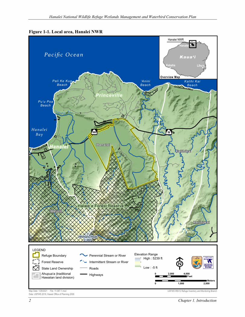
1.1 BACKGROUND Hanalei National Wildlife Refuge (NWR or Refuge) is managed by the U.S. Fish and Wildlife Service (USFWS or Service) as part of the National Wildlife Refuge System (NWRS or Refuge System). The Refuge, located in northern Kaua‘i in Hanalei Valley (Figure 1-1), contains one of the first protected wetlands in the State of Hawai‘i. The Refuge was established in 1972 under the authority of the Endangered Species Conservation Act of 1969 (16 United States Code [U.S.C.] 668aa; Statute 275) to aid in the recovery of threatened and endangered species through the preservation and management of habitat. The approved refuge acquisition boundary (defined as the area within which the Service may acquire lands from willing sellers) totals 934 acres. Currently, 917 acres are owned in fee title and managed by the Service.
The Refuge is in a relatively flat river valley ranging in elevation from 20 to 40 feet above sea level and includes some steep wooded hillsides reaching up to 1,600 feet. A portion of the Hanalei River, which is a designated American Heritage River, runs through the Refuge.
Following the Refuge’s establishment purpose, management focuses on the conservation of federally listed species, with a particular emphasis on the endangered koloa maoli (Hawaiian duck, Anas wyvilliana). In total, the Refuge supports four endangered birds including the koloa maoli, ‘alae ke‘oke‘o (Hawaiian coot, Fulica alai), ‘alae ‘ula (Hawaiian common gallinule, Gallinula galeata sandvicensis), and ae‘o (Hawaiian stilt, Himantopus mexicanus knudseni); and the threatened nēnē (Hawaiian goose, Branta sandvicensis)1. Hanalei NWR is one of two Refuges in the state where habitat managed to support all of the life history needs for these five federally listed Hawaiian waterbirds is available year-round. In addition, the Refuge is one of the only places where the threat of hybridization of koloa maoli with feral mallards (Anas platyrhynchos) can be managed and nonhybridized, pure koloa maoli can thrive. The Refuge also provides habitat for the endangered ‘ōpe‘ape‘a (Hawaiian hoary bat, Lasiurus cinereus semotus) and other native species, including migratory waterfowl and shorebirds.
Lowland areas of the Refuge are managed in a mosaic of wetland habitats, including rotational managed wetland (moist-soil) units (also referred to in this document as wetland management units) and kalo (taro, Colocasia esculenta) farms. The resulting agroecological system provides a variety of societal benefits (ecological, cultural, aesthetic, and historical). In addition to providing essential habitat for plants and animals and providing an ideal place to farm traditional wet agriculture crops such as kalo, wetlands serve as ‘landscape filters’ that improve water quality of connected rivers and offshore waters. The plant communities and soil within wetlands also serve as carbon sinks, helping to moderate global climate change. Wetlands help to dissipate the energy of surface water flow during periods of heavy rainfall by temporarily retaining water, slowing downstream flows, and attenuating downstream flooding. Wetlands are also important water retention areas, which can restore groundwater and its flow.
1 Throughout the document, the term “threatened and endangered waterbirds” will be used to refer collectively to these five species.
‘‘
Hanalei National Wildlife Refuge Wetlands Management and Waterbird Conservation Plan
Figure 1-1. Local area, Hanalei NWR
Pacific Ocean
Wa i‘oli
Hanalei River
‘O
hiki Rd
‘O
hiki Rd
Hanale i Bay
‘Anini River
Halale‘a Forest Reserve
Hīhīmanu Peak 2,360'
River
‘Anini Beach
Kalihi Kai Beach
Pali Ke Kua Beach
Pu‘u Poa Beach
Hanalei
Princeville
Â
$
56Â
$
560
Ha n a le i
Ka l i h i k a i
Ka l i h i w a i
Wa i o l iWa i o l i
!(
!( !(
Hanalei NWR
Kaua‘i
Līhu‘eKekaha
Hanalei
Map Date: 1/29/2021 File: 11-067-1.mxd Data: USFWS 2019, Hawaii Office of Planning 2009
0 2,000 4,000 Feet
LEGEND
Refuge Boundary
Forest Reserve
State Land Ownership Ahupua‘a (traditional Hawaiian land division)
Perennial Stream or River
Intermittent Stream or River
Roads
Highways
Elevation Range High : 5239 ft
Low : -5 ft
Overview Map
0 1,000 2,000 Meters
E USFWS IR9/12 Refuge Inventory and Monitoring Branch
Chapter 1. Introduction 2
Hanalei National Wildlife Refuge Wetlands Management and Waterbird Conservation Plan
Chapter 1. Introduction 3
Kalo farming on the Refuge is a cooperative venture, with substantial involvement from both the Service and individual farmers. This type of flooded agriculture is conducted by farmers in support of a biological objective for managing shallow-water habitat to satisfy life history requirements of threatened and endangered waterbirds.
Hanalei NWR currently permits kalo farming as a Refuge management economic activity through Special Use Permits (SUPs) on approximately 160 acres (not including houses and storage areas). Kalo farming existed prior to and at the time of the establishment of the Refuge and is culturally and economically important both to the State of Hawai‘i and local communities. Kalo itself is a staple food and highly valued plant in the Hawaiian culture. Current farming on Hanalei NWR represents a substantial portion of kalo acreage and production statewide, estimated at 40–60 percent (Gutscher-Chutz 2011; NASS 2012; Cho, Yamakawa, and Hollyer 2007).
1.2 SCOPE AND RATIONALE The Wetlands Management and Waterbird Conservation Plan (WMWCP) describes the processes and procedures needed to achieve the Refuge’s management objectives for approximately 480 acres of rotational managed wetland units, lo‘i kalo (wetland taro fields), ditches and dikes, fallow, riparian habitat, and associated uplands. The definition of a waterbird for the purpose of this plan follows from Sawyer (1926): “A water bird is any species of bird primarily and anatomically adapted to live continuously where aquatic conditions predominate.” The WMWCP is being prepared to facilitate compliance with applicable laws, regulations, and policies, including the revised Service policy on Cooperative Agricultural Use (620 U.S. Fish and Wildlife Service Manual [FW] 2). To comply with the Service’s Appropriate Refuge Uses (603 FW 1) and Compatibility (603 FW 2) policies, appropriate use findings (AUFs) and compatibility determinations (CDs) for kalo farming, livestock grazing, and research and scientific collections were prepared and included as appendices to this plan. In accordance with the National Environmental Policy Act (NEPA), an environmental assessment (EA) was concurrently prepared to disclose the effects of alternatives associated with this plan.
The Service released the Draft WMWCP and EA for a 32-day public review and comment period starting August 12, 2020 and ending September 12, 2020. On September 21, 2020, the Service announced a 15-day extension of the review and comment period to October 5, 2020. Based on comments received during the combined 47-day public review and comment period, the Service modified the plan and associated documents. These changes are described in Appendix F, Public Comments and Service Responses.
The goals, objectives, and strategies described in this plan will be re-examined as part of the Comprehensive Conservation Plan (CCP), a 15-year plan that provides management direction for all Refuge programs and managed lands, which is currently being developed. Information from this WMWCP will be revised as appropriate and incorporated into the CCP.
1.3 LEGAL MANDATES
1.3.1 REFUGE PURPOSE
The purpose(s) for which a refuge was established or acquired is of key importance in refuge planning. Purposes must form the foundation for management decisions. The purpose(s) of a refuge
Hanalei National Wildlife Refuge Wetlands Management and Waterbird Conservation Plan
4 Chapter 1. Introduction
are specified in or derived from the law, proclamation, Executive Order, agreement, public land order, donation document, or administrative memorandum establishing, authorizing, or expanding a refuge, refuge unit, or refuge subunit. Unless the establishing law, order, or other document indicates otherwise, purposes dealing with the conservation, management, and restoration of fish, wildlife, and plants, and the habitats on which they depend take precedence over other purposes in the management and administration of any unit. When a conflict exists between the Refuge System mission and the specific purpose(s) of an individual refuge, the refuge purpose(s) supersede the mission (601 FW 1).
Hanalei NWR was established in 1972 through the acquisition of lands from Eagle County Development Corporation (ECDC). The purpose of Hanalei NWR is to “conserve (A) fish or wildlife which are listed as endangered species or threatened species ... or (B) plants ... ” 16 U.S.C. § 1534 (ESA; Endangered Species Act of 1973). The establishment authority for this Refuge originated from the Endangered Species Conservation Act of 1969 (16 U.S.C. 668aa; Stat. 275).
1.3.2 NATIONAL WILDLIFE REFUGE SYSTEM
For consistency across the Refuge System, there are a number of laws, policies, and directives that guide our management. Key concepts and guidance of the Refuge System are derived from the National Wildlife Refuge System Administration Act of 1966 (Refuge Administration Act), as amended, including by the National Wildlife Refuge System Improvement Act of 1997 (Refuge Improvement Act); Title 50 of the Code of Federal Regulations (CFR); and the FW. The Refuge Administration Act is implemented through regulations covering the Refuge System, published in Title 50, Subchapter C of the CFR. These regulations govern general administration of units of the Refuge System.
In addition, the Service has developed or revised numerous policies and Director’s orders to reflect the mandates and intent of the Improvement Act. Some of these key policies include Biological Integrity, Diversity, and Environmental Health (BIDEH; 601 FW 3); Compatibility (603 FW 2); Refuge System Mission, Goals, and Purposes (601 FW 1); Appropriate Refuge Uses (603 FW 1); Cooperative Agricultural Use (620 FW 2); Inventory and Monitoring (701 FW 2); and the Director’s Order for Coordination and Cooperative Work with State/Territorial Fish and Wildlife Agency Representatives on Management of the Refuge System. These policies and others in draft form or under development can be found at http://refuges.fws.gov/policymakers/nwrpolicies.html.
Cooperative Agricultural Use
In August 2017, the Service finalized the revised Cooperative Agricultural Use policy, which outlines objectives for the use of cooperative agriculture on Refuge System lands and provides an open, transparent, and competitive process for awarding cooperative agriculture agreements (CAAs) on refuges in compliance with the Department of the Interior (DOI) policy on procurement contracts, grant and cooperative agreements (505 Department Manual [DM] 2). Additional federal laws providing authorities for this policy include the Federal Grant and Cooperative Agreement Act (31 U.S.C. 6301–6308), Fish and Wildlife Coordination Act (16 U.S.C. 661–667e), Migratory Bird Conservation Act (16 U.S.C. 715), Refuge Administration Act (16 U.S.C. 668dd), Refuge Revenue Sharing Act (16 U.S.C. 715s), and Refuge System regulations on economic uses and cooperative land management (50 CFR 29.1–29.2). Per policy, cooperative agriculture is when a person or entity uses agricultural practices on Refuge System lands in support of objectives for target species or their associated habitats that represent the biological outcomes the Service desires, and there is substantial
Hanalei National Wildlife Refuge Wetlands Management and Waterbird Conservation Plan
Chapter 1. Introduction 5
involvement between the Service and the person or entity. Our policy is to use cooperative agriculture as a habitat management tool only in situations where we cannot meet our resource management objectives through maintenance, management or mimicking of natural ecosystem processes or functions.
All agricultural uses on Hanalei NWR which are appropriate and compatible; in compliance with legal requirements for federal actions (e.g., NEPA; National Historic Preservation Act of 1966 [NHPA] Section 106; ESA Section 7); specified in a current management plan for the refuge; and cooperative must be entered into a CAA through an open and competitive process. CAAs may last up to a maximum of five years. This WMWCP, along with associated compliance documents (e.g., EA and CDs) fulfill the prerequisites for initiating an open and competitive process for selecting and awarding CAAs.
The updated process for awarding CAAs will include the following:
• The Service will provide the public with a notice of cooperative agricultural opportunities. This will include publication of a Notice of Funding Opportunity on Grants.gov, notification on a national Service website (https://www.fws.gov/refuges/whm/cooperativeAgriculture.html) and local outreach. The notice will include details on the cooperative agricultural opportunity such as the objective criteria that will be used to rank and score applications.
• Applicants will apply directly to the Kaua‘i NWR Complex using the application guidance provided in the CAA prospectus.
• The Kaua‘i NWR Complex Project Leader, along with a selection panel, will score and rank all applicants and notify each applicant regarding whether they were awarded the CAA and the reasoning for the panel’s decision. Unsuccessful applicants have the right to appeal the decision in accordance with 50 CFR 25.45.
• Once the CAA has been awarded, the cooperator and the Service will work together to finalize the terms and conditions of the CAA, including a plan of operations.
1.3.3 OTHER LAWS AND MANDATES
Many other federal laws, Executive Orders, Service policies, and international treaties govern the Service and Refuge System. Examples include the Migratory Bird Treaty Act of 1918 (MBTA), Refuge Recreation Act of 1962, NHPA, and the ESA. For additional information on laws and other mandates, a list and brief description of federal laws of interest to the Service can be found in the Laws Digest at http://www.fws.gov/laws/Lawsdigest.html.
1.4 RELATIONSHIP TO OTHER PLANS When developing this WMWCP, the Service considered the goals and objectives of existing national, regional, state, and ecosystem plans and/or assessments. The Service intends to be consistent with existing plans, as much as possible, and assist in meeting their conservation goals and objectives. If there are conflicts between these various sources and Refuge management, conflicts would be resolved in favor of and in priority order of consistency with Refuge purpose, System mission, and other plans. This section summarizes some of the key wildlife- and habitat-related plans reviewed by the planning team while developing this WMWCP.
Hanalei National Wildlife Refuge Wetlands Management and Waterbird Conservation Plan
6 Chapter 1. Introduction
1.4.1 REFUGE PLANS
The following Hanalei NWR plans, reports, or environmental assessments were reviewed:
• Archaeological Investigations of Hanalei NWR (Shapiro and Shapiro 1995); • Environmental Assessment and Finding of No Significant Impact for the Wetland
Enhancement of Units A, B, and C at Hanalei NWR (USFWS 2004c); • Hawaiian Wetland Refuge Wildlife and Habitat Management Review (Paveglio et al. 1999) • Wildland Fire Management Plan (USFWS 2004b); • Internal Draft Annual Habitat Management Plan (HMP, USFWS 2007); • Complex-wide Invasive Species Management Plan (USFWS 2008); • Draft Quarterly Unit Assessment Protocol (USFWS 2010a); and • Draft Waterbird Monitoring Plan (USFWS 2010b).
1.4.2 OTHER PLANS AND ASSESSMENTS
The following plans were reviewed and determined to be consistent with the Refuge purpose; System mission; and management goals, objectives, and strategies described in this plan:
Recovery Plan for Hawaiian Waterbirds, Second Revision (USFWS 2011e). The goal of the recovery program is to restore and maintain multiple self-sustaining populations of Hawaiian waterbirds (i.e., koloa maoli, ‘alae ke‘oke‘o, ‘alae ‘ula, and ae‘o) statewide within their historic ranges. The recovery of these waterbirds focuses on the following objectives:
• Increasing population numbers to statewide baseline levels (consistently stable or increasing with a minimum of 2,000 birds for each species);
• Establishing multiple, self-sustaining breeding populations throughout each species’ historic range;
• Establishing and protecting a network of both core and supporting wetlands that are managed as habitat suitable for waterbirds, including the maintenance of appropriate hydrological conditions and control of invasive nonnative plants;
• For all four species, eliminating or controlling the threats posed by introduced predators, avian diseases, and contaminants; and
• For the koloa maoli, removing the threat of hybridization with feral mallards.
Draft Revised Recovery Plan for the Nēnē or Hawaiian Goose (Branta sandvicensis) (USFWS 2004a). Of the five or so endemic goose species described from the Hawaiian Islands, only the nēnē has survived to the present day. The nēnē was declared a federally endangered species in 1967. It was considered one of the most endangered geese in the world and was the second most endangered waterfowl in the United States (U.S.). The implementation of recovery actions for nēnē has reduced the risk of extinction for the species, leading to the species being reclassified from endangered to threatened, effective January 21, 2020.
The Service’s recovery plan aims to restore and maintain multiple self-sustaining nēnē populations on Hawai‘i, Maui Nui (Maui, Moloka‘i, Lāna‘i, Kaho‘olawe), and Kaua‘i. Additionally, threats to the nēnē must be reduced to allow for the long-term viability of these populations, and sufficient suitable habitat must be identified, protected, and managed in perpetuity on each of the islands
Hanalei National Wildlife Refuge Wetlands Management and Waterbird Conservation Plan
Chapter 1. Introduction 7
resulting in the species no longer meeting the definition of endangered or threatened under the ESA. The recovery of the nēnē focuses on the following objectives:
• Identify and protect nēnē habitat, focusing on the identification and protection of sufficient habitat to sustain target population levels;
• Manage habitat and existing populations for sustainable productivity and survival complemented by monitoring changes in distribution and abundance;
• Control alien predators, which addresses control of introduced mammals to enhance nēnē populations;
• Continue captive propagation program, which describes techniques and priorities for the captive propagation and release of nēnē into the wild;
• Establish additional nēnē populations, which focuses on partnerships with private landowners;
• Address conflicts between nēnē and human activities, which includes potential management and relocation of nēnē in unsuitable areas;
• Identify new research needs and continue research, which describes general categories of research needed to better evaluate threats to nēnē and develop and evaluate management strategies to address these threats;
• Provide a public education and information program, which describes important outreach and education activities; and
• Validate recovery actions, which call for formalizing the Nēnē Recovery Action Group and evaluating management and research projects to determine if recovery objectives have been met.
Hawai‘i’s State Wildlife Action Plan (DLNR 2015). The U.S. Congress mandated each state and territory to develop a comprehensive wildlife conservation plan in order to continue to receive State Wildlife Grants, which assist states with wildlife management. Hawai‘i’s state wildlife action plan (SWAP) reviews the status of the full range of the state’s native terrestrial and aquatic species (over 10,000 of which are found nowhere else on Earth) and provides management recommendations for their continued conservation. Hawai‘i’s Species of Greatest Conservation Need include all native terrestrial animals, all endemic aquatic animals, additional indigenous aquatic animals identified as in need of conservation attention, a range of native plants identified as in need of conservation attention, and all identified endemic algae. This list includes a terrestrial mammal (1), birds (78), terrestrial invertebrates (approximately 5,000), freshwater fishes (5), freshwater invertebrates (12), anchialine pond-associated fauna (20), marine mammals (26), marine reptiles (6), marine fishes (151), marine invertebrates (197), and flora (over 756).
Pacific Coast Joint Venture Strategic Plan for Wetland Conservation in Hawai‘i (Henry 2005). The mission of the Hawai‘i Wetland Joint Venture, a subset of the Pacific Coast Joint Venture, is to protect, restore, increase, and enhance all types of wetlands, riparian habitat, and associated uplands throughout the Hawaiian Islands through partnerships for the benefit of birds, other wildlife, people, and the Hawaiian culture. This strategic plan is intended to guide partners in collaborative efforts that protect the best and most important wetlands first, with an eye toward long-term habitat sustainability and site adaptability in the face of climate change.
Koloa Maoli Communication and Outreach Plan (Sato 2009). This plan provides a framework for localized (Kaua‘i/Ni‘ihau) and statewide educational campaigns to build public support for removing
Hanalei National Wildlife Refuge Wetlands Management and Waterbird Conservation Plan
8 Chapter 1. Introduction
the threat of feral mallards and mallard-koloa maoli hybrids, strengthening public policies, and restoring/managing primary habitats to benefit a suite of native Hawaiian and migratory waterbirds.
Recovery Plan for the Kaua‘i Plant Cluster (USFWS 1995). The Service’s recovery plan covers 37 plant taxa, 34 of which are federally listed as endangered and three listed as threatened. The recovery actions identified in the plan include protecting current populations, controlling threats, and monitoring; expanding current populations; conducting research essential to conservation of the species; establishing new populations as needed to reach recovery objectives; validating and revising recovery objectives; and devising and implementing a public education program.
Recovery Plan for the ‘Ōpe‘ape‘a (Lasiurus cinereus semotus, Hawaiian Hoary Bat) (USFWS 1998). The ‘ōpe‘ape‘a is the only native land mammal in the Hawaiian Islands. There is a general lack of historic and current data on this subspecies and its present status is not well understood. The Service’s recovery objective is delisting from the ESA, with the interim goals of determining present population status and downlisting to threatened status. Distribution and abundance of ‘ōpe‘ape‘a will also provide information on specific roosting habitat associations and food habits. With basic information on the location of ‘ōpe‘ape‘a and their resource needs, threats can then be identified and managed. Management actions that may be needed to address threats include protection of key roosting and foraging areas, particularly if ‘ōpe‘ape‘a or their food resources depend on native vegetation. Predation, the potential impacts of pesticides to bats or their food resources, and other threats may also need to be addressed.
U.S. Pacific Islands Regional Shorebird Conservation Plan (Engilis and Naughton 2004). Conservation and restoration of shorebird habitats is essential for the protection of endangered and declining shorebird populations. Wetlands, beach strand, coastal forests, and mangrove habitats are particularly vulnerable on Pacific islands due to increasing development pressures and already limited acreage. Monitoring and research needs include assessment of population sizes and trends; assessment of the timing and abundance of birds at key wintering and migration stopover sites; assessment of habitat use and requirements at wintering and migration areas; exploration of the geographic linkages between wintering, stopover, and breeding areas; and evaluation of habitat restoration and management techniques to meet the needs of resident and migratory species. Education and public outreach are critical components of this plan. Resource management agencies of federal, territorial, commonwealth, and state governments will need to work together with military agencies, nongovernmental organizations, and the scientific community. On a larger scale, coordination at the international level will be key to the conservation of vulnerable species, both migratory and resident.
Hanalei National Wildlife Refuge Wetlands Management and Waterbird Conservation Plan
Chapter 2. Management Context 9
CHAPTER 2. MANAGEMENT CONTEXT
2.1 LOCATION The 917-acre Hanalei NWR in Kaua‘i County is situated near Hanalei Town and is located within the Hanalei ahupua‘a (watershed), in the Halele‘a moku ‘aina (district), extending 1.5 miles south of the Hanalei River and 0.5 miles west of the Hanalei Bridge. Approximately 90 percent of the forested watershed is undeveloped, including the state-managed Halele‘a Natural Area Reserve. The Refuge occupies 1.5 square miles of the watershed in the lower valley (Kubo and Henderson 2005).
Not including reservoirs, irrigation and flood control ditches, golf course water features, streams, ephemeral springs and basins, or sewer treatment ponds, the current extent of coastal plain wetlands in the main Hawaiian Islands is approximately 15,474 acres. Over 31 percent of coastal wetlands have been lost (Kosaka 1990) and the majority that remain are degraded by altered hydrology, invasive species, human encroachment, and contaminants. Of the coastal plain wetlands, roughly 8,690 acres are identified core (5,820 acres) or supporting areas (2,869 acres) important for the recovery of waterbirds (USFWS 2011e). Hanalei NWR is considered a core wetland area and is the largest wetland complex on Kaua‘i.
2.2 PHYSICAL ENVIRONMENT
2.2.1 CLIMATE, AIR TEMPERATURE, AND PRECIPITATION
Climatic conditions on the island of Kaua‘i are dominated by northeasterly tradewinds approximately 70 percent of the year. Tradewinds bring warm, tropical, moisture-laden air to Kaua‘i. As a result of the steep topography, the northern and eastern (windward) sides of Kaua‘i record heavier rainfall than the drier south and west (leeward) sides. Traditionally, only two seasons were recognized in Hawai‘i: kau—the warm season occurring from May to October that is characterized by northeast winds and an overhead sun, and ho‘oilo—the cold season, occurring from October to April and characterized by cooler temperatures, rain, variable winds, and a lower sun (Juvik and Juvik 1998; Siemers 2009).
The nearest climate/weather station to the Hanalei NWR is the National Weather Service CO-OP Princeville Ranch station (#518165) located within a mile northeast of the Refuge. The period of record dates from 1939 to the present. Monthly climate normals have been compiled for the period from 1981–2010 (Table 2-1). High and low average temperatures do not exhibit much variability over the course of the year, with about 7 degrees Fahrenheit (°F) separating January minimums from August/September maximums. About 57 percent of the rain typically falls during the six months between November and April, the remaining 43 percent between May and October (WRCC 2017).
Hanalei National Wildlife Refuge Wetlands Management and Waterbird Conservation Plan
10 Chapter 2. Management Context
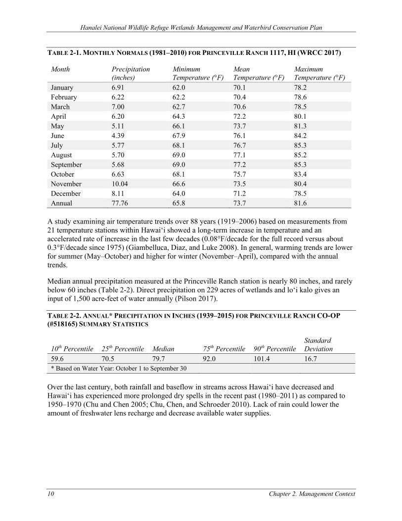
TABLE 2-1. MONTHLY NORMALS (1981–2010) FOR PRINCEVILLE RANCH 1117, HI (WRCC 2017)
Month Precipitation (inches)
Minimum Temperature (°F)
Mean Temperature (°F)
Maximum Temperature (°F)
January 6.91 62.0 70.1 78.2 February 6.22 62.2 70.4 78.6 March 7.00 62.7 70.6 78.5 April 6.20 64.3 72.2 80.1 May 5.11 66.1 73.7 81.3 June 4.39 67.9 76.1 84.2 July 5.77 68.1 76.7 85.3 August 5.70 69.0 77.1 85.2 September 5.68 69.0 77.2 85.3 October 6.63 68.1 75.7 83.4 November 10.04 66.6 73.5 80.4 December 8.11 64.0 71.2 78.5 Annual 77.76 65.8 73.7 81.6
A study examining air temperature trends over 88 years (1919–2006) based on measurements from 21 temperature stations within Hawai‘i showed a long-term increase in temperature and an accelerated rate of increase in the last few decades (0.08°F/decade for the full record versus about 0.3°F/decade since 1975) (Giambelluca, Diaz, and Luke 2008). In general, warming trends are lower for summer (May–October) and higher for winter (November–April), compared with the annual trends.
Median annual precipitation measured at the Princeville Ranch station is nearly 80 inches, and rarely below 60 inches (Table 2-2). Direct precipitation on 229 acres of wetlands and lo‘i kalo gives an input of 1,500 acre-feet of water annually (Pilson 2017).
TABLE 2-2. ANNUAL* PRECIPITATION IN INCHES (1939–2015) FOR PRINCEVILLE RANCH CO-OP (#518165) SUMMARY STATISTICS
10th Percentile 25th Percentile Median 75th Percentile 90th Percentile Standard Deviation
59.6 70.5 79.7 92.0 101.4 16.7 * Based on Water Year: October 1 to September 30
Over the last century, both rainfall and baseflow in streams across Hawaiʻi have decreased and Hawaiʻi has experienced more prolonged dry spells in the recent past (1980–2011) as compared to 1950–1970 (Chu and Chen 2005; Chu, Chen, and Schroeder 2010). Lack of rain could lower the amount of freshwater lens recharge and decrease available water supplies.
Hanalei National Wildlife Refuge Wetlands Management and Waterbird Conservation Plan
Chapter 2. Management Context 11
2.2.2 HYDROLOGY
Watershed Context
The Hanalei River subwatershed (hydrologic unit code [HUC] 200700000103) is 33.1 square miles and encompasses the Hanalei River as well as four additional streams that drain into Hanalei Bay. The Hanalei River drainage is the largest component of the subwatershed and covers 23.6 square miles. Heavy precipitation (over 400 inches annually) dominates the upper reaches of the subwatershed on Mount Waiʻaleʻale; lower‐lying coastal areas receive about 100 inches of rain per year. The river begins in the Halele‘a Forest Reserve and travels 15.7 miles to Hanalei Bay through a mixture of forest and shrub‐scrub landscape. A portion of the flow from the Hanalei River is diverted into rotational managed wetland (moist-soil) units and loʻi kalo on the Refuge. The Hanalei Estuary begins about 3.5 miles upstream of the river’s entrance into the bay. Urban development associated with the town of Hanalei dominates this reach of the river.
Rivers, Streams, and Creeks
The perennial Hanalei River is the only major stream in the vicinity of Hanalei NWR; it travels approximately 3.1 miles through the Refuge (Figure 2-1). In 1998, the river was designated as an American Heritage River by Executive Order (EO) 13061. This designation fosters cooperative, community-based efforts for its preservation.
This river has the greatest average discharge of any river or stream on Kaua‘i (HDBEDT 2009). This could be the reason why water diversion of the river for sugarcane plantations began in the early 1900s. In 1925, the Ka‘āpoko Tunnel was constructed to bring water from the Hanalei River to Wailua. A year later, the Hanalei Tunnel was built to bring water to Līhu‘e. Around 1991, water diversions from the upper Hanalei River basin to the Wailua side of the island for sugar irrigation ended. Today, the only major water diversion from the Hanalei River is the Service’s intake for wetland management units and kalo farms managed for threatened and endangered waterbirds, much of which is re-directed back out to the River after passing through the Refuge.
From the U.S. Geological Survey (USGS) Hanalei River gauging station (#16110300) located upstream of the Refuge, median daily flow calculated for water years 1993–2015 ranged between 90–250 cubic feet per second (cfs); however, peak daily flows >1,000 cfs occurred during all months except June. There is a trend toward slightly higher (~50–75 cfs) streamflow in winter compared to summer months. Interannual variation in flow is generally within a range of 100 cfs. As expected from its setting within a very wet watershed, the Hanalei River is characterized by good flow volumes throughout the year and from year to year. Monthly and yearly average discharge generally exceeds 150 cfs (mean for both: 212 cfs), and on 60 percent of days, mean flow is above 100 cfs (USGS 2017; summarized by Pilson 2017).
In contrast to daily, monthly, or annual statistics, instantaneous peak flows provide a sense of the magnitude of flows a river is capable of generating. The USGS has calculated that the Hanalei River has a peak flood discharge of 14,500 cfs about every two years and a peak flood discharge of 28,100 cfs every 10 years (Oki, Rosa, and Yeung 2010). The flow of this river is extremely flashy in nature because of high rainfall, short travel distances, steep slopes, and high topography inland from the Refuge toward the headwaters of the river. Flow magnitudes can change ten-fold over a few hours (Berg, McGurk, and Calhoun 1997).
Hanalei National Wildlife Refuge Wetlands Management and Waterbird Conservation Plan
12 Chapter 2. Management Context
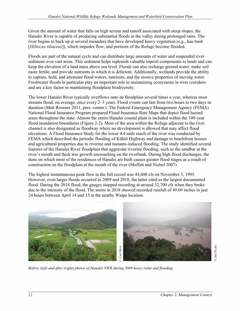
Given the amount of water that falls on high terrain and runoff associated with steep slopes, the Hanalei River is capable of producing substantial floods in the valley during prolonged rains. The river begins to back up at several meanders that have developed heavy vegetation (e.g., hau bush [Hibiscus tiliaceus]), which impedes flow, and portions of the Refuge become flooded.
Floods are part of the natural cycle and can distribute large amounts of water and suspended river sediment over vast areas. This sediment helps replenish valuable topsoil components to lands and can keep the elevation of a land mass above sea level. Floods can also recharge ground water, make soil more fertile, and provide nutrients in which it is deficient. Additionally, wetlands provide the ability to capture, hold, and attenuate flood waters, nutrients, and the erosive properties of moving water. Freshwater floods in particular play an important role in maintaining ecosystems in river corridors and are a key factor in maintaining floodplain biodiversity.
The lower Hanalei River typically overflows onto its floodplain several times a year, whereas most streams flood, on average, once every 2–3 years. Flood events can last from two hours to two days in duration (Matt Rosener 2011, pers. comm.). The Federal Emergency Management Agency (FEMA) National Flood Insurance Program prepared Flood Insurance Rate Maps that depict flood hazard areas throughout the state. Almost the entire Hanalei coastal plain is included within the 100-year flood inundation boundaries (Figure 2-2). Most of the area within the Refuge adjacent to the river channel is also designated as floodway where no development is allowed that may affect flood elevations. A Flood Insurance Study for the lower 4.4-mile reach of the river was conducted by FEMA which described the periodic flooding of Kūhiō Highway and damage to beachfront houses and agricultural properties due to riverine and tsunami-induced flooding. The study identified several features of the Hanalei River floodplain that aggravate riverine flooding, such as the sandbar at the river’s mouth and thick tree growth encroaching on the riverbank. During high flood discharges, the dune on which most of the residences of Hanalei are built causes greater flood stages as a result of construction on the floodplain at the mouth of the river (Moffatt and Nichol 2007).
The highest instantaneous peak flow in the full record was 44,600 cfs on November 3, 1995. However, even larger floods occurred in 2009 and 2018, the latter cited as the largest documented flood. During the 2018 flood, the gauges stopped recording at around 32,700 cfs when they broke due to the intensity of the flood. The storm in 2018 showed recorded rainfall of 49.69 inches in just 24 hours between April 14 and 15 at the nearby Waipa location.
Before (left) and after (right) photos of Hanalei NWR during 2009 heavy rains and flooding.
© C
arl B
erg
© J
im P
ycha
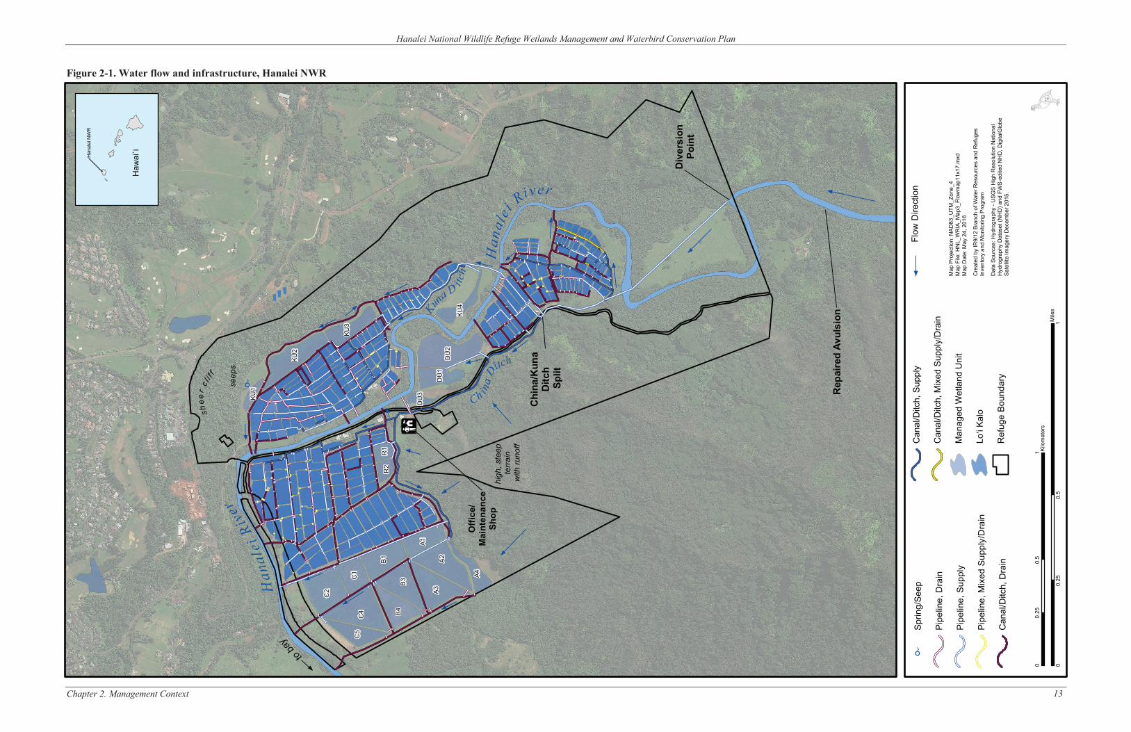
shee
rc l
i f f
vier
Han
alei
R
aby
to
Kuna
D
itch
Ch ina
DH
anal
ei
itch
Riv r
Han
alei
NW
R
Haw
ai`i
Hanalei National Wildlife Refuge Wetlands Management and Waterbird Conservation Plan
Figure 2-1. Water flow and infrastructure, Hanalei NWR
Chapter 2. Management Context
seep
s
D
KU1
KU2
C2
KU3
C1
C5
C4
B1
R1
R2
B4
B3
@
DU
3 A1
A3
DU
1 A2
D
U2
KU4
Offi
ce/
A4
Mai
nten
ance
Sh
op
high
, ste
ep
terr
ain
with
runo
ff
Chi
na/K
una
Ditc
h Sp
lit
e
Rep
aire
d Av
ulsi
on
Can
al/D
itch,
Sup
ply
Can
al/D
itch,
Mix
ed S
uppl
y/D
rain
Man
aged
Wet
land
Uni
t
Lo‘i
Kalo
Ref
uge
Boun
dary
D
Sprin
g/Se
ep
Pipe
line,
Dra
in
Pipe
line,
Sup
ply
Pipe
line,
Mix
ed S
uppl
y/D
rain
Can
al/D
itch,
Dra
in
Div
ersi
on
Poin
t
Flow
Dire
ctio
n
Map
Pro
ject
ion:
NAD
83_U
TM_Z
one_
4M
ap F
ile: H
NL_
WR
IA_M
ap3_
Flow
map
11x1
7.m
xdM
ap D
ate:
May
24,
201
6
Cre
ated
by
IR9/
12 B
ranc
h of
Wat
er R
esou
rces
and
Ref
uges
Inve
ntor
y an
d M
onito
ring
Prog
ram
Dat
a So
urce
s: H
ydro
grap
hy -
USG
S H
igh
Res
olut
ion
Nat
iona
lH
ydro
grap
hy D
atas
et (N
HD
) and
FW
S-ed
ited
NH
D, D
igita
lGlo
beSa
tellit
e Im
ager
y D
ecem
ber 2
015.
0 0.
25
0.5
1 Kilo
met
ers
Mile
s 0
0.25
0.
5 1
13
Hanalei National Wildlife Refuge Wetlands Management and Waterbird Conservation Plan
This page intentionally left blank
Chapter 2. Management Context 14
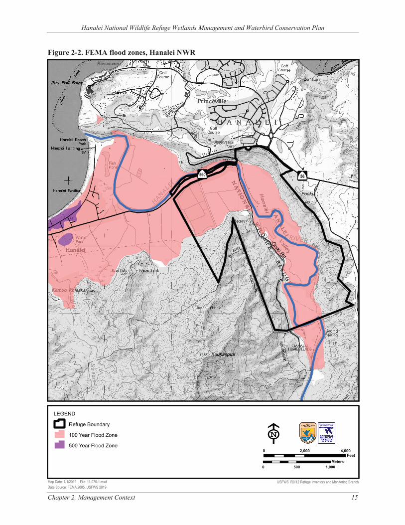
Hanalei National Wildlife Refuge Wetlands Management and Waterbird Conservation Plan
Figure 2-2. FEMA flood zones, Hanalei NWR
‘Ōhiki Rd
Â
$
56 Â
$
560
LEGEND
Refuge Boundary
100 Year Flood Zone E500 Year Flood Zone 0 2,000 4,000
Feet Meters
0 500 1,000
Map Date: 7/1/2019 File: 11-070-1.mxd USFWS IR9/12 Refuge Inventory and Monitoring Branch Data Source: FEMA 2005, USFWS 2019
Chapter 2. Management Context 15
Hanalei National Wildlife Refuge Wetlands Management and Waterbird Conservation Plan
16 Chapter 2. Management Context
The U.S. Army Corps of Engineers (USACE) analyzed the flooding issues in the valley in Flood Plain Re-analysis of Hanalei River, Island of Kaua‘i (USACE 1999). This analysis was conducted to determine impacts that a private, elevated roadway/berm and Service rotational managed wetland units (impoundments or ponds) A–D have had on the Hanalei River 100-year floodplain. This project was initiated, in part, because of the November 3, 1995 flood.
The analysis concluded that collectively the Service ponds and the roadway/berm constructed by a separate private landowner had increased the 100-year flood height to a maximum of 2.12 feet at Section 102+36 (the upstream side of the Service’s ABC ponds). However, the study does not take into account the ponds acting as part of the floodplain (rather than as an encroachment); does not look at the whole floodplain to take into account the lo‘i kalo, other ponds, and access roads; and the modeling results are for a flow (58,000 cfs) that is much higher than the highest measured flow in the record (which occurred on November 3, 1995, at that time). This record measured 44,600 cfs, but all other peak flows from 1962 to 2009 have been 26,600 cfs or less, about half of what was modeled.
Canals, Drainage Ditches, and Pipelines
As a result of agricultural infrastructure, the Refuge has a multitude of ditches and pipes to facilitate water delivery and drainage (Figure 2-1). The diversions from the Hanalei River supply all the water to flood lo‘i kalo and rotational managed wetland units on the Refuge. Water from the River flows into a 48-inch concrete pipeline that empties into China Ditch northwest of a bend in the river. A natural clay bank with many river rocks across it keeps the opening to the pipeline submerged and a gate valve at the diversion intake controls the flow into the pipeline. Once water enters China Ditch it is diverted to lo‘i kalo, rotational managed wetland units, or spills back to the Hanalei River. Flow from China Ditch is controlled primarily by gate valves and also has some stop-log structures or open polyvinyl chloride (PVC) pipes. The primary diversion from China Ditch is to the east side of the Hanalei River into Kuna Ditch.
The existing diversion structure is a manhole structure just within the boundary of the Refuge. Refuge water, with a design flow of 50 cfs, enters a 48-inch pipe that runs northwesterly until it intersects the river again. The water is then conveyed under the river by a 48-inch diameter inverted siphon, which discharges the water into a 48-inch pipeline that feeds multiple lateral Refuge pipelines.
The Hanalei River has historically been a reliable water source for the Hanalei NWR and its kalo farmers; however, in 1995 a breach formed upstream of the Refuge’s water intake structure outside of the Refuge boundary, on State of Hawai‘i land. Large-scale storm events caused varying volumes of water to bypass the Refuge’s intake structure by transporting large amounts of river rock downstream. A large flood eroded this new bypass channel that conveyed about one-half of the total river flow to a point below the existing diversion area. High flow storm events in the Hanalei River led to repeated widening of the riverbank breach, allowing more and more of the Hanalei River to flow away from its original channel, predominantly toward the breach channel. The diversion altered river conditions (i.e., reduced sediment transport capacity) in the immediate downstream vicinity, which has resulted in accumulation of sediment along the west bank and consequently increased erosion of the east bank. The diverted flow also contributed to sediment loading to downstream areas, including Hanalei Bay.
During the 2011 Hawai‘i State Legislative session, $1,000,000 was appropriated under the Budget Act (Act 164, Session Laws of Hawaii [SLH] 2011, Item No. D-3) to plan, design, and construct
Hanalei National Wildlife Refuge Wetlands Management and Waterbird Conservation Plan
Chapter 2. Management Context 17
upgrades, repairs, and reinforcements to the Hanalei River breach. The funding was appropriated to the Hawaii Department of Land and Natural Resources (DLNR) for building a dam to maintain adequate flows to the Refuge. All improvements were made on DLNR land in 2015. In November 2017, two large flood events caused further damage to the breach channel repair site as well as the infrastructure and bank surrounding the main irrigation intake for the Refuge. During the April 2018 record rainfall event, the Hanalei River jumped its banks through both a previously repaired breach and a new breach immediately downstream. The old repair was effectively eliminated by flood waters. Through both the old and new breach, the river is largely bypassing the Refuge’s water supply intake, which supplies all kalo farms on the Refuge as well as providing water for the rotational managed wetlands that are crucial for recovery of the threatened and endangered waterbirds. Emergency corrective action to keep water in the main river channel was led by the Kaua‘i Taro Grower’s Association (KTGA) and the State of Hawai‘i, as this damage occurred off-Refuge. In addition, the intake and head wall on the Refuge were extensively compromised by the flood and will require substantial effort to re-stabilize and design a longer-term solution and location. The Refuge will continue to coordinate with DLNR, other agencies, and kalo farmers to achieve Refuge objectives related to protecting the environmental integrity of Hanalei River and Bay and providing a stable water supply for wetland management and kalo production on Hanalei NWR. Along with partners, the Refuge will seek to address historic flooding, sedimentation, bank scouring, and general river instability in the vicinity of the existing intake.
In total, there are 14.2 miles of ditches on the Refuge. There are approximately 15 miles of pipe on the Refuge, with a portion of that owned and maintained by kalo farmers. Much of the pipe infrastructure is rudimentary, consisting of PVC piping and open “box” distribution junctions where flow is controlled by tilting an open elbow pipe until the outlet level is below the head of water in the system. Given the open‐air nature of many of the junctions (to facilitate debris removal), the pressure head within certain units can be very low.
Moist-Soil Wetlands and Lo‘i Kalo
Management of wetlands on the Refuge is divided into two broad categories: rotational managed wetland units and lo‘i kalo. Moist-soil management techniques (e.g., Fredrickson and Taylor 1982) adapted to the tropical climate of Kaua‘i are used within managed wetland units. There are currently 23 managed wetland units on the Refuge, encompassing 89 acres of intensively managed habitat (excluding dikes and ditches) to promote recovery for threatened and endangered waterbirds.
Lo‘i kalo make up a large proportion of the lowland acreage on the Refuge, and are managed to produce kalo throughout the year, with wet and dry fallows interspersed throughout. The main kalo cultivar currently grown at the Refuge has a 12–16 month cycle from planting to harvest. Each lo’i is then wet fallowed for at least 30 days and dry fallowed for 0–6 months. Most loʻi are small, averaging about a half‐acre, but some are as large as several acres. At any given time, on average approximately 76–79 percent of lo‘i are in kalo production, 10–13 percent are in dry fallow, and 11 percent in wet fallow (Gee 2007; Lee and Tonneson 2019). There is currently a total kalo farming footprint of 160 acres (i.e., including dikes, ditches, and canals).
Groundwater
Kuna Spring emerges from the toe of the valley wall and is collected in a small depression before being distributed to wetland unit KU1. Service hydrologists have estimated its flow rate as being close to the evaporative rates, so it is not practical for diversion to supply other wetlands (Fred
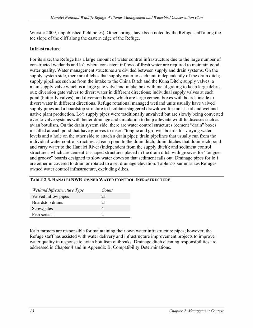
Hanalei National Wildlife Refuge Wetlands Management and Waterbird Conservation Plan
18 Chapter 2. Management Context
Wurster 2009, unpublished field notes). Other springs have been noted by the Refuge staff along the toe slope of the cliff along the eastern edge of the Refuge.
Infrastructure
For its size, the Refuge has a large amount of water control infrastructure due to the large number of constructed wetlands and loʻi where consistent inflows of fresh water are required to maintain good water quality. Water management structures are divided between supply and drain systems. On the supply system side, there are ditches that supply water to each unit independently of the drain ditch; supply pipelines such as from the intake to the China Ditch and the Kuna Ditch; supply valves; a main supply valve which is a large gate valve and intake box with metal grating to keep large debris out; diversion gate valves to divert water in different directions; individual supply valves at each pond (butterfly valves); and diversion boxes, which are large cement boxes with boards inside to divert water in different directions. Refuge rotational managed wetland units usually have valved supply pipes and a boardstop structure to facilitate staggered drawdown for moist-soil and wetland native plant production. Loʻi supply pipes were traditionally unvalved but are slowly being converted over to valve systems with better drainage and circulation to help alleviate wildlife diseases such as avian botulism. On the drain system side, there are water control structures (cement “drain” boxes installed at each pond that have grooves to insert “tongue and groove” boards for varying water levels and a hole on the other side to attach a drain pipe); drain pipelines that usually run from the individual water control structures at each pond to the drain ditch; drain ditches that drain each pond and carry water to the Hanalei River (independent from the supply ditch); and sediment control structures, which are cement U-shaped structures placed in the drain ditch with grooves for “tongue and groove” boards designed to slow water down so that sediment falls out. Drainage pipes for loʻi are either uncovered to drain or rotated to a set drainage elevation. Table 2-3 summarizes Refuge‐owned water control infrastructure, excluding dikes.
TABLE 2-3. HANALEI NWR-OWNED WATER CONTROL INFRASTRUCTURE
Wetland Infrastructure Type Count Valved inflow pipes 21 Boardstop drains 21 Screwgates 4 Fish screens 2
Kalo farmers are responsible for maintaining their own water infrastructure pipes; however, the Refuge staff has assisted with water delivery and infrastructure improvement projects to improve water quality in response to avian botulism outbreaks. Drainage ditch cleaning responsibilities are addressed in Chapter 4 and in Appendix B, Compatibility Determinations.
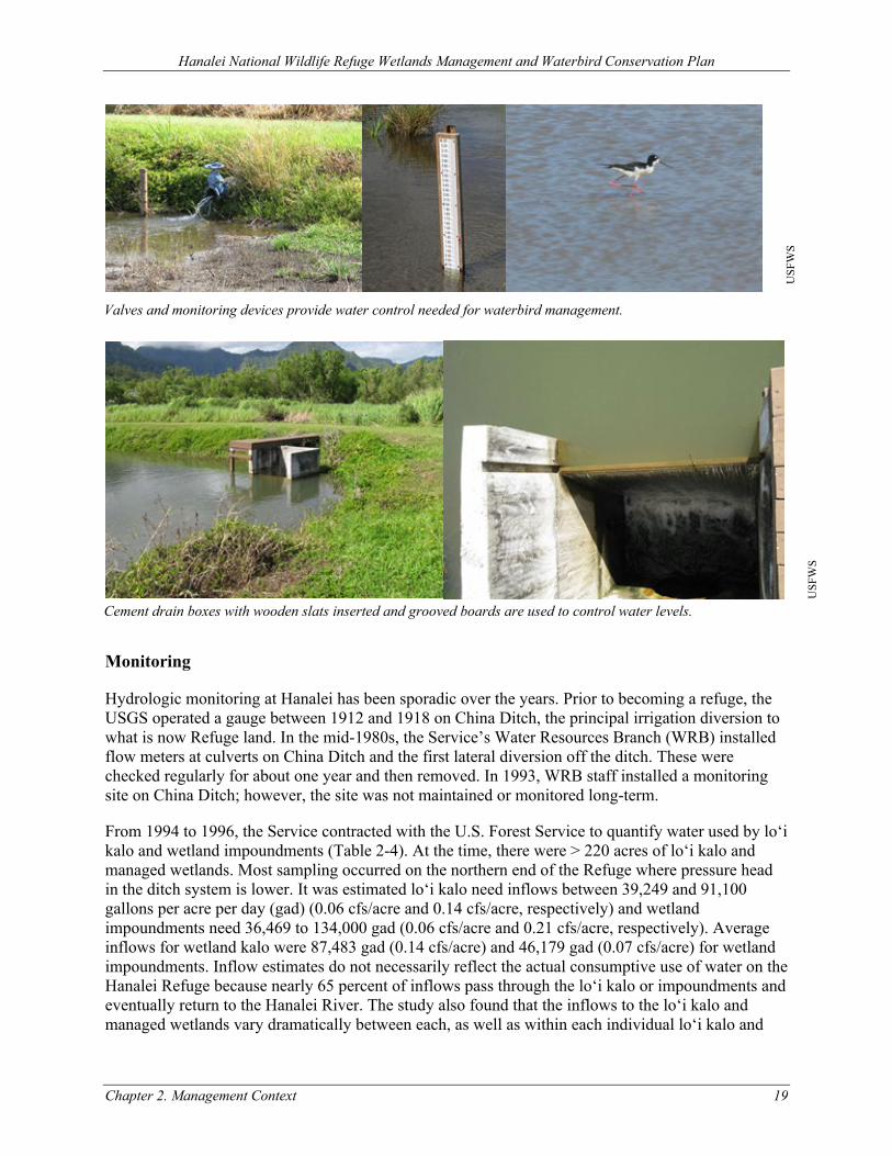
Hanalei National Wildlife Refuge Wetlands Management and Waterbird Conservation Plan
Chapter 2. Management Context 19
Monitoring
Hydrologic monitoring at Hanalei has been sporadic over the years. Prior to becoming a refuge, the USGS operated a gauge between 1912 and 1918 on China Ditch, the principal irrigation diversion to what is now Refuge land. In the mid-1980s, the Service’s Water Resources Branch (WRB) installed flow meters at culverts on China Ditch and the first lateral diversion off the ditch. These were checked regularly for about one year and then removed. In 1993, WRB staff installed a monitoring site on China Ditch; however, the site was not maintained or monitored long-term.
From 1994 to 1996, the Service contracted with the U.S. Forest Service to quantify water used by lo‘i kalo and wetland impoundments (Table 2-4). At the time, there were > 220 acres of lo‘i kalo and managed wetlands. Most sampling occurred on the northern end of the Refuge where pressure head in the ditch system is lower. It was estimated lo‘i kalo need inflows between 39,249 and 91,100 gallons per acre per day (gad) (0.06 cfs/acre and 0.14 cfs/acre, respectively) and wetland impoundments need 36,469 to 134,000 gad (0.06 cfs/acre and 0.21 cfs/acre, respectively). Average inflows for wetland kalo were 87,483 gad (0.14 cfs/acre) and 46,179 gad (0.07 cfs/acre) for wetland impoundments. Inflow estimates do not necessarily reflect the actual consumptive use of water on the Hanalei Refuge because nearly 65 percent of inflows pass through the lo‘i kalo or impoundments and eventually return to the Hanalei River. The study also found that the inflows to the lo‘i kalo and managed wetlands vary dramatically between each, as well as within each individual lo‘i kalo and
USF
WS
USF
WS
Valves and monitoring devices provide water control needed for waterbird management.
Cement drain boxes with wooden slats inserted and grooved boards are used to control water levels.
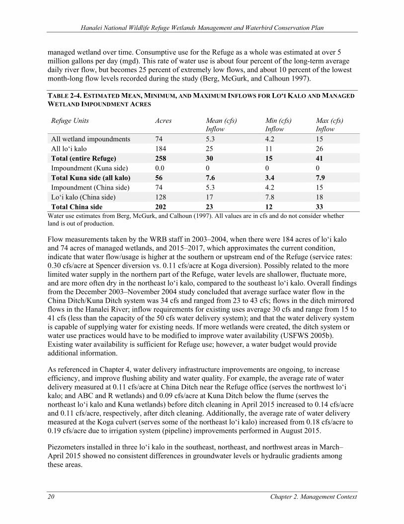
Hanalei National Wildlife Refuge Wetlands Management and Waterbird Conservation Plan
20 Chapter 2. Management Context
managed wetland over time. Consumptive use for the Refuge as a whole was estimated at over 5 million gallons per day (mgd). This rate of water use is about four percent of the long-term average daily river flow, but becomes 25 percent of extremely low flows, and about 10 percent of the lowest month-long flow levels recorded during the study (Berg, McGurk, and Calhoun 1997).
TABLE 2-4. ESTIMATED MEAN, MINIMUM, AND MAXIMUM INFLOWS FOR LO‘I KALO AND MANAGED WETLAND IMPOUNDMENT ACRES
Refuge Units Acres Mean (cfs) Inflow
Min (cfs) Inflow
Max (cfs) Inflow
All wetland impoundments 74 5.3 4.2 15 All lo‘i kalo 184 25 11 26 Total (entire Refuge) 258 30 15 41 Impoundment (Kuna side) 0.0 0 0 0 Total Kuna side (all kalo) 56 7.6 3.4 7.9 Impoundment (China side) 74 5.3 4.2 15 Lo‘i kalo (China side) 128 17 7.8 18 Total China side 202 23 12 33
Water use estimates from Berg, McGurk, and Calhoun (1997). All values are in cfs and do not consider whether land is out of production.
Flow measurements taken by the WRB staff in 2003–2004, when there were 184 acres of lo‘i kalo and 74 acres of managed wetlands, and 2015–2017, which approximates the current condition, indicate that water flow/usage is higher at the southern or upstream end of the Refuge (service rates: 0.30 cfs/acre at Spencer diversion vs. 0.11 cfs/acre at Koga diversion). Possibly related to the more limited water supply in the northern part of the Refuge, water levels are shallower, fluctuate more, and are more often dry in the northeast lo‘i kalo, compared to the southeast lo‘i kalo. Overall findings from the December 2003–November 2004 study concluded that average surface water flow in the China Ditch/Kuna Ditch system was 34 cfs and ranged from 23 to 43 cfs; flows in the ditch mirrored flows in the Hanalei River; inflow requirements for existing uses average 30 cfs and range from 15 to 41 cfs (less than the capacity of the 50 cfs water delivery system); and that the water delivery system is capable of supplying water for existing needs. If more wetlands were created, the ditch system or water use practices would have to be modified to improve water availability (USFWS 2005b). Existing water availability is sufficient for Refuge use; however, a water budget would provide additional information.
As referenced in Chapter 4, water delivery infrastructure improvements are ongoing, to increase efficiency, and improve flushing ability and water quality. For example, the average rate of water delivery measured at 0.11 cfs/acre at China Ditch near the Refuge office (serves the northwest lo‘i kalo; and ABC and R wetlands) and 0.09 cfs/acre at Kuna Ditch below the flume (serves the northeast lo‘i kalo and Kuna wetlands) before ditch cleaning in April 2015 increased to 0.14 cfs/acre and 0.11 cfs/acre, respectively, after ditch cleaning. Additionally, the average rate of water delivery measured at the Koga culvert (serves some of the northeast lo‘i kalo) increased from 0.18 cfs/acre to 0.19 cfs/acre due to irrigation system (pipeline) improvements performed in August 2015.
Piezometers installed in three lo‘i kalo in the southeast, northeast, and northwest areas in March–April 2015 showed no consistent differences in groundwater levels or hydraulic gradients among these areas.
Hanalei National Wildlife Refuge Wetlands Management and Waterbird Conservation Plan
Chapter 2. Management Context 21
2.2.3 TOPOGRAPHY AND BATHYMETRY
Located on Kaua‘i’s north shore, Hanalei Valley extends from Mount Wai‘ale‘ale (elevation 5,148 feet) to the sea. The valley itself is rather long and narrow and the upper areas are steep. The first eight miles of the valley floor ascend to an elevation of 590 feet. In the remaining three miles, the elevation increases steeply up to the summit of Mount Wai‘ale‘ale. The valley is 2–3 miles wide, with a drainage area of about 23 square miles (Timbol 1977). A majority of Hanalei NWR resides on the floor of the valley. The area of interest for this plan, the northwest section of the Refuge, is an open flat alluvial plain that extends west toward Hanalei Bay from the north end of the valley.
2.2.4 SOILS
In Hanalei Valley, erosion and sediment deposition are ongoing. Soils on the Hanalei Refuge fall predominantly in the Hanalei soil series (Foote et al. 1972; NRCS 2017). These silty clays and silty loams underlie most of the wetlands and loʻi and they are characterized by poor drainage and moderate permeability. They have been forming in alluvium deposited by the Hanalei River in this low gradient and meandering section of the river.
Soils cores in the northwest portion of the Hanalei NWR revealed that there is a coarser (i.e., sand) element to soils to the northwest of the ABC unit, which is indicative of former shoreline(s) when the sea level was higher (Chadd Smith 2017, pers. comm.). From here, there is a gradient toward finer textured soils to the southeast. Wetland configuration was modified in 2005–2007 to preserve textural homogeneity (and consequently drainage characteristics and plant species) and simplify management. The geomorphology of the Hanalei River also impacts soil texture with coarser, gravelly textures dominating point bars along the river and finer silts found in floodplain where settling occurs.
Hanalei Valley has a history of agriculture dating back at least one thousand years or more, including rice, kalo, ‘awa, wauke, ranching, sugar, and coffee. These uses may have altered the original soils by affecting structure, composition, biota, nutrient supply, and other characteristics.
2.2.5 FIRE
Unlike the continental U.S. where fire can play a large role in ecosystem function and species adaptations, fire is a relatively infrequent disturbance regime in Hawaiian ecosystems. The two primary sources of natural fires are lava flows and lightning strikes (Mueller-Dombois and Lamoureux 1967; Mueller-Dombois 1981; Smith and Tunison 1992). Most ecologists agree that natural fire has not played a significant ecological or evolutionary role in most Hawaiian ecosystems. Most native vegetation is not conducive to fire spread, producing low fuel loads and/or litter of relatively low flammability. When fires did occur, they probably did not spread quickly or extensively due to the patchiness inherent in native habitats. While fires certainly occurred, they were not a formative force in the distribution or type of vegetation found in native Hawaiian habitats.
However, early Polynesians used fire to clear much of the native forests of Hawai‘i for agricultural purposes. Most of the vegetation at Hanalei NWR is dense tropical foliage which has a very slow rate of fire spread, although pest species, such as California grass (Urochloa mutica) and Guinea grass (Megathyrsus maximus), have taken over large areas of the Refuge and have increased the potential for fires.
Hanalei National Wildlife Refuge Wetlands Management and Waterbird Conservation Plan
22 Chapter 2. Management Context
As is the case in most Hawaiian wetlands, the vegetation on and adjacent to the Refuge grows year-round. The combination of high humidity, high precipitation, and a preponderance of moist vegetation on the Refuge make the threat of wildfire slight. The Refuge supports a diverse mixture of vegetation and open water which would help confine a fire. Conversely, a week of constant dry weather, significant amount of dead, accumulated grass stems, and strong winds could increase chances of wildfire onsite.
The only known wildland fire at Hanalei NWR occurred around 1979 in the wooded slopes on the west side of the Hanalei River. There are no records of any fires on the valley floor of Hanalei NWR. An occasional brush pile was burned at Hanalei NWR in the late 1970s during an unseasonably dry period.
The Refuge has a Wildland Fire Management Plan that was completed in 2004 (USFWS 2004b) and is updated regularly. Small-scale prescribed burns might be occasionally necessary as a method of disposal of woody debris. Prescribed burns would also require individual burn prescriptions. A Hawai‘i State Department of Health (HDOH) burn permit may also be necessary for each prescribed burn to minimize effects on air quality. The prescribed fire season is expected to be from September to February. Conditions for the permit would exclude specified time periods (“no-burn” days) as broadcast by the National Weather Service.
2.2.6 ENVIRONMENTAL CONTAMINANTS
The Hanalei Valley, both pre- and post-Refuge designation, has been used for agriculture. No records or evidence has been found of large industrial use or habitation. Potential contamination would most likely be related to past or present farming pesticide practices.
A 1999 investigation into the impacts of a molluscicide (copper sulfate) applied to combat the invasive apple snail (Pomacea canaliculata) found elevated levels of metals in sediments on the Refuge (Woodward and Hopper 2002); these levels were often in excess of National Oceanic and Atmospheric Administration (NOAA) Screening Quick Reference Tables (SQuiRTs) Threshold Effect Levels (Buchman 1999). Heavy metals of concern included copper, manganese, chromium, and nickel. However, because of the volcanic origin of the Hawaiian Islands, Hawaiian soils and sediments tend to have higher concentrations of heavy metals than the continental U.S. and the SQuiRT guidance may not be an appropriate assessment tool to evaluate risk to native fauna (see Halbig et al. 1985 and McMurtry, Wiltshire, and Kauahikaua 1995 for soil/sediment concentrations of heavy metals at several sites in the Hawaiian Islands). Copper concentrations were highest at sites immediately downstream of pesticide application, and higher at a reference site where copper sulfate had been applied for many years. The investigation also found low diversity and numbers of benthic (i.e., at or in the bottom of a body of water) and infaunal (i.e., in the sediment or substrate of a body of water) organisms in loʻi kalo, but differences between sites were not quantifiable because densities were too low. Copper sulfate is no longer allowed for use on loʻi kalo on the Refuge.
All sediment samples were also analyzed for a suite of organochlorine contaminants to further document any background contamination within the Refuge. There was no detectable organochlorine contamination in any of the samples. The method detection limits were high and frequently exceeded the SQuiRT threshold effects levels for freshwater sediments. The detection limits did not exceed the upper effects threshold levels except for total polychlorinated biphenyls.
Hanalei National Wildlife Refuge Wetlands Management and Waterbird Conservation Plan
Chapter 2. Management Context 23
A survey of persistent organic contaminants and elements in the water, sediment, and biota of the Hanalei River in 2001 found the contaminants at only undetectable or very low levels, below U.S. Environmental Protection Agency (EPA) probable adverse effects levels for aquatic organisms (Orazio et al. 2007). This suggests that upriver practices are not contributing contamination to the Refuge.
2.2.7 WATER QUALITY
A state is required to identify waters that do not meet that state’s water quality standards under Section 303(d) of the Clean Water Act (CWA). These waters are considered “water quality limited” and placed on the state’s 303(d) impaired waters list. Section 303(d) requires the state to develop total maximum daily loads (TMDLs) for impaired waterbodies. The TMDLs are the amount of each pollutant a waterbody can receive and not exceed water quality standards. Water quality standards in the Water Quality Management Plan for the State of Hawai‘i (Hawai‘i Administrative Rules [HAR] §11-54) include designated uses, numeric and narrative criteria, and antidegradation policies and procedures. State waters are classified as either inland waters or marine waters with specific water quality criteria for streams, estuaries, embayments, open coastal waters and oceanic waters. Hawai‘i’s water quality standard categories are further refined by inclusion of a wet or dry season criterion, defined either by calendar date (for inland waters) or by levels of freshwater input (for embayments and open coastal waters). Depending upon the waterbody class, parameters evaluated under the State’s water quality standards can include a combination of the following: toxic pollutants, nutrients, suspended solids, turbidity, Enterococci, pH, dissolved oxygen, temperature, specific conductance, chlorophyll a, salinity, oxidation, biochemical oxygen demand, and pathogens (fecal coliform or Salmonella sp.).
Data collected over many years and used in the TMDL process have shown frequent exceedances of water quality standards for bacteria and turbidity and occasional exceedances for nutrients (nitrogen and phosphorus) (e.g., Berg 1995; Berg, McGurk, and Calhoun 1997; Berg 2007) within waterbodies associated with Hanalei NWR. The TMDLs were developed for the Hanalei Bay Watershed in two phases—the first for streams and estuaries (Tetra Tech and HDOH 2008) and the second for the embayment (Tetra Tech and HDOH 2011). The Phase 1 TMDL report identified Hanalei NWR as one of multiple sources in the watershed contributing sediment and nutrients to Hanalei Bay, and recommended cesspool closure, upgrading septic systems, ungulate fencing and management, stream restoration, trail stabilization, road management, and education to reduce fertilizer and sediment inputs to the river. Two biotic integrity indices suggest habitat in the upper Hanalei River is in good condition and the lower portion is moderately impaired (Tetra Tech and HDOH 2008). For the 2018 303(d) reporting cycle, the waterbodies associated with Hanalei NWR, including those downstream in the bay, listed as impaired are shown in Table 2-5.
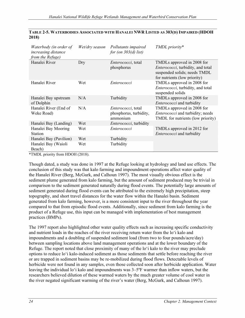
Hanalei National Wildlife Refuge Wetlands Management and Waterbird Conservation Plan
24 Chapter 2. Management Context
TABLE 2-5. WATERBODIES ASSOCIATED WITH HANALEI NWR LISTED AS 303(D) IMPAIRED (HDOH 2018)
Waterbody (in order of increasing distance from the Refuge)
Wet/dry season Pollutants impaired for (on 303(d) list)
TMDL priority*
Hanalei River Dry Enterococci, total phosphorus
TMDLs approved in 2008 for Enterococci, turbidity, and total suspended solids; needs TMDL for nutrients (low priority)
Hanalei River Wet Enterococci TMDLs approved in 2008 for Enterococci, turbidity, and total suspended solids
Hanalei Bay upstream of Dolphin
N/A Turbidity TMDLs approved in 2008 for Enterococci and turbidity
Hanalei River (End of Weke Road)
N/A Enterococci, total phosphorus, turbidity, ammonium
TMDLs approved in 2008 for Enterococci and turbidity; needs TMDL for nutrients (low priority)
Hanalei Bay (Landing) Wet Enterococci, turbidity Hanalei Bay Mooring Station
Wet Enterococci TMDLs approved in 2012 for Enterococci and turbidity
Hanalei Bay (Pavilion) Wet Turbidity Hanalei Bay (Waioli Beach)
Wet Turbidity
*TMDL priority from HDOH (2018).
Though dated, a study was done in 1997 at the Refuge looking at hydrology and land use effects. The conclusion of this study was that kalo farming and impoundment operations affect water quality of the Hanalei River (Berg, McGurk, and Calhoun 1997). The most visually obvious effect is the sediment plume generated from kalo farming, but the amount of sediment produced may be trivial in comparison to the sediment generated naturally during flood events. The potentially large amounts of sediment generated during flood events can be attributed to the extremely high precipitation, steep topography, and short travel distances for the water flow within the Hanalei basin. Sediment generated from kalo farming, however, is a more consistent input to the river throughout the year compared to that from episodic flood events. Additionally, since sediment from kalo farming is the product of a Refuge use, this input can be managed with implementation of best management practices (BMPs).
The 1997 report also highlighted other water quality effects such as increasing specific conductivity and nutrient loads in the reaches of the river receiving return water from the lo‘i kalo and impoundments and a doubling of suspended sediment load (from two to four pounds/acre/day) between sampling locations above land management operations and at the lower boundary of the Refuge. The report noted that close proximity of many of the lo‘i kalo to the river may preclude options to reduce lo‘i kalo-induced sediment as those sediments that settle before reaching the river or are trapped in sediment basins may be re-mobilized during flood flows. Detectable levels of herbicide were not found in any samples, even those collected soon after herbicide application. Water leaving the individual lo‘i kalo and impoundments was 3–5ºF warmer than inflow waters, but the researchers believed dilution of these warmed waters by the much greater volume of cool water in the river negated significant warming of the river’s water (Berg, McGurk, and Calhoun 1997).
Hanalei National Wildlife Refuge Wetlands Management and Waterbird Conservation Plan
Chapter 2. Management Context 25
In addition, bank erosion can produce sediment that can be suspended. One example is related to the increased sediment load resulting from the Hanalei River intake breach (also see Section 2.2.2). Suspended sediment monitoring has been conducted at Hanalei River. The Hanalei Basin data averaged a 3-year suspended sediment yield of 1,360 tons/year/square mile (Stock and Tribble 2010). The processes that provide fine sediments to Hanalei Bay are not fully understood. However, possibilities include (1) storm-triggered landslides and debris flow; (2) overland flow from areas impacted by feral pigs; (3) erosion of fine deposits from stream banks; (4) decreased trapping of fine sediment in floodplain; and (5) entrainment of floodplain deposits (Stock and Tribble 2010). Increasing nutrient loads were recorded in the reaches of the Hanalei River receiving return water from lo‘i kalo and waterbird impoundments within the Refuge (Berg 1995). Fertilizers are not added to rotational managed wetland units.
It is important to distinguish between natural and anthropogenic, pathogenic and non-pathogenic, and manageable and non-manageable sources of pollutants and their pathways within the watershed. Boehm (2010; cited in Sustainable Resources Group International Inc. 2012) collected and analyzed water quality data to determine the sources and fluxes of bacteria and nutrients in several surface waterbodies around the Hanalei Bay Watershed. The results showed that although the relative concentrations of nutrients and bacteria were much higher in the waters of the three smaller watersheds draining into the bay (Wai‘oli, Waipā, and Waikoko), the Hanalei River contributed the largest amount of these pollutants to the bay (64 percent of the bay’s dissolved inorganic nitrogen and 80 percent of phosphate). Fecal bacteria tested were E. coli and Enterococci, with the Hanalei River delivering 60 percent and 50 percent of the bay’s total respectively. A positive correlation was found between these parameters and urbanized or cultivated areas and a negative correlation with forested areas. A contribution of these pollutants to surface water bodies via groundwater seepage is suspected, but this has yet to be confirmed by research. The study also used genetic methods to test samples containing fecal contamination for the source species (human, pig, or ruminant). The study results indicate that many areas have occasional influxes of human fecal contamination, which is suspected to come from cesspools and other sewage related issues. Another observation was a higher amount of fecal indicator bacteria in samples with pig markers, suggesting that pigs are the major source of fecal indicator bacteria in Hanalei Bay. Additional sampling was conducted during kayak trips on the Hanalei River and in the Refuge. In the river, 29 out of 49 samples (60 percent) were above State of Hawai‘i standards for Enterococci. Some water samples from the river contained bacteria levels that were ten times higher than the standard. Riverbank sediments were also examined. Since Enterococci can naturally occur in Hawaiian soils, it is important to be aware that during high precipitation time periods, large amounts of non-sewage related Enterococci could be washed into the bay. The riverbank sediments sampled contained extremely high levels, some up to 100 times higher than water levels. This could cause a huge influx of bacteria into the water during wet weather events when riverbanks are eroded. River water and sediment samples were also tested for DNA markers, which showed that fecal material came from human and pig sources. Samples were also taken in the Refuge from drainage ditches, lo‘i kalo, and managed wetlands. These results indicated high concentrations of bacteria in the water and sediment of drainage ditches. In the lo‘i kalo, there were relatively low concentrations in both water and sediment. In the managed wetlands, low concentrations were recorded in the sediment, but high concentrations were in the water, where birds are frequently found (ibid.).
While herbicides and pesticides have not been detected in the amounts of any concern in the river, there is concern that nutrients from the fertilizers used by kalo farmers in the Refuge and cultivated lands throughout the watershed may be contributing to the elevated nutrient levels found in the receiving Hanalei Estuary and suspected of adversely affecting coral reefs in downstream Hanalei
Hanalei National Wildlife Refuge Wetlands Management and Waterbird Conservation Plan
26 Chapter 2. Management Context
Bay. Based on sampling within Hanalei Bay, two studies suggest that agricultural runoff is the primary source of nitrogen in the bay (Derse et al. 2007; Knee et al. 2008). The State of Hawai‘i’s Coral Reef Local Action Strategy for addressing land-based pollution threats to coral reefs (EPA et al. 2004) has identified the Hanalei watershed, including runoff from kalo farming, as one of three potential areas that are the sources for elevated nutrient input.
The Service’s WRB continuously monitored field water quality parameters (temperature, conductivity, pH, dissolved oxygen [DO], and oxidation/reduction potential [ORP]) in areas of the Refuge for various periods from 2015 to 2017. Monitoring was done in lo‘i selected randomly from the northeast and southeast kalo farms and in rotational managed wetland units from all areas of the Refuge; lo‘i kalo within the northwest part of the Refuge were not monitored. Inflows to these areas had lower temperature, conductivity, and turbidity and higher pH, DO and ORP. Comparing managed wetlands to lo‘i kalo, temperatures were either the same or slightly warmer in the wetlands. DO was low in wetlands but not nearly as low as in lo‘i kalo and the upper range of concentrations was higher in wetlands. pH in the wetlands was slightly acidic (6.0–7.0) and similar to the lo‘i kalo. ORP was always positive. Conductivity was slightly lower in the wetlands compared to the lo‘i kalo but in general, conductivity was very low everywhere on the refuge so this difference may not be significant. There were occasional higher spikes in conductivity observed in the lo‘i kalo in the northeast.
Comparing field water quality parameters in the lo‘i kalo in the northeast versus the southeast, the differences were usually small or non-existent. For most sampling periods, water temperatures were slightly cooler in the northeast versus the southeast (contrary to what was expected). Conductivity was slightly lower, and pH was usually slightly higher in the southeast. DO concentrations were low in both areas but usually higher in the southeast, with the exception of summer 2015, when they were lower. There was a lot of variability in field water quality parameters, especially DO and pH, at the scale of the individual lo‘i kalo (comparing one lo‘i kalo to another from the same area or farmer). This variability was so great that it is hard to generalize about comparisons between areas or farmers.
Comparisons of field water quality parameters between recently fertilized versus unfertilized lo‘i kalo were inconclusive. One might expect that fertilization, and the drawdowns that accompany them, would lead to consistent differences in DO and pH but this was not observed. In the summer 2015, we observed no differences in DO or pH in recently fertilized lo’i kalo compared to lo’i kalo that had not been fertilized recently. In the winter 2016, we observed lower pH and DO in recently fertilized lo’i kalo in the northeast. In the summer 2017, we monitored the same lo’i kalo before and after they were fertilized and observed an increase in DO following fertilization and drawdown, but little change in pH.
The Service’s WRB also conducted nutrient sampling from July to September 2015 and from January to March 2016 in the same areas as described above. Concentrations of total nitrogen, total phosphorus, and ammonia nitrogen were lowest in the inflows and higher in the lo‘i kalo compared to managed wetland units. Bioavailable nitrogen was in the form of ammonia nitrogen at all sites; nitrate nitrogen was non-detectable in all samples. Considering all samples from both seasons combined, total nitrogen, total phosphorus, and ammonia nitrogen concentrations were highest in the northeast lo‘i kalo. Occasionally, there were very high concentrations of ammonia nitrogen in the northeast lo‘i kalo; Similar nutrient spikes were not observed in the southeast lo‘i kalo or managed wetlands. There was almost no ammonia nitrogen in the managed wetlands. Finally, there was no statistical difference in nutrient concentrations between summer and winter in the northeast lo‘i kalo.
Hanalei National Wildlife Refuge Wetlands Management and Waterbird Conservation Plan
Chapter 2. Management Context 27
All the other areas showed much lower nutrient concentrations in the winter compared to the summer. Nutrient concentrations appear to be very high in the northeast lo‘i kalo throughout the year.
In winter 2016, the WRB also sampled the Hanalei River upstream and downstream of the Refuge for total nitrogen, total phosphorus, ammonia nitrogen, and nitrate nitrogen. Samples were collected weekly for eight weeks. Nitrogen was almost always non-detectable at both sites. Phosphorus was slightly higher downstream. It was mostly non-detectable upstream and at low concentrations downstream. Samples were not collected during the summer, when nutrient concentrations are known to be higher and river flows lower.
Currently, kalo farmers typically use conventional, chemical fertilizers year‐round. The estimated fertilizer use by kalo farmers permitted by the Refuge range from 25 to 1,000 lbs. per acre per year, as reported by the farmers. Analysis of the nitrogen cycle in kalo ponds suggests that the conventional fertilization methods applied throughout most of the lo‘i kalo is prone to loss and runoff over time, and that use of slow-release or organic fertilizers applied to the subsoil prior to planting would allow for more efficient use of the fertilizer by kalo and thus less runoff over time (Deenik, Penton, and Bruland 2013). Based on a study conducted in 2011–2012 (Deenik et al. 2013), the use of slow-release or organic fertilizers provided a long-term reservoir of plant-available nitrogen in the root zone for kalo and reduced nitrogen export to the river system. By comparison, the use of conventional fertilizers did not store applied nitrogen in the soil, but rather showed an increased export of nitrogen to the river. A partial cost-benefit analysis showed that slow-release fertilizer had the highest mean return with the lowest variability across three different farm sites. In other words, Deenik et al. (2013) concluded that the environmental benefit (reduced nitrogen input into the river) of using slow-release fertilizer does not come at a cost to the farmer since yields remained stable and net returns to the farmer were equal to or greater than the current practice. However, future research is needed to confirm these findings, as new, more efficient and appropriate products are available now.
Additional water quality concerns related to kalo farming are the prevalence of wet tilling and other soil disturbance during kalo production, which can cause turbid water to flow back into the river. Results from water quality monitoring conducted during spring (March–April) and summer (June–September) 2015, winter (January–March) 2016 in randomly selected managed wetland units and lo‘i kalo in the northeast and southeast indicated differences between water quality in managed wetland units and lo‘i kalo (Feddern 2016). The largest differences were DO and ORP, both of which were lower in loʻi kalo than in the managed wetland units. Additionally, a strong correlation between low DO and low ORP was observed suggesting anoxic conditions contribute to negative ORP and thus higher avian botulism risk (Feddern 2015b). In both lo‘i kalo and managed wetlands, summer DO was lower than winter DO. DO saturation and concentrations in the northeast lo‘i kalo in winter were greatly lower than southeast lo‘i kalo.
Additional observations were made regarding algal and plant abundance in loʻi compared to managed wetlands. In some loʻi, large mats of Azolla filiculoides (a nitrogen-fixing aquatic fern) and algae were present, while in other loʻi and managed wetlands Azolla was absent and algal abundance was minimal. Azolla grows best in high-phosphorus conditions and at depths of 0.5 to 0.833 feet (Uchida et al. 2008). Based on this information it was hypothesized fertilization in loʻi kalo causes Azolla and algal blooms in response to nutrient inputs. It is likely plant and algae die-offs follow these blooms as nutrients are consumed and loʻi water depth decreases (water drawdowns typically follow kalo fertilization).
Hanalei National Wildlife Refuge Wetlands Management and Waterbird Conservation Plan
28 Chapter 2. Management Context
Some farmers have expressed concern that the high density of waterbirds may be contributing to nutrient loading in the river and bay. Research suggests resident birds foraging locally would not result in external loadings of the system, as with birds that forage in fields and then roost in wetlands (Post et al. 1998; Hahn, Bauer, and Klassen 2007). Further monitoring of the nutrient cycle is necessary to assess the relative contribution of nutrients from all potential sources and to better quantify the system inputs from birds, flooding, and other naturally occurring factors versus introduced inputs from farming, management, invasive species, or other non-naturally occurring sources. This monitoring should also include groundwater monitoring, as Knee et al. (2008) determined a significant amount of nitrogen entered the bay from subsurface flows. Because the Refuge was established to conserve threatened and endangered species which are endemic to the area, and has mandates to manage for BIDEH, the Service will work with partners to focus on management of introduced sediment and nutrient inputs versus those of natural origin.
In 2014, water temperature loggers were deployed within mixed-supply (i.e., fresh and drain water) and fresh-supply water lines in the northeast lo‘i kalo. This experiment showed that the average water temperature was higher and more variable in mixed-supply lines, compared to fresh-supply lines. In addition, this experiment showed that average water temperature increased within a mixed pipeline as the number of lo‘i draining into the system increased, but average water temperature does not increase in a similar way in an adjacent fresh pipeline. Overall, the results illustrated how changes to water quality could be cumulative along a mixed-supply line (Cosgrove 2014).
In 2015, following the conversion of two mixed-supply systems to fresh-supply systems, water temperature loggers were again deployed in the northeast lo‘i kalo to determine the impact of the infrastructure improvements. Based on these data, the infrastructural improvements, particularly the open to closed system conversion, significantly decreased water temperature in fresh water pipelines and drain pipelines on the Refuge (Feddern 2015a).
Algal sampling on the Refuge (December 2014 and June 2015) identified several genera of cyanobacteria in Refuge wetlands and loʻi (Sherwood and Conklin 2015). Some cyanobacterial blooms in lo‘i kalo actively produce toxins (microcystins) (Egelhoff, Conklin, and Sherwood 2016).
The Refuge works with organizations such as the Hanalei Watershed Hui, EPA, NRCS, and HDOH to address water quality issues. For example, in 2009 four residential cesspools were upgraded to septic systems. Due to the potential for nutrients to enter the Hanalei River via drain water from the Refuge, investigations are being designed to quantify possible nutrient input to the Hanalei River and methods of controlling or minimizing this release. The Refuge also participates in studies and workshops such as the 2007 Hanalei Watershed Workshop to continue to better understand the Refuge’s role in larger watershed management issues and integrate with such initiatives. Other ongoing water quality efforts include HDOH monitoring streams (nutrient and sediment) that drain into Hanalei Bay, bacterial source tracking, and pharmaceutical monitoring.
2.3 WETLAND HABITAT DESCRIPTIONS AND MANAGEMENT UNITS Wetlands are lands transitional between terrestrial and aquatic systems where the water table is usually at or near the surface or the land is covered by shallow water. Wetlands usually have at least one of the following qualities: (1) at least periodically, the land supports predominantly hydrophytes; (2) the substrate is predominantly undrained hydric soil; and (3) the substrate is nonsoil and is saturated with water or covered by shallow water at some time during the growing season of each year (Cowardin et al. 1979). Wetlands are legally protected because of their high societal (e.g.,
Hanalei National Wildlife Refuge Wetlands Management and Waterbird Conservation Plan
Chapter 2. Management Context 29
recreational fishing and hunting, flood buffers, sediment and nutrients filters) and ecological (e.g., aquifer recharge, global nutrient cycling, native wildlife habitat) values.
Wetland cycles and processes vary in complexity. For habitat, abiotic conditions of wetlands, such as soils, hydrology, geomorphology, and water chemistry, largely determine biotic conditions. The resulting plant community greatly influences the distribution, abundance, and species composition of invertebrates and vertebrates. Over time, the biotic communities, in turn, affect the abiotic conditions of a wetland by altering the hydrology, soil and water chemistry, and other processes (Mitsch and Gosselink 2000).
Traditional land management in Hawai‘i occurred under a system of land divisions known as ahupua‘a. Similar to the concept of watersheds, ahupua‘a focused on utilization and distribution of water with its boundaries, as determined by valleys or ridges, and extended from the mountains into the sea, ensuring the variety of resources necessary for its residents. Prior to the arrival of British explorer Captain James Cook in 1778, the Hawaiian landscape consisted of a mosaic of natural habitats and farming areas, including immense wetland agricultural terrace systems. The Hawaiian Islands have ecosystems with fixed terrestrial boundaries and being unable to expand their area, Native Hawaiians intensified their agricultural systems and integrated them with the islands’ ecosystems. This resulted in a wide variety of agricultural systems making use of the full range of natural habitats, with specialized methods for managing water and nutrients. Native Hawaiian farmers used the ecosystem services provided by natural systems to develop soil fertility and other conditions conducive to crop growth. Water and nutrient flows and topography connected irrigated agricultural fields and nearshore fishponds within a cohesive ahupua‘a (traditional land management system that extends from the mountains to the sea) and land tenure system (Kagawa-Viviani et al. 2018).
Following European contact, native vegetation communities and traditional Native Hawaiian agricultural systems were converted and supplanted by other uses. Natural wetland habitats such as lowland marshes, swamps, mudflats, and bogs were either lost or degraded by altered hydrology, invasive plants and animals, human encroachment or disturbance, land use change, and contaminants. Additionally, the amount of anthropogenic wetlands on the landscape, including lo‘i kalo and fishponds, decreased due to urban development or conversion to other types of agriculture. For example, commercial sugarcane plantations steadily consumed agricultural lands, resulting in large amounts of surface and ground water being diverted from streams, kalo, and fishpond systems. Wetland kalo acreage declined from ~50,000 acres to ~30,000 acres by the end of the 19th century (Kagawa-Viviani et al. 2018). By 1939, approximately 1,200 acres remained in wetland kalo and commercial acreage has hovered around 400 acres since 1965 (ibid.).
Prior to historical and substantial human-related changes for kalo and rice production, the Hanalei Valley consisted of a braided river system with a mosaic of riverine, riparian, and seasonal freshwater marshlands. Following Polynesian colonization, land use history within the Valley can be categorized in the following manner (Shapiro and Shapiro 1995):
• Pre-contact (pre-1770s): kalo and breadfruit agriculture supported by ‘auwai (stone-lined water ditches) and lo‘i by Native Hawaiians; evidence for irrigated kalo cultivation within the Hanalei Valley dates back as far as A.D. 610±95 (Schilt 1980);
• Early Western contact (1770–1848): kalo supported by ‘auwai and lo‘i by Native Hawaiians and Caucasians;
Hanalei National Wildlife Refuge Wetlands Management and Waterbird Conservation Plan
30 Chapter 2. Management Context
• Missionaries, agricultural experiments (1830s–1860s): coffee, sugar, cattle, silk production supported by fencing, tree plantings, and early roads built by Caucasians and Chinese (though these failed due to the wet climate and poor soil condition);
• Agricultural stabilization (1860s–1890s): sugar, sugar mills, and rice supported by plantations, ornamental planting, expanded road system, ferries, early bridges by Chinese, Japanese, Caucasians;
• Agricultural transition (1890s–1930s): rice and kalo supported by wetland agriculture, fields and patches, and bridges by Chinese, Japanese;
• Consolidation (1930s–1960s): kalo and some rice supported by loss of rice mills, abandoned lo‘i kalo, ‘auwai stabilization by Japanese, Chinese; and
• Increased mechanization (1960s–1980s): increasing tourism, the Refuge, and kalo farms supported by increased field sizes, mechanization, ‘auwai improvements by Native Hawaiians, Japanese-Americans, and Caucasians.
Due to historical land use and more current Refuge management decisions, the portion of the Hanalei Valley located within the present-day Refuge includes areas managed to restore or mimic natural ecosystem processes or functions and agricultural or cultivated wetlands managed in cooperation with local farmers. Wetland habitats within the scope of this plan and described within the following sections include: (1) rotational managed emergent wetlands, (2) dikes and ditches, (3) kalo farms, (4) riverine, and (5) riparian. The Service recognizes that this mosaic of wetland habitats provides a variety of ecological and societal benefits (e.g., cultural, historical, and economical).
In the Hawaiian Islands, wetlands provide critical stopover or wintering habitat for migratory waterfowl and shorebirds from both Asia and the Americas and is necessary for the persistence of five of six resident endemic waterbirds that are federally listed as threatened or endangered. Waterbirds use small habitat patches for certain life functions. Collectively, these habitat patches loosely define the range of a waterbird (e.g., multiple sites within a large wetland complex or multiple wetlands). “Functional habitat units for nesting, resting, feeding, roosting, molting, migration, stopovers, and wintering are essential for completion of the annual life cycle and, therefore, must be considered equally important….” (Weller 1999).
Declines in Hawaiian and migratory waterbird populations parallel losses of wetland habitat. Historical declines in koloa maoli populations, one of our high priority species, are related to the cumulative effects of introduced mammalian predators and loss of large coastal wetland habitats including Waikīkī and Ka‘elepulu marshes on O‘ahu and Mānā Swamp on Kaua‘i (Engilis, Uyehara, and Giffin 2002). Prior to its drainage in 1923, Mānā Swamp was reported to support 400 koloa maoli per square mile. The legal bag limit was 25 ducks per day during a 4-month hunting season (Swedberg 1967).
Given the overall loss or modification of wetland habitat (both natural and anthropogenic) at the landscape-scale since at least the 1850s, protecting and managing remaining wetland habitat to meet as many of the life history requirements of threatened and endangered Hawaiian waterbirds as possible is a prudent strategy. Also, given the substantially altered ‘natural’ conditions that exist in the 21st century, these wetland units require intensive management to create conditions that support Hawaiian waterbird life history requirements.
Hanalei National Wildlife Refuge Wetlands Management and Waterbird Conservation Plan
Chapter 2. Management Context 31
2.3.1 ROTATIONAL MANAGED EMERGENT WETLANDS
Hanalei NWR contains approximately 89 total acres of rotational managed wetland units, not including dikes and ditches. To restore the functions of wetland wildlife habitat, staff currently use a technique known as moist-soil management which involves the manipulation of soils, hydrology, and vegetation to mimic the natural dynamics of seasonally flooded wetlands (Fredrickson and Taylor 1982). Prior to about 2004, wetland habitat management mainly consisted of mowing and flooding California grass, a highly invasive plant that offers little habitat value. Currently, techniques such as mowing, grinding, disking, tilling, and water level management are used to control undesirable species and provide suitable habitat structure so that threatened and endangered waterbirds can have the opportunity to reproduce successfully at rates that will meet population recovery goals. Practical techniques for restoring heavily modified, lowland Hawaiian wetlands to native plant-dominated communities are currently unavailable. Moist-soil management techniques are known to considerably improve the nutritional quality of plant and animal foods available to wetland birds, and subsequently body condition, survival, and recruitment (Fredrickson and Taylor 1982; Brasher, Steckel, and Gates 2007).
We manage for a mix of native and naturalized plants that naturally occur in the seed bank, are beneficial to wildlife, and are likely to provide for all of the life history needs of ‘alae ‘ula and ae‘o, and most of the life history needs of koloa maoli. Malachowski and Dugger (2018) identified 41 unique plant species in rotational managed wetlands, including 7 that were indigenous to Hawai‘i. Lesser fimbristylis (Fimbristylis littoralis) was common in most rotational managed wetland units, but cover was highest in early-successional wetlands. These moist-soil plant species provide high seed production and important nutrient sources (e.g., carbohydrates and protein; DesRochers et al. 2009; DesRochers, McWilliams, and Reed 2010). They are among the species targeted by wetland management at Hanalei NWR (Chadd Smith 2018, pers. comm.). Birds were often observed dabbling seeds from the water surface from plants, such as kāmole (Mexican primrose-willow, Ludwigia octovalvis) and flatsedges (Cyperus spp.). They were also observed nibbling the seeds, leaves, and inflorescences from plants such as, Mexican primrose-willow, Javanese flatsedge (Cyperus javanicus), manyspike flatsedge (Cyperus polystachyos), lesser fimbristylis, forked fimbry (Fimbristylis dichotoma), rock bulrush (Schoenoplectus juncoides), barnyard grass (Echinochloa crus-galli), and crowngrasses (Paspalum spp.).
Information on the basic ecology of plants and animals of Hawaiian wetlands is lacking and the year-round growing season combined with year-round breeding of multiple threatened and endangered species presents special management challenges and opportunities. Our wetlands management program is still under development; thus, treatments are adapted as information is acquired on the plant, invertebrate, and bird responses to manipulations and will be improved upon based on new information resulting from monitoring and other scientific research.
For more information on rotational managed wetland habitat, see Chapter 4 and Appendix C, Management of Rotational Managed Wetland (Moist-Soil) Units.
2.3.2 DIKES AND DITCHES
Dikes are used to impound or transport water and are dominated by various grasses and sedges. Although the importance of dikes in meeting the life history needs of wetland birds is uncertain, dikes may provide opportunities for ‘alae ke‘oke‘o and ‘alae ‘ula to establish pair bonds. Koloa
Hanalei National Wildlife Refuge Wetlands Management and Waterbird Conservation Plan
32 Chapter 2. Management Context
maoli use dikes for resting (Malachowski and Dugger 2018). Dikes are elevated and often provide good visibility, which possibly aids in predator detection, and quick access to escape cover.
Dikes provide forage for grazers like nēnē, ‘alae ‘ula, and ‘alae ke‘oke‘o. ‘Alae ‘ula forage on California grass shorter than four inches tall, which is a good source of protein and carbohydrates (DesRochers et al. 2009). The forage value of other existing dike grasses is unknown. However, in mid-elevation Hawai‘i Island, nēnē selected forage with high water and protein content such as the young shoots of a Kikuyu grass-Spanish clover grassland, preferred sward-forming (turf-like growth) over bunch grasses, and short grasses (4–6 inches) over tall grasses (Woog and Black 2001). Maintaining dikes with low to intermediate growing grasses and leafy forbs also helps to control pest plants and reduces concealment cover for introduced predators.
Ditches are used to transport water from waterways to wetlands management units and lo‘i kalo and are dominated by herbaceous plants with patches of woody vegetation and bare ground. Vegetated ditches supporting macroinvertebrates provide supplemental foraging and breeding habitat for ‘alae ‘ula and koloa maoli. Enhancement of ditches may provide additional forage and nesting cover for ‘alae ‘ula and koloa maoli (Gee 2007). Vegetated ditch banks also help to trap sediment and nutrients reducing Hanalei River inputs. Thus, we use mowing, brush-cutting, and herbicide to maintain free-flowing waterways, control pest species, and enhance wildlife habitat.
2.3.3 KALO FARMS
Kalo is a member of the Philodendron family (Araceae) farmed in upland or wetland conditions for its corm and leaves. Cultivation at Hanalei NWR is in flooded patches similar to rice paddies. Kalo cultivation is an agricultural tradition of the Native Hawaiian people and considered an important component of the ahupua‘a. In 1980, there were an estimated 124 acres of kalo on Hanalei NWR (Byrd and Zeillemaker 1981). Today, there are an estimated 160 acres involved in kalo farming, including lo‘i kalo, dikes, and ditches.
Kalo farming is determined to be an appropriate and compatible use on Hanalei NWR (Appendices A and B) because, when farmed according to the stipulations designed to ensure compatibility with Refuge purposes, lo‘i kalo provides habitat that satisfies some of the life history requirements of threatened and endangered waterbirds and, consequently, contributes to the goals of recovery. Kalo farms provide shallow-water habitat with a variable canopy and subcanopy cover depending on growth stage and farming intensity. Like many agricultural lands, though, limitations come with benefits to native wildlife (Heard et al. 2000). Water levels and species composition in lo‘i kalo on Hanalei NWR have often historically been managed to meet kalo production goals. In contrast, water levels and species composition in rotational managed wetland (moist-soil) units are managed by Refuge staff to meet the life history requirements of threatened and endangered waterbirds.
For example, lo‘i kalo appears to provide suitable ae‘o foraging habitat, but less suitable breeding habitat. Invertebrate blooms occurring incidental to farming practices provide abundant temporary foraging resources, especially during harvest and wet fallow periods. However, if suitable breeding habitat (early successional wetlands consisting of shallow open water and mudflat) is not nearby, birds nest on dike edges where their eggs are at risk of being crushed by vehicles. In addition, adult birds, eggs, and chicks are easy prey for introduced predators. Gee (2007) observed that most ae‘o dike nests were abandoned due to human disturbance. Ae‘o appear to be semi-colonial, nesting in groups. How this influences predator avoidance is uncertain. However, a predator stalking an isolated bird nesting on a dike is less likely to be detected than one approaching a bird colony on a mudflat.
Hanalei National Wildlife Refuge Wetlands Management and Waterbird Conservation Plan
Chapter 2. Management Context 33
Ae‘o may also nest on mudflats within lo‘i, which puts nests at risk for flooding, since water levels are manipulated to optimize kalo growth.
From 2010 to 2011, approximately 95 percent of native birds killed by predators were recovered on lo‘i kalo dikes and 5 percent were recovered elsewhere including wetlands management units. There are undoubtedly multiple interacting factors involved, such as cat abandonment along roads, tendency of certain bird species to use dikes, and availability of adequate roosting habitat away from dikes. However, open dikes serve as corridors for mammalian predators in search of food and thus more travel lanes for introduced predators may influence the rate of depredation.
Gee (2007) found that although 64 percent of ‘alae ‘ula nests (n=56 nests) in harvested lo‘i kalo hatched at least one egg, less than half of all eggs hatched (n=352 eggs), and only about three percent of chicks fledged (n=162 chicks) despite the required 3-foot radius vegetated buffer zone around the nest sites in lo‘i kalo. This indicates the need to re-evaluate buffer size and other factors during these stages (Gutscher-Chutz 2011).
Causes of nest failure include flooding, depredation of eggs by introduced avian and mammalian predators, and depredation of incubating adults during drawdowns for fertilization (Gee 2007). Successful reproduction is most likely when ‘alae ‘ula are able to incubate, hatch, and rear young (80–90 days) within the corm growth stage and prior to harvest (8–11 month period), when there are fewer water level fluctuations due to soil amendments, and, when there are abundant invertebrate and natural plant foods available.
Farming practices can have a negative or positive effect on wildlife depending on the timing and duration. Two beneficial foraging stages of kalo, the wet fallow and harvest stages, have the highest use by endangered waterbirds (Gee 2007; Gutscher-Chutz 2011). Additionally, vegetated wet fallows (greater than or equal to 25 percent cover emergent vegetation) were preferred by ‘alae ke‘oke‘o, koloa maoli, and ‘alae ‘ula. Unvegetated wet fallows (less than 25 percent cover emergent vegetation) were preferred by ae‘o and ‘alae ke‘oke‘o over other kalo stages (Gee 2007).
Soil disturbance from harvest stimulates invertebrate production (dipteran larvae and other benthic invertebrates) maximizing foraging opportunities for endangered waterbirds (Broshears 1980). In lo‘i kalo, it is the period of highest invertebrate egg laying and larval growth. Two weeks post-harvest had the highest densities of endangered waterbirds in lo‘i kalo.
Flooding of dry fallow lo‘i during rainfall events mimics irrigation of moist-soil vegetation and attracts high densities of endangered waterbirds (Gee 2007). Dry fallows for one to three months are recommended for proper vegetative breakdown and disease suppression, especially in the context of avian botulism. Six-month dry fallows can lead to increased yield, corm quality, and reduction/elimination of some diseases and pests (University of Hawai‘i College of Tropical Agriculture and Human Resources 2008). Vegetated dry fallow lo‘i greater than an acre provide foraging and roosting habitat for threatened and endangered waterbirds, while unvegetated dry fallow lo‘i or mudflats provide roosting sites for migratory shorebirds such as kōlea.
Wetland kalo farming does not replace the functions and values of natural wetland habitat, but the overall wildlife conservation benefits are positive in terms of providing additional habitat supporting some of the life history requirements for federally listed waterbirds. Thus, kalo farming would continue to be permitted on Hanalei NWR, if it continues to meet the requirements for compatibility
Hanalei National Wildlife Refuge Wetlands Management and Waterbird Conservation Plan
34 Chapter 2. Management Context
and complies with permit requirements and policy, considering that it continues to enhance the threatened and endangered species purposes of the Refuge (USDOI 1974).
2.3.4 RIVERINE
Approximately 3.1 miles of the 16-mile perennial Hanalei River flows through Hanalei NWR. The Refuge does not have jurisdiction over the river itself. However, the river provides habitat for all five threatened and endangered waterbirds, primarily koloa maoli. It also provides habitat for species of ‘o‘opu (Hawaiian amphidromous gobies) and native invertebrates such as pinao ‘ula (endemic damselflies) and ‘ōpae ‘oeha‘a (endemic shrimp).
Data collected over many years and used in the TMDL process have shown frequent exceedances of water quality standards for bacteria and turbidity and occasional exceedances for nutrients (nitrogen and phosphorus) in the Hanalei River. For more information, refer to Section 2.2.7 Water Quality.
2.3.5 RIPARIAN
Hanalei NWR has approximately 189 acres of degraded riparian habitat which extends from the active river channel to the upland edge of the 100-year floodplain. The term “riparian” describes the habitat within this flood zone that is not developed or managed under another habitat category (i.e., rotational managed wetland or lo‘i kalo). The term “floodplain” describes lands regulated under EO 11988 (42 FR 4393) and other laws protecting floodplains. The Hanalei riparian habitat is dominated by invasive hau (Hibiscus tiliaceus) primarily along river and ditch margins, and California grass and Guinea grass throughout.
2.4 BIOLOGICAL INTEGRITY, DIVERSITY, AND ENVIRONMENTAL HEALTH (BIDEH) The BIDEH policy (601 FW 3) defines biological integrity as “the biotic composition, structure, and functioning at genetic, organism, and community levels comparable with historic conditions, including the natural biological processes that shape genomes, organisms, and communities.” Biological diversity is defined as “the variety of life and its processes, including the variety of living organisms, the genetic differences among them, and communities and ecosystems in which they occur.” Environmental health is defined as the “composition, structure, and functioning of soil, water, air, and other abiotic features comparable with historic conditions, including the natural abiotic processes that shape the environment.” Historic conditions are defined as the “composition, structure, and functioning of ecosystems resulting from natural processes that we believe, based on sound professional judgment, were present prior to substantial human related changes to the landscape.” In simplistic terms, elements of BIDEH are represented by native fish, wildlife, plants, and their habitats, as well as those ecological processes that support them. The BIDEH policy provides guidance on consideration and protection of the broad spectrum of fish, wildlife, and habitat resources found on refuges, and associated ecosystems that represent BIDEH on each refuge.
Biological integrity theoretically lies along a continuum from a completely natural system to a biological system extensively altered by considerable human impacts to the landscape. However, no modern landscape is completely natural and unaltered by human activities. We strive to prevent the further loss of natural biological features and processes. Maintaining or restoring biological integrity is not the same as maximizing biological diversity. Maintaining habitat for a specific threatened or
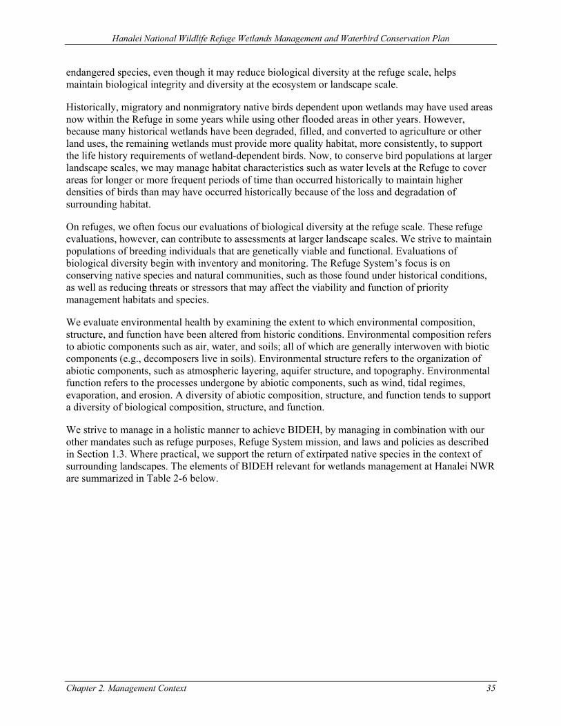
Hanalei National Wildlife Refuge Wetlands Management and Waterbird Conservation Plan
Chapter 2. Management Context 35
endangered species, even though it may reduce biological diversity at the refuge scale, helps maintain biological integrity and diversity at the ecosystem or landscape scale.
Historically, migratory and nonmigratory native birds dependent upon wetlands may have used areas now within the Refuge in some years while using other flooded areas in other years. However, because many historical wetlands have been degraded, filled, and converted to agriculture or other land uses, the remaining wetlands must provide more quality habitat, more consistently, to support the life history requirements of wetland-dependent birds. Now, to conserve bird populations at larger landscape scales, we may manage habitat characteristics such as water levels at the Refuge to cover areas for longer or more frequent periods of time than occurred historically to maintain higher densities of birds than may have occurred historically because of the loss and degradation of surrounding habitat.
On refuges, we often focus our evaluations of biological diversity at the refuge scale. These refuge evaluations, however, can contribute to assessments at larger landscape scales. We strive to maintain populations of breeding individuals that are genetically viable and functional. Evaluations of biological diversity begin with inventory and monitoring. The Refuge System’s focus is on conserving native species and natural communities, such as those found under historical conditions, as well as reducing threats or stressors that may affect the viability and function of priority management habitats and species.
We evaluate environmental health by examining the extent to which environmental composition, structure, and function have been altered from historic conditions. Environmental composition refers to abiotic components such as air, water, and soils; all of which are generally interwoven with biotic components (e.g., decomposers live in soils). Environmental structure refers to the organization of abiotic components, such as atmospheric layering, aquifer structure, and topography. Environmental function refers to the processes undergone by abiotic components, such as wind, tidal regimes, evaporation, and erosion. A diversity of abiotic composition, structure, and function tends to support a diversity of biological composition, structure, and function.
We strive to manage in a holistic manner to achieve BIDEH, by managing in combination with our other mandates such as refuge purposes, Refuge System mission, and laws and policies as described in Section 1.3. Where practical, we support the return of extirpated native species in the context of surrounding landscapes. The elements of BIDEH relevant for wetlands management at Hanalei NWR are summarized in Table 2-6 below.
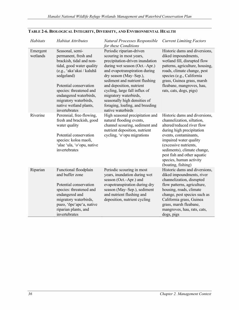
Hanalei National Wildlife Refuge Wetlands Management and Waterbird Conservation Plan
36 Chapter 2. Management Context
TABLE 2-6. BIOLOGICAL INTEGRITY, DIVERSITY, AND ENVIRONMENTAL HEALTH
Habitats Habitat Attributes Natural Processes Responsible for these Conditions
Current Limiting Factors
Emergent wetlands
Seasonal, semi-permanent, fresh and brackish, tidal and non-tidal, good water quality (e.g., ‘aka‘akai / kaluhā sedgeland) Potential conservation species: threatened and endangered waterbirds, migratory waterbirds, native wetland plants, invertebrates
Periodic riparian-driven scouring in most years, precipitation-driven inundation during wet season (Oct.–Apr.) and evapotranspiration during dry season (May–Sep.), sediment and nutrient flushing and deposition, nutrient cycling, large fall influx of migratory waterbirds, seasonally high densities of foraging, loafing, and breeding native waterbirds
Historic dams and diversions, diked impoundments, wetland fill, disrupted flow patterns, agriculture, housing, roads, climate change, pest species (e.g., California grass, Guinea grass, marsh fleabane, mangroves, hau, rats, cats, dogs, pigs)
Riverine Perennial, free-flowing, fresh and brackish, good water quality Potential conservation species: koloa maoli, ‘alae ‘ula, ‘o‘opu, native invertebrates
High seasonal precipitation and natural flooding events, channel scouring, sediment and nutrient deposition, nutrient cycling, ‘o‘opu migrations
Historic dams and diversions, channelization, siltation, altered/reduced river flow during high precipitation events, contaminants, impaired water quality (excessive nutrients, sediments), climate change, pest fish and other aquatic species, human activity (boating, fishing)
Riparian
Functional floodplain and buffer zone Potential conservation species: threatened and endangered and migratory waterbirds, pueo, ‘ōpe‘ape‘a, native riparian plants, and invertebrates
Periodic scouring in most years, inundation during wet season (Oct.–Apr.) and evapotranspiration during dry season (May–Sep.), sediment and nutrient flushing and deposition, nutrient cycling
Historic dams and diversions, diked impoundments, river channelization, disrupted flow patterns, agriculture, housing, roads, climate change, pest species such as California grass, Guinea grass, marsh fleabane, mangroves, hau, rats, cats, dogs, pigs

Hanalei National Wildlife Refuge Wetlands Management and Waterbird Conservation Plan
Chapter 2. Management Context 37
2.5 WILDLIFE
2.5.1 SPECIAL STATUS ANIMAL AND PLANT SPECIES
Several species listed under the ESA are known to occur within or in the vicinity of the wetlands at Hanalei NWR: koloa maoli, ‘alae ke‘oke‘o, ‘alae ‘ula, ae‘o, nēnē, ‘ōpe‘ape‘a, ‘akē‘akē (band-rumped storm petrel, Oceanodroma castro) and ‘ua‘u (Hawaiian petrel, Pterodroma sandwichensis). All of these species are listed as endangered. ‘A‘o (Newell’s shearwater, Puffinus auricularis newelli), a threatened species, was identified nearby during the nesting season. There is no designated or proposed critical habitat for any of these species. No special status plant or invertebrate species are known to occur on lands potentially impacted by wetlands management.
Federally-listed Threatened and Endangered Waterbird Monitoring
At Hanalei NWR, Refuge staff, volunteers, and partners conducted bi-annual waterbird surveys from 1986–2009, monthly surveys from 2010–2016, and quarterly (January, April, August, September) surveys starting in 2017 and continuing to the present. In 2010, Refuge staff transitioned the survey methods from counting birds at overlook locations using a spotting scope to a ground-based survey. This change increased the accuracy of the count. For that reason, data presented below, representing indices of abundance for the five threatened and endangered waterbird species, are from 2010 onwards.
The current procedures use area search and count techniques. However, this sampling method provides “only indices of species’ presence and relative abundance and is not robust compared to other census techniques widely used” (Camp et al. 2014). Camp et al. (2014) further explain that:
“…population counts from area searches and direct counts do not account for imperfect detection of presence, with simple counts widely known to underestimate relative abundances by some unknown amount (Anderson 2001; USFWS 2011e). Importantly, while changes in the occurrence and numbers of birds counted across years are assumed to be a close surrogate for true abundance, detection probabilities can change between years and sites making such trend analysis questionable (Anderson 2001; see also DesRochers et al. 2008).”
Figure 2-3 presents a summary of indices of abundance for the five threatened and endangered waterbirds on Hanalei NWR from the 2010–2020 Refuge waterbird surveys. Please note the survey limitations described above and refer to the individual species accounts below for additional information and discussion.
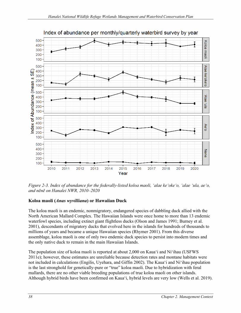
Hanalei National Wildlife Refuge Wetlands Management and Waterbird Conservation Plan
38 Chapter 2. Management Context
Figure 2-3. Index of abundance for the federally-listed koloa maoli, ‘alae ke‘oke‘o, ‘alae ‘ula, ae‘o, and nēnē on Hanalei NWR, 2010–2020
Koloa maoli (Anas wyvilliana) or Hawaiian Duck
The koloa maoli is an endemic, nonmigratory, endangered species of dabbling duck allied with the North American Mallard Complex. The Hawaiian Islands were once home to more than 13 endemic waterfowl species, including extinct giant flightless ducks (Olson and James 1991; Burney et al. 2001), descendants of migratory ducks that evolved here in the islands for hundreds of thousands to millions of years and became a unique Hawaiian species (Rhymer 2001). From this diverse assemblage, koloa maoli is one of only two endemic duck species to persist into modern times and the only native duck to remain in the main Hawaiian Islands.
The population size of koloa maoli is reported at about 2,000 on Kaua‘i and Ni‘ihau (USFWS 2011e); however, these estimates are unreliable because detection rates and montane habitats were not included in calculations (Engilis, Uyehara, and Giffin 2002). The Kaua‘i and Ni‘ihau population is the last stronghold for genetically-pure or “true” koloa maoli. Due to hybridization with feral mallards, there are no other viable breeding populations of true koloa maoli on other islands. Although hybrid birds have been confirmed on Kaua‘i, hybrid levels are very low (Wells et al. 2019).
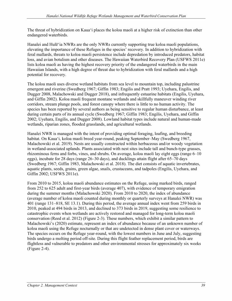
Hanalei National Wildlife Refuge Wetlands Management and Waterbird Conservation Plan
Chapter 2. Management Context 39
The threat of hybridization on Kaua‘i places the koloa maoli at a higher risk of extinction than other endangered waterbirds.
Hanalei and Hulē‘ia NWRs are the only NWRs currently supporting true koloa maoli populations, elevating the importance of these Refuges in the species’ recovery. In addition to hybridization with feral mallards, threats to koloa maoli persistence include depredation by introduced predators, habitat loss, and avian botulism and other diseases. The Hawaiian Waterbird Recovery Plan (USFWS 2011e) lists koloa maoli as having the highest recovery priority of the endangered waterbirds in the main Hawaiian Islands, with a high degree of threat due to hybridization with feral mallards and a high potential for recovery.
The koloa maoli uses diverse wetland habitats from sea level to mountain top, including palustrine emergent and riverine (Swedberg 1967; Giffin 1983; Engilis and Pratt 1993; Uyehara, Engilis, and Dugger 2008, Malachowski and Dugger 2018), and infrequently estuarine habitats (Engilis, Uyehara, and Giffin 2002). Koloa maoli frequent montane wetlands and skillfully maneuver winding river corridors, stream plunge pools, and forest canopy where there is little to no human activity. The species has been reported by several authors as being sensitive to regular human disturbance, at least during certain parts of its annual cycle (Swedberg 1967; Giffin 1983; Engilis, Uyehara, and Giffin 2002; Uyehara, Engilis, and Dugger 2008). Lowland habitat types include natural and human-made wetlands, riparian zones, flooded grasslands, and agricultural wetlands.
Hanalei NWR is managed with the intent of providing optimal foraging, loafing, and breeding habitat. On Kaua‘i, koloa maoli breed year-round, peaking September–May (Swedberg 1967, Malachowski et al. 2019). Nests are usually constructed within herbaceous and/or woody vegetation in wetland-associated uplands. Plants associated with nest sites include tall and bunch-type grasses, rhizominous ferns and forbs, vines, and shrubs. On average, koloa maoli lay eight eggs (range 6–10 eggs), incubate for 28 days (range 26–30 days), and ducklings attain flight after 65–70 days (Swedberg 1967; Giffin 1983, Malachowski et al. 2018). The diet consists of aquatic invertebrates, aquatic plants, seeds, grains, green algae, snails, crustaceans, and tadpoles (Engilis, Uyehara, and Giffin 2002; USFWS 2011e).
From 2010 to 2015, koloa maoli abundance estimates on the Refuge, using marked birds, ranged from 252 to 625 adult and first-year birds (average 407), with evidence of temporary emigration during the summer months (Malachowski 2020). From 2010 to 2020, the index of abundance (average number of koloa maoli counted during monthly or quarterly surveys at Hanalei NWR) was 401 (range 131–818, SE 13.1). During this period, the average annual index went from 259 birds in 2010, peaked at 494 birds in 2013, and declined to 373 birds in 2019, suggesting some resilience to catastrophic events when wetlands are actively restored and managed for long-term koloa maoli conservation (Reed et al. 2012) (Figure 2-3). These numbers, which exhibit a similar pattern to Malachowski’s (2020) estimate, represent an index of abundance because of an unknown number of koloa maoli using the Refuge nocturnally or that are undetected in dense plant cover or waterways. The species occurs on the Refuge year-round, with the lowest numbers in June and July, suggesting birds undergo a molting period off-site. During this flight feather replacement period, birds are flightless and vulnerable to predators and other environmental stresses for approximately six weeks (Figure 2-4).
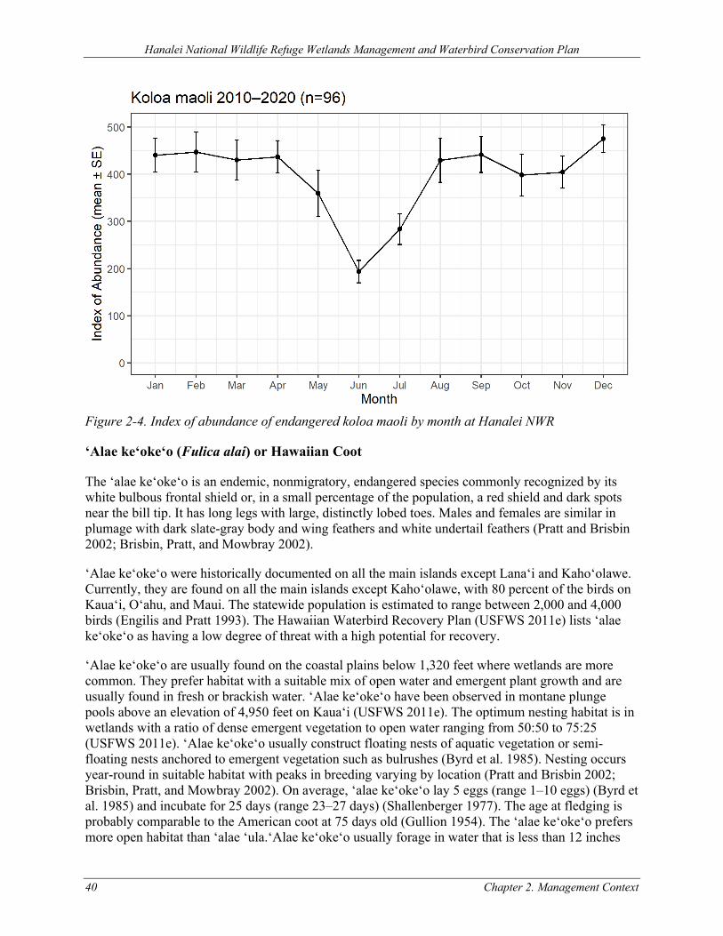
Hanalei National Wildlife Refuge Wetlands Management and Waterbird Conservation Plan
40 Chapter 2. Management Context
Figure 2-4. Index of abundance of endangered koloa maoli by month at Hanalei NWR
‘Alae ke‘oke‘o (Fulica alai) or Hawaiian Coot
The ‘alae ke‘oke‘o is an endemic, nonmigratory, endangered species commonly recognized by its white bulbous frontal shield or, in a small percentage of the population, a red shield and dark spots near the bill tip. It has long legs with large, distinctly lobed toes. Males and females are similar in plumage with dark slate-gray body and wing feathers and white undertail feathers (Pratt and Brisbin 2002; Brisbin, Pratt, and Mowbray 2002).
‘Alae ke‘oke‘o were historically documented on all the main islands except Lana‘i and Kaho‘olawe. Currently, they are found on all the main islands except Kaho‘olawe, with 80 percent of the birds on Kaua‘i, O‘ahu, and Maui. The statewide population is estimated to range between 2,000 and 4,000 birds (Engilis and Pratt 1993). The Hawaiian Waterbird Recovery Plan (USFWS 2011e) lists ‘alae ke‘oke‘o as having a low degree of threat with a high potential for recovery.
‘Alae ke‘oke‘o are usually found on the coastal plains below 1,320 feet where wetlands are more common. They prefer habitat with a suitable mix of open water and emergent plant growth and are usually found in fresh or brackish water. ‘Alae ke‘oke‘o have been observed in montane plunge pools above an elevation of 4,950 feet on Kaua‘i (USFWS 2011e). The optimum nesting habitat is in wetlands with a ratio of dense emergent vegetation to open water ranging from 50:50 to 75:25 (USFWS 2011e). ‘Alae ke‘oke‘o usually construct floating nests of aquatic vegetation or semi-floating nests anchored to emergent vegetation such as bulrushes (Byrd et al. 1985). Nesting occurs year-round in suitable habitat with peaks in breeding varying by location (Pratt and Brisbin 2002; Brisbin, Pratt, and Mowbray 2002). On average, ‘alae ke‘oke‘o lay 5 eggs (range 1–10 eggs) (Byrd et al. 1985) and incubate for 25 days (range 23–27 days) (Shallenberger 1977). The age at fledging is probably comparable to the American coot at 75 days old (Gullion 1954). The ‘alae ke‘oke‘o prefers more open habitat than ‘alae ‘ula.‘Alae ke‘oke‘o usually forage in water that is less than 12 inches
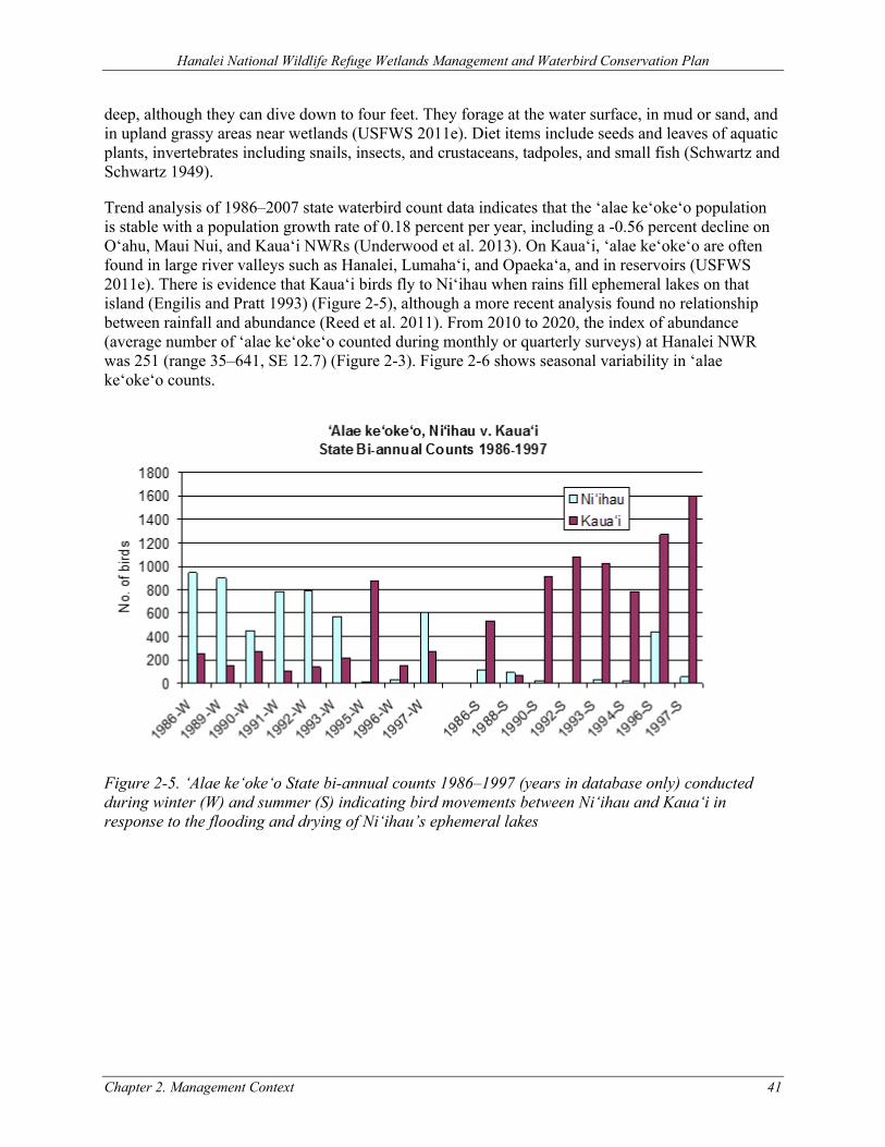
Hanalei National Wildlife Refuge Wetlands Management and Waterbird Conservation Plan
Chapter 2. Management Context 41
deep, although they can dive down to four feet. They forage at the water surface, in mud or sand, and in upland grassy areas near wetlands (USFWS 2011e). Diet items include seeds and leaves of aquatic plants, invertebrates including snails, insects, and crustaceans, tadpoles, and small fish (Schwartz and Schwartz 1949).
Trend analysis of 1986–2007 state waterbird count data indicates that the ‘alae ke‘oke‘o population is stable with a population growth rate of 0.18 percent per year, including a -0.56 percent decline on O‘ahu, Maui Nui, and Kaua‘i NWRs (Underwood et al. 2013). On Kaua‘i, ‘alae ke‘oke‘o are often found in large river valleys such as Hanalei, Lumaha‘i, and Opaeka‘a, and in reservoirs (USFWS 2011e). There is evidence that Kaua‘i birds fly to Ni‘ihau when rains fill ephemeral lakes on that island (Engilis and Pratt 1993) (Figure 2-5), although a more recent analysis found no relationship between rainfall and abundance (Reed et al. 2011). From 2010 to 2020, the index of abundance (average number of ‘alae ke‘oke‘o counted during monthly or quarterly surveys) at Hanalei NWR was 251 (range 35–641, SE 12.7) (Figure 2-3). Figure 2-6 shows seasonal variability in ‘alae ke‘oke‘o counts.
Figure 2-5. ‘Alae ke‘oke‘o State bi-annual counts 1986–1997 (years in database only) conducted during winter (W) and summer (S) indicating bird movements between Ni‘ihau and Kaua‘i in response to the flooding and drying of Ni‘ihau’s ephemeral lakes
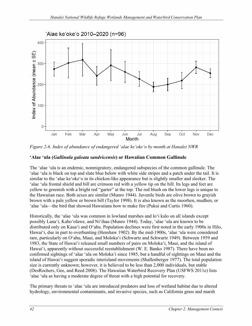
Hanalei National Wildlife Refuge Wetlands Management and Waterbird Conservation Plan
42 Chapter 2. Management Context
Figure 2-6. Index of abundance of endangered ‘alae ke‘oke‘o by month at Hanalei NWR
‘Alae ‘ula (Gallinula galeata sandvicensis) or Hawaiian Common Gallinule
The ‘alae ‘ula is an endemic, nonmigratory, endangered subspecies of the common gallinule. The ‘alae ‘ula is black on top and slate blue below with white side stripes and a patch under the tail. It is similar to the ‘alae ke‘oke‘o in its chicken-like appearance but is slightly smaller and sleeker. The ‘alae ‘ula frontal shield and bill are crimson red with a yellow tip on the bill. Its legs and feet are yellow to greenish with a bright red “garter” at the top. The red blush on the lower legs is unique to the Hawaiian race. Both sexes are similar (Munro 1944). Juvenile birds are olive brown to grayish brown with a pale yellow or brown bill (Taylor 1998). It is also known as the moorhen, mudhen, or ‘alae ‘ula—the bird that showed Hawaiians how to make fire (Pukui and Curtis 1960).
Historically, the ‘alae ‘ula was common in lowland marshes and lo‘i kalo on all islands except possibly Lana‘i, Kaho‘olawe, and Ni‘ihau (Munro 1944). Today, ‘alae ‘ula are known to be distributed only on Kaua‘i and O‘ahu. Population declines were first noted in the early 1900s in Hilo, Hawai‘i, due in part to overhunting (Henshaw 1902). By the mid-1900s, ‘alae ‘ula were considered rare, particularly on O‘ahu, Maui, and Moloka‘i (Schwartz and Schwartz 1949). Between 1959 and 1983, the State of Hawai‘i released small numbers of pairs on Moloka‘i, Maui, and the island of Hawai‘i, apparently without successful reestablishment (W. E. Banko 1987). There have been no confirmed sightings of ‘alae ‘ula on Moloka‘i since 1985, but a handful of sightings on Maui and the island of Hawai‘i suggest sporadic interisland movements (Shallenberger 1977). The total population size is currently unknown; however, it is believed to be less than 2,000 individuals, but stable (DesRochers, Gee, and Reed 2008). The Hawaiian Waterbird Recovery Plan (USFWS 2011e) lists ‘alae ‘ula as having a moderate degree of threat with a high potential for recovery.
The primary threats to ‘alae ‘ula are introduced predators and loss of wetland habitat due to altered hydrology, environmental contaminants, and invasive species, such as California grass and marsh
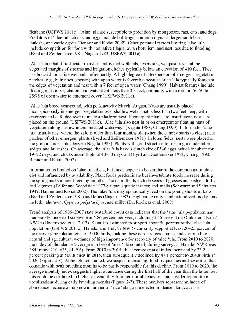
Hanalei National Wildlife Refuge Wetlands Management and Waterbird Conservation Plan
Chapter 2. Management Context 43
fleabane (USFWS 2011e). ‘Alae ‘ula are susceptible to predation by mongooses, rats, cats, and dogs. Predators of ‘alae ‘ula chicks and eggs include bullfrogs, common mynahs, largemouth bass, ‘auku‘u, and cattle egrets (Bannor and Kiviat 2002). Other potential factors limiting ‘alae ‘ula include competition for food with nonnative tilapia, avian botulism, and nest loss due to flooding (Byrd and Zeillemaker 1981; Nagata 1983; USFWS 2011e).
‘Alae ‘ula inhabit freshwater marshes, cultivated wetlands, reservoirs, wet pastures, and the vegetated margins of streams and irrigation ditches typically below an elevation of 410 feet. They use brackish or saline wetlands infrequently. A high degree of interspersion of emergent vegetation patches (e.g., bulrushes, grasses) with open water is favorable because ‘alae ‘ula typically forage at the edges of vegetation and nest within 7 feet of open water (Chang 1990). Habitat features include floating mats of vegetation, and water depth less than 3.3 feet, optimally with a ratio of 50:50 to 25:75 of open water to emergent cover (USFWS 2011e).
‘Alae ‘ula breed year-round, with peak activity March–August. Nests are usually placed inconspicuously in emergent vegetation over shallow water that is less than two feet deep, with emergent stalks folded over to make a platform nest. If emergent plants are insufficient, nests are placed on the ground (USFWS 2011e). ‘Alae ‘ula also nest in or on emergent or floating mats of vegetation along narrow interconnected waterways (Nagata 1983; Chang 1990). In lo‘i kalo, ‘alae ‘ula usually nest where the kalo is older than four months old (when the canopy starts to close) near patches of other emergent plants (Byrd and Zeillemaker 1981). In lotus fields, nests were placed on the ground under lotus leaves (Nagata 1983). Plants with good structure for nesting include taller sedges and bulrushes. On average, the ‘alae ‘ula have a clutch size of 5–6 eggs, which incubate for 19–22 days, and chicks attain flight at 40–50 days old (Byrd and Zeillemaker 1981; Chang 1990; Bannor and Kiviat 2002).
Information is limited on ‘alae ‘ula diets, but foods appear to be similar to the common gallinule’s diet and influenced by availability. Plant foods predominate but invertebrate foods increase during the spring and summer breeding months. The main foods include seeds of grasses and sedges, forbs, and legumes (Telfer and Woodside 1977); algae; aquatic insects; and snails (Schwartz and Schwartz 1949; Bannor and Kiviat 2002). The ‘alae ‘ula may sporadically feed on the young shoots of kalo (Byrd and Zeillemaker 1981) and lotus (Nagata 1983). High value native and naturalized food plants include ‘ahu‘awa, Cyperus polystachyos, and millet (DesRochers et al. 2009).
Trend analysis of 1986–2007 state waterbird count data indicates that the ‘alae ‘ula population has moderately increased statewide at 6.86 percent per year, including 5.46 percent on O‘ahu, and Kaua‘i NWRs (Underwood et al. 2013). Kaua‘i is estimated to support about 50 percent of the ‘alae ‘ula population (USFWS 2011e). Hanalei and Hulē‘ia NWRs currently support at least 20–25 percent of the recovery population goal of 2,000 birds, making these core protected areas and surrounding natural and agricultural wetlands of high importance for recovery of ‘alae ‘ula. From 2010 to 2020, the index of abundance (average number of ‘alae ‘ula counted) during surveys at Hanalei NWR was 384 (range 210–675, SE 9.6). From 2010 to 2015, this average annual index increased by 33.2 percent peaking at 500.8 birds in 2015, then subsequently declined by 47.1 percent to 264.8 birds in 2020 (Figure 2-3). Although not studied, we suspect increasing flood frequencies and severities that coincide with peak breeding months to be partly responsible for this decline. From 2010 to 2020, the average monthly index suggests higher abundance during the first half of the year than the latter, but this could be attributed to higher detectability from territorial behaviors and a wider repertoire of vocalizations during early breeding months (Figure 2-7). These numbers represent an index of abundance because an unknown number of ‘alae ‘ula go undetected in dense plant cover or
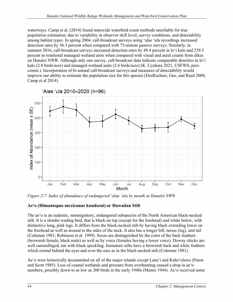
Hanalei National Wildlife Refuge Wetlands Management and Waterbird Conservation Plan
44 Chapter 2. Management Context
waterways. Camp et al. (2014) found statewide waterbird count methods unreliable for true population estimation, due to variability in observer skill level, survey conditions, and detectability among habitat types. In spring 2004, call-broadcast surveys using ‘alae ‘ula recordings increased detection rates by 56.3 percent when compared with 75-minute passive surveys. Similarly, in summer 2016, call-broadcast surveys increased detection rates by 49.4 percent in lo‘i kalo and 239.3 percent in rotational managed wetland units when compared with visual and aural counts from dikes on Hanalei NWR. Although only one survey, call-broadcast data indicate comparable densities in lo‘i kalo (2.8 birds/acre) and managed wetland units (2.6 birds/acre) (K. Uyehara 2021, USFWS, pers. comm.). Incorporation of bi-annual call-broadcast surveys and measures of detectability would improve our ability to estimate the population size for this species (DesRochers, Gee, and Reed 2008; Camp et al 2014).
Figure 2-7. Index of abundance of endangered ‘alae ‘ula by month at Hanalei NWR
Ae‘o (Himantopus mexicanus knudseni) or Hawaiian Stilt
The ae‘o is an endemic, nonmigratory, endangered subspecies of the North American black-necked stilt. It is a slender wading bird, that is black on top (except for the forehead) and white below, with distinctive long, pink legs. It differs from the black-necked stilt by having black extending lower on the forehead as well as around to the sides of the neck. It also has a longer bill, tarsus (leg), and tail (Coleman 1981; Robinson et al. 1999). Sexes are distinguished by the color of the back feathers (brownish female, black male) as well as by voice (females having a lower voice). Downy chicks are well camouflaged, tan with black speckling. Immature stilts have a brownish back and white feathers which extend behind the eyes and over the ears as in the black-necked stilt (Coleman 1981).
Ae‘o were historically documented on all of the major islands except Lana‘i and Kaho‘olawe (Paton and Scott 1985). Loss of coastal wetlands and pressure from overhunting caused a drop in ae‘o numbers, possibly down to as low as 200 birds in the early 1940s (Munro 1944). Ae‘o received some
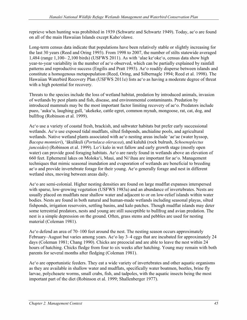
Hanalei National Wildlife Refuge Wetlands Management and Waterbird Conservation Plan
Chapter 2. Management Context 45
reprieve when hunting was prohibited in 1939 (Schwartz and Schwartz 1949). Today, ae‘o are found on all of the main Hawaiian Islands except Kaho‘olawe.
Long-term census data indicate that populations have been relatively stable or slightly increasing for the last 30 years (Reed and Oring 1993). From 1998 to 2007, the number of stilts statewide averaged 1,484 (range 1,100– 2,100 birds) (USFWS 2011). As with ‘alae ke‘oke‘o, census data show high year-to-year variability in the number of ae‘o observed, which can be partially explained by rainfall patterns and reproductive success (Engilis and Pratt 1993). Ae‘o readily disperse between islands and constitute a homogenous metapopulation (Reed, Oring, and Silbernagle 1994; Reed et al. 1998). The Hawaiian Waterbird Recovery Plan (USFWS 2011e) lists ae‘o as having a moderate degree of threat with a high potential for recovery.
Threats to the species include the loss of wetland habitat, predation by introduced animals, invasion of wetlands by pest plants and fish, disease, and environmental contaminants. Predation by introduced mammals may be the most important factor limiting recovery of ae‘o. Predators include pueo, ‘auku‘u, laughing gull, ‘akekeke, cattle egret, common mynah, mongoose, rat, cat, dog, and bullfrog (Robinson et al. 1999).
Ae‘o use a variety of coastal fresh, brackish, and saltwater habitats but prefer early successional wetlands. Ae‘o use exposed tidal mudflats, silted fishponds, anchialine pools, and agricultural wetlands. Native wetland plants associated with ae‘o nesting areas include ‘ae‘ae (water hyssop, Bacopa monnieri), ‘ākulikuli (Portulaca oleracea), and kaluhā (rock bulrush, Schoenoplectus juncoides) (Robinson et al. 1999). Lo‘i kalo in wet fallow and early growth stage (mostly open water) can provide good foraging habitats. Ae‘o are rarely found in wetlands above an elevation of 660 feet. Ephemeral lakes on Moloka‘i, Maui, and Ni‘ihau are important for ae‘o. Management techniques that mimic seasonal inundation and evaporation of wetlands are beneficial to breeding ae‘o and provide invertebrate forage for their young. Ae‘o generally forage and nest in different wetland sites, moving between areas daily.
Ae‘o are semi-colonial. Higher nesting densities are found on large mudflat expanses interspersed with sparse, low-growing vegetation (USFWS 1983a) and an abundance of invertebrates. Nests are usually placed on mudflats near shallow water and adjacent to or on low-relief islands within water bodies. Nests are found in both natural and human-made wetlands including seasonal playas, silted fishponds, irrigation reservoirs, settling basins, and kalo patches. Though mudflat islands may deter some terrestrial predators, nests and young are still susceptible to bullfrog and avian predation. The nest is a simple depression on the ground. Often, grass stems and pebbles are used for nesting material (Coleman 1981).
Ae‘o defend an area of 70–100 feet around the nest. The nesting season occurs approximately February–August but varies among years. Ae‘o lay 3–4 eggs that are incubated for approximately 24 days (Coleman 1981; Chang 1990). Chicks are precocial and are able to leave the nest within 24 hours of hatching. Chicks fledge from four to six weeks after hatching. Young may remain with both parents for several months after fledging (Coleman 1981).
Ae‘o are opportunistic feeders. They eat a wide variety of invertebrates and other aquatic organisms as they are available in shallow water and mudflats, specifically water boatmen, beetles, brine fly larvae, polycheaete worms, small crabs, fish, and tadpoles, with the aquatic insects being the most important part of the diet (Robinson et al. 1999; Shallenberger 1977).
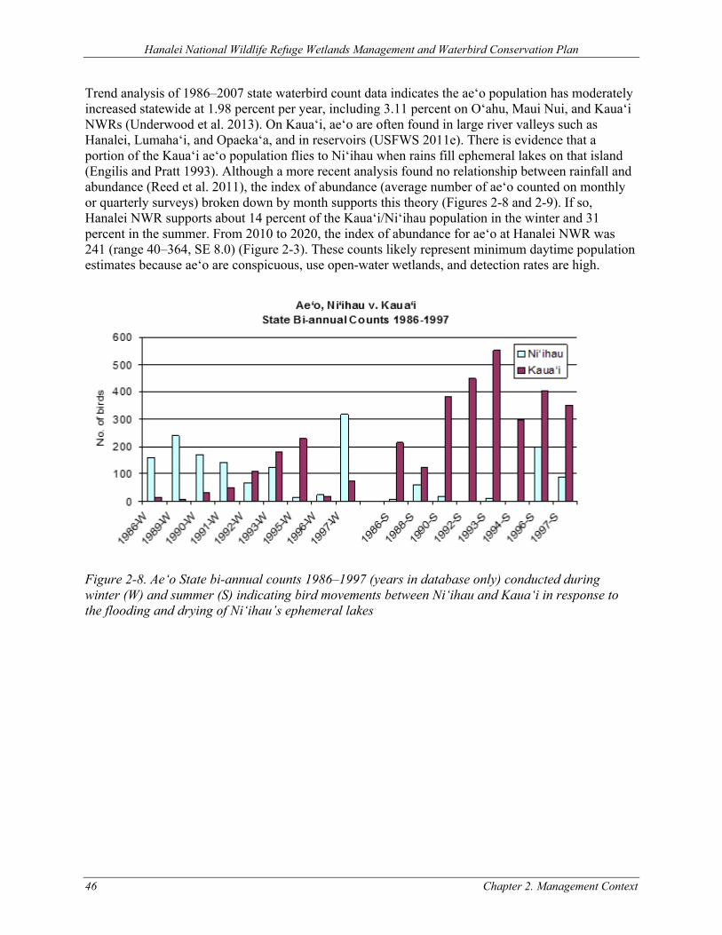
Hanalei National Wildlife Refuge Wetlands Management and Waterbird Conservation Plan
46 Chapter 2. Management Context
Trend analysis of 1986–2007 state waterbird count data indicates the ae‘o population has moderately increased statewide at 1.98 percent per year, including 3.11 percent on O‘ahu, Maui Nui, and Kaua‘i NWRs (Underwood et al. 2013). On Kaua‘i, ae‘o are often found in large river valleys such as Hanalei, Lumaha‘i, and Opaeka‘a, and in reservoirs (USFWS 2011e). There is evidence that a portion of the Kaua‘i ae‘o population flies to Ni‘ihau when rains fill ephemeral lakes on that island (Engilis and Pratt 1993). Although a more recent analysis found no relationship between rainfall and abundance (Reed et al. 2011), the index of abundance (average number of ae‘o counted on monthly or quarterly surveys) broken down by month supports this theory (Figures 2-8 and 2-9). If so, Hanalei NWR supports about 14 percent of the Kaua‘i/Ni‘ihau population in the winter and 31 percent in the summer. From 2010 to 2020, the index of abundance for ae‘o at Hanalei NWR was 241 (range 40–364, SE 8.0) (Figure 2-3). These counts likely represent minimum daytime population estimates because ae‘o are conspicuous, use open-water wetlands, and detection rates are high.
Figure 2-8. Ae‘o State bi-annual counts 1986–1997 (years in database only) conducted during winter (W) and summer (S) indicating bird movements between Ni‘ihau and Kaua‘i in response to the flooding and drying of Ni‘ihau’s ephemeral lakes
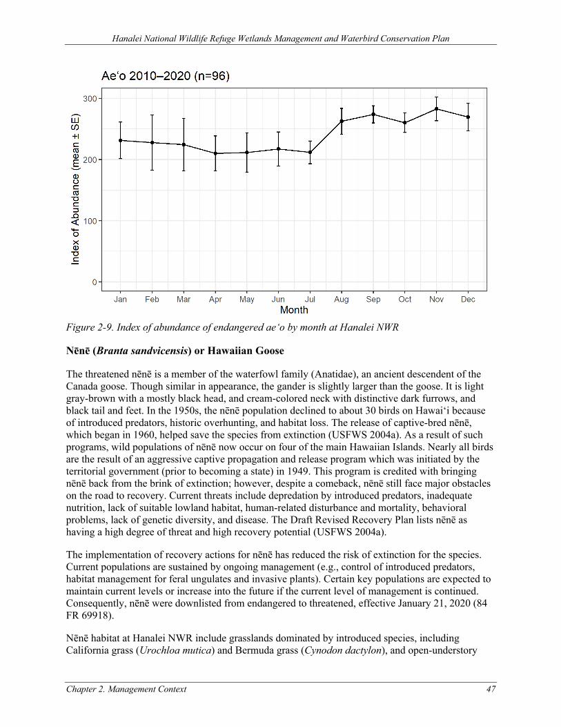
Hanalei National Wildlife Refuge Wetlands Management and Waterbird Conservation Plan
Chapter 2. Management Context 47
Figure 2-9. Index of abundance of endangered ae‘o by month at Hanalei NWR
Nēnē (Branta sandvicensis) or Hawaiian Goose
The threatened nēnē is a member of the waterfowl family (Anatidae), an ancient descendent of the Canada goose. Though similar in appearance, the gander is slightly larger than the goose. It is light gray-brown with a mostly black head, and cream-colored neck with distinctive dark furrows, and black tail and feet. In the 1950s, the nēnē population declined to about 30 birds on Hawai‘i because of introduced predators, historic overhunting, and habitat loss. The release of captive-bred nēnē, which began in 1960, helped save the species from extinction (USFWS 2004a). As a result of such programs, wild populations of nēnē now occur on four of the main Hawaiian Islands. Nearly all birds are the result of an aggressive captive propagation and release program which was initiated by the territorial government (prior to becoming a state) in 1949. This program is credited with bringing nēnē back from the brink of extinction; however, despite a comeback, nēnē still face major obstacles on the road to recovery. Current threats include depredation by introduced predators, inadequate nutrition, lack of suitable lowland habitat, human-related disturbance and mortality, behavioral problems, lack of genetic diversity, and disease. The Draft Revised Recovery Plan lists nēnē as having a high degree of threat and high recovery potential (USFWS 2004a).
The implementation of recovery actions for nēnē has reduced the risk of extinction for the species. Current populations are sustained by ongoing management (e.g., control of introduced predators, habitat management for feral ungulates and invasive plants). Certain key populations are expected to maintain current levels or increase into the future if the current level of management is continued. Consequently, nēnē were downlisted from endangered to threatened, effective January 21, 2020 (84 FR 69918).
Nēnē habitat at Hanalei NWR include grasslands dominated by introduced species, including California grass (Urochloa mutica) and Bermuda grass (Cynodon dactylon), and open-understory
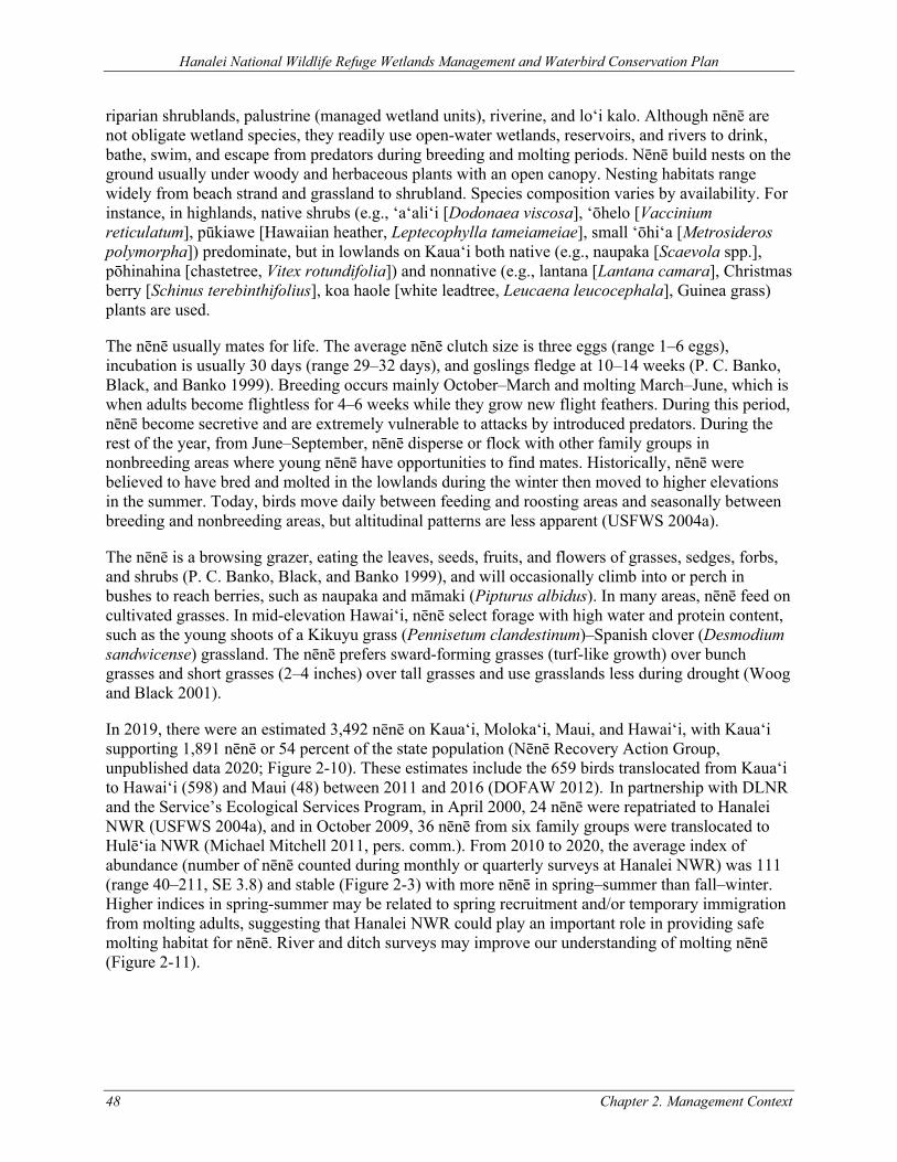
Hanalei National Wildlife Refuge Wetlands Management and Waterbird Conservation Plan
48 Chapter 2. Management Context
riparian shrublands, palustrine (managed wetland units), riverine, and lo‘i kalo. Although nēnē are not obligate wetland species, they readily use open-water wetlands, reservoirs, and rivers to drink, bathe, swim, and escape from predators during breeding and molting periods. Nēnē build nests on the ground usually under woody and herbaceous plants with an open canopy. Nesting habitats range widely from beach strand and grassland to shrubland. Species composition varies by availability. For instance, in highlands, native shrubs (e.g., ‘a‘ali‘i [Dodonaea viscosa], ‘ōhelo [Vaccinium reticulatum], pūkiawe [Hawaiian heather, Leptecophylla tameiameiae], small ‘ōhi‘a [Metrosideros polymorpha]) predominate, but in lowlands on Kaua‘i both native (e.g., naupaka [Scaevola spp.], pōhinahina [chastetree, Vitex rotundifolia]) and nonnative (e.g., lantana [Lantana camara], Christmas berry [Schinus terebinthifolius], koa haole [white leadtree, Leucaena leucocephala], Guinea grass) plants are used.
The nēnē usually mates for life. The average nēnē clutch size is three eggs (range 1–6 eggs), incubation is usually 30 days (range 29–32 days), and goslings fledge at 10–14 weeks (P. C. Banko, Black, and Banko 1999). Breeding occurs mainly October–March and molting March–June, which is when adults become flightless for 4–6 weeks while they grow new flight feathers. During this period, nēnē become secretive and are extremely vulnerable to attacks by introduced predators. During the rest of the year, from June–September, nēnē disperse or flock with other family groups in nonbreeding areas where young nēnē have opportunities to find mates. Historically, nēnē were believed to have bred and molted in the lowlands during the winter then moved to higher elevations in the summer. Today, birds move daily between feeding and roosting areas and seasonally between breeding and nonbreeding areas, but altitudinal patterns are less apparent (USFWS 2004a).
The nēnē is a browsing grazer, eating the leaves, seeds, fruits, and flowers of grasses, sedges, forbs, and shrubs (P. C. Banko, Black, and Banko 1999), and will occasionally climb into or perch in bushes to reach berries, such as naupaka and māmaki (Pipturus albidus). In many areas, nēnē feed on cultivated grasses. In mid-elevation Hawai‘i, nēnē select forage with high water and protein content, such as the young shoots of a Kikuyu grass (Pennisetum clandestinum)–Spanish clover (Desmodium sandwicense) grassland. The nēnē prefers sward-forming grasses (turf-like growth) over bunch grasses and short grasses (2–4 inches) over tall grasses and use grasslands less during drought (Woog and Black 2001).
In 2019, there were an estimated 3,492 nēnē on Kaua‘i, Moloka‘i, Maui, and Hawai‘i, with Kaua‘i supporting 1,891 nēnē or 54 percent of the state population (Nēnē Recovery Action Group, unpublished data 2020; Figure 2-10). These estimates include the 659 birds translocated from Kauaʻi to Hawaiʻi (598) and Maui (48) between 2011 and 2016 (DOFAW 2012). In partnership with DLNR and the Service’s Ecological Services Program, in April 2000, 24 nēnē were repatriated to Hanalei NWR (USFWS 2004a), and in October 2009, 36 nēnē from six family groups were translocated to Hulē‘ia NWR (Michael Mitchell 2011, pers. comm.). From 2010 to 2020, the average index of abundance (number of nēnē counted during monthly or quarterly surveys at Hanalei NWR) was 111 (range 40–211, SE 3.8) and stable (Figure 2-3) with more nēnē in spring–summer than fall–winter. Higher indices in spring-summer may be related to spring recruitment and/or temporary immigration from molting adults, suggesting that Hanalei NWR could play an important role in providing safe molting habitat for nēnē. River and ditch surveys may improve our understanding of molting nēnē (Figure 2-11).
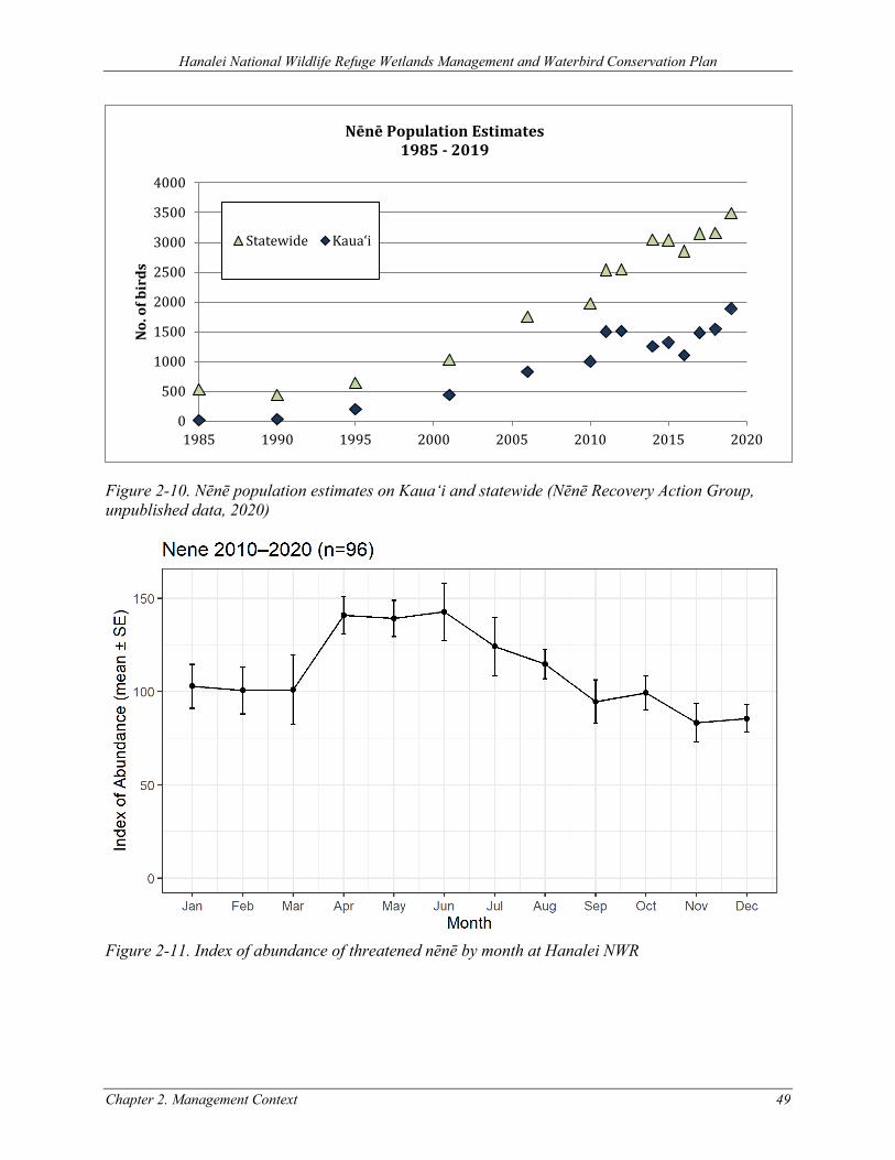
Hanalei National Wildlife Refuge Wetlands Management and Waterbird Conservation Plan
Chapter 2. Management Context 49
Figure 2-10. Nēnē population estimates on Kaua‘i and statewide (Nēnē Recovery Action Group, unpublished data, 2020)
Figure 2-11. Index of abundance of threatened nēnē by month at Hanalei NWR
0
500
1000
1500
2000
2500
3000
3500
4000
1985 1990 1995 2000 2005 2010 2015 2020
No.
of b
irds
Nēnē Population Estimates1985 - 2019
Statewide Kaua‘i
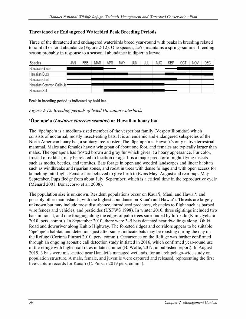
Hanalei National Wildlife Refuge Wetlands Management and Waterbird Conservation Plan
50 Chapter 2. Management Context
Threatened or Endangered Waterbird Peak Breeding Periods
Three of the threatened and endangered waterbirds breed year-round with peaks in breeding related to rainfall or food abundance (Figure 2-12). One species, ae‘o, maintains a spring–summer breeding season probably in response to a seasonal abundance in dipteran larvae.
Peak in breeding period is indicated by bold bar.
Figure 2-12. Breeding periods of listed Hawaiian waterbirds
‘Ōpe‘ape‘a (Lasiurus cinereus semotus) or Hawaiian hoary bat
The ‘ōpe‘ape‘a is a medium-sized member of the vesper bat family (Vespertillionidae) which consists of nocturnal, mostly insect-eating bats. It is an endemic and endangered subspecies of the North American hoary bat, a solitary tree-rooster. The ‘ōpe‘ape‘a is Hawai‘i’s only native terrestrial mammal. Males and females have a wingspan of about one foot, and females are typically larger than males. The ōpe‘ape‘a has frosted brown and gray fur which gives it a hoary appearance. Fur color, frosted or reddish, may be related to location or age. It is a major predator of night-flying insects such as moths, beetles, and termites. Bats forage in open and wooded landscapes and linear habitats such as windbreaks and riparian zones, and roost in trees with dense foliage and with open access for launching into flight. Females are believed to give birth to twins May–August and rear pups May–September. Pups fledge from about July–September, which is a critical time in the reproductive cycle (Menard 2001; Bonaccorso et al. 2008).
The population size is unknown. Resident populations occur on Kaua‘i, Maui, and Hawai‘i and possibly other main islands, with the highest abundance on Kaua‘i and Hawai‘i. Threats are largely unknown but may include roost disturbance, introduced predators, obstacles to flight such as barbed wire fences and vehicles, and pesticides (USFWS 1998). In winter 2010, three sightings included two bats in transit, and one foraging along the edges of palm trees surrounded by lo‘i kalo (Kim Uyehara 2010, pers. comm.). In September 2010, there were 3–5 bats detected near dwellings along ‘Ōhiki Road and downriver along Kūhiō Highway. The forested ridges and corridors appear to be suitable ‘ōpe‘ape‘a habitat, and detections just after sunset indicate bats may be roosting during the day on the Refuge (Corinna Pinzari 2010, pers. comm.). Occurrence on the Refuge was further confirmed through an ongoing acoustic call detection study initiated in 2016, which confirmed year-round use of the refuge with higher call rates in late summer (B. Wolfe, 2017, unpublished report). In August 2019, 3 bats were mist-netted near Hanalei’s managed wetlands, for an archipelago-wide study on population structure. A male, female, and juvenile were captured and released, representing the first live-capture records for Kaua‘i (C. Pinzari 2019 pers. comm.).
Hanalei National Wildlife Refuge Wetlands Management and Waterbird Conservation Plan
Chapter 2. Management Context 51
‘Akē‘akē (Oceanodroma castro) or Band-rumped Storm-petrel
The ‘akē‘akē is a small seabird about eight inches long. Although the Hawaiian population was previously recognized as a distinct subspecies, taxonomists today generally combine the various Pacific populations into a single taxon. The ‘akē‘akē probably was common on all of the main Hawaiian Islands when Polynesians arrived about 1,500 years ago (Berger 1972; Harrison, Telfer, and Sincock 1990). In the Hawaiian Islands, ‘akē‘akē are known to nest in remote cliff locations on Kaua‘i and Lehua Island, in steep open to vegetated cliffs, and in little vegetated, high-elevation lava fields on Hawai‘i Island (Wood et al. 2002; VanderWerf et al. 2007; T. Joyce and Holmes 2010; Paul Banko 2015, in litt. cited in 81 FR 67786; Andre Raine 2015, in litt. cited in 81 FR 67786). Vocalizations were heard in Haleakala Crater on Maui in 1992 (Johnston 1992; cited in Wood et al. 2002), on Lanai (Jay Penniman 2015, in litt. cited in 81 FR 67786), and in Hawaii Volcanoes National Park (Cindy Orlando 2015, in litt. cited 81 FR 67786).
‘Akē‘akē are regularly observed in coastal waters around Kaua‘i, Ni‘ihau, and Hawai‘i Island (Harrison, Telfer, and Sincock 1990; J. Holmes, Troy, and Joyce 2009), and in ‘‘rafts’’ (regular concentrations) of a few birds up to 100, possibly awaiting nightfall before coming ashore to breeding colonies. Kaua‘i likely has the largest population, with an estimated 221 nesting pairs in cliffs along the north shore of the island in 2002, and additional observations on the north and south side of the island in 2010 (Harrison, Telfer, and Sincock 1990; Wood et al. 2002; J. Holmes, Troy, and Joyce 2009; T. Joyce and Holmes 2010). Audio detections for Kaua‘i indicate this species may be predominantly breeding on the Na Pali coast and Waimea Canyon, with a very small number in Wainiha Valley (Andre Raine 2015, in litt. cited in 81 FR 67786).
The ‘akē‘akē (Hawai‘i Distinct Population Segment) was listed as endangered under the ESA in 2016 (81 FR 67786). The Hawaiian Islands population of the ‘akē‘akē is the only population within U.S. borders or under U.S. jurisdiction. Threats and conservation efforts for ‘akē‘akē are the same as described for ‘a‘o, below.
Cooper and Day (1995) found that seabirds were using the Hanalei Valley flyway. It is unknown what percentage of these seabirds may be ‘akē‘akē. Recent data maintains that the Hanalei flyway has the highest passage rate of seabirds on the island (DLNR Division of Forestry and Wildlife [DOFAW] n.d., unpublished data cited in DOFAW 2010).
‘Ua‘u (Pterodroma sandwichensis) or Hawaiian Petrel
‘Ua‘u are federally listed as endangered. The ‘ua‘u was formerly treated as a subspecies of P. phaeopygia, and was commonly known as the dark-rumped petrel (USFWS 1983b). The ‘ua‘u was reclassified as a full species in 1993 because of differences in morphology and vocalization. In 1997, the evolutionary split was confirmed by genetic analyses. The ‘ua‘u was once abundant on all of the main Hawaiian Islands, except Ni‘ihau. Today, ‘ua‘u breed in high-elevation colonies, primarily on east Maui and Mauna Loa on Hawai‘i Island, on Lana‘i, and to a lesser extent, on Kaua‘i, and probably Moloka‘i, Lehua, and sea stacks off Kaho‘olawe, and is estimated to be 6,500–8,300 pairs with an overall population of ~19,000 (Ainley, Telfer, and Reynolds 1997). The breeding season for ‘ua‘u is approximately April–November.
The ‘ua‘u was listed in 1967 (USFWS 1983b), pursuant to the Endangered Species Preservation Act of 1966. The Hawaiian Dark-rumped Petrel and Newell’s Manx Shearwater Recovery Plan was published in 1983 (USFWS 1983b), with a species 5-year review completed in 2011 (USFWS
Hanalei National Wildlife Refuge Wetlands Management and Waterbird Conservation Plan
52 Chapter 2. Management Context
2011b). Critical habitat has not been designated for the ‘ua‘u (USFWS 1983b). Threats and conservation efforts for ‘ua‘u are the same as described for ‘a‘o, below.
The status of ‘ua‘u on the Refuge is unknown. However, on November 22, 2012, an adult ‘ua‘u was recovered on ‘Ōhiki Road in front of the Hanalei bunkhouse, which is consistent with radar surveys from Kalihiwai showing ‘ua‘u transiting to and from breeding colonies in the morning and evening hours directly over the Refuge (Andre Raine 2012, pers. comm.). Cooper and Day (1995) found a significant proportion of ‘ua‘u were using the Hanalei Valley flyway. Recent data maintains that the Hanalei flyway has the highest passage rate on the island (DOFAW n.d., unpublished data cited in DOFAW 2010).
‘A‘o (Puffinus auricularis newelli) or Newell’s Shearwater
‘A‘o are federally listed as threatened. It is a member of the genus Puffinus and utilizes open tropical seas and offshore waters near its island breeding grounds on forested mountain slopes.
‘A‘o was once abundant on all of the main Hawaiian Islands. Today, the breeding population is primarily restricted to Kaua‘i; nests have also been documented on Moloka‘i and Hawai‘i and are suspected on Maui, Lāna‘i, and possibly on O‘ahu (Ainley, Telfer, and Reynolds 1997; M. H. Reynolds and Ritchotte 1997; VanderWerf et al. 2007; Planning Solutions Inc., Rana Biological Consulting Inc., and Ebbin Moser + Skaggs LLP 2011).
The most recent population estimate based on at-sea observations is of 84,000 birds in 1993 (Spear et al. 1995). Approximately 90 percent of the population was believed to nest on Kaua‘i (Cooper and Day 1994; Spear et al. 1995; Ainley, Telfer, and Reynolds 1997; Griesemer and Holmes 2011). Using this population estimate and allowing for an estimated 7,600 one-year-old birds that do not visit Kaua‘i, Ainley et al. (1995) estimated that the Kaua‘i island population in the mid-1990s was approximately 65,000 birds, with a breeding population of about 14,600 pairs (Planning Solutions Inc., Rana Biological Consulting Inc., and Ebbin Moser + Skaggs LLP 2011).
Since 1993, all indications are that the ‘a‘o population has suffered a sharp decline. The number of fledglings retrieved by the Save-Our-Shearwaters (SOS) program on Kaua‘i has steadily declined since 1979, from an average of about 1,500 per year between 1979 and 1990 to an average of less than 500 collected between 1999 and 2006 (Planning Solutions Inc., Rana Biological Consulting Inc., and Ebbin Moser + Skaggs LLP 2011). In 2009, the SOS program handled 265 retrieved birds (Planning Solutions Inc., Rana Biological Consulting Inc., and Ebbin Moser + Skaggs LLP 2011). Day et al. (2003) reported analysis of data trends from radar surveys showing an overall decline of roughly 50–70 percent in detection rates between 1993 and 2001; radar surveys show an apparent decline of 75 percent between 1993 and 2008 (N. Holmes et al. 2011); and preliminary indications are a decline up to 80 percent from 1993 to 2015 (Andre Raine, pers. comm.). Using population models incorporating best estimates of breeding effort and success, Ainley et al. (2001) projected an annual population decrease of 3.2 percent. When anthropogenic variables influencing ‘a‘o mortality (e.g., predation, light attraction, and power line collision) were included, their models predict an annual population decline of 6.1 percent, or approximately 60 percent every 10 years (Ainley et al. 2001; Planning Solutions Inc., Rana Biological Consulting Inc., and Ebbin Moser + Skaggs LLP 2011). Subsequent modeling by Griesemer and Holmes (2011) using radar and fallout data estimated a more severe decline of about 9–10 percent per year during the last two decades. There is little empirical data to confirm which population estimate is more accurate, but an updated estimate of at-
Hanalei National Wildlife Refuge Wetlands Management and Waterbird Conservation Plan
Chapter 2. Management Context 53
sea ‘a‘o populations analogous (though not identical) to the Spear survey was 27,011 birds (Joyce 2016).
The ‘a‘o was listed in 1975 (USFWS 1983b), pursuant to the Endangered Species Preservation Act of 1966. The Hawaiian Dark-rumped Petrel and Newell’s Manx Shearwater Recovery Plan was published in 1983 (USFWS 1983b), with a species 5-year review completed in 2011. The review recommend uplisting to endangered due to precipitous decline in populations on Kaua‘i over the last couple of decades (USFWS 2011c). Critical habitat has not been designated for the ‘a‘o (USFWS 1983b).
Threats to ‘a‘o are many and varied and cannot be entirely eliminated. Like other birds in the order Procellariiformes, ‘a‘o exhibit strong natal philopatry (tendency to return to birth site to breed) and high nest-site fidelity. These behavioral traits, along with a protracted nesting period and ground nesting habitat, result in great vulnerability of eggs, chicks, and adults to predation by introduced mammals at the breeding colonies (Croxall et al. 2012). Predation by feral cats, feral pigs, rats (particularly black rats), dogs, and barn owls have all been documented (Planning Solutions Inc., Rana Biological Consulting Inc., and Ebbin Moser + Skaggs LLP 2011; Raine and McFarland 2014a; Raine and McFarland 2014b; Ainley, Telfer, and Reynolds 1997). Predation by small Indian mongoose is likely on islands with established mongoose populations. Light attraction (fallout) and collision with artificial structures are also contributors to ‘a‘o mortality (Ainley et al. 1995). Fledglings are the main victim of light attraction-related fallout since it is thought they use the moon and stars to guide them to the ocean and become confused by other sources of light. Collision with artificial structures, predominantly utility lines, kills adults—particularly breeding adults moving to and from montane breeding colonies in the dark (Travers et al. 2014). Habitat loss and degradation from invasive plant species or natural catastrophe (e.g., hurricane or wildfire) is often compounded with predation as reduction in dense native canopy cover can provide access for predators into breeding colonies. ‘A‘o are likely susceptible to marine-based threats as well, such as Pacific-wide changes to food supply, but limited information exists on the scope and intensity of marine-based threats.
The status of ‘a‘o on the Refuge is unknown as surveys have never been conducted there. However, radar surveys from Kalihiwai show ‘a‘o transiting to and from breeding colonies in the morning and evening hours directly over the Hanalei NWR (Andre Raine 2012, pers. comm.). The upper ridges of the Refuge have been identified as potential ‘a‘o breeding habitat (USFWS 2011a) including possibly the northeast and central ridges (Andre Raine 2012, pers. comm.). Cooper and Day (1995) found a significant proportion of ‘a‘o were using the Hanalei Valley flyway. Recent data maintains that the Hanalei flyway has the highest passage rate on the island (DOFAW n.d., unpublished data cited in DOFAW 2010). The breeding season for ‘a‘o is approximately April–November (Ainley, Telfer, and Reynolds 1997).
2.5.2 OTHER KEY WILDLIFE SPECIES SUPPORTED
Non-listed (Federally) Resident Hawaiian Birds
‘Auku‘u (Nycticorax nycticorax) or Black-crowned Night-Heron
The indigenous ‘auku‘u is a cosmopolitan species resident in the main Hawaiian Islands. It is the only non-listed Hawaiian waterbird. However, in North America declining populations have prompted several states such as Pennsylvania, Illinois, Ohio, Maine, and New Jersey to protect the
Hanalei National Wildlife Refuge Wetlands Management and Waterbird Conservation Plan
54 Chapter 2. Management Context
species under state threatened and endangered species laws. It is a medium-sized stocky heron. Adults have a distinctive black cap and back, gray wings, white undersides, and red iris. First-year birds are brown with pale spotting on backsides and streaks on undersides, and second-year birds have muted adult plumage. Though similar in appearance, males are slightly larger than females. Both sexes develop long white plumes during the breeding season and pink legs during courtship and egg-laying (Hothem, Brianne, and Davis 2010).
Surveys from 1977 to 1987 showed a steady statewide increase in ‘auku‘u populations through 1985, with a decline in 1986. Nearly two-thirds of O‘ahu’s ‘auku‘u were counted at Kahuku aquaculture ponds, and O‘ahu accounted for over half the annual statewide total. Thus, the increase in ‘auku‘u numbers appeared to be related to expansion of aquaculture on O‘ahu, with the subsequent decline related to control of ‘auku‘u for depredation on shrimp and fish farms (Engilis and Pratt 1993). Auku‘u are opportunistic and use a wide range of aquatic habitat types including lagoons and reefs; however, most ‘auku‘u use streams, permanent freshwater wetlands, and agricultural and industrial wetlands and waterways (Engilis and Pratt 1993). ‘Auku‘u are highly-skilled fishers, but also forage on crustaceans, insects, frogs, mice, and occasionally the eggs and young of threatened and endangered waterbirds. They are generally solitary foragers, and nesting occurs in colonies in a wide range of aquatic habitats. The breeding season occurs between December–February in North America, and probably longer in the tropics. An average of 3 eggs (range 2–5) are laid, the incubation period is 23 days (range 21–26), and chicks fledge at 42–49 days.
‘Auku‘u are vulnerable to human disturbance during nesting, introduced predators, habitat loss, avian diseases such as avian botulism, and particularly environmental contaminants because they are top native predators susceptible to effects of bioaccumulation within the food chain. ‘Auku‘u are good indicators of climate change and environmental quality (Hothem, Brianne, and Davis 2010).
From 2010–2020, the average index of abundance during monthly or quarterly survey at Hanalei NWR was 60.4 (range 4-129, SE 2.6). These numbers represent a population index at best because stream and remote roost habitats were not included in surveys.
Pueo (Asio flammeus sandwichensis) or Hawaiian Short-eared Owl
The pueo is an endemic subspecies of the nearly pandemic short-eared owl. The adult is brown and buffy white and ventrally streaked with darker brown. The eyes are yellow, and the bill is black. Unlike most owls, pueo are diurnal, though nocturnal or crepuscular activity has also been documented. Pueo are commonly seen hovering or soaring over open areas. It is listed by the State of Hawai‘i as an endangered species on the island of O‘ahu.
The pueo is found on all the main Hawaiian Islands from sea level to 8,000 feet elevation. There have been no surveys to estimate the pueo population. The species was widespread at the end of the 19th century but is thought to be declining (Mostello 1996; Mitchell et al. 2005). Pueo occupy a variety of habitats, including wet and dry forests, but are most common in open habitats such as grasslands, shrublands, and montane parklands, including urban areas and those actively managed for conservation (Mitchell et al. 2005). Their relatively recent establishment on Hawai‘i (less than 1,200 years) may have been tied to the rats that Polynesians brought to the islands. In Hawai‘i, pellet analyses indicate that rodents, birds, and insects are their most common prey. Birds depredated by pueo include passerines, seabirds, and shorebirds.
Hanalei National Wildlife Refuge Wetlands Management and Waterbird Conservation Plan
Chapter 2. Management Context 55
Little is known about Hawai‘i’s only native owl and in particular about the breeding biology of the ground-nesting pueo, but nests have been found throughout the year. Nests are constructed by females and are comprised of simple scrapes in the ground lined with grasses and feather down. Females also perform all incubating and brooding, while males feed females and defend nests. The young may “fledge” from nest on foot before they are able to fly, and depend on their parents for approximately 2 months (Mitchell et al. 2005). Pueo can be sighted roosting on and soaring over open areas on both Refuges.
Similar to other native Hawaiian birds, loss and degradation of habitat, predation by mammals, and disease threaten pueo. Pueo appear particularly sensitive to habitat loss and fragmentation, as they require relatively large tracts of grassland and are ground nesters. Ground nesters are more susceptible to the increased predation pressure that is typical within fragmented habitats and near rural developments (Wiggins, Holt, and Leasure 2006). These nesting habits make them increasingly vulnerable to predation by rats, cats, and Indian mongooses (Mostello 1996; Mitchell et al. 2005). Mortality of the pueo on Kaua‘i has been attributed to the “sick owl syndrome,” which may be related to pesticide poisoning or food shortages. They may be vulnerable to the ingestion of poisoned rodents. However, in the one study conducted, there was no evidence that organochlorine, organophosphorus, or carbamate pesticides caused mortality in pueo. Other causes of death on Maui, O‘ahu, and Kaua‘i have been attributed to trauma (apparently vehicular collisions), emaciation, and infectious disease (pasteurellosis) (Work and Hale 1996). However, their persistence in lowland, nonnative and rangeland habitats suggests that they may be less vulnerable to extinction than other native birds, especially because they may be resistant to avian malaria and avian pox (Mitchell et al. 2005).
Though no formal surveys for pueo have been conducted, they are known to occur at Hanalei NWR.
Migratory Birds
In addition to the above-described species, the wetland habitats of Hanalei NWR provide feeding, resting, or breeding habitat for a variety of both resident and migratory species. Hawaiian wetlands provide critical stopover and wintering habitat for at least 36 species of migratory waterfowl (ducks, geese, swans) from both North America and Asia annually from approximately October–April. The koloa mohā (northern shoveler, Anas clypeata), koloa māpu (northern pintail, Anas acuta), lesser scaup (Aythya affinis), American and Eurasian wigeons (Anas americana, Anas penelope), and green-winged teal (Anas crecca) represent 95 percent of the migratory waterbird records. Of the 36 migratory waterfowl species documented for the Hawaiian Islands, at least 29 have been observed at Hanalei NWR. Of these, the most common are koloa māpu, koloa mohā, and American wigeon.
The Pacific Island region functions as an essential migratory habitat for maintaining global shorebird populations. At least 49 species of shorebirds (plovers, sandpipers, and waders) have been recorded in the Hawaiian Islands (Pyle and Pyle 2009). The most common migratory shorebirds by order of abundance are kōlea (Pacific golden-plovers, Pluvialis fulva), ‘akekeke (ruddy turnstones, Arenaria interpres), ‘ūlili (wandering tattlers, Tringa incana), and hunakai (sanderlings, Calidris alba). The only resident shorebird is the ae‘o. A majority of the migratory shorebirds occur in the Hawaiian Islands August through April (Engilis and Naughton 2004).
The kōlea is the most common shorebird in the Pacific region, with Hawai‘i supporting a substantial portion of the Alaskan breeding population during winter. The kōlea is known to make direct, nonstop trans-Pacific flights to and from Alaskan breeding grounds covering approximately 2,980
Hanalei National Wildlife Refuge Wetlands Management and Waterbird Conservation Plan
56 Chapter 2. Management Context
miles in three days (Johnson et al. 2011). The kioea (bristle-thighed curlew, Numenius tahitiensis) is the only migratory species that winters exclusively on Pacific islands, with an estimated 800 birds wintering in the northwestern Hawaiian Islands (Marks et al. 2002). The Pacific region is considered to be a critical area for supporting regional populations of these two species as well as ‘ūlili. Shorebird habitats include primarily wetlands, tidal flats, and estuaries; however, grasslands and beaches are important for the kōlea and the kioea (Engilis and Naughton 2004).
At least 24 of the 49 species of migratory shorebirds documented for the Hawaiian Islands have been observed at Hanalei NWR. Of these, the most common are kōlea, ‘ūlili, and ‘akekeke. Kōlea are by far the most numerous species on the Refuge, accounting for 90 percent of the migratory shorebirds. The primary habitat is mowed dikes, but shallow wetlands and lo‘i kalo are also used. Fallow units with open mudflats are used for night roosting, stopover, and rest/post-migration. Kōlea use the Refuge mainly August through April.
Fishes
All five species of Hawaiian ‘o‘opu inhabit the Hanalei River, which include one indigenous and three endemic true gobies and one endemic sleeper goby. The ‘o‘opu are amphidromous, migrating between freshwater and seawater, but not for the specific purpose of breeding. Instead, ‘o‘opu spawn in fresh or brackish water, and the newly hatched larvae flow out to sea for a period of feeding and growing, then return to freshwater as well-grown juveniles for period of feeding and maturing prior to reproduction. True gobies can be distinguished from sleeper gobies by their fused pelvic fins which form a sucking disc for clinging to rocks or scaling waterfalls. The most impressive climber is ‘o‘opu alamo‘o, found above the 400-foot high ‘Akaka Falls on Hawai‘i Island. Each species occupies an overlapping but unique niche in Hawaiian streams. For example, ‘o‘opu nōpili prefers faster flows of runs and riffles within middle reaches and can be used as indicators of good water quality (Yamamoto and Tagawa 2000). The greatest threat to ‘o‘opu is habitat loss and degradation including dewatering streams through diversions, dams, and channel modifications. ‘O‘opu that swim into waterways and become trapped in lo‘i kalo or other impoundments are unlikely to survive. Excessive sedimentation and nutrient loads degrade habitat and food resources. Other threats include introduced fishes including tilapia, mosquitofish, and several catfish species, and parasites associated with introduced and pest fishes.
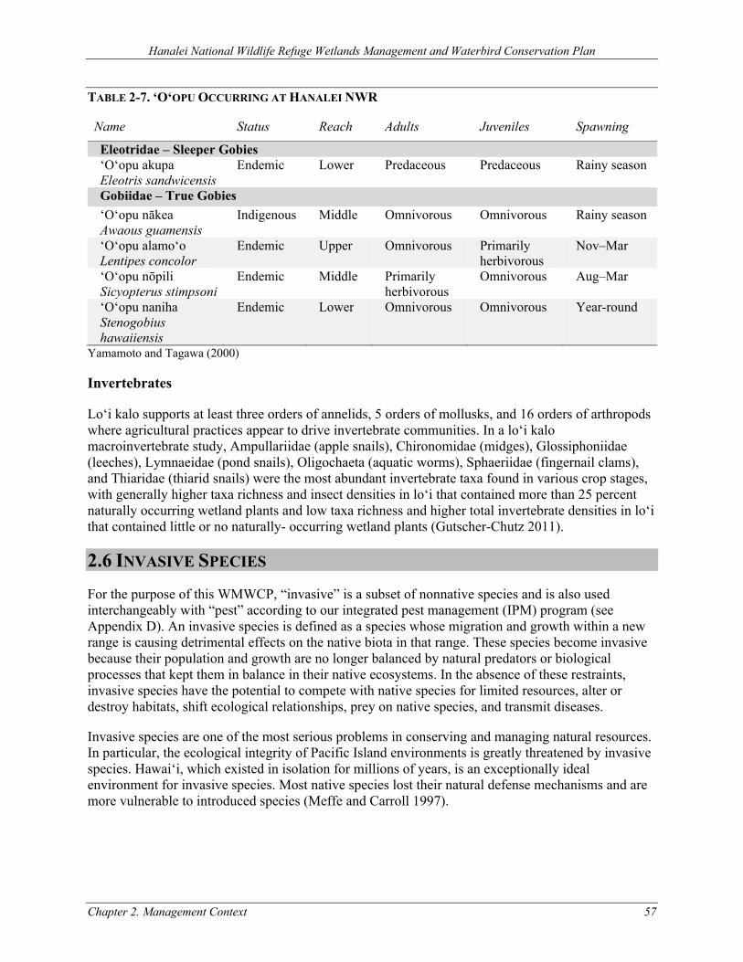
Hanalei National Wildlife Refuge Wetlands Management and Waterbird Conservation Plan
Chapter 2. Management Context 57
TABLE 2-7. ‘O‘OPU OCCURRING AT HANALEI NWR
Name Status Reach Adults Juveniles Spawning
Eleotridae – Sleeper Gobies ‘O‘opu akupa Eleotris sandwicensis
Endemic Lower Predaceous Predaceous Rainy season
Gobiidae – True Gobies ‘O‘opu nākea Awaous guamensis
Indigenous Middle Omnivorous Omnivorous Rainy season
‘O‘opu alamo‘o Lentipes concolor
Endemic Upper Omnivorous Primarily herbivorous
Nov–Mar
‘O‘opu nōpili Sicyopterus stimpsoni
Endemic Middle Primarily herbivorous
Omnivorous Aug–Mar
‘O‘opu naniha Stenogobius hawaiiensis
Endemic Lower Omnivorous Omnivorous Year-round
Yamamoto and Tagawa (2000)
Invertebrates
Lo‘i kalo supports at least three orders of annelids, 5 orders of mollusks, and 16 orders of arthropods where agricultural practices appear to drive invertebrate communities. In a lo‘i kalo macroinvertebrate study, Ampullariidae (apple snails), Chironomidae (midges), Glossiphoniidae (leeches), Lymnaeidae (pond snails), Oligochaeta (aquatic worms), Sphaeriidae (fingernail clams), and Thiaridae (thiarid snails) were the most abundant invertebrate taxa found in various crop stages, with generally higher taxa richness and insect densities in lo‘i that contained more than 25 percent naturally occurring wetland plants and low taxa richness and higher total invertebrate densities in lo‘i that contained little or no naturally- occurring wetland plants (Gutscher-Chutz 2011).
2.6 INVASIVE SPECIES For the purpose of this WMWCP, “invasive” is a subset of nonnative species and is also used interchangeably with “pest” according to our integrated pest management (IPM) program (see Appendix D). An invasive species is defined as a species whose migration and growth within a new range is causing detrimental effects on the native biota in that range. These species become invasive because their population and growth are no longer balanced by natural predators or biological processes that kept them in balance in their native ecosystems. In the absence of these restraints, invasive species have the potential to compete with native species for limited resources, alter or destroy habitats, shift ecological relationships, prey on native species, and transmit diseases.
Invasive species are one of the most serious problems in conserving and managing natural resources. In particular, the ecological integrity of Pacific Island environments is greatly threatened by invasive species. Hawai‘i, which existed in isolation for millions of years, is an exceptionally ideal environment for invasive species. Most native species lost their natural defense mechanisms and are more vulnerable to introduced species (Meffe and Carroll 1997).
Hanalei National Wildlife Refuge Wetlands Management and Waterbird Conservation Plan
58 Chapter 2. Management Context
2.6.1 MAMMALS
Rat (Rattus spp.)
Three nonnative rat species are found throughout the Hawaiian Islands. Polynesian rats (Rattus exulans) arrived from the central Pacific approximately 1,500 years ago with the Polynesians who settled Hawai‘i; Norway rats (Rattus norvegicus) reached the Hawaiian Islands after the arrival of Captain Cook in the 1770s; and black or roof rats (Rattus rattus) most likely arrived in the 1870s. It is estimated that these three rat species have populated nearly 82 percent of the major islands and island chains throughout the globe. Black and Polynesian rats have a large distribution and can be found from sea level to 10,000 feet. Norway rats are restricted to areas below 6,000 feet. Polynesian and Norway rats nest exclusively in terrestrial habitats, while black rats are arboreal nesters. This nesting difference may contribute to a larger population of black rats in Hawai‘i due to the presence of nonarboreal mongoose predators (Tomich 1986; Tobin and Sugihara 1992; Hays and Conant 2007).
Globally, introduced Rattus species have caused the decline, extirpation, or extinction of insular bird species. In the main Hawaiian Islands, Atkinson (1977) suggested that black rats caused the accelerated decline or extinction of many native forest birds between 1870 and 1930. Polynesian rats are speculated to have been a contributing factor in the large-scale extinctions of Hawaiian bird species during Polynesian settlement prior to European contact. Rats continue to be a major threat to waterbirds, seabirds, and forest birds in the Hawaiian Islands. All three rat species in Hawai‘i are known predators of eggs, nestlings, young, and occasionally adults of threatened or endangered waterbirds, seabirds, migratory shorebirds, and forest birds. Rats also consume plants, insects, mollusks, herpetofauna, and other invertebrates. Because these species are also eaten by birds, a reduction in these populations may indirectly affect avian populations (Olson and James 1982; USFWS 2004a; USFWS 2005a; Mitchell et al. 2005).
The use of snap traps and ground-based application of Diphacinone rodenticide to control rats in the main Hawaiian Islands has shown a positive effect in native bird survival. Using these two treatments, rodent abundance dropped 58–90 percent within 1 month of treatments for three years in a row at Hakalau Forest NWR on the island of Hawai‘i. The estimated cost for treating a 247-acre grid in the first year was $7,000, and $2,000 per year in years two and three (Nelson et al. 2002).
At Hanalei NWR, rats and mice may be controlled year-round through the use of trapping (e.g., snap traps or self-resetting Goodnature A24 traps) set at specific targeted locations.
Cat (Felis catus)
Cats in the United States kill more than one million birds per day on average (Dauphine and Cooper 2011) and are recognized by the International Union for Conservation of Nature as one of the “world’s worst” invasive species (Lowe et al. 2000). Cats have a universally damaging effect on island forest birds, breeding seabirds, resident waterbirds, and migratory shorebirds and waterfowl (Smucker, Lindsey, and Mosher 2000; USFWS 2004a; USFWS 2005a; USFWS 2011e; Mitchell et al. 2005). The diet of feral cats in Hawai‘i includes insects, crustaceans, amphibians, lizards, mice, rats, birds (eggs, young, and adults), endangered ‘ōpe‘ape‘a, grasses, and seeds.
Cats are found on all the main Hawaiian Islands from sea level to 10,000 feet, in urban to very remote areas. On remote lands of Mauna Kea on the island of Hawai‘i, feral cats prey on about 11
Hanalei National Wildlife Refuge Wetlands Management and Waterbird Conservation Plan
Chapter 2. Management Context 59
percent of endangered palila nests (finch-billed Hawaiian honeycreeper) annually, and radio-collared male cats can range up to eight square miles. Cats are most active at night when birds are roosting or incubating eggs and are more vulnerable to predation (S. Hess 2011).
In addition, cats are reservoirs of diseases that can be transmitted to birds and other mammals including humans. Feral and domestic cats are the definitive hosts for an infectious parasite called Toxoplasmosis gondii, which reproduces in cat intestines and shed in cat feces. The T. gondii parasite has been linked to deaths of ‘ā (red-footed booby), threatened nēnē, critically endangered ‘alalā (Hawaiian crow, Corvus hawaiiensis) (Work et al. 2000; Work et al. 2002), and critically endangered ‘īlio-holo-i-kauaua (Hawaiian monk seal, Monachus schauinslandi) on the coast of Kaua‘i (Honnold et al. 2005).
At Hanalei NWR there is ongoing evidence of cats killing endangered koloa maoli, ae‘o, ‘alae ‘ula, and ‘alae ke‘oke‘o from analysis of cat stomach contents, photos taken with the use of trail cameras, and waterbird carcass recoveries on dikes. From January 2012 to December 2014, there were 305 waterbird carcasses collected on the Refuge during avian botulism surveys with cat or owl kill sign, averaging over 100 carcasses annually. Of these carcasses, 82.6 percent, 12.8 percent, and 4.6 percent were classified as cat kills (n=252), owl kills (n=39), or cat or owl kills (n=14), respectively. Of the 252 cat kills, 81 percent were ‘alae ‘ula and ‘alae ke‘oke‘o and 94 percent were threatened or endangered species.
Sources of cats on the Refuge include abandoned domestic animals and feral cats immigrating from adjacent areas. Due to ongoing threats and the presence of free-roaming cats across Kaua‘i, feral cat control is conducted on NWRs year-round. Trap cycles last from two to seven days with at least 10–25 traps per Refuge active on a bi-monthly basis. In addition, cats are trapped opportunistically when fresh carcasses of threatened or endangered birds show evidence of cat depredation or when cats have been detected in the area. Cats captured with collars and showing domesticated behavior are transported to the Kaua‘i Humane Society. Feral cats that are caught on the Refuge are humanely euthanized following the American Veterinary Medical Association (AMVA) guidelines for euthanasia (AVMA 2013). Control is conducted by trained Service staff, volunteers, or contractors. Trapping success varies widely depending on many factors, including the cat’s condition, food availability, methods, and techniques. From January 2014 to September 2019, there were 257 feral/stray cats (10,710 effective trap nights) removed from Hanalei NWR. An average of 43 (8.6 standard deviation) cats were caught each year.
Indian Mongoose (Herpestes javanicus)
The Indian mongoose was intentionally introduced to numerous island ecosystems during the 1800s and 1900s and has since expanded to large portions of Asia, Africa, Europe, Oceania, and the Americas. In 1883, the species was introduced to the main Hawaiian Islands as a biocontrol agent to eradicate rats from sugarcane fields. The mongoose inhabits all habitat types from sea level to nearly 10,000 feet on the islands of Hawai‘i, Maui, O‘ahu, and Moloka‘i. In other areas of the world, mongooses appear to avoid wet areas; however, in Hawai‘i, dense populations of mongooses are concentrated in wet habitats. The mean home range of a female in Hawai‘i is approximately 3.5 acres, and the main reproductive period occurs February–August. The high density of mongooses in the Hawaiian Islands is due to abundant food and the lack of natural predators (Tomich 1986; Hays and Conant 2007).
Hanalei National Wildlife Refuge Wetlands Management and Waterbird Conservation Plan
60 Chapter 2. Management Context
Mongooses are voracious omnivores, consuming insects, reptiles, mammals, amphibians, crabs, plants, and birds. In Hawai‘i, mongooses are diurnal predators that primarily eat invertebrates and small mammals as well as plants, birds, reptiles, and amphibians. They are a major threat to any ground-dwelling and -nesting species in Hawai‘i. These mammals are known to eat eggs, young, and adults of the threatened and endangered waterbirds, various seabirds, migratory waterfowl and shorebirds, and young sea turtles (Mitchell et al. 2005; Hays and Conant 2007)
Since 1968, mongoose sightings have been reported in many of the inhabited and regularly travelled parts of Kaua‘i at increasing rates with varying degrees of credibility (Keanini, Speith, and Gundersen 2010). Until recently, Kaua‘i was thought to be mongoose-free. On May 23 and June 29, 2012, two live mongooses were captured in Līhue and Nāwiwili Port, reconfirming presence of mongooses on Kaua‘i. On October 11, 2016, a juvenile mongoose was captured at Līhue Airport exiting a cargo shipment. Previously, the only hard evidence of mongooses on the island was a Kalāheo roadkill of a lactating female in November 1976. In September 2010, an unconfirmed mongoose sighting was reported on Kūhiō Highway along Hanalei NWR. Less than one year earlier, a mongoose was reported at the Hanalei NWR overlook. On May 13, 2012 a mongoose was sighted on the northern boundary of Hulē‘ia NWR near Halehaka Road. Other evidence includes 160 credible sightings, including more than 70 within the last 10 years, with sightings concentrated near Nāwiwili Port and Port Allen. Credible mongoose sightings occurred in 2012–2013 all over Kaua‘i, from Polihale to Lihu‘e to Kīlauea, indicating that mongooses could eventually be detected within the Refuges.
Mongooses have been detrimental to native ground-nesting birds on other Hawaiian islands, and the effects are expected to be even more detrimental on Kaua‘i, as the island is the last stronghold for several threatened and endangered species.
Feral pig (Sus scrofa)
Feral pigs that occur in Hawai‘i are likely to be a blend descended from two ancestral types introduced on separate occasions. Polynesians first brought pigs to the islands as a food source approximately 1,500 years ago. Captain Cook subsequently brought European pigs to the islands in 1778 (Tomich 1986). Pigs descended from European strains were generally larger, more fecund, and more nomadic than their Polynesian counterparts (Van Driesche and Van Driesche 2000). Although pigs have been eradicated from numerous islands worldwide, these animals remain highly abundant in Hawaiian island ecosystems (Courchamp, Chapuis, and Michel 2003; Cruz et al. 2005) and occupy every main island in the Hawaiian archipelago (Tomich 1986).
The pigs are long and narrow in shape, predominately black in color, and generally hairy. The pigs measure 3.5–4.5 feet in length and average two feet in height. Pigs are highly intelligent and elusive animals. They have been reported to be highly active in the early morning and late afternoon in tropical climates. The reproductive potential of pigs contributes to their invasive potential. These animals are polyestrous meaning that adult females have more than one estrus cycle (21 days) in a breeding season. Pregnancy can occur year-round with peaks between January–March. The average sow in Hawai‘i has 1.1 liters per year. Reproductive rates peak between 2–4 years, but breeding has occurred by 10-month-old sows (S. C. Hess et al. 2006).
Pigs are an omnivorous species that consume fruits, seeds, plant material, invertebrates, and opportunistically, the eggs and young of ground-nesting birds. In Hawai‘i, pigs consume and damage plant material in both wet and dry habitats and in agricultural and natural area settings. They root and
Hanalei National Wildlife Refuge Wetlands Management and Waterbird Conservation Plan
Chapter 2. Management Context 61
trample native vegetation and dig up soil for earthworms and underground plant parts. Pigs act as vectors for invasive plants, such as strawberry guava (Psidium cattleianum) and banana poka (Passiflora tarminiana) (LaRosa 1992; Stone, Cuddihy, and Tunison 1992). Pigs are also vectors for human disease such as leptospirosis; they are known to harbor at least 30 viral and bacteriological diseases, many of which are transmissible to humans. They have also been known, through their digging and rooting activities, to damage cultural resources.
Other ecosystem effects can also be attributed to pig activity. Rooting and compaction can deplete the soil of needed oxygen (Van Driesche and Van Driesche 2000). The behavior of pigs causes erosion of cliff and stream banks leading to degraded water quality. Pigs are controlled seasonally at Hanalei NWR, or as needed. Techniques for controlling wild pigs include exclusion fencing, shooting, and live-trapping using baited walk-in pen traps. Pig control efforts and methods vary year-to- year. There were 80 pigs removed from KNWRC in 2008 (6.7 pigs/month) and an additional 22 pigs removed during the first three months of 2011 (7.3 pigs/month) (USFWS 2011d).
2.6.2 BIRDS
Cattle egret (Bubulcus ibis)
Cattle egrets were introduced to Hawai‘i from Florida in 1959. The release was sponsored by local ranchers and the Hawai‘i State Board of Agriculture to control pasture insects. Nearly 150 birds were released on all the main islands except Kaho‘olawe. After one year, successful breeding was recorded on O‘ahu where egrets were quick to establish. On Kaua‘i, egret numbers remained low until 1975, when the population exploded. By 1982, Kaua‘i had three active roost sites totaling approximately 8,000 birds, including a rookery of 4,000 birds at Crater Hill in Kīlauea. By the mid-1980s, cattle egrets were well established on five of the main islands.
Cattle egrets are highly adaptable and generally found foraging in grasslands and shallow wetlands, but will also feed in roadside ditches and landfills. Roosts in the Hawaiian Islands are usually on level lowland areas near water bodies, often in trees less than 30 feet high. It is the only species in the family Ardeidae (herons) that can breed at one year of age. Reproduction in the Hawaiian Islands occurs year-round and clutch sizes average three eggs (range 2–6 eggs) (Paton, Fellows, and Tomich 1986). Chicks, known as “branchers”, begin wandering on branches at 14–21 days and fledge at 25–30 days. Some birds in Hawai‘i may breed twice per year (Telfair 2006).
Cattle egrets are opportunistic feeders. In addition to pest insects, they consume a variety of native and nonnative invertebrates and small vertebrates such as fishes, skinks, and frogs, and seabird and threatened or endangered Hawaiian waterbird chicks (USFWS 2011d). Cattle egrets are controlled at airports to avert bird strikes and at wildlife sanctuaries to protect endangered species (Paton, Fellows, and Tomich 1986).
At Hanalei NWR, the mean number of cattle egrets counted during 1986–2006 state bi-annual waterbird surveys was 79 (range 11–233, SE 7.7), and during January 2010–May 2011 Refuge monthly counts were 90 (range 8–179, SE 10.3). From 2010 to 2015, the average number of cattle egrets counted during monthly population monitoring at Hanalei NWR was 109 (range 23–300, SE 5.3). These counts represent minimum daytime numbers in wetland areas and do not include evening roosts. From 2007 to 2010, 291 cattle egrets were removed from KNWRC, at an average of approximately 100 individuals per year (USFWS 2011d). Cattle egret hazing and removal at the Refuge is a low priority compared to control of other more damaging invasive species; however, the
Hanalei National Wildlife Refuge Wetlands Management and Waterbird Conservation Plan
62 Chapter 2. Management Context
Refuge may need to reinstitute control techniques at some point in the future should substantial loss to threatened or endangered species due to cattle egrets become an issue again. Techniques for cattle egret removal include shooting and other methods, as regulated by the “Control Order for Introduced Migratory Bird Species in Hawaii” approved in 2017 (82 FR 34419; 50 CFR 21.55).
Feral mallard (Anas platyrhynchos)
Worldwide, native ducks are vulnerable to invasion and hybridization with feral mallards, particularly when populations are already suffering from habitat loss and introduced mammalian predators. The greatest threat to the persistence of endangered koloa maoli is hybridization with the introduced mallard. In the 1950s and 1960s, hundreds of mallards were imported from North American game farms to stock hunting areas in the Hawaiian Islands. Resident feral mallards are believed to be the descendants of domestic stock. Migratory mallards that occasionally stop over or winter in the Hawaiian Islands are rare, not in breeding condition, and are not known to pose a threat to koloa maoli.
In addition to the “true” mallard, there are domestic mallard breeds or “barnyard ducks.” They come in various shapes, sizes, and colors. They can breed with and are the same species as the mallard, including Pekin, Khaki Campbell, Blue Cayuga, Rouen, and Indian Runner. Although the chances of a koloa maoli and barnyard duck directly hybridizing in the wild are very small, there are concerns about the large numbers of abandoned domestic ducks found on public water bodies and the possibilities that these ducks harbor bird and human diseases (Uyehara, Engilis Jr., and Reynolds 2007).
In the late 1980s, the mallard was placed on the State of Hawai‘i’s List of Restricted Animals for importation, which allows exceptions for research and exhibition. In 2002, the Hawai‘i Department of Agriculture placed an embargo on all birds shipped to the islands (with some exceptions, for example, fertile eggs) to protect the public from West Nile Virus. However, the mallard continues to reproduce and be sold in the state. The state’s population index shows alarming trends with an overall slight decrease in koloa maoli observations and a substantial increase in mallard and mallard/koloa hybrid observations within the past 20 years (Hawai‘i Conservation Alliance 2008); genetic studies support interpretation of these trends (Fowler, Eadie, and Engilis Jr. 2009). See additional information on hybridization of koloa maoli under Section 2.5.1 (Koloa maoli).
Feral mallards and hybrids also potentially threaten other listed Hawaiian waterbirds by competing for limited wetland resources. Techniques for removing feral mallards and hybrids include live-trapping and euthanasia or shooting, which are regulated by the ESA and MBTA permits. From 2007 to 2012, the Refuge removed about one feral mallard or hybrid duck annually. Kaua‘i and Ni’ihau are the last stronghold for pure koloa maoli, as viable breeding populations no longer persist on other islands (Wells et al. 2019). Removing the threat of koloa maoli hybridization by feral mallards is a primary recovery action in the Hawaiian Waterbird Recovery Plan (USFWS 2011e) and is important to achieving the Refuge’s purpose.
Barn owl (Tyto alba)
The barn owl, which is native to North America, is found throughout the main Hawaiian Islands, including offshore islets such as Lehua near Kaua‘i, where they were introduced in 1958 for rodent control (Pyle and Pyle 2009). Barn owls can be distinguished from pueo (Hawaiian owl) by their primarily nocturnal habits, rounder faces, and lighter coloring.
Hanalei National Wildlife Refuge Wetlands Management and Waterbird Conservation Plan
Chapter 2. Management Context 63
In their native environment, barn owls specialize in hunting small ground mammals and the vast majority of their food consists of small rodents. However, in the Hawaiian Islands they are known to be serious predators of seabirds and waterbirds, including the endangered koloa maoli and ‘alae ke‘oke‘o. Because barn owls will breed at any time during the year and, depending on food supply, can reproduce up to two times per year, they are able to increase rapidly in a relatively short period of time. Barn owls likely compete with the native pueo for introduced rats and mice and could potentially be limiting their population. Techniques for barn owl removal, including trapping and shooting, are regulated by the “Control Order for Introduced Migratory Bird Species in Hawaii” approved in 2017 (82 FR 34419; 50 CFR 21.55). From 2013–2019, there were 12 barn owls removed from Hanalei NWR.
Feral chicken (Gallus gallus)
Archaeological evidence indicates that chickens were first introduced to the Hawaiian island chain over 800 years ago by Polynesian settlers. These founding populations of chickens were likely descended from the ancestral red junglefowl breed. In 1939, additional red junglefowl were introduced to Kaua‘i in a State-sponsored effort to maintain game bird populations in the Hawaiian Islands (Pyle and Pyle 2009). Gering et al. (2015) showed that the feral chickens inhabiting Kaua‘i today exhibit characteristics of both the original red junglefowl founders and more recently derived European domestic breeds. Anecdotally, Hurricane Iwa in 1982 and then Hurricane Iniki in 1992 destroyed many of the coops containing Kauai’s domestic birds, released their occupants into local forests, and potentially spurred large-scale interbreeding and species invasions. Supporting this theory, data from the Audubon Society’s Christmas bird counts in Kapa‘a and Waimea showed increased feral chicken population density following the two major storm events (Gering et al. 2015).
At Hanalei NWR, feral chickens have been observed depredating eggs of native ground-nesting birds and regularly interfere with feral cat traps. Additionally, feral chickens are vectors of diseases that affect native wildlife and people (e.g., toxoplasmosis, see Chalkowski et al. 2020). Consequently, feral chickens are included as targets of the Refuge’s IPM program.
2.6.3 FISHES
Fishes of the topminnow family (Poeciliidae), including guppies (Poecilia reticulata), mollies (Poecilia spp.), and mosquitofishes (Gambusia spp.), bear live young. Thus, only a single gravid female is necessary to establish or re-establish a population. For instance, female Gambusia can bear up to 50–100 live young every 4–5 weeks, 5 or more times per season. In the tropics, where Gambusia have fewer seasonal constraints, there is evidence of year-round reproduction. Thus, in one year a single mature female Gambusia could produce 500–1200 offspring, and her female offspring are able to reproduce as early as 18 days (Pyke 2008), resulting in tens of thousands of Gambusia within several months. Although small fishes provide a food source for the native ‘auku‘u and are opportunistically fed on by adult ae‘o (Broshears 1980), introduced mosquitofish and mollies can negatively impact endangered waterbirds through competition for invertebrate foods and are potentially a major source of nitrogen in wetlands.
Introduced tilapia can indirectly impact native birds by heavily modifying aquatic plant communities and degrading water quality (MacKenzie, Bruland, and Kryss 2008). At Keālia Pond NWR in Maui, Wirwa (2007) found that tilapia reduced macroinvertebrate densities by 48–96 percent. In addition, high densities of these exotic fishes increase the risk of avian botulism by impairing water quality and providing a protein substrate for the pathogen. The primary techniques to control invasive fishes
Hanalei National Wildlife Refuge Wetlands Management and Waterbird Conservation Plan
64 Chapter 2. Management Context
in the managed wetland units are water level drawdowns to concentrate and expose fish to fish-eating birds and fish screens to keep fishes out.
2.6.4 AMPHIBIANS
Bullfrog (Rana catesbeiana)
Bullfrogs are native to eastern North America. They were intentionally introduced to Hawai‘i from California in the late 1800s to provide a food source for people. They now occur on Kaua‘i, O‘ahu, Moloka‘i, Maui, and Hawai‘i. Bullfrogs are highly predaceous, feeding on insects and animals that can fit in their large mouths (Kishinami 2001). Bullfrogs have a negative effect on native Hawaiian species. Endangered koloa maoli ducklings have been found in the stomach contents of bullfrogs on O‘ahu (Engilis, Uyehara, and Giffin 2002). Studies using radio transmitters to track the fate of endangered ae‘o chicks at James Campbell NWR on O‘ahu found that bullfrogs were responsible for 45 percent of ae‘o chick deaths over two years (Eizenga n.d., unpublished data).
In temperate zones, bullfrog maturity is attained at a body length of 3–4 inches, females annually lay 1,000–25,000 eggs, eggs hatch in 3–4 days, and larvae mature in two years. In the tropics, frogs mature at a faster rate and reproduce more frequently (Bury and Whelan 1984). Techniques to control bullfrogs include water level drawdowns to expose bullfrogs to bird predators such as ‘auku‘u, lured swim-in traps, and spot-lighting and spearing. Bullfrog control efforts and methods at Hanalei NWR vary from year to year and are not comparable among years. In 2007, 2008, and 2010, a total of 1,981 bullfrogs were removed from the Refuge with a high of 1,721 bullfrogs in 2008 (USFWS 2011d).
Cane toad (Bufo marinus)
Cane toads, which are native to Latin America, have a broad geographic range that includes a majority of the Pacific region. The toads were brought to the Hawaiian Islands in 1932 to control insect pests. The adults only require water for breeding, an event which results in thousands of eggs per mating occurrence. Tadpoles are a food source for waterbirds. Cane toads are active at night and primarily feed on cockroaches, crickets, grasshoppers, grubs, earthworms, slugs, spiders, centipedes, and snails. In addition, these highly invasive amphibians could be a potential predator of endangered waterbird eggs and young (Yamamoto and Tagawa 2000; Kishinami 2001).
Coqui (Eleutherodactylus coqui)
Coqui frogs, which are native to Puerto Rico, were accidentally introduced to the Hawaiian Islands in the late 1980s through eggs or frogs in nursery plants. They are small, nocturnally active, brown frogs approximately 1 inch in length. Their habitat includes moist leaf bases of foliage and leaf litter from the coastal zone to 4,000 feet elevation or higher. Coqui are a human health and quality of life nuisance because of the male’s loud, high-pitched, two-note call “co-kee,” heard primarily at night. They eat large number of small insects, in native and nonnative habitats, posing a threat to native insects and insectivores (Kishinami 2001). Coqui have occurred on five of the main Hawaiian Islands including the Island of Kaua‘i. In 2001, a breeding population was discovered in Lawai, but after extensive eradication efforts by the Kaua‘i Invasive Species Committee (KISC) and partners, Kaua‘i was declared “coqui-free” in June 2012. Coqui are not known to occur on the Refuge. However, in May 2014 KISC responded to a report of coqui on the north shore of Kaua‘i (State of Hawai‘i
Hanalei National Wildlife Refuge Wetlands Management and Waterbird Conservation Plan
Chapter 2. Management Context 65
Department of Agriculture 2014). In April 2017, a single male coqui was contained and eliminated in Līhu‘e (Else 2017).
2.6.5 GOLDEN APPLE SNAIL (POMACEA CANALICULATA)
Between 20 and 30 species of introduced snails are established on the Hawaiian Islands (Staples and Cowie 2001). Of the four apple snail species in the Hawaiian Islands, the most invasive is the channeled or golden apple snail (Pomacea canaliculata). Apple snails became pests when they were introduced to lo‘i kalo in the 1980s for aquaculture (Yamamoto and Tagawa 2000). They are prolific feeders and breeders. Female snails lay 200–500 eggs per cluster and can lay clusters every two weeks. An adult snail lives 2–5 years, depositing more than 12,000 eggs in a year. Snails forage on algae, kalo, and a wide range of aquatic plants. Small snails are a food source for waterbirds, and large snail shells are regularly found with the meat eaten out in ‘alae ‘ula and koloa maoli nests. However, apple snails have been implicated in the decline of native species in Southeast Asia (Cowie 2002). Apple snails are controlled by water level drawdowns, tilling or disking, and dry fallows. In lo‘i kalo, apple snails are also collected by hand and crushed.
2.6.6 PLANTS
Invasive species are recognized as a major threat to native ecosystems and to the survival of threatened and endangered species. At the ecosystem level, invasive plants have been shown to be capable of changing fire regimes, altering nutrient cycling patterns, and modifying the surface runoff of water. Invasive plants can physically displace native species and displace them by competition for water, nutrients, or other limited resources. Nonnative plants can also be vectors and hosts for introduced pests and diseases to which the native species lack natural defenses. Furthermore, compared to native plants, nonnative plants lack their natural enemies in the introduced range, which again gives them a competitive edge over native species. Invasive plants are also often faster growing, and have life history traits that easily and quickly colonize, establish, and displace native species (Vitousek 1990; D’Antonio and Vitousek 1992; Blossey and Notzold 1995).
Approximately 1,100 species of naturalized nonnative plants occur in Hawai‘i—almost half the flora of the Hawaiian Islands. Invasive plants are successful in island ecosystems due to a multitude of traits. According to Staples, Herbst, and Imada (2000), invasive plants in Hawai‘i are:
• Adaptable to and capable of thriving in different habitats; • Tolerant of variable conditions (such as light, temperature, moisture); • Fast-growing; • Tolerant of disturbance; • Easily dispersible to new localities by seeds, fruits, spores, or vegetative parts; • Producing small seeds/spores early in life; • Experiencing long reproductive periods; and • Dispersed by animals with no special germination requirements.
The control and eradication of pest plants has been the top priority of natural resource managers in Hawai‘i. In the wetland habitats of the Refuge, invasive plant species can drastically reduce the value of wetland habitat to native species. Nonnative species out-compete more desirable plant species and smother open-water and mudflat habitats. In addition, the high biomass characteristic of invasive grasses produces a high amount of fuel for fire, which threatens nearby residential and commercial
Hanalei National Wildlife Refuge Wetlands Management and Waterbird Conservation Plan
66 Chapter 2. Management Context
land uses. In Hawai‘i, plants grow year-round; therefore, maintaining habitat by controlling nonnative plants is a full-time task which requires adequate staff and lots of resources. At Hanalei NWR, a combination of control techniques are employed for invasive plant removal including chemical, mechanical (hand and tractor), and water level manipulations.
California grass (Urochloa mutica)
California grass (Family–Poaceae) is a sprawling perennial with culms (stems) up to 20 feet long and rooting at the nodes. Stolons and leaf sheaths are densely hairy. California grass occurs pantropically as a pasture grass and its native range is unknown, although it is suspected to have originated in sub-Saharan Africa. California grass occurs in aquatic environments such as the openings of wet forests, marshes, and other open water areas. It is reported to be well adapted to a wide range of soil conditions (sandy to clay) and tolerates moderate shade but prefers full sun (Wagner, Herbst, and Sohmer 1999).
In Hawai‘i, California grass occurs between sea level and 3,445 feet on the five main Hawaiian Islands. The grass can form monotypic stands reaching 5 feet in height, with rooting runners up to 18 feet in length. Throughout the state, it has been reported to grow in a wide range of moisture conditions. It grows prolifically in wet, swampy habitats, but it can also withstand severe drought. In addition to displacing native plants, California grass alters and destroys aquatic environments, causing a loss in bird habitat.
The grass also interferes with stream flow and poses a nuisance to marine navigation when grass rafts float out to sea. The Hawai‘i-Pacific Weed Risk Assessment is a research project conducted by the University of Hawai‘i and the U.S. Forest Service to identify plants that pose a high risk in Hawai‘i and other Pacific Islands. The assessment score of 18 (high risk) for California grass reflects its invasion potential. It also designates the species as H (Hawai‘i), meaning the species is “documented to cause significant ecological or economic harm in Hawai‘i” (Motooka et al. 2003). Techniques used to control California grass include an integrated system of mowing, disking, tilling, hand-pulling, and application of herbicides.
Guinea grass (Megathyrsus maximus)
Guinea grass is a large, clumping, perennial grass that is native to Africa but has been widely introduced to other regions as a pasture forage crop and now is distributed throughout in the tropics. Guinea grass became naturalized in the Hawaiian Islands by 1871 (Motooka et al. 2003). It quickly became a problematic invader in Hawaiian landscapes because it is propagated readily by seed and by division of the roots, is adapted to a wide range of ecosystems (e.g., dry to mesic), and alters flammability by increasing fuel loads and continuity. At Hanalei NWR, techniques for controlling Guinea grass is the same as for California grass.
Pluchea spp.
In Hawai‘i, Pluchea spp. (Family–Asteraceae) comprises two shrub species— Indian fleabane (P. indica) and sourbush (P. carolinensis)—and a hybrid species. Indian fleabane readily hybridizes with sourbush to form the intermediate plant Pluchea x fosbergii. The leaves of this hybrid species are usually more similar to P. indica, while the inflorescence more closely resembles sourbush. The hybrid P. x fosbergii can be found where the two species occur together (Wagner, Herbst, and Sohmer 1999)
Hanalei National Wildlife Refuge Wetlands Management and Waterbird Conservation Plan
Chapter 2. Management Context 67
Sourbush is an erect aromatic shrub native to parts of North and South America. The species has naturalized in Hawai‘i, Guam, Taiwan, Africa, and other tropical and Pacific areas. It can grow in poor soil conditions; however, it cannot withstand shade and severe competition from brush and grass. In dry habitats, the fast-growing shrub can form thickets. In Hawai‘i, sourbush has spread to all the main islands since its arrival in the 1930s. This shrub is able to grow in a wide array of habitats, ranging in distribution from dry coastal areas to open forests at an elevation of 2,953 feet. The plant seeds prolifically and the seeds are easily dispersed by wind (Mueller-Dombois and Fosberg 1998; Wagner, Herbst, and Sohmer 1999). Techniques used to control Pluchea spp. include an integrated system of manual removal and application of herbicides.
Cattail (Typha latifolia)
The common cattail (Family–Typhaceae) is native to northern Africa, Eurasia, and North America. It was first noted on O‘ahu in 1979 and has since spread to Moloka‘i, Hawai‘i, and Kaua‘i (Wagner, Herbst, and Sohmer 1999). This plant spreads rapidly both by rhizome and seed, forms dense patches, and excludes native plants and animals. Each flowering head can produce 250,000 seeds, which are wind- and water-dispersed and remain viable for 100 years. On Kaua‘i, cattail occurs in natural and agricultural wetlands of Māhā‘ulepū, Niumalu, Keālia, Nukoli‘i, Puhi, Waimea Valley, Hanapēpē, and Kōloa, with the largest population in Makaweli Valley in lo‘i kalo. Cattail is listed as one of the state’s high-profile invasive species targeted for control (Keanini, Speith, and Gundersen 2010). At Hanalei NWR, cattail occurs in small patches totaling <0.25 acre.
Hau (Hibiscus tiliaceus)
Hau is a fast growing, evergreen, sprawling tree that typically grows 10–33 feet tall (Elevitch and Thomson 2006). It is indigenous to many parts of the tropics and was possibly brought to Hawai‘i by early Polynesian voyagers. Early Hawaiians used hau as a valuable resource for the many products that could be made from its bark and stems, such as canoe parts, crafts, medicines, and cordage (Elevitch and Thomson 2006; White 2019). The plant was managed to limit its encroachment, promote floodplain drainage, and protected water-delivery systems. However, management of hau has not kept up with its prolific growth and has resulted in its rapid spread throughout many waterways, including the Hanalei River.
The tall hau stems often fall over from their own weight. Once fallen, the branches continue to grow as new stems, producing an interwoven growth of vegetation. The roots of hau form dense mats across the channel, trapping sediment and slowing stream velocity. These roots and branches obstruct stream flow, forcing water out of the banks, promoting erosion and altering the hydrology, and eliminating habitat. The obstructed streamflow inhibits both the seaward migration of larvae from endemic stream fauna but also the return of migrating post larvae and juveniles. Further, hau has large leaves that aide in its fast growth but occlude the understory and the river channel. The lack of sunlight and the deposition of large quantities of leave material produces anoxic stream conditions that prevent freshwater species from inhabiting the river channel (USFWS 2017a).
Hanalei National Wildlife Refuge Wetlands Management and Waterbird Conservation Plan
68 Chapter 2. Management Context
2.7 AVIAN BOTULISM Avian botulism is the most significant disease of waterbirds worldwide (Rocke 2006). Although the first cases at Hanalei NWR probably occurred in the late 1970s (Fruth 1992), outbreaks of avian botulism type C, a paralytic disease caused by ingestion of a toxin produced by the bacterium Clostridium botulinum, have become chronic at the Refuge since a November/December 2011 epizootic killed hundreds of endangered waterbirds. Between 2011–2018, there were 1,342 cases of avian botulism recorded on the Refuge (Reynolds et al. 2019). In 2019, the total number of sick and dead native birds affected by avian botulism was 157, with 90 percent of these birds affected during a July–December outbreak. In 2020, an additional 165 native birds were affected raising the 2011–2020 total to 1,664 suspected botulism cases (K. Uyehara 2020, pers. comm.). These botulism outbreaks have killed individuals of all five threatened or endangered waterbird species occurring on the Refuge and have been particularly detrimental to endangered koloa maoli, which represents 62% of birds affected (Reynolds et al. 2019). Unlike mainland avian botulism events, outbreaks on the Refuge can occur year-round due to lack of seasonal variability in temperatures; however, they have been most prevalent during the winter months in northern lo‘i kalo.
C. botulinum is a strict anaerobe that occurs naturally in soil, often lying dormant until the appearance of favorable conditions for growth and toxin production. During the growth phase of C. botulinum, the bacterium produces potent neurotoxins. Botulinum spores can be found in wetland sediments and the tissues of aquatic invertebrates and many vertebrates, creating many pathways for outbreaks to occur once conditions for growth are favorable. One of the more common mechanisms of large avian botulism outbreaks is the carcass‐maggot cycle, where fly larvae feed on an infected carcass and are in turn consumed by birds that become affected and die, leading to more sites for maggots to feed. Ingestion of the botulinum toxin by birds inhibits the neurotransmitter acetylcholine and results in eventual paralysis of the voluntary muscles. This can lead to death by drowning, starvation, or predation (Rocke and Friend 1999).
Environmental conditions associated with avian botulism outbreaks include temperatures between 20–40°C, low dissolved oxygen, pH between 7.5 and 9.0, negative redox (oxidation/reduction) potential, and sources of decaying organic matter (especially protein such as decaying fish) (Rocke and Bollinger 2007; Rocke and Samuel 1999). Sandler et al. (1993) reported the prevalence of C. botulinum was higher in permanently flooded marshes compared to seasonally drained marshes. Prevalence of the bacteria declined throughout the dry period in the seasonally drained wetlands but not in permanently flooded wetlands.
The hydrological infrastructure and management of the Refuge, particularly within certain areas of lo‘i kalo, might influence the abiotic growth factors for C. botulinum, alter the availability of growth media, or lead to buildups of the toxin in areas with less water flow to flush the toxin. Water flow data, fertilizer application rates and associated drawdown frequencies, and botulism carcass densities show differences between northern kalo farms, southern kalo farms, and managed wetland units. These patterns suggest botulism risk increases in areas with both lower water capacity and higher fertilizer volume, and decreases with higher water capacity and lower fertilizer volume (or no fertilizer applications in the case of the wetland management units). Related to water capacity is proximity of the unit to the main intake, with lo‘i further away having more severe and frequent outbreaks than lo‘i nearby. An inconsistency in this pattern is that the westerly rotational managed wetlands units are at lower risk for botulism outbreaks despite being the furthest downstream from the main intake (Mayer 2020; Pilson 2020), but again, this supports the scientific findings on- and
Hanalei National Wildlife Refuge Wetlands Management and Waterbird Conservation Plan
Chapter 2. Management Context 69
off-Refuge that show that it is typically not any one factor or condition that causes or exacerbates avian botulism, but a combination of several.
Hotspot (density) mapping of avian botulism cases based on data from 2011–2015 showed that although the location of hotspots varied somewhat from year-to-year, the most severe outbreaks (i.e., highest density botulism hotspot for koloa maoli, representing 62% of cases) occurred in lo‘i kalo in the northern part of the Refuge, with significantly fewer outbreaks in southern lo‘i kalo and managed wetlands (Figure 2-13). We subsequently mapped the density of live/healthy koloa maoli from waterbird surveys and compared it to the density of dead/sick koloa maoli to examine if northern lo‘i kalo appear to be botulism hotspots because more koloa maoli use these areas and found no relationship. The managed wetlands supported the highest densities of live/healthy koloa maoli. The northern and southern kalo regions had similar densities of live/healthy koloa maoli, but significantly fewer birds compared with managed wetlands (Figure 2-14). Consequently, northern kalo farms contained more dead/sick koloa maoli relative to the numbers of live/healthy koloa maoli using these areas (McDonald 2016). This pattern of high risk and low risk botulism zones varies in severity year-to-year but generally has repeated itself from 2011 to 2020 (USFWS unpublished data).
Because the Refuge provides core habitat for threatened and endangered waterbirds, especially koloa maoli, botulism outbreaks further threaten the recovery of these species. An avian botulism task force has been formed to study the problem and make recommendations. Research and monitoring (of both birds and water quality) have been undertaken to better understand the drivers of the outbreaks in the system. The Refuge is also currently engaged in improving water system infrastructure to promote higher water quality and facilitate better flushing and drainage so that waterbird exposure to warm, anaerobic soil conditions with decaying protein sources is minimized. Following improvements to infrastructure on the Refuge, including improvements in water infrastructure and farming techniques on three northeastern kalo farms 2015–2017, some reductions in bird deaths were seen over the past several years. However, outbreaks continue to occur in these same areas supporting what scientific studies have shown that there are other factors besides water capacity that cause outbreaks. Additional strategies identified to address avian botulism are described in Chapter 4.
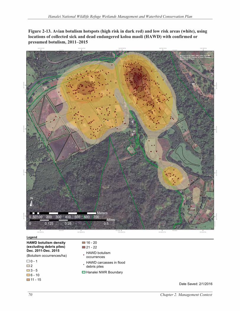
j i _i l i i ,
i
±
!
!
!
!!
!
!
! !
!
!
!!
!
!
!!
!!
!
!
!!
Hanalei National Wildlife Refuge Wetlands Management and Waterbird Conservation Plan
Figure 2-13. Avian botulism hotspots (high risk in dark red) and low risk areas (white), using locations of collected sick and dead endangered koloa maoli (HAWD) with confirmed or presumed botulism, 2011–2015
159°29'0"W 159°28'45"W 159°28'30"W 159°28'15"W 159°28'0"W 450400 451000 451600
!
!
!
!
!
!!
!
!
!
!
!
!!
!
!
!
!
!
!
!
!
!
!
!
!
!
!
!
!
!!
!
!!!!!!!!!
!
!
!!!
!
!
!
!
!
!
!
!!
!
!
!
!
!
!
!
!
!
!
!
!
!
!
!
!
!
!
!
!
!
!
!
! !
!
!
!
!
!
!!
!
!
!
! !
!
!!
!
!
!
!
!
!
!
!
!
!
!
!
!
!
!
!
!
!
!
!!
!
!
!
!
!
!
!
!
!!
! ! ! !
!
! ! !
!
!
!
!
!
!
!
!!
!
!
!
!
!
!
!
!!
!
!
!
!
!
!
!
!
!!
!
!
!!!
!
!
!
!
!
!
!
!
!
!
!
!
!
!
!
!
!
!
!
!
!
!
!
!
!
!
!
!
!
!
! !
!!
!
!
!
!
!
!
!
!
! !
!!
!!
!!!!!!!
!!
!
!
!!
!
!
!
!
!
!
!
!
!
!
!
!
!
!
!
!
!
!
!
!
!
!
!
!! !
!
!
!
!
!
!
!
!
!
!
!
!
! !
!
!
!
!
!
!
!
!
!!!
!!
!
!
!
!
!
!
!
!
!
!
!
!
!
!
!
!
!
!
!
!
!
!
!
!
!
!
!
!
!
!
! !
!
!
!
!
!
!
!
!
!
!
!
!
!
!
!
!
! !!
!
!
!
! !!
!
!
!!
! !!
!!
!
!
!
!
!
!
!
!
!
!
!
!
!
!
!
!
!!
!
!
!
!
!
!
!
!
!
!
!! !
!
!
! !
!
!
!
!
!
!
!!
!
!
!
!!
!
!
!
!
!
!
!
!
!!
!
! !
! ! !
!
! !
!
!
!
!
!
!
! !
! !
!
!
!
!
!
!
!
!
!
!!
! !
!
!
!
!
!
!
!
! !
!
!
!!
!
!
!
!
!
!
!
!
! ! !
!
!
!
!
!
!
!
!! !
!
!
!
! !
!
!
!
!
!
!
!
!
!
!
!
Map Pro ect on: NAD_1983_UTM Zone_4N Grat cu e Un ts: degrees, m nutes seconds Map Grid Un t: Meter
!
!
!
!
!!
!
!
!
!
!
!
!
!
!! !!
!
!
!
!
!
!
!
!! !
!
!
!
!
±
159°29'0"W 159°28'45"W 159°28'30"W 159°28'15"W 159°28'0"W
22°1
1'45
"N
22°1
2'0"
N
22°1
2'15
"N
22°1
2'30
"N
2454
500
2455
200
2455
900
2454
500
2455
200
2455
900
22°1
1'45
"N
22°1
2'0"
N
22°1
2'15
"N
22°1
2'30
"N
Legend
HAWD botulism density (excluding debris piles)Dec. 2011-Dec. 2015
!(Botulism occurrences/ha) 0 - 1 2 !
3 - 5 6 - 10 11 - 15
16 - 20 21 - 22 HAWD botulism occurrences HAWD carcasses in flood debris piles Hanalei NWR Boundary
Date Saved: 2/1/2016
Chapter 2. Management Context
!
!
!
!
450400 451000 451600
00 0.250.25 0.50.50.1250.125 MilesMiles
0 100 200 300 400 500 600 70050 Meters
70
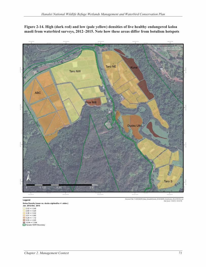
j i _i l i i
i
±
Hanalei National Wildlife Refuge Wetlands Management and Waterbird Conservation Plan
Figure 2-14. High (dark red) and low (pale yellow) densities of live healthy endangered koloa maoli from waterbird surveys, 2012–2015. Note how these areas differ from botulism hotspots
159°29'0"W 159°28'45"W 159°28'30"W 159°28'15"W 159°28'0"W
Taro NW
Taro S
Taro NE
ABC
Kuna
Ducks Ultd.
Rice Mill
22°1
2'30
"N
22°1
2'30
"N
22°1
2'15
"N
22°1
2'15
"N
22°1
2'0"
N
22°1
2'0"
N
22°1
1'45
"N
22°1
1'45
"N
450400
450400
451000
451000
451600
451600
2454
500
2454
500
2455
200
2455
200
2455
900
2455
900
Map Pro ect on: NAD_1983_UTM Zone_4N Grat cu e Un ts: degrees, m nutes, seconds Map Grid Un t: Meter
00 0.250.25 0.50.50.1250.125 MilesMiles
± 159°29'0"W 159°28'45"W 159°28'30"W 159°28'15"W 159°28'0"W
Document Path: F:\GIS\HANWR_Maps_KelseyMcDonald_2016\HANWR_KoloaDensity_KM_20160104.mxdLegend Date Saved: 1/4/2016 1:35:00 PM
Koloa Density (mean no. ducks sighted/ha +/- stdev.) Jan. 2012-Dec. 2015
2.52 +/- 0.49 2.60 +/- 0.20 3.38 +/- 0.42 3.51 +/- 0.80 5.29 +/- 1.12 9.55 +/- 2.20 12.94 +/- 2.64 Hanalei NWR Boundary
Chapter 2. Management Context 71
Hanalei National Wildlife Refuge Wetlands Management and Waterbird Conservation Plan
72 Chapter 3. Resources of Concern
CHAPTER 3. RESOURCES OF CONCERN
3.1 ANALYSIS OF RESOURCES OF CONCERN In identifying resources of concern (ROCs), the planning team followed the process outlined in the Service’s Identifying Refuge Resources of Concern and Management Priorities: A Handbook (Taylor and Paveglio 2017). As defined in the Service’s Policy on HMPs (620 FW 1), ROCs are:
“all plant and/or animal species, species groups, or communities specifically identified in refuge purpose(s), System mission, or international, national, regional, state, or ecosystem conservation plans or acts. For example, waterfowl and shorebirds are a resource of concern on a refuge whose purpose is to protect ‘migrating waterfowl and shorebirds.’ Federal or State threatened and endangered species on that same refuge are also a resource of concern under terms of the respective endangered species acts (620 FW 1.4G)”
Habitats or plant communities are ROCs when they are specifically identified in refuge purposes, when they support species or species groups identified in refuge purposes, when they support Refuge System ROCs, and/or when they are important in the maintenance or restoration of BIDEH.
3.2 SELECTION OF PRIORITY RESOURCES OF CONCERN APPLICABLE TO WETLANDS MANAGEMENT AND WATERBIRD CONSERVATION Early in the planning process, the planning team collectively identified ROCs for the Refuge. Negative features of the landscape, such as invasive plants, may demand a large part of the Refuge management effort but are not designated as ROCs. The team then selected priority ROCs from the ROC list. The main criteria for selecting priority ROCs included the following requirements:
• The resource must be reflective of the Refuge’s establishing purpose(s) and the Refuge System mission;
• The resource must include the main natural habitat types found at the Refuge; • The resource must be recommended as a conservation priority in the Wildlife and Habitat
Management Review; or • The resource must be federally or state-listed, a candidate for listing, or a species of concern.
Other criteria that were considered in the selection of priority ROCs included the following:
• Species groups and/or Refuge features of special management concern; • Species contributing to the BIDEH of the ecosystem; and • Species where it is feasible to estimate abundance and distribution (needed for future
monitoring and adaptive management).
In developing its listing of priority ROCs, the planning team selected not only species mentioned in establishing documents for the Refuge, but also species that captured the ecological attributes of habitats required by larger suites of species. The ecological attributes of habitats should meet the life history requirements of ROCs and are therefore important to sustain the long-term viability of the priority ROC and other benefitting species. Ecological attributes of habitats include vegetation structure, species composition, and age class; hydrologic regime; and disturbance events. These
Hanalei National Wildlife Refuge Wetlands Management and Waterbird Conservation Plan
Chapter 3. Resources of Concern 73
provide measurable indicators that strongly correlate with the ability of a habitat to support a given species. Tables listing the desired conditions for habitat types found on the Refuge were developed based on scientific literature review and team members’ professional judgment. These desired conditions for specific ecological attributes were then used to help design habitat goals and objectives, as presented in Chapter 4. However, not all ecological attributes or indicators were deemed ultimately feasible or necessary to design an objective around. Other factors, such as the ability to reasonably influence or measure certain indicators, played a role in determining the parameters chosen for each habitat objective. Thus, ecological attributes should be viewed as a step in the planning process.
Limiting factors were also considered in developing objectives. A limiting factor is a threat to, or an impairment or degradation of, the natural processes responsible for creating and maintaining plant and animal communities. In developing objectives and strategies, the team gave priority to mitigating or abating limiting factors that presented high risk to ROCs. In many cases, limiting factors occur on a regional or landscape scale and are beyond the control of individual refuges. Therefore, objectives and strategies may seek to mimic, rather than restore, natural processes. For example, mowing may be used to maintain a desirable vegetation structure, when restoring native grassland communities may be impractical. Through the consideration of BIDEH, the Refuge will provide for or maintain all appropriate native habitats and species. Refuge management priorities may change over time, and because the WMWCP is designed to be a living, flexible document, changes will be made at appropriate times.
Table 3-1 identifies the priority ROCs for Hanalei NWR wetlands management and waterbird conservation. Definitions for the column headings are as follows:
• Focal Resources: Species or species groups that are highly associated with conditions that represent the needs of larger groups of species or communities that have similar requirements (e.g., habitats, ecological and/or ecosystem processes) and respond to management similarly. Management will be focused on attaining conditions required by the focal resource. Other species using the associated habitat type will generally be expected to benefit as a result of management for the focal resource.
• Habitat Type: The general habitat description used by the focal resources. • Habitat Structure: The specific and measurable habitat attributes considered necessary to
support the focal resource. • Life History Requirement: The general season of use for the focal resource. • Other Benefiting Species: Other species that are expected to benefit from management for
the selected focal resource. The list is not comprehensive.

Hanalei National Wildlife Refuge Wetlands Management and Waterbird Conservation Plan
74 Chapter 3. Resources of Concern
TABLE 3-1. PRIORITY RESOURCES OF CONCERN
Habitat Type Habitat Structure2 Life History Requirements
Other Benefitting Species
Focal Resource: Koloa maoli Emergent wetlands
Early to mid-successional, mosaic of shallow (<8 in. deep) open water and 50–75% cover, seed-bearing wetland plants, abundant macroinvertebrates, no feral mallards or hybrids
Foraging, loafing, courtship, brood-rearing, molting
Migratory waterfowl, shorebirds, ‘alae ‘ula, ae‘o, ‘alae ke‘oke‘o
Lo‘i kalo Mosaic of wet fallow (6–8 in. deep), dry fallow, early- to late-stage cultivated fields with shallow open water (3–6 in. deep) and 10–75% kalo cover with ≥10% beneficial non-kalo emergent (moist-soil) plants; abundant macroinvertebrates; no feral mallards or hybrids; and <1 avian botulism outbreak annually
Foraging, loafing, courtship, brood-rearing, molting
Migratory waterfowl, shorebirds, ‘alae ‘ula, ae‘o, ‘alae ke‘oke‘o
Riverine Step-pool structure (calm pools that form at the base of falls or runs) with exposed mudflat, boulders, or rocky ledges, and aquatic vegetation and invertebrates, point bars and islands
Foraging, loafing, courtship, brood-rearing, molting
‘Alae ‘ula, ‘o‘opu, native invertebrates
Herbaceous uplands adjacent to wetlands or waterways
Dense canopy >10 in. tall with dead or dying plant material to build nests
Nesting ‘Alae ‘ula, ‘alae ke‘oke‘o
Focal Resource: ‘Alae ‘ula and ‘Alae ke‘oke‘o Emergent wetlands
Mid- to late- successional, mosaic of shallow open water (<8 in. deep) and 50–75% cover, seed-bearing, robust emergent, and submerged plants, abundant macroinvertebrates
Foraging, loafing, breeding, molting
Migratory waterfowl, shorebirds, koloa maoli, nēnē
Lo‘i kalo Mosaic of wet fallow (6–8 in. deep), dry fallow, early- to late-stage cultivated fields with shallow open water (3–6 in. deep) and 10–75% kalo cover with ≥10% beneficial non-kalo emergent (moist-soil) plants; abundant macroinvertebrates; and <1 avian botulism annually
Foraging, loafing, breeding, molting
Migratory waterfowl, shorebirds, koloa maoli, nēnē
2 For all habitat structures, no introduced predators or competitors and no or low human disturbance.
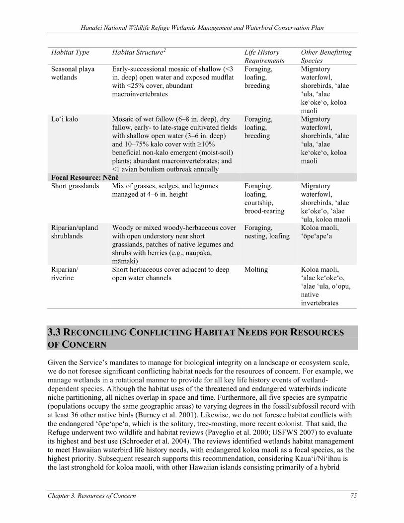
Hanalei National Wildlife Refuge Wetlands Management and Waterbird Conservation Plan
Chapter 3. Resources of Concern 75
Habitat Type Habitat Structure2 Life History Requirements
Other Benefitting Species
Seasonal playa wetlands
Early-successional mosaic of shallow (<3 in. deep) open water and exposed mudflat with <25% cover, abundant macroinvertebrates
Foraging, loafing, breeding
Migratory waterfowl, shorebirds, ‘alae ‘ula, ‘alae ke‘oke‘o, koloa maoli
Lo‘i kalo Mosaic of wet fallow (6–8 in. deep), dry fallow, early- to late-stage cultivated fields with shallow open water (3–6 in. deep) and 10–75% kalo cover with ≥10% beneficial non-kalo emergent (moist-soil) plants; abundant macroinvertebrates; and <1 avian botulism outbreak annually
Foraging, loafing, breeding
Migratory waterfowl, shorebirds, ‘alae ‘ula, ‘alae ke‘oke‘o, koloa maoli
Focal Resource: Nēnē Short grasslands Mix of grasses, sedges, and legumes
managed at 4–6 in. height Foraging, loafing, courtship, brood-rearing
Migratory waterfowl, shorebirds, ‘alae ke‘oke‘o, ‘alae ‘ula, koloa maoli
Riparian/upland shrublands
Woody or mixed woody-herbaceous cover with open understory near short grasslands, patches of native legumes and shrubs with berries (e.g., naupaka, māmaki)
Foraging, nesting, loafing
Koloa maoli, ‘ōpe‘ape‘a
Riparian/ riverine
Short herbaceous cover adjacent to deep open water channels
Molting Koloa maoli, ‘alae ke‘oke‘o, ‘alae ‘ula, o‘opu, native invertebrates
3.3 RECONCILING CONFLICTING HABITAT NEEDS FOR RESOURCES OF CONCERN Given the Service’s mandates to manage for biological integrity on a landscape or ecosystem scale, we do not foresee significant conflicting habitat needs for the resources of concern. For example, we manage wetlands in a rotational manner to provide for all key life history events of wetland-dependent species. Although the habitat uses of the threatened and endangered waterbirds indicate niche partitioning, all niches overlap in space and time. Furthermore, all five species are sympatric (populations occupy the same geographic areas) to varying degrees in the fossil/subfossil record with at least 36 other native birds (Burney et al. 2001). Likewise, we do not foresee habitat conflicts with the endangered ‘ōpe‘ape‘a, which is the solitary, tree-roosting, more recent colonist. That said, the Refuge underwent two wildlife and habitat reviews (Paveglio et al. 2000; USFWS 2007) to evaluate its highest and best use (Schroeder et al. 2004). The reviews identified wetlands habitat management to meet Hawaiian waterbird life history needs, with endangered koloa maoli as a focal species, as the highest priority. Subsequent research supports this recommendation, considering Kaua‘i/Ni‘ihau is the last stronghold for koloa maoli, with other Hawaiian islands consisting primarily of a hybrid
Hanalei National Wildlife Refuge Wetlands Management and Waterbird Conservation Plan
76 Chapter 3. Resources of Concern
swarm through introgression of predominantly feral mallard genes (Wells et al. 2016). Both lo‘i kalo and rotational managed wetlands are used regularly by this species, with managed wetlands used for a wider range of life history events (Malachowski and Dugger 2018). The Refuge, additionally, is estimated to support approximately half the state’s endangered ʻalae ʻula population, highlighting the importance of the Refuge to this species as well, including the vulnerability of both species and others to chance events associated with disease and climate change.
Hanalei National Wildlife Refuge Wetlands Management and Waterbird Conservation Plan
Chapter 4. Management Goals, Objectives, and Strategies 77
CHAPTER 4. MANAGEMENT GOALS, OBJECTIVES, AND STRATEGIES Goals and objectives are the unifying elements of successful refuge management. They focus and describe management priorities and actions that resolve issues and help a refuge fulfill the refuge purpose(s), the Refuge System mission and goals, other statutory requirements, and larger-scale plans as appropriate. Management goals lead to objectives that direct effort into incremental and measurable steps toward achieving those goals. Finally, strategies identify specific tools and actions to accomplish objectives (USFWS and USGS 2004). Some strategies apply to multiple goals or objectives; these are presented in Section 4.1.
The goals for Hanalei NWR wetlands management and waterbird conservation are presented in Sections 4.2 and 4.3, respectively. The goal order does not imply any priority. Each goal is followed by the objectives that pertain to it. The “Rationale” section provides additional information and the reasoning behind the objectives and strategies.
4.1 STRATEGIES THAT APPLY TO MULTIPLE GOALS OR OBJECTIVES Some goals or objectives are supported by common strategies. These are presented below to reduce the length and redundancy of the individual goal and objective descriptions.
Adaptive Management. Based upon the Adaptive Management Implementation policy (522 DM 1), the Refuge will employ adaptive management for conserving, protecting, and where appropriate, restoring lands and resources. Within Title 43 of CFR 46.30, adaptive management is defined as a system of management practices based upon clearly identified outcomes, where monitoring evaluates whether management actions are achieving desired results (objectives). The DOI Adaptive Management Technical Guide further defines adaptive management as “…a decision process that promotes flexible decision making that can be adjusted in the face of uncertainties as outcomes from management actions and other events become better understood. Careful monitoring of these outcomes both advances scientific understanding and helps adjust policies or operations as part of an iterative learning process” (Williams, Szaro, and Shapiro 2009). Adaptive management accounts for the fact that knowledge about fish, wildlife, plants, habitats, and the ecological processes supporting them is incomplete and changing over time. The role of natural variability contributing to ecological resilience also is recognized as an important principle for adaptive management. It is not a “trial and error” process, but rather adaptive management emphasizes learning while doing based upon available scientific information and best professional judgment considering site-specific biotic and abiotic factors on Refuge lands.
The Service recognizes that there is a critical need for transparency as the WMWCP is implemented. This transparency as it pertains to adaptive management includes both the learning and decision-making processes. The following discussion describes how the Service will move forward using adaptive management (adapted from Williams, Szaro, and Shapiro 2009 and Knutson et al. 2017).
• Stakeholder involvement: Ensure stakeholder commitment to adaptively manage the enterprise for its duration.
• Objectives: Identify clear, measurable, and agreed-upon management objectives to guide decision-making and evaluate management effectiveness over time.
Hanalei National Wildlife Refuge Wetlands Management and Waterbird Conservation Plan
78 Chapter 4. Management Goals, Objectives, and Strategies
• Management actions: Identify a set of potential management actions for decision-making. • Models: Identify models that characterize different ideas (hypotheses) about how the system
works. • Monitoring plans: Design and implement a monitoring plan to track resource status and other
key resource attributes. • Decision-making:
o Select management actions based on management objectives, resource conditions, and understanding. As the Service and our partners learn through the adaptive management process, new information may show the need for adjustments, confirm existing strategies, or identify additional information. Based on the best information available at the time, the Service will make decisions for future management actions.
o The Service is committed to bringing together interested parties to assist with the evaluation of available information, as well as consultation about management options and their implications prior to making course-changing decisions. This process does not diminish the Service’s legal authority to make decisions but rather serves to enhance the decision-making process by enabling the Service to approach issues from multiple perspectives, thereby finding creative solutions to complex challenges.
• Follow-up monitoring: Use monitoring to track system responses to management actions. • Assessment: Improve understanding of resource dynamics by comparing predicted and
observed changes in resource status. • Information sharing/learning: The Service is committed to an adaptive management process
that will bring diverse interests together through various forums to share information and site-specific results so that all those engaged can learn together. These forums would evolve over time but would include collaborative mechanisms with others such as (and potentially evolving from) the collaborative groups that have been active during the CCP and WMWCP processes (e.g., the avian botulism task force). The timing and frequency of information sharing and learning will be determined by how rapidly new information is being acquired, level of partners’ interest and engagement, ecological cycles, and the forum being used. The Service will also share the results of its inventory and monitoring work on an ongoing basis and strive to be responsive to partners’ requests for open discussion and collaboration in assessing the need for adaptive changes in management to achieve the goals and objectives of the WMWCP.
As described in the Service’s Habitat Management Planning policy (620 FW 1), annual habitat work plans (AHWPs) provide the mechanism for effectively implementing adaptive management on a refuge over time. Specifically, adaptive management entails assessing and modifying management actions, as necessary, in order to achieve habitat objectives. Management strategies and prescriptions are evaluated by comparing results to desired outcomes to assess their effectiveness (Figure 4-1). The Refuge staff has articulated specific and measurable habitat management objectives associated with wetlands and waterbird conservation (see Sections 4.2 and 4.3), where Refuge surveys within its forthcoming inventory and monitoring plan would be assessing progress toward achieving them. Using adaptive management (Figure 4-1) and the decision flowchart (Figure 4-2), management of the wetland units, lo'i kalo, and other priority areas (Figure 4-3) will be undertaken as described in Sections 4.2 and 4.3 goals and objectives. As previously mentioned, documenting survey results also provides a feedback loop to inform any needed and timely adjustments to management actions. Because planned and implemented
Hanalei National Wildlife Refuge Wetlands Management and Waterbird Conservation Plan
Chapter 4. Management Goals, Objectives, and Strategies 79
management actions to achieve habitat objectives would be documented by Refuge staff and permittees (kalo farming and livestock grazing) using a format consistent with specifications for AHWPs (620 FW 1, Exhibit 2), the Refuge staff would support fundamental components of managing Refuge resources adaptively (objectives, documenting management actions, and implementing surveys to evaluate progress) in accordance with Service and Departmental policies described herein.
Avian Botulism Surveillance and Control. Refuge staff, interns, and volunteers will continue to conduct regular surveillance of lo‘i kalo and rotational managed wetland units in order to control and minimize the outbreak of avian botulism. Research and monitoring on the potential environmental drivers of avian botulism outbreaks (e.g., water quality and water use) will continue. Methods for improving efficiency and detection of avian botulism such as the use of highly trained dogs to locate carcasses and the development of a new diagnostic assay, which uses samples from avian blood, native and invasive invertebrates, fish, and/or amphibians, will continue to be explored. Other methods for responding to avian botulism outbreaks include immediate response for dead bird removal and sick bird treatment.
The Refuge will continue to monitor and manage water levels to provide suitable waterbird habitat and prevent disease outbreaks such as avian botulism. Continued efforts over the life of this plan to improve various aspects of the Refuge water delivery infrastructure (e.g., supply pipelines, ditches and valves, water control structures, drains) will increase water quantity, improve water flushing ability, and reduce water temperatures where they are most needed. These efforts will help to minimize the presence of conditions conducive to botulism spore germination and with proper water management, will reduce the severity of outbreaks as they occur, especially in the northern kalo farming units on Hanalei NWR, which have been identified as avian botulism hotspots over time.
Cultural and Historic Resource Protection and Section 106 Compliance. Cultural and historic resources on refuges receive protection and consideration in accordance with federal cultural resources laws, Executive Orders, regulations, and policies and procedures established by the DOI and the Service. Actions with the potential to affect cultural and historic resources will undergo a thorough review before being implemented, as is consistent with the requirements of cultural resource laws. All ground-disturbing projects will undergo a review (including, but not limited to, archaeological and cultural surveys) under Section 106 of the NHPA. The Service will provide our Regional Historic Preservation Officer (RHPO) a description and location of projects and activities that affect ground and structures, including project requests from third parties. Information will include any alternatives being considered. We will also coordinate and consult with the State Historic Preservation Division (SHPD) and seek assistance from the Native Hawaiian community and organizations on issues related to cultural resources, education, and interpretation; special programs; and NHPA.
Implementation Subject to Funding Availability. After the WMWCP is completed, actions will be implemented as funding becomes available. Draft project priorities and projected staffing/funding needs are in Appendix E, although special funding initiatives, unforeseeable management issues, and other budget issues will likely require adjustments to the implementation schedule in the future. The WMWCP assumes adequate staffing and funding for implementation. However, without these resources some strategies may be deferred or modified.
Integrated Pest Management. Pests are defined as “living organisms that may interfere with the site-specific purposes, operations, or management objectives or that jeopardize human health or
Hanalei National Wildlife Refuge Wetlands Management and Waterbird Conservation Plan
80 Chapter 4. Management Goals, Objectives, and Strategies
safety” from Department policy 517 DM 1 (Integrated Pest Management Policy). Similarly, 569 FW 1 defines pests as “invasive plants and introduced or native organisms that may interfere with achieving our management goals and objectives on or off our lands, or that jeopardize human health or safety.” 517 DM 1 also defines an invasive species as “a species that is non-native to the ecosystem under consideration and whose introduction causes or is likely to cause economic or environmental harm or harm to human health.” Throughout the remainder of this WMWCP, the terms pest and invasive species are used interchangeably because both can prevent/impede achievement of refuge wildlife and habitat objectives and/or degrade environmental quality.
In accordance with DOI and Service policies 517 DM 1 and 569 FW 1 respectively, an IPM approach would be utilized, where practicable, to eradicate, control, or contain pest and invasive species (herein collectively referred to as pests) on the Refuge. IPM would involve using methods based upon effectiveness, cost, and minimal ecological disruption, which considers minimum potential effects to nontarget species and the Refuge environment. Pesticides may be used where mechanical/physical (e.g., mowing, brush-cutting, excavation, prescribed fire), cultural (e.g., water levels), and biological, methods, or combinations thereof, are impractical or incapable of providing adequate control, eradication, or containment. If a pesticide would be needed on Refuge lands or waters, the most specific (selective) chemical available for the target species would be used unless considerations of persistence or other environmental or biotic hazards would preclude it. In accordance with 517 DM 1, pesticide usage would be further restricted because only pesticides registered with the EPA in full compliance with the Federal Insecticide, Fungicide, and Rodenticide Act (FIFRA) and as provided in regulations, orders, or permits issued by EPA may be applied on lands and waters under Refuge jurisdiction.
Environmental harm by nonnative pest species would refer to a biologically substantial decrease in environmental quality as indicated by a variety of potential factors including declines in native species populations or communities, degraded habitat quality or long-term habitat loss, and altered ecological processes. Environmental harm may be a result of direct effects of pests on native species, including preying and feeding on them; causing or vectoring diseases; preventing them from reproducing or killing their young; out-competing them for food, nutrients, light, nest sites, or other vital resources; or hybridizing with them so frequently that within a few generations few, if any, truly native individuals remain. Environmental harm also can be the result of an indirect effect of pest species. For example, decreased waterbird use may result from pest plant infestations reducing the availability and abundance of native wetland plants that provide forage during the winter; increased predation on native species may occur because pest plants also provide cover for predators.
Environmental harm may involve detrimental changes in ecological processes. For example, Guinea grass infestations can alter fire return intervals by displacing native species and communities of bunch grasses, forbs, and shrubs. Environmental harm may also cause or be associated with economic losses and damage to human, plant, and animal health. For example, invasions by fire-prone grasses that alter entire plant and animal communities by eliminating or sharply reducing populations of many native plant and animal species can also greatly increase fire-fighting costs.
The program to control introduced predators is aimed at minimizing entry of species that threaten threatened and endangered species populations and native ecosystems year-round using exclusion (e.g., fences), habitat modification (e.g., removal of trees used by introduced cattle egrets for roosting, water drawdowns), hazing (e.g., for cattle egrets), and control/eradication (e.g., reducing or eliminating populations of ants, mice, rats, barn owls, feral cats, feral dogs, feral pigs, and mongooses, if they are detected.
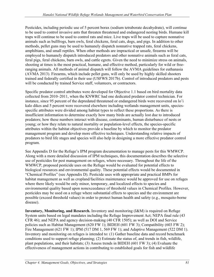
Hanalei National Wildlife Refuge Wetlands Management and Waterbird Conservation Plan
Chapter 4. Management Goals, Objectives, and Strategies 81
Pesticides, including periodic use of 5 percent borax (sodium tetraborate decahydrate), will continue to be used to control invasive ants that threaten threatened and endangered nesting birds. Humane kill traps will continue to be used to control rats and mice. Live traps will be used to capture nonnative animals such as bullfrogs, barn owls, feral chickens, feral cats, dogs, and pigs. In addition to other methods, pellet guns may be used to humanely dispatch nonnative trapped rats, feral chickens, amphibians, and small reptiles. When other methods are impractical or unsafe, firearms will be employed to humanely dispatch introduced predators and other nonnative animals such as feral cats, feral pigs, feral chickens, barn owls, and cattle egrets. Given the need to minimize stress on animals, shooting at times is the most practical, humane, and effective method, particularly for wild or free-ranging animals. All methods of animal dispatch will follow the AVMA guidelines for euthanasia (AVMA 2013). Firearms, which include pellet guns, will only be used by highly skilled shooters trained and federally certified in their use (USFWS 2017b). Control of introduced predators and pests will be conducted by trained Service staff, volunteers, or contractors.
Specific predator control attributes were developed for Objective 1.1 based on bird mortality data collected from 2010–2011, when the KNWRC had one dedicated predator control technician. For instance, since 95 percent of the depredated threatened or endangered birds were recovered on lo’i kalo dikes and 5 percent were recovered elsewhere including wetlands management units, species-specific attributes were divided among habitat types to reflect these proportions. As there is insufficient information to determine exactly how many birds are actually lost due to introduced predators; how these numbers interact with disease, contaminants, human disturbance of nests or young; or how they relate to natural mortality or population-level effects, the species-specific attributes within the habitat objectives provide a baseline by which to monitor the predator management program and develop more effective techniques. Understanding relative impacts of predators to bird life stages and species will also help in designing a more effective predator control program.
See Appendix D for the Refuge’s IPM program documentation to manage pests for this WMWCP. Along with a more detailed discussion of IPM techniques, this documentation describes the selective use of pesticides for pest management on refuges, where necessary. Throughout the life of the WMWCP, proposed pesticide uses on the Refuge would be evaluated for potential effects to biological resources and environmental quality. These potential effects would be documented in “Chemical Profiles” (see Appendix D). Pesticide uses with appropriate and practical BMPs for habitat management as well as cropland/facilities maintenance would be approved for use on refuges where there likely would be only minor, temporary, and localized effects to species and environmental quality based upon nonexceedance of threshold values in Chemical Profiles. However, pesticides may be used on a refuge where substantial effects to species and the environment are possible (exceed threshold values) in order to protect human health and safety (e.g., mosquito-borne disease).
Inventory, Monitoring, and Research. Inventory and monitoring (I&M) is required on Refuge System units based on legal mandates including the Refuge Improvement Act; NEPA final rule (43 CFR 46); and NEPA and agency decision-making (40 CFR 1505); as well as DOI and Service policies such as Habitat Management (620 FW 1); BIDEH (601 FW 3); Compatibility (603 FW 2); Fire Management (621 FW 1); IPM (517 DM 1, 569 FW 1); and Adaptive Management (522 DM 1). Inventory and monitoring on refuges is intended to: (1) Gather baseline data and record benchmark conditions used to support refuge planning; (2) Estimate the status of, and trends in fish, wildlife, plant populations, and their habitats; (3) Assess trends in BIDEH (601 FW 3); (4) Evaluate the effectiveness of management actions in contributing to established goals for fish and wildlife
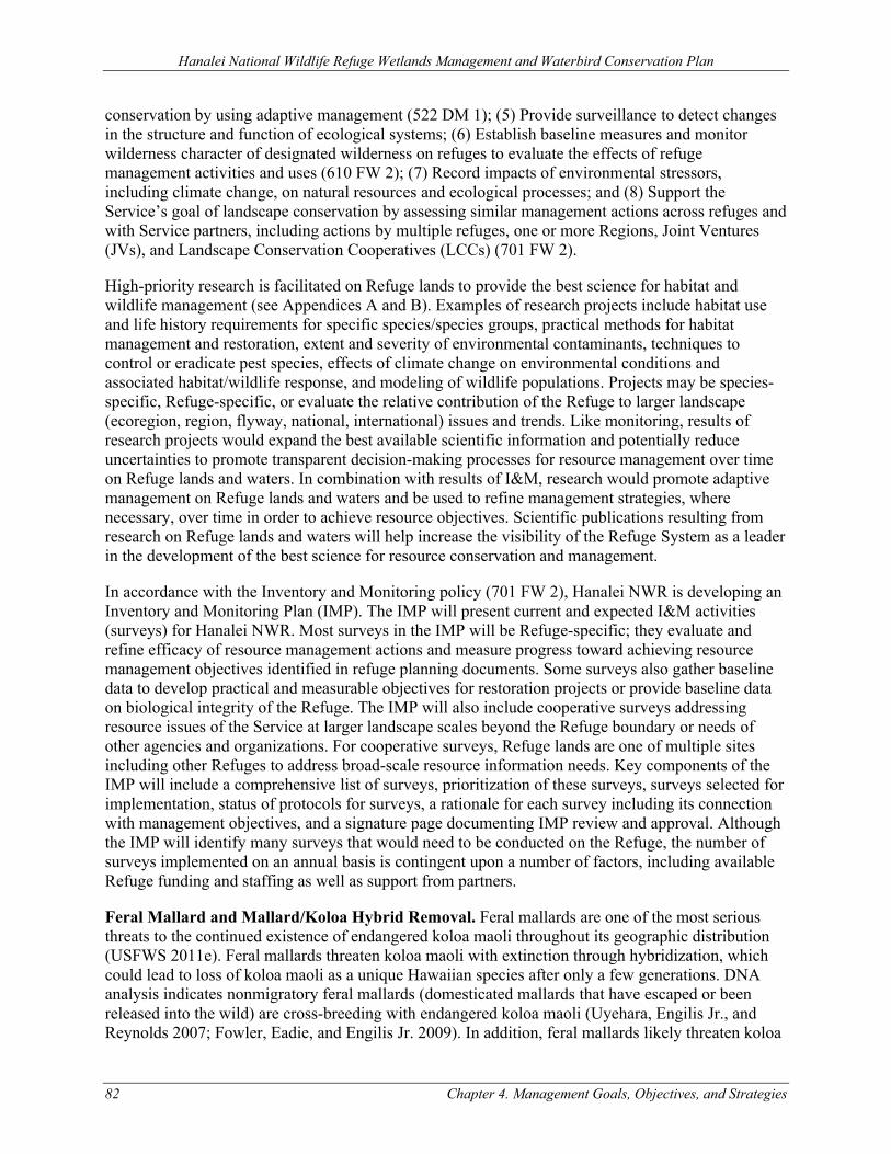
Hanalei National Wildlife Refuge Wetlands Management and Waterbird Conservation Plan
82 Chapter 4. Management Goals, Objectives, and Strategies
conservation by using adaptive management (522 DM 1); (5) Provide surveillance to detect changes in the structure and function of ecological systems; (6) Establish baseline measures and monitor wilderness character of designated wilderness on refuges to evaluate the effects of refuge management activities and uses (610 FW 2); (7) Record impacts of environmental stressors, including climate change, on natural resources and ecological processes; and (8) Support the Service’s goal of landscape conservation by assessing similar management actions across refuges and with Service partners, including actions by multiple refuges, one or more Regions, Joint Ventures (JVs), and Landscape Conservation Cooperatives (LCCs) (701 FW 2).
High-priority research is facilitated on Refuge lands to provide the best science for habitat and wildlife management (see Appendices A and B). Examples of research projects include habitat use and life history requirements for specific species/species groups, practical methods for habitat management and restoration, extent and severity of environmental contaminants, techniques to control or eradicate pest species, effects of climate change on environmental conditions and associated habitat/wildlife response, and modeling of wildlife populations. Projects may be species-specific, Refuge-specific, or evaluate the relative contribution of the Refuge to larger landscape (ecoregion, region, flyway, national, international) issues and trends. Like monitoring, results of research projects would expand the best available scientific information and potentially reduce uncertainties to promote transparent decision-making processes for resource management over time on Refuge lands and waters. In combination with results of I&M, research would promote adaptive management on Refuge lands and waters and be used to refine management strategies, where necessary, over time in order to achieve resource objectives. Scientific publications resulting from research on Refuge lands and waters will help increase the visibility of the Refuge System as a leader in the development of the best science for resource conservation and management.
In accordance with the Inventory and Monitoring policy (701 FW 2), Hanalei NWR is developing an Inventory and Monitoring Plan (IMP). The IMP will present current and expected I&M activities (surveys) for Hanalei NWR. Most surveys in the IMP will be Refuge-specific; they evaluate and refine efficacy of resource management actions and measure progress toward achieving resource management objectives identified in refuge planning documents. Some surveys also gather baseline data to develop practical and measurable objectives for restoration projects or provide baseline data on biological integrity of the Refuge. The IMP will also include cooperative surveys addressing resource issues of the Service at larger landscape scales beyond the Refuge boundary or needs of other agencies and organizations. For cooperative surveys, Refuge lands are one of multiple sites including other Refuges to address broad-scale resource information needs. Key components of the IMP will include a comprehensive list of surveys, prioritization of these surveys, surveys selected for implementation, status of protocols for surveys, a rationale for each survey including its connection with management objectives, and a signature page documenting IMP review and approval. Although the IMP will identify many surveys that would need to be conducted on the Refuge, the number of surveys implemented on an annual basis is contingent upon a number of factors, including available Refuge funding and staffing as well as support from partners.
Feral Mallard and Mallard/Koloa Hybrid Removal. Feral mallards are one of the most serious threats to the continued existence of endangered koloa maoli throughout its geographic distribution (USFWS 2011e). Feral mallards threaten koloa maoli with extinction through hybridization, which could lead to loss of koloa maoli as a unique Hawaiian species after only a few generations. DNA analysis indicates nonmigratory feral mallards (domesticated mallards that have escaped or been released into the wild) are cross-breeding with endangered koloa maoli (Uyehara, Engilis Jr., and Reynolds 2007; Fowler, Eadie, and Engilis Jr. 2009). In addition, feral mallards likely threaten koloa
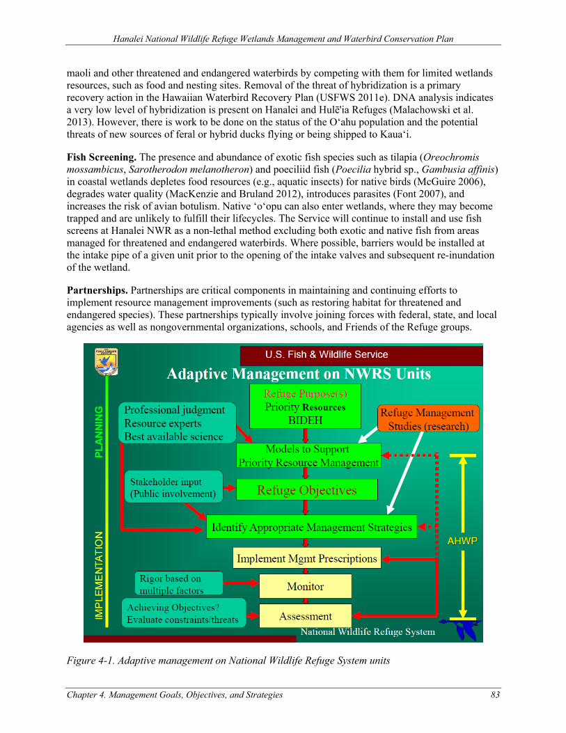
Hanalei National Wildlife Refuge Wetlands Management and Waterbird Conservation Plan
Chapter 4. Management Goals, Objectives, and Strategies 83
maoli and other threatened and endangered waterbirds by competing with them for limited wetlands resources, such as food and nesting sites. Removal of the threat of hybridization is a primary recovery action in the Hawaiian Waterbird Recovery Plan (USFWS 2011e). DNA analysis indicates a very low level of hybridization is present on Hanalei and Hulē'ia Refuges (Malachowski et al. 2013). However, there is work to be done on the status of the O‘ahu population and the potential threats of new sources of feral or hybrid ducks flying or being shipped to Kaua‘i.
Fish Screening. The presence and abundance of exotic fish species such as tilapia (Oreochromis mossambicus, Sarotherodon melanotheron) and poeciliid fish (Poecilia hybrid sp., Gambusia affinis) in coastal wetlands depletes food resources (e.g., aquatic insects) for native birds (McGuire 2006), degrades water quality (MacKenzie and Bruland 2012), introduces parasites (Font 2007), and increases the risk of avian botulism. Native ‘o‘opu can also enter wetlands, where they may become trapped and are unlikely to fulfill their lifecycles. The Service will continue to install and use fish screens at Hanalei NWR as a non-lethal method excluding both exotic and native fish from areas managed for threatened and endangered waterbirds. Where possible, barriers would be installed at the intake pipe of a given unit prior to the opening of the intake valves and subsequent re-inundation of the wetland.
Partnerships. Partnerships are critical components in maintaining and continuing efforts to implement resource management improvements (such as restoring habitat for threatened and endangered species). These partnerships typically involve joining forces with federal, state, and local agencies as well as nongovernmental organizations, schools, and Friends of the Refuge groups.
Figure 4-1. Adaptive management on National Wildlife Refuge System units

Figure 4-2. Low
land/wetland m
anagement flow
chart, Hanalei N
WR
84 Chapter 4. Management Goals, Objectives, and Strategies
Hanalei National Wildlife Refuge Wetlands Management and Waterbird Conservation Plan
At minim
um*, through the
annual habitat work
planning process, determ
ine how to m
anage low
land acreage as either:(1) ac�vely m
anaged by the Refuge;(2) land rested for farm
ing, conserva�on, and/or w
atershed benefits; or(3) kalo farm
ing or grazing through Coopera�ve Agriculture Agreem
ent.
Decision:
U�lize acreage as rota�onal
managed w
etland unit(s) or upland habitat
Spa�ally reconfigure m
anagement strategies by
revising areas under exis�ng Coopera�ve Agriculture
Agreement
Or
Rest land for farming,
conserva�on, and/or w
atershed benefits
Per 620 FW 2:
(1) No�ce of coopera�ve kalo farm
ing or grazing opportunity adver�sed, including descrip�on and details of the objec�ve criteria on w
hich applica�ons w
ould be ranked and scored(2) Applicants w
ill apply directly to the Refuge using the Com
mercial Special U
se Permit (SUP)
form 3-1388-C
(3) The Kaua‘i NW
RC Project Leader and selec�on panel w
ill score and rank all applicants and no�fy applicants of w
hether or not they were aw
arded the Coopera�ve Agriculture Agreem
ent (CAA) and the reasoning(4) O
nce the CAA has been awarded, the
cooperator and the Service will w
ork together to finalize the term
s and condi�ons of the CAA
Coopera�ve agriculture
Environmental factors and loca�on on the
Refuge:• Clim
ate-related factors• Soil types, drainage, and health• W
ater quan�ty and quality• Priority species life-history requirem
ents• Erosion and sedim
enta�on• Flood risk• Threats (e.g., avian botulism
, disturbance, invasive species) and ability to m
anage for threats• Spa�al configura�on of uses (e.g.,
mosaic, disease and pest m
anagement,
proximity of habitat r equirem
ents)
Logis�cs:• Availability of Refuge staff and resources• Accessibility and ease of m
anagement
(e.g., ability to manage w
ith heavy equipm
ent)• Exis�ng infrastructure or feasibility of
installing new infrastructure
• Partnerships and outside funding opportuni�es
Social and cultural:• Stakeholder coordina�on and input• Historic and cultural considera�ons
Legal:• Perm
i�ng and com
pliance (e.g., AUF, CD,
NH
PA Sec�on 106, ESA Sec�on 7)
• Permi�
ee compliance w
ith Refuge regula�ons
• Ow
nership of exis�ng infrastructure or other partnership feasibility considera�ons (e.g., ac�ve perm
its, rights-of-w
ay)
Considera�ons:
Reevaluate
Or
Current permi�ee/
cooperator allowed to farm
kalo or graze in the area
New
permi�
ee/cooperator allow
ed to farm kalo or
graze in the area but not allow
ed to have residence on Refuge
Reevaluate annually and at end of CAA and permit period
* This flowchart w
ould inform m
anagement
decisions at an annual basis related to annual habitat w
ork planning, however,
decision points could be triggered at any �m
e as condi�ons necessitate (e.g., addi�onal funding is acquired, catastrophic flooding, new
partnership opportuni�es).
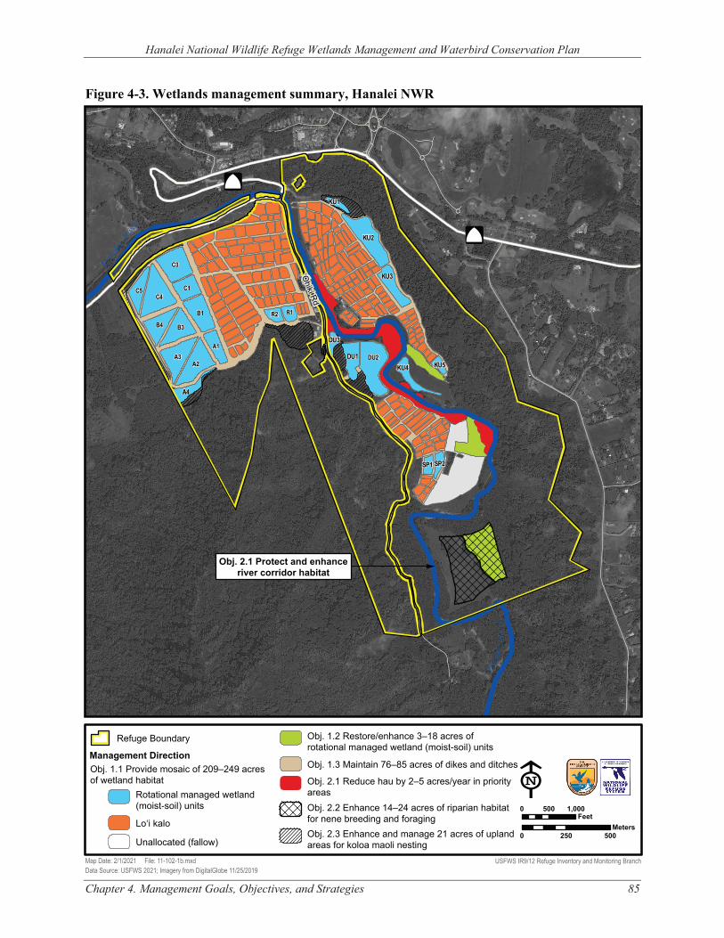
r evii R
elanaH
‘Ohiki Rd
Hana
lei R
iver
Hanalei National Wildlife Refuge Wetlands Management and Waterbird Conservation Plan
Figure 4-3. Wetlands management summary, Hanalei NWR
560Â
KU2
C3
$
KU1
56Â
DU3 A1
A3 DU1 DU2 A2 KU5 KU4
A4
SP1 SP2
Obj. 2.1 Protect and enhance river corridor habitat
$
Refuge Boundary Obj. 1.2 Restore/enhance 3–18 acres of
KU3
C1 C5 C4
B1 R1 R2
B4 B3
rotational managed wetland (moist-soil) unitsManagement Direction Obj. 1.1 Provide mosaic of 209–249 acres of wetland habitat
Rotational managed wetland
Obj. 1.3 Maintain 76–85 acres of dikes and ditches
Obj. 2.1 Reduce hau by 2–5 acres/year in priority areas E
(moist-soil) units Obj. 2.2 Enhance 14–24 acres of riparian habitat 0 500 1,000 Feetfor nene breeding and foragingLo‘i kalo Meters
Obj. 2.3 Enhance and manage 21 acres of upland 0 250 500Unallocated (fallow) areas for koloa maoli nesting
Map Date: 2/1/2021 File: 11-102-1b.mxd USFWS IR9/12 Refuge Inventory and Monitoring Branch Data Source: USFWS 2021; Imagery from DigitalGlobe 11/25/2019
Chapter 4. Management Goals, Objectives, and Strategies 85
Hanalei National Wildlife Refuge Wetlands Management and Waterbird Conservation Plan
86 Chapter 4. Management Goals, Objectives, and Strategies
4.2 GOAL 1: PROTECT, RESTORE, ENHANCE, AND MANAGE WETLAND HABITATS TO MEET THE LIFE HISTORY NEEDS OF THREATENED AND ENDANGERED HAWAIIAN WATERBIRDS TO PROMOTE THEIR RECOVERY.
OBJECTIVE 1.1 PROVIDE WETLAND HABITAT FOR FORAGING, LOAFING, AND BREEDING THREATENED AND ENDANGERED WATERBIRDS.
Provide a mosaic of approximately 209–249 acres of wetland habitat (rotational managed wetlands and lo‘i kalo) for foraging, loafing, and breeding threatened and endangered waterbirds throughout the year, with the following attributes:
• Abundant macroinvertebrates (e.g., damselflies, midges, small mollusks and crustaceans) for foraging;
• <5% cover of pest plants (e.g., California grass, Paspalum, Guinea grass, cattail); • Minimal human disturbance year-round; • No feral mallards or their hybrids; • Early-successional managed wetlands for koloa maoli, ae‘o, and ‘alae ke‘oke‘o foraging and
loafing: o Recently-flooded mosaic of shallow (<8 inches, mostly 3–4 inches), open water and
50–75% cover of short (<12 inches tall), non-persistent emergents (e.g., Fimbristylis, Cyperus, Eleocharis);
• Mid-successional managed wetlands for koloa maoli breeding and ‘alae ‘ula foraging and loafing:
o Mosaic of shallow (<8 inches, mostly 3–4 inches), open water with a 50–75% canopy cover of tall (12–60 inches) emergents (e.g., kāmole, millet, ‘ahu‘awa) and 25% understory cover of short (<6 inches tall) non-persistent emergents (e.g., Fimbristylis, Cyperus, Eleocharis);
o Presence of submerged aquatic vegetation (e.g., pondweeds) enhanced by fish exclusion devices;
• Late-successional managed wetlands for ‘alae ‘ula and ‘alae ke‘oke‘o breeding and koloa maoli molting:
o Mosaic of open water (3–12 inches) with initially a 50–75% cover of tall (>24 inches) robust emergents (e.g., kāmole, nānaku, Manchurian wild rice) declining to 25–50% cover as marsh matures;
o Interspersion with sufficient vegetative edge to provide visual barriers to maximize territories available for breeding;
o Presence of submerged aquatic vegetation (e.g., pondweeds); • Early-successional managed wetlands for ae‘o breeding:
o Recently flooded mosaic of shallow (<3 inches), open water and exposed mudflat (saturated and unsaturated) with sparse (<25% cover) of low-growing (<6 inches tall) emergent plants (e.g., Fimbristylis, Bacopa);
o Undulating, irregular topography creating unsaturated mudflats with gradual slopes (~15:1) during drawdown to provide nesting adjacent to foraging habitat;
o Reproductive success of ≥2 hatchlings and ≥1 fledgling per nest; • Managed wetlands for ‘alae ke‘oke‘o breeding:
Hanalei National Wildlife Refuge Wetlands Management and Waterbird Conservation Plan
Chapter 4. Management Goals, Objectives, and Strategies 87
o Mosaic of open water (10–14 inches) with initially a 50–75% cover of tall (>24 inches) robust emergents (e.g., kāmole, nānaku, Manchurian wild rice) declining to 25–50% cover as marsh matures;
o Interspersion with sufficient vegetative edge to provide visual barriers to maximize territories available for breeding;
o Presence of submerged aquatic vegetation (e.g., pondweeds); • Predation rates within rotational managed wetlands:
o Predation levels by introduced predators (e.g., cats, barn owls, dogs, cats, rats) ≤6 individual threatened or endangered waterbirds per year.
• Lo‘i kalo: o During all flooded stages for foraging and breeding threatened and endangered
waterbirds: 10–25% of total lo‘i acreage in beneficial non-kalo emergent plants (≥3
species of low-growing annuals, <6–12 inches tall; e.g., Fimbristylis littoralis, Cyperus spp., Eleocharis spp., Ludwigia spp., Schoenoplectus juncoides)
75% cover of herbaceous plants on the total length lo‘i banks (≥3 species; e.g., Fimbristylis dichotoma, Bacopa monnieri, Cyperus polystachyos, Echinochloa crus-galli); and
Water depth 3–6 inches. o During harvest, to protect nesting and brood-rearing habitat for threatened and
endangered waterbirds: Minimum 6-foot radius unharvested vegetation buffer around threatened or
endangered waterbird nests. o During fallow, to enhance foraging resources for threatened and endangered
waterbirds: Minimum 30-day wet fallow period; Presence of moist-soil plants; Water depth 6–8 inches; and Optional dry fallow period ≤180 days total.
o <1 avian botulism outbreak annually and negligible impacts on threatened and endangered waterbird populations
• Predation rates within lo‘i kalo: o Predation levels by introduced predators (e.g., cats, barn owls, dogs, cats, rats) ≤20
individual threatened or endangered waterbirds per year.
Strategies Applied to Achieve Objective
1.1.1. Assignment of available wetland/lowland areas for rotational managed wetland (moist-soil) units; lo‘i kalo (via CAA); land rested for farming, conservation, and/or watershed benefits (i.e., fallow or non-actively managed lands); or riparian and upland habitat (e.g., nēnē breeding or foraging habitat, Objective 2.2; koloa nesting habitat, Objective 2.3) based on decision flowchart (Figure 4-2) and re-evaluated periodically using adaptive management
Rotational managed wetlands 1.1.2. Mowing, disking, rototilling, and water level management, as needed, to set back wetland
plant succession and provide suitable habitat structure and function. See Appendix C for additional information
Hanalei National Wildlife Refuge Wetlands Management and Waterbird Conservation Plan
88 Chapter 4. Management Goals, Objectives, and Strategies
1.1.3. From Quarterly Management Unit Assessments (QMUA), manage water accordingly (e.g., spigots, riser boards) to stimulate plant and invertebrate production
1.1.4. Transplant native bulrush for nesting material and visual barriers 1.1.5. Maintain minimal water level fluctuations during threatened and endangered waterbird
laying and incubation periods 1.1.6. Limited and responsible public use authorized in advance via guided tours, environmental
education, and SUPs within closed areas of the Refuge. Refuge staff presence consistent with a level necessary to conduct biological monitoring, predator control, water management, refuge operations, and maintenance, under normal circumstances, 1–5 visits per week
1.1.7. Prior to implementing maintenance schedule, perform a waterbird nest/brood search in accordance with established protocol
1.1.8. As possible, schedule maintenance outside of peak rail (‘alae ke‘oke‘o and ‘alae ‘ula) breeding and koloa maoli molting season or conduct nest/brood searches commensurate with breeding activity
1.1.9. Use IPM strategies including mechanical/physical (e.g., mowing, brush-cutting, excavation, prescribed fire), cultural (e.g., water levels), chemical (herbicides), biological, and other suitable techniques to control California grass, Paspalum, Guinea grass, cattail, and other pest/undesirable plants
1.1.10. Live-trapping and humanely dispatching feral mallards and their hybrids 1.1.11. Live-trapping, humanely dispatching, and bait stations to remove vertebrate pests that
prey on threatened and endangered waterbirds 1.1.12. Maintain existing three miles of fence to protect wetland management units from feral
pigs and dogs
Lo‘i kalo: permitting 1.1.13. Kalo farming on the Refuge, and necessary activities related to kalo farming, including
permits for existing residences and sheds, would be authorized through a CAA and documented on a Commercial Activities SUP for each permittee/cooperator. The CAAs and SUPs would authorize kalo farming and necessary related activities for 1–5 years each. The CAA and SUP would describe allowed and prohibited activities both on the Refuge and within permit areas, and responsibilities of the Service and the permittee/cooperator. See Appendix B, Cooperative Kalo Farming; Residences and Farm Storage Areas CD
Lo‘i kalo: vegetation structure for foraging and breeding threatened and endangered waterbirds 1.1.14. Enhance vegetation structure of lo‘i habitat (all stages) for foraging and breeding
threatened and endangered waterbirds by maintaining either: • ≥10% cover of beneficial non-kalo emergent plants (≥3 species of low-growing
annuals, <6–12 inches tall; e.g., Fimbristylis littoralis, Cyperus spp., Eleocharis spp., Ludwigia spp., Schoenoplectus juncoides) in understory within each lo‘i;
• ≥20% cover of beneficial non-kalo emergent plants in understory on ≥50% of lo‘i; or
• ≥10% of total lo‘i acreage in vegetated wet fallow (approximately nine month period: germinate, grow emergent vegetation >4”, flood six months) to promote growth of non-kalo emergent plants (See Appendix B, Cooperative Kalo Farming; Residences and Farm Storage Areas CD, Stipulations to Ensure Compatibility)
Hanalei National Wildlife Refuge Wetlands Management and Waterbird Conservation Plan
Chapter 4. Management Goals, Objectives, and Strategies 89
Lo‘i kalo: nesting and brood-rearing habitat 1.1.15. Require kalo farming permittees/cooperators to report and inform all farm workers and
the Refuge manager or biologist about the nests (or broods) of threatened and endangered Hawaiian waterbirds found within their permit area as soon as possible and no later than within 24 hours of discovery and mark nests on adjacent dike. See Appendix B, Cooperative Kalo Farming; Residences and Farm Storage Areas CD, Stipulations to Ensure Compatibility
1.1.16. In lo‘i where threatened or endangered waterbird nests (or broods) are found, kalo farming permittees/cooperators would be required to keep the lo‘i flooded to a depth of 3–6 inches. Kalo farming permittee/cooperators must coordinate with and receive approval from the Refuge manager or biologist prior to water level fluctuations (e.g., drawdowns) in lo‘i where nests occur (to prevent flooding or collapse of waterbird nests and brood platforms).
1.1.17. If a threatened or endangered waterbird nest (or brood) is found in a field being harvested, a minimum 6-foot radius area of unharvested kalo plants must be maintained around each active waterbird nest (or brood) until the young birds fledge or leave the lo‘i on their own accord. Kalo farming permittee/cooperators must coordinate with Refuge staff to minimize impacts or take of birds by implementing additional protective measures as needed, such as delaying harvest in areas where nests are known to occur until the young birds fledge or leave the lo‘i of their own accord. Permittees/cooperators would plant and maintain lo‘i in a way that would distribute kalo at different stages of maturity among different lo‘i, so that harvesting of all lo‘i at one time would not occur. This would allow kalo farmers the continued ability to harvest in lo‘i that do not have a nest present. See Appendix B, Cooperative Kalo Farming; Residences and Farm Storage Areas CD, Stipulations to Ensure Compatibility
1.1.18. Initiate a study of the relative effectiveness of different size nest buffers on nest and fledging success of threatened and endangered Hawaiian waterbirds within three years; modify buffer requirements and compatibility stipulations if necessary
1.1.19. During kalo harvest, leave kalo and non-kalo plants until threatened or endangered Hawaiian waterbird nestling fledges
1.1.20. Trample aquatic plants into soil to facilitate vegetative breakdown for invertebrate production
1.1.21. If a threatened or endangered waterbird nest is found on a dike or in dry fallow lo‘i, the nest would be staked by Refuge staff approximately nine feet (three meters) from the nest in order to prevent nest destruction. Kalo farming permittee/cooperators would be required to avoid the area until the nest hatches and birds leave the area of their own accord.
Lo‘i kalo: foraging resources in fallow areas 1.1.22. Fallow lo‘i and flood to maximize foraging opportunities for threatened and endangered
waterbirds during this period of high invertebrate egg laying and larval growth; longer fallow periods enhance soil productivity. Minimum required 30-day wet fallow period followed by optional dry fallow period ≤180 days total. See Appendix B, Cooperative Kalo Farming; Residences and Farm Storage Areas CD, Stipulations to Ensure Compatibility
Lo‘i kalo: avian botulism prevention and response 1.1.23. Require kalo farming permittee/cooperators to participate in implementing relevant
aspects of the Avian Botulism Prevention and Response Protocol as part of their CAA
Hanalei National Wildlife Refuge Wetlands Management and Waterbird Conservation Plan
90 Chapter 4. Management Goals, Objectives, and Strategies
and SUP. If a given kalo patch is identified as an avian botulism hotspot, then work with Refuge staff to change environmental conditions. See Appendix B, Cooperative Kalo Farming; Residences and Farm Storage Areas CD, Stipulations to Ensure Compatibility
1.1.24. Require kalo farming permittees/cooperators to report sick or dead birds to the Refuge manager or biologist within 24 hours. See Appendix B, Cooperative Kalo Farming; Residences and Farm Storage Areas CD, Stipulations to Ensure Compatibility
1.1.25. Thoroughly drain and aerate every kalo patch after the 30-day wet fallow period prior to replanting. See Appendix B, Cooperative Kalo Farming; Residences and Farm Storage Areas CD, Stipulations to Ensure Compatibility
1.1.26. In avian botulism-prone areas, implement Avian Botulism Prevention and Response Protocol BMPs, which include the following measures (see Appendix B, Cooperative Kalo Farming; Residences and Farm Storage Areas CD, Stipulations to Ensure Compatibility):
• Reconfigure pipelines to remove all flow-through (i.e., lo‘i-to-lo‘i) drains • Drain, harvest, and dry fallowing lo‘i for ≥30 days, pending Refuge request
1.1.27. Work with kalo farming permittees/cooperators and other partners (e.g., National Resources Conservation Service) to continue to develop, implement, and monitor effectiveness of BMPs for Hanalei NWR to improve water quality and flow and reduce the number and severity of avian botulism outbreaks that can cause sickness and mortality. These BMPs include, but are not limited to:
• Using fresh and cool supply water in a well-circulated manner in each lo‘i kalo • Adequately draining and aerating the soils of lo‘i kalo, which also requires proper
maintenance of assigned drainage ditches (see Objective 1.3) • Maintaining free-flowing internal water supply lines (i.e., regularly monitor and
keep supply ditches, supply pipes, and screens free of clogs) • Maintaining conditions where irrigation “cross-flow” occurs across each path.
Cross-flow can be improved by draining from the opposite corner of the patch from the supply pipe, preferably downwind
• Minimizing periods of stagnant water and percolation periods by keeping supply and drain pipes open regularly
• Reducing sediment runoff into the river 1.1.28. Meet quarterly, or as necessary, with Refuge kalo farming permittees/cooperators to
coordinate avian botulism response
Lo‘i kalo: overall reduction in farming intensity and improvement in water quality 1.1.29. Work with kalo farming permittees/cooperators and other experts to find or refine
strategies that benefit threatened and endangered waterbirds and kalo and support the Refuge purpose; for example:
• Reduction in farming intensity and labor expenses • Ecologically friendly alternatives to traditional chemical fertilizers (e.g., slow-
release fertilizer, use of nitrogen-fixing vegetation) • Organic kalo farming • “Wildlife-friendly” BMPs or certifications
1.1.30. Require kalo farming permittees/cooperators to participate in a comprehensive Refuge water budget analysis and implement recommended changes to ensure adequate water supply throughout the Refuge. See Appendix B, Cooperative Kalo Farming; Residences and Farm Storage Areas CD, Stipulations to Ensure Compatibility.
1.1.31. Minimize the runoff of excess fertilizer from kalo farms by:
Hanalei National Wildlife Refuge Wetlands Management and Waterbird Conservation Plan
Chapter 4. Management Goals, Objectives, and Strategies 91
• Developing and implementing a fertilizer management (use) plan for all Refuge kalo farms within two years, with the objective of minimizing losses of nutrients through leaching to groundwater and surface runoff (while improving conditions to prevent avian botulism outbreaks). See Appendix B, Cooperative Kalo Farming; Residences and Farm Storage Areas CD, Stipulations to Ensure Compatibility.
• Periodic soil testing for all farms to determine existing nutrient amount, estimate losses from leaching and surface water runoff, determine crop needs, fertilizer application efficiency, and associated water levels fluctuations for fertilization
1.1.32. Within two years, develop and implement an herbicide management plan for all Refuge kalo farms and rotational managed wetland units (see also Objective 2.1 and Appendix B, Cooperative Kalo Farming; Residences and Farm Storage Areas CD, Stipulations to Ensure Compatibility)
1.1.33. Work with kalo farming permittees/cooperators to ensure accurate and specific fertilizer and herbicide reporting annually, in accordance with federal laws and requirements
Lo‘i kalo: invasive species management 1.1.34. Use IPM strategies including mechanical/physical, cultural, chemical, biological, and
other suitable techniques to control pest plants (see Appendix D) 1.1.35. Cooperatively implement fencing, live-trapping, and bait stations (non-flood areas only)
on kalo production acres to exclude and remove vertebrate pests that prey on threatened and endangered waterbirds
1.1.36. Require kalo farming permittees/cooperators to report stray dogs or cats found on the Refuge to the Refuge manager or biologist within eight hours of discovery. See Appendix B, Cooperative Kalo Farming; Residences and Farm Storage Areas CD, Stipulations to Ensure Compatibility.
Lo‘i kalo: collaboration 1.1.37. Coordinate annually with individual Refuge permittees/cooperators on SUP or, starting
during implementation of this plan, CAA. See Appendix B, Cooperative Kalo Farming; Residences and Farm Storage Areas CD, Stipulations to Ensure Compatibility
1.1.38. Conduct bi-annual Refuge-permittee/cooperators meetings/workshops (e.g., avian botulism, water use and systems, monitoring, plant identification).
1.1.39. Work with kalo farming permittees/cooperators on priority research and monitoring needs, as described in the IMP
1.1.40. Cooperatively maintain fences, gates, roads, water control structures, drainage ditches, signs, and other infrastructure in partnership with the kalo farming permittees/cooperators. See Appendix B, Cooperative Kalo Farming; Residences and Farm Storage Areas CD, Stipulations to Ensure Compatibility
1.1.41. Within three years of WMWCP completion, develop incentive mechanisms for the use of more sustainable and wildlife-friendly farming practices (e.g., maintaining larger nest buffers and use of ≥60-day vegetated wet-fallow period followed by a 2–6-month dry fallow period after tilling organic matter into soil)
1.1.42. Continue to work cooperatively with kalo farmers to describe and quantify the costs of the goods and services the Service provides to the farmers, the benefits the Service receives as a result of allowing kalo farming on the Refuge, and the fair market value for kalo farming (including evaluation of land rents for comparable agriculture-related residential and farm-storage uses) to develop a fair and rational cost-sharing program related to kalo farming
Hanalei National Wildlife Refuge Wetlands Management and Waterbird Conservation Plan
92 Chapter 4. Management Goals, Objectives, and Strategies
1.1.43. Develop a compliance monitoring system that is reviewed and updated annually
Rationale
Wetland habitats at Hanalei NWR are currently managed as rotational managed wetland units (89 acres) or lo‘i kalo farmed through SUPs (approximately 124 acres, excluding dikes and ditches). Lowland acreage that is currently unallocated to kalo farmers and composed of fallow lo‘i kalo and their associated dikes and ditches totals 17 acres. An additional 3–18 acres of lowlands that are not currently in rotational managed wetland units, lo‘i kalo, or fallow would be restored to functional managed wetland units (Objective 1.2). Under this WMWCP, available lowland/wetland acreage on the Refuge would be allocated towards rotational managed wetlands, lo‘i kalo (via CAAs, see Section 1.3.2), land rested for farming, conservation, and/or watershed benefits (e.g., fallow), or riparian and upland habitat (e.g., nēnē breeding or foraging habitat, Objective 2.2; koloa nesting habitat, Objective 2.4) based on a decision flowchart (Figure 4-2) and re-evaluated periodically using an adaptive management framework. Use of this framework would ensure that the purpose of the Refuge is fulfilled by providing habitats that meet life history requirements for threatened and endangered waterbirds, while allowing for management flexibility to adjust to changing conditions (e.g., additional information from inventory and monitoring, disease outbreaks, availability of funding and resources, compliance with conditions of CAAs). This framework would also enable the spatial reconfiguration of management strategies; for example, retired or unallocated acreage could be exchanged for existing lo‘i kalo acreage depending upon soil, hydrological, and other environmental conditions.
Moist-soil management techniques would be used within rotational managed wetland units to manipulate native and naturalized beneficial nonnative vegetation to provide important structure for threatened and endangered waterbird nesting, foraging, brooding, loafing, and thermal/escape cover. The use of seasonal water drawdowns with periodic soil disturbance (e.g., disking, rototilling) within these wetland units attempts to mimic the natural dynamics of seasonally flooded natural wetlands (e.g., flood events and precipitation/drying cycles). Moist-soil management oxidizes wetland bottoms and incorporates plant material into the soil increasing its fertility and producing an abundance and diversity of aquatic invertebrates as well as creates a seed bed for germination of native/naturalized wetland plants. Annual plants resulting from moist-soil management produce an abundance of seeds that are readily available and consumed by waterbirds. The energy available from these seeds is often as high as or higher than agricultural crops. As moist-soil annuals decompose, they provide substrate and forage for aquatic invertebrates which are also an important food resource for waterbirds, particularly young waterbirds and pre-laying hens. In addition, some of the challenges associated with agricultural crops (e.g., disturbance, loss of crops to foraging wildlife) do not occur or cause less adverse impacts when moist-soil management strategies are implemented. With consistent management, rotational managed wetlands provide for all of the life history needs of the threatened and endangered waterbirds year-round. Attributes for rotational managed wetland units vary depending upon successional stage and focal species. See Appendix C for more information and rationale.
For centuries, kalo, as well as other aquaculture crops, have provided habitat for Hawaiian waterbirds. Although agricultural or cultivated wetlands do not replace all of the functions and values of natural wetlands, many of these lands, if left unmanaged, may revert to solid stands of monotypic, invasive vegetation which is of little value to waterbirds. Because kalo farming is conducted on a year-round basis, the crops are staggered to continually produce a harvestable crop. This results in all stages of kalo growth, including open- and closed-canopy stages along with open water and mudflats,
Hanalei National Wildlife Refuge Wetlands Management and Waterbird Conservation Plan
Chapter 4. Management Goals, Objectives, and Strategies 93
available at any given time. All of these conditions provide some benefits for the waterbirds. However, lo‘i kalo provides unstable (e.g., fluctuating water levels, artificial additives) and thus lower quality habitat for threatened and endangered waterbirds when compared to wetlands managed for a varied moist-soil plant community. Like many agricultural lands, limitations come with the benefits to native wildlife (Heard et al. 2000). Water levels and species composition have often historically been managed primarily to meet kalo production goals; whereas, water levels and species composition in rotational managed wetland units are managed by Refuge staff to meet the life history requirements of threatened and endangered waterbirds. Despite limitations (e.g., disturbance during breeding events, agro-chemicals), kalo farms offer shallow-water habitat that can satisfy some of the life history requirements of threatened and endangered waterbirds (Gee 2007; Gutscher-Chutz 2011) and provide a means to manage supplemental waterbird habitat on Hanalei NWR, when managed consistent with the Refuge purpose to recover threatened and endangered species.
Kalo farming existed prior to and at the time of the establishment of the Hanalei NWR and continues to be an important part of the area’s agricultural history. The nine kalo farmers on Hanalei Refuge collectively are the largest producers of kalo in the State of Hawai‘i, estimated at 40–60 percent (Gutscher-Chutz 2011; NASS 2012; Cho, Yamakawa, and Hollyer 2007). Kalo is a staple food for the people of Hawai‘i and is important in Hawaiian culture. The Service values the cultural and historical significance of kalo in Hanalei Valley. When the Refuge was established in 1972 for the purpose of endangered waterbird recovery, kalo farming, implemented in a way that was determined as being compatible with that Refuge purpose, was continued via a permit system and integrated as one of the strategies for wetlands management (USDOI 1974).
The Service appreciates the role of individual farmers in maintaining the kalo farming tradition and associated wetland habitat functions and values. The Service’s intent is to work with local farmers in order to preserve and perpetuate kalo farming on the Refuge, using BMPs, in a manner compatible with the conservation and recovery of threatened and endangered waterbirds.
To ensure consistency with the Service mission, Refuge purpose, and Refuge System policies (e.g., policy on BIDEH of the Refuge System) and remain compliant with laws (e.g., ESA), the Service is required to re-evaluate the compatibility of kalo farming every 10 years. The intent of the Service is to ensure kalo farming remains compatible with the Refuge’s purpose to recover federally listed species. However, issues with kalo farming on a Refuge include ongoing violations of basic SUP terms by some permittees (e.g., pet cats, dogs on dikes, storage of refuse and abandoned vehicles on site, no or limited 30-day wet fallow, incomplete reporting of fertilizer, pesticide use, or discovered threatened or endangered bird nests), sedimentation and nutrient enrichment of receiving waters, and intensive removal of non-kalo emergent plants used as food, cover, and nesting material by threatened or endangered waterbirds. Strategies related to kalo farming at Hanalei NWR under this objective are intended to cooperatively provide and enhance habitat within kalo farms to meet the life history needs of threatened and endangered waterbirds and promote their recovery; and improve compliance with SUP terms and cooperative wildlife-friendly farming. In the short- to medium-term, emphasis during implementation would be on strategies related to reducing the frequency and severity of avian botulism outbreaks. The rationales for specific groups of strategies follow.
Providing and enhancing vegetation structure of lo‘i kalo as habitat (all stages) for foraging and breeding threatened and endangered waterbirds (Strategy 1.1.14)
The growth stages of kalo include young (root establishment and leaf growth stages, 0–5 months), mature (corm growth stage, 5–9 months) when water is maintained at 1–6 inch depth (University of
Hanalei National Wildlife Refuge Wetlands Management and Waterbird Conservation Plan
94 Chapter 4. Management Goals, Objectives, and Strategies
Hawai‘i College of Tropical Agriculture and Human Resources 2008), and pre-harvest (late corm growth stage, 10–12 months) when water is drawn down 1–2 weeks before harvest. Kalo canopy cover ranges from 10–90% depending on the stage. Kalo provides thermal and escape cover (e.g., from introduced predators) for ‘alae ‘ula, ‘alae ke‘oke‘o (Gee 2007), and koloa maoli year-round. Mature kalo habitat contains medium to dense growth (>50% kalo cover) and provides nesting habitat for ‘alae ‘ula and ‘alae ke‘oke‘o (Gee 2007). During pre-harvest, reduction in canopy cover and declining water levels stimulates aquatic plant and invertebrate production and enhances foraging resources for endangered waterbirds.
Waterbirds are more sensitive to sudden changes in habitat conditions during critical periods such as breeding. For example, removal of non-kalo vegetation and water level fluctuations during breeding could result in nest desertion or access by predators. On the other hand, when birds are not breeding, removal of invasive weed species from the lo‘i is a beneficial farm practice because plants are maintained at a mid-successional stage. Without weed control that is done periodically, lo‘i can become overgrown within 4–6 months, which leads to reduced values to wildlife and may reduce kalo production.
Waterbirds are generally opportunistic and use plants that are available for foraging and breeding. Many kalo farmers intensively remove non-kalo emergent vegetation during the first 4–6 months of growth to prevent these plants from out-competing kalo, which can provide more of an open-water habitat for ae‘o. However, this practice also decreases vegetative structure available to invertebrates, nesting ‘alae ‘ula and ‘alae ke‘oke‘o, and foraging for ‘alae ‘ula, ‘alae ke‘oke‘o, and koloa maoli. Less intensive removal of selected emergent plants would provide additional seeds, leaves, and invertebrate food resources for all threatened and endangered waterbirds and enhance visual obscurity for breeding ‘alae ‘ula. Byrd and Zeillemaker (1981) found ‘alae ‘ula favored grasses, sedges, and ferns over kalo to build their nests when these plants were available nearby within their established territories, and Gee (2007) found 46% of 48 nests built in patches of annuals (S. juncoides, C. difformis, L. palustris) beneath the kalo canopy. Allowing non-kalo emergent plants beneficial to waterbirds would diversify invertebrates available for food (Gutscher-Chutz 2011) and increase the quantity and quality of plants available for forage, nesting material, and nest anchors for multiple waterbird species. In addition, non-kalo emergent plants would assist with filtration, assimilation, and retaining nutrients and sediments on land. Under this WMWCP, permittees would allow at least three species of selected plants beneficial to threatened and endangered waterbirds to grow from seedbank interspersed within the understory, on either ≥10% of each of their lo‘i permitted for farming or ≥20% of each lo‘i on at least half of their lo‘i permitted for farming; or maintain ≥10% of their total lo‘i acreage under permit in vegetated wet fallow. Collectively, implementation of these options would result in enhanced habitat, while also maintaining open-water habitat for shorebirds. Providing “non-kalo food sources” and nesting material in and around the existing lo‘i kalo would also reduce the potential for crop depredation.
Protect nesting and brood-rearing habitat in kalo (Strategies 1.1.15–1.1.21)
Kalo harvesting is done manually within a period of several days up to four weeks depending on the size of lo‘i, number of workers (Gee 2007), and other environmental conditions. During this period, the leaves die back (~25% kalo cover) and the lo‘i is reflooded (~2–6 inches). Of the kalo stages, the harvest stage along with wet fallows had the highest use by endangered waterbirds (Gee 2007; Gutscher-Chutz 2011). Broshears (1980) found a strong positive relationship between ae‘o and chironomid densities following harvest. Farmers could naturally restore soil structure by trampling or tilling aquatic plants into the soil, to enhance organic matter and promote beneficial microorganisms.
Hanalei National Wildlife Refuge Wetlands Management and Waterbird Conservation Plan
Chapter 4. Management Goals, Objectives, and Strategies 95
On kalo farms, Byrd and Zeillemaker (1981) found that 95% of the 80 ‘alae ‘ula nests in kalo were more than four months old, the age at which the kalo canopy starts to close. However, this could be an overestimate because nests were documented opportunistically, primarily during harvest. Currently, when a farmer discovers an ‘alae ‘ula or ‘alae ke‘oke‘o nest while harvesting, the farmer is required to leave an unharvested 3-foot radius buffer around the nest. This nest buffer is not based on empirical data and appears to be inadequate (Gee 2007) and in need of expansion and re-evaluation (Paveglio et al. 1999) to prevent detrimental effects on breeding adults and offspring.
‘Alae ‘ula nest and fledging success from a study conducted in 2004 was 64% and 3%, respectively (Gee 2007). Nest and brood failures are attributed to predation, abandonment, and flooding (Gee 2007), indicating the need to re-evaluate nest buffer and other factors during this period (Gutscher-Chutz 2011). Nest platforms are also used for brood-rearing. Although inadequate buffer size has been identified as a factor, it is uncertain if buffer size alone or combined with other factors causes brood failure.
Under this WMWCP, the Refuge recognizes the need for research to determine adequate buffer size (see Strategy 1.1.17) or alternate strategies (see Strategy 1.1.18). Assessment of nesting success would be undertaken to verify the effects of buffer size during post-harvest periods. In the interim, in lo‘i where threatened or endangered waterbird nests are found, the current 3-foot radius buffer would be changed to a minimum 6-foot radius buffer around nests. Kalo farmers would be required to keep the lo‘i flooded and coordinate with Refuge staff to minimize impacts or take of birds by implementing additional protective measures as needed, such as delaying harvest in areas where nests are known to occur until the young birds fledge or leave the lo‘i of their own accord.
Drawdowns in lo‘i with active nests during any stage may result in nest collapse and failure (Paveglio et al. 1999; Gee 2007) by exposing eggs, flightless young, and breeding adults to introduced mammalian predators. Gutscher-Chutz (2011) recommended slow drawdowns at half-inch increments to extend the time in which invertebrates are available to endangered waterbirds for foraging; however, this may not apply in avian botulism hotspots where the area needs to be drained or flushed quickly.
Provide and enhance foraging resources in fallow lo‘i kalo (Strategy 1.1.22)
A wet fallow is when the lo‘i is flooded during the post-harvest, pre-planting period for 30 or more days. Of all kalo stages, the wet fallows and harvest stages had the highest use by endangered waterbirds (Gee 2007; Gutscher-Chutz 2011). Additionally, vegetated wet fallows (≥25% cover emergent vegetation) were preferred by ‘alae ke‘oke‘o, koloa maoli, and ‘alae ‘ula, and unvegetated wet fallows (<25% cover emergent vegetation) were preferred by ae‘o and ‘alae ke‘oke‘o over other kalo stages (Gee 2007). Soil disturbance from harvest stimulates invertebrate production (dipteran larvae and other benthic invertebrates), maximizing foraging opportunities for endangered waterbirds (Broshears 1980). In lo‘i kalo, it is the period of highest invertebrate egg laying and larval growth. Two weeks post-harvest had the highest densities of endangered waterbirds in lo‘i kalo.
There are two types of dry fallows, vegetated (≥ 25% cover vegetation) and unvegetated (<25% cover vegetation). Flooding of dry fallow lo‘i during rainfall events mimics irrigation of moist-soil vegetation and attracts high densities of endangered waterbirds (Gee 2007). Dry fallows for 1–3 months are recommended for proper vegetative breakdown and disease suppression. Six-month dry fallows can lead to increased yield, corm quality, and reduction or elimination of some diseases and pests (Uchida et al. 2008). Vegetated dry fallow lo‘i (>1 acre) provides foraging and roosting habitat
Hanalei National Wildlife Refuge Wetlands Management and Waterbird Conservation Plan
96 Chapter 4. Management Goals, Objectives, and Strategies
for threatened nēnē and endangered waterbirds, including koloa maoli nesting habitat, while unvegetated dry fallow lo‘i or mudflats provide roosting sites for migratory shorebirds such as kōlea.
Avian botulism prevention and response (Strategies 1.1.23–1.1.28)
The Refuge would continue to cooperate with kalo farming permittees/cooperators to implement a multi-pronged approach towards minimizing the number and severity of avian botulism outbreaks. Preventative measures include BMPs for improving drainage and circulation within lo‘i kalo. The quantity of cool, clean, well-oxygenated and well-circulated water through lo‘i kalo is important for lowering the likelihood of an avian botulism outbreak. If a given lo‘i kalo is avian botulism prone, then reconfiguring pipelines to remove flow-through (i.e., lo‘i-to-lo‘i) drains is mandatory because these lines can contribute to environmental conditions more conducive to botulism outbreaks, spread the botulism toxin between patches, and prolong avian botulism outbreaks.
In addition to using plenty of water, one of the most important actions that Refuge kalo farmers can do to help prevent avian botulism is to thoroughly drain, dry, and fully aerate their soils. After the wet fallow period, Refuge kalo farmers will be required to drain and disk and/or till the soils of each patch. Soil (and water) aeration reduces the anaerobic environmental conditions required for the bacteria (Clostridium botulinum) to germinate and improves soil health through oxygenation. Lo‘i kalo identified as “continuous problem” patches in hotspot areas, including those areas that are slow or unable to completely drain (and disk and/or till), will be required to have their wet fallow period replaced with an extended dry fallow period followed by extensive soil aeration.
A key strategy for avian botulism response is to require kalo farmers report sick or dead birds to the Refuge manager or biologist within 24 hours of detection. The botulism toxin is a fast-acting neurotoxin that can kill koloa (which are approximately 65% of the birds afflicted) within as short as eight hours if not given an antidote, which the Refuge biologist has available on-Refuge. Avian botulism affected birds often drown because the toxin affects the nervous system and the birds’ ability to hold their head up out of the water. If an afflicted bird is given this antidote soon enough and the bird is properly hydrated and kept warm, then their chances of survival go up exponentially. The recovery rate is good if the afflicted bird can be caught, given the anti-toxin, and taken to the “Save Our Shearwaters” facility at the Kaua‘i Humane Society, in a timely manner. If the bird is already dead when found, then removal of the carcass may stop the botulism outbreak or prevent continuation of an ongoing outbreak. Bird carcasses can develop maggots that have the toxin; other birds may eat the toxic maggots and the outbreak cycle continues and may expand. Thus, it is important to remove dead birds before maggots develop.
Additional strategies related to avian botulism prevention and response are mentioned above in Section 4.1, Avian Botulism Surveillance and Control.
Overall reduction in farming intensity (e.g., human disturbance, chemical load, water level fluctuations) and improvement in water quality (Strategies 1.1.29–1.1.33)
The Refuge would continue to work cooperatively with the kalo farming permittees/cooperators to resolve issues and come up with workable solutions and measurable, achievable goals for both kalo farming and threatened and endangered waterbird recovery. Issues would include, but are not limited to, methods to reduce farming intensity and enhance waterbird habitat as was recommended in a Refuge review (Paveglio et al. 1999) and habitat use studies (Gee 2007; Gutscher-Chutz 2011); and
Hanalei National Wildlife Refuge Wetlands Management and Waterbird Conservation Plan
Chapter 4. Management Goals, Objectives, and Strategies 97
strategies and practices to improve water quality of receiving waters (Tetra Tech and HDOH 2008; Sustainable Resources Group International Inc. 2012; see also Objective 2.1).
Specific strategies to reduce chemical inputs to lo‘i kalo include the development and implementation of fertilizer and herbicide management plans. A fertilizer management plan is a conservation practice recommended to be prepared for any activities where fertilizer is used to promote plant growth. The objective of the plan is to ensure application of fertilizer amounts that minimize losses of nutrients through leaching to groundwater and surface water runoff. A fertilizer management plan may be comprised of a soil test to determine existing nutrient amounts, generated estimates of losses from leaching and surface water runoff, crop needs, fertilizer application efficiency, and irrigation scheduling (Sustainable Resources Group International Inc. 2014). An herbicide management plan would detail the type, timing, number of applications per year, maximum rate per application, and locations and buffer zones for herbicide use.
Invasive species management (Strategies 1.1.34–1.1.36)
The Refuge would explore cooperative programs to control introduced predators and other pests in kalo habitat. It is critical to control predators during the breeding season to reduce mortality and increase reproductive success and survival of threatened and endangered waterbirds. In 2004, predation by cattle egrets, ‘auku‘u, cats, rats, or owls, accounted for 17.6% and 22.9% of ‘alae ‘ula and ae‘o nest losses, respectively (Gee 2007). Bullfrogs are also a considerable predator of waterbird chicks. Nonnative predator control benefits multiple native species, including endangered koloa maoli, ‘alae ‘ula, ‘alae ke‘oke‘o, nēnē, and migratory birds (USFWS 2011e) and is important to achieve the Refuge purpose. Pest and nonnative predator control also reduces losses to kalo farmers (e.g., pigs cause severe damage to lo‘i kalo by digging up and eating kalo, rats and feral chickens depredate kalo corms).
Collaboration with kalo farming permittees (Strategies 1.1.37–1.1.43)
The use of kalo farming as a wetland management tool for providing supplemental threatened and endangered waterbird habitat on Hanalei NWR requires effective communication and collaboration between the Service and kalo farming permittees/cooperators. Occasionally, threatened and endangered waterbird management goals and objectives may conflict with optimal kalo water management and production. The Service aims to strengthen relationships with the permittees through regular communication, information sharing and learning, and incorporation of multiple perspectives so that collaborative solutions could be developed and implemented.
Currently, in exchange for kalo farming permittees’ contribution to waterbird recovery, the Service provides multiple benefits to the permittees, including:
• Permit fees currently set at a reduced rate to compensate permittees for practices that may be required to favor threatened and endangered waterbirds in kalo-bird conflicts. The permit fee for kalo farming on Hanalei NWR is $25/acre/year, which is comparable to 1898 annexation rates for rice farming ($30–35/acre; Coulter and Chun 1937). This fee has not increased since the Refuge was established in 1972. This fee applies only to cultivated acres (lo‘i) and is not applied to other farm use areas used for houses, storage, etc. This fee does not go directly to Hanalei NWR, but instead goes to the U.S. Department of Treasury general funds.
• Not requiring resident farmers to pay property tax for their homes or associated land; • Not requiring farmers to purchase liability insurance;
Hanalei National Wildlife Refuge Wetlands Management and Waterbird Conservation Plan
98 Chapter 4. Management Goals, Objectives, and Strategies
• Coordination and technical assistance (e.g., workshops and meeting with permittees); • Installation, operation, and maintenance of the main irrigation system; • Drainage ditch cleaning; • Maintenance of primary access roads on the Refuge; • Invasive species management (including feral pigs, feral cats, rats, chickens, Guinea grass,
California grass, Paspalum grasses, and Albizia trees) including the construction and maintenance of over two miles of perimeter fence;
• Avian botulism control and surveillance; • Coordination and implementation of BMPs for sustainable farming and prevention and
limitation of avian disease outbreaks; • Ensuring compliance and coverage for pesticide and fertilizer application; • Disposal of waste related to farming and houses; • Equipment sharing; and • Monitoring and controlling trespassing, theft, poaching, and other illegal activities.
In addition to the core requirements (stipulations) maintained to ensure compatibility of kalo farming, the Service proposes developing incentive mechanisms within three years of WMWCP completion to reward more sustainable farming practices and support a phased approach to implementation of management strategies related to kalo farming. Each permittee/cooperator and their farming practices would be reviewed per the terms of the CAA.
The Service is working cooperatively with kalo farmers to describe and quantify the costs of the goods and services the Service provides to the farmers, the benefits the Service receives as a result of allowing kalo farming on the Refuge, and the fair market value for kalo farming to develop a fair and rational cost-sharing program related to kalo farming. This study will facilitate collaboration between the Service and the kalo farmers by providing cost-benefit analysis and illustrating both parties’ responsibilities and contributions towards kalo farming on the Refuge.
Cost-sharing would be implemented through kalo farming CAAs. Per the cooperative agricultural use policy (620 FW 2), cost-sharing is defined as the portion of the costs for cooperative agriculture on Refuge System lands that are borne by the cooperator. Cost-sharing can vary depending on the needs and objectives of the particular refuge land. For example, the Service may provide the cooperator with the right to perform agricultural practices on Refuge land and a percentage of any resulting crop yield, as well as the ability to use Service water, equipment, or Refuge staff. In exchange, the cooperator may provide the Service with labor, equipment, and materials; a percentage of any resulting crop yield; or maintenance, rehabilitation, or reestablishment of specific habitat conditions on Refuge lands.
The Service policy on the administration of specialized uses (5 Refuge Manual [RM] 17) requires that specialized uses, which include economic, recreational, right-of-way, and other privileged uses, must be accompanied by a fee or cooperative exchange to recover the costs of administering the SUP and use and/or the fair market value of the benefit received.
Hanalei National Wildlife Refuge Wetlands Management and Waterbird Conservation Plan
Chapter 4. Management Goals, Objectives, and Strategies 99
OBJECTIVE 1.2 RESTORE AND/OR ENHANCE SEASONAL/ROTATIONAL WETLAND HABITAT TO BENEFIT THREATENED AND ENDANGERED AND MIGRATORY WATERBIRDS.
Within 7 years, restore and/or enhance an additional 3–18 acres of seasonal/rotational wetland habitats for threatened and endangered and migratory waterbirds, with the following attributes (as in Objective 1.1*):
• Recently flooded mosaic of shallow (<8 inches, mostly 3–4 inches), open water and 50–75% cover of short (<12 inches tall), non-persistent emergents (e.g., Fimbristylis, Cyperus, Eleocharis);
• Abundant macroinvertebrates (e.g., damselflies, crayfish, midges) for foraging; • Minimal human disturbance year-round; • <5% cover of pest plants (e.g., California grass, Paspalum, Guinea grass); and • No feral mallards or their hybrids.
*Once completed, the rotational managed wetland units would be managed for habitat attributes in Objective 1.1 and incorporated into the 18–24 month rotation.
Strategies Applied to Achieve Objective:
Restoration and enhancement 1.2.1. Remove hau 1.2.2. Use mowing to remove invasive species and clear area 1.2.3. Explore use of seasonal livestock grazing, on an experimental basis and including pre-
and post-monitoring, to remove invasive species and clear area (see also Appendix B, Cooperative Grazing CD)
1.2.4. Evaluate any areas being considered for domestic livestock grazing and develop a Prescribed Grazing Plan that identify mitigation measures such as fencing animals out of water resources, riparian buffer zones
1.2.5. Install water control structures
Management: 1.2.6. Mowing, disking, rototilling, and water level management, as needed, to set back wetland
plant succession and provide suitable habitat structure and function. See Appendix C for additional information
1.2.7. Contour pond bottoms to create variable topography 1.2.8. Create sloughs to promote drainage 1.2.9. Pulse water/flood in 2–4-inch increments during first six months to promote vegetative
growth 1.2.10. Flood after water pulse to break down vegetation that promotes invertebrate production 1.2.11. Slow drawdown (over 1–3 weeks), as needed to control pest fish (e.g., tilapia and
poeciliid fish), concentrate invertebrates, and promote invertebrate/plant growth 1.2.12. Public use and management activities by Refuge staff are timed and conducted to prevent
or minimize disturbance 1.2.13. Use IPM strategies including mechanical/physical, cultural, chemical, biological, and
other suitable techniques to control Guinea grass, red mangrove, cattail, and other pest/undesirable plants
Hanalei National Wildlife Refuge Wetlands Management and Waterbird Conservation Plan
100 Chapter 4. Management Goals, Objectives, and Strategies
1.2.14. Live-trapping and humanely dispatching feral mallards and mallard/koloa hybrids 1.2.15. Live-trapping, humanely dispatching, and bait stations to remove vertebrate pests that
prey on threatened and endangered waterbirds 1.2.16. Maintain existing three miles of fence to protect wetlands management units from pigs
and dogs
Rationale
At Hanalei NWR there are currently 3–18 acres of lowlands that are not currently in rotational managed wetland units or lo‘i kalo and could be restored to functional managed wetland units. The areas include three acres in between the KU4 wetland unit on the south and lo‘i kalo on the north, 5 acres bordered on the west and south by fallow lo‘i kalo and to the east by a hau-dominated area, and also 10 acres located near a riparian grassland and adjacent hau dominated area by the Hanalei River diversion. These areas would need to be opened up using heavy equipment, herbicides, and/or grazing to remove California grass. Water delivery systems and water control structures would need to be installed.
At least initially, grazing programs would be conducted on a short-term, experimental basis (with 1-year SUP/CAA) to determine whether the grazing program could create the habitat conditions being sought. Grazing program parameters (timing, frequency, intensity, or other elements) would be developed and documented in a grazing plan for the Refuge and associated BMPs for grazing. See Appendix B, Cooperative Grazing CD for more information.
Once the new wetlands management units are functional, they would be managed as described in Objective 1.1 to provide for the life history requirements of threatened and endangered waterbirds and continue to fulfill the purpose of the Refuge. These activities would provide safe equipment and vehicle access, structurally sound dikes, topographic features suitable for waterbird habitat management, a functional and efficient water delivery system that allows for water level management, restored hydrologic functions and vegetation structure to regain waterbird habitat values, and protected and managed habitat.
OBJECTIVE 1.3 MAINTAIN DIKES AND DITCHES FOR WATER DELIVERY AND FORAGING AND BREEDING WATERBIRDS.
Provide and maintain 76–85 acres of dikes and ditches for water delivery and nēnē, koloa maoli, ‘alae ‘ula, and ‘alae ke‘oke‘o foraging and loafing throughout the year, with the following attributes:
• ≥75% of dikes at 4–6 inch vegetation height; • >75% of ditch banks contain 100% herbaceous cover; and • <5% of ditch banks contain pest woody vegetation (e.g., sourbush, shoebutton ardisia).
Strategies Applied to Achieve Objective
1.3.1. Develop and utilize BMPs for ditch maintenance to minimize adverse water quality impacts. For example:
• Reduce use of chemical treatments on bank vegetation • Utilize mechanical methods of drain ditch vegetation control in order to minimize
herbicide use • Maintain vegetated banks to control erosion and filter sediment and nutrients
Hanalei National Wildlife Refuge Wetlands Management and Waterbird Conservation Plan
Chapter 4. Management Goals, Objectives, and Strategies 101
• Explore methods for sustainable removal of nutrients and sediment (e.g., experiment with beneficial wetland/ditch remediation areas, use of floating racks of plants to assist in removing nutrients and sediment
1.3.2. Rehabilitate dike around DU ponds 1.3.3. Rehabilitate main irrigation intake on China Ditch 1.3.4. Conduct assessment of dike size and integrity as part of maintenance to ensure wetland
management is supported sufficiently; rehabilitate, as necessary 1.3.5. Use IPM strategies including mechanical/physical, cultural, chemical, biological, and
other suitable techniques to control pest/invasive plants
Rotational managed wetlands 1.3.6. Mowing to set back plant succession and provide suitable habitat structure and function
Lo‘i kalo 1.3.7. Cooperatively manage drainage ditches with kalo farmers to maintain free flow (e.g., the
ability to efficiently drain lo‘i kalo), while exploring methods to reduce sediment and nutrient loading within the river. See Appendix B, Cooperative Kalo Farming; Residences and Farm Storage Areas CD, Stipulations to Ensure Compatibility
1.3.8. Document individual and shared maintenance responsibilities in a Plan of Operations associated with CAAs. Finalize maps of shared drainage ditch cleaning and fence maintenance responsibilities annually
1.3.9. Maintain dikes using mowing or brush-cutting. See Appendix B, Cooperative Kalo Farming; Residences and Farm Storage Areas CD, Stipulations to Ensure Compatibility
Rationale
Dikes and ditches support water level management within both rotational managed wetlands and kalo farms on Hanalei NWR. Enhancement of dikes may provide additional forage for grazers like nēnē, ‘alae ‘ula, and ‘alae ke‘oke‘o. Maintaining dikes with low-intermediate growing grasses and leafy forbs also helps to control pest plants and reduces concealment cover for introduced predators. Less frequent mowing reduces expenses for fossil fuels and disturbance to threatened and endangered waterbirds. Enhancement of ditches may provide additional forage and nesting material for ‘alae ‘ula. Vegetated ditch banks would also help to trap sediment and nutrients, thereby reducing Hanalei River inputs.
The Watershed Management Plan for Hanalei Bay Watershed (Sustainable Resources Group International Inc. 2014) recommends that surface water discharges from Hanalei NWR (both from lo‘i kalo and rotational managed wetland units) should pass through a constructed wetland designed to filter excess nutrients and sediment before the water reaches the Hanalei River. This constructed wetland(s) could help to bio-remediate nutrients by using native sedges and soil microbes to uptake excess nutrients in addition to collecting sediment carried in the water coming from the Refuge. The Refuge would experiment with beneficial wetland/ditch remediation areas to improve water quality of receiving waters. However, if these constructed wetlands are not effective, concentrate agricultural discharge, accumulate chemicals and toxins, and/or create conditions conducive to avian botulism outbreaks (e.g., warm, high nutrient, stagnant) which put threatened and endangered waterbirds at higher risk, then these constructed wetlands would be discontinued.
The opportunity currently exists to establish riparian buffer zones to attenuate sedimentation and nutrient enrichment of receiving waters, utilize the existing drainage ditches to perform some
Hanalei National Wildlife Refuge Wetlands Management and Waterbird Conservation Plan
102 Chapter 4. Management Goals, Objectives, and Strategies
functions of bio-remediation and sediment filtration by allowing some ground cover vegetation to grow in the ditch. Improved ditch management, along with use of BMPs for kalo cultivation and fertilizer and pesticide management plans, would support water quality improvements (see Goal 1).
Additionally, the Service is replacing kalo pipelines containing re-used water (water draining into multiple lo‘i kalo) with fresh water sources. See Section 4.1, Avian Botulism Surveillance and Control, and Objective 1.1 for more information.
4.3 GOAL 2: PROTECT, RESTORE, AND MANAGE THE RIVERINE AND RIPARIAN ECOSYSTEM TO BENEFIT NATIVE PLANT AND ANIMAL COMMUNITIES.
OBJECTIVE 2.1 PROTECT AND ENHANCE RIVER CORRIDOR HABITAT.
Protect and enhance BIDEH of 3.1 miles of Hanalei River for native fish, wildlife, and humans throughout the year, with the following attributes:
• Multiple stream assessment indices (e.g., biotic integrity) suggest a positive trend in the health of river resources; and
• Community-based stewardship of Hanalei River watershed.
Strategies Applied to Achieve Objective:
2.1.1. Develop, implement, and monitor the effectiveness of BMPs for Hanalei NWR to improve water quality (e.g., assist with meeting State standards for reduction in nutrients)
2.1.2. Develop and implement water quality and flow monitoring program 2.1.3. Work with partners to develop a watershed-scale hau management plan 2.1.4. Reduction of hau by 2–5 acre/year in priority areas (e.g., blocking drainage, potential
cause of accelerated erosion) and restore area with native or beneficial nonnative plant community
2.1.5. Work with partners (e.g., Hanalei Watershed Hui, EPA, Department of Health) to implement a community-based watershed management plan to address excessive sources of anthropogenic sediment and nutrients from Refuge lands
2.1.6. Work with Hawai‘i Division of Aquatic Resources and other partners to develop an Aquatic Resources Management Plan
2.1.7. Work with partners (e.g., Hanalei Watershed Hui, DLNR, hiking organizations) to continually stabilize Ōkolehao Trail
2.1.8. Support additional research to set measurable and attainable milestones for nutrient load reductions in river
2.1.9. Develop and implement a fertilizer management plan for all Refuge kalo farms (see Objective 1.1 and Appendix B, Cooperative Kalo Farming; Residences and Farm Storage Areas CD, Stipulations to Ensure Compatibility)
2.1.10. Develop and implement an herbicide management plan for all Refuge kalo farms and rotational managed wetland units (see Objective 1.1 and See Appendix B, Cooperative Kalo Farming; Residences and Farm Storage Areas CD, Stipulations to Ensure Compatibility)
2.1.11. Evaluate any areas being considered for domestic livestock grazing and develop a Prescribed Grazing Plan that identifies mitigation measures such as fencing animals out
Hanalei National Wildlife Refuge Wetlands Management and Waterbird Conservation Plan
Chapter 4. Management Goals, Objectives, and Strategies 103
of water resources, riparian buffer zones (see Objective 1.2, Objective 2.2, and Appendix B, Cooperative Grazing)
2.1.12. Monitor and provide feedback to the DLNR regarding the effects of the Hanalei River breach repair on irrigation water levels at the Refuge
2.1.13. As soon as possible, work with the Army Corps of Engineers to re-evaluate the floodplain at Hanalei NWR to update the findings from the study completed in 1999 based on the most current conditions and using new technology for more accurate and detailed analysis to see if any modifications to dike elevation or other infrastructure are recommended
2.1.14. Use IPM strategies including mechanical/physical, cultural, chemical, biological, and other suitable techniques to control hau, Guinea grass, and other pest/undesirable plants
2.1.15. Kalo farming permittees/cooperators would be prohibited from dumping or disposing of any non-composted organic materials (e.g. green waste from outside sources, peelings or residues from kalo/poi mills) on the Refuge. See Appendix B, Cooperative Kalo Farming; Residences and Farm Storage Areas CD, Stipulations to Ensure Compatibility.
Rationale
Approximately 3.1 miles of the 16-mile perennial Hanalei River (an American Heritage River) flows through Hanalei NWR. The 24 square-mile watershed originates at the Mount Wai‘ale‘ale summit, one of the wettest spots on earth, and terminates at Hanalei Bay, a popular recreational area. The Refuge is located within the lower basin, and represents 6% of the land area in the Hanalei watershed. The river provides habitat for 5 species of threatened and endangered waterbirds, primarily koloa maoli; 5 species of ‘o‘opu (Hawaiian amphidromous gobies); and native invertebrates such as pinao ‘ula (endemic damselflies) and ‘ōpae ‘oeha‘a (endemic shrimp).
Nonnative hau is an invasive species that grows thickly along the banks of the Hanalei River, slowing and backing up flow, thus exacerbating flooding during large rain events. Hau removal would be coordinated with partners and be prioritized in areas where drainage is blocked or where it causes accelerated erosion that threatens homes or other structures.
Water quality data collected over many years in the Hanalei Bay watershed have shown frequent exceedances of water quality standards for bacteria and turbidity and occasional exceedances for nutrients (nitrogen and phosphorus) (e.g., Berg 1995; Berg, McGurk, and Calhoun 1997; Berg 2007; see also Section 2.2.7). The Hanalei River is on the EPA 303(d) List of Impaired Waters for enterococci, excessive nutrients, and turbidity (see Section 2.2 for more information). The Phase 1 TMDLs report identified Hanalei NWR as one of multiple sources in the watershed contributing sediment and nutrients to the bay, and recommended cesspool closure, upgrading septic systems, ungulate fencing and management, stream restoration, trail stabilization, road management, and education to reduce fertilizer and sediment inputs to the river. Based on sampling within Hanalei Bay, two studies suggest that agricultural runoff is the primary source of nitrogen in the bay (Derse et al. 2007; Knee et al. 2008). Two biotic integrity indices suggest habitat in the upper Hanalei River is in good condition and the lower portion is moderately impaired (Tetra Tech and HDOH 2008).
As a major landowner in the Hanalei Watershed, the Service takes a leading role to reduce the sediment, bacteria, and agricultural-based contamination in the Hanalei River. Mitigation and clean-up methods are not as effective as minimizing the run-off of identified pollutants. Refuge strategies include (1) focusing on priority projects on Refuge lands and (2) working with partners to develop watershed-level initiatives. Priority projects on Refuge land may include passive restoration
Hanalei National Wildlife Refuge Wetlands Management and Waterbird Conservation Plan
104 Chapter 4. Management Goals, Objectives, and Strategies
(cessation of anthropogenic activities causing degradation); road improvement (e.g., water bars, riparian buffers, retire old roads); feral pig control; control of large, introduced cattle egret rookeries along the river; riparian buffer zone establishment (no development); diverting storm runoff to vegetated flats (instead of waterways); restoration of native plant communities adapted to riparian conditions, and investigating efficient methods for sediment control (e.g., sediment traps on major drains). The Refuge and partners intend to evaluate the environmental and economic effects of slow-release nitrogen fertilizer in wetland kalo as an alternative to traditional fertilizers. Additional water quality concerns are the prevalence of wet tilling and other disturbance of the soil during kalo production which can cause turbid water to flow back into the river if drains are open during or within a week after the process. The Refuge would be developing, implementing, and monitoring the effectiveness of BMPs to improve water quality on-site.
OBJECTIVE 2.2 ENHANCE AND MANAGE RIPARIAN HABITAT FOR NĒNĒ BREEDING AND FORAGING.
Within 5 to 10 years, enhance and manage 14–24 acres of riparian grassland habitat for breeding and foraging nēnē throughout the year with the following attributes:
• High-value grass-sedge forage for nēnē maintained at approximately 4–6 inches vegetation height;
• ≥150-foot riparian/wildlife buffer zone; and • ≤2 nēnē mortalities by introduced predators (e.g., cats, barn owls, dogs, rats) per year.
Strategies Applied to Achieve Objective:
2.2.1. Mowing of grassy sedgelands to set back plant succession and provide suitable habitat structure and function
2.2.2. Explore use of seasonal livestock grazing on 14–24 acres (see Appendix B, Cooperative Grazing)
2.2.3. Evaluate any areas being considered for domestic livestock grazing and develop a Prescribed Grazing Plan that identifies mitigation measures such as fencing animals out of water resources, riparian buffer zones
2.2.4. Integrate monitoring needs for establishing baseline conditions and evaluating effectiveness of livestock grazing for enhancing nēnē breeding and foraging habitat into the IMP
2.2.5. Install water delivery system (~100 feet of 6-inch pipeline and supply valves) 2.2.6. Build and maintain 1–1.5 miles of new protective fencing 2.2.7. Establish ≥150-foot riparian/wildlife buffer zones 2.2.8. Use IPM strategies including mechanical/physical, cultural, chemical, biological, and
other suitable techniques to control pest/undesirable plants 2.2.9. Live-trapping, humanely dispatching, and bait stations to remove vertebrate pests that
prey on threatened nēnē
Rationale
Nēnē are browsing grazers of grasses, sedges, forbs, and shrubs and typically nest in edges of open-understory woodlands. No studies have been conducted on nēnē lowland foods. However, research conducted at mid-elevations on Hawai‘i Island found that: (1) nēnē fed mainly on cultivated grasses;
Hanalei National Wildlife Refuge Wetlands Management and Waterbird Conservation Plan
Chapter 4. Management Goals, Objectives, and Strategies 105
(2) legumes and grass leaves had more protein than berries and grass seeds; (3) pasture grasses had more protein than shrubland grasses; (4) mowed or livestock-grazed grasses had more protein than rank grasses; and (5) breeding success was higher for nēnē with more grasses in their diet (Black et al. 1994; Woog and Black 2001). Birds selected forage with high water and protein content such as the young shoots of a Kikuyu grass-Spanish clover grassland, and preferred sward-forming (turf-like growth) over bunch grasses, and short grasses (2–4 inches) over tall grasses (Woog and Black 2001).
At Hanalei NWR, 14–24 acres of riparian grassland located near southern boundary of the Refuge and encircled on three sides by the Hanalei River would be enhanced and managed for breeding and foraging nēnē. Mowing is a recommended strategy for nēnē because it can provide more consistent habitat structure and forage timed to meet the requirements of the annual cycle.
Livestock grazing would potentially be used to open up and maintain areas currently choked with pest California grass. A ≥150-foot riparian buffer would be established to protect river resources from sediment or nutrients associated with grassland and livestock management and provide for koloa maoli and ‘alae ‘ula nesting habitat. The area inside the buffer zone would be fenced to protect breeding and molting birds and allow for seasonal livestock grazing during the nēnē nonbreeding season (approximately May–September). Through CAA, a local livestock grazer, following a prescribed grazing plan that would minimize effects on river resources and maximize nēnē habitat values, would provide managed grasslands for nēnē. See Appendix B, Cooperative Grazing CD for more information.
Nēnē eggs and goslings are vulnerable to introduced predators including rats, mongooses, dogs, cats, and pigs. Adult nēnē are mainly vulnerable to dogs and cats, especially during their synchronous molt of flight feathers, which renders birds flightless. It is critical to control introduced predators to reduce mortality and increase reproductive success and survival. Controlling introduced predators would also benefit multiple migratory and federally listed bird species, including endangered ae‘o, ‘alae ke‘oke‘o, ‘alae ‘ula, and koloa maoli (USFWS 2011e), and are important to achieve the purposes of the Refuge.
OBJECTIVE 2.3 ENHANCE AND MANAGE UPLAND AREAS FOR KOLOA MAOLI NESTING.
Within two years, enhance and manage 21 acres of upland habitat for nesting koloa maoli:
• Non-flooded; • Dense vegetative canopy (>75% horizontal visual obscurity at 18 inches; less dense above)
dominated by ferns, forbs, and grasses; • Vertical structure (18–36 inches); • >10% of residual plant material; • Minimal human disturbance year-round; • <5% cover of pest plants (e.g., California grass, Guinea grass); • No feral mallards or their hybrids; and • ≤2 individual koloa maoli mortalities by introduced predators (e.g., cats, barn owls, dogs,
rats) per year.
Hanalei National Wildlife Refuge Wetlands Management and Waterbird Conservation Plan
106 Chapter 4. Management Goals, Objectives, and Strategies
Strategies Applied to Achieve Objective
2.3.1. Mowing, disking, cultipacking, and rototilling to provide suitable habitat structure and function
2.3.2. Use IPM strategies including mechanical/physical (e.g., mowing, brush-cutting, excavation, prescribed fire), cultural (e.g., water levels), chemical (herbicides), biological, and other suitable techniques to control California grass, Guinea grass, and other pest/undesirable plants
2.3.3. Prior to implementing maintenance schedule, perform a waterbird nest/brood search in accordance with established protocol
Rationale
Little is known about koloa maoli nesting habitat, but it is likely they historically occupied a wide range of mesic and wet coastal, lowland, and montane habitats as they do today. In lowlands, it is presumed that wetland-associated, managed, grassy-herblands free from inundation, disturbance, and introduced predators provide suitable nest sites. On Kaua‘i, koloa maoli nest from sea level to 3,500 feet elevation. Although koloa maoli nests have been documented in all months of the year, 77 percent were recorded December to May (Swedberg 1967) and 74 percent were initiated December to April (C. Malachowski, unpublished data). Nests are usually placed on the ground and concealed by dense shoreline or upland vegetation near freshwater resources including wetlands, water impoundments, ditches, and streams. They are often found at base of bunch grasses with overhanging tussocks (e.g., kāwelu, Eragrostis variabilis, broomsedge, Andropogon spp.), but are also found in ferns, shrubs, and rhizominous herbs (Engilis, Uyehara, and Giffin 2002).
On Hanalei NWR, a small sample of nests were characterized (n=21). Habitat types included kalo farms, forest, managed wetlands, grasslands, and scrub/shrub in association with dikes, upland flats, dry lo‘i kalo/wetland impoundments, and mountain ridges. Ferns (uluhe, Dicranopteris linearis), forbs (e.g., wedelia, Spahagneticola trilobata), and grasses (e.g., California grass) dominated ground covers within 45 feet of nests, with smaller components of sedges, shrubs, trees, vines, and bare ground. The mean ground vegetation height above nests was 40 inches, with 66 to 95 percent vertical visual obscurity. Horizontal visual obscurity ranged from approximately 28 percent concealment 66 inches above nests to 75 percent at the bases of nests. Nests were constructed of stems, leaves, and seed pod casings of nearby plants and variable amounts of down. The distance of nests to water varied from four inches to 330 feet, with a mean distance of 90 feet (C. Malachowski, unpublished data). Although a larger unbiased sample is needed to understand habitat suitability, these nests provide an initial characterization of koloa maoli nest sites.
Hanalei National Wildlife Refuge Wetlands Management and Waterbird Conservation Plan
Chapter 5. References 107
CHAPTER 5. REFERENCES Ainley, D. G., R. Podolsky, L. DeForest, G. Spencer, and N. Nur. 1995. “The Ecology of Newell’s
Shearwater and Dark Rumped Petrel on the Island of Kaua’i Final Report, Task 2, Seabird Ecology Study.” Palo Alto, CA.
Ainley, D. G., R. Podolsky, L. DeForest, G. Spencer, and N. Nur. 2001. “The Status and Population Trends of the Newell’s Shearwater on Kaua’i: Insights from Modeling.” Studies in Avian Biology 22: 108–123.
Ainley, D. G., T. C. Telfer, and M. H. Reynolds. 1997. “Newell’s Shearwater (Puffinus newelli).” In The Birds of North America, edited by P. G. Rodewald. Ithaca, NY: Cornell Lab of Ornithology. doi:10.2173/bna.297.
Anderson, D. R. 2001. “The need to get the basics right in wildlife field studies.” Wildlife Society Bulletin 29: 1294–1297.
Atkinson, I. A. E. 1977. “A Reassessment of Factors, Particularly Rattus rattus L., That Influenced the Decline of Endemic Forest Birds in the Hawaiian Islands.” Pacific Science 31: 109–133.
AVMA (American Veterinary Medical Association). 2013. “American Veterinary Medical Association Guidelines on the Euthanasia of Animals.” Schaumberg, IL: American Veterinary Medical Association. https://www.avma.org/KB/Policies/Pages/Euthanasia-Guidelines.aspx.
Banko, P. C., J. M. Black, and W. E. Banko. 1999. “Hawaiian Goose (Branta sandvicensis).” In The Birds of North America, edited by P. G. Rodewald. Ithaca, NY: Cornell Lab of Ornithology. doi:10.2173/bna.434.
Banko, W. E. 1987. “History of Endemic Hawaiian Birds: Part I: Population Histories, Species Accounts: Freshwater Birds: Hawaiian Gallinule ‘Alae-‘ula.” CPSU/UH Avian History Report, 12a. Honolulu, HI: University of Hawai‘i, Cooperative National Park Resources Studies Unit. http://hdl.handle.net/10125/776.
Bannor, B. K., and E. Kiviat. 2002. “Common Gallinule (Gallinula galeata).” In The Birds of North America, edited by P. G. Rodewald. Ithaca, NY: Cornell Lab of Ornithology. doi:10.2173/bna.685.
Berg, C. J. 2007. “History of Water Quality Studies in the Hanalei Bay Watershed.” In Science and Management in the Hanalei Watershed; a Trans-Disciplinary Approach: Proceedings from the Hanalei Watershed Workshop, 21–22 February 2007, Hanalei, HI, edited by M. E. Field, C. J. Berg, and S. A. Cochran, 2–4. U.S. Geological Survey Open File Report 2007-1219. https://pubs.usgs.gov/of/2007/1219/of2007-1219.pdf.
Berg, N. 1995. “Effects of Fertilizer and Herbicide Application on Chemical Water Quality at the Hanalei National Wildlife Refuge.” Unpublished report on file at Kaua‘i National Wildlife Refuge Complex, Kīlauea, HI.
Hanalei National Wildlife Refuge Wetlands Management and Waterbird Conservation Plan
108 Chapter 5. References
Berg, N., B. McGurk, and R. S. Calhoun. 1997. “Hydrology and Land Use Effects on the Hanalei National Wildlife Refuge, Kaua‘i, Hawaiʻi: Final Report.” Interagency Agreement 14‐48‐0001‐94588, U.S. Department of Agriculture, Forest Service.
Berger, A. J. 1972. Hawaiian Birdlife. Honolulu, HI: University of Hawai‘i Press.
Black, J. M., J. Prop, J. M. Hunter, F. Woog, A. P. Marshall, and J. M. Bowler. 1994. “Foraging Behaviour and Energetics of the Hawaiian Goose Branta sandvicensis.” Wildfowl 45: 65–109.
Blossey, B., and R. Notzold. 1995. “Evolution of Increased Competitive Ability in Invasive Nonindigenous Plants: A Hypothesis.” Journal of Ecology 83: 887–889.
Boehm, A. 2010. “Bacterial and Nutrient Contamination of Hanalei Area Rivers and Streams and Their Potential Impacts on Coastal Water Quality.” Unpublished data.
Bonaccorso, F., P. M. Gorresen, C. Todd, and C. Cornett. 2008. “Seasonal Movements and the Occurrence of Hoary Bats in Hawai‘i.” Paper presented at the Hawai‘i Conservation Conference, Honolulu, HI.
Brasher, M. G., J. D. Steckel, and R. J. Gates. 2007. “Energetic Carrying Capacity of Actively and Passively Managed Wetlands for Migrating Ducks in Ohio.” Journal of Wildlife Management 71 (8): 2532–2541.
Brisbin, I. L. Jr., H. D. Pratt, and T. B. Mowbray. 2002. “American Coot (Fulica americana).” In The Birds of North America, edited by P. G. Rodewald. Ithaca, NY: Cornell Lab of Ornithology. doi:10.2173/bna.697a.
Broshears, R. E. 1980. “The Influence of Trophic Interaction on the Distribution and Abundance of Selected Aquatic Species in a Hawaiian Taro Pond Ecosystem.” MSc thesis, University of Hawai‘i.
Buchman, M. F. 1999. “NOAA Screening Quick Reference Tables (SQuiRTs), HAZMAT REPORT 99-1.” Seattle, WA: National Oceanography and Atmospheric Administration, Coastal Protection and Restoration Division.
Burney, D. A., H. F. James, L. P. Burney, S. L. Olson, W. Kikuchi, W. L. Wagner, M. Burney, et al. 2001. “Fossil Evidence for a Diverse Biota from Kaua‘i and Its Transformation since Human Arrival.” Ecological Monographs 71 (4): 615–641.
Bury, R. B., and J. A. Whelan. 1984. Ecology and Management of the Bullfrog. U.S. Fish and Wildlife Service Resource Publication 155. Washington, D.C.: U.S. Department of the Interior, Fish and Wildlife Service.
Byrd, G. V., R. A. Cole, R. J. Shallenberger, and C. S. Arume. 1985. “Notes on the Breeding Biology of the Hawaiian Race of the American Coot.” ‘Elepaio 45: 57–63.
Byrd, G. V., and C. F. Zeillemaker. 1981. “Ecology of Nesting Hawaiian Common Gallinules at Hanalei, HI.” Western Birds 12: 105–116.
Hanalei National Wildlife Refuge Wetlands Management and Waterbird Conservation Plan
Chapter 5. References 109
Camp, R. J., K. W. Brinck, E. H. Paxton, and C. Leopold. “Monitoring Hawaiian Waterbirds: Evaluation of Sampling Methods to Produce Reliable Estimates.” Hilo, HI: Hawai‘i Cooperative Studies Unit, University of Hawai‘i at Hilo: 33p. http://dspace.lib.hawaii.edu/handle/10790/2615.
Chalkowski, K., K. Fiedler, W. G. Lucey, S. Zohdy, and C. A. Lepczyk. 2020. “Spatial Epidemiology of Toxoplasma gondii Seroprevalence in Sentinel Feral Chickens (Gallus gallus) in Kaua‘i, Hawai‘i.” Pacific Conservation Biology. doi:10.1071/PC20045
Chang, P. R. 1990. “Strategies for Managing Endangered Waterbirds in Hawaiian National Wildlife Refuges.” Amherst, MA: MSc thesis, University of Massachusetts.
Cho, J. J., R. A. Yamakawa, and J. Hollyer. 2007. “Hawaiian Kalo, Past and Future.” Sustainable Agriculture SA-1. Honolulu, HI: University of Hawai‘i, College of Tropical Agriculture and Human Resources, Cooperative Extension Service: 8 p. http://scholarspace.manoa.hawaii.edu/handle/10125/12594.
Chu, P., and H. Chen. 2005. “Interannual and Interdecadal Rainfall Variations in the Hawaiian Islands.” Journal of Climate 18 (22): 4796–4813.
Chu, P., Y. R. Chen, and T. A. Schroeder. 2010. “Changes in Precipitation Extremes in the Hawaiian Islands in a Warming Climate.” Journal of Climate 23 (18): 4881–4900.
Coleman, R. A. 1981. “The Reproductive Biology of the Hawaiian Subspecies of the Black-Necked Stilts, Himantopus mexicanus knudseni.” Ph.D. diss., Pennsylvania State University.
Cooper, B. A., and R. H. Day. 1994. “Interactions of Dark-Rumped Petrels and Newell’s Shearwaters with Utility Structures on Kaua’i, Hawai’i: Results of 1993 Studies.” Final Report, Electric Power Research Institute, Palo Alto, CA.
Cooper, B. A., and R. H. Day. 1995. “Kaua‘i Endangered Seabird Study. Volume 1: Interactions of Dark-Rumped Petrels and Newell’s Shearwaters with Utility Structures on Kaua‘i, Hawai‘i.” Final Report TR-105847-V1. Palo Alto, CA: Electric Power Research Institute.
Cosgrove, J. 2014. “Monitoring Water Temperature along Fresh and Mixed Water Lines in an Avian Botulism Hotspot on Hanalei National Wildlife Refuge.” Unpublished report on file at Kaua‘i National Wildlife Refuge Complex, Kīlauea, HI.
Coulter, J. W., and C. K. Chun. 1937. “Chinese Rice Farmers in Hawai‘i.” University of Hawai‘i Resource Publication 16. Honolulu, HI: University of Hawai‘i Press.
Courchamp, F., J. Chapuis, and P. Michel. 2003. “Mammal Invaders on Islands: Impact, Control and Control Impact.” Biological Reviews 78 (3): 347–383.
Cowardin, L. M., V. Carter, F. C. Golet, and E. T. LaRoe. 1979. Classification of Wetlands and Deepwater Habitats of the United States. Washington, D.C.: U.S. Department of the Interior, Fish and Wildlife Service, Office of Biological Services. https://www.fws.gov/wetlands/Documents/Classification-of-Wetlands-and-Deepwater-Habitats-of-the-United-States.pdf.
Hanalei National Wildlife Refuge Wetlands Management and Waterbird Conservation Plan
110 Chapter 5. References
Cowie, R. 2002. “Apple Snails (Ampulariidae) as Agricultural Pests: Their Biology, Impacts, and Management.” In Molluscs as Crop Pests, edited by G. M. Barker, 145–192. CABI. doi:10.1079/9780851993201.0145.
Croxall, J. P., S. H. M. Butchart, B. Lascelles, A. J. Stattersfield, B. Sullivan, A. Symes, and P. Taylor. 2012. “Seabird Conservation Status, Threats and Priority Actions: A Global Assessment.” Bird Conservation International 22: 1–34. doi:10.1017/S0959270912000020.
Cruz, F., C. J. Donlan, K. Campbell, and V. Carrion. 2005. “Conservation Action in the Galapagos: Feral Pig (Sus scrofa) Eradication from Santiago Island.” Biological Conservation 121 (3): 473–478. doi:http://dx.doi.org/10.1016/j.biocon.2004.05.018.
D’Antonio, C. M., and P. M. Vitousek. 1992. “Biological Invasions by Exotic Grasses, the Grass Fire Cycle, and the Global Change.” Annual Review of Ecology and Systematics 23: 63–87.
Dauphine, N., and R. J. Cooper. 2011. “Pick One: Outdoor Cats or Conservation, the Fight over Managing an Invasive Predator.” Wildlife Professional 5: 50–56.
Day, R. H., B. A. Cooper, and T. C. Telfer. 2003. “Decline of Townsend’s (Newell’s) Shearwaters (Puffinus auricularis newelli) On Kaua’i, Hawai’i.” The Auk 120 (3): 669–679. doi:http://dx.doi.org/10.1043/0004-8038(2003)120(0669:DOTNSP)2.0.CO;2.
Deenik, J. L., G. Bruland, R. A. Yamakawa, and L. J. Cox. 2013. “Alternative Nitrogen Fertilizer Management Strategies to Improve Fertilizer Recovery and Water Quality in Wetland Taro (Colocassia esculenta) Production Systems.” University of Hawai‘i, College of Tropical Agriculture and Human Resources.
Deenik, J. L., C. R. Penton, and G. Bruland. 2013. “Nitrogen Cycling in Flooded Taro Agriculture.” Soil and Crop Management SCM-31: 8 p. https://www.ctahr.hawaii.edu/oc/freepubs/pdf/SCM-31.pdf.
Derse, E., K. L. Knee, S. D. Wankel, C. Kendall, C. J. Berg, and A. Paytan. 2007. “Identifying Sources of Nitrogen to Hanalei Bay, Kauai, Utilizing the Nitrogen Isotope Signature of Macroalgae.” Environmental Science and Technology 41 (15): 5217–5223. doi:10.1021/ES0700449.
DesRochers, D. W., H. K. W. Gee, and J. M. Reed. 2008. “Response of Hawaiian Moorhens to Broadcast of Conspecific Calls and a Comparison with Other Survey Methods.” Journal of Field Ornithology 79 (December): 448–457. doi:http://dx.doi.org/10.1111/j.1557-9263.2008.00190.x.
DesRochers, D. W., S. R. McWilliams, and J. M. Reed. 2010. “Evaluating If Energy and Protein Limit Abundance of Hawaiian Moorhen.” Journal of Wildlife Management 74: 788–795.
DesRochers, D. W., S. R. McWilliams, M. D. Silbernagle, and J. M. Reed. 2009. “Macronutrient Profiles of Wetland Plants Consumed by the Hawaiian Moorhen (Gallinula chloropus sandvicensis).” Wetlands 29 (3): 845–853. doi:http://dx.doi.org/10.1672/08-189.1.
Hanalei National Wildlife Refuge Wetlands Management and Waterbird Conservation Plan
Chapter 5. References 111
DLNR (Hawai‘i Department of Land and Natural Resources). 2015. Hawai‘i’s State Wildlife Action Plan. Honolulu, HI: Prepared by H.T. Harvey & Associates. https://dlnr.hawaii.gov/wildlife/files/2016/12/HI-SWAP-2015.pdf.
DOFAW (Hawai‘i Department of Land and Natural Resources Division of Forestry and Wildlife). 2010. Halele‘a Forest Reserve Management Plan. Hawai‘i Department of Land and Natural Resources, Division of Forestry and Wildlife, Forest Management Section. http://dlnr.hawaii.gov/forestry/files/2013/02/Halelea_Sept2010_FINAL.pdf.
DOFAW. 2012. Kaua‘i Nēnē Relocation Project: 2011–2016 Work plan. Honolulu, HI.
Dugger, B. D., C. P. Malachowski, and K. J. Uyehara. 2018. “Monitoring Population Size of Endangered Hawaiian Duck and Prevalence of Mallard/Hawaiian Duck Hybrids on Hanalei and Hulē‘ia NWRs, Kaua‘i, Hawai‘i – Final Report.” https://ecos.fws.gov/ServCat/DownloadFile/156083?Reference=104913.
Egelhoff, J., K. Conklin, and A. Sherwood. 2016. “Diversity of Microcystin-Producing Cyanobacteria in Lo‘i in Hanalei National Wildlife Refuge, Kaua‘i, Hawai‘i.”
Elevitch, C. R., and L. A. J. Thomson. 2006. “Hibiscus Tiliaceus (Beach Hibiscus), Ver. 1.2.” Species Profiles for Pacific Island Agroforestry. Hōlualoa, HI: Permanent Agriculture Resources. http://www.traditionaltree.org.
Else, J. 2017. “Coqui Frog Captured in Lihue.” The Garden Island, April 8. http://thegardenisland.com/news/local/coqui-frog-captured-in-lihue/article_a24ac4c1-a3ad-5b6e-bb9e-88e63b87725d.html.
Engilis, A. Jr., and M. Naughton. 2004. U.S. Pacific Islands Regional Shorebird Conservation Plan. Portland, OR: U.S. Department of the Interior, Fish and Wildlife Service. http://www.botany.hawaii.edu/basch/uhnpscesu/pdfs/sam/Engilis2004.pdf.
Engilis, A. Jr., and T. K. Pratt. 1993. “Status and Population Trends of Hawai‘i’s Native Waterbirds, 1977–1987.” Wilson Bulletin 105 (1): 142–158.
Engilis, A. Jr., K. J. Uyehara, and J. G. Giffin. 2002. “Hawaiian Duck (Anas wyvilliana).” In The Birds of North America, edited by P. G. Rodewald. Ithaca, NY: Cornell Lab of Ornithology. doi:10.2173/bna.694.
EPA et al. (U.S. Environmental Protection Agency, U.S. Department of Agriculture Natural Resources Conservation Service, State of Hawai‘i Department of Health, and Tourism State of Hawai‘i Department of Business, Economic Development, Coastal Zone Management Program, National Oceanic and Atmospheric Administration, U.S. Fish and Wildlife Service, and U.S. Geological Survey). 2004. “Hawai‘i’s Local Action Strategy to Address Land-Based Pollution Threats to Coral Reefs.” http://health.hawaii.gov/cwb/files/2013/05/PRC_LandBasedPollutionLAS.pdf.
Feddern, M. 2015a. “Monitoring Changes in Water Temperature after Mixed Pipeline Replacement in Hanalei National Wildlife Refuge, Hanalei, Hawai‘i.” Unpublished report on file at Kaua‘i National Wildlife Refuge Complex, Kīlauea, HI.
Hanalei National Wildlife Refuge Wetlands Management and Waterbird Conservation Plan
112 Chapter 5. References
Feddern, M. 2015b. “Spatial Variation of Water Quality on Hanalei National Wildlife Refuge, July–September 2015.” Unpublished report on file at Kaua‘i National Wildlife Refuge Complex, Kīlauea, HI.
Feddern, M.. 2016. “Relationships between Algal Blooms, Water Quality, and Fertilization on Hanalei National Wildlife Refuge, Kaua‘i, Hawai‘i.” Unpublished report on file at Kaua‘i National Wildlife Refuge Complex, Kīlauea, HI.
Font, W. F. 2007. “Parasites of Hawaiian Stream Fishes: Sources and Impacts.” Bishop Museum Bulletin in Cultural and Environmental Studies 3: 157–169.
Foote, D. E., E. L. Hill, S. Nakamura, and F. Stephens. 1972. Soil Survey of the Islands of Kaua‘i, O‘ahu, Maui, Moloka‘i, and Lāna‘i, State of Hawai‘i. U.S. Department of Agriculture, Soil Conservation Service.
Fowler, A. C., J. M. Eadie, and A. Engilis Jr. 2009. “Identification of Endangered Hawaiian Ducks (Anas wyvilliana), Introduced North American Mallards (A. platyrhynchos) and Their Hybrids Using Multilocus Genotypes.” Conservation Genetics 10 (6): 1747–1758. doi:http://dx.doi.org/10.1007/s10592-008-9778-8.
Fredrickson, L. H., and T. S. Taylor. 1982. Management of Seasonally Flooded Impoundments for Wildlife. U.S. Fish and Wildlife Service Resource Publication 148. Washington, D.C.: U.S. Department of the Interior, Fish and Wildlife Service. http://www.fwspubs.org/doi/suppl/10.3996/072013-JFWM-050/suppl_file/072013-jfwm-050.s4.pdf.
Fruth, K. J. 1992. “Summer 1990 waterbird die-off, Hanalei National Wildlife Refuge.” Unpublished report on file at Kaua‘i National Wildlife Refuge Complex, Kīlauea, HI. 6pp.
Gee, H. K. W. 2007. “Habitat Characteristics of Refuge Wetlands and Taro Lo‘i Used by Endangered Waterbirds at Hanalei National Wildlife Refuge, Hawai‘i.” MSc thesis, South Dakota State University. http://www.sdstate.edu/wfs/publications/thesis/upload/Gee-Hugo-K-W-M-S-2007.pdf.
Gering, E., M. Johnsson, P. Willis, T. Getty, and D. Wright. 2015. “Mixed Ancestry and Admixture in Kauai’s Feral Chickens: Invasion of Domestic Genes into Ancient Red Junglefowl Reservoirs.” Molecular Ecology 24: 2112–2124. doi:10.1111/mec.13096
Giambelluca, T. W., H. F. Diaz, and M. S. A. Luke. 2008. “Secular Temperature Changes in Hawai‘i.” Geophysical Research Letters 35 (12): L12702. doi:10.1029/2008GL034377.
Giffin, J. G. 1983. Final Report on: (1) Abundance and Distribution of Koloa on the Island of Hawai‘i and (2) Movements, Survival, Reproductive Success, and Habitat of Koloa on the Island of Hawai‘i. Pittman-Robertson Projects W-18-R-7 and W-18-R-8, Job R-III-H. Hawai‘i Division of Fish and Game.
Griesemer, A. M., and N. D. Holmes. 2011. “Newell’s Shearwater Population Modeling for Habitat Conservation Plan and Recovery Planning.” Technical Report 176. Honolulu, HI: University of Hawai‘i, Hawaii-Pacific Islands Cooperative Ecosystem Studies Unit and Pacific Cooperative Studies Unit.
Hanalei National Wildlife Refuge Wetlands Management and Waterbird Conservation Plan
Chapter 5. References 113
Gullion, G. W. 1954. “The Reproductive Cycle of American Coots in California.” The Auk 71: 366–412.
Gutscher-Chutz, J. L. 2011. “Relationships among Aquatic Macroinvertebrates, Endangered Waterbirds, and Macrophytes in Taro Lo‘i at Hanalei National Wildlife Refuge, Kaua‘i, Hawai‘i.” MSc thesis, South Dakota State University. http://openprairie.sdstate.edu/etd/448/.
Hahn, S., S. Bauer, and M. Klassen. 2007. “Estimating the Contribution of Carnivorous Waterbirds to Nutrient Loading in Freshwater Habitats.” Freshwater Biology 52 (12): 2421–2433. doi:10.1111/j.1365-2427.2007.01838.x.
Halbig, J. B., W. M. Barnard, S. E. Johnston, R. A. Butts, and S. A. Bartlett. 1985. “A Baseline Study of Soil Geochemistry in Selected Areas of the Island of Hawai‘i.” Honolulu, HI: Department of Planning and Economic Development.
Harrison, C. S., T. C. Telfer, and J. L. Sincock. 1990. “The Status of Harcourt’s Storm-Petrel (Oceanodroma castro) in Hawai‘i.” ‘Elepaio 50: 47–51.
Hawai‘i Conservation Alliance. 2008. “The Feral Mallard Threat to Hawai‘i’s Native Duck: Recommendations for Preventing the Extinction Of The Endangered Koloa Maoli.” Honolulu, HI: Hawai‘i Conservation Alliance. http://www.hawaiiconservation.org/images/uploads/resources/hca_koloa_mallard_hybridization_position_paper.pdf.
Hays, W. S. T., and S. Conant. 2007. “Biology and Impacts of Pacific Island Invasive Species. A Worldwide Review of Effects of the Small Indian Mongoose, Herpestes javanicus (Carnivora: Herpestidae).” Pacific Science 61 (1): 3–16. doi:10.1353/psc.2007.0006.
HDBEDT (State of Hawai‘i Department of Business, Economic Development, and Tourism). 2009. “2009 State of Hawai‘i Data Book.” http://dbedt.hawaii.gov/economic/databook/db2009/.
HDOH (State of Hawai‘i Department of Health). 2018. 2018 State of Hawai‘i Water Quality Monitoring and Assessment Report: Integrated Report to the U.S. Environmental Protection Agency and the U.S. Congress pursuant to Sections §303(D) and §305(B), Clean Water Act (P.L. 97-117). Honolulu, HI: State of Hawai‘i Department of Health. https://health.hawaii.gov/cwb/files/2018/09/Final-2018-State-of-Hawaii-Water-Quality-Monitoring-Assessment-Report.pdf.
Heard, P. L., A. W. Allen, L. B. Best, S. J. Brady, W. Burger, A. J. Esser, E. Hackett, et al. 2000. “A Comprehensive Review of Farm Bill Contributions to Wildlife Conservation, 1985–2000.” Technical Report USDA/NRCS/WHMI-2000. Washington, D.C.: U.S. Department of Agriculture, Natural Resources Conservation Service, Wildlife Habitat Management Institute. https://www.fort.usgs.gov/publication/21351.
Henry, A. 2005. Pacific Coast Joint Venture Strategic Plan Hawai‘i Strategic Plan for Wetland Conservation in Hawai‘i. Ducks Unlimited, Inc. prepared for Pacific Coast Joint Venture. http://www.pacificbirds.org/wp-content/uploads/2015/01/HWJVStrategicPlan-3.pdf.
Henshaw, H. W. 1902. Birds of the Hawaiian Islands. Honolulu, HI: Thos. G. Thrum Publisher. https://archive.org/details/cu31924000063275.
Hanalei National Wildlife Refuge Wetlands Management and Waterbird Conservation Plan
114 Chapter 5. References
Hess, S. 2011. “By Land and by Sea, the Widespread Threat of Feral Cats on Hawaiian Wildlife.” Wildlife Professional 5: 66–67.
Hess, S. C., J. J. Jeffrey, D. L. Ball, and L. Babich. 2006. “Efficacy of Feral Pig Removals at Hakalau Forest National Wildlife Refuge.” Technical Report HCSC-004. Hilo, HI: University of Hawai‘i at Hilo, Hawai‘i Cooperative Studies Unit, Pacific Aquaculture and Coastal Resources Center. http://dspace.lib.hawaii.edu/handle/10790/2681.
Holmes, J., R. Troy, and T. W. Joyce. 2009. “Status and Conservation of Newell’s Shearwaters on Kaua’i, Hawai’i: Reduction in Breeding Range and Developments towards Protecting Colonies.” Paper presented at the 36th Pacific Seabird Group meeting, Hakodate, Japan.
Holmes, N., H. Freifeld, F. Duvall, J. Penniman, M. Laut, and N. Creps. 2011. “Newell’s Shearwater and Hawaiian Petrel Recovery: A Five-Year Action Plan.”
Honnold, S. P., R. Braun, D. P. Scott, C. Sreekumar, and J. P. Dubey. 2005. “Toxoplasmosis in a Hawaiian Monk Seal (Monachus schauinslandi).” The Journal of Parasitology 91 (3): 695–697.
Hothem, R. L., E. B. Brianne, and W. E. Davis Jr. 2010. “Black-Crowned Night-Heron (Nycticorax nycticorax).” In The Birds of North America, edited by P. G. Rodewald. Ithaca, NY: Cornell Lab of Ornithology. doi:10.2173/bna.74.
Johnson, O. W., L. Fielding, J. W. Fox, R. S. Gold, R. H. Goodwill, and P. M. Johnson. 2011. “Tracking the Migrations of Pacific Golden-Plovers (Pluvialis fulva) between Hawai‘i and Alaska: New Insight on Flight Performance, Breeding Ground Destinations, and Nesting from Birds Carrying Light Level Geolocators.” Wader Study Group Bulletin 118: 26–31.
Johnston, S. M. 1992. “Trip Report, Pre-Listing Band-Rumped Storm-Petrel Survey, August 19, 1992 (Unpublished, for Haleakala, Submitted to R. Smith on 8/27/92).”
Joyce, T., and N. Holmes. 2010. “Band-Rumped Storm-Petrel Oceanodroma castro on Kauai: Submission to Fish and Wildlife Service for 2010 Species Assessment and Endangered Species Listing Priority.”
Joyce, T. W. 2016. “Foraging Ecology, Biogeography, and Population Biology of Seabird and Toothed Whale Predators in the Anthropocene.” PhD diss., University of California, San Diego. http://escholarship.org/uc/item/0zp36438.pdf.
Juvik, S. P., and J. O. Juvik. 1998. Atlas of Hawai‘i. 3rd ed. Honolulu, HI: University of Hawai‘i Press.
Kagawa-Viviani, A., P. Levin, E. Johnston, J. Ooka, J. Baker, M., Kantar, and N. K. Lincoln. 2018. “I Ke Ēwe ‘Āina o Ke Kupuna: Hawaiian Ancestral Crops in Perspective.” Sustainability 10 (4607). doi:10.3390/su10124607.
Keanini, T., E. Speith, and K. Gundersen. 2010. “A Field Guide to Early Detection of Invasive Plants and Animals on Kaua‘i, Hawai‘i.” Kaua‘i Invasive Species Committee and USGS National Biological Information Infrastructure Pacific Basin Information Node. http://www.kauaiisc.org/wp-content/uploads/kiscfieldguide2010.pdf.
Hanalei National Wildlife Refuge Wetlands Management and Waterbird Conservation Plan
Chapter 5. References 115
Kishinami, C. H. 2001. “Amphibians and Reptiles.” In Hawai‘i's Invasive Species, edited by G. W. Staples and R. H. Cowie, 27–31. Honolulu, HI: Bishop Museum Press and Mutual Publishing.
Knee, K. L., B. A. Layton, J. H. Street, A. B. Boehm, and A. Paytan. 2008. “Sources of Nutrients and Fecal Indicator Bacteria to Nearshore Waters on the North Shore of Kaua‘i (Hawai‘i, USA).” Estuaries and Coasts 31 (4): 607–622. doi:10.1007/s12237-008-9055-6.
Knutson, M. G., H. A. Tonneson, D. Wood, K. O’Brien, D. Wirwa, J. R. Robb, and P. J. Heglund. 2017. Forging the Future: A Guide to Implementing Adaptive Management in The National Wildlife Refuge System. Falls Church, VA: U.S. Department of the Interior, Fish and Wildlife Service, National Wildlife Refuge System.
Kosaka, E. 1990. “Letter to T.E. Dahl, U.S. Fish and Wildlife Service, March 29, 1990 Regarding Technical Review of Draft Report, Wetland Losses in the United States, 1780s to 1980s, U.S. Fish and Wildlife Service.”
Kubo, D., and K. Henderson. 2005. “Challenges in Using AnnAGNPS for an Island Watershed.” Paper presented at the 2005 American Water Resources Association Summer Specialty Conference, Honolulu, HI. https://www.nrcs.usda.gov/Internet/FSE_DOCUMENTS/nrcs142p2_036788.pdf.
LaRosa, A. M. 1992. “The Status of Banana Poka in Hawai‘i.” In Alien Plant Invasions in Native Ecosystems of Hawai’i: Management and Research, edited by C. P. Stone, C. W. Smith, and J. T. Tunison, 271–299. Honolulu, HI: University of Hawai‘i, Cooperative National Park Resources Studies Unit. http://manoa.hawaii.edu/hpicesu/book/1992_chap/13.pdf.
Lee, D. J. and H. A. Tonneson. 2019. Socioeconomic Benefits and Costs of Taro Farming in the Hanalei National Wildlife Refuge. Report to the U.S. Fish and Wildlife Service on file at Kaua‘i National Wildlife Refuge Complex, Kīlauea, HI.
Lowe, S., M. Browne, S. Boudjelas, and M. De Poorter. 2000. “One Hundred of the World’s Worst Invasive Alien Species: A Selection from the Global Invasive Species Database.” Species Survival Commission of the World Conservation Union, Invasive Species Specialist Group. https://portals.iucn.org/library/sites/library/files/documents/2000-126.pdf.
MacKenzie, R. A., and G. L. Bruland. 2012. “Nekton Communities in Hawaiian Coastal Wetlands: The Distribution and Abundance of Introduced Fish Species.” Estuaries and Coasts 35 (1): 212–226. doi:10.1007/s12237-011-9427-1.
MacKenzie, R., G. Bruland, and C. Kryss. 2008. “Impacts of Invasive Fish Communities on Hawaiian Coastal Wetlands.” Paper presented at the Hawai‘i Conservation Conference, July 29–31, 2008, Honolulu, HI.
Malachowski, C. P., and B. D. Dugger. 2018. “Hawaiian Duck Behavioral Patterns in Seasonal Wetlands and Cultivated Taro.” The Journal of Wildlife Management 82 (4): 840–49. doi:10.1002/jwmg.21429.
Hanalei National Wildlife Refuge Wetlands Management and Waterbird Conservation Plan
116 Chapter 5. References
Malachowski, C. P., B. D. Dugger, K. Uyehara, M. Reynolds, A. Engilis, and D. Heard. 2013. “Koloa Recovery on Hanalei National Wildlife Refuge.” Paper presented at Region 1 Science Excellence on National Wildlife Refuges Series.
Malachowski, C. P. 2020. “Movement Ecology and Population Dynamics of the Endangered Hawaiian Duck (Anas wyvilliana).” PhD dissertation, Oregon State University. https://ir.library.oregonstate.edu/concern/graduate_thesis_or_dissertations/cn69mb648.
Marks, J. S., T. L. Tibbitts, R. E. Gill, and B. J. McCaffery. 2002. “Bristle-Thighed Curlew (Numenius tahitiensis).” In The Birds of North America, edited by P. G. Rodewald. Ithaca, NY: Cornell Lab of Ornithology. doi:10.2173/bna.705.
Mayer, T. 2020. “Summary of Water Quality and Quantity Monitoring on Hanalei National Wildlife Refuge.” Presentation for the Avian Botulism Task Force, July 17, 2020.
McDonald, K. 2016. “Avian Botulism Monitoring and Mapping: Hanalei National Wildlife Refuge, Kauai, Hawaii.” Unpublished report on file at Kaua‘i National Wildlife Refuge Complex, Kīlauea, HI.
McGuire, C. R. 2006. “Effects of Introduced Fish on Aquatic Insect Abundance : A Case Study of Hamakua Marsh, Oahu Hawaiʻi.” MSc thesis, University of Hawai‘i at Manoa. http://scholarspace.manoa.hawaii.edu/handle/10125/20452.
McMurtry, G. M., J. C. Wiltshire, and J. P. Kauahikaua. 1995. “Heavy Metal Anomalies in Coastal Sediments of O’ahu, Hawai’i.” Pacific Science 49 (4): 452–470.
Meffe, G. K., and C. R. Carroll. 1997. Principles of Conservation Biology. 2nd ed. Sunderland, MA: Sinauer Associated, Inc.
Menard, T. 2001. “Activity Patterns of the Hawaiian Hoary Bat (Lasiurus cinereus semotus) in Relation to Reproductive Time Periods.” MSc thesis, University of Hawai‘i at Manoa.
Mitchell, C., C. Ogura, D. Meadows, A. Kane, L. Strommer, S. Fretz, D. Leonard, and A. McClung. 2005. Hawai‘i’s Comprehensive Wildlife Conservation Strategy. Honolulu, HI: Hawai‘i Department of Land and Natural Resources. http://dlnr.hawaii.gov/wildlife/files/2013/09/CWCS-Full-Document-2005Oct01.pdf.
Mitsch, W. J., and J. G. Gosselink. 2000. Wetlands. 3rd ed. New York, NY: John Wiley & Sons, Inc.
Moffatt and Nichol. 2007. “Preliminary Feasibility Assessment Hanalei River Diversion.” Prepared for Ducks Unlimited.
Mostello, C. S. 1996. “Diets of the Pueo, the Barn Owl, the Cat, and the Mongoose in Hawai‘i: Evidence for Competition.” MSc thesis, University of Hawai‘i.
Motooka, P., L. Castro, D. Nelson, G. Nagai, and L. Ching. 2003. Weeds of Hawai’i’s Pastures and Natural Areas, an Identification and Management Guide. University of Hawai‘i, College of Tropical Agriculture and Human Resources.
Hanalei National Wildlife Refuge Wetlands Management and Waterbird Conservation Plan
Chapter 5. References 117
Mueller-Dombois, D. 1981. “Spatial Variation and Succession in Tropical Island Rain Forests.” Hawai‘i Botanical Science Paper, 96 pp.
Mueller-Dombois, D., and F. R. Fosberg. 1998. Vegetation of the Tropical Pacific Islands. New York, NY: Springer-Verlag.
Mueller-Dombois, D., and C. H. Lamoureux. 1967. Soil-Vegetation Relationships in Hawaiian Kipukas. Honolulu, HI: University of Hawai‘i Press.
Munro, G. C. 1944. Birds of Hawai‘i. Tokyo, Japan: Charles E. Tuttle Co.
Nagata, S. 1983. “Status of the Hawaiian Gallinule on Lotus Farms and a Marsh on Oahu, Hawai‘i.” MSc thesis, Colorado State University.
NASS (National Agricultural Statistics Service). 2012. “State of Hawai‘i - Taro - Acres Harvested.” Quick Stats. http://quickstats.nass.usda.gov.
Nelson, J. T., B. L. Woodworth, S. G. Fancy, G. D. Lindsey, and E. J. Tweed. 2002. “Effectiveness of Rodent Control and Monitoring Techniques for a Montane Rainforest.” Wildlife Society Bulletin 30: 82–92.
NRCS (U.S. Department of Agriculture Natural Resources Conservation Service). 2017. “Soil Survey Geographic Database (SSURGO).” Accessed April 6, 2017. https://websoilsurvey.sc.egov.usda.gov/App/HomePage.htm.
Oki, D. S., S. N. Rosa, and C. W. Yeung. 2010. “Flood-Frequency Estimates for Streams on Kaua‘i, O‘ahu, Moloka‘i, Maui, and Hawai‘i, State of Hawai‘i.” U.S. Geological Survey Scientific Investigations Report 2010-5035. https://pubs.usgs.gov/sir/2010/5035/.
Olson, S. L., and H. F. James. 1982. “Prodromus of the Fossil Avifauna of the Hawaiian Islands.” Smithsonian Contributions to Zoology 365: 1–59.
Olson, S. L., and H. F. James. 1991. “Descriptions of Thirty-Two New Species of Birds from the Hawaiian Islands: Part I Non-Passeriformes.” Ornithological Monographs 45: 1–88.
Orazio, C. E., T. W. May, R. W. Gale, J. C. Meadows, W. G. Brumbaugh, K. R. Echols, W. W. M. Steiner, and C. J. Berg Jr. 2007. “Survey of Chemical Contaminants in the Hanalei River, Kaua‘i, Hawai‘i, 2001.” U.S. Geological Survey Scientific Investigations Report 2007-5096. http://pubs.er.usgs.gov/publication/sir20075096.
Paton, P. W. C., D. P. Fellows, and P. Q. Tomich. 1986. “Distribution of Cattle Egret Roosts in Hawai‘i with Notes on the Problems Egrets Pose to Airports.” ‘Elepaio 46: 143–147.
Paton, P. W., and M. J. Scott. 1985. “Waterbirds of Hawai‘i Island.” ‘Elepaio 45: 69–75.
Paveglio, F., A. Engilis, J. Kauffeld, M. Silbernagle, and G. Zahm. 1999. “Hawaiian Wetland Refuge Habitat Management Review, April 7–16, 1999.” Portland, OR: U.S. Department of the Interior, Fish and Wildlife Service, Region 1.
Hanalei National Wildlife Refuge Wetlands Management and Waterbird Conservation Plan
118 Chapter 5. References
Pilson, S. 2017. “Hanalei National Wildlife Refuge Water Resource Inventory and Assessment.” Portland, OR: U.S. Department of the Interior, Fish and Wildlife Service, Region 1, Division of Engineering, Branch of Water Resources.
Pilson, S. 2020. “Update on Water and Soil Sampling at Hanalei NWR.” Presentation for the Avian Botulism Task Force and Refuge Kalo Farmers, December 8, 2020.
Planning Solutions Inc., Rana Biological Consulting Inc., and Ebbin Moser + Skaggs LLP. 2011. Short-Term Seabird Habitat Conservation Plan Kaua‘i Island Utility Cooperative (KIUC). Planning Solutions, Inc., Rana Biological Consulting, Inc. and Ebbin Moser + Skaggs LLP for Kaua‘i Island Utility Cooperative. https://ecos.fws.gov/docs/plan_documents/thcp/thcp_1067.pdf.
Post, D. M., J. P. Taylor, J. F. Kitchell, M. H. Olson, D. E. Schindler, and B. R. Herwig. 1998. “The Role of Migratory Waterfowl as Nutrient Vectors in a Managed Wetland.” Conservation Biology 12 (4): 910–920.
Pratt, H. D., and I. L. Brisbin Jr. 2002. “Hawaiian Coot (Fulica alai).” In The Birds of North America. Ithaca, NY: Cornell Lab of Ornithology. doi:10.2173/bna.697b.
Pukui, M. K., and C. Curtis. 1960. Tales of the Menehune. Honolulu, HI: Kamehameha Schools Press.
Pyke, G. H. 2008. “Plague Minnow or Mosquito Fish? A Review of the Biology and Impacts of Introduced Gambusia Species.” Annual Review of Ecology, Evolution, and Systematics 39: 171–191.
Pyle, R. L., and P. Pyle. 2009. The Birds of the Hawaiian Islands: Occurrence, History, Distribution, and Status. Honolulu, HI: B.P. Bishop Museum. http://hbs.bishopmuseum.org/birds/rlp-monograph.
Raine, A. F., and B. McFarland. 2014a. “Monitoring of Endangered Seabirds in Hono O Na Pali NAR – Annual Report 2013.” Kaua‘i Endangered Seabird Recovery Project.
Raine, A. F., and B. McFarland. 2014b. “Monitoring of Endangered Seabirds in Upper Limahuli Preserve – Annual Report 2013.” Kaua‘i Endangered Seabird Recovery Project.
Reed, J. M., and L. W. Oring. 1993. “Long-Term Population Trends of the Endangered Ae‘o (Hawaiian Stilt, Himantopus mexicanus knudseni).” Transactions of the Western Section of the Wildlife Society 29: 54–60.
Reed, J. M., L. W. Oring, and M. Silbernagle. 1994. “Metapopulation Dynamics and Conservation of the Endangered Hawaiian Stilt (Himantopus mexicanus knudseni).” Transactions of the Western Section of the Wildlife Society1 30: 7–14.
Reed, J. M., M. D. Silbernagle, K. Evans, A. Engilis Jr., and L. W. Oring. 1998. “Subadult Movement Patterns of the Endangered Hawaiian Stilt (Himantopus mexicanus knudseni).” The Auk 115 (3): 791–797.
Hanalei National Wildlife Refuge Wetlands Management and Waterbird Conservation Plan
Chapter 5. References 119
Reed, J. M., C. S. Elphick, E. N. Ieno, and A. F. Zuur. 2011. “Long-term Population Trends of Endangered Hawaiian Waterbirds.” Population Ecology 53: 473–481. doi:10.1007/s10144-011-0262-9.
Reed, J. M., D. W. DesRochers, E. A. VanderWerf, and J. M. Scott. 2012. “Long-term Persistence of Hawai‘i’s Endangered Avifauna through Conservation-Reliant Management.” BioScience 62: 881–892. doi:10.1525/bio.2012.62.10.8.
Reynolds, M. H., and G. L. Ritchotte. 1997. “Evidence of Newell’s Shearwater Breeding in Puna District, Hawaii.” Journal of Field Ornithology 68 (1): 26–32. https://www.jstor.org/stable/4514189?seq=1#page_scan_tab_contents.
Reynolds, M. H., K. J. Uyehara, K. Johnson, S. Hess, and D. Dewey. 2019. “Efficacy of Detection Canines for Avian Botulism Surveillance and Mitigation.” Paper presented at Region 1 Science of the Service, Portland, OR, April 23–24, 2019.
Rhymer, J. M. 2001. “Evolutionary Relationships and Conservation of the Hawaiian Anatids.” Studies in Avian Biology 22: 61–67.
Robinson, J. A., J. M. Reed, J. P. Skorupa, and L. W. Oring. 1999. “Black-Necked Stilt (Himantopus mexicanus).” In The Birds of North America, edited by P. G. Rodewald. Ithaca, NY: Cornell Lab of Ornithology. doi:10.2173/bna.449.
Rocke, T. 2006. “The global importance of avian botulism.” In Waterbirds around the World, edited by G. C. Boere, C. A. Galbraith, and D. A. Stroud, 424–426. Edinburgh, UK: The Stationary Office.
Rocke, T. E., and T. K. Bollinger. 2007. “Avian Botulism.” In Infectious Diseases of Wild Birds, edited by N. J. Thomas, D. B. Hunter, and C. T. Atkinson, 377–416. Ames, IA: Blackwell Publishing Professional. doi:10.1002/9780470344668.ch21.
Rocke, T. E., and M. Friend. 1999. “Avian Botulism.” In Field Manual of Wildlife Diseases: General Field Procedures and Diseases of Birds. Biological Resources Division Information and Technology Report 1999-001, 271–281. Washington, D.C.: U.S. Geological Survey, Biological Resources Division. https://www.nwhc.usgs.gov/publications/field_manual/field_manual_of_wildlife_diseases.pdf.
Rocke, T. E., and M. D. Samuel. 1999. “Water and Sediment Characteristics Associated with Avian Botulism Outbreaks in Wetlands.” Journal of Wildlife Management 63: 1249–1260.
Sandler, R. J., T. E. Rocke, M. D. Samuel, T. M. Yuill. 1993. “Seasonal Prevalence of Clostridium botulinum type-C in Sediments of a Northern California Wetland.” Journal of Wildlife Disease 29: 533–539. doi:10.7589/0090-3558-29.4.533
Sato, P. 2009. “Koloa Maoli Communication and Outreach Plan.” Prepared by Mālama Hawai‘i and the U.S. Fish and Wildlife Service for the Pacific Coast Joint Venture.
Sawyer, E. J. 1926. “What Is a Water Bird?” The Condor 28 (5): 238–239. doi:10.2307/1363119.
Hanalei National Wildlife Refuge Wetlands Management and Waterbird Conservation Plan
120 Chapter 5. References
Schilt, A. R. 1980. “Archaeological Investigations in Specified Areas of the Hanalei National Wildlife Refuge, Hanalei Valley, Kaua‘i” Manuscript number 101680, Department of Anthropology, Bernice P. Bishop Museum, Honolulu, Hawai‘i.
Schroeder, R. L., J. I. Holler, and J. P. Taylor. 2004. “Managing National Wildlife Refuges for Historic or Non-Historic Conditions: Determining the Role of the Refuge in the Ecosystem.” Natural Resources Journal 44 (4): 1185–1210.
Schwartz, C. W., and E. R. Schwartz. 1949. The Game Birds in Hawai‘i. Hilo, HI: Division of Fish and Game, Board of Commissioners of Agriculture and Forestry, Territory of Hawaii.
Shallenberger, R J. 1977. “An Ornithological Survey of Hawaiian Wetlands, Vol. 2.” Unpublished report to U.S. Army, Engineer District, Honolulu, HI. Contract DACW 84-77-C-0036.
Shapiro, L., and W. Shapiro. 1995. Archaeological Investigations of Hanalei National Wildlife Refuge. Kailua, HI: Biosystems Analysis, Inc.
Sherwood, A. R., and K. Y. Conklin. 2015. “Inventory of Algae on Hanalei and Hule‘ia NWRs, Kaua‘i, Hawai‘i, Interim Report.” Unpublished report on file at Kaua‘i National Wildlife Refuge Complex, Kīlauea, HI.
Siemers, R.J. 2009. “Kaua‘i Island Atlas and Maps: A Guide to the Garden Island.” Environmental Designs.
Smith, C. W., and J. T. Tunison. 1992. “Fire and Alien Plants in Hawai’i: Research and Management for Native Ecosystems.” In Alien Plant Invasions in Native Ecosystems of Hawai’i: Management and Research, edited by C. P. Stone, C. W. Smith, and J. T. Tunison, 394–409. Honolulu, HI: University of Hawai‘i, Cooperative National Park Resources Studies Unit. http://manoa.hawaii.edu/hpicesu/book/1992_chap/17.pdf.
Smucker, T. D., G. D. Lindsey, and S. M. Mosher. 2000. “Home Range and Diet of Feral Cats in Hawai‘i Forests.” Pacific Conservation Biology 6 (3): 229–237.
Spear, L. B., D. G. Ainley, N. Nur, and S. N. G. Howell. 1995. “Population Size and Factors Affecting at-Sea Distributions of Four Endangered Procellariids in the Tropical Pacific.” Condor 97: 613–638. https://sora.unm.edu/sites/default/files/journals/condor/v097n03/p0613-p0638.pdf.
Staples, G .W., and R. H. Cowie, eds. 2001. Hawai‘i's Invasive Species. Honolulu, HI: Bishop Museum Press and Mutual Publishing.
Staples, G .W., D. Herbst, and C. T. Imada. 2000. “Survey of Invasive or Potentially Invasive Cultivated Plants in Hawai‘i.” Bishop Museum Occasional Papers 65: 1–35.
State of Hawai‘i Department of Agriculture. 2014. “Two More Coqui Found on Oahu and Three on Kauai.” http://hdoa.hawaii.gov/blog/main/morecoquionoahukauai/.
Stock, J., and G. Tribble. 2010. “Erosion and Sediment Loads from Two Hawaiian Watersheds.” Paper presented at the 2nd Joint Federal Interagency Conference, June 27–July 1, 2010, Las Vegas, NV. https://acwi.gov/sos/pubs/2ndJFIC/Contents/11D_Stock_02_28_10.pdf.
Hanalei National Wildlife Refuge Wetlands Management and Waterbird Conservation Plan
Chapter 5. References 121
Stone, C. P., L. W. Cuddihy, and J. T. Tunison. 1992. “Responses of Hawaiian Ecosystems to the Removal of Feral Pigs and Goats.” In Alien Plant Invasions in Native Ecosystems of Hawai’i: Management and Research, edited by C. P. Stone, C. W. Smith, and J. T. Tunison, 666–704. Honolulu, HI: University of Hawai‘i, Cooperative National Park Resources Studies Unit. http://manoa.hawaii.edu/hpicesu/book/1992_chap/32.pdf.
Sustainable Resources Group International Inc. 2012. Watershed Management Plan for Hanalei Bay Watershed, Volume 1: Watershed Characterization. Kailua, HI: Sustainable Resources Group International, Inc. for Hanalei Watershed Hui. http://www.hanaleiwatershedhui.org/sites/default/files/docs/projects/2012/HBWMWCP_Vol1_Oct2012.pdf.
Sustainable Resources Group International Inc.. 2014. Watershed Management Plan for Hanalei Bay Watershed, Volume 2: Strategies and Implementation. Kailua, HI: Sustainable Resources Group International, Inc. for Hanalei Watershed Hui. http://health.hawaii.gov/cwb/files/2013/05/HBWMWCP_Vol2_StrategiesImplementation_Apr2014-small.pdf.
Swedberg, G. E. 1967. “The Koloa: A Preliminary Report on the Life History and Status of the Hawaiian Duck (Anas wyvilliana).” Honolulu, HI: Hawai‘i Department of Land and Natural Resources.
Taylor, B. 1998. Rails: A Guide to the Rails, Crakes, Gallinules and Coots of the World. New Haven, CT: Yale University Press.
Taylor, J. D., and F. L. Paveglio. 2017. “Identifying Refuge Resources of Concern and Management Priorities: A Handbook.” Denver, CO: U.S. Department of the Interior, Fish and Wildlife Service. https://ecos.fws.gov/ServCat/DownloadFile/132303.
Telfair, R. C. II. 2006. “Cattle Egret (Bubulcus ibis).” In The Birds of North America, edited by P. G. Rodewald. Ithaca, NY: Cornell Lab of Ornithology. doi:10.2173/bna.113.
Telfer, T. C., and D. H. Woodside. 1977. “Description of Waterbird Habitats as Related to Food Availability and Feeding Behavior of Endangered Waterbird Species on the Islands of Kaua‘i and Oahu.” Pittman-Robertson Project W-18-R-2, Job R-III-D-6. Hawai‘i Division of Fish and Game.
Tetra Tech and HDOH (Tetra Tech, Inc., and State of Hawai‘i Department of Health). 2008. Total Maximum Daily Loads for the Hanalei Bay Watershed: Phase 1—Streams and Estuaries. San Diego, CA and Honolulu, HI: Tetra Tech, Inc. and State of Hawai‘i Department of Health. http://health.hawaii.gov/cwb/files/2013/05/Integrated_HanaleiPhase1.pdf.
Tetra Tech and HDOH. 2011. Total Maximum Daily Loads for the Hanalei Bay Watershed: Phase 2—Embayment Total Maximum Daily Loads for the Hanalei Bay Watershed – Phase 2, Embayment. San Diego, CA and Honolulu, HI: Tetra Tech, Inc. and State of Hawai‘i Department of Health. http://health.hawaii.gov/cwb/files/2013/05/Integrated_HanaleiPhase2.pdf.
Hanalei National Wildlife Refuge Wetlands Management and Waterbird Conservation Plan
122 Chapter 5. References
Timbol, A. S. 1977. “A Report on the Aquatic Survey of Stream Macrofauna for the Hydroelectric Power Study for Hawai‘i.” Honolulu, HI: Report prepared for the U.S. Army Corps of Engineers, Pacific Ocean Division.
Tobin, M. E., and R. T. Sugihara. 1992. “Abundance and Habitat Relationships of Rats in Hawaiian Sugar Cane Fields.” Journal of Wildlife Management 56: 816–822.
Tomich, P. Q. 1986. Mammals in Hawai‘i. 2nd ed. Honolulu, HI: Bishop Museum Press.
Travers, M., A. Shipley, M. Dusch, and A. F. Raine. 2014. “Underline Monitoring Project: Annual Report – 2013 Field Season.” University of Hawai‘i, Pacific Cooperative Studies Unit, and State of Hawai‘i Division of Forestry and Wildlife.
Uchida, J., P. Levin, S. Miyasaka, G. Teve, J. Hollyer, S. Nelson, and J. Ooka. 2008. “How to Grow Azolla.” In Taro Mauka to Makai: A Taro Production and Business Guide for Hawai‘i Growers, edited by D. Evans, 87. Honolulu, HI: University of Hawai‘i, College of Tropical and Human Resources.
Underwood, J. G., M. Silbernagle, M. Nishimoto, and K. J. Uyehara. 2013. “Managing Conservation Reliant Species: Hawai‘i’s Endangered Endemic Waterbirds.” PLoS ONE 8 (6): e67872. doi:10.1371/journal.pone.0067872.
University of Hawai‘i College of Tropical Agriculture and Human Resources. 2008. Taro Mauka to Makai: A Taro Production and Business Guide for Hawai‘i Growers. Honolulu, HI: University of Hawai‘i, College of Tropical and Human Resources.
USACE (U.S. Army Corps of Engineers). 1999. “Flood Plain Re-Analysis of Hanalei River, Island of Kaua‘i.” Honolulu, HI: U.S. Army Corps of Engineers, Honolulu District, Civil Works Technical Branch for Federal Emergency Management Agency and County of Kaua‘i.
USDOI (U.S. Department of the Interior). 1974. “Letter from C. Bohlen, Acting Assistant Secretary of Fish and Wildlife and Parks to P.T. Mink, House of Representatives, July 2, 1974 Regarding Hawai‘i State House Concurrent Resolution No. 50, Taro Farming Leases on Hanalei NWR.” Document on file at Kaua‘i National Wildlife Refuge Complex, Kīlauea, HI.
USFWS (U.S. Fish and Wildlife Service). 1983a. “Hawaiian Wetland National Wildlife Refuge Complex Draft Master Plan.” Unpublished document on file at Kaua‘i National Wildlife Refuge Complex, Kīlauea, HI.
USFWS. 1983b. Recovery Plan for the Hawaiian Dark-Rumped Petrel and Newell’s Manx Shearwater. Portland, OR: U.S. Department of the Interior, Fish and Wildlife Service. https://ecos.fws.gov/docs/recovery_plan/830425.pdf.
USFWS. 1995. Recovery Plan for the Kaua‘i Plant Cluster. Portland, OR: U.S. Department of the Interior, Fish and Wildlife Service. https://ecos.fws.gov/docs/recovery_plan/950920a.pdf.
USFWS. 1998. Recovery Plan for the Hawaiian Hoary Bat (Lasiurus cinereus semotus). Portland, OR: U.S. Department of the Interior, Fish and Wildlife Service, Region 1. https://ecos.fws.gov/docs/recovery_plan/980511b.pdf.
Hanalei National Wildlife Refuge Wetlands Management and Waterbird Conservation Plan
Chapter 5. References 123
USFWS. 2004a. Draft Revised Recovery Plan for the Nēnē or Hawaiian Goose (Branta sandvicensis). Portland, OR: U.S. Department of the Interior, Fish and Wildlife Service. https://ecos.fws.gov/docs/recovery_plan/040924a.pdf.
USFWS. 2004b. Hanalei National Wildlife Refuge and Hulē‘ia National Wildlife Refuge Wildland Fire Management Plan. U.S. Department of the Interior, Fish and Wildlife Service, Region 1.
USFWS. 2004c. Wetland Enhancement of Units A, B, and C at Hanalei National Wildlife Refuge Environmental Assessment. U.S. Department of the Interior, Fish and Wildlife Service, Region 1.
USFWS. 2005a. Regional Seabird Conservation Plan, Pacific Region. Portland, OR: U.S. Department of the Interior, Fish and Wildlife Service, Region 1, Migratory Birds and Habitat Program. https://www.fws.gov/pacific/migratorybirds/PDF/Seabird Conservation Plan Complete.pdf.
USFWS. 2005b. “Summary of Water Monitoring at Hanalei NWR: December 2003–November 2004.” Portland, OR: Unpublished document on file at Kaua‘i National Wildlife Refuge Complex, Kīlauea, HI.
USFWS. 2007. “Hanalei and Hulē‘ia National Wildlife Refuge Draft Annual Habitat Management Plans.” Unpublished document on file at Kaua‘i National Wildlife Refuge Complex, Kīlauea, HI.
USFWS. 2008. Kaua‘i National Wildlife Refuge Complex-Wide Invasive Species Management Plan. U.S. Department of the Interior, Fish and Wildlife Service, Region 1.
USFWS. 2010a. “Draft Quarterly Unit Assessment Protocol for Hanalei and Hulē‘ia National Wildlife Refuges.” Unpublished document on file at Kaua‘i National Wildlife Refuge Complex, Kīlauea, HI.
USFWS. 2010b. “Draft Waterbird Monitoring Plan for Hanalei National Wildlife Refuge.” Unpublished document on file at Kaua‘i National Wildlife Refuge Complex, Kīlauea, HI.
USFWS. 2011a. Final Environmental Assessment Kaua‘i Island Utility Cooperative Short-Term Habitat Conservation Plan. Honolulu, HI: U.S. Department of the Interior, Fish and Wildlife Service. https://ecos.fws.gov/ecp0/conservationPlan/plan?plan_id=3530.
USFWS. 2011b. “Hawaiian Dark-Rumped Petrel (Pterodroma phaeopygia sandwichensis) 5-Year Review Summary and Evaluation.” Honolulu, HI: U.S. Department of the Interior, Fish and Wildlife Service, Pacific Islands Fish and Wildlife Office. https://ecos.fws.gov/docs/five_year_review/doc3866.pdf.
USFWS. 2011c. “Newell’s Shearwater (Puffinus auricularis newelli) 5-Year Review Summary and Evaluation.” Honolulu, HI: U.S. Department of the Interior, Fish and Wildlife Service, Pacific Islands Fish and Wildlife Office. https://ecos.fws.gov/docs/five_year_review/doc3867.pdf.
Hanalei National Wildlife Refuge Wetlands Management and Waterbird Conservation Plan
124 Chapter 5. References
USFWS. 2011d. “Pest Control Program Monitoring at Kaua‘i National Wildlife Refuge Complex, 2006–2011.” Unpublished data on file at Kaua‘i National Wildlife Refuge Complex, Kīlauea, HI.
USFWS. 2011e. Recovery Plan for Hawaiian Waterbirds, Second Revision. Portland, OR: U.S. Department of the Interior, Fish and Wildlife Service. https://ecos.fws.gov/docs/recovery_plan/Hawaiian Waterbirds RP 2nd Revision.pdf.
USFWS. 2017a. “Kahana Stream Restoration Project: Ahupu‘a ‘o Kahana State Park, Kahana, O‘ahu.” Final Report to the Hawaii Fish Habitat Partnership Commission on Water Resources Management, Department of Land and Natural Resources, State of Hawai‘i. http://files.hawaii.gov/dlnr/cwrm/publishedreports/USFWS_Kahana.pdf.
USFWS. 2017b. “Pacific Region Division of Refuges Firearms Policy for Non-Law Enforcement Personnel (Version 1.1).” Portland, OR: U.S. Department of the Interior, Fish and Wildlife Service, Region 1.
USFWS and USGS (U.S. Fish and Wildlife Service, and U.S. Geological Survey). 2004. “Writing Refuge Management Goals and Objectives: A Handbook.” U.S. Department of the Interior, Fish and Wildlife Service. http://www.fws.gov/refuges/policiesandbudget/pdfs/WritingRefugeGoals_022504.pdf.
USGS (U.S. Geological Survey). 2017. “USGS 16103000 Hanalei River Nr Hanalei, Kauai, HI.” https://waterdata.usgs.gov/nwis/inventory/?site_no=16103000&agency_cd=USGS.
Uyehara, K. J., A. Engilis Jr., and B. D. Dugger. 2008. “Wetland Features That Influence Occupancy by the Endangered Hawaiian Duck.” The Wilson Journal of Ornithology 120 (2): 311–319.
Uyehara, K. J., A. Engilis Jr., and M. Reynolds. 2007. “Hawaiian Duck’s Future Threatened by Feral Mallards.” U.S. Geological Survey Fact Sheet 2007-3047. http://pubs.usgs.gov/fs/2007/3047/fs2007-3047.pdf.
Van Driesche, J., and R. Van Driesche. 2000. Nature Out of Place, Biological Invasions in the Global Age. Washington, D.C.: Island Press.
VanderWerf, E. A., K. R. Wood, C. Swenson, M. LeGrande, H. Eijzenga, and R. L. Walker. 2007. “Avifauna of Lehua Islet, Hawai‘i: Conservation Value and Management Needs.” Pacific Science 61 (1): 39–52.
Vitousek, P. M. 1990. “Biological Invasions and Ecosystem Processes: Towards an Integration of Population Biology and Ecosystem Studies.” Oikos 57 (1): 7–13.
Wagner, W. L., D. R. Herbst, and S. H. Sohmer. 1999. Manual of the Flowering Plants of Hawai‘i. Rev. ed. Honolulu, HI: University of Hawai‘i Press and Bishop Museum Press.
Weller, M. W. 1999. Wetland Birds: Habitat Resources and Conservation Implications. Cambridge, UK: Cambridge University Press.
Wells, C. P., P. Lavretsky, M. D. Sorenson, J. L. Peters, J. M. DaCosta, S. Turnbull, K. J. Uyehara, C. P. Malachowski, B. D. Dugger, J. M. Eadie, and A. Engilis Jr. 2019. “Persistence of an
Hanalei National Wildlife Refuge Wetlands Management and Waterbird Conservation Plan
Chapter 5. References 125
Endangered Native Duck, Feral Mallards, and Multiple Hybrid Swarms across the Main Hawaiian Islands.” Molecular Ecology 28 (24): 5203–5216. https://doi.org/10.1111/mec.15286
White, L. D. 2019. “Hau.” Canoe Plants of Ancient Hawai‘i. https://www.canoeplants.com/hau.html.
Wiggins, D. A., D. W. Holt, and S. M. Leasure. 2006. “Short-Eared Owl (Asio flammeus).” In The Birds of North America, edited by P. G. Rodewald. Ithaca, NY: Cornell Lab of Ornithology. doi:10.2173/bna.62.
Williams, B. K., R. C. Szaro, and C. D. Shapiro. 2009. Adaptive Management: The U.S. Department of the Interior Technical Guide. 2009 ed. Washington, D.C.: U.S. Department of the Interior, Adaptive Management Working Group. https://www2.usgs.gov/sdc/doc/DOI- Adaptive ManagementTechGuide.pdf.
Wirwa, N. L. 2007. “Macroinvertebrate Response to Management Strategies and Habitat Conditions at Kealia Pond NWR, Maui, Hawai‘i.” MSc thesis, South Dakota State University. http://www.sdstate.edu/wfs/publications/thesis/upload/Wirwa-Nicholas-L-M-S-2007.pdf.
Wood, K. R., D. Boydton, E. A. VanderWerf, L. Arnold, M. LeGrande, J. W. Slotterbuck, and D. Kuhn. 2002. “The Distribution and Abundance of the Band-Rumped Storm-Petrel (Oceanodroma castro): A Preliminary Survey on Kaua‘i, Hawai‘i.” Final report prepared for the Pacific Islands Fish and Wildlife Office, Honolulu, HI. http://www.fwspubs.org/doi/suppl/10.3996/112013-JFWM-074/suppl_file/112013-jfwm-074-s09.pdf.
Woodward, L. A., and D. Hopper. 2002. “Impacts of Non‐source Molluscicide on the Biota and Habitat of Hanalei NWR.” On-Refuge Investigation. U.S. Department of the Interior, Fish and Wildlife Service, Environmental Contaminants Program.
Woog, F., and J. M. Black. 2001. “Foraging Behavior and Temporal Use of Grasslands by Nēnē: Implications for Management.” Studies in Avian Biology 22: 319–328.
Work, T. M., and J. Hale. 1996. “Causes of Owl Mortality in Hawai‘i, 1992–1994.” Journal of Wildlife Diseases 32 (2): 266–273. doi:10.7589/0090-3558-32.2.266.
Work, T. M., J. G. Massey, D. S. Lindsay, and J. P. Dubey. 2002. “Toxoplasmosis in Three Species of Native and Introduced Hawaiian Birds.” Journal of Parasitology 88 (5): 1040–1042.
Work, T. M., J. G. Massey, B. A. Rideout, C. H. Gardiner, D. B. Ledig, O. C. H. Kwok, and J P Dubey. 2000. “Fatal Toxoplasmosis in Free-Ranging Endangered ‘Alala from Hawai‘i.” Journal of Wildlife Diseases 36 (2): 205–212. doi:10.7589/0090-3558-36.2.205.
WRCC (Western Regional Climate Center). 2017. “PRINCEVILLE RCH 1117, HAWAII NCDC 1981–2010 Monthly Normals.” http://www.wrcc.dri.edu/cgi-bin/cliNORMNCDC2010.pl?hi8165.
Yamamoto, M. N., and A. W. Tagawa. 2000. Hawai‘i's Native and Exotic Freshwater Animals. Honolulu, HI: Mutual Publishing.

Hanalei National Wildlife Refuge Wetlands Management and Waterbird Conservation Plan
Appendix A: Appropriate Use Findings A-1
APPENDIX A. APPROPRIATE USE FINDINGS
A.1 FWS Form 3-2319 – Cooperative Kalo Farming; Residences and Farm Storage Areas (Residential [other] and Farming) ...................................................................................................... A-2
A.2 Supplement to FWS Form 3-2319 – Cooperative Kalo Farming; Residences and Farm Storage Areas (Residential [other] and Farming) ........................................................................................... A-5
A.3 FWS Form 3-2319 – Cooperative Grazing ................................................................................. A-9
A.4 Supplement to FWS Form 3-2319 – Cooperative Grazing ....................................................... A-12
A.5 FWS Form 3-2319 – Research and Scientific Collections ........................................................ A-14
A.6 Supplement to FWS Form 3-2319 – Research and Scientific Collections ............................... A-17
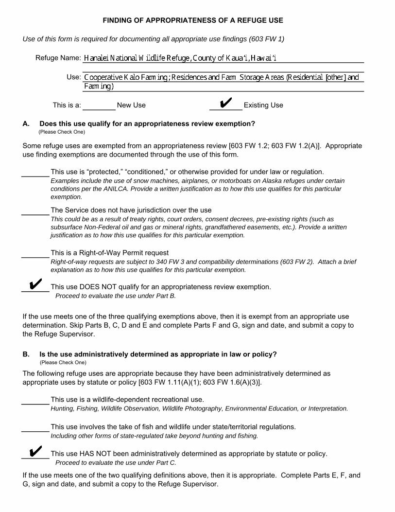
FINDING OF APPROPRIATENESS OF A REFUGE USE
Use of this form is required for documenting all appropriate use findings (603 FW 1)
Refuge Name:
Use:
This is a: New Use Existing Use
A. Does this use qualify for an appropriateness review exemption? (Please Check One)
Some refuge uses are exempted from an appropriateness review [603 FW 1.2; 603 FW 1.2(A)]. Appropriate use finding exemptions are documented through the use of this form.
This use is “protected,” “conditioned,” or otherwise provided for under law or regulation. Examples include the use of snow machines, airplanes, or motorboats on Alaska refuges under certain conditions per the ANILCA. Provide a written justification as to how this use qualifies for this particular exemption.
The Service does not have jurisdiction over the use This could be as a result of treaty rights, court orders, consent decrees, pre-existing rights (such as subsurface Non-Federal oil and gas or mineral rights, grandfathered easements, etc.). Provide a written justification as to how this use qualifies for this particular exemption.
This is a Right-of-Way Permit request Right-of-way requests are subject to 340 FW 3 and compatibility determinations (603 FW 2). Attach a brief explanation as to how this use qualifies for this particular exemption.
This use DOES NOT qualify for an appropriateness review exemption. Proceed to evaluate the use under Part B.
If the use meets one of the three qualifying exemptions above, then it is exempt from an appropriate use determination. Skip Parts B, C, D and E and complete Parts F and G, sign and date, and submit a copy to the Refuge Supervisor.
B. Is the use administratively determined as appropriate in law or policy? (Please Check One)
The following refuge uses are appropriate because they have been administratively determined as appropriate uses by statute or policy [603 FW 1.11(A)(1); 603 FW 1.6(A)(3)].
This use is a wildlife-dependent recreational use. Hunting, Fishing, Wildlife Observation, Wildlife Photography, Environmental Education, or Interpretation.
This use involves the take of fish and wildlife under state/territorial regulations. Including other forms of state-regulated take beyond hunting and fishing.
This use HAS NOT been administratively determined as appropriate by statute or policy. Proceed to evaluate the use under Part C.
If the use meets one of the two qualifying definitions above, then it is appropriate. Complete Parts E, F, and G, sign and date, and submit a copy to the Refuge Supervisor.

C. Is the use appropriate because it contributes to the refuge's purpose(s), goals, or objectives or Refuge System mission? (Please check one.)
Refuge managers, in their sound professional judgement, may determine a refuge use to be appropriate if it contributes to fulfilling the refuge purpose(s), goals, or objectives described in the refuge’s comprehensive conservation plan, or the Refuge System mission [603 FW 1.11 (A)(2)]. Urban wildlife refuges have the additional goal of fostering environmental awareness through outreach programs and activities that develop an informed and involved populace that supports fish and wildlife conservation [110 FW 1.5].
This use contributes to the refuge purpose(s), goals, or objectives, or Refuge System mission. Provide a written justification of how the use contributes to the qualifying purpose(s), goals, or objectives or Refuge System mission. Complete Parts E, F, and G, sign and date, and submit a copy to the Refuge Supervisor.
This use DOES NOT contribute to refuge purpose(s), goals, objectives, or Refuge System mission. Proceed to evaluate the use under Part D.
D. Is this use appropriate?
Decision Criteria: YES NO
(1) Does the use comply with applicable laws and regulations (Federal, State/Territorial, tribal,and local)?
(2) Is the use consistent with applicable Executive orders and Department and Service policies?
(3) Is the use consistent with public safety?
(4) Is the use consistent with the goals and objectives of approved management plans or other management document?
(5) If this is the first time the use has been proposed or if it was previously found appropriate, check Yes. If the use was previously analyzed but denied, check No.
(6) Is the use manageable within available budget and staff?
(7) Will the use be manageable in the future with existing resources? [603 FW 1.11 (A)(3)(h)].
(8) Does the use contribute to the public's understanding and appreciation of the refuge's natural and cultural resources?
(9) Can the use be accommodated without impairing existing wildlife-dependent recreational uses or reducing the potential to provide quality [603 FW 1.6 (D)], compatible,
wildlife-dependent recreation into the future?
(10) Is the use on an urban wildlife refuge [110 FW 1.15] and/or will it help new audiences become familiar and comfortable with fish, wildlife and their habitats?
If the answer is "NO" to (1), (2), or (3 ), mark the use as "Not Appropriate" under Part G. If the answer is "NO" to any of (4) through (10), the use will generally be "Not Appropriate." Refuge managers may, however, check one or more of boxes (4) through (10) and still find the use "Appropriate" by providing a written justification of the finding and how the factor(s) are mitigated or of minimal effect.
Complete Parts E, F, and G, sign and date, and submit a copy to the Refuge Supervisor.

E. Consultation with State/Territorial Fish and Wildlife Agency (Please check one.)
Refuge managers must consult with the applicable State/Territorial fish and wildlife agency when a request for a use could affect fish, wildlife, or other resources that are of concern to a State fish and wildlife agency [603 FW 1.7E(3) and 1.12].
Consultation WAS required.
Consultation took place on: (Month/Date/Year)Proceed to Part F.
Consultation WAS NOT required. Proceed to Part F.
F. Is the use significantly complex or potentially controversial? (Please check one.)
Yes
If Yes, date the Regional Chief was briefed: (Month/Date/Year)Proceed to Part G.
No Proceed to Part G.
G. Finding
Based on my review of all relevant factors, I find the refuge use identified above:
Exempted Not Appropriate Appropriate*
[* Includes findings that a use is administratively determined as appropriate (Section B and C) or is found appropriate through the use of the decision tool (Section D).]
Refuge Manager Date
H. Concurrence
The Refuge Supervisor MUST concur and sign a finding of "Not Appropriate" for an EXISTING use if the designation is made OUTSIDE of the Comprehensive Conservation Plan process. The Refuge Supervisor MUST concur and sign a finding of "Appropriate" for any proposed NEW use. Signature from the Refuge Supervisor WILL NOT be necessary for a finding of "Not Appropriate" with a proposed NEW use.
Refuge Supervisor Date
Any use found to be "Appropriate" will require the development of a compatibility determination before the use may be allowed on Refuge lands.
FWS-3-2319
9/2018
Hanalei National Wildlife Refuge Wetlands Management and Waterbird Conservation Plan
Appendix A. Appropriate Use Findings A-5
A.2 FINDING OF APPROPRIATENESS OF A REFUGE USE: SUPPLEMENT TO FWS FORM 3-2319
FURTHER EXPLANATION OF ANSWERS PROVIDED FOR THE DECISION CRITERIA:
PROJECT: COOPERATIVE KALO FARMING; RESIDENCES AND FARM STORAGE AREAS (RESIDENTIAL [OTHER] AND FARMING)
JUSTIFICATION OF HOW THIS USE CONTRIBUTES TO THE REFUGE’S PURPOSE(S), GOALS, OR OBJECTIVES OR REFUGE SYSTEM MISSION:
The purpose of Hanalei National Wildlife Refuge (NWR or Refuge) is to benefit species listed under the Endangered Species Act of 1973 (ESA). At Hanalei NWR, the management focus includes supporting the recovery of five federally-listed Hawaiian waterbirds: endangered ae‘o (Hawaiian stilt, Himantopus mexicanus knudseni); endangered ‘alae ke‘oke‘o (Hawaiian coot, Fulica alai); endangered ‘alae ‘ula (Hawaiian common gallinule, Gallinula galeata sandvicensis); endangered koloa maoli (Hawaiian duck, Anas wyvilliana); and threatened nēnē (Hawaiian goose, Branta sandvicensis).
This use involves cooperative farming of kalo (taro, Colocasia esculenta) in lo‘i (an impounded terrace or field) and the use of residences, farm storage sheds and surrounding lands, in support of kalo farming on Hanalei NWR. Kalo farming on the Refuge meets the definition of cooperative agriculture because (1) it is conducted in support of resource management objectives for managing shallow-water habitat to satisfy life history requirements of threatened and endangered Hawaiian waterbirds (Objective 1.1 in the Wetlands Management and Waterbird Conservation Plan [WMWCP]) and (2) there is substantial involvement between the Service and the cooperator, as defined by 620 U.S. Fish and Wildlife Service Manual (FW) 2 and 505 U.S. Department of the Interior Department Manual 2.9.
The WMWCP describes cooperative kalo farming as a component of the overall management of lowland/wetland habitats on the Refuge. Under the WMWCP, available lowland/wetland acreage on the Refuge would be allocated between rotational managed wetlands, lo‘i kalo, lands rested for farming, conservation, and/or watershed benefits (i.e., fallow or non-actively managed lands), or riparian and upland habitat (e.g., nēnē breeding or foraging habitat or koloa maoli nesting habitat) based on a decision flowchart and reevaluated periodically using an adaptive management framework.
As currently practiced, kalo farming directly or indirectly supports Refuge goals. Implementation of new Special Use Permit (SUP) and Cooperative Agriculture Agreement (CAA) conditions would be expected to enhance support of kalo farming for these Refuge goals outlined within the WMWCP:
• Cultivation of kalo supports Goal 1 by satisfying some of the life history needs of threatened and endangered Hawaiian waterbirds and supplementing the native and naturalized habitats provided by the rotational wetland (moist-soil) management units on the Refuge; and
• Current kalo farming practices directly support Goal 1 by creating a diverse, year-round mosaic of wetland habitats that satisfy some of the life history needs of threatened and endangered Hawaiian waterbirds. Conversely, some farming practices reduce food and cover, and cause disturbance to threatened or endangered breeding birds. Implementation of
Hanalei National Wildlife Refuge Wetlands Management and Waterbird Conservation Plan
A-6 Appendix A. Appropriate Use Findings
strengthened permit and agreement conditions under the WMWCP would increase the value of lo‘i kalo to threatened and endangered Hawaiian waterbird, helping to ensure this practice remains compatible with the Refuge purpose.
The subject residences, storage sheds, and the immediately surrounding areas are supportive of kalo farming on the Refuge. By extension, these buildings and areas support the same Refuge goals as does kalo farming.
As practiced in the past, kalo farming on the Refuge provided wetland habitat of a quality that satisfied some of the life history requirements of threatened and endangered Hawaiian waterbirds. However, this use, like many agricultural uses, has limitations that come with the benefits to native wildlife (Heard et al. 2000). Agronomic practices, such as drawdowns for fertilizer applications, may contribute to threatened or endangered waterbird nest collapse and failure and the impaired quality of receiving waters. Under the WMWCP, conditions of the kalo farming permits/agreements would be strengthened to address these and other issues.
Appropriate and compatible cooperative kalo farming would require farmers to enhance vegetation structure and diversity of lo‘i habitat (all stages) for foraging and breeding threatened and endangered waterbirds to promote growth of non-kalo emergent plants by maintaining either:
• ≥ 10 percent cover of beneficial non-kalo emergent plants in understory within each lo‘i; • ≥ 20 percent cover of beneficial non-kalo emergent plants in understory on ≥ 50 percent of
lo‘i; or • ≥ 10 percent of total lo‘i acreage in vegetated wet fallow (approximately nine month period:
germinate, grow emergent vegetation > 4 inches, flood 6 months).
In lo‘i where threatened or endangered waterbird nests are found, farmers would be required to:
• maintain a minimum six-foot radius unharvested buffer around the nest; • keep the lo‘i flooded to a depth of three to six inches; and • coordinate with Refuge staff to minimize impacts or take of birds by implementing additional
protective measures as needed, such as delaying harvest in areas where nests are known to occur until the young birds fledge or leave the lo‘i of their own accord.
Kalo permittee/cooperators would be required to coordinate with and receive approval from the Refuge manager or biologist prior to water level fluctuations (e.g., drawdowns) in lo‘i where nests occur (to prevent flooding or collapse of waterbird nests and brood platforms).
Farmers would plant and maintain lo‘i in a way that would distribute kalo at different stages of maturity among different lo‘i, so that harvesting of all lo‘i at one time would not occur. This would allow kalo farmers the continued ability to harvest in lo‘i that do not have a nest present.
If a threatened or endangered waterbird nest is found on a dike or in dry fallow lo‘i, the nest would be staked by Refuge staff approximately nine feet (three meters) from the nest in order to prevent nest destruction. Kalo permittee/cooperators would be required to avoid the area until the nest hatches and birds leave the area of their own accord.
During fallow, farmers would be required to enhance foraging resources for threatened and endangered waterbirds (may vary in documented avian botulism areas) by providing:
Hanalei National Wildlife Refuge Wetlands Management and Waterbird Conservation Plan
Appendix A. Appropriate Use Findings A-7
• a minimum 30-day wet fallow period immediately post-harvest (may require a dry period for soil aeration) with water depth 6–8 inches and with the presence of moist-soil plants; and
• an optional dry fallow period ≤ 6 months total depending on needs and conditions.
Farmers would be required to participate in implementing relevant aspects of the Avian Botulism Prevention and Response Protocol. Hanalei NWR staff would work cooperatively with farmers and other partners to develop best management practices for kalo farming consistent with recovery of threatened and endangered Hawaiian waterbirds and improvements in the quality of discharge waters. Farmers would be required to report fertilizer and herbicide use annually and participate in the development of fertilizer and herbicide management plans.
The Service would work with the farmers and others to conduct studies to evaluate the benefits for waterbirds of various kalo farming practices. For example, one study would evaluate the effects on fledging success of increasing the diameters of nest buffers. Another study would evaluate the efficacy of slow-release and/or other more sustainable options for fertilizers and assess their effects on the quality of discharge waters.
Results of all of these studies would be used to appropriately modify conditions of kalo farming permits/agreements. Phased implementation of these additional sustainable and wildlife friendly farming techniques would address identified concerns about intensive kalo farming on the Refuge and cause the beneficial aspects of this use to increase and its detrimental effects to diminish. Monitoring would help ensure that benefits were realized.
Although not solely related to kalo farming and associated activities, vehicle traffic along ‘Ōhiki Road threatens threatened and endangered waterbirds. From 2003 to 2008, the Service documented, on average, four threatened or endangered bird deaths each year on this road (Letter from M. Hawkes to W. Kudo, June 25, 2008). From 2013 to 2015, we documented on average 14 threatened or endangered and migratory bird deaths each year on this road, including 22 ‘alae ‘ula, 11 ‘alae ke‘oke‘o, seven nēnē, and two kōlea. During the first six months of 2016, 15 additional threatened or endangered birds were recorded as struck by vehicles on the same road, nearly three birds per month. These numbers indicate an increasing trend in threatened and endangered bird deaths on ‘Ōhiki Road (Letter from H. Tonneson to L. Tabata, July 29, 2016). Along with the general public, kalo farming permittee/cooperators would need to comply with the posted speed limit (15 miles per hour) and use pullouts as appropriate to halt the loss of threatened and endangered species from vehicle strikes and resolve other issues, including public safety.
Currently, five of the Refuge kalo farmers live in residences on the Refuge. The Refuge’s other four kalo farmers live off-site and maintain storage sheds on the Refuge. In both cases, the farmers also use the areas immediately surrounding their residences and storage sheds for storage of equipment and supplies and, for resident farmers, for landscaping, fruit and vegetable gardening, outbuildings, livestock, and pets.
The subject residences and storage sheds were constructed prior to Service acquisition of the Refuge. The lands underlying and surrounding the buildings are part of the Refuge and owned by the Service. This arrangement is typical of traditional tenant-farming systems in Hawai‘i.
There are some challenges with the management of these buildings and the surrounding lands. Areas surrounding some residences have grown in size over the years, consuming actual or potential wildlife habitat and increasing the human footprint and zone of wildlife disturbance. Within or
Hanalei National Wildlife Refuge Wetlands Management and Waterbird Conservation Plan
A-8 Appendix A. Appropriate Use Findings
adjacent to some residential, storage, and farm areas, there has been a growing accumulation of abandoned vehicles, equipment, and supplies that are not being actively used which provide habitat for feral cats and rodents. Organic wastes and other refuse have been dumped on Refuge property. This can attract pests, predators, and disease vectors; and it is contrary to Service policies (Resource Conservation and Recovery Act of 1976 (RCRA), as amended (42 United States Code (U.S.C.) 6901–6992k)—Solid Waste (Nonhazardous); 50 Code of Federal Regulations (CFR) 27.93, Abandonment of Property; 50 CFR 27.94, Disposal of Waste; and 561 FW 5, Managing, Recycling, and Disposing of Non-Hazardous Solid Waste). In addition, it encourages native birds to feed on kalo which is not part of their natural diet. In other areas, equipment and supplies (including fertilizers, pesticides, and petroleum products) are stored outdoors or inside three-sided shelters directly on the ground. Exposure to weather and periodic Hanalei Valley flooding increases the potential for damage of storage containers, and leakage of petroleum products, heavy metals, fertilizers, and/or pesticides into the underlying soil and surface and ground waters. During high-water events, these contaminants, when not properly stored, are dispersed onto the Refuge and downriver.
Enforcement and conditions of future commercial SUPs for farming residences, storage sheds, outbuildings, and the immediately surrounding areas would be strengthened to address these and other issues. For example, there would be a specific acreage limit placed on the size of permit areas (i.e., the residences, outbuildings, and the immediately surrounding areas; and the storage sheds and immediately surrounding areas). The boundaries of these areas would be clearly marked. Requirements regarding storage of equipment and supplies and dumping would be strengthened and clarified. Farmers would be required to maintain their buildings and surrounding grounds consistent with county and state requirements.
All of these strengthened conditions would address identified concerns about residences, storage sheds, outbuildings, and the immediately surrounding areas and would assist in diminishing detrimental effects. Monitoring would help ensure that benefits were realized.
To ensure the compatibility of this use, staff will be dedicated to managing, monitoring, and reporting on the kalo farming program, which would include a qualified biologist(s) to implement a monitoring and adaptive management program.
Overall, the use would contribute to the achievement of the Refuge’s purposes and the National Wildlife Refuge System mission. The use evaluated herein is more fully described and evaluated in the compatibility determination for this use and the documents referenced there (Appendix B).
REFERENCES CITED:
Heard, P. L., A. W. Allen, L. B. Best, S. J. Brady, W. Burger, A. J. Esser, E. Hackett, et al. 2000. “A Comprehensive Review of Farm Bill Contributions to Wildlife Conservation, 1985–2000.” Technical Report USDA/NRCS/WHMI-2000. Washington, D.C.: U.S. Department of Agriculture, Natural Resources Conservation Service, Wildlife Habitat Management Institute. https://www.fort.usgs.gov/publication/21351.
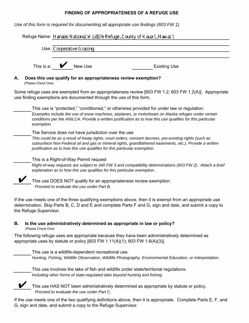
FINDING OF APPROPRIATENESS OF A REFUGE USE
Use of this form is required for documenting all appropriate use findings (603 FW 1)
Refuge Name:
Use:
This is a: New Use Existing Use
A. Does this use qualify for an appropriateness review exemption? (Please Check One)
Some refuge uses are exempted from an appropriateness review [603 FW 1.2; 603 FW 1.2(A)]. Appropriate use finding exemptions are documented through the use of this form.
This use is “protected,” “conditioned,” or otherwise provided for under law or regulation. Examples include the use of snow machines, airplanes, or motorboats on Alaska refuges under certain conditions per the ANILCA. Provide a written justification as to how this use qualifies for this particular exemption.
The Service does not have jurisdiction over the use This could be as a result of treaty rights, court orders, consent decrees, pre-existing rights (such as subsurface Non-Federal oil and gas or mineral rights, grandfathered easements, etc.). Provide a written justification as to how this use qualifies for this particular exemption.
This is a Right-of-Way Permit request Right-of-way requests are subject to 340 FW 3 and compatibility determinations (603 FW 2). Attach a brief explanation as to how this use qualifies for this particular exemption.
This use DOES NOT qualify for an appropriateness review exemption. Proceed to evaluate the use under Part B.
If the use meets one of the three qualifying exemptions above, then it is exempt from an appropriate use determination. Skip Parts B, C, D and E and complete Parts F and G, sign and date, and submit a copy to the Refuge Supervisor.
B. Is the use administratively determined as appropriate in law or policy? (Please Check One)
The following refuge uses are appropriate because they have been administratively determined as appropriate uses by statute or policy [603 FW 1.11(A)(1); 603 FW 1.6(A)(3)].
This use is a wildlife-dependent recreational use. Hunting, Fishing, Wildlife Observation, Wildlife Photography, Environmental Education, or Interpretation.
This use involves the take of fish and wildlife under state/territorial regulations. Including other forms of state-regulated take beyond hunting and fishing.
This use HAS NOT been administratively determined as appropriate by statute or policy. Proceed to evaluate the use under Part C.
If the use meets one of the two qualifying definitions above, then it is appropriate. Complete Parts E, F, and G, sign and date, and submit a copy to the Refuge Supervisor.
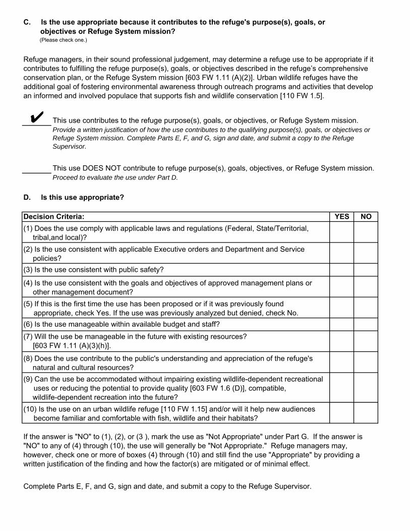
C. Is the use appropriate because it contributes to the refuge's purpose(s), goals, or objectives or Refuge System mission? (Please check one.)
Refuge managers, in their sound professional judgement, may determine a refuge use to be appropriate if it contributes to fulfilling the refuge purpose(s), goals, or objectives described in the refuge’s comprehensive conservation plan, or the Refuge System mission [603 FW 1.11 (A)(2)]. Urban wildlife refuges have the additional goal of fostering environmental awareness through outreach programs and activities that develop an informed and involved populace that supports fish and wildlife conservation [110 FW 1.5].
This use contributes to the refuge purpose(s), goals, or objectives, or Refuge System mission. Provide a written justification of how the use contributes to the qualifying purpose(s), goals, or objectives or Refuge System mission. Complete Parts E, F, and G, sign and date, and submit a copy to the Refuge Supervisor.
This use DOES NOT contribute to refuge purpose(s), goals, objectives, or Refuge System mission. Proceed to evaluate the use under Part D.
D. Is this use appropriate?
Decision Criteria: YES NO
(1) Does the use comply with applicable laws and regulations (Federal, State/Territorial, tribal,and local)?
(2) Is the use consistent with applicable Executive orders and Department and Service policies?
(3) Is the use consistent with public safety?
(4) Is the use consistent with the goals and objectives of approved management plans or other management document?
(5) If this is the first time the use has been proposed or if it was previously found appropriate, check Yes. If the use was previously analyzed but denied, check No.
(6) Is the use manageable within available budget and staff?
(7) Will the use be manageable in the future with existing resources? [603 FW 1.11 (A)(3)(h)].
(8) Does the use contribute to the public's understanding and appreciation of the refuge's natural and cultural resources?
(9) Can the use be accommodated without impairing existing wildlife-dependent recreational uses or reducing the potential to provide quality [603 FW 1.6 (D)], compatible,
wildlife-dependent recreation into the future?
(10) Is the use on an urban wildlife refuge [110 FW 1.15] and/or will it help new audiences become familiar and comfortable with fish, wildlife and their habitats?
If the answer is "NO" to (1), (2), or (3 ), mark the use as "Not Appropriate" under Part G. If the answer is "NO" to any of (4) through (10), the use will generally be "Not Appropriate." Refuge managers may, however, check one or more of boxes (4) through (10) and still find the use "Appropriate" by providing a written justification of the finding and how the factor(s) are mitigated or of minimal effect.
Complete Parts E, F, and G, sign and date, and submit a copy to the Refuge Supervisor.

E. Consultation with State/Territorial Fish and Wildlife Agency (Please check one.)
Refuge managers must consult with the applicable State/Territorial fish and wildlife agency when a request for a use could affect fish, wildlife, or other resources that are of concern to a State fish and wildlife agency [603 FW 1.7E(3) and 1.12].
Consultation WAS required.
Consultation took place on: (Month/Date/Year)Proceed to Part F.
Consultation WAS NOT required. Proceed to Part F.
F. Is the use significantly complex or potentially controversial? (Please check one.)
Yes
If Yes, date the Regional Chief was briefed: (Month/Date/Year)Proceed to Part G.
No Proceed to Part G.
G. Finding
Based on my review of all relevant factors, I find the refuge use identified above:
Exempted Not Appropriate Appropriate*
[* Includes findings that a use is administratively determined as appropriate (Section B and C) or is found appropriate through the use of the decision tool (Section D).]
Refuge Manager Date
H. Concurrence
The Refuge Supervisor MUST concur and sign a finding of "Not Appropriate" for an EXISTING use if the designation is made OUTSIDE of the Comprehensive Conservation Plan process. The Refuge Supervisor MUST concur and sign a finding of "Appropriate" for any proposed NEW use. Signature from the Refuge Supervisor WILL NOT be necessary for a finding of "Not Appropriate" with a proposed NEW use.
Refuge Supervisor Date
Any use found to be "Appropriate" will require the development of a compatibility determination before the use may be allowed on Refuge lands.
FWS-3-2319
9/2018
Hanalei National Wildlife Refuge Wetlands Management and Waterbird Conservation Plan
A-12 Appendix A. Appropriate Use Findings
A.4 FINDING OF APPROPRIATENESS OF A REFUGE USE: SUPPLEMENT TO FWS FORM 3-2319
FURTHER EXPLANATION OF ANSWERS PROVIDED FOR THE DECISION CRITERIA:
PROJECT: COOPERATIVE GRAZING
JUSTIFICATION OF HOW THIS USE CONTRIBUTES TO THE REFUGE’S PURPOSE(S), GOALS, OR OBJECTIVES OR REFUGE SYSTEM MISSION:
The purpose of Hanalei National Wildlife Refuge (NWR or Refuge) is to benefit species listed under the Endangered Species Act of 1973 (ESA). At Hanalei NWR, the management focus includes supporting the recovery of five federally-listed Hawaiian waterbird species: endangered ae‘o (Hawaiian stilt, Himantopus mexicanus knudseni); endangered ‘alae ke‘oke‘o (Hawaiian coot, Fulica alai); endangered ‘alae ‘ula (Hawaiian common gallinule, Gallinula galeata sandvicensis); endangered koloa maoli (Hawaiian duck, Anas wyvilliana); and threatened nēnē (Hawaiian goose, Branta sandvicensis).
The use evaluated herein involves cooperative grazing of Refuge lands by domestic livestock, which may include cattle, sheep, or goats. Grazing on the Refuge would meet the definition of cooperative agriculture because (1) it is conducted in support of resource management objectives for restoring or enhancing rotational managed wetlands and riparian habitat to satisfy life history requirements of threatened and endangered Hawaiian waterbirds (Objectives 1.2 and 2.2 in the Wetlands Management and Waterbird Conservation Plan [WMWCP]) and (2) it involves substantial involvement between the Service and the cooperator, as defined by 620 U.S. Fish and Wildlife Service Manual 2 and 505 U.S. Department of the Interior Department Manual 2.9.
The cooperative grazing program would be specifically designed for two distinct purposes.
1. In conjunction with heavy equipment (e.g., mowing) and herbicides, livestock grazing could be used as an initial (time-limited) strategy for reducing plant biomass and controlling or removing invasive plants (e.g., six- to eight-foot tall, dense California grass [Urochloa mutica]) to clear areas in preparation for long-term habitat management (i.e., either restoration of rotational managed wetland units or maintenance of short grass habitat).
2. Livestock grazing could also be used as a long-term strategy for seasonally managing and maintaining short grass conditions (e.g., grasses four to six inches in height) conducive to foraging (grazing) and nesting by threatened nēnē (Hawaiian goose, Branta sandvicensis).
Grazing can cause a variety of impacts, including damage to vegetation and soils as a result of overgrazing, vegetation trampling, soil compaction, and erosion; wildlife disturbance, potentially including destruction of threatened nēnē eggs, or injury or death to young birds through trampling; and increased sedimentation and nutrient loading of waterways and wetlands, which could alter microbial communities and conditions for avian botulism. Livestock can also facilitate the introduction of alien, including pest, species (e.g., through seeds carried in hair, on vehicles and farm machinery, and in feces).
Based on the reasons for using cooperative grazing, different stipulations regarding duration, timing, and monitoring would apply. For example, livestock grazing for area clearing could be conducted at
Hanalei National Wildlife Refuge Wetlands Management and Waterbird Conservation Plan
Appendix A. Appropriate Use Findings A-13
any time of year with baseline monitoring, whereas grazing for short-grass habitat management would only be permitted seasonally during the non-peak threatened and endangered waterbird breeding period (e.g., approximately May–September because nēnē peak breeding is from October–April) and would be associated with a more intensive monitoring program. In either case, additional stipulations are included to minimize adverse impacts to threatened and endangered species, soils, and aquatic resources. Pastures would be fenced to contain livestock, focus their grazing efforts, and keep them out of riparian areas and river corridor. In-pasture water and salt would be made available to better manage grazing intensity and locations. Biosecurity measures would be implemented to prevent the introduction and spread of pest species. Biological monitoring, including establishment of baseline conditions, and adaptive management based on measurable and meaningful criteria are important for ensuring that cooperative grazing remains appropriate and compatible over time.
At least initially, the cooperative grazing program would be conducted on a short-term, experimental basis (with one-year special use permit and cooperative agriculture agreement) to determine whether the program could create the habitat conditions and associated wildlife benefits being sought while minimizing impacts to threatened and endangered species and aquatic resources. Grazing program parameters (timing, frequency, intensity, or other elements) would be developed with the assistance of the Natural Resources Conservation Service (NRCS), the University of Hawai‘i, Hawai‘i Department of Land and Natural Resources, livestock grazers, Hawaiian waterbird biologists, and others. The end result of this effort would be a grazing plan for the Refuge and associated best management practices (BMP) for grazing.
Overall, the use would contribute to the achievement of the Refuge’s purpose and the National Wildlife Refuge System mission. The use evaluated herein is more fully described and evaluated in the compatibility determination for this use and the documents referenced there (Appendix B).
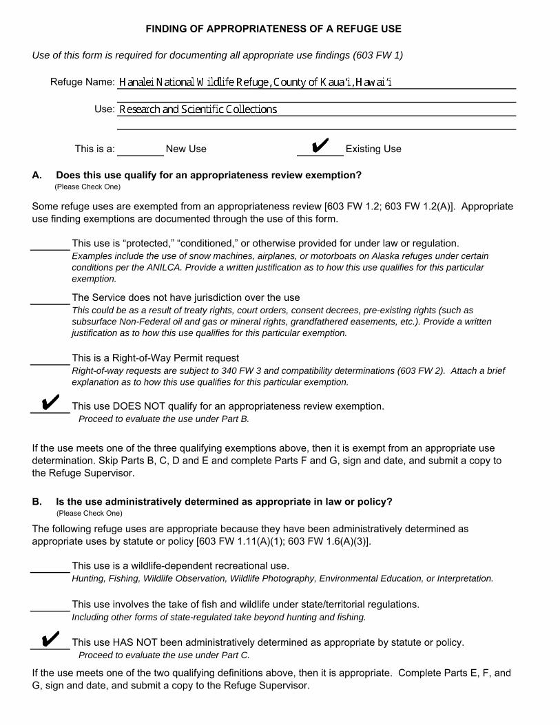
FINDING OF APPROPRIATENESS OF A REFUGE USE
Use of this form is required for documenting all appropriate use findings (603 FW 1)
Refuge Name:
Use:
This is a: New Use Existing Use
A. Does this use qualify for an appropriateness review exemption? (Please Check One)
Some refuge uses are exempted from an appropriateness review [603 FW 1.2; 603 FW 1.2(A)]. Appropriate use finding exemptions are documented through the use of this form.
This use is “protected,” “conditioned,” or otherwise provided for under law or regulation. Examples include the use of snow machines, airplanes, or motorboats on Alaska refuges under certain conditions per the ANILCA. Provide a written justification as to how this use qualifies for this particular exemption.
The Service does not have jurisdiction over the use This could be as a result of treaty rights, court orders, consent decrees, pre-existing rights (such as subsurface Non-Federal oil and gas or mineral rights, grandfathered easements, etc.). Provide a written justification as to how this use qualifies for this particular exemption.
This is a Right-of-Way Permit request Right-of-way requests are subject to 340 FW 3 and compatibility determinations (603 FW 2). Attach a brief explanation as to how this use qualifies for this particular exemption.
This use DOES NOT qualify for an appropriateness review exemption. Proceed to evaluate the use under Part B.
If the use meets one of the three qualifying exemptions above, then it is exempt from an appropriate use determination. Skip Parts B, C, D and E and complete Parts F and G, sign and date, and submit a copy to the Refuge Supervisor.
B. Is the use administratively determined as appropriate in law or policy? (Please Check One)
The following refuge uses are appropriate because they have been administratively determined as appropriate uses by statute or policy [603 FW 1.11(A)(1); 603 FW 1.6(A)(3)].
This use is a wildlife-dependent recreational use. Hunting, Fishing, Wildlife Observation, Wildlife Photography, Environmental Education, or Interpretation.
This use involves the take of fish and wildlife under state/territorial regulations. Including other forms of state-regulated take beyond hunting and fishing.
This use HAS NOT been administratively determined as appropriate by statute or policy. Proceed to evaluate the use under Part C.
If the use meets one of the two qualifying definitions above, then it is appropriate. Complete Parts E, F, and G, sign and date, and submit a copy to the Refuge Supervisor.

C. Is the use appropriate because it contributes to the refuge's purpose(s), goals, orobjectives or Refuge System mission?(Please check one.)
Refuge managers, in their sound professional judgement, may determine a refuge use to be appropriate if it contributes to fulfilling the refuge purpose(s), goals, or objectives described in the refuge’s comprehensive conservation plan, or the Refuge System mission [603 FW 1.11 (A)(2)]. Urban wildlife refuges have the additional goal of fostering environmental awareness through outreach programs and activities that develop an informed and involved populace that supports fish and wildlife conservation [110 FW 1.5].
This use contributes to the refuge purpose(s), goals, or objectives, or Refuge System mission. Provide a written justification of how the use contributes to the qualifying purpose(s), goals, or objectives or Refuge System mission. Complete Parts E, F, and G, sign and date, and submit a copy to the Refuge Supervisor.
This use DOES NOT contribute to refuge purpose(s), goals, objectives, or Refuge System mission. Proceed to evaluate the use under Part D.
D. Is this use appropriate?
Decision Criteria: YES NO
(1) Does the use comply with applicable laws and regulations (Federal, State/Territorial,tribal,and local)?
(2) Is the use consistent with applicable Executive orders and Department and Servicepolicies?
(3) Is the use consistent with public safety?
(4) Is the use consistent with the goals and objectives of approved management plans orother management document?
(5) If this is the first time the use has been proposed or if it was previously foundappropriate, check Yes. If the use was previously analyzed but denied, check No.
(6) Is the use manageable within available budget and staff?
(7) Will the use be manageable in the future with existing resources?[603 FW 1.11 (A)(3)(h)].
(8) Does the use contribute to the public's understanding and appreciation of the refuge'snatural and cultural resources?
(9) Can the use be accommodated without impairing existing wildlife-dependent recreationaluses or reducing the potential to provide quality [603 FW 1.6 (D)], compatible,wildlife-dependent recreation into the future?
(10) Is the use on an urban wildlife refuge [110 FW 1.15] and/or will it help new audiencesbecome familiar and comfortable with fish, wildlife and their habitats?
If the answer is "NO" to (1), (2), or (3 ), mark the use as "Not Appropriate" under Part G. If the answer is "NO" to any of (4) through (10), the use will generally be "Not Appropriate." Refuge managers may, however, check one or more of boxes (4) through (10) and still find the use "Appropriate" by providing a written justification of the finding and how the factor(s) are mitigated or of minimal effect.
Complete Parts E, F, and G, sign and date, and submit a copy to the Refuge Supervisor.
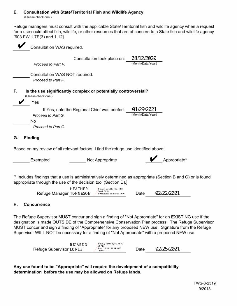
E. Consultation with State/Territorial Fish and Wildlife Agency(Please check one.)
Refuge managers must consult with the applicable State/Territorial fish and wildlife agency when a request for a use could affect fish, wildlife, or other resources that are of concern to a State fish and wildlife agency [603 FW 1.7E(3) and 1.12].
Consultation WAS required.
Consultation took place on: (Month/Date/Year)Proceed to Part F.
Consultation WAS NOT required. Proceed to Part F.
F. Is the use significantly complex or potentially controversial?(Please check one.)
Yes
If Yes, date the Regional Chief was briefed: (Month/Date/Year)Proceed to Part G.
No Proceed to Part G.
G. Finding
Based on my review of all relevant factors, I find the refuge use identified above:
Exempted Not Appropriate Appropriate*
[* Includes findings that a use is administratively determined as appropriate (Section B and C) or is found appropriate through the use of the decision tool (Section D).]
Refuge Manager Date
H. Concurrence
The Refuge Supervisor MUST concur and sign a finding of "Not Appropriate" for an EXISTING use if the designation is made OUTSIDE of the Comprehensive Conservation Plan process. The Refuge Supervisor MUST concur and sign a finding of "Appropriate" for any proposed NEW use. Signature from the Refuge Supervisor WILL NOT be necessary for a finding of "Not Appropriate" with a proposed NEW use.
Refuge Supervisor Date
Any use found to be "Appropriate" will require the development of a compatibility determination before the use may be allowed on Refuge lands.
FWS-3-2319
9/2018
Hanalei National Wildlife Refuge Wetlands Management and Waterbird Conservation Plan
Appendix A. Appropriate Use Findings A-17
A.6 FINDING OF APPROPRIATENESS OF A REFUGE USE: SUPPLEMENT TO FWS FORM 3-2319
FURTHER EXPLANATION OF ANSWERS PROVIDED FOR THE DECISION CRITERIA:
PROJECT: RESEARCH AND SCIENTIFIC COLLECTIONS
JUSTIFICATION OF HOW THIS USE CONTRIBUTES TO THE REFUGE’S PURPOSE(S), GOALS, OR OBJECTIVES OR REFUGE SYSTEM MISSION:
This use involves research and scientific collections conducted by non-National Wildlife Refuge System (Refuge System) parties on Hanalei National Wildlife Refuge (NWR or Refuge).
Research refers to a planned, organized, and systematic investigation of a scientific nature. Such studies are designed to determine the cause(s) of observed biotic or abiotic phenomenon over a finite time period, where cause and effect relationships usually can be inferred through statistical analyses.
Scientific collecting involves gathering of Refuge natural resources or cultural artifacts for scientific purposes. Examples include collection of vegetation, small mammals, and soils; contaminant sampling; and collection and curation of cultural resources.
Refuge staff periodically receive requests from outside parties (e.g., universities, state agencies, other federal agencies, and nongovernmental organizations) to conduct research and scientific collections on Refuge lands. These project requests can involve a wide range of natural and cultural resources as well as public use management issues, including collection of new species for identification, habitat use and life history requirements for specific species and species groups, practical methods for habitat restoration, extent and severity of environmental contaminants, techniques to control or eradicate pest species, effects of climate change on environmental conditions and associated habitat and wildlife response, modeling of wildlife populations, bioprospecting, and assessing response of habitat and wildlife to disturbance from public uses. Projects may be species-specific, Refuge-specific, or evaluate the relative contribution of Refuge lands to larger landscape (ecoregion, region, flyway, national, and international) issues and trends.
Use of the Refuge to conduct research or scientific collecting would generally provide information of benefit to native fish, wildlife, plants, and their habitats; or to cultural resources. Scientific findings gained through these projects could provide important information regarding life history needs of species and species groups, as well as identify or refine management actions to achieve the Refuge’s natural or cultural resource management goals and objectives. Reducing uncertainty regarding wildlife and habitat responses to Refuge management actions undertaken in order to achieve desired outcomes (objectives) is essential for adaptive management (522 Department Manual 1).
Suitable research and scientific collections on refuges are inherently valuable to the U.S. Fish and Wildlife Service (Service) when they expand scientific information available for resource management decisions about fish, wildlife, plants, and their habitats; cultural resources; and/or public use. In many cases, if it were not for the Refuge staff providing access to Refuge lands and waters along with some support, the project would never occur, and less scientific information would be available to aid the Service in managing and conserving Refuge resources.
The Service’s Research and Management Studies (4 Refuge Manual 6) and Appropriate Refuge Uses
Hanalei National Wildlife Refuge Wetlands Management and Waterbird Conservation Plan
A-18 Appendix A. Appropriate Use Findings
(603 U.S. Fish and Wildlife Service Manual 1) policies indicate priority for scientific investigatory studies that contribute to the enhancement, protection, use, preservation, and management of native wildlife populations and their habitat as well as their natural diversity. Projects that contribute to Refuge-specific needs for resource management goals and objectives, where applicable, would be given a higher priority over other requests. Likewise, projects that materially interfere with or detract from the fulfillment of the National Wildlife Refuge System mission or the refuge purposes would be denied.
The use evaluated herein is more fully described and evaluated in the compatibility determination for this use and the documents referenced there (Appendix B).
Hanalei National Wildlife Refuge Wetlands Management and Waterbird Conservation Plan
Appendix B. Compatibility Determinations B-1
APPENDIX B. COMPATIBILITY DETERMINATIONS B.1 Compatibility Determination - Use: Cooperative Kalo Farming; Residences and Farm Storage Areas (Residential [other] and Farming) .......................................................................... B-3
B.1.1 Description of Use(s) .................................................................................................. B-3 B.1.2 Administration of the Use ........................................................................................... B-7 B.1.3 Anticipated Impacts of the Uses ............................................................................... B-10 B.1.4 Public Review and Comment .................................................................................... B-18 B.1.5 Determination ............................................................................................................ B-18 B.1.6 Stipulations Necessary to Ensure Compatibility ....................................................... B-19 B.1.7 Justification ............................................................................................................... B-24 B.1.8 Compatibility Standard ............................................................................................. B-25 B.1.9 Mandatory Re-Evaluation Date: ............................................................................... B-26 B.1.10 NEPA Compliance for Refuge Use Decision: (check one below) ............................ B-26 B.1.11 Compatibility Determination: Kalo Farming; Residences and Farm Storage Areas (Residential [other] and Farming) ............................................................................................ B-27 B.1.12 References Cited ....................................................................................................... B-28
B.2 Compatibility Determination - Use: Cooperative Grazing ............................................... B-36 B.2.1 Description of Use(s) ................................................................................................ B-36 B.2.2 Administration of the Use ......................................................................................... B-38 B.2.3 Anticipated Impacts of the Use(s) ............................................................................. B-40 B.2.4 Public Review and Comment .................................................................................... B-42 B.2.5 Determination ............................................................................................................ B-42 B.2.6 Stipulations Necessary to Ensure Compatibility ....................................................... B-43 B.2.7 Justification ............................................................................................................... B-45 B.2.8 Compatibility Standard ............................................................................................. B-47 B.2.9 Mandatory Re-Evaluation Date: ............................................................................... B-48 B.2.10 NEPA Compliance for Refuge Use Decision: (check one below) ............................ B-48 B.2.11 Compatibility Determination: Cooperative Grazing ................................................. B-48 B.2.12 References Cited ....................................................................................................... B-49
B.3 Compatibility Determination - Use: Research and Scientific Collections ....................... B-51 B.3.1 Description of Use(s) ................................................................................................ B-51 B.3.2 Anticipated Impacts of the Use(s) ............................................................................. B-53 B.3.3 Public Review and Comment .................................................................................... B-55 B.3.4 Determination ............................................................................................................ B-55 B.3.5 Stipulations Necessary to Ensure Compatibility ....................................................... B-55
Hanalei National Wildlife Refuge Wetlands Management and Waterbird Conservation Plan
B-2 Appendix B. Compatibility Determinations
B.3.6 Justification ............................................................................................................... B-58 B.3.7 Mandatory Re-Evaluation Date: ............................................................................... B-59 B.3.8 NEPA Compliance for Refuge Use Decision: (check one below) ............................ B-59 B.3.9 Compatibility Determination: Research and Scientific Collections ......................... B-59 B.3.10 References Cited ....................................................................................................... B-60 B.3.11 High-Priority Research and Scientific Collections ................................................... B-60
Hanalei National Wildlife Refuge Wetlands Management and Waterbird Conservation Plan
Appendix B. Compatibility Determinations B-3
B.1 COMPATIBILITY DETERMINATION - USE: COOPERATIVE KALO FARMING; RESIDENCES AND FARM STORAGE AREAS (RESIDENTIAL [OTHER] AND FARMING)
REFUGE NAME: HANALEI NATIONAL WILDLIFE REFUGE, COUNTY OF KAUA‘I, HAWAI‘I
ESTABLISHING AND ACQUISITION AUTHORITY(IES):
Endangered Species Conservation Act of 1969, as amended (16 United States Code [U.S.C.] 668aa)
REFUGE PURPOSE(S):
“… to conserve (A) fish or wildlife which are listed as endangered species or threatened species…or (B) plants…” (ESA; Endangered Species Act of 1973) (16 U.S.C. 1531–1544)
NATIONAL WILDLIFE REFUGE SYSTEM (REFUGE SYSTEM OR NWRS) MISSION:
“The mission of the [National Wildlife Refuge] System is to administer a national network of lands and waters for the conservation, management, and where appropriate, restoration of the fish, wildlife, and plant resources and their habitats within the United States for the benefit of present and future generations of Americans” (National Wildlife Refuge System Administration Act of 1966, as amended) (16 U.S.C. 668dd–668ee)
B.1.1 DESCRIPTION OF USE(S)
COOPERATIVE AGRICULTURE
Cooperative agriculture is when a person or entity uses agricultural practices on National Wildlife Refuge System (NWRS or Refuge System) lands in support of objectives for target species or their associated habitats that represent the biological outcomes the U.S. Fish and Wildlife Service (Service) desires, and there is substantial involvement (i.e., collaboration, participation, or intervention) between the Service and the person or entity. The Service uses cooperative agriculture agreements (CAAs) as the legal instruments to formalize the cooperative agreement between the Service and the cooperator. CAAs describe the objectives, roles, responsibilities, terms, and conditions of cooperative agriculture on Refuge System land and must be documented on a Commercial Activities Special Use Permit (SUP), Form 3-1383-C.
COOPERATIVE KALO FARMING
This use involves cooperative farming of kalo (taro, Colocasia esculenta) in lo‘i (an impounded terrace or field) on Hanalei National Wildlife Refuge (NWR or Refuge). Before being allowed on the Refuge, this use would first need to be found appropriate (see 603 U.S. Fish and Wildlife Service Manual [FW] 1) and determined compatible (see 603 FW 2). Farming is also an economic use of refuge lands under relevant Code of Federal Regulations (see 50 CFR 29.1). Per the Cooperative Agricultural Use policy (620 FW 2) approved on August 3, 2017, cooperative kalo farming activities on the Refuge would be authorized under CAAs and documented on Commercial Activities SUPs.
Hanalei National Wildlife Refuge Wetlands Management and Waterbird Conservation Plan
B-4 Appendix B. Compatibility Determinations
Kalo farming on the Refuge meets the definition of cooperative agriculture because (1) it is conducted in support of a biological objective for managing shallow-water habitat to satisfy life history requirements of threatened and endangered Hawaiian waterbirds (Objective 1.1 in the Wetlands Management and Waterbird Conservation Plan [WMWCP]) and (2) there is substantial involvement between the Service and the cooperator, as defined by 620 FW 2 and U.S. Department of the Interior (DOI) 505 Department Manual (DM) 2.9. Examples of Service involvement in support of kalo farming include, but are not limited to, coordination and technical assistance (particularly in relation to avian botulism and providing wetland habitat for threatened and endangered waterbirds); installation, operation, and maintenance of the main irrigation system; drainage ditch cleaning; maintenance of primary access roads on the Refuge; invasive species management (including feral pigs, feral cats, rats, chickens, Guinea grass [Megathyrsus maximus], California grass [Urochloa mutica], Paspalum grasses, and Albizia trees); construction and maintenance of over two miles of perimeter fence; coordination and implementation of best management practices (BMP) for sustainable farming and prevention and control of avian disease outbreaks; ensuring compliance and coverage for pesticide and fertilizer application; coordination of disposal of waste related to farming and houses; equipment sharing; and assistance with controlling trespassing, theft, poaching, trash dumping, and other illegal activities.
Kalo farming has continued to be used as a refuge management economic activity since its establishment in 1972. Kalo may have been farmed in the Hanalei Valley for more than 1,000 years prior to the establishment of Hanalei NWR (Schilt 1980). At present, approximately 160 acres (approximately 17 percent of the 917-acre Refuge) are devoted to kalo farming. This includes both acreage in lo‘i and kalo-associated banks, ditches, and dikes. The WMWCP describes kalo farming as a component of the overall management of lowland/wetland habitats on the Refuge. Under the WMWCP, available lowland/wetland acreage on the Refuge would be allocated among rotational managed wetlands, lo‘i kalo, lands rested for farming, conservation, and/or watershed benefits (i.e., fallow or non-actively managed lands), or riparian and upland habitat based on a decision flowchart (Figure B-1) and re-evaluated periodically using an adaptive management framework.
Kalo farming is currently conducted by nine cooperators (individuals or families) whose operations range in size from approximately 2–48.5 acres each. Compared to modern agricultural operations elsewhere in the United States, these are small farming operations. Much of the farm work (e.g., planting, weeding, and harvesting) is conducted by hand (NRCS 2009).
The Hanalei Valley’s warm and wet climate allows kalo farming to occur year-round. The full production cycle (from planting to harvest) is approximately 12–16 months (Gutscher-Chutz 2011; NRCS 2009; Gee 2007). Successful kalo farming involves numerous actions, including mowing or other means of removing unwanted vegetation; disking or tilling of the soil; amending the soil by cover cropping or adding nutrients as needed, such as fertilizer and lime; and flooding to prepare lo‘i for planting; planting of cut kalo plants (huli) or underground shoots (‘oha); dewatering and reflooding with cool, clean water; harvesting of kalo corms (swollen underground plant stems), stalks, and leaves; and dry and wet fallowing before starting the cycle again. Fallowing helps increase yield per acre by resting lo‘i, improving soil health, and breaking disease and pest cycles (NRCS 2009). The length of time a lo’i is in each kalo habitat category during the kalo agricultural cycle is as follows: recently planted 4–6 weeks; early growth 6–8 weeks and mature growth 5–9 weeks; medium to dense growth 20–36 weeks; being harvested 1–4 weeks; unvegetated or vegetated wet fallow up to four weeks; unvegetated dry fallow up to one week; and vegetated dry fallow typically up to 12 weeks (Gee 2007).
Hanalei National Wildlife Refuge Wetlands Management and Waterbird Conservation Plan
Appendix B. Compatibility Determinations B-5
Kalo farmers also mow dikes and clear lo‘i, ditch banks, and ditches of unwanted vegetation by hand weeding, mowing, and use of herbicides. Pest control costs can account for almost one-tenth to one-third of kalo production expenses and hand-weeding can account from one-fifth to more than three-quarters of those costs (Fleming 1994; Ooka and Brennan 2000; Hanalei NWR kalo farming permittees 2017, pers. comm.). Like many agricultural crops, kalo are also plagued by pests such as the nonnative apple snail (Pomacea canaliculata), root and corm rot caused by Pythium spp., and a leaf blight caused by Phytophthora colocasiae. Kalo farmers on the Refuge use water level drawdowns, disking or tilling, and hand-collection in an attempt to control snails (Gutscher-Chutz 2011) and use dry fallowing in an attempt to control snails and kalo diseases. These practices, along with waterbirds feeding on snails, have greatly reduced snail abundance.
Kalo is grown for its food and cultural value. Its corm, stalk (huli), leaves (lū‘au), and flowers (pua) are all eaten. If eaten raw, calcium oxalate crystals contained in these plant parts are irritants that can cause swelling to the throat and mouth. Therefore, the corm and leaves are cooked or otherwise processed to reduce the calcium oxalate, and then eaten in a variety of forms. The corms provide starch and sugar and are boiled or steamed, then pounded to make poi; roasted; baked; or deep fried. Poi is a complex carbohydrate that is easily digestible and hypoallergenic, low in fat and protein and contains vitamins (A, B6, B12, and C), calcium, iron, potassium, magnesium, phosphorus, and zinc (Cho et al. 2007; Lo 2006). The leaves are good sources of vitamins (A, B1, B2, and C), calcium, iron, phosphorus, fiber, and protein and are eaten like cooked greens or used to wrap and cook other foods (Cho et al. 2007). Kalo also has cultural and medicinal values (see cultural resources section) and is used as a dye and glue (Kāne 1997).
The WMWCP describes other management strategies relevant to kalo farming or related practices. The following are not stipulations required to ensure compatibility; however, they may be incentivized and/or incorporated into future stipulations. The list below is not exhaustive.
▪ Permittees would be encouraged to allow low-growing native or desirable naturalized herbaceous wetland plants, including Fimbristylis dichotoma, Bacopa monnieri, Cyperus polystachyos, and Echinochloa crus-galli, to germinate and grow on at least 25 percent of lo‘i banks and at least 75 percent of ditch banks in each permit area (that does not significantly impede the ability to drain areas effectively). This would reduce erosion, help filter discharge water, and increase the foraging and breeding values of these banks for threatened and endangered Hawaiian waterbirds.
▪ Applying slow-release and organic fertilizers as potential alternatives to traditional farm fertilizers would be encouraged. Based on a study conducted in 2011–2012 (Deenik et al. 2013), the use of slow-release or organic fertilizers provided a long-term reservoir of plant-available nitrogen in the root zone for kalo and reduced nitrogen export to the river system. By comparison, the use of conventional fertilizers did not store applied nitrogen in the soil, but rather showed an increased export of nitrogen to the river. There are better slow-release fertilizer products designed for use in water that are available now, and the Refuge will work with cooperative farmers to explore options for pilot implementation.
▪ The Refuge would initiate a study of the relative effectiveness of different diameter nest buffers (e.g., 12-foot versus 18-foot diameter buffers in vegetated and unvegetated wet fallow lo‘i) on nest and fledging success of threatened or endangered Hawaiian waterbirds. In addition, the study will look at the effects of other farming and management practices on nest success for threatened or endangered waterbirds. Depending upon the results of this study, nest buffer requirements or other requirements in the harvest stage could be modified if there is a need to prevent incidental take (e.g., mortality, reproductive failure) of Hawaiian waterbirds.
Hanalei National Wildlife Refuge Wetlands Management and Waterbird Conservation Plan
B-6 Appendix B. Compatibility Determinations
▪ Permittees would be encouraged (and incentivized) to transition over the next 15 years towards farming practices which minimize threatened and endangered waterbird mortality due to avian botulism and also improve water quality within the watershed. The Refuge would engage the U.S. Department of Agriculture (USDA) Natural Resources Conservation Service (NRCS) and others, as appropriate, to provide technical and financial assistance with this transition. Shifting to organic production would eliminate reliance on petrochemical farming and would be expected to increase the economic value of kalo produced on the Refuge while reducing farming-related contaminant loads being discharged into the Hanalei River and, as such, practices such as these would be incentivized and encouraged.
▪ The Refuge would work cooperatively with the NRCS, University of Hawai‘i, Hawai‘i Department of Health, kalo farmers, and others to develop BMPs appropriate for kalo farming and consistent with recovery of threatened and endangered waterbirds and improvements in the quality of discharge waters. BMPs could potentially be integrated into integrated pest management (IPM); use of longer fallowing periods to restore soil fertility and break disease and pest cycles; less-intensive farming practices (such as allowing nonpest native or beneficial, naturalized wetland plants to grow interspersed within the lo‘i); use of native, beneficial, naturalized plants, legumes, or other nitrogen-fixing plants as cover crops; transitioning to organic kalo farming; installing energy dissipaters and filters at select water discharge locations. These BMPs may become required stipulations for Refuge kalo farming or be implemented using an incentive program. The NRCS or others might be able to provide technical and/or financial assistance with implementation and evaluation of BMPs.
▪ The Refuge may work with the kalo farmers to establish and maintain a program within their farming SUP areas to exclude and remove introduced vertebrate predators that prey on threatened and endangered Hawaiian waterbirds and kalo such as feral chickens, feral pigs, and rats. The Refuge would explore options for a cooperative predator control program. This program could include Refuge perimeter fencing, live-trapping, or shooting and would also benefit kalo farmers and farming.
INTEGRATED PEST MANAGEMENT FOR COOPERATIVE KALO FARMING
The DOI and Service policies require that all farming on a refuge, whether conducted with in-house resources or by private farmers, be conducted consistent with the principles of IPM (Integrated Pest Management, 517 DM 1 and Integrated Pest Management, 569 FW 1). Implementation of IPM helps ensure that all potential pest management strategies were considered for use (including physical, cultural, biological, and chemical), and that the method(s) chosen for use was based on human safety, environmental integrity, effectiveness, and cost.
CULTIVATION OF GENETICALLY MODIFIED CROPS (GMCS)
In accordance with Biological Integrity, Diversity, and Environmental Health (BIDEH) policy (601 FW 3), the Service would not allow cultivation of genetically modified crops (GMCs) on the Refuge unless their use is essential to accomplishing the Refuge purpose and the Director approves the use. Additionally, several other factors may prevent approval of the use of GMCs such as State or local laws. Currently, GMCs are not cultivated on Hanalei NWR. The use of GMCs is not essential for accomplishing the Refuge’s purpose and consequently it was not included within the WMWCP. In order to consider GMC use, an Eligibility Questionnaire for Genetically Modified Crops must be completed, and applicable refuge compliance documents (e.g., Appropriate Use (603 FW 1), Compatibility Determination (603 FW 2), National Environmental Policy Act (NEPA), and ESA Section 7) must be updated.
Hanalei National Wildlife Refuge Wetlands Management and Waterbird Conservation Plan
Appendix B. Compatibility Determinations B-7
RESIDENCES AND FARM STORAGE AREAS (RESIDENTIAL [OTHER] AND FARMING).
The cooperative farming use evaluated in this compatibility determination (CD) includes residences, farm facilities, and the lands adjacent to these properties that support kalo farming. Before being allowed on the Refuge, this use would first need to be found appropriate (603 FW 1) and then be determined compatible (603 FW 2). Because these facilities are related to efficient cooperative farming on the Refuge, the occupancy, use, and maintenance of residences and farm facilities would be authorized through CAA and regulated through Commercial Activities SUP along with its associated cooperative kalo farming. It is also an economic use of refuge lands under relevant federal regulation (see 50 CFR 29.1).
Currently on Hanalei NWR, there are six residences that are owned and occupied by five of the nine operators (individuals or families) who farm kalo on the Refuge. These farmers also use the areas immediately surrounding their residences for storing vehicles, farm equipment, and supplies; landscaping; fruit and vegetable gardening; and keeping livestock and pets. Structures associated with these activities include outbuildings, storage sheds, chicken coops, and pig pens. The resident farmers are responsible for maintenance of these facilities and immediately surrounding areas. The lands occupied by these residences and surrounding areas vary in size in relation to each authorized farm acreage.
In addition to the residences, there are three storage sheds on the Refuge that were constructed and are used by Refuge kalo farmers who reside off the Refuge. These nonresident farmers also use the areas immediately surrounding their storage sheds for storage of equipment and supplies. The nonresident farmers are responsible for the maintenance of these storage sheds and immediately surrounding areas. The lands occupied by these storage facilities and surrounding areas vary in size in relation to the amount of authorized farm acreage.
The kalo farming-related residences, storage sheds, and outbuildings on the Refuge are the personal property of each kalo farmer (DOI Office of the Solicitor 1986). Most of these buildings were constructed prior to Service acquisition of the Refuge. At the time of their construction, it was common practice for landowners to lease kalo, rice, or other farmlands to farmers and allow those farmers to construct dwellings on or adjacent to the lease lands. The lands underlying and surrounding the residences and other buildings are deeded real estate owned by the Service. The permittees/cooperators have no legal interest in or rights to the surface land or subsurface resources. See the attached map for the location of farm residences, farm storage sheds, surrounding areas, and kalo farming lands and associated structures, such as dikes, canals, and ditches (Figure B-2).
This CD was developed and made publicly available concurrent with the draft WMWCP and associated environmental assessment (EA) for Hanalei NWR. Much of the information and some of the analyses contained in this CD are addressed in greater detail in the WMWCP, EA, and Finding of No Significant Impact (FONSI), which are incorporated by reference herein.
B.1.2 ADMINISTRATION OF THE USE
COOPERATIVE AGRICULTURE AGREEMENTS
Cooperative kalo farming and associated use of residences and farm facilities would be authorized under CAAs and documented in Commercial Activities SUPs. Permittees/cooperators would be
Hanalei National Wildlife Refuge Wetlands Management and Waterbird Conservation Plan
B-8 Appendix B. Compatibility Determinations
entered into CAAs through an open and competitive process. The process for awarding CAAs includes the following:
▪ The Service would provide the public with a notice of cooperative agricultural opportunities. This would include publication of a Notice of Funding Opportunity on Grants.gov, notification on the national Service website (https://www.fws.gov/refuges/whm/cooperativeAgriculture.html) and local outreach. The notice would include details on the cooperative agricultural opportunity such as the objective criteria that would be used to rank and score applications.
▪ Applicants would apply directly to the Kaua‘i NWR Complex using the application guidance provided in the CAA prospectus.
▪ The Kaua‘i NWR Complex Project Leader, along with a selection panel, would score and rank all applicants and notify each applicant regarding whether they were awarded the CAA and the reasoning for the panel’s decision. Unsuccessful applicants have the right to appeal the decision in accordance with 50 CFR 25.45.
▪ Once the CAA has been awarded, each cooperator and the Service will work together to finalize the specific terms and conditions of each CAA, including an annual plan of operations for each designated unit.
DIRECT AND INDIRECT REFUGE COSTS TO IMPLEMENT THE USES
Kaua‘i National Wildlife Refuge Complex staff would directly administer CAAs for the cooperative kalo farming program. Direct and indirect costs to administer this use include the following:
▪ Costs associated with construction, repair, operation, and maintenance of associated facilities (e.g., residence septic system and the Kuna-side road);
▪ Salaries and associated employee expenses related to evaluation of the proposed use (including appropriateness finding, CD, and compliance with applicable laws, regulations, and policies such as NEPA, ESA, and National Historic Preservation Act [NHPA]), and development of the SUP or agreement;
▪ Salaries and associated employee expenses related to monitoring of this use to ensure that SUP/agreement requirements are followed and that the use remains compatible over time. This includes evaluation of these use effects on the Refuge’s natural and cultural resources, and compatible, especially wildlife-dependent, public use;
▪ Use-related supplies, equipment, and travel; and ▪ An applicable portion of Refuge overhead costs.
Over the past few decades, the Refuge has expended substantial time and money developing, repairing, operating, and maintaining an extensive water delivery system that is used to manage rotational managed wetland (moist-soil) units and to farm kalo. The Refuge has also repaired dike breaches; helped farmers recover from flooding; maintained some Refuge roads used by the farmers; monitored and managed avian botulism epizootics in lo‘i kalo to alleviate botulism and improve kalo production; managed invasive species (e.g., feral pigs, feral cats, rats, chickens); monitored and controlled trespassing, theft, poaching, and other illegal activities; shared equipment with the farmers; constructed and maintained miles of fence line; conducted drainage ditch cleaning which helped associated farmers; repaired septic systems for farmers’ residences; and conducted extensive invasive tree removal which has helped to protect a farmer’s residence and ensure proper irrigation flow in the main supply ditch.
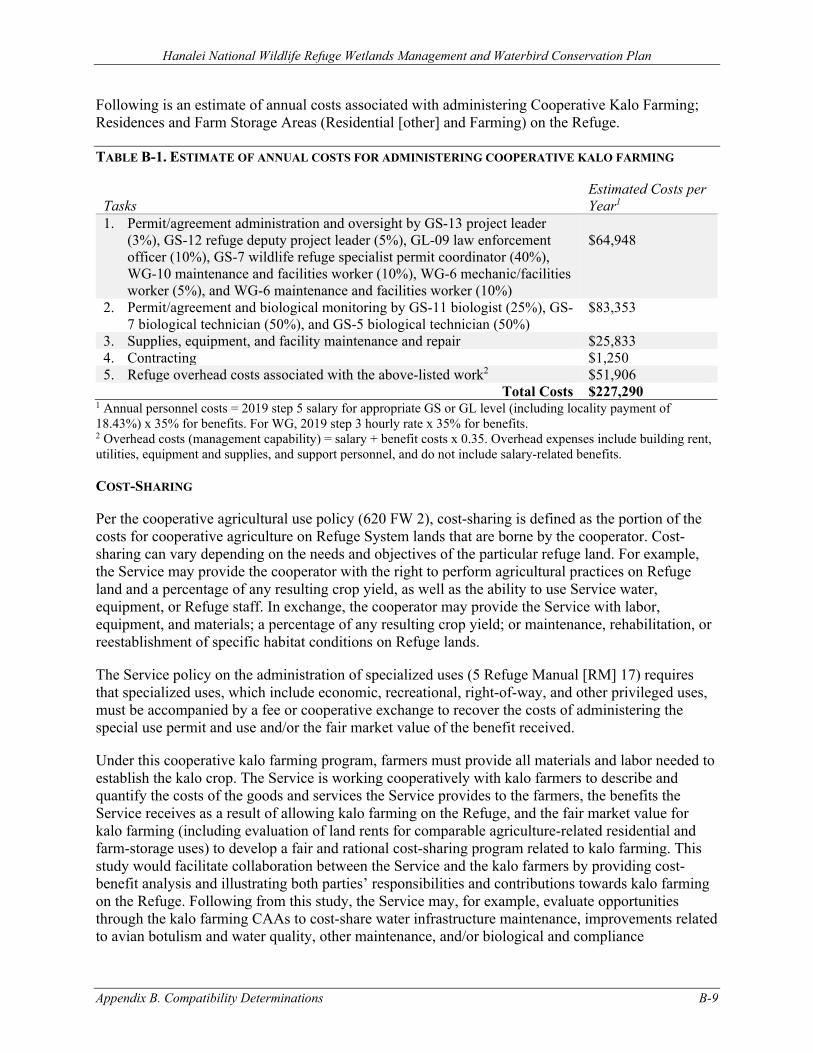
Hanalei National Wildlife Refuge Wetlands Management and Waterbird Conservation Plan
Appendix B. Compatibility Determinations B-9
Following is an estimate of annual costs associated with administering Cooperative Kalo Farming; Residences and Farm Storage Areas (Residential [other] and Farming) on the Refuge.
TABLE B-1. ESTIMATE OF ANNUAL COSTS FOR ADMINISTERING COOPERATIVE KALO FARMING
Tasks Estimated Costs per Year1
1. Permit/agreement administration and oversight by GS-13 project leader (3%), GS-12 refuge deputy project leader (5%), GL-09 law enforcement officer (10%), GS-7 wildlife refuge specialist permit coordinator (40%), WG-10 maintenance and facilities worker (10%), WG-6 mechanic/facilities worker (5%), and WG-6 maintenance and facilities worker (10%)
$64,948
2. Permit/agreement and biological monitoring by GS-11 biologist (25%), GS-7 biological technician (50%), and GS-5 biological technician (50%)
$83,353
3. Supplies, equipment, and facility maintenance and repair $25,833 4. Contracting $1,250 5. Refuge overhead costs associated with the above-listed work2 $51,906
Total Costs $227,290 1 Annual personnel costs = 2019 step 5 salary for appropriate GS or GL level (including locality payment of 18.43%) x 35% for benefits. For WG, 2019 step 3 hourly rate x 35% for benefits. 2 Overhead costs (management capability) = salary + benefit costs x 0.35. Overhead expenses include building rent, utilities, equipment and supplies, and support personnel, and do not include salary-related benefits.
COST-SHARING
Per the cooperative agricultural use policy (620 FW 2), cost-sharing is defined as the portion of the costs for cooperative agriculture on Refuge System lands that are borne by the cooperator. Cost-sharing can vary depending on the needs and objectives of the particular refuge land. For example, the Service may provide the cooperator with the right to perform agricultural practices on Refuge land and a percentage of any resulting crop yield, as well as the ability to use Service water, equipment, or Refuge staff. In exchange, the cooperator may provide the Service with labor, equipment, and materials; a percentage of any resulting crop yield; or maintenance, rehabilitation, or reestablishment of specific habitat conditions on Refuge lands.
The Service policy on the administration of specialized uses (5 Refuge Manual [RM] 17) requires that specialized uses, which include economic, recreational, right-of-way, and other privileged uses, must be accompanied by a fee or cooperative exchange to recover the costs of administering the special use permit and use and/or the fair market value of the benefit received.
Under this cooperative kalo farming program, farmers must provide all materials and labor needed to establish the kalo crop. The Service is working cooperatively with kalo farmers to describe and quantify the costs of the goods and services the Service provides to the farmers, the benefits the Service receives as a result of allowing kalo farming on the Refuge, and the fair market value for kalo farming (including evaluation of land rents for comparable agriculture-related residential and farm-storage uses) to develop a fair and rational cost-sharing program related to kalo farming. This study would facilitate collaboration between the Service and the kalo farmers by providing cost-benefit analysis and illustrating both parties’ responsibilities and contributions towards kalo farming on the Refuge. Following from this study, the Service may, for example, evaluate opportunities through the kalo farming CAAs to cost-share water infrastructure maintenance, improvements related to avian botulism and water quality, other maintenance, and/or biological and compliance
Hanalei National Wildlife Refuge Wetlands Management and Waterbird Conservation Plan
B-10 Appendix B. Compatibility Determinations
monitoring. Cost-sharing will be required in order to ensure that there are adequate resources to support the administration of this use to full compliance.
Providing waterbird habitat and aiding in the recovery of the species is the justification for allowing farming as a management tool. Kalo farming on the Refuge can satisfy some of the life history requirements of threatened and endangered Hawaiian waterbirds. Kalo farming on Hanalei NWR operates by providing for the needs of the birds in lieu of farming techniques optimized for kalo production. For example, there is an understanding that there will occasionally be some loss or damage to young kalo plants that results from some of the threatened or endangered waterbirds’ sporadic feeding or roosting habits within the lo‘i kalo, and that farmers are currently required to maintain a 3-foot radius (6-foot diameter) buffer of unharvested kalo around nesting waterbirds (the WMWCP adopts a minimum 6-foot radius [12-foot diameter buffer]) and retain lo‘i kalo in wet fallow status for at least 30 days following harvest. Therefore, kalo farming on the Refuge is a cooperative venture. Cost-sharing through the CAAs will attempt to ensure that fair market value is taken into account.
B.1.3 ANTICIPATED IMPACTS OF THE USES
REFUGE GOALS AND NWRS MISSION
As currently practiced, kalo farming and supporting subject residences, storage sheds, and surrounding areas on the Refuge directly or indirectly supports Refuge Goal 1 from the WMWCP.
▪ Cultivation of kalo supports Goal 1 by satisfying some of the life history needs of threatened and endangered Hawaiian waterbirds and supplements the native and naturalized habitats provided by the rotational wetland (moist-soil) management units on the Refuge; and
▪ Current kalo farming practices directly support Goal 1 by creating a diverse, year-round mosaic of wetland habitats that satisfy some of the life history needs of threatened and endangered Hawaiian waterbirds. Conversely, some management practices reduce food and cover, and cause disturbance to threatened and endangered breeding birds. Implementation of permit/agreement conditions as identified in the CD stipulations would increase the value of lo‘i kalo to threatened and endangered Hawaiian waterbirds, helping to ensure this practice remains compatible with the Refuge purpose.
To the extent that kalo farming provides habitat to support the recovery of threatened and endangered Hawaiian waterbirds, it is consistent with the Refuge System statutory mission, “…to administer a national network of lands and waters for the conservation, management, and where appropriate, restoration of the fish, wildlife, and plant resources and their habitats within the United States for the benefit of present and future generations of Americans” and with the establishment purpose of the Refuge to aid in the recovery of threatened and endangered species.
BIOLOGICAL INTEGRITY, DIVERSITY, AND ENVIRONMENTAL HEALTH
Historically, migratory and nonmigratory native waterbirds had access to more available and higher quality habitat. However, because many historical wetlands have been degraded, filled, and converted to agriculture or other land uses, threatened and endangered Hawaiian waterbirds must satisfy all of their daily resource requirements (e.g., foraging and roosting habitat) and seasonal life history requirements (e.g., breeding and molting) within a more restricted range. Agricultural wetlands, such as the lo‘i kalo on Hanalei NWR, provide wetland habitat for waterbirds. Thus, at the
Hanalei National Wildlife Refuge Wetlands Management and Waterbird Conservation Plan
Appendix B. Compatibility Determinations B-11
Refuge scale, BIDEH is negatively impacted by permitting cooperative kalo farming. However, at the larger landscape scale, kalo farming contributes to BIDEH by supporting the maintenance of threatened and endangered waterbird populations.
FISH, WILDLIFE, PLANTS, AND THEIR HABITATS
As noted earlier, the purpose of the Refuge is to benefit species listed under the ESA. At Hanalei NWR, the management focus is supporting the recovery of five federally-listed Hawaiian waterbirds: endangered ae‘o (Hawaiian stilt, Himantopus mexicanus knudseni); endangered ‘alae ke‘oke‘o (Hawaiian coot, Fulica alai); endangered ‘alae ‘ula (Hawaiian common gallinule, Gallinula galeata sandvicensis); endangered koloa maoli (Hawaiian duck, Anas wyvilliana); and threatened nēnē (Hawaiian goose, Branta sandvicensis).
Cooperative Kalo Farming Taken as a whole, Hanalei NWR, including lo‘i kalo, rotational managed wetlands, and associated upland and riverine habitats, represents 70 percent of the core habitat on Kaua‘i designated as essential to the recovery and delisting of four endangered waterbirds (USFWS 2005). Kalo farming provides a majority of the wetland acreage on Hanalei NWR. Excluding dikes, canals, and ditches, there is currently approximately 124 acres of lo‘i kalo versus 89 acres of rotational wetland (moist-soil) management units, respectively.
Across the Refuge year-round, lo‘i are in various stages of kalo production, including dry fallow (vegetated and nonvegetated), wet fallow (vegetated and nonvegetated), planting, flooded young plants, fully mature plants, and harvesting. In many cases, lo‘i also include native or beneficial, naturalized wetland plants. This provides a diversity of habitats, including water, vegetation, and invertebrates, and satisfies several of the life history requirements for the Refuge’s threatened and endangered Hawaiian waterbirds (Gutscher-Chutz 2011; Gee 2007).
For example, previous studies and observations from ongoing research on the Refuge reveal that koloa maoli use lo‘i kalo for many of the same life history requirements—including loafing, foraging, courtship, and nesting—for which they use moist-soil wetlands (Gee 2007; Malachowski 2014; Malachowski and Dugger 2018). This is important, because the Refuge is the most important protected site for this species and it hosts a large portion of the few remaining non-hybridized koloa maoli, and therefore the Refuge may have the best opportunity in the state of supporting recovery of this species.
The threatened and endangered Hawaiian waterbirds and other Refuge wildlife feed on vegetation, seeds, invertebrates, and small fishes and tadpoles in lo‘i in all stages of kalo production. Koloa maoli use kalo farms predominantly for resting (primarily on dikes) and foraging (primarily in lo‘i kalo, feeding on aquatic invertebrates as well as on plants) (Malachowski and Dugger 2018). ‘Alae ke‘oke‘o and ‘alae ‘ula sporadically feed on kalo shoots, and use young and mature kalo for cover, nest sites, or nest materials (Gee 2007; NRCS 2009). This behavior is uncommon but has occurred prior to breeding in extremely dry years when the waterbirds might be seeking calcium found in the kalo when regular sources (snails, crustaceans, insects) are unavailable. Wet fallows and providing additional food sources such as moist soil vegetation should provide alternate food resources to meet annual lifecycle needs of birds and reduce feeding on kalo. Threatened nēnē and endangered waterbirds use vegetated dry fallow and recently planted lo‘i for foraging and roosting. Dry fallow lo‘i that are unvegetated or mudflats are used for roosting by kōlea (Pacific golden plover, Pluvialis fulva) and other migratory shorebirds. Vegetated dry fallow lo‘i are heavily used by ‘alae ‘ula, ‘alae
Hanalei National Wildlife Refuge Wetlands Management and Waterbird Conservation Plan
B-12 Appendix B. Compatibility Determinations
ke‘oke‘o, and koloa maoli in the initial growing stages (Gee 2007; Michael Mitchell 2011, pers. comm.). Lo‘i water levels are drawn down prior to kalo harvest and this stimulates production of wetland plants and invertebrates that are readily fed upon by Hawaiian waterbirds. Dry fallowing lo‘i for at least a few weeks is recommended between harvesting and replanting to improve soil conditions, restore fertility and reduce fertilizer use and costs (NRCS 2009). In addition, this practice helps to reduce the incidence of botulism outbreaks by drying out and aerating the soils (Egelhoff 2017).
Lo‘i kalo in post-harvest wet fallow are heavily used by Hawaiian waterbirds, in part because this stage generates substantial invertebrate biomass, its shallowly flooded sediments are easily accessed by wildlife, and potential predators are clearly seen (Broshears and Parrish 1980; Gutscher-Chutz 2011). Studies of lo‘i kalo use by ‘alae ‘ula and koloa maoli reveal the highest densities of their use in wet fallow and during harvest (Gutscher-Chutz 2011). Ae‘o use unvegetated wet fallow, and ‘alae ke‘oke‘o and koloa maoli prefer vegetated wet fallow (Gee 2007). Considering the high value of wet fallow to the Hawaiian waterbirds, Refuge kalo farming CAA/SUPs would require that following harvest, lo‘i be kept in wet fallow for a minimum of 30 days. Field observations reveal that this is not always occurring (Gee 2007).
Without adherence to stipulations designed to ensure compatibility, kalo farming practices could conflict with the establishment purpose of Hanalei NWR and other legal mandates such as the ESA. Lo‘i kalo on the Refuge has often historically been managed primarily to meet kalo production goals. Potentially conflicting practices include fertilization schedules and flooding and drying cycles timed to benefit kalo, rather than threatened and endangered Hawaiian waterbirds, their nesting requirements, or production of invertebrate and plant food sources. Kalo farming often involves control of non-kalo plants and invasive species through hand-weeding, mowing, dewatering lo‘i, or application of pesticides. Many of these non-kalo, wetland plants which may be unwanted by farmers (e.g., Fimbristylis littoralis, Cyperus spp., Eleocharis spp., Ludwigia spp., and Schoenoplectus juncoides) provide waterbirds with vegetative forage, cover, enhance the production of invertebrates, and, for ‘alae ‘ula and ‘alae ke‘oke‘o, provide nesting structure or materials (Gee 2007). In less intensively managed lo‘i and fallow lo‘i where non-kalo emergent vegetation was present, koloa maoli engaged in foraging behaviors similar to those used in managed wetlands (Chris Malachowski 2019, pers. obs. cited in Malachowski and Dugger 2018).
Many of the activities associated with kalo farming disturb or have the potential to disturb wildlife, including threatened and endangered Hawaiian waterbirds that use the lo‘i and surrounding areas as habitat (Gee 2007). The Hanalei Valley’s warm and wet climate allows kalo farming to occur year-round, so lo‘i kalo and associated features (e.g., dikes, ditches, and banks) are manipulated year-round. This includes numerous farm production activities, such as plowing, tilling, fertilizing and liming, planting, weeding, mowing, applying pesticides, managing water levels, and harvesting. Some of these activities (e.g., flooding and dewatering, weeding, and application of fertilizer and lime) are repeated multiple times throughout the production cycle (Gee 2007). During nonbreeding periods, nēnē, ae‘o, and ‘alae ke‘oke‘o appear to be fairly tolerant of disturbance. However, when birds are breeding or in heavy molt, they are all more susceptible to disturbance and more vulnerable to predation. Koloa maoli and ‘alae ‘ula are very wary and often flush or move quickly into dense cover when disturbed (Gutscher-Chutz 2011). Flushing of birds or even raising their alert levels creates stress and requires expending energy that would otherwise be invested in essential life history activities such as foraging, mating, nesting, brood-rearing, and predator avoidance. Disturbance can cause nest desertion; affect survival of individual birds, eggs, nestlings, or broods; and alter behavior of nonbreeding waterbirds. Overall, koloa maoli were disturbed less often in rotational managed
Hanalei National Wildlife Refuge Wetlands Management and Waterbird Conservation Plan
Appendix B. Compatibility Determinations B-13
wetlands than in kalo farms; however, the differences in human-related disturbances between wetland types was comparatively small (10 percent vs. 14 percent) and of questionable biological significance (Malachowski and Dugger 2018).
Lo‘i water levels are fluctuated and kalo corms, stalks, and leaves are harvested during times when some waterbirds are nesting over water in mature kalo plants. This can increase nest flooding, nest desertion, and increase the vulnerability of nesting waterbirds, their eggs, and their chicks to predation. Gee (2007) followed ‘alae ‘ula nests that were primarily found during kalo harvest on the Refuge. These nests experienced average nest success, but low fledging success. Nest failure was attributed to predation, abandonment, and flooding.
Complaints about suspected reduced kalo yields due to threatened and endangered waterbird depredation resulted in two of nine permittees being allowed to temporarily place fences around three lo‘i kalo during March–May 2013. Monitoring showed that the fences created obstacles that resulted in collisions for waterbirds (Dugger, Unfried, and Malachowski 2015). The frequency of high impact collisions was highest for ‘alae ‘ula. Because of the negative impacts to the threatened and endangered waterbirds, fencing and other barriers are not permitted within the kalo farming permit areas.
Some kalo farming on the Refuge includes management or removal of unwanted vegetation from lo‘i, banks, ditches, and dikes. Dike top mowing allows easy travel across dikes, good access to short vegetation, enhanced predator visibility, and provides loafing, preening, and foraging habitat for ‘alae ke‘oke‘o, ‘alae ‘ula, koloa maoli, and nēnē (Gee 2007). Removal of vegetation from lo‘i and ditch banks results in loss of some native and beneficial naturalized plants (e.g., Fimbristylis dichotoma, Bacopa monnieri, Cyperus polystachyos, and Echinochloa crus-galli), reduction in invertebrates, and accompanying loss in potential loafing, foraging, breeding, and nesting habitat. These management practices are also expensive, create wildlife disturbance, and potentially enhance sedimentation while reducing vegetative filtering of discharge water.
Residences and Farm Storage Areas (Residential [other] and Farming) Resident farmers are allowed to keep some domesticated animals on the lands they occupy associated with their houses (their permit areas). Because Hawai‘i’s threatened and endangered waterbirds evolved in the absence of mammalian predators and some birds nest directly on the ground, domestic animals, especially cats and dogs, running loose (i.e., feral animals) or being kept in areas that waterbirds use regularly on the Refuge, pose a significant threat to recovery of these waterbirds.
Refuge staff has observed that storage and personal use areas surrounding some residences have grown in size over the years. These areas are used for landscaping, fruit and vegetable gardens, outbuildings, and storage of equipment and other materials. This unauthorized expansion consumes actual or potential wildlife habitat and increases the human footprint and zone of wildlife disturbance.
In addition, within or adjacent to some permit areas, there has been a growing accumulation of abandoned motor vehicles, abandoned farming equipment, and other abandoned equipment; supplies that are not being actively used in kalo farming or in maintenance, repair, or other legal use of permit areas; and other refuse and piles of excess or unused materials. Storage of this equipment and other materials can attract pests, such as rats, that can prey on threatened and endangered Hawaiian waterbirds and vector disease; violates Service policy on the management of nonhazardous solid waste on Refuges (561 FW 5); and is unsightly.
Hanalei National Wildlife Refuge Wetlands Management and Waterbird Conservation Plan
B-14 Appendix B. Compatibility Determinations
Although not solely related to kalo farming and associated activities, vehicle traffic along ‘Ōhiki Road threatens threatened and endangered waterbirds. From 2003 to 2008, the Service documented on average four threatened or endangered bird deaths each year on this road (Letter from M. Hawkes to W. Kudo, June 25, 2008). From 2013 to 2015, we documented on average 14 threatened or endangered and migratory bird deaths each year on this road, including 22 ‘alae ‘ula, 11 ‘alae ke‘oke‘o, seven nēnē, and two kōlea. During the first six months of 2016, 15 additional threatened or endangered birds have already been recorded as struck by vehicles on the same road, nearly three birds per month. These numbers indicate an increasing trend in threatened and endangered bird deaths on ‘Ōhiki Road (Letter from H. Tonneson to L. Tabata, July 29, 2016). Along with the general public, kalo farming permittee/cooperators would need to comply with the posted speed limit (15 miles per hour) and use pullouts as appropriate to halt the loss of threatened and endangered species from vehicle strikes and resolve other issues, including public safety.
WATER QUALITY
In recognition of its scenic beauty, rich biological resources, cultural significance, and recreational and economic values, the Hanalei River was designated an American Heritage River (under Executive Order [EO] 13061) in 1998. Among other things, the river provides habitat for native fishes and invertebrates, including five species of ‘o‘opu (Hawaiian gobies), pinao ‘ula (damselflies), and ‘ōpae ‘oeha‘a (shrimp). The American Heritage River Executive Order charges federal agencies with assisting local communities in protecting and restoring designated rivers.
Because of elevated levels of Enterococci and turbidity (total suspended solids), the State of Hawai‘i Department of Health (HDOH) identified the Hanalei Bay Watershed as water quality limited under section 303(d) of the Clean Water Act (HDOH 2008). Elevated levels of nutrients (total nitrogen and total phosphorus) were also identified as a concern (Tetra Tech and HDOH 2008). The Hanalei River flows through Hanalei NWR and is the largest tributary in this watershed. In an effort to address constituents of concern in these waterbodies, HDOH established total maximum daily loads (TMDL) for the Hanalei River and Hanalei Estuary (HDOH 2008). The HDOH identified no dischargers with National Pollutant Discharge Elimination System permits or other point sources of pollution in the Hanalei River Watershed, so the TMDL address non-point sources. Hanalei NWR’s native and exotic wildlife, and lo‘i kalo were identified as sources of constituents of concern to the Hanalei River (Tetra Tech and HDOH 2008).
Water quality concerns related to kalo farming include the additional inputs of fertilizer and herbicides and the prevalence of wet tilling and other soil disturbances during kalo production, which can cause turbid water to flow back into the river. Ditch cleaning and the removal of vegetation along ditch banks (i.e., grinding vegetation or removing vegetation by digging) can also adversely affect water quality. As noted above, kalo farmers routinely control unwanted vegetation using, among other methods, application of herbicides. Glyphosate is the only herbicide currently approved for use per SUP and the pesticide use proposal (PUP) for the Refuge.
The Service’s Water Resources Branch (WRB) continuously monitored field water quality parameters (temperature, conductivity, pH, dissolved oxygen [DO], and oxidation/reduction potential [ORP]) in areas of the Refuge for various periods from 2015 to 2017. Monitoring was done in lo‘i selected randomly from the northeast and southeast kalo farms and in rotational managed wetland units from all areas of the Refuge; lo‘i kalo within the northwest part of the Refuge were not monitored. Inflows to these areas had lower temperature, conductivity, and turbidity and higher pH, DO and ORP. Comparing managed wetlands to lo‘i kalo, temperatures were either the same or
Hanalei National Wildlife Refuge Wetlands Management and Waterbird Conservation Plan
Appendix B. Compatibility Determinations B-15
slightly warmer in the wetlands. DO was low in wetlands but not nearly as low as in lo‘i kalo and the upper range of concentrations was higher in wetlands. pH in the wetlands was slightly acidic (6.0–7.0) and similar to the lo‘i kalo. ORP was always positive. Conductivity was slightly lower in the wetlands compared to the lo‘i kalo but in general, conductivity was very low everywhere on the refuge so this difference may not be significant. There were occasional higher spikes in conductivity observed in the lo‘i kalo in the northeast.
Comparing field water quality parameters in the lo‘i kalo in the northeast versus the southeast, the differences were usually small or non-existent. For most sampling periods, water temperatures were slightly cooler in the northeast versus the southeast (contrary to what was expected). Conductivity was slightly lower, and pH was usually slightly higher in the southeast. DO concentrations were low in both areas but usually higher in the southeast, with the exception of summer 2015, when they were lower. There was a lot of variability in field water quality parameters, especially DO and pH, at the scale of the individual lo‘i kalo (comparing one lo‘i kalo to another from the same area or farmer). This variability was so great that it is hard to generalize about comparisons between areas or farmers.
Comparisons of field water quality parameters between recently fertilized versus unfertilized lo‘i kalo were inconclusive. One might expect that fertilization, and the drawdowns that accompany them, would lead to consistent differences in DO and pH but this was not observed. In the summer 2015, we observed no differences in DO or pH in recently fertilized lo’i kalo compared to lo’i kalo that had not been fertilized recently. In the winter 2016, we observed lower pH and DO in recently fertilized lo’i kalo in the northeast. In the summer 2017, we monitored the same lo’i kalo before and after they were fertilized and observed an increase in DO following fertilization and drawdown, but little change in pH.
The Service’s WRB also conducted nutrient sampling from July to September 2015 and from January to March 2016 in the same areas as described above. Concentrations of total nitrogen, total phosphorus, and ammonia nitrogen were lowest in the inflows and higher in the lo‘i kalo compared to managed wetland units. Bioavailable nitrogen was in the form of ammonia nitrogen at all sites; nitrate nitrogen was non-detectable in all samples. Considering all samples from both seasons combined, total nitrogen, total phosphorus, and ammonia nitrogen concentrations were highest in the northeast lo‘i kalo. Occasionally, there were very high concentrations of ammonia nitrogen in the northeast lo‘i kalo; Similar nutrient spikes were not observed in the southeast lo‘i kalo or managed wetlands. There was almost no ammonia nitrogen in the managed wetlands. Finally, there was no statistical difference in nutrient concentrations between summer and winter in the northeast lo‘i kalo. All the other areas showed much lower nutrient concentrations in the winter compared to the summer. Nutrient concentrations appear to be very high in the northeast lo‘i kalo throughout the year.
In winter 2016, the WRB also sampled the Hanalei River upstream and downstream of the Refuge for total nitrogen, total phosphorus, ammonia nitrogen, and nitrate nitrogen. Samples were collected weekly for eight weeks. Nitrogen was almost always non-detectable at both sites. Phosphorus was slightly higher downstream. It was mostly non-detectable upstream and at low concentrations downstream. Samples were not collected during the summer, when nutrient concentrations are known to be higher and river flows lower.
Additional water quality concerns related to kalo farming are the prevalence of wet tilling and other soil disturbance during kalo production, which can cause turbid water to flow back into the river. Results from water quality monitoring conducted during spring (March–April) and summer (June–September) 2015, winter (January–March) 2016 in randomly selected managed wetland units and lo‘i
Hanalei National Wildlife Refuge Wetlands Management and Waterbird Conservation Plan
B-16 Appendix B. Compatibility Determinations
kalo in the northeast and southeast indicated differences between water quality in managed wetland units and lo‘i kalo (Feddern 2016). The largest differences were DO and ORP, both of which were lower in loʻi kalo than in the managed wetland units. Additionally, a strong correlation between low DO and low ORP was observed suggesting anoxic conditions contribute to negative ORP and thus higher avian botulism risk (Feddern 2015). In both lo‘i kalo and managed wetlands, summer DO was lower than winter DO. DO saturation and concentrations in the northeast lo‘i kalo in winter were greatly lower than southeast lo‘i kalo.
Additional observations were made regarding algal and plant abundance in loʻi compared to managed wetlands. In some loʻi, large mats of Azolla filiculoides (a nitrogen fixing aquatic fern) and algae were present, while in other loʻi and managed wetlands Azolla was absent and algal abundance was minimal. Azolla grows best in high phosphorus conditions and at depths of 0.5 to 0.833 ft (Uchida et al. 2008). Based on this information it was hypothesized fertilization in loʻi kalo causes Azolla and algal blooms in response to nutrient inputs. It is likely plant and algae die offs follow these blooms as nutrients are consumed and loʻi water depth decreases (water draw-downs typically follow kalo fertilization).
The Refuge has worked with residents to upgrade their old cesspools to modern septic systems. Some of the farm storage structures are three-sided sheds without constructed floors or drain/filtering systems. In addition, some farming and other equipment and supplies are stored directly on the ground, outdoors, and without overhead shelter where they are exposed to the Hanalei Valley’s rains, intense sun, wind, and flood events. Exposure of storage containers to the weather increases the likelihood that they will develop rust and holes, and leak petroleum products or heavy metals into the underlying soil and surface and ground waters. Storage, transfer, and use of farming-related supplies such as fertilizers, pesticides, and petroleum products outdoors or in areas without impervious floors, drains, and containment/filtering systems increases the likelihood of surface and ground water contamination and of winds picking up surface dust. If not managed properly, these contaminants could adversely affect Refuge habitats and wildlife, including threatened and endangered Hawaiian waterbirds, and could contribute to the river’s water quality problems. Finally, as noted above, there is evidence of unauthorized expansion of areas surrounding some residences and storage sheds. This expansion creates additional potential threats to surface and ground water through rainwater leaching, to air quality through wind-blown dust, and direct contamination during large flooding events.
The Hanalei River watershed is large and steeply sloped in many areas. Flows in the lower river—which the Refuge straddles—are flashy, and the Refuge lands used for residences, storage sheds, other facilities, and storage of equipment and supplies are subject to periodic flooding. This increases the risks to soil and water quality associated with flooding and transfers of fertilizer, pesticide, and petroleum residues across the ground surface into lo‘i kalo and rotational managed wetland units or through leaching into ground waters. This is a special concern for equipment, supplies, and other materials stored on the ground outdoors, in three-sided sheds, or in other buildings with dirt floors.
AVIAN BOTULISM
Although the first case was reported in the late 1970s, outbreaks of avian botulism type C, a paralytic disease caused by ingestion of a toxin produced by the bacterium Clostridium botulinum, have occurred with regularity at Hanalei NWR since November/December 2011. Between 2011–2018, 1,342 cases of avian botulism were recorded on the Refuge (Reynolds et al. 2019). These botulism outbreaks have killed individuals of all five federally-listed waterbird species occurring on the Refuge and have been particularly detrimental to koloa maoli, which represent 62 percent of birds
Hanalei National Wildlife Refuge Wetlands Management and Waterbird Conservation Plan
Appendix B. Compatibility Determinations B-17
affected (Reynolds et al. 2019). Unlike mainland avian botulism events, outbreaks on the Refuge can occur year-round due to lack of seasonal variability in temperatures; however, they have been most prevalent in the northern lo‘i kalo during the winter months.
C. botulinum occurs naturally in soil, often lying dormant until the appearance of favorable conditions for growth and toxin production. During the growth phase of C. botulinum, the bacterium produces potent neurotoxins. Botulinum spores can be found in wetland sediments and the tissues of aquatic invertebrates and many vertebrates, creating many pathways for outbreaks to occur once conditions for growth are favorable. One of the more common mechanisms of large avian botulism outbreaks is the carcass‐maggot cycle, where fly larvae feed on an infected carcass and are in turn consumed by birds that become affected and die, leading to more sites for maggots to feed. Ingestion of the botulinum toxin by birds inhibits the neurotransmitter acetylcholine and results in eventual paralysis of the voluntary muscles. This can lead to death by drowning, starvation, or predation (Rocke and Friend 1999).
Environmental conditions associated with avian botulism outbreaks include temperatures between 20–40°C, low dissolved oxygen, pH between 7.5 and 9.0, negative redox (oxidation/reduction) potential, and sources of decaying organic matter (especially protein such as decaying fish) (Rocke and Bollinger 2007; Rocke and Samuel 1999). The hydrological infrastructure and management of the Refuge, particularly within certain areas of lo‘i kalo, might influence the abiotic growth factors for C. botulinum, alter the availability of growth media, or lead to buildups of the toxin in areas with less water flow to flush the toxin. Factors leading to C. botulinum growth might also vary naturally or with other management practices, such as lo‘i kalo drawdowns, fertilization, or pesticide application. Hotspot (density) mapping of avian botulism cases based on data from 2011–2020 indicate that the location of hotspots varied somewhat from year to year with the most severe outbreaks (i.e., highest density botulism hotspot) occurring in lo‘i kalo in the northern part of the Refuge. The kalo regions Refuge-wide had similar densities of live/healthy koloa maoli; however, the northern kalo regions (northeast and west) contained more botulism cases relative to the numbers of koloa maoli using these areas (McDonald 2016).
Since 2015, Refuge staff has worked concertedly to improve Refuge kalo farmers’ capacity to use water more effectively and to prevent and respond to avian botulism outbreaks in hotspot areas. These efforts include improving water system infrastructure to promote higher water quality and facilitate better flushing and drainage so that waterbird exposure to warm, anaerobic soil conditions with decaying protein sources is minimized. Following improvements to water infrastructure on the Refuge, there have been reductions in avian botulism outbreak severity and frequency and in associated bird deaths over the past several years.
PUBLIC USE
Due to the Refuge’s primary purpose of management for threatened and endangered species and the sensitivity of habitat and species within the Refuge, public use of the Refuge is restricted. There is public access to ‘Ōkolehao Trail from a parking lot and trailhead along ‘Ōhiki Road, as well as some environmental education and limited guided hikes along the main roads that occur. Kalo farming is managed via SUP over 160 acres of the Refuge lowlands (including dikes and ditches but excluding buildings and farm storage areas). Resident farmers and their families, nonresident farmers, and kalo farming employees travel and haul equipment and other materials along the narrow ‘Ōhiki Road. The scenic valley in the heart of the Refuge is a popular subject of photographers on Kaua‘i and is often best captured from above at the Hanalei Valley Scenic Overlook along Kūhiō Highway.
Hanalei National Wildlife Refuge Wetlands Management and Waterbird Conservation Plan
B-18 Appendix B. Compatibility Determinations
Most of the residences and storage sheds lie along roads adjacent to the Hanalei River, which bisects the Refuge.
Currently, this use has negligible to minor impacts to the limited amount of public use occurring on the Refuge. Continuation of this use would not be expected to reduce the potential for high-quality, compatible, wildlife-dependent recreation into the future.
CULTURAL RESOURCES
Farming on Hanalei NWR represents a substantial portion of kalo acreage and production statewide (40–60 percent; Gutscher-Chutz 2011; NASS 2012; Cho, Yamakawa, and Hollyer 2007). Kalo farming on Hanalei NWR is of cultural interest and importance to Native Hawaiians across the state and the public at large.
Kalo plays a prominent role in the Hawaiian origin and traditional stories. It is revered as a divine ancestor and for its mana (supernatural or divine power, life force). Kalo was brought to the Hawaiian Islands by Polynesian voyagers more than 1,000 years ago and has been a staple of the Hawaiian diet ever since. It has been used for food, for religious and medicinal purposes, as well as for bait, glue, and dye (Kāne 1997). Kalo is also closely tied to traditional Native Hawaiian concepts of family, responsibility, personal health, a healthy environment, sustainability, and perpetuation of cultural values (Lo 2006). Today, efforts are underway to help Native Hawaiians reconnect with traditional cultural values and practices by locating and restoring historic lo‘i kalo and cultivating and processing kalo for food and other purposes.
The Hanalei Valley, which includes Hanalei NWR, contains a number of historic and pre-contact resources. Farmers living in modest residences adjacent to the lo‘i kalo where they work is representative of a traditional, tenant-farming system that has mostly disappeared in Hawai‘i. During the 1980s the Hanalei Valley was identified by the National Trust for Historic Preservation (NTHP) as an important site for rural preservation. One structure located on the Refuge among the residences, the Haraguchi Rice Mill, is listed on the National Register of Historic Places. This structure is privately owned, is not a residence, is not used for kalo farming, is no longer a functioning mill, and is not addressed in this CD.
As noted earlier, the residences, farm storage sheds, other facilities, and surrounding areas were constructed and used by individuals and families to support kalo farming on the Refuge.
B.1.4 PUBLIC REVIEW AND COMMENT
The review and comment period for this CD were concurrent with the Refuge's draft WMWCP and EA. These documents were available for an initial 30-day comment period from August 21 to September 12, 2020, during which two virtual public meetings were held, as well as additional outreach meetings. In response to requests for additional time for review and comment, the Service extended the comment period an additional 15 days from September 21 to October 5, 2020.
B.1.5 DETERMINATION
Use is Not Compatible
X Use is Compatible with Following Stipulations
Hanalei National Wildlife Refuge Wetlands Management and Waterbird Conservation Plan
Appendix B. Compatibility Determinations B-19
B.1.6 STIPULATIONS NECESSARY TO ENSURE COMPATIBILITY
GENERAL (SPECIFIC TO KALO FARMING)
1. Kalo farming on the Refuge is officially authorized through a CAA and documented on a Commercial Activities SUP for each permittee/cooperator (hereafter referred to as permittee). The CAAs would authorize kalo farming and necessary, related activities for 1–5 years each (this includes permits for existing residences and sheds). Use of Refuge lands for other purposes would not be allowed without specific, prior written approval of the Refuge manager (for the purpose of these stipulations, the Refuge manager is the Refuge Project Leader of the Kaua‘i National Wildlife Refuge Complex). In the event an existing permittee chooses to discontinue or is unable to continue kalo farming on the Refuge, the Service would evaluate whether to retain the area in lo‘i kalo or assign it to other habitat types based on a management decision flowchart (Figure B-1). If the Service determines that kalo farming would continue within that particular area, an open and competitive process would determine award of the CAA.
2. Permittees are required to restrict their activities and access on the Refuge to their residences or storage sheds and the immediately surrounding areas, their lo‘i kalo and associated facilities (e.g., dikes, canals, and ditches), the access roads depicted on the attached map (Figure B-2), and other areas open to the public. Access to other areas of the Refuge that are not open to the public would not be allowed without specific, prior written approval of the Refuge manager.
3. Permittees are prohibited from assigning or sub-permitting their Refuge farming authorizations. Permittees are required to personally supervise and participate in all kalo farming activities, including maintenance of irrigation ditches and roads in their permit area.
4. Permittees are required to supply labor for all ditch cleaning and maintenance and repair of roads in their permit area. Each permittee is required to keep a record of ditch cleaning and road maintenance or repair effort that is available upon request from the Refuge manager. Additionally, permittees are required to cooperatively maintain fences, gates, water control structures, signs, and other infrastructure in partnership with the Refuge staff (Figures B-3, B-4, and B-5). Specific individual and shared responsibilities for maintenance would be included in the plan of operations associated with the CAA.
5. Permittees are required to brief new employees (i.e., farm workers) about the special status of Hanalei NWR; management of the Refuge for native fish, wildlife, plants, and their habitats; the need to exercise care and caution while on the Refuge to minimize disturbance or other impacts to threatened and endangered species, other native wildlife, or Refuge visitors engaging in wildlife-dependent education or recreation; the need to minimize the likelihood that nonnative species, including domestic dogs, cats, noxious weeds, or pest plants, are brought onto the Refuge; and all of the special conditions of their CAA/SUP.
6. Permittees will be required to participate in a comprehensive Refuge water budget analysis, and subsequent implementation of recommended improvements is required to help ensure the availability of an adequate water supply throughout Hanalei NWR.
GENERAL (SPECIFIC TO RESIDENCES AND FARM STORAGE AREAS)
1. Use of Refuge lands for kalo farming-related residences, outbuildings, other structures associated with the residences, storage sheds, and surrounding areas is authorized through the same CAA and documented on the same Commercial Activities SUP as its associated
Hanalei National Wildlife Refuge Wetlands Management and Waterbird Conservation Plan
B-20 Appendix B. Compatibility Determinations
cooperative kalo farming and as such has the same terms and conditions associated, including permit length.
2. Use of Refuge lands for permittee-owned residences, storage sheds, and other facilities will be terminated if associated kalo farming CAAs and SUPs are terminated. In the event of termination, the permittees will be granted 180 days to remove their improvements (residences, storage sheds, outbuildings, and other structures), equipment, supplies, and other personal property from the Refuge. Any property remaining on the Refuge after 180 days will be considered abandoned, becomes the property of the Service, and could be disposed of.
3. Only permittees and members of their immediate family—legal parents, spouses, and children—are allowed to live in the primary residences described in the CAAs and SUPs. At least one permit holder must live in the residence. The number of people residing in a residence located within the Refuge cannot exceed the design limit or County Code for the residence and its associated septic system.
4. No new farmer residences are authorized on Refuge property. Permittees are prohibited from constructing new structures or making modifications/additions to their existing structures in their CAA/SUP area or elsewhere on the Refuge without specific, prior written approval of the Refuge manager. All residences, outbuildings, other structures associated with the residences, and the immediately surrounding areas, and all storage sheds and immediately surrounding areas are also required to be constructed, modified, and maintained consistent with relevant County and State building, electrical, plumbing, health and safety, and other similar codes, standards, and other relevant requirements. This includes securing appropriate permits and approval from the Refuge manager prior to construction or modification. Stipulations associated with this Refuge authorization could be more restrictive than county and state requirements. Permittees are required to comply with the most restrictive applicable requirement.
5. Permittees who both reside and farm kalo on-site are restricted to use of a Refuge area totaling approximately one acre in size for their existing residence and immediately surrounding areas for residential use and storage; this area is specified within the CAA/SUP. These areas will be marked with signs or through use of other appropriate means that clearly show the boundary of the CAA/SUP area. The final size limitation and the shape of individual permit areas will be based in part on an on-the-ground review by Refuge staff in consultation with Refuge kalo farmers. Permittees are prohibited from clearing or otherwise using areas of the Refuge outside their permit areas for any reason without specific, prior written approval of the Refuge manager.
6. Permittees who live off-site, but farm kalo on-site, are restricted to use of a Refuge area totaling approximately 0.06 acre (2,500 square feet) in size for their existing storage sheds and immediately surrounding areas. These CAA/SUP areas will be marked with signs or through use of other appropriate means that clearly show the boundary of the permit area. The final size limitation and the shape of individual permit areas will be determined in part on an on-the-ground review by Refuge staff in consultation with Refuge kalo farmers. Permittees are prohibited from clearing or otherwise using areas of the Refuge outside of their permit areas without specific, prior written approval of the Refuge manager.
7. Permittees who live on-site are allowed to store and use a number (specified within their CAA/SUP) of personal vehicles and equipment that are used in farming or maintenance and repair of their homes, storage sheds, or permit areas. However, permittees are prohibited from storing abandoned or unusable motor vehicles and farming equipment or supplies that are not being actively used in kalo farming on the Refuge or in maintenance, repair, or other legal use of their permit areas.
Hanalei National Wildlife Refuge Wetlands Management and Waterbird Conservation Plan
Appendix B. Compatibility Determinations B-21
8. Permittees who live on-site are allowed to plant and maintain fruit and vegetable gardens/orchards immediately adjacent to residences, in consultation with the Refuge manager, and keep a total of no more than the following numbers of pets or livestock inside each of their CAA/SUP areas: two dogs (must be fully contained in a kennel or fenced area near residence or kept indoors) and one horse, if used in kalo farming operations. Young animals cannot be kept on the Refuge after they have been weaned. Neither indoor nor outdoor pet cats are allowed. One pig and ten adult chickens may be raised for personal consumption only (not for sale), but they must be confined to pens at all times. Other than horses used in farming operations, these animals are prohibited from roaming freely on the Refuge, or from accompanying resident farmers or their employees, family members, and guests to kalo fields or in any other part of the Refuge. Any dog observed harassing wildlife on the Refuge is subject to immediate removal.
9. Permittees and their employees who live off-site are prohibited from planting or maintaining fruit or vegetable plants, gardens, or orchards; or from bringing or keeping any animals on the Refuge.
GENERAL (APPLIES TO ALL KALO FARMING AND RELATED RESIDENTIAL/STORAGE USES)
The following stipulations apply to permittees, their family members, employees, and guests.
1. In the absence of specific, prior written approval of the Refuge manager, permittees, their family members, their employees, and their guests are prohibited from collecting and removing any abiotic or biological specimens or samples, or mementos from the Refuge.
2. Consistent with Service policy regarding management of nonhazardous solid waste on refuges (Resource Conservation and Recovery Act of 1976 [RCRA], as amended (42 U.S.C. 6901–6992k)—Solid Waste (Nonhazardous); 50 CFR 27.93, Abandonment of Property; 50 CFR 27.94, Disposal of Waste; and 561 FW 5, Managing, Recycling, and Disposing of Non-Hazardous Solid Waste), permittees are prohibited from dumping or disposing of refuse/trash, debris, litter, or abandoned, excess, or unused materials, building materials, and supplies on the Refuge, including permit areas. These must be removed by permittees on at least a quarterly (90 day) basis. Permittees are prohibited from dumping or disposing of noncomposted organic material on the Refuge without specific, prior written approval of the Refuge manager (see Farming, Fish and Wildlife, and Water Quality, #7, below).
3. Permittees are required to hold the United States Government harmless from any damages or injury to the permittee or members of the public in areas and facilities accessed via the terms of their permit.
4. In addition to the stipulations listed here and the Commercial Activities SUP conditions and requirements, permittees, their family members, their employees, and their guests are required to comply with Refuge System-related and other applicable laws, regulations, and policies including “Prohibited Acts” listed in 50 CFR 27.
5. Permittees or their representatives are required to participate in meetings or workshops with Refuge management at least twice annually. The purposes of such meetings would be to share new information, discuss results of monitoring, assist with plant identification, review compliance with these stipulations, and address other issues. Other meetings will be scheduled as needed.
6. No changes can be made to any of these stipulations without specific, prior written approval of the Refuge manager.
Hanalei National Wildlife Refuge Wetlands Management and Waterbird Conservation Plan
B-22 Appendix B. Compatibility Determinations
FARMING, FISH AND WILDLIFE, AND WATER QUALITY
1. All lo‘i are required to be kept in kalo farming at all times, subject to the normal practice of keeping the land fallow at intervals for soil conservation (i.e., 4–8 weeks). Permittees are allowed to keep up to 25 percent of the total lo‘i area in dry fallow for a period not to exceed 180 days. The area in cultivation and the area in dry fallow must be alternated. In avian botulism prone areas, permittees are required to drain, harvest, and dry fallow lo‘i for ≥30 days pending Refuge manager request.
2. Permittees are required to keep lo‘i in wet fallow for a minimum of 30 days, with a water depth of 6–8 inches, following the complete harvest of kalo in that lo‘i. All exceptions to the wet fallow time requirement must be approved in writing by the Refuge manager prior to replanting. The Refuge manager may extend or reduce the required wet fallow period with advance notice. Permittees are required to maintain a record of dates and locations of wet and dry fallow periods and provide those records to the Refuge manager annually.
3. After the 30-day minimum wet fallow, permittees are required to thoroughly drain and aerate each lo‘i kalo prior to replanting.
4. Permittees are required to manage either: a. ≥10 percent cover of beneficial non-kalo emergent plants (≥3 species of low-growing
annuals, <6–12 inches tall; e.g., Fimbristylis littoralis, Cyperus spp., Eleocharis spp., Ludwigia spp., Schoenoplectus juncoides) in understory within each lo‘i;
b. ≥20 percent cover of beneficial non-kalo emergent plants in understory on ≥50 percent of lo‘i; or
c. ≥10 percent of total lo‘i acreage in vegetated wet fallow to promote growth of non-kalo emergent plants.
These native or naturalized wetland plants would increase the habitat value of lo‘i to threatened and endangered Hawaiian waterbirds. Some of these native or naturalized plants, for instance kāmole (Ludwigia octovalvis), which are efficient at oxidizing root zones could even enhance the growth of surrounding plants (Ernst 1990), potentially including kalo.
5. Permittees are required to maintain grasses, leafy forbs, and other vegetation at 4–6 inches in height through mowing, brush cutting, or other means on at least 75 percent of dike tops in each permit area. This would provide foraging and loafing habitat for ‘alae ke‘oke‘o, ‘alae ‘ula, and nēnē, and allow these threatened or endangered waterbirds to more easily see any approaching predators (Gee 2007). This practice would also help control pest plants.
6. Pesticide, herbicide, fungicide, and/or insecticide use must be approved in advance each year by the Service and only occur per terms of approved PUPs and other terms of the IPM program (see Appendix D). Approved PUPs would authorize application for specific pesticide products for a period of one year. These pesticides must be applied by qualified applicators and consistent with pesticide label restrictions and approved PUPs or as modified by a special needs restriction approved by the U.S. Environmental Protection Agency. Permittees are required to maintain accurate, written records of pesticide and fertilizer use (e.g., dates, types, and amounts) and provide those records to the Refuge manager annually.
The Service’s approval process begins with a request submitted by the permittee which must
include documentation of the pest problem, proposed application dates, amounts, methods, and chemicals requested for use. The request would need to be submitted at least 90 days prior to proposed use to allow adequate time for PUP evaluation and processing. A fertilizer and an herbicide use plan must be developed by each permittee and approved by Refuge manager within two years.
Hanalei National Wildlife Refuge Wetlands Management and Waterbird Conservation Plan
Appendix B. Compatibility Determinations B-23
7. Permittees may use compost (defined as the product resulting from the controlled biological decomposition of organic wastes) or similar organic materials or cover cropping (Refuge pre-approved plant species and time periods only) as soil amendments in their lo‘i. However, without specific, prior written approval of the Refuge manager, dumping or disposing of any noncomposted organic materials, including animal waste (manure), green waste from outside sources, or other organic materials such as peelings or other residues from kalo/poi mills elsewhere on the Refuge, is prohibited. Following harvest, permittees are prohibited from discarding excess kalo harvesting byproduct on lo‘i dikes. These byproducts are to be left within the lo‘i.
8. Permittees are required to report the nests of threatened and endangered Hawaiian waterbirds found within their permit area to their farm workers and the Refuge manager or Refuge biologist within 24 hours of discovery. On the same day as the nest discovery is made, farmers are required to place a minimum 6-foot tall bamboo, or other wooden pole, vertically and securely in the ground on a dike at the end of the row in which the nest was found. Those same lo‘i must remain flooded to a depth of 3–6 inches and if in a field being harvested, a minimum 6-foot radius area of unharvested kalo plants must be maintained around each active waterbird nest until the young birds fledge or leave the lo‘i on their own accord. Farmers must coordinate with Refuge staff to minimize impacts or take of birds by implementing additional protective measures as needed, such as delaying harvest in areas where nests are known to occur until the young birds fledge or leave the lo‘i of their own accord. Farmers must also coordinate with and receive approval from the Refuge manager or biologist prior to water level fluctuations (e.g., drawdowns) in lo‘i where nests occur (to prevent flooding or collapse of waterbird nests and brood platforms). Permittees would plant and maintain lo‘i in a way that would distribute kalo at different stages of maturity among different lo‘i, so that harvesting of all lo‘i at one time would not occur. This would allow farmers the continued ability to harvest in lo‘i that do not have a nest present. If a threatened or endangered waterbird nest is found on a dike or in dry fallow lo‘i, the nest would be staked by Refuge staff approximately nine feet (three meters) from the nest in order to prevent nest destruction. Farmers are required to avoid the area until the nest hatches and birds leave the area of their own accord.
9. Permittees are required to participate in relevant aspects of the Avian Botulism Prevention and Response Protocol as part of their CAA and SUP. If a given kalo patch is identified as an avian botulism hotspot, then permittees must work with Refuge staff to change environmental conditions. This includes implementing BMPs such as improving water circulation in lo‘i (i.e., cross-flow irrigation) or reconfiguring pipelines to remove all flow-through (i.e., lo‘i-to-lo‘i) drains.
10. Farmers are required to report dead or sick waterbirds found on the Refuge to the Refuge biologist or Refuge management as soon as possible, but no more than within 24 hours of discovery.
11. Permittees are required to report stray dogs or cats found on the Refuge to the Refuge manager or Refuge biologist within eight hours of discovery.
12. Consistent with applicable federal regulations (see 50 CFR 27.52), permittees are prohibited from introducing plants, animals (including pets), plants, or invertebrates onto the Refuge without specific, prior written approval of the Refuge manager.
Hanalei National Wildlife Refuge Wetlands Management and Waterbird Conservation Plan
B-24 Appendix B. Compatibility Determinations
13. No new kalo hybrid (non-GMC) varieties would be considered by the Refuge manager for introduction to Hanalei NWR without written proof or certification of the hybrid’s method of origin.
14. Permittees are prohibited from erecting or maintaining fences or barriers that exclude or are flying hazards/obstacles to threatened and endangered Hawaiian waterbirds from lo‘i kalo or other permitted areas. Permittees are also prohibited from erecting or maintaining scarecrows, raptor effigies, or similar devices designed to scare birds away from lo‘i kalo, or to haze birds away from their permit areas.
15. While on the Refuge, including within their permit area, permittees are required to store, label, maintain, use, and dispose of hazardous materials such as pesticides, herbicides, fungicides, fertilizers, and petroleum products consistent with applicable county, state, and federal requirements. Permittees will be required to cooperate with periodic governmental environmental compliance audit and safety inspections (see 560 FW 7) for the Refuge, with a focus on the management of hazardous and nonhazardous materials in kalo farming and related permit areas, especially areas surrounding residences and storage sheds. Such an audit would generate findings and recommendations for complying with application laws, regulations, and policies. The audit recommendations could provide the basis for new or modified permit stipulations. Permittees would have 90 days to come into compliance with such new or modified stipulations.
16. Permittees shall work cooperatively with the Refuge on priority research and monitoring (e.g., soil and water testing) and provide any data collected to Refuge management annually.
CULTURAL RESOURCES
1. In the absence of specific, prior written approval of the Refuge manager, permittees, their family members, their employees, and their guests are prohibited from disturbing or otherwise adversely impacting any pre-contact, historic, or other cultural resources on the Refuge. In the event such resources are inadvertently disturbed in the course of conducting otherwise permitted activities, the disturbing activity must be immediately discontinued, and the Refuge manager must be notified within 24 hours. If iwi (skeletal human remains) are encountered, the activity must be immediately stopped and the Refuge manager, police, and Hawai‘i Department of Land and Natural Resources must be notified. Collecting and removing any pre-contact or historic artifacts is prohibited.
2. Collecting and removing any prehistoric, pre-contact, or historic artifacts is prohibited.
B.1.7 JUSTIFICATION
Like moist-soil wetland management, kalo farming is labor intensive. If conducted by kalo farmers under a CAA, it would be an alternative method for providing Refuge wetland habitat that satisfies several of the life history requirements for the Refuge’s threatened and endangered Hawaiian waterbirds (Gee 2007; Gutscher-Chutz 2011; Malachowski 2014; Malachowski and Dugger 2018) and assists in controlling the spread of pest plant species that otherwise would quickly create large monotypic habitat patches of little or no value to wildlife. Consequently, cooperative kalo farming and supporting subject residences, storage sheds, and surrounding areas support the Refuge purpose, two of the Refuge goals, and the Refuge System mission. Where it continues to contribute to the threatened and endangered species recovery purpose of the Refuge, allowing kalo farming on the Refuge is also consistent with previous official correspondence on this subject (for example, see DOI 1974a, 1974b, 1974c; USFWS 1972).
Hanalei National Wildlife Refuge Wetlands Management and Waterbird Conservation Plan
Appendix B. Compatibility Determinations B-25
Regulations in 50 CFR 29.1 require that the Service only authorize economic uses of refuge natural resources where a determination has been made that the use contributes to the achievement of the Refuge purpose or the Refuge System mission. The regulations define an economic use to include “cultivating areas,” so kalo farming at Hanalei NWR qualifies as an economic use subject to these regulations. The subject existing residences, storage sheds, and surrounding areas are supportive of kalo farming on the Refuge. By extension, these uses qualify as economic uses subject to these regulations, and also contribute to achieving the Refuge purpose and the Refuge System mission.
As described earlier, cultivation and use of kalo play important roles in Hawaiian culture. Because kalo produced on the Refuge represents a substantial portion of statewide production, continued kalo farming on the Refuge would measurably support perpetuation of these traditional cultural values. Additionally, the kalo farming landscape on the Refuge has been officially recognized as of historic importance.
Cooperative kalo farming and its supporting subject residences, storage sheds, and surrounding areas have the potential to generate effects on wildlife, their habitats, public use, and cultural resources. The stipulations enumerated above, including specific prohibitions, would minimize adverse effects and help enhance potential beneficial effects.
The Refuge would undertake monitoring to determine, among other things, whether the stipulations are being properly implemented and are resulting in desired outcomes. Violation of any of these stipulations may result in citations, notice of violation or noncompliance, suspension of permit, or temporary or permanent withdrawal by appropriate Refuge personnel of official permission to continue this use on the Refuge. Permits could be revoked by the Refuge manager within 30 days of written notice of noncompliance with these stipulations.
The Refuge would also monitor habitat quantity and quality; wildlife use and productivity; water quality; conditions and uses of residences, storage sheds, and other buildings; conditions and uses of immediately surrounding areas; ditch and road conditions in areas near the permit areas; public use; and other relevant attributes to determine if stipulations are resulting in expected and desirable outcomes. In consultation with permittees/cooperators, the Refuge would apply adaptive management to modify stipulations or adjust objectives, as necessary, to achieve desirable results.
The Refuge reserves the right to add to or otherwise modify the stipulations listed herein in order to ensure the continued compatibility of this use. New or modified stipulations could be instituted as a result of new information generated by ongoing or new studies (especially in regards to factors influencing avian botulism), audits, or reviews; new legal, regulatory, or policy requirements; significant changes to the Refuge environment or status of native fish, wildlife, plants, or their habitats; changes to uses of residences, storage sheds, or immediately surrounding areas; changes to kalo farming or related practices; mutual agreement with the kalo farmers; or for other legitimate reasons. Except in the case of emergencies, farmers would be advised of new or significantly modified stipulations at least 90 days prior to becoming effective.
B.1.8 COMPATIBILITY STANDARD
In order to continue to utilize cooperative kalo farming on Hanalei NWR as a management tool along with the related residences, facilities, and immediate surrounding areas, compatibility would need to be determined. By allowing these uses to occur under the stipulations described above, it is anticipated that wildlife disturbance would be minimized, and most wildlife disturbed by this use
Hanalei National Wildlife Refuge Wetlands Management and Waterbird Conservation Plan
B-26 Appendix B. Compatibility Determinations
would find sufficient food resources and resting places so their abundance and use would not be measurably lessened on the Refuge. Additionally, it is anticipated that the required monitoring associated with this use would help prevent unacceptable or irreversible impacts to fish, wildlife, plants, and their habitats; cultural resources; and public use. For the several reasons stated above, continued kalo farming and its related residences, facilities, and immediate surrounding areas, consistent with the stipulations described herein, would provide wetland habitat and not materially interfere with or detract from maintenance of the Refuge’s biological integrity, diversity, and environmental health; fulfillment of the Hanalei NWR purpose; or the Refuge System mission.
B.1.9 MANDATORY RE-EVALUATION DATE:
Mandatory 15-year re-evaluation date (for wildlife-dependent public uses)
X Mandatory 10-year re-evaluation date (for all uses other than wildlife-dependent public uses)
B.1.10 NEPA COMPLIANCE FOR REFUGE USE DECISION: (CHECK ONE BELOW)
Categorical Exclusion without Environmental Action Statement
Categorical Exclusion and Environmental Action Statement
X Environmental Assessment and Finding of No Significant Impact
Environmental Impact Statement and Record of Decision
This compatibility determination has been developed and issued concurrently with the WMWCP and EA for Hanalei NWR.
Hanalei National Wildlife Refuge Wetlands Management and Waterbird Conservation Plan
Appendix B. Compatibility Determinations B-27
B.1.11 COMPATIBILITY DETERMINATION: KALO FARMING; RESIDENCES AND FARM STORAGE AREAS (RESIDENTIAL [OTHER] AND FARMING)
REFUGE DETERMINATION:
Refuge Manager, Hanalei National Wildlife Refuge: __________________________________ ______________
(Signature) (Date)
CONCURRENCE:
Regional Chief, National Wildlife Refuge System, Pacific Region: __________________________________ ______________
(Signature) (Date)
Hanalei National Wildlife Refuge Wetlands Management and Waterbird Conservation Plan
B-28 Appendix B. Compatibility Determinations
B.1.12 REFERENCES CITED
Broshears, R. E., and J. D. Parrish. 1980. “Aquatic Habitat and Aquatic Food Sources for Endangered Waterbirds at Hanalei National Wildlife Refuge.” Hawaii Cooperative Fishery Research Unit Technical Report. Honolulu, HI: Hawai‘i Department of Land and Natural Resources, Division of Forestry and Wildlife.
Cho, J. J., R. A. Yamakawa, and J. Hollyer. 2007. “Hawaiian Kalo, Past and Future.” Sustainable Agriculture SA-1. Honolulu, HI: University of Hawai‘i, College of Tropical Agriculture and Human Resources, Cooperative Extension Service: 8 p. http://scholarspace.manoa.hawaii.edu/handle/10125/12594.
Deenik, J. L., G. Bruland, R. A. Yamakawa, and L. J. Cox. 2013. “Alternative Nitrogen Fertilizer Management Strategies to Improve Fertilizer Recovery and Water Quality in Wetland Taro (Colocassia esculenta) Production Systems.” University of Hawai‘i, College of Tropical Agriculture and Human Resources.
DOI (U.S. Department of the Interior). 1974a. “Letter from C. Bohlen, Acting Assistant Secretary of Fish and Wildlife and Parks to P.T. Mink, House of Representatives, July 2, 1974 Regarding Hawai‘i State House Concurrent Resolution No. 50, Taro Farming Leases on Hanalei NWR.” Document on file at Kaua‘i National Wildlife Refuge Complex, Kīlauea, HI.
DOI. 1974b. “Letter from N. Reed, Assistant Secretary of Fish and Wildlife and Parks to D. Inouye, U.S. Senate, March 29, 1974 Regarding Taro Farming on Hanalei National Wildlife Refuge.” Document on file at Kaua‘i National Wildlife Refuge Complex, Kīlauea, HI.
DOI. 1974c. “Letter from N. Reed, Assistant Secretary of Fish and Wildlife and Parks to S. Matsunaga, House of Representatives, June 25, 1974 Regarding Taro Farming on Hanalei National Wildlife Refuge.” Document on file at Kaua‘i National Wildlife Refuge Complex, Kīlauea, HI.
DOI Office of the Solicitor. 1986. “Ownership of Taro Farmers Buildings.” Memorandum from Office of the Regional Solicitor to Acting Regional Director, Fish and Wildlife Service, Region 1.
Dugger, B. D., J. K. Unfried, and C. P. Malachowski. 2015. “Quantifying the Effects of Taro Fencing on Endangered Waterbirds and Taro Plants at Hanalei National Wildlife Refuge, Kaua‘i.” Oregon State University, Department of Fisheries and Wildlife. Unpublished report on file at Kaua‘i National Wildlife Refuge Complex, Kīlauea, HI.
Egelhoff, J. 2017. “Investigating Relationships between Taro Farming Practices and Avian Botulism on Hanalei National Wildlife Refuge” Unpublished report on file at Kaua‘i National Wildlife Refuge Complex, Kīlauea, HI.
Ernst, W. H. O. 1990. “Ecophysiology of Plants in Waterlogged and Flooded Environments.” Aquatic Botany 38 (1): 73–90. doi:10.1016/0304-3770(90)90099-7.
Feddern, M. 2015. “Spatial Variation of Water Quality on Hanalei National Wildlife Refuge, July–September 2015.” Unpublished report on file at Kaua‘i National Wildlife Refuge Complex, Kīlauea, HI.
Feddern, M. 2016. “Relationships between Algal Blooms, Water Quality, and Fertilization on Hanalei National Wildlife Refuge, Kaua‘i, Hawai‘i.” Unpublished report on file at Kaua‘i National Wildlife Refuge Complex, Kīlauea, HI.
Hanalei National Wildlife Refuge Wetlands Management and Waterbird Conservation Plan
Appendix B. Compatibility Determinations B-29
Fleming, K. 1994. “The Economics of Commercial Wetland Taro Production in Hawaii.” AgriBusiness. Honolulu, HI: University of Hawai‘i, Department of Agriculture and Resource Economics, Cooperative Extension Service. https://www.ctahr.hawaii.edu/oc/freepubs/pdf/AB-07.pdf.
Gee, H. K. W. 2007. “Habitat Characteristics of Refuge Wetlands and Taro Lo‘i Used by Endangered Waterbirds at Hanalei National Wildlife Refuge, Hawai‘i.” MSc thesis, South Dakota State University. http://www.sdstate.edu/wfs/publications/thesis/upload/Gee-Hugo-K-W-M-S-2007.pdf.
Gutscher-Chutz, J. L. 2011. “Relationships among Aquatic Macroinvertebrates, Endangered Waterbirds, and Macrophytes in Taro Lo‘i at Hanalei National Wildlife Refuge, Kaua‘i, Hawai‘i.” MSc thesis, South Dakota State University. http://openprairie.sdstate.edu/etd/448/.
HDOH (State of Hawai‘i Department of Health). 2008. 2006 State of Hawai‘i Water Quality Monitoring and Assessment Report: Integrated Report to the U.S. Environmental Protection Agency and the U.S. Congress pursuant to Sections §303(D) and §305(B), Clean Water Act (P.L. 97-117). Honolulu, HI: State of Hawai‘i Department of Health. http://health.hawaii.gov/cwb/files/2013/05/Integrated_2006_StateOfHawaii.pdf.
Kāne, H. K. 1997. Ancient Hawai‘i. Captain Cook, HI: The Kawainui Press.
Lo, C. 2006. “Food for Life, From Lo‘i to Lo‘i, Renewing the Source.” Honolulu Weekly, March 8. http://hdl.handle.net/10524/56227.
Malachowski, C. P. 2014. “Hawaiian Duck (Anas wyvilliana) Behavior and Response to Wetland Habitat Management at Hanalei National Wildlife Refuge on Kaua‘i.” MSc thesis, Oregon State University. http://ir.library.oregonstate.edu/xmlui/bitstream/handle/1957/43255/MalachowskiChristopherP2014.pdf?sequence=1.
Malachowski, C. P., and B. D. Dugger. 2018. “Hawaiian Duck Behavioral Patterns in Seasonal Wetlands and Cultivated Taro.” The Journal of Wildlife Management 82 (4): 840–49. doi:10.1002/jwmg.21429.
McDonald, K. 2016. “Avian Botulism Monitoring and Mapping: Hanalei National Wildlife Refuge, Kauai, Hawaii.” Unpublished report on file at Kaua‘i National Wildlife Refuge Complex, Kīlauea, HI.
NASS (National Agricultural Statistics Service). 2012. “State of Hawai‘i - Taro - Acres Harvested.” Quick Stats. http://quickstats.nass.usda.gov.
NRCS (Natural Resources Conservation Service. 2009). “Practices to Enhance Native Wildlife Habitat on Wetland Taro Farms.” Biology Technical Note 21: 21 pp. https://www.nrcs.usda.gov/Internet/FSE_DOCUMENTS/nrcs142p2_036706.pdf.
Ooka, J., and B. M. Brennan. 2000. “Crop Profile for Taro in Hawaii General Production Information.” https://ipmdata.ipmcenters.org/documents/cropprofiles/HItaro.pdf.
Reynolds, M., T. Mayer, K. Uyehara, K. Courtot, C. Malachowski, M. Duhr‐Schultz, M. Feddern, K. McDonald, and Wolfe B. 2016. “Avian Botulism Jeopardizes Island Waterbirds: Case Studies
Hanalei National Wildlife Refuge Wetlands Management and Waterbird Conservation Plan
B-30 Appendix B. Compatibility Determinations
from Two Hawaiʻi National Wildlife Refuges.” Paper presented at the Hawaiian Wetlands and Waterbird Workshop, Kaneohe, HI, January 26–28, 2016.
Reynolds, M. H., K. J. Uyehara, K. Johnson, S. Hess, and D. Dewey. 2019. “Efficacy of Detection Canines for Avian Botulism Surveillance and Mitigation.” Paper presented at Region 1 Science of the Service.
Rocke, T. E., and T. K. Bollinger. 2007. “Avian Botulism.” In Infectious Diseases of Wild Birds, edited by N. J. Thomas, D. B. Hunter, and C. T. Atkinson, 377–416. Ames, IA: Blackwell Publishing Professional. doi:10.1002/9780470344668.ch21.
Rocke, T. E., and M. Friend. 1999. “Avian Botulism.” In Field Manual of Wildlife Diseases: General Field Procedures and Diseases of Birds. Biological Resources Division Information and Technology Report 1999-001, 271–281. Washington, D.C.: U.S. Geological Survey, Biological Resources Division. https://www.nwhc.usgs.gov/publications/field_manual/field_manual_of_wildlife_diseases.pdf.
Rocke, T. E., and M. D. Samuel. 1999. “Water and Sediment Characteristics Associated with Avian Botulism Outbreaks in Wetlands.” Journal of Wildlife Management 63: 1249–1260.
Schilt, A. R. 1980. Archaeological Investigations in Specified Areas of the Hanalei National Wildlife Refuge, Hanalei Valley, Kauai. Honolulu, HI: Bishop Museum.
Tetra Tech and HDOH (Tetra Tech, Inc., and State of Hawai‘i Department of Health). 2008. Total Maximum Daily Loads for the Hanalei Bay Watershed: Phase 1—Streams and Estuaries. San Diego, CA and Honolulu, HI: Tetra Tech, Inc. and State of Hawai‘i Department of Health. http://health.hawaii.gov/cwb/files/2013/05/Integrated_HanaleiPhase1.pdf.
USFWS (U.S. Fish and Wildlife Service). 1972. “Letter from J.D. Findlay, Regional Director of U.S. Fish and Wildlife Service, to B. Nishimoto, Planning Director of County of Kaua‘i, October 20, 1972 Regarding Taro Farming in Hanalei Valley.” Document on file at Kaua‘i National Wildlife Refuge Complex, Kīlauea, HI.
USFWS. 2011. Recovery Plan for Hawaiian Waterbirds, Second Revision. Portland, OR: U.S. Department of the Interior, Fish and Wildlife Service. https://ecos.fws.gov/docs/recovery_plan/Hawaiian Waterbirds RP 2nd Revision.pdf.
Uchida, J., P. Levin, S. Miyasaka, G. Teve, J. Hollyer, S. Nelson, and J. Ooka. 2008. “How to Grow Azolla.” In Taro Mauka to Makai: A Taro Production and Business Guide for Hawai‘i Growers, edited by D. Evans, 87. Honolulu, HI: University of Hawai‘i, College of Tropical and Human Resources.
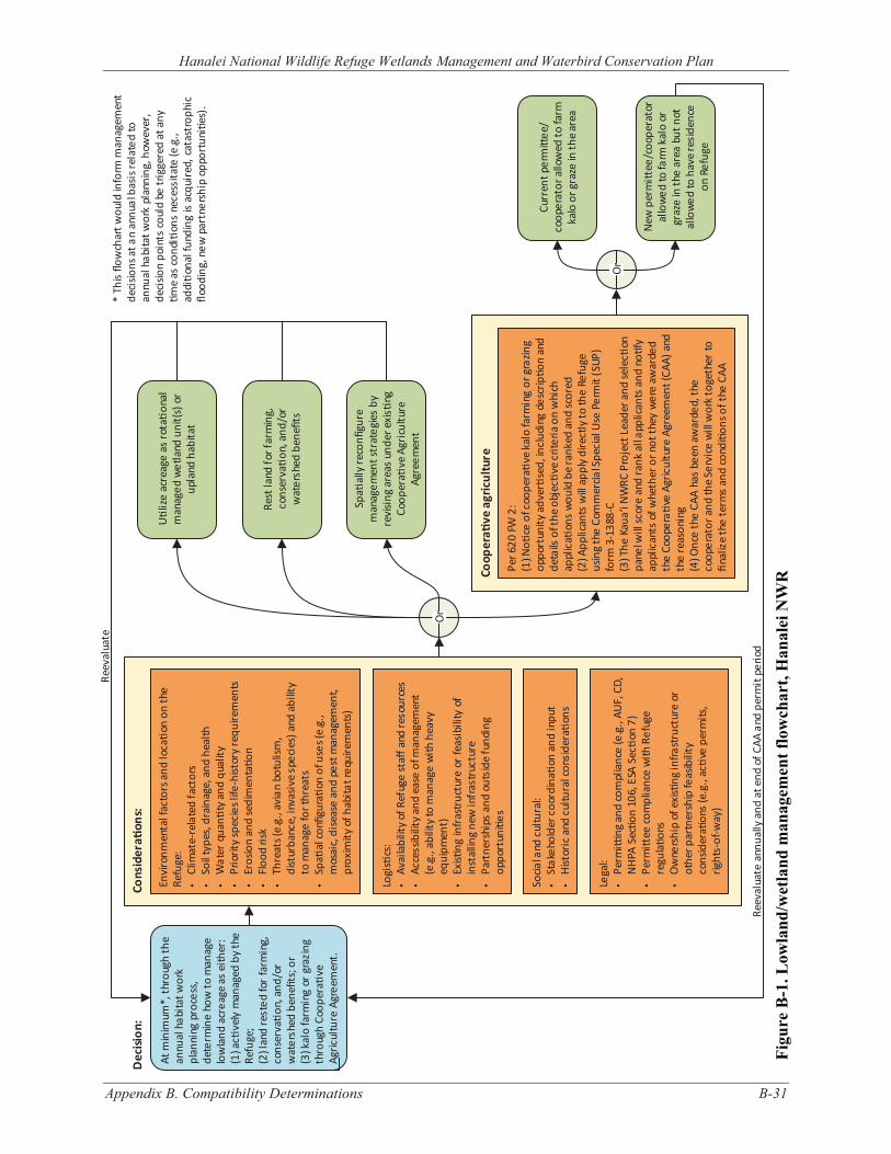
Figu
re B
-1. L
owla
nd/w
etla
nd m
anag
emen
t flo
wch
art,
Han
alei
NW
R
Appendix B. Compatibility Determinations B-31
Hanalei National Wildlife Refuge Wetlands Management and Waterbird Conservation Plan
At m
inim
um*,
thro
ugh
the
annu
al h
abita
t wor
k pl
anni
ng p
roce
ss,
dete
rmin
e ho
w to
man
age
low
land
acr
eage
as
eith
er:
(1) a
c�ve
ly m
anag
ed b
y th
e Re
fuge
;(2
) lan
d re
sted
for f
arm
ing,
co
nser
va�o
n, a
nd/o
r w
ater
shed
ben
efits
; or
(3) k
alo
farm
ing
or g
razi
ng
thro
ugh
Coop
era�
ve
Agric
ultu
re A
gree
men
t.
Dec
ision
:
U�l
ize
acre
age
as ro
ta�o
nal
man
aged
wet
land
uni
t(s)
or
upla
nd h
abita
t
Spa�
ally
rec
onfig
ure
man
agem
ent s
trat
egie
s by
re
visi
ng a
reas
und
er e
xis�
ng
Coop
era�
ve A
gric
ultu
re
Agre
emen
t
Or
Rest
land
for f
arm
ing,
co
nser
va�o
n, a
nd/o
r w
ater
shed
ben
efits
Per 6
20 F
W 2
:(1
) No�
ce o
f coo
pera�v
e ka
lo fa
rmin
g or
gra
zing
oppo
rtun
ity a
dver�s
ed, i
nclu
ding
des
crip�o
n an
d de
tails
of t
he o
bjec�v
e cr
iteria
on
whi
ch
appl
ica�
ons
wou
ld b
e ra
nked
and
sco
red
(2) A
pplic
ants
will
app
ly d
irect
ly to
the
Refu
ge
usin
g th
e Co
mm
ercia
l Spe
cial
Use
Per
mit
(SUP
) fo
rm 3
-138
8-C
(3) T
he K
aua‘
i NW
RC P
roje
ct L
eade
r and
sele
c�on
pa
nel w
ill sc
ore
and
rank
all a
pplic
ants
and
no�
fy
appl
ican
ts o
f whe
ther
or n
ot th
ey w
ere
awar
ded
the
Coop
era�
ve A
gric
ultu
re A
gree
men
t (CA
A) a
nd
the
reas
onin
g(4
) Onc
e th
e CA
A ha
s be
en a
war
ded,
the
coop
erat
or a
nd th
e Se
rvic
e w
ill w
ork
toge
ther
to
final
ize
the
term
s an
d co
ndi�
ons o
f the
CAA
Coop
era�
ve a
gric
ultu
re
Envi
ronm
enta
l fac
tors
and
loca�o
n on
the
Refu
ge:
• Cl
imat
e-re
late
d fa
ctor
s•
Soil
type
s, d
rain
age,
and
hea
lth•
Wat
er q
uan�
ty a
nd q
ualit
y•
Prio
rity
spec
ies l
ife-h
istor
y re
quire
men
ts•
Eros
ion
and
sedi
men
ta�o
n•
Floo
d ris
k•
Thre
ats (
e.g.
, avi
an b
otul
ism
, di
stur
banc
e, in
vasi
ve s
peci
es) a
nd a
bilit
y to
man
age
for t
hrea
ts•
Spa�
al c
onfig
ura�
on o
f use
s (e.
g.,
mos
aic,
dis
ease
and
pes
t man
agem
ent,
prox
imity
of h
abita
t req
uire
men
ts)
Logi
s�cs
:•
Avai
labi
lity
of R
efug
e st
aff a
nd re
sour
ces
• Ac
cess
ibili
ty a
nd e
ase
of m
anag
emen
t (e
.g.,
abili
ty to
man
age
with
hea
vy
equi
pmen
t)•
Exis�
ng in
fras
truc
ture
or
feas
ibili
ty o
f in
stal
ling
new
infr
astr
uctu
re•
Part
ners
hips
and
out
side
fund
ing
oppo
rtun
i�es
Socia
l and
cul
tura
l:•
Stak
ehol
der c
oord
ina�
on a
nd in
put
• H
istor
ic a
nd c
ultu
ral c
onsi
dera�o
ns
Lega
l:•
Perm
i�ng
and
com
plia
nce
(e.g
., AU
F, C
D,
NH
PA S
ec�o
n 10
6, E
SA S
ec�o
n 7)
• Pe
rmi�
ee c
ompl
ianc
e w
ith R
efug
e re
gula�o
ns•
Ow
ners
hip
of e
xis�n
g in
frast
ruct
ure
or
othe
r par
tner
ship
feas
ibili
ty
cons
ider
a�on
s (e
.g.,
ac�v
e pe
rmits
, rig
hts-
of-w
ay)
Cons
ider
a�on
s:
Reev
alua
te
Or
Curr
ent p
erm
i�ee
/co
oper
ator
allo
wed
to fa
rm
kalo
or g
raze
in th
e ar
ea
New
per
mi�
ee/c
oope
rato
r al
low
ed to
farm
kal
o or
gr
aze
in th
e ar
ea b
ut n
ot
allo
wed
to h
ave
resi
denc
e on
Ref
uge
Reev
alua
te a
nnua
lly a
nd a
t end
of C
AA a
nd p
erm
it pe
riod
* Th
is flo
wch
art w
ould
info
rm m
anag
emen
t de
cisio
ns a
t an
annu
al b
asis
rela
ted
to
annu
al h
abita
t wor
k pl
anni
ng, h
owev
er,
deci
sion
poin
ts c
ould
be
trig
gere
d at
any
�m
e as
cond
i�on
s ne
cess
itate
(e.g
., ad
di�o
nal f
undi
ng is
acq
uire
d, c
atas
trop
hic
flood
ing,
new
par
tner
ship
opp
ortu
ni�e
s).
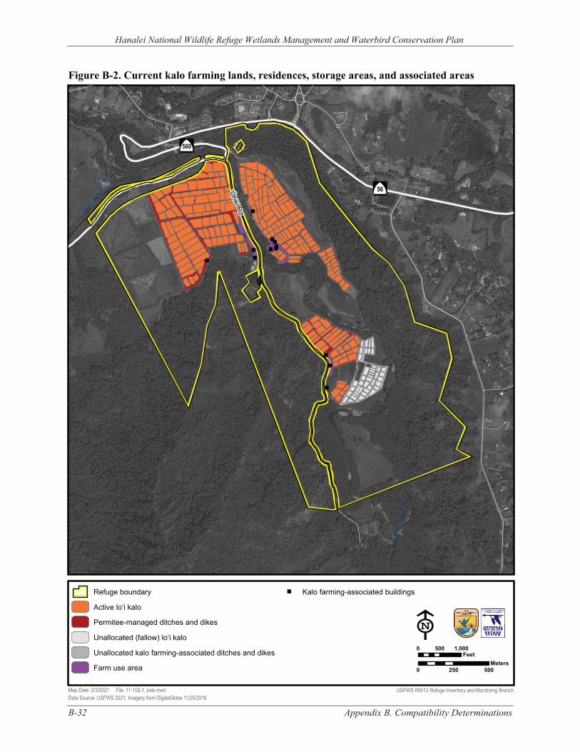
B-32 Appendix B. Compatibility Determinations
Hanalei National Wildlife Refuge Wetlands Management and Waterbird Conservation Plan
Figure B-2. Current kalo farming lands, residences, storage areas, and associated areas
"
"
""
""""
"
"
"
"
"
"
"
" " " """
"
"
"
"
Hanale
i Rive
r
‘Ohiki Rd
Hana
lei R
iver
Â
$
56
Â
$
560
Refuge boundary " Kalo farming-associated buildings
Active lo‘i kalo
Permitee-managed ditches and dikes
Unallocated (fallow) lo‘i kalo E 0 500 1,000Unallocated kalo farming-associated ditches and dikes Feet
MetersFarm use area 0 250 500
Map Date: 2/3/2021 File: 11-102-1_kalo.mxd USFWS IR9/12 Refuge Inventory and Monitoring Branch Data Source: USFWS 2021; Imagery from DigitalGlobe 11/25/2019
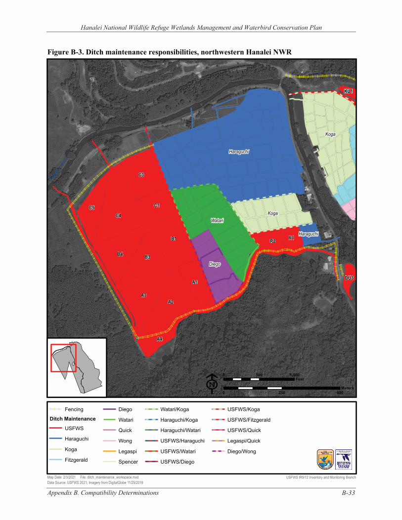
Hanalei National Wildlife Refuge Wetlands Management and Waterbird Conservation Plan
Figure B-3. Ditch maintenance responsibilities, northwestern Hanalei NWR Han
alei Rive
r
Diego
Watari
Haraguchi
Haraguchi
Koga
Koga
C5
A1
C1
C3
A2 A3
B4 B3
C4
B1
A4
R2 R1
DU3
KU1
E 0 500 1,000
Feet
0 250 500 Meters
Fencing Diego Watari/Koga USFWS/Koga
Ditch Maintenance Watari Haraguchi/Koga USFWS/Fitzgerald
USFWS Quick Haraguchi/Watari USFWS/Quick
Haraguchi Wong USFWS/Haraguchi Legaspi/Quick
Koga Legaspi USFWS/Watari Diego/Wong
Fitzgerald Spencer USFWS/Diego
Map Date: 2/3/2021 File: ditch_maintenance_workspace.mxd USFWS IR9/12 Inventory and Monitoring Branch Data Source: USFWS 2021; Imagery from DigitalGlobe 11/25/2019
Appendix B. Compatibility Determinations B-33
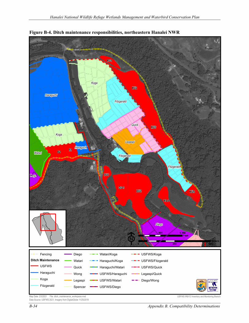
Quick
Diego
Diego
Watari
Legaspi
Haraguchi
Haraguchi
Koga
Koga
Fitzgerald
Fitzgerald
Fitzgerald R2
R1
DU3
DU1 DU2
KU4
KU3
KU2
KU1
KU5
E 0 500 1,000
Feet
0 250 500 Meters
Fencing Diego Watari/Koga USFWS/Koga
Ditch Maintenance Watari Haraguchi/Koga USFWS/Fitzgerald
USFWS Quick Haraguchi/Watari USFWS/Quick
Haraguchi Wong USFWS/Haraguchi Legaspi/Quick
Koga Legaspi USFWS/Watari Diego/Wong
Fitzgerald Spencer USFWS/Diego
Figure B-4. Ditch maintenance responsibilities, northeastern Hanalei NWR
Hanalei National Wildlife Refuge Wetlands Management and Waterbird Conservation Plan
Map Date: 2/3/2021 File: ditch_maintenance_workspace.mxd USFWS IR9/12 Inventory and Monitoring Branch Data Source: USFWS 2021; Imagery from DigitalGlobe 11/25/2019
Appendix B. Compatibility Determinations B-34
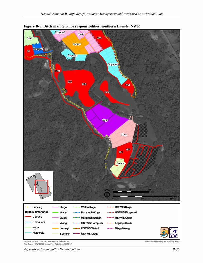
Quick
Diego
Legaspi
Wong
Haraguchi
Koga
Fitzgerald
Fitzgerald
Spencer
R2
R1
DU3
DU1DU2
KU4
KU3
Map Date: 7/9/2019 File: ditch_maintenance_workspace.mxdData Source: USFWS 2019; Imagery from DigitalGlobe 6/3/2019
Fencing
Ditch Maintenance
USFWS
Haraguchi
Koga
Fitzgerald
Diego
Watari
Quick
Wong
Legaspi
Spencer
Watari/Koga
Haraguchi/Koga
Haraguchi/Watari
USFWS/Haraguchi
USFWS/Watari
USFWS/Diego
USFWS/Koga
USFWS/Fitzgerald
USFWS/Quick
Legaspi/Quick
Diego/Wong
USFWS R1 Inventory and Monitoring Branch
0 500 1,000Feet
0 250 500Meters
Quick
Diego
Legaspi
Wong
Haraguchi
Koga
Fitzgerald
Fitzgerald
Fitzgerald
Spencer
R1
DU3
DU1DU2
KU4
KU3
KU5
SP1SP2
Map Date: 2/3/2021 File: ditch_maintenance_workspace.mxdData Source: USFWS 2021; Imagery from DigitalGlobe 11/25/2019
Fencing
Ditch Maintenance
USFWS
Haraguchi
Koga
Fitzgerald
Diego
Watari
Quick
Wong
Legaspi
Spencer
Watari/Koga
Haraguchi/Koga
Haraguchi/Watari
USFWS/Haraguchi
USFWS/Watari
USFWS/Diego
USFWS/Koga
USFWS/Fitzgerald
USFWS/Quick
Legaspi/Quick
Diego/Wong
USFWS IR9/12 Inventory and Monitoring Branch
E0 500 1,000
Feet
0 250 500Meters
Figure B-5. Ditch maintenance responsibilities, southern Hanalei NWR
Appendix B. Compatibility Determinations B-35
Hanalei National Wildlife Refuge Wetlands Management and Waterbird Conservation Plan
Hanalei National Wildlife Refuge Wetlands Management and Waterbird Conservation Plan
B-36 Appendix B. Compatibility Determinations
B.2 COMPATIBILITY DETERMINATION - USE: COOPERATIVE GRAZING
REFUGE NAME: HANALEI NATIONAL WILDLIFE REFUGE, COUNTY OF KAUA‘I, HAWAI‘I
ESTABLISHING AND ACQUISITION AUTHORITY(IES):
Endangered Species Act of 1973, as amended (16 United States Code [U.S.C.] 1531–1544)
REFUGE PURPOSE(S):
“… to conserve (A) fish or wildlife which are listed as endangered species or threatened species…or (B) plants…” (ESA; Endangered Species Act of 1973)
NATIONAL WILDLIFE REFUGE SYSTEM (REFUGE SYSTEM OR NWRS) MISSION:
“The mission of the [National Wildlife Refuge] System is to administer a national network of lands and waters for the conservation, management, and where appropriate, restoration of the fish, wildlife, and plant resources and their habitats within the United States for the benefit of present and future generations of Americans” (National Wildlife Refuge System Administration Act of 1966 [Refuge Administration Act], as amended) (16 U.S.C. 668dd–668ee).
B.2.1 DESCRIPTION OF USE(S)
COOPERATIVE AGRICULTURE
Cooperative agriculture is when a person or entity uses agricultural practices on National Wildlife Refuge System (NWRS or Refuge System) lands in support of objectives for target species or their associated habitats that represent the biological outcomes the U.S. Fish and Wildlife Service (USFWS or Service) desires, and there is substantial involvement (i.e., collaboration, participation, or intervention) between the Service and the person or entity. The Service uses cooperative agriculture agreements (CAAs) as the legal instruments to formalize the cooperative agreement between the Service and the cooperator. CAAs describe the objectives, roles, responsibilities, terms, and conditions of cooperative agriculture on Refuge System land and must be documented on a Commercial Activities Special Use Permit (SUP), Form 3-1383-C.
COOPERATIVE GRAZING
This use involves cooperative grazing of Hanalei National Wildlife Refuge (NWR or Refuge) lands by domestic livestock, which may include cattle, sheep, or goats. Before being allowed on the Refuge, this use would first need to be found appropriate (see 603 U.S. Fish and Wildlife Service Manual [FW] 1) and determined compatible (see 603 FW 2). Farming is also an economic use of refuge lands under relevant Code of Federal Regulations (CFR; 50 CFR 29.1). Per the Cooperative Agricultural Use policy (620 FW 2) approved on August 3, 2017, cooperative grazing on the Refuge would be authorized under CAAs and documented on Commercial Activities SUPs.
Grazing on the Refuge would meet the definition of cooperative agriculture because (1) it is conducted in support of resource management objectives for restoring or enhancing rotational managed wetlands and riparian habitat to satisfy life history requirements of threatened and
Hanalei National Wildlife Refuge Wetlands Management and Waterbird Conservation Plan
Appendix B. Compatibility Determinations B-37
endangered Hawaiian waterbirds (Objectives 1.2 and 2.2 in the Wetlands Management and Waterbird Conservation Plan [WMWCP]) and (2) it involves substantial involvement between the Service and the cooperator, as defined by 620 FW 2 and 505 Department Manual (DM) 2.9.
At Hanalei NWR, the cooperative grazing program would be specifically designed for two distinct purposes.
1. In conjunction with heavy equipment (e.g., mowing) and herbicides, livestock grazing could be used as an initial (time-limited) strategy for reducing plant biomass and controlling or removing invasive plants (e.g., 6- to 8-foot tall, dense California grass [Urochloa mutica]) to clear areas in preparation for long-term habitat management (i.e., either restoration of rotational managed wetland units or maintenance of short grass habitat).
2. Livestock grazing could also be used as a long-term strategy for seasonally managing and maintaining short grass conditions (e.g., grasses 4–6 inches in height) conducive to foraging (grazing) and nesting by threatened nēnē (Hawaiian goose, Branta sandvicensis).
Based on the reasons for using cooperative grazing, different stipulations regarding duration, timing, and monitoring would apply. For example, livestock grazing for the former purpose could be conducted at any time of year with baseline monitoring whereas grazing for the latter purpose would only be permitted seasonally during the non-peak threatened and endangered waterbird breeding period (e.g., approximately May–September since nēnē peak breeding is October–April) and would be associated with a more intensive monitoring program. In either case, fencing would be erected around the pastures to focus the grazing where desired and keep livestock from riparian areas, steep banks, and the Hanalei River. An in-pasture water supply and salt blocks would also be made available and used to deter livestock from riparian areas and river corridor and, as necessary, encourage livestock to graze in areas of particular interest. Monitoring and adaptive management based on measurable and meaningful criteria are important for ensuring that cooperative grazing remains compatible over time.
At least initially, the cooperative grazing program would be conducted on a short-term, experimental basis (with 1-year SUP and CAA) to determine whether the program could create the habitat conditions and associated wildlife benefits being sought while minimizing impacts to threatened and endangered species and aquatic resources. Grazing program parameters (timing, frequency, intensity, or other elements) would be developed with the assistance of the United States Department of Agriculture (USDA) Natural Resources Conservation Service (NRCS), the University of Hawai‘i, Hawai‘i Department of Land and Natural Resources, livestock grazers, Hawaiian waterbird biologists, and others. The end result of this effort would be a grazing plan for the Refuge and associated best management practices (BMP) for grazing.
PROPOSED AREAS OF USE
There are currently 3–18 acres of lowlands that are not currently in rotational managed wetlands or actively farmed lo‘i kalo and could be restored to functional wetland units for the benefit of threatened and endangered and migratory waterbirds. Specifically, the areas include three acres in between the KU4 wetland unit on the south and lo‘i kalo and the KU5 wetland unit on the north, five acres bordered on the west and south by fallow lo‘i kalo and to the east by a hau (Hibiscus tiliaceus) dominated area, and also 10 acres located near a riparian grassland and adjacent hau dominated area by the Hanalei River diversion (Figure B-6). These areas would need to be opened up to bare mineral soil using heavy equipment, herbicides, and/or grazing (to remove California grass) as a first step in
Hanalei National Wildlife Refuge Wetlands Management and Waterbird Conservation Plan
B-38 Appendix B. Compatibility Determinations
restoration. Following area clearing, water delivery systems and water control structures would need to be installed. Subsequently, moist-soil management techniques would be used within these rotational managed wetland units to manipulate native and naturalized beneficial non-native vegetation to provide important structure for threatened and endangered waterbird nesting, foraging, brooding, loafing, and thermal/escape cover.
Within an approximately 14–24-acre riparian grassland and adjacent hau-dominated area near the southern boundary of the Refuge (Figure B-6), grazing would be used to create and maintain a short grass habitat 4–6 inches in height for foraging (grazing) and nesting by nēnē. The fenced area outside the grazed area would include a relatively undisturbed riparian zone with taller and denser vegetation that could be used for nesting by endangered koloa maoli (Hawaiian duck, Anas wyvilliana) and ‘alae ‘ula (Hawaiian common gallinule, Gallinula galeata sandvicensis). It is expected that other native wildlife could also benefit from the grazed area and adjacent riparian zone. Within the 10-acre hau-dominated area, following the removal of hau, grazing would maintain the cleared area (e.g., control/removal of invasive species such as California grass) prior to completing wetland habitat restoration.
In managing short grass habitat, grazing could supplement, and be used in conjunction with mowing by Refuge staff. Regardless of the management technique employed, treatments would need to occur regularly because the grass grows quickly and year-round. The costs, habitat benefits, and other effects of grazing and mowing would be evaluated over time. As data are generated and monitoring results become available, the Service would implement adaptive management principles to refine grazing prescriptions. If results were favorable, this program could be extended to a more long-term basis.
This CD was developed and made publicly available concurrent with the draft WMWCP and associated environmental assessment (EA) for Hanalei NWR. Much of the information and some of the analyses contained in this CD are addressed in greater detail in the WMWCP, EA, and Finding of No Significant Impact (FONSI), which are incorporated by reference herein.
B.2.2 ADMINISTRATION OF THE USE
COOPERATIVE AGRICULTURE AGREEMENTS
As mentioned above, cooperative grazing would be authorized under CAAs and documented on Commercial Activities SUPs. Permittees/cooperators would be entered into CAAs through an open and competitive process. The process for awarding CAAs includes the following:
▪ The Service would provide the public with a notice of cooperative agricultural opportunities. This would include publication of a Notice of Funding Opportunity on Grants.gov, notification on a national Service website (https://www.fws.gov/refuges/whm/cooperativeAgriculture.html), and local outreach. The notice would include details on the cooperative agricultural opportunity such as the objective criteria that would be used to rank and score applications.
▪ Applicants would apply directly to the Kaua‘i NWR Complex using the application guidance provided in the CAA prospectus.
▪ The Kaua‘i NWR Complex Project Leader, along with a selection panel, would score and rank all applicants and notify each applicant regarding whether they were awarded the CAA and the reasoning for the panel’s decision. Unsuccessful applicants have the right to appeal the decision in accordance with 50 CFR 25.45.
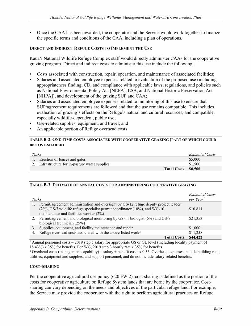
Hanalei National Wildlife Refuge Wetlands Management and Waterbird Conservation Plan
Appendix B. Compatibility Determinations B-39
▪ Once the CAA has been awarded, the cooperator and the Service would work together to finalize the specific terms and conditions of the CAA, including a plan of operations.
DIRECT AND INDIRECT REFUGE COSTS TO IMPLEMENT THE USE
Kaua‘i National Wildlife Refuge Complex staff would directly administer CAAs for the cooperative grazing program. Direct and indirect costs to administer this use include the following:
▪ Costs associated with construction, repair, operation, and maintenance of associated facilities; ▪ Salaries and associated employee expenses related to evaluation of the proposed use (including
appropriateness finding, CD, and compliance with applicable laws, regulations, and policies such as National Environmental Policy Act [NEPA], ESA, and National Historic Preservation Act [NHPA]), and development of the grazing SUP and CAA;
▪ Salaries and associated employee expenses related to monitoring of this use to ensure that SUP/agreement requirements are followed and that the use remains compatible. This includes evaluation of grazing’s effects on the Refuge’s natural and cultural resources, and compatible, especially wildlife-dependent, public use;
▪ Use-related supplies, equipment, and travel; and ▪ An applicable portion of Refuge overhead costs.
TABLE B-2. ONE-TIME COSTS ASSOCIATED WITH COOPERATIVE GRAZING (PART OF WHICH COULD BE COST-SHARED)
Tasks Estimated Costs 1. Erection of fences and gates $5,000 2. Infrastructure for in-pasture water supplies $1,500
Total Costs $6,500
TABLE B-3. ESTIMATE OF ANNUAL COSTS FOR ADMINISTERING COOPERATIVE GRAZING
Tasks Estimated Costs per Year1
1. Permit/agreement administration and oversight by GS-12 refuge deputy project leader (2%), GS-7 wildlife refuge specialist permit coordinator (10%), and WG-10 maintenance and facilities worker (2%)
$10,811
2. Permit/agreement and biological monitoring by GS-11 biologist (5%) and GS-7 biological technician (25%)
$21,353
3. Supplies, equipment, and facility maintenance and repair $1,000 4. Refuge overhead costs associated with the above-listed work2 $11,258
Total Costs $44,422 1 Annual personnel costs = 2019 step 5 salary for appropriate GS or GL level (including locality payment of 18.43%) x 35% for benefits. For WG, 2019 step 3 hourly rate x 35% for benefits. 2 Overhead costs (management capability) = salary + benefit costs x 0.35. Overhead expenses include building rent, utilities, equipment and supplies, and support personnel, and do not include salary-related benefits.
COST-SHARING
Per the cooperative agricultural use policy (620 FW 2), cost-sharing is defined as the portion of the costs for cooperative agriculture on Refuge System lands that are borne by the cooperator. Cost-sharing can vary depending on the needs and objectives of the particular refuge land. For example, the Service may provide the cooperator with the right to perform agricultural practices on Refuge
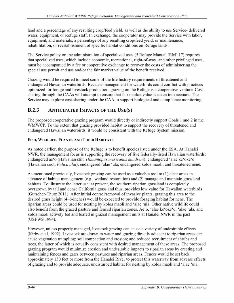
Hanalei National Wildlife Refuge Wetlands Management and Waterbird Conservation Plan
B-40 Appendix B. Compatibility Determinations
land and a percentage of any resulting crop/feed yield, as well as the ability to use Service- delivered water, equipment, or Refuge staff. In exchange, the cooperator may provide the Service with labor, equipment, and materials; a percentage of any resulting crop/feed yield; or maintenance, rehabilitation, or reestablishment of specific habitat conditions on Refuge lands.
The Service policy on the administration of specialized uses (5 Refuge Manual [RM] 17) requires that specialized uses, which include economic, recreational, right-of-way, and other privileged uses, must be accompanied by a fee or cooperative exchange to recover the costs of administering the special use permit and use and/or the fair market value of the benefit received.
Grazing would be required to meet some of the life history requirements of threatened and endangered Hawaiian waterbirds. Because management for waterbirds could conflict with practices optimized for forage and livestock production, grazing on the Refuge is a cooperative venture. Cost-sharing through the CAAs will attempt to ensure that fair market value is taken into account. The Service may explore cost-sharing under the CAA to support biological and compliance monitoring.
B.2.3 ANTICIPATED IMPACTS OF THE USE(S)
The proposed cooperative grazing program would directly or indirectly support Goals 1 and 2 in the WMWCP. To the extent that grazing provided habitat to support the recovery of threatened and endangered Hawaiian waterbirds, it would be consistent with the Refuge System mission.
FISH, WILDLIFE, PLANTS, AND THEIR HABITATS
As noted earlier, the purpose of the Refuge is to benefit species listed under the ESA. At Hanalei NWR, the management focus is supporting the recovery of five federally-listed Hawaiian waterbirds: endangered ae‘o (Hawaiian stilt, Himantopus mexicanus knudseni); endangered ‘alae ke‘oke‘o (Hawaiian coot, Fulica alai); endangered ‘alae ‘ula; endangered koloa maoli; and threatened nēnē.
As mentioned previously, livestock grazing can be used as a valuable tool to (1) clear areas in advance of habitat management (e.g., wetland restoration) and (2) manage and maintain grassland habitats. To illustrate the latter use: at present, the southern riparian grassland is completely overgrown by tall and dense California grass and thus, provides low value for Hawaiian waterbirds (Gutscher-Chutz 2011). After initial control/removal of invasive plants, grazing this area to the desired grass height (4–6-inches) would be expected to provide foraging habitat for nēnē. The riparian areas could be used for nesting by koloa maoli and ‘alae ‘ula. Other native wildlife could also benefit from the grazed pasture and fenced riparian zones. Ae‘o, ‘alae ke‘oke‘o, ‘alae ‘ula, and koloa maoli actively fed and loafed in grazed management units at Hanalei NWR in the past (USFWS 1994).
However, unless properly managed, livestock grazing can cause a variety of undesirable effects (Kirby et al. 1992). Livestock are drawn to water and grazing directly adjacent to riparian areas can cause vegetation trampling; soil compaction and erosion; and reduced recruitment of shrubs and trees, the latter of which is actually consistent with desired management of these areas. The proposed grazing program would minimize erosion and undesirable impacts to riparian areas by erecting and maintaining fences and gates between pastures and riparian areas. Fences would be set back approximately 150 feet or more from the Hanalei River to protect this waterway from adverse effects of grazing and to provide adequate, undisturbed habitat for nesting by koloa maoli and ‘alae ‘ula.
Hanalei National Wildlife Refuge Wetlands Management and Waterbird Conservation Plan
Appendix B. Compatibility Determinations B-41
Where stocking rates are too high, livestock can overgraze pastures causing long-term damage to vegetation and soils. Livestock can also graze pastures unevenly. Grazing pressure within a pasture can be influenced by the availability of water and salt. The provision of an in-pasture water supply and salt blocks would deter livestock from riparian areas and encourage more consistency in grazing pressure. Additionally, in-pasture water supplies will be necessary since direct livestock access to the river would be blocked by fencing. Cross-fencing and pasture rotations would also be considered and used, as appropriate. Livestock can also facilitate the introduction of alien, including pest, species (e.g., through seeds carried in hair, on vehicles and farm machinery, and in feces).
Grazing-related activities, such as transporting livestock, moving water and salt, fence and gate maintenance and repair, and monitoring, would be sources of potential wildlife disturbance. During nonbreeding periods, nēnē, ae‘o, and ‘alae ke‘oke‘o appear to be fairly tolerant of disturbance. However, when birds are breeding or in heavy molt, they are all more vulnerable to disturbance. Koloa maoli and ‘alae ‘ula are very wary and often flush or move quickly into dense cover when disturbed (Gutscher-Chutz 2011). Flushing of birds or even raising their alert levels creates stress and requires animals to expend energy that would otherwise be invested in essential life history activities such as foraging, mating, nesting, brood-rearing, and predator avoidance. Disturbance can cause nest desertion; affect survival of individual birds, eggs, nestlings, or broods; and alter behavior of nonbreeding waterbirds. Disturbance levels would be expected to be highest when the livestock program was initially established and when turn-outs or round-ups occurred. These events would be short-lived. In the absence of human and other activity, the waterbirds could acclimate, during their nonbreeding periods, to the presence of low-intensity livestock grazing. Nēnē are ground nesters, usually hiding their nests in the shade of a shrub or other vegetation (USFWS 2004). Livestock could destroy nēnē eggs or injure or kill young birds by stepping on them. If threatened or endangered waterbirds are nesting in an area, such as nēnē in a given paddock, then grazing would only be allowed seasonally during non-peak breeding periods, or grazing would not be permitted in that area. This would be addressed through the monitoring program.
WATER QUALITY
Because of elevated levels of Enterococci and turbidity (total suspended solids), the State of Hawai‘i Department of Health (HDOH) identified the Hanalei Bay Watershed as water quality limited under section 303(d) of the Clean Water Act (HDOH 2014). Elevated levels of nutrients (total nitrogen and total phosphorus) were also identified as a concern (Tetra Tech and HDOH 2008). The Hanalei River flows through Hanalei NWR and is the largest tributary in this watershed. In an effort to address constituents of concern in these waterbodies, HDOH established total maximum daily loads (TMDL) for the Hanalei River and Hanalei Estuary (Tetra Tech and HDOH 2008). HDOH identified no dischargers with National Pollutant Discharge Elimination System permits or other point sources of pollution in the Hanalei River Watershed, so the TMDL address non-point sources. Hanalei NWR was identified as a source of constituents of concern to the Hanalei River (Tetra Tech and HDOH 2008).
As noted above, livestock are drawn to water and riparian areas. They can increase sedimentation in waterways from bank erosion associated with trails to streams and from stirring up bottom sediments through wading. Nutrient loading can also increase as a result of livestock defecation on stream banks that is later washed into the water, or direct urination or defecation into water. Cattle may also carry leptospirosis. Additional water quality degradation could result from grazers and other personnel crossing the river in vehicles for other grazing-related management purposes. The proposed grazing program would address these issues by erecting and maintaining fences and gates
Hanalei National Wildlife Refuge Wetlands Management and Waterbird Conservation Plan
B-42 Appendix B. Compatibility Determinations
between pastures, riparian areas, and waterways. Fences would be set back approximately 150 feet from the Hanalei River to protect this waterway from adverse effects of grazing.
PUBLIC USE
Due to limited public access and its management for threatened and endangered species, public use of the Refuge is restricted. Kalo farming occurs adjacent to the narrow, single-lane public road (‘Ōhiki Road) that bisects the Refuge. Although farmers and their employees travel and haul equipment and other materials along this narrow road, it does not appear to conflict with public use. Grazing permittees would likely use trucks and/or trailers to transport livestock into and out of the Refuge, with the primary access route being via Burma Road. This traffic would be infrequent but would need to move slowly and be watchful for other vehicles, public and commercial users (e.g., kalo farmers), and threatened and endangered waterbirds. This requirement is included as a stipulation.
CULTURAL RESOURCES
The Hanalei Valley, including the Refuge, contains a number of historic and pre-contact resources. During the 1980s the Hanalei Valley was identified by the National Trust for Historic Preservation (NTHP) as an important site for rural preservation.
There is potential that grazing permittees could adversely affect the Refuge’s cultural resources. Permittees would be provided clear maps depicting areas they were authorized to access and use, and they would be made aware of prohibitions related to cultural resources. As a result, impacts to these resources would not be expected.
B.2.4 PUBLIC REVIEW AND COMMENT
The review and comment period for this CD were concurrent with the Refuge's draft WMWCP and EA. These documents were available for an initial 30-day comment period from August 21 to September 12, 2020, during which two virtual public meetings were held, as well as additional outreach meetings. In response to requests for additional time for review and comment, the Service extended the comment period an additional 15 days from September 21 to October 5, 2020.
B.2.5 DETERMINATION
Use is Not Compatible
X Use is Compatible with Following Stipulations
Hanalei National Wildlife Refuge Wetlands Management and Waterbird Conservation Plan
Appendix B. Compatibility Determinations B-43
B.2.6 STIPULATIONS NECESSARY TO ENSURE COMPATIBILITY
GENERAL
1. Permission to graze on the Refuge will be officially authorized through a CAA and documented on a Commercial Activities SUP, one to each permittee/cooperator (hereafter referred to as permittee). Initially, the CAA would authorize grazing for a maximum of 1 year. Additional CAAs for additional years would depend on the results of monitoring data demonstrating the value of the grazing program for threatened and endangered Hawaiian waterbirds. Future CAAs could be issued on a short-term basis or for up to five years each. Use of Refuge lands for other purposes or the introduction of plants, animals, or invertebrates onto the Refuge is not allowed without specific, prior written approval of the Refuge manager. For the purpose of these stipulations, the Refuge manager is the Project Leader of the Kaua‘i National Wildlife Refuge Complex.
2. Permittees are required to restrict their activities and access on the Refuge to their SUP areas, the access roads identified, and other areas open to the public.
3. Permittees are prohibited from transferring, assigning, or sub-permitting their Refuge grazing authorizations.
4. Permittees or their representatives are required to participate in meetings or workshops with Refuge management annually. The purposes of such meetings would be to share new information, discuss results of monitoring, review compliance with these stipulations, and address other issues. Other meetings would be scheduled as needed.
5. With the exception of livestock fences, associated gates, and other grazing-related structures specifically described in the grazing plan (see below), permittees are prohibited from constructing new or maintaining existing structures on the Refuge without specific, prior written approval of the Refuge manager.
6. In the absence of specific, prior written approval of the Refuge manager, permittees and their employees are prohibited from collecting and removing any archaeological or historic artifacts, abiotic or biological specimens or samples, or mementos from the Refuge.
7. Consistent with Service policy regarding management of nonhazardous solid waste on refuges (Resource Conservation and Recovery Act of 1976 [RCRA], as amended (42 U.S.C. 6901–6992k)—Solid Waste (Nonhazardous); 50 CFR 27.93, Abandonment of Property; 50 CFR 27.94, Disposal of Waste; and 561 FW 5, Managing, Recycling, and Disposing of Non-Hazardous Solid Waste), permittees are prohibited from dumping or disposing of refuse/trash, debris, litter, or abandoned, excess, or unused materials, building materials, and supplies on the Refuge, including permit areas. These would need to be removed by permittees on at least a quarterly (90 day) basis.
8. Permittees are required to hold the United States Government harmless from any damages or injury to the permittee or members of the public in areas and facilities accessed via the terms of their SUP.
9. In addition to the stipulations listed here, the Commercial Activities SUP conditions and requirements, permittees and their employees are required to comply with Refuge System-related and other applicable laws, regulations, and policies including “Prohibited Acts” listed in 50 CFR 27.
10. No changes can be made to any of these stipulations without specific, prior written approval of the Refuge manager.
Hanalei National Wildlife Refuge Wetlands Management and Waterbird Conservation Plan
B-44 Appendix B. Compatibility Determinations
GRAZING, FISH AND WILDLIFE, AND WATER QUALITY
1. The Refuge will work cooperatively with the NRCS, University of Hawai‘i, grazers, Hawaiian waterbird biologists, and others to develop a grazing plan for the Refuge and associated BMPs for grazing that is consistent with recovery of threatened and endangered Hawaiian waterbirds. Once adopted, the plan’s elements (grazing timing, frequency, intensity, contingencies during high water events, or other elements) and BMPs would automatically become required conditions of Refuge grazing SUP and agreements. The NRCS or others might be able to provide technical or financial assistance with implementation and evaluation of BMPs. Permittees will be provided with a prescribed grazing plan for the pasture(s). Among other things, this plan will spell out expectations from the grazing program, including grass height and evenness of grazing. Permittees must manage their livestock, and grazing facilities and supplies (e.g., water and salt) to achieve plan objectives. Permittees are required to maintain accurate written records on livestock numbers in each field and turn-in–turn-out dates and provide those records to the Refuge manager upon request.
2. If the purpose of grazing within a specified area is for the clearing of unwanted vegetation in preparation for long-term habitat management, then cooperative grazing may be conducted at any time of year according to BMPs and with baseline monitoring as articulated in an approved grazing plan. If threatened or endangered waterbirds are nesting in an area, such as nēnē in a given paddock, then grazing will only be allowed seasonally outside of the peak threatened and endangered waterbird breeding period (e.g., approximately May–September because nēnē peak breeding is October–April), or grazing will not be permitted in that area.
3. If the purpose of grazing within a specified area is to maintain short grass conditions (e.g., grasses 4–6 inches in height) for the benefit of nēnē foraging (grazing) and nesting, then cooperative grazing will be conducted seasonally during the nēnē nonbreeding season (May–September) according to BMPs and with intensive, prescriptive monitoring as articulated in an approved grazing plan. If threatened or endangered waterbirds are nesting in an area, such as nēnē in a given paddock, then grazing would not be permitted in that area.
4. Permittees are required to report the nests of threatened and endangered Hawaiian waterbirds found within their SUP area to the Refuge manager or Refuge biologist within 24 hours of discovery.
5. Grazing permittees are required to have proof of ownership of livestock used in the Refuge grazing program. Each animal must be branded or otherwise permanently marked.
6. Permittees are required to satisfy and maintain compliance with state and local government requirements regarding livestock health and sanitation.
7. Pesticide, herbicide, fungicide, and/or insecticide use must be approved in advance each year by the Service and only occur per terms of approved Pesticide User Proposals (PUPs) and other terms of the integrated pest management (IPM) program (see Appendix D). Approved PUPs authorize application for specific pesticide products for a period of 1 year. These pesticides must be applied by qualified applicators and consistent with pesticide label restrictions and approved PUPs or as modified by a special needs restriction approved by the U.S. Environmental Protection Agency. Permittees are required to maintain accurate, written records of pesticide use and provide those records to the Refuge manager annually. The Service’s approval process begins with a request submitted by the permittee which must include documentation of the pest problem, proposed application dates, amounts, methods,
Hanalei National Wildlife Refuge Wetlands Management and Waterbird Conservation Plan
Appendix B. Compatibility Determinations B-45
and chemicals requested for use. The request must be submitted at least 90 days prior to proposed use to allow adequate time for PUP evaluation and processing.
8. Permittees are required to follow biosecurity measures, as specified in the prescribed grazing plan, to prevent weed seed transport on animals, humans, or equipment.
9. When traveling on any Refuge roads, permittees are required to drive slowly and be watchful for other vehicles, public and commercial users (e.g., kalo farmers), and threatened and endangered Hawaiian waterbirds. The primary access route for grazing operations is via Burma Road.
10. Grazed pastures must be fenced and gated. Grazing permittees are responsible for ensuring that gates are closed, and livestock do not roam across the Refuge or onto neighboring lands outside the pasture fences. Permittees are responsible for locating and removing livestock that have strayed outside fenced pastures within 24 hours of notification by Refuge staff. Permittees are responsible for any kalo (taro, Colocasia esculenta) damage. Permittees are responsible for surveying fences and gates to identify breaks or other problems. Responsibilities for maintenance and repair of these facilities will be described through the CAA and plan of operations. Regardless of who constructed them, all grazing-related facilities on the Refuge are the property of the Service.
11. In-pasture water supplies will be provided by the permittee. If these are mobile facilities, grazing permittees are responsible for moving them to achieve objectives of the grazing plan.
12. The Refuge will work with the permittees to establish and maintain a program within their SUP areas to exclude and remove introduced vertebrate predators that prey on threatened or endangered Hawaiian waterbirds. This program may include fencing, live-trapping, shooting, and use of bait stations. Permittees will be required to report stray dogs or cats found on the Refuge to the Refuge manager or Refuge biologist within eight hours of discovery.
13. Permittees are required to report dead or sick waterbirds found on the Refuge to the Refuge manager or Refuge biologist within 24 hours of discovery.
CULTURAL RESOURCES
1. In the absence of specific, prior written approval of the Refuge manager, permittees, their family members, their employees, and their guests are prohibited from disturbing or otherwise adversely impacting any pre-contact, historic, or other cultural resources on the Refuge. In the event such resources are inadvertently disturbed in the course of conducting otherwise permitted activities, the disturbing activity must be immediately discontinued, and the Refuge manager must be notified within 24 hours. If iwi (skeletal human remains) are encountered, the activity must be immediately stopped and the Refuge manager, police, and Hawai‘i Department of Land and Natural Resources must be notified.
2. Collecting and removing any pre-contact or historic artifacts is prohibited.
B.2.7 JUSTIFICATION
REFUGE GOALS AND THE REFUGE SYSTEM MISSION
The proposed cooperative grazing program would directly or indirectly support Goals 1 and 2 identified in the WMWCP. To the extent that grazing provided habitat to support the recovery of threatened and endangered Hawaiian waterbirds, it would be consistent with the Refuge System mission.
Hanalei National Wildlife Refuge Wetlands Management and Waterbird Conservation Plan
B-46 Appendix B. Compatibility Determinations
FISH, WILDLIFE, PLANTS, AND THEIR HABITATS; AND WATER QUALITY
It is expected that grazing could be used as a management technique to convert existing areas on the Refuge that are overgrown with exotic vegetation and of low value to wildlife into productive wetlands or short grass habitats for threatened and endangered Hawaiian waterbirds. The pastures would be fenced, and outside riparian areas should provide nesting habitat for koloa maoli and ‘alae ‘ula.
However, grazing can cause a variety of impacts, including damage to vegetation and soils as a result of overgrazing, vegetation trampling, soil compaction and erosion, and reduced recruitment of shrubs and trees in riparian areas; wildlife disturbance, potentially including destruction of nēnē eggs, or injury or death to young birds through trampling; and increased sedimentation and nutrient loading of waterways and wetlands, which could alter microbial communities and conditions for avian botulism.
Stipulations are included to specifically address these concerns. Pastures would be fenced to contain livestock, focus their grazing efforts, and keep them out of riparian areas and streams. In-pasture water and salt would be supplied to better manage grazing intensity and locations. Based on the purpose of the cooperative grazing, different stipulations regarding duration, timing, and monitoring would apply.
The Refuge would establish a program to monitor compliance with the stipulations, including BMPs enumerated herein. Violation of any of these stipulations could result in temporary or permanent withdrawal of official permission to continue grazing on the Refuge. The SUP could be revoked by the Refuge manager immediately for noncompliance with these stipulations.
Management parameters of the Refuge grazing program, including timing, frequency, intensity, or other elements, would be developed with the assistance of the NRCS, the University of Hawai‘i, livestock grazers, endangered Hawaiian waterbird biologists, or others. The Refuge would monitor habitat quantity and quality, wildlife use and productivity, water quality, and other relevant attributes to determine if grazing was resulting in expected and desirable outcomes. Monitoring would assess, grassland condition (e.g., height, vigor, and species diversity) and wildlife use (e.g., foraging and nesting use, and nest success). Findings would be evaluated against habitat and wildlife objectives to determine whether the grazing program was achieving desired results. In consultation with permittees, the grazing program would be altered as needed until the grazing program was achieving objectives.
The Refuge reserves the right to add to or otherwise modify the stipulations listed herein in order to ensure the continued compatibility of this use. New or modified stipulations could be instituted as a result of new information generated by ongoing or new studies, audits, or reviews; new legal, regulatory, or policy requirements; significant changes to the Refuge environment or status of native fish, wildlife, plants, or their habitats; changes to grazing or related practices; mutual agreement with the grazers; or for other legitimate reasons. Except in the case of emergencies, permittees would be advised of new or significantly modified stipulations at least 90 days prior to their becoming effective.
PUBLIC USE AND CULTURAL RESOURCES
Grazing permittees would likely use trucks and/or trailers to transport livestock into and out of the Refuge along the narrow, single-lane ‘Ōhiki Road. This traffic would be infrequent, but drivers
Hanalei National Wildlife Refuge Wetlands Management and Waterbird Conservation Plan
Appendix B. Compatibility Determinations B-47
would need to move slowly and be watchful for other vehicles, public and commercial users (e.g., kalo farmers), and threatened and endangered waterbirds.
Clear maps depicting areas they are authorized to access and use, and prohibitions related to cultural resources should greatly reduce the likelihood that impacts would occur to these resources as a result of grazing.
ECONOMIC USES
Regulations in 50 CFR 29.1 require that the Service only authorize economic uses of refuge natural resources where a determination has been made that the use contributes to the achievement of Refuge purpose or the Refuge System mission. The regulations define an economic use to include “grazing livestock;” this proposal is subject to these regulations.
As discussed above, it is the intent of the proposed grazing program to convert Refuge habitats of low use to wildlife into valuable habitats for threatened and endangered Hawaiian waterbirds, including nēnē, koloa maoli, and ‘alae ‘ula. However, if not properly managed, grazing can have some adverse side effects. With the stipulations described herein, the beneficial aspects of this use should increase, and its detrimental effects should diminish. Overall, the proposed use would contribute to achievement of the Refuge’s purpose and the Refuge System mission.
B.2.8 COMPATIBILITY STANDARD
The areas proposed for cooperative grazing currently provide low value to wildlife. Grazing would be used as a management tool for clearing areas of undesirable vegetation and also maintaining short grass habitat conditions. Following clearing, 14–24 acres of overgrown, rank riparian grassland could be converted and maintained as a short grass pasture which would benefit nēnē foraging and nesting, and adjacent riparian areas would provide nesting habitat for koloa maoli and ‘alae ‘ula. Following clearing and with the availability of resources to install a water delivery system and water control structures, 3–18 acres of lowland could be converted to rotational managed wetlands which would provide for threatened and endangered waterbird nesting, foraging, brooding, loafing, and thermal/escape cover.
A properly managed livestock grazing program could also be used to achieve these habitat and wildlife objectives. When conducted under a SUP and CAA, livestock grazing by a non-Refuge party would be a cost-effective management technique to achieve desired results. As proposed, this would be an experimental program, and incorporate monitoring and adaptive management. Stipulations would reduce potential adverse effects and enhance beneficial effects.
In order to be allowed on the Refuge, grazing would need to be determined compatible. By allowing the use to occur under the stipulations described above, it is anticipated that wildlife disturbance would be minimized, and wildlife disturbed by this use would find sufficient food resources and resting places so their abundance and use would not be measurably lessened on the Refuge. Additionally, it is anticipated that monitoring, as needed, would prevent unacceptable or irreversible impacts to fish, wildlife, plants, and their habitats; cultural resources; and public use. For the several reasons stated above, cooperative grazing, consistent with the stipulations described herein, would not materially interfere with or detract from maintenance of the Refuge’s biological integrity, diversity, and environmental health; fulfillment of the Hanalei NWR’s purpose; or the Refuge System mission.
Hanalei National Wildlife Refuge Wetlands Management and Waterbird Conservation Plan
B-48 Appendix B. Compatibility Determinations
B.2.9 MANDATORY RE-EVALUATION DATE:
Mandatory 15-year re-evaluation date (for wildlife-dependent public uses)
X Mandatory 10-year re-evaluation date (for all uses other than wildlife-dependent public uses)
B.2.10 NEPA COMPLIANCE FOR REFUGE USE DECISION: (CHECK ONE BELOW)
Categorical Exclusion without Environmental Action Statement
Categorical Exclusion and Environmental Action Statement
X Environmental Assessment and Finding of No Significant Impact
Environmental Impact Statement and Record of Decision
This compatibility determination has been developed and issued concurrently with the WMWCP for Hanalei NWR.
B.2.11 COMPATIBILITY DETERMINATION: COOPERATIVE GRAZING
REFUGE DETERMINATION:
Refuge Manager, Hanalei National Wildlife Refuge: __________________________________ ______________
(Signature) (Date)
CONCURRENCE:
Regional Chief, National Wildlife Refuge System, Pacific Region: __________________________________ ______________
(Signature) (Date)
Hanalei National Wildlife Refuge Wetlands Management and Waterbird Conservation Plan
Appendix B. Compatibility Determinations B-49
B.2.12 REFERENCES CITED
Gutscher-Chutz, J. L. 2011. “Relationships among Aquatic Macroinvertebrates, Endangered Waterbirds, and Macrophytes in Taro Lo‘i at Hanalei National Wildlife Refuge, Kaua‘i, Hawai‘i.” MSc thesis, South Dakota State University. http://openprairie.sdstate.edu/etd/448/.
HDOH (State of Hawai‘i Department of Health). 2014. 2014 State of Hawai‘i Water Quality Monitoring and Assessment Report: Integrated Report to the U.S. Environmental Protection Agency and the U.S. Congress pursuant to Sections §303(D) and §305(B), Clean Water Act (P.L. 97-117). Honolulu, HI: State of Hawai‘i Department of Health. http://health.hawaii.gov/cwb/files/2013/05/2014_Draft-Integrated-Report_public-comment.pdf.
Kirby, R. E., J. K. Ringelman, D. R. Anderson, and R. S. Sojda. 1992. “Grazing on National Wildlife Refuges: Do the Needs Outweigh the Problems?” Transactions of the 57th North American Wildlife and Natural Resources Committee.
Tetra Tech and HDOH (Tetra Tech, Inc., and HDOH). 2008. Total Maximum Daily Loads for the Hanalei Bay Watershed: Phase 1—Streams and Estuaries. San Diego, CA and Honolulu, HI: Tetra Tech, Inc. and State of Hawai‘i Department of Health. http://health.hawaii.gov/cwb/files/2013/05/Integrated_HanaleiPhase1.pdf.
USFWS (U.S. Fish and Wildlife Service). 1994. “Compatibility Determination, Agriculture – Cattle Grazing.” Kīlauea, HI: Document on file at Kaua‘i National Wildlife Refuge Complex, Kīlauea, HI.
USFWS. 2004. Draft Revised Recovery Plan for the Nēnē or Hawaiian Goose (Branta Sandvicensis). Portland, OR: U.S. Department of the Interior, Fish and Wildlife Service. https://ecos.fws.gov/docs/recovery_plan/040924a.pdf.
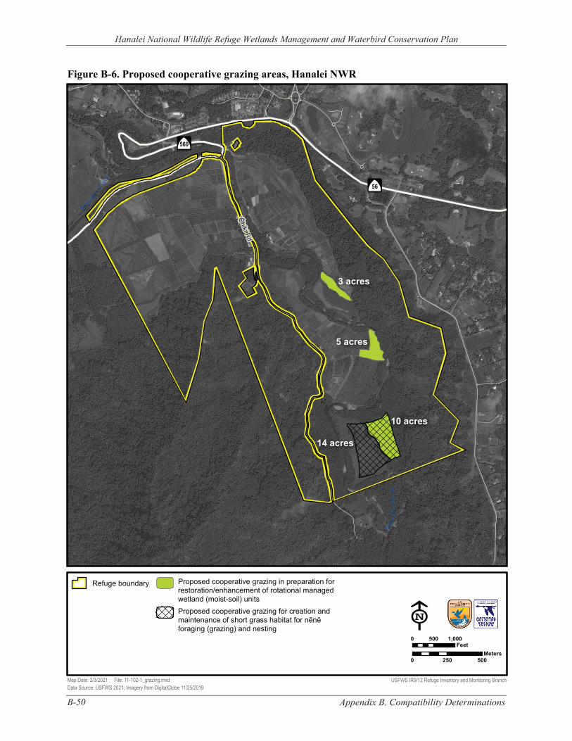
Figure B-6. Proposed cooperative grazing areas, Hanalei NWR
Hanalei National Wildlife Refuge Wetlands Management and Waterbird Conservation Plan
Hanale
i Rive
r
‘Ōhiki Rd
Han
alei
Riv
er
3 acres
5 acres
10 acres
14 acres
56
560
Refuge boundary Proposed cooperative grazing in preparation for restoration/enhancement of rotational managed wetland (moist-soil) units
Proposed cooperative grazing for creation and maintenance of short grass habitat for nēnē foraging (grazing) and nesting
0 500 1,000 Feet
Meters 0 250 500
Map Date: 2/3/2021 File: 11-102-1_grazing.mxd USFWS IR9/12 Refuge Inventory and Monitoring Branch Data Source: USFWS 2021; Imagery from DigitalGlobe 11/25/2019
Appendix B. Compatibility Determinations B-50
Hanalei National Wildlife Refuge Wetlands Management and Waterbird Conservation Plan
Appendix B. Compatibility Determinations B-51
B.3 COMPATIBILITY DETERMINATION - USE: RESEARCH AND SCIENTIFIC COLLECTIONS
REFUGE NAME: HANALEI NATIONAL WILDLIFE REFUGE, COUNTY OF KAUA‘I, HAWAI‘I
ESTABLISHING AND ACQUISITION AUTHORITY(IES):
Endangered Species Act of 1973, as amended (16 United States Code [U.S.C.] 1531–1544)
REFUGE PURPOSE(S):
“… to conserve (A) fish or wildlife which are listed as endangered species or threatened species…or (B) plants…” (ESA; Endangered Species Act of 1973)
NATIONAL WILDLIFE REFUGE SYSTEM (REFUGE SYSTEM OR NWRS) MISSION:
“The mission of the [National Wildlife Refuge] System is to administer a national network of lands and waters for the conservation, management, and where appropriate, restoration of the fish, wildlife, and plant resources and their habitats within the United States for the benefit of present and future generations of Americans” (National Wildlife Refuge System Administration Act of 1966 [Refuge Administration Act], as amended) (16 U.S.C. 668dd–668ee).
B.3.1 DESCRIPTION OF USE(S)
This use involves research and scientific collections conducted by non-National Wildlife Refuge System (Refuge System) parties on Hanalei National Wildlife Refuge (NWR or Refuge).
Research refers to a planned, organized, and systematic investigation of a scientific nature. Such studies are designed to determine the cause(s) of observed biotic or abiotic phenomenon over a finite time period, where cause and effect relationships usually can be inferred through statistical analyses.
Scientific collecting involves gathering of Refuge natural resources or cultural artifacts for scientific purposes. Examples include collection of vegetation, small mammals, and soils; contaminant sampling; and collection and curation of cultural resources.
Refuge staff periodically receive requests from outside parties (e.g., universities, state agencies, other federal agencies, and nongovernmental organizations) to conduct research and scientific collections on Refuge lands. These project requests can involve a wide range of natural and cultural resources as well as public use management issues, including collection of new species for identification, habitat use and life history requirements for specific species and species groups, practical methods for habitat restoration, extent and severity of environmental contaminants, techniques to control or eradicate pest species, effects of climate change on environmental conditions and associated habitat and wildlife response, modeling of wildlife populations, bioprospecting, and assessing response of habitat and wildlife to disturbance from public uses. Projects may be species-specific, Refuge-specific, or evaluate the relative contribution of Refuge lands to larger landscape (ecoregion, region, flyway, national, and international) issues and trends.
The U.S. Fish and Wildlife Service’s (USFWS’ or Service’s) Research and Management Studies (4 Refuge Manual [RM] 6) and Appropriate Refuge Uses (603 U.S. Fish and Wildlife Service Manual
Hanalei National Wildlife Refuge Wetlands Management and Waterbird Conservation Plan
B-52 Appendix B. Compatibility Determinations
[FW] 1) policies indicate priority for scientific investigatory studies that contribute to the enhancement, protection, use, preservation, and management of native wildlife populations and their habitat as well as their natural diversity. Projects that contribute to refuge-specific needs for resource management goals and objectives, where applicable, would be given a higher priority over other requests. Attached to this compatibility determination (CD) are examples of high-priority research and scientific collection topics for Hanalei NWR (see attached).
Research and scientific collections on the Refuge would generally be authorized through individual special use permits (SUPs) consistent with Service policy (Administration of Specialized Uses, 5 RM 17).
Projects that represent public or private economic use of the natural resources of the Refuge would need to comply with relevant Federal regulations for such uses (50 Code of Federal Regulations [CFR] 29.1). In such cases, the Refuge would need to first determine that the use contributes to the achievement of Refuge purposes or the Refuge System mission prior to making a determination regarding the project’s compatibility.
This CD was developed and made publicly available concurrent with the draft Wetlands Management and Waterbird Conservation Plan (WMWCP) and associated environmental assessment (EA) for Hanalei NWR. Much of the information and some of the analyses contained in this CD are addressed in greater detail in the WMWCP, EA, and Finding of No Significant Impact (FONSI), which are incorporated by reference herein.
AVAILABILITY OF RESOURCES
Refuge staff responsibilities for research and scientific collections by non-Refuge System entities are primarily limited to the following: review of proposals, preparation of an SUP(s) and other appropriate compliance documents (pursuant to the National Environmental Policy Act (NEPA), ESA, National Historic Preservation Act, etc.), and monitoring project implementation to ensure that impacts and conflicts remain within acceptable levels (remain compatible) over time. Additional administrative, logistical, and operational support could also be provided depending on each specific request. Estimated costs for one-time and annually recurring tasks by Refuge staff would be determined on a project-by-project basis. Sufficient funding in the Refuge’s general operating budget would need to be available to cover expenses for these projects. The terms and conditions for funding and staff support necessary to administer each project on the Refuge would be clearly stated in the SUP(s).
The Refuge has the following staffing and funding to administratively support and monitor research and scientific collections that are currently taking place on Hanalei NWR (see table below). Any substantial increase in the number of projects would create a need for additional resources to satisfy administrative and monitoring needs to ensure the projects were implemented in a compatible manner. Any substantial additional costs above those itemized below could result in determining a project not compatible unless expenses were offset by the investigator, sponsoring organization, or other party. Table B-4 summarizes annual costs.
Hanalei National Wildlife Refuge Wetlands Management and Waterbird Conservation Plan
Appendix B. Compatibility Determinations B-53
TABLE B-4. ESTIMATE OF ANNUAL COSTS FOR ADMINISTERING RESEARCH AND SCIENTIFIC COLLECTIONS
Tasks Estimated Costs per Year1
1. Permit/agreement administration and oversight by GS-12 refuge deputy project leader (1%) and GL-09 law enforcement officer (1%)
$1,970
2. Permit/agreement monitoring by GS-11 biologist (3%) $2,884 3. Supplies, equipment, and travel $1,000 4. Refuge overhead costs associated with the above-listed work2 $1,699
Total Costs $6,554 1 Annual personnel costs = 2019 step 5 salary for appropriate GS or GL level (including locality payment of 18.43%) x 35% for benefits. For WG, 2019 step 3 hourly rate x 35% for benefits. 2 Overhead costs (management capability) = salary + benefit costs x 0.35. Overhead expenses include building rent, utilities, equipment and supplies, and support personnel, and do not include salary-related benefits.
B.3.2 ANTICIPATED IMPACTS OF THE USE(S)
Use of the Refuge to conduct research or scientific collecting would generally provide information of benefit to native fish, wildlife, plants, and their habitats or cultural resources. Scientific findings gained through these projects could provide important information regarding life history needs of species and species groups, as well as identify or refine management actions to achieve natural or cultural resource management objectives. Reducing uncertainty regarding wildlife and habitat responses to Refuge management actions undertaken in order to achieve desired outcomes (objectives) is essential for adaptive management (522 Department Manual [DM] 1).
Potentially, some project’s methods could impact or conflict with Refuge-specific natural or cultural resources, priority wildlife-dependent public uses, other research, or Refuge management programs. In such cases, in order for the project to be determined compatible, it would need to be clearly demonstrated that the project’s scientific findings would contribute to Refuge management and that the project could not be conducted off-Refuge. The investigator(s) would need to identify methods/strategies in advance to eliminate or minimize potential impacts and conflicts. If unacceptable impacts, including long-term and cumulative impacts, could not be avoided, then the project could not be determined compatible.
REFUGE GOALS AND NWRS MISSION
It is likely that most proposed research or scientific collection projects would support one or more of the Refuge goals, but each would need to be evaluated separately. Projects that were determined supportive of Refuge goals and the Refuge System mission would have a greater chance of being found appropriate, determined compatible, and authorized for implementation.
FISH, WILDLIFE, PLANTS, AND THEIR HABITATS
Impacts would be project- and site-specific and would vary depending upon the nature and scope of the fieldwork. Data collection techniques would generally have no or minimal animal mortality or disturbance, habitat destruction, no introduction of contaminants, and no introduction of nonindigenous species. In contrast, projects involving the collection of biotic samples (plants or animals) or requiring intensive ground-based data or sample collection would at least have short-term, localized impacts.
Hanalei National Wildlife Refuge Wetlands Management and Waterbird Conservation Plan
B-54 Appendix B. Compatibility Determinations
As noted earlier, the purpose of the Refuge is to benefit species listed under the ESA. At Hanalei NWR, the management focus is supporting the recovery of five federally-listed Hawaiian waterbirds: endangered ae‘o (Hawaiian stilt, Himantopus mexicanus knudseni); endangered ‘alae ke‘oke‘o (Hawaiian coot, Fulica alai); endangered ‘alae ‘ula (Hawaiian common gallinule, Gallinula galeata sandvicensis); endangered koloa maoli (Hawaiian duck, Anas wyvilliana); and threatened nēnē (Hawaiian goose, Branta sandvicensis).
Disturbance would likely be one of the greatest wildlife effects caused by research and scientific collections. Disturbance would be possible where users penetrate the interior of the Refuge, particularly near rotational managed wetland (moist-soil) units that are in greatest use by federally-listed Hawaiian waterbirds. During nonbreeding periods, nēnē, ae‘o, and ‘alae ke‘oke‘o appear to be fairly tolerant of disturbance. However, when birds are breeding or in heavy molt, they are all more vulnerable to disturbance. Koloa maoli and ‘alae ‘ula are very wary and often flush or move quickly into dense cover when disturbed (Gutscher-Chutz 2011). Flushing of birds or even raising their alert levels creates stress and requires animals to expend energy that would otherwise be invested in essential life history activities such as foraging, mating, nesting, brood-rearing, and predator avoidance. Disturbance can cause nest desertion; affect survival of individual birds, eggs, nestlings, or broods; and alter behavior of nonbreeding waterbirds.
Trulio (2005) reviewed numerous studies of the effects of recreational and other human uses on wildlife, especially waterbirds. Reviewed studies found that research can have a number of adverse effects on wildlife and can contribute to nest abandonment, increased depredation, reduction of nests near disturbed areas, lower productivity, and increased flight. These findings are consistent with studies at a seabird colony on the lower Columbia River where land-based researchers flushed large numbers of California brown pelicans (Wright et al. 2007).
Field research could also cause trampling of native plants, erosion, and introduction or spread of exotic species, including invertebrates, plants, and pest species. All of these impacts could adversely affect native fish, wildlife, plants, and their habitats.
Spread of nonnative and/or pest plants, invertebrates, and/or pathogens is possible from ground disturbance and/or transportation of project equipment and personnel. These effects would be minimized or eliminated by requiring proper cleaning of investigator equipment and clothing as well as quarantine methods and possibly restoration or mitigation plans, where appropriate (see attached).
There also could be localized and temporary effects from vegetation trampling, erosion, collecting of soil and plant samples, or trapping and handling of fish and wildlife. Impacts could also occur from infrastructure necessary to support a project (e.g., permanent transects or plot markers, exclosure devices).
All of these impacts could adversely affect native fish, wildlife, plants, and their habitats. Individual circumstances associated with specific studies would determine the degree of actual effects upon reproduction, survival of individuals, and diversity and abundance of native species (community health).
PUBLIC USE
Authorizing research or scientific collections would be expected to negligibly impact wildlife-dependent or other public uses. Permittees conducting commercial tour operations and participants in special Refuge events would be advised of any active research or scientific collections on the Refuge,
Hanalei National Wildlife Refuge Wetlands Management and Waterbird Conservation Plan
Appendix B. Compatibility Determinations B-55
and, as appropriate, warned to avoid areas under study and markers or other equipment used for study.
CULTURAL RESOURCES
Hanalei NWR is rich in pre-contact and historic resources. To the extent that the ground surface or existing structures are disturbed, research and scientific collections have the potential to affect cultural resources. The stipulations require that researchers are provided with clear maps depicting access points and use areas, and include prohibitions related to cultural resources. These provisions would greatly reduce the likelihood of impacts occurring and would reduce the degree of effect if they did occur.
B.3.3 PUBLIC REVIEW AND COMMENT
The review and comment period for this CD were concurrent with the Refuge's draft WMWCP and EA. These documents were available for an initial 30-day comment period from August 21 to September 12, 2020, during which two virtual public meetings were held, as well as additional outreach meetings. In response to requests for additional time for review and comment, the Service extended the comment period an additional 15 days from September 21 to October 5, 2020.
B.3.4 DETERMINATION
Use is Not Compatible
X Use is Compatible with Following Stipulations
B.3.5 STIPULATIONS NECESSARY TO ENSURE COMPATIBILITY
GENERAL
1. Permission to use the Refuge for research or scientific collections will be officially authorized through a SUP. Generally, a permit would be issued on a year-to-year basis. SUPs cover use by a specified individual or organization and cannot be assigned or sub-permitted to others (i.e., the permit is not transferable). Annual or other short-term SUPs are preferred; however, some permits may be longer, if needed, to allow completion of the project. All SUPs will have a definite termination date in accordance with 5 RM 17.11. Renewals will be subject to Refuge manager review and approval based on timely submission of and content in progress reports, compliance with SUP stipulations, and required permits. For the purpose of these stipulations, the Refuge manager is the Refuge Project Leader of the Kaua‘i National Wildlife Refuge Complex.
Prior to potential SUP renewal, Refuge staff will meet with researchers to share new
information, discuss results of monitoring, review compliance with SUP conditions, and address other issues. Other meetings may be scheduled as needed.
2. The SUP will include maps clearly depicting the areas that researchers are authorized to access and use, including the Refuge entry point(s). Travel within the Refuge is by designated road, dike, or trail. Permittees are prohibited from straying outside the areas depicted on the maps.
Hanalei National Wildlife Refuge Wetlands Management and Waterbird Conservation Plan
B-56 Appendix B. Compatibility Determinations
3. The Refuge will supply researchers with information about the Refuge; its purpose and goals; natural and cultural resources of concern; open and closed areas; rules and regulations; and any hazardous conditions. Researchers are responsible for reviewing and understanding this information and ensuring that their colleagues also receive, review, and understand this information.
4. Researchers are prohibited from constructing new or maintaining existing structures on the Refuge without specific, prior written approval of the Refuge manager.
5. Unless it was an element included in their approved project proposal, researchers and their colleagues are prohibited from collecting and removing any archaeological or historic artifacts, abiotic or biological specimens or samples, or mementos from the Refuge.
6. Consistent with Service policy regarding management of nonhazardous solid waste on refuges (Resource Conservation and Recovery Act of 1976 [RCRA], as amended (42 U.S.C. 6901–6992k)—Solid Waste (Nonhazardous); 50 CFR 27.93, Abandonment of Property; 50 CFR 27.94, Disposal of Waste; and 561 FW 5, Managing, Recycling, and Disposing of Non-Hazardous Solid Waste), permittees are prohibited from dumping or disposing of refuse/trash, debris, litter, or abandoned, excess, or unused materials, building materials, and supplies on the Refuge, including permit areas.
7. Researchers are required to hold the United States Government harmless from any damages or injury to the permittee or members of the public in areas and facilities accessed via the terms of their SUP.
8. In addition to the stipulations listed here, the general SUP conditions and requirements, and the special SUP conditions, researchers and their colleagues are required to comply with Refuge System-related and other applicable laws, regulations, and policies including “Prohibited Acts” listed in 50 CFR 27.
9. No changes can be made to any of these stipulations without specific, prior written approval of the Refuge manager.
RESEARCH AND SCIENTIFIC COLLECTIONS
1. The Refuge will periodically issue a call for research proposals. Proposals received by the stated deadline will be evaluated and considered for approval during the next cycle.
2. At least six months before initiation of fieldwork, a researcher(s) is required to submit a detailed proposal (see attached format). Among other things, proposals must adhere to scientifically defensible protocols for data collection, where available and applicable.
Project proposals are reviewed by Refuge staff and others, as needed. This review will assess—relative to Refuge management issues and understanding of natural systems—the potential impacts (short-term, long-term, and cumulative) relative to the benefits of the investigation. This assessment will form the primary basis for determining whether or not the project could be approved.
3. Researchers are required to submit progress reports at least annually for multiple-year projects. A list of the minimum required elements for these reports is attached. Final project reports are due 1 year after completion of the project unless negotiated otherwise with the Refuge manager. Researchers are required to provide Refuge staff with the following: a. An opportunity to review and comment on draft manuscripts prior to their submittal to a
scientific journal for consideration for publication; b. Copies (reprints) of all publications resulting from a project permitted on the Refuge; and c. At the conclusion of the project, raw data (preferably in an electronic database format).
Hanalei National Wildlife Refuge Wetlands Management and Waterbird Conservation Plan
Appendix B. Compatibility Determinations B-57
In all written and oral presentations resulting from projects on the Refuge, researchers are required to appropriately cite and acknowledge the Refuge System, Hanalei NWR, and Refuge staff and other Service personnel who supported or contributed to the project.
Upon completion of the project or annually, the researcher is required to remove all
equipment and physical markers (unless required for long-term projects) and restore sites to the Refuge manager’s satisfaction. The SUP would specify conditions for removal and clean up.
4. Researchers must obtain all required local, state, and federal permits for collections and other purposes.
5. A Section 7 consultation under the ESA is required for all project activities that may affect a federally listed species and/or critical habitat. Only projects which would have “no effect” or would result in a” not likely to adversely affect” determination are considered for potential approval.
6. To reduce impacts, the minimum number of samples (e.g., water, soils, vegetative litter, plants, macroinvertebrates, vertebrates, and artifacts) will be collected for identification and/or experimentation and statistical analysis.
Where possible, researchers will be required to coordinate and share collections. This may reduce sampling needed for multiple projects and any associated mortality and disturbance. For example, if one investigator collected fish for a diet study and another researcher was examining otoliths, then it could be possible to accomplish sampling for both projects with one collection effort.
All samples collected on Refuge lands and waters are the property of the Service even while in the possession of the researcher. Any future work with previously collected samples not clearly identified in the project proposal will require submission of a subsequent proposal for Refuge review and approval. In addition, a new SUP is required for additional project work. For samples or specimens to be stored at other facilities, such as museums, a memorandum of understanding is necessary (see attached).
7. To minimize the introduction and spread of pests, sampling equipment as well as researchers’ clothing and vehicles (e.g., all-terrain vehicles, boats) must be thoroughly cleaned (free of dirt and plant material) before being used on the Refuge. Depending on the project, quarantine methods may be necessary (see attached).
8. Researchers are required to secure approval from the Service prior to use of any pesticides, including uses of herbicides, fungicides, and insecticides, on the Refuge. Researchers must submit a completed Pesticide Use Proposal (PUP) for each proposed pesticide use to the Refuge manager. The PUP must be submitted at least 60 days prior to proposed use of the pesticide to allow adequate time for evaluation and processing.
9. At any time, Refuge staff may accompany researchers in the field. 10. Researchers are required to report dead or sick threatened and endangered Hawaiian
waterbirds or other wildlife to Refuge staff within 24 hours of discovery.
CULTURAL RESOURCES
1. In the absence of specific, prior written approval of the Refuge manager, researchers and their colleagues are prohibited from disturbing or otherwise adversely impacting any pre-contact, historic, or other cultural resources on the Refuge. In the event such resources are inadvertently disturbed in the course of conducting otherwise permitted activities, the
Hanalei National Wildlife Refuge Wetlands Management and Waterbird Conservation Plan
B-58 Appendix B. Compatibility Determinations
disturbing activity must be immediately discontinued, and the Refuge manager must be notified within 24 hours. If iwi (skeletal human remains) are encountered, the activity must be immediately stopped and the Refuge manager, police, and Hawai‘i Department of Land and Natural Resources must be notified.
2. Collecting and removing any pre-contact or historic artifacts is prohibited.
B.3.6 JUSTIFICATION
Suitable research and scientific collections on refuges are inherently valuable to the Service when they expand scientific information available for resource management decisions about fish, wildlife, plants, and their habitats; cultural resources; and/or public use. In many cases, if it were not for the Refuge staff providing access to Refuge lands and waters along with some support, the project would never occur, and less scientific information would be available to aid the Service in managing and conserving Refuge resources.
The Refuge would monitor compliance with the stipulations enumerated herein. Violation of any of these stipulations could result in temporary or permanent withdrawal by appropriate Refuge personnel of official permission to continue research or scientific collections on the Refuge. Permits could be revoked by the Refuge manager with 30 days’ written notice of noncompliance with these stipulations.
The Refuge would also monitor habitat quantity and quality, wildlife use and productivity, water quality, cultural resources, and other relevant endpoints to determine if stipulations associated with research and scientific collections result in expected and desirable outcomes. In consultation with researchers, the Refuge would apply adaptive management principles to modify stipulations or adjust objectives, as necessary, to achieve desirable results.
The Refuge reserves the right to add to or otherwise modify the stipulations listed herein in order to ensure the continued compatibility of this use. New or modified stipulations would be instituted as a result of ongoing or new studies; new legal, regulatory, or policy requirements; significant changes to the Refuge environment or status of native fish, wildlife, plants, or their habitats; as a result of mutual agreement with researchers; or for other legitimate reason. Researchers would be advised of new or significantly modified stipulations at least 90 days prior to their becoming effective.
The Refuge also reserves the right to terminate permission for these uses if permittees violate Refuge rules or regulations; if unacceptable impacts occur to native fish, wildlife, plants, or their habitats, cultural resources or Refuge facilities, or other Refuge visitors; or for other legitimate reasons.
By allowing the use to occur under the stipulations described above, it is anticipated that wildlife which could be disturbed by this use would find sufficient food resources and resting places so their abundance and use would not be measurably lessened on the Refuge. Additionally, it is anticipated that monitoring, as needed, would prevent unacceptable or irreversible impacts to fish, wildlife, plants, and their habitats; cultural resources; and public use. Where this was not the case, the proposed project would likely not be compatible and would not be authorized for implementation. As a result, potential research and scientific collections, consistent with the stipulations described herein, would not materially interfere with or detract from maintenance of the Refuge’s biological integrity, diversity, and environmental health; fulfillment of Hanalei NWR’s purpose; or the Refuge System mission.
Hanalei National Wildlife Refuge Wetlands Management and Waterbird Conservation Plan
Appendix B. Compatibility Determinations B-59
B.3.7 MANDATORY RE-EVALUATION DATE:
Mandatory 15-year re-evaluation date (for wildlife-dependent public uses)
X Mandatory 10-year re-evaluation date (for all uses other than wildlife-dependent public uses)
B.3.8 NEPA COMPLIANCE FOR REFUGE USE DECISION: (CHECK ONE BELOW)
Categorical Exclusion without Environmental Action Statement
Categorical Exclusion and Environmental Action Statement
X Environmental Assessment and Finding of No Significant Impact
Environmental Impact Statement and Record of Decision
This compatibility determination has been developed and issued concurrently with the WMWCP and EA for Hanalei NWR.
B.3.9 COMPATIBILITY DETERMINATION: RESEARCH AND SCIENTIFICCOLLECTIONS
REFUGE DETERMINATION:
Refuge Manager, Hanalei National Wildlife Refuge: __________________________________ ______________
(Signature) (Date)
CONCURRENCE:
Regional Chief, National Wildlife Refuge System, Pacific Region: __________________________________ ______________
(Signature) (Date)
Hanalei National Wildlife Refuge Wetlands Management and Waterbird Conservation Plan
B-60 Appendix B. Compatibility Determinations
B.3.10 REFERENCES CITED
Gutscher-Chutz, J.L. 2011. Relationships Among Aquatic Macroinvertebrates, Endangered Waterbirds, and Macrophytes in Taro Lo‘i at Hanalei National Wildlife Refuge, Kaua‘i, Hawaiʻi. Master’s Thesis. South Dakota State University, SD. http://openprairie.sdstate.edu/etd/448
Trulio, L. 2005. Understanding the Effects of Public Access and Recreation on Wildlife and their Habitats in the Restoration Project Area. San Jose State University, Department of Environmental Studies, CA.
Wright, S.K., D.D. Roby, and R.G. Anthony. 2007. Responses of California Brown Pelicans to Disturbances at a Large Oregon Roost. Waterbirds 30(4): 479-487.
B.3.11 HIGH-PRIORITY RESEARCH AND SCIENTIFIC COLLECTIONS
The following are examples of high-priority research and scientific collection topics for Hanalei NWR. They are not listed in priority order.
▪ Evaluate methods to control hybridization threats to koloa maoli; support completion of hybrid identification keys within 1 year.
▪ Identify factors most limiting koloa maoli population recovery. ▪ Develop survey methods to reliably estimate koloa maoli population size; refine methods for
other threatened and endangered waterbirds. ▪ Investigate how habitat types influence ‘alae ‘ula reproductive success and ecology, including
identification of factors limiting population size. ▪ Investigate methods to control pest fish that degrade habitat quality. ▪ Work with partners to investigate status and distribution of ‘ōpe‘ape‘a; identify management
priorities. ▪ Develop water budget and conduct efficiency study. ▪ Conduct on-Refuge contaminant investigations relevant to threatened and endangered waterbirds. ▪ Investigate pest aquatic vertebrate ecology (e.g., bullfrogs, tilapia) to develop life-cycle specific
control methods. ▪ Investigate methods to effectively control and monitor nonnative vertebrate pests that prey on
threatened and endangered waterbirds. ▪ Identify primary predators for each life stage of the threatened and endangered waterbirds. ▪ Investigate the relative importance of causes of mortality for threatened and endangered
waterbirds. ▪ Describe phenology and other life history characteristics of important wetland plants and
invertebrates relative to abiotic factors. ▪ Investigate threatened and endangered waterbird daily and seasonal movements. ▪ Conduct pollen core studies to assess historical vegetation composition. ▪ Work with partners to conduct stream assessments. ▪ Conduct assessment of dike size and integrity as part of maintenance to ensure wetland
management is supported sufficiently; rehabilitate, as necessary. ▪ Work with partners to investigate designs for ‘o‘opu-friendly river outlets to prevent ‘o‘opu
entrapment in lo‘i and impoundments during river migrations.
Hanalei National Wildlife Refuge Wetlands Management and Waterbird Conservation Plan
Appendix B. Compatibility Determinations B-61
▪ Conduct hydrogeomorphic investigations relevant to restoration of watershed processes and functions.
▪ Investigate abiotic/biotic conditions of specific lo‘i kalo with avian botulism occurrence; identify management measures.
▪ Determine effect of nest buffer size and cover in harvested lo‘i kalo on waterbird nest and brood success within three years.
▪ Support additional research to set measurable and attainable milestones for nutrient load reductions in Hanalei River.
▪ Determine nutrient and sediment levels in water released from Refuge wetlands and lo‘i kalo into the Hanalei River.
▪ Investigate efficient methods for nutrient removal and sediment control (e.g., sediment traps on major drains, floating racks of plants).
▪ Evaluate costs and benefits of longer wet and dry fallow periods to threatened and endangered waterbirds and kalo farming.
Hanalei National Wildlife Refuge Wetlands Management and Waterbird Conservation Plan
B-62 Appendix B. Compatibility Determinations
Format for Proposals to Conduct Research or Long-Term Monitoring on National Wildlife Refuges
A Special Use Permit (SUP) is required to conduct research and/or long-term monitoring on refuge lands. To receive a SUP, a detailed project proposal using the following format must be submitted to the Refuge manager approximately six months prior to the start of the project.
Title:
Principal Investigator(s):
Provide the name(s) and affiliation(s) of all principal investigator(s) that will be responsible for implementation of the research and/or long-term monitoring described in the proposal. In addition, provide a brief description or attach vitae of expertise for principal investigator(s) germane to work described in the proposal.
Background and Justification:
In a narrative format, describe the following as applicable:
▪ The resource management issue and/or knowledge gap regarding ecological function that currently exists with any available background information.
▪ Benefit of project findings to resources associated with refuge. ▪ Potential consequences if the conservation issue and/or knowledge gap regarding ecological
function is not addressed.
Objectives:
Provide detailed objective(s) for the proposed project.
Methods and Materials:
Provide a detailed description of the methods and materials associated with field and laboratory work (if applicable) to be conducted for the project. Methods should include the following:
▪ study area(s); ▪ number of samples; ▪ sampling dates and locations; ▪ sampling techniques; and ▪ data analyses including statistical methods and significance levels.
Previously published methods should be cited without explanation; whereas, new or modified techniques should be described in detail. Include number of personnel as well as all facilities and equipment (e.g., vehicles, boats, structures, markers) required to collect samples/data. Provide a clear description of the relationships among study objectives, field methods, and statistical analyses.
Permits:
Identify all State or Territorial and Federal permits required if applicable.
Hanalei National Wildlife Refuge Wetlands Management and Waterbird Conservation Plan
Appendix B. Compatibility Determinations B-63
Potential Impacts to Refuge Resources:
Describe potential impacts to threatened or endangered species as well as other refuge plants, wildlife, and fish species that could result from the implementation of project activities on the refuge. Consider the cumulative impacts associated with this project.
Animal Welfare Plan:
If appropriate, attach a copy of the Institutional Animal Care and Use review and/or animal welfare plans that are required by the principle investigator’s affiliation.
Partnerships and Funding Sources:
List other participating institutions, agencies, organizations, or individuals as well as the nature and magnitude of their cooperative involvement (e.g., funding, equipment, personnel).
Project Schedule:
Provide estimated initiation and completion dates for field sampling, laboratory work, data analyses, and report/manuscript preparation. If the project is divided into phases to be accomplished separately provide separate initiation and completion dates for each phase.
Reports and Raw Data:
Establish a schedule for annual progress and final reports; include adequate time for peer review of the final report/manuscript. Draft reports/manuscripts should be submitted to the Refuge manager for review prior to submission for consideration of publication. At the conclusion of a research study (manuscripts accepted for publication), an electronic copy of the data (e.g., GIS vegetation layers, animal species composition and numbers, genetics) should be provided to the Refuge manager. For long-term monitoring projects, the Service also requires raw data for management and planning purposes for the Refuge.
Publications:
Describe the ultimate disposition of study results as publications in scientific journals, presentation at professional symposiums, or final reports.
Disposition of Samples:
If the project entails the collection of biotic and/or abiotic samples, then describe their storage. Although the samples may be in the possession of scientists for the purposes of conducting the project in accordance with the SUP, the Service retains ownership of all samples collected on refuge lands. If the samples will be used for subsequent research activities that are not described within the original proposal, a new proposal must be submitted to the Refuge manager to obtain a SUP before initiation of the follow-up project. After conclusion of the research activities, consult with the refuge manager regarding the final disposition of the samples. If specimens will be curated at a museum, then prepare a MOU using the format provided in Attachment 3.
Hanalei National Wildlife Refuge Wetlands Management and Waterbird Conservation Plan
B-64 Appendix B. Compatibility Determinations
ANNUAL PROGRESS REPORTS FOR REFUGE RESEARCH AND LONG-TERM MONITORING PROJECTS
Study title:
Fiscal year:
Progress:
In a narrative format, summarize the work that was completed on the study including the number and types of samples collected and/or data analyses.
Important findings:
In narrative format, generally describe any conclusions and/or management recommendations that may be drawn from the work completed to date.
Describe problems encountered:
In narrative format, describe any problems that were encountered during the year and their effects upon the study.
Proposed resolution to problems:
For each problem encountered, describe the actions that have been taken to remediate it.
Preparer:
Date prepared:
Hanalei National Wildlife Refuge Wetlands Management and Waterbird Conservation Plan
Appendix B. Compatibility Determinations B-65
MEMORANDUM OF UNDERSTANDING FOR CURATORIAL SERVICES
BETWEEN THE
(Name of the Federal agency)
AND THE
(Name of the Repository)
This Memorandum of Understanding is entered into this (day) day of (month and year), between the United States of America, acting by and through the (name of the Federal agency), hereinafter called the Depositor, and the (name of the Repository), hereinafter called the Repository, in the State/Territory of (name of the State/Territory).
The Parties do witnesseth that
WHEREAS, the Depositor has the responsibility under Federal law to preserve for future use certain collections of paleontological specimens and/or biological samples as well as associated records, herein called the Collection, listed in Attachment A which is attached hereto and made a part hereof, and is desirous of obtaining curatorial services; and
WHEREAS, the Repository is desirous of obtaining, housing and maintaining the Collection, and recognizes the benefits which will accrue to it, the public and scientific interests by housing and maintaining the Collection for study and other educational purposes; and
WHEREAS, the Parties hereto recognize the Federal Government's continued ownership and control over the Collection and any other U.S. Government-owned personal property, listed in Attachment B which is attached hereto and made a part hereof, provided to the Repository, and the Federal Government's responsibility to ensure that the Collection is suitably managed and preserved for the public good; and
WHEREAS, the Parties hereto recognize the mutual benefits to be derived by having the Collection suitably housed and maintained by the Repository;
NOW THEREFORE, the Parties do mutually agree as follows:
1. The Repository shall:
a. Provide for the professional care and management of the Collection from the (names of the resources) sites, assigned (list site numbers) site numbers. The collections were recovered in connection with the (name of the Federal or federally authorized project) project, located in (name of the nearest city or town), (name of the county, if applicable) county, in the State/Territory of (name of the State/Territory)-
b. Assign as the Curator, the Collections Manager and the Conservator having responsibility for the work under this Memorandum, persons who are qualified museum professionals and whose expertise is appropriate to the nature and content of the Collection.
Hanalei National Wildlife Refuge Wetlands Management and Waterbird Conservation Plan
B-66 Appendix B. Compatibility Determinations
c. Begin all work on or about (month, date and year) and continue for a period of (number of years) years or until sooner terminated or revoked in accordance with the terms set forth herein.
d. Provide and maintain a repository facility having requisite equipment, space and adequate safeguards for the physical security and controlled environment for the Collection and any other U.S. Government-owned personal property in the possession of the Repository.
e. Not in any way adversely alter or deface any of the Collection except as may be absolutely necessary in the course of stabilization, conservation, scientific study, analysis and research. Any activity that will involve the intentional destruction of any of the Collection must be approved in advance and in writing by the Depositor.
f. Annually inspect the facilities, the Collection and any other U.S. Government-owned personal property. Every (number of years) years inventory the Collection and any other U.S. Government-owned personal property. Perform only those conservation treatments as are absolutely necessary to ensure the physical stability and integrity of the Collection, and report the results of all inventories, inspections and treatments to the Depositor.
g. Within five (5) days of discovery, report all instances of and circumstances surrounding loss of, deterioration and damage to, or destruction of the Collection and any other U.S. Government-owned personal property to the Depositor, and those actions taken to stabilize the Collection and to correct any deficiencies in the physical plant or operating procedures that may have contributed to the loss, deterioration, damage or destruction. Any actions that will involve the repair and restoration of any of the Collection and any other U.S. Government-owned personal property must be approved in advance and in writing by the Depositor.
h. Review and approve or deny requests for access to or short-term loan of the Collection (or a part thereof) for scientific and educational uses. In addition, refer requests for consumptive uses of the Collection (or a part thereof) to the Depositor for approval or denial.
i. Not mortgage, pledge, assign, repatriate, transfer, exchange, give, sublet, discard, or part with possession of any of the Collection or any other U.S. Government-owned personal property in any manner to any third party either directly or indirectly without the prior written permission of the Depositor, and redirect any such request to the Depositor for response. In addition, not take any action whereby any of the Collection or any other U.S. Government-owned personal property shall or may be encumbered, seized, taken in execution, sold, attached, lost, stolen, destroyed or damaged.
2. The Depositor shall:
a. On or about (month, date and year), deliver or cause to be delivered to the Repository the Collection, as described in Attachment A, and any other U.S. Government-owned personal property, as described in Attachment B.
b. Assign as the Depositor's Representative having full authority with regard to this Memorandum, a person who meets pertinent professional qualifications.
Hanalei National Wildlife Refuge Wetlands Management and Waterbird Conservation Plan
Appendix B. Compatibility Determinations B-67
c. Every (number of years) years, jointly with the Repository's designated representative, have the Depositor's Representative inspect and inventory the Collection and any other U.S. Government-owned personal property, and inspect the repository facility.
d. Review and approve or deny requests for consumptively using the Collection (or a part thereof).
3. Removal of all or any portion of the Collection from the premises of the Repository for scientific or educational purposes; any conditions for handling, packaging and transporting the Collection; and other conditions that may be specified by the Repository to prevent breakage, deterioration and contamination.
4. The Collection or portions thereof may be exhibited, photographed or otherwise reproduced and studied in accordance with the terms and conditions stipulated in Attachment C to this Memorandum. All exhibits, reproductions and studies shall credit the Depositor, and read as follows: "Courtesy of the (name of the Federal agency)."The Repository agrees to provide the Depositor with copies of any resulting publications.
5. The Repository shall maintain complete and accurate records of the Collection and any other U.S. Government-owned personal property, including information on the study, use, loan and location of said Collection which has been removed from the premises of the Repository.
6. Upon execution by both parties, this Memorandum of Understanding shall be effective on this (day) day of (month and year) and shall remain in effect for (number of years) years, at which time it will be reviewed, revised, as necessary, and reaffirmed or terminated. This Memorandum may be revised or extended by mutual consent of both parties, or by issuance of a written amendment signed and dated by both parties. Either party may terminate this.
Memorandum by providing 90 days written notice. Upon termination, the Repository shall return such Collection and any other U.S. Government-owned personal property to the destination directed by the Depositor and in such manner to preclude breakage, loss, deterioration and contamination during handling, packaging and shipping, and in accordance with other conditions specified in writing by the Depositor. If the Repository terminates, or is in default of, this Memorandum, the Repository shall fund the packaging and transportation costs. If the Depositor terminates this Memorandum, the Depositor shall fund the packaging and transportation costs.
7. Title to the Collection being cared for and maintained under this Memorandum lies with the Federal Government.
Hanalei National Wildlife Refuge Wetlands Management and Waterbird Conservation Plan
B-68 Appendix B. Compatibility Determinations
IN WITNESS WHEREOF, the Parties hereto have executed this Memorandum.
Signed: (signature of the Federal Agency Official) Date: (date)
Signed: (signature of the Repository Official) Date: (date)
Attachment 3A: Inventory of the Collection
Attachment 3B: Inventory of any other U.S. Government-owned Personal Property
Attachment 3C: Terms and Conditions Required by the Depositor
Hanalei National Wildlife Refuge Wetlands Management and Waterbird Conservation Plan
Appendix B. Compatibility Determinations B-69
ALIEN SPECIES QUARANTINE RESTRICTIONS FOR NATIONAL WILDLIFE REFUGES
A. Introduction
Thank you for your interest in conducting research/monitoring on the refuge(s). To protect wildlife and habitat communities found on the refuge, visitation is carefully regulated and requires that each individual or group secure a Special Use Permit (SUP) to gain access to the refuge. Each SUP clearly outlines the responsibilities of each permittee, including specific quarantine policies, which may be more detailed than the policies listed within this document. Details for securing a SUP can be found by contacting the refuge manager. Prospective scientific researchers must apply for the SUP at least six months prior to their proposed study period.
One of the gravest threats to the refuge(s) is the introduction of alien plant and animal species. The practices described below are complex, but the Service has found them to be effective at greatly reducing additional introductions of invasive species on refuge(s).
B. Definitions
1. Clothing - all apparel, including shoes, socks, over and under garments. 2. Soft gear - all gear such as books, office supplies, daypacks, fannypacks, packing foam or
similar material, camera bags, camera/binocular straps, microphone covers, nets, holding or weighing bags, bedding, tents, luggage, or any fabric or material capable of harboring seeds or insects.
3. New Clothing/Soft Gear - new retail items, recently purchased and never used. 4. Refuge Dedicated Clothing/Soft Gear - items that have ONLY been used at the 5. refuge(s), and which have been stored in a quarantined environment between trips to the
refuge(s). 6. Sensitive Gear - computers, optical equipment, and other sensitive equipment. 7. Non-Sensitive Equipment and Construction Materials - building materials, power and
hand tools, generators, misc. machinery, etc. 8. Suitable Plastic Packing Container - packing containers must be constructed of smooth,
durable plastic which can be easily cleaned and will not harbor seeds or insects. Packing containers may be re-used for multiple trips to the refuge(s) but must be thoroughly cleaned before each trip and strictly dedicated to refuge-related projects.
a. Examples of APPROPRIATE plastic packing containers are five gallon plastic buckets and plastic totes constructed with a single layer and having a smooth surface. All appropriate packing containers must have tight-fitting plastic lids.
b. An example of an INAPPROPRIATE plastic packing container is U.S. mail totes. Mail totes are typically constructed of cardboard-like plastic that provides a porous, multi-layered surface, allowing seeds and insects to easily hitch-hike.
C. Special Use Permit (SUP)
All persons requesting use of the refuge(s) must secure a SUP, as described in Section A above, and agree to comply with all refuge requirements to minimize the risk of alien species introductions.
Hanalei National Wildlife Refuge Wetlands Management and Waterbird Conservation Plan
B-70 Appendix B. Compatibility Determinations
D. Quarantine Inspections
All personal gear, supplies, equipment, machinery, vehicles (e.g., ATVs, trucks, trailers), and vessels (e.g., planes, boats, ships, barges) will be inspected for quarantine compliance by Service staff prior to entering the refuge(s) and again before departing the refuge(s). A concerted effort will be made to ensure that alien pests are not transported. Service staff on the refuge(s) will inspect outbound cargo prior to transport.
E. Prohibited Items (Transport of the following items are strictly prohibited)
1. Rooted plants, cuttings, flowers, and seeds (raw or propagative). 2. Soil, sand, gravel, or any other material that may harbor unwanted plant and animal species. 3. Animals (no exceptions). 4. Cardboard (paper and plastic cardboard harbors seeds and insects).
F. Regulated Items (Transport of the following items are strictly regulated)
1. Food items have the potential to carry alien pests and are therefore selected, packed, and shipped with great care for consumption on the refuge(s). Foods will not be allowed on the refuge(s) without prior authorization.
2. Because wood products often harbor seeds and insects, only treated wood that has been painted or varnished may be allowed on the refuge(s). Approved wood products must also be frozen for 48 hours or fumigated as described in Section K below.
G. Packing Procedures
Ensure that the environment selected for packing has been well cleaned and free of seeds and insects. Keep packing containers closed as much as possible throughout the packing process so insects cannot crawl in before the containers have been securely closed. Quarantine procedures should be performed as close to the transportation date as possible to ensure that pests do not return as hitch-hikers on the packing containers.
H. Packing Containers
1. All supplies and gear must be packed and shipped in SUITABLE PLASTIC PACKING CONTAINERS (see Section A for definitions of packing containers). Packing containers must be constructed of smooth, durable plastic that has been thoroughly cleaned prior to use.
2. Packing containers may be re-used for multiple trips to the refuge(s) but must be thoroughly cleaned before each trip and strictly dedicated to refuge-related projects. Cardboard containers are strictly prohibited because they can harbor seeds and insects.
I. Clothing and Soft Gear
1. All persons entering the refuge(s) must have NEW or REFUGE DEDICATED clothing and soft gear (including all footwear).
a. Freeze all clothing and soft gear for 48 hours (including both new and refuge dedicated).
b. Fumigation under a tarp or in a large container is also an option.
Hanalei National Wildlife Refuge Wetlands Management and Waterbird Conservation Plan
Appendix B. Compatibility Determinations B-71
J. Sensitive Equipment
All sensitive gear (e.g., optical equipment, computers, satellite phones, other electronic equipment) must be thoroughly inspected and cleaned. K. Non-Sensitive Equipment and Construction Materials
1. All nonsensitive equipment, machinery, and construction materials that are water resistant must be steam cleaned or pressure washed to ensure the removal of all dirt, insects, and seeds from external surfaces.
2. All non-water resistant items must be tented and fumigated to kill unwanted pests or frozen for 48 hours.
3. Quarantine procedures should be performed as close to the transportation date as possible to ensure that pests do not return to the equipment or packing containers.

Hanalei National Wildlife Refuge Wetlands Management and Waterbird Conservation Plan
Appendix C. Management of Rotational Managed Wetland (Moist-Soil) Units C-1
APPENDIX C. MANAGEMENT OF ROTATIONAL MANAGED WETLAND (MOIST-SOIL) UNITS
C.1 Management Timeline ........................................................................................................ C-2 C.2 Before and After Management ........................................................................................... C-3 C.3 Desired Future Conditions for Rotational Managed Wetland Units ................................... C-3
C.3.1 Early-Successional Managed Wetlands for Koloa Maoli, Ae‘o, and ‘Alae ke‘oke‘o Foraging and Loafing ................................................................................................................. C-5 C.3.2 Mid-Successional Managed Wetlands for Koloa Maoli Breeding and ‘Alae ‘ula Foraging and Loafing ................................................................................................................. C-7 C.3.3 Late-Successional Managed Wetlands ‘Alae ‘ula and ‘Alae ke‘oke‘o Breeding and Koloa Maoli Molting ................................................................................................................. C-9 C.3.4 Early-Successional Managed Wetlands for Ae‘o Breeding ...................................... C-10 C.3.5 Managed Wetland Habitat for ‘Alae ke‘oke‘o Breeding .......................................... C-12
C.4 Wetland Unit Management and Maintenance .................................................................. C-14 C.5 References......................................................................................................................... C-20
Hanalei National Wildlife Refuge Wetlands Management and Waterbird Conservation Plan
C-2 Appendix C. Management of Rotational Managed Wetland (Moist-Soil) Units
APPENDIX C. MANAGEMENT OF ROTATIONAL MANAGED WETLAND (MOIST-SOIL) UNITS Given the substantially altered ‘natural’ conditions throughout the Main Hawaiian Islands that exist in the 21st century, wetland units require intensive management to meet the life history requirements of threatened and endangered Hawaiian waterbirds. The U.S. Fish and Wildlife (USFWS or Service) employs a technique known as moist-soil management which involves the use of seasonal water drawdowns with periodic soil disturbance (e.g., disking, rototilling) within wetland units to attempt to simulate the dynamics of seasonally flooded natural wetlands (e.g., flood events and precipitation/drying cycles). Moist-soil management oxidizes wetland bottoms and incorporates plant material into the soil increasing its fertility and producing an abundance and diversity of aquatic invertebrates as well as creates a seed bed for germination of native/naturalized wetland plants. Annual plants resulting from moist-soil management produce an abundance of seeds that are readily available and consumed by waterbirds. The energy available from these seeds is often as high as or higher than agricultural crops. As moist-soil annuals decompose, they provide substrate and forage for aquatic invertebrates which are also an important food resource for waterbirds, particularly young waterbirds and pre-laying hens.
To provide the reader with additional background information concerning Hanalei National Wildlife Refuge (NWR or Refuge) management in rotational managed wetland (moist-soil) units, the following sections are provided:
• Brief timeline summary of major management actions to date at Hanalei NWR; • Before and after photos of areas managed; • Desired future conditions for rotational managed wetland units; and • Typical management activities related to wetland unit management and maintenance.
C.1 MANAGEMENT TIMELINE
TABLE C-1. BRIEF MANAGEMENT TIMELINE FOR HANALEI NWR
Year Action 1972 Refuge established 1983 Irrigation system constructed 1988–1989 Work began on creating three managed wetland ponds (A, B, C ponds) 1993 An additional pond (D) was constructed 1995 The irrigation system was extended on the eastside of Hanalei River 2004 R ponds reverted back to the Refuge for management 2005–2007 Reconfigured existing wetland ponds based on soil textures and extended
supply pipelines (western and eastern A, B, C, D ponds) to align with reconfiguration; created K ponds Created independent water control structures to improve individual wetland unit management
2005–2006 Established formal program to control introduced predators 2007 Developed internal draft annual habitat management plan
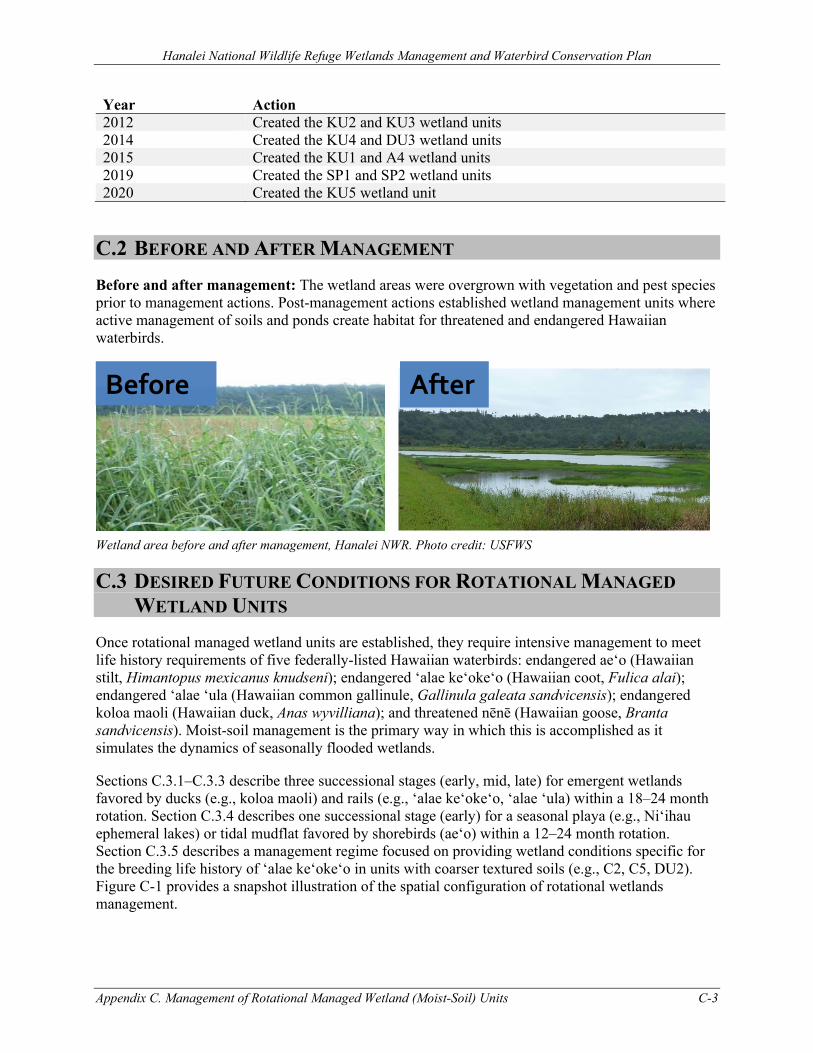
Hanalei National Wildlife Refuge Wetlands Management and Waterbird Conservation Plan
Appendix C. Management of Rotational Managed Wetland (Moist-Soil) Units C-3
Year Action 2012 Created the KU2 and KU3 wetland units 2014 Created the KU4 and DU3 wetland units 2015 Created the KU1 and A4 wetland units 2019 Created the SP1 and SP2 wetland units 2020 Created the KU5 wetland unit
C.2 BEFORE AND AFTER MANAGEMENT Before and after management: The wetland areas were overgrown with vegetation and pest species prior to management actions. Post-management actions established wetland management units where active management of soils and ponds create habitat for threatened and endangered Hawaiian waterbirds.
Wetland area before and after management, Hanalei NWR. Photo credit: USFWS
C.3 DESIRED FUTURE CONDITIONS FOR ROTATIONAL MANAGED WETLAND UNITS
Once rotational managed wetland units are established, they require intensive management to meet life history requirements of five federally-listed Hawaiian waterbirds: endangered ae‘o (Hawaiian stilt, Himantopus mexicanus knudseni); endangered ‘alae ke‘oke‘o (Hawaiian coot, Fulica alai); endangered ‘alae ‘ula (Hawaiian common gallinule, Gallinula galeata sandvicensis); endangered koloa maoli (Hawaiian duck, Anas wyvilliana); and threatened nēnē (Hawaiian goose, Branta sandvicensis). Moist-soil management is the primary way in which this is accomplished as it simulates the dynamics of seasonally flooded wetlands.
Sections C.3.1–C.3.3 describe three successional stages (early, mid, late) for emergent wetlands favored by ducks (e.g., koloa maoli) and rails (e.g., ‘alae ke‘oke‘o, ‘alae ‘ula) within a 18–24 month rotation. Section C.3.4 describes one successional stage (early) for a seasonal playa (e.g., Ni‘ihau ephemeral lakes) or tidal mudflat favored by shorebirds (ae‘o) within a 12–24 month rotation. Section C.3.5 describes a management regime focused on providing wetland conditions specific for the breeding life history of ‘alae ke‘oke‘o in units with coarser textured soils (e.g., C2, C5, DU2). Figure C-1 provides a snapshot illustration of the spatial configuration of rotational wetlands management.
Before After
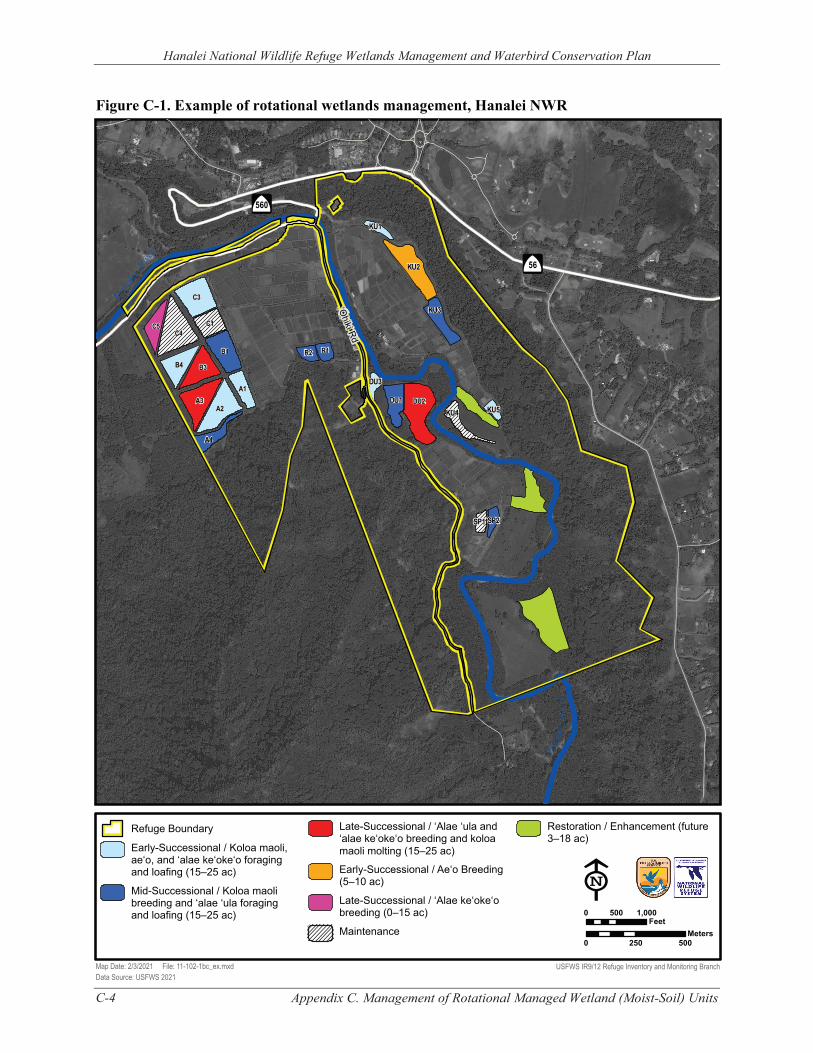
Figure C-1. Example of rotational wetlands management, Hanalei NWR
C-4 Appendix C. Management of Rotational Managed Wetland (Moist-Soil) Units
Hanalei National Wildlife Refuge Wetlands Management and Waterbird Conservation Plan
Hanale
i Rive
r
‘Ohiki Rd
DU1
KU2
KU3
KU4
KU1
DU3
A4
Hana
lei R
iver
SP2 SP1
KU5
R1 R2
C5
A1
B1
C1
C3
A2 A3
B4 B3
C4
DU2
Â
$
56
Â
$
560
Refuge Boundary
Early-Successional / Koloa maoli, ae‘o, and ‘alae ke‘oke‘o foraging and loafing (15–25 ac)
Mid-Successional / Koloa maoli breeding and ‘alae ‘ula foraging and loafing (15–25 ac)
Map Date: 2/3/2021 File: 11-102-1bc_ex.mxd Data Source: USFWS 2021
Late-Successional / ‘Alae ‘ula and ‘alae ke‘oke‘o breeding and koloa maoli molting (15–25 ac)
Early-Successional / Ae‘o Breeding (5–10 ac)
Late-Successional / ‘Alae ke‘oke‘o breeding (0–15 ac)
Maintenance
Restoration / Enhancement (future 3–18 ac)
E 0 500 1,000
Feet Meters
0 250 500
USFWS IR9/12 Refuge Inventory and Monitoring Branch
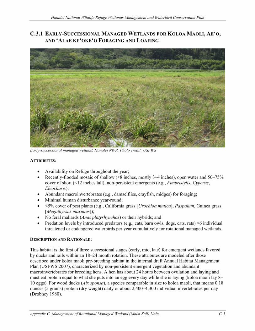
Hanalei National Wildlife Refuge Wetlands Management and Waterbird Conservation Plan
Appendix C. Management of Rotational Managed Wetland (Moist-Soil) Units C-5
C.3.1 EARLY-SUCCESSIONAL MANAGED WETLANDS FOR KOLOA MAOLI, AE‘O, AND ‘ALAE KE‘OKE‘O FORAGING AND LOAFING
Early-successional managed wetland, Hanalei NWR. Photo credit: USFWS
ATTRIBUTES:
• Availability on Refuge throughout the year; • Recently-flooded mosaic of shallow (<8 inches, mostly 3–4 inches), open water and 50–75%
cover of short (<12 inches tall), non-persistent emergents (e.g., Fimbristylis, Cyperus, Eleocharis);
• Abundant macroinvertebrates (e.g., damselflies, crayfish, midges) for foraging; • Minimal human disturbance year-round; • <5% cover of pest plants (e.g., California grass [Urochloa mutica], Paspalum, Guinea grass
[Megathyrsus maximus]); • No feral mallards (Anas platyrhynchos) or their hybrids; and • Predation levels by introduced predators (e.g., cats, barn owls, dogs, cats, rats) ≤6 individual
threatened or endangered waterbirds per year cumulatively for rotational managed wetlands.
DESCRIPTION AND RATIONALE:
This habitat is the first of three successional stages (early, mid, late) for emergent wetlands favored by ducks and rails within an 18–24 month rotation. These attributes are modeled after those described under koloa maoli pre-breeding habitat in the internal draft Annual Habitat Management Plan (USFWS 2007), characterized by non-persistent emergent vegetation and abundant macroinvertebrates for breeding hens. A hen has about 24 hours between ovulation and laying and must eat protein equal to what she puts into an egg every day while she is laying (koloa maoli lay 8–10 eggs). For wood ducks (Aix sponsa), a species comparable in size to koloa maoli, that means 0.18 ounces (5 grams) protein (dry weight) daily or about 2,400–4,300 individual invertebrates per day (Drobney 1980).
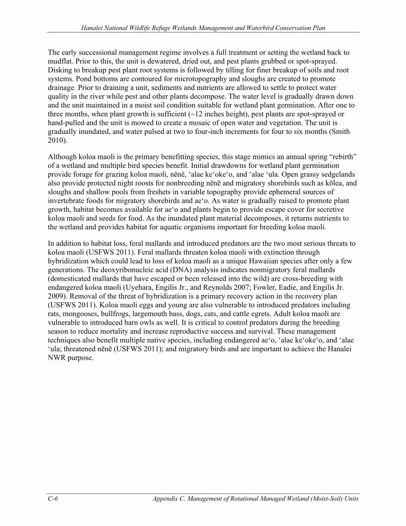
Hanalei National Wildlife Refuge Wetlands Management and Waterbird Conservation Plan
C-6 Appendix C. Management of Rotational Managed Wetland (Moist-Soil) Units
The early successional management regime involves a full treatment or setting the wetland back to mudflat. Prior to this, the unit is dewatered, dried out, and pest plants grubbed or spot-sprayed. Disking to breakup pest plant root systems is followed by tilling for finer breakup of soils and root systems. Pond bottoms are contoured for microtopography and sloughs are created to promote drainage. Prior to draining a unit, sediments and nutrients are allowed to settle to protect water quality in the river while pest and other plants decompose. The water level is gradually drawn down and the unit maintained in a moist soil condition suitable for wetland plant germination. After one to three months, when plant growth is sufficient (~12 inches height), pest plants are spot-sprayed or hand-pulled and the unit is mowed to create a mosaic of open water and vegetation. The unit is gradually inundated, and water pulsed at two to four-inch increments for four to six months (Smith 2010).
Although koloa maoli is the primary benefitting species, this stage mimics an annual spring “rebirth” of a wetland and multiple bird species benefit. Initial drawdowns for wetland plant germination provide forage for grazing koloa maoli, nēnē, ‘alae ke‘oke‘o, and ‘alae ‘ula. Open grassy sedgelands also provide protected night roosts for nonbreeding nēnē and migratory shorebirds such as kōlea, and sloughs and shallow pools from freshets in variable topography provide ephemeral sources of invertebrate foods for migratory shorebirds and ae‘o. As water is gradually raised to promote plant growth, habitat becomes available for ae‘o and plants begin to provide escape cover for secretive koloa maoli and seeds for food. As the inundated plant material decomposes, it returns nutrients to the wetland and provides habitat for aquatic organisms important for breeding koloa maoli.
In addition to habitat loss, feral mallards and introduced predators are the two most serious threats to koloa maoli (USFWS 2011). Feral mallards threaten koloa maoli with extinction through hybridization which could lead to loss of koloa maoli as a unique Hawaiian species after only a few generations. The deoxyribonucleic acid (DNA) analysis indicates nonmigratory feral mallards (domesticated mallards that have escaped or been released into the wild) are cross-breeding with endangered koloa maoli (Uyehara, Engilis Jr., and Reynolds 2007; Fowler, Eadie, and Engilis Jr. 2009). Removal of the threat of hybridization is a primary recovery action in the recovery plan (USFWS 2011). Koloa maoli eggs and young are also vulnerable to introduced predators including rats, mongooses, bullfrogs, largemouth bass, dogs, cats, and cattle egrets. Adult koloa maoli are vulnerable to introduced barn owls as well. It is critical to control predators during the breeding season to reduce mortality and increase reproductive success and survival. These management techniques also benefit multiple native species, including endangered ae‘o, ‘alae ke‘oke‘o, and ‘alae ‘ula; threatened nēnē (USFWS 2011); and migratory birds and are important to achieve the Hanalei NWR purpose.
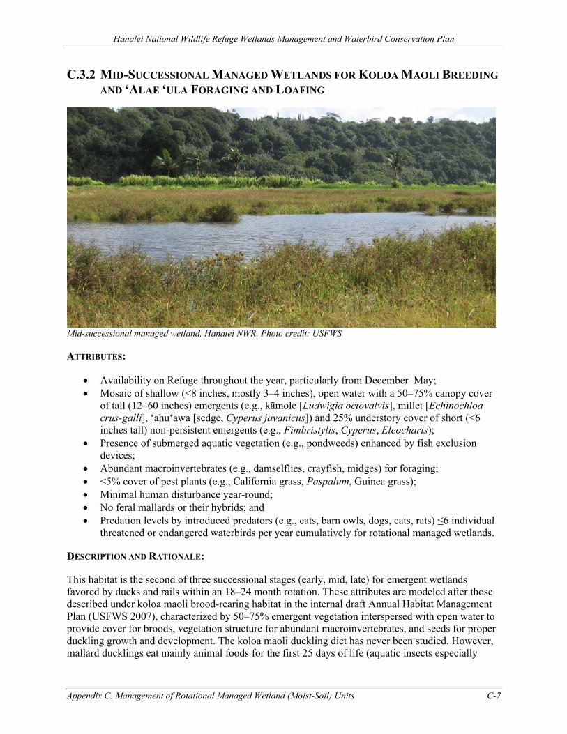
Hanalei National Wildlife Refuge Wetlands Management and Waterbird Conservation Plan
Appendix C. Management of Rotational Managed Wetland (Moist-Soil) Units C-7
C.3.2 MID-SUCCESSIONAL MANAGED WETLANDS FOR KOLOA MAOLI BREEDING AND ‘ALAE ‘ULA FORAGING AND LOAFING
Mid-successional managed wetland, Hanalei NWR. Photo credit: USFWS
ATTRIBUTES:
• Availability on Refuge throughout the year, particularly from December–May; • Mosaic of shallow (<8 inches, mostly 3–4 inches), open water with a 50–75% canopy cover
of tall (12–60 inches) emergents (e.g., kāmole [Ludwigia octovalvis], millet [Echinochloa crus-galli], ‘ahu‘awa [sedge, Cyperus javanicus]) and 25% understory cover of short (<6 inches tall) non-persistent emergents (e.g., Fimbristylis, Cyperus, Eleocharis);
• Presence of submerged aquatic vegetation (e.g., pondweeds) enhanced by fish exclusion devices;
• Abundant macroinvertebrates (e.g., damselflies, crayfish, midges) for foraging; • <5% cover of pest plants (e.g., California grass, Paspalum, Guinea grass); • Minimal human disturbance year-round; • No feral mallards or their hybrids; and • Predation levels by introduced predators (e.g., cats, barn owls, dogs, cats, rats) ≤6 individual
threatened or endangered waterbirds per year cumulatively for rotational managed wetlands.
DESCRIPTION AND RATIONALE:
This habitat is the second of three successional stages (early, mid, late) for emergent wetlands favored by ducks and rails within an 18–24 month rotation. These attributes are modeled after those described under koloa maoli brood-rearing habitat in the internal draft Annual Habitat Management Plan (USFWS 2007), characterized by 50–75% emergent vegetation interspersed with open water to provide cover for broods, vegetation structure for abundant macroinvertebrates, and seeds for proper duckling growth and development. The koloa maoli duckling diet has never been studied. However, mallard ducklings eat mainly animal foods for the first 25 days of life (aquatic insects especially
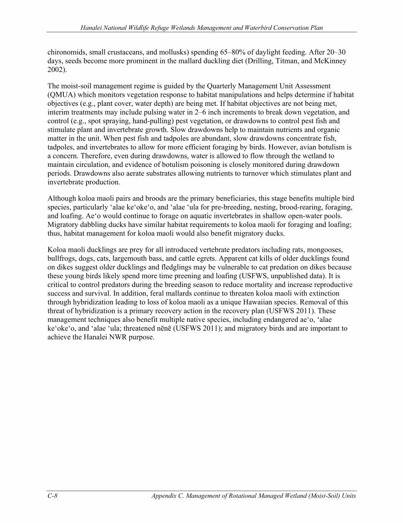
Hanalei National Wildlife Refuge Wetlands Management and Waterbird Conservation Plan
C-8 Appendix C. Management of Rotational Managed Wetland (Moist-Soil) Units
chironomids, small crustaceans, and mollusks) spending 65–80% of daylight feeding. After 20–30 days, seeds become more prominent in the mallard duckling diet (Drilling, Titman, and McKinney 2002).
The moist-soil management regime is guided by the Quarterly Management Unit Assessment (QMUA) which monitors vegetation response to habitat manipulations and helps determine if habitat objectives (e.g., plant cover, water depth) are being met. If habitat objectives are not being met, interim treatments may include pulsing water in 2–6 inch increments to break down vegetation, and control (e.g., spot spraying, hand-pulling) pest vegetation, or drawdowns to control pest fish and stimulate plant and invertebrate growth. Slow drawdowns help to maintain nutrients and organic matter in the unit. When pest fish and tadpoles are abundant, slow drawdowns concentrate fish, tadpoles, and invertebrates to allow for more efficient foraging by birds. However, avian botulism is a concern. Therefore, even during drawdowns, water is allowed to flow through the wetland to maintain circulation, and evidence of botulism poisoning is closely monitored during drawdown periods. Drawdowns also aerate substrates allowing nutrients to turnover which stimulates plant and invertebrate production.
Although koloa maoli pairs and broods are the primary beneficiaries, this stage benefits multiple bird species, particularly ‘alae ke‘oke‘o, and ‘alae ‘ula for pre-breeding, nesting, brood-rearing, foraging, and loafing. Ae‘o would continue to forage on aquatic invertebrates in shallow open-water pools. Migratory dabbling ducks have similar habitat requirements to koloa maoli for foraging and loafing; thus, habitat management for koloa maoli would also benefit migratory ducks.
Koloa maoli ducklings are prey for all introduced vertebrate predators including rats, mongooses, bullfrogs, dogs, cats, largemouth bass, and cattle egrets. Apparent cat kills of older ducklings found on dikes suggest older ducklings and fledglings may be vulnerable to cat predation on dikes because these young birds likely spend more time preening and loafing (USFWS, unpublished data). It is critical to control predators during the breeding season to reduce mortality and increase reproductive success and survival. In addition, feral mallards continue to threaten koloa maoli with extinction through hybridization leading to loss of koloa maoli as a unique Hawaiian species. Removal of this threat of hybridization is a primary recovery action in the recovery plan (USFWS 2011). These management techniques also benefit multiple native species, including endangered ae‘o, ‘alae ke‘oke‘o, and ‘alae ‘ula; threatened nēnē (USFWS 2011); and migratory birds and are important to achieve the Hanalei NWR purpose.
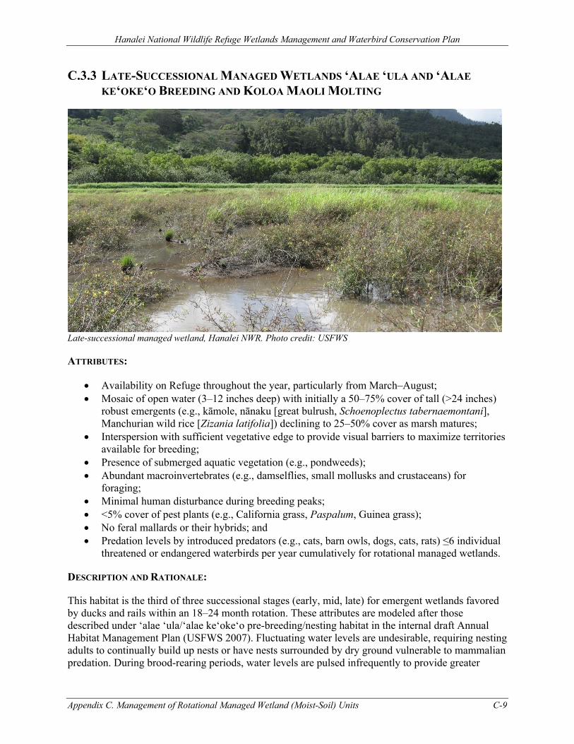
Hanalei National Wildlife Refuge Wetlands Management and Waterbird Conservation Plan
Appendix C. Management of Rotational Managed Wetland (Moist-Soil) Units C-9
C.3.3 LATE-SUCCESSIONAL MANAGED WETLANDS ‘ALAE ‘ULA AND ‘ALAE KE‘OKE‘O BREEDING AND KOLOA MAOLI MOLTING
Late-successional managed wetland, Hanalei NWR. Photo credit: USFWS
ATTRIBUTES:
• Availability on Refuge throughout the year, particularly from March–August; • Mosaic of open water (3–12 inches deep) with initially a 50–75% cover of tall (>24 inches)
robust emergents (e.g., kāmole, nānaku [great bulrush, Schoenoplectus tabernaemontani], Manchurian wild rice [Zizania latifolia]) declining to 25–50% cover as marsh matures;
• Interspersion with sufficient vegetative edge to provide visual barriers to maximize territories available for breeding;
• Presence of submerged aquatic vegetation (e.g., pondweeds); • Abundant macroinvertebrates (e.g., damselflies, small mollusks and crustaceans) for
foraging; • Minimal human disturbance during breeding peaks; • <5% cover of pest plants (e.g., California grass, Paspalum, Guinea grass); • No feral mallards or their hybrids; and • Predation levels by introduced predators (e.g., cats, barn owls, dogs, cats, rats) ≤6 individual
threatened or endangered waterbirds per year cumulatively for rotational managed wetlands.
DESCRIPTION AND RATIONALE:
This habitat is the third of three successional stages (early, mid, late) for emergent wetlands favored by ducks and rails within an 18–24 month rotation. These attributes are modeled after those described under ‘alae ‘ula/‘alae ke‘oke‘o pre-breeding/nesting habitat in the internal draft Annual Habitat Management Plan (USFWS 2007). Fluctuating water levels are undesirable, requiring nesting adults to continually build up nests or have nests surrounded by dry ground vulnerable to mammalian predation. During brood-rearing periods, water levels are pulsed infrequently to provide greater
Hanalei National Wildlife Refuge Wetlands Management and Waterbird Conservation Plan
C-10 Appendix C. Management of Rotational Managed Wetland (Moist-Soil) Units
availability of macroinvertebrates eaten by breeding adults and fed to developing chicks. These invertebrates are an important protein source necessary for survival and proper development. Additionally, invertebrates are critical for molting ducks. Both survey and tracking data indicate koloa maoli seek undisturbed wetlands with dense cover to molt, including late successional wetlands with peak in May to July (USFWS, unpublished data; C. Malachowski, unpublished data). Providing a mosaic of open water and desirable plant species promotes the greatest number of nesting and brood-rearing territories, while minimizing territorial aggression between family units.
The moist-soil management regime is guided by the QMUA which monitors vegetation response to habitat manipulations and helps determine if habitat objectives (e.g., plant cover, water depth) are being met. If habitat objectives are not being met (and there are no nests or broods) a partial treatment could be conducted. Prior to partial treatment (i.e., returning the unit to mid-succession if habitat is not responding to management), the unit is dewatered, dried out, and pest plants grubbed or spot-sprayed as needed. The unit may be kept moist with sloughs, but is maintained in moist soil conditions to allow wetland plants to germinate on mudflats. After one to four months, when plant growth is sufficient (~8–24 inches high), pest plants are spot-sprayed or hand-pulled and the unit may be mowed to create a mosaic of open water and vegetation. The unit is gradually inundated, and water pulsed at 2–4-inch increments as needed (Smith 2010).
Although breeding ‘alae ke‘oke‘o, and ‘alae ‘ula are the primary species to benefit, this stage benefits multiple bird species, particularly ae‘o, koloa maoli, and migratory dabbling and diving ducks that use later succession habitats for foraging and loafing.
‘Alae ‘ula and ‘alae ke‘oke‘o appear to be less susceptible to human disturbance compared with ae‘o and koloa maoli, which may relate to their nest location, nesting habitat, and response to disturbance. However, ‘alae ke‘oke‘o, and ‘alae ‘ula are vulnerable to the same introduced predators as the other threatened or endangered waterbirds. Adults are susceptible to predation by dogs, cats, mongooses, and rats. Predators of chicks or eggs include bullfrogs, common mynah, largemouth bass, and cattle egret. Native ‘auku‘u (black-crowned night heron) are also known to take chicks (Bannor and Kiviat 2002; Pratt and Brisbin Jr. 2002). It is critical to control predators during the breeding season to reduce mortality and increase reproductive success and survival. These management techniques benefit multiple threatened and endangered and migratory waterbird species (USFWS 2011).
C.3.4 EARLY-SUCCESSIONAL MANAGED WETLANDS FOR AE‘O BREEDING
ATTRIBUTES:
• Availability on Refuge from approximately March–August • Recently flooded mosaic of shallow (<3 inches), open water and exposed mudflat (saturated
and unsaturated) with sparse (<25% cover) of low-growing (<6 inches tall) emergent plants (e.g., Fimbristylis, water hyssop [Bacopa spp.]);
• Undulating, irregular topography creating unsaturated mudflats with gradual slopes (~15:1) during drawdown to provide nesting adjacent to foraging habitat;
• Abundant macroinvertebrates (e.g., damselflies, crayfish, midges) for foraging; • Reproductive success of ≥2 hatchlings and ≥1 fledgling per nest; • Minimal human disturbance year-round; • <5% cover of pest plants (e.g., California grass, cattail [Typha latifolia]); • No feral mallards or their hybrids; and
Hanalei National Wildlife Refuge Wetlands Management and Waterbird Conservation Plan
Appendix C. Management of Rotational Managed Wetland (Moist-Soil) Units C-11
• Predation levels by introduced predators (e.g., cats, barn owls, dogs, cats, rats) ≤6 individual threatened or endangered waterbirds per year cumulatively for rotational managed wetlands.
DESCRIPTION AND RATIONALE:
This habitat is an early successional stage of a seasonal playa (e.g., Ni‘ihau ephemeral lakes) or tidal mudflat favored by shorebirds within a 12–24 month rotation. These attributes are modeled after those described under ae‘o breeding/nesting/brood-rearing in the internal draft Annual Habitat Management Plan (USFWS 2007). Ae‘o use a diversity of wetland habitats, but higher nesting densities are found on early successional wetlands with large mudflats, sparse, low-growing vegetation (USFWS 1983), and abundant macroinvertebrates. Suitable ae‘o breeding habitat is rare in the Hawaiian Islands because of altered hydrology, contaminants, and pest species (USFWS 2011). Successful breeding colonies are found almost exclusively on human-maintained wetlands (Robinson et al. 1999) managed primarily for the purpose of threatened and endangered Hawaiian waterbird recovery. Gee (2007) found ae‘o at Hanalei NWR to be responsive to wetlands management with 42 of 48 nests constructed in wetlands specifically managed for this species. Although nest (42%) and fledging (3%) success was low with ~2 chicks fledged because of predators and inundation, creating suitable habitat in larger units to increase predator detection by birds, and creating habitat in sync with the breeding season was recommended. In 2010, water level management resulted in lower nest success (33%) probably due to high rainfall/flooding but higher fledging success (44%) with at least 17 chicks fledged for Hanalei NWR.
Water level management timed to mimic seasonal inundation and evapotranspiration is beneficial to breeding ae‘o. Management should be focused on units that naturally have less robust vegetative growth. Prior to full treatment, the unit is dewatered, dried out, and pest plants grubbed or spot-sprayed. Disking to breakup pest plant root systems may be followed by a wet till (water depth ≤6 inches) for finer breakup of soils and root systems. Pond bottoms are sculpted to create a mosaic of saturated and unsaturated mudflat with gradual slopes to provide nesting adjacent to foraging habitat. If needed, the unit is maintained for a few weeks in moist soil conditions for seed germination. Two-to-three inch shoots are inundated to stimulate invertebrate foods and foraging by breeding pairs.
This pre-breeding and foraging habitat is managed starting in February or March for one to three months at 100 percent open water four to six inches deep to suppress plant growth. Initial water level drawdowns help establish unsaturated mudflats required for nest building and maximize the number of nests/breeding pairs an area can support. Mid-season water level drawdowns provide a mosaic of unsaturated and saturated mudflats required for brood-rearing. Pulsing water helps to stimulate production of invertebrate foods throughout the brood-rearing period and maximizes the number of broods an area can support. It also allows adult ae‘o with broods to establish suitable feeding territories and reduces inter-brood conflicts that can result in injury or death to young chicks.
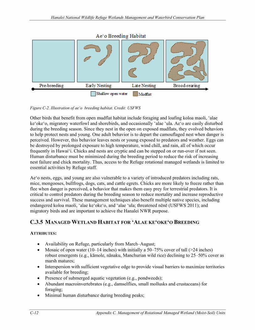
Hanalei National Wildlife Refuge Wetlands Management and Waterbird Conservation Plan
C-12 Appendix C. Management of Rotational Managed Wetland (Moist-Soil) Units
Figure C-2. Illustration of ae‘o breeding habitat. Credit: USFWS
Other birds that benefit from open mudflat habitat include foraging and loafing koloa maoli, ‘alae ke‘oke‘o, migratory waterfowl and shorebirds, and occasionally ‘alae ‘ula. Ae‘o are easily disturbed during the breeding season. Since they nest in the open on exposed mudflats, they evolved behaviors to help protect nests and young. One adult behavior is to depart the camouflaged nest when danger is perceived. However, this behavior leaves nests or young exposed to predators and weather. Eggs can be destroyed by prolonged exposure to high temperature, wind chill, and rain, all of which occur frequently in Hawai‘i. Chicks and nests are cryptic and can be stepped on or run-over if not seen. Human disturbance must be minimized during the breeding period to reduce the risk of increasing nest failure and chick mortality. Thus, access to the Refuge rotational managed wetlands is limited to essential activities by Refuge staff.
Ae‘o nests, eggs, and young are also vulnerable to a variety of introduced predators including rats, mice, mongooses, bullfrogs, dogs, cats, and cattle egrets. Chicks are more likely to freeze rather than flee when danger is perceived, a behavior that makes them easy prey for terrestrial predators. It is critical to control predators during the breeding season to reduce mortality and increase reproductive success and survival. These management techniques also benefit multiple native species, including endangered koloa maoli, ‘alae ke‘oke‘o, and ‘alae ‘ula; threatened nēnē (USFWS 2011); and migratory birds and are important to achieve the Hanalei NWR purpose.
C.3.5 MANAGED WETLAND HABITAT FOR ‘ALAE KE‘OKE‘O BREEDING
ATTRIBUTES:
• Availability on Refuge, particularly from March–August; • Mosaic of open water (10–14 inches) with initially a 50–75% cover of tall (>24 inches)
robust emergents (e.g., kāmole, nānaku, Manchurian wild rice) declining to 25–50% cover as marsh matures;
• Interspersion with sufficient vegetative edge to provide visual barriers to maximize territories available for breeding;
• Presence of submerged aquatic vegetation (e.g., pondweeds); • Abundant macroinvertebrates (e.g., damselflies, small mollusks and crustaceans) for
foraging; • Minimal human disturbance during breeding peaks;
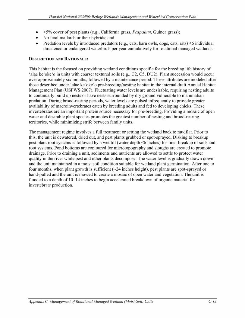
Hanalei National Wildlife Refuge Wetlands Management and Waterbird Conservation Plan
Appendix C. Management of Rotational Managed Wetland (Moist-Soil) Units C-13
• <5% cover of pest plants (e.g., California grass, Paspalum, Guinea grass); • No feral mallards or their hybrids; and • Predation levels by introduced predators (e.g., cats, barn owls, dogs, cats, rats) ≤6 individual
threatened or endangered waterbirds per year cumulatively for rotational managed wetlands.
DESCRIPTION AND RATIONALE:
This habitat is the focused on providing wetland conditions specific for the breeding life history of ‘alae ke‘oke‘o in units with coarser textured soils (e.g., C2, C5, DU2). Plant succession would occur over approximately six months, followed by a maintenance period. These attributes are modeled after those described under ‘alae ke‘oke‘o pre-breeding/nesting habitat in the internal draft Annual Habitat Management Plan (USFWS 2007). Fluctuating water levels are undesirable, requiring nesting adults to continually build up nests or have nests surrounded by dry ground vulnerable to mammalian predation. During brood-rearing periods, water levels are pulsed infrequently to provide greater availability of macroinvertebrates eaten by breeding adults and fed to developing chicks. These invertebrates are an important protein source necessary for pre-breeding. Providing a mosaic of open water and desirable plant species promotes the greatest number of nesting and brood-rearing territories, while minimizing strife between family units.
The management regime involves a full treatment or setting the wetland back to mudflat. Prior to this, the unit is dewatered, dried out, and pest plants grubbed or spot-sprayed. Disking to breakup pest plant root systems is followed by a wet till (water depth ≤6 inches) for finer breakup of soils and root systems. Pond bottoms are contoured for microtopography and sloughs are created to promote drainage. Prior to draining a unit, sediments and nutrients are allowed to settle to protect water quality in the river while pest and other plants decompose. The water level is gradually drawn down and the unit maintained in a moist soil condition suitable for wetland plant germination. After one to four months, when plant growth is sufficient (~24 inches height), pest plants are spot-sprayed or hand-pulled and the unit is mowed to create a mosaic of open water and vegetation. The unit is flooded to a depth of 10–14 inches to begin accelerated breakdown of organic material for invertebrate production.
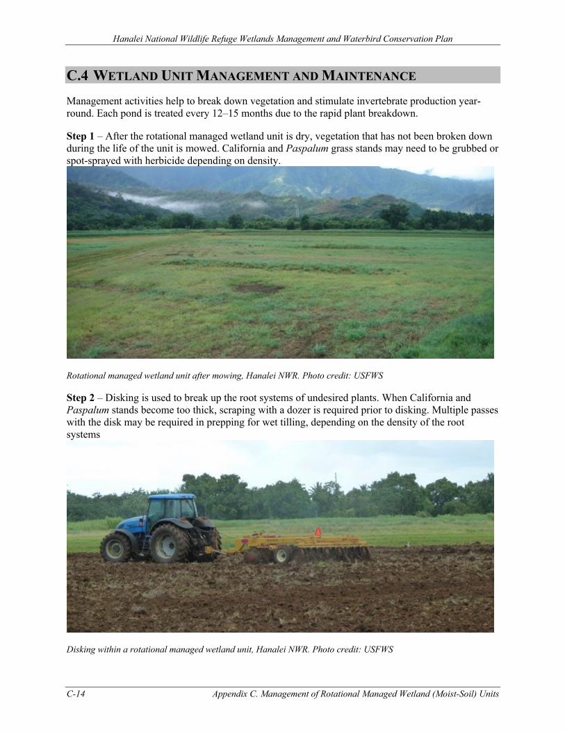
Hanalei National Wildlife Refuge Wetlands Management and Waterbird Conservation Plan
C-14 Appendix C. Management of Rotational Managed Wetland (Moist-Soil) Units
C.4 WETLAND UNIT MANAGEMENT AND MAINTENANCE Management activities help to break down vegetation and stimulate invertebrate production year-round. Each pond is treated every 12–15 months due to the rapid plant breakdown.
Step 1 – After the rotational managed wetland unit is dry, vegetation that has not been broken down during the life of the unit is mowed. California and Paspalum grass stands may need to be grubbed or spot-sprayed with herbicide depending on density.
Rotational managed wetland unit after mowing, Hanalei NWR. Photo credit: USFWS
Step 2 – Disking is used to break up the root systems of undesired plants. When California and Paspalum stands become too thick, scraping with a dozer is required prior to disking. Multiple passes with the disk may be required in prepping for wet tilling, depending on the density of the root systems
Disking within a rotational managed wetland unit, Hanalei NWR. Photo credit: USFWS
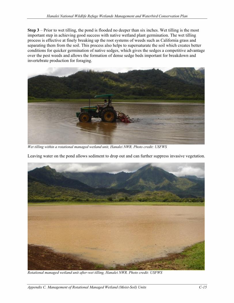
Hanalei National Wildlife Refuge Wetlands Management and Waterbird Conservation Plan
Appendix C. Management of Rotational Managed Wetland (Moist-Soil) Units C-15
Step 3 – Prior to wet tilling, the pond is flooded no deeper than six inches. Wet tilling is the most important step in achieving good success with native wetland plant germination. The wet tilling process is effective at finely breaking up the root systems of weeds such as California grass and separating them from the soil. This process also helps to supersaturate the soil which creates better conditions for quicker germination of native sedges, which gives the sedges a competitive advantage over the pest weeds and allows the formation of dense sedge beds important for breakdown and invertebrate production for foraging.
Wet tilling within a rotational managed wetland unit, Hanalei NWR. Photo credit: USFWS
Leaving water on the pond allows sediment to drop out and can further suppress invasive vegetation.
Rotational managed wetland unit after-wet tilling, Hanalei NWR. Photo credit: USFWS
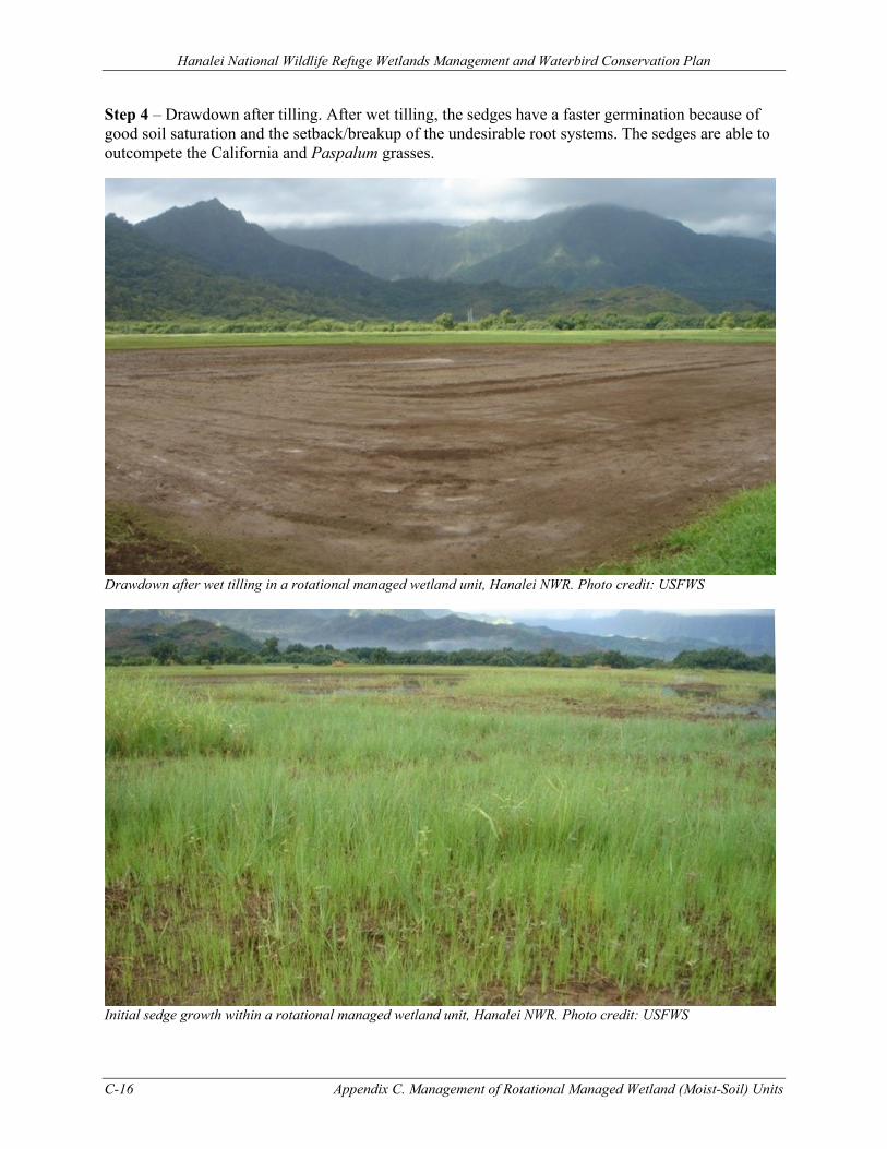
Hanalei National Wildlife Refuge Wetlands Management and Waterbird Conservation Plan
C-16 Appendix C. Management of Rotational Managed Wetland (Moist-Soil) Units
Step 4 – Drawdown after tilling. After wet tilling, the sedges have a faster germination because of good soil saturation and the setback/breakup of the undesirable root systems. The sedges are able to outcompete the California and Paspalum grasses.
Drawdown after wet tilling in a rotational managed wetland unit, Hanalei NWR. Photo credit: USFWS
Initial sedge growth within a rotational managed wetland unit, Hanalei NWR. Photo credit: USFWS
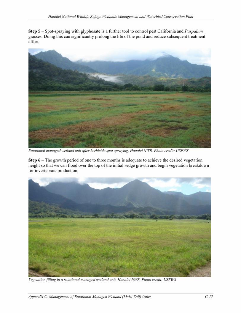
Hanalei National Wildlife Refuge Wetlands Management and Waterbird Conservation Plan
Appendix C. Management of Rotational Managed Wetland (Moist-Soil) Units C-17
Step 5 – Spot-spraying with glyphosate is a further tool to control pest California and Paspalum grasses. Doing this can significantly prolong the life of the pond and reduce subsequent treatment effort.
Rotational managed wetland unit after herbicide spot-spraying, Hanalei NWR. Photo credit: USFWS
Step 6 – The growth period of one to three months is adequate to achieve the desired vegetation height so that we can flood over the top of the initial sedge growth and begin vegetation breakdown for invertebrate production.
Vegetation filling in a rotational managed wetland unit, Hanalei NWR. Photo credit: USFWS
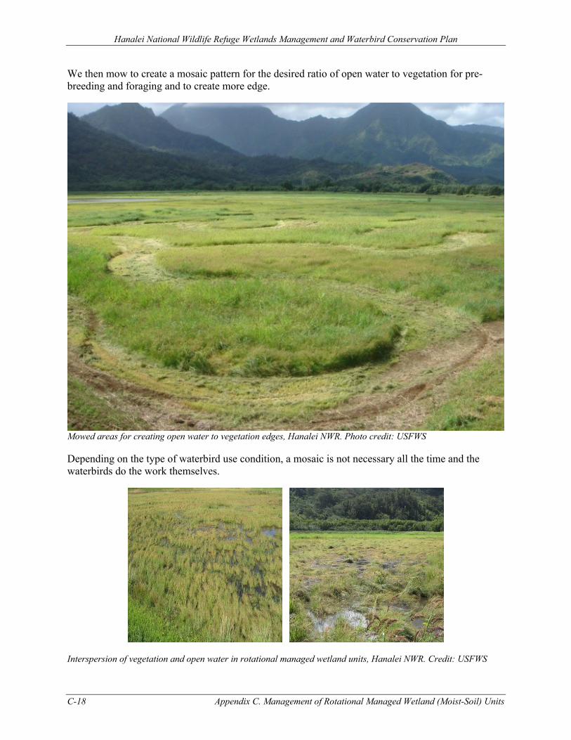
Hanalei National Wildlife Refuge Wetlands Management and Waterbird Conservation Plan
C-18 Appendix C. Management of Rotational Managed Wetland (Moist-Soil) Units
We then mow to create a mosaic pattern for the desired ratio of open water to vegetation for pre-breeding and foraging and to create more edge.
Mowed areas for creating open water to vegetation edges, Hanalei NWR. Photo credit: USFWS
Depending on the type of waterbird use condition, a mosaic is not necessary all the time and the waterbirds do the work themselves.
Interspersion of vegetation and open water in rotational managed wetland units, Hanalei NWR. Credit: USFWS
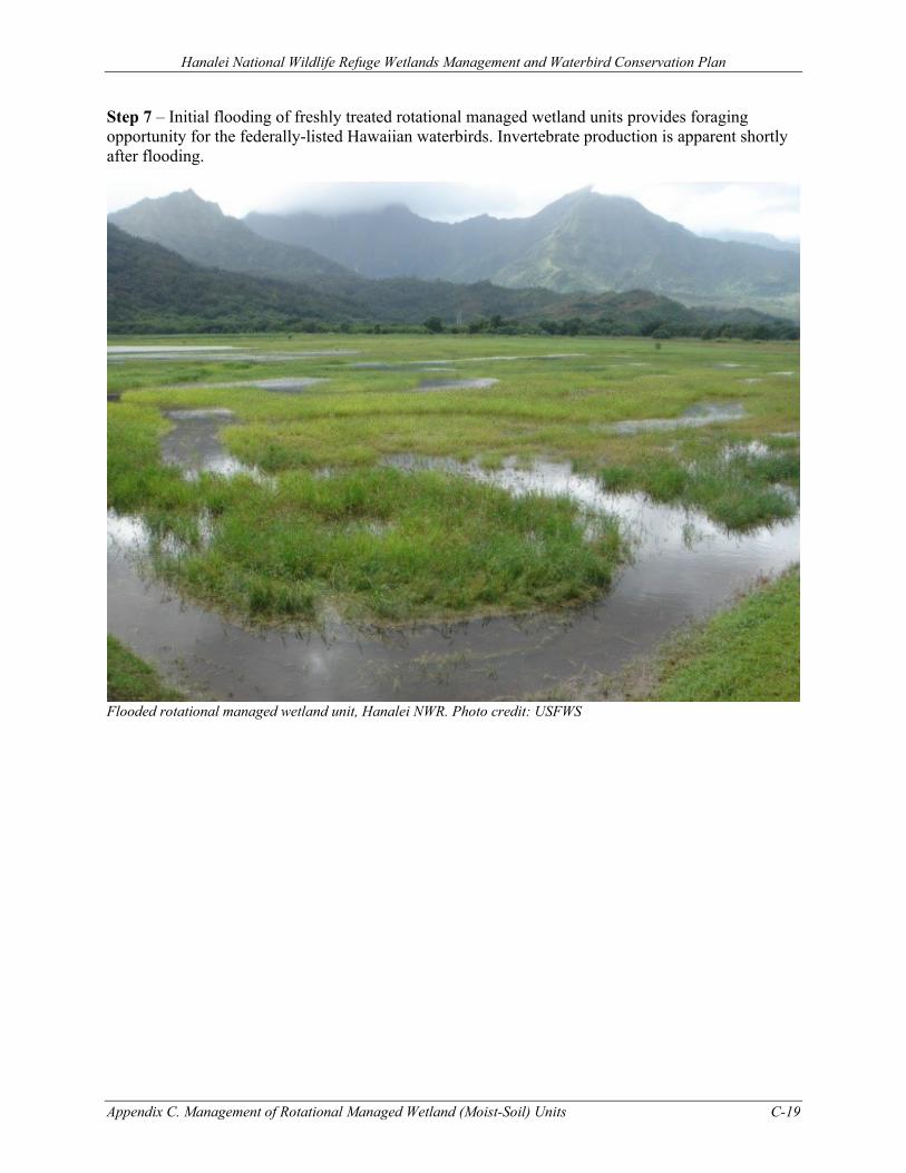
Hanalei National Wildlife Refuge Wetlands Management and Waterbird Conservation Plan
Appendix C. Management of Rotational Managed Wetland (Moist-Soil) Units C-19
Step 7 – Initial flooding of freshly treated rotational managed wetland units provides foraging opportunity for the federally-listed Hawaiian waterbirds. Invertebrate production is apparent shortly after flooding.
Flooded rotational managed wetland unit, Hanalei NWR. Photo credit: USFWS
Hanalei National Wildlife Refuge Wetlands Management and Waterbird Conservation Plan
C-20 Appendix C. Management of Rotational Managed Wetland (Moist-Soil) Units
C.5 REFERENCES Bannor, B. K., and E. Kiviat. 2002. “Common Gallinule (Gallinula galeata).” In The Birds of North
America, edited by P. G. Rodewald. Ithaca, NY: Cornell Lab of Ornithology. doi:10.2173/bna.685.
Drilling, N., R. Titman, and F. McKinney. 2002. “Mallard (Anas platyrhynchos).” In The Birds of North America, edited by P. Rodewald. Ithaca, NY: Cornell Lab of Ornithology. https://birdsna.org/Species-Account/bna/species/mallar.
Drobney, R. D. 1980. “Reproductive Bioenergetics of Wood Ducks.” Auk 97: 480–490.
Fowler, A. C., J. M. Eadie, and A. Engilis Jr. 2009. “Identification of Endangered Hawaiian Ducks (Anas wyvilliana), Introduced North American Mallards (A. platyrhynchos) and Their Hybrids Using Multilocus Genotypes.” Conservation Genetics 10 (6): 1747–1758. doi:http://dx.doi.org/10.1007/s10592-008-9778-8.
Gee, H. K. W. 2007. “Habitat Characteristics of Refuge Wetlands and Taro Lo‘i Used by Endangered Waterbirds at Hanalei National Wildlife Refuge, Hawai‘i.” MSc thesis, South Dakota State University. http://www.sdstate.edu/wfs/publications/thesis/upload/Gee-Hugo-K-W-M-S-2007.pdf.
Pratt, H. D., and I. L. Brisbin Jr. 2002. “Hawaiian Coot (Fulica alai).” In The Birds of North America. Ithaca, NY: Cornell Lab of Ornithology. doi:10.2173/bna.697b.
Robinson, J. A., J. M. Reed, J. P. Skorupa, and L. W. Oring. 1999. “Black-Necked Stilt (Himantopus mexicanus).” In The Birds of North America, edited by P. G. Rodewald. Ithaca, NY: Cornell Lab of Ornithology. doi:10.2173/bna.449.
Smith, C. 2010. “The Art and Science of Wetlands Management at Hanalei NWR.” Oral presentation at the Pacific Coast Joint Venture, Moist-soil Management for Maintenance Staff, Sacramento NWR, Willows, CA. September 28–29, 2010.
USFWS (U.S. Fish and Wildlife Service). 1983. “Hawaiian Wetland National Wildlife Refuge Complex Draft Master Plan.” Unpublished document on file at Kaua‘i National Wildlife Refuge Complex, Kīlauea, HI.
USFWS. 2007. “Hanalei and Hulē‘ia National Wildlife Refuge Draft Annual Habitat Management Plans.” Unpublished document on file at Kaua‘i National Wildlife Refuge Complex, Kīlauea, HI.
USFWS. 2011. Recovery Plan for Hawaiian Waterbirds, Second Revision. Portland, OR: U.S. Department of the Interior, Fish and Wildlife Service. https://ecos.fws.gov/docs/recovery_plan/Hawaiian Waterbirds RP 2nd Revision.pdf.
Uyehara, K. J., A. Engilis Jr., and M. Reynolds. 2007. “Hawaiian Duck’s Future Threatened by Feral Mallards.” U.S. Geological Survey Fact Sheet 2007-3047. http://pubs.usgs.gov/fs/2007/3047/fs2007-3047.pdf.
Hanalei National Wildlife Refuge Wetlands Management and Waterbird Conservation Plan
Appendix D. Integrated Pest Management Program D-1
APPENDIX D. INTEGRATED PEST MANAGEMENT (IPM) PROGRAM
D.1 Background ............................................................................................................................. D-3
D.2 Pest Management Laws and Policies...................................................................................... D-4
D.3 Strategies ................................................................................................................................ D-5
D.3.1 Prevention ................................................................................................................... D-6
D.3.2 Mechanical/Physical Methods .................................................................................... D-7
D.3.3 Cultural Methods ......................................................................................................... D-8
D.3.4 Biological Control Agents .......................................................................................... D-8
D.3.5 Pesticides ................................................................................................................... D-10
D.3.6 Habitat Restoration/Maintenance .............................................................................. D-11
D.4 Priorities for Treatments ....................................................................................................... D-11
D.5 Best Management Practices (BMPs) .................................................................................... D-12
D.5.1 Pesticide Handling and Mixing ................................................................................. D-12
D.5.2 Applying Pesticides ................................................................................................... D-13
D.6 Safety .................................................................................................................................... D-14
D.6.1 Personal Protective Equipment ................................................................................. D-14
D.6.2 Notification ............................................................................................................... D-14
D.6.3 Medical Surveillance ................................................................................................. D-15
D.6.4 Certification and Supervision of Pesticide Applicators ............................................ D-15
D.6.5 Record Keeping ......................................................................................................... D-15
D.7 Evaluating Pesticide Use Proposals ...................................................................................... D-17
D.7.1 Overview of Ecological Risk Assessment ................................................................ D-17
D.7.2 Determining Ecological Risk to Fish and Wildlife ................................................... D-18
D.7.3 Pesticide Mixtures and Degradates ........................................................................... D-30
D.7.4 Determining Effects to Soil and Water Quality ........................................................ D-32
D.7.5 Determining Effects to Air Quality ........................................................................... D-35
D.7.6 Preparing a Chemical Profile .................................................................................... D-35
D.7.7 Toxicological Endpoints ........................................................................................... D-37
D.7.8 Ecological Incident Reports ...................................................................................... D-38
D.7.9 Environmental Fate ................................................................................................... D-39
D.8 References ............................................................................................................................ D-51
Hanalei National Wildlife Refuge Wetlands Management and Waterbird Conservation Plan
D-2 Appendix D. Integrated Pest Management Program
ADDITIONAL ABBREVIATIONS AND UNITS These additional abbreviations are specific to this appendix; other abbreviations are provided in the cover pages to the WMWCP.
% percent ae basis highest application of an active
ingredient a.i. active ingredient APHIS Animal Plant Health Inspection
Service ARS Agricultural Research Service BAFs bioaccumulation factors BCFs bioconcentration factors bw body weight CAS Chemical Abstract Service cm centimeter DT50 dissipation time EC50 environmental concentration EEC estimated environmental
concentration ELS early life stage EXTOXNET Extension Toxicology Network ft feet ft2 square feet g grams gal gallons GUS Groundwater Ubiquity Score I vapor pressure index kg kilograms Koc sorption coefficient Kow Octanol-Water lb(s) pound(s) LC50 Median Lethal Concentration
(Toxicological Endpoint) LD50 Oral Lethal Dose (Toxicological
Endpoint) LOC Level of Concern LOEC Lowest Observed Effect
Concentration LOEL Lowest Observed Effect Level
mg milligrams mm HG millimeter of mercury NIOSH National Institute for Occupational
Safety and Health NOAEC No Observed Adverse Effect
Concentration NOAEC No Observed Adverse Effect
Concentration NOAEL No Observed Adverse Effect Level NOEC No Observed Effect Concentration NPE Nonylphenol polyethylate oz ounce POEA polyoxyethylene-amine ppb parts per billion ppm parts per million PPQ Plant Protection and Quarantine PUPS Pesticide Use Proposal System Reg. No. EPA Registration Number REI restricted entry interval RLGIS Refuge Lands Geographic
Information System RQ Risk Quotient RTECS Registry of Toxic Effects of Chemical
Substances SARA Superfund Amendments and
Reauthorization Act SDS Safety Fata Sheets Sw water solubility t½ half-life T-REX Terrestrial Residue Exposure model TWA time-weighted-average v version wt weight μg microgram
Hanalei National Wildlife Refuge Wetlands Management and Waterbird Conservation Plan
Appendix D. Integrated Pest Management Program D-3
APPENDIX D. INTEGRATED PEST MANAGEMENT (IPM) PROGRAM
D.1 BACKGROUND Integrated pest management (IPM) is an interdisciplinary approach utilizing methods to prevent, eliminate, contain, and/or control pest species in concert with other management activities on refuge lands and waters to achieve wildlife and habitat management goals and objectives. IPM is a scientifically based, adaptive management process where available scientific information and best professional judgment of the refuge staff as well as other resource experts are used to identify and implement appropriate management strategies that can be modified and/or changed over time to ensure effective, site-specific management of pest species to achieve desired outcomes. In accordance with 43 Code of Federal Regulations (CFR) 46.145, adaptive management is particularly relevant where long-term impacts may be uncertain and future monitoring would be needed to make adjustments in subsequent implementation decisions. After a tolerable pest population (threshold) is determined considering achievement of refuge resource objectives and the ecology of pest species, one or more methods, or combinations thereof, are selected that are feasible, efficacious, and most protective of non-target resources, including native species (fish, wildlife, and plants), and Service personnel, Service authorized agents, volunteers, and the public. Staff time and available funding are considered when determining feasibility/practicality of various treatments.
The Wetlands Management and Waterbird Conservation Plan (WMWCP) includes strategies to address pests (see Chapter 4 of this WMWCP) based on IPM techniques and adaptive management to achieve refuge resource objectives. In order to satisfy requirements for IPM planning as identified in the Director’s Memo (dated September 9, 2004) entitled Integrated Pest Management Plans and Pesticide Use Proposals: Updates, Guidance, and an Online Database, the following elements of an IPM program have been incorporated into this WMWCP:
• Habitat and/or wildlife objectives that identify pest species and appropriate thresholds to indicate the need for and successful implementation of IPM techniques; and
• Monitoring before and/or after treatment to assess progress toward achieving objectives including pest thresholds.
Where pesticides would be necessary to address pests, this appendix provides a structured procedure to evaluate potential effects of proposed uses involving ground-based applications to refuge biological resources and environmental quality in accordance with effects analyses (environmental consequences) of the Environmental Assessment (EA) associated with the draft WMWCP. Only pesticide uses that likely would cause minor, temporary, or localized effects to refuge biological resources and environmental quality with appropriate best management practices (BMPs), where necessary, would be allowed for use on the Refuge.
This appendix does not describe the more detailed process to evaluate potential effects associated with aerial applications of pesticides. Moreover, it does not address effects of mosquito control with pesticides (larvicides, pupacides, or adulticides) based upon identified human health threats and presence of disease-carrying mosquitoes in sufficient numbers from monitoring conducted on a refuge. However, the basic framework to assess potential effects to refuge biological resources and environmental quality from aerial application of pesticides or use of insecticides for mosquito
Hanalei National Wildlife Refuge Wetlands Management and Waterbird Conservation Plan
D-4 Appendix D. Integrated Pest Management Program
management would be similar to the process described in this appendix for ground-based treatments of other pesticides.
D.2 PEST MANAGEMENT LAWS AND POLICIES In accordance with Service policy 569 U.S. Fish and Wildlife Service Manual (FW) 1 (Integrated Pest Management), plant, invertebrate, and vertebrate pests on units of the National Wildlife Refuge System (NWRS or Refuge System) can be controlled to ensure balanced wildlife and fish populations in support of refuge-specific wildlife and habitat management objectives. Pest control on federal (Refuge) lands and waters is authorized under the following legal mandates:
• National Wildlife Refuge System Administration Act of 1966 (Refuge Administration Act), as amended (16 United States Code (USC) 668dd-668ee);
• Plant Protection Act of 2000 (7 USC 7701 et seq.); • Noxious Weed Control and Eradication Act of 2004 (7 USC 7781-7786, Subtitle E); • Federal Insecticide, Fungicide, and Rodenticide Act of 1996 (FIFRA; 7 USC 136-136y); • National Invasive Species Act of 1996 (16 USC 4701); • Nonindigenous Aquatic Nuisance Prevention and Control Act of 1990 (16 USC 4701); • Food Quality Protection Act of 1996 (7 USC 136); • Executive Order (EO) 13148, Section 601(a); • EO 13112; and • Animal Damage Control Act of 1931 (7 USC 426-426c, 46 Stat. 1468).
Pests are defined as “…living organisms that may interfere with the site-specific purposes, operations, or management objectives or that jeopardize human health or safety” from Department policy 517 Department Manual (DM) 1 (Integrated Pest Management Policy). Similarly, 569 FW 1 defines pests as “…invasive plants and introduced or native organisms that may interfere with achieving our management goals and objectives on or off our lands, or that jeopardize human health or safety.” 517 DM 1 also defines an invasive species as “a species that is nonnative to the ecosystem under consideration and whose introduction causes or is likely to cause economic or environmental harm or harm to human health.” Throughout the remainder of this WMWCP, the terms pest and invasive species are used interchangeably because both can prevent/impede the achievement of refuge wildlife and habitat objectives and/or degrade environmental quality.
In general, control of pests (vertebrate or invertebrate) on the Refuge would conserve and protect the nation’s fish, wildlife, and plant resources as well as maintain environmental quality. From 569 FW 1, animal or plant species that are considered pests may be managed if the following criteria are met1:
• Threat to human health and well being or private property, the acceptable level of damage by the pest has been exceeded, or state or local government has designated the pest as noxious;
• Detrimental to resource objectives as specified in a refuge resource management plan (e.g., comprehensive conservation plan, habitat management plan), if available; and
1 Note that during the life span of the WMWCP, policies, such as 569 FW 1, may be updated and revised. As such, the Refuge will comply with the most updated Service policies related to IPM.
Hanalei National Wildlife Refuge Wetlands Management and Waterbird Conservation Plan
Appendix D. Integrated Pest Management Program D-5
• Control would not conflict with attainment of resource objectives or the purpose(s) for which the Refuge was established.
The specific justifications for pest management activities on the Refuge are the following:
• Protect human health and well being; • Prevent substantial damage to important to refuge resources; • Protect newly introduced or re-establish native species; • Control nonnative (exotic) species in order to support existence for populations of native
species; • Prevent damage to private property; and • Provide the public with quality, compatible wildlife-dependent recreational opportunities.
In accordance with Service policy 620 FW 1 (Habitat Management Plans), there are additional management directives regarding invasive species found on the Refuge:
• “We are prohibited by Executive Order, law, and policy from authorizing, funding, or carrying out actions that are likely to cause or promote the introduction or spread of invasive species in the United States or elsewhere.”
• “Manage invasive species to improve or stabilize biotic communities to minimize unacceptable change to ecosystem structure and function and prevent new and expanded infestations of invasive species. Conduct refuge habitat management activities to prevent, control, or eradicate invasive species…”
Animal species damaging/destroying federal property and/or detrimental to the management program of a refuge may be controlled as described in 50 CFR 31.14 (Official Animal Control Operations). For example, the removal of feral pigs damaging Hanalei Refuge infrastructure and/or negatively affecting habitats managed on Refuge lands may be conducted without a pest control proposal.
Trespass and feral animals also may be controlled on refuge lands. Based upon 50 CFR 28.43 (Destruction of Dogs and Cats), dogs and cats running at large on a national wildlife refuge and observed in the act of killing, injuring, harassing or molesting humans or wildlife may be disposed of in the interest of public safety and protection of the wildlife. Feral animals should be disposed by the most humane method(s) available and in accordance with relevant Service directives (including EO 11643). Disposed wildlife specimens may be donated or loaned to public institutions. Donation or loans of resident wildlife species will only be made after securing State approval (50 CFR 30.11 [Donation and Loan of Wildlife Specimens]). Surplus wildlife specimens may be sold alive or butchered, dressed and processed subject to federal and state laws and regulations (50 CFR 30.12 [Sale of Wildlife Specimens]).
D.3 STRATEGIES To fully embrace IPM as identified in 569 FW 1, the following strategies, where applicable, are carefully considered on the Refuge for each pest species. Any pests and IPM needs identified during implementation of the WMWCP, when and if approved, would follow these existing strategies.
Hanalei National Wildlife Refuge Wetlands Management and Waterbird Conservation Plan
D-6 Appendix D. Integrated Pest Management Program
D.3.1 PREVENTION
This is the most effective and least expensive long-term management option for pests. It encompasses methods to prevent new introductions or the spread of the established pests to uninfested areas. It requires identifying potential routes of invasion to reduce the likelihood of infestation. Hazard Analysis and Critical Control Points (HACCP) planning can be used to determine if current management activities on a refuge may introduce and/or spread invasive species in order to identify appropriate BMPs for prevention. See http://www.haccp-nrm.org/ for more information about HACCP planning.
Prevention may include source reduction, using pathogen-free or weed-free seeds or fill; exclusion methods (e.g., barriers); and/or sanitation methods (e.g., wash stations). These prevent re-introductions by various mechanisms including vehicles, personnel, livestock, and horses. Because invasive species are frequently the first to establish in newly disturbed sites, prevention requires a reporting mechanism for early detection of new pest occurrences with quick response to eliminate any new satellite pest populations. Prevention requires consideration of the scale and scope of land management activities that may promote pest establishment within uninfested areas or promote reproduction and spread of existing populations. Along with preventing initial introduction, prevention involves halting the spread of existing infestations to new sites (Mullin et al. 2000). The primary purpose of prevention is to keep pest-free lands or waters from becoming infested. EO 11312 emphasizes the priority for prevention with respect to managing pests.
The following are methods to prevent the introduction and/or spread of pests on refuge lands:
• Before beginning ground-disturbing activities (e.g., disking, scraping), inventory and prioritize pest infestations in project operating areas and along access routes. Refuge staff identify pest species on-site or within reasonably expected potential invasion vicinity. Where possible, the refuge staff begin project activities in uninfested areas before working in pest-infested areas.
• The refuge staff locate and use pest-free project staging areas. They avoid or minimize travel through pest-infested areas, or restrict to those periods when spread of seed or propagules of invasive plants is least likely.
• The refuge staff determine the need for and, when appropriate, identify sanitation sites where equipment can be cleaned of pests. Where possible, the refuge staff clean equipment before entering lands at on-refuge approved cleaning site(s). This practice does not pertain to vehicles traveling frequently in and out of the project area that will remain on roadways. Seeds and plant parts of pest plants need to be collected, where practical. The refuge staff remove mud, dirt, and plant parts from project equipment before moving it into a project area.
• The refuge staff clean all equipment, before leaving the project site, if operating in areas infested with pests. The refuge staff determine the need for and, when appropriate, identify sanitation sites where equipment can be cleaned.
• Refuge staff, their authorized agents, and refuge volunteers, where possible, inspect, remove, and properly dispose of seed and parts of invasive plants found on their clothing and equipment. Proper disposal means bagging the seeds and plant parts and then properly discarding of them (e.g., incinerating).
• The refuge staff evaluate options, including closure, to restrict the traffic on sites with on-going restoration of desired vegetation. The refuge staff revegetate disturbed soil (except
Hanalei National Wildlife Refuge Wetlands Management and Waterbird Conservation Plan
Appendix D. Integrated Pest Management Program D-7
travel ways on surfaced projects) to optimize plant establishment for each specific site. Revegetation may include topsoil replacement, planting, seeding, fertilization, liming, and weed-free mulching as necessary. The refuge staff use native material, where appropriate and feasible. The refuge staff use certified weed-free or weed-seed-free hay or straw where certified materials are reasonably available.
• The refuge staff provide information, training, and appropriate pest identification materials to permit holders and recreational visitors. The refuge staff educate them about pest identification, biology, impacts, and effective prevention measures.
• The refuge staff inspect borrowed material for invasive plants prior to use and transport onto and/or within refuge lands.
• The refuge staff consider invasive plants in planning for road maintenance activities. • The refuge staff restrict off-road travel to designated routes.
The following are methods to prevent the introduction and/or spread of pests into refuge waters:
• The refuge staff inspect boats (including air boats), trailers, and other boating equipment and where possible, remove any visible plants, animals, or mud before leaving any waters or boat launching facilities.
• Where possible, the refuge staff drain water from motors, live wells, bilges, and transom wells while on land before leaving the site.
• If possible, the refuge staff wash and dry boats, downriggers, anchors, nets, floors of boats, propellers, axles, trailers, and other boating equipment to kill pests not visible at the boat launch.
These prevention methods to minimize/eliminate the introduction and/or spread of pests were taken verbatim or slightly modified from Appendix E of the U.S. Forest Service’s (USFS’s) Preventing and Managing Invasive Plants Final Environmental Impact Statement (2005).
D.3.2 MECHANICAL/PHYSICAL METHODS
These methods remove and destroy, disrupt the growth of, or interfere with the reproduction of pest species. For plants species, these treatments can be accomplished by hand, hand tool (manual), or power tools (mechanical) and include pulling, grubbing, digging, tilling/disking, cutting, swathing, grinding, shearing, girdling, mowing, and mulching of the pest plants.
For animal species, Service employees or their authorized agents could use mechanical/physical methods (including trapping) to control pests as a refuge management activity. Based upon 50 CFR 31.2, trapping can be used on a refuge to reduce surplus wildlife populations for a “balanced conservation program” in accordance with federal or state laws and regulations. In some cases, non-lethally trapped animals may be relocated to off-refuge sites with prior approval from the state.
Each of these tools are efficacious to some degree and applicable to specific situations. In general, mechanical controls can effectively control annual and biennial pest plants. However, to control perennial plants, the root system must be destroyed or it may resprout and continue to grow and develop. Mechanical controls are typically not capable of destroying a perennial plant’s root system. Although some mechanical tools (e.g., disking, plowing) may damage root systems, they may stimulate regrowth producing a denser plant population that may aid in the spread depending upon the target species. In addition, steep terrain and soil conditions are major factors that can limit the use of many mechanical control methods.
Hanalei National Wildlife Refuge Wetlands Management and Waterbird Conservation Plan
D-8 Appendix D. Integrated Pest Management Program
Some mechanical control methods (e.g., mowing), used in combination with herbicides, can be a very effective technique to control perennial species. For example, mowing perennial plants followed sequentially by treating the plant regrowth with a systemic herbicide often improve the efficacy of the herbicide compared to herbicide only treatment.
D.3.3 CULTURAL METHODS
These methods involve manipulating habitat to increase pest mortality by reducing its suitability to the pest. Cultural methods could include water-level manipulation, mulching, changing planting dates to minimize pest impact, prescribed burning (facilitate revegetation, increase herbicide efficacy, and remove litter to assist in emergence of desirable species), flaming with propane torches, trap crops, crop rotations that would include non-susceptible crops, moisture management, addition of beneficial insect habitat, reducing clutter, proper trash disposal, planting or seeding desirable species to shade or out-compete invasive plants, applying fertilizer to enhance desirable vegetation, prescriptive grazing, and other habitat alterations.
D.3.4 BIOLOGICAL CONTROL AGENTS
Classical biological control involves the deliberate introduction and management of natural enemies (parasites, predators, or pathogens) to reduce pest populations. Many of the most ecologically or economically damaging pest species in the United States originated in foreign countries. These newly introduced pests, which are free from natural enemies found in their country or region of origin, may have a competitive advantage over cultivated and native species. This competitive advantage often allows introduced species to flourish, and they may cause widespread economic damage to crops or out compete and displace native vegetation. Once the introduced pest species population reaches a certain level, traditional methods of pest management may be cost prohibitive or impractical. Biological controls typically are used when these pest populations have become so widespread that eradication or effective control would be difficult or is no longer practical.
Biological control has advantages as well as disadvantages. Benefits include reducing pesticide usage, host specificity for target pests, long-term self-perpetuating control, low cost/acre, capacity for searching and locating hosts, synchronizing biological control agents to hosts’ life cycles, and the unlikelihood that hosts will develop resistance to agents. Disadvantages include the following: limited availability of agents from their native lands, the dependence of control on target species density, slow rate at which control occurs, biotype matching, the difficulty and expense of conflicts over control of the target pest, and host specificity when host populations are low.
A reduction in target species populations from biological controls is typically a slow process, and efficacy can be highly variable. It may not work well in a particular area although it may work well in other areas. Biological control agents require specific environmental conditions to survive over time. Some of these conditions are understood; whereas, others are only partially understood or not at all.
Biological control agents will not completely eradicate a target pest. When using biological control agents, residual levels of the target pest typically are expected; the agent population level or survival would be dependent upon the density of its host. After the pest population decreases, the population of the biological control agent decreases correspondingly. This is a natural cycle. Some pest populations (e.g., invasive plants) tend to persist for several years after a biological control agent
Hanalei National Wildlife Refuge Wetlands Management and Waterbird Conservation Plan
Appendix D. Integrated Pest Management Program D-9
becomes established due to seed reserves in the soil, inefficiencies in the agent’s search behavior, and the natural lag in population buildup of the agent.
The full range of pest groups potentially found on refuge lands and waters include diseases, invertebrates, vertebrates, and invasive plants (most common group). Often it is assumed that biological control would address many, if not most, of these pest problems. There are several well-documented success stories of biological control of invasive species in Hawai‘i, including banana poka (Passiflora mollisima) and Eurythrina gall wasps (Quadrastichus erythrinae). However, historically, each new introduction of a biological control agent in the United States has only about a 30 percent success rate (Coombs et al. 2004).
Introduced species without desirable close relatives in the United States are generally selected as biological controls. Natural enemies that are restricted to one or a few closely related plants in their country of origin are targeted as biological controls (Center, Frank, and Dray Jr. 1997; Hasan and Ayres 1990).
The refuge staff would ensure introduced agents are approved by the applicable authorities. Except for a small number of formulated biological control products registered by U.S. Environmental Protection Agency (EPA) under FIFRA, most biological control agents are regulated by the U.S. Department of Agriculture (USDA)-Animal Plant Health Inspection Service(APHIS), Plant Protection and Quarantine (PPQ). State departments of agriculture and, in some cases, county agricultural commissioners or weed districts have additional approval authority.
Federal permits (USDA-APHIS-PPQ Form 526) are required to import biocontrols agents from another state. Form 526 may be obtained by writing:
USDA-APHIS-PPQ Biological Assessment and Taxonomic Support 4700 River Road, Unit 113 Riverdale, MD 20737
Or through the internet at:
http://www.aphis.usda.gov/plant_health/permits/organism/plantpest_howtoapply.shtml
The Service strongly supports the development, and legal and responsible use of appropriate, safe, and effective biological control agents for nuisance and non-indigenous or pest species.
State and county agriculture departments may also be sources for biological control agents or they may have information about where biological control agents may be obtained. Commercial sources should have an Application and Permit to Move Live Plant Pests and Noxious Weeds (USDA-PPQ Form 226 USDA-APHIS-PPQ, Biological Assessment and Taxonomic Support, 4700 River Road, Unit 113, Riverdale, MD 20737) to release specific biological control agents in a state and/or county. Furthermore, certification regarding the biological control agent’s identity (genus, specific epithet, sub-species, and variety) and purity (e.g., parasite free, pathogen free, and biotic and abiotic contaminants) should be specified in purchase orders.
Biological control agents are subject to 569 FW1. In addition, the refuge staff would follow the International Code of Best Practice for Classical Biological Control of Weeds
Hanalei National Wildlife Refuge Wetlands Management and Waterbird Conservation Plan
D-10 Appendix D. Integrated Pest Management Program
(http://wiki.bugwood.org/Code_of_Best_Practices) as ratified by delegates to the X International Symposium on Biological Control of Weeds, Bozeman, MT, July 9, 1999. This code identifies the following:
Release only approved biological control agents; Use the most effective agents; Document releases; and Monitor for impact to the target pest species, nontarget species, and the environment.
Biological control agents formulated as pesticide products and registered by the EPA (e.g., Bti) are also subject to pesticide use proposal (PUP) review and approval (see below).
A record of all releases would be maintained with date(s), location(s), and environmental conditions of the release site(s); the identity, quantity, and condition of the biological control agents released; and other relevant data and comments such as weather conditions. Systematic monitoring to determine the establishment and effectiveness of the release is also recommended.
For any new biological control agents, the relevant NEPA documents regarding biological and other environmental effects of biological control agents prepared by another federal agency, where the scope is relevant to evaluation of releases on refuge lands, would be reviewed. See Section D.7.2 for more about incorporating previous analyses from other federal agencies.
D.3.5 PESTICIDES
The selective use of pesticides is based upon pest ecology (including mode of reproduction), the size and distribution of its populations, site-specific conditions (e.g., soils, topography), known efficacy under similar site conditions, and the capability to use BMPs to reduce/eliminate potential effects to non-target species, sensitive habitats, and potential to contaminate surface and groundwater. All pesticide usage (pesticide, target species, application rate, and method of application) will comply with the applicable federal (FIFRA) and state regulations pertaining to pesticide use, safety, storage, disposal, and reporting. Before pesticides can be used to eradicate, control, or contain pests on refuge lands and waters, pesticide use proposals (PUPs) are prepared and approved in accordance with 569 FW 1. The PUP records provide a detailed, time-, site-, and target-specific description of the proposed use of pesticides on the Refuge. See Section D.6.5.2 for more on record-keeping related to PUPs.
Application equipment is selected to provide site-specific delivery to target pests while minimizing/eliminating direct or indirect (e.g., drift) exposure to non-target areas and degradation of surface and groundwater quality. Where possible, target-specific equipment (e.g., backpack sprayer, wiper) is used to treat target pests. Other target-specific equipment to apply pesticides include soaked wicks or paint brushes for wiping vegetation and lances, hatchets, or syringes for direct injection into stems. Granular pesticides may be applied using seeders or other specialized dispensers.
Repeated use of one pesticide may allow resistant organisms to survive and reproduce, so multiple pesticides with variable modes of action are considered for treatments on refuge lands and waters. This is especially important if multiple applications within years and/or over a growing season likely would be necessary for habitat maintenance and restoration activities to achieve resource objectives. Integrated chemical and non-chemical controls also are highly effective, where practical, because pesticide-resistant organisms can be removed from the site.
Hanalei National Wildlife Refuge Wetlands Management and Waterbird Conservation Plan
Appendix D. Integrated Pest Management Program D-11
Cost may not be the primary factor in selecting a pesticide for use on a refuge. If the least expensive pesticide could potentially harm natural resources or people, then a different product is selected, if available. The most efficacious pesticide available with the least potential to degrade environment quality (soils, surface water, and groundwater) as well as least potential effect to native species and communities of fish, wildlife, plants, and their habitats is acceptable for use on refuge lands in the context of an IPM approach.
D.3.6 HABITAT RESTORATION/MAINTENANCE
Restoration and/or proper maintenance of refuge habitats associated with achieving wildlife and habitat objectives is essential for long-term prevention, eradication, or control (at or below threshold levels) of pests. Promoting desirable plant communities through the manipulation of species composition, plant density, and growth rate is an essential component of invasive plant management (Masters et al. 1996; Masters and Sheley 2001; Brooks et al. 2004). The following three components of succession could be manipulated through habitat maintenance and restoration: site availability, species availability, and species performance (Cox and Anderson 2004). Although a single method (e.g., herbicide treatment) may eliminate or suppress pest species in the short term, the resulting gaps and bare soil create niches that are conducive to further invasion by the species and/or other invasive plants. On degraded sites where desirable species are absent or in low abundance, revegetation with native/desirable grasses, forbs, and legumes may be necessary to direct and accelerate plant community recovery and achieve site-specific objectives in a reasonable time frame. The selection of appropriate species for revegetation would be dependent on several factors including resource objectives and site-specific, abiotic factors (e.g., soil texture, precipitation/temperature regimes, and shade conditions). Seed availability and cost, ease of establishment, seed production, and competitive ability also are important considerations.
D.4 PRIORITIES FOR TREATMENTS For many refuges, the magnitude (number, distribution, and sizes of infestations) of pest problems is too extensive and beyond the available capital resources to effectively address during any single field season. To manage pests in the Refuge, it is essential to prioritize treatment of infestations. Highest priority treatments are focused on early detection and rapid response to eliminate infestations of new pests, if possible. This is especially important for aggressive pests potentially impacting species, species groups, communities, and/or habitats associated refuge purpose(s), Refuge System resources of concern (federally listed species, migratory birds, selected marine mammals, and interjurisdictional fish), and native species for maintaining/restoring biological integrity, diversity, and environmental health.
The next priority is treating established pests that appear in one or more previously uninfested areas. Moody and Mack (1988) demonstrated through modeling that small, new outbreaks of invasive plants eventually would infest an area larger than the established, source population. They also found that control efforts focusing on the large, main infestation rather than the new, small satellites reduced the chances of overall success. The lowest priority would be treating large infestations (sometimes monotypic stands) of well-established pests. In this case, initial efforts would focus upon containment of the perimeter followed by work to control/eradicate the established infested area. If containment and/or control of a large infestation is not effective, then efforts focus upon halting pest reproduction or managing source populations. Maxwell et al. (2009) found treating fewer populations
Hanalei National Wildlife Refuge Wetlands Management and Waterbird Conservation Plan
D-12 Appendix D. Integrated Pest Management Program
that are sources represents an effective long-term strategy to reduce of total number of invasive populations and decreasing meta-population growth rates.
Although state listed noxious weeds are always of high priority for management, other pest species known to cause substantial ecological impact are also considered. For example, short-spined kiawe may not be listed by the State of Hawai‘i as noxious, but it can greatly alter fire regimes in the coastal dryland shrub habitat resulting in large monotypic stands that displace native bunch grasses, forbs, and shrubs. Pest control in support of the WMWCP would likely require a multi-year commitment from Refuge staff. Pre- and post-treatment monitoring, assessment of the successes and failures of treatments, and development of new approaches when proposed methods do not achieve desired outcomes are essential to the long-term success of pest management.
D.5 BEST MANAGEMENT PRACTICES (BMPS) BMPs can minimize or eliminate possible effects associated with pesticide usage to non-target species and/or sensitive habitats as well as degradation of water quality from drift, surface runoff, or leaching. Based upon the U.S. Department of the Interior (DOI) Pesticide Use Policy (517 DM 1) and the Service IPM Policy and Responsibilities (569 FW 1), the use of applicable BMPs (where feasible) also ensures that pesticide uses may not adversely affect federally listed species and/or their critical habitats through determinations made using the process described in 50 CFR part 402.
The following are BMPs pertaining to mixing/handling and applying pesticides for all ground-based treatments of pesticides, which are considered and utilized, where feasible, based upon target- and site-specific factors and time-specific environmental conditions. Although not listed below, the most important BMP to eliminate/reduce potential impacts to non-target resources would be an IPM approach to prevent, control, eradicate, and contain pests.
D.5.1 PESTICIDE HANDLING AND MIXING
• As a precaution against spilling, spray tanks will not be left unattended during filling. • All pesticide containers will be triple rinsed and the rinsate used as water in the sprayer tank
and applied to treatment areas. • All pesticide spray equipment will be properly cleaned. Where possible, rinsate will be used
as part of the makeup water in the sprayer tank and applied to treatment areas. • The refuge staff will dispose of triple-rinsed pesticide containers per label directions. • All unused pesticides will be properly discarded at a local “safe send” collection. • Pesticides and pesticide containers will be lawfully stored, handled, and disposed of in
accordance with the label and in a manner safeguarding human health, fish, and wildlife and prevent soil and water contaminant.
• The refuge staff will consider the water quality parameters (e.g., pH, hardness) that are important to ensure greatest efficacy where specified on the pesticide label.
• All pesticide spills will be addressed immediately using procedures identified in the refuge spill response plan.

Hanalei National Wildlife Refuge Wetlands Management and Waterbird Conservation Plan
Appendix D. Integrated Pest Management Program D-13
D.5.2 APPLYING PESTICIDES
• Pesticide treatments will only be conducted by or under the supervision of Service personnel and non-Service applicators with the appropriate state or BLM certification to safely and effectively conduct these activities on refuge lands and waters.
• The refuge staff will comply with all federal, state, and local pesticide use laws and regulations as well as Department, Service, and Refuge System pesticide-related policies. For example, the refuge staff will use application equipment and apply rates for the specific pest(s) identified on the pesticide label as required under FIFRA.
• Before each treatment season and prior to mixing or applying any product for the first time each season, all applicators will review the labels, safety data sheets (SDSs), and PUPs for each pesticide, determining the target pest, appropriate mix rate(s), personal protective equipment (PPE), and other requirements listed on the pesticide label.
• A 1-foot no-spray buffer from the water’s edge will be used, where applicable and where it does not detrimentally influence effective control of pest species.
• Use low-impact herbicide application techniques (e.g., spot treatment, cut stump, oil basal, Thinvert system applications) rather than broadcast foliar applications (e.g., boom sprayer, other larger tank wand applications), where practical.
• Use low-volume rather than high-volume foliar applications where low-impact methods above are not feasible or practical, to maximize herbicide effectiveness and ensure correct and uniform application rates.
• Applicators will use and adjust spray equipment to apply the coarsest droplet size spectrum with optimal coverage of the target species while reducing drift.
• Applicators will use the largest droplet size that results in uniform coverage. • Applicators will use drift reduction technologies such as low-drift nozzles, where possible. • Where possible, spraying will occur during low (average<seven mph and preferably three to
five mph) and consistent direction wind conditions with moderate temperatures (typically <85°F).
• Where possible, applicators will avoid spraying during inversion conditions (often associated with calm and very low wind conditions) that can cause large-scale herbicide drift to non-target areas.
• Equipment will be calibrated regularly to ensure that the proper rate of pesticide is applied to the target area or species.
• Spray applications will be made at the lowest height for uniform coverage of target pests to minimize/eliminate potential drift.
• If windy conditions frequently occur during afternoons, spraying (especially boom treatments) will typically be conducted during early morning hours.
• Spray applications will not be conducted on days with >30% forecast for rain within six hours, except for pesticides that are rapidly rain fast (e.g., glyphosate in 1 hour) to minimize/eliminate potential runoff.
• Where possible, applicators will use drift retardant adjuvants during spray applications, especially adjacent to sensitive areas.
• Where possible, applicators will use a non-toxic dye to aid in identifying target area treated as well as potential over spray or drift. A dye can also aid in detecting equipment leaks. If a leak is discovered, the application will be stopped until repairs can be made to the sprayer.
Hanalei National Wildlife Refuge Wetlands Management and Waterbird Conservation Plan
D-14 Appendix D. Integrated Pest Management Program
• For pesticide uses associated with cropland and facilities management, buffers, as appropriate, will be used to protect sensitive habitats, especially wetlands and other aquatic habitats.
• When drift cannot be sufficiently reduced through altering equipment set up and application techniques, buffer zones may be identified to protect sensitive areas downwind of applications. The refuge staff will only apply adjacent to sensitive areas when the wind is blowing the opposite direction.
• Applicators will utilize scouting for early detection of pests to eliminate unnecessary pesticide applications.
• The refuge staff will consider timing of application so native plants are protected (e.g., senescence) while effectively treating invasive plants.
• Rinsate from cleaning spray equipment after application will be recaptured and reused or applied to an appropriate pest plant infestation.
• Application equipment (e.g., sprayer, all-terrain vehicle, tractor) will be thoroughly cleaned and PPE will be removed/disposed of on-site by applicators after treatments to eliminate the potential spread of pests to uninfested areas.
• Cleaning boots (or use rubber boots to aid in sanitation) and brush off clothing in a place where monitoring is feasible to control for new seed transportation.
D.6 SAFETY
D.6.1 PERSONAL PROTECTIVE EQUIPMENT
All applicators will wear the specific PPE identified on the pesticide label. The appropriate PPE will be worn at all times during handling, mixing, and applying. PPE can include the following: disposable (e.g., Tyvek) or laundered coveralls; gloves (latex, rubber, or nitrile); rubber boots; and/or a National Institute for Occupational Safety and Health (NIOSH)-approved respirator. Because exposure to concentrated product is usually greatest during mixing, extra care should be taken while preparing pesticide solutions. Persons mixing these solutions can be best protected if they wear long gloves, an apron, footwear, and a face shield.
Coveralls and other protective clothing used during an application would be laundered separately from other laundry items. Transporting, storing, handling, mixing and disposing of pesticide containers will be consistent with label requirements, EPA and Occupational Safety and Health Administration (OSHA) requirements, and Service policy.
If a respirator is necessary for a pesticide use, then the following requirements would be met in accordance with Service safety policy: a written Respirator Program, fit testing, physical examination (including pulmonary function and blood work for contaminants), and proper storage of the respirator.
D.6.2 NOTIFICATION
The restricted entry interval (REI) is the time period required after the application at which point someone may safely enter a treated area without PPE. Refuge staff, authorized management agents of the Service, volunteers, and members of the public who could be in or near a pesticide treated area within the stated re-entry time period on the label are notified about treatment areas. Posting occurs at any site where individuals might inadvertently become exposed to a pesticide during other
Hanalei National Wildlife Refuge Wetlands Management and Waterbird Conservation Plan
Appendix D. Integrated Pest Management Program D-15
activities on the Refuge. Where required by the label and/or state-specific regulations, sites are also posted on its perimeter and at other likely locations of entry. The refuge staff also notify appropriate private property owners of an intended application, including any private individuals who have requested notification. Special efforts are made to contact nearby individuals who are beekeepers or who have expressed chemical sensitivities.
D.6.3 MEDICAL SURVEILLANCE
Medical surveillance may be required for Service personnel and approved volunteers who mix, apply, and/or monitor the use of pesticides (see 242 FW 7 [Pesticide Users] and 242 FW 4 [Medical Surveillance]). In accordance with 242 FW 7.12A, Service personnel are medically monitoring if one or more of the following criteria is met: exposed or may be exposed to concentrations at or above the published permissible exposure limits or threshold limit values (see 242 FW 4); use pesticides in a manner considered “frequent pesticide use”; or use pesticides in a manner that requires a respirator (see 242 FW 14 for respirator use requirements). In 242 FW 7.7A, “Frequent Pesticide Use means when a person applying pesticide handles, mixes, or applies pesticides, with a Health Hazard rating of three or higher, for eight or more hours in any week or 16 or more hours in any 30-day period.” Under some circumstances, individuals may be medically monitored who use pesticides infrequently (see Section D.7.7), experience an acute exposure (sudden, short-term), or use pesticides with a health hazard ranking of 1 or 2. This decision would consider the individual’s health and fitness level, the pesticide’s specific health risks, and the potential risks from other pesticide-related activities. Refuge cooperators (e.g., cooperative farmers) and other authorized agents (e.g., state and county employees) are responsible for their own medical monitoring needs and costs.
Standard examinations (at refuge expense) of appropriate refuge staff are provided by the nearest certified occupational health and safety physician as determined by Federal Occupational Health.
D.6.4 CERTIFICATION AND SUPERVISION OF PESTICIDE APPLICATORS
Appropriate refuge staff or approved volunteers handling, mixing, and/or applying or directly supervising others engaged in pesticide use activities are trained and state or federally (BLM) licensed to apply pesticides to refuge lands or waters. In accordance with 242 FW 7.18A and 569 FW 1.10B, certification is required to apply restricted use pesticides based upon EPA regulations. For safety reasons, all individuals participating in pest management activities with general use pesticides also are encouraged to attend appropriate training or acquire pesticide applicator certification. New staff unfamiliar with proper procedures for storing, mixing, handling, applying, and disposing of herbicides and containers will receive orientation and training before handling or using any products. Documentation of training is kept in the files at the refuge office.
D.6.5 RECORD KEEPING
D.6.5.1 LABELS AND MATERIAL SAFETY DATA SHEETS
Pesticide labels and SDSs are maintained at the refuge shop and laminated copies in the mixing area. These documents also will be carried by field applicators, where possible. A written reference (e.g., note pad, chalk board, dry erase board) for each tank to be mixed will be kept in the mixing area for quick reference while mixing is in progress. In addition, approved PUPs stored in the PUPS database typically contain website links to pesticide labels and SDSs.
Hanalei National Wildlife Refuge Wetlands Management and Waterbird Conservation Plan
D-16 Appendix D. Integrated Pest Management Program
D.6.5.2 PESTICIDE USE PROPOSALS
A PUP is prepared for each proposed pesticide use associated with annual pest management on refuge lands and waters. A PUP includes specific information about the proposed pesticide use including the common and chemical names of the pesticide(s), target pest species, size and location of treatment site(s), application rate(s) and method(s), and federally listed species determinations, where applicable.
Upon meeting identified criteria, including an approved IPM plan, where necessary and consistent with Service guidelines (see Director’s memo [December 12, 2007]), refuge staff may receive up to five-year approvals for proposed pesticide uses that have been reviewed and approved by the field and Headquarters offices. For a refuge, an IPM plan (requirements described herein) can be completed independently or in association with a Comprehensive Conservation Plan (CCP), a habitat management plan (HMP), or as in this case, a WMWCP if IPM strategies and potential environmental effects are adequately addressed within appropriate NEPA documentation.
The PUPs would be created, approved or disapproved, and stored as records in the Pesticide Use Proposal System (PUPS), which is centralized database on the Service’s intranet (https://systems.fws.gov/pups). Only Service employees can access PUP records in this database.
D.6.5.3 PESTICIDE USAGE
In accordance with 569 FW 1, the refuge Project Leader is required to maintain records of all pesticides annually applied on lands or waters under refuge jurisdiction. This encompasses pesticides applied by other federal agencies, state and county governments, non-government applicators including cooperators, and pest management service providers with Service permission. For clarification, pesticide means all insecticides, insect and plant growth regulators, desiccants, herbicides, fungicides, rodenticides, acaricides, nematicides, fumigants, avicides, and piscicides.
The following usage information can be reported for approved PUPs in the PUPS database:
• Pesticide trade name(s); • Active ingredient(s); • Total acres treated; • Total amount of pesticides used (pounds [lbs] or gallons); • Total amount of active ingredient(s) used (lbs); • Target pest(s); and • Efficacy (% control).
To determine whether treatments are efficacious (eradicating, controlling, or containing the target pest) and achieving resource objectives, habitat and/or wildlife response will be monitored both pre- and post-treatment, where possible. Considering available annual funding and staffing, appropriate monitoring data regarding characteristics (attributes) of pest infestations (e.g., area, perimeter, degree of infestation-density, % cover, density) as well as habitat and/or wildlife response to treatments may be collected and stored in a relational database (e.g., Refuge Habitat Management Database), preferably a geo-referenced data management system (e.g., Refuge Lands Geographic Information System [RLGIS]) to facilitate data analyses and subsequent reporting. In accordance with adaptive management, data analysis and interpretation allow treatments to be modified or changed over time, as necessary, to achieve resource objectives considering site-specific conditions in conjunction with
Hanalei National Wildlife Refuge Wetlands Management and Waterbird Conservation Plan
Appendix D. Integrated Pest Management Program D-17
habitat and/or wildlife responses. Monitoring could also identify short- and long-term impacts to natural resources and environmental quality associated with IPM treatments in accordance with adaptive management principles identified in 43 CFR 46.145.
D.7 EVALUATING PESTICIDE USE PROPOSALS Pesticides will only be used on refuge lands for habitat management as well as croplands/facilities maintenance after approval of a PUP. In general, proposed pesticide uses on refuge lands will only be approved where there would likely be minor, temporary, or localized effects to fish and wildlife species as well as minimal potential to degrade environmental quality. Potential effects to listed and non-listed species will be evaluated with quantitative ecological risk assessments (ERAs) and other screening measures. Potential effects to environmental quality will be based upon pesticide characteristics of environmental fate (water solubility, soil mobility, soil persistence, and volatilization) and other quantitative screening tools. ERAs, as well as characteristics of environmental fate and potential to degrade environmental quality for pesticides, would be documented in Chemical Profiles (see Section D.7.5). These profiles will include threshold values for quantitative measures of ERAs and screening tools for environmental fate that represent minimal potential effects to species and environmental quality. In general, only pesticide uses with appropriate BMPs (see Section D.4) for habitat management and cropland/facilities maintenance on refuge lands that will potentially have minor, temporary, or localized effects on refuge biological and environmental quality (threshold values not exceeded) will be approved.
D.7.1 OVERVIEW OF ECOLOGICAL RISK ASSESSMENT
An ERA process will be used to evaluate potential adverse effects to biological resources as a result of a pesticide(s) proposed for use on refuge lands. It is an established quantitative and qualitative methodology for comparing and prioritizing risks of pesticides and conveying an estimate of the potential risk for an adverse effect. This quantitative methodology provides an efficient mechanism to integrate best available scientific information regarding hazard, patterns of use (exposure), and dose-response relationships in a manner that is useful for ecological risk decision-making. It provides an effective way to evaluate potential effects where there is missing or unavailable scientific information (data gaps) to address reasonable, foreseeable adverse effects in the field as required under 40 CFR Part 1502.22. Protocols for ERAs of pesticide uses on the Refuge were developed through research and established by the EPA (2004). Assumptions for these risk assessments are presented in Section D.7.2.3.
The toxicological data used in ERAs are typically results of standardized laboratory studies provided by pesticide registrants to the EPA to meet regulatory requirements under FIFRA. These studies assess the acute (lethality) and chronic (reproductive) effects associated with short- and long-term exposure to pesticides on representative species of birds, mammals, freshwater fish, aquatic invertebrates, and terrestrial and aquatic plants. Other effects data publicly available can also be utilized for risk assessment protocols described herein. Toxicity endpoint and environmental fate data are available from a variety of resources. Some of the more useful resources can be found at the end of Section D.7.5.
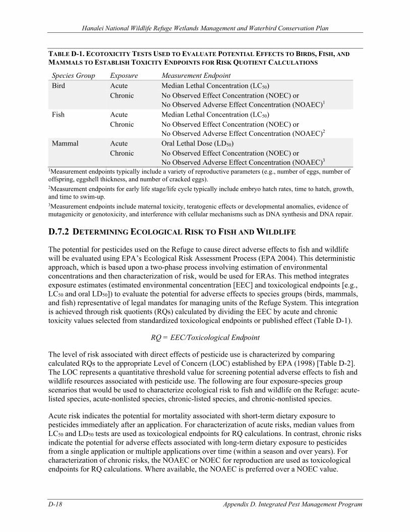
Hanalei National Wildlife Refuge Wetlands Management and Waterbird Conservation Plan
D-18 Appendix D. Integrated Pest Management Program
TABLE D-1. ECOTOXICITY TESTS USED TO EVALUATE POTENTIAL EFFECTS TO BIRDS, FISH, AND MAMMALS TO ESTABLISH TOXICITY ENDPOINTS FOR RISK QUOTIENT CALCULATIONS
Species Group Exposure Measurement Endpoint Bird Acute Median Lethal Concentration (LC50) Chronic No Observed Effect Concentration (NOEC) or
No Observed Adverse Effect Concentration (NOAEC)1 Fish Acute Median Lethal Concentration (LC50) Chronic No Observed Effect Concentration (NOEC) or
No Observed Adverse Effect Concentration (NOAEC)2 Mammal Acute Oral Lethal Dose (LD50) Chronic No Observed Effect Concentration (NOEC) or
No Observed Adverse Effect Concentration (NOAEC)3 1Measurement endpoints typically include a variety of reproductive parameters (e.g., number of eggs, number of offspring, eggshell thickness, and number of cracked eggs). 2Measurement endpoints for early life stage/life cycle typically include embryo hatch rates, time to hatch, growth, and time to swim-up. 3Measurement endpoints include maternal toxicity, teratogenic effects or developmental anomalies, evidence of mutagenicity or genotoxicity, and interference with cellular mechanisms such as DNA synthesis and DNA repair.
D.7.2 DETERMINING ECOLOGICAL RISK TO FISH AND WILDLIFE
The potential for pesticides used on the Refuge to cause direct adverse effects to fish and wildlife will be evaluated using EPA’s Ecological Risk Assessment Process (EPA 2004). This deterministic approach, which is based upon a two-phase process involving estimation of environmental concentrations and then characterization of risk, would be used for ERAs. This method integrates exposure estimates (estimated environmental concentration [EEC] and toxicological endpoints [e.g., LC50 and oral LD50]) to evaluate the potential for adverse effects to species groups (birds, mammals, and fish) representative of legal mandates for managing units of the Refuge System. This integration is achieved through risk quotients (RQs) calculated by dividing the EEC by acute and chronic toxicity values selected from standardized toxicological endpoints or published effect (Table D-1).
RQ = EEC/Toxicological Endpoint
The level of risk associated with direct effects of pesticide use is characterized by comparing calculated RQs to the appropriate Level of Concern (LOC) established by EPA (1998) [Table D-2]. The LOC represents a quantitative threshold value for screening potential adverse effects to fish and wildlife resources associated with pesticide use. The following are four exposure-species group scenarios that would be used to characterize ecological risk to fish and wildlife on the Refuge: acute-listed species, acute-nonlisted species, chronic-listed species, and chronic-nonlisted species.
Acute risk indicates the potential for mortality associated with short-term dietary exposure to pesticides immediately after an application. For characterization of acute risks, median values from LC50 and LD50 tests are used as toxicological endpoints for RQ calculations. In contrast, chronic risks indicate the potential for adverse effects associated with long-term dietary exposure to pesticides from a single application or multiple applications over time (within a season and over years). For characterization of chronic risks, the NOAEC or NOEC for reproduction are used as toxicological endpoints for RQ calculations. Where available, the NOAEC is preferred over a NOEC value.
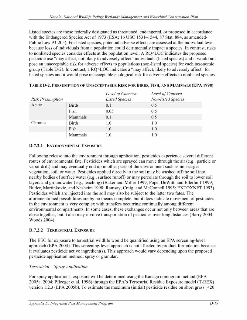
Hanalei National Wildlife Refuge Wetlands Management and Waterbird Conservation Plan
Appendix D. Integrated Pest Management Program D-19
Listed species are those federally designated as threatened, endangered, or proposed in accordance with the Endangered Species Act of 1973 (ESA; 16 USC 1531–1544, 87 Stat. 884, as amended-Public Law 93-205). For listed species, potential adverse effects are assessed at the individual level because loss of individuals from a population could detrimentally impact a species. In contrast, risks to nonlisted species consider effects at the population level. A RQ<LOC indicates the proposed pesticide use “may affect, not likely to adversely affect” individuals (listed species) and it would not pose an unacceptable risk for adverse effects to populations (non-listed species) for each taxonomic group (Table D-2). In contrast, a RQ>LOC indicates a “may affect, likely to adversely affect” for listed species and it would pose unacceptable ecological risk for adverse effects to nonlisted species.
TABLE D-2. PRESUMPTION OF UNACCEPTABLE RISK FOR BIRDS, FISH, AND MAMMALS (EPA 1998)
Risk Presumption Level of Concern Listed Species
Level of Concern Non-listed Species
Acute Birds 0.1 0.5 Fish 0.05 0.5 Mammals 0.1 0.5 Chronic Birds 1.0 1.0 Fish 1.0 1.0 Mammals 1.0 1.0
D.7.2.1 ENVIRONMENTAL EXPOSURE
Following release into the environment through application, pesticides experience several different routes of environmental fate. Pesticides which are sprayed can move through the air (e.g., particle or vapor drift) and may eventually end up in other parts of the environment such as non-target vegetation, soil, or water. Pesticides applied directly to the soil may be washed off the soil into nearby bodies of surface water (e.g., surface runoff) or may percolate through the soil to lower soil layers and groundwater (e.g., leaching) (Baker and Miller 1999; Pope, DeWitt, and Ellerhoff 1999; Butler, Martinkovic, and Nesheim 1998; Ramsay, Craig, and McConnell 1995; EXTOXNET 1993). Pesticides which are injected into the soil may also be subject to the latter two fates. The aforementioned possibilities are by no means complete, but it does indicate movement of pesticides in the environment is very complex with transfers occurring continually among different environmental compartments. In some cases, these exchanges occur not only between areas that are close together, but it also may involve transportation of pesticides over long distances (Barry 2004; Woods 2004).
D.7.2.2 TERRESTRIAL EXPOSURE
The EEC for exposure to terrestrial wildlife would be quantified using an EPA screening-level approach (EPA 2004). This screening-level approach is not affected by product formulation because it evaluates pesticide active ingredient(s). This approach would vary depending upon the proposed pesticide application method: spray or granular.
Terrestrial – Spray Application
For spray applications, exposure will be determined using the Kanaga nomogram method (EPA 2005a, 2004; Pfleeger et al. 1996) through the EPA’s Terrestrial Residue Exposure model (T-REX) version 1.2.3 (EPA 2005b). To estimate the maximum (initial) pesticide residue on short grass (<20
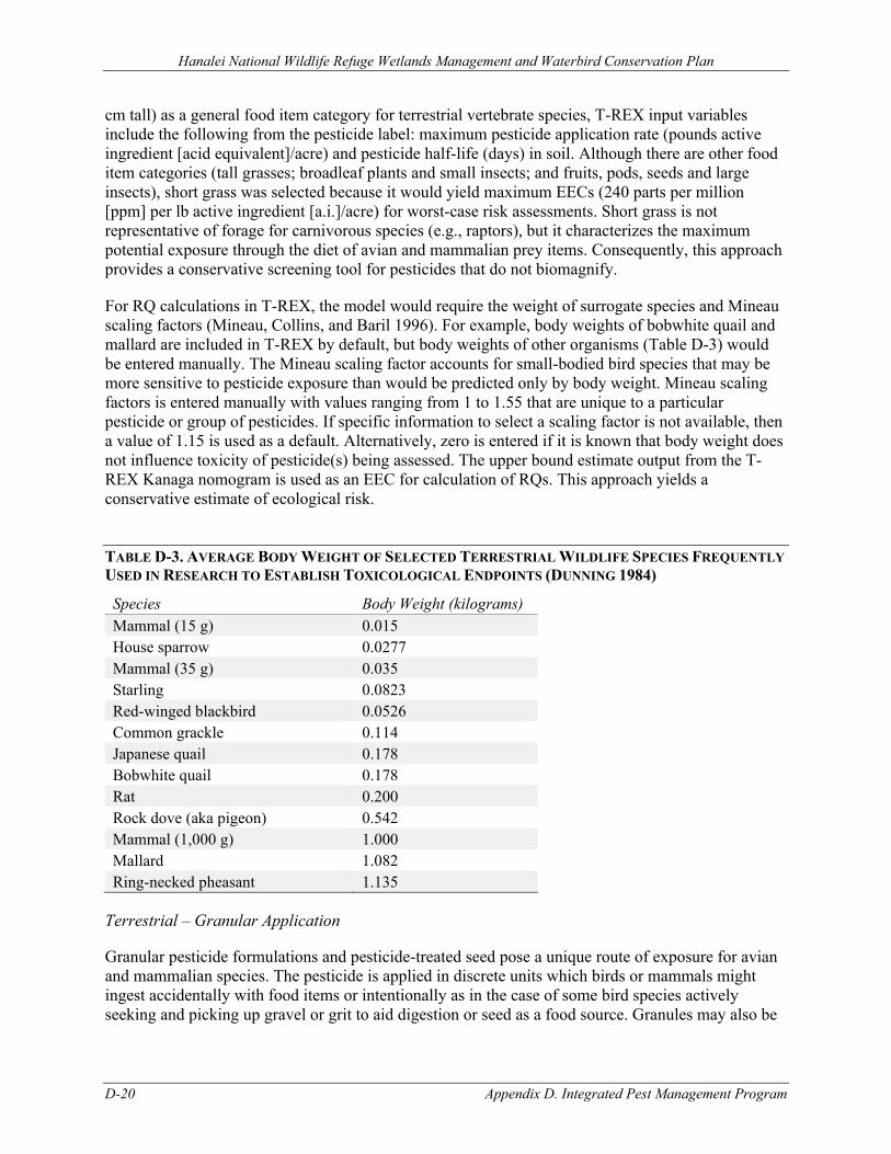
Hanalei National Wildlife Refuge Wetlands Management and Waterbird Conservation Plan
D-20 Appendix D. Integrated Pest Management Program
cm tall) as a general food item category for terrestrial vertebrate species, T-REX input variables include the following from the pesticide label: maximum pesticide application rate (pounds active ingredient [acid equivalent]/acre) and pesticide half-life (days) in soil. Although there are other food item categories (tall grasses; broadleaf plants and small insects; and fruits, pods, seeds and large insects), short grass was selected because it would yield maximum EECs (240 parts per million [ppm] per lb active ingredient [a.i.]/acre) for worst-case risk assessments. Short grass is not representative of forage for carnivorous species (e.g., raptors), but it characterizes the maximum potential exposure through the diet of avian and mammalian prey items. Consequently, this approach provides a conservative screening tool for pesticides that do not biomagnify.
For RQ calculations in T-REX, the model would require the weight of surrogate species and Mineau scaling factors (Mineau, Collins, and Baril 1996). For example, body weights of bobwhite quail and mallard are included in T-REX by default, but body weights of other organisms (Table D-3) would be entered manually. The Mineau scaling factor accounts for small-bodied bird species that may be more sensitive to pesticide exposure than would be predicted only by body weight. Mineau scaling factors is entered manually with values ranging from 1 to 1.55 that are unique to a particular pesticide or group of pesticides. If specific information to select a scaling factor is not available, then a value of 1.15 is used as a default. Alternatively, zero is entered if it is known that body weight does not influence toxicity of pesticide(s) being assessed. The upper bound estimate output from the T-REX Kanaga nomogram is used as an EEC for calculation of RQs. This approach yields a conservative estimate of ecological risk.
TABLE D-3. AVERAGE BODY WEIGHT OF SELECTED TERRESTRIAL WILDLIFE SPECIES FREQUENTLY USED IN RESEARCH TO ESTABLISH TOXICOLOGICAL ENDPOINTS (DUNNING 1984)
Species Body Weight (kilograms) Mammal (15 g) 0.015 House sparrow 0.0277 Mammal (35 g) 0.035 Starling 0.0823 Red-winged blackbird 0.0526 Common grackle 0.114 Japanese quail 0.178 Bobwhite quail 0.178 Rat 0.200 Rock dove (aka pigeon) 0.542 Mammal (1,000 g) 1.000 Mallard 1.082 Ring-necked pheasant 1.135
Terrestrial – Granular Application
Granular pesticide formulations and pesticide-treated seed pose a unique route of exposure for avian and mammalian species. The pesticide is applied in discrete units which birds or mammals might ingest accidentally with food items or intentionally as in the case of some bird species actively seeking and picking up gravel or grit to aid digestion or seed as a food source. Granules may also be
Hanalei National Wildlife Refuge Wetlands Management and Waterbird Conservation Plan
Appendix D. Integrated Pest Management Program D-21
consumed by wildlife foraging on earthworms, slugs or other soft-bodied soil organisms to which the granules may adhere.
Terrestrial wildlife RQs for granular formulations or seed treatments will be calculated by dividing the maximum milligrams of a.i. exposed (e.g., EEC) on the surface of an area equal to one square foot by the appropriate LD50 value multiplied by the surrogate’s body weight (Table D-3). An adjustment to surface area calculations is made for broadcast, banded, and in-furrow applications. An adjustment also is made for applications with and without incorporation of the granules. Without incorporation, it is assumed that 100 percent of the granules remain on the soil surface available to foraging birds and mammals. Press wheels push granules flat with the soil surface, but they are not incorporated into the soil. If granules are incorporated in the soil during band or T-band applications or after broadcast applications, it is assumed only 15 percent of the applied granules remain available to wildlife. It is assumed that only one percent of the granules are available on the soil surface following in-furrow applications.
EECs for pesticides applied in granular form and as seed treatments are determined considering potential ingestion rates of avian or mammalian species (e.g., 10–30% body weight/day). This provides an estimate of maximum exposure that may occur as a result of granule or seed treatment spills such as those that commonly occur at end rows during application and planting. The availability of granules and seed treatments to terrestrial vertebrates is also considered by calculating the loading per unit area (LD50/ft2) for comparison to EPA LOCs (EPA 1998). The T-REX version 1.2.3 (EPA 2005b) contains a submodel which automates Kanaga exposure calculations for granular pesticides and treated seed.
The following formulas will be used to calculate EECs depending upon the type of granular pesticide application:
In-furrow applications assume a typical value of 1% granules, bait, or seed remain unincorporated.
mg a.i./ft2 = [(lbs product/acre)(% a.i.)(453,580 mg/lbs)(1% exposed))] / {[(43,560 ft2/acre)/(row spacing (ft))] / (row spacing (ft)}
or
mg a.i./ft2 = [(lbs product/1,000 ft row)(% a.i.)(1,000 ft row)(453,580 mg/lb)(1% exposed)
EEC = [(mg a.i./ft2)(% of pesticide biologically available)]
Incorporated banded treatments assume that 15% of granules, bait, and seeds are unincorporated.
mg a.i./ft2 = [(lbs product/1,000 row ft)(% a.i.)(453,580 mg/lb)(1-% incorporated)] / (1,000 ft)(band width (ft))
EEC = [(mg a.i./ft2)(% of pesticide biologically available)]
Broadcast treatment without incorporation assumes 100% of granules, bait, seeds are unincorporated.
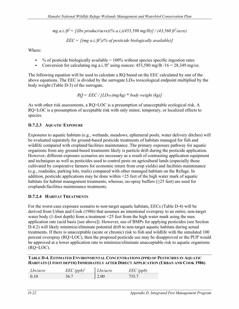
Hanalei National Wildlife Refuge Wetlands Management and Waterbird Conservation Plan
D-22 Appendix D. Integrated Pest Management Program
mg a.i./ft2 = [(lbs product/acre)(% a.i.)(453,590 mg/lb)] / (43,560 ft2/acre)
EEC = [(mg a.i./ft2)(% of pesticide biologically available)]
Where:
% of pesticide biologically available = 100% without species specific ingestion rates Conversion for calculating mg a.i./ft2 using ounces: 453,580 mg/lb /16 = 28,349 mg/oz.
The following equation will be used to calculate a RQ based on the EEC calculated by one of the above equations. The EEC is divided by the surrogate LD50 toxicological endpoint multiplied by the body weight (Table D-3) of the surrogate.
RQ = EEC / [LD50 (mg/kg) * body weight (kg)]
As with other risk assessments, a RQ>LOC is a presumption of unacceptable ecological risk. A RQ<LOC is a presumption of acceptable risk with only minor, temporary, or localized effects to species.
D.7.2.3 AQUATIC EXPOSURE
Exposures to aquatic habitats (e.g., wetlands, meadows, ephemeral pools, water delivery ditches) will be evaluated separately for ground-based pesticide treatments of habitats managed for fish and wildlife compared with cropland/facilities maintenance. The primary exposure pathway for aquatic organisms from any ground-based treatments likely is particle drift during the pesticide application. However, different exposure scenarios are necessary as a result of contrasting application equipment and techniques as well as pesticides used to control pests on agricultural lands (especially those cultivated by cooperative farmers for economic return from crop yields) and facilities maintenance (e.g., roadsides, parking lots, trails) compared with other managed habitats on the Refuge. In addition, pesticide applications may be done within <25 feet of the high water mark of aquatic habitats for habitat management treatments; whereas, no-spray buffers (≥25 feet) are used for croplands/facilities maintenance treatments.
D.7.2.4 HABITAT TREATMENTS
For the worst-case exposure scenario to non-target aquatic habitats, EECs (Table D-4) will be derived from Urban and Cook (1986) that assumes an intentional overspray to an entire, non-target water body (1-foot depth) from a treatment <25 feet from the high water mark using the max application rate (acid basis [see above]). However, use of BMPs for applying pesticides (see Section D.4.2) will likely minimize/eliminate potential drift to non-target aquatic habitats during actual treatments. If there is unacceptable (acute or chronic) risk to fish and wildlife with the simulated 100 percent overspray (RQ>LOC), then the proposed pesticide use may be disapproved or the PUP would be approved at a lower application rate to minimize/eliminate unacceptable risk to aquatic organisms (RQ=LOC).
TABLE D-4. ESTIMATED ENVIRONMENTAL CONCENTRATIONS (PPB) OF PESTICIDES IN AQUATIC HABITATS (1 FOOT DEPTH) IMMEDIATELY AFTER DIRECT APPLICATION (URBAN AND COOK 1986)
Lbs/acre EEC (ppb)1 Lbs/acre EEC (ppb) 0.10 36.7 2.00 735.7
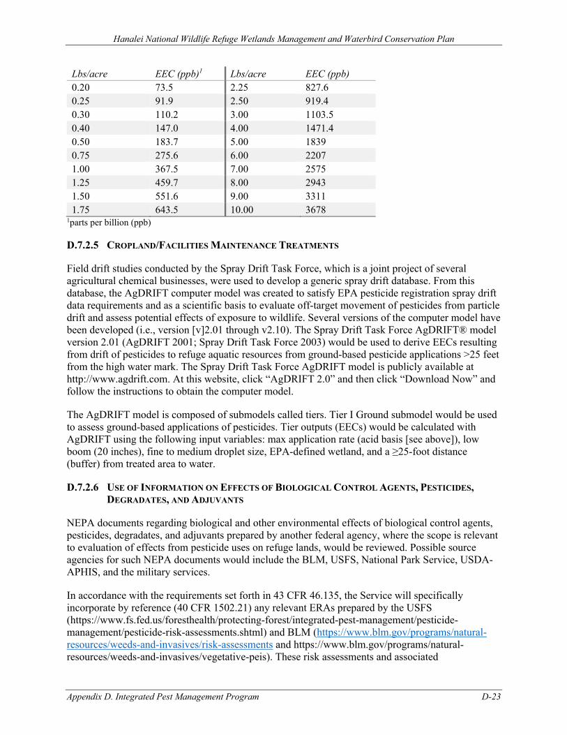
Hanalei National Wildlife Refuge Wetlands Management and Waterbird Conservation Plan
Appendix D. Integrated Pest Management Program D-23
Lbs/acre EEC (ppb)1 Lbs/acre EEC (ppb) 0.20 73.5 2.25 827.6 0.25 91.9 2.50 919.4 0.30 110.2 3.00 1103.5 0.40 147.0 4.00 1471.4 0.50 183.7 5.00 1839 0.75 275.6 6.00 2207 1.00 367.5 7.00 2575 1.25 459.7 8.00 2943 1.50 551.6 9.00 3311 1.75 643.5 10.00 3678
1parts per billion (ppb)
D.7.2.5 CROPLAND/FACILITIES MAINTENANCE TREATMENTS
Field drift studies conducted by the Spray Drift Task Force, which is a joint project of several agricultural chemical businesses, were used to develop a generic spray drift database. From this database, the AgDRIFT computer model was created to satisfy EPA pesticide registration spray drift data requirements and as a scientific basis to evaluate off-target movement of pesticides from particle drift and assess potential effects of exposure to wildlife. Several versions of the computer model have been developed (i.e., version [v]2.01 through v2.10). The Spray Drift Task Force AgDRIFT® model version 2.01 (AgDRIFT 2001; Spray Drift Task Force 2003) would be used to derive EECs resulting from drift of pesticides to refuge aquatic resources from ground-based pesticide applications >25 feet from the high water mark. The Spray Drift Task Force AgDRIFT model is publicly available at http://www.agdrift.com. At this website, click “AgDRIFT 2.0” and then click “Download Now” and follow the instructions to obtain the computer model.
The AgDRIFT model is composed of submodels called tiers. Tier I Ground submodel would be used to assess ground-based applications of pesticides. Tier outputs (EECs) would be calculated with AgDRIFT using the following input variables: max application rate (acid basis [see above]), low boom (20 inches), fine to medium droplet size, EPA-defined wetland, and a ≥25-foot distance (buffer) from treated area to water.
D.7.2.6 USE OF INFORMATION ON EFFECTS OF BIOLOGICAL CONTROL AGENTS, PESTICIDES, DEGRADATES, AND ADJUVANTS
NEPA documents regarding biological and other environmental effects of biological control agents, pesticides, degradates, and adjuvants prepared by another federal agency, where the scope is relevant to evaluation of effects from pesticide uses on refuge lands, would be reviewed. Possible source agencies for such NEPA documents would include the BLM, USFS, National Park Service, USDA-APHIS, and the military services.
In accordance with the requirements set forth in 43 CFR 46.135, the Service will specifically incorporate by reference (40 CFR 1502.21) any relevant ERAs prepared by the USFS (https://www.fs.fed.us/foresthealth/protecting-forest/integrated-pest-management/pesticide-management/pesticide-risk-assessments.shtml) and BLM (https://www.blm.gov/programs/natural-resources/weeds-and-invasives/risk-assessments and https://www.blm.gov/programs/natural-resources/weeds-and-invasives/vegetative-peis). These risk assessments and associated
Hanalei National Wildlife Refuge Wetlands Management and Waterbird Conservation Plan
D-24 Appendix D. Integrated Pest Management Program
documentation also are available in total with the administrative record for the Final Environmental Impact Statement entitled Pacific Northwest Region Invasive Plant Program – Preventing and Managing Invasive Plants (USFS 2005) and Vegetation Treatments Using Herbicides on Bureau of Land Management Lands in 17 Western States Programmatic EIS (PEIS) (BLM 2007). In accordance with 43 CFR 46.120(d), use of existing NEPA documents by supplementing, tiering to, incorporating by reference, or adopting previous NEPA environmental analyses would avoid redundancy and unnecessary paperwork.
As a basis for completing “Chemical Profiles” for approving or disapproving refuge PUPs, ERAs for the following herbicide and adjuvant uses prepared by the USFS will be incorporated by reference:
• 2,4-D • Chlorsulfuron • Clopyralid • Dicamba • Glyphosate • Imazapic • Imazapyr • Metsulfuron methyl • Picloram • Sethoxydim • Sulfometuron methyl • Triclopyr • Nonylphenol polyethylate (NPE) based surfactants
As a basis for completing “Chemical Profiles” for approving or disapproving refuge PUPs, ERAs for the following herbicide uses as well as evaluation of risks associated with pesticide degradates and adjuvants prepared by the BLM will be incorporated by reference:
• Bromacil • Chlorsulfuron • Diflufenzopyr • Diquat • Diuron • Fluridone • Imazapic • Overdrive (diflufenzopyr and dicamba) • Sulfometuron methyl • Tebuthiuron • Pesticide degradates and adjuvants (Appendix D – Evaluation of risks from degradates,
polyoxyethylene-amine (POEA) and R-11, and endocrine disrupting chemicals)
D.7.2.7 ASSUMPTIONS FOR ERAS
There are several assumptions involved with the ecological risk assessment process for terrestrial and aquatic organisms associated with utilization of the EPA’s (2004) process. These assumptions may be risk neutral or may lead to an over- or underestimation of risk from pesticide exposure depending upon site-specific conditions. The following describes these assumptions, their application to the
Hanalei National Wildlife Refuge Wetlands Management and Waterbird Conservation Plan
Appendix D. Integrated Pest Management Program D-25
conditions typically encountered, and whether or not they may lead to recommendations that are risk neutral, underestimate, or overestimate ecological risk from potential pesticide exposure.
• Indirect effects are not be evaluated by ERAs. These effects include the mechanisms of indirect exposure to pesticides: consuming prey items (fish, birds, or small mammals), reductions in the availability of prey items, and disturbance associated with pesticide application activities.
• Exposure to a pesticide product can be assessed based upon the active ingredient. However, exposure to a chemical mixture (pesticide formulation) may result in effects that are similar or substantially different compared to only the active ingredient. Non-target organisms may be exposed directly to the pesticide formulation or only various constituents of the formulation as they dissipate and partition in the environment. If toxicological information for both the active ingredient and formulated product are available, then data representing the greatest potential toxicity would be selected for use in the risk assessment process (EPA 2004). As a result, this conservative approach may lead to an overestimation of risk characterization from pesticide exposure.
• Because toxicity tests with listed or candidate species or closely related species are not available, data for surrogate species are often used for risk assessments. Specifically, bobwhite quail and mallard duck are the most frequently used surrogates for evaluating potential toxicity to federally listed avian species. Bluegill sunfish, rainbow trout, and fathead minnow are the most common surrogates for evaluating toxicity for freshwater fishes. However, sheep’s head minnow can be an appropriate surrogate marine species for coastal environments. Rats and mice are the most common surrogates for evaluating toxicity for mammals. Interspecies sensitivity is a major source of uncertainty in pesticide assessments. As a result of this uncertainty, data are selected for the most sensitive species tested within a taxonomic group (birds, fish, and mammals) given the quality of the data is acceptable. If additional toxicity data for more species of organisms in a particular group are available, the selected data will not be limited to the species previously listed as common surrogates.
• The Kanaga nomogram outputs maximum EEC values that may be used to calculate an average daily concentration over a specified interval of time, which is referred to as a time-weighted-average (TWA). The maximum EEC would be selected as the exposure input for both acute and chronic risk assessments in the screening-level evaluations. The initial or maximum EEC derived from the Kanaga nomogram represents the maximum expected instantaneous or acute exposure to a pesticide. Acute toxicity endpoints are determined using a single exposure to a known pesticide concentration typically for 48 to 96 hours. This value is assumed to represent ecological risk from acute exposure to a pesticide. On the other hand, chronic risk to pesticide exposure is a function of pesticide concentration and duration of exposure to the pesticide. An organism’s response to chronic pesticide exposure may result from either the concentration of the pesticide, length of exposure, or some combination of both factors. Standardized tests for chronic toxicity typically involve exposing an organism to several different pesticide concentrations for a specified length of time (days, weeks, months, years or generations). For example, avian reproduction tests include a 10-week exposure phase. Because a single length of time is used in the test, time response data are usually not available for inclusion into risk assessments. Without time response data it is difficult to determine the concentration which elicited a toxicological response.
• Using maximum EECs for chronic risk estimates may result in an overestimate of risk, particularly for compounds that dissipate rapidly. Conversely, using TWAs for chronic risk estimates may underestimate risk if it is the concentration rather than the duration of
Hanalei National Wildlife Refuge Wetlands Management and Waterbird Conservation Plan
D-26 Appendix D. Integrated Pest Management Program
exposure that is primarily responsible for the observed adverse effect. The maximum EEC is used for chronic risk assessments although it may result in an overestimate of risk. TWAs may be used for chronic risk assessments, but they will be applied judiciously considering the potential for an underestimate or overestimate of risk. For example, the number of days exposure exceeds a Level of Concern may influence the suitability of a pesticide use. The greater the number of days the EEC exceeds the Level of Concern translates into greater the ecological risk. This is a qualitative assessment and is subject to reviewer’s expertise in ecological risk assessment and tolerance for risk.
• The length of time used to calculate the TWA can have a substantial effect on the exposure estimates and there is no standard method for determining the appropriate duration for this estimate. The T-REX model assumes a 21-week exposure period, which is equivalent to avian reproductive studies designed to establish a steady-state concentration for bioaccumulative compounds. However, this does not necessarily define the true exposure duration needed to elicit a toxicological response. Pesticides, which do not bioaccumulate, may achieve a steady-state concentration earlier than 21 weeks. The duration of time for calculating TWAs will require justification and it will not exceed the duration of exposure in the chronic toxicity test (approximately 70 days for the standard avian reproduction study). An alternative to using the duration of the chronic toxicity study is to base the TWA on the application interval. In this case, increasing the application interval would suppress both the estimated peak pesticide concentration and the TWA. Another alternative to using TWAs would be to consider the number of days that a chemical is predicted to exceed the LOC.
• Pesticide dissipation is assumed to be first-order in the absence of data suggesting alternative dissipation patterns such as bi-phasic. Field dissipation data would generally be the most pertinent for assessing exposure in terrestrial species that forage on vegetation. However, these data are often not available and it can be misleading particularly if the compound is prone to “wash-off.” Soil half-life is the most common degradation data available. Dissipation or degradation data that would reflect the environmental conditions typical of refuge lands would be utilized, if available.
• For species found in the water column, it is assumed that the greatest bioavailable fraction of the pesticide active ingredient in surface waters is freely dissolved in the water column.
• Actual habitat requirements of any particular terrestrial species are not considered, and it is assumed that species exclusively and permanently occupy the treated area, or adjacent areas receiving pesticide at rates commensurate with the treatment rate. This assumption produces a maximum estimate of exposure for risk characterization. This assumption could likely lead to an overestimation of exposure for species that do not permanently and exclusively occupy the treated area (EPA 2004).
• Exposure through incidental ingestion of pesticide contaminated soil is not considered in the EPA risk assessment protocols. Research suggests <15% of the diet can consist of incidentally ingested soil depending upon species and feeding strategy (Beyer, Connor, and Gerould 1994). An assessment of pesticide concentrations in soil compared to food item categories in the Kanaga nomogram indicates incidental soil ingestion would not likely increase dietary exposure to pesticides. Inclusion of soil into the diet would effectively reduce the overall dietary concentration compared to the present assumption that the entire diet consists of a contaminated food source (Fletcher, Nellessen, and Pfleeger 1994). An exception to this may be soil-applied pesticides in which exposure from incidental ingestion of soil may increase. Potential for pesticide exposure under this assumption may be underestimated for soil-applied pesticides and overestimated for foliar-applied pesticides. The concentration of a pesticide in soil would likely be less than predicted on food items.
Hanalei National Wildlife Refuge Wetlands Management and Waterbird Conservation Plan
Appendix D. Integrated Pest Management Program D-27
• Exposure through inhalation of pesticides is not considered in the EPA risk assessment protocols. Such exposure may occur through three potential sources: spray material in droplet form at time of application, vapor phase with the pesticide volatilizing from treated surfaces, and airborne particulates (soil, vegetative matter, and pesticide dusts). The EPA (1990) reported exposure from inhaling spray droplets at the time of application is not an appreciable route of exposure for birds. According to research on mallards and bobwhite quail, respirable particle size (particles reaching the lung) in birds is limited to maximum diameter of 2 to 5 microns. The spray droplet spectra covering the majority of pesticide application scenarios indicate that less than one percent of the applied material is within the respirable particle size. This route of exposure is further limited because the permissible spray drop size distribution for ground pesticide applications is restricted to American Society of Agricultural Engineers (ASAE) medium or coarser drop size distribution.
• Inhalation of a pesticide in the vapor phase may be another source of exposure for some pesticides under certain conditions. This mechanism of exposure to pesticides occurs post application, and it pertains to those pesticides with a high vapor pressure. The EPA is currently evaluating protocols for modeling inhalation exposure from pesticides including near-field and near-ground air concentrations based upon equilibrium and kinetics-based models. Risk characterization for exposure with this mechanism is unavailable.
• The effect from exposure to dusts contaminated with the pesticide cannot be assessed generically as partitioning issues related to application site soils and chemical properties of the applied pesticides render the exposure potential from this route highly situation specific.
• Dermal exposure may occur through three potential sources: direct application of spray to terrestrial wildlife in the treated area or within the drift footprint, incidental contact with contaminated vegetation, or contact with contaminated water or soil. Interception of spray and incidental contact with treated substrates may pose risk to avian wildlife (Driver et al. 1991). However, available research related to wildlife dermal contact with pesticides is extremely limited, except dermal toxicity values are common for some mammals used as human surrogates (rats and mice). The EPA is currently evaluating protocols for modeling dermal exposure. Risk characterization may be underestimated for this route of exposure, particularly with high- risk pesticides such as some organophosphates or carbamate insecticides. If protocols are established by the EPA for assessing dermal exposure to pesticides, they will be considered for incorporation into pesticide assessment protocols.
• Exposure to a pesticide may occur from consuming surface water, dew or other water on treated surfaces. Water soluble pesticides have the potential to dissolve in surface runoff and puddles in a treated area may contain pesticide residues. Similarly, pesticides with lower organic carbon partitioning characteristics and higher solubility in water have a greater potential to dissolve in dew and other water associated with plant surfaces. Estimating the extent to which such pesticide loadings to drinking water occurs is complex and would depend upon the partitioning characteristics of the active ingredient, soils types in the treatment area, and the meteorology of the treatment area. In addition, the use of various water sources by wildlife is highly species-specific. Currently, risk characterization for this exposure mechanism is not available. The EPA is actively developing protocols to quantify drinking water exposures from puddles and dew. If and when protocols are formally established by the EPA for assessing exposure to pesticides through drinking water, these protocols will be incorporated into pesticide risk assessment protocols.
• Risk assessments are based upon the assumption that the entire treatment area would be subject to pesticide application at the rates specified on the label. In most cases, there is potential for uneven application of pesticides through such plausible incidents such as
Hanalei National Wildlife Refuge Wetlands Management and Waterbird Conservation Plan
D-28 Appendix D. Integrated Pest Management Program
changes in calibration of application equipment, spillage, and localized releases at specific areas in or near the treated field that are associated with mixing and handling and application equipment as well as applicator skill. Inappropriate use of pesticides and the occurrence of spills represent a potential underestimate of risk. It is likely not an important factor for risk characterization. All pesticide applicators are required to be certified by the state in which they apply pesticides. Certification training includes the safe storage, transport, handling, and mixing of pesticides; equipment calibration; and proper application with annual continuing education.
• The EPA relies on Fletcher et al. (1994) for setting the assumed pesticide residues in wildlife dietary items. The EPA (2004) “believes that these residue assumptions reflect a realistic upper-bound residue estimate, although the degree to which this assumption reflects a specific percentile estimate is difficult to quantify.” Fletcher et al.’s (1994) research suggests that the pesticide active ingredient residue assumptions used by the EPA represent a 95th percentile estimate. However, research conducted by Pfleeger et al. (1996) indicates EPA residue assumptions for short grass was not exceeded. Baehr and Habig (2000) compared EPA residue assumptions with distributions of measured pesticide residues for the EPA’s UTAB database. Overall residue selection level will tend to overestimate risk characterization. This is particularly evident when wildlife individuals are likely to have selected a variety of food items acquired from multiple locations. Some food items may be contaminated with pesticide residues whereas others are not contaminated. However, it is important to recognize differences in species feeding behavior. Some species may consume whole above-ground plant material, but others will preferentially select different plant structures. Also, species may preferentially select a food item although multiple food items may be present. Without species-specific knowledge regarding foraging behavior characterizing ecological risk other than in general terms is not possible.
• Acute and chronic risk assessments rely on comparisons of wildlife dietary residues with LC50 or NOEC values expressed as concentrations of pesticides in laboratory feed. These comparisons assume that ingestion of food items in the field occurs at rates commensurate with those in the laboratory. Although the screening assessment process adjusts dry-weight estimates of food intake to reflect the increased mass in fresh-weight wildlife food intake estimates, it does not allow for gross energy and assimilative efficiency differences between wildlife food items and laboratory feed. Differences in assimilative efficiency between laboratory and wild diets suggest that current screening assessment methods are not accounting for a potentially important aspect of food requirements.
• There are several other assumptions that can affect non-target species not considered in the risk assessment process. These include possible additive or synergistic effects from applying two or more pesticides or additives in a single application, co-location of pesticides in the environment, cumulative effects from pesticides with the same mode of action, effects of multiple stressors (e.g., combination of pesticide exposure, adverse abiotic and biotic factors) and behavioral changes induced by exposure to a pesticide. These factors may exist at some level contributing to adverse effects to non-target species, but they are usually characterized in the published literature in only a general manner limiting their value in the risk assessment process.
• It is assumed that aquatic species exclusively and permanently occupy the water body being assessed. Actual habitat requirements of aquatic species are not considered. With the possible exception of scenarios where pesticides are directly applied to water, it is assumed that no habitat use considerations specific for any species would place the organisms in closer proximity to pesticide use sites. This assumption produces a maximum estimate of exposure
Hanalei National Wildlife Refuge Wetlands Management and Waterbird Conservation Plan
Appendix D. Integrated Pest Management Program D-29
or risk characterization. It would likely be realistic for many aquatic species that may be found in aquatic habitats within or in close proximity to treated terrestrial habitats. However, the spatial distribution of wildlife is usually not random because wildlife distributions are often related to habitat requirements of species. Clumped distributions of wildlife may result in an under- or over-estimation of risk depending upon where the initial pesticide concentration occurs relative to the species or species habitat.
• For species found in the water column, it is assumed that the greatest bioavailable fraction of the pesticide active ingredient in surface waters is freely dissolved in the water column. Additional chemical exposure from materials associated with suspended solids or food items is not considered because partitioning onto sediments likely is minimal. Adsorption and bioconcentration occurs at lower levels for many newer pesticides compared with older more persistent bioaccumulative compounds. Pesticides with RQs close to the listed species level of concern, the potential for additional exposure from these routes may be a limitation of risk assessments, where potential pesticide exposure or risk may be underestimated.
• Mass transport losses of pesticide from a water body (except for losses by volatilization, degradation and sediment partitioning) are not be considered for ecological risk assessment. The water body is assumed to capture all pesticide active ingredients entering as runoff, drift, and adsorbed to eroded soil particles. It is also assumed that pesticide active ingredient is not lost from the water body by overtopping or flow-through, nor is concentration reduced by dilution. In total, these assumptions lead to a near maximum possible water-borne concentration. However, this assumption would not account for the potential to concentrate pesticide through the evaporative loss. This limitation may have the greatest impact on water bodies with high surface-to-volume ratios such as ephemeral wetlands, where evaporative losses are accentuated and applied pesticides have low rates of degradation and volatilization.
• For acute risk assessments, there is no averaging time for exposure. An instantaneous peak concentration is assumed, where instantaneous exposure is sufficient in duration to elicit acute effects comparable to those observed over more protracted exposure periods (typically 48 to 96 hours) tested in the laboratory. In the absence of data regarding time-to-toxic event, analyses and latent responses to instantaneous exposure, risk is likely overestimated.
• For chronic exposure risk assessments, the averaging times considered for exposure are commensurate with the duration of invertebrate life-cycle or fish-early life stage tests (e.g., 21–28 days and 56–60 days, respectively). Response profiles (time to effect and latency of effect) to pesticides likely vary widely with mode of action and species and should be evaluated on a case-by-case basis as available data allow. Nevertheless, because the EPA relies on chronic exposure toxicity endpoints based on a finding of no observed effect, the potential for any latent toxicity effects or averaging time assumptions to alter the results of an acceptable chronic risk assessment prediction is limited. The extent to which duration of exposure from water-borne concentrations overestimate or underestimate actual exposure depends on several factors. These include the following: localized meteorological conditions, runoff characteristics of the watershed (e.g., soils, topography), the hydrological characteristics of receiving waters, environmental fate of the pesticide active ingredient, and the method of pesticide application. It should also be understood that chronic effects studies are performed using a method that holds water concentration in a steady state. This method is not likely to reflect conditions associated with pesticide runoff. Pesticide concentrations in the field increase and decrease in surface water on a cycle influenced by rainfall, pesticide use patterns, and degradation rates. As a result of the dependency of this assumption on several undefined variables, risk associated with chronic exposure may in some situations underestimate risk and overestimate risk in others.
Hanalei National Wildlife Refuge Wetlands Management and Waterbird Conservation Plan
D-30 Appendix D. Integrated Pest Management Program
• There are several other factors that can affect non-target species not considered in the risk assessment process. These include the following: possible additive or synergistic effects from applying two or more pesticides or additives in a single application, co-location of pesticides in the environment, cumulative effects from pesticides with the same mode of action, effects of multiple stressors (e.g., combination of pesticide exposure, adverse abiotic [not pesticides] and biotic factors), and sub-lethal effects such as behavioral changes induced by exposure to a pesticide. These factors may exist at some level contributing to adverse effects to non-target species, but they are not routinely assessed by regulatory agencies. Therefore, information on the factors is not extensive limiting their value for the risk assessment process. As this type of information becomes available, it will be included, either quantitatively or qualitatively, in this risk assessment process.
• EPA is required by the Food Quality Protection Act to assess the cumulative risks of pesticides that share common mechanisms of toxicity or act the same within an organism. Currently, EPA has identified four groups of pesticides that have a common mechanism of toxicity requiring cumulative risk assessments. These four groups are: the organophosphate insecticides, N-methyl carbamate insecticides, triazine herbicides, and chloroacetanilide herbicides.
D.7.3 PESTICIDE MIXTURES AND DEGRADATES
Pesticide products are usually a formulation of several components generally categorized as active ingredients and inert or other ingredients. The term active ingredient is defined by the FIFRA as preventing, destroying, repelling, or mitigating the effects of a pest, or it is a plant regulator, defoliant, desiccant, or nitrogen stabilizer. In accordance with FIFRA, the active ingredient(s) must be identified by name(s) on the pesticide label along with its relative composition expressed in percentage(s) by weight. In contrast, inert ingredient(s) are not intended to affect a target pest. Their role in the pesticide formulation is to act as a solvent (keep the active ingredient is a liquid phase), an emulsifying or suspending agent (keep the active ingredient from separating out of solution), or a carrier (such as clay in which the active ingredient is impregnated on the clay particle in dry formulations). For example, if isopropyl alcohol would be used as a solvent in a pesticide formulation, then it would be considered an inert ingredient. FIFRA only requires that inert ingredients identified as hazardous and associated percent composition, and the total percentage of all inert ingredients must be declared on a product label. Inert ingredients that are not classified as hazardous are not required to be identified.
The EPA (September 1997) issued Pesticide Regulation Notice 97-6, which encouraged manufacturers, formulators, producers, and registrants of pesticide products to voluntarily substitute the term “other ingredients” for “inert ingredients” in the ingredient statement. This change recognized that all components in a pesticide formulation potentially could elicit or contribute to an adverse effect on non-target organisms and, therefore, are not necessarily inert. Whether referred to as “inerts” or “other ingredients,” these constituents within a pesticide product have the potential to affect species or environmental quality. The EPA categorizes regulated inert ingredients into the following four lists (http://www.epa.gov/opprd001/inerts/index.html):
• List 1 – Inert Ingredients of Toxicological Concern • List 2 – Potentially Toxic Inert Ingredients • List 3 – Inerts of Unknown Toxicity • List 4 – Inerts of Minimal Toxicity
Hanalei National Wildlife Refuge Wetlands Management and Waterbird Conservation Plan
Appendix D. Integrated Pest Management Program D-31
Several of the List 4 compounds are naturally-occurring earthen materials (e.g., clay materials, simple salts) that would not elicit toxicological response at applied concentrations. However, some of the inerts (particularly the List 3 compounds and unlisted compounds) may have moderate to high potential toxicity to aquatic species based on SDSs or published data.
Comprehensively assessing potential effects to non-target fish, wildlife, plants, and/or their habitats from pesticide use is a complex task. It is preferable to assess the cumulative effects from exposure to the active ingredient, its degradates, and inert ingredients as well as other active ingredients in the spray mixture. However, it is only feasible to conduct deterministic risk assessments for each component in the spray mixture singly. Limited scientific information is available regarding ecological effects (additive or synergistic) from chemical mixtures that typically rely upon broadly encompassing assumptions. For example, the USFS (2005) found that mixtures of pesticides used in land (forest) management likely do not cause additive or synergistic effects to non-target species based upon a review of scientific literature regarding toxicological effects and interactions of agricultural chemicals (Agency for Toxic Substances and Disease Registry 2004). Moreover, information on inert ingredients, adjuvants, and degradates is often limited by the availability of and access to reliable toxicological data for these constituents.
Toxicological information regarding “other ingredients” may be available from sources such as the following:
• TOMES (a proprietary toxicological database including EPA’s IRIS, the Hazardous Substance Data Bank, the Registry of Toxic Effects of Chemical Substances [RTECS]).
• EPA’s ECOTOX database, which includes AQUIRE (a database containing scientific papers published on the toxic effects of chemicals to aquatic organisms).
• TOXLINE (a literature searching tool). • SDSs from pesticide suppliers. • Other sources such as the Farm Chemicals Handbook.
Because there is a lack of specific inert toxicological data, inert(s) in a pesticide may cause adverse ecological effects. However, inert ingredients typically represent only a small percentage of the pesticide spray mixture, and it would be assumed that negligible effects would be expected to result from inert ingredient(s).
Although the potential effects of degradates should be considered when selecting a pesticide, it is beyond the scope of this assessment process to consider all possible breakdown chemicals of the various product formulations containing an active ingredient. Degradates may be more or less mobile and more or less hazardous in the environment than their parent pesticides (Battaglin et al. 2003). Differences in environmental behavior (e.g., mobility) and toxicity between parent pesticides and degradates would make assessing potential degradate effects extremely difficult. For example, a less toxic and more mobile, bioaccumulative, or persistent degradate may have potentially greater effects on species and/or degrade environmental quality. The lack of data on the toxicity of degradates for many pesticides would represent a source of uncertainty for assessing risk.
An EPA-approved label specifies whether a product can be mixed with one or more pesticides. Without product-specific toxicological data, it would not be possible to quantify the potential effects of these mixtures. In addition, a quantitative analysis could only be conducted if reliable scientific information allowed a determination of whether the joint action of a mixture would be additive, synergistic, or antagonistic. Such information would not likely exist unless the mode of action would
Hanalei National Wildlife Refuge Wetlands Management and Waterbird Conservation Plan
D-32 Appendix D. Integrated Pest Management Program
be common among the chemicals and receptors. Moreover, the composition of and exposure to mixtures would be highly site- and/or time-specific and, therefore, it would be nearly impossible to assess potential effects to species and environmental quality.
To minimize or eliminate potential negative effects associated with applying two or more pesticides as a mixture, the use will be conducted in accordance with the labeling requirements. Labels for two or more pesticides applied as a mixture should be completely reviewed, where products with the least potential for negative effects will be selected for use on the Refuge. This is especially relevant when a mixture would be applied in a manner that may already have the potential for an effect(s) associated with an individual pesticide (e.g., runoff to ponds in sandy watersheds). Use of a tank mix under these conditions could increase the level of uncertainty in terms of risk to species or potential to degrade environmental quality.
Adjuvants generally function to enhance or prolong the activity of pesticide. For terrestrial herbicides, adjuvants aid in the absorption into plant tissue. Adjuvant is a broad term that generally applies to surfactants, selected oils, anti-foaming agents, buffering compounds, drift control agents, compatibility agents, stickers, and spreaders. Adjuvants are not under the same registration requirements as pesticides and the EPA does not register or approve the labeling of spray adjuvants. Individual pesticide labels identify types of adjuvants approved for use with it. In general, adjuvants compose a relatively small portion of the volume of pesticides applied. Selection of adjuvants with limited toxicity and low volumes would be recommended to reduce the potential for the adjuvant to influence the toxicity of the pesticide.
D.7.4 DETERMINING EFFECTS TO SOIL AND WATER QUALITY
The approval process for pesticide uses considers potential to degrade water quality on and off refuge lands. A pesticide can only affect water quality through movement away from the treatment site. After application, pesticide mobilization can be characterized by one or more of the following (Kerle, Jenkins, and Vogue 1996):
• Attach (sorb) to soil, vegetation, or other surfaces and remain at or near the treated area; • Attach to soil and move off-site through erosion from runoff or wind; and/or • Dissolve in water that can be subjected to runoff or leaching.
As an initial screening tool, selected chemical characteristics and rating criteria for a pesticide can be evaluated to assess potential to enter ground and/or surface waters. These include the following: persistence, sorption coefficient (Koc), groundwater ubiquity score (GUS), and solubility.
Persistence, which is expressed as half-life (t½), represents the length of time required for 50 percent of the deposited pesticide to degrade (completely or partially). Persistence in the soil can be categorized as the following: non-persistent <30 days, moderately persistent = 30 to 100 days, and persistent >100 days (Kerle, Jenkins, and Vogue 1996). Half-life data are usually available for aquatic and terrestrial environments.
Another measure of pesticide persistence is dissipation time (DT50). It represents the time required for 50 percent of the deposited pesticide to degrade and move from a treated site; whereas, half-life describes the rate for degradation only. As for half-life, units of dissipation time are usually expressed in days. Field or foliar dissipation time is the preferred data for use to estimate pesticide concentrations in the environment. However, soil half-life is the most common persistence data cited
Hanalei National Wildlife Refuge Wetlands Management and Waterbird Conservation Plan
Appendix D. Integrated Pest Management Program D-33
in published literature. If field or foliar dissipation data are not available, soil half-life data may be used. The average or representative half-life value of most important degradation mechanism will be selected for quantitative analysis for both terrestrial and aquatic environments.
Mobility of a pesticide is a function of how strongly it is adsorbed to soil particles and organic matter, its solubility in water, and its persistence in the environment. Pesticides strongly adsorbed to soil particles, relatively insoluble in water, and not environmentally persistent are less likely to move across the soil surface into surface waters or to leach through the soil profile and contaminate groundwater. Conversely, pesticides that are not strongly adsorbed to soil particles, are highly water soluble, and are persistent in the environment have greater potential to move from the application site (off-site movement).
The degree of pesticide adsorption to soil particles and organic matter (Kerle, Jenkins, and Vogue 1996) is expressed as the soil adsorption coefficient (Koc). The soil adsorption coefficient is measured as micrograms of pesticide per gram of soil (μg/g) that can range from near zero to the thousands. Pesticides with higher Koc values are strongly absorbed to soil and, therefore, would be less subject to movement.
Water solubility describes the amount of pesticide that will dissolve in a known quantity of water. The water solubility of a pesticide is expressed as milligrams of pesticide dissolved in a liter of water (mg/L or ppm]. Pesticides with solubility <0.1 ppm are virtually insoluble in water, 100–1000 ppm are moderately soluble, and >10,000 ppm highly soluble (USGS 2000). As pesticide solubility increases, there would be greater potential for off-site movement.
The GUS is a quantitative screening tool to estimate a pesticide’s potential to move in the environment. It utilizes soil persistence and adsorption coefficients in the following formula.
GUS = log10 (t½) × [4 − log10 (Koc)]
The potential pesticide movement rating is based upon its GUS value. Pesticides with a GUS <0.1 are considered to have an extremely low potential to move toward groundwater. Values of 1.0–2.0 are low, 2.0–3.0 are moderate, 3.0–4.0 are high, and >4.0 are considered to have a very high potential to move toward groundwater.
Water solubility describes the amount of pesticide dissolving in a specific quantity of water, where it is usually measured as mg/L or ppm. Solubility is useful as a comparative measure because pesticides with higher values are more likely to move by runoff or leaching. GUS, water solubility, t½, and Koc values are available for selected pesticides from the Oklahoma State University Extension Pesticide Properties Database at http://npic.orst.edu/ppdmove.htm. Many of the values in this database were derived from the SCS/ARS/CES Pesticide Properties Database for Environmental Decision Making (Wauchope et al. 1992).
Soil properties influence the fate of pesticides in the environment. The following six properties are mostly likely to affect pesticide degradation and the potential for pesticides to move off-site by leaching (vertical movement through the soil) or runoff (lateral movement across the soil surface).
• Permeability is the rate of water movement vertically through the soil. It is affected by soil texture and structure. Coarse textured soils (e.g., high sand content) have a larger pore size and they are generally more permeable than fine textured soils (i.e., high clay content). The
Hanalei National Wildlife Refuge Wetlands Management and Waterbird Conservation Plan
D-34 Appendix D. Integrated Pest Management Program
more permeable soils have a greater potential for pesticides to move vertically down through the soil profile. Soil permeability rates (inches/hour) are usually available in county soil survey reports.
• Soil texture describes the relative percentage of sand, silt, and clay. In general, greater clay content with smaller pore size lowers likelihood and rate water moves through the soil profile. Clay also serves to adsorb (bind) pesticides to soil particles. Soils with high clay content absorb more pesticide than soils with relatively low clay content. In contrast, sandy soils with coarser texture and lower water holding capacity have a greater potential for water to leach through them.
• Soil structure describes soil aggregation. Soils with a well-developed soil structure have looser, more aggregated, structure that would be less likely to be compacted. Both characteristics allow for less restricted flow of water through the soil profile resulting in greater infiltration.
• Organic matter is the single most important factor affecting pesticide adsorption in soils. Many pesticides are adsorbed to organic matter which reduces their rate of downward movement through the soil profile. Also, soils high in organic matter tend to hold more water, which may make less water available for leaching.
• Soil moisture affects how fast water moves through the soil. If soils are already wet or saturated before rainfall or irrigation, excess moisture runoff rather than infiltrate into the soil profile. Soil moisture also influences microbial and chemical activity in soil, which affects pesticide degradation.
• Soil pH influences chemical reactions that occur in the soil which in turn determines whether or not a pesticide will degrade, rate of degradation, and, in some instances, which degradation products are produced.
Based upon the aforementioned properties, soils most vulnerable to groundwater contamination are sandy soils with low organic matter. In contrast, the least vulnerable soils are well-drained clayey soils with high organic matter. Consequently, pesticides with the lowest potential for movement in conjunction with appropriate best management practices (see below) will be used in an IPM framework to treat pests while minimizing effects to non-target biota and protecting environmental quality.
Along with soil properties, the potential for a pesticide to affect water quality through runoff and leaching considers site-specific environmental and abiotic conditions including rainfall, water table conditions, and topography (Huddleston 1996).
• Water is necessary to separate pesticides from soil. This can occur in two basic ways. Pesticides that are soluble move easily with runoff water. Pesticide-laden soil particles can be dislodged and transported from the application site in runoff. The concentration of pesticides in the surface runoff is greatest for the first runoff event following treatment. The rainfall intensity and route of water infiltration into soil, to a large extent, determine pesticide concentrations and losses in surface runoff. The timing of the rainfall after application also has an effect. Rainfall interacts with pesticides at a shallow soil depth (¼ to ½ inch), which is called the mixing zone (Baker and Miller 1999). The pesticide/water mixture in the mixing zone tend to leach down into the soil or runoff depending upon how quickly the soil surface becomes saturated and how rapidly water can infiltrate into the soil. Leaching decreases the amount of pesticide available near the soil surface (mixing zone) to runoff during the initial rainfall event following application and subsequent rainfall events.
Hanalei National Wildlife Refuge Wetlands Management and Waterbird Conservation Plan
Appendix D. Integrated Pest Management Program D-35
• Terrain slope affects the potential for surface runoff and the intensity of runoff. Steeper slopes have greater potential for runoff following a rainfall event. In contrast, soils that are relatively flat have little potential for runoff, except during intense rainfall events. In addition, soils in lower areas are more susceptible to leaching as a result of receiving excessive water from surrounding higher elevations.
• Depth to groundwater is an important factor affecting the potential for pesticides to leach into groundwater. If the distance from the soil surface to the top of the water table is shallow, pesticides have less distance to travel to reach groundwater. Shallower water tables that persist for longer periods are more likely to experience groundwater contamination. Soil survey reports are available for individual counties. These reports provide data in tabular format regarding the water table depths and the months during which it persists. In some situations, a hard pan exists above the water table that would prevent pesticide contamination from leaching.
D.7.5 DETERMINING EFFECTS TO AIR QUALITY
Pesticides may volatilize from soil and plant surfaces and move from the treated area into the atmosphere. The potential for a pesticide to volatilize is determined by the pesticide’s vapor pressure which is affected by temperature, sorption, soil moisture, and the pesticide’s water solubility. Vapor pressure is often expressed in mm Hg. To make these numbers easier to compare, vapor pressure may be expressed in exponent form (I x 10-7), where I represents a vapor pressure index. In general, pesticides with I<10 have a low potential to volatilize; whereas, pesticides with I>1,000 have a high potential to volatilize (Oregon State University 1996). Vapor pressure values for pesticides are usually available in the pesticide product SDS or the USDA Agricultural Research Service (ARS) pesticide database.
D.7.6 PREPARING A CHEMICAL PROFILE
The following instructions are used by Service personnel to complete Chemical Profiles for pesticides. Specifically, profiles are prepared for pesticide active ingredients (e.g., glyphosate, imazapic) that are contained in one or more trade name products that are registered and labeled with EPA. All information fields under each category (e.g., Toxicological Endpoints, Environmental Fate) are completed for a Chemical Profile. If no information is available for a specific field, then “No data are available in references” is recorded in the profile. Available scientific information is used to complete Chemical Profiles. Each entry of scientific information is shown with applicable references.
Completed Chemical Profiles provide a structured decision-making process utilizing quantitative assessment/screening tools with threshold values (where appropriate) that are used to evaluate potential biological and other environmental effects to refuge resources. For ERAs presented in these profiles, the “worst-case scenario” would be evaluated to determine whether a pesticide could be approved for use considering the maximum single application rate specified on pesticide labels for habitat management and croplands/facilities maintenance treatments pertaining to refuges. Where the “worst-case scenario” likely would only result in minor, temporary, and localized effects to listed and non-listed species with appropriate BMPs (see Section D.5), the proposed pesticide’s use in a PUP has a scientific basis for approval under any application rate specified on the label that is at or below rates evaluated in a Chemical Profile. In some cases, the Chemical Profile includes a lower application rate than the maximum labeled rate in order to protect refuge resources. As necessary,
Hanalei National Wildlife Refuge Wetlands Management and Waterbird Conservation Plan
D-36 Appendix D. Integrated Pest Management Program
Chemical Profiles are periodically updated with new scientific information or as pesticides with the same active ingredient are proposed for use on the Refuge in PUPs.
Throughout this section, threshold values (to prevent or minimize potential biological and environmental effects) are clearly identified for specific information presented in a completed Chemical Profile. Comparison with these threshold values provides an explicit scientific basis to approve or disapprove PUPs for habitat management and cropland/facilities maintenance on refuge lands. In general, PUPs will be approved for pesticides with Chemical Profiles where there would be no exceedances of threshold values. However, BMPs are identified for some screening tools to minimize/eliminate potential effects (exceedance of the threshold value) as a basis for approving PUPs.
Date: Service personnel record the date when the Chemical Profile is completed or updated. Chemical Profiles (e.g., currently approved pesticide use patterns) are periodically reviewed and updated, as necessary. The most recent review date is recorded on a profile to document when it was last updated.
Trade Name(s): Service personnel accurately and completely record the trade name(s) from the pesticide label, which includes a suffix that describes the formulation (e.g., WP, DG, EC, L, SP, I, II or 64). The suffix often distinguishes a specific product among several pesticides with the same active ingredient. Service personnel record a trade name for each pesticide product with the same active ingredient.
Common chemical name(s): Service personnel record the common name(s) listed on the pesticide label or safety data sheet (SDS) for an active ingredient. The common name of a pesticide is listed as the active ingredient on the title page of the product label immediately following the trade name, and the SDS, Section 2: Composition/Information on Ingredients. A Chemical Profile is completed for each active ingredient.
Pesticide Type: Service personnel record the type of pesticide for an active ingredient as one of the following: herbicide, desiccant, fungicide, fumigant, growth regulator, insecticide, piscicide, or rodenticide.
EPA Registration Number(s): This number (EPA Reg. No.) appears on the title page of the label and SDS, Section 1: Chemical Product and Company Description. It is not the EPA Establishment Number that is usually located near it. Service personnel record the EPA Reg. No. for each trade name product with an active ingredient based upon PUPs.
Pesticide Class: Service personnel list the general chemical class for the pesticide (active ingredient). For example, malathion is an organophosphate and carbaryl is a carbamate.
CAS (Chemical Abstract Service) Number: This number is often located in the second section (Composition/Information on Ingredients) of the SDS. The SDS table listing components usually contains this number immediately prior to or following the % composition.
Other Ingredients: From the most recent SDS for the proposed pesticide product(s), Service personnel include any chemicals in the pesticide formulation not listed as an active ingredient that are described as toxic or hazardous, or regulated under the Superfund Amendments and Reauthorization Act (SARA), Comprehensive Environmental Response, Compensation, and Liability Act
Hanalei National Wildlife Refuge Wetlands Management and Waterbird Conservation Plan
Appendix D. Integrated Pest Management Program D-37
(CERCLA), TSCA, OSHA, State Right-to-Know, or other listed authorities. These are usually found in SDS sections titled “Hazardous Identifications,” “Exposure Control/Personal Protection,” and “Regulatory Information.” If concentrations of other ingredients are available for any compounds identified as toxic or hazardous, then Service personnel record this information in the Chemical Profile by trade name. SDS(s) may be obtained from the manufacturer, manufacturer’s website or from an on-line database maintained by Crop Data Management Systems, Inc. (see list below).
D.7.7 TOXICOLOGICAL ENDPOINTS
Toxicological endpoint data is collected for acute and chronic tests with mammals, birds, and fish. Data is recorded for species available in the scientific literature. If no data are found for a particular taxonomic group, then “No data are available in references” is recorded as the data entry. Throughout the Chemical Profile, references (including toxicological endpoint data) are cited using parentheses (#) following the recorded data.
Mammalian LD50: For test species in the scientific literature, Service personnel record available data for oral lethal dose (LD50) in mg/kg-bw (body weight) or ppm-bw. Most common test species in scientific literature are the rat and mouse. The lowest LD50 value found for a rat are used as a toxicological endpoint for dose-based RQ calculations to assess acute risk to mammals (see Table D-1 in Section D.7.1).
Mammalian LC50: For test species in the scientific literature, Service personnel record available data for dietary lethal concentration (LC50) as reported (e.g., mg/kg-diet or ppm-diet). Most common test species in scientific literature are the rat and mouse. The lowest LC50 value found for a rat are used as a toxicological endpoint for diet-based RQ calculations to assess acute risk (see Table D-1 in Section D.7.1).
Mammalian Reproduction: For test species listed in the scientific literature, Service personnel record the test results (e.g., Lowest Observed Effect Concentration [LOEC], Lowest Observed Effect Level [LOEL], No Observed Adverse Effect Level [NOAEL], No Observed Adverse Effect Concentration [NOAEC]) in mg/kg-bw or mg/kg-diet for reproductive test procedure(s) (e.g., generational studies [preferred], fertility, new born weight). Most common test species available in scientific literature are rats and mice. The lowest NOEC, NOAEC, NOEL, or NOAEL test results found for a rat are used as a toxicological endpoint for RQ calculations to assess chronic risk (see Table D-1 in Section D.7.1).
Avian LD50: For test species available in the scientific literature, Service personnel record values for oral lethal dose (LD50) in mg/kg-bw or ppm-bw. Most common test species available in scientific literature are the bobwhite quail and mallard. The lowest LD50 value found for an avian species are used as a toxicological endpoint for dose-based RQ calculations to assess acute risk (see Table D-1 in Section D.7.1).
Avian LC50: For test species available in the scientific literature, Service personnel record values for dietary lethal concentration (LC50) as reported (e.g., mg/kg-diet or ppm-diet). Most common test species available in scientific literature are the bobwhite quail and mallard. The lowest LC50 value found for an avian species are used as a toxicological endpoint for dietary-based RQ calculations to assess acute risk (see Table D-1 in Section D.7.1).
Hanalei National Wildlife Refuge Wetlands Management and Waterbird Conservation Plan
D-38 Appendix D. Integrated Pest Management Program
Avian Reproduction: For test species available in the scientific literature, Service personnel record test results (e.g., LOEC, LOEL, NOAEC, NOAEL) in mg/kg-bw or mg/kg-diet consumed for reproductive test procedure(s) (e.g., early life cycle, reproductive). Most common test species available in scientific literature are the bobwhite quail and mallard. The lowest NOEC, NOAEC, NOEL, or NOAEL test results found for an avian species are used as a toxicological endpoint for RQ calculations to assess chronic risk (see Table D-1 in Section D.7.1).
Fish LC50: For test freshwater or marine species listed in the scientific literature, Service personnel record a LC50 in ppm or mg/L. Most common test species available in the scientific literature are the bluegill, rainbow trout, and fathead minnow (marine). Test results for many game species may also be available. The lowest LC50 value found for a freshwater fish species are used as a toxicological endpoint for RQ calculations to assess acute risk (see Table D-1 in Section D.7.1).
Fish Early Life Stage (ELS)/Life Cycle: For test freshwater or marine species available in the scientific literature, Service personnel record test results (e.g., LOEC, NOAEL, NOAEC, LOAEC) in ppm for test procedure(s) (e.g., early life cycle, life cycle). Most common test species available in the scientific literature are bluegill, rainbow trout, and fathead minnow. Test results for other game species may also be available. The lowest test value found for a fish species (preferably freshwater) are used as a toxicological endpoint for RQ calculations to assess chronic risk (see Table D-1 in Section D.7.1).
Other: For test invertebrate as well as non-vascular and vascular plant species available in the scientific literature, Service personnel record LC50, LD50, LOEC, LOEL, NOAEC, NOAEL, or EC50 (environmental concentration) values in ppm or mg/L. Most common test invertebrate species available in scientific literature are the honey bee and the water flea (Daphnia magna). Green algae (Selenastrum capricornutum) and pondweed (Lemna minor) are frequently available test species for aquatic non-vascular and vascular plants, respectively.
D.7.8 ECOLOGICAL INCIDENT REPORTS
After a site has been treated with pesticide(s), wildlife may be exposed to these chemical(s). When exposure is high relative to the toxicity of the pesticides, wildlife may be killed or visibly harmed (incapacitated). Such events are called ecological incidents. The EPA maintains a database (Ecological Incident Information System) of ecological incidents. This database stores information extracted from incident reports submitted by various federal and state agencies and non-government organizations. Information included in an incident report is date and location of the incident, type, and magnitude of effects observed in various species, use(s) of pesticides known or suspected of contributing to the incident, and results of any chemical residue and cholinesterase activity analyses conducted during the investigation.
Incident reports can play an important role in evaluating the effects of pesticides by supplementing quantitative risk assessments. All incident reports for pesticide(s) with the active ingredient and associated information would be recorded.
Hanalei National Wildlife Refuge Wetlands Management and Waterbird Conservation Plan
Appendix D. Integrated Pest Management Program D-39
D.7.9 ENVIRONMENTAL FATE
D.7.9.1 WATER SOLUBILITY
Service personnel record values for water solubility (Sw), which describes the amount of pesticide that dissolves in a known quantity of water. Sw is expressed as mg/L (ppm). Pesticide Sw values are categorized as one of the following: insoluble <0.1 ppm, moderately soluble = 100 to 1000 ppm, highly soluble >10,000 ppm (USGS 2000). As pesticide Sw increases, there is a greater potential to degrade water quality through runoff and leaching.
Sw is used to evaluate potential for bioaccumulation in aquatic species [see Octanol-Water Partition Coefficient (Kow) below].
D.7.9.2 SOIL MOBILITY
Service personnel record available values for soil adsorption coefficient (Koc [μg/g]). It provides a measure of a chemical’s mobility and leaching potential in soil. Koc values are directly proportional to organic content, clay content, and surface area of the soil. Koc data for a pesticide may be available for a variety of soil types (e.g., clay, loam, sand).
Koc values are used in evaluating the potential to degrade groundwater by leaching (see Potential to Move to Groundwater below).
D.7.9.3 SOIL PERSISTENCE
Service personnel record values for soil half-life (t½), which represents the length of time (days) required for 50% of the deposited pesticide to degrade (completely or partially) in the soil. Based upon the t½ value, soil persistence is categorized as one of the following: non-persistent <30 days, moderately persistent = 30 to 100 days, and persistent >100 days (Kerle, Jenkins, and Vogue 1996).
Threshold for Approving PUPs:
If soil t½ ≤100 days, then a PUP will be approved without additional BMPs to protect water quality.
If soil t½ >100 days, then a PUP will only be approved with additional BMPs specifically to protect water quality. One or more BMPs such as the following could be included in the Specific Best Management Practices (BMPs) section to minimize potential surface runoff and leaching that can degrade water quality:
• Do not exceed one application per site per year. • Do not use on coarse-textured soils where the ground water table is <10 feet and average
annual precipitation >12 inches. • Do not use on steep slopes if substantial rainfall is expected within 24 hours or ground is
saturated.
Along with Koc, soil t½ values are used in evaluating the potential to degrade groundwater by leaching (see Potential to Move to Groundwater below).
Hanalei National Wildlife Refuge Wetlands Management and Waterbird Conservation Plan
D-40 Appendix D. Integrated Pest Management Program
D.7.9.4 SOIL DISSIPATION
Dissipation time (DT50) represents the time required for 50% of the deposited pesticide to degrade and move from a treated site; whereas, soil t½ describes the rate for degradation only. As for t½, units of dissipation time are usually expressed in days. Field dissipation time is the preferred data for use to estimate pesticide concentrations in the environment because it is based upon field studies compared to soil t½, which is derived in a laboratory. However, soil t½ is the most common persistence data available in the published literature. If field dissipation data are not available, soil half-life data is used in a Chemical Profile. The average or representative half-life value of most important degradation mechanism is selected for quantitative analysis for both terrestrial and aquatic environments.
Based upon the DT50 value, environmental persistence in the soil also is categorized as one of the following: non-persistent <30 days, moderately persistent = 30 to 100 days, and persistent >100 days.
Threshold for Approving PUPs:
If soil DT50 ≤100 days, then a PUP will be approved without additional BMPs to protect water quality.
If soil DT50 >100 days, then a PUP will only be approved with additional BMPs specifically to protect water quality. One or more BMPs such as the following could be included in the Specific Best Management Practices (BMPs) section to minimize potential surface runoff and leaching that can degrade water quality:
• Do not exceed one application per site per year. • Do not use on coarse-textured soils where the ground water table is <10 feet and average
annual precipitation >12 inches. • Do not use on steep slopes if substantial rainfall is expected within 24 hours or ground is
saturated.
Along with Koc, soil DT50 values (preferred over soil t½) are used in evaluating the potential to degrade groundwater by leaching (see Potential to Move to Groundwater below), if available.
D.7.9.5 AQUATIC PERSISTENCE
Service personnel record values for aquatic t½, which represents the length of time required for 50% of the deposited pesticide to degrade (completely or partially) in water. Based upon the t½ value, aquatic persistence is categorized as one of the following: non-persistent <30 days, moderately persistent = 30 to 100 days, and persistent >100 days (Kerle, Jenkins, and Vogue 1996).
Threshold for Approving PUPs:
If aquatic t½ ≤100 days, then a PUP will be approved without additional BMPs to protect water quality.
If aquatic t½ >100 days, then a PUP will only be approved with additional BMPs specifically to protect water quality. One or more BMPs such as the following could be included in the Specific Best Management Practices (BMPs) section to minimize potential surface runoff and leaching that can degrade water quality:
Hanalei National Wildlife Refuge Wetlands Management and Waterbird Conservation Plan
Appendix D. Integrated Pest Management Program D-41
• Do not exceed one application per site per year. • Do not use on coarse-textured soils where the ground water table is <10 feet and average
annual precipitation >12 inches. • Do not use on steep slopes if substantial rainfall is expected within 24 hours or ground is
saturated.
D.7.9.6 AQUATIC DISSIPATION
Dissipation time (DT50) represents the time required for 50% of the deposited pesticide to degrade or move (dissipate); whereas, aquatic t½ describes the rate for degradation only. As for t½, units of dissipation time are usually expressed in days. Based upon the DT50 value, environmental persistence in aquatic habitats also is categorized as one of the following: non-persistent <30 days, moderately persistent = 30 to 100 days, and persistent >100 days.
Threshold for Approving PUPs:
If aquatic DT50 ≤100 days, then a PUP will be approved without additional BMPs to protect water quality.
If aquatic DT50 >100 days, then a PUP will only be approved with additional BMPs specifically to protect water quality. One or more BMPs such as the following could be included in the Specific Best Management Practices (BMPs) section to minimize potential surface runoff and leaching that can degrade water quality:
• Do not exceed one application per site per year. • Do not use on coarse-textured soils where the ground water table is <10 feet and average
annual precipitation >12 inches. • Do not use on steep slopes if substantial rainfall is expected within 24 hours or ground is
saturated.
D.7.9.7 POTENTIAL TO MOVE TO GROUNDWATER
GUS = log10(soil t ½) x [4 – log10(Koc)]. If a DT50 value is available, it is used rather than a t ½ value to calculate a GUS score. Based upon the GUS value, the potential to move toward groundwater is recorded as one of the following categories: extremely low potential <1.0, low—1.0 to 2.0, moderate—2.0 to 3.0, high—3.0 to 4.0, or very high >4.0.
Threshold for Approving PUPs:
If GUS ≤4.0, then a PUP will be approved without additional BMPs to protect water quality.
If GUS >4.0, then a PUP will only be approved with additional BMPs specifically to protect water quality. One or more BMPs such as the following could be included in the Specific Best Management Practices (BMPs) section to minimize potential surface runoff and leaching that can degrade water quality:
• Do not exceed one application per site per year. • Do not use on coarse-textured soils where the ground water table is <10 feet and average
annual precipitation >12 inches.
Hanalei National Wildlife Refuge Wetlands Management and Waterbird Conservation Plan
D-42 Appendix D. Integrated Pest Management Program
• Do not use on steep slopes if substantial rainfall is expected within 24 hours or ground is saturated.
D.7.9.8 VOLATILIZATION
Pesticides may volatilize (evaporate) from soil and plant surfaces and move off-target into the atmosphere. The potential for a pesticide to volatilize is a function of its vapor pressure that is affected by temperature, sorption, soil moisture, and the pesticide’s water solubility. Vapor pressure is often expressed in mm Hg. To make these values easier to compare, vapor pressure is recorded by Service personnel in exponential form (I x 10-7), where I represents a vapor pressure index. In general, pesticides with I<10 have low potential to volatilize; whereas, pesticides with I >1,000 have a high potential to volatilize (Oregon State University 1996). Vapor pressure values for pesticides are usually available in the pesticide product SDS or the USDA ARS pesticide database (see References).
Threshold for Approving PUPs:
If I ≤1,000, then a PUP will be approved without additional BMPs to minimize drift and protect air quality.
If I >1,000, then a PUP will only be approved with additional BMPs specifically to minimize drift and protect air quality. One or more BMPs such as the following could be included in the Specific Best Management Practices (BMPs) section to reduce volatilization and potential to drift and degrade air quality:
• Do not treat when wind velocities are <2 or >10 mph with existing or potential inversion conditions.
• Apply the large-diameter droplets possible for spray treatments. • Avoid spraying when air temperatures >85oF. • Use the lowest spray height possible above target canopy. • Where identified on the pesticide label, soil incorporate pesticide as soon as possible during
or after application.
D.7.9.9 OCTANOL-WATER PARTITION COEFFICIENT (KOW)
The octanol-water partition coefficient (Kow) is the concentration of a pesticide in octanol and water at equilibrium at a specific temperature. Because octanol is an organic solvent, it is considered a surrogate for natural organic matter. Therefore, Kow is used to assess potential for a pesticide to bioaccumulate in tissues of aquatic species (e.g., fish). If Kow >1,000 or Sw<1 mg/L and soil t½>30 days, then there is a high potential for a pesticide to bioaccumulate in aquatic species such as fish (USGS 2000).
Threshold for Approving PUPs:
If there is not a high potential for a pesticide to bioaccumulate in aquatic species, then the PUP will be approved.
Hanalei National Wildlife Refuge Wetlands Management and Waterbird Conservation Plan
Appendix D. Integrated Pest Management Program D-43
If there is a high potential to bioaccumulate in aquatic species (Kow>1,000 or Sw<1 mg/L and soil t½>30 days), then the PUP will not be approved, except under unusual circumstances where approval would only be granted by the Washington Office.
D.7.9.10 BIOACCUMULATION/BIOCONCENTRATION
The physiological process where pesticide concentrations in tissue increase in biota because they are taken and stored at a faster rate than they are metabolized or excreted. The potential for bioaccumulation is evaluated through bioaccumulation factors (BAFs) or bioconcentration factors (BCFs). Based upon BAF or BCF values, the potential to bioaccumulate is recorded as one of the following: low – 0 to 300, moderate – 300 to 1,000, or high >1,000 (Calabrese and Baldwin 1993).
Threshold for Approving PUPs:
If BAF or BCF≤1,000, then a PUP will be approved without additional BMPs.
If BAF or BCF>1,000, then a PUP will not be approved, except under unusual circumstances where approval would only be granted by the Washington Office.
Worst-Case Ecological Risk Assessment
Max Application Rates (acid equivalent): Service personnel record the highest application rate of an active ingredient (ae basis) for habitat management and cropland/facilities maintenance treatments in this data field of a Chemical Profile. These rates can be found in Table CP.1 under the column heading “Max Product Rate – Single Application (lbs/acre – ai on acid equiv basis).” This table is prepared for a Chemical Profile from information specified in labels for trade name products identified in PUPs. If these data are not available in pesticide labels, then write “NS” for “not specified on label” in this table.
D.7.9.11 ESTIMATED ENVIRONMENTAL CONCENTRATION
An estimated environmental concentration (ECC) represents potential exposure to fish and wildlife (birds and mammals) from using a pesticide. EECs is derived by Service personnel using an EPA screening-level approach (EPA 2004). For each max application rate [see description under Max Application Rates (acid equivalent)], Service personnel record 2 EEC values in a Chemical Profile; these represent the worst-case terrestrial and aquatic exposures for habitat management and croplands/facilities maintenance treatments. For terrestrial and aquatic EEC calculations, see description for data entry under Presumption of Unacceptable Risk/Risk Quotients, which is the next field for a Chemical Profile.
D.7.9.12 PRESUMPTION OF UNACCEPTABLE RISK/RISK QUOTIENTS
Service personnel calculate and record acute and chronic RQs for birds, mammals, and fish using the provided tabular formats for habitat management and/or cropland/facilities maintenance treatments. RQs recorded in a Chemical Profile represent the worst-case assessment for ecological risk. See Section D.7.2 for discussion regarding the calculations of RQs.
For aquatic assessments associated with habitat management treatments, RQ calculations are based upon selected acute and chronic toxicological endpoints for fish and the EEC are derived from Urban
Hanalei National Wildlife Refuge Wetlands Management and Waterbird Conservation Plan
D-44 Appendix D. Integrated Pest Management Program
and Cook (1986) assuming 100% overspray to an entire one-foot deep water body using the max application rate (ae basis [see above]).
For aquatic assessments associated with cropland/facilities maintenance treatments, RQ calculations are done by Service personnel based upon selected acute and chronic toxicological endpoints for fish and an EEC are derived from the aquatic assessment in AgDRIFT® model version 2.01 under Tier I ground-based application with the following input variables: max application rate (acid basis [see above]), low boom (20 inches), fine to medium/coarse droplet size, 20 swaths, EPA-defined wetland, and 25-foot distance (buffer) from treated area to water.
See Section D.7.2 for more details regarding the calculation of EECs for aquatic habitats for habitat management and cropland/facilities maintenance treatments.
For terrestrial avian and mammalian assessments, RQ calculations are done by Service personnel based upon dietary exposure, where the “short grass” food item category represent the worst-case scenario. For terrestrial spray applications associated with habitat management and cropland/facilities maintenance treatments, exposure (EECs and RQs) are determined using the Kanaga nomogram method through the EPA’s T-REX version 1.2.3. T-REX input variables include the following: max application rate (acid basis [see above]) and pesticide half-life (days) in soil to estimate the initial, maximum pesticide residue concentration on general food items for terrestrial vertebrate species in short (<20 cm tall) grass.
For granular pesticide formulations and pesticide-treated seed with a unique route of exposure for terrestrial avian and mammalian wildlife, see Section D.7.2 for the procedure that is used to calculate RQs.
All calculated RQs in both tables are compared with Levels of Concern (LOCs) established by EPA (see Table D-2 in Section D.7.2). If a calculated RQ exceeds an established LOC value (in brackets inside the table), then there is a potential for an acute or chronic effect (unacceptable risk) to federally listed species and nonlisted species. See Section D.7.2 for detailed descriptions of acute and chronic RQ calculations and comparison to LOCs to assess risk.
Threshold for Approving PUPs:
If RQs≤LOCs, then a PUP will be approved without additional BMPs.
If RQs>LOCs, then a PUP will only be approved with additional BMPs specifically to minimize exposure (ecological risk) to bird, mammal, and/or fish species. One or more BMPs such as the following could be included in the Specific Best Management Practices (BMPs) section to reduce potential risk to non-listed or listed species:
• Lower application rate and/or fewer number of applications so RQs≤LOCs • For aquatic assessments (fish) associated with cropland/facilities maintenance, increase the
buffer distance beyond 25 feet so RQs≤LOCs.
Justification for Use: Service personnel would describe the reason for using the pesticide based control of specific pests or groups of pests. In most cases, the pesticide label will provide the appropriate information regarding control of pests to describe in the section.
Hanalei National Wildlife Refuge Wetlands Management and Waterbird Conservation Plan
Appendix D. Integrated Pest Management Program D-45
D.7.9.13 SPECIFIC BEST MANAGEMENT PRACTICES (BMPS)
Service personnel record specific BMPs necessary to minimize or eliminate potential effects to non-target species and/or degradation of environmental quality from drift, surface runoff, or leaching. These BMPs are based upon scientific information documented in previous data fields of a Chemical Profile. Where necessary and feasible, these specific practices are included in PUPs as a basis for approval.
If there are no specific BMPs that are appropriate, then Service personnel can describe why the potential effects to refuge resources and/or degradation of environmental quality is outweighed by the overall resource benefit(s) from the proposed pesticide use in the BMP section of the PUP. See Section D.4 of this document for a complete list of BMPs associated with mixing and applying pesticides appropriate for all PUPs with ground-based treatments that would be additive to any necessary, chemical-specific BMPs.
References: Service personnel record scientific resources used to provide data/information for a chemical profile. Use the number sequence to uniquely reference data in a chemical profile.
The following on-line data resources are readily available for toxicological endpoint and environmental fate data for pesticides:
1. California Product/Label Database. Department of Pesticide Regulation, California Environmental Protection Agency. (http://www.cdpr.ca.gov/docs/label/labelque.htm#regprods)
2. ECOTOX database. Office of Pesticide Programs, U.S. Environmental Protection Agency, Washington, D.C. (http://cfpub.epa.gov/ecotox/)
3. Extension Toxicology Network (EXTOXNET) Pesticide Information Profiles. Cooperative effort of University of California-Davis, Oregon State University, Michigan State University, Cornell University and University of Idaho through Oregon State University, Corvallis, Oregon. (http://extoxnet.orst.edu/pips/ghindex.html)
4. Food and Agriculture specifications and evaluations for plant protection products. Pesticide Management Unit, Plant Protection Services, Food and Agriculture Organization, United Nations. (http://www.fao.org/agriculture/crops/thematic-sitemap/theme/pests/jmps/manual/en/)
5. Human health and ecological risk assessments. Pesticide Management and Coordination, Forest Health Protection, U.S. Department of Agriculture, U.S. Forest Service.
6. Pesticide Fact Sheets. Published by Information Ventures, Inc. for Bureau of Land Management, Department of Interior; Bonneville Power Administration, U.S. Department of Energy; and Forest Service, U.S. Department of Agriculture.
7. Pesticide Fact Sheets. National Pesticide Information Center. (http://npic.orst.edu/npicfact.htm)
8. Pesticide Fate Database. U.S. Environmental Protection Agency, Washington, D.C. (http://www.epa.gov/opp00001/science/efed_databasesdescription.htm).
9. Pesticide product labels and material safety data sheets. Crop Data Management Systems, Inc. (CDMS) (http://www.cdms.net/pfa/LUpdateMsg.asp) or multiple websites maintained by agrichemical companies.
10. Registered Pesticide Products (Oregon database). Oregon Department of Agriculture. (http://oda.state.or.us/dbs/pest_productsL2K/search.lasso)
Hanalei National Wildlife Refuge Wetlands Management and Waterbird Conservation Plan
D-46 Appendix D. Integrated Pest Management Program
11. Regulatory notes. Pest Management Regulatory Agency, Health Canada, Ontario, Canada. (http://www.hc-sc.gc.ca/pmra-arla/)
12. Reptile and Amphibian Toxicology Literature. Canadian Wildlife Service, Environment Canada, Ontario, Canada. (http://publications.gc.ca/site/eng/96287/publication.html)
13. Specific Chemical Fact Sheet – New Active Ingredients, Biopesticide Fact Sheet and Registration Fact Sheet. U.S. Environmental Protection Agency, Washington, DC. (http://www.epa.gov/oppbppd1/biopesticides/)
14. Weed Control Methods Handbook: Tools and Techniques for Use in Natural Areas. The Invasive Species Initiative. The Nature Conservancy. (https://www.wilderness.net/toolboxes/documents/invasive/Weed%20Control%20Methods%20Handbook.pdf)
15. Wildlife Contaminants Online. U.S. Geological Survey, Department of Interior, Washington, DC. (http://www.pwrc.usgs.gov/contaminants-online/)
16. One-liner database. 2000. U.S. Environmental Protection Agency, Office of Pesticide Programs, Washington, DC.
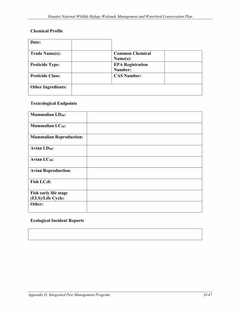
Hanalei National Wildlife Refuge Wetlands Management and Waterbird Conservation Plan
Appendix D. Integrated Pest Management Program D-47
Chemical Profile
Date:
Trade Name(s): Common Chemical Name(s):
Pesticide Type: EPA Registration Number:
Pesticide Class: CAS Number:
Other Ingredients:
Toxicological Endpoints
Mammalian LD50:
Mammalian LC50:
Mammalian Reproduction:
Avian LD50:
Avian LC50:
Avian Reproduction:
Fish LC50:
Fish early life stage (ELS)/Life Cycle:
Other:
Ecological Incident Reports
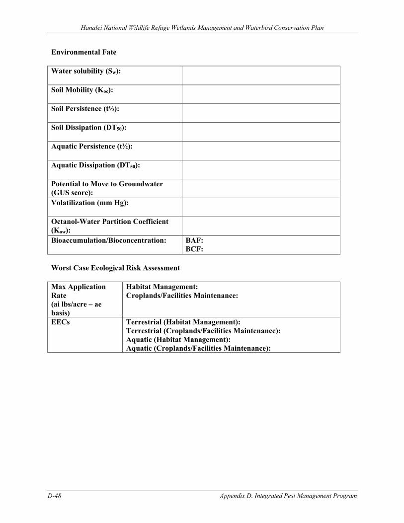
Hanalei National Wildlife Refuge Wetlands Management and Waterbird Conservation Plan
D-48 Appendix D. Integrated Pest Management Program
Environmental Fate
Water solubility (Sw):
Soil Mobility (Koc):
Soil Persistence (t½):
Soil Dissipation (DT50):
Aquatic Persistence (t½):
Aquatic Dissipation (DT50):
Potential to Move to Groundwater (GUS score):
Volatilization (mm Hg):
Octanol-Water Partition Coefficient (Kow):
Bioaccumulation/Bioconcentration: BAF: BCF:
Worst Case Ecological Risk Assessment
Max Application Rate (ai lbs/acre – ae basis)
Habitat Management: Croplands/Facilities Maintenance:
EECs Terrestrial (Habitat Management): Terrestrial (Croplands/Facilities Maintenance): Aquatic (Habitat Management): Aquatic (Croplands/Facilities Maintenance):
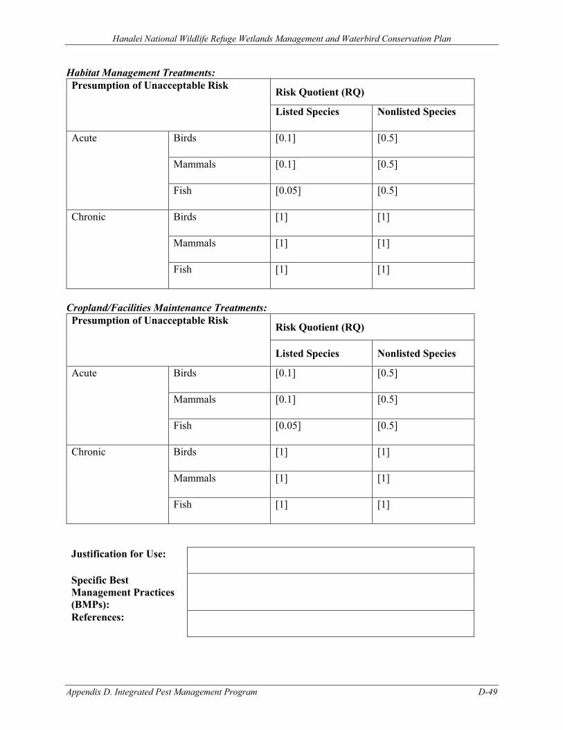
Hanalei National Wildlife Refuge Wetlands Management and Waterbird Conservation Plan
Appendix D. Integrated Pest Management Program D-49
Habitat Management Treatments: Presumption of Unacceptable Risk Risk Quotient (RQ)
Listed Species Nonlisted Species
Acute Birds [0.1] [0.5]
Mammals [0.1] [0.5]
Fish [0.05] [0.5]
Chronic Birds [1] [1]
Mammals [1] [1]
Fish [1] [1]
Cropland/Facilities Maintenance Treatments: Presumption of Unacceptable Risk Risk Quotient (RQ)
Listed Species Nonlisted Species
Acute Birds [0.1] [0.5]
Mammals [0.1] [0.5]
Fish [0.05] [0.5]
Chronic Birds [1] [1]
Mammals [1] [1]
Fish [1] [1]
Justification for Use:
Specific Best Management Practices (BMPs):
References:
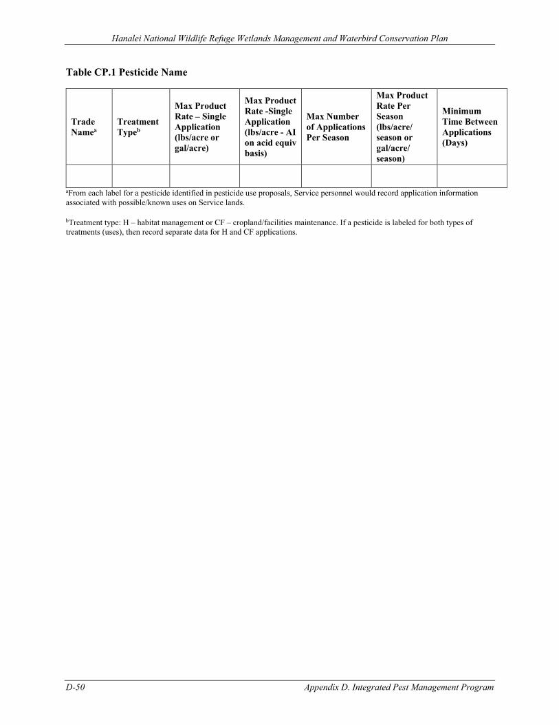
Hanalei National Wildlife Refuge Wetlands Management and Waterbird Conservation Plan
D-50 Appendix D. Integrated Pest Management Program
Table CP.1 Pesticide Name
Trade Namea
Treatment Typeb
Max Product Rate – Single Application (lbs/acre or gal/acre)
Max Product Rate -Single Application (lbs/acre - AI on acid equiv basis)
Max Number of Applications Per Season
Max Product Rate Per Season (lbs/acre/ season or gal/acre/ season)
Minimum Time Between Applications (Days)
aFrom each label for a pesticide identified in pesticide use proposals, Service personnel would record application information associated with possible/known uses on Service lands.
bTreatment type: H – habitat management or CF – cropland/facilities maintenance. If a pesticide is labeled for both types of treatments (uses), then record separate data for H and CF applications.
Hanalei National Wildlife Refuge Wetlands Management and Waterbird Conservation Plan
Appendix D. Integrated Pest Management Program D-51
D.8 REFERENCES AgDRIFT. 2001. “A User’s Guide for AgDrift 2.04: A Tiered Approach for the Assessment of Spray
Drift of Pesticides.” Macon, MO: Spray Drift Task Force.
Agency for Toxic Substances and Disease Registry. 2004. Guidance Manual for the Assessment of Joint Toxic Action of Chemical Mixtures. U.S. Department of Health and Human Services, Public Health Service, ATSDR, Division of Toxicology.
Baehr, C. H., and C. Habig. 2000. “Statistical Evaluation of the UTAB Database for Use in Terrestrial Nontarget Organism Risk Assessment.” Presentation at the American Society for Testing and Materials (ASTM) Tenth Symposium on Environmental Toxicology and Risk Assessment, April 2000, Toronto, Canada.
Baker, J., and G. Miller. 1999. “Understanding and Reducing Pesticide Losses.” Extension Publication PM 1495. Ames, IA: Iowa State University Extension: 6 pp.
Barry, T. 2004. “Characterization of Propanil Prune Foliage Residues as Related to Propanil Use Patterns in the Sacramento Valley, CA.” In Proceedings of the International Conference on Pesticide Application for Drift Management, 15 pp. Waikoloa, HI.
Battaglin, W. A., E. M. Thurman, S. J. Kalkhoff, and S. D. Porter. 2003. “Herbicides and Transformation Products in Surface Waters of the Midwestern United States.” Journal of the American Water Resources Association 39 (4): 743–756.
Beyer, W. N., E. E. Connor, and S. Gerould. 1994. “Estimates of Soil Ingestion by Wildlife.” Journal of Wildlife Management 58: 375–382.
BLM (Bureau of Land Management). 2007. Vegetation Treatments Using Herbicides on Bureau of Land Management Lands in 17 Western States Programmatic EIS (PEIS). Washington, D.C.: Bureau of Land Management.
Brooks, M. L., C. M. D’Antonio, D. M. Richardson, J. B. Grace, J. E. Keeley, J. M. DiTomaso, R. J. Hobbs, M. Pellant, and D. Pyke. 2004. “Effects of Invasive Alien Plants on Fire Regimes.” BioScience 54: 77–88.
Butler, T., W. Martinkovic, and O. N. Nesheim. 1998. “Factors Influencing Pesticide Movement to Ground Water.” Extension Publication PI-2. Gainesville, FL: University of Florida, Cooperative Extension Service: 4 pp.
Calabrese, E. J., and L. A. Baldwin. 1993. Performing Ecological Risk Assessments. Chelsea, MI: Lewis Publishers.
Center, T. D., J. H. Frank, and F. A. Dray Jr. 1997. “Biological Control.” In Strangers in Paradise: Impact and Management of Nonindigenous Species in Florida, edited by D. Simberloff, D. C. Schmitz, and T. C. Brown, 245–263. Washington D.C.: Island Press.
Coombs, E. M., J. K. Clark, G. L. Piper, and A. F. Cofrancesco Jr. 2004. Biological Control of Invasive Plants in the United States. Corvallis, OR: Oregon State University Press.
Cox, R. D., and V. J. Anderson. 2004. “Increasing Native Diversity of Cheatgrass-Dominated Rangeland through Assisted Succession.” Journal of Range Management 57: 203–210.
Driver, C. J., M. W. Ligotke, P. Van Voris, B. D. McVeety, B. J. Greenspan, and D. B. Brown. 1991. “Routes of Uptake and Their Relative Contribution to the Toxicologic Response of Northern Bobwhite (Colinus Virginianus) to an Organophosphate Pesticide.” Environmental
Hanalei National Wildlife Refuge Wetlands Management and Waterbird Conservation Plan
D-52 Appendix D. Integrated Pest Management Program
Toxicology and Chemistry 10: 21–33.
Dunning, J. B. 1984. “Body Weights of 686 Species of North American Birds.” Western Bird Banding Association Monograph 1. Cave Creek, AZ: Eldon Publishing.
EPA (U.S. Environmental Protection Agency). 1990. Laboratory Test Methods of Exposure to Microbial Pest Control Agents by the Respiratory Route to Nontarget Avian Species. EPA/600/3-90/070. Corvallis, OR: Environmental Research Laboratory.
EPA. 1998. A Comparative Analysis of Ecological Risks from Pesticides and Their Uses: Background, Methodology and Case Study. Washington, D.C.: Environmental Fate and Effects Division, Office of Pesticide Programs, U.S. Environmental Protection Agency.
EPA. 2004. Overview of the Ecological Risk Assessment Process in the Office of Pesticide Programs, U.S. Environmental Protection Agency: Endangered and Threatened Species Effects Determinations. Washington, D.C.: Office of Pesticide Programs.
EPA. 2005a. Technical Overview of Ecological Risk Assessment Risk Characterization; Approaches for Evaluating Exposure; Granular, Bait, and Treated Seed Applications. Washington, D.C.: U.S. Environmental Protection Agency, Office of Pesticide Programs.
EPA. 2005b. User’s Guide TREX v1.2.3. Washington, D.C.: Office of Pesticide Programs, U.S. Environmental Protection Agency.
EXTOXNET. 1993. “Movement of Pesticides in the Environment.” Pesticide Information Project of Cooperative Extension Offices of Cornell University, Oregon State University, University of Idaho, University of California – Davis, and the Institute for Environmental Toxicology, Michigan State University, 4 pp.
Fletcher, J. S., J. E. Nellessen, and T. G. Pfleeger. 1994. “Literature Review and Evaluation of the EPA Food-Chain (Kanaga) Nomogram, and Instrument for Estimating Pesticide Residue on Plants.” Environmental Toxicology and Chemistry 13: 1381–1391.
Hasan, S., and P. G. Ayres. 1990. “The Control of Weeds through Fungi: Principles and Prospects.” Tansley Review 23: 201–222.
Huddleston, J. H. 1996. “How Soil Properties Affect Groundwater Vulnerability to Pesticide Contamination.” EM 8559. Corvallis, OR: Oregon State University Extension Service: 4 pp.
Kerle, E. A., J. J. Jenkins, and P. A. Vogue. 1996. “Understanding Pesticide Persistence and Mobility for Groundwater and Surface Water Protection.” EM 8561. Corvallis, OR: Oregon State University Extension Service: 8 pp.
Masters, R. A., S. J. Nissen, R. E. Gaussoin, D. D. Beran, and R. N. Stougaard. 1996. “Imidazolinone Herbicides Improve Restoration of Great Plains Grasslands.” Weed Technology 10: 392–403.
Masters, R. A., and R. L. Sheley. 2001. “Invited Synthesis Paper: Principles and Practices for Managing Rangeland Invasive Plants.” Journal of Range Management 54: 502–517.
Maxwell, B. D., E. Lehnhoff, and L. J. Rew. 2009. “The Rationale for Monitoring Invasive Plant Populations as a Crucial Step for Management.” Invasive Plant Science and Management 2: 1–9.
Mineau, P., B. T. Collins, and A. Baril. 1996. “On the Use of Scaling Factors to Improve Interspecies Extrapolation to Acute Toxicity in Birds.” Regulatory Toxicology and Pharmacology 24: 24–29.
Hanalei National Wildlife Refuge Wetlands Management and Waterbird Conservation Plan
Appendix D. Integrated Pest Management Program D-53
Moody, M. E., and R. N. Mack. 1988. “Controlling the Spread of Plant Invasions: The Importance of Nascent Foci.” Journal of Applied Ecology 25: 1009–1021.
Mullin, B. H., L. W. Anderson, J. M. DiTomaso, R. E. Eplee, and K. D. Getsinger. 2000. “Invasive Plant Species.” Council for Agricultural Science and Technology Issue Paper ( 13: 1–18.
Oregon State University. 1996. EXTOXNET-Extension Toxicology Network, Pesticide Information Profiles. Corvallis, OR: Oregon State University.
Pfleeger, T. G., A. Fong, R. Hayes, H. Ratsch, and C. Wickliff. 1996. “Field Evaluation of the EPA (Kanaga) Nomogram, a Method for Estimating Wildlife Exposure to Pesticide Residues on Plants.” Environmental Toxicology and Chemistry 15: 535–543.
Pope, R., J. DeWitt, and J. Ellerhoff. 1999. “Pesticide Movement: What Farmers Need to Know.” Extension Publication PAT 36. Ames, IA and Des Moines, IA: Iowa State University Extension and Iowa Department of Agriculture and Land Stewardship: 6 pp.
Ramsay, C. A., G. C. Craig, and C. B. McConnell. 1995. “Clean Water for Washington -- Protecting Groundwater from Pesticide Contamination.” Extension Publication EB 1644. Pullman, WA: Washington State University Extension: 12 pp.
Spray Drift Task Force. 2003. A Summary of Chemigation Application Studies. Macon, MO: Spray Drift Task Force.
Urban, D. J., and N. J. Cook. 1986. Ecological Risk Assessment. EPA 540/9-85-001. Washington, D.C.: U.S. Environmental Protection Agency, Office of Pesticide Programs.
USFS (U.S. Forest Service). 2005. Pacific Northwest Region Invasive Plant Program Preventing and Managing Invasive Plants Final Environmental Impact Statement. Portland, OR: U.S. Forest Service.
USGS (U.S. Geological Survey). 2000. “Pesticides in Stream Sediment and Aquatic Biota—current Understanding of Distribution and Major Influences.” USGS Fact Sheet 092–00. Sacramento, CA: U.S. Geological Survey: 4 pp.
Wauchope, R. D., T. M. Buttler, A. G. Hornsby, P. M. Augustijn-Beckers, and J. P. Burt. 1992. “The SCS/ARS/CES Pesticide Properties Database for Environmental Decision Making.” Reviews of Environmental Contamination and Toxicology 123: 1–155.
Woods, N. 2004. “Australian Developments in Spray Drift Management.” In Proceedings of the International Conference on Pesticide Application for Drift Management, 8 pp. Waikoloa, HI.

Hanalei National Wildlife Refuge Wetlands Management and Waterbird Conservation Plan
Appendix E. Implementation E-1
APPENDIX E. IMPLEMENTATION E.1 Overview ............................................................................................................................ E-2
E.2 Costs to Implement WMWCP ............................................................................................ E-2
E.2.1 One-time Costs ............................................................................................................ E-2
E.2.2 Annual Operational (Recurring) Costs........................................................................ E-4
E.2.3 Staffing ........................................................................................................................ E-5
E.3 Partnering Opportunities ..................................................................................................... E-6
Hanalei National Wildlife Refuge Wetlands Management and Waterbird Conservation Plan
E-2 Appendix E. Implementation
APPENDIX E. IMPLEMENTATION
E.1 OVERVIEW Implementation of the WMWCP will require increased funding, which will be sought from a variety of sources including congressional allocations and public and private partnerships and grants. There are no guarantees that additional federal funds will be made available to implement any of these projects. Activities and projects identified will be implemented as funds become available.
The WMWCP identifies several projects to be implemented over the next 15 years. Some of these projects are included in the Refuge Management Information Systems (RONS–Refuge Operational Needs System or SAMMS–Service Asset Maintenance Management System) which are used to request funding from Congress. Upon completion of the WMWCP, new projects that are needed to meet Hanalei National Wildlife Refuge (NWR or Refuge) goals and objectives and legal mandates will be entered into RONS documents or SAMMS databases. Currently, a backlog of maintenance needs exists on the Refuge. Prioritized staffing needs identified in RONS will be necessary to implement the WMWCP to meet Refuge goals and objectives and legal mandates. The SAMMS database documents and tracks repairs, replacements, and maintenance of facilities and equipment. Smaller proposed projects will be implemented as funding allows, and funding would be sought for these projects through a variety of sources.
Monitoring activities will be conducted on a percentage of all new and existing projects and activities to document wildlife populations and changes across time, habitat conditions, and responses to management practices. Actual monitoring and evaluation procedures will be detailed in an Inventory and Monitoring Plan.
E.2 COSTS TO IMPLEMENT WMWCP The following sections detail both one-time and recurring costs for various projects as described within the WMWCP. One-time costs (Table E-1) reflect the initial costs associated with a project, such as the purchase of equipment, contracting services, construction, or other activity. Recurring costs (Tables E-2 and E-3) reflect the future operational and maintenance costs associated with the project. The potential funding sources identify both base funding that is appropriated by Congress as part of the Refuge’s budget (e.g., 126X series such as 1261, 1262, etc.) and grants/external funds received (e.g., Ecological Services [ES], Inventory and Monitoring [I&M], North American Wetlands Conservation Act [NAWCA]). Note that for both Tables E-1 and E-2, only costs the Refuge is directly responsible for have been identified. For partnering or cost-sharing strategies identified, due to the unknown associated costs and timing, these figures have not been identified in the tables below.
E.2.1 ONE-TIME COSTS
One-time costs have a start-up cost associated with them, such as purchasing equipment necessary for wildlife and habitat monitoring or designing and testing a monitoring protocol. Some cost estimates are for projects that can be completed in three years or less. One-time costs can include the cost of temporary or term salary associated with a short-term project. Salary for existing and new positions, and operational costs, are reflected in operational (or recurring) costs.
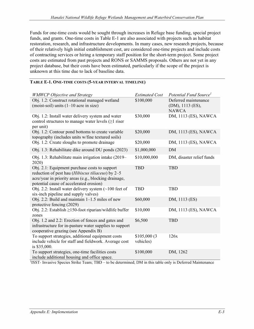
Hanalei National Wildlife Refuge Wetlands Management and Waterbird Conservation Plan
Appendix E: Implementation E-3
Funds for one-time costs would be sought through increases in Refuge base funding, special project funds, and grants. One-time costs in Table E-1 are also associated with projects such as habitat restoration, research, and infrastructure developments. In many cases, new research projects, because of their relatively high initial establishment cost, are considered one-time projects and include costs of contracting services or hiring a temporary staff position for the short-term project. Some project costs are estimated from past projects and RONS or SAMMS proposals. Others are not yet in any project database, but their costs have been estimated, particularly if the scope of the project is unknown at this time due to lack of baseline data.
TABLE E-1. ONE-TIME COSTS (5-YEAR INTERVAL TIMELINE)
WMWCP Objective and Strategy Estimated Cost Potential Fund Source1 Obj. 1.2: Construct rotational managed wetland (moist-soil) units (1–10 acre in size)
$100,000 Deferred maintenance (DM), 1113 (ES), NAWCA
Obj. 1.2: Install water delivery system and water control structures to manage water levels (≥1 riser per unit)
$30,000 DM, 1113 (ES), NAWCA
Obj. 1.2: Contour pond bottoms to create variable topography (includes units w/fine textured soils)
$20,000 DM, 1113 (ES), NAWCA
Obj. 1.2: Create sloughs to promote drainage $20,000 DM, 1113 (ES), NAWCA Obj. 1.3: Rehabilitate dike around DU ponds (2023) $1,000,000 DM Obj. 1.3: Rehabilitate main irrigation intake (2019–2020)
$10,000,000 DM, disaster relief funds
Obj. 2.1: Equipment purchase costs to support reduction of pest hau (Hibiscus tiliaceus) by 2–5 acre/year in priority areas (e.g., blocking drainage, potential cause of accelerated erosion)
TBD TBD
Obj. 2.2: Install water delivery system (~100 feet of six-inch pipeline and supply valves)
TBD TBD
Obj. 2.2: Build and maintain 1–1.5 miles of new protective fencing (2029)
$60,000 DM, 1113 (ES)
Obj. 2.2: Establish ≥150-foot riparian/wildlife buffer zones
$10,000 DM, 1113 (ES), NAWCA
Obj. 1.2 and 2.2: Erection of fences and gates and infrastructure for in-pasture water supplies to support cooperative grazing (see Appendix B)
$6,500 TBD
To support strategies, additional equipment costs include vehicle for staff and fieldwork. Average cost is $35,000.
$105,000 (3 vehicles)
126x
To support strategies, one-time facilities costs include additional housing and office space.
$100,000 DM, 1262
1ISST- Invasive Species Strike Team; TBD – to be determined; DM in this table only is Deferred Maintenance

Hanalei National Wildlife Refuge Wetlands Management and Waterbird Conservation Plan
E-4 Appendix E. Implementation
E.2.2 ANNUAL OPERATIONAL (RECURRING) COSTS
Operational costs reflect Refuge spending of base funds allocated each year. These are also known as recurring costs and are usually associated with day-to-day operations and projects that last longer than three years. Operational costs use base funding in Service fund code 1260.
Table E-2 displays projected annual operating costs to implement strategies under the WMWCP. The WMWCP will require increased funding for new or expanded habitat management and restoration activities and new monitoring needs. This table includes such things as salary and operational expenditures such as travel, training, supplies, utilities, and maintenance costs. Project costs listed in Table E-2 include administrative support for all programs and projects as well as permanent and seasonal staff needed year after year to accomplish each project. These staffing costs are not isolated in this table but are included as part of the entire project cost.
TABLE E-2. OPERATIONAL (RECURRING) COSTS (ANNUAL, OVER THE ENTIRE 15-YEAR PLAN)
WMWCP Objective and Strategy Estimated Costs Potential Fund Source1
Habitat management (Goal 1): Mowing, disking, rototilling, and water level management
to set back wetland plant succession and provide suitable habitat structure and function
Use integrated pest management (IPM) strategies including mechanical/physical (e.g., mowing, brush-cutting, excavation, prescribed fire), cultural (e.g., water levels), chemical (herbicides), biological, and other suitable techniques to control pest/undesirable plants (Appendix D)
Pulse water/flood to promote vegetation and invertebrates Flood after water pulse to break down vegetation that
promotes invertebrate production growth Slow drawdown, as needed to control pest fish, concentrate
invertebrates, and promote invertebrate/plant growth Maintain minimal water level fluctuations during laying
and incubation Flood for pre-breeding (as a follow-up to full treatment) Maintain dikes and ditches (mowing and using IPM
strategies to control pest/undesirable plants)
$100,000 126x, RO, ISST, ES, KPNHA, grants
Threat management (Goals 1 and 2): Live-trapping, shooting, and bait stations to exclude or
remove vertebrate pests that prey on threatened or endangered waterbirds
Avian botulism surveillance and response Live-trapping and shooting feral mallards and their hybrids Maintain fences to protect wetland management units from
feral pigs and dogs
$90,000 126x, ES, KPNHA, grants, ISST
Obj. 2.1: Reduction of pest hau by 2–5 acre/year in priority areas (e.g., blocking drainage, potential cause of accelerated erosion)
$20,000 126x, ISST
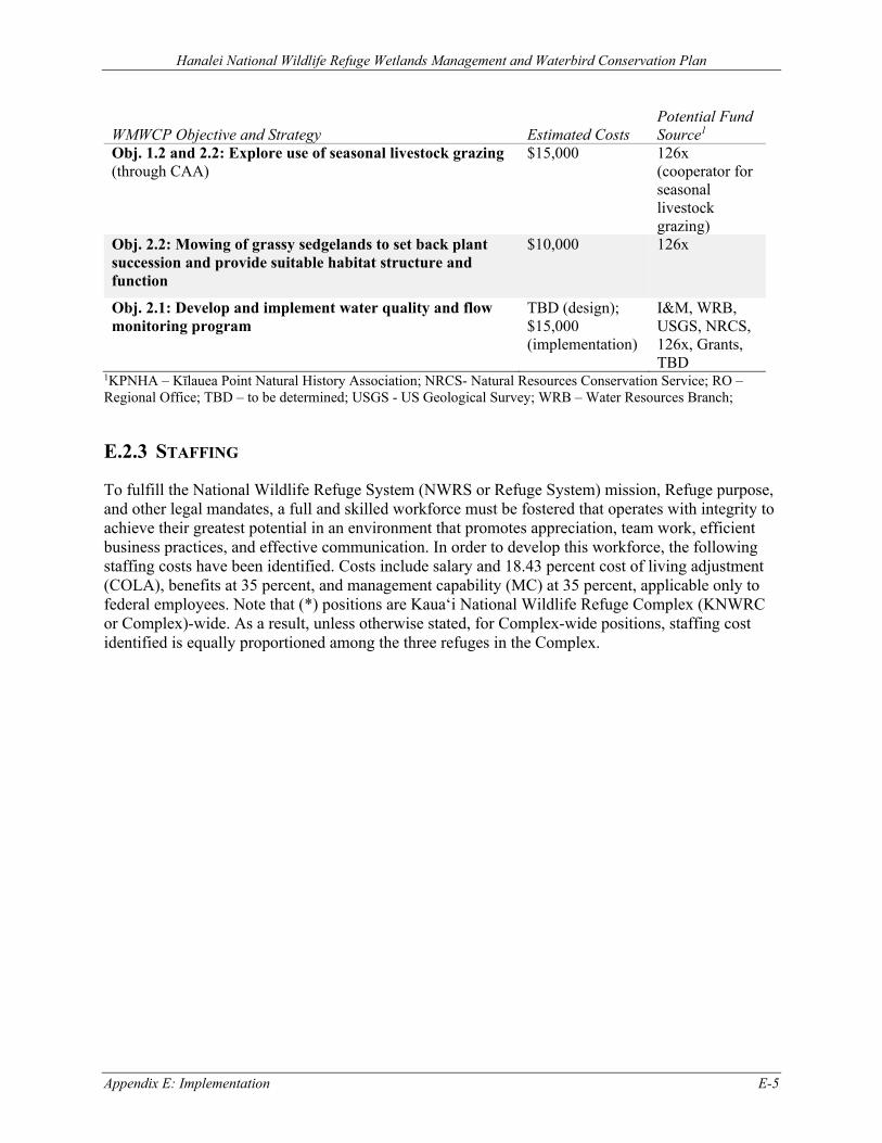
Hanalei National Wildlife Refuge Wetlands Management and Waterbird Conservation Plan
Appendix E: Implementation E-5
WMWCP Objective and Strategy Estimated Costs Potential Fund Source1
Obj. 1.2 and 2.2: Explore use of seasonal livestock grazing (through CAA)
$15,000 126x (cooperator for seasonal livestock grazing)
Obj. 2.2: Mowing of grassy sedgelands to set back plant succession and provide suitable habitat structure and function
$10,000 126x
Obj. 2.1: Develop and implement water quality and flow monitoring program
TBD (design); $15,000 (implementation)
I&M, WRB, USGS, NRCS, 126x, Grants, TBD
1KPNHA – Kīlauea Point Natural History Association; NRCS- Natural Resources Conservation Service; RO – Regional Office; TBD – to be determined; USGS - US Geological Survey; WRB – Water Resources Branch;
E.2.3 STAFFING
To fulfill the National Wildlife Refuge System (NWRS or Refuge System) mission, Refuge purpose, and other legal mandates, a full and skilled workforce must be fostered that operates with integrity to achieve their greatest potential in an environment that promotes appreciation, team work, efficient business practices, and effective communication. In order to develop this workforce, the following staffing costs have been identified. Costs include salary and 18.43 percent cost of living adjustment (COLA), benefits at 35 percent, and management capability (MC) at 35 percent, applicable only to federal employees. Note that (*) positions are Kaua‘i National Wildlife Refuge Complex (KNWRC or Complex)-wide. As a result, unless otherwise stated, for Complex-wide positions, staffing cost identified is equally proportioned among the three refuges in the Complex.
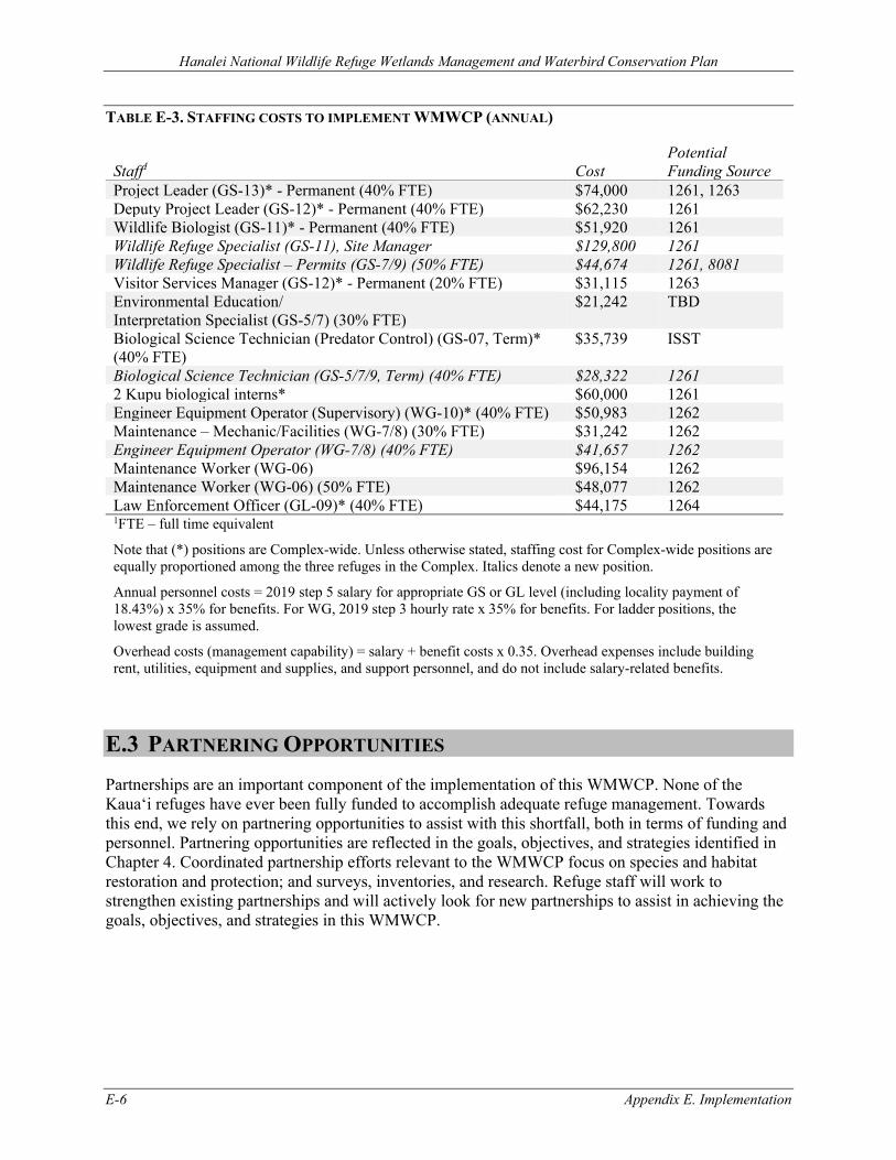
Hanalei National Wildlife Refuge Wetlands Management and Waterbird Conservation Plan
E-6 Appendix E. Implementation
TABLE E-3. STAFFING COSTS TO IMPLEMENT WMWCP (ANNUAL)
Staff1 Cost Potential Funding Source
Project Leader (GS-13)* - Permanent (40% FTE) $74,000 1261, 1263 Deputy Project Leader (GS-12)* - Permanent (40% FTE) $62,230 1261 Wildlife Biologist (GS-11)* - Permanent (40% FTE) $51,920 1261 Wildlife Refuge Specialist (GS-11), Site Manager $129,800 1261 Wildlife Refuge Specialist – Permits (GS-7/9) (50% FTE) $44,674 1261, 8081 Visitor Services Manager (GS-12)* - Permanent (20% FTE) $31,115 1263 Environmental Education/ Interpretation Specialist (GS-5/7) (30% FTE)
$21,242 TBD
Biological Science Technician (Predator Control) (GS-07, Term)* (40% FTE)
$35,739 ISST
Biological Science Technician (GS-5/7/9, Term) (40% FTE) $28,322 1261 2 Kupu biological interns* $60,000 1261 Engineer Equipment Operator (Supervisory) (WG-10)* (40% FTE) $50,983 1262 Maintenance – Mechanic/Facilities (WG-7/8) (30% FTE) $31,242 1262 Engineer Equipment Operator (WG-7/8) (40% FTE) $41,657 1262 Maintenance Worker (WG-06) $96,154 1262 Maintenance Worker (WG-06) (50% FTE) $48,077 1262 Law Enforcement Officer (GL-09)* (40% FTE) $44,175 1264 1FTE – full time equivalent
Note that (*) positions are Complex-wide. Unless otherwise stated, staffing cost for Complex-wide positions are equally proportioned among the three refuges in the Complex. Italics denote a new position.
Annual personnel costs = 2019 step 5 salary for appropriate GS or GL level (including locality payment of 18.43%) x 35% for benefits. For WG, 2019 step 3 hourly rate x 35% for benefits. For ladder positions, the lowest grade is assumed.
Overhead costs (management capability) = salary + benefit costs x 0.35. Overhead expenses include building rent, utilities, equipment and supplies, and support personnel, and do not include salary-related benefits.
E.3 PARTNERING OPPORTUNITIES Partnerships are an important component of the implementation of this WMWCP. None of the Kaua‘i refuges have ever been fully funded to accomplish adequate refuge management. Towards this end, we rely on partnering opportunities to assist with this shortfall, both in terms of funding and personnel. Partnering opportunities are reflected in the goals, objectives, and strategies identified in Chapter 4. Coordinated partnership efforts relevant to the WMWCP focus on species and habitat restoration and protection; and surveys, inventories, and research. Refuge staff will work to strengthen existing partnerships and will actively look for new partnerships to assist in achieving the goals, objectives, and strategies in this WMWCP.
Hanalei National Wildlife Refuge Wetlands Management and Waterbird Conservation Plan
Appendix F. Public Comments and Service Responses F-1
APPENDIX F. PUBLIC COMMENTS AND SERVICE RESPONSES F.1 Introduction......................................................................................................................... F-3 F.2 Changes Made to the Final WMWCP ................................................................................ F-3 F.3 Summary of Comments Received and Service Responses ................................................. F-3
F.3.1 Hawaiian Waterbird Population Counts ........................................................................... F-3 F.3.2 Management Goals and Objectives .................................................................................. F-6 F.3.3 Lowland/Wetland Habitat Management Decision Flowchart........................................... F-6 F.3.4 Avian Botulism ................................................................................................................. F-7 F.3.5 Hydrology ....................................................................................................................... F-10 F.3.6 Native Fish and Invertebrate Restoration ....................................................................... F-10 F.3.7 Nēnē ................................................................................................................................ F-11 F.3.8 Traffic Calming on ‘Ōhiki Road ..................................................................................... F-11 F.3.9 Invasive Species .............................................................................................................. F-12 F.3.10 Pesticide and Herbicide Use ......................................................................................... F-13 F.3.11 Water Quality ................................................................................................................ F-14 F.3.12 Cooperative Agriculture Use Policy ............................................................................. F-14 F.3.13 Cooperative Livestock Grazing .................................................................................... F-15 F.3.14 Cooperative Kalo Farming: Cultural and Historic Importance ..................................... F-16 F.3.15 Cooperative Kalo Farming: Communication with Refuge Farmers ............................. F-17 F.3.16 Cooperative Kalo Farming: Compatibility ................................................................... F-17 F.3.17 Cooperative Kalo Farming: Threatened and Endangered Waterbird Nests in Lo‘i Kalo ..... .................................................................................................................................................. F-18 F.3.18 Cooperative Kalo Farming: Enhanced Vegetation Structure in Lo‘i Kalo ................... F-19 F.3.19 Cooperative Kalo Farming: Farming Intensity ............................................................. F-20 F.3.20 Cooperative Kalo Farming: Best Management Practices ............................................. F-20 F.3.21 Cooperative Kalo Farming: Fertilizer Management ..................................................... F-21 F.3.22 Cooperative Kalo Farming: Fencing ............................................................................. F-22 F.3.23 Cooperative Kalo Farming: Cooperative Agriculture Agreements .............................. F-22 F.3.24 Cooperative Kalo Farming: Application and Selection Process for Cooperative Agriculture Agreements ........................................................................................................... F-23 F.3.25 Cooperative Kalo Farming: Length of Cooperative Agriculture Agreements and Permits .................................................................................................................................................. F-25 F.3.26 Cooperative Kalo Farming: Cost-sharing under Cooperative Agriculture Agreements ....... .................................................................................................................................................. F-25 F.3.27 Cooperative Kalo Farming: Incentive Programs .......................................................... F-27
Hanalei National Wildlife Refuge Wetlands Management and Waterbird Conservation Plan
F-2 Appendix F. Public Comments and Service Responses
F.3.28 Cooperative Kalo Farming: Residences and Farm Storage Areas ................................ F-27 F.3.29 Cooperative Kalo Farming: Law Enforcement ............................................................. F-27 F.3.30 Relationship of WMWCP with Comprehensive Conservation Plan ............................ F-28 F.3.31 Public Involvement ....................................................................................................... F-28 F.3.32 Economic Analysis ....................................................................................................... F-29 F.3.33 Implementation ............................................................................................................. F-31 F.3.34 Regulatory Compliance ................................................................................................ F-31 F.3.35 Outside of Scope ........................................................................................................... F-32 F.3.36 Corrections .................................................................................................................... F-32
F.4 References......................................................................................................................... F-33
Hanalei National Wildlife Refuge Wetlands Management and Waterbird Conservation Plan
Appendix F. Public Comments and Service Responses F-3
APPENDIX F. PUBLIC COMMENTS AND SERVICE RESPONSES
F.1 INTRODUCTION The U.S. Fish and Wildlife Service (USFWS or Service) received written comments on the Hanalei National Wildlife Refuge (NWR or Refuge) draft Wetlands Management and Waterbird Conservation Plan (WMWCP) and Environmental Assessment (EA) from nine entities during the combined 47-day public review and comment period held from August 12, 2020 to September 12, 2020 and September 21, 2020 to October 5, 2020. The Service also received verbal comments during two virtual public meetings, both held on August 26, 2020, and from stakeholder meetings on August 27 and October 1, 2020. All comments were reviewed, analyzed, and addressed. A summary of the comments and our response to each is presented in this appendix.
Each original piece of correspondence was identified with the commenter’s last name and first initial and a number. Note that for simplicity’s sake, we use the word “letter” to refer to any comment or reference document we received, whether by letter, phone call, e-mail, or in person. Multiple correspondences from a commenter are counted as one comment letter.
To help us analyze the comments, a number of themes and subthemes were identified within the letters, and similar comments were grouped together under a theme. Our responses apply to the comments grouped under a theme. Comments that fell outside the scope of the WMWCP were also considered and responded to as appropriate.
F.2 CHANGES MADE TO THE FINAL WMWCP The planning team reviewed and evaluated all of the comments we received during the draft WMWCP and EA comment period. In some cases, the management direction was either modified or clarified based on the comments. Modifications included revising and restructuring the habitat management decision flowchart to accommodate stakeholder coordination and input; cultural and historic considerations; logistics; compliance; and other factors. Additionally, we modified strategies to increase the protection of threatened and endangered waterbird nests or broods within kalo (taro, Colocasia esculenta) farms, in response to comments received and in support of the Refuge establishment purpose and Refuge System mission. We also made corrections, clarifications, and provided further information on avian botulism and Refuge waterbird use, population counts, and trends. Section F.3 below provides additional details. For additional information on the management direction under the final WMWCP, see Chapter 4.
F.3 SUMMARY OF COMMENTS RECEIVED AND SERVICE RESPONSES
F.3.1 HAWAIIAN WATERBIRD POPULATION COUNTS
1. Comment: The WMWCP should provide more complete status and trend information for listed waterbirds on the Refuge, including comparisons between lo‘i kalo (ponds for wetland kalo that are enclosed by earthen banks) and rotational managed wetland habitats, using waterbird count and other data.
Hanalei National Wildlife Refuge Wetlands Management and Waterbird Conservation Plan
F-4 Appendix F. Public Comments and Service Responses
Response: The Service updated Section 2.5 within the WMWCP to include the current scientific data for listed waterbirds on Hanalei NWR. New or updated information includes summarized data from monthly or quarterly Refuge waterbird surveys from 2010 to 2020. However, due to variability in observer skill level, observer survey effort, survey conditions, and detectability among habitat types, data from Refuge waterbird surveys represent indices of species’ presence and relative abundance, not direct population measures of occupancy and abundance (Camp et al. 2014). Further, these data underestimate relative abundances by some unknown amount and detection probabilities can vary between sites, habitats, and time. Refer to the individual species accounts within Section 2.5 for additional information and discussion.
Comparisons of waterbird density and use between lo‘i kalo and rotational managed wetland (moist-soil) units (also referred to as wetland management units [WMUs]) are complicated by waterbird species’ use of different habitats during different life history stages (e.g., Gee 2007; Gutscher-Chutz 2011; Malachowski and Dugger 2018; Malachowski et al. 2018). Waterbird abundance or use depends upon the species and breeding status.
As mentioned above, the longest time series of waterbird data collected on the Refuge (the monthly or quarterly Refuge waterbird surveys) is an imperfect source of population status and trend. With these caveats, we present preliminary figures on these data. We plan on doing further statistical analysis and modeling and will share these results with the public when available.
Figure F-1 shows boxplots of waterbird density (count, or index of abundance, per acre) in managed wetland and kalo habitats for each of the five listed waterbirds, from 2010 to 2020. Each boxplot displays the distribution of data from monthly or quarterly surveys within a given year. For the density calculation, the survey count area for kalo farms was estimated from acreage under permit during a given year. This acreage includes lo‘i, dikes, and ditches. Survey count areas for rotational managed wetland units include impoundments, dikes, ditches, and associated grasslands.
To illustrate the complexity of interpreting Refuge waterbird count data, we present case examples involving koloa maoli (Hawaiian duck, Anas wyvillana) and ʻalae ʻula (Hawaiian common gallinule, Gallinula galeata sandvicensis). From 2010–2020 Refuge waterbird survey data, the index of abundance per acre for koloa maoli appears higher and more variable on managed wetlands than kalo farms (Figure F-1). In support of this figure, tracking studies of koloa maoli core use areas and population level hotspots showed a disproportionately greater use of managed wetlands than kalo farms, although both habitat types were used to meet important life history needs (Malachowski 2014; Malachowski 2020).
In addition, the index of abundance per acre for ʻalae ʻula appears higher and more variable in kalo than managed wetlands (Figure F-1). However, in the summer of 2016, we compared regular visual-aural survey methods from dikes to call-broadcast surveys, and found it was approximately five times easier to see and hear ʻalae ʻula in kalo than managed wetlands. Use of call-broadcast surveys increased detection rates by 49.4 percent in kalo and 239.3 percent in rotational managed wetland units, resulting in comparable densities in kalo (2.8 birds/acre) and managed wetland units (2.6 birds/acre) (K. Uyehara 2021, USFWS, pers. comm.). Additional call-broadcast comparisons and incorporation of detection probabilities during the
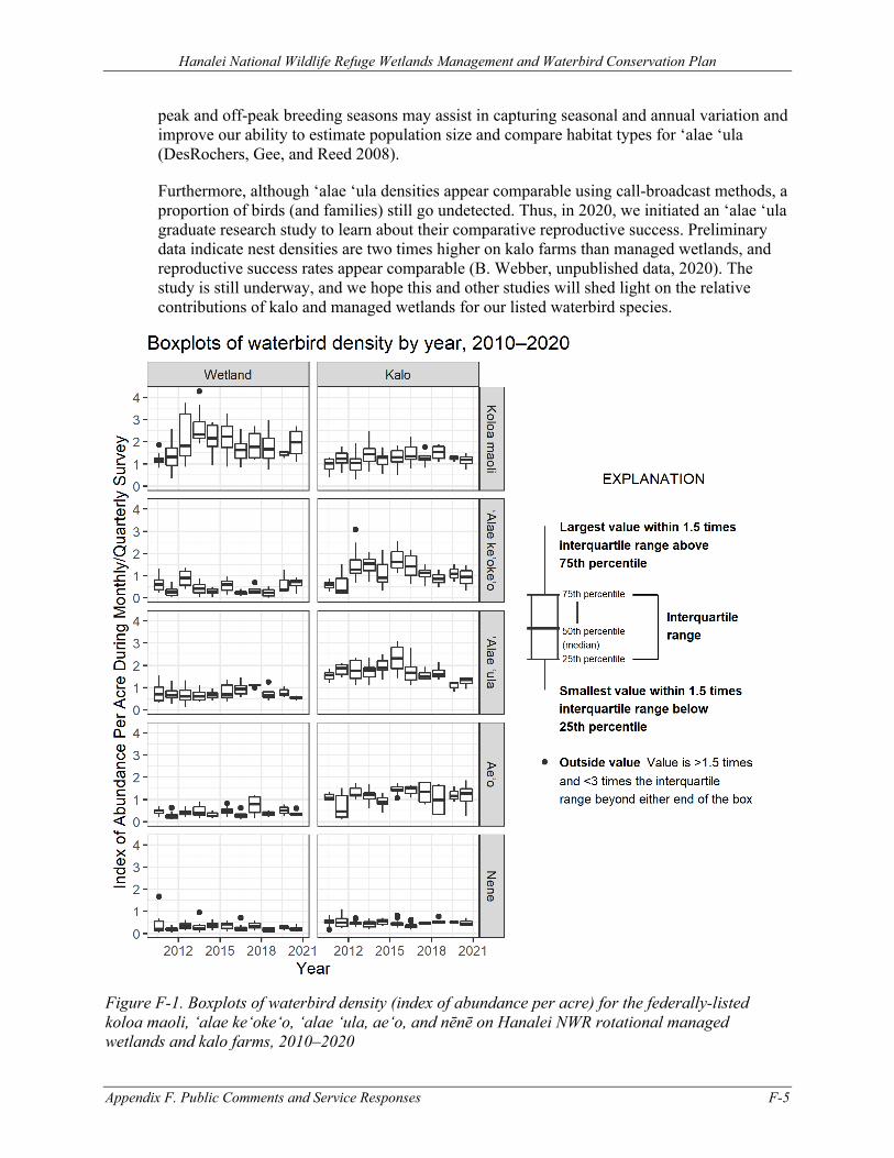
Hanalei National Wildlife Refuge Wetlands Management and Waterbird Conservation Plan
Appendix F. Public Comments and Service Responses F-5
peak and off-peak breeding seasons may assist in capturing seasonal and annual variation and improve our ability to estimate population size and compare habitat types for ʻalae ʻula (DesRochers, Gee, and Reed 2008).
Furthermore, although ʻalae ʻula densities appear comparable using call-broadcast methods, a proportion of birds (and families) still go undetected. Thus, in 2020, we initiated an ʻalae ʻula graduate research study to learn about their comparative reproductive success. Preliminary data indicate nest densities are two times higher on kalo farms than managed wetlands, and reproductive success rates appear comparable (B. Webber, unpublished data, 2020). The study is still underway, and we hope this and other studies will shed light on the relative contributions of kalo and managed wetlands for our listed waterbird species.
Figure F-1. Boxplots of waterbird density (index of abundance per acre) for the federally-listed koloa maoli, ‘alae ke‘oke‘o, ‘alae ‘ula, ae‘o, and nēnē on Hanalei NWR rotational managed wetlands and kalo farms, 2010–2020
Hanalei National Wildlife Refuge Wetlands Management and Waterbird Conservation Plan
F-6 Appendix F. Public Comments and Service Responses
F.3.2 MANAGEMENT GOALS AND OBJECTIVES
2. Comment: The WMWCP should present measurable population objectives for threatened and endangered waterbirds using Hanalei NWR habitats and relate those objectives to the recovery plans for those species.
Response: We agree that WMWCP would be improved by having measurable population objectives; however, the statewide population statuses and viabilities of listed waterbirds are currently unknown for endangered koloa maoli, ʻalae ʻula, and ʻalae keʻokeʻo (Hawaiian coot, Fulica alai). The Ecological Services program of the U.S. Fish and Wildlife Service in the Pacific Islands is preparing a package to downlist ae‘o (Hawaiian stilt, Himantopus mexicanus knudseni) from endangered to threatened, similar to the process in 2018–2019 for nēnē (Hawaiian goose, Branta sandvicensis). We currently have better information on these two species statewide, and our Ecological Services office could move forward on establishing more measurable recovery population objectives if targeted funding becomes available.
F.3.3 LOWLAND/WETLAND HABITAT MANAGEMENT DECISION FLOWCHART
3. Comment: The Service should clarify the role and timing of stakeholder or partner involvement within the habitat management decision flowchart, especially in regard to the kalo farmers on the Refuge. The flowchart should incorporate cultural aspects and considerations. Hydrology and planned or proposed water infrastructure improvements, specifically as they relate to avian botulism prevention and response, should also be considered in the Service’s decision-making process.
Response: Based on public comments, we made edits to the flowchart (Figure 4-2 in the WMWCP) to clarify the considerations the Service would use in evaluating habitat management on the Refuge. We restructured the flowchart to be more inclusive of the factors that would be evaluated by the Service. We organized these considerations into the following categories: environmental factors and location on the Refuge, logistics, social and cultural, and legal. We explicitly include stakeholder coordination and input (e.g., discussions with Refuge kalo farmers and partners) and historic and cultural considerations as examples of social and cultural factors that would influence our decision-making. Hydrology, water infrastructure, and avian botulism risk would be evaluated via the flowchart as either environmental, logistical, or legal considerations.
We also edited the flowchart to clarify the timing of decision-making. At minimum, the Service would evaluate habitat allocations on an annual basis as part of the annual habitat work planning process. This process is described in Section 4.1, Adaptive Management. However, decision points could be triggered at any time as conditions necessitate (e.g., additional funding is acquired, catastrophic flooding, and new partnership opportunities).
The Service is committed to bringing together interested parties to assist with the evaluation of available information, as well as consultation about management options and their implications prior to making course-changing decisions. This process does not diminish the Service’s legal authority to make decisions but rather serves to enhance the decision-making process by enabling the Service to approach issues from multiple perspectives, thereby finding creative solutions to complex challenges.
Hanalei National Wildlife Refuge Wetlands Management and Waterbird Conservation Plan
Appendix F. Public Comments and Service Responses F-7
4. Comment: The flowchart allows flexibility in the allocation of acreage towards different management strategies. The Service should clarify how the considerations on the flowchart would be prioritized. Are certain types of management favored over others?
Response: The flowchart does not list considerations in any priority order; rather it is a list of the variety of factors that should, in totality, be evaluated in making a sound management decision. As a component of the Refuge’s adaptive management framework, this flowchart is designed to be flexible and generalized, rather than overly prescriptive, to account for uncertainty and changing conditions (e.g., climate, additional information from inventory and monitoring, disease outbreaks, availability of funding and resources, compliance with conditions of Cooperative Agriculture Agreements [CAAs], and kalo market forces).
Ultimately, the allocation of habitat acreages under the WMWCP must be consistent with the Refuge purpose for supporting the conservation of threatened and endangered species. With the new CAA program for kalo farming and the natural attrition that has occurred over the last few years with amount of loʻi kalo on the Refuge, the guidance will remain to continue to find a balance between the habitat types that provide for the life history requirements of the threatened and endangered waterbirds we are managing for while ensuring that we are also highlighting the important historic, cultural, economic, and community values of kalo grown in the Hanalei Valley. Management under constantly changing conditions requires flexibility. The Service intends to use the flowchart as part of a transparent and informed decision-making framework.
5. Comment: Refuge kalo farmers own water management infrastructure within their permit areas. If the Service decides to spatially reconfigure management strategies by exchanging lo‘i kalo areas with other uses, then how would the Service account for the farmer’s previous infrastructure investments and potential financial impact?
Response: We recognize the up-front contribution that many farmers on the Refuge have made to pay for and install their own infrastructure, such as irrigation pipes and valves, which adds an additional layer of complexity and consideration for any reconfiguration proposals. The Refuge has been working to address irrigation infrastructure issues through upgrades and fixes that the Service has been funding. We will continue to look to do this within unallocated acreage, prior to issuing permits, in order to make any future transitions easier and also to allow farmers to come into a new permit area more easily without having large upfront costs. In addition, we would be working very closely with farmers in any situation where a switch or exchange of acres for their permit might be proposed to ensure safeguards are in place to make it feasible for both parties (e.g., consideration of a reasonable transition period and/or compensation required per permit and legal mandates to alleviate any possible financial hardship).
F.3.4 AVIAN BOTULISM
6. Comment: Can bird populations on the Refuge become too large and unmanageable and as a result, contribute to the spread of avian botulism?
Response: The Hanalei NWR was established in 1972 with the purpose of aiding in the recovery of threatened and endangered species. On the Refuge, we manage specifically for the recovery of threatened and endangered waterbird species that have relict populations and
Hanalei National Wildlife Refuge Wetlands Management and Waterbird Conservation Plan
F-8 Appendix F. Public Comments and Service Responses
extremely limited habitat. Population size or density is affected by both abiotic factors such as space, food, or water availability and biotic factors such as interactions with other species including predators, parasites, diseases, and competitors. Generally, native species populations under pressure from invasive species that are predators or competitors; diseases (e.g., avian botulism); or other biotic limiting factors could exhibit populations that are much lower than the carrying capacity. It is uncommon to find emaciated birds on the Refuge that are showing signs of starvation, which would be a primary indicator that waterbird populations on the Refuge are limited by food availability, and that populations have reached or exceeded carrying capacity. Following from the Refuge purpose, the management strategies within the WMWCP are intended to reduce these population limiting factors and to aid in the recovery of these threatened and endangered species. Furthermore, all Hawaiian waterbird species have the ability to disperse from a natal site or move when the site is not meeting their resource requirements, and have been documented moving among multiple wetlands and occasionally islands.
Avian botulism is caused by ingestion of a neurotoxin produced by a naturally occurring bacterium, Clostridium botulinum. This bacterium is a strict anaerobe that occurs naturally in soil, often lying dormant until the appearance of favorable environmental conditions for growth and toxin production. Avian botulism is essentially food poisoning for birds and does not spread directly from one individual to another; however, the toxin does bioaccumulate in protein sources such as maggots, fishes, and other invertebrates that the birds eat and can easily come in contact with. As birds die from avian botulism, the disease source can become more prevalent, if carcasses are not immediately found and retrieved from the areas in which the birds are feeding. Therefore, there is some validity to the idea that the more birds you have within a particular area that has a strong presence of the botulism-causing toxin, the more likely you are to have more birds becoming exposed to and affected by the disease. Comparisons of koloa maoli density (index of abundance per acre) from Refuge waterbird surveys versus density of koloa botulism cases suggest that the highest densities of healthy koloa counted during our Refuge waterbird surveys occur in our wetland management units (Kuna units, Rice Mill units), but the highest densities of koloa botulism cases (koloa represent 63% of botulism cases) occur in northern kalo farms (McDonald 2016), which suggests that a higher abundance of birds within a given area does not lead to increased botulism alone, unless there are also other factors present that cause increased production of the toxin. In addition, although koloa use predominantly the northern portions of the Refuge (versus the southern portions), their core use areas were in wetlands management units (ABC units, Rice Mill units) and adjacent lo‘i kalo, which do not match up with botulism hotspots on northern kalo farms (Malachowski 2020).
Thus, Refuge bird abundance does not appear to be a major driver of the disease itself. We are continuing to work with our partners to identify and address the conditions that are known to cause and exacerbate avian botulism outbreaks, such as warm, stagnant, anaerobic, high nutrient levels within the aquatic system.
7. Comment: What are the causes of avian botulism on the Refuge? Both wet agriculture and threatened and endangered waterbirds have existed in Hanalei River Valley prior to the establishment of the Refuge. Prior to the 2011 outbreak, there was little to no avian botulism documented in the Hanalei River Valley. How have environmental conditions changed since then? Why is the Service hypothesizing that fertilizer inputs are a contributing factor when avian botulism occurs in areas where fertilization does not occur? Avian botulism is likely
Hanalei National Wildlife Refuge Wetlands Management and Waterbird Conservation Plan
Appendix F. Public Comments and Service Responses F-9
impacted by water availability and it seems that the patterns of occurrence support this (i.e. fewer avian botulism cases in southern portions of the Refuge where there is more water availability versus much higher amounts of avian botulism in the north, at end of the water distribution system).
Response: Hotspot (density) mapping of avian botulism cases show that although the location of hotspots vary from year-to-year, the most severe outbreaks (i.e., highest density botulism hotspot for koloa maoli, representing 62% of cases) occur primarily during the fall/winter season in lo‘i kalo in the northern part of the Refuge, with significantly fewer outbreaks in southern lo‘i kalo and rotational managed wetlands. The regular occurrence of the botulism outbreaks at these particular locations on the Refuge seem to indicate that there is something unique about the environmental conditions in the northern lo‘i kalo compared to other areas of the Refuge. These northern loʻi kalo areas on the Refuge have higher fertilization use, less water availability, and limited hydraulic head to move water (i.e., these areas are located at the downstream end of the water distribution system), factors that can contribute to higher temperatures, lower dissolved oxygen, low oxidation/reduction potential, and higher nutrient concentrations, which are associated in the scientific literature (summarized in Section 2.7) with higher risk of avian botulism outbreaks.
Water flow data, fertilizer application rates and associated drawdown frequencies, and botulism carcass densities show differences between northern kalo farms, southern kalo farms, and managed wetland units. These differences suggest botulism risk increases in areas with both lower water capacity and higher fertilizer volume, and decreases with higher water capacity and lower fertilizer volume (or no fertilizer applications in the case of the wetland management units). Related to water capacity is proximity of the unit to the main intake, with loʻi further away having more severe and frequent outbreaks than loʻi nearby. An inconsistency in this pattern is that the westerly rotational managed wetlands units are at lower risk for botulism outbreaks despite being the furthest downstream from the main intake (Mayer 2020; Pilson 2020), but again, this supports the scientific findings on- and off-Refuge that show that it is typically not any one factor or condition that causes or exacerbates avian botulism, but a combination of several. We have updated Section 2.7 to include additional data.
The Service intends to continue to work with Refuge kalo farmers and partners to further understand how the above factors may interact and exacerbate conditions conducive to botulism toxin poisoning of waterbirds. The Service also will continue to work with kalo farmers and partners to improve our water infrastructure and understanding of sustainable farming practices that could be applied on the Refuge to help us meet our goals and objectives.
8. Comment: Avian botulism is mentioned in many places throughout the WMWCP, but there is no one section that includes a comprehensive discussion about this issue and possible actions/solutions. There should be a comprehensive action plan included in the document.
Response: The Refuge will be producing an Avian Botulism Action Plan, which incorporates information and strategies from this plan, and outcomes of the 2014 and 2020 Avian Botulism Task Force meetings, within a year of this plan’s approval.
Hanalei National Wildlife Refuge Wetlands Management and Waterbird Conservation Plan
F-10 Appendix F. Public Comments and Service Responses
F.3.5 HYDROLOGY
9. Comment: A water budget study conducted many years ago on the Refuge was done only for kalo farms; there were no rotational managed wetland units at that time. The study did not evaluate water supply for rotational managed wetland units and for avian botulism prevention and response, which require more water.
Response: Section 2.2.2 in the WMWCP summarizes information from the available hydrological studies at the Refuge. From 1994 to 1996, the Service contracted with the U.S. Forest Service to quantify water used by lo‘i kalo and wetland impoundments. At the time, the study evaluated water use for 120 acres of lo‘i kalo and over 100 acres of wetlands management units (Berg, McGurk, and Calhoun 1997). A subsequent USFWS study evaluated water availability for future diversions to support lo‘i kalo and wetland management units and concluded that the water supply was adequate for improvements to the Kuna Ditch and western wetlands management units when combined with improving water efficiency (USFWS 2005). For this study, flow measurements were taken in 2003–2004, when there were 184 acres of lo‘i kalo and 74 acres of wetlands management units. Water flow monitoring of the water supply distribution system from 2015–2016 approximates the current condition.
Flow measurements reported by Berg, McGurk, and Calhoun (1997) and USFWS (2005) indicate that the system capacity is operating below the 50 cubic feet per second (cfs) it was designed for, instead averaging closer to 35 cfs. The Service’s Water Resource Branch measured about 27 cfs in April 2019 when ditches still had a lot of sediment in them from the 2018 flood (S. Pilson 2021, USFWS, pers. comm.). Thus, long-term (at least since 1995–1997), there have likely been problems of sedimentation, obstruction, or reduced hydraulic head at the diversion structure that are causing water availability issues. The delivery system has high variability in how much water per acre is applied. These values (taken from USFWS 2005) are highest in southeast lo‘i kalo probably because of higher head, and lowest in northwest lo‘i kalo with lower available head.
Although water supply plays a role in botulism outbreaks, our monitoring data indicate that there are multiple interacting factors (e.g., proximity to main intake, farming practices). However, to provide information that would help ensure adequate water supply throughout the Refuge, we will work with partners, the Water Resource Branch, and kalo farmers to update our hydrological monitoring and water budget data in the future, as referenced in the plan under strategy 1.1.30 and within the cooperative kalo farming Compatibility Determination (CD) in Appendix B.
F.3.6 NATIVE FISH AND INVERTEBRATE RESTORATION
10. Comment: Could restoration of native populations of fishes (‘o‘opu) and invertebrates contribute to water quality improvement and also reduce avian botulism risks?
Response: Statewide, the greatest threat to ‘o‘opu is habitat loss and degradation, which can result from water quality impairments (e.g., excessive sedimentation and nutrient loads), decreased riparian vegetation, and the presence of exotic fish species. On the Refuge, ‘o‘opu that swim into waterways and become trapped in lo‘i kalo or other impoundments are unlikely to survive and fulfill their lifecycles. Strategies in the WMWCP that contribute to
Hanalei National Wildlife Refuge Wetlands Management and Waterbird Conservation Plan
Appendix F. Public Comments and Service Responses F-11
the conservation of native ‘o‘opu include those focused on improving the environmental quality of the Hanalei watershed and bay, river corridor habitat enhancement, and fish screening. It is expected that strategies applied in the plan would help address watershed-level issues, such as ‘o‘opu conservation, and vice versa.
In 2012–2013, the Refuge conducted a pilot study, to exclude invasive fishes using a Coanda fish screen in a rotational managed wetland unit, with the goal of enhancing water quality and invertebrate abundance, which is an important source of protein for waterbirds. We found three times more insects emerging from the fish-free unit, than the control. Although reducing botulism risk was an underlying goal, we were unable to answer that question within the small scope of the study and are interested to do more work on this topic (Macaulay et al. 2013; MacKenzie et al. 2015).
F.3.7 NĒNĒ
11. Comment: Nēnē did not exist in the Hanalei Valley historically and were introduced there, not repatriated. Nēnē were also recently downlisted because their population is increasing. What is the rationale for proposing the creation of additional nēnē habitat in the plan? New nēnē habitat should not be created in the Hanalei Valley and should be off the Refuge in the areas that they previously occupied or on conservation land outside of Hanalei NWR.
Response: Fossil remains of nēnē have been discovered on Hawai‘i, Maui, Kaho‘olawe, Lāna‘i, Moloka‘i, and Kaua‘i (Olson and James 1982; Olson and James 1991; Burney et al. 2001), which provided support for the 1985–2003 partnership between the State of Hawai‘i Department of Land and Natural Resources (DLNR) and USFWS to repatriate nēnē to Kaua‘i starting with Kipu Kai, Kīlauea Point NWR, Nā Pali Coast, and Hanalei NWR (USFWS 2004).
Providing safe, diverse grasslands and shrublands on Hanalei NWR for nēnē to meet their life history requirements is consistent with our Refuge purpose and may give nēnē alternatives to feeding on crops. Although no studies have been conducted, observations of nēnē feeding and roosting at sunset in our rotational managed wetland units and dikes, and higher nest densities within the managed wetland units in some years support this assumption. Kalo is not a preferred food for any waterbird or nēnē, but when there is lack of other preferred food sources, nēnē will occasionally feed on kalo. Therefore, providing alternative habitat on the Refuge that more closely mimics their preferred natural habitat and food sources, is consistent with the Refuge’s establishment purpose of contributing to the recovery of threatened and endangered species. Further rationale on management strategies specific to nēnē are under Objective 2.2 in the WMWCP.
F.3.8 TRAFFIC CALMING ON ‘ŌHIKI ROAD
12. Comment: Vehicle traffic along ‘Ōhiki Road, including non-compliance with the posted 15 mile per hour speed limit, threatens threatened and endangered waterbirds. The Service should work with County of Kaua‘i to install traffic calming measures (e.g., speed bumps/humps or rumble strips).
Response: The Service has been working with the County and other stakeholders for the last several years on coordination on management of ‘Ōhiki Road, which is currently described as
Hanalei National Wildlife Refuge Wetlands Management and Waterbird Conservation Plan
F-12 Appendix F. Public Comments and Service Responses
a “Road in Limbo”; therefore, fee title ownership is unclear. A “Road in Limbo” is any road that was at one time owned and/or maintained by the State (or previously the Territory of Hawai‘i or the Kingdom of Hawai‘i) and State has since declared that the road is a County road, but the County has never formally accepted the road for ownership and maintenance (Michael Moule 2017, pers. comm.). The County does, however, carry out routine maintenance such as paving and mowing, and carries out emergency repairs in times of flooding. Determining or clarifying road ownership, maintenance responsibilities, liability, and law enforcement jurisdiction is outside of the scope of the WMWCP. However, the Service will continue to work with partners and the community to assess feasibility and need for any additional traffic calming measures.
The Refuge did get concurrence to strategically place four speed limit signs along the first part of the road in 2017, which has helped to remind the public to slow down. Although there was little change in the average number of birds struck before and after sign installation (17 birds/year on average from 2013–2016 versus 16 birds/year on average from 2018–2020), there was a 35% drop in 2017 during the broadcast of a related KVIC (Kaua‘i Visitor Information Channel) public service announcement which ran for one year starting April 2017, suggesting that public communications supporting regulatory signage had a positive effect. In addition, we will continue to work with partners on outreach and education, especially during waterbird breeding and molting seasons.
F.3.9 INVASIVE SPECIES
13. Comment: Invasive species appear to pose the greatest risks to birds. Feral chickens are mentioned in Appendix B and elsewhere in the plan but were not listed in the Section 2.6 invasive species accounts.
Response: Invasive species threaten all native resident and migratory birds and the habitats they need to survive. In addition to pecking mature kalo corms, feral chickens depredate eggs of native ground-nesting birds, regularly interfere with feral cat traps, and are vectors of diseases that affect native wildlife and people (e.g., toxoplasmosis, see Chalkowski et al. 2020). We have updated Section 2.6 to include feral chickens.
14. Comment: There is no information in the plan concluding that kalo farmers and/or other people are intentionally killing Refuge birds. Kalo farmers might be a deterrent to invasive species.
Response: We do not believe that people are intentionally killing birds, nor have we stated that this is an issue; however, people are responsible for unintentional mortalities through speeding and vehicle strikes or releasing unwanted animals such as feral chickens or stray cats on to the Refuge.
Similar to how things operate now, per strategies 1.1.34–1.1.36 and stipulations listed in the Compatibility Determination for kalo farming, kalo farmers and Refuge staff work together on invasive species prevention and control.
15. Comment: The Refuge needs to allocate adequate resources and develop effective strategies to control introduced predators. In addition to botulism, koloa and other birds are at risk of feral cat depredation. Are there improved plans to control feral cats?
Hanalei National Wildlife Refuge Wetlands Management and Waterbird Conservation Plan
Appendix F. Public Comments and Service Responses F-13
Response: Refuge baseline operations include ongoing regular feral cat traplines, trapping and humane dispatch in response to sightings, and monitoring studies. The staffing level projected for full implementation of this plan (Appendix E) includes 3 biologists; of these, 1 technician would dedicate 40% of their time to invasive predator control on Hanalei NWR with support from other biologists and interns. We agree that current lack of staffing and resources for invasive predator control limit our abilities to be more effective and we will continue to explore creative ways to fund this priority need (e.g., automation, contractors). We will also continue to look for ways to continue studies to estimate feral cat abundance and validate methods to monitor the success of our control efforts and adapt management. We support partner and community efforts to (1) raise public awareness on the detrimental impacts of feral cats on threatened and endangered island bird populations and (2) control ongoing immigration of feral cats on to Refuge lands and other protected and managed areas. For example, our Refuge biologist is a member of the statewide Toxoplasmosis and At-large Cat Technical Working Group.
F.3.10 PESTICIDE AND HERBICIDE USE
16. Comment: The Service should decrease the amount of pesticides and herbicides used on the Refuge, including by kalo farming cooperator/permittees, in order to improve the environmental quality of the Hanalei River and Bay and health of species using these habitats.
Response: Before implementing any kind of Integrated Pest Management (IPM), we look at the potential effects to the biological and physical environment caused by control efforts. We aim to use most effective method for controlling an invasive species with the least harm to native species and environmental quality. Alternative methods to pesticide and herbicide use includes mechanical treatments, and we would consider their use where appropriate.
IPM methods on the Refuge will be adaptive, based on information about effectiveness and impacts. The use of herbicides or pesticides to control invasive plants or animals poses several environmental risks, including drift, volatilization, persistence in the environment, water contamination, and harmful effects to wildlife. Decisions and criteria to use particular tools and techniques, including herbicides or pesticides, are based on numerous factors and considerations (particular species being targeted, associated natural history characteristics, proximity to sensitive resources and nontarget species, feasibility, efficacy of treatment method, etc.). The Service’s decision process is described in the WMWCP’s Appendix D, Integrated Pest Management Program.
Pesticide, herbicide, fungicide, and/or insecticide use by kalo farming cooperator/permittees must be approved in advance each year by the Service and only occur per terms of approved pesticide use proposals (PUPs) and other terms of the IPM program (see WMWCP Appendix D). Approved PUPs would authorize application for specific pesticide products for a period of one year. These pesticides must be applied by qualified applicators and consistent with pesticide label restrictions and approved PUPs or as modified by a special needs restriction approved by the U.S. Environmental Protection Agency. Permittees are required to maintain accurate, written records of pesticide and fertilizer use (e.g., dates, types, and amounts) and provide those records to the Refuge manager annually.
Hanalei National Wildlife Refuge Wetlands Management and Waterbird Conservation Plan
F-14 Appendix F. Public Comments and Service Responses
The Service’s approval process begins with a request submitted by the permittee which must include documentation of the pest problem, proposed application dates, amounts, methods, and chemicals requested for use. The request would need to be submitted at least 90 days prior to proposed use to allow adequate time for PUP evaluation and processing. A fertilizer and an herbicide use plan must be developed by each permittee and approved by Refuge manager within two years. Additional stipulations regarding herbicide or pesticide use for kalo farming are included in the WMWCP’s Appendix B, Compatibility Determinations.
Under the WMWCP, the Service will implement strategies (1.1.29–1.1.33) to reduce farming intensity, which includes herbicide and pesticide use, in order to improve environmental quality.
F.3.11 WATER QUALITY
17. Comment: The WMWCP did not consider the Hanalei River intake breach when discussing sedimentation and downstream water quality concerns.
Response: The Service acknowledges that the initial breach of the Hanalei River intake as well as subsequent recurring breaches during high flood events impact downstream water quality, including through sedimentation. Additional language was added to Sections 2.2.2 and 2.2.7 to reference these considerations. However, actions to address river flow and sediment transport issues related to breaches are outside of the scope of the WMWCP (see F.3.35).
F.3.12 COOPERATIVE AGRICULTURE USE POLICY
18. Comment: Why would the kalo farming and grazing uses need to comply with the cooperative agricultural use (CAU) policy?
Response: The national CAU policy (620 FW 2) outlines objectives for the use of cooperative agriculture on Refuge System lands and provides an open, transparent, and competitive process for awarding cooperative agriculture agreements (CAAs) on refuges in compliance with the Department of the Interior (DOI) policy on procurement contracts, grant and cooperative agreements (505 Department Manual [DM] 2).
The administration of kalo farming and livestock grazing on the Refuge is required to be consistent with the national CAU policy in order to be authorized because these uses fit the definition of “cooperative agriculture.” Kalo farming meets the definition of cooperative agriculture, as defined by the CAU policy, because (1) it is conducted in support of a biological objective for managing shallow-water habitat to satisfy life history requirements of threatened and endangered Hawaiian waterbirds (Objective 1.1 in the WMWCP) and (2) there is substantial involvement between the Service and the cooperator, as defined by 620 FW 2 and 505 DM 2.9. Livestock grazing on the Refuge would meet the definition of cooperative agriculture because (1) it would be conducted in support of resource management objectives for restoring or enhancing rotational managed wetlands and riparian habitat to satisfy life history requirements of threatened and endangered Hawaiian waterbirds (Objectives 1.2 and 2.2 in the WMWCP) and (2) it would involve substantial involvement between the Service and the cooperator.
Hanalei National Wildlife Refuge Wetlands Management and Waterbird Conservation Plan
Appendix F. Public Comments and Service Responses F-15
19. Comment: Will the Refuge be in compliance with the CAU policy without a Comprehensive Conservation Plan (CCP)?
Response: Per the CAU policy, section 2.8, the Service may enter into a Cooperative Agriculture Agreement (CAA) on National Wildlife Refuge lands when:
“A. It is found to be an appropriate and compatible use of the NWRS lands, in accordance with Service procedures described in 603 FW 1 (Appropriate Refuge Uses) and 603 FW 2 (Compatibility), respectively;
B. It is described as a management action in an approved plan, complies with the National Environmental Policy Act (NEPA) and other applicable laws and regulations, and sets explicit objectives for target species or their associated habitats that represent the biological outcomes the Service desires and to meet wildlife or habitat management objectives; and
C. Only when we cannot meet our resource management objectives through maintenance, management, or mimicking of natural ecosystem processes or functions of the particular NWRS land area in compliance with 601 FW 3.”
The Appropriate Use Findings and Compatibility Determinations for cooperative kalo farming and associated uses and cooperative grazing, included in Appendices A and B of the WMWCP, fulfill criterion A. The WMWCP satisfies the requirement for an approved plan (criterion B). The Environmental Assessment and Finding of No Significant Impact for the WMWCP satisfies NEPA compliance requirements (criterion B). Goals 1 and 2 include objectives that describe the biological outcomes the Service desires, related to wetland habitat management and including cooperative kalo farming (criterion B). With finalization of these documents, the Service would be able to enter into CAAs for cooperative kalo farming and cooperative grazing.
F.3.13 COOPERATIVE LIVESTOCK GRAZING
20. Comment: Livestock grazing on the Refuge would cause adverse impacts (direct and indirect) to kalo farming, residents, threatened and endangered waterbirds, and the Hanalei River and Bay.
Response: Before being allowed on the Hanalei NWR, cooperative grazing by domestic livestock, which may include cattle, sheep, or goats, would first need to be found appropriate (603 FW 1) and determined compatible with the Refuge System mission and Refuge purpose (603 FW 2). Through development of the WMWCP and associated compliance documents, the Service consulted internally and reached out to partners to analyze the impacts that livestock grazing could have on the Refuge and environs. Following this analysis, we articulated special conditions intended to minimize adverse impacts and to ensure compatibility of this use. These stipulations are detailed in the CD for cooperative grazing (Appendix B) and include fencing, buffer zones, monitoring, and restrictions on intensity, duration, and timing.
Grazing is included as a strategy in the WMWCP to provide the Refuge with another tool for manage nesting and foraging habitat for the threatened and endangered waterbirds. There are
Hanalei National Wildlife Refuge Wetlands Management and Waterbird Conservation Plan
F-16 Appendix F. Public Comments and Service Responses
currently no immediate plans to begin the grazing program. However, if implemented, the cooperative grazing program would initially be conducted on a short-term, experimental basis (with one-year Special Use Permit and CAA) to determine whether the program could create the habitat conditions and associated wildlife benefits being sought while minimizing impacts to threatened and endangered species and aquatic resources. Grazing program parameters (timing, frequency, intensity, or other elements) would be developed with the assistance of the United States Department of Agriculture (USDA) Natural Resources Conservation Service (NRCS), the University of Hawai‘i, Hawai‘i Department of Land and Natural Resources, livestock grazers, Hawaiian waterbird biologists, and others. The end result of this effort would be a grazing plan for the Refuge and associated best management practices (BMPs) for grazing.
The areas proposed for cooperative grazing are described in Objective 2.2 of the WMWCP and in the CD for cooperative grazing.
F.3.14 COOPERATIVE KALO FARMING: CULTURAL AND HISTORIC IMPORTANCE
21. Comment: Kalo farming in Hanalei is of high cultural and historic significance. The Service should seek to find greater synergies between promoting the Refuge System mission, Refuge purpose of conserving threatened and endangered species, and kalo farming. The WMWCP should state in concrete terms that the Service is committed to supporting kalo farming on the Refuge.
Response: Kalo farming in the Hanalei Valley existed prior to and at the time of the establishment of the Refuge and is culturally and economically important both to the State of Hawai‘i and local communities. As stated in the WMWCP, the Service’s intent is to work with local farmers in order to preserve and perpetuate kalo farming on the Refuge, using BMPs, in a manner compatible with the conservation and recovery of threatened and endangered waterbirds. Kalo farming on the Refuge is a cooperative venture, with substantial involvement from both the Service and individual farmers.
As described in Section 2.3 in the WMWCP, in the wake of landscape-scale wetlands loss and degradation, kalo farming has proven to maintain wetlands and habitat for threatened and endangered wetlands. Thus, the Service recognizes that there is a long-standing relationship between kalo farming and waterbird and Hawaiian cultural survival. The Service is proud to be a part of working with local farmers to maintain the kalo farming tradition and associated wetland habitat functions and values. The Service’s commitment to kalo farming on the Refuge is the same as it was in 1979; as stated by the Congressional Delegation and Service leadership at that time, the Service supports kalo farming on the Hanalei Refuge so long as it remains compatible with the establishment purpose to recover threatened and endangered species.
The Service has worked hard over the years to nurture partnership with kalo farmers on the Refuge. The WMWCP highlights the ways that the Service intends to continue this collaboration in the future (e.g., Objective 1.1). We have numerous resources available on our website that highlight the importance of this partnership and significance of kalo in the Hanalei Valley and have spent time doing community engagement with the public to continue to foster understanding.
Hanalei National Wildlife Refuge Wetlands Management and Waterbird Conservation Plan
Appendix F. Public Comments and Service Responses F-17
F.3.15 COOPERATIVE KALO FARMING: COMMUNICATION WITH REFUGE FARMERS
22. Comment: There should be more open and regular cooperation, conversation, and learning between the Service and Refuge kalo farmers. Education and communication are keys to a successful partnership which supports both waterbird habitat and kalo production.
Response: We are committed to continuing to nurture our partnership with Refuge kalo farmers and have recently taken steps to make staff and management, as well as additional resources more available. Our new Deputy Project Leader for the Kauaʻi NWR Complex is stationed primarily down in Hanalei, which we hope will continue to improve relations and allow for staff to be more readily able to respond when issues arise. In addition, as stated in the WMWCP (Appendix E, Implementation) and discussed with our Refuge farmers at recent meetings, we hope to obtain funding and approval in the next couple years to hire a Refuge Operations Specialist/Assistant Refuge Manager that would also be stationed primarily at Hanalei NWR and be the liaison between the farmers and the Refuge. We spend time at our annual meetings with individual kalo farming permittees to discuss issues and address concerns while reviewing the past year and upcoming changes or priorities for the year to come. Within the last few years, we have also been scheduling more regular bi-annual or quarterly meetings to discuss mutual topics of interest. While we are constrained by budget and staffing limitations, we remain open and interested in additional suggestions of ways we can continue to improve our communication and coordination.
F.3.16 COOPERATIVE KALO FARMING: COMPATIBILITY
23. Comment: If kalo farming has historically been determined to be compatible, why does the WMWCP propose so many changes to make this use compatible into the future?
Response: Per the Service’s compatibility policy (603 FW 2), the compatibility of non-wildlife-dependent uses such as kalo farming must be reevaluated at least every 10 years. The last signed Compatibility Determination (CD) for kalo farming at Hanalei NWR on file was dated July 29, 1994. On February 9, 1996, this use was recertified. Towards the end of the 2003 calendar year, the use was re-evaluated, however, no new record of CD was produced. In order for the Service to be in compliance with its compatibility policy, as well as the CAU policy (620 FW 2), the compatibility of cooperative kalo farming and associated uses was evaluated in concert with preparation of the WMWCP. In the intervening time between the last documented CD and the present, new information relative to the use and its effects have become available. For example, as described in Section 2.7, avian botulism outbreaks have occurred with regularity at the Refuge since late-2011 with the most severe outbreaks (i.e., highest density botulism hotspots) occurring in lo‘i kalo in the northern part of the Refuge. Additional sources of information which influenced the development of stipulations to ensure the compatibility of kalo farming include, but are not limited to, threatened and endangered Hawaiian waterbird research by Gee (2007), Gutscher-Chutz (2011), Malachowski (2014, 2020), Malachowski and Dugger (2018), and Malachowski et al. (2018) as cited in Chapter 4 of the WMWCP.
Hanalei National Wildlife Refuge Wetlands Management and Waterbird Conservation Plan
F-18 Appendix F. Public Comments and Service Responses
F.3.17 COOPERATIVE KALO FARMING: THREATENED AND ENDANGERED WATERBIRD NESTS IN LO‘I KALO
24. Comment: Can threatened and endangered waterbird nests be relocated?
Response: Relocation of nests of threatened and endangered waterbirds is not allowed by law under the Endangered Species Act (ESA), unless a take permit has been issued to allow the activity under rare and temporary circumstances. The public use of kalo farming on the Refuge is allowed because this use has been shown to be compatible with the Refuge establishment purpose of aiding in the recovery of threatened and endangered species. If we were to move threatened and endangered waterbirds out of the habitat that kalo farms provide, not only would it be a violation of the ESA, it would also make kalo farming incompatible with the Refuge purpose, which would mean that the Refuge would no longer be allowed to permit this activity.
25. Comment: The current requirement for a three-foot radius buffer around active threatened and endangered waterbird nests in loʻi kalo is not sufficient and allows for too much disturbance which can be detrimental to nest success. The proposed six-foot radius buffer still does not provide the necessary safeguards for these species. When nests are found, there should be more restrictions in place to protect the nests and their broods from the fluctuations of water management and harvesting in loʻi. Additionally, the Service should specify requirements regarding nests found on dikes.
Response: In response to these comments we made revisions to Objective 1.1, strategies 1.1.15–1.1.21 of the WMWCP. We clarified that in lo‘i where threatened or endangered waterbird nests (or broods) are found, kalo farming permittees/cooperators would be required to keep the lo‘i flooded to a depth of 3–6 inches. Kalo farming permittee/cooperators must coordinate with and receive approval from the Refuge manager or biologist prior to water level fluctuations (e.g., drawdowns) in lo‘i where nests occur (to prevent flooding or collapse of waterbird nests and brood platforms). Additionally, if a threatened or endangered waterbird nest is found on a dike or in dry fallow lo‘i, the nest would be staked by Refuge staff approximately nine feet (three meters) from the nest in order to prevent nest destruction. Kalo farming permittee/cooperators would be required to avoid the area until the nest hatches and birds leave the area of their own accord.
26. Comment: Under the WMWCP, kalo farming permittee/cooperators would be required to report threatened and endangered waterbird nests within 24 hours of discovery. How would this be enforced? Is there an easy reporting mechanism in place?
Response: The Service intends to develop compliance monitoring system that is reviewed and updated annually (Strategy 1.1.43). This system is not in place yet but would be developed and implemented once the final plan has been released. This system will address how reporting and compliance would occur and be tracked. In the current reporting system, per the terms of their Special Use Permits, farmers text, call, or send an email to a designated Refuge staff contact when a waterbird nest is discovered.
Hanalei National Wildlife Refuge Wetlands Management and Waterbird Conservation Plan
Appendix F. Public Comments and Service Responses F-19
F.3.18 COOPERATIVE KALO FARMING: ENHANCED VEGETATION STRUCTURE IN LO‘I KALO
27. Comment: The Service should explain the rationale and decision-making process for requiring beneficial non-kalo emergent plants within lo‘i kalo (strategy 1.1.14). Allowing “weeds” or natural regeneration of wetland plants in small kalo patches is a non-sustainable practice for farmers.
Response: Like many agricultural lands, limitations come with the benefits to native wildlife (Heard et al. 2000; Haufler 2005; Haufler 2007). Increasing habitat diversity on farmlands can result in beneficial effects for native wildlife including listed species. Native and naturalized wetland plants provide soil organic matter and nutrients, habitat for beneficial microorganisms and macroinvertebrates, oxygenate soils and convert nutrients to bio-available forms, filter sediments and contaminants, assimilate excess nutrients, and provide natural nutritious alternatives to kalo for bird food, roost sites, and nesting material. Further details supporting use of this strategy are provided in the Rationale section of Objective 1.1 in the WMWCP.
This strategy was initially developed during 2011–2012 draft Comprehensive Conservation Plan stakeholder meetings and workshops with kalo farmer permittees (one-on-one and as a group in the field) and subsequently modified using their feedback. For example, plant species examples listed in this strategy are plants several permittees advised they could allow in small quantities, but not in large amounts. Likewise, we agreed there was an upper threshold where beneficial plants can take over a field and explained that was not what was being proposed. Thus, instead of providing one option of 25–50% non-kalo emergent plant cover in half their fields (original strategy), we developed a total of three options and dropped the required amounts to ≥10% cover on all fields, ≥20% cover on half of fields, or 10% of acres for varying degrees of time (current strategy), so farmers could decide which species and strategy best suited their farming style. In April–May 2013, Refuge-wide surveys indicated that over half of the kalo farming permittees were already meeting these criteria and farming sustainably. These data were provided to farmers at a September 2013 meeting. Incidentally, farmers that did not meet these criteria were also those who reported substantial crop loss due to listed birds.
28. Comment: Rather than requiring kalo farmers to maintain non-kalo emergent plants within lo‘i, the Service should consider creating “fake” or “staged” lo‘i throughout the Refuge to attract birds away from commercial kalo.
Response: Other than periodic feeding if birds are nutrient limited (e.g., post-catastrophic flood, although this has not been thoroughly studied), we are not aware of evidence that birds prefer kalo over natural foods (e.g., aquatic invertebrates, palatable grass shoots, sedge seeds). In addition, scientific studies have shown that koloa have a disproportionately higher use of the managed wetland units over lo‘i kalo (Malachowski et al. 2018). We also learned that 86% of koloa hens and broods spent 50% of their time foraging in kalo fields, as ducklings require abundant small aquatic invertebrates and plants for proper growth and development. Thus, koloa used lo‘i kalo, wetland management units, and riverine habitats for different life history needs and collectively these habitats met their seasonal resource requirements (Malachowski 2014). It is prudent to manage for habitat diversity to provide high quality habitat choices for koloa and other listed waterbirds and managed wetlands
Hanalei National Wildlife Refuge Wetlands Management and Waterbird Conservation Plan
F-20 Appendix F. Public Comments and Service Responses
provide for all the life history requirements and most closely mimic natural habitat conditions that waterbirds need to survive. In addition, there is already a limited amount of acreage available for lowland wetland areas (kalo and wetland management units) on the Refuge, but if the opportunity arises, we would support more interspersion of naturalized habitats. The process of land allocations is described in Figure 4-2.
F.3.19 COOPERATIVE KALO FARMING: FARMING INTENSITY
29. Comment: The term “reduction in farming intensity” used in Strategy 1.1.29 needs to be defined.
Response: Rather than referring to the overall acreage, scale, or volume produced by farming on the Refuge, the term “farming intensity” generally refers to the types of farming practices occurring within a given area. Within context of Refuge kalo farming, more intensive farming practices correspond with higher use of pesticides, herbicides, and chemical fertilizers; more frequent turnover of crops and production per acre; and greater human disturbance and habitat manipulations (e.g., water level fluctuations).
F.3.20 COOPERATIVE KALO FARMING: BEST MANAGEMENT PRACTICES
30. Comment: Best management practices (BMPs) for kalo farming intended to benefit threatened and endangered waterbird recovery may not completely align with BMPs optimized for kalo production. There should be a collaborative process to determine BMPs for kalo farming on Hanalei NWR. This process should include both the Service and kalo farmers so that a workable standard that satisfies the needs of both groups could be reached.
Response: Providing waterbird habitat and aiding in the recovery of the threatened and endangered waterbird species is the justification for allowing kalo farming as a management tool on Hanalei NWR. Kalo farming on the Refuge operates by providing for the needs of the birds in lieu of farming techniques optimized for kalo production. In exchange for the right to farm kalo on the Refuge, kalo farming permittees/cooperators must provide the Service with maintenance, rehabilitation, or reestablishment of specific habitat conditions on Refuge lands. For example, there is an understanding that there will occasionally be some loss or damage to young kalo plants that results from some of the threatened or endangered waterbirds’ sporadic feeding or roosting habits within the lo‘i kalo, and that farmers would be required to maintain buffer of unharvested kalo around nesting waterbirds and retain lo‘i kalo in wet fallow status for at least 30 days following harvest. Therefore, kalo farming on the Refuge is a cooperative venture between the Service and kalo farmers.
The Service has and will continue to work cooperatively with kalo farmers, NRCS, University of Hawai‘i, Hawai‘i Department of Health, and others to develop BMPs appropriate for kalo farming and consistent with recovery of threatened and endangered waterbirds and improvements in the quality of discharge waters (e.g., see strategies 1.1.27 and 1.1.29 in the WMWCP). These BMPs may become required stipulations for Refuge kalo farming or be implemented using an incentive program. The NRCS or others might be able to provide technical and/or financial assistance with implementation and evaluation of BMPs.
Hanalei National Wildlife Refuge Wetlands Management and Waterbird Conservation Plan
Appendix F. Public Comments and Service Responses F-21
F.3.21 COOPERATIVE KALO FARMING: FERTILIZER MANAGEMENT
31. Comment: Transitioning from current kalo farming practices to slow-release or organic fertilizers would be difficult and not cost-effective or economically viable for some Refuge kalo farmers. The scientific publications cited in the plan (Deenik, Penton, and Bruland 2013; Deenik et al. 2013) are not definitive and the Service should support more study and discussion on the effectiveness and economic cost to farmers of transitioning to slow-release fertilizer and organic farming practices.
Response: Although it provided valuable information at the time when there was very little known about the possible use of slow-release fertilizer in aquatic farming systems on the Refuge, we agree that the Deenik et al. (2013) study is outdated and that there are more efficient and appropriate products available now for testing and use. Under strategy 1.1.29 in the WMWCP, the Service would work with kalo farming permittee/cooperators and other experts to explore options for pilot implementation. The use of slow-release fertilizers could reduce nutrient loading in the Hanalei River, thus improving water quality and helping provide options to reduce the amount of fertilizer use overall. While it may be more expensive up-front, it could also result in cost savings in terms of labor for application since it requires much less. Transitioning towards wildlife-friendly and sustainable options such as slow-release or organic fertilizers would be encouraged and potentially incentivized. We will be working closely with Refuge kalo farmers and the NRCS to develop a feasible and effective suite of options for helping us reach our mutual goals and needs.
32. Comment: The practice of cover cropping in lo‘i kalo would benefit soil health but could also adversely affect Refuge kalo farmers because of the time required to plant, grow, and incorporate these plants into the soil. There would be an opportunity cost due to delay of kalo replanting and harvest. Is the Service planning on requiring or incentivizing this practice?
Response: Cover cropping is not specifically discussed as a strategy within the WMWCP. However, the Service would work cooperatively with kalo farmers, NRCS, University of Hawai‘i, Hawai‘i Department of Health, and others to develop BMPs appropriate for kalo farming and consistent with recovery of threatened and endangered waterbirds and improvements in the quality of discharge waters, which may include the use of native, beneficial, naturalized plants, legumes, or other nitrogen-fixing plants as cover crops specifically intended to amend soil for wet agriculture. There are many benefits to both the kalo farmers and the Refuge from cover cropping, including that this can be an effective practice for breaking disease and pest cycles (e.g., avian botulism, crop pests and diseases such as leaf blight, etc.) and naturally building soil nutrients. Additionally, cover cropping can be less labor and cost intensive than using only traditional chemical fertilizers. The implementation of this practice could also lead to reduced nutrient loading in the river and in the loʻi.
In the near term, the Service would like to explore a demonstration project for evaluating either crop rotation or moist-soil plants as cover crops that would be tilled into the soil after the wet fallow period. The NRCS or others might be able to provide technical and/or financial assistance with implementation and evaluation. If effective, cover cropping may either become required stipulations for Refuge kalo farming or be implemented using an incentive program.
Hanalei National Wildlife Refuge Wetlands Management and Waterbird Conservation Plan
F-22 Appendix F. Public Comments and Service Responses
F.3.22 COOPERATIVE KALO FARMING: FENCING
33. Comment: Complaints about suspected reduced kalo yields due to threatened and endangered waterbird depredation resulted in two of nine permittees being allowed to temporarily place fences around three lo‘i kalo during March–May 2013. Monitoring was conducted to evaluate the impacts of fencing on waterbirds. The USFWS Director received results of the fencing study and decided that fences were causing unacceptable harm to listed birds on the Refuge before farmers were able to comment on the results, which were presented in a second mediated meeting between the Service and kalo farmers.
Response: On July 15, 2013, the USFWS Director Dan Ashe responded to the farmers’ request to continue the pilot study to allow fencing on the Refuge during certain planting/growth stages of the kalo. The Director’s letter made clear that fencing for the purpose of keeping threatened and endangered waterbirds out of the loʻi kalo would not be allowed and contained justification for that decision. In addition, there was a Biological Opinion compliance monitoring report (issued to comply with the Endangered Species Act section 7), which provided an analysis on the amount of lethal and injurious take of threatened and endangered waterbirds that occurred during the three-month period. The report concluded that if the pilot study had been conducted for the full 10 months authorized, lethal and injurious take of threatened and endangered waterbirds would have exceeded the allowable levels. Furthermore, because Hanalei NWR was established to aid in the recovery of threatened and endangered species, including Hawaiian waterbirds, in order for agricultural and other public uses of the Refuge to be appropriate and compatible by law and policy, the farming must contribute to and not detract from the Refuge establishment purpose. Keeping threatened and endangered waterbirds out of the habitat and life history requirements that the lo‘i kalo provides would result in the public use of kalo farming to be no longer compatible with the Refuge purpose and as such, we would no longer be able to permit kalo farming on the Refuge.
In addition to take of threatened and endangered waterbirds being higher than allowable, participation in the study was lower than expected with two of nine kalo farmer permittees participating. The USFWS Director wrote: “Given the impacts to listed species and the limited utility of the Biological Opinion (BiOp) to the taro permittees, it is clear that extending or developing a new BiOp will not resolve the challenges at the Refuge.” Further, the Director offered reasonable alternatives that do not harm listed species or put financial burdens on taro farming permittees, including a study on waterbird foraging resources and waterbird use of kalo and non-kalo plants. We have discussed this with the Refuge taro farmers in the past as the topic has come up and will continue to openly discuss and share any data and justifications regarding the decision not to allow fencing of the loʻi kalo on the Refuge.
F.3.23 COOPERATIVE KALO FARMING: COOPERATIVE AGRICULTURE AGREEMENTS
34. Comment: The Service should clarify the relationship between the CAU policy, the WMWCP objectives, Compatibility Determinations, and how Cooperative Agricultural Agreements (CAAs) will be implemented. The WMWCP does not provide enough details on how the kalo farming CAAs will be implemented for commenters to provide substantive
Hanalei National Wildlife Refuge Wetlands Management and Waterbird Conservation Plan
Appendix F. Public Comments and Service Responses F-23
comment. The WMWCP should draw a direct line between its objectives, strategies, compatibility stipulations and what would be expressed as CAA objective criteria.
Response: Within the WMWCP’s Chapter 4, Objective 1.1 includes measurable attributes that describe desired future conditions for lo‘i kalo habitat. These attributes include percentage of lo‘i kalo acreage in beneficial non-kalo emergent plants, percent cover of herbaceous plants on the total length of lo‘i banks, minimum unharvested vegetation buffer around threatened or endangered waterbird nests, minimum and optional fallow periods, prevention of avian botulism outbreaks, and predation rates within lo‘i kalo. Strategies 1.1.13 through 1.1.43 identify specific tools or actions the Service would use to accomplish this objective. There is substantial overlap between the strategies supporting Objective 1.1 in the WMWCP and the stipulations that were determined to be necessary to ensure compatibility of cooperative kalo farming (Appendix B, Compatibility Determinations, Section B.1.6). In combination, the WMWCP strategies and the Compatibility Determination stipulations form the foundation for the Commercial Activities Special Use Permit (SUP) that would authorize and document a cooperative kalo farming CAA. The SUP would describe allowed and prohibited activities, and responsibilities of the Service and the permittee/cooperator.
Per the CAU policy, the Service will award cooperative kalo farming CAAs through a competitive process based on objective criteria. The objective criteria under which the Service will evaluate applications will be included as part of a Notice of Cooperative Agricultural Opportunities, which includes a solicitation for applications and description of CAA opportunities. The policy includes general examples of objective criteria the Service may use to evaluate applications (620 FW 2,Section 2.12.B). However, the development of specific objective criteria for cooperative kalo farming is pending the finalization of the WMWCP and associated documents. Within three months of WMWCP finalization, the Service will announce a Notice of Cooperative Agricultural Opportunities for cooperative kalo farming, including objective criteria.
F.3.24 COOPERATIVE KALO FARMING: APPLICATION AND SELECTION PROCESS FOR COOPERATIVE AGRICULTURE AGREEMENTS
35. Comment: What is the process for applying for a cooperative kalo farming CAA? How will the Service choose the selection panel that will review CAA applications?
Response: The process for applying for a cooperative kalo farming CAA will include the following:
• The Service will provide the public with a notice of cooperative kalo farming opportunities on Hanalei NWR. Outreach will include direct distribution of the notice to local media, individuals, and organizations. Additionally, the Service will publish of a Notice of Funding Opportunity on Grants.gov and notifications on a national Service website (https://www.fws.gov/refuges/whm/cooperativeAgriculture.html), Hanalei NWR website (https://www.fws.gov/refuge/hanalei/), and other outlets as appropriate. The notice will include details on the cooperative kalo farming opportunity such as the objective criteria that will be used to rank and score applications.
Hanalei National Wildlife Refuge Wetlands Management and Waterbird Conservation Plan
F-24 Appendix F. Public Comments and Service Responses
• Applicants will apply directly to the Kaua‘i NWR Complex using the application guidance provided in the CAA prospectus (i.e., not through Grants.gov or Service Regional or Headquarter Offices). The applicant will use applicable sections of the USFWS Form 3-1383-C (Commercial SUP) to apply for the individual CAA. Included with this form will be supplemental instructions specific to the cooperative kalo farming application.
• The Kaua‘i NWR Complex Project Leader, along with a selection panel, will score and rank all applicants and notify each applicant regarding whether they were awarded the CAA and the reasoning for the panel’s decision. Unsuccessful applicants have the right to appeal the decision in accordance with 50 Code of Federal Regulations (CFR) 25.45.
• Once the CAA has been awarded, the cooperator and the Service will work together to finalize the terms and conditions of the CAA, including a plan of operations.
A selection panel is not required per policy; however, the purpose of using a panel along with the objective criteria and associated ranking in the application process to assist in the selection of cooperators is to help ensure impartiality and transparency of the CAA process. The Kaua‘i NWR Complex Project Leader will select participants for the selection panel. The panel will be composed of Service employees and/or other experts who will use the objective criteria to score and rank applicants.
36. Comment: The WMWCP should include information on the selection criteria for the cooperative kalo farming CAAs.
Response: As mentioned in Section F.3.12, the Service is required to have a completed management plan, Appropriate Use Finding, Compatibility Determination, and NEPA documentation prior to implementing the CAA process. The development of specific objective criteria for evaluating cooperative kalo farming CAA applications is pending the finalization of these planning and compliance documents. However, the CAU policy includes the following examples of objective criteria the Service may use to evaluate applications (620 FW 2, Section 2.12.B):
“(1) Experience in the type of agricultural opportunity posted, especially personal experience on NWRS lands or comparable land;
(2) Experience and ability to successfully cultivate crops or produce specific cover types or growing methods that meet the life history requirements of species for which we have established objectives under Service or similar restrictions;
(3) Having the proper equipment, materials, labor, or other resources to participate in the cost-sharing nature of a CAA; and
(4) Other objective criteria necessary to ensure the cooperative agriculture meets the resource management objectives of the NWRS lands.”
The Service will host meetings and provide outreach materials for interested parties once these objective criteria are developed to help explain the application and selection process.
Hanalei National Wildlife Refuge Wetlands Management and Waterbird Conservation Plan
Appendix F. Public Comments and Service Responses F-25
F.3.25 COOPERATIVE KALO FARMING: LENGTH OF COOPERATIVE AGRICULTURE AGREEMENTS AND PERMITS
37. Comment: Due to the cost of infrastructure and the lengthy time of a full rotation of kalo farming, there is a concern that the maximum five year permit length is too short for receiving loans and meeting NRCS requirements for participation in their programs.
Response: For over the last decade, the Refuge has been issuing a special use permits for kalo farming on an annual basis. Under the revised national Service policy governing the administration of cooperative farming on refuge lands, the maximum permit length for cooperative agriculture is five years. This policy was revised to ensure compliance with already existing laws that pertain to the use of farming on refuges and refuges at the local level must comply with this policy by administering farming permits within the parameters set forth within the policy, such as permit lengths. This recent ability to extend the permit to longer than an annual renewal requirement will offer a lot more flexibility and we believe it will address many of the concerns that have been expressed over the years about the challenges that come with only allowing an annual permit renewal basis. This five year permit option will also allow optional participation for the Refuge kalo farmers in NRCS Technical Assistance and other programs, which is a benefit. We do want to continue to clarify that special use permits for commercial farming on refuges are always subject to ongoing evaluation for compliance with terms and conditions and be revoked at any time that noncompliance has been documented as an ongoing issue.
F.3.26 COOPERATIVE KALO FARMING: COST-SHARING UNDER COOPERATIVE AGRICULTURE AGREEMENTS
38. Comment: Comments related to cost-sharing under CAAs follow:
• The Service should offset some of the financial costs to Refuge kalo farmers from (1) depredation of young and mature kalo by threatened and endangered waterbirds and (2) implementation of additional wildlife-friendly farming requirements.
• The permit fee for kalo farming on Hanalei NWR is $25/acre/year, which has not increased since the Refuge was established in 1972. This permit fee should be adjusted to adequately reflect inflation, the increased cost of farmland rental on Kauaʻi, and the nature of collaboration of the management of shared infrastructure on the Refuge. This fee applies only to cultivated acres (lo‘i) and is not applied to other farm use areas used for houses, storage, etc. Kalo farmers who use housing or storage sites on the Refuge should be charged according to comparable off-Refuge rates.
Response: Per the CAU policy, cost-sharing is defined as “the portion of the costs for cooperative agriculture on Refuge System lands that are borne by the cooperator.” Cost-sharing can vary depending on the needs and objectives of the particular refuge land. For example, the Service may provide the cooperator with the right to perform agricultural practices on Refuge land and a percentage of any resulting crop yield, as well as the ability to use Service water, equipment, or Refuge staff. In exchange, the cooperator may provide the Service with labor, equipment, and materials; a percentage of any resulting crop yield; or
Hanalei National Wildlife Refuge Wetlands Management and Waterbird Conservation Plan
F-26 Appendix F. Public Comments and Service Responses
maintenance, rehabilitation, or reestablishment of specific habitat conditions on Refuge lands.
Providing waterbird habitat and aiding in the recovery of the species is the justification for allowing farming as a management tool. Kalo farming can satisfy some of the life history requirements of threatened and endangered Hawaiian waterbirds. Cooperative kalo farming on Hanalei NWR operates by providing for the needs of the birds in lieu of farming techniques optimized for kalo production. For example, there is an understanding that there will occasionally be some loss or damage to young or mature kalo plants that results from some of the threatened or endangered waterbirds’ sporadic feeding or roosting habits within the lo‘i kalo, and that farmers, under the WMWCP, would be required to maintain a 6-foot radius buffer of unharvested kalo around nesting waterbirds and retain lo‘i kalo in wet fallow status for at least 30 days following harvest.
The Hanalei NWR provides benefits for kalo farmers on the Refuge, including but not limited to: (1) charging a reduced permit rate to compensate permittees for practices that may be required to favor threatened and endangered waterbirds in kalo-bird conflicts (currently $25/acre/year); (2) charging permit fees only for “wet acres,” which does not include acreage used for residences or other farm uses; (3) not requiring resident farmers to pay property tax for their homes or associated land; (4) maintaining the Refuge’s main irrigation system; (5) helping to maintain primary access roads on the Refuge; (5) providing help with invasive species management (pigs, rats, cats, chickens, and vegetation); and (6) monitoring and controlling trespassing, theft, poaching, and other illegal activities. Kalo farmers on the Refuge also work collaboratively with the Service to manage many shared resources, including habitat for threatened and endangered waterbirds, some irrigation components, roads, etc.
Under the Refuge’s cooperative kalo farming program, farmers must provide all materials and labor needed to establish the kalo crop. The Service is working cooperatively with kalo farmers to describe and quantify the costs of the goods and services the Service provides to the farmers, the benefits the Service receives as a result of allowing kalo farming on the Refuge, and the fair market value for kalo farming (including evaluation of land rents for comparable agriculture-related residential and farm-storage uses) to develop a fair and rational cost-sharing program related to kalo farming.
We are required to ensure that we are adequately taking into account cost-sharing when issuing commercial special use permits for farming on the Refuge and conducted a socio-economic study as part of the WCWMP and EA to help us understand the costs of administering farming on the refuge, as well as some of the monetary/resource benefits that we get as part of allowing farming on the refuge (Lee and Tonneson 2019). During the CAA process, this cost-sharing program will be further outlined to ensure that it is fair for both the Service and our farming permittees. In addition, the Service will continue to look for ways that costs can be reduced or potential additional ways that implementation of optional wildlife-friendly BMPs can be incentivized, such as working with NRCS and other similar partners.
Hanalei National Wildlife Refuge Wetlands Management and Waterbird Conservation Plan
Appendix F. Public Comments and Service Responses F-27
F.3.27 COOPERATIVE KALO FARMING: INCENTIVE PROGRAMS
39. Comment: The WMWCP should define and provide specific examples of the “incentive mechanisms” for kalo farmers to encourage sustainable agriculture and BMPs.
Response: Per strategy 1.1.41, within three years of WMWCP completion, the Service will develop incentive mechanisms for the use of more sustainable and wildlife-friendly farming practices. The Service is currently in direct coordination with our partners at NRCS and Refuge kalo farmers to develop details of the incentive mechanisms. However, at present, there is still more work that needs to be done to formalize the Memorandum of Understanding with NRCS. Further, the NRCS is working through their areawide conservation planning process, which will support development of incentives. We hope to have more details worked out in conjunction with the transition to CAAs on the Refuge and will be able to offer more clarity on options that might be offered in the near future. We anticipate that the incentive program will need to be refined as needs arise and/or conditions change.
F.3.28 COOPERATIVE KALO FARMING: RESIDENCES AND FARM STORAGE AREAS
40. Comment: Under what Service policy is it permissible to allow a member of the public to live on the Refuge?
Response: The Service evaluated the appropriateness and compatibility of residences, farm facilities, and the lands adjacent to these properties in association with cooperative kalo farming (Appendices A and B). Because these facilities are related to efficient cooperative farming on the Refuge, the occupancy, use, and maintenance of residences and farm facilities would be authorized through CAA and regulated through Commercial Activities SUP along with its associated cooperative kalo farming. It is also an economic use of refuge lands under relevant federal regulation (see 50 CFR 29.1).
The houses that are currently allocated for living on the Refuge are tied directly to the special use permits for kalo farming and there is a provision that states that only those houses in existence are allowed, as they were there as part of the kalo farming operations prior to the establishment of the Refuge. The farmers paid for and own the above ground infrastructure tied to the housing and storage units (DOI Office of the Solicitor 1986). The Refuge has limited the amount of space that can be used for these purposes; houses and other infrastructure are not allowed to expand beyond these limits and any remodeling or changes must be approved by the Service before implementation.
F.3.29 COOPERATIVE KALO FARMING: LAW ENFORCEMENT
41. Comment: Refuge kalo farming permittee/cooperators work with Service Law Enforcement Officers (LEOs) to monitor and prevent trespassing and other illegal activities. However, trespassing still occurs with regularity, which can lead to damaged infrastructure.
Response: Law enforcement issues on Refuge lands and waters are under the jurisdiction of Service LEOs. Their roles are to conduct and document law enforcement incidents and coordinate and meet with Refuge staff and law enforcement partners. Service LEOs are empowered to enforce laws as authorized. Activities could include issuing traffic citations
Hanalei National Wildlife Refuge Wetlands Management and Waterbird Conservation Plan
F-28 Appendix F. Public Comments and Service Responses
and warrants for arrest as they relate to drugs, trespass, hunting, fishing, and the harm of wildlife on Federal lands and, in some instances, boating safety related to refuges. Under the WMWCP, Service LEOs will continue to work with partners, such as Refuge kalo farming permittee/cooperators, and other law enforcement agencies to protect natural resources, eliminate criminal activity (including trespassing and access by dogs), and disturbance to sensitive areas. To improve coordination, Service LEOs will offer trainings to non-law enforcement Refuge staff, volunteers, and permittee/cooperators on law enforcement incident reporting, monitoring, and procedures. In addition to regular LEO patrols and outreach, the Service will continue the use of law enforcement signage (e.g., boundary/fence markings, public safety, Refuge regulations) and physical barriers such as gates and fences to deter trespassing.
F.3.30 RELATIONSHIP OF WMWCP WITH COMPREHENSIVE CONSERVATION PLAN
42. Comment: The Service should clarify the relationship between the Comprehensive Conservation Plan (CCP) and WMWCP planning processes for Hanalei NWR.
Response: The CCP is a 15-year plan that provides management direction for all Refuge managed lands and programs, including those outside of the scope of the WMWCP such as forest management, visitor services, and facilities. As described in Appendix A of the EA, the CCP process for Hanalei and Hulē‘ia NWRs was initiated in September 2009. This CCP is still under development. The timelines for completion are currently in flux, as priorities, policy, and resources are being re-evaluated. However, because of the need to implement actions at Hanalei NWR, especially related to avian botulism prevention and response, and because the Refuge needs to comply with the Appropriateness, Compatibility, revised Cooperative Agricultural Use, and other policies, the Service decided to proceed with separate planning for wetlands management and waterbird conservation. The WMWCP only covers a subset of issues and activities that would be covered under a CCP. However, the WMWCP has independent utility, meaning that its implementation is not dependent upon other aspects of Refuge management covered by the CCP. The Service sees the WMWCP and CCP processes as complementary since the goals, objectives, and strategies described in the WMWCP will be re-examined as part of the CCP. Information gathered as the Service implements the WMWCP through adaptive management will inform the development of the CCP, as we learn more about the effectiveness of different wetland management strategies to benefit threatened and endangered waterbirds. The WMWCP will be revised as needed and incorporated into the CCP.
Per 43 CFR 46.305, public scoping is not required for EAs. However, since the planning processes for the WMWCP and CCP overlap, some issues and priorities raised during public scoping for the CCP were considered in development of the WMWCP. Appendix A in the EA describes the cumulative public outreach efforts relevant to wetlands management and waterbird conservation planning at Hanalei NWR.
F.3.31 PUBLIC INVOLVEMENT
1. Comment: The Service did not provide adequate amounts of notice and time for public
Hanalei National Wildlife Refuge Wetlands Management and Waterbird Conservation Plan
Appendix F. Public Comments and Service Responses F-29
review and comment of the Draft WMWCP and EA. The Service should extend the public review and comment period and offer additional opportunities for meetings. Response: Originally, the Service released the Draft WMWCP and EA for a 32-day public review and comment period starting August 12, 2020 and ending September 12, 2020. On September 21, 2020, the Service announced a 15-day extension of the review and comment period to October 5, 2020. During the combined 47-day public review and comment period, the Service hosted two virtual public meetings, both on August 26, 2020, as well as additional outreach meetings including those with kalo farmers on August 27 and October 1, 2020.
The Service provided public notice of the availability of the draft plan and EA for review and comment through a variety of methods including: distribution to a mailing list of 76 individuals or organizations; postings on the Hanalei NWR website (https://www.fws.gov/refuge/hanalei/); postings on the Kīlauea Point NWR Facebook page (https://www.facebook.com/KilaueaPointNWR/); and a scheduled discussion and Q&A on a KKCR public radio program on 9/9/2020.
Based on the extent of public opportunity and involvement throughout the planning process and the volume and specificity of the comments received, the Service believes that the amount of time for the public and other agencies to review and comment on the draft WMWCP and EA was adequate. The Service plans to hold additional meetings with interested stakeholders during implementation of the plan, including informational meetings about the kalo farming CAA application process.
43. Comment: Hanalei NWR kalo farmers, Hanalei residents, and/or the greater Kaua‘i community should have been allowed greater input into WMWCP development (e.g., during drafting of the plan).
Response: Public involvement surrounding the issues, priorities, and management strategies covered by the WMWCP have been ongoing since the initiation of the CCP process for Hanalei and Hulē‘ia NWRs in September 2009. Public involvement strategies included face-to-face meetings or phone conversations with community organizations; local, state, and federal agencies; elected officials or their aides; and local Refuge users, including kalo farmers. For example, WMWCP strategies related to kalo farming, such as Strategy 1.1.14 (enhancing vegetation structure within lo‘i kalo), and the draft kalo farming CD have been discussed and modified based on kalo farmer feedback from as early as 2011–2013 (see also Section F.3.18). As described in Appendix A of the EA, these conversations continued throughout the development of the WMWCP.
For the broader public, the Service provided formal opportunities to inform, invite discussion, and solicit feedback on Hanalei NWR wetlands management and waterbird conservation through CCP public scoping efforts (see Appendix A of the EA) and during the draft WMWCP and EA public review and comment period.
F.3.32 ECONOMIC ANALYSIS
44. Comment: The WMWCP and EA do not include adequate economic impacts analysis regarding kalo farming and kalo farmers. For example, the Service should analyze the
Hanalei National Wildlife Refuge Wetlands Management and Waterbird Conservation Plan
F-30 Appendix F. Public Comments and Service Responses
impacts of WMWCP kalo farming strategies (Strategies 1.1.13–1.1.43), BMPs, and CD stipulations on Refuge kalo farmer revenues and cost of farming.
Response: The National Environmental Policy Act (NEPA) requires agencies to “utilize a systematic, interdisciplinary approach which will insure the integrated use of the natural and social sciences and the environmental design arts in planning and in decision-making which may have an impact on man’s environment”(42 U.S.C. 4332(2)(A)). In the language of the case law, NEPA broadly requires that the [agency] take a “hard look” at the environmental consequences of its actions. This “hard look” is subject to the “rule of reason”, meaning that rather than addressing every impact that could possibly result from an action, an agency only needs to account for those that have some likelihood of occurring or are reasonably foreseeable. Further, NEPA does not call for certainty or precision, but an estimate of anticipated (not unduly speculative) impacts. When faced with uncertainty, NEPA only requires “reasonable forecasting.” Similarly, the U.S. Supreme Court has held that NEPA does not require a “worst case analysis.” The Department of the Interior’s NEPA regulations specifies that for an EA:
“(e) the level of detail and depth of impact analysis should normally be limited to the minimum needed to determine whether there would be significant environmental effects. (f) Bureaus may choose to provide additional detail and depth of analysis as appropriate….” (43 CFR 46.310)
The EA for the WMWCP provided an impact analysis regarding kalo farming and kalo farmers within Section 3.11. To support this analysis, the Service contracted with DJL Economic Consulting through Wood Environment and Infrastructure Solutions, Inc. to develop a questionnaire form to collect primary data on the costs and benefits of kalo farming on the Refuge. The questionnaire was administered through personal interviews during February–April 2018. By April 2018, seven of nine Refuge kalo farming permittees were interviewed. The Refuge kalo farmers answered the questions based on personal recollection and ballpark estimates, rather than farm records, measurements, or observations. The Service made multiple attempts to contact the remaining two farmers but was unable to schedule interviews in time to complete this study. During April–May 2018, all the information gathered from the questionnaires was analyzed by DJL Economic Consulting.
In spite of incomplete or unavailable information, the results from the contracted economic study (Lee and Tonneson 2019) were still useful for providing a baseline estimate of the economics associated with farming and managing the wetlands within the Refuge. These data represent a partial accounting of the net costs and benefits associated with kalo farming in the Refuge under current management, which is equivalent to Alternative A (no-action alternative).
The impact analysis within Section 3.11 of the EA noted that implementation of the preferred Alternative B would have slightly greater economic impacts on kalo permittees than under the no-action Alternative A due to the additional farming stipulations and management required to ensure compatibility of farming in the Refuge. For example, under Alternative B, in lo‘i kalo that are being harvested, the minimum buffer of unharvested vegetation that must be maintained around active T&E waterbird nests (or broods) until the young birds fledge or leave the lo‘i of their own accord is increased from three- to six-foot radius. While this
Hanalei National Wildlife Refuge Wetlands Management and Waterbird Conservation Plan
Appendix F. Public Comments and Service Responses F-31
increased buffer would provide greater protection to threatened and endangered waterbirds, it would also result in slightly lower kalo production in lo‘i where nests occur. The EA also noted that there may be additional costs to farmers associated with developing and implementing fertilizer and herbicide management plans and implementing BMPs to reduce the number and severity of avian botulism outbreaks. However, the economic benefits to Refuge kalo farmers would remain similar to existing conditions and on the balance, the Service determined that impacts to kalo farming and kalo farmers under Alternative B would not be significant.
F.3.33 IMPLEMENTATION
45. Comment: How will the WMWCP be implemented if funding and resources are limited?
Response: Full implementation of WMWCP will require additional funding, resources, and partnerships. The Implementation Appendix in the WMWCP describes some of the project and staffing costs we expect, as well as potential internal and external funding sources and partners. Activities and projects identified in the plan will be implemented as staffing and funding allows. The Service will explore cost-sharing through CAAs, which may also help to fund actions related to cooperative kalo farming, and if implemented, cooperative grazing.
F.3.34 REGULATORY COMPLIANCE
46. Comment: The WMWCP is eligible for Coastal Zone Management Act (CZMA) federal consistency review. However, the plan establishes goals, objectives, and strategies rather than prescribing specific implementing actions. As the Service develops specific implementing actions and the level of information about the specific actions are of sufficient detail to evaluate the consistency of the proposed actions with the Hawaii enforceable policies, then the Hawaii Coastal Zone Management (CZM) Program may be consulted regarding the applicability of federal consistency review requirements. For any implementing actions of the WMWCP that the Service determines will have coastal effects, a consistency determination will be submitted to the Hawaii CZM Program for review, which also includes public notice, review, and comment period. As an alternative, the Hawaii CZM Program and the Service may agree to exclude environmentally beneficial federal agency activities (either on a case-by-case basis or for a category of activities) from further state consistency review. This procedure would require public notice, review, and comment period. In addition, a negative determination may be issued for activities that potentially have coastal effects but for which the Service has determined there will not be coastal effects.
Response: The Service will consult, coordinate, and request review from the Hawaii CZM Program, as appropriate, to comply with CZMA federal consistency review requirements prior to implementing specific actions that may have reasonably foreseeable coastal effects. Examples of WMWCP implementing actions that may have reasonably foreseeable coastal effects, and would potentially be subject to federal consistency review, include: activities that cause polluted runoff from the Refuge, e.g., sediment or chemicals, to enter non-federal areas, such as Hanalei River and Hanalei Bay; activities that introduce pesticides or fertilizer into non-federal areas; actions that affect the flow or water quality of Hanalei River; actions that negatively affect wildlife and aquatic species both within the refuge and in non-federal areas, unless the species is restricted to federal areas for its entire life cycle and, therefore, is
Hanalei National Wildlife Refuge Wetlands Management and Waterbird Conservation Plan
F-32 Appendix F. Public Comments and Service Responses
not a natural resource of the coastal zone; and activities that directly interface with non-federal areas, such as hau removal along and within Hanalei River.
F.3.35 OUTSIDE OF SCOPE
47. Comment: The Service received comments related to repairing the breach at the Hanalei River water intake structure, which supplies water to lo‘i kalo and rotational managed wetland units on the Refuge.
Response: Information about the Hanalei River water intake structure and breach repair is provided in the Hydrology section of the WMWCP (Section 2.2.2) as management context. Additionally, under Strategy 2.1.12, the Service will “monitor and provide feedback to the Hawai‘i Department of Lands and Natural Resources (DLNR) regarding effects of the Hanalei River breach repair on irrigation water levels at the Refuge.” Actions to repair the current intake or develop possible future intake are outside of the scope of the WMWCP and would be the subject of a separate and detailed planning effort, including effects assessment under NEPA, surveys and consultation under Section 106 of National Historic Preservation Act, evaluation and consultation under Section 7 of Endangered Species Act, and compliance with other applicable laws and policies. The Refuge will continue to coordinate with DLNR, other agencies, and kalo farmers to achieve Refuge objectives related to protecting the environmental integrity of the Hanalei River and providing a stable water supply for wetland management and kalo production on Hanalei NWR.
48. Comment: Are there plans to mitigate large flood events in coordination with the County of Kaua‘i?
Response: The Refuge has had numerous conversations with the Congressional Delegation and other elected officials and stakeholders to discuss emergency management and response and community resilience. The Refuge looks forward to working with the Hanalei Watershed Hui and other partners on studying and implementing safeguards and plans that are well coordinated within the community and stakeholders to ensure swift and proactive actions can be taken to work together on mitigating and responding to flood events in the future.
49. Comment: Could public access to the Refuge be increased in a wildlife-friendly way?
Response: The scope of the WMWCP is limited to processes and procedures related to wildlife and habitat management within approximately 480 lowland acres of the Refuge. Public access and visitor services management for the entire 917-acre Refuge will be addressed within the CCP and Visitor Services Plan planning processes. These planning processes will evaluate options for appropriate and compatible public uses on the Refuge.
F.3.36 CORRECTIONS
Corrections and clarifications for improving readability and accuracy were noted by the commenters. These factual and/or editorial changes were made in the final WMWCP.
Hanalei National Wildlife Refuge Wetlands Management and Waterbird Conservation Plan
Appendix F. Public Comments and Service Responses F-33
F.4 REFERENCES Berg, N., B. McGurk, and R. S. Calhoun. 1997. “Hydrology and Land Use Effects on the Hanalei
National Wildlife Refuge, Kaua‘i, Hawaiʻi: Final Report.” Interagency Agreement 14‐48‐0001‐94588, U.S. Department of Agriculture, Forest Service.
Burney, D.A., H.F. James, L.P. Burney, S.L. Olson, W. Kikuchi, W.L. Wagner, M. Burney, D. McCloskey, D. Kikuchi, F.V. Grady, R. Gage II, and R. Nishek. 2001. “Fossil Evidence for a Diverse Biota from Kaua‘i and its Transformation since Human Arrival.” Ecological Monographs 71:615–641.
Camp, R. J., K. W. Brinck, E. H. Paxton, and C. Leopold. “Monitoring Hawaiian Waterbirds: Evaluation of Sampling Methods to Produce Reliable Estimates.” Hilo, HI: Hawai‘i Cooperative Studies Unit, University of Hawai‘i at Hilo: 33p. http://dspace.lib.hawaii.edu/handle/10790/2615.
Chalkowski, K., K. Fiedler, W. G. Lucey, S. Zohdy, and C. A. Lepczyk. 2020. “Spatial Epidemiology of Toxoplasma gondii Seroprevalence in Sentinel Feral Chickens (Gallus gallus) in Kaua‘i, Hawai‘i.” Pacific Conservation Biology. doi:10.1071/PC20045
Department of the Interior (DOI) Office of the Solicitor. 1986. “Ownership of Taro Farmers Buildings.” Memorandum from Office of the Regional Solicitor to Acting Regional Director, Fish and Wildlife Service, Region 1.
Espelund, M. and D. Klaveness. 2014. “Botulism Outbreaks in Natural Environments – an Update.” Frontiers in Microbiology 5: 287. doi:10.3389/fmicb.2014.00287
Gee, H. K. W. 2007. “Habitat Characteristics of Refuge Wetlands and Taro Lo‘i Used by Endangered Waterbirds at Hanalei National Wildlife Refuge, Hawai‘i.” MSc thesis, South Dakota State University. http://www.sdstate.edu/wfs/publications/thesis/upload/Gee-Hugo-K-W-M-S-2007.pdf.
Gutscher-Chutz, J. L. 2011. “Relationships among Aquatic Macroinvertebrates, Endangered Waterbirds, and Macrophytes in Taro Lo‘i at Hanalei National Wildlife Refuge, Kaua‘i, Hawai‘i.” MSc thesis, South Dakota State University. http://openprairie.sdstate.edu/etd/448/.
Haufler, J. B., editor. 2005. “Fish and Wildlife Benefits of Farm Bill Conservation Programs: 2000–2005 Update.” The Wildlife Society Technical Review 05-2.
Haufler, J. B., editor. 2007. “Fish and Wildlife Response to Farm Bill Conservation Practices.” The Wildlife Society Technical Review 07-1.
Heard, P. L., A. W. Allen, L. B. Best, S. J. Brady, W. Burger, A. J. Esser, E. Hackett, et al. 2000. “A Comprehensive Review of Farm Bill Contributions to Wildlife Conservation, 1985–2000.” Technical Report USDA/NRCS/WHMI-2000. Washington, D.C.: U.S. Department of Agriculture, Natural Resources Conservation Service, Wildlife Habitat Management Institute. https://www.fort.usgs.gov/publication/21351.
Lee, D. J. and H. A. Tonneson. 2019. Socioeconomic Benefits and Costs of Taro Farming in the
Hanalei National Wildlife Refuge Wetlands Management and Waterbird Conservation Plan
F-34 Appendix F. Public Comments and Service Responses
Hanalei National Wildlife Refuge. Report to the U.S. Fish and Wildlife Service on file at Kaua‘i National Wildlife Refuge Complex, Kīlauea, HI.
Macaulay, J., P. Foulk, R. MacKenzie, and K. Uyehara. 2013. “The Impacts of Invasive Fish on Hawaiian Wetland Communities.” Paper presented at the Hawai‘i Conservation Conference, Honolulu, HI, July 16-18, 2013.
MacKenzie, R., P. Foulk, K. Uyehara, and J. Macaulay. 2015. “Monitoring Exotic Fish and Fish Barriers to Determine Efficient Control Strategies in Wetlands Managed for Endangered Hawaiian Waterbirds, Kaua‘i, Hawai‘i.” Unpublished final report prepared by U.S. Forest Service for the Inventory and Monitoring Initiative, Kaua‘i National Wildlife Refuge Complex, U.S. Fish and Wildlife Service. 18 pp.
Malachowski, C. P. 2014. “Hawaiian Duck (Anas wyvilliana) Behavior and Response to Wetland Habitat Management at Hanalei National Wildlife Refuge on Kaua‘i.” MSc thesis, Oregon State University. https://ir.library.oregonstate.edu/concern/graduate_thesis_or_dissertations/ft848t366.
Malachowski, C. P. 2020. “Movement Ecology and Population Dynamics of the Endangered Hawaiian Duck (Anas wyvilliana).” PhD dissertation, Oregon State University. https://ir.library.oregonstate.edu/concern/graduate_thesis_or_dissertations/cn69mb648.
Malachowski, C. P., and B. D. Dugger. 2018. “Hawaiian Duck Behavioral Patterns in Seasonal Wetlands and Cultivated Taro.” The Journal of Wildlife Management 82 (4): 840–49. doi:10.1002/jwmg.21429.
Malachowski, C. P., B. D. Dugger, M. Reynolds, and K. Uyehara. 2018. “Annual Habitat Selection of the Endangered Island-endemic Hawaiian Duck on Kaua‘i.” Paper presented at American Ornithology Society Annual Conference, Tuscon, AZ, April 11, 2018.
Mayer, T. 2020. “Summary of Water Quality and Quantity Monitoring on Hanalei National Wildlife Refuge.” Presentation for the Avian Botulism Task Force, July 17, 2020.
McDonald, K. 2016. “Avian Botulism Monitoring and Mapping: Hanalei National Wildlife Refuge, Kauai, Hawaii.” Unpublished report on file at Kaua‘i National Wildlife Refuge Complex, Kīlauea, HI.
Olson, S. L., and H. F. James. 1982. “Prodromus of the Fossil Avifauna of the Hawaiian Islands.” Smithsonian Contributions to Zoology 365: 1–59.
Olson, S. L., and H. F. James. 1991. “Descriptions of Thirty-Two New Species of Birds from the Hawaiian Islands: Part I Non-Passeriformes.” Ornithological Monographs 45: 1–88.
Pilson, S. 2020. “Update on Water and Soil Sampling at Hanalei NWR.” Presentation for the Avian Botulism Task Force and Refuge Kalo Farmers, December 8, 2020.
Rocke, T. E., and T. K. Bollinger. 2007. “Avian Botulism.” In Infectious Diseases of Wild Birds, edited by N. J. Thomas, D. B. Hunter, and C. T. Atkinson, 377–416. Ames, IA: Blackwell Publishing Professional. doi:10.1002/9780470344668.ch21.
Hanalei National Wildlife Refuge Wetlands Management and Waterbird Conservation Plan
Appendix F. Public Comments and Service Responses F-35
USFWS. 2004. Draft Revised Recovery Plan for the Nēnē or Hawaiian Goose (Branta sandvicensis). Portland, OR: U.S. Department of the Interior, Fish and Wildlife Service. https://ecos.fws.gov/docs/recovery_plan/040924a.pdf.
USFWS. 2005. “Summary of Water Monitoring at Hanalei NWR: December 2003–November 2004.” Portland, OR: Unpublished document on file at Kaua‘i National Wildlife Refuge Complex, Kīlauea, HI.


U.S. Department of the InteriorU.S. Fish & Wildlife ServiceKaua‘i National Wildlife Refuge Complex 3500 Kı̄lauea Road; P.O. Box 1128Kı̄lauea, HI 96754Phone: 808/828 1413Fax: 808/828 6634
http://www.fws.gov
National Wildlife Refuge System Information 1 800/344 WILD
February 2021
The mission of the U.S. Fish & Wildlife Service is working with others to conserve, protect, and enhance fish, wildlife, and plants and their habitats for the continuing benefit of the American people.
Cover: Hanalei National Wildlife Refuge. Photo: USFWS‘Alae ‘ula (Hawaiian comon gallinule). Photo: Gary Kramer/USFWSNene (Hawaiian goose). Photo: Gary Kramer/USFWSKoloa maoli (Hawaiian duck). Photo: Gary Kramer/USFWS