Embed Size (px)
Citation preview

Background Report
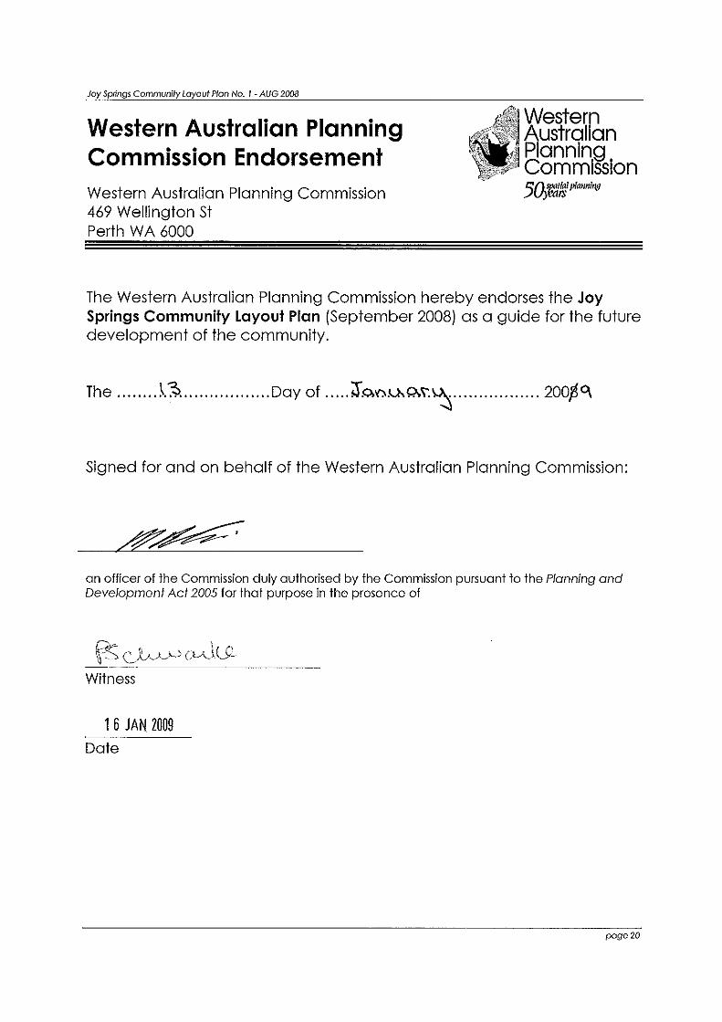
January 2009 Date endorsed by WAPC
Joy Springs (Eight Mile)
Layout Plan 1
Amendments Amendment 1 - September 2011 Amendment 2 - November 2012 Amendment 3 - November 2014 Amendment 4 - November 2014 Amendment 5 - July 2016
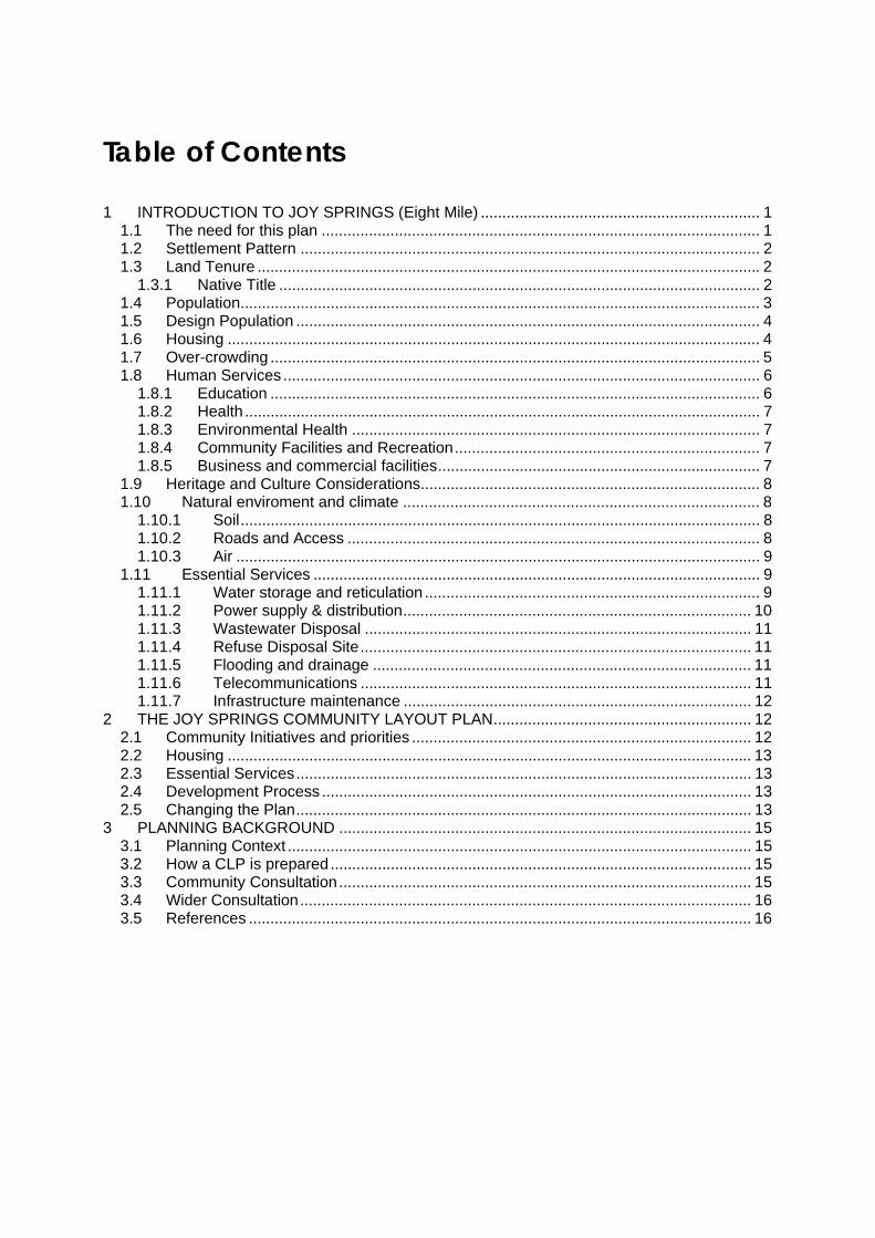
Table of Contents 1 INTRODUCTION TO JOY SPRINGS (Eight Mile) ................................................................. 1
1.1 The need for this plan ...................................................................................................... 1 1.2 Settlement Pattern ........................................................................................................... 2 1.3 Land Tenure ..................................................................................................................... 2
1.3.1 Native Title ................................................................................................................ 2 1.4 Population......................................................................................................................... 3 1.5 Design Population ............................................................................................................ 4 1.6 Housing ............................................................................................................................ 4 1.7 Over-crowding .................................................................................................................. 5 1.8 Human Services ............................................................................................................... 6
1.8.1 Education .................................................................................................................. 6 1.8.2 Health ........................................................................................................................ 7 1.8.3 Environmental Health ............................................................................................... 7 1.8.4 Community Facilities and Recreation....................................................................... 7 1.8.5 Business and commercial facilities........................................................................... 7
1.9 Heritage and Culture Considerations............................................................................... 8 1.10 Natural enviroment and climate ................................................................................... 8
1.10.1 Soil......................................................................................................................... 8 1.10.2 Roads and Access ................................................................................................ 8 1.10.3 Air .......................................................................................................................... 9
1.11 Essential Services ........................................................................................................ 9 1.11.1 Water storage and reticulation .............................................................................. 9 1.11.2 Power supply & distribution................................................................................. 10 1.11.3 Wastewater Disposal .......................................................................................... 11 1.11.4 Refuse Disposal Site........................................................................................... 11 1.11.5 Flooding and drainage ........................................................................................ 11 1.11.6 Telecommunications ........................................................................................... 11 1.11.7 Infrastructure maintenance ................................................................................. 12
2 THE JOY SPRINGS COMMUNITY LAYOUT PLAN............................................................ 12 2.1 Community Initiatives and priorities ............................................................................... 12 2.2 Housing .......................................................................................................................... 13 2.3 Essential Services.......................................................................................................... 13 2.4 Development Process .................................................................................................... 13 2.5 Changing the Plan.......................................................................................................... 13
3 PLANNING BACKGROUND ................................................................................................ 15 3.1 Planning Context ............................................................................................................ 15 3.2 How a CLP is prepared.................................................................................................. 15 3.3 Community Consultation................................................................................................ 15 3.4 Wider Consultation......................................................................................................... 16 3.5 References ..................................................................................................................... 16
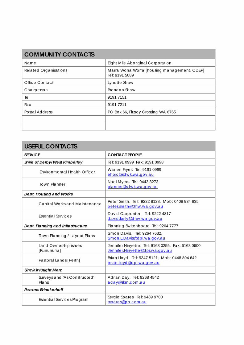
COMMUNITY CONTACTS Name Eight Mile Aboriginal Corporation
Related Organisations Marra Worra Worra [housing management, CDEP] Tel: 9191 5089
Office Contact Lynette Shaw
Chairperson Brendan Shaw
Tel 9191 7151
Fax 9191 7211
Postal Address PO Box 66, Fitzroy Crossing WA 6765
USEFUL CONTACTS SERVICE CONTACT PEOPLE
Shire of Derby/West Kimberley Tel: 9191 0999 Fax: 9191 0998
Environmental Health Officer Warren Fryer. Tel: 9191 0999 [email protected]
Town Planner Noel Myers. Tel: 9443 8273 [email protected]
Dept. Housing and Works
Capital Works and Maintenance Peter Smith. Tel: 9222 8128. Mob: 0408 934 835 [email protected]
Essential Services David Carpenter. Tel: 9222 4817 [email protected]
Dept. Planning and Infrastructure Planning Switchboard Tel: 9264 7777
Town Planning / Layout Plans Simon Davis. Tel: 9264 7632. [email protected]
Land Ownership issues [Kununurra]
Jennifer Ninyette. Tel: 9168 0255. Fax: 6168 0600 [email protected]
Pastoral Lands [Perth] Brian Lloyd. Tel: 9347 5121. Mob: 0448 894 642 [email protected]
Sinclair Knight Merz
Surveys and 'As Constructed' Plans
Adrian Day. Tel: 9268 4542 [email protected]
Parsons Brinckerhoff
Essential Services Program Sergio Soares. Tel: 9489 9700 [email protected]

List of Acronyms used in this Report AACAP ATSIC Army Community Assistance Program
ALT Aboriginal Lands Trust
ATSIC Aboriginal and Torres Strait Islander Council
CDEP Community Development Employment Program
CLP Community Layout Plan
DHW Department of Housing and Works
DIA Department of Indigenous Affairs
DPI Department for Planning and Infrastructure
EHNS Environmental Needs Health Survey
KRSP Kimberley Regional Service Providers
RAESP Remote Area Essential Services Program
WAPC Western Australia Planning Commission
ILUA Indigenous Land Use Agreement (under the Native Title Act)

Development Priorities Identified in CLP No. 1
The Joy Springs Community Layout Plan No. 1 has been prepared over a three-year period between 2005-2008. The Joy Springs community is rapidly growing and residential overcrowding has increased as a primary community concern during this period.
Development and land-use planning priorities and community aspirations centre on reducing overcrowding and identifying suitable future growth areas and infrastructure requirements.
Based on community aspirations and the land use needs for the settlement, the following projects have been identified as development priorities:
Within the next year:
• Allocate five additional residential lots to address overcrowding;
• Build five new residential dwellings to address overcrowding;
• Improve existing housing stock;
• Establish a second potable drinking water source outside the living area, preferably within the land holding of the Eight Mile Community;
• Increase the size of the Eight Mile Community landholding in consultation with GoGo Pastoral Station so that infrastructure, including future water source, tip and residential areas, can be accommodated.
Within the next five years:
• Determine suitable future growth areas, subject to enlarged landholding and further technical investigation;
• Undertake assessment of current power supply and increase its capacity, if necessary, to supply future growth area;
• Identify suitable area for market gardening, subject to available water source(s) and designated future growth area;
• Improve existing drainage infrastructure;
• Relocate the rubbish tip so that its buffer does not encroach on community living area or drinking water source;
• Establish sewerage ponds and connect to housing via reticulation;
• Bitumenise road layout within living area to reduce health problems associated with dust.
Within the next ten years:
• Build additional housing to accommodate design population;
• Relocate workshop away from living area
Joy Springs Community Layout Plan No. 1 - AUG 2008
page 1
1 INTRODUCTION TO JOY SPRINGS (Eight Mile) Joy Springs is located approximately 30km east of Fitzory Crossing in the Shire of Derby-West Kimberley. The community is positioned on the eastern side of the Great Northern Highway and surrounded by the GoGo pastoral lease. The community was established in 1987, as part of the broader outstation movement, by the late Mr. Jock Shandley, a Gooniandi man who had worked and lived on GoGo Station. Prior to establishing Joy Springs, Mr. Shandley would often camp at the site of the existing windmill at 8 Mile Well, on GoGo Station. The outstation was initially referred to as 'Jock Shandley's Camp'. The Joy Springs community today is located close to the 8 Mile Well and has an estimated 128 residents, most of whom are Gooniandi speakers and who are descended from Mr. Shandley.
1.1 The need for this plan This plan has been prepared to identify appropriate land for additional housing lots within the community. Overcrowding was identified as a critical issue during an environmental health needs survey (EHNS) in 2003, with an average of 7-8 occupants per house at that time. Overcrowding has become a greater problem since that time because the population has grown by some 44 people but no additional housing has been built since the 2003 survey. As a result of overcrowding, many community members who would otherwise live in the community have effectively been forced to relocate to other towns or communities, either on a part-time or permanent basis. Another important land-use planning issue is that the existing community drinking water source is located within the living area and is at risk of contamination from septic household wastewater. This plan has been prepared to identify possible sites and options for a new drinking water source, located away from the living area . The plan has been prepared in consultation with GoGo Station to identify a suitable area to be excised from the station lease for amalgamation with the Joy Springs landholding. This will enable future expansion of the community living area and will enable existing infrastructure such as the rubbish tip to be contained within the Joy Springs landholding, which at present is located on the GoGo lease. It is intended that this plan be used to assist in the orderly and efficient growth and development of Joy Springs, specifically in the delivery of much needed housing, and in informing negotiations for possible future Indigenous Land Use Agreements (ILUAs) and land tenure arrangements.
Joy Springs Community Layout Plan No. 1 - AUG 2008
page 2
1.2 Settlement Pattern The road layout is a two-loop system around centrally located open space and community facilities.
The settlement consists of 11 formal dwellings, an administrative office, former store, a workshop and a community hall. At the time of community consultation in August 2008, the community store and community office-buildings were being used as informal residential dwellings as a means of alleviating overcrowding.
Areas for future settlement should have primary regard to the location and capacity of existing and future drinking water sources. At present, no test drilling for new sources has been undertaken and therefore the location of a future bore remains unknown.
Future residential areas should be located in proximity to the existing power cable, as indicated on the plan, to minimize costs of establishing new infrastructure.
More detailed lot configuration and road layout within the future residential area should be worked out after an additional drinking water source has been secured.
Should future housing be located in the area as indicated on the plan then the existing rubbish tip will need to be moved so that the settlement is outside of its associated buffer.
1.3 Land Tenure Joy Springs is located on Crown Reserve 40569 (12ha) vested to the Aboriginal Lands Trust (ALT). The reserve is leased to Eight Mile Aboriginal Corporation (lease expires 30-Sep-2087).
Eight Mile Aboriginal Corporation was incorporated on 22 November 1988.
The existing infrastructure for Joy Springs is not fully contained within the Joy Springs crown reserve; the community's rubbish tip, cemetery, and several informal shelters are located on the abutting GoGo lease (Crown Lease 398/801). An amendment to cadastre is required to contain this existing infrastructure.
A cadastral amendment is also necessary for establishing a future living area, which will be required as soon as practicable to alleviate over-crowding.
Importantly, a new drinking water source is required for the community and this will need to be secured either by increasing the landholding of the community via cadastral amendment or by formalizing an easement right over a source such as the 8 Mile Well on the abutting GoGo Station.
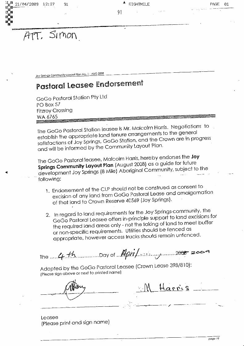
The GoGo Station lessee has indicated in-principle support for excising a portion of the existing pastoral lease for the purpose of amalgamating with the Joy Springs reserve.
A proposed suitable area for excision from the GoGo lease and amalgamation with the Joy Springs reserve, as discussed with both parties during preparation of this plan, is indicated on the CLP as the 'suggested cadastre amendment area'.
1.3.1 Native Title Crown Reserve 4059 and Crown Lease 398/801 fall within the Gooniyandi Combined #2 native title claim, registered with the National Native Title Tribunal in 2001 (WC00/10). Registered claims and claimants have the right to negotiate with other land users, under the Native Title Act.

Joy Springs Community Layout Plan No. 1 - AUG 2008
page 3
The claim is currently active and yet-to-be-determined.
1.4 Population Populations in Aboriginal communities often vary because people can be mobile with changing housing and living arrangements. Populations can increase or decrease quite rapidly based on family, cultural and administrative factors. Population figures change based on the time of year of enumeration, methods and sources by which data are collected. Population figures can also vary due to changing census boundaries over time.
Australian Bureau of Statistics (ABS) census boundaries changed at the collection district (CD) level for Joy Springs between 2001 and 20061. The CD for Joy Springs is not comparable during this period due to an amalgamation of three or more CDs.
ABS census data for Joy Springs in 2006 record the population as 70 on the day of enumeration, 65 of which were Aboriginal people. This figure seems too low and could possibly be explained by, for example, community members attending a funeral or other significant event at the time of enumeration.
Further, these figures are problematic because ABS data for that year also record that there were 14 dwellings, which means that either the boundaries for the CD are larger than those of the Joy Springs community or that informal shelters, the workshop and administrative offices had been miscalculated as formal dwellings.
For these reasons, ABS data for Joy Springs are considered here as being unreliable.
An Environmental Health Needs Survey (EHNS) undertaken by the Shire of Derby-West Kimberley's Environmental Health Officer in 2003 recorded the resident Indigenous population as 84. This figure included 4 children and 4 adults living in an informal shelter without walls. This population figure of 84 was reported by the Shire's EHO to the then Minister for Housing2.
The estimated population for December 2005, based on persons enumerated in a letter sent by the Chair of Joy Springs to the Department of Housing and Works, is 105 residents. This figure is derived from those persons named in the letter as living in overcrowded dwellings (house numbers 2, 3, 5, 6, 7, 8, 9, 10) plus the number of people living in remaining houses (as enumerated in the 2003 EHNS) plus the family members recorded as living in the make-shift shelter, as outlined in the letter.
The community Chairperson enumerates the usual resident population (as at July 2008) as 128 residents, with approximately 100 residents currently in the community. It was explained by the community that up to 28 family members have been forced to leave Joy Springs to nearby communities including Junjuwa and Bayulu, Fitzroy Crossing, or as far away as Derby, to alleviate overcrowding.
It is anticipated that community members will return to Joy Springs once additional housing has been built and the issue of overcrowding has been ameliorated.
1 The ABS Collection District identification number for Joy Springs at the 2001 census was 5010309 while in 2006 this had changed to 5010335, with a comparability change code of '8' between the two periods. See ABS website for a further explanation of comparability change codes. 2 The Shire EHO’s letter to the then Minister for Housing outlined the situation of overcrowding and asked for additional housing to be built to ameliorate the problem.

Joy Springs Community Layout Plan No. 1 - AUG 2008
page 4
The Shire's Environmental Health Officer has informed that overcrowding remains an issue for the Joy Springs community at the present time.
Based on the above, this report assumes that the Joy Springs resident population has grown by about 36-44 people, from 84 to 120-128, in the period between 2003 – 2008.
1.5 Design Population The Western Australian Planning Commission’s Fitzroy Futures Town Plan (WAPC 2005) estimates a 5 per cent annual growth rate for communities in Fitzroy Crossing.
The estimated design population for Joy Springs over a 15-year period, based on a current population of 120 and an annual growth rate of 5 per cent, is 195 residents by 2018 (10 years) and 250 residents by 2023 (15 years).
This is considered a conservative estimate, given that the current population may be as high as 128 residents, which would result in a population of 266 residents by 2023 if growth increased by 5 per cent per year.
Growth of the Joy Springs community should be seen within the broader regional context of the Kimberley. The State Planning Strategy (WAPC 1997) anticipates that centres within the Kimberley region will expand and offer a range of services to the growing population.
This conservative estimate of 250 residents in 15 years based on an annual growth rate of 5 per cent does not consider that communities such as Joy Springs, located close to the regional centre of Fitzroy Crossing, might experience additional growth due to in-migration from more remote communities as the price of fuel and diesel increase during that same period.
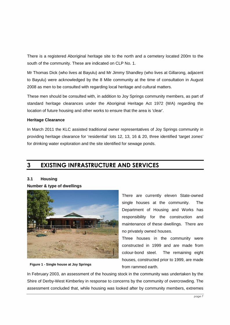
1.6 Housing There are currently eleven State-owned single houses at the community. The Department of Housing and Works has responsibility for the construction and maintenance of these dwellings. There are no privately owned houses. Three houses in the community were constructed in 1999 and are made from colour-bond steel. The remaining eight houses, constructed prior to 1999, are made from rammed earth.
Figure 1 - Single house at Joy Springs In February 2003, an assessment of the housing stock in the community was undertaken by the Shire of Derby-West Kimberley in response to concerns by the community of overcrowding. The assessment concluded that, while housing was looked after by community members, extremes in weather combined with poor housing design and
Joy Springs Community Layout Plan No. 1 - AUG 2008
page 5
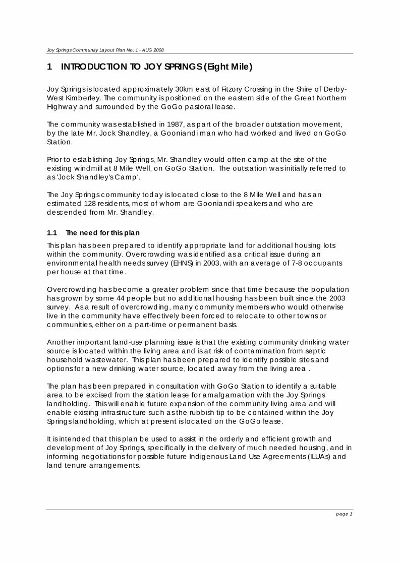
overcrowding required the need for additional housing and repairs to older housing stock. The Shire's EHO found evidence of termite activity at the community office in 2003 and it is possible that this building has suffered structural damage as a result.
Figure 2 - Buckled cornice & water damage to ceiling in kitchen area due to housing design/construction and environmental conditions (source: Shire EHO 2003) At the time of the most recent site visit in August 2008, prior to the preparation of this report, no additional housing had been built since 2003 and dwellings still required repairs and renovation.
Four new houses have been programmed by DHW for completion in the forthcoming year, subject to native title issues.
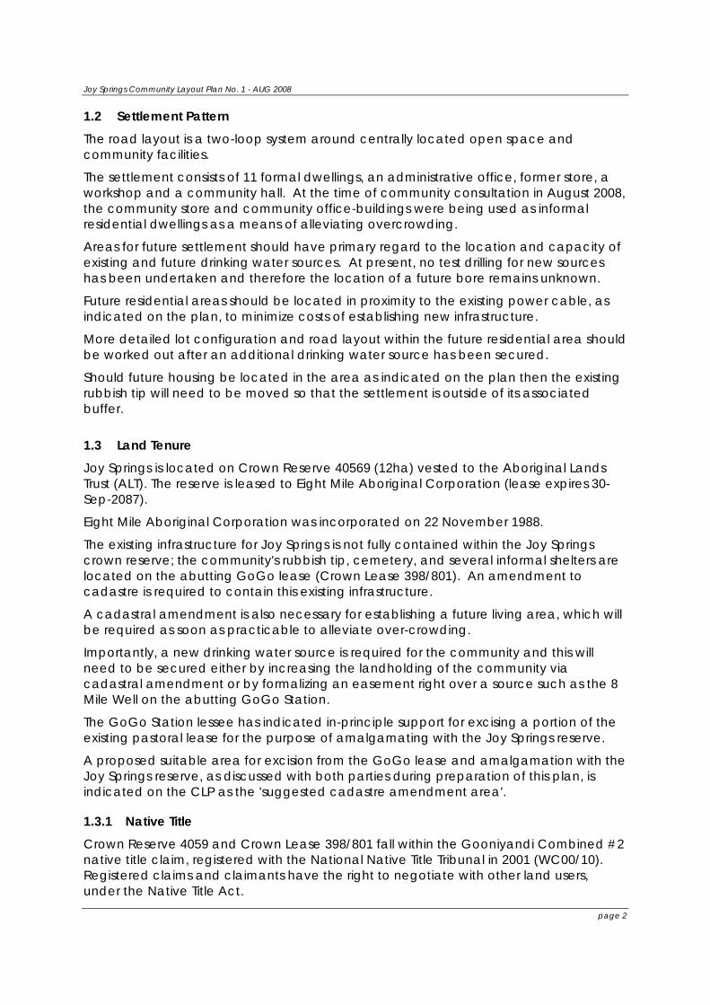
1.7 Over-crowding In the period between 2003-2008, make-shift shelters without walls, toilets or running water had variously been used to accommodate families of up to 8 people, though none were being used as dwellings as at August 2008.
As a means of alleviating over-crowding, part of the administration office is currently being used to house 2 adults and the former community store is currently being used to house 2 families consisting of 9 people. The table below illustrates the situation of over-crowding as it existed at the time of the EHNS in 2003.
Figure 3 - Site of former make-shift shelter used to accommodate residents
Joy Springs Community Layout Plan No. 1 - AUG 2008
page 6
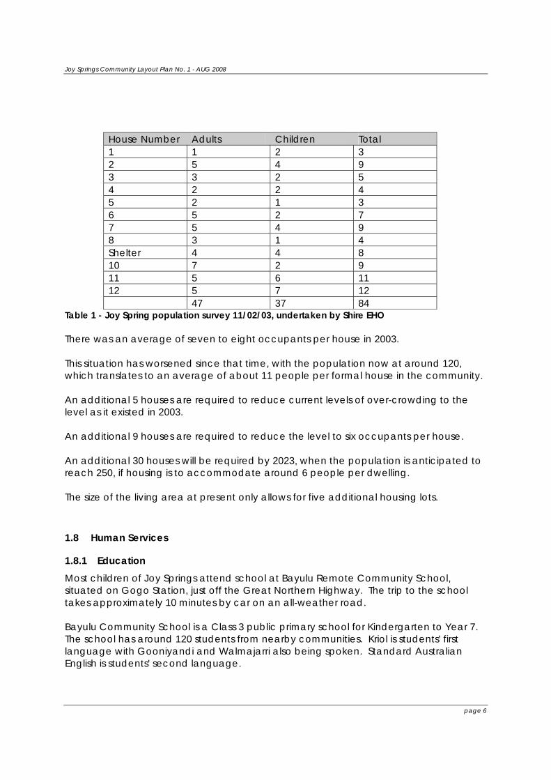
House Number Adults Children Total 1 1 2 3 2 5 4 9 3 3 2 5 4 2 2 4 5 2 1 3 6 5 2 7 7 5 4 9 8 3 1 4 Shelter 4 4 8 10 7 2 9 11 5 6 11 12 5 7 12 47 37 84
Table 1 - Joy Spring population survey 11/02/03, undertaken by Shire EHO There was an average of seven to eight occupants per house in 2003. This situation has worsened since that time, with the population now at around 120, which translates to an average of about 11 people per formal house in the community. An additional 5 houses are required to reduce current levels of over-crowding to the level as it existed in 2003. An additional 9 houses are required to reduce the level to six occupants per house. An additional 30 houses will be required by 2023, when the population is anticipated to reach 250, if housing is to accommodate around 6 people per dwelling. The size of the living area at present only allows for five additional housing lots.
1.8 Human Services
1.8.1 Education Most children of Joy Springs attend school at Bayulu Remote Community School, situated on Gogo Station, just off the Great Northern Highway. The trip to the school takes approximately 10 minutes by car on an all-weather road. Bayulu Community School is a Class 3 public primary school for Kindergarten to Year 7. The school has around 120 students from nearby communities. Kriol is students' first language with Gooniyandi and Walmajarri also being spoken. Standard Australian English is students' second language.
Joy Springs Community Layout Plan No. 1 - AUG 2008
page 7
The school has a Principal and 9 teachers who are assisted by 7 local Education Assistants.
1.8.2 Health Overcrowding in houses not only places stress on housing hardware, but may increase the risk of infection and the spread of infectious disease between occupants. In addition to this, over-crowding reduces opportunities for young families to be afforded privacy and sufficient space to look after young children. The community also has a problem with dust from the surrounding landscape and unsealed roads. Many children in the community suffer from asthma and some have required hospitalization overnight so that breathing can be assisted with ventolin. In 2007 the community’s only water source became contaminated after a bird was trapped and died inside the water storage tower, resulting in complaints of gastro problems and giardiasis. Residents had to boil their water for several weeks thereafter. This issue highlights the importance of securing a second drinking water source for the community to ensure adequate standards of public health are maintained. There is no medical clinic at Joy Springs. There is a medical clinic at Bayulu community, which also services the 8 Mile community. Residents also use medical facilities at Fitzroy Crossing, which is a 20 minute drive by car.
1.8.3 Environmental Health The Shire 's EHO and field support officers visit the community every 4-6 weeks. They undertake general checks on infrastructure including store fridges/freezers, effluent ponds, rubbish dump, fuel tanks and other primary contaminant points.
1.8.4 Community Facilities and Recreation Two large public open space areas are located in the middle of the community, which include a playset and swings. A creek line runs through the bottom open space area, which is at times inundated with water.
1.8.5 Business and commercial facilities A workshop is located in the northern area of the community on Lot 21.
The Community Development Employment Program is the primary means of employment. Some residents have been able to get work with the surrounding mines, at Marra Worra Worra resource centre, Gogo school and other jobs in the townsite. At the time of community consultation in August 2008, one of the surrounding mines had recently closed resulting in employment uncertainty for some community members.
The community hopes to establish horticultural gardens an area north of the proposed future residential area, however this will require more water resources available than at present. It is anticipated that the current water source might be used for horticultural
Joy Springs Community Layout Plan No. 1 - AUG 2008
page 8
purposes if a second drinking water source, such as the 8 Mile Well on GoGo Station, is secured in the future.
1.9 Heritage and Culture Considerations While the community has not identified any “no go” areas within the living and surrounding area, there is a registered Aboriginal heritage site to the north and a cemetery located 200m to the south of the community, both of which are indicated on CLP No. 1.
Mr Thomas Dick (who lives at Bayulu) and Mr Jimmy Shandley (who lives at Gillarong, adjacent to Bayulu) were acknowledged by the 8 Mile community at the time of consultation in August 2008 as men to be consulted with regarding local heritage and cultural matters.
These men should be consulted with, in addition to Joy Springs community members, as part of standard heritage clearances under the Aboriginal Heritage Act 1972 (WA) regarding the location of future housing and other works to ensure that the area is 'clear'.
The future expansion of the community's infrastructure will also be subject to native title considerations, and consultation with the relevant traditional Gooniyandi owners must occur to ensure that native title is not extinguished in the act of establishing, eg. future housing.
It is beyond the scope of this CLP to identify the relevant traditional owners for such consultation. Government agencies should contact the Kimberley Land Council (KLC) in that regard.
1.10 Natural enviroment and climate Joy Springs is subject to a dry winter and a wet summer. Average annual rainfall is approximately 537mm with an average of 49 rain days. Most of this rainfall is recorded in the months from December to March. During this time localised flooding is common and access to Fitzroy Crossing can be cut off during this time. From May to October, days are warm and dry and nights cool whilst December to March in most years, tropical storms are common. The average maximum temperature is 35.7 degrees C and the average minimum temperature is 19.2 degrees C. The variations in rainfall and temperature result in high levels of humidity.
1.10.1 Soil The soil type is predominantly a mix of ‘pindan’ or red brown sand clay in addition to areas of hard rock.
1.10.2 Roads and Access Access to the community is provided via a diversion road from the Great Northern Highway, 24km from Fitzroy Crossing.
Joy Springs Community Layout Plan No. 1 - AUG 2008
page 9
The internal road layout involves two looped unsealed roads around two open space areas.
1.10.3 Air Dust has been identified as an issue in the community mainly due to the surrounding environment combined with unsealed roads.
1.11 Essential Services
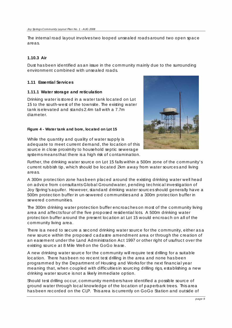
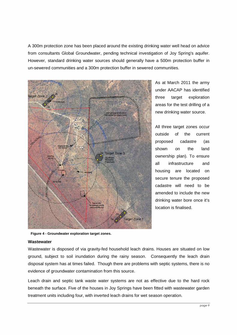
1.11.1 Water storage and reticulation Drinking water is stored in a water tank located on Lot 15 to the south-west of the townsite. The existing water tank is elevated and stands 2.4m tall with a 7.7m diameter.
Figure 4 - Water tank and bore, located on Lot 15 While the quantity and quality of water supply is adequate to meet current demand, the location of this source in close proximity to household septic sewerage systems means that there is a high risk of contamination.
Further, the drinking water source on Lot 15 falls within a 500m zone of the community’s current rubbish tip, which should be located 2km away from water sources and living areas.
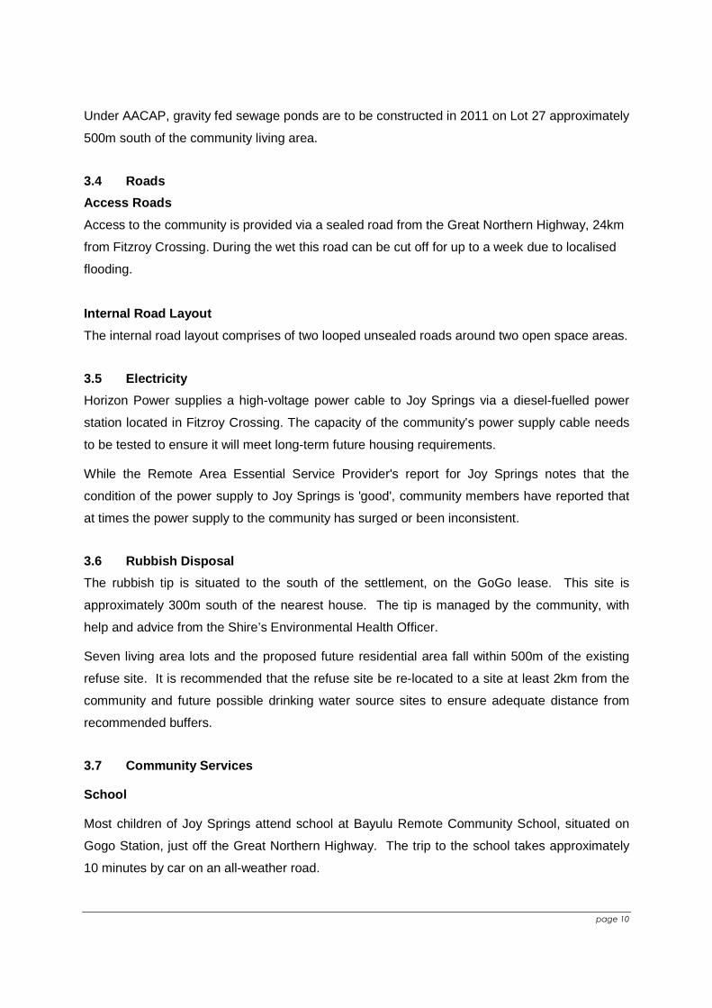
A 300m protection zone has been placed around the existing drinking water well head on advice from consultants Global Groundwater, pending technical investigation of Joy Spring's aquifer. However, standard drinking water sources should generally have a 500m protection buffer in un-sewered communities and a 300m protection buffer in sewered communities.
The 300m drinking water protection buffer encroaches on most of the community living area and affects four of the five proposed residential lots. A 500m drinking water protection buffer around the present location at Lot 15 would encroach on all of the community living area.
There is a need to secure a second drinking water source for the community, either as a new source within the proposed cadastre amendment area or through the creation of an easement under the Land Administration Act 1997 or other right of usufruct over the existing source at 8 Mile Well on the GoGo lease.
A new drinking water source for the community will require test drilling for a suitable location. There has been no recent test drilling in the area and none has been programmed by the Department of Housing and Works for the next financial year meaning that, when coupled with difficulties in sourcing drilling rigs, establishing a new drinking water source is not a likely immediate option.
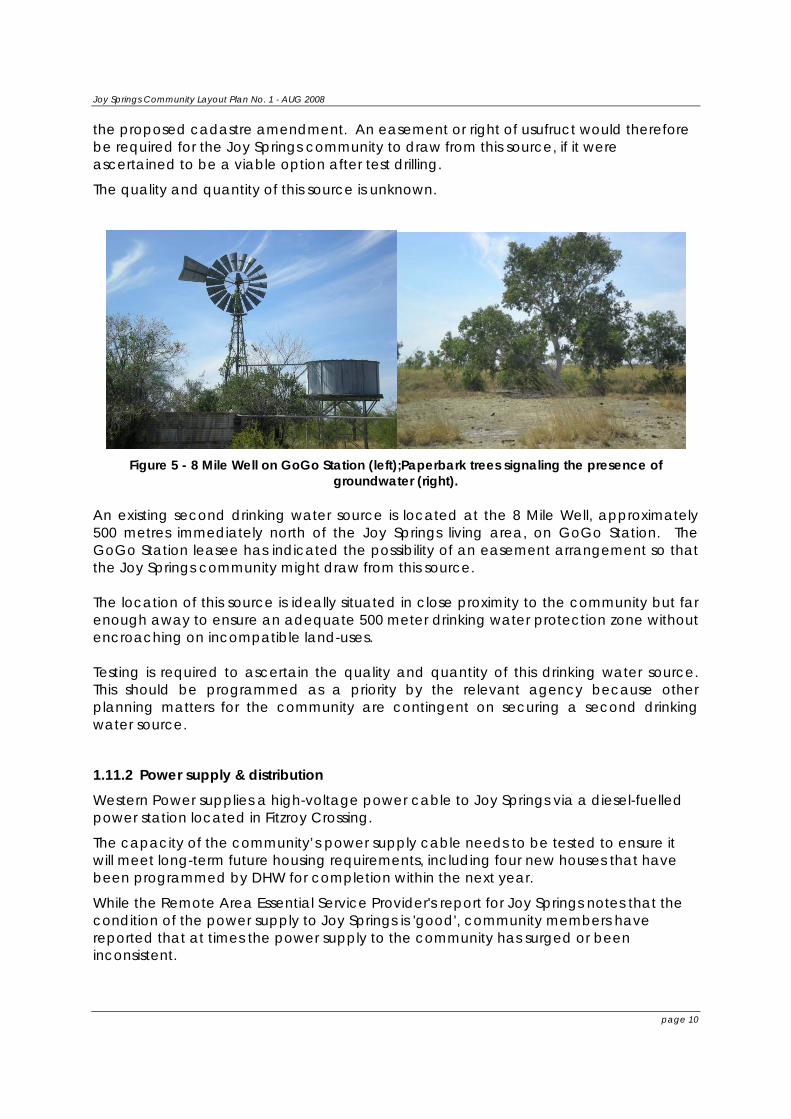
Should test drilling occur, community members have identified a possible source of ground water through local knowledge of the location of paperbark trees. This area has been recorded on the CLP. This area is currently on GoGo Station and outside of
Joy Springs Community Layout Plan No. 1 - AUG 2008
page 10
the proposed cadastre amendment. An easement or right of usufruct would therefore be required for the Joy Springs community to draw from this source, if it were ascertained to be a viable option after test drilling.
The quality and quantity of this source is unknown.
Figure 5 - 8 Mile Well on GoGo Station (left);Paperbark trees signaling the presence of
groundwater (right). An existing second drinking water source is located at the 8 Mile Well, approximately 500 metres immediately north of the Joy Springs living area, on GoGo Station. The GoGo Station leasee has indicated the possibility of an easement arrangement so that the Joy Springs community might draw from this source. The location of this source is ideally situated in close proximity to the community but far enough away to ensure an adequate 500 meter drinking water protection zone without encroaching on incompatible land-uses. Testing is required to ascertain the quality and quantity of this drinking water source. This should be programmed as a priority by the relevant agency because other planning matters for the community are contingent on securing a second drinking water source.
1.11.2 Power supply & distribution Western Power supplies a high-voltage power cable to Joy Springs via a diesel-fuelled power station located in Fitzroy Crossing.
The capacity of the community’s power supply cable needs to be tested to ensure it will meet long-term future housing requirements, including four new houses that have been programmed by DHW for completion within the next year.
While the Remote Area Essential Service Provider's report for Joy Springs notes that the condition of the power supply to Joy Springs is 'good', community members have reported that at times the power supply to the community has surged or been inconsistent.
Joy Springs Community Layout Plan No. 1 - AUG 2008
page 11
1.11.3 Wastewater Disposal Wastewater is disposed of via a gravity-operated sewerage system, linking household septic tanks.
Houses are situated on low ground, subject to soil inundation during the rainy season. Consequently, normal leach drain disposal has at times failed. Though there are problems with septic systems, there is no evidence of contamination from this source.
The typical waste water systems are not as effective due to the hard rock beneath the surface. Five of the houses in Joy Springs have been fitted with wastewater garden treatment units including four with inverted leach drains for wet season operation.
The CLP indicates an area south of the community living area for the possible location of future sewerage ponds and associated 500m buffer, subject to technical investigation. The location of future ponds should be assessed only after a second drinking water source has been secured.
1.11.4 Refuse Disposal Site The rubbish tip is situated to the south of the settlement, on the GoGo lease. This site is approximately 300m south of the nearest house. The tip is managed by the community, with help and advice from the Shire’s Environmental Health Officer.
Seven living area lots and the proposed future residential area fall within 500m of the existing refuse site. It is recommended that the refuse site be re-located at a site at least 2km from the community and future possible drinking water source sites to ensure adequate distance from recommended buffers.
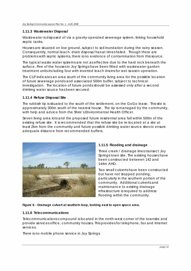
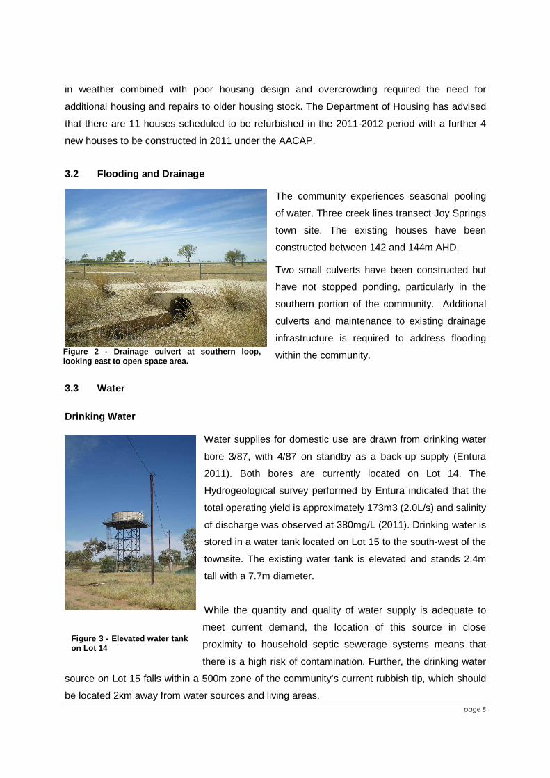
1.11.5 Flooding and drainage Three creek / drainage lines transect Joy Springs town site. The existing houses have been constructed between 142 and 144m AHD.
Two small culverts have been constructed but have not stopped ponding, particularly in the southern portion of the community. Additional culverts and maintenance to existing drainage infrastructure is required to address flooding within the community.
Figure 6 - Drainage culvert at southern loop, looking east to open space area.
1.11.6 Telecommunications Telecommunications compound is located in the north-west corner of the townsite and provide services office, community houses. This provides for telephone, fax and Internet services.
There is no mobile phone service in Joy Springs.

Joy Springs Community Layout Plan No. 1 - AUG 2008
page 12
A radio mast is positioned on Crown Reserve 45630, adjacent to the Great Northern Highway.
1.11.7 Infrastructure maintenance KRSP are contracted under the Remote Area Essential Services Program (RAESP) for planned maintenance (on a 6 week cycle) to service all infrastructure outside of the designated property boundaries (fence line or reasonable residential yard). They attend breakdown and emergency repairs as needed.
Everyday operation and maintenance within houses and lot boundaries is the responsibility of the community. Training programs have been undertaken to ensure ESOP’s (Essential Service Operators Program) from the community have the skills and possible on-going employment as part of the CDEP. This may also be done by hired tradesmen.
2 THE JOY SPRINGS COMMUNITY LAYOUT PLAN This next section describes the community layout plan, and provides information and justification for the plan. The layout plan is included at the back of this report.
2.1 Community Initiatives and priorities Based on community aspirations and the land use needs for the settlement, the following projects have been identified as development priorities:
Within the next year:
• Allocate five additional residential lots to address overcrowding;
• Build five new residential dwellings to address overcrowding;
• Improve existing housing stock;
• Establish a second potable drinking water source outside the living area, preferably within the land holding of the Eight Mile Community;
• Increase the size of the Eight Mile Community landholding in consultation with GoGo Pastoral Station so that infrastructure, including future water source, tip and residential areas, can be accommodated.
Within the next five years:
• Determine suitable future growth areas, subject to enlarged landholding and further technical investigation;
• Undertake assessment of current power supply and increase its capacity, if necessary, to supply future growth area;
• Identify suitable area for market gardening, subject to available water source(s) and designated future growth area;
• Improve existing drainage infrastructure;
• Relocate the rubbish tip so that its buffer does not encroach on community living area or drinking water source;
• Establish sewerage ponds and connect to housing via reticulation;

Joy Springs Community Layout Plan No. 1 - AUG 2008
page 13
• Bitumenise road layout within living area to reduce health problems associated with dust.
Though the CLP has allocated land for these purposes where required, delivery of these projects is the subject of other programs and agencies.
2.2 Housing The CLP provides for 5 new housing blocks which are positioned to consolidate the settlement and utilise existing infrastructure services.
To accommodate for future growth, adjustments are required to the existing lease boundary, to include the land approximately 550m east of the settlement and south, as far as the muster setback from the Great Northern Highway. It is noted that prior to pursuing boundary changes, the suitability of this land for development should be determined, particularly in relation to ground water sources and soil types.
2.3 Essential Services Services at Joy Springs are generally well located. With the exception of the existing drinking water source and tip site, there are adequate buffers between essential services and existing and proposed houses. It is recommended that the future tip be located in the southern most corner of the future lease area, if not 2km away, to ensure an adequate buffer from living areas and the future drinking water source. However the south-east corner of the future cadastre amendment area may not prove a suitable site for the tip if the new drinking water source is located near the existing paperbark trees, as indicated on the plan.
2.4 Development Process When new development is proposed, the following should happen:
1. developer / builder gets a copy of the plan; 2. developer / builder chooses site in consultation with Joy Springs community; 3. Joy Springs approves or refuses development site and design of building; 4. If approved developer / builder seeks planning / building / environmental health
approval through the Shire of Derby/West Kimberley 3; 5. Development can occur.
All new houses must be connected to essential services. Once development is complete, the developer / builder must survey the location of the new building and essential service connections and supply to Sinclair Knight Merz. This will keep an accurate record of development and services at Joy Springs.
2.5 Changing the Plan Over time it may be necessary to change the plan to suit community needs or specific proposals. If a development is proposed that does not fit in with the plan, the plan can be changed. However, before the plan is changed, people need to think about things like: 3 fees apply for planning and building approvals lodged with the Shire of Derby/West Kimberley

Joy Springs Community Layout Plan No. 1 - AUG 2008
page 14
• how the change could affect other people or the lifestyle of Joy Springs; or • how the change could affect essential services like power lines, water pipes or
telephone lines. If the plan needs to be changed, this is process that should be followed:
1. Developer / builder speaks to Joy Springs about the change and why it is needed;
2. Joy Springs agrees to change the plan, or not change the plan; 3. If the plan is to be changed, the developer / builder should have this approved
by the Shire of Derby/West Kimberley; 4. If the change is agreed on, the Shire of Derby/West Kimberley must notify the
DPI, so they can change the layout plan and give new copies to Joy Springs and the Shire.

Joy Springs Community Layout Plan No. 1 - AUG 2008
page 15
3 PLANNING BACKGROUND
3.1 Planning Context This document was prepared by the Department for Planning and Infrastructure, under the Western Australian Planning Commission's (WAPC) Planning for Aboriginal Communities Project. Planning for Aboriginal communities is given policy direction from:
• The State Planning Strategy; and • Statement of Planning Policy No. 3.2 - Planning for Aboriginal communities,
prepared under Part 3 of the Planning and Development Act 2005. Joy Springs community is not currently covered by a town planning scheme or interim development order (IDO). However, the Shire is currently progressing an all-of-shire IDO that will give the Shire development control over its entire municipality. An IDO is a temporary measure to control development while a town planning scheme is being developed.
3.2 How a CLP is prepared A CLP provides a land use planning structure for future development in a settlement. It has a 5-10 year outlook taking into account existing conditions, demographics and the community’s aspirations. It also aims to co-ordinate development and provide a means of implementing the plan.
The basic process is:
• prepare plan in collaboration with community and stakeholders, including landowner (usually DIA/ALT), local government, DPI, service providers, RAESP managers and developers.
• seek endorsement of community council as the accepted development plan for the community.
• seek local government endorsement. • seek landowner endorsement where there are land tenure matters that require
resolution (currently informal requirement that may become a formal requirement)
• seek WAPC endorsement Regular reviews should be conducted subsequent to this at times of large planned capital works or as monitoring of the existing conditions on a community highlights the need for further planning work eg. major population expansion.
3.3 Community Consultation The plan was developed in consultation with the community via a series of community meetings and site visits. This also involved discussions with community administrators and school staff.
Joy Springs Community Layout Plan No. 1 - AUG 2008
page 16
Meetings were conducted on:
• 2 May 2005 • 14 June 2005 • 24 August 2005 • 13 August 2008
3.4 Wider Consultation This plan and report was developed between 2005-2008 in discussion and consultation with the Shire of Derby/West Kimberley, RAESP managers, Department of Housing and Works, Department of Indigenous Affairs and a range of organisations that work at Joy Springs.
3.5 References Western Australian Planning Commission (WAPC) 2005 Fitzroy Futures Town Plan - Draft December 2004. WAPC: Perth.

AMENDMENTS
Joy Springs Layout Plan 1 Amendment 1
Background Report
September 2011
Prepared by the Department of Planning
page 1
Joy Springs CLP1 Amendment 1 - Report
SUMMARY ................................................................................................................................ 2 1 DEVELOPMENT PRIORITIES........................................................................................... 3 2 COMMUNITY PROFILE..................................................................................................... 4
2.1 Population.................................................................................................................... 4 2.2 Governance ................................................................................................................. 5 2.3 Land Tenure ................................................................................................................ 6 2.4 Native Title................................................................................................................... 6 2.5 Heritage ....................................................................................................................... 6
3 EXISTING INFRASTRUCTURE AND SERVICES ............................................................. 7 3.1 Housing ....................................................................................................................... 7 3.2 Flooding and Drainage................................................................................................. 8 3.3 Water........................................................................................................................... 8 3.4 Roads .........................................................................................................................10 3.5 Electricity ....................................................................................................................10 3.6 Rubbish Disposal ........................................................................................................10 3.7 Community Services...................................................................................................10
4 RECOMENDATIONS........................................................................................................12 4.1 Future Housing ...........................................................................................................12 4.2 Essential Services.......................................................................................................12 4.3 Suggested Cadastre Amendment Area.......................................................................12 4.4 Development Process.................................................................................................12 4.5 Amendments to the Layout Plan .................................................................................13
5 REFERENCES..................................................................................................................14 6 ENDORSEMENTS............................................................................................................15 7 ATTACHMENTS...............................................................................................................16
Community Contacts
Name : Eight Mile Aboriginal Corporation
Related Organisations
: Marra Worra Worra [housing management, CDEP] Tel: 9191 5089
Office Contact : Lynette Shaw
Chairperson : Andrew Shandley
Tel : 9191 7151
Fax : 9191 7211
Postal Address : PO Box 66, Fitzroy Crossing WA 6765
page 2
SUMMARY
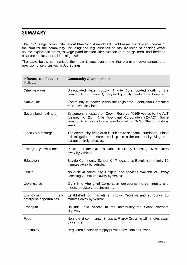
The Joy Springs Community Layout Plan No.1 Amendment 1 addresses the revised updates of the plan for the community, including: the regularisation of lots, inclusion of drinking water source exploration areas, sewage pond location, identification of a ‘no go area’ and heritage clearance of lots for residential growth.
The table below summarises the main issues concerning the planning, development and provision of services within Joy Springs.
Infrastructure/service Indicator
Community Characteristics
Drinking water Unregulated water supply. 8 Mile Bore located north of the community living area. Quality and quantity meets current needs.
Native Title Community is located within the registered Gooniyandi Combined #2 Native title Claim.
Secure land holding(s) Settlement is located on Crown Reserve 40569 vested to the ALT (Leased to Eight Mile Aboriginal Corporation (EMAC). Some community infrastructure is also located on GoGo Station pastoral lease.
Flood / storm surge The community living area is subject to seasonal inundation. Flood risk mitigation measures are in place in the community living area but not entirely effective.
Emergency assistance Police and medical assistance in Fitzroy Crossing 15 minutues away by vehicle.
Education Bayulu Community School K-Y7 located at Bayulu community 10 minutes away by vehicle.
Health No clinic at community. Hospital and services available at Fitzroy Crossing 20 minutes away by vehicle.
Governance Eight Mile Aboriginal Corporation represents the community and meets regulatory requirements.
Employment and enterprise opportunities
Established job markets at Fitzroy Crossing and surrounds 15 minutes away by vehicle.
Transport Reliable road access to the community via Great Northern Highway.
Food No store at community. Shops at Fitzroy Crossing 15 minutes away by vehicle.
Electricity Regulated electricity supply provided by Horizon Power.
page 3
1 DEVELOPMENT PRIORITIES
The Joy Springs Community Layout Plan No. 1 Amendment 1 Report has been prepared to
identify changes to the plan at the request of EMAC, the Department of Housing and
Department of Defence. The Joy Springs community is rapidly growing and residential
overcrowding has increased as a primary community concern. To alleviate the immediate
burden of overcrowding; new housing, sewage ponds and a water bore have been proposed to
be built for the community under the Army Aboriginal Community Assistance Program (AACAP)
and are discussed in this report.
Based on community aspirations and the land use needs for the settlement, the following
projects have been identified as development priorities:
Within the next year:
• Build five additional residential houses to address overcrowding (AACAP)
• Improve existing housing stock;
• Establish a second potable drinking water source outside the living area, preferably within the land holding of the Eight Mile Community (AACAP)
• Increase the size of the Eight Mile Community landholding in consultation with GoGo Pastoral Station so that infrastructure, including future water source, sewage ponds, tip and residential areas, can be accommodated.
• Establish sewerage ponds and connect to housing via reticulation;
Within the next five years:
• Determine suitable future growth areas, subject to enlarged landholding and further technical investigation;
• Undertake assessment of current power supply and increase its capacity, if necessary, to supply future growth area;
• Identify suitable area for market gardening, subject to available water source(s) and designated future growth area;
• Improve existing drainage infrastructure;
• Relocate the rubbish tip so that its buffer does not encroach on community living area or drinking water source;
• Form and drain road layout within living area to reduce health problems associated with dust.
Within the next ten years:
• Build additional housing to accommodate design population;
• Relocate workshop away from living area
page 4
2 COMMUNITY PROFILE
2.1 Population
Existing Population
Populations in Aboriginal communities often vary because people can be mobile with changing
housing and living arrangements. Populations can increase or decrease quite rapidly based on
family, cultural and administrative factors. Population figures change based on the time of year
of enumeration, methods and sources by which data are collected. Population figures can also
vary due to changing census boundaries over time.
Australian Bureau of Statistics (ABS) census boundaries changed at the collection district (CD)
level for Joy Springs between 2001 and 20061. The CD for Joy Springs is not comparable
during this period due to an amalgamation of three or more CDs.
ABS census data for Joy Springs in 2006 record the population as 70 on the day of
enumeration, 65 of which were Aboriginal people. This figure seems too low and could possibly
be explained by, for example, community members attending a funeral or other significant event
at the time of enumeration.
Further, these figures are problematic because ABS data for that year also record that there
were 14 dwellings, which means that either the boundaries for the CD are larger than those of
the Joy Springs community or that informal shelters, the workshop and administrative offices
had been miscalculated as formal dwellings.
For these reasons, ABS data for Joy Springs are considered here as being unreliable.
An Environmental Health Needs Survey (EHNS) undertaken by the Shire of Derby-West
Kimberley's Environmental Health Officer in 2003 recorded the resident Indigenous population
as 84. This figure included 4 children and 4 adults living in an informal shelter without walls.
This population figure of 84 was reported by the Shire's EHO to the then Minister for Housing2.
The estimated population for December 2005, based on persons enumerated in a letter sent by
the Chair of Joy Springs to the Department of Housing and Works, is 105 residents. This figure
is derived from those persons named in the letter as living at Joy Springs.
1 The ABS Collection District identification number for Joy Springs at the 2001 census was 5010309 while in 2006 this had changed to 5010335, with a comparability change code of '8' between the two periods. See ABS website for a further explanation of comparability change codes. 2 The Shire EHO’s letter to the then Minister for Housing outlined the situation of overcrowding and asked for additional housing to be built to ameliorate the problem.
page 5
Joy Springs is located approximately 30km east of Fitzroy Crossing in the Shire of Derby-West
Kimberley. The community is positioned on the eastern side of the Great Northern Highway and
surrounded by the GoGo pastoral lease.
Design Population The Western Australian Planning Commission’s Fitzroy Futures Town Plan (WAPC 2005)
estimates a 5 per cent annual growth rate for communities in Fitzroy Crossing.
The estimated design population for Joy Springs over a 15-year period, based on a current
population of 120 and an annual growth rate of 5 per cent, is 195 residents by 2018 (10 years)
and 250 residents by 2023 (15 years).
This is considered a conservative estimate, given that the current population may be as high as
128 residents, which would result in a population of 266 residents by 2023 if growth increased
by 5 per cent per year.
Growth of the Joy Springs community should be seen within the broader regional context of the
Kimberley. The State Planning Strategy (WAPC 1997) anticipates that centers within the
Kimberley region will expand and offer a range of services to the growing population.
The design population of Joy Springs is 250 people.
2.2 Governance
Eight Mile Aboriginal Corporation is the incorporated community council that represents the Joy
Springs community. The objectives of EMAC, as provided in the EMAC rule book (2009), are to
provide direct relief from poverty, sickness, suffering, destitution, misfortune, distress and
helplessness to all Aboriginal people in the State of Western Australia without discrimination
and to include, but without limiting the generality of the above, the following:
(a) support the social development of its members in all ways;
(b) help to bring about the self support of its members by the development of economic
projects and industries;
(c) support education, job training, health services, work and housing for its members;
(d) help and encourage its members to manage their affairs upon their own lands;
(e) help and encourage its members to keep and renew their traditional culture;
(f) help build trust and friendship between its members and other people;
(g) participate with other Aboriginal Corporations in projects for their mutual benefit; and
(h) receive and spend grants of money from the Government of the Commonwealth or of
the State or from other sources.
page 6
2.3 Land Tenure
Joy Springs is located on Crown Reserve 40569 (12ha) vested to the Aboriginal Lands Trust
(ALT). The reserve is leased to Eight Mile Aboriginal Corporation (lease expires 30-Sep-2087).
EMAC was incorporated on 22 November 1988.
The existing infrastructure for Joy Springs is not fully contained within the Joy Springs crown
reserve and requires an amendment of cadastre to include the community's rubbish tip,
cemetery, several informal shelters and for the community to establish a future residential area
to alleviate over-crowding, which are all located on the abutting GoGo lease (Crown Lease
398/801). Once locations have been finalised for the future drinking water source this proposed
cadastre will need to be amended to ensure all infrastructure and proposed future residential
areas are located on secure tenure.
The GoGo Station lessee has indicated in-principle support for excising a portion of the existing
pastoral lease for the purpose of amalgamating with the Joy Springs reserve.
A proposed suitable area for excision from the GoGo lease and amalgamation with the Joy
Springs reserve, as discussed with both parties during preparation of this plan, is indicated on
the CLP as the 'suggested cadastre amendment area'. This will be required to be changed once
the drinking water source is determined. However it provides a good indication as to the size of
the proposed cadastre amendment
2.4 Native Title
Crown Reserve 4059 and Crown Lease 398/801 fall within the Gooniyandi Combined #2 native
title claim, registered with the National Native Title Tribunal in 2001 (WC00/10). Registered
claims and claimants have the right to negotiate with other land users, under the Native Title
Act.
The claim is currently active and yet-to-be-determined.
2.5 Heritage
No-Go Area
The community has advised that there is a ‘no-go’ area to the east of the community living area.
This has been identified on both the context and living area plan.
Registered Site
It should be noted that both registered and unregistered sites of cultural significance to
Aboriginal people are protected under the State Government’s Aboriginal Heritage Act 1972, but
only registered sites are recorded on the Department of Indigenous Affairs’ database.
page 7
Figure 1 - Single house at Joy Springs
There is a registered Aboriginal heritage site to the north and a cemetery located 200m to the
south of the community. These are indicated on CLP No. 1.
Mr Thomas Dick (who lives at Bayulu) and Mr Jimmy Shandley (who lives at Gillarong, adjacent
to Bayulu) were acknowledged by the 8 Mile community at the time of consultation in August
2008 as men to be consulted with regarding local heritage and cultural matters.
These men should be consulted with, in addition to Joy Springs community members, as part of
standard heritage clearances under the Aboriginal Heritage Act 1972 (WA) regarding the
location of future housing and other works to ensure that the area is 'clear'.
Heritage Clearance
In March 2011 the KLC assisted traditional owner representatives of Joy Springs community in
providing heritage clearance for ‘residential’ lots 12, 13, 16 & 20, three identified ‘target zones’
for drinking water exploration and the site identified for sewage ponds.
3 EXISTING INFRASTRUCTURE AND SERVICES
3.1 Housing
Number & type of dwellings There are currently eleven State-owned
single houses at the community. The
Department of Housing and Works has
responsibility for the construction and
maintenance of these dwellings. There are
no privately owned houses.
Three houses in the community were
constructed in 1999 and are made from
colour-bond steel. The remaining eight
houses, constructed prior to 1999, are made
from rammed earth.
In February 2003, an assessment of the housing stock in the community was undertaken by the
Shire of Derby-West Kimberley in response to concerns by the community of overcrowding. The
assessment concluded that, while housing was looked after by community members, extremes
page 8
Figure 3 - Elevated water tank on Lot 14
in weather combined with poor housing design and overcrowding required the need for
additional housing and repairs to older housing stock. The Department of Housing has advised
that there are 11 houses scheduled to be refurbished in the 2011-2012 period with a further 4
new houses to be constructed in 2011 under the AACAP.
3.2 Flooding and Drainage
The community experiences seasonal pooling
of water. Three creek lines transect Joy Springs
town site. The existing houses have been
constructed between 142 and 144m AHD.
Two small culverts have been constructed but
have not stopped ponding, particularly in the
southern portion of the community. Additional
culverts and maintenance to existing drainage
infrastructure is required to address flooding
within the community.
3.3 Water
Drinking Water
Water supplies for domestic use are drawn from drinking water
bore 3/87, with 4/87 on standby as a back-up supply (Entura
2011). Both bores are currently located on Lot 14. The
Hydrogeological survey performed by Entura indicated that the
total operating yield is approximately 173m3 (2.0L/s) and salinity
of discharge was observed at 380mg/L (2011). Drinking water is
stored in a water tank located on Lot 15 to the south-west of the
townsite. The existing water tank is elevated and stands 2.4m
tall with a 7.7m diameter.
While the quantity and quality of water supply is adequate to
meet current demand, the location of this source in close
proximity to household septic sewerage systems means that
there is a high risk of contamination. Further, the drinking water
source on Lot 15 falls within a 500m zone of the community’s current rubbish tip, which should
be located 2km away from water sources and living areas.
Figure 2 - Drainage culvert at southern loop, looking east to open space area.
page 9
Figure 4 - Groundwater exploration target zones.
A 300m protection zone has been placed around the existing drinking water well head on advice
from consultants Global Groundwater, pending technical investigation of Joy Spring's aquifer.
However, standard drinking water sources should generally have a 500m protection buffer in
un-sewered communities and a 300m protection buffer in sewered communities.
As at March 2011 the army
under AACAP has identified
three target exploration
areas for the test drilling of a
new drinking water source.
All three target zones occur
outside of the current
proposed cadastre (as
shown on the land
ownership plan). To ensure
all infrastructure and
housing are located on
secure tenure the proposed
cadastre will need to be
amended to include the new
drinking water bore once it’s
location is finalised.
Wastewater
Wastewater is disposed of via gravity-fed household leach drains. Houses are situated on low
ground, subject to soil inundation during the rainy season. Consequently the leach drain
disposal system has at times failed. Though there are problems with septic systems, there is no
evidence of groundwater contamination from this source.
Leach drain and septic tank waste water systems are not as effective due to the hard rock
beneath the surface. Five of the houses in Joy Springs have been fitted with wastewater garden
treatment units including four, with inverted leach drains for wet season operation.
page 10
Under AACAP, gravity fed sewage ponds are to be constructed in 2011 on Lot 27 approximately
500m south of the community living area.
3.4 Roads
Access Roads
Access to the community is provided via a sealed road from the Great Northern Highway, 24km
from Fitzroy Crossing. During the wet this road can be cut off for up to a week due to localised
flooding.
Internal Road Layout
The internal road layout comprises of two looped unsealed roads around two open space areas.
3.5 Electricity
Horizon Power supplies a high-voltage power cable to Joy Springs via a diesel-fuelled power
station located in Fitzroy Crossing. The capacity of the community’s power supply cable needs
to be tested to ensure it will meet long-term future housing requirements.
While the Remote Area Essential Service Provider's report for Joy Springs notes that the
condition of the power supply to Joy Springs is 'good', community members have reported that
at times the power supply to the community has surged or been inconsistent.
3.6 Rubbish Disposal
The rubbish tip is situated to the south of the settlement, on the GoGo lease. This site is
approximately 300m south of the nearest house. The tip is managed by the community, with
help and advice from the Shire’s Environmental Health Officer.
Seven living area lots and the proposed future residential area fall within 500m of the existing
refuse site. It is recommended that the refuse site be re-located to a site at least 2km from the
community and future possible drinking water source sites to ensure adequate distance from
recommended buffers.
3.7 Community Services
School
Most children of Joy Springs attend school at Bayulu Remote Community School, situated on
Gogo Station, just off the Great Northern Highway. The trip to the school takes approximately
10 minutes by car on an all-weather road.
page 11
Bayulu Community School is a Class 3 public primary school for Kindergarten to Year 7. The
school has around 120 students from nearby communities. Kriol is students' first language with
Gooniyandi and Walmajarri also being spoken. Standard Australian English is students' second
language. The school has a Principal and 9 teachers who are assisted by 7 local Education
Assistants.
Health
There is no medical clinic at Joy Springs. There is a medical clinic at Bayulu community, which
also services the 8 Mile community. Residents also use medical facilities at Fitzroy Crossing,
which is a 15 minute drive by car. The community currently experiences health issues from the
dust in the surrounding landscape and unsealed roads. Many children in the community suffer
from asthma and some have required hospitalization overnight so that breathing can be
assisted with ventolin.
Environmental Health
The Shire’s EHO and field support officers visit the community every 4-6 weeks. They undertake
general checks on infrastructure including store fridges/freezers, rubbish dump, fuel tanks and
other primary contaminant points.
Recreation Area
Two large public open space areas are located in the middle of the community, which include a
playset and swings. A creek line runs through the bottom open space area, which is at times
inundated with water.
Business and Commercial Facilities
A workshop is located in the northern area of the community on Lot 21. The Community
Development Employment Program is the primary means of employment. Some residents have
been able to get work with the surrounding mines, at Marra Worra Worra resource centre, Gogo
school and other jobs in the townsite.
The community hopes to establish horticultural gardens an area north of the proposed future
residential area, however this will require more water resources available than at present. It is
anticipated that the current water source might be used for horticultural purposes if a second
drinking water source, such as the 8 Mile Well on GoGo Station, is secured in the future.
Telecommunications
The telecommunications compound is located on Lot 23 and provides telephone, fax and
internet services to the office and community houses.
A radio mast is positioned on Crown Reserve 45630, adjacent to the Great Northern Highway.
page 12
4 RECOMENDATIONS
4.1 Future Housing
The CLP provides for 5 new housing blocks which are positioned to consolidate the settlement
and utilise existing infrastructure services.
To accommodate the future residential area to the west of the community living area,
adjustments are required to the existing lease boundary, to include the land approximately
550m east of the settlement and south, as far as the muster setback from the Great Northern
Highway.
4.2 Essential Services
Services at Joy Springs are generally well located. With the exception of the existing drinking
water source and tip site, there are adequate buffers between essential services and existing
and proposed houses.
It is recommended that the future tip be located in the southern most corner of the future lease
area, if not 2km away, to ensure an adequate buffer from living areas and the future drinking
water source. However the south-east corner of the future cadastre amendment area may not
prove a suitable site for the tip if the new drinking water source (Target Zone 1) is located near
the existing paper bark trees, as indicated on the plan.
4.3 Suggested Cadastre Amendment Area
The size of the existing landholding for Joy Springs (Lot 39 Crown Reserve 40569) restricts
proposed community development, in particular, the expansion of proposed future residential
area. The suggested cadastre amendment area has been developed in consultation with GoGo
station and includes all necessary services and infrastructure to support projected community
growth in Joy Springs. The final cadastre amendment area is to be resolved once the final
drinking water bore and future rubbish tip sites are determined.
4.4 Development Process
When new development is proposed, the following should happen:
1. developer / builder gets a copy of the plan;
2. developer / builder chooses site in consultation with Joy Springs community;
3. Joy Springs approves or refuses development site and design of building;
page 13
4. If approved developer / builder seeks planning / building / environmental health approval
through the Shire of Derby/West Kimberley 3;
5. Development can occur.
All new houses must be connected to essential services.
Once development is complete, the developer / builder must survey the location of the new
building and essential service connections and supply to Department of Planning. This will keep
an accurate record of development and services at Joy Springs.
4.5 Amendments to the Layout Plan
As outlined in SPP 3.2 this Layout Plan may be amended from time to time at the request of any
interested party by advising the WAPC of amendments required. Prior to requesting an
amendment, consultation is to be undertaken with the resident community, traditional owners,
local government and relevant key agencies and stakeholders in the preparation of Layout
Plans.
Amendments to Layout Plans will remain in draft format until community endorsement is
received. It is the responsibility of the interested party that requests an amendment to seek this
endorsement. All works that take place at a settlement must be in accordance with the latest
endorsed plan.
After an amendment is endorsed, the background report and the map-set are required to be
updated outlining the date and description of the amendment. The amendment report explaining
the changes is to be attached to section 9 of this report.
If an amendment is considered to be minor in nature e.g. change of lot number etc. it may be
completed by WAPC without the requirement for community endorsement. The date and
description of a minor amendment are still included in the map-set and report.
3 fees apply for planning and building approvals lodged with the Shire of Derby/West Kimberley
Joy Springs Community Layout Plan No.1
Amendment No.1
Date : 1 December 2010 WAPC
Endorsed : 13 January 2009
Officer : Brianna Sharp Requires Endorsement
: Yes
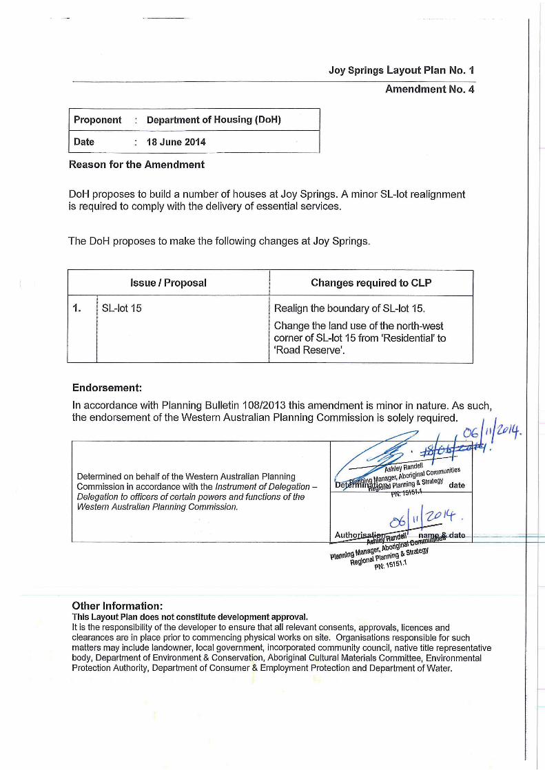
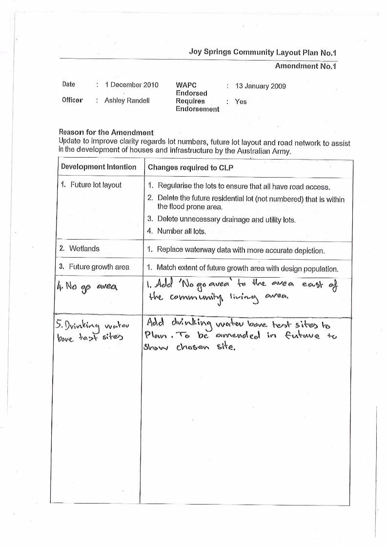
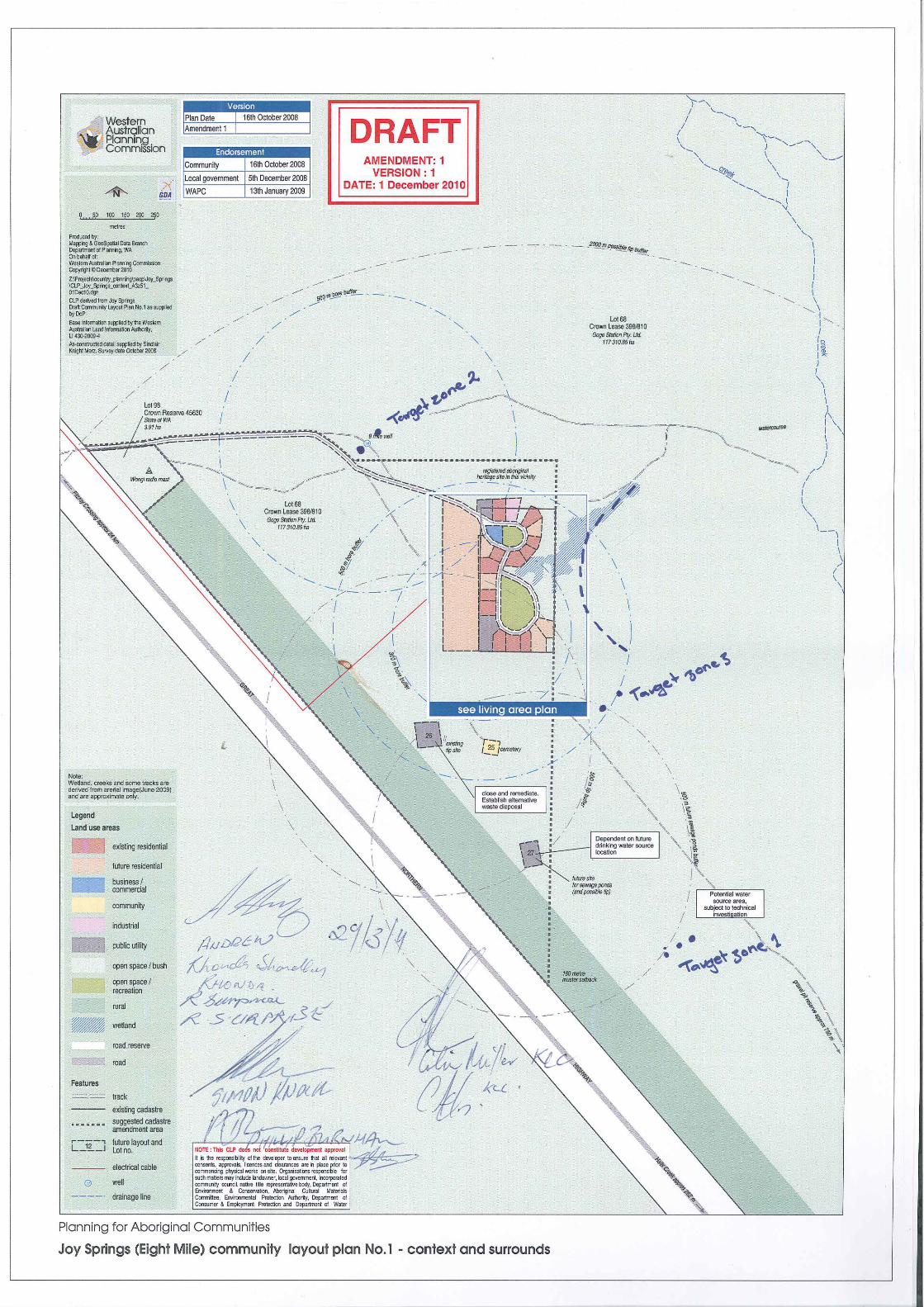
Reason for the Amendment Update to improve clarity regards lot numbers, future lot layout and road network to assist in the development of houses and infrastructure by the Australian Army.
Development Intention Changes required to CLP
1. Future lot layout 1. Regularise the lots to ensure that all have road access.
2. Delete the future residential lot (not numbered) that is within the flood prone area.
3. Delete unnecessary drainage and utility lots.
4. Number all lots.
2. Wetlands 1. Replace waterway data with more accurate depiction.
3. Future growth area 1. Match extent of future growth area with design population.
4. No Go Area 1. Add ‘no go area’ to the east of the community living area.
5. Drinking water source areas
1. Identify drinking water source exploration areas to be amended in future to reflect chosen site.
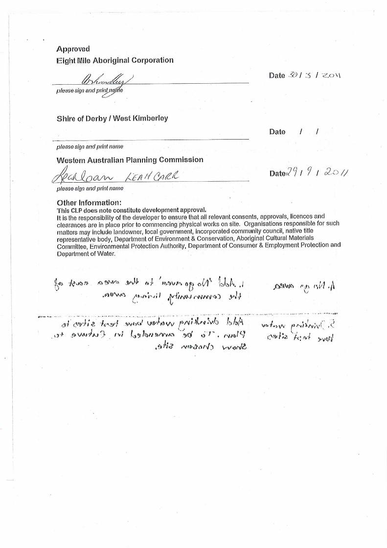
Approved:
Approved (see attachment)
Other Information: This CLP does note constitute development approval. It is the responsibility of the developer to ensure that all relevant consents, approvals, licences and clearances are in place prior to commencing physical works on site. Organisations responsible for such matters may include landowner, local government, incorporated community council, native title representative body, Department of Environment & Conservation, Aboriginal Cultural Materials Committee, Environmental Protection Authority, Department of Consumer & Employment Protection and Department of Water.


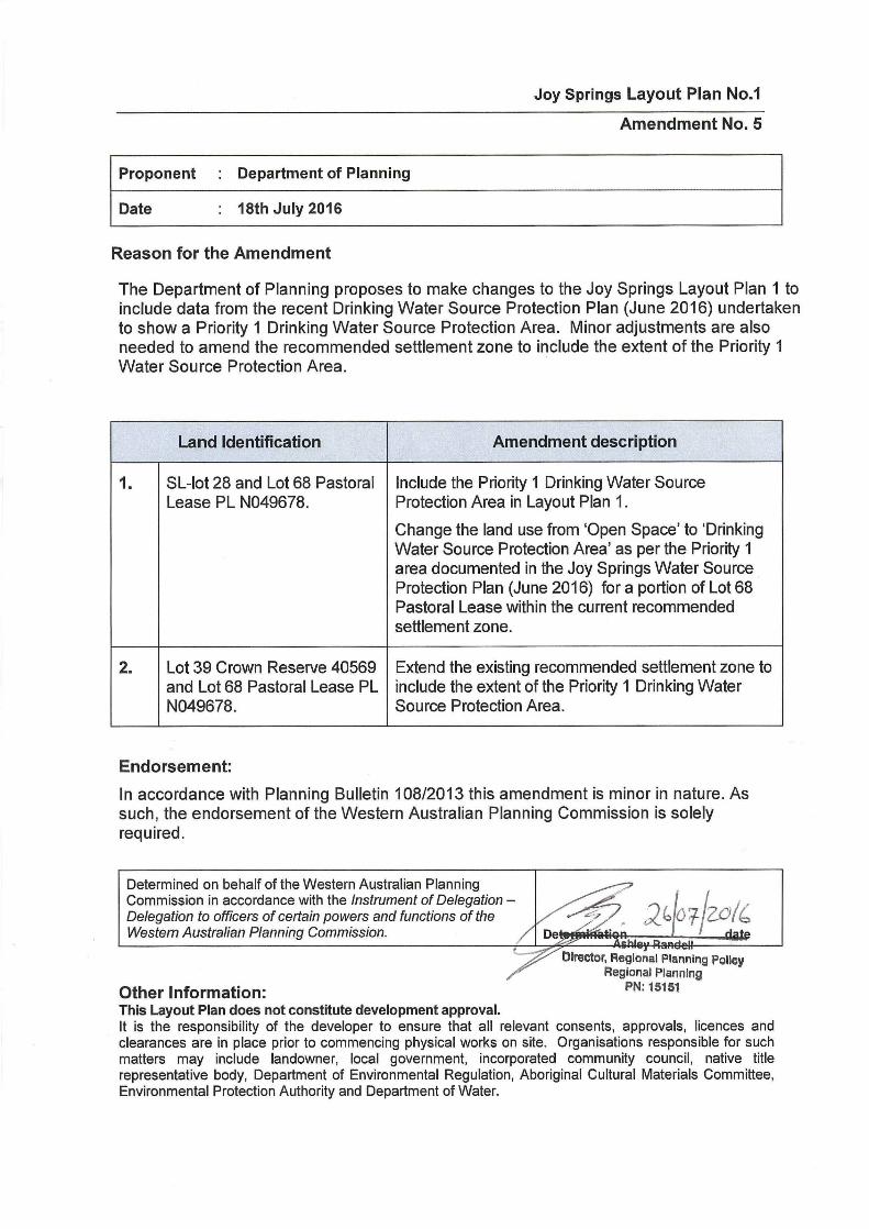
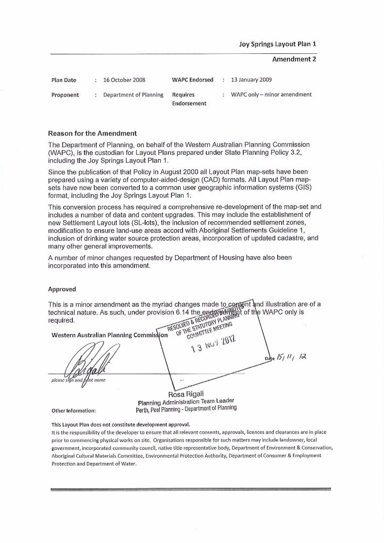
AMENDMENT 2

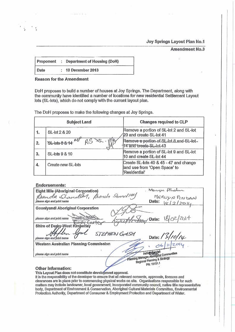
AMENDMENT 3

AMENDMENT 4