Embed Size (px)
Citation preview

. . . 1/285 9 . . . 11120
. 02 582 3509 . 02 582 3510 LINE ID : @SDMthailand | E-mail : [email protected]
HOTLINE : 081-5148151LaserScannerThailandSDMcompany
We are the Professional and Innovative Geospatial Solutions Provider
www.sdm.co.th
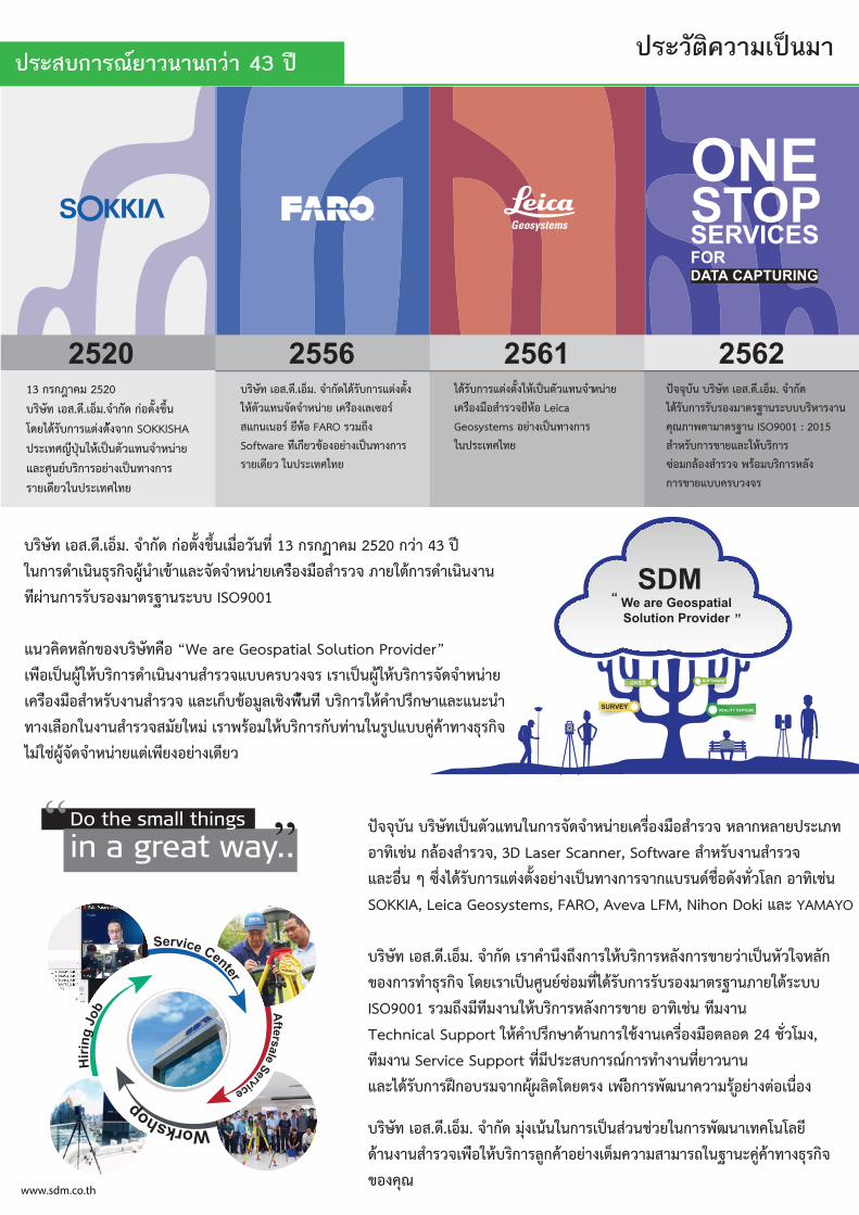
ามนปเมาวคิตัวะรปประสบการณยาวนานกวา 43 ป
บริษัท เอส.ดี.เอ็ม. จํากัด กอตั้งขึ้นเมื่อวันที่ 13 กรกฏาคม 2520 กวา 43 ป
ในการดำเนินธุรกิจผูนำเขาและจัดจำหนายเครืองมือสำรวจ ภายใตการดำเนินงาน
ทีผานการรับรองมาตรฐานระบบ ISO9001
”redivorP noituloS laitapsoeG era eW“ อืคทัษิรบงอขกัลหดิควนแ
ยานหาํจดัจรากิรบหใูผนปเารเ รจงวบรคบบแจวราํสนางนินเาํดรากิรบหใูผนปเอืพเ
ีทนืพงิชเลูมอขบ็กเะลแ จวราํสนางบัรหาํสอืมงอืรคเ าํนะนแะลแาษกึรปาํคหใรากิรบ
มหใยัมสจวราํสนางนใกอืลเงาท จิกรุธงาทาคูคบบแปูรนในาทบักรากิรบหใมอรพารเ
วยีดเงายองยีพเตแยานหาํจดัจูผชใมไ
ปจจุบัน บริษัทเปนตัวแทนในการจัดจําหนายเครื่องมือสํารวจ หลากหลายประเภท
อาทิเชน กลองสํารวจ, 3D Laser Scanner, Software สําหรับงานสํารวจ
และอื่น ๆ ซึ่งไดรับการแตงตั้งอยางเปนทางการจากแบรนดชื่อดังทั่วโลก อาทิเชน
SOKKIA, Leica Geosystems, FARO, Aveva LFM, Nihon Doki และ YAMAYO
บริษัท เอส.ดี.เอ็ม. จํากัด เราคํานึงถึงการใหบริการหลังการขายวาเปนหัวใจหลัก
ของการทำธุรกิจ โดยเราเปนศูนยซอมที่ไดรับการรับรองมาตรฐานภายใตระบบ
ISO9001 รวมถึงมีทีมงานใหบริการหลังการขาย อาทิเชน ทีมงาน
Technical Support ใหคําปรึกษาดานการใชงานเครื่องมือตลอด 24 ชั่วโมง,
ทีมงาน Service Support ที่มีประสบการณการทํางานที่ยาวนาน
และไดรับการฝกอบรมจากผผูลิตโดยตรง เพอืการพัฒนาความรอูยางตอเนื่อง
ํจ .ม็อเ.ีด.สอเ ทัษิรบ ียลโนโคทเานฒัพรากนใยวชนวสนปเรากนในนเงุม ดักา
ยอาคกูลรากิรบหใอืพเจวราํสนางนาด จิกรุธงาทาคูคะนาฐนใถรามาสมาวคม็ตเงา
ณุคงอข
2520 2556 2561 256213 กรกฎาคม 2520
บริษัท เอส.ดี.เอ็ม.จํากัด กอตั้งขึ้น
โดยไดรับการแตงตังจาก SOKKISHA
ประเทศญีปุนใหเปนตัวแทนจำหนาย
และศูนยบริการอยางเปนทางการ
รายเดียวในประเทศไทย
บริษัท เอส.ดี.เอ็ม. จํากัดไดรับการแตงตั้ง
ใหตัวแทนจัดจ หนาย เครืองเลเซอร
สแกนเนอร ยีหอ FARO รวมถึง
Software ทีเกียวของอยางเปนทางการ
รายเดียว ในประเทศไทย
ไดรับการแตงตั้งใหเปนตัวแทนจ หนาย
เครืองมือส รวจยีหอ Leica
Geosystems อยางเปนทางการ
ในประเทศไทย
นับุจจป ทัษิรบ เอส.ดี. ม็อเ . จ ดัก
นางราหิรบบบะรนาฐรตามงอรบัรรากบัรดไ
นาฐรตามาตพาภณุค ISO9001 : 2015
รากิรบหใะลแยาขรากบัรหำส
จวรำสงอลกมอซ งัลหรากิรบมอรพ
การขายแบบครบวงจร
ONESTOPSERVICESFOR DATA CAPTURING
REALITY CAPTURESURVEY
SOFTWAREGNSS
SDMWe are GeospatialSolution Provider
“ “
Service Center
Aftersale Service
Workshop
Hirin
g Jo
b
Do the small things
in a great way..
www.sdm.co.th
IP
M A X
MIN
ERRORR A N G I N G
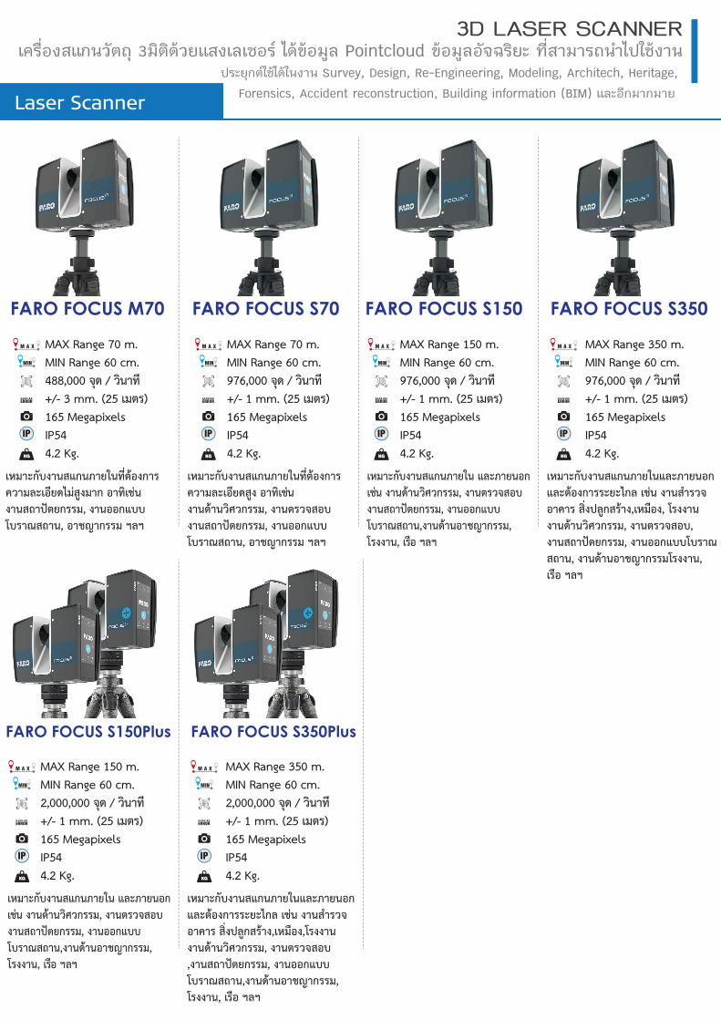
FARO FOCUS S150
MAX Range 150 m.MIN Range 60 cm.976,000 จุด / วินาที+/- 1 mm. (25 เมตร)165 MegapixelsIP544.2 Kg.
เหมาะกับงานสแกนภายใน และภายนอก เชน งานดานวิศวกรรม, งานตรวจสอบ งานสถาปตยกรรม, งานออกแบบ โบราณสถาน,งานดานอาชญากรรม, โรงงาน, เรือ ฯลฯ
FARO FOCUS S350
IP
M A X
MIN
ERRORR A N G I N G
MAX Range 350 m.MIN Range 60 cm.976,000 จุด / วินาที+/- 1 mm. (25 เมตร)165 MegapixelsIP544.2 Kg.
เหมาะกับงานสแกนภายในและภายนอก และตองการระยะไกล เชน งานสํารวจ อาคาร สิ่งปลูกสราง,เหมือง, โรงงาน งานดานวิศวกรรม, งานตรวจสอบ, งานสถาปตยกรรม, งานออกแบบโบราณ สถาน, งานดานอาชญากรรมโรงงาน, เรือ ฯลฯ
Laser Scanner
3D LASER SCANNERเครื่องสแกนวัตถุ 3มิติดวยแสงเลเซอร ไดขอมูล Pointcloud ขอมูลอัจฉริยะ ที่สามารถนำไปใชงาน
ประยุกตใชไดในงาน Survey, Design, Re-Engineering, Modeling, Architech, Heritage,
Forensics, Accident reconstruction, Building information (BIM) และอีกมากมาย
IP
M A X
MIN
ERRORR A N G I N G
FARO FOCUS S150Plus
MAX Range 150 m.MIN Range 60 cm.2,000,000 จุด / วินาที+/- 1 mm. (25 เมตร)165 MegapixelsIP544.2 Kg.
เหมาะกับงานสแกนภายใน และภายนอก เชน งานดานวิศวกรรม, งานตรวจสอบ งานสถาปตยกรรม, งานออกแบบ โบราณสถาน,งานดานอาชญากรรม, โรงงาน, เรือ ฯลฯ
FARO FOCUS S350Plus
IP
M A X
MIN
ERRORR A N G I N G
MAX Range 350 m.MIN Range 60 cm.2,000,000 จุด / วินาที+/- 1 mm. (25 เมตร)165 MegapixelsIP544.2 Kg.
เหมาะกับงานสแกนภายในและภายนอกและตองการระยะไกล เชน งานสํารวจอาคาร สิ่งปลูกสราง,เหมือง,โรงงานงานดานวิศวกรรม, งานตรวจสอบ,งานสถาปตยกรรม, งานออกแบบโบราณสถาน,งานดานอาชญากรรม, โรงงาน, เรือ ฯลฯ
IP
M A X
MIN
ERRORR A N G I N G
FARO FOCUS S70
MAX Range 70 m.MIN Range 60 cm.976,000 จุด / วินาที+/- 1 mm. (25 เมตร)165 MegapixelsIP544.2 Kg.
เหมาะกับงานสแกนภายในที่ตองการ ความละเอียดสูง อาทิเชน งานดานวิศวกรรม, งานตรวจสอบงานสถาปตยกรรม, งานออกแบบ โบราณสถาน, อาชญากรรม ฯลฯ
IP
M A X
MIN
ERRORR A N G I N G
FARO FOCUS M70
MAX Range 70 m.MIN Range 60 cm.488,000 จุด / วินาที+/- 3 mm. (25 เมตร)165 MegapixelsIP544.2 Kg.
เหมาะกับงานสแกนภายในที่ตองการความละเอียดไมสูงมาก อาทิเชน งานสถาปตยกรรม, งานออกแบบโบราณสถาน, อาชญากรรม ฯลฯ
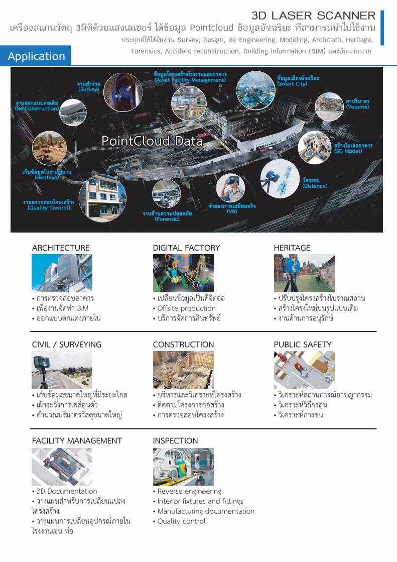
Application
3D LASER SCANNERุถตัวนกแสงอืรคเ 3 รอซเลเงสแยวดิติม ลูมอขดไ Pointcloud ะยิรฉจัอลูมอข นางชใปไำนถรามาสีท
ตกุยะรป ใช นางนใดไ Survey, Design, Re-Engineering, Modeling, Architech, Heritage,
Forensics, Accident reconstruction, Building information (BIM) ยามกามกีอะลแ
ARCHITECTURE
• การตรวจสอบอาคาร• เพื่องานจัดทำ BIM• ออกแบบตกแตงภายใน
INSPECTION
• Reverse engineering• Interior fixtures and fittings• Manufacturing documentation• Quality control
CIVIL / SURVEYING
• เก็บขอมูลขนาดใหญที่มีระยะไกล• เฝาระวังการเคลื่อนตัว• คำนวณปริมาตรวัสดุขนาดใหญ
FACILITY MANAGEMENT
• 3D Documentation• วางแผนสำหรับการเปลี่ยนแปลงโครงสราง• วางแผนการเปลี่ยนอุปกรณภายในโรงงานเชน ทอ
DIGITAL FACTORY
• เปลี่ยนขอมูลเปนดิจิตอล• Offsite production• บริการจัดการสินทรัพย
CONSTRUCTION
• บริหารและวิเคราะหโครงสราง• ติดตามโครงการกอสราง• การตรวจสอบโครงสราง
PUBLIC SAFETY
• วิเคราะหสถานการณอาชญากรรม• วิเคราะหวิถีกรสุน• วิเคราะหการชน
HERITAGE
• ปรับปรุงโครงสรางโบราณสถาน• สรางโครงใหมบนรูปแบบเดิม• งานดานการอนุรักษ
Laser Scanner
3D LASER SCANNERเครื่องสแกนวัตถุ 3มิติดวยแสงเลเซอร ไดขอมูล Pointcloud ขอมูลอัจฉริยะ ที่สามารถนำไปใชงาน
ประยุกตใชไดในงาน Survey, Design, Re-Engineering, Modeling, Architech, Heritage,
Forensics, Accident reconstruction, Building information (BIM) และอีกมากมาย
Faro Laser Scanner FOCUS S150 Plus และ S350 Plusเปนเครื่องสแกนวัตถุ 3มิติ ดวยแสงเลเซอรพรอมกลองถายภาพHD สามารถ ถายภาพโหมดHDR ทีสามารถเก็บรายละเอียดตางๆไดอยางคมชัดในสภาพแสง ท่ีแตกตางกันมาก มีรัศมีการสแกน 150 และ 350 เมตร เหมาะสำหรับการใชสแกนวัตถุตางๆทั้งภายใน ภายนอก สถานที่ สามารถทาํงานในสภาพแวดลอมที่มีฝุนและความชื้นได โดยสามารถใชงานกลาง แดดจาไดอยางมีประสิทธิภาพ ตัวเครื่องมีขนาดกะทัดรัด พกพาเคลื่อนยายได สะดวก ติดตั้งและใชงานงาย ขอมูลที่สแกนไดสามารถใชงานรวมกับโปรแกรม ของ AutoDesk ไดโดยตรง• อัตราการสแกนสูงสุด 2,000,000 จุดตอวินาที• มีชวงระยะการสแกน 0.6 – 350 เมตร• ความคลาดเคล่ือน +/- 1 มิลลิเมตร• มุมมองในการสแกน แนวราบ 360 องศา / แนวด่ิง 300 องศา• แสงเลเซอรท่ีใชเปนประเภท Class 1 ปลอดภัยกับดวงตา• ระบบชดเชยแกนกลองอัตโนมัติแบบ 2แกน มีชวงการทำงาน +/- 2 องศา• มี Multi-Sensorติดต้ังภายในตัวเคร่ืองประกอบดวยGPS, Compass, Height Sensor
• หนวยความจำภายใน SD Card 32 GB• ควบคุมส่ังงานผานหนาจอดวยระบบ Touchscreenและแบบไรสาย (WLAN)
• กลองถายภาพ HDR ความละเอียดสูงสุด 165 megapixel• แบตเตอร่ีภายในใชงานได 4.5 ช่ัวโมง• น้ำหนักตัวเคร่ือง 4.2 กิโลเมตร
Additional Performance Specifications
Color Unit
Color Resolution Up to 165-megapixel colorHDR Camera Exposure bracketing 2x, 3x, 5x
Parallax Minimized due to co-axial design
Deflection Unit
Field of View
Step Size0.0009 (40,960 3D-pixel on
360°) vertical / 0.0009 (40,960 3D-pixel on 360°) horizontal
Max. Scan Speed 97Hz (vertical)
Laser (Optical Transmitter)
Laser Class Laser Class 1Wavelength 1550nmBeam Divergence 0.3mrad (1/e)Beam Diameter at Exit 2.12mm (1/e)
Data Handling and Control
Data Storage SDHCTM, SDXCTM; 32GB card
Scanner ControlVia touch screen display and WLAN connection, Access by mobile devices with HTML5
Interface Connection
WLAN802.11n (150Mbit/s),
as access point or client in existing networks
Additional Features
Dual Axis Compensator Performs a leveling of each scan with an accuracy of 19 arcsec valid within ±2°
Height Sensor Via an electronic barometer, the height relative to a fixed point can be detected and added to a scan
The electronic compass gives the scan an orientationGNSS Integrated GPS & GLONASSOn-Site Compensation* Creates current quality report and improves compensation automatically
Accessory Bay* The accessory bay connects versatile accessories to the scanner Inverse Mounting Yes Real-time, On-site Registration in SCENE* Connects to SCENE, real-time scan processing and registration, overview map
Electronic Automation Interface* Available as option, only at point of sale Digital Hash Function Scans are cryptographically hashed and signed by the scannerRescanning of Distant Targets Defined areas recaptured in higher resolution at a greater distance
Retake Photos Select individual photographs with unwanted objects and retake them
*Not integrated with the FocusM 70
General Specifications
Power Supply 19V (external supply), 14.4V (internal battery)Power Consumption 15W idle, 25W scanning, 80W chargingBattery Service Life 4.5 hoursTemperature Ingress Protection (IP) Rating Class IP54Humidity Resistance Non-condensingWeight 4.2 kg (including battery)Size/Dimensions 230 x 183 x 103mmMaintenance / Calibration Recommended annual
Performance SpecificationsFocusS Plus 350 FocusS Plus 150
Ranging Unit
Unambiguity Interval614m for up to 0.5 mil pts/sec
307m at 1 mil pts/sec 153m at 2 mil pts/sec
Range¹
90% Reflectivity (white) 0.6-350m 0.6-150m10% Reflectivity (dark-gray) 0.6-150m 0.6-150m2% Reflectivity (black) 0.6-50m 0.6-50m
@10m 90% (white) 0.1@10m 10% (dark-gray) 0.3@10m 2% (black) 0.9@25m 90% (white) 0.2@25m 10% (dark-gray) 0.5@25m 2% (black) 1.6Max. Measurement Speed (mil. pts/sec) Up to 2 Ranging Error³ (mm)
2 @10m 3.5 @25m

Laser Scanner
3D LASER SCANNERเครื่องสแกนวัตถุ 3มิติดวยแสงเลเซอร ไดขอมูล Pointcloud ขอมูลอัจฉริยะ ที่สามารถนำไปใชงาน
ประยุกตใชไดในงาน Survey, Design, Re-Engineering, Modeling, Architech, Heritage,
Forensics, Accident reconstruction, Building information (BIM) และอีกมากมาย
FARO Focus3D S350เปนเครื่องสแกนวัตถุ 3 มิติดวยแสงเลเซอรพรอมกลองถายภาพ HD สามารถถายภาพโหมด HDR ท่ีสามารถเก็บรายละเอียดตางๆได อยางคมชัดในสภาพแสงท่ีแตกตางกันมาก มีรัศมีการสแกน 350 เมตร เหมาะสำหรับการ ใชสแกนวัตถุตางๆ ทัง้ภายใน ภายนอกสถานที่ สามารถทาํงานในสภาพแวดลอม ทีมีฝนุและความชื้นได โดยสามารถใชงานกลางแดดจา ไดอยางมีประสิทธิภาพ ตัวเครื่องมีขนาดกะทัดรัด พกพาเคลื่อนยายไดสะดวก ติดตั้งและใชงานงาย ขอมูลที่สแกนไดสามารถใชงานรวมกับโปรแกรมของ AutoDesk ไดโดยตรง• อัตราการสแกนสูงสุด 976,000 จุดตอวินาที• มีชวงระยะการสแกน 0.6 – 350 เมตร• ความคลาดเคล่ือน +/- 1 มิลลิเมตร• มุมมองในการสแกน แนวราบ 360 องศา / แนวด่ิง 300 องศา• แสงเลเซอรท่ีใชเปนประเภท Class 1 ปลอดภัยกับดวงตา• ระบบชดเชยแกนกลองอัตโนมัติแบบ 2แกน มีชวงการทำงาน +/- 2 องศา• มี Multi-Sensorติดต้ังภายในตัวเคร่ืองประกอบดวยGPS, Compass, Height Sensor
• หนวยความจำภายใน SD Card 32 GB• ควบคุมส่ังงานผานหนาจอดวยระบบ Touchscreenและแบบไรสาย (WLAN)
• กลองถายภาพ HDR ความละเอียดสูงสุด 165 megapixel• แบตเตอร่ีภายในใชงานได 4.5 ช่ัวโมง• น้ำหนักตัวเคร่ือง 4.2 กิโลเมตร
Performance Speci cationsRanging unit Unambiguity interval: 614m for 122 to 488 kpts/s
307m for 976 kpts/s
Measurement speed (pts/sec): 122,000 / 244,000 / 488,000 / 976,000
Ranging error4: ±1mm Angular accuracy5: 19 arcsec for vertical/horizontal
angles3D position accuracy6: 10m: 2mm / 25m: 3.5mmColor unit Resolution: Up to 165 megapixel colorHigh Dynamic Range (HDR): Exposure Bracketing 2x, 3x, 5x Parallax: Minimized due to co-axial design
Field of view (vertical7/horizontal): 300° / 360°Step size (vertical/horizontal): 0.009° (40,960 3D-Pixel on 360°) /
0.009° (40,960 3D-Pixel on 360°)Max. vertical scan speed: 97HzLaser (optical transmitter)Laser class: Laser class 1Wavelength: 1550nmBeam divergence: 0.3mrad (1/e)Beam diameter at exit: 2.12mm (1/e)
Data handling and controlData storage: SD, SDHC™, SDXC™; 32GB cardScanner control: Via touchscreen display and
WLAN connection. Accsess by mobile devices with HTML5
Interface ConnectionWLAN: 802.11n (150Mbit/s), as Access
Point or client in existing networksIntegrated SensorsDual axis compensator: Performs a leveling of each scan
with an accuracy of 19 arcsec valid within ±2°
Height sensor: Via an electronic barometer the height relative to a fixed poin can be detected and added to a scan.
Compass8: The electronic compass gives the scan an orientation.
GNNS: Integrated GPS & GLONASSOn-site Compensation Creates a current quality report
and provides the option to im-prove the devices compensation automatically.
Accessory Bay The accessory bay is located on top of the laser scanner and is used to connect versatile acces-sories to the scanner.
Re ectivity 90% (white) 10% (dark-gray) 2% (black)
Range1 0.6-350 m 0.6-150 m 0.6-50 m
Ranging noise2 @10m @10m - noise reduction3
@25m @25m - noise reduction3
90% re ectivity 0.3mm 0.15mm 0.3mm 0.15mm10% re ectivity 0.4mm 0.2mm 0.5mm 0.25mm2% re ectivity 1.3mm 0.65mm 2mm 1mm
www.sdm.co.th
Laser Scanner
3D LASER SCANNERเครื่องสแกนวัตถุ 3มิติดวยแสงเลเซอร ไดขอมูล Pointcloud ขอมูลอัจฉริยะ ที่สามารถนำไปใชงาน
ประยุกตใชไดในงาน Survey, Design, Re-Engineering, Modeling, Architech, Heritage,
Forensics, Accident reconstruction, Building information (BIM) และอีกมากมาย
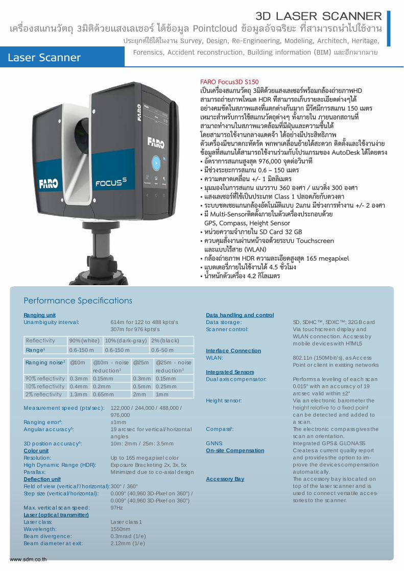
FARO Focus3D S150เปนเครื่องสแกนวัตถุ 3มิติดวยแสงเลเซอรพรอมกลองถายภาพHD สามารถถายภาพโหมด HDR ทีสามารถเก็บรายละเอียดตางๆได อยางคมชัดในสภาพแสงท่ีแตกตางกันมาก มีรัศมีการสแกน 150 เมตร เหมาะสําหรับการใชสแกนวัตถุตางๆ ทั้งภายใน ภายนอกสถานที่ สามาถทํางานในสภาพแวดลอมที่มีฝนุและความชื้นได โดยสามารถใชงานกลางแดดจา ไดอยางมีประสิทธิภาพ ตัวเครื่องมีขนาดกะทัดรัด พกพาเคลื่อนยายไดสะดวก ติดตั้งและใชงานงาย ขอมูลที่สแกนไดสามารถใชงานรวมกับโปรแกรมของ AutoDesk ไดโดยตรง• อัตราการสแกนสูงสุด 976,000 จุดตอวินาที• มีชวงระยะการสแกน 0.6 – 150 เมตร• ความคลาดเคล่ือน +/- 1 มิลลิเมตร• มุมมองในการสแกน แนวราบ 360 องศา / แนวด่ิง 300 องศา• แสงเลเซอรท่ีใชเปนประเภท Class 1 ปลอดภัยกับดวงตา• ระบบชดเชยแกนกลองอัตโนมัติแบบ 2แกน มีชวงการทำงาน +/- 2 องศา• มี Multi-Sensorติดต้ังภายในตัวเคร่ืองประกอบดวยGPS, Compass, Height Sensor
• หนวยความจำภายใน SD Card 32 GB• ควบคุมส่ังงานผานหนาจอดวยระบบ Touchscreenและแบบไรสาย (WLAN)
• กลองถายภาพ HDR ความละเอียดสูงสุด 165 megapixel• แบตเตอร่ีภายในใชงานได 4.5 ช่ัวโมง• น้ำหนักตัวเคร่ือง 4.2 กิโลเมตร
Ranging unit Unambiguity interval: 614m for 122 to 488 kpts/s
307m for 976 kpts/s
Measurement speed (pts/sec): 122,000 / 244,000 / 488,000 / 976,000
Ranging error4: ±1mm Angular accuracy5: 19 arcsec for vertical/horizontal
angles3D position accuracy6: 10m: 2mm / 25m: 3.5mmColor unit Resolution: Up to 165 megapixel colorHigh Dynamic Range (HDR): Exposure Bracketing 2x, 3x, 5x Parallax: Minimized due to co-axial design
Field of view (vertical7/horizontal): 300° / 360°Step size (vertical/horizontal): 0.009° (40,960 3D-Pixel on 360°) /
0.009° (40,960 3D-Pixel on 360°)Max. vertical scan speed: 97HzLaser (optical transmitter)Laser class: Laser class 1Wavelength: 1550nmBeam divergence: 0.3mrad (1/e)Beam diameter at exit: 2.12mm (1/e)
Data handling and controlData storage: SD, SDHC™, SDXC™; 32GB cardScanner control: Via touchscreen display and
WLAN connection. Accsess by mobile devices with HTML5
Interface ConnectionWLAN: 802.11n (150Mbit/s), as Access
Point or client in existing networksIntegrated SensorsDual axis compensator: Performs a leveling of each scan
0.015° with an accuracy of 19 arcsec valid within ±2°
Height sensor: Via an electronic barometer the
can be detected and added to a scan.
Compass8: The electronic compass gives the scan an orientation.
GNNS: Integrated GPS & GLONASSOn-site Compensation Creates a current quality report
and provides the option to im-prove the devices compensation automatically.
Accessory Bay The accessory bay is located on top of the laser scanner and is used to connect versatile acces-sories to the scanner.
90% (white) 10% (dark-gray) 2% (black)
Range1 0.6-150 m 0.6-150 m 0.6-50 m
Ranging noise2 @10m @10m - noise reduction3
@25m @25m - noise reduction3
0.3mm 0.15mm 0.3mm 0.15mm0.4mm 0.2mm 0.5mm 0.25mm1.3mm 0.65mm 2mm 1mm
www.sdm.co.th
Laser Scanner
3D LASER SCANNERเครื่องสแกนวัตถุ 3มิติดวยแสงเลเซอร ไดขอมูล Pointcloud ขอมูลอัจฉริยะ ที่สามารถนำไปใชงาน
ประยุกตใชไดในงาน Survey, Design, Re-Engineering, Modeling, Architech, Heritage,
Forensics, Accident reconstruction, Building information (BIM) และอีกมากมาย
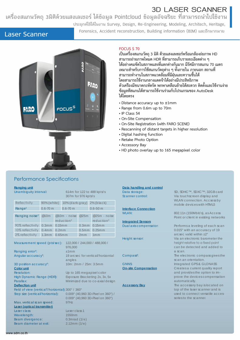
FOCUS S 70เปนเคร่ืองสแกนวัตถุ 3 มิติ ดวยแสงเลเซอรพรอมกลองถยภาพ HD สามารถถายภาพโหมด HDR ท่ีสามารถเก็บรายละเอียดตาง ๆ ไดอยางคมชัดในสภาพแสงท่ีแตกตางกันมาก มีรัศมีการสแกน 70 เมตร เหมาะสําหรับการใชสแกนวัตถุตาง ๆ ท้ังภายใน ภายนอก สถานท่ี สามารถทาํงานในสภาพแวดลอมท่ีมีฝุนและความช้ืนได โดยสามารถใชงานกลางแดดจาไดอยางมีประสิทธิภาพ ตัวเครอืงมีขนาดกะทัดรัด พกพาเคลอืนยายไดสะดวก ติดต้ังและใชงานงาย ขอมูลทสีแกนไดสามารถใชงานรวมกับโปรแกรมของ AutoDesk ไดโดยตรง
• Distance accuracy up to ±1mm• Range from 0.6m up to 70m• IP Class 54• On-Site Compensation• On-Site Registration (with FARO SCENE)• Rescanning of distant targets in higher resolution• Digital hashing function• Retake Photo Option• Accessory Bay• HD photo overlay up to 165 megapixel color
Ranging unit Unambiguity interval: 614m for 122 to 488 kpts/s
307m for 976 kpts/s
Measurement speed (pts/sec): 122,000 / 244,000 / 488,000 / 976,000
Ranging error4: ±1mm Angular accuracy5: 19 arcsec for vertical/horizontal
angles3D position accuracy6: 10m: 2mm / 25m: 3.5mmColor unit Resolution: Up to 165 megapixel colorHigh Dynamic Range (HDR): Exposure Bracketing 2x, 3x, 5x Parallax: Minimized due to co-axial design
Field of view (vertical7/horizontal): 300° / 360°Step size (vertical/horizontal): 0.009° (40,960 3D-Pixel on 360°) /
0.009° (40,960 3D-Pixel on 360°)Max. vertical scan speed: 97HzLaser (optical transmitter)Laser class: Laser class 1Wavelength: 1550nmBeam divergence: 0.3mrad (1/e)Beam diameter at exit: 2.12mm (1/e)
Data handling and controlData storage: SD, SDHC™, SDXC™; 32GB cardScanner control: Via touchscreen display and
WLAN connection. Accsess by mobile devices with HTML5
Interface ConnectionWLAN: 802.11n (150Mbit/s), as Access
Point or client in existing networksIntegrated SensorsDual axis compensator: Performs a leveling of each scan
0.015° with an accuracy of 19 arcsec valid within ±2°
Height sensor: Via an electronic barometer the
can be detected and added to a scan.
Compass8: The electronic compass gives the scan an orientation.
GNNS: Integrated GPS & GLONASSOn-site Compensation Creates a current quality report
and provides the option to im-prove the devices compensation automatically.
Accessory Bay The accessory bay is located on top of the laser scanner and is used to connect versatile acces-sories to the scanner.
90% (white) 10% (dark-gray) 2% (black)
Range1 0.6-70 m 0.6-70 m 0.6-50 m
Ranging noise2 @10m @10m - noise reduction3
@25m @25m - noise reduction3
0.3mm 0.15mm 0.3mm 0.15mm0.4mm 0.2mm 0.5mm 0.25mm1.3mm 0.65mm 2mm 1mm
www.sdm.co.th
Laser Scanner
3D LASER SCANNERเครื่องสแกนวัตถุ 3มิติดวยแสงเลเซอร ไดขอมูล Pointcloud ขอมูลอัจฉริยะ ที่สามารถนำไปใชงาน
ประยุกตใชไดในงาน Survey, Design, Re-Engineering, Modeling, Architech, Heritage,
Forensics, Accident reconstruction, Building information (BIM) และอีกมากมาย
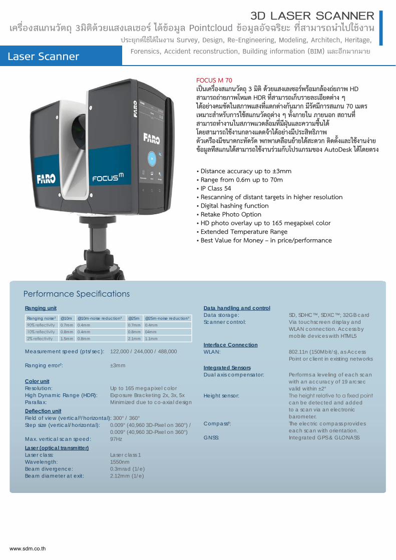
FOCUS M 70เปนเคร่ืองสแกนวัตถุ 3 มิติ ดวยแสงเลเซอรพรอมกลองถยภาพ HD สามารถถายภาพโหมด HDR ท่ีสามารถเก็บรายละเอียดตาง ๆ ไดอยางคมชัดในสภาพแสงท่ีแตกตางกันมาก มีรัศมีการสแกน 70 เมตร เหมาะสําหรับการใชสแกนวัตถุตาง ๆ ท้ังภายใน ภายนอก สถานท่ี สามารถทาํงานในสภาพแวดลอมท่ีมีฝุนและความช้ืนได โดยสามารถใชงานกลางแดดจาไดอยางมีประสิทธิภาพ ตัวเครอืงมีขนาดกะทัดรัด พกพาเคลอืนยายไดสะดวก ติดต้ังและใชงานงาย ขอมูลทสีแกนไดสามารถใชงานรวมกับโปรแกรมของ AutoDesk ไดโดยตรง
• Distance accuracy up to ±3mm• Range from 0.6m up to 70m• IP Class 54• Rescanning of distant targets in higher resolution• Digital hashing function• Retake Photo Option• HD photo overlay up to 165 megapixel color• Extended Temperature Range• Best Value for Money – in price/performance
Ranging unit
Measurement speed (pts/sec): 122,000 / 244,000 / 488,000
Ranging error2: ±3mm
Color unit Resolution: Up to 165 megapixel colorHigh Dynamic Range (HDR): Exposure Bracketing 2x, 3x, 5x Parallax: Minimized due to co-axial design
Field of view (vertical3/horizontal): 300° / 360°Step size (vertical/horizontal): 0.009° (40,960 3D-Pixel on 360°) /
0.009° (40,960 3D-Pixel on 360°)Max. vertical scan speed: 97HzLaser (optical transmitter)Laser class: Laser class 1Wavelength: 1550nmBeam divergence: 0.3mrad (1/e)Beam diameter at exit: 2.12mm (1/e)
Data handling and controlData storage: SD, SDHC™, SDXC™; 32GB cardScanner control: Via touchscreen display and
WLAN connection. Access by mobile devices with HTML5
Interface ConnectionWLAN: 802.11n (150Mbit/s), as Access
Point or client in existing networksIntegrated SensorsDual axis compensator: Performs a leveling of each scan
with an accuracy of 19 arcsec valid within ±2°
Height sensor: can be detected and added to a scan via an electronic barometer.
Compass4: The electric compass provides each scan with orientation.
GNSS: Integrated GPS & GLONASS
Ranging noise2 @10m @10m-noise reduction3 @25m @25m-noise reduction3
0.7mm 0.4mm 0.7mm 0.4mm0.8mm 0.4mm 0.8mm 04mm1.5mm 0.8mm 2.1mm 1.1mm
www.sdm.co.th
Software
Softwareสำหรับจ ลูมอขรากดั Pointcloud และ จวรำสนางรากดัจบัรหำส
12Dเปนโปรแกรมสำหรับงานสำรวจ งานโยธา และงานออกแบบ สิ่งปลูกสรางโดยชางสํารวจรองรับการใชงานรวมกับขอมูล Pointcloudคำสั่งการใชงานงาย และรองรับการใชงานไดหลาก หลายคําสั่ง
Leica Captivateโปรแกรมควบคุมการทํางานกลอง Total Station และ GNSS ยี่หอ Leica Geosystems มีคําสั่ง รองรับการใชงานรูปแบบกราฟฟค รองรับขอมูลสามมิติ ใชงานงาย สามารถเพิ่มเติมคําสั่งไดตามความ ตองการ
FARO® AS-BUILT™ tnioP ลูมอขราหิรบมรกแรปโ
บบแกออนางบัรหำส duolcนางชใ gnireenignE , hcetihcrA
มวร ni-gulP นปเ ว็รเดวร ยางดไ DACotuA บัก
Aveva LFM SOFTWAREโปรแกรมบริหารขอมูล Point cloud สำหรับงานออกแบบ ปรับปรุง Plant / Engineering รองรับขอมูลสแกนจำนวนมาก และมีขนาดใหญ ผาน SQL Database
FARO® SCENEโปรแกรมประมวลผลและ Register ขอมูลสแกนจากเครือง สแกนเนอรยีหอFaro รุน Focus ทีทรงประสิทธิภาพ รองรับการ ประมวลผลขอมูลสแกนไมจำกัด จำนวน ดวยระบบประมวลผลแบบ อัตโนมัติ สะดวก รวดเร็ว ใชงาน งายสามารถสงออกขอมูลไดหลาก หลายรูปแบบ รวมถึงสามารถ สรางไฟลแชรใหกับผู้ใชงานทั่วไปได
SCENE WebShareโปรแกรมเผยแพรขอมูลสแกนจาก เครื่อง สแกนเนอรยี่หอ FARO รุน Focus ที่ทรงประสิทธิภาพ รองรับการใชงานผานระบบ Cloud สามารถแชรขอมูลไดทั่วโลกไดอยางรวดเร็ว
Leica Infinityโปรแกรมสําหรับประมวลผลขอมูล จาก Total Station, GNSS, Image, Point cloud เพื่อนําไปใช งานดานการประมวลผล วิเคราะห ออกแบบงานกอสราง มีคําสั่งรองรับการใชงานมากมาย ตามความตองการของผูใชงาน
MAGNET Officeกาจลูมอขลผลวมะรปมรกแรปโถรามาส สอเีพีจะลแจวรำสงอลก
กาลหีทลุกสมานชใรากบัรงอรนางชใรากบัรหำสงัสำคีม ยาลห
ๆ นือะลแ บบแกออ งารสอกนาดนางชใูผงอขรากงอตมาวคมาตดไ
MAGNET Fieldโปรแกรมควบคุมการทำงานภาค สนามของกลอง Total Station และ GPS งายตอการใช งาน รองรับคำสั่งสำหรับงาน สำรวจ และการปฏิบัติงานไดเปน อยางดี
BUILD-ITโปรแกรมบริหารขอมูล Point cloud
สำหรับงานตรวจสอบการกอสรางและ
การตรวจสอบโครงสราง คำสั่งใชงาน
งาย รองรับขอมูล Point Cloud จาก
เลเซอรสแกนเนอร
FARO Zone 3Dโปรแกรมบริหารขอมูล Point cloud
เหมาะสําหรับมืออาชีพ ในการบังคับใช
กฏหมาย ใชวิเคราะหสถานที่เกิดเหตุ
เพื่อชวยในการสืบสวนทาง
นิติวิทยาศาสตร การวิเคราะหขอมูลดาน
อัคคีภัย การวางแผนการรักษาความ
ปลอดภัย การประกันภัย
และการปองกันอัคคีภัย
GEXCEL - JRCสามารถนําเขา ประมวลผล
และบริหารขอมูลจาก LiDAR เชน
จาก 3D Terrestrial Laaser
Scanner, และแบบ handheld,
mobile, airborne laser scanner
รวมถึง UAV และ 3D imaging
data
Software
Softwareสำหรับจ ลูมอขรากดั Pointcloud และ จวรำสนางรากดัจบัรหำส
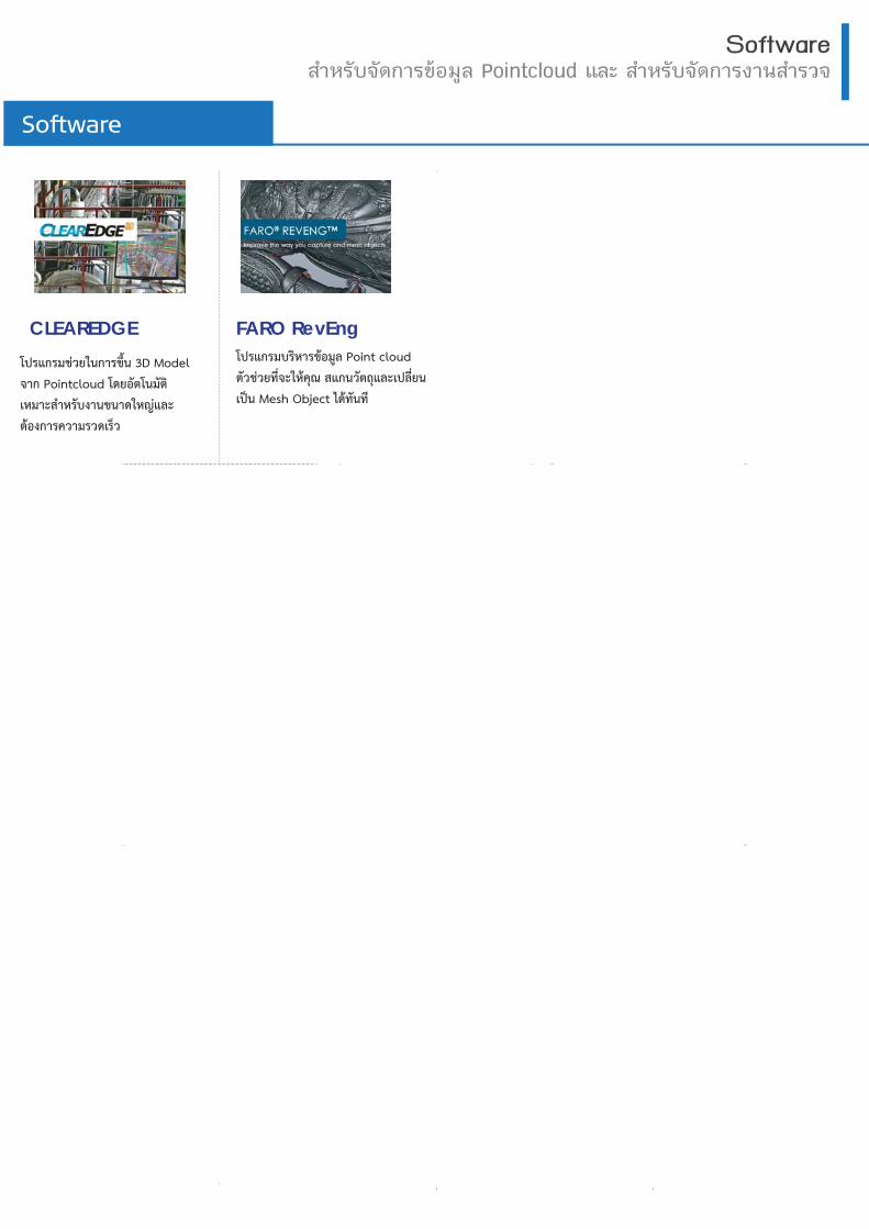
CLEAREDGE FARO RevEngโปรแกรมบริหารขอมูล Point cloud ตัวชวยท่ีจะใหคุณ สแกนวัตถุและเปลี่ยน
เปน Mesh Object ไดทันที
โปรแกรมชวยในการขึ้น 3D Model
จาก Pointcloud โดยอัตโนมัติ
เหมาะสําหรับงานขนาดใหญและ
ตองการความรวดเร็ว
1” / 3” / 5”
MAGNET Field
1 GB.4 Hrs.
800 m.
180o / Sec.
Laser
6,000 m.
SOKKIA iX500Series* Auto-Collimation Model
1”
Leica Captivate
internal 2 GBSD card 1 GB / 8GB7-9 Hrs.
2,000 m. Laser
10,000 m.
180o / Sec.
Leica NOVA MS60
1” / 2” / 3” / 5”
Leica Captivate
internal 2 GBSD card 1 GB / 8GB8-10 Hrs.
1,000 m. Laser
3,500 m.
40.5o / Sec.
Leica TS13
2” / 3” / 5”
Leica FlexField Plus
2 GB.30 Hrs.
500 m. Laser
3,500 m.
Leica TS03
1” / 2” / 3” / 5” / 7”
Leica FlexField Plus
2 GB.30 Hrs.
500 m. Laser
3,500 m.
Leica TS07
1” / 2” / 3” / 5”
Leica Captivate
2 GB.18 Hrs.
500 m. Laser
3,500 m.
Leica TS10
1” / 2” / 3” / 5”
Leica Captivate
internal 2 GBSD card 1 GB / 8GB5-8 Hrs.45o / Sec.
500 m. Laser
3,500 m.
Leica VIVA TS16
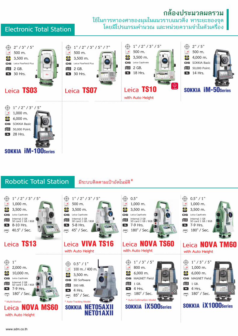
Electronic Total Station
Robotic Total Station
กลองประมวลผลรวมใชในการหาองศาของมุมในแนวราบแนวดิ่ง หาระยะของจุด
โดยมีโปรแกรมคำนวณ และหนวยความจำในตัวเครื่อง
1” / 2” / 3“ / 5”
SOKKIA Basic
50,000 Point.28 Hrs.
1,000 m. Laser
6,000 m.
SOKKIA iM-100Series
2” / 5”
SOKKIA Basic
50,000 Point.14 Hrs.
500 m. Laser
4,000 m.
SOKKIA iM-50Series
1” / 3” / 5”
MAGNET Field
1 GB.4 Hrs.
1,000 m. Laser
6,000 m.
180o / Sec.
SOKKIA iX1000Series
มีระบบติดตามเปาอัตโนมัติ*
0.5” / 1”
3D Software
500 MB.4 Hrs.85o / Sec.
100 m. / 400 m. Laser
3,500 m.
SOKKIA NET05AXII NET01AXII
* Auto-Tracking Model* Multi-Station
0.5”
Leica Captivate
internal 2 GBSD card 1 GB / 8GB7-9 Hrs.180o / Sec.
1,000 m. Laser
3,500 m.
Leica NOVA TS60
0.5” / 1”
Leica Captivate
internal 1 GBSD card 1 GB / 8GB7-9 Hrs.180o / Sec.
1,000 m. Laser
3,500 m.
Leica NOVA TM60
www.sdm.co.th
with Auto Height with Auto Height with Auto Height
with Auto Height
with Auto Height
Electronic Total Station
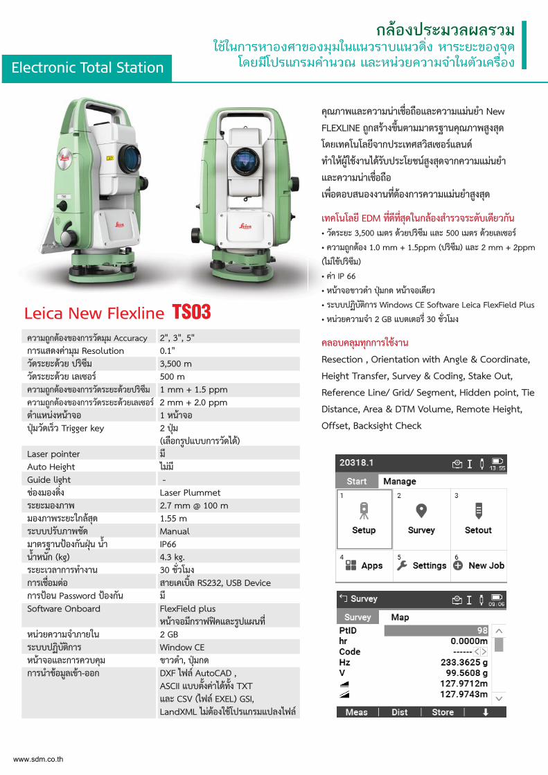
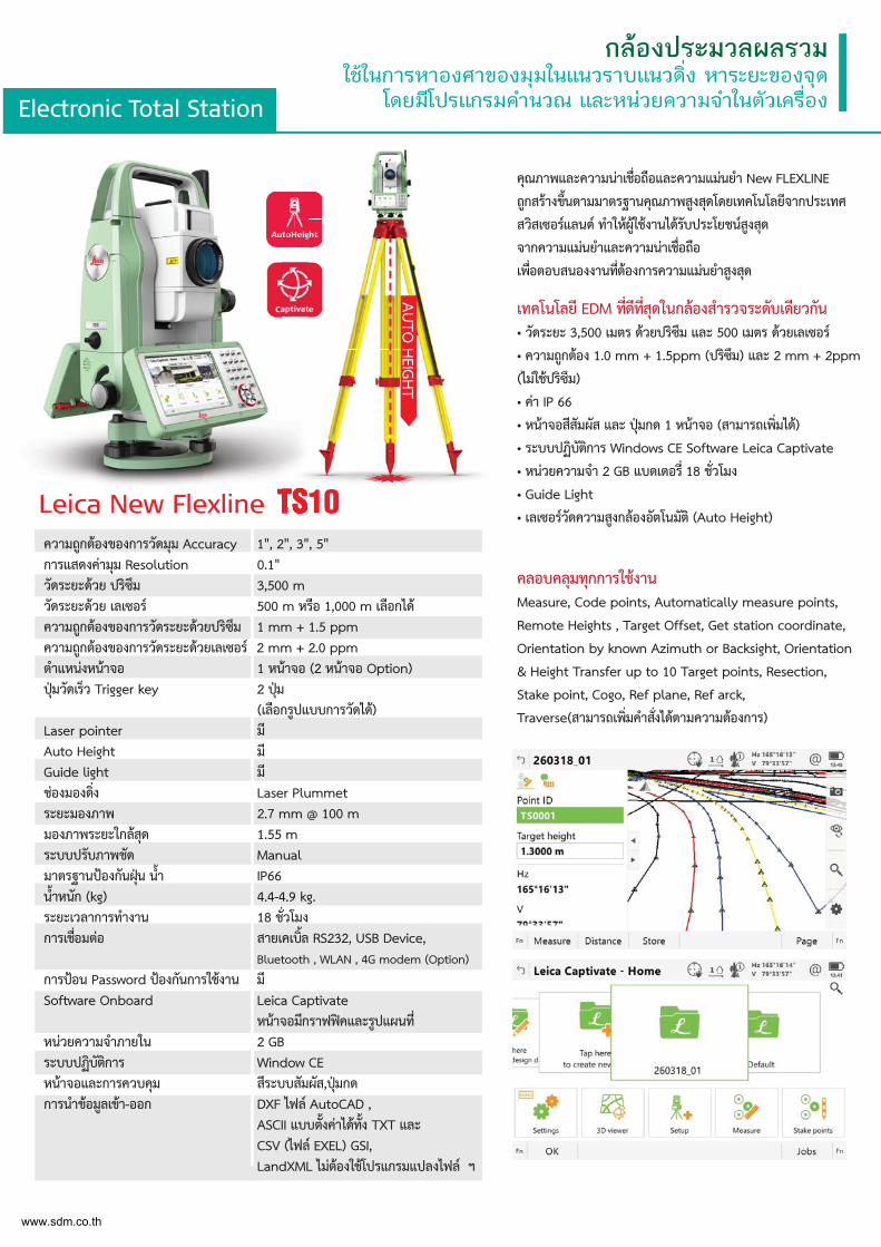
กลองประมวลผลรวมใชในการหาองศาของมุมในแนวราบแนวดิ่ง หาระยะของจุด
โดยมีโปรแกรมคำนวณ และหนวยความจำในตัวเครื่อง
คุณภาพและความนาเช่ือถือและความแมนยำ New
FLEXLINE ถูกสรางข้ึนตามมาตรฐานคุณภาพสูงสุด
โดยเทคโนโลยีจากประเทศสวิสเซอรแลนด
ทำใหผูใชงานไดรับประโยชนสูงสุดจากความแมนยำ
และความนาเช่ือถือ
เพ่ือตอบสนองงานท่ีตองการความแมนยำสูงสุด
เทคโนโลยี EDM ท่ีดีท่ีสุดในกลองสำรวจระดับเดียวกัน• วัดระยะ 3,500 เมตร ดวยปริซึม และ 500 เมตร ดวยเลเซอร
• ความถูกตอง 1.0 mm + 1.5ppm (ปริซึม) และ 2 mm + 2ppm
(ไมใชปริซึม)
• คา IP 66
• หนาจอขาวดำ ปุมกด หนาจอเดียว
• ระบบปฏิบัติการ Windows CE Software Leica FlexField Plus
• หนวยความจำ 2 GB แบตเตอร่ี 30 ช่ัวโมง
คลอบคลุมทุกการใชงาน
Resection , Orientation with Angle & Coordinate,
Height Transfer, Survey & Coding, Stake Out,
Reference Line/ Grid/ Segment, Hidden point, Tie
Distance, Area & DTM Volume, Remote Height,
Offset, Backsight Check
คุณภ
FLEXโดยเ
ทำใหและคเพ่ือต
เทคโ• วัดร• ควา
(ไมใช
• คา
• หนา
• ระบ• หนวLeica New Flexline TS03
ความถูกตองของการวัดมุม Accuracy 2", 3", 5"การแสดงคามุม Resolution 0.1"วัดระยะดวย ปริซึม 3,500 mวัดระยะดวย เลเซอร 500 mความถูกตองของการวัดระยะดวยปริซึม 1 mm + 1.5 ppmความถูกตองของการวัดระยะดวยเลเซอร 2 mm + 2.0 ppm ตำแหนงหนาจอ 1 หนาจอปุมวัดเร็ว Trigger key 2 ปุม
(เลือกรูปแบบการวัดได)Laser pointer มีAuto Height ไมมีGuide light -ชองมองด่ิง Laser Plummetระยะมองภาพ 2.7 mm @ 100 mมองภาพระยะใกลสุด 1.55 mระบบปรับภาพชัด Manualมาตรฐานปองกันฝุน น้ำ IP66น้ำหนัก (kg) 4.3 kg.ระยะเวลาการทำงาน 30 ช่ัวโมงการเช่ือมตอ สายเคเบ้ิล RS232, USB Deviceการปอน Password ปองกัน มีSoftware Onboard FlexField plus
หนาจอมีกราฟฟคและรูปแผนท่ีหนวยความจำภายใน 2 GBระบบปฏิบัติการ Window CEหนาจอและการควบคุม ขาวดำ, ปุมกดการนำขอมูลเขา-ออก DXF ไฟล AutoCAD ,
ASCII แบบต้ังคาไดท้ัง TXT และ CSV (ไฟล EXEL) GSI,LandXML ไมตองใชโปรแกรมแปลงไฟล
www.sdm.co.th
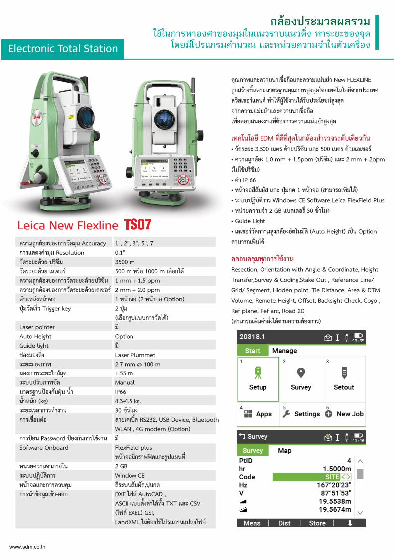
Electronic Total Station
กลองประมวลผลรวมใชในการหาองศาของมุมในแนวราบแนวดิ่ง หาระยะของจุด
โดยมีโปรแกรมคำนวณ และหนวยความจำในตัวเครื่อง
คุณภาพและความนาเช่ือถือและความแมนยำ New FLEXLINE
ถูกสรางข้ึนตามมาตรฐานคุณภาพสูงสุดโดยเทคโนโลยีจากประเทศ
สวิสเซอรแลนด ทำใหผูใชงานไดรับประโยชนสูงสุด
จากความแมนยำและความนาเช่ือถือ
เพ่ือตอบสนองงานท่ีตองการความแมนยำสูงสุด
เทคโนโลยี EDM ท่ีดีท่ีสุดในกลองสำรวจระดับเดียวกัน• วัดระยะ 3,500 เมตร ดวยปริซึม และ 500 เมตร ดวยเลเซอร
• ความถูกตอง 1.0 mm + 1.5ppm (ปริซึม) และ 2 mm + 2ppm
(ไมใชปริซึม)
• คา IP 66
• หนาจอสีสัมผัส และ ปุมกด 1 หนาจอ (สามารถเพ่ิมได)
• ระบบปฏิบัติการ Windows CE Software Leica FlexField Plus
• หนวยความจำ 2 GB แบตเตอร่ี 30 ช่ัวโมง
• Guide Light
• เลเซอรวัดความสูงกลองอัตโนมัติ (Auto Height) เปน Option
สามารถเพ่ิมได
คลอบคลุมทุกการใชงานResection, Orientation with Angle & Coordinate, Height
Transfer,Survey & Coding,Stake Out , Reference Line/
Grid/ Segment, Hidden point, Tie Distance, Area & DTM
Volume, Remote Height, Offset, Backsight Check, Cogo ,
Ref plane, Ref arc, Road 2D
(สามารถเพ่ิมคำส่ังไดตามความตองการ)
Leica New Flexline TS07ความถูกตองของการวัดมุม Accuracy 1", 2", 3", 5", 7"การแสดงคามุม Resolution 0.1"วัดระยะดวย ปริซึม 3500 mวัดระยะดวย เลเซอร 500 m หรือ 1000 m เลือกไดความถูกตองของการวัดระยะดวยปริซึม 1 mm + 1.5 ppmความถูกตองของการวัดระยะดวยเลเซอร 2 mm + 2.0 ppm ตำแหนงหนาจอ 1 หนาจอ (2 หนาจอ Option)ปุมวัดเร็ว Trigger key 2 ปุม (เลือกรูปแบบการวัดได)Laser pointer มีAuto Height OptionGuide light มีชองมองด่ิง Laser Plummetระยะมองภาพ 2.7 mm @ 100 mมองภาพระยะใกลสุด 1.55 mระบบปรับภาพชัด Manualมาตรฐานปองกันฝุน น้ำ IP66น้ำหนัก (kg) 4.3-4.5 kg.ระยะเวลาการทำงาน 30 ช่ัวโมงการเช่ือมตอ สายเคเบ้ิล RS232, USB Device, Bluetooth WLAN , 4G modem (Option)การปอน Password ปองกันการใชงาน มีSoftware Onboard FlexField plus หนาจอมีกราฟฟคและรูปแผนท่ีหนวยความจำภายใน 2 GBระบบปฏิบัติการ Window CEหนาจอและการควบคุม สีระบบสัมผัส,ปุมกดการนำขอมูลเขา-ออก DXF ไฟล AutoCAD , ASCII แบบต้ังคาไดท้ัง TXT และ CSV (ไฟล EXEL) GSI, LandXML ไมตองใชโปรแกรมแปลงไฟล
Leica New Flexxline1" 2"ความถกตองของการวัดมม Accuracy
www.sdm.co.th
AUTO HEIGHT
Electronic Total Station
กลองประมวลผลรวมใชในการหาองศาของมุมในแนวราบแนวดิ่ง หาระยะของจุด
โดยมีโปรแกรมคำนวณ และหนวยความจำในตัวเครื่อง
คุณภาพและความนาเช่ือถือและความแมนยำ New FLEXLINE
ถูกสรางข้ึนตามมาตรฐานคุณภาพสูงสุดโดยเทคโนโลยีจากประเทศ
สวิสเซอรแลนด ทำใหผูใชงานไดรับประโยชนสูงสุด
จากความแมนยำและความนาเช่ือถือ
เพ่ือตอบสนองงานท่ีตองการความแมนยำสูงสุด
เทคโนโลยี EDM ท่ีดีท่ีสุดในกลองสำรวจระดับเดียวกัน• วัดระยะ 3,500 เมตร ดวยปริซึม และ 500 เมตร ดวยเลเซอร
• ความถูกตอง 1.0 mm + 1.5ppm (ปริซึม) และ 2 mm + 2ppm
(ไมใชปริซึม)
• คา IP 66
• หนาจอสีสัมผัส และ ปุมกด 1 หนาจอ (สามารถเพ่ิมได)
• ระบบปฏิบัติการ Windows CE Software Leica Captivate
• หนวยความจำ 2 GB แบตเตอร่ี 18 ช่ัวโมง
• Guide Light
• เลเซอรวัดความสูงกลองอัตโนมัติ (Auto Height)
คลอบคลุมทุกการใชงานMeasure, Code points, Automatically measure points,
Remote Heights , Target Offset, Get station coordinate,
Orientation by known Azimuth or Backsight, Orientation
& Height Transfer up to 10 Target points, Resection,
Stake point, Cogo, Ref plane, Ref arck,
Traverse(สามารถเพ่ิมคำส่ังไดตามความตองการ)
Leica New Flexline TS10ความถูกตองของการวัดมุม Accuracy 1", 2", 3", 5"การแสดงคามุม Resolution 0.1"วัดระยะดวย ปริซึม 3,500 mวัดระยะดวย เลเซอร 500 m หรือ 1,000 m เลือกไดความถูกตองของการวัดระยะดวยปริซึม 1 mm + 1.5 ppmความถูกตองของการวัดระยะดวยเลเซอร 2 mm + 2.0 ppm ตำแหนงหนาจอ 1 หนาจอ (2 หนาจอ Option)ปุมวัดเร็ว Trigger key 2 ปุม
(เลือกรูปแบบการวัดได)Laser pointer มีAuto Height มีGuide light มีชองมองด่ิง Laser Plummetระยะมองภาพ 2.7 mm @ 100 mมองภาพระยะใกลสุด 1.55 mระบบปรับภาพชัด Manualมาตรฐานปองกันฝุน น้ำ IP66น้ำหนัก (kg) 4.4-4.9 kg.ระยะเวลาการทำงาน 18 ช่ัวโมงการเช่ือมตอ สายเคเบ้ิล RS232, USB Device,
Bluetooth , WLAN , 4G modem (Option)
การปอน Password ปองกันการใชงาน มีSoftware Onboard Leica Captivate
หนาจอมีกราฟฟคและรูปแผนท่ีหนวยความจำภายใน 2 GBระบบปฏิบัติการ Window CEหนาจอและการควบคุม สีระบบสัมผัส,ปุมกดการนำขอมูลเขา-ออก DXF ไฟล AutoCAD ,
ASCII แบบต้ังคาไดท้ัง TXT และ CSV (ไฟล EXEL) GSI,LandXML ไมตองใชโปรแกรมแปลงไฟล ฯ
Leica New Flexline1" 2" 3"ความถกตองของการวัดมม A
www.sdm.co.th
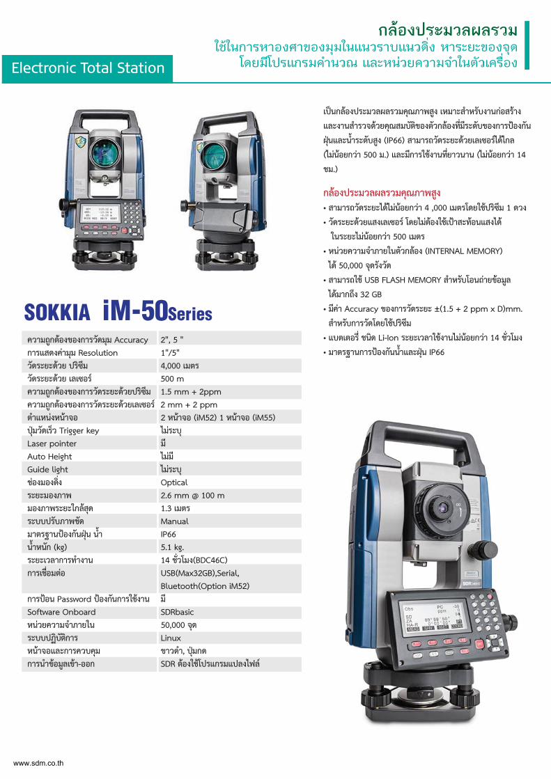
Electronic Total Station
กลองประมวลผลรวมใชในการหาองศาของมุมในแนวราบแนวดิ่ง หาระยะของจุด
โดยมีโปรแกรมคำนวณ และหนวยความจำในตัวเครื่อง
เปนกลองประมวลผลรวมคุณภาพสูง เหมาะสำหรับงานกอสราง
และงานสำรวจดวยคุณสมบัติของตัวกลองท่ีมีระดับของการปองกัน
ฝุนและน้ำระดับสูง (IP66) สามารถวัดระยะดวยเลเซอรไดไกล
(ไมนอยกวา 500 ม.) และมีการใชงานท่ียาวนาน (ไมนอยกวา 14
ชม.)
กลองประมวลผลรวมคุณภาพสูง • สามารถวัดระยะไดไมนอยกวา 4 ,000 เมตรโดยใชปริซึม 1 ดวง
• วัดระยะดวยแสงเลเซอร โดยไมตองใชเปาสะทอนแสงได
ในระยะไมนอยกวา 500 เมตร
• หนวยความจำภายในตัวกลอง (INTERNAL MEMORY)
ได 50,000 จุดรังวัด
• สามารถใช USB FLASH MEMORY สำหรับโอนถายขอมูล
ไดมากถึง 32 GB
• มีคา Accuracy ของการวัดระยะ ±(1.5 + 2 ppm x D)mm.
สำหรับการวัดโดยใชปริซึม
• แบตเตอร่ี ชนิด Li-Ion ระยะเวลาใชงานไมนอยกวา 14 ช่ัวโมง
• มาตรฐานการปองกันน้ำและฝุน IP66ความถูกตองของการวัดมุม Accuracy 2", 5 "การแสดงคามุม Resolution 1"/5"วัดระยะดวย ปริซึม 4,000 เมตรวัดระยะดวย เลเซอร 500 mความถูกตองของการวัดระยะดวยปริซึม 1.5 mm + 2ppmความถูกตองของการวัดระยะดวยเลเซอร 2 mm + 2 ppm ตำแหนงหนาจอ 2 หนาจอ (iM52) 1 หนาจอ (iM55)ปุมวัดเร็ว Trigger key ไมระบุLaser pointer มีAuto Height ไมมีGuide light ไมระบุชองมองด่ิง Opticalระยะมองภาพ 2.6 mm @ 100 mมองภาพระยะใกลสุด 1.3 เมตรระบบปรับภาพชัด Manualมาตรฐานปองกันฝุน น้ำ IP66น้ำหนัก (kg) 5.1 kg.ระยะเวลาการทำงาน 14 ช่ัวโมง(BDC46C)การเช่ือมตอ USB(Max32GB),Serial, Bluetooth(Option iM52)การปอน Password ปองกันการใชงาน มีSoftware Onboard SDRbasicหนวยความจำภายใน 50,000 จุดระบบปฏิบัติการ Linuxหนาจอและการควบคุม ขาวดำ, ปุมกดการนำขอมูลเขา-ออก SDR ตองใชโปรแกรมแปลงไฟล
SOKKIA iM-50Series
www.sdm.co.th
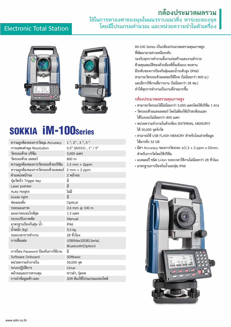
Electronic Total Station
กลองประมวลผลรวมใชในการหาองศาของมุมในแนวราบแนวดิ่ง หาระยะของจุด
โดยมีโปรแกรมคำนวณ และหนวยความจำในตัวเครื่อง
IM-100 Series เปนกลองประมวลผลรวมคุณภาพสูง
ท่ีพัฒนามาอยางเหนือระดับ
รองรับทุกการทำงานท้ังงานกอสรางและงานสำรวจ
ดวยคุณสมบัติของตัวกลองท่ีท้ังแข็งแรง ทนทาน
มีระดับของการปองกันฝุนและน้ำระดับสูง (IP66)
สามารถวัดระยะดวยเลเซอรไดไกล (ไมนอยกวา 800 ม.)
และมีการใชงานท่ียาวนาน (ไมนอยกวา 28 ชม.)
ทำใหทุกการทำงานเปนงานท่ีงายมากข้ึน
กลองประมวลผลรวมคุณภาพสูง • สามารถวัดระยะไดไมนอยกวา 5,000 เมตรโดยใชปริซึม 1 ดวง
• วัดระยะดวยแสงเลเซอร โดยไมตองใชเปาสะทอนแสง
ไดในระยะไมนอยกวา 800 เมตร
• หนวยความจำภายในตัวกลอง (INTERNAL MEMORY)
ได 50,000 จุดรังวัด
• สามารถใช USB FLASH MEMORY สำหรับโอนถายขอมูล
ไดมากถึง 32 GB
• มีคา Accuracy ของการวัดระยะ ±(1.5 + 2 ppm x D)mm.
สำหรับการวัดโดยใชปริซึม
• แบตเตอร่ี ชนิด Li-Ion ระยะเวลาใชงานไมนอยกวา 28 ช่ัวโมง
• มาตรฐานการปองกันน้ำและฝุน IP66
ความถูกตองของการวัดมุม Accuracy 1 ", 2" , 3 ", 5 "การแสดงคามุม Resolution 0.5" (iM101) , 1" / 5" วัดระยะดวย ปริซึม 5,000 เมตรวัดระยะดวย เลเซอร 800 mความถูกตองของการวัดระยะดวยปริซึม 1.5 mm + 2ppmความถูกตองของการวัดระยะดวยเลเซอร 2 mm + 2 ppm ตำแหนงหนาจอ 2 หนาจอปุมวัดเร็ว Trigger key มีLaser pointer มีAuto Height ไมมีGuide light มีชองมองด่ิง Opticalระยะมองภาพ 2.6 mm @ 100 mมองภาพระยะใกลสุด 1.3 เมตรระบบปรับภาพชัด Manualมาตรฐานปองกันฝุน น้ำ IP66น้ำหนัก (kg) 5.3 kg.ระยะเวลาการทำงาน 28 ช่ัวโมงการเช่ือมตอ USB(Max32GB),Serial, Bluetooth(Option)การปอน Password ปองกันการใชงาน มีSoftware Onboard SDRbasicหนวยความจำภายใน 50,000 จุดระบบปฏิบัติการ Linuxหนาจอและการควบคุม ขาวดำ, ปุมกดการนำขอมูลเขา-ออก SDR ตองใชโปรแกรมแปลงไฟล
SOKKIA iM-100Series
www.sdm.co.th
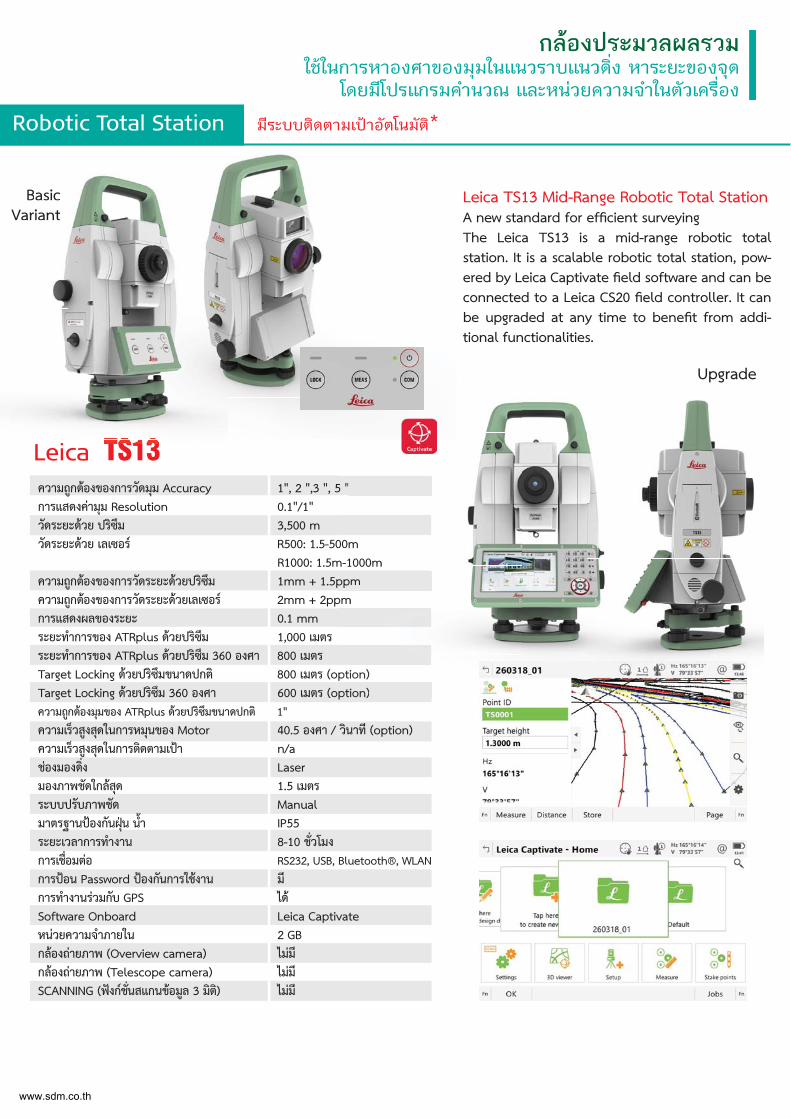
Robotic Total Station มีระบบติดตามเปาอัตโนมัติ*
กลองประมวลผลรวมใชในการหาองศาของมุมในแนวราบแนวดิ่ง หาระยะของจุด
โดยมีโปรแกรมคำนวณ และหนวยความจำในตัวเครื่อง
Leica TS13 Mid-Range Robotic Total StationA new standard for efficient surveyingThe Leica TS13 is a mid-range robotic total station. It is a scalable robotic total station, pow-ered by Leica Captivate field software and can be connected to a Leica CS20 field controller. It can be upgraded at any time to benefit from addi-tional functionalities.
Leica TS13ความถูกตองของการวัดมุม Accuracy 1", 2 ",3 ", 5 "การแสดงคามุม Resolution 0.1"/1"วัดระยะดวย ปริซึม 3,500 mวัดระยะดวย เลเซอร R500: 1.5-500m
R1000: 1.5m-1000mความถูกตองของการวัดระยะดวยปริซึม 1mm + 1.5ppmความถูกตองของการวัดระยะดวยเลเซอร 2mm + 2ppmการแสดงผลของระยะ 0.1 mmระยะทำการของ ATRplus ดวยปริซึม 1,000 เมตรระยะทำการของ ATRplus ดวยปริซึม 360 องศา 800 เมตรTarget Locking ดวยปริซึมขนาดปกติ 800 เมตร (option)Target Locking ดวยปริซึม 360 องศา 600 เมตร (option)ความถูกตองมุมของ ATRplus ดวยปริซึมขนาดปกติ 1"ความเร็วสูงสุดในการหมุนของ Motor 40.5 องศา / วินาที (option)ความเร็วสูงสุดในการติดตามเปา n/aชองมองด่ิง Laserมองภาพชัดใกลสุด 1.5 เมตรระบบปรับภาพชัด Manualมาตรฐานปองกันฝุน น้ำ IP55ระยะเวลาการทำงาน 8-10 ช่ัวโมงการเช่ือมตอ RS232, USB, Bluetooth®, WLANการปอน Password ปองกันการใชงาน มีการทำงานรวมกับ GPS ไดSoftware Onboard Leica Captivate หนวยความจำภายใน 2 GBกลองถายภาพ (Overview camera) ไมมีกลองถายภาพ (Telescope camera) ไมมีSCANNING (ฟงกช่ันสแกนขอมูล 3 มิติ) ไมมี
5 "
00mm-1000mppmpm
ption)ption)
BasicVariant
Upgrade
i
BasicVariant
www.sdm.co.th
Robotic Total Station มีระบบติดตามเปาอัตโนมัติ*
กลองประมวลผลรวมใชในการหาองศาของมุมในแนวราบแนวดิ่ง หาระยะของจุด
โดยมีโปรแกรมคำนวณ และหนวยความจำในตัวเครื่อง
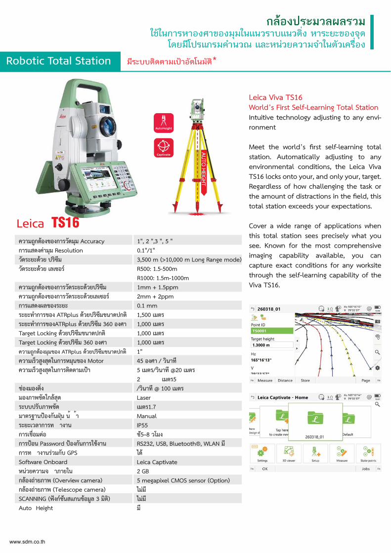
Leica Viva TS16 World’s First Self-Learning Total StationIntuitive technology adjusting to any envi-ronment
Meet the world’s first self-learning total station. Automatically adjusting to any environmental conditions, the Leica Viva TS16 locks onto your, and only your, target. Regardless of how challenging the task or the amount of distractions in the field, this total station exceeds your expectations.
Cover a wide range of applications when this total station sees precisely what you see. Known for the most comprehensive imaging capability available, you can capture exact conditions for any worksite through the self-learning capability of the Viva TS16.
Leica TS16ความถูกตองของการวัดมุม Accuracy 1", 2 ",3 ", 5 "การแสดงคามุม Resolution 0.1"/1"วัดระยะดวย ปริซึม 3,500 m (>10,000 m Long Range mode)วัดระยะดวย เลเซอร R500: 1.5-500m
R1000: 1.5m-1000mความถูกตองของการวัดระยะดวยปริซึม 1mm + 1.5ppmความถูกตองของการวัดระยะดวยเลเซอร 2mm + 2ppmการแสดงผลของระยะ 0.1 mmระยะทำการของ ATRplus ดวยปริซึมขนาดปกติ 1,500 เมตรระยะทำการของATRplus ดวยปริซึม 360 องศา 1,000 เมตรTarget Locking ดวยปริซึมขนาดปกติ 1,000 เมตรTarget Locking ดวยปริซึม 360 องศา 1,000 เมตรความถูกตองมุมของ ATRplus ดวยปริซึมขนาดปกติ ความเร็วสูงสุดในการหมุนของ Motor ความเร็วสูงสุดในการติดตามเปา
ชองมองดิ่ง มองภาพชัดใกลสุด ระบบปรับภาพชัด มาตรฐานปองกันฝนุ น้ ้า ระยะเวลาการท างาน การเชื่อมตอ การปอน Password ปองกันการใชงาน การท างานรวมกับ GPS Software Onboard หนวยความจ าภายใน กลองถายภาพ (Overview camera) กลองถายภาพ (Telescope camera) SCANNING (ฟงกชันสแกนขอมูล 3 มิติ)Auto Height
1"45 องศา / วินาที5 เมตร/วินาที @20 เมตร2 เมตร5 /วินาที @ 100 เมตรLaserเมตร1.7 ManualIP55ช5ั–8 วโมงRS232, USB, Bluetooth®, WLAN มีไดLeica Captivate 2 GB 5 megapixel CMOS sensor (Option) ไมมีไมมีมี
www.sdm.co.th
Robotic Total Station มีระบบติดตามเปาอัตโนมัติ*
กลองประมวลผลรวมใชในการหาองศาของมุมในแนวราบแนวดิ่ง หาระยะของจุด
โดยมีโปรแกรมคำนวณ และหนวยความจำในตัวเครื่อง
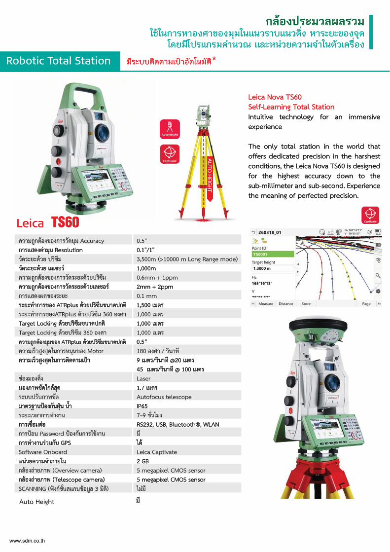
Leica Nova TS60Self-Learning Total StationIntuitive technology for an immersive experience
The only total station in the world that offers dedicated precision in the harshest conditions, the Leica Nova TS60 is designed for the highest accuracy down to the sub-millimeter and sub-second. Experience the meaning of perfected precision.
Leica TS60ความถูกตองของการวัดมุม Accuracy 0.5” การแสดงคามุม Resolution 0.1"/1"วัดระยะดวย ปริซึม 3,500m (>10000 m Long Range mode)วัดระยะดวย เลเซอร 1,000mความถูกตองของการวัดระยะดวยปริซึม 0.6mm + 1ppmความถูกตองของการวัดระยะดวยเลเซอร 2mm + 2ppmการแสดงผลของระยะ 0.1 mmระยะทำการของ ATRplus ดวยปริซึมขนาดปกติ 1,500 เมตรระยะทำการของATRplus ดวยปริซึม 360 องศา 1,000 เมตรTarget Locking ดวยปริซึมขนาดปกติ 1,000 เมตรTarget Locking ดวยปริซึม 360 องศา 1,000 เมตรความถูกตองมุมของ ATRplus ดวยปริซึมขนาดปกติ 0.5” ความเร็วสูงสุดในการหมุนของ Motor 180 องศา / วินาทีความเร็วสูงสุดในการติดตามเปา 9 เมตร/วินาที @20 เมตร
45 เมตร/วินาที @ 100 เมตรชองมองด่ิง Laserมองภาพชัดใกลสุด 1.7 เมตรระบบปรับภาพชัด Autofocus telescopeมาตรฐานปองกันฝุน น้ำ IP65ระยะเวลาการทำงาน 7–9 ช่ัวโมงการเช่ือมตอ RS232, USB, Bluetooth®, WLANการปอน Password ปองกันการใชงาน มีการทำงานรวมกับ GPS ไดSoftware Onboard Leica Captivate หนวยความจำภายใน 2 GBกลองถายภาพ (Overview camera) 5 megapixel CMOS sensorกลองถายภาพ (Telescope camera) 5 megapixel CMOS sensorSCANNING (ฟงกช่ันสแกนขอมูล 3 มิติ) ไมมี
Robotic Total Station มีระบบติดตามเปาอัตโนมัติ*
กลองประมวลผลรวมใชในการหาองศาของมุมในแนวราบแนวดิ่ง หาระยะของจุด
โดยมีโปรแกรมคำนวณ และหนวยความจำในตัวเครื่อง
Leica Nova TS60Self-Learning Total StationIntuitive technology for an immersive experience
The only total station in the world that offers dedicated precision in the harshest conditions, the Leica Nova TS60 is designed for the highest accuracy down to the sub-millimeter and sub-second. Experience the meaning of perfected precision.
Leica TS60ความถูกตองของการวัดมุม Accuracy 0.5” การแสดงคามุม Resolution 0.1"/1"วัดระยะดวย ปริซึม 3,500m (>10000 m Long Range mode)วัดระยะดวย เลเซอร 1,000mความถูกตองของการวัดระยะดวยปริซึม 0.6mm + 1ppmความถูกตองของการวัดระยะดวยเลเซอร 2mm + 2ppmการแสดงผลของระยะ 0.1 mmระยะทำการของ ATRplus ดวยปริซึมขนาดปกติ 1,500 เมตรระยะทำการของATRplus ดวยปริซึม 360 องศา 1,000 เมตรTarget Locking ดวยปริซึมขนาดปกติ 1,000 เมตรTarget Locking ดวยปริซึม 360 องศา 1,000 เมตรความถูกตองมุมของ ATRplus ดวยปริซึมขนาดปกติ 0.5” ความเร็วสูงสุดในการหมุนของ Motor 180 องศา / วินาทีความเร็วสูงสุดในการติดตามเปา 9 เมตร/วินาที @20 เมตร
45 เมตร/วินาที @ 100 เมตรชองมองด่ิง Laserมองภาพชัดใกลสุด 1.7 เมตรระบบปรับภาพชัด Autofocus telescopeมาตรฐานปองกันฝุน น้ำ IP65ระยะเวลาการทำงาน 7–9 ช่ัวโมงการเช่ือมตอ RS232, USB, Bluetooth®, WLANการปอน Password ปองกันการใชงาน มีการทำงานรวมกับ GPS ไดSoftware Onboard Leica Captivate หนวยความจำภายใน 2 GBกลองถายภาพ (Overview camera) 5 megapixel CMOS sensorกลองถายภาพ (Telescope camera) 5 megapixel CMOS sensorSCANNING (ฟงกช่ันสแกนขอมูล 3 มิติ) ไมมี
www.sdm.co.th
Auto Height มี
Robotic Total Station มีระบบติดตามเปาอัตโนมัติ*
กลองประมวลผลรวมใชในการหาองศาของมุมในแนวราบแนวดิ่ง หาระยะของจุด
โดยมีโปรแกรมคำนวณ และหนวยความจำในตัวเครื่อง
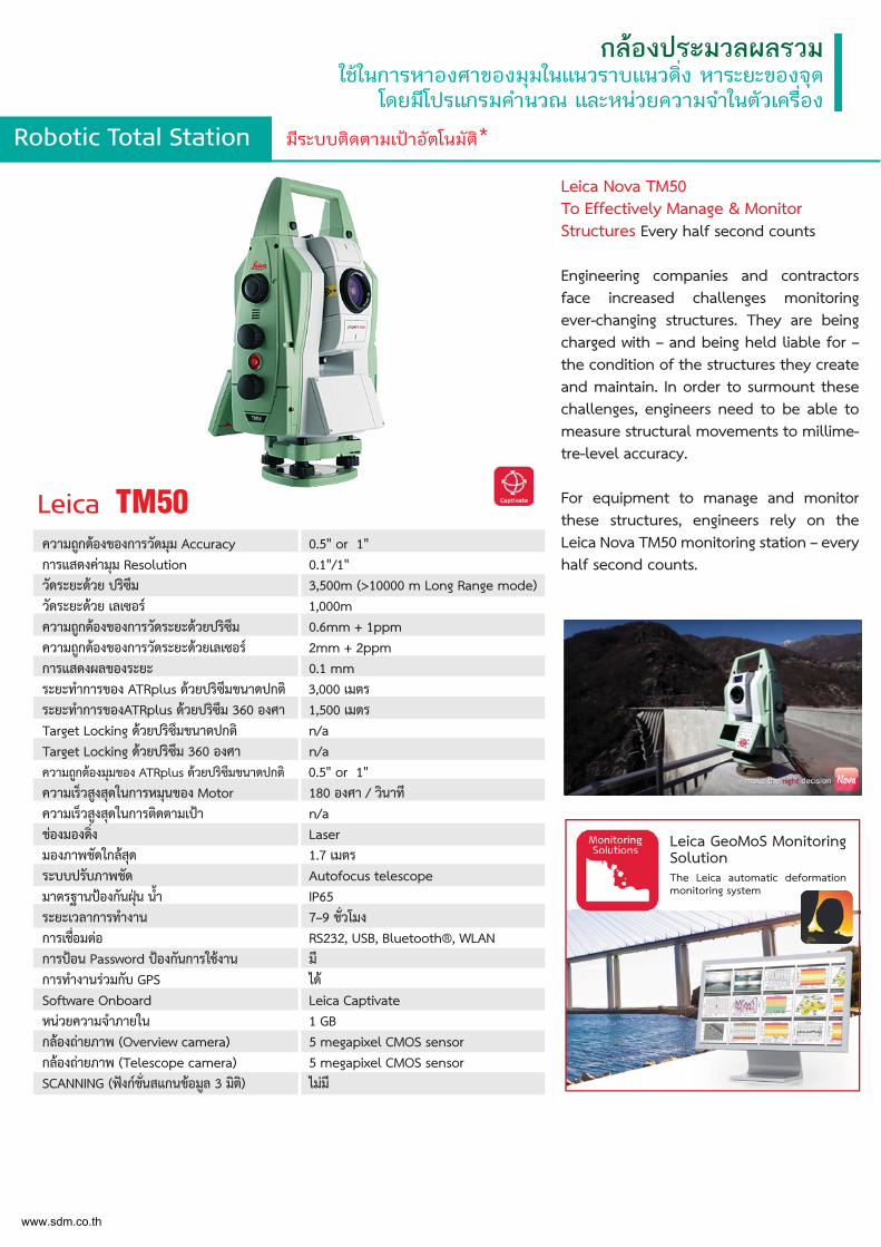
Leica Nova TM50 To Effectively Manage & Monitor Structures Every half second counts
Engineering companies and contractors face increased challenges monitoring ever-changing structures. They are being charged with – and being held liable for – the condition of the structures they create and maintain. In order to surmount these challenges, engineers need to be able to measure structural movements to millime-tre-level accuracy.
For equipment to manage and monitor these structures, engineers rely on the Leica Nova TM50 monitoring station – every half second counts.
Leica TM50ความถูกตองของการวัดมุม Accuracy 0.5" or 1"การแสดงคามุม Resolution 0.1"/1"วัดระยะดวย ปริซึม 3,500m (>10000 m Long Range mode)วัดระยะดวย เลเซอร 1,000mความถูกตองของการวัดระยะดวยปริซึม 0.6mm + 1ppmความถูกตองของการวัดระยะดวยเลเซอร 2mm + 2ppmการแสดงผลของระยะ 0.1 mmระยะทำการของ ATRplus ดวยปริซึมขนาดปกติ 3,000 เมตรระยะทำการของATRplus ดวยปริซึม 360 องศา 1,500 เมตรTarget Locking ดวยปริซึมขนาดปกติ n/aTarget Locking ดวยปริซึม 360 องศา n/aความถูกตองมุมของ ATRplus ดวยปริซึมขนาดปกติ 0.5" or 1"ความเร็วสูงสุดในการหมุนของ Motor 180 องศา / วินาทีความเร็วสูงสุดในการติดตามเปา n/aชองมองด่ิง Laserมองภาพชัดใกลสุด 1.7 เมตรระบบปรับภาพชัด Autofocus telescopeมาตรฐานปองกันฝุน น้ำ IP65ระยะเวลาการทำงาน 7–9 ช่ัวโมงการเช่ือมตอ RS232, USB, Bluetooth®, WLANการปอน Password ปองกันการใชงาน มีการทำงานรวมกับ GPS ไดSoftware Onboard Leica Captivateหนวยความจำภายใน 1 GBกลองถายภาพ (Overview camera) 5 megapixel CMOS sensorกลองถายภาพ (Telescope camera) 5 megapixel CMOS sensorSCANNING (ฟงกช่ันสแกนขอมูล 3 มิติ) ไมมี
Leica GeoMoS Monitoring SolutionThe Leica automatic deformation monitoring system
www.sdm.co.th
Robotic Total Station มีระบบติดตามเปาอัตโนมัติ*
กลองประมวลผลรวมใชในการหาองศาของมุมในแนวราบแนวดิ่ง หาระยะของจุด
โดยมีโปรแกรมคำนวณ และหนวยความจำในตัวเครื่อง
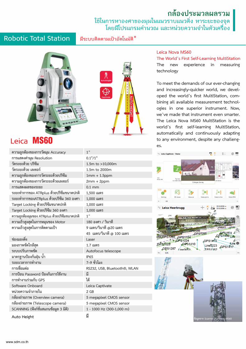
Leica Nova MS60The World’s First Self-Learning MultiStationThe new experience in measuring technology
To meet the demands of our ever-changing and increasingly-quicker world, we devel-oped the world’s first MultiStation, com-bining all available measurement technol-ogies in one superior instrument. Now, we’ve made that instrument even smarter. The Leica Nova MS60 MultiStation is the world’s first self-learning MultiStation, automatically and continuously adapting to any environment, despite any challeng-es.
Leica MS60ความถูกตองของการวัดมุม Accuracy 1”การแสดงคามุม Resolution 0.1"/1"วัดระยะดวย ปริซึม 1.5m to >10,000mวัดระยะดวย เลเซอร 1.5m to 2000mความถูกตองของการวัดระยะดวยปริซึม 1mm + 1.5ppmความถูกตองของการวัดระยะดวยเลเซอร 2mm + 2ppmการแสดงผลของระยะ 0.1 mmระยะทำการของ ATRplus ดวยปริซึมขนาดปกติ 1,500 เมตรระยะทำการของATRplus ดวยปริซึม 360 องศา 1,000 เมตรTarget Locking ดวยปริซึมขนาดปกติ 1,000 เมตรTarget Locking ดวยปริซึม 360 องศา 1,000 เมตรความถูกตองมุมของ ATRplus ดวยปริซึมขนาดปกติ 1”ความเร็วสูงสุดในการหมุนของ Motor 180 องศา / วินาทีความเร็วสูงสุดในการติดตามเปา 9 เมตร/วินาที @20 เมตร
45 เมตร/วินาที @ 100 เมตรชองมองด่ิง Laserมองภาพชัดใกลสุด 1.7 เมตรระบบปรับภาพชัด Autofocus telescopeมาตรฐานปองกันฝุน น้ำ IP65ระยะเวลาการทำงาน 7–9 ช่ัวโมงการเช่ือมตอ RS232, USB, Bluetooth®, WLANการปอน Password ปองกันการใชงาน มีการทำงานรวมกับ GPS ไดSoftware Onboard Leica Captivate หนวยความจำภายใน 2 GBกลองถายภาพ (Overview camera) 5 megapixel CMOS sensorกลองถายภาพ (Telescope camera) 5 megapixel CMOS sensorSCANNING (ฟงกช่ันสแกนขอมูล 3 มิติ) 1 - 1000 Hz (300-1,000 m)
ขอมูลจาก Scanner Function MS60
ขอมูลจาก Scanner Function MS60
www.sdm.co.th
Auto Height มี
Robotic Total Station มีระบบติดตามเปาอัตโนมัติ*
กลองประมวลผลรวมใชในการหาองศาของมุมในแนวราบแนวดิ่ง หาระยะของจุด
โดยมีโปรแกรมคำนวณ และหนวยความจำในตัวเครื่อง
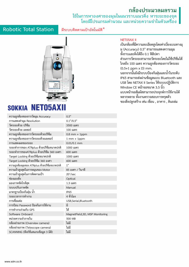
NET05AX IIเปนกลองท่ีมีความละเอียดสูงโดยคาเบ่ียงเบนทางมุม (Accuracy) 0.5" สามารถแสดงความมุม ท้ังราบและด่ิงไดถึง 0.1 ฟลิปดา สวนการวัดระยะสามารถวัดระยะโดยไมใชปริซึมได ไกลถึง 100 เมตร ความถูกตองของการวัดระยะ (0.5+1 ppm x D) mm. นอกจากน้ันยังมีระบบปองกันฝุนและน้ำในระดับ IP65 สามารถสงผานขอมูลแบบ Bluetooth และ USB โดย NETAX II Series ใชระบบปฏิบัติการ Window CE หนาจอขนาด 3.5 น้ิว แบบหนาจอสัมผัสสามารถประยุกตการใชงานได หลากหลาย ท้ังงานตรวจสอบการทรุดตัว ของส่ิงปลูกสราง เชน เข่ือน , อาคาร , ดินถลม
ความถูกตองของการวัดมุม Accuracy 0.5"การแสดงคามุม Resolution 0.1"/0.5"วัดระยะดวย ปริซึม 3500 เมตรวัดระยะดวย เลเซอร 100 เมตรความถูกตองของการวัดระยะดวยปริซึม 0.8 mm + 1ppmความถูกตองของการวัดระยะดวยเลเซอร 1 mm + 1ppmการแสดงผลของระยะ 0.01/0.1 mmระยะทำการของ ATRplus ดวยปริซึมขนาดปกติ 1000 เมตรระยะทำการของATRplus ดวยปริซึม 360 องศา 600 เมตรTarget Locking ดวยปริซึมขนาดปกติ 1000 เมตรTarget Locking ดวยปริซึม 360 องศา 600 เมตรความถูกตองมุมของ ATRplus ดวยปริซึมขนาดปกติ 1"ความเร็วสูงสุดในการหมุนของ Motor 85 องศา / วินาทีความเร็วสูงสุดในการติดตามเปา 20°/secชองมองด่ิง Opticalมองภาพชัดใกลสุด 1.3 เมตรระบบปรับภาพชัด Manualมาตรฐานปองกันฝุน น้ำ IP65ระยะเวลาการทำงาน 4 ช่ัวโมงการเช่ือมตอ USB,Serial,Bluetoothการปอน Password ปองกันการใชงาน มีการทำงานรวมกับ GPS ไดSoftware Onboard MagnetField,3D, MSP Monitoringหนวยความจำภายใน 500 MBกลองถายภาพ (Overview camera) ไมมีกลองถายภาพ (Telescope camera) ไมมีSCANNING (ฟงกช่ันสแกนขอมูล 3 มิติ) ไมมี
SOKKIA NET05AXII
www.sdm.co.th
Robotic Total Station มีระบบติดตามเปาอัตโนมัติ*
กลองประมวลผลรวมใชในการหาองศาของมุมในแนวราบแนวดิ่ง หาระยะของจุด
โดยมีโปรแกรมคำนวณ และหนวยความจำในตัวเครื่อง
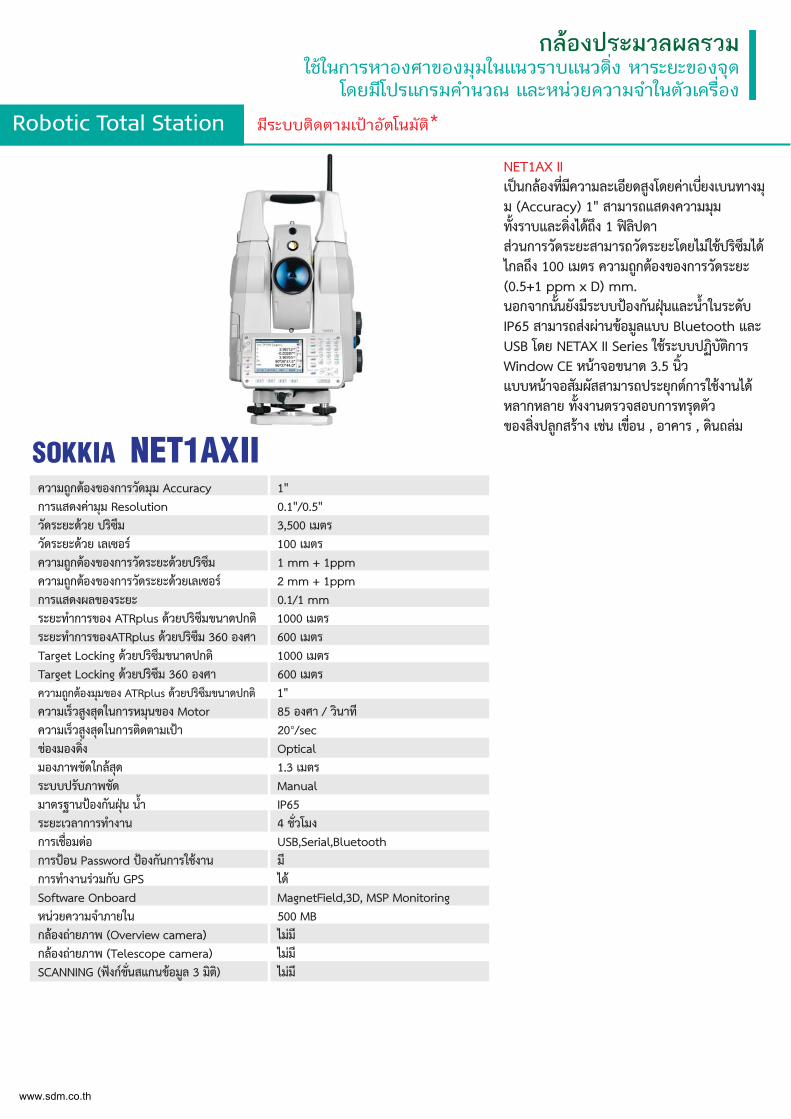
NET1AX IIเปนกลองท่ีมีความละเอียดสูงโดยคาเบ่ียงเบนทางมุม (Accuracy) 1" สามารถแสดงความมุม ท้ังราบและด่ิงไดถึง 1 ฟลิปดา สวนการวัดระยะสามารถวัดระยะโดยไมใชปริซึมได ไกลถึง 100 เมตร ความถูกตองของการวัดระยะ (0.5+1 ppm x D) mm. นอกจากน้ันยังมีระบบปองกันฝุนและน้ำในระดับ IP65 สามารถสงผานขอมูลแบบ Bluetooth และ USB โดย NETAX II Series ใชระบบปฏิบัติการ Window CE หนาจอขนาด 3.5 น้ิว แบบหนาจอสัมผัสสามารถประยุกตการใชงานได หลากหลาย ท้ังงานตรวจสอบการทรุดตัว ของส่ิงปลูกสราง เชน เข่ือน , อาคาร , ดินถลม
ความถูกตองของการวัดมุม Accuracy 1"การแสดงคามุม Resolution 0.1"/0.5"วัดระยะดวย ปริซึม 3,500 เมตรวัดระยะดวย เลเซอร 100 เมตรความถูกตองของการวัดระยะดวยปริซึม 1 mm + 1ppmความถูกตองของการวัดระยะดวยเลเซอร 2 mm + 1ppmการแสดงผลของระยะ 0.1/1 mmระยะทำการของ ATRplus ดวยปริซึมขนาดปกติ 1000 เมตรระยะทำการของATRplus ดวยปริซึม 360 องศา 600 เมตรTarget Locking ดวยปริซึมขนาดปกติ 1000 เมตรTarget Locking ดวยปริซึม 360 องศา 600 เมตรความถูกตองมุมของ ATRplus ดวยปริซึมขนาดปกติ 1"ความเร็วสูงสุดในการหมุนของ Motor 85 องศา / วินาทีความเร็วสูงสุดในการติดตามเปา 20°/secชองมองด่ิง Opticalมองภาพชัดใกลสุด 1.3 เมตรระบบปรับภาพชัด Manualมาตรฐานปองกันฝุน น้ำ IP65ระยะเวลาการทำงาน 4 ช่ัวโมงการเช่ือมตอ USB,Serial,Bluetoothการปอน Password ปองกันการใชงาน มีการทำงานรวมกับ GPS ไดSoftware Onboard MagnetField,3D, MSP Monitoringหนวยความจำภายใน 500 MBกลองถายภาพ (Overview camera) ไมมีกลองถายภาพ (Telescope camera) ไมมีSCANNING (ฟงกช่ันสแกนขอมูล 3 มิติ) ไมมี
SOKKIA NET1AXII
www.sdm.co.th
Robotic Total Station มีระบบติดตามเปาอัตโนมัติ*
กลองประมวลผลรวมใชในการหาองศาของมุมในแนวราบแนวดิ่ง หาระยะของจุด
โดยมีโปรแกรมคำนวณ และหนวยความจำในตัวเครื่อง
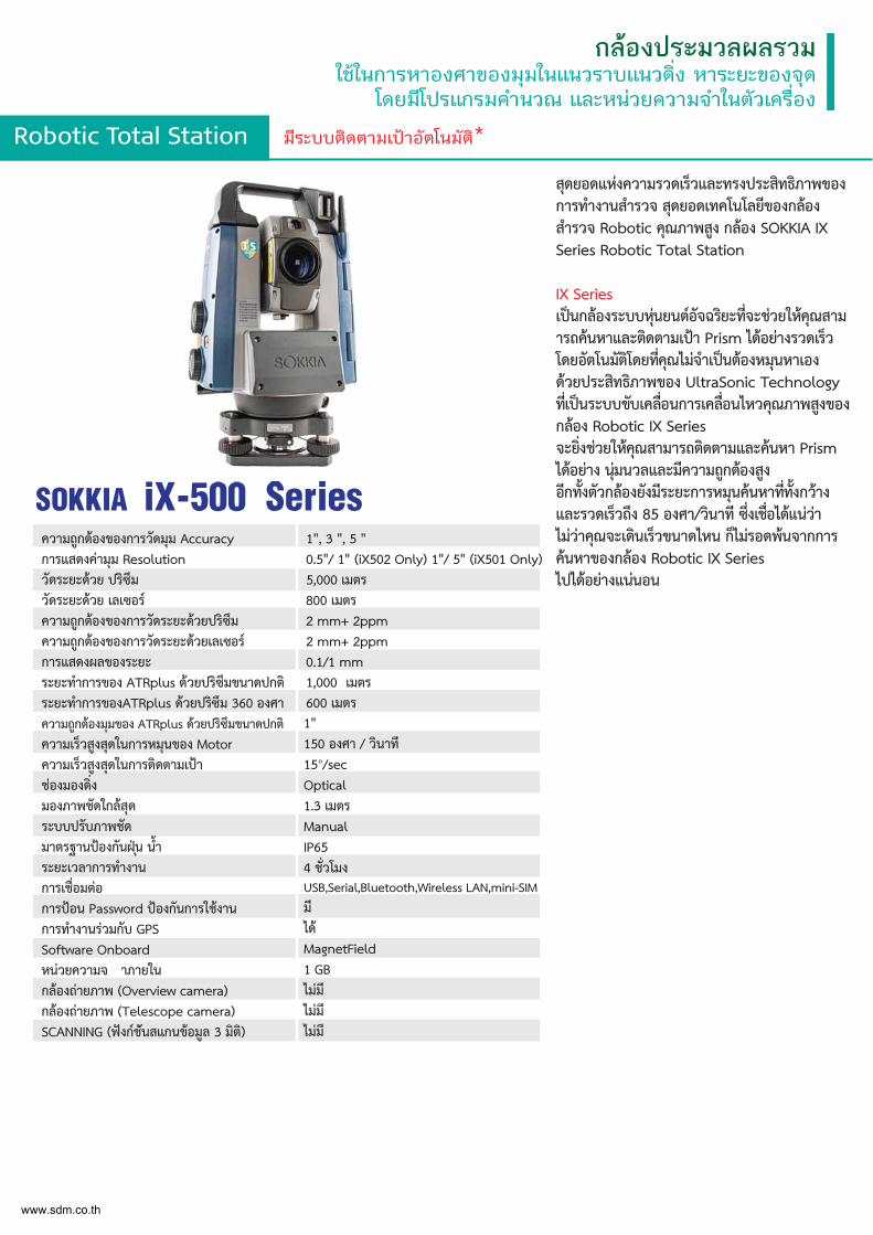
สุดยอดแหงความรวดเร็วและทรงประสิทธิภาพของการทำงานสำรวจ สุดยอดเทคโนโลยีของกลอง สำรวจ Robotic คุณภาพสูง กลอง SOKKIA IX Series Robotic Total Station
IX Series เปนกลองระบบหุนยนตอัจฉริยะท่ีจะชวยใหคุณสามารถคนหาและติดตามเปา Prism ไดอยางรวดเร็ว โดยอัตโนมัติโดยท่ีคุณไมจำเปนตองหมุนหาเอง ดวยประสิทธิภาพของ UltraSonic Technology ท่ีเปนระบบขับเคล่ือนการเคล่ือนไหวคุณภาพสูงของกลอง Robotic IX Series จะย่ิงชวยใหคุณสามารถติดตามและคนหา Prism ไดอยาง นุมนวลและมีความถูกตองสูง อีกท้ังตัวกลองยังมีระยะการหมุนคนหาท่ีท้ังกวาง และรวดเร็วถึง 85 องศา/วินาที ซ่ึงเช่ือไดแนวา ไมวาคุณจะเดินเร็วขนาดไหน ก็ไมรอดพนจากการ คนหาของกลอง Robotic IX Series ไปไดอยางแนนอน
1", 3 ", 5 "0.5"/ 1" (iX502 Only) 1"/ 5" (iX501 Only)5,000 เมตร800 เมตร2 mm+ 2ppm2 mm+ 2ppm0.1/1 mm1,000 เมตร 600 เมตร
ความถูกตองของการวัดมุม Accuracy การแสดงคามุม Resolution วัดระยะดวย ปริซึม วัดระยะดวย เลเซอร ความถูกตองของการวัดระยะดวยปริซึม ความถูกตองของการวัดระยะดวยเลเซอร การแสดงผลของระยะ ระยะทำการของ ATRplus ดวยปริซึมขนาดปกติ ระยะทำการของATRplus ดวยปริซึม 360 องศา ความถูกตองมุมของ ATRplus ดวยปริซึมขนาดปกติ ความเร็วสูงสุดในการหมุนของ Motor ความเร็วสูงสุดในการติดตามเปาชองมองดิ่ง มองภาพชัดใกลสุด ระบบปรับภาพชัด มาตรฐานปองกันฝนุ นํ้าระยะเวลาการทำงาน การเชื่อมตอ การปอน Password ปองกันการใชงาน การทำงานรวมกับ GPS Software Onboard หนวยความจ าภายใน กลองถายภาพ (Overview camera) กลองถายภาพ (Telescope camera) SCANNING (ฟงกชันสแกนขอมูล 3 มิติ)
1"150 องศา / วินาที15°/secOptical1.3 เมตรManualIP654 ช่ัวโมงUSB,Serial,Bluetooth,Wireless LAN,mini-SIM มีไดMagnetField1 GB ไมมีไมมีไมมี
SOKKIA iX-500 Series
www.sdm.co.th
Robotic Total Station มีระบบติดตามเปาอัตโนมัติ*
กลองประมวลผลรวมใชในการหาองศาของมุมในแนวราบแนวดิ่ง หาระยะของจุด
โดยมีโปรแกรมคำนวณ และหนวยความจำในตัวเครื่อง
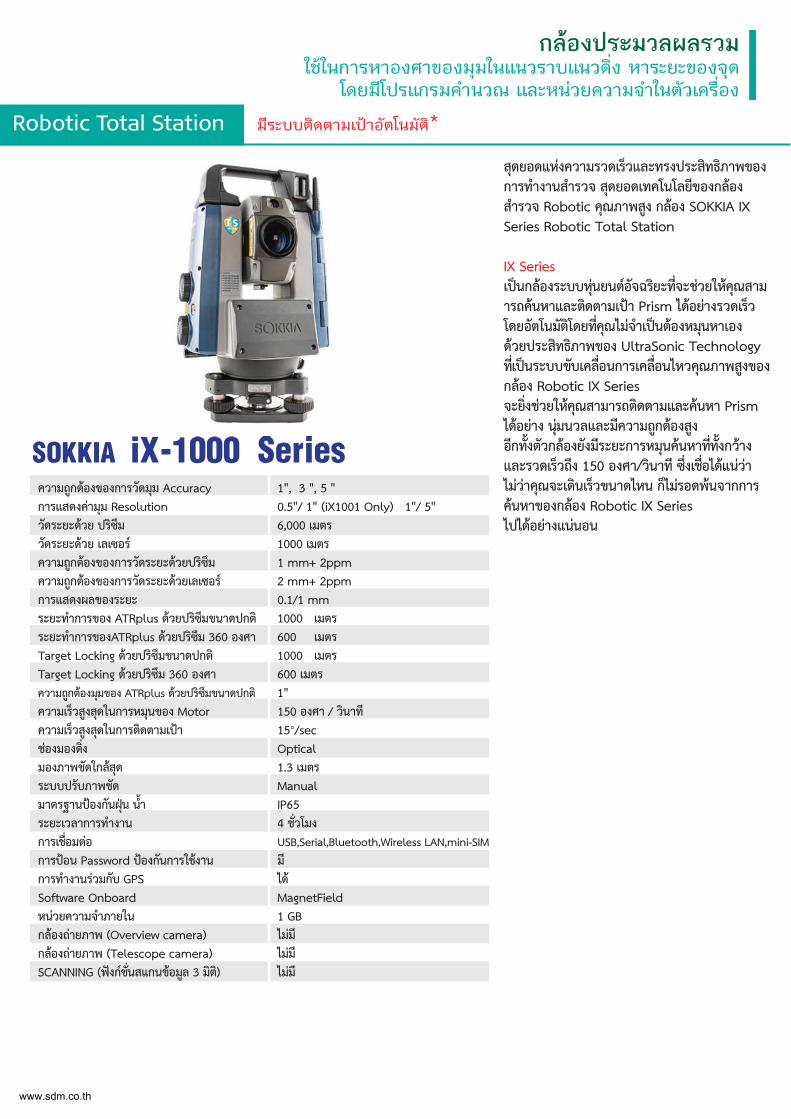
สุดยอดแหงความรวดเร็วและทรงประสิทธิภาพของการทำงานสำรวจ สุดยอดเทคโนโลยีของกลอง สำรวจ Robotic คุณภาพสูง กลอง SOKKIA IX Series Robotic Total Station
IX Series เปนกลองระบบหุนยนตอัจฉริยะท่ีจะชวยใหคุณสามารถคนหาและติดตามเปา Prism ไดอยางรวดเร็ว โดยอัตโนมัติโดยท่ีคุณไมจำเปนตองหมุนหาเอง ดวยประสิทธิภาพของ UltraSonic Technology ท่ีเปนระบบขับเคล่ือนการเคล่ือนไหวคุณภาพสูงของกลอง Robotic IX Series จะย่ิงชวยใหคุณสามารถติดตามและคนหา Prism ไดอยาง นุมนวลและมีความถูกตองสูง อีกท้ังตัวกลองยังมีระยะการหมุนคนหาท่ีท้ังกวาง และรวดเร็วถึง 150 องศา/วินาที ซ่ึงเช่ือไดแนวา ไมวาคุณจะเดินเร็วขนาดไหน ก็ไมรอดพนจากการ คนหาของกลอง Robotic IX Series ไปไดอยางแนนอน
ความถูกตองของการวัดมุม Accuracy การแสดงคามุม Resolution วัดระยะดวย ปริซึม วัดระยะดวย เลเซอร ความถูกตองของการวัดระยะดวยปริซึม ความถูกตองของการวัดระยะดวยเลเซอร การแสดงผลของระยะ
1", 3 ", 5 "0.5"/ 1" (iX1001 Only) 1"/ 5" 6,000 เมตร1000 เมตร1 mm+ 2ppm2 mm+ 2ppm0.1/1 mm
ระยะทำการของ ATRplus ดวยปริซึมขนาดปกติ ระยะทำการของATRplus ดวยปริซึม 360 องศา Target Locking ดวยปริซึมขนาดปกติ Target Locking ดวยปริซึม 360 องศา
1000 เมตร 600 เมตร 1000 เมตร 600 เมตร
ความถูกตองมุมของ ATRplus ดวยปริซึมขนาดปกติ 1"ความเร็วสูงสุดในการหมุนของ Motor 150 องศา / วินาทีความเร็วสูงสุดในการติดตามเปา 15°/secชองมองด่ิง Opticalมองภาพชัดใกลสุด 1.3 เมตรระบบปรับภาพชัด Manualมาตรฐานปองกันฝุน น้ำ IP65ระยะเวลาการทำงาน 4 ช่ัวโมงการเช่ือมตอ USB,Serial,Bluetooth,Wireless LAN,mini-SIMการปอน Password ปองกันการใชงาน มีการทำงานรวมกับ GPS ไดSoftware Onboard MagnetFieldหนวยความจำภายใน 1 GBกลองถายภาพ (Overview camera) ไมมีกลองถายภาพ (Telescope camera) ไมมีSCANNING (ฟงกช่ันสแกนขอมูล 3 มิติ) ไมมี
SOKKIA iX-1000 Series
www.sdm.co.th
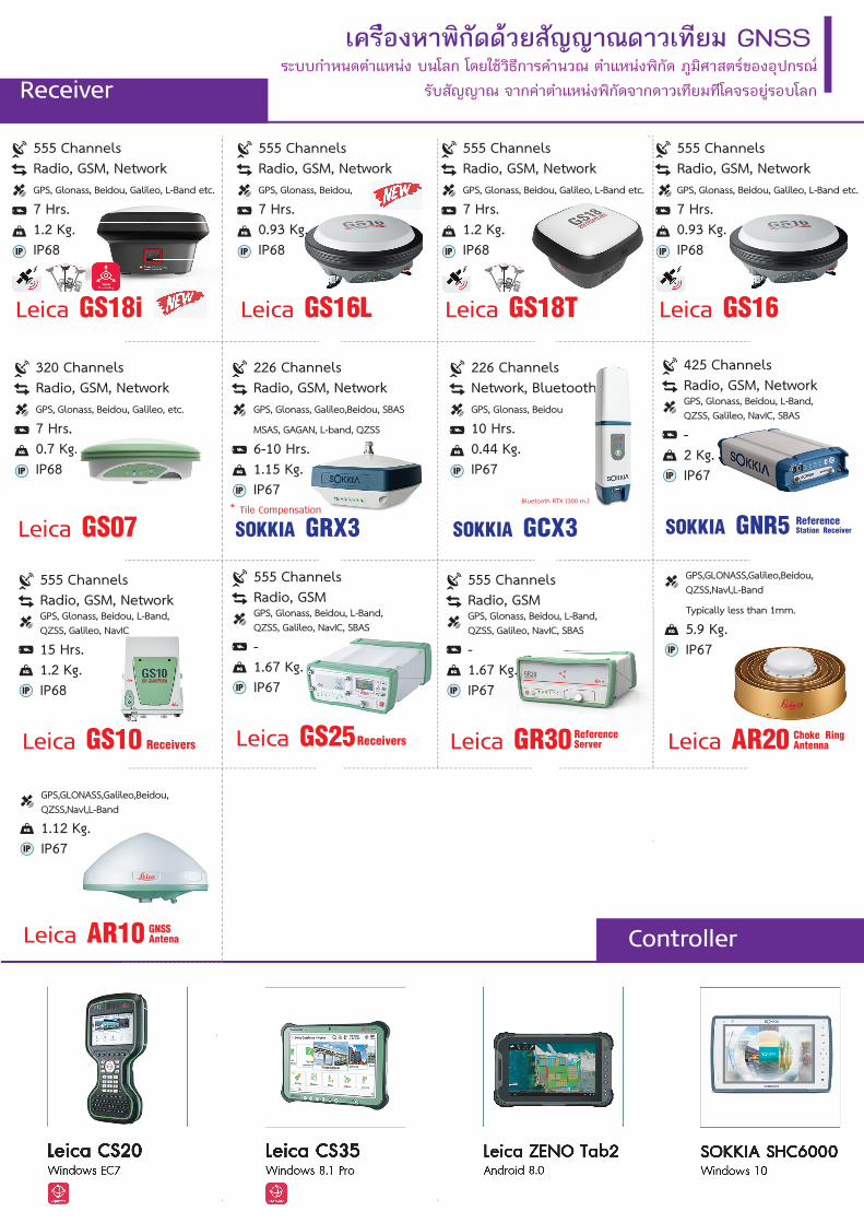
เครืองหาพิกัดดวยสัญญาณดาวเทียม GNSSระบบกำหนดตำแหนง บนโลก โดยใชวิธีการคำนวณ ตำแหนงพิกัด ภูมิศาสตรของอุปกรณ
รับสัญญาณ จากคาตำแหนงพิกัดจากดาวเทียมทีโคจรอยูรอบโลกReceiver
Controller
Leica GS18T
555 ChannelsRadio, GSM, NetworkGPS, Glonass, Beidou, Galileo, L-Band etc.
7 Hrs.1.2 Kg.IP68IP
Leica GS18i
555 ChannelsRadio, GSM, NetworkGPS, Glonass, Beidou, Galileo, L-Band etc.
7 Hrs.1.2 Kg.IP68IP
Leica GS16L
555 ChannelsRadio, GSM, NetworkGPS, Glonass, Beidou,
7 Hrs.0.93 Kg.IP68IP
Leica GS07
320 ChannelsRadio, GSM, NetworkGPS, Glonass, Beidou, Galileo, etc.
7 Hrs.0.7 Kg.IP68IP
, , ,
s.Kg.
Leica GS16
555 ChannelsRadio, GSM, NetworkGPS, Glonass, Beidou, Galileo, L-Band etc.
7 Hrs.0.93 Kg.IP68IP
Leica GS10
555 ChannelsRadio, GSM, NetworkGPS, Glonass, Beidou, L-Band,QZSS, Galileo, NavIC
15 Hrs.1.2 Kg.IP68IP
Receivers Leica GR30
555 ChannelsRadio, GSMGPS, Glonass, Beidou, L-Band,QZSS, Galileo, NavIC, SBAS
-1.67 Kg.IP67IP
ReferenceServerLeica GS25
555 ChannelsRadio, GSMGPS, Glonass, Beidou, L-Band,QZSS, Galileo, NavIC, SBAS
-1.67 Kg.IP67IP
Receivers Leica AR20
GPS,GLONASS,Galileo,Beidou,QZSS,Navl,L-Band
Typically less than 1mm.
5.9 Kg.IP67IP
Choke Ring Antenna
Leica AR10
GPS,GLONASS,Galileo,Beidou,QZSS,Navl,L-Band
1.12 Kg.IP67IP
GNSSAntena
SOKKIA GCX3
226 ChannelsNetwork, BluetoothGPS, Glonass, Beidou
10 Hrs.0.44 Kg.IP67IP
Bluetooth RTK (300 m.)
hhhhhhhhhh
SOKKIA GRX3
226 ChannelsRadio, GSM, NetworkGPS, Glonass, Galileo,Beidou, SBAS
MSAS, GAGAN, L-band, QZSS
6-10 Hrs.1.15 Kg.IP67IP
* Tile Compensation
SOKKIA GNR5
425 ChannelsRadio, GSM, NetworkGPS, Glonass, Beidou, L-Band,QZSS, Galileo, NavIC, SBAS
-2 Kg.IP67IP
ReferenceStation Receiver
เครืองหาพิกัดดวยสัญญาณดาวเทียม GNSSระบบกาํหนดตําแหนง บนโลก โดยใชวิธีการคาํนวณ ตําแหนงพิกัด ภูมิศาสตรของอุปกรณ
รับสัญญาณ จากคาตาํแหนงพิกัดจากดาวเทียมทีโคจรอยูรอบโลกReceiver
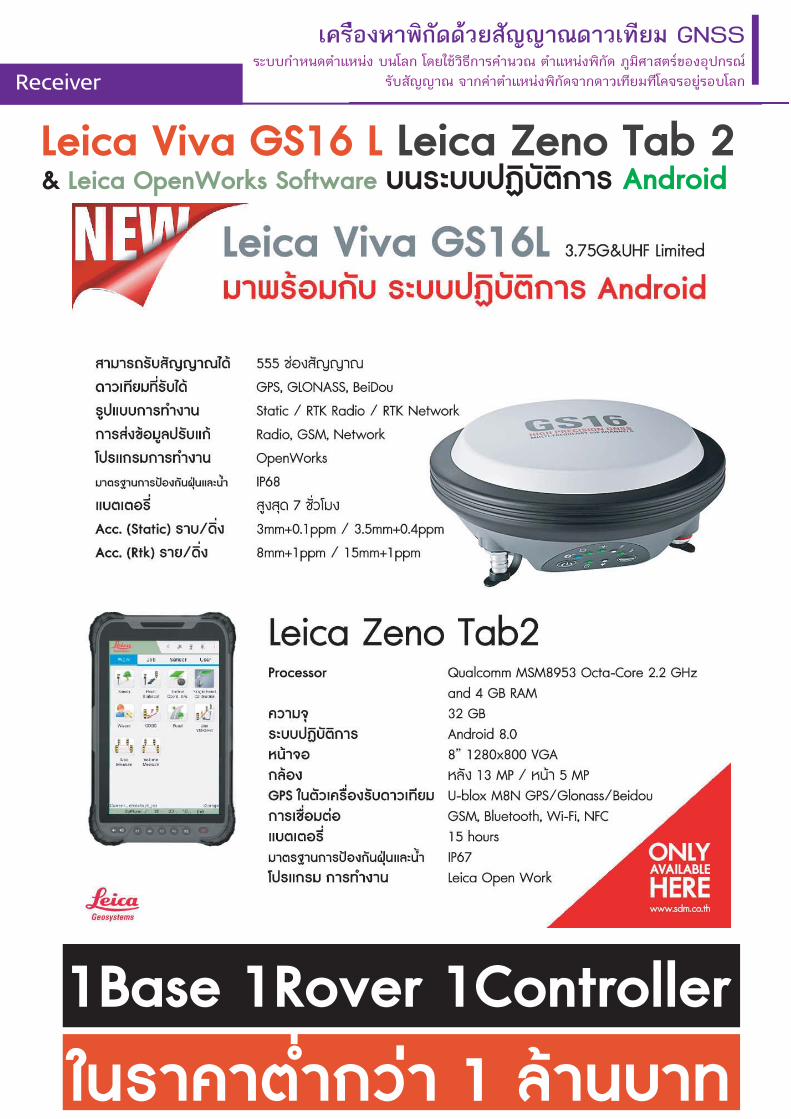
Leica Viva GS16 L Leica Zeno Tab 2 & Leica OpenWorks Software บนระบบปฏิบัติการ Android
1Base 1Rover 1Controllerในราคาต่ำกวา 1 ลานบาท
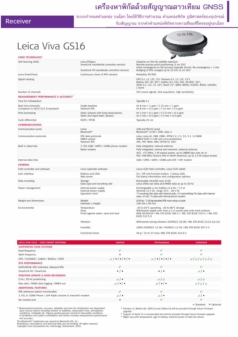
GNSS TECHNOLOGY
Self-learning GNSS Leica RTKplusSmartLink (worldwide correction service)
SmartLink fill (worldwide correction service)
Adaptive on-the-fly satellite selectionRemote precise point positioning (3 cm 2D)1
Initial convergence to full accuracy typically 18 min, Re-convergence < 1 minBridging of RTK outages up to 10 min (3 cm 2D)1
Leica SmartCheck Continuous check of RTK solution Reliability 99.99%
Signal tracking GPS (L1, L2, L2C, L5), Glonass (L1, L2, L2C, L32), BeiDou (B1, B2, B32), Galileo (E1, E5a, E5b, Alt-BOC, E62),QZSS (L1, L2C, L5, L62), NavIC L53, SBAS (WAAS, EGNOS, MSAS, GAGAN), L-band
Number of channels 555 (more signals, fast acquisition, high sensitivity)
MEASUREMENT PERFORMANCE & ACCURACY1
Time for initialisation Typically 4 s
Real-time kinematic(Compliant to ISO17123-8 standard)
Single baselineNetwork RTK
Hz 8 mm + 1 ppm / V 15 mm + 1 ppmHz 8 mm + 0.5 ppm / V 15 mm + 0.5 ppm
Post processing Static (phase) with long observationsStatic and rapid static (phase)
Hz 3 mm + 0.1 ppm / V 3.5 mm + 0.4 ppmHz 3 mm + 0.5 ppm / V 5 mm + 0.5 ppm
Code differential DGPS / RTCM Typically 25 cm
COMMUNICATIONS
Communication ports LemoBluetooth®
USB and RS232 serialBluetooth® v2.00 + EDR, class 2
Communication protocols RTK data protocolsNMEA outputNetwork RTK
Leica, Leica 4G, CMR, CMR+, RTCM 2.2, 2.3, 3.0, 3.1, 3.2 MSMNMEA 0183 V 4.00 and Leica proprietaryVRS, FKP, iMAX, MAC (RTCM SC 104)
Built-in data links 3.75G GSM / UMTS / CDMA phone modemRadio modem
Fully integrated, internal antennaFully integrated, receive and transmit, external antenna403 - 473 MHz, 1 W output power, up to 28800 bps over air or 902-928 MHz (licence free in North America); up to 1.0 W output power
External data links GSM / GPRS / UMTS / CDMA and UHF / VHF modem
GENERAL
Field controller and software Leica Captivate software Leica CS20 field controller, Leica CS35 tablet
User interface Buttons and LEDsWeb server
On / Off and Function button, 7 status LEDsFull status information and configuration options
Data recording StorageData type and recording rate
Removable microSD card, 8 GBLeica GNSS raw data and RINEX data at up to 20 Hz
Power management Internal power supplyExternal power supplyOperation time4
Exchangeable Li-Ion battery (2.6 Ah / 7.4 V)Nominal 12 V DC, range 10.5 - 28 V DC7 h receiving (Rx) data with internal radio, 5 h transmitting (Tx) data with internal radio, 6 h Rx / Tx data with internal phone modem
Weight and dimensions WeightDiameter x Height
0.93 kg / 3.20 kg standard RTK rover setup on pole190 mm x 90 mm
Environmental TemperatureDropProof against water, sand and dust
Vibration
Humidity
Functional shock
-40 to 65°C operating, -40 to 80°C storageWithstands topple over from a 2 m survey pole onto hard surfacesIP68 (IEC60529 / MIL STD 810G 506.5 I / MIL STD 810G 510.5 I / MIL STD810G 512.5 I)
Withstands strong vibration (ISO9022-36-08 / MIL STD 810G 514.6 Cat.24)
100% (ISO9022-13-06 / ISO9022-12-04 / MIL STD 810G 507.5 I)
40 g / 15 to 23 msec (MIL STD 810G 516.6 I)
1 Measurement precision, accuracy, reliability and time for initialisation are dependent upon various factors including number of satellites, observation time, atmospheric conditions, multipath etc. Figures quoted assume normal to favourable conditions. A full BeiDou and Galileo constellation will further increase measurement performance and accuracy.
LEICA VIVA GS16 - GNSS SMART ANTENNA Limited Performance Unlimited
SUPPORTED GNSS SYSTEMS
Dual-frequency ✔ ✔ ✔
Multi-frequency • ✔ ✔
GPS / GLONASS / Galileo / BeiDou / QZSS ✔ / • / • / • / • ✔ / • / • / • / • ✔ / ✔ / ✔ / ✔ / ✔ RTK PERFORMANCE
DGPS/RTCM. RTK Unlimited, Network RTK ✔ ✔ ✔
SmartLink fill / SmartLink • / • • / • ✔ / •
POSITION UPDATE & DATA RECORDING
5 Hz / 20 Hz positioning ✔ / • ✔ / ✔ ✔ / ✔Raw data / RINEX data logging / NMEA out ✔ / • / • ✔ / • / • ✔ / ✔ / ✔ADDITIONAL FEATURES
RTK reference station functionality ✔ ✔ ✔
3.75G or CDMA Phone / UHF Radio (receive & transmit) modem ✔ / • ✔ / • ✔ / •No country lock • ✔ ✔
✔ Standard • Optional2 Glonass L3, BeiDou B3, QZSS L6 and Galileo E6 will be provided through future firmware
upgrade.3 Support of NavIC L5 is incorporated and will be provided through future firmware upgrade. 4 Might vary with temperature, age of battery, transmit power of data link device.
The Bluetooth® trademarks are owned by Bluetooth SIG, Inc.Illustrations, descriptions and technical data are not binding. All rights reserved. Copyright Leica Geosystems AG, Heerbrugg, Switzerland, 2016.
Leica Viva GS16
เครืองหาพิกัดดวยสัญญาณดาวเทียม GNSS
Receiverระบบกําหนดตําแหนง บนโลก โดยใชวิธีการคาํนวณ ตําแหนงพิกัด ภูมิศาสตรของอุปกรณ
รับสัญญาณ จากคาตาํแหนงพิกัดจากดาวเทียมทีโคจรอยูรอบโลก
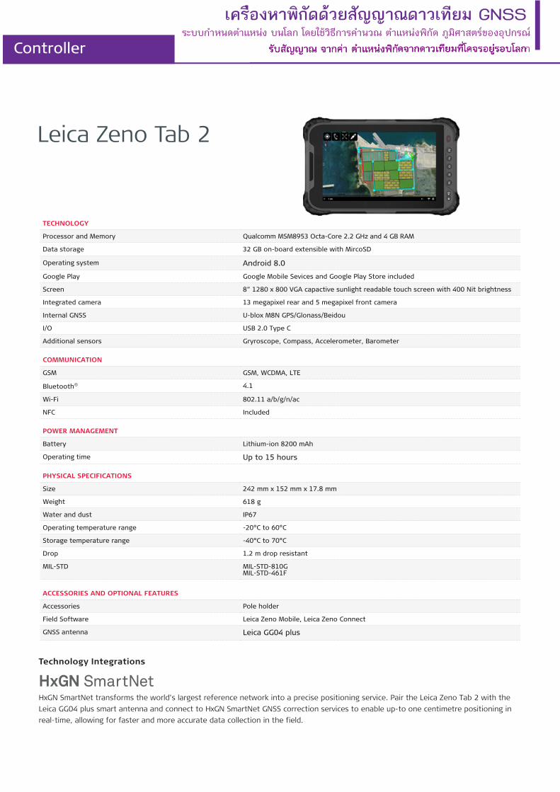
Leica Zeno Tab 2
TECHNOLOGY
Processor and Memory Qualcomm MSM8953 Octa-Core 2.2 GHz and 4 GB RAM
Data storage 32 GB on-board extensible with MircoSD
Operating system Android 8.0
Google Play Google Mobile Sevices and Google Play Store included
Screen 8” 1280 x 800 VGA capactive sunlight readable touch screen with 400 Nit brightness
Integrated camera 13 megapixel rear and 5 megapixel front camera
Internal GNSS U-blox M8N GPS/Glonass/Beidou
I/O USB 2.0 Type C
Additional sensors Gryroscope, Compass, Accelerometer, Barometer
COMMUNICATION
GSM GSM, WCDMA, LTE
Bluetooth® 4.1
Wi-Fi 802.11 a/b/g/n/ac
NFC Included
POWER MANAGEMENT
Battery Lithium-ion 8200 mAh
Operating time Up to 15 hours
PHYSICAL SPECIFICATIONS
Size 242 mm x 152 mm x 17.8 mm
Weight 618 g
Water and dust IP67
Operating temperature range -20°C to 60°C
Storage temperature range -40°C to 70°C
Drop 1.2 m drop resistant
MIL-STD MIL-STD-810GMIL-STD-461F
ACCESSORIES AND OPTIONAL FEATURES
Accessories Pole holder
Field Software Leica Zeno Mobile, Leica Zeno Connect
GNSS antenna Leica GG04 plus
Technology Integrations
HxGN SmartNet transforms the world’s largest reference network into a precise positioning service. Pair the Leica Zeno Tab 2 with the Leica GG04 plus smart antenna and connect to HxGN SmartNet GNSS correction services to enable up-to one centimetre positioning in real-time, allowing for faster and more accurate data collection in the field.
เครืองหาพิกัดดวยสัญญาณดาวเทียม GNSSระบบกําหนดตําแหนง บนโลก โดยใชวิธีการคํานวณ ตําแหนงพิกัด ภูมิศาสตรของอุปกรณ
รับสัญญาณ จากคาตําแหนงพิกัดจากดาวเทียมทีโคจรอยูรอบโลกController
Self-learning GNSS Leica RTKplusSmartLink (worldwide correction service)
SmartLink fill (worldwide correction service)
Adaptive on-the-fly satellite selectionRemote precise point positioning (3 cm 2D)1, Initial convergence to full accuracy typically 18 min, Re-convergence < 1 minBridging of RTK outages up to 10 min (3 cm 2D) 1
Leica SmartCheck Continuous check of RTK solution Reliability 99.99%
Signal tracking GPS / GLONASS Galileo / BeiDou
L1, L2, L2C, L5 / L1, L2, L2C, L32 E1, E5a, E5b, AltBOC, E63 / B1I, B1C, B2I, B2a, B3I
QZSS / NavIC L1, L2C, L5, L62 / L53
SBAS / L-Band WAAS, EGNOS, MSAS, GAGAN / TerraStar
Number of channels 555 (more signals, fast acquisition, high sensitivity)
Tilt compensation Increased measurement productivity and traceability
Calibration-free, immune to magnetic disturbances
IMAGING
Camera Sensor / Field of view (Hz, V) / Frame rate Global shutter with 1.2 MP / 80°, 60° / 20 Hz
Image group capture 2 Hz capturing rate Max. capturing time: 60 s, size of an image group appr. 50 MB
Point cloud Leica Infinity software Derive point cloud from an image group
MEASUREMENT PERFORMANCE & ACCURACY 1
Time for initialisation Typically 4 s
Real-time kinematic(Compliant to ISO17123-8 standard)
Single baselineNetwork RTK
Hz 8 mm + 1 ppm / V 15 mm + 1 ppmHz 8 mm + 0.5 ppm / V 15 mm + 0.5 ppm
Real-time kinematic tilt compensated Topographic points (not for control points) Additional Hz uncertainty max 8 mm + 0.4 mm/° tilt down to 30° tilt
Post processing Static (phase) with long observationsStatic and rapid static (phase)
Hz 3 mm + 0.1 ppm / V 3.5 mm + 0.4 ppmHz 3 mm + 0.5 ppm / V 5 mm + 0.5 ppm
Code differential DGNSS Hz 25 cm / V 50 cm
Image point measurement 1-click measurement in field / office Typically 2 cm – 4 cm (2D1), within the distance of 2 m to 10 m to the object
COMMUNICATIONS
Communication ports Lemo / Bluetooth® / WLAN USB and RS232 serial / Bluetooth® v2.1 + EDR, class 1.5 / 802.11 b/g for field controller communication only
Communication protocols RTK data protocolsNMEA outputNetwork RTK
Leica 4G, Leica, CMR, CMR+, RTCM 2.2, 2.3., 3.0, 3.1, 3.2 MSMNMEA 0183 v4.00 & v4.10 and Leica proprietaryVRS, FKP, iMAX, MAC (RTCM SC 104)
Built-in LTE modem LTE frequency bandsUMTS frequency bandsGSM frequency bands
Penta Band (20, 8, 3, 7, 1) / Penta Band (13, 17, 5, 4, 2)4
Tri Band (900/1800/2100 MHz) / Tri Band (1700/1900/2100 MHz)4
Dual Band (900/1800 MHz / Quad Band (850/900/1800/1900 MHz)4
Built-in UHF modem5 Receive & transmit UHF radio modem 403 – 473 MHz, channel spacing 12.5 kHz, 20 kHz, 25 kHz, max. 1 W output power up to 28800 bps over air
GENERAL
Field controller and software Leica Captivate software Leica CS20 LTE field controller, Leica CS35 tablet
User interface Buttons and LEDsWeb server
On / Off and Function button, 8 status LEDsFull status information and configuration options
Data recording StorageData type and recording rate
Removable SD card, 8 GBLeica GNSS raw data and RINEX data at up to 20 Hz
Power management Internal power supplyExternal power supplyOperation time6
Exchangeable Li-Ion battery (2.8 Ah / 11.1 V)Nominal 12 V DC, range 10.5 – 26.4 V DC7 h receiving (Rx) data with internal radio, 5 h transmitting (Tx) data with internal Radio, 6 h Rx/Tx with internal phone modem
Weight and dimensions Weight | Dimensions 1.25 kg / 3.55 kg standard RTK rover setup on pole | 173 mm x 73 mm x 108 mm
Environmental Temperature
DropProof against water, sand and dust
VibrationHumidityFunctional shock
-30 to +50°C operating with camera, -40 to +65°C operating without camera, -40 to +85°C storageWithstands topple over from a 2 m survey pole onto hard surfacesIP66 / IP68 (IEC60529 / MIL STD 810G CHG-1 510.6 I / MIL STD 810G CHG-1 506.6 II, MIL STD 810G CHG-1 512.6 I)Withstands strong vibration (ISO9022-36-08 / MIL STD 810G 514.6 Cat.24)95% (ISO9022-13-06 / ISO9022-12-04 / MIL STD 810G CHG-1 507.6 II)40 g / 15 to 23 msec (MIL STD 810G 516.6 I)
เครื่องหาพิกัดดวยสัญญาณดาวเทียม GNSS
Receiver
Leica GS18 irecrectiotion sn serverviceice))
AdaAdaptiptiveve on-on-thethe-fl-fly sy sateatellillitete selselectectionionRemRemoteote prpreciecisese poipointnt pospositiitionioningng (3(3 cmcm 2D)2D)1 I, Initnitialial coconvenvergergencence toto
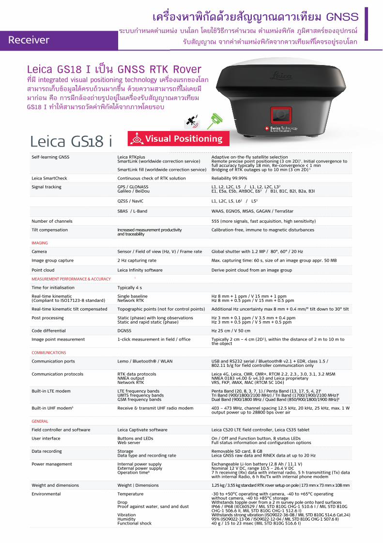
Leica GS18 I เปน GNSS RTK Rover ที่มี integrated visual positioning technology เครื่องแรกของโลก สามารถเก็บขอมูลไดครบถวนมากขึ้น ดวยความสามารถที่ไมเคยมีมากอน คือ การมีกลองถายรูปอยูในเครื่องรับสัญญาณดาวเทียม GS18 I ทำใหสามารถวัดคาพิกัดไดจากภาพโดยรอบ
ระบบกําหนดตําแหนง บนโลก โดยใชวิธีการคํานวณ ตําแหนงพิกัด ภูมิศาสตรของอุปกรณ รับสัญญาณ จากคาตําแหนงพิกัดจากดาวเทียมทีโคจรอยูรอบโลก
เครื่องหาพิกัดดวยสัญญาณดาวเทียม GNSSระบบกําหนดตําแหนง บนโลก โดยใชวิธีการคํานวณ ตําแหนงพิกัด ภูมิศาสตรของอุปกรณ
รับสัญญาณ จากคาตําแหนงพิกัดจากดาวเทียมทีโคจรอยูรอบโลกReceiver
Leica GS18 TGNSS TECHNOLOGY
Self-learning GNSS Leica RTKplusSmartLink (worldwide correction service) Remote precise point positioning (3 cm 2D) 1
Initial convergence to full accuracy 20 - 40 min, Re-convergence < 1 min Bridging of RTK outages up to 10 min (3 cm 2D) 1
Leica SmartCheck Continuous check of RTK solution Reliability 99.99%
Signal tracking GPS (L1, L2, L2C, L5), Glonass (L1, L2, L3 2),BeiDou (B1, B2, B3 2), Galileo (E1, E5a, E5b, Alt-BOC, E6 2),QZSS (L1, L2, L5), NavIC L5 3, SBAS (WAAS, EGNOS, MSAS, GAGAN), L-band
Number of channels 555 (more signals, fast acquisition, high sensitivity)
Tilt compensation Increased measurement productivity and traceability
Calibration-freeImmune to magnetic disturbances
MEASUREMENT PERFORMANCE & ACCURACY1
Time for initialisation Typically 4 s
Real-time kinematic(Compliant to ISO17123-8 standard)
Single baselineNetwork RTK
Hz 8 mm + 1 ppm / V 15 mm + 1 ppmHz 8 mm + 0.5 ppm / V 15 mm + 0.5 ppm
Real-time kinematic tilt compensated Topographic points (not for static control points)
Additional Hz pole tip uncertainty typically less than 10 mm + 0.7 mm/° tilt
Post processing Static (phase) with long observationsStatic and rapid static (phase)
Hz 3 mm + 0.1 ppm / V 3.5 mm + 0.4 ppmHz 3 mm + 0.5 ppm / V 5 mm + 0.5 ppm
Code differential DGPS / RTCM Typically 25 cm
COMMUNICATIONS
Communication ports LemoBluetooth®
USB and RS232 serialBluetooth® v2.1 + EDR, class 1.5
Communication protocols RTK data protocolsNMEA outputNetwork RTK
Leica, Leica 4G, CMR, CMR+, RTCM 2.2, 2.3, 3.0, 3.1, 3.2 MSMNMEA 0183 v4.00 and Leica proprietaryVRS, FKP, iMAX, MAC (RTCM SC 104)
Built-in data links GSM / UMTS / LTE phone modemRadio modem
Fully integrated, external antennaFully integrated, receive and transmit, external antenna403 - 470 MHz, 1 W output power, up to 28800 bps over air
External data links GSM / GPRS / UMTS / LTE / CDMA and UHF / VHF modem
GENERAL
Field controller and software Leica Captivate software
User interface Buttons and LEDsWeb server
On / Off and Function button, 8 status LEDs
Data recording StorageData type and recording rate
Removable SD card, 8 GBLeica GNSS raw data and RINEX data at up to 20 Hz
Power management Internal power supplyExternal power supplyOperation time4
Exchangeable Li-Ion battery (2.8 Ah / 11.1 V)Nominal 12 V DC, range 10.5 - 28 V DC7h receiving (Rx) data with internal radio, 5 h transmitting (Tx) data with internalradio, 6 h Rx/Tx data with internal phone modem
Weight and dimensions WeightDimensions
1.20 kg / 3.50 kg standard RTK rover setup on pole173 mm x 173 mm x 108 mm
Environmental TemperatureDropProof against water, sand and dust
VibrationHumidityFunctional shock
-40 to 65°C operating, -40 to 85°C storageWithstands topple over from a 2 m survey pole onto hard surfacesIP66 / IP68 (IEC60529 / MIL STD 810G CHG-1 510.6 I / MIL STD 810G CHG-1 506.6 II / MIL STD 810G CHG-1 512.6 I)Withstands strong vibration (ISO9022-36-08 / MIL STD 810G 514.6 Cat.24)95% (ISO9022-13-06 / ISO9022-12-04 / MIL STD 810G CHG-1 507.6 II)40 g / 15 to 23 msec (MIL STD 810G 516.6 I)
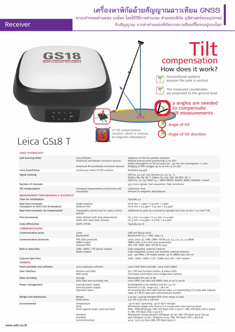
Tiltcompensation
Conventional systems assume the pole is vertical
2 angles are needed to compensate tilt measurements
Angle of tilt
Angle of tilt direction
The measured coordinates are projected to the ground level
How does it work?
1st tilt compensation solution, which is immune to magnetic disturbance
www.sdm.co.th
เครื่องหาพิกัดดวยสัญญาณดาวเทียม GNSSระบบกําหนดตําแหนง บนโลก โดยใชวิธีการคํานวณ ตําแหนงพิกัด ภูมิศาสตรของอุปกรณ
รับสัญญาณ จากคาตําแหนงพิกัดจากดาวเทียมทีโคจรอยูรอบโลกReceiver
GNSS TECHNOLOGY
Self-learning GNSS Leica RTKplusSmartLink (worldwide correction service)
SmartLink fill (worldwide correction service)
Adaptive on-the-fly satellite selectionRemote precise point positioning (3 cm 2D) 1
Initial convergence to full accuracy 20 - 40 min, Re-convergence < 1 minBridging of RTK outages up to 10 min (3 cm 2D) 1
Leica SmartCheck Continuous check of RTK solution Reliability 99.99%
Signal tracking GPS (L1, L2, L2C, L5), Glonass (L1, L2, L3 2), BeiDou (B1, B2, B3 2), Galileo (E1, E5a, E5b, Alt-BOC, E6 2),QZSS 3, NavIC L5 3, SBAS (WAAS, EGNOS, MSAS, GAGAN), L-band
Number of channels 555 (more signals, fast acquisition, high sensitivity)
MEASUREMENT PERFORMANCE & ACCURACY 1
Time for initialisation Typically 4 s
Real-time kinematic(Compliant to ISO17123-8 standard)
Single baselineNetwork RTK
Hz 8 mm + 1 ppm / V 15 mm + 1 ppmHz 8 mm + 0.5 ppm / V 15 mm + 0.5 ppm
Post processing Static (phase) with long observationsStatic and rapid static (phase)
Hz 3 mm + 0.1 ppm / V 3.5 mm + 0.4 ppmHz 3 mm + 0.5 ppm / V 5 mm + 0.5 ppm
Code differential DGPS / RTCM Typically 25 cm
COMMUNICATIONS
Communication ports LemoBluetooth ®
USB and RS232 serialBluetooth ® v2.00 + EDR, class 2
Communication protocols RTK data protocolsNMEA outputNetwork RTK
Leica, Leica 4G, CMR, CMR+, RTCM 2.2, 2.3, 3.0, 3.1, 3.2 MSMNMEA 0183 V 4.00 and Leica proprietaryVRS, FKP, iMAX, MAC (RTCM SC 104)
Built-in data links 3.75G GSM / UMTS / CDMA phone modemRadio modem
Fully integrated, internal antennaFully integrated, receive and transmit, external antenna403 - 470 MHz, 1 W output power, up to 28800 bps over air
External data links GSM / GPRS / UMTS / CDMA and UHF / VHF modem
GENERAL
Field controller and software Leica Captivate software Leica CS20 field controller, Leica CS35 tablet
User interface Buttons and LEDsWeb server
On / Off and Function button, 7 status LEDsFull status information and configuration options
Data recording StorageData type and recording rate
Removable microSD card, 8 GBLeica GNSS raw data and RINEX data at up to 20 Hz
Power management Internal power supplyExternal power supplyOperation time 4
Exchangeable Li-Ion battery (2.6 Ah / 7.4 V)Nominal 12 V DC, range 10.5 - 28 V DC7 h receiving (Rx) data with internal radio, 5 h transmitting (Tx) data with internal radio, 6 h Rx / Tx data with internal phone modem
Weight and dimensions WeightDiameter x Height
0.93 kg / 3.20 kg standard RTK rover setup on pole190 mm x 90 mm
Environmental TemperatureDropProof against water, sand and dust
Vibration
Humidity
Functional shock
-40 to 65°C operating, -40 to 80°C storageWithstands topple over from a 2 m survey pole onto hard surfacesIP68 (IEC60529 / MIL STD 810G 506.5 I / MIL STD 810G 510.5 I / MIL STD810G 512.5 I)
Withstands strong vibration (ISO9022-36-08 / MIL STD 810G 514.6 Cat.24)
100% (ISO9022-13-06 / ISO9022-12-04 / MIL STD 810G 507.5 I)
40 g / 15 to 23 msec (MIL STD 810G 516.6 I)
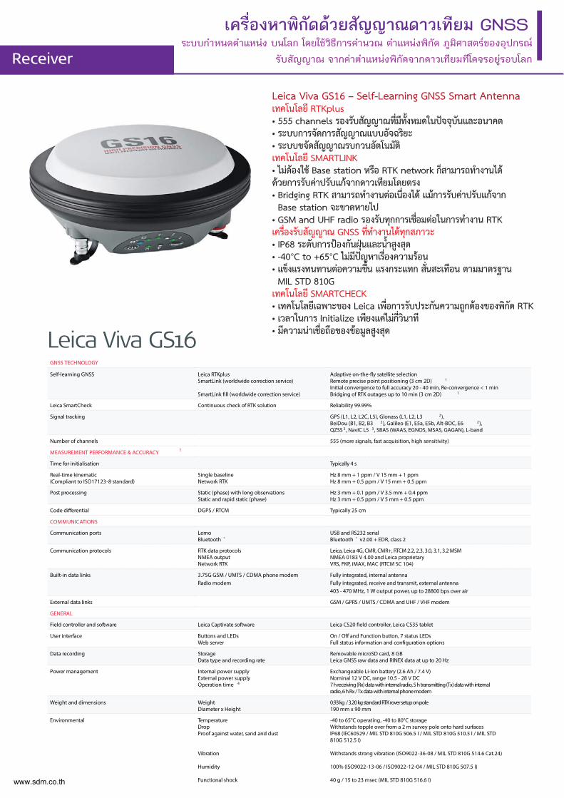
Leica Viva GS16
Leica Viva GS16 – Self-Learning GNSS Smart Antennaเทคโนโลยี RTKplus• 555 channels รองรับสัญญาณท่ีมีท้ังหมดในปจจุบันและอนาคต• ระบบการจัดการสัญญาณแบบอัจฉริยะ• ระบบขจัดสัญญาณรบกวนอัตโนมัติเทคโนโลยี SMARTLINK• ไมตองใช Base station หรือ RTK network ก็สามารถทำงานไดดวยการรับคาปรับแกจากดาวเทียมโดยตรง• Bridging RTK สามารถทำงานตอเน่ืองได แมการรับคาปรับแกจาก Base station จะขาดหายไป• GSM and UHF radio รองรับทุกการเช่ือมตอในการทำงาน RTKเคร่ืองรับสัญญาณ GNSS ท่ีทำงานไดทุกสภาวะ• IP68 ระดับการปองกันฝุนและน้ำสูงสุด• -40°C to +65°C ไมมีปญหาเร่ืองความรอน• แข็งแรงทนทานตอความช้ืน แรงกระแทก ส่ันสะเทือน ตามมาตรฐานMIL STD 810G
เทคโนโลยี SMARTCHECK• เทคโนโลยีเฉพาะของ Leica เพ่ือการรับประกันความถูกตองของพิกัด RTK• เวลาในการ Initialize เพียงแคไมก่ีวินาที• มีความนาเช่ือถือของขอมูลสูงสุด
www.sdm.co.th
เครื่องหาพิกัดดวยสัญญาณดาวเทียม GNSSระบบกําหนดตําแหนง บนโลก โดยใชวิธีการคํานวณ ตําแหนงพิกัด ภูมิศาสตรของอุปกรณ
รับสัญญาณ จากคาตําแหนงพิกัดจากดาวเทียมทีโคจรอยูรอบโลกReceiver
Leica GS07GNSS PERFORMANCE
GNSS Technology Leica RTKplus
Leica SmartCheck Continuous check of RTK solution Reliability 99.95%
Signal tracking SmartTrack GPS (L1, L2, L2C, L5), Glonass (L1, L2, L3 2), BeiDou (B1, B2, B3 2), Galileo (E1, E5a, E5b, Alt-BOC, E6 2), QZSS (L1, L2, L5, LEX 2), NavIC L53, SBAS (WAAS, EGNOS, MSAS, GAGAN)
Number of channels 320 hardware channels
MEASUREMENT PERFORMANCE & ACCURACY1
Time for initialisation Typically 6 s
Real-time kinematic (Compliant to IS017123-8 standard)
Single baseline Network RTK
Hz 10 mm + 1 ppm / V 20 mm + 1 ppm Hz 10 mm + 0.5 ppm / V 20 mm + 0.5 ppm
Post processing Static (phase) with long observations Static and rapid static (phase)
Hz 3 mm + 0.5 ppm / V 6 mm + 0.5 ppm Hz 5 mm + 0.5 ppm / V 10 mm + 0.5 ppm
Code differential DGPS / RTCM Typically 25 cm
COMMUNICATIONS
Communication ports Lemo Bluetooth®
USB and RS232 serial Bluetooth v2.00 + EDR, class 2
Communication protocols RTK data protocols Network RTK
Leica, Leica 4G, CMR, CMR+, RTCM 2.2, 2.3, 3.0, 3.1, 3.2 MSMVRS, FKP, iMAX, MAC (RTCM SC 104)
Built-in data links4 3.75G GSM / UMTS / CDMA phone modem Radio modem
Fully integrated, internal antenna Fully integrated, receive, external antenna 403 - 470 MHz, up to 28800 bps over air
External data links Bluetooth GSM / GPRS / UMTS / LTE / CDMA phone modem
GENERAL
Field controller and software Leica Captivate software
User interface Buttons and LEDs On / Off button, 3 status LEDs
Data recording Storage5 Data type and recording rate
Removable SD card, 8 GB Leica GNSS raw data and RINEX data at up to 5 Hz
Power management Internal power supply External power supply Operation time6
Exchangeable Li-Ion battery (2.6 Ah / 7.4 V) Nominal 12 V DC, range 10.5 - 28 V DC 8 h GNSS 7 h receiving RTK data with CS modem
Weight and dimensions Weight Diameter x Height
0.7 kg / 2.7 kg standard RTK rover setup on pole 186 mm x 71 mm
Environmental Temperature Drop Proof against water, sand and dust
Vibration Humidity Functional shock
-40 to 65°C operating, -40 to 80°C storage Withstands topple over from a 2 m survey pole onto hard surfaces IP66 / IP68 (IEC60529 / MIL STD 810G CHG-1 510.6 I / MIL STD 810G CHG-1 506.6 II / MIL STD 810G CHG-1 512.6 I) Withstands strong vibration (ISO9022-36-05 / MIL STD 810G 514.6 Cat.24)95% (ISO9022-13-06 / ISO9022-12-04 / MIL STD 810G CHG-1 507.6 II) 40 g / 15 to 23 msec (MIL STD 810G 516.6 I)
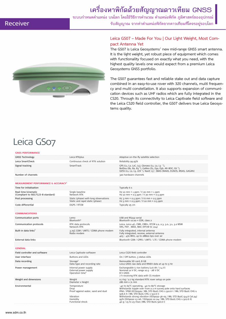
Leica GS07 – Made For You | Our Light Weight, Most Com-pact Antenna YetThe GS07 is Leica Geosystems’ new mid-range GNSS smart antenna. It is the light weight, yet robust piece of equipment which comes with functionality focused on exactly what you need, with the highest quality levels one would expect from a premium Leica Geosystems GNSS portfolio.
The GS07 guarantees fast and reliable stake out and data capture combined in an easy-to-use rover with 320 channels, multi frequen-cy and multi constellation. It also supports expansion of communi-cation devices such as UHF radios which are fully integrated in the CS20. Through its connectivity to Leica Captivate field software and the Leica CS20 field controller, the GS07 delivers true Leica Geosys-tems quality.
www.sdm.co.th
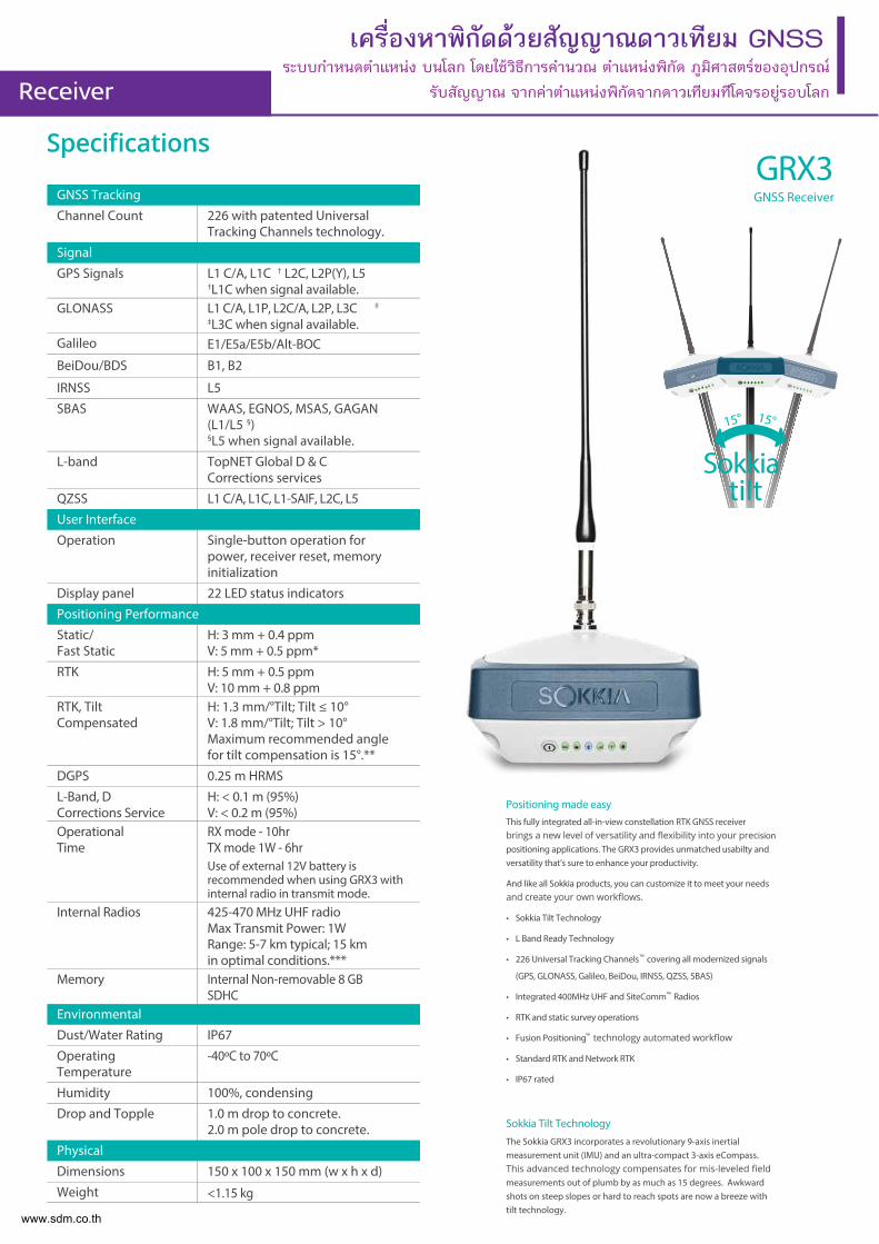
เครื่องหาพิกัดดวยสัญญาณดาวเทียม GNSSระบบกําหนดตําแหนง บนโลก โดยใชวิธีการคํานวณ ตําแหนงพิกัด ภูมิศาสตรของอุปกรณ
รับสัญญาณ จากคาตําแหนงพิกัดจากดาวเทียมทีโคจรอยูรอบโลกReceiver
GNSS Tracking
Channel Count 226 with patented Universal Tracking Channels technology.
Signal
GPS Signals L1 C/A, L1C † L2C, L2P(Y), L5 †L1C when signal available.
GLONASS L1 C/A, L1P, L2C/A, L2P, L3C ‡
‡L3C when signal available.Galileo E1/E5a/E5b/Alt-BOC
BeiDou/BDS B1, B2
IRNSS L5
SBAS WAAS, EGNOS, MSAS, GAGAN (L1/L5 §)§L5 when signal available.
L-band TopNET Global D & CCorrections services
QZSS L1 C/A, L1C, L1-SAIF, L2C, L5
User Interface
Operation Single-button operation for power, receiver reset, memory initialization
Display panel 22 LED status indicators
Positioning Performance
Static/Fast Static
H: 3 mm + 0.4 ppmV: 5 mm + 0.5 ppm*
RTK H: 5 mm + 0.5 ppmV: 10 mm + 0.8 ppm
RTK, Tilt Compensated
H: 1.3 mm/°Tilt; Tilt ≤ 10°V: 1.8 mm/°Tilt; Tilt > 10°Maximum recommended angle for tilt compensation is 15°.**
DGPS 0.25 m HRMS
L-Band, D Corrections Service
H: < 0.1 m (95%) V: < 0.2 m (95%)
Operational Time
RX mode - 10hrTX mode 1W - 6hrUse of external 12V battery is recommended when using GRX3 with internal radio in transmit mode.
Internal Radios 425-470 MHz UHF radio Max Transmit Power: 1WRange: 5-7 km typical; 15 km in optimal conditions.***
Memory Internal Non-removable 8 GB SDHC
Environmental
Dust/Water Rating IP67
Operating Temperature
-40ºC to 70ºC
Humidity 100%, condensing
Drop and Topple 1.0 m drop to concrete.2.0 m pole drop to concrete.
Physical
Dimensions 150 x 100 x 150 mm (w x h x d)
Weight <1.15 kg
GRX3GNSS Receiver
15°15°
Sokkiatilt
Positioning made easy
This fully integrated all-in-view constellation RTK GNSS receiver ision
positioning applications. The GRX3 provides unmatched usabilty and versatility that’s sure to enhance your productivity.
And like all Sokkia products, you can customize it to meet your needs
• Sokkia Tilt Technology
• L Band Ready Technology
• 226 Universal Tracking Channels™ covering all modernized signals
(GPS, GLONASS, Galileo, BeiDou, IRNSS, QZSS, SBAS)
• Integrated 400MHz UHF and SiteComm™ Radios
• RTK and static survey operations
• Fusion Positioning™
• Standard RTK and Network RTK
• IP67 rated
Sokkia Tilt Technology
The Sokkia GRX3 incorporates a revolutionary 9-axis inertial measurement unit (IMU) and an ultra-compact 3-axis eCompass.
measurements out of plumb by as much as 15 degrees. Awkward shots on steep slopes or hard to reach spots are now a breeze with tilt technology.
www.sdm.co.th
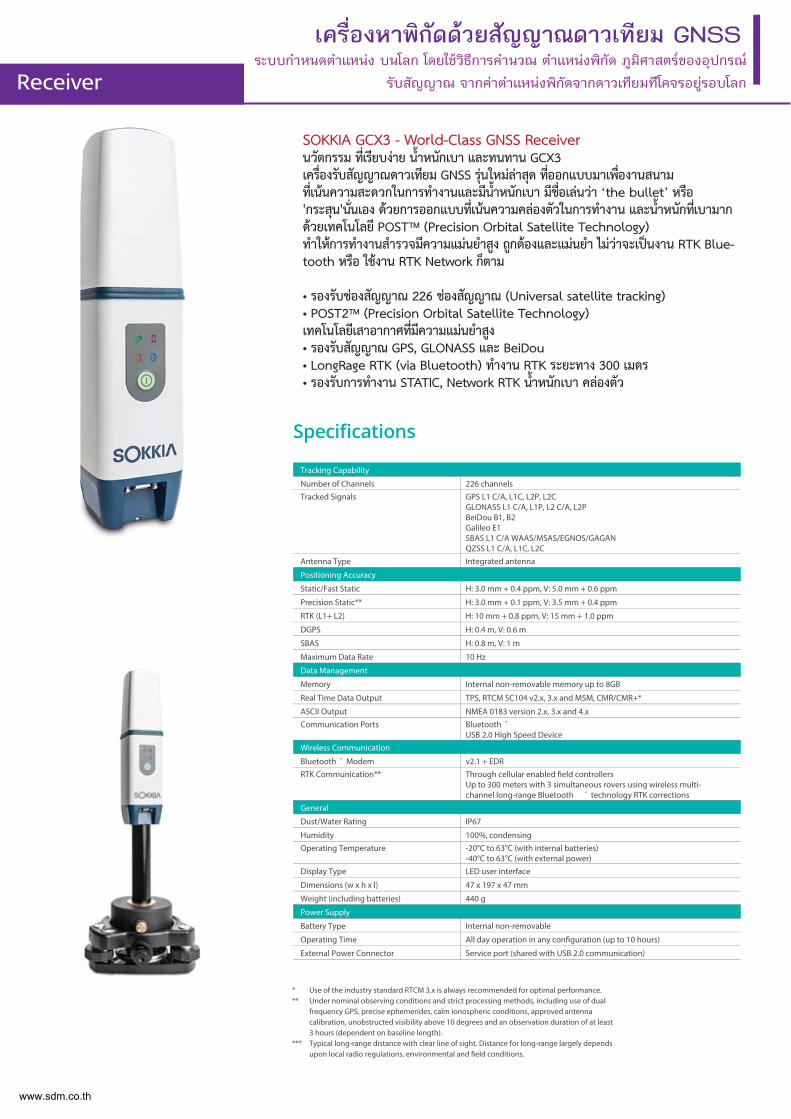
เครื่องหาพิกัดดวยสัญญาณดาวเทียม GNSSระบบกําหนดตําแหนง บนโลก โดยใชวิธีการคํานวณ ตําแหนงพิกัด ภูมิศาสตรของอุปกรณ
รับสัญญาณ จากคาตําแหนงพิกัดจากดาวเทียมทีโคจรอยูรอบโลกReceiver
SOKKIA GCX3 - World-Class GNSS Receiverนวัตกรรม ท่ีเรียบงาย น้ำหนักเบา และทนทาน GCX3 เคร่ืองรับสัญญาณดาวเทียม GNSS รุนใหมลาสุด ท่ีออกแบบมาเพ่ืองานสนาม ท่ีเนนความสะดวกในการทำงานและมีน้ำหนักเบา มีช่ือเลนวา ‘the bullet’ หรือ 'กระสุน'น่ันเอง ดวยการออกแบบท่ีเนนความคลองตัวในการทำงาน และน้ำหนักท่ีเบามาก ดวยเทคโนโลยี POST™ (Precision Orbital Satellite Technology) ทำใหการทำงานสำรวจมีความแมนยำสูง ถูกตองและแมนยำ ไมวาจะเปนงาน RTK Blue-tooth หรือ ใชงาน RTK Network ก็ตาม
• รองรับชองสัญญาณ 226 ชองสัญญาณ (Universal satellite tracking)• POST2™ (Precision Orbital Satellite Technology)เทคโนโลยีเสาอากาศท่ีมีความแมนยำสูง • รองรับสัญญาณ GPS, GLONASS และ BeiDou• LongRage RTK (via Bluetooth) ทำงาน RTK ระยะทาง 300 เมตร• รองรับการทำงาน STATIC, Network RTK น้ำหนักเบา คลองตัว
Tracking Capability
Number of Channels 226 channelsTracked Signals GPS L1 C/A, L1C, L2P, L2C
GLONASS L1 C/A, L1P, L2 C/A, L2PBeiDou B1, B2Galileo E1SBAS L1 C/A WAAS/MSAS/EGNOS/GAGANQZSS L1 C/A, L1C, L2C
Antenna Type Integrated antenna
Positioning Accuracy
Static/Fast Static H: 3.0 mm + 0.4 ppm, V: 5.0 mm + 0.6 ppm
Precision Static** H: 3.0 mm + 0.1 ppm, V: 3.5 mm + 0.4 ppm
RTK (L1+ L2) H: 10 mm + 0.8 ppm, V: 15 mm + 1.0 ppm
DGPS H: 0.4 m, V: 0.6 m
SBAS H: 0.8 m, V: 1 m
Maximum Data Rate 10 Hz
Data Management
Memory Internal non-removable memory up to 8GB
Real Time Data Output TPS, RTCM SC104 v2.x, 3.x and MSM, CMR/CMR+*
ASCII Output NMEA 0183 version 2.x, 3.x and 4.xCommunication Ports Bluetooth ®
USB 2.0 High Speed DeviceWireless Communication
Bluetooth ® Modem v2.1 + EDRRTK Communication** Through cellular enabled field controllers
Up to 300 meters with 3 simultaneous rovers using wireless multi-channel long-range Bluetooth ® technology RTK corrections
General
Dust/Water Rating IP67
Humidity 100%, condensingOperating Temperature -20°C to 63°C (with internal batteries)
-40°C to 63°C (with external power)Display Type LED user interface
Dimensions (w x h x l) 47 x 197 x 47 mm
Weight (including batteries) 440 g
Power Supply
Battery Type Internal non-removable
Operating Time All day operation in any configuration (up to 10 hours)
External Power Connector Service port (shared with USB 2.0 communication)
* Use of the industry standard RTCM 3.x is always recommended for optimal performance.** Under nominal observing conditions and strict processing methods, including use of dual
frequency GPS, precise ephemerides, calm ionospheric conditions, approved antenna calibration, unobstructed visibility above 10 degrees and an observation duration of at least 3 hours (dependent on baseline length).
*** Typical long-range distance with clear line of sight. Distance for long-range largely depends upon local radio regulations, environmental and field conditions.
www.sdm.co.th
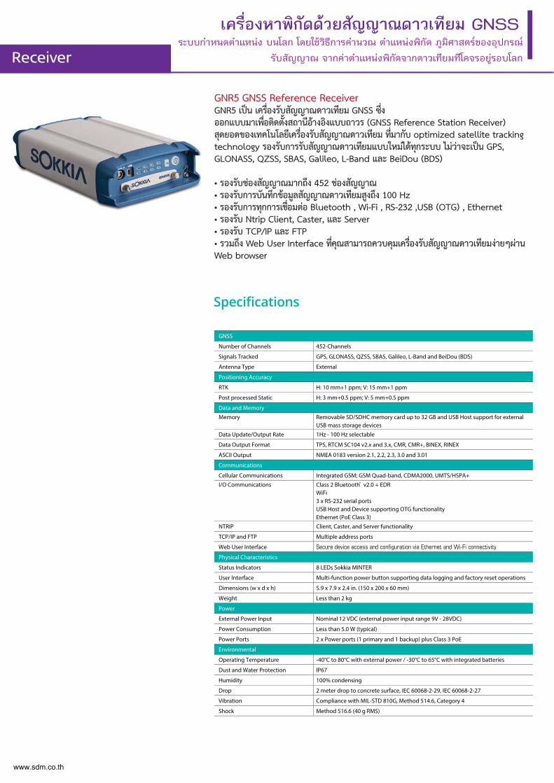
GNR5 GNSS Reference ReceiverGNR5 เปน เคร่ืองรับสัญญาณดาวเทียม GNSS ซ่ึง ออกแบบมาเพ่ือติดต้ังสถานีอางอิงแบบถาวร (GNSS Reference Station Receiver) สุดยอดของเทคโนโลยีเคร่ืองรับสัญญาณดาวเทียม ท่ีมากับ optimized satellite tracking technology รองรับการรับสัญญาณดาวเทียมแบบใหมไดทุกระบบ ไมวาจะเปน GPS, GLONASS, QZSS, SBAS, Galileo, L-Band และ BeiDou (BDS)
• รองรับชองสัญญาณมากถึง 452 ชองสัญญาณ• รองรับการบันทึกขอมูลสัญญาณดาวเทียมสูงถึง 100 Hz• รองรับการทุกการเช่ือมตอ Bluetooth , Wi-Fi , RS-232 ,USB (OTG) , Ethernet• รองรับ Ntrip Client, Caster, และ Server• รองรับ TCP/IP และ FTP• รวมถึง Web User Interface ท่ีคุณสามารถควบคุมเคร่ืองรับสัญญาณดาวเทียมงายๆผานWeb browser
เครื่องหาพิกัดดวยสัญญาณดาวเทียม GNSSระบบกําหนดตําแหนง บนโลก โดยใชวิธีการคํานวณ ตําแหนงพิกัด ภูมิศาสตรของอุปกรณ
รับสัญญาณ จากคาตําแหนงพิกัดจากดาวเทียมทีโคจรอยูรอบโลกReceiver
GNSS
Number of Channels 452-Channels
Signals Tracked GPS, GLONASS, QZSS, SBAS, Galileo, L-Band and BeiDou (BDS)
Antenna Type External
Positioning Accuracy
RTK H: 10 mm+1 ppm; V: 15 mm+1 ppm
Post processed Static H: 3 mm+0.5 ppm; V: 5 mm+0.5 ppm
Data and Memory
Memory Removable SD/SDHC memory card up to 32 GB and USB Host support for external USB mass storage devices
Data Update/Output Rate 1Hz - 100 Hz selectable
Data Output Format TPS, RTCM SC104 v2.x and 3.x, CMR, CMR+, BINEX, RINEX
ASCII Output NMEA 0183 version 2.1, 2.2, 2.3, 3.0 and 3.01
Communications
Cellular Communications Integrated GSM; GSM Quad-band, CDMA2000, UMTS/HSPA+
I/O Communications Class 2 Bluetooth® v2.0 + EDRWiFi 3 x RS-232 serial portsUSB Host and Device supporting OTG functionalityEthernet (PoE Class 3)
NTRIP Client, Caster, and Server functionality
TCP/IP and FTP Multiple address ports
Web User Interface
Physical Characteristics
Status Indicators 8 LEDs Sokkia MINTER
User Interface Multi-function power button supporting data logging and factory reset operations
Dimensions (w x d x h) 5.9 x 7.9 x 2.4 in. (150 x 200 x 60 mm)
Weight Less than 2 kg
Power
External Power Input Nominal 12 VDC (external power input range 9V - 28VDC)
Power Consumption Less than 5.0 W (typical)
Power Ports 2 x Power ports (1 primary and 1 backup) plus Class 3 PoE
Environmental
Operating Temperature -40°C to 80°C with external power / -30°C to 65°C with integrated batteries
Dust and Water Protection IP67
Humidity 100% condensing
Drop 2 meter drop to concrete surface, IEC 60068-2-29, IEC 60068-2-27
Vibration Compliance with MIL-STD 810G, Method 514.6, Category 4
Shock Method 516.6 (40 g RMS)
www.sdm.co.th
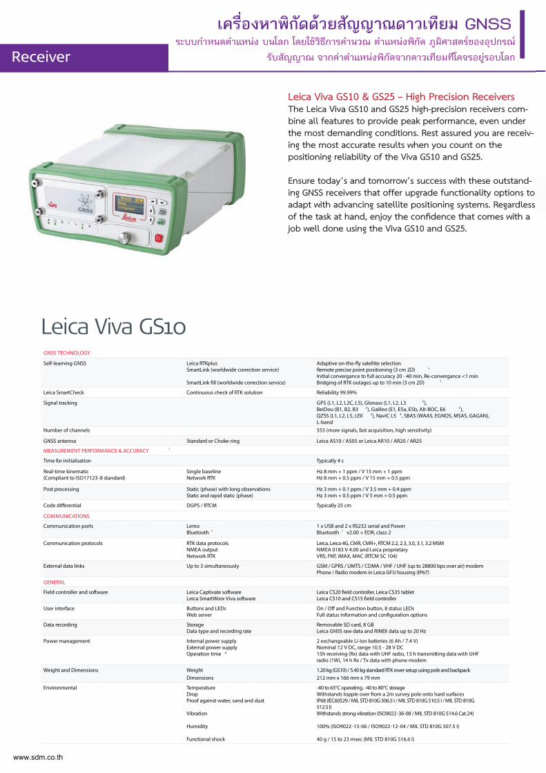
Leica Viva GS10 & GS25 – High Precision ReceiversThe Leica Viva GS10 and GS25 high-precision receivers com-bine all features to provide peak performance, even under the most demanding conditions. Rest assured you are receiv-ing the most accurate results when you count on the positioning reliability of the Viva GS10 and GS25.
Ensure today’s and tomorrow’s success with these outstand-ing GNSS receivers that offer upgrade functionality options to adapt with advancing satellite positioning systems. Regardless of the task at hand, enjoy the confidence that comes with a job well done using the Viva GS10 and GS25.
เครื่องหาพิกัดดวยสัญญาณดาวเทียม GNSSระบบกําหนดตําแหนง บนโลก โดยใชวิธีการคํานวณ ตําแหนงพิกัด ภูมิศาสตรของอุปกรณ
รับสัญญาณ จากคาตําแหนงพิกัดจากดาวเทียมทีโคจรอยูรอบโลกReceiver
GNSS TECHNOLOGY
Self-learning GNSS Leica RTKplusSmartLink (worldwide correction service)
SmartLink fill (worldwide correction service)
Adaptive on-the-fly satellite selectionRemote precise point positioning (3 cm 2D) 1
Initial convergance to full accuracy 20 - 40 min, Re-convergance <1 minBridging of RTK outages up to 10 min (3 cm 2D) 1
Leica SmartCheck Continuous check of RTK solution Reliability 99.99%
Signal tracking GPS (L1, L2, L2C, L5), Glonass (L1, L2, L3 2), BeiDou (B1, B2, B3 2), Galileo (E1, E5a, E5b, Alt-BOC, E6 2), QZSS (L1, L2, L5, LEX 2), NavIC L5 3, SBAS (WAAS, EGNOS, MSAS, GAGAN), L-band
Number of channels 555 (more signals, fast acquisition, high sensitivity)
GNSS antenna Standard or Choke-ring Leica AS10 / AS05 or Leica AR10 / AR20 / AR25
MEASUREMENT PERFORMANCE & ACCURACY 1
Time for initialisation Typically 4 s
Real-time kinematic(Compliant to ISO17123-8 standard)
Single baseline Network RTK
Hz 8 mm + 1 ppm / V 15 mm + 1 ppmHz 8 mm + 0.5 ppm / V 15 mm + 0.5 ppm
Post processing Static (phase) with long observationsStatic and rapid static (phase)
Hz 3 mm + 0.1 ppm / V 3.5 mm + 0.4 ppmHz 3 mm + 0.5 ppm / V 5 mm + 0.5 ppm
Code differential DGPS / RTCM Typically 25 cm
COMMUNICATIONS
Communication ports LemoBluetooth ®
1 x USB and 2 x RS232 serial and PowerBluetooth ® v2.00 + EDR, class 2
Communication protocols RTK data protocolsNMEA outputNetwork RTK
Leica, Leica 4G, CMR, CMR+, RTCM 2.2, 2.3, 3.0, 3.1, 3.2 MSMNMEA 0183 V 4.00 and Leica proprietaryVRS, FKP, iMAX, MAC (RTCM SC 104)
External data links Up to 3 simultaneously GSM / GPRS / UMTS / CDMA / VHF / UHF (up to 28800 bps over air) modemPhone / Radio modem in Leica GFU housing (IP67)
GENERAL
Field controller and software Leica Captivate softwareLeica SmartWorx Viva software
Leica CS20 field controller, Leica CS35 tabletLeica CS10 and CS15 field controller
User interface Buttons and LEDsWeb server
On / Off and Function button, 8 status LEDsFull status information and configuration options
Data recording StorageData type and recording rate
Removable SD card, 8 GBLeica GNSS raw data and RINEX data up to 20 Hz
Power management Internal power supplyExternal power supplyOperation time 4
2 exchangeable Li-Ion batteries (6 Ah / 7.4 V)Nominal 12 V DC, range 10.5 - 28 V DC15h receiving (Rx) data with UHF radio, 13 h transmitting data with UHF radio (1W), 14 h Rx / Tx data with phone modem
Weight and Dimensions WeightDimensions
1.20 kg (GS10) / 5.40 kg standard RTK rover setup using pole and backpack212 mm x 166 mm x 79 mm
Environmental TemperatureDropProof against water, sand and dust
Vibration
Humidity
Functional shock
-40 to 65°C operating, -40 to 80°C storageWithstands topple over from a 2m survey pole onto hard surfacesIP68 (IEC60529 / MIL STD 810G 506.5 I / MIL STD 810G 510.5 I / MIL STD 810G 512.5 I)Withstands strong vibration (ISO9022-36-08 / MIL STD 810G 514.6 Cat.24)
100% (ISO9022-13-06 / ISO9022-12-04 / MIL STD 810G 507.5 I)
40 g / 15 to 23 msec (MIL STD 810G 516.6 I)
Leica Viva GS10
www.sdm.co.th
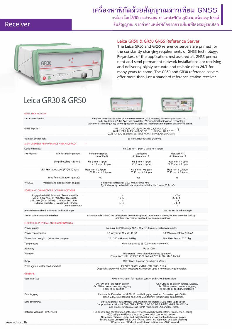
Leica GR50 & GR30 GNSS Reference ServerThe Leica GR50 and GR30 reference servers are primed for the constantly changing requirements of GNSS technology. Regardless of the application, rest assured all GNSS perma-nent and semi-permanent network installations are receiving and delivering highly accurate and reliable data 24/7 for many years to come. The GR50 and GR30 reference servers offer more than just a standard reference station receiver.
เครื่องหาพิกัดดวยสัญญาณดาวเทียม GNSSระบบกําหนดตําแหนง บนโลก โดยใชวิธีการคํานวณ ตําแหนงพิกัด ภูมิศาสตรของอุปกรณ
รับสัญญาณ จากคาตําแหนงพิกัดจากดาวเทียมทีโคจรอยูรอบโลกReceiver
เครองห
Receiver
Leica GR30 & GR50GNSS TECHNOLOGY
Leica SmartTrack+ Very low noise GNSS carrier phase measurements (<0.5 mm rms). Signal acquisition < 30 s 1.Industry-leading Pulse Aperture Correlator (PAC) multipath mitigation technology.
Advanced radio frequency power spectrum analysis and interference mitigation on all GNSS bands.
GNSS Signals 2 GPS (L1, L2P(Y), L2C, L5); GLONASS (L1, L2P, L2C, L3) 3;Galileo (E1, E5a, E5b, AltBOC, E6) 3; BeiDou (B1, B2, B3) 4;
QZSS (L1, L2C, L5); NavIC L5; SBAS (WAAS, EGNOS, GAGAN, MSAS)
Number of channels 555 universal tracking channels
MEASUREMENT PERFORMANCE AND ACCURACY 5
Code differential Hz: 0.25 m + 1 ppm / V: 0.5 m + 1 ppm
Site Monitor RTK Positioning modes: Reference station(smoothed)
Monitoring(instantaneous)
Network RTK(instantaneous)
Single baseline (<30 km): Hz: 6 mm + 1 ppmV: 10 mm +1 ppm
Hz: 8 mm + 1 ppmV: 15 mm + 1 ppm
Hz: 8 mm + 1 ppmV: 15 mm + 1 ppm
VRS, FKP, iMAX, MAC (RTCM SC 104): Hz: 6 mm + 0.5 ppmV: 10 mm + 0.5 ppm
Hz: 8 mm + 0.5 ppmV: 15 mm + 0.5ppm
Hz: 8 mm + 0.5 ppmV: 15 mm + 0.5 ppm
Time for initialisation (typical): 10s 10s 4s
VADASE Velocity and displacement engine:
PORTS AND CONNECTORS, COMMUNICATIONS
Ruggedized RJ45 Ethernet / Power over Eth.Serial RS232 / Slot-In / WLAN or Bluetooth ®
USB client (PC or tablet) / USB host (ext. disk)External oscillator / Event input / PPS Out
Dual-Power Input
1 / -1 / 1 / -
1 / -1 / - / -
1
1 / Yes2 / 1 / 1
1 / 11 / 1 / 1
1
Internal removable battery and built-in charger - GEB242 (up to 24h backup)
Slot-in communication interface Exchangeable radio/GSM/GPRS/UMTS devices supported. Automatic gateway routing provides backup of internet access for continuity of communications.
ELECTRICAL, PHYSICAL AND ENVIRONMENTAL
Power supply Nominal 24 V DC, range 10.5 – 28 V DC. Two external power inputs.
Power consumption 3.5 W typical, 24 V at 145 mA 3.1 W typical, 24 V at 130 mA
Dimension / weight (with rubber bumpers) 20 x 200 x 94 mm / 1.67kg 20 x 200 x 94 mm / 2.01 kg
Temperature Operating: -40 to 65 °C, Storage: -40 to 80 °C
Humidity Up to 100%
Vibration Withstands strong vibration during operation.Compliance with ISO9022-36-08 and MIL-STD-810G - 514.6-Cat.24
Drop Withstands 1 m drop onto hard surfaces.
Proof against water, sand and dust IP67 (IEC 60529) and MIL-STD-810G - 512.5-IDust tight, protected against water jets. Waterproof up to 1 m temporary submersion.
GENERAL
User interface Web Interface for full receiver control and status information.
Data logging Removable SD card up to 32 GB. 12 parallel logging sessions. Data rates up to 50 Hz.RINEX 2.11/3.xx, Hatanaka and Leica MDB formats including zip compression.
Data streaming Up to 20 parallel data streams with multiple connections. Data rates up to 50 Hz.Supports Leica, Leica 4G, CMR, CMR+, RTCM v2.1/2.2/2.3/3.2, BINEX, NMEA 0183 V 2.20
and proprietary formats via TCPIP, Ntrip, serial, USB and Bluetooth ®
RefWorx Web and FTP Services Full control and configuration of the receiver over a web browser. Internet connection sharing (ICS) using the GR50 as a internet gateway for connected devices.
Ntrip server (source), client and caster functionality with unlimited mount points.Secure access using HTTPS, SSL certificates, access management and port blocking.
FTP server and FTP client (push), Email notification, SNMP support.
s). Signal acquisi i iition < 3< 30 s0 e GNSS carrier phhase memeasuasuremmentents (s (<<
On / Off and 6x button keypad, Display,7x LED for power, memory, logging, RT out, RT in, position, Bluetooth ®
On / Off and 1x function button6x LED for power, memory, logging,
RT out, RT in, position
Velocity accuracy: Hz: 0.003 m/s, V: 0.005 m/s.Typical velocity derived displacement sensitivity: Hz: 1 cm/s, V: 2 cm/s
www.sdm.co.th
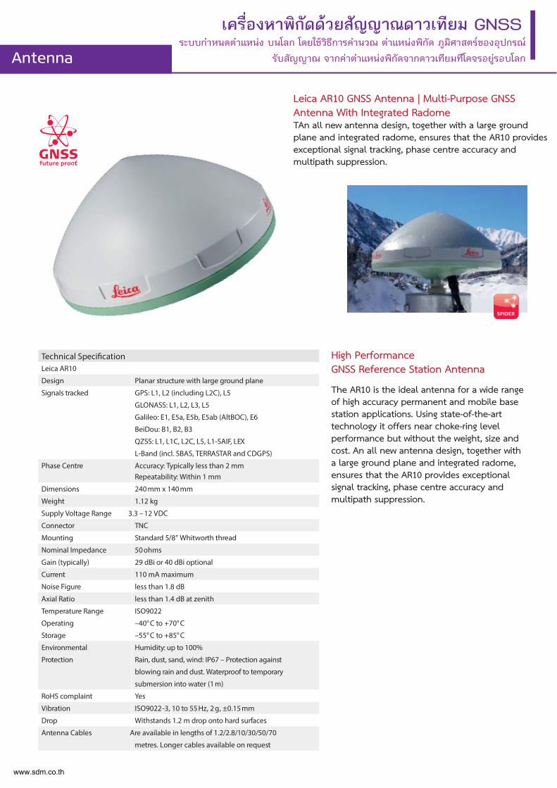
Leica AR10 GNSS Antenna | Multi-Purpose GNSS Antenna With Integrated RadomeTAn all new antenna design, together with a large ground plane and integrated radome, ensures that the AR10 provides exceptional signal tracking, phase centre accuracy and multipath suppression.
เครื่องหาพิกัดดวยสัญญาณดาวเทียม GNSSระบบกําหนดตําแหนง บนโลก โดยใชวิธีการคํานวณ ตําแหนงพิกัด ภูมิศาสตรของอุปกรณ
รับสัญญาณ จากคาตําแหนงพิกัดจากดาวเทียมทีโคจรอยูรอบโลกAntenna
Technical SpecificationLeica AR10
Design Planar structure with large ground plane
Signals tracked GPS: L1, L2 (including L2C), L5
GLONASS: L1, L2, L3, L5
Galileo: E1, E5a, E5b, E5ab (AltBOC), E6
BeiDou: B1, B2, B3
QZSS: L1, L1C, L2C, L5, L1-SAIF, LEX
L-Band (incl. SBAS, TERRASTAR and CDGPS)
Phase Centre Accuracy: Typically less than 2 mmRepeatability: Within 1 mm
Dimensions 240 mm x 140 mm
Weight 1.12 kg
Supply Voltage Range 3.3 – 12 VDC
Connector TNC
Mounting Standard 5/8” Whitworth thread
Nominal Impedance 50 ohms
Gain (typically) 29 dBi or 40 dBi optional
Current 110 mA maximum
Noise Figure less than 1.8 dB
Axial Ratio less than 1.4 dB at zenith
Temperature Range
Operating
Storage
ISO9022
–40° C to +70° C
–55° C to +85° C
Environmental
Protection
Humidity: up to 100%
Rain, dust, sand, wind: IP67 – Protection against
blowing rain and dust. Waterproof to temporary
submersion into water (1 m)
RoHS complaint Yes
Vibration ISO9022-3, 10 to 55 Hz, 2 g, ±0.15 mm
Drop Withstands 1.2 m drop onto hard surfaces
Antenna Cables Are available in lengths of 1.2/2.8/10/30/50/70
metres. Longer cables available on request
High Performance GNSS Reference Station Antenna
The AR10 is the ideal antenna for a wide range of high accuracy permanent and mobile base station applications. Using state-of-the-art technology it offers near choke-ring level performance but without the weight, size and cost. An all new antenna design, together with a large ground plane and integrated radome, ensures that the AR10 provides exceptional signal tracking, phase centre accuracy and multipath suppression.
www.sdm.co.th
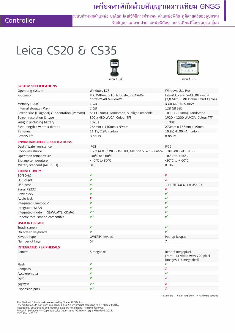
Leica CS20 & CS35
SYSTEM SPECIFICATIONS
Operating system Windows EC7 Windows 8.1 Pro
Processor TI OMAP4430 1GHz Dual-core ARM® Cortex™-A9 MPCore™
Intel® Core™ i5-4310U vPro™ (2,0 GHz, 3 MB Intel® Smart Cache)
Memory (RAM) 1 GB 4 GB DDR3L SDRAM
Internal storage (Max) 2 GB 128 GB SSD
Screen size (Diagonal) & orientation (Primary) 5“ (127mm), Landscape, sunlight-readable 10.1“ (257mm), Landscape
Screen resolution & type 800 x 480 WVGA, Colour TFT 1920 x 1200 WUXGA, Colour TFT
Weight (including battery) 1095g 1100g
Size (length x width x depth) 284mm x 150mm x 49mm 270mm x 188mm x 19mm
Batteries 11.1V, 2.8Ah Li-Ion 10.8V, 4100mAh Li-Ion
Battery life 8 hours 8 hours
ENVIRONMENTAL SPECIFICATIONS
Dust / Water resistance IP68 IP65
Shock resistance 1.2m (4 ft) / MIL-STD-810F, Method 514.5 – Cat24 1.8m MIL-STD-810G
Operation temperature -30°C to +60°C -10°C to + 50°C
Storage temperature –40°C to 80°C -20°C to + 60°C
Military standard (MIL.-STD) 810F 810G
CONNECTIVITY
SD/SDHC ✔ ✗
USB client ✔ ✗
USB host ✔ 1 x USB 3.0 & 1 x USB 2.0
Serial RS232 ✔ ✗
Power jack ✔ ✔
Audio jack ✗ ✔
Integrated Bluetooth® ✔ ✔
Integrated WLAN ✔ ✔
Integrated modem (GSM/UMTS, CDMA) ✔★ ✔
Robotic total station compatible ✔★ ✔
USER INTERFACE
Touch screen ✔ ✔
On screen keyboard ✔ ✔
Keypad type QWERTY keypad Pop up keypad
Number of keys 67 7
INTEGRATED PERIPHERALS
Camera 5 megapixel Rear: 5 megapixel Front: HD-Video with 720 pixel (Images 1.3 megapixel)
Flash ✔ ✔
Compass ✔ ✗
Accelerometer ✔ ✔
Gyro ✔ ✗
DISTO™ ✔★ ✗
Expansion pack ✔★ ✗
Leica CS20
The Bluetooth® trademarks are owned by Bluetooth SIG, Inc.Laser radiation, do not stare into beam. Class 2 laser product according to IEC 60825-1:2014.Illustrations, descriptions and technical data are not binding. All rights reserved. Printed in Switzerland – Copyright Leica Geosystems AG, Heerbrugg, Switzerland, 2015. 836357en - 03.16
Leica CS35
✔ Standard ✗ Not Available ★ Hardware specific
เครืองหาพิกัดดวยสัญญาณดาวเทียม GNSS
Controllerระบบกําหนดตําแหนง บนโลก โดยใชวิธีการคํานวณ ตําแหนงพิกัด ภูมิศาสตรของอุปกรณ
รับสัญญาณ จากคาตําแหนงพิกัดจากดาวเทียมทีโคจรอยูรอบโลก
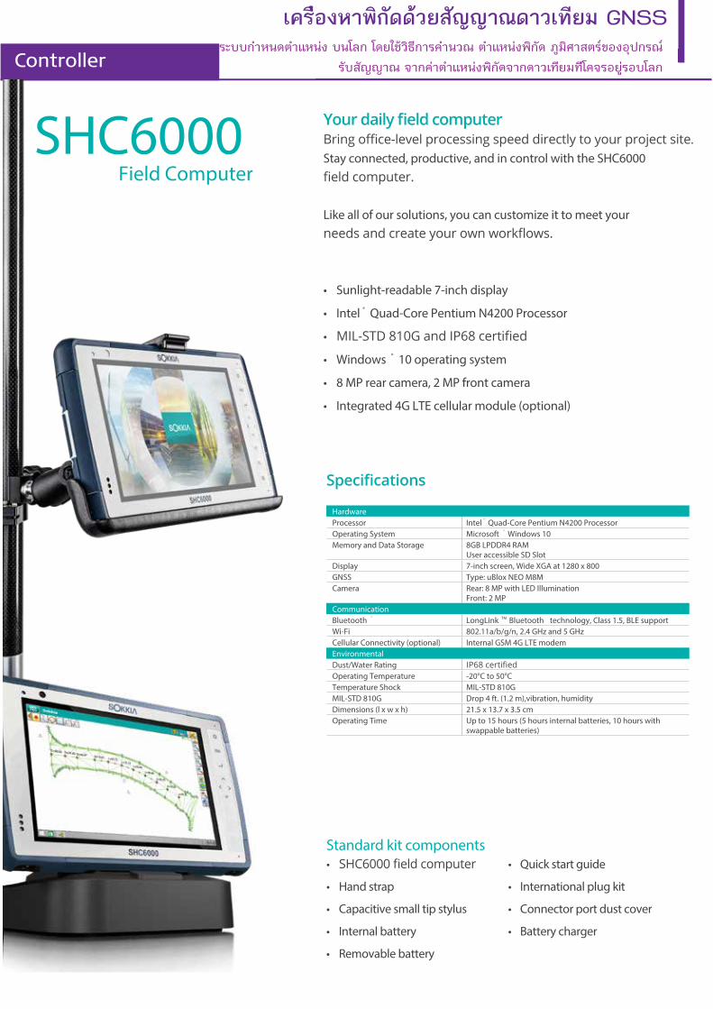
มยีทเวาดณาญญัสยวดดักิพาหงอืรคเ GNSS
Controller
HardwareProcessor Intel ® Quad-Core Pentium N4200 ProcessorOperating System Microsoft ® Windows 10Memory and Data Storage 8GB LPDDR4 RAM
User accessible SD SlotDisplay 7-inch screen, Wide XGA at 1280 x 800GNSS Type: uBlox NEO M8MCamera Rear: 8 MP with LED Illumination
Front: 2 MPCommunicationBluetooth ® LongLink TM Bluetooth technology, Class 1.5, BLE supportWi-Fi 802.11a/b/g/n, 2.4 GHz and 5 GHzCellular Connectivity (optional) Internal GSM 4G LTE modemEnvironmentalDust/Water RatingOperating Temperature -20°C to 50°CTemperature Shock MIL-STD 810GMIL-STD 810G Drop 4 ft. (1.2 m),vibration, humidityDimensions (l x w x h) 21.5 x 13.7 x 3.5 cmOperating Time Up to 15 hours (5 hours internal batteries, 10 hours with
swappable batteries)
Standard kit components• • Quick start guide
• Hand strap • International plug kit
• Capacitive small tip stylus • Connector port dust cover
• Internal battery • Battery charger
• Removable battery
SHC6000Field Computer
. Stay connected, productive, and in control with the SHC6000
Like all of our solutions, you can customize it to meet your
• Sunlight-readable 7-inch display
• Intel ® Quad-Core Pentium N4200 Processor
•
• Windows ® 10 operating system
• 8 MP rear camera, 2 MP front camera
• Integrated 4G LTE cellular module (optional)
ระบบกําหนดตําแหนง บนโลก โดยใชวิธีการคํานวณ ตําแหนงพิกัด ภูมิศาสตรของอุปกรณ รับสัญญาณ จากคาตําแหนงพิกัดจากดาวเทียมทีโคจรอยูรอบโลก
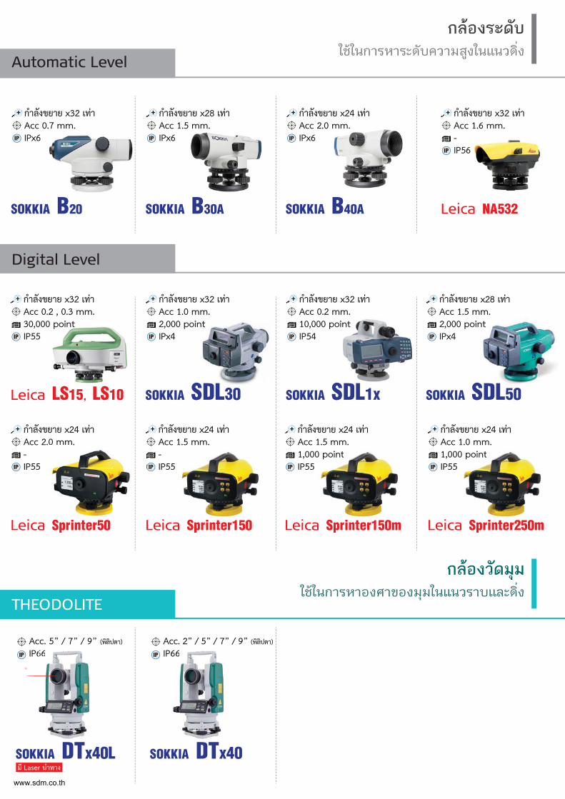
กลองระดับใชในการหาระดับความสูงในแนวดิ่ง
กลองวัดมุมใชในการหาองศาของมุมในแนวราบและดิ่ง
Automatic Level
THEODOLITE
SOKKIA B20
กำลังขยาย x32 เทาAcc 0.7 mm.IPx6IP
SOKKIA DTx40L
Acc. 5” / 7” / 9” (พิลิปดา)
IP66IP
SOKKIA B30A
กำลังขยาย x28 เทาAcc 1.5 mm.IPx6IP
SOKKIA B40A
กำลังขยาย x24 เทาAcc 2.0 mm.IPx6IP
mm.
มี Laser นำทาง
66
SOKKIA DTx40
Acc. 2” / 5” / 7” / 9” (พิลิปดา)
IP66IP 66
Leica NA532
กำลังขยาย x32 เทาAcc 1.6 mm.-IP56IP
Leica Sprinter150
กำลังขยาย x24 เทาAcc 1.5 mm.-IP55IP
Leica Sprinter50
กำลังขยาย x24 เทาAcc 2.0 mm.-IP55IP
.0 mm.
Digital Level
SOKKIA SDL1x
กำลังขยาย x32 เทาAcc 0.2 mm.10,000 pointIP54IP
SOKKIA SDL30
กำลังขยาย x32 เทาAcc 1.0 mm.2,000 pointIPx4IP
SOKKIA SDL50
กำลังขยาย x28 เทาAcc 1.5 mm.2,000 pointIPx4IP
Leica LS15, LS10
กำลังขยาย x32 เทาAcc 0.2 , 0.3 mm.30,000 pointIP55IP
Leica Sprinter250m
กำลังขยาย x24 เทาAcc 1.0 mm.1,000 pointIP55IP
0 point
Leica Sprinter150m
กำลังขยาย x24 เทาAcc 1.5 mm.1,000 pointIP55IP
0 point
www.sdm.co.th
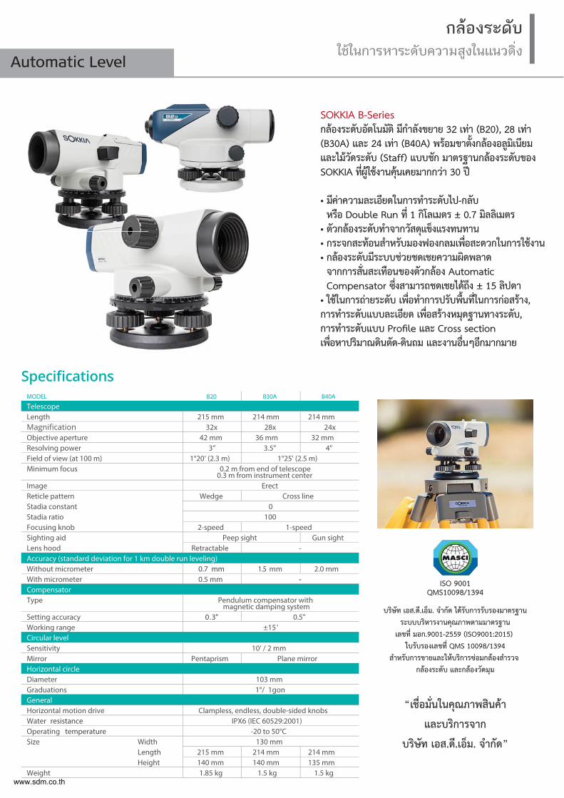
กลองระดับใชในการหาระดับความสูงในแนวดิ่ง
Automatic Level
SOKKIA B-Seriesกลองระดับอัตโนมัติ มีกำลังขยาย 32 เทา (B20), 28 เทา (B30A) และ 24 เทา (B40A) พรอมขาต้ังกลองอลูมิเนียม และไมวัดระดับ (Staff) แบบชัก มาตรฐานกลองระดับของ SOKKIA ท่ีผูใชงานคุนเคยมากกวา 30 ป
• มีคาความละเอียดในการทำระดับไป-กลับหรือ Double Run ท่ี 1 กิโลเมตร ± 0.7 มิลลิเมตร
• ตัวกลองระดับทำจากวัสดุแข็งแรงทนทาน• กระจกสะทอนสำหรับมองฟองกลมเพ่ือสะดวกในการใชงาน• กลองระดับมีระบบชวยชดเชยความผิดพลาดจากการส่ันสะเทือนของตัวกลอง AutomaticCompensator ซ่ึงสามารถชดเชยไดถึง ± 15 ลิปดา
• ใชในการถายระดับ เพ่ือทำการปรับพ้ืนท่ีในการกอสราง,การทำระดับแบบละเอียด เพ่ือสรางหมุดฐานทางระดับ, การทำระดับแบบ Profile และ Cross section เพ่ือหาปริมาณดินตัด-ดินถม และงานอ่ืนๆอีกมากมาย
MODEL B20 B30A B40A
TelescopeLength 215 mm 214 mm 214 mm
32x 28x 24xObjective aperture 42 mm 36 mm 32 mmResolving power 3” 3.5" 4"Field of view (at 100 m) 1°20’ (2.3 m) 1°25' (2.5 m)Minimum focus 0.2 m from end of telescope
0.3 m from instrument centerImage ErectReticle pattern Wedge Cross lineStadia constant 0Stadia ratio 100Focusing knob 2-speed 1-speedSighting aid Peep sight Gun sightLens hood Retractable -Accuracy (standard deviation for 1 km double run leveling)Without micrometer 0.7 mm 1.5 mm 2.0 mmWith micrometer 0.5 mm -CompensatorType Pendulum compensator with
magnetic damping systemSetting accuracy 0.3" 0.5"Working range ±15'Circular levelSensitivity 10’ / 2 mmMirror Pentaprism Plane mirrorHorizontal circleDiameter 103 mmGraduations 1°/ 1gonGeneralHorizontal motion drive Clampless, endless, double-sided knobsWater resistance IPX6 (IEC 60529:2001)Operating temperature -20 to 50°CSize Width 130 mm
Length 215 mm 214 mm 214 mmHeight 140 mm 140 mm 135 mm
Weight 1.85 kg 1.5 kg 1.5 kg
“เช่ือมั่นในคุณภาพสินคา
และบริการจาก
บริษัท เอส.ดี.เอ็ม. จำกัด”
บริษัท เอส.ดี.เอ็ม. จำกัด ไดรับการรับรองมาตรฐานระบบบริหารงานคุณภาพตามมาตรฐาน
เลขที่ มอก.9001-2559 (ISO9001:2015) ใบรับรองเลขที่ QMS 10098/1394
สำหรับการขายและใหบริการซอมกลองสำรวจ กลองระดับ และกลองวัดมุม
ISO 9001QMS10098/1394
www.sdm.co.th
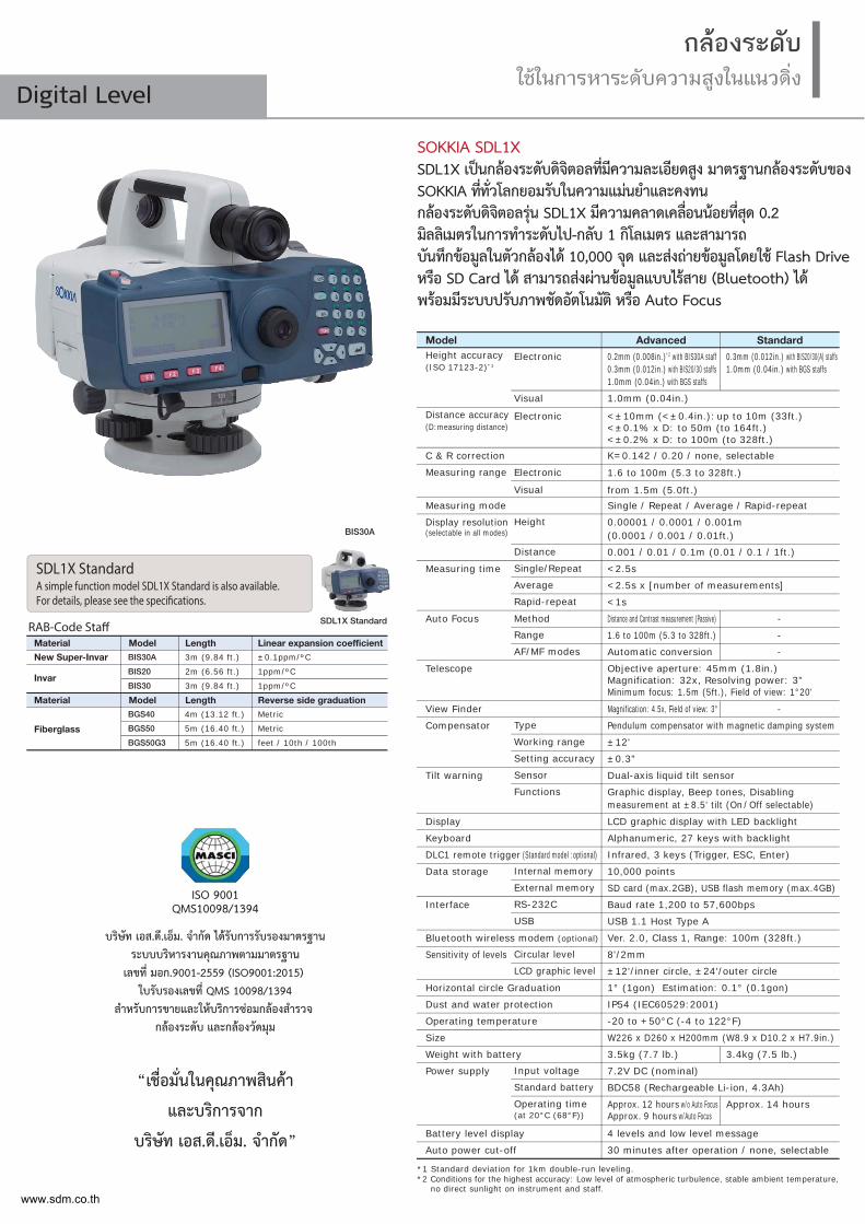
กลองระดับใชในการหาระดับความสูงในแนวดิ่ง
Digital Level
SOKKIA SDL1XSDL1X เปนกลองระดับดิจิตอลท่ีมีความละเอียดสูง มาตรฐานกลองระดับของ SOKKIA ท่ีท่ัวโลกยอมรับในความแมนยำและคงทน กลองระดับดิจิตอลรุน SDL1X มีความคลาดเคล่ือนนอยท่ีสุด 0.2 มิลลิเมตรในการทำระดับไป-กลับ 1 กิโลเมตร และสามารถ บันทึกขอมูลในตัวกลองได 10,000 จุด และสงถายขอมูลโดยใช Flash Drive หรือ SD Card ได สามารถสงผานขอมูลแบบไรสาย (Bluetooth) ได พรอมมีระบบปรับภาพชัดอัตโนมัติ หรือ Auto Focus
“เชื่อมั่นในคุณภาพสินคา
และบริการจาก
บริษัท เอส.ดี.เอ็ม. จำกัด”
บริษัท เอส.ดี.เอ็ม. จำกัด ไดรับการรับรองมาตรฐานระบบบริหารงานคุณภาพตามมาตรฐาน
เลขที่ มอก.9001-2559 (ISO9001:2015) ใบรับรองเลขที่ QMS 10098/1394
สำหรับการขายและใหบริการซอมกลองสำรวจ กลองระดับ และกลองวัดมุม
ISO 9001QMS10098/1394
AdvancedModel StandardHeight accuracy (ISO 17123-2)*1
Visual
Visual
Electronic
*1 Standard deviation for 1km double-run leveling.*2 Conditions for the highest accuracy: Low level of atmospheric turbulence, stable ambient temperature,
no direct sunlight on instrument and staff.
Electronic 0.2mm (0.008in.)*2 with BIS30A staff0.3mm (0.012in.) with BIS20/30 staffs1.0mm (0.04in.) with BGS staffs
0.3mm (0.012in.) with BIS20/30(A) staffs1.0mm (0.04in.) with BGS staffs
Distance accuracy (D:measuring distance)
C & R correction
Measuring range
Electronic <±10mm (<±0.4in.): up to 10m (33ft.)<±0.1% x D: to 50m (to 164ft.)<±0.2% x D: to 100m (to 328ft.)K=0.142 / 0.20 / none, selectable
1.6 to 100m (5.3 to 328ft.)
from 1.5m (5.0ft.)Measuring mode Single / Repeat / Average / Rapid-repeat
HeightDisplay resolution(selectable in all modes)
0.00001 / 0.0001 / 0.001m(0.0001 / 0.001 / 0.01ft.)
Distance 0.001 / 0.01 / 0.1m (0.01 / 0.1 / 1ft.)Single/RepeatMeasuring time <2.5sAverage <2.5s x [number of measurements]Rapid-repeat <1s
MethodAuto Focus Distance and Contrast measurement (Passive)
Telescope
Range
AF/MF modes1.6 to 100m (5.3 to 328ft.)
Automatic conversion
-
-
-
Type
Objective aperture: 45mm (1.8in.)Magnification: 32x, Resolving power: 3"Minimum focus: 1.5m (5ft.), Field of view: 1°20'
View Finder Magnification: 4.5x, Field of view: 3° -
Compensator
Tilt warning
Pendulum compensator with magnetic damping system
1.0mm (0.04in.)
Working range ±12'Setting accuracy ±0.3"Sensor Dual-axis liquid tilt sensor
Display LCD graphic display with LED backlight
Keyboard Alphanumeric, 27 keys with backlight
DLC1 remote trigger (Standard model :optional) Infrared, 3 keys (Trigger, ESC, Enter)
Data storage Internal memory 10,000 pointsExternal memory SD card (max.2GB), USB flash memory (max.4GB)
Interface RS-232C Baud rate 1,200 to 57,600bpsUSB USB 1.1 Host Type A
Bluetooth wireless modem (optional) Ver. 2.0, Class 1, Range: 100m (328ft.)
Sensitivity of levels Circular level 8'/2mmLCD graphic level ±12'/inner circle, ±24'/outer circle
Horizontal circle Graduation 1° (1gon) Estimation: 0.1° (0.1gon)
Dust and water protection IP54 (IEC60529:2001)
Operating temperature -20 to +50°C (-4 to 122°F)
Size W226 x D260 x H200mm (W8.9 x D10.2 x H7.9in.)
Weight with battery 3.5kg (7.7 lb.) 3.4kg (7.5 lb.)
Power supply Input voltage 7.2V DC (nominal)Standard battery BDC58 (Rechargeable Li-ion, 4.3Ah)Operating time(at 20°C (68°F))
Approx. 12 hours w/o Auto FocusApprox. 9 hours w/Auto Focus
Approx. 14 hours
Battery level display 4 levels and low level message
Auto power cut-off 30 minutes after operation / none, selectable
Functions Graphic display, Beep tones, Disablingmeasurement at ±8.5' tilt (On / Off selectable)
RAB-Code StaffModelMaterial
New Super-Invar
Invar
Fiberglass
BIS30A
BIS20
BIS30
BGS40
BGS50
BGS50G3
Length3m (9.84 ft.)
2m (6.56 ft.)
3m (9.84 ft.)
4m (13.12 ft.)
5m (16.40 ft.)
5m (16.40 ft.)
±0.1ppm/ºC
1ppm/ºC
1ppm/ºC
Linear expansion coefficient
ModelMaterial Length Reverse side graduationMetric
Metric
feet / 10th / 100th
BIS30A
SDL1X Standard
SDL1X StandardA simple function model SDL1X Standard is also available. For details, please see the specifications.
www.sdm.co.th
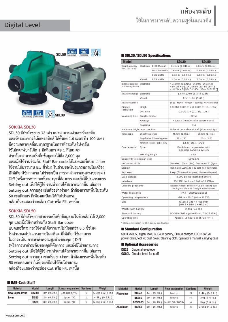
SOKKIA SDL30SDL30 มีกำลังขยาย 32 เทา และสามารถอานคาวัดระดับ และวัดระยะทางอิเล็คทรอนิกส ไดต้ังแต 1.6 เมตร ถึง 100 เมตร มีความคลาดเคล่ือนมาตรฐานในการทำระดับ ไป-กลับ ใชไมสตาฟบารโคด 1 มิลลิเมตร ตอ 1 กิโลเมตร ตัวกลองสามารถบันทึกขอมูลลงไดถึง 2,000 จุด และเม่ือใชงานรวมกับ Staff Bar code ใชแบตเตอร่ีแบบ Li-ion ใชงานไดยาวนาน 8.5 ช่ัวโมง ในสวนของโปรแกรมภายในเคร่ือง มีใหเลือกใชมากมาย ไมวาจะเปน การหาคาความสูงตางของจุด ( Diff )หรือการหาคาระดับของจุดท่ีตองการ และยังมีโปรแกรมการ Setting out เพ่ือใหผูใช งานทำงานไดสะดวกมากข้ึน เชนการ Setting out ความสูง เชนตัวอยางงายๆ ถาตองการเทพ้ืนในระดับ 50 เซนติเมตร ก็เพียงแคปอนใหกับโปรแกรม กลองก็จะแสดงวาจะตอง Cut หรือ Fill เทาน้ัน
SOKKIA SDL50SDL50 มีกำลังขยายสามารถบันทึกขอมูลลงในตัวกลองได 2,000 จุด และเม่ือใชงานรวมกับ Staff Bar code แบตเตอร่ีสามารถใชงานไดยาวนานไมนอยกวา 8.5 ช่ัวโมง ในสวนของโปรแกรมภายในเคร่ือง มีใหเลือกใชมากมาย ไมวาจะเปน การหาคาความสูงตางของจุด ( Diff )หรือการหาคาระดับของจุดท่ีตองการ และยังมีโปรแกรมการ Setting out เพ่ือใหผูใช งานทำงานไดสะดวกมากข้ึน เชนการ Setting out ความสูง เชนตัวอยางงายๆ ถาตองการเทพ้ืนในรดับ 50 เซนตอเมตร ก็เพียงแคปอนใหกับโปรแกรม กลองก็จะแสดงวาจะตอง Cut หรือ Fill เทาน้ัน
Model SDL30 SDL50Height accuracy(ISO 17123-2)*
Electronic BIS30A staff 0.4mm (0.016in.) 0.6mm (0.024in.)
BIS20/30 staffs 0.6mm (0.024in.) 0.8mm (0.03in.)
BGS staffs 1.0mm (0.04in.) 1.5mm (0.06in.)
Visual BGS staffs 1.0mm (0.04in.) 2.0mm (0.08in.)
Distance accuracy (D: measuring distance)
Electronic <±10mm (±0.4in.) [D<=10m (D<=33ft.)]<±0.1% x D [10<D<=50m (33<D<=164ft.)<±0.2% x D [50<D<=100m (164<D<=328ft.)]
Measuring range Electronic 1.6 to 100m (5.3 to 328ft.)
Visual from 1.5m (5.0ft.)
Measuring mode Single / Repeat / Average / Tracking / Wave-and-Read
Display resolution
Height 0.0001/0.001/0.01m (0.001/0.01/1ft., 1/8in.)
Distance 0.01/0.1m (0.1/1ft., 1in.)
Measuring time Single / Repeat <2.5s
Average <2.5s x [number of measurements]
Tracking <1s
Minimum brightness condition 20 lux at the surface of staff (with natural light)
Telescope Objective aperture 45mm (1.8in.) 36mm (1.4in.)
32x / 3" 28x / 3.5"
Minimum focus / Field of view 1.5m (5ft.) / 1°20'
Compensator Type Pendulum compensator with magnetic damping system
Working range ±15'
Sensitivity of circular level 10'/2mm
Horizontal circle Diameter: 103mm (4in.), Graduation: 1° (1gon)
Display Dot matrix LCD (128 x 32 dot) with illuminator
Keyboard 8 keys (7 keys on front panel, 1 key on side panel)
Data storage 2,000 points internal memory
Interface RS-232C, baud rate 1,200 to 38,400bps
Onboard programs Elevation / Height difference / Cut & Fill setting-out / Setting-out distance / Height measurement
Water resistance IPX4 (IEC60529:2001)
Operating temperature -20 to +50°C (-4 to 122°F)
Size W158 x D257 x H182mm (W6.2 x D10.1 x H7.2in.)
Weight with battery 2.4kg (5.3 lb.)
Standard battery BDC46B (Rechargeable Li-ion, 7.2V, 2.45Ah)
Operating time Approx. 16 hours at 25°C (77°F)
SDL30 / SDL50 Specifications
* Standard deviation for 1km double-run leveling
Optional AccessoriesDE23 Diagonal eyepieceGS60L Circular level for staff
Standard ConfigurationSDL30/SDL50 digital level, BDC46B battery, CDC68 charger, EDC113A/B/C power cable, tool kit, dust cover, cleaning cloth, operator's manual, carrying case
กลองระดับใชในการหาระดับความสูงในแนวดิ่ง
Digital Level
RAB-Code StaffMaterial Model Length Linear expansion Sections Weight
New Super-Invar BIS30A 3m (9.9ft.) ±0.1ppm/°C 1 5.5kg (12.2 lb.)
Invar BIS20 2m (6.6ft.) 1ppm/°C 1 4.3kg (9.5 lb.)
BIS30 3m (9.9ft.) 1ppm/°C 1 5.5kg (12.2 lb.)
Material Model Length Rear graduation Sections Weight
Fiberglass BGS40 4m (13.2ft.) Metric 3 2.4kg (5.3 lb.)
BGS50 5m (16.4ft.) Metric 4 3kg (6.6 lb.)
BGS50G3 5m (16.4ft.) feet/10th/100th 4 3kg (6.6 lb.)
Aluminum BAS55 5m (16.4ft.) Metric 5 1.9kg (4.2 lb.)
Telescope
SDL30
32xAccuracy
SDL30
0.4mm 4 SDL30
Telescope
SDL50
28xAccuracy
SDL50
0.6mm 4SDL50
www.sdm.co.th
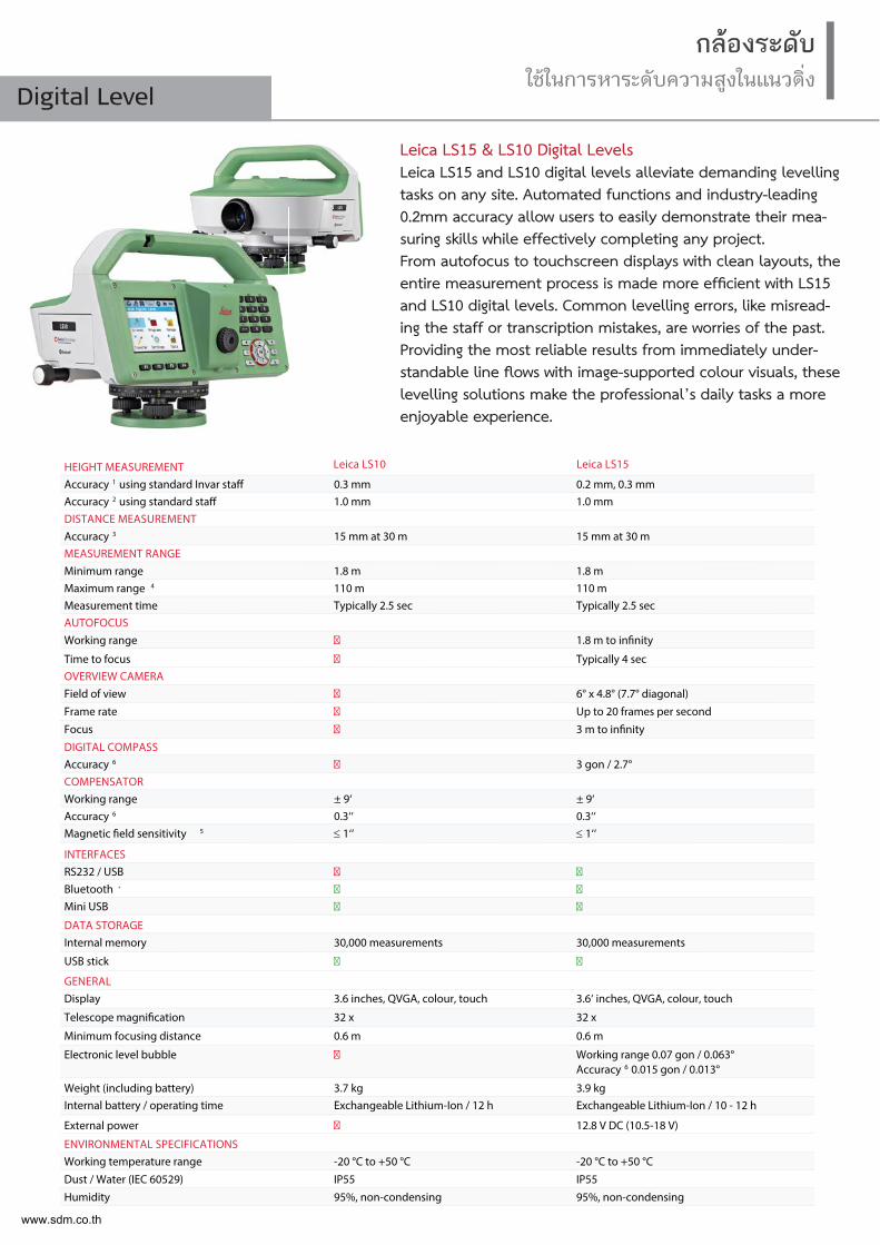
Leica LS15 & LS10 Digital LevelsLeica LS15 and LS10 digital levels alleviate demanding levelling tasks on any site. Automated functions and industry-leading 0.2mm accuracy allow users to easily demonstrate their mea-suring skills while effectively completing any project. From autofocus to touchscreen displays with clean layouts, the entire measurement process is made more efficient with LS15 and LS10 digital levels. Common levelling errors, like misread-ing the staff or transcription mistakes, are worries of the past. Providing the most reliable results from immediately under-standable line flows with image-supported colour visuals, these levelling solutions make the professional’s daily tasks a more enjoyable experience.
กลองระดับใชในการหาระดับความสูงในแนวดิ่ง
Digital Level
HEIGHT MEASUREMENT Accuracy 1 using standard Invar staff 0.3 mm 0.2 mm, 0.3 mmAccuracy 2 using standard staff 1.0 mm 1.0 mmDISTANCE MEASUREMENT Accuracy 3 15 mm at 30 m 15 mm at 30 m MEASUREMENT RANGE Minimum range 1.8 m 1.8 mMaximum range 4 110 m 110 mMeasurement time Typically 2.5 sec Typically 2.5 secAUTOFOCUS Working range � 1.8 m to infinity
Time to focus � Typically 4 secOVERVIEW CAMERA Field of view � 6° x 4.8° (7.7° diagonal)
Frame rate � Up to 20 frames per second
Focus � 3 m to infinity
DIGITAL COMPASS Accuracy 6 � 3 gon / 2.7°COMPENSATOR Working range ± 9‘ ± 9‘Accuracy 6 0.3‘‘ 0.3‘‘Magnetic field sensitivity 5 1‘‘ 1‘‘
INTERFACESRS232 / USB � �Bluetooth ® � �Mini USB � �
DATA STORAGEInternal memory 30,000 measurements 30,000 measurements
USB stick � �
GENERALDisplay 3.6 inches, QVGA, colour, touch 3.6‘ inches, QVGA, colour, touch
Telescope magnification 32 x 32 x
Minimum focusing distance 0.6 m 0.6 m
Electronic level bubble � Working range 0.07 gon / 0.063° Accuracy 6 0.015 gon / 0.013°
Weight (including battery) 3.7 kg 3.9 kgInternal battery / operating time Exchangeable Lithium-Ion / 12 h Exchangeable Lithium-Ion / 10 - 12 h
External power � 12.8 V DC (10.5-18 V)
ENVIRONMENTAL SPECIFICATIONSWorking temperature range -20 °C to +50 °C -20 °C to +50 °C
Dust / Water (IEC 60529) IP55 IP55
Humidity 95%, non-condensing 95%, non-condensing
Leica LS10 Leica LS15
www.sdm.co.th
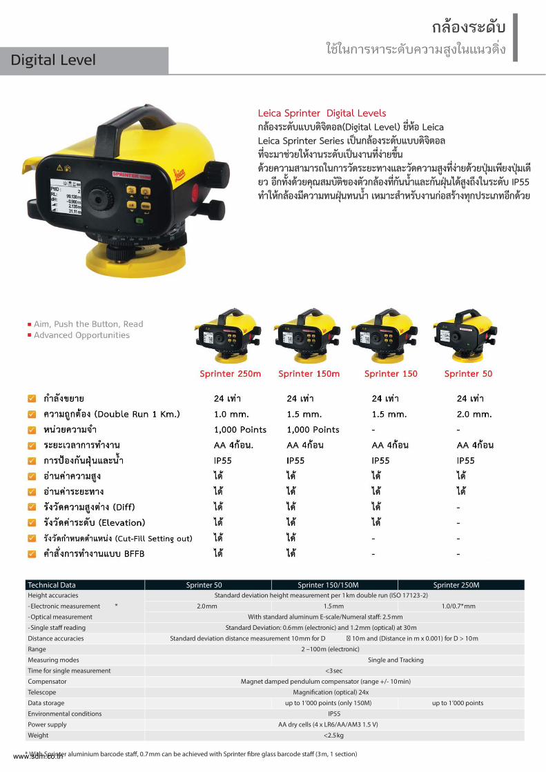
Leica Sprinter Digital Levelsกลองระดับแบบดิจิตอล(Digital Level) ย่ีหอ Leica Leica Sprinter Series เปนกลองระดับแบบดิจิตอล ท่ีจะมาชวยใหงานระดับเปนงานท่ีงายข้ึน ดวยความสามารถในการวัดระยะทางและวัดความสูงท่ีงายดวยปุมเพียงปุมเดียว อีกท้ังดวยคุณสมบัติของตัวกลองท่ีกันน้ำและกันฝุนไดสูงถึงในระดับ IP55 ทำใหกลองมีความทนฝุนทนน้ำ เหมาะสำหรับงานกอสรางทุกประเภทอีกดวย
กลองระดับใชในการหาระดับความสูงในแนวดิ่ง
Digital Level
Technical Data Sprinter 50 Sprinter 150/150M Sprinter 250MHeight accuracies
-Electronic measurement *
-Optical measurement
Standard deviation height measurement per 1 km double run (ISO 17123-2)
2.0 mm 1.5 mm 1.0/0.7* mm
With standard aluminum E-scale/Numeral staff: 2.5 mm
-Single staff reading Standard Deviation: 0.6 mm (electronic) and 1.2 mm (optical) at 30 m
Distance accuracies Standard deviation distance measurement 10 mm for D � 10 m and (Distance in m x 0.001) for D > 10 m
Range 2 –100 m (electronic)
Measuring modes Single and Tracking
Time for single measurement <3 sec
Compensator Magnet damped pendulum compensator (range +/- 10 min)
Telescope Magnification (optical) 24x
Data storage up to 1’000 points (only 150M) up to 1’000 points
Environmental conditions IP55
Power supply AA dry cells (4 x LR6/AA/AM3 1.5 V)
Weight <2.5 kg
* With Sprinter aluminium barcode staff, 0.7 mm can be achieved with Sprinter fibre glass barcode staff (3 m, 1 section)www.sdm.co.th
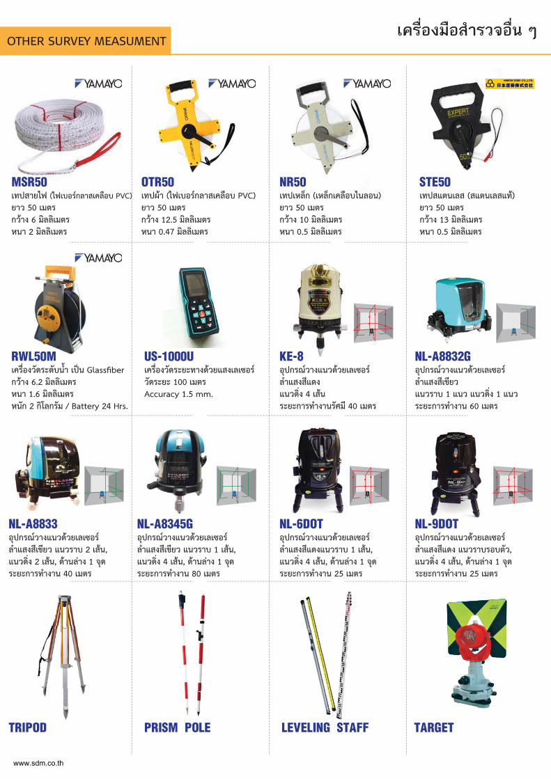
MSR50 เทปสายไฟ (ไฟเบอรกลาสเคลือบ PVC)ยาว 50 เมตร กวาง 6 มิลลิเมตร หนา 2 มิลลิเมตร
OTR50เทปผา (ไฟเบอรกลาสเคลือบ PVC)ยาว 50 เมตร กวาง 12.5 มิลลิเมตร หนา 0.47 มิลลิเมตร
NR50เทปเหล็ก (เหล็กเคลือบไนลอน)ยาว 50 เมตรกวาง 10 มิลลิเมตร หนา 0.5 มิลลิเมตร
STE50เทปสแตนเลส (สแตนเลสแท)ยาว 50 เมตรกวาง 13 มิลลิเมตร หนา 0.5 มิลลิเมตร
RWL50Mเครื่องวัดระดับน้ำ เปน Glassfiberกวาง 6.2 มิลลิเมตร หนา 1.6 มิลลิเมตรหนัก 2 กิโลกรัม / Battery 24 Hrs.
NL-A8833อุปกรณวางแนวดวยเลเซอร ลำแสงสีเขียว แนวราบ 2 เสน, แนวดิ่ง 2 เสน, ดานลาง 1 จุด ระยะการทำงาน 40 เมตร
TRIPOD PRISM POLE LEVELING STAFF TARGET
NL-A8345Gอุปกรณวางแนวดวยเลเซอร ลำแสงสีเขียว แนวราบ 1 เสน, แนวดิ่ง 4 เสน, ดานลาง 1 จุด ระยะการทำงาน 80 เมตร
NL-6DOTอุปกรณวางแนวดวยเลเซอร ลำแสงสีแดงแนวราบ 1 เสน, แนวดิ่ง 4 เสน, ดานลาง 1 จุด ระยะการทำงาน 25 เมตร
NL-9DOTอุปกรณวางแนวดวยเลเซอร ลำแสงสีแดง แนวราบรอบตัว, แนวดิ่ง 4 เสน, ดานลาง 1 จุด ระยะการทำงาน 25 เมตร
US-1000Uเครื่องวัดระยะทางดวยแสงเลเซอร วัดระยะ 100 เมตร Accuracy 1.5 mm.
KE-8อุปกรณวางแนวดวยเลเซอร ลำแสงสีแดง แนวดิ่ง 4 เสน ระยะการทำงานรัศมี 40 เมตร
NL-A8832Gอุปกรณวางแนวดวยเลเซอร ลำแสงสีเขียว แนวราบ 1 แนว แนวดิ่ง 1 แนว ระยะการทำงาน 60 เมตร
เครื่องมือสำรวจอื่น ๆOTHER SURVEY MEASUMENT
www.sdm.co.th

Leveling Staffs
สตาฟ
Tripodขากลอง
Tape Measurementเทปวัดระยะ
NR50เทปเหล็ก
เหล็กเคลือบไนลอน
MSR50เทปสายไฟ
ไฟเบอรกลาสเคลือบ PVCเทปผา
ไฟเบอรกลาสเคลือบ PVC
OTR50
เทปวัดระดับน้ำไฟเบอรกลาส
RWL50MSTE50เทปสแตนเลสสแตนเลสแท
สตาฟชัก 5 เมตรสตาฟชัก 4 เมตร วัสดุ : อลูมิเนียม
ย่ีหอ : SCON
สตาฟพับ 4 เมตรสตาฟพับ 3 เมตร
วัสดุ : อลูมิเนียม ย่ีหอ : NEDO
สตาฟพับ 4 เมตร วัสดุ : ไม
ย่ีหอ : NEDO
PFA1ขากลองอลูมิเนียมยี่หอ : SOKKIA
RangePole
โพลอลูมิเนียมยาว 2.15 เมตร
BiPodขาต้ังหลักโพล
แบบ 2 ขา
LC-Aขากลองอลูมิเนียม
ยี่หอ : SCON
LC-PPAโพลอลูมิเนียม
ยาว 2.15 เมตร
PFW1ขากลองไม
ยี่หอ : SOKKIA
www.sdm.co.th
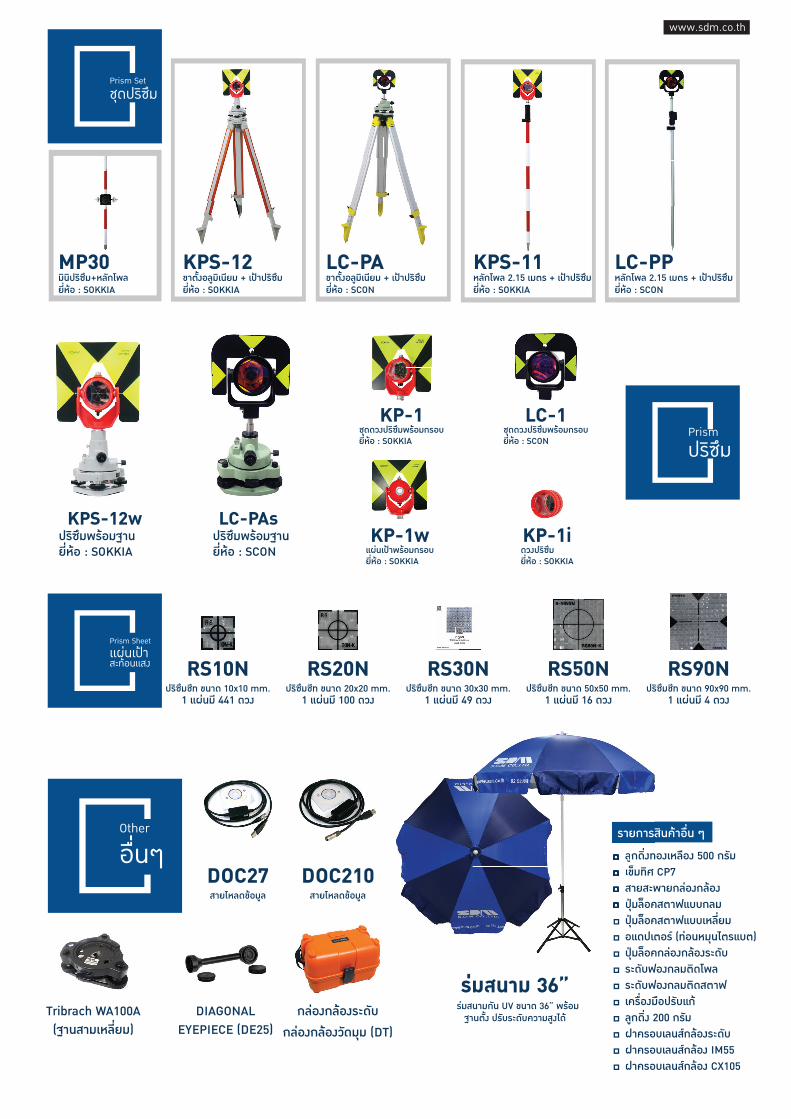
Prism Setชุดปริซึม
Prismปริซึม
KPS-12ขาตั้งอลูมิเนียม + เปาปริซึมยี่หอ : SOKKIA
MP30มินิปริซึม+หลักโพลยี่หอ : SOKKIA
KPS-11หลักโพล 2.15 เมตร + เปาปริซึมยี่หอ : SOKKIA
LC-PPหลักโพล 2.15 เมตร + เปาปริซึมยี่หอ : SCON
LC-PAขาตั้งอลูมิเนียม + เปาปริซึมยี่หอ : SCON
KPS-12wปริซึมพรอมฐานยี่หอ : SOKKIA
LC-PAsปริซึมพรอมฐานย่ีหอ : SCON
LC-1ชุดดวงปริซึมพรอมกรอบยี่หอ : SCON
KP-1ชุดดวงปริซึมพรอมกรอบยี่หอ : SOKKIA
KP-1iดวงปริซึมยี่หอ : SOKKIA
KP-1wแผนเปาพรอมกรอบยี่หอ : SOKKIA
Prism Sheetแผนเปาสะทอนแสง RS30N
ปริซึมชีท ขนาด 30x30 mm.1 แผนมี 49 ดวง
RS50Nปริซึมชีท ขนาด 50x50 mm.
1 แผนมี 16 ดวง
RS90Nปริซึมชีท ขนาด 90x90 mm.
1 แผนมี 4 ดวง
RS10Nปริซึมชีท ขนาด 10x10 mm.
1 แผนมี 441 ดวง
RS20Nปริซึมชีท ขนาด 20x20 mm.
1 แผนมี 100 ดวง
ลูกด่ิงทองเหลือง 500 กรัมเข็มทิศ CP7สายสะพายกลองกลองปุมล็อคสตาฟแบบกลมปุมล็อคสตาฟแบบเหล่ียมอแดปเตอร (ทอนหมุนไตรแบต)ปุมล็อคกลองกลองระดับระดับฟองกลมติดโพลระดับฟองกลมติดสตาฟเครื่องมือปรับแกลูกด่ิง 200 กรัมฝาครอบเลนสกลองระดับฝาครอบเลนสกลอง IM55ฝาครอบเลนสกลอง CX105
รายการสินคาอื่น ๆ Other
อื่นๆ DOC27สายโหลดขอมูล
DOC210สายโหลดขอมูล
DIAGONALEYEPIECE (DE25)
Tribrach WA100A(ฐานสามเหล่ียม)
กลองกลองระดับ
กลองกลองวัดมุม (DT)
ลูกดิ่งทเข็มทิศ สายสะพปุมลอ็ค
รายการสิ
รมสนาม 36”รมสนามกัน UV ขนาด 36” พรอมฐานต้ัง ปรับระดับความสูงได
www.sdm.co.th
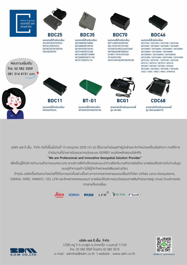
Battery & Chargerแบเตอรี่ และสายชารท
BDC25
BDC11
BDC35
BT-G1 CDC68BCG1
BDC46BDC70แบตเตอร่ีสำหรับกลองDT4/DT4E/DT5/DT6/ SET2CII/SET3CII/ SET5E/SET5F/SET5A /SET6E/SET6F
แบตเตอร่ีสำหรับกลองRED2A/RED2L
แบตเตอร่ีสำหรับกลองSET02N/SET05N/SET65
สายชารทสำหรับแบตเตอรี่ รุน SG1083
สายชารทสำหรับแบตเตอรี่รุน BDC46/BDC70
แบตเตอร่ีสำหรับกลองSET2000/SET3000/ SET4000/SET2010/ SET3010/SET4010/ SET2100/SET3100/ SET4100/SET1030R/ SET2030R/SET2110/ SET3110/SET4110
แบตเตอร่ีสำหรับกลองSET210K / SET310K / SET510K / SET610KSET230R / SET330R / SET530R / SET630RSET230R3 / SET330R3 / SET530R3 / SET630R3SET230RK / SET330RK / SET530RK SET230RK3 / SET330RK3 / SET530RK3 SET210RX / SET310RX / SET510RX / SET610RXSET210X / SET310X / SET510X / SET610X SET210 / SET310 / SET510 / SET610SET220 / SET320 / SET520 / SET620SET220K / SET320K / SET520K / SET620KCX52 / CX55 / IM52 / IM55 / STRATUS
แบตเตอร่ีสำหรับกลองSET1x/SET2X/SET3X/ SDL1X/CX101/CX102/ CX103/CX105/Cx62/CX65/ NET05AX/NET05AXII/ iX1001/ FX101/FX102/ FX103/FX105/ IM101/IM102/IM103/IM105
บริษัท เอส.ดี.เอ็ม. จำกัด กอตั้งขึ้นเมื่อวันที่ 13 กรกฏาคม 2520 กวา 42 ปในการดำเนินธุรกิจผูนำเขาและจัดจำหนายเครื่องมือสำรวจ ภายใตการดำเนินงานที่ผานการรับรองมาตรฐานระบบ ISO9001 แนวคิดหลักของบริษัทคือ “We are Professional and Innovative Geospatial Solution Provider”
เพื่อเปนผูใหบริการดานงานสำรวจแบบครบวงจร เราบริการใหคำปรึกษาและแนะนำทางเลือกในงานสำรวจสมัยใหม เราพรอมใหบริการกับทานในรูปแบบคูคาทางธุรกิจ ไมใชผูจัดจำหนายแตเพียงอยางเดียว
ปจจุบัน บริษทัเปนตัวแทนจำหนายที่ไดรับการแตงต้ังอยางเปนทางการจากหลากหลายแบรนดชั่นนำท่ัวโลก อาทิเชน Leica Geosystems, SOKKIA, FARO, YAMAYO, 12D, LFM และอีกหลากหลายแบรนด เราพรอมใหบริการคุณดวยคุณภาพสินคาคุณภาพสูง ควบคู กับบริการหลัง
การขายท่ียอดเยี่ยม
สอบถามเพ่ิมเติมโทร. 02 582 3509 081 514 8151 นะคะ
บริษัท เอส.ดี.เอ็ม. จำกัด 1/285 หมู 9 ต.บางพูด อ.ปากเกร็ด จ.นนทบุรี 11120
โทร. 02 582 3509 โทรสาร 02 582 3510e-mail : [email protected] | website : www.sdm.co.th
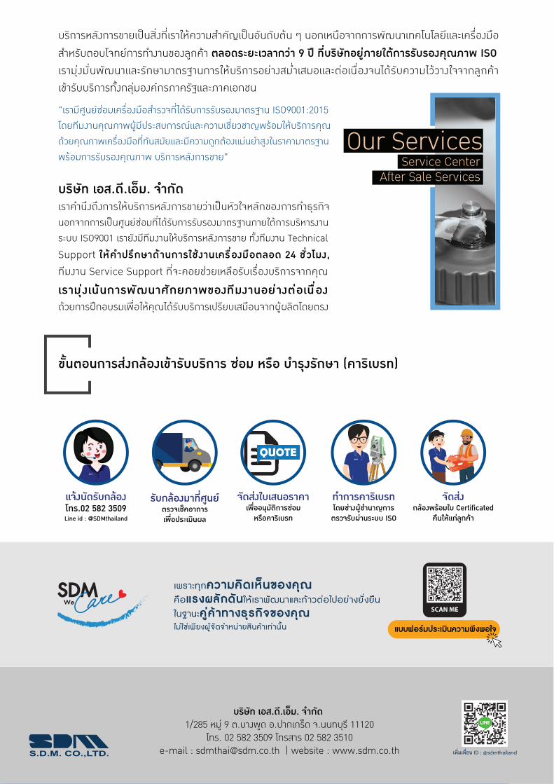
บริการหลังการขายเปนสิ่งที่เราใหความสำคัญเปนอันดับตน ๆ นอกเหนือจากการพัฒนาเทคโนโลยีและเครื่องมือ สำหรับตอบโจทยการทำงานของลูกคา ตลอดระยะเวลากวา 9 ป ที่บริษัทอยูภายใตการรับรองคุณภาพ ISO เรามุงมั่นพัฒนาและรักษามาตรฐานการใหบริการอยางสม่ำเสมอและตอเนื่องจนไดรับความไววางใจจากลูกคา เขารับบริการทั้งกลุมองคกรภาครัฐและภาคเอกชน
บริษัท เอส.ดี.เอ็ม. จำกัด 1/285 หมู 9 ต.บางพูด อ.ปากเกร็ด จ.นนทบุรี 11120
โทร. 02 582 3509 โทรสาร 02 582 3510e-mail : [email protected] | website : www.sdm.co.th
"เรามีศูนยซอมเครื่องมือสำรวจที่ไดรับการรับรองมาตรฐาน ISO9001:2015 โดยทีมงานคุณภาพผูมีประสบการณและความเชี่ยวชาญพรอมใหบริการคุณ ดวยคุณภาพเครื่องมือที่ทันสมัยและมีความถูกตองแมนยำสูงในราคามาตรฐาน พรอมการรับรองคุณภาพ บริการหลังการขาย"
บริษัท เอส.ดี.เอ็ม. จำกัด เราคำนึงถึงการใหบริการหลังการขายวาเปนหัวใจหลักของการทำธุรกิจ นอกจากการเปนศูนยซอมที่ไดรับการรับรองมาตรฐานภายใตการบริหารงานระบบ ISO9001 เรายังมีทีมงานใหบริการหลังการขาย ทั้งทีมงาน Technical Support ใหคำปรึกษาดานการใชงานเครื ่องมือตลอด 24 ชั่วโมง, ทีมงาน Service Support ที่จะคอยชวยเหลือรับเรื่องบริการจากคุณ
เรามุ งเนนการพัฒนาศักยภาพของทีมงานอยางตอเนื ่อง ดวยการฝกอบรมเพื่อใหคุณไดรับบริการเปรียบเสมือนจากผูผลิตโดยตรง
Our ServicesService Center
After Sale Services
ขั้นตอนการสงกลองเขารับบริการ ซอม หรือ บำรุงรักษา (คาริเบรท)
แจงนัดรับกลองโทร.02 582 3509Line id : @SDMthailand
รับกลองมาที่ศูนยตรวจเช็คอาการเพื่อประเมินผล
QUOTE
จัดสงใบเสนอราคาเพื่ออนุมัติการซอมหรือคาริเบรท
www.sdm
.co.th
ทำการคาริเบรทโดยชางผูชำนาญการตรวจรับผานระบบ ISO
www.sdm
.co.th
จัดสงกลองพรอมใบ Certificated
คืนใหแกลูกคา
เพราะทุกความคิดเห็นของคุณคือแรงผลักดันใหเราพัฒนาและกาวตอไปอยางยั ่งยืนในฐานะคูคาทางธุรกิจของคุณ ไมใชเพียงผูจัดจำหนายสินคาเทานั ้น แบบฟอรมประเมินความพึงพอใจ
SCAN MEWe


