Embed Size (px)
Citation preview

INTRODUCTION TO MAPS
What is a map? A map is a generalized and reduced representation of the portion of the curved surface of the earth on a flat plane or surface. ORA schematic representation of the features of the earth on a flat surface
Generalized or schematic: it shows only important man-made and natural features. Not everything that appears on the landscape is shown.
Reduced: a bigger area like South Africa, Thohoyandou or Nandoni dam is reduced to fit on a small A4-size paper.
Portion: sometimes only a small part of an area or the landscape is shown
Curved: since the earth is not flat, features on a map are portrayed on a flat surface like a paper so that it is easy to read than when using a globe.
Flat plane: Curved surface of the earth as represented by the globe is put on a flat surface so that it is easier to see all land masses at once.
Then why are maps important in geography? Because the do the following: Show spatial location of geographical phenomena (where are
things located on earth, e.g south of equator or north) Show spatial distribution of geographical phenomena (show how
features are distributed over the entire landscape, e.g. how are grassland distributed over the world)
Show spatial arrangement/ pattern of geographical phenomena (show how features are arranged, e.g. are they linear or circular or irregular?)
Show spatial association of geographical phenomena (how certain features are associated with others, e.g. why do we always find an agricultural field next to a river in a semi-arid environment? Because rivers are associated with agricultural practices)
Which maps are therefore, important in geography? The following are important:
Topographical map: It is a map that shows important man-made and natural features. It depicts features by using different standard map symbols.
Figure 1 An example of a topographical map
Topocadastral map: it is a topographical map with little information on man-made and natural features. Information has been deliberately left out to accommodate information on magisterial boundaries. It shows magisterial and municipal boundaries.
Orthophoto map: It is a photograph with topographical features like scale, title, contour lines trig beacons, spot heights and
1

direction. Unlike a topographical map it shows everything that appears on the landscape. Scales are normally 1: 10 000.
Figure 2 A typical orthophoto map
Thematic map: It shows the distribution of geographical phenomena like rainfall, vegetation, soils, etc. It shows one phenomenon at a time.
Synoptic map: It shows elements of climate and weather like dew point temperature, air temperature, atmospheric pressure, etc.
2

What are the distinguishing characteristics of a good map? A good map that is easy to read and interpret or use contains the following:
Title. E.g. Rainfall distribution in South Africa, 2230 Thohoyandou etc. The title tells us what the map is all about.
Reference key: It explains all symbols used in a map Direction/ Bearing: This makes it easier for one to orientate a
map. Scale: A scale is used to measure distances and area on a map.
(E.g. 1: 20 000 or 3cm equals 6km)
Ways in which scales are expressed on maps: Ratio/ Proportional scale: 1: 50 000 Fractional/ Representative Fraction (RF): 1/50 000
Statement/ Word scale: 3cm equals 1200m or 2cm-per-4km Linear/ Graphical scale:
Types of map symbols: Point: e.g. symbol representing a windmill, school, wind vane,
spot height, trig beacons, etc Line: e.g. contour lines, roads, rivers, isobars, anti-erosion wall,
telephone lines, railway lines etc. Area: cultivated land, orchards and vineyard, thematic map
symbols showing values, etc.
We can therefore distinguish between quantitative and qualitative point, line and area symbols:Symbol Quantitative (type and
value)Qualitative (type)
Point Spot height, wind vane, trig beacons, etc
School, police station, windmill, monument, marine lighthouse, etc
Line Isobars, contour lines, isotherms,
Rivers, roads, railway lines, canals, telephone lines, etc.
Area Choropleth maps, isopleths maps
Cultivated area, marshes, orchards & vineyard, trees & bush
With quantitative map symbols specific features like height and value are shown. Take a trig beacon for example (∆1230: It shows a feature (which is height above mean sea-level) and the value of the height (which is 1230m above mean sea-level)
With qualitative map symbols only a specific feature is shown without showing the value. Take a symbol representing a school on a topographical map (∙s). This symbol shows a feature (school) but does not show how many schools or how big the school is. (See appendix for more map symbols)
Map scales Determination of scales
3

To determine the scale two measurements are used: map distance and actual distance on the ground. Suppose the distance from Univen main gate to the School of Environmental Sciences on a map is 5cm and the corresponding distance on the ground is 800m. To get the scale the following is done:
Scale = Actual distance ÷ map distance= 800m ÷ 5cm (convert meters to cm so that they are same units of measurement)= 800 (100) ÷ 5= 16 000
Scale = 1: 16 000(Multiply 800m by 100 because there are 100cm in 1 meter)(Always make sure that the units of measurement are the same before you divide)
Scale conversions
In some cases it is difficult to use scales that are expressed either as line or statement. Therefore, such scales need to be converted either to ratio or fractions. Here are few examples:(Word to proportional scales)
(a) 3cm-per-900m= 3cm : 900(100) 3cm 3cm= 1: 30 000(To change 900m to cm multiply it by 100 because there
are 100cm in 1 meter)
(b) 4mm-per-200m= 4mm : 200(1000) 4 4= 1: 50 000
(Multiply 200m by 1000 because there are 1000 in 1 meter)
(c) 12mm-per-6km= 12mm: 6km (1 000 000) 12 12= 1: 500 000(Multiply 6km by 1 000 000 because there are 1 000 000mm in 1 km)
(d) 6cm-per-3km= 6cm : 3 (100 000) 6 6= 1: 50 000(Multiply 3km by 100 000 because there are 100 000cm in km)
(Proportional to statement scale)
Ratio/ proportional scales can be converted to statement scales to read either as cm-per-km or km-per-cm scale
To convert a ratio scale to read as cm-per-km scale divide 1km (100 000cm) by the given map scale.
e.g. 1: 60 000= 100 000 60 000= 1.67cm-per-1km
On a map with the scale of 1: 60 000, 1.67cm equal 1km on the ground
To convert a ratio scale to read as km-per-cm scale divide the given map scale by 1km (100 000cm).
e.g. 1: 60 000= 60 000 100 000
4

= 0.6km-per-1cmOn a map with the scale of 1: 60 000, 0.6km on the ground equal 1cm on a map
(Line scale to ratio)
To convert the above scale to read as a ratio measure from 0 to 1km on the graphical scale. The distance equals 2cm, which means 2cm on a map = 1km on the ground.
Therefore: 2cm = 1km2cm : 1km (100 000)2 2 1: 50 000
Even if you measure from 0 point up to 2km, 3km or to the end of the line scale the answer will be the same
Types of scalesOne can distinguish between large-scale maps and small scale maps
Large scale maps They are more detailed They are specialized maps Features appear bigger They cover smaller areas like cities and towns. The numerical value of the scale is smaller (e.g. 1: 10
000)
Small-scale maps They contain limited information They are over-generalized Features appear smaller
They cover larger areas like provinces and continents The numerical value of the scale is larger (e.g. 1: 1000
000)(See the appendix for differences in large and small scale maps)
Factors that determine the scale of a map (whether large-scale or small-scale)
The purpose of the map The amount of information to be shown on a map The size and shape of the area to be mapped.
Enlargement and ReductionWhen you enlarge a map divide the scale and when you reduce you multiply the scale. Example: Enlargement: If a map has been enlarged by two-thirds the original scale is divided as follows e.g. 1: 60 000
= 1/60 000 ÷ 2/3
= 1/60 000 x 3/2
= 3 ÷ 120 000 = 1 ÷ 40 000 (the new scale will be 1: 40 000)
Example: Reduction: If the map has been reduced by one-third the original scale is multiplied as follows:
1: 60 000= 1/60 000 x 1/3
= 1/180 000
(The new scale is then 1: 180 000)
Take the following examples: Figure 1A (Enlarge thrice/ 3 times) (Appendix)To enlarge the figure three times it means that the whole diagram is going to be three times bigger than what it is. Check Figure 1B and see the difference. Everything including the square size is three times bigger than the original Figure 1A. The scale is then calculated as follows:
1: 90 000 (divide the scale by three) 3= 1 ÷ 30 000 (the new scale will be 1: 30 000)
5

To reduce Figure 1C (Appendix) by half it means that the whole diagram is going to be half the size (Figure 1D) of the original diagram (Figure 1C). Check Figure 1D and spot the difference. Everything including the square size is half the size of the original diagram. Therefore, the scale is calculated as follows:
1: 30 000 = 1/30 000 x 1/2
= 1/60 000
(The new scale is then 1: 60 000)
Now take the following winding line Figure 2A (Appendix) and enlarge it by two-thirds. Firstly, change the line scale to read as proportional or ratio before attempting to calculate the new one for a figure that has been enlarged by two-thirds. Secondly, draw a straight horizontal line across the winding line. The length of the straight line should correspond to the length of the line (displacement – short distance in a straight line). Thirdly, draw a straight vertical line that bisects the displacement line into two equal halves. Fourthly, draw two lines that run from the top or bottom of the vertical line to pass at the margins of the displacement line. Fifth, draw two other lines that run halfway between the straight vertical line and outer diagonal lines. In total there are 5 lines (one vertical and four diagonal → the diagram now has four quarters as in Figure 2B. Now enlarge the winding line by two-thirds. Original Line = 6cm across.
6cm ÷ 2/3
= 6cm x 3/2
= 18/2= 9cm (The length of the straight horizontal line will be 9cm)
Now redraw the winding line the way it passes through all the four quarters like in Figure 2A. Check the difference between Figure 2B and 2A. The line is now two-thirds bigger than in Figure 2A.
What about the scale? Change the linear scale to statement. It now reads as 2cm =1.5km or 4cm = 3km. Convert to read as ratio scale and it will be 1: 75 000. Now work it out to enlarge it by two-thirds.
= 1/75 000 ÷ 2/3
= 1/75 000 x 3/2
= 3 ÷ 150 000= 1 ÷ 50 000 (the new scale will be 1: 50 000)
What if the line is reduced by one-third? Reduce the length of the horizontal straight line by one third by doing the following:
Line = 6cm across = 6cm x 1/3
= 6/3 = 2cm (The length of the straight horizontal line will be 2cm)
Now redraw the winding line the way it passes through all the four quarters like in Figure 2A. Check the difference between Figure 2C and 2A. The line is now one-third smaller than in Figure 2A.
From the above examples the scales have to be changed as well. Can you change them? Do as shown in the previous examples.
ABSOLUTE AND RELATIVE LOCATION
Absolute locationAbsolute location is the location of geographical phenomenon in terms of degrees, minutes and seconds of longitude and latitude. This is the exact location on the ground and it is the most common methods used by jetfighters to hit a target from the air. Missiles or rockets are also programmed to hit targets based on their absolute location. The lines of longitude and latitude are used to determine the absolute location of features. Before going deep into the subject it is better to understand the properties of longitude and latitude.
Longitude (meridians) All meridians represent true north-south lines on the globe
6

They are farthest apart at the equator but converge at a common point at the poles.
All meridians are great circles They are used to determine time The prime meridian (Greenwich) divides the globe into eastern and
western hemispheres.
Latitudes (Parallels) Parallels represent true east-west lines on the globe They are parallel to one another (they never meet) Except the equator all parallels are small circles of different sizes. They are used to determine seasons and the sun’s declination The Equator divides the earth into northern and southern
hemispheres(See figure 3 for arrangement of meridians and parallels on the globe)
How to determine time Vhuhwavho leaves Durban for Smoky Bay (Australia) at 11H35 (Monday). The time in Smoky Bay when she leaves Durban is 18H27 (same day). The duration of flight is 10 hours and 45minutes. (1) At what time and on which day will she arrive in Smoky Bay? (2) What will be the time and date in Durban when she lands in Smoky Bay?
(Answer 1): 05H12 (Tuesday)(Answer 2): 22h20 (Monday)
Moloko leaves Durban for Pittsburgh (USA) at 13H40 (Friday). The time in Pittsburgh when he leaves Durban is 06H16 (same day). The duration of flight is 10 hours and 55 minutes. (1) At what time and on which day will he arrive in Pittsburgh? (2) What will be the time and date in Durban when he arrives in Pittsburgh?
(Answer 1): 17H11 (same day-Friday)(Answer 2): 0H35 (Saturday)
Determination of longitudeTo determine the longitude of a place you use time difference between the two places.
The local time in Pittsburgh (USA) is 06H16 (Friday. The local time in Durban (31˚E) is 13H40 (same day). Determine the longitude for Pittsburgh.
Time difference = 7 hours and 24 minutes (change hours to minutes by multiplying by 60 because there are 60 minutes in an hour)
= 7x 60 + 24’
= 444’ (Now you need to determine the number of degrees of longitude that separate the two places. To do this divide 444 minutes by 4 minutes. The reason for this is because for every degree of longitude time difference is 4’. In simple terms this means that in actual fact a place located at 1˚E is 4’ ahead on time of a place at 0˚ meridian it would be 10H00 at 0˚ meridian, but 10H04 at 1˚E.
444÷ 4
111˚ (This is not the longitude for Pittsburgh, but the number of degrees of longitude separating the two places. Because Durban lies 31˚ east of the Greenwich meridian we then subtract 31 from 111 and the answer is 80˚W. From the time difference it is obvious that Durban lies to the east of Pittsburgh since its time is well ahead of that of Pittsburgh. It then makes sense to say Pittsburgh lies far away to the west of Durban. Therefore, the time difference from 0˚ meridian to 31˚E is 124 minutes (2 hours and 4minutes). The time difference from 0˚ meridian to 80˚W is 320 minutes (5 hours and 20 minutes). The time difference between the two places is 5hrs 20’ + 2hrs 04’ =7hrs 24’. The number of degrees of longitude that separate the two places is 80˚ + 31˚ = 111˚.)
7

Example 2: The local time in Smoky Bay (Australia) is 18H27 (Tuesday) The local time in Durban (31˚E) is 11H35 (same day).
Time difference = 6 hours and 52 minutes
6 x 60 + 52 minutes
= 412’÷ 4’
=103˚ (number of degrees of longitude that separate the two places)
(Because Smoky Bay’s time is ahead of that of Durban we then take 31˚ and add to 103˚. Why? Because the time difference from 0˚ meridian to 31˚E is 2 hours and 4 minutes, 6hrs and 52’from 31˚E to an unknown longitude that is 103˚ east of 31˚E. Therefore, we add 31˚ to 103˚ and the longitude for Smoky Bay is 134˚E)
Example 3: What if we were looking for Durban’s longitude and we only knew Smoky Bay’s longitude (134˚E)? Using the same time difference it would be calculated as follows:
Time difference = 6 hrs + 52 minutes
= 412’ ÷ 4’
= 103˚ (number of degrees of longitude that separate the two places)
(Durban’s time is behind that of Smoky Bay, which means it lies to the west of Smoky Bay. It then makes sense to say it lies 103˚ west of Smoky Bay which lies at 134˚E. Its longitude is determined by subtracting 103 degrees from 134 degrees of longitude. Then the answer is 31˚E)
Task1: The local time in Pretoria is 16h45 (28˚E) (Wednesday). The local time in Ussurijk (Russian Federation) is 23H41 (same day). Calculate the longitude for Ussurijk. Task2: The local time in Kilebe (Uganda) is 07H23 (Thursday) and the local time in Galole (Kenya) is 08H03 (Thursday). If Kilebe is situated at 30˚E what is Galole’s longitude?Task3: Vhuhwavho and Ofentse leave Ussurijsk (Russian Federation (132˚E) for Durban at 11H55 (Sunday). The time in Durban when they leave Ussurijisk is 05H11 (same day). The duration of flight is 11 hours and 45 minutes. (1) At what time and on which day will they arrive in Durban? (2) What will be the time and date in Ussurijisk when they arrive in Durban? (3) Calculate the longitude for Durban.
Determination of latitudes
This is determined by using two things:
the meridian height or noon altitude of the sun - the angle which the sun forms at 12H00 (local time) with the horizon
the angle of declination – the latitude at which the sun rays strike the ground at an angle of 90° at 12H00 local time.
This means that there is a relationship between the meridian height and the angle of declination. This means that on a particular day of the year, the sun rays will strike the earth at an angle of 90°. Suppose this happens on the 21st
March. On this day the sun rays will shine perpendicularly (at right angles) at equator at 12H00 noon local time. Away from the equator say at 15ºS the sun rays at noon strike the ground at an angle of 82º. This means that on that day the sun will be at an angle of 82º above the northern horizon at noon at latitude 15ºS, but shining perpendicularly at equator (0ºlat). Therefore, we say the angle of declination on the 21st March is 0º. Why? Check the definition of angle of declination. On the 23 rd September the declination is 0 as well. However, on the 22nd December the declination is 231/2ºS. Why? The sun rays shine perpendicularly at 231/2ºS (Tropic of Capricorn) at 12H00 (local time). Therefore, on the 21st June the angle of
8

declination is 231/2ºN, because this is the latitude (231/2ºN - Tropic of Cancer) where the sun rays strike the ground at 90º on that day.
Therefore, it is now evident that the sun rays can strike perpendicularly at 12H00 (local time) in place lying within the tropics. Tropic of Capricorn marks the most southerly boundary where the sun rays strike the ground at an angle of 90º, while the Tropic of Cancer marks the most northerly boundary where the sun rays strike the ground at an angle of 90º at 12H00 (local time). Remember, summer solstice (long day & short night) in the Southern Hemisphere is on the 22nd December. Winter solstice (short day & long night) in the Southern Hemisphere is experienced on the 21st June. Vernal and Autumnal equinoxes (equal day & night) are experienced on the 23rd September and 21st March respectively.
Why then are 661/2ºN and 661/2ºS lines also important? 661/2ºN marks the boundary from 661/2ºN to North Pole where the sun is visible over the horizon for 24 hours during winter solstice (21st June) in the Southern Hemisphere. 661/2ºS marks the boundary from 661/2ºS to South Pole where the sun is visible over the horizon during summer solstice in the Southern Hemisphere. Learn more about other lines of longitude and latitudes.
Example 1: The noon altitude of the sun in Umtata (Eastern cape) during summer solstice in the Southern Hemisphere is 82° above the northern horizon. Use an accurate diagram to show Umtata’s latitude.
Figure. ???Umtata’s latitude
Step no.1. Draw a circle which has the equator line dividing the circle into the southern and northern hemispheres.
Step no. 2. Mark the midpoint of the equator line.
Step no.3. Measure the angle of declination (231/2ºS using a protractor.) Extend your line outside the circumference of the circle. This line represents your sun ray perpendicular to latitude 231/2ºS.
Step no. 4. Measure the noon altitude (meridian height) angle along the sunray line from the side of the circle. Keep on shifting the line, but maintaining the noon altitude angle constant, until the line touches the circumference of the circle. (NB: Measure to the south of the sun ray line because Umtata is found to the south of Topic of Cancer)
Step no. 5. Mark the point where the line touches the circumference of the circle as the location of Umtata.
Step no. 6. Join your point (Umtata location) o the midpoint line.
Step no. 7. Measure the angle between 0° latitude (equator) and your Umtata line. The angle is the Latitude for Umtata.
9

(Follow the same steps to do examples 2 and 3. and check in the appendix to compare your answers.)
Example 2.The meridian height of the sun in Windhoek (Namibia) on the 21st of March is 67° above the northern horizon. Use an accurate diagram to show Windhoek’s latitude.
Example 3. The noon altitude of the sun in Pretoria on 29th of August is 55° above the northern horizon. The declination on that day is 9° north. Use a diagram to show Pretoria’s latitude.
RELATIVE LOCATION
Relative location is the location of phenomena relative to another, e.g. XX lies east of YY. It does not give the exact location in terms of degrees, minutes and seconds of latitude and longitude. Relative location can be given as direction, bearing or azimuthally. For example, example can be given using the eight cardinal points of the compass, Figure SSS. Bearing is given using angles ranging form 0-90º and azimuthal location is given using reading from 0-360°.
The direction of P from X is southwest The bearing of P form X I S45ºW The azimuthal location of P from X is 225°.
10
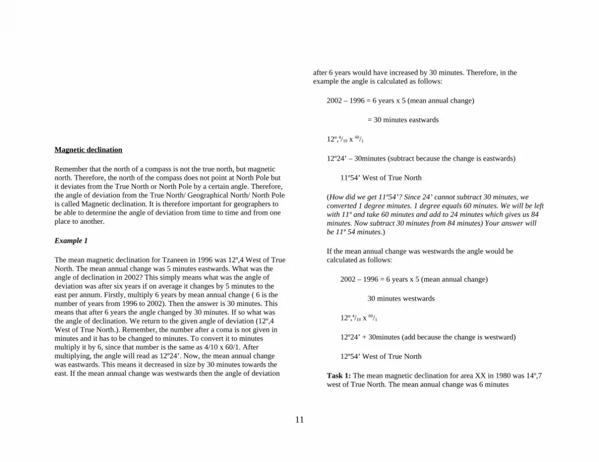
Magnetic declination
Remember that the north of a compass is not the true north, but magnetic north. Therefore, the north of the compass does not point at North Pole but it deviates from the True North or North Pole by a certain angle. Therefore, the angle of deviation from the True North/ Geographical North/ North Pole is called Magnetic declination. It is therefore important for geographers to be able to determine the angle of deviation from time to time and from one place to another.
Example 1
The mean magnetic declination for Tzaneen in 1996 was 12º,4 West of True North. The mean annual change was 5 minutes eastwards. What was the angle of declination in 2002? This simply means what was the angle of deviation was after six years if on average it changes by 5 minutes to the east per annum. Firstly, multiply 6 years by mean annual change ( 6 is the number of years from 1996 to 2002). Then the answer is 30 minutes. This means that after 6 years the angle changed by 30 minutes. If so what was the angle of declination. We return to the given angle of deviation (12º,4 West of True North.). Remember, the number after a coma is not given in minutes and it has to be changed to minutes. To convert it to minutes multiply it by 6, since that number is the same as 4/10 x 60/1. After multiplying, the angle will read as 12º24’. Now, the mean annual change was eastwards. This means it decreased in size by 30 minutes towards the east. If the mean annual change was westwards then the angle of deviation
after 6 years would have increased by 30 minutes. Therefore, in the example the angle is calculated as follows:
2002 – 1996 = 6 years x 5 (mean annual change)
= 30 minutes eastwards
12º,4/10 x 60/1
12º24’ – 30minutes (subtract because the change is eastwards)
11º54’ West of True North
(How did we get 11º54’? Since 24’ cannot subtract 30 minutes, we converted 1 degree minutes. 1 degree equals 60 minutes. We will be left with 11º and take 60 minutes and add to 24 minutes which gives us 84 minutes. Now subtract 30 minutes from 84 minutes) Your answer will be 11º 54 minutes.)
If the mean annual change was westwards the angle would be calculated as follows:
2002 – 1996 = 6 years x 5 (mean annual change)
30 minutes westwards
12º,4/10 x 60/1
12º24’ + 30minutes (add because the change is westward)
12º54’ West of True North
Task 1: The mean magnetic declination for area XX in 1980 was 14º,7 west of True North. The mean annual change was 6 minutes
11

westwards. What was the angle of deviation in 1985? What would be the angle of deviation for 1984 if the given mean annual change was eastwards? See appendix.
MAP PROJECTIONS
a map projection is a system in which locations on the curved surface of the earth are displayed on a flat sheet or surface according to some set of rules
mathematically, projection is a process of transforming global location (j,l) to a planar position (x,y) or (r,q)
o for example, the transformations for Mercator projection are:
x = l
y = loge tan(p/4 + j/2)
Relevance to GIS maps are a common source of input data for a GIS
o often input maps will be in different projections, requiring transformation of one or all maps to make coordinates compatible
o thus, mathematical functions of projections are needed in a GIS
often GIS are used for projects of global or regional scales so consideration of the effect of the earth's curvature is necessary
monitor screens are analogous to a flat sheet of paper o thus, need to provide transformations from the curved
surface to the plane for displaying data
DISTORTION PROPERTIES
angles, areas, directions, shapes and distances become distorted when transformed from a curved surface to a plane
all these properties cannot be kept undistorted in a single projection
o usually the distortion in one property will be kept to a minimum while other properties become very distorted
Tissot's Indicatrix is a convenient way of showing distortion imagine a tiny circle drawn on the surface of the globe on the distorted map the circle will become an ellipse, squashed or
stretched by the projection the size and shape of the Indicatrix will vary from one part of the
map to another we use the Indicatrix to display the distorting effects of projections
Conformal (Orthomorphic) Reference: Mercator projection (Strahler and Strahler 1987, p. 15)
a projection is conformal if the angles in the original features are preserved
o over small areas the shapes of objects will be preserved o preservation of shape does not hold with large regions
(i.e. Greenland in Mercator projection) o a line drawn with constant orientation (e.g. with respect to
north) will be straight on a conformal projection, is termed a rhumb line or loxodrome
parallels and meridians cross each other at right angles (note: not all projections with this appearance are conformal)
the Tissot Indicatrix is a circle everywhere, but its size varies conformal projections cannot have equal area properties, so some
areas are enlarged o generally, areas near margins have a larger scale than
areas near the center
Equal area (Equivalent) Reference: Lambert Equal Area projection (Maling 1973, p. 72)
12

the representation of areas is preserved so that all regions on the projection will be represented in correct relative size
equal area maps cannot be conformal, so most earth angles are deformed and shapes are strongly distorted
the Indicatrix has the same area everywhere, but is always elliptical, never a circle (except at the standard parallel)
Equidistant Reference: Conic Equidistant projection (Maling 1973, p. 151)
cannot make a single projection over which all distances are maintained
thus, equidistant projections maintain relative distances from one or two points only
o i.e., in a conic projection all distances from the center are represented at the same scale
FIGURE OF THE EARTH a figure of the earth is a geometrical model used to generate
projections; a compromise between the desire for mathematical simplicity and the need for accurate approximation of the earth's shape
types in common use
1. Plane assume the earth is flat (use no projection) used for maps only intended to depict general relationships or for
maps of small areas o at scales larger than 1:10,000 planar representation has
little effect on accuracy planar projections are usually assumed when working with air
photos
2. Sphere assume the earth is perfectly spherical
o does not truly represent the earth's shape
3. Spheroid or ellipsoid of rotation Reference: Ellipsoid of rotation (Maling 1973, p. 2)
this is the figure created by rotating an ellipse about its minor axis the spheroid models the fact that the earth's diameter at the equator
is greater than the distance between poles, by about 0.3% at global scales, the difference between the sphere and spheroid are
small, about equal to the topographic variation on the earth's surface
o with a line width of 0.5 mm the earth would have to be drawn with a radius of 15 cm before the two models would deviate
o the difference is unlikely to affect mapping of the globe at scales smaller than 1:10,000,000
Accuracy of figures used the spheroid is still an approximation to the actual shape
o the earth is actually slightly pear shaped, slightly larger in the southern hemisphere, and has other smaller bulges
o therefore, different spheroids are used in different regions, each chosen to fit the observed datum of each region
o accurate conversion between latitude and longitude and projected coordinates requires knowledge of the specific figures of the earth that have been used
the actual shape of the earth can now be determined quite accurately by observing satellite orbits
satellite systems, such as GPS, can determine latitude and longitude at any point on the earth's surface to accuracies of fractions of a second
o thus, it is now possible to observe otherwise unapparent errors introduced by the use of an approximate figure for map projections
GEOMETRIC ANALOGY
Developable surfaces
13

the most common methods of projection can be conceptually described by imagining the developable surface, which is a surface that can be made flat by cutting it along certain lines and unfolding or unrolling it
Reference: Developable surfaces (Maling 1973, pp. 55-57)
the points or lines where a developable surface touches the globe in projecting from the globe are called standard points and lines, or points and lines of zero distortion. At these points and lines, the scale is constant and equal to that of the globe, no linear distortion is present
if the developable surface touches the globe, the projection is called tangent
if the surface cuts into the globe, it is called secant o where the surface and the globe intersect, there is no
distortion o where the surface is outside the globe, objects appear
bigger than in reality - scales are greater than 1 o where the surface is inside the globe, objects appear
smaller than in reality and scales are less than 1
Reference: Projection equations (Maling 1973, pp. x-xi and 234-245)
note: symbols used in the following: l - longitude j - latitude c - colatitude (90 - lat)
h - distortion introduced along lines of longitude k - distortion introduced along lines of latitude
(h and k are the lengths of the minor and major axes of the Indicatrix)
commonly used developable surfaces are:
(a)Planar or azimuthal a flat sheet is placed in contact with a globe, and points are
projected from the globe to the sheet mathematically, the projection is easily expressed as mappings
from latitude and longitude to polar coordinates with the origin located at the point of contact with the paper
o formulas for stereographic projection (conformal) are:
r = 2 tan(c / 2)
q = l
h = k = sec2(c / 2)
References: Azimuthal projections (Strahler and Strahler 1987, p. 13, Robinson et al 1984, p. 102)
o stereographic projection o gnomic projection o Lambert's azimuthal equal-area projection o orthographic projection
(b) Conic the transformation is made to the surface of a cone tangent at a
small circle (tangent case) or intersecting at two small circles (secant case) on a globe
mathematically, this projection is also expressed as mappings from latitude and longitude to polar coordinates, but with the origin located at the apex of the cone
o formulas for equidistant conical projection with one standard parallel (j0 , colatitude c0) are:
r = tan(c0) + tan(c - c0)
14

q = n l
n = cos(c0)
h = 1.0
k = n r / sin(c)
Examples o References: Conic projections (Strahler and Strahler 1987
p. 14, Maling 1973, p. 164) o Alber's conical equal area projection with two standard
parallels o Lambert conformal conic projection with two standard
parallels o equidistant conic projection with one standard parallel
(c) Cylindrical developed by transforming the spherical surface to a tangent or
secant cylinder mathematically, a cylinder wrapped around the equator is
expressed with x equal to longitude, and the y coordinates some function of latitude
o formulas for cylindrical equal area projection are:
x = l
y = sin(j)
k = sec(j)
h = cos(j)
Examples
o References: Mercator and Lambert projections (Strahler and Strahler 1987, p. 15, Maling 1973, p. 72)
o note: Mercator Projection characteristics meridians and parallels intersect at right angles straight lines are lines of constant bearing -
projection is useful for navigation great circles appear as curves
(d) Non-Geometric (Mathematical) projections some projections cannot be expressed geometrically
o have only mathematical descriptions
Examples
o Reference: Non-geometric projections (Robinson et al, 1984, p. 97)
o Molleweide o Eckert
UNIVERSAL TRANSVERSE MERCATOR (UTM) UTM is the first of two projection based coordinate systems to be
examined in this unit UTM provides georeferencing at high levels of precision for the
entire globe established in 1936 by the International Union of Geodesy and
Geophysics o adopted by the US Army in 1947 o adopted by many national and international mapping
agencies, including NATO is commonly used in topographic and thematic mapping, for
referencing satellite imagery and as a basis for widely distributed spatial databases
Transverse Mercator Projection
15

results from wrapping the cylinder around the poles rather than around the equator
the central meridian is the meridian where the cylinder touches the sphere
o theoretically, the central meridian is the line of zero distortion
o by rotating the cylinder around the poles o the central meridian (and area of least distortion) can be
moved around the earth for North American data, the projection uses a spheroid of
approximate dimensions: o 6378 km in the equatorial plane o 6356 km in the polar plane
Zone System Reference: UTM zones (Strahler and Strahler 1987, p. 18)
in order to reduce distortion the globe is divided into 60 zones, 6 degrees of longitude wide
o zones are numbered eastward, 1 to 60, beginning at 180 degrees (W long)
the system is only used from 84 degrees N to 80 degrees south as distortion at the poles is too great with this projection
o at the poles, a Universal Polar Stereographic projection (UPS) is used
each zone is divided further into strips of 8 degrees latitude o beginning at 80 degrees S, are assigned letters C through
X, O and I are omitted
Distortion to reduce the distortion across the area covered by each zone, scale
along the central meridian is reduced to 0.9996 o this produces two parallel lines of zero distortion
approximately 180 km away from the central meridian o scale at the zone boundary is approximately 1.0003 at US
latitudes
Coordinates coordinates are expressed in meters
o eastings (x) are displacements eastward o northings (y) express displacement northward
the central meridian is given an easting of 500,000 m the northing for the equator varies depending on hemisphere
o when calculating coordinates for locations in the northern hemisphere, the equator has a northing of 0 m
o in the southern hemisphere, the equator has a northing of 10,000,000 m
Reference: UTM coordinates (Strahler and Strahler 1987, p. 19)
Advantages UTM is frequently used consistent for the globe is a universal approach to accurate georeferencing
Disadvantages full georeference requires the zone number, easting and northing
(unless the area of the data base falls completely within a zone) rectangular grid superimposed on zones defined by meridians
causes axes on adjacent zones to be skewed with respect to each other
o problems arise in working across zone boundaries o no simple mathematical relationship exists between
coordinates of one zone and an adjacent zone
STATE PLANE COORDINATES (SPC) SPCs are individual coordinate systems adopted by U.S. state
agencies each state's shape determines which projection is chosen to
represent that state o e.g. a state extended N/S may use a Transverse Mercator
projection while a state extended E/W may use a Lambert Conformal Conic projection (both of these are conformal)
16

projections are chosen to minimize distortion over the state o a state may have 2 or more overlapping zones, each with
its own projection system and grid units are generally in feet
Advantages SPC may give a better representation than the UTM system for a
state's area SPC coordinates may be simpler than those of UTM
Disadvantages SPC are not universal from state to state problems may arise at the boundaries of projections
Use in GIS many GIS have catalogues of SPC projections listed by state which
can be used to choose the appropriate projection for a given state
CLASSES
1. Azimuthal projections
General characteristics Lines of latitude and longitude are intersecting at 90 degrees Meridians are straight lines
Parallels are concentric circles Forms a circular map Scale near the centre is true Can have the properites of equidistance, conformality or equal area The pole is represented as a point
Perspective projectionsStereographic projection
Conformal Parallels get closer near
the centre Scale is true at the
centre Every circle is shown
as circular arcs or straight lines
A perspective projection of the globe onto a tangent (or secant) plane from a point opposite the point of the projection centre
Used in the polar aspect for topographic maps of polar regions
Recommended for conformal mapping of regions that are circular in shape
17

Orthographic projection Neither conformal nor
equal-area (general distortion)
Parallels get closer near the centre
Scale is true at the centre and along any circle centred on the projection centre but only the circumference of the circle
A perspective projection of the globe onto a tangent plane from an infinite distance
All great or small circles are shown as elliptical arcs or straight lines
It is frequently used for views of the Earth as would be seen from space
Gnomonic projection Neither conformal nor
equal-area A perspective
projection from the centre of the globe onto a tangent plane at the central point of the projection
Is used by navigators and aviators because great-circle paths (shortest distances or orthodromes) are shown as straight lines
Less than one hemisphere can be viewed from a given origin
Scale is true at the centre
All great circles are shown as straight lines
18

Non-perspective projectionsPostel azimuthal equidistant projection
Equidistant. The distance between any two points on a straight line passing through the centre of the projection is shown at true scale. Distortion of other properties increases away from the center point.
Can view the entire Earth, but more than a hemisphere is rarely depicted
Used in the polar aspect for maps of polar regions, and the northern and southern hemispheres. It is sometimes used to show air-route distances
Equal-area Scale is true only at the
centre but in all directions
Can view the entire Earth, but angular distortions are extremely bad on the edges
Frequently used in the polar aspect in atlases for maps of polar regions and of the northern and southern hemispheres. The equatorial aspect is used for atlas maps of the eastern and western hemispheres. The oblique aspect is used for atlas maps of continents and oceans
Recommended for equal-area maps of regions that are nearly circular
2. Cylindrical projections
19

General characteristics Lines of latitude and longitude are parallel intersecting at 90
degrees Meridians are equidistant Forms a rectangular map Scale along the equator or standard parallels (lines of tangency) is
true Can have the properites of equidistance, conformality or equal area The poles are represented as lines
Equirectangular projection Compromise (general) distortion Both meridians and parallels are
equally spaced (equidistant) Plate Carree-square grid
One of the oldest and simplest projections
Mercator projection Conformal Parallels unequally spaced, distance
increases away from equator Loxodromes or rhumb lines are
straight (all straight lines on the map are lines of constant azimuth)
The image of the poles are at infinity Used for navigation and regions near
equator. Invented in 1569 by Gerardus Mercator graphically
[Equations]
20

Lambert's cylindrical equal-area projection
Parallels get closer near poles. Shape and scale distortions increase near points 90 degrees from the central line
Scale is true along the central line (the equator for normal, the central meridian for transverse, and a selected line for oblique) and along two lines equidistant from the central line
Invented in 1772 by J. H. Lambert
Gall's stereographic cylindrical projection Compromise, moderately distorts
distance, shape, direction, and area Projected geometrically from a point
on the equator opposite meridian being projected onto a secant cylinder intersected by the globe at 45 degrees north and 45 degrees south
Invented by James Gall in 1855
3. Conic projections
General characteristics Lines of latitude and longitude are intersecting at 90 degrees Meridians are straight lines Parallels are concentric circular arcs Scale along the standard parallel(s) is true Can have the properites of equidistance, conformality or equal area The pole is represented as an arc or a point
Equidistant or simple conic projection Equally spaced parallels
21

Compromise. Direction, area, and shape are distorted away from standard parallels
Equidistant meridians converging at a common point
This projection was developed by De l'Isle. It was used for field sheets and some charts of small areas in th 19th century.
Lambert-Gauss conformal conic projection
Conformal. Area, and shape are distorted away from standard parallels. Directions are true in limited areas
Developed by J.H. Lambert in 1772. Harding, Herschel and Boole had developed it independently in both spherical and ellipsoidal forms during the 19th century. World War I gave this projection new life, making it the standard projection for intermediate - and large-scale maps of regions in midlatitudes (for which the transverse Mercator is not
used). Today it is often used for air navigation maps
Albers equal-area conic projection
Distorts scale and distance except along standard parallels. Areas are proportional and directions are true in limited areas
Conic-like projections(Simple) Polyconic projection
The projection is true to scale along the central meridian and along each parallel. It is neither conformal nor equal-area, and it is only free of distortion along the central meridian. Therefore, it should only be used for regions of predominant north-south
22

extent
The polyconic was applied as a specific projection in 1853 by the US Coast Survey. It was commonly, but not exclusively, used for coastal charts of the United States. The emphasis on usage by US government agencies led to its use in several 19th century commercial atlases as well, for some maps of the United States, Canada, North America, Asia and Oceania.The polyconic projection of Hassler is simultaneously universal for a given figure of the earth (sphere or ellipsoid), simply drawn, even for the ellipsoid, and employs useful scale characteristics.
Rectangular polyconic projection Neither conformal nor equal-
area
The first reference to this projection was made in 1853. This projection was derived and used at that time by the U.S. Coastal Survey for portions of the United States exceeding about a square degree. It has since been used for topographic maps of the British War Office and thus
has been called the War Office projection as well.
Bonne's pseudoconic projection Equal-area The Bonne was the preferred
projection for atlas maps of large countries and continents, giving the regions a uniform area scale and an appealing combination of curved meridians and curved parallels befitting a representation of the globe. More than half the maps of the world's most populated continents were prepared on the Bonne projections.
The Bonne projection played a significant role in 19th century larger-scale topographic mapping using ellipsoidal formulas. This began with its adoption in France after efforts by Bonne in 1802, when his projection was accepted by a special commission of the Depot de la Guerre (war office). It later received the name projection depot de la guerre in other European countries. These regions included Austria-Hungary (1:750,000 scale maps), Belgium (1:20,000 and reductions), Denmark
23

(1:20,000), Italy (1:500,000), Netherlands (1:25,000), Russia (1:126,000), Spain (1:200,000), Switzerland (1:25,000 and 1:50,000), Scotland and Ireland (1:63,360 and smaller), as well as France (1:80,000 and 1:200,000) (Hinks 1912).
Werner (Stabius) pseudoconic projection Equal-area Heart-shaped (also referred to as
cordiform and cardioid) In 1514, Stabius invented a series
of three attractive heart-shaped projections which were further publicized by Werner.
After sporadic usage, the cordiform projection all but disappeared by the 18th century in favour of the Bonne projection. This more general adaptation of Werner's projection provides less angular distortion for a map of a continent.
Van der Grinten projection Compromise, but huge
distortion on high latitudes The whole Earth is
represented on a circle
Both paralles and meridians are circular arcs
Grid analysis
Procedures of grid analysis are used when detecting unknown projections. Geometrically it is based on Tissot's Indicatrix (see the section on distortions!). But there are certain aspects which can be determined by simple visual inspection.
If meridians and parallels intersect each other at right angles, the projections is normal (and not miscellaneous or pseudo).
If meridians are straight, intersecting each other at one distinct point and parallels are concentric circular arcs, the projection can be conic or azimuthal. If the angle between meridians are smaller than the angle between longitudes, then the projection is conic.
If both meridians and parallels are straight parallel lines, the projection is cylindrical.
If both meridians and parallels are circular arcs, the projection can be stereographical or miscellaneous.
If parallels are straight parallel lines and meridians are curves, the projection can be pseudocylindrical.
If parallels are circular arcs and meridians are curves, projection can be pseudoconic.
Choosing projections
When planning map projections the following conditions are to be considered:
The purpose of the map (geodesy, navigation and military maps require conformal projections, while equal area projections are better for geographical and school maps)
The scale of the map The size and shape of the mapped area with regard to its latitude
(circular areas can be mapped on azimuthal projections, areas along parallel lines can be mapped on conic projections, areas
24

along great circles are usually represented on cylindrical projections)
Sometimes there are more specific conditions projections should fulfill:
straight orthodrome lines (gnomonic pr.) straight loxodrome lines (Mercator pr.) both parallels and meridians are straight (cylindrical pr.) parallels and meridians intersect each other at right angles (normal
pr.) circles on the datum (sphere) remain circles on the map (conformal
pr.) the Pole is represented as a point (eg. azimuthal pr.) mild distortions (eg. miscellaneous pr.)
Contour Mapping
Other features: Some features can be identified using the shape of contour lines. However one striking feature about contour lines is that:
- They are closed lines. Even if it is not a complete closed line it will start and end at the margin of the map to show that if the map was big enough it would be drawn around until it is a complete closed line.
- They never intersect: Contour lines do not cross each other like roads on a map. They sometimes touch, but they can never intersect. Where they touch show a cliff or free face.
- They are drawn at regular intervals: On topographical maps the interval is 20 meters.
- Some index contours have elevation values: This is common on topographical maps. The index contours are usually thicker.
The spacing between contours tells whether a feature is a gentle or steep slope. Steep slopes are seen by closely-drawn contours, while gentle slopes are seen by contours that are far apart. By studying the shape of contour lines it is easy to tell what feature has been represented. The shape of the contours together with the elevation values describe the feature. For
example, take V-shaped contours without elevation values. What feature is that? One might say it is a river valley and another might say it is mountain spur. Both answers are correct, but to avoid guess work and strive for accuracy we then insert elevation values so that we have one answer.
100 160 160 100
(a) (b) (c)
From the above features, a can be a river valley or spur. Now there are elevation values in b and c. Therefore b is a river valley and c a spur. The two differ in that with a river valley the inner contour lines have lower elevation values and values increase outward. The opposite holds true for a mountain spur.
Concave and convex slopes: These can be identified by studying the spacing between contours together with elevation values
100 180 140 140 160 120 180 100
25

(a) (b)The two features look identical but they become different when we check elevation values. The first (a) is a convex slope while (b) a concave slope. The same can be done with features such as saddle, pass, mesa, butte, escarpment, canyon and terraced slopes. You have to know each feature very well and how they appear when seen from side. Knowing these will help one to identify these features on maps with relative ease, by studying contour shapes and values. See the appendix for more information on geographical features.
Interpolation
Interpolation is done by drawing contour lines joining all places lying at the same elevation above mean-sea-level. This is done by drawing lines across spot heights to produce a contour map that will look like Figure????. Remember, contour lines are drawn at specific intervals, so, in figure??? The contour interval is 10m. Compare Figure ???A (before contour lines) and B (after contour lines have been drawn). Can you do Example 1A?
Remember in the example 0f Figure ???B we made sure that contour lines pass through points that are lower and higher in altitude between the two spot heights. Chech contour line joining all places at 50m above sea-level. We made sure that when drawing the line it does not overlap over other altitudes. One cannot draw a line that passes between spot height XX and YYY because there elevation there is less than 50m, one can draw a contour line that pass between CCC and DDD because elevatiobn between these points is more than 50m.
Gradient
Remember that the spacing between contour lines determines the steepeness of the slope. If the contours are farthest apart then the slope is gentle, but if contours are close to one another then the slope will be steeper. If the contours tend to touch and appear as one line then one will know that that feature is a cliff. Therefore, the steepness of the slope can also be expressed as ration or degrees. Use FigureKKK in the appendix. Calculate the gradient from X to Y.
Gradient = Vertical Interval ÷ Horizontal Equivalent.
= 660-420 ÷ (4cm x 40 000)/ 100
= 240/1600
=1/ 6.67m
(Vertical interval is the difference in height between two points which is X and Y; and horizontal equivalent is the distance between the same two points in meters. Therefore, in the above calculate of the gradient, the difference in height between X and Y is 240m [determine this by subtracting 420 (lowest point at Y) from 660 (highest point at X)]. Measure the distance from X to Y on a map using a ruler. In the example above the distance is 4cm. Now convert the 4cm to read in meters. Multiply it by the
scale of the map and divide by 1000. The distance in meters is 1600m. Therefore, you will end up with a figure like 240/1600 or 240m: 1600m. To get the gradient to read as ratio divide by 240, i.e. divide 240 by 240 to get 1m & 1600 by 240 to get 6.67m . Therefore your slope in ratio form is 1: 6.67m. What does this mean? This means that in Figure KKK for every 6.67m one walks up or downslope the elevation increases by 1 meter. This means that on average if you are at Y where the elevation is 420 and you
26

walk 6.67m towards X then your elevation after 6.67 will be 421m, walk another 6.67 meters the elevation will be 422, and so on.)
Cross-section (Profile)
Cross-section is the side view of a feature. Check the examples below where A is view from above and B view from the side:
To draw the cross-section follow the steps in the example below. Here a cross-section of a feature from C to D in Figure KKKK has been drawn.
In the example above, we chose the vertical scale of 1cm = 20m interval because our contour interval is 20m. It does not mean that the vertical interval of the graph will always be 1cm per 20m contour interval. We might also decide to use the vertical interval of 0.5cm 0r 0.2cm per 20m interval. Back to the example above. We then put a paper across the C to D line and mark all the contour lines that cross over the overlaid paper. And indicate the elevations as indicated in the example above. Transfer all the elevation values to a graph. Your Y axis will represent the vertical interval height (heights above sea level) and the X axis represents C to D on a map. Transfer all the elevation values to a graph as in the example above.
Vertical exaggerationRemember every cross section is characterized by a certain degree of exaggeration in terms of the appearance of redrawn features. Therefore it is necessary to calculate the vertical exaggeration for every cross-section we draw. This is done to determine the number of times a particular features has been distorted when drawing the cross-section. Follow the following steps to determine the vertical exaggeration:
Vertical exaggeration (VE) = Vertical scale (VS) Horizontal scale (HS)= 1/20m (100) ÷ 1/40 000= 1/2000 x 40 000/1= 40 000/2000= 20 times
(This means the appearance of the feature in the cross-section has been exaggerated 20 times than its normal appearance.)(Vertical scale: This is the vertical scale of the graph: 1:20M & the horizontal scale is the map scale: 1: 40 000)
27