Embed Size (px)
Citation preview
City of Los Angeles Department of City Planning � Environmental Analysis Section
City Hall � 200 N. Spring Street, Room 750 � Los Angeles, CA 90012
June 20, 2013
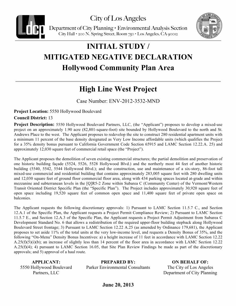
INITIAL STUDY / MITIGATED NEGATIVE DECLARATION
Hollywood Community Plan Area
High Line West Project Case Number: ENV-2012-3532-MND
Project Location: 5550 Hollywood Boulevard Council District: 13 Project Description: 5550 Hollywood Boulevard Partners, LLC, (the “Applicant”) proposes to develop a mixed-use project on an approximately 1.90 acre (82,801-square-foot) site bounded by Hollywood Boulevard to the north and St. Andrews Place to the west. The Applicant proposes to redevelop the site to construct 280 residential apartment units with a minimum 11 percent of the base density designated as Very Low Income affordable units (which qualifies the Project for a 35% density bonus pursuant to California Government Code Section 65915 and LAMC Section 12.22.A. 25) and approximately 12,030 square feet of commercial retail space (the “Project”). The Applicant proposes the demolition of seven existing commercial structures; the partial demolition and preservation of one historic building façade (5524, 5526, 5528 Hollywood Blvd.) and the northerly most 44 feet of another historic building (5540, 5542, 5544 Hollywood Blvd.); and the construction, use and maintenance of a six-story, 86-foot tall mixed-use commercial and residential building that contains approximately 283,005 square feet with 280 dwelling units and 12,030 square feet of ground floor commercial floor area, along with 434 parking spaces located at-grade and within mezzanine and subterranean levels in the [Q]R5-2 Zone within Subarea C (Community Center) of the Vermont/Western Transit Oriented District Specific Plan (the “Specific Plan”). The Project includes approximately 30,920 square feet of open space including 19,520 square feet of common open space and 11,400 square feet of private open space on balconies. The Applicant requests the following discretionary approvals: 1) Pursuant to LAMC Section 11.5.7 C., and Section 12.A.1 of the Specific Plan, the Applicant requests a Project Permit Compliance Review; 2) Pursuant to LAMC Section 11.5.7 E., and Section 12.A.3 of the Specific Plan, the Applicant requests a Project Permit Adjustment from Subarea C Development Standard No. 6 that allows a redistribution of the required upper-floor building stepback along Hollywood Boulevard Street frontage; 3) Pursuant to LAMC Section 12.22 A.25 (as amended by Ordinance 179,681), the Applicant proposes to set aside 11% of the total units at the very low-income level, and requests a Density Bonus of 35%, and the following “On-Menu” Density Bonus Incentives: a) a height increase of 11 feet in accordance with LAMC Section 12.22 A.25(f)(5)(i)(b); an increase of slightly less than 14 percent of the floor area in accordance with LAMC Section 12.22 A.25(f)(4); 4) pursuant to LAMC Section 16.05, that Site Plan Review Findings be made as part of the discretionary approvals; and 5) approval of a haul route.
APPLICANT: 5550 Hollywood Boulevard
Partners, LLC
PREPARED BY: Parker Environmental Consultants
ON BEHALF OF: The City of Los Angeles
Department of City Planning

IS-‐2
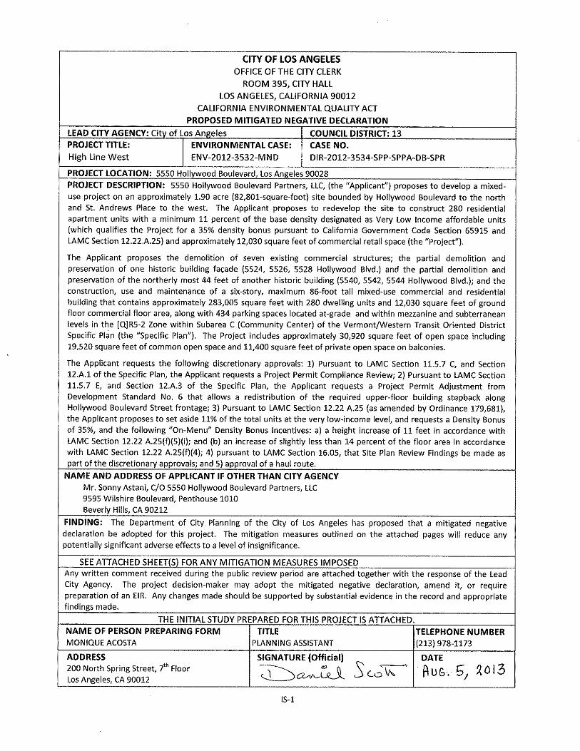
CITY OF LOS ANGELES OFFICE OF THE CITY CLERK ROOM 395, CITY HALL
LOS ANGELES, CALIFORNIA 90012 CALIFORNIA ENVIRONMENTAL QUALITY ACT
INITIAL STUDY and CHECKLIST (CEQA Guidelines Section 15063) LEAD CITY AGENCY: City of Los Angeles
COUNCIL DISTRICT: CD 13 – Eric Garcetti
DATE: June 20, 2013
RESPONSIBLE AGENCIES: Department of City Planning ENVIRONMENTAL CASE: ENV-‐2012-‐3532-‐MND
RELATED CASES: DIR-‐2012-‐3534-‐SPP-‐SPPA-‐DB-‐SPR
PREVIOUS ACTIONS CASE NO. DIR-‐2006-‐8901-‐SPP, VTT-‐67068
x DOES have significant changes from previous actions. q DOES NOT have significant changes from previous
actions. PROJECT DESCRIPTION: 5550 Hollywood Boulevard Partners, LLC, (the “Applicant”) proposes to develop a mixed-‐use project on an approximately 1.90 acre (82,801-‐square foot) site bounded by Hollywood Boulevard to the north and St. Andrews Place to the west. The Applicant proposes to redevelop the site to construct 280 residential apartment units with a minimum 11 percent of the base density designated as Very Low Income affordable units (which qualifies the Project for a 35% density bonus pursuant to California Government Code Section 65915 and LAMC Section 12.22 A.25) and approximately 12,030 square feet of commercial retail space (the “Project”).
The Applicant proposes the demolition of seven existing commercial structures; the partial demolition and preservation of one historic building façade (5524, 5526, 5528 Hollywood Blvd.) and the partial demolition and preservation of the northerly most 44 feet of another historic building (5540, 5542, 5544 Hollywood Blvd.); and the construction, use and maintenance of a six-‐story, 86-‐foot tall mixed-‐use commercial and residential building that contains approximately 283,005 square feet with 280 dwelling units and 12,030 square feet of ground floor commercial floor area, along with 434 parking spaces located at-‐grade as well as mezzanine and subterranean levels in the [Q]R5-‐2 Zone within Subarea C (Community Center) of the Vermont/Western Transit Oriented District Specific Plan (the “Specific Plan”). The Project includes approximately 30,920 square feet of open space including 19,520 square feet of common open space and 11,400 square feet of private open space on balconies.
The Applicant requests the following discretionary approvals: 1) Pursuant to LAMC Section 11.5.7 C, and Section 12.A.1 of the Specific Plan, the Applicant requests a Project Permit Compliance Review; 2) Pursuant to LAMC Section 11.5.7 E, and Section 12.A.3 of the Specific Plan, the Applicant requests a Project Permit Adjustment from Development Standard No. 6 that allows a redistribution of the required upper-‐floor building stepback along Hollywood Boulevard Street frontage; 3) Pursuant to LAMC Section 12.22 A.25 (as amended by Ordinance 179,681), the Applicant proposes to set aside 11% of the total units at the very low-‐income level, and requests a Density Bonus of 35%, and the following “On-‐Menu” Density Bonus Incentives: a) a height increase of 11 feet in accordance with LAMC Section 12.22 A.25(f)(5)(i); and (b) an increase of slightly less than 14 percent of the floor area in accordance with LAMC Section 12.22 A.25(f)(4); 4) pursuant to LAMC Section 16.05, that Site Plan Review Findings be made as part of the discretionary approvals; and 5) approval of a haul route. ENV PROJECT DESCRIPTION: A detailed description of the Proposed Project with the proposed Site Plans, Building Sections, Cross Sections, and illustrative renderings is provided in the Expanded Initial Study/Mitigated Negative Declaration prepared by Parker Environmental Consultants, dated June 20, 2013.

IS-‐3
ENVIRONMENTAL SETTING: The Project Site is located at 5550 Hollywood Boulevard, Los Angeles CA 90028. The Project Site is bounded by Hollywood Boulevard to the north, St. Andrews Place and a two-‐story commercial retail building (5562-‐5564 Hollywood Boulevard) to the west, the Mayer Building (5550 Hollywood Boulevard) and the Bricker Building (1669-‐1673 N. Western Avenue) to the east, and one-‐ two-‐ and three-‐story multi-‐family residential buildings to the south. All the surrounding properties are in the [Q]R5-‐2 Zone and designated High Density Residential.
Altogether, the Project Site includes approximately 82,801 gross square feet of lot area (i.e., 1.9 acres). The net lot area after required dedications is approximately 81,155 square feet (i.e., 1.86 acres). The Project Site is located approximately one-‐quarter mile east of the Hollywood (101) Freeway on Hollywood Boulevard and less than one-‐half a block west of the Hollywood/Western Metro Red Line Station.
The Project Site is located within the Hollywood Community Plan Area (“CPA”) of the City of Los Angeles and is also subject to the Hollywood Redevelopment Plan and the Vermont/Western Transit Oriented District Specific Plan (Station Neighborhood Area Plan (“SNAP”)). The Hollywood Community Plan designates the land use of the project site as High Density Residential. The Project Site is zoned [Q]R5-‐2. The Specific Plan designates the project site as Subarea C – Community Center. The [Q] condition limits uses on the property to residential uses permitted in the R4 zone. The Specific Plan Subarea C designation permits residential uses in the R4 Zone and commercial uses in the C4 Zone. The Project Site is located within 500 feet of three schools: Grant Elementary School, Citizens of the World Charter School No. 2 and Magnolia Science Academy 5. The Project Site is also located within a distance of 1 km from the Hollywood Fault and located in Fire District No. 1.
Hollywood Boulevard is designated as a Modified Major Highway II with two travel lanes in each direction. St. Andrews Place is designated as a Local Street with one travel lane in each direction and dedicated to a width of 50 feet at the project frontage. The Project Site includes a total of seven properties with nine existing structures that have a combined existing developed floor area of 37,786 square feet. All of the existing buildings on the site would be removed with the exception of the façade of the Falcon Studios Building (which is designated Los Angeles Historic Cultural Monument #382) at 5524 Hollywood Boulevard and the northerly most 44 feet of the commercial building (which is eligible for listing in the California Register of Historical Resources) at 5540 Hollywood Boulevard. The existing land uses within the Project Site include recording studios, acting studios, office space, retail space and surface parking. An aerial photograph of the Project Site and site photographs depicting the current conditions of the Project Site and surrounding area are provided in the expanded Initial Study Checklist prepared by Parker Environmental Consultants, dated June 20, 2013.
PROJECT LOCATION: 5550 Hollywood Boulevard, Los Angeles 90028 COMMUNITY PLAN AREA: STATUS:
q Preliminary q Proposed x ADOPTED in 2012
Hollywood x Does Conform to Plan q Does NOT Conform to Plan
AREA PLANNING COMMISSION: Central
CERTIFIED NEIGHBORHOOD COUNCIL: East Hollywood Neighborhood Council
EXISTING ZONING: [Q]R5-‐2
MAX DENSITY ZONING: 3:1
LA River Adjacent: No
GENERAL PLAN LAND USE: High Density Residential
MAX. DENSITY PLAN: 3:1
PROPOSED PROJECT DENSITY: 3.42:1

IS-‐5
standards, and state whether such effects were addressed by mitigation measures based on the earlier analysis.
c. Mitigation Measures. For effects that are “Less Than Significant With Mitigation Measures Incorporated,” describe the mitigation measures which were incorporated or refined from the earlier document and the extent to which they address site-‐specific conditions for the project.
6. Lead agencies are encouraged to incorporate into the checklist references to information sources for potential impacts (e.g., general plans, zoning ordinances). Reference to a previously prepared or outside document should, where appropriate, include a reference to the page or pages where the statement is substantiated
7. Supporting Information Sources: A sources list should be attached, and other sources used or individuals contacted should be cited in the discussion.
8. This is only a suggested form, and lead agencies are free to use different formats; however, lead agencies should normally address the questions from this checklist that are relevant to a project’s environmental effects in whichever format is selected.
9. The explanation of each issue should identify: a. The significance criteria or threshold, if any, used to evaluate each question; and b. The mitigation measure identified, if any, to reduce the impact to less than significant.
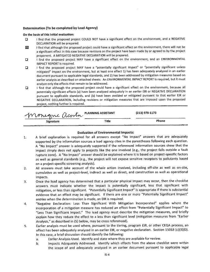
Environmental Factors Potentially Affected: The environmental factors checked below would be potentially affected by this project, involving at least one impact that is a “Potentially Significant Impact” as indicated by the checklist on the following pages.
x AESTHETICS q AGRICULTURE AND FOREST
RESOURCES x AIR QUALITY x BIOLOGICAL RESOURCES x CULTURAL RESOURCES x GEOLOGY AND SOILS
x GREENHOUSE GAS
EMISSIONS x HAZARDS AND
HAZARDOUS MATERIALS x HYDROLOGY AND WATER
QUALITY q LAND USE AND
PLANNING q MINERAL RESOURCES xNOISE
q POPULATION AND HOUSING x PUBLIC SERVICES x RECREATION xTRANSPORTATION/CIRCULATION x UTILITIES x MANDATORY FINDINGS OF
SIGNIFICANCE
INITIAL STUDY CHECKLIST (To be completed by the Lead City Agency)
Background PROPONENT NAME: Mr. Sonny Astani,
C/O 5550 Hollywood Boulevard Partners, LLC
PHONE NUMBER: (310) 273-‐2999
APPLICANT ADDRESS: 9595 Wilshire Boulevard, Penthouse 1010 Beverly Hills, CA 90212
AGENCY REQUIRING CHECKLIST: Department of City Planning DATE SUBMITTED: March 15, 2013
PROPOSAL NAME (If Applicable): High Line West

IS-‐6
Potentially Significant Impact
Potentially Significant Unless
Mitigation Incorporated
Less Than Significant Impact
No Impact
PLEASE NOTE THAT EACH AND EVERY RESPONSE IN THE CITY OF LOS ANGELES INITIAL STUDY AND CHECKLIST IS SUMMARIZED FROM AND BASED UPON THE ENVIRONMENTAL ANALYSIS CONTAINED IN ATTACHEMENT B, EXPLANATION OF CHECKLIST DETERMINATIONS. PLEASE REFER TO THE APPLICABLE RESPONSE IN ATTACHMENT B FOR A DETAILED DISCUSSION OF CHECKLIST DETERMINATIONS.
I. AESTHETICS
a. HAVE A SUBSTANTIAL ADVERSE EFFECT ON A SCENIC VISTA? q q q x
b. SUBSTANTIALLY DAMAGE SCENIC RESOURCES, INCLUDING, BUT NOT LIMITED TO, TREES, ROCK OUTCROPPINGS, AND HISTORIC BUILDINGS, OR OTHER LOCALLY RECOGNIZED DESIRABLE AESTHETIC NATURAL FEATURE WITHIN A CITY-‐DESIGNATED SCENIC HIGHWAY?
q x q q
c. SUBSTANTIALLY DEGRADE THE EXISTING VISUAL CHARACTER OR QUALITY OF THE SITE AND ITS SURROUNDINGS?
q x q q
d. CREATE A NEW SOURCE OF SUBSTANTIAL LIGHT OR GLARE WHICH WOULD ADVERSELY AFFECT DAY OR NIGHTTIME VIEWS IN THE AREA?
q x q q
II. AGRICULTURE AND FOREST RESOURCES
a. CONVERT PRIME FARMLAND, UNIQUE FARMLAND, OR FARMLAND OF STATEWIDE IMPORTANCE, AS SHOWN ON THE MAPS PREPARED PURSUANT TO THE FARMLAND MAPPING AND MONITORING PROGRAM OF THE CALIFORNIA RESOURCES AGENCY, TO NON-‐AGRICULTURAL USE?
q q q x
b. CONFLICT WITH EXISTING ZONING FOR AGRICULTURAL USE, OR A WILLIAMSON ACT CONTRACT?
q q q x
c. CONFLICT WITH EXISTING ZONING FOR, OR CAUSE REZONING OF, FOREST LAND (AS DEFINED IN PUBLIC RESOURCES CODE SECTION 1220(G)), TIMBERLAND (AS DEFINED BY PUBLIC RESOURCES CODE SECTION 4526), OR TIMBERLAND ZONED TIMBERLAND PRODUCTION (AS DEFINED BY GOVERNMENT CODE SECTION 51104(G))?
q q q x
d. RESULT IN THE LOSS OF FOREST LAND OR CONVERSION OF FOREST LAND TO NON-‐FOREST USE?
q q q x
e. INVOLVE OTHER CHANGES IN THE EXISTING ENVIRONMENT WHICH, DUE TO THEIR LOCATION OR NATURE, COULD RESULT IN CONVERSION OF FARMLAND, TO NON-‐AGRICULTURAL USE OR CONVERSION OF FOREST LAND TO NON-‐FOREST USE?
q q q x
III. AIR QUALITY
a. CONFLICT WITH OR OBSTRUCT IMPLEMENTATION OF THE SCAQMD OR CONGESTION MANAGEMENT PLAN?
q q x q
b. VIOLATE ANY AIR QUALITY STANDARD OR CONTRIBUTE SUBSTANTIALLY TO AN EXISTING OR PROJECTED AIR QUALITY VIOLATION?
q x q q
c. RESULT IN A CUMULATIVELY CONSIDERABLE NET INCREASE OF ANY CRITERIA POLLUTANT FOR WHICH THE AIR BASIN IS NON-‐ATTAINMENT (OZONE, CARBON MONOXIDE, & PM 10) UNDER AN APPLICABLE FEDERAL OR STATE AMBIENT AIR QUALITY STANDARD?
q q x q
d. EXPOSE SENSITIVE RECEPTORS TO SUBSTANTIAL POLLUTANT CONCENTRATIONS?
q q x q
e. CREATE OBJECTIONABLE ODORS AFFECTING A SUBSTANTIAL NUMBER OF PEOPLE?
q q x q
IS-‐7
Potentially Significant Impact
Potentially Significant Unless
Mitigation Incorporated
Less Than Significant Impact
No Impact
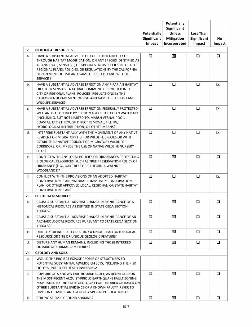
IV. BIOLOGICAL RESOURCES
a. HAVE A SUBSTANTIAL ADVERSE EFFECT, EITHER DIRECTLY OR THROUGH HABITAT MODIFICATION, ON ANY SPECIES IDENTIFIED AS A CANDIDATE, SENSITIVE, OR SPECIAL STATUS SPECIES IN LOCAL OR REGIONAL PLANS, POLICIES, OR REGULATIONS BY THE CALIFORNIA DEPARTMENT OF FISH AND GAME OR U.S. FISH AND WILDLIFE SERVICE ?
q x q q
b. HAVE A SUBSTANTIAL ADVERSE EFFECT ON ANY RIPARIAN HABITAT OR OTHER SENSITIVE NATURAL COMMUNITY IDENTIFIED IN THE CITY OR REGIONAL PLANS, POLICIES, REGULATIONS BY THE CALIFORNIA DEPARTMENT OF FISH AND GAME OR U.S. FISH AND WILDLIFE SERVICE?
q q q x
c. HAVE A SUBSTANTIAL ADVERSE EFFECT ON FEDERALLY PROTECTED WETLANDS AS DEFINED BY SECTION 404 OF THE CLEAN WATER ACT (INCLUDING, BUT NOT LIMITED TO, MARSH VERNAL POOL, COASTAL, ETC.) THROUGH DIRECT REMOVAL, FILLING, HYDROLOGICAL INTERRUPTION, OR OTHER MEANS?
q q q x
d. INTERFERE SUBSTANTIALLY WITH THE MOVEMENT OF ANY NATIVE RESIDENT OR MIGRATORY FISH OR WILDLIFE SPECIES OR WITH ESTABLISHED NATIVE RESIDENT OR MIGRATORY WILDLIFE CORRIDORS, OR IMPEDE THE USE OF NATIVE WILDLIFE NURSERY SITES?
q q q x
e. CONFLICT WITH ANY LOCAL POLICIES OR ORDINANCES PROTECTING BIOLOGICAL RESOURCES, SUCH AS TREE PRESERVATION POLICY OR ORDINANCE (E.G., OAK TREES OR CALIFORNIA WALNUT WOODLANDS)?
q x q q
f. CONFLICT WITH THE PROVISIONS OF AN ADOPTED HABITAT CONSERVATION PLAN, NATURAL COMMUNITY CONSERVATION PLAN, OR OTHER APPROVED LOCAL, REGIONAL, OR STATE HABITAT CONSERVATION PLAN?
q q q x
V. CULTURAL RESOURCES
a. CAUSE A SUBSTANTIAL ADVERSE CHANGE IN SIGNIFICANCE OF A HISTORICAL RESOURCE AS DEFINED IN STATE CEQA SECTION 15064.5?
q x q q
b. CAUSE A SUBSTANTIAL ADVERSE CHANGE IN SIGNIFICANCE OF AN ARCHAEOLOGICAL RESOURCE PURSUANT TO STATE CEQA SECTION 15064.5?
q x q q
c. DIRECTLY OR INDIRECTLY DESTROY A UNIQUE PALEONTOLOGICAL RESOURCE OR SITE OR UNIQUE GEOLOGIC FEATURE?
q x q q
d. DISTURB ANY HUMAN REMAINS, INCLUDING THOSE INTERRED OUTSIDE OF FORMAL CEMETERIES?
q x q q
VI. GEOLOGY AND SOILS
a. WOULD THE PROJECT EXPOSE PEOPLE OR STRUCTURES TO POTENTIAL SUBSTANTIAL ADVERSE EFFECTS, INCLUDING THE RISK OF LOSS, INJURY OR DEATH INVOLVING:
i. RUPTURE OF A KNOWN EARTHQUAKE FAULT, AS DELINEATED ON THE MOST RECENT ALQUIST-‐PRIOLO EARTHQUAKE FAULT ZONING MAP ISSUED BY THE STATE GEOLOGIST FOR THE AREA OR BASED ON OTHER SUBSTANTIAL EVIDENCE OF A KNOWN FAULT? REFER TO DIVISION OF MINES AND GEOLOGY SPECIAL PUBLICATION 42.
q x q q
ii. STRONG SEISMIC GROUND SHAKING? q x q q

IS-‐8
Potentially Significant Impact
Potentially Significant Unless
Mitigation Incorporated
Less Than Significant Impact
No Impact
iii. SEISMIC-‐RELATED GROUND FAILURE, INCLUDING LIQUEFACTION? q q x q iv. LANDSLIDES? q q q x b. RESULT IN SUBSTANTIAL SOIL EROSION OR THE LOSS OF TOPSOIL? q x q q c. BE LOCATED ON A GEOLOGIC UNIT OR SOIL THAT IS UNSTABLE, OR
THAT WOULD BECOME UNSTABLE AS A RESULT OF THE PROJECT, AND POTENTIAL RESULT IN ON-‐ OR OFF-‐SITE LANDSLIDE, LATERAL SPREADING, SUBSIDENCE, LIQUEFACTION, OR COLLAPSE?
q x q q
d. BE LOCATED ON EXPANSIVE SOIL, AS DEFINED IN TABLE 18-‐1-‐B OF THE UNIFORM BUILDING CODE (1994), CREATING SUBSTANTIAL RISKS TO LIFE OR PROPERTY?
q x q q
e. HAVE SOILS INCAPABLE OF ADEQUATELY SUPPORTING THE USE OF SEPTIC TANKS OR ALTERNATIVE WASTE WATER DISPOSAL SYSTEMS WHERE SEWERS ARE NOT AVAILABLE FOR THE DISPOSAL OF WASTE WATER?
q q q x
VII. GREENHOUSE GAS EMISSIONS
a. GENERATE GREENHOUSE GAS EMISSIONS, EITHER DIRECTLY OR INDIRECTLY, THAT MAY HAVE A SIGNIFICANT IMPACT ON THE ENVIRONMENT?
q x q q
b. CONFLICT WITH AN APPLICABLE PLAN, POLICY OR REGULATION ADOPTED FOR THE PURPOSE OF REDUCING THE EMISSIONS OF GREENHOUSE GASES?
q q x q
VIII. HAZARDS AND HAZARDOUS MATERIALS
a. CREATE A SIGNIFICANT HAZARD TO THE PUBLIC OR THE ENVIRONMENT THROUGH THE ROUTINE TRANSPORT, USE, OR DISPOSAL OF HAZARDOUS MATERIALS
q x q q
b. CREATE A SIGNIFICANT HAZARD TO THE PUBLIC OR THE ENVIRONMENT THROUGH REASONABLY FORESEEABLE UPSET AND ACCIDENT CONDITIONS INVOLVING THE RELEASE OF HAZARDOUS MATERIALS INTO THE ENVIRONMENT?
q q x q
c. EMIT HAZARDOUS EMISSIONS OR HANDLE HAZARDOUS OR ACUTELY HAZARDOUS MATERIALS, SUBSTANCES, OR WASTE WITHIN ONE-‐QUARTER MILE OF AN EXISTING OR PROPOSED SCHOOL?
q q x q
d. BE LOCATED ON A SITE WHICH IS INCLUDED ON A LIST OF HAZARDOUS MATERIALS SITES COMPILED PURSUANT TO GOVERNMENT CODE SECTION 65962.5 AND, AS A RESULT, WOULD IT CREATE A SIGNIFICANT HAZARD TO THE PUBLIC OR THE ENVIRONMENT?
q q q x
e. FOR A PROJECT LOCATED WITHIN AN AIRPORT LAND USE PLAN OR, WHERE SUCH A PLAN HAS NOT BEEN ADOPTED, WITHIN TWO MILES OF A PUBLIC AIRPORT OR PUBLIC USE AIRPORT, WOULD THE PROJECT RESULT IN A SAFETY HAZARD FOR PEOPLE RESIDING OR WORKING IN THE PROJECT AREA?
q q q x
f. FOR A PROJECT WITHIN THE VICINITY OF A PRIVATE AIRSTRIP, WOULD THE PROJECT RESULT IN A SAFETY HAZARD FOR THE PEOPLE RESIDING OR WORKING IN THE AREA?
q q q x
g. IMPAIR IMPLEMENTATION OF OR PHYSICALLY INTERFERE WITH AN ADOPTED EMERGENCY RESPONSE PLAN OR EMERGENCY EVACUATION PLAN?
q q q x
h. EXPOSE PEOPLE OR STRUCTURES TO A SIGNIFICANT RISK OF LOSS, INJURY OR DEATH INVOLVING WILDLAND FIRES, INCLUDING WHERE
q q q x
IS-‐9
Potentially Significant Impact
Potentially Significant Unless
Mitigation Incorporated
Less Than Significant Impact
No Impact
WILDLANDS ARE ADJACENT TO URBANIZED AREAS OR WHERE RESIDENCES ARE INTERMIXED WITH WILDLANDS?
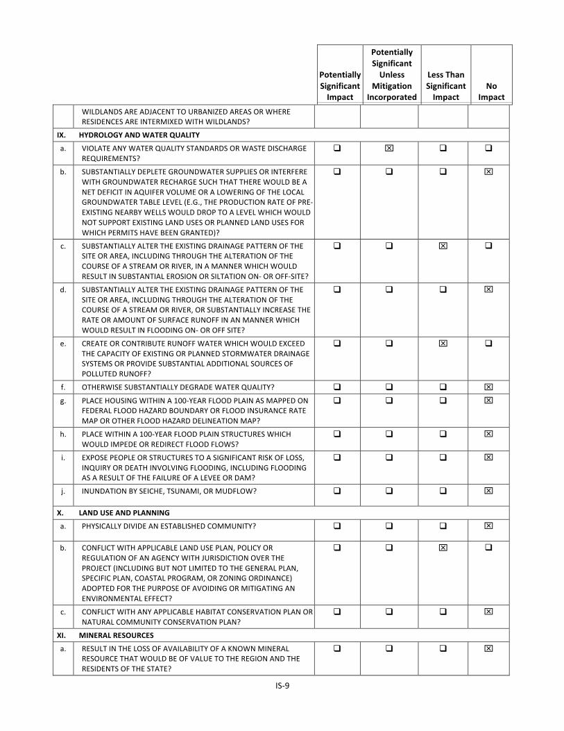
IX. HYDROLOGY AND WATER QUALITY
a. VIOLATE ANY WATER QUALITY STANDARDS OR WASTE DISCHARGE REQUIREMENTS?
q x q q
b. SUBSTANTIALLY DEPLETE GROUNDWATER SUPPLIES OR INTERFERE WITH GROUNDWATER RECHARGE SUCH THAT THERE WOULD BE A NET DEFICIT IN AQUIFER VOLUME OR A LOWERING OF THE LOCAL GROUNDWATER TABLE LEVEL (E.G., THE PRODUCTION RATE OF PRE-‐EXISTING NEARBY WELLS WOULD DROP TO A LEVEL WHICH WOULD NOT SUPPORT EXISTING LAND USES OR PLANNED LAND USES FOR WHICH PERMITS HAVE BEEN GRANTED)?
q q q x
c. SUBSTANTIALLY ALTER THE EXISTING DRAINAGE PATTERN OF THE SITE OR AREA, INCLUDING THROUGH THE ALTERATION OF THE COURSE OF A STREAM OR RIVER, IN A MANNER WHICH WOULD RESULT IN SUBSTANTIAL EROSION OR SILTATION ON-‐ OR OFF-‐SITE?
q q x q
d. SUBSTANTIALLY ALTER THE EXISTING DRAINAGE PATTERN OF THE SITE OR AREA, INCLUDING THROUGH THE ALTERATION OF THE COURSE OF A STREAM OR RIVER, OR SUBSTANTIALLY INCREASE THE RATE OR AMOUNT OF SURFACE RUNOFF IN AN MANNER WHICH WOULD RESULT IN FLOODING ON-‐ OR OFF SITE?
q q q x
e. CREATE OR CONTRIBUTE RUNOFF WATER WHICH WOULD EXCEED THE CAPACITY OF EXISTING OR PLANNED STORMWATER DRAINAGE SYSTEMS OR PROVIDE SUBSTANTIAL ADDITIONAL SOURCES OF POLLUTED RUNOFF?
q q x q
f. OTHERWISE SUBSTANTIALLY DEGRADE WATER QUALITY? q q q x g. PLACE HOUSING WITHIN A 100-‐YEAR FLOOD PLAIN AS MAPPED ON
FEDERAL FLOOD HAZARD BOUNDARY OR FLOOD INSURANCE RATE MAP OR OTHER FLOOD HAZARD DELINEATION MAP?
q q q x
h. PLACE WITHIN A 100-‐YEAR FLOOD PLAIN STRUCTURES WHICH WOULD IMPEDE OR REDIRECT FLOOD FLOWS?
q q q x
i. EXPOSE PEOPLE OR STRUCTURES TO A SIGNIFICANT RISK OF LOSS, INQUIRY OR DEATH INVOLVING FLOODING, INCLUDING FLOODING AS A RESULT OF THE FAILURE OF A LEVEE OR DAM?
q q q x
j. INUNDATION BY SEICHE, TSUNAMI, OR MUDFLOW? q q q x
X. LAND USE AND PLANNING
a. PHYSICALLY DIVIDE AN ESTABLISHED COMMUNITY? q q q x
b. CONFLICT WITH APPLICABLE LAND USE PLAN, POLICY OR REGULATION OF AN AGENCY WITH JURISDICTION OVER THE PROJECT (INCLUDING BUT NOT LIMITED TO THE GENERAL PLAN, SPECIFIC PLAN, COASTAL PROGRAM, OR ZONING ORDINANCE) ADOPTED FOR THE PURPOSE OF AVOIDING OR MITIGATING AN ENVIRONMENTAL EFFECT?
q q x q
c. CONFLICT WITH ANY APPLICABLE HABITAT CONSERVATION PLAN OR NATURAL COMMUNITY CONSERVATION PLAN?
q q q x
XI. MINERAL RESOURCES
a. RESULT IN THE LOSS OF AVAILABILITY OF A KNOWN MINERAL RESOURCE THAT WOULD BE OF VALUE TO THE REGION AND THE RESIDENTS OF THE STATE?
q q q x
IS-‐10
Potentially Significant Impact
Potentially Significant Unless
Mitigation Incorporated
Less Than Significant Impact
No Impact
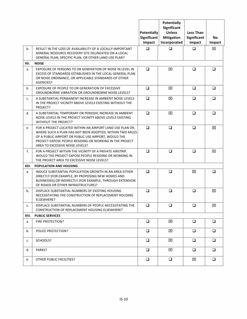
b. RESULT IN THE LOSS OF AVAILABILITY OF A LOCALLY-‐IMPORTANT MINERAL RESOURCE RECOVERY SITE DELINEATED ON A LOCAL GENERAL PLAN, SPECIFIC PLAN, OR OTHER LAND USE PLAN?
q q q x
XII. NOISE
a. EXPOSURE OF PERSONS TO OR GENERATION OF NOISE IN LEVEL IN EXCESS OF STANDARDS ESTABLISHED IN THE LOCAL GENERAL PLAN OR NOISE ORDINANCE, OR APPLICABLE STANDARDS OF OTHER AGENCIES?
q x q q
b. EXPOSURE OF PEOPLE TO OR GENERATION OF EXCESSIVE GROUNDBORNE VIBRATION OR GROUNDBORNE NOISE LEVELS?
q x q q
c. A SUBSTANTIAL PERMANENT INCREASE IN AMBIENT NOISE LEVELS IN THE PROJECT VICINITY ABOVE LEVELS EXISTING WITHOUT THE PROJECT?
q x q q
d. A SUBSTANTIAL TEMPORARY OR PERIODIC INCREASE IN AMBIENT NOISE LEVELS IN THE PROJECT VICINITY ABOVE LEVELS EXISTING WITHOUT THE PROJECT?
q x q q
e. FOR A PROJECT LOCATED WITHIN AN AIRPORT LAND USE PLAN OR, WHERE SUCH A PLAN HAS NOT BEEN ADOPTED, WITHIN TWO MILES OF A PUBLIC AIRPORT OR PUBLIC USE AIRPORT, WOULD THE PROJECT EXPOSE PEOPLE RESIDING OR WORKING IN THE PROJECT AREA TO EXCESSIVE NOISE LEVELS?
q q q x
f. FOR A PROJECT WITHIN THE VICINITY OF A PRIVATE AIRSTRIP, WOULD THE PROJECT EXPOSE PEOPLE RESIDING OR WORKING IN THE PROJECT AREA TO EXCESSIVE NOISE LEVELS?
q q q x
XIII. POPULATION AND HOUSING
a. INDUCE SUBSTANTIAL POPULATION GROWTH IN AN AREA EITHER DIRECTLY (FOR EXAMPLE, BY PROPOSING NEW HOMES AND BUSINESSES) OR INDIRECTLY (FOR EXAMPLE, THROUGH EXTENSION OF ROADS OR OTHER INFRASTRUCTURE)?
q q x q
b. DISPLACE SUBSTANTIAL NUMBERS OF EXISTING HOUSING NECESSITATING THE CONSTRUCTION OF REPLACEMENT HOUSING ELSEWHERE?
q q q x
c. DISPLACE SUBSTANTIAL NUMBERS OF PEOPLE NECESSITATING THE CONSTRUCTION OF REPLACEMENT HOUSING ELSEWHERE?
q q q x
XIV. PUBLIC SERVICES
a. FIRE PROTECTION? q x q q
b. POLICE PROTECTION? q x q q
c. SCHOOLS? q x q q
d. PARKS? q x q q
e. OTHER PUBLIC FACILITIES? q q x q
IS-‐11
Potentially Significant Impact
Potentially Significant Unless
Mitigation Incorporated
Less Than Significant Impact
No Impact
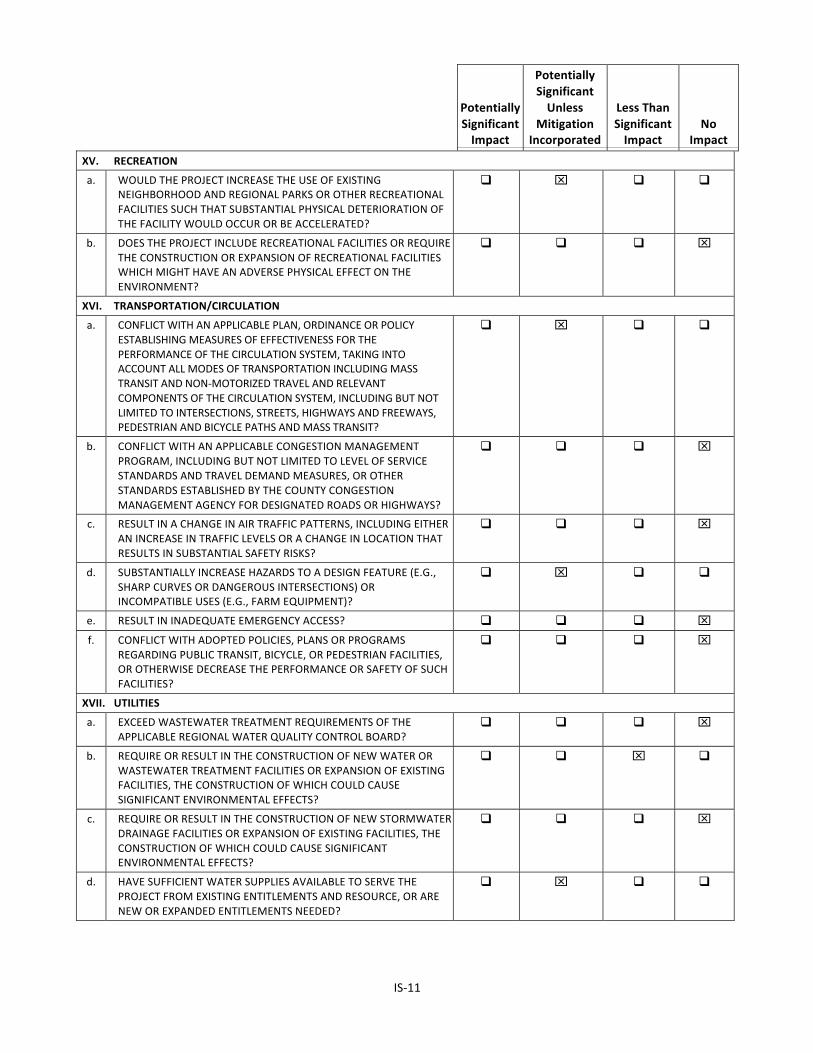
XV. RECREATION
a. WOULD THE PROJECT INCREASE THE USE OF EXISTING NEIGHBORHOOD AND REGIONAL PARKS OR OTHER RECREATIONAL FACILITIES SUCH THAT SUBSTANTIAL PHYSICAL DETERIORATION OF THE FACILITY WOULD OCCUR OR BE ACCELERATED?
q x q q
b. DOES THE PROJECT INCLUDE RECREATIONAL FACILITIES OR REQUIRE THE CONSTRUCTION OR EXPANSION OF RECREATIONAL FACILITIES WHICH MIGHT HAVE AN ADVERSE PHYSICAL EFFECT ON THE ENVIRONMENT?
q q q x
XVI. TRANSPORTATION/CIRCULATION
a. CONFLICT WITH AN APPLICABLE PLAN, ORDINANCE OR POLICY ESTABLISHING MEASURES OF EFFECTIVENESS FOR THE PERFORMANCE OF THE CIRCULATION SYSTEM, TAKING INTO ACCOUNT ALL MODES OF TRANSPORTATION INCLUDING MASS TRANSIT AND NON-‐MOTORIZED TRAVEL AND RELEVANT COMPONENTS OF THE CIRCULATION SYSTEM, INCLUDING BUT NOT LIMITED TO INTERSECTIONS, STREETS, HIGHWAYS AND FREEWAYS, PEDESTRIAN AND BICYCLE PATHS AND MASS TRANSIT?
q x q q
b. CONFLICT WITH AN APPLICABLE CONGESTION MANAGEMENT PROGRAM, INCLUDING BUT NOT LIMITED TO LEVEL OF SERVICE STANDARDS AND TRAVEL DEMAND MEASURES, OR OTHER STANDARDS ESTABLISHED BY THE COUNTY CONGESTION MANAGEMENT AGENCY FOR DESIGNATED ROADS OR HIGHWAYS?
q q q x
c. RESULT IN A CHANGE IN AIR TRAFFIC PATTERNS, INCLUDING EITHER AN INCREASE IN TRAFFIC LEVELS OR A CHANGE IN LOCATION THAT RESULTS IN SUBSTANTIAL SAFETY RISKS?
q q q x
d. SUBSTANTIALLY INCREASE HAZARDS TO A DESIGN FEATURE (E.G., SHARP CURVES OR DANGEROUS INTERSECTIONS) OR INCOMPATIBLE USES (E.G., FARM EQUIPMENT)?
q x q q
e. RESULT IN INADEQUATE EMERGENCY ACCESS? q q q x f. CONFLICT WITH ADOPTED POLICIES, PLANS OR PROGRAMS
REGARDING PUBLIC TRANSIT, BICYCLE, OR PEDESTRIAN FACILITIES, OR OTHERWISE DECREASE THE PERFORMANCE OR SAFETY OF SUCH FACILITIES?
q q q x
XVII. UTILITIES
a. EXCEED WASTEWATER TREATMENT REQUIREMENTS OF THE APPLICABLE REGIONAL WATER QUALITY CONTROL BOARD?
q q q x
b. REQUIRE OR RESULT IN THE CONSTRUCTION OF NEW WATER OR WASTEWATER TREATMENT FACILITIES OR EXPANSION OF EXISTING FACILITIES, THE CONSTRUCTION OF WHICH COULD CAUSE SIGNIFICANT ENVIRONMENTAL EFFECTS?
q q x q
c. REQUIRE OR RESULT IN THE CONSTRUCTION OF NEW STORMWATER DRAINAGE FACILITIES OR EXPANSION OF EXISTING FACILITIES, THE CONSTRUCTION OF WHICH COULD CAUSE SIGNIFICANT ENVIRONMENTAL EFFECTS?
q q q x
d. HAVE SUFFICIENT WATER SUPPLIES AVAILABLE TO SERVE THE PROJECT FROM EXISTING ENTITLEMENTS AND RESOURCE, OR ARE NEW OR EXPANDED ENTITLEMENTS NEEDED?
q x q q
IS-‐12
Potentially Significant Impact
Potentially Significant Unless
Mitigation Incorporated
Less Than Significant Impact
No Impact
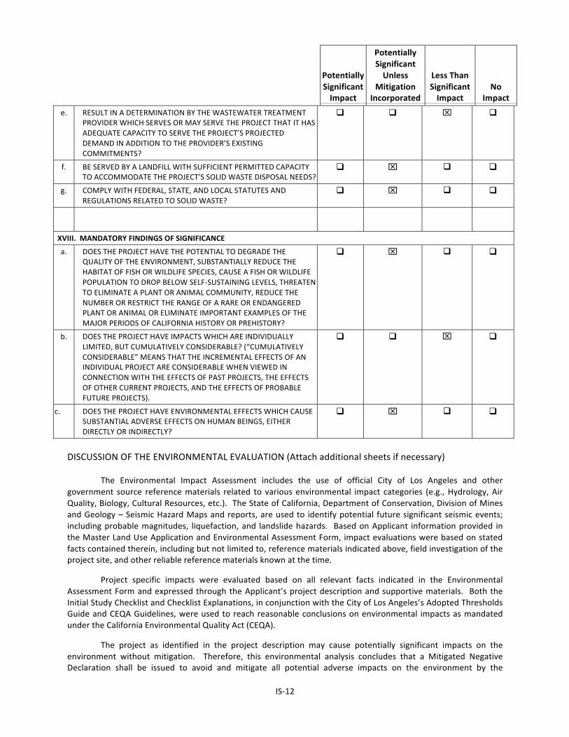
e. RESULT IN A DETERMINATION BY THE WASTEWATER TREATMENT PROVIDER WHICH SERVES OR MAY SERVE THE PROJECT THAT IT HAS ADEQUATE CAPACITY TO SERVE THE PROJECT’S PROJECTED DEMAND IN ADDITION TO THE PROVIDER’S EXISTING COMMITMENTS?
q q x q
f. BE SERVED BY A LANDFILL WITH SUFFICIENT PERMITTED CAPACITY TO ACCOMMODATE THE PROJECT’S SOLID WASTE DISPOSAL NEEDS?
q x q q
g. COMPLY WITH FEDERAL, STATE, AND LOCAL STATUTES AND REGULATIONS RELATED TO SOLID WASTE?
q x q q
XVIII. MANDATORY FINDINGS OF SIGNIFICANCE
a. DOES THE PROJECT HAVE THE POTENTIAL TO DEGRADE THE QUALITY OF THE ENVIRONMENT, SUBSTANTIALLY REDUCE THE HABITAT OF FISH OR WILDLIFE SPECIES, CAUSE A FISH OR WILDLIFE POPULATION TO DROP BELOW SELF-‐SUSTAINING LEVELS, THREATEN TO ELIMINATE A PLANT OR ANIMAL COMMUNITY, REDUCE THE NUMBER OR RESTRICT THE RANGE OF A RARE OR ENDANGERED PLANT OR ANIMAL OR ELIMINATE IMPORTANT EXAMPLES OF THE MAJOR PERIODS OF CALIFORNIA HISTORY OR PREHISTORY?
q x q q
b. DOES THE PROJECT HAVE IMPACTS WHICH ARE INDIVIDUALLY LIMITED, BUT CUMULATIVELY CONSIDERABLE? (“CUMULATIVELY CONSIDERABLE” MEANS THAT THE INCREMENTAL EFFECTS OF AN INDIVIDUAL PROJECT ARE CONSIDERABLE WHEN VIEWED IN CONNECTION WITH THE EFFECTS OF PAST PROJECTS, THE EFFECTS OF OTHER CURRENT PROJECTS, AND THE EFFECTS OF PROBABLE FUTURE PROJECTS).
q q x q
c. DOES THE PROJECT HAVE ENVIRONMENTAL EFFECTS WHICH CAUSE SUBSTANTIAL ADVERSE EFFECTS ON HUMAN BEINGS, EITHER DIRECTLY OR INDIRECTLY?
q x q q
DISCUSSION OF THE ENVIRONMENTAL EVALUATION (Attach additional sheets if necessary) The Environmental Impact Assessment includes the use of official City of Los Angeles and other government source reference materials related to various environmental impact categories (e.g., Hydrology, Air Quality, Biology, Cultural Resources, etc.). The State of California, Department of Conservation, Division of Mines and Geology – Seismic Hazard Maps and reports, are used to identify potential future significant seismic events; including probable magnitudes, liquefaction, and landslide hazards. Based on Applicant information provided in the Master Land Use Application and Environmental Assessment Form, impact evaluations were based on stated facts contained therein, including but not limited to, reference materials indicated above, field investigation of the project site, and other reliable reference materials known at the time.
Project specific impacts were evaluated based on all relevant facts indicated in the Environmental Assessment Form and expressed through the Applicant’s project description and supportive materials. Both the Initial Study Checklist and Checklist Explanations, in conjunction with the City of Los Angeles’s Adopted Thresholds Guide and CEQA Guidelines, were used to reach reasonable conclusions on environmental impacts as mandated under the California Environmental Quality Act (CEQA).
The project as identified in the project description may cause potentially significant impacts on the environment without mitigation. Therefore, this environmental analysis concludes that a Mitigated Negative Declaration shall be issued to avoid and mitigate all potential adverse impacts on the environment by the

IS-‐14
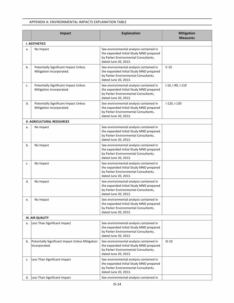
APPENDIX A: ENVIRONMENTAL IMPACTS EXPLANATION TABLE Impact Explanation Mitigation
Measures I. AESTHETICS
a. No Impact See environmental analysis contained in the expanded Initial Study MND prepared by Parker Environmental Consultants, dated June 20, 2013.
b. Potentially Significant Impact Unless Mitigation Incorporated.
See environmental analysis contained in the expanded Initial Study MND prepared by Parker Environmental Consultants, dated June 20, 2013.
V-‐10
c. Potentially Significant Impact Unless Mitigation Incorporated.
See environmental analysis contained in the expanded Initial Study MND prepared by Parker Environmental Consultants, dated June 20, 2013.
I-‐10, I-‐90, I-‐110
d. Potentially Significant Impact Unless Mitigation Incorporated.
See environmental analysis contained in the expanded Initial Study MND prepared by Parker Environmental Consultants, dated June 20, 2013.
I-‐120, I-‐130
II. AGRICULTURAL RESOURCES
a. No Impact See environmental analysis contained in the expanded Initial Study MND prepared by Parker Environmental Consultants, dated June 20, 2013.
b. No Impact See environmental analysis contained in the expanded Initial Study MND prepared by Parker Environmental Consultants, dated June 20, 2013.
c. No Impact See environmental analysis contained in the expanded Initial Study MND prepared by Parker Environmental Consultants, dated June 20, 2013.
d. No Impact See environmental analysis contained in the expanded Initial Study MND prepared by Parker Environmental Consultants, dated June 20, 2013.
e. No Impact See environmental analysis contained in the expanded Initial Study MND prepared by Parker Environmental Consultants, dated June 20, 2013.
III. AIR QUALITY
a. Less Than Significant Impact See environmental analysis contained in the expanded Initial Study MND prepared by Parker Environmental Consultants, dated June 20, 2013.
b. Potentially Significant Impact Unless Mitigation Incorporated.
See environmental analysis contained in the expanded Initial Study MND prepared by Parker Environmental Consultants, dated June 20, 2013.
III-‐10
c. Less Than Significant Impact See environmental analysis contained in the expanded Initial Study MND prepared by Parker Environmental Consultants, dated June 20, 2013.
d. Less Than Significant Impact See environmental analysis contained in
IS-‐15
Impact Explanation Mitigation Measures
the expanded Initial Study MND prepared by Parker Environmental Consultants, dated June 20, 2013.
e. Less Than Significant Impact See environmental analysis contained in the expanded Initial Study MND prepared by Parker Environmental Consultants, dated June 20, 2013.
IV. BIOLOGICAL RESOURCES
a. Potentially Significant Impact Unless Mitigation Incorporated.
See environmental analysis contained in the expanded Initial Study MND prepared by Parker Environmental Consultants, dated June 20, 2013.
IV-‐20
b. No Impact See environmental analysis contained in the expanded Initial Study MND prepared by Parker Environmental Consultants, dated June 20, 2013.
c. No Impact See environmental analysis contained in the expanded Initial Study MND prepared by Parker Environmental Consultants, dated June 20, 2013.
d. No Impact See environmental analysis contained in the expanded Initial Study MND prepared by Parker Environmental Consultants, dated June 20, 2013.
e. Potentially Significant Impact Unless Mitigation Incorporated.
See environmental analysis contained in the expanded Initial Study MND prepared by Parker Environmental Consultants, dated June 20, 2013.
IV-‐70
f. No Impact See environmental analysis contained in the expanded Initial Study MND prepared by Parker Environmental Consultants, dated June 20, 2013.
V. CULTURAL RESOURCES
a. Potentially Significant Impact Unless Mitigation Incorporated.
See environmental analysis contained in the expanded Initial Study MND prepared by Parker Environmental Consultants, dated June 20, 2013.
V-‐10
b. Potentially Significant Impact Unless Mitigation Incorporated.
See environmental analysis contained in the expanded Initial Study MND prepared by Parker Environmental Consultants, dated June 20, 2013.
V-‐20
c. Potentially Significant Impact Unless Mitigation Incorporated.
See environmental analysis contained in the expanded Initial Study MND prepared by Parker Environmental Consultants, dated June 20, 2013.
V-‐30
d. Potentially Significant Impact Unless Mitigation Incorporated.
See environmental analysis contained in the expanded Initial Study MND prepared by Parker Environmental Consultants, dated June 20, 2013.
V-‐40
VI. GEOLOGY AND SOILS
a.i. Potentially Significant Impact Unless Mitigation Incorporated.
See environmental analysis contained in the expanded Initial Study MND prepared by Parker Environmental Consultants, dated June 20, 2013.
VI-‐50
IS-‐16
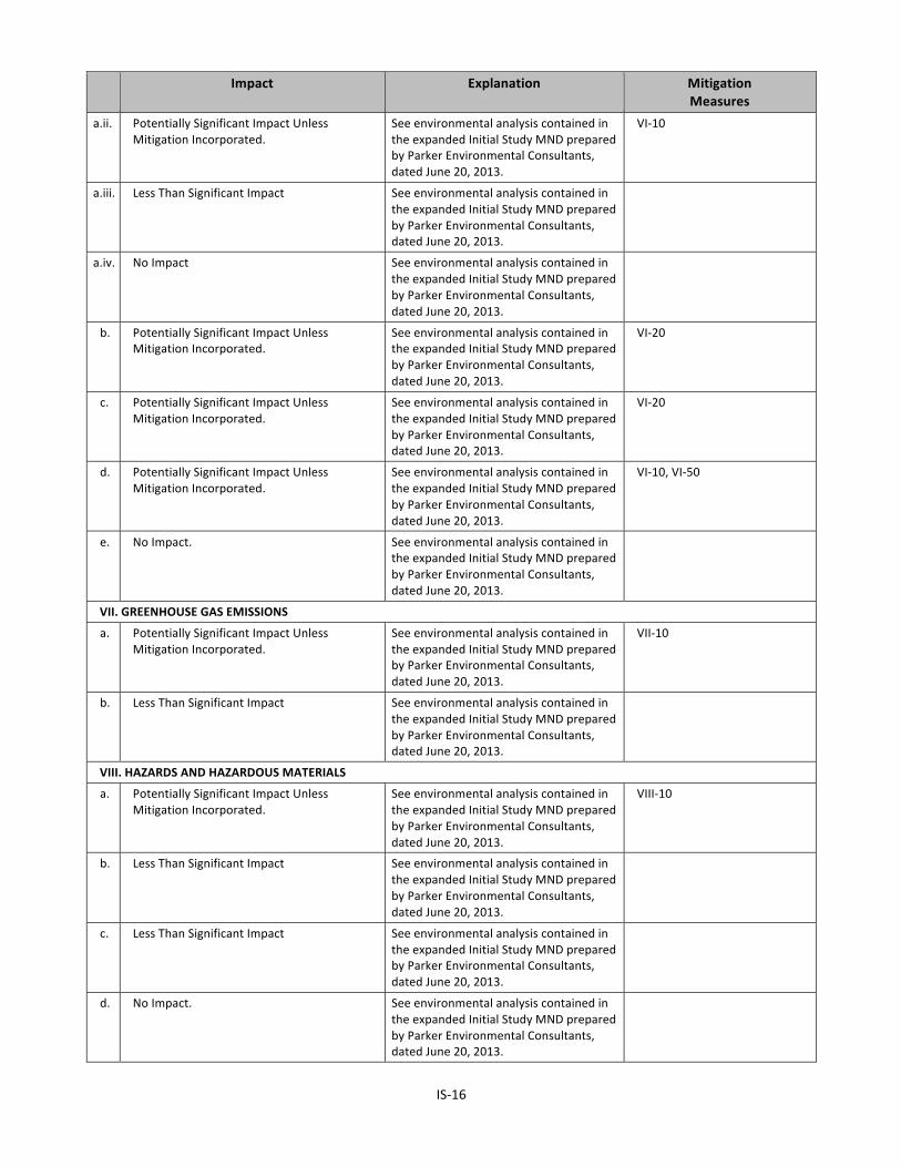
Impact Explanation Mitigation Measures
a.ii. Potentially Significant Impact Unless Mitigation Incorporated.
See environmental analysis contained in the expanded Initial Study MND prepared by Parker Environmental Consultants, dated June 20, 2013.
VI-‐10
a.iii. Less Than Significant Impact See environmental analysis contained in the expanded Initial Study MND prepared by Parker Environmental Consultants, dated June 20, 2013.
a.iv. No Impact See environmental analysis contained in the expanded Initial Study MND prepared by Parker Environmental Consultants, dated June 20, 2013.
b. Potentially Significant Impact Unless Mitigation Incorporated.
See environmental analysis contained in the expanded Initial Study MND prepared by Parker Environmental Consultants, dated June 20, 2013.
VI-‐20
c. Potentially Significant Impact Unless Mitigation Incorporated.
See environmental analysis contained in the expanded Initial Study MND prepared by Parker Environmental Consultants, dated June 20, 2013.
VI-‐20
d. Potentially Significant Impact Unless Mitigation Incorporated.
See environmental analysis contained in the expanded Initial Study MND prepared by Parker Environmental Consultants, dated June 20, 2013.
VI-‐10, VI-‐50
e. No Impact. See environmental analysis contained in the expanded Initial Study MND prepared by Parker Environmental Consultants, dated June 20, 2013.
VII. GREENHOUSE GAS EMISSIONS
a. Potentially Significant Impact Unless Mitigation Incorporated.
See environmental analysis contained in the expanded Initial Study MND prepared by Parker Environmental Consultants, dated June 20, 2013.
VII-‐10
b. Less Than Significant Impact See environmental analysis contained in the expanded Initial Study MND prepared by Parker Environmental Consultants, dated June 20, 2013.
VIII. HAZARDS AND HAZARDOUS MATERIALS
a. Potentially Significant Impact Unless Mitigation Incorporated.
See environmental analysis contained in the expanded Initial Study MND prepared by Parker Environmental Consultants, dated June 20, 2013.
VIII-‐10
b. Less Than Significant Impact See environmental analysis contained in the expanded Initial Study MND prepared by Parker Environmental Consultants, dated June 20, 2013.
c. Less Than Significant Impact See environmental analysis contained in the expanded Initial Study MND prepared by Parker Environmental Consultants, dated June 20, 2013.
d. No Impact. See environmental analysis contained in the expanded Initial Study MND prepared by Parker Environmental Consultants, dated June 20, 2013.
IS-‐17
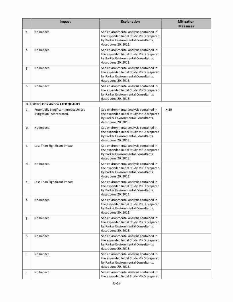
Impact Explanation Mitigation Measures
e. No Impact. See environmental analysis contained in the expanded Initial Study MND prepared by Parker Environmental Consultants, dated June 20, 2013.
f. No Impact. See environmental analysis contained in the expanded Initial Study MND prepared by Parker Environmental Consultants, dated June 20, 2013.
g. No Impact. See environmental analysis contained in the expanded Initial Study MND prepared by Parker Environmental Consultants, dated June 20, 2013.
h. No Impact. See environmental analysis contained in the expanded Initial Study MND prepared by Parker Environmental Consultants, dated June 20, 2013.
IX. HYDROLOGY AND WATER QUALITY
a. Potentially Significant Impact Unless Mitigation Incorporated.
See environmental analysis contained in the expanded Initial Study MND prepared by Parker Environmental Consultants, dated June 20, 2013.
IX-‐20
b. No Impact. See environmental analysis contained in the expanded Initial Study MND prepared by Parker Environmental Consultants, dated June 20, 2013.
c. Less Than Significant Impact See environmental analysis contained in the expanded Initial Study MND prepared by Parker Environmental Consultants, dated June 20, 2013.
d. No Impact. See environmental analysis contained in the expanded Initial Study MND prepared by Parker Environmental Consultants, dated June 20, 2013.
e. Less Than Significant Impact See environmental analysis contained in the expanded Initial Study MND prepared by Parker Environmental Consultants, dated June 20, 2013.
f. No Impact. See environmental analysis contained in the expanded Initial Study MND prepared by Parker Environmental Consultants, dated June 20, 2013.
g. No Impact. See environmental analysis contained in the expanded Initial Study MND prepared by Parker Environmental Consultants, dated June 20, 2013.
h. No Impact. See environmental analysis contained in the expanded Initial Study MND prepared by Parker Environmental Consultants, dated June 20, 2013.
i. No Impact. See environmental analysis contained in the expanded Initial Study MND prepared by Parker Environmental Consultants, dated June 20, 2013.
j. No Impact. See environmental analysis contained in the expanded Initial Study MND prepared

IS-‐18
Impact Explanation Mitigation Measures
by Parker Environmental Consultants, dated June 20, 2013.
X. LAND USE AND PLANNING
a. No Impact. See environmental analysis contained in the expanded Initial Study MND prepared by Parker Environmental Consultants, dated June 20, 2013.
b. Less Than Significant See environmental analysis contained in the expanded Initial Study MND prepared by Parker Environmental Consultants, dated June 20, 2013.
c. No Impact. See environmental analysis contained in the expanded Initial Study MND prepared by Parker Environmental Consultants, dated June 20, 2013.
XI. MINERAL RESOURCES
a. No Impact. See environmental analysis contained in the expanded Initial Study MND prepared by Parker Environmental Consultants, dated June 20, 2013.
b. No Impact. See environmental analysis contained in the expanded Initial Study MND prepared by Parker Environmental Consultants, dated June 20, 2013.
XII. NOISE
a. Potentially Significant Impact Unless Mitigation Incorporated.
See environmental analysis contained in the expanded Initial Study MND prepared by Parker Environmental Consultants, dated June 20, 2013.
XII-‐20, XII-‐60
b. Potentially Significant Impact Unless Mitigation Incorporated.
See environmental analysis contained in the expanded Initial Study MND prepared by Parker Environmental Consultants, dated June 20, 2013.
XII-‐240
c. Potentially Significant Impact Unless Mitigation Incorporated.
See environmental analysis contained in the expanded Initial Study MND prepared by Parker Environmental Consultants, dated June 20, 2013.
XII-‐40
d. Potentially Significant Impact Unless Mitigation Incorporated.
See environmental analysis contained in the expanded Initial Study MND prepared by Parker Environmental Consultants, dated June 20, 2013.
XII-‐20, XII-‐40, XII-‐60, XII-‐240
e. No Impact See environmental analysis contained in the expanded Initial Study MND prepared by Parker Environmental Consultants, dated June 20, 2013.
f. No Impact See environmental analysis contained in the expanded Initial Study MND prepared by Parker Environmental Consultants, dated June 20, 2013.
XIII. POPULATION AND HOUSING
a. Less Than Significant See environmental analysis contained in the expanded Initial Study MND prepared by Parker Environmental Consultants, dated June 20, 2013.
IS-‐19
Impact Explanation Mitigation Measures
b. No Impact See environmental analysis contained in the expanded Initial Study MND prepared by Parker Environmental Consultants, dated June 20, 2013.
c. No Impact See environmental analysis contained in the expanded Initial Study MND prepared by Parker Environmental Consultants, dated June 20, 2013.
XIV. PUBLIC SERVICES
ai. Potentially Significant Impact Unless Mitigation Incorporated.
See environmental analysis contained in the expanded Initial Study MND prepared by Parker Environmental Consultants, dated June 20, 2013.
XIV-‐10
aii. Potentially Significant Impact Unless Mitigation Incorporated.
See environmental analysis contained in the expanded Initial Study MND prepared by Parker Environmental Consultants, dated June 20, 2013.
XIV-‐20, XIV-‐30
aiii Potentially Significant Impact Unless Mitigation Incorporated.
See environmental analysis contained in the expanded Initial Study MND prepared by Parker Environmental Consultants, dated June 20, 2013.
XIV-‐40, XIV-‐60
aiv Potentially Significant Impact Unless Mitigation Incorporated.
See environmental analysis contained in the expanded Initial Study MND prepared by Parker Environmental Consultants, dated June 20, 2013.
XV-‐10
e. Less Than Significant See environmental analysis contained in the expanded Initial Study MND prepared by Parker Environmental Consultants, dated June 20, 2013.
XV. RECREATION
a. Potentially Significant Impact Unless Mitigation Incorporated.
See environmental analysis contained in the expanded Initial Study MND prepared by Parker Environmental Consultants, dated June 20, 2013.
XV-‐10
b. No Impact See environmental analysis contained in the expanded Initial Study MND prepared by Parker Environmental Consultants, dated June 20, 2013.
XVI. TRANSPORTATION/CIRCULATION
a. Potentially Significant Impact Unless Mitigation Incorporated.
See environmental analysis contained in the expanded Initial Study MND prepared by Parker Environmental Consultants, dated June 20, 2013.
XVI-‐10, XVI-‐30
b. No Impact See environmental analysis contained in the expanded Initial Study MND prepared by Parker Environmental Consultants, dated June 20, 2013.
c. No Impact See environmental analysis contained in the expanded Initial Study MND prepared by Parker Environmental Consultants, dated June 20, 2013.
d. Potentially Significant Impact Unless Mitigation Incorporated.
See environmental analysis contained in the expanded Initial Study MND prepared by Parker Environmental Consultants,
XVI-‐40
IS-‐20
Impact Explanation Mitigation Measures
dated June 20, 2013.
e. No Impact See environmental analysis contained in the expanded Initial Study MND prepared by Parker Environmental Consultants, dated June 20, 2013.
f. No Impact See environmental analysis contained in the expanded Initial Study MND prepared by Parker Environmental Consultants, dated June 20, 2013.
XVII. UTILITIES
a. No Impact See environmental analysis contained in the expanded Initial Study MND prepared by Parker Environmental Consultants, dated June 20, 2013.
b. Less Than Significant See environmental analysis contained in the expanded Initial Study MND prepared by Parker Environmental Consultants, dated June 20, 2013.
c. No Impact See environmental analysis contained in the expanded Initial Study MND prepared by Parker Environmental Consultants, dated June 20, 2013.
d. Potentially Significant Impact Unless Mitigation Incorporated.
See environmental analysis contained in the expanded Initial Study MND prepared by Parker Environmental Consultants, dated June 20, 2013.
XVII-‐10, XVII-‐20, XVII-‐30, XVII-‐40
e. Less Than Significant See environmental analysis contained in the expanded Initial Study MND prepared by Parker Environmental Consultants, dated June 20, 2013.
f. Potentially Significant Impact Unless Mitigation Incorporated.
See environmental analysis contained in the expanded Initial Study MND prepared by Parker Environmental Consultants, dated June 20, 2013.
XVII-‐90
g. Potentially Significant Impact Unless Mitigation Incorporated.
See environmental analysis contained in the expanded Initial Study MND prepared by Parker Environmental Consultants, dated June 20, 2013.
XVII-‐90
XVIII. MANDATORY FINDINGS OF SIGNIFICANCE
a. Potentially Significant Impact Unless Mitigation Incorporated.
See environmental analysis contained in the expanded Initial Study MND prepared by Parker Environmental Consultants, dated June 20, 2013.
V-‐10
b. Less Than Significant See environmental analysis contained in the expanded Initial Study MND prepared by Parker Environmental Consultants, dated June 20, 2013.
c. Potentially Significant Impact Unless Mitigation Incorporated.
See environmental analysis contained in the expanded Initial Study MND prepared by Parker Environmental Consultants, dated June 20, 2013.
XVIII-‐30

IS-‐21
MITIGATION MEASURES
I-‐10 Aesthetics (Landscape Plan) • All open areas not used for buildings, driveways, parking areas, recreational facilities or sidewalks shall be attractively landscaped and maintained in accordance with a landscape plan and an automatic irrigation plan, prepared by a licensed Landscape Architect and to the satisfaction of the decision maker.
I-‐90 Aesthetics (Vandalism)
• Every building, structure, or portion thereof, shall be maintained in a safe and sanitary condition and good repair, and free from, debris, rubbish, garbage, trash, overgrown vegetation or other similar material pursuant to Municipal Code Section 91.8104.
• The exterior of all buildings and fences shall be free from graffiti when such graffiti is visible from a street or alley, pursuant to Municipal Code Section 91.8104.15.
I-‐110 Aesthetics (Signage on Construction Barriers)
• The applicant shall affix or paint a plainly visible sign, on publically accessible portions of the construction barriers, with the following language: “POST NO BILLS.”
• Such language shall appear at intervals of no less than 25 feet along the length of the publically accessible portions of the barrier.
• The applicant shall be responsible for maintaining the visibility of the required signage and for maintaining the construction barrier free and clear of any unauthorized signs within 48 hours of occurrence.
I-‐120 Aesthetics (Light)
• Outdoor lighting shall be designed and installed with shielding, such that the light source cannot be seen from adjacent residential properties or the public right-‐of-‐way.
I-‐130 (Aesthetics (Glare)
• The exterior of the proposed structure shall be constructed of materials such as, but not limited to, high-‐performance and/or non-‐reflective tinted glass (no mirror like tints or films) and pre-‐cast concrete or fabricated wall surfaces to minimize glare and reflected heat.
III-‐10 Air Pollution (Demolition, Grading, and Construction Activities)
• All unpaved demolition and construction areas shall be wetted at least twice daily during excavation and construction, and temporary dust covers shall be used to reduce dust emissions and meet SCAQMD District Rule 403. Wetting would reduce fugitive dust by as much as 50 percent.
• The construction area shall be kept sufficiently dampened to control dust caused by grading and hauling, and at all times provide reasonable control of dust caused by wind.
• All clearing, earth moving, or excavation activities shall be discontinued during periods of high winds (i.e., greater than 15 mph), so as to prevent excessive amounts of dust.
• All dirt/soil loads shall be secured by trimming, watering or other appropriate means to prevent spillage and dust.
• All dirt/soil materials transported off-‐site shall be either sufficiently watered or securely covered to prevent excessive amount of dust.
• General contractors shall maintain and operate construction equipment so as to minimize exhaust emissions.
• Trucks having no current hauling activity shall not idle but be turned off.

IS-‐22
IV-‐20 Habitat Modification (Nesting Native Birds, Non-‐Hillside or Urban Areas) • Proposed project activities (including disturbances to native and non-‐native vegetation,
structures and substrates) should take place outside of the breeding bird season which generally runs from March 1-‐ August 31 (as early as February 1 for raptors) to avoid take (including disturbances which would cause abandonment of active nests containing eggs and/or young). Take means to hunt, pursue, catch, capture, or kill, or attempt to hunt, pursue, catch, capture of kill (Fish and Game Code Section 86).
• If project activities cannot feasibly avoid the breeding bird season, beginning thirty days prior to the disturbance of suitable nesting habitat, the applicant shall: a. Arrange for weekly bird surveys to detect any protected native birds in the habitat to be
removed and any other such habitat within properties adjacent to the project site, as access to adjacent areas allows. The surveys shall be conducted by a qualified biologist with experience in conducting breeding bird surveys. The surveys shall continue on a weekly basis with the last survey being conducted no more than 3 days prior to the initiation of clearance/construction work.
b. If a protected native bird is found, the applicant shall delay all clearance/construction disturbance activities within 300 feet of suitable nesting habitat for the observed protected bird species until August 31.
c. Alternatively, the Qualified Biologist could continue the surveys in order to locate any nests. If an active nest is located, clearing and construction within 300 feet of the nest or as determined by a qualified biological monitor, shall be postponed until the nest is vacated and juveniles have fledged and when there is no evidence of a second attempt at nesting. The buffer zone from the nest shall be established in the field with flagging and stakes. Construction personnel shall be instructed on the sensitivity of the area.
d. The applicant shall record the results of the recommended protective measures described above to document compliance with applicable State and Federal laws pertaining to the protection of native birds. Such record shall be submitted and received into the case file for the associated discretionary action permitting the project.
IV-‐70 Tree Removal (Non-‐Protected Trees)
• Prior to the issuance of any permit, a plot plan shall be prepared indicating the location, size, type, and general condition of all existing trees on the site and within the adjacent public right(s)-‐of-‐way.
• All significant (8-‐inch or greater trunk diameter, or cumulative trunk diameter if multi-‐trunked, as measured 54 inches above the ground) non-‐protected trees on the site proposed for removal shall be replaced at a 1:1 ratio with a minimum 24-‐inch box tree. Net, new trees, located within the parkway of the adjacent public right(s)-‐of-‐way, may be counted toward replacement tree requirements.
• Removal or planting of any tree in the public right-‐of-‐way requires approval of the Board of Public Works. Contact Urban Forestry Division at: 213-‐847-‐3077. All trees in the public right-‐of-‐way shall be provided per the current standards of the Urban Forestry Division the Department of Public Works, Bureau of Street Services.
V-‐10 Cultural Resources (Designated Historic-‐Cultural Resource)
• As the plans evolve beyond the schematic level, compliance with the Secretary of the Interior’s Standards for rehabilitation shall be reviewed, monitored, and carried out in compliance with the Secretary of Interior’s Standards to the satisfaction of the City of Los Angeles Cultural Heritage Commission. The Commission may delegate this responsibility to its staff in the Office of Historic Resources.
IS-‐23
• The brick on the side and rear walls of the Falcon Studios Building should be salvaged. The Office of Historic Resources shall be consulted to determine if the brick can be used to reconstruct the side walls, and if it can be used, it shall be.
V-‐20 Cultural Resources (Archaeological)
• If any archaeological materials are encountered during the course of the Project development, all further development activity shall halt and:
a. The services of an archaeologist shall then be secured by contacting the South Central Coastal Information Center (657-‐278-‐5395) located at California State University Fullerton, or a member of the Society of Professional Archaeologist (SOPA) or a SOPA-‐qualified archaeologist, who shall assess the discovered material(s) and prepare a survey, study, or report evaluating the impact.
b. The archaeologist’s survey, study or report shall contain a recommendation(s), if necessary, for the preservation, conservation, or relocation of the resource.
c. The applicant shall comply with the recommendations of the evaluating archaeologist, as contained in the survey, study or report.
d. Project development activities may resume once copies of the archaeological survey, study or report are submitted to: SCCIC Department of Anthropology McCarthy Hall 477 CSU Fullerton 800 North State College Boulevard Fullerton, CA 92834
• Prior to the issuance of any building permit, the applicant shall submit a letter to the case file indicating what, if any, archaeological reports have been submitted, or a statement indicating that no material was discovered.
• A covenant and agreement binding the applicant to this condition shall be recorded prior to issuance of a grading permit.
V-‐30 Cultural Resources (Paleontological)
• If any paleontological materials are encountered during the course of the Project development, all further development activities shall halt and:
a) The services of a paleontologist shall be secured by contacting the Center for Public Paleontology -‐ USC, UCLA, Cal State Los Angeles, Cal State Long Beach, or the County Natural History Museum – who shall assess the discovered material(s) and prepare a survey, study or report evaluating the impact.
b) The paleontologist's survey, study or report shall contain a recommendation(s), if necessary, for the preservation, conservation, or relocation of the resource.
c) The applicant shall comply with the recommendations of the evaluating paleontologist, as contained in the survey, study or report.
d) Project development activities may resume once copies of the paleontological survey, study or report are submitted to the Los Angeles County Natural History Museum.
• Prior to the issuance of any building permit, the applicant shall submit a letter to the case file indicating what, if any, paleontological reports have been submitted, or a statement indicating that no material was discovered.
• A covenant and agreement binding the applicant to this condition shall be recorded prior to issuance of a grading permit.
IS-‐24
V-‐40 Cultural Resources (Human Remains) • In the event that human remains are discovered during excavation activities, the following procedure shall be observed:
a) Stop immediately and contact the County Coroner: 1104 N. Mission Road Los Angeles, CA 90033 323-‐343-‐0512 (8 a.m. to 5 p.m. Monday through Friday) or 323-‐343-‐0714 (After Hours, Saturday, Sunday, and Holidays)
b) The coroner has two working days to examine human remains after being notified by the responsible person. If the remains are Native American, the Coroner has 24 hours to notify the Native American Heritage Commission.
c) The Native American Heritage Commission will immediately notify the person it believes to be the most likely descendent of the deceased Native American.
d) The most likely descendent has 48 hours to make recommendations to the owner, or representative, for the treatment or disposition, with proper dignity, of the human remains and grave goods.
e) If the descendent does not make recommendations within 48 hours the owner shall reinter the remains in an area of the property secure from further disturbance, or;
f) If the owner does not accept the descendant’s recommendations, the owner or the descendent may request mediation by the Native American Heritage Commission.
• Discuss and confer means the meaningful and timely discussion careful consideration of the views of each party.
VI-‐10 Seismic
• The design and construction of the Project shall conform to the Uniform Building Code seismic standards as approved by the Department of Building and Safety.
VI-‐20 Erosion/Grading/Short-‐Term Construction Impacts
• The Proposed Project shall comply with Chapters 29 and 70 of the California Building Code (“CBC”) and Chapter IX, Division 70 of the LAMC to ensure that uncovered or uncompacted soils are managed to prevent movement.
• The Project Applicant shall provide a staked signage at the site with a minimum of 3-‐inch lettering containing contact information for the Senior Street Use Inspector (Department of Public Works), the Senior Grading Inspector (“LADBS”) and the hauling or general contractor.
• Chapter IX, Division 70 of the LAMC addresses grading, excavations, and fills. All grading activities require grading permits from the Department of Building and Safety. Additional provisions are required for grading activities within Hillside areas. The application of BMPs includes but is not limited to the following mitigation measures: a. Excavation and grading activities shall be scheduled during dry weather periods. If
grading occurs during the rainy season (October 15 through April 1), diversion dikes shall be constructed to channel runoff around the site. Channels shall be lined with grass or roughened pavement to reduce runoff velocity.
b. Stockpiles, excavated, and exposed soil shall be covered with secured tarps, plastic sheeting, erosion control fabrics, or treated with a bio-‐degradable soil stabilizer.

IS-‐25
VI-‐50 Geotechnical Report • The Project shall comply with the conditions contained within the Department of Building and Safety’s Geology and Soils Report Approval Letter for the Proposed Project, and as it may be subsequently amended or modified.
VII-‐10 Green House Gas Emissions
• Install a demand (tankless or instantaneous) water heater system, or high efficiency central boiler system, sufficient to serve the anticipated needs of the dwelling(s).
• Only low-‐ and non-‐VOC-‐containing paints, sealants, adhesives, and solvents shall be utilized in the construction of the Project.
VIII-‐10 Explosion/Release (Existing Toxic/Hazardous Construction Materials)
• (Asbestos) Prior to the issuance of any permit for the demolition or alteration of the existing structure(s), the applicant shall provide a letter to the Department of Building and Safety from a qualified asbestos abatement consultant indicating that no Asbestos-‐Containing Materials (ACM) are present in the building. If ACMs are found to be present, it will need to be abated in compliance with the South Coast Air Quality Management District's Rule 1403 as well as all other applicable State and Federal rules and regulations.
• (Lead Paint) Prior to issuance of any permit for the demolition or alteration of the existing structure(s), a lead-‐based paint survey shall be performed in accordance with LADBS standards and to the written satisfaction of the Department of Building and Safety. Should lead-‐based paint materials be identified, standard handling and disposal practices shall be implemented pursuant to OSHA regulations.
• (Polychlorinated Biphenyl – Commercial and Industrial Buildings) Prior to issuance of a demolition permit, a polychlorinated biphenyl (“PCB”) abatement contractor shall conduct a survey of the project site to identify and assist with compliance with applicable state and federal rules and regulation governing PCB removal and disposal.
IX-‐20 Stormwater Pollution (Demolition, Grading, and Construction Activities)
• Sediment carries with it other work-‐site pollutants such as pesticides, cleaning solvents, cement wash, asphalt, and car fluids that are toxic to sea life.
• Leaks, drips and spills shall be cleaned up immediately to prevent contaminated soil on paved surfaces that can be washed away into the storm drains.
• All vehicle/equipment maintenance, repair, and washing shall be conducted away from storm drains. All major repairs shall be conducted off-‐site. Drip pans or drop clothes shall be used to catch drips and spills.
• Pavement shall not be hosed down at material spills. Dry cleanup methods shall be used whenever possible.
• Dumpsters shall be covered and maintained. Uncovered dumpsters shall be placed under a roof or be covered with tarps or plastic sheeting.
XII-‐20 Increased Noise Levels (Demolition, Grading, and Construction Activities)
• The project shall comply with the City of Los Angeles Noise Ordinance No. 144,331 and 161,574, and any subsequent ordinances, which regulate construction noise sources.
• Construction and demolition shall be restricted to the hours of 7:00 A.M. to 6:00 P.M. Monday through Friday, and 8:00 A.M. to 6:00 P.M. on Saturday.
• Demolition and construction activities shall be scheduled so as to avoid operating several pieces of equipment simultaneously, which causes high noise levels.

IS-‐26
• The project contractor shall use power construction equipment with state-‐of-‐the-‐art noise shielding and muffling devices.
• Noise and groundborne vibration construction activities whose specific location on the site may be flexible (e.g., operation of compressors and generators, cement mixing, general truck idling) shall be conducted as far as possible from the nearest noise-‐ and vibration-‐sensitive land uses, and natural and/or manmade barriers (e.g., intervening construction trailers) shall be used to screen propagation of noise from such activities towards these land uses to the maximum extent possible.
• Barriers such as, but not limited to, plywood structures or flexible sound control curtains extending eight feet in height shall be erected around the perimeter of active construction areas wherever feasible and physically possible to minimize the amount of noise during construction on the nearby noise-‐sensitive uses.
• All construction truck traffic shall be restricted to truck routes approved by the City of Los Angeles Department of Building and Safety, which shall avoid residential areas and other sensitive receptors to the extent feasible.
• The project shall comply with the City of Los Angeles Building Regulations Ordinance No. 178048, which requires a construction site notice to be provided that includes the following information: job site address, permit number, name and phone number of the contractor and owner or owner’s agent, hours of construction allowed by code or any discretionary approval for the site, and City telephone numbers where violations can be reported. The notice shall be posted and maintained at the construction site prior to the start of construction and displayed in a location that is readily visible to the public.
XII-‐40 Increased Noise Levels (Parking Structure Ramps)
• Concrete, not metal, shall be used for construction of parking ramps. • The interior ramps shall be textured to prevent tire squeal at turning areas.
XII-‐60 Increased Noise Levels (Mixed-‐Use Development)
• Wall and floor-‐ceiling assemblies separating commercial tenant spaces, residential units, and public places, shall have a Sound Transmission Coefficient (“STC”) value of at least 50, as determined in accordance with ASTM E90 and ASTM E413.
XII-‐240: Temporary Groundborne Vibration Impacts During Construction
• All new construction work shall be performed so as not to adversely affect the historic designations of the Mayer Building located immediately adjacent to the site at 5500 Hollywood Boulevard and the Bricker Building located at 1671 N. Western Avenue. Preconstruction surveys shall be performed to document conditions of the on-‐site and adjacent historic structures. The structural monitoring program shall be implemented and recorded during construction.
• The performance standards of the structure monitoring plan shall including the following: a) Documentation shall consist of video and/or photographic documentation of accessible and visible areas on the exterior and select interior facades of the buildings. A registered civil engineer or certified engineering geologist shall develop recommendations for the adjacent structure monitoring program that will include, but not be limited to, vibration monitoring, elevation and lateral monitoring points, crack monitors and other instrumentation deemed necessary to protect the historic resources from construction-‐related damage.
b) The monitoring program shall survey for vertical and horizontal movement, as well as vibration thresholds. If the thresholds are met or exceeded, or noticeable structural damage becomes evident to the project contractor, work shall stop in the area of the

IS-‐27
affected building until measures have been taken to stabilize the affected building to prevent construction related damage to historic resources.
c) The structure monitoring program shall be submitted to the Department of Building and Safety and received into the case file for the associated discretionary action permitting the project prior to initiating any construction activities.
XIV-‐10 Public Services (Fire)
• The following recommendations of the Fire Department relative to fire safety shall be incorporated into the building plans, which includes the submittal of a plot plan for approval by the Fire Department either prior to the recordation of a final map or the approval of a building permit. The plot plan shall include the following minimum design features: fire lanes, where required, shall be a minimum of 20 feet in width; all structures must be within 300 feet of an approved fire hydrant, and entrances to any dwelling unit or guest room shall not be more than 150 feet in distance in horizontal travel from the edge of the roadway of an improved street or approved fire lane.
XIV-‐20 Public Services (Police – Demolition/Construction Sites)
• Fences shall be constructed around the site to minimize trespassing, vandalism, short-‐cut attractions and attractive nuisances.
XIV-‐30 Public Services (Police)
• The plans shall incorporate the design guidelines relative to security, semi-‐public and private spaces, which may include but not be limited to access control to building, secured parking facilities, walls/fences with key systems, well-‐illuminated public and semi-‐public space designed with a minimum of dead space to eliminate areas of concealment, location of toilet facilities or building entrances in high-‐foot traffic areas, and provision of security guard patrol throughout the project site if needed. Please refer to "Design Out Crime Guidelines: Crime Prevention Through Environmental Design", published by the Los Angeles Police Department. Contact the Community Relations Division, located at 100 W. 1st Street, #250, Los Angeles, CA 90012; (213) 486-‐6000. These measures shall be approved by the Police Department prior to the issuance of building permits.
XIV-‐40 Public Services (Construction Activity Near Schools)
• The developer and contractors shall maintain ongoing contact with administrator of Grant Elementary, Citizens of the World Charter School No. 2 and Magnolia Science Academy 5. The administrative offices shall be contacted when demolition, grading and construction activity begin on the project site so that students and their parents will know when such activities are to occur. The developer shall obtain school walk and bus routes to the schools from either the administrators or from the LAUSD's Transportation Branch (323) 342-‐1400 and guarantee that safe and convenient pedestrian and bus routes to the school be maintained.
• The developer shall install appropriate traffic signs around the site to ensure pedestrian and vehicle safety.
• There shall be no staging or parking of construction vehicles, including vehicles to transport workers on any of the streets adjacent to the school.
• Due to noise impacts on the schools, no construction vehicles or haul trucks shall be staged or idled on these streets during school hours.
IS-‐28
XIV-‐60 Public Services (Schools) • The Applicant shall pay school fees to the Los Angeles Unified School District as required by Section 65995 of the Government Code to offset the impact of additional student enrollment at schools serving the project area.
XV-‐10 Recreation (Increased Demand For Parks Or Recreational Facilities)
• (Apartments) Pursuant to Section 21.10 of the Los Angeles Municipal Code, the applicant shall pay the Dwelling Unit Construction Tax for construction of apartment buildings.
• (Vermont/Western Specific Plan, Ordinance 173,749) Pursuant to the Vermont/Western Specific Plan, Section 6.F. Parks First Program and Park Fees, the applicant shall pay a fee to the Parks First Trust Fund of $4,300 per dwelling unit and shall be off-‐set by the amount of any Quimby Fee or Dwelling Unit Construction Tax Fee paid as a result of the project.
XVI-‐30 Transportation (Haul Route)
• The developer shall install appropriate traffic signs around the site to ensure pedestrian and vehicle safety.
• (Non-‐Hillside): Projects involving the import/export of 20,000 cubic yards or more of dirt shall obtain haul route approval by the Department of Building and Safety.
XVI-‐10 Increased Vehicle Trips/Congestion
• The Applicant shall work with DOT’s Hollywood/Wilshire District Office to seek review and final approval of the traffic signal warrants analysis. If a new signal is approved at Hollywood Boulevard and St. Andrews Place, DOT will issue a Traffic Control Report authorizing the installation of the traffic signal and the Applicant shall be required to plan, design and construct the new signal through the Bureau of Engineering (BOE) B-‐permit process.
• A construction work site traffic control plan shall be submitted to DOT’s Hollywood/Wilshire District Office for review and approval prior to the start of any construction work. The plan shall show the location of any roadway or sidewalk closures, traffic detours, haul routes hours of operation, protective devices, warning signs and access to abutting properties. All construction related traffic shall be restricted to off-‐peak hours.
• The Department of Building and Safety shall determine the number of Code-‐required parking spaces needed for the project.
• Prior to the commencement of building or parking layout design efforts, contact DOT for driveway width and internal circulation requirements. All new driveways shall be Case 2 driveways and any security gates shall be a minimum 20 feet from the property line.
• The applicant shall pay any applicable fees per Ordinance No. 180542 for traffic study review, condition clearance, and permit issuance.
XVI-‐40 Safety Hazards
• The developer shall install appropriate traffic signs around the site to ensure pedestrian and vehicle safety.
• The applicant shall submit a parking and driveway plan that incorporates design features that reduce accidents in compliance with the LAMC, to the Bureau of Engineering and the Department of Transportation for approval.
XVII-‐10 Utilities (Local Water Supplies -‐ Landscaping)
• The project shall comply with Ordinance No. 170,978 (Water Management Ordinance), which imposes numerous water conservation measures in landscape, installation, and maintenance (e.g, use drip irrigation and soak hoses in lieu of sprinklers to lower the

IS-‐29
amount of water lost to evaporation and overspray, set automatic sprinkler systems to irrigate during the early morning or evening hours to minimize water loss due to evaporation, and water less in the cooler months and during the rainy season).
• In addition to the requirements of the Landscape Ordinance, the landscape plan shall incorporate the following:
• Weather-‐based irrigation controller with rain shutoff • Matched precipitation (flow) rates for sprinkler heads • Drip/microspray/subsurface irrigation where appropriate • Minimum irrigation system distribution uniformity of 75 percent • Proper hydro-‐zoning, turf minimization and use of native/drought tolerant plan materials • Use of landscape contouring to minimize precipitation runoff • A separate water meter (or submeter), flow sensor, and master valve shutoff shall be installed for existing and expanded irrigated landscape areas totaling 5,000 sf. or greater.
XVII-‐20 Utilities (Local Water Supplies -‐ All New Construction)
• If conditions dictate, the Department of Water and Power may postpone new water connections for this project until water supply capacity is adequate.
• Install high-‐efficiency toilets (maximum 1.28 gpf), including dual-‐flush water closets, and high-‐efficiency urinals (maximum 0.5 gpf), including no-‐flush or waterless urinals, in all restrooms having urinals.
• Install restroom faucets with a maximum flow rate of 1.5 gallons per minute. • A separate water meter (or submeter), flow sensor, and master valve shutoff shall be installed for all landscape irrigation uses.
• Single-‐pass cooling equipment shall be strictly prohibited from use. Prohibition of such equipment shall be indicated on the building plans and incorporated into tenant lease agreements. (Single-‐pass cooling refers to the use of potable water to extract heat from process equipment, e.g. vacuum pump, ice machines, by passing the water through equipment and discharging the heated water to the sanitary wastewater system.)
XVII-‐30 Utilities (Local Water Supplies -‐ New Commercial or Industrial)
• All restroom faucets shall be of a self-‐closing design. XVII-‐40 Utilities (Local Water Supplies -‐ New Residential)
• Install no more than one showerhead per shower stall, having a flow rate no greater than 2.0 gallons per minute.
• Install and utilize only high-‐efficiency clothes washers (water factor of 6.0 or less) in the project, if proposed to be provided in either individual units and/or in a common laundry room(s). If such appliance is to be furnished by a tenant, this requirement shall be incorporated into the lease agreement, and the applicant shall be responsible for ensuring compliance.
• Install and utilize only high-‐efficiency Energy Star-‐rated dishwashers in the project, if proposed to be provided. If such appliance is to be furnished by a tenant, this requirement shall be incorporated into the lease agreement, and the applicant shall be responsible for ensuring compliance.
XVII-‐90 Utilities (Solid Waste Recycling)
• (Operational) Recycling bins shall be provided at appropriate locations to promote recycling of paper, metal, glass, and other recyclable material. These bins shall be emptied and recycled accordingly as a part of the Project's regular solid waste disposal program.

IS-‐30
• (Construction/Demolition) Prior to the issuance of any demolition or construction permit, the applicant shall provide a copy of the receipt or contract from a waste disposal company providing services to the project, specifying recycled waste service(s), in compliance with the LAMC and to the satisfaction of the Department of Building and Safety. The demolition and construction contractor(s) shall only contract for waste disposal services with a company that recycles demolition and/or construction-‐related wastes.
• (Construction/Demolition) To facilitate on-‐site separation and recycling of demolition-‐ and construction-‐related wastes, the contractor(s) shall provide temporary waste separation bins on-‐site during demolition and construction. These bins shall be emptied and the contents recycled accordingly as a part of the Project’s regular solid waste disposal program.
Cumulative Impacts
There may be environmental impacts which are individually limited, but significant when viewed in connection with the effects of past projects, other current project, and probably future projects. However, these cumulative impacts will be mitigated to a less than significant level through compliance with the above mitigation measures.
End
The conditions outlined in this proposed mitigated negative declaration which are not
already required by law shall be required as condition(s) of approval by the decision-‐making body except as noted on face page of this document. Therefore, it is concluded that no significant impacts are apparent which might result from this project’s implementation.

TABLE OF CONTENTS
High Line West Project Table of Contents ENV-2012-3532-MND Page i
Mitigated Negative Declaration Form and CEQA Initial Study Checklist (front insert)
I. INTRODUCTION ..................................................................................................................... I-1
II. PROJECT DESCRIPTION .................................................................................................... II-1
A. PROJECT LOCATION ........................................................................................................ II-1
B. PROJECT CHARACTERISTICS ......................................................................................... II-9
C. ENTITLEMENT REQUESTS ............................................................................................ II-36
III. ENVIRONMENTAL IMPACT ANALYSIS ........................................................................ III-1
1. AESTHETICS ....................................................................................................................... III-1
2. AGRICULTURE ................................................................................................................ III-27
3. AIR QUALITY ................................................................................................................... III-29
4. BIOLOGICAL RESOURCES ............................................................................................ III-38
5. CULTURAL RESOURCES ............................................................................................... III-41
6. GEOLOGY AND SOILS ................................................................................................... III-56
7. GREENHOUSE GAS EMISSIONS ................................................................................... III-63
8. HAZARDS AND HAZARDOUS MATERIALS ............................................................. III-69
9. HYDROLOGY AND WATER QUALITY ........................................................................ III-75
10. LAND USE AND PLANNING ........................................................................................ III-80
11. MINERAL RESOURCES .............................................................................................. III-106
12. NOISE ............................................................................................................................. III-106
13. POPULATION AND HOUSING ................................................................................... III-123
14. PUBLIC SERVICES ...................................................................................................... III-125
15. RECREATION ............................................................................................................... III-139
16. TRANSPORTATION/CIRCULATION ......................................................................... III-140
17. UTILITIES AND SERVICE SYSTEMS ....................................................................... III-153
18. MANDATORY FINDINGS OF SIGNIFICANCE ........................................................ III-161
IV. PREPARERS OF THE INITIAL STUDY AND PERSONS CONSULTED .................... IV-1
V. REFERENCES, ACRONYMS AND ABBREVIATIONS ................................................... V-1

City of Los Angeles June 2013
High Line West Project Table of Contents ENV-2012-3532-MND Page ii
List of Figures
Figure II-1: Project Location Map … ..................................................................................................... II-2
Figure II-2: Aerial Photograph of the Project Site ................................................................................. II-4
Figure II-3: Photographs of the Project Site .......................................................................................... II-5
Figure II-4: Photographs of the Surrounding Land Uses ....................................................................... II-6
Figure II-5: Proposed Plot Plan ............................................................................................... ……… II-11
Figure II-6: Basement Level Floor Plan .............................................................................................. II-12
Figure II-7: First Level Floor Plan / Site Plan ..................................................................................... II-13
Figure II-8: Parking Mezzanine Level Floor Plan ............................................................................... II-14
Figure II-9: Second Level Floor Plan .................................................................................................. II-15
Figure II-10: Third Through Sixth Level Floor Plans .......................................................................... II-16
Figure II-11: Building Elevations ........................................................................................................ II-17
Figure II-12: Historic Building Elevations .......................................................................................... II-18
Figure II-13: Illustrative Perspective Looking West on Hollywood Boulevard .................................. II-19
Figure II-14: Illustrative Perspective Looking East on Hollywood Boulevard ................................... II-20
Figure II-15: Building Section 1 .......................................................................................................... II-21
Figure II-16: Building Section 2 .......................................................................................................... II-22
Figure II-17: Landscape Plan ............................................................................................................... II-28
Figure II-18: Related Project Location Map ........................................................................................ II-35
Figure III-1: Winter Solstice Shadows 9:00 A.M. ................................................................................ III-7
Figure III-2: Winter Solstice Shadows 10:00 A.M. ............................................................................. III-8
Figure III-3: Winter Solstice Shadows 11:00 A.M. ............................................................................. III-9
Figure III-4: Winter Solstice Shadows 12:00 P.M. ............................................................................. III-10
Figure III-5: Winter Solstice Shadows 1:00 P.M. ............................................................................... III-11
Figure III-6: Winter Solstice Shadows 2:00 P.M. ............................................................................... III-12
Figure III-7: Winter Solstice Shadows 3:00 P.M. ............................................................................... III-13
Figure III-8: Summer Solstice Shadows 9:00 A.M. ............................................................................ III-14
Figure III-9: Summer Solstice Shadows 10:00 A.M. .......................................................................... III-15
Figure III-10: Summer Solstice Shadows 11:00 A.M. ........................................................................ III-16

City of Los Angeles June 2013
High Line West Project Table of Contents ENV-2012-3532-MND Page iii
Figure III-11: Summer Solstice Shadows 12:00 P.M. ........................................................................ III-17
Figure III-12: Summer Solstice Shadows 1:00 P.M. .......................................................................... III-18
Figure III-13: Summer Solstice Shadows 2:00 P.M. .......................................................................... III-19
Figure III-14: Summer Solstice Shadows 3:00 P.M. .......................................................................... III-20
Figure III-15: Summer Solstice Shadows 4:00 P.M. .......................................................................... III-21
Figure III-16: Summer Solstice Shadows 5:00 P.M. .......................................................................... III-22
Figure III-17: Cross Sectional Shade and Shadow Diagram, Winter Solstice at 11:00 AM ............... III-23
Figure III-18: Map of Historic Resources in the Study Area .............................................................. III-43
Figure III-19: Hollywood Community Plan Existing Land Use Designation .................................... III-85
Figure III-20: Existing City Zoning Designations .............................................................................. III-86
Figure III-21: Noise Monitoring and Sensitive Receptor Location Map .......................................... III-111
Figure III-22: City of Los Angeles Existing Park Location Map ..................................................... III-135
Figure III-23: City of Los Angeles Public Library Location Map ..................................................... III-138
List of Tables
Table II-1: Summary of Existing Land Uses .......................................................................................... II-3
Table II-2: Proposed Development Program ......................................................................................... II-9
Table II-3: Summary of Required and Provided Open Space .............................................................. II-25
Table II-4: Related Project List ............................................................................................................ II-31
Table III-1: Summary of Shade and Shadow Sensitive Properties and Shadow Impacts ...................... III-5
Table III-2: Estimated Peak Daily Construction Emissions ................................................................ III-32
Table III-3: Existing Daily Operational Emissions at Project Site ...................................................... III-33
Table III-4 Estimated Daily Operational Emissions ........................................................................... III-34
Table III-5 Localized On-Site Peak Daily Construction Emissions ................................................... III-36
Table III-6: Proposed Project Construction Greenhouse Gas Emissions ............................................ III-66
Table III-7: Existing Project Site Greenhouse Gas Emissions ............................................................ III-67
Table III-8: Proposed Project Operational Greenhouse Gas Emissions .............................................. III-67
Table III-9: SCAG’s 2% Strategy Consistency Analysis .................................................................... III-82
Table III-10: Summary of the 2006-2014 Housing Element Update Targets Quantified Objectives: New Construction (RHNA Allocation) ................................................................................................ III-83

City of Los Angeles June 2013
High Line West Project Table of Contents ENV-2012-3532-MND Page iv
Table III-11: Project Consistency Analysis with the Vermont/Western Transit Oriented District/SNAP ....................................................................................................................... III-87
Table III-12: Vermont/Western Station Neighborhood Area Plan/SNAP Development Standards Consistency Analysis .......................................................................................................... III-93
Table III-13: Vermont/Western Station Neighborhood Area Plan/SNAP Design Guidelines Consistency Analysis ......................................................................................................................... III-101
Table III-14: Noise Range of Typical Construction Equipment ...................................................... III-110
Table III-15: Typical Outdoor Construction Noise Levels ................................................................ III-110
Table III-16: Existing Ambient Daytime Noise Levels in Project Site Vicinity ............................... III-112
Table III-17: Estimated Exterior Construction Noise at Nearest Sensitive Receptors ...................... III-113
Table III-18: Vibration Source Levels for Construction Equipment ................................................. III-117
Table III-19: Estimated Vibration Levels at Nearest Sensitive Receptors ........................................ III-118
Table III-20: Community Noise Exposure (CNEL) .......................................................................... III-121
Table III-21: SCAG’s 2008 RTP Growth Forecast for the City of Los Angeles Subregion ............. III-124
Table III-22: Projected Cumulative Housing Units .......................................................................... III-125
Table III-23: Hollywood Area Crime and Arrest Statistics ............................................................. III-128
Table III-24 Proposed Project Estimated Student Generation ........................................................... III-130
Table III-25: Projected Cumulative Student Population ................................................................... III-132
Table III-26 Recreation and Park Facilities Within the Project Area ................................................ III-134
Table III-27 Trip Generation Estimates – Daily Trips ....................................................................... III-142
Table III-28 Trip Generation Estimates – AM Peak Hour ................................................................. III-143
Table III-29 Trip Generation Estimates –PM Peak Hour .................................................................. III-144
Table III-30: Existing With Project Conditions Intersection LOS AM Peak Hour ........................... III-146
Table III-31: Existing With Project Conditions Intersection LOS PM Peak Hour ........................... III-146
Table III-32: Future With Project Conditions – Intersection LOS AM Peak Hour ........................... III-147
Table III-33: Future With Project Conditions – Intersection LOS PM Peak Hour ............................ III-147
Table III-34: Proposed Project Estimated Water Demand ................................................................ III-154
Table III-35: Proposed Project Estimated Wastewater Generation ................................................... III-156
Table III-36: Expected Operational Solid Waste Generation ............................................................ III-160
City of Los Angeles June 2013
High Line West Project Table of Contents ENV-2012-3532-MND Page v
APPENDICES
APPENDIX A: AIR QUALITY AND GREENHOUSE GAS EMISSIONS MODELING WORKSHEETS
APPENDIX B: HISTORIC RESOURCE REPORT
APPENDIX C: GEOTECHNICAL REPORT
APPENDIX D: NOISE MODELING WORKSHEETS
APPENDIX E: TRAFFIC STUDY
APPENDIX F: WATER AND SEWER SERVICE AVAILABILITY REPORTS
I. INTRODUCTION
High Line West Project I. Introduction ENV-2012-3532-MND Page 1
PROJECT INFORMATION
Project Title: High Line West Project
Project Location: 5550 Hollywood Boulevard, Los Angeles 90028
Project Applicant: 5550 Hollywood Boulevard Partners, LLC
9595 Wilshire Boulevard, Penthouse 1010 Beverly Hills, CA 90212
Lead Agency: City of Los Angeles Department of City Planning 200 N. Spring Street, Room 721 Los Angeles, CA 90012
PROJECT SUMMARY
The subject of this expanded Initial Study Mitigated Negative Declaration (IS/MND) is the proposed High Line West Project (the “Project”). The High Line West Project is a transit oriented urban infill mixed-use project located in the Hollywood neighborhood of the City of Los Angeles. 5550 Hollywood Boulevard Partners, LLC, (the “Applicant”) proposes to develop a mixed-use project on an approximately 1.90 acre (82,801-square-foot) site bounded by Hollywood Boulevard to the north and St. Andrews Place to the west. The Applicant proposes the redevelopment of the site to construct 280 residential apartment units with a minimum 11 percent of the base density designated as Very Low Income affordable units (which qualifies the Project for a 35% density bonus pursuant to California Government Code Section 65915 and LAMC 12.22.A.25) and approximately 12,030 square feet of commercial retail space (“the Project”).
The Applicant proposes the demolition of seven existing commercial structures (a total of 37,717 square feet of floor area); the partial demolition and preservation of one historic building façade (at 5524, 5526 and 5528 Hollywood Boulevard) and partial demolition and preservation of the northerly most 44 feet of another historic building (at 5540, 5542 and 5544 Hollywood Boulevard); and the construction of a new six-story, mixed-use commercial and residential building with 280 dwelling units and 12,030 square feet of ground floor commercial floor area, along with 434 parking spaces located at-grade and within mezzanine and subterranean levels in the [Q]R5-2 Zone within Subarea C (Community Center) of the Vermont/Western Transit Oriented District Specific Plan (“Specific Plan”). The Project also includes approximately 30,920 square feet of open space including 19,520 square feet of common open space and 11,400 square feet of private open space on balconies.
The Applicant requests the following discretionary approvals: 1) Pursuant to L.A.M.C. Section 11.5.7 C, and Section 12.A.1 of the Vermont/Western Transit Oriented District Station Neighborhood Area Specific

City of Los Angeles June 2013
High Line West Project I. Introduction ENV-2012-3532-MND Page 2
Plan, the Applicant requests a Project Permit Compliance Review; 2) Pursuant to LAMC Section 11.5.7 E, and Section 12.A.3 of the Specific Plan, the Applicant requests a Project Permit Adjustment from Development Standard No. 6 to allow for a redistribution of the required upper-floor building stepback along Hollywood Boulevard Street frontage; 3) Pursuant to LAMC Section 12.22 A.25 (as amended by Ordinance 179,681), the Applicant proposes to set aside 11% of the total units at the very low-income level, and requests a Density Bonus of 35%. Additionally, the Applicant requests the following “On-Menu” Density Bonus Incentives: a) A height increase of 11 feet in accordance with LAMC Section 12.22 A.25 (f)(5)(i); and b) An increase of slightly less than 14 percent of the floor area in accordance with LAMC Section 12.22 A.25 (f)(4); 4) Pursuant to LAMC Section 16.05, the Applicant requests that Site Plan Review Findings be made as part of the discretionary approvals; and 5) Approval of a haul route would also be requested.
ORGANIZATION OF THE INITIAL STUDY
This Draft IS/MND is organized into six sections as follows:
Initial Study Checklist: This Section contains the completed IS Checklist showing the significance level under each environmental impact category.
Introduction: This Section provides introductory information such as the Proposed Project title, the Project Applicant, and the lead agency for the Proposed Project.
Project Description: This Section provides a detailed description of the Proposed Project including the environmental setting, project characteristics, related project information, project objectives, and environmental clearance requirements.
Environmental Impact Analysis: This Section contains an assessment and discussion of impacts for each environmental issue identified in the Initial Study Checklist. Where the evaluation identifies potentially significant effects, mitigation measures are provided to reduce such impacts to less-than-significant levels.
Preparers of the Initial Study and Persons Consulted: This Section provides a list of consultant team members and governmental agencies that participated in the preparation of the IS.
References, Acronyms and Abbreviations: This Section includes various documents and information used and referenced during the preparation of the IS, along with a list of commonly used acronyms.
This expanded IS/MND is a preliminary analysis prepared by and for the City of Los Angeles as Lead Agency to determine whether an Environmental Impact Report (EIR) or a Negative Declaration (ND) or MND must be prepared for a proposed project. An “MND” is prepared for a project when the initial study has identified potentially significant effects on the environment, but (1) revisions in the project plans or proposals made by, or agreed to by, the applicant before the proposed negative declaration and initial study are released for public review would avoid the effects or mitigate the effects to a point where

City of Los Angeles June 2013
High Line West Project I. Introduction ENV-2012-3532-MND Page 3
clearly no significant effect on the environment would occur, and (2) there is no substantial evidence in light of the whole record before the public agency that the project, as revised, may have a significant effect on the environment.
Implementation of the Proposed Project could cause some potentially significant impacts on the environment, but as shown in the environmental analysis contained in this IS/MND, all of the Project’s potentially significant impacts would be reduced to less than significant levels through the implementation of mitigation measures. Consequently, the analysis contained herein concludes that an MND shall be prepared for the Proposed Project.
II. PROJECT DESCRIPTION
A. PROJECT LOCATION
High Line West Project II. Project Description ENV-2012-3532-MND Page II-1
PROJECT LOCATION
The Project Site is located at 5550 Hollywood Boulevard, Los Angeles CA 90028.1 The Project Site is bounded by Hollywood Boulevard to the north, St. Andrews Place and a two-story commercial retail building (5562-5564 Hollywood Boulevard) to the west, the Mayer Building (5550 Hollywood Boulevard) to the east, and multi-family residential buildings to the south.
Altogether, the Project Site includes approximately 82,801 gross square feet of lot area (i.e., 1.9 acres). The net lot area after required dedications is approximately 81,155 square feet (i.e., 1.86 acres).
As shown in Figure II-1, Project Location Map, the Project Site is located approximately one-quarter mile east of the Hollywood (101) Freeway on Hollywood Boulevard and less than one-half a block west of the Hollywood/Western Metro Red Line Station.
ZONING AND GENERAL PLAN DESIGNATIONS
The Project Site is located within the Hollywood Community Plan Area (“CPA”) of the City of Los Angeles and is also subject to the Hollywood Redevelopment Plan and the Vermont/Western Transit Oriented District Specific Plan (Station Neighborhood Area Plan (“SNAP”)). The Hollywood Community Plan designates the land use of the project site as High Density Residential. The High Density Residential designation corresponds to the R5 Zone. The SNAP designates the Project Site as Subarea C – Community Center, which limits uses to residential uses permitted in the R4 Zone and commercial uses in the C4 Zone. The Project Site is zoned [Q]R5-2. The [Q] condition limits uses on the property to residential uses permitted in the R4 zone. The Project Site is designated as Height District 2, which does not have a height limitation. However, Subarea C limits mixed-use projects to a maximum building height of 75 feet and a maximum permitted FAR of 3:1.
EXISTING LAND USES
The Project Site includes a total of seven properties with nine existing structures with a combined existing developed floor area of 37,786 square feet. The existing land uses within the Project Site include recording studios, acting studios, office space, retail space and surface parking. A summary of the existing land uses and developed floor area is provided in Table II-1, Summary of Existing Land Uses, on page II-3. An aerial photograph of the Project Site depicting the location where project site photographs were taken is shown in Figure II-2, Aerial Photograph of the Project Site. Photographs depicting the current conditions of the Project Site are provided in Figure II-3, Photographs of the Project Site.
1 While 5550 Hollywood Boulevard is listed as the primary identifying address, the Project Site includes multiple
properties with separate addresses. A complete list of all property addresses and land uses associated with the Project Site is provided in Table II-1. Collectively these properties are referred to as the “Project Site.”
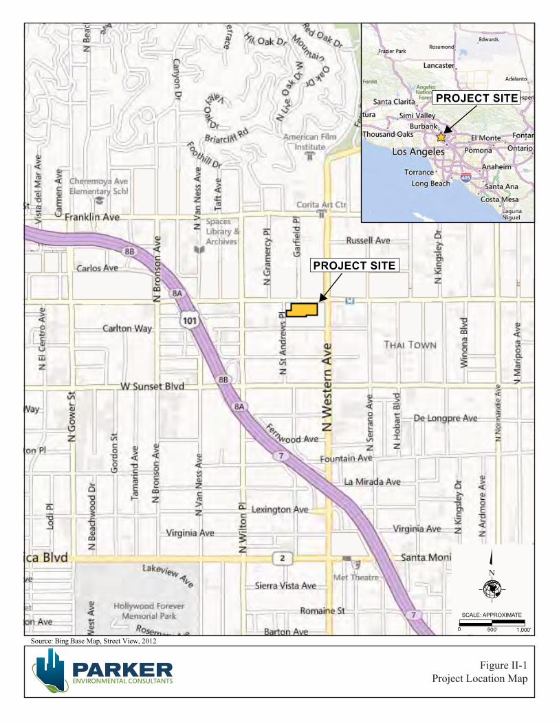
Source: Bing Base Map, Street View, 2012
PROJECT SITE
N
0 500’ 1,000’
SCALE: APPROXIMATE
PROJECT SITE
Figure II-1Project Location Map

City of Los Angeles June 2013
High Line West Project II. Project Description ENV-2012-3532-MND Page II-3
Table II-1
Summary of Existing Land Uses
Addresses APN Name/Land Use Floor Area
(square feet)
1 5514, 5516, 5518, 5520, & 5522 Hollywood Blvd. 5544-025-034 2-story building with recording studio
and office uses 9,256
2 5524, 5526, 5528 Hollywood Blvd. 5544-025-005 Falcon Studios: 1-story building with
studio land uses 2,400
3 5540, 5542, 5544, Hollywood Blvd.
5544-025-011, 5544-025-012, 5544-025-013
2-story building with recording studio, office and surface parking land uses. a 15,840
4 5546, 5548, 5550, 5552 Hollywood Blvd. 5544-025-031 1-story building with retail and office
uses and a 900 sf storage shed 3,040
5 5558, 5560 Hollywood Blvd. 5544-025-015 1-story building with retail uses 4,000
6 1668 St. Andrews 5544-025-017 5544-025-018, 1-story building with surface parking 1,250
7 1666 St. Andrews 5544-025-019 1-story building with surface parking 2,000
Total Existing Floor Area 37,786 Sources: ALTA/ACSM Land Title Survey and Department of City Planning Zoning and Map Access System (ZIMAS) database.
a Note: 5540 Hollywood Boulevard is noted on the ALTA Survey as three separate buildings corresponding to the site addresses. Two additions have been added to the original structure. The original structure and additions are all identified as Building #3 (see Figure II-2).
SURROUNDING LAND USES
Photographs of the land uses immediately surrounding the Project Site are provided in Figure II-4, Photographs of Surrounding Uses. A summary of the surrounding land uses is provided below.
North: The Project Site is bounded by Hollywood Boulevard to the north. Along the north side of Hollywood Boulevard, between Garfield Place to the west and Western Avenue to the east, there is a large, 5-story mixed-use building (the Gershwin Hotel) with ground floor retail (See Figure II-4, View 9), and several one-story commercial buildings (See Figure II-4, View 7) as well as a vacant lot. The Gershwin Hotel is undergoing adaptive reuse as a mixed-use project with ground floor retail uses. At the northwest corner of Garfield Place and Hollywood Boulevard is a 5-story mixed-use building currently under construction for a senior housing (the “Metro at Hollywood”) with studio uses on the ground floor (see Figure II-4, View 10). The zoning for the uses to the

Figure II-2Aerial Photograph of the Project Site
W. HOLLYWOOD BOULEVARD
PROJECT SITE
N. W
ESTE
RN
AVE
NU
E
N. S
T. A
ND
REW
S PL
AC
E
CARLTON WAY
Source: Google Earth, Aerial View, 2012
0 50’ 100’
SCALE: APPROXIMATE
LEGENDProject Site Boundary
Photograph Locations
Building Numbers (See Table II-1)
#
N
1234
56
7
8
910
11
12
1
#
2
3
4
6
5
7
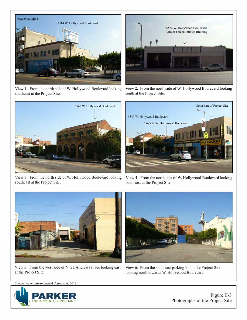
Figure II-3Photographs of the Project Site
Source: Parker Environmental Consultants, 2012
View 1: From the north side of W. Hollywood Boulevard looking southeast at the Project Site.
View 2: From the north side of W. Hollywood Boulevard looking south at the Project Site.
View 3: From the north side of W. Hollywood Boulevard looking southeast at the Project Site.
View 4: From the north side of W. Hollywood Boulevard looking southeast at the Project Site.
View 5: From the west side of N. St. Andrews Place looking east at the Project Site.
View 6: From the southeast parking lot on the Project Site looking north towards W. Hollywood Boulevard.
Mayer Building5514 W. Hollywood Boulevard
5524 W. Hollywood Boulevard(Former Falcon Studios Building)
5540 W. Hollywood Boulevard
5540 W. Hollywood Boulevard
5546-52 W. Hollywood Boulevard
Not a Part of Project Site
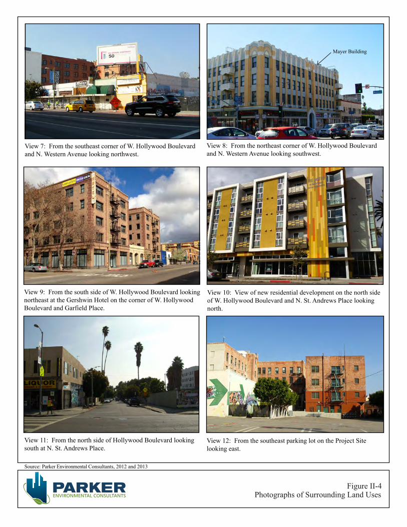
Figure II-4Photographs of Surrounding Land Uses
Source: Parker Environmental Consultants, 2012 and 2013
View 7: From the southeast corner of W. Hollywood Boulevard and N. Western Avenue looking northwest.
View 8: From the northeast corner of W. Hollywood Boulevard and N. Western Avenue looking southwest.
View 9: From the south side of W. Hollywood Boulevard looking northeast at the Gershwin Hotel on the corner of W. Hollywood Boulevard and Garfield Place.
View 10: View of new residential development on the north side of W. Hollywood Boulevard and N. St. Andrews Place looking north.
View 11: From the north side of Hollywood Boulevard looking south at N. St. Andrews Place.
View 12: From the southeast parking lot on the Project Site looking east.
Mayer Building

City of Los Angeles June 2013
High Line West Project II. Project Description ENV-2012-3532-MND Page II-7
north is zoned [Q]R5-2 and R3-1. The Specific Plan designates the properties in [Q]R5-2 Zone as Subarea C – Community Center and the properties in the R3-1 Zone as Subarea A – Neighborhood Conservation.
East: Immediately adjacent to the Project Site to the east, at the southwest corner of Hollywood Boulevard and Western Avenue, is the historic Louis B. Mayer Building, a four-story commercial building with ground floor retail space and offices on the floors above (See Figure II-4, View 8). The Project Site is also immediately adjacent to the historic Bricker Building, a four-story mixed-use building with ground floor retail space and residential units above. Further to the east, across Western Avenue, is the portal to the Hollywood/Western MTA Rail Station, which is located in a plaza that is part of a 4-story mixed-use building. On the north side of Hollywood Boulevard to the east of Western Avenue is a large four-story mixed-use complex that includes a major supermarket, brand-name clothing store, and neighborhood-serving retail uses. The property immediately to the east is zoned [Q]R5-2 and the properties to the east of Western Avenue are zoned [Q]C2-2D and C4-1VL. The Specific Plan designates these properties as Subarea C.
South: The area to the south of the Project Site, between St. Andrews Place to the west and Western Avenue to the east, is developed with multi-family residential buildings, mostly two- and three-story buildings. The zoning for the residential buildings is zoned R4-2. The Specific Plan designates these properties as Subarea C.
West: To the immediate west is a commercial parcel at the southeast corner of St. Andrews Place and Hollywood Boulevard, a two-story building with a liquor store and other retail uses (see Figure II-3, View 4 and Figure II-4, View 11). Further to the west, along Hollywood Boulevard, on both the north and south sides of the street are a mix of commercial properties, including a motel, an auto body repair shop, a café, retail shops and a vacant lot. The zoning for these uses is zoned [Q]R5-2. The Specific Plan designates these properties as Subarea C.
Transit Oriented Development
The Proposed Project is located less than one-half block (about 200 feet) from the entrance to the MTA Metro Red Line rail station at the corner of Hollywood Boulevard and Western Avenue. The Metro Red Line connects to North Hollywood to the north and to Union Station to the south in downtown Los Angeles. The Metro Red Line rail system allows connections to the Metro Purple Line at the Wilshire-Vermont station, to the Metro Blue Line as well as the Expo Line at the 7th Street/Metro Center station in downtown Los Angeles and to the Orange Line providing access to a wide swath of the San Fernando Valley. The MTA rail line station at Hollywood Boulevard and Western Avenue affords easy access to the MTA’s rail network for residents and visitors, as well as for customers of the retail spaces to be incorporated into the ground floor of the mixed-use project.
The Project Site is also close to many MTA bus transit lines. MTA Rapid Bus Line 780 provides service along Hollywood Boulevard, with a destination of Glendale and Pasadena to the east and Fairfax Avenue to the west. MTA Rapid Bus Line 757 originates at the intersection of Hollywood Boulevard and
City of Los Angeles June 2013
High Line West Project II. Project Description ENV-2012-3532-MND Page II-8
Western Avenue and travels to the south along Western Avenue to Imperial Highway. MTA Rapid Bus Line 757 offers connections to the Metro Purple Line at the rail station located at Western Avenue and Wilshire Boulevard and to the Metro Expo Line at the rail station located at Western Avenue and Exposition Boulevard. MTA Rapid Bus Line 757 also connects to the MTA Rapid Bus Line 704 at the intersection of Western Avenue and Santa Monica Boulevard. MTA Rapid Bus Line 704 provides service along Santa Monica Boulevard with a termination in the City of Santa Monica at Main Street; to the east, the MTA Rapid Bus Line 704 connects to Sunset Boulevard and Cesar Chavez Avenue with a termination at Union Station/Patsaouras Transit Plaza. MTA Local Bus Line 207 originates at the intersection of Hollywood Boulevard and Western Avenue and travels to the south along Western Avenue to Imperial Highway. MTA Local Bus Line 217 travels along Hollywood Boulevard to the west, turning south on Fairfax Avenue, connecting with the Washington/Fairfax Transit Hub, and then going south along La Cienega Boulevard, terminating at the Culver City Transit Center. Additionally, DASH Hollywood bus service has stops at Western Avenue and Sunset Boulevard to the south and at Western Avenue and Franklin Avenue to the north; the DASH service encircles the project site with destinations to the west at Highland Avenue and to the east at Vermont Avenue.
The Proposed Project is located in close proximity to several transit options, with easy access to the MTA Metro Rail System and the MTA’s Rapid Bus lines. The Metro Red Line rail system facilitates easy commuting to the job-rich environment of downtown Los Angeles. The MTA Rapid Bus Lines offers easy access to destinations on the Westside, such as West Hollywood, Beverly Hills, Century City and Santa Monica. MTA Rapid Bus Line service provides easy access to destinations to the east, such as Los Feliz, Atwater Village, Glendale, Eagle Rock and Pasadena.

II. PROJECT DESCRIPTION
B. PROJECT CHARACTERISTICS
High Line West Project II. Project Description ENV-2012-3532-MND Page II-9
PROPOSED DEVELOPMENT
5550 Hollywood Boulevard Partners, LLC, (the “Applicant”) proposes to develop a transit adjacent mixed-use project within the Vermont/Western Transit Oriented District Specific Plan (“Specific Plan”) area located in the Hollywood Community Planning area of the City. The Proposed Project, referred to as the “High Line West,” consists of 280 residential apartment units, 11 percent of which will be set aside as Very Low Income affordable units, and approximately 12,030 square feet of neighborhood serving retail space (“the Proposed Project”). The Proposed Project includes a total of 283,005 square feet with approximately 270,975 square feet of residential floor area and 12,030 square feet of commercial retail space. Approximately 434 parking spaces are proposed, which will be located at-grade as well as mezzanine and subterranean levels. The Proposed Project will be six-stories in height and a maximum of approximately 86 feet above grade level. A summary of the development program is provided in Table II-2, below.
Table II-2 Proposed Development Program
Land Uses Units Floor Area (Square Feet)
Residential Studio Units 128
270,975 a 1-Bedroom Units 64 2-Bedroom Units 83 3-Bedroom Units 5
Subtotal 280 Non-Residential
Retail 12,030 12,030
TOTAL 283,005 Notes: a Residential floor area includes common areas, interior lobby and recreational
amenity areas, and interior spaces within the proposed dwelling units. Source: PSL Architects, Project Compliance Submittal for the High Line West Project, December 18, 2012.
There are nine existing buildings on the site, of which seven would be removed and two historic structures that would be partially removed. The facade of the Falcon Studios Building (LAHCM #336) at 5524 Hollywood Boulevard and the northerly most 44 feet of the commercial building at 5540 Hollywood Boulevard would be preserved and the remaining parts of these buildings would be removed. Additional information pertaining to the retention of the two historic resources located on-site is presented under the Historic Preservation Plan subheading, below.

City of Los Angeles June 2013
High Line West Project II. Project Description ENV-2012-3532-MND Page II-10
The Architectural plans and renderings of the Proposed Project are depicted in Figures II-5 through II-16. Along the Hollywood Boulevard street frontage, the Project consists of four (4) retail spaces. A residential lobby also fronts on Hollywood Boulevard to provide access to the upper floors. Adjacent to the lobby is a residential common open space area. Another lobby area will be located along St. Andrews Place and will provide access to the residential units above. The ground floor includes a common open space community area.
The residential units are located on levels two through six, which will include the 280 residential units along with several residential open space amenities. On the first level of residential units (2nd floor), two separate courtyards create large common open space areas around which individual units are arranged to maximize access to light and air. On the western half of the site is an approximately 3,800-square-foot courtyard dedicated to passive outdoor activities. On the eastern half of the site, an approximately 8,100-square-foot area dedicated to the pool, its deck area and a courtyard. Additional common open space is located at the ground level in an approximately 6,250-square-footcommunity room, a 600-square-foot lobby and another 770-square-foot lobby.. Throughout the Project Site, additional private open space is located in private balcony space, which amounts to 11,400 square feet.
PARKING AND ACCESS
Vehicular Access
As shown in Figure II-6, Proposed Basement Level Floor Plan, the Proposed Project will include one level of below grade parking. Additional parking areas are provided on the First Floor Plan Level/Site Plan (see Figure II-7), and the Parking Level Mezzanine (See Figure II-8).
As shown on Figure II-7, First Floor Plan/Site Plan, vehicular access to the site would be provided via three driveways. Two ingress/egress driveways would be provided along Hollywood Boulevard and will serve residential, guest and retail parking. These driveways, from Hollywood Boulevard, will be unsignalized and stop-controlled as each driveway would be located within the block.
An additional ingress/egress driveway will be provided along St. Andrews Place. This driveway will access the subterranean parking and the parking on the mezzanine level. Both the subterranean and mezzanine parking levels are reserved for the use of the residential tenants only. This driveway will also be unsignalized and stop-controlled as it is located mid-block along St. Andrews Place.
In addition, a 400-square-foot loading area will be striped within the central portion of the ground floor in the parking garage, adjacent to the residential lobby and retail spaces. Tenants and/or delivery trucks may enter the site from the eastern driveway along Hollywood Boulevard.
Parking
Notwithstanding the contrary provisions of Section 12.21 A.4 (a) of the Zoning Code and regardless of the underlying zone, the required number of residential parking spaces is determined by minimum and maximum standards established by Section 9.E.1 of the Specific Plan.

Source: PSL Architects, High Line West Project Compliance Submittal, May 31, 2013
Figure II-5Proposed Plot Plan
N

Source: PSL Architects, High Line West Project Compliance Submittal, May 31, 2013
Figure II-6Basement Level Floor Plan
N
Source: PSL Architects, High Line West Project Compliance Submittal, May 31, 2013
Figure II-7First Level Floor Plan / Site Plan
N
Source: PSL Architects, High Line West Project Compliance Submittal, May 31, 2013
Figure II-8Parking Level Mezzanine Floor Plan
N
Source: PSL Architects, High Line West Project Compliance Submittal, May 31, 2013
Figure II-9Second Level Floor Plan
N
Source: PSL Architects, High Line West Project Compliance Submittal, May 31, 2013
Figure II-10Third Through Sixth Level Floor Plans
N

Source: PSL Architects, High Line West Project Compliance Submittal, May 31, 2013
Figure II-11Building Elevations
KEY PLAN

Source: PSL Architects, High Line West Project Compliance Submittal, May 31, 2013
Figure II-12Historic Building Elevations
KEY PLAN
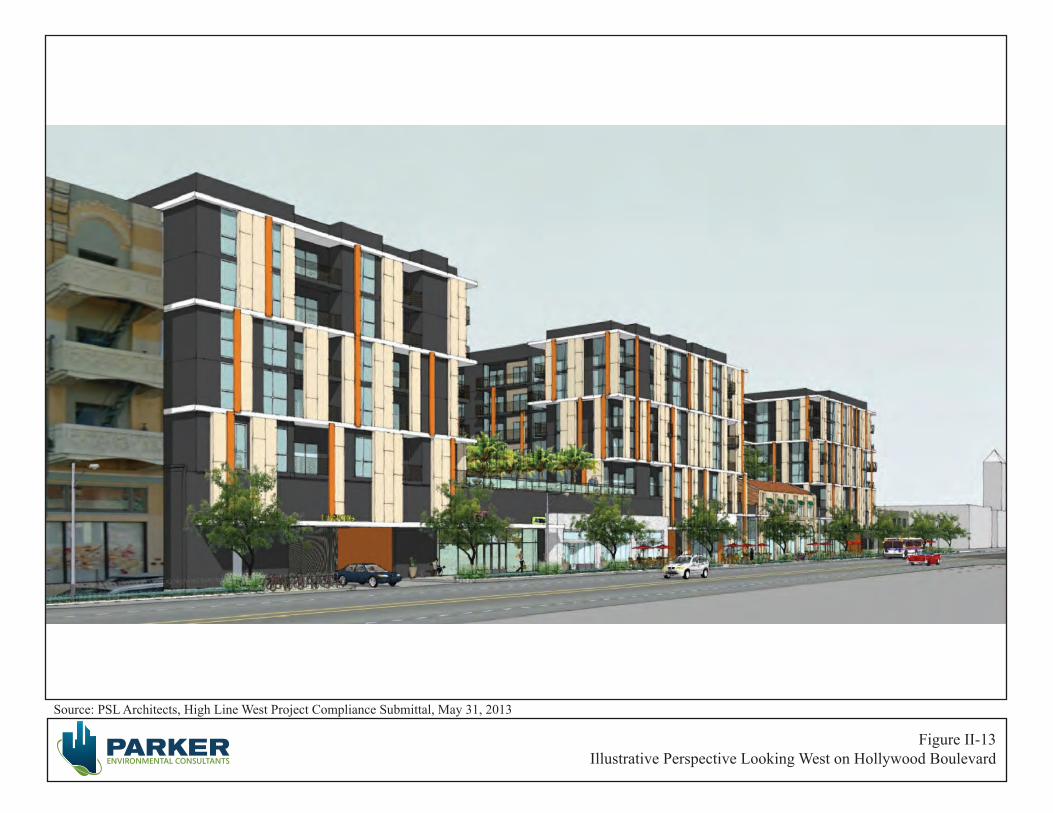
Source: PSL Architects, High Line West Project Compliance Submittal, May 31, 2013
Figure II-13Illustrative Perspective Looking West on Hollywood Boulevard
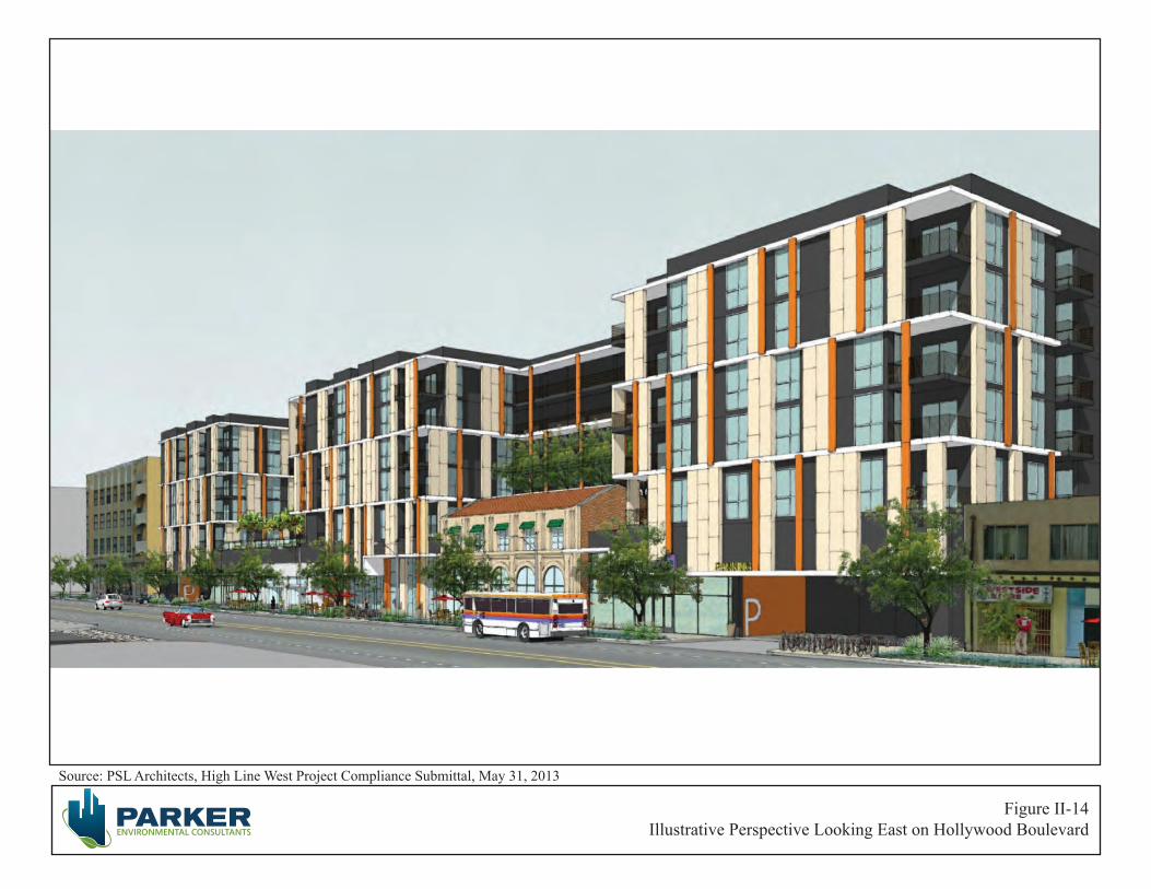
Source: PSL Architects, High Line West Project Compliance Submittal, May 31, 2013
Figure II-14Illustrative Perspective Looking East on Hollywood Boulevard
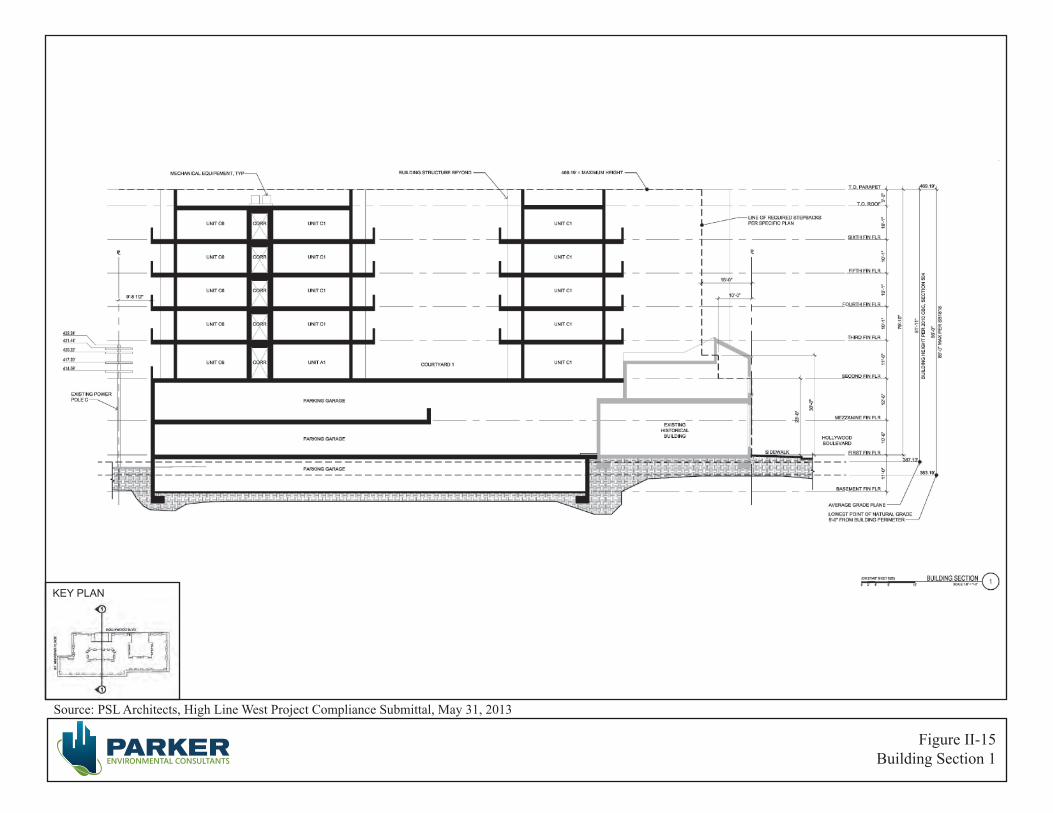
Source: PSL Architects, High Line West Project Compliance Submittal, May 31, 2013
Figure II-15Building Section 1
KEY PLAN
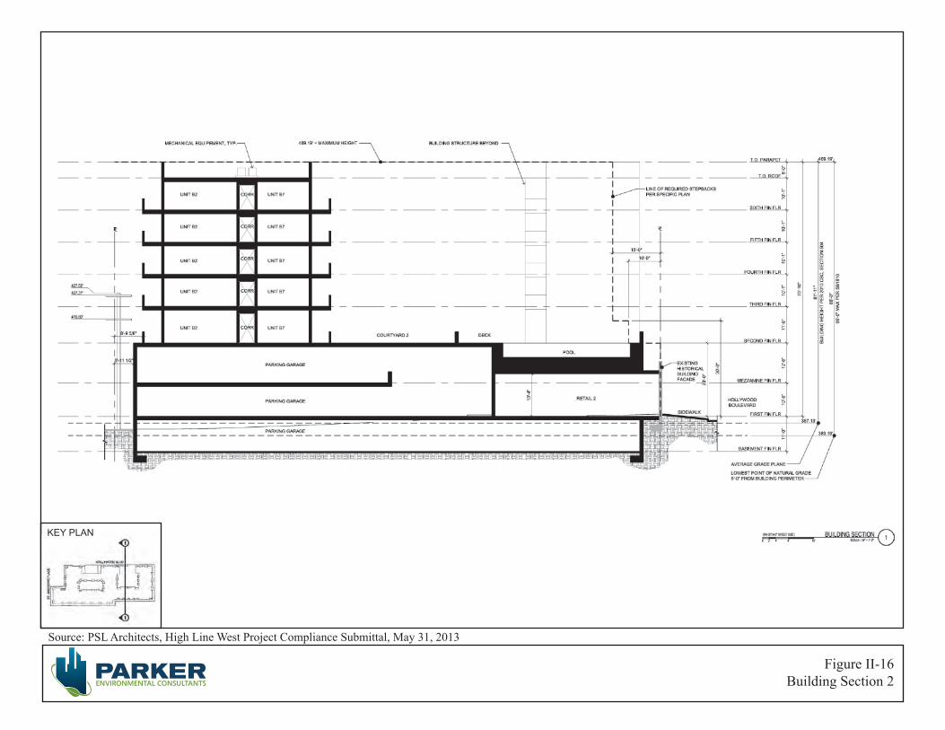
Source: PSL Architects, High Line West Project Compliance Submittal, May 31, 2013
Figure II-16Building Section 2
KEY PLAN

City of Los Angeles June 2013
High Line West Project II. Project Description ENV-2012-3532-MND Page II-23
The minimum number of residential parking spaces shall be provided at the following ratios: at least one parking space for each dwelling unit having fewer than three habitable rooms, and at least one and one-half parking spaces for each dwelling unit having more than three habitable rooms, in addition to at least one-quarter parking space for each dwelling unit as guest parking. The minimum number of residential parking spaces required, per the Specific Plan, is 326 spaces and 70 spaces guest residential parking spaces for a total amount of 396 spaces.
The maximum number of residential parking spaces shall be provided at the following ratios: a maximum of one parking space for each dwelling unit having fewer than three habitable rooms, a maximum of one and one-half parking spaces for each dwelling unit having three habitable rooms, a maximum of two parking spaces for each dwelling unit having more than three habitable rooms, and a maximum of one-half parking space for each dwelling unit as guest parking. The maximum number of residential parking spaces required, per the Specific Plan, is 400 spaces and 140 guest residential parking spaces for a total of 540 spaces.
Notwithstanding the contrary provisions of Section 12.21 A.4 (d) of the Zoning Code and regardless of the underlying zone, the required number of commercial parking spaces is determined by the standards established by Section 9.E.3 of the Specific Plan.
The maximum number of off-street parking spaces which may be provided shall be limited to two parking spaces for each 1,000 square feet of combined floor area of commercial uses contained within all buildings on a lot. The Specific Plan further requires guest parking spaces for residential uses in mixed-use projects to be provided through shared use of the required commercial spaces. The maximum number of commercial parking spaces required, per the Specific Plan, is 24 spaces, which will be shared with guest residential spaces.
Based upon the required parking for residential and commercial uses in the Project, the Specific Plan requires a minimum of 396 parking spaces and a maximum of 540 parking spaces for the Proposed Project. The Applicant proposes to provide a total of 434 parking spaces, of which 364 will be residential parking spaces, 24 will be retail parking spaces and 46 spaces will be shared guest parking.
The Specific Plan requires bike parking at ½ space per dwelling unit and 1 space per 1,000 square feet of non-residential floor area for the first 10,000 square feet of floor area and 1 space for every additional 10,000 square feet of non-residential floor area. According to the Specific Plan, the Project requires 140 bike parking spaces for the residential units and 11 spaces for the commercial space. The Proposed Project will provide a total of 151 bicycle parking spaces onsite, including 18 short term bicycle parking spaces located along the Hollywood Boulevard sidewalk right-of-way.
The Proposed Project will also feature bicycle parking in excess of the Specific Plan requirements located within the subterranean, ground floor and mezzanine levels of the development.

City of Los Angeles June 2013
High Line West Project II. Project Description ENV-2012-3532-MND Page II-24
AFFORDABLE HOUSING
The Proposed Project will set aside a minimum of 11% of its units as Very Low Income affordable housing units, which will, at a minimum, meet the Los Angeles Municipal Code’s (“LAMC”) definition of Very Low Income, as noted in LAMC Section 12.22 A.25. The LAMC stipulates that the annual income of a household may not exceed the amounts designated for the Very Low Income category as determined by the California Department of Housing and Community Development (“HCD”) or any successor agency.
As a result of providing 11% of its units as Very Low Income units, the Proposed Project is entitled to a 35% Density Bonus. The Affordable Housing Incentives – Density Bonus Ordinance (LAMC Section 12.22 A.25, as amended in 2008) offers development incentives based on the percent of units set aside and their affordability level. The Proposed Project intends to create a mixed-use mixed-income development that conforms to the Affordable Housing Incentives – Density Bonus Ordinance.
FLOOR AREA
The gross lot area of the project site is 82,801 square feet. The Specific Plan, for Subarea C, allows the maximum permitted floor area ratio (FAR) for a mixed-use project to be 3 to 1. The Specific Plan limits the commercial floor area within a mixed-use project to an FAR of 1.5 to 1. A 3:1 FAR generates approximately 248,403 square feet of development. Due to the proposed inclusions of deed restricted affordable units, the Proposed Project is entitled to a floor area increase equal 35% of its by-right development (or 335,344 square feet).2 However, the Proposed Project is only requesting a floor area increase equal to slightly less than 14% generating 283,005 square feet of floor area consisting of 270,975 square feet of residential floor area and 12,030 square feet of commercial floor area, resulting in a FAR of approximately 3.42 to 1.
DENSITY
The Proposed Project is located on property that is zoned [Q]R5-2. According to LAMC Section 12.12 C.4, the R5 Zone permits the minimum lot area per dwelling unit to be 200 square feet. However, “[Q]” Condition (Ordinance 165,668-SA420) and the Specific Plan include provisions which limit the Project Site’s density to the R4 density standard of 1 unit per 400 square feet of lot area. Section 3.B of the Specific Plan stipulates that the more restrictive provisions of the Specific Plan shall prevail and supersede the applicable provisions of the Zoning Code. Thus, the density of the Project Site is, therefore, calculated upon the density permitted by the R4 Zone, which in turn allows for 207 units on a site consisting of 82,801 square feet. A project providing 11% of its residential units for Very Low Income tenants is entitled to a Density Bonus of 35% (per LAMC Section 12.22 A.25 (c) (1)). As a result, by providing 11% of the Proposed Project’s units as Very Low Income units, the Proposed Project is permitted a 35% density increase generating a total of 280 residential units.
2 Pursuant to LAMC Section 12.22 A.25 (f) (4) (i).
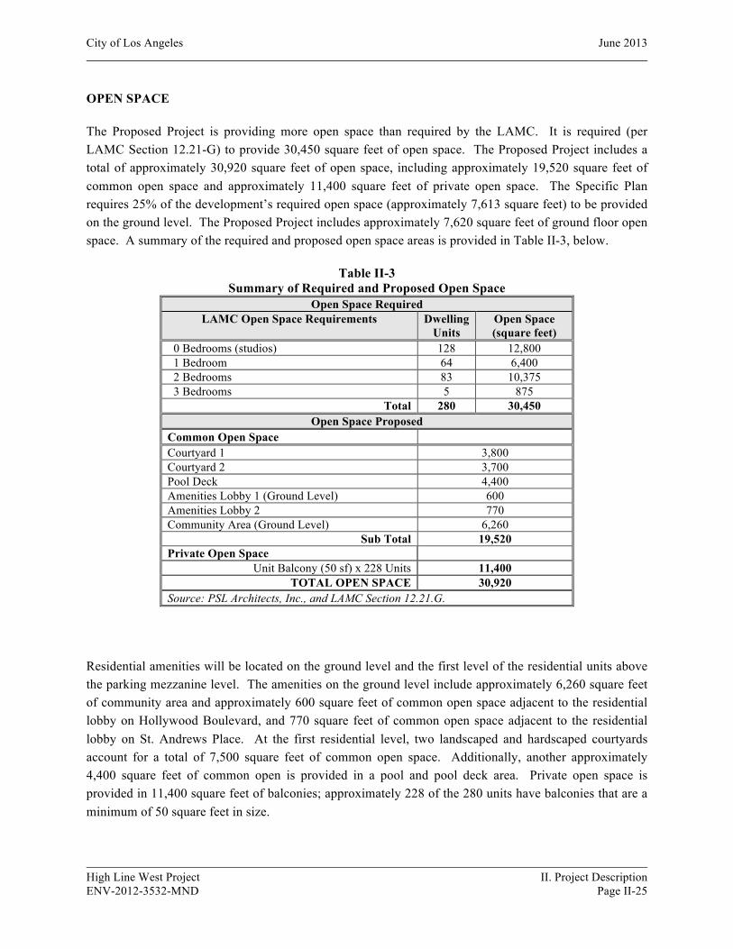
City of Los Angeles June 2013
High Line West Project II. Project Description ENV-2012-3532-MND Page II-25
OPEN SPACE
The Proposed Project is providing more open space than required by the LAMC. It is required (per LAMC Section 12.21-G) to provide 30,450 square feet of open space. The Proposed Project includes a total of approximately 30,920 square feet of open space, including approximately 19,520 square feet of common open space and approximately 11,400 square feet of private open space. The Specific Plan requires 25% of the development’s required open space (approximately 7,613 square feet) to be provided on the ground level. The Proposed Project includes approximately 7,620 square feet of ground floor open space. A summary of the required and proposed open space areas is provided in Table II-3, below.
Table II-3 Summary of Required and Proposed Open Space
Open Space Required LAMC Open Space Requirements Dwelling
Units Open Space (square feet)
0 Bedrooms (studios) 128 12,800 1 Bedroom 64 6,400 2 Bedrooms 83 10,375 3 Bedrooms 5 875
Total 280 30,450 Open Space Proposed
Common Open Space Courtyard 1 3,800 Courtyard 2 3,700 Pool Deck 4,400 Amenities Lobby 1 (Ground Level) 600 Amenities Lobby 2 770 Community Area (Ground Level) 6,260
Sub Total 19,520 Private Open Space
Unit Balcony (50 sf) x 228 Units 11,400 TOTAL OPEN SPACE 30,920
Source: PSL Architects, Inc., and LAMC Section 12.21.G.
Residential amenities will be located on the ground level and the first level of the residential units above the parking mezzanine level. The amenities on the ground level include approximately 6,260 square feet of community area and approximately 600 square feet of common open space adjacent to the residential lobby on Hollywood Boulevard, and 770 square feet of common open space adjacent to the residential lobby on St. Andrews Place. At the first residential level, two landscaped and hardscaped courtyards account for a total of 7,500 square feet of common open space. Additionally, another approximately 4,400 square feet of common open is provided in a pool and pool deck area. Private open space is provided in 11,400 square feet of balconies; approximately 228 of the 280 units have balconies that are a minimum of 50 square feet in size.

City of Los Angeles June 2013
High Line West Project II. Project Description ENV-2012-3532-MND Page II-26
The Specific Plan requires mixed-use projects with two or more residential units to contain usable open space in accordance with the standards of Section 12.21 G.2 of the Zoning Code, with the exception that up to 75% of the common or private open space may be located above the grade level. The Project is required to provide a minimum of approximately 30,450 square feet of open space.
HISTORIC PRESERVATION PLAN
Two historic resources have been identified on the Project Site and were evaluated for historic significance by an architectural historian with Galvin Preservation Associates: the Falcon Studios Building (LAHCM #336) at 5524 Hollywood Boulevard and the commercial building at 5540 Hollywood Boulevard. The Falcon Studios building located at 5524 Hollywood Boulevard is a historic resource subject to CEQA based upon the fact that it was designated Los Angeles Historic-Cultural Monument in 1988. The property is considered significant in the history of the motion picture industry in Los Angeles because it was occupied by Falcon Studios. The building located at 5540 Hollywood Boulevard is a historic resource subject to CEQA because it appears to be eligible for listing in the California Register.
The Proposed Project would incorporate the historic Falcon Studios Building as part of a retail space (or spaces) fronting on Hollywood Boulevard. The primary façade of the building would be preserved in place, while the rear would be removed for the construction of the subterranean parking structure. The primary façade and storefronts would be restored and most of the interior volume of the building would be reconstructed. The side walls on the east and west would be reconstructed in their original locations; however, the rear wall on the south would be in a slightly different location. The building is now 60’6” deep. The Proposed Project calls for a space 55’6” deep, to create a more efficient parking plan to the rear.
The Proposed Project also proposes to incorporate the commercial building at 5540 Hollywood Boulevard as part of another retail space fronting Hollywood Boulevard. The northern 44 feet of the building would be preserved, while the rear of the building would be removed for the construction of the subterranean parking structure. The primary façade, remaining side facades, and roof would be preserved and repaired as necessary, and the existing non-original storefronts would be replaced.
An illustrative rendering of the historic building elevations is shown in Figure II-12. Additional illustrative renderings depicting the Proposed Project looking west and east along Hollywood Boulevard are shown in Figures II-13 and II-14, respectively. The surrounding new building would be 86 feet tall and would include six stories above ground. (See Figure II-15, Building Section I and Figure II-16, Building Section 2). A required five-foot highway dedication means that the new building would be set back from the historic buildings along Hollywood Boulevard. The massing of the new building would be broken along Hollywood Boulevard on the third through sixth stories in two locations, generally corresponding with the historic resources. Contemporary in design, the new building would have a flat roof and cement plaster exterior, stone and metal accent panels, aluminum windows and storefronts.

City of Los Angeles June 2013
High Line West Project II. Project Description ENV-2012-3532-MND Page II-27
Landscaping
As illustrated on the Conceptual Landscape Plan, depicted in Figure II-17, the Proposed Project will feature native plants and other drought-tolerant species throughout the development in tree wells and rooftop courtyards. Existing street trees adjacent to the property will remain in place or will be replaced in consultation with the City of Los Angeles Division of Urban Forestry and approved by the Board of Public Works.
Construction
Construction Schedule/Phasing
For purposes of analyzing impacts associated with air quality, this analysis assumes a Project construction schedule of approximately 18 months, with final buildout occurring in 2014. Construction activities associated with the Project would be undertaken in three main steps: (1) demolition/site clearing, (2) excavation, grading and foundations and (3) building construction. The building construction phase includes the construction of the proposed buildings, connection of utilities to the buildings, laying irrigation for landscaping, architectural coatings, paving, and landscaping the Project Site.
Demolition/Site Clearing Phase
The demolition/site clearing phase would include the demolition of the existing 37,786 square feet of commercial uses.3 In addition, this phase would include the removal of all trees, walls, fences, and parking lot related debris. This analysis assumes demolition/site clearing would be completed in approximately one month. This analysis assumes daily on-site demolition activities would require the following equipment: one concrete/industrial saw, one rubber tired dozer, and three tractors/loaders/backhoes. For purposes of modeling, the emissions associated with this equipment fleet, it was conservatively estimated that each piece of equipment would be operated for 8 hours each day.
Excavation, Grading and Foundation Phase
After the completion of demolition/site clearing, the excavation phase for the Project would occur for approximately three months and would involve the cut and fill of land to ensure the proper base and slope for the building foundations. In order to construct the subterranean parking, the Project would require approximately 26,500 cubic yards of soil to be excavated and hauled off-site. It is anticipated that daily grading and site preparation activities would require the following equipment: one bore/drill rig, one cement/mortar mixer, one grader, one excavator, and one tractor/loader/backhoe. For purposes of modeling the emissions associated with this equipment fleet, it was conservatively estimated that each piece of equipment would be operated for 8 hours each day.
3 This estimate is conservatively based on all of the developed floor area that exits on site and does not factor in
the retention of the façade of one historic building and the façade and northerly 44 feet of another historic building.
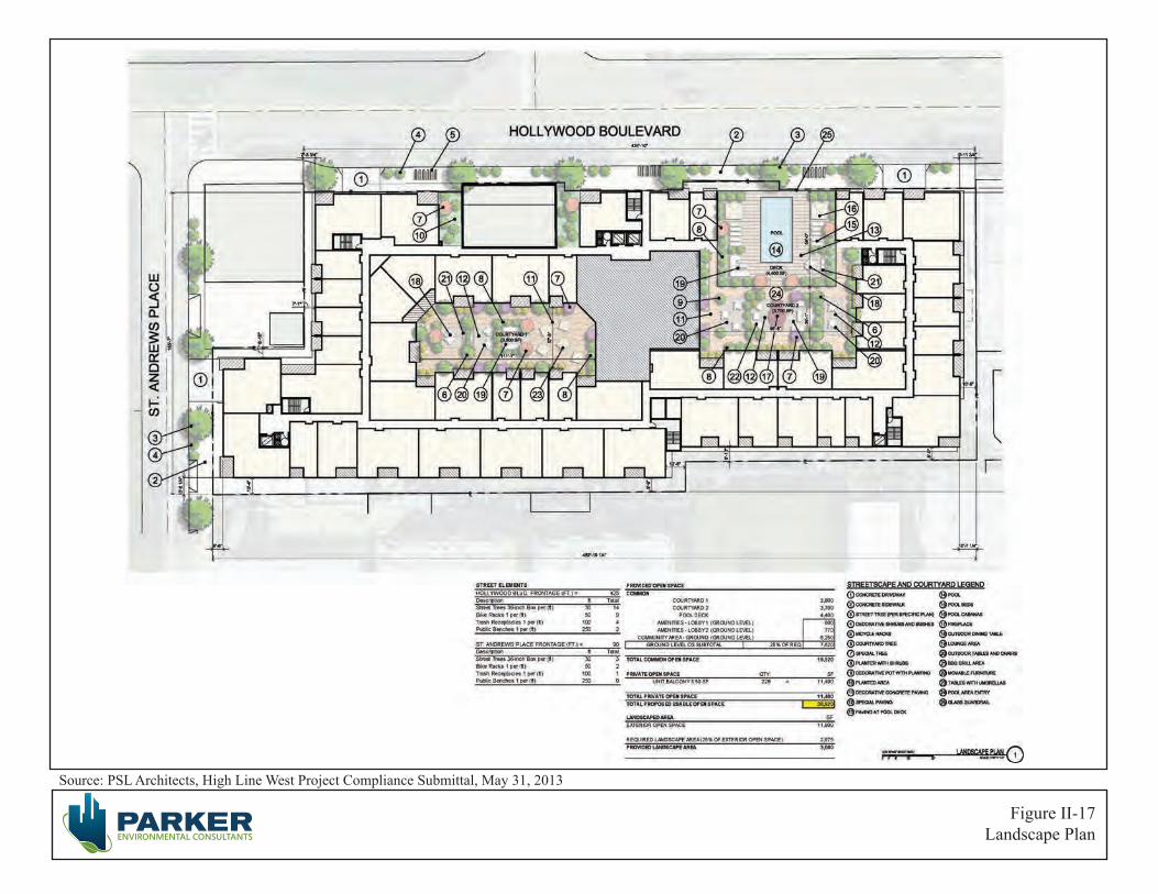
Source: PSL Architects, High Line West Project Compliance Submittal, May 31, 2013
Figure II-17Landscape Plan
City of Los Angeles June 2013
High Line West Project II. Project Description ENV-2012-3532-MND Page II-29
Building Construction Phase
The building construction phase consists of below grade and above grade structures and is expected to occur for approximately 14 months. Upon completion of the structures, architectural coating, finishing, and paving would occur. It is estimated that architectural coatings would occur over the final five months of the building construction phase, and paving would occur during the final month of construction. This analysis assumes that the maximum daily construction building activities would require the following equipment: one crane, two cement/mortar mixers, one forklift, one generator set, one tractor/loader/backhoe, three welders, one air compressor, one paver, one piece of paving equipment, and one roller. For purposes of modeling the emissions associated with this equipment fleet, it was conservatively estimated that each piece of equipment would be operated for 8 hours each day.
Construction activities could necessitate temporary lane closures on streets adjacent to the Project Site on an intermittent basis for utility relocations/hook-ups, delivery of materials, and other construction activities as may be required. However, site deliveries and the staging of all equipment and materials would be organized in the most efficient manner possible on-site to mitigate any temporary impacts to the neighborhood and surrounding traffic. Construction equipment would be staged on-site for the duration of construction activities. Traffic lane and right-of-way closures, if required, will be properly permitted by the City agencies.
Unless stated otherwise, all construction activities would be performed in accordance with all applicable state and federal laws and City Codes and policies with respect to building construction and activities. As provided in Section 41.40 of the LAMC, the permissible hours of construction within the City of Los Angeles are 7:00 a.m. to 9:00 p.m. Monday through Friday, and between 8:00 a.m. and 6:00 p.m. on any Saturday or national holiday. No construction activities are permitted on Sundays. The Department of City Planning further restricts construction activities associated with development projects to be between 7:00 a.m. and 6:00 p.m. Monday through Friday. The Proposed Project will comply with these restrictions.
Haul Route
All construction and demolition debris would be recycled to the maximum extent feasible. Demolition debris and soil materials from the site that cannot be recycled or diverted would likely be hauled to the Sunshine or Chiquita Canyon landfills, which accept construction and demolition debris and inert waste from areas within the City of Los Angeles. The Sunshine Canyon Landfill is approximately 20 miles north of the Project Site. The Chiquita Canyon landfill is approximately 33 miles to the north of the Project Site. For recycling efforts, the Central L.A. Recycling Center and Transfer Station (Browning Ferris Industries) accepts construction waste for recycling and is located approximately 10 miles southeast of the Project Site.
For purposes of analyzing the construction-related impacts, it is anticipated that the excavation and soil export would involve 18-wheel bottom-dump trucks with a 20 cubic yard hauling capacity (i.e., 30 tons maximum gross weight). All truck staging would either occur on-site or at designated off-site locations and radioed into the site to be filled. The local haul route would include entering/exiting the Project Site
City of Los Angeles June 2013
High Line West Project II. Project Description ENV-2012-3532-MND Page II-30
from Hollywood Boulevard to the Hollywood 101 Freeway. The haul route would then extend southbound to the 10 Freeway or northbound to the 170 and I-5 Freeways, as applicable. The haul route may be modified provided DOT and/or Street Services approves any such modification. Approval of a Haul Route would be requested prior to construction.
RELATED PROJECTS
In accordance with CEQA Guidelines Section 15064(h), this IS/MND includes an evaluation of the Project’s cumulative impacts. The guidance provided under CEQA Guidelines Section 15064(h) is as follows:
“(1) When assessing whether a cumulative effect requires an EIR, the lead agency shall consider whether the cumulative impact is significant and whether the effects of the project are cumulatively considerable. An EIR must be prepared if the cumulative impact may be significant and the project’s incremental effect, though individually limited, is cumulatively considerable. “Cumulatively considerable” means that the incremental effects of an individual project are significant when viewed in connection with the effects of past projects, the effects of other current projects, and the effects of probable future projects.
(2) A lead agency may determine in an initial study that a project’s contribution to a significant cumulative impact will be rendered less than cumulatively considerable and thus is not significant. When a project might contribute to a significant cumulative impact, but the contribution will be rendered less than cumulatively considerable through mitigation measures set forth in a mitigated negative declaration, the initial study shall briefly indicate and explain how the contribution has been rendered less than cumulatively considerable.
(3) A lead agency may determine that a project’s incremental contribution to a cumulative effect is not cumulatively considerable if the project will comply with the requirements in a previously approved plan or mitigation program (including, but not limited to, water quality control plan, air quality attainment or maintenance plan, integrated waste management plan, habitat conservation plan, natural community conservation plan, plans or regulations for the reduction of greenhouse gas emissions) that provides specific requirements that will avoid or substantially lessen the cumulative problem within the geographic area in which the project is located. Such plans or programs must be specified in law or adopted by the public agency with jurisdiction over the affected resources through a public review process to implement, interpret, or make specific the law enforced or administered by the public agency. When relying on a plan, regulation or program, the lead agency should explain how implementing the particular requirements in the plan, regulation or program ensure that the project’s incremental contribution to the cumulative effect is not cumulatively considerable. If there is substantial evidence that the possible effects of a particular project are still cumulatively considerable notwithstanding that the project complies with the specified plan or mitigation program addressing the cumulative problem, an EIR must be prepared for the project.
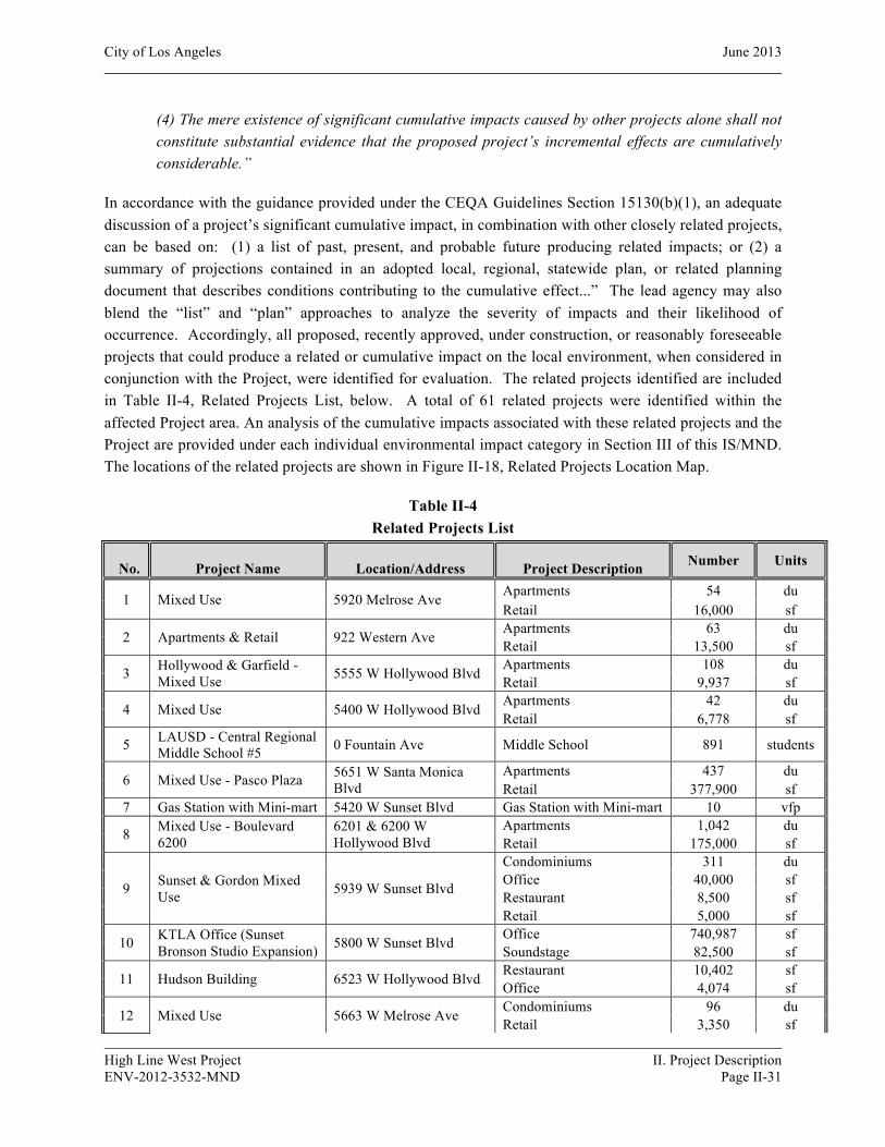
City of Los Angeles June 2013
High Line West Project II. Project Description ENV-2012-3532-MND Page II-31
(4) The mere existence of significant cumulative impacts caused by other projects alone shall not constitute substantial evidence that the proposed project’s incremental effects are cumulatively considerable.”
In accordance with the guidance provided under the CEQA Guidelines Section 15130(b)(1), an adequate discussion of a project’s significant cumulative impact, in combination with other closely related projects, can be based on: (1) a list of past, present, and probable future producing related impacts; or (2) a summary of projections contained in an adopted local, regional, statewide plan, or related planning document that describes conditions contributing to the cumulative effect...” The lead agency may also blend the “list” and “plan” approaches to analyze the severity of impacts and their likelihood of occurrence. Accordingly, all proposed, recently approved, under construction, or reasonably foreseeable projects that could produce a related or cumulative impact on the local environment, when considered in conjunction with the Project, were identified for evaluation. The related projects identified are included in Table II-4, Related Projects List, below. A total of 61 related projects were identified within the affected Project area. An analysis of the cumulative impacts associated with these related projects and the Project are provided under each individual environmental impact category in Section III of this IS/MND. The locations of the related projects are shown in Figure II-18, Related Projects Location Map.
Table II-4 Related Projects List
ID No. Project Name Location/Address Project Description Number Units
1 Mixed Use 5920 Melrose Ave Apartments 54 du Retail 16,000 sf
2 Apartments & Retail 922 Western Ave Apartments 63 du Retail 13,500 sf
3 Hollywood & Garfield - Mixed Use 5555 W Hollywood Blvd Apartments 108 du
Retail 9,937 sf
4 Mixed Use 5400 W Hollywood Blvd Apartments 42 du Retail 6,778 sf
5 LAUSD - Central Regional Middle School #5 0 Fountain Ave Middle School 891 students
6 Mixed Use - Pasco Plaza 5651 W Santa Monica Blvd
Apartments 437 du Retail 377,900 sf
7 Gas Station with Mini-mart 5420 W Sunset Blvd Gas Station with Mini-mart 10 vfp
8 Mixed Use - Boulevard 6200
6201 & 6200 W Hollywood Blvd
Apartments 1,042 du Retail 175,000 sf
9 Sunset & Gordon Mixed Use 5939 W Sunset Blvd
Condominiums 311 du Office 40,000 sf Restaurant 8,500 sf Retail 5,000 sf
10 KTLA Office (Sunset Bronson Studio Expansion) 5800 W Sunset Blvd Office 740,987 sf
Soundstage 82,500 sf
11 Hudson Building 6523 W Hollywood Blvd Restaurant 10,402 sf Office 4,074 sf
12 Mixed Use 5663 W Melrose Ave Condominiums 96 du Retail 3,350 sf
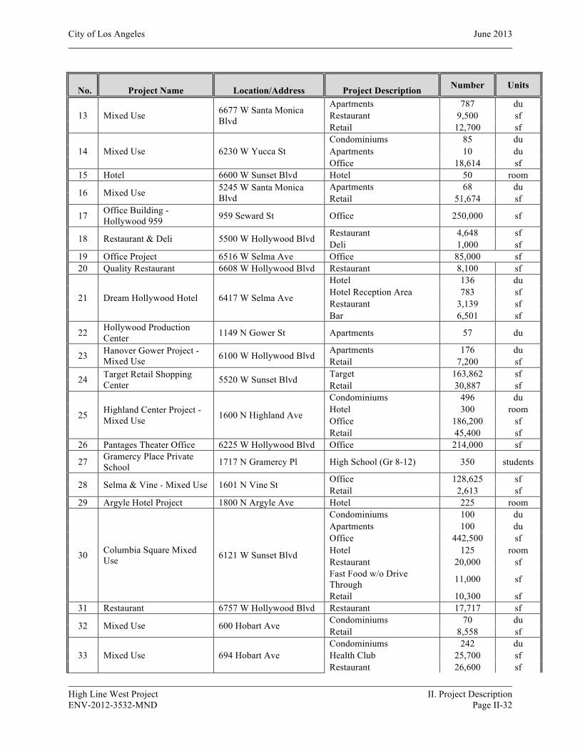
City of Los Angeles June 2013
High Line West Project II. Project Description ENV-2012-3532-MND Page II-32
ID No. Project Name Location/Address Project Description Number Units
13 Mixed Use 6677 W Santa Monica Blvd
Apartments 787 du Restaurant 9,500 sf Retail 12,700 sf
14 Mixed Use 6230 W Yucca St Condominiums 85 du Apartments 10 du Office 18,614 sf
15 Hotel 6600 W Sunset Blvd Hotel 50 room
16 Mixed Use 5245 W Santa Monica Blvd
Apartments 68 du Retail 51,674 sf
17 Office Building - Hollywood 959 959 Seward St Office 250,000 sf
18 Restaurant & Deli 5500 W Hollywood Blvd Restaurant 4,648 sf Deli 1,000 sf
19 Office Project 6516 W Selma Ave Office 85,000 sf 20 Quality Restaurant 6608 W Hollywood Blvd Restaurant 8,100 sf
21 Dream Hollywood Hotel 6417 W Selma Ave
Hotel 136 du Hotel Reception Area 783 sf Restaurant 3,139 sf Bar 6,501 sf
22 Hollywood Production Center 1149 N Gower St Apartments 57 du
23 Hanover Gower Project - Mixed Use 6100 W Hollywood Blvd Apartments 176 du
Retail 7,200 sf
24 Target Retail Shopping Center 5520 W Sunset Blvd Target 163,862 sf
Retail 30,887 sf
25 Highland Center Project - Mixed Use 1600 N Highland Ave
Condominiums 496 du Hotel 300 room Office 186,200 sf Retail 45,400 sf
26 Pantages Theater Office 6225 W Hollywood Blvd Office 214,000 sf
27 Gramercy Place Private School 1717 N Gramercy Pl High School (Gr 8-12) 350 students
28 Selma & Vine - Mixed Use 1601 N Vine St Office 128,625 sf Retail 2,613 sf
29 Argyle Hotel Project 1800 N Argyle Ave Hotel 225 room
30 Columbia Square Mixed Use 6121 W Sunset Blvd
Condominiums 100 du Apartments 100 du Office 442,500 sf Hotel 125 room Restaurant 20,000 sf Fast Food w/o Drive Through 11,000 sf
Retail 10,300 sf 31 Restaurant 6757 W Hollywood Blvd Restaurant 17,717 sf
32 Mixed Use 600 Hobart Ave Condominiums 70 du Retail 8,558 sf
33 Mixed Use 694 Hobart Ave Condominiums 242 du Health Club 25,700 sf Restaurant 26,600 sf
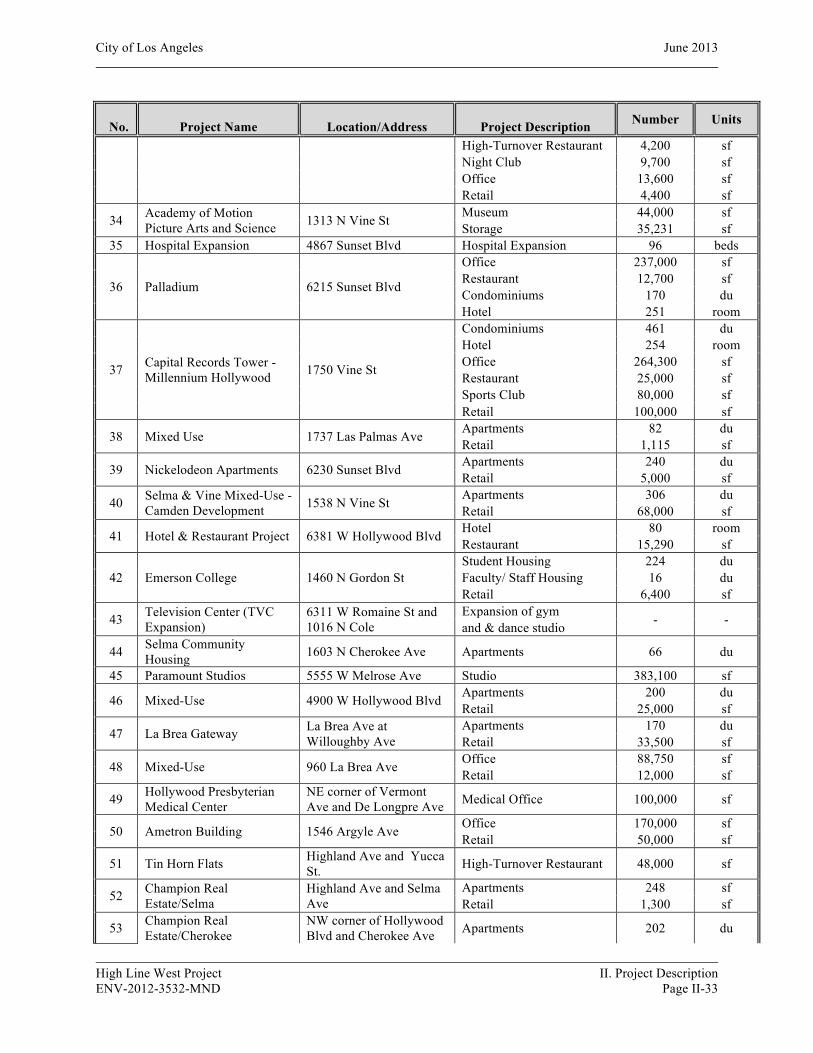
City of Los Angeles June 2013
High Line West Project II. Project Description ENV-2012-3532-MND Page II-33
ID No. Project Name Location/Address Project Description Number Units
High-Turnover Restaurant 4,200 sf Night Club 9,700 sf Office 13,600 sf Retail 4,400 sf
34 Academy of Motion Picture Arts and Science 1313 N Vine St Museum 44,000 sf
Storage 35,231 sf 35 Hospital Expansion 4867 Sunset Blvd Hospital Expansion 96 beds
36 Palladium 6215 Sunset Blvd
Office 237,000 sf Restaurant 12,700 sf Condominiums 170 du Hotel 251 room
37 Capital Records Tower - Millennium Hollywood 1750 Vine St
Condominiums 461 du Hotel 254 room Office 264,300 sf Restaurant 25,000 sf Sports Club 80,000 sf Retail 100,000 sf
38 Mixed Use 1737 Las Palmas Ave Apartments 82 du Retail 1,115 sf
39 Nickelodeon Apartments 6230 Sunset Blvd Apartments 240 du Retail 5,000 sf
40 Selma & Vine Mixed-Use - Camden Development 1538 N Vine St Apartments 306 du
Retail 68,000 sf
41 Hotel & Restaurant Project 6381 W Hollywood Blvd Hotel 80 room Restaurant 15,290 sf
42 Emerson College 1460 N Gordon St Student Housing 224 du Faculty/ Staff Housing 16 du Retail 6,400 sf
43 Television Center (TVC Expansion)
6311 W Romaine St and 1016 N Cole
Expansion of gym - - and & dance studio
44 Selma Community Housing 1603 N Cherokee Ave Apartments 66 du
45 Paramount Studios 5555 W Melrose Ave Studio 383,100 sf
46 Mixed-Use 4900 W Hollywood Blvd Apartments 200 du Retail 25,000 sf
47 La Brea Gateway La Brea Ave at Willoughby Ave
Apartments 170 du Retail 33,500 sf
48 Mixed-Use 960 La Brea Ave Office 88,750 sf Retail 12,000 sf
49 Hollywood Presbyterian Medical Center
NE corner of Vermont Ave and De Longpre Ave Medical Office 100,000 sf
50 Ametron Building 1546 Argyle Ave Office 170,000 sf Retail 50,000 sf
51 Tin Horn Flats Highland Ave and Yucca St. High-Turnover Restaurant 48,000 sf
52 Champion Real Estate/Selma
Highland Ave and Selma Ave
Apartments 248 sf Retail 1,300 sf
53 Champion Real Estate/Cherokee
NW corner of Hollywood Blvd and Cherokee Ave Apartments 202 du

City of Los Angeles June 2013
High Line West Project II. Project Description ENV-2012-3532-MND Page II-34
ID No. Project Name Location/Address Project Description Number Units
54 Monarch Group Projects
SE corner of La Brea Ave and Fountain Ave NW corner of La Brea Ave and Santa Monica Blvd
Apartments 187 du Retail 19,559 sf Apartments 184 du
Retail 13,350 sf
55 Student Housing 6406-6420 Franklin Ave Apartments 126 du 56 The Gordon Apartments 1555 N Gordon St Apartments 21 du
57 Residential Project 1600 Serrano Ave and 1600 Hobart Blvd Apartments 24 du
58 CIM Project NW corner of Western Ave and Hollywood Blvd Retail 51,336 sf
59 Residential Project 1840 N. Highland Ave Apartments 118 du 60 Residential Project 5606 Harold Way Apartments 54 du 61 Residential Project 1818 Cherokee Ave Apartments 63 du
Notes: sf = square feet; du = dwelling units; vfp = vehicle fuel pumps Source: The Mobility Group, High Line West Project Draft Traffic Study, March 28, 2013

Source: The Mobility Group, High Line West Project Draft Traffic Study, March 5, 2013
Figure II-18Related Project Location Map
Related Project

II. PROJECT DESCRIPTION
C. ENTITLEMENT REQUESTS
High Line West Project II. Project Description ENV-2012-3532-MND Page II-36
Necessary project entitlements would be granted by the City of Los Angeles. The Project Applicant, 5550 Hollywood Boulevard Partners, LLC, requests the following discretionary approvals to allow for the construction of a mixed-use project consisting of 280 residential units located above approximately 12,030 square feet of commercial uses:
1. Pursuant to LAMC Section 11.5.7 C, and Section 12.A.1 of the Vermont/Western Transit Oriented District Station Neighborhood Area Specific Plan, the Applicant requests Project Permit Compliance review.
2. Pursuant to LAMC Section 11.5.7 E, and Section 12.A.3 of the Specific Plan, the Applicant requests the following Project Permit Adjustment from Subarea C Development Standard No. 6:
a. To allow for a redistribution of the required upper-floor building stepback along Hollywood Boulevard Street frontage.
3. Pursuant to LAMC Section 12.22 A.25 (as amended by Ordinance 179,681), the Applicant proposes to set aside 11% of the total units at the very low-income level, and requests a Density Bonus of 35%. Additionally, the Applicant requests the following “On-Menu” Density Bonus Incentives:
a. A height increase of 11 feet in accordance with LAMC Section 12.22-A.25 (f)(5)(i). b. An increase of slightly less than 14 percent of the floor area in accordance with LAMC
Section 12.22-A.25 (f)(4). 4. Pursuant to LAMC Section 16.05, the Applicant requests that Site Plan Review Findings be made
as part of the discretionary approvals.
Pursuant to various sections of the LAMC, the Applicant will requests the following administrative approvals and permits from the Los Angeles Department of Building and Safety and other municipal agencies for project construction actions, including but not limited to the following: demolition, excavation, haul route, shoring, grading, foundation, building, and tenant improvements.
Other approvals (as needed), ministerial or otherwise, may be necessary in order to execute and implement the Proposed Project. Other responsible governmental agencies may also serve as a responsible agency for certain discretionary approvals associated with the construction process, which include, but are not limited to the South Coast Air Quality Management District (construction-related air quality emissions) and the Regional Water Quality Control Board, Los Angeles Region (construction- related water quality).
III. ENVIRONMENTAL IMPACT ANALYSIS
High Line West Project III. Environmental Impact Analysis ENV-2012-3532-MND Page III-1
INTRODUCTION
This section of the Initial Study contains an assessment and discussion of impacts associated with the environmental issues and subject areas identified in the Initial Study Checklist (Appendix G to the State CEQA Guidelines, (C.C.R. Title 14, Chapter 3, 15000-15387). The thresholds of significance are based on the City of Los Angeles CEQA Thresholds Guide.
For purposes of this expanded Initial Study analysis and to provide flexibility to the Proposed Project’s architectural plans as they move from schematic to construction drawings, the following analysis is based on slightly larger retail square footage of 12,900 square feet instead of the 12,030 square feet as currently proposed. In all cases this analysis presents a conservative assessment of the Project’s environmental impacts.
IMPACT ANALYSIS
1. AESTHETICS
a) Would the project have a substantial adverse effect on a scenic vista?
No Impact. A significant impact may occur if the Project introduces incompatible visual elements within a field of view containing a scenic vista or substantially blocks views of a scenic vista. Scenic vistas are generally described in two ways: panoramic views (visual access to a large geographic area, for which the field of view can be wide and extend into the distance) and focal views (visual access to a particular object, scene, or feature of interest). The Project Site is currently occupied by nine one-and two-story commercial structures and surface parking lots. The Project Site is not located within or along a designated scenic corridor. Views in the vicinity of the Project Site are largely constrained by adjacent structures and the area’s relatively flat topography. No scenic views are provided from or through the Project Site. The Project Site is an infill lot within a developed area of the Hollywood area and does not possess any unique aesthetic characteristics. The Proposed Project would improve the Project Site with a new mixed-use development, resulting in the development of a six-story, approximately 86 feet high above grade, residential building with ground floor retail space. The Proposed Project would alter the existing views and character of the Project Site and immediate surrounding area in a manner that is compatible with the urban form of the surrounding neighborhood. The Proposed Project would be visually compatible with the surrounding land uses and is consistent with the revitalization of several other developments in the area. Due to the relatively level topography and extent of development within the immediate area, there are no scenic views or vantage points that afford scenic views. Therefore, no impact to any recognized or valued scenic view would occur.

City of Los Angeles June 2013
High Line West Project III. Environmental Impact Analysis ENV-2012-3532-MND Page III-2
b) Would the project substantially damage scenic resources, including, but not limited to, trees, rock outcroppings, and historic buildings within a city-designated scenic highway?
Potentially Significant Impact Unless Mitigation Incorporated. Based on the LA CEQA Thresholds Guide, a significant impact would occur if scenic resources would be damaged and/or removed by development of the Proposed Project including, but not limited to, trees, rock outcroppings, and historic buildings within a city-designated scenic highway. The Project Site fronts Hollywood Boulevard to the north and St. Andrews Place to the west. Neither of these roadways are designated scenic highways. The Project Site is currently occupied by nine structures, of which two have been identified as historic resources: the Falcon Studios Building (LAHCM #382) at 5524 Hollywood Boulevard and the commercial building at 5540 Hollywood Boulevard. The Falcon Studios building located at 5524 Hollywood Boulevard is a historic resource subject to CEQA based upon the fact that it was designated a Los Angeles Historic-Cultural Monument (LAHCM #382) in 1988. The property is considered significant in the history of the motion picture industry in Los Angeles because it was occupied by Falcon Studios. The building located at 5540 Hollywood Boulevard is a historic resource subject to CEQA because it appears to be eligible for listing in the California Register.
The intent of the Proposed Project is to preserve, rehabilitate, and restore the primary character-defining features (which are mainly located on the primary facades) of both buildings, and to incorporate them by design and function into the Project, which as a whole must comply with current zoning and building and safety codes. By doing so, all or portions of the rear of the historic buildings would be removed to create the subterranean parking structure. The rear portions of the historic buildings could not be retrieved, once removed. Furthermore, the new and historic buildings would for all intents and purposes be blended into one single new building. Therefore, the “related new construction” could not be removed without affecting the historic buildings. Based on the findings and conclusions of the Historic Resource Report, prepared by Galvin Preservation Associates (June 2013), the Proposed Project will have a less than significant impact on the identified historic resources with the incorporation of Mitigation Measure V-10. Additional information pertaining the Project’s potential impacts upon historic resources is provided in Section 5, Cultural Resources, below. As supported by the analysis in that section, the Project would not substantially damage scenic resources, including, but not limited to, historic buildings. As such, the Projects aesthetic impacts would be less than significant.
c) Would the project substantially degrade the existing visual character or quality of the site and its surroundings?
Potentially Significant Impact Unless Mitigation Incorporated. Based on the City of Los Angeles CEQA Thresholds Guide, a significant impact would occur if the Proposed Project were to introduce incompatible visual elements on the Project Site or visual elements that would be incompatible with the character of the area surrounding the Project Site.
Building Heights and Massing
With respect to building mass and height, land uses in the Project vicinity vary in use and height. In a few block radius of the Project Site, there are commercial retail, office, restaurant, parking, hotel and
City of Los Angeles June 2013
High Line West Project III. Environmental Impact Analysis ENV-2012-3532-MND Page III-3
residential land uses ranging in height from one to five stories above grade. The Project Site is located in Height District No. 2, which does not specify a height restriction. The recently completed Hollywood Metro building located on the northwest corner of Garfield Avenue and Hollywood Boulevard is 5 stories in height and approximately 60 feet high. The Gershwin Hotel building, which is undergoing an adaptive reuse renovation, is 5 stories and approximately 60 feet high as well. The Mayer Building, located at the southwest corner of Hollywood Boulevard and Western Avenue is four stories and approximately 45 feet high. The proposed structures would be six stories high (approximately 86 feet above grade), which is higher but generally consistent with the surrounding land uses. As a result of providing 11% of the residential units for Very Low Income households, the Applicant requests a Density Bonus On-Menu Incentive to increase the height of the structure an additional 11 feet above the 75-foot limit. As noted in the analysis below, the height of the Proposed Project would not create any significant adverse impacts upon the adjacent land uses. Thus the aesthetic impacts created by the scale and massing of the Proposed Project would be less than significant.
Landscaping and Maintenance
The Proposed Project will feature native plants and other drought-tolerant species throughout the development in tree wells and roof top courtyards. Existing street trees adjacent to the property will remain in place or will be replaced in consultation with the City of Los Angeles Division of Urban Forestry and approved by the Board of Public Works. As with any project within the City, the aesthetics of the Project Site and surrounding area is dependent upon the general upkeep and maintenance of the property. With the implementation of mitigation measures I-10, I-90, and I-110, listed below, potential impacts associated with unkempt premises will be mitigated to a less than significant level.
Mitigation Measures:
I-10 Aesthetics (Landscape Plan)
• All open areas not used for buildings, driveways, parking areas, recreational facilities or sidewalks shall be attractively landscaped and maintained in accordance with a landscape plan and an automatic irrigation plan, prepared by a licensed Landscape Architect and to the satisfaction of the decision maker.
I-90 Aesthetics (Vandalism)
• Every building, structure, or portion thereof, shall be maintained in a safe and sanitary condition and good repair, and free from, debris, rubbish, garbage, trash, overgrown vegetation or other similar material pursuant to Municipal Code Section 91.8104.
• The exterior of all buildings and fences shall be free from graffiti when such graffiti is visible from a street or alley, pursuant to Municipal Code Section 91.8104.15.
I-110 Aesthetics (Signage on Construction Barriers)
• The applicant shall affix or paint a plainly visible sign, on publically accessible portions of the construction barriers, with the following language: “POST NO BILLS.”
City of Los Angeles June 2013
High Line West Project III. Environmental Impact Analysis ENV-2012-3532-MND Page III-4
• Such language shall appear at intervals of no less than 25 feet along the length of the publically accessible portions of the barrier.
• The applicant shall be responsible for maintaining the visibility of the required signage and for maintaining the construction barrier free and clear of any unauthorized signs within 48 hours of occurrence.
Shade/Shadow
Shadow lengths are directly dependent on the height and shape of the building from which they are cast and the angle of the sun. The angle of the sun varies with respect to the rotation of the earth (i.e. time of day) and elliptical orbit (i.e. change in seasons). The longest shadows are cast during the winter months and the shortest shadows are cast during the summer months. Based on the LA CEQA Thresholds Guide, a shading impact would normally be considered significant if the Proposed Project’s structure cast shadows for more than three hours each day between the hours of 9:00 a.m. and 3:00 p.m. during winter months, or for more than four hours each day between the hours of 9:00 a.m. and 5:00 p.m. during the summer months.
The issue of shade and shadow pertains to the blockage of direct sunlight by proposed buildings, which may affect adjacent properties. Shading is an important environmental issue because the users or occupants of certain land uses have some reasonable expectations for direct sunlight and warmth from the sun. Based on the Los Angeles CEQA Thresholds Guide, “facilities and operations sensitive to the effects of shading include: routinely useable outdoor spaces associated with residential, recreational, or institutional (e.g., schools, convalescent homes) land uses; commercial uses such as pedestrian oriented outdoor spaces or restaurants with outdoor eating areas; nurseries; and existing solar collectors.” These land uses are termed “shadow-sensitive” because sunlight is important to function, physical comfort of commerce. The Proposed Project’s shadow pattern would cast shadows to the west in the early morning hours, directly north in mid-afternoon, and to the east in the late afternoon.
The Project’s shadow impacts for the winter and summer solstices are illustrated in Figures III-1 through III-16, respectively. Based on a survey of the buildings within the potential shadow envelope of the Proposed Project, ten properties are located within the potential shadow envelope of the Proposed Project. A summary of these properties and the duration of potential shadow impact is provided in Table III-1, below. As noted in Table III-1, only one of the surveyed properties is considered a shadow sensitive land use; the Metro at Hollywood Senior Housing project located at 1717 N. Garfield Place (See Related Project No. 3, Table II-4). This recently constructed project is anticipated to be occupied by the buildout year of the Proposed Project. It is a five-story building with ground floor studio uses and senior housing residential land uses on floors 2 through 5. The ground floor retail space is not considered a shadow sensitive land

City of Los Angeles June 2013
High Line West Project III. Environmental Impact Analysis ENV-2012-3532-MND Page III-5
Table III-1 Summary of Shade and Shadow Sensitive Properties and Shadow Impacts
ID Address Description Shadow Sensitive Property
Duration of Summer and Winter Solstice Shadow Impacts
1 5601 W. Hollywood Blvd.
Hollywood Downtowner Inn. This two-story motel has south facing balconies which are currently shaded by an architectural pitched roof and awnings. The swimming pool is located within an interior courtyard and is shaded by the existing motel structure. Therefore, it was not considered a shadow sensitive use.
No
Winter: 0.5 hours between 9:00 a.m. to approx. 9:30 a.m. Summer: No shading impact.
2 1717 N. Garfield PL.
The Metro at Hollywood Senior Apartments (Related Project No. 3). This five-story senior housing project has balconies on the south- facing facade on floors 2-4, above ground floor studio uses. There are no ground floor shadow sensitive land uses. The residential balconies on floors 2-4 are considered shadow sensitive land uses.
Yes
Winter: 5 hours between 9:00 a.m. to approx. 2:00 p.m. Summer: No shading impact.
3 5533 W. Hollywood Blvd.
Gershwin Hollywood Hotel. This five story building has ground floor retail with hotel rooms above the ground floor. The south-facing facade does not have any balconies or useable outdoor areas that are dependent upon direct sunlight. Therefore, it was not considered a shadow sensitive use.
No
Winter: 6 hours of intermittent shadows between 9:00 a.m. to 3:00 p.m. Summer: No shading impact.
4 5507 W. Hollywood Blvd.
Hollywood Western Retail: Currently vacant single-story retail land uses. Proposed for future retail land uses. See Related Project No. 58.
No
Winter: 5 hours of intermittent shadows between 10:00 a.m. to approx. 9:30 a.m. Summer: No shading impact.
5 5453 W. Hollywood Blvd. Retail Shopping Center. No
Winter: No Shading Impact until after 3:00 pm. Summer: No shading impact.
6 5606 W. Hollywood Blvd. Retail and Residential. No
Winter: 0.5 hours between 9:00 a.m. to approx. 9:30 a.m. Summer: No shading impact.
7 5600 W. Hollywood Blvd. Vacant Lot No
Winter: 1 hour between 9:00 a.m. to approx. 10:00 a.m. Summer: 1 hour between 9:00 a.m. to approx. 10:00 a.m.
8 5564 W. Hollywood Blvd.
Retail and Residential. This two-story building is developed with zero side yards and the rear yard is used for surface parking. There are no useable outdoor areas or shadow sensitive features. Therefore it is not considered a shadow sensitive land use.
No
Winter: 5 hours between 9:00 a.m. to approx. 2:00 p.m. Summer: 4 hours between 9:00 a.m. to approx. 1:00 p.m.

City of Los Angeles June 2013
High Line West Project III. Environmental Impact Analysis ENV-2012-3532-MND Page III-6
ID Address Description Shadow Sensitive Property
Duration of Summer and Winter Solstice Shadow Impacts
9 5500 Hollywood Blvd.
This property includes the four-story Mayer Building, which is a commercial retail land use. There are no useable outdoor areas or shadow sensitive features. Therefore, it is not considered a shadow sensitive land use.
No
Winter: 3 hours between 12:00 p.m. to approx. 3:00 p.m. Summer: 4 hours between 1:00 p.m. to approx. 5:00 p.m.
10 1671 N. Western Ave.
Retail and Residential. As shown in Figure II-4, View 12, the west facing yard of this mixed-use residential building is a surface parking lot with no useable outdoor open space areas. There are no balconies or useable open space areas that are dependent upon direct sunlight. Therefore this use is not considered shadow sensitive.
No
Winter: 2 hours between 1:00 p.m. to approx. 3:00 p.m. Summer: 3.5 hours between 1:30 p.m. to approx. 5:00 p.m.
Note: Property identification (ID) numbers in this table correspond to the ID’s noted in Figures III-1 through III-16. Source(s): Property data obtained from ZIMAS, Google Earth Satellite Imagery (3/2011), and Parker Environmental Consultants, 2013.
use. The residential balconies on floors 2 through 5 are considered shadow sensitive land uses. As shown in Table III-1, the Project’s shadows would impact portions of this property for approximately 5 hours from 9:00 a.m. to approximately 2:00 p.m. in the winter solstice. However, due to the Project’s staggered building height along the north facing façade, no portion of the Metro at Hollywood Senior Housing building would be impacted for a continuous 5-hour period. As shown in the winter solstice shadow graphics depicted in Figures III-1 through III-7, the Project’s shadow would be uneven with a shadow gap occurring between 10:00 to 11:00 am on the building’s eastern façade. As shown in Figure III-17, Cross Sectional Shade and Shadow Diagram, the Project’s longest shadow would only impact the lower 16 feet of the building, which includes the ground floor uses and would not extend to the residential balconies. Furthermore, this property would not be impacted at all by the Project’s summer shadows. Therefore, the Project’s shadow impacts upon this shadow sensitive property would be considered less than significant.
As noted in Table III-1, the remainder of the land uses that would be potentially impacted by the Proposed Project are not considered shade or shadow sensitive land uses. Nevertheless a detailed assessment of the Project’s shade and shadow impacts upon each of these land uses is provided as follows:

Source: Google Earth, Aerial View, 2012
0 100’ 200’
SCALE: APPROXIMATE
LEGENDProposed Building
Shade and Shadow Study
Hollywood Downtowner Inn:5601 W. Hollywood Blvd.
Multi-Family Residential and Retail: 1717 N. Garfield PL.
N
Project Site Boundary
Gershwin Hollywood Hotel5533 W. Hollywood Blvd.
Hollywood Western Retail: (Related Project) 5507 W. Hollywood Blvd.
1
2
3
4
Shopping Center: 5453 W. Hollywood Blvd.
5
Retail and Residential: 5606 W. Hollywood Blvd.
6
Vacant Lot: 5600 W. Hollywood Blvd.
7
Retail and Residential: 5564 W. Hollywood Blvd.
8
The Mayer Building: 5500 Hollywood Blvd.
9
Retail and Residential: 1671 N. Western Ave. 10
9:00 A.M.Winter Solstice Shadows
Figure III-01
86 FEET
23 FEET
23 FEET
35 FEET 23 FEET
N. S
T. A
ND
REW
S PL
AC
E
W. HOLLYWOOD BOULEVARD
CARLTON WAY
N. W
ESTE
RN
AVE
NU
E
N. G
AR
FIEL
D P
LAC
E
1
2
34
5
6
7
89
10

Source: Google Earth, Aerial View, 2012
0 100’ 200’
SCALE: APPROXIMATE
LEGENDProposed Building
Shade and Shadow Study
Hollywood Downtowner Inn:5601 W. Hollywood Blvd.
Multi-Family Residential and Retail: 1717 N. Garfield PL.
N
Project Site Boundary
Gershwin Hollywood Hotel5533 W. Hollywood Blvd.
Hollywood Western Retail: (Related Project) 5507 W. Hollywood Blvd.
1
2
3
4
Shopping Center: 5453 W. Hollywood Blvd.
5
Retail and Residential: 5606 W. Hollywood Blvd.
6
Vacant Lot: 5600 W. Hollywood Blvd.
7
Retail and Residential: 5564 W. Hollywood Blvd.
8
The Mayer Building: 5500 Hollywood Blvd.
9
Retail and Residential: 1671 N. Western Ave. 10
10:00 A.M.Winter Solstice Shadows
Figure III-02
86 FEET
23 FEET
23 FEET
35 FEET 23 FEET
N. S
T. A
ND
REW
S PL
AC
E
W. HOLLYWOOD BOULEVARD
CARLTON WAY
N. W
ESTE
RN
AVE
NU
E
N. G
AR
FIEL
D P
LAC
E
1
2
34
5
6
7
89
10

Source: Google Earth, Aerial View, 2012
0 100’ 200’
SCALE: APPROXIMATE
LEGENDProposed Building
Shade and Shadow Study
Hollywood Downtowner Inn:5601 W. Hollywood Blvd.
Multi-Family Residential and Retail: 1717 N. Garfield PL.
N
Project Site Boundary
Gershwin Hollywood Hotel5533 W. Hollywood Blvd.
Hollywood Western Retail: (Related Project) 5507 W. Hollywood Blvd.
1
2
3
4
Shopping Center: 5453 W. Hollywood Blvd.
5
Retail and Residential: 5606 W. Hollywood Blvd.
6
Vacant Lot: 5600 W. Hollywood Blvd.
7
Retail and Residential: 5564 W. Hollywood Blvd.
8
The Mayer Building: 5500 Hollywood Blvd.
9
Retail and Residential: 1671 N. Western Ave. 10
11:00 A.M.Winter Solstice Shadows
Figure III-03
86 FEET
23 FEET
23 FEET
35 FEET 23 FEET
N. S
T. A
ND
REW
S PL
AC
E
W. HOLLYWOOD BOULEVARD
CARLTON WAY
N. W
ESTE
RN
AVE
NU
E
N. G
AR
FIEL
D P
LAC
E
1
2
34
5
6
7
89
10
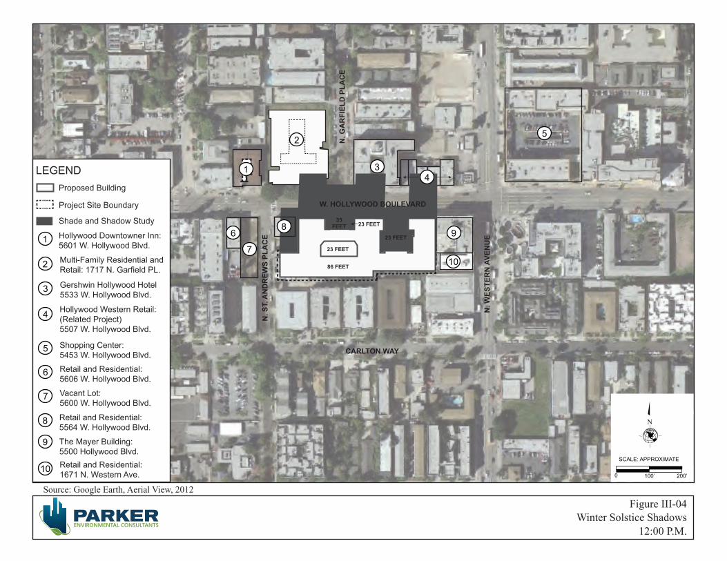
Source: Google Earth, Aerial View, 2012
0 100’ 200’
SCALE: APPROXIMATE
LEGENDProposed Building
Shade and Shadow Study
Hollywood Downtowner Inn:5601 W. Hollywood Blvd.
Multi-Family Residential and Retail: 1717 N. Garfield PL.
N
Project Site Boundary
Gershwin Hollywood Hotel5533 W. Hollywood Blvd.
Hollywood Western Retail: (Related Project) 5507 W. Hollywood Blvd.
1
2
3
4
Shopping Center: 5453 W. Hollywood Blvd.
5
Retail and Residential: 5606 W. Hollywood Blvd.
6
Vacant Lot: 5600 W. Hollywood Blvd.
7
Retail and Residential: 5564 W. Hollywood Blvd.
8
The Mayer Building: 5500 Hollywood Blvd.
9
Retail and Residential: 1671 N. Western Ave. 10
12:00 P.M.Winter Solstice Shadows
Figure III-04
86 FEET
23 FEET
23 FEET
35 FEET 23 FEET
N. S
T. A
ND
REW
S PL
AC
E
W. HOLLYWOOD BOULEVARD
CARLTON WAY
N. W
ESTE
RN
AVE
NU
E
N. G
AR
FIEL
D P
LAC
E
1
2
34
5
6
7
89
10

Source: Google Earth, Aerial View, 2012
0 100’ 200’
SCALE: APPROXIMATE
LEGENDProposed Building
Shade and Shadow Study
Hollywood Downtowner Inn:5601 W. Hollywood Blvd.
Multi-Family Residential and Retail: 1717 N. Garfield PL.
N
Project Site Boundary
Gershwin Hollywood Hotel5533 W. Hollywood Blvd.
Hollywood Western Retail: (Related Project) 5507 W. Hollywood Blvd.
1
2
3
4
Shopping Center: 5453 W. Hollywood Blvd.
5
Retail and Residential: 5606 W. Hollywood Blvd.
6
Vacant Lot: 5600 W. Hollywood Blvd.
7
Retail and Residential: 5564 W. Hollywood Blvd.
8
The Mayer Building: 5500 Hollywood Blvd.
9
Retail and Residential: 1671 N. Western Ave. 10
1:00 P.M.Winter Solstice Shadows
Figure III-05
86 FEET
23 FEET
23 FEET
35 FEET 23 FEET
N. S
T. A
ND
REW
S PL
AC
E
W. HOLLYWOOD BOULEVARD
CARLTON WAY
N. W
ESTE
RN
AVE
NU
E
N. G
AR
FIEL
D P
LAC
E
1
2
34
5
6
7
89
10
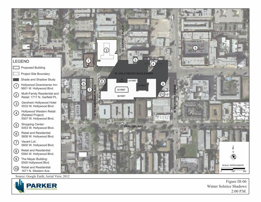
Source: Google Earth, Aerial View, 2012
0 100’ 200’
SCALE: APPROXIMATE
LEGENDProposed Building
Shade and Shadow Study
Hollywood Downtowner Inn:5601 W. Hollywood Blvd.
Multi-Family Residential and Retail: 1717 N. Garfield PL.
N
Project Site Boundary
Gershwin Hollywood Hotel5533 W. Hollywood Blvd.
Hollywood Western Retail: (Related Project) 5507 W. Hollywood Blvd.
1
2
3
4
Shopping Center: 5453 W. Hollywood Blvd.
5
Retail and Residential: 5606 W. Hollywood Blvd.
6
Vacant Lot: 5600 W. Hollywood Blvd.
7
Retail and Residential: 5564 W. Hollywood Blvd.
8
The Mayer Building: 5500 Hollywood Blvd.
9
Retail and Residential: 1671 N. Western Ave. 10
2:00 P.M.Winter Solstice Shadows
Figure III-06
86 FEET
23 FEET
23 FEET
35 FEET 23 FEET
N. S
T. A
ND
REW
S PL
AC
E
W. HOLLYWOOD BOULEVARD
CARLTON WAY
N. W
ESTE
RN
AVE
NU
E
N. G
AR
FIEL
D P
LAC
E
1
2
34
5
6
7
89
10

Source: Google Earth, Aerial View, 2012
0 100’ 200’
SCALE: APPROXIMATE
LEGENDProposed Building
Shade and Shadow Study
Hollywood Downtowner Inn:5601 W. Hollywood Blvd.
Multi-Family Residential and Retail: 1717 N. Garfield PL.
N
Project Site Boundary
Gershwin Hollywood Hotel5533 W. Hollywood Blvd.
Hollywood Western Retail: (Related Project) 5507 W. Hollywood Blvd.
1
2
3
4
Shopping Center: 5453 W. Hollywood Blvd.
5
Retail and Residential: 5606 W. Hollywood Blvd.
6
Vacant Lot: 5600 W. Hollywood Blvd.
7
Retail and Residential: 5564 W. Hollywood Blvd.
8
The Mayer Building: 5500 Hollywood Blvd.
9
Retail and Residential: 1671 N. Western Ave. 10
3:00 P.M.Winter Solstice Shadows
Figure III-07
86 FEET
23 FEET
23 FEET
35 FEET 23 FEET
N. S
T. A
ND
REW
S PL
AC
E
W. HOLLYWOOD BOULEVARD
CARLTON WAY
N. W
ESTE
RN
AVE
NU
E
N. G
AR
FIEL
D P
LAC
E
1
2
34
5
6
7
89
10

Source: Google Earth, Aerial View, 2012
0 100’ 200’
SCALE: APPROXIMATE
LEGENDProposed Building
Shade and Shadow Study
Hollywood Downtowner Inn:5601 W. Hollywood Blvd.
Multi-Family Residential and Retail: 1717 N. Garfield PL.
N
Project Site Boundary
Gershwin Hollywood Hotel5533 W. Hollywood Blvd.
Hollywood Western Retail: (Related Project) 5507 W. Hollywood Blvd.
1
2
3
4
Shopping Center: 5453 W. Hollywood Blvd.
5
Retail and Residential: 5606 W. Hollywood Blvd.
6
Vacant Lot: 5600 W. Hollywood Blvd.
7
Retail and Residential: 5564 W. Hollywood Blvd.
8
The Mayer Building: 5500 Hollywood Blvd.
9
Retail and Residential: 1671 N. Western Ave. 10
9:00 A.M.Summer Solstice Shadows
Figure III-08
86 FEET
23 FEET
23 FEET
35 FEET 23 FEET
N. S
T. A
ND
REW
S PL
AC
E
W. HOLLYWOOD BOULEVARD
CARLTON WAY
N. W
ESTE
RN
AVE
NU
E
N. G
AR
FIEL
D P
LAC
E
1
2
34
5
6
7
89
10

Source: Google Earth, Aerial View, 2012
0 100’ 200’
SCALE: APPROXIMATE
LEGENDProposed Building
Shade and Shadow Study
Hollywood Downtowner Inn:5601 W. Hollywood Blvd.
Multi-Family Residential and Retail: 1717 N. Garfield PL.
N
Project Site Boundary
Gershwin Hollywood Hotel5533 W. Hollywood Blvd.
Hollywood Western Retail: (Related Project) 5507 W. Hollywood Blvd.
1
2
3
4
Shopping Center: 5453 W. Hollywood Blvd.
5
Retail and Residential: 5606 W. Hollywood Blvd.
6
Vacant Lot: 5600 W. Hollywood Blvd.
7
Retail and Residential: 5564 W. Hollywood Blvd.
8
The Mayer Building: 5500 Hollywood Blvd.
9
Retail and Residential: 1671 N. Western Ave. 10
10:00 A.M.Summer Solstice Shadows
Figure III-09
86 FEET
23 FEET
23 FEET
35 FEET 23 FEET
N. S
T. A
ND
REW
S PL
AC
E
W. HOLLYWOOD BOULEVARD
CARLTON WAY
N. W
ESTE
RN
AVE
NU
E
N. G
AR
FIEL
D P
LAC
E
1
2
34
5
6
7
89
10
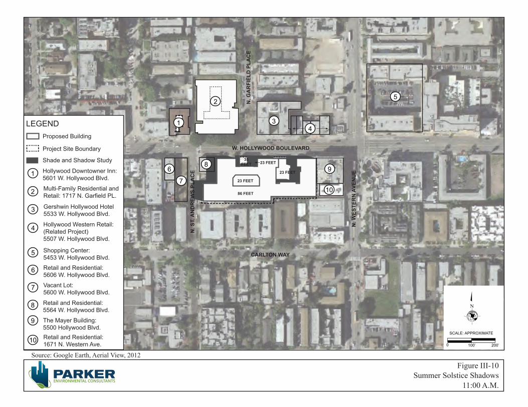
Source: Google Earth, Aerial View, 2012
0 100’ 200’
SCALE: APPROXIMATE
LEGENDProposed Building
Shade and Shadow Study
Hollywood Downtowner Inn:5601 W. Hollywood Blvd.
Multi-Family Residential and Retail: 1717 N. Garfield PL.
N
Project Site Boundary
Gershwin Hollywood Hotel5533 W. Hollywood Blvd.
Hollywood Western Retail: (Related Project) 5507 W. Hollywood Blvd.
1
2
3
4
Shopping Center: 5453 W. Hollywood Blvd.
5
Retail and Residential: 5606 W. Hollywood Blvd.
6
Vacant Lot: 5600 W. Hollywood Blvd.
7
Retail and Residential: 5564 W. Hollywood Blvd.
8
The Mayer Building: 5500 Hollywood Blvd.
9
Retail and Residential: 1671 N. Western Ave. 10
11:00 A.M.Summer Solstice Shadows
Figure III-10
86 FEET
23 FEET
23 FEET
35 FEET 23 FEET
N. S
T. A
ND
REW
S PL
AC
E
W. HOLLYWOOD BOULEVARD
CARLTON WAY
N. W
ESTE
RN
AVE
NU
E
N. G
AR
FIEL
D P
LAC
E
1
2
34
5
6
7
89
10
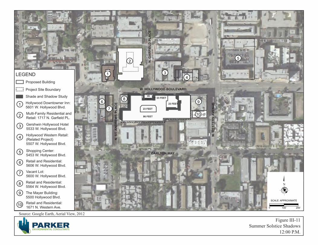
Source: Google Earth, Aerial View, 2012
0 100’ 200’
SCALE: APPROXIMATE
LEGENDProposed Building
Shade and Shadow Study
Hollywood Downtowner Inn:5601 W. Hollywood Blvd.
Multi-Family Residential and Retail: 1717 N. Garfield PL.
N
Project Site Boundary
Gershwin Hollywood Hotel5533 W. Hollywood Blvd.
Hollywood Western Retail: (Related Project) 5507 W. Hollywood Blvd.
1
2
3
4
Shopping Center: 5453 W. Hollywood Blvd.
5
Retail and Residential: 5606 W. Hollywood Blvd.
6
Vacant Lot: 5600 W. Hollywood Blvd.
7
Retail and Residential: 5564 W. Hollywood Blvd.
8
The Mayer Building: 5500 Hollywood Blvd.
9
Retail and Residential: 1671 N. Western Ave. 10
12:00 P.M.Summer Solstice Shadows
Figure III-11
86 FEET
23 FEET
23 FEET
35 FEET 23 FEET
N. S
T. A
ND
REW
S PL
AC
E
W. HOLLYWOOD BOULEVARD
CARLTON WAY
N. W
ESTE
RN
AVE
NU
E
N. G
AR
FIEL
D P
LAC
E
1
2
34
5
6
7
89
10

Source: Google Earth, Aerial View, 2012
0 100’ 200’
SCALE: APPROXIMATE
LEGENDProposed Building
Shade and Shadow Study
Hollywood Downtowner Inn:5601 W. Hollywood Blvd.
Multi-Family Residential and Retail: 1717 N. Garfield PL.
N
Project Site Boundary
Gershwin Hollywood Hotel5533 W. Hollywood Blvd.
Hollywood Western Retail: (Related Project) 5507 W. Hollywood Blvd.
1
2
3
4
Shopping Center: 5453 W. Hollywood Blvd.
5
Retail and Residential: 5606 W. Hollywood Blvd.
6
Vacant Lot: 5600 W. Hollywood Blvd.
7
Retail and Residential: 5564 W. Hollywood Blvd.
8
The Mayer Building: 5500 Hollywood Blvd.
9
Retail and Residential: 1671 N. Western Ave. 10
1:00 P.M.Summer Solstice Shadows
Figure III-12
86 FEET
23 FEET
23 FEET
35 FEET 23 FEET
N. S
T. A
ND
REW
S PL
AC
E
W. HOLLYWOOD BOULEVARD
CARLTON WAY
N. W
ESTE
RN
AVE
NU
E
N. G
AR
FIEL
D P
LAC
E
1
2
34
5
6
7
89
10

Source: Google Earth, Aerial View, 2012
0 100’ 200’
SCALE: APPROXIMATE
LEGENDProposed Building
Shade and Shadow Study
Hollywood Downtowner Inn:5601 W. Hollywood Blvd.
Multi-Family Residential and Retail: 1717 N. Garfield PL.
N
Project Site Boundary
Gershwin Hollywood Hotel5533 W. Hollywood Blvd.
Hollywood Western Retail: (Related Project) 5507 W. Hollywood Blvd.
1
2
3
4
Shopping Center: 5453 W. Hollywood Blvd.
5
Retail and Residential: 5606 W. Hollywood Blvd.
6
Vacant Lot: 5600 W. Hollywood Blvd.
7
Retail and Residential: 5564 W. Hollywood Blvd.
8
The Mayer Building: 5500 Hollywood Blvd.
9
Retail and Residential: 1671 N. Western Ave. 10
2:00 P.M.Summer Solstice Shadows
Figure III-13
86 FEET
23 FEET
23 FEET
35 FEET 23 FEET
N. S
T. A
ND
REW
S PL
AC
E
W. HOLLYWOOD BOULEVARD
CARLTON WAY
N. W
ESTE
RN
AVE
NU
E
N. G
AR
FIEL
D P
LAC
E
1
2
34
5
6
7
89
10
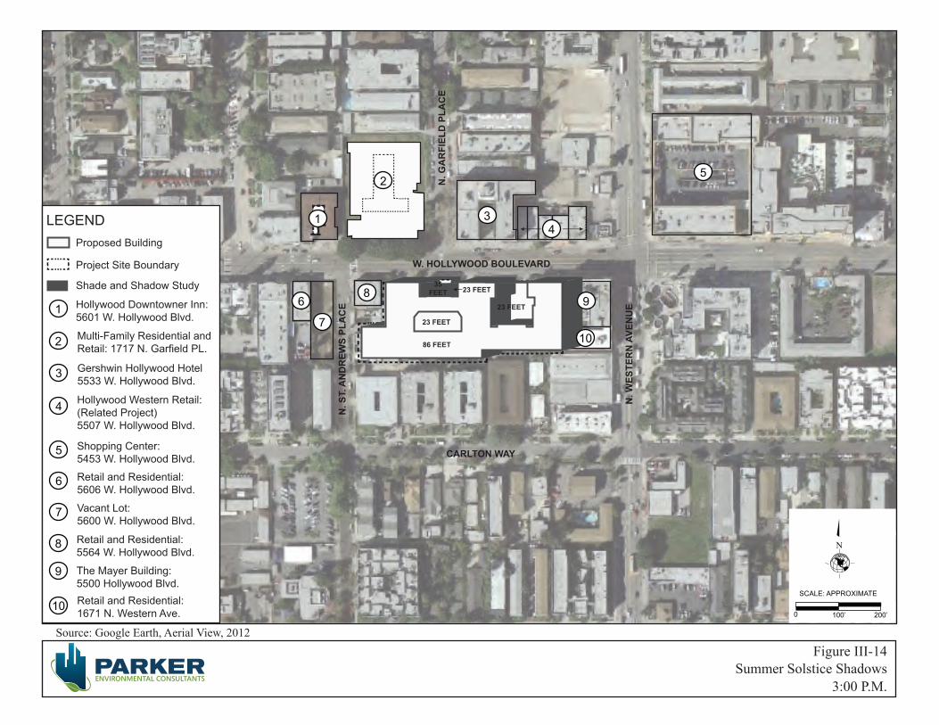
Source: Google Earth, Aerial View, 2012
0 100’ 200’
SCALE: APPROXIMATE
LEGENDProposed Building
Shade and Shadow Study
Hollywood Downtowner Inn:5601 W. Hollywood Blvd.
Multi-Family Residential and Retail: 1717 N. Garfield PL.
N
Project Site Boundary
Gershwin Hollywood Hotel5533 W. Hollywood Blvd.
Hollywood Western Retail: (Related Project) 5507 W. Hollywood Blvd.
1
2
3
4
Shopping Center: 5453 W. Hollywood Blvd.
5
Retail and Residential: 5606 W. Hollywood Blvd.
6
Vacant Lot: 5600 W. Hollywood Blvd.
7
Retail and Residential: 5564 W. Hollywood Blvd.
8
The Mayer Building: 5500 Hollywood Blvd.
9
Retail and Residential: 1671 N. Western Ave. 10
3:00 P.M.Summer Solstice Shadows
Figure III-14
86 FEET
23 FEET
23 FEET
35 FEET 23 FEET
N. S
T. A
ND
REW
S PL
AC
E
W. HOLLYWOOD BOULEVARD
CARLTON WAY
N. W
ESTE
RN
AVE
NU
E
N. G
AR
FIEL
D P
LAC
E
1
2
34
5
6
7
89
10
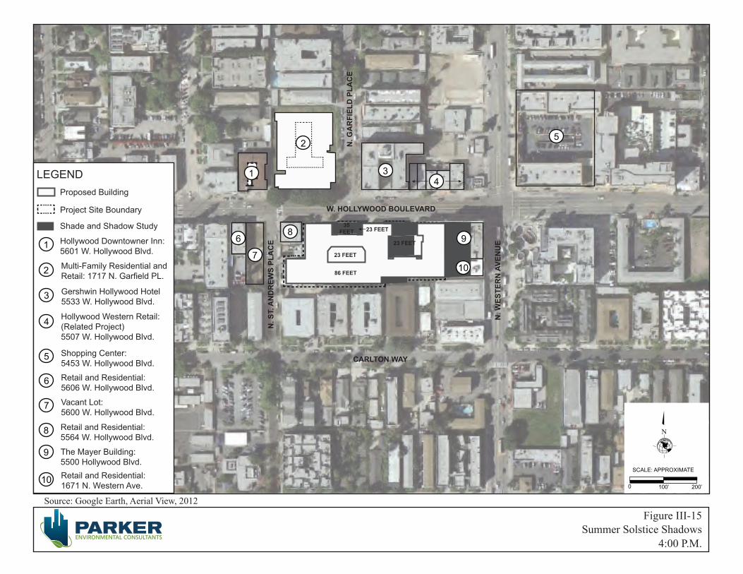
Source: Google Earth, Aerial View, 2012
0 100’ 200’
SCALE: APPROXIMATE
LEGENDProposed Building
Shade and Shadow Study
Hollywood Downtowner Inn:5601 W. Hollywood Blvd.
Multi-Family Residential and Retail: 1717 N. Garfield PL.
N
Project Site Boundary
Gershwin Hollywood Hotel5533 W. Hollywood Blvd.
Hollywood Western Retail: (Related Project) 5507 W. Hollywood Blvd.
1
2
3
4
Shopping Center: 5453 W. Hollywood Blvd.
5
Retail and Residential: 5606 W. Hollywood Blvd.
6
Vacant Lot: 5600 W. Hollywood Blvd.
7
Retail and Residential: 5564 W. Hollywood Blvd.
8
The Mayer Building: 5500 Hollywood Blvd.
9
Retail and Residential: 1671 N. Western Ave. 10
4:00 P.M.Summer Solstice Shadows
Figure III-15
86 FEET
23 FEET
23 FEET
35 FEET 23 FEET
N. S
T. A
ND
REW
S PL
AC
E
W. HOLLYWOOD BOULEVARD
CARLTON WAY
N. W
ESTE
RN
AVE
NU
E
N. G
AR
FIEL
D P
LAC
E
1
2
34
5
6
7
89
10
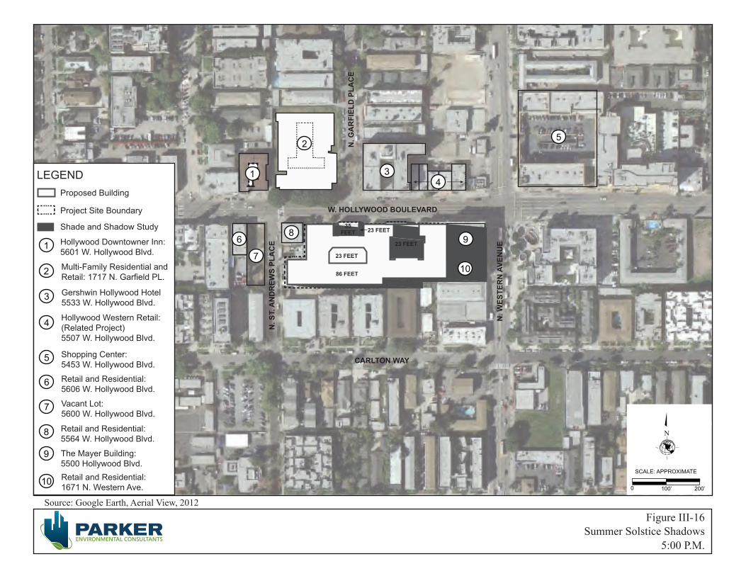
Source: Google Earth, Aerial View, 2012
0 100’ 200’
SCALE: APPROXIMATE
LEGENDProposed Building
Shade and Shadow Study
Hollywood Downtowner Inn:5601 W. Hollywood Blvd.
Multi-Family Residential and Retail: 1717 N. Garfield PL.
N
Project Site Boundary
Gershwin Hollywood Hotel5533 W. Hollywood Blvd.
Hollywood Western Retail: (Related Project) 5507 W. Hollywood Blvd.
1
2
3
4
Shopping Center: 5453 W. Hollywood Blvd.
5
Retail and Residential: 5606 W. Hollywood Blvd.
6
Vacant Lot: 5600 W. Hollywood Blvd.
7
Retail and Residential: 5564 W. Hollywood Blvd.
8
The Mayer Building: 5500 Hollywood Blvd.
9
Retail and Residential: 1671 N. Western Ave. 10
5:00 P.M.
Figure III-16Summer Solstice Shadows
86 FEET
23 FEET
23 FEET
35 FEET 23 FEET
N. S
T. A
ND
REW
S PL
AC
E
W. HOLLYWOOD BOULEVARD
CARLTON WAY
N. W
ESTE
RN
AVE
NU
E
N. G
AR
FIEL
D P
LAC
E
1
2
34
5
6
7
89
10
City of Los Angeles June 2013
High Line West Project III. Environmental Impact Analysis ENV-2012-3532-MND Page III-23
Figure III-17 Cross Sectional Shadow Diagram, Winter Solstice at 11:00 AM.

City of Los Angeles June 2013
High Line West Project III. Environmental Impact Analysis ENV-2012-3532-MND Page III-24
Hollywood Downtowner Inn located at 5601 Hollywood Boulevard is a two-story motel with south facing balconies that are currently shaded by an architectural pitched roof and awnings. The swimming pool is located within an interior courtyard and is shaded by the existing motel structure. Therefore, it was not considered a shadow sensitive use. The Project’s winter solstice shadow would impact this property for approximately 0.5 hours between 9:00 a.m. to approx. 9:30 a.m. No shading impacts would occur during the summer months.
The Gershwin Hollywood Hotel building located at 5553 Hollywood Boulevard is a five-story building with ground floor retail and hotel rooms above the ground floor. The south-facing facade does not have any balconies or useable outdoor areas that are dependent upon direct sunlight. Therefore, it was not considered a shadow sensitive use. The Project’s winter solstice shadows would impact this building for 6 hours with intermittent shadows between 9:00 a.m. to 3:00 p.m. No shading impact would occur during the summer months. Because this building does not have any shadow sensitive land uses or features, the Proposed Project’s shade and shadow impacts would be considered less than significant.
The proposed Hollywood Western Retail project located at 5507 W. Hollywood Boulevard is currently improved with vacant single-story retail land uses and a surface parking lot. The site is proposed for future retail land uses (See Related Project No. 58). The Proposed Project’s winter solstice shadows would impact this property for 5 hours with intermittent shadows between 10:00 a.m. to approx. 9:30 a.m. There would be no shading impact during the summer months. Because the existing or proposed uses do not contain any features or land uses that are considered shadow sensitive, the Project’s shade and shadow impact upon this property would be less than significant.
The retail and residential property located to the west of the Project Site at 5606 W. Hollywood Boulevard would be impacted for approximately 0.5 hours between 9:00 a.m. to approx. 9:30 a.m. during the winter months and not at all during the summer solstice. Because the east facing façade does not have any shadow sensitive features, it is not considered a shadow sensitive land use. Additionally, the Project’s shadow impacts to this property would be less than half-hour in duration which is below the thresholds of significance. The Project’s shade and shadow impact would therefore be less than significant.
The vacant lot located to the west of the Project Site at the southwest corner of Hollywood Boulevard and St. Andrews would be impacted for approximately 1 hour between 9:00 a.m. to approx. 10:00 a.m. during the winter and summer solstices. Because this vacant lot is not currently used or accessible to the public, it is not considered a shadow sensitive land use. Additionally, the Project’s shadow impacts to this property would be approximately one hour in duration, which is below the thresholds of significance. The Project’s shade and shadow impact would therefore be less than significant.
The property located at the southeast corner of Hollywood Boulevard and St. Andrews (5564 W. Hollywood Blvd.) is developed with a two-story building with ground floor retail and residential above. This property is directly adjacent to the Project Site’s western boundary and would be impacted for 5 hours between 9:00 a.m. to approx. 2:00 p.m. during the winter solstice and approximately 4 hours between 9:00 a.m. to approx. 1:00 p.m. during the summer solstice. This building has no side yard setbacks and the rear yard is used for surface parking. There are no useable outdoor areas or shadow sensitive features. There are no windows on the east-facing facade and the windows on the second level

City of Los Angeles June 2013
High Line West Project III. Environmental Impact Analysis ENV-2012-3532-MND Page III-25
of the south-facing façade do not include any balconies or outdoor usable spaces. Therefore it is not considered a shadow sensitive land use and the Proposed Project’s shadow impacts would be less than significant.
The Mayer Building at 5500 Hollywood Boulevard is a four-story building with ground floor retail and offices above that does not include useable outdoor areas or shadow sensitive features. Therefore, it is not considered a shadow sensitive land use. The Project would shade this building for approximately 3 hours between 12:00 p.m. to approx. 3:00 p.m. during the winter solstice and approximately 4 hours between 1:00 p.m. to 5:00 p.m. Because this commercial building does not have any useable outdoor areas or shadow sensitive features it is not considered a shadow sensitive land use and the Project’s shadow impacts would be less than significant.
The building located at 1671 N. Western Avenue, directly to the east of the Project Site, is improved with a four-story mixed use building with retail and residential land uses. The windows on the west facing façade of this building do not contain any balconies or outdoor usable spaces. As shown in Figure II-4, View 12, the west facing yard of this mixed-use residential building is a surface parking lot with no useable outdoor open space areas. There are no balconies or useable open space areas that are dependent upon direct sunlight. Therefore this use is not considered a shadow sensitive land use. The Proposed project would shade this property from 2 hours between 1:00 p.m. to approximately 3:00 p.m. during the winter solstice and for approximately 3.5 hours between 1:30 p.m. to approx. 5:00 p.m. during the summer solstice. However, because it is not a shadow sensitive land use, the Proposed Project’s impacts upon this property would be less than significant.
d) Would the project create a new source of substantial light or glare which would adversely affect day or nighttime views in the area?
Potentially Significant Impact Unless Mitigation Incorporated. A significant impact may occur if the Project introduces new sources of light or glare on or from the Project Site which would be incompatible with the areas surrounding the Project Site, or which pose a safety hazard to motorists utilizing adjacent streets or freeways. Based on the LA CEQA Thresholds Guide, the determination of whether the Project results in a significant nighttime illumination impact shall be made considering the following factors: (a) the change in ambient illumination levels as a result of Project sources; and (b) the extent to which Project lighting would spill off the Project Site and affect adjacent light-sensitive areas.
Light
Night lighting for the Proposed Project would be provided in order to illuminate the building entrances, common open space areas, and parking areas, largely to provide adequate night visibility for residents and visitors and to provide a measure of security. It should be noted that a moderate degree of illumination already exists at the Project Site along both Hollywood Boulevard and St. Andrews Street. The Proposed Project would not generate a substantial increase in ambient lighting. In addition, the majority of lighting would be directed towards the interior of the Project Site and away from any nearby land uses. The Proposed Project would not introduce any new sources of substantial light that are incompatible with the surrounding areas. Vehicular access to the Project Sites would be provided off of St. Andrews Street and Hollywood Boulevard. Thus vehicle headlights would not be directed towards any adjacent residential

City of Los Angeles June 2013
High Line West Project III. Environmental Impact Analysis ENV-2012-3532-MND Page III-26
land uses. Furthermore, the adjacent multi-family residential land uses bordering the site to the south would not be impacted by vehicle headlights at the ground level, because the properties are separated by a solid masonry wall. Additionally, as noted in Mitigation Measure I-120, below, the Project will include directional lighting with shielding to ensure outdoor parking areas and security lights do not cast excessive light on adjacent properties. Therefore, with mitigation the Proposed Project’s impacts would be less than significant.
Glare
Potential reflective surfaces in the Project vicinity include automobiles traveling and parked on streets in the vicinity of the Project, exterior building windows, and surfaces of brightly painted buildings in the Project vicinity. Excessive glare not only restricts visibility, but increases the ambient heat reflectivity in a given area. The Proposed Project’s building exteriors would consist mainly of concrete or masonry block, exterior plaster, tile veneer, low emissivity tinted glass, and metal cladding. Landscaping in the form of parkway and street trees would be provided along all street edges of the Proposed Project to buffer and partially screen the buildings from public view. The Proposed Project would not introduce any new sources of glare that are incompatible with the surrounding areas. Therefore, the Proposed Project’s impacts would be less than significant.
Mitigation Measures:
I-120 Aesthetics (Light)
• Outdoor lighting shall be designed and installed with shielding, such that the light source cannot be seen from adjacent residential properties or the public right-of-way.
I-130 (Aesthetics (Glare)
• The exterior of the proposed structure shall be constructed of materials such as, but not limited to, high-performance and/or non-reflective tinted glass (no mirror like tints or films) and pre-cast concrete or fabricated wall surfaces to minimize glare and reflected heat.
Cumulative Impacts
Less Than Significant Impact. Development of the Proposed Project in conjunction with the 61 related projects would result in an intensification of existing prevailing land uses in an already heavily urbanized area of Los Angeles. Cumulative aesthetic impacts could occur if any of the other related projects in the vicinity of the Project Site would result in the degradation of the Project Area in conjunction with the impacts of the Proposed Project.
The Proposed Project would not contribute to a cumulatively considerably significant impact with respect to aesthetics (including visual character, light/glare and shadow impacts), as it would further revitalize efforts within the Hollywood Boulevard area. Development of the related projects is expected to occur in accordance with adopted plans and regulations. Additionally, with respect to the overall visual quality of the surrounding neighborhood, each of the related projects would be required to submit a landscape plan
City of Los Angeles June 2013
High Line West Project III. Environmental Impact Analysis ENV-2012-3532-MND Page III-27
and signage plan (if proposed) to the Los Angeles Department of City Planning for review and approval prior to the issuance of grading permits. Therefore, cumulative aesthetic impacts would be less than significant.
2. AGRICULTURE AND FORESTRY RESOURCES
a) Would the project convert Prime Farmland, Unique Farmland, or Farmland of Statewide Importance (Farmland), as shown on the maps prepared pursuant to the Farmland Mapping and Monitoring Program of the California Resources Agency, to non-agricultural use?
No Impact. Although not specified in the LA CEQA Thresholds Guide, a significant impact may occur if the Proposed Project were to result in the conversion of state-designated agricultural land from agricultural use to another non-agricultural use. The Project Site is occupied by nine existing commercial structures and surface parking. The Project Site is also located in a heavily urbanized area of the City of Los Angeles in the Hollywood Community Plan area. No farmland or agricultural activity exists on or in the vicinity of the Project Site. According to the Soil Candidate Listing for Prime Farmland of Statewide Importance, Los Angeles County, which was prepared by the U.S. Department of Agriculture Natural Resources Conservation Service (NRCS), the soils at the Project Site are not candidates for listing as Prime Farmland, Unique Farmland, or Farmland of Statewide Importance. In addition, the Project Site has not been mapped pursuant to the Farmland Mapping and Monitoring Program of the California Resources Agency. Therefore, no impact to agricultural lands would occur.
b) Would the project conflict with existing zoning for agricultural use, or a Williamson Act Contract?
No Impact. A significant impact may occur if the Project were to result in the conversion of land zoned for agricultural use or under a Williamson Act contract from agricultural use to another non-agricultural use. The Project Site is located within the jurisdiction of the City of Los Angeles and is, therefore, subject to the applicable land use and zoning requirements in the LAMC. The Project Site is zoned [Q]R5-2 within Subarea C of the Vermont/Western Transit Oriented District Specific Plan of the Hollywood Community Plan area and has a land use designation of High Density Residential. The Project Site is not zoned for agricultural production, and there is no farmland at the Project Site. In addition, no Williamson Act Contracts are in effect for the Project Site.1 Therefore no impact would occur.
c) Would the project conflict with existing zoning for, or cause rezoning of, forest land (as defined in Public Resources Code section 12220(g)), timberland (as defined by Public Resources Code section 4526), or timberland zoned Timberland Production (as defined by Government Code section 51104(g))?
1 Williamson Act Program, California Division of Land Resource Protection, website: ftp://ftp.consrv.ca.gov/ pub/dlrp/FMMP/pdf/statewide/2006/fmmp2006_wallsize.pdf, accessed October 2012.

City of Los Angeles June 2013
High Line West Project III. Environmental Impact Analysis ENV-2012-3532-MND Page III-28
No Impact. A significant impact may occur if the Project were to result in the conversion of land zoned for, or cause rezoning of, forest land (as defined in Public Resources Code section 12220(g)), timberland (as defined by Public Resources Code section 4526), or timberland zoned Timberland Production (as defined by Government Code section 51104(g)). The Project Site is zoned [Q]R5-2 within Subarea C of the Vermont/Western Transit Oriented District Specific Plan of the Hollywood Community Plan area and has a land use designation of High Density Residential. The Project Site is not zoned as forest land or timberland, and there is no Timberland Production at the Project Site. Therefore, no impact would occur.
d) Would the project result in the loss of forest land or conversion of forest land to non-forest use?
No Impact. Although not specified in the LA CEQA Thresholds Guide, a significant impact may occur if the Project were to result in the loss of forest land or conversion of forest land to non-forest use. The Project Site is occupied by nine existing commercial structures and surface parking. The Project Site is also located in a heavily urbanized area of the City of Los Angeles in the Hollywood Community Plan area. No forested lands or natural vegetation exist on or in the vicinity of the Project Site. Therefore no impact would occur.
e) Would the project involve other changes in the existing environment, which due to their location or nature, could result in conversion of Farmland, to non-agricultural use or conversion of forest land to non-forest use?
No Impact. A significant impact may occur if a Project results in the conversion of farmland to non-agricultural use or conversion of forest land to non-forest use. Neither the Project Site, nor nearby properties, are currently utilized for agricultural or forestry uses and the Project Site is not classified in any “Farmland” category designated by the State of California. According to the City General Plan Conservation Element (Exhibit B), the Project Site is not located near or in any significant farmland area (i.e., a significant commercial crop or animal producing site). Therefore, no impact would occur.
Cumulative Impacts
No Impact. Development of the Proposed Project in combination with the related projects would not result in the conversion of State-designated agricultural land from agricultural use to a non-agricultural use, nor result in the loss of forest land or conversion of forest land to non-forest use. The Extent of Important Farmland Map Coverage maintained by the Division of Land Protection indicates that the Project Site and the surrounding area are not included in the Important Farmland category.2 The Project Site is located in an urbanized area in the City of Los Angeles and does not include any State-designated agricultural lands or forest uses. Therefore, no cumulative impact would occur.
2 State of California Department of Conservation, Division of Land Resource Protection, Farmland Mapping and Monitoring Program.

City of Los Angeles June 2013
High Line West Project III. Environmental Impact Analysis ENV-2012-3532-MND Page III-29
3. AIR QUALITY
a) Would the project conflict with or obstruct implementation of the applicable air quality plan?
Less Than Significant Impact. Based on the LA CEQA Thresholds Guide, a significant air quality impact may occur if a project is not consistent with the applicable Air Quality Management Plan (AQMP) or would in some way represent a substantial hindrance to employing the policies or obtaining the goals of that plan. In the case of projects proposed within the City of Los Angeles or elsewhere in the South Coast Air Basin (Basin), the applicable plan is the Air Quality Management Plan (AQMP), which is prepared by the South Coast Air Quality Management District (SCAQMD). The SCAQMD is the agency principally responsible for comprehensive air pollution control in the Basin. To that end, the SCAQMD, a regional agency, works directly with the Southern California Association of Governments (SCAG), county transportation commissions, local governments, and cooperates actively with all State and federal government agencies. The SCAQMD develops rules and regulations, establishes permitting requirements, inspects emissions sources, and enforces such measures though educational programs or fines, when necessary.
The SCAQMD is directly responsible for reducing emissions from stationary (area and point), mobile, and indirect sources. It has responded to this requirement by preparing a series of AQMPs. The most recent AQMP was adopted by the Governing Board of the SCAQMD on December 7, 2012. The 2012 AQMP was prepared to comply with the federal and State Clean Air Acts and amendments, to accommodate growth, to reduce the high levels of pollutants in the Basin, to meet federal and State air quality standards, and to minimize the fiscal impact that pollution control measures have on the local economy. It builds on the approaches taken from the 2007 AQMP for the attainment of the federal ozone air quality standard. These planning efforts have substantially decreased the population’s exposure to unhealthful levels of pollutants, even while substantial population growth has occurred within the Basin.
Projects that are consistent with the projections of employment and population forecasts identified in the Growth Management Chapter of the Regional Comprehensive Plan and Guide (RCPG) are considered consistent with the AQMP growth projections, since the Growth Management Chapter forms the basis of the land use and transportation control portions of the AQMP. As discussed in Question 16(a), impacts with respect to population, housing and employment would be less than significant. Thus, the Proposed Project would not impair implementation of the AQMP, and this impact would be less than significant.
b) Would the project violate any air quality standard or contribute substantially to an existing or projected air quality violation?
Potentially Significant Impact Unless Mitigation Incorporated. Based on the LA CEQA Thresholds Guide, a project may have a significant impact where project-related emissions would exceed federal, State, or regional standards or thresholds, or where project-related emissions would substantially contribute to an existing or projected air quality violation.

City of Los Angeles June 2013
High Line West Project III. Environmental Impact Analysis ENV-2012-3532-MND Page III-30
Construction Emissions
For purposes of analyzing impacts associated with air quality, this analysis assumes a Project construction schedule of approximately 18 months. This assumption is conservative and yields the maximum daily impacts. Construction activities associated with the Project would be undertaken in three main steps: (1) demolition/site clearing, (2) excavation, grading and foundations and (3) building construction. The building construction phase includes the construction of the proposed buildings, connection of utilities to the buildings, laying irrigation for landscaping, architectural coatings, paving, and landscaping the Project Site.
These construction activities would temporarily create emissions of dusts, fumes, equipment exhaust, and other air contaminants. Construction activities involving site excavation, grading and foundation preparation would primarily generate PM2.5 and PM10 emissions. Mobile sources (such as diesel-fueled equipment onsite and traveling to and from the Project Site) would primarily generate NOx emissions. The application of architectural coatings would primarily result in the release of ROG emissions. The amount of emissions generated on a daily basis would vary, depending on the amount and types of construction activities occurring at the same time. Each construction phase is described in more detail below.
Demolition/Site Clearing Phase
This phase would include the demolition of 37,717 square feet of existing uses on the Project Site. In addition, this phase would include the removal of all trees, walls, fences, and parking lot related debris. This analysis assumes demolition/site clearing would be completed in approximately one month. This analysis assumes daily on-site demolition activities would require the following equipment: one concrete/industrial saw, one rubber tired dozer, and three tractors/loaders/backhoes. For purposes of modeling the emissions associated with this equipment fleet, it was conservatively estimated that each piece of equipment would be operated for 8 hours each day.
Excavation, Grading and Foundation Phase
After the completion of demolition/site clearing, the excavation phase for the Project would occur for approximately three months and would involve the cut and fill of land to ensure the proper base and slope for the building foundations. In order to construct the subterranean parking, the Project would require approximately 26,500 cubic yards of soil to be excavated and hauled off-site. This analysis assumes daily grading and site preparation activities would require the following equipment: one bore/drill rig, one cement/mortar mixer, one grader, one excavator, and one tractor/loader/backhoe. For purposes of modeling the emissions associated with this equipment fleet, it was conservatively estimated that each piece of equipment would be operated for 8 hours each day.
Building Construction Phase
The building construction phase consists of below grade and above grade structures and is expected to occur for approximately 14 months. Upon completion of the structures, architectural coating, finishing, and paving would occur. It is estimated that architectural coatings would occur over the final five months of the building construction phase, and paving would occur during the final month of

City of Los Angeles June 2013
High Line West Project III. Environmental Impact Analysis ENV-2012-3532-MND Page III-31
construction. This analysis assumes that the maximum daily construction building activities would require the following equipment: one crane, two cement/mortar mixers, one forklift, one generator set, one tractor/loader/backhoe, three welders, one air compressor, one paver, one piece of paving equipment, and one roller. For purposes of modeling the emissions associated with this equipment fleet, it was conservatively estimated that each piece of equipment would be operated for 8 hours each day.
The analysis of daily construction emissions has been prepared utilizing the California Emissions Estimator Model (CalEEMod) recommended by the SCAQMD. Due to the construction time frame and the normal day-to-day variability in construction activities, it is difficult, if not impossible, to precisely quantify the daily emissions associated with each phase of the proposed construction activities. Nonetheless, Table III-2, Estimated Peak Daily Construction Emissions, identifies daily emissions that are estimated to occur on peak construction days for each construction phase. These calculations assume that appropriate dust control measures would be implemented as part of the Proposed Project during each phase of development, as required by SCAQMD Rule 403 - Fugitive Dust. Specific Rule 403 control requirements include, but are not limited to, applying water in sufficient quantities to prevent the generation of visible dust plumes, applying soil binders to uncovered areas, reestablishing ground cover as quickly as possible, utilizing a wheel washing system to remove bulk material from tires and vehicle undercarriages before vehicles exit the Project Site, and maintaining effective cover over exposed areas. To ensure compliance with these applicable rules, the following mitigation measures will apply to the project:
Mitigation Measures:
III-10 Air Pollution (Demolition, Grading, and Construction Activities)
• All unpaved demolition and construction areas shall be wetted at least twice daily during excavation and construction, and temporary dust covers shall be used to reduce dust emissions and meet SCAQMD District Rule 403. Wetting would reduce fugitive dust by as much as 50 percent.
• The construction area shall be kept sufficiently dampened to control dust caused by grading and hauling, and at all times provide reasonable control of dust caused by wind.
• All clearing, earth moving, or excavation activities shall be discontinued during periods of high winds (i.e., greater than 15 mph), so as to prevent excessive amounts of dust.
• All dirt/soil loads shall be secured by trimming, watering or other appropriate means to prevent spillage and dust.
• All dirt/soil materials transported off-site shall be either sufficiently watered or securely covered to prevent excessive amount of dust.
• General contractors shall maintain and operate construction equipment so as to minimize exhaust emissions.
• Trucks having no current hauling activity shall not idle but be turned off.
As shown in Table III-2, the estimated peak daily construction emissions associated with the Proposed Project would not exceed any regional SCAQMD significance thresholds for criteria pollutants during the construction phases. Therefore, construction impacts are considered to be less than significant.
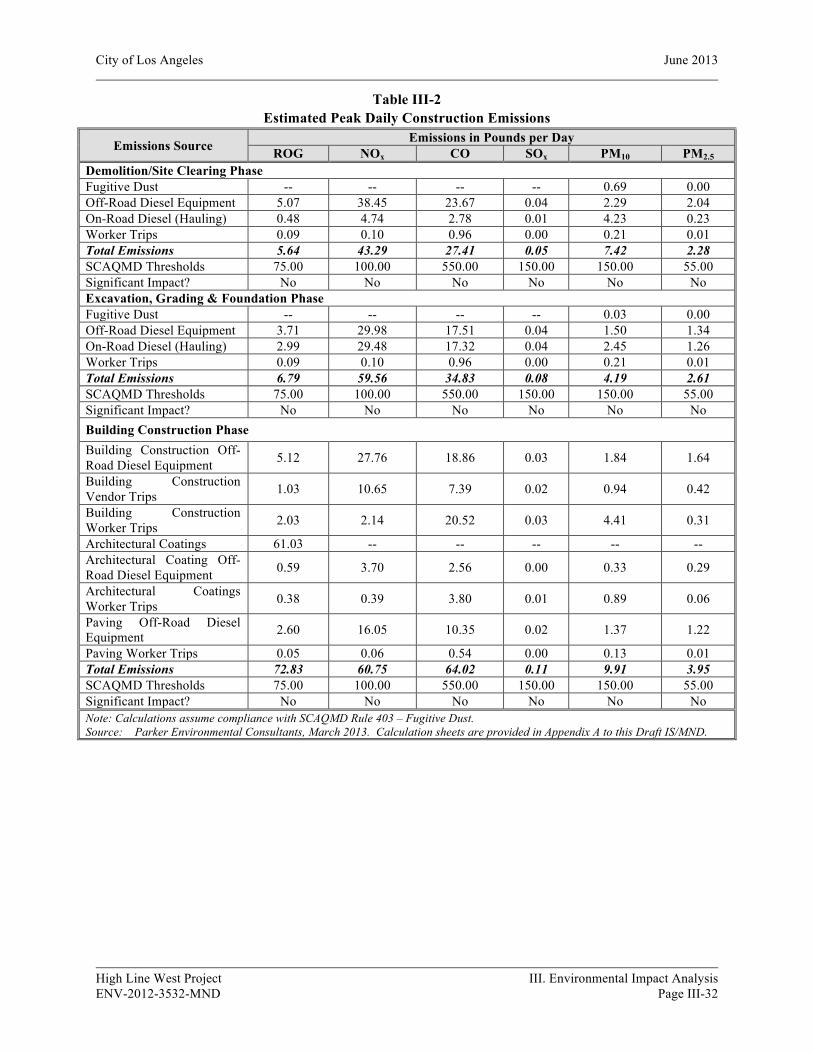
City of Los Angeles June 2013
High Line West Project III. Environmental Impact Analysis ENV-2012-3532-MND Page III-32
Table III-2 Estimated Peak Daily Construction Emissions
Emissions Source Emissions in Pounds per Day ROG NOx CO SOx PM10 PM2.5
Demolition/Site Clearing Phase Fugitive Dust -- -- -- -- 0.69 0.00 Off-Road Diesel Equipment 5.07 38.45 23.67 0.04 2.29 2.04 On-Road Diesel (Hauling) 0.48 4.74 2.78 0.01 4.23 0.23 Worker Trips 0.09 0.10 0.96 0.00 0.21 0.01 Total Emissions 5.64 43.29 27.41 0.05 7.42 2.28 SCAQMD Thresholds 75.00 100.00 550.00 150.00 150.00 55.00 Significant Impact? No No No No No No Excavation, Grading & Foundation Phase Fugitive Dust -- -- -- -- 0.03 0.00 Off-Road Diesel Equipment 3.71 29.98 17.51 0.04 1.50 1.34 On-Road Diesel (Hauling) 2.99 29.48 17.32 0.04 2.45 1.26 Worker Trips 0.09 0.10 0.96 0.00 0.21 0.01 Total Emissions 6.79 59.56 34.83 0.08 4.19 2.61 SCAQMD Thresholds 75.00 100.00 550.00 150.00 150.00 55.00 Significant Impact? No No No No No No Building Construction Phase
Building Construction Off-Road Diesel Equipment 5.12 27.76 18.86 0.03 1.84 1.64
Building Construction Vendor Trips 1.03 10.65 7.39 0.02 0.94 0.42
Building Construction Worker Trips 2.03 2.14 20.52 0.03 4.41 0.31
Architectural Coatings 61.03 -- -- -- -- -- Architectural Coating Off-Road Diesel Equipment 0.59 3.70 2.56 0.00 0.33 0.29
Architectural Coatings Worker Trips 0.38 0.39 3.80 0.01 0.89 0.06
Paving Off-Road Diesel Equipment 2.60 16.05 10.35 0.02 1.37 1.22
Paving Worker Trips 0.05 0.06 0.54 0.00 0.13 0.01 Total Emissions 72.83 60.75 64.02 0.11 9.91 3.95 SCAQMD Thresholds 75.00 100.00 550.00 150.00 150.00 55.00 Significant Impact? No No No No No No Note: Calculations assume compliance with SCAQMD Rule 403 – Fugitive Dust. Source: Parker Environmental Consultants, March 2013. Calculation sheets are provided in Appendix A to this Draft IS/MND.
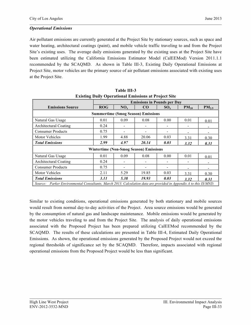
City of Los Angeles June 2013
High Line West Project III. Environmental Impact Analysis ENV-2012-3532-MND Page III-33
Operational Emissions
Air pollutant emissions are currently generated at the Project Site by stationary sources, such as space and water heating, architectural coatings (paint), and mobile vehicle traffic traveling to and from the Project Site’s existing uses. The average daily emissions generated by the existing uses at the Project Site have been estimated utilizing the California Emissions Estimator Model (CalEEMod) Version 2011.1.1 recommended by the SCAQMD. As shown in Table III-3, Existing Daily Operational Emissions at Project Site, motor vehicles are the primary source of air pollutant emissions associated with existing uses at the Project Site.
Table III-3 Existing Daily Operational Emissions at Project Site
Emissions Source Emissions in Pounds per Day
ROG NOx CO SOx PM10 PM2.5 Summertime (Smog Season) Emissions
Natural Gas Usage 0.01 0.09 0.08 0.00 0.01 0.01 Architectural Coating 0.24 - - - - - Consumer Products 0.75 - - - - - Motor Vehicles 1.99 4.88 20.06 0.03 3.31 0.30 Total Emissions 2.99 4.97 20.14 0.03 3.32 0.31
Wintertime (Non-Smog Season) Emissions
Natural Gas Usage 0.01 0.09 0.08 0.00 0.01 0.01 Architectural Coating 0.24 - - - - - Consumer Products 0.75 - - - - - Motor Vehicles 2.11 5.29 19.85 0.03 3.31 0.30 Total Emissions 3.11 5.38 19.93 0.03 3.32 0.31 Source: Parker Environmental Consultants, March 2013. Calculation data are provided in Appendix A to this IS/MND.
Similar to existing conditions, operational emissions generated by both stationary and mobile sources would result from normal day-to-day activities of the Project. Area source emissions would be generated by the consumption of natural gas and landscape maintenance. Mobile emissions would be generated by the motor vehicles traveling to and from the Project Site. The analysis of daily operational emissions associated with the Proposed Project has been prepared utilizing CalEEMod recommended by the SCAQMD. The results of these calculations are presented in Table III-4, Estimated Daily Operational Emissions. As shown, the operational emissions generated by the Proposed Project would not exceed the regional thresholds of significance set by the SCAQMD. Therefore, impacts associated with regional operational emissions from the Proposed Project would be less than significant.
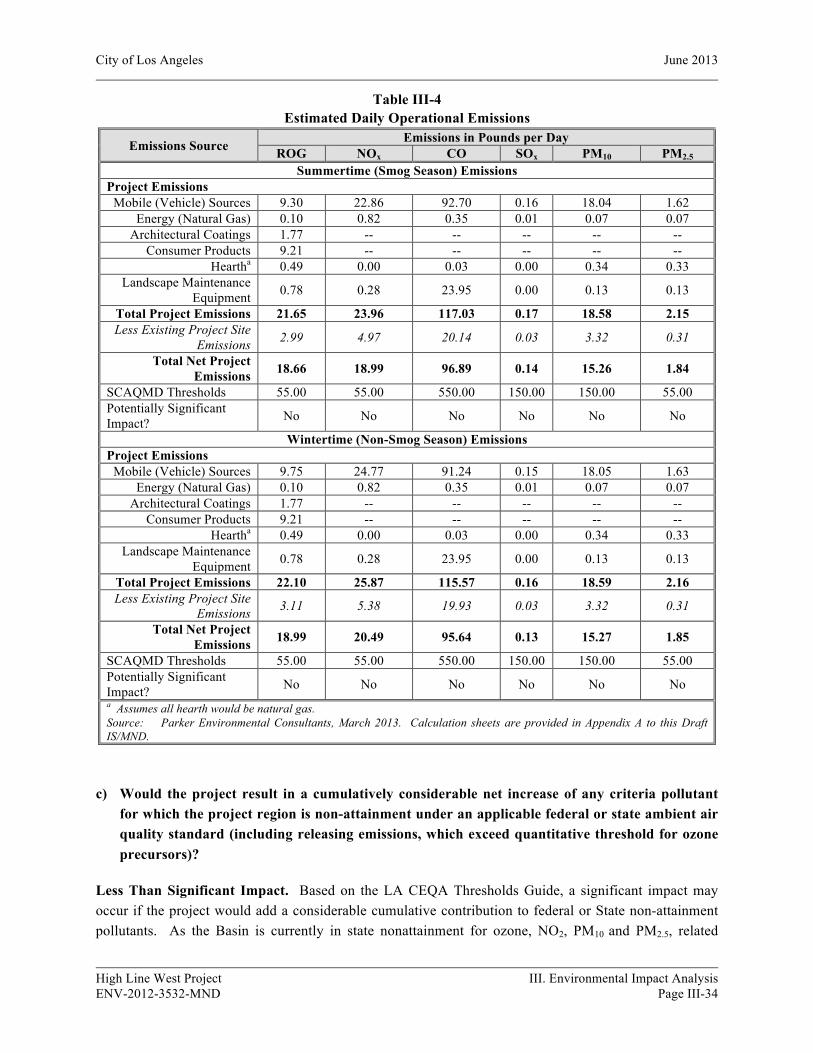
City of Los Angeles June 2013
High Line West Project III. Environmental Impact Analysis ENV-2012-3532-MND Page III-34
Table III-4 Estimated Daily Operational Emissions
Emissions Source Emissions in Pounds per Day ROG NOx CO SOx PM10 PM2.5
Summertime (Smog Season) Emissions Project Emissions
Mobile (Vehicle) Sources 9.30 22.86 92.70 0.16 18.04 1.62 Energy (Natural Gas) 0.10 0.82 0.35 0.01 0.07 0.07
Architectural Coatings 1.77 -- -- -- -- -- Consumer Products 9.21 -- -- -- -- --
Heartha 0.49 0.00 0.03 0.00 0.34 0.33 Landscape Maintenance
Equipment 0.78 0.28 23.95 0.00 0.13 0.13
Total Project Emissions 21.65 23.96 117.03 0.17 18.58 2.15 Less Existing Project Site
Emissions 2.99 4.97 20.14 0.03 3.32 0.31
Total Net Project Emissions 18.66 18.99 96.89 0.14 15.26 1.84
SCAQMD Thresholds 55.00 55.00 550.00 150.00 150.00 55.00 Potentially Significant Impact? No No No No No No
Wintertime (Non-Smog Season) Emissions
Project Emissions Mobile (Vehicle) Sources 9.75 24.77 91.24 0.15 18.05 1.63
Energy (Natural Gas) 0.10 0.82 0.35 0.01 0.07 0.07 Architectural Coatings 1.77 -- -- -- -- --
Consumer Products 9.21 -- -- -- -- -- Heartha 0.49 0.00 0.03 0.00 0.34 0.33
Landscape Maintenance Equipment 0.78 0.28 23.95 0.00 0.13 0.13
Total Project Emissions 22.10 25.87 115.57 0.16 18.59 2.16 Less Existing Project Site
Emissions 3.11 5.38 19.93 0.03 3.32 0.31
Total Net Project Emissions 18.99 20.49 95.64 0.13 15.27 1.85
SCAQMD Thresholds 55.00 55.00 550.00 150.00 150.00 55.00 Potentially Significant Impact? No No No No No No a Assumes all hearth would be natural gas. Source: Parker Environmental Consultants, March 2013. Calculation sheets are provided in Appendix A to this Draft IS/MND.
c) Would the project result in a cumulatively considerable net increase of any criteria pollutant for which the project region is non-attainment under an applicable federal or state ambient air quality standard (including releasing emissions, which exceed quantitative threshold for ozone precursors)?
Less Than Significant Impact. Based on the LA CEQA Thresholds Guide, a significant impact may occur if the project would add a considerable cumulative contribution to federal or State non-attainment pollutants. As the Basin is currently in state nonattainment for ozone, NO2, PM10 and PM2.5, related
City of Los Angeles June 2013
High Line West Project III. Environmental Impact Analysis ENV-2012-3532-MND Page III-35
projects could exceed an air quality standard or contribute to an existing or projected air quality exceedance. In regards to determining the significance of the Proposed Project contribution, the SCAQMD neither recommends quantified analyses of construction and/or operational emissions from multiple development projects nor provides methodologies or thresholds of significance to be used to assess the cumulative emissions generated by multiple cumulative projects. Instead, the SCAQMD recommends that a project’s potential contribution to cumulative impacts should be assessed utilizing the same significance criteria as those for project specific impacts. Furthermore, SCAQMD states that if an individual development project generates less than significant construction or operational emissions, then the development project would not generate a cumulatively considerable increase in emissions for those pollutants for which the Basin is in nonattainment.
As discussed under Question 3(b) above, the Proposed Project would not generate construction or operational emissions that exceed the SCAQMD’s recommended regional thresholds of significance. Therefore, the Proposed Project would not generate a cumulatively considerable increase in emissions of the pollutants for which the Basin is in nonattainment, and impacts would be less than significant.
d) Would the project expose sensitive receptors to substantial pollutant concentrations?
Less Than Significant Impact. Based on the LA CEQA Thresholds Guide, a significant impact may occur if a project were to generate pollutant concentrations to a degree that would significantly affect sensitive receptors. Sensitive receptors are populations that are more susceptible to the effects of air pollution than are the population at large. The SCAQMD identifies the following as sensitive receptors: long-term health care facilities, rehabilitation centers, convalescent centers, retirement homes, residences, schools, playgrounds, child care centers, and athletic facilities.3
The SCAQMD has developed localized significance thresholds (LSTs) that are based on the amount of pounds of emissions per day that can be generated by a project that would cause or contribute to adverse localized air quality impacts. These localized thresholds, which are found in the mass rate look-up tables in the “Final Localized Significance Threshold Methodology” document prepared by the SCAQMD,4 apply to projects that are less than or equal to five acres in size and are only applicable to the following criteria pollutants: NOx, CO, PM10, and PM2.5. LSTs represent the maximum emissions from a project that are not expected to cause or contribute to an exceedance of the most stringent applicable federal or State ambient air quality standards, and are developed based on the ambient concentrations of that pollutant for each SRA. For PM10, the LSTs were derived based on requirements in SCAQMD Rule 403 — Fugitive Dust. For PM2.5, the LSTs were derived based on a general ratio of PM2.5 to PM10 for both fugitive dust and combustion emissions.
LSTs are provided for each of SCAQMD’s 38 source receptor areas (SRA) at various distances from the source of emissions. The Project Site is located within SRA 1, which covers the Central Los Angeles
3 South Coast Air Quality Management District, CEQA Air Quality Handbook, 1993, page 5-1. 4 South Coast Air Quality Management District, Final Localized Significance Threshold Methodology, June
2003, Revised July 2008.

City of Los Angeles June 2013
High Line West Project III. Environmental Impact Analysis ENV-2012-3532-MND Page III-36
area. The nearest air quality sensitive receptors that could potentially be subject to localized air quality impacts associated with construction of the Proposed Project include multi-family residences located to the north, east, south and west. Given the proximity of these sensitive receptors to the Project Site, the LSTs with receptors located within 25 meters (82.02 feet) have been used to address the potential localized air quality impacts associated with the construction-related NOX, CO, PM10, and PM2.5
emissions for each construction phase.
Localized Construction Emissions
Emissions from construction activities have the potential to generate localized emissions that may expose sensitive receptors to harmful pollutant concentrations. However, as shown in Table III-5, Localized On-Site Peak Daily Construction Emissions, peak daily emissions generated within the Project Site during construction activities for each phase would not exceed the applicable construction LSTs for a 1.89-acre site in SRA 1. Therefore, localized air quality impacts from construction activities on the off-site sensitive receptors would be less than significant.
Table III-5 Localized On-Site Peak Daily Construction Emissions
Construction Phase a Total On-site Emissions (Pounds per Day) NOx
b CO PM10 PM2.5
Demolition/Site Clearing Emissions 38.45 23.67 2.29 2.04 SCAQMD Localized Thresholds (1.89 acres) 54.54 971.37 7.55 4.41 Potentially Significant Impact? No No No No Excavation, Grading & Foundation Emissions 29.98 17.51 1.50 1.34 SCAQMD Localized Thresholds (1.89 acres) 54.54 971.37 7.55 4.41 Potentially Significant Impact? No No No No Building Construction Emissions 47.51 31.77 3.54 3.15 SCAQMD Localized Thresholds (1.89 acres) 54.54 971.37 7.55 4.41 Potentially Significant Impact? No No No No Note: Calculations assume compliance with SCAQMD Rule 403 – Fugitive Dust. a The localized thresholds for all phases are based on a receptor distance of 82 feet in SCAQMD’s SRA 1. Thresholds were calculated based on the linear regression methodology recommended by the SCAQMD for a 1.89-acre site in SRA 1. b The localized thresholds listed for NOx in this table takes into consideration the gradual conversion of NOx to NO2, and are provided in the mass rate look-up tables in the “Final Localized Significance Threshold Methodology” document prepared by the SCAQMD. As discussed previously, the analysis of localized air quality impacts associated with NOx emissions is focused on NO2 levels as they are associated with adverse health effects. Source: Parker Environmental Consultants, March 2013. Calculation sheets are provided in Appendix A to this Draft IS/MND.
With regard to localized emissions from motor vehicle travel, traffic congested roadways and intersections have the potential to generate localized high levels of carbon monoxide (CO). The SCAQMD suggests conducting a CO hotspots analysis for any intersection where a project would worsen the Level of Service (LOS) to any level below C, and for any intersection rated D or worse where the project would increase the V/C ratio by two percent or more. Based on a review of the Project Traffic Study, the proposed Project would not meet these criteria for any of the studied intersections. As such, the proposed Project would not have the potential to cause or contributes to an exceedance of the California
City of Los Angeles June 2013
High Line West Project III. Environmental Impact Analysis ENV-2012-3532-MND Page III-37
one-hour or eight-hour CO standards of 20 or 9.0 ppm, respectively; or generate an incremental increase equal to or greater than 1.0 ppm for the California one-hour CO standard, or 0.45 ppm for the eight-hour CO standard at any local intersection. Therefore, impacts with respect to localized CO concentrations would be less than significant.
Toxic Air Contaminants (TAC)
As the Proposed Project consists of a mixed-use development containing apartments and retail uses, the Project would not include any land uses that would involve the use, storage, or processing of carcinogenic or non-carcinogenic toxic air contaminants and no toxic airborne emissions would typically result from Project implementation. In addition, construction activities associated with the Proposed Project would be typical of other development projects in the City, and would be subject to the regulations and laws relating to toxic air pollutants at the regional, State, and federal level that would protect sensitive receptors from substantial concentrations of these emissions. Therefore, impacts associated with the release of toxic air contaminants would be less than significant.
e) Would the project create objectionable odors affecting a substantial number of people?
Less Than Significant Impact. A significant impact may occur if objectionable odors occur which would adversely impact sensitive receptors. Odors are typically associated with industrial projects involving the use of chemicals, solvents, petroleum products, and other strong-smelling elements used in manufacturing processes, as well as sewage treatment facilities and landfills. As the Proposed Project involves no elements related to these types of activities, no odors are anticipated.
During the construction phase, activities associated with the application of architectural coatings and other interior and exterior finishes may produce discernible odors typical of most construction sites. Such odors would be a temporary source of nuisance to adjacent uses, but because they are temporary and intermittent in nature, they would not be considered a significant impact. Therefore, impacts associated with objectionable odors would be less than significant.
Operational odors associated with residential restaurant and retail uses would be kept to a minimum through good housekeeping measures. Garbage collection and storage areas would be provided in designated locations on site and would be maintained in accordance with the property management association. Exhaust fans for any restaurant uses would be directed away from the pedestrian level and away from the residential units. Thus through proper site planning and best management practices during operation, objectionable odors associated with the residential, retail and restaurant uses would be reduced to less than significant levels.
Cumulative Impacts
Less than Significant Impact. Development of the Proposed Project in conjunction with the related projects in the Project Site vicinity would result in an increase in construction and operational emissions in the already urbanized area of the City of Los Angeles. Cumulative air quality impacts from project construction and operation, based on SCAQMD guidelines, are analyzed in a manner similar to project-specific air quality impacts. The SCAQMD recommends that a project’s potential contribution to

City of Los Angeles June 2013
High Line West Project III. Environmental Impact Analysis ENV-2012-3532-MND Page III-38
cumulative impacts should be assessed utilizing the same significance criteria as those for project specific impacts. Therefore, according to the SCAQMD, individual development projects that generate construction or operational emissions that exceed the SCAQMD recommended daily thresholds for project-specific impacts would also cause a cumulatively considerable increase in emissions for those pollutants for which the Basin is in non-attainment. Thus, as discussed in Question 3(c) above, because the construction-related and operational daily emissions associated with Proposed Project would not exceed the SCAQMD’s recommended thresholds, these emissions associated with the proposed Project would not be cumulatively considerable. Therefore, cumulative air quality impacts would be less than significant.
4. BIOLOGICAL RESOURCES
a) Would the project have a substantial adverse effect, either directly or through habitat modifications, on any species identified as a candidate, sensitive, or special status species in local or regional plans, policies, or regulation, or by the California Department of Fish and Game or U.S. Fish and Wildlife Service?
Potentially Significant Impact Unless Mitigation Incorporated. Based upon the criteria established in the LA CEQA Thresholds Guide, a project would normally have a significant impact on biological resources if it could result in: (a) the loss of individuals, or the reduction of existing habitat, of a state or federal listed endangered, threatened, rare, protected, candidate, or sensitive species or a Species of Special Concern; (b) the loss of individuals or the reduction of existing habitat of a locally designated species or a reduction in a locally designated natural habitat or plant community; or (c) interference with habitat such that normal species behaviors are disturbed (e.g., from the introduction of noise, light) to a degree that may diminish the chances for long-term survival of a sensitive species. The Project Site is fully developed and occupied by a nine commercial buildings and surface parking. The Project Site does not contain any habitat or support any species identified as a candidate, sensitive, or special status species in local or regional plans, policies, or regulations, or by the California Department of Fish and Game or U.S. Fish and Wildlife Service. However, there are approximately 14 street trees (ficus sp and pyrus sp) and approximately 66 trees located on the Project Site (ficus sp) that would likely be removed or disturbed during construction. Nesting birds are protected under the Federal Migratory Bird Treaty Act (MBTA) (Title 33, United States Code, Section 703 et seq., see also Title 50, Code of Federal Regulation, Part 10) and Section 3503 of the California Department of Fish and Game Code. Thus, the Project Applicant shall comply with the measures listed below as part of the Proposed Project to ensure that no significant impacts to nesting birds would occur. Therefore, with mitigation the Project would have no impact on sensitive biological species or habitat.
Mitigation Measures:
IV-20 Habitat Modification (Nesting Native Birds, Non-Hillside or Urban Areas)
• Proposed Project activities (including disturbances to native and non-native vegetation, structures and substrates) should take place outside of the breeding bird season which generally runs from March 1- August 31 (as early as February 1 for raptors) to avoid take (including disturbances
City of Los Angeles June 2013
High Line West Project III. Environmental Impact Analysis ENV-2012-3532-MND Page III-39
which would cause abandonment of active nests containing eggs and/or young). Take means to hunt, pursue, catch, capture, or kill, or attempt to hunt, pursue, catch, capture of kill (Fish and Game Code Section 86).
• If project activities cannot feasibly avoid the breeding bird season, beginning thirty days prior to the disturbance of suitable nesting habitat, the applicant shall: a. Arrange for weekly bird surveys to detect any protected native birds in the habitat to be
removed and any other such habitat within properties adjacent to the project site, as access to adjacent areas allows. The surveys shall be conducted by a qualified biologist with experience in conducting breeding bird surveys. The surveys shall continue on a weekly basis with the last survey being conducted no more than 3 days prior to the initiation of clearance/construction work.
b. If a protected native bird is found, the applicant shall delay all clearance/construction disturbance activities within 300 feet of suitable nesting habitat for the observed protected bird species until August 31.
c. Alternatively, the Qualified Biologist could continue the surveys in order to locate any nests. If an active nest is located, clearing and construction within 300 feet of the nest or as determined by a qualified biological monitor, shall be postponed until the nest is vacated and juveniles have fledged and when there is no evidence of a second attempt at nesting. The buffer zone from the nest shall be established in the field with flagging and stakes. Construction personnel shall be instructed on the sensitivity of the area.
d. The applicant shall record the results of the recommended protective measures described above to document compliance with applicable State and Federal laws pertaining to the protection of native birds. Such record shall be submitted and received into the case file for the associated discretionary action permitting the project.
b) Would the project have a substantial adverse effect on any riparian habitat or other sensitive natural community identified in local or regional plans, policies, and regulations or by the California Department of Fish and Game or U.S. Fish and Wildlife Service?
No Impact. Based upon the criteria established in the LA CEQA Thresholds Guide, a project would normally have a significant impact on biological resources if it could result in: (a) the loss of individuals, or the reduction of existing habitat, of a state or federal listed endangered, threatened, rare, protected, candidate, or sensitive species or a Species of Special Concern; (b) the loss of individuals or the reduction of existing habitat of a locally designated species or a reduction in a locally designated natural habitat or plant community; (c) the alternation of an existing wetland habitat; or (d) interference with habitat such that normal species behaviors are disturbed (e.g., from the introduction of noise, light) to a degree that may diminish the chances for long-term survival of a sensitive species. The Project Site is occupied by nine commercial buildings and surface parking. No riparian or other sensitive natural community is located on or adjacent to the Project Site. Therefore, implementation of the Project would not result in any adverse impacts to riparian habitat or other sensitive natural communities.

City of Los Angeles June 2013
High Line West Project III. Environmental Impact Analysis ENV-2012-3532-MND Page III-40
c) Would the project have a substantial adverse effect on federally protected wetlands as defined by Section 404 of the Clean Water Act (including, but not limited to, marsh, vernal pool, coastal, etc.) through direct removal, filling, hydrological interruption, or other means?
No Impact. Based upon the criteria established in the LA CEQA Thresholds Guide, a project would normally have a significant impact on biological resources if it could result in the alteration of an existing wetland habitat. The Project Site is entirely developed and covered with impermeable surfaces and does not contain any wetlands or natural drainage channels. Therefore, the Project Site does not have the potential to support any riparian or wetland habitat, as defined by Section 404 of the Clean Water Act (see Section 4(b), above) and no impacts to riparian or wetland habitats would occur with implementation of the Project.
d) Would the project interfere substantially with the movement of any native resident or migratory fish or wildlife species or with established native resident or migratory wildlife corridors, or impede the use of native wildlife nursery sites?
No Impact. Based upon the criteria established in the LA CEQA Thresholds Guide, a project would normally have a significant impact on biological resources if it could result in the interference with wildlife movement/migration corridors that may diminish the chances for long-term survival of a sensitive species. The Project Site is located in an area that has been previously developed in a heavily urbanized area of the City of Los Angeles. Due to the highly urbanized surroundings, there are no wildlife corridors or native wildlife nursery sites in the Project vicinity. Therefore, the Project would not interfere with the movement of any resident or migratory fish or wildlife species.
e) Would the project conflict with any local policies or ordinances protecting biological resources, such as a tree preservation policy or ordinance (e.g., oak trees or California walnut woodlands)?
Potentially Significant Impact Unless Mitigation Incorporated. Based upon the criteria established in the LA CEQA Thresholds Guide, a project-related significant adverse effect could occur if a project were to cause an impact that is inconsistent with local regulations pertaining to biological resources, such as the City of Los Angeles Protected Tree Ordinance, 177,404. The Project Site is occupied by nine commercial buildings and surface parking and contains approximately 66 trees (ficus sp). Additionally, approximately 14 trees (ficus sp and pyrus sp) exist within the public right-of-way adjacent to the Project Site within the sidewalks along W. Hollywood Boulevard and N. St Andrews Place. These street trees would likely be removed and replaced by the Applicant during construction. The removal and placement of these trees would be subject to the review and approval of the Board of Public Works, Urban Forestry Division. Therefore, with implementation of the mitigation measures listed below, the Proposed Project would not have the potential to conflict with any tree preservation ordinance and any potential impacts associated with the removal of street trees would be mitigated to less than significant levels.

City of Los Angeles June 2013
High Line West Project III. Environmental Impact Analysis ENV-2012-3532-MND Page III-41
Mitigation Measures:
IV-70 Tree Removal (Non-Protected Trees)
• Prior to the issuance of any permit, a plot plan shall be prepared indicating the location, size, type, and general condition of all existing trees on the site and within the adjacent public right(s)-of-way.
• All significant (8-inch or greater trunk diameter, or cumulative trunk diameter if multi-trunked, as measured 54 inches above the ground) non-protected trees on the site proposed for removal shall be replaced at a 1:1 ratio with a minimum 24-inch box tree. Net, new trees, located within the parkway of the adjacent public right(s)-of-way, may be counted toward replacement tree requirements.
• Removal or planting of any tree in the public right-of-way requires approval of the Board of Public Works. Contact Urban Forestry Division at: 213-847-3077. All trees in the public right-of-way shall be provided per the current standards of the Urban Forestry Division the Department of Public Works, Bureau of Street Services.
f) Would the project conflict with the provisions of an adopted Habitat Conservation Plan, Natural Community Conservation Plan, or other approved local, regional, or state habitat conservation plan?
No Impact. Although not specified in the LA CEQA Thresholds Guide, a significant impact would occur if the Project would be inconsistent with mapping or policies in any conservation plans of the types cited. The Project Site and its vicinity are not part of any draft or adopted Habitat Conservation Plan, Natural Community Conservation Plan, or other approved local, regional or state habitat conservation plan. Therefore, no impact would occur with implementation of the Project.
Cumulative Impacts
Less Than Significant Impact. The Project would have a less than significant impact upon biological resources with mitigation. Development of the Proposed Project in combination with the 61 related projects (listed in Section2, Project Description, Table II-4) would not significantly impact wildlife corridors or habitat for any candidate, sensitive, or special status species identified in local plans, policies, or regulations, or by the CDFG or the USFWS. No such habitat occurs in the vicinity of the Project Site or related projects due to the existing urban development. Development of any of the related projects would be subject to the City of Los Angeles Protected Tree Ordinance. Thus, cumulative impacts to biological resources would be considered less than significant.
5. CULTURAL RESOURCES
The following section includes information from the historic resources report conducted for the Proposed Project. The High Line West Historic Resource Report, (the “Historic Resources Report”) was prepared by Galvin Preservation Associates, dated June 2013. The Historic Resources Report has been included as Appendix B to this Initial Study.
City of Los Angeles June 2013
High Line West Project III. Environmental Impact Analysis ENV-2012-3532-MND Page III-42
a) Would the project cause a substantial adverse change in the significance of an historic resource pursuant to §15064.5?
Potentially Significant Impact Unless Mitigation Incorporated. Section 15064.5 of the State CEQA Guidelines defines a historical resources as: (1) a resource listed in or determined to be eligible by the State Historical Resources Commission, for listing in the California Register of Historical Resources; (2) a resource listed in a local register of historical resources or identified as significant in an historical resource survey meeting certain state guidelines; or (3) an object, building, structure, site, area, place, record or manuscript which a lead agency determines to be significant in the architectural, engineering, scientific, economic, agricultural, educational, social, political, military, or cultural annals of California, provided that the lead agency’s determination is supported by substantial evidence in light of the whole record. A project-related significant adverse effect would occur if the Proposed Project were to adversely affect a historical resource meeting one of the above definitions.
The Historic Resources Report concludes that there are two historic resources on the Project Site: the Falcon Studios Building at 5524 Hollywood Boulevard is a designated Los Angeles Historic-Cultural Monument and the commercial building at 5540 Hollywood Boulevard is eligible for listing in the California Register of Historical Resources. In addition, there are two buildings adjacent to the Project Site on Hollywood Boulevard: 1) the Mayer Building at 5500 Hollywood Boulevard is listed in the California Register of Historical Resources and is also a designated Los Angeles Historic-Cultural Monument #336 (As shown in Figure III-18) and 2) the Bricker Building at 1671 N. Western Avenue is listed in the National Register of Historic Places (As shown in Figure III-18). All of the buildings on the Project Site, with the notable exception of the two historic resources, will be removed. The Proposed Project involves the construction of apartment units, commercial retail spaces, and ground level and subterranean parking. The two historic resources will be partially preserved and incorporated into the Proposed Project.
As discussed in the Historic Resources Report, the Falcon Studios Building is located on the Project Site at 5524 Hollywood Boulevard. The original construction date of the building is 1920, although the building has been altered multiple times. While the complex once included multiple buildings and a courtyard, the site is currently occupied by a single street-facing building. The one-story commercial brick vernacular building is of unreinforced masonry construction and characterized by a flat roof, painted brick on the façade, and minimal decoration. The façade of the building is symmetrically organized into three storefronts, each separated by simple brick pilasters. The eastern storefront is actually a covered bay extending from the street through to the rear surface parking lot. The open-air bay provides access from the street to the rear parking area. A non-original metal security gate covers the opening. Plain display windows and colored bulkheads characterize the central and western storefronts. The central storefront is partially obscured by a non-original metal security gate. The western storefront has been boarded over and is no longer visible. The only remaining architectural detail appears to be a subtle pattern in the painted brick façade. Vertical bands of bricks are raised to highlight the separation of the three storefronts. Raised bricks form an outline of a rectangle above each storefront. These outlines on the façade of the building create a cohesive design, even though the east portion of the building is actually

Source: Galvin Preservation Associates, High Line West Historic Resource Report, June 2013
Figure III-18Map of Historic Resources in the Study Area
City of Los Angeles June 2013
High Line West Project III. Environmental Impact Analysis ENV-2012-3532-MND Page III-44
an open-air bay. Historic photos show that transom windows were originally arranged above the display windows in the central and eastern storefronts. However, the transom windows are boarded over. The building is currently vacant.
The second historic structure on the Project Site is located at 5540 Hollywood Boulevard. This is a two-story commercial building that was constructed in the Italian Renaissance Revival style in 1921 for George M. Bennetheum. It was designed and constructed by Frank Meline as stores, offices, and apartments. In 1925 and 1960, additions were made to the rear of the building. The building is constructed of unreinforced masonry with a primary façade clad in glazed terra cotta. The front (north) portion of the building is covered a gabled roof, while the rear has a flat roof. The gabled roof is fit with red clay tiles on the street-facing portion and is marked by a cornice with horizontal bands. The north façade is organized symmetrically into five bays by decorative terra cotta pilasters with panels of intertwining leaves and plain capitals. The most distinctive aspect of the design is the five tall arched window openings on the ground floor, which are surrounded by banded terra cotta moldings. The windows are shielded from view by podacarpus hedges, but appear to have been replaced. The panes in the upper portion of arches are highly reflective and modern. Wrought iron detailing, decorative false balconies, and fabric awnings define the five pairs of multi-paned casement windows on the second story, which are surrounded by terra cotta tiles laid in a block pattern. The side and rear elevations are unpainted and unadorned brick. The main entrance to the building is actually located on the east side of the building, which sits next to a surface parking lot. A tall metal gate and hedge are located along the length of the sidewalk in front of the parking lot.
Evaluation of Significance
5524 Hollywood Boulevard
5524 Hollywood Boulevard is a historic resource subject to CEQA based upon the fact that it was designated Los Angeles Historic-Cultural Monument #382 in 1988. The property is considered significant in the history of the motion picture industry in Los Angeles because it was occupied by Falcon Studios. Founded by Ralph B. Faulkner and his wife Edith Jane Plate, the studio taught fencing, dancing, and the allied arts in film and theater. Faulkner was originally a vaudeville and silent film actor, and was a member of the Olympic Fencing teams in 1928 and 1932. Various sources date the founding of the studio to 1929 and 1944. It appears that the studio was founded in 1929 and occupied several different locations before settling into the existing property in 1944. The studio continued to function through 1987, when Faulkner died. At one time, there were several other buildings on the property, which were all demolished in 1991. Apparently the classes actually took place in one of the now demolished buildings that stood at the rear of the lot. During the sixty years of the studio’s operation, Faulkner taught the art of staged swordplay to many of the golden era’s movie stars including Douglas Fairbanks Jr., Errol Flynn, John Barrymore, Gilbert Roland, David Niven, Ronald Coleman, Basil Rathbone, Victory Jory, John Derek, Pamela Mason, McDonald Carey, Alexis Smith, Anthony Quinn, and Danny Kaye. Many of these actors’ signatures and handprints cast in cement were once featured in the garden, similar to the sidewalk outside of Grauman’s Chinese Theater.
City of Los Angeles June 2013
High Line West Project III. Environmental Impact Analysis ENV-2012-3532-MND Page III-45
5540 Hollywood Boulevard
5540 Hollywood Boulevard is a historic resource subject to CEQA because it appears to be eligible for listing in the California Register. The building was previously evaluated as such, and this report concurs with the finding in the 2003 Hollywood Historic Resource Survey Update. The building appears to be eligible for listing in the California Register under Criterion 3 as an excellent example of the Italian Renaissance Revival style. Renaissance refers to the artistic, architectural, and literary movement in Europe between the 14th and 16th centuries. The Italian Renaissance Revival style is based on the architecture of Italy, with additional elements borrowed from Ancient Greek and Roman architecture. The style was loosely based on the Italian Renaissance palazzo. Traditionally, the palazzo rested on a “basement” which was half above ground and facade with smooth or rusticated stone. Above it was the “piano nobile”, the main floor of the house, often recessed slightly from the basement and differentiated in style and facing material. Above the “piano nobile” was the “attic,” an imposing roof or upper story, usually more ornate than the features below it and crowned with a classical cornice.
Interest in Renaissance architecture was ushered in by the New York firm of McKim, Mead & White, first in the Villard Houses (New York, 1883), and then in the Boston Public Library (1888-95). The Beaux Arts skyscraper was an American contribution to the movement. In Los Angeles, a conservative but well executed version of Beaux Arts Classicism began to unfold along Spring Street after 1900. The image of the Italian Renaissance palace was lost, however, in stretching the tripartite form over as many as twelve stories. The best interpretations of the Italian Renaissance palace in downtown are the Subway Terminal Building (1924-26) on Hill Street; the Broadway-Spring Arcade Building (1924); and the Standard Oil Company Office Building (1923- 24) at 605 W. Olympic Blvd. These buildings, however, lack the horizontal orientation and proportions of their historical prototypes. The Pasadena, Glendale, and Beverly Hills Post Offices are also good examples of the Italian Renaissance Revival style. 5540 Hollywood Boulevard is a more similar to these smaller-scaled post office buildings than the high-rise examples in downtown.
5540 Hollywood Boulevard embodies the distinctive characteristics of the Italian Renaissance Revival style. The primary design feature of the building is the symmetrically organized façade comprised of five rectangular casement windows over five arched openings on the ground level. Elaborate terra-cotta clad ornamentation of Moorish vines and foliage surround each arch. Smaller commercial and residential Italian Renaissance Revival buildings usually featured terra cotta as decoration; large swaths of detailed cladding were typically reserved for much larger structures, like the ornamentation of the Beverly Hills Post Office. In this respect, 5540 Hollywood Boulevard is a unique example of a large amount of elaborate terra cotta cladding concentrated on a relatively small commercial building. The red clay tiled gable roof of 5540 Hollywood Boulevard is also unusual adaptation of the Italian Renaissance Revival style. While the gable is a departure from the usually Italian Renaissance Revival low-pitched hipped roof, the red tiles associate the roof with the Italian Renaissance Revival style. Although the windows within the ground level arches have been altered, 5540 certainly retains enough physical integrity to qualify for listing in the California Register. It is important to note that this alteration merely replaced the original wood framing with metal. While the glass within these openings appears to be more reflective than it would have been originally, this is essentially a reversible alteration. The 2003 Hollywood Historic Resource Survey Update noted that the replacement of the ground floor windows constituted a

City of Los Angeles June 2013
High Line West Project III. Environmental Impact Analysis ENV-2012-3532-MND Page III-46
significant alteration, rendering the structure ineligible for the National Register. However, the level of physical integrity required for listing in the California Register is somewhat lower than that required for listing in the National Register. The building is thus considered a historic resource under CEQA.
Thresholds of Significance
In enacting the California Register, the Legislature amended CEQA to clarify which properties are significant, as well as which project impacts are considered to be significantly adverse.
A project that may cause a substantial adverse change in the significance of a historical resource is a project that may have a significant effect on the environment.5
A substantial adverse change means demolition, destruction, relocation, or alteration of the resource such that the significance of an historical resource would be materially impaired.6
The State CEQA Guidelines include a slightly different definition of “substantial adverse change”:
Substantial adverse change in the significance of an historical resource means physical demolition, destruction, relocation, or alteration or the resource or its immediate surroundings such that the significance of an historical resource would be materially impaired.7
The Guidelines go on to state that “the significance of a historic resource is materially impaired when a project demolishes or materially alters in an adverse manner those physical characteristics that convey its significance and that justify its inclusion in or eligibility for inclusion in the California Register, local register, or its identification in a historic resources survey.”8
According to National Register Bulletin 15, to be eligible for listing in the National Register, a property must not only be shown to be significant under National Register criteria, but it must also have integrity. Integrity is defined as the ability of a property to convey its significance.
The following factors are set forth in the LA CEQA Thresholds Guide, which states that a project would normally have a significant impact on historic resources if it would result in a substantial adverse change in the significance of a historic resource. A substantial adverse change in significance occurs if the project involves:
• Demolition of a significant resource;
• Relocation that does not maintain the integrity and (historical/architectural) significance of a significant resource;
5 PRC Section 21084.1. 6 PRC Section 5020.1(q). 7 14 CCR Section 15064.5(b)(2)(A). 8 14 CCR Section 15064.5(b)(2).
City of Los Angeles June 2013
High Line West Project III. Environmental Impact Analysis ENV-2012-3532-MND Page III-47
• Conversion, rehabilitation, or alteration of a significant resource which does not conform to the Secretary of the Interior’s Standards for Rehabilitation and Guidelines for Rehabilitating Historic Buildings; or
• Construction that reduces the integrity or significance of important resources on the site or in the vicinity.
Project Impacts
Any impacts the Proposed Project may have on the two identified historic buildings will be mitigated to a less than significant level through the application of the Secretary of the Interior’s Standards for the Treatment of Historic Properties with Guidelines for Rehabilitating Historic Buildings (Standards). Projects, which may affect historic resources, are considered to be mitigated to a level of less than a significant impact, if they conform to the Secretary of the Interior’s Standards for the Treatment of Historic Properties with Guidelines for Rehabilitating Historic Buildings.9 Projects with no other potential impacts qualify for a Class 31 exemption under CEQA if they meet the Standards.10
The definition of rehabilitation assumes that at least some repair or alteration of the historic building will be needed in order to provide for an efficient contemporary use; however these repairs and alterations must not damage or destroy materials, features or finishes that are important in defining the building’s historic character. The Standards are as follows:
1. A property shall be used for its historic purpose or be placed in a new use that requires minimal change to the defining characteristics of the building and its site and environment.
2. The historic character of a property shall be retained and preserved. The removal of historic material or alteration of features and spaces shall be avoided.
3. Each property shall be recognized as a physical record its time, place and use. Changes that create a false sense of historical development, such as adding conjectural features or elements from other buildings, shall not be undertaken.
4. Most properties change over time; those changes that have acquired significance in their own right shall be retained and preserved.
5. Distinctive features, finishes and construction techniques or examples of skilled craftsmanship, which characterize a historic property shall be preserved.
6. Deteriorated historic features shall be repaired rather than replaced. Where the severity of deterioration requires replacement of a distinctive historic feature, the new feature shall match the old in design, color, texture, and other visual qualities, and where possible, materials. Replacement of missing features shall be substantiated by documentary, physical, or pictorial evidence.
9 14 CCR Section 15126.4(b). 10 14 CCR Section 155331.
City of Los Angeles June 2013
High Line West Project III. Environmental Impact Analysis ENV-2012-3532-MND Page III-48
7. Chemical or physical treatments, if appropriate, will be undertaken using the gentlest means possible. Treatments that cause damage to historic materials will not be used.
8. Significant archeological resources affected by a project shall be protected and preserved. If such resources must be disturbed, mitigation measures shall be undertaken.
9. New additions, exterior alterations, or related new construction shall not destroy historic materials that characterize the property. The new work shall be differentiated from the old and shall be compatible with the massing, size, scale, and architectural features to protect the historic integrity of the property and its environment.
10. New additions and adjacent or related new construction shall be undertaken in such a manner that if removed in the future, the essential form and integrity of the historic property and its environment would be impaired.
As previously stated, the Falcon Studios Building is a designated Los Angeles Historic-Cultural Monument. The City of Los Angeles Cultural Heritage Commission uses the Standards in reviewing the appropriateness of alterations to designated Monuments.
Analysis of Schematic Design
1. The Proposed Project is consistent with Standard #1 - A property shall be used for its historic purpose or be placed in a new use that requires minimal change to the defining characteristics of the building and its site and environment.
The Falcon Studios Building was designed as a commercial building containing three retail spaces. The current configuration of those spaces dates from 1991 when the eastern storefront was removed to create a vehicular passageway to the surface parking lot at the rear. The Project calls for the building to be occupied by one to three retail spaces. The proposed use is not inconsistent with the original use of the building or its use when it was occupied by Falcon Studios. The primary exterior character-defining features are found on the front portion of the building that contains the street-facing elevation. The only character-defining feature of the building interior is the volume of the space, which will be reconstructed with the exception of the depth. The space is now 60’6” deep, while the schematic plans call for a space 55’6” deep.
5540 Hollywood Boulevard was designed as a mixed-use building containing stores, offices, and apartments. It is presently used by a recording company containing studios and offices. The proposed use for the building would be commercial on both floors; however, the ground floor space would be reoriented and opened up to Hollywood Boulevard. The interior of the building has been substantially altered by a cession of tenants. The primary character-defining features are found on the front portion of the building that contains the street-facing elevation and gabled roof, which will be preserved.
2. The Proposed Project appears to be consistent with Standard #2 - The historic character of a property shall be retained and preserved. The removal of historic material or alteration of features and spaces shall be avoided.

City of Los Angeles June 2013
High Line West Project III. Environmental Impact Analysis ENV-2012-3532-MND Page III-49
The historic character of the Falcon Studios Building is that of a one-story commercial brick vernacular building, which will be retained and preserved. The street-facing elevation will be preserved and the interior volume will be mostly reconstructed. The side and rear walls will be removed during construction in order to build the subterranean parking structure. New walls will be reconstructed in the exact location of the original walls. It is not known if any of the existing bricks can be reused, but that would certainly be desirable. The details of the reconstructed walls should be determined in consultation with the Los Angeles Cultural Heritage Commission and/or its staff.
The historic character of 5540 Hollywood Boulevard is that of a two-story commercial building with an intricately detailed street-facing elevation and gabled roof, which will be retained and preserved. The rear portion of the building would be removed to allow for the construction of the subterranean parking structure as well as the above ground development of the site. This is acceptable as the rear of the building includes two additions and as the side elevations are essentially undistinguished blank masonry walls. The first 44 feet of the building that includes the primary façade and the gabled roof would be preserved.
3. The Proposed Project is consistent with Standard #3 - Each property shall be recognized as a physical record of its time, place and use. Changes that create a false sense of historical development, such as adding conjectural features or elements from other buildings, shall not be undertaken.
No such changes are proposed.
4. The Proposed Project is consistent with Standard #4 - Most properties change over time; those changes that have acquired significance in their own right shall be retained and preserved.
None of the additions or alterations to the buildings have achieved significance.
5. The Proposed Project is consistent with Standard #5 - Distinctive features, finishes and construction techniques or examples of skilled craftsmanship, which characterize a historic property shall be preserved.
The distinctive features on both buildings are the street-facing elevations, which would be preserved. In the case of the Falcon Studios Building the only distinctive feature is the subtle pattern in the painted brick façade. Vertical bands of bricks are raised to highlight the separation of the three storefronts. Raised bricks form an outline of a rectangle above each storefront. The distinctive features of the building at 5540 Hollywood Boulevard are the overall design of the street-facing elevation, the glazed terra cotta, and the gabled roof.
6. The Proposed Project appears to be consistent with Standard #6 - Deteriorated historic features shall be repaired rather than replaced. Where the severity of deterioration requires replacement of a distinctive historic feature, the new feature shall match the old in design, color, texture, and other visual qualities, and where possible, materials. Replacement of missing features shall be substantiated by documentary, physical, or pictorial evidence.
City of Los Angeles June 2013
High Line West Project III. Environmental Impact Analysis ENV-2012-3532-MND Page III-50
The condition of the primary facade of the Falcon Studios Building has not been assessed. It appears as though the brick can be repaired as necessary. The eastern storefront should be restored based upon the existing center and western storefronts, which should be repaired as necessary. The storefront details should be designed in consultation with the Los Angeles Cultural Heritage Commission and/or its staff.
The street-facing elevation of 5540 Hollywood Boulevard is substantially intact and in good condition; however, the existing storefronts are not original, nor is the side entrance to the building. New storefronts, similar to what existed originally should be installed. The details of these storefronts should be designed in consultation with the Los Angeles Cultural Heritage Commission and/or its staff.
7. The Proposed Project appears to be consistent with Standard #7 - Chemical or physical treatments, if appropriate, will be undertaken using the gentlest means possible. Treatments that cause damage to historic materials will not be used.
The treatment of the masonry façade of the Falcon Studios Building has yet to be determined. A small section of paint should be removed to determine the type of brick and if it was originally exposed or painted. If it was originally exposed, the paint should be removed. The method for removing the paint should be determined in consultation with the Los Angeles Cultural Heritage Commission and/or its staff.
No such treatments appear to be necessary for 5540 Hollywood Boulevard. The exterior of the building should be cleaned with a low-pressure water wash. A qualified contractor should repair the terra cotta and masonry as necessary.
8. The Proposed Project is consistent with Standard #8 - Significant archeological resources affected by a project shall be protected and preserved. If such resources must be disturbed, mitigation measures shall be undertaken.
Archeological issues are not covered in this report. An archeological records search conducted by the South Central Coastal Information Center at California State University, Fullerton did not identify any significant resources on the property. (See Checklist Question 5(b), below.)
9. The Proposed Project appears to be consistent with Standard #9 - New additions, exterior alterations, or related new construction shall not destroy historic materials that characterize the property. The new work shall be differentiated from the old and shall be compatible with the massing, size, scale, and architectural features to protect the historic integrity of the property and its environment.
The Project was designed to relate to the four-story Art Deco Mayer Building, the one-story commercial brick vernacular Falcon Studios Building, and two-story Italian Renaissance Revival building at 5540 Hollywood Boulevard; three very different buildings in size, style, materials, and features. The new building is contemporary in design, but does not compete with the historic buildings. The new building is six stories in height or 86 feet at its highest point. It has a flat roof and cement plaster exterior, stone and metal accent panels, aluminum windows and storefronts.
City of Los Angeles June 2013
High Line West Project III. Environmental Impact Analysis ENV-2012-3532-MND Page III-51
The second story of the new building would be constructed over the Falcon Studios Building, and would be set back approximately five feet from the primary façade. A 4,400-square-foot deck with a pool and a 3,700-square-foot courtyard are situated on the second story of this portion of the new building, providing open space above the historic building. But this would only be the case above the eastern and center bays of the historic building. Apartments would be stacked the full height of the new building above the western bay of the historic building. West of the historic building would be a retail space very simple in design and largely transparent. To the east would be a breezeway for pedestrians to access the at-grade parking to the rear. Thus, the historic building would be a prominent part of the streetscape and would not be overwhelmed by the new building.
The datum lines of the building at 5540 Hollywood Boulevard are used in the design of the new building. The third story of the new building begins at the roofline of the historic building. Also, the molding that divides the first and second stories of the historic building is carried east and west into the adjacent storefronts in the new building. West of the historic building would be a retail space, once again very simple in design and largely transparent. To the east would be amenities related to the residential lobby. On the third through the sixth stories, the new building would be setback from the historic building 36’6”. Thus, the historic building would continue to read as a separate and freestanding building.
The new building relates to the Mayer Building in the cement plaster exterior and the vertical orientation of windows and stone and metal accent panels. The new building does not share a block face with the Bricker Building. Rather the rear elevation of the Bricker Building will face the side elevation of the new building. As the rear elevation of the Bricker Building does not contain any character-defining features, the design of the new building is of no consequence.
In conclusion, the Project appears to comply with Standard #9 because the new building is differentiated from the historic buildings by its contemporary design, simple geometry, and neutral palette of materials. The new building is compatible in height and scale with the historic buildings. The new building is similar in height and scale with the Mayer Building. The new building physically or visually recedes above and to each side of the historic buildings so that they are still prominent features of the streetscape.
10. The Proposed Project is inconsistent with Standard #10 - New additions and adjacent or related new construction shall be undertaken in such a manner that if removed in the future, the essential form and integrity of the historic property and its environment would not be impaired.
The intent of the Proposed Project is to preserve, rehabilitate, and restore the primary character-defining features (which are mainly located on the primary facades) of both buildings, and to incorporate them by design and function into the Project, which as a whole must comply with current zoning and building and safety codes. By doing so, all or portions of the rear of the historic buildings would be removed to create the subterranean parking structure. The rear portions of the historic buildings could not be retrieved, once removed. Furthermore, the new and historic buildings would for all intents and purposes be blended into one single new building. Therefore, the “related new construction” could not be removed without affecting the historic buildings.

City of Los Angeles June 2013
High Line West Project III. Environmental Impact Analysis ENV-2012-3532-MND Page III-52
It appears that the Proposed Project will have a less than significant impact on the identified historic resources. No changes are proposed for the Mayer Building, which is not a part of the Project. The schematic plans appear to comply with the Standards, with the exception of Standard #10. Even so, the historic resources would retain sufficient integrity to convey their significance. As the architectural details of the new building and specific treatment of the historic buildings have not yet been determined, there is still a potential for impact. However, the Project will have a less than significant impact on the identified historic resources after the implementation of the mitigation measures.
Mitigation Measures:
V-10 Cultural Resources (Designated Historic-Cultural Resource)
• As the plans evolve beyond the schematic level, compliance with the Secretary of the Interior’s Standards for rehabilitation shall be reviewed, monitored, and carried out in compliance with the Secretary of the Interior’s Standards to the satisfaction of the City of Los Angeles Cultural Heritage Commission. The Commission may delegate this responsibility to its staff in the Office of Historic Resources.
• The brick on the side and rear walls of the Falcon Studios Building should be salvaged. The Office of Historic Resources shall be consulted to determine if the brick can be used to reconstruct the side walls, and if it can be used it shall be.
b) Would the project cause a substantial adverse change in the significance of an archaeological resource pursuant to §15064.5?
Potentially Significant Impact Unless Mitigation Incorporated. Section 15064.5 of the State CEQA Guidelines defines significant archaeological resources as resources which meet the criteria for historical resources, as discussed above, or resources which constitute unique archaeological resources. A project-related significant adverse effect could occur if the project were to affect archaeological resources which fall under either of these categories.
The Project Site is located in an urban area and has been fully developed and operational for many years. As such, it is likely that any surface archaeological remains that might have once occurred on the Project Site would have been eliminated by past development activities. Further, there are no archaeological resources known to exist at the Project Site, and no known prehistoric and historic archaeological sites or survey areas are on or near the Project Site.11 Construction of the Proposed Project, therefore, would have less than significant impacts on known archaeological resources. There is, however, a remote possibility that archaeological resources exist below the surface, and that these remains could be encountered during site preparation and subsurface excavation. While no further evaluation of this issue is recommended, periodic monitoring during construction is recommended to identify any previously unidentified archaeological resources uncovered by project construction activity.
11 City of Los Angeles, Department of City Planning, Environmental and Public Facilities Maps: Prehistoric and Historic Archaeological Sites and Survey Areas in the City of Los Angeles, September 1996.

City of Los Angeles June 2013
High Line West Project III. Environmental Impact Analysis ENV-2012-3532-MND Page III-53
Mitigation Measures:
V-20 Cultural Resources (Archaeological)
• If any archaeological materials are encountered during the course of the Project development, all further development activity shall halt and:
a. The services of an archaeologist shall then be secured by contacting the South Central Coastal Information Center (657-278-5395) located at California State University Fullerton, or a member of the Society of Professional Archaeologist (SOPA) or a SOPA-qualified archaeologist, who shall assess the discovered material(s) and prepare a survey, study, or report evaluating the impact.
b. The archaeologist’s survey, study or report shall contain a recommendation(s), if necessary, for the preservation, conservation, or relocation of the resource.
c. The applicant shall comply with the recommendations of the evaluating archaeologist, as contained in the survey, study or report.
d. Project development activities may resume once copies of the archaeological survey, study or report are submitted to:
SCCIC Department of Anthropology McCarthy Hall 477 CSU Fullerton 800 North State College Boulevard Fullerton, CA 92834
• Prior to the issuance of any building permit, the applicant shall submit a letter to the case file indicating what, if any, archaeological reports have been submitted, or a statement indicating that no material was discovered.
• A covenant and agreement binding the applicant to this condition shall be recorded prior to issuance of a grading permit.
c) Would the project directly or indirectly destroy a unique paleontological resource or site or unique geologic feature?
Potentially Significant Impact Unless Mitigation Incorporated. A project-related significant adverse effect could occur if grading or excavation activities associated with the Proposed Project would disturb paleontological resources or geologic features which presently exist within the Project Site. The Project Site is located in an urban area and has been fully developed and operational for many years. As such, it is likely that any surface paleontological resources that might have once occurred on the Project Site would have been eliminated by past development activities. There are no known paleontological resources on the Project Site.12 No vertebrate fossil site has been identified in the vicinity of the Project
12 Environmental and Public Facilities Maps: Prehistoric & Historic Archaeological Sites & Survey Areas and Vertebrate Paleontological Resources, Los Angeles City Planning Department, February 24, 2007.
City of Los Angeles June 2013
High Line West Project III. Environmental Impact Analysis ENV-2012-3532-MND Page III-54
Site and the previously disturbed surficial layers in the Proposed Project area are not likely to contain substantive fossils. Therefore, project impacts to paleontological resources would be less than significant. Nevertheless, there is a remote possibility that unsuspected paleontological resources exist below the ground surface and could be encountered during construction. While no further evaluation of this issue is recommended, periodic monitoring during construction is recommended to identify any previously unidentified paleontological resources uncovered by project construction activity.
Mitigation Measures:
V-30 Cultural Resources (Paleontological)
• If any paleontological materials are encountered during the course of the Project development, all further development activities shall halt and: a) The services of a paleontologist shall be secured by contacting the Center for Public
Paleontology - USC, UCLA, Cal State Los Angeles, Cal State Long Beach, or the County Natural History Museum – who shall assess the discovered material(s) and prepare a survey, study or report evaluating the impact.
b) The paleontologist's survey, study or report shall contain a recommendation(s), if necessary, for the preservation, conservation, or relocation of the resource.
c) The applicant shall comply with the recommendations of the evaluating paleontologist, as contained in the survey, study or report.
d) Project development activities may resume once copies of the paleontological survey, study or report are submitted to the Los Angeles County Natural History Museum.
• Prior to the issuance of any building permit, the applicant shall submit a letter to the case file indicating what, if any, paleontological reports have been submitted, or a statement indicating that no material was discovered.
• A covenant and agreement binding the applicant to this condition shall be recorded prior to issuance of a grading permit.
d) Would the project disturb any human remains, including those interred outside of formal cemeteries?
Potentially Significant Impact Unless Mitigation Incorporated. A project-related significant adverse effect could occur if grading or excavation activities associated with the Proposed Project would disturb previously interred human remains. The Project Site is located in an urban area and has been fully developed and operational for many years. As such, it is likely that any human remains that might have once occurred on the Project Site would have been eliminated by past development activities. Furthermore, there is no evidence that human remains. While there is no evidence that human remains are located on the Project Site, there is, however, a remote possibility that the construction phase of the Proposed Project could encounter human remains. As such, the Proposed Project would result in a less than significant impact with respect to human remains, and implementation of Mitigation Measure V-40, is recommended to further reduce the less than significant impacts of the Proposed Project.
City of Los Angeles June 2013
High Line West Project III. Environmental Impact Analysis ENV-2012-3532-MND Page III-55
Mitigation Measures:
V-40 Cultural Resources (Human Remains)
• In the event that human remains are discovered during excavation activities, the following procedure shall be observed: a) Stop immediately and contact the County Coroner:
1104 N. Mission Road Los Angeles, CA 90033 323-343-0512 (8 a.m. to 5 p.m. Monday through Friday) or 323-343-0714 (After Hours, Saturday, Sunday, and Holidays)
b) The coroner has two working days to examine human remains after being notified by the responsible person. If the remains are Native American, the Coroner has 24 hours to notify the Native American Heritage Commission.
c) The Native American Heritage Commission will immediately notify the person it believes to be the most likely descendent of the deceased Native American.
d) The most likely descendent has 48 hours to make recommendations to the owner, or representative, for the treatment or disposition, with proper dignity, of the human remains and grave goods.
e) If the descendent does not make recommendations within 48 hours the owner shall reinter the remains in an area of the property secure from further disturbance, or;
f) If the owner does not accept the descendant’s recommendations, the owner or the descendent may request mediation by the Native American Heritage Commission.
• Discuss and confer means the meaningful and timely discussion careful consideration of the views of each party.
Cumulative Impacts
Less Than Significant Impact. Implementation of the Proposed Project in combination with 61 related projects (Table II-4) would result in the continued development (or redevelopment) of land uses in the City of Los Angeles. Impacts to historical, archaeological, and paleontological resources are generally site-specific and are assessed on a site-by-site basis. It is unknown whether historical, archaeological, and paleontological resources can be found on any of the related project sites. Similar to the Proposed Project, determinations of site-specific impacts would be made on a case-by-case basis and, if necessary, the applicants of the related projects would be required to implement the appropriate mitigation measures. As such, cumulative cultural resource impacts would not be cumulatively considerable and less than significant.
City of Los Angeles June 2013
High Line West Project III. Environmental Impact Analysis ENV-2012-3532-MND Page III-56
6. GEOLOGY AND SOILS
The following section summarizes and incorporates by reference information from the Geotechnical Investigation Proposed Development at Hollywood and Western (5550 Hollywood Boulevard) Los Angeles, California (Geotechnical Report) dated January 7, 2013 and prepared by GeoPentech. The Geotechnical Report is included as Appendix C to this Initial Study.
a) Would the project expose people or structures to potential substantial adverse effects, including the risk of loss, injury, or death involving:
(i) Rupture of a known earthquake fault, as delineated on the most recent Alquist-Priolo Earthquake Fault Zoning Map issued by the State Geologist for the area or based on other substantial evidence of a known fault? Refer to Division of Mines and Geology Special Publication 42.
Potentially Significant Impact Unless Mitigation Incorporated. Based upon the criteria established in the LA CEQA Thresholds Guide, a significant impact may occur if a Proposed Project site is located within a State-designated Alquist-Priolo Zone or other designated fault zone. Based on the information contained in the Geotechnical Report, the Project Site is not located within a seismic hazard zone for liquefaction, landsliding or faulting, as delineated by the State of California, in accordance with the Seismic Hazards Mapping Act or the Alquist-Priolo Act. The Project Site is located on the hanging wall of the potentially active Puente Hills (LA) blind thrust fault. Based on the estimated depth of the fault plane, the closest distance from the site to the fault plane beneath the site is approximately 3.4 miles. The Project Site is also located approximately 5 miles northwest of the vertical surface projection of the Puente Hills blind thrust fault. Other blind thrust faults near the Project Site include the Elysian Park (Upper) blind thrust fault, located approximately 2.1 miles to the east, and the Puente Hills (Santa Fe Springs) blind thrust fault, located approximately 12.1 miles to the south. The Geotechnical Report finds that these blind thrust faults end several kilometers beneath the ground surface and therefore do not represent a surface rupture hazard. Significant faults near the site, which displace ground surface, include the Hollywood fault, located approximately 0.62 miles to the north; the Raymond fault, located approximately 5.1 miles to the northeast; the Newport- Inglewood fault, located approximately 6 miles to the southwest; the Santa Monica fault, located approximately 6.2 miles to the west; and the Verdugo fault, located approximately 5.8 miles to the north. The San Andreas Fault is located approximately 33 miles to the northeast (See Figure 5, Regional Fault Map, of the Geotechnical Report, in Appendix C of the MND). No known active faults cross the site, nor is the site located in a currently established Alquist-Priolo (AP) Special Studies Zone based on a review of the Hollywood Quadrangle AP Map13. Therefore, the potential risk for surface fault rupture through the Project Site is currently deemed low and the potential for impacts associated with surface fault rupture would be considered less than significant.
Excavation and Temporary Shoring
13 California Division of Mines and Geology (CDMG), 1986. Special Studies Zones Map of the Hollywood Quadrangle, Alquist-Priolo Special Studies Zones Act, California.
City of Los Angeles June 2013
High Line West Project III. Environmental Impact Analysis ENV-2012-3532-MND Page III-57
Based on the Geotechnical Report, shoring will likely be necessary due to the need to excavate at least one subterranean basement level below the site (currently proposed as approximately 11 feet below existing grade) and the lack of adequate space for temporary slopes. According to the Geotechnical Report, a typical soldier pile and tie-back with lagging system can be used. However, impacts to subterranean structures may limit the use of tie-back anchors, in particular along the north side of the site where the Metro Hollywood Transit Tunnel is located and adjacent to the historic building. Recommendations for shoring are identified in the Geotechnical Report, which is presented in Appendix C to this MND. In addition, due to the close proximity of adjacent existing structures to the site, the Geotechnical Report recommends establishing a monitoring program during the excavation and installation of the shoring. Such a monitoring program should include measurements of vertical and horizontal movements of the shoring system and selected existing monuments. Additionally, the Geotechnical Report recommends the installation of inclinometers along the Metro Transit side (See Section 9.0, Conclusions and Geotechnical Recommendations of the Geotechnical Report, in Appendix C of the MND).
Proximity to Metro Transit System Tunnels
According to the Geotechnical Report, the majority of the south tunnel of the Hollywood line appears to pass within approximately 20 feet (closest distance) of the exterior footing of the proposed structure on its north side (See Figure 8 of the Geotechnical Report in Appendix C of the MND). Based on the available information for the Metro transit system and the preliminary architectural drawings, the portion of the exterior footing line shown behind the existing historical building is set back approximately 60 feet from the tunnel. However, the rest of the building is set back approximately 20 feet from the tunnel. Based on this information, and by drawing a 45-degree line projected downward from the footing, the zone of potential surcharge can be seen. The Geotechnical Report’s evaluation was made considering the depth of the proposed excavation for the basement (1 subterranean level approximately 11 feet deep), the exterior footing with assumed width of 5 feet and located about 4 feet below the basement floor level, and foundation dead plus live loads of 18 kips per lineal foot. The results of this evaluation indicate that horizontal and vertical pressures ranging between 100 and 150 psf could surcharge a portion of the tunnel (See Figure 8b of the Geotechnical Report in Appendix C of the MND). The Geotechnical Report notes that this calculation was performed for the area where the tunnel passes closest to the proposed footing (northeast portion of the project). The tunnel depth changes along the building length and the potential surcharge in turn could vary. This calculation is based on assumed loads as the final structural loads and configuration of the building are not available at this time. The Geotechnical Report finds that this potential surcharge could change or be reduced to a negligible level subject to the final design of the project (See Section 9.0, Conclusions and Geotechnical Recommendations, of the Geotechnical Report in Appendix C of the MND).
City of Los Angeles June 2013
High Line West Project III. Environmental Impact Analysis ENV-2012-3532-MND Page III-58
Mitigation Measures:
VI-50 Geotechnical Report
• The Project shall comply with the conditions contained within the Department of Building and Safety’s Geology and Soils Report Approval Letter for the Proposed Project, and as it may be subsequently amended or modified.
(ii) Strong seismic ground shaking?
Potentially Significant Impact Unless Mitigation Incorporated. Based upon the criteria established in the LA CEQA Thresholds Guide, a significant impact may occur if a project represents an increased risk to public safety or destruction of property by exposing people, property, or infrastructure to seismically induced ground shaking hazards that are greater than the average risk associated with other locations in Southern California. The Project Site is located within a seismically active region, as is all of Southern California. The intensity of ground shaking depends primarily upon the earthquake magnitude, the distance from the source, and the site response characteristics. As previously discussed the Project Site is not located within a seismic hazard zone for liquefaction, landsliding or faulting, as delineated by the State of California, in accordance with the Seismic Hazards Mapping Act or the Alquist-Priolo Act. Based on the Geotechnical Report, the Project Site is located above the Puente Hills (LA) blind thrust fault, which ends several kilometers beneath the ground surface, and therefore does not represent a surface rupture hazard. As identified in the Geotechnical Report, the Project Site conditions are suitable for developing the Proposed Project. The subsurface profile at the Project Site consists of artificial infill ranging in depths of 3 feet to 17 feet at different locations across the site and consists of medium stiff to stiff silts and clays, and medium dense to dense sands, which varies in consistency. Underlying the infill is native alluvium material, which consist of medium stiff to stiff silty clays, sandy silty clays, silts and sandy silts, and medium dense to dense silty and clayey sands. Based on the observed groundwater conditions, it appears that the groundwater level at the site lies at about 60-80 feet below the ground surface. The Geotechnical report indicates that the native materials beneath the site are moderately dense to dense and that the groundwater level is deeper than 50 feet below the ground surface. Therefore, potential for seismically induced settlement at the Project Site is considered small and the geotechnical conditions are favorable for foundations, as well as the permanent retaining structure, provided that the recommendations specified in the Geotechnical Report are included in the design and construction of the Proposed Project to the satisfaction of the Department of Building and Safety. Site parameters for seismic design are identified in the Geotechnical Report, which is presented in Appendix C to this MND. Accordingly, the following mitigation measures are recommended to reduce impacts associated with seismic hazards to a less than significant level.
Mitigation Measures:
VI-10 Seismic
• The design and construction of the Project shall conform to the Uniform Building Code seismic standards as approved by the Department of Building and Safety.
City of Los Angeles June 2013
High Line West Project III. Environmental Impact Analysis ENV-2012-3532-MND Page III-59
(iii) Seismic-related ground failure, including liquefaction?
Less Than Significant Impact. Based upon the criteria established in the LA CEQA Thresholds Guide, a significant impact may occur if a Project Site is located within a liquefaction zone. Liquefaction is the loss of soil strength or stiffness due to a buildup of pore-water pressure during severe ground shaking. Liquefaction is associated primarily with loose (low density), saturated, fine- to medium-grained, cohesionless soils. According to the California Divisions of Mines (CDMG) Seismic Hazard Zones Map of the Hollywood Quadrangle14, and the County of Los Angeles Seismic Safety Element (1990), the site is not located within an area identified as having a potential for liquefaction. The Geotechnical Report finds that the subsurface profile at the Project Site consists of artificial infill ranging in depths of 3 feet to 17 feet at different locations across the site. The infill consists of medium stiff to stiff silts and clays, and medium dense to dense sands, which varies in consistency. Brick fragments were identified in the fill throughout the site. Underlying the infill is native alluvium material, which consists of medium stiff to stiff silty clays, sandy silty clays, silts and sandy silts, and medium dense to dense silty and clayey sands. The materials are highly variable with zones of softer/looser soil mixed with relatively dense/stiff material. Based on the boring logs, it is projected that the alluvium material extends to greater than 100 feet bgs and the depth to bedrock is unknown. Groundwater levels have been measured in four borings at the site at depths varying from 58 to 75 feet bgs. Observations of water levels at the Project Site are summarized in the Geotechnical Report (See Section 7.0, Subsurface Conditions, of the Geotechnical Report in Appendix C of the MND). Based on the observed groundwater conditions, the groundwater level at the site lies at about 60-80 feet below the ground surface. According to the Geotechnical Report, liquefaction potential is greatest where the groundwater level is shallow and submerged loose to medium dense sand or sensitive silts or clays occur within a depth of about 50 feet or less below the ground surface. The native materials identified beneath the Project Site are moderately dense to dense and the groundwater level is deeper than 50 feet below the ground surface. Additionally, the medium dense fill materials identified in the upper portion of the site are expected to be largely removed during excavation for the project basement level. Therefore, the potential for liquefaction to result in significant structural damage at this site is low and a less-than-significant impact would occur.
(iv) Landslides?
No Impact. Based upon the criteria established in the LA CEQA Thresholds Guide, a project would normally have a significant geologic hazard impact if it would cause or accelerate geologic hazards which would result in substantial damage to structures or infrastructure, or expose people to substantial risk of injury. For the purpose of this specific issue, a project-related significant adverse effect may occur if the project is located in a hillside area with soil conditions that would suggest a high potential for sliding. The Project Site is relatively flat and consists of nine existing commercial buildings and paved surface parking. The Geotechnical Reports finds that the Project Site is located on level terrain, the underlying
14 California Division of Mines and Geology, 1999, Seismic Hazard Zones Map of the Hollywood Quadrangle, California.

City of Los Angeles June 2013
High Line West Project III. Environmental Impact Analysis ENV-2012-3532-MND Page III-60
bedrock is at least 100 feet below the surface, and no landslides are mapped in the vicinity of the site15. In addition, based on the California Divisions of Mines (CDMG) Seismic Hazard Zones Map of the Hollywood Quadrangle16, the site is not located within an area that has been identified by the State of California as being potentially susceptible to seismically induced landslides. Therefore the probability of landslides, including seismically induced landslides, is considered to be very low and no impact would occur.
b) Would the project result in substantial soil erosion or the loss of topsoil?
Potentially Significant Impact Unless Mitigation Incorporated. Based upon the criteria established in the LA CEQA Thresholds Guide, a project would normally have significant sedimentation or erosion impact if it would: (a) constitute a geologic hazard to other properties by causing or accelerating instability from erosion; or (b) accelerate natural processes of wind and water erosion and sedimentation, resulting in sediment runoff or deposition which would not be contained or controlled on-site. Although development of the Project has the potential to result in the erosion of soils during site preparation and construction activities, erosion would be reduced by implementation of stringent erosion controls imposed by the City of Los Angeles through grading and building permit regulations. Minor amounts of erosion and siltation could occur during Project grading. The potential for soil erosion during the ongoing operation of the Proposed Project is extremely low due to the generally level topography of the site and the fact that the site would be mostly paved-over or built upon, so little soil would be exposed. All grading activities require grading permits from the Department of Building and Safety, which include requirements and standards designed to limit potential impacts to acceptable levels. In addition, all onsite grading and site preparation would comply with applicable provisions of Chapter IX, Division 70 of the LAMC, which addresses grading, excavations, and fills. With implementation of mitigation measures III-10 (Identified previously in Section III, Air Quality) and VI-20, below, a less-than-significant impact would occur with respect to erosion or loss of topsoil. These measures are in addition to any conditions that may be imposed by the City of Los Angeles Department of Building and Safety’s Soils Report Approval Letter (see MM-IV-50, above).
Mitigation Measures:
VI-20 Erosion/Grading/Short-Term Construction Impacts
• The Proposed Project shall comply with Chapters 29 and 70 of the California Building Code (“CBC”) and Chapter IX, Division 70 of the LAMC to ensure that uncovered or uncompacted soils are managed to prevent movement.
15 Dibblee, T.W., 1991, Geologic Map of the Hollywood and Burbank (South ½) Quadrangles, Los Angeles County, California, Dibblee Geological Foundation Map #DF-30, First Printing, Scale = 1:24,000.
16 California Division of Mines and Geology, 1999, Seismic Hazard Zones Map of the Hollywood Quadrangle,California.
City of Los Angeles June 2013
High Line West Project III. Environmental Impact Analysis ENV-2012-3532-MND Page III-61
• The Project Applicant shall provide a staked signage at the site with a minimum of 3-inch lettering containing contact information for the Senior Street Use Inspector (Department of Public Works), the Senior Grading Inspector (“LADBS”) and the hauling or general contractor.
• Chapter IX, Division 70 of the LAMC addresses grading, excavations, and fills. All grading activities require grading permits from the Department of Building and Safety. Additional provisions are required for grading activities within Hillside areas. The application of BMPs includes but is not limited to the following mitigation measures:
a. Excavation and grading activities shall be scheduled during dry weather periods. If grading occurs during the rainy season (October 15 through April 1), diversion dikes shall be constructed to channel runoff around the site. Channels shall be lined with grass or roughened pavement to reduce runoff velocity.
b. Stockpiles, excavated, and exposed soil shall be covered with secured tarps, plastic sheeting, erosion control fabrics, or treated with a bio-degradable soil stabilizer.
c) Would the project be located on a geologic unit or soil that is unstable, or that would become unstable as a result of the project, and potentially result in on- or off-site landslide, lateral spreading, subsidence, liquefaction or collapse?
Potentially Significant Impact Unless Mitigation Incorporated. Based upon the criteria established in the LA CEQA Thresholds Guide, a project would normally have a significant geologic hazard impact if it would cause or accelerate geologic hazards which would result in substantial damage to structures or infrastructure, or expose people to substantial risk of injury. For the purpose of this specific issue, a significant impact may occur if the Project is built in an unstable area without proper site preparation or design features to provide adequate foundations for Project buildings, thus posing a hazard to life and property. Based on the results of the Geotechnical Report, the site conditions are suitable for developing the site as proposed. As previously discussed, the subsurface profile at the Project Site consists of artificial infill ranging in depths of 3 feet to 17 feet at different locations across the site and consists of medium stiff to stiff silts and clays and medium dense to dense sands, which varies in consistency. Underlying the infill is native alluvium material, which is anticipated to consist of medium stiff to stiff silty clays, sandy silty clays, silts, and sandy silts, and medium dense to dense silty and clayey sands. Based on the observed groundwater conditions, it appears that the groundwater level at the site lies at about 60-80 feet below the ground surface. Therefore, potential for seismically induced settlement at the Project Site is considered small and the geotechnical conditions are favorable for foundations, as well as the permanent retaining structure, provided that the recommendations specified in the Geotechnical Report are included in the design and construction of the Proposed Project to the satisfaction of the Department of Building and Safety. Site parameters for seismic design are identified in the Geotechnical Report, which is presented in Appendix C to this MND. Construction of the Proposed Project would comply with the City of Los Angeles Uniform Building Code (Building Code), which is designed to assure safe construction and includes building foundation requirements appropriate to site conditions. With the implementation of Building Code requirements (see discussion of Checklist Question 6(a)(ii), above) and Mitigation Measure VI-20, the potential for landslide, lateral spreading, subsidence, liquefaction, or collapse would be reduced to a less-than-significant level.
City of Los Angeles June 2013
High Line West Project III. Environmental Impact Analysis ENV-2012-3532-MND Page III-62
d) Would the project be located on expansive soil, as identified in Table 18-1-B of the Uniform Building Code (1994), creating substantial risks to life or property?
Potentially Significant Impact Unless Mitigation Incorporated. Based upon the criteria established in the LA CEQA Thresholds Guide, a project would normally have a significant geologic hazard impact if it would cause or accelerate geologic hazards which would result in substantial damage to structures or infrastructure, or expose people to substantial risk of injury. For the purpose of this specific issue, a significant impact may occur if the Project is built on expansive soils without proper site preparation or design features to provide adequate foundations for Project buildings, thus posing a hazard to life and property. Expansive soils contain significant amounts of clay particles that swell considerably when wetted and which shrink when dried. Foundations constructed on these soils are subject to uplifting forces caused by the swelling. Without proper mitigation measures, heaving and cracking of both building foundations and slabs-on-grade could result. Based on the results of the Geotechnical Report, moderate plasticity clayey soils were identified in borings at depths consistent with the proposed depth of the subterranean garage level. However, the majority of the fill is anticipated to be largely removed by excavation to the bottom of the subterranean level. Construction of the Proposed Project would be required to comply with the City of Los Angeles Uniform Building Code, which includes building foundation requirements appropriate to site-specific conditions, as recommended in the Geotechnical Report. Therefore, with the implementation of Mitigation Measures VI-10 and VI-50, above, impacts related to expansive soil would be reduced to less-than-significant levels.
e) Would the project have soils incapable of adequately supporting the use of septic tanks or alternative wastewater disposal systems where sewers are not available for the disposal of wastewater?
No Impact. Although not specified in the LA CEQA Thresholds Guide, this question would apply to the Project only if it was located in an area not served by an existing sewer system. The Project Site is located in a developed area of the City of Los Angeles, which is served by a wastewater collection, conveyance and treatment system operated by the City of Los Angeles. No septic tanks or alternative disposal systems neither are necessary, nor are they proposed. Thus, no impact would occur.
Cumulative Impacts
Less Than Significant Impact. Geotechnical hazards are site-specific and there is little, if any, cumulative geological relationship between the Proposed Project and any of the 61 related projects identified in Section II, Project Description. Similar to the Proposed Project, potential impacts related to geology and soils would be assessed on a case-by-case basis and, if necessary, the applicants of the related projects would be required to implement the appropriate mitigation measures. Furthermore, the analysis of the Proposed Project’s geology and soils impacts concluded that, through the implementation of the mitigation measures recommended above, Project impacts would be reduced to less than significant levels. Therefore, the Proposed Project would not make a cumulatively considerable contribution to any potential cumulative impacts, and cumulative geology and soil impacts would be less than significant.

City of Los Angeles June 2013
High Line West Project III. Environmental Impact Analysis ENV-2012-3532-MND Page III-63
7. GREENHOUSE GAS EMISSIONS
a) Would the project generate greenhouse gas emissions, either directly or indirectly, that may have a significant impact on the environment?
Potentially Significant Impact Unless Mitigation Incorporated. Although not specified in the LA CEQA Thresholds Guide, a significant impact would occur if the project would generate greenhouse gas emissions, either directly or indirectly, that may have a significant impact on the environment.
Greenhouse gas (GHG) emissions refer to a group of emissions that are believed to affect global climate conditions. These gases trap heat in the atmosphere and the major concern is that increases in GHG emissions are causing global climate change. Global climate change is a change in the average weather on earth that can be measured by wind patterns, storms, precipitation and temperature. Although there is disagreement as to the speed of global warming and the extent of the impacts attributable to human activities, most agree that there is a direct link between increased emission of GHGs and long-term global temperature. What GHGs have in common is that they allow sunlight to enter the atmosphere, but trap a portion of the outward-bound infrared radiation and warm up the air. The process is similar to the effect greenhouses have in raising the internal temperature, hence the name greenhouse gases. Both natural processes and human activities emit GHGs. The accumulation of greenhouse gases in the atmosphere regulates the earth’s temperature; however, emissions from human activities such as electricity generation and motor vehicle operations have elevated the concentration of GHGs in the atmosphere. This accumulation of GHGs has contributed to an increase in the temperature of the earth’s atmosphere and contributed to global climate change.
The principal GHGs are carbon dioxide (CO2), methane (CH4), nitrous oxide (N2O), sulfur hexafluoride (SF6), perfluorocarbons (PFCs), hydrofluorocarbons (HFCs), and water vapor (H2O). CO2 is the reference gas for climate change because it is the predominant greenhouse gas emitted. To account for the varying warming potential of different GHGs, GHG emissions are often quantified and reported as CO2 equivalents (CO2e).
In September 2002, then-Governor Gray Davis signed Assembly Bill (AB) 1493, requiring the development and adoption of regulations to achieve “the maximum feasible reduction of greenhouse gases” emitted by noncommercial passenger vehicles, light-duty trucks, and other vehicles used primarily for personal transportation in the State. On June 1, 2005, California Governor Arnold Schwarzenegger announced, through Executive Order S-3-05, the following GHG emission reduction targets: by 2010, reduce GHG emissions to 2000 levels; by 2020, reduce GHG emissions to 1990 levels; by 2050, reduce GHG emissions to 80 percent below 1990 levels. In response to the Executive Order, the Secretary of Cal/EPA created the Climate Action Team (CAT), which, in March 2006, published the Climate Action Team Report (the “2006 CAT Report”). The 2006 CAT Report identified a recommended list of strategies that the State could pursue to reduce climate change GHG emissions. These are strategies that could be implemented by various State agencies to ensure that the Governor’s targets are met and can be met with existing authority of the State agencies.
City of Los Angeles June 2013
High Line West Project III. Environmental Impact Analysis ENV-2012-3532-MND Page III-64
In September 2006, Governor Arnold Schwarzenegger signed the California Global Warming Solutions Act of 2006, also known as AB 32, into law. AB 32 focuses on reducing GHG emissions in California, and requires CARB, the State agency charged with regulating statewide air quality, to adopt rules and regulations that would achieve greenhouse gas emissions equivalent to statewide levels in 1990 by 2020. To achieve this goal, AB 32 mandates that CARB establish a quantified emissions cap, institute a schedule to meet the cap, implement regulations to reduce statewide GHG emissions from stationary sources, and develop tracking, reporting, and enforcement mechanisms to ensure that reductions are achieved. As the intent of AB 32 is to limit 2020 emissions to the equivalent of those from 1990, it is expected that the regulations would affect many existing sources of greenhouse and not just new general development projects.
As a central requirement of AB 32, the CARB was assigned the task of developing a Scoping Plan that outlines the State’s strategy to achieve the 2020 greenhouse gas emissions limit. This Scoping Plan, which was developed by CARB in coordination with the CAT, was published in October 2008. The Scoping Plan proposed a comprehensive set of actions designed to reduce overall greenhouse gas emissions in California, improve the environment, reduce the State’s dependence on oil, diversify the State’s energy sources, save energy, create new jobs, and enhance public health. An important component of the plan is a cap-and-trade program covering 85 percent of the State’s emissions. Additional key recommendations of the Scoping Plan include strategies to enhance and expand proven cost-saving energy efficiency programs; implementation of California’s clean cars standards; increases in the amount of clean and renewable energy used to power the State; and implementation of a low-carbon fuel standard that will make the fuels used in the State cleaner. Furthermore, the Scoping Plan proposes full deployment of the California Solar Initiative, high-speed rail, water-related energy efficiency measures, and a range of regulations to reduce emissions from trucks and from ships docked in California ports. The Proposed Scoping Plan was approved by CARB on December 11, 2008. As required by AB 32, CARB must update its Scoping Plan every five years to ensure that California remains on the path toward a low carbon future.
On August 19, 2011, following legal action in opposition to the Scoping Plan, CARB updated the Scoping Plan through a Final Supplement to the AB 32 Scoping Plan Functional Equivalent Document (FED or 2011 Scoping Plan).17 CARB’s updated projected “business as usual” (BAU) emissions in the 2011 Scoping Plan are based on current economic forecasts (i.e., as influenced by the economic downturn) and certain GHG reduction measures already in place. The BAU projection for 2020 GHG emissions in California was originally estimated to be 596 MMTCO2E. The updated calculation of the 2011 Scoping Plan’s estimates for projected emissions in 2020, as of October 2010 based on current economic forecasts, totals 506.8 MMTCO2E (or approximately 507 MMTCO2E). Considering the updated BAU estimate of 507 MMTCO2E by 2020, CARB estimates a 16 percent reduction below the estimated statewide BAU levels would now be necessary to return to 1990 emission levels (i.e., 427 MMTCO2E) by 2020, instead of the 28.35% BAU reduction previously reported under the 2008 Scoping
17 Final Supplement to the AB 32 Scoping Plan Functional Equivalent Document (FED), Attachment D, CARB, August 19, 2011.
City of Los Angeles June 2013
High Line West Project III. Environmental Impact Analysis ENV-2012-3532-MND Page III-65
Plan.18 The mix of measures in the Scoping Plan provides a comprehensive approach to reduce emissions to achieve the 2020 target, and to initiate the transformations required to achieve the 2050 target set forth in Executive Order S-03-05 (80% below 1990 levels by 2050). The Cap-and-Trade Program included in the Scoping Plan would cover about 85 percent of GHG emissions throughout California’s economy. The inclusion of many of these emissions within the Cap-and-Trade Program, along with a margin of safety in the uncapped sectors, will ensure that the 2020 target is met.
The LA CEQA Thresholds Guide does not provide guidance as to how climate change issues are to be addressed in CEQA documents. Furthermore, neither the SCAQMD nor the CEQA Guidelines Amendments adopted by the Natural Resources Agency on December 30, 2009 provide any adopted thresholds of significance for addressing a mixed-use project’s GHG emissions. Nonetheless, Section 15064.4 of the CEQA Guidelines Amendments serves to assist lead agencies in determining the significance of the impacts of GHGs. Because the City of Los Angeles does not have an adopted quantitative threshold of significance for a mixed-use project’s generation of greenhouse gas emissions, the following analysis is based on a combination of the requirements outlined in the CEQA Guidelines. As required in Section 15604.4 of the CEQA Guidelines, this analysis includes an impact determination based on the following: (1) an estimate of the amount of greenhouse gas emissions resulting from the Project; (2) a qualitative analysis or performance based standards; (3) a quantification of the extent to which the Project increases greenhouse gas emissions as compared to the existing environmental setting; and (4) the extent to which the Project complies with regulations or requirements adopted to implement a statewide, regional, or local plan for the reduction or mitigation of greenhouse gas emissions.
In addition, as a central component of the CEQA Guidelines, there is substantial evidence to support that compliance with the LA Green Building Code is qualitatively consistent with statewide goals and policies in place for the reduction of greenhouse gas emissions, including AB 32 and the corresponding Scoping Plan. The City adopted the LA Green Plan to provide a citywide plan for achieving the City’s GHG emissions targets, for both existing and future generation of greenhouse gas emissions. In order to further implement the LA Green Plan’s goal of improving energy conservation and efficiency, the Los Angeles City Council has adopted multiple ordinances and updates to establish the current Los Angeles Green Building Code applicable to new development projects. As it relates to new development, the City adopted the LA Green Building Code (Ordinance No. 181480) which incorporates applicable provisions of the CALGreen Code, and in some cases outlines more strict GHG reduction measures available to development projects in the City of Los Angeles. Among the many GHG reduction reduction measures outlined later in this Section, the LA Green Building Code requires projects to achieve a 20 percent reduction in potable water use and wastewater generation, meet and exceed Title 24 Standards adopted by the California Energy Commission on December 17, 2008, and meet 50 percent construction waste recycling levels. The Scoping Plan encourages communities to adopt building codes that go beyond the state code. Accordingly, as the LA Green Building Code meets and exceeds applicable provisions of the CALGreen Code, a new development Project that can demonstrate it complies with the LA Green
18 Final Supplement to the AB 32 Scoping Plan Functional Equivalent Document (FED), Attachment D, page 11, CARB, August 19, 2011.
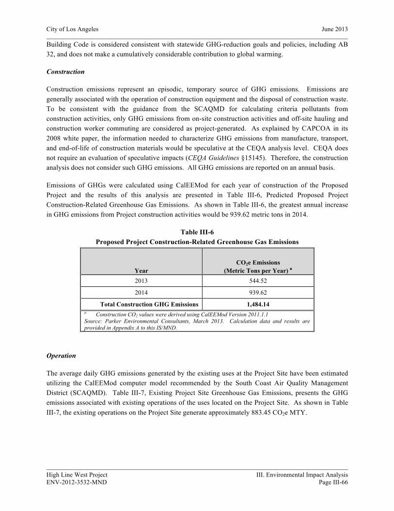
City of Los Angeles June 2013
High Line West Project III. Environmental Impact Analysis ENV-2012-3532-MND Page III-66
Building Code is considered consistent with statewide GHG-reduction goals and policies, including AB 32, and does not make a cumulatively considerable contribution to global warming.
Construction
Construction emissions represent an episodic, temporary source of GHG emissions. Emissions are generally associated with the operation of construction equipment and the disposal of construction waste. To be consistent with the guidance from the SCAQMD for calculating criteria pollutants from construction activities, only GHG emissions from on-site construction activities and off-site hauling and construction worker commuting are considered as project-generated. As explained by CAPCOA in its 2008 white paper, the information needed to characterize GHG emissions from manufacture, transport, and end-of-life of construction materials would be speculative at the CEQA analysis level. CEQA does not require an evaluation of speculative impacts (CEQA Guidelines §15145). Therefore, the construction analysis does not consider such GHG emissions. All GHG emissions are reported on an annual basis.
Emissions of GHGs were calculated using CalEEMod for each year of construction of the Proposed Project and the results of this analysis are presented in Table III-6, Predicted Proposed Project Construction-Related Greenhouse Gas Emissions. As shown in Table III-6, the greatest annual increase in GHG emissions from Project construction activities would be 939.62 metric tons in 2014.
Table III-6 Proposed Project Construction-Related Greenhouse Gas Emissions
Year CO2e Emissions
(Metric Tons per Year) a
2013 544.52
2014 939.62
Total Construction GHG Emissions 1,484.14 a Construction CO2 values were derived using CalEEMod Version 2011.1.1 Source: Parker Environmental Consultants, March 2013. Calculation data and results are provided in Appendix A to this IS/MND.
Operation
The average daily GHG emissions generated by the existing uses at the Project Site have been estimated utilizing the CalEEMod computer model recommended by the South Coast Air Quality Management District (SCAQMD). Table III-7, Existing Project Site Greenhouse Gas Emissions, presents the GHG emissions associated with existing operations of the uses located on the Project Site. As shown in Table III-7, the existing operations on the Project Site generate approximately 883.45 CO2e MTY.
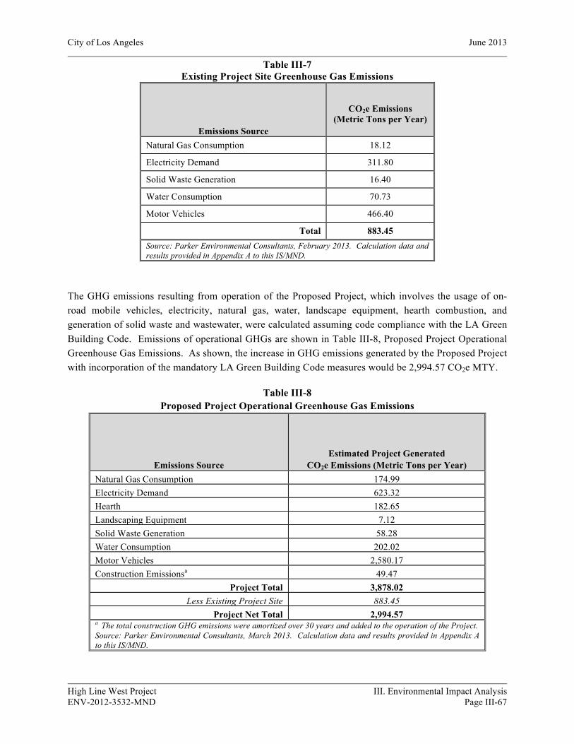
City of Los Angeles June 2013
High Line West Project III. Environmental Impact Analysis ENV-2012-3532-MND Page III-67
Table III-7 Existing Project Site Greenhouse Gas Emissions
Emissions Source
CO2e Emissions (Metric Tons per Year)
Natural Gas Consumption 18.12
Electricity Demand 311.80
Solid Waste Generation 16.40
Water Consumption 70.73
Motor Vehicles 466.40
Total 883.45 Source: Parker Environmental Consultants, February 2013. Calculation data and results provided in Appendix A to this IS/MND.
The GHG emissions resulting from operation of the Proposed Project, which involves the usage of on-road mobile vehicles, electricity, natural gas, water, landscape equipment, hearth combustion, and generation of solid waste and wastewater, were calculated assuming code compliance with the LA Green Building Code. Emissions of operational GHGs are shown in Table III-8, Proposed Project Operational Greenhouse Gas Emissions. As shown, the increase in GHG emissions generated by the Proposed Project with incorporation of the mandatory LA Green Building Code measures would be 2,994.57 CO2e MTY.
Table III-8 Proposed Project Operational Greenhouse Gas Emissions
Emissions Source Estimated Project Generated
CO2e Emissions (Metric Tons per Year) Natural Gas Consumption 174.99 Electricity Demand 623.32 Hearth 182.65 Landscaping Equipment 7.12 Solid Waste Generation 58.28 Water Consumption 202.02 Motor Vehicles 2,580.17 Construction Emissionsa 49.47
Project Total 3,878.02 Less Existing Project Site 883.45
Project Net Total 2,994.57 a The total construction GHG emissions were amortized over 30 years and added to the operation of the Project. Source: Parker Environmental Consultants, March 2013. Calculation data and results provided in Appendix A to this IS/MND.

City of Los Angeles June 2013
High Line West Project III. Environmental Impact Analysis ENV-2012-3532-MND Page III-68
As discussed previously in this Section, a project’s GHG emissions typically would be relatively very small in comparison to state or global GHG emissions and, consequently, they would, in isolation, have no significant direct impact on climate change. Rather, it is the increased accumulation of GHG from more than one project and many sources in the atmosphere that may result in global climate change, which can cause the adverse environmental effects previously discussed. Accordingly, the threshold of significance for GHG emissions determines whether a project’s contribution to global climate change is “cumulatively considerable.” Many regulatory agencies, including the SCAQMD, concur that GHG and climate change should be evaluated as a potentially significant cumulative impact, rather than a project direct impact. Accordingly, the GHG analysis presented in this Section analyzes whether the Project’s impact would be cumulatively considerable using a plan-based approach (and quantitative and qualitative analysis) to determine the Project’s contributing effect on global warming.
As noted above, there is substantial evidence to support that compliance with the LA Green Building Code is qualitatively consistent with statewide goals and policies in place for the reduction of greenhouse gas emissions, including AB 32 and the corresponding Scoping Plan. As discussed previously, the City adopted the LA Green Plan to provide a citywide plan for achieving the City’s GHG emissions targets, for both existing and future generation of greenhouse gas emissions. In order to further implement the LA Green Plan’s goal of improving energy conservation and efficiency, the Los Angeles City Council has adopted multiple ordinances and updates to establish the current Los Angeles Green Building Code applicable to new development projects. As it relates to new development, the City adopted the LA Green Building Code (Ordinance No. 181480), which incorporates applicable provisions of the CALGreen Code, and in some cases outlines more strict GHG reduction measures available to development projects in the City of Los Angeles. The LA Green Building Code requires projects to achieve a 20 percent reduction in potable water use and wastewater generation, meet and exceed Title 24 Standards adopted by the California Energy Commission on December 17, 2008, and meet 50 percent construction waste recycling levels. The Scoping Plan encourages communities to adopt building codes that go beyond the state code. Accordingly, as the LA Green Building Code meets and exceeds applicable provisions of the CALGreen Code, a new development Project that can demonstrate it complies with the LA Green Building Code is considered consistent with statewide GHG-reduction goals and policies, including AB 32.
Through required implementation of the LA Green Building Code, the Project would be consistent with local and statewide goals and policies aimed at reducing the generation of GHGs, including CARB’s AB 32 Scoping Plan aimed at achieving 1990 GHG emission levels by 2020. Therefore, the Project’s generation of GHG emissions would not be considered cumulatively considerable and impacts would be less than significant. To further reduce the Project’s GHG emissions, the Department fo City Planning recommends the following mitigation measures be implemented for the Project:
City of Los Angeles June 2013
High Line West Project III. Environmental Impact Analysis ENV-2012-3532-MND Page III-69
Mitigation Measures:
VII-10 Green House Gas Emissions
• Install a demand (tankless or instantaneous) water heater system, or high efficiency central boiler system, sufficient to serve the anticipated needs of the dwelling(s).
• Only low- and non-VOC-containing paints, sealants, adhesives, and solvents shall be utilized in the construction of the Project.
b) Would the project conflict with an applicable plan, policy or regulation adopted for the purpose of reducing the emissions of greenhouse gases?
Less Than Significant Impact. Although not specified in the LA CEQA Thresholds Guide, a significant impact would occur if the project would conflict with an applicable plan, policy or regulation adopted for the purpose of reducing the emissions of greenhouse gases.
As described in Question 7(a), through required implementation of the LA Green Building Code, the Project would be consistent with local and statewide goals and policies aimed at reducing the generation of GHGs, including CARB’s AB 32 Scoping Plan aimed at achieving 1990 GHG emission levels by 2020. Therefore, the Project’s generation of GHG emissions would not be considered cumulatively considerable and impacts would be less than significant.
Cumulative Impacts
Less Than Significant Impact. As discussed in greater detail above, the threshold of significance for GHG emissions determines whether a project’s contribution to global climate change is “cumulatively considerable.” Many regulatory agencies, including the SCAQMD, concur that GHG and climate change should be evaluated as a potentially significant cumulative impact, rather than a project direct impact. Accordingly, the GHG analysis presented in the Section above analyzes whether the Project’s impact would be cumulatively considerable using a plan-based approach (and quantitative and qualitative analysis) to determine the Project’s contributing effect on global warming. As described in Questions 7(a) and 7(b), the Project would be consistent with local and statewide goals and policies aimed at reducing the generation of GHGs, including CARB’s AB 32 Scoping Plan aimed at achieving 1990 GHG emission levels by 2020 and, as such, the Project’s generation of GHG emissions would not be considered cumulatively considerable. The Project’s cumulative impacts are therefore considered to be less than significant.
8. HAZARDS AND HAZARDOUS MATERIALS
The following section is a summary of the Phase I Environmental Site Assessments previously conducted for the Project Site. The Phase I Environmental Site Assessment, 5544 and 5552 West Hollywood Boulevard, Los Angeles, California 90028, was prepared by Winzler & Kelly Consulting Engineers, dated December 16, 2005. The Phase I Environmental Site Assessment, 5524 and 5542 Hollywood Boulevard, Hollywood, California, was prepared by Smith-Emery GeoServices, dated October 26, 2005. The Phase I Environmental Site Assessment Report, 5500-5520 and 5224 Hollywood Boulevard, and
City of Los Angeles June 2013
High Line West Project III. Environmental Impact Analysis ENV-2012-3532-MND Page III-70
1671 North Western Avenue, Los Angeles, CA, was prepared by Salem Engineering Group, Inc., dated August 26, 2003. Collectively, these reports will be referred to as the Phase I Environmental Site Assessment (“Phase I ESA”) and are available on file with the Department of City Planning.
a) Would the project create a significant hazard to the public or the environment through the routine transport, use, or disposal of hazardous materials?
Potentially Significant Impact Unless Mitigation Incorporated. A significant impact may occur if the proposed project would involve the use or disposal of hazardous materials as part of its routine operations, or would have the potential to generate toxic or otherwise hazardous emissions that could adversely affect sensitive receptors. Site reconnaissance was performed as part of the Phase I ESA, with the results analyzed below.
Polychlorinated Biphenyls (PCBs)
Transformers, elevators, hydraulic lifts, and fluorescent lighting ballasts are potential sources of PCB containing insulating fluids, which are subject to regulation by the U.S. EPA. No transformers, elevators, or hydraulic lifts were observed at the project site. Fluorescent lighting ballasts were observed throughout the buildings on the project site. It was concluded that the fluorescent lighting ballasts are unlikely to represent an environmental concern to the site and, recommends no further investigation. In addition, one pole-mounted transformer was observed along the southern border of the project site and one pad-mounted transformer was observed adjacent to the south of the 5500-5520 building on the Project Site. These transformers displayed no evidence of leakage, and the ground surface below the transformers displayed no evidence of discoloration. According to Los Angeles Department of Water and Power (LADWP), the owner of the transformers, the transformers do not contain PCB fluids. Provided the removal and disposal of PCBs from the Project Site follows the guidelines described in Mitigation Measure VIII-10, below, hazardous materials impacts relative to exposure to PCBs would be less than significant.
Asbestos Containing Materials (ACMs)
The existing buildings on the project site were constructed between 1914 and 1984. As at least some of the existing buildings were built prior to the ban on the use of asbestos as building insulation, there is the potential that demolition of these buildings could release asbestos-containing materials present in the structures. Exposure to workers to ACMs during demolition activities would be a significant impact. Prior to the demolition activities, a complete asbestos survey will be conducted to identify all sources of asbestos. This activity is required by the U.S. EPA National Emission Standard for Hazardous Air Pollutants (NESHAP) regulation and the South Coast Air Quality Management District’s (SCAQMD’s) Rule 1403. Bulk samples of all materials that are suspected of containing asbestos will be collected and analyzed for asbestos content. Asbestos removal is stringently controlled by Federal Regulations and SCAQMD Rule 1403. Removal of asbestos in a building is not unusual and can be readily accomplished. In accordance with the EPA’s NESHAP regulation and SCAQMD’s Rule 1403, all materials that are identified as ACMs would be removed by a trained and licensed asbestos abatement contractor. The asbestos removal operations would be conducted in accordance with CAL-OSHA Asbestos for the
City of Los Angeles June 2013
High Line West Project III. Environmental Impact Analysis ENV-2012-3532-MND Page III-71
Construction Industry Standard, SCAQMD and EPA rules and regulations and industry standards. The contractor selected for the removal process would be chosen based on experience, reputation, and relationship with local agencies such as SCAQMD and OSHA regional offices. Generally, asbestos removal operations are low risk. When following asbestos-related regulations, the possibility of exposure to airborne asbestos fibers from asbestos removal projects is limited. The SCAQMD has very specific regulations for asbestos emissions. Provided the removal and disposal of ACMs from the Project Site follows the various required guidelines described above and in Mitigation Measure VIII-10, below, hazardous materials impacts relative to exposure to asbestos would be less than significant.
Lead Based Paint (LBP)
Due to the age of the existing on-site structures, lead-based paint may be present on site. Exposure to workers to lead-based paint during demolition of the existing structures would be a significant impact. A qualified lead-paint abatement consultant would be required to comply with applicable state and federal rules and regulations governing lead paint abatement. Such regulations that would be followed during demolition include Construction Safety Orders 1532.1 (pertaining to lead) from Title 8 of the California Code of Regulations, and lead exposure guidelines provided by the U.S. Department of Housing and Urban Development (HUD). Provided that abatement rules and regulations are followed as described in Mitigation Measure VIII-10, below, hazardous materials impacts caused by exposure to lead-based paint would be less than significant.
Radon
Radon is a radioactive gas that is found in certain geologic environments and is formed by the natural breakdown of radium, which is found in the earth’s crust. The State of California Department of Health Services (DHS) conducted a statewide radon survey during 1990-1991 which entailed testing of radon in homes in designated geographic areas. Radon detection devices were placed in homes through the study region to determine geographic regions with elevated radon concentrations. The U.S. EPA has set the action level for radon gas in homes to be 4 pico Curies per liter (pCi/l). According to the DHS radon survey, radon concentrations in residences in the geographical region of the Project Site average below 4 pCi/l. Therefore, upon development of the Proposed Project, radon is not anticipated to adversely impact the Project Site.
Hazardous Materials, Hazardous Waste and Petroleum Products
Small amounts of household cleaning materials were stored in the break room of the 5544 W. Hollywood Boulevard building. The building referred to as “storage” contained numerous closed (4-gallon) containers of carpet and floor tile mastics and adhesives. Also stored in this building were several propane tanks for use on the forklift. There was a containerized storage building that also contained carpets and several 4-gallon containers of mastic. All containers had labels on them. Besides the above-mentioned containers, no other hazardous substances or petroleum products were observed in or on the Project Site at the time of the site visit. These containers should be properly removed and disposed of prior to structural demolition. Provided these containers are properly removed and disposed of, hazardous materials impacts relative to exposure to hazardous wastes would be less than significant.

City of Los Angeles June 2013
High Line West Project III. Environmental Impact Analysis ENV-2012-3532-MND Page III-72
Mitigation Measures:
VIII-10 Explosion/Release (Existing Toxic/Hazardous Construction Materials)
• (Asbestos) Prior to the issuance of any permit for the demolition or alteration of the existing structure(s), the applicant shall provide a letter to the Department of Building and Safety from a qualified asbestos abatement consultant indicating that no Asbestos-Containing Materials (ACM) are present in the building. If ACMs are found to be present, it will need to be abated in compliance with the South Coast Air Quality Management District's Rule 1403 as well as all other applicable State and Federal rules and regulations.
• (Lead Paint) Prior to issuance of any permit for the demolition or alteration of the existing structure(s), a lead-based paint survey shall be performed in accordance with LADBS standards and to the written satisfaction of the Department of Building and Safety. Should lead-based paint materials be identified, standard handling and disposal practices shall be implemented pursuant to OSHA regulations.
• (Polychlorinated Biphenyl – Commercial and Industrial Buildings) Prior to issuance of a demolition permit, a polychlorinated biphenyl (“PCB”) abatement contractor shall conduct a survey of the project site to identify and assist with compliance with applicable state and federal rules and regulation governing PCB removal and disposal.
b) Would the project create significant hazard to the public or the environment through reasonably foreseeable upset and accidental conditions involving the release of hazardous materials into the environment?
Less Than Significant Impact. A significant impact may occur if a project utilizes quantities of hazardous materials as part of its routine operations and could potentially pose a hazard to nearby sensitive receptors under accident or upset conditions. The proposed project is not anticipated to result in a substantial release of hazardous materials into the environment. In addition, the project site does not contain any oil or gas wells and is not located in a City-designated Methane Zone.19 The project would utilize limited quantities of common cleaning and maintenance materials, which would be shipped, stored, used, and disposed of in accordance with applicable statutes. All land uses and materials would be in accordance with City zoning, and local, state, and federal regulations. Based on the amount stored, nature of packaging, materials involved, and the proposed project’s required compliance with applicable regulations, the risk from the use of these materials is considered to be low. Therefore, accidental conditions involving the release of hazardous materials into the environment during project operation is considered to be less than significant.
19 City of Los Angeles Department of City Planning, Parcel Profile Report for 5550 West Hollywood Boulevard, Los Angeles, California, website: www.zimas.lacity.org, February 6, 2013.

City of Los Angeles June 2013
High Line West Project III. Environmental Impact Analysis ENV-2012-3532-MND Page III-73
c) Would the project emit hazardous emissions or handle hazardous or acutely hazardous materials, substances, or waste within one-quarter mile of an existing or proposed school?
Less Than Significant Impact. A project-related significant adverse effect may occur if the Project Site is located within one-quarter mile of an existing or proposed school site, and is projected to release toxic emissions which would pose a health hazard beyond regulatory thresholds. The nearest school to the project site is Grant Elementary School, which is located approximately one-quarter mile southwest of the Project Site. However, as discussed in Question 7(a), the potentially existing hazardous materials located at the Project Site would be removed in accordance with applicable regulatory requirements prior to construction of the project. When completed, the Proposed Project would use, at most, minimal amounts of hazardous materials for routine cleaning and maintenance and, therefore, would not pose any substantial potential for accident conditions involving the release of hazardous materials.
d) Would the project be located on a site which is included on a list of hazardous materials sites compiled pursuant to Government Code Section 65962.5 and, as a result, would it create a significant hazard to the public or the environment?
No Impact. California Government Code Section 65962.5 requires various State agencies to compile lists of hazardous waste disposal facilities, unauthorized releases from underground storage tanks, contaminated drinking water wells and solid waste facilities where there is known migration of hazardous waste and submit such information to the Secretary for Environmental Protection on at least an annual basis. A significant impact may occur if a project site is included on any of the above lists and poses an environmental hazard to surrounding sensitive uses.
A review of the most current databases and files from federal, State, and local environmental regulatory agencies was conducted to identify use, generation, storage, treatment, or disposal of hazardous materials and chemicals, or release incidents of such materials, which may impact the proposed project. The Phase I ESA included a database search of hazardous materials sites that are listed pursuant to Government Code Section 65962.5. Concluded therein, the project site is not included on any of the applicable lists. The database review also indicates that there are no properties immediately adjoining the project site that are listed as being identified or under investigation by a state or federal environmental regulatory agency, or to have been a facility involved in generating, treating, or disposing of hazardous wastes onsite. However, there are 13 neighboring properties that were identified in the database search; however only eight are located cross-gradient to the Project Site. Additionally, all sites are at least an eighth of a mile from the project site and none of these are recognized environmental conditions (RECs) as defined under the American Society for Testing and Materials (ASTM) standards. Therefore, as the project site is not included in any hazards list and would not be impacted by any adjacent hazardous sites, no impact would occur.
e) For a project located within an airport land use plan or, where such a plan has not been adopted, within two miles of a public airport or public use airport, would the project result in a safety hazard for people residing or working in the project area?

City of Los Angeles June 2013
High Line West Project III. Environmental Impact Analysis ENV-2012-3532-MND Page III-74
No Impact. A significant project-related impact may occur if the proposed project were placed within a public airport land use plan area or within two miles of a public airport, and subject to a safety hazard. The nearest airport to the project site is the Bob Hope Burbank Airport, located approximately eight miles to the north. The Santa Monica Airport is located approximately 10 miles to the southwest of the project site. The project site is not located within the boundaries of an airport land use plan and would not result in a safety hazard for people residing or working in the project area. Therefore, no impact would occur.
f) For a project within the vicinity of a private airstrip, would the project result in a safety hazard for people residing or working in the project area?
No Impact. This question would apply to the proposed project only if it were in the vicinity of a private airstrip and would subject area residents and workers to a safety hazard. The proposed project is not located in the vicinity of a private airstrip. Therefore, no impact would occur.
g) Would the project impair implementation of or physically interfere with an adopted emergency response plan or emergency evacuation plan?
No Impact. A significant impact may occur if the project were to interfere with roadway operations used in conjunction with an emergency response plan or emergency evacuation plan, or would generate sufficient traffic to create traffic congestion that would interfere with the execution of such a plan. The proposed project is not located on or near an adopted emergency response or evacuation plan.20 Development of the project site may require temporary and/or partial street closures due to construction activities. Nonetheless, while such closures may cause temporary inconvenience, they would not be expected to substantially interfere with emergency response or evacuation plans. The Proposed Project would not cause permanent alterations to vehicular circulation routes and patterns impede public access or travel upon public rights-of-way. Therefore, the Proposed Project would not be expected to interfere with any adopted emergency response plan or emergency evacuation plan, and no project would occur.
h) Would the project expose people or structures to a significant risk of loss, injury or death involving wildland fires, including where wildlands are adjacent to urbanized areas or where
No Impact. A significant impact may occur if the project is located in proximity to wildland areas and poses a potential fire hazard, which could affect persons or structures in the area in the event of a fire. The project site is located in a dense urban area of the City of Los Angeles that does not include wildlands or high fire hazard terrain or vegetation and, therefore, is not subject to hazards from wildland fires.21 Consequently, no impact would occur.
20 Los Angeles City Planning Department, Environmental and Public Facilities Map: Critical Facilities & Lifeline Systems, September 1, 1996.
21 Los Angeles City Planning Department, Environmental and Public Facilities Maps: Brushfire Hazard Areas and Wildfire Hazard Areas, 1996.

City of Los Angeles June 2013
High Line West Project III. Environmental Impact Analysis ENV-2012-3532-MND Page III-75
Cumulative Impacts
Less Than Significant Impact. Development of the proposed project in combination with the related projects would have the potential to increase the use, storage, transport, and/or release of hazardous materials into the environment. As discussed above, the proposed project’s potential impacts associated with hazardous materials would be less than significant. With respect to the presence of hazardous substances associated with the related projects, each related project would be evaluated for potential threats to public safety. This would occur for each individual project affected, in conjunction with development proposals on these properties. Furthermore, local municipalities are required to follow local, State and federal laws regarding hazardous materials. Therefore, assuming compliance with local, State and federal laws pertaining to hazardous materials, cumulative impacts would not be cumulatively considerable and would be less than significant.
9. HYDROLOGY AND WATER QUALITY
a) Would the project violate any water quality standards or waste discharge requirements?
Potentially Significant Impact Unless Mitigation Incorporated. Based upon the criteria established in the LA CEQA Thresholds Guide, a project would normally have a significant impact on surface water quality if discharges associated with the project would create pollution, contamination, or nuisance as defined in Section 13050 of the California Water Code (CWC) or that cause regulatory standards to be violated, as defined in the applicable National Pollution Discharge Elimination System (NPDES) stormwater permit or Water Quality Control Plan for the receiving water body. For the purpose of this specific issue, a significant impact may occur if the project would discharge water which does not meet the quality standards of agencies which regulate surface water quality and water discharge into stormwater drainage systems. Significant impacts would also occur if the project does not comply with all applicable regulations with regard to surface water quality as governed by the State Water Resources Control Board (SWRCB). These regulations include compliance with the Standard Urban Storm Water Mitigation Plan (SUSMP) requirements to reduce potential water quality impacts.
Construction
Three general sources of potential short-term, construction-related stormwater pollution associated with the Proposed Project include: 1) the handling, storage, and disposal of construction materials containing pollutants; 2) the maintenance and operation of construction equipment; and 3) earth moving activities which, when not controlled, may generate soil erosion via storm runoff or mechanical equipment. As required under the National Pollution Discharge Elimination System (NPDES), the Project Applicant is responsible for preparing a Storm Water Pollution Prevention Plan (SWPPP) to mitigate the effects of erosion and the inherent potential for sedimentation and other pollutants entering the stormwater system. The primary objectives of the NPDES storm water program requirements are to: 1) effectively prohibit non-storm water discharges, and 2) reduce the discharge of pollutants from storm water conveyance systems to the Maximum Extent Practicable (“MEP” statutory standard). The SWPPP would incorporate the required implementation of Best Management Practices (BMPs) for erosion control and other measures to meet the NPDES requirements for storm water quality. Implementation of the BMPs

City of Los Angeles June 2013
High Line West Project III. Environmental Impact Analysis ENV-2012-3532-MND Page III-76
identified in the SWPPP and compliance with the NPDES and City discharge requirements would ensure that the construction of the Proposed Project would not violate any water quality standards or discharge requirements, or otherwise substantially degrade water quality. Furthermore, the implementation of the following mitigation measures would ensure that the Proposed Project’s construction-related water quality impacts would be less than significant.
Mitigation Measures:
IX-20 Stormwater Pollution (Demolition, Grading, and Construction Activities)
• Sediment carries with it other work-site pollutants such as pesticides, cleaning solvents, cement wash, asphalt, and car fluids that are toxic to sea life.
• Leaks, drips and spills shall be cleaned up immediately to prevent contaminated soil on paved surfaces that can be washed away into the storm drains.
• All vehicle/equipment maintenance, repair, and washing shall be conducted away from storm drains. All major repairs shall be conducted off-site. Drip pans or drop clothes shall be used to catch drips and spills.
• Pavement shall not be hosed down at material spills. Dry cleanup methods shall be used whenever possible.
• Dumpsters shall be covered and maintained. Uncovered dumpsters shall be placed under a roof or be covered with tarps or plastic sheeting.
Operation
Similar to the existing uses on the Project Site, the Proposed Project would continue to generate surface water runoff. The Project Site is completely covered with impervious surfaces. As such, 100 percent of the surface water runoff from the Project Site is directed to adjacent storm drains and does not percolate into the groundwater table beneath the Site. Potential impacts to surface water runoff would be mitigated to a level of insignificance by incorporating stormwater pollution control measures. The Proposed Project will be required to demonstrate compliance with Low Impact Development Ordinance standards and retain or treat the first ¾ inch of rainfall in a 24-hour period. Compliance with this measure would reduce the amount of surface water runoff leaving the Project Site as compared to the current conditions. City of Los Angeles Ordinance No. 172,176 and Ordinance No. 173,494 specify Stormwater and Urban Runoff Pollution Control which require the application of Best Management Practices (BMPs). Chapter IX, Division 70 of the LAMC addresses grading, excavations, and fills. The Proposed Project would also comply with water quality standards and wastewater discharge requirements set forth by the Standard Urban Stormwater Mitigation Plan (SUSMP) for Los Angeles County and Cities in Los Angeles County and approved by the Los Angeles Regional Water Quality Control Board (LARWQCB). Full compliance with the SUSMP and implementation of design-related BMPs would ensure that the operation of the Proposed Project would not violate any water quality standards or discharge requirements or otherwise substantially degrade water quality. Therefore, operational water quality impacts would be less than significant.

City of Los Angeles June 2013
High Line West Project III. Environmental Impact Analysis ENV-2012-3532-MND Page III-77
b) Would the project substantially deplete groundwater supplies or interfere substantially with groundwater recharge such that there would be a net deficit in aquifer volume or a lowering of the local groundwater table level (e.g., the production rate of pre-existing nearby wells would drop to a level which would not support existing land uses or planned uses for which permits have been granted)?
No Impact. Based upon the criteria established in the LA CEQA Thresholds Guide, a project would normally have a significant impact on groundwater level if it would change potable water levels sufficiently to: (a) reduce the ability of a water utility to use the groundwater basin for public water supplies, conjunctive use purposes, storage of imported water, summer/winter peaking, or respond to emergencies and drought; (b) reduce yields of adjacent wells or well fields (public or private); (c) adversely change the rate or direction of flow of groundwater; or (d) result in demonstrable and sustained reduction in groundwater recharge capacity. The Project Site is 100 percent impervious. As such, 100 percent of the surface water runoff from the Project Site is directed to adjacent storm drains and does not percolate into the groundwater table beneath the Site. Based on the findings of the Geotechnical Investigation for Proposed Development at Hollywood & Western (5550 Hollywood Boulevard) Los Angeles, CA (5550 Hollywood Boulevard) prepared by GeoPentec, dated January 7, 2013, the depth to water was measured during drilling at about 69 and 75 feet bgs in GP-1 and GP-2, respectively and was again measured in GP-2 at about 68 feet bgs on the day following drilling. Relatively shallower groundwater levels were encountered in Geotechnologies borings B-2 and B-13 at depths of 58 and 59 feet, respectively. Review of the CDMG Seismic Hazard Map for the Hollywood Quadrangle indicates that groundwater is anticipated to be at a depth greater than 80 feet bgs. The Proposed Project would excavate soils beneath the site to a depth of approximately 11 feet below grade and would not impact the groundwater table. No dewatering activities would be required. Thus, construction of the Proposed Project would not deplete groundwater supplies or interfere substantially with groundwater recharge and no impact would occur.
c) Would the project substantially alter the existing drainage pattern of the site or area, including through the alteration of the course of a stream or river, in a manner, which would result in substantial erosion or siltation on- or off-site?
Less Than Significant Impact. Based upon the criteria established in the LA CEQA Thresholds Guide, a project would normally have a significant impact on surface water hydrology if it would result in a permanent, adverse change to the movement of surface water sufficient to produce a substantial change in the current or direction of water flow. The Project Site is located in a highly urbanized area of Los Angeles, and no streams or river courses are located on or within the Project vicinity. The Project Site is 100 percent impervious. Implementation of the Proposed Project would not increase site runoff or result any changes in the local drainage patterns. Implementation of the SWPPP, however, would reduce the amount of surface water runoff after storm events, as the Proposed Project would be required to implement stormwater BMPs to retain or treat the runoff from a storm event producing ¾ inch of rainfall in a 24-hour period. Therefore, no impacts would occur to surface water hydrology or result in substantial erosion or siltation on- or off-site.
City of Los Angeles June 2013
High Line West Project III. Environmental Impact Analysis ENV-2012-3532-MND Page III-78
d) Would the project substantially alter the existing drainage pattern of the site or area, including through the alteration of the course of a stream or river, or substantially increase the rate or amount of surface runoff in a manner which would result in flooding on- or off-site?
No Impact. Based upon the criteria established in the LA CEQA Thresholds Guide, a project would normally have a significant impact on surface water hydrology if it would result in a permanent, adverse change to the movement of surface water sufficient to produce a substantial change in the current or direction of water flow. The Proposed Project would not result in a significant increase in site runoff, or any changes in the local drainage patterns. Therefore, as the Proposed Project would not substantially increase the rate or amount of surface runoff in a manner which would result in flooding on- or off-site, no impact would occur.
e) Would the project create or contribute runoff water which would exceed the capacity of existing or planned stormwater drainage systems or provide substantial additional sources of
Less Than Significant Impact. Based upon the criteria established in the LA CEQA Thresholds Guide, a project would normally have a significant impact on surface water quality if discharges associated with the project would create pollution, contamination, or nuisance as defined in Section 13050 of the California Water Code (CWC) or that cause regulatory standards to be violated, as defined in the applicable National Pollution Discharge Elimination System (NPDES) stormwater permit or Water Quality Control Plan for the receiving water body. For the purpose of this specific issue, a significant impact may occur if the volume of storm water runoff from the Project Site were to increase to a level which exceeds the capacity of the storm drain system serving the Project Site. A Project-related significant adverse effect would also occur if the Proposed Project would substantially increase the probability that polluted runoff would reach the storm drain system.
Several existing relatively large sized storm drain trunk lines that are located adjacent to the site, which are owned and maintained by City of Los Angeles. The Site is currently 100% impervious and all surface water is directed off site to the adjacent storm drain system. The Proposed Project would not result in a significant increase in site runoff, or any changes in the local drainage patterns. Runoff from the Project Site currently is and would continue to be collected on the site and directed towards existing storm drains in the Project vicinity that have adequate capacity. Pursuant to local practice and City policy storm water retention will be required as part of the Low Impact Development (LID) Ordinance and BMP implementation features (despite no increased imperviousness of the site). Any contaminants gathered during routine cleaning of construction equipment would be disposed of in compliance with applicable stormwater pollution prevention permits. Accordingly, the Proposed Project will be required to demonstrate compliance with LID standards and retain or treat the first ¾ inch of rainfall in a 24-hour period, which will reduce the Proposed Project’s impact to the stormwater infrastructure. Therefore, Proposed Project would not create or contribute runoff water which would exceed the capacity of existing or planned stormwater drainage systems or provide substantial additional sources of polluted runoff and potential impacts to surface water quality would be less than significant.
City of Los Angeles June 2013
High Line West Project III. Environmental Impact Analysis ENV-2012-3532-MND Page III-79
f) Would the project otherwise substantially degrade water quality?
No Impact. Although not specified in the LA CEQA Thresholds Guide, a significant impact may occur if a project includes potential sources of water pollutants that would have the potential to substantially degrade water quality. The Proposed Project does not include potential sources of contaminants, which could potentially degrade water quality and would comply with all federal, state and local regulations governing stormwater discharge. Therefore, no impact would occur.
g) Would the project place housing within a 100-year flood hazard area as mapped on a federal Flood Hazard Boundary or Flood Insurance Rate Map or other flood hazard delineation map?
No Impact. A significant impact would occur if the Proposed Project were to place housing within a 100-year flood hazard area. A 100-year flood is defined as a flood which results from a severe rainstorm with a probability of occurring approximately once every 100 years. According to the Federal Emergency Management Agency (FEMA) flood insurance rate map for the Project Area, the site is not located within a designated flood zone.22 Therefore, the Proposed Project would not place housing within a 100-year flood hazard area and no impact would occur.
h) Would the project place within a 100-year flood hazard area structures which would impede or redirect flood flows?
No Impact. Although not specified in the LA CEQA Thresholds Guide, a significant impact may occur if the Project was located within a 100-year flood zone, which would impede or redirect flood flows. As stated above, the Project Site is not in an area designated as a 100-year flood hazard area. The Project Site is located in a highly urbanized area and, as no changes to the local drainage pattern would occur with implementation of the Proposed Project, the Proposed Project would not have the potential to impede or redirect floodwater flows. No impact would occur.
i) Would the project expose people or structures to a significant risk of loss, injury or death involving flooding, including flooding as a result of the failure of a levee or dam?
No Impact. Although not specified in the LA CEQA Thresholds Guide, a significant impact may occur if the Proposed Project exposes people or structures to a significant risk of loss or death caused by the failure of a levee or dam, including but not limited to a seismically-induced seiche. Based on the lack of large enclosed water bodies nearby, seiches and tsunami risks are considered nil. Thus, the Proposed Project would not expose people or structures to a significant risk of loss, injury or death involving flooding, including flooding as a result of the failure of a levee or dam and no impact would occur.
22 Federal Emergency Management Agency website: https://hazards.fema.gov/femaportal/wps/portal/, accessed December 2012.
City of Los Angeles June 2013
High Line West Project III. Environmental Impact Analysis ENV-2012-3532-MND Page III-80
j) Would the project expose people or structures to a significant risk of loss, injury or death involving inundation by seiche, tsunami, or mudflow?
No Impact. Although not specified in the LA CEQA Thresholds Guide, a significant impact may occur if the Project Site is sufficiently close to the ocean or other water body to be potentially at risk of the effects of seismically-induced tidal phenomena (i.e., seiche and tsunami), or if the Project Site is located adjacent to a hillside area with soil characteristics that would indicate potential susceptibility to mudslides or mudflows. The Proposed Project site is not located in a potential seiche or tsunami zone. With respect to the potential impact from a mudflow, the Project Site is relatively flat and is surrounded by urban development; therefore, it does not contain any sources of mudflow. There are no major hills or steep slopes in the Project vicinity. Therefore, no impact would occur.
Cumulative Impacts
Less Than Significant Impact. Development of the Proposed Project in combination with the related projects identified in Table II-4 would result in the further infilling of uses in the Hollywood area. As discussed above, the Project Site and the surrounding areas are adequately served by the existing City storm drain system. Runoff from the Project Site and adjacent urban uses is typically directed into the adjacent streets, where it flows to the nearest drainage improvements. Little if any additional cumulative runoff is expected from the Project Site and the related Project Sites, since this part of the City is already fully developed with impervious surfaces. Under the requirements of the Low Impact Development Ordinance, each related project will be required to implement stormwater BMPs to retain or treat the runoff from a storm event producing ¾ inch of rainfall in a 24-hour period. Mandatory structural BMPs in accordance with the NPDES water quality program will therefore result in a cumulative reduction to surface water runoff, as the development in the surrounding area is limited to infill developments and redevelopment of existing urbanized areas. Therefore, the Proposed Project would not make a cumulatively considerable contribution to impacting the volume or quality of surface water runoff, and cumulative impacts to the existing or planned stormwater drainage systems would be less than significant. Therefore, cumulative water quality impacts would be less than significant.
10. LAND USE AND PLANNING
a) Would the project physically divide an established community?
No Impact. A significant impact may occur if the Proposed Project would be sufficiently large enough or otherwise configured in such a way as to create a physical barrier within an established community. According to the LA CEQA Thresholds Guide, the determination of significance shall be made on a case-by-case basis considering the following factors: (a) the extent of the area that would be impacted, the nature and degree of impacts, and the types of land uses within that area; (b) the extent to which existing neighborhoods, communities, or land uses would be disrupted, divided or isolated, and the duration of the disruptions; and (c) the number, degree, and type of secondary impacts to surrounding land uses that could result from implementation of the Proposed Project.
City of Los Angeles June 2013
High Line West Project III. Environmental Impact Analysis ENV-2012-3532-MND Page III-81
The Proposed Project Site is an infill development site located within an urbanized area of the Hollywood Community Plan Area. The proposed land uses are consistent with the existing zoning and general plan designations and existing physical arrangement of the neighboring properties within the vicinity of the site. No separation of uses or disruption of access between land use types would occur as a result of the Proposed Project. Accordingly, implementation of the Proposed Project would not disrupt or divide the physical arrangement of the established community, and no impact would occur.
b) Would the project conflict with any applicable land use plan, policy, or regulation of an agency with jurisdiction over the project (including, but not limited to the general plan, specific plan, local coastal program, or zoning ordinance) adopted for the purpose of avoiding or mitigating an environmental effect?
Less Than Significant Impact. A significant impact may occur if a project is inconsistent with the General Plan or zoning designations currently applicable to the Project Site, and would cause adverse environmental effects, which the General Plan and zoning ordinance are designed to avoid or mitigate.
The Project Site is located within the jurisdiction of the City of Los Angeles, and is therefore subject to the designations and regulations of several local and regional land use and zoning plans. At the regional level, the Project Site is located within the planning area of the Southern California Association of Governments (SCAG), the Southern California region’s federally-designated metropolitan planning organization. The Proposed Project is also located within the South Coast Air Basin and, therefore, is within the jurisdiction of the South Coast Air Quality Management District (SCAQMD).
At the local level, development of the Project Site is guided by the General Plan of the City of Los Angeles, the Hollywood Community Plan, the Vermont/Western Transit Oriented District Specific Plan/Station Neighborhood Area Plan (SNAP), the Hollywood Redevelopment Plan (Redevelopment Plan), and the LAMC, which are intended to guide local land use decisions and development patterns.
The following analysis addresses the Proposed Project’s consistency with applicable plans and policies associated with the relevant planning agencies and documents identified above.
Consistency with SCAG Policies
The Proposed Project would result in a net increase of 280 dwelling units and, as such, does not meet the criteria to be classified as a project of statewide, regional, or area-wide significance as defined in CEQA Guidelines Section 15206. Therefore, a consistency analysis with respect to SCAG’s regional goals and policies as contained in the RCPG, RCP, and RTP is not warranted. The Project Site is, however, located within a designated Compass 2% Strategy Area and is subject to the policies of the Compass 2% Strategy. The Proposed Project’s consistency with these policies is evaluated below in Table III-9, Compass 2% Strategy Consistency Analysis. As discussed in Table III-9, development of the Proposed Project would be consistent with the policies of the Compass 2% Strategy as the Proposed Project would: (1) redevelop an infill development site located within an urban center; and (2) increase the density of affordable housing in close proximity to the MTA Metro Rail Red Line station. Land use consistency impacts with respect to SCAG polices would, therefore, be less than significant and no mitigation is required.
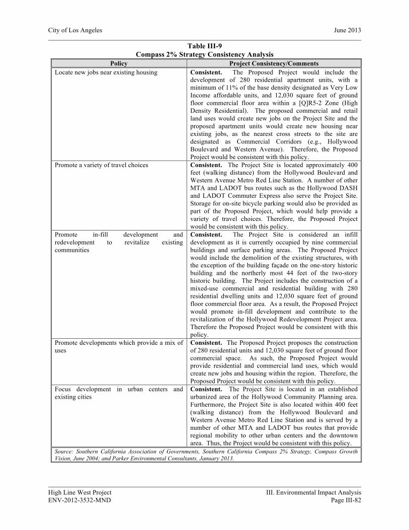
City of Los Angeles June 2013
High Line West Project III. Environmental Impact Analysis ENV-2012-3532-MND Page III-82
Table III-9 Compass 2% Strategy Consistency Analysis
Policy Project Consistency/Comments Locate new jobs near existing housing Consistent. The Proposed Project would include the
development of 280 residential apartment units, with a minimum of 11% of the base density designated as Very Low Income affordable units, and 12,030 square feet of ground floor commercial floor area within a [Q]R5-2 Zone (High Density Residential). The proposed commercial and retail land uses would create new jobs on the Project Site and the proposed apartment units would create new housing near existing jobs, as the nearest cross streets to the site are designated as Commercial Corridors (e.g., Hollywood Boulevard and Western Avenue). Therefore, the Proposed Project would be consistent with this policy.
Promote a variety of travel choices Consistent. The Project Site is located approximately 400 feet (walking distance) from the Hollywood Boulevard and Western Avenue Metro Red Line Station. A number of other MTA and LADOT bus routes such as the Hollywood DASH and LADOT Commuter Express also serve the Project Site. Storage for on-site bicycle parking would also be provided as part of the Proposed Project, which would help provide a variety of travel choices. Therefore, the Proposed Project would be consistent with this policy.
Promote in-fill development and redevelopment to revitalize existing communities
Consistent. The Project Site is considered an infill development as it is currently occupied by nine commercial buildings and surface parking areas. The Proposed Project would include the demolition of the existing structures, with the exception of the building façade on the one-story historic building and the northerly most 44 feet of the two-story historic building. The Project includes the construction of a mixed-use commercial and residential building with 280 residential dwelling units and 12,030 square feet of ground floor commercial floor area. As a result, the Proposed Project would promote in-fill development and contribute to the revitalization of the Hollywood Redevelopment Project area. Therefore the Proposed Project would be consistent with this policy.
Promote developments which provide a mix of uses
Consistent. The Proposed Project proposes the construction of 280 residential units and 12,030 square feet of ground floor commercial space. As such, the Proposed Project would provide residential and commercial land uses, which would create new jobs and housing within the region. Therefore, the Proposed Project would be consistent with this policy.
Focus development in urban centers and existing cities
Consistent. The Project Site is located in an established urbanized area of the Hollywood Community Planning area. Furthermore, the Project Site is also located within 400 feet (walking distance) from the Hollywood Boulevard and Western Avenue Metro Red Line Station and is served by a number of other MTA and LADOT bus routes that provide regional mobility to other urban centers and the downtown area. Thus, the Project would be consistent with this policy.
Source: Southern California Association of Governments, Southern California Compass 2% Strategy, Compass Growth Vision, June 2004; and Parker Environmental Consultants, January 2013.

City of Los Angeles June 2013
High Line West Project III. Environmental Impact Analysis ENV-2012-3532-MND Page III-83
City of Los Angeles Housing Element
The Proposed Project would involve the development of 280 multi-family dwelling units. The Project Site is appropriately zoned for multi-family housing and is consistent with adjacent High Density Residential land uses. Additionally, the Proposed Project will provide 11% of its residential units for Very Low Income tenants, thereby achieving a Density Bonus of 35%. The net gain of 280 housing units would be consistent with the City’s target goals for increasing the stock of housing units, including affordable housing, throughout the City.
Through the implementation of the policies and programs set forth in the 2006-2014 Housing Element, the City’s RHNA goal is to provide 112,876 new units by 2014. Table III-10, below, quantifies the units anticipated to be built through implementation of all of the programs by income and by type of program. As shown in Table III-10, SCAG’s State-approved 2007 RHNA assigns 112,876 units of housing production need to the City for the 2006-2014 Housing Element (which actually covers a 7.5-year planning period), or an annual average of about 15,000 new dwelling units per year. The Proposed Project would result in a net increase of 280 housing units as compared to the existing conditions. 31 of the 280 dwelling units (or 11%) will be classified as Very Low Income affordable housing units. While relatively small in comparison to the City-wide housing targets, the Project would assist the City in reaching its RHNA goal, specifically with respect to increasing affordable housing. As such, impacts associated with the Proposed Project’s consistency with the Housing Element would be less than significant.
Table III-10 Summary of the 2006-2014 Housing Element Update Targets Quantified Objectives: New Construction (RHNA Allocation)
Income Level New Construction Units – RHNA Allocation --
Extremely Low-Income 4,344
Very Low-Income 8,576
Low-Income 8,582
Moderate-Income 4,4415
Above Moderate Income 86,961
Total 112,876
Source: City of Los Angeles Housing Element of the General Plan 2006-2014, adopted January 14, 2009 (Table ES.1a.).
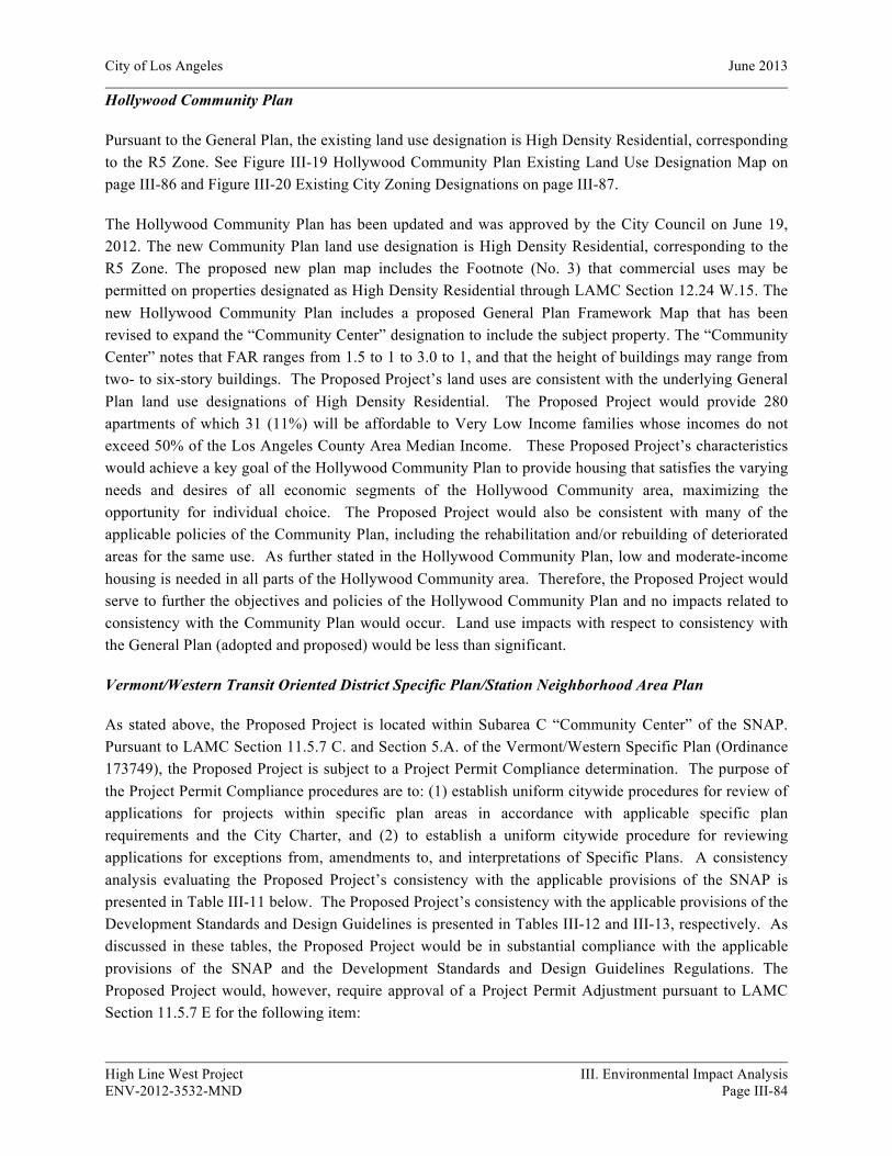
City of Los Angeles June 2013
High Line West Project III. Environmental Impact Analysis ENV-2012-3532-MND Page III-84
Hollywood Community Plan
Pursuant to the General Plan, the existing land use designation is High Density Residential, corresponding to the R5 Zone. See Figure III-19 Hollywood Community Plan Existing Land Use Designation Map on page III-86 and Figure III-20 Existing City Zoning Designations on page III-87.
The Hollywood Community Plan has been updated and was approved by the City Council on June 19, 2012. The new Community Plan land use designation is High Density Residential, corresponding to the R5 Zone. The proposed new plan map includes the Footnote (No. 3) that commercial uses may be permitted on properties designated as High Density Residential through LAMC Section 12.24 W.15. The new Hollywood Community Plan includes a proposed General Plan Framework Map that has been revised to expand the “Community Center” designation to include the subject property. The “Community Center” notes that FAR ranges from 1.5 to 1 to 3.0 to 1, and that the height of buildings may range from two- to six-story buildings. The Proposed Project’s land uses are consistent with the underlying General Plan land use designations of High Density Residential. The Proposed Project would provide 280 apartments of which 31 (11%) will be affordable to Very Low Income families whose incomes do not exceed 50% of the Los Angeles County Area Median Income. These Proposed Project’s characteristics would achieve a key goal of the Hollywood Community Plan to provide housing that satisfies the varying needs and desires of all economic segments of the Hollywood Community area, maximizing the opportunity for individual choice. The Proposed Project would also be consistent with many of the applicable policies of the Community Plan, including the rehabilitation and/or rebuilding of deteriorated areas for the same use. As further stated in the Hollywood Community Plan, low and moderate-income housing is needed in all parts of the Hollywood Community area. Therefore, the Proposed Project would serve to further the objectives and policies of the Hollywood Community Plan and no impacts related to consistency with the Community Plan would occur. Land use impacts with respect to consistency with the General Plan (adopted and proposed) would be less than significant.
Vermont/Western Transit Oriented District Specific Plan/Station Neighborhood Area Plan
As stated above, the Proposed Project is located within Subarea C “Community Center” of the SNAP. Pursuant to LAMC Section 11.5.7 C. and Section 5.A. of the Vermont/Western Specific Plan (Ordinance 173749), the Proposed Project is subject to a Project Permit Compliance determination. The purpose of the Project Permit Compliance procedures are to: (1) establish uniform citywide procedures for review of applications for projects within specific plan areas in accordance with applicable specific plan requirements and the City Charter, and (2) to establish a uniform citywide procedure for reviewing applications for exceptions from, amendments to, and interpretations of Specific Plans. A consistency analysis evaluating the Proposed Project’s consistency with the applicable provisions of the SNAP is presented in Table III-11 below. The Proposed Project’s consistency with the applicable provisions of the Development Standards and Design Guidelines is presented in Tables III-12 and III-13, respectively. As discussed in these tables, the Proposed Project would be in substantial compliance with the applicable provisions of the SNAP and the Development Standards and Design Guidelines Regulations. The Proposed Project would, however, require approval of a Project Permit Adjustment pursuant to LAMC Section 11.5.7 E for the following item:
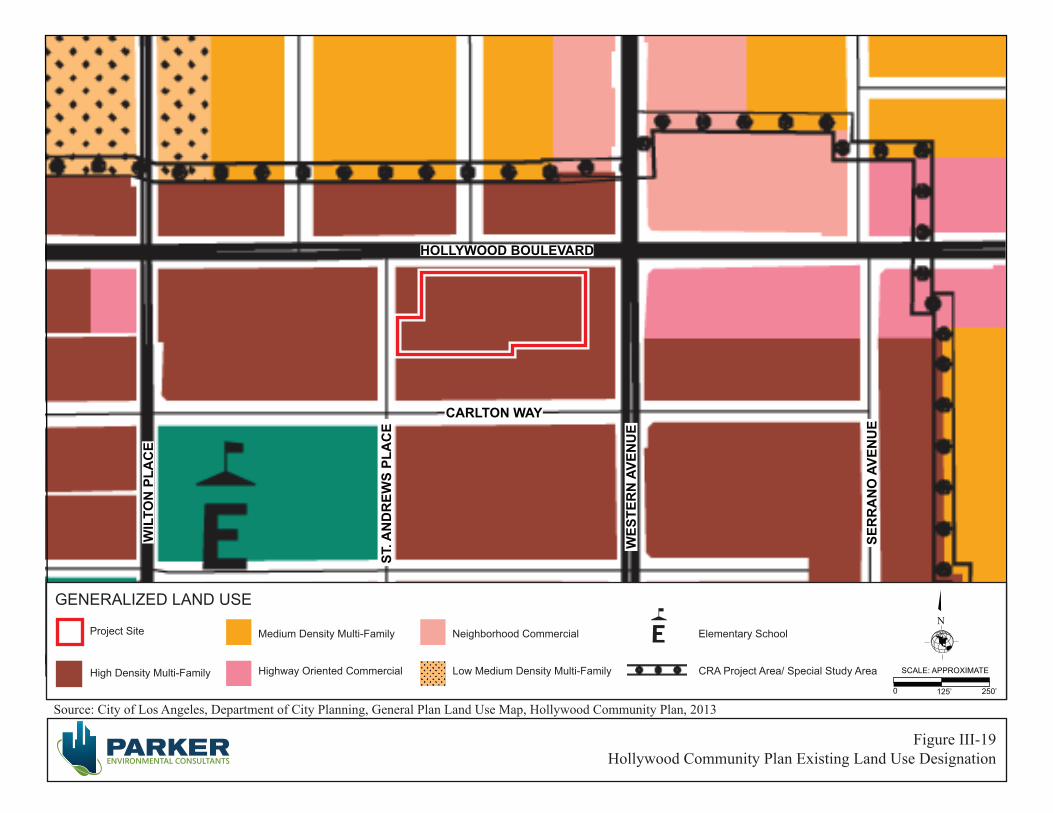
Source: City of Los Angeles, Department of City Planning, General Plan Land Use Map, Hollywood Community Plan, 2013
Figure III-19Hollywood Community Plan Existing Land Use Designation
0 125’ 250’
SCALE: APPROXIMATE
GENERALIZED LAND USEN
High Density Multi-Family Highway Oriented Commercial
Medium Density Multi-Family
Low Medium Density Multi-Family
Neighborhood Commercial
CRA Project Area/ Special Study Area
Elementary SchoolProject Site
HOLLYWOOD BOULEVARD
WES
TER
N A
VEN
UE
SER
RA
NO
AVE
NU
E
ST. A
ND
REW
S PL
AC
E
WIL
TON
PLA
CE
CARLTON WAY
Source: City of Los Angeles, ZIMAS, 2013
Figure III-20Existing City Zoning Designations
0 100’ 200’
SCALE: APPROXIMATE
GENERALIZED ZONINGN
PF
Charter School
Elementary SchoolCR, C1, C1.5, C2, C4, C5, CW, ADP, LASED, WC
R2, RD, RMP, RW2, R3, R4, R5Project Site
City of Los Angeles June 2013
High Line West Project III. Environmental Impact Analysis ENV-2012-3532-MND Page III-87
a) Section V.6 Building Design - The Project Applicant requests a Specific Plan Project Permit Adjustment to allow for a redistribution of the required upper-floor building stepback along Hollywood Boulevard Street frontage.
With approval of the Project Permit Compliance and Project Permit Adjustment identified above, the Project would be in compliance the applicable policies and procedures of the SNAP and land use consistency impacts would be less than significant.
Table III-11 Project Consistency Analysis with the Vermont/Western Transit Oriented District/SNAP
Development Standards a Project Consistency/Comments Section 5. PROHIBITION. A. Project Permit Compliance. No demolition, grading or building permit shall be issued for any Project unless a Project Permit Compliance has been issued pursuant to Section 12 of this Specific Plan.
Consistent. The Proposed Project includes a discretionary request for approval of a Project Permit Compliance determination in accordance with this requirement. With approval of this request and the requisite findings associated with the requested discretionary actions identified in this MND, the Proposed Project would be in compliance the applicable policies and procedures of the SNAP. Therefore, the Proposed Project would be consistent with this provision and land use consistency impacts would be less than significant.
Section 6 LAND USE REGULATIONS AND DESIGNATION OF SUBAREAS Section 6 A. Designation of Subareas. The Specific Plan area is divided into five Subareas, as shown on the Map 1. The Subareas are designated as follows: Subarea A - Neighborhood Conservation Subarea B - Mixed Use Boulevard Subarea C - Community Center Subarea D - Light Industrial/Commercial Subarea E - Public Facility
Consistent. The Project Site is located in Subarea C, Community Center. The intent of the Community Center subarea is to create a denser, livelier pedestrian environment along major commercial and transit corridors such as Hollywood Boulevard, Sunset Boulevard, Santa Monica Boulevard and Vermont Avenue, near each of the four subway stations. Uses in Subarea C include multi-family residences, community serving retail, workshops and offices. The Proposed Project would improve the existing character of the underutilized Project Site, create additional multi-family residential units and commercial space, encourage the use of public transportation options and contribute to the walkability of the area serving the Project Site. The Proposed Project would also be consistent with the prevailing character and scale of the multi-family and commercial structures along W. Hollywood Boulevard and N. Western Avenue in the vicinity of the Project Site. Therefore the Proposed Project would be consistent with the intent of Subarea C Development Standards.
F. Parks First Program and Park Fees. 1. Account. Monies in the Parks First Trust Fund shall be used to acquire an interest in properties and develop the properties for parks and open space, for landscaping of public properties, maintenance and related facilities located within the Specific Plan Area shown on Map 1, and further described in the Guidelines. 2. Park First Program Fees.
Consistent. The Proposed Project would develop 280 apartment units, of which 31 (11%) will be affordable to Very Low Income families whose incomes do not exceed 50% of the Los Angeles County Area Median Income. However, the Project is not exempt from the Park First Program Fees because the Project does not include any public subsidies. Therefore, the Proposed Project will be subject to the Parks First Program and

City of Los Angeles June 2013
High Line West Project III. Environmental Impact Analysis ENV-2012-3532-MND Page III-88
Table III-11 Project Consistency Analysis with the Vermont/Western Transit Oriented District/SNAP
Development Standards a Project Consistency/Comments a. Residential. Prior to issuance of a Certificate of Occupancy, the Applicant for any residential Project shall pay a fee to the Parks First Trust Fund of $4,300 per dwelling unit. b. Exemptions. iii. Low and Very Low Income Housing. All residential units in a Project containing low and very low income residential units as defined by the United States Department of Housing and Urban Development that are subsidized with public funds and/or Federal or State Tax Credits with affordability covenants of at least 30 years are exempt from the Parks First Trust Fund fee.
Park Fees and will need to pay a fee of $4,300 per dwelling unit prior to the Certificate of Occupancy.
Section 9 . SUBAREA C - COMMUNITY CENTER A. Commercial and Mixed-Use Zoned Properties. Notwithstanding any provisions of the Code to the contrary, residential uses permitted in the R4 Zone by Section 12.11 of the Code, Hospital and Medical Uses, and commercial uses permitted in the C4 Commercial Zone by Section 12.16 of the Code, Live/Work Quarters and Small Assembly Workshops, shall be permitted on any lot located within Subarea C as shown on Map 1, provided that the following requirements are met: 1. Commercial Uses. Commercial uses in a Mixed-Use Project shall be limited to the Ground Floor; 3. Mixed Use Regulations. Projects shall comply with the Mixed Use development standards of Section 13.09 F of the Code and The Pedestrian Orientation development standards of Section 13.07 E of the Code
Consistent. The Proposed Project’s land uses are consistent with the uses allowed by the Subarea C designation, which limits use to those permitted in the R4 Zone and C4 Zone. The Proposed Project would limit commercial retail to the ground floor in four spaces that front W. Hollywood Boulevard. One of these spaces would include 2,700 square feet of the two-story historic building on the Project Site. The mixed-use character and design of the Proposed Project limits retail space to the ground floor fronting W. Hollywood Boulevard, promotes a live/work environment, encourages pedestrian activities, and provides access to public transportation options. A driveway at the eastern edge of the property along W. Hollywood Boulevard would provide access to ground level parking reserved for guests and the retail spaces. A driveway at the western edge of the property along W. Hollywood Boulevard would provide access to ground level residential parking. A driveway on N. St. Andrews Place would provide access to residential parking on the subterranean and mezzanine levels. Thus, the Proposed Project would be consistent with LAMC Section 13.09 F and 13.07 E and the mixed-use regulations outlined in this policy.
B. Height and Floor Area Mixed-Use Project. The maximum height of any building for a Mixed-Use Project shall not exceed 75 feet, provided, however, that roofs and roof structures for the purposes specified in Section 12.21.1 B 3 of the Code, may be erected up to ten feet above the prescribed height limit established in this section, provided that the structures and features are set back a minimum of ten feet from the roof perimeter and screened from view at street level by a parapet or a sloping roof. The maximum permitted FAR for a Mixed-Use Project shall be 3.0. Commercial uses in a Mixed-Use Project shall be limited to a maximum FAR of 1.5.
Consistent. The Proposed Project proposes a total floor area of 283,005 square feet of mixed-use development, resulting in a FAR of approximately 3.42 to 1. The State Density Bonus Program and LAMC Section 12.22 A.25(c)(1) allows a 35% Density Bonus if 11% of the units are reserved for Very Low Income households. By providing 11% of the Proposed Project’s units as Very Low Income affordable units, the Proposed Project would be eligible to request two on-menu incentives, of which one would be a FAR increase of up to 35%, which would allow for a floor area of approximately 335,344 square feet. However, the Project is only requesting an FAR increase of slightly less than 14% amounting

City of Los Angeles June 2013
High Line West Project III. Environmental Impact Analysis ENV-2012-3532-MND Page III-89
Table III-11 Project Consistency Analysis with the Vermont/Western Transit Oriented District/SNAP
Development Standards a Project Consistency/Comments to 3.42:1 FAR, thus the proposed floor area would be below what is permitted under the 35%FAR increase. The Proposed Project proposes that the mixed-use development be six-stories high and approximately 86 feet in height above existing grade. Although the Project Site is located in Subarea C of the SNAP, which limits commercial only buildings to a maximum height of 35 feet and mixed-use buildings to a maximum height of 75 feet. The Proposed Project includes23 affordable units designated at Very Low Income (11%). This allows for a 35% density bonus and a request for up to two Incentives as defined in LAMC Section 12.22 A.25(c). The Proposed Project would request an increase in the height of the development of eleven feet as one on-menu incentive, which would permit a building height of 86 feet. Therefore, by designating 11% of residential units as Very Low Income affordable units and thus, receiving a Density Bonus of 35%, the Proposed Project would comply with the Height and Floor regulations set forth in this policy.
C. Transitional Height. 1. Height Limits. Notwithstanding any provisions of Sections 12.21.1 A 10 of the Code to the contrary, portions of buildings on a lot located within the Subarea shall not exceed the transitional height limits set forth below when located within the distances specified therein from a lot within the Subarea A. Distance Height 0 to 49 feet 25 feet 50 to 99 feet 33 feet 100 to 200 feet 61 feet 2. Calculating Distances. Transitional Height limits as set forth above in Section 9 C of this Specific Plan shall only apply to lots adjoining or abutting a lot in Subarea A and shall not apply to lots separated by a public street.
Not Applicable. The Proposed Project is located in Subarea C of the SNAP and does not adjoin or abut a lot in Subarea A. Therefore, the Proposed Project is not subject to the transitional height policy.
D. Usable Open Space. Notwithstanding any provisions of Sections 12.21 G of the Code to the contrary, Projects constituting a Mixed-Use Project containing two or more residential units or a Project comprised exclusively of residential uses containing two or more residential units shall contain usable open space in accordance with the standards of Section 12.21 G 2 of the Code, with the following exceptions:
1. Above Grade. Up to 75% of the common or private open space, regardless of the underlying zone, may be located above the grade level or first habitable room level; 2. Roof decks. Roof Decks, regardless of the underlying zone, may be used in their entirety as common or private open space, excluding that portion of the roof within 20 feet of the roof perimeter.
Consistent. According to LAMC Section 12.21 G, the Proposed Project is required to provide a minimum of approximately 30,450 square feet of open space. The Proposed Project would provide a total of approximately 30,920 square feet of open space, including approximately 19,520 square feet of common open space and approximately 11,400 square feet of private open space. The Project is required to provide 25% of the required 30,450 square feet of open space on the ground floor. The Project incorporates approximately 7,620 square feet of common open space on the ground floor, which includes two lobby areas and a community room. Therefore, the Proposed Project would be consistent with this policy.
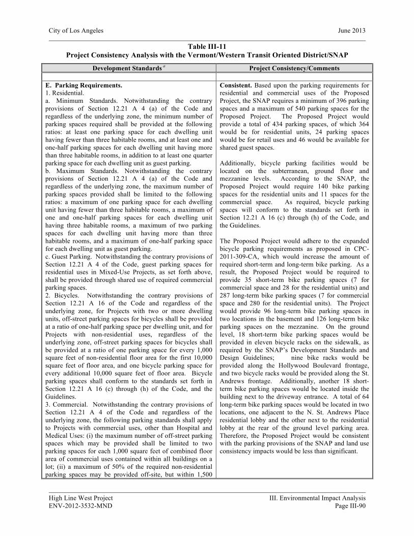
City of Los Angeles June 2013
High Line West Project III. Environmental Impact Analysis ENV-2012-3532-MND Page III-90
Table III-11 Project Consistency Analysis with the Vermont/Western Transit Oriented District/SNAP
Development Standards a Project Consistency/Comments
E. Parking Requirements. 1. Residential. a. Minimum Standards. Notwithstanding the contrary provisions of Section 12.21 A 4 (a) of the Code and regardless of the underlying zone, the minimum number of parking spaces required shall be provided at the following ratios: at least one parking space for each dwelling unit having fewer than three habitable rooms, and at least one and one-half parking spaces for each dwelling unit having more than three habitable rooms, in addition to at least one quarter parking space for each dwelling unit as guest parking. b. Maximum Standards. Notwithstanding the contrary provisions of Section 12.21 A 4 (a) of the Code and regardless of the underlying zone, the maximum number of parking spaces provided shall be limited to the following ratios: a maximum of one parking space for each dwelling unit having fewer than three habitable rooms, a maximum of one and one-half parking spaces for each dwelling unit having three habitable rooms, a maximum of two parking spaces for each dwelling unit having more than three habitable rooms, and a maximum of one-half parking space for each dwelling unit as guest parking. c. Guest Parking. Notwithstanding the contrary provisions of Section 12.21 A 4 of the Code, guest parking spaces for residential uses in Mixed-Use Projects, as set forth above, shall be provided through shared use of required commercial parking spaces. 2. Bicycles. Notwithstanding the contrary provisions of Section 12.21 A 16 of the Code and regardless of the underlying zone, for Projects with two or more dwelling units, off-street parking spaces for bicycles shall be provided at a ratio of one-half parking space per dwelling unit, and for Projects with non-residential uses, regardless of the underlying zone, off-street parking spaces for bicycles shall be provided at a ratio of one parking space for every 1,000 square feet of non-residential floor area for the first 10,000 square feet of floor area, and one bicycle parking space for every additional 10,000 square feet of floor area. Bicycle parking spaces shall conform to the standards set forth in Section 12.21 A 16 (c) through (h) of the Code, and the Guidelines. 3. Commercial. Notwithstanding the contrary provisions of Section 12.21 A 4 of the Code and regardless of the underlying zone, the following parking standards shall apply to Projects with commercial uses, other than Hospital and Medical Uses: (i) the maximum number of off-street parking spaces which may be provided shall be limited to two parking spaces for each 1,000 square feet of combined floor area of commercial uses contained within all buildings on a lot; (ii) a maximum of 50% of the required non-residential parking spaces may be provided off-site, but within 1,500
Consistent. Based upon the parking requirements for residential and commercial uses of the Proposed Project, the SNAP requires a minimum of 396 parking spaces and a maximum of 540 parking spaces for the Proposed Project. The Proposed Project would provide a total of 434 parking spaces, of which 364 would be for residential units, 24 parking spaces would be for retail uses and 46 would be available for shared guest spaces. Additionally, bicycle parking facilities would be located on the subterranean, ground floor and mezzanine levels. According to the SNAP, the Proposed Project would require 140 bike parking spaces for the residential units and 11 spaces for the commercial space. As required, bicycle parking spaces will conform to the standards set forth in Section 12.21 A 16 (c) through (h) of the Code, and the Guidelines. The Proposed Project would adhere to the expanded bicycle parking requirements as proposed in CPC-2011-309-CA, which would increase the amount of required short-term and long-term bike parking. As a result, the Proposed Project would be required to provide 35 short-term bike parking spaces (7 for commercial space and 28 for the residential units) and 287 long-term bike parking spaces (7 for commercial space and 280 for the residential units). The Project would provide 96 long-term bike parking spaces in two locations in the basement and 126 long-term bike parking spaces on the mezzanine. On the ground level, 18 short-term bike parking spaces would be provided in eleven bicycle racks on the sidewalk, as required by the SNAP’s Development Standards and Design Guidelines; nine bike racks would be provided along the Hollywood Boulevard frontage, and two bicycle racks would be provided along the St. Andrews frontage. Additionally, another 18 short-term bike parking spaces would be located inside the building next to the driveway entrance. A total of 64 long-term bike parking spaces would be located in two locations, one adjacent to the N. St. Andrews Place residential lobby and the other next to the residential lobby at the rear of the ground level parking area. Therefore, the Proposed Project would be consistent with the parking provisions of the SNAP and land use consistency impacts would be less than significant.
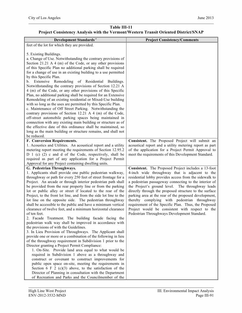
City of Los Angeles June 2013
High Line West Project III. Environmental Impact Analysis ENV-2012-3532-MND Page III-91
Table III-11 Project Consistency Analysis with the Vermont/Western Transit Oriented District/SNAP
Development Standards a Project Consistency/Comments feet of the lot for which they are provided. 5. Existing Buildings. a. Change of Use. Notwithstanding the contrary provisions of Section 21.21 A 4 (m) of the Code, or any other provisions of this Specific Plan no additional parking shall be required for a change of use in an existing building to a use permitted by this Specific Plan. b. Extensive Remodeling of Residential Buildings. Notwithstanding the contrary provisions of Section 12.21 A 4 (m) of the Code, or any other provisions of this Specific Plan, no additional parking shall be required for an Extensive Remodeling of an existing residential or Mixed-Use building with so long as the uses are permitted by this Specific Plan. c. Maintenance of Off Street Parking. Notwithstanding the contrary provisions of Section 12.21 A 4 (m) of the Code, off-street automobile parking spaces being maintained in connection with any existing main building or structure as of the effective date of this ordinance shall be maintained, so long as the main building or structure remains, and shall not be reduced. F. Conversion Requirements. 1. Acoustics and Utilities. An acoustical report and a utility metering report meeting the requirements of Section 12.95.2 D 1 (c) (2) c and d of the Code, respectively, shall be required as part of any application for a Project Permit Approval for any Project containing dwelling units.
Consistent. The Proposed Project will submit an acoustical report and a utility metering report as part of the application for a Project Permit Approval to meet the requirements of this Development Standard.
G. Pedestrian Throughways. 1. Applicants shall provide one public pedestrian walkway, throughway or path for every 250 feet of street frontage for a Project. An arcade or through interior pedestrian path shall be provided from the rear property line or from the parking lot or public alley or street if located to the rear of the Project, to the front lot line, and from the side lot line to the lot line on the opposite side. The pedestrian throughway shall be accessible to the public and have a minimum vertical clearance of twelve feet, and a minimum horizontal clearance of ten feet. 2. Facade Treatment. The building facade facing the pedestrian walk way shall be improved in accordance with the provisions of with the Guidelines. 3. In Lieu Provision of Throughways. The Applicant shall provide one or more or a combination of the following in lieu of the throughway requirement in Subdivision 1 prior to the Director granting a Project Permit Compliance:
1. On-Site. Provide land area equal to what would be required in Subdivision 1 above as a throughway and construct or covenant to construct improvements for public open space on-site, meeting the requirements in Section 6 F 2 (c)(3) above, to the satisfaction of the Director of Planning in consultation with the Department of Recreation and Parks and the Councilmember of the
Consistent. The Proposed Project includes a 13-foot 4-inch wide throughway that is adjacent to the residential lobby provides access from the sidewalk to a pedestrian passageway connecting to the interior of the Project’s ground level. The throughway leads directly through the proposed structure to the surface parking area at the rear of the proposed development, thereby complying with pedestrian throughway requirement of the Specific Plan. Thus, the Proposed Project would be consistent with respect to the Pedestrian Throughways Development Standard.
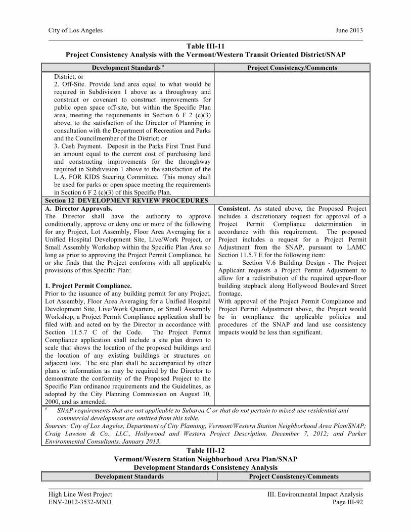
City of Los Angeles June 2013
High Line West Project III. Environmental Impact Analysis ENV-2012-3532-MND Page III-92
Table III-11 Project Consistency Analysis with the Vermont/Western Transit Oriented District/SNAP
Development Standards a Project Consistency/Comments District; or 2. Off-Site. Provide land area equal to what would be required in Subdivision 1 above as a throughway and construct or covenant to construct improvements for public open space off-site, but within the Specific Plan area, meeting the requirements in Section 6 F 2 (c)(3) above, to the satisfaction of the Director of Planning in consultation with the Department of Recreation and Parks and the Councilmember of the District; or 3. Cash Payment. Deposit in the Parks First Trust Fund an amount equal to the current cost of purchasing land and constructing improvements for the throughway required in Subdivision 1 above to the satisfaction of the L.A. FOR KIDS Steering Committee. This money shall be used for parks or open space meeting the requirements in Section 6 F 2 (c)(3) of this Specific Plan.
Section 12 DEVELOPMENT REVIEW PROCEDURES A. Director Approvals. The Director shall have the authority to approve conditionally, approve or deny one or more of the following for any Project, Lot Assembly, Floor Area Averaging for a Unified Hospital Development Site, Live/Work Project, or Small Assembly Workshop within the Specific Plan Area so long as prior to approving the Project Permit Compliance, he or she finds that the Project conforms with all applicable provisions of this Specific Plan: 1. Project Permit Compliance. Prior to the issuance of any building permit for any Project, Lot Assembly, Floor Area Averaging for a Unified Hospital Development Site, Live/Work Quarters, or Small Assembly Workshop, a Project Permit Compliance application shall be filed with and acted on by the Director in accordance with Section 11.5.7 C of the Code. The Project Permit Compliance application shall include a site plan drawn to scale that shows the location of the proposed buildings and the location of any existing buildings or structures on adjacent lots. The site plan shall be accompanied by other plans or information as may be required by the Director to demonstrate the conformity of the Proposed Project to the Specific Plan ordinance requirements and the Guidelines, as adopted by the City Planning Commission on August 10, 2000, and as amended.
Consistent. As stated above, the Proposed Project includes a discretionary request for approval of a Project Permit Compliance determination in accordance with this requirement. The proposed Project includes a request for a Project Permit Adjustment from the SNAP, pursuant to LAMC Section 11.5.7 E for the following item: a. Section V.6 Building Design - The Project Applicant requests a Project Permit Adjustment to allow for a redistribution of the required upper-floor building stepback along Hollywood Boulevard Street frontage. With approval of the Project Permit Compliance and Project Permit Adjustment above, the Project would be in compliance the applicable policies and procedures of the SNAP and land use consistency impacts would be less than significant.
a SNAP requirements that are not applicable to Subarea C or that do not pertain to mixed-use residential and commercial development are omitted from this table.
Sources: City of Los Angeles, Department of City Planning, Vermont/Western Station Neighborhood Area Plan/SNAP; Craig Lawson & Co., LLC., Hollywood and Western Project Description, December 7, 2012; and Parker Environmental Consultants, January 2013.
Table III-12 Vermont/Western Station Neighborhood Area Plan/SNAP
Development Standards Consistency Analysis Development Standards Project Consistency/Comments
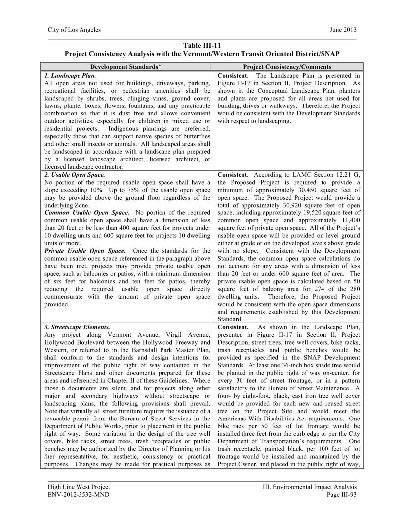
City of Los Angeles June 2013
High Line West Project III. Environmental Impact Analysis ENV-2012-3532-MND Page III-93
Table III-11 Project Consistency Analysis with the Vermont/Western Transit Oriented District/SNAP
Development Standards a Project Consistency/Comments 1. Landscape Plan. All open areas not used for buildings, driveways, parking, recreational facilities, or pedestrian amenities shall be landscaped by shrubs, trees, clinging vines, ground cover, lawns, planter boxes, flowers, fountains, and any practicable combination so that it is dust free and allows convenient outdoor activities, especially for children in mixed use or residential projects. Indigenous plantings are preferred, especially those that can support native species of butterflies and other small insects or animals. All landscaped areas shall be landscaped in accordance with a landscape plan prepared by a licensed landscape architect, licensed architect, or licensed landscape contractor.
Consistent. The Landscape Plan is presented in Figure II-17 in Section II, Project Description. As shown in the Conceptual Landscape Plan, planters and plants are proposed for all areas not used for building, drives or walkways. Therefore, the Project would be consistent with the Development Standards with respect to landscaping.
2. Usable Open Space. No portion of the required usable open space shall have a slope exceeding 10%. Up to 75% of the usable open space may be provided above the ground floor regardless of the underlying Zone. Common Usable Open Space. No portion of the required common usable open space shall have a dimension of less than 20 feet or be less than 400 square feet for projects under 10 dwelling units and 600 square feet for projects 10 dwelling units or more. Private Usable Open Space. Once the standards for the common usable open space referenced in the paragraph above have been met, projects may provide private usable open space, such as balconies or patios, with a minimum dimension of six feet for balconies and ten feet for patios, thereby reducing the required usable open space directly commensurate with the amount of private open space provided.
Consistent. According to LAMC Section 12.21 G, the Proposed Project is required to provide a minimum of approximately 30,450 square feet of open space. The Proposed Project would provide a total of approximately 30,920 square feet of open space, including approximately 19,520 square feet of common open space and approximately 11,400 square feet of private open space. All of the Project’s usable open space will be provided on level ground either at grade or on the developed levels above grade with no slope. Consistent with the Development Standards, the common open space calculations do not account for any areas with a dimension of less than 20 feet or under 600 square feet of area. The private usable open space is calculated based on 50 square feet of balcony area for 274 of the 280 dwelling units. Therefore, the Proposed Project would be consistent with the open space dimensions and requirements established by this Development Standard.
3. Streetscape Elements. Any project along Vermont Avenue, Virgil Avenue, Hollywood Boulevard between the Hollywood Freeway and Western, or referred to in the Barnsdall Park Master Plan, shall conform to the standards and design intentions for improvement of the public right of way contained in the Streetscape Plans and other documents prepared for these areas and referenced in Chapter II of these Guidelines. Where those 6 documents are silent, and for projects along other major and secondary highways without streetscape or landscaping plans, the following provisions shall prevail. Note that virtually all street furniture requires the issuance of a revocable permit from the Bureau of Street Services in the Department of Public Works, prior to placement in the public right of way. Some variation in the design of the tree well covers, bike racks, street trees, trash receptacles or public benches may be authorized by the Director of Planning or his /her representative, for aesthetic, consistency or practical purposes. Changes may be made for practical purposes as
Consistent. As shown in the Landscape Plan, presented in Figure II-17 in Section II, Project Description, street trees, tree well covers, bike racks, trash receptacles and public benches would be provided as specified in the SNAP Development Standards. At least one 36-inch box shade tree would be planted in the public right of way on-center, for every 30 feet of street frontage, or in a pattern satisfactory to the Bureau of Street Maintenance. A four- by eight-foot, black, cast iron tree well cover would be provided for each new and reused street tree on the Project Site and would meet the Americans With Disabilities Act requirements. One bike rack per 50 feet of lot frontage would be installed three feet from the curb edge or per the City Department of Transportation’s requirements. One trash receptacle, painted black, per 100 feet of lot frontage would be installed and maintained by the Project Owner, and placed in the public right of way,
City of Los Angeles June 2013
High Line West Project III. Environmental Impact Analysis ENV-2012-3532-MND Page III-94
Table III-11 Project Consistency Analysis with the Vermont/Western Transit Oriented District/SNAP
Development Standards a Project Consistency/Comments long as the aesthetic values are maintained. Street Trees. At least one 36-inch box shade tree shall be planted in the public right of way on-center, or in a pattern satisfactory to the Bureau of Street Maintenance, for every 30 feet of street frontage. Shade trees as identified in the Street Tree List of the Bureau of Street Maintenance shall be planted. An automatic irrigation system shall also be provided within the tree well. Businesses, tenants, and property owners along both block faces of a street are encouraged to collaboratively select a signature tree. Tree Well Covers. A four-foot by eight foot, black, cast iron tree well cover shall be provided for each new and reused street tree in the project area. The design shall meet the Americans With Disabilities Act requirements and minimize trip and fall accidents, and provide a cut out adequate for whatever tree used. Bike Racks. One bike rack per lot, or 50 feet of lot frontage for lots with more than 50 feet of frontage, shall be required. Bike racks shall be installed three feet from the curb edge or per the City Department of Transportation’s requirements. Simple bike racks painted black are required. Trash Receptacles. One trash receptacle, painted black, per 100 feet of lot frontage along major or secondary highways, to be maintained and emptied by the Project owner, and placed in the public right of way, according to the requirements of the City Department of Public Works. Public Benches. One public bench, painted black with a backrest, three armrests, and intermediate frame, for every 250 feet of lot frontage on a major or secondary highway shall be required and placed in the public right of way according to the requirements of the City Department of Public Works.
according to the requirements of the City Department of Public Works. One public bench, painted black with a backrest, three armrests, and intermediate frame would be placed in the public right of way for every 250 feet of lot frontage, according to the requirements of the City Department of Public Works. Therefore, the Project would be consistent with the Development Standards with respect to this Design Standard.
4. Pedestrian/Vehicular Circulation. All structures shall be oriented toward the main commercial street where the parcel is located and shall avoid pedestrian/vehicular conflicts by adhering to the following standards: Parking Lot Location. Surface parking shall be located to the rear of all structures if vehicular access is available to the rear of the parcel either via an alley or a public street. Where no vehicular access is available from the rear of any lot, parking shall be provided to the rear of a lot via a “flag” parking layout. Waiver. The Director of Planning or his/her representative may authorize a waiver from the requirement to provide parking in the rear of the lot for mid-block lots that do not have through access to an alley or public street at the rear, and where creation of a flag parking lot results in a total building frontage of 30 feet or less. Applicants requesting a waiver shall submit alternative site plan scenarios with calculations showing total building frontage. Applicants shall incorporate design mitigation measures to ensure the pedestrian oriented streetscape is not undermined.
Consistent. The Proposed Project would include the development of a mixed-use building that fronts W. Hollywood Boulevard. All parking spaces would be located within the interior of the project in a three level parking garage. The Proposed Project would include one parking garage entrance on N. St. Andrews Place and two parking garage entrances on the western and eastern edge of the Proposed Project fronting W. Hollywood Boulevard. The distance between curb cuts exceeds 150 feet. The Proposed Project would also include one pedestrian entrance on W. Hollywood Boulevard and one side pedestrian entrance on N. St. Andrew’s Place. Both pedestrian entrances would lead into a lobby and would be located approximately mid-block along the building façade. As shown in the Plot Plan, presented in Figure II-5 in Section II, Project Description, the location of pedestrian and vehicular circulation on the Project Site would be designed to meet the requirements of this Development Standard.

City of Los Angeles June 2013
High Line West Project III. Environmental Impact Analysis ENV-2012-3532-MND Page III-95
Table III-11 Project Consistency Analysis with the Vermont/Western Transit Oriented District/SNAP
Development Standards a Project Consistency/Comments Curb Cuts. Whenever a project must take its access from a major or secondary street, only one curb cut shall be permitted for every 150 feet of street frontage on the main commercial street. Such curb cuts shall be a maximum width of 20 feet, unless otherwise required by the Departments of Public Works, Transportation or Building and Safety. Pedestrian Entrance. All buildings that front on a major or secondary highway or main commercial street, including parking structures, shall provide a pedestrian entrance at the front of the building, even when rear public entrances are provided. Maximum spacing of entries along commercial frontages for shops, lobbies or arcades is fifty feet. Design of Entrances. Pedestrian Walkways, mid block throughways, arcades or entrances shall be located in the center of the facade, or symmetrically spaced if there are more than one, or at the corner if in a corner building. Entrances shall be accented by architectural elements such as columns, overhanging roofs, awnings, etc. Inner Block Pedestrian Walkway. Projects shall provide one pedestrian access, walkway or path for every 250 feet of street frontage. An arcade or through interior pedestrian path or throughway shall be provided from the rear property line or from the parking lot or public alley or street if located to the rear of the project, to the front property line. The building facade facing the pedestrian walk way shall provide windows, doors and signs at ground level oriented to pedestrian traffic. The pedestrian walkway shall be accessible to the public and have a minimum vertical clearance of twelve feet, and a minimum horizontal clearance of ten feet. Speed Bumps. Whenever a pedestrian walk way and a drive way share the same path for more than 50 lineal feet, speed bumps shall be provided on the driveway at a distance of no more than 20 feet apart. 5. Utilities. When new utility service is installed in conjunction with new development or extensive remodeling, all proposed utilities on the Project Site shall be placed underground. If underground service is not currently available, then provisions shall be made for future underground service.
Consistent. All new utility lines which directly service the Project Site would be installed underground. Therefore, the proposed Project would be consistent with the Development Standards with respect to the installation of new utilities.
6. Building Design. The purpose of the following provisions is to ensure that a project avoids large blank expanses of building walls, is designed in harmony with the surrounding neighborhood, and contributes to a lively pedestrian friendly atmosphere. Accordingly, the following standards shall be met: Stepbacks. No portion of any structure located in Subareas B or C shall exceed more than 30 feet in height within 15 feet of the front property line. (See Figure 1) All buildings with a property line fronting on a major highway, including Hollywood Boulevard, Sunset Boulevard, Santa Monica Boulevard and Vermont Avenue, shall set the second floor back from the first floor frontage at least ten feet.
Not Consistent. The Project Applicant requests a Specific Plan Project Permit Adjustment to allow for a redistribution of the required upper-floor building stepback along Hollywood Boulevard Street frontage. Transparent building elements such as windows and doors would occupy at least fifty percent of the exterior wall surface of the ground floor facades for the front and side elevations of the Proposed Project. All exterior walls of the Proposed Project would provide a break in the plane, or a change in material every 20 feet in horizontal length and every 30 feet in vertical length, created by an articulation or architectural detail. Architectural treatments on the
City of Los Angeles June 2013
High Line West Project III. Environmental Impact Analysis ENV-2012-3532-MND Page III-96
Table III-11 Project Consistency Analysis with the Vermont/Western Transit Oriented District/SNAP
Development Standards a Project Consistency/Comments Transparent Building Elements. Transparent building elements such as windows and doors shall occupy at least fifty percent of the exterior wall surface of the ground floor facades for the front and side elevations. (See Figure 2) Transparent building elements shall occupy at least twenty percent of the surface area of the rear elevation of the ground floor portion of any building which has surface parking located to the rear of the structure. Facade Relief. All exterior building walls shall provide a break in the plane, or a change in material every 20 feet in horizontal length and every 30 feet in vertical length, created by an articulation or architectural detail such as: a change in plane of at least six inches for a distance of not more than 20 feet; recessed entry ways, recessed windows, or pop-out windows; porticos, awnings, terraces, balconies, or trellises; building overhangs, projections or cantilevered designs; horizontal moldings; cornice lines; or other features or building materials that create a visual break. Aluminum framed window or doors that are flush with the plane of the building shall not be included as a change in material or as a break in the plane. Materials such as wood, glass block, brick, adobe and tile are encouraged. Architectural treatments on the building front elevation shall be continued on the sides and back of buildings. (See Figure 3) Building Materials. All buildings shall apply at least two types of complementary building materials to exterior building facades such as adobe, wood, brick, stone or tile. Transparent building elements shall not be included as a change in material towards this requirement. Surface Mechanical Equipment. All surface or ground mounted mechanical equipment, including transformers, terminal boxes, pull boxes, air conditioner condensers, gas meters and electric meter cabinets shall be screened from public view and treated to match the materials and colors of the building which they serve. Roof Lines. All roof lines in excess of forty feet must be broken up through the use of gables, dormers, plant-ons, cutouts or other appropriate means. (See Figure 4)
Proposed Project’s front elevation would be continued on the sides and back of the building. The Proposed Project would apply at least two types of complementary building materials to exterior building facades. All surface or ground mounted mechanical equipment would be screened from public view and treated to match the materials and colors of the building. Appropriate aesthetics features would break up the Proposed Project’s roofline when in excess of forty feet. Therefore, with approval for a Specific Plan Project Permit Adjustment to allow for a redistribution of the required upper-floor building stepback along Hollywood Boulevard Street frontage the Proposed Project would be consistent with the Development Standards with respect to Building Design.
7. Rooftop Appurtenances. All rooftop equipment and building appurtenances shall be screened from public view or architecturally integrated into the design of the building as follows: Flat Roofs. Building equipment and ducts shall be screened from view from any street, public right of way or adjacent property. The screening shall be solid and match the exterior materials, design and color of the building. Pitched Roofs. Building equipment and ducts on pitched roofs shall be screened from view from any street, public right of way or adjacent property. The pitched roof shall be designed and constructed to accommodate roof-mounted equipment. A platform shall be constructed and recessed into the roof such that one side of the equipment shall be below the
Consistent. The roof of the Proposed Project would be a parapet roof. All equipment will be screened with material similar to the design and color of the building. Therefore, the Proposed Project would be consistent with the Development Standards with respect to roofs and rooftop appurtenances.
City of Los Angeles June 2013
High Line West Project III. Environmental Impact Analysis ENV-2012-3532-MND Page III-97
Table III-11 Project Consistency Analysis with the Vermont/Western Transit Oriented District/SNAP
Development Standards a Project Consistency/Comments pitch of the roof. The remainder of the equipment and ducts which are above the roof pitch shall be screened from view. The screening shall be solid and match the exterior materials, design and color of the building. Parapet Roofs. The parapet roof shall be designed and constructed to accommodate roof-mounted equipment. Any portions of the equipment or ducts which are above the parapet shall be screened from view from any street, public right of way or adjacent property. The screening shall be solid and match the exterior building material, design and color. 8. Trash and Recycling Areas. Trash storage bins shall be located within a gated, covered enclosure constructed of materials identical to the exterior wall materials of the building. The trash enclosure shall be minimum six feet high, and shall have a separate area for recyclable materials. (See Figure 5)
Consistent. Two trash areas would be located on the ground floor level of the Proposed Project within enclosed rooms and would include a separate area for recyclables. Therefore, the Proposed Project would be consistent with this Development Standard.
9. Pavement. Paved areas, excluding parking and driveway areas, shall consist of enhanced paving materials such as stamped concrete, permeable paved surfaces, tile, and/or brick pavers.
Consistent. As shown in the Landscape Plan, presented in Figure II-17 in Section II, Project Description, decorative concrete paving and special paving would be used throughout the open space areas of the Proposed Project and therefore would be consistent with this Development Standard.
10. Freestanding Walls. All freestanding walls shall contain an architectural element at intervals of no more than 20 feet. All freestanding walls shall be setback from the property line adjacent to a public street with a landscaped buffer. Chain-link, barbed and concertina fences are not permitted. (See Figure 6)
Consistent. All freestanding walls on the Project Site would contain an architectural element at intervals of no more than 20 feet and would be setback from the property line adjacent to a public street with a landscape buffer. Therefore the Proposed Project would be consistent with this Development Standard.
11. Parking Structures-Required. Commercial Frontage. All of the building frontage along major or secondary highways, for a parking structure shall be for commercial, community facilities, or other non-residential uses to a minimum depth of 25 feet. (See Figure 7)
Consistent. The Proposed Project’s parking structure has a depth of 160 feet as measured from Hollywood Boulevard. Therefore, the Proposed Project is consistent with this Development Standard.
12. Parking Structures-Facade Treatments. The exterior elevations of all parking structures shall be designed to match the style, materials and color of the main building they serve so there is no notable differentiation between the parking and non-parking structure. (See Figure 8) If the parking structure is not architecturally associated with any one building, the wall at ground level shall be screened by a landscaped buffer. (See Figure 9)
Consistent. The Proposed Project would include a three level parking garage that accommodates 434 parking spaces. The exterior elevations of the parking garage would be concealed by the retail store fronts along Hollywood Boulevard, including the retention of the facades of two historic buildings. Therefore, the Proposed Project would be consistent with this Development Standard.
13. Parking Structures Across from Residential Uses. Wherever a parking structure abuts or is directly across an alley or public street from any residential use or zone, the facade facing such residential use or zone shall conform to the following standards: a landscaped buffer in front of a decorative perimeter wall at least three feet six inches in height shall be provided along the sides of any structure which faces any residential use or zone, so that light is blocked and noise deflected; a maximum of 40% of the building facade
Consistent. The Proposed Project abuts residential buildings to the south, therefore the Proposed Project would comply with the provisions of the standards. Specifically, a landscaped buffer would be provided on the southerly property line, abutting the adjacent residential uses. In addition, lighting would be controlled to prevent spillover light impacts and the garage floors and ramps will be constructed with textured surfaces to minimize tire squeal noises. See

City of Los Angeles June 2013
High Line West Project III. Environmental Impact Analysis ENV-2012-3532-MND Page III-98
Table III-11 Project Consistency Analysis with the Vermont/Western Transit Oriented District/SNAP
Development Standards a Project Consistency/Comments shall be for openings that allow for natural ventilation; solid panels a minimum of three feet six inches tall shall be installed at the ramps of the structure which are adjacent to residential uses or zones so as to minimize headlight glare; light standards on any uncovered above ground level areas of the structure shall not be higher than the adjacent perimeter walls; and garage floors and ramps shall be constructed with textured surfaces to minimize tire squeal noises.
also Mitigation Measures 1-120 (Aesthetics – Light) and XII-40 Noise (parking Structure Ramps).
14. Surface Parking Lots. Surface parking lots and driveways shall be paved with portland cement concrete, pervious cement, grass-crete or any other porous surface acceptable to the Department of Building and safety, that reduces heat radiation and/or increases surface absorption. A landscape plan prepared by a licensed landscape architect, licensed architect or licensed landscape contractor shall be required. At least ten percent of a surface parking lot shall be landscaped in accordance with the following standards: One 24-inch box shade tree for every four parking spaces, spaced evenly to create an orchard-like effect; a landscaped buffer around the property line; and a three and a half foot solid decorative masonry wall shall be provided behind the three foot landscaped buffer. Shade producing trees as identified in the Street Tree List of the Bureau of Street Maintenance shall be planted. The trees shall be located so that an overhead canopy effect is anticipated to cover at least 50 percent of the parking area after ten years of growth. (See Figure 10)
Not Applicable. All parking spaces would be located within the Proposed Project’s interior three level parking structure. No surface parking lots are proposed.
15. Surface Parking Abutting Residential. Whenever a surface parking lot abuts or is directly across an alley from an residential use or zone, a decorative wall at least six feet in height shall be erected along the perimeter of the parking area facing such residential lot or use, and a landscaped buffer shall be installed along this wall with one 24-inch box shade tree planted for every 20 feet of landscaped buffer around the property line. A landscape plan prepared by a landscape architect, licensed architect, or licensed landscape contractor is required.
Not Applicable. All parking spaces would be located within the Proposed Project’s interior three level parking structure. No surface parking lots are proposed.
16. On-Site Lighting. On-site lighting shall be installed along all vehicular access ways and pedestrian walkways. Parking areas shall have a minimum of ¾ foot-candle of flood lighting measured at the pavement. All on-site lighting shall be directed away from adjacent properties. This condition shall not preclude the installation of low-level security lighting. Lighting Shielded. Sources of illumination shall be shielded from casting light higher than fifteen degrees (15) below the horizontal plane as measured from the light source. They shall not cast light directly into adjacent residential windows. Light Mounting Height. A maximum mounting height of light sources for ground level illumination shall be fourteen feet, measured from the finished grade of the area to be lit. Lamp Color. Color corrected (“white”) high pressure sodium (HPS), color corrected fluorescent (2,700-3,000 degrees K),
Consistent. Lighting for the Proposed Project would be installed in compliance with the Development Standards of the SNAP. The Proposed Project would be consistent with the On-Site Lighting Development Standards.
City of Los Angeles June 2013
High Line West Project III. Environmental Impact Analysis ENV-2012-3532-MND Page III-99
Table III-11 Project Consistency Analysis with the Vermont/Western Transit Oriented District/SNAP
Development Standards a Project Consistency/Comments metal halide, or incandescent lamps shall be used for ground level illumination. Standard “peach” high pressure sodium, low pressure sodium, standard mercury vapor, and cool white fluorescent shall not be used for ground floor illumination. 17. Security Devices. Security devices shall be screened from public view. Alternative methods such as interior electronic security and fire alarm systems are encouraged. If metal security grills are used, grilles which recess into pockets or overhead cylinders, completely concealed and retractable shall be used and shall be integrated into the design of the building, using the space behind signage to house the gate if possible. Vertical or horizontally folding accordion grills in front of a building are prohibited. All security window bars shall be installed on the inside of the building.
Consistent. Security devices for the Proposed Project would be screened from public view. As noted in mitigation measure XIV-30 (Police Services), the Project will incorporate security features into the architectural design of the Project consistent with the features identified in “Design Out Crime Guidelines: Crime Prevention Through Environmental Design.” Therefore, the Proposed Project would be consistent with the Development Standards with respect to Security Devices.
18. Privacy. Buildings shall be arranged to avoid windows facing windows across property lines, or the private open space of other residential units.
Consistent. The Proposed Project abuts residential properties to the south and east. The Project includes a three level parking garage with two levels above grade. The first level of proposed residential units are located 22 feet above grade and would not directly face windows across property lines.
19. Hours of Operation. Parking lot cleaning and sweeping, trash collections and deliveries to or from a building shall occur no earlier than 7AM and no later than 8PM, Monday through Friday, and no earlier than 10AM and no later than 4PM on Saturdays and Sundays.
Consistent. The Proposed Project would adhere to the hours of operation which prohibits parking lot cleaning and sweeping, trash collections and deliveries to or from a building from occurring no earlier than 7 AM and no later than 8 PM, Monday through Friday, and no earlier than 10 AM and no later than 4 PM on Saturdays and Sundays. The Proposed Project would therefore be consistent with this Development Standard.
20. Noise Control. Any dwelling unit exterior wall including windows and doors having a line of sight to a public street or alley, shall be constructed so as to provide a Sound Transmission Class of 50 or greater, as defined in the Uniform Building Code Standard No. 35-1, 1979 edition, or latest edition. The developer, as an alternative, may retain an acoustical engineer to submit evidence, along with the application of a building permit, specifying any alternative means of sound insulation sufficient to reduce interior noise levels below 45dBA in any habitable room.
Consistent. The Proposed Project would be consistent with respect to the Noise Control Development Standard. See Mitigation Measure XII-60, Increased Noise Levels (Mixed-Use Development), under the Noise subheading in this MND.
21. Required Ground Floor Uses. For Subarea B, any residential, community facility or commercial use permitted by the Specific Plan Ordinance is allowed on the ground floor. For Subareas C, one hundred percent (100 %) of the street level floor, excluding entrances to upper floors, must be for commercial uses or community facilities up to a depth of 25 feet.
Consistent. The Proposed Project is located in Subarea C. Consistent with this standard, 100% of the ground floor is for commercial uses, entrances to residential lobbies, and common areas. Therefore, the Proposed Project is consistent with this Development Standard.
Sources: City of Los Angeles, Department of City Planning, Vermont/Western Station Neighborhood Area Plan/SNAP, Development Standards and Design Guidelines; Craig Lawson & Co., LLC., Hollywood and Western Project Description, December 7, 2012; and Parker Environmental Consultants, January 2013.
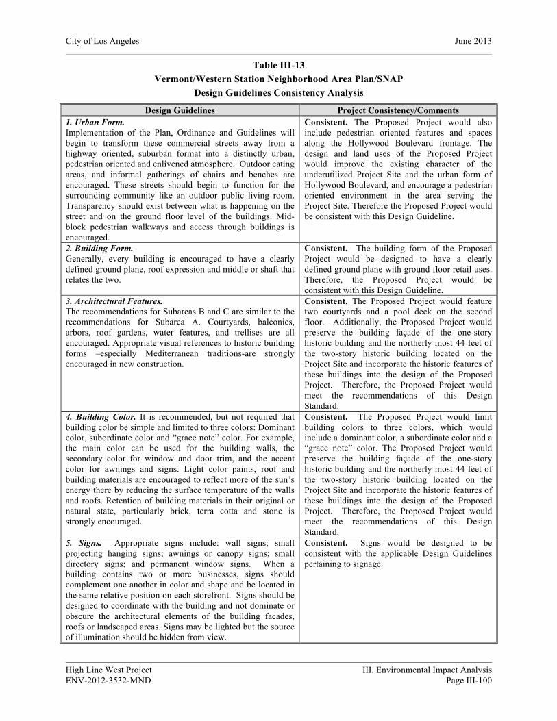
City of Los Angeles June 2013
High Line West Project III. Environmental Impact Analysis ENV-2012-3532-MND Page III-100
Table III-13 Vermont/Western Station Neighborhood Area Plan/SNAP
Design Guidelines Consistency Analysis
Design Guidelines Project Consistency/Comments 1. Urban Form. Implementation of the Plan, Ordinance and Guidelines will begin to transform these commercial streets away from a highway oriented, suburban format into a distinctly urban, pedestrian oriented and enlivened atmosphere. Outdoor eating areas, and informal gatherings of chairs and benches are encouraged. These streets should begin to function for the surrounding community like an outdoor public living room. Transparency should exist between what is happening on the street and on the ground floor level of the buildings. Mid-block pedestrian walkways and access through buildings is encouraged.
Consistent. The Proposed Project would also include pedestrian oriented features and spaces along the Hollywood Boulevard frontage. The design and land uses of the Proposed Project would improve the existing character of the underutilized Project Site and the urban form of Hollywood Boulevard, and encourage a pedestrian oriented environment in the area serving the Project Site. Therefore the Proposed Project would be consistent with this Design Guideline.
2. Building Form. Generally, every building is encouraged to have a clearly defined ground plane, roof expression and middle or shaft that relates the two.
Consistent. The building form of the Proposed Project would be designed to have a clearly defined ground plane with ground floor retail uses. Therefore, the Proposed Project would be consistent with this Design Guideline.
3. Architectural Features. The recommendations for Subareas B and C are similar to the recommendations for Subarea A. Courtyards, balconies, arbors, roof gardens, water features, and trellises are all encouraged. Appropriate visual references to historic building forms –especially Mediterranean traditions-are strongly encouraged in new construction.
Consistent. The Proposed Project would feature two courtyards and a pool deck on the second floor. Additionally, the Proposed Project would preserve the building façade of the one-story historic building and the northerly most 44 feet of the two-story historic building located on the Project Site and incorporate the historic features of these buildings into the design of the Proposed Project. Therefore, the Proposed Project would meet the recommendations of this Design Standard.
4. Building Color. It is recommended, but not required that building color be simple and limited to three colors: Dominant color, subordinate color and “grace note” color. For example, the main color can be used for the building walls, the secondary color for window and door trim, and the accent color for awnings and signs. Light color paints, roof and building materials are encouraged to reflect more of the sun’s energy there by reducing the surface temperature of the walls and roofs. Retention of building materials in their original or natural state, particularly brick, terra cotta and stone is strongly encouraged.
Consistent. The Proposed Project would limit building colors to three colors, which would include a dominant color, a subordinate color and a “grace note” color. The Proposed Project would preserve the building façade of the one-story historic building and the northerly most 44 feet of the two-story historic building located on the Project Site and incorporate the historic features of these buildings into the design of the Proposed Project. Therefore, the Proposed Project would meet the recommendations of this Design Standard.
5. Signs. Appropriate signs include: wall signs; small projecting hanging signs; awnings or canopy signs; small directory signs; and permanent window signs. When a building contains two or more businesses, signs should complement one another in color and shape and be located in the same relative position on each storefront. Signs should be designed to coordinate with the building and not dominate or obscure the architectural elements of the building facades, roofs or landscaped areas. Signs may be lighted but the source of illumination should be hidden from view.
Consistent. Signs would be designed to be consistent with the applicable Design Guidelines pertaining to signage.

City of Los Angeles June 2013
High Line West Project III. Environmental Impact Analysis ENV-2012-3532-MND Page III-101
Table III-13 Vermont/Western Station Neighborhood Area Plan/SNAP
Design Guidelines Consistency Analysis
Design Guidelines Project Consistency/Comments 5. Window Signs. Open and non-obtrusive views into stores are encouraged. A clear view into the store will provide added security for merchants and attract shoppers into stores. Temporary banner signs create visual clutter and are discouraged. Permanently painted signs or lettering on the inside of windows is encouraged provided it takes up less than ten percent of the total glass surface. Clerestory windows are also encouraged. They are horizontal panels of glass between the ground floor and the second story. They are a traditional main street element, especially in historical buildings. They are good locations for neon or painted window signs.
Consistent. Window signs would be designed to be consistent with the applicable Design Guidelines pertaining to signage.
6. Pole Signs, Off-site Signs, and Roof Signs. Pole signs, off-site signs, or roof signs are not permitted. Individual lettering on the building, or painted lettering on the building are preferred.
Consistent. The Proposed Project does not contain pole signs, off-site signs or roof signs. Therefore, the Proposed Project would be consistent with this Design Guideline.
7. Awning Signs. Fabric awnings and awning signs are encouraged. Lettering should occur only on the awning valences and not exceed 10 inches. Awning signs above the first floor are not desirable.
Consistent. Awning signs, if proposed, would be designed to be consistent with the applicable Design Guidelines pertaining to signage.
8. Painted Lettering. This type of sign is strongly encouraged. Painted murals on the building facade are encouraged provided the lettering is not overly large and is compatible with surrounding signs.
Consistent. Painted lettering, if proposed, would be designed to be consistent with the applicable Design Guidelines pertaining to signage.
9. Pedestrian Oriented Signs. Hanging signs and permanent banners are readable by pedestrians walking by the facade. They are visible from the sidewalk in both directions and help pedestrians to recognize locations quickly without having to stand back and read signs flat against the building. Hanging signs should be located so they protrude from the top of the first floor, are at least seven feet above the finished grade, and extend no more than four feet from the wall. Hanging signs should be no more than twelve square feet in surface area.
Consistent. The Project will include pedestrian oriented signage that would be designed to be consistent with the applicable Design Guidelines pertaining to signage.
10. Directory Signs or Kiosks. These are strongly encouraged. Directory signs should be considered for mounting on buildings at sidewalk locations and near arcades, access ways or passages.
Consistent. The Proposed Project would include directory signs at sidewalk locations and near access ways. Therefore, the Proposed Project would be consistent with respect to this Development Standard.
11. Portable Signs. Portable signs such as menu boards for restaurants are encouraged provided they do not project into the public sidewalk more than 30 inches, are less than 10 square feet in surface area, and are stored indoors after hours of operation.
Consistent. To the extent that any portable signs are proposed, they would be consistent with this Design Guideline.
12. Figurative Signs. Figurative signs shaped to reflect the silhouette of a particular object (e.g. a key, a coffee cup, etc.) are encouraged. These may be portable, wall-mounted or projecting.
Consistent. To the extent that any figurative signs are proposed, they would be consistent with this Design Guideline.
13. Canned Signs. Canned signs should not be used. They are internally illuminated plastic panels within a sheet metal box enclosure.
Consistent. To the extent that any canned signs are proposed, they would be consistent with this Design Guideline.

City of Los Angeles June 2013
High Line West Project III. Environmental Impact Analysis ENV-2012-3532-MND Page III-102
Table III-13 Vermont/Western Station Neighborhood Area Plan/SNAP
Design Guidelines Consistency Analysis
Design Guidelines Project Consistency/Comments They use a limited range of colors and lettering types and tend to have no relationship to the architectural character of the building. 14. Custom-made Neon. Custom-made neon signs are encouraged. They may be either exterior-mounted on a signboard or metal support frame or enclosure, or interior-mounted behind clerestory or display windows.
Consistent. To the extent that any custom-made neon signs are proposed, they would be consistent with this Design Guideline.
15. Plant Materials on Facades. Facade plant materials are in addition to permanent landscaping. They should be arranged to express individuality and create a welcoming environment for pedestrians. Plants can be arranged in planters, containers, hanging baskets, flower boxes, etc. They need to be properly maintained so they are fresh and healthy. Drought tolerant, especially indigenous or native California plants are highly recommended. Facade planting should be considered for both first and second floors of a building. Minimum sidewalk width for placement of planter boxes is 12 feet. Facade plant materials should not extend into the public right of way or side walk more than three feet. Planters should not be more than three feet high. All planters should be secured to the ground-except window boxes-and provide proper drainage. Other furnishings such as tables, chairs and umbrellas may be provided in the pedestrian and open space. Note that virtually all street furniture requires the issuance of a revocable permit from the Bureau of Street Services in the Department of Public Works, prior to placement in the public right of way.
Consistent. The Proposed Landscape plan is provided in Figure II-17, in Section II, Project Description. To the extent plant materials and proposed on building facades, such materials would be planted in a manner that is consistent with the applicable standards of the SNAP Design Guidelines. Therefore, the Proposed Project would be consistent with this Design Guideline.
Sources: City of Los Angeles, Department of City Planning, Vermont/Western Station Neighborhood Area Plan/SNAP, Development Standards and Design Guidelines; Craig Lawson & Co., LLC., Hollywood and Western Project Description, December 7, 2012; and Parker Environmental Consultants, January 2013.
Hollywood Redevelopment Plan
The Hollywood Redevelopment Plan, which was first adopted in 1986 and amended in 2003, provides the CRA/LA with powers, duties and obligations to implement and further the redevelopment, rehabilitation, and revitalization of the Redevelopment Project Area.23 The Proposed Project is subject to the policies and development guidelines set forth in the Hollywood Redevelopment Plan. The Proposed Project is
23 On December 29, 2011, the California Supreme Court ruled to uphold Assembly Bill x1-26 (ABx1-26), which abolished all Redevelopment Agencies within the State of California. This ruling does not abolish the City’s existing Redevelopment Plans, which will continue to be administered by a Designated Local Authority (DLA) that oversees projects of the former CRA/LA. The land-use authorities granted in the Redevelopment Plans remain effective and will continue to be administered by the DLA starting on February 1, 2012.
City of Los Angeles June 2013
High Line West Project III. Environmental Impact Analysis ENV-2012-3532-MND Page III-103
substantially consistent with respect to several applicable goals of the Hollywood Redevelopment Project Area, including:
• Encourage the involvement and participation of residents, business persons, property owners, and community organizations in the redevelopment of the community;
• Promote a balanced community meeting the needs of the residential, commercial, industrial, arts and entertainment sectors;
• Improve the quality of the environment, promote a positive image for Hollywood and provide a safe environment;
• Provide housing choices and increase the supply and improve the quality of housing for all income and age groups, especially for persons with low and moderate incomes; and to provide home ownership opportunities and other housing choices which meet the needs of the resident population; and
• Recognize, promote and support the retention, restoration and appropriate reuse of existing buildings, groupings of buildings and other physical features especially those having significant historic and/or architectural value and ensure that new development is sensitive to these features through land use and development criteria.
Therefore, as the Proposed Project would be substantially consistent with the stated goals and objectives of the Hollywood Redevelopment Plan, land use impacts would be less than significant.
City of Los Angeles Municipal Code
The Project Site is located within a [Q]R5-2 Zone. The Proposed Project includes the development of a mixed-use structure with residential and commercial land uses and associated on-site parking which are permitted uses in both the R5 and R4 zones. Therefore, the Project is consistent with the LAMC with respect to allowable land uses.
Affordable Housing Incentives - Density Bonus Law
The Proposed Project would provide 11% (or 23 units) of the residential units as Restricted Affordable units for Very Low income households. Therefore, the Proposed Project, qualifies for up to two on-menu Incentives pursuant to LAMC Section 12.22 A.25(c). The Proposed Project would request one on-menu Density Bonus Incentive to allow for a building height increase of eleven feet. The Project Site is located in Subarea C “Community Center” of the SNAP, which allows a building height up to 75 feet for mixed-use projects. The Proposed Project’s building height would therefore be allowed a height of 86 feet including the on-menu incentive of 11 feet pursuant to the LAMC. The Project Site is located on a [Q]R5-2 Zone, and is therefore calculated upon the density permitted by the R4 Zone, which permits the minimum lot area per dwelling unit to be 400 square feet. This allows for 207 units on a Project Site consisting of 82,801 square feet. The State Density Bonus Program and LAMC Section 12.22 A.25(c)(1) allows a 35% Density Bonus if 11% of the units allowed are reserved for Very Low Income households. Thus a 35% density bonus, or 73 additional units, for a total of 280 dwelling units, is permitted on the subject property if at least 10% or 21 units are reserved for Very Low Income households. Since the
City of Los Angeles June 2013
High Line West Project III. Environmental Impact Analysis ENV-2012-3532-MND Page III-104
Proposed Project will reserve approximately 11% or 23 units for Very Low Income households, the proposed project will utilize the 35% density bonus, or a total of 280 units, which is permitted.
The above listed “on-menu” affordable housing incentives would be required to be approved by the Director of Planning prior to construction of the Proposed Project. With approval of the requested Density Bonus/Affordable Housing Incentive determinations, the Proposed Project would be in conformance with the LAMC. Furthermore, as discussed in the preceding analysis, approval of the Project’s discretionary requests would not result in any adverse environmental impacts. In approving the requests, the decision makers would be required to make additional findings demonstrating that the approval of these requests will not be detrimental to the public welfare or injurious to the property or improvements adjacent to or in the same vicinity of the subject property. Accordingly, impacts related to project consistency with the LAMC would be less than significant.
Building Height
The Proposed Project includes a six-story mixed–use residential and commercial development with parking located at grade and on the mezzanine and subterranean levels, and is approximately 86 feet in height above existing grade. The Proposed Project will be located within a [Q]R5-2 Zone which does not specify a structural height limit. However, the Project Site is located in Subarea C “Community Center” of the SNAP. The Community Center designation allows the building height of mixed-use projects up to 75 feet. The Proposed Project includes 23 affordable housing units designated at Very Low Income (11%), which allows for a 35% density bonus and a request for up to two “On-Menu” Incentives as defined in LAMC Section 12.22 A.25(c). The Proposed Project would request an increase in the height of the development of eleven feet as one on-menu Density Bonus Incentive to be in compliance with the 75 feet height restriction as defined in the SNAP. Therefore, with an increase of eleven feet as permitted by the Density Bonus Incentive, the proposed 86-foot height of the Proposed Project would comply with the LAMC with respect to building height. The building height of the Proposed Project would be consistent with the SNAP and with the prevailing scale and massing along Hollywood Boulevard. Additionally, as discussed in further detail in Section IV.B, Aesthetics, the Proposed Project’s building height would not result in any significant impacts with respect to altering the aesthetic visual character of the area, blockage of any protected public views, or generating any significant shade and shadow impacts upon neighboring land uses. Therefore, building height of the Proposed Project would not result in any significant environmental impacts.
c) Would the project conflict with any applicable habitat conservation plan or natural community conservation plan?
No Impact. A project-related significant adverse effect could occur if the Project Site were located within an area governed by a habitat conservation plan or natural community conservation plan and results in activities or development that is inconsistent with said plan(s). As discussed in Section 4(f) above, the Project Site is currently developed with commercial land uses and no habitat conservation plans presently exist which govern any portion of the Project Site. Further, the Project Site is located in an area, which is already fully developed with commercial uses, and is also within a heavily urbanized area of Los Angeles. Therefore, the Proposed Project would not have the potential to conflict with or
City of Los Angeles June 2013
High Line West Project III. Environmental Impact Analysis ENV-2012-3532-MND Page III-105
interfere with the implementation of any applicable habitat conservation plan or natural community conservation plans.
Cumulative Impacts
A “cumulative impact” refers to two or more individual effects which, when considered together, are considerable or which compound or increase other environmental effects. Pursuant to Section 15130(a) of the State CEQA Guidelines, an EIR must discuss the cumulative impacts of a project when the project’s incremental impacts are cumulatively considerable. An impact is considered “cumulatively considerable” when the incremental impacts of an individual project are significant when viewed in connection with the effects of past projects, the effects of other current projects, and the effects of probable future projects. When the lead agency is examining a project with an incremental effect that is not “cumulatively considerable,” the lead agency need not consider that effect significant, but must briefly describe its basis for concluding that the incremental effect is not cumulatively considerable.
Pursuant to CEQA Guidelines Section 15130(b)(1)(A)(B), an adequate discussion of a project’s significant cumulative impact, in combination with other closely related projects, can be based on either: (1) a list of past, present, and probable future producing related impacts; or (2) a summary of projections contained in an adopted local, regional, or statewide plan, or a related planning document that describes conditions contributing to the cumulative effect. The lead agency may also blend the “list” and “plan” approaches to analyze the severity of impacts and their likelihood of occurrence. For purposes of assessing the Proposed Project’s cumulative impact with respect to land use and planning, the analysis below is appropriately based on a plan-based approach to determine the Project’s contributing effect on potential cumulative impacts on land use and planning. The plan approach is appropriate for the Proposed Project because the Proposed Project and each of the 61 related projects identified in Section II, Project Description are subject to the applicable regulations of the LAMC, the General Plan, the Framework Element, the Hollywood Community Plan (and the SNAP, if applicable based on the project’s location) and other planning related documents that are aimed at addressing cumulative development within the City.
As discussed in the project-specific analysis presented above, the Proposed Project is substantially consistent with the applicable regional plans and General Plan of the City of Los Angeles. The Proposed Project’s discretionary requests for “on-menu” incentives under LAMC Section 12.22.A. 25 (affordable Housing Incentives – Density Bonus) would not result in any significant environmental impacts related to land use. Furthermore, with respect to physical land use compatibility, the Proposed Project would not change the existing land use of the Project Site and would remain consistent with the multi-family and commercial uses in the surrounding area. Therefore, approval of the Project’s discretionary land use requests would not be cumulatively considerable with respect to land use compatibility or consistency with existing applicable plans or zoning code requirements. Therefore, the Proposed Project would not result in cumulatively significant physical land use impacts and no mitigation measures are required.

City of Los Angeles June 2013
High Line West Project III. Environmental Impact Analysis ENV-2012-3532-MND Page III-106
11. MINERAL RESOURCES
a) Would the project result in the loss of availability of a known mineral resource that would be of value to the region and the residents of the state?
b) Would the project result in the loss of availability of a locally-important mineral resource recovery site delineated on a local general plan, specific plan or other land use plan?
No Impact. A significant impact may occur if the Project Site is located in an area used or available for extraction of a regionally-important mineral resource, or if the development would convert an existing or future regionally-important mineral extraction use to another use, or if the development would affect access to a site used or potentially available for regionally-important mineral resource extraction. Natural mineral deposits are nonrenewable resources that cannot be replaced once they are depleted. The primary mineral resources within the city are rock, gravel and sand deposits. According to the LA CEQA Thresholds Guide, the determination of significance shall be made on a case-by-case basis considering: (a) whether, or the degree to which, the project might result in the permanent loss of, or loss of access to, a mineral resource that is located in a State Mining and Geology Board Mineral Resource Zone MRZ-2 zone or other known or potential mineral resource area, and (b) whether the mineral resource is of regional or statewide significance, or is noted in the Conservation Element as being of local importance. The Project Site is not located within a Mineral Resource Zone 2 (MRZ-2) Area.24 Furthermore, the Project Site is not a locally-important mineral resource recovery site delineated on a local general plan, specific plan or other land use plan. Therefore, no impact associated with the loss of availability of a known mineral resource would occur.
Cumulative Impacts
No Impact. Section 15355 of the State CEQA Guidelines defines cumulative impacts as “two or more individual effects which, when considered together, are considerable or which compound or increase other environmental impacts.” As discussed above, the Proposed Project would have no impact on mineral resources. It is not known if any of the 61 related projects (listed in Section2, Project Description, Table II-4) would result in the loss of availability of known mineral resources. Regardless, because the Proposed Project would have no incremental contribution to the potential cumulative impact on mineral resources, the Proposed Project would have no cumulative impact on such resources.
12. NOISE
Sound is technically described in terms of amplitude (loudness) and frequency (pitch). The standard unit of sound amplitude measurement is the decibel (dB). The decibel scale is a logarithmic scale that describes the physical intensity of the pressure vibrations that make up any sound. The pitch of the sound is related to the frequency of the pressure vibration. Since the human ear is not equally sensitive to a
24 City of Los Angeles Department of City Planning, Environmental and Public Facilities Maps: Areas Containing Significant Mineral Deposits in the City of Los Angeles, September 1996.

City of Los Angeles June 2013
High Line West Project III. Environmental Impact Analysis ENV-2012-3532-MND Page III-107
given sound level at all frequencies, a special frequency-dependent rating scale has been devised to relate noise to human sensitivity. The A-weighted decibel scale (dBA) provides this compensation by discriminating against frequencies in a manner approximating the sensitivity of the human ear.
Noise, on the other hand, is typically defined as unwanted sound. A typical noise environment consists of a base of steady “background” noise that is the sum of many distant and indistinguishable noise sources. Superimposed on this background noise is the sound from individual local sources. These can vary from an occasional aircraft or train passing by to virtually continuous noise from, for example, traffic on a major highway.
Several rating scales have been developed to analyze the adverse effect of community noise on people. Since environmental noise fluctuates over time, these scales consider that the effect of noise upon people is largely dependent upon the total acoustical energy content of the noise, as well as the time of day when the noise occurs. Those that are applicable to this analysis are as follows:
• Leq – An Leq, or equivalent energy noise level, is the average acoustic energy content of noise for a stated period of time. Thus, the Leq of a time-varying noise and that of a steady noise are the same if they deliver the same acoustic energy to the ear during exposure. For evaluating community impacts, this rating scale does not vary, regardless of whether the noise occurs during the day or the night.
• Lmax – The maximum instantaneous noise level experienced during a given period of time.
• Lmin – The minimum instantaneous noise level experienced during a given period of time.
• CNEL – The Community Noise Equivalent Level is a 24-hour average Leq with a 5 dBA “weighting” during the hours of 7:00 P.M. to 10:00 P.M. and a 10 dBA “weighting” added to noise during the hours of 10:00 P.M. to 7:00 A.M. to account for noise sensitivity in the evening and nighttime, respectively. The logarithmic effect of these additions is that a 60 dBA 24 hour Leq would result in a measurement of 66.7 dBA CNEL.
Noise environments and consequences of human activities are usually well represented by median noise levels during the day, night, or over a 24-hour period. For residential uses, environmental noise levels are generally considered low when the CNEL is below 60 dBA, moderate in the 60–70 dBA range, and high above 70 dBA. Noise levels greater than 85 dBA can cause temporary or permanent hearing loss. Examples of low daytime levels are isolated, natural settings with noise levels as low as 20 dBA and quiet suburban residential streets with noise levels around 40 dBA. Noise levels above 45 dBA at night can disrupt sleep. Examples of moderate level noise environments are urban residential or semi-commercial areas (typically 55–60 dBA) and commercial locations (typically 60 dBA). People may consider louder environments adverse, but most will accept the higher levels associated with more noisy urban residential or residential-commercial areas (60–75 dBA) or dense urban or industrial areas (65–80 dBA).
It is widely accepted that in the community noise environment the average healthy ear can barely perceive CNEL noise level changes of 3 dBA. CNEL changes from 3 to 5 dBA may be noticed by some individuals who are extremely sensitive to changes in noise. A 5 dBA CNEL increase is readily noticeable, while the human ear perceives a 10 dBA CNEL increase as a doubling of sound.
City of Los Angeles June 2013
High Line West Project III. Environmental Impact Analysis ENV-2012-3532-MND Page III-108
Noise levels from a particular source generally decline as distance to the receptor increases. Other factors, such as the weather and reflecting or barriers, also help intensify or reduce the noise level at any given location. A commonly used rule of thumb for roadway noise is that for every doubling of distance from the source, the noise level is reduced by about 3 dBA at acoustically “hard” locations (i.e., the area between the noise source and the receptor is nearly complete asphalt, concrete, hard-packed soil, or other solid materials) and 4.5 dBA at acoustically “soft” locations (i.e., the area between the source and receptor is normal earth or has vegetation, including grass). Noise from stationary or point sources is reduced by about 6 to 7.5 dBA for every doubling of distance at acoustically hard and soft locations, respectively. In addition, noise levels are also generally reduced by 1 dBA for each 1,000 feet of distance due to air absorption. Noise levels may also be reduced by intervening structures – generally, a single row of buildings between the receptor and the noise source reduces the noise level by about 5 dBA, while a solid wall or berm reduces noise levels by 5 to 10 dBA. The normal noise attenuation within residential structures with open windows is about 17 dBA, while the noise attenuation with closed windows is about 25 dBA.25
a) Would the project result in exposure of persons to or generation of noise levels in excess of standards established in the local general plan or noise ordinance, or applicable standards of other agencies?
Potentially Significant Impact Unless Mitigation Incorporated. A significant impact may occur if the Proposed Project would generate excess noise that would cause the ambient noise environment at the Project Site to exceed noise level standards set forth in the City of Los Angeles General Plan Noise Element (Noise Element) and the City of Los Angeles Noise Ordinance (Noise Ordinance). Implementation of the Proposed Project would result in an increase in ambient noise levels during both construction and operation, as discussed in further detail below.
Construction Noise
Construction-related noise impacts would be significant if, as indicated in Section 112.05 of the LAMC, noise from construction equipment within 500 feet of a residential zone exceeds 75 dBA at a distance of 50 feet from the noise source. However, the above noise limitation does not apply where compliance is technically infeasible. Technically infeasible means that the above noise limitation cannot be complied with despite the use of mufflers, shields, sound barriers and/or any other noise reduction device or techniques during the operation of the equipment. Additionally, as defined in the L.A. CEQA Thresholds Guide threshold for construction noise impacts, a significant impact would occur if construction activities lasting more than one day would increase the ambient noise levels by 10 dBA or more at any off-site noise-sensitive location. Furthermore, the L.A. CEQA Thresholds Guide also states that construction activities lasting more than ten days in a three-month period, which would increase ambient exterior noise levels by 5 dBA or more at a noise sensitive use, would also normally result in a significant impact.
25 National Cooperative Highway Research Program Report 117, Highway Noise: A Design Guide for Highway Engineers, 1971.

City of Los Angeles June 2013
High Line West Project III. Environmental Impact Analysis ENV-2012-3532-MND Page III-109
Construction of the Proposed Project would require the use of heavy equipment for demolition and site clearing, grading, excavation and foundation preparation, the installation of utilities, paving, and building construction. During each construction phase there would be a different mix of equipment operating and noise levels would vary based on the amount of equipment in operation and the location of each activity.
The U.S. Environmental Protection Agency (EPA) has compiled data regarding the noise generating characteristics of specific types of construction equipment and typical construction activities. The data pertaining to the types of construction equipment and activities that would occur at the Project Site are presented in Table III-14, Noise Range of Typical Construction Equipment, and Table III-15, Typical Outdoor Construction Noise Levels, respectively, at a distance of 50 feet from the noise source (i.e., reference distance). The noise levels shown in Table III-15 represent composite noise levels associated with typical construction activities, which take into account both the number of pieces and spacing of heavy construction equipment that are typically used during each phase of construction. As shown in Table III-15, construction noise during the heavier initial periods of construction is presented as 86 dBA Leq when measured at a reference distance of 50 feet from the center of construction activity.26 These noise levels would diminish rapidly with distance from the construction site at a rate of approximately six dBA per doubling of distance. For example, a noise level of 84 dBA Leq measured at 50 feet from the noise source to the receptor would reduce to 78 dBA Leq at 100 feet from the source to the receptor, and reduce by another 6 dBA Leq to 72 dBA Leq at 200 feet from the source to the receptor.
Project construction activities would be expected to occur and generate noise. These activities include demolition, site preparation/excavation/grading and the physical construction and finishing of the proposed structures.
Land uses on the properties surrounding the Project Site primarily include surface parking lots, office/commercial, warehouse/industrial, religious institutions, medical facilities and multi-family residential uses. Among these land uses, several uses have been identified and depicted in Figure III-21, Noise Monitoring and Sensitive Receptor Location Map, as the most likely sensitive receptors to experience noise level increases during Project construction. To identify the existing ambient noise levels at these nearby off-site sensitive receptors as well as the general vicinity of the Project Site, noise measurements were taken at these sensitive receptors with a 3M SoundPro SE series sound level meter, , which conforms to industry standards set forth in ANSI S1.4-1983 (R2001) - American National Standard
26 Although the peak noise levels generated by certain construction equipment may be greater than 86 dBA at a distance of 50 feet, the equivalent noise level would be approximately 86 dBA Leq (i.e., the equipment does not operate at the peak noise level over the entire duration).
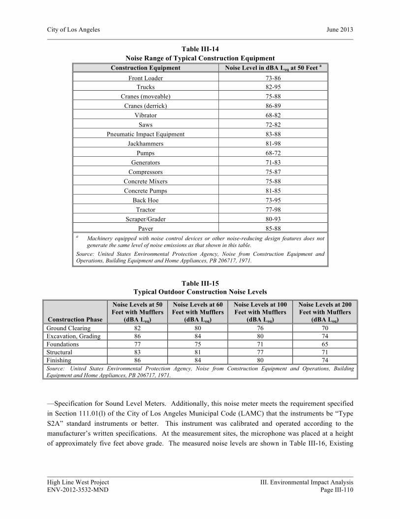
City of Los Angeles June 2013
High Line West Project III. Environmental Impact Analysis ENV-2012-3532-MND Page III-110
Table III-14 Noise Range of Typical Construction Equipment
Construction Equipment Noise Level in dBA Leq at 50 Feet a Front Loader 73-86
Trucks 82-95 Cranes (moveable) 75-88
Cranes (derrick) 86-89 Vibrator 68-82
Saws 72-82 Pneumatic Impact Equipment 83-88
Jackhammers 81-98 Pumps 68-72
Generators 71-83 Compressors 75-87
Concrete Mixers 75-88 Concrete Pumps 81-85
Back Hoe 73-95 Tractor 77-98
Scraper/Grader 80-93 Paver 85-88
a Machinery equipped with noise control devices or other noise-reducing design features does not generate the same level of noise emissions as that shown in this table.
Source: United States Environmental Protection Agency, Noise from Construction Equipment and Operations, Building Equipment and Home Appliances, PB 206717, 1971.
Table III-15 Typical Outdoor Construction Noise Levels
Construction Phase
Noise Levels at 50 Feet with Mufflers
(dBA Leq)
Noise Levels at 60 Feet with Mufflers
(dBA Leq)
Noise Levels at 100 Feet with Mufflers
(dBA Leq)
Noise Levels at 200 Feet with Mufflers
(dBA Leq) Ground Clearing 82 80 76 70 Excavation, Grading 86 84 80 74 Foundations 77 75 71 65 Structural 83 81 77 71 Finishing 86 84 80 74 Source: United States Environmental Protection Agency, Noise from Construction Equipment and Operations, Building Equipment and Home Appliances, PB 206717, 1971.
—Specification for Sound Level Meters. Additionally, this noise meter meets the requirement specified in Section 111.01(l) of the City of Los Angeles Municipal Code (LAMC) that the instruments be “Type S2A” standard instruments or better. This instrument was calibrated and operated according to the manufacturer’s written specifications. At the measurement sites, the microphone was placed at a height of approximately five feet above grade. The measured noise levels are shown in Table III-16, Existing
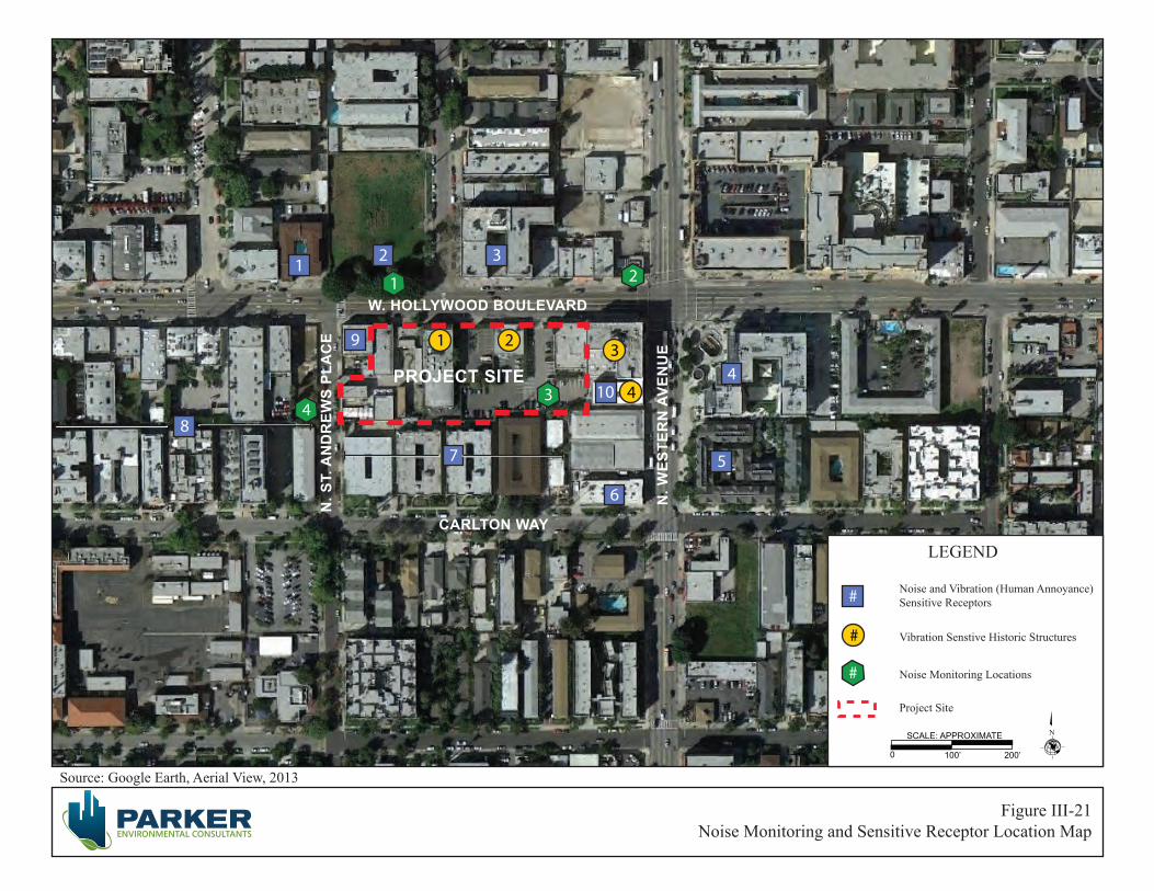
Figure III-21Noise Monitoring and Sensitive Receptor Location Map
W. HOLLYWOOD BOULEVARD
PROJECT SITE
N. W
ESTE
RN
AVE
NU
E
N. S
T. A
ND
REW
S PL
AC
E
CARLTON WAY
Source: Google Earth, Aerial View, 2013
1 2 3
4
5
6
7
8
9
10
LEGEND
N
0 100’ 200’
SCALE: APPROXIMATE
Noise and Vibration (Human Annoyance)Sensitive Receptors
Vibration Senstive Historic Structures
Noise Monitoring Locations
#
#
#
Project Site
1 2
34
3
4
1 2

City of Los Angeles June 2013
High Line West Project III. Environmental Impact Analysis ENV-2012-3532-MND Page III-112
Table III-16 Existing Ambient Daytime Noise Levels in Project Site Vicinity
No. Location Primary Noise Sources Noise Level Statistics a Leq Lmin Lmax
1 North side of Hollywood Boulevard Traffic noise along Hollywood Boulevard and pedestrian activity. 69.1 58.4 82.5
2 Northwest corner of Hollywood Boulevard and Western Avenue
Traffic noise along Hollywood Boulevard and Western Avenue, bus stop activity located approximately 40 feet from measurement location, and pedestrian activity.
72.7 61.4 90.5
3 Southeast corner on the Project Site. Traffic noise along Hollywood Boulevard and surface parking lot activity. 56.6 68.1 48.1
4 Westside of St. Andrews Place near southwest corner of Project Site.
Traffic noise along St. Andrews Place and pedestrian activity. 61.6 49.9 78.9
a Noise measurements were taken on February 13, 2013 at each location for a duration of 15 minutes. Source: Parker Environmental Consultants, November 2012. See Appendix D to this IS/MND for noise monitoring data sheets.
Ambient Daytime Noise Levels in Project Site Vicinity. In addition, the noise measurement locations and the noise sensitive receptors are illustrated in Figure III-21, Noise Monitoring and Sensitive Receptor Location Map.
Due to the use of construction equipment during the construction phase, the Proposed Project would expose surrounding off-site receptors to increased ambient exterior noise levels comparable to those listed above in Table III-15. Table III-17, Estimated Exterior Construction Noise at Nearest Sensitive Receptors, shows the estimated construction noise levels that would occur at the nearest sensitive uses during construction of the Project.
As shown in Table III-17, the construction noise levels forecasted for the proposed construction work during each phase of development associated with the Proposed Project would result in noise increases at the nearest sensitive receptors. It should be noted, however, that any increase in noise levels at off-site receptors during construction of the Proposed Project would be temporary in nature, and would not generate continuously high noise levels, although occasional single-event disturbances from construction are possible. In addition, the construction noise during the heavier initial periods of construction (i.e., excavation and grading work) would typically be reduced in the later construction phases (i.e., interior building construction at the proposed buildings) as the physical structure of the proposed structure would break the line-of-sight noise transmission from the construction area to the nearby sensitive receptors.
As discussed previously, typical construction noise levels associated with the Proposed Project could exceed 75 dBA at 50 feet from the Project Site. However, as defined in the L.A. CEQA Thresholds Guide threshold for construction noise impacts, a significant impact would occur if construction activities

City of Los Angeles June 2013
High Line West Project III. Environmental Impact Analysis ENV-2012-3532-MND Page III-113
Table IIII-17 Estimated Exterior Construction Noise at Nearest Sensitive Receptors
Sensitive Land Usesa
Distance to Project
Site (feet)
Existing Monitored Daytime Ambient
Noise Levels (dBA Leq)
Estimated Peak Construction Noise
Levels (dBA Leq) Noise Level
Increase 1. Downtowner Inn Motel 140 69.1 77.1 8.0 2. Senior Housing with ground floor retail 90 69.1 80.9 11.8
3. Mixed Use With Residential 90 69.1 80.9 11.8
4. Mixed Use With Residential 200 72.7 74.0 1.3
5. Residential 210 72.7 73.5 0.8
6. Roxy Hotel 140 72.7 77.1 4.4
7. Residential 8 56.6 101.9 45.3
8. Residential 60 61.6 84.4 22.8
9. Residential 1 69.1 101.9 32.8
10. Residential 5 56.6 101.9 45.3 a See Figure IV-1, Noise Monitoring and Sensitive Receptor Location Map. Source: Parker Environmental Consultants, February 2013. Calculations based on Federal Transit Administration, Transit Noise and Vibration Impact Assessment, Final Report, May 2006. It should be noted that the peak noise level increase at the nearby sensitive receptors during project construction represents the highest composite noise level that would be generated periodically during a worst-case construction activity and does not represent continuous noise levels occurring throughout the construction day or period.
lasting more than one day would increase the ambient noise levels by 10 dBA or more at any off-site noise-sensitive location. Furthermore, the L.A. CEQA Thresholds Guide also states that construction activities lasting more than ten days in a three-month period, which would increase ambient exterior noise levels by 5 dBA or more at a noise sensitive use, would also normally result in a significant impact. Since construction activities associated with each of the proposed developments at the Project Site would last for more than ten days in a three-month period, the Proposed Project would cause a significant noise impact during construction if the ambient exterior noise levels at the identified off-site and on-site sensitive receptors would be increased by 5 dBA or more. Based on the results shown in Table III-17, the ambient exterior noise levels at five of the identified off-site sensitive receptors would be exceeded by 5 dBA or more (Sensitive Receptor Nos. 1, 2, 3, 7, 8, 9 and 10). Thus, based on criteria established in the L.A. CEQA Threshold Guide, a substantial temporary or periodic increase in ambient noise levels would occur at five of the identified off-site sensitive receptors.
Section 41.40 of the LAMC regulates noise from demolition and construction activities. Exterior demolition and construction activities that generate noise are prohibited between the hours of 9:00 P.M. and 7:00 A.M. Monday through Friday, and between 6:00 P.M. and 8:00 A.M. on Saturday. Demolition and construction are prohibited on Sundays and all federal holidays. The construction activities associated with the Proposed Project would comply with these LAMC requirements. As indicated in Mitigation Measure XII-20, the Department of City Planning further restricts construction and demolition activities to the hours of 7:00 A.M. to 6:00 P.M. Monday through Friday. In addition, pursuant the City
City of Los Angeles June 2013
High Line West Project III. Environmental Impact Analysis ENV-2012-3532-MND Page III-114
Noise Ordinance (LAMC Section 112.05), construction noise levels are exempt from the 75 dBA noise threshold if all technically feasible noise attenuation measures are implemented. Although the estimated construction-related noise levels associated with the Proposed Project would exceed the numerical noise threshold of 75 dBA at 50 feet from the noise source as outlined in the City Noise Ordinance, and the typical construction noise levels associated with the Proposed Project would exceed the existing ambient noise levels at five of the identified off-site sensitive receptors by more than the 5 dBA threshold established by the LA CEQA Thresholds Guide during all construction phases, implementation of the Mitigation Measures identified under MM XII-20, below, would ensure impacts associated with construction-related noise levels are reduced to the maximum extent feasible. Thus, the Proposed Project would be in compliance with the Noise Ordinance and construction noise impacts would be mitigated to less than significant levels.
Mitigation Measures:
XII-20 Increased Noise Levels (Demolition, Grading, and Construction Activities)
• The project shall comply with the City of Los Angeles Noise Ordinance No. 144,331 and 161,574, and any subsequent ordinances, which regulate construction noise sources.
• Construction and demolition shall be restricted to the hours of 7:00 A.M. to 6:00 P.M. Monday through Friday, and 8:00 A.M. to 6:00 P.M. on Saturday.
• Demolition and construction activities shall be scheduled so as to avoid operating several pieces of equipment simultaneously, which causes high noise levels.
• The project contractor shall use power construction equipment with state-of-the-art noise shielding and muffling devices.
• Noise and groundborne vibration construction activities whose specific location on the site may be flexible (e.g., operation of compressors and generators, cement mixing, general truck idling) shall be conducted as far as possible from the nearest noise- and vibration-sensitive land uses, and natural and/or manmade barriers (e.g., intervening construction trailers) shall be used to screen propagation of noise from such activities towards these land uses to the maximum extent possible.
• Barriers such as, but not limited to, plywood structures or flexible sound control curtains extending eight feet in height shall be erected around the perimeter of active construction areas wherever feasible and physically possible to minimize the amount of noise during construction on the nearby noise-sensitive uses.
• All construction truck traffic shall be restricted to truck routes approved by the City of Los Angeles Department of Building and Safety, which shall avoid residential areas and other sensitive receptors to the extent feasible.
• The project shall comply with the City of Los Angeles Building Regulations Ordinance No. 178048, which requires a construction site notice to be provided that includes the following information: job site address, permit number, name and phone number of the contractor and owner or owner’s agent, hours of construction allowed by code or any discretionary approval for the site, and City telephone numbers where violations can be reported. The notice shall be posted
City of Los Angeles June 2013
High Line West Project III. Environmental Impact Analysis ENV-2012-3532-MND Page III-115
and maintained at the construction site prior to the start of construction and displayed in a location that is readily visible to the public.
Operational Noise
Upon completion and operation of the Proposed Project, on-site operational noise would be generated by heating, ventilation, and air conditioning (HVAC) equipment installed on the new structure. However, the noise levels generated by these equipment types are not anticipated to be substantially greater than those generated by the current HVAC equipment serving the existing buildings in the Project vicinity. As such, the HVAC equipment associated with the Proposed Project would not represent a new source of noise in the Project Site vicinity. In addition, the operation of this and any other on-site stationary sources of noise would be required to comply with the Section 112.02 of the LAMC, which prohibits noise from air conditioning, refrigeration, heating, pumping, and filtering equipment from exceeding the ambient noise level on the premises of other occupied properties by more than five decibels.
In order to ensure that on-site residences would not be adversely impacted by ambient urban noise levels, Mitigation Measure XII-60 shall be implemented to ensure that dwelling units associated with the Project would be constructed in accordance with Title 24 insulation standards of the California Code of Regulations for residential buildings, which serves to provide an acceptable interior noise environment for sensitive uses. Furthermore, implementation of Mitigation Measure XII-60 would require that the Project Applicant submit evidence to the City’s Department of Building and Safety of a means of sound insulation sufficient to mitigate interior noise levels below a CNEL of 45 dBA in any habitable room of the Project. With mitigation, impacts associated with interior noise levels at the proposed residences would be less than significant.
Mitigation Measures:
XII-60 Increased Noise Levels (Mixed-Use Development)
• Wall and floor-ceiling assemblies separating commercial tenant spaces, residential units, and public places, shall have a Sound Transmission Coefficient (“STC”) value of at least 50, as determined in accordance with ASTM E90 and ASTM E413.
b) Would the project result in exposure of persons to or generation of excessive groundborne vibration or groundborne noise levels?
Potentially Significant Impact Unless Mitigation Incorporated. Vibration is sound radiated through the ground. Vibration can result from a source (e.g., subway operations, vehicles, machinery equipment, etc.) causing the adjacent ground to move, thereby creating vibration waves that propagate through the soil to the foundations of nearby buildings. This effect is referred to as groundborne vibration. The peak particle velocity (PPV) or the root mean square (RMS) velocity is usually used to describe vibration levels. PPV is defined as the maximum instantaneous peak of the vibration level, while RMS is defined as the square root of the average of the squared amplitude of the level. PPV is typically used for evaluating potential building damage, while RMS velocity in decibels (VdB) is typically more suitable for evaluating human response.

City of Los Angeles June 2013
High Line West Project III. Environmental Impact Analysis ENV-2012-3532-MND Page III-116
The background vibration velocity level in residential areas is usually around 50 VdB. The vibration velocity level threshold of perception for humans is approximately 65 VdB. A vibration velocity level of 75 VdB is the approximate dividing line between barely perceptible and distinctly perceptible levels for most people. Most perceptible indoor vibration is caused by sources within buildings such as operation of mechanical equipment, movement of people, or the slamming of doors. Typical outdoor sources of perceptible groundborne vibration are construction equipment, steel-wheeled trains, and traffic on rough roads. If a roadway is smooth, the groundborne vibration from traffic is rarely perceptible. The range of interest is from approximately 50 VdB, which is the typical background vibration velocity level, to 100 VdB, which is the general threshold where minor damage can occur in fragile buildings.
Construction
Construction activities for the Proposed Project have the potential to generate low levels of groundborne vibration. The operation of construction equipment generates vibrations that propagate though the ground and diminishes in intensity with distance from the source. Vibration impacts can range from no perceptible effects at the lowest vibration levels, to low rumbling sounds and perceptible vibration at moderate levels, to slight damage of buildings at the highest levels. Thus, construction activities associated with the Proposed Project could have an adverse impact on both sensitive structures (i.e., building damage) and populations (i.e., annoyance).
In terms of construction-related impacts on buildings, the City of Los Angeles has not adopted any policies or guidelines relative to groundborne vibration impacts. While the Los Angeles County Code (LACC Section 12.08.350) states a presumed perception threshold of 0.01 inch per second RMS, this threshold applies to groundborne vibrations from long-term operational activities, not construction. Consequently, as both the City of Los Angeles and the County of Los Angeles do not have a significance threshold to assess vibration impacts during construction, the Federal Transit Administration (FTA) and California Department of Transportation’s (Caltrans) adopted vibration standards for buildings which are used to evaluate potential impacts related to project construction. Based on the FTA and Caltrans criteria, construction impacts relative to groundborne vibration would be considered significant if the following were to occur:27
• Project construction activities would cause a PPV groundborne vibration level to exceed 0.5 inches per second at any building that is constructed with reinforced-concrete, steel, or timber;
• Project construction activities would cause a PPV groundborne vibration level to exceed 0.3 inches per second at any engineered concrete and masonry buildings;
• Project construction activities would cause a PPV groundborne vibration level to exceed 0.2 inches per second at any non-engineered timber and masonry buildings; or
27 Federal Transit Administration, Transit Noise and Vibration Impact Assessment, May 2006; and California Department of Transportation, Transportation- and Construction –Induced Vibration Guidance Manual, June 2004.

City of Los Angeles June 2013
High Line West Project III. Environmental Impact Analysis ENV-2012-3532-MND Page III-117
• Project construction activities would cause a PPV ground-borne vibration level to exceed 0.12 inches per second at any historical building or building that is extremely susceptible to vibration damage.
In addition, the City of Los Angeles has not adopted any thresholds associated with human annoyance for groundborne vibration impacts. Therefore, this analysis uses the FTA’s vibration impact thresholds for human annoyance. These thresholds include 80 VdB at residences and buildings where people normally sleep (e.g., nearby residences) and 83 VdB at institutional buildings, which includes schools and churches. No thresholds have been adopted or recommended for commercial and office uses.
Table III-18, Vibration Source Levels for Construction Equipment, identifies various PPV and RMS velocity (in VdB) levels for the types of construction equipment that would operate at the Project Site during construction. As shown in Table III-18, vibration velocities could range from 0.003 to 0.089 inch/sec PPV at 25 feet from the source activity, with corresponding vibration levels ranging from 58 VdB to 87 VdB at 25 feet from the source activity, depending on the type of construction equipment in use.
Table III-18 Vibration Source Levels for Construction Equipment
Equipment Approximate PPV (in/sec) Approximate RMS (VdB)
25 Feet
50 Feet
60 Feet
75 Feet
100 Feet
25 Feet
50 Feet
60 Feet
75 Feet
100 Feet
Large Bulldozer 0.089 0.031 0.024 0.017 0.011 87 78 76 73 69 Caisson Drilling 0.089 0.031 0.024 0.017 0.011 87 78 76 73 69 Loaded Trucks 0.076 0.027 0.020 0.015 0.010 86 77 75 72 68 Jackhammer 0.035 0.012 0.009 0.007 0.004 79 70 68 65 61
Small Bulldozer 0.003 0.001 0.0008 0.0006 0.0004 58 49 47 44 40 Source: Federal Transit Administration, Transit Noise and Vibration Impact Assessment, Final Report, 2006.
There are two historic buildings on the Project Site and two historic buildings immediately adjacent to the Project Site to the east. The two historic buildings located on the Project Site include the Falcon Studios Building located at 5524 Hollywood Boulevard and a two-story commercial building in the Italian Renaissance Revival style located at 5540 Hollywood Boulevard. The off-site adjacent historic buildings include the Mayer Building located at 5500 Hollywood Boulevard and the Bricker Building located at 1671 N. Western Avenue. The Project includes the preservation and incorporation of the Falcon Studios’ historic building façade and the northerly most 44 feet of the two-story commercial building located at 5540 Hollywood Boulevard. Because the project involves physical changes to these two structures, including the removal and reconstruction of the side walls and roof, a vibration monitoring plan would be impractical for purposes of determining the level of potential impact. Rather, as noted in Mitigation Measure V-10, under Cultural Resources, compliance with the Secretary of the Interior’s Standards for Rehabilitation and Guidelines for Rehabilitating Historic Buildings shall be reviewed, monitored, and carried out to the satisfaction of the City of Los Angeles Cultural Heritage Commission. The Commission may delegate this responsibility to its staff in the Office of Historic Resources.

City of Los Angeles June 2013
High Line West Project III. Environmental Impact Analysis ENV-2012-3532-MND Page III-118
Due to its close proximity to the Project Site, construction and earthwork activities would also have the potential to adversely impact the adjacent off-site Mayer and Bricker Buildings. The Project would have the potential to cause a PPV ground-borne vibration level to exceed 0.12 inches per second at any historical building or building that is extremely susceptible to vibration damage. As detailed in Mitigation Measure VII-240 below, the Project will be required to implement a structure monitoring program during construction activities to ensure the structural stability of the adjacent historic resources is not compromised. As such, impacts with respect to building damage upon the historic Mayer and Bricker buildings would be mitigated to a less than significant level.
In terms of human annoyance resulting from vibration generated during construction, persons in the multi-family residential uses and nearby hotels could be exposed to increased vibration levels on a temporary and intermittent basis during the construction period. Table III-19, Estimated Vibration Levels at Nearest Sensitive Receptors, shows that construction-generated vibration levels experienced at the sensitive receptors identified in Figure III-21, Noise Monitoring and Sensitive Receptor Location Map, would not exceed the 80 VdB threshold for all uses, except the residences located directly south of the Project Site (Sensitive Receptor No. 7). It should be noted that much of the construction work would be conducted away from the southern property line and vibration levels at these residences would be substantially reduced when the construction activities are located toward the center and northern portions of the Project Site. Furthermore, implementation of the measures identified under Mitigation Measure XII-20, above, would serve to reduce construction related vibration levels to the maximum extent feasible, and thus reducing the annoyance factor to an acceptable level. For example, pursuant to the proposed mitigation measures, construction and demolition activities will be restricted to the hours of 7:00 A.M. to 6:00 P.M. Monday through Friday, and 8:00 A.M. to 6:00 P.M. on Saturday. For these reasons, and because any vibration level increases experienced at the residential uses south of the Project Site above the annoyance thresholds would occur during the acceptable time periods for construction activities, and on a temporary and intermittent basis during the construction period, impacts associated with groundborne vibration would be considered less than significant.
Table III-19 Estimated Vibration Levels at Nearest Sensitive Receptors
Sensitive Land Usesa Distance to
Project Site (feet) Estimated Vibration
Levels (VdB) 1. Downtowner Inn Motel 140 64.6 2. Mixed Use With Residential 90 70.3 3. Mixed Use With Residential 90 70.3 4. Mixed Use With Residential 200 59.9 5. Residential 210 59.3 6. Roxy Hotel 140 64.6 7. Residential 8 101.9 8. Residential 60 75.6 a See Figure IV-1, Noise Monitoring and Sensitive Receptor Location Map. Source: Parker Environmental Consultants, February 2013. Calculations based on Federal Transit Administration, Transit Noise and Vibration Impact Assessment, Final Report, May 2006.
City of Los Angeles June 2013
High Line West Project III. Environmental Impact Analysis ENV-2012-3532-MND Page III-119
Mitigation Measures:
XII-240: Temporary Groundborne Vibration Impacts During Construction
• All new construction work shall be performed so as not to adversely affect the historic designations of the Mayer Building located immediately adjacent to the site at 5500 Hollywood Boulevard and the Bricker Building located at 1671 N. Western Avenue. Preconstruction surveys shall be performed to document conditions of the on-site and adjacent historic structures. The structural monitoring program shall be implemented and recorded during construction.
• The performance standards of the structure monitoring plan shall including the following: a) Documentation shall consist of video and/or photographic documentation of accessible
and visible areas on the exterior and select interior facades of the buildings. A registered civil engineer or certified engineering geologist shall develop recommendations for the adjacent structure monitoring program that will include, but not be limited to, vibration monitoring, elevation and lateral monitoring points, crack monitors and other instrumentation deemed necessary to protect the historic resources from construction-related damage.
b) The monitoring program shall survey for vertical and horizontal movement, as well as vibration thresholds. If the thresholds are met or exceeded, or noticeable structural damage becomes evident to the project contractor, work shall stop in the area of the affected building until measures have been taken to stabilize the affected building to prevent construction related damage to historic resources.
c) The structure monitoring program shall be submitted to the Department of Building and Safety and received into the case file for the associated discretionary action permitting the project prior to initiating any construction activities.
Operation
The Proposed Project is a mixed-use development and would not involve the use of stationary equipment that would result in high vibration levels, which are more typical for large commercial and industrial projects. Although groundborne vibration at the Project Site and immediate vicinity may currently result from heavy-duty vehicular travel (e.g., refuse trucks and transit buses) on the nearby local roadways, the proposed land uses at the Project Site would not result in the increased use of these heavy-duty vehicles on the public roadways. While refuse trucks would be used for the removal of solid waste at the Project Site, these trips would typically only occur once a week and would not be any different than those presently occurring in the vicinity of the Project Site. As such, vibration impacts associated with operation of the Proposed Project would be less than significant.
c) Would the project result in a substantial permanent increase in ambient noise levels in the project vicinity above levels existing without the project?
Potentially Significant Impact Unless Mitigation Incorporated. A significant impact may occur if the Proposed Project were to result in a substantial permanent increase in ambient noise levels above existing ambient noise levels without the Proposed Project. As defined in the L.A. CEQA Thresholds Guide
City of Los Angeles June 2013
High Line West Project III. Environmental Impact Analysis ENV-2012-3532-MND Page III-120
threshold for operational noise impacts, a project would normally have a significant impact on noise levels from project operations if the project causes the ambient noise level measured at the property line of affected uses that are shown in Table III-20, Community Noise Exposure (CNEL), to increase by 3 dBA in CNEL to or within the “normally unacceptable” or “clearly unacceptable” category, or any 5 dBA or greater noise increase. Thus, a significant impact would occur if noise levels associated with operation of the Proposed Project would increase the ambient noise levels by 3 dBA CNEL at homes where the resulting noise level would be at least 70 dBA CNEL. In addition, any long-term increase of 5 dBA CNEL or more is considered to cause a significant impact. Generally, in order to achieve a 3 dBA CNEL increase in ambient noise from traffic, the volume on any given roadway would need to double. In addition to analyzing potential impacts in terms of CNEL, the analysis also addresses increases in on-site noise sources per the provisions of the LAMC, which establishes a Leq standard of 5 dBA over ambient conditions as constituting a LAMC violation.
Traffic Noise
In order for a new noise source to be audible, there would need to be a 3 dBA or greater CNEL noise increase. As discussed above, the traffic volume on any given roadway would need to double in order for a 3 dBA increase in ambient noise to occur. According to the L.A. CEQA Thresholds Guide, if a project would result in an increase to traffic volumes that is less than double the existing traffic volumes, then the project’s mobile noise impacts can be assumed to be less than significant.
According to the traffic analysis provided for the Proposed Project, the proposed development would result in a maximum net increase of 1,267 daily vehicle trips, including 40 a.m. peak hour trips and 64 p.m. peak hour trips. As shown in greater detail in the Project Traffic Study, the highest project-related trip increase would occur at intersection number 3 during the p.m. peak hour with 25 peak hour trips. When compared to the existing 2,734 vehicle trips occurring at intersection number 3 during the a.m. peak hour, it is clear that the Project would not have the potential to double the traffic volumes on any roadway segment in the vicinity of the Project Site. As such, the Project would not have the potential to increase roadway noise levels by 3 dBA, and thus traffic generated noise impacts would be considered less than significant.
Operational Noise
Stationary Noise Sources
New stationary sources of noise, such as rooftop mechanical HVAC equipment would be installed on the proposed building at the Project Site. As discussed in Question 11(a) above, the design of this equipment would be required to comply with Section 112.02 of the LAMC, which prohibits noise from air conditioning, refrigeration, heating, pumping, and filtering equipment from exceeding the ambient noise level on the premises of other occupied properties by more than five decibels. Thus, because the noise levels generated by the HVAC equipment serving the Proposed Project would not be allowed to exceed the ambient noise level by five decibels on the premises of the adjacent properties, a substantial permanent increase in noise levels would not occur at the nearby sensitive receptors. This impact would be less than significant.

City of Los Angeles June 2013
High Line West Project III. Environmental Impact Analysis ENV-2012-3532-MND Page III-121
Table III-20 Community Noise Exposure (CNEL)
Land Use Normally
Acceptablea Conditionally Acceptableb
Normally Unacceptablec
Clearly Unacceptabled
Single-family, Duplex, Mobile Homes 50 - 60 55 - 70 70 - 75 above 75
Multi-Family Homes 50 - 65 60 - 70 70 - 75 above 75
Schools, Libraries, Churches, Hospitals, Nursing Homes 50 - 70 60 - 70 70 - 80 above 80
Transient Lodging – Motels, Hotels 50 - 65 60 - 70 70 - 80 above 75
Auditoriums, Concert Halls, Amphitheaters --- 50 - 70 --- above 70
Sports Arena, Outdoor Spectator Sports --- 50 - 75 --- above 75
Playgrounds, Neighborhood Parks 50 - 70 --- 67 - 75 above 75
Golf Courses, Riding Stables, Water Recreation, Cemeteries 50 - 75 --- 70 - 80 above 80
Office Buildings, Business and Professional Commercial 50 - 70 67 - 77 above 75 ---
Industrial, Manufacturing, Utilities, Agriculture 50 - 75 70 - 80 above 75 ---
a Normally Acceptable: Specified land use is satisfactory, based upon the assumption that any buildings involved are of normal conventional construction without any special noise insulation requirements. b Conditionally Acceptable: New construction or development should be undertaken only after a detailed analysis of the noise reduction requirements is made and needed noise insulation features included in the design. Conventional construction, but with closed windows and fresh air supply systems or air conditioning will normally suffice. c Normally Unacceptable: New construction or development should generally be discouraged. If new construction or development does proceed, a detailed analysis of the noise reduction requirements must be made and needed noise insulation features included in the design. d Clearly Unacceptable: New construction or development should generally not be undertaken. Source: Office of Planning and Research, State of California Genera Plan Guidelines, October 2003 (in coordination with the California Department of Health Services); City of Los Angeles, General Plan Noise Element, adopted February 1999.
Parking Garage Noise
Noise would be generated by activities within the new parking garage associated with the Proposed Project. Parking would be provided on the ground floor and one subterranean level under the Project Site. Sources of noise within the parking areas would include engines accelerating, doors slamming, car alarms, and people talking. Noise levels within the parking areas would fluctuate with the amount of automobile and human activity. Operational-related noise generated by motor driven vehicles within the Project Site is regulated under the LAMC. Specifically, with regard to motor driven vehicles, Section 114.02 of the LAMC prohibits the operation of any motor driven vehicles upon any property within the City such that the created noise would cause the noise level on the premises of any occupied residential property to exceed the ambient noise level by more than five decibels. With implementation of
City of Los Angeles June 2013
High Line West Project III. Environmental Impact Analysis ENV-2012-3532-MND Page III-122
Mitigation Measure XII-40, below, noise impacts associated with the Project’s subterranean parking garage would be less than significant.
Mitigation Measures:
XII-40 Increased Noise Levels (Parking Structure Ramps)
• Concrete, not metal, shall be used for construction of parking ramps. • The interior ramps shall be textured to prevent tire squeal at turning areas.
d) Would the project result in a substantial temporary or periodic increase in ambient noise levels in the project vicinity above levels existing without the project?
Potentially Significant Impact Unless Mitigation Incorporated. A significant impact may occur if the Proposed Project were to result in a substantial temporary or periodic increase in ambient noise levels above existing ambient noise levels without the Proposed Project. A significant impact would occur if construction activities lasting more than one day would increase the ambient noise levels by 10 dBA or more at any off-site noise-sensitive location. In addition, based on the L.A. CEQA Thresholds Guide, construction activities lasting more than ten days in a three-month period, which would increase ambient exterior noise levels by 5 dBA or more at a noise sensitive use, would also normally result in a significant impact.
As discussed above, impacts are expected to be less than significant for construction noise and vibration, and operational noise and vibration. The implementation of construction-related mitigation measures identified under Mitigation Measures XII-20, XII-40, XII-60 and XII-240 would ensure the Project would not result in a substantial temporary or periodic increase in ambient noise levels in the project vicinity, and these impacts would be less than significant.
e) For a project located within an airport land use plan or, where such a plan has not been adopted, within two miles of a public airport or public use airport, would the project expose people residing or working in the project area to excessive noise levels?
No Impact. A significant impact may occur if a Proposed Project were located within an airport land use plan and would introduce substantial new sources of noise or substantially add to existing sources of noise within or in the vicinity of a Project Site. There are no airports within a two-mile radius of the Project Site, and the Project Site is not within any airport land use plan or airport hazard zone. The Proposed Project would not expose people to excessive noise levels associated with airport uses. No impact would occur.
f) For a project within the vicinity of a private airstrip, would the project expose people residing or working in the project area to excessive noise levels?
No Impact. This question would apply to a project only if it were in the vicinity of a private airstrip and would subject area residents and workers to a safety hazard. The Project Site is not located in the vicinity

City of Los Angeles June 2013
High Line West Project III. Environmental Impact Analysis ENV-2012-3532-MND Page III-123
of a private airstrip. As no such facilities are located in the vicinity of the Project Site, no impact would occur.
Cumulative Impacts
Less Than Significant Impact. Development of the Proposed Project in conjunction with the related projects would result in an increase in construction-related and traffic-related noise as well as on-site stationary noise sources in the already urbanized downtown area of the City of Los Angeles. The Project Applicant has no control over the timing or sequencing of the related projects that have been identified within the Proposed Project study area. Therefore, any quantitative analysis that assumes multiple, concurrent construction projects would be speculative. Construction-period noise for the Proposed Project and each related project (that has not yet been built) would be localized. In addition, each of the related projects would be required to comply with the City’s noise ordinance, as well as mitigation measures that may be prescribed pursuant to CEQA provisions that require potentially significant impacts to be reduced to the extent feasible. Thus, the cumulative impact associated with construction noise would be less than significant.
13. POPULATION AND HOUSING
a) Would the project induce substantial population growth in an area, either directly (for example, by proposing new homes and businesses) or indirectly (for example, through extension of roads or other infrastructure)?
Less Than Significant Impact. A significant impact may occur if the project would locate new development such as homes, businesses, or infrastructure, with the effect of substantially inducing growth in the project area that would otherwise not have occurred as rapidly or in as great a magnitude. Based on the LA CEQA Thresholds Guide, the determination of whether the project results in a significant impact on population and housing growth shall be made considering the following factors:
• The degree to which a project would cause growth (i.e., new housing or employment generators) or accelerate development in an undeveloped area that exceeds projected/planned levels for the year of project occupancy/buildout, and that would result in an adverse physical change in the environment;
• Whether the project would introduce unplanned infrastructure that was not previously evaluated in the adopted Community Plan or General Plan; and
• The extent to which growth would occur without implementation of the project.
The Proposed Project is consistent with the regional growth forecast for the Los Angeles Subregion. According to the SCAG 2008 Regional Growth Forecast, the City of Los Angeles Subregion had a population of about 4.05 million in 2010. By 2030, SCAG forecasts a population increase to 4.34 million persons. As shown in Table III-21, SCAG Population/Households Forecast for the City of Los Angeles Subregion, below, the forecast from 2010 through 2030 envisions growth of 290,797 additional persons, yielding an approximate 6.7 percent growth rate.
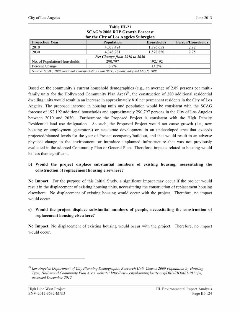
City of Los Angeles June 2013
High Line West Project III. Environmental Impact Analysis ENV-2012-3532-MND Page III-124
Table III-21 SCAG’s 2008 RTP Growth Forecast
for the City of Los Angeles Subregion Projection Year Population Households Person/Households 2010 4,057,484 1,386,658 2.92 2030 4,348,281 1,578,850 2.75
Net Change from 2010 to 2030 No. of Population/Households 290,797 192,192 Percent Change 6.7% 13.2% Source: SCAG, 2008 Regional Transportation Plan (RTP) Update, adopted May 8, 2008.
Based on the community’s current household demographics (e.g., an average of 2.89 persons per multi-family units for the Hollywood Community Plan Area)28, the construction of 280 additional residential dwelling units would result in an increase in approximately 810 net permanent residents in the City of Los Angeles. The proposed increase in housing units and population would be consistent with the SCAG forecast of 192,192 additional households and approximately 290,797 persons in the City of Los Angeles between 2010 and 2030. Furthermore the Proposed Project is consistent with the High Density Residential land use designation. As such, the Proposed Project would not cause growth (i.e., new housing or employment generators) or accelerate development in an undeveloped area that exceeds projected/planned levels for the year of Project occupancy/buildout, and that would result in an adverse physical change in the environment; or introduce unplanned infrastructure that was not previously evaluated in the adopted Community Plan or General Plan. Therefore, impacts related to housing would be less than significant.
b) Would the project displace substantial numbers of existing housing, necessitating the construction of replacement housing elsewhere?
No Impact. For the purpose of this Initial Study, a significant impact may occur if the project would result in the displacement of existing housing units, necessitating the construction of replacement housing elsewhere. No displacement of existing housing would occur with the project. Therefore, no impact would occur.
c) Would the project displace substantial numbers of people, necessitating the construction of replacement housing elsewhere?
No Impact. No displacement of existing housing would occur with the project. Therefore, no impact would occur.
28 Los Angeles Department of City Planning Demographic Research Unit, Census 2000 Population by Housing Type, Hollywood Community Plan Area, website: http://www.cityplanning.lacity.org/DRU/HOMEDRU.cfm, accessed December 2012.

City of Los Angeles June 2013
High Line West Project III. Environmental Impact Analysis ENV-2012-3532-MND Page III-125
Cumulative Impacts
No Impact. The 61 related projects (Table II-4) would introduce additional residential, hotel, commercial/retail/restaurant, office, hospital, school, parking and entertainment industry related uses to the City of Los Angeles. Any residential related projects would result in direct population growth in the City of Los Angeles, while other types of related projects could result in indirect population growth. As shown in Table III-22, the Proposed Project and related projects that involve residential developments would cumulatively contribute approximately 7,786 new residential dwelling units to the area, generating approximately 22,505 new residents.
Table III-22 Projected Cumulative Housing Units
Related Projects (By Housing Type) Total Housing Units Total Residents a Apartments 5,235 15,130 Condominiums 2,031 5,870 Student Housing 224 648 Faculty/Staff Housing 16 47
Related Projects Total: 7,506 21,695 Proposed Project Net Total: 280 810
Cumulative Total: 7,786 22,505 Notes: a Based on a generation rate of 2.89 residents per dwelling unit. Los Angeles Department of City Planning Demographic
Research Unit, Census 2000 Population by Housing Type, Hollywood Community Plan Area, accessed December 2012. Source: Parker Environmental Consultants, 2013.
As discussed in Question 13(a), the Proposed Project would not exceed the growth projections of SCAG’s RCP for the City of Los Angeles subregion. Furthermore, the Proposed Project is the type of project encouraged by SCAG and City policies to accommodate growth in urban centers that are close to existing employment centers and accessible to mass transit. Because the Proposed Project would not displace any residents, and the population growth potentially associated with the Proposed Project has already been anticipated and planned for within the Hollywood Community Plan Area, the Proposed Project’s population growth would not be cumulatively considerable. Therefore, the Proposed Project’s cumulative impacts to population and housing would be less than significant.
14. PUBLIC SERVICES
a) Would the project result in substantial adverse physical impacts associated with the provision of new or physically altered government facilities, need for new or physically altered governmental facilities, the construction of which could cause significant environmental impacts, in order to maintain acceptable service ratios, response times or other performance objective for any of the following public services:

City of Los Angeles June 2013
High Line West Project III. Environmental Impact Analysis ENV-2012-3532-MND Page III-126
(i) Fire protection
Potentially Significant Impact Unless Mitigation Incorporated. Based on the LA CEQA Thresholds Guide, a project would normally have a significant impact on fire protection if it requires the addition of a new fire station or the expansion, consolidation or relocation of an existing facility to maintain service. The City of Los Angeles Fire Department (LAFD) considers fire protection services for a project adequate if a project is within the maximum response distance for the land use proposed. Pursuant to Section 57.09.07A of the LAMC, the maximum response distance between residential land uses and a LAFD fire station that houses an engine or truck company is 1.5 miles; while for a commercial land use, the distance is one mile for an engine company and 1.5 miles for a truck company. If either of these distances is exceeded, all structures located in the applicable residential or commercial area would be required to install automatic fire sprinkler systems.
The Proposed Project would include 280 dwelling units and 12,030 square feet of ground floor commercial retail uses. The Project would generate approximately 810 new residents. Therefore, the Proposed Project could potentially increase the demand for LAFD services. The Project Site is served by LAFD Station No. 82, located at 1800 North Bronson Avenue, approximately 0.5 mile northwest of the Project Site. Based on the response distance criteria specified in LAMC 57.09.07A and the relatively short distance from Fire Station No. 82 to the Project Site, fire protection response would be considered adequate.
The required fire flow necessary for fire protection varies with the type of development, life hazard, occupancy, and the degree of fire hazard. Pursuant to LAMC Section 57.09.06, City-established fire flow requirements vary from 2,000 gallons per minute (gpm) in low-density residential areas to 12,000 gpm in high-density commercial or industrial areas. In any instance, a minimum residual water pressure of 20 pounds per square inch (PSI) is to remain in the water system while the required gpm is flowing. The overall fire flow requirement for the proposed mixed-use commercial/residential development is 4,000 gpm from four fire hydrants flowing simultaneously. The adequacy of existing water pressure and availability in the project area with respect to required fire flow would be determined by LAFD during the site plan review process. Therefore, since the LAFD could adequately serve the project without the addition of a new or expanded station, the impact related to fire protection would be less than significant.
Mitigation Measure:
XIV-10 Public Services (Fire)
• The following recommendations of the Fire Department relative to fire safety shall be incorporated into the building plans, which includes the submittal of a plot plan for approval by the Fire Department either prior to the recordation of a final map or the approval of a building permit. The plot plan shall include the following minimum design features: fire lanes, where required, shall be a minimum of 20 feet in width; all structures must be within 300 feet of an approved fire hydrant, and entrances to any dwelling unit or guest room shall not be more than 150 feet in distance in horizontal travel from the edge of the roadway of an improved street or approved fire lane.
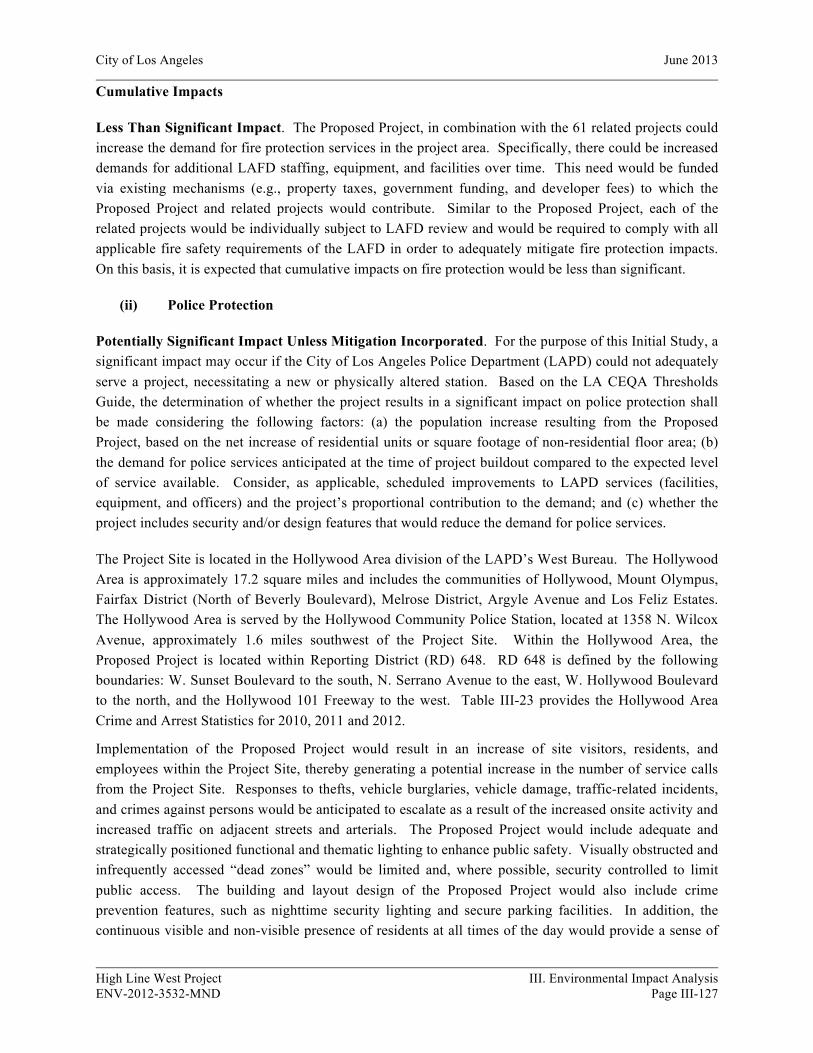
City of Los Angeles June 2013
High Line West Project III. Environmental Impact Analysis ENV-2012-3532-MND Page III-127
Cumulative Impacts
Less Than Significant Impact. The Proposed Project, in combination with the 61 related projects could increase the demand for fire protection services in the project area. Specifically, there could be increased demands for additional LAFD staffing, equipment, and facilities over time. This need would be funded via existing mechanisms (e.g., property taxes, government funding, and developer fees) to which the Proposed Project and related projects would contribute. Similar to the Proposed Project, each of the related projects would be individually subject to LAFD review and would be required to comply with all applicable fire safety requirements of the LAFD in order to adequately mitigate fire protection impacts. On this basis, it is expected that cumulative impacts on fire protection would be less than significant.
(ii) Police Protection
Potentially Significant Impact Unless Mitigation Incorporated. For the purpose of this Initial Study, a significant impact may occur if the City of Los Angeles Police Department (LAPD) could not adequately serve a project, necessitating a new or physically altered station. Based on the LA CEQA Thresholds Guide, the determination of whether the project results in a significant impact on police protection shall be made considering the following factors: (a) the population increase resulting from the Proposed Project, based on the net increase of residential units or square footage of non-residential floor area; (b) the demand for police services anticipated at the time of project buildout compared to the expected level of service available. Consider, as applicable, scheduled improvements to LAPD services (facilities, equipment, and officers) and the project’s proportional contribution to the demand; and (c) whether the project includes security and/or design features that would reduce the demand for police services.
The Project Site is located in the Hollywood Area division of the LAPD’s West Bureau. The Hollywood Area is approximately 17.2 square miles and includes the communities of Hollywood, Mount Olympus, Fairfax District (North of Beverly Boulevard), Melrose District, Argyle Avenue and Los Feliz Estates. The Hollywood Area is served by the Hollywood Community Police Station, located at 1358 N. Wilcox Avenue, approximately 1.6 miles southwest of the Project Site. Within the Hollywood Area, the Proposed Project is located within Reporting District (RD) 648. RD 648 is defined by the following boundaries: W. Sunset Boulevard to the south, N. Serrano Avenue to the east, W. Hollywood Boulevard to the north, and the Hollywood 101 Freeway to the west. Table III-23 provides the Hollywood Area Crime and Arrest Statistics for 2010, 2011 and 2012.
Implementation of the Proposed Project would result in an increase of site visitors, residents, and employees within the Project Site, thereby generating a potential increase in the number of service calls from the Project Site. Responses to thefts, vehicle burglaries, vehicle damage, traffic-related incidents, and crimes against persons would be anticipated to escalate as a result of the increased onsite activity and increased traffic on adjacent streets and arterials. The Proposed Project would include adequate and strategically positioned functional and thematic lighting to enhance public safety. Visually obstructed and infrequently accessed “dead zones” would be limited and, where possible, security controlled to limit public access. The building and layout design of the Proposed Project would also include crime prevention features, such as nighttime security lighting and secure parking facilities. In addition, the continuous visible and non-visible presence of residents at all times of the day would provide a sense of
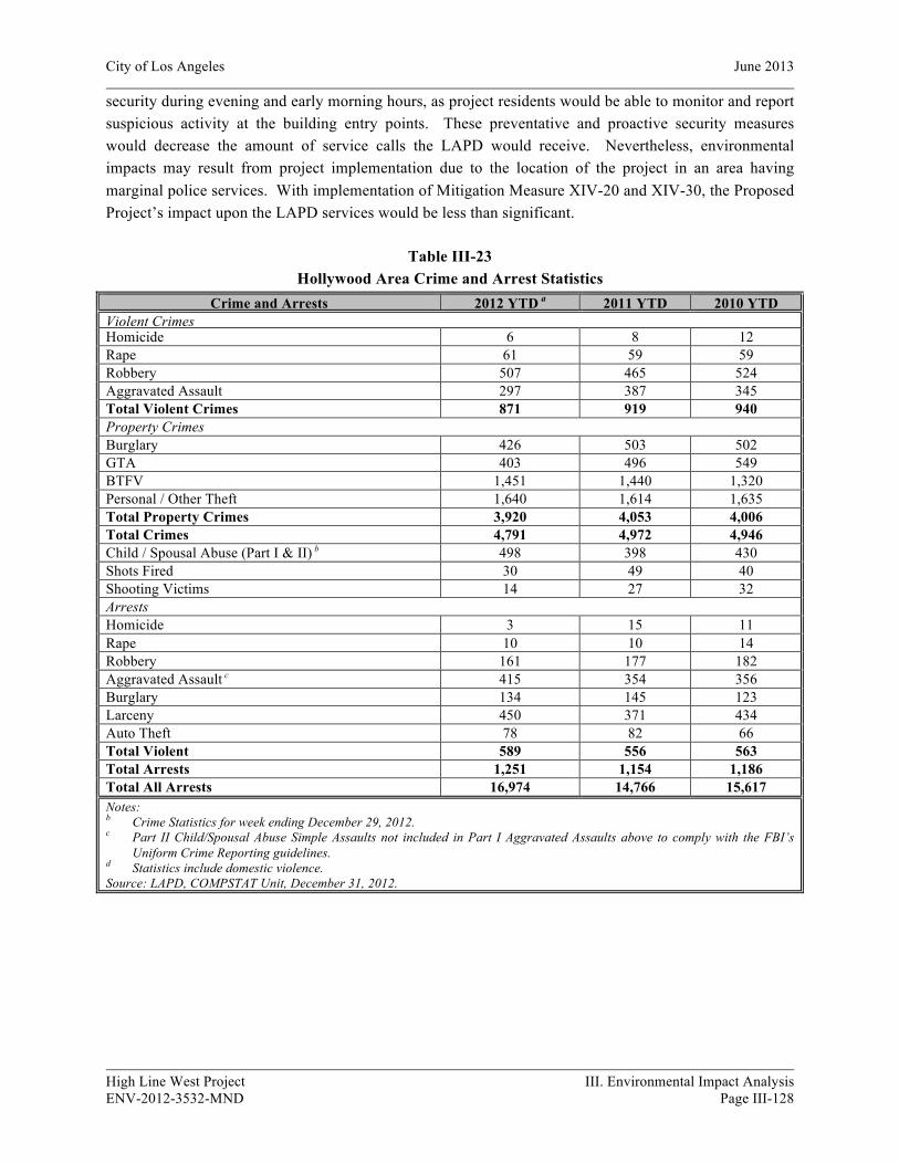
City of Los Angeles June 2013
High Line West Project III. Environmental Impact Analysis ENV-2012-3532-MND Page III-128
security during evening and early morning hours, as project residents would be able to monitor and report suspicious activity at the building entry points. These preventative and proactive security measures would decrease the amount of service calls the LAPD would receive. Nevertheless, environmental impacts may result from project implementation due to the location of the project in an area having marginal police services. With implementation of Mitigation Measure XIV-20 and XIV-30, the Proposed Project’s impact upon the LAPD services would be less than significant.
Table III-23 Hollywood Area Crime and Arrest Statistics
Crime and Arrests 2012 YTD a 2011 YTD 2010 YTD Violent Crimes Homicide 6 8 12 Rape 61 59 59 Robbery 507 465 524 Aggravated Assault 297 387 345 Total Violent Crimes 871 919 940 Property Crimes Burglary 426 503 502 GTA 403 496 549 BTFV 1,451 1,440 1,320 Personal / Other Theft 1,640 1,614 1,635 Total Property Crimes 3,920 4,053 4,006 Total Crimes 4,791 4,972 4,946 Child / Spousal Abuse (Part I & II) b 498 398 430 Shots Fired 30 49 40 Shooting Victims 14 27 32 Arrests Homicide 3 15 11 Rape 10 10 14 Robbery 161 177 182 Aggravated Assault c 415 354 356 Burglary 134 145 123 Larceny 450 371 434 Auto Theft 78 82 66 Total Violent 589 556 563 Total Arrests 1,251 1,154 1,186 Total All Arrests 16,974 14,766 15,617 Notes: b Crime Statistics for week ending December 29, 2012. c Part II Child/Spousal Abuse Simple Assaults not included in Part I Aggravated Assaults above to comply with the FBI’s
Uniform Crime Reporting guidelines. d Statistics include domestic violence. Source: LAPD, COMPSTAT Unit, December 31, 2012.
City of Los Angeles June 2013
High Line West Project III. Environmental Impact Analysis ENV-2012-3532-MND Page III-129
Mitigation Measures:
XIV-20 Public Services (Police – Demolition/Construction Sites)
• Fences shall be constructed around the site to minimize trespassing, vandalism, short-cut attractions and attractive nuisances.
XIV-30 Public Services (Police)
• The plans shall incorporate the Design Guidelines (defined in the following sentence) relative to security, semi-public and private spaces, which may include but not be limited to access control to building, secured parking facilities, walls/fences with key systems, well-illuminated public and semi-public space designed with a minimum of dead space to eliminate areas of concealment, location of toilet facilities or building entrances in high-foot traffic areas, and provision of security guard patrol throughout the project site if needed. Please refer to “Design Out Crime Guidelines: Crime Prevention Through Environmental Design,” published by the Los Angeles Police Department (the “Design Guidelines”). Contact the Community Relations Division, located at 100 W. 1st Street, #250, Los Angeles, CA 90012; (213) 486-6000. These measures shall be reviewed and approved by the Police Department prior to the issuance of building permits to determine compliance with the Design Guidelines.
Cumulative Impacts
Less Than Significant Impact. The Proposed Project, in combination with the 61 related projects would increase the demand for police protection services in the project area. Specifically, there would be an increased demand for additional LAPD staffing, equipment, and facilities over time. This need would be funded via existing mechanisms (e.g., sales taxes, government funding, and developer fees), to which the Proposed Project and related projects would contribute. In addition, each of the related projects would be individually subject to LAPD review and would be required to comply with all applicable safety requirements of the LAPD and the City of Los Angeles in order to adequately address police protection service demands. Furthermore, each of the related projects would incorporate adequate crime prevention design features in consultation with the LAPD, as necessary in conjunction with the Site Plan review process, to further decrease the demand for police protection services. Therefore, a less-than-significant cumulative impact on police protection services would occur.
(iii) Schools
Potentially Significant Impact Unless Mitigation Incorporated. A significant impact may occur if a project includes substantial employment or population growth, which could generate a demand for school facilities that would exceed the capacity of the Los Angeles Unified School District (LAUSD). Based on the LA CEQA Thresholds Guide, the determination of whether the project results in a significant impact on public schools shall be made considering the following factors: (a) the population increase resulting from the Proposed Project, based on the net increase of residential units or square footage of non-residential floor area; (b) the demand for school services anticipated at the time of project buildout

City of Los Angeles June 2013
High Line West Project III. Environmental Impact Analysis ENV-2012-3532-MND Page III-130
compared to the expected level of service available. Consider, as applicable, scheduled improvements to LAUSD services (facilities, equipment, and personnel) and the project’s proportional contribution to the demand; (c) whether (and to the degree to which) accommodation of the increased demand would require construction of new facilities, a major reorganization of students or classrooms, major revisions to the school calendar (such as year-round sessions), or other actions which would create a temporary or permanent impact on the school(s); and (d) whether the project includes features that would reduce the demand for school services (e.g., on-site school facilities or direct support to LAUSD).
The project area is currently served by the following LAUSD public schools: Grant Elementary School, located at 1316 N. Bronson Avenue, which serves kindergarten through sixth-grade students; Le Conte Middle School, located at 650 S. Union Avenue, which serves seventh- through eight-grade students; and Hollywood Senior High School, located at 1521 N. Highland Avenue, which serves ninth through twelfth grade students. As shown in Table III-24, the Proposed Project would generate approximately 58 elementary students, 28 middle school students and 28 high school students, for a total of approximately 112 students.
Table III-24 Proposed Project Estimated Student Generation
Land Use Size Elementary School Students
Middle School
Students
High School
Students Total
Proposed Project: Multi-family Residences a 280 du 57.18 27.66 27.86 112.70 Commercial / Retail b 12,900 sf 0.19 0.09 0.09 0.37
Proposed Project Total: 57.37 27.75 27.95 113.07 Existing Uses: Commercial / Retail b 37,786 sf 0.56 .26 .25 1.07
Proposed Project Net Total: 57 27 28 112
Notes: sf = square feet; du = dwelling units a Student generation rates are as follows for residential uses: .2042 elementary, .0988 middle and .0995 high school
students per unit. b Student generation rates are as follows for commercial uses: .0149 elementary, .0069 middle and .0067 high school
students per 1,000 square feet. c The current entitlement plans include 280 dwelling units and 12,030 square feet of retail. The estimated student
generation was based on a slightly higher amount of retail area (e.g., 12,900 square feet), which presents a slightly conservative analysis with respect to the Project’s student generation impacts.
Source: Los Angeles Unified School District, School Fee Justification Study, September 2002.
It is likely that some of the students generated by the Proposed Project would already reside in areas served by the LAUSD and would already be enrolled in LAUSD schools. However, for a conservative analysis, it is assumed that all students generated by the Proposed Project would be new to the LAUSD. Environmental impacts may result from project implementation due to the location of the project in an area with insufficient school capacity. However, the potential impact will be mitigated to a less than significant level by the payment of school fees to the LAUSD (See Mitigation Measure XIV-60, below).

City of Los Angeles June 2013
High Line West Project III. Environmental Impact Analysis ENV-2012-3532-MND Page III-131
With respect to construction impacts, environmental impacts may result from project implementation due to the close proximity of the project to a school. However, the potential impact will be mitigated to a less than significant level by the implementation of mitigation measure XIV-40.
Mitigation Measures:
XIV-40 Public Services (Construction Activity Near Schools)
• The developer and contractors shall maintain ongoing contact with administrator of Grant Elementary, Citizens of the World Charter School No. 2 and Magnolia Science Academy 5. The administrative offices shall be contacted when demolition, grading and construction activity begin on the project site so that students and their parents will know when such activities are to occur. The developer shall obtain school walk and bus routes to the schools from either the administrators or from the LAUSD's Transportation Branch (323) 342-1400 and guarantee that safe and convenient pedestrian and bus routes to the school be maintained.
• The developer shall install appropriate traffic signs around the site to ensure pedestrian and vehicle safety.
• There shall be no staging or parking of construction vehicles, including vehicles to transport workers on any of the streets adjacent to the school.
• Due to noise impacts on the schools, no construction vehicles or haul trucks shall be staged or idled on these streets during school hours.
XIV-60 Public Services (Schools)
• The Applicant shall pay school fees to the Los Angeles Unified School District as required by Section 65995 of the Government Code to offset the impact of additional student enrollment at schools serving the project area.
Cumulative Impacts
Less Than Significant Impact. The Proposed Project, in combination with the 61 related projects (listed in Section II, Project Description), is expected to result in a cumulative increase in the demand for school services. Two out of the 61 related projects involve the development of either public or private schools (See related projects #27 and #43). Together, the related projects would have the potential to generate students that would attend the same schools as the Proposed Project.
As shown in Table III-25, the Proposed Project and related projects would cumulatively contribute approximately 3,353 students including 1,705 elementary school students, 822 middle school students and 826 high school students. This would create an increased cumulative demand on local school districts. However, as discussed in Question 13(a), the Proposed Project would not contribute to population growth either directly or indirectly. Therefore, the Proposed Project would not contribute to any incremental increase to a cumulative demand for public school services. Furthermore, the related projects would be required to pay school developer fees, pursuant to California Education Code Section 17620(a)(1), which

City of Los Angeles June 2013
High Line West Project III. Environmental Impact Analysis ENV-2012-3532-MND Page III-132
would further alleviate cumulative impacts. As such, cumulative impacts associated with the Proposed Project would be less than significant.
(iv) Parks
Potentially Significant Impact Unless Mitigation Incorporated. A significant impact would occur if the recreation and park services available could not accommodate the projected population increase resulting from implementation of a project. Based on the LA CEQA Thresholds Guide, the determination of whether the project results in a significant impact on recreation and parks shall be made considering the following factors: (a) the net population increase resulting from the Proposed Project; (b) the demand for recreation and park services anticipated at the time of project buildout compared to the expected level of service available. Consider, as applicable, scheduled improvements to recreation and park services (renovation, expansion, or addition) and the project’s proportional contribution to the demand; and (c) whether the project includes features that would reduce the demand for park services (e.g., on-site recreation facilities, land dedication, or direct financial support to the Department of Recreation and Parks).
Table III-25 Projected Cumulative Student Population
Land Use Size
Elementary School
Students Middle School
Students High School
Students Total
Students Multi-Family Residences a b 7,506 du 1,532.73 741.59 746.85 3,021.17 Hospital c 539,118 sf 10.03 4.64 4.47 19.14 Hotel d e 47,341 sf 0.36 0.17 0.16 0.69 Office f 2,883,650 sf 67.19 31.14 29.99 128.32 Retail g h 2,519,049 sf 37.53 17.38 16.88 71.79
Related Projects Total: 1,648 795 798 3,241 Proposed Project Net Total i: 57 27 28 112
Cumulative Total: 1,705 822 826 3,353 Notes: sf = square feet; du = dwelling units e Student generation rates are as follows for residential uses: .2042 elementary, .0988 middle and .0995 high school students
per unit. f Multi-family residences include student housing and faculty/staff housing uses. g Student generation rates are as follows for hospital uses: .0186 elementary, .0086 middle and .0083 high school students
per 1,000 square feet. h Student generation rates are as follows for hotel uses: .0076 elementary, .0035 middle and .0034 high school students per
1,000 square feet. i Assumed 575 sf of floor area per hotel/motel room. j Student generation rates are as follows for office uses: .0233 elementary, .0108 middle and .0104 high school students per
1,000 square feet. k Student generation rates are as follows for retail/commercial uses: .0149 elementary, .0069 middle and .0067 high school
students per 1,000 square feet. l Retail includes bar, deli, fast food, gas station with mini-mart, health club, hotel reception area, museum, nightclub,
restaurant, soundstage, sports club, storage and studio uses. m Refer to Table III-24 for Proposed Project Net Totals. Source: Los Angeles Unified School District, School Fee Justification Study, September 2002.
City of Los Angeles June 2013
High Line West Project III. Environmental Impact Analysis ENV-2012-3532-MND Page III-133
The City of Los Angeles Department of Recreation and Parks (LADRP) operates and maintains over 15,000 acres of parkland, over 400 neighborhood and regional parks, eleven lakes, more than 180 recreation and community centers, 61 swimming pools, thirteen golf courses, nine dog parks, more than a dozen museums and historic sites, and hundreds of programs for youth, senior, physically disabled and volunteers.29 The Public Recreation Plan, a portion of the Service Systems Element of the City of Los Angeles General Plan, provides standards for the provision of recreational facilities throughout the City and includes Local Recreation Standards. The standard ratio of neighborhood and community parks to population is four acres per 1,000 residents, within a one- to two-mile radius (for neighborhood and community parks, respectively). The Project Site is located within a highly urbanized area of the Hollywood community and is currently below the standard ratio. There are eight parks and three recreation centers within a two-mile radius of the Project Site totaling approximately 26.05 acres. These facilities range in size and amenities from a 0.32-acre children’s play area to a 13.63-acre art park and recreation center. The Project Site is also located near the Los Feliz Boulevard entrance to Griffith Park, which provides the Hollywood and Los Angeles community with 4,210 acres of parkland and recreation space.30 Table III-26, Recreation and Park Facilities within the Project Area, provides a summary of the park and recreation facilities within proximity to the project site, their relative distances and the types of amenities provided at each facility. The locations of these park and recreation facilities are identified in Figure III-22, Park Location Map.
As discussed in Checklist Question 12(a), it is estimated that the development of the Proposed Project would result in an increase of 810 new residents to the Hollywood Community Plan Area. Based on the standard parkland ratio goal of 4 acres per 1,000 residents, the Proposed Project would generate a need for approximately 3.24 acres of public parkland. This demand would be met through a combination of on-site open space proposed within the Project, payment of applicable taxes in accordance with LAMC Section 21.10.3(a)(1), and the availability of existing park and recreation facilities within the area.
The Proposed Project includes community area and common open space, two landscaped and hardscaped courtyards, a pool and pool deck area, a community room and private balconies. According to LAMC Section 12.21 G., the Proposed Project is required to provide a minimum of approximately 30,450 square feet of open space. The Proposed Project would provide a total of approximately 30,920 square feet of open space, including approximately 19,520 square feet of common open space and approximately 11,400 square feet of private open space. These on-site open space areas and amenities meet the LAMC requirements for the proposed development and would serve to off-set or reduce the future residents reliance on public recreation facilities within the project area. Nevertheless the project is still expected to generate a general increase in use of parks and recreation facilities within the community.
29 City of Los Angeles Department of Recreation and Parks, Department, website: http://www.laparks.org/dept.htm, accessed December 2012.
30 City of Los Angeles Department of Recreation and Parks, Griffith Park General Information, website: http://www.laparks.org/dos/parks/griffithpk/gp_info.htm, accessed December 2012.

City of Los Angeles June 2013
High Line West Project III. Environmental Impact Analysis ENV-2012-3532-MND Page III-134
Table III-26 Recreation and Park Facilities within the Project Area
Pursuant to LAMC Section 21.10.3(a)(1) (Dwelling Unit Construction Tax), the City imposes a tax of $200 per dwelling unit on all construction of new and modification of existing dwelling units to be paid to the Department of Building and Safety. These Parkland fees are placed into a “Park and Recreational Sites and Facilities Fund” to be used exclusively for the acquisition and development of park and recreational sites. If a developer has already paid Quimby fees, as described under Section 17.12, or has dedicated in lieu parkland or recreational facilities, the Parkland fees required may be reduced accordingly. Neither of these factors apply to the Project. Pursuant to Section 6.F. of the Vermont/Western Specific Plan (Ordinance 173749), residential projects shall pay a fee to the Parks First Trust Fund of $4,300 per dwelling unit. These fees are placed into the Parks First Trust Fund and are to be used to acquire an interest in properties and develop the properties for parks and open space, for landscaping of public properties, maintenance and related facilities located within the Specific Plan Area.
Park Name Park Size Park Amenities Distance to Project Site
1. Griffith Park 4,210 acres Museums, bird sanctuary, picnic areas, soccer fields, auditorium, nature center, Griffith
Observatory, hiking trails, miniature train rides, tennis courts, Greek Theatre, golf
course/clubhouse, merry-go-round, pony rides, and rangers station headquarters.
0.6 miles (to Los Feliz Boulevard
park entrance)
2. Lexington Pocket Park 0.71 acres Children’s play area, picnic tables and benches 0.8 miles 3. Seily Rodriguez Park 0.34 acres Basketball courts, volleyball courts, game tables
and children’s play area. 0.8 miles
4. Barnsdall Art Park and Recreation Center
13.63 acres Barnsdall art center, gallery theatre, hollyhock house, junior art center and municipal art
gallery.
0.9 miles
5. Selma Park 0.32 acres Children’s play area. 1.4 miles 6. Lemon Grove Recreation Center
3.53 acres Auditorium, baseball diamond, basketball courts, children’s play area and picnic tables.
1.4 miles
7. Yucca Park and Community Center
.97 acres Community room, barbecue pits, basketball courts, children’s play area, handball courts,
picnic tables, soccer field and benches.
1.5 miles
8. De Longpre Park 1.37 acres Children’s play area, benches, and Rudolph Valentino monument.
1.8 miles
9. Hollywood Recreation Center 3.01 acres Auditorium, basketball courts, children’s play area, and community room.
1.8 miles
10. Dorothy and Benjamin Smith Park
.49 acres Benches. 1.83 miles
11. Burns Park 1.68 acres Children’s play area and picnic tables.
2 miles
Source: City of Los Angeles Department of Recreation and Parks, Location Map, website: http://raponline.lacity.org/maplocator, accessed December 2012. Parcel sizes were measured using City of Los Angeles, Department of Public Works, website: NavigateLA.org, accessed December 2012, and Zimas, website: http://zimas.lacity.org/, accessed December 2012. Distances to facilities were measured within a two-mile walking distance from the Project Site using Google Maps, accessed December 2012.
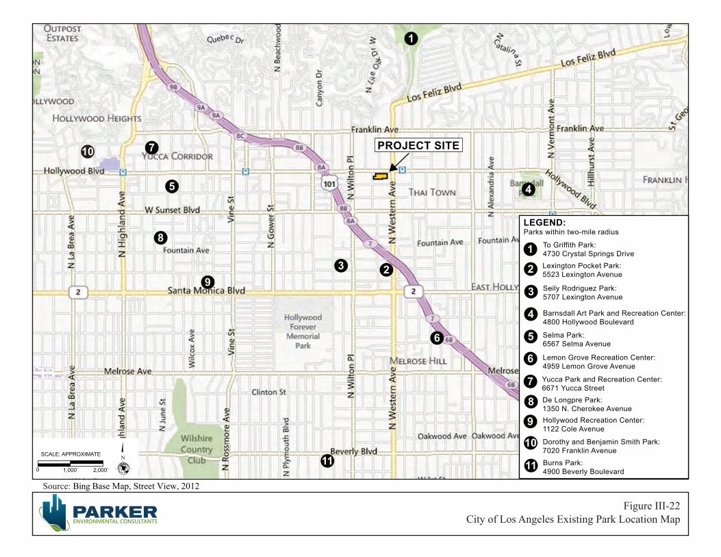
Source: Bing Base Map, Street View, 2012
0 1,000’ 2,000’
SCALE: APPROXIMATE N
City of Los Angeles Existing Park Location Map Figure III-22
PROJECT SITE
Selma Park:6567 Selma Avenue
Lemon Grove Recreation Center:4959 Lemon Grove Avenue
De Longpre Park:1350 N. Cherokee AvenueHollywood Recreation Center: 1122 Cole Avenue
Dorothy and Benjamin Smith Park:7020 Franklin Avenue
Burns Park: 4900 Beverly Boulevard
Lexington Pocket Park:5523 Lexington Avenue
To Griffith Park:4730 Crystal Springs Drive
Barnsdall Art Park and Recreation Center:4800 Hollywood Boulevard
Yucca Park and Recreation Center:6671 Yucca Street
10 7
5
8
9
11
2
6
4
1
1
2
3
4
5
6
7
8
9
10
LEGEND: Parks within two-mile radius
3
Seily Rodriguez Park:5707 Lexington Avenue
11
City of Los Angeles June 2013
High Line West Project III. Environmental Impact Analysis ENV-2012-3532-MND Page III-136
These fees may be off-set by the amount of any Quimby Fee or dwelling unit construction tax. Accordingly, the Proposed Project will be required to pay a tax of $200 per unit and a fee of $4,300 per unit for Parks First, which may be offset or reduced based on the amount of on-site open space and recreational amenities provided on-site. Therefore, under the City’s mandatory Dwelling Unit Construction Tax and Parks First Program and Park Fees, which are collected prior to a certificate of occupancy for residential land uses, the Proposed Project’s impact upon parks and recreational facilities would be reduced to a less-than-significant level.
Mitigation Measure:
XV-10 Recreation (Increased Demand For Parks Or Recreational Facilities)
• (Apartments) Pursuant to Section 21.10 of the Los Angeles Municipal Code, the applicant shall pay the Dwelling Unit Construction Tax for construction of apartment buildings.
• (Vermont/Western Specific Plan, Ordinance 173,749) Pursuant to the Vermont/Western Specific Plan, Section 6.F. Parks First Program and Park Fees, the applicant shall pay a fee to the Parks First Trust Fund of $4,300 per dwelling unit and shall be off-set by the amount of any Quimby Fee or Dwelling Unit Construction Tax Fee paid as a result of the project.
Cumulative Impacts
Less Than Significant Impact. Development of the Proposed Project, in conjunction with the 61 related projects could result in an increase in permanent residents residing in the project area. In the absence of mitigation, additional cumulative development would contribute to lowering the City’s existing parkland to population ratio, which is currently below the preferred standard. However, each of the residential related projects are expected to comply with payment of Quimby Fees (which apply to condominium units) and other fees, such as the Parks and Recreation Fee (which apply to apartment units). Therefore, with payment of the applicable recreation fees on a project-by-project basis, the cumulative park impacts related to parks and recreational facilities would be reduced to a less-than-significant level.
(v) Other Public Facilities
Less Than Significant Impact. A significant impact may occur if a project includes substantial employment or population growth that could generate a demand for other public facilities (such as libraries), which would exceed the capacity available to serve the Project Site. Based on the LA CEQA Thresholds Guide, the determination of whether the project results in a significant impact on libraries shall be made considering the following factors: (a) the net population increase resulting from the Proposed Project; (b) the demand for library services anticipated at the time of project buildout compared to the expected level of service available. Consider, as applicable, scheduled improvements to recreation and park services (renovation, expansion, addition or relocation) and the project’s proportional contribution to the demand; and (c) whether the project includes features that would reduce the demand for library services (e.g., on-site library facilities or direct financial support to the Los Angeles Public Library).
City of Los Angeles June 2013
High Line West Project III. Environmental Impact Analysis ENV-2012-3532-MND Page III-137
Within the City of Los Angeles, the Los Angeles Public Library (LAPL) provides library services at the Central Library, eight regional branch libraries, 64 neighborhood branches and two bookmobile units, consisting of a total of five individual bookmobiles. Approximately 6.5 million books and other materials comprise the LAPL collection. Based on the LA CEQA Thresholds Guide, there are three LAPL branches currently serving the Project Site within a two-mile radius, which include the Frances Howard Goldwyn Hollywood Regional Branch Library, located approximately 1.1 miles west of the Project Site, the Los Feliz Branch Library, located approximately 1.6 miles northeast of the Project Site, and the Cahuenga Branch Library, located approximately 2 miles southeast of the Project Site (See Figure III-23, Library Location Map).31 The Frances Howard Goldwyn Hollywood Regional Branch Library is the nearest LAPL to serve the Project Site. The Regional Library is 19,000 sf 32 and, in addition to regular collections, houses special collections of unpublished motion picture and television scripts, production files, posters and lobby cards, theater and dance programs and playbills, and archives of the history of the Hollywood community.33 The Regional Library also provides free access to computer workstations, which are connected to the Library's information network. The Regional Library also hosts events for adults, teens and children such as film festivals and reading clubs.34 In February 2007 the Board of Library Commissioners adopted an updated Branch Facilities Plan that included a total of 19 library projects, including eight new Branch Libraries throughout the City, none of which are within the Hollywood Community Plan Area. The 810 net additional residents that would be generated by the Proposed Project are within the anticipated growth projections for the Hollywood Community Plan Area and thus would not pose a significant increase in the demand for library services. Furthermore, and more importantly, the LAPL does not have any plans to increase library services or construct or modernize any library facilities within the Project area to accommodate the project. Therefore, project impacts associated with library services would be less than significant.
Cumulative Impacts
Less Than Significant Impact. The related projects that have a residential component could generate additional residents who could increase the demand upon library services. To meet the cumulative demands upon the City’s Public Library system, Los Angeles voters passed a Library Bond Issue for $178.3 million to improve, renovate, expand, and construct 32 branch libraries. Since the Program’s inception in 1998, the Library Department and the Department of Public Works, Bureau of Engineering have made considerable progress in the design and construction of the branch library facilities. Therefore, the cumulative impacts related to library facilities would be reduced to a less than significant level.
31 City of Los Angeles Public Library, Hours and Locations, website: http://www.lapl.org/branches, accessed December 2012.
32 City of Los Angeles, LA CEQA Thresholds Guide, Page K.5-7, 2006 33 Los Angeles Public Library, Brach Information, website: http://www.lapl.org/branches/hist/11-h.html, accessed
December 2012. 34 Los Angeles Public Library, Frances Howard Goldwyn - Hollywood Regional Branch library, website:
http://www.lapl.org/branches/Branch.php?bID=11, accessed December 2012.
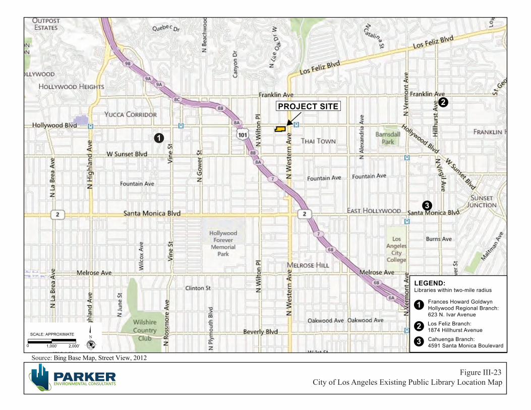
Source: Bing Base Map, Street View, 2012
City of Los Angeles Existing Public Library Location Map Figure III-23
0 1,000’ 2,000’
SCALE: APPROXIMATE N
PROJECT SITE
1
2
3
Los Feliz Branch:1874 Hillhurst Avenue
Frances Howard Goldwyn Hollywood Regional Branch: 623 N. Ivar Avenue
Cahuenga Branch: 4591 Santa Monica Boulevard
1
2
3
LEGEND:Libraries within two-mile radius

City of Los Angeles June 2013
High Line West Project III. Environmental Impact Analysis ENV-2012-3532-MND Page III-139
15. RECREATION
a) Would the project increase the use of existing neighborhood and regional parks or other recreational facilities such that substantial physical deterioration of the facility would occur or be accelerated?
Potentially Significant Impact Unless Mitigation Incorporated. For the purpose of this Initial Study, a significant impact may occur if the project would include substantial employment or population growth, which would increase the use of existing neighborhood and regional parks or other recreational facilities, such that substantial physical deterioration of the facility would occur or be accelerated. Based on the LA CEQA Thresholds Guide, the determination of whether the project results in a significant impact on recreation and parks shall be made considering the following factors: (a) the net population increase resulting from the Proposed Project; (b) the demand for recreation and park services anticipated at the time of project buildout compared to the expected level of service available. Consider, as applicable, scheduled improvements to recreation and park services (renovation, expansion, or addition) and the project’s proportional contribution to the demand; and (c) whether the project includes features that would reduce the demand for park services (e.g., on-site recreation facilities, land dedication, or direct financial support to the Department of Recreation and Parks).
The Proposed Project will provide a approximately 30,920 square feet of open space areas, including private open space on balconies and common open space areas with a community room, pool deck, two courtyards and a lobby. The availability of these on-site recreation amenities and opportunities would serve to reduce the demand for off-site park services. As noted in Table III-26, there are eight parks and three recreation centers within a two-mile radius of the Project Site, totaling approximately 26.05 acres. The Project Site is also located near an entrance to Griffith Park, which provides the Hollywood and Los Angeles community with 4,210 acres of parkland and recreation space. Furthermore, under the City’s mandatory Dwelling Unit Construction Tax and Parks First Program and Park Fees, which are collected prior to a certificate of occupancy for residential land uses, the Proposed Project’s impact upon parks and recreational facilities would be reduced to a less-than-significant level (see Mitigation Measure XV-10, Recreation (Increased Demand For Parks Or Recreational Facilities, above). Therefore, the Proposed Project would not substantially increase the use of existing neighborhood and regional parks or other recreational facilities such that substantial physical deterioration of the facility would occur or be accelerated and impacts would be less than significant.
b) Does the project include recreational facilities or require the construction or expansion of recreational facilities which might have an adverse physical effect on the environment?
No Impact. A significant impact may occur if a project includes the construction or expansion of park facilities and such construction would have a significant adverse effect on the environment. The Proposed Project will provide approximately 30,920 square feet of open space areas on site. As previously discussed in 15a) the Proposed Project would not require the construction or expansion of recreational facilities beyond the limits of the Project Site which might have an adverse physical effect on the environment and thus there would be no impact.

City of Los Angeles June 2013
High Line West Project III. Environmental Impact Analysis ENV-2012-3532-MND Page III-140
Cumulative Impacts
Less Than Significant Impact. Section 15355 of the State CEQA Guidelines defines cumulative impacts as “two or more individual effects which, when considered together, are considerable or which compound or increase other environmental impacts.” As discussed above, the project would have a less than significant impact on recreational resources. It is not known if any of the 61 related projects (listed in Section ##, Environmental Setting) would adversely affect recreational resources. Regardless, because the Proposed Project would have a less than significant incremental contribution to the potential cumulative impact on recreational resources, the Proposed Project would have a less than significant cumulative impact on such resources.
16. TRANSPORTATION AND TRAFFIC
The following section summarizes and incorporates by reference the information provided in the Draft Traffic Study for the High Line West Project (Traffic Study) prepared by The Mobility Group dated March 28, 2013. The Traffic Study and related correspondence from the Los Angeles Department of Transportation are provided as Appendix E to this Draft IS/MND.
a) Would the project conflict with an applicable plan, ordinance or policy establishing measures of effectiveness for the performance of the circulation system, taking into account all modes of transportation including mass transit and non-motorized travel and relevant components of the circulation system, including but not limited to intersections, streets, highways and freeways, pedestrian and bicycle paths, and mass transit?
Potentially Significant Impact Unless Mitigation Incorporated. A significant impact could occur if a project were to result in substantial increases in traffic volumes in the vicinity of the project such that the existing street capacity experiences a decrease in the existing volume to capacity ratios, or experiences increased traffic congestion exceeding LADOT’s recommended level of service.
Operational Traffic
A total of six study intersections were identified, in conjunction with LADOT staff, for inclusion in the traffic analysis. The analyzed locations are shown in Figure 3 of the Traffic Study and correspond to locations where potential traffic impacts from the Proposed Project are most likely to occur. The intersections identified for analysis are as follows:
1. Hollywood Boulevard & US 101 SB Ramps
2. Hollywood Boulevard & US 101 NB Ramps
3. Hollywood Boulevard & Wilton Place
4. Hollywood Boulevard & Western Avenue
5. Sunset Boulevard & Wilton Place
6. Sunset Boulevard & Western Avenue

City of Los Angeles June 2013
High Line West Project III. Environmental Impact Analysis ENV-2012-3532-MND Page III-141
Estimated Trip Generation
The Proposed Project will consist of 280 apartments and 12,030 square feet of retail use.35 The Proposed Project would demolish 20,524 square feet of recording studio, 7,485 square feet of acting studio, 8,108 square feet of retail, and 1,600 square feet of office uses.
Trip generation from the Project was estimated using trip rates from Trip Generation Manual 9th Edition (Institute of Transportation Engineers, 2012). Tables III-27 through III-29 summarize the trip generation estimates for the daily, AM peak, & PM peak hour periods respectively.
Because of the Proposed Project’s location near transit, employment and commercial destinations, a number of Project trips might be expected to be walk or transit trips rather than auto vehicle trips. Similarly, because the commercial components of the Proposed Project will be primarily locally serving to the Proposed Project and the surrounding area, some of the trips might be expected to be walk-ins either from the Proposed Project or the surrounding area. Certain adjustments to the trip generation were therefore made, with LADOT approval, to reflect these conditions. The trips generated by all land use components of the Proposed Project (residential, retail and studio) were reduced by 25% to allow for use of transit to and from the Project Site due to its immediate proximity to the Metro Red Line station at Hollywood Boulevard and Western Avenue. For the retail uses, an additional reduction of 10% was applied for walk-ins from the Project and the surrounding area and a pass-by rate of 50% was applied. Because the Project would entail the elimination of some current uses on the site, the existing vehicle trips from those uses would be removed from the roadway system. The Proposed Project’s new uses would generation new additional trips. As shown in Tables III-27 through III-29, the analysis estimates that the Proposed Project would generate a total of 1,267 daily vehicle trips, 40 AM peak hour vehicle trips and 64 PM peak hour vehicle trips.
Project Impacts
Existing With Project Impacts
This section addresses an analysis of potential impacts for the existing conditions plus project scenario. Proposed Project traffic was added to existing conditions traffic and the potential for impacts evaluated. The total existing with Project conditions peak hour traffic volumes are illustrated in the Traffic Study for the AM and PM peak hours.
Tables III-30 and III-31 summarize the level of service for the “Existing with Project Conditions” at the analyzed intersections for the AM and PM peak hours respectively. As shown in Table-III-30, the addition of Proposed Project traffic would not cause the level of service to change at any of the study
35 Note: the current entitlement plans include 280 dwelling units and 12,030 square feet of retail. The trip generation estimate provided in the Traffic Study was based on a slightly higher amount of retail (e.g., 12,900 square feet), which presents a slightly conservative analysis with respect to the Project’s traffic impacts.

City of Los Angeles June 2013
High Line West Project III. Environmental Impact Analysis ENV-2012-3532-MND Page III-142
Table III-27 Trip Generation Estimates – Daily Trips
Land Use Assumptions Source & Code Quantity Units
Daily Trips
Trip Rate Total Trips
Existing Uses
OTC 20,524 sf 8.77
Recording Studio -180
Reduction for transit trips - 25% 45
Net Recording Studio -135
Acting Studio OTC 7,485 sf 8.77
-66
Reduction for transit trips - 25% 16
Net Acting Studio -50
Retail
ITE 820 8,108 sf 42.70
-346
Reduction for internal trips – 10% 35
Reduction for transit stops – 25% 78
Reduction for pass-by trips – 50% 117
Net Retail -116
Office ITE 710 1,600 sf 11.03
-18
Reduction for transit trips – 25% 4
Net Office -14
Total Existing Daily Trips -315
Proposed Uses
ITE 220 280 du 6.65
Apartments 1,862
Reduction for transit - 25% -466
Net Apartments 1,396 Retail
ITE 820 12,900 sf 42.70
551
Reduction for internal trips - 10% -55
Reduction for transit/walk trips - 25% -124
Reduction for pass-by trips - 50% -186
Net Retail 186
Total Proposed Daily Trips 1,582
Proposed Net Total Daily Trips (proposed minus existing trips) 1,267 Notes: sf = square feet; du = dwelling units Source: High Line West Project Draft Traffic Study, The Mobility Group, March 28, 2013.
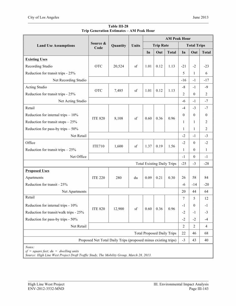
City of Los Angeles June 2013
High Line West Project III. Environmental Impact Analysis ENV-2012-3532-MND Page III-143
Table III-28 Trip Generation Estimates – AM Peak Hour
Land Use Assumptions Source & Code Quantity Units
AM Peak Hour
Trip Rate Total Trips
In Out Total In Out Total
Existing Uses
OTC 20,524 sf 1.01 0.12 1.13
Recording Studio -21 -2 -23
Reduction for transit trips - 25% 5 1 6
Net Recording Studio -16 -1 -17
Acting Studio OTC 7,485 sf 1.01 0.12 1.13
-8 -1 -9
Reduction for transit trips - 25% 2 0 2
Net Acting Studio -6 -1 -7
Retail
ITE 820 8,108 sf 0.60 0.36 0.96
-4 -3 -7
Reduction for internal trips – 10% 0 0 0
Reduction for transit stops – 25% 1 1 2
Reduction for pass-by trips – 50% 1 1 2
Net Retail -2 -1 -3
Office ITE710 1,600 sf 1.37 0.19 1.56
-2 0 -2
Reduction for transit trips – 25% 1 0 1
Net Office -1 0 -1
Total Existing Daily Trips -25 -3 -28
Proposed Uses
ITE 220 280 du 0.09 0.21 0.30
Apartments 26 58 84
Reduction for transit - 25% -6 -14 -20
Net Apartments 20 44 64 Retail
ITE 820 12,900 sf 0.60 0.36 0.96
7 5 12
Reduction for internal trips - 10% -1 0 -1
Reduction for transit/walk trips - 25% -2 -1 -3
Reduction for pass-by trips - 50% -2 -2 -4
Net Retail 2 2 4
Total Proposed Daily Trips 22 46 68
Proposed Net Total Daily Trips (proposed minus existing trips) -3 43 40
Notes: sf = square feet; du = dwelling units Source: High Line West Project Draft Traffic Study, The Mobility Group, March 28, 2013.
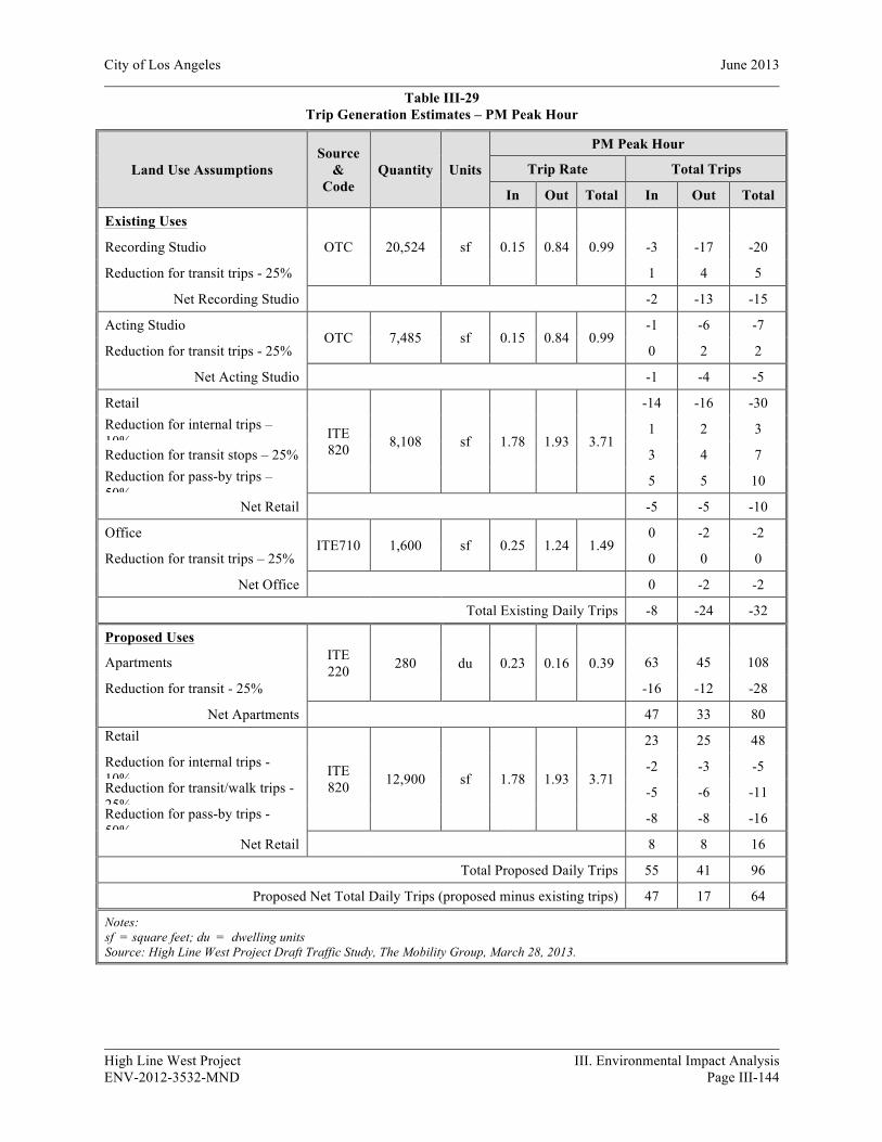
City of Los Angeles June 2013
High Line West Project III. Environmental Impact Analysis ENV-2012-3532-MND Page III-144
Table III-29 Trip Generation Estimates – PM Peak Hour
Land Use Assumptions Source
& Code
Quantity Units
PM Peak Hour
Trip Rate Total Trips
In Out Total In Out Total
Existing Uses
OTC 20,524 sf 0.15 0.84 0.99
Recording Studio -3 -17 -20
Reduction for transit trips - 25% 1 4 5
Net Recording Studio -2 -13 -15
Acting Studio OTC 7,485 sf 0.15 0.84 0.99
-1 -6 -7
Reduction for transit trips - 25% 0 2 2
Net Acting Studio -1 -4 -5
Retail
ITE 820 8,108 sf 1.78 1.93 3.71
-14 -16 -30 Reduction for internal trips – 10%
1 2 3
Reduction for transit stops – 25% 3 4 7 Reduction for pass-by trips – 50%
5 5 10
Net Retail -5 -5 -10
Office ITE710 1,600 sf 0.25 1.24 1.49
0 -2 -2
Reduction for transit trips – 25% 0 0 0
Net Office 0 -2 -2
Total Existing Daily Trips -8 -24 -32
Proposed Uses ITE 220 280 du 0.23 0.16 0.39
Apartments 63 45 108
Reduction for transit - 25% -16 -12 -28
Net Apartments 47 33 80 Retail
ITE 820 12,900 sf 1.78 1.93 3.71
23 25 48 Reduction for internal trips - 10%
-2 -3 -5 Reduction for transit/walk trips - 25%
-5 -6 -11 Reduction for pass-by trips - 50%
-8 -8 -16
Net Retail 8 8 16
Total Proposed Daily Trips 55 41 96
Proposed Net Total Daily Trips (proposed minus existing trips) 47 17 64
Notes: sf = square feet; du = dwelling units Source: High Line West Project Draft Traffic Study, The Mobility Group, March 28, 2013.
City of Los Angeles June 2013
High Line West Project III. Environmental Impact Analysis ENV-2012-3532-MND Page III-145
intersections for the AM peak hour, and that any increases in volume/capacity (V/C) ratios would be less than the threshold for a significant impact to occur. The data summarized in Table III-31 shows that for the PM peak hour, the addition of Proposed Project traffic would not cause the level of service to change at any of the study intersections, and that any increases in volume/capacity (V/C) ratios would be less than the threshold for a significant impact to occur. It is therefore concluded that the Proposed Project would not cause any significant traffic impacts in either the AM or PM peak hour.
Project Driveways – Existing With Project Impacts
The LOS for the three driveway intersections are shown in the Traffic Study. The LOS for the three driveway intersections were estimated to be LOS C or better in both the AM and PM peak hours. These driveway intersections would therefore operate satisfactorily with the Proposed Project.
Future With Project Intersection Level of Service
Tables III-32 and III-33 summarize the level of service for the “Future with Project Conditions” at the analyzed intersections for the AM and PM peak hours respectively. The analysis summarized in Table III-32 indicates that for the AM peak hour, the addition of Project traffic would not cause the level of service to change at any of the study intersections, and that any increases in volume/capacity (V/C) ratios would be less than the threshold for a significant impact to occur. The analysis summarized in Table III-33 indicates that for the PM peak hour, the addition of Project traffic would not cause the level of service to change at any of the study intersections, and that any increases in volume/capacity (V/C) ratios would be less than the threshold for a significant impact to occur. It is therefore concluded that the Proposed Project would not cause any significant traffic impacts in either the AM or PM peak hour.
Project Driveways – Future With Project Conditions As previously discussed, and shown in Figures II-5 Section II, Project Description, the Proposed Project would have three driveways, one on St. Andrews Place and two on Hollywood Boulevard. The St. Andrews Place driveway will serve the residential use only and will allow full movements. Two driveways on Hollywood Boulevard will serve both retail and residential uses and only right-in-right-out movements will be allowed for these driveways. All three driveway intersections are unsignalized. A Level of Service (LOS) analysis for these unsignalized intersections was conducted using the Highway Capacity Manual (HCM) method. The LOS for the driveway intersections were estimated to be LOS C or better in both the AM and PM peak hours. These driveway intersections would therefore operate satisfactorily with the Project.
CMP and Freeway Analysis
The Los Angeles County Congestion Management Plan (CMP) requires that new development projects analyze potential project impacts on CMP monitoring locations, if an EIR is prepared for the project. As an EIR is not being prepared for the Proposed Project, no CMP analysis is required. Nevertheless, for purposes of preparing a comprehensive study, a check was conducted against CMP criteria.

City of Los Angeles June 2013
High Line West Project III. Environmental Impact Analysis ENV-2012-3532-MND Page III-146
Table III-30 Existing With Project Conditions – Intersection Level of Service AM Peak Hour
Intersection
AM Peak Hour Change in V/C
Significant Impact? Existing Existing With Project
V / C LOS V / C LOS
1. Hollywood Boulevard & US 101 SB Ramps
0.501 A 0.503 A 0.002 No
2. Hollywood Boulevard & US 101 NB Ramps
0.496 A 0.499 A 0.003 No
3. Hollywood Boulevard & Wilton Place
0.651 B 0.656 B 0.005 No
4. Hollywood Boulevard & Western Avenue
0.787 C 0.791 C 0.004 No
5. Sunset Boulevard & Wilton Place
0.529 A 0.531 A 0.002 No
6. Sunset Boulevard & Western Avenue
0.677 B 0.680 B 0.003 No
Source: High Line West Project Draft Traffic Study, The Mobility Group, March 28, 2013.
Table III-31
Existing With Project Conditions – Intersection Level of Service PM Peak Hour
Intersection
PM Peak Hour Change in V/C
Significant Impact? Existing Existing With Project
V / C LOS V / C LOS
1. Hollywood Boulevard & US 101 SB Ramps
0.475 A 0.480 A 0.005 No
2. Hollywood Boulevard & US 101 NB Ramps
0.428 A 0.432 A 0.004 No
3. Hollywood Boulevard & Wilton Place
0.682 B 0.689 B 0.007 No
4. Hollywood Boulevard & Western Avenue
0.810 D 0.815 D 0.005 No
5. Sunset Boulevard & Wilton Place
0.563 A 0.567 A 0.004 No
6. Sunset Boulevard & Western Avenue
0.750 C 0.751 C 0.001 No
Source: High Line West Project Draft Traffic Study, The Mobility Group, March 28, 2013.

City of Los Angeles June 2013
High Line West Project III. Environmental Impact Analysis ENV-2012-3532-MND Page III-147
Table III-32 Future With Project Conditions – Intersection Level of Service AM Peak Hour
Intersection
AM Peak Hour Change in V/C
Significant Impact? Future Without Project Future With Project
V / C LOS V / C LOS
1. Hollywood Boulevard & US 101 SB Ramps
0.708 C 0.710 C 0.002 No
2. Hollywood Boulevard & US 101 NB Ramps
0.653 B 0.656 B 0.003 No
3. Hollywood Boulevard & Wilton Place
0.810 D 0.815 D 0.005 No
4. Hollywood Boulevard & Western Avenue
0.987 E 0.991 E 0.004 No
5. Sunset Boulevard & Wilton Place
0.708 C 0.711 C 0.003 No
6. Sunset Boulevard & Western Avenue
0.856 D 0.857 D 0.001 No
Source: High Line West Project Draft Traffic Study, The Mobility Group, March 28, 2013.
Table III-33
Future With Project Conditions – Intersection Level of Service PM Peak Hour
Intersection
PM Peak Hour Change in V/C
Significant Impact? Future Without Project Future With Project
V / C LOS V / C LOS
1. Hollywood Boulevard & US 101 SB Ramps
0.689 B 0.692 B 0.003 No
2. Hollywood Boulevard & US 101 NB Ramps
0.659 B 0.661 B 0.002 No
3. Hollywood Boulevard & Wilton Place
0.908 E 0.915 E 0.007 No
4. Hollywood Boulevard & Western Avenue
1.075 F 01.080 F 0.005 No
5. Sunset Boulevard & Wilton Place
0.767 C 0.771 C 0.004 No
6. Sunset Boulevard & Western Avenue
0.997 E 0.998 E 0.001 No
Source: High Line West Project Draft Traffic Study, The Mobility Group, March 28, 2013.

City of Los Angeles June 2013
High Line West Project III. Environmental Impact Analysis ENV-2012-3532-MND Page III-148
When a CMP is required, the CMP methodology requires that the Traffic Study analyze traffic conditions at all CMP arterial monitoring intersections where the Proposed Project will add 50 or more trips during either the AM or PM weekday peak hours of adjacent street traffic. The CMP also requires that traffic studies analyze mainline freeway monitoring locations where the Proposed Project will add 150 or more trips in either direction during either AM or PM weekday peak hours. If, based on these criteria, the Traffic Study identifies no facilities for study then no further traffic analysis is required.
As shown previously, the Proposed Project would generate 40 AM peak hour trips and 64 PM peak hour trips. A review of the 2010 CMP indicated the following arterial monitoring stations that are closest to the Project Site:
- Santa Monica Boulevard and Western Avenue
- Santa Monica Boulevard and Highland Avenue
As these are some distance from the Project Site, and as the Proposed Project’s trips will disperse onto numerous roadways, it is therefore clear that the Proposed Project traffic volumes would not exceed the thresholds for analysis. Further, it is estimated that the maximum number of trips that the Proposed Project would add to any single CMP monitoring station would be 6 trips in all directions.
It is also clear that the Proposed Project traffic volumes would not exceed the thresholds for analysis for freeway analysis.
Further, it is estimated that the maximum number of trips that the Proposed Project would add to any single freeway segment would be 6 trips in any one direction. This low incremental volume would be below the CMP threshold of 150 trips and would not cause any significant impacts to freeway operations.
CMP Transit Impact Analysis
An analysis of potential Proposed Project impacts on the transit system was also performed, per the CMP requirements and guidelines.
Based on factors in the LA CEQA Thresholds Guide, the following criterion was established to determine if there would be any significant transit impacts due to the Proposed Project:
- The capacity of the transit system serving the Project area would be substantially exceeded.
The number of transit trips that would be generated by the Proposed Project was estimated based on the trip generation methodology described previously. These transit trip numbers are higher than the general default countywide guidelines in the CMP, but are more conservative and more accurate in this instance as they reflect the higher transit use that would occur for the Project because of its location in close proximity to a major transit hub in Hollywood.
There would be approximately 20 net additional transit trips (-1 inbound trips and 21 outbound trips) in the AM peak hour due to the Proposed Project, and approximately 34 additional transit trips (24 inbound

City of Los Angeles June 2013
High Line West Project III. Environmental Impact Analysis ENV-2012-3532-MND Page III-149
and 10 outbound) in the PM peak hour. The highest number of additional transit trips would therefore occur in the PM peak hour. The Project Site is located close to subway and bus transit lines in the Hollywood area. Metro (Los Angeles County Metropolitan Transportation Authority) operates the Metro Red Line, two Metro Rapid lines and four Metro Local lines within about a quarter-mile radius of the Project Site. The Metro Red Line also connects directly to Los Angeles Union Station which is the hub for the regional rail system in Southern California including the Metrolink commuter rail system and Amtrak train service.
The peak directional capacity of the transit system serving the Project Site is approximately 5,970 persons. The highest directional volume of peak hour trips added by the Project would be 24 trips. As this would be only about 0.4% of total transit capacity, it is concluded that the Proposed Project would not cause the capacity of the transit system to be substantially exceeded and therefore that the Proposed Project would not create any significant impacts on the transit systems serving the Project Area and Hollywood.
Future With Project – Traffic Signal Warrant Analysis
LADOT Traffic Study guidelines indicate that unsignalized intersections adjacent to the project or integral to the project’s site access and circulation should be evaluated solely to determine the need for installation of a traffic signal or other traffic control device. Traffic signal warrant analyses were conducted at the following three unsignalized intersections:
• Hollywood Boulevard & St. Andrews Place • Sunset Boulevard & St. Andrews Place • Western Avenue & Carlton Way
The warrant analysis was based on the peak hour traffic volumes. The results of the traffic signal warrant analyses are shown in Table 9 in the Traffic Study for the Future With Project conditions (see Appendix E to this MND). Based on this analysis, the peak hour traffic volumes at the intersection of Hollywood Boulevard & St Andrews Place would be less than the volumes required to warrant a signal in the AM peak hour, and would be slightly higher than the volumes to warrant a signal in the PM peak hour (105 vehicles per hour on the minor approach compared to the warrant threshold of 100 vehicles per hour). The traffic volumes would not warrant a traffic signal at the intersections of Sunset Boulevard & St Andrews Place, and at Western Avenue & Carlton Way.
The satisfaction of a traffic signal warrant does not in of itself require the installation of a signal. LADOT will ultimately determine at the time of Project construction if a signal is feasible and if it should be installed, after a consideration of other factors relative to safety, traffic flow, signal spacing and coordination, and roadway geometrics (including: eight hour, four hour, and one hour traffic volumes, pedestrian volumes, accident records, existence of suitable gaps for turning traffic, traffic signal coordination issues, and providing the safe and orderly movement of vehicles for all movements through the intersection).

City of Los Angeles June 2013
High Line West Project III. Environmental Impact Analysis ENV-2012-3532-MND Page III-150
Installation of a traffic signal at this location could require the removal of approximately twelve on-street parking spaces along Hollywood Boulevard. The loss of on-street parking in of itself would not constitute a significant impact. However the Project would provide surplus off-street parking which would be available to the public to accommodate the displaced spaces.
It is therefore recommended that at the time of Project construction, LADOT conduct its normal procedure of evaluation of a potential new signal and if they determine a signal is warranted and feasible at that time that the Project install a new signal at the intersection of Hollywood Boulevard & St. Andrews Place.
Construction Traffic Impacts
The Proposed Project would require the use of haul trucks during site clearing and excavation and the use of a variety of other construction vehicles throughout the construction of the Proposed Project. The addition of these vehicles onto the street system would contribute to increased traffic in the Project vicinity. As noted in the Project Description (see Section II of this IS/MND), however, the haul trucks would travel along established traffic corridors noted in the Haul Route application, such as Hollywood Boulevard. The trucks would enter and exit the Project Site via W. Hollywood Boulevard and/or N. Western Avenue and would avoid residential areas to the extent feasible. The haul trips would occur outside of the peak hours and during the permissible hauling hours identified in the haul route to be approved by the Department of Building and Safety. The Proposed Project’s construction trip traffic would be a fraction of the operational traffic that would not cause any significant impacts at the studied intersections. Therefore, it is not anticipated that they could contribute to a significant increase in the overall congestion in the Project vicinity. In addition, any truck trips would be limited to the length of time required for the Project’s construction. Due to the off-peak and temporary nature of the traffic, impacts would be less than significant. Furthermore, implementation of mitigation measure XVI-10 would further ensure construction traffic impacts are mitigated to a less than significant level.
Mitigation Measures:
XVI-10 Increased Vehicle Trips/Congestion
• The Applicant shall work with DOT’s Hollywood/Wilshire District Office to seek review and final approval of the traffic signal warrants analysis. If a new signal is approved at Hollywood Boulevard and St. Andrews Place, DOT will issue a Traffic Control Report authorizing the installation of the traffic signal and the applicant shall be required to plan, design and construct the new signal through the Bureau of Engineering (BOE) B-permit process.
• A Construction work site traffic control plan shall be submitted to DOT’s Hollywood Wilshire District Office for review and approval prior to the start of any construction work. The plan shall show the location of any roadway or sidewalk closures, traffic detours, haul routes, hours of operation, protective devices, warning signs and access to abutting properties in compliance with all mitigation measures. All construction related traffic shall be restricted to off-peak hours.
• The Department of Building and Safety shall determine the number of Code-required parking spaces needed for the project.

City of Los Angeles June 2013
High Line West Project III. Environmental Impact Analysis ENV-2012-3532-MND Page III-151
• Prior to the commencement of building or parking layout design efforts, contact DOT for driveway width and internal circulation requirements. All new driveways shall be Case 2 driveways and any security gates shall be a minimum 20 feet from the property line.
• The Applicant shall pay any applicable fees per Ordinance No. 180542 for traffic study review, condition clearance, and permit issuance.
XVI-30 Transportation (Haul Route)
• The developer shall install appropriate traffic signs around the site to ensure pedestrian and vehicle safety.
• (Non-Hillside): Projects involving the import/export of 20,000 cubic yards or more of dirt shall obtain haul route approval by the Department of Building and Safety.
b) Would the project conflict with an applicable congestion management program, including, but not limited to level of service standards and travel demand measures, or other standards established by the county congestion management agency for designated roads or highways?
No Impact. As previously discussed in 16.a), no CMP freeway monitoring segment or intersection analysis is required and there would be no Proposed Project-related impacts to the CMP. The Proposed Project would not conflict with any travel demand measures. Therefore, no impact would occur.
c) Would the project result in a change in air traffic patterns, including either an increase in traffic levels or a change in location that results in substantial safety risks?
No impact. This question would apply to the Proposed Project only if it involved an aviation-related use or would influence changes to existing flight paths. The Proposed Project does not include any aviation-related uses and would have no airport impact. It would also not require any modification of flight paths for the existing airports in the Los Angeles Basin. Therefore, no impact would occur.
d) Would the project substantially increase hazards due to a design feature (e.g., sharp curves or dangerous intersections) or incompatible uses (e.g., farm equipment)?
Potentially Significant Impact Unless Mitigation Incorporated. A significant impact may occur if the Proposed Project includes new roadway design or introduces a new land use or features into an area with specific transportation requirements and characteristics that have not been previously experienced in that area, or if Project Site access or other features were designed in such a way as to create hazard conditions. The Proposed Project would not include unusual or hazardous design features. However the Proposed Project will include new vehicular access driveways to the Project Site, which, if they aren’t properly designed and constructed, could potentially conflict with pedestrian circulation in the Project area. Three driveways, one on St. Andrews Place and two on Hollywood Boulevard, would provide access to the Proposed Project. With implementation of Mitigation Measure XVI-40, below, potential vehicle-pedestrian conflicts will be mitigated to a less than significant level.

City of Los Angeles June 2013
High Line West Project III. Environmental Impact Analysis ENV-2012-3532-MND Page III-152
Mitigation Measure:
XVI-40 Safety Hazards
• The developer shall install appropriate traffic signs around the site to ensure pedestrian and vehicle safety.
• The applicant shall submit a parking and driveway plan that incorporates design features that reduce accidents in compliance with the LAMC, to the Bureau of Engineering and the Department of Transportation for approval.
e) Would the project result in inadequate emergency access?
No Impact. A significant impact may occur if the Project design would not provide emergency access meeting the requirements of the LAFD, or in any other way threatened the ability of emergency vehicles to access and serve the Project Site or adjacent uses.
As previously discussed in Section 7(h), the Proposed Project is not located on or near an adopted emergency response or evacuation plan. Development of the Project Site may require temporary and/or partial street closures due to construction activities. However, any such closures would be temporary in nature and would be coordinated with the Departments of Transportation, Building and Safety, and Public Works. Nonetheless, while such closures may cause temporary inconvenience, they would not be expected to substantially interfere with emergency response or evacuation plans. Therefore, the Proposed Project would not cause permanent alterations to vehicular circulation routes and patterns, impede public access or travel upon public rights-of-way.
As described in Section 14(a), the Proposed Project would satisfy the emergency response requirements of the LAFD, and as discussed in Checklist Question 16(d), there are no hazardous design features included in the access design or site plan for the Proposed Project that could impede emergency access. Furthermore, the Proposed Project would be subject to the site plan review requirements of the LAFD and the LAPD to ensure that all access roads, driveways and parking areas would remain accessible to emergency service vehicles. Therefore, the Proposed Project would not be expected to result in inadequate emergency access, and no impact would occur.
f) Would the project conflict with adopted policies, plans, or programs regarding public transit, bicycles, or pedestrian facilities, or otherwise decrease the performance or safety of such facilities?
No Impact. For the purpose of this Initial Study, a significant impact may occur if the Proposed Project would conflict with adopted polices or involve modification of existing alternative transportation facilities located on- or off-site.
The Proposed Project would not require the disruption of public transportation services or the alteration of public transportation routes. Furthermore, the Proposed Project would not interfere with any Class I or Class II bikeway systems. Since the Proposed Project would not modify or conflict with any alternative transportation policies, plans or programs, it would have no impact on such programs.

City of Los Angeles June 2013
High Line West Project III. Environmental Impact Analysis ENV-2012-3532-MND Page III-153
Cumulative Impacts
Less Than Significant Impact. Development of the Proposed Project in conjunction with the related projects would result in an increase in average daily vehicle trips and peak hour vehicle trips in the Hollywood area. The Traffic Study for the Proposed Project included both an individual and cumulative analysis because the baseline discussion is a cumulative baseline.
17. UTILITIES AND SERVICE SYSTEMS
a) Would the project exceed wastewater treatment requirements of the applicable Regional Water Quality Control Board?
No Impact. A significant impact would occur if a project exceeds wastewater treatment requirements of the applicable Regional Water Quality Control Board. Section 13260 of the California Water Code states that persons discharging or proposing to discharge waste that could affect the quality of the waters of the State, other than into a community sewer system, shall file a Report of Waste Discharge (ROWD) containing information which may be required by the appropriate Regional Water Quality Control Board (RWQCB). The RWQCB then authorizes an NPDES permit that ensures compliance with wastewater treatment and discharge requirements. The LARWQCB enforces wastewater treatment and discharge requirements for properties in the project area.
Wastewater from the Project Site is conveyed via municipal sewage infrastructure maintained by the Los Angeles Bureau of Sanitation to the Hyperion Treatment Plant (HTP). For further discussion of the sewage system that serves the Project Site, see Checklist Question 16(b). The HTP is a public facility and, therefore, is subject to the State’s wastewater treatment requirements. Wastewater from the Project Site is and would continue to be treated according to the wastewater treatment requirements enforced by the LARWQCB. Therefore, no impact would occur.
b) Would the project require or result in the construction of new water or wastewater treatment facilities or expansion of existing facilities, the construction of which could cause significant environmental effects?
Less Than Significant Impact. A significant impact may occur if a project would increase water consumption or wastewater generation to such a degree that the capacity of facilities currently serving the Project Site would be exceeded. Based on the LA CEQA Thresholds Guide, the determination of whether the project results in a significant impact on water shall be made considering the following factors: (a) the total estimated water demand for the project; (b) whether sufficient capacity exists in the water infrastructure that would serve the project, taking into account the anticipated conditions at project buildout; (c) the amount by which the project would cause the projected growth in population, housing or employment for the Community Plan area to be exceeded in the year of the project completion; and (d) the degree to which scheduled water infrastructure improvements or project design features would reduce or offset service impacts.
Water Treatment Facilities and Existing Infrastructure
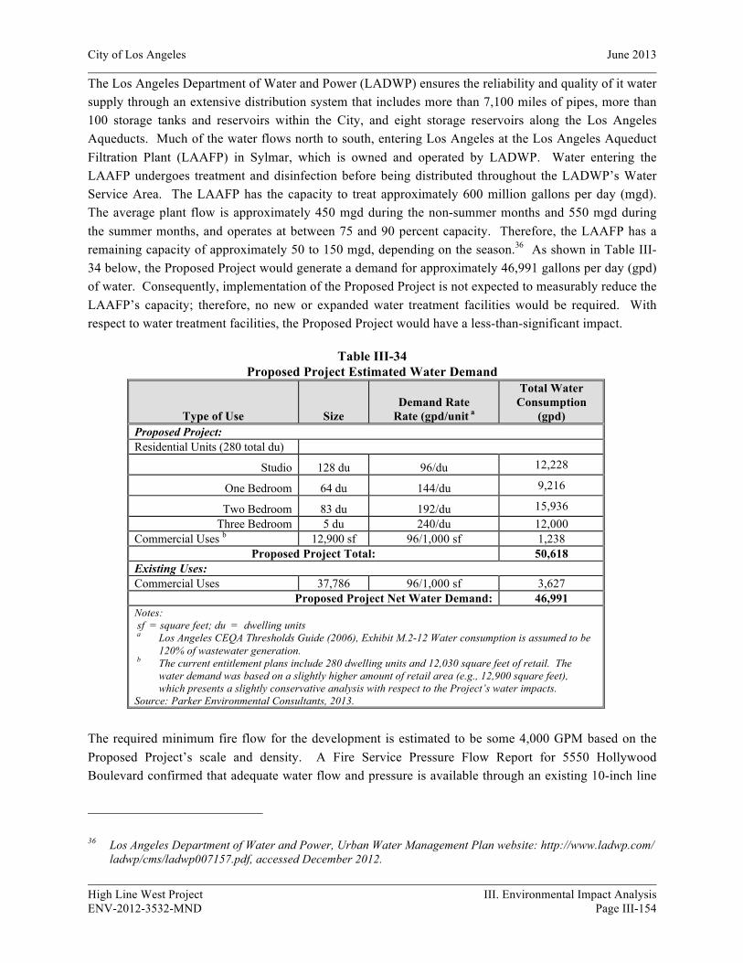
City of Los Angeles June 2013
High Line West Project III. Environmental Impact Analysis ENV-2012-3532-MND Page III-154
The Los Angeles Department of Water and Power (LADWP) ensures the reliability and quality of it water supply through an extensive distribution system that includes more than 7,100 miles of pipes, more than 100 storage tanks and reservoirs within the City, and eight storage reservoirs along the Los Angeles Aqueducts. Much of the water flows north to south, entering Los Angeles at the Los Angeles Aqueduct Filtration Plant (LAAFP) in Sylmar, which is owned and operated by LADWP. Water entering the LAAFP undergoes treatment and disinfection before being distributed throughout the LADWP’s Water Service Area. The LAAFP has the capacity to treat approximately 600 million gallons per day (mgd). The average plant flow is approximately 450 mgd during the non-summer months and 550 mgd during the summer months, and operates at between 75 and 90 percent capacity. Therefore, the LAAFP has a remaining capacity of approximately 50 to 150 mgd, depending on the season.36 As shown in Table III-34 below, the Proposed Project would generate a demand for approximately 46,991 gallons per day (gpd) of water. Consequently, implementation of the Proposed Project is not expected to measurably reduce the LAAFP’s capacity; therefore, no new or expanded water treatment facilities would be required. With respect to water treatment facilities, the Proposed Project would have a less-than-significant impact.
Table III-34 Proposed Project Estimated Water Demand
Type of Use Size Demand Rate
Rate (gpd/unit a
Total Water Consumption
(gpd) Proposed Project: Residential Units (280 total du)
Studio 128 du 96/du 12,228
One Bedroom 64 du 144/du 9,216
Two Bedroom 83 du 192/du 15,936 Three Bedroom 5 du 240/du 12,000
Commercial Uses b 12,900 sf 96/1,000 sf 1,238 Proposed Project Total: 50,618
Existing Uses: Commercial Uses 37,786 96/1,000 sf 3,627
Proposed Project Net Water Demand: 46,991 Notes: sf = square feet; du = dwelling units a Los Angeles CEQA Thresholds Guide (2006), Exhibit M.2-12 Water consumption is assumed to be
120% of wastewater generation. b The current entitlement plans include 280 dwelling units and 12,030 square feet of retail. The
water demand was based on a slightly higher amount of retail area (e.g., 12,900 square feet), which presents a slightly conservative analysis with respect to the Project’s water impacts.
Source: Parker Environmental Consultants, 2013.
The required minimum fire flow for the development is estimated to be some 4,000 GPM based on the Proposed Project’s scale and density. A Fire Service Pressure Flow Report for 5550 Hollywood Boulevard confirmed that adequate water flow and pressure is available through an existing 10-inch line
36 Los Angeles Department of Water and Power, Urban Water Management Plan website: http://www.ladwp.com/ ladwp/cms/ladwp007157.pdf, accessed December 2012.

City of Los Angeles June 2013
High Line West Project III. Environmental Impact Analysis ENV-2012-3532-MND Page III-155
on south side of Hollywood Boulevard, approximately 250 feet east of St. Andrews Place, and a 4-inch line on the east side of St. Andrews Place, approximately 46 feet south of Hollywood Boulevard. (See Appendix F to this MND). Although no upgrades are anticipated at this time, in the event that water main and/or other infrastructure upgrades are required for the proposed development, such infrastructure improvements would be conducted within the right-of-way easements serving the project area and would not create a significant impact to the physical environment. This is largely due to the fact that (a) any disruption of service would be of a short-term nature, (b) the replacement of the water mains would be within public rights-of-way, and (c) any foreseeable infrastructure improvements would be limited to the immediate project vicinity. Therefore, potential impacts resulting from water infrastructure improvements would be less than significant.
Wastewater Treatment Facilities and Existing Infrastructure
Based upon the criteria established in the LA CEQA Thresholds Guide, a project would normally have a significant wastewater impact if: (a) the project would cause a measurable increase in wastewater flows to a point where, and a time when, a sewer’s capacity is already constrained or that would cause a sewer’s capacity to become constrained; or (b) the project’s additional wastewater flows would substantially or incrementally exceed the future scheduled capacity of any one treatment plant by generating flows greater than those anticipated in the Wastewater Facilities Plan or General plan and its elements.
The Los Angeles Bureau of Sanitation provides sewer service to the Proposed Project area. Sewage from the Project Site is conveyed via sewer infrastructure to the Hyperion Treatment Plant (HTP). The HTP treats an average daily flow of 362 million gallons per day (mgd), and has capacity to treat 450 mgd. This equals a remaining capacity of 88 mgd of wastewater able to be treated at the HTP.37 As shown in Table III-35 below, the Proposed Project would generate approximately 33,232 gpd of wastewater, representing a fraction of one percent of the available capacity. As such, with respect to the capacities of wastewater treatment facilities, the Proposed Project would have a less-than-significant impact.
The sewer infrastructure in the vicinity of the Project Site includes an existing 8-inch sewer line that runs along the centerline of W. Hollywood Boulevard and a 15-inch sewer line that runs along the centerline of N. St. Andrews Place. A Sewer Capacity Availability Request (SCAR) form was submitted for the Proposed Project by Hall and Foreman, Inc., and has been approved for by the Bureau of Sanitation for a total sewer flow of approximately 30,000 gpd. (See Appendix F to this MND). It is anticipated that the local sewer lines would be able to accommodate the additional flow from the Proposed Project. As such, no new or expanded wastewater infrastructure would be required to serve the Proposed Project and a less-than-significant impact would occur.
37 City of Los Angeles Department of Public Works, Bureau of Sanitation, Hyperion Treatment Plant, website: http://san.lacity.org/lasewers/treatment_plants/hyperion/index.htm, accessed December 2012.

City of Los Angeles June 2013
High Line West Project III. Environmental Impact Analysis ENV-2012-3532-MND Page III-156
Table III-35 Proposed Project Estimated Wastewater Generation
Type of Use Size Sewage Generation
Rate (gpd/unit)a Total Sewage
Generated (gpd) Proposed Project: Residential Units (280 total du)
Studio 128 du 80/du 10,240 One Bedroom 64 du 120/du 7,680 Two Bedroom 83 du 160/du 13,280
Three Bedroom 5 du 200/du 1,000 Commercial Uses b 12,900 sf 80/1,000 sf 1,032
Proposed Project Total: 33,232 Existing Land Uses: Commercial Uses 37,786 80/1,000 sf 3,023
Proposed Project Net Total Sewage Generation 30,209 Notes: sf = square feet; du = dwelling units a City of Los Angeles, CEQA Thresholds Guide, May 14, 1998. b The current entitlement plans include 280 dwelling units and 12,030 square feet of retail. The
wastewater demand was based on a slightly higher amount of retail area (e.g., 12,900 square feet), which presents a slightly conservative analysis with respect to the Project’s sewer impacts.
Source: Parker Environmental Consultants, 2013.
c) Would the project require or result in the construction of new storm water drainage facilities or expansion of existing facilities, the construction of which could cause significant environmental effects?
No Impact. A significant impact may occur if the volume of storm water runoff would increase to a level exceeding the capacity of the storm drain system serving a Project Site, resulting in the construction of new storm water drainage facilities.
As described in Section 8(c) the Proposed Project would not result in a significant increase in site runoff, or any changes in the local drainage patterns. Runoff from the Project Site currently is and would continue to be collected on the site and directed towards existing storm drains in the project vicinity. Further, as discussed Section 8(a), the pollutants from the parking area would be subject to the requirements and regulations of the NPDES and SUSMP and as such, the Proposed Project would actually result in a net beneficial impact by improving the quality of the runoff from the Project Site. Therefore, the Proposed Project would not create or contribute runoff water which would exceed the capacity of existing or planned stormwater drainage systems and no impact would occur.
d) Would the project have sufficient water supplies available to serve the project from existing entitlements and resources, or are new or expanded entitlements needed?
Potentially Significant Impact Unless Mitigation Incorporated. For the purpose of this Initial Study, a significant impact may occur if a project would increase water consumption to such a degree that new water sources would need to be identified. Based on the LA CEQA Thresholds Guide, the determination of whether the project results in a significant impact on water shall be made considering the following

City of Los Angeles June 2013
High Line West Project III. Environmental Impact Analysis ENV-2012-3532-MND Page III-157
factors: (a) the total estimated water demand for the project; (b) whether sufficient capacity exists in the water infrastructure that would serve the project, taking into account the anticipated conditions at project buildout; (c) the amount by which the project would cause the projected growth in population, housing or employment for the Community Plan area to be exceeded in the year of the project completion; and (d) the degree to which scheduled water infrastructure improvements or project design features would reduce or offset service impacts.
As shown in Table III-34, the Proposed Project’s net increase for water demand would be 46,991 gallons per day. It was concluded in 17 b), above, that the Proposed Project would have a less-than-significant impact on water demand. In addition, pursuant to Section 122.03(a) of the LAMC, the Proposed Project is required to utilize water saving devices including, but not limited to, urinals equipped with flush-o-meter valves, which flush with a maximum of 1.28 gallons, which would further reduce impacts associated with this issue to a level that is less than significant. Environmental impacts would further be reduced by implementation of the following the following standard mitigation measures:
Mitigation Measures:
XVII-10 Utilities (Local Water Supplies - Landscaping)
• The project shall comply with Ordinance No. 170,978 (Water Management Ordinance), which imposes numerous water conservation measures in landscape, installation, and maintenance (e.g, use drip irrigation and soak hoses in lieu of sprinklers to lower the amount of water lost to evaporation and overspray, set automatic sprinkler systems to irrigate during the early morning or evening hours to minimize water loss due to evaporation, and water less in the cooler months and during the rainy season).
• In addition to the requirements of the Landscape Ordinance, the landscape plan shall incorporate the following: • Weather-based irrigation controller with rain shutoff • Matched precipitation (flow) rates for sprinkler heads • Drip/microspray/subsurface irrigation where appropriate • Minimum irrigation system distribution uniformity of 75 percent • Proper hydro-zoning, turf minimization and use of native/drought tolerant plan materials • Use of landscape contouring to minimize precipitation runoff
• A separate water meter (or submeter), flow sensor, and master valve shutoff shall be installed for existing and expanded irrigated landscape areas totaling 5,000 sf. or greater.
XVII-20 Utilities (Local Water Supplies - All New Construction)
• If conditions dictate, the Department of Water and Power may postpone new water connections for this project until water supply capacity is adequate.
• Install high-efficiency toilets (maximum 1.28 gpf), including dual-flush water closets, and high-efficiency urinals (maximum 0.5 gpf), including no-flush or waterless urinals, in all restrooms having urinals.
• Install restroom faucets with a maximum flow rate of 1.5 gallons per minute.
City of Los Angeles June 2013
High Line West Project III. Environmental Impact Analysis ENV-2012-3532-MND Page III-158
• A separate water meter (or submeter), flow sensor, and master valve shutoff shall be installed for all landscape irrigation uses.
• Single-pass cooling equipment shall be strictly prohibited from use. Prohibition of such equipment shall be indicated on the building plans and incorporated into tenant lease agreements. (Single-pass cooling refers to the use of potable water to extract heat from process equipment, e.g. vacuum pump, ice machines, by passing the water through equipment and discharging the heated water to the sanitary wastewater system.)
XVII-30 Utilities (Local Water Supplies - New Commercial or Industrial)
• All restroom faucets shall be of a self-closing design.
XVII-40 Utilities (Local Water Supplies - New Residential)
• Install no more than one showerhead per shower stall, having a flow rate no greater than 2.0 gallons per minute.
• Install and utilize only high-efficiency clothes washers (water factor of 6.0 or less) in the project, if proposed to be provided in either individual units and/or in a common laundry room(s). If such appliance is to be furnished by a tenant, this requirement shall be incorporated into the lease agreement, and the applicant shall be responsible for ensuring compliance.
• Install and utilize only high-efficiency Energy Star-rated dishwashers in the project, if proposed to be provided. If such appliance is to be furnished by a tenant, this requirement shall be incorporated into the lease agreement, and the applicant shall be responsible for ensuring compliance.
e) Would the project result in a determination by the wastewater treatment provider which serves or may serve the project that it has adequate capacity to serve the project’s projected demand in addition to the provider’s existing commitments?
Less Than Significant Impact. Based upon the criteria established in the LA CEQA Thresholds Guide, a project would normally have a significant wastewater impact if: (a) the project would cause a measurable increase in wastewater flows to a point where, and a time when, a sewer’s capacity is already constrained or that would cause a sewer’s capacity to become constrained; or (b) the project’s additional wastewater flows would substantially or incrementally exceed the future scheduled capacity of any one treatment plant by generating flows greater than those anticipated in the Wastewater Facilities Plan or General plan and its elements. As stated in 17 b), above, the sewage flow will ultimately be conveyed to the Hyperion Treatment Plant, which has sufficient capacity for the project.38 Therefore, impacts would be less than significant.
38 City of Los Angeles Department of Public Works, Bureau of Sanitation, Hyperion Treatment Plant, website: http://san.lacity.org/lasewers/treatment_plants/hyperion/index.htm, accessed December 2012.
City of Los Angeles June 2013
High Line West Project III. Environmental Impact Analysis ENV-2012-3532-MND Page III-159
f) Would the project be served by a landfill with sufficient permitted capacity to accommodate the project’s solid waste disposal needs?
Potentially Significant Impact Unless Mitigation Incorporated. For the purpose of this Initial Study, a significant impact may occur if a project were to increase solid waste generation to a degree such that the existing and projected landfill capacity would be insufficient to accommodate the additional solid waste. Based on the LA CEQA Thresholds Guide, the determination of whether the project results in a significant impact on solid waste shall be made considering the following factors: (a) amount of projected waste generation, diversion, and disposal during demolition, construction, and operation of the project, considering proposed design and operational features that could reduce typical waste generation rates; (b) need for additional solid waste collection route, or recycling or disposal facility to adequately handle project-generated waste; and (c) whether the project conflicts with solid waste policies and objectives in the Source Reduction and Recycling Element (SRRE) or its updates, the Solid Waste Management Policy Plan (CiSWMPP), Framework Element of the Curbside Recycling Program, including consideration of the land use-specific waste diversion goals contained in Volume 4 of the SRRE.
Solid waste generated within the City is disposed of at privately owned landfill facilities throughout Los Angeles County. The City of Los Angeles Bureau of Sanitation annually collects approximately 1.4 million tons of refuse from single and small multi-family residences, as well as approximately 190,000 tons of recyclables and 480,000 tons of yard trimmings in the City.39 While the Bureau of Sanitation provides waste collection services to single-family and some small multi-family developments, private haulers provide waste collection services for most multi-family residential and commercial developments within the City. Solid waste transported by both public and private haulers is either recycled, reused, transformed at a waste-to-energy facility, or disposed of at a landfill.
Based on a gross development size of 283,005 square feet of floor area and a standard waste generation rate of 4.38 lbs/sf, it is estimated that the construction of the Proposed Project would generate approximately 619.78 tons of debris during the construction process.40 As shown in Table III-36, Proposed Project Solid Waste Generation, the Proposed Project’s net generation during the life of the project would be 996 pounds per day. This estimate is conservative, as it does not factor in any recycling or waste diversion programs. The Project’s solid waste would be handled by private waste collection services.
39 City of Los Angeles, Department of Public Works, Bureau of Sanitation, General Information, website: www.lacity.org/ san/general_info/about_us/our_services/service_summary.htm, accessed December 2012.
40 USEPA Report No. EPA530-98-010. Characterization of Building Related Construction and Demolition Debris in the United States, June 1998, page A-1

City of Los Angeles June 2013
High Line West Project III. Environmental Impact Analysis ENV-2012-3532-MND Page III-160
Table III-36 Expected Operational Solid Waste Generation
Type of Use Size
Waste Generation Rate a
(lbs/unit/day)
Total Solid Waste Generated (lbs/day)
Proposed Project: Multi-Family Residential Units 280 4/du 1,120 Commercial Uses b 12,900 sf 5/1,000 sf 65
Proposed Project Total: 1,185 Existing Land Uses: Commercial Uses 37,786 5/1,000 sf 189
Proposed Project Net Total Solid Waste Generation: 996
Notes: sf = square feet; du = dwelling units a City of Los Angeles Bureau of Sanitation, Solid Waste Generation, 1981. The current entitlement plans include 280 dwelling units and 12,030 square feet of retail. The solid waste generation estimate was based on a slightly higher amount of retail area (e.g., 12,900 square feet), which presents a slightly conservative analysis with respect to the Project’s solid waste impacts. Source: Parker Environmental Consultants, 2013.
The amount of waste is minimal compared to daily capacities of nearby recycling or disposal faculties and transfer stations and these modest amounts would be further reduced through source reduction and recycling programs (i.e., AB 939), further reducing the amount of solid waste to be disposed of at the landfills described above and implementation of Mitigation Measure XVII-90 (Solid Waste Recycling). Further, the project would not conflict with solid waste policies or objectives that are required by law, statute, or regulation. Therefore, the impacts would be less than significant.
Mitigation Measures:
XVII-90 Utilities (Solid Waste Recycling)
• (Operational) Recycling bins shall be provided at appropriate locations to promote recycling of paper, metal, glass, and other recyclable material. These bins shall be emptied and recycled accordingly as a part of the Project’s regular solid waste disposal program.
• (Construction/Demolition) Prior to the issuance of any demolition or construction permit, the Applicant shall provide a copy of the receipt or contract from a waste disposal company providing services to the project, specifying recycled waste service(s), in compliance with the LAMC and to the satisfaction of the Department of Building and Safety. The demolition and construction contractor(s) shall only contract for waste disposal services with a company that recycles demolition and/or construction-related wastes.
• (Construction/Demolition) To facilitate on-site separation and recycling of demolition- and construction-related wastes, the contractor(s) shall provide temporary waste separation bins on-site during demolition and construction. These bins shall be emptied and the contents recycled accordingly as a part of the Project’s regular solid waste disposal program.
City of Los Angeles June 2013
High Line West Project III. Environmental Impact Analysis ENV-2012-3532-MND Page III-161
g) Would the project comply with federal, state, and local statutes and regulations related to solid waste?
Potentially Significant Impact Unless Mitigation Incorporated. A significant impact may occur if a project would generate solid waste that was not disposed of in accordance with applicable regulations. The Proposed Project would generate solid waste that is typical of a mixed-use residential and commercial building and would be consistent with all federal, state, and local statutes and regulations regarding proper disposal. The Proposed Project will also incorporate Mitigation Measure XVII-90, as shown above, to ensure impacts are less than significant. Therefore, impacts would be less than significant.
18. MANDATORY FINDINGS OF SIGNIFICANCE
a) Does the project have the potential to degrade the quality of the environment, substantially reduce the habitat of a fish or wildlife species, cause a fish or wildlife population to drop below self-sustaining levels, threaten to eliminate a plant or animal community, reduce the number or restrict the range of a rare or endangered plant or animal or eliminate important examples of the major periods of California history or prehistory?
Potentially Significant Impact Unless Mitigated. A significant impact may occur only if the Proposed Project would have an identified potentially significant impact for any of the above issues. The Proposed Project is located in a densely populated urban area and would have no unmitigated significant impacts with respect to biological resources or quality of the environment provided the mitigation measures listed above are implemented. The Proposed Project involves the redevelopment of an infill development site. The Project Site is currently occupied by nine structures, two of which have been identified as historic resources: the Falcon Studios Building (LAHCM #382) at 5524 Hollywood Boulevard and the commercial building at 5540 Hollywood Boulevard. The Falcon Studios building located at 5524 Hollywood Boulevard is a historic resource subject to CEQA based upon the fact that it was designated Los Angeles Historic-Cultural Monument in 1988. The property is considered significant in the history of the motion picture industry in Los Angeles because it was occupied by Falcon Studios. The building located at 5540 Hollywood Boulevard is a historic resource subject to CEQA because it appears to be eligible for listing in the California Register.
Based on the findings and conclusions of the Historic Resource Report, prepared by Galvin Preservation Associates (June 2013), the Proposed Project will have a less than significant impact on the identified historic resources. No changes are proposed for the nearby Mayer Building, which is not a part of the Project. With implementation of Mitigation Measure V-10, the Proposed Project’s potential impacts to historic/cultural resources would be mitigated to a less than significant level.
b) Does the project have impacts that are individually limited, but cumulatively considerable? (“Cumulatively considerable” means that the incremental effects of a project are considerable when viewed in connection with the effects of past projects, the effects of other current projects, and the effects of probable future projects)?

City of Los Angeles March 2013
High Line West Project III. Environmental Impact Analysis ENV-2012-3532-MND Page III-162
Less than Significant Impact. A significant impact may occur if the Proposed Project, in conjunction with other related projects in the area of the Project Site, would result in impacts that would be less than significant when viewed separately, but would be significant when viewed together.
As concluded in this analysis, the Proposed Project’s incremental contribution to cumulative impacts related to aesthetics, agriculture and forestry resources, air quality, biological resources, cultural resources, geology/soils, green house gas emissions, hazards/hazardous materials, hydrology/water quality, land use/planning, mineral resources, noise, population/housing, public services, recreation, transportation/traffic, and utilities would be less than significant. As such, the Proposed Project’s contribution to cumulative impacts would be less than significant.
c) Does the project have environmental effects, which would cause substantial adverse effects on human beings, either directly or indirectly?
Potentially Significant Impact Unless Mitigation Incorporated. A significant impact may occur if the Proposed Project has the potential to result in significant impacts, as discussed in the preceding sections.
Based on the preceding environmental analysis, the Proposed Project would not have significant environmental effects on human beings, either directly or indirectly. Any potentially significant impacts would be reduced to less-than-significant levels through the implementation of the applicable mitigation measures identified above in Checklist Questions 1 through 17 and Mitigation Measure XVIII-30, identified below.
XVIII-30 End
• The conditions outlined in this proposed mitigated negative declaration which are not already required by law shall be required as condition(s) of approval by the decision-making body except as noted on the face page of this document. Therefore, it is concluded that no significant impacts are apparent which might result from this project's implementation.
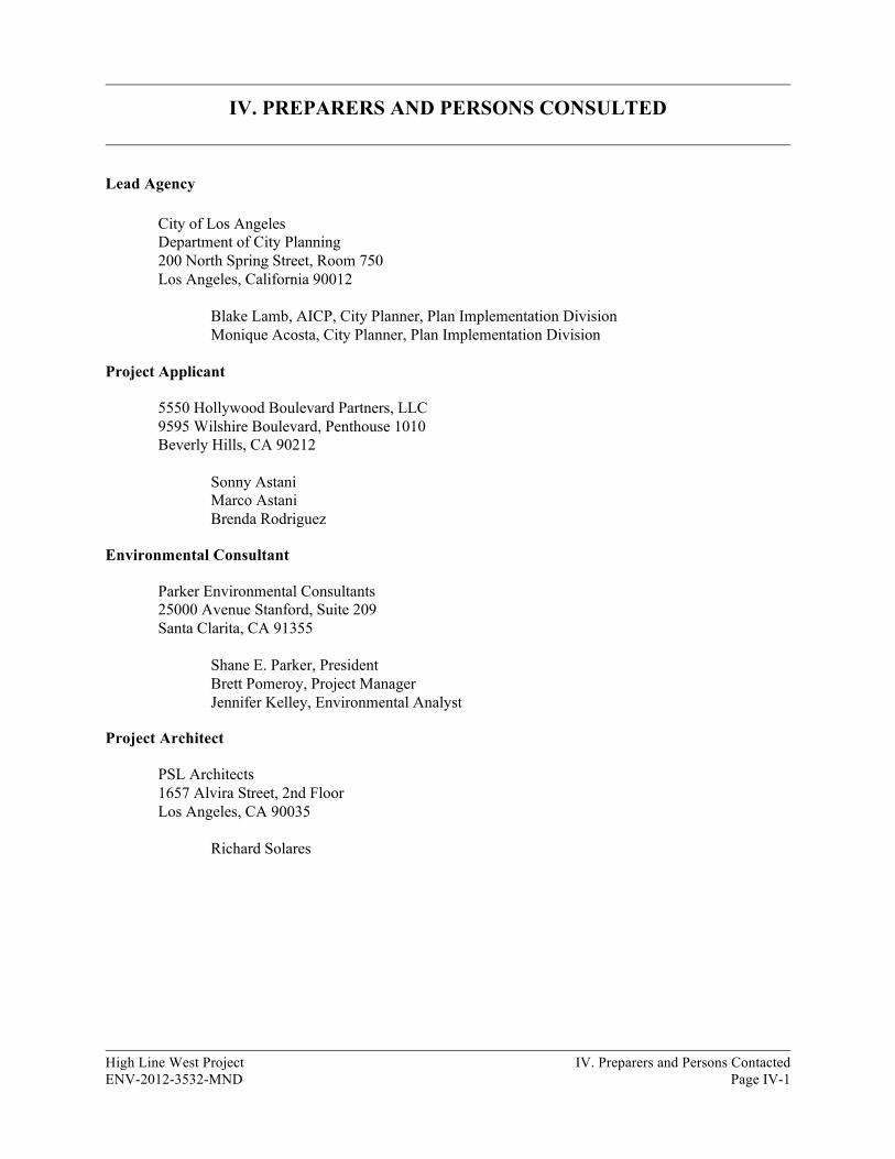
High Line West Project IV. Preparers and Persons Contacted ENV-2012-3532-MND Page IV-1
IV. PREPARERS AND PERSONS CONSULTED
Lead Agency
City of Los Angeles Department of City Planning 200 North Spring Street, Room 750 Los Angeles, California 90012
Blake Lamb, AICP, City Planner, Plan Implementation Division Monique Acosta, City Planner, Plan Implementation Division
Project Applicant
5550 Hollywood Boulevard Partners, LLC 9595 Wilshire Boulevard, Penthouse 1010 Beverly Hills, CA 90212
Sonny Astani Marco Astani Brenda Rodriguez
Environmental Consultant
Parker Environmental Consultants 25000 Avenue Stanford, Suite 209 Santa Clarita, CA 91355 Shane E. Parker, President Brett Pomeroy, Project Manager Jennifer Kelley, Environmental Analyst
Project Architect
PSL Architects 1657 Alvira Street, 2nd Floor Los Angeles, CA 90035 Richard Solares
City of Los Angeles June 2013
High Line West Project IV. Preparers and Persons Contacted ENV-2012-3535-MND Page IV-2
Traffic Consultant
The Mobility Group 18301 Von Karman, Suite 490 Irvine, CA 92612
Michael Bates, Principal Matthew Simmons, Senior Transportation Engineer
Land Use/Entitlement Consultant
Craig Lawson & Co., LLC 8758 Venice Blvd., Suite 200 Los Angeles, CA 90034
Craig Lawson, President Jim Ries, Vice President Alex Irvine, Project Manager
Historic Consultant
Galvin Preservation Associates 1611 S. Pacific Coast Hwy, #104 Redondo Beach, CA 90277
Teresa Grimes, Architectural Historian
Civil Engineer
Hall & Foreman, Inc. 25152 Springfield Court, Suite 350 Santa Clarita, CA 91355-1096
Alex Moore, Project Manager
Geotechnical & Environmental Engineers
GeoPentech 525 N. Cabrillo Park Drive, Suite 280 Santa Ana, CA 92701
Sarkis Tatusian, Principal Geotechnical Engineer, GE 2118 Steven K. Duke, Senior Engineering Geologist, CEG 2269 Doug Wahl, Senior Staff Engineer, PE 74422

V. REFERENCES AND ACRONYMS
High Line West Project V. References and Acronyms ENV-2012-3532-MND Page V-1
1. REFERENCES
California Air Resources Board, Final Supplement to the AB 32 Scoping Plan Functional Equivalent Document (FED), Attachment D, August 19, 2011.
California Department of Conservation, Division of Land Resource Protection, Land Resource Protection – Home, Important Farmland Maps in PDF Format, Important Farmland in California, 2006, Map, website: http://www.conservation.ca.gov/DLRP/Pages/Index.aspx, accessed October 2012.
California Department of Conservation, Division of Oil, Gas, and Geothermal Resources (DOGGR), 2006, Wildcat Map 119, Sacramento, California, website: ftp://ftp.consrv.ca.gov/pub/oil/maps/dist1/119/Map119.pdf, accessed October 2012.
California Department of Transportation, Representative Environmental Noise Levels, 1998.
California Department of Transportation, Transportation- and Construction –Induced Vibration Guidance Manual, June 2004.
California Environmental Protection Agency, Climate Action Team, Climate Action Team Report to Governor Schwarzenegger and the Legislature, March 2006.
California Environmental Protection Agency, State Water Resources Control Board, Storm Water Program, website: http://www.swrcb.ca.gov/water_issues/programs/stormwater/construction. shtml, accessed October 2012.
City of Los Angeles, Air Quality Element of the General Plan, November 24, 1992.
City of Los Angeles, Bureau of Engineering, Navigate LA, website: http://navigatela.lacity.org, accessed October 2012.
City of Los Angeles, CEQA Thresholds Guide, 2006.
City of Los Angeles Citywide General Plan Framework EIR, July 17, 1996.
City of Los Angeles Department of City Planning, Environmental and Public Facilities Maps, September 1996.
City of Los Angeles Department of City Planning, Environmental and Public Facilities Maps, Critical Facilities & Lifeline Systems in the City of Los Angeles, September 1996.
City of Los Angeles Department of City Planning, Environmental and Public Facilities Maps: Prehistoric and Historic Archaeological Sites and Survey Areas in the City of Los Angeles, September 1996.
City of Los Angeles Department of City Planning, Environmental and Public Facilities Maps: Vertebrate Paleontological Resources in the City of Los Angeles, September 1996.
City of Los Angeles Department of City Planning, Parcel Profile Reports, Zoning Information and Map Access System (ZIMAS), http://www.zimas.lacity.org, accessed January 2013.
City of Los Angeles June 2013
High Line West Project V. References and Acronyms ENV-2012-3535-MND Page V-2
City of Los Angeles Department of City Planning, The Citywide General Plan Framework, An Element of the City of Los Angeles General Plan, adopted December 11, 1996 and re-adopted August 8, 2001.
City of Los Angeles, Department of Public Works, Bureau of Sanitation, General Information, website: www.lacity.org/san/general_info/about_us/our_services/service_summary.htm, accessed October 2012.
City of Los Angeles Department of Public Works, Bureau of Sanitation, Hyperion Treatment Plant, website: http://san.lacity.org/lasewers/treatment_plants/hyperion/index.htm, accessed October 2012.
City of Los Angeles Department of Public Works, Bureau of Sanitation, Wastewater, Facts & Figures, website: http://www.lacitysan.org/wastewater/factsfigures.htm, accessed October 2012.
City of Los Angeles, Department of Public Works, Sanitation Department, Sewer System Management Plan, May 2011.
City of Los Angeles Department of Water and Power, 2010 Urban Water Management Plan, LADWP Board of Water and Power Commissioners Resolution No. 011268, adopted May 3, 2011.
City of Los Angeles, Green Building Code (Ordinance No. 181,480).
City of Los Angeles, Green LA, An Action Plan to Lead the Nation in Fighting Global Warming (LA Green Plan)
City of Los Angeles, Noise Element of the General Plan, November 24, 1992.
City of Los Angeles Municipal Code.
City of Los Angeles Noise Ordinance (LAMC Section 112.05)
City of Los Angeles Ordinance 144331 and 161574.
City of Los Angeles Ordinance 179681, adopted February 20, 2008.
City of Los Angeles Ordinance 181142, April 9, 2010.
City of Los Angeles Public Library, Hours and Locations, website: http://www.lapl.org/branches, accessed October 2012.
City of Los Angeles, Safety Element of the Los Angeles City General Plan, Exhibit G, Inundation & Tsunami Hazard Areas, March 1994.

City of Los Angeles June 2013
High Line West Project V. References and Acronyms ENV-2012-3535-MND Page V-3
City of Los Angeles Stormwater Program, Standard Urban Stormwater Mitigation Plans (SUSMPs), website: http://www.lastormwater.org/Siteorg/businesses/susmp/susmpintro.htm, accessed October 2012.
County of Los Angeles Department of Public Works, 2011 Annual Report, Los Angeles Countywide Integrated Waste Management Plan, August 2012.
Federal Emergency Management Agency, Flood Insurance Rate Maps, Search by Street Address, website: http://www.fema.gov/hazard/map/firm.shtm, accessed October 2012.
Federal Emergency Management Agency, 2008, website: https://hazards.fema.gov/femaportal/wps/portal/, accessed October 2012.
Federal Transit Administration (Harris Miller Miller & Hanson), Transit Noise and Vibration Impact Assessment, May 2006.
Green LA: An Action Plan to Lead the Nation In Fighting Global Warming. City of Los Angeles, May 2007.
Institute of Transportation Engineers, Trip Generation Manual – 8th Edition, 2008.
Intergovernmental Panel on Climate Change, Second Assessment Report, 1996.
Los Angeles County Department of Public Work, Disaster Route Maps by City, City of Los Angeles – Central Area Map, website: http://dpw.lacounty.gov/dsg/DisasterRoutes/city.cfm, accessed October 2012.
Los Angeles County Congestion Management Plan (CMP), 2010.
Los Angeles Department of Water and Power, Urban Water Management Plan website: http://www.ladwp.com/ ladwp/cms/ladwp007157.pdf, accessed October 2012.
Los Angeles Unified School District, Residential Development School Fee Justification Study, Table 5, February 25, 2008.
National Cooperative Highway Research Program Report 117, Highway Noise: A Design Guide for Highway Engineers, 1971.
Senate Bill 97 (SB 97), August 2007.
Senate Bill 375, September 2008.
South Coast Air Quality Management District, 2007 Air Quality Management Plan, June 1, 2007.
City of Los Angeles June 2013
High Line West Project V. References and Acronyms ENV-2012-3535-MND Page V-4
South Coast Air Quality Management District, Air Quality Significance Thresholds, Revision March 2011, website: http://www.aqmd.gov/ceqa/handbook/signthres.pdf, accessed November 2012.
South Coast Air Quality Management District, California Emissions Estimator Model (CalEEMod Version 2011.1.1), 2012.
South Coast Air Quality Management District, CEQA Air Quality Handbook, 1993, page 5-1
South Coast Air Quality Management District, Final Localized Significance Threshold Methodology, June 2003, Revised July 2008.
Southern California Association of Governments, Regional Comprehensive Plan and Guide.
Southern California Association of Governments, SCAG Forecast 2008.
State of California Assembly Bill (AB 32), the California Global Warming Solutions Act of 2006, 2006
State of California Department of Conservation, Division of Land Resource Protection, Farmland Mapping and Monitoring Program, Los Angeles County Important Farmland 2006, Map. ftp://ftp.consrv.ca.gov/pub/dlrp/FMMP/pdf/2006/los06.pdf, accessed October 2012.
State of California Department of Conservation, Division of Oil, Gas & Geothermal Resources, Online Mapping System, District 1, website: http://maps.conservation.ca.gov/doms/index.html, accessed October 2012.
State of California Integrated Waste Management Board, Solid Waste Information System, Facility Search, website: http://www.ciwmb.ca.gov/SWIS/, accessed October 2012.
Sunshine Canyon Landfill, Update from Project Director, website: http://www.sunshinecanyonlandfill.com/update/_index.htm, accessed October 2012.
Title 24 of the California Code of Regulations.
United States Environmental Protection Agency, Noise from Construction Equipment and Operations, Building Equipment and Home Appliances, PB 206717, 1971.
United States Geological Survey (USGS), 2008c, National Seismic Hazard Maps – Fault Parameters, website: http://geohazards.usgs.gov/cfusion/hazfaults_search/hf_search_main.cfm, accessed October 2012.
USEPA Report No. EPA530-98-010. Characterization of Building Related Construction and Demolition Debris in the United States, June 1998, page A-1
White Paper on Regulatory Options for Addressing Cumulative Impacts from Air Pollution Emissions, SCAQMD Board Meeting, September 5, 2003, Agenda No. 29, Appendix D, p. D-3.

City of Los Angeles June 2013
High Line West Project V. References and Acronyms ENV-2012-3535-MND Page V-5
U.S. Fish & Wildlife Service, National Wetlands Inventory, Wetlands Mapper, website: http://www.fws.gov/wetlands/Data/mapper.html, accessed October 2012.
Williamson Act Program, California Division of Land Resource Protection, website: ftp://ftp.consrv.ca.gov/pub/dlrp/FMMP/pdf/statewide/2006/fmmp2006_wallsize.pdf, accessed October 2012.
2. ACRONYMS AND ABBREVIATIONS
AAM Annual Arithmetic Mean AB Assembly Bill ACM Asbestos-containing materials AEP Association of Environmental Professionals AFY Acre-feet per year APN Assessor Parcel Number AQMP Air Quality Management Plan ASTM American Society of Testing and Materials ASTs above-ground storage tanks ATCS Adaptive Traffic Control System Basin South Coast Air Basin BMPs Best Management Practices C/D construction/demolition CAA Clean Air Act CAAQS California ambient air quality standards Cal/EPA California Environmental Protection Agency CAPCOA California Air Pollution Control Officers Association CARB California Air Resources Board CAT Climate Action Team CBC California Building Code (2007) CCAA California Clean Air Act CCAR California Climate Action Registry CCR California Code of Regulations CDFG California Department of Fish and Game CDMG California Division of Mines and Geology CEC California Energy Commission CEQA California Environmental Quality Act CERCLIS Comprehensive Environmental Response, Compensation, and Liability
Information System Cf Cubic feet CFC Chlorofluorocarbons CGS California Geological Survey CH4 Methane CHMIRS California Hazardous Material Incident Report System

City of Los Angeles June 2013
High Line West Project V. References and Acronyms ENV-2012-3535-MND Page V-6
CiSWMPP City of Los Angeles Solid Waste Management Policy Plan City Zoning Code City of Los Angeles Planning and Zoning Code CMP Congestion Management Plan CNEL Community Noise Exposure Level CO carbon monoxide CO2 carbon dioxide CO2e carbon dioxide equivalent COHb carboxyhemoglobin COPC Chemical of Potential Concern CORRACTS Corrective Action Treatment, Storage, and Disposal Facilities CPA Community Plan Area CPT cone penetrometer test CPU Crime Prevention Unit CRA/LA Community Redevelopment Agency of the City of Los Angeles CWA Clean Water Act CWC California Water Code cy cubic yards dB decibel dBA A-weighted decibel scale d/D flow level DHS California Department of Health and Services DWP Department of Water and Power DWR California Department of Water Resources du dwelling unit EIR Environmental Impact Report EMS Emergency Medical Service EOO Emergency Operations Organization EPA Environmental Protection Agency ERNS Emergency Response Notification System EZ Los Angeles State Enterprise Zone FAR Floor Area Ratio FCAA Federal Clean Air Act FEMA Federal Emergency Management Agency FHWA Federal Highway Administration GBCI Green Building Certification Institute GHG greenhouse gas gpd gallons per day gpm gallons per minute GWP Global Warming Potential HFC hydrofluorocarbons HSA Hyperion Service Area HTP Hyperion Treatment Plant
City of Los Angeles June 2013
High Line West Project V. References and Acronyms ENV-2012-3535-MND Page V-7
HVAC Heating, Ventilation and Air Conditioning I-10 Santa Monica Freeway I-101 Hollywood Freeway ISO Interim Control Ordinance ITE Institute of Transportation Engineers km kilometers kV kilovolt kWh kilowatt-hours LAA Los Angeles Aqueduct LABS Los Angeles Department of Public Works Bureau of Sanitation LADBS Los Angeles Department of Building and Safety LADOT Los Angeles Department of Transportation LADRP Los Angeles Department of Recreation and Parks LADWP Los Angeles Department of Water and Power LAFD Los Angeles Fire Department LAMC Los Angeles Municipal Code LAPD Los Angeles Police Department LAPL Los Angeles Public Library LARWQCB Los Angeles Regional Water Quality Control Board LAUSD Los Angeles Unified School District LBP Lead-based paint lbs/day pounds per day LCFS Low Carbon Fuel Standard Ldn day-night average noise level LEED Leadership in Energy and Environmental Design Leq equivalent energy noise level/ambient noise level LOS Level of Service LST localized significance thresholds LUST leaking underground storage tank LUTP Land Use/Transportation Policy MBTA Migratory Bird Treaty Act MCE Maximum Considered Earthquake MEP maximum extent practicable Metro Los Angeles County Metropolitan Transit Authority mgd million gallons per day mi miles MPO Metropolitan Planning Organization MS4 medium and large municipal separate storm sewer systems msl mean sea level mm millimeters Mmax maximum moment magnitude MTA Metropolitan Transportation Authority

City of Los Angeles June 2013
High Line West Project V. References and Acronyms ENV-2012-3535-MND Page V-8
MWD Metropolitan Water District MWh Mega-Watt hours N2O nitrous oxide NAAQS National ambient air quality standards NFRAP No Further Remedial Action Planned Sites NO2 nitrogen dioxide NOP Notice of Preparation NOx nitrogen oxides NPDES National Pollutant Discharge Elimination System NPL National Priorities List O3 Ozone OAL California Office of Administrative Law OPR Office of Planning and Research Pb lead PEC Potential environmental concern PFC perfluorocarbons PGA peak horizontal ground acceleration PM particulate matter PM10 respirable particulate matter PM2.5 fine particulate matter ppd pounds per day ppm parts per million PRC Public Resources Code PSI pounds per square inch PUC Public Utilities Commission (also see CPUC) PWS Public water suppliers RCP Regional Comprehensive Plan RCPG Regional Comprehensive Plan and Guide RCRA Resource Conservation Recovery Act RD Reporting District REC Recognized Environmental Condition ROG Reactive Organic Gases RTP Regional Transportation Plan RWQCB Regional Water Quality Control Board SB Senate Bill SCAB South Coast Air Basin SCAG Southern California Association of Governments SCAQMD South Coast Air Quality Management District SCG Southern California Gas Company SCH State Clearinghouse sf square feet SF6 sulfur hexafluoride
City of Los Angeles June 2013
High Line West Project V. References and Acronyms ENV-2012-3535-MND Page V-9
SIP State Implementation Plan SLIC Spills, Leaks, Investigation and Cleanup SO2 sulfur dioxide SO4 sulfates SOx sulfur oxides SOPA Society of Professional Archeologist SPT Standard Penetration Test SR-110 Harbor Freeway SRA source receptor area SRRE Source Reduction and Recycling Element SWAT Solid Waste Assessment Test SWF/LF Solid Waste Information System SWFP Solid Waste Facility Permit SWMP stormwater management plan SWP State Water Project SWPPP Storm Water Pollution Prevention Plan SWRCB State Water Resource Control Board TAC Toxic Air Contaminants TOD Transit Oriented District TPH total petroleum hydrocarbons TSD Treatment, Storage, and Disposal TSP Transportation Specific Plan ULSD Ultra Low Sulfur Diesel US-101 Hollywood Freeway USEPA/ U.S. EPA United States Environmental Protection Agency USFWS United States Fish and Wildlife Service USGBC United States Green Building Council USGS U.S. Geological Survey UST underground storage tank UWMP Urban Water Management Plan V/C Volume-to-Capacity VCP Voluntary Cleanup Plan VdB Vibration decibels VMT Vehicle Miles Traveled VOC Volatile Organic Compound WMA Watershed Management Area WMUDS Waste Management Unit Database System WSA Water Supply Assessment µg/m3 micrograms per cubic meter ZIMAS Zoning Information and Map Access System


