Embed Size (px)
Citation preview
Impacts of climate change on erosion and erosion control methods – A critical review Final Report MPI Technical Paper No: 2012/45 Prepared for MPI by L Basher, Landcare Research; S Elliott, A Hughes, A Tait, NIWA; M Page, B Rosser, GNS Science; I McIvor, Plant & Food Research; G Douglas, AgResearch; H Jones, Scion August 2012 ISBN No: 978-0-478-40465-4 (online) ISSN No: 2253-3923 (online) November 2012

Disclaimer While every effort has been made to ensure the information in this publication is accurate, the Ministry for Primary Industries does not accept any responsibility or liability for error of fact, omission, interpretation or opinion that may be present, nor for the consequences of any decisions based on this information.
Requests for further copies should be directed to:
Publications Logistics Officer Ministry for Primary Industries PO Box 2526 WELLINGTON 6140
Email: [email protected] Telephone: 0800 00 83 33 Facsimile: 04-894 0300
This publication is also available on the Ministry for Primary Industries website at http://www.mpi.govt.nz/news-resources/publications.aspx
© Crown Copyright - Ministry for Primary Industries
i
Contents Page
Extended Summary 1
1 Introduction 11
2 Background 11
3 Objectives 12
4 Methods 12
5 Climate change projections 13
6 Climate and erosion processes 24
7 Palaeo-records of erosion response to climate variability 57
8 Erosion modelling as a tool for assessing climate change impacts 63
9 Previous studies of climate change impacts on erosion in New Zealand 76
10 International studies of climate change impacts on erosion 80
11 Biological erosion control in New Zealand 87
12 Effect of climate change on establishment, growth, survival, & health of species used for biological erosion control 95
13 Discussion 132
14 Conclusions 153
15 Recommendations 155
16 Acknowledgements 156
17 References 156
Appendix 1 – Contracted research outputs and contract performance 207


iii
List of Tables Table 1: Projected changes (%) for selected stations within each regional council area in seasonal and annual precipitation from 1980–99 to 2080–99. Lower and upper limits are shown in brackets (Source: MfE 2008) ................................................................................... 14
Table 2: Factor of percentage adjustment per 1°C to apply to extreme rainfall, for use in deriving extreme rainfall information for screening assessments (Source: MfE 2008) .......... 21
Table 3: Potential slope stability (landslide) response to climate change (Source Crozier 2010) ........................................................................................................................................ 29
Table 4: Storm periods (cal. years BP) based on variations in frequency and thickness of storm sediment layers .............................................................................................................. 60
Table 5: Main data requirements of SHETRAN relevant to erosion and climate change ....... 69
Table 6: Main data requirements for the hydrology and slope stability components of the Schmidt landslide model (Source: Schmidt et al. 2008b) ........................................................ 70
Table 7: Predicted impacts of climate change on sheet and rill erosion rates (from Wei et al. 2009) ........................................................................................................................................ 81
iv
List of Figures Figure 1: Projected mean annual precipitation change (%) between 1980–99 and 2030–49 (based on the average from 12 downscaled General Circulation Models and the A1B emission scenario) (Source: MfE 2008). ................................................................................. 15
Figure 2: Projected mean annual precipitation change (%) between 1980–99 and 2080–99 (based on the average from 12 downscaled General Circulation Models and the A1B emission scenario) (Source: MfE 2008). ................................................................................. 16
Figure 3: Projected mean seasonal precipitation change (%) between 1980–99 and 2080–99 (based on the average from 12 downscaled General Circulation Models and the A1B emission scenario) (Source: MfE 2008). ................................................................................. 17
Figure 4: New Zealand 100-year Average Recurrence Interval 24-hour-rainfall totals (Source: HIRDS v3 online at http://hirds.niwa.co.nz/). ......................................................................... 18
Figure 5: Difference between present-day and future (2°C warmer) 100-year Average Recurrence Interval 24-hour-rainfall totals (Source: HIRDS v3 online at http://hirds.niwa.co.nz/). .......................................................................................................... 19
Figure 6: Projected change in return period of present-day 1-in-20 year droughts (using Potential Evapotranspiration Deficit (PED) as a drought index) for the future period 2070–2099. Left: a ‘low–medium’ scenario (based on the CSIRO model); Right: a ‘medium–high’ scenario (based on the Hadley Centre model) (Source: Mullan et al. 2005). .......................... 22
Figure 7: Projected increase in percentage of time spent in drought from 1980–99 levels for the A1B emissions scenario. Results summarise 19 General Circulation Models (Source: Clark et al. 2011)...................................................................................................................... 23
Figure 8: Shallow rainfall triggered landslides in soft rock hill country (left) and debris avalanches on forested slopes (right). ...................................................................................... 25
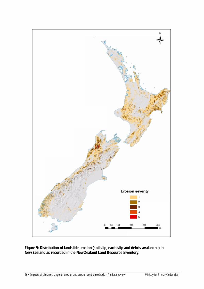
Figure 9: Distribution of landslide erosion (soil slip, earth slip and debris avalanche) in New Zealand as recorded in the New Zealand Land Resource Inventory. .............................. 26
Figure 10: Caine’s global rainfall-intensity threshold tested with some New Zealand data (Source: Crozier 1997). ............................................................................................................ 27
Figure 11: Relationship between frequency of landslide events and mean annual rainfall (Source: Hicks 1995a). ............................................................................................................. 28
Figure 12: Relationship between storm magnitude and areal landslide density for forest and pasture on landslide-prone land systems. Curved lines indicate the 95% confidence interval for the unconstrained regressions (solid lines), and bold dashed lines indicate regressions constrained to fit observations of threshold magnitudes for landslide generation. Maximum magnitudes for which landslides were not generated are indicated by arrows on the x-axis (Source: Reid & Page 2002). ................................................................................................... 31
Figure 13: Regional frequency of recorded landslide-triggering rainstorms in New Zealand. Points are locations of recorded events (Sources: Glade 1997, 1998). .................................... 34

v
Figure 14: Probability of landsliding in relation to daily rainfall (Sources: Glade 1997, 1998)................................................................................................................................................... 35
Figure 15: Antecedent Daily Rainfall Model applied to (a) Wairarapa, (b) Hawke’s Bay, and (c) Wellington (Sources: Glade 1997; Glade et al. 2000). Large dots are rainfalls that triggered landslides, open circles are rainfalls with probable landslide occurrence, and small dots are rainfalls that did not trigger landslides. The solid lines are the probability curves (0.1, 0.5, 0.9) and confidence intervals are indicated for each probability curve by dashed lines. .. 36
Figure 16: Antecedent Soil Water Status Model applied to Wairarapa, Hawke’s Bay and Wellington (Sources: Glade 1997, 2000). The probability ranges for triggering thresholds of soil water status and daily rainfall are shown. ......................................................................... 37
Figure 17: Different styles of gully erosion in New Zealand – linear (left) and amphitheatre-shaped mass movement gully complex (right). ....................................................................... 38
Figure 18: Distribution of gully erosion in New Zealand as recorded in the New Zealand Land Resource Inventory. ........................................................................................................ 39
Figure 19: Extensive earthflow erosion, Gisborne area. .......................................................... 42
Figure 20: Distribution of earthflow erosion in New Zealand, as recorded in the New Zealand Land Resource Inventory. ........................................................................................................ 43
Figure 21: Severe sheet erosion under vegetable cropping at Pukekohe following a large storm in 1999. .......................................................................................................................... 45
Figure 22: Distribution of sheet erosion in New Zealand as recorded in the New Zealand Land Resource Inventory. ........................................................................................................ 46
Figure 23: Different styles of bank erosion in New Zealand – extensive bank erosion in cohesive fine-grained sediment (left), localised bank erosion of cliffs of cohesive gravelly sediment. .................................................................................................................................. 48
Figure 24: Distribution of bank erosion in New Zealand,as recorded in the New Zealand Land Resource Inventory. ................................................................................................................. 49
Figure 25: Wind erosion of cultivated paddocks. .................................................................... 51
Figure 26: Distribution of wind erosion in New Zealand as recorded in the New Zealand Land Resource Inventory. ........................................................................................................ 52
Figure 27: Chain of modelling steps for assessment of climate change effects on slope stability and landslide frequency (Source: Malet et al. 2007). ................................................ 84
Figure 28: Native areas of Salicaceae (poplars and willows) in the world (Source: FAO, http://www.fao.org/forestry/3779/en/). .................................................................................... 91
Figure 29: Relationship between projected rainfall changes (to 2080–2099) and potential for landslide erosion (soil slip, earthslip, debris avalanche) – from the New Zealand Land Resource Inventory. Area shaded blue is projected to have increased rainfall by 2099;

vi
unshaded area is projected to have decreased rainfall. Percentage rainfall changes are shown in Figure 2. ............................................................................................................................. 136
Figure 30: Relationship between projected rainfall changes (to 2080–2099) and potential for gully erosion – from the New Zealand Land Resource Inventory. Area shaded blue is projected to have increased rainfall by 2099; unshaded area is projected to have decreased rainfall. Percentage rainfall changes are shown in Figure 2. ................................................. 137
Figure 31: Relationship between projected rainfall changes (to 2080–2099) and potential for earthflow erosion – from the New Zealand Land Resource Inventory. Area shaded blue is projected to have increased rainfall by 2099; unshaded area is projected to have decreased rainfall. Percentage rainfall changes are shown in Figure 2. ................................................. 139
Figure 32: Relationship between projected rainfall changes (to 2080–2099) and potential for sheet erosion – from the New Zealand Land Resource Inventory. Area shaded blue is projected to have increased rainfall by 2099; unshaded area is projected to have decreased rainfall. Percentage rainfall changes are shown in Figure 2. ................................................. 140
Figure 33: Relationship between projected rainfall changes (to 2080–2099) and potential for streambank erosion – from the New Zealand Land Resource Inventory. Area shaded blue is projected to have increased rainfall by 2099; unshaded area is projected to have decreased rainfall. Percentage rainfall changes are shown in Figure 2. ................................................. 141
Figure 34: Relationship between projected rainfall changes (to 2080–209) and potential for wind erosion – from the New Zealand Land Resource Inventory. Area shaded blue is projected to have increased rainfall by 2099; unshaded area is projected to have decreased rainfall. Percentage rainfall changes are shown in Figure 2. ................................................. 143
Ministry for Primary Industries Impacts of climate change on erosion and erosion control methods – A critical review • 1
Extended Summary Project and Client Landcare Research assembled a team of experts in climate change prediction, erosion processes and plant-based erosion control from NIWA, GNS Science, AgResearch, Plant & Food Research and Scion to undertake a project in 2011/12 for MAF (now Ministry of Primary Industries) to review knowledge of the impacts of climate change on erosion processes and erosion control methods in New Zealand.
Objectives • Review climate change projections relevant to climate drivers of erosion • Summarise literature that links erosion processes and rates to climate drivers • Review information on the potential impacts of climate change on erosion control • Identify areas of New Zealand most susceptible to climate change impacts on erosion • Summarise our ability to quantify climate change effects on erosion and identify
information gaps and future research priorities
Main findings
Climate change projections The main features of climate change that will affect erosion are:
a) Changes in rainfall patterns: annual rainfall will increase in the W and S and decrease in the E and N and extreme storm rainfalls (return periods) are projected to decrease substantially
b) Increases in temperature affecting plant water use and soil water balance c) Increased windiness and incidence of drought, particularly in the east d) A possible reduction in number and intensity of extra-tropical cyclones, particularly
in winter
Erosion processes Climate and erosion are clearly linked as regards water movement into and through the soil, soil-–water balance and slope hydrology. Storm rainfalls are an important influence on the rate of most erosion processes, and projected increases in extreme rainfalls will play a critical role in determining the effect of climate change. In some areas the effects of increased temperature and lower rainfall will tend to counteract the effect of increased storm rainfalls by lowering antecedent moisture conditions.
Extensive erosion processes likely to be influenced by climate change are shallow landslides, earthflows, gully, sheet, streambank and wind erosion:
a) Shallow rapid landslides differ in frequency and magnitude throughout New Zealand. As these are usually triggered by a rainfall event (intense storm or long period of wet weather), they are likely to change in frequency with climate change depending on changes to storm and annual rainfall, rainfall variability, extra-tropical cyclone frequency, temperature, and wind. To try and establish thresholds for landsliding, several statistical and probabilistic approaches have been used to relate landslide frequency/occurrence to rainfall (annual, daily or storm rainfall); all have wide error limits. The probability of occurrence of landsliding related to storm parameters ranges widely, indicating antecedent conditions are a very strong influence on landsliding.
2 • Impacts of climate change on erosion and erosion control methods – A critical review Ministry for Primary Industries
b) Earthflow erosion is most extensive on crushed mudstone and argillite in the Gisborne–East Coast area–southern Hawke’s Bay, but also in Northland and the soft rock hill country of inland Taranaki and the southern Waikato. There are complex links between earthflow movement and climate related to soil moisture and storm rainfall. Changes in rainfall and temperature (through its effect on evapotranspiration) with climate change may influence rates of earthflow movement. There are no published quantitative relationships relating earthflow movement to climate that would allow assessment of climate change impacts.
c) Gully erosion is most common in the North Island east coast soft rock hill country, mountainlands of both islands, Northland and the Volcanic Plateau. It has been related to high annual and storm rainfalls, but no quantitative relationships have been published. Any increase in rainfall with climate change, either of annual totals or storm events, can be expected to increase gully erosion.
d) Sheet erosion will potentially be increased by any change in runoff as a result of increased rainfall intensity or duration with climate change. Many modelling approaches are available to predict any such changes in rates of sheet erosion.
e) Bank erosion is common along rivers and streams but is not well understood. Rates of bank erosion are influenced by flow velocity and stream power, implying any increase in runoff and flood flows associated with increased rainfall and high magnitude storms will result in an increase in bank erosion rates.
f) Large areas of New Zealand are susceptible to wind erosion – e.g. coastal sand dunes, the Volcanic Plateau, and large areas of the plains and steeplands of the eastern South Island. Wind erosivity and soil moisture content are key controls on wind erosion rates and these may change with climate change, along with increased drought frequency.
Variation in suspended sediment yield is strongly correlated with mean annual rainfall. There is a power law relationship that implies small changes in annual rainfall may cause substantial changes in suspended sediment yield.
Palaeo-environmental studies show that:
a) Natural variability in storm magnitude and frequency in the past 7200 years (when temperatures fluctuated within 1–2°C of modern values) is greater than in the last 150 years of instrumented record. Seven prehistoric storms of likely greater magnitude than Cyclone Bola have been identified among 54 of at least similar magnitude. Periods with increased frequency of large storms were typically decades to a century long, often with sudden onset and cessation. Storm magnitude and frequency were influenced by the El Niño-Southern Oscillation and the Southern Annular Mode.
b) Erosion rates have been an order of magnitude greater under pasture than under natural forest. A targeted increase in afforestation could potentially offset the erosion impact from the projected increase in storm rainfall with climate change.
The only feasible means of quantifying the predicted impact of climate change on erosion is through models that explicitly incorporate climate impacts on erosion processes. Two types of models have been used in New Zealand:
a) Empirical – based on statistical relationships between erosion and key controlling factors. These require limited input data to run but usually have limited spatial detail.

Ministry for Primary Industries Impacts of climate change on erosion and erosion control methods – A critical review • 3
Examples are the Universal Soil Loss Equation, Suspended Sediment Yield Estimator, NZeem®, SPARROW/CLUES, probabilistic rainfall-induced landslide models.
b) Process-based – using complex physical equations to represent atmospheric, hydrologic, plant growth and erosion processes. These require extensive input data to parameterise but usually have a high degree of spatial detail. Examples are HydroTrend, SHETRAN, GLEAMS, SWAT, WEPP, Hillslope Erosion Model, Schmidt probabilistic landslide model.
None of these models incorporate the full range of erosion processes in New Zealand. Several models have been used in local or regional assessments of climate change impacts on erosion (probabilistic landslide models, NZeem®, HydroTrend, SHETRAN, GLEAMS).
Hybrid models represent a ‘half-way house’ with some process representation and requiring limited input data. SedNetNZ (based on the Australian SedNet model) is currently under development and will model the full range of erosion processes (landslide, earthflow, gully, sheet, rill, bank erosion), sediment transport and floodplain deposition, and sediment yield.
One of the biggest constraints to developing reliable relationships between erosion and key climatic parameters is the availability of data since there is no routine monitoring of any form of erosion. This is especially relevant to shallow landslides, where relationships between landslide magnitude and event rainfall need to be developed for the range of terrain in New Zealand. Without good quality data it will be difficult to separate the impact of climate change on erosion from the existing high temporal variability of erosion.
Numerous international studies have investigated the effect of climate change on sheet and rill erosion processes using models such as WEPP, SWAT and SHETRAN. These suggest:
a) The major direct effects are likely to be changes in rainfall erosivity, runoff, vegetation cover, and soil erodibility with the greatest impact from rainfall amounts and increased rainfall extremes. Where rainfall increases erosion can be expected to increase but where rainfall decreases the effect may be more complex depending on interactions between plant biomass, runoff and erosion.
b) The ability of downscaled General Circulation Model (GCM) climate projections to produce daily or sub-daily rainfall projections is critical for realistically modelling future soil erosion.
c) Relative changes predicted by models are more reliable than the absolute changes. d) Links between rainfall and temperature changes, runoff, canopy and ground cover,
and erosion are complex and non-linear.
No models will reliably predict the impacts of climate change on gully erosion and none of the available models simulate complex mass movement-gully erosion typical of New Zealand.
To determine the impact of climate change on landslide rates, downscaled GCM rainfall estimates to predict rainfall, a hydrological model to derive time series of groundwater levels or pore water pressure, and factor-of-safety analysis to predict slope instability are typically used. Different types of landslides respond to different climatic triggers, e.g. debris flows (event rainfall) or deep-seated episodic landslides (seasonal effective precipitation), and
4 • Impacts of climate change on erosion and erosion control methods – A critical review Ministry for Primary Industries
effects will depend on the balance between rainfall change and increased evapotranspiration with temperature warming. Most studies have been local and on deep slumps and mudslides.
The few international studies of climate change impacts on shallow landslides have used both factor-of-safety analysis approaches and probabilistic approaches. Other studies have looked at the impact of recent climate change on the size–frequency distribution of landslides. Several suggest that uncertainties in predicted extreme precipitation events, soil parameters and antecedent precipitation confound accurate estimation of changes in slope stability.
A qualitative assessment of regional variation in potential climate change impacts on erosion was derived relating potential erosion mapped in the NZLRI to projected changes in rainfall:
a) Areas most susceptible to increased landsliding include the soft rock hill country of Taranaki, southern Waikato, Manawatu-Wanganui west of the Ruahine Range, Otago, South Canterbury and inland Marlborough. Many of the areas of the South Island with the highest projected increase in rainfall and high potential for landslide erosion are steep forested mountains in national parks. Many areas in both islands with highest potential for landslide erosion (erodible soft rock hill country of eastern North Island, Bay of Plenty, northern Waikato, Auckland, Northland, North Canterbury and Marlborough) are projected to have a decrease in mean annual rainfall and the impact of climate change will depend on changes to extreme rainfall and extra-tropical cyclone activity.
b) Areas most susceptible to increased gully erosion are the soft rock hill country of Taranaki, southern Waikato and Manawatu-Wanganui west of the Ruahine Range, and the greywacke and the hard rock mountainlands of the South Island. The areas with the highest potential for gully erosion (Gisborne-East Coast, Southern Hawke’s Bay, Northland) are projected to have decreased rainfall and the impact of climate change will depend on changes in storm rainfalls.
c) Areas most susceptible to increased earthflow erosion are the soft rock hill country of inland Taranaki, and Wanganui areas. Most of the areas with the highest potential for earthflow erosion (Gisborne-East Coast, Southern Hawke Bay, Wairarapa coast, Northland) are projected to have a decrease in rainfall, which is likely to reduce rates of earthflow movement.
d) Areas most susceptible to increased sheet erosion are the Volcanic Plateau (including the intensive cropping area around Ohakune), and the northern Manawatu-Wanganui-Taranaki hill country. Many areas with the highest potential for sheet erosion (e.g. the intensive cropping area around Pukekohe, Auckland urban subdivisions) are projected to have lower rainfall and the impact of climate change will depend on changes in storm rainfalls.
e) Bank erosion could become increasingly severe in many parts of the country as rainfall and river flow increase, except in the east and north of the North Island. A more realistic assessment of effects of climate change on bank erosion would require improved estimation of changes in river flow.
f) Strong winds are predicted to increase in frequency throughout New Zealand, but only by a small magnitude, leading to a minor increase in the potential for wind erosion in susceptible areas (South Island east of the main ranges, Volcanic Plateau, coastal sand dunes). In many areas an increase in rainfall may counteract the effects of slightly stronger winds.

Ministry for Primary Industries Impacts of climate change on erosion and erosion control methods – A critical review • 5
Erosion control Many vegetation types and species have been used to control erosion, from herbaceous and shrub species to trees, and comprise mainly exotic species with some indigenous species. These will continue to be used widely and effectively under projected future climates:
a) The numerous species used for surface erosion control include grasses (perennial ryegrass, cocksfoot, phalaris, prairie grass, Yorkshire fog, wheatgrasses, tall fescue), legumes (white, red and subterranean clover, Lotus spp., lucerne), and herbs (plantain, sheep’s burnet, chicory). These plants also have an important role as forage plants for livestock and need to be managed for both erosion control and production purposes by avoiding overgrazing.
b) Limited attention has been given to use of exotic and indigenous woody shrubs for erosion control, these being largely confined to semi-arid and drought-prone areas for protection against wind and sheet erosion, and along waterways for reducing streambank erosion. They are rarely introduced to sites grazed by livestock because protection of nursery-prepared seedlings is too costly and they need different management from herbaceous species.
c) Spaced tree–pasture systems have been widely used in erosion-prone pastoral hill country to manage landslide, gully and earthflow erosion. The dominant genera used are Populus and Salix, although tree–pasture systems involving Pinus radiata have also been used to derive income from the wood at maturity. Eucalyptus and Acacia spp. have been used rarely. Spaced tree–pasture systems (root growth and strength) and their performance for erosion control have been evaluated and recommendations for planting density and tree management established, mainly for poplars, willows and Pinus. Poplars and willows are affected by disease (poplar leaf rust and fungal diseases) and pests (willow sawfly) that compromise their erosion control performance. Willows are also used along waterways to reduce bank erosion.
d) A mature closed-canopy cover of exotic or indigenous forest (or tall shrub) species provides the greatest erosion control benefit (e.g. forested slopes have about 90% less landsliding than pasture slopes) and this appears largely independent of species. The dominant exotic species for afforestation for protection planting is Pinus radiata. Stage of canopy development, age/size and density of trees determine the effectiveness of forestry for controlling erosion.
Little experimental work has been conducted in New Zealand on the responses of plant types to key climate change factors (e.g. elevated atmospheric CO2 concentrations, warmer temperatures, changes to rainfall patterns and amounts), their interactions with pests and diseases under changed climatic conditions, and potential for weed ingression. Effects on erosion control plant species may be either direct (e.g. on plant growth, function, and distribution) or indirect (e.g. on the incidence of pest and diseases, fire and wind risk, and microbial activity) and can vary by species and region. Effects can be positive (e.g. potentially increased growth rates) or negative (likely increased incidence of pests and diseases). Most previous studies have looked at impacts on attributes related to production for forage or timber, rather than attributes more relevant to soil conservation such as rate of development of ground or canopy cover, and root mass, length and distribution.
New Zealand work on climate change impacts on herbaceous species has concerned prediction of effects on pasture production and related attributes. Effectiveness of herbaceous

6 • Impacts of climate change on erosion and erosion control methods – A critical review Ministry for Primary Industries
species in providing ground cover and reducing sediment loss is unlikely to be reduced by climate change, and could be enhanced.
Work on potential impacts of predicted climate change on shrubs has centred on invasive weed species such as broom. However, elevated temperatures and CO2 concentrations have been shown to promote shrub growth and this is likely to increase the rate of soil stabilisation by native shrub and tree species for marginal land that has been retired from pastoral grazing.
Evaluation of the effects of future climate change on poplar and willow establishment and subsequent growth is limited by the lack of records on survival and growth under New Zealand conditions.
The establishment of spaced-planted poplar and willow species is most difficult on eroded slopes in summer-dry environments. New systems to reduce pole mortality should be developed to increase survival in an environment that is expected to become drier. Better information is needed on resilience of the different poplar and willow clones to water stress so that the clones most suited to the expected future regional climates are planted in greatest numbers. At present poplar establishment, especially in eastern regions, is strongly dependent on rainfall in the following two summers rather than long-term rainfall and there is opportunity for sourcing new poplar ecotypes from low rainfall areas (e.g. western USA) for these regions. Increased wind and storm damage with climate change may also be issues for poplar and willow growth and survival.
New Zealand willow clones were not bred for drought tolerance and mature willow trees may need to be pollarded to cope with increased drought frequency in the east of New Zealand. Increasing temperatures will decrease root biomass relative to above-ground biomass, which could affect plant performance for slope stabilisation. Increased wind damage may also be an issue for willow survival.
Eucalyptus spp. are well adapted to warmer temperatures and lower rainfall so would be expected to adapt readily to the expected future climate changes in northern and eastern regions.
The greatest risk to new pest and disease arrivals and successful establishment (for poplars, willows and eucalypts) is not considered to be warmer temperatures but biosecurity failure.
Tree growth in planted forests will generally be improved under elevated CO2 concentrations, but the effect may be greater in warmer and drier areas or limited by soil nutrient availability. The length of the growing season, and thus tree growth, is generally expected to be increased under climate change due to increased air temperatures. Tree growth may also be indirectly affected via changes in the incidence and severity of factors such as pests and diseases, fire and wind, and competition from weeds. Response to climate change will vary between species and growth stage.
Productivity of Pinus radiata is strongly related to air temperature and rainfall. Modelling predicts that productivity will increase by 19% by 2040 and 37% by 2090 under increased CO2 concentrations, with increases being greatest in southern regions due to increased temperatures. However, soil fertility will have to be maintained to achieve potential productivity increases.
Ministry for Primary Industries Impacts of climate change on erosion and erosion control methods – A critical review • 7
The growth of Douglas-fir is also strongly related to temperature and rainfall factors (including available soil water) and its suitable range is projected to be substantially decreased by the 2080s. The severity of Swiss needle cast will be significantly increased in the North Island but not in the South Island.
While some international studies have looked at climate change effects on the growth, function, and productivity of selected Eucalyptus species, none have been done in New Zealand.
Climate change will alter the global habitable range of pests and diseases of planted forests, perhaps expanding source areas around the world for risks to New Zealand. Climate-change-induced changes in forest pests and diseases may indirectly affect the growth and productivity of planted forests in New Zealand. For example, wood borers and bark beetle populations increase following drought or below-average rainfall conditions, and the severity of sap-sucking Monterey pine aphid effects could potentially be greater under climate change. The risk of new warm-temperate and subtropical species becoming established is likely to be greater and insect abundance and survival are likely to increase with climate change. Pathogen abundance, distribution, and growth may be similarly affected with possible implications for forest productivity. The effects of climate change on Dothistroma needle blight, Cyclaneusma needle cast, pitch canker, and Swiss needle cast have been assessed.
The potential for existing erosion-control herbaceous and shrub species to become weeds under altered climatic conditions has received negligible attention, but the weed status of poplars and willows is unlikely to change. Climate change is likely to have little impact on the supply of erosion control plantings although, in northern and eastern areas that become drier, management of water supply to increase survival may become important for poplars.
Climate change will increase wind damage to forests and increase fire risk, particularly in eastern areas.
Expansion of planted forests, or space-planted trees, in erodible hill country will be an effective means to counter increased storminess and erosion. Similarly selection of appropriate herbaceous species to maintain a healthy, vigorous ground cover will be effective in reducing surface erosion.
Conclusions • The predictions of increased storminess, increased wind and drought have potentially
important consequences for managing the effects of erosion on sustainability of land resources, and its off-site effects on infrastructure and public safety.
• The most significant effect of climate change on erosion is likely to be on rates of shallow landsliding, but effects on earthflows, gully, streambank, sheet and wind erosion are also likely. For most erosion processes incidence of storm rainfalls will be critical, although for some, increased temperatures and lower rainfalls in the north and east will tend to counteract the effect of increased storm rainfalls by lowering antecedent moisture conditions. Increasing incidence of drought and projected increase in windiness will increase wind erosion risk.
• The areas most susceptible to increased erosion (landsliding, earthflows, gully and sheet erosion) are the soft rock hill country of Taranaki, southern Waikato, Manawatu-Wanganui west of the Ruahine Range, Otago, South Canterbury and inland Marlborough. As rainfall and river flows increase, bank erosion could become increasingly severe in
8 • Impacts of climate change on erosion and erosion control methods – A critical review Ministry for Primary Industries
many parts of the country, except the east and north of the North Island. The intensive cropping area around Ohakune is susceptible to increased sheet erosion. Increasing incidence of drought in the east of the country is likely to have a greater influence on wind erosion than will changes in wind erosivity. Many areas in the east of both islands with highest potential for erosion (landslides, gully erosion and earthflows) are projected to have a decrease in mean annual rainfall so the impact of climate change will depend on changes to extreme rainfall and extra-tropical cyclone activity.
• There are three key constraints to quantitatively evaluating climate change impacts on erosion:
– Availability of data that quantitatively link erosion and climate parameters – Availability of models that incorporate the full range of erosion processes. – Reliabilty of storm event predictions of rainfall and downscaled rainfall time-series data
• There is a need for relationships between landslide magnitude and storm event rainfall to be developed for the range of terrain in New Zealand. Without good quality storm-based data it will be difficult to separate the impact of climate change on erosion from the existing high temporal variability of erosion.
• The only feasible means of quantitatively predicting the impact of climate change on erosion is through models. While many models are available and some have been used in New Zealand there is clear opportunity to develop improved fit-for-purpose models as tools for predicting climate change impacts on erosion.
• Biological erosion control will continue to be the most widely used tool to offset the effects of climate change. There is need for studies on: a) plant parameters relevant to soil conservation (e.g. rate of development of ground or
canopy cover, root mass and length) rather than to forage or timber production. b) resilience of poplar and willow clones to water stress so that those most suited to
expected future regional climates can be planted c) sourcing of new poplar ecotypes from low rainfall areas d) the effect of new pest and disease arrivals
• Forest expansion or space-planting of trees in erodible hill country will be an effective means to counter increased storminess and erosion. Similarly, selection of appropriate herbaceous species to maintain a healthy, vigorous ground cover will be effective in reducing surface erosion.
Recommendations
Erosion processes and modelling 1. Improve confidence in the projections for time-series storm rainfall data particularly in
those areas where rainfall is projected to decrease. The ability of downscaled GCM climate projections to produce daily or sub-daily storm rainfall projections is critical for realistically modelling future soil erosion.
2. Develop more reliable approaches for predicting likely changes to extreme rainfalls in drier areas and obtain better information on likely frequency and severity of extra-tropical cyclones with climate change.
3. Improve monitoring of erosion; especially needed are storm-based landslide data that will allow development of reliable relationships between the magnitude of landslide erosion and climate parameters. Without time-series data on erosion it will be very difficult to discern the effect of climate change on erosion from the existing inherent spatial and temporal variability of erosion processes.
4. Improve probabilistic models for landsliding and rainfall to underpin quantitative assessments of the impact of climate change.

Ministry for Primary Industries Impacts of climate change on erosion and erosion control methods – A critical review • 9
5. Continue to develop models that include all erosion processes in New Zealand.
Erosion control 1. Develop and test on-farm watering systems to enhance survival of poplar and willow
poles during the establishment years, or develop alternative establishment technologies. 2. Identify alternative clones of poplars and willows, or alternative species, that better cope
with dry conditions. 3. Strengthen collaborative relationships with overseas researchers concerning pests and
diseases of poplars and willows through the International Poplar Commission of which New Zealand is a member.
4. Understand how different poplar and willow clones allocate above- and below-ground biomass under current and future climate regimes.
5. Understand how climate change may affect the extension/distribution of roots of poplars and willows.
6. Investigate the use of other deciduous tree species that can complement poplars and willows and provide long-term soil protection.
7. Understand the effect of climate change on a range of plantation forest species and their effectiveness for use in erosion control in multiple-purpose forests.
8. Research the contribution of conservation trees to soil carbon to 1 m depth. 9. Improve knowledge of the benefits of conservation trees to soil health and animal welfare
under current and future climate regimes. 10. Investigate the need for improved germplasm (temperate or subtropical) to provide a
persistent ground cover in summer-dry hill country with low inputs and with the potential for drought over several consecutive years.

Ministry for Primary Industries Impacts of climate change on erosion and erosion control methods – A critical review • 11
1 Introduction The Ministry of Agriculture and Forestry’s (MAF, now Ministry of Primary Industries) Sustainable Land Management and Climate Change (SLMACC) programme provides funding for research to understand the impacts of a changing global climate. In the SLMACC investment priorities for 2011/12 MAF sought a project to summarise what is known of the impacts of climate change on erosion processes and erosion control methods. Landcare Research assembled a team of experts in climate change prediction, erosion processes and plant-based erosion control from NIWA, GNS Science, AgResearch, Plant & Food Research and Scion to review current understanding of climate change predictions, develop a regional assessment of the likely impacts of climate change on erosion rates and processes, and to evaluate the implications for erosion control.
2 Background New Zealand has a very high-energy geomorphic environment in which erosion, sediment delivery and sediment transport processes are naturally very active. In addition deforestation of much of the country over the last millennia has accelerated rates of erosion (e.g. Page et al. 2000; Glade 2003). A wide diversity of erosion processes occur that include landslides, gullies, earthflows, streambank, sheet and wind erosion with strong regional patterns in the types and activity of erosion related to climate, geological setting and land use (Eyles 1983, 1985; Glade 2003; Basher et al. 2010). The activity of most processes is also temporally highly variable. Any assessment of the likely impact of climate change needs to take this spatial and temporal variability into account.
Climate is one of the major factors controlling the magnitude of erosion and sediment yield (e.g. Hicks et al. 1996, 2011; Crozier 1997; Glade 1998). Since a warmer atmosphere can hold more moisture (about 8% more for each 1ºC rise in temperature) there is potential for heavier rainfall with global warming. In response to global warming, soil erosion rates are generally expected to increase (e.g. Ministry for the Environment (MfE) 2008) through a variety of mechanisms, including changes in (1) the erosive power of rainfall, (2) soil water affecting slope stability, (3) plant biomass, (4) windiness and drought frequency, and (5) land use necessary to adapt to climate change (e.g. Nearing et al. 2004; Crozier 2010). It is widely predicted that one of the first impacts of climate change will be changes in the magnitude and frequency of extreme events (storms, floods and droughts) with potential consequent effects on erosion and sediment yield (Fowler & Hennessey 1995; MfE 2008).
The potential impact of climate change on the sustainability and primary productivity of New Zealand’s rural lands is large. Changes to average climatic conditions and the predicted increased frequency of extreme events (MfE 2008) are likely to cause increased erosion by mass movement and wind in some areas. Regional climatic variation is likely to be a key feature of the impacts of climate change and will interact with regional differences in erosion susceptibility to determine whether erosion risk will be higher or lower than at present. The main features of climate change projections relevant to erosion are summarised in MfE (2008):
• Increases in annual rainfall in the west and south, decreases in the north and east • Heavier and/or more frequent extreme rainfalls especially where mean rainfall is
predicted to increase • A possible increase in strong winds • Increased soil erosion, including landslides
12 • Impacts of climate change on erosion and erosion control methods – A critical review Ministry for Primary Industries
• Increased peak flows in streams and related erosion In commenting on erosion and landslides MfE (2008) note there is a lack of regional detail in the predictions of climate change on erosion.
This report reviews existing information on erosion and climatic drivers to predict likely effects of climate change on erosion rates and assess regional variation in these impacts. It critically reviews existing information and methods to assess impacts of climate change on erosion rates/processes and plant-based erosion control methods. We hypothesise that under climate change, extreme (low frequency/high magnitude) events will result in a change in the rates of erosion processes, and possibly the relative importance of different processes, causing significant shifts in regional vulnerability compared with today. The report is structured into eight main sections (climate change projections, climate and erosion processes, palaeo-records of erosion response to climate variability, erosion modelling as a tool for assessing climate change impacts, previous New Zealand studies of climate change impacts on erosion, international studies of climate change impacts on erosion, biological erosion control, impact of climate change on biological erosion control). Each section is followed by a summary of key points.
3 Objectives • Review climate change projections for New Zealand and available methods to downscale
modelled climate projections of key climate drivers of erosion for regional application to erosion assessment
• Summarise recent reviews of erosion processes in New Zealand with an emphasis on literature that links erosion processes and rates to climate drivers
• Review national reports, relevant international literature and other information sources relating to the potential impacts of predicted climate change on erosion control
• Identify areas of New Zealand most susceptible to climate change impacts on erosion. • Summarise our ability to quantify climate change effects on erosion and identify
information gaps and future research priorities.
4 Methods NIWA provided a summary of the most recent climate change projections, largely derived from previous assessments for MfE (MfE 2008, 2010) and Ministry of Agriculture and Forestry (Clark et al. 2011; Mullan et al. 2011). They also summarised approaches for predicting future heavy rainfall (from MfE 2010). Literature on the impact of climate and climate change on erosion processes and erosion control built on previous reviews for MfE (Basher et al. 2010) and MAF (Basher et al. 2008; Jones et al. 2008; Phillips et al. 2008), and included review of relevant recent literature and overseas literature on climate change, erosion and erosion control. Data from the New Zealand Land Resource Inventory (NZLRI) are used to illustrate the distribution and severity of different erosion processes. Predictions of changes in rainfall, wind and drought with climate change were intersected with maps of the potential for different forms of erosion from the NZLRI to identify those areas of New Zealand most susceptible to climate change impacts.
Ministry for Primary Industries Impacts of climate change on erosion and erosion control methods – A critical review • 13
5 Climate change projections Tait (2011) summarises the latest climate change projections for New Zealand and the key findings are provided in this section. Tait’s report provides a synopsis of greenhouse gas emission scenarios, global climate change models (coupled atmosphere–ocean general circulation models, referred to here as GCMs) and projections, and how they have been downscaled for use in New Zealand. The report focuses on the likely changes to average temperature, average rainfall, drought frequency, wind and heavy rainfall for New Zealand based primarily on mid-range climate change projections for the end of the 21st century. Mean annual temperature increases are predicted to be (average of all global climate scenarios) 0.9°C by 2040 and 2.1°C by 2090, with minor regional variation (see fig. 2.3 in MfE 2008). Tait (2011) also notes that the climate change projections need to be considered within a probabilistic framework – there are often considerable differences between models in their long-term trends, and the details of year-to-year variability are not predictable. For many of the climate change projections presented, the error limits are large compared with the average change predicted.
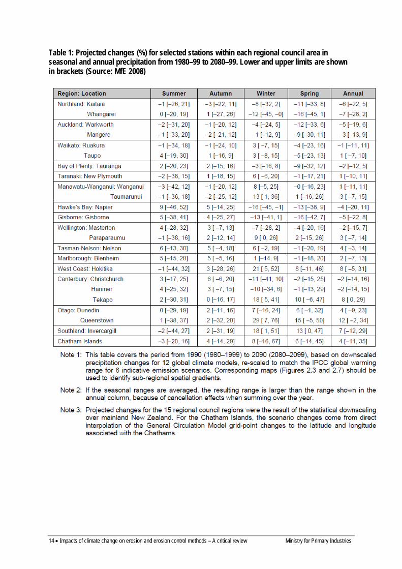
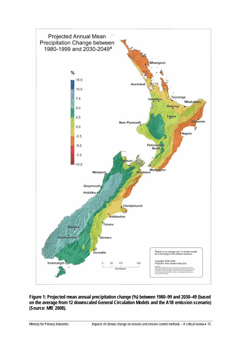
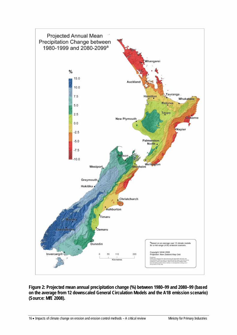
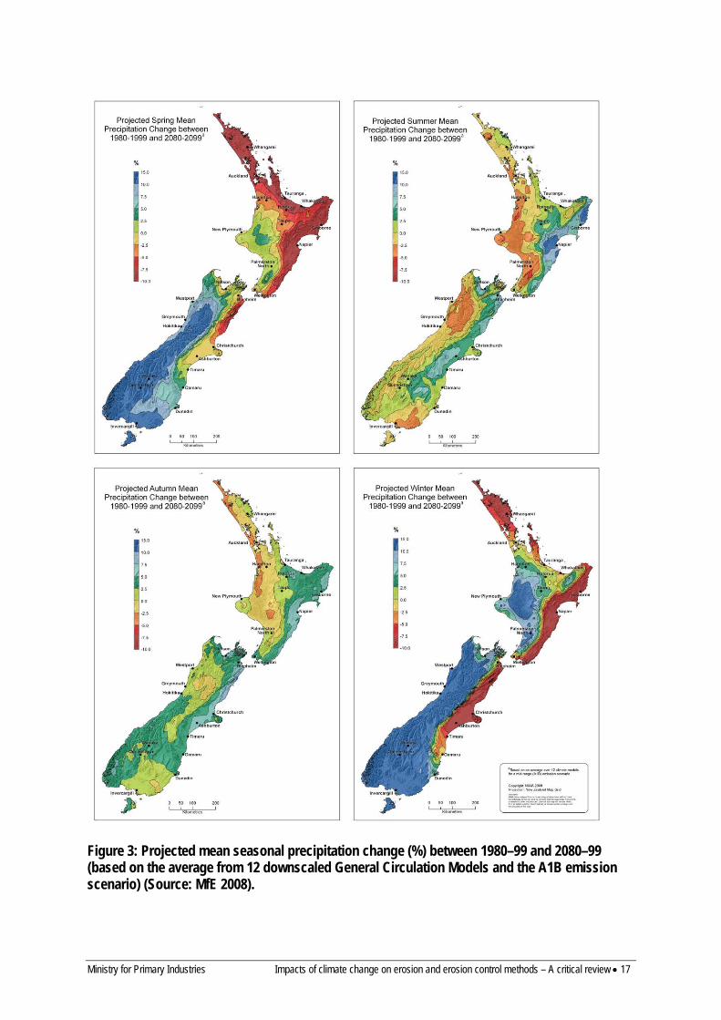
5.1 ANNUAL AND SEASONAL RAINFALL Projected annual precipitation changes for the period from 1990 to 2090, averaged over 12 GCMs and for a mid-range climate scenario (A1B) are an increase of 5–15% in the south and west and a decrease of 2.5–7.5% in the east and north of the country. The spatial patterns of precipitation change to 2049 and 2099 are illustrated in Figures 1 and 2 and show considerable within-region variation in the predictions of annual rainfall change. Table 1 provides predictions of annual rainfall change for selected sites within each region of New Zealand. The annual pattern of rainfall change is dominated by the changes in winter and spring (Figure 3 and Table 1), with projected changes to rainfall in summer and autumn being less significant and quite different to the annual pattern (being wetter in the east, drier in the west). These seasonal rainfall differences are related to the projected changes to the seasonal windflow patterns over the country.
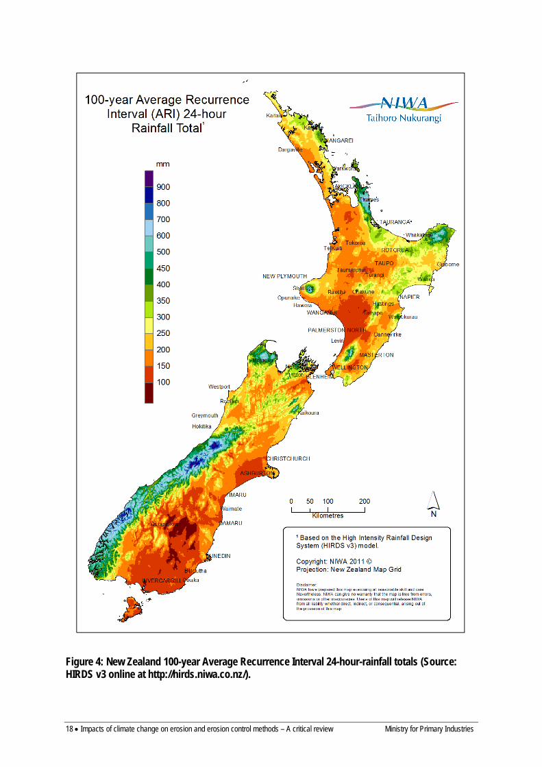
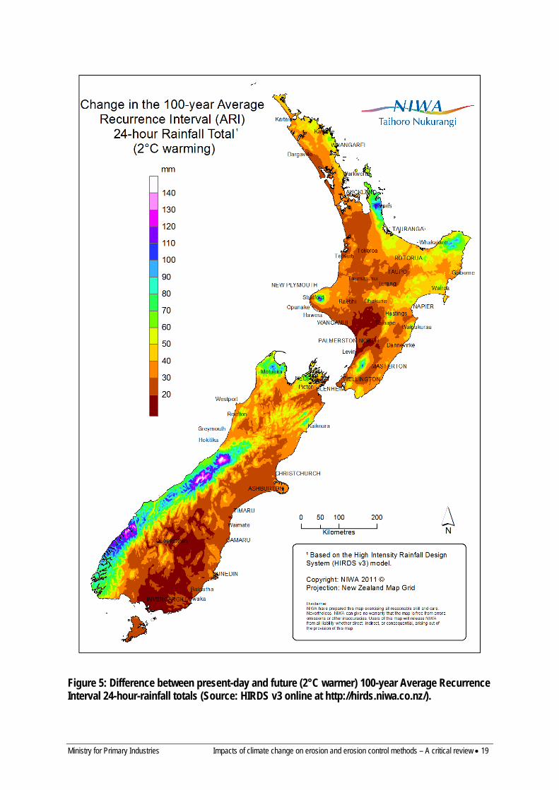
5.2 HEAVY RAINFALL Climate change is expected to lead to increases in the frequency and intensity of extreme rainfall, especially in places where mean annual rainfall is also expected to increase (MfE 2010). Increases to extreme rainfall for New Zealand of approximately 8% are projected for each 1°C increase in temperature (MfE 2008). Given the projected temperature increase for New Zealand, this results in a present-day 24-hour extreme rainfall with a 100-year average recurrence interval (ARI) (Figure 4) being projected to occur about twice as often in most places by 2080 to 2099 (based on the average of 12 GCMs and the A1B emission scenario), compared with 1980 to 1999. The projected increase in the 24-hour 100-year rainfall is shown in Figure 5.
However, Figure 5 does not take into account the projected changes to mean rainfall (Figures 1 and 2). Given that it is more likely that heavy rainfall will increase in places where the mean rainfall is expected to increase, it is suggested that confidence in the numbers in Figure 5 could be subjectively ‘weighted’ based on the patterns shown in Figures 1 and 2.
14 • Impacts of climate change on erosion and erosion control methods – A critical review Ministry for Primary Industries
Table 1: Projected changes (%) for selected stations within each regional council area in seasonal and annual precipitation from 1980–99 to 2080–99. Lower and upper limits are shown in brackets (Source: MfE 2008)
Ministry for Primary Industries Impacts of climate change on erosion and erosion control methods – A critical review • 15
Figure 1: Projected mean annual precipitation change (%) between 1980–99 and 2030–49 (based on the average from 12 downscaled General Circulation Models and the A1B emission scenario) (Source: MfE 2008).
16 • Impacts of climate change on erosion and erosion control methods – A critical review Ministry for Primary Industries
Figure 2: Projected mean annual precipitation change (%) between 1980–99 and 2080–99 (based on the average from 12 downscaled General Circulation Models and the A1B emission scenario) (Source: MfE 2008).
Ministry for Primary Industries Impacts of climate change on erosion and erosion control methods – A critical review • 17
Figure 3: Projected mean seasonal precipitation change (%) between 1980–99 and 2080–99 (based on the average from 12 downscaled General Circulation Models and the A1B emission scenario) (Source: MfE 2008).
18 • Impacts of climate change on erosion and erosion control methods – A critical review Ministry for Primary Industries
Figure 4: New Zealand 100-year Average Recurrence Interval 24-hour-rainfall totals (Source: HIRDS v3 online at http://hirds.niwa.co.nz/).
Ministry for Primary Industries Impacts of climate change on erosion and erosion control methods – A critical review • 19
Figure 5: Difference between present-day and future (2°C warmer) 100-year Average Recurrence Interval 24-hour-rainfall totals (Source: HIRDS v3 online at http://hirds.niwa.co.nz/).

20 • Impacts of climate change on erosion and erosion control methods – A critical review Ministry for Primary Industries
Tait (2011), quoting Mullan et al. (2011), suggests that because of a poleward shift in cyclone tracks under a warmer climate it is likely there will be a reduction in the number of extra-tropical cyclones over the North Island and to the east of the country in winter. However, there may be an increase in summer over the Tasman Sea. Mullan et al. (2011) also suggest cyclone intensity is likely to decrease over New Zealand. Since these extra-tropical cyclones often bring heavy and prolonged rainfall and are the triggers for regional landsliding events, better information on their frequency and intensity is essential for predicting the effects of climate change on erosion.
Tait (2011) also outlines a number of tools that can be used for predicting the effect of global warming on heavy rainfalls:
• A simple screening method that uses a scaling factor by which rainfall is adjusted for each 1°C of temperature change. The recommended scaling factors vary with rainfall duration and Annual Recurrence Interval (MfE 2010, Table 2). This can be simply implemented in NIWA’s High Intensity Rainfall Design System (HIRDS, http://hirds.niwa.co.nz/) for any value of temperature increase.
• Advanced methods (described in detail by MfE (2010)), including – Weather generators ( stochastic models, which are used for simulating a daily time-
series of linked climatic elements) – Empirical adjustment of historical daily rainfall data (uses scenarios of the change in
both mean rainfall and temperature to make adjustments to the distribution of rainfall over a daily time-series and to increase the most extreme rainfall volumes)
– Analogue selection from observed data in which a subset of past rainfall data with specific anticipated characteristics in a future climate is selected
– Directly estimating rainfall changes by downscaling of GCMs – Regional climate models (RCM), which simulate all the atmospheric processes
significant to heavy rainfall events and allow these processes to change under global warming. Rainfall data output from an RCM can be at a very high temporal resolution (e.g. 3 min) and reasonably high spatial resolution (e.g. 20 km)
– Mesoscale weather models can be used, firstly, to simulate an event that could or has occurred under the current climate, and secondly, to run the same simulation under a climate with increased air temperature consistent with the warming from a climate change scenario. These types of models can provide specific information on the location, structure, and timing of rainfall across a study area
The simple screening method is readily available for sites throughout the country using HIRDS, whereas the advanced methods are not routinely available and require greater expertise to implement.

Ministry for Primary Industries Impacts of climate change on erosion and erosion control methods – A critical review • 21
Table 2: Factor of percentage adjustment per 1°C to apply to extreme rainfall, for use in deriving extreme rainfall information for screening assessments (Source: MfE 2008)
ARI (years)
Duration 2 5 10 20 30 50 100
< 10 min 8.0 8.0 8.0 8.0 8.0 8.0 8.0
10 min 8.0 8.0 8.0 8.0 8.0 8.0 8.0
30 min 7.2 7.4 7.6 7.8 8.0 8.0 8.0
1 h 6.7 7.1 7.4 7.7 8.0 8.0 8.0
2 h 6.2 6.7 7.2 7.6 8.0 8.0 8.0
3 h 5.9 6.5 7.0 7.5 8.0 8.0 8.0
6 h 5.3 6.1 6.8 7.4 8.0 8.0 8.0
12 h 4.8 5.8 6.5 7.3 8.0 8.0 8.0
24 h 4.3 5.4 6.3 7.2 8.0 8.0 8.0
48 h 3.8 5.0 6.1 7.1 7.8 8.0 8.0
72 h 3.5 4.8 5.9 7.0 7.7 8.0 8.0
5.3 WIND Future changes to windiness in New Zealand were predicted by MfE (2008) as:
• Increase (c. 10%) in annual mean westerly component of windflow across New Zealand • The above increase is most prominent in winter (> 50% by 2090) and spring (c. 20% by
2090), with decreased westerly airflow in summer and autumn (c. 20% by 2090) • Up to 10% increase in strong winds by 2090, with more storminess possible More recent work by Mullan et al. (2011) reported that while the frequency of extreme winds over this century is likely to increase in almost all regions of New Zealand in winter, it is also likely to decrease in summer especially for the Wellington Region and the South Island. Furthermore, the magnitude of the increase in extreme wind speed is not large – only a few percent by the end of the century under the middle-of-the-range A1B emission scenario. This is significantly less of a projected change than was reported in MfE (2008). In addition Mullan et al. (2011) predict a reduction in the number of extra-tropical cyclones over the North Island and to the east of the country in winter, and increased extra-tropical cyclone activity over the Tasman Sea in summer.
5.4 DROUGHT The impact of climate change on drought (a severe and prolonged water deficit) was first assessed by Mullan et al. (2005). They predicted that present-day 1-in-20-year droughts experienced in eastern areas of New Zealand and northern areas of the North Island are projected to become two to four times as frequent by 2070–2099 (Figure 6).
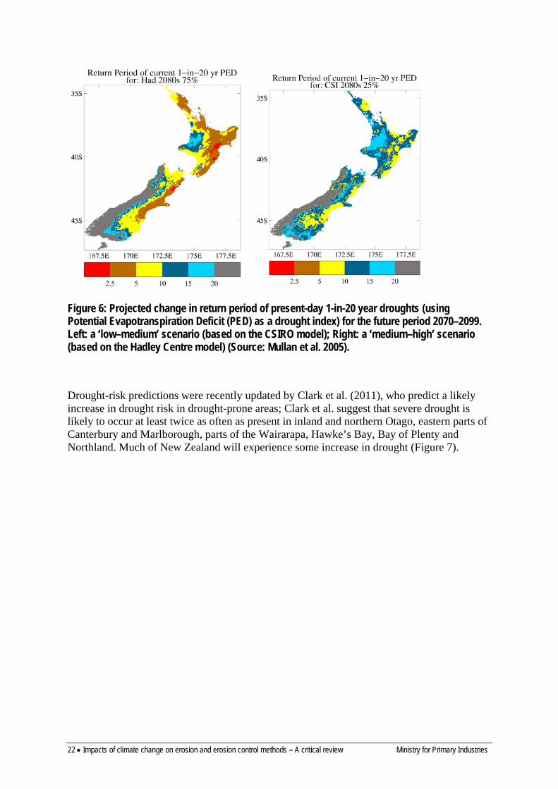
22 • Impacts of climate change on erosion and erosion control methods – A critical review Ministry for Primary Industries
Figure 6: Projected change in return period of present-day 1-in-20 year droughts (using Potential Evapotranspiration Deficit (PED) as a drought index) for the future period 2070–2099. Left: a ‘low–medium’ scenario (based on the CSIRO model); Right: a ‘medium–high’ scenario (based on the Hadley Centre model) (Source: Mullan et al. 2005).
Drought-risk predictions were recently updated by Clark et al. (2011), who predict a likely increase in drought risk in drought-prone areas; Clark et al. suggest that severe drought is likely to occur at least twice as often as present in inland and northern Otago, eastern parts of Canterbury and Marlborough, parts of the Wairarapa, Hawke’s Bay, Bay of Plenty and Northland. Much of New Zealand will experience some increase in drought (Figure 7).

Ministry for Primary Industries Impacts of climate change on erosion and erosion control methods – A critical review • 23
Figure 7: Projected increase in percentage of time spent in drought from 1980–99 levels for the A1B emissions scenario. Results summarise 19 General Circulation Models (Source: Clark et al. 2011)
KEY FINDINGS – CLIMATE CHANGE PREDICTIONS (based on average of 12 General Circulation Models and for a mid-range climate scenario (A1B))
1. Mean annual temperature increases are predicted to be 0.9°C by 2040 and 2.1°C by 2090, with minor regional variation.
2. Projected annual precipitation changes for the period 1990 to 2090 are an increase of 5–15% in the south and west and a decrease of 2.5–7.5% in the east and north. The annual pattern of rainfall change is dominated by changes in winter and spring.
3. Increases to extreme rainfall for New Zealand of c. 8% for each 1°C increase in temperature are projected. The present-day 24-hour extreme rainfall with a 100-year Annual Recurrence Interval is projected to occur about twice as often in most places by 2080–2099. It is expected that heavy rainfall intensities will increase even where annual rainfall decreases.
4. The number and intensity of extra-tropical cyclones may decrease. 5. Several methods are available to predict future heavy rainfall including HIRDS, empirical adjustment of historical
data, analogue selection of historical data, weather generators, and use of weather models. 6. An increase (around 10%) in the annual mean westerly component of windflow across New Zealand is projected
and the frequency of extreme winds is likely to increase in most regions, although the magnitude of the increase in extreme wind speed is not large.
7. Drought risk in drought-prone areas will increase with severe drought likely to occur at least twice as often as present in inland and northern Otago, eastern parts of Canterbury and Marlborough, parts of the Wairarapa, Hawke’s Bay, Bay of Plenty and Northland.
24 • Impacts of climate change on erosion and erosion control methods – A critical review Ministry for Primary Industries
6 Climate and erosion processes Climate is one of the major influences on types and rates of erosion processes, both by water and wind. Rainfall is a major control on river sediment yield (Hicks et al. 1996, 2011) and rates of landsliding (e.g. Glade 2000) with numerous reports of widespread landsliding events related to rainstorms (see Harmsworth & Page 1991; Glade 1997; Page 2008). Gully erosion and earthflows have both been shown to increase during large storms or long wet periods (e.g. McSaveney & Griffiths 1987; Hancox 2003). Similarly there is a clear link between the occurrence of strong winds and wind erosion (Basher & Painter 1997). Any trend in climate characteristics therefore has the potential to impact on erosion processes. However, one of the characteristics of erosion in New Zealand is very strong temporal and spatial variability:
• Slope processes and sediment transport are typically characterised by short periods of high activity and long periods of low activity or inactivity
• The majority of storms have localised effects, with some larger events having regional effects (e.g. Cylone Bola March 1988, the February 2004 lower North Island storm)
Any assessment of the influence of climate change on erosion processes must be set within the context of inherent spatial and temporal variability of erosion processes. This section reviews existing knowledge of the relationship between erosion and climate, and tools to predict changes in erosion rates and processes in response to climate change. It also outlines the regional distribution of the different types of erosion, largely derived from mapping in the New Zealand Land Resource Inventory (NZLRI; see Eyles 1983, 1985). This mapping was completed in the 1970s to 1990s and depicts the general distribution of erosion at the time of mapping and its severity1. The NZLRI also includes an assessment of the potential for different types of erosion, which is used in Section 13 to assess regional susceptibility to erosion under climate change.
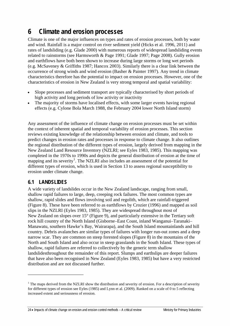
6.1 LANDSLIDES A wide variety of landslides occur in the New Zealand landscape, ranging from small, shallow rapid failures to large, deep, creeping rock failures. The most common types are shallow, rapid slides and flows involving soil and regolith, which are rainfall-triggered (Figure 8). These have been referred to as earthflows by Crozier (1996) and mapped as soil slips in the NZLRI (Eyles 1983, 1985). They are widespread throughout most of New Zealand on slopes over 15° (Figure 9), and particularly extensive in the Tertiary soft rock hill country of the North Island (Gisborne–East Coast, inland Wanganui–Taranaki–Manawatu, southern Hawke’s Bay, Wairarapa), and the South Island mountainlands and hill country. Debris avalanches are similar types of failures with longer run-out zones and a deep narrow scar. They are common on steep forested slopes (Figure 8) in the mountains of the North and South Island and also occur in steep grasslands in the South Island. These types of shallow, rapid failures are referred to collectively by the generic term shallow landslidesthroughout the remainder of this report. Slumps and earthslips are deeper failures that have also been recognised in New Zealand (Eyles 1983, 1985) but have a very restricted distribution and are not discussed further.
1 The maps derived from the NZLRI show the distribution and severity of erosion. For a description of severity for different types of erosion see Eyles (1985) and Lynn et al. (2009). Ranked on a scale of 0 to 5 reflecting increased extent and seriousness of erosion.
Ministry for Primary Industries Impacts of climate change on erosion and erosion control methods – A critical review • 25
Figure 8: Shallow rainfall triggered landslides in soft rock hill country (left) and debris avalanches on forested slopes (right).
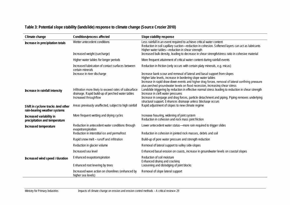
Shallow rapid landslides occur throughout New Zealand with regional differences in frequency and magnitude (Crozier 1997; Glade 1997). They are most commonly a response to a triggering rainfall event, either localised events or regional storm events. Landslides can be triggered by intense individual storms or small rainfall events after prolonged wet periods leading to high antecedent soil moisture conditions. Numerous authors have described the impacts of storm events (see Page (2008) for a recent summary) and a number have addressed the issue of rainfall thresholds that cause landsliding (Crozier & Eyles 1980; Eyles & Eyles 1982; Hicks 1989, 1995a; Kelliher et al. 1995; Glade 1997, 1998, 2000; Crozier 1999; Glade et al. 2000; Brooks et al. 2004; Reid & Page 2002). The occurrence of rainfall events capable of triggering landslides varies greatly in time and space (Glade 1997) and it is assumed here for the analysis of potential climate effects that the thresholds for triggering landslides will not change but the frequency of their occurrence may. This may not be entirely valid as Crozier and Preston (1999) note that ‘event resistance’ (due to exhaustion of regolith available to fail) might increase the threshold rainfall required to initiate landslides. Phillips (1988, 1989) observed that of three large storms that affected the Upper Mata River in 1980, 1982 and 1988, only the first caused widespread landsliding, which he attributed to event resistance. Predicted increases in rainfall amounts and intensities, temperature and wind may affect both shear stress and shear strength and hence slope stability. The range of impacts that may occur are described by Crozier (2010) (see Table 3).
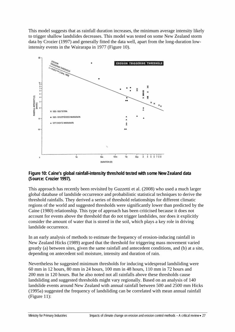
A common approach in climate–landslide research has been to seek empirical relationships between landslide occurrence and landslide-triggering storm characteristics such as rainfall intensity and duration. Caine (1980) identified a global threshold for the occurrence of shallow landslides and debris flows of the form
I = 14.82 D–0.39
where D = rainfall duration (h, 167< D <500)
I = rainfall intensity (mm h–1)
26 • Impacts of climate change on erosion and erosion control methods – A critical review Ministry for Primary Industries
Figure 9: Distribution of landslide erosion (soil slip, earth slip and debris avalanche) in New Zealand as recorded in the New Zealand Land Resource Inventory.
Ministry for Primary Industries Impacts of climate change on erosion and erosion control methods – A critical review • 27
This model suggests that as rainfall duration increases, the minimum average intensity likely to trigger shallow landslides decreases. This model was tested on some New Zealand storm data by Crozier (1997) and generally fitted the data well, apart from the long-duration low-intensity events in the Wairarapa in 1977 (Figure 10).
Figure 10: Caine’s global rainfall-intensity threshold tested with some New Zealand data (Source: Crozier 1997).
This approach has recently been revisited by Guzzetti et al. (2008) who used a much larger global database of landslide occurrence and probabilistic statistical techniques to derive the threshold rainfalls. They derived a series of threshold relationships for different climatic regions of the world and suggested thresholds were significantly lower than predicted by the Caine (1980) relationship. This type of approach has been criticised because it does not account for events above the threshold that do not trigger landslides, nor does it explicitly consider the amount of water that is stored in the soil, which plays a key role in driving landslide occurrence.
In an early analysis of methods to estimate the frequency of erosion-inducing rainfall in New Zealand Hicks (1989) argued that the threshold for triggering mass movement varied greatly (a) between sites, given the same rainfall and antecedent conditions, and (b) at a site, depending on antecedent soil moisture, intensity and duration of rain.
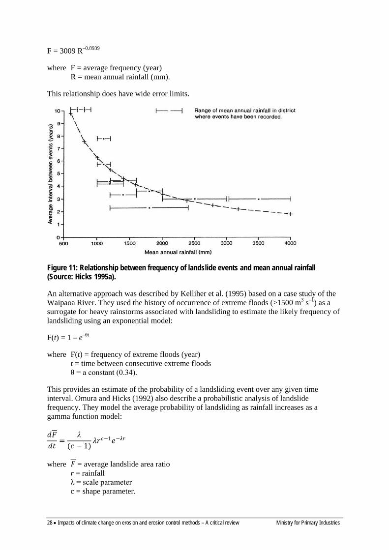
Nevertheless he suggested minimum thresholds for inducing widespread landsliding were 60 mm in 12 hours, 80 mm in 24 hours, 100 mm in 48 hours, 110 mm in 72 hours and 200 mm in 120 hours. But he also noted not all rainfalls above these thresholds cause landsliding and suggested thresholds might vary regionally. Based on an analysis of 140 landslide events around New Zealand with annual rainfall between 500 and 2500 mm Hicks (1995a) suggested the frequency of landsliding can be correlated with mean annual rainfall (Figure 11):
28 • Impacts of climate change on erosion and erosion control methods – A critical review Ministry for Primary Industries
F = 3009 R–0.8939
where F = average frequency (year) R = mean annual rainfall (mm).
This relationship does have wide error limits.
Figure 11: Relationship between frequency of landslide events and mean annual rainfall (Source: Hicks 1995a).
An alternative approach was described by Kelliher et al. (1995) based on a case study of the Waipaoa River. They used the history of occurrence of extreme floods (>1500 m3 s–1) as a surrogate for heavy rainstorms associated with landsliding to estimate the likely frequency of landsliding using an exponential model:
F(t) = 1 – e–θt
where F(t) = frequency of extreme floods (year) t = time between consecutive extreme floods θ = a constant (0.34).
This provides an estimate of the probability of a landsliding event over any given time interval. Omura and Hicks (1992) also describe a probabilistic analysis of landslide frequency. They model the average probability of landsliding as rainfall increases as a gamma function model:
𝑑𝑑𝐹𝐹𝑑𝑑𝑑𝑑
=𝜆𝜆
(𝑐𝑐 − 1)𝜆𝜆𝑟𝑟𝑐𝑐−1𝑒𝑒−𝜆𝜆𝑟𝑟
where 𝐹𝐹 = average landslide area ratio r = rainfall λ = scale parameter c = shape parameter.
Ministry for Primary Industries Impacts of climate change on erosion and erosion control methods – A critical review • 29
Table 3: Potential slope stability (landslide) response to climate change (Source Crozier 2010)
Climate change Condition/process affected Slope stability response
Increase in precipitation totals Wetter antecedent conditions Less rainfall in an event required to achieve critical water content Reduction in soil capillary suction—reduction in cohesion. Softened layers can act as lubricants Higher water tables—reduction in shear strength
Increased weight (surcharge) Increased bulk density, leading to decrease in shear strength/stress ratio in cohesive material
Higher water tables for longer periods More frequent attainment of critical water content during rainfall events
Increased lubrication of contact surfaces between certain minerals
Reduction in friction (only occurs with certain platy minerals, e.g. micas)
Increase in river discharge Increase bank scour and removal of lateral and basal support from slopes Higher lake levels, increase in bordering slope water tables Increase in rapid draw down events and higher drag forces, removal of lateral confining pressure plus perched groundwater levels on flood recession, increasing shear stress
Increase in rainfall intensity Infiltration more likely to exceed rates of subsurface drainage. Rapid build-up of perched water tables
Landslide triggering by reduction in effective normal stress leading to reduction in shear strength Increase in cleft water pressures
Increased throughflow Increase in seepage and drag forces, particle detachment and piping. Piping removes underlying structural support. Enhances drainage unless blockage occurs
Shift in cyclone tracks /and other rain-bearing weather systems
Areas previously unaffected, subject to high rainfall Rapid adjustment of slopes to new climate regime
Increased variability in precipitation and temperature
More frequent wetting and drying cycles Increase fissuring, widening of joint system Reduction in cohesion and rock mass joint friction
Increased temperature Reduction in antecedent water conditions through evapotranspiration
Lower antecedent water status—more rain required to trigger slides
Reduction in interstitial ice and permafrost Reduction in cohesion in jointed rock masses, debris and soil
Rapid snow melt – runoff and infiltration Build-up of pore water pressure and strength reduction
Reduction in glacier volume Removal of lateral support to valley side-slopes
Increased sea level Enhanced basal erosion on coasts, increase in groundwater levels on coastal slopes
Increased wind speed / duration Enhanced evapotranspiration Reduction of soil moisture Enhanced drying and cracking
Enhanced root levering by trees Loosening and dislodging of joint blocks
Increased wave action on shorelines (enhanced by higher sea levels)
Removal of slope lateral support

Ministry for Primary Industries Impacts of climate change on erosion and erosion control methods – A critical review • 31
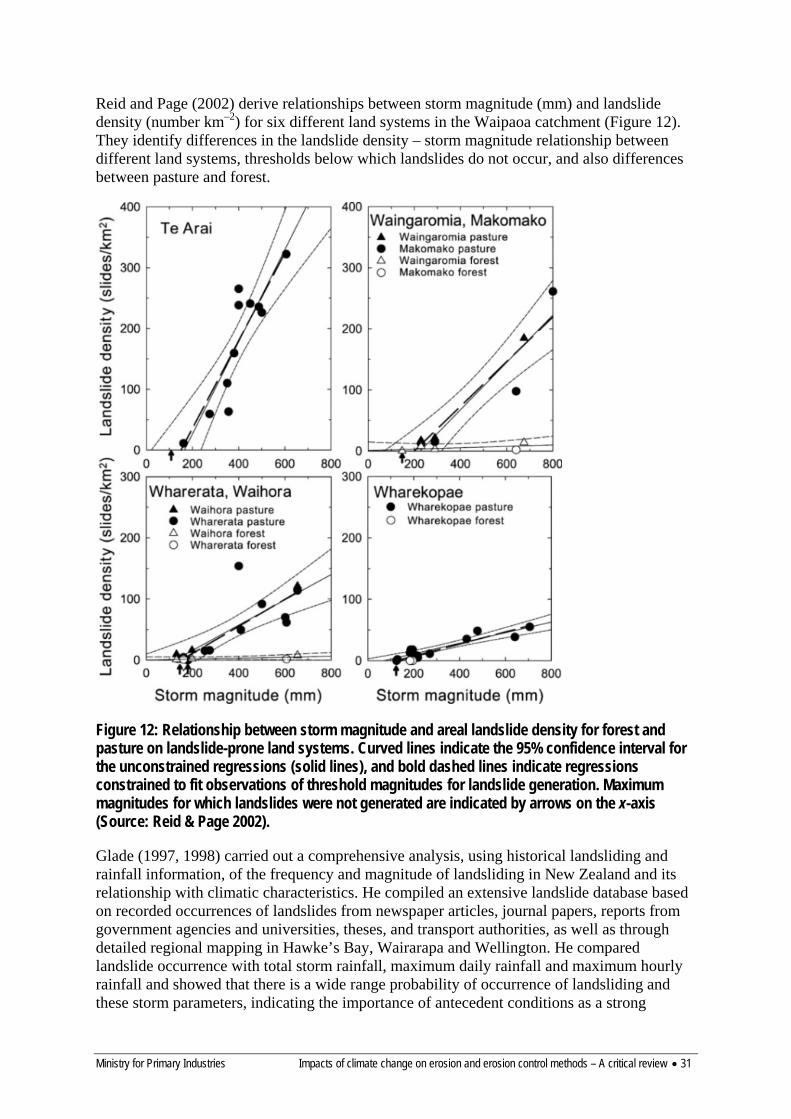
Reid and Page (2002) derive relationships between storm magnitude (mm) and landslide density (number km–2) for six different land systems in the Waipaoa catchment (Figure 12). They identify differences in the landslide density – storm magnitude relationship between different land systems, thresholds below which landslides do not occur, and also differences between pasture and forest.
Figure 12: Relationship between storm magnitude and areal landslide density for forest and pasture on landslide-prone land systems. Curved lines indicate the 95% confidence interval for the unconstrained regressions (solid lines), and bold dashed lines indicate regressions constrained to fit observations of threshold magnitudes for landslide generation. Maximum magnitudes for which landslides were not generated are indicated by arrows on the x-axis (Source: Reid & Page 2002).
Glade (1997, 1998) carried out a comprehensive analysis, using historical landsliding and rainfall information, of the frequency and magnitude of landsliding in New Zealand and its relationship with climatic characteristics. He compiled an extensive landslide database based on recorded occurrences of landslides from newspaper articles, journal papers, reports from government agencies and universities, theses, and transport authorities, as well as through detailed regional mapping in Hawke’s Bay, Wairarapa and Wellington. He compared landslide occurrence with total storm rainfall, maximum daily rainfall and maximum hourly rainfall and showed that there is a wide range probability of occurrence of landsliding and these storm parameters, indicating the importance of antecedent conditions as a strong

32 • Impacts of climate change on erosion and erosion control methods – A critical review Ministry for Primary Industries
influence on landsliding. He also identifies apparent temporal clustering of landslide-inducing rainstorms (with high activity in the 1940s and 1970s–1980s). Glade (1997, 1998) described how the frequency of landsliding varies on a regional basis (Figure 13) with highest frequencies occurring in Northland and Wellington in the North Island and Greymouth and North Otago in the South Island. However, he does note that these results in part reflect the limitations of the available data sources which do not necessarily record all landslide events nor do they include all storm events that did not produce landsliding.
Glade (1997) described three models relating landslide occurrence to rainfall thresholds based on establishing regional minimum and maximum landslide-triggering rainfall thresholds from historical landslide occurrence and daily climate data. The minimum threshold is the value below which landsliding has not been recorded and the maximum threshold is the value above which landsliding always occurs. Between these thresholds the probability of landsliding varies. Typically the minimum and maximum thresholds cover a wide range of daily rainfall indicating the importance of antecedent moisture conditions.
The Daily Rainfall Model relates measured daily rainfall to landslide-triggering rainfall to identify maximum and minimum rainfall thresholds for landslide occurrence. This model provides the probability of occurrence of landslides in 20-mm daily rainfall increments (Figure 14). It showed that the minimum daily rainfall to trigger landslides is 20 mm in Hawke’s Bay, Wairarapa and Wellington regions but that the maximum threshold ranged from120 mm (Wairarapa) to 300 mm in Hawke’s Bay, the probability of landsliding increases substantially above 100–120 mm in Hawke’s Bay and Wairarapa, and above 60–80 mm in Wellington. However, because it neglected antecedent soil moisture conditions the Daily Rainfall Model had a high level of inaccuracy. The Antecedent Daily Rainfall Model and the Antecedent Soil Water Status Model include consideration of antecedent conditions.
The Antecedent Daily Rainfall Model (ADRM) incorporates both storm rainfall and an index of rainfall prior to a storm (Crozier & Eyles 1980; Glade et al. 2000). This is calculated as an antecedent daily rainfall index (ADRI) directly from rainfall alone, as an index of antecedent soil moisture. It relates landslide occurrence to the daily storm rainfall along with the rainfall for 10 days before the storm (decayed using a constant or a recession curve approach – an index of soil drainage).
𝑟𝑟𝑎𝑎0 = 𝑘𝑘 ∗ 𝑟𝑟1 + 𝑘𝑘2 ∗ 𝑟𝑟2 +……..𝑘𝑘𝑛𝑛 ∗ 𝑟𝑟2𝑛𝑛
where ra0 = antecedent daily rainfall for day 0 rn = rainfall on n-th day before 0 k = a constant or regression coefficient derived from regional flood hydrographs.
This approach was applied to three regions (Wairarapa, Hawke’s Bay and Wellington – see Figure 15) and produced different predictive models for the three regions:
Wairarapa 𝑙𝑙𝑙𝑙𝑙𝑙 � 𝑃𝑃1−𝑃𝑃
� = −8.45 +0.033 ∗ 𝑟𝑟 + 0.036 ∗ 𝑟𝑟𝑎𝑎
Hawke’s Bay 𝑙𝑙𝑙𝑙𝑙𝑙 � 𝑃𝑃1−𝑃𝑃
� = −8.82 +0.033 ∗ 𝑟𝑟 + 0.075 ∗ 𝑟𝑟𝑎𝑎 − 0.0052 ∗ 𝑟𝑟𝑎𝑎2 + 0.00000012 ∗ 𝑟𝑟𝑎𝑎3
Wellington 𝑙𝑙𝑙𝑙𝑙𝑙 � 𝑃𝑃1−𝑃𝑃
� = −8.08 +0.072 ∗ 𝑟𝑟 + 0.00036 ∗ 𝑟𝑟𝑎𝑎2
where P = probability of landslide occurrence at a given value of r (daily rainfall) and ra (antecedent daily rainfall).

Ministry for Primary Industries Impacts of climate change on erosion and erosion control methods – A critical review • 33
The Antecedent Soil Water Status model (AWSM) is a further development (Crozier 1999; Glade 2000) that uses a similar approach to the ADRM but explicitly considers water loss through drainage as well as soil storage and water loss through evapotranspiration. It is based on the concept that a critical water content is needed to cause landsliding and this can be calculated from storm-event soil water (approximated by daily rainfall) and antecedent soil water (based on climatic water balance). Glade (1997, 2000) applied this model to the Wairarapa, Hawke’s Bay and Wellington regions also, to produce probability envelopes of failure for different combinations of soil water status and daily rainfall (Figure 16).
More recently Harrison et al. (2012) developed an empirical model for the forest industry to predict the probability of shallow landsliding. This model relates the area of landslides occurring during storm events to rainfall (72-hour-rainfall total above a threshold value related to soil type), slope, soil type, vegetation cover and aspect. It has only been applied to one area of the coastal Hawke’s Bay hill country so its general applicability is unclear.
L = R*S*V*A
Where L = area of landslides R = 72-hour-rainfall total above a threshold value related to soil type S = soil/slope factor (empirical factors for different slope classes and soils) V = vegetation cover factor (for pasture, scrub, exotic forest) A = aspect adjustment (1+g*cos(aspect-f)); f and g are empirically derived constants
Tatard (2010) examined the links between landslides and triggering factors of earthquakes and heavy rainfall using the Geonet landslide catalogue over the period 1996–2004. She found correlations between landslide activity monthly rainfall and number of rain days per month with the strongest correlation between landslide activity and number of rain days per month (r = 0.37). She suggests this reinforces the importance of antecedent moisture in controlling landslide rates. Similarly Schicker (2010) used the Geonet landslide catalogue to examine landslide susceptibility in the Waikato Region and its relationship with mean and maximum monthly rainfall. The best model for predicting landslide susceptibility included mean monthly rainfall as a predictor term.
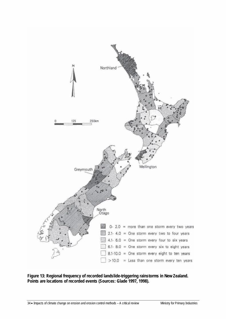
34 • Impacts of climate change on erosion and erosion control methods – A critical review Ministry for Primary Industries
Figure 13: Regional frequency of recorded landslide-triggering rainstorms in New Zealand. Points are locations of recorded events (Sources: Glade 1997, 1998).
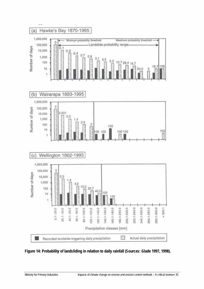
Ministry for Primary Industries Impacts of climate change on erosion and erosion control methods – A critical review • 35
Figure 14: Probability of landsliding in relation to daily rainfall (Sources: Glade 1997, 1998).
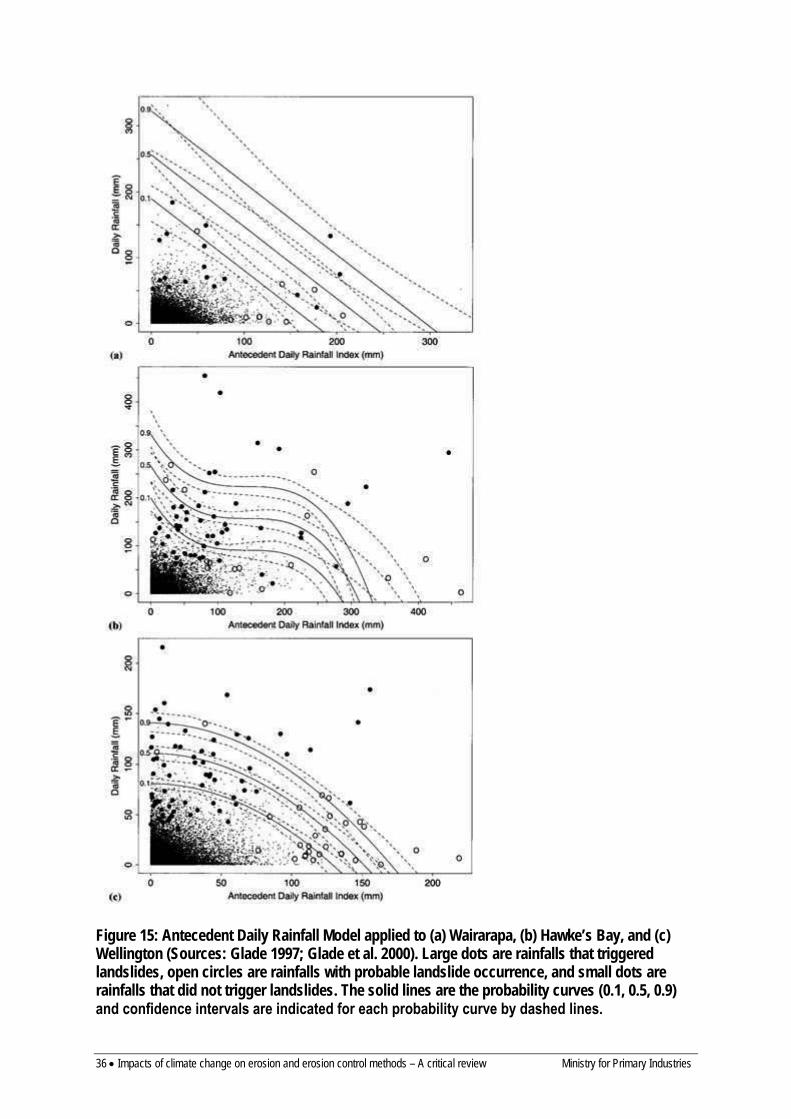
36 • Impacts of climate change on erosion and erosion control methods – A critical review Ministry for Primary Industries
Figure 15: Antecedent Daily Rainfall Model applied to (a) Wairarapa, (b) Hawke’s Bay, and (c) Wellington (Sources: Glade 1997; Glade et al. 2000). Large dots are rainfalls that triggered landslides, open circles are rainfalls with probable landslide occurrence, and small dots are rainfalls that did not trigger landslides. The solid lines are the probability curves (0.1, 0.5, 0.9) and confidence intervals are indicated for each probability curve by dashed lines.
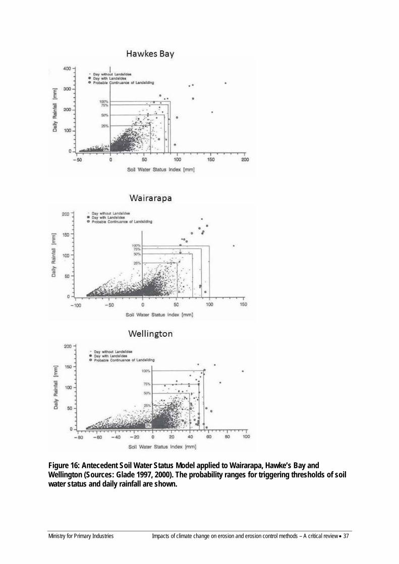
Ministry for Primary Industries Impacts of climate change on erosion and erosion control methods – A critical review • 37
Figure 16: Antecedent Soil Water Status Model applied to Wairarapa, Hawke’s Bay and Wellington (Sources: Glade 1997, 2000). The probability ranges for triggering thresholds of soil water status and daily rainfall are shown.
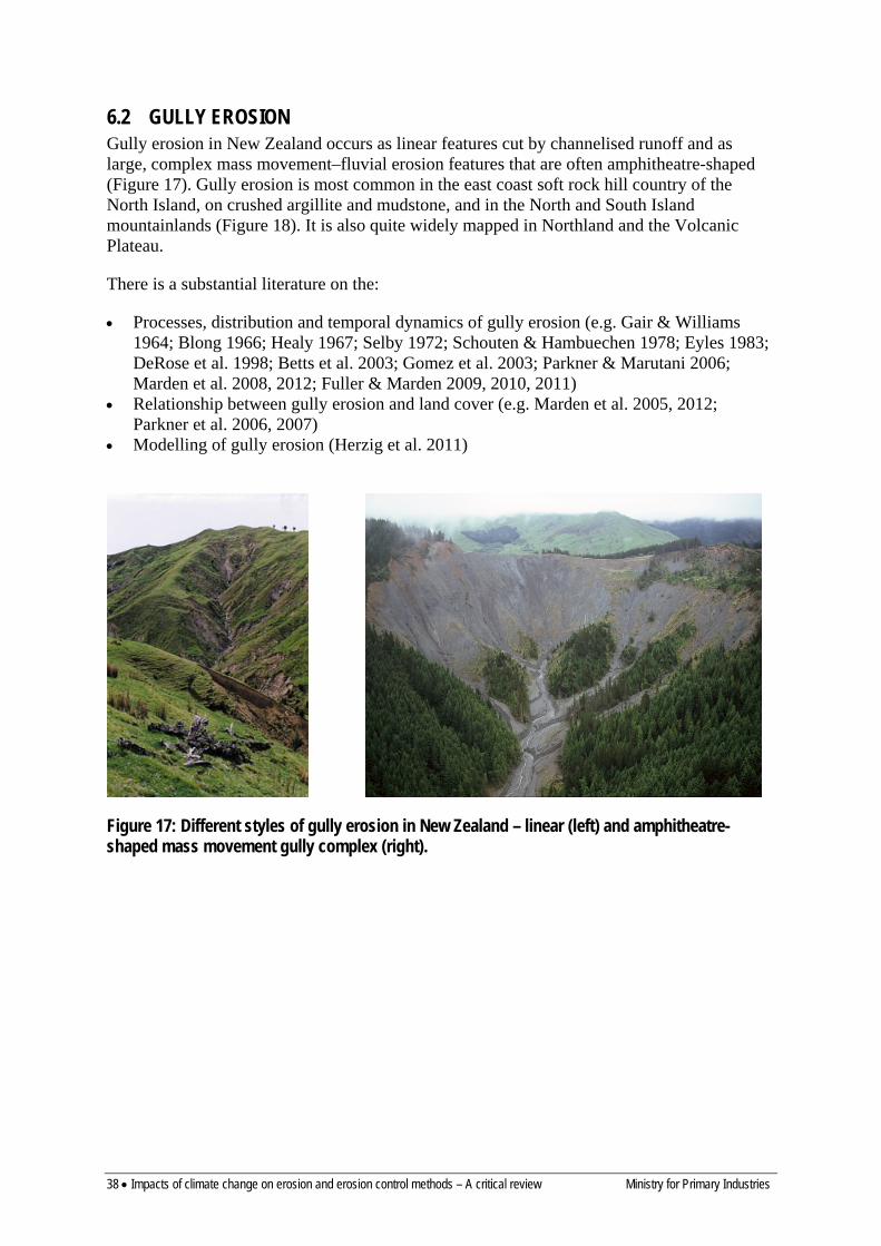
38 • Impacts of climate change on erosion and erosion control methods – A critical review Ministry for Primary Industries
6.2 GULLY EROSION Gully erosion in New Zealand occurs as linear features cut by channelised runoff and as large, complex mass movement–fluvial erosion features that are often amphitheatre-shaped (Figure 17). Gully erosion is most common in the east coast soft rock hill country of the North Island, on crushed argillite and mudstone, and in the North and South Island mountainlands (Figure 18). It is also quite widely mapped in Northland and the Volcanic Plateau.
There is a substantial literature on the:
• Processes, distribution and temporal dynamics of gully erosion (e.g. Gair & Williams 1964; Blong 1966; Healy 1967; Selby 1972; Schouten & Hambuechen 1978; Eyles 1983; DeRose et al. 1998; Betts et al. 2003; Gomez et al. 2003; Parkner & Marutani 2006; Marden et al. 2008, 2012; Fuller & Marden 2009, 2010, 2011)
• Relationship between gully erosion and land cover (e.g. Marden et al. 2005, 2012; Parkner et al. 2006, 2007)
• Modelling of gully erosion (Herzig et al. 2011)
Figure 17: Different styles of gully erosion in New Zealand – linear (left) and amphitheatre-shaped mass movement gully complex (right).
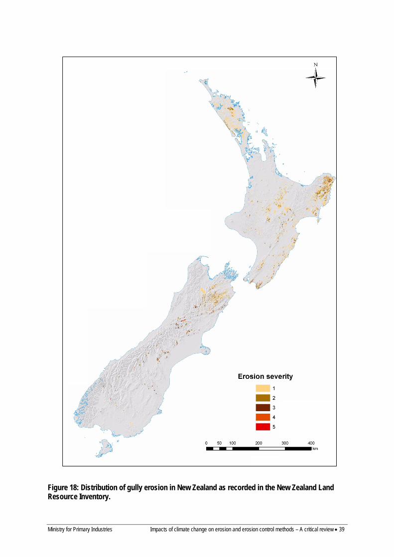
Ministry for Primary Industries Impacts of climate change on erosion and erosion control methods – A critical review • 39
Figure 18: Distribution of gully erosion in New Zealand as recorded in the New Zealand Land Resource Inventory.
40 • Impacts of climate change on erosion and erosion control methods – A critical review Ministry for Primary Industries
There are few studies quantitatively relating gully erosion to climate. However, a number of studies comment on links between gully erosion and climate:
• Selby (1972) describes development of gullies in the pumice soils of the Volcanic Plateau and notes that gully erosion was first noted near Rotorua after a year with double the average rainfall and suggests it coincided with the first unusually wet season after land development and that short-duration high-intensity rainfall was responsible for increased surface runoff and gully erosion. Blong (1966) and Healy (1967) also comment on the role of short-duration high-intensity rainfall and above-average rainfall in causing gully erosion of pumice soils. These erosion events occurred during the land development phase on the Volcanic Plateau, and are less common now that the importance of maintaining ground cover is understood.
• Many of the larger gullies in New Zealand erode by both fluvial erosion and mass movement erosion processes and are major sediment sources. In Northland most of the gully erosion takes place during large floods in autumn and winter when mass movement in the gully headwalls is very active (Schouten & Hambuechen 1978). These processes have been studied in detail by Fuller and Marden (2010, 2011) at the Tarndale gully in the upper Waipaoa catchment. They identify a general relationship between activity of gully erosion and average daily rainfall and suggest both single large storm events and longer periods of wetter weather can trigger mass movement and gully erosion.
• Betts et al. (2003), in a study (1999–2000) of the geomorphological changes in a Cretaceous, alternating sandstone and mudstone (argillite) gully complex in the Waiapu catchment, showed that both erosion processes and gully-channel coupling varied with the magnitude and frequency of rainfall events. Almost 90% of the sediment generated was by mass movement (slumping and debris flows), and c. 10% by surface erosion and fluvial erosion. Surface and fluvial erosion occurred mainly during rainfall events when rainfall intensity exceeded infiltration rates, leading to surface runoff. On the other hand, mass movement processes showed a less clear relationship to rainfall events and were more likely to occur during periods (weeks to months) of lower intensity but longer duration rainfall, when infiltration and saturation of the regolith resulted in increased groundwater pressures. Rainfall during the study was c. 2500 mm, and 11 discrete rainfall events occurred (between 83 and 187 mm totals), although all had return periods of < 2 years.
• Fuller and Marden (2010, 2011), in a study of the Tarndale gully and fan in the Waipaoa catchment, estimated that between 2005 and 2008 mass movements dominated during severe rainstorms and wet weather periods, and that incision (rills and gullies) dominated during drier periods. However, by contrast with Betts et al. (2003), rills and gullies contributed c. 70%, and mass movements c. 30% of the sediment contributed to the fan from the gully complex. A comparison of erosion rate with the number of storm events > 150 mm was made for the periods 1939–1958, 1958–1992 and 2005–2008. A reduction in erosion rate accompanied a reduction in storm frequency between the 1939–1958 and 1958–1992 periods, but while a further reduction in erosion rate occurred for the period 2005–2008, storm frequency was higher than for the two earlier periods. So, while links with rainfall are apparent, gully behaviour is complex and not just driven by rainfall.
• Parkner and Marutani (2006) and Parkner et al. (2007) relate erosion of large gullies in the Waiapu catchment to large storms, particularly Cyclone Bola. They also describe how Cyclone Bola initiated new gullies under both native forest and pasture.
• In the South Island mountainlands of Canterbury and Marlborough large storms are responsible for both increased gully activity and formation of new gullies (Gair & Williams 1964; Bowring et al. 1978). Similarly, landsliding and debris flows formed new

Ministry for Primary Industries Impacts of climate change on erosion and erosion control methods – A critical review • 41
gullies and reactivated existing gullies during storms in 2003 and 2004 in the lower North Island (Hancox 2003; Hancox & Wright 2005) and in the Gisborne area in 2005 (Beetham & Grant 2006).
• Hicks et al. (2000) showed that in subcatchments of the Waipaoa River dominated by gully-erosion 50% of long-term sediment load was carried in flood events with < 1 year return period. Gully erosion provides a continuous contribution of sediment that is active in small rainfall events, but is also increased during large events like Cyclone Bola.
Herzig et al. (2011) developed a model of gully erosion for the east coast of the North Island. However, it was aimed at assessing the effectiveness of gully stabilisation strategies and relates gully erosion to gully area and vegetation cover, and does not consider the role of rainfall in controlling gully erosion.
While it is clear that climate plays a major role in controlling rates of gully erosion, there is no model available to assess this relationship quantitatively. In the New Zealand context gully erosion is both a runoff-driven process in which large storms play an important role, and it has a mass-movement component in which antecedent rainfall and storm rainfall both play a role. Because many New Zealand gullies involve complex mass-movement–fluvial erosion processes it would be difficult to adopt an overseas model (e.g. see Bocco 1991; Poesen et al. 2003). The types of gully and the erosion processes generating sediment are controlled by geological material and structure, and the amount of sediment generated is linked to intrinsic gully dynamics such as overall stage of gully development, and in the case of mass movements the time since the last failure. Nevertheless, it can be expected that any increase in rainfall, either in terms of annual totals or storm events, can be expected to increase gully erosion, although it is not possible to quantify this increase.
6.3 EARTHFLOWS Earthflow erosion is the slow movement of soil and associated regolith, along basal and marginal shear planes, and with internal deformation of the moving mass (Figure 19). Earthflows may be shallow (< 1–2 m) to deep-seated (>10 m, and typically 3–5 m). Deep-seated earthflows typically occur on slopes between 10° and 20° and can cover large areas of a hillslope, while shallow earthflows are more common on slopes >20°, and are smaller in area (Lynn et al. 2009). Earthflow erosion occurs mostly in the North Island, and is most extensive on crushed mudstone and argillite in the Gisborne–East Coast area and in southern Hawke’s Bay (Figure 20). It also occurs in Northland and in the soft rock hill country of inland Taranaki and the southern Waikato. Small areas occur on mudstone in North Canterbury, South Canterbury and coastal Otago.
Rates and depth of movement are influenced by rock type (usually on mudstones and argillites), degree of shearing and crushing, slope, vegetation cover, and rainfall. Movement of earthflows tends to be progressive and intermittent and is strongly influenced by rainfall and pore water pressures. Earthflows may show seasonal variation in activity and may reactivate following years of stability. They often commence or increase activity late in winter in response to periods of elevated rainfall. Maximum downslope movement rates typically occur in late winter to early spring (Belz 1967; Crozier 1968), when evaporation and temperature are lowest and soil moisture is high. Often there is a lag (of weeks to months) between wet periods and the onset of earthflow movement (Crozier 1968; Wasson & Hall 1981; McSaveney & Griffiths 1987). Massey (2010) found that periods of accelerated creep on the Utiku and Taihape landslides corresponded to periods of high pore water
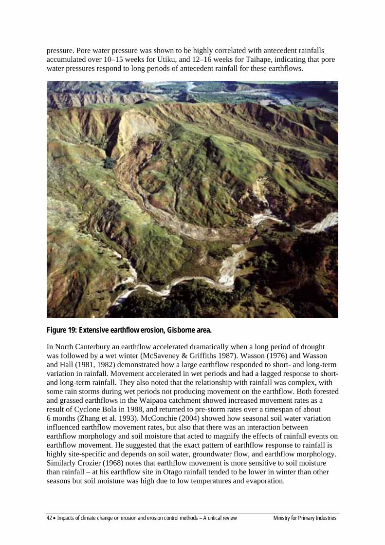
42 • Impacts of climate change on erosion and erosion control methods – A critical review Ministry for Primary Industries
pressure. Pore water pressure was shown to be highly correlated with antecedent rainfalls accumulated over 10–15 weeks for Utiku, and 12–16 weeks for Taihape, indicating that pore water pressures respond to long periods of antecedent rainfall for these earthflows.
Figure 19: Extensive earthflow erosion, Gisborne area.
In North Canterbury an earthflow accelerated dramatically when a long period of drought was followed by a wet winter (McSaveney & Griffiths 1987). Wasson (1976) and Wasson and Hall (1981, 1982) demonstrated how a large earthflow responded to short- and long-term variation in rainfall. Movement accelerated in wet periods and had a lagged response to short- and long-term rainfall. They also noted that the relationship with rainfall was complex, with some rain storms during wet periods not producing movement on the earthflow. Both forested and grassed earthflows in the Waipaoa catchment showed increased movement rates as a result of Cyclone Bola in 1988, and returned to pre-storm rates over a timespan of about 6 months (Zhang et al. 1993). McConchie (2004) showed how seasonal soil water variation influenced earthflow movement rates, but also that there was an interaction between earthflow morphology and soil moisture that acted to magnify the effects of rainfall events on earthflow movement. He suggested that the exact pattern of earthflow response to rainfall is highly site-specific and depends on soil water, groundwater flow, and earthflow morphology. Similarly Crozier (1968) notes that earthflow movement is more sensitive to soil moisture than rainfall – at his earthflow site in Otago rainfall tended to be lower in winter than other seasons but soil moisture was high due to low temperatures and evaporation.
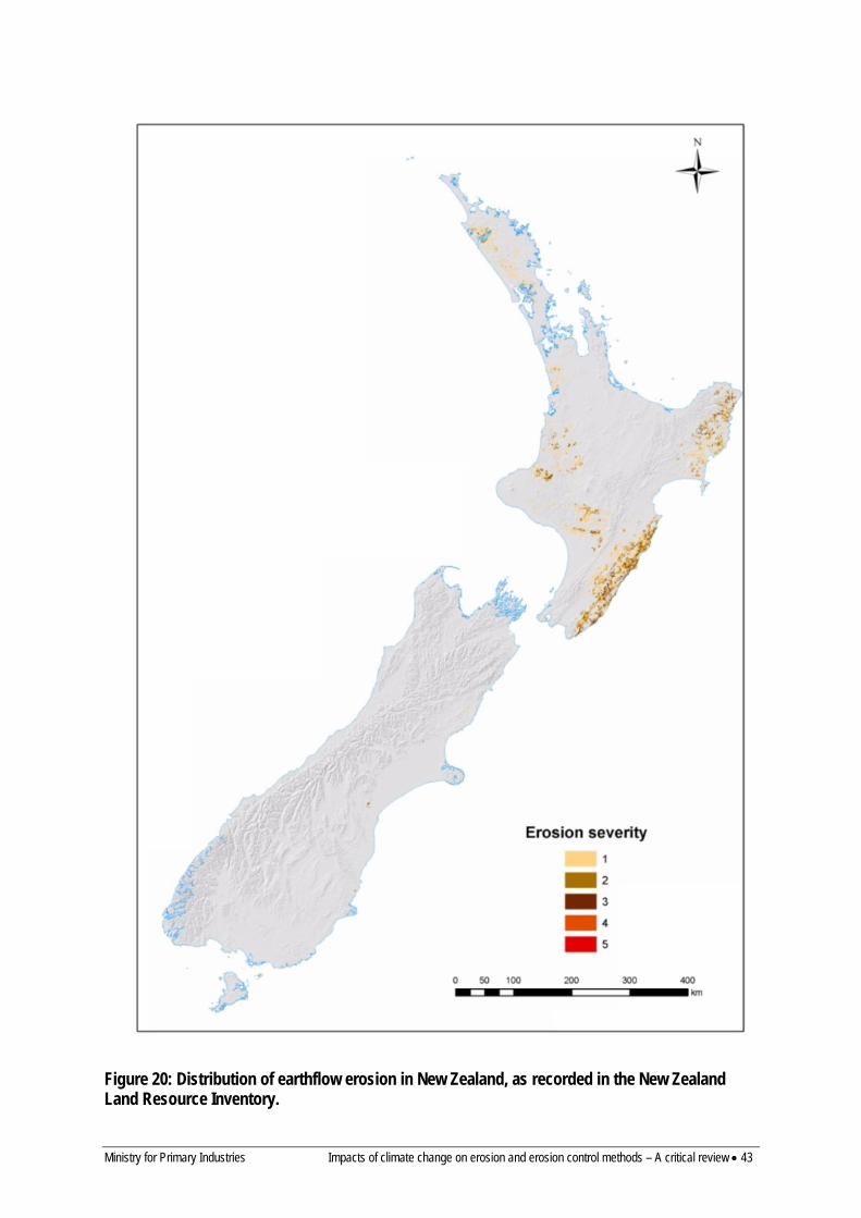
Ministry for Primary Industries Impacts of climate change on erosion and erosion control methods – A critical review • 43
Figure 20: Distribution of earthflow erosion in New Zealand, as recorded in the New Zealand Land Resource Inventory.
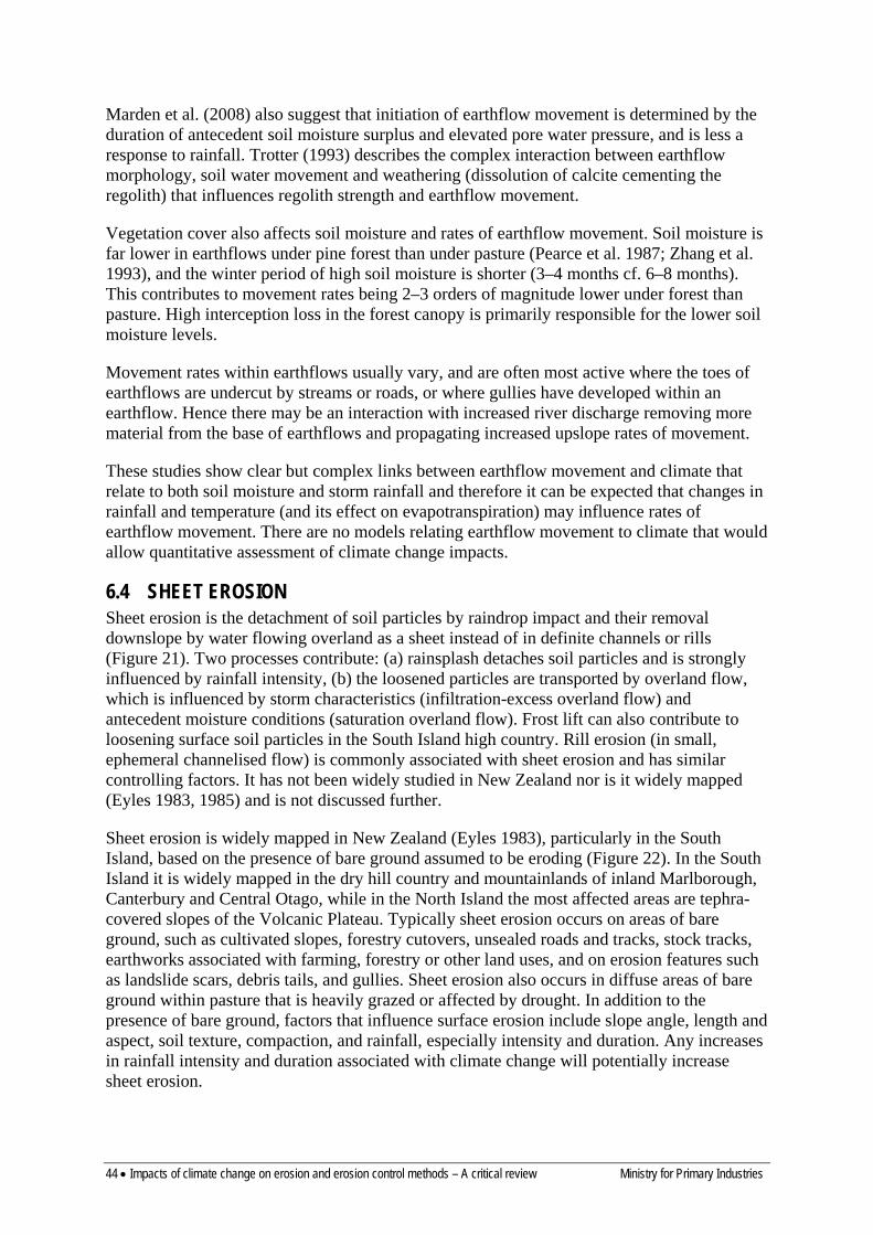
44 • Impacts of climate change on erosion and erosion control methods – A critical review Ministry for Primary Industries
Marden et al. (2008) also suggest that initiation of earthflow movement is determined by the duration of antecedent soil moisture surplus and elevated pore water pressure, and is less a response to rainfall. Trotter (1993) describes the complex interaction between earthflow morphology, soil water movement and weathering (dissolution of calcite cementing the regolith) that influences regolith strength and earthflow movement.
Vegetation cover also affects soil moisture and rates of earthflow movement. Soil moisture is far lower in earthflows under pine forest than under pasture (Pearce et al. 1987; Zhang et al. 1993), and the winter period of high soil moisture is shorter (3–4 months cf. 6–8 months). This contributes to movement rates being 2–3 orders of magnitude lower under forest than pasture. High interception loss in the forest canopy is primarily responsible for the lower soil moisture levels.
Movement rates within earthflows usually vary, and are often most active where the toes of earthflows are undercut by streams or roads, or where gullies have developed within an earthflow. Hence there may be an interaction with increased river discharge removing more material from the base of earthflows and propagating increased upslope rates of movement.
These studies show clear but complex links between earthflow movement and climate that relate to both soil moisture and storm rainfall and therefore it can be expected that changes in rainfall and temperature (and its effect on evapotranspiration) may influence rates of earthflow movement. There are no models relating earthflow movement to climate that would allow quantitative assessment of climate change impacts.
6.4 SHEET EROSION Sheet erosion is the detachment of soil particles by raindrop impact and their removal downslope by water flowing overland as a sheet instead of in definite channels or rills (Figure 21). Two processes contribute: (a) rainsplash detaches soil particles and is strongly influenced by rainfall intensity, (b) the loosened particles are transported by overland flow, which is influenced by storm characteristics (infiltration-excess overland flow) and antecedent moisture conditions (saturation overland flow). Frost lift can also contribute to loosening surface soil particles in the South Island high country. Rill erosion (in small, ephemeral channelised flow) is commonly associated with sheet erosion and has similar controlling factors. It has not been widely studied in New Zealand nor is it widely mapped (Eyles 1983, 1985) and is not discussed further.
Sheet erosion is widely mapped in New Zealand (Eyles 1983), particularly in the South Island, based on the presence of bare ground assumed to be eroding (Figure 22). In the South Island it is widely mapped in the dry hill country and mountainlands of inland Marlborough, Canterbury and Central Otago, while in the North Island the most affected areas are tephra-covered slopes of the Volcanic Plateau. Typically sheet erosion occurs on areas of bare ground, such as cultivated slopes, forestry cutovers, unsealed roads and tracks, stock tracks, earthworks associated with farming, forestry or other land uses, and on erosion features such as landslide scars, debris tails, and gullies. Sheet erosion also occurs in diffuse areas of bare ground within pasture that is heavily grazed or affected by drought. In addition to the presence of bare ground, factors that influence surface erosion include slope angle, length and aspect, soil texture, compaction, and rainfall, especially intensity and duration. Any increases in rainfall intensity and duration associated with climate change will potentially increase sheet erosion.
Ministry for Primary Industries Impacts of climate change on erosion and erosion control methods – A critical review • 45
Figure 21: Severe sheet erosion under vegetable cropping at Pukekohe following a large storm in 1999.
Quantitative information on surface erosion is limited and there has been little study of its relationship with climate. Basher and Ross (2002a) summarise studies of surface erosion under arable cropping in New Zealand and Basher (2000) summarises studies of surface erosion assessment using the 137Cs technique in New Zealand. Estimates of soil loss and redistribution are available for cropland at Pukekohe (Basher et al. 1997; Basher & Ross 2001, 2002b), Ohakune (Basher et al. 2004), the South Canterbury downlands (South Canterbury Catchment and Regional Water Board 1987; Hunter & Lynn 1990; Basher et al. 1995), and the South Island high country (Soons & Rainer 1968; Hayward 1969; Soons 1971; O’Loughlin 1984).
These studies showed that:
• Under intensive cropping at both Pukekohe and Ohakune rates of soil loss can be very high (>100 t ha–1 year–1), although much of the soil is redistributed within paddocks and the net loss is low (0.5 t ha–1 year–1 at Pukekohe 16 t ha–1 year–1 at Ohakune)
• Most of the erosion occurs during storm events (e.g. Hunter & Lynn 1990; Basher & Thompson 1999) with a strong relationship between soil loss and runoff at both paddock and catchment scale (Basher et al. 1997; Basher & Ross 2002b)
• Much of the soil loss comes from compacted areas such as wheel tracks and headlands, which have very low infiltration rates and generate the surface runoff to mobilise soil (Basher & Ross 2001; Basher et al. 2004)
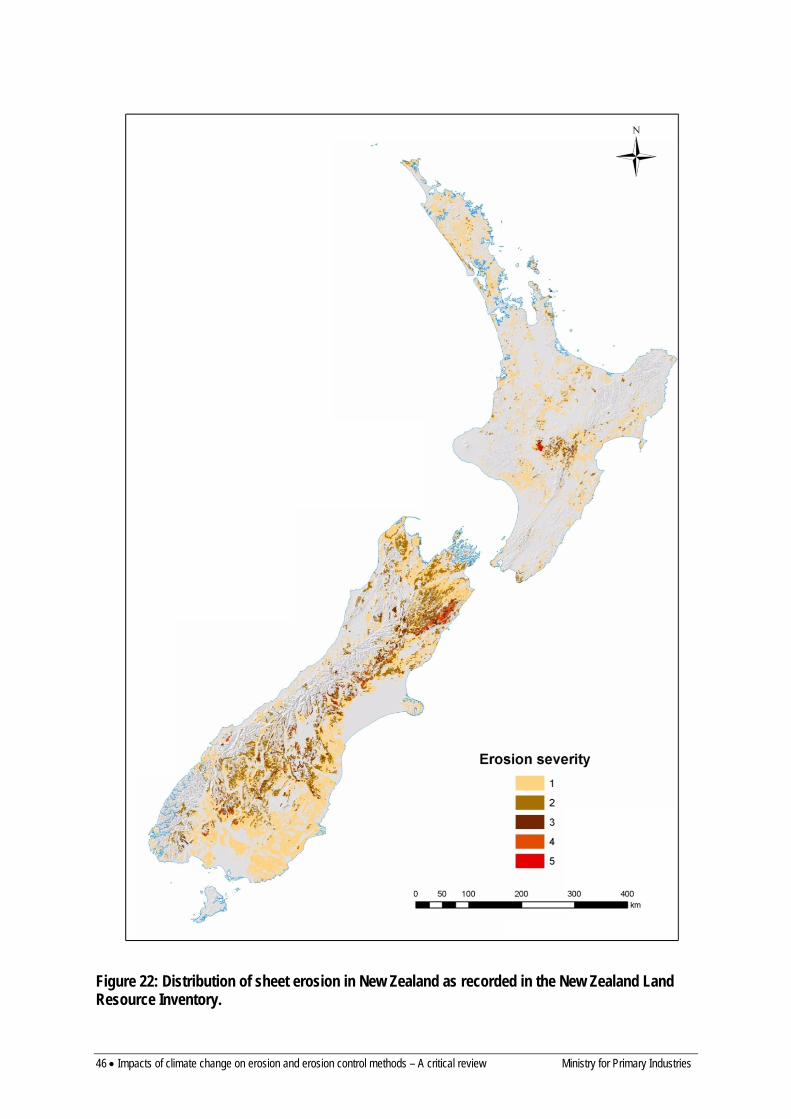
46 • Impacts of climate change on erosion and erosion control methods – A critical review Ministry for Primary Industries
Figure 22: Distribution of sheet erosion in New Zealand as recorded in the New Zealand Land Resource Inventory.
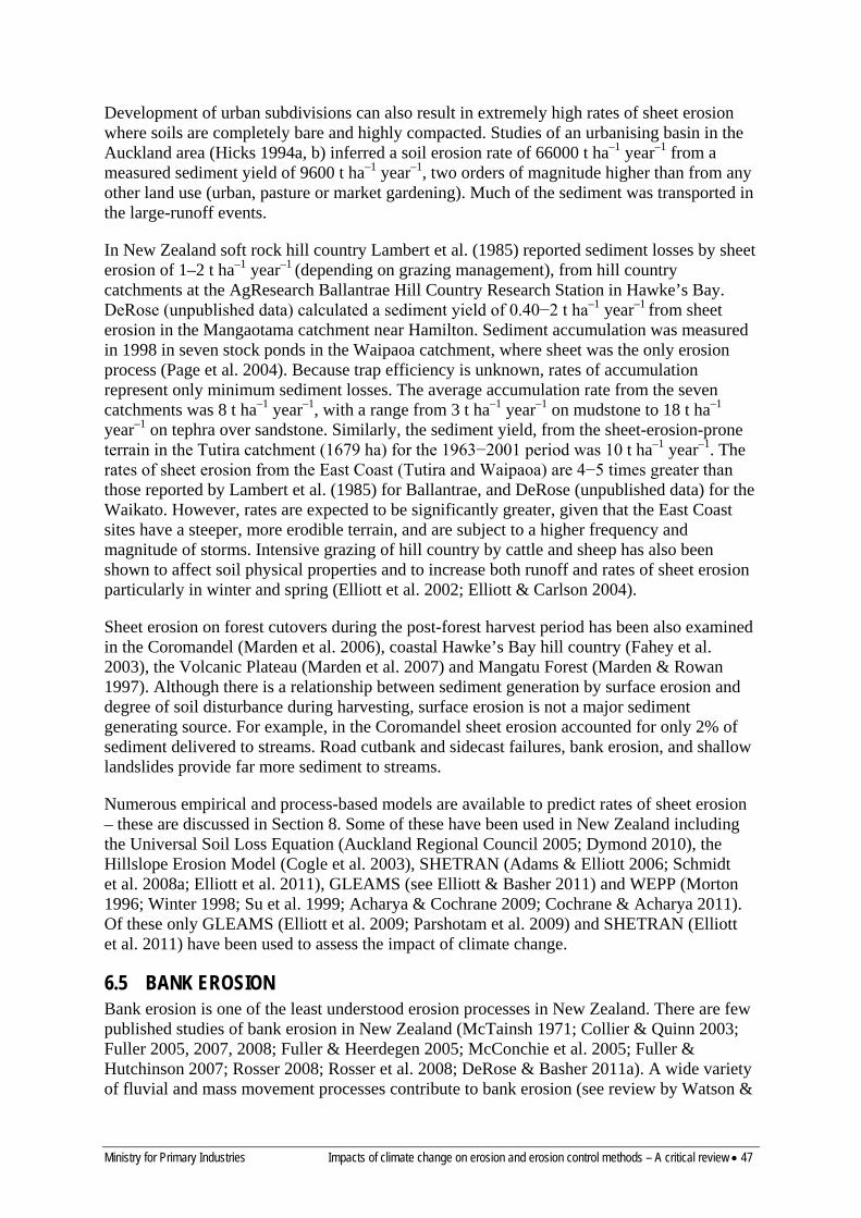
Ministry for Primary Industries Impacts of climate change on erosion and erosion control methods – A critical review • 47
Development of urban subdivisions can also result in extremely high rates of sheet erosion where soils are completely bare and highly compacted. Studies of an urbanising basin in the Auckland area (Hicks 1994a, b) inferred a soil erosion rate of 66000 t ha–1 year–1 from a measured sediment yield of 9600 t ha–1 year–1, two orders of magnitude higher than from any other land use (urban, pasture or market gardening). Much of the sediment was transported in the large-runoff events.
In New Zealand soft rock hill country Lambert et al. (1985) reported sediment losses by sheet erosion of 1–2 t ha–1 year–1 (depending on grazing management), from hill country catchments at the AgResearch Ballantrae Hill Country Research Station in Hawke’s Bay. DeRose (unpublished data) calculated a sediment yield of 0.40−2 t ha–1 year–1 from sheet erosion in the Mangaotama catchment near Hamilton. Sediment accumulation was measured in 1998 in seven stock ponds in the Waipaoa catchment, where sheet was the only erosion process (Page et al. 2004). Because trap efficiency is unknown, rates of accumulation represent only minimum sediment losses. The average accumulation rate from the seven catchments was 8 t ha–1 year–1, with a range from 3 t ha–1 year–1 on mudstone to 18 t ha–1 year–1 on tephra over sandstone. Similarly, the sediment yield, from the sheet-erosion-prone terrain in the Tutira catchment (1679 ha) for the 1963−2001 period was 10 t ha–1 year–1. The rates of sheet erosion from the East Coast (Tutira and Waipaoa) are 4−5 times greater than those reported by Lambert et al. (1985) for Ballantrae, and DeRose (unpublished data) for the Waikato. However, rates are expected to be significantly greater, given that the East Coast sites have a steeper, more erodible terrain, and are subject to a higher frequency and magnitude of storms. Intensive grazing of hill country by cattle and sheep has also been shown to affect soil physical properties and to increase both runoff and rates of sheet erosion particularly in winter and spring (Elliott et al. 2002; Elliott & Carlson 2004).
Sheet erosion on forest cutovers during the post-forest harvest period has been also examined in the Coromandel (Marden et al. 2006), coastal Hawke’s Bay hill country (Fahey et al. 2003), the Volcanic Plateau (Marden et al. 2007) and Mangatu Forest (Marden & Rowan 1997). Although there is a relationship between sediment generation by surface erosion and degree of soil disturbance during harvesting, surface erosion is not a major sediment generating source. For example, in the Coromandel sheet erosion accounted for only 2% of sediment delivered to streams. Road cutbank and sidecast failures, bank erosion, and shallow landslides provide far more sediment to streams.
Numerous empirical and process-based models are available to predict rates of sheet erosion – these are discussed in Section 8. Some of these have been used in New Zealand including the Universal Soil Loss Equation (Auckland Regional Council 2005; Dymond 2010), the Hillslope Erosion Model (Cogle et al. 2003), SHETRAN (Adams & Elliott 2006; Schmidt et al. 2008a; Elliott et al. 2011), GLEAMS (see Elliott & Basher 2011) and WEPP (Morton 1996; Winter 1998; Su et al. 1999; Acharya & Cochrane 2009; Cochrane & Acharya 2011). Of these only GLEAMS (Elliott et al. 2009; Parshotam et al. 2009) and SHETRAN (Elliott et al. 2011) have been used to assess the impact of climate change.
6.5 BANK EROSION Bank erosion is one of the least understood erosion processes in New Zealand. There are few published studies of bank erosion in New Zealand (McTainsh 1971; Collier & Quinn 2003; Fuller 2005, 2007, 2008; Fuller & Heerdegen 2005; McConchie et al. 2005; Fuller & Hutchinson 2007; Rosser 2008; Rosser et al. 2008; DeRose & Basher 2011a). A wide variety of fluvial and mass movement processes contribute to bank erosion (see review by Watson &
48 • Impacts of climate change on erosion and erosion control methods – A critical review Ministry for Primary Industries
Basher 2006) and result in a wide range of styles of bank erosion (Figure 23). While bank erosion was mapped in the NZLRI (Figure 24) it is undoubtedly more widespread than shown in this database. It is common along rivers and streams throughout New Zealand.
Figure 23: Different styles of bank erosion in New Zealand – extensive bank erosion in cohesive fine-grained sediment (left), localised bank erosion of cliffs of cohesive gravelly sediment.
Bank erosion rates are influenced by a number of factors, including channel bank material, channel sinuosity and slope, riparian vegetation, and especially flow velocity. Although rates are therefore highly variable, it can be expected that an increase in runoff and flood flows associated with increased rainfall and high magnitude storms would result in an increase in bank erosion rates. Discharge or stream power (a function of discharge and channel slope) is one of the main factors controlling bank erosion (Watson & Basher 2006; DeRose & Basher 2011b) which may change as a result of climate change.
Previous work on bank erosion in New Zealand includes:
• McTainsh (1971) describes the processes contributing to bank erosion on Banks Peninsula and notes the importance of moisture content of channel banks and stream power as controls on bank erosion rates.
• Collier and Quinn (2003) investigated channel widening in small streams as the result of a large flood (28-year ARI) using repeat cross-section surveys in small paired catchments (c. 2 km2), and found widening to be about four times higher in pasture (0.018 m year–1) than in native forest (0.0054 m year–1) streams.
In the Manawatu catchment Fuller (2005, 2007, 2008) and Fuller and Heerdegen (2005) described large-scale bank erosion in an extreme flood event (50- to 150-year ARI) in February 2004 along three 30-km river reaches in neighbouring subcatchments. Changes in channel area were equivalent to lateral bank retreat rates of 0.17–0.25. m year–1. Rosser et al. (2008) evaluate longer-term bank erosion in the Pohangina River (1953–2000) and suggest it accounts for about 28% of the catchment sediment yield.
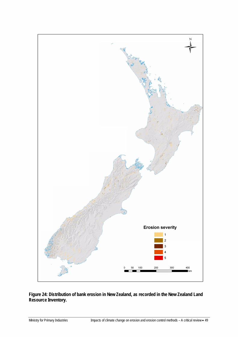
Ministry for Primary Industries Impacts of climate change on erosion and erosion control methods – A critical review • 49
Figure 24: Distribution of bank erosion in New Zealand, as recorded in the New Zealand Land Resource Inventory.

50 • Impacts of climate change on erosion and erosion control methods – A critical review Ministry for Primary Industries
• In the Waipaoa catchment Rosser (2008) found that while there was widespread signs of bank instability in the Waikohu River it only accounted for 8% of the catchment sediment yield (1952–2002). Recently increased bank erosion rates in the Waikohu coincided with an increase in frequency and magnitude of flood events. Similarly DeRose and Basher (2011a) reported that for a 44-km length of the main-stem Waipaoa River, bank erosion contributed 1.5% of the suspended sediment load over the last five decades. They identified two mechanisms of bank erosion. Fluvial processes (particle detachment and entrainment), and some small mass failures, tend to occur between large flood events and account for small, narrow (1–10 m) areas of bank retreat. Larger and wider (10–50 m) areas of bank collapse and mass failure tend to occur during big flood events (e.g. Cyclone Bola). The two mechanisms are of similar importance in terms of sediment contribution over decadal timescales.
• In the landslide-prone Tutira catchment in Hawke’s Bay, Cyclone Bola caused severe bank erosion but it contributed only 2% to the sediment budget for the storm (Page et al. 1994b).
• In the Mangaotama catchment west of Hamilton, bank erosion and scour were estimated to contribute >6% to sediment yields (1943–1993), and in recent years may now be the major source of sediment due to a decline in landslide erosion (DeRose 1998).
• McConchie et al. (2005) found that about 3% of the banks of the Waikato River are affected by bank erosion. They related potential for bank erosion to near-bank flow velocity and found that velocities were generally below the threshold for sediment entrainment.
There has been no previous analysis of the impact of climate change on bank erosion rates, but given the predicted increases in mean annual rainfall and storm rainfall it is highly likely that bank erosion rates will increase in those areas where stream discharge increases. MfE (2010) provide methods for estimating changes in flood flows. These are grouped into screening methods and advanced methods:
• Screening methods are simple empirical methods based on historical data that are used with projected changes in rainfall to predict changes in runoff.
– The Rational Method predicts runoff as:
𝑄𝑄 = 𝐶𝐶 𝑖𝑖 𝐴𝐴
3.6
Where Q = peak discharge (m3 s-1) C = runoff coefficient i = rainfall intensity (mm h–1) for time of flow concentration A = catchment area
– The Unit Hydrograph method empirically converts a hyetograph (rainfall time series) into a hydrograph (runoff time series) while the SCS method empirically relates rainfall to peak flood flow using land cover related parameters. These have been implemented for the Auckland Region as a design guideline for stormwater runoff in TP108 (Auckland Regional Council 1999). Event runoff is predicted as:
𝑄𝑄 =(𝑃𝑃 − 𝐼𝐼𝑎𝑎)2
𝑃𝑃 − 𝐼𝐼𝑎𝑎 + 𝑆𝑆
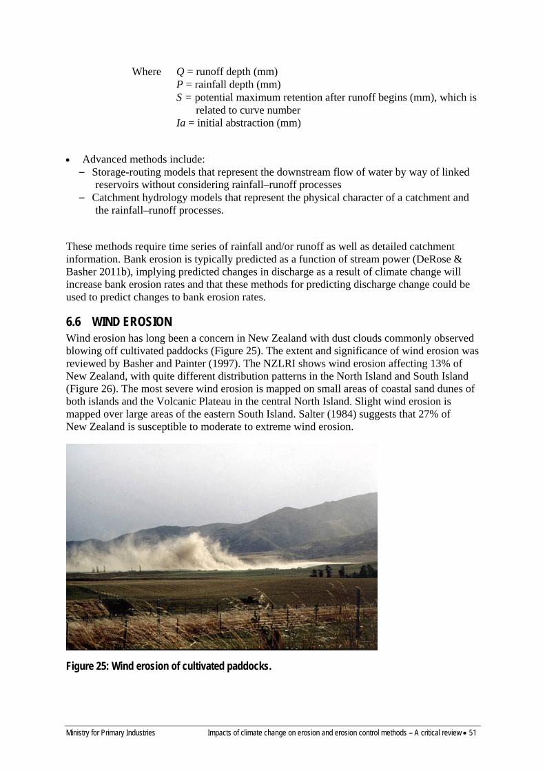
Ministry for Primary Industries Impacts of climate change on erosion and erosion control methods – A critical review • 51
Where Q = runoff depth (mm) P = rainfall depth (mm) S = potential maximum retention after runoff begins (mm), which is
related to curve number Ia = initial abstraction (mm)
• Advanced methods include: – Storage-routing models that represent the downstream flow of water by way of linked
reservoirs without considering rainfall–runoff processes – Catchment hydrology models that represent the physical character of a catchment and
the rainfall–runoff processes.
These methods require time series of rainfall and/or runoff as well as detailed catchment information. Bank erosion is typically predicted as a function of stream power (DeRose & Basher 2011b), implying predicted changes in discharge as a result of climate change will increase bank erosion rates and that these methods for predicting discharge change could be used to predict changes to bank erosion rates.
6.6 WIND EROSION Wind erosion has long been a concern in New Zealand with dust clouds commonly observed blowing off cultivated paddocks (Figure 25). The extent and significance of wind erosion was reviewed by Basher and Painter (1997). The NZLRI shows wind erosion affecting 13% of New Zealand, with quite different distribution patterns in the North Island and South Island (Figure 26). The most severe wind erosion is mapped on small areas of coastal sand dunes of both islands and the Volcanic Plateau in the central North Island. Slight wind erosion is mapped over large areas of the eastern South Island. Salter (1984) suggests that 27% of New Zealand is susceptible to moderate to extreme wind erosion.
Figure 25: Wind erosion of cultivated paddocks.
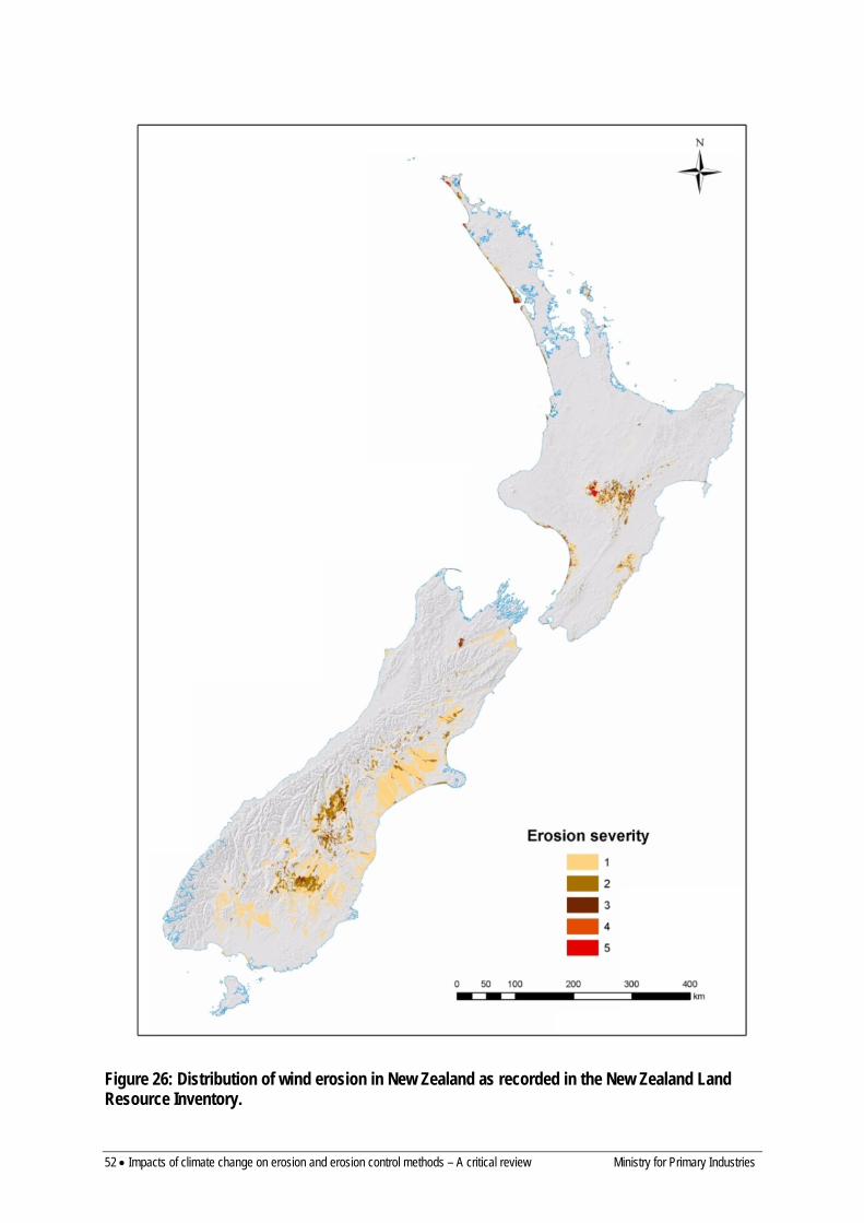
52 • Impacts of climate change on erosion and erosion control methods – A critical review Ministry for Primary Industries
Figure 26: Distribution of wind erosion in New Zealand as recorded in the New Zealand Land Resource Inventory.
Ministry for Primary Industries Impacts of climate change on erosion and erosion control methods – A critical review • 53
Wind erosion affects 4.6% of the North Island, occurring locally in three main environments:
• The mobile, coastal dunes on the west coast of Northland and the Manawatu that have not yet been afforested or which have poor grass cover
• High-altitude (>700 m), volcanic-ash-mantled, gently rolling to moderately steep slopes in the central North Island that have poor vegetation cover due to frequent strong winds and cool temperatures
• Low-altitude, loess-mantled argillite hill country and heavily cropped alluvial terraces and floodplains in the eastern North Island with severe seasonal soil moisture deficits
In the South Island wind erosion is widespread. It is mapped over 19% of the island, mostly on loess-mantled terraces and slopes in low-rainfall, seasonally dry eastern regions subject to common strong foëhn winds. It is common in the following areas:
• Extensive alluvial plains in Canterbury, Marlborough and Southland with silty alluvial soils on younger terraces and loess soils on older terraces, that are susceptible to wind erosion when cultivated
• Loess-mantled downlands in Canterbury and North Otago, subject to wind erosion when cultivated
• Large inland basins in central Otago, Canterbury, and Southland with loess-mantled terraces and moraines where extensive grazing by sheep and rabbits has led to severe vegetation depletion
• The steep, dry mountain lands of Canterbury, Otago and Marlborough with severe summer soil moisture deficits and widespread vegetation depletion
• Hill country with shallow soils, discontinuous loess cover, severe summer soil moisture deficits and localised vegetation depletion in North Canterbury
• The exposed rolling uplands of Otago where vegetation is depleted
This distribution suggests a clear link between windiness (windrun and peak windspeeds), evaporation, drought, poor vegetation cover and wind erosion.
There are few quantitative data on rates of wind erosion and links with climate (see Basher & Painter 1997; Basher & Webb 1997; Basher 2000). However, wind erosivity is the main factor controlling the broad pattern of wind erosion (Painter 1978a). Erosivity can be estimated from daily or hourly records of wind speed above a threshold related to the lowest speed at which soil particles are entrained (Skidmore & Woodruff 1968). Because of variation in particle size and aggregate size distribution in soils there is no single value of threshold windspeed; however, a value of 6.0 m s–1 was used by Painter (1978a) to calculate erosivity for New Zealand sites. In the Mackenzie Basin, McGowan (1997) found wind transport was initiated above windspeeds of 7–8 m s–1. Erosivity values in New Zealand are relatively high by world standards, owing to the windy climate (Painter 1978a). Monthly erosivity values for the sites at which suitable hourly wind speed data are available commonly lie between 100 and 300 m3 s–3 and are typically highest in spring and lowest in winter. By comparison, monthly values for the USA (derived from data in Skidmore & Woodruff (1968)) commonly lie between 10 and 100 m3 s–3 (Painter 1977). There is also strong regional variation in erosivity (Painter 1978a).
A factor related to climate that influences wind erosion is evaporative energy supply, which acts to reduce near-surface soil water content (Painter 1978a). It is related to wind erosivity,

54 • Impacts of climate change on erosion and erosion control methods – A critical review Ministry for Primary Industries
as it depends on advected energy in the wind, but it also depends on radiant solar energy. There have been many examples of severe wind erosion where northwesterly foëhn winds dry out cropland east of the main mountain ranges over a period of one or more days, then begin to move soil if they are of sufficient erosivity. The two factors of wind erosivity and evaporative energy supply explain much of the dominant spatial distribution of wind-eroded areas east of the main mountain ranges.
Surface soil water content at time of cultivation also influences erodibility (Cresswell et al. 1991). Most of New Zealand’s cropping soils, used for grain, vegetable, and row-crop agriculture, are susceptible to wind erosion. But wind erosion occurs only when drying and erosive wind speeds persist long enough at locations where non-irrigated, cultivated soils have little vegetative cover. The history of rainfall, irrigation, and evaporation, together with the soil water holding capacity and resistance to evaporative flux, combine with soil erodibility (for dry, particulate soil) to determine whether soil will erode.
It is likely that much of the wind erosion in New Zealand is caused by infrequent high-magnitude storms with high and prolonged windspeeds. There are several reports of the effect of such storms in producing high rates of soil loss (e.g. Painter 1978b; Hunter & Lynn 1988; McGuigan 1989; Basher 1990).
There has been little recent study of wind erosion rates and their links with climate, and no previous assessment of the likely impacts of climate change. However, given the likely changes to wind climate and drought outlined in Sections 5.3 and 5.4 there is potential for significant changes in wind erosion in some areas.
6.7 SEDIMENT YIELD Sediment yield varies widely around New Zealand and it has been well established that the broad-scale variation is most strongly correlated with mean annual rainfall (Griffiths 1981, 1982; Hicks et al. 1996, 2011). The variation in yield fits a power law relationship:
SSY = aPb
Where SSY = suspended sediment yield (t km–2 year–1) P = mean annual rainfall (mm year–1) a and b = constants
The constant a reflects terrain characteristics (geology, soils, slope, erosion processes, vegetation) and the exponent b determines the influence of rainfall on SSY. Different authors have used a range of values for b. Griffiths (1981) determined a value of 2.4 for South Island catchments while Hicks et al. (1996) determined a value of 2.3 based on loads from catchments throughout New Zealand. In the most recent and comprehensive analysis of the available suspended sediment data Hicks et al. (2011) used a value of 1.7 for b. Elliott et al. (2008) extended this type of modelling to incorporate a greater range of source terms and stream delivery or transport processes and found b = 2.02. These results imply even small changes in annual rainfall may cause substantial changes in suspended sediment yield.
At local scale sediment yield is strongly linked to runoff implying changes in runoff caused by climate change have the potential to affect sediment yield. A number of studies have shown that storm sediment yield has a power law relationship with storm peak flow (Hicks 1994a, b; Basher et al. 1997, 2011; Fahey & Marden 2000; Hicks et al. 2000, 2004, 2009; Phillips et al. 2005; Hoyle et al. 2012). Any increases in peak discharge associated with

Ministry for Primary Industries Impacts of climate change on erosion and erosion control methods – A critical review • 55
climate change have the potential to cause increases in sediment yield at the storm-event scale. The published rating relationships provide a means of predicting the magnitude of increase of event sediment yields with increase in peak discharge. In a recent analysis of sediment yields for catchments in the Waikato Region Hoyle et al. (2012) found the best predictor of suspended sediment yield included a stream power parameter (the product of annual runoff and catchment slope).
Changes in sediment yield in response to forest harvesting have been well established from studies in Northland (Hicks & Harmsworth 1989), Coromandel (Phillips et al. 2005; Marden et al. 2006), coastal Hawke’s Bay hill country (Fahey & Marden 2000; Fahey et al. 2003; Eyles & Fahey 2006), Volcanic Plateau (Marden et al. 2007), Nelson (O’Loughlin 1980; O’Loughlin et al. 1978; Hewitt 2002; Basher et al. 2011) and West Coast (O’Loughlin & Pearce 1976; O’Loughlin et al. 1978, 1980, 1982; O’Loughlin 1980). On steeplands there is commonly a significant sediment yield increase (up to an order of magnitude) following harvesting with most sediment generated in large storm events. Slopes are more prone to landsliding during storm events due to lower root reinforcement as the old tree roots decay and new tree roots develop (Philips et al. 2012). This maximum period of susceptibility is between 1 and 6 years and its impact is highly dependent on the frequency of large storms. If large storms become more frequent as a result of climate change, the impacts of forest harvesting have the potential to increase.
These studies all suggest that sediment yield is strongly correlated with either storm or annual runoff, or with rainfall. Rainfall, runoff and stream power are highly inter-correlated (Hicks et al. 2011). MfE (2010) describe a number of tools for estimating the effects of climate change on discharge (see Section 6.5). The screening methods could be used along with the published relationships between suspended sediment yield and flow to provide a first-order estimate of the magnitude of changes in sediment yield with climate change. For example, using the Hicks et al. (2011) relationship between SSY and mean annual rainfall (SSY ∝ P1.7) a 10% increase in rainfall results in a 17% increase in SSY, and a 20% increase in rainfall results in a 36% increase in SSY.

56 • Impacts of climate change on erosion and erosion control methods – A critical review Ministry for Primary Industries
KEY FINDINGS –CLIMATE AND EROSION PROCESSES
1. Climate is one of the major influences on rates of water, mass movement and wind erosion processes. Any assessment of the influence of climate change on erosion processes must be set within the context of inherent spatial and temporal variability of erosion processes. Rates of shallow landsliding, gully erosion, earthflows, sheet, bank and wind erosion may all be affected by climate change.
2. Shallow landslides are widespread throughout New Zealand with regional differences in frequency and magnitude. They are most commonly a response to a triggering rainfall event, either localised events or regional storm events, and/or high antecedent moisture conditions. The occurrence of rainfall events capable of triggering landslides varies greatly in time and space depending on both storm rainfall and antecedent moisture conditions. Changes to landslide frequency as a result of climate change will depend on changes to storm and annual rainfall, rainfall variability, extra-tropical cyclone frequency, temperature, and wind. Several statisical and probabilistic approaches have been used to relate landslide frequency or occurrence to rainfall (annual, daily or storm rainfall) to try and establish thresholds for landsliding. All have wide error limits. There is a wide range probability of occurrence of landsliding related to storm parameters, indicating antecedent conditions are a very strong influence on landsliding.
3. Two types of gully erosion occur in New Zealand: linear gullies cut by fluvial erosion and amphitheatre-shaped formed as complex mass-movement–fluvial erosion features. Gully erosion is most common in the North Island east coast soft rock hill country, in the North and South Island mountainlands, Northland and the Volcanic Plateau. Gully erosion has been related to high annual and storm rainfalls but no quantitative relationships have been published. Any increase in rainfall with climate change, either in terms of annual totals or storm events, can be expected to increase gully erosion.
4. Earthflow erosion is most extensive on crushed mudstone and argillite in the Gisborne–East Coast–southern Hawke’s Bay area, but also in Northland and the soft rock hill country of inland Taranaki and the southern Waikato. Movement of earthflows tends to be progressive and intermittent and is strongly influenced by rainfall and pore water pressures, with movement often beginning late in winter in response to periods of elevated rainfall. There are complex links between earthflow movement and climate related to soil moisture and storm rainfall. Changes in rainfall and temperature (and its effect on evapotranspiration) with climate change may influence rates of earthflow movement. There are no quantitative relationships relating earthflow movement to climate that would allow assessment of climate change impacts.
5. Sheet erosion is widely mapped in New Zealand and typically occurs on cultivated slopes, unsealed roads and tracks, earthworks, and as diffuse areas of bare ground within pasture or forestry clear-cuts. It is a runoff-driven process and any change in runoff as a result of increases in rainfall intensity and duration associated with climate change will potentially increase sheet erosion. Many modelling approaches are available to predict changes in rates of sheet erosion as a result of climate change.
6. Bank erosion is common along rivers and streams but is one of the least understood erosion processes in New Zealand. Bank erosion rates are influenced by flow velocity and stream power, implying any increase in runoff and flood flows associated with increased rainfall and high magnitude storms will result in an increase in bank erosion rates. Several methods are available for predicting increases in discharge with climate change including simple empirical methods, storage-routing models and catchment hydrology models.
7. Large areas of New Zealand are susceptible to wind erosion including coastal sand dunes, the Volcanic Plateau in the central North Island, and large areas of the plains and steeplands of the eastern South Island. Wind erosivity and soil moisture content are key controls on wind erosion rates that may change with climate change, along with increased drought frequency.
8. Suspended sediment yield variation in New Zealand has a power law relationship with rainfall implying small changes in annual rainfall will cause substantial changes in suspended sediment yield.
Ministry for Primary Industries Impacts of climate change on erosion and erosion control methods – A critical review • 57
7 Palaeo-records of erosion response to climate variability There is now a reasonable understanding of variation in climatic conditions through the Holocene in New Zealand, based on numerous palaeo-climate records (Alloway et al. 2007; Lowe et al. 2008). Using multi-proxy palaeoclimate data, Lorrey et al. (2008) have recently attempted broad reconstructions of weather regimes (trough, zonal, blocking), precipitation and temperature over the last c. 4000 years for two (eastern North Island and western South Island) of the six New Zealand regional climate zones (Kidson 2000). They have identified 20 discrete periods of past regional-climate-regime operation. However, there are few records that identify the magnitude and frequency of events such as rainstorms that characterise these climatic periods, and their impact on the landscape.
Records of palaeoclimate variability at annual- to century-scale resolution are usually established using a variety of biological (tree rings, corals, pollen, micro-organisms) and geological (glaciers, speleothems, ice sheets) data. However, lake, terrestrial or marine sediments also record sub-annular events such as storms, together with the impact they have on the landscape. Such records have the potential to represent a greater range of natural variability in storm magnitude and frequency than that captured by c. 150 years of rainfall recordings. Where storm magnitude/frequency – landslide relationships can be identified these can then inform forecast models.
There is growing evidence that climate changes may be abrupt, when either rapid or gradual forces on components of the Earth System exceed a threshold or tipping point (Alley et al. 2003). Spanning only years to decades, such changes would provide little time for adaptation and mitigation. Our ability to forecast the impact these changes will have on the landscape will be aided by high-resolution records of past impacts.
7.1 LAKE TUTIRA Lake Tutira in northern Hawke’s Bay has been the focus of research linking catchment erosion with lake sedimentation for two decades. The lake contains a c. 7000-year record of variability in the magnitude and frequency of storm events, together with the erosion-response to these storms under indigenous forest, scrub and pasture. The catchment is underlain by Tertiary and Quaternary siltstones and sandstones interbedded with limestones and conglomerates, and is considered representative of landslide-prone soft rock hill country that occupies c. 19% of New Zealand (Page et al. 2004).
A sediment budget for Cyclone Bola in 1988 quantified the impact major storms have on this landscape, and established that sediment produced during storms is preserved as identifiable layers in the lake (Page et al. 1994b). Cyclone Bola is the largest rainfall event since European settlement. Major findings from this study included:
• 1.35 million m3 of sediment have been generated at 420 m3 ha–1 • 44% of the catchment generated 90% of the sediment at 830 m3 ha–1 • Landslides accounted for 89% of sediment generated • 43% of sediment was retained on the landscape (21% on hillslopes, 22% in valley floors) • 51% of the sediment was deposited on the lake bed and 6% discharged from the lake
The magnitude and frequency of storm-induced erosion since European settlement has been established by correlating the storm sediment record in the lake with the storm history

58 • Impacts of climate change on erosion and erosion control methods – A critical review Ministry for Primary Industries
derived from a daily rainfall record for 1894–1988 (Page et al. 1994a). Major findings included:
• Approximate threshold of 150–200-mm storm rainfall for deposition of sediment in the lake. Storms deposit sediment on a near annual basis
• High correlation between sediment thickness and total storm rainfall (r2 = 0.80) • Extreme events account for most of the accumulated sediment, with the two largest events
contributing >50% of the sediment • A reduction in storm sediment thickness between successive storms of similar size. This
provides support for a rise in the triggering threshold for landsliding (event resistance), due to reducing sediment availability driven by erosion rates in excess of regolith formation rates.
The sedimentation rates have been measured for three periods and three different vegetation types (Page & Trustrum 1997): European pastoral farming (last c. 100 years), Polynesian burning-induced fern/scrub (c. 500 years), prehuman indigenous forest (c. 1750 years). Major findings included:
• Sedimentation rates under pasture were an order of magnitude greater than under forest • Sedimentation rates under fern/scrub were only c. 60% greater than under forest. • Under pastoral land use there has been an increase in sheet and tunnel gully erosion, and
an increase in erosion of secondary storage sites (colluvium-filled hollows and valley floors)
• Removal of woody riparian vegetation and straightening of streams on valley floors has increased sediment delivery to the hydrological network.
Erosion-related soil carbon fluxes have been estimated for the period of European pastoral farming (114 years) and for 1887–1925, 1925–1963 and 1963–2001 (Page et al. 2004). Major findings included:
• Area eroded by landslides for the period 1963–2001 was c. 27% greater than for previous periods
• The average sediment delivery ratio (1887–2001) was 0.43 • Landslides mobilised 1.17 Mg C ha–1 year–1 • C recovery on landslide scars was c. 0.61 Mg C ha–1 year–1
A record of storm magnitude and frequency has also been established for the last c. 7000 years (Orpin et al. 2010; Page et al. 2010). Major findings included:
• c. 1400 storm sediment layers were identified with an average storm frequency of c. 1 storm every 5 years
• Storm magnitude and frequency were highly variable • There were 25 periods with increased frequency of large storms, typically of decadal to
century duration, often with sudden onset and cessation (Table 4) • There were several periods with storm magnitude/frequency greater than the last 100
years) • There were c. 54 prehistoric storms of at least similar magnitude to Cyclone Bola, seven
of which were likely of greater magnitude
Ministry for Primary Industries Impacts of climate change on erosion and erosion control methods – A critical review • 59
• Comparison of the timing of major storm periods with other proxy climate and landscape records indicates that the Tutira storm record is not just a record of local conditions, but contains signals of regional or wider significance
• Correlation of the Lake Tutira storm record with other proxy climate records suggests that rainfall and the magnitude/frequency of storms are influenced by interactions between El Niño–Southern Oscillation (ENSO) and the Southern Annular Mode (SAM), the two leading modes of climate variability in the New Zealand region (Gomez et al. 2012)
The high-resolution Lake Tutira storm sediment record was used to derive a palaeorainfall record (Litchfield et al. 2011). Using a c. 100-year daily rainfall record from beside the lake, relationships between storm sediment layer thickness and storm rainfall (r2 = 0.7, Gomez et al. 2012), and between storm rainfall and annual rainfall (r2 = 0.53), were identified under European pastoral land use. A 6.1-times difference in storm sedimentation rate between pasture and forest (Eden & Page 1998) was then used to infer storm rainfall and annual rainfall for pre-European storm sediment layers. An annual rainfall was allocated to each storm (based on the assumption of one storm per year) using the storm chronology that was derived from the age model (Page et al. 2010). Non-storm years were allocated a rainfall of 1200 mm, which is the average rainfall of non-storm years in the monitored European period. Annual rainfalls were then binned to provide 100-year annual averages. However, the storm sediment record is not complete, and for c. 25% of bins the 100-year annual rainfall average was based on less than 33 years of record.
Using a slightly different method, a palaeorainfall index was derived as a parameter for HydroTrend, a climate-driven hydrologic transport model, used to simulate the suspended sediment discharge of the nearby Waipaoa River system over the last 5,600 years (Upton et al. 2012). Long-term variations in sediment flux predicted by the HydroTrend model agree with those observed in a marine core (MD97-2122) from the middle shelf offshore from Poverty Bay (Gomez et al. 2007).
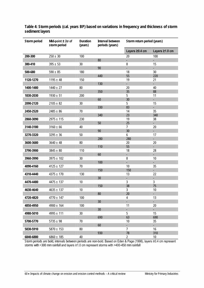
60 • Impacts of climate change on erosion and erosion control methods – A critical review Ministry for Primary Industries
Table 4: Storm periods (cal. years BP) based on variations in frequency and thickness of storm sediment layers
Storm period Mid-point ± 2σ of storm period
Duration (years)
Interval between periods (years)
Storm return period (years)
Layers ≥0.4 cm Layers ≥1.0 cm 200-300 250 ± 30 100 20 100 80 - - 380-410 395 ± 53 30 8 15 90 - - 500-680 590 ± 85 180 18 30 440 55 220 1120-1270 1195 ± 48 150 19 21 130 - - 1400-1480 1440 ± 27 80 20 40 350 35 88 1830-2030 1930 ± 51 200 5 11 60 30 - 2090-2120 2105 ± 82 30 5 15 330 83 - 2450-2520 2485 ± 86 70 14 35 340 23 340 2860-3090 2975 ± 115 230 19 38 50 25 - 3140-3180 3160 ± 66 40 7 20 90 30 - 3270-3320 3295 ± 36 50 6 17 280 280 - 3600-3680 3640 ± 48 80 20 20 110 55 - 3790-3900 3845 ± 80 110 18 28 60 - - 3960-3990 3975 ± 102 30 8 10 100 - - 4090-4160 4125 ± 127 70 10 35 150 150 - 4310-4440 4375 ± 170 130 13 22 30 - - 4470-4480 4475 ± 137 10 3 3 150 38 75 4630-4640 4635 ± 137 10 3 10 80 20 - 4720-4820 4770 ± 147 100 4 13 30 - - 4850-4950 4900 ± 164 100 11 20 30 - - 4980-5010 4995 ± 111 30 5 15 690 63 690 5700-5770 5735 ± 98 70 10 35 60 - - 5830-5910 5870 ± 153 80 7 16 930 78 310 6840-6880 6860 ± 185 40 2 10 Storm periods are bold, intervals between periods are non-bold. Based on Eden & Page (1998), layers ≥0.4 cm represent storms with >300 mm rainfall and layers ≥1.0 cm represent storms with >400-450 mm rainfall
Ministry for Primary Industries Impacts of climate change on erosion and erosion control methods – A critical review • 61
7.2 OTHER PALAEO-RECORDS THAT IDENTIFY AN EROSION RESPONSE TO RAINFALL EVENTS OR CLIMATE VARIABILITY
Claessens et al. (2006), in a study of sediment cores from a wetland in the Waitakere Ranges west of Auckland, identified at least four high-magnitude landslide events since c. 1000 cal. years BP. Two occurred in pre-European times, and were thought to have been caused by natural landslide activity or under the influence of early Polynesian settlement. The two younger events occurred during the last 150 years when logging and/or quarrying may have been influences. A physically based landslide model (LAPSUS-LS) was used to determine spatially distributed relative landslide hazard, and critical threshold rainfall estimates of between c. 25 and 90 mm day–1 for the events were made through back analysis of modelled sediment yield.
In addition to the Lake Tutira record, there are a number of other records from the East Coast of the North Island, in part reflecting the high erosion rates in that region. These include:
• Chester and Prior (2004) identified seven episodes of erosion in a 3500-year sediment record from a small lake 47 km south of Lake Tutira. Several episodes, including one at about 2050 years BP, correlate with stormy periods at Lake Tutira.
• Pullar and Penhale (1970) identified five periods of infilling of the Waipaoa floodplain. At about 2100 14C years BP, rapid erosion in the Ngatapa Valley led to the development of a large fan, which ceased building after the Taupo eruption.
• At Lake Poukawa in Hawke’s Bay increases in Typha orientalis, an indicator of lake-level rise due to wetter conditions, occurred around 2000, 3280, and 4000–4700 14C years BP (McGlone 2002), which correspond with storm periods in the Tutira record.
• Marine core MD97-2122, located on the continental shelf off Poverty Bay, shows several increases in sediment flux at the times of Tutira storm periods, with the highest increase at c. 2000 years BP, closely matching the 1830–2030 years BP storm period at Tutira (Phillips & Gomez 2007).
In a more wide ranging study Grant (1985) recognised eight major periods of erosion and alluvial sedimentation in New Zealand during the last 1800 years: Taupo (1764 years BP), post-Taupo (1600–1500 years BP), Pre-Kaharoa (1300–900 years BP), Waihirere (680–600 years BP), Matawhero (450–330 years BP), Wakarara (180–150 years BP), Tamaki (1870–1900 AD) and Waipawa (1950 to present). With the exception of the Taupo period he suggested they occurred throughout New Zealand and were a response to increased northerly airflow and atmospheric warming over New Zealand, and the associated increased magnitude of major rainstorms and floods producing increased rates of erosion and sediment transport. Further he suggested periods dominated by meridional (westerly) atmospheric circulation were characterised by cooler air temperatures and less storminess. He suggests a history of long-term irregular fluctuations of warm, stormy periods separated by cooler, less stormy intervals.
The Tutira record, together with the records above, identify a period around 2000 years ago as a time of major erosion in north-eastern New Zealand. The period at 1830–2030 years BP in the Tutira record has the highest storm magnitude and frequency in the 7000-year record, with a storm recurrence interval of one storm every 2.4 years.
Under the scenario of a 2°C increase in temperature during the 21st century, projections are for an increase in the current frequency and intensity of extreme rainfalls (Tait 2011). The
62 • Impacts of climate change on erosion and erosion control methods – A critical review Ministry for Primary Industries
Lake Tutira storm sediment record has suggested that the natural variability in storm magnitude and frequency over the last c. 7200 years (a period when temperatures have fluctuated within 1–2°C of modern values (Salinger 1988) is greater than that captured by the last 150 years of monitored record. Therefore, the following aspects of the Lake Tutira record could have implications for the nature of storm rainfall events associated with a 2°C increase in temperature:
• Storm magnitude and frequency was highly variable • Periods with increased frequency of large storms were typically of decadal to century
duration, often with sudden onset and cessation • Several periods had storm magnitude/frequency greater than at present (last 100 years) • Seven storms were of likely greater magnitude than Cyclone Bola
Long-term sedimentation rates at Lake Tutira, and numerous contemporary studies of landsliding, have identified that erosion rates under pasture are an order of magnitude greater than under forest. This provides the potential for targeted increase in afforestation to offset the erosion impact of the projected increase in storm rainfall.
KEY FINDINGS – PALAEO-RECORDS
1. Landscape response to variation in climatic conditions through the Holocene has been established through palaeoenvironmental reconstruction at key sites. This demonstrates storm magnitude and frequency, and hence rates of erosion processes, have been highly variable.
2. The Lake Tutira storm sediment record is the most complete and represents both local and regional signals of climatic variation. It suggests that the natural variability in storm magnitude and frequency over the last c. 7200 years (a period when temperatures have fluctuated within 1–2°C of modern values) is greater than that captured by the last 150 years of instrumented record. There have been several periods with storm magnitude/frequency greater than in the last 100 years. Approximately 54 prehistoric storms of at least similar magnitude to Cyclone Bola, seven of which were likely of greater magnitude, were identified. Periods with increased frequency of large storms were typically of decadal to century duration, often with sudden onset and cessation. The magnitude and frequency of storms was influenced by interactions between the El Niño–Southern Oscillation and the Southern Annular Mode.
3. Other palaeo-records match some of the storm episodes recorded at Lake Tutira. 4. Erosion rates under pasture are an order of magnitude greater than under natural forest. This provides the
potential for a targeted increase in afforestation to offset the erosion impact of the projected increase in storm rainfall with climate change.
Ministry for Primary Industries Impacts of climate change on erosion and erosion control methods – A critical review • 63
8 Erosion modelling as a tool for assessing climate change impacts
The only feasible means of quantitatively predicting the impact of climate change on erosion is through models that explicitly incorporate climate impacts on erosion processes. This section reviews the range of models that are available to relate erosion to climate, with an emphasis on those that have been used in New Zealand and which incorporate the range of erosion processes characteristic of the New Zealand landscape. Modelling approaches are characterised as:
• Empirical: based on statistical relationships between erosion and key controlling factors, and usually with a limited degree of spatial detail. Require limited input data to run
• Process-based: using complex physical equations, often partial differential equations, to represent atmospheric, hydrologic, plant growth and erosion processes. Usually have a high degree of spatial detail and require extensive input data to parameterise
• Hybrid empirical–process-based models
However, it is worth noting that many models characterised as process-based rely in part on empirical relationships for some calculations (e.g. GLEAMS, HydroTrend). The three probabilistic models of Glade (1997), relating landslide occurrence to rainfall thresholds described in Section 6.1, are also a form of empirical model. Further detail about erosion models is given in Merritt et al. (2003), while Elliott and Basher (2011) review the use of erosion models in New Zealand.
8.1 EMPIRICAL MODELS
8.1.1 Universal Soil Loss Equation The Universal Soil Loss Equation (USLE) was developed in the USA from empirical modelling of plot runoff data (Wischmeier & Smith 1978). It is often used in New Zealand for estimating sediment losses from earthworks areas to support earthworks consent applications (Auckland Regional Council 2005). It models sheet and rill erosion as a function of rainfall erosivity, soil erodibility, slope steepness and length, land cover and management, all of which influence soil detachment by rainfall and overland flow. It was originally designed for use in modelling cropland erosion and has been extended for rangeland and forest land uses, but the calibration dataset covers a restricted range of environmental conditions (slope, soils, vegetation). The USLE is used for predictions at hillslope scale but does not provide catchment-scale predictions without incorporation of a sediment delivery term. The delivery ratio of eroded sediment to the stream network is difficult to estimate (typically a delivery ratio of 0.5 is used for slopes <10% and 0.7 for slopes >10% in Auckland). Such arbitrary factors lead to reservations about the use of the USLE for quantifying sediment flux to streams.
A simplified version of the USLE has recently been developed for New Zealand (Dymond 2010). This model (NZUSLE) was developed for national-scale assessment of sediment flux related to soil carbon losses. Sheet and rill erosion is modelled as:
E = αP2KLZU

64 • Impacts of climate change on erosion and erosion control methods – A critical review Ministry for Primary Industries
where E = mean annual erosion rate due to surface erosion (t km–2 year–1) α = a constant calibrated with published surface erosion rate data P = mean annual rainfall (mm) K = soil erodibility (four classes defined from soil texture) L = slope-length factor Z = slope-gradient factor U = vegetation-cover factor
The model was calibrated to results from sediment yield studies in New Zealand where sheet and rill erosion were assumed to be the dominant sediment delivery processes. It explained 60% of the variance in yield (log-transformed). This model could be used with projections of mean annual rainfall increase to provide a crude estimate of the effect of climate change on sheet and rill erosion, although for much of New Zealand it would be used well outside the range of conditions for which the model is suitable.
8.1.2 Suspended Sediment Yield Estimator The Suspended Sediment Yield Estimator (SSYE) was developed by Hicks and Shankar (2003) to predict specific suspended sediment yield at national scale from mean annual rainfall and terrain characteristics (defined by an erosion terrain classification):
SSY = aPb
Where SSY = suspended sediment yield (t km–2 year–1) P = mean annual rainfall (mm) a = coefficient depending on erosion terrain b = constants
The constant a is derived from an erosion terrain classification (defined on the basis of slope, surface rock type, soils, dominant erosion processes) based on the NZLRI and expert knowledge (Hicks et al. 2011). The coefficients associated with each erosion terrain grouping were calibrated to sediment load measurements at over 200 stream sites, and so implicitly include the sediment delivery component. The model takes account of key drivers such as rainfall and geology, but does not explicitly model erosion processes. The model explains 97% of the suspended sediment yield variance (log-transformed) in South Island catchment sites and 96% for North Island sites (Hicks et al. 2011).
It is available as a 100-m-resolution raster GIS layer (http://www.niwa.co.nz/our-science/freshwater /tools/suspended-sediment-yield-estimator) or through the Water Resources Explorer (http://wrenz.niwa.co.nz/webmodel/). Sediment flux through streams can be determined by accumulating the flux from upstream grid cells to any point in a stream network. The primary driver for sediment yield is mean annual rainfall and the model could be used with the projected increase in rainfall to provide an estimate of the likely increase in sediment yield as a result of climate change. A 10% increase in rainfall will result in a 18% increase in yield, while a 20% increase will result in a 37% increase in yield.
8.1.3 New Zealand Empirical Erosion Model Dymond et al. (2010) developed the New Zealand Empirical Erosion Model (NZeem®) to provide a simple means of assessing the effects of tall woody vegetation cover on erosion and sediment yield. Based on the SSYE estimates of suspended sediment yield NZeem® assumes a factor-of-10 reduction in erosion rates for areas with land covered in trees. Erosion is modelled as:
Ministry for Primary Industries Impacts of climate change on erosion and erosion control methods – A critical review • 65
E = aCRb
Where E = erosion rate (t km-2 year-1) R = mean annual rainfall (mm year–1) C = 1 for non-woody vegetation, 10 for non-woody vegetation a = the erosion terrain coefficient b = 2
It also incorporates a sediment delivery term defined by connection to a stream network derived from DEM analysis.
The erosion terrain coefficients were recalibrated to give the same overall sediment load as the SSYE. This approach also enabled spatial downscaling from 100-m resolution in the SSYE to 15-m resolution available from vegetation cover mapping. However, the ability of NZeem®to accurately represent erosion at such a fine scale is questionable since it is based on coarser-resolution suspended sediment yield data that are themselves derived from a model (SSYE).
This model has been used to assess the effects of different land-use scenarios in the Motueka catchment, national trends in erosion with trends in land cover, and to compare strategies for implementing on-farm sediment control measures on sediment loads in the Manawatu River catchment (Dymond et al. 2010). The latter assumes a fixed percentage reduction in sediment yield for those areas implementing a farm plan (Schierlitz et al. 2006). In this case C is set to 0.3 for farm plan implementation. It has also been used to assess the effect of climate change in the Manawatu catchment (see Section 9).
8.1.4 SPARROW regional regression for sediment yields The SSYE approach was also extended by Elliott et al. (2008) by adding slope and land cover terms. The model was calibrated to measured suspended yields using the SPARROW regional regression methods (Alexander et al. 2004). The terms included in the model are mean annual rainfall, slope, vegetation cover, and erosion terrain groupings. This method has the advantage that parameter errors can be assessed, and also the effect of in-stream attenuation or sources of sediment can be included. The model explains 93% of the variance in measured sediment loads (log-transformed). The SPARROW model has been included in the CLUES water quality modelling system (Woods et al. 2006; see also http://www.maf.govt.nz).
8.1.5 Probabilistic Rainfall-induced Landslide Hazard Model GNS Science has developed a probabilistic rainfall-induced landslide hazard model (PRILHM) for New Zealand (Dellow et al. 2010). The PRILHM is based on empirical landslide data, and assesses the probability of a landslide occurring at any location according to rainfall. The model uses the following datasets to spatially and temporally distribute the rainfall-induced landslide hazard on a national scale:
1. Landslide data a) landslide size (area) distribution data b) landslide area-frequency data for different rainfall intensities, from post-event satellite
imagery 2. Rainfall data – NIWA, Met Service and regional council daily rainfall (assessed in 50-
mm bands)
66 • Impacts of climate change on erosion and erosion control methods – A critical review Ministry for Primary Industries
3. Geological units – from GNS Science QMap (1:250 000 scale Geological Map of New Zealand)
4. Vegetation (woody and non-woody) – from post-event satellite imagery 5. Watercourse/water body – from LINZ NZMS260 1:50 000 scale maps 6. Digital elevation model (DEM) – from LINZ NZMS260 DEM 20-m contour information
The landslide data are obtained from satellite image assessment of historical rainfall events. Individual landslides identified on the satellite imagery, either manually or using semi-automated processing algorithms, are assigned attributes from the rainfall, geology, vegetation and DEM datasets.
The PRILHM then takes a rainfall forecast and compares it against the historical landslide–rainfall data at a site to forecast the probability of a landslide occurring at that site. Rainfall input data are a rainfall index (RI) comprising a combination of antecedent rainfall (RA) and forecast 24-hour rainfall (RF):
RI = RA + RF.
The probability of a landslide occurring changes as the rainfall input into the model is changed. The probability of landslide initiation is determined for each geology–vegetation combination in each pixel in the DEM, and the probability of landslide movement into an adjacent pixel is determined using the landslide-size distribution. Watercourse and water body data are used for ending the landslide movement (scar and debris).
The model can also be used to assess the impact changes in rainfall patterns will have on the landslide hazard, and identify sites with the highest risk at a nominated rainfall frequency. To date the PRILHM has been run for greywacke, volcanic breccia, and conglomerate rock types, using empirical landslide/rainfall data collected during assessments of storm damage. The model is data intensive, requiring empirical data on landslide distribution for several rainfall intensities for each unique geological unit – vegetation class in order to prime the model. However, the model is self-training – as more landslide data are added to the dataset, the model becomes better calibrated and uncertainties are better determined.
8.2 PROCESS-BASED MODELS
8.2.1 HydroTrend HydroTrend is a climate-driven hydrological transport model that simulates water discharge and sediment load at a river mouth on a daily basis. The model is designed to simulate the fluvial fluxes of rivers for decades to many millennia, provided that the input parameters represent the river basin characteristics over that period (Kettner & Syvitski 2008). Input parameters incorporate drainage-basin properties (hypsometry, relief, lakes, lithology) together with biophysical parameters (temperature, precipitation, evapotranspiration, glacier characteristics) and anthropogenic factors (vegetation/human-influenced soil erosion factor, dams and reservoirs). Model source code is freely available online at http://csdms.colorado.edu/wiki/Model:HydroTrend. A detailed description of the model structure and its components is provided by Kettner and Syvitski (2008).
HydroTrend simulates daily water discharge (Q[i]) using a water balance approach:
][][][][ ievapigriri QQQQ −±= (1)

Ministry for Primary Industries Impacts of climate change on erosion and erosion control methods – A critical review • 67
Where Qr[i] = discharge generated by rain Qgr [i] = groundwater discharge or storage Qevap [i] = discharge lost by evapotranspiration from either canopy interception or the groundwater pool i denotes a daily time step
The suspended sediment load is computed in two steps. The first step involves computing the average long-term suspended sediment load
Qs (>30 years), which is simulated by implementing a globally-derived empirical relation (equation 2 from Syvitski & Milliman 2007). The relationship is based on a dataset from 488 rivers that in total deliver 63% of the world’s fresh water to the ocean. Suspended sediment load is expressed as a function of hypsometry, catchment area, climate, geology, lake storage, vegetation cover, and/or anthropogenic (land use) change:
RTAQBQs 5.0
31.0
=
αω (2)
where Qs = sediment year-load (Mt year–1) ω = a coefficient of proportionality (0.02) B = a term accounting for geological and human factors
Q = the long-term water discharge derived as an average from equation (1) α = a dimensionless constant to transfer between units water discharge (from m3 s–1 to km3 year–1) A = drainage basin area R = drainage basin relief T = average long-term temperature of the drainage basin
The B term expands to:
vegTLB E )1( −= (3)
where L = the average lithology factor, varying for most basins between 0.5 and 3 but which could reach 10, depending on the erodibility of the rock TE = the trapping efficiency due to lakes or reservoirs of the basin, which is defined by the Brune equation for large reservoirs or Brown equation for small reservoirs (see Kettner & Syvitski 2008) veg = the vegetation factor varying between 0.2 and 2 but for a few rivers could increase to 8 (Kettner et al. 2007).
The second step involves computing daily suspended sediment load, which can be simulated once the average sediment load trend is determined. Morehead et al. (2003) developed a stochastic relation between sediment load and discharge:
Qs[ i]
Qs
=ψ[ i]
Q[ i]
Q
C ( a )
(4)
where Qs[i] = the daily sediment load ψ[i] = a daily log-normal random distribution to mimic daily scatter in the sediment
68 • Impacts of climate change on erosion and erosion control methods – A critical review Ministry for Primary Industries
load (inter-annual variability), and C(a) = a normally distributed annual rating coefficient (intra-annual variability).
Time series (e.g. hysteresis loops) cannot be simulated with this relation but it captures the variance relation as a scatter plot between water discharge and suspended sediment load very well. Morehead et al. (2003) describe in more detail how both the variability terms (ψ[i], C(a)) are established.
HydroTrend has been used to model suspended sediment discharge in the Waipaoa catchment for the last 22 000 years (Upton et al. 2012), and the last 3000 years (Kettner et al. 2007). Results are consistent with the sedimentary record preserved offshore (middle shelf) and indicate that sediment generation today is about 7–8 times what it was under fully forested Holocene conditions, and twice that during the Last Glacial Maximum. During the late Holocene, variations in sediment flux were largely driven by precipitation, but currently, anthropogenic deforestation is the dominant control.
8.2.2 SHETRAN SHETRAN is a physically based, dynamic, spatially distributed modelling system that is based on the Système Hydrologique Européen (SHE) hydrological model that integrated surface and subsurface flow components into a single modelling system (Ewen et al. 2000; Lukey et al. 2000). SHE was extensively modified by researchers in the School of Civil Engineering and Geosciences at Newcastle University (UK) to include sediment and contaminant transport components (Ewen et al. 2000). The three components of SHETRAN (i.e. stream flow, sediment transport and solute transport) model physical processes represented by physically-based spatially-distributed models, the majority of which are partial differential equations (Ewen et al. 2000). SHETRAN thus provides a combined surface and subsurface representation of water, sediment and solute movement through a catchment, incorporating the main components of the land phase of the hydrological cycle (i.e. canopy interception, evapotranspiration, subsurface flow, overland flow and channel flow) and incorporates sheet, rill and bank erosion processes (Lukey et al. 2000).
SHETRAN, which is able to be applied at a range of spatial scales, uses a square grid in plan area and a column of horizontal soil layers for each grid cell (Ewen et al. 2000). The main computational units are stream links and columns. The stream links are positioned along the edges of the catchment grid cells. Overland flow is routed through the grid cells to the stream network, and then down the stream network using kinematic wave routing (Elliott et al. 2011). The sediment component includes rainfall erosivity, erodibility coefficients, bank erosion and entrainment of riverbed sediment, and accounts for a wide range of particle sizes (Ewen et al. 2000; Elliott et al. 2011). Any sediment flux in excess of transport capacity is deposited within grid cells and stream links. An advantage of SHETRAN for modelling erosion processes under New Zealand conditions is that a landslide component based on factor-of-safety analysis2 has recently been incorporated into the modelling system (Bathurst et al. 2006; Elliott et al. 2011; Bovolo & Bathurst 2012).
2 A widely used method of slope stability analysis based on comparison of shear strength of a hillslope (s) and shear stress (τ) on a potential failure plane
FS = s/ τ
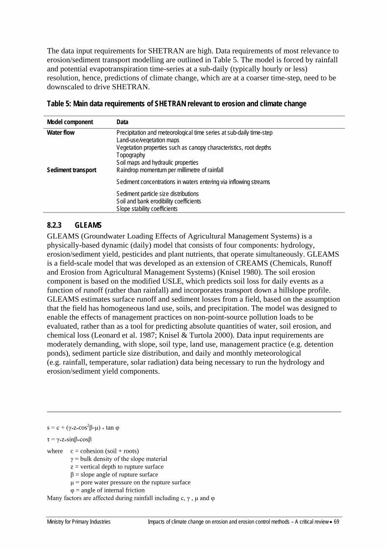
Ministry for Primary Industries Impacts of climate change on erosion and erosion control methods – A critical review • 69
The data input requirements for SHETRAN are high. Data requirements of most relevance to erosion/sediment transport modelling are outlined in Table 5. The model is forced by rainfall and potential evapotranspiration time-series at a sub-daily (typically hourly or less) resolution, hence, predictions of climate change, which are at a coarser time-step, need to be downscaled to drive SHETRAN.
Table 5: Main data requirements of SHETRAN relevant to erosion and climate change
Model component Data Water flow Precipitation and meteorological time series at sub-daily time-step Land-use/vegetation maps Vegetation properties such as canopy characteristics, root depths
Topography Soil maps and hydraulic properties Sediment transport Raindrop momentum per millimetre of rainfall Sediment concentrations in waters entering via inflowing streams Sediment particle size distributions Soil and bank erodibility coefficients
Slope stability coefficients
8.2.3 GLEAMS GLEAMS (Groundwater Loading Effects of Agricultural Management Systems) is a physically-based dynamic (daily) model that consists of four components: hydrology, erosion/sediment yield, pesticides and plant nutrients, that operate simultaneously. GLEAMS is a field-scale model that was developed as an extension of CREAMS (Chemicals, Runoff and Erosion from Agricultural Management Systems) (Knisel 1980). The soil erosion component is based on the modified USLE, which predicts soil loss for daily events as a function of runoff (rather than rainfall) and incorporates transport down a hillslope profile. GLEAMS estimates surface runoff and sediment losses from a field, based on the assumption that the field has homogeneous land use, soils, and precipitation. The model was designed to enable the effects of management practices on non-point-source pollution loads to be evaluated, rather than as a tool for predicting absolute quantities of water, soil erosion, and chemical loss (Leonard et al. 1987; Knisel & Turtola 2000). Data input requirements are moderately demanding, with slope, soil type, land use, management practice (e.g. detention ponds), sediment particle size distribution, and daily and monthly meteorological (e.g. rainfall, temperature, solar radiation) data being necessary to run the hydrology and erosion/sediment yield components.
s = c + (γ*z*cos2β-μ) * tan φ
τ = γ*z*sinβ*cosβ
where c = cohesion (soil + roots) γ = bulk density of the slope material z = vertical depth to rupture surface β = slope angle of rupture surface μ = pore water pressure on the rupture surface φ = angle of internal friction
Many factors are affected during rainfall including c, γ , μ and φ

70 • Impacts of climate change on erosion and erosion control methods – A critical review Ministry for Primary Industries
A version of the model (GLEAMS-Catchment) has been developed by NIWA whereby catchments are able to be modelled by combining (field-scale) landscape units in a geographic information system (GIS). As the data requirements are not overly demanding, and the spatial layers can be easily modified to incorporate land use and climate change scenarios, GLEAMS-Catchment has been used in numerous land management applications (e.g. Elliott et al. 2009).
Despite the development of a catchment-scale GIS framework for the application of GLEAMS, its use in large, complex catchments is untested and may be inappropriate in many parts of New Zealand as it only accounts for erosion by sheet and rill erosion processes. In large, complex catchments – where catchment sediment storage may be significant (Walling 1983) and/or non-hillslope erosion sediment sources (e.g. bank erosion and mass movement) may dominate – such a model would be unable to reliably predict the impacts of land use or climate change scenarios. The model does not predict changes in ground cover due to climate change.
8.2.4 Schmidt probabilistic landslide model A probabilistic modelling system for forecasting shallow, rainfall-initiated landslides has recently been developed at NIWA (Schmidt et al. 2008b). The modelling system has three components: weather forecasting, catchment hydrology and slope stability. Weather forecasts are derived from the New Zealand Limited Area Model (NZLAM). NZLAM is based on the UK Met Office’s Unified Model and assimilates data all local observations, both satellite and ground based to produce accurate weather forecasts (NIWA 2012). Catchment hydrology is simulated by the spatially-distributed, physically-based TopNet model using weather forecast data. Slope stability is determined from factor-of-safety analysis (Schmidt et al. 2008b), with soil moisture inputs from TopNet. The slope stability model determines the effects of changes in soil moisture on shear stress and soil strength (Schmidt et al. 2008b). Comparison of shear stress and soil strength is used to determine the probability of slope failure (Schmidt et al. 2008b). The data requirements for the model are low to moderately demanding (see Table 6).
Table 6: Main data requirements for the hydrology and slope stability components of the Schmidt landslide model (Source: Schmidt et al. 2008b)
Model component Data Catchment hydrology Subcatchment boundaries
Surface albedo Evaporation enhancement (increased evaporation from interception) Canopy capacity Wetness index Saturated hydraulic conductivity Depth of soil Wilting point Field capacity Saturated water content Soil dry unit weight
Slope stability Slope angle Soil cohesion Soil friction angle Shear plane depth
Ministry for Primary Industries Impacts of climate change on erosion and erosion control methods – A critical review • 71
An initial test of the model (without any calibration) had a 70–90% success rate (observed landslide densities versus predicted probabilities) for an extreme rainfall event within the 6000-km2 Manawatu catchment. Schmidt et al. (2008b) did, however, warn that due to the ‘inherent uncertainties in weather simulation, hydrological modelling, and geotechnical models…landslide forecast results contain high degrees of uncertainties, in particular if verified on a local scale, hence, the forecast results need to be upscaled to regional levels to be useful for applied purposes’.
This model has not yet been applied to assessment of the effects of climate change. It could potentially be used for this purpose, because it is driven by climate time-series data that can be derived from climate model predictions with suitable temporal downscaling.
8.2.5 WEPP The Watershed Erosion Prediction Project (WEPP) model is a physically-based, continuous daily simulation model (similar to SHETRAN) that was designed to determine the key mechanisms controlling hillslope erosion (sheet and rill), including the impact of human activities (Flanagan & Nearing 1995; Merritt et al. 2003). WEPP simulates surface hydrology, plant growth, hillslope erosion, soil water balance, and residue decomposition and requires extensive data layers of slope, soil, climate, and crop management (Flanagan & Nearing 1995). WEPP’s erosion component is quantified using the rill–interill concept of describing sediment detachment and operates in three stages (detachment, transport and deposition) (Merritt et al. 2003). The model was originally designed for use at the field-scale; however, a catchment-scale version has been developed that links surface erosion processes to the river network (Ascough et al. 1997).
WEPP has been used in New Zealand to simulate erosion on urban subdivisions (Morton 1996; Winter 1998), cropland (Su et al. 1999) and to simulate forest-road erosion (Cochrane et al. 2007). A shallow-landslide-generation component was recently added to WEPP, which combines prediction of surface erosion processes with prediction of shallow landslides using soil moisture in conjunction with an infinite-slope shallow landslide model (Acharya & Cochrane 2009; Cochrane & Acharya 2011). This model was applied to a laboratory flume and trialled on a catchment near Christchurch.
Merritt et al. (2003) suggested that WEPP has a number of limitations that might limit its use and applicability to climate change impact assessment:
• High data and computational demands • Erosion process representation is limited to sheet and rill erosion • The model uses a rill–interrill concept of erosion that may not be applicable to non-
cultivated areas
8.2.6 Hillslope Erosion Model The Hillslope Erosion Model (HEM) uses similar concepts and algorithms to WEPP, based on mathematical relationships between sediment yield, runoff, hillslope characteristics, and soil erodibility. However, it simplifies the data input and computational processing and is delivered via a Web interface (http://eisnr.tucson.ars.ag.gov/hillslopeerosionmodel). Input data required are limited to hillslope segment lengths, slope gradient, percent canopy cover, percent surface ground cover, runoff volume, and a soil erodibility value. The model simulates erosion processes along the hillslope and predicts runoff volume, sediment yield,
72 • Impacts of climate change on erosion and erosion control methods – A critical review Ministry for Primary Industries
interrill detachment, rill detachment, rill deposition, and the mean concentration of sediment in the flow for each hillslope segment.
The Hillslope Erosion Model was tested using plot-based data from Pukekohe (Cogle et al. 2003). It predicted erosion from bare soil plots well (r2 > 0.8) but its performance for grassed plots was poorer (r2 = 0.6). This model could be used with estimates of runoff changes due to climate change to assess the impact of climate change on soil loss by surface processes, although Cogle et al. (2003) suggested more validation data are needed for routine application.
8.2.7 SWAT The SWAT (Soil and Water Assessment Tool; Arnold et al. 1998) is a distributed dynamic (daily) catchment model founded on field-scale models of the same family as GLEAMS. It is a catchment-scale, continuous, daily-time-step model that simulates the water, nutrient, chemical, and sediment movement in a watershed resulting from the interaction of weather, soil properties, stream channel characteristics, agricultural management, and crop growth. The model provides an analysis of water quality (nutrients, pesticides, and sediments) at the subcatchment outlets resulting from these factors. It includes a component for the response of crop growth to increased CO2 levels. Erosion is modelled somewhat simplistically as a function of runoff and USLE soils, erodibility and management factors (the Modified USLE model). A stream erosion component is included, which only operates on a daily timescale. SWAT has been integrated within a GIS environment, which allows modelling at larger spatially distributed scales.
SWAT has been used in New Zealand to model the impacts of different land-cover scenarios on water yield in the Motueka catchment (Cao et al. 2006, 2008), but because it only simulates surface erosion processes it was not used to predict sediment yield.
8.2.8 EPIC The Erosion/Productivity Impact Calculator (EPIC) uses similar principles to GLEAMS to simulate erosion, plant growth and the economic costs of erosion (Williams & Renard 1985). It simulates relationships between soil water balance, runoff, weather, nutrients, soil temperature, water and wind erosion (with three options for erosion simulation), crop growth and soil productivity on a daily time-step. It was primarily designed for examining long-term (100-year) effects of soil erosion on crop production, and evaluating various land management strategies or climate change scenarios (e.g. Easterling et al. 1992). EPIC has been modified to account for the effects of change in CO2 concentration and vapour pressure deficit with climate change on plant growth (Stockle et al. 1992). EPIC is suitable for applying at the field-scale. To our knowledge it has not been used in New Zealand.
8.3 HYBRID MODELS There are a range of issues with the use of empirical and process-based models. Empirical models require limited input data but are generally limited in application to the range of conditions for which they were calibrated. By contrast process-based models are widely applicable but require unrealistically large input datasets at detailed spatial scales, and are computationally demanding. Hybrid models represent a ‘halfway house’ with some process representation and limited input data requirements.
SedNet is a spatially distributed, time-averaged (decadal to century) model that routes sediment through a river network, based on a relatively simple physical representation (as a

Ministry for Primary Industries Impacts of climate change on erosion and erosion control methods – A critical review • 73
sediment budget) of hillslope and channel processes at the reach scale, accounting for losses in water bodies (reservoirs, lakes) and deposition on floodplains and in the channel. SedNet was first developed for the National Land and Water Audit of Australia (Prosser et al. 2001), but has increasingly been used at regional scales by incorporating higher resolution datasets (McKergow et al. 2005; Wilkinson et al. 2009), and is gaining wider acceptance for use outside Australia (e.g. Ding & Richards 2009).
The basic element in the model is the stream link, typically several kilometres or more in length. Each link has an internal catchment area (watershed) that drains overland flow and delivers sediment to that link. For each link an annual mass budget and sediment yield are calculated by taking the difference between: (1) the sum of sediment supplied from the internal catchment area and upstream tributaries and (2) the loss of sediment in the channel, on floodplains and in any reservoirs and lakes. Sediment supply is the sum of sediment delivered from hillslope, gully and riverbank erosion processes. Erosion and deposition are modelled as follows:
1. Hillslope erosion is modelled by the revised USLE 2. Gully erosion by an empirical relationship between mapped gully density, gully cross-
sectional area, soil density and average age of gullies 3. Riverbank erosion is calculated as a function of stream-power, channel length, bank
height, bank soil density and riparian vegetation cover 4. Deposition is derived by multiplying the fraction of overbank to total discharge for the
median flood event, by the fraction of sediment that settles out during this event 5. SedNet models both bedload (sand and gravel) and suspended load (silt and clay) and
conserves mass in these fractions
The main outputs from the model are predictions of mean annual bed and suspended sediment loads in each stream link, throughout the river network. The original model does not include mass movement erosion processes (landslides, earthflows) nor the type of complex gully erosion that occurs in New Zealand.
A simplified version of SedNet was used to predict erosion and sedimentation in the 5885-km2 Manawatu River associated with a range of different whole-farm plan scenarios (Schierlitz et al. 2006; Ausseil & Dymond 2008). The focus of the study was on spatial prediction of sediment concentrations for two indicative discharges (mean discharge and that which is exceeded 5% of the time) for three land-use scenarios: (1) indigenous cover, (2) present day, and (3) a future implementation of 500 farm plans. Individual erosion processes were not explicitly represented and delivery of sediment from hillsides was predicted using the empirical NZeem® hillslope erosion grid (Dymond et al. 2010) and a sediment delivery ratio (s) to account for hillslope connectivity (s = 0 if two consecutive pixels < 5° slope lay in the flow line between a cell and the stream line > 30 ha in area). Bank erosion was set equal to floodplain deposition so that mean sediment discharge for a stream link could be simply calculated as the integral of the hillslope erosion over the upstream watershed area.
Currently Landcare Research is developing a New Zealand version of SedNet (SedNetNZ) that will explicitly incorporate modelling of mass movement processes. It is intended the model incorporate the following (DeRose & Basher 2011b):
• Sheet and rill erosion predicted by NZUSLE

74 • Impacts of climate change on erosion and erosion control methods – A critical review Ministry for Primary Industries
• Bank erosion as a function of stream power or discharge (based on local studies of bank erosion rates)
• Shallow landslide erosion as a function of landslide density (as a function of slope and terrain characteristics, failure depth, soil density and time)
• Mass movement gully complexes as a function of gully area, soil density, gully age and terrain characteristics
• Earthflow erosion as a function earthflow cross-sectional area, movement rate, depth, and soil density
In its current form it could not be used for assessing the impact of climate change on landsliding, although it could inform assessments of bank erosion and sheet processes. The longer-term intention is to downscale the model for annual and event-based predictions and this will need to incorporate relationships between climate and landslide processes that could have application to assessment of climate change impacts.

Ministry for Primary Industries Impacts of climate change on erosion and erosion control methods – A critical review • 75
KEY FINDINGS – EROSION MODELLING
1. The only feasible means of quantitatively predicting the impact of climate change on erosion is through models that explicitly incorporate climate impacts on erosion processes. Two types of models have been used in New Zealand: a) Empirical - based on statistical relationships between erosion and key controlling factors. These require
limited input data to run but usually have limited spatial detail. b) Process-based - using complex physical equations to represent atmospheric, hydrologic, plant growth and
erosion processes. These require extensive input data to parameterise but usually have a high degree of spatial detail.
2. Empirical models include: a) The Universal Soil Loss Equation is widely used to predict sheet and rill erosion. A simplified version
developed for New Zealand predicts erosion as a function of mean annual rainfall. b) The Suspended Sediment Yield Estimator predicts specific average annual suspended sediment yield (t km–2
year–1) from mean annual rainfall and terrain characteristics. The New Zealand Empirical Erosion Model incorporates vegetation cover into the prediction. The SPARROW regional regression model for sediment yields is a similar approach, which incorporates mean annual rainfall, slope, vegetation cover, and terrain characteristics into the prediction. All these models provide complete national coverage at 15–100-m resolution but none predict erosion process contribution to sediment yield.
c) The Probabilistic Rainfall-Induced Landslide Hazard Model predicts the probability of a landslide occurring at any location according to a forecast 24-hour rainfall and antecedent rainfall. Currently it has only been developed for a limited range of terrain.
3. Process-based models include: a) HydroTrend is a climate-driven hydrological transport model that simulates daily water discharge and
sediment load at a river mouth (i.e. it has no spatial representation) and is designed to simulate the fluvial fluxes of rivers over decades to millenia. Daily water discharge estimates are based on a water balance approach and sediment load on a two-step approach (first estimating average sediment load and using that to simulate daily sediment load). HydroTrend has been used to model suspended sediment discharge in the Waipaoa catchment for the last 22 000 years.
b) SHETRAN is a physically-based, dynamic, spatially distributed modelling system that simulates stream flow, sediment transport and solute transport. It models surface and subsurface movement of water, sediment and solutes through a catchment incorporating sheet, rill, bank and landslide erosion processes. It predicts spatial distribution of erosion and sediment yield at sub-daily time intervals. It has been used to simulate storm event erosion at plot-scale at Whatawhata and catchment scale at Raglan.
c) GLEAMS is a physically-based daily model that simulates hydrology, erosion/sediment yield, pesticides and plant nutrients. It only accounts for erosion by sheet and rill erosion processes and was originally designed to be applied at hillslope scale. It has been used in a number of studies in New Zealand in the Auckland and Tauranga areas.
d) SWAT is a distributed dynamic (daily) catchment model founded on field-scale models of the same family as GLEAMS.
e) NIWA have developed a probabilistic model for forecasting shallow, rainfall-initiated landslides. The model has three components: weather forecasting, catchment hydrology (using TopNet) and slope stability (factor-of-safety analysis). Model predictions were tested using data on the 2004 Manawatu storm and produced a 70–90% success rate (observed landslide densities versus predicted probabilities).
f) WEPP is a physically-based, continuous daily simulation model that simulates surface hydrology, plant growth, soil water balance, residue decomposition, and hillslope erosion. It was designed to predict sheet and rill erosion but a shallow landslide component (based on factor-of-safety analysis) was recently added. WEPP has been used in New Zealand to simulate erosion on urban subdivisions, cropland and forest roads.
g) The Hillslope Erosion Model uses similar concepts and algorithms to WEPP but simplifies the data input and computational processing and is delivered via a Web interface. It was tested using plot-based data from Pukekohe.
All these models incorporate a variety of climatic parameters into the underlying algorithms. 4. Empirical models require limited input data but are generally limited in application to the range of conditions for
which they were calibrated. Process-based models are widely applicable but require unrealistically large input datasets at detailed spatial scales, and are computationally demanding. Hybrid models represent a ‘halfway house’ with some process representation and limited input data requirements. SedNetNZ (based on the Australian SedNet model) is currently under development and will model the full range of erosion processes (sheet, rill, landslide, earthflow, gully, bank erosion), sediment transport and floodplain deposition, and sediment yield.
76 • Impacts of climate change on erosion and erosion control methods – A critical review Ministry for Primary Industries
9 Previous studies of climate change impacts on erosion in New Zealand
Schmidt and Glade (2003) used regionalised GCM outputs for New Zealand with the three probabilistic landslide models of Glade (1997) to analyse climate change impacts on landslide activity in the Wellington and Hawke’s Bay areas for the period 2070–2099. In both areas winter rainfall and landslide activity were projected to decrease, by all three modelling approaches. The downscaling and landslide prediction procedure was more reliable for the Wellington area than Hawke’s Bay because it poorly predicted the high-magnitude storms characteristic of Hawke’s Bay.
Crozier (2010) reviews the theoretical basis for assessing the potential impact of climate change on landslides (see Table 3) and evaluates the potential of several modelling approaches to predict landslide response to climate change. Predicted increases in rainfall amounts and intensities, temperature and wind may affect both shear stress and shear strength and hence slope stability – see Table 3. Some of his key conclusions are:
• The less stable a hillslope system is, the more readily it will respond to climate change • Landslide response will vary according to the type, size and activity of the landslide • Slope stability will depend on changes in the relative balance of infiltration and runoff. The Antecedent Soil Water Status model (Glade et al. 2000) is used by Crozier (2010) with downscaled event rainfall predictions to suggest a 20% increase in the number of days when soil water status would be above the threshold for landslide initiation. However, he notes the high uncertainty in the downscaled daily rainfall and urges caution in using this approach for prediction. Nor did this analysis factor in temperature-increase effects on soil water balance. Crozier (2010) also illustrates the use of the Hicks (1995a) relationship between landslide frequency and mean annual rainfall (see Section 6.1) which suggests that under a mean annual rainfall of 1000 mm an 8% increase in annual rainfall reduces the return period of landslide events from 6.26 to 5.04 years. However, he notes that the large standard error in the Hicks (1995a) relationship and the limited terrain from which it was derived limit its usefulness. Similar comments are made about the use of relationships between landslide magnitude (area affected by regional landslide events) and event rainfall (Eyles & Eyles 1982; Omura & Hicks 1992) and emphasise the need for such relationships to be developed for the range of terrain in New Zealand, and to also account for the likely effects of terrain resistance (Crozier & Preston 1999). Crozier (2010) concludes that while there is a strong theoretical basis for increased landslide activity as a result of predicted climate change, there remains a high level of uncertainty resulting from the error margins inherent in downscaling GCMs spatially and temporally.
NZeem® (Dymond et al. 2010) was used by Schierlitz (2008) to assess the effects of climate change to 2040 on suspended sediment yield in the Manawatu catchment. The assessment used changes in both mean annual rainfall and extreme rainfall events to predict changes in erosion rates. The extreme-event analysis used a threshold of 150 mm for the storm rainfall required to trigger erosion and adjusted the magnitude of these events by 7.8% – it did not consider possible changes in the frequency of these events. The NZeem® estimates of mean annual erosion rate were adjusted by an ‘extreme event factor’. Projected changes of mean annual rainfall for the 2040s were small and ranged from a −2.7% decrease to a 3.1% increase, considerably smaller than the increase of rainfall in extreme events. These small changes in mean annual rainfall resulted in similar relative changes in mean erosion rates and
Ministry for Primary Industries Impacts of climate change on erosion and erosion control methods – A critical review • 77
sediment yield. By contrast the extreme-event approach in climate change scenarios predicted a large increase (52%) in future mean erosion rate.
HydroTrend has been used to model sediment yield of the Waipaoa River for the 21st century (Kettner et al. 2008; Gomez et al. 2009) based on climate change projections for mean annual temperature and precipitation, but excluding a forecast increase in extreme events. Mean flow and flood flows in the Waipaoa are predicted to decrease. The model results suggested a change in the mean annual suspended sediment discharge (currently 13.4 ± 7.3 Mt year─1) of ± 1 Mt year─1 in the 2030s, and either a decline of 1 Mt year─1 or an increase of 1.9 ±1.1 Mt year─1 in the 2080s. Any adverse impacts have the potential to be offset by a 35% increase in forest cover in the catchment headwaters, and targeted at gullies. Overall, the effect of climate change on suspended sediment load will be less than the magnitude of the change that occurred following deforestation and difficult to distinguish from that signal.
Elliott et al. (2011) used SHETRAN to assess the effect of climate change on erosion within the Waitetuna catchment (167 km2) in the Waikato. A high spatial resolution (20-m grid cell size, giving 420 000 grid cells overall) was used in this study to capture the effects of topography on runoff generation and erosion. Two climate-change predictions (the wettest and driest) for 2090 condition were selected out of 12 climate models and three emissions scenarios. A 15-min rainfall record for each scenario was obtained by adjusting the measured values by the increase or decrease in rain for the climate change scenario relative to the baseline scenario (current conditions) for the relevant day. Potential evapotranspiration was not adjusted for climate change. A 6-month period encompassing a large rainfall event in summer was run. Although the scenarios only increased the event rainfall by 1.8% in the wet scenario, there was a 7% increase in erosion, highlighting the non-linear response to rainfall. The erosion for the dry scenario decreased for the large event, mainly because the rainfall was predicted to decrease for that summer event (even though rainfall increased for winter events). They identified that it would be desirable to run a long time-series (decades) rather than a single event to capture the effect of climate change over a range of seasons and storm sizes. This was not possible due to computational constraints with the very detailed model. They therefore suggested that the use of SHETRAN for climate change predictions may be impractical if a high degree of spatial detail is used at catchment scale, in which case a coarser spatial resolution, a faster model, or a smaller catchment area is needed for examining the effect of climate change. Another limitation of SHETRAN is that it does not predict changes in plant growth and associated groundcover in response to changes in CO2 levels or climate, which can be important when considering climate change effects (Nearing et al. 2004).
GLEAMS was used to assess the effect of climate change on erosion at Tauranga (Elliott et al. 2009; Parshotam et al. 2009) and Waitemata (Green et al. 2010) harbours. For the Tauranga study, the available long-term measured historical rainfall and temperature records were adjusted to represent the effect of climate change for a number of different time horizons. A single mid-range emissions scenario (A1B), in conjunction with a single climate model (with the largest increase in mean annual rainfall), was used (uncertainty associated with different emissions or models was not investigated). The historical temperature record was de-trended, and then the increase in mean annual temperature was applied to the de-trended records. This temperature record drives potential evapotranspiration. Modification of the rainfall record involved a number of steps. The essence of the approach was to modify the distribution of daily rainfall amounts based on the increase in mean annual temperature, so that infrequent events are increased by 8% per degree temperature increase. The size of
78 • Impacts of climate change on erosion and erosion control methods – A critical review Ministry for Primary Industries
smaller events was also adjusted to ensure that monthly mean changes were in accord with the climate model predictions. The rainfall was increased by the same proportion in each rainfall zone in the model.
Climate change was predicted to increase the mean annual sediment load to the harbour by 42.8% by 2051. Part of this increase can be attributed to the increase in mean annual rainfall. For New Zealand as a whole, measured sediment loads increase with the square of mean annual precipitation (e.g. Elliott et al. 2008), so we would expect the mean annual rainfall increase of 4.4% by 2050 to increase the sediment yield by 9%. This by itself does not explain the 42.8% increase in predicted sediment load. Similarly, model sensitivity runs showed that an increase of 4.4% to all daily rainfall amounts would increase the modelled sediment yield by approximately 14%, so the increase in mean annual rainfall does not account for the 42.8% increase.
The increase in sediment yield beyond that expected from the increase in mean annual rainfall is a consequence of increased variability in rainfall, in conjunction with the non-linear response of erosion to rainfall. With climate change, the percentage increase in the largest rainfalls was more than the percentage increase in mean annual rainfall. For example, the largest daily rainfall in the 50-year simulation period was predicted to increase in intensity by 9.7% by 2050. Such large events are responsible for a large proportion of the mean annual sediment load. Moreover, the sediment loss increases sharply with rainfall amounts for large events. For the largest rainfall event, the sediment load increased by 23%. Other large events had a greater percentage increase in rainfall and sediment load, giving rise to the overall increase of 42.8% in mean annual load. These effects were amplified further in terms of sediment deposition rates in sensitive parts of the catchment.
A similar approach was taken in the Waitemata application (Green et al. 2010), except that three emissions scenarios were investigated. The largest increase was for the high-emissions scenario A2 for 2090 climate, where mean annual sediment loads increased by 30.8% compared with the baseline (current climate) scenario and urban loads increased by 11.5%.
In this study an attempt was also made to assess the increase in bank erosion under climate change, in a relative sense. From the GLEAMS-catchment model runs, the percentage increase in daily flow was determined as a function of return period. This distribution of increases was applied to the measured flow record to derive a flow record under climate change. The flow record was then applied to a curve of bank erosion potential versus flow rate, which was derived from experimental studies, to determine the long-term bank erosion potential. The results were sensitive to the method of fitting a curve to the erosion-flow data. For the A2 2090 climate scenario, there was a 6% increase in erosion under the linear curve fit, and a near doubling of erosion potential under the power-relationship curve fit, highlighting the importance of the combination of infrequent events and non-linear responses of erosion to flow rate. The predictions were not translated into absolute bank erosion rates, due to lack of knowledge of the current erosion rates and difficulties in determining increased deposition/storage under climate change.
Several regional studies of climate change have been completed that mention climate change impacts on erosion:
• Tait et al. (2005) describe the character of erosion in the Manawatu-Wanganui Region but do not predict the likely consequences of climate change other than to comment on the need for more accurate erosion prediction.

Ministry for Primary Industries Impacts of climate change on erosion and erosion control methods – A critical review • 79
• Similarly Tait et al. (2002) describe the character of erosion in the Wellington Region but do not predict the likely consequences of climate change other than to suggest that rainfall thresholds for initiating landsliding may be exceeded more often.
• Savage (2006) describes climate change impacts for the Gisbrne District and notes that an expected increase in intense rainfall events may exacerbate soil erosion and increase the need for soil conservation measures to manage the effects of erosion.
• O’Donnell (2007) describes climate change impacts for the Canterbury Region, noting: – Hotter temperatures, increased wind, and the loss of vegetation cover associated with
drought conditions would increase topsoil loss and may create aridity problems on non-irrigated areas
– An increase in heavy rainfall events and flooding would strip soil nutrients and increase landslides, mudslides and erosion
None of these studies use a quantitative approach to erosion–climate change prediction.
KEY FINDINGS –PREVIOUS NZ STUDIES
1. Previous assessment of climate change impacts on erosion have been local or regional in scale and have used a variety of approaches to predicting rainfall changes (including downscaling GCMs and empirical adjustment of historical daily rainfalls).
2. The theoretical basis for assessing the potential impact of climate change on landslides has been described and suggests: a) The less stable a hillslope system is, the more readily it will respond to climate change b) Landslide response will vary according to the type, size and activity of the landslide, and c) Slope stability will depend on changes in the relative balance of infiltration and runoff
3. Although there is a strong theoretical basis for increased landslide activity as a result of predicted climate change, there remains a high level of uncertainty resulting from the error margins inherent in downscaling GCMs and there is a need for relationships between landslide magnitude and event rainfall to be developed for the range of terrain in New Zealand.
4. Models that have been used to assess climate change impacts on erosion include: a) Probabilistic landslide models – used to analyse impacts on landslide activity in Wellington and Hawke’s Bay
areas to 2099. In both, winter rainfall and landslide activity were projected to decrease b) NZeem® - to assess the effects of climate change to 2040 on suspended sediment yield in the Manawatu
catchment. Small mean annual rainfall changes resulted in small changes in mean erosion rates and sediment yield, but when changes to extreme events were factored in, a large increase (52%) in future mean erosion rate was predicted
c) HydroTrend - to model sediment yield of the Waipaoa River for the 21st century. The effect of climate change was predicted to be less than the magnitude of the change following deforestation and difficult to distinguish from that signal
d) SHETRAN - to assess the effect of climate change on erosion at storm-event scale within the Waitetuna catchment. Concluded it would be difficult to use except for relatively small catchments
e) GLEAMS - to predict the effect of climate change on erosion at Tauranga and Waitemata harbours. Predicted an increase in mean annual sediment load to the Tauranga Harbour of 42.8% by 2051, primarily due to effect of large rainfall events
80 • Impacts of climate change on erosion and erosion control methods – A critical review Ministry for Primary Industries
10 International studies of climate change impacts on erosion Numerous model-based studies have investigated the effect of climate change on sheet and rill erosion processes – see reviews by Nearing et al. (2004), Wei et al. (2009) and Nunes and Nearing (2011). The major effects are likely to be changes in rainfall erosivity, runoff, vegetation cover, and soil erodibility that influence erosion rates (Nunes & Nearing 2011). It is predicted that the greatest impact will be from the direct effects of changes in rainfall amounts and intensities, including increased rainfall extremes (Wei et al. 2009). However, indirect effects such as changes in plant species, plant litter and soil organic matter decomposition, and consequent effects on land use patterns may also be important and confound the direct effect of rainfall changes. Wei et al. (2009) review 11 studies from different parts of the world, using a range of soil erosion models, all of which predict far greater proportional increases in soil erosion rates than in rainfall or runoff (see Table 7).
Nunes and Nearing (2011) describe the range of approaches that have been used in applying process-based erosion models to climate change impact assessment:
• Continuous modelling at the slope scale using WEPP • Continuous modelling at the catchment scale using SWAT • Grid-based continuous modelling using the Pan-European Soil Erosion Risk Assessment
Model (similar to WEPP) • Modelling of channel processes (using sediment rating curve adjustment, artificial neural
network modelling or river sediment dynamics models) • Modelling of extreme events and their impact on erosion
They identify the significant research gaps as uncertainties in climate change scenarios, upscaling of results to larger spatial scales, and poor understanding of linkages between potential land use changes as a result of climate change and impacts on erosion.
Pruski and Nearing (2002a) and Nearing et al. (2004) review the impact of climate change on surface erosion processes in the USA using the WEPP model. The climate change factors involved are complex and interact with each other, but include changes in rainfall amounts and intensities, the number of rain days, the ratio of rain to snow, plant biomass production, plant residue decomposition rates, soil microbial activity, evapotranspiration rates, and shifts in land use. They suggest the dominant driver for erosion increase with climate change is rainfall amounts and intensities, with a ratio of erosion increase to rainfall increase of 1.7. The second dominant process is biomass production, which has a complex relationship with changes in erosion rates. There was considerable variation within the USA with erosion predicted to decrease in some areas for some crops. Overall they suggest where rainfall increases, erosion can be expected to increase, but where rainfall decreases, the effect may be more complex depending on interactions between plant biomass, runoff and erosion.
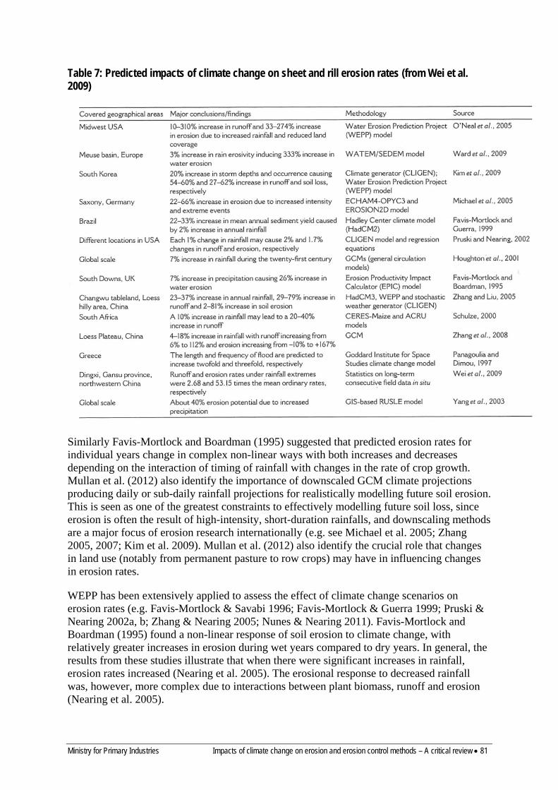
Ministry for Primary Industries Impacts of climate change on erosion and erosion control methods – A critical review • 81
Table 7: Predicted impacts of climate change on sheet and rill erosion rates (from Wei et al. 2009)
Similarly Favis-Mortlock and Boardman (1995) suggested that predicted erosion rates for individual years change in complex non-linear ways with both increases and decreases depending on the interaction of timing of rainfall with changes in the rate of crop growth. Mullan et al. (2012) also identify the importance of downscaled GCM climate projections producing daily or sub-daily rainfall projections for realistically modelling future soil erosion. This is seen as one of the greatest constraints to effectively modelling future soil loss, since erosion is often the result of high-intensity, short-duration rainfalls, and downscaling methods are a major focus of erosion research internationally (e.g. see Michael et al. 2005; Zhang 2005, 2007; Kim et al. 2009). Mullan et al. (2012) also identify the crucial role that changes in land use (notably from permanent pasture to row crops) may have in influencing changes in erosion rates.
WEPP has been extensively applied to assess the effect of climate change scenarios on erosion rates (e.g. Favis-Mortlock & Savabi 1996; Favis-Mortlock & Guerra 1999; Pruski & Nearing 2002a, b; Zhang & Nearing 2005; Nunes & Nearing 2011). Favis-Mortlock and Boardman (1995) found a non-linear response of soil erosion to climate change, with relatively greater increases in erosion during wet years compared to dry years. In general, the results from these studies illustrate that when there were significant increases in rainfall, erosion rates increased (Nearing et al. 2005). The erosional response to decreased rainfall was, however, more complex due to interactions between plant biomass, runoff and erosion (Nearing et al. 2005).
82 • Impacts of climate change on erosion and erosion control methods – A critical review Ministry for Primary Industries
There are several studies that have used SWAT to assess the impact of various climate change scenarios on water resources (e.g. Jha et al. 2004, 2006, Wang et al. 2008), and erosion (Nearing et al. 2005, Chaplot 2007, Nunes et al. 2008). Using SWAT, Nearing et al. (2005) investigated the erosional response to changing rates and duration of rainfall that might be expected as a result of different climate change scenarios. Unsurprisingly, they found that erosion rates increased with increases in both rainfall amount and intensity, although the changes in erosion rates were most sensitive to increasing rainfall intensities. Chaplot (2007) used SWAT to model impacts of two climate change scenarios in humid and semi-arid catchments in the USA. The results suggested that in the humid catchment a rainfall increase of 40% led to a 157% increase in sediment yield. By contrast in the semi-arid catchment soil ersoion decreased under the same rainfall increase as vegetation cover improved. Nunes et al. (2008) used SWAT to model impacts of two climate change scenarios in humid and semi-arid catchments under a variety of land uses in Portugal. The results pointed to strong interactions between climate change, land cover and erosion rates.
There are numerous studies that have used EPIC to assess the impact of various climate change scenarios (e.g. Williams 1990; Favis-Mortlock & Boardman 1995; Lee et al. 1996). The crop growth component has been modified to account for the effects of rising CO2 (Easterling et al. 1992).
SHETRAN has been used for exploring the effects of different climate change scenarios on stream flow and sediment transport. Lukey et al. (2000) and Bathurst et al. (2004) argue on the basis of successful calibration/validation and the physically-based nature of the model that SHETRAN is suitable for assessing the effects of climate change on erosion although there is a clear need to reduce the uncertainty in model parameter evaluation. Parkin et al. (1996) (see Ewen et al. (2000) for a summary) applied SHETRAN to a small catchment in Portugal to investigate the effect of climate change under doubled CO2 levels. Long-term (40-year) rainfall and potential evapotranspiration time-series were obtained from a GCM and were then disaggregated from 12-hour to hourly time-steps. It was found that runoff and erosion decreased under the doubled-CO2 scenario (erosion decreased by about 28–40%), although there was more variability under climate change. These studies did not incorporate modelling of landslide erosion.
Nearing et al. (2005) and Nunes and Nearing (2011) provide comparisons of the range of models that have been used to predict climate change impacts primarily on sheet and rill erosion. When applied to the same data and climate change scenarios, erosion models can produce a wide range of results, although the direction of change tends to be consistent (Nearing et al. 2005). They conclude:
• The relative changes predicted by models are more reliable than the absolute changes • There remains a high degree of uncertainty in downscaled climate change predictions,
particularly for rainfall intensity • Links between rainfall and temperature changes, runoff, canopy and ground cover and
erosion are complex and non-linear. Few studies have assessed the effect of climate change on gully erosion (Poesen et al. 2003) and overseas studies deal with classical fluvially-driven gully erosion rather than the complex mass movement gully erosion typical of New Zealand conditions. Fluvially-driven gully erosion develops where runoff exceeds the threshold force required for channel initiation. Increases in runoff as a result of climate change have the potential to increase gully erosion rates. Poesen et al. (2003) suggest there are no reliable models for predicting the impacts of climate change on gully erosion despite its importance as a sediment source.
Ministry for Primary Industries Impacts of climate change on erosion and erosion control methods – A critical review • 83
Similarly relatively few studies have addressed the impact of climate change on landslide erosion rates. Buma and Dehn (1998) describe a method for predicting climate change impacts on landsliding:
• Downscaled GCM rainfall estimates are used to predict rainfall • A hydrological model is used to derive time series of groundwater levels or pore water
pressure • This provides input to factor-of-safety analysis to predict slope instability
They also note that different types of landslides respond to different climatic triggers such as event rainfall (debris flows) or seasonal effective precipitation (deep-seated episodic landslides). They apply the methodology to a small rockslide in France and identify a series of problems with the methodology, including the accuracy of the downscaling procedure (using monthly rainfall time-series) and the hillslope hydrology model.
A similar approach is used by Collison et al. (2000) to predict the impact of climate change on movement of a large rotational slump, with downscaled GCM rainfall estimates used to predict daily rainfall and a DEM-based model to distribute the mean water table across the topography. The results suggested climate change is not likely to alter the frequency of large-scale slope instability because increases in rainfall would be more than matched by increases in evapotranspiration. Dehn et al. (2000) apply a similar approach to a mudslide in Italy and also suggest reduced landslide activity because climate change was predicted to lower groundwater levels in the spring. Malet et al. (2007) note how climate acts as a complex influence on the magnitude and frequency of landslides via the non-linear soil water system They simulate the effect of climate change on landslide frequency for two types of landslides (a clay-rich flow-like mudslide and a rotational slump) with simple process-based models of slope hydrology and slope stability and climate scenarios derived from downscaled GCMs (see Figure 27). The results suggested a reduction in slope instability for rotational slumps due to an increase in evapotranspiration and decrease in soil moisture, and little change for mudslides. This type of approach has mostly been applied to individual landslides and Malet et al. (2007) point to the need to combine local and regional-scale analyses. Melchiorre and Frattini (2011) combine a hydology – slope stability model with regional climate projections to assess how climate change may impact on the probability of rainfall-induced shallow landslides. They suggest that uncertainties in predicted extreme precipitation events, soil parameters and antecedent precipitation do not allow accurate estimation of changes in slope stability conditions.
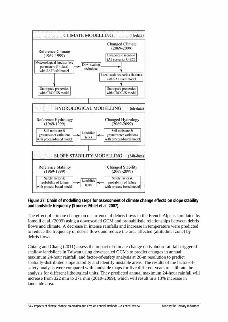
84 • Impacts of climate change on erosion and erosion control methods – A critical review Ministry for Primary Industries
Figure 27: Chain of modelling steps for assessment of climate change effects on slope stability and landslide frequency (Source: Malet et al. 2007).
The effect of climate change on occurrence of debris flows in the French Alps is simulated by Jomelli et al. (2009) using a downscaled GCM and probabilistic relationships between debris flows and climate. A decrease in intense rainfalls and increase in temperature were predicted to reduce the frequency of debris flows and reduce the area affected (altitudinal zone) by debris flows.
Chiang and Chang (2011) assess the impact of climate change on typhoon-rainfall-triggered shallow landslides in Taiwan using downscaled GCMs to predict changes in annual maximum 24-hour rainfall, and factor-of-safety analysis at 20-m resolution to predict spatially-distributed slope stability and identify unstable areas. The results of the factor-of-safety analysis were compared with landslide maps for five different years to calibrate the analysis for different lithological units. They predicted annual maximum 24-hour rainfall will increase from 322 mm to 371 mm (2010–2099), which will result in a 13% increase in landslide area.
Ministry for Primary Industries Impacts of climate change on erosion and erosion control methods – A critical review • 85
An approach to predicting the effect of climate change on rainfall-induced shallow landsliding and sediment yield in Japan is described by Ono et al. (2011). It uses:
• A probabilistic model of the relationship between slope failure and triggering factors (incorporating hydraulic gradient, infiltration, extreme rainfall amount and return period, topography, geology as described by Kawagoe et al. (2010)
• A regression relationship between slope failure probability and sediment yield • Application of these relationships with two downscaled GCM scenarios for future climate
(2031–2050 and 2065–2095)
The results suggested c.17–18% mean increase in sediment yield in the first half of the 21st century, but with considerable spatial variation within Japan (e.g. five rivers were predicted to have >90% increase in sediment yield) allowing targeting of erosion and sedimentation hazard.
Schmidt and Dehn (2000) apply downscaled GCM outputs to predict future landslide activity in parts of Italy and New Zealand. In the Italian example the impact on a slow-moving mudflow is assessed by using climate projections to model groundwater levels and predict instability in the mudflow. In this case rainfall changed little compared with temperature increase, resulting in a decrease in landslide activity. The New Zealand example used downscaled GCM projections with the daily rainfall probabilistic landslide model of Glade (1997) to assess future landslide activity in the Wellington Region. Lower landsliding activity was predicted due to decreased rainfall in the winter.
There have been attempts to identify the impact of recent climate change on landslide characteristics such as the size-frequency distribution. Schlögel et al. (2011) map landslides at five different times (1962 to 2007) in the Kyrgyztan mountains and demonstrate a power law function between landslide number and size. Size-frequency analysis applied to the five landslide inventories showed the number and size of landslides increased from 1962 to 2007 and the power-law exponent decreased. Korup et al. (2012) use Monte Carlo and bootstrap simulations of statistical models used to characterise empirical landslide size distributions. They show that small errors in model parameters of the size (volume)-frequency relationship may produce large errors in total landslide volumes in landslide inventories. To reliably assess the effect of climate change on size-frequency distribution, landslide inventories need to explicitly determine error limits during mapping and statistical extrapolation.
Several studies have modelled climate change impacts on fine and coarse sediment transport. Thodsen et al. (2008) looked at the impacts of combined land-use and climate change scenarios on suspended sediment transport in two Danish rivers, using sediment rating curves adjusted for rainfall, runoff and season (to take into account vegetation cover inside the catchment). They found that a warmer and rainier scenario led to increases of 9% to 27% for the 2080s, mostly due to increased river flow in winter with greater sediment transport capacity; the longer growing season for annual crops had a minor impact on these predictions. Istanbulluoglu and Bras (2006) applied a river sediment dynamics model with a stochastic model linking rainfall amount and frequency, soil moisture and within-catchment vegetation dynamics to study the relationship between climate, vegetation cover and sediment transport. The results indicate that soil erosion is not only dependent upon changes to mean annual rainfall, but also that an increase in sediment transport can be expected under lower storm frequency, especially in humid catchments, even with lower rainfalls. Lane et al. (2007) coupled GCM predictions with models of flood hydrology, sediment transport and

86 • Impacts of climate change on erosion and erosion control methods – A critical review Ministry for Primary Industries
floodplain inundation to study the feedback between climate change and flood frequency and sedimentation in a British River. The results indicate that in-channel sedimentation increases the sensitivity of flood inundation to climate change, and measures to prevent streambank erosion might aggravate this problem as the river would require enlargement to compensate for the rising channel bed.
KEY FINDINGS –INTERNATIONAL STUDIES 1. Numerous model-based studies have investigated the effect of climate change on sheet and rill erosion processes
using models such as WEPP, SWAT and SHETRAN. These suggest the major direct effects are likely to be changes in rainfall erosivity, runoff, vegetation cover, and soil erodibility with the greatest impact from rainfall amounts and increased rainfall extremes. There are also likely to be indirect effects from changes in plant species, plant litter and soil organic matter decomposition, and land use patterns. Results suggest where rainfall increases, erosion can be expected to increase, but where rainfall decreases, the effect may be more complex depending on interactions between plant biomass, runoff and erosion.
2. These studies suggest a) The ability of downscaled GCM climate projections to produce daily or sub-daily rainfall projections is critical
for realistically modelling future soil erosion b) The relative changes predicted by models are more reliable than the absolute changes c) Links between rainfall and temperature changes, runoff, canopy and ground cover – and erosion – are
complex and non-linear 3. There are no reliable models for predicting the impacts of climate change on gully erosion and none of the
available models simulate complex mass-moment gully erosion typical of New Zealand. 4. The impact of climate change on landslide erosion rates typically uses downscaled GCM rainfall estimates to
predict rainfall, a hydrological model to derive time series of groundwater levels or pore water pressure, and factor-of-safety analysis to predict slope instability. Different types of landslides respond to different climatic triggers, including event rainfall (debris flows) or seasonal effective precipitation (deep -seated episodic landslides), and for many landslides the effect of climate change depends on the balance between rainfall change and increased evapotranspiration with temperature warming. Most studies have been at local scale and on deep slumps and mudslides.
5. The few studies of climate change impacts on shallow landslides have used both factor-of-safety analysis approaches and probabilistic approaches. There have also been studies to identify the impact of recent climate change on landslide characteristics such as the size–frequency distribution. Several suggest that uncertainties in predicted extreme precipitation events, soil parameters, and antecedent precipitation confound accurate estimation of changes in slope stability conditions with climate change.
Ministry for Primary Industries Impacts of climate change on erosion and erosion control methods – A critical review • 87
11 Biological erosion control in New Zealand A large range of vegetation types and species have been used to control a diversity of erosion processes throughout New Zealand. These cover the continuum of herbaceous, shrub and tree species and comprise mainly exotic species, but also include indigenous species. There are numerous recent publications on the use of species in erosion control programmes, their effectiveness in reducing the occurrence and severity of erosion processes, and establishment and management of different species (Lambrechtsen 1986a; Pollock 1986; van Kraayenoord & Hathaway 1986a, b; Hawley & Dymond 1988; Phillips et al. 1990, 2008, 2011; Hawley 1991; Hicks 1991a, b, 1995b; Marden & Rowan 1993; Quilter et al. 1993; Thompson & Luckman 1993; Bergin et al. 1995; Douglas et al. 1998, 2006a, b, 2010, 2011; Anthony 2001; Hicks & Anthony 2001; Hicks & Crippen 2004; Marden 2004; Phillips & Marden 2005; McIvor et al. 2007, 2008, 2009, 2011a, b; Basher et al. 2008; Davis et al. 2009; Marden & Phillips 2011). Space-planted poplars and willows have been the most widely used soil conservation plants in New Zealand since they can be established as poles in the presence of grazing animals, and are appropriate for the control of landslide, earthflow and gully erosion. These species have also been widely used for control of bank erosion. This section provides a summary of the key species used for erosion control in New Zealand. Relevant, recent international literature is used to a limited extent to supplement New Zealand studies and experiences in this and the following section.
11.1 HERBACEOUS SPECIES Surface erosion (sheet, wind and rilling) can be prevented or reduced through establishing and maintaining a persistent, healthy, complete ground cover. The effectiveness of the cover depends on both above- and below-ground plant components (Hicks 1995b; Quinton et al. 1997; Hicks & Anthony 2001; De Baets et al. 2006, 2007a, b; Durán Zuazo & Rodríguez Pleguezuelo 2008; Comino et al. 2010; Dlamini et al. 2011; Ghahramani et al. 2011). Herbaceous species used for erosion control are often recognised as important forages for livestock, and in a number of erosion-prone farmland situations, there must be a balance between providing ground protection for fragile soils, and adequate quantity and quality of forage. The relative importance of these two roles varies with the characteristics of the target site, e.g. topography, climate, erosion type and severity, enterprise mix (stock type, age, stocking intensity). An effective herbaceous ground cover can be established and maintained using cultivars of grasses, legumes and herbs that are persistent and adapted to drought, wet, and cold conditions; strategic grazing management in spring to maintain a short, leafy pasture; use of fertiliser to maintain sward vigour and growth; adequate subdivision to enable appropriate grazing management; and improved stock-grazing practices such as de-stocking at particular times of the year (Charlton & Belgrave 1992; Moloney et al. 1993; Hicks 1995b; Kemp et al. 1999; Matthews et al. 1999; Power et al. 2006). Cover of unimproved pasture swards can also be maintained using some of the management options recommended for improved pastures, but pasture growth responses are not generally as large as when applied to swards comprising improved pasture cultivars. Whether exotic or indigenous species are present, overgrazing of species on erosion-susceptible land should be avoided to increase the chance of maintaining an effective ground cover, even a cover of short stature.
There are numerous grass, legume and herb species that have been used for erosion control, including the grasses Lolium perenne (perennial ryegrass), Dactylis glomerata (cocksfoot), Phalaris aquatica (phalaris), Bromus willdenowii (prairie grass), Holcus lanatus (Yorkshire fog), Thinopyrum spp. (wheatgrasses), and Festuca arundinacea (tall fescue); the legumes Trifolium repens (white clover), T. pratense (red clover), Lotus spp. (L. corniculatus,
88 • Impacts of climate change on erosion and erosion control methods – A critical review Ministry for Primary Industries
L. tenuis, L. uliginosus), Medicago sativa (lucerne), and Trifolium subterraneum (subterranean clover); and the herbs Plantago lanceolata (plantain), Sanguisorba minor (sheep’s burnet), and Cichorium intybus (chicory) (Scott et al. 1985; Lambrechtsen 1986a, b; Sheppard & Hathaway 1986; Wills 1986a, b; Wills et al. 1987, 1998; Douglas et al. 1996, 1998; Avery et al. 2008). For a number of these species, various cultivars are available (Kemp et al. 1999; Charlton & Stewart 2006; Williams et al. 2007) such as 19 cultivars of Lolium perenne, 14 cultivars of Trifolium repens, six cultivars of Medicago sativa, and four cultivars of Cichorium intybus (Charlton & Stewart 2006). However, a number of these have been developed for moderately to highly fertile, intensively farmed lowland sites, and do not often grow and survive as well under harsher environmental and less stringent management conditions such as those occurring on much of the erosion-prone hill country. Nevertheless, the benefits of pasture improvement (oversowing and fertilisation) in hill country for facilitating and maintaining a dense pasture cover and consequently reducing surface erosion are significant. For example, in a review of on-farm erosion control methods (Hicks 1995b), improved pastures reduced surface erosion by 50–80% compared with levels on land covered with unimproved pasture, and improved pastures in combination with more subdivision and better grazing enabled a 2–4-fold increase in stock carrying capacity. Failure to adequately control surface erosion can lead to more severe erosion types, e.g. rilling progressing to channel and gully formation and associated erosion.
11.2 SHRUB SPECIES Reducing erosion on farmland through the use of exotic and indigenous woody shrubs has received limited attention in New Zealand, largely being confined to semi-arid and drought-prone areas for protection against wind and sheet erosion, and waterways for reducing streambank erosion (Anthony 2001; Douglas et al. 1998; Phillips et al. 2011; Pollock 1986; Sheppard & Bulloch 1986a, b; Sheppard & Douglas 1986; Wills 1986a, b; Wills & Begg 1992; Wills et al. 1987, 1989a, 1990, 1999). Exotic species evaluated or used include Atriplex halimus (Mediterranean saltbush), Chamaecytisus palmensis (tagasaste), Dorycnium spp. (canary clovers), Kochia prostrata (prostrate blue bush), Medicago arborea (tree medick), and Melilotus officinalis (yellow sweet clover). Indigenous species such as Cordyline australis (cabbage tree) and Leptospermum scoparium (mānuka) are common on some lowland and hill country pastoral land, and they have a potentially important role in ground stabilisation (Pollock 1986; Bergin et al. 1995; Stephens et al. 2005). However, they are rarely introduced to sites grazed by livestock because protection of nursery-prepared seedlings is normally too costly. There is the potential to introduce species by direct-seeding into pastoral land, but establishment success has mostly been low (Dodd & Power 2007; Douglas et al. 2007; Davis et al. 2009).
The significant role of shrubs in reducing soil loss and runoff has been shown overseas, such as in the Mediterranean region, Australia, Africa and North America, where it has been found that the vegetation is very efficient in reducing erosion by water and wind (Bochet et al. 2006; Collard & Fisher 2010; Garcia-Estringana et al. 2011; Leenders et al. 2011; Muñoz-Robles et al. 2011; Munson et al. 2011; Nunes et al. 2011; Romero-Díaz et al. 1999). The extent of this reduction varies with factors such as plant morphology (species, architecture), spatial arrangement of plants and spacing, underlying plant litter, and rainfall and wind intensity and duration. These findings and understandings are applicable to the use and function of shrubs in New Zealand, particularly in semi-arid and drought-prone areas, but the environmental impacts of shrubs under New Zealand conditions have not been quantified.
Ministry for Primary Industries Impacts of climate change on erosion and erosion control methods – A critical review • 89
11.3 SPACED TREES ON PASTURE Trees are introduced at various spacings into pasture to reduce the occurrence and impact of mass movement (landsliding, slumping, and earthflow) and gully erosion on pasture production and consequent livestock carrying capacity. The resulting tree–pasture systems – known variously as two-tier systems, agroforestry systems, and silvopastoral systems, depending mainly on the extent of individual tree management (pruning) – have been used widely in many pastoral hill country areas of New Zealand (Gillingham 1984; Percival & Hawke 1985; Hawke 1991; Knowles 1991; Mead 1995; Miller et al. 1996; Wall et al. 1997; Power et al. 1999, 2001; Guevara-Escobar et al. 2000, 2002, 2007; Douglas et al. 2001, 2006a, b, 2010, 2011; McIvor et al. 2005a, b, 2008, 2009, 2011a, b; Phillips et al. 2008). Trees are planted either at strategic positions on a slope (e.g. those with maximum potential for erosion) or in a systematic planting grid across the slope. Species used in tree–pasture systems include those of the genera Acacia, Eucalyptus, Pinus, Populus, and Salix. Populus and Salix species are often preferred where erosion is mediated by surplus soil water and grazing livestock (sheep) during tree establishment is feasible (Wilkinson 1999; McIvor et al. 2011a). Some Acacia spp. and Eucalyptus spp. are recommended for use on seasonally drought-prone sites (Hathaway & King 1986; Hathaway & Sheppard 1986; Sheppard & Bulloch 1986c; Bulloch 1991) such as those on upper slopes with northerly aspect, where Populus spp. and Salix spp. can fail to establish or survive.
Tree–pasture systems involving Pinus radiata originated as a component of forestry management in the late 1960s to early 1970s and aimed to derive dual benefits of timber production at maturity and meat/wool income in at least the early and intermediate years of the tree rotation (Hawke 1991; Benavides et al. 2009). The system was also deemed to be useful for erosion control, though there seem to be no specific detailed studies of the erosion benefits of systems involving spaced P. radiata. In South Otago, P. radiata at 155 stems per ha (sph) was harvested and it was concluded that there was a lack of volume of logs from such a system compared with trees grown in plantation at 320 sph and that ‘you cannot, it seems, have it both ways’ (Jones & Cullen 2008). There are probably few examples of tree–pasture systems involving P. radiata. It is predicted that this trend will continue, partly because the tree’s evergreen, dense canopy dramatically reduces pasture understorey yield and quality, and the species, like most other tree species, needs to be planted as seedlings and grazing stock excluded during the early stages of tree establishment.
An emerging problem with tree–pasture systems where the trees have not been managed (e.g. many plantings of Populus and Salix spp.) is the size of large trees and their potential to topple or succumb to branch breakage as they age or are damaged during severe storms. Large trees can be a liability to livestock, farm infrastructure (buildings, fences, tracks), and even farmers, and it is now recommended that trees be managed over their lifetime to avoid potential problems (National Poplar and Willow Users Group 2007; McIvor et al. 2011a).
Root growth and strength of P. radiata have been determined in several studies to estimate the species’ likely contribution to hillslope stability (Watson & O’Loughlin 1990; Ekanayake et al. 1998; Watson et al. 1999), and comparisons have been conducted with other species, including Populus spp., because of their suitability for similar erosion control functions (Knowles 2006). The maximum tensile strength of live roots of P. radiata (mean diameter 5.3 mm, range 1.3–13.9 mm) averaged 17.6 MPa (Watson et al. 1999) and 19 MPa has been used as a general estimate (Knowles 2006). In contrast, roots of Populus spp. (4–8 mm diameter) have an estimated tensile strength of 23.3–48.6 MPa (Hathaway & Penny 1975) and mean tensile strength of ‘Veronese’ poplar growing on slopes in the southern North

90 • Impacts of climate change on erosion and erosion control methods – A critical review Ministry for Primary Industries
Island was 90.8 MPa for roots < 1 mm diameter, 56.9 MPa for roots 1–2 mm diameter, 40.1 MPa for roots 2–3 mm diameter and 19.0–24.3 MPa for roots 3–9 mm diameter (McIvor et al. 2011a). The results indicate that roots of Populus spp. have higher tensile strength than those of P. radiata, although this attribute is probably less important to slope intactness than root distribution and the interactions between the roots of neighbouring trees across a slope.
Roots of Populus spp. have the capacity for extensive lateral spread with roots > 2 mm diameter extending more than 12 m from the trunk of trees aged 9.5 and 11.5 years (McIvor et al. 2008, 2009), and roots of older trees can extend beyond 20 m. Comparable distribution data for wide-spaced trees of P. radiata are lacking, with almost all work having been conducted with trees growing in more densely planted plantation forests (Phillips et al. 1990; Watson et al. 1999). The biomass of the root system of P. radiata exceeds that for Populus spp. at a specific diameter at breast height (dbh, 1.4 m above ground on upslope side of trunk) and the difference increases with age (Knowles 2006). For example, a graph presented by Knowles (2006) showed that at a dbh of 30 cm, the root biomass of P. radiata was 150 kg compared with 60 kg for Populus spp. In an effort to estimate the likely soil binding ability of each species, Knowles (2006) multiplied root tensile strength by root biomass, which gave similar values for each species at dbh up to 50 cm. One of the factors unaccounted for in these calculations is the difference between the species in root distribution, particularly lateral spread.
Spaced trees are effective in reducing the occurrence of shallow landslides (soil slips) on pasture-covered slopes. For example, individual trees of Populus spp. aged 14–17 years in a 20 × 20 m grid reduced the area of shallow landslides following a severe storm by 13.8% compared with an adjacent hillside without trees (Hawley & Dymond 1988). Mature trees of Populus and Salix spp. and other broadleaved species on slopes at spacings of 12 m (70 sph) or less reduced the area of shallow landslides in pastoral hill country by 50–80% compared with unstable slopes without trees (Hicks 1992, 1995b). Spaced trees of mostly Populus spp. reduced the occurrence of shallow landslides by 95% compared with adjacent sites without trees, and of 65 paired tree–pasture sites, landslides occurred on 10 sites with trees and 45 sites with pasture (Douglas et al. 2011). The intermeshing of roots from adjacent trees, as influenced by species, tree density (spacing), position on slope and tree size/age are important factors determining the effectiveness of plantings (Hawley 1988; Hawley & Dymond 1988; Hicks 1992, 1995b; Thompson & Luckman 1993; Basher et al. 2008; Douglas et al. 2010, 2011). Ideally trees should be planted on sites with the most potential for landsliding rather than repairing eroded sites. Planting specifications and effectiveness for controlling other erosion types, e.g. gully erosion, have been determined (Thompson & Luckman 1993).
11.3.1 Populus (poplar) Species and hybrids of the genus Populus (grouped together with willows in the family Salicaceae) are rapid-growing, deciduous trees of considerable economic and soil conservation importance. Historically poplars and willows were introduced as they were the only trees that could be planted (as poles) in the presence of grazing animals. Poplars (and willows) largely occur naturally on river banks and marshy areas and the fastest-growing, and most profitable, plantations have been established in these sites (http://www.fao.org/forestry/ipc/69994/en/). Their natural ecological zones are mostly in the temperate climates (Figure 28). Internationally, hybridisation and selection have resulted in many new poplar clones superior in form, disease resistance, timber production, and for remediation applications.
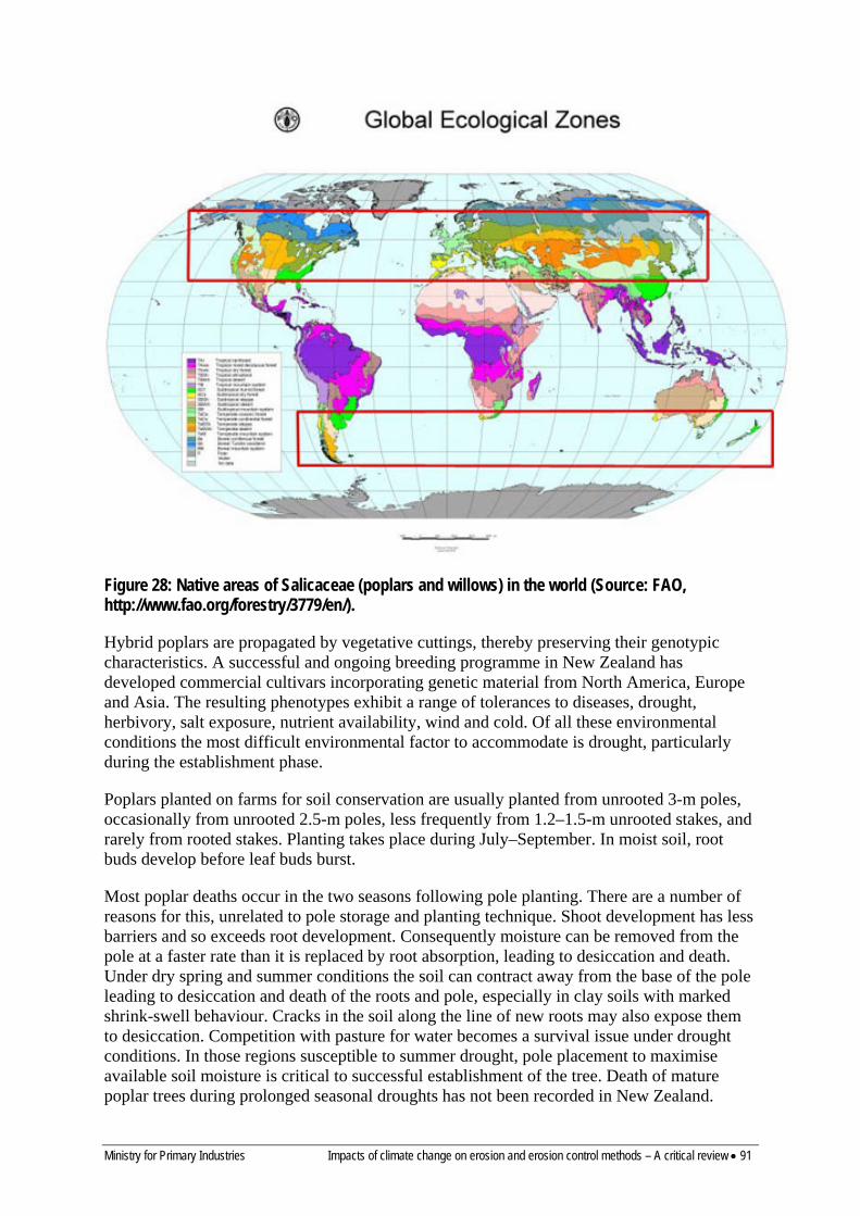
Ministry for Primary Industries Impacts of climate change on erosion and erosion control methods – A critical review • 91
Figure 28: Native areas of Salicaceae (poplars and willows) in the world (Source: FAO, http://www.fao.org/forestry/3779/en/).
Hybrid poplars are propagated by vegetative cuttings, thereby preserving their genotypic characteristics. A successful and ongoing breeding programme in New Zealand has developed commercial cultivars incorporating genetic material from North America, Europe and Asia. The resulting phenotypes exhibit a range of tolerances to diseases, drought, herbivory, salt exposure, nutrient availability, wind and cold. Of all these environmental conditions the most difficult environmental factor to accommodate is drought, particularly during the establishment phase.
Poplars planted on farms for soil conservation are usually planted from unrooted 3-m poles, occasionally from unrooted 2.5-m poles, less frequently from 1.2–1.5-m unrooted stakes, and rarely from rooted stakes. Planting takes place during July–September. In moist soil, root buds develop before leaf buds burst.
Most poplar deaths occur in the two seasons following pole planting. There are a number of reasons for this, unrelated to pole storage and planting technique. Shoot development has less barriers and so exceeds root development. Consequently moisture can be removed from the pole at a faster rate than it is replaced by root absorption, leading to desiccation and death. Under dry spring and summer conditions the soil can contract away from the base of the pole leading to desiccation and death of the roots and pole, especially in clay soils with marked shrink-swell behaviour. Cracks in the soil along the line of new roots may also expose them to desiccation. Competition with pasture for water becomes a survival issue under drought conditions. In those regions susceptible to summer drought, pole placement to maximise available soil moisture is critical to successful establishment of the tree. Death of mature poplar trees during prolonged seasonal droughts has not been recorded in New Zealand.
92 • Impacts of climate change on erosion and erosion control methods – A critical review Ministry for Primary Industries
Under the current climate scenario pole survival in years with normal spring and summer rainfall often exceeds 90%, and in years of prolonged drought can be as low as 10%.
11.3.2 Salix (willow) Tree willow species (Salix spp.) are used for soil conservation in pastoral land in New Zealand. Shrub and osier willows are used for gully plantings and fodder blocks and for non-pastoral sites. There are differences in the biology of tree willow species and other commercially used species. Tree species grow into large trees, up to 20 m high, nearly always with a single trunk (sometimes only short) which can be 60–90 cm in diameter. Most tree willow hybridise with each other but not with other willow species. Examples are Salix matsudana, S. alba and the hybrid series S. matsudana ×alba (e.g. ‘Tangoio’).The osier willows are medium-sized shrubs forming several stems up to 20 cm in diameter. The most common osier in New Zealand is S. viminalis. Osiers and other shrub willows have shallower root systems than tree willows. In a pot experiment comparing two tree willows and two osier willows, the tree willows allocated a greater biomass to stem and root than osier willows and under prolonged water stress had a higher survival rate (McIvor et al. 2005b).
Almost all international willow research is focused on fields directly affecting biomass production and bioenergy applications, for which osier willows are used. As a consequence most findings reported in peer-reviewed journals are of non-tree willow cultivars, and findings may be inappropriate when applied to tree willows.
Tree willows are planted as poles in the same way as poplars, and at the same time of year. Willows become physiologically active much earlier than poplars, producing the first leaves and flowers as early as mid-August. Root activity increases at the same time, notably an increase in fine root length density (McIvor, unpublished). This earlier initiation of new roots and shoots when compared with poplars gives willow poles a head start over poplar poles and aids their survival in the first two years, both in drought and in locations where soil water storage is lower, e.g. upper slopes.
11.3.3 Eucalyptus Eucalyptus spp. are rarely used as spaced soil conservation trees on pastoral hillslopes. They do not establish from cuttings and have to be planted as seedlings (Van Kraayenoord & Hathaway 1986b). Cloned eucalyptus trees are not available in New Zealand so the performance of the material cannot be known before planting. They have been successfully established from seedlings on upper slopes where it is more difficult to establish poplars and willows but planting and early protection is labour-intensive and expensive compared with poplars and willows (Van Kraayenoord & Hathaway 1986b). Eucalyptus spp. are not deciduous so the reduction in pasture production under Eucalyptus spp. is very much more severe. There are allelopathic effects also (Molina et al. 1991; Sasikumar et al. 2001; Khan et al. 2008). For these reasons this genus is rarely planted or promoted for soil conservation in pastoral hill country.
11.3.4 Pests and diseases affecting conservation trees and present in New Zealand The most significant poplar diseases in New Zealand are caused by the poplar leaf rust Melampsora larici-populina and the leaf spot or anthracnose fungus Marssonina brunnea. Both of these leaf diseases thrive in our cool, moist environments and cause early defoliation, reduced root and stem growth, and dieback in susceptible cultivars. Two other leaf disease fungi, Marssonina castagnei, which affects white poplars (especially the widespread female silver poplar cultivar), and Melampsora medusae, an American poplar rust that is well

Ministry for Primary Industries Impacts of climate change on erosion and erosion control methods – A critical review • 93
established in Australia, can cause minor problems. Incorporating resistance to all four diseases has been included as an objective in the Plant & Food Research and New Zealand Poplar and Willow Research Trust poplar breeding programme. A sound coverage of fungal diseases and insect pests can be found at http://www.nzffa.org.nz/farm-forestry-model/the-essentials/forest-health-pests-and-diseases/poplar. Melampsora rust is the most significant disease affecting tree willows.
Insect damage to poplars and willows is generally of minor importance in New Zealand currently, though the depredations of willow sawfly Nematus oligospilus during the period 1997–2004 on tree willows caused many tree deaths and seriously compromised riverbank protection in the eastern North Island.
Disease and pest organisms of Eucalyptus are much more numerous than those of the Salicaceace and are economically significant. Excellent coverage of current pests and diseases of Eucalyptus in New Zealand can be found at http://www.nzffa.org.nz/farm-forestry-model/the-essentials/forest-health-pests-and-diseases/Eucalyptus.
11.3.5 Fungal diseases and insect pests of poplars and willows in their countries of origin There are a vast array of pest and disease organisms that infect and affect poplars and willows worldwide. Some are mentioned here. Poplar borers are serious pests. The roundheaded borer is the larva of a long-horned beetle (Saperda calcarata) that primarily attacks aspen, but can also damage poplar, cottonwood and willow trees. Saperda calcarata is difficult to control because of its long life-cycle. Poplar-and-willow borer (Cryptorhynchus lapathi) affects many species of poplar as well as all species of willow. All species of poplars are affected by some sort of leaf-feeding caterpillar. Larvae feed on the buds or the leaves causing a lacy appearance. Infestations usually aren’t fatal, but several successive years of attack can weaken a tree enough to kill it. Canker and dieback on poplars is caused by several different fungi. Lombardy poplars are especially vulnerable. Dark sunken cankers form where the fungus enters a tree through wounds or cracks. These cankers can disrupt water and nutrient flow and, if they spread to more than half of the diameter of the trunk, will probably kill the tree.
A complete list of these potential pests and diseases of New Zealand poplars and willows can be found at http://foris.fao.org/static/pdf/ipc/damaging_poplar_insects_eBook.pdf.
11.4 FORESTRY SPECIES Hillslopes with mature and complete cover of exotic or indigenous forestry have the lowest occurrence of erosion and this appears largely independent of species (Phillips et al. 1990; Brown 1991; Hicks 1991b, 1995b; Marden & Rowan 1993; Hicks & Anthony 2001; Hicks & Crippen 2004). Surveys have found that forested slopes have about 90% less landsliding than slopes covered in pasture (Hicks 1991b, 1995b; Marden & Rowan 1993; Dymond et al. 2006). By far the major exotic species for afforestation for protection planting (e.g. of gullies), is Pinus radiata (Hicks & Anthony 2001). Other exotic tree species used at high density/close spacing for erosion control include Acacia spp., Alnus spp., Cupressus spp. Eucalyptus spp., Populus spp., Pseudotsuga menziesii and Salix spp. (Hathaway 1986; Hathaway & Sheppard 1986; van Kraayenoord & Hathaway 1986a, b; Hicks & Anthony 2001). The key considerations for erosion management in tree plantations focus on establishment and harvesting activities, where vegetation removal and mechanical earthworks temporarily increase soil movement and the risk of significant soil loss (Marden et al. 2005, 2006). The forestry industry and government agencies have therefore developed extensive

94 • Impacts of climate change on erosion and erosion control methods – A critical review Ministry for Primary Industries
guidelines (Vaughan 1984; Spiers 1987) and a code of practice (Vaughan et al. 1993; New Zealand Forest Owners Association 2007) to guide operational planning and maintain soil and water values through mitigation of erosion and sedimentation. These focus heavily on the practices that have been shown to contribute most to sediment generation, particularly management of roads, landings and stream crossings.
Stage of canopy development, age/size and density of vegetation mainly determine the effectiveness of forestry for controlling erosion. For example, on the East Cape after Cyclone Bola devastated the area in March 1988, land with indigenous forest (> 80 years, closed canopy, emergent broadleaved species including Weinmannia racemosa and Knightia excelsa) and exotic P. radiata forest aged greater than 8 years (closed canopy) had an average of less than 0.1 landslides/ha (Marden & Rowan 1993). This was less than for land supporting pasture and exotic forest less than 6 years old (negligible canopy cover), which had 0.5 landslides/ha or greater. Land with regenerating scrub comprising Leptospermum scoparium and/or Kunzea ericoides (closed canopy, 0.12 landslides ha–1) and exotic Pinus radiata forest (aged 6–8 years, 0.16 landslides ha–1) had intermediate landslide densities (Marden & Rowan 1993).
An East Coast study found a highly significant relationship between the age of mixed stands of Leptospermum scoparium / Kunzea ericoides (mānuka/kānuka) and the incidence of shallow landslides (Bergin et al. 1995). Relative to pasture, stands aged 10 years had 65% less landslides ha–1, 90% less at 20 years, and a near 100% reduction in landslide density in older stands. Over time, there was an increase in the proportion of the stands comprising Kunzea ericoides and it was suggested that this species has a more effective root system for soil stabilisation than that of younger stands with a dominance of Leptospermum scoparium (Bergin et al. 1995).
KEY FINDINGS –BIOLOGICAL EROSION CONTROL IN NZ 1. A range of vegetation types and species have been used to control a diversity of erosion processes throughout
New Zealand. These cover the continuum of herbaceous, shrub and tree species and comprise mainly exotic species, but also include indigenous species.Poplars and willows have been the dominant species used.
2. Numerous species that have been used for surface erosion control including grasses (perennial ryegrass, cocksfoot, phalaris, prairie grass, Yorkshire fog, wheatgrasses, and tall fescue), legumes (white, red and subterranean clover, Lotus spp., lucerne), and herbs (plantain, sheep’s burnet, and chicory). These plants also have an important role as forage plants for livestock and need to be managed for both erosion control and production purposes by avoiding overgrazing.
3. The use of exotic and indigenous woody shrubs for erosion control has received limited attention in New Zealand, largely being confined to semi-arid and drought-prone areas for protection against wind and sheet erosion, and along waterways for reducing streambank erosion. They are rarely introduced to sites grazed by livestock because protection of nursery-prepared seedlings is too costly.
4. Spaced tree–pasture systems have been widely used in erosion-prone pastoral hill country areas to manage landslide, gully and earthflow erosion. Willows are also used along waterways to reduce bank erosion.
5. The dominant species used are Populus and Salix spp., although tree–pasture systems involving Pinus radiata have also been used in the past to derive income from the wood at maturity. Eucalyptus and Acacia spp. have rarely been used. The functional behaviour of spaced-tree–pasture systems (root growth and strength) and their performance for erosion control have been evaluated in a number of studies and recommendations for planting density and tree management established, mainly for poplars and willows. Poplars and willows are affected by a number of diseases (poplar leaf rust and several fungal diseases) and pests (willow sawfly) that compromise their erosion control performance and require continuing breeding programmes.
6. A mature and closed-canopy cover of exotic or indigenous forest (including tall shrub) species provides the greatest erosion control benefit (e.g. forested slopes have about 90% less landsliding than pasture slopes) and this appears largely independent of species. The dominant exotic species for afforestation for protection planting is Pinus radiata. Stage of canopy development, age/size and density of trees determine the effectiveness of forestry for controlling erosion.
Ministry for Primary Industries Impacts of climate change on erosion and erosion control methods – A critical review • 95
12 Effect of climate change on establishment, growth, survival, & health of species used for biological erosion control
Warmer temperatures mean faster accumulation of growing degree-days, which can increase biomass production rates. In other cases warmer temperatures can limit biomass production because of excessive temperatures (Pruski & Nearing 2002a,b). Temperature also impacts microbial activity levels, and hence residue decomposition rates. The level of carbon dioxide in the air also has a direct impact on the amount of biomass produced by various crops via direct CO2 fertilisation effects (Stockle et al. 1992). Such biomass changes affect canopy and ground residue cover, which can indirectly affect erosion rates. Increased CO2 can also enhance stomatal resistance, suppress transpiration, and lead to a moister soil, conducive to greater runoff-induced erosion (Schulze 2000). Temperature can also influence evapotranspiration rates, which impact soil moisture, which in turn may influence infiltration and runoff amounts and rates (Pruski & Nearing 2002b).
This section reviews literature on the potential impact of climate change on selected plant species used for erosion control. Possible adjustments required to plant-based erosion control methods to adapt them to climate change predictions are outlined.
12.1 HERBACEOUS SPECIES
12.1.1 Establishment, growth, & survival The morphological, reproductive, physiological and yield responses of herbaceous species to key elements of climate change, including elevated concentrations of atmospheric CO2, rising temperatures, and altered precipitation and transpiration patterns, have been determined through experimentation (Crush 1994; Campbell 1996; Campbell & Hunt 2001; Craine & Reich 2001; Edwards et al. 2001a, b; Lilley et al. 2001; Crush & Rowarth 2007; Hovenden et al. 2007, 2008; Dodd et al. 2010; Perring et al. 2010; Rutting et al. 2010; Adair et al. 2011; Lee et al. 2011), surveys (Field & Forde 1990; Campbell et al. 1999), and modelling (Baars et al. 1990; Campbell et al. 1999; Zhang et al. 2007, 2009; Bryant & Snow 2008; Cullen et al. 2009; Soussana et al. 2010; Polley et al. 2011, Watt et al. 2011a). There have been recent reviews on some or all of these aspects (Pritchard et al. 1999; Soussana & Lüscher 2007; Tubiello et al. 2007; Rogers et al. 2009; Izaurralde et al. 2011; Jensen et al. 2011; Walck et al. 2011).
Most field studies have involved mixtures of herbaceous species in swards, either natural or introduced, but responses of monocultures or nearly pure areas of species have also been determined, e.g. for Trifolium subterraneum (Lilley et al. 2001), Phalaris aquatica (Lilley et al. 2001; Volder et al. 2007), Pascopyrum smithii (Hunt et al. 1996), Lolium perenne (Hebeisen et al. 1997; Ainsworth et al. 2003; Schneider et al. 2004), and Trifolium repens (Hebeisen et al. 1997). The responses to climate change factors of C3 and C4 herbaceous species, with their different photosynthetic pathways and mechanisms, have been compared in field experiments and controlled environments (Crush 1994; Greer et al. 1995; Hunt et al. 1996; Ghannoum & Conroy 1998; Lee et al. 2011; Morgan et al. 2001). Many studies have determined the above- and sometimes below-ground responses of herbaceous species to an individual key climate change factor, such as elevated CO2 concentration (Crush 1994; Edwards et al. 2001a, b; Morgan et al. 2001; Allard et al. 2004, 2006; Ross et al. 2004; Kammann et al. 2005; Barnard et al. 2006; Dijkstra et al. 2008; Rutting et al. 2010), while others have determined the plant responses to two or more factors simultaneously, for example, elevated CO2 concentration and warming (Hunt et al. 1996; Lilley et al. 2001;
96 • Impacts of climate change on erosion and erosion control methods – A critical review Ministry for Primary Industries
Hovenden et al. 2007; Volder et al. 2007). Some key findings are presented in the following subsections.
Germination, seedling emergence, & survival Seed germination has increased (Ziska & Bunce 1993), decreased (Popay & Roberts 1970), or not changed (St. Omer & Horvath 1983) under elevated CO2 concentration. In controlled environment chambers, the rate and final percentage of germination of seed of Medicago sativa increased when CO2 concentration increased from 350 to 700 ppm, and similarly for weed species Amaranthus hydridus and Chenopodium album (Ziska & Bunce 1993). For seven species, including some weed species, there was no significant interaction between temperature (20° and 30°C) and CO2 concentration (350 and 700 ppm) on germination response. In Rangitikei in the southern North Island, Edwards et al. (2001b) found that seed from plants of Trifolium repens grown under elevated (475 ppm) compared with ambient (360 ppm) CO2 concentration had higher germination and produced seedlings of higher mass, irrespective of post-sowing CO2 concentration. In contrast, they found that seed of the perennial herb Leontodon saxatilis gown under the same conditions had lower germination and seedling mass. Elevated CO2 during seed development had no significant effect on germination of Anthoxanthum odoratum, Cerastium glomeratum, Lolium perenne and Poa pratensis (Edwards et al. 2001b). At the same site, elevated CO2 increased seedling emergence and survival to at least 7 months in A. odoratum, Hypochaeris radicata, Leontodon saxatilis, L. perenne, P. pratensis, T. repens and T. subterraneum (Edwards et al. 2001a).
The essential role of temperature and moisture in seed germination, including the breaking of any dormancy, and subsequent seedling emergence, has been investigated widely (see reviews by Douglas et al. (2007), Donohue et al. (2010), Walck et al. (2011)), and early plant development stages can be expected to be more sensitive to climate change than mature stages. Seed dormancy due to a physiological-limiting mechanism is often overcome by an interaction between temperature and moisture over time, and physical dormancy can also be broken by variation in these environmental parameters (Fenner & Thompson 2005; Walck et al. 2011). Adjustments to temperature and soil water content through climate change have the potential to adjust the timing of dormancy break, the commencement and duration of germination and seedling emergence, and seedling survival. The temperature requirements for germination of seed of a range of herbaceous species used in New Zealand are highly variable (Hampton et al. 1987; Charlton et al. 1986; Charlton 1989; Charlton & Hampton 1989). In addition to showing differential sensitivity of species to altered temperature, their findings suggest the potential variation in seedling composition of sown mixtures likely to result under slight shifts in temperature, which has implications for subsequent sward composition and ground cover development.
In an Australian temperate grassland system, Hovenden et al. (2008) determined the effects of warming (+2oC) and elevated CO2 concentration (550 ppm) on seedling emergence, survival and establishment of annual and perennial species in a water-limited system (annual precipitation of 500 mm, high potential evaporation of 1250 mm year–1). Over 3 years, warming reduced total seedling emergence, seedling establishment, and seedling survival compared with unwarmed plots. However, there was a significant warming × year interaction for all seedling parameters, which was largely attributed to annual variation in rainfall and experimental treatment effects on soil water potential. Recruitment of annual species was reduced through the effect of warming alone, whereas that of perennials was strongly influenced by the effect of warming on soil water potential. Elevated CO2 did not
Ministry for Primary Industries Impacts of climate change on erosion and erosion control methods – A critical review • 97
significantly affect any seedling recruitment parameter, over 3 years, or in any year. Reductions in seedling emergence and survival due to warming have been found in a Mediterranean ecosystem (Lloret et al. 2004).
Plant growth Many studies have shown that elevated CO2 concentration increases photosynthesis, growth rate and biomass of herbaceous species. For example, in 11 C3 pasture species grown under three alternating temperature regimes, short-term (within minutes) increases in CO2 concentration increased photosynthetic rate by an average of 50–60% at 700 ppm compared with at 350 ppm, whereas two C4 species were unaffected by the changes in CO2 concentration (Greer et al. 1995). Over 4–8 weeks, rates of photosynthesis were 40–50% higher at 700 ppm CO2 concentration, with slight response by C4 species. Plant growth responses to elevated CO2 concentration increased strongly with increased temperature over the range 12/7°C to 28/23°C. Reviewed literature from 1980–1997 showed that C4 and C3 grasses (Poaceae) increased total biomass significantly under elevated CO2 concentration by 33% and 44%, respectively (Wand et al. 1999). Under controlled conditions, C3 and C4 Panicum grasses grown in pots failed to respond to CO2 enrichment in nitrogen-deficient soil (Ghannoum & Conroy 1998), and in other studies, relatively high growth stimulation occurred at elevated CO2 concentration under high (Bowler & Press 1996; Schneider et al. 2004) or limiting (Wong & Osmond 1991) nitrogen levels, or was not influenced by nitrogen status (Hocking & Meyer 1991). Reich et al. (2001) found growth and other responses to elevated CO2 concentration and soil N status for 16 grassland species and there was no interaction between CO2 concentration and soil N status. These findings have implications for establishing and maintaining ground cover on eroded soils such as those that have slipped, which are characterised by usually low organic matter content, low nutrient status, and low water holding capacity (Lambert et al. 1984; Rosser & Ross 2011).
On shortgrass steppe in Colorado, USA, elevated CO2 concentration (720 ppm) increased above-ground productivity of C3 and C4 grasses and forbs by up to 47% compared with growth at ambient CO2 concentration, and there was no interaction between CO2 concentration and defoliation during the growing season on growth responses (Morgan et al. 2001). In a semi-natural grassland ecosystem in Germany, under suboptimal N supply, a 20% increase in ambient CO2 concentration resulted in an annual increase in biomass of 9.8–11.2% over 3 years, which the authors regarded as surprisingly high (Kammann et al. 2005). They suggested that this might be because of a non-linear response to elevated CO2 concentration. In a Californian annual grassland, the complexity of interactions between CO2 concentration and other climate change factors was shown when net primary productivity was increased by factors such as warming and CO2 concentration when applied individually, whereas in factorial treatments, elevated CO2 concentration seemed to suppress the positive effects of the other factors (Shaw et al. 2002). Annual production of temperate (C3) species-dominant pastures in South Australia was predicted to increase by 24–29% under elevated (550 ppm) compared with ambient (380 ppm) CO2 concentration (Cullen et al. 2009). In a review of literature on responses of pasture and rangeland species to elevated CO2 concentration, and changed temperature and precipitation (Izaurralde et al. 2011), it was concluded that plants generally respond positively to elevated CO2 concentration in terms of biomass and yield, interactions between environmental factors are complex, and increasing temperatures and changed rainfall patterns may have positive or negative effects on plant productivity. The net effect of predicted future elevated CO2 concentration and warming on the balance between C3 and C4 plants remains uncertain (Tubiello et al. 2007). Findings reviewed by Polley et al. (2011) found that responses in above-ground biomass of grassland
98 • Impacts of climate change on erosion and erosion control methods – A critical review Ministry for Primary Industries
to experimentally elevated CO2 concentration were highly variable, ranging from a decrease, to no change, to a 95% increase depending mainly on site limitations such as drought and pool sizes and cycling rates of essential soil nutrients.
Under climate change scenarios expected around 2030 in New Zealand, pasture production in cooler and wetter sites in the South Island was estimated to increase by 50–80% in winter, 20–40% in spring and autumn, and be unchanged in summer, resulting in an annual production increase of about 20% (Baars et al. 1990). In contrast, on two warmer and drier sites in the North Island (East Coast and Waikato), the researchers predicted increases of 20–40% in autumn and winter, no change in spring, and slight depression in production in summer, giving an annual production increase of about 5%. In addition, the model predicted that future spring growth would commence 2–4 weeks earlier at all sites. If these predicted changes are realised, or at least trend in the directions indicated, current levels of effectiveness of herbaceous species in providing ground cover and reducing sediment loss are unlikely to be reduced, and even could be enhanced. An exception is the suggestion of slightly reduced pasture production in summer in warmer and drier sites in the North Island, which may result in reduced ground cover and increased susceptibility to erosion from wind and extreme weather events such as short, intense, cyclonic storms (Zuazo & Pleguezuelo 2008; Munson et al. 2011).
Reproductive development Elevated CO2 concentration, warming and changed precipitation patterns can increase, decrease or have no affect on the initiation of flowering, seed set, seed size and weight, and seed composition, depending on species and other factors (Curtis et al. 1994; Navas et al. 1997; Leishman et al. 1999; Edwards et al. 2001a, b; Hovenden et al. 2007, Thomas et al. 2009). For example, when CO2 concentration increased from 350 to 700 ppm, there were significant changes in time of fruit set (date of first harvest of mature fruits) in six of 18 grassland species in France (Navas et al. 1997). Under elevated CO2 concentration, those species with higher biomass tended to set fruit earlier and produce more fruits per plant, whereas those species with repressed biomass had delayed fruit set and fewer fruits per plant. Elevated CO2 concentration resulted in increased and decreased fruit number per plant in legumes and grasses, respectively. In a sheep-grazed pasture in Rangitikei, New Zealand, Edwards et al. (2001a) found that between-species variation in seed dispersal when CO2 concentration increased from 360 to 475 ppm was because some species such as Anthoxanthum odoratum and Trifolium repens produced more inflorescences per unit area and more seeds per inflorescence. In contrast, species such as Lolium perenne and T. subterraneum only produced more inflorescences per unit area. In crop plants, elevated temperatures (above ambient) have had negative effects on reproductive attributes, with the potential to nullify the beneficial effects of elevated CO2 concentration (Baker et al. 1989; Prasad et al. 2002, 2003; Thomas et al. 2009).
In Tasmania, Hovenden et al. (2007) determined the effect of elevated CO2 concentration and warming on flowering, seed production and seed mass in a temperate, nutrient-poor grassland. In most species, flowering and seed attributes were not significantly affected by the treatments or their interaction. Exceptions included increased seed mass in the grass Elymus scaber and decreased seed mass in the grass Austrodanthonia caespitosa and the forb Hypochaeris radicata in response to elevated CO2 concentration. An increase of 2°C resulted in a larger fraction of the population that flowered in perennial grasses. The authors concluded overall that CO2 enrichment and warming had negligible effect on seed production over the 3 years of their study.
Ministry for Primary Industries Impacts of climate change on erosion and erosion control methods – A critical review • 99
Once seed is shed it can germinate immediately if not hindered by dormancy, or contribute to the soil seed bank where it can germinate later when dormancy is overcome, or the seed dies before this happens. Climate change has the potential to alter the quantity and quality/vigour of seed entering the seed bank and its survival depending on factors such as plant form (e.g. grass vs legume), species, and availability, type and activity of insect pollinators, which impact subsequent re-establishment, sward composition and productivity. Annual species must produce viable seed within their annual life cycle to enable persistence, which is not mandatory for perennial species. The impacts of climate change on soil seed banks have been reviewed most recently by Walck et al. (2011).
12.1.2 Pests & diseases
Pests The impacts of altered environmental conditions on above- and below-ground insects/pests have been determined in recent studies (Masters et al. 1998; Staley et al. 2006, 2007; Willis et al. 2006; Ward & Masters 2007; Kardol et al. 2011) and reviewed extensively (Porter et al. 1991; Bezemer & Jones 1998; Cannon 1998; Patterson et al. 1999; Bale et al. 2002; Fuhrer 2003). Temperature has a strong and direct effect on all phases of an insect’s life cycle, and on its distribution and abundance. Increasing temperature above critical thresholds, for example, can impact insect survival and fecundity. Literature reviewed by Bale et al. (2002) indicated that there was negligible evidence of any direct effects of CO2 concentration or UVB on insect herbivores, and that the direct impacts of precipitation had received scant research attention.
Abundance of leaf-mining species feeding on herbaceous host plants increased, decreased or showed no consistent response to simulated drought, indicating that it was inappropriate to generalise about responses at the feeding guild level (Staley et al. 2006). Activity of the pest slug Deroceras reticulatum is driven strongly by ambient temperature and soil moisture and under simulated changes in climate in the United Kingdom, Willis et al. (2006) predicted that by 2080 there would be a significant shift in the distribution of slug damage compared with current patterns. On limestone grassland in the United Kingdom, abundance of the insect herbivores Auchenorrhyncha (Homoptera), including leaf, plant and frog hoppers, increased under supplemented summer rainfall which was related directly to increased vegetation cover (Masters et al. 1998). In contrast, vegetation cover in a summer-drought treatment decreased, but did not result in a corresponding decline in Auchenorrhyncha numbers, perhaps because of other factors such as leaf nutrition status and its implications for forage quality. Also in their study, winter warming hastened egg hatch date and the end of nymphal hibernation, which collectively resulted in individuals that were significantly older than in unwarmed plots. In Inner Mongolia, warming by approximately 1.5°C significantly advanced egg development in three grasshopper species but responses varied with species and season (Guo et al. 2009). For example, egg development for Oedaleus asiaticus was advanced between 1.34 and 5.55 stages depending on season, and hatch date of eggs of the three species was 0.55–3.23 days earlier. Increased precipitation interacted with warming in affecting hatching of eggs in Chorthippus fallax, but there was no interaction between warming and increased precipitation for the other two species, and the effects of increased precipitation appeared to offset the effect of warming on egg development. A recent study in the USA showed the potential of climate change (warming) for altering predator–prey relationships, extinction of species, and changing food webs in a grassland ecosystem (Barton & Schmitz 2009).
100 • Impacts of climate change on erosion and erosion control methods – A critical review Ministry for Primary Industries
Diseases Climate has long been known to have a significant influence on the prevalence and severity of disease through its impact on both the plant host and pathogen, and their interaction (Coakley et al. 1999; Chakraborty et al. 2000a, b; Garrett et al. 2006; De Wolf & Isard 2007; Jones 2009; Reynaud et al. 2009; Luck et al. 2011). Temperature and rainfall/humidity directly affect plant growth and survival and they individually or in tandem govern growth and survival of pathogens, their distribution and host infection processes. The response of foliar diseases to elevated CO2 concentration may be positive, negative, or unchanged depending on factors such as potential impact of CO2 concentration on plant architecture, carbon availability for growth of the pathogen, leaf nitrogen concentration, and shoot water content (Thompson & Drake 1994; Mitchell et al. 2003; Ainsworth & Long 2005; Strengbom & Reich 2006). In a study of perennial grassland species in USA, Mitchell et al. (2003) found that elevated CO2 concentration increased percent leaf area of C3 grasses infected by fungi causing a range of diseases, but did not increase percent leaf area infected on foliage of C4 grasses and leguminous and non-leguminous C3 forbs. In a field experiment, the incidence of leaf spot disease on the indigenous North America species Solidago rigida was 57% lower under elevated CO2 concentration (560 ppm) than under ambient conditions (368 ppm) (Strengbom & Reich 2006).
The implications of climate change on diseases of food crops were reviewed by Luck et al. (2011) and they identified significant climate change factors likely to influence disease incidence and severity. In addition to elevated CO2 concentration, they listed warmer winter temperatures, increased humidity and drought, and heavy and unseasonal rainfall. In another review on a range of plant growth forms, it was concluded that accurate prediction of responses of pathogens to climate change will be restricted by a lack of detailed, current multi-factor and multi-species data and, furthermore, by the variability and adaptability of pathogen populations (Juroszek & Von Tiedemann 2011). The multitude and complexity of the interactions between host, pathogen and environment will make it very difficult to predict long-term pathogen responses to climate change.
12.2 SHRUB SPECIES Shrubs are used in New Zealand for multiple purposes including soil erosion control (Pollock 1986; Sheppard & Bulloch 1986a, b; Sheppard & Douglas 1986; van Kraayenoord & Hathaway 1986a, b; Wills et al. 1989a, b, 1987; Douglas et al. 1998; Hicks & Anthony 2001; Basher et al. 2008) but no literature was located on the potential impacts of predicted climate change on shrubs in this country, other than on invasive weed species, e.g. Cytisus scoparius (Potter et al. 2009). Many of the direct and indirect effects of key climate change factors on establishment, growth, reproduction, and pests and diseases of herbaceous species, and governing principles, are relevant to shrub species but the similarities and differences in responses between the plant groups requires clarification. Limited international literature on responses of shrubs to climate change factors is reviewed in the following subsections.
12.2.1 Establishment, growth, & survival A number of studies have been conducted on the response of shrubs to changes in climatic factors in a range of ecosystems from arctic, alpine and high mountain regions (Xu et al. 2009; Hallinger et al. 2010; Yashiro et al. 2010; Dawes et al. 2011) to Mediterranean and arid environments (Kriticos et al. 2003; Morgan et al. 2007; Riera et al. 2007; Prieto et al. 2008, 2009; Sardans et al. 2008; Valladares et al. 2008; Matesanz et al. 2009; Monjardino et al. 2010; Bernal et al. 2011). In the Eastern Tibetan Plateau (3240 m a.s.l.), increasing mean air temperature by 2.9°C throughout the growing season resulted in earlier bud break, flowering
Ministry for Primary Industries Impacts of climate change on erosion and erosion control methods – A critical review • 101
and fruit colouring, and extended flower longevity of three deciduous shrubs and one evergreen shrub, compared with plants in control plots (Xu et al. 2009). Warming also increased leaf lifespan of the deciduous shrubs and enhanced shoot and leaf growth of most species. A significant impact of warming in high-altitude, high-latitude environments has been marked increases in shrub cover and reduced species diversity (Chapin et al. 2005; Walker et al. 2006). Yashiro et al. (2010) determined the impact of a shrub, Potentilla fruticosa, on ecosystem CO2 fluxes in the Tibetan plateau at elevations ranging from 3400 to 3800 m a.s.l., and gained an understanding of vegetation effects on carbon dynamics in this high-altitude ecosystem. In the Swiss Alps, growth of the dwarf shrub Vaccinium mytillus responded to elevated CO2 concentration (575 vs 380 ppm) and even more to soil warming (3.1–3.9°C increase) during the growing season (Dawes et al. 2011). In contrast, two other shrub species did not respond to soil warming and had a relatively weak response to CO2 enrichment. Implications of the findings for changes in species diversity and environmental interactions in a changing climate were discussed.
In a 5-year study in a semi-arid natural grassland in Colorado, USA, increasing CO2 concentration from 360 ppm (ambient) to 720 ppm resulted in an approximately 20-fold increase in plant cover and a 40-fold increase in above-ground biomass of the shrub Artemisia frigida (Morgan et al. 2007). It was hypothesised that this was because of increased carbon allocation to roots enabling enhanced extraction of available soil water. In a Spanish study of flowering responses of autumn-flowering shrubs to experimental drought and night-time warming over 4 years, Erica multiflora was unaffected by either treatment whereas drought delayed flowering of Globularia alypum in two years and decreased flowering in one year (Prieto et al. 2008). Warming also affected flowering of Globularia alypum, for example increased maximum flowering intensity in one year.
The effects of water availability (watered, deemed typical season, non-watered, simulating climate change via reduced rainfall) and two other global-change drivers (fragmentation, habitat quality) on survival, growth, phenology and reproductive success of the Mediterranean shrub Centaurea hyssopifolia were determined in a semi-arid area of Spain in 2005 and 2006 (Matesanz et al. 2009). Water availability significantly affected plant phenology in one or both years, and sometimes interacted with fragmentation or habitat quality. For example, in 2006, onset of flowering of plants in non-watered treatments in poor-quality habitat sites occurred 5 days earlier than in any other treatment, and this combination had the longest duration of flowering of about 37 days. In the same year, peak flowering of plants in the non-watered treatment was significantly earlier than in the watered treatment. There were some other affects of water availability on phenological traits such as percentage senescent leaves, but very few significant effects on reproductive traits. The study was important in showing that responses to watering interacted with factors other than those affected directly by components of climate change.
In further Mediterranean research, the effect of spring drought (rainfall exclusion) on phenology and growth of the shrubs Erica multiflora and Globularia alypum was determined (Bernal et al. 2011). Rainfall was excluded from drought plots, using curtains, and resulted in a 29% reduction in volumetric soil water content. For E. multiflora, spring growth commenced 14 days earlier in the drought treatment than the control treatment, and the drought treatment had no affect on time of end of the growing season. In contrast, commencement of spring growth of G. alypum was not significantly affected by drought treatment. Mean stem elongation of E. multiflora was reduced slightly in the drought treatment (1.33 vs 1.68 cm) whereas elongation of G. alypum was significantly less in the
102 • Impacts of climate change on erosion and erosion control methods – A critical review Ministry for Primary Industries
drought treatment (7.35 cm) than control (9.68 cm) plots. The different responses to drought between the species in spring growth and development in this and other studies (Prieto et al. 2008) indicates that generalisations of responses of shrubs to predicted climate change, at least with respect to water availability, cannot be made.
In shrubland dominated by E. multiflora and G. alypum, the concentration and accumulation of a range of trace elements in soil and plant tissues were increased, decreased or unaltered by experimental warming and drought depending mainly on the element, plant part (leaf, stem, litter), and soil solubility (Sardans et al. 2008). Responses to treatments were generally stronger or more widespread in tissues of E. multiflora than G. alypum. In one of the driest and hottest years recorded in the last 60 years, results from a study in Spain suggested that the potential benefits of shade for evergreen shrubs Quercus ilex and Arctostaphylos uva-ursi were offset or eclipsed by low soil water content (Valladares et al. 2008), and these findings may become increasingly relevant with predicted likely increases in dryness in the Mediterranean region. Recent studies have valued the contribution of shrubs in agricultural systems designed to be more resilient under predicted climate change (Monjardino et al. 2010) and valued the human-welfare effects of soil erosion and other attributes sensitive to climate change, in natural shrublands (Riera et al. 2007).
12.2.2 Pests & diseases There appear to have been no studies conducted in New Zealand on the effects of climate change on pests and diseases of shrubs. This is probably because of the relatively limited use of shrubs for a range of purposes and the much greater economic and environmental importance of grassland and forestry species, and hence a more urgent interest in how they might be impacted by predicted climate change. In a limited search of international literature, more studies have been conducted on the effect of climate change factors on insects attacking shrubs (Johnson & Lincoln 1990, 1991; Stiling et al. 2003; Asshoff & Hättenschwiler 2005; Stiling & Cornelissen 2007; Bairstow et al. 2010) than on determining how climate change factors influence diseases of shrubs (Rohrs-Richey et al. 2011).
The effect of three concentrations of CO2 (270, 350 (ambient), and 650 ppm) on activity of two grasshopper species feeding on leaves of the shrub Artemisia tridentata was determined in a phytotron (Johnson & Lincoln 1990). With increasing CO2 concentration, total biomass of plants increased, nitrogen concentration declined, and there was no difference between treatments in concentration of a range of allelochemicals, possibly because some of these had large natural variability within treatments. The grasshoppers had higher feeding rates at 270 and 650 ppm than at 350 ppm, and their consumption was markedly affected by leaf allelochemical concentrations but not by leaf nitrogen concentration. Interactions between leaf allelochemical and nitrogen concentrations on relative growth and consumption, and possible compensatory consumption by the grasshoppers, might have helped to explain some of the results. A sequel study also found that grasshoppers had significantly higher consumption of leaves of A. tridentata grown at elevated (650 ppm) compared with ambient (350 ppm) CO2 concentration but that responses varied with soil nutrient status (Johnson & Lincoln 1991). Consumption of leaves grown under low soil nutrient status was reduced and may have been linked to the relatively high volatile terpene concentration of leaves in that treatment.
At a field site in Switzerland (2180 m a.s.l.), Asshoff and Hättenschwiler (2005) determined the effect of CO2 enrichment (550 ppm) on growth and reproduction of alpine grasshoppers consuming foliage of the dwarf shrubs Vaccinium myrtillus and V. uliginosum. Elevated CO2
Ministry for Primary Industries Impacts of climate change on erosion and erosion control methods – A critical review • 103
concentration affected relative growth rate of grasshopper nymphs depending on the plant species they were feeding on and nymph development stage, reduced adult weight of female grasshoppers, did not significantly affect nymphal mortality, and resulted in production of lighter eggs by newly molted adults. Consumption of the foliage of the shrub species increased (female grasshoppers) or decreased (male) under enhanced compared with ambient CO2 concentration. The results indicated significant impact of CO2 enrichment on the host plant and on stages of the grasshopper life cycle, and their interactions.
The relative importance of plant traits and climate on the diversity of leaf minor and gall insects on Acacia species in New South Wales, Australia, was determined along a 950-km climatic gradient (Bairstow et al. 2010). It was found that mean minimum temperature and mean annual rainfall were the key climate factors, along with a few plant traits such as specific leaf area and C:N ratio, that best explained patterns of diversity of the insect species. The study provided a solid foundation for predicting likely responses to distribution of these species under predicted climate change.
In glasshouse studies in Alaska, the effects of water deficits and the prevalence and severity of canker disease caused by the fungus Valsa melanodisus on the physiology of an Alaskan shrub (Alnus fruticosa) were determined (Rohrs-Richey et al. 2011). The water deficits were used to mimic the effect of drought stress arising from the trend of warming and drying over recent decades in the country. The study found no differences between well-watered and water-limited plants in disease incidence, severity or disease-related mortality, and therefore their findings did not support the hypothesis of increasing disease of plants exposed to stress (water deficit) conditions. Water deficit and disease had the most adverse effect on shrub physiology at an advanced plant growth stage and under hot, dry conditions, highlighting the impact of interactions between stresses and how changing climate might modify plant vigour.
12.3 SPACED TREES ON PASTURE The effect of regional and national climate change scenarios on spaced tree species used for soil erosion control on pastoral land and along waterways is now considered for the tree species Populus, Salix and briefly for Eucalyptus. Many of the issues presented for Populus are generic to all three species so the sections for the latter two species are briefer.
12.3.1 Populus Poplars in New Zealand have been planted in a range of conditions and across a range of climates. Poplar trials of both introduced and New Zealand bred clones were established in the 1980s, but there has not been regular monitoring of survival, growth rates etc. The trials have not always been duplicated in different parts of the country; this was largely a resource issue. Consequently evaluation of the effects of future climate changes on poplar establishment and subsequent growth is quantitatively limited by the lack of survival and growth records available for poplar clones in New Zealand. A wide-spaced trial of four experimental P. maximowiczii ×nigra clones planted together with six commercial clones, largely P. ×euramericana, planted in the successive years 1999–2001 was the first trial that strategically focused on climatic zones. Performance of the clones in this trial after 6–8 years was reported by McIvor et al. (2011b). Unpublished data on diameter and height growth after 8 and 16 years for three poplar clones (‘Veronese’, ‘Toa’ and ‘Tasman’), planted from poles in a nelder arrangement in 1995 (located in Wairoa, inland Hawke’s Bay, Woodville and northern Manawatu), are also used in this report to evaluate possible effects of climate change on future growth performance of poplars collectively without distinguishing too much
104 • Impacts of climate change on erosion and erosion control methods – A critical review Ministry for Primary Industries
between clones. Consequently overseas studies on the effect of projected climate change on poplars will be referred to in quantitative support of the conclusions expressed in this report.
Major issues arising are around establishment, survival in the early stages of establishment, pests and diseases, and continuing suitability of local ecotypes.
Poplars & water stress Poplars are one of the woody plants that are very sensitive to water stress. Under climate change, drought is expected to become an increasingly important factor limiting tree growth, primarily in eastern regions. Response of poplar clones to water stress, such as induced by drought conditions, has been evaluated for some but not all clones. The physiological response of poplars to water stress has been of research interest internationally (Braatne et al. 1992; Tyree et al. 1994; Chunyang et al. 2003; Chunying et al. 2004; Monclus et al. 2006; Giovanelli et al. 2007; Larcheveque et al. 2011).
There is variation in the way different poplar species and their hybrids respond to water stress. Populus trichocarpa is resistant to xylem cavitation but exhibits relatively poor stomatal control , whereas P. deltoides has a relatively sensitive stomatal response to water stress, but xylem cavitation can occur at pressures much higher than required to induce cavitation in P. trichocarpa. Loss of hydraulic conductivity of 100% occurred at xylem pressures of −1 to −2 MPa in P. deltoides but not till xylem pressures as low as −5 MPa in P. trichocarpa with hybrids being in between (Braatne et al. 1992; Tyree et al. 1994). Only one hybrid of these two species has been released (‘Pakai’) and plantings are not common for reasons unrelated to drought tolerance.
Other studies on water stress in poplars with species (e.g. P. angustifolia, P. balsamifera, P. cathayana, P.deltoides, P. fremontii, P. kangdingensi, P. trichocarpa), some of which are not used in New Zealand, showed considerable variation between physiological responses (Braatne et al. 1992; Chunyang et al. 2003; Chunying et al. 2004,). Additional studies have shown that endogenous ABA content increased rapidly under water stress and could enhance drought tolerance in woody plants. ABA is a hormonal stress signal that moves in the xylem from the root to the different parts of the shoot where it regulates transpirational water loss and leaf growth. Drought stress mostly reduces leaf growth and increases, at least relatively, dry mass allocation into the root fraction, leading to a significant rise of root/shoot ratio and fine root/total root ratio under drought stress (Chunying et al. 2004). Whether ABA production in roots of trees established from poles would be sufficient in the first two years to make a difference is not known. Likewise, comparing responses of trees planted in disturbed soil with poles planted into undisturbed and often compacted soil may not be helpful.
In evaluating 29 P. ×euramericana clones for response to water stress Monclus et al. (2006) found most of the productive genotypes displayed a low level of drought tolerance (i.e. a large reduction of biomass), while the less productive genotypes presented a large range of drought tolerance. Populus nigra ‘Poli’ sourced from a lower rainfall region was better able to adapt to induced water stress than a P. nigra 58-861 clone from a higher rainfall region. ‘Poli’ was able to maintain photosynthetic rate and the data suggest that assimilation and partitioning of carbon to the roots are decreased, resulting in mobilisation of stored starch in the roots (Regier et al. 2009).This is in contrast to the findings of Chunying et al. (2004). Yang and Miao (2010) reported that P. kangdingensis originating from a high altitude has a better drought tolerance than does P. cathayana originating from a low altitude. Furthermore, this study showed that acclimatisation to drought stress is related to the rapidity, severity and duration of a drought event and the altitude of origin of the two poplar species.
Ministry for Primary Industries Impacts of climate change on erosion and erosion control methods – A critical review • 105
In an experiment reported by Giovanelli et al. (2007) different irrigation effects on stem radius variation (ΔR) and maximum daily shrinkage (MDS) in P. deltoides ‘Dvina’ and P. ×canadensis ‘I-214’ were studied to assess differences in drought tolerance between clones. One-year-old trees growing in concrete tanks were submitted to two irrigation regimes (natural rainfall and irrigation) from 24 June to 10 August, and ΔR was monitored by automatic point dendrometers. Independently of the irrigation regime, ‘Dvina’ showed a higher stem radial increment than ‘I-214’. In both clones, the first response to changed soil water content was a significant increase in MDS, whilst ΔR decreased about 20 days later when pre-dawn leaf water potential (Ψpd) dropped below −0.4 MPa. However, they displayed different strategies to overcome drought. ‘Dvina’ maintained a positive ΔR for longer than ‘I-214’, which had lower leaf Ψpd and greater leaf abscission at the end of the drought period. After irrigation resumed, ‘Dvina’ showed a higher capacity to restore stem growth. ‘I-214’ was probably unable to recover secondary growth because of higher leaf abscission during drought stress and the production of newly expanded leaves during recovery. It is concluded that the larger radial growth of ‘Dvina’ was from better water use (carbon uptake vs water loss) than in ‘I-214’ under limited water availability. The clone ‘I-124’ was planted in New Zealand 40 years ago but has been replaced by NZ-bred P. ×euramericana clones.
Poplars can exhibit several drought-tolerance strategies that may impact productivity differently. Trees from two improved hybrids, P. balsamifera × P. trichocarpa (clone B×T) and P. balsamifera × P. maximowiczii (clone B×M), having P. balsamifera as a parent, and trees from native and unimproved P. balsamifera were subjected to a 1-month drying cycle in a growth chamber and then rewatered (Larcheveque et al. 2011). The unimproved and native B clone maintained higher stomatal conductance than the hybrids, and high photosynthetic activity and transpiration, even when soil water content was nearly zero. As a result, both instantaneous water use efficiency (WUEi) and leaf carbon isotope composition (δ13C) indicated that this clone was less affected by drought than both hybrids at maximal drought stress. However, this clone shed its leaves when the drought threshold was exceeded, which implied a greater loss of productivity. The B×M hybrid showed a relatively conservative response to water stress, with the greatest decrease in transpiring versus absorbing surface (total leaf area to root biomass ratio). This clone was also the only one to develop new leaves after rewatering, and its total biomass production was not significantly decreased by drought. Among the two hybrids, clone B×T was the most vigorous, with the greatest transpiration and net CO2 assimilation rates, allowing for high biomass production. However, it had a more risky strategy under drought conditions by keeping its stomata open and high transpiration rates under moderate drought, resulting in a lower recovery rate after rewatering. The opposite drought response strategies of the two hybrids were reflected by clone B×T having lower WUEi values than clone B×M at maximal drought, with a very low Ψmin value of −3.2 MPa, despite closed stomata and stopped photosynthetic activity. Positive linear relationships between CO2 assimilation and stomatal conductance for the three hybrids indicated strong stomatal control of photosynthesis. Moreover, the three poplar clones showed anisohydric behaviour for stomatal control and their use under long-term drought should be of interest, especially the B×M clone.
There is opportunity for sourcing new poplar ecotypes from low rainfall regions, notably the western USA, for use in eastern regions of New Zealand. At present poplar establishment, in particular in eastern regions of New Zealand, is strongly dependent on rainfall in the following two summers rather than long-term rainfall.
106 • Impacts of climate change on erosion and erosion control methods – A critical review Ministry for Primary Industries
12.3.2 New Zealand poplar clones and climate change
Drought Soil water availability is a major driver of tree growth. Pot studies have repeatedly shown that a reduction in soil water availability results in stomatal closure, premature leaf fall, reduced growth, and, if the plants are stressed enough, plant death (e.g. Johnson et al. 2002; McIvor et al. 2005b). As has already been mentioned, this is a critical factor in successful tree establishment. Root systems of established trees search out regions of soil where water availability is favourable (McIvor et al. 2009). Some mortality in P. ×euramericana and P. maximowiczii ×nigra clones evaluated nationally in a range of climatic zones were thought to be due to water stress (McIvor et al. 2011b). However, there is still monitoring of the various clones in a limited number of locations with respect to survival and growth under drought conditions. Of the other clones, their local limitations are well known to regional council land management staff and records of plantings on farms (where they are part of a farm plan) are available from the respective regional council. There is a need to develop poplar clones better adapted to drought stress, without regard to productivity (Larcheveque et al. 2011).
Enhanced atmospheric CO2 concentration Hovenden (2003) measured poplar performance in an enhanced CO2 environment (550 μmol mol–1 ) and found that maximum carbon assimilation (photosynthetic rate) of coppiced poplars was stimulated by an average of 29.8% for P. alba, 32.1% for P. ×euramericana and 49.5% for P. nigra , poplars common in the New Zealand landscape. Scarascia-Mugnozza et al. (2005), working with the same clones, reported increases of above-ground biomass production ranged from 15% to 27%, while the effect of elevated CO2 on below-ground biomass was even greater, from 22% to 38%, depending on the genotype. This increased biomass production was obtained without a significant increment of stand leaf area, indicating an increased foliage efficiency. Johnson et al. (2002) assessed gas exchange, water potential components, whole plant transpiration and growth response to soil drying and recovery in hybrid poplar (Clone 53-246) and in willow (S. sagitta) rooted cuttings growing in either ambient (350 ppm) or elevated (700 ppm) atmospheric CO2 concentration ([CO2]). Gas exchange was reduced by water stress while elevated [CO2] increased photosynthetic rates, reduced leaf conductance and nearly doubled instantaneous transpiration efficiency in both species. Dark respiration decreased in elevated [CO2] and water stress reduced dark respiration in the trees growing in ambient [CO2]. Willow had 56% lower whole plant hydraulic conductivity than poplar, and showed a 14% increase in elevated [CO2] while poplar was unresponsive. The physiological responses exhibited by poplar and willow to elevated [CO2]and water stress, singly, suggest that these species respond like other tree species. The interaction of [CO2] and water stress suggests that elevated [CO2] did mitigate the effects of water stress in willow, but not in poplar.
Wind Populus ×euramericana poplar clones are observed (McIvor pers. comm.) to be more susceptible to wind damage than P. maximowiczii ×nigra and P. yunnanensis clones. Increased wind runs shatter leaves, close stomata and reduce growth rate and shade effectiveness. Wind damage in two poplar plantations, of 15 and 33 ha, was assessed using wind damage classes based on leaning angle of individual trees on plots established before wind damage occurred. The loss of increment on the strongest damaged plots during the 2-year period after a storm was 30%, whereas there was no difference in growth between damaged and undamaged plots in the third year after the storm (Karacic 2005). Survival is
Ministry for Primary Industries Impacts of climate change on erosion and erosion control methods – A critical review • 107
unlikely to be threatened due to increased wind run. However, rate of growth can be expected to decrease from increased wind run over the growing season. Pruning or height management has been advocated for poplars in New Zealand to reduce the impact of increased wind run (National Poplar and Willow Users Group 2007; McIvor et al. 2009).
Storms Storm damage to poplar trees varies with individual clones. More fastigiate clones are less prone to limb breakage or uprooting by strong winds than broader branched clones. Most modern New Zealand bred clones are of the fastigiate type. The rooting characteristics (wide spreading with well-dispersed sinker roots, large buttress roots) of poplars make them more resistant to uprooting than many other species (McIvor 2008), their weak points being more commonly observed at branch–branch and branch–trunk junctions rather than root–trunk junctions.
Enhanced air temperatures New Zealand poplar species and hybrid clones were sourced from Belgium and Italy in Europe, Mississippi and Oregon in the USA, Turkey, Japan, Korea, Nepal and China. At their origin the climates are variable, but for most source sites the average daily maximum temperatures are within or higher than those experienced in New Zealand. For example, average daily maximum temperature in August in Paris is 26°C, in Milan is 27°C, in Portland, Oregon, is 27.3°C, in Mississippi State is 33°C, in Beijing is 31°C. Typical summer daytime maximum air temperatures in northern New Zealand range from 22° to 26°C, but seldom exceed 30°C. Under the New Zealand climate change scenario(s), temperature is projected to increase by 0.9°C by 2040 and by 2.1°C by 2090 for a mid-range scenario. The full range of projections across scenarios is 0.2–2.0°C by 2040 and 0.7–5.1°C by 2090. These rises fall within the temperature range experienced by most poplar species and hybrids in their natural ecological zones (Figure 28). However, changes in tree physiology can be expected with an increase in air temperatures.
Bud set, the cornerstone delimiting the seasonal growth period in trees, is the dynamic net result of the often photoperiod-controlled growth cessation and the subsequent bud formation (Rohde et al. 2011). In hybrid P. ×euramericana poplar, the critical day length for growth cessation and the duration of bud formation each vary with local climatic conditions in identical genotypes (Rohde et al 2011). Current research suggests temperature modifies the sensitivity to day-length signals at growth cessation and influences the duration of bud formation in poplar (Rohde et al. 2011). Predicted temperature rises are not expected to influence root growth and root biomass (Tryon & Chapin 1983). However, the studies of Rohde et al. (2011) suggest that any prolonging of daylength signals influencing leaf senescence will also lead to increased translocation of photosynthate to root systems. Using the TREGRO simulation model Constable and Retzlaf (2000) examined the relative impact of asymmetric and symmetric elevations of day/night temperatures on 3-year biomass gain of yellow-poplar (Liriodendron tulipifera L.) and loblolly pine (Pinus taeda L.). Temperature elevation scenarios used were: (1) an asymmetric 0.3°C/0.9°C increase in day/night temperature (T+0.3/0.9) as observed since the turn of the century, (2) a symmetric 4°C elevation during both day and night periods (T+4) as predicted by general circulation models, and (3) an asymmetric 2°C/6°C elevation of day/night temperature (T+2/6). TREGRO incorporates temperature effects on photosynthesis, respiration, growth rate, and phenology. In both species for all temperature elevation scenarios, respiratory increases exceeded photosynthetic increases and reduced below-ground growth. In yellow-poplar, below-ground growth was reduced by 7.6% in the T+0.3/0.9 scenario, whereas the T+4 and T+2/6 scenarios
108 • Impacts of climate change on erosion and erosion control methods – A critical review Ministry for Primary Industries
reduced below-ground growth by 145% and 155%, respectively. Fung et al. (2003) reported that S. matsudana ×alba ‘Tangoio’ cuttings grown in a 23°C/14°C day/night temperature regime produced 28% less root biomass than when grown in a 22°C/8°C regime. In contrast above-ground biomass production was 285% higher under the 23°C/14°C day/night temperature regime. Enhanced air temperatures may lead to a longer growing season despite a constant day-length pattern, but are likely to redistribute growth unfavourably for root biomass and hence have a negative effect on soil stabilisation.
Soil nutrients & soil moisture Soil moisture under trees is higher in late summer and autumn than in the open (McIvor & Hurst, unpubl., Dunlop et al. 2010). This is thought to be a response to lower soil temperatures, particularly during the hottest part of the day. Pasture growth under trees is boosted by the lower air and soil temperatures, and higher soil moisture.
The importance of stock shade will increase and this will influence the distribution of animal manure promoting nutrient increases under trees but also distributing excreta more uniformly over the slope (Betteridge et al. 2012).
12.3.3 Salix (willow) and climate change
Water stress Willows are riparian species adapted to grow in wet and, for short periods of time, water-logged sites. They have been used extensively to halt erosion on earthflows, up gully systems and along waterways. However, willow clones are being successfully established high up on pastoral slopes with strategic placement.
Drought The species from which New Zealand commercial clones were bred are not known for drought tolerance. Under current drought conditions they shed leaves as a mechanism to cope with water stress. Pollarding as a management tool reduces tree canopy size, and pollarded trees have been observed to retain their leaves during drought when unpollarded trees are losing theirs. Under increased frequency of summer and possibly spring drought as predicted for eastern regions of the country, pollarding of mature willows (which in itself is a strategy for providing stock fodder during pasture shortage) should be employed to maintain tree health and aid survival.
Wind Willows are normally multi-branched above the single stem and can be prone to branch breakage during periods of high wind run. They can be uprooted if soils are saturated or have very poor structure. Increased wind run will exacerbate these tendencies. Pollarding reduces vulnerability to wind damage.
High temperatures A controlled climate experiment where ‘Tangoio’ willow was subjected to varying conditions of water and temperature showed that under daytime/night-time temperatures of 23°C/14°C cf. 22°C/8°C (day/night, 12h/12h) the trees invested 33% less biomass in their root systems under ‘wet’ conditions, and c. 25% less under ‘drought’ conditions (Fung et al. 2002). Shinohara et al. (1998) also reported for Salix gilgiana (a shrub willow species) exposed to regimes of 30°C/25°C, 25°C/20°C and 20°C/15°C (day/night, 12h/12h) total dry matter production and dry weight of stems did not differ much between treatments; however, dry
Ministry for Primary Industries Impacts of climate change on erosion and erosion control methods – A critical review • 109
weight of leaves increased at high temperatures while that of roots decreased. They found both photosynthetic and respiration rates increased, but that respiration rate increase was much larger than photosynthetic rate increase. Fung et al. (2003) found that defoliation at 8-week intervals (in this experiment to simulate willow sawfly depredation) reduced root biomass by 50% for the 23°C/14°C regime. Defoliation could result from drought or herbivory. Fung et al. (2003) reported that S. matsudana ×alba ‘Tangoio’ cuttings grown in a 23°C/14°C day/night (12h/12h) temperature regime produced 28% less root biomass than when grown in a 22°C/8°C regime. In contrast above-ground biomass production was 285% higher under the 23°C/14°C day/night temperature regime. This reduction in resource allocation to below-ground biomass in environments with increased day/night temperatures needs further investigation.
Experimental evidence supports the contention that increasing ambient temperatures will increase physiological stress on willow species, resulting in a decrease in allocation to root mass in favour of above-ground biomass. This may result in reduced effectiveness of younger willow trees in eastern regions expected to receive reduced rainfall, but is unlikely to affect willows in western and southern regions. Willows along river systems will be expected to have better access to water, even during low flows, than willows on hillslopes. Survival of willows along river systems is therefore not likely to be adversely affected. However, the development of a satisfactory root system may require a new, more active management approach.
12.3.4 Eucalyptus and climate change From the more than 500 species in the genus Eucalyptus, there will likely be a number that are well adapted to warmer temperatures and lower rainfall so would be expected to adapt readily to the expected future climate changes in the northern and eastern regions. In western and southern regions replacement of the current species of choice by Eucalyptus spp. would not be necessary. The temperature ranges in the native habitat of eucalyptus are between 3°C and 32°C depending on the time of year (Silvics manual Vol. 2 Hardwoods -USDA Forest Service). Eucalyptus saligna, E. fastigata, and E. grandis are grown successfully in warm temperate to subtropical countries such as South Africa and Brazil. Hughes et al. (1996) pointed out that for 819 species of Eucalyptus in Australia 53% of species currently have ranges spanning less than 3°C of mean annual temperature, with 41% having a range of less than 2°C and 25% having a range of less than 1°C. As to rainfall 23% of species have ranges of mean annual rainfall that span less than 20% variation (Hughes et al. 1996). The authors conclude that unless current projections greatly overestimate future climate change in Australia, within the next few decades many eucalypt species will have their entire present-day populations exposed to temperatures and rainfall under which no individuals currently exist. The projected ranges for New Zealand are lower. However, the warning has been signalled. While we do not know how well these species will adapt, the evidence from cultivation of Eucalyptus spp. in countries other than Australia is that a rise of 5°C is likely within their adaptive capability.
Likewise, for those species currently in New Zealand, they appear well adapted throughout their mean annual temperature and rainfall range, which under projected climate changes will not exceed current Australian climate regimes. In western and southern areas replacement of the current species of choice by Eucalyptus spp. would not be necessary.
Retirement of unproductive pastoral slopes to certain Eucalyptus spp. may become a better option in the future in the drier northern and eastern regions of New Zealand (Meason et al.
110 • Impacts of climate change on erosion and erosion control methods – A critical review Ministry for Primary Industries
2012). However, careful selection will be required to ensure the best match between species or provenances, and sites. Beets (2010) reported that E. fastigata stand growth varied regionally, with the most productive sites located in Northland and the least productive site in Southland. Eucalyptus fastigata requires a minimum rainfall of 750 mm and is known to be site specific (McMahon et al. 2010). Warmer temperatures should extend the southern ranges of current productivity and carbon sequestration. Information is lacking on E. regnans, E. saligna, and other less planted Eucalyptus spp.
Drought stress is likely to be the greatest climate change issue in relation to Eucalyptus. In north-east Australia, multi-year droughts have repeatedly triggered widespread Eucalyptus mortality (Fensham & Fairfax 2007; Allen et al. 2010). While this report is necessarily generic in its approach, most Eucalyptus species are adapted to specific environments, outside of which they do not grow well. Under some extended (e.g. for several years) drought conditions it has been reported in New Zealand that some plantings of Eucalyptus species such as E. regnans have died. Knowledge of the severity of drought and its likelihood of reoccurrence in consecutive years will be very important in the choice of species.
12.3.5 Pests & diseases The present climate in New Zealand is favourable to the potential pests and diseases mentioned above. The greater risk to new pest and disease arrivals and successful establishment is not considered to be warmer temperatures but rather biosecurity failure. The arrival and rapid spread of Melampsora spp. in the 1970s and Nematus oligospilus willow sawfly in the late 1990s demonstrate our vulnerability to new incursions of pests and diseases. Warmer temperatures will potentially shorten the life cycle of this insect and increase the number of annual defoliation events in any one year.
The successful applications of poplars and willows in New Zealand has been aided significantly by the lack of damaging insect pests and the success of the breeding programme in producing new rust-resistant or rust-tolerant clones.
12.4 FORESTRY SPECIES A review of physiological responses of planted forests to climate change in New Zealand was undertaken by Watt et al. (2008a). They concluded that tree growth in planted forests is likely to be significantly affected by climate change due to changes in air temperature, rainfall, and atmospheric CO2 concentration. Changes in these climatic conditions are expected to cause both direct and indirect tree-growth responses. Increased CO2 concentrations and air temperatures may induce direct tree-growth responses. Tree growth will generally be improved under elevated CO2 concentrations but the effect may be greater in warmer and drier areas or those limited by soil nutrient availability. The length of the growing season, and thus tree growth, is generally expected to be increased under climate change due to increased air temperatures. Tree growth may also be indirectly affected by climate change via changes in the incidence and severity of factors such as pests and diseases, fire and wind, and competition from weeds (Watt et al. 2008a).
Response to climate change may vary among species and growth stage (Watt et al. 2008a; Leites et al. 2012; Whitehead et al. 1992). In this section we focus on the main planted forest species used in New Zealand: radiata pine (Pinus radiata), Douglas-fir (Pseudotsuga menziesii), and Eucalyptus spp.
Ministry for Primary Industries Impacts of climate change on erosion and erosion control methods – A critical review • 111
12.4.1 Radiata pine Over the last two decades or so several studies have been published in the international literature on the effects of climate change on the growth and productivity of P. radiata (e.g. Barlow & Conroy 1988; Whitehead et al. 1992; Kirschbaum 1999; Thomas et al. 2000; Magnani et al. 2004; Simioni et al. 2008, 2009; Kirschbaum et al. 2012; Stone et al. 2012). Only three of these studies have focused on the New Zealand situation (Whitehead et al. 1992; Thomas et al. 2000; Kirschbaum et al. 2012) with the majority focused on climate change in Australia. However, several studies have been published since 1990 on the relationships between various climatic and climate-related (e.g. soil moisture) variables on the growth, productivity, and other characteristics (e.g. fibre length and modulus of elasticity) of P. radiata in New Zealand (McMurtrie et al. 1990; Woollons et al. 1998, 2002; Watt et al. 2005, 2006, 2008b, c). Other recent studies have investigated the spatial distribution or variation in growth, productivity, or suitable range of P. radiata in New Zealand based on various environmental drivers such as climate-related variables (Palmer et al. 2010; Watt et al. 2010a, b; Kirschbaum & Watt 2011).
Growth & climatic factors Various measures of P. radiata growth or productivity (e.g. height, basal area, stand volume, Site Index, 300 Index) have been found to be correlated to and, therefore, influenced by air temperature (or elevation as a proxy for temperature) and rainfall in New Zealand (Woollons et al. 2002; Watt et al. 2005, 2010a; Kirschbaum & Watt 2011). Site index is a measure of dominant tree height at stand age 20 years whereas the 300 Index is a measure of stem volume mean annual increment at stand age 30 years at 300 stems per hectare (Kimberley et al. 2005). Kirschbaum and Watt (2011) found that optimal productivity nationally was achieved at 1500–2000 mm rainfall and 12° to 15°C. Net photosynthesis and transpiration of P. radiata have been found to be reduced in a dry year compared to a wet year at an Auckland site (McMurtrie et al. 1990). Mean minimum temperature and minimum temperature in March have been shown to be positively related to fibre length (Watt et al. 2008b) and the dynamic modulus of elasticity (Watt et al. 2006) of P. radiata, respectively. Site Index and mean top height have been found to also be influenced by mean wind speed (Woollons et al. 2002; Watt et al. 2010a,). Watt et al. (2010a) also showed that mean annual water storage in the root zone has an important influence on Site Index.
Growth under climate change The productivity (in terms of wood production) of P. radiata in New Zealand under climate change was recently modelled by Kirschbaum et al. (2012) using the CenW forest growth model and 12 global climate models with three emission levels for 2040 and 2090. They found that wood productivity was generally increased by 19% and 37% (by 2040 and 2090, respectively) under increased CO2 concentrations. Only slight increases in productivity were predicted under constant CO2 concentrations. Productivity increases were greatest in southern regions largely due to the benefit of increased temperature (Kirschbaum et al. 2012). However, Kirschbaum et al. (2012) noted that the maintenance of adequate soil nutrient levels would be required to support the predicted increases in productivity under climate change. In a much earlier study, Whitehead et al. (1992) estimated that around 21% of planted forests in New Zealand could be exposed to temperatures around the upper end of the optimal range for P. radiata growth based on climate change projections of the time. Increased below-ground allocation of carbon in trees may be caused by elevated concentrations of CO2 in the atmosphere (Thomas et al. 2000). In an experimental study, Thomas et al. (2000) investigated the effect of increased CO2 concentrations on the flux of soil carbon and its relationship to fine root growth of P. radiata trees. Although the annual
112 • Impacts of climate change on erosion and erosion control methods – A critical review Ministry for Primary Industries
flux of carbon was greater from plots under elevated CO2 concentrations, the difference in flux was not statistically significant. They attributed the greater flux under elevated CO2 concentrations to an increase in fine root biomass.
Simioni et al. (2009) also used the CenW model to predict net ecosystem and stem wood production of P. radiata under climate change (four emission scenarios), in south-western Australia. They found little change in production under moderate climate change but substantial declines under the most pessimistic scenario. Although water use efficiency (the ratio of net primary productivity and stand transpiration) may be improved by increased CO2 concentrations, this affect was probably offset by the detrimental effects of reduced rainfall and increased temperatures in this region. A significant decrease in future rainfall is predicted for south-western Australia (Simioni et al. 2009). Modelling of the productivity of P. radiata stands in Italy undertaken by Magnani et al. (2004) indicated that climate change (increased rainfall and temperature) would have a positive impact on tree growth and resulted in increased water use efficiency. Their modelling also predicted an increase in the allocation of carbon to the foliage (Magnani et al. 2004).
Modelling undertaken by Kirschbaum (1999) using the CenW model showed that P. radiata forest growth would, on average, increase by more than 50% in Canberra, Australia in response to doubled CO2 concentrations under water-limited conditions via increased photosynthesis associated with the ‘CO2 fertilisation’ effect and improved water use efficiency. Simulations also indicated that soil nutrient limitations in the absence of a water limitation muted the growth response to the doubled CO2 concentration. Growth increases of 15–20% due to increased CO2 concentration were predicted where no limitation to water supply or soil nutrients occurred (Kirschbaum 1999). The modelling also predicted that growth would be increased by increasing temperature where soil nutrient limitations occurred as a result of greater N mineralisation, but would not be much affected where soil nutrients were adequate. The combined effect of increased temperature and CO2 concentrations was predicted to be an increase in growth of 5–15% between 1950 and 2030 (Kirschbaum 1999). Kirschbaum (1999) pointed out that, on the basis of his modelling work, the growth response to increased CO2 concentrations and temperatures will not always be the same and will depend on the complex interaction of the effects of changes in temperature and CO2 concentration with other variables that influence tree growth (e.g. soil moisture availability and nutrient status), which should also be accounted for. Simioni et al. (2008) found that the growth response to climate change in south-western Australia was determined by soil type and the interaction of rainfall changes and increasing CO2 concentrations. A much earlier study, by Barlow and Conroy (1988), suggested that the impact of elevated CO2 concentrations on the growth of P. radiata in Australia may be limited by the maintenance of sufficient soil P levels. They also expressed concern that the range of P. radiata in Australia may be restricted by climate change due to susceptibility to increased drought.
Predicted lower rainfall in northern and eastern regions in New Zealand under climate change is expected to lead to an increase in the frequency and severity of droughts in those regions (Tait 2011). Stone et al. (2012) investigated the mortality of P. radiata following a severe drought event in southern New South Wales, Australia. They found that mortality in response to a severe drought was related to stand age, elevation, and slope steepness. Modelling results indicated that the onset of catastrophic mortality in unthinned stands occurred from about stand age 17 to 18 years on fertile sites and from around 16 years on less fertile sites (Stone et al. 2012).
Ministry for Primary Industries Impacts of climate change on erosion and erosion control methods – A critical review • 113
Range & distribution Kirschbaum and Watt (2011) modelled the growth (in terms of height, basal area, stand volume, and stem diameter) of P. radiata in New Zealand based on soil (e.g. texture, N levels, and water-holding capacity) and climatic (e.g. rainfall, air temperatures, humidity, and solar radiation) factors using the CenW model. Under current climatic conditions, the warm and moist parts of the North Island (northern and western regions) were predicted to have the highest productivity whereas the dry parts of the South Island (eastern regions), the very wet West Coast region, and the cold, high-elevation areas were predicted to have the lowest productivity (Kirschbaum & Watt 2011). The productivity (represented by Site Index and 300 Index) of P. radiata across New Zealand was mapped by Palmer et al. (2010) using a spatial prediction technique. Differences in air temperature and water storage in the root zone were thought to be largely responsible for the considerable regional variation in productivity observed. Subsequently, multiple regression modelling of spatial datasets was used by Watt et al. (2010a) to establish and map the variation in P. radiata productivity (represented by Site Index and 300 Index) across New Zealand.
The productivity (as expressed by the 300 Index) of future P. radiata forests that might be established on land marginal for other productive land uses in New Zealand (e.g. erosion-prone land) was predicted and compared with that of existing forests at the national level by Watt et al. (2011b). They investigated three afforestation scenarios based on differing areas of land targeted for future afforestation, which ranged from about 0.7 million to 2.9 million hectares nationally. Productivity of the afforested areas was predicted to be 2–6% greater than that of existing P. radiata forests nationally (300 Index of 27.4 m3 ha–1 year–1) (Watt et al. 2011b). Watt et al. (2011b) suggested that the rate of soil loss due to erosion would be significantly decreased by the afforestation they envisaged. However, in lower rainfall areas of New Zealand (<900 mm year–1) lower densities of P. radiata (150 stems ha–1) may be required to maintain tree growth until maturity, or the use of conifers better adapted to drier environments.
12.4.2 Douglas-fir In comparison to P. radiata and Eucalyptus spp., a relatively large number of studies (20) have been published since the late 1990s on the effects of climate change on the growth, function, productivity, and other characteristics (e.g. wood density) of Douglas-fir (Pseudotsuga menzieii) (e.g. Guak et al. 1998; Olszyk et al. 1998a, b, 2003, 2005; Apple et al. 1999, 2000; Constable et al. 1999; Hobbie et al. 2002; Lewis et al. 2002, 2004; Spittlehouse 2003; Tingey et al. 2003; Magnani et al. 2004; Littell & Peterson 2005; Stoehr et al. 2009; Coops et al. 2010; Littell et al. 2010; Griesbauer et al. 2011; Leites et al. 2012). Other studies have investigated the relationships between the growth and productivity of Douglas-fir and climate-related variables (Case & Peterson 2005; Nigh 2006; Littell et al. 2008; Waring et al. 2008; Griesbauer & Green 2010). The role of climate and climate change in determining the spatial distribution (range) or variation in growth response of Douglas-fir has been investigated by several recent studies (Case & Peterson 2005; Coops et al. 2007; Chen et al. 2010; Griesbauer & Green 2010; Ettinger et al. 2011; Watt et al. 2011c). Two of the studies noted above were focused on New Zealand (Waring et al. 2008; Watt et al. 2011c).
Growth & climatic factors Similar to the soil–climate relationships identified for P. radiata above, the growth of Douglas-fir is strongly related to temperature and rainfall factors (including available soil water). Griesbauer and Green (2010) found that annual rainfall is the main factor influencing
114 • Impacts of climate change on erosion and erosion control methods – A critical review Ministry for Primary Industries
the growth of populations in warm, dry areas in British Columbia. In contrast, they suggest that temperature (winter and annual), snowfall, and ocean–atmosphere interactions are more important for populations growing in wet, cold (high elevation) areas. Other studies also found that temperature and rainfall were important determinants of Douglas-fir growth (Spittlehouse 2003; Case & Peterson 2005; Chen et al. 2010; Griesbauer et al. 2011; Leites et al. 2012) and wood density (Stoehr et al. 2009). Seasonal effects have also been demonstrated. In a study of climate–growth relationships in north-western USA, Littell et al. (2008) found that during summer, growth was commonly related to rainfall or associated effects (i.e. soil water balance or drought). They also found that, in some cases, cool season temperature or snow-related impacts were important influences on growth. Based on these findings, they concluded that increases in summer temperatures without increases in rainfall over the same period may result in reductions in Douglas-fir growth. Although, growth at cool wet high-elevation sites may be improved by increasing temperatures (Littell et al. 2008). A comparative study of Douglas-fir growth (in terms of periodic annual increments) in Oregon (USA) and New Zealand showed that the greater productivity observed in New Zealand is probably the result of lower humidity deficits (evaporative demand) during the growing season in New Zealand than in Oregon (Waring et al. 2008).
Growth under climate change The effects of climate change on the productivity of Douglas-fir in British Columbia were investigated by Coops et al. (2010). They found that Site Index for Douglas-fir (dominant height at age 50 years) may be significantly decreased in some regions (i.e. ‘the interior’) but increased in others (i.e. coastal areas). Littell et al. (2010) reported that the growth of Douglas-fir may decline in response to greater water deficits in summer in areas where growth is currently limited by water availability in Washington State, USA. Modelling work undertaken by Magnani et al. (2004) suggested that increases in rainfall and temperature under climate change in Italy will increase Douglas-fir stand volume by 73% and height at age 40 years by 55%. Magnani et al. (2004) also found that climate change would increase net ecosystem exchange and water-use efficiency. However, reductions in available water for tree growth, either via a decrease in rainfall or an increase in potential evapotranspiration, over a rotation may decrease stand volume by 10–30% (Spittlehouse 2003). Other recent studies have shown that the response of Douglas-fir growth to climate change in the Pacific Northwest (i.e. British Columbia, Washington, Idaho, Montana) will be strongly related to, and dependent on, provenance or seed-source climate (Griesbauer et al. 2011; Leites et al. 2012).
In a study on the effect of climate change on the wood density of coastal Douglas-fir in British Columbia, Stoehr et al. (2009) predicted that wood density will be reduced under future climate (based on two global climate change models). Stoehr et al. (2009) suggested that a reduction in wood density may have implications in terms of the breeding and deployment of Douglas-fir.
Considerable research effort, involving controlled experiments, has been focused on the effects of increased temperature and CO2 concentrations on the growth and physiological functions of Douglas-fir seedlings (e.g. Guak et al. 1998; Olszyk et al. 1998a, b, 2003, 2005; Apple et al. 1999, 2000; Constable et al. 1999; Hobbie et al. 2002; Lewis et al. 2002, 2004; Tingey et al. 2003). The productivity of Douglas-fir forests may be affected by these climate-change effects on seedling foliage (Apple et al. 2000). Some of the studies found no significant interaction of temperature and CO2 concentration (Tingey et al. 2003; Olszyk et al. 2005). Olszyk et al. (2005) found that increased temperature affected the shoot structure
Ministry for Primary Industries Impacts of climate change on erosion and erosion control methods – A critical review • 115
and function of seedlings but that increased CO2 had little effect other than to increase specific leaf mass. Earlier studies made similar conclusions (i.e. effects of elevated temperature but not elevated CO2) in relation to needle and bud growth (Olszyk et al. 1998a) and seedling height, stem diameter, and leaf biomass (Olszyk et al. 1998b). Olszyk et al. (2003) showed that increased temperatures may result in a reduction in biomass allocation to needles. Abnormal bud development may occur due to changes in the internal temperature of Douglas-fir buds in response to increased air temperatures (Apple et al. 1999). Dormancy and cold-hardiness of Douglas-fir may be affected by increased temperatures and which have been found to reduce bud burst and shoot growth (Guak et al. 1988).
Douglas-fir needle chemistry may be affected by changes in temperature and CO2 concentration (Olszyk et al. 2003). Lewis et al. (2004) showed that needle N in Douglas-fir is related to photosynthesis and that needle N may control the photosynthetic response of Douglas-fir to changing climatic conditions. Increases in needle N of 26% and net photosynthetic rates of 17% were found in response to increased temperature. In contrast, needle N and net photosynthetic rates were reduced by increased CO2 concentration although net photosynthesis was increased by increased CO2 (Lewis et al. 2004). Similar effects on needle N was observed by Tingey et al. (2003). Tingey et al. (2003) also found that the non-polar fraction of principal carbon constituents of needles was decreased by elevated CO2 concentration and increased by elevated temperature. The reverse of the effects on carbon constituents was found for sugars in needles (Tingey et al. 2003) and for labile C in needles (Hobbie et al. 2002). Olszyk et al. (2003) found that sugars in fine roots were elevated by increased temperature but only where CO2 concentration was also increased. An earlier study suggested that the impact of elevated CO2 concentration on photosynthetic rates of needles may depend on needle age (Constable et al. 1999). Constable et al. (1999) found that photosynthetic rates of old needles were increased by elevated CO2 concentration but this was not the case for young needles.
Water-use efficiency of Douglas-fir seedlings may be affected by climate change (Lewis et al. 2002). Lewis et al. (2002) found that transpiration of seedlings was decreased by elevated CO2 concentration and increased by elevated temperature. However, the net effect of elevated CO2 and temperature was to increase transpiration (Lewis et al. 2002). The findings of Lewis et al. (2002) with respect to the effect of elevated temperature on transpiration are supported by earlier findings of Apple et al. (2000). However, Apple et al. (2000) did not find any effect of elevated CO2 on transpiration or stomatal conductance.
Range & distribution Forest species may be affected by climate change across their geographic range, rather than just at the margins (Chen et al. 2010). However, Griesbauer and Green (2010) suggested that the strongest climate change responses were in populations at the extremities of their range. Changes in the range of closed-canopy forest species due to climate change may be difficult to accurately predict (Ettinger et al. 2011). Watt et al. (2011c) used the CLIMEX model to predict the effects of climate change on Douglas-fir distribution in New Zealand. In particular, they consider the impact of the distribution and severity of Swiss needle cast disease in relation to the growth of Douglas-fir. The suitable range for Douglas-fir in New Zealand is projected to be substantially decreased by the 2080s (from almost 100% of the land area to 36–64%). Associated with this restricted range is the prediction (under most of the climate change scenarios trialled) that the severity of Swiss needle cast will be significantly increased in the North Island but not in the South Island (Watt et al. 2011c). Predictions of the impacts of climate change in the range of Douglas-fir in North America for
116 • Impacts of climate change on erosion and erosion control methods – A critical review Ministry for Primary Industries
three periods (the 2020s, 2050s, and 2080s) were made by Chen et al. (2010). They found that productivity generally declined in response to climate change and that the largest declines occurred in the central Rocky Mountains area and the smallest reductions occurred to the south in Mexico. This finding is not consistent with assertions of Griesbauer and Green (2010) in terms of where the largest changes might be expected. Griesbauer and Green (2010) concluded that the productivity of Douglas-fir would decline throughout much of its range. Chen et al. (2010) also found that growth reductions were greater at higher elevations. Coops et al. (2007) showed that slope aspect is also important in terms of the growth of Douglas-fir. Case and Peterson (2005) suggested that extended summer droughts associated with climate change may, in the long term, substantially change spatial patterns in Douglas-fir productivity.
12.4.3 Eucalyptus A number of international (mostly recent) published studies have specifically addressed aspects of the effects of climate change on the growth, function, and productivity of selected Eucalyptus spp. (e.g. Lutze et al. 1998; Warburton & Schulze 2008; Almeida et al. 2009; Ghannoum et al. 2010; Ayub et al. 2011; Zeppel et al. 2011; Mok et al. 2012). In addition, several other recent studies have been undertaken on the influence of climate-related factors on the growth, function, mortality, and productivity of selected Eucalyptus spp. (Mummery & Battaglia 2004; Harper et al. 2009; White et al. 2009; Pfautsch et al. 2010; Keith et al. 2012). None of the studies noted above have been focused on New Zealand conditions.
Growth & climatic factors Recent research on climate-growth relationships for Eucalyptus spp. has largely focussed on available soil moisture and the effects of drought stress in Australia (Mummery & Battaglia 2004; Harper et al. 2009; White et al. 2009; Pfautsch et al. 2010; Keith et al. 2012). Drought conditions may involve elevated temperatures in addition to increased vapour pressure deficit, and decreased available soil moisture (Keith et al. 2012). An example of an interaction of climate-change-induced effects on tree growth is the interaction and combined effects of drought and pest attack. The risk of pest outbreak, susceptibility to attack, and ability to repair leaf damage may be influenced by drought conditions (Keith et al. 2012). Keith et al. (2012) found significant reduction in the growth of an E. delegatensis stand in south-eastern Australia. Growth was reduced by 45–80% and mortality was increased by 5–60%. Mortality was found to be high where the decrease in soil water was greatest (Keith et al. 2012). Pfautsch et al. (2010) found that water use of E. regnans in south-eastern Australia was strongly related to daily maximum temperature. The approach they developed to estimate stand water use, which accounts for temperature variations, indicated that an increase in maximum winter temperature of 0.25°C would result in a 2% increase in stand water use (Pfautsch et al. 2010). Harper et al. (2009) reported that the mortality of young (3–6 years), first-rotation E. globulus in south-western Australia, where annual summer drought occurs, was related to limited capacity for soil water storage. Although E. globulus is adapted to grow well with moderate seasonal water stress, it is vulnerable to extended periods of water stress (White et al. 2009). White et al. (2009) found that most of the variation in growth of E. globulus (expressed in terms of volume) among sites across a climate gradient in south-western Australia was accounted for by an index of climate wetness and soil depth (associated with water storage). Mummery and Battaglia (2004) noted that it is important that rainfall distribution be adequately represented in models (e.g. CABALA) for the prediction of growth and water stress development of species such as E. globulus.
Ministry for Primary Industries Impacts of climate change on erosion and erosion control methods – A critical review • 117
Growth under climate change The establishment of five Eucalyptus spp. (E. regnans, E. nitens, E. delegatensis, E. pauciflora, and E. oblique) under climate change in south-eastern Australia was investigated by Mok et al. (2012) using mechanistic modelling. They found that regeneration will be affected by climate change and that the effect will depend on the nature of the ecosystem, with the greatest impact likely in dry forest ecosystems. Establishment of species that employ a seed-dormancy mechanism (e.g. E. delegatensis) may be more affected by climate change than those that do not (Mok et al. 2012). Modelling showed that substantial changes to the spatial distribution of species regeneration at the landscape scale would occur with a reduction in rainfall of 22% and an increase in temperature of 4.3°C (at 2080). Local changes in regeneration may occur with smaller changes in rainfall and temperature (Mok et al. 2012). Almeida et al. (2009) examined the effects of climate change on the growth and water use efficiency of E. grandis and E. urophlla in Brazil, using the process-based model 3-PG (modified to allow for the effects of increased CO2 concentrations). They predicted that average productivity (mean annual increment) will increase by 6 m3 ha–1 year–1 by 2030 and by 10 m3 ha–1 year–1 by 2050 and that water use efficiency would also be increased for both periods (by 29% by 2030 and 51% by 2050) due to increased atmospheric CO2 concentrations.
The impacts of elevated CO2 concentrations and, in some cases, elevated temperatures on selected Eucalyptus spp. have been investigated experimentally by several studies (e.g. Lutze et al. 1998; Ghannoum et al. 2010; Ayub et al. 2011, Zeppel et al. 2011). Ayub et al. (2011) found that CO2 concentration and temperature did not substantially affect leaf respiration of E. saligna trees either under light or dark conditions. However, they did find that simulated sustained drought conditions reduced photosynthesis and leaf respiration under both light and dark conditions (although the effect was more pronounced under light conditions). The interaction between elevated CO2 concentrations and drought conditions was also examined by Zeppel et al. (2011) for E. saligna in a field experiment. In particular, they investigated the effect of elevated CO2 concentration on nocturnal plant water flux, using stem sap flux under imposed drought conditions (irrigation withheld) over summer and under sufficient moisture availability. Their results indicated that elevated CO2 concentrations increased water flux under sufficient moisture availability and reduced water flux under drought conditions (i.e. low soil moisture content and high vapour pressure deficit) compared with ambient CO2 concentrations. The response of trees to water stress is expected to be influenced by changes in sap (water) flux; Zeppel et al. (2011) concluded that it is important to consider nocturnal fluxes when predicting the impacts of climate change on tree function and growth. Ghannoum et al. (2010) studied the growth and physiological responses of E. saligna and E. sideroxylon under different CO2 concentrations (pre-industrial, current, and predicted) and temperatures (current and predicted). They found that the fast-growing E. saligna responded similarly to elevated CO2 and temperatures whereas the slow-growing E. sideroxylon responded more to elevated CO2 than to elevated temperature. Growth and photosynthesis of the trees increased in response to the increase in CO2 from current to projected levels, whereas elevated temperature increased growth but not photosynthesis. The observed effects of both CO2 concentration and temperature were independent of one another (Ghannoum et al. 2010). Ghannoum et al. (2010) point to the need to understand how growth responses to climate change might be affected by water availability. The incidence of spring frost damage to leaves of E. pauciflora seedlings was found to be increased by elevated CO2 by Lutze et al. (1998). They point out the potential gains in growth due to increased CO2 concentration and temperature may be limited by increased frost susceptibility.
118 • Impacts of climate change on erosion and erosion control methods – A critical review Ministry for Primary Industries
Range & distribution Warburton and Schulze (2008) studied the effect of climate change on the spatial distribution of the suitable growth range of four Eucalyptus spp. in South Africa. They found that increased temperature may result in a slight increase or a decrease in suitable growing area depending on region. Decreases in rainfall are predicted to restrict areas suitable for growth whereas increases in rainfall are expected to override any negative temperature effects and increase the areas suitable for growth (Warburton & Schulze 2008).
12.4.4 Pests & diseases It is thought likely that changes in climatic conditions will alter the habitable range of pest and disease species associated with planted forests on a global scale. This may involve the expansion of areas around the world from which there is risk to New Zealand in terms of invasion of pests and diseases. The growth and productivity of planted forests in New Zealand may be indirectly affected by climate-change-induced changes in forest pests and diseases (Watt et al. 2008a). Littell et al. (2010) suggested that forest disturbance associated with changes in the effects of pests and fire due to climate change could have a more substantial impact than potential declines in productivity.
Insect pests Watt et al. (2008a) reviewed the influence of climate change on insect pests in relation to planted forests in New Zealand. They identified the black pine bark beetle (Hylastes ater) as the most significant insect pest (as at 2008). The beetle causes seedling mortality when it feeds on them and is also a vector of sapstain fungi (Watt et al. 2008a). Serious outbreaks of the sirex woodwasp (Sirex noctilio) and the native common looper (Pseudocoremia suavis) have occurred in planted forests in New Zealand in the past. Biological control and changes to silvicultural practices largely addressed the problems caused by the sirex woodwasp and the fungus associated with it. Past outbreaks of the native common looper were treated with the aerial application of DDT (Watt et al. 2008a). The Monterey pine aphid (Essigella californica) occurs throughout planted forests in New Zealand but, as at 2008, had caused little damage (Watson et al. 2008). The effect of insect pests on planted forests in New Zealand has not been as significant as those observed internationally (Watt et al. 2008a).
There has not been much research on the risk to planted forests in New Zealand in terms of exposure to insect pests (Watt et al. 2008a). However, Watt et al. (2009a) have examined the potential risk to our planted forests posed by the pine processionary moth (Thaumetopoea pityocampa; a defoliator of pine trees) under climate change. They found that the area of planted forests in New Zealand that is climatically suitable for the moth would increase from 60% of the estate under the present climate to 82–93% of the estate under future climate scenarios. They also predicted that, over a rotation, there would be a 16% decrease in merchantable and total stem volume on average nationally due to invasion by the pine processionary moth under the present climate and that the average national decrease would be between 29% and 33% under future climate scenarios.
Watt et al. (2008a) were not aware of any instances where the spread of insect pests in response to climate change had been documented in New Zealand but suggested there is plenty of evidence for this overseas and that modelling work indicates that this effect is likely in New Zealand. Research in France indicates that the range of the pine processionary moth is extending northward as temperatures increase (Battisti et al. 2005; Robinet et al. 2007). A significant northward extension in range has also been observed for the mountain pine beetle (Dendroctonus ponderosae) in Canada (Carroll et al. 2004), and is thought to be due to
Ministry for Primary Industries Impacts of climate change on erosion and erosion control methods – A critical review • 119
increasing winter temperatures associated with climate change (Watt et al. 2008a). A shift in the climatic suitability of the mountain pine beetle to higher elevations and an increase in host-tree vulnerability due to climate change in the Pacific Northwest region of the USA may facilitate outbreaks of this pest (Littell et al. 2010).
Little research has been undertaken in New Zealand on how forest insect pest populations (e.g. abundance) might be affected by climate change (Watt et al. 2008a). However, Watt et al. (2008a) suggested that some inferences may be made on the basis of limited available information on how insect damage is related to climate. There is some evidence to suggest that populations of wood borers and bark beetles (e.g. the mountain pine beetle) increase in abundance following drought or below-average rainfall conditions. The relationship between drought and species that defoliate trees (e.g. the native common looper) is not as clear but cannot be ruled out without further research (Watt et al. 2008a). The severity of the impact of the sap-sucking Monterey pine aphid could potentially be greater under climate change. There is some evidence to suggest that this species may become more abundant under dryer conditions and possibly also with increased temperatures (due to impacts on the timing and rate of reproduction) (Watt et al. 2008a). It is possible that increased temperatures under climate change may have some positive effects on forest insect pest abundance (Watt et al. 2008a); the authors give the example of the eucalyptus tortoise beetle (Paropsis charybdis) for which the effectiveness of the biocontrol of this pest using an egg parasitoid (Enoggera nassaui) may be improved in regions where temperatures increase.
The impacts of climate change (i.e. increasing temperatures and increased rainfall) on the abundance and distribution of insect pests in planted forests in New Zealand are uncertain due to a lack of knowledge of the relationships between these species and climatic factors (Watt et al. 2008a). However, Watt et al. (2008a) suggest that the risk of new warm-temperate and subtropical species becoming established is likely to be greater and that insect abundance and survival are likely to be increased under climate change. They indicate that further work is required to establish how changes in insect pest distribution and abundance might influence the growth and productivity of planted forests in New Zealand.
Diseases The effect of climate change on pathogens in planted forests in New Zealand was reviewed by Watt et al. (2008a). They considered the effects of climate change on pathogen abundance, distribution, and growth and some possible implications for forest productivity. Of the pathogens already established in New Zealand, they identified the most damaging to be those that affect P. radiata: Cyclaneusma minus, Armillaria spp., Dothistroma pini, and Nectria fuckeliana. Eucalyptus spp. are susceptible to fungal attack but this received little attention in the review by Watt et al. (2008a) as eucalypts account for a minor proportion of the planted forest estate (i.e. the economic impact is minor also).
Several recent studies have focused on Dothistroma needle blight, a damaging foliar disease, in New Zealand’s P. radiata forests under current and future climatic conditions (Watt et al. 2009a, b, 2011d, e, f). The level of the disease has been reported to significantly and adversely affect tree growth in terms of volume and foliage loss (Watt et al. 2008a). As at 2009, all current planted forests in New Zealand were found to occur within areas potentially suitable for Dothistroma needle blight under present and future climatic conditions (Watt et al. 2009a). Forest growth will be reduced by an increase in disease severity (Watt et al. 2008a). Watt et al. (2011d) used regression modelling to examine spatial variation in the severity of Dothistroma needle blight across New Zealand under the current climate. They
120 • Impacts of climate change on erosion and erosion control methods – A critical review Ministry for Primary Industries
found that the key drivers of Dothistroma severity were mean air temperature (November to April), mean relative humidity (October to April), mean total rainfall in November, and stand age (severity reached a maximum at stand age 12 years and declined beyond that age). Dothistroma severity generally increased with increases in rainfall, relative humidity, and air temperature (up to 15.5°C, beyond which the severity declined). Consequently, severity was predicted to be greatest under moderately warm moist conditions in the North Island and in the West Coast of the South Island, whereas severity was predicted to be lowest in drier regions (Watt et al. 2011d). The model developed by Watt et al. (2011b) was also used to predict Dothistroma severity under future climate conditions by Watt et al. (2011e). They predicted low to moderate changes in severity in response to climate change projections for 2040 and moderate to high changes in response to longer-term (2090) climate change projections. Severity was also predicted to decline in the North Island and increase in the South Island under both climate change projection time-frames (Watt et al. 2011e).
The potential global distribution of Dothistroma needle blight in the 2080s under six climate scenarios (based on three global climate models with either moderate or high CO2 levels) was estimated by Watt et al. (2011f) who used CLIMEX, a process-based niche model. A reduction of 11–22% in the global range of the blight was predicted, but with expansion of the range in New Zealand and Europe under all climate scenarios considered (Watt et al. 2011f). Watt et al. (2009b) established the potential distribution and abundance of Dothistroma spp. (the pathogens that cause Dothistroma needle blight), using the CLIMEX model, which involved determining the spatial distribution of host tree species and inference of climatic conditions suitable for Dothistroma spp. They found the global range of Dothistroma spp. could be further expanded (Watt et al. 2009b).
Cyclaneusma needle cast is a damaging foliar disease (Watt et al. 2012) that affects one-year-old needles of trees (Pinus spp.) aged 6–15 years, with infection occurring in autumn or winter. Wet and relatively warm (temperatures greater than 10°C) conditions are conducive to infection. However, rainfall is thought to be the main limiting factor. The impact it has on tree growth is not as substantial as that of Dothistroma needle blight (Watt et al. 2008a). The Cyclaneusma pathogen already occurs in pine forests throughout New Zealand, including in dry areas such as Central Otago. Therefore, the distribution of the disease is unlikely to be substantially altered by climate change, although the regional incidence and severity of a fungal disease such as Cyclaneusma needle cast may be affected by climate change (Watt et al. 2008a). Watt et al. (2008a) suggested that the severity of the disease may be greater in Northland and the East Coast − where it is currently most severe − if warming occurs, unless mitigated by the expected decrease in rainfall in those regions. Watt et al. (2012) have examined the spatial variation in the severity of Cyclaneusma under the current climate, using regression modelling. They found the key drivers of Cyclaneusma needle cast severity were elevation, mean winter air temperature (severity increased to a maximum at temperatures of 7–9°C, above which it declined), mean relative humidity in July, and stand age. Cyclaneusma severity generally increased linearly with increases in elevation, relative humidity, and stand age. Consequently, severity was predicted to be greatest under moderately warm moist (humid) conditions at high-elevation sites in the central North Island, whereas severity was predicted to be lowest in drier (eastern and southern) regions (Watt et al. 2012).
Pitch canker is a disease that affects Pinus spp. and Douglas-fir (Ganley et al. 2009) by causing canopy dieback and mortality (Inman et al. 2008). Cool temperatures limit the extent and distribution of the disease (Inman et al. 2008). Therefore, increasing temperatures under climate change may have implications for the potential range and severity of pitch canker.

Ministry for Primary Industries Impacts of climate change on erosion and erosion control methods – A critical review • 121
The disease is currently not present in New Zealand, but investigations have been undertaken into the potential distribution of the disease under current and future climatic conditions and the associated risk posed (Watt et al. 2009a; Ganley et al. 2011). Ganley et al. (2011) used the CLIMEX model to estimate the potential distribution of pitch canker in New Zealand and Australia based on current climate data and six climate change scenarios (three global climate change models under both moderate and high CO2 levels). They found that, within New Zealand, the northern and coastal areas of the North Island are potentially suitable for pitch canker under the current climate. They predicted that the potential distribution of pitch canker would move southward to encompass most of the North Island as well as the northern and northern coastal areas of the South Island (Watt et al. 2009a; Ganley et al. 2011). Prior to the work described above, Ganley et al. (2009) used the CLIMEX model to investigate the global risk of pitch canker establishment. They found that the model predictions conformed well to observed incidences of the disease.
Swiss needle cast is a disease that affects Douglas-fir trees and is caused by the pathogen Phaeocryptopus gaeumannii, which is widespread in New Zealand’s Douglas-fir forests (Watt et al. 2008a, 2010b). The disease causes the premature shedding of needles and substantial declines in growth (Watt et al. 2010b). Black et al. (2010) reported growth reductions of up to 85% in natural Douglas-fir stands severely affected by Swiss needle cast in Oregon, USA. Watt et al. (2008a) suggested that the incidence of this disease is likely to be increase by climate change as a strong relationship between minimum winter temperature and abundance of P. gaeumannii in New Zealand has been reported (Stone et al. 2007). Based on this finding, which was in agreement with overseas findings (e.g. Manter et al. 2005), Watt et al. (2008a) argued that predicted increases in air temperatures across New Zealand due to climate change will lead to a substantial increase in the incidence of Swiss needle cast in our Douglas-fir forests. Watt et al. (2010b) investigated the severity of Swiss needle cast in New Zealand under current and future climate conditions. They developed models of infection from which foliage retention could be predicted under current and future climate conditions. Pathogen abundance (strongly negatively correlated with foliage retention) was found to be related to air temperature in June, and November rainfall. Foliage retention was predicted to be 70–100% for much of the South Island and 40–70% for much of the North Island under the current climate. Predictions under climate change at 2040 were little different. However, predictions to 2090 indicated significant reductions in foliage retention, particularly in the North Island; these reductions were greater with higher predicted emission levels. Much of the South Island, except for low-lying and coastal areas, was predicted to remain suitable for Douglas-fir production (Watt et al. 2010b). A recent study undertaken in Oregon and south-western Washington, USA, (Zhao et al. 2011) has shown that foliage retention in relation to Swiss needle cast is related to temperature and rainfall variables. However, their modelling suggested that foliage retention would increase under projected future climate scenarios in those regions.
12.4.5 Fire & wind Improved estimates of the effect of climate change on fire danger in New Zealand were provided in a recent report (Pearce et al. 2011). Watt et al. (2008a) also considered changes in the risks posed to planted forests in New Zealand by fire and wind. An overview of research used to describe and predict fire-related climatic conditions in New Zealand is provided by Pearce and Clifford (2008). Several studies have examined the effect of climate change on fire in Australia (mainly in eucalypt forests) (e.g. Spring et al. 2005; Brennan et al. 2009; Penman & York 2010; King et al. 2011). The effects of wind on Eucalyptus tereticornis seedlings were investigated by McArthur et al. (2010).
122 • Impacts of climate change on erosion and erosion control methods – A critical review Ministry for Primary Industries
Seasonal weather conditions (wind speed, temperature, humidity, and rainfall) are major determinants of the fire environment and strongly influence fire danger and behaviour. High wind speeds, high temperatures, low rainfall, and low humidity are conditions conducive to increased fire danger (Pearce & Clifford 2008). Pearce et al. (2011) estimated fire danger ratings for two future periods (2030–2049 and 2080–2099) via the downscaling of global climate models for the A1B emissions scenario to provide predicted changes in wind speed, temperature, rainfall, and humidity. They found that climate change is likely to increase fire climate severity in many areas of New Zealand (e.g. Whanganui, Marlborough, coastal Otago, and south-eastern Southland) due to elevated temperature, reduced rainfall, decreased humidity and increased wind speeds. Increases in fire climate severity could be expected to result in longer fire seasons, an increased number of fires, and an increase in the size of planted forest areas burned. However, the fire danger may decrease in areas with increased rainfall (Watt et al. 2008a; Pearce et al. 2011). The modelling of Pearce et al. (2011) also points to rapid increases in fire danger through to the 2040s, followed by a stabilisation in, or decrease of, fire danger by the 2090s in response to predicted increases in rainfall in the latter period. They point out that the use of regional climate models may allow for further improvement in their estimates of future fire climate and associated effects.
Modelling involving FIRESCAPE, a landscape fire regime simulator, was undertaken by King et al. (2011) to examine fire dynamics under climate change in south-eastern Australia for several climate scenarios. They found that a warmer and drier future climate would result in increases in the incidence of fire, the size of burned areas, mean fire intensity, and the proportion of fires early in the fire season; and a decrease in the lengths of fire cycles. The impacts of a warmer and drier climate on fire activity were found to be only partially offset by simulated adjustments to fire management. It has been suggested that prescribed burning to reduce fuel loads is a management strategy that could be adopted to reduce the impacts of climate change on fire risk (Penman & York 2010). However, the modelling of fuel loads under predicted future climate undertaken by Penman and York (2010) suggested that impact of prescribed burning would not be substantially changed under climate change. Effects of more frequent burning, as expected under climate change, may include slowed litter decomposition and an increase in the role of insects in litter decomposition (Brennan et al. 2009). An increase in fire frequency may also have implications for decisions around the timing of harvesting of E. regnans forests in south-eastern Australia (Spring et al. 2005).
Average and extreme wind speeds are projected to increase with climate change in many parts of New Zealand; although, extreme wind speeds may decrease in the northern and central parts of the North Island. The frequency of severe storm events is expected to increase in the north and east of the North Island. The occurrence of winds strong enough to damage planted forests is thought likely to increase in regions where higher wind speeds are predicted, but the impacts on forests in terms of wind damage risk are expected to be highly variable and dependent on the nature of the forest (Watt et al. 2008a). McArthur et al. (2010) undertook a controlled experimental study to investigate the impact of wind exposure on the growth and function of E. tereticornis seedlings. They found that leaf area and height growth were reduced, leaf morphology and chemistry were altered, and minimum water conductance became more variable due to chronic exposure to wind (3 hours per day for 6 weeks). Changes to trees due to long-term exposure to increased wind speeds could lead to other ecological changes (McArthur et al. 2010).
Ministry for Primary Industries Impacts of climate change on erosion and erosion control methods – A critical review • 123
12.5 EFFECT OF CLIMATE CHANGE ON POTENTIAL WEED STATUS
12.5.1 Herbaceous species The potential of the existing range of herbaceous species used for erosion control in New Zealand (e.g. Lambrechtsen 1986a) to become weeds under altered climatic conditions appears to have received negligible attention. From literature reviewed above, establishment, growth and reproduction of a number of species have the potential to be altered to varying extents through adjustment of one or more factors such as warming, elevated CO2 concentration, and soil water status (wetting and drying) (Greer et al. 1995; Navas et al. 1997; Campbell & Hunt 2001; Edwards et al. 2001a, b; Lilley et al. 2001; Morgan et al. 2001; Crush & Rowarth 2007; Hovenden et al. 2007; Dodd et al. 2010; Perring et al. 2010). Although plant life cycles, species composition of sown mixes, between-species competition, and plant–animal interactions will largely determine yield, botanical composition and ground cover in a given environment, there seems a low risk of any herbaceous pasture species being classed as a weed in areas grazed by livestock. However, under predicted changes in climate, the ability for enhanced seed production of exotic species has the potential for greater ingress of species into areas where they are not desired, such as in fragments or larger areas of indigenous bush or forest.
Weeds have the potential to increase their abundance and increase or change their distribution under simulated climate change (Field & Forde 1990; Patterson et al. 1999; Dukes 2002; Fuhrer 2003; Dukes et al. 2011; O’Donnell et al. 2011), which detracts from their valuable contribution to ground cover and reduced erosion susceptibility.
12.5.2 Shrub species In view of the relatively limited active use of shrubs to control erosion in New Zealand, it is perhaps not surprising that no studies were found on the effect of key climate change factors on their potential to become weeds. In New Zealand and overseas, the potential of invasive shrub species to alter or expand their distribution and growth under predicted changes in climate has been determined (Kriticos et al. 2003, 2011; Potter et al. 2009), as well as for shrubs in natural grassland (Morgan et al. 2007) and arctic (Olofsson et al. 2009) ecosystems. The observed or modelled responses of some of these shrub species to climate change factors may have relevance to shrubs used in New Zealand for erosion control.
The invasion potential of the woody legume Acacia nilotica ssp. indica in Australia was predicted using the CLIMEX modelling package, and climatic factors limiting its further expansion were identified (Kriticos et al. 2003). Under current climatic conditions, it was found that the species has the potential for much greater distribution than has been observed, and under predicted climate change scenarios across Australia, the potential distribution of A. nilotica increases significantly. Key climatic factors enabling increased potential distribution of the species are enhanced CO2 concentration – resulting in increased plant water-use efficiency and likely ability to grow in drier areas, and increased temperatures – enabling populations in currently cooler parts of the country to reproduce successfully. The global distributions of other weedy shrubs under current and predicted climatic conditions have been determined for Cytisus scoparius (Potter et al. 2009) and Buddleja davidii (Kriticos et al. 2011), also using CLIMEX software.
Increasing CO2 concentration over the past 200 years is thought to be partly responsible for the expansion of woody species into a number of grasslands globally. For example, in a study conducted in a North American native grassland over 5 years, doubling the CO2
124 • Impacts of climate change on erosion and erosion control methods – A critical review Ministry for Primary Industries
concentration from 360 to 720 ppm increased above-ground biomass of the woody shrub Artemisia frigida by 40-fold and its plant cover by 20-fold (Morgan et al. 2007). The results suggested that enhanced CO2 concentration may have contributed to wider distribution of A. frigida into this native grassland ecosystem over many years. In Scandinavian ecosystems over 10 years, abundance of the dominant shrub Betula nana increased because of natural warming (Olofsson et al. 2009). However shrub growth responses varied with the extent of exclusion of wildlife herbivores such as deer, moose and rodents, indicating that herbivory intervention should be considered when determining climate change impacts in tundra ecosystems.
12.5.3 Spaced trees on pasture The weed status of poplars and willows is unlikely to change as a result of projected climate change. In practice, poplars do not have weed status, whereas willows do. Weed status has been conferred on crack willow S. fragilis, and on grey willow S. cinerea because of their spread in river and stream ecosystems. All S. fragilis trees are male, so spread is vegetative through twigs and branches broken by wind, stock or water and dispersed by water. The characteristic that makes crack willow so useful in soil binding – its readiness to form new roots – makes it a problem in some river systems. This problem is well understood and addressed by most regional councils. Salix cinerea is represented by both male and female plants so dispersal by seed is an issue with it. Neither of these species is sold commercially, nor are they promoted. Their pest status is listed on the MAF Biosecurity website:
http://www.biosecurity.govt.nz/pests/grey-willow http://www.biosecurity.govt.nz/pests/crack-willow
The risk of other willows achieving pest status is determined by the location where they are being used (pest status will only be achieved in swamps, streams and river systems), their brittleness (brittleness is selected against in the current breeding programme), and whether there is potential for hybridisation. Male clones are released, rather than female clones, to reduce this possibility. For information on the poplar and willow breeding programme in New Zealand refer to this website: http://www.poplarandwillow.org.nz/files/poplar-and-willow-breeding-programme.
Neither poplars, willows nor eucalypts are limited in their range by climatic factors, and are found from one end of the country to the other.
12.5.4 Forestry species We are not aware of any research that has been undertaken to establish the effect of climate change on the potential weed status of exotic planted forest species. However, the spread of introduced conifers (‘wildings’) has been investigated in New Zealand in terms of the nature and implications of the problem and approaches to dealing with the problem, in a number of published studies (Ledgard 2001, 2006, 2008, 2009; Paul & Ledgard 2008, 2009; Gous et al. 2010; Pawson et al. 2010). In addition, Ohlemüller et al. (2006) have studied the factors, such as climate variables, that influence the invasion of natural forest fragments by introduced plant species in New Zealand.
Under current climatic conditions, more than 210 000 ha of conservation of land in the South Island are considered to be under threat from wilding conifers (Gous et al. 2010). The impact of the invasion of semi-natural grasslands by conifers in the South Island on the ecological integrity and biodiversity of native species in these ecosystems is of particular concern
Ministry for Primary Industries Impacts of climate change on erosion and erosion control methods – A critical review • 125
(Pawson et al. 2010). Affects on landscape values and the productivity of grasslands are also concerns (Ledgard 2009). The most vigorous naturally regenerating conifer is thought to be lodgepole pine (P. contorta). The potential weed status of conifers like P. contorta is likely to be influenced by factors such as the timing of seeding and the ease with which seed dispersal by wind occurs (e.g. P. contorta has a relatively light seed) and the management of the vegetation cover in land at risk of invasion (Ledgard 2001). Ohlemüller et al. (2006) also found that climatic variables such as rainfall and temperature were important in determining invasion of natural forest by exotic species. Therefore, changes in the invasiveness of exotic species may be altered under climate change. In a controlled experimental study of P. nigra, Pawson et al. (2010) found that the density of wilding conifers was a strong determinant of the impact on assemblages of grassland invertebrates and that significant effects occur with densities above 800 stems ha–1.
Wilding conifers are commonly controlled using herbicide treatment or felling (Paul & Ledgard 2008; Gous et al. 2010). Paul and Ledgard (2009) point out that the approach to controlling wilding conifers can have implications for vegetation successions. They found that stem poisoning of wilding conifers with the dead trees left standing was an effective method of control and favoured the succession of native plants. The felling of the wilding trees resulted in vigorous grass and native plant growth in the vicinity of the felled tree but this effect was found to be short-lived (Paul & Ledgard 2009). The fertilisation of unimproved grassland may also be used to control the spread of wilding conifers by increasing competition (Ledgard 2006). New Zealand guidelines to assist landowners and managers in selecting appropriate wilding control methods have been developed (Ledgard 2009). Decision support systems to determine the risk of wilding conifer spread and establishment have also been developed to help landowners and managers manage the risks in New Zealand. Factors incorporated in the decision support systems include the nature of the conifer species being considered (e.g. vigour and palatability), siting of parent trees, vegetation cover, and land use (Ledgard 2008).
12.6 IMPLICATIONS OF CLIMATE CHANGE FOR THE SUPPLY AND MANAGEMENT OF EROSION CONTROL PLANTINGS
12.6.1 Herbaceous and shrub species The vast majority of herbaceous species used for erosion control are established in the field from sown seed. This is produced by specialist seed growers and supplied through various seed merchants and outlets. The potential for changes in the productivity of seed multiplication areas under predicted changes in climate is uncertain because aspects such as warming, elevated CO2 concentration and altered precipitation patterns can increase, decrease or have no affect on the initiation of flowering, seed set, seed size and weight, and seed composition, depending on species and other factors (Curtis et al. 1994; Navas et al. 1997; Leishman et al. 1999; Edwards et al. 2001a, b; Hovenden et al. 2007; Thomas et al. 2009). Hence there may or may not be changes in seed yield and quality under the scenarios predicted. If current seed producers experience reduced or unreliable seed yields in the ensuing years in response to changing climate (or any other factor), to the extent that it impacts significantly on the economic viability of their businesses, they are likely to cease production and hence supply. Predicted changes in climate, if realised, could see a change in the location of seed producers within a region, a partial redistribution of seed production areas between regions, including use of suitable land in regions not currently renowned for seed production, and the possibility of increased offshore production. It is envisaged that seed supply will not be unduly compromised in the medium to longer term. Since indigenous and
126 • Impacts of climate change on erosion and erosion control methods – A critical review Ministry for Primary Industries
exotic shrub planting stocks are usually prepared under controlled environmental conditions in the nursery, it is reasonable to expect that their supply to land managers and other users will be largely independent of potential changes in climate.
The diverse current suite of herbaceous species and cultivars enables selection of ground covers suitable for a wide range of environmental conditions such as dryness, low to moderate soil fertility status, and cold or hot conditions (Scott et al. 1985; Lambrechtsen 1986a; Charlton & Stewart 2006). Hence, even if there is diminished plant breeding effort in the future, it is anticipated that there will be at least one, or more likely a few appropriate species available for use in erosion control programmes in areas subject to climate change. It is possible that greater use will be made of C4 photosynthetic pathway grasses such as Paspalum dilatatum and Pennisetum clandestinum (Crush & Rowarth 2007) in areas subject to warming.
12.6.2 Spaced trees on pasture
Supply The rate of growth of poplars is faster in the warmer parts of New Zealand, depending on the availability of rainfall (McIvor et al. 2011a). The same pattern has been measured for willows (Nilsson & Echersten 1983; Veteli et al. 2002).
Currently erosion control poplar and willow poles take 2–3 years to produce from a stool or from cuttings in nurseries from Christchurch to Whangarei. The time taken for commercial production of pole material further south is not well known. The time difference is primarily driven by water availability. Nurseries with irrigation water produce poles in 2 years. Nurseries without irrigation may take 3 years depending on the summer rainfall. Quality control of pole material is a management issue not a climate issue. Any increase in mean annual temperature will increase the rate of growth providing water is not limiting. Fungal rust can reduce nursery production significantly. Fungal rust first appears in the nurseries in mid- to late November and most regional council nurseries start spraying for rust every 2–3 weeks from December. Warmer temperatures will promote fungal infection and growth and spray programmes may need to be advanced by several weeks. Small private commercial pole-producing nurseries such as on-farm nurseries may find it increasingly difficult to produce poles economically because of higher rates of fungal infection and inadequate irrigation.
Supply is unlikely to be reduced by the projected climate change scenarios.
Management Very few poles planted on pastoral land are watered to assist their establishment. However, the potential exists in drought-prone regions to develop a simple drip irrigation system to enhance establishment of poles in the first season of planting. Many farm properties now have fenced-off waterways and have developed alternative watering systems for stock, e.g. troughs fed from an elevated tank or dam. These systems could be adapted to supplying drip irrigation to poles. Pole establishment in northern and eastern regions of the country where soil protection measures still need to be completed will become increasingly more difficult and will likely require additional water to be supplied to maintain current survival rates. Planting of poles in late autumn could be evaluated as a strategy to increase pole survival in drier regions.
Ministry for Primary Industries Impacts of climate change on erosion and erosion control methods – A critical review • 127
12.6.3 Forestry species
Supply We are not aware of any research that has been undertaken to determine the implications of climate change for the supply of planted forest species. Watt et al. (2008a) note that overseas studies have reported growth responses in young trees to elevated CO2 levels and that nursery stock may be improved by this response. Good early growth is particularly important when rotation age is less than 30 years (Watt et al. 2008a).
Nurseries that supply commercial forestry species are located across New Zealand – from Northland to Southland – but there is some clustering around the regions where forestry is a major land use (e.g. the Central North Island/Bay of Plenty). The majority of nurseries produce bare-root stock grown outdoors as opposed to container-grown stock and the use of irrigation to maintain adequate soil moisture levels is common. Due to the relatively controlled growing conditions in nurseries and together with the current geographic spread of the nurseries, climate change is not expected to have any major direct impact on the ability of nurseries to supply seedlings for forestry (for erosion control or otherwise). However, two potential indirect impacts on seedling supply have been suggested. Firstly, it is possible that changing climate conditions and the incidence of pests and disease in some regions of New Zealand may precipitate a shift in the mix of species demanded. Although a shift in the mix of species demanded may not cause an issue for supply in and of itself, problems may arise in relation to the importation of seed to meet the changing demand due to concerns over disease risk. The second indirect impact could be that the ability of nurseries to source sufficient irrigation water to sustain production may become limited in regions where lower rainfall and increased incidence of drought is projected (e.g. northern and eastern regions) (M. Menzies, pers. comm.).
Management A study by Bu et al. (2008) investigated the use of the LANDIS model to assess forest harvesting and planting strategies under projected climate change in China. Several studies have examined genetic adaptation, improvement, and hybrids in relation to climatic range and climate change (Grace et al. 1991; Dungey et al. 2003; St Clair & Howe 2007).
Work on the role of future, multi-function forests in erosion control in New Zealand has recently been undertaken, and is on-going, within the MSI-funded Protecting and Enhancing the Environment through Forestry (PEEF) programme (CO4X0806) run through Future Forests Research Ltd (FFR). Consideration of alternative forest species (i.e. other than P. radiata) and the provision of ecosystem services (including erosion prevention) by forests have been important themes of the programme. Some of the relevant outputs of the programme are summarised below.
Phillips et al. (2012) have compared the roots of young redwood trees (Sequoia sempervirens) with those of P. radiata, poplars, and selected indigenous species and considered the implications of the results for erosion control. They concluded that redwoods have the potential to become an important erosion control species due to their many fine lateral roots, ability to coppice, and growth rates that are comparable to those of P. radiata. They see particular potential in the use of redwoods in helping to mitigate rainstorm-related landsliding risk following steepland forest harvesting. These observations add furhter weight to the debate that has existed for nearly 40 years on the potential of redwoods in mitigating the effects of erosion (Clinton et al. 2009). Watt et al. (2011b) have identified areas of non-
128 • Impacts of climate change on erosion and erosion control methods – A critical review Ministry for Primary Industries
arable land suitable for future afforestation and made a comparison of the potential productivity of P. radiata at those locations with the productivity of existing forests. Another relevant study is currently being prepared for publication by researchers in the programme on the suitability of SINMAP (Stability Index MAPping) (Pack et al. 1998) for high-resolution assessment of shallow landslide erosion risk in New Zealand. A key part of this project has been the comparison of the SINMAP approach with a multiple regression approach to predicting the probability of an erosion event.
Other work undertaken by the PEEF programme that is relevant to the adaptation of future forests to erosion control under current and future climates has included (1) the calculation of the areas of erosion prone farmland at high risk of storm events under both current and future climatic conditions and examination of the effect of potential future afforestation on areas at risk (Palmer & Kimberley, 2012), (2) a survey to further prioritise which alternative tree species landowners and managers are interested in planting and their views and knowledge on the environmental function of those species (Bayne & Coker, 2011), and (3) the investigation of the economics of avoided soil erosion. New field trials to investigate alternative forest management systems and the relationships between alternative forest species (both exotic and indigenous) and site conditions are planned. Further work relating to redwoods is also planned.
12.7 EFFECTIVENESS OF EROSION CONTROL PLANTINGS WITH POTENTIALLY INCREASED EROSION ARISING FROM CLIMATE CHANGE
12.7.1 Herbaceous & shrub species The occurrence and severity of surface erosion processes can be reduced effectively by establishing and maintaining a healthy, persistent, and complete herbaceous ground cover (Hicks 1995b; Hicks & Anthony 2001). In addition to selecting different species or cultivars to better match predicted changes in physical environmental conditions at specific sites, ground cover on erodible farmland can be manipulated by a range of management factors including altering stock grazing frequency, intensity and duration, stock class and age, timing of grazing, and fertiliser inputs (Hicks 1995b; Matthews et al. 1999; Hicks & Anthony 2001; McKeon et al. 2009). Although there is potential for increased surface erosion arising from climate change, there are likely sufficient options available currently in terms of range of species, changes in stock management, and adjustment of soil fertility to minimise the future risk of not being able to maintain a complete herbaceous ground cover. The current range of herbaceous species and new cultivars has fairly wide tolerance to variations in temperature, moisture, and other environmental attributes. However, in specific situations such as summer-dry hill country with low inputs and with the potential for drought over several consecutive years, there may be a need for improved germplasm (temperate or subtropical) to provide a persistent ground cover. Under some climate change scenarios (e.g. increased rainfall and frequency of storms, potentially resulting in increased erosion) a stage may be reached where it is considered difficult and uneconomic to continue a grazing enterprise without a significant woody vegetation component on the pastoral land (spaced shrubs or trees), or the extreme of changing land use to production or protection forestry.
12.7.2 Spaced trees on pasture The effectiveness of spaced tree plantings in reducing the erosion impacts arising from climate change will be dependent on the rate at which vulnerable pastoral slopes are planted with poles and the poles get established. Mature plantings of spaced poplar and willow trees were shown to be very effective in controlling soil slip erosion compared with slippage on
Ministry for Primary Industries Impacts of climate change on erosion and erosion control methods – A critical review • 129
nearby pasture-only sites (Douglas et al. 2011). Spaced trees take several years to establish a root system that will effectively stabilise soil on pastoral slopes (McIvor et al. 2008). Regional councils being funded under the MAF Hill Country Erosion Fund are increasing planting rates on vulnerable pastoral hill country, with the limiting factor being supply of material. However, this rate of planting needs to continue to increase, while being complemented by research into root development under projected climate change conditions.
12.7.3 Forestry species The effectiveness of planted forest species with potentially increased erosion arising from climate change has not previously been evaluated as far as we are aware. However, a recently published study (Marden 2012) has discussed the effectiveness of afforestation in erosion mitigation in the East Coast region of New Zealand. Much earlier work on the effectiveness of exotic forest species in erosion mitigation in New Zealand was presented by O’Loughlin (1984, 1995). A number of other New Zealand studies have investigated the effect of afforestation on erosion and sediment yields (e.g. Fahey et al. 2003; Kasai et al. 2005; Marden et al. 2005, 2012; Herzig et al. 2011). In addition, a study by Marden et al. (2007) has examined slopewash erosion and resulting sedimentation after harvesting of a planted forest in the North Island pumice lands. These studies have found afforestation (leading to canopy closure) to be effective in reducing sediment yields from eroding slopes affected by various forms of erosion (e.g. gully, earthflows, shallow landslides). However, there is a well-acknowledged risk of erosion during the period (about 8 years) following forest harvesting and during re-establishment of the next crop of trees (Phillips et al. 2012). Increased storminess as a result of climate change may increase the risk of slope failure and improved approaches to managing the risk during the post-harvest period may be needed.
The effect of climate change on the extent and effectiveness of riparian plantings in planted forests has not been investigated as far as we are aware. However, several studies have examined the nature and function of riparian buffers in relation to forest harvesting in New Zealand (e.g. Boothroyd et al. 2004; Quinn et al. 2004; Langer et al. 2008). In a study of riparian buffers in pre- and post-harvest planted (P. radiata) forest and natural forest sites on the Coromandel Peninsula, Langer et al. (2008) found that riparian buffers in post-harvest planted forest and natural forest sites had the highest species richness. They also found that about 80–90% of the total vegetation cover of riparian buffers in pre-harvested planted forest sites was accounted for by native species with a similar range in species to those of the natural forest sites. Harvesting of the planted forest was conducive to the invasion of riparian buffers by non-native species, but many of these were expected to be shaded-out by the growth of the subsequent rotation. At the same study sites, Boothroyd et al. (2004) found that streambank erosion and channel widths were greatest where riparian vegetation was absent (planted forest harvested to stream edge). Quinn et al. (2004) found that the maintenance of continuous riparian buffers substantially reduced the impact of forest harvesting disturbance on stream ecology. They concluded that mature planted forests support invertebrate communities in streams similar to those in natural forests and that the maintenance of riparian buffers are important for the protection of these communities.
The impacts of climate change on the rate of regeneration of indigenous vegetation on retired pastoral land in New Zealand have not yet been established. However, Leathwick et al. (1996) used a modelling approach to predict changes in the composition of natural forests under climate change in New Zealand. They concluded that a increase in temperature of 2 °C could result in the current pattern of natural forests becoming significantly out of sync with temperatures. More recently, Cullen et al. (2001) examined the effect of climate warming on

130 • Impacts of climate change on erosion and erosion control methods – A critical review Ministry for Primary Industries
the tree-line population dynamics of silver beech (Nothofagus menziesii). They found that tree-line recruitment of silver beech has not been substantially affected by climate warming since 1950 and that recruitment will most likely require natural disturbance to create canopy openings.
KEY FINDINGS – CLIMATE CHANGE EFFECTS ON BIOCONTROL SPECIES
1. Elevated atmospheric CO2 concentrations, warmer temperatures and changes to rainfall patterns and amounts have the potential to change plant biomass production, residue decomposition, and evapotranspiration either directly or indirectly through the effect of pests/diseases and microbial activity.
2. Little New Zealand based work has been done on climate change impacts on herbaceous species apart from prediction of effects on pasture production and related attributes. Current levels of effectiveness of herbaceous species in providing ground cover and reducing sediment loss are unlikely to be reduced, and could be enhanced. However, in specific situations such as summer-dry hill country with low inputs and with the potential for drought over several consecutive years, there may be a need for improved germplasm (temperate or subtropical) to provde a persistent ground cover.
3. There has been little research on the potential impacts of predicted climate change on shrubs in New Zealand, other than on invasive weed species such as broom.
4. Evaluation of the effects of future climate changes on poplar establishment and subsequent growth is limited by the lack of survival and growth records available for poplar clones in New Zealand. Similar comments apply to willows and eucalypts.
5. Major issues for poplars arising from climate change include establishment, survival in the early stages, pests and diseases, and continuing suitability of local ecotypes as climate warms and rainfall patterns change. Poplars are very sensitive to water stress and drought is expected to become an increasingly important factor limiting tree growth, primarily in eastern areas. At present poplar establishment, especially in eastern regions of New Zealand, is strongly dependent on rainfall in the following two summers rather than long-term rainfall and there is opportunity for sourcing new poplar ecotypes from low-rainfall areas (e.g. western USA) for these regions. Increased wind and storm damage with climate change may also be issues for poplar growth and survival.
6. New Zealand willow clones were not bred for drought tolerance and mature trees may need to be pollarded to cope with increased drought frequency in the east of New Zealand. Increasing temperatures will decrease root biomass relative to above-ground biomass, which could affect plant performance for slope stabilisation. Increased wind damage may also be an issue for willow survival.
7. Eucalyptus spp. are well adapted to warmer temperatures and lower rainfall so would be expected to adapt readily to the expected future climate changes in northern and eastern regions.
8. The greatest risk to new pest and disease arrivals and successful establishment (for poplars, willows and eucalypts) is not considered to be warmer temperatures but biosecurity failure.
9. Tree growth in planted forests will generally be improved under elevated CO2 concentrations but the effect may be greater in warmer and drier areas or limited by soil nutrient availability. The length of the growing season, and thus tree growth, is generally expected to be increased under climate change due to increased air temperatures. Tree growth may also be indirectly affected by climate change via changes in the incidence and severity of factors such as pests and diseases, fire and wind, and competition from weeds. Response to climate change will vary between species and growth stage.
10. Productivity of Pinus radiata is strongly related to air temperature and rainfall. The effect of climate change on productivity in New Zealand has been modelled. Productivity was predicted to increase by 19% and 37% (by 2040 and 2090, respectively) under increased CO2 concentrations. Productivity increases were greatest in southern regions due to increased temperatures, but soil fertility will have to be maintained to achieve potential productivity increases.
11. Like P. radiata the growth of Douglas-fir is strongly related to temperature and rainfall factors (including available soil water). The suitable range for Douglas-fir in New Zealand is projected to be substantially decreased by the 2080s and the severity of Swiss needle cast will be significantly increased in the North Island but not in the South Island.
12. A number of international studies have addressed aspects of the effects of climate change on the growth, function, and productivity of selected Eucalyptus spp. but none have been done in New Zealand.
13. Climate change will alter the habitable range of pest and disease species associated with planted forests globally. This may involve the expansion of areas around the world from which there is risk to New Zealand in terms of invasion of pests and diseases. The growth and productivity of planted forests in New Zealand may be indirectly affected by climate-change-induced changes in forest pests and diseases. For example, populations of wood borers and bark beetles increase in abundance following drought or below-average rainfall conditions, and the severity of the impact of the sap-sucking Monterey pine aphid could potentially be greater under climate change.

Ministry for Primary Industries Impacts of climate change on erosion and erosion control methods – A critical review • 131
The risk of new warm-temperate and subtropical species becoming established is likely to be greater and insect abundance and survival is likely to be increased under climate change. Similarly, climate change will affect pathogen abundance, distribution, and growth and with possible implications for forest productivity. The effects of climate change on Dothistroma needle blight, Cyclaneusma needle cast, pitch canker, and Swiss needle cast have been assessed.
14. The potential of the existing range of herbaceous and shrub species used for erosion control in New Zealand to become weeds under altered climatic conditions has received negligible attention. The weed status of poplars and willows is unlikely to change as a result of projected climate change.
15. Climate change is likely to have little impact on the supply of erosion control plantings. In northern and eastern areas that become drier, management of water supply to increase survival may become important for poplars and planted forest species.
16. Expansion of planted forests, or space-planted trees, in erodible hill country will be an effective means to counter increased storminess and erosion, but will also require careful management of harvesting to ensure post-harvesting erosion is minimised. Similarly selection of appropriate herbaceous species to maintain a healthy, vigorous ground cover, especially in summer-dry areas, will be effective in reducing surface erosion.

132 • Impacts of climate change on erosion and erosion control methods – A critical review Ministry for Primary Industries
13 Discussion 13.1 EROSION PROCESSES There are clear links between climate and erosion in New Zealand, but they are complex and the nature of the links varies for different processes. Some processes are runoff-driven (sheet, rill and some gully erosion), others depend much more on soil water balance (earthflows, deep landslides), while others respond to both soil water balance and storm rainfalls (shallow landslides, complex mass movement – fluvial gully erosion). And even for those processes that are runoff-driven the generation of runoff is often controlled by soil water balance (i.e. saturation overland flow) rather than by rainfall in excess of infiltration. Wind erosion is controlled by factors related to wind run and the frequency of strong winds above a threshold to initiate soil movement, which are projected to increase (Tait 2011). The frequency of drought is projected to increase in the east and north of the country, and this along with decreases in rainfall in these same areas will contribute to an increase in wind erosion risk. Quantitatively predicting the response to climate change will depend on understanding the nature of linkages between the climate drivers of erosion and how they will alter with climate change. Not all the effects will be direct, with erosional responses to rainfall and temperature changes also being mediated by plant water use and plant growth.
For all processes, soil water movement into and through the soil is important (Crozier 2010) and soil water balance and slope hydrology are critical. For most processes storm rainfalls are an important influence on rate of process and the projected increases in extreme rainfalls as a result of atmospheric warming will play a critical role in determining the effect of climate change. However, the effects of increased temperatures and lower rainfalls in some areas will tend to counteract the effect of increased storm rainfalls by lowering antecedent moisture conditions. This is more important for earthflows, and for landsliding triggered by smaller storm rainfalls where antecedent moisture can have a significant effect. Extreme rainfall events over 3–4 days or more tend to saturate the soil and regolith, making antecedent conditions less important. As noted in some of the overseas literature (Section 10) increases in rainfall may be more than matched by increases in evapotranspiration and reduce some types of erosion (particularly deep-seated mass movements such as earthflows). Such effects can only be modelled using time-series data to link atmospheric, hydrologic, plant growth and erosion processes. Several studies point to non-linear responses of erosion to rainfall changes (e.g. Schmidt & Dehn 2000; Malet et al. 2007; Elliott et al. 2009). Changes in wind regime and drought will be important for wind erosion, although Mullan et al. (2011) note the magnitude of predicted increase in extreme wind speeds is not large.
Quantitative assessment of the impact of climate change on erosion relies heavily on models that link climatic, hydrologic and erosion processes. Much of the international work is focused on sheet and rill erosion processes (Nearing et al. 2004; Wei et al. 2009; Nunes & Nearing 2011) for which modelling approaches are well advanced. Much less attention has been focused on mass movement processes, which are predominant in the New Zealand landscape. Similarly little attention has been focused on wind erosion, even though process-based modelling of wind erosion is well advanced (e.g. Hagen 1991; Shao et al. 1996; Butler et al. 2008).
Thus far there have been limited attempts to quantitatively model climate change impacts on erosion in New Zealand. The studies that have been completed are catchment (Schierlitz 2008; Kettner et al. 2008; Gomez et al. 2009; Elliott et al. 2009; Parshotam et al. 2009; Green et al. 2010; Elliott et al. 2011) to regional (Schmidt & Glade 2003; Crozier 2010) scale, and

Ministry for Primary Industries Impacts of climate change on erosion and erosion control methods – A critical review • 133
cover a restricted range of processes (shallow landslides, sheet, rill erosion). No studies have investigated the impact of climate change on earthflows or gully erosion. Past work has used both empirical (the three probabilistic landslide models of Glade (1997), NZeem®) and process-based (HydroTrend, SHETRAN and GLEAMS) modelling approaches. Elliott et al. (2011) suggest that the use of detailed process-based models like SHETRAN for climate change predictions may be impractical if a high degree of spatial detail is needed. Alternatively probabilistic models (e.g. Glade 1997) have wide error limits associated with the prediction of landslide occurrence. In part this relates to the metrics used for assessing landsliding.
The Glade (1997) models use the presence or absence of landsliding as a metric to relate to rainfall conditions. As shown in Section 6.1 this type of data produces a minimum threshold below which landsliding is never recorded, a maximum threshold above which landsliding always occurs, and a wide range of probability of landsliding in between these thresholds (largely depending on antecedent moisture conditions). Stronger relationships between climate and landsliding are more likely to be derived from investigating landslide magnitude metrics (e.g. landslide density, landslide frequency, number of landslides, area affected by landsliding, landslide size/volume) and storm rainfall (probably a combination of storm rainfall and an index of antecedent moisture conditions), similar to Reid and Page (2002 – see Figure 12). These have the potential to more precisely define thresholds for landsliding which could be combined with downscaled climate change predictions to more reliably estimate the effect of climate change on shallow landsliding. Reid (1998) illustrates this type of approach using data from California, although she used analysis of historical aerial photos rather than storm-based data. She fits linear, quadratic and cubic models to relationships between areal landslide density and a number of rainfall metrics (maximum 1-month, 2-month and annual rainfall). She found a cubic relationship between maximum 1-month rainfall and landslide density was the best predictor and used this relationship to identify a change in landslide frequency associated with a change in frequency of high-intensity storms.
One of the greatest constraints to developing reliable statistically-based probability relationships is the availability of high quality storm-based landslide data – this same comment applies to all erosion in New Zealand since there is no routine monitoring of any form of erosion. Glade’s (1997) analysis relied on piecing together information from a wide variety of sources of varying reliability because there is no standardised, comprehensive system for recording landslide data in New Zealand. The need for a better information base is discussed by Glade and Crozier (1996) and little has been done to improve the situation in the intervening 15 years. GNS Science maintains a landslide database and undertakes some storm-based landslide assessment as part of the Geonet rapid response capability, but this monitoring system is far from comprehensive (Grant Dellow, pers. comm.). The landslide database includes a landslide catalogue dating from 1996 (with reports of landslides obtained from media sources and field observations – these data accurately record dates of known landslides but provide limited detail on the spatial extent of landsliding) and event data (currently containing landslide distribution data from 4 events - Manawatu 2004, Whangaparoa 2007, Hawke's Bay 2011, Tasman 2011). It potentially provides the mechanism for gathering reliable and comprehensive storm-based landslide data if adequate and ongoing funding for the data collection can be secured.
Crozier (2010) identifies the need for relationships between landslide magnitude and event rainfall to be developed for the range of terrain in New Zealand (as Reid & Page (2002) did for different terrains in the Waipaoa catchment), and to also account for the likely effects of
134 • Impacts of climate change on erosion and erosion control methods – A critical review Ministry for Primary Industries
terrain resistance. Only when this type of storm-based data is available is it likely that improved metrics relating landslide magnitude to climate will be derived. Without this type of data it will be very difficult to identify through observations or monitoring the impact of climate change on landsliding as it will require separation of a trend in erosion from the existing high temporal variability, which is largely caused by annual to decadal fluctuation of extreme rainfall in response to factors such as the El Nino–Southern Oscillation and the Interdecadal Pacific Oscillation (Thompson 2006).
While there has been no comprehensive attempt to evaluate the impact of climate change on erosion nationally there is an often-stated perception that an increase in extreme rainfall events may cause more erosion. Most commonly this refers to an increase in shallow landsliding, which is the most extensive form of erosion in New Zealand and about which there is most concern. Current approaches to estimating the increase in extreme rainfalls (e.g. HIRDS) assume the same increase in rainfall intensities with increase in temperature throughout the country (Table 2). This has been investigated by applying a regional climate model (Carey-Smith at al. 2010), which showed that precipitation extremes are likely to increase over most, if not all, of New Zealand. However, they suggest the results are more reliable for wet areas and that changes in dry areas may be more complicated. In examining historical extreme rainfalls Griffiths (2006) observes that between 1930 and 2004 there has been an increase in extreme rainfalls in the west of both islands but a decrease in the east. This was strongly related to changes in annual rainfall and stronger westerly circulation, rather than temperature warming (during this period New Zealand-averaged air temperature increased c. 0.9°C).
The current approach (e.g. HIRDS) suggests present-day 24-hour rainfall with a 100-year ARI could occur about twice as often in most places by 2080–2099, which would increase rates of landsliding significantly. This does not take into account the projected changes to annual rainfall, nor the projected decrease in the number of extra-tropical cyclones likely to affect New Zealand. The latter have historically caused some of the most extensive regional landsliding events. One of the clear research gaps is to get a better understanding of how rainfall during extreme events will change in those areas where annual rainfall decreases, which also coincides with some of the most erodible terrain in New Zealand (e.g. Gisborne-East Coast, Northland, Kaikoura hill country and mountains). Elliott et al. (2009) predicted a 42.8% increase in sediment load to Tauranga Harbour as a result of climate change and suggested this large increase, well beyond what might be expected from a change in annual rainfall alone, would be the result of the effect of large storms.
A qualitative assessment of regional variation in potential climate change impacts on erosion can be derived by considering the relationship between variation in susceptibility to erosion (potential erosion mapped in the NZLRI) and projected changes in rainfall. The largest increases in rainfall (Figure 2) are projected to occur in the mountains of the South Island (up to 10–15% increase by 2080–99), with smaller increases in Otago, Southland, the south-western North Island (including the Tararua Range, Manawatu, Taranaki, Wanganui, the Volcanic Plateau, southern Waikato and Raukumara Range. These areas are also more likely to have an increase in extreme storm rainfall. The eastern South Island north of Ashburton, the eastern North Island, northern Waikato, Coromandel, Auckland and Northland are projected to receive lower mean annual rainfall with the biggest decreases in Northland, Gisborne, Napier and the north-east coast of the South Island from Blenheim to North Canterbury.

Ministry for Primary Industries Impacts of climate change on erosion and erosion control methods – A critical review • 135
Figures 29–34 compare the distribution of potential erosion for each erosion process, derived from the NZLRI, with projected areas of rainfall increase and decrease. This analysis suggests the following:
• Landslide erosion (Figure 29) Many areas in the North Island with moderate or high potential for landslide erosion (soil slip, earthslip, debris avalanche) are projected to have a decrease in mean annual rainfall. This includes the erodible soft rock hill country of the eastern North Island, Bay of Plenty, northern Waikato, Auckland and Northland. In these areas there will be an interaction between possible increased extreme rainfall events and lowered mean annual rainfall and reduced extra-tropical cyclone activity that make the effect of climate change more difficult to predict. Schmidt and Glade (2003) suggest decreased landslide activity in Hawke’s Bay as a result of climate change (to 2099). However, they acknowledged the downscaled GCM they used did not predict extreme rainfall events very well and that these were particularly important for initiating landslides in this area. Areas where rainfall is projected to increase and that are highly susceptible to landsliding include the soft rock hill country of Taranaki, southern Waikato and Manawatu–Wanganui west of the Ruahine Range. Schmidt and Glade (2003) suggest decreased landslide activity in Wellington despite the projected annual rainfall increase. The climate model they used suggested reduced heavy rainfall events and reduced winter rainfall, which lowered antecedent moisture conditions, a major contributor to landsliding in Wellington.
Much of the South Island is projected to have an increase in mean annual rainfall. However, the areas with the highest potential for landslide erosion are the steep forested mountains of Fiordland, Westland and north-west Nelson, much of which is in national parks. The soft rock hill country of the eastern South Island in Otago, South Canterbury and Marlborough is projected to have an increase in mean annual rainfall and is the most susceptible terrain. Most of the soft rock hill country of North Canterbury and Marlborough is projected to have lower annual rainfall and the key influence will be possible increased extreme rainfall events. In the past some of the most damaging storms have been associated with extra-tropical cyclones (e.g. Cyclone Alison; Bell 1976) and a projected reduction in their frequency may also reduce erosion.
• Gully erosion (Figure 30) The highest potential for gully erosion is mapped in the mountains of the South Island, which are projected to receive increased rainfall by 2099. There is also significant potential in Otago where rainfall is projected to increase. In the North Island the soft rock hill country of Taranaki, southern Waikato and Manawatu–Wanganui west of the Ruahine Range has moderate to high potential for gully erosion where rainfall is projected to increase. Many of the areas with the highest potential for gully erosion in the North Island (Gisborne–East Coast, southern Hawke’s Bay, Northland) are projected to have decreased rainfall and the key influence will probably be changes in extreme rainfall events in these areas.
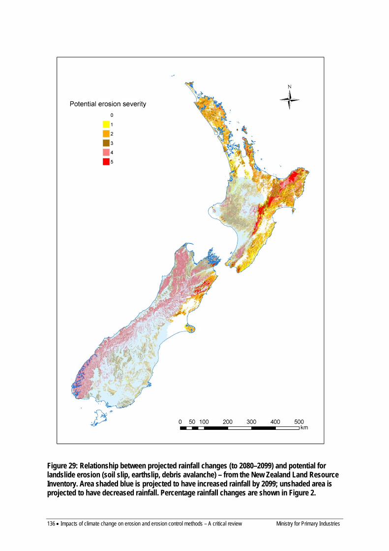
136 • Impacts of climate change on erosion and erosion control methods – A critical review Ministry for Primary Industries
Figure 29: Relationship between projected rainfall changes (to 2080–2099) and potential for landslide erosion (soil slip, earthslip, debris avalanche) – from the New Zealand Land Resource Inventory. Area shaded blue is projected to have increased rainfall by 2099; unshaded area is projected to have decreased rainfall. Percentage rainfall changes are shown in Figure 2.
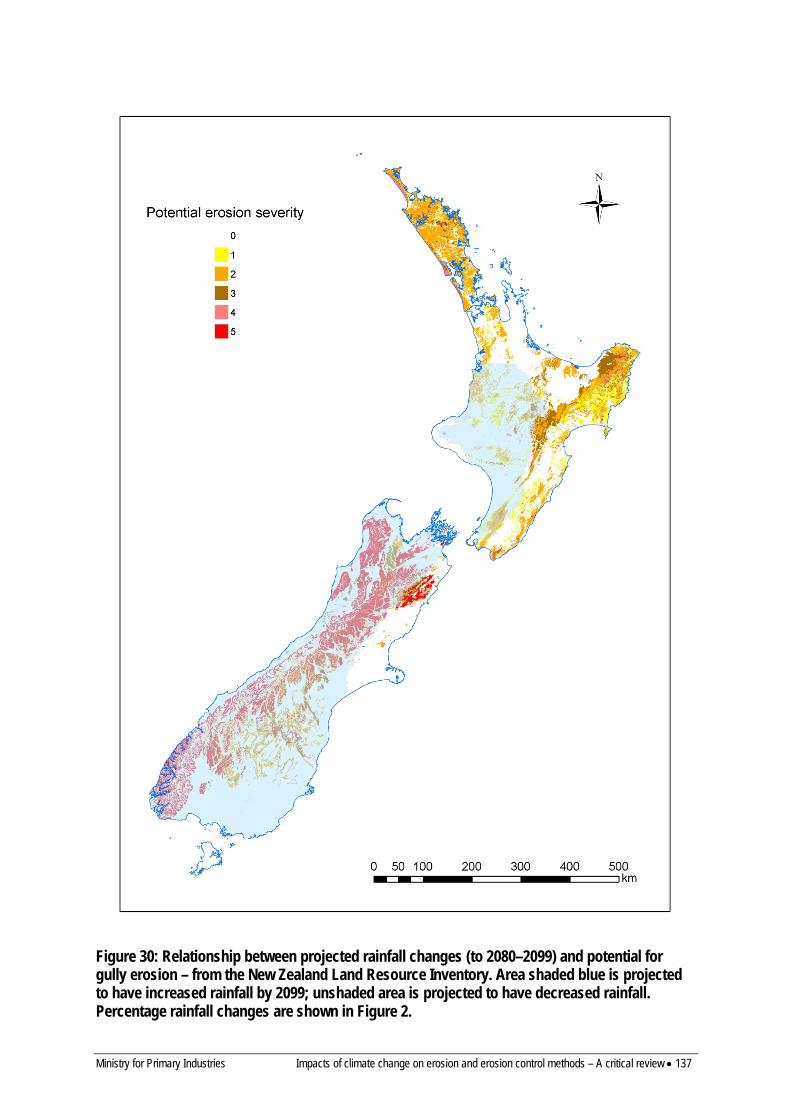
Ministry for Primary Industries Impacts of climate change on erosion and erosion control methods – A critical review • 137
Figure 30: Relationship between projected rainfall changes (to 2080–2099) and potential for gully erosion – from the New Zealand Land Resource Inventory. Area shaded blue is projected to have increased rainfall by 2099; unshaded area is projected to have decreased rainfall. Percentage rainfall changes are shown in Figure 2.
138 • Impacts of climate change on erosion and erosion control methods – A critical review Ministry for Primary Industries
• Earthflows (Figure 31) Most of the areas with the highest potential for earthflow erosion (Gisborne-East Coast, southern Hawke’s Bay, Wairarapa coast, Northland) are projected to have a decrease in rainfall, which is likely to reduce rates of earthflow movement. The most susceptible areas where rainfall is projected to increase are in the soft rock hill country of inland Taranaki, and Wanganui areas.
• Sheet erosion (Figure 32) Potential for sheet erosion is widely mapped in both islands with the highest potential mapped in the wet mountainlands of the South Island (much of which is forested and unlikely to be prone to sheet erosion), the Kaikoura Ranges (with extensive bare ground), the Ruahine Ranges, the Volcanic Plateau, southern Bay of Plenty, parts of Taranaki, and Northland. The available data on sheet erosion suggest it can be significant on sloping lands under intensive cropping, on pastoral hill country where vegetation cover is poor and/or intensive animal grazing leads to soil compaction and increased runoff, and on developing urban subdivisions. Areas where rainfall is projected to increase and that have higher potential for sheet erosion are the Volcanic Plateau (including the intensive cropping area around Ohakune), and the northern Manawatu–Wanganui–Taranaki hill country (although the higher rainfall will lead to better ground cover and may reduce the potential for sheet erosion). Many of the areas with the highest potential for sheet erosion (e.g. the intensive cropping area around Pukekohe, Auckland urban subdivisions) are projected to have lower rainfall and the effect of changes in extreme rainfalls is likely to be more significant than changes to annual rainfall.
• Bank erosion (Figure 33) Bank erosion was a difficult process to map using the NZLRI mapping methodology, and is probably under-represented in the potential erosion map, which shows low potential in most parts of the country. The major influence on bank erosion will be changes in river flow. MfE (2008) suggests that river flows are, on average, likely to increase in the west and decrease in the east of New Zealand. However, in the South Island many of the eastern rivers have headwaters in the zone where rainfall is predicted to increase, so these rivers may also experience an increase in flow. It is likely that bank erosion could become increasingly severe in many parts of the country as rainfall and river flow increase. The exceptions may be the east and north of the North Island. A more realistic assessment of effects of climate change on bank erosion would require improved estimation of changes in river flow.
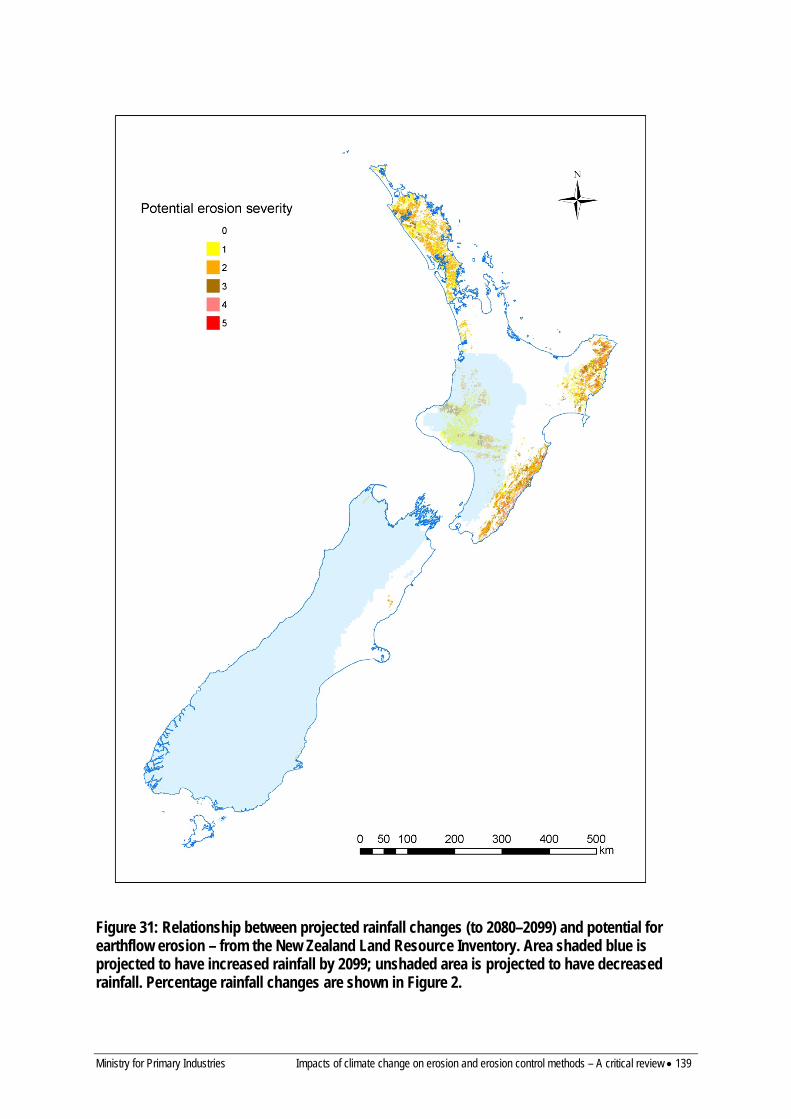
Ministry for Primary Industries Impacts of climate change on erosion and erosion control methods – A critical review • 139
Figure 31: Relationship between projected rainfall changes (to 2080–2099) and potential for earthflow erosion – from the New Zealand Land Resource Inventory. Area shaded blue is projected to have increased rainfall by 2099; unshaded area is projected to have decreased rainfall. Percentage rainfall changes are shown in Figure 2.
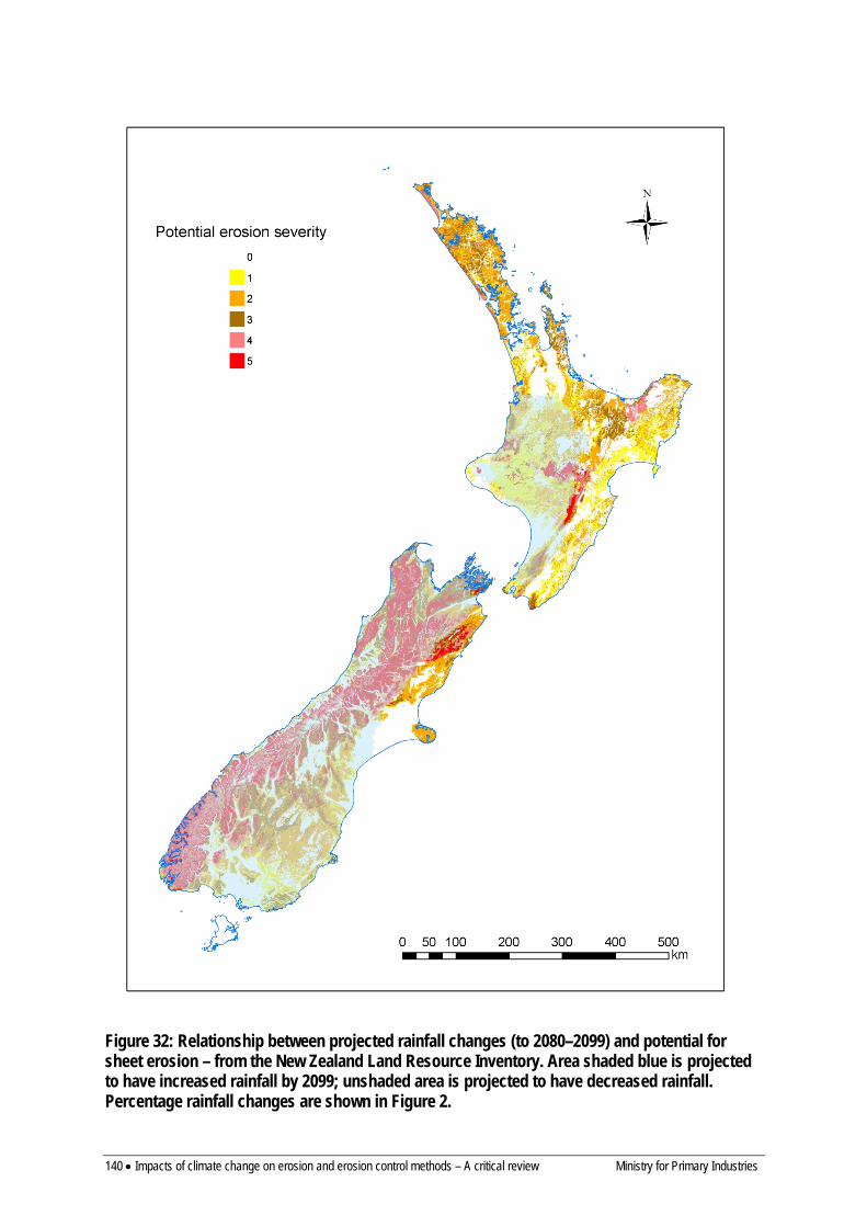
140 • Impacts of climate change on erosion and erosion control methods – A critical review Ministry for Primary Industries
Figure 32: Relationship between projected rainfall changes (to 2080–2099) and potential for sheet erosion – from the New Zealand Land Resource Inventory. Area shaded blue is projected to have increased rainfall by 2099; unshaded area is projected to have decreased rainfall. Percentage rainfall changes are shown in Figure 2.
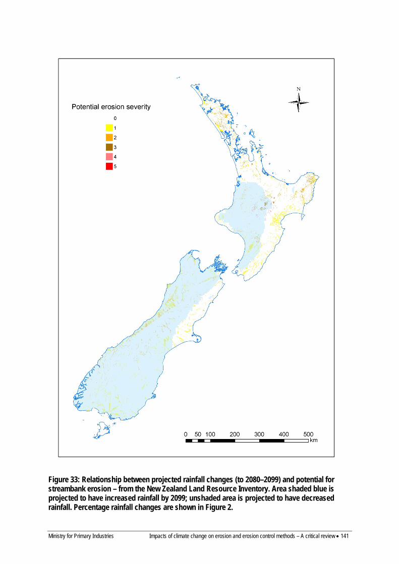
Ministry for Primary Industries Impacts of climate change on erosion and erosion control methods – A critical review • 141
Figure 33: Relationship between projected rainfall changes (to 2080–2099) and potential for streambank erosion – from the New Zealand Land Resource Inventory. Area shaded blue is projected to have increased rainfall by 2099; unshaded area is projected to have decreased rainfall. Percentage rainfall changes are shown in Figure 2.

142 • Impacts of climate change on erosion and erosion control methods – A critical review Ministry for Primary Industries
• Wind erosion (Figure 34) Potential for wind erosion is widely mapped in the South Island to the east of the main ranges (in the mountainlands, hill country and Canterbury Plains), with the highest potential severity in the mountainlands. It has a more restricted distribution in the North Island with the highest potential severity on the Volcanic Plateau and the coastal sand dune terrain. The most important factors influencing the severity of wind erosion with climate change will be changes to mean and extreme windspeeds, and to the frequency and duration of drought conditions. Changes to windiness predicted by MfE (2008) were for: an increase (around 10%) in the annual mean westerly component of windflow across New Zealand, most prominent in winter (>50% by 2090) and spring (around 20% by 2090), with decreased westerly airflow in summer and autumn (around 20% by 2090); up to 10% increase in strong winds by 2090, with more storminess possible. More recent work reported in Mullan et al. (2011) predicted the frequency of strong winds to increase throughout New Zealand, but that the magnitude of increase is likely to be quite small (a few percent). This will lead to a minor increase in the potential for wind erosion in those areas prone to wind erosion. However, many areas of the South Island prone to wind erosion are also projected to have an increase in rainfall, which may counteract the effects of slightly stronger winds. Droughts are predicted to be more frequent (by two to four times) in the east of both islands and in northern New Zealand (Figure 6) by 2099 (Clark et al. 2011) and this could have a very significant effect on wind erosion, particularly on the Canterbury, Hawke’s Bay and Wairarapa plains.
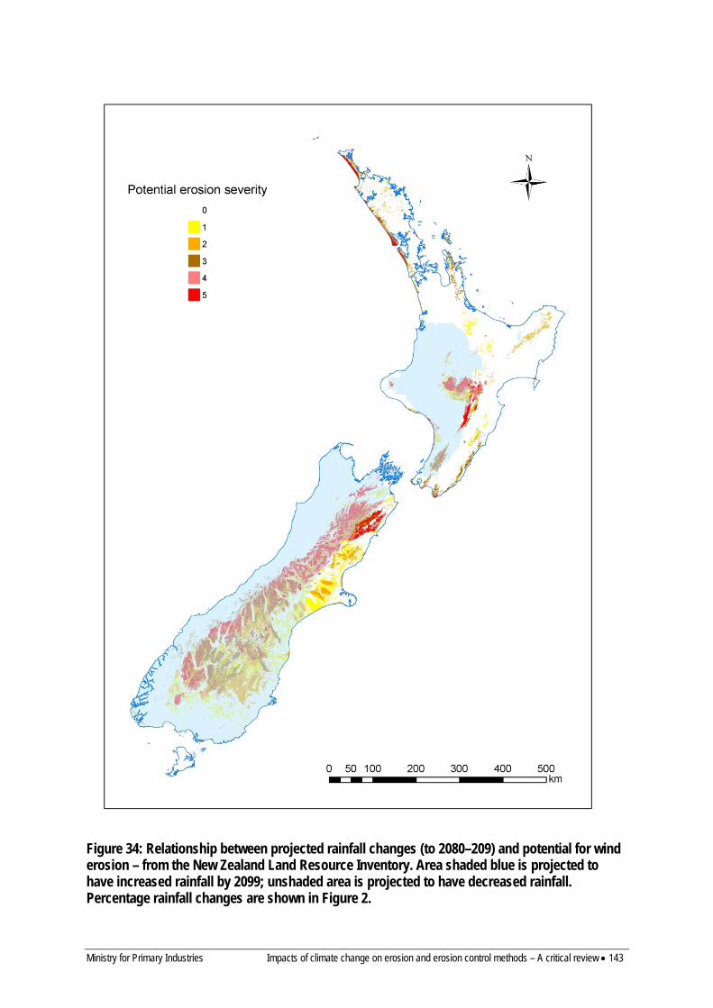
Ministry for Primary Industries Impacts of climate change on erosion and erosion control methods – A critical review • 143
Figure 34: Relationship between projected rainfall changes (to 2080–209) and potential for wind erosion – from the New Zealand Land Resource Inventory. Area shaded blue is projected to have increased rainfall by 2099; unshaded area is projected to have decreased rainfall. Percentage rainfall changes are shown in Figure 2.

144 • Impacts of climate change on erosion and erosion control methods – A critical review Ministry for Primary Industries
13.2 EROSION CONTROL The use of herbaceous, tree and, to a lesser extent, shrub species for controlling or preventing various erosion processes on landscapes throughout New Zealand has been a significant feature for many decades (Van Kraayenoord & Hathaway 1986a, b; Hicks 1995b; Wilkinson 1999; Hicks & Anthony 2001). Under predicted future climates, plant-based approaches for erosion mitigation will continue to be used widely and effectively. Many genera and species have been used successfully, comprising a range of herbaceous grasses, legumes and herbs (Scott et al. 1985; Lambrechtsen 1986) and a much narrower range of tree germplasm used in wide-spaced plantings on pastoral hill country, principally Populus and Salix spp. (Wilkinson 1999; McIvor et al. 2011), or in protection or plantation forestry where the most widely used species is Pinus radiata (Van Kraayenoord & Hathaway 1986a; Hicks & Anthony 2001). Shrub species have been used for soil conservation in a few environments (Sheppard & Bulloch 1986a, b; Wills et al. 1990, 1999) but their use based on area planted or protected has been negligible compared to herbaceous and tree species.
The reviewed literature indicated a general lack of experimental work conducted in New Zealand on the responses of the different plant types to key climate change factors (e.g. warming, altered rainfall, and CO2 enhancement), their interactions with pests and diseases under changed climatic conditions, and potential for weed ingression. Of the few research trials reported, nearly all involved exotic species, even though indigenous species have a valuable role in soil conservation and revegetation (Pollock 1986). No New Zealand studies on climate change impacts on exotic shrub species were found, likely because of their relatively low use in soil conservation and other practices. Major information gaps and recommendations for future work have been identified in Section 13.3.
Predictions such as the northern and eastern regions of New Zealand becoming drier and warmer during this century may have more implications for the use and effectiveness of the limited range of tree species used currently, than herbaceous species. This is because there is relatively large variability in the current range of herbaceous species and cultivars with respect to adaptability and tolerance to variations in temperature, moisture, and other environmental attributes (Scott et al. 1985; Lambrechtsen 1986a; Charlton & Belgrave 1992; Charlton & Stewart 2006). It is suggested that most, if not all, future requirements for ground cover provision in altered environmental conditions could be met with revised mixtures of the currently available suite of herbaceous species. The role of the grazing animal in modifying the responses of herbaceous mixtures to altered climatic factors has received negligible attention globally in many farming situations. This needs to be addressed to better understand the complex plant–climate–animal interactions that likely exist.
For both herbaceous and tree species, most studies reviewed focused on the impact of climate change factors on attributes relating to production for forage or timber, rather than attributes more relevant to soil conservation such as rate of development of ground or canopy cover, and root mass, length and distribution. Exceptions included studies determining responses of roots of grassland and forest species to CO2 enhancement (Thomas et al. 2000; LeCain et al. 2006; Volder et al. 2007). Nevertheless, attributes such as above-ground growth rate and various measures of productivity determined or modelled in a number of studies (Greer et al. 1995; Morgan et al. 2001; Reich et al. 2001; Griesbauer & Green 2010; Kirschbaum et al. 2012) can be related to at least provision of vegetative cover, and are therefore relevant to soil conservation objectives.
Ministry for Primary Industries Impacts of climate change on erosion and erosion control methods – A critical review • 145
Many studies have shown that elevated CO2 concentration increases photosynthesis, growth rate and biomass of herbaceous species. These responses were greater for C3 plants than C4 plants (Greer et al. 1995; Wand et al. 1999). Effects of elevated CO2 concentration and elevated temperature on herbaceous seed germination and seedling survival are less certain. Studies investigating the interaction of elevated CO2 and soil N (Wong & Osmond 1991; Ghannoum & Conroy 1998; Schneider et al. 2004) are inconclusive. Because of the uncertainty around the interactions of elevated CO2 concentration and soil N status, these findings have implications for establishing and maintaining ground cover on eroded soils, which are characterised by low organic matter content, low nutrient status and low water storage capacity (Rosser & Ross 2011). In their literature review on responses of pasture and rangeland species to elevated, and changed temperature and precipitation, Izaurralde et al. (2011) concluded that plants generally respond positively to elevated CO2 concentration in terms of biomass and yield, interactions between environmental factors are complex, and increasing temperatures and changed rainfall patterns may have positive or negative effects on plant productivity. Under climate change scenarios predicted for 2040 and 2090 in New Zealand, annual pasture production in cooler, wetter sites in the South Island is expected to increase by more than 20%, and in warmer and drier sites in the North Island by 5% consequent on maintaining sufficient ground cover over summer when production is expected to reduce. Reduced ground cover will increase the risk of erosion during extreme weather events. Amidst all the possible scenarios the possibility of differential herbaceous plant germination, survival and growth and reduced ground cover in warmer, drier parts of the North Island could be the most consequential. New sward mixes may be required to maintain ground cover in warmer, drier regions in future.
Studies of shrub and tree species are far fewer in number and conducted in more extreme environments than experienced in New Zealand, particularly pastoral lands. Elevated temperatures and CO2 concentrations have been shown to promote shrub growth and this is likely to increase the rate of soil stabilisation by native shrub and tree species for marginal land that has been retired from pastoral grazing. The application of findings from recent (Monjardino et al. 2010) and any future studies valuing the contribution of shrubs in agricultural systems under climate change could be of value, particularly for regions expected to be warmer and drier in future.
The establishment of spaced-planted Populus and Salix species is most difficult on eroded slopes in summer dry environments. Low soil moisture content and surface cracking coupled with a very limited root system can lead to desiccation of the poles. New systems to reduce pole mortality should be developed to increase survival in an environment that is expected to become more difficult. Once the trees are established, tree shade lowers soil moisture loss during summer and will assist the maintenance of ground cover. For established poplars and willows, elevated CO2 concentration and temperatures are expected to increase the rate of growth (Hovenden 2003) and increase allocation of photosynthate to root mass (Scarascia-Mugnozza et al. 2003) as demand for soil water and nutrients is increased. The consequences for soil stabilisation are a greater root length density and reduced soil water content, factors important in reducing slope erosion (Gray & Sotir 1996). Better information on resilience of the different poplar and willow clones to water stress is needed so that the clones most suited to the expected future regional climate are planted in greatest numbers.
Studies on the productivity of Pinus radiata and other forestry species have indicated improved growth rates nationally under climate change. Kirschbaum et al. (2012) predicted productivity would increase by 19% and 37% (by 2040 and 2090 respectively) with increased

146 • Impacts of climate change on erosion and erosion control methods – A critical review Ministry for Primary Industries
atmospheric CO2 concentration (assuming maintenance of adequate soil nutrient levels), but only slight increases were predicted under constant CO2 concentration. They suggested that increased CO2 concentration would offset the effect of water stress on productivity in those areas where rainfall is predicted to decrease.
New pests and diseases of herbaceous, shrub and tree species are expected to arrive in the future. The predicted climate change scenarios are expected to be more favourable to the establishment and survival of both pest and disease species already present in New Zealand and also new species. Watt et al. (2008) reported that there is ample evidence of insect species spreading in response to climate change overseas and that modelling work indicates that this is likely in New Zealand also. For example, Watt et al. (2011d) found that Dothistroma severity increased with increases in mean air temperature, mean relative humidity and mean total rainfall. Consequently, changes in severity of this disease are predicted to be low to moderate by 2040 and moderate to high by 2090. Other diseases limited in extent and distribution by current temperature, e.g. pitch canker and Swiss needle cast, are expected to cause greater reductions in productivity of our current forest species.
The occurrence of winds strong enough to damage planted forests is thought likely to increase in regions where higher wind speeds are predicted, but the impacts on forests in terms of wind damage risk are expected to be highly variable and dependent on the nature of the forest (Watt et al. 2008a). Climate change is likely to increase fire climate severity in many areas of New Zealand (e.g. Whanganui, Hawke’s Bay, Marlborough, coastal Otago, and south-eastern Southland) due to elevated temperature, reduced rainfall, decreased humidity and increased wind speeds. Increases in fire climate severity can be expected to result in longer fire seasons, an increased number of fires, and an increase in the size of planted forest areas burned (Pearce et al. 2011).
Weeds demonstrate the potential to increase their abundance and increase or change their distribution under simulated climate change (e.g. Dukes et al. 2011). Changes in abundance and distribution of herbaceous and shrub species should be monitored. Spaced conservation trees are not limited in their range in New Zealand by climate and there is no evidence of current natural spread except for a few willow species. Spread of these willows is limited to waterways and is currently monitored and, in some locations, managed. This monitoring should continue.
The weed potential of exotic forestry species under climate change has not been researched in New Zealand. Wilding pines in parts of the South Island have weed status, which may be expected to increase under climate change. Increased planting of exotic forestry species in some regions as an erosion management tool may increase their weed potential.
The impacts of climate change on the effectiveness of species used for erosion control have not yet been directly studied in New Zealand. However, this review has highlighted numerous studies that suggest that projected climate change may have both direct (e.g. the effect of changing climatic conditions on plant growth, function, and distribution) and indirect effects (e.g. the effect of climate change on the incidence of pest and diseases and on fire and wind risk) on erosion control plant species in New Zealand. Effects tend to vary by species and region and can be positive (e.g. potentially increased growth rates) or negative (likely increased incidence of pests and diseases). Based on the available research, we can only make some inferences as to the likely effects of climate change on the effectiveness of biological erosion control in New Zealand. We must assume that where the growth of erosion control species is predicted to remain constant or improve, their effectiveness will at least be
Ministry for Primary Industries Impacts of climate change on erosion and erosion control methods – A critical review • 147
similar to present levels if not improved, and that where growth is expected to decline or is threatened by biotic or abiotic disturbances, their effectiveness may be compromised to some extent.
This review has described the findings of numerous studies that have modelled changes in the growth, function, or spatial distribution of species used in erosion control in response to changes in atmospheric CO2 concentration, temperature, and rainfall for herbaceous (e.g. Baars et al. 1990; Campbell et al. 1999; Zhang et al. 2007; Bryant & Snow 2008; Cullen et al. 2009; Zhang et al. 2009; Soussana et al. 2010; Polley et al. 2011; Watt et al. 2011a), spaced tree (e.g. Constable et al. 2000) and forestry (e.g. Magnani et al. 2004; Simioni et al. 2009; Kirschbaum & Watt 2011; Watt et al. 2011b, c; Kirschbaum et al. 2012; Mok et al. 2012) species, but not for shrub species. Modelling has also been applied to predicting the effects of climate change on the incidence of pests and diseases (e.g. Watt et al. 2011e, f), fire and wind risk (e.g. Pearce et al. 2011), and the potential weed status of species (e.g. Kriticos et al. 2003, 2011). Some studies have also included other factors such as wind speed and humidity in predicting changes in fire danger (Pearce et al. 2011), for example. Often, the climate change scenarios used in these studies have been derived from global climate change models. Modelling provides good information on the possible nature, magnitude, and (in some cases) distribution of climate change impacts on erosion control species. However, we must infer how these effects (discussed above) might translate into implications for the effectiveness of the species in controlling erosion under climate change in the absence of any direct studies into this issue. Modelled effects of climate change on plant growth need to be considered in the context of interactions with other environmental variables, particularly soil nutrient status and moisture content as, for example, projected increases in tree growth in some regions may be constrained by the ability of the soil to supply sufficient nutrients and moisture (e.g. Barlow & Conroy 1988; Kirschbaum 1999; Simioni et al. 2008; Kirschbaum et al. 2012).
Many of the experimental studies on the impacts of projected climate change on species used for biological erosion control in New Zealand reviewed here have been undertaken overseas (e.g. North America, Australia). Negligible New Zealand based experimental research has been conducted on this topic. Moreover, there appears to be a paucity of experimental studies investigating climate change effects on P. radiata, the predominant forestry species in New Zealand, whereas a number of overseas studies have been undertaken on the effects on Douglas-fir (e.g. Lewis et al. 2004; Olszyk et al. 2005) and Eucalyptus spp. (e.g. Ayub et al. 2011; Zeppel et al. 2011). Studies reviewed have predominantly described controlled glasshouse or field-based experiments undertaken on herbaceous species, shrubs, or tree seedlings. Commonly, the effects of elevated CO2 concentrations and temperatures (at different levels) on various measures of growth, physiological function, and plant chemistry were tested. In some cases, the effects of moisture stress (simulated drought conditions) were also tested but often interactions with variable soil nutrients and moisture levels were avoided by ensuring that these were not limiting.
It is uncertain as to whether climate change will have implications for the supply of herbaceous species used for erosion control. The research reviewed suggests that there may or may not be changes in seed yield and quality under predicted climate change scenarios. A shift in the current regional distribution of seed production may occur under climate change. However, it is thought that seed supply will not be unduly compromised in the medium to longer term. The supply of shrub, spaced-tree, and forestry species is not expected to be much affected by climate change because stocks are usually prepared under relatively controlled conditions in nurseries. Elevated CO2 concentrations and temperatures may promote faster
148 • Impacts of climate change on erosion and erosion control methods – A critical review Ministry for Primary Industries
growth of plants in nurseries, but the incidence of certain diseases may also be increased. Management considerations relating to erosion control species under climate change may include species selection, adaptation, and watering.
13.3 INFORMATION GAPS To date there have been limited attempts to evaluate the effect of climate change on erosion processes and erosion control, at least in a quantitative way. The predictions of increased storminess, wind and drought have potentially important consequences for managing the effects of erosion on sustainability of land resources, and its offsite effects on infrastructure and public safety. A number of useful modelling tools are available for improving quantitative evaluation of climate changes effects on erosion and evaluating the consequences for erosion control. However there are some important information gaps.
13.3.1 Erosion processes and modelling 1. A more complete understanding is needed of the linkage between the climate drivers of
erosion and how they will alter with climate change. Shallow landsliding is the process most likely to be widely affected by climate change and there is a need to define metrics between magnitude of landsliding and rainfall drivers (incorporating storm rainfall and antecedent moisture conditions) for the complete range of terrain in New Zealand.
2. One of the greatest constraints to developing reliable relationships between erosion and climate is the availability of data. There is no routine comprehensive monitoring of any form of erosion or sediment yield on a national basis. Collection of high-quality storm-based landslide data is critical to developing relationships between landslide erosion and climate that would be useful for simulating climate change effects.
3. Storm rainfall and extreme climatic events are critically important for regional landsliding events and also for other forms of erosion (e.g. earthflow, gully, sheet erosion). There is a need for better projections of extra-tropical cyclone activity, extreme rainfall variation especially where rainfall is projected to decrease, and for development of downscaling methods to produce daily and storm rainfalls with projected climate change that have less uncertainty than at present.
4. Erosion models need to be developed that simulate the full range of erosion processes in New Zealand and incorporate linkages between hillslopes, channels and downstream effects. Few existing models incorporate mass movement erosion processes, and none incorporate the type of large-scale gully erosion characteristic of New Zealand or earthflows. The emphasis should be on developing models that realistically simulate erosion processes but have practical data and computer processing requirements.
13.3.2 Herbaceous & shrub species 1. There have been few multi-factor experiments to determine the effect of climate change
on establishment, growth and longevity of herbaceous species. Experiments involving several factors are required to better understand potential impacts of changed weather conditions on effectiveness of key soil conservation species. It is recommended that multi-factor experiments include combinations of CO2 concentration, soil water content, air temperature and soil nutrient status.
2. Appropriate mixtures of herbaceous species in swards to provide complete and persistent ground cover under various climate change scenarios (particularly in areas projected to become drier) remain to be identified. Such studies would need to involve simulated or actual grazing by livestock to account for any interactions in responses between species, climate change and defoliation.
Ministry for Primary Industries Impacts of climate change on erosion and erosion control methods – A critical review • 149
3. There is negligible information on the impact of predicted climate change in New Zealand on planted exotic shrubs used for erosion control. However, in view of their relatively low use on farmed landscapes, research on shrubs in the context of climate change seems unjustified currently. A possible exception is the potential for some species to become weeds through altered distribution patterns arising from climate change (e.g. under warmer and drier conditions). There appears to be no information on the effect of climate change on establishment and growth of indigenous shrub species. There are numerous and ongoing plantings of these species in riparian areas on farms predominantly for nutrient management (soil conservation usually of secondary importance). The implications of climate change for growth and biomass partitioning (above- vs below-ground) of selected indigenous shrubs warrants investigation.
4. The multitude and complexity of interactions between host, pathogen/pest and environment of species used for soil conservation are poorly understood. The potential for increased or decreased prevalence and severity of pests and diseases in different regions of New Zealand, arising from predicted climate change, requires clarification. Research should determine potential scenarios with pests and diseases already in New Zealand as well as the potential impact of the arrival and establishment of new pests and diseases.
13.3.3 Spaced trees on pasture 1. The extent of damage that could be inflicted to current and future plantings of poplar and
willow by the arrival of new pests and diseases is uncertain. There are a wide range of potential insect pests, particularly, which could arrive in New Zealand and establish quickly in our plantings.
2. How the survival of any new pest and disease arrivals will be enhanced by climate change is not well understood. This is particularly applicable to close plantings as found on river berms, in fodder blocks, gully, earthflow and shelterbelt plantings and along streambanks. These plantings are vulnerable because they are so extensive, they are planted in close proximity to each other, and chemical control means for pests and diseases are not affordable.
3. Other things that are poorly understood include: a) The effectiveness and feasibility of developing on-farm watering systems to enhance
pole survival particularly on upper slopes and in drier regions b) The redistribution of biomass to above and below ground parts under enhanced
temperatures and rainfall c) Effect of climate change on the rate of carbon storage and enhancement of soil carbon
by conservation trees d) The contribution of conservation trees to soil moisture retention under climate change e) The benefits of conservation trees to stock health and well-being under climate
change f) The use of other deciduous tree species that can complement poplars and willows and
provide long-term soil protection
13.3.4 Forestry species 1. The effects or implications of climate change on the performance of planted forest species
in erosion control in New Zealand have not yet been directly investigated. Studies should be designed and implemented to directly address this issue.
2. The effects of climate change on the growth of P. radiata, particularly in New Zealand, have not been as extensively studied as for Douglas fir in North America. Few experimental studies on the effects of elevated CO2 concentrations, temperatures, and changes in other factors have been undertaken for P. radiata in New Zealand. As P.

150 • Impacts of climate change on erosion and erosion control methods – A critical review Ministry for Primary Industries
radiata is currently the most common forestry species used in erosion control in New Zealand, a greater understanding of its physiological responses to the changes in temperature, CO2 concentration, and rainfall expected under climate change in New Zealand would be useful. Further investigation of the response of older trees (rather than just seedlings) to elevated CO2 has also been suggested (Watt et al. 2008a). From an erosion control perspective, a greater focus on the effects of climate change on root growth and characteristics may be particularly helpful. There may be a need to shift to alternative (non-radiata pine) tree species in response to climate change, particularly in areas of New Zealand projected to become drier, or a need to reduce tree densities. Little is known about the physiological responses to ongoing climate change of less well studied species (Watt et al. 2008a).
3. Responses of tree growth the changes in climatic conditions may be regulated by feed-backs and processes associated with soil organic matter and nutrient dynamics. Further research to better understand these feed-backs and processes in New Zealand would be useful (Watt et al. 2008a). Combined and interacting direct and indirect (e.g. pests and diseases, fire and wind damage) affects of climate change on forestry species should also be identified and research undertaken to quantify the impacts of these interactive effects (Watt et al. 2008a).
4. The impacts of climate change on the abundance and distribution of insect pests in planted forests in New Zealand are currently not well understood. Further work is required to establish how changes in insect pest distribution and abundance might influence the growth and productivity of planted forests in New Zealand. The establishment of long-term monitoring programmes for important pests and pathogens to enable the detection of climate change impacts was recommended by Watt et al. (2008a).
5. The use of regional climate models may allow for further improvement in estimates of future fire climate and the associated effects (Watt et al. 2008a; Pearce et al. 2011).
6. Little work has been undertaken on the impacts of climate change on wind damage to forests in New Zealand. Greater monitoring and reporting of actual wind damage to forests under current conditions was recommended by Watt et al. (2008a) to enable to assessment of changes over time.
7. There does not appear to have been any research undertaken to establish the effect of climate change on the potential weed status of exotic planted forest species in New Zealand. Research to address this question may be important for regions where ‘wilding’ exotic trees are already a problem under current climatic conditions.
8. The impacts of climate change on the extent and effectiveness of riparian plantings in planted forests has not been investigated.
9. The effects of climate change on the rate of regeneration of indigenous vegetation (especially its ability to withstand drought) on retired pastoral land in New Zealand have not yet been established. Investigation of the implications of climate change for the regeneration of manuka/kanuka may be particularly useful.

Ministry for Primary Industries Impacts of climate change on erosion and erosion control methods – A critical review • 151
KEY FINDINGS – DISCUSSION
1. There are clear links between climate and erosion in New Zealand relating to soil water movement into and through the soil, soil water balance and slope hydrology. For most processes storm rainfalls are an important influence on rate of process and projected increases in extreme rainfalls will play a critical role in determining the effect of climate change. The effects of increased temperatures and lower rainfalls in some areas will tend to counteract the effect of increased storm rainfalls on mass movement processes by lowering antecedent moisture conditions, but will exacerbate susceptibility to wind erosion.
2. Quantitative assessments of the impact of climate change on erosion relies on models that link climatic, hydrological and erosion processes. Most international work has focused on sheet and rill erosion processes with less attention to mass movement processes (which are dominant in the New Zealand landscape) and wind erosion.
3. There have been limited catchment- and regional-scale analyses of climate change impacts on erosion and sediment yield using a range of models, but no national assessment.
4. One of the greatest constraints to developing reliable relationships between erosion and key climate parameters is the availability of data since there is no routine monitoring of any form of erosion. This is especially relevant to shallow landslides. There is a need for relationships between landslide magnitude and event rainfall to be developed for the range of terrain in New Zealand. Without good quality data it will be difficult to separate the impact of climate change on erosion from the existing high temporal variability of erosion.
5. A qualitative assessment of regional variation in potential climate change impacts on erosion was derived relating potential erosion mapped in the NZLRI to projected changes in rainfall. This suggests: a) Many areas in the North and South Island with highest potential for landslide erosion are projected to have a
decrease in mean annual rainfall and the impact of climate change will depend on changes to extreme rainfall and extra-tropical cyclone activity (includes the erodible soft rock hill country of the eastern North Island, Bay of Plenty, northern Waikato, Auckland, Northland, North Canterbury and Marlborough). Areas most susceptible to increased landsliding include the soft rock hill country of Taranaki, southern Waikato, Manawatu–Wanganui west of the Ruahine Range, Otago, South Canterbury and Marlborough. Many of the areas of the South Island with the highest projected increase in rainfall and high potential for landslide erosion are steep forested mountains in national parks.
b) The areas most susceptible to an increase in gully erosion are the soft rock hill country of Taranaki, southern Waikato and Manawatu–Wanganui west of the Ruahine Range, and the greywacke and the hard rock mountainlands of the South Island. The areas with the highest potential for gully erosion (Gisborne–East Coast, southern Hawke’s Bay, Northland) are projected to have decreased rainfall and the impact of climate change will depend on changes in storm rainfalls.
c) Most of the areas with the highest potential for earthflow erosion (Gisborne–East Coast, southern Hawke’s Bay, Wairarapa coast, Northland) are projected to have a decrease in rainfall, which is likely to reduce rates of earthflow movement. The areas most susceptible to earthflows where rainfall is projected to increase are in the soft rock hill country of inland Taranaki, and Wanganui areas.
d) Areas with the highest potential for increases in sheet erosion are the Volcanic Plateau (including the intensive cropping area around Ohakune), and the northern Manawatu-Wanganui-Taranaki hill country (although the higher rainfall will lead to better ground cover and reduce the potential for sheet erosion). Many areas with the highest potential for sheet erosion (e.g. the intensive cropping area around Pukekohe, Auckland urban subdivisons) are projected to have lower rainfall and the impact of climate change will depend on changes in storm rainfalls.
e) Bank erosion could become increasingly severe in many parts of the country as rainfall and river flows increase, except in the east and north of the North Island. A more realistic assessment of effects of climate change on bank erosion would require improved estimation of changes in river flow.
f) The frequency of strong winds is predicted to increase throughout New Zealand, but the magnitude of increase is likely to be quite small, leading to a minor increase in the potential for wind erosion in those areas prone to wind erosion (South Island east of the main ranges, Volcanic Plateau, coastal sand dunes). An increase in rainfall may counteract the effects of slightly stronger winds in many areas.
6. Plant-based approaches for erosion mitigation will continue to be used widely and effectively under projected future climates. There has been little experimental work conducted in New Zealand on the responses of the different plant types to key climate change factors (e.g. warming, altered rainfall, and CO2 enhancement), their interactions with pests and diseases under changed climatic conditions, and potential for weed ingression.
7. Projected climate change may have both direct (e.g. the effect of changing climatic conditions on plant growth, function, and distribution) and indirect effects (e.g. the effect of climate change on the incidence of pests and diseases and on fire and wind risk) on erosion control plant species in New Zealand. Effects tend to vary by species and region and can be positive (e.g. potentially increased growth rates) or negative (likely increased incidence of pests and diseases).

152 • Impacts of climate change on erosion and erosion control methods – A critical review Ministry for Primary Industries
8. Predictions that the northern and eastern regions of New Zealand will become drier and warmer during this century may have more implications for the use and effectiveness of the limited range of tree species used currently, than herbaceous species. The current range of herbaceous species and cultivars has wide tolerance to variations in temperature, moisture, and other environmental attributes, although in summer-dry hill country with low inputs and with the potential for drought over several consecutive years, there may be a need for improved germplasm (temperate or subtropical) to provide a persistent ground cover.
9. Most studies have focused on the impact of climate change on attributes relating to production for forage or timber, rather than attributes more relevant to soil conservation such as rate of development of ground or canopy cover, and root mass, length and distribution.
10. Elevated temperatures and CO2 concentrations have been shown to promote shrub growth and this is likely to increase the rate of soil stabilisation by native shrub and tree species for marginal land that has been retired from pastoral grazing.
11. The establishment of spaced-planted Populus and Salix species is most difficult on eroded slopes in summer dry environments. New systems to reduce pole mortality should be developed to increase survival in an environment that is expected to become drier. Better information on resilience of the different poplar and willow clones to water stress is needed so that the clones most suited to the expected future regional climates are planted in greatest numbers and appropriate clones should be bred to suit these dry environments. The use of other deciduous tree species that can complement poplars and willows and provide long-term soil protection should be investigated.
12. Pinus radiata and other forestry species are predicted to have improved growth rates nationally under climate change and offer opportunities to reduce erosion on susceptible land. However, the weed potential of some tree species is likely to increase, and in areas where annual rainfall is low (<900 mm) lower tree densities may be required to maintain tree growth until maturity, or the use of conifers better adapted to drier environments.
13. Future climates are expected to be more favourable to the establishment and survival of both pest and disease species already present in New Zealand and also new species.
14. Climate change will increase wind damage to forests and increase fire risk, particularly in eastern areas. 15. The supply of plant material used for erosion control (by seed or poles) is unlikely to be affected by climate
change.
Ministry for Primary Industries Impacts of climate change on erosion and erosion control methods – A critical review • 153
14 Conclusions The predictions of increased storminess, increased wind and drought have potentially important consequences for managing the effects of erosion on sustainability of land resources, and its off-site effects on infrastructure and public safety. The most significant effect of climate change on erosion is likely to be on rates of shallow landsliding, but there are also likely to be effects on other erosion processes. For most processes storm rainfalls will play a critical role in determining the effect of climate change. The effects of increased temperatures and lower rainfalls in some areas, and for some processes, will tend to counteract the effect of increased storm rainfalls by lowering antecedent moisture conditions. Increasing incidence of drought, and projected increase in windiness will increase wind erosion risk.
The areas most susceptible to increasing erosion (including landsliding, gully erosion and earthflows, and sheet erosion) are the soft rock hill country of Taranaki, southern Waikato, Manawatu–Wanganui west of the Ruahine Range, Otago, South Canterbury and inland Marlborough. Bank erosion could become increasingly severe in many parts of the country, except in the east and north of the North Island, as rainfall and river flows increase. The intensive cropping area around Ohakune is susceptible to increasing sheet erosion. Increasing incidence of drought in the east of the country is likely to have a greater influence on wind erosion than changes in wind erosivity. Many areas in the east of the North and South islands with highest potential for erosion (including landslides, gully and earthflows) are projected to have a decrease in mean annual rainfall and the impact of climate change will depend on changes to extreme rainfall and extra-tropical cyclone activity.
There are three key constraints to quantitatively evaluating climate change impacts on erosion:
• Availability of data that quantitatively link erosion and climate parameters • Availability of models that incorporate the full range of erosion processes • Reliability of storm event predictions of rainfall and downscaled rainfall time-series data
There is a need for relationships between landslide magnitude and storm-event rainfall to be developed for the range of terrain in New Zealand. Without good quality storm-based data it will be difficult to separate the impact of climate change on erosion from the existing high temporal variability of erosion.
The only feasible means of quantitatively predicting the impact of climate change on erosion is through models that explicitly incorporate climate impacts on erosion processes. While many models are available and some have previously been used in New Zealand, there is clear opportunity for improved model development to provide the tools to quantitatively predict the impact of climate change on erosion.
Biological erosion control will continue to be the most widely used tool to offset the effects of climate change. There is need for studies that focus on:
• Plant parameters relevant to soil conservation (e.g. rate of development of ground or canopy cover, root mass and length) in addition to production for forage or timber

154 • Impacts of climate change on erosion and erosion control methods – A critical review Ministry for Primary Industries
• Identifying herbaceous species (new, released cultivars of existing species, or subtropical species) that will provide persistent ground cover in summer-dry hill country with low inputs
• Resilience of the different poplar and willow clones, and common forestry species, to water stress so that the clones most suited to the expected future regional climates are planted in greatest numbers
• Sourcing of new poplar ecotypes from low-rainfall areas • The use of slower growing, long-lived (>100 years) deciduous tree species that will grow
in summer-dry environments and can complement poplars and willows in providing long-term soil protection
• The effect of new pest and disease arrivals
Expansion of planted forests, or space-planted trees, in erodible hill country will be an effective means to counter increased storminess and erosion. Vegetation solutions that provide multiple benefits (erosion control, biodiversity, carbon storage) may be necessary. Similarly, selection of appropriate herbaceous species to maintain a healthy, vigorous ground cover will be effective in reducing surface erosion.

Ministry for Primary Industries Impacts of climate change on erosion and erosion control methods – A critical review • 155
15 Recommendations Erosion processes and modelling 1. Improve confidence in the projections for time-series storm rainfall data particularly in
those areas where rainfall is projected to decrease. The ability of downscaled GCM climate projections to produce daily or sub-daily storm rainfall projections is critical for realistically modelling future soil erosion.
2. Develop more reliable approaches for predicting likely changes to extreme rainfalls, especially in drier areas, and obtain better information on likely frequency and severity of extra-tropical cyclones with climate change.
3. Improve monitoring of erosion; especially needed are storm-based landslide data that will allow development of reliable relationships between the magnitude of landslide erosion and climate parameters. Without time-series data on erosion it will be very difficult to discern the effect of climate change on erosion from the existing inherent spatial and temporal variability of erosion processes.
4. Improve probabilistic models for landsliding and rainfall to underpin quantitative assessments of the impact of climate change.
5. Continue to develop models that cover all erosion processes in New Zealand.
Erosion control 1. Develop and test on-farm watering systems to enhance survival of poplar and willow
poles during the establishment years, or develop alternative establishment technologies. 2. Identify alternative clones of poplars and willows, or alternative species, that better cope
with dry conditions. 3. Strengthen collaborative relationships with overseas researchers concerning pests and
diseases of poplars and willows through the International Poplar Commission of which New Zealand is a member.
4. Understand how different poplar and willow clones allocate above- and below-ground biomass under current and future climate regimes.
5. Understand how climate change may affect the extension/distribution of roots of poplars and willows.
6. Investigate the use of other deciduous tree species that can complement poplars and willows and provide long-term soil protection.
7. Understand the effect of climate change on a range of plantation forest species and their effectiveness for use in erosion control in multiple-purpose forests.
8. Research the contribution of conservation trees to soil carbon to 1 m depth. 9. Improve knowledge of the benefits of conservation trees to soil health and animal welfare
under current and future climate regimes. 10. Investigate the need for improved germplasm (temperate or subtropical) to provide a
persistent ground cover in summer-dry hill country with low inputs and with the potential for drought over several consecutive years.
156 • Impacts of climate change on erosion and erosion control methods – A critical review Ministry for Primary Industries
16 Acknowledgements We thank the Ministry for Primary Industries (formerly MAF) for funding the work under contract C09X1102. Ian Lynn, Mike Marden, Chris Phillips, John Dymond, Christine Bezar and Garth Eyles made helpful comments on earlier drafts of this report.
17 References Acharya G, Cochrane TD 2009. Development of an integrated model for water induced top
soil erosion and shallow landslides In: Anderssen RS, Braddock RD, Newham LTH eds 18th World IMACS Congress and MODSIM09 International Congress on Modelling and Simulation. Cairns, Australia, Modelling and Simulation Society of Australia and New Zealand and International Association for Mathematics and Computers in Simulation. Pp. 1908–1914
Adair EC, Reich PB, Trost JJ, Hobbie SE 2011. Elevated CO2 stimulates grassland soil respiration by increasing carbon inputs rather than by enhancing soil moisture. Global Change Biology 17: 3546–3563.
Adams R, Elliott AH 2006. Physically-based modelling of sediment generation and transport under a large rainfall simulator. Hydrological Processes 20: 2253–2270.
Ainsworth EA, Long SP 2005. What have we learned from 15 years of free-air CO2 enrichment (FACE)? A meta-analytic review of the responses of photosynthesis, canopy properties and plant production to rising CO2. New Phytologist 165: 351–372.
Ainsworth EA, Davey PA, Hymus GJ, Osborne CP, Rogers A, Blum H, Nösberger J, Long S P 2003. Is stimulation of leaf photosynthesis by elevated carbon dioxide concentration maintained in the long term? A test with Lolium perenne grown for 10 years at two nitrogen fertilization levels under Free Air CO2Enrichment (FACE). Plant, Cell & Environment 26: 705–714.
Alexander RB, Smith RA, Schwarz GE 2004. Estimates of diffuse pollution sources in surface waters of the United States using a spatially referenced watershed model. Water Science and Technology 49: 1–10.
Allard V, Newton PCD, Lieffering M, Soussana J-F, Grieu P, Matthew C 2004. Elevated CO2 effects on decomposition processes in a grazed grassland. Global Change Biology 10: 1553–1564.
Allard V, Robin C, Newton PCD, Lieffering M, Soussana J-F 2006. Short and long-term effects of elevated CO2 on Lolium perenne rhizodeposition and its consequences on soil organic matter turnover and plant N yield. Soil Biology and Biochemistry 38: 1178–1187.
Allen CD, Alison K. Macalady AK, Haroun Chenchouni H, Bachelet D, McDowell N,Vennetier M, Kitzberger T, Rigling A, Breshears DB, Hogg EH, Gonzalez P, Fensham R, Zhang Z, Castro J, Demidova N, Lim J, Allard G, Running SW, Semerci A, Cobb N 2010. A global overview of drought and heat-induced tree mortality reveals emerging climate change risks for forests. Forest Ecology and Management 259: 660–684.
Ministry for Primary Industries Impacts of climate change on erosion and erosion control methods – A critical review • 157
Alley RB, Marotzke J, Nordhaus, WD, Overpeck JT, Peteet DM, Pielke Jr RA, Pierrehumbert RT, Rhines PB, Stocker TF, Talley LD, Wallace JM 2003. Abrupt climate change. Science 299: 2005–2010.
Alloway BV, Lowe DJ, Barrell DJA, Newnham RM, Almond PC, Augustinus PC, Bertler NAN, Carter L, Litchfield NJ, McGlone MS, Shulmeister J, Vandergoes MJ, Williams PW, NZ-INTIMATE members 2007. Towards a climate event stratigraphy for New Zealand over the past 30 000 years (NZ INTIMATE project). Journal of Quaternary Science 22: 9–35.
Almeida AC, Sands PJ, Bruce J, Siggins AW, Leriche A, Battaglia M, Batista TR 2009. Use of a spatial process-based model to quantify forest plantation productivity and water use efficiency under climate change scenarios. In: Anderssen RS, Braddock RD, Newham LTH eds 18th World IMACS Congress and MODSIM09 International Congress on Modelling and Simulation. Cairns, Australia, Modelling and Simulation Society of Australia and New Zealand and International Association for Mathematics and Computers in Simulation. Pp. 1816–1822.
Anthony T 2001. Managing waterways on farms. Wellington, Ministry for the Environment. 209 p.
Apple ME, Lucash MS, Phillips DL, Olszyk DM, Tingey DT 1999. Internal temperature of Douglas-fir buds is altered at elevated temperature. Environmental and Experimental Botany 41: 25–30.
Apple ME, Olszyk DM, Ormrod D P, Lewis J, Southworth D, Tingey DT 2000. Morphology and stomatal function of Douglas fir needles exposed to climate change: elevated CO2 and temperature. International Journal of Plant Sciences 161: 127–132.
Arnold JG, Srinivasan R, Muttiah RS, Williams JR 1998. Large area hydrologic modelling and assessment. Part I Model development. Journal of the American Water Resources Association 34: 73–89.
Ascough JC, Baffaut C, Nearing MA, Liu BY 1997. The WEPP watershed model: I hydrology and erosion. Transactions of the American Society of Agricultural and Biological Engineers 40: 921–933.
Asshoff R, Hättenschwiler S 2005. Growth and reproduction of the alpine grasshopper Miramella alpina feeding on CO2-enriched dwarf shrubs at treeline. Oecologia 142: 191–201.
Auckland Regional Council 1999. Guidelines for stormwater runoff modelling in the Auckland region. Technical Publication 108. Auckland, Auckland Regional Council.
Auckland Regional Council 2005. Estimating sediment yield. Universal Soil Loss Equation (USLE). Land Fact 8. Auckland, Auckland Regional Council.
Ausseil A-GE, Dymond JR 2008. Estimating the spatial distribution of sediment concentration in the Manawatu River, New Zealand, under different land-use scenarios. In: Schmidt J, Cochrane T, Phillips C, Elliott S, Davies T, Basher L eds Sediment dynamics in changing environments. IAHS Publication 325: 502–509.
158 • Impacts of climate change on erosion and erosion control methods – A critical review Ministry for Primary Industries
Avery D, Avery F, Ogle GI, Wills BJ, Moot DJ 2008. Adapting farm systems to a drier future. Proceedings of the New Zealand Grassland Association 70: 13–18.
Ayub G, Smith RA, Tissue DT, Atkin OK 2011. Impacts of drought on leaf respiration in darkness and light in Eucalyptus saligna exposed to industrial-age atmospheric CO2 and growth temperature. New Phytologist 190: 1003–1018.
Baars JA, Radcliffe JE, Rollo MD 1990. Climatic change effects on seasonal patterns of pasture production in New Zealand. Proceedings of the New Zealand Grassland Association 51: 43–46.
Bairstow K, Clarke K, McGeoch M, Andrew N 2010. Leaf miner and plant galler species richness on Acacia: relative importance of plant traits and climate. Oecologia 163: 437–448.
Baker JT, Allen LH, Boote KJ, Jones P, Jones JW 1989. Response of soybean to air temperature and carbon dioxide concentration. Crop Science 29: 98–105.
Bale JS, Masters GJ, Hodkinson ID, Awmack C, Bezemer TM, Brown VK, Butterfield J, Buse A, Coulson JC, Farrar J, Good JEG, Harrington R, Hartley S, Jones TH, Lindroth RL, Press MC, Symrnioudis I, Watt AD, Whittaker JB 2002. Herbivory in global climate change research: Direct effects of rising temperature on insect herbivores. Global Change Biology 8: 1–16.
Barlow EWR, Conroy J 1988. Influence of elevated atmospheric carbon dioxide on the productivity of Australian forestry plantations. In: Pearman GI ed. Greenhouse: planning for climate change. Melbourne, CSIRO. Pp. 520–533.
Barnard R, Barthes L, Leadley P 2006. Short-term uptake of 15N by a grass and soil micro-organisms after long-term exposure to elevated CO2. Plant and Soil 280: 91–99.
Barton BT, Schmitz OJ 2009. Experimental warming transforms multiple predator effects in a grassland food web. Ecology Letters 12: 1317–1325.
Basher LR 1990. Wind erosion and soil re-formation in the upper Hurunui River gorge. Division of Land and Soil Sciences Technical Record CH6. Christchurch, DSIR.
Basher LR 2000. Surface erosion assessment using 137Cs: examples from New Zealand. Acta Geologica Hispanica 35: 219–228.
Basher LR, Painter DJ 1997. Wind erosion in New Zealand. In: Proceedings of the International Symposium on Wind Erosion, Manhattan, Kansas, 3–5 June 1997, USDA-ARS, Manhattan. (http://www.weru.ksu.edu/symposium/proceed.htm).
Basher LR, Ross CW 2001. Role of wheel tracks in runoff and sediment generation under vegetable production on clay loam, strongly structured soils at Pukekohe, New Zealand. Soil and Tillage Research 62: 117–130.
Basher LR, Ross CW 2002a. Soil erosion under arable cropping in New Zealand. In: Stephens P, Callaghan J, Austin A compilers Proceedings: Soil Quality and Sustainable Land Management Conference, Landcare Research, Palmerston North. Pp. 105–110.
Ministry for Primary Industries Impacts of climate change on erosion and erosion control methods – A critical review • 159
Basher LR, Ross CW 2002b. Soil erosion rates under intensive vegetable production on clay loam, strongly structured soils at Pukekohe, New Zealand. Australian Journal of Soil Research 40: 947–961.
Basher LR, Thompson T 1999. Erosion at Pukekohe during the storm of 21 January 1999. Landcare Research Contract Report LC9899/96, for the Franklin Sustainability Project.
Basher LR, Webb TH 1997. Wind erosion rates on terraces in the Mackenzie Basin. Journal of the Royal Society of New Zealand 27: 499–512.
Basher LR, Matthews KM, Zhi L 1995. Surface erosion assessment in the South Canterbury downlands, New Zealand using 137Cs distribution. Australian Journal of Soil Research 33: 787–803.
Basher LR, Hicks DM, Ross CW, Handyside B 1997. Erosion and sediment transport from the market gardening lands at Pukekohe, Auckland, New Zealand. Journal of Hydrology (NZ) 36: 73–95.
Basher LR, Ross CW, Dando J 2004. Impacts of carrot growing on volcanic ash soils in the Ohakune area, New Zealand. Australian Journal of Soil Research 42: 259–72.
Basher LR, Botha N, Dodd MB, Douglas GB, Lynn I, Marden M, McIvor IR, Smith W 2008. Hill country erosion: a review of knowledge on erosion processes, mitigation options, social learning and their long-term effectiveness in the management of hill country erosion. Landcare Research Contract Report LC0708/081, for the Ministry of Agriculture and Forestry Policy.
Basher LR, Barringer J, Lynn IH, Page MJ 2010. Accounting for the effects of mass-movement erosion on soil carbon stocks: defining and mapping mass-movement erosion prone land. Landcare Research Contract Report LC0910/086, for the Ministry for the Environment, Wellington.
Basher LR, Hicks DM, Clapp B, Hewitt T 2011. Sediment yield responses to forest harvesting and large storm events, Motueka River, New Zealand. New Zealand Journal of Marine and Freshwater Research 45: 333–356.
Bathurst JC, Ewen J, Parkin G, O’Connell PE, Cooper JD 2004. Validation of catchment models for predicting land-use and climate change impacts. 3. Blind validation for internal and outlet responses. Journal of Hydrology 287: 74–94.
Bathurst JC, Burton A, Clarke BG, Gallart F 2006. Application of the SHETRAN basin-scale, landslide sediment yield model to the Llobregat basin, Spanish Pyrenees. Hydrological Processes 20: 3119–3138.
Battisti A, Stastny M, Netherer S, Robinet C, Schopf A, Roques A, Larsson S 2005. Expansion of geographic range in the pine processionary moth caused by increased winter temperatures. Ecological Applications 15: 2084–2096.
Bayne K, Coker G 2011. Functional forests within New Zealand – which species should we plant? FFR Environment and Social Theme, Technical Note ESTN-019.
160 • Impacts of climate change on erosion and erosion control methods – A critical review Ministry for Primary Industries
Beetham RD, Grant H 2006. Reconnaissance of landslide and flood damage in the Gisborne area caused by the 2005 Labour Weekend Storm. Institute of Geological and Nuclear Sciences Science Consultancy Report 2006/022.
Beets P 2010. Development of a carbon sequestration web tool for Eucalyptus fastigata. MAF Technical Paper No. 2011/43.
Bell DH 1976. High intensity rainstorms and geological hazards: Cyclone Alison, March 1975, Kaikoura, New Zealand. Bulletin of the International Association of Engineering Geology 14: 189–200.
Belz DT 1967. Investigations of subsidence at Utiku. Soil and Water 4: 19–22.
Benavides R, Douglas GB, Osoro K 2009. Silvopastoralism in New Zealand: review of effects of evergreen and deciduous trees on pasture dynamics. Agroforestry Systems 76: 327–350.
Bergin DO, Kimberley MO, Marden M 1995. Protective value of regenerating tea tree stands on erosion-prone hill country, East Coast, North Island, New Zealand. New Zealand Journal of Forestry Science 25: 3–19.
Bernal M, Estiarte M, Penuelas J 2011. Drought advances spring growth phenology of the Mediterranean shrub Erica multiflora. Plant Biology 13: 252–257.
Betteridge K, Costall D, Martin S, Reidy B, Stead A, Millner I 2012. Impact of shade trees on Angus cow behaviour and phsiology in summer dry hill country: grazing activity, skin temperature and nutrient transfer issues. In: Currie LD, Christensen CL eds Advanced nutrient management: gains from the past – goals for the future. Occasional Report No. 25. Palmerston North, Fertilizer and Lime Research Centre, Massey University.
Betts HD, Trustrum NA, DeRose RC 2003. Geomorphic changes in a complex gully system measured from sequential digital elevation models, and implications for management. Earth Surface Processes and Landforms 28: 1043–1058.
Bezemer TM, Jones TH 1998. Plant–insect herbivore interactions in elevated atmospheric CO2: quantitative analyses and guild effects. Oikos 82: 212–222.
Black BA, Shaw DC, Stone JK 2010. Impacts of Swiss needle cast on overstory Douglas-fir forests of the western Oregon Coast Range. Forest Ecology and Management 259: 1673–1680.
Blong RJ 1966. Discontinuous gullies on the volcanic plateau. Journal of Hydrology (NZ) 5: 87–99.
Bocco G 1991. Gully erosion: processes and models. Progress in Physical Geography 15: 392–406.
Bochet E, Poesen J, Rubio JL 2006. Runoff and soil loss under individual plants of a semi-arid Mediterranean shrubland: Influence of plant morphology and rainfall intensity. Earth Surface Processes and Landforms 31: 536–549.
Ministry for Primary Industries Impacts of climate change on erosion and erosion control methods – A critical review • 161
Boothroyd IKG, Quinn JM, Langer ER, Costley KJ, Steward G 2004. Riparian buffers mitigate effects of pine plantation logging on New Zealand streams: 1. Riparian vegetation structure, stream geomorphology and periphyton. Forest Ecology and Management 194: 199–213.
Bovolo CI, Bathurst JC 2012. Modelling catchment-scale shallow landslide occurrence and sediment yield as a function of rainfall return period. Hydrological Processes: 579–596.
Bowler JM, Press MC 1996. Effects of elevated CO2, nitrogen form and concentration on growth and photosynthesis of a fast- and slow-growing grass. New Phytologist 132: 391–401.
Bowring LD, Cunliffe JJ, Mackay DA, Wright AF 1978. East Coast survey: a study of catchment and stream condition with recommendations. Blenheim, Marlborough Catchment and Regional Water Board.
Braatne JH, Hinckley TM, Stettler RF 1992. Influence of soil water on the physiological and morphological components of plant water balance in Populus trichocarpa, Populus deltoides and their F1 hybrids. Tree Physiology 11: 325–339.
Brennan KEC, Christie FJ, York A 2009. Global climate change and litter decomposition: More frequent fire slows decomposition and increases the functional importance of invertebrates. Global Change Biology 15: 2958–2971.
Brooks S, Crozier MJ, Glade T, Anderson M. 2004. Towards establishing climatic thresholds for slope stability: use of a physically-based combined soil hydrology–slope stability model. Pure and Applied Geophysics 161: 881–905.
Brown W J 1991. Landslide control on North Island, New Zealand. Geographical Review 81: 457–472.
Bryant JR, Snow VO 2008. Modelling pastoral farm agro-ecosystems: a review. New Zealand Journal of Agricultural Research 51: 349–363.
Bu R, He HS, Hu Y, Chang Y, Larsen D 2008. Using the LANDIS model to evaluate forest harvesting and planting strategies under possible warming climates in Northeastern China. Forest Ecology and Management 254: 407–419.
Bulloch BT 1991. Eucalyptus species selection for soil conservation in seasonally dry hill country – twelfth year assessment. New Zealand Journal of Forestry Science 21: 10–31.
Buma J, Dehn M 1998. A method for predicting the impact of climate change on slope stability, Environmental Geology 35: 190–196.
Butler H, Shao Y, Leys J, McTainsh G 2008. Modelling wind erosion at national and regional scale using the CEMSYS model. Canberra, ACT, National Land and Water Resources Audit. 37 p.
Caine N 1980.The rainfall-intensity-duration control of shallow landslides and debris flows. Geografiska Annaler A 62: 23–27.
162 • Impacts of climate change on erosion and erosion control methods – A critical review Ministry for Primary Industries
Campbell BD 1996. Climate change and pastures. In: Lomas J ed. Proceedings, 48th Ruakura Farmers' Conference held at Ruakura, New Zealand, 11 June 1996. Pp. 67–74.
Campbell BD, Hunt DY 2001. Global climate change effects on competition and succession in pastures. In: Tow PG, Lazenby A eds Competition and succession in pastures. Wallingford, CAB International. Pp. 233–259.
Campbell BD, Mitchell ND and Field TRO 1999. Climate profiles of temperate C3 and subtropical C4 species in New Zealand pastures. New Zealand Journal of Agricultural Research 42: 223–233.
Cannon RJC 1998. The implications of predicted climate change for insect pests in the UK, with emphasis on non-indigenous species. Global Change Biology 4: 785–796.
Cao W, Bowden WB, Davie T, Fenemor A 2006. Multi-variable and multi-site calibration and validation of SWAT in a large mountainous catchment with high variability. Hydrological Processes 20: 1057–1073.
Cao W, Bowden WB, Davie T, Fenemor A 2008. Modelling impacts of land cover change on critical water resources in the Motueka River catchment, New Zealand. Water Resources Management 23: 137–151.
Carey-Smith T, Dean S, Vial J, Thompson C. 2010. Changes in precipitation extremes for New Zealand: climate model predictions. Weather and Climate 30: 23–48.
Carroll AL, Taylor SW, Regniere J, Safranyik L 2004. Effects of climate change on range expansion by the mountain pine beetle in British Columbia. In: Brooks TL, Stone JE eds Mountain pine beetle symposium: challenges and solutions. Shore Natural Resources Canada, Canadian Forest Service, Pacific Forestry Centre, Information Report BC-X-399, Victoria, BC. Pp. 223–232.
Case MJ, Peterson DL 2005. Fine-scale variability in growth-climate relationships of Douglas-fir, North Cascade Range, Washington. Canadian Journal of Forest Research 35: 2743–2755.
Chakraborty S, Pangga IB, Lupton J, Hart L, Room PM, Yates D 2000a. Production and dispersal of Colletotrichum gloeosporioides spores on Stylosanthes scabra under elevated CO2. Environmental Pollution 108: 381–387.
Chakraborty S, Tiedemann AV, Teng PS 2000b. Climate change: potential impact on plant diseases. Environmental Pollution 108: 317–326.
Chapin FS, Sturm M, Serreze MC, McFadden JP, Key JR, Lloyd AH, McGuire AD, Rupp TS, Lynch AH, Schimel JP, Beringer J, Chapman WL, Epstein HE, Euskirchen ES, Hinzman LD, Jia G, Ping C-L, Tape KD, Thompson CDC, Walker DA, Welker JM 2005. Role of land-surface changes in Arctic summer warming. Science 310: 657–660.
Chaplot V 2007. Water and soil resource response to rising levels of atmospheric CO2 concentration and to changes in preciptiation and air temperature. Journal of Hydrology 337: 159–171.
Ministry for Primary Industries Impacts of climate change on erosion and erosion control methods – A critical review • 163
Charlton JFL 1989. Temperature effects on germination of “Grasslands Maku” lotus and other experimental lotus selections. Proceedings of the New Zealand Grassland Association 50: 197–201.
Charlton D, Stewart A 2006. Pasture and forage plants for New Zealand. Grassland Research and Practice Series No. 8. 3rd edn. New Zealand Grassland Association New Zealand Grassland Trust. 128 p.
Charlton JFL, Belgrave B 1992. The range of pasture species in New Zealand and their use in different environments. Proceedings of the New Zealand Grassland Association 54: 99–104.
Charlton JFL, Hampton JG 1989. Effects of low temperature on germination of herbage species used in New Zealand. Proceedings of the XVI International Grassland Congress Nice, France. Pp. 1453–1454.
Charlton JFL, Hampton JG, Scott DJ 1986. Temperature effects on germination of New Zealand herbage grasses. Proceedings of the New Zealand Grassland Association 47: 165–172.
Chen PY, Welsh C, Hamann A 2010. Geographic variation in growth response of Douglas-fir to interannual climate variability and projected climate change. Global Change Biology 16: 3374–3385.
Chester PI, Prior CA 2004. An AMS 14C pollen-dated sediment and pollen sequence from the late Holocene, southern coastal Hawke’s Bay, New Zealand. Radiocarbon 46: 721–731.
Chiang S, Chang K 2011. The potential impact of climate change on typhoon-triggered landslides in Taiwan 2010–2099. Geomorphology 133: 143–151.
Chunyang L, Chunying Y, Shirong L 2003. Different responses of two contrasting Populus davidiana populations to exogenous abscisic acid application. Environmental and Experimental Botany 51: 237–246
Chunying Y, Baoli D, Xiang W, Chunyang L 2004. Morphological and physiological responses of two contrasting poplar species to drought stress and exogenous abscissic acid application. Plant Science 167: 1091–1097.
Claessens L, Lowe DJ, Hayward BW, Schaap BF, Schoorl JM, Veldkamp A 2006. Reconstructing high-magnitude/low frequency landslide events based on soil redistribution modelling and a Late-Holocene sediment record from New Zealand. Geomorphology 74: 29–49.
Clark A, Mullan AB, Porteous A. 2011. Scenarios of regional drought under climate change. NIWA Client Report WLG2010-32, for the Ministry of Agriculture and Forestry. 135 p.
Clinton PW, Phillips CJ, Coker R 2009. Redwoods – what have we been waiting for? New Zealand Tree Grower 30: 3–5.
164 • Impacts of climate change on erosion and erosion control methods – A critical review Ministry for Primary Industries
Coakley SM, Scherm H, Chakraborty S 1999. Climate change and plant disease management. Annual Review of Phytopathology 37: 399–426.
Cochrane TD, Acharya G. 2011. Changes in sediment delivery from hillslopes affected by shallow landslides and soil armouring. Journal of Hydrology (NZ) 50: 5–18.
Cochrane TA, Egli M, Phillips C, Acharya G 2007. Development of a forest road erosion calculation GIS tool for forest road planning and design. In: Oxley L, Kulasiri D eds MODSIM 2007 International Congress on Modelling and Simulation, Land Water & Environmental Management: Integrating Systems for Sustainability, 1–5 Dec 2007. Modelling and Simulation Society of Australia and New Zealand. Pp. 1273–1279.
Cogle AL, Lane LJ, Basher LR 2003. Testing the hillslope erosion model for application in India, New Zealand and Australia. Environmental Modelling & Software 18: 825–830.
Collard SJ, Fisher AM 2010. Shrub-based plantings of woody perennial vegetation in temperate Australian agricultural landscapes: What benefits for native biodiversity? Ecological Management and Restoration 11: 31–35.
Collier KJ, Quinn JM 2003. Land-use influences macroinvertebrate community response following a pulse disturbance. Freshwater Biology 48: 1462–1481.
Collison A, Wade S, Griffiths J, Dehn M 2000. Modelling the impact of predicted climate change on landslide frequency and magnitude in SE England. Engineering Geology 55: 205–218.
Comino E, Marengo P, Rolli V 2010. Root reinforcement effect of different grass species: a comparison between experimental and models results. Soil and Tillage Research 110: 60–68.
Constable JVH, Retzlaff A 2000. Asymmetric day/night temperature elevation: growth implications for yellow-poplar and loblolly pine using simulation modelling. Forest Science 46: 248–257.
Constable JVH, Litvak ME, Greenberg JP, Monson RK 1999. Monoterpene emission from coniferous trees in response to elevated CO2 concentration and climate warming. Global Change Biology 5: 255–267.
Coops NC, Coggins SB, Kurz WA 2007. Mapping the environmental limitations to growth of coastal Douglas-fir stands on Vancouver Island, British Columbia. Tree Physiology 27: 805–815.
Coops NC, Hember RA, Waring RH 2010. Assessing the impact of current and projected climates on Douglas-Fir productivity in British Columbia, Canada, using a process-based model (3-PG). Canadian Journal of Forest Research 40: 511–524.
Craine JM, Reich PB 2001. Elevated CO2 and nitrogen supply alter leaf longevity of grassland species. New Phytologist 150: 397–403.
Cresswell HP, Painter DJ, Cameron KC 1991. Tillage and water content effects on surface soil physical properties. Soil and Tillage Research 21: 67–83.
Ministry for Primary Industries Impacts of climate change on erosion and erosion control methods – A critical review • 165
Crozier MJ 1968. Earthflows and related environmental factors of eastern Otago. Journal of Hydrology (NZ) 7: 4–12.
Crozier MJ 1996. Runout behaviour of shallow, rapid earthflows. Zeitschrift für Geomorphologie NF Supplementband 105: 35–48.
Crozier MJ 1997. The climate landslide couple: a Southern Hemisphere perspective. In: Matthews JA, Brunsden D, Frenzel B, Glaser B, WeiБ, MM eds Rapid mass movement as a source of climatic evidence for the Holocene. Stuttgart, Gustav Fisher. Paleoclimate Research 19: 329–350.
Crozier MJ 1999. Prediction of rainfall-triggered landslides: a test of the antecedent water status model. Earth Surface Processes and Landforms 24: 825–833.
Crozier MJ 2010. Deciphering the effect of climate change on landslide activity: a review. Geomorphology 124: 260–267.
Crozier MJ, Eyles RJ 1980. Assessing the probability of rapid mass movement. Third Australia – New Zealand Conference on Geomechanics, Wellington 1980, Institution of Engineers Proceedings of Technical Groups. Vol. 2. Pp. 2.47–2.53.
Crozier MJ, Preston N 1999. Modelling changes in terrain resistance as a component of landform evolution in unstable hill country. In; Hergarten S, Neugebauer H eds Process modelling and landform evolution. Lecture Notes in Earth Sciences 78: 267–284.
Crush JR 1994. Elevated atmospheric CO2 concentration and rhizosphere nitrogen fixation in four forage plants. New Zealand Journal of Agricultural Research 37: 455–463.
Crush JR, Rowarth JS 2007. The role of C4 grasses in New Zealand pastoral systems. New Zealand Journal of Agricultural Research 50: 125–137.
Cullen BR, Johnson IR, Eckard RJ, Lodge GM, Walker RG, Rawnsley RP, McCaskill MR 2009. Climate change effects on pasture systems in south-eastern Australia. Crop and Pasture Science 60: 933–942.
Cullen LE, Stewart GH, Duncan RP, Palmer JG 2001. Disturbance and climate warming infiuences on New Zealand Nothofagus tree-line population dynamics. Journal of Ecology 89: 1061–1071.
Curtis PS, Snow AA, Miller AS 1994. Genotype-specific effects of elevated CO2 on fecundity in wild radish (Raphanus raphanistrum). Oecologia 97: 100–105.
Davis M, Douglas G, Ledgard N, Palmer D, Dhakal B, Paul T, Bergin D, Hock B, Barton I 2009. Establishing indigenous forest on erosion-prone grassland: land areas, establishment methods, costs and carbon benefits. Scion Contract Report for Ministry for Agriculture and Forestry. 90 p.
Dawes MA, Hagedorn F, Zumbrunn T, Handa IT, Hattenschwiler S, Wipf S, Rixen C 2011. Growth and community responses of alpine dwarf shrubs to in situ CO2 enrichment and soil warming. New Phytologist 191: 806–818.
166 • Impacts of climate change on erosion and erosion control methods – A critical review Ministry for Primary Industries
De Baets S, Poesen J, Gyssels G, Knapen A 2006. Effects of grass roots on the erodibility of topsoils during concentrated flow. Geomorphology 76: 54–67.
De Baets S, Poesen J, Knapen A, Barberá GG, Navarro JA 2007a. Root characteristics of representative Mediterranean plant species and their erosion-reducing potential during concentrated runoff. Plant and Soil 294: 169–183.
De Baets S, Poesen J, Knapen A, Galindo P 2007b. Impact of root architecture on the erosion-reducing potential of roots during concentrated flow. Earth Surface Processes and Landforms 32: 1323–1345.
Dehn M, Bürger G, Buma J, Gasparetto P 2000. Impact of climate change on slope stability using expanded downscaling. Enginering Geology 55: 193–204.
Dellow GD, Buxton R, Joyce KE, Matcham IR 2010. A probabilistic rainfall- induced landslide hazard model for New Zealand. In: Geologically active Procedings of the 11th Congress of the International Association for Engineering Geology and the Environment, Auckland, Aotearoa, 5–10 September 2010.
DeRose RC 1998. Assessment of sediment storage and transfer rates along a 3rd order channel using 137Cs. Landcare Research Contract Report, for AgResearch, Palmerston North.
DeRose RC, Basher LR 2011a. Measurement of river bank and cliff erosion from sequential LIDAR and historical aerial photography. Geomorphology 126: 132–147.
De Rose RC, Basher LR 2011b. Strategy for the development of a New Zealand SedNet. Landcare Research Contract Report LC226, for AgResearch and Ministry of Science and Innovation. 60 p.
DeRose RC, Gomez B, Marden M, Trustrum NA 1998. Gully erosion in Mangatu Forest, New Zealand, estimated from digital elevation models. Earth Surface Processes and Landforms 23: 1045–1053.
De Wolf ED, Isard SA 2007. Disease cycle approach to plant disease prediction. Annual Review of Phytopathology 45: 203–220.
Dijkstra FA, Pendall E, Mosier AR, King JY, Milchunas DG, Morgan JA 2008. Long-term enhancement of N availability and plant growth under elevated CO2 in a semi-arid grassland. Functional Ecology 22: 975–982.
Ding J, Richards K 2009. Preliminary modelling of sediment production and delivery in the Xihanshui River basin, Gansu, China. Catena 79: 277–287.
Dlamini P, Orchard C, Jewitt G, Lorentz S, Titshall L, Chaplot V 2011. Controlling factors of sheet erosion under degraded grasslands in the sloping lands of KwaZulu-Natal, South Africa. Agricultural Water Management 98: 1711–1718.
Dodd MB, Power IL 2007. Direct seeding of indigenous tree and shrub species into New Zealand hill country pasture. Ecological Management & Restoration 8: 49–55.
Ministry for Primary Industries Impacts of climate change on erosion and erosion control methods – A critical review • 167
Dodd MB, Newton PCD, Lieffering M, Luo D 2010. The responses of three C4 grasses to elevated temperature and CO2 in the field. Proceedings of the New Zealand Grassland Association 72: 61–66.
Donohue K, Rubio de Casas R, Burghardt L, Kovach K, Willis CG 2010. Germination, postgermination adaptation, and species ecological ranges. Annual Review of Ecology, Evolution, and Systematics 41: 293–319.
Douglas GB, Wills BJ, Pryor HN, Foote AG, Trainor KD 1996. Establishment of perennial legume species in drought-prone North and South Island sites. Proceedings of the New Zealand Grassland Association 58: 253–257.
Douglas GB, Sheppard JS, Wilkinson AG, Wills BJ, Ledgard NJ, Fung LE 1998. A review of pastoral development and land stabilisation using plants in New Zealand hill and mountain regions. In: 98 International symposium on resources development and protection of mountainous areas, Shijiazhuang, Hebei, P. R. China. Pp. 1–21.
Douglas GB, Walcroft AS, Wills BJ, Hurst SE, Foote AG, Trainor KD, Fung L E 2001. Resident pasture growth and the micro-environment beneath young, wide-spaced poplars in New Zealand. Proceedings of the New Zealand Grassland Association 62: 131–138.
Douglas GB, Walcroft AS, Hurst SE, Potter JF, Foote AG, Fung LE, Edwards WRN, van den Dijssel C 2006a. Interactions between widely spaced young poplars (Populus spp.) and introduced pasture mixtures. Agroforestry Systems 66: 165–178.
Douglas GB, Walcroft AS, Hurst SE, Potter JF, Foote AG, Fung LE, Edwards WRN, van den Dijssel C 2006b. Interactions between widely spaced young poplars (Populus spp.) and the understorey environment. Agroforestry Systems 67: 177–186.
Douglas GB, Dodd MB, Power IL 2007. Potential of direct seeding for establishing native plants into pastoral land in New Zealand. New Zealand Journal of Ecology 31: 143–153.
Douglas GB, McIvor IR, Potter JF, Foote LG 2010. Root distribution of poplar at varying densities on pastoral hill country. Plant and Soil 333: 147–161.
Douglas GB, McIvor IR, Manderson AK, Koolaard JP, Todd M, Braaksma S, Gray RAJ 2011. Reducing shallow landslide occurrence in pastoral hill country using wide-spaced trees. Land Degradation & Development doi: 10.1002/ldr1106.
Dukes JS 2002. Comparison of the effect of elevated CO2 on an invasive species (Centaurea solstitialis) in monoculture and community settings. Plant Ecology 160: 225–234.
Dukes JS, Chiariello NR, Loarie SR, Field CB 2011. Strong response of an invasive plant species (Centaurea solstitialis L.) to global environmental changes. Ecological Applications 21: 1887–1894.
Dungey HS, Carson MJ, Low CB, King NG 2003. Potential and niches for inter-specific hybrids with Pinus radiata in New Zealand. New Zealand Journal of Forestry Science 33: 295–318.
168 • Impacts of climate change on erosion and erosion control methods – A critical review Ministry for Primary Industries
Dunlop S, Sivakumaran S, McIvor I, Deurer M, Hall A, Mason K, Clothier B 2010. Effect of conservation trees on the chemical, biological and physical properties of two hill country soils in Hawke’s Bay. In: Currie LD, Christensen CL eds Farming’s future, minimising footprints and maximising margins. Occasional Report No. 23. Palmerston North, Fertilizer and Lime Research Centre, Massey University. Pp 450–458.
Durán Zuazo V, Rodríguez Pleguezuelo C 2008. Soil-erosion and runoff prevention by plant covers. a review. Agronomy for Sustainable Development 28: 65–86.
Dymond JR 2010. Soil erosion in New Zealand is a net sink of CO2. Earth Surface Processes and Landforms 35: 1763–1772.
Dymond JR, Ausseil A-G, Shepherd JD, Buettner L 2006. Validation of a region-wide model of landslide susceptibility in the Manawatu-Wanganui region of New Zealand. Geomorphology 74: 70–79.
Dymond JR, Betts HD, Schierlitz CS 2010. An erosion model for evaluating regional land-use scenarios. Environmental Modelling and Software 25: 289–298.
Easterling WE, Rosenberg NJ, McKenney MS, Jones CA, Dyke PT, Williams JR 1992. Preparing the erosion productivity impact calculator (EPIC) model to simulate crop response to climate change and the direct effects of CO2. Agricultural and Forest Meteoroogy 59: 17–34.
Eden DN, Page MJ 1998. Palaeoclimatic implications of a storm erosion record from late Holocene lake sediments, North Island, New Zealand. Palaeogeography, Palaeoclimatology, Palaeoecology 139: 37–58.
Edwards GR, Clark H, Newton PCD 2001a. The effects of elevated CO2 on seed production and seedling recruitment in a sheep-grazed pasture. Oecologia 127: 383–394.
Edwards GR, Newton PCD, Tilbrook JC, Clark H 2001b. Seedling performance of pasture species under elevated CO2. New Phytologist 150: 359–369.
Ekanayake JC, Marden M, Watson AJ, Rowan D 1998. Tree roots and slope stability: a comparison between Pinus radiata and kanuka. New Zealand Journal of Forestry Science 27: 216–233.
Elliott AH, Basher LR 2011. Modelling sediment flux: a review of New Zealand catchment-scale approaches. Journal of Hydrology (NZ) 50: 143–160.
Elliott AH, Carlson WT 2004. Effects of sheep grazing episodes on sediment and nutrient loss in overland flow. Australian Journal of Soil Research 42: 213–220
Elliott AH, Tian YQ, Rutherford JC, Carlson WT 2002. Effect of cattle treading on interrill erosion from hill pasture: modelling concepts and analysis of rainfall simulator data. Australian Journal of Soil Research 40: 963–976.
Elliott AH, Shankar U, Hicks DM, Woods RA, Dymond JR 2008. SPARROW regional regression for sediment yields in New Zealand rivers. In: Schmidt J, Cochrane T,
Ministry for Primary Industries Impacts of climate change on erosion and erosion control methods – A critical review • 169
Phillips C, Elliott S, Davies T, Basher L eds Sediment dynamics in changing environments. IAHS Publication 325: 242–249.
Elliott AH, Oehler F, Schmidt J, Ekanayake JC 2011. Sediment modelling with fine temporal and spatial resolution for a hilly catchment. Hydrological Processes (2011): doi 10.1002/hyp.8445.
Elliott S, Parshotam A, Wadhwa S 2009. Tauranga Harbour sediment study: Catchment model results. NIWA Client Report HAM2009-046, Hamilton.
Ettinger AK, Ford KR, Hillerislambers J 2011. Climate determines upper, but not lower, altitudinal range limits of Pacific Northwest conifers. Ecology 92: 1323–1331.
Ewen J, Parkin G, O’Connell PE 2000. Shetran: distributed river basin flow and transport modeling system. Journal of Hydrologic Engineering 5: 250–258.
Eyles GO 1983. Severity of present erosion in New Zealand. New Zealand Geographer 39: 12–28.
Eyles GO 1985. The New Zealand Land Resource Inventory erosion classification. Water and Soil Miscellaneous Publication 85. 61 p.
Eyles G, Fahey B 2006. The Pakuratahi Land Use Study: a 12 year paired catchment study of the environmental effects of Pinus radiata forestry. HBRC Plan No. 3868. Napier, Hawke’s Bay Regional Council.
Eyles RJ, Eyles GO 1982. Recognition of storm damage events. In: Proceedings, 11th NZ Geography Conference, Wellington. Pp. 118–123.
Fahey BD, Marden M 2000. Sediment yields from a forested and a pasture catchment, coastal Hawke’s Bay, North Island, New Zealand. Journal of Hydrology (NZ) 39: 49–63.
Fahey B, Marden M, Phillips C 2003. Sediment yields from plantation forestry and pastoral farming, coastal Hawke's Bay, North Island, New Zealand. Journal of Hydrology (NZ) 42: 27–38.
Favis-Mortlock D, Boardman J 1995. Nonlinear responses of soil erosion to climate change: a modelling study on the UK South Downs. Catena 25: 365–387.
Favis-Mortlock DT, Guerra AJT 1999. The implications of general circulation model estimates of rainfall for future erosion: a case study from Brazil. Catena 37: 329–354.
Favis-Mortlock DT, Savabi MR 1996. Shifts in rates and spatial distributions of soil erosion and deposition under climate change. In: Anderson MG, Brooks SM eds Advances in hillslope processes. Chichester, UK, Wiley. Pp. 529–560.
Fenner M, Thompson K 2005. The ecology of seeds. Cambridge University Press.
Fensham RJ, Fairfax RJ 2007. Drought-related tree death of savanna eucalypts: species susceptibility, soil conditions and root architecture. Journal of Vegetation Science 18: 71–80.
170 • Impacts of climate change on erosion and erosion control methods – A critical review Ministry for Primary Industries
Field TRO, Forde MB 1990. Effects of climate warming on the distribution of C4 grasses in New Zealand. Proceedings of the New Zealand Grassland Association 51: 47–50.
Flanagan DC, Nearing MA eds 1995. USDA-Water Erosion Prediction Project (WEPP) Hillslope Profile and Watershed Model Documentation. NSERL Report No. 10. West Lafayette, IN, National Soil Erosion Research Laboratory, USDA-Agricultural Research Service.
Fowler AM, Hennessey KJ 1995. Potential impacts of global warming on the frequency and magnitude of heavy precipitation. Natural Hazards 11: 283–303.
Fuhrer J 2003 Agroecosystem responses to combinations of elevated CO2, ozone, and global climate change. Agriculture, Ecosystems and Environment 97: 1–20.
Fuller IC 2005. February floods in the lower North Island, 2004: Catastrophe-causes and consequences. New Zealand Geographer 61: 40–50.
Fuller IC 2007. Geomorphic work during a “150-year” storm: contrasting behaviours of river channels in a New Zealand catchment. Annals of the Association of American Geographers 97: 665–676.
Fuller IC 2008. Geomorphic impacts of a 100-year flood: Kiwitea Stream, Manawatu catchment, New Zealand. Geomorphology 98: 84–95.
Fuller IC, Heerdegen RG 2005. The February 2004 floods in the Manawatu, New Zealand: hydrological significance and impact on channel morphology. Journal of Hydrology (NZ) 44: 75–90.
Fuller IC, Hutchinson EL 2007. Sediment flux in a small gravel-bed stream: response to channel remediation works. New Zealand Geographer 63: 169–180.
Fuller IC, Marden M 2009. Connectivity in steepland environments: gully-fan coupling in the Tarndale system, Waipaoa catchment, New Zealand. In: Schmidt J, Cochrane T, Phillips C, Elliott S, Davies T, Basher L eds Sediment dynamics in changing environments. IAHS Publication 325: 275–282.
Fuller I, Marden M 2010. Rapid channel response to variability in sediment supply: cutting and filling of the Tarndale Fan, Waipaoa catchment, New Zealand. Marine Geology 270: 45–54.
Fuller I, Marden M 2011. Slope-channel coupling in steepland terrain: a field-based conceptual model from the Tarndale Fan, Waipaoa catchment, New Zealand. Geomorphology 128: 105–115.
Fung LE, Hurst S, McIvor I 2002. Riparian threats – simulated sawfly defoliation of willows. In: Annual Report to the Willow and Poplar Research Collective. HortResearch Client Report No. 2002/429. Pp. 13–17.
Fung LE, Hurst SE, McIvor IR, Norling C 2003. Simulated sawfly defoliations of willows: effect of temperature and moisture on willow growth. In: Annual Progress Report to River Managers. HortResearch Client Report No. 2003/6277, Appendix 2. Pp. 1–10.
Ministry for Primary Industries Impacts of climate change on erosion and erosion control methods – A critical review • 171
Gair HS, Williams CL 1964. Note on recent gully erosion. New Zealand Journal of Geology and Geophysics 7: 897–900.
Ganley RJ, Watt MS, Manning L, Iturritxa E 2009. A global climatic risk assessment of pitch canker disease. Canadian Journal of Forest Research 39: 2246–2256.
Ganley RJ, Watt MS, Kriticos DJ, Hopkins AJM, Manning LK 2011. Increased risk of pitch canker to Australasia under climate change. Australasian Plant Pathology 40: 228–237.
Garcia-Estringana P, Alonso-Blázquez N, Marques MJ, Bienes R, González-Andrés F, Alegre J 2011. Use of Mediterranean legume shrubs to control soil erosion and runoff in central Spain. A large-plot assessment under natural rainfall conducted during the stages of shrub establishment and subsequent colonisation. Catena: doi:10.1016/j.catena.2011.09.003.
Garrett KA, Dendy SP, Frank EE, Rouse MN, Travers SE 2006. Climate change effects on plant disease: genomes to ecosystems. Annual Review of Phytopathology 44: 489–509.
Ghahramani A, Ishikawa Y, Gomi T, Shiraki K, Miyata S 2011. Effect of ground cover on splash and sheetwash erosion over a steep forested hillslope: a plot-scale study. Catena 85: 34–47.
Ghannoum O, Conroy JP 1998. Nitrogen deficiency precludes a growth response to CO2 enrichment in C3 and C4 Panicum grasses. Functional Plant Biology 25: 627–636.
Ghannoum O, Phillips NG, Conroy JP, Smith RA, Attard RD, Woodfield R, Logan BA, Lewis JD, Tissue DT 2010. Exposure to preindustrial, current and future atmospheric CO2 and temperature differentially affects growth and photosynthesis in Eucalyptus. Global Change Biology 16: 303–319.
Gillingham AG 1984. Agroforestry on steep hill country: results to year 13. In: Bilbrough GW ed. Proceedings of a Technical Workshop on Agroforestry Ministry of Agriculture and Fisheries, Wellington. Pp. 33–38.
Giovanelli A, Deslauriers A, Fragnelli G, Scaletti L, Castro G, Rossi S, Crivellaro A 2007. Evaluation of drought response of to poplar clones (Populus × canadensis Monch 'I-124' and P. deltoides Marsh ‘Dvina’) through high resolution analysis of stem growth. Journal of Experimental Botany 58: 2673–2683.
Glade T 1997. The temporal and spatial occurrence of rainstorm-triggered landslide events in New Zealand – an investigation into the frequency, magnitude and characteristics of landslide events and their relationship with climatic and terrain characteristics. Unpublished PhD thesis, Victoria University of Wellington, New Zealand.
Glade T 1998. Establishing the frequency and magnitude of landslide triggering rainstorm events in New Zealand. Environmental Geology 35: 160–174.
Glade T 2000. Modelling landslide-triggering rainfalls in different regions of New Zealand – the soil water status model. Zeitschrift für Geomorphologie Supplementband 122: 63–84.
172 • Impacts of climate change on erosion and erosion control methods – A critical review Ministry for Primary Industries
Glade T 2003. Landslide occurrence as a response to land use change: a review of evidence from New Zealand. Catena 51: 297–314.
Glade T, Crozier MJ 1996. Towards a national landslide information base for New Zealand. New Zealand Geographer 52: 29–40.
Glade T, Crozier MJ, Smith P 2000. Applying probability determination to refine landslide-triggering rainfall thresholds using an empirical ‘Antecedent Daily Rainfall Model”. Pure and Applied Geophysics 157: 1059–1079.
Gomez B, Trustrum NA, Hicks DM, Rogers KM, Page MJ, Tate KR 2003. Production, storage, and output of particulate organic carbon: Waipaoa River basin, New Zealand. Water Resources Research 39: 1161–1169.
Gomez B, Carter L, Trustrum NA 2007. A 2400 yr record of natural events and anthropogenic impacts in intercorrelated terrestrial and marine sediment cores: Waipaoa sedimentary system, New Zealand. Bulletin of the Geological Society of America 119: 1415–1432.
Gomez B, Cui Y, Kettner AJ, Peacock DH, Syvitski JPM 2009. Simulating changes to the sediment transport regime of the Waipaoa River, New Zealand, driven by climate change in the twenty-first century. Global and Planetary Change 67: 153–166.
Gomez B, Carter L, Orpin AR, Cobb KM, Page MJ, Trustrum NA, Palmer AS 2012. ENSO/SAM interactions during the middle and late Holocene. The Holocene 22: 23–30.
Gous SF, Watt MS, Richardson B, Kimberley MO 2010. Herbicide screening trial to control dormant wilding Pinus contorta, P. mugo and Pseudotsuga menziesii during winter. New Zealand Journal of Forestry Science 40: 153–159.
Grace JC, Carson MJ, Carson SD 1991. Climate change – implications for Pinus radiata improvement. New Zealand Journal of Forestry Science 21: 123–134.
Grant PJ 1985. Major periods of erosion and alluvial sedimentation in New Zealand during the Late Holocene. Journal of the Royal Society of New Zealand 15: 67–121.
Gray DH, Sotir 1996. Biotechnical and soil engineering slope stabilzation: a practical guide for erosion control. New York, Wiley.
Green M, Parshotam A, Elliott S, Moores J, Hreinsson E 2010. Project Twin Streams value case: stage 3. Effects of climate change on sediment generation and accumulation in the central Waitemata Harbour and on stream erosion in the Project Twin Streams catchment. NIWA Client Report AKL-2010-032, Auckland.
Greer D, Laing W, Campbell B 1995. Photosynthetic responses of thirteen pasture species to elevated CO2 and temperature. Functional Plant Biology 22: 713–722.
Griesbauer HP, Green DS 2010. Regional and ecological patterns in interior Douglas-fir climate-growth relationships in British Columbia, Canada. Canadian Journal of Forest Research 40: 308–321.
Ministry for Primary Industries Impacts of climate change on erosion and erosion control methods – A critical review • 173
Griesbauer HP, Green DS, O’Neill GA 2011. Using a spatiotemporal climate model to assess population-level Douglas-fir growth sensitivity to climate change across large climatic gradients in British Columbia, Canada. Forest Ecology and Management 261: 589–600.
Griffiths GA 1981. Some suspended sediment yields from South Island catchments, New Zealand. Water Resources Bulletin 17: 662–671.
Griffiths GA 1982. Spatial and temporal variability in suspended sediment yields of North Island basins, New Zealand. Water Resources Bulletin 18: 575–584.
Griffiths GM 2006. Changes in New Zealand daily extreme rainfalls 1930–2004. Weather and Climate 27: 3–44.
Guak S, Olsyzk DM, Fuchigami LH, Tingey DT 1998. Effects of elevated CO2 and temperature on cold hardiness and spring bud burst and growth in Douglas-fir (Pseudotsuga menziesii). Tree Physiology 18: 671–679.
Guevara-Escobar A, Edwards WRN, Morton RH, Kemp PD, Mackay AD 2000. Tree water use and rainfall partitioning in a mature poplar-pasture system. Tree Physiology 20: 97–106.
Guevara-Escobar A, Kemp PD, Mackay AD, Hodgson J 2002. Soil properties of a widely spaced, planted poplar (Populus deltoides)-pasture system in a hill environment. Australian Journal of Soil Research 40: 873–886.
Guevara-Escobar A, Kemp PD, Mackay AD, Hodgson J 2007. Pasture production and composition under poplar in a hill environment in New Zealand. Agroforestry Systems 69: 199–213.
Guo KUN, Hao S-G, Sun OJ, Kang LE 2009. Differential responses to warming and increased precipitation among three contrasting grasshopper species. Global Change Biology 15: 2539–2548.
Guzzetti F, Perucacci S, Rossi M, Stark CP 2008. The rainfall-intensity-duration control of shallow landslides and debris flows: an update. Landslides 5: 3–17.
Hagen LJ 1991. A wind erosion prediction system to meet user needs. Journal of Soil and Water Conservation. 46: 105–111.
Hallinger M, Manthey M, Wilmking M 2010. Establishing a missing link: warm summers and winter snow cover promote shrub expansion into alpine tundra in Scandinavia. New Phytologist 186: 890–899.
Hampton JG, Charlton JFL, Bell DD, Scott DJ 1987. Temperature effects on the germination of herbage legumes in New Zealand. Proceedings of the New Zealand Grassland Association 48: 177–183.
Hancox GT 2003. Preliminary report on landslides, gully erosion, and debris flood effects in the Paekakariki area as a result of the 3 October 2003 flood. Institute of Geological & Nuclear Sciences Client Report 2003/120.

174 • Impacts of climate change on erosion and erosion control methods – A critical review Ministry for Primary Industries
Hancox GT, Wright K 2005. Landslides caused by the February 2004 rainstorms and floods in southern North Island, New Zealand. Institute of Geological & Nuclear Sciences Science Report 2005/10, Wellington.
Harmsworth GR, Page MJ 1991. A review of selected storm damage assessments in New Zealand. DSIR Land Resources Scientific Report 9, Palmerston North.
Harper RJ, Smettem KRJ, Carter JO, McGrath JF 2009. Drought deaths in Eucalyptus globulus (Labill.) plantations in relation to soils, geomorphology and climate. Plant and Soil 324: 199–207.
Harrison D, Kimberley M, Garrett L 2012. Testing a modelling approach to landslide erosion in New Zealand. Environment & Social Technical Note ESTN-021. Rotorua, Future Forests Research.
Hathaway RL 1986. Plant materials for gully control. In: Van Kraayenoord CWS, Hathaway RL eds Plant materials handbook for soil conservation. Volume I Principles and practices. Water and Soil Miscellaneous Publication No. 93. Wellington, Water and Soil Directorate, Ministry of Works and Development. Pp. 49–56.
Hathaway RL, King M 1986. Selection of Eucalyptus species for soil conservation planting in seasonally dry hill country. New Zealand Journal of Forestry Science 16: 142–151.
Hathaway RL, Penny D 1975. Root strength of some Populus and Salix clones. New Zealand Journal of Botany 13: 333–344.
Hathaway RL, Sheppard JS 1986. Management and uses of Eucalyptus spp. (Eucalypts). In: Van Kraayenoord CWS, Hathaway RL eds Plant materials handbook for soil conservation. Volume 2 Introduced plants. Water and Soil Miscellaneous Publication No. 94. Wellington, Water and Soil Directorate, Ministry of Works and Development. Pp. 49–69.
Hawke MF 1991. Pasture production and animal performance under pine agroforestry in New Zealand. Forest Ecology and Management 45: 109–118.
Hawley JG 1988. Measuring the influence of trees on landslip. In: Proceedings, New Zealand Association of Soil and Water Conservation Annual Conference, Havelock North, New Zealand.
Hawley JG 1991. Hill country erosion research. In: Moldenhauer WC, Hudson NW, Sheng TC, Lee SW eds Development of conservation farming on hillslopes. Ankeny, IA, Soil and Water Conservation Society. Pp. 233–244.
Hawley JG, Dymond JR 1988. How much do trees reduce landsliding? Journal of Soil and Water Conservation 43: 495–498.
Hayward JA 1969. The use of fractional acre plots to predict soil loss from a mountain catchment. Lincoln Papers in Water Resources 7, New Zealand Agricultural Engineering Institute, Lincoln College.
Ministry for Primary Industries Impacts of climate change on erosion and erosion control methods – A critical review • 175
Healy J. 1967. Recent erosion in Taupo pumice, central North Island, New Zealand. New Zealand Journal of Geology and Geophysics 10: 839–854.
Hebeisen T, Lüscher A, Zanetti S, Fischer B, Hartwig U, Frehner M, Hendrey G, Blum H, NöSberger J 1997. Growth response of Trifolium repens L. and Lolium perenne L. as monocultures and bi-species mixture to free air CO2 enrichment and management. Global Change Biology 3: 149–160.
Herzig A, Dymond JR, Marden M 2011. A gully-complex model for assessing gully stabilisation strategies. Geomorphology 133: 23–33.
Hewitt T 2002. A study of the effects of forest management practices on sediment yields in granitic terrain in Motueka Forest. Unpublished DipApplSci dissertation, Massey University, Palmerston North, New Zealand.
Hicks DL 1989. Some ways to estimate the frequency of erosion-inducing rainfall. Division of Land and Soil Sciences Technical Record LH14. Lower Hutt, DSIR.
Hicks DL 1991a. Effect of soil conservation tree plantings on damage sustained by the Whareama catchment during the storm of 8–11 April 1991. DSIR Land Resources Contract Report 91/106, for Wellington Regional Council.
Hicks DL 1991b. Erosion under pasture, pine plantations, scrub and indigenous forest: a comparison from Cyclone Bola. New Zealand Forestry 36: 21–22.
Hicks D 1992. Impact of soil conservation on storm-damaged hill grazing lands in New Zealand. Australian Journal of Soil and Water Conservation 5: 34–40.
Hicks DL 1995a. A way to estimate the frequency of rainfall-induced mass movements (note). Journal of Hydrology (NZ) 33: 59–67.
Hicks DL 1995b. Control of soil erosion on farmland: a summary of erosion’s impact on New Zealand agriculture, and farm management practices which counteract it. Wellington, MAF Policy, Ministry of Agriculture. 45 p.
Hicks DL, Anthony T eds 2001. Soil conservation technical handbook. Wellington, Ministry for the Environment, Ministry of Agriculture and Forestry, New Zealand Association of Resource Management.
Hicks DL, Crippen T 2004. Erosion of Manawatu-Wanganui hill country during the storm on 15-16 February 2004. Calibration of bare ground measured from satellite images with bare ground measured from aerial photographs, for different landforms and vegetation covers. Contract Report prepared for Horizons Regional Council. 56 p.
Hicks DM 1994a. Land-use effects on magnitude-frequency characteristics of storm sediment yields: some New Zealand examples. In: Olive LJ, Loughran RJ, Kesby JA eds Variability in stream erosion and sediment transport. IAHS Publication 224: 395–402.
Hicks DM 1994b. Storm sediment yields from basins with various landuses in Auckland area. Technical Publication No. 51. Auckland, Auckland Regional Council.
176 • Impacts of climate change on erosion and erosion control methods – A critical review Ministry for Primary Industries
Hicks DM, Harmsworth GR 1989. Changes in sediment yield regime during logging at Glenbervie Forest, Northland, New Zealand. In: Hydrology and Water Resources Symposium 28–30 November 1989, “Comparisons in Austral Hydrology”, University of Canterbury, Christchurch, New Zealand. Pp. 424–428.
Hicks DM, Shankar U 2003. Sediment from New Zealand rivers. NIWA Chart, Miscellaneous Series No. 79. Wellington, National Institute of Water and Atmospheric Research.
Hicks DM, Hill J, Shankar U 1996. Variation of suspended sediment yields around New Zealand: the relative importance of rainfall and geology. In: Erosion and sediment yield: global and regional perspectives. IAHS Publication 236: 149–156.
Hicks DM, Gomez B, Trustrum NA 2000. Erosion thresholds and suspended sediment yields, Waipaoa River basin, New Zealand. Water Resources Research 36: 1129–1142.
Hicks DM, Gomez B, Trustrum NA 2004. Event suspended sediment characteristics and the generation of hyperpycnal plumes at river mouths, East Coast continental margin, North Island, New Zealand. Journal of Geology 112: 471–485.
Hicks DM, Hoyle J, Roulston H 2009. Analysis of sediment yields within the Auckland region. Technical Report 2009/064. Auckland, Auckland Regional Council.
Hicks DM, Shankar U, McKerchar AI, Basher L, Jessen M, Lynn I, Page M 2011. Suspended sediment yields from New Zealand rivers. Journal of Hydrology (NZ) 50: 81–142.
Hobbie EA, Gregg J, Olszyk DM, Rygiewicz PT, Tingey DT 2002. Effects of climate change on labile and structural carbon in Douglas-fir needles as estimated by δ13C and Carea measurements. Global Change Biology 8: 1072–1084.
Hocking P, Meyer C 1991. Effects of CO2 enrichment and nitrogen stress on growth, and partitioning of dry matter and nitrogen in wheat and maize. Functional Plant Biology 18: 339–356.
Hovenden MJ 2003. Photosynthesis of coppicing poplar clones in a free-air CO2 enrichment (FACE) experiment in a short-rotation forest. Functional Plant Biology 30: 391–400.
Hovenden MJ, Wills KE, Vander Schoor JK, Chaplin RE, Williams AL, Nolan MJ, Newton PCD 2007. Flowering, seed production and seed mass in a species-rich temperate grassland exposed to FACE and warming. Australian Journal of Botany 55: 780–794.
Hovenden MJ, Newton PCD, Wills KE, Janes JK, Williams AL, Vander Schoor JK, Nolan MJ 2008. Influence of warming on soil water potential controls seedling mortality in perennial but not annual species in a temperate grassland. New Phytologist 180: 143–152.
Hoyle J, Hicks DM, Roulston H 2012. Sampled suspended sediment yields from the Waikato region. Waikato Regional Council Technical Report 2012/01, Hamilton.
Hughes L, Cawsey EM, Westby M 1996. Climatic range sizes of Eucalyptus species in realtion to future climate change. Global Ecology and Biogeography 5: 23–29.
Ministry for Primary Industries Impacts of climate change on erosion and erosion control methods – A critical review • 177
Hunt HW, Elliott ET, Detling JK, Morgan JA, Chen DX 1996. Responses of a C3 and a C4 perennial grass to elevated CO2 and temperature under different water regimes. Global Change Biology 2: 35–47.
Hunter GG, Lynn IH 1988. Wind erosion of a soil in North Canterbury. New Zealand Journal of Experimental Agriculture 16: 173–177.
Hunter GG, Lynn IH 1990. Storm induced soil losses from South Canterbury and North Otago downlands. DSIR Land Resources Technical Record 22. Held at Landcare Research, Lincoln.
Inman AR, Kirkpatrick SC, Gordon TR, Shaw DV, 2008. Limiting effects of low temperature on growth and spore germination in Gibberella circinata, the cause of pitch canker in pine species. Plant Disease 92: 542–545.
Istanbulluoglu E, Bras RL 2006. On the dynamics of soil moisture, vegetation, and erosion: Implications of climate variability and change. Water Resources Research 42: W06418.
Izaurralde RC, Thomson AM, Morgan JA, Fay PA, Polley HW, Hatfield JL 2011. Climate impacts on agriculture: implications for forage and rangeland production. Agronomy Journal 103: 371–381.
Jensen E, Peoples M, Boddey R, Gresshoff P, Hauggaard-Nielsen H, Alves B, Morrison M 2011. Legumes for mitigation of climate change and the provision of feedstock for biofuels and biorefineries. A review. Agronomy for Sustainable Development: 1–36.
Jha M, Pan Z, Takle ES, Gu R 2004. Impacts of climate change on streamflow in the Upper Mississippi River Basin: a regional climate model perspective. Journal of Geophysical Research 109, D09105, doi:10.1029/2003JD003686
Jha M, Arnold JG, Gassman PW, Giorgi F, Gu RR 2006. Climate change sensitivity assessment on upper Mississippi River basin streamsflows using SWAT. Journal of the American Water Resources Association 42: 997–1015.
Johnson JD, Tognetti R, Paris P 2002. Water relations and gas exchange in poplar and willow under water stress and elevated atmmospheric CO2. Physiologia Plantarum 115: 93–100.
Johnson R, Lincoln D 1990. Sagebrush and grasshopper responses to atmospheric carbon dioxide concentration. Oecologia 84: 103–110.
Johnson RH, Lincoln DE 1991. Sagebrush carbon allocation patterns and grasshopper nutrition: the influence of CO2 enrichment and soil mineral limitation. Oecologia 87: 127–134.
Jomelli V, Brunstein D, Déqué M, Vrac M, Grancher D 2009. Impacts of future climatic change (2070–2099) on the potential occurrence of debris flows: a case study in the Massif des Ecrins (French Alps). Climatic Change 97: 171–191.
Jones H, Clough P, Höck B, Phillips C 2008. Economic costs of hill country erosion and benefits of mitigation in New Zealand: Review and recommendation of approach.

178 • Impacts of climate change on erosion and erosion control methods – A critical review Ministry for Primary Industries
Scion Contract Report, for the Ministry of Agriculture and Forestry. Rotorua, New Zealand Forest Research Institute.
Jones K, Cullen N 2008. Wide planting does not work. New Zealand Tree Grower 29: 4.
Jones RAC 2009. Plant virus emergence and evolution: Origins, new encounter scenarios, factors driving emergence, effects of changing world conditions, and prospects for control. Virus Research 141: 113–130.
Juroszek P, Von Tiedemann A 2011. Potential strategies and future requirements for plant disease management under a changing climate. Plant Pathology 60: 100–112.
Kammann C, Grünhage L, Grüters U, Janze S and Jäger H J 2005. Response of aboveground grassland biomass and soil moisture to moderate long-term CO2 enrichment. Basic and Applied Ecology 6: 351–365.
Karacic A 2005. Production and ecological aspects of short rotation poplars in Sweden. PhD thesis, Swedish University of Agricultural Sciences, Uppsala. ISBN 91-576-7012-9.
Kardol P, Reynolds WN, Norby RJ, Classen AT 2011. Climate change effects on soil microarthropod abundance and community structure. Applied Soil Ecology 47: 37–44.
Kasai M, Brierley GJ, Page MJ, Marutani T, Trustrum NA 2005. Impacts of land use change on patterns of sediment flux in Weraamaia catchment, New Zealand. Catena 64: 27–60.
Kawagoe S, Kazama S, Sarukkalige PR 2010. Probabilistic modelling of rainfall induced landslide hazard assessment, Hydrology and Earth Systems Science 14: 1047–1061.
Keith H, van Gorsel E, Jacobsen KL, Cleugh HA 2012. Dynamics of carbon exchange in a Eucalyptus forest in response to interacting disturbance factors. Agricultural and Forest Meteorology 153: 67–81.
Kelliher FM, Marden M, Watson AJ, Arulchelvam IM 1995. Estimating the risk of landsliding using historical extreme river flood data (note). Journal of Hydrology (NZ) 33: 123–129.
Kemp PD, Matthew C, Lucas RJ 1999. Pasture species and cultivars. In: White J, Hodgson J eds New Zealand pasture and crop science. Auckland, Oxford University Press. Pp. 83–99.
Kettner AJ, Syvitski JPM 2008. HydroTrend v.3.0: A climate-driven hydrological transport model that simulates discharge and sediment load leaving a river system. Computers and Geosciences 34: 1170–1183.
Kettner AJ, Gomez B, Syvitski JPM 2007. Modeling suspended sediment discharge from the Waipaoa River system, New Zealand: the last 3000 years. Water Resources Research 43: doi:10.1029/2006WR005570.
Kettner AJ, Gomez B, Syvitski JPM 2008. Will human catalysts or climate change have a greater impact on the sediment load of the Waipaoa River in the 21st century?
Ministry for Primary Industries Impacts of climate change on erosion and erosion control methods – A critical review • 179
Sediment Dynamics in Changing Environments, Proceedings of a symposium held in Christchuch, New Zealand. IAHS Publication 325: 425–431.
Khan MA, Hussain I, Khan EA 2008. Allelopathic effects of Eucalyptus (Eucalyptus camaldulensis L.) on germination and seedling growth of wheat (Triticum aestivum L.). Pak. Journal of Weed Science Research 14: 9–18.
Kidson JW 2000. An analysis of New Zealand synoptic types and their use in defining weather regimes. International Journal of Climatology 20: 299–316.
Kim M-K, Flanagan DC, Frankenberger JR, Meyer CR 2009. Impact of precipitation changes on runoff and soil erosion in Korea using CLIGEN and WEPP. Journal of Soil and Water Conservation 64: 154–162.
Kimberley M, West G, Dean M, Knowles L 2005. The 300 Index – a volume productivity index for radiata pine. New Zealand Journal of Forestry 50: 13–18.
King KJ, De Ligt RM, Cary GJ, 2011. Fire and carbon dynamics under climate change in south-eastern Australia: Insights from FullCAM and FIRESCAPE modelling. International Journal of Wildland Fire 20: 563–577.
Kirschbaum MUF 1999. Modelling forest growth and carbon storage in response to increasing CO2 and temperature. Tellus, Series B: Chemical and Physical Meteorology 51: 871–888.
Kirschbaum MUF, Watt MS 2011. Use of a process-based model to describe spatial variation in Pinus radiata productivity in New Zealand. Forest Ecology and Management 262: 1008–1019.
Kirschbaum MUF, Watt MS, Tait A, Ausseil AGE 2012. Future wood productivity of Pinus radiata in New Zealand under expected climatic changes. Global Change Biology 18: 1342–1356.
Knisel WG 1980. CREAMS: A field-scale model for non-point source pollution evaluation. In: Proceeding of the Non-point Pollution Control Tools and Techniques for the Future Symposium, Gettysburg, PA, June 11–13. Pp. 100–106.
Knisel WG, Turtola E 2000. Gleams model application on a heavy clay soil in Finland. Agricultural Water Management 43: 285–309.
Knowles L 2006 Understanding the way trees reduce soil erosion. New Zealand Tree Grower 27: 15–16.
Knowles RL 1991. New Zealand experience with silvopastoral systems: a review. Forest Ecology and Management 45: 251–267.
Korup O, Görüm T, Hayakawa Y 2012. Without power? Landslide inventories in the face of climate change. Earth Surface Processes and Landforms 37: 92–99.
180 • Impacts of climate change on erosion and erosion control methods – A critical review Ministry for Primary Industries
Kriticos DJ, Sutherst RW, Brown JR, Adkins SW, Maywald GF 2003. Climate change and the potential distribution of an invasive alien plant: Acacia nilotica ssp. indica in Australia. Journal of Applied Ecology 40: 111–124.
Kriticos DJ, Watt MS, Potter KJB, Manning LK, Alexander NS, Tallent-Halsell N 2011. Managing invasive weeds under climate change: considering the current and potential future distribution of Buddleja davidii. Weed Research 51: 85–96.
Lambert MG, Trustrum NA, Costall DA 1984. Effect of soil slip erosion on seasonally dry Wairarapa hill pastures. New Zealand Journal of Agricultural Research 27: 57–64.
Lambert MG, Devantier BP, Nes P, Penny PE 1985. Losses of nitrogen, phosphorus, and sediment in runoff from hill country under different fertiliser and grazing managementregimes. New Zealand Journal of Agricultural Research 28: 371–379.
Lambrechtsen NC 1986a. Management and uses of grasses, legumes and herbs – an introduction. In: Van Kraayenoord CWS, Hathaway RL eds Plant materials handbook for soil conservation. Volume 2 Introduced plants. Water and Soil Miscellaneous Publication No. 94. Wellington, Water and Soil Directorate, Ministry of Works and Development. Pp. 119–245.
Lambrechtsen N C 1986b. Plant materials for slip oversowing. In: Van Kraayenoord CWS, Hathaway RL eds Plant materials handbook for soil conservation. Volume 1 Principles and practices. Water and Soil Miscellaneous Publication No. 93. Wellington, Water and Soil Directorate, Ministry of Works and Development. Pp. 119–124.
Lane SN, Tayefi V, Reid SC, Yu D, Hardy RJ 2007. Interactions between sediment delivery, channel change, climate change and flood risk in a temperate upland environment. Earth Surface Processes and Landforms 32: 429–46.
Langer ER, Steward GA, Kimberley MO 2008. Vegetation structure, composition and effect of pine plantation harvesting on riparian buffers in New Zealand. Forest Ecology and Management 256: 949–957.
Larcheveque M, Maurel M, Desrochers A, Larocque GR and Oren R 2011. How does drought tolerance compare between two improved hybrids of balsam poplar and an unimproved native species? Tree Physiology: doi: 10.1093/treephys/tpr011.
Leathwick JR, Whitehead D, McLeod M, 1996. Predicting changes in the composition of New Zealand's indigenous forests in response to global warming: a modelling approach. Environmental Software 11: 81–90.
LeCain D, Morgan J, Milchunas D, Mosier A, Nelson J, Smith D 2006. Root biomass of individual species, and root size characteristics after five years of CO2 enrichment on native shortgrass steppe. Plant and Soil 279: 219–228.
Ledgard N 2001. The spread of lodgepole pine (Pinus contorta, Dougl.) in New Zealand. Forest Ecology and Management 141: 43–57.
Ministry for Primary Industries Impacts of climate change on erosion and erosion control methods – A critical review • 181
Ledgard NJ 2006. Determining the effect of increasing vegetation competition through fertiliser use on the establishment of wildings in unimproved high country grassland. New Zealand Journal of Forestry 51: 29–34.
Ledgard NJ 2008. Assessing risk of the natural regeneration of introduced conifers, or wilding spread. New Zealand Plant Protection 61: 91–97.
Ledgard NJ 2009. Wilding control guidelines for farmers and land managers. New Zealand Plant Protection 62: 380–386.
Lee JJ, Phillips DL, Dodson RF 1996. Sensitivity of the US corn belt to climate change and elevated CO2: II. Soil erosion and organic carbon. Agricultural Systems 52: 503–521.
Lee TD, Barrott SH, Reich PB 2011. Photosynthetic responses of 13 grassland species across 11 years of free-air CO2 enrichment is modest, consistent and independent of N supply. Global Change Biology 17: 2893–2904.
Leenders JK, Sterk G, Van Boxel JH 2011. Modelling wind-blown sediment transport around single vegetation elements. Earth Surface Processes and Landforms 36: 1218–1229.
Leishman MR, Sanbrooke KJ, Woodfin RM 1999. The effects of elevated CO2 and light environment on growth and reproductive performance of four annual species. New Phytologist 144: 455–462.
Leites LP, Robinson AP, Rehfeldt GE, Marshall JD, Crookston NL 2012. Height-growth response to climatic changes differs among populations of Douglas-fir: A novel analysis of historic data. Ecological Applications 22: 154–165.
Leonard RA, Knisel WG, Still DA 1987. GLEAMS: Groundwater loading effects of agricultural management systems. Transactions of the American Society of Agricultural Engineers 30: 1403–1418.
Lewis JD, Lucash M, Olszyk DM, Tingey DT 2002. Stomatal responses of Douglas-fir seedlings to elevated carbon dioxide and temperature during the third and fourth years of exposure. Plant, Cell and Environment 25: 1411–1421.
Lewis JD, Lucash M, Olszyk DM, Tingey DT 2004. Relationships between needle nitrogen concentration and photosynthetic responses of Douglas-fir seedlings to elevated CO2 and temperature. New Phytologist 162: 355–364.
Lilley JM, Bolger TP, Gifford RM 2001. Productivity of Trifolium subterraneum and Phalaris aquatica under warmer, high CO2 conditions. New Phytologist 150: 371–383.
Litchfield N, Page M, Upton P, Gomez B, Carter L, Vandergoes M. 2011. Last Glacial Maximum to present paleoclimate and paleovegetation records from the North Island East Coast, selection for input into a climate-driven hydrological transport model. GNS Science Report 2011/20. 24 p.
Littell JS, Peterson DL 2005. A method for estimating vulnerability of Douglas-fir growth to climate change in the northwestern U.S. Forestry Chronicle 81: 369–374.
182 • Impacts of climate change on erosion and erosion control methods – A critical review Ministry for Primary Industries
Littell JS, Peterson DL, Tjoelker M 2008. Douglas-fir growth in mountain ecosystems: water limits tree growth from stand to region. Ecological Monographs 78: 349–368.
Littell JS, Oneil EE, McKenzie D, Hicke JA, Lutz JA, Norheim RA, Elsner MM 2010. Forest ecosystems, disturbance, and climatic change in Washington State, USA. Climatic Change 102: 129–158.
Lloret F, Peñuelas J, Estiarte M 2004. Experimental evidence of reduced diversity of seedlings due to climate modification in a Mediterranean-type community. Global Change Biology 10: 248–258.
Lorrey A, Williams P, Salinger J, Martin T, Palmer J, Fowler A, Zhao J-X, Neil H 2008. Speleothem stable isotope records interpreted within a multi-proxy framework and implications for New Zealand palaeoclimate reconstruction. Quaternary International 187: 52–75.
Lowe DJ, Shane PAR, Alloway BV, Newnham RM 2008. Fingerprints and age models for widespread New Zealand tephra marker beds erupted since 30,000 years ago: a framework for NZ-INTIMATE. Quaternary Science Reviews 27: 95–126.
Luck J, Spackman M, Freeman A, TreBicki P, Griffiths W, Finlay K, Chakraborty S 2011. Climate change and diseases of food crops. Plant Pathology 60: 113–121.
Lukey BT, Sheffield J, Bathurst JC, Hiley RA, Mathys N 2000. Test of the SHETRAN technology for modelling the impact of reforestation on badlands runoff and sediment yield at Draix, France. Journal of Hydrology 235: 44–62.
Lutze JL, Roden JS, Holly CJ, Wolfe J, Egerton JJG, Ball MC 1998. Elevated atmospheric [CO2] promotes frost damage in evergreen tree seedlings. Plant, Cell and Environment 21: 631–635.
Lynn IH, Manderson AK, Page MJ, Harmsworth GR, Eyles GO, Douglas GB, Mackay AD, Newsome PJ 2009. Land Use Capability survey handbook – a New Zealand handbook for the classification of land. 3rd edn. Hamilton, AgResearch; Lincoln, Landcare Research; Lower Hutt, GNS Science. 163 p.
Magnani F, Consiglio L, Erhard M, Nolè A, Ripullone F, Borghetti M 2004. Growth patterns and carbon balance of Pinus radiata and Pseudotsuga menziesii plantations under climate change scenarios in Italy. Forest Ecology and Management 202: 93–105.
Malet J-P, Durand Y, Remaïtre A, Maquaire O, Etchevers P, Guyomarc’h G., Déqué M, Van Beek LPH 2007. Assessing the influence of climate change on the activity of landslides in the Ubaye Valley. In: McInnes R, Fairbank H eds Proceedings, International Conference on Landslides and Climate change – Challenges and Solutions. London, Wiley. Pp. 195–205.
Manter DK, Reeser PW, Stone J, 2005. A climate-based model for predicting geographic variation in swiss needle cast severity in the Oregon coast range. Phytopathology 95: 1256–1265.

Ministry for Primary Industries Impacts of climate change on erosion and erosion control methods – A critical review • 183
Marden M 2004. Future-proofing erosion-prone hill country against soil degradation and loss during large storm events: have past lessons been heeded? New Zealand Journal of Forestry 49: 11–16.
Marden M 2012. Effectiveness of reforestation in erosion mitigation and implications for future sediment yields, East Coast catchments, New Zealand: a review. New Zealand Geographer 68: 24–35.
Marden M, Phillips C 2011. Poplar and willow growth during their formative years: preliminary findings from new field trials. Envirolink advice grant: 907-GSDC83. Contract Report prepared for Gisborne District Council. 23 p.
Marden M, Rowan D 1993. Protective value of vegetation on Tertiary terrain before and during Cyclone Bola, East Coast, North Island, New Zealand. New Zealand Journal of Forestry Science 23: 255–263.
Marden M, Rowan D 1997. Vegetation recovery and indicative sediment generation rates by sheetwash erosion from hauler-logged settings at Mangatu Forest. New Zealand Journal of Forestry 42: 29–34.
Marden M, Arnold G, Gomez B, Rowan D 2005. Pre- and post-reforestation gully development in Mangatu Forest, East Coast, North Island, New Zealand. River Research and Applications 21: 757–771.
Marden M, Rowan D, Phillips C 2006. Sediment sources and delivery following plantation harvesting in a weathered volcanic terrain, Coromandel Peninsula, North Island, New Zealand. Australian Journal of Soil Research 44: 219–232.
Marden M, Rowe L, Rowan D 2007. Slopewash erosion following plantation harvesting in pumice terrain and its contribution to stream sedimentation, Pokairoa catchment, North Island, New Zealand. Journal of Hydrology New Zealand 46: 73–90.
Marden M, Betts HD, Arnold G, Hambling R 2008. Gully erosion and sediment load: Waipaoa, Waiapu and Uawa Rivers, eastern North island, New Zealand. In: Schmidt J, Cochrane T, Phillips C, Elliott S, Davies T, Basher L eds Sediment dynamics in changing environments. IAHS Publication 325: 339–350.
Marden M, Arnold G, Seymour A, Hambling R 2012. History, distribution and stabilisation of steepland gullies in response to land use change, East Coast region, North Island, New Zealand. Geomorphology 153: 81–90.
Massey CI 2010. The dynamics of reactivated landslides: Utiku and Tahape, North Island, New Zealand. Unpublished PhD Thesis (Geography), Durham University, UK.
Masters GJ, Brown VK, Clarke IP, Whittaker JB, Hollier JA 1998. Direct and indirect effects of climate change on insect herbivores: Auchenorrhyncha (Homoptera). Ecological Entomology 23: 45–52.
Matesanz S, Escudero A, Valladares F 2009. Impact of three global change drivers on a Mediterranean shrub. Ecology 90: 2609–2621.
184 • Impacts of climate change on erosion and erosion control methods – A critical review Ministry for Primary Industries
Matthews PNP, Harrington KC, Hampton JG 1999. Management of grazing systems. In: White J, Hodgson J eds New Zealand pasture and crop science. Auckland, Oxford University Press. Pp. 153–174.
McArthur C, Bradshaw OS, Jordan GJ, Clissold FJ, Pile AJ, 2010. Wind affects morphology, function, and chemistry of eucalypt tree seedlings. International Journal of Plant Sciences 171: 73–80.
McConchie JA 2004. The influence of earthflow morphology on moisture conditions and slope instability. Journal of Hydrology (NZ) 43: 3-17.
McConchie JA, Toleman IEJ, Hawke RM 2005. Effect of flow regulation on near-bank velocities and sediment transport potential: a case study from the Waikato River, New Zealand. Journal of Hydrology (NZ) 44: 45–72.
McGlone MS 2002. A Holocene and latest Pleistocene pollen record from Lake Poukawa, Hawke’s Bay, New Zealand. Global and Planetary Change 33: 282–299.
McGowan HA 1997. Meteorological controls on wind erosion during foehn wind events in the eastern Southern Alps, New Zealand. Canadian Journal of Earth Sciences 34: 1477–1485.
McGuigan FJ 1989. Wind erosion on the Canterbury Plains October 1988. Unpublished report to North Canterbury Catchment Board and Regional Water Board, Christchurch.
McIvor I 2008. What’s with wind and toppling trees. Tree Grower 29: 36–37.
McIvor IR, Cumming H, Hurst S 2005a. Response of four Salix species to soil water deficit. Agronomy NZ 35: 74–80.
McIvor IR, Metral B, Douglas GB 2005b. Variation in root density of poplar trees at different plant densities. Proceedings of the New Zealand Agronomy Society 35: 66–73.
McIvor IR, Douglas GB, Hurst SE 2007. Root development of Veronese poplar on hill slopes. In: Currie LD, Yates LJ eds Proceedings, 20th Annual Fertiliser and Lime Research Centre Workshop ‘Designing sustainable farm’, 8–9 February 2007. Occasional Report 20. Palmerston North, Fertiliser and Lime Research Centre, Massey University. Pp. 340–347.
McIvor IR, Douglas GB, Hurst SE, Hussain Z, Foote AG 2008. Structural root growth of young Veronese poplars on erodible slopes in the southern North Island, New Zealand. Agroforestry Systems 72: 75–86.
McIvor IR, Douglas GB, Benavides R 2009. Coarse root growth of Veronese poplar trees varies with position on an erodible slope in New Zealand. Agroforestry Systems 76: 251–264.
McIvor I, Douglas G, Dymond J, Eyles G, Marden M 2011a. Pastoral hill slope erosion in New Zealand and the role of poplar and willow trees in its reduction. In: Godone D, Stanchi S eds Soil erosion issues in agriculture. Pp. 257–278. InTech – Open Access:
Ministry for Primary Industries Impacts of climate change on erosion and erosion control methods – A critical review • 185
http://www.intechopen.com/articles/show/title/pastoral-hill-slope-erosion-in-new-zealand-and-the-role-of-poplar-and-willow-trees-in-its-reduction.
McIvor IR, Hedderley DI, Hurst SE, Fung LE 2011b. Survival and growth to age 8 of four Populus maximowiczii × P. nigra clones in field trials on pastoral hill slopes in six climatic zones of New Zealand. New Zealand Journal of Forestry Science 41: 151–163.
McKeon GM, Stone GS, Syktus JI, Carter JO, Flood NR, Ahrens DG, Bruget DN, Chilcott CR, Cobon DH, Cowley RA, Crimp SJ, Fraser GW, Howden SM, Johnston PW, Ryan JG, Stokes CJ, Day KA 2009. Climate change impacts on Australia’ rangeland livestock carrying capacity: a review of challenges. Rangeland Journal 31: 1–29.
McKergow LA, Prosser IP, Hughes AO, Brodie J 2005. Sources of sediment to the Great Barrier Reef World Heritage Area. Marine Pollution Bulletin 51: 200–211.
McMahon L, George B, Hean R 2010. Eucalyptus fastigata. Primefact 1082. http://www.dpi.nsw.gov.au/__data/assets/pdf_file/0008/368144/Eucalyptus-fastigata.pdf
McMurtrie RE, Rook DA, Kelliher FM 1990. Modelling the yield of Pinus radiata on a site limited by water and nitrogen. Forest Ecology and Management 30: 381–413.
McSaveney MJ, Griffiths GA 1987. Drought, rain, and movement of a recurrent earthflow complex in New Zealand. Geology 15: 643–646.
McTainsh GH 1971. Stream bank erosion, Banks Peninsula, New Zealand. Unpublished MA thesis (Geography), University of Canterbury, Christchurch, New Zealand.
Mead DJ 1995. The role of agroforestry in industrialized nations: The southern hemisphere perspective with special emphasis on Australia and New Zealand. Agroforestry Systems 31: 143–156.
Meason DF, Palma JHN, Harrison D and Palmer D 2012. Exploring Eucalyptus fastigata growth with 3PG projections in New Zealand under different climate scenarios. International Conference on Tackling Climate Change: the contribution of forest scientific knowledge, 21–24 May 2012, Tours, France. http://home.isa.utl.pt/~joaopalma/docs/Meason_Tours_May12.pdf
Melchiorre C, Frattini P 2011. Modelling probability of rainfall-induced shallow landslides in a changing climate, Otta, central Norway. Climatic Change 111: 1–24.
Merritt WS, Letcher RA, Jakeman AJ 2003. A review of erosion and sediment transport models. Environmental Modelling & Software 18: 761–799.
Michael A, Schmidt J, Enke W, Deutschländer Th, Malitz G 2005. Impact of expected increase in precipitation intensities on soil loss—results of comparative model simulations. Catena 61: 155–164.
Miller DEK, Gilchrist AN, Hicks DL 1996. The role of broad-leaved trees in slope stablisation in New Zealand pastoral farming. In: Ralston MM, Hughey KFD,
186 • Impacts of climate change on erosion and erosion control methods – A critical review Ministry for Primary Industries
O’Connor KF eds Mountains of East Asia and the Pacific. Lincoln, Canterbury, New Zealand Centre for Mountain Studies, Lincoln University. Pp. 96–104.
Ministry for the Environment 2008. Climate change effects and impacts assessment: a guidance manual for local government in New Zealand. 2nd edn. Mullan B, Wratt D, Dean S, Hollis M, Allan S, Williams T, Kenny G, MfE eds. Wellington, Ministry for the Environment. xviii + 149 p.
Ministry for the Environment 2010. Tools for estimating the effects of climate change on flood flow: A guidance manual for local government in New Zealand. Prepared by NIWA (Woods R, Mullan AB, Smart G, Rouse H, Hollis M, McKerchar A, Ibbitt R, Dean S, Collins D eds) for the Ministry for the Environment.
Mitchell CE, Reich PB, Tilman D, Groth JV 2003. Effects of elevated CO2, nitrogen deposition, and decreased species diversity on foliar fungal plant disease. Global Change Biology 9: 438–451.
Mok HF, Arndt SK, Nitschke CR 2012. Modelling the potential impact of climate variability and change on species regeneration potential in the temperate forests of South-Eastern Australia. Global Change Biology 18: 1053–1072.
Molina A, Reigosa MJ, Carbelleria A 1991. Release of allelochemical agents from litter throughfall and topsoil of plantations of Eucalyptus globulus (L) in Spain. Journal of Chemical Ecology 17: 147–160.
Moloney SC, Lancashire JA, Barker DJ 1993. Introduction, production, and persistence of five grass species in dry hill country: 7. Central Plateau, North Island, New Zealand. New Zealand Journal of Agricultural Research 36: 49–59.
Monclus R, Dreyer E, Villar M, Delmotte FM, Delay D, Petit JM, Barbaroux C, LeThiec D, Bréchet C, Brignolas F 2006. Impact of drought on productivity and water use efficiency in 29 genotypes of Populus deltoides × Populus nigra. New Phytologist 169: 765–777.
Monjardino M, Revell D, Pannell DJ 2010. The potential contribution of forage shrubs to economic returns and environmental management in Australian dryland agricultural systems. Agricultural Systems 103: 187–197.
Morehead MD, Syvitski JPM, Hutton EWH, Peckham SD 2003. Modeling the temporal variability in the flux of sediment from ungauged river basins. Global and Planetary Change 39: 95–110.
Morgan JA, Lecain DR, Mosier AR, Milchunas DG 2001. Elevated CO2 enhances water relations and productivity and affects gas exchange in C3 and C4 grasses of the Colorado shortgrass steppe. Global Change Biology 7: 451–466.
Morgan JA, Milchunas DG, LeCain DR, West M, Mosier AR 2007. Carbon dioxide enrichment alters plant community structure and accelerates shrub growth in the shortgrass steppe. Proceedings of the National Academy (USA) 104: 14724–14729.
Ministry for Primary Industries Impacts of climate change on erosion and erosion control methods – A critical review • 187
Morton D 1996.Prediction of sediment discharge during development of a residential subdivision, Auckland, New Zealand. Unpublished MSc thesis, University of Waikato, Hamilton, New Zealand.
Mullan AB, Wratt D, Porteous A, Hollis M 2005. Changes in drought risk with climate change. NIWA Client Report WLG2005-23, for the Ministry for the Environment.
Mullan AB, Carey-Smith T, Griffiths G, Sood A 2011. Scenarios of storminess and regional wind extremes under climate change. NIWA Client Report WLG2010-31, for the Ministry of Agriculture and Forestry. 80 p.
Mullan D, Favis-Mortlock D, Fealy R 2012. Addressing key limitations associated with modelling soil erosion inder the impacts of future climate change. Agricultural and Forest Meteorology 156: 18–30.
Mummery D, Battaglia M 2004. Significance of rainfall distribution in predicting eucalypt plantation growth, management options, and risk assessment using the process-based model CABALA. Forest Ecology and Management 193: 283–296.
Muñoz-Robles C, Reid N, Tighe M, Briggs S V, Wilson B 2011. Soil hydrological and erosional responses in patches and inter-patches in vegetation states in semi-arid Australia. Geoderma 160: 524–534.
Munson SM, Belnap J, Okin GS 2011. Responses of wind erosion to climate-induced vegetation changes on the Colorado Plateau. Proceedings of the National Academy of Sciences (USA) 108: 3854–3859.
National Poplar and Willow Users Group 2007. Growing poplar and willow trees on farms. Guidelines for establishing and managing poplar and willow trees on farms. National Poplar and Willow Users Group. 72 p.
Navas M-L, Sonie L, Richarte J, Roy J 1997. The influence of elevated CO2 on species phenology, growth and reproduction in a Mediterranean old-field community. Global Change Biology 3: 523–530.
Nearing MA, Pruski FF, O’Neal MR 2004. Expected climate change impacts on soil erosion rates: a review. Journal of Soil and Water Conservation 59: 43–50.
Nearing MA, Jetten V, Baffaut C, Cerdan O, Couturier A, Hernandez M, Le Bissonnais Y, Nichols MH, Nunes JP, Renschler CS, Souchère V, van Oost K 2005. Modeling response of soil erosion and runoff to changes in precipitation and cover. Catena 61: 131–154.
New Zealand Forest Owners Association 2007. New Zealand environmental code of practice for plantation forestry. Wellington, New Zealand Forest Owners Assocation.
Nigh GD 2006. Impact of climate, moisture regime, and nutrient regime on the productivity of Douglas-fir in coastal British Columbia, Canada. Climatic Change 76: 321–337.
Nilsson L-O, H Echersten 1983. Willow production as a function of radiation and temperature. Agricultural Meteorology 30: 49–57
188 • Impacts of climate change on erosion and erosion control methods – A critical review Ministry for Primary Industries
NIWA 2012. From weather prediction to forecasting hazards.'Available at http://www.niwa.co.nz/publications/wa/vol15-no3-september-2007/from-weather-prediction-to-forecasting-hazards.
Nunes AN, de Almeida AC, Coelho CO A 2011. Impacts of land use and cover type on runoff and soil erosion in a marginal area of Portugal. Applied Geography 31: 687–699.
Nunes JP, Nearing MA 2011. Modelling impacts of climatic change: case studies using the new generatin of erosion models. In: Morgan RPC, Nearing MA eds Handbook of erosion modelling. Oxford, Wiley-Blackwell. Pp. 289–312.
Nunes JP, Seixas J, Pacheco NR 2008. Vulnerability of water resources, vegetation productivity and soil erosion to climate change in Mediterranean watersheds. Catena 61: 165–184.
Nunes JP, Seixas J, Keizer JJ 2011. Modeling the response of within-storm runoff and erosion dynamics to climate change in two Mediterranean watersheds: A multi-model multi-scale approach to scenario dsign and analysis, Catena: doi:10.1016/j.catena.2011.04.001.
O’Donnell J, Gallagher RV, Wilson PD, Downey PO, Hughes L, Leishman MR 2011. Invasion hotspots for non-native plants in Australia under current and future climates. Global Change Biology 18: 617–629.
O’Donnell L 2007. Climate change: an analysis of policy considerations for climate change for the review of the Canterbury Regional Policy Statement. Report R07/4. Christchurch, Environment Canterbury.
Ohlemüller R, Walker S, Bastow Wilson J 2006. Local vs regional factors as determinants of the invasibility of indigenous forest fragments by alien plant species. Oikos 112: 493–501.
Olofsson J, Oksanen L, Callaghan T, Hulme PE, Oksanen T, Suominen O 2009. Herbivores inhibit climate-driven shrub expansion on the tundra. Global Change Biology 15: 2681–2693.
O’Loughlin CL 1980. Water quality and sediment yield consequences of forest practices in north Westland and Nelson. In: Seminar on Land Use in Relation to Water Quantity and Quality, Nelson, 7–8 November 1979. Nelson, Nelson Catchment and Regional Water Board. Pp. 152–171.
O’Loughlin CL 1984. Effectiveness of introduced forest vegetation for protection against landslides in New Zealand steeplands. In: Symposium on the Effects of Land Use on Erosion and Slope Stability, East West Center, Honolulu. Pp. 275–280.
O’Loughlin CL 1995. The sustainable paradox – an examination of the plantation effect – a review of the environmental effects of plantation forestry in New Zealand. New Zealand Forestry 39: 3–8.
Ministry for Primary Industries Impacts of climate change on erosion and erosion control methods – A critical review • 189
O’Loughlin CL, Pearce AJ 1976. Influence of Cenozoic geology on mass movement and sediment yield response to forest removal, North Westland, New Zealand. Bulletin of the International Association of Engineering Geology 14: 41–46.
O’Loughlin CL, Rowe LK, Pearce AJ 1978. Sediment yields, from small forested catchments North Westland – Nelson, New Zealand. Journal of Hydrology (NZ) 17: 1–15.
O’Loughlin CL, Rowe LK, Pearce, AJ 1980. Sediment yield and water quality responses to clearfelling of evergreen mixed forests in western New Zealand. IAHS Publication 130: 285–292.
O’Loughlin CL, Rowe LK, Pearce AJ 1982. Exceptional storm influences on slope erosion and sediment yield in small forested catchments, North Westland, New Zealand. In: O’Loughlin EM, Bren EJ eds Proceedings, First National Symposium on Forest Hydrology, Melbourne, 11–13 May 1982. Australian National Conference Publication 82/6. Pp. 84–91.
Olszyk D, Wise C, VanEss E, Apple M, Tingey D 1998a. Phenology and growth of shoots, needles, and buds of Douglas-fir seedlings with elevated CO2 and (or) temperature. Canadian Journal of Botany 76: 1991–2001.
Olszyk D, Wise C, VanEss E, Tingey D 1998b. Elevated temperature but not elevated CO2 affects long-term patterns of stem diameter and height of Douglas-fir seedlings. Canadian Journal of Forest Research 28: 1046–1054.
Olszyk DM, Johnson MG, Tingey D, Rygiewicz PT, Wise C, VanEss E, Benson A, Storm MJ, King R 2003. Whole-seedling biomass allocation, leaf area, and tissue chemistry for Douglas-fir exposed to elevated CO2 and temperature for 4 years. Canadian Journal of Forest Research 33: 269–278.
Olszyk D, Apple M, Gartner B, Spicer R, Wise C, Buckner E, Benson-Scott A, Tingey D 2005. Xeromorphy increases in shoots of Pseudotsuga menziesii (Mirb.) Franco seedlings with exposure to elevated temperature but not elevated CO2. Trees – Structure and Function 19: 552–563.
Omura H, Hicks D 1992. Probability of landslides in hill country. In: Bell DH ed. Landslides, Proceedings Sixth International Symposium, Christchurch, February 1992. Vol. 2. Rotterdam, AA Balkema. Pp. 1045–1049.
Ono K, Akimoto T, Gunawardhana LN, Kazama S, Kawagoe S 2011. Distributed specific sediment yield estimations in Japan attributed to extreme-rainfall-induced slope failures under a changing climate. Hydrology and Earth System Science 15: 197–207.
Orpin AR, Carter L, Page MJ, Cochran UA, Trustrum NA, Gomez B, Palmer AS, Mildenhall DC, Rogers KM, Brackley HL, Northcote L 2010. Holocene sedimentary record from Lake Tutira: a template for upland watershed erosion proximal to the Waipaoa sedimentary system, northeastern New Zealand. Marine Geology 270: 11–29.
Pack RT, Tarboton DG, Goodwin CN 1998. Terrain stability mapping with SINMAP, technical description and users guide for version 1.00. Report No. 4114-0, Terratech Consulting Ltd., Salmon Arm, B.C., Canada.
190 • Impacts of climate change on erosion and erosion control methods – A critical review Ministry for Primary Industries
Page MJ 2008. A bibliography of “rainfall-induced” landslide studies in New Zealand. GNS Science Report 2008/08. Wellington, Institute of Geological and Nuclear Sciences.
Page MJ, Trustrum NA 1997. A late Holocene lake sediment record of the erosion response to land use change in a steepland catchment, New Zealand. Zeitschrift für Geomorphologie N.F. 41: 369–392.
Page MJ, Trustrum NA, DeRose RC 1994a. A high-resolution record of storm-induced erosion from lake sediments, New Zealand. Journal of Paleolimnology 11: 333–348.
Page MJ, Trustrum NA, Dymond JR 1994b. Sediment budget to assess the geomorphic effect of a cyclonic storm, New Zealand. Geomorphology 9: 169–188.
Page MJ, Trustrum NA, Gomez B 2000. Implications of a century of anthropogenic erosion for future land use in the Gisborne-East Coast region of New Zealand. New Zealand Geographer 56: 13–24.
Page MJ, Trustrum NA, Brackley HL, Baisden WT 2004. Erosion-related soil carbon fluxes in a pastoral steepland catchment, New Zealand. Agriculture, Ecosystems and Environment 103: 561–579.
Page MJ, Trustrum NA, Orpin AR, Carter L, Gomez B, Cochran UA, Mildenhall DC, Rogers KM, Brackley HL, Palmer AS, Northcote L 2010. Storm frequency and magnitude in response to Holocene climate variability, Lake Tutira, north-eastern New Zealand. Marine Geology 270: 30–44.
Painter DJ 1977. Wind erosiveness summaries for New Zealand sites. Project Report P/15. Canterbury, New Zealand Agricultural Engineering Institute, Lincoln College.
Painter DJ 1978a. Wind erosiveness in New Zealand. New Zealand Journal of Science 21: 137–148.
Painter DJ 1978b. Soil erosion rates on New Zealand farm land. In: Proceedings of the Conference on Erosion Assessment and Control in New Zealand. Christchurch, New Zealand Association of Soil Conservators. Pp. 25–42.
Palmer D, Kimberly MO 2012. The effect of extreme rainfall events on marginal land across New Zealand under current and future climate. FFR Environment and Social Theme. Technical Note ESTN-018.
Palmer DJ, Watt MS, Kimberley MO, Höck BK, Payn TW, Lowe DJ 2010. Mapping and explaining the productivity of Pinus radiata in New Zealand. New Zealand Journal of Forestry 55: 15–21.
Parkin G, O’Donnell G, Ewen J, Bathurst JC, O’Connell PE, Lavabre J 1996. Validation of catchment models for predicting land-use and climate change impacts. 2. Case study for a Mediterranean catchment. Journal of Hydrology 175: 595–613.
Parkner T, Marutani T 2006. Reworking of a rock flow by gullying, East Coast Region, New Zealand. In: Marui H ed. Disaster mitigation of debris flows, slope failures and landslides. Interpraevent 1: 57–63.
Ministry for Primary Industries Impacts of climate change on erosion and erosion control methods – A critical review • 191
Parkner T, Page MJ, Marutani T, Trustrum NA 2006. Development and controlling factors of gullies and gully complexes, East Coast, New Zealand. Earth Surface Processes and Landforms 31: 187–199.
Parkner T, Page M, Marden M, Marutani T 2007. Gully systems under undisturbed indigenous forest, East Coast Region, New Zealand. Geomorphology 84: 241–253.
Parshotam A, Wadhwa S, Mullan B 2009. Tauranga Harbour Sediment Study: Sediment Load Model Implementation and Validation. NIWA Client Report HAM2009-007, Hamilton.
Patterson DT, Westbrook JK, Joyce RJV, Lingren PD, Rogasik J 1999. Weeds, insects, and diseases. Climatic Change 43: 711–727.
Paul TSH, Ledgard NJ 2008. Effect of felled wilding pines on plant growth in high country grasslands. New Zealand Plant Protection 61: 105–110.
Paul TSH, Ledgard NJ 2009. Vegetation succession associated with wilding conifer removal. New Zealand Plant Protection 62: 374–379.
Pawson SM, McCarthy JK, Ledgard NJ, Didham RK 2010. Density-dependent impacts of exotic conifer invasion on grassland invertebrate assemblages. Journal of Applied Ecology 47: 1053–1062.
Pearce AJ, O'Loughlin CL, Jackson RJ, Zhang XB 1987. Reforestation: on-site effects on hydrology and erosion, eastern Raukumara Range, New Zealand. In: Proceedings, Forest Hydrology and Watershed Management, Vancouver Symposium, August 1987. IASH Publication 167: 489–497.
Pearce HG, Clifford V 2008. Fire weather and climate of New Zealand. New Zealand Journal of Forestry 53: 13–18.
Pearce HG, Kerr J, Clark A, Mullan B, Ackerley D, Carey-Smith T, Yang E 2011. Improved estimates of the effect of climate change on NZ fire danger. Scion Contract Report C04X0809 for MAF. Rotorua, Scion.
Penman TD, York A 2010. Climate and recent fire history affect fuel loads in Eucalyptus forests: Implications for fire management in a changing climate. Forest Ecology and Management 260: 1791–1797.
Percival NS, Hawke MF 1985. Agroforestry development and research in New Zealand. New Zealand Agricultural Science 19: 86–92.
Perring M, Cullen B, Johnson I, Hovenden M 2010. Modelled effects of rising CO2 concentration and climate change on native perennial grass and sown grass-legume pastures. Climate Research 42: 65–78.
Pfautsch S, Bleby TM, Rennenberg H, Adams MA 2010. Sap flow measurements reveal influence of temperature and stand structure on water use of Eucalyptus regnans forests. Forest Ecology and Management 259: 1190–1199.
192 • Impacts of climate change on erosion and erosion control methods – A critical review Ministry for Primary Industries
Phillips CJ 1988. Geomorphic effects of two storms on the upper Waitahaia River catchment, Raukumara Peninsula, New Zealand. Journal of Hydrology (NZ) 27: 99–112.
Phillips CJ 1989. Geomorphic effects of Cyclone Bola 1988 – a note. Journal of Hydrology (NZ) 28: 142–146.
Phillips C, Marden M 2005. Reforestation schemes to manage regional landslide risk. Glade T, Anderson MG, Crozier MJ eds Landslide hazard and risk. Chichester, Wiley. Pp. 517–548.
Phillips C, Ekanayake J, Marden M 2011. Root site occupancy modelling of young New Zealand native plants: implications for soil reinforcement. Plant and Soil 346: 201–214.
Phillips C, Marden M, Basher L 2012. Plantation forest harvesting and landscape response – what we know and what we need to know. New Zealand Journal of Forestry 56: 4–12.
Phillips CJ, Marden M, Pearce AJ 1990. Effectiveness of reforestation in prevention and control of landsliding during cyclonic storms. In: Proceedings of International Union of Forest Research Organisations 19th World Congress, 5–11 August 1990, Montreal, Canada. Vol. I. Pp. 340–350.
Phillips CJ, Marden M, Rowan D 2005. Sediment yield following plantation harvesting, Coromandel Peninsula, North Island, New Zealand. Journal of Hydrology (NZ) 44: 29–44.
Phillips CJ, Marden M, Douglas G, McIvor I, Ekanayake J 2008. Decision support for sustainable land management: effectiveness of wide-spaced trees. Landcare Research Contract Report: LC0708/126, for the Ministry of Agriculture and Forestry. 66 p.
Phillips CJ, Marden M, Lambie S, Watson A, Ross C, Fraser S 2012. Observations of below-ground characteristics of young redwood trees (Sequoia sempervirens) from two sites in New Zealand – implications for erosion control. Plant and Soil: doi 10.1007/s11104-012-1286-4.
Phillips JD, Gomez B 2007. Controls on sediment export from the Waipaoa River basin, New Zealand. Basin Research 19: 241–252.
Poesen J, Nachtergaele J, Verstaeten G, Valentin C 2003. Gully erosion and environmental change: importance and research needs. Catena 50: 91–133.
Polley HW, Morgan JA, Fay PA 2011. Application of a conceptual framework to interpret variability in rangeland responses to atmospheric CO2 enrichment. The Journal of Agricultural Science 149: 1–14.
Pollock KM 1986. Plant materials handbook for soil conservation. Volume 3 Native plants. Water and Soil Miscellaneous Publication No. 95. Wellington, Water and Soil Directorate, Ministry of Works and Development. 66 p.
Popay AI, Roberts EH 1970. Factors Involved in the dormancy and germination of Capsella bursa- pastoris (L.) Medik. and Senecio vulgaris L. Journal of Ecology 58: 103–122.

Ministry for Primary Industries Impacts of climate change on erosion and erosion control methods – A critical review • 193
Porter JH, Parry ML, Carter TR 1991. The potential effects of climatic change on agricultural insect pests. Agricultural and Forest Meteorology 57: 221–240.
Potter KJB, Kriticos DJ, Watt MS, Leriche A 2009. The current and future potential distribution of Cytisus scoparius: a weed of pastoral systems, natural ecosystems and plantation forestry. Weed Research 49: 271–282.
Power DR, Pollock KM, Lucas RJ, Moot DJ 2006. Clover species cover on summer dry hill country in Central Otago. Proceedings of the New Zealand Grassland Association 68: 343–347.
Power IL, Dodd MB, Thorrold BS 1999. A comparison of pasture and soil moisture under Acacia melanoxylon and Eucalyptus nitens. Proceedings of the New Zealand Grassland Association 61: 203–207.
Power IL, Dodd MB, Thorrold BS 2001. Deciduous or evergreen: Does it make a difference to understorey pasture yield and riparian zone management? Proceedings of the New Zealand Grassland Association 63: 121–125.
Prasad PVV, Boote KJ, Allen LH, Thomas JMG 2002. Effects of elevated temperature and carbon dioxide on seed-set and yield of kidney bean (Phaseolus vulgaris L.). Global Change Biology 8: 710–721.
Prasad PVV, Boote KJ, Allen Jr LH, Thomas JMG 2003. Super-optimal temperatures are detrimental to peanut (Arachis hypogaea L.) reproductive processes and yield at both ambient and elevated carbon dioxide. Global Change Biology 9: 1775–1787.
Prieto P, Penuelas J, Ogaya R, Estiarte M 2008. Precipitation-dependent flowering of Globularia alypum and Erica multiflora in Mediterranean shrubland under experimental drought and warming, and its inter-annual variability. Annals of Botany 102: 275–285.
Prieto P, Penuelas J, Niinemets U, Ogaya R, Schmidt I K, Beier C, Tietema A, Sowerby A, Emmett B A, Lang E K, Kroel-Dulay G, Lhotsky B, Cesaraccio C, Pellizzaro G, Dato G d, Sirca C, Estiarte M 2009. Changes in the onset of spring growth in shrubland species in response to experimental warming along a north-south gradient in Europe. Global Ecology and Biogeography 18: 473–484.
Pritchard SG, Rogers HH, Prior SA, Peterson CM 1999. Elevated CO2 and plant structure: a review. Global Change Biology 5: 807–837.
Prosser IP, Young B, Rustomji P, Moran C, Hughes AO 2001. Constructing river basin sediment budgets for the National Land and Water Resources Audit. CSIRO Technical Report 15/01, CSIRO Land and Water, Canberra, Australia.
Pruski FF, Nearing MA 2002a. Climate-induced changes in erosion during the 21st century for eight US locations. Water Resources Research 38: 1298, doi:10.1029/2001WR00049.
Pruski FF, Nearing MA 2002b. Runoff and soil loss responses to changes in precipitation: a computer simulation study. Journal of Soil and Water Conservation 57: 7–16.
194 • Impacts of climate change on erosion and erosion control methods – A critical review Ministry for Primary Industries
Pullar WA, Penhale HR 1970. Periods of recent infilling of the Gisborne Plains basin: associated marker beds and changes in shoreline. New Zealand Journal of Science 13: 410–434.
Quilter SJ, Korte CJ, Smith DR 1993. Low cost revegetation of slips near Gisborne. Proceedings of the New Zealand Grassland Association 55: 187–191.
Quinn JM, Boothroyd IKG, Smith BJ 2004. Riparian buffers mitigate effects of pine plantation logging on New Zealand streams: 2. Invertebrate communities. Forest Ecology and Management 191: 129–146.
Quinton JN, Edwards GM, Morgan RPC 1997. The influence of vegetation species and plant properties on runoff and soil erosion: results from a rainfall simulation study in south east Spain. Soil Use and Management 13: 143–148.
Regier Ne, Streb S, Cocozza C, Schaub M, Cherubini P, Zeeman SC, Frey B 2009. Drought tolerance of two black poplar (Populus nigra L.) clones: contribution of carbohydrates and oxidative stress defence. Plant, Cell and Environment 32: 1724–1736.
Reich PB, Tilman D, Craine J, Ellsworth D, Tjoelker MG, Knops J, Wedin D, Naeem S, Bahauddin D, Goth J, Bengtson W, Lee TD 2001. Do species and functional groups differ in acquisition and use of C, N and water under varying atmospheric CO2 and N availability regimes? A field test with 16 grassland species. New Phytologist 150: 435–448.
Reid LM 1998. Calculation of average landslide frequency using climatic records. Water Resources Research 34: 869–877.
Reid LM, Page MJ 2002. Magnitude and frequency of landsliding in a large New Zealand catchment. Geomorphology 49: 71–88.
Reynaud B, Delatte H, Peterschmitt M, Fargette D 2009. Effects of temperature increase on the epidemiology of three major vector-borne viruses. European Journal of Plant Pathology 123: 269–280.
Riera P, Peñuelas J, Farreras V, Estiarte M 2007. Valuation of climate-change effects on Mediterranean shrublands. Ecological Applications 17: 91–100.
Robinet C, Baier P, Pennerstorfer J, Schopf A, Roques A 2007. Modelling the effects of climate change on the potential feeding activity of Thaumetopoea pityocampa (Den. & Schiff.) (Lep., Notodontidae) in France. Global Ecology and Biogeography 16: 460–471.
Rogers A, Ainsworth EA, Leakey ADB 2009. Will elevated carbon dioxide concentration amplify the benefits of nitrogen fixation in legumes? Plant Physiology 151: 1009–1016.
Rohde A, Bastien C, Boerjan W, Thomas S 2011a. Temperature signals contribute to the timing of photoperiodic growth cessation and bud set in poplar. Tree Physiology 31: 472–482.
Ministry for Primary Industries Impacts of climate change on erosion and erosion control methods – A critical review • 195
Rohrs-Richey JK, Mulder CPH, Winton LM, Stanosz G 2011b. Physiological performance of an Alaskan shrub (Alnus fruticosa) in response to disease (Valsa melanodiscus) and water stress. New Phytologist 189: 295–307.
Romero-Díaz A, Cammeraat LH, Vacca A, Kosmas C 1999. Soil erosion at three experimental sites in the Mediterranean. Earth Surface Processes and Landforms 24: 1243–1256.
Ross DJ, Newton PCD, Tate KR 2004. Elevated CO2 effects on herbage production and soil carbon and nitrogen pools and mineralization in a species-rich, grazed pasture on a seasonally dry sand. Plant and Soil 260: 183–196.
Rosser BR 2008. Bank erosion in the Waikohu River: results of a field survey and possible causes of instability. Landcare Research Contract Report LC0708/085 for Gisborne District Council.
Rosser BR, Mildner T, Dymond JR 2008. Sediment mass balance and adjustment of channel morphology, Pohangina River 1950–2000, Manawatu, New Zealand. Landcare Research Contract Report LC0910/011.
Rosser BJ, Ross CW 2011. Recovery of pasture production and soil properties on soil slip scars in erodible siltstone hill country, Wairarapa, New Zealand. New Zealand Journal of Agricultural Research 54: 23–44.
Rutting T, Clough TJ, Muller C, Lieffering M, Newton PCD 2010. Ten years of elevated atmospheric carbon dioxide alters soil nitrogen transformations in a sheep-grazed pasture. Global Change Biology 16: 2530–2542.
Salinger MJ 1988. New Zealand climate: Past and present. In: Climate Change – the New Zealand response. Proceedings of a workshop in Wellington, March 29–30 1988. Wellington, Ministry for the Environment. Pp. 17–24.
Salter RT 1984. Wind erosion. In: Speden I, Crozier MJ compilers Natural hazards in New Zealand. Wellington, New Zealand National Commission for Unesco. Pp. 206–248.
Sardans J, Peñuelas J, Estiarte M 2008. Warming and drought change trace element bioaccumulation patterns in a Mediterranean shrubland. Chemosphere 70: 874–885.
Sasikumar K, Vijayalakshmi C, Parthiban KT 2001. Allelopathic effects of four Eucalyptus species on Redgram (Cajanus cajan L.). Journal of Tropical Agriculture 39: 134–138.
Savage L 2006. An overview of climate change and expected consequences for Gisborne District. Report prepared for Gisborne Civil Defence and Emergency Management Group, Gisborne District Council, Gisborne.
Scarascia-Mugnozza G, De Angelis P, Sabatti M, Calfapietra C, Miglietta F, Raines C, Godbold D, Hoosbeek M, Taylor G, Polle A, Ceulemans R 2005. Global change and agro-forest ecosystems: adaptation and mitigation in a FACE experiment on a poplar plantation. Plant Biosystems 139: 255–264.
196 • Impacts of climate change on erosion and erosion control methods – A critical review Ministry for Primary Industries
Schicker RD 2010. Quantitative landslide susceptibility assessment of the Waikato region using GIS. Unpublished MSc thesis, University of Waikato, Hamilton, New Zealand.
Schierlitz CS 2008. New Zealand Empirical Erosion Model (NZeem®): Analysis, evaluation and application in climate change scenarios. Unpublished diplomarbeit (thesis), University of Bonn, Germany.
Schierlitz C, Dymond J, Shepherd J 2006. Erosion/sedimentation in the Manawatu catchment associated with scenarios of Whole Farm Plans. Landcare Research Contract Report 0607/028, for Horizons Regional Council.
Schlögel R, Torgoev I, De Marneffe C, Havenith HB 2011. Evidence of a changing size-frequency distribution of landslides in the Kyrgyz Tien Shan, Central Asia. Earth Surface Processes and Landforms 36: 1658–1669.
Schmidt M, Dehn M 2000. Examining links between climate change and landslide activity using GCMs: case studies from Italy and New Zealand. In: McLaren S, Kniveton D eds Linking climate change to land surface change. Dordrecht, Kluwer. Pp 123–141.
Schmidt M, Glade T 2003. Linking global circulation model outputs to regional geomorphic models: a case study of landslide activity in New Zealand. Climate Research 25: 135–150.
Schmidt J, Elliott S, McKergow L 2008a. Land-use impacts on catchment erosion for the Waitetuna catchment, New Zealand. In: Schmidt J, Cochrane T, Phillips C, Elliott S, Davies T, Basher L (Eds), Sediment dynamics in changing environments, IAHS Publication 325: 453-457.
Schmidt J, Turek G, Clark MP, Uddstrom M, Dymond JR 2008b. Probabilistic forecasting of shallow, rainfall-triggered landslides using real-time numerical weather predictions. Natural Hazards and Earth System Sciences 8: 349–357.
Schneider MK, Lüscher A, Richter M, Aeschlimann U, Hartwig UA, Blum H, Frossard E, Nösberger J 2004. Ten years of free-air CO2 enrichment altered the mobilization of N from soil in Lolium perenne L. swards. Global Change Biology 10: 1377–1388.
Schouten CJ, Hambuechen WH 1978. Water quality and erosion: assessment of the impact of gullying and of subsequently applied soil conservation techniques in a Northland mudstone catchment. In: Proceedings of the Conference on Erosion Assessment and Control in New Zealand, Christchurch, August 1978. Christchurch, New Zealand Association of Soil Conservators. Pp. 205–234.
Schulze R 2000. Transcending scales of space and time in impact studies of climate and climate change on agrohydrological responses. Agriculture, Ecosystems and Environment 82: 185–212.
Scott D, Keoghan JM, Cossens GG, Maunsell LA, Floate MJS, Wills BJ, Douglas G 1985. Limitations to pasture production and choice of species. Grassland Research and Practice Series, New Zealand Grassland Association Inc. No. 3. Pp. 9–15.
Ministry for Primary Industries Impacts of climate change on erosion and erosion control methods – A critical review • 197
Selby MJ 1972. The relationships between land use and erosion in the central North Island, New Zealand. Journal of Hydrology (NZ) 11: 73–87.
Shao Y, Raupach MR, Leys JF 1996. A model for predicting aeolian sand drift and dust entrainment on scales from paddock to regio. Australian Journal of Soil Research 34: 309–342.
Shaw MR, Zavaleta ES, Chiariello NR, Cleland EE, Mooney HA, Field CB 2002. Grassland responses to global environmental changes suppressed by elevated CO2. Science 298: 1987–1990.
Sheppard JS, Bulloch B T 1986a. Management and uses of Atriplex spp. (saltbushes). In: Van Kraayenoord CWS, Hathaway RL eds Plant materials handbook for soil conservation. Volume 2 Introduced plants. Water and Soil Miscellaneous Publication No. 94. Wellington, Water and Soil Directorate, Ministry of Works and Development. Pp. 189–193.
Sheppard JS, Bulloch BT 1986b. Management and uses of Chamaecytisus palmensis (tree lucerne, tagasaste). In: Van Kraayenoord CWS, Hathaway RL eds Plant materials handbook for soil conservation. Volume 2 Introduced plants. Water and Soil Miscellaneous Publication No. 94. Wellington, Water and Soil Directorate, Ministry of Works and Development. Pp. 194–198.
Sheppard JS, Bulloch BT 1986c. Management and uses of Acacia spp. (wattles) and Albizia spp. (brush wattles). In: Van Kraayenoord CWS, Hathaway RL eds Plant materials handbook for soil conservation. Volume 2 Introduced plants. Water and Soil Miscellaneous Publication No. 94. Wellington, Water and Soil Directorate, Ministry of Works and Development. Pp. 7–19.
Sheppard JS, Douglas GB 1986. Management and uses of Dorycnium spp. In: Van Kraayenoord CWS, Hathaway RL eds Plant materials handbook for soil conservation. Volume 2 Introduced plants. Water and Soil Miscellaneous Publication No. 94. Wellington, Water and Soil Directorate, Ministry of Works and Development. Pp. 260–262
Sheppard JS, Hathaway RL 1986. Plant materials for land stabilisation in mountain regions. In: Van Kraayenoord CWS, Hathaway RL eds Plant materials handbook for soil conservation, Volume I Principles and practices. Water and Soil Miscellaneous Publication No. 93. Wellington, Water and Soil Directorate, Ministry of Works and Development. Pp. 95–103.
Shinohara K, Nagao A, Okuda S, Niiyama K, Sugawa T 1998. Effects of temperature on the growth of a Japanese willow (Salix gilgiana Seemen). Journal of Forest Research 3: 55–60.
Simioni G, Ritson P, McGrath J, Kirschbaum MUF, Copeland B, Dumbrell I 2008. Predicting wood production and net ecosystem carbon exchange of Pinus radiata plantations in south-western Australia: application of a process-based model. Forest Ecology and Management 255: 901–912.
198 • Impacts of climate change on erosion and erosion control methods – A critical review Ministry for Primary Industries
Simioni G, Ritson P, Kirschbaum MUF, McGrath J, Dumbrell I, Copeland B 2009. The carbon budget of Pinus radiata plantations in south-western Australia under four climate change scenarios. Tree Physiology 29: 1081–1093.
Skidmore EL, Woodruff NP 1968. Wind erosion forces in the United States and their use in predicting soil loss. Agriculture Handbook No. 346. United States Department of Agriculture Agricultural Research Service.
Soons JM 1971. Factors involved in soil erosion in the Southern Alps, New Zealand. Zeitschrift für Geomorphologie N.F. Supplementband 15: 460–470.
Soons JM, Rainer JM 1968. Micro-climate and erosion processes in the Southern Alps, New Zealand. Geografiska Annaler 50A: 1–15.
Soussana JF, Lüscher A 2007. Temperate grasslands and global atmospheric change: a review. Grass and Forage Science 62: 127–134.
Soussana JF, Graux AI, Tubiello FN 2010. Improving the use of modelling for projections of climate change impacts on crops and pastures. Journal of Experimental Botany 61: 2217–2228.
South Canterbury Catchment and Regional Water Board 1987. Report on flood 13th March 1986. SCCB Publication No. 47. Timaru, South Canterbury Catchment and Regional Water Board.
Spiers JJK 1987 Logging operations guidelines. Rotorua, New Zealand Logging Industry Research Organisation.
Spittlehouse DL 2003. Water availability, climate change and the growth of Douglas fir in the Georgia Basin. Canadian Water Resources Journal 28: 673–688.
Spring DA, Kennedy JOS, MacNally R 2005. Optimal management of a forested catchment providing timber and carbon sequestration benefits: climate change effects. Global Environmental Change 15: 281–292.
St Clair JB, Howe GT, 2007. Genetic maladaptation of coastal Douglas-fir seedlings to future climates. Global Change Biology 13: 1441–1454.
St. Omer L, Horvath SM 1983. Potential effects of elevated carbon dioxide on seed germination of three native plant species. Botanical Gazette 144: 477–480.
Staley JT, Mortimer SR, Masters GJ, Morecroft MD, Brown VK, Taylor ME 2006. Drought stress differentially affects leaf-mining species. Ecological Entomology 31: 460–469.
Staley JT, Hodgson CJ, Mortimer SR, Morecroft MD, Masters GJ, Brown VK, Taylor ME 2007. Effects of summer rainfall manipulations on the abundance and vertical distribution of herbivorous soil macro-invertebrates. European Journal of Soil Biology 43: 189–198.
Stephens JMC, Molan PC, Clarkson BD 2005. A review of Leptospermum scoparium (Myrtaceae) in New Zealand. New Zealand Journal of Botany 43: 431–449.
Ministry for Primary Industries Impacts of climate change on erosion and erosion control methods – A critical review • 199
Stiling P, Cornelissen T 2007. How does elevated carbon dioxide (CO2) affect plant–herbivore interactions? A field experiment and meta-analysis of CO2-mediated changes on plant chemistry and herbivore performance. Global Change Biology 13: 1823–1842.
Stiling P, Moon D, Hunter M, Colson J, Rossi A, Hymus G, Drake B 2003. Elevated CO2 lowers relative and absolute herbivore density across all species of a scrub-oak forest. Oecologia 134: 82–87.
Stockle CO, Dyke PT, Williams JR, Jones CA, Rosenberg NJ 1992. A method for estimating the direct and climatic effects of rising atmospheric carbon dioxide on growth and yield of crops: Part II. Sensitivity analysis at three sites in the Midwestern USA. Agricultural Systems 38: 239–256.
Stoehr MU, Ukrainetz NK, Hayton LK, Yanchuk AD 2009. Current and future trends in juvenile wood density for coastal Douglas-fir. Canadian Journal of Forest Research 39: 1415–1419.
Stone C, Penman T, Turner R 2012. Managing drought-induced mortality in Pinus radiata plantations under climate change conditions: a local approach using digital camera data. Forest Ecology and Management 265: 94–101.
Stone JK, Hood IA, Watt MS, Kerrigan JL 2007. Distribution of Swiss needle cast in New Zealand in relation to winter temperature. Australasian Plant Pathology 36: 445–454.
Strengbom J, Reich PB 2006. Elevated CO2 and increased N supply reduce leaf disease and related photosynthetic impacts on Solidago rigida. Oecologia 149: 519–525.
Su N, Basher L, Barringer J, Doscher C 1999. Reconstructing the patterns of sediment transport and related hydrological processes using the WEPP model. In: Zerger A, Argent RM eds MODSIM 2005 International Congress on Modelling and Simulation Modelling and Simulation Society of Australia and New Zealand, December 2005. Pp. 209–213.
Syvitski JPM, Milliman JD 2007. Geology, geography, and humans battle for dominance over the delivery of fluvial sediment to the coastal ocean. Journal of Geology 115: 1–19.
Tait A 2011. Climate change projections for New Zealand – a literature review. NIWA Client Report WLG2011-48, for Landcare Research. 43 p.
Tait A, Bell R, Burgess S, Gray W, Larsen H, Mullan B, Reid S, Sansom J, ThompsonC, Wratt D, Harkness M 2002. Meteorological Hazards and the Potential Impacts of Climate Change in the Wellington Region. NIWA Client Report WLG2002-19, for Wellington Regional Council.
Tait A, Bell R, Burgess S, Gray W, Ladd M, Mullan B, Ramsay D, Reid S, Thompson C, Todd M, Watson M, Wratt D 2005. Meteorological hazards and the potential impacts of climate change in the Manawatu-Wanganui region. NIWA Client Report WLG2005-17, for Horizons Regional Council.
200 • Impacts of climate change on erosion and erosion control methods – A critical review Ministry for Primary Industries
Tatard L 2010. Statistical analysis of triggered landslides: implications for earthquake and weather controls. Unpublished PhD thesis, University of Canterbury, Christchurch and Université de Grenoble, Grenoble.
Thodsen H, Hasholt B, Kjærsgaard JH 2008. The influence of climate change on suspended sediment transport in Danish rivers. Hydrological Processes 22: 764–74.
Thomas JMG, Prasad PVV, Boote KJ, Allen Jr LH 2009. Seed composition, seedling emergence and early seedling vigour of red kidney bean seed produced at elevated temperature and carbon dioxide. Journal of Agronomy and Crop Science 195: 148–156.
Thomas SM, Cook FJ, Whitehead D, Adams JA 2000. Seasonal soil-surface carbon fluxes from the root systems of young Pinus radiata trees growing at ambient and elevated CO2 concentration. Global Change Biology 6: 393–406.
Thompson CS 2006. Decadal variability of extreme rainfalls in New Zealand. Weather and Climate 26: 3–20.
Thompson GB, Drake BG 1994. Insects and fungi on a C3 sedge and a C4 grass exposed to elevated atmospheric CO2 concentrations in open-top chambers in the field. Plant, Cell & Environment 17: 1161–1167.
Thompson RC, Luckman PG 1993. Performance of biological erosion control in New Zealand soft rock hill terrain. Agroforestry Systems 21: 191–211.
Tingey DT, McKane RB, Olszyk DM, Johnson MG, Rygiewicz PT, Lee EH 2003. Elevated CO2 and temperature alter nitrogen allocation in Douglas-fir. Global Change Biology 9: 1038–1050.
Trotter CM 1993. Weathering and regolith properties at an earthflow site. Quarterly Journal of Engineering Geology 26: 163–178.
Tryon PR, Chapin FS 1983. Temperature control over root growth and root biomass in taiga forest areas. Canadian Journal of Forest Research 13: 827–833.
Tubiello FN, Soussana JF, Howden SM 2007. Crop and pasture response to climate change. Proceedings of the National Academy of Sciences (USA) 104: 19686–19690.
Tyree MT, Kolb KJ, Rood SB, Patino S 1994. Vulnerability to drought-induced cavitation of riparian cottonwoods in Alberta: a possible factor in the decline of the ecosystem? Tree Physiology 14: 455–466.
Upton P, Kettner AJ, Gomez B, Orpin AR, Litchfield N, Page MJ 2012. Simulating post-LGM riverine fluxes to the coastal zone: the Waipaoa River system, New Zealand. Computers and Geosciences, doi: 10.1016/j.cageo.2012.02.001.
Valladares F, Zaragoza-Castells J, Sánchez-Gómez D, Matesanz S, Alonso B, Portsmuth A, Delgado A and Atkin O K 2008. Is shade beneficial for Mediterranean shrubs experiencing periods of extreme drought and late-winter frosts? Annals of Botany 102: 923–933.
Ministry for Primary Industries Impacts of climate change on erosion and erosion control methods – A critical review • 201
van Kraayenoord CWS, Hathaway RL 1986a. Plant materials handbook for soil conservation. Volume 1 Principles and practices. Water and Soil Miscellaneous Publication No. 93. Wellington, Water and Soil Directorate, Ministry of Works and Development. 295 p.
van Kraayenoord CWS, Hathaway RL 1986b. Plant materials handbook for soil conservation. Volume 2, Introduced plants. Water and Soil Miscellaneous Publication No. 94. Wellington, Water and Soil Directorate, Ministry of Works and Development. 299 p.
Vaughan L, Visser R, Smith M 1993. New Zealand forest code of practice. 2nd edn. Rotorua, Logging Industry Research Organisation.
Vaughan LW 1984. Logging and the environment: a review of research findings and management practices. Rotorua, New Zealand Logging Industry Research Organisation,
Veteli TO, Kuokkanen K, Julkunen-Titto R, Roininena H, Tahvanainen J 2002. Effects of elevated CO2 and temperature on plant growth and herbivore defensive chemistry. Global Change Biology 8: 1240–1252.
Volder A, Gifford RM, Evans JR 2007. Effects of elevated atmospheric CO2, cutting frequency, and differential day/night atmospheric warming on root growth and turnover of Phalaris swards. Global Change Biology 13: 1040–1052.
Walck JL, Hidayati SN, Dixon KW, Thompson K, Poschlod P 2011. Climate change and plant regeneration from seed. Global Change Biology 17: 2145–2161.
Walker MD, Wahren CH, Hollister RD, Henry GHR, Ahlquist LE, Alatalo JM, Bret-Harte MS, Calef MP, Callaghan TV, Carroll AB, Epstein HE, Jónsdóttir IS, Klein JA, Magnússon B, Molau U, Oberbauer SF, Rewa SP, Robinson CH, Shaver GR, Suding KN, Thompson CC, Tolvanen A, Totland Ø, Turner PL, Tweedie CE, Webber PJ, Wookey PA 2006. Plant community responses to experimental warming across the tundra biome. Proceedings of the National Academy of Sciences (USA) 103: 1342–1346.
Wall AJ, Mackay AD, Kemp PD, Gillingham AG, Edwards WR 1997. The impact of widely spaced soil conservation trees on hill pastoral systems. Proceedings of the New Zealand Grassland Association 59: 171–177.
Walling DE 1983. The sediment delivery problem. Journal of Hydrology 65: 209–237.
Wand SJE, Midgley GF, Jones MH, Curtis PS 1999. Responses of wild C4 and C3 grass (Poaceae) species to elevated atmospheric CO2 concentration: a meta-analytic test of current theories and perceptions. Global Change Biology 5: 723–741.
Wang S, Kang S, Zhang L, Li F 2008. Modelling hydrological response to different land-use and climate change scenarios in the Zamu River basin of northwest China. Hydrological Processes 22: 2502–2510.
Warburton ML, Schulze RE 2008. Potential impacts of climate change on the climatically suitable growth areas of Pinus and Eucalyptus: results from a sensitivity study in South Africa. Southern Forests 70: 27–36.
202 • Impacts of climate change on erosion and erosion control methods – A critical review Ministry for Primary Industries
Ward NL, Masters GJ 2007. Linking climate change and species invasion: an illustration using insect herbivores. Global Change Biology 13: 1605–1615.
Waring R, Nordmeyer A, Whitehead D, Hunt J, Newton M, Thomas C, Irvine J 2008. Why is the productivity of Douglas-fir higher in New Zealand than in its native range in the Pacific Northwest, USA? Forest Ecology and Management 255: 4040–4046.
Wasson RJ 1976. Earthflow movement and climatic variation. Proceedings of the N.Z. Hydrological Society Annual Symposium, 13–22.
Wasson RJ, Hall G. 1981. Mudslide reactivation: Waerenga-o-Kuri, New Zealand. Australian Geographical Studies 19: 217–223.
Wasson RJ, Hall G 1982. A long record of mudstone movement at Waerenga-o-kuri, New Zealand. Zeitschrift für Geomorphologie 26L: 73–85.
Watson AJ, Basher LR 2006. Stream bank erosion: a review of processes of bank failure, measurement and assessment techniques, and modelling approaches. Landcare Research ICM Report No. 2005-06/01, unpublished report for Motueka Integrated Catchment Management Programme.
Watson A, O’Loughlin C 1990. Structural root morphology and biomass of three age classes of Pinus radiata. New Zealand Journal of Forestry Science 20: 97–110.
Watson A, Phillips C, Marden M 1999. Root strength, growth, and rates of decay: root reinforcement changes of two tree species and their contribution to slope stability. Plant and Soil 217: 39–47.
Watson MC, Kriticos DJ, Drayton GM, Teulon DAJ, Brockerhoff EG 2008. Assessing the effect of Essigella californica on Pinus radiata at two sites in New Zealand. New Zealand Plant Protection 61: 179–184.
Watt MS, Coker G, Clinton PW, Davis MR, Parfitt R, Simcock R, Garrett L, Payn T, Richardson B, Dunningham A 2005. Defining sustainability of plantation forests through identification of site quality indicators influencing productivity – a national view for New Zealand. Forest Ecology and Management 216: 51–63.
Watt MS, Moore JR, Façon JP, Downes GM, Clinton PW, Coker G, Davis MR, Simcock R, Parfitt RL, Dando J, Mason EG, Bown HE 2006. Modelling the influence of stand structural, edaphic and climatic influences on juvenile Pinus radiata dynamic modulus of elasticity. Forest Ecology and Management 229: 136–144.
Watt MS, Kirschbaum MUF, Paul TSH, Tait A, Pearce HG, Brockerhoff EG, Moore JR, Bulman LS, Kriticos DJ 2008a. The effect of climate change on New Zealand’s planted forests: impacts, risks, and opportunities. Scion Contract Report to MAF (MAF POL_2008-07 (106-1)).
Watt MS, D'Ath R, Leckie AC, Clinton PW, Coker G, Davis MR, Simcock R, Parfitt RL, Dando J, Mason EG 2008b. Modelling the influence of stand structural, edaphic and climatic influences on juvenile Pinus radiata fibre length. Forest Ecology and Management 254: 166–177.
Ministry for Primary Industries Impacts of climate change on erosion and erosion control methods – A critical review • 203
Watt MS, Kiyvyra AL, Clinton PW, Coker G, Parfitt RL, Simcock R, Dando J, Davis MR, Schoenholtz SH 2008c. Modelling water balance in fertilised and unfertilised Cupressus lusitanica and Pinus radiata grown across an environmental gradient. Forest Ecology and Management 255: 1104–1112.
Watt MS, Ganley RJ, Kriticos DJ, Palmer DJ, Manning LK, Brockerhoff EG 2009a. Future proofing plantation forests from pests. Scion Contract Report to MAF (CO4X0810).
Watt MS, Kriticos DJ, Alcaraz S, Brown AV, Leriche A 2009b. The hosts and potential geographic range of Dothistroma needle blight. Forest Ecology and Management 257: 1505–1519.
Watt MS, Palmer DJ, Kimberley MO, Höck BK, Payn TW, Lowe DJ 2010a. Development of models to predict Pinus radiata productivity throughout New Zealand. Canadian Journal of Forest Research 40: 488–499.
Watt MS, Stone JK, Hood IA, Palmer DJ 2010b. Predicting the severity of Swiss needle cast on Douglas-fir under current and future climate in New Zealand. Forest Ecology and Management 260: 2232–2240.
Watt MS, Kriticos DJ, Lamoureaux SL, Bourdot GW 2011a. Climate change and the potential global distribution of serrated tussock (Nassella trichotoma). Weed Science 59: 538–545.
Watt MS, Palmer DJ, Höck BK 2011b. Spatial description of potential areas suitable for afforestation within New Zealand and quantification of their productivity under Pinus radiata. New Zealand Journal of Forestry Science 41: 115–129.
Watt MS, Stone JK, Hood IA, Manning LK 2011c. Using a climatic niche model to predict the direct and indirect impacts of climate change on the distribution of Douglas-fir in New Zealand. Global Change Biology 17: 3608–3619.
Watt MS, Palmer DJ, Bulman LS 2011d. Predicting the severity of Dothistroma on Pinus radiata under current climate in New Zealand . Forest Ecology and Management 261: 1792–1798.
Watt MS, Palmer DJ, Bulman LS 2011e. Predicting the severity of Dothistroma needle blight on Pinus radiata under future climate in New Zealand. New Zealand Journal of Forestry Science 41: 207–215.
Watt MS, Ganley RJ, Kriticos DJ, Manning LK 2011f. Dothistroma needle blight and pitch canker: the current and future potential distribution of two important diseases of Pinus species. Canadian Journal of Forest Research 41: 412–424.
Watt MS, Rolando CA, Palmer DJ, Bulman LS 2012. Predicting the severity of Cyclaneusma minus on Pinus radiata under current climate in New Zealand. Canadian Journal of Forest Research 42: 667–674.
Wei W, Chen L, Fu B 2009. Effects of rainfall change on water erosion processes in terrestrial ecosystems: a review. Progress in Physical Geography 33: 307–318.

204 • Impacts of climate change on erosion and erosion control methods – A critical review Ministry for Primary Industries
White DA, Crombie DS, Kinal J, Battaglia M, McGrath JF, Mendham DS, Walker SN 2009. Managing productivity and drought risk in Eucalyptus globulus plantations in south-western Australia. Forest Ecology and Management 259: 33–44.
Whitehead D, Leathwick JR, Hobbs JFF 1992. How will New Zealand’s forests respond to climate change? Potential changes in response to increasing temperature. New Zealand Journal of Forestry Science 22: 39–53.
Wilkinson AG 1999. Poplars and willows for soil erosion control in New Zealand. Biomass and Bioenergy 16: 263–274.
Wilkinson SN, Prosser IP, Rustomji P, Read AM 2009. Modelling and testing spatially distributed sediment budgets to relate erosion processes to sediment yields. Environmental Modelling & Software 24: 489–501.
Williams JR 1990. The erosion-productivity impact calculator (EPIC) model. Philosophical Transactions of the of the Royal Society Biological Sciences 329: 421–428.
Williams JR, Renard KG 1985. Assessment of soil erosion and crop productivity with process models (EPIC). In: Follett RF, Stewart BA eds Soil erosion and crop productivity. Madison, WI, American Society of Agronomy/Crop Science Society of America/Soil Science Society of America. Pp. 67–103.
Williams WM, Easton HS, Jones CS 2007. Future options and targets for pasture plant breeding in New Zealand. New Zealand Journal of Agricultural Research 50: 223–248.
Willis JC, Bohan DA, Choi YH, Conrad KF, Semenov MA 2006. Use of an individual-based model to forecast the effect of climate change on the dynamics, abundance and geographical range of the pest slug Deroceras reticulatum in the UK. Global Change Biology 12: 1643–1657.
Wills BJ 1986a. Plant materials for revegetation and reclamation in semi-arid areas. In: Van Kraayenoord CWS, Hathaway RL eds Plant materials handbook for soil conservation. Volume I Principles and practices. Water and Soil Miscellaneous Publication No. 93. Wellington, Water and Soil Directorate, Ministry of Works and Development. Pp. 79–93.
Wills BJ 1986b. Soil conservation plants for the semi-arid high country and rangelands of New Zealand. In: Rangelands: a resource under siege, Adelaide, Australia, 13–18 May 1984. Pp. 1309–1310.
Wills BJ, Begg JSC 1992. Forage shrubs for the South Island dry hill country: 2. Salt/lime amendments have potential to improve the versatility of saltbush (Atriplex halimus L.). Proceedings of the New Zealand Grassland Association 54: 121–125.
Wills BJ, Sheppard JS, Begg JSC 1987. Evaluation of alternative dryland pasture plants and browse shrubs for soil conservation in drought-prone Otago grasslands. Proceedings of the New Zealand Grassland Association 48: 115–118.
Ministry for Primary Industries Impacts of climate change on erosion and erosion control methods – A critical review • 205
Wills BJ, Begg JSC, Foote AG 1989a. Dorycnium species – two new legumes with potential for dryland pasture rejuvenation and resource conservation in New Zealand. Proceedings of the New Zealand Grassland Association 50: 169–174.
Wills BJ, Begg JSC, Sheppard JSS 1989b. Dorycnium and other Mediterranean species – their use for forage and soil conservation in semi-arid environments in New Zealand. In: Proceedings of the XVI International Grassland Congress Nice, France. 1989. Pp. 1517–1518.
Wills BJ, Begg JSC, Brosnan M 1990. Forage shrubs for the South Island dry hill country: 1. Atriplex halimus L. (Mediterranean saltbush). Proceedings of the New Zealand Grassland Association 52: 161–165.
Wills BJ, Douglas GB, McKenzie J, Trainor KD, Foote AG 1998. Thinopyrum intermedium (Host) Barkw. & Dewey – a review, and evaluation of intermediate and pubescent wheatgrass for dryland agriculture in New Zealand. Proceedings of the New Zealand Grassland Association 60: 233–241.
Wills BJ, Douglas GB, Foote AG, Trainor KD 1999. Germplasm characterization and palatability of Dorycnium species under New Zealand dryland conditions. FAO/International Plant Genetic Resources Newsletter 120: 8–14.
Winter ER 1998. Predicting sediment yield during the earthworks development stage of a subdivision, Auckland, and assessment of the efficiency of a sediment retention pond. Unpublished MSc thesis, University of Waikato, Hamilton, New Zealand.
Wischmeier WH, Smith DD 1978. Predicting rainfall erosion losses – a guide to conservation planning. Agriculture Handbook No. 537. Washington, DC, United States Department of Agriculture.
Wong S, Osmond C 1991. Elevated atmosphere partial pressure of CO2 and plant growth. III. Interactions between Triticum aestivum (C3) and Echinochloa frumentacea (C4) during growth in mixed culture under different CO2, N nutrition and irradiance treatments, with emphasis on below-ground responses estimated using the δ13C value of root biomass. Functional Plant Biology 18: 137–152.
Woods R, Elliott S, Shankar U, Bidwell V, Harris S, Wheeler D, Clothier B, Green S, Hewitt A, Gibb R, Parfitt R, Wheeler D 2006. The CLUES Project: Predicting the effects of land-use on water quality – Stage II. NIWA Client Report HAM2006-096, Hamilton.
Woollons RC, Sands R, Snowdon P 1998. Influence of climate on top height and diameter development in Pinus radiata forests in the Hawke's Bay region of New Zealand. Commonwealth Forestry Review 77: 267–271.
Woollons RC, Skinner MF, Richardson B, Rijske WC 2002. Utility of "”A” horizon soil characteristics to separate pedological groupings, and their influence with climatic and topographic variables on Pinus radiata height growth. New Zealand Journal of Forestry Science 32: 195–207.
Xu Z-F, Hu T-X, Wang K-Y, Zhang Y-B, Xian J-R 2009. Short-term responses of phenology, shoot growth and leaf traits of four alpine shrubs in a timberline ecotone to

206 • Impacts of climate change on erosion and erosion control methods – A critical review Ministry for Primary Industries
simulated global warming, Eastern Tibetan Plateau, China. Plant Species Biology 24: 27–34.
Yang F, Miao L-F 2010. Adaptive responses to progressive drought stress in two poplar species originating from different altitudes. Silva Fennica 44: 23–37.
Yashiro Y, Shizu Y, Hirota M, Shimono A, Ohtsuka T 2010. The role of shrub (Potentilla fruticosa) on ecosystem CO2 fluxes in an alpine shrub meadow. Journal of Plant Ecology 3: 89–97.
Zeppel MJB, Lewis J, Medlyn B, Barton CVM, Duursma RA, Eamus D, Adams MA, Phillips N, Ellsworth DS, Forster MA, Tissue DT 2011. Interactive effects of elevated CO2 and drought on nocturnal water fluxes in Eucalyptus saligna. Tree Physiology 31: 932–944.
Zhang B, Valentine I, Kemp PD 2007. Spatially explicit modelling of the impact of climate changes on pasture production in the North Island,New Zealand. Climatic Change 84: 203–216.
Zhang B, Tillman R, Gillingham A, Gray M 2009. Fine-scale spatial modelling of pasture production and fertiliser responses under variable climate: assessing a decision support tool in pasture management. New Zealand Journal of Agricultural Research 52: 455–470.
Zhang X, Phillips CJ, Marden M 1993. A comparison of earthflow movement rates on forested and grassed slopes, Raukumara Peninsula, North Island, New Zealand. Geomorphology 6: 175–187.
Zhang X-C 2005. Spatial downscaling of global climate model output for site-specific assessment of crop production and soil erosion. Agricultural and Forest Meteorology 135: 215–229.
Zhang X-C 2007. A comparison of explicit and implicit spatial downscaling of GCM output for soil erosion and crop production assessments. Climatic Change 84: 337–363.
Zhang X-C, Nearing MA 2005. Impact of climate change on soil erosion, runoff, and wheat productivity in central Oklahoma. Catena 61: 185–195.
Zhao J, Mainwaring DB, Maguire DA, Kanaskie A 2011. Regional and annual trends in Douglas-fir foliage retention: correlations with climatic variables. Forest Ecology and Management 262: 1872–1886.
Ziska LH, Bunce JA 1993. The influence of elevated CO2 and temperature on seed germination and emergence from soil. Field Crops Research 34: 147–157.
Zuazo VHD, Pleguezuelo CRR 2008. Soil-erosion and runoff prevention by plant covers, a review. Agronomy for Sustainable Development 28: 65–86.

Appendix 1 – Contracted research outputs and contract performance
The request for proposals in the 2011 SLMACC funding round in Theme 3.1 (Impacts of climate change and adaptation) sought a short-term project to address the priority research topic ‘The impacts of climate change on erosion and erosion control methods’. Landcare Research responded by assembling a multidisciplinary team of experts in climate change prediction (NIWA), erosion processes (Landcare Research, GNS Science) and plant-based erosion control (AgResearch, Plant & Food Research and Scion) to prepare a proposal to address this topic. The proposal aimed to:
• Review current understanding of climate change predictions and develop a regional assessment of the likely impacts of climate change on erosion rates and processes.
• Determine whether current erosion control methods may need to be modified in the future, perhaps through changes in species/clones or altering the content and extent of conservation works programmes and management.
MAF funded a project with four critical steps:
CS1 – Climate change projections Existing data are analysed to provide climate change predictions for rainfall and wind on a regional basis. Methods for downscaling global and national predictions of climate change are documented.
Output Tait A 2011. Climate change projections for New Zealand – a literature review. NIWA Client Report WLG2011-48 for Landcare Research. 43 p.
CS2 – Climate change impacts on erosion rates and processes Relationships between erosion and key climate drivers are summarised, and methods to utilise these relationships for regional application to predict changes in erosion rates and processes in response to climate change are identified.
Output Sections in this report to Ministry for Primary Industries (see CS5 below) on climate and erosion processes, palaeo-records of erosion response to climate variability, erosion modelling as a tool for assessing climate change impacts, previous studies of climate change impacts on erosion in New Zealand, international studies of climate change impacts on erosion.
CS3 – Impact of climate change on erosion control Effects of climate change on key conservation plants are reviewed and, using knowledge of predicted changes in climate and of these on erosion rates and processes, the likely impacts for conservation plants and their effectiveness are suggested. Possible changes in plant-based erosion control methods in maintaining effectiveness under climate change are identified.

208 • Impacts of climate change on erosion and erosion control methods – A critical review Ministry for Primary Industries
Output Sections in this report to Ministry for Primary Industries (see CS5 below) on biological erosion control in New Zealand, effect of climate change on establishment, growth, survival, and health of species used for biological erosion control.
CS4 – Identification of information needs and research gaps A workshop is held with end-users of this research to discuss results and implications of the research, and identify information gaps and future research needs.
Output Because of a 3-month delay in contracting it was not possible to hold the end-user workshop. The draft report prepared for CS2 and 3 was circulated to all regional councils, Federated Farmers, Beef & Lamb NZ and NZ Forest Owners Association at the beginning of July. Feedback was requested on three questions:
• Do you have sufficient information on projected climate change and its consequences for erosion?
• If not, what information would you need to be able to better fulfil your role in managing the effects of climate change on erosion, sustainable land use, and hazards associated with erosion?
• Is there research that is needed to better understand the effects of climate change on erosion and erosion control?
Only three regional councils have responded to this request and because of the poor response it has not been possible to formulate conclusions on information gaps and future research needs from an end-user perspective. A list of information gaps, from a science perspective, is included in the Discussion section of the final report.
CS5 – Report to MAF Deliver to MAF (now Ministry for Primary Industries) a report detailing a review of existing information and methodologies to assess the likely impacts of climate change on erosion rates and processes, and on plant-based erosion control methods, and identifying knowledge gaps and future research priorities to improve future management of the effects of increased erosion.
Output Basher L, Douglas G, Elliott S, Hughes A, Jones H, McIvor I, Page M, Rosser B, Tait A 2012. Impacts of climate change on erosion processes and plant-based erosion control. Landcare Research Contract Report LC1021 prepared for the Ministry for Primary Industries. 222 p.


