Embed Size (px)
Citation preview
Date: 04.12.2021
To,
The Addl. Principal Chief Conservator of Forests (C),
Ministry of Env., Forest and Climate Change
Regional Office (WZ), E-5
Kendriya Paryavaran Bhawan,
E-5 Arera Colony, Link Road-3, Ravishankar Nagar,
Bhopal-462016
Sub: Proposed Limestone Mine (ML Area: 575.830 ha) at Villages: Bairiha, Patarhai &
Janardanpur, Tehsil: Rampur Baghelan, District: Satna (Madhya Pradesh) of M/s Dalmia
Cement (Bharat) Ltd. - Submission of Half-Yearly Compliance-reg.
Ref: 1. Environmental Clearance (EC) granted by MOEFCC, Govt. of India vide Letter No. J-
11015/13/2019-IA.II (M) dated 26.07.2021
Dear Sir,
With reference to above subject matter and referred letter, we are herewith submitting point
wise Half-Yearly Compliance report of conditions laid down in Environment Clearance for the period
April 2021 to Sept. 2021 for your kind perusal and record.
Thanking You
Yours faithfully, Yours Faithfully
For Dalmia Cement (Bharat) Ltd.
(Dinesh Dixit)
DGM, Mines
Encl: As Above
CC: 1) Regional Director, CPCB Zonal Office, Vithal Market, Paryavaran Parisar, E-5, Arera Colony,
Bhopal-462016, Madhya Pradesh
2) Regional Officer, M.P. Pollution Control Board, Satna, Madhya Pradesh.
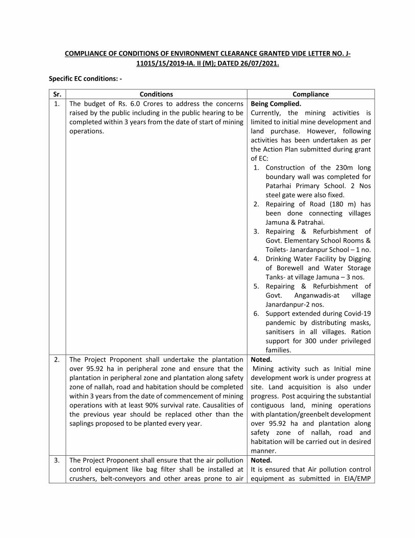
COMPLIANCE OF CONDITIONS OF ENVIRONMENT CLEARANCE GRANTED VIDE LETTER NO. J-
11015/15/2019-IA. II (M); DATED 26/07/2021.
Specific EC conditions: -
Sr. Conditions Compliance
1. The budget of Rs. 6.0 Crores to address the concerns raised by the public including in the public hearing to be completed within 3 years from the date of start of mining operations.
Being Complied. Currently, the mining activities is limited to initial mine development and land purchase. However, following activities has been undertaken as per the Action Plan submitted during grant of EC: 1. Construction of the 230m long
boundary wall was completed for Patarhai Primary School. 2 Nos steel gate were also fixed.
2. Repairing of Road (180 m) has been done connecting villages Jamuna & Patrahai.
3. Repairing & Refurbishment of Govt. Elementary School Rooms & Toilets- Janardanpur School – 1 no.
4. Drinking Water Facility by Digging of Borewell and Water Storage Tanks- at village Jamuna – 3 nos.
5. Repairing & Refurbishment of Govt. Anganwadis-at village Janardanpur-2 nos.
6. Support extended during Covid-19 pandemic by distributing masks, sanitisers in all villages. Ration support for 300 under privileged families.
2. The Project Proponent shall undertake the plantation over 95.92 ha in peripheral zone and ensure that the plantation in peripheral zone and plantation along safety zone of nallah, road and habitation should be completed within 3 years from the date of commencement of mining operations with at least 90% survival rate. Causalities of the previous year should be replaced other than the saplings proposed to be planted every year.
Noted. Mining activity such as Initial mine development work is under progress at site. Land acquisition is also under progress. Post acquiring the substantial contiguous land, mining operations with plantation/greenbelt development over 95.92 ha and plantation along safety zone of nallah, road and habitation will be carried out in desired manner.
3. The Project Proponent shall ensure that the air pollution control equipment like bag filter shall be installed at crushers, belt-conveyors and other areas prone to air
Noted. It is ensured that Air pollution control equipment as submitted in EIA/EMP
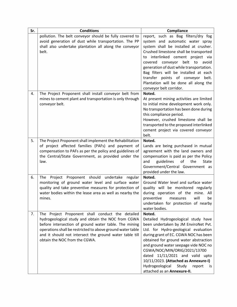
Sr. Conditions Compliance
pollution. The belt conveyor should be fully covered to avoid generation of dust while transportation. The PP shall also undertake plantation all along the conveyor belt.
report, such as Bag filters/dry fog system and automatic water spray system shall be installed at crusher. Crushed limestone shall be transported to interlinked cement project via covered conveyor belt to avoid generation of dust while transportation. Bag filters will be installed at each transfer points of conveyor belt. Plantation will be done all along the conveyor belt corridor.
4. The Project Proponent shall install conveyor belt from mines to cement plant and transportation is only through conveyor belt.
Noted. At present mining activities are limited to initial mine development work only. No transportation has been done during this compliance period. However, crushed limestone shall be transported to the proposed interlinked cement project via covered conveyor belt.
5. The Project Proponent shall implement the Rehabilitation of project affected families (PAFs) and payment of compensation to PAFs as per the policy and guidelines of the Central/State Government, as provided under the law.
Noted. Lands are being purchased in mutual agreement with the land owners and compensation is paid as per the Policy and guidelines of the State Government/Central Government as provided under the law.
6. The Project Proponent should undertake regular monitoring of ground water level and surface water quality and take preventive measures for protection of water bodies within the lease area as well as nearby the mines.
Noted. Ground Water level and surface water quality will be monitored regularly during operation of the mine. All preventive measures will be undertaken for protection of nearby water bodies.
7. The Project Proponent shall conduct the detailed hydrogeological study and obtain the NOC from CGWA before intersection of ground water table. The mining operations shall be restricted to above ground water table and it should not intersect the ground water table till obtain the NOC from the CGWA.
Noted. Detailed Hydrogeological study have been undertaken by JM EnviroNet Pvt. Ltd. for Hydro-geological evaluation during grant of EC. CGWA NOC has been obtained for ground water abstraction and ground water seepage vide NOC no CGWA/NOC/MIN/ORIG/2021/13700 dated 11/11/2021 and valid upto 10/11/2023. (Attached as Annexure-I) Hydrogeological Study report is attached as an Annexure-II.
Sr. Conditions Compliance
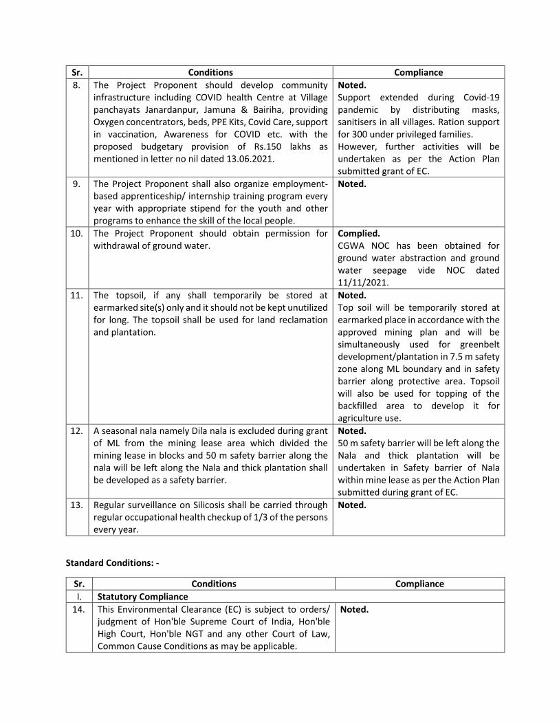
8. The Project Proponent should develop community infrastructure including COVID health Centre at Village panchayats Janardanpur, Jamuna & Bairiha, providing Oxygen concentrators, beds, PPE Kits, Covid Care, support in vaccination, Awareness for COVID etc. with the proposed budgetary provision of Rs.150 lakhs as mentioned in letter no nil dated 13.06.2021.
Noted. Support extended during Covid-19 pandemic by distributing masks, sanitisers in all villages. Ration support for 300 under privileged families. However, further activities will be undertaken as per the Action Plan submitted grant of EC.
9. The Project Proponent shall also organize employment-based apprenticeship/ internship training program every year with appropriate stipend for the youth and other programs to enhance the skill of the local people.
Noted.
10. The Project Proponent should obtain permission for withdrawal of ground water.
Complied. CGWA NOC has been obtained for ground water abstraction and ground water seepage vide NOC dated 11/11/2021.
11. The topsoil, if any shall temporarily be stored at earmarked site(s) only and it should not be kept unutilized for long. The topsoil shall be used for land reclamation and plantation.
Noted. Top soil will be temporarily stored at earmarked place in accordance with the approved mining plan and will be simultaneously used for greenbelt development/plantation in 7.5 m safety zone along ML boundary and in safety barrier along protective area. Topsoil will also be used for topping of the backfilled area to develop it for agriculture use.
12. A seasonal nala namely Dila nala is excluded during grant of ML from the mining lease area which divided the mining lease in blocks and 50 m safety barrier along the nala will be left along the Nala and thick plantation shall be developed as a safety barrier.
Noted. 50 m safety barrier will be left along the Nala and thick plantation will be undertaken in Safety barrier of Nala within mine lease as per the Action Plan submitted during grant of EC.
13. Regular surveillance on Silicosis shall be carried through regular occupational health checkup of 1/3 of the persons every year.
Noted.
Standard Conditions: -
Sr. Conditions Compliance
I. Statutory Compliance
14. This Environmental Clearance (EC) is subject to orders/ judgment of Hon'ble Supreme Court of India, Hon'ble High Court, Hon'ble NGT and any other Court of Law, Common Cause Conditions as may be applicable.
Noted.

Sr. Conditions Compliance
15. The Project proponent complies with all the statutory requirements and judgement of Hon'ble Supreme Court dated 2nd August,2017 in Writ Petition (Civil) No. 114 of 2014 in matter of Common Cause versus Union of India & Ors before commencing the mining operations.
Noted.
16. The State Government concerned shall ensure that mining operation shall not be commenced till the entire compensation levied, if any, for illegal mining paid by the Project Proponent through their respective Department of Mining & Geology in strict compliance of Judgement of Hon'ble Supreme Court dated 2nd August, 2017 in Writ Petition (Civil) No. 114 of 2014 in matter of Common Cause versus Union of India & Ors.
-
17. The Project Proponent shall follow the mitigation measures provided in MoEFCC's Office Memorandum No. Z-11013/57/2014-IAJI (M), dated 29th October, 2014, titled "Impact of mining activities on Habitations-Issues related to the mining Projects wherein Habitations and villages are the part of mine lease areas or Habitations and villages are surrounded by the mine lease area".
Noted.
18 A copy of EC letter will be marked to concerned Panchayat / local NGO etc. if any, from whom suggestion / representation has been received while processing the proposal.
Complied. Attached as Annexure-III.
19. State Pollution Control Board/Committee shall be responsible for display of this EC letter at its Regional office, District Industries Centre and Collector's office/ Tehsildar's Office for 30 days.
-
20. The Project Authorities should widely advertise about the grant of this EC letter by printing the same in at least two local newspapers, one of which shall be in vernacular language of the concerned area. The advertisement shall be done within 7 days of the issue of the clearance letter mentioning that the instant project has been accorded EC and copy of the EC letter is available with the State Pollution Control Board/Committee and web site of the Ministry of Environment, Forest and Climate Change (www.environmentalclearance.nic.in). A copy of the advertisement may be forwarded to the concerned MoEFCC Regional Office for compliance and record.
Complied. A public notice informing about grant of EC has been published in two newspapers named “Dainik Jagaran and Navbharat” on 4th August 2021 in English as well as in vernacular language i.e. Hindi. Copy of Advertisements are attached as Annexure-IV. Newspapers with advertisement have been submitted to the Regional Office of MoEFCC. Copy of submission receipt is attached as Annexure-V.
21. The Project Proponent shall inform the MoEF&CC for any change in ownership of the mining lease. In case there is any change in ownership or mining lease is transferred than mining operation shall only be carried out after
Noted.
Sr. Conditions Compliance
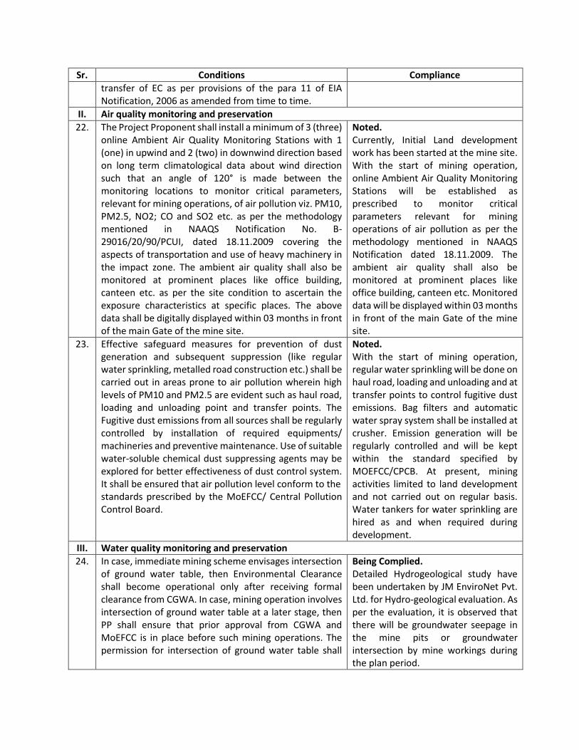
transfer of EC as per provisions of the para 11 of EIA Notification, 2006 as amended from time to time.
II. Air quality monitoring and preservation
22. The Project Proponent shall install a minimum of 3 (three) online Ambient Air Quality Monitoring Stations with 1 (one) in upwind and 2 (two) in downwind direction based on long term climatological data about wind direction such that an angle of 120° is made between the monitoring locations to monitor critical parameters, relevant for mining operations, of air pollution viz. PM10, PM2.5, NO2; CO and SO2 etc. as per the methodology mentioned in NAAQS Notification No. B-29016/20/90/PCUI, dated 18.11.2009 covering the aspects of transportation and use of heavy machinery in the impact zone. The ambient air quality shall also be monitored at prominent places like office building, canteen etc. as per the site condition to ascertain the exposure characteristics at specific places. The above data shall be digitally displayed within 03 months in front of the main Gate of the mine site.
Noted. Currently, Initial Land development work has been started at the mine site. With the start of mining operation, online Ambient Air Quality Monitoring Stations will be established as prescribed to monitor critical parameters relevant for mining operations of air pollution as per the methodology mentioned in NAAQS Notification dated 18.11.2009. The ambient air quality shall also be monitored at prominent places like office building, canteen etc. Monitored data will be displayed within 03 months in front of the main Gate of the mine site.
23. Effective safeguard measures for prevention of dust generation and subsequent suppression (like regular water sprinkling, metalled road construction etc.) shall be carried out in areas prone to air pollution wherein high levels of PM10 and PM2.5 are evident such as haul road, loading and unloading point and transfer points. The Fugitive dust emissions from all sources shall be regularly controlled by installation of required equipments/ machineries and preventive maintenance. Use of suitable water-soluble chemical dust suppressing agents may be explored for better effectiveness of dust control system. It shall be ensured that air pollution level conform to the standards prescribed by the MoEFCC/ Central Pollution Control Board.
Noted. With the start of mining operation, regular water sprinkling will be done on haul road, loading and unloading and at transfer points to control fugitive dust emissions. Bag filters and automatic water spray system shall be installed at crusher. Emission generation will be regularly controlled and will be kept within the standard specified by MOEFCC/CPCB. At present, mining activities limited to land development and not carried out on regular basis. Water tankers for water sprinkling are hired as and when required during development.
III. Water quality monitoring and preservation
24. In case, immediate mining scheme envisages intersection of ground water table, then Environmental Clearance shall become operational only after receiving formal clearance from CGWA. In case, mining operation involves intersection of ground water table at a later stage, then PP shall ensure that prior approval from CGWA and MoEFCC is in place before such mining operations. The permission for intersection of ground water table shall
Being Complied. Detailed Hydrogeological study have been undertaken by JM EnviroNet Pvt. Ltd. for Hydro-geological evaluation. As per the evaluation, it is observed that there will be groundwater seepage in the mine pits or groundwater intersection by mine workings during the plan period.
Sr. Conditions Compliance
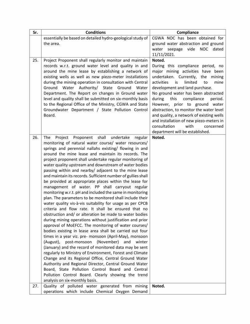
essentially be based on detailed hydro-geological study of the area.
CGWA NOC has been obtained for ground water abstraction and ground water seepage vide NOC dated 11/11/2021.
25. Project Proponent shall regularly monitor and maintain records w.r.t. ground water level and quality in and around the mine lease by establishing a network of existing wells as well as new piezo-meter installations during the mining operation in consultation with Central Ground Water Authority/ State Ground Water Department. The Report on changes in Ground water level and quality shall be submitted on six-monthly basis to the Regional Office of the Ministry, CGWA and State Groundwater Department / State Pollution Control Board.
Noted. During this compliance period, no major mining activities have been undertaken. Currently, the mining activities is limited to mine development and land purchase. No ground water has been abstracted during this compliance period. However, prior to ground water abstraction, to monitor the water level and quality, a network of existing wells and installation of new piezo-meters in consultation with concerned department will be established.
26. The Project Proponent shall undertake regular monitoring of natural water course/ water resources/ springs and perennial nallahs existing/ flowing in and around the mine lease and maintain its records. The project proponent shall undertake regular monitoring of water quality upstream and downstream of water bodies passing within and nearby/ adjacent to the mine lease and maintain its records. Sufficient number of gullies shall be provided at appropriate places within the lease for management of water. PP shall carryout regular monitoring w.r.t. pH and included the same in monitoring plan. The parameters to be monitored shall include their water quality vis-à-vis suitability for usage as per CPCB criteria and flow rate. It shall be ensured that no obstruction and/ or alteration be made to water bodies during mining operations without justification and prior approval of MoEFCC. The monitoring of water courses/ bodies existing in lease area shall be carried out four times in a year viz. pre- monsoon (April-May), monsoon (August), post-monsoon (November) and winter (January) and the record of monitored data may be sent regularly to Ministry of Environment, Forest and Climate Change and its Regional Office, Central Ground Water Authority and Regional Director, Central Ground Water Board, State Pollution Control Board and Central Pollution Control Board. Clearly showing the trend analysis on six-monthly basis.
Noted.
27. Quality of polluted water generated from mining operations which include Chemical Oxygen Demand
Noted.
Sr. Conditions Compliance
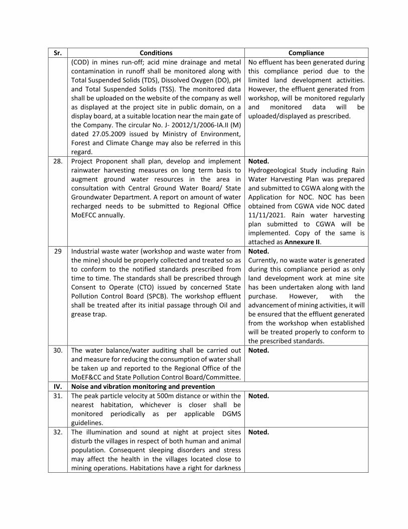
(COD) in mines run-off; acid mine drainage and metal contamination in runoff shall be monitored along with Total Suspended Solids (TDS), Dissolved Oxygen (DO), pH and Total Suspended Solids (TSS). The monitored data shall be uploaded on the website of the company as well as displayed at the project site in public domain, on a display board, at a suitable location near the main gate of the Company. The circular No. J- 20012/1/2006-IA.II (M) dated 27.05.2009 issued by Ministry of Environment, Forest and Climate Change may also be referred in this regard.
No effluent has been generated during this compliance period due to the limited land development activities. However, the effluent generated from workshop, will be monitored regularly and monitored data will be uploaded/displayed as prescribed.
28. Project Proponent shall plan, develop and implement rainwater harvesting measures on long term basis to augment ground water resources in the area in consultation with Central Ground Water Board/ State Groundwater Department. A report on amount of water recharged needs to be submitted to Regional Office MoEFCC annually.
Noted. Hydrogeological Study including Rain Water Harvesting Plan was prepared and submitted to CGWA along with the Application for NOC. NOC has been obtained from CGWA vide NOC dated 11/11/2021. Rain water harvesting plan submitted to CGWA will be implemented. Copy of the same is attached as Annexure II.
29 Industrial waste water (workshop and waste water from the mine) should be properly collected and treated so as to conform to the notified standards prescribed from time to time. The standards shall be prescribed through Consent to Operate (CTO) issued by concerned State Pollution Control Board (SPCB). The workshop effluent shall be treated after its initial passage through Oil and grease trap.
Noted. Currently, no waste water is generated during this compliance period as only land development work at mine site has been undertaken along with land purchase. However, with the advancement of mining activities, it will be ensured that the effluent generated from the workshop when established will be treated properly to conform to the prescribed standards.
30. The water balance/water auditing shall be carried out and measure for reducing the consumption of water shall be taken up and reported to the Regional Office of the MoEF&CC and State Pollution Control Board/Committee.
Noted.
IV. Noise and vibration monitoring and prevention
31. The peak particle velocity at 500m distance or within the nearest habitation, whichever is closer shall be monitored periodically as per applicable DGMS guidelines.
Noted.
32. The illumination and sound at night at project sites disturb the villages in respect of both human and animal population. Consequent sleeping disorders and stress may affect the health in the villages located close to mining operations. Habitations have a right for darkness
Noted.
Sr. Conditions Compliance
and minimal noise levels at night. PPs must ensure that the biological clock of the villages is not disturbed; by orienting the floodlights/ masks away from the villagers and keeping the noise levels well within the prescribed limits for day /night hours.
33. The Project Proponent shall take measures for control of noise levels below 85 dBA in the work environment. The workers engaged in operations of HEMM, etc. should be provided with ear plugs /muffs. All personnel including laborers working in dusty areas shall be provided with protective respiratory devices along with adequate training, awareness and information on safety and health aspects. The PP shall be held responsible in case it has been found that workers/ personals/ laborers are working without personal protective equipment.
Noted and Being Complied.
V. Mining Plan
34. The Project Proponent shall adhere to approved mining plan, inter alia, including total excavation (quantum of mineral, waste, over burden, inter burden and top soil etc.); mining technology; lease area; scope of working (viz. method of mining, overburden & dump management, O.B & dump mining, mineral transportation mode, ultimate depth of mining, concurrent reclamation and reclamation at mine closure; land-use of the mine lease area at various stages of mining scheme as well as end-of-life; etc.
Noted. Mining operation could not commence due to onset of monsoon. Mining Operations will be carried out in accordance with the approved mining plan.
35. The land-use of the mine lease area at various stages of mining scheme as well as at the end-of-life shall be governed as per the approved Mining Plan. The excavation vis-à-vis backfilling in the mine lease area and corresponding afforestation to be raised in the reclaimed area shall be governed as per approved mining plan. PP shall ensure the monitoring and management of rehabilitated areas until the vegetation becomes self-sustaining. The compliance status shall be submitted half-yearly to the MoEFCC and its concerned Regional Office.
Noted. Mining operation and reclamation-rehabilitation of mined out area will be carried out in accordance with the approved mining plan.
VI. Land reclamation
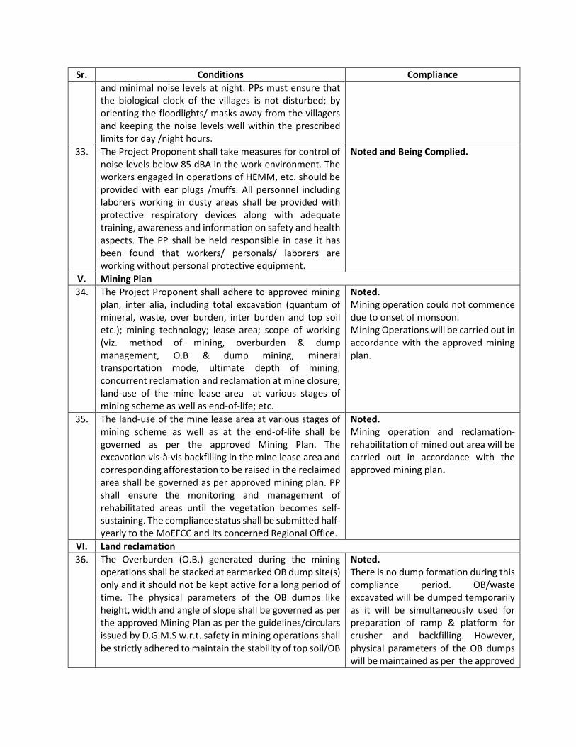
36. The Overburden (O.B.) generated during the mining operations shall be stacked at earmarked OB dump site(s) only and it should not be kept active for a long period of time. The physical parameters of the OB dumps like height, width and angle of slope shall be governed as per the approved Mining Plan as per the guidelines/circulars issued by D.G.M.S w.r.t. safety in mining operations shall be strictly adhered to maintain the stability of top soil/OB
Noted. There is no dump formation during this compliance period. OB/waste excavated will be dumped temporarily as it will be simultaneously used for preparation of ramp & platform for crusher and backfilling. However, physical parameters of the OB dumps will be maintained as per the approved
Sr. Conditions Compliance
dumps. The topsoil shall be used for land reclamation and plantation.
Mining Plan as per the guidelines/circulars issued by D.G.M.S. Top soil will be dumped temporarily at northeastern side of the ML area and will be used for land reclamation and plantation. There will not be any dumps at conceptual stage.
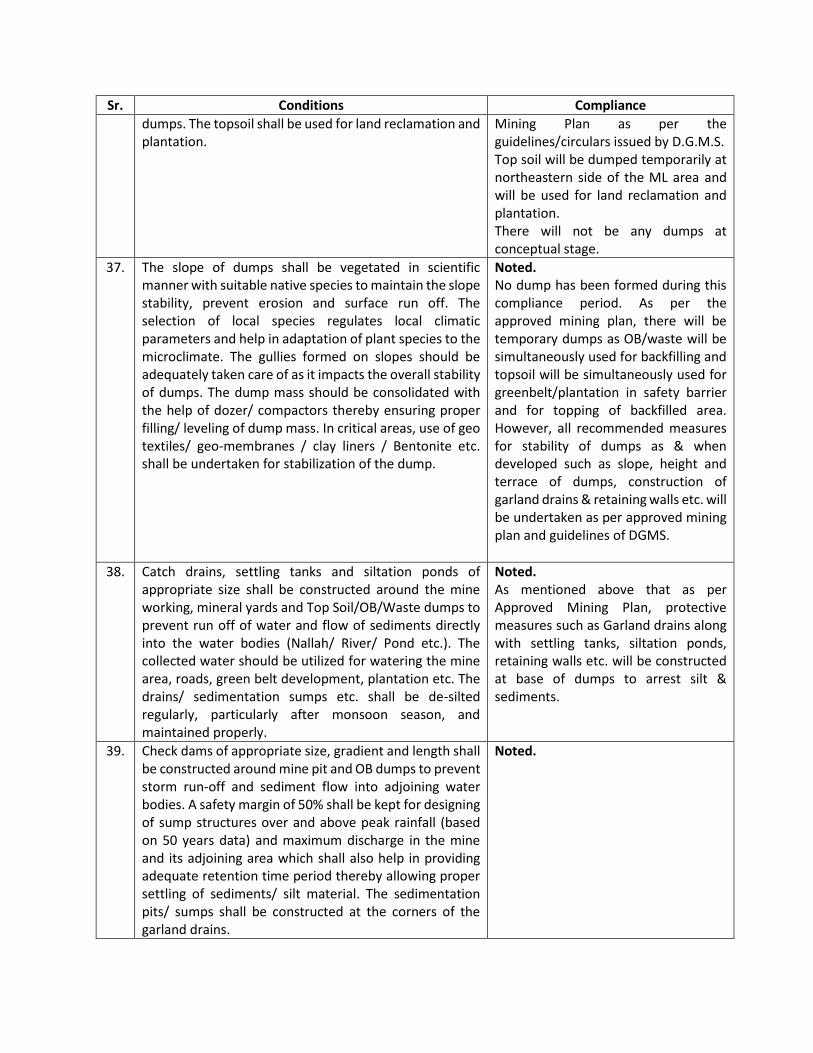
37. The slope of dumps shall be vegetated in scientific manner with suitable native species to maintain the slope stability, prevent erosion and surface run off. The selection of local species regulates local climatic parameters and help in adaptation of plant species to the microclimate. The gullies formed on slopes should be adequately taken care of as it impacts the overall stability of dumps. The dump mass should be consolidated with the help of dozer/ compactors thereby ensuring proper filling/ leveling of dump mass. In critical areas, use of geo textiles/ geo-membranes / clay liners / Bentonite etc. shall be undertaken for stabilization of the dump.
Noted. No dump has been formed during this compliance period. As per the approved mining plan, there will be temporary dumps as OB/waste will be simultaneously used for backfilling and topsoil will be simultaneously used for greenbelt/plantation in safety barrier and for topping of backfilled area. However, all recommended measures for stability of dumps as & when developed such as slope, height and terrace of dumps, construction of garland drains & retaining walls etc. will be undertaken as per approved mining plan and guidelines of DGMS.
38. Catch drains, settling tanks and siltation ponds of appropriate size shall be constructed around the mine working, mineral yards and Top Soil/OB/Waste dumps to prevent run off of water and flow of sediments directly into the water bodies (Nallah/ River/ Pond etc.). The collected water should be utilized for watering the mine area, roads, green belt development, plantation etc. The drains/ sedimentation sumps etc. shall be de-silted regularly, particularly after monsoon season, and maintained properly.
Noted. As mentioned above that as per Approved Mining Plan, protective measures such as Garland drains along with settling tanks, siltation ponds, retaining walls etc. will be constructed at base of dumps to arrest silt & sediments.
39. Check dams of appropriate size, gradient and length shall be constructed around mine pit and OB dumps to prevent storm run-off and sediment flow into adjoining water bodies. A safety margin of 50% shall be kept for designing of sump structures over and above peak rainfall (based on 50 years data) and maximum discharge in the mine and its adjoining area which shall also help in providing adequate retention time period thereby allowing proper settling of sediments/ silt material. The sedimentation pits/ sumps shall be constructed at the corners of the garland drains.
Noted.

Sr. Conditions Compliance
VII. Transportation
40. No Transportation of the minerals shall be allowed in case of roads passing through villages/ habitations. In such cases, PP shall construct a ‘bypass’ road for the purpose of transportation of the minerals leaving an adequate gap (say at least 200 meters) so that the adverse impact of sound and dust along with chances of accidents could be mitigated. All costs resulting from widening and strengthening of existing public road network shall be borne by the PP in consultation with nodal State Govt. Department. Transportation of minerals through road movement in case of existing village/ rural roads shall be allowed in consultation with nodal State Govt. Department only after required strengthening such that the carrying capacity of roads is increased to handle the traffic load. The pollution due to transportation load on the environment will be effectively controlled and water sprinkling will also be done regularly. Vehicular emissions shall be kept under control and regularly monitored. Project should obtain Pollution Under Control (PUC) certificate for all the vehicles from authorized pollution testing centers. [If applicable in case of road transport].
Noted. No transportation of minerals outside lease area has been undertaken during this compliance period. However, Limestone from the mine shall be transported to the interlinked cement project by covered conveyor belt.
41. The Main haulage road within the mine lease should be provided with a permanent water sprinkling arrangement for dust suppression. Other roads within the mine lease should be wetted regularly with tanker-mounted water sprinkling system. The other areas of dust generation like crushing zone, material transfer points, material yards etc. should invariably be provided with dust suppression arrangements. The air pollution control equipments like bag filters, vacuum suction hoods, dry fogging system etc. shall be installed at Crushers, belt-conveyors and other areas prone to air pollution. The belt conveyor should be fully covered to avoid generation of dust while transportation. PP shall take necessary measures to avoid generation of fugitive dust emissions.
Noted. Currently, Water tankers are hired as and when required as the mining activities are limited to initial land development and not carried out on regular basis. With the advancement of mining operation, all the measures shall be implemented as per the provisions of EMP given in EIA/EMP report to control fugitive dust emissions such as permanent water sprinkling arrangement at the main haulage road , Bag filters will be installed at crusher and transfer points on conveyor belt, use of covered conveyor belt etc.
VIII. Green Belt
42. The Project Proponent shall develop greenbelt in 7.5m wide safety zone all along the mine lease boundary as per the guidelines of CPCB in order to arrest pollution emanating from mining operations within the lease. The whole Green belt shall be developed within first 5 years starting from windward side of the active mining area. The development of greenbelt shall be governed as per
Noted. The mining activities is currently limited to initial mine development and land purchase as Mining operation could not be commenced due to onset of monsoon. Safety barrier (No mining zone) of 7.5m is demarcated all along

Sr. Conditions Compliance
the EC granted by the Ministry irrespective of the stipulation made in approved mine plan.
the ML boundary and soon after, land development activities and land purchase, greenbelt will be developed as per guidelines of CPCB and as per approved mining plan.
43. The Project Proponent shall carryout plantation/ afforestation in backfilled and reclaimed area of mining lease, around water body, along the roadsides, in community areas etc. by planting the native species in consultation with the State Forest Department/ Agriculture Department/ Rural development department/ Tribal Welfare Department/ Gram Panchayat such that only those species be selected which are of use to the local people. The CPCB guidelines in this respect shall also be adhered. The density of the trees should be around 2500 saplings per Hectare. Adequate budgetary provision shall be made for protection and care of trees.
Noted. No major mining activities have been undertaken after grant of EC & CTO due to onset of monsoon except the initial land development and land purchase. Consultation with DFO, Satna is in progress for development of greenbelt/plantation. Letter submitted to the concerned DFO is attached as Annexure-VI.
44. The Project Proponent shall make necessary alternative arrangements for livestock feed by developing grazing land with a view to compensate those areas which are coming within the mine lease. The development of such grazing land shall be done in consultation with the State Government. In this regard, Project Proponent should essentially implement the directions of the Hon’ble Supreme Court with regard to acquisition of grazing land. The sparse trees on such grazing ground, which provide mid-day shelter from the scorching sun, should be scrupulously guarded/ protected against felling and plantation of such trees should be promoted.
No grazing land falls within ML area.
IX. Public hearing and human health issues
45. Project Proponent shall make provision for the housing for workers/labors or shall construct labor camps within/outside (company owned land) with necessary basic: infrastructure/ facilities like fuel for cooking, mobile toilets, mobile STP, safe drinking water, medical health care, creche for kids etc. The housing may be provided in the form of temporary structures which can be removed after the completion of the project related infrastructure. The domestic waste water should be treated with STP in order to avoid contamination of underground water.
Noted. The mining operation is limited to initial land development and land purchase during this compliance period. Being mining project, no major construction will be done except mines office, crusher etc. As local people will be engaged during construction and operation phase, provision for housing for workers will not be required. However, all necessary facilities will be provided. Currently, mining activities are being carried out intermittently with limited

Sr. Conditions Compliance
manpower. At present, it is regulated by a remote office outside the ML area having all infrastructure facilities. Therefore, it is proposed to install portable Bio-toilets at the site to cater to the requirement. During later years when the mine will be operating at full capacity, domestic waste water will be treated in proposed STP and treated water will be used for plantation purpose.
X. Corporate Environment Responsibility (CER)
46. The Project Proponent shall submit the time-bound action plan to the' concerned regional office of the Ministry within 6 months from the date of issuance of environmental clearance for undertaking the activities committed during public consultation by the project proponent and as discussed by the EAC, in terms of the provisions of the MoEF&CC Office Memorandum No.22-65/2017-IA. lll dated 30 September, 2020. The action plan shall be implemented within three years of commencement of the project.
Time bound action plan was prepared as per MoEF&CC Office Memorandum No.22-65/2017-IA. lll dated 30 September, 2020 and submitted during grant of EC. Time bound action plan with budgetary provisions is attached as an Annexure VII. Copy of submission of the same to RO, MOEFCC dated 01.12.2021 is attached as an Annexure-VIII. The mine is in initial stage of land development and land purchase. It will be undertaken as per the Action Plan submitted.
XI. Miscellaneous
47. The Project Proponent shall prepare digital map (land use & land cover) of the entire lease area once in five years purpose of monitoring land use pattern and submit a report to concerned Regional Office of the MoEF&CC.
Noted.
48. The Project Authorities should inform to the Regional Office regarding date of financial closures and final approval of the project by the concerned authorities and the date of start of land development work.
Noted.
49. The Project Proponent shall submit six monthly compliance reports on the status of the implementation of the stipulated environmental safeguards to the MOEFCC & its concerned Regional Office, Central Pollution Control Board and State Pollution Control Board.
Noted.
50. A separate 'Environmental Management Cell' with suitable qualified manpower should be set up under the control of a Senior Executive. The Senior Executive shall directly report to Head of the Organization. Adequate number of qualified Environmental Scientists and Mining
Noted.
Sr. Conditions Compliance
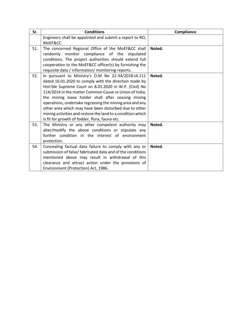
Engineers shall be appointed and submit a report to RO, MoEF&CC.
51. The concerned Regional Office of the MoEF&CC shall randomly monitor compliance of the stipulated conditions. The project authorities should extend full cooperation to the MoEF&CC officer(s) by furnishing the requisite data / information/ monitoring reports.
Noted.
52. In pursuant to Ministry's O.M No 22-34/2018-IA.111 dated 16.01.2020 to comply with the direction made by Hon'ble Supreme Court on 8.01.2020 in W.P. (Civil) No 114/2014 in the matter Common Cause vs Union of India, the mining lease holder shall after ceasing mining operations, undertake regrassing the mining area and any other area which may have been disturbed due to other mining activities and restore the land to a condition which is fit for growth of fodder, flora, fauna etc.
Noted.
53. The Ministry or any other competent authority may alter/modify the above conditions or stipulate any further condition in the interest of environment protection.
Noted.
54. Concealing factual data failure to comply with any or submission of false/ fabricated data and of the conditions mentioned above may result in withdrawal of this clearance and attract action under the provisions of Environment (Protection) Act, 1986.
Noted.
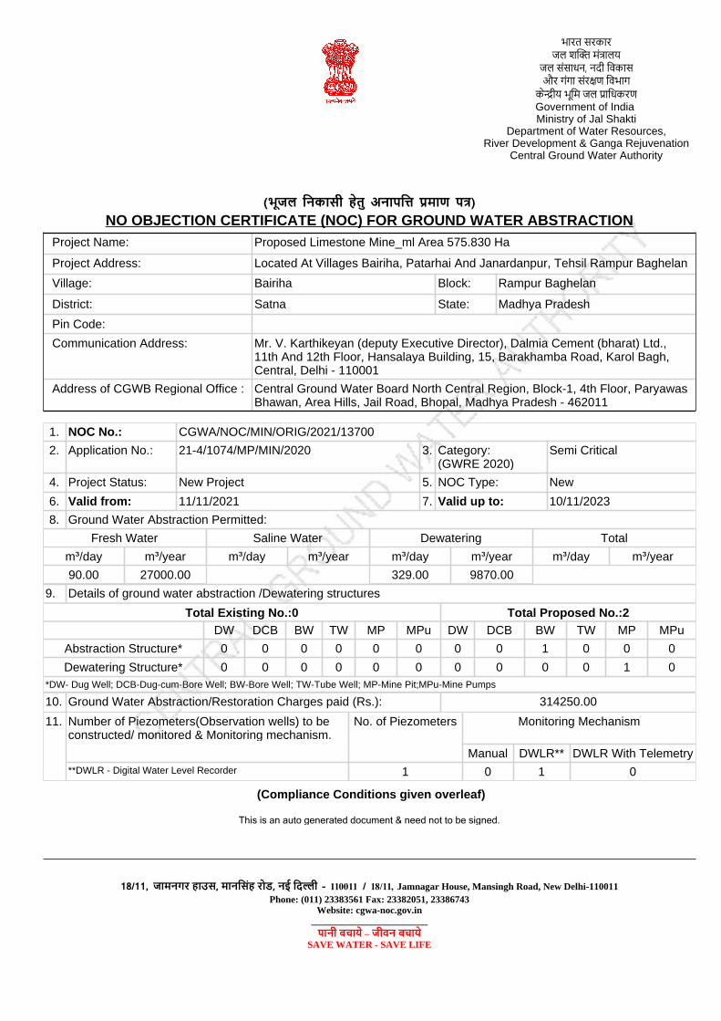
Project Name: Proposed Limestone Mine_ml Area 575.830 Ha
Project Address: Located At Villages Bairiha, Patarhai And Janardanpur, Tehsil Rampur Baghelan
Village: Bairiha Block: Rampur Baghelan
District: Satna State: Madhya Pradesh
Pin Code:
Communication Address: Mr. V. Karthikeyan (deputy Executive Director), Dalmia Cement (bharat) Ltd., 11th And 12th Floor, Hansalaya Building, 15, Barakhamba Road, Karol Bagh, Central, Delhi - 110001
Address of CGWB Regional Office : Central Ground Water Board North Central Region, Block-1, 4th Floor, Paryawas Bhawan, Area Hills, Jail Road, Bhopal, Madhya Pradesh - 462011
1. NOC No.: CGWA/NOC/MIN/ORIG/2021/13700
2. Application No.: 21-4/1074/MP/MIN/2020 3. Category:(GWRE 2020)
Semi Critical
4. Project Status: New Project 5. NOC Type: New
6. Valid from: 11/11/2021 7. Valid up to: 10/11/2023
8. Ground Water Abstraction Permitted:
Fresh Water Saline Water Dewatering Total
m³/day m³/year m³/day m³/year m³/day m³/year m³/day m³/year
90.00 27000.00 329.00 9870.00
9. Details of ground water abstraction /Dewatering structures
DW DCB BW TW MP MPu DW DCB BW TW MP MPu
Abstraction Structure* 0 0 0 0 0 0 0 0 1 0 0 0
Dewatering Structure* 0 0 0 0 0 0 0 0 0 0 1 0*DW- Dug Well; DCB-Dug-cum-Bore Well; BW-Bore Well; TW-Tube Well; MP-Mine Pit;MPu-Mine Pumps
10. Ground Water Abstraction/Restoration Charges paid (Rs.): 314250.00
11. Number of Piezometers(Observation wells) to be constructed/ monitored & Monitoring mechanism.
No. of Piezometers Monitoring Mechanism
Manual DWLR** DWLR With Telemetry**DWLR - Digital Water Level Recorder 1 0 1 0
(भूजल निकासी हेतु िा न मा )NO OBJECTION CERTIFICATE (NOC) FOR GROUND WATER ABSTRACTION
(Compliance Conditions given overleaf)
This is an auto generated document & need not to be signed.
Total Existing No.:0 Total Proposed No.:2
भारत सरकार म ा य
ससाधन, नदी विकासर ा सर विभा
क ीय भवम ावधकरGovernment of India Ministry of Jal Shakti
Department of Water Resources,River Development & Ganga Rejuvenation
Central Ground Water Authority
18/11, जामिगर हा स मािनसह र ि न ी – 110011 / 18/11, Jamnagar House, Mansingh Road, New Delhi-110011Phone: (011) 23383561 Fax: 23382051, 23386743
Website: cgwa-noc.gov.in________________________
ािी बचाये – जीवि बचायेSAVE WATER - SAVE LIFE

Validity of this NOC shall be subject to compliance of the following conditions:
Mandatory conditions:
1) Installation of tamper proof digital water flow meter with telemetry on all the abstraction structure(s) shall be mandatory for all users seeking No Objection Certificate and intimation regarding their installation shall be communicated to the CGWA within 30 days of grant of No Objection Certificate.
2) Proponents shall mandatorily get water flow meter calibrated from an authorized agency once in a year.
3) Construction of purpose-built observation wells (piezometers) for ground water level monitoring shall be mandatory as per Section 14 of Guidelines. Water level data shall be made available to CGWA through web portal. Detailed guidelines for construction of piezometers are given in Annexure-II of the guidelines.
4) Proponents shall monitor quality of ground water from the abstraction structure(s) once in a year. Water samples from bore wells/ tube wells / dug wells shall be collected during April/May every year and analysed in NABL accredited laboratories for basic parameters (cations and anions), heavy metals, pesticides/ organic compounds etc. Water quality data shall be made available to CGWA through the web portal.
5) In case of mining projects, additional key wells shall be established in consultation with the Regional Director, CGWB for ground water level monitoring four (4) times a year (January, May, August and November) in core as well as buffer zones of the mine.
6) In case of mining project the firm shall submit water quality report of mine discharge/ seepage from Govt. approved/ NABL accredited lab.
7) The firm shall report compliance of the NOC conditions online in the website (www.cgwa-noc.gov.in) within one year from the date of issue of this NOC.
8) Industries abstracting ground water in excess of 100 m 3 /d shall undertake annual water audit through certified auditors and submit audit reports within three months of completion of the same to CGWA. All such industries shall be required to reduce their ground water use by at least 20% over the next three years through appropriate means.
9) Application for renewal can be submitted online from 90 days before the expiry of NOC. Ground water withdrawal, if any, after expiry of NOC shall be illegal & liable for legal action as per provisions of Environment (Protection) Act, 1986.
10) This NOC is subject to prevailing Central/State Government rules/laws/norms or Court orders related to construction of tube well/ground water abstraction structure / recharge or conservation structure/discharge of effluents or any such matter as applicable.
General conditions:
11) No additional ground water abstraction and/or de-watering structures shall be constructed for this purpose without prior approval of the Central Ground Water Authority (CGWA).
12) The proponent shall seek prior permission from CGWA for any increase in quantum of groundwater abstraction (more than that permitted in NOC for specific period).
13) Proponents shall install roof top rain water harvesting in the premise as per the existing building bye laws in the premise.
14) The project proponent shall take all necessary measures to prevent contamination of ground water in the premises failing which the firm shall be responsible for any consequences arising thereupon.
15) In case of industries that are likely to contaminate the ground water, no recharge measures shall be taken up by the firm inside the plant premises. The runoff generated from the rooftop shall be stored and put to beneficial use by the firm.
16) Wherever feasible, requirement of water for greenbelt (horticulture) shall be met from recycled / treated waste water.
17) Wherever the NOC is for abstraction of saline water and the existing wells (s) is /are yielding fresh water, the same shall be sealed and new tubewell(s) tapping saline water zone shall be constructed within 3 months of the issuance of NOC. The firm shall also ensure safe disposal of saline residue, if any.
18) Unexpected variations in inflow of ground water into the mine pit, if any, shall be reported to the concerned Regional Director, Central Ground Water Board.
19) In case of violation of any NOC conditions, the applicant shall be liable to pay the penalties as per Section 16 of Guidelines.
20) This NOC does not absolve the proponents of their obligation / requirement to obtain other statutory and administrative clearances from appropriate authorities.
21) The issue of this NOC does not imply that other statutory / administrative clearances shall be granted to the project by the concerned authorities. Such authorities would consider the project on merits and take decisions independently of the NOC.
22) In case of change of ownership, new owner of the industry will have to apply for incorporation of necessary changes in the No Objection Certificate with documentary proof within 60 days of taking over possession of the premises.
23) This NOC is being issued without any prejudice to the directions of the Hon’ble NGT/court orders in cases related to ground water or any other related matters.
24) Proponents, who have installed/constructed artificial recharge structures in compliance of the NOC granted to them previously and have availed rebate of upto 50% (fifty percent) in the ground water abstraction charges/ground water restoration charges, shall continue to regularly maintain artificial recharge structures.
25) Industries which are likely to cause ground water pollution e.g. Tanning, Slaughter Houses, Dye, Chemical/ Petrochemical, Coal washeries, pharmaceutical, other hazardous units etc. (as per CPCB list) need to undertake necessary well head protection measures to ensure prevention of ground water pollution as per Annexure III of the guidelines.
26) In case of new infrastructure projects having ground water abstraction of more than 20 m3/day, the firm/entity shall ensure implementation of dual water supply system in the projects.
27) In case of infrastructure projects, paved/parking area must be covered with interlocking/perforated tiles or other suitable measures to ensure groundwater infiltration/harvesting.
28) In case of coal and other base metal mining projects, the project proponent shall use the advance dewatering technology (by construction of series of dewatering abstraction structures) to avoid contamination of surface water.
29) The NOC issued is conditional subject to the conditions mentioned in the Public notice dated 27.01.2021 failing which penalty/EC/cancellation of NOC shall be imposed as the case may be. 30) This NOC is issued subject to the clearance of Expert Appraisal Committee (EAC) (if applicable).
(Non-compliance of the conditions mentioned above is likely to result in the cancellation of NOC and legal action against the proponent.)

SUBMISSION to Central Ground Water Authority /BOARD
NABET ACCREDITED CONSULTANT
J.M. ENVIRONET PVT. LTD. (NABET CERTIFICATE NO. NABET/EIA/2023/RA 0186)
EMMAR DIGITAL GREENS, TOWER – B, UNIT NO. 1517, GOLF COURSE
EXT. ROAD, SECTOR – 61, GURUGRAM (HARYANA)
Email: [email protected]
PROJECT PROPONENT
M/S. DALMIA CEMENT (BHARAT) LIMITED (DCBL)
11TH AND 12TH FLOOR, HANSALAYA BUILDING 15, BARAKHAMBA ROAD
NEW DELHI-110001
COMPREHENSIVE hydrogeological report
As PER
Gazette Notification of Central Ground
Water Authority dated 24.09.2020
And
Subsequent public notices
APRIL 2021
PROPOSED LIMESTONE MINE (ML AREA: 575.830 HA.)
LIMESTONE PRODUCTION CAPACITY - 4.0 MTPA, TOP SOIL / SUB SOIL - 1.25 MTPA, WASTE
(OB/IB/SHALE) - 1.00 MTPA & SCREEN REJECTS - 0.40 MTPA
ALONG WITH INSTALLATION OF CRUSHER - 1200 TPH CAPACITY WITH WOBBLER
AT
VILLAGES: BAIRIHA, PATARHAI & JANARDANPUR, TEHSIL: RAMPUR BAGHELAN, DISTRICT:
SATNA (MP)
i
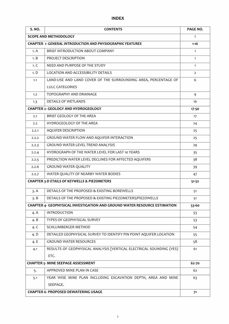
INDEX
S. NO. CONTENTS PAGE NO.
SCOPE AND METHODOLOGY I
CHAPTER 1- GENERAL INTRODUCTION AND PHYSIOGRAPHIC FEATURES 1-16
1. A BRIEF INTRODUCTION ABOUT COMPANY 1
1. B PROJECT DESCRIPTION 1
1. C NEED AND PURPOSE OF THE STUDY 1
1. D LOCATION AND ACCESSIBILITY DETAILS 2
1.1 LAND-USE AND LAND COVER OF THE SURROUNDING AREA, PERCENTAGE OF
LULC CATEGORIES
6
1.2 TOPOGRAPHY AND DRAINAGE 9
1.3 DETAILS OF WETLANDS 16
CHAPTER 2- GEOLOGY AND HYDROGEOLOGY 17-50
2.1 BRIEF GEOLOGY OF THE AREA 17
2.2 HYDROGEOLOGY OF THE AREA 24
2.2.1 AQUIFER DESCRIPTION 25
2.2.2 GROUND WATER FLOW AND AQUIFER INTERACTION 25
2.2.3 GROUND WATER LEVEL TREND ANALYSIS 29
2.2.4 HYDROGRAPH OF THE WATER LEVEL FOR LAST 10 YEARS 35
2.2.5 PREDICTION WATER LEVEL DECLINES FOR AFFECTED AQUIFERS 38
2.2.6 GROUND WATER QUALITY 39
2.2.7 WATER QUALITY OF NEARBY WATER BODIES 47
CHAPTER 3-D ETAILS OF KEYWELLS & PIEZOMETERS 51-52
3. A DETAILS OF THE PROPOSED & EXISTING BOREWELLS 51
3. B DETAILS OF THE PROPOSED & EXISTING PIEZOMETERS/PIEZOWELLS 51
CHAPTER 4- GEOPHYSICAL INVESTIGATION AND GROUND WATER RESOURCE ESTIMATION 53-60
4. A INTRODUCTION 53
4. B TYPES OF GEOPHYSICAL SURVEY 53
4. C SCHLUMBERGER METHOD 54
4. D DETAILED GEOPHYSICAL SURVEY TO IDENTIFY PIN POINT AQUIFER LOCATION 55
4. E GROUND WATER RESOURCES 58
4.1 RESULTS OF GEOPHYSICAL ANALYSIS [VERTICAL ELECTRICAL SOUNDING (VES)
ETC.
61
CHAPTER 5- MINE SEEPAGE ASSESSMENT 62-70
5. APPROVED MINE PLAN IN CASE 62
5.1 YEAR WISE MINE PLAN INCLUDING EXCAVATION DEPTH, AREA AND MINE
SEEPAGE.
63
CHAPTER 6- PROPOSED DEWATERING USAGE 71
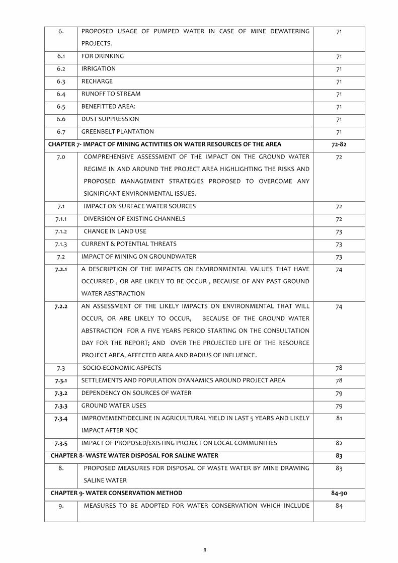
ii
6. PROPOSED USAGE OF PUMPED WATER IN CASE OF MINE DEWATERING
PROJECTS.
71
6.1 FOR DRINKING 71
6.2 IRRIGATION 71
6.3 RECHARGE 71
6.4 RUNOFF TO STREAM 71
6.5 BENEFITTED AREA: 71
6.6 DUST SUPPRESSION 71
6.7 GREENBELT PLANTATION 71
CHAPTER 7- IMPACT OF MINING ACTIVITIES ON WATER RESOURCES OF THE AREA 72-82
7.0 COMPREHENSIVE ASSESSMENT OF THE IMPACT ON THE GROUND WATER
REGIME IN AND AROUND THE PROJECT AREA HIGHLIGHTING THE RISKS AND
PROPOSED MANAGEMENT STRATEGIES PROPOSED TO OVERCOME ANY
SIGNIFICANT ENVIRONMENTAL ISSUES.
72
7.1 IMPACT ON SURFACE WATER SOURCES 72
7.1.1 DIVERSION OF EXISTING CHANNELS 72
7.1.2 CHANGE IN LAND USE 73
7.1.3 CURRENT & POTENTIAL THREATS 73
7.2 IMPACT OF MINING ON GROUNDWATER 73
7.2.1 A DESCRIPTION OF THE IMPACTS ON ENVIRONMENTAL VALUES THAT HAVE
OCCURRED , OR ARE LIKELY TO BE OCCUR , BECAUSE OF ANY PAST GROUND
WATER ABSTRACTION
74
7.2.2 AN ASSESSMENT OF THE LIKELY IMPACTS ON ENVIRONMENTAL THAT WILL
OCCUR, OR ARE LIKELY TO OCCUR, BECAUSE OF THE GROUND WATER
ABSTRACTION FOR A FIVE YEARS PERIOD STARTING ON THE CONSULTATION
DAY FOR THE REPORT; AND OVER THE PROJECTED LIFE OF THE RESOURCE
PROJECT AREA, AFFECTED AREA AND RADIUS OF INFLUENCE.
74
7.3 SOCIO-ECONOMIC ASPECTS 78
7.3.1 SETTLEMENTS AND POPULATION DYANAMICS AROUND PROJECT AREA 78
7.3.2 DEPENDENCY ON SOURCES OF WATER 79
7.3.3 GROUND WATER USES 79
7.3.4 IMPROVEMENT/DECLINE IN AGRICULTURAL YIELD IN LAST 5 YEARS AND LIKELY
IMPACT AFTER NOC
81
7.3.5 IMPACT OF PROPOSED/EXISTING PROJECT ON LOCAL COMMUNITIES 82
CHAPTER 8- WASTE WATER DISPOSAL FOR SALINE WATER 83
8. PROPOSED MEASURES FOR DISPOSAL OF WASTE WATER BY MINE DRAWING
SALINE WATER
83
CHAPTER 9- WATER CONSERVATION METHOD 84-90
9. MEASURES TO BE ADOPTED FOR WATER CONSERVATION WHICH INCLUDE 84
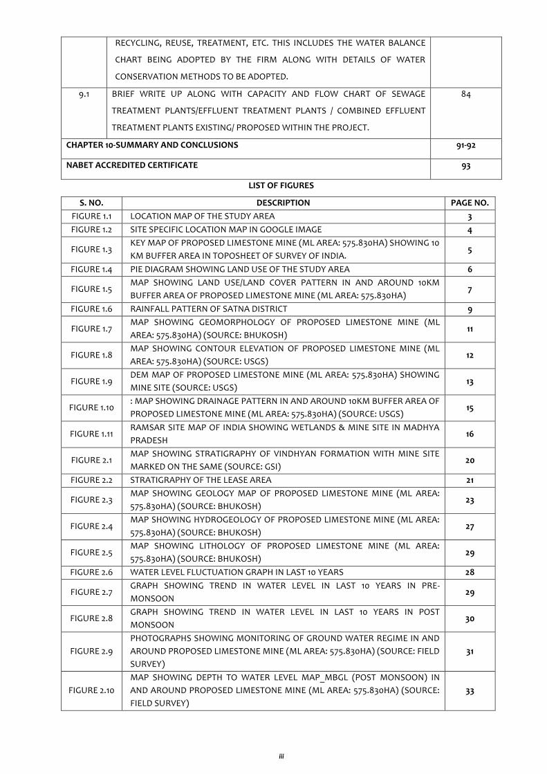
iii
RECYCLING, REUSE, TREATMENT, ETC. THIS INCLUDES THE WATER BALANCE
CHART BEING ADOPTED BY THE FIRM ALONG WITH DETAILS OF WATER
CONSERVATION METHODS TO BE ADOPTED.
9.1 BRIEF WRITE UP ALONG WITH CAPACITY AND FLOW CHART OF SEWAGE
TREATMENT PLANTS/EFFLUENT TREATMENT PLANTS / COMBINED EFFLUENT
TREATMENT PLANTS EXISTING/ PROPOSED WITHIN THE PROJECT.
84
CHAPTER 10-SUMMARY AND CONCLUSIONS 91-92
NABET ACCREDITED CERTIFICATE 93
LIST OF FIGURES
S. NO. DESCRIPTION PAGE NO.
FIGURE 1.1 LOCATION MAP OF THE STUDY AREA 3
FIGURE 1.2 SITE SPECIFIC LOCATION MAP IN GOOGLE IMAGE 4
FIGURE 1.3 KEY MAP OF PROPOSED LIMESTONE MINE (ML AREA: 575.830HA) SHOWING 10
KM BUFFER AREA IN TOPOSHEET OF SURVEY OF INDIA. 5
FIGURE 1.4 PIE DIAGRAM SHOWING LAND USE OF THE STUDY AREA 6
FIGURE 1.5 MAP SHOWING LAND USE/LAND COVER PATTERN IN AND AROUND 10KM
BUFFER AREA OF PROPOSED LIMESTONE MINE (ML AREA: 575.830HA) 7
FIGURE 1.6 RAINFALL PATTERN OF SATNA DISTRICT 9
FIGURE 1.7 MAP SHOWING GEOMORPHOLOGY OF PROPOSED LIMESTONE MINE (ML
AREA: 575.830HA) (SOURCE: BHUKOSH) 11
FIGURE 1.8 MAP SHOWING CONTOUR ELEVATION OF PROPOSED LIMESTONE MINE (ML
AREA: 575.830HA) (SOURCE: USGS) 12
FIGURE 1.9 DEM MAP OF PROPOSED LIMESTONE MINE (ML AREA: 575.830HA) SHOWING
MINE SITE (SOURCE: USGS) 13
FIGURE 1.10 : MAP SHOWING DRAINAGE PATTERN IN AND AROUND 10KM BUFFER AREA OF
PROPOSED LIMESTONE MINE (ML AREA: 575.830HA) (SOURCE: USGS) 15
FIGURE 1.11 RAMSAR SITE MAP OF INDIA SHOWING WETLANDS & MINE SITE IN MADHYA
PRADESH 16
FIGURE 2.1 MAP SHOWING STRATIGRAPHY OF VINDHYAN FORMATION WITH MINE SITE
MARKED ON THE SAME (SOURCE: GSI) 20
FIGURE 2.2 STRATIGRAPHY OF THE LEASE AREA 21
FIGURE 2.3 MAP SHOWING GEOLOGY MAP OF PROPOSED LIMESTONE MINE (ML AREA:
575.830HA) (SOURCE: BHUKOSH) 23
FIGURE 2.4 MAP SHOWING HYDROGEOLOGY OF PROPOSED LIMESTONE MINE (ML AREA:
575.830HA) (SOURCE: BHUKOSH) 27
FIGURE 2.5 MAP SHOWING LITHOLOGY OF PROPOSED LIMESTONE MINE (ML AREA:
575.830HA) (SOURCE: BHUKOSH) 29
FIGURE 2.6 WATER LEVEL FLUCTUATION GRAPH IN LAST 10 YEARS 28
FIGURE 2.7 GRAPH SHOWING TREND IN WATER LEVEL IN LAST 10 YEARS IN PRE-
MONSOON 29
FIGURE 2.8 GRAPH SHOWING TREND IN WATER LEVEL IN LAST 10 YEARS IN POST
MONSOON 30
FIGURE 2.9
PHOTOGRAPHS SHOWING MONITORING OF GROUND WATER REGIME IN AND
AROUND PROPOSED LIMESTONE MINE (ML AREA: 575.830HA) (SOURCE: FIELD
SURVEY)
31
FIGURE 2.10
MAP SHOWING DEPTH TO WATER LEVEL MAP_MBGL (POST MONSOON) IN
AND AROUND PROPOSED LIMESTONE MINE (ML AREA: 575.830HA) (SOURCE:
FIELD SURVEY)
33
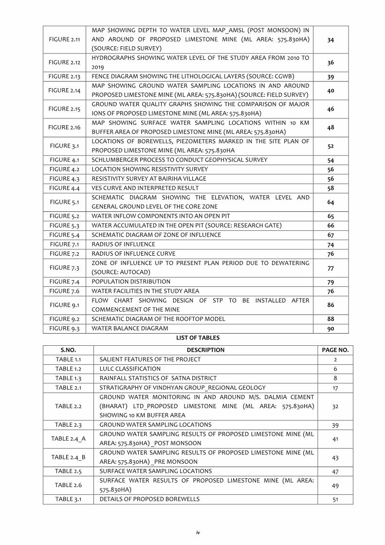
iv
FIGURE 2.11
MAP SHOWING DEPTH TO WATER LEVEL MAP_AMSL (POST MONSOON) IN
AND AROUND OF PROPOSED LIMESTONE MINE (ML AREA: 575.830HA)
(SOURCE: FIELD SURVEY)
34
FIGURE 2.12 HYDROGRAPHS SHOWING WATER LEVEL OF THE STUDY AREA FROM 2010 TO
2019 36
FIGURE 2.13 FENCE DIAGRAM SHOWING THE LITHOLOGICAL LAYERS (SOURCE: CGWB) 39
FIGURE 2.14 MAP SHOWING GROUND WATER SAMPLING LOCATIONS IN AND AROUND
PROPOSED LIMESTONE MINE (ML AREA: 575.830HA) (SOURCE: FIELD SURVEY) 40
FIGURE 2.15 GROUND WATER QUALITY GRAPHS SHOWING THE COMPARISON OF MAJOR
IONS OF PROPOSED LIMESTONE MINE (ML AREA: 575.830HA) 46
FIGURE 2.16 MAP SHOWING SURFACE WATER SAMPLING LOCATIONS WITHIN 10 KM
BUFFER AREA OF PROPOSED LIMESTONE MINE (ML AREA: 575.830HA) 48
FIGURE 3.1 LOCATIONS OF BOREWELLS, PIEZOMETERS MARKED IN THE SITE PLAN OF
PROPOSED LIMESTONE MINE (ML AREA: 575.830HA 52
FIGURE 4.1 SCHLUMBERGER PROCESS TO CONDUCT GEOPHYSICAL SURVEY 54
FIGURE 4.2 LOCATION SHOWING RESISTIVITY SURVEY 56
FIGURE 4.3 RESISTIVITY SURVEY AT BAIRIHA VILLAGE 56
FIGURE 4.4 VES CURVE AND INTERPRETED RESULT 58
FIGURE 5.1 SCHEMATIC DIAGRAM SHOWING THE ELEVATION, WATER LEVEL AND
GENERAL GROUND LEVEL OF THE CORE ZONE 64
FIGURE 5.2 WATER INFLOW COMPONENTS INTO AN OPEN PIT 65
FIGURE 5.3 WATER ACCUMULATED IN THE OPEN PIT (SOURCE: RESEARCH GATE) 66
FIGURE 5.4 SCHEMATIC DIAGRAM OF ZONE OF INFLUENCE 67
FIGURE 7.1 RADIUS OF INFLUENCE 74
FIGURE 7.2 RADIUS OF INFLUENCE CURVE 76
FIGURE 7.3 ZONE OF INFLUENCE UP TO PRESENT PLAN PERIOD DUE TO DEWATERING
(SOURCE: AUTOCAD) 77
FIGURE 7.4 POPULATION DISTRIBUTION 79
FIGURE 7.6 WATER FACILITIES IN THE STUDY AREA 76
FIGURE 9.1 FLOW CHART SHOWING DESIGN OF STP TO BE INSTALLED AFTER
COMMENCEMENT OF THE MINE 86
FIGURE 9.2 SCHEMATIC DIAGRAM OF THE ROOFTOP MODEL 88
FIGURE 9.3 WATER BALANCE DIAGRAM 90
LIST OF TABLES
S.NO. DESCRIPTION PAGE NO.
TABLE 1.1 SALIENT FEATURES OF THE PROJECT 2
TABLE 1.2 LULC CLASSIFICATION 6
TABLE 1.3 RAINFALL STATISTICS OF SATNA DISTRICT 8
TABLE 2.1 STRATIGRAPHY OF VINDHYAN GROUP_REGIONAL GEOLOGY 17
TABLE 2.2
GROUND WATER MONITORING IN AND AROUND M/S. DALMIA CEMENT
(BHARAT) LTD_PROPOSED LIMESTONE MINE (ML AREA: 575.830HA)
SHOWING 10 KM BUFFER AREA
32
TABLE 2.3 GROUND WATER SAMPLING LOCATIONS 39
TABLE 2.4_A GROUND WATER SAMPLING RESULTS OF PROPOSED LIMESTONE MINE (ML
AREA: 575.830HA) _POST MONSOON 41
TABLE 2.4_B GROUND WATER SAMPLING RESULTS OF PROPOSED LIMESTONE MINE (ML
AREA: 575.830HA) _PRE MONSOON 43
TABLE 2.5 SURFACE WATER SAMPLING LOCATIONS 47
TABLE 2.6 SURFACE WATER RESULTS OF PROPOSED LIMESTONE MINE (ML AREA:
575.830HA) 49
TABLE 3.1 DETAILS OF PROPOSED BOREWELLS 51
v
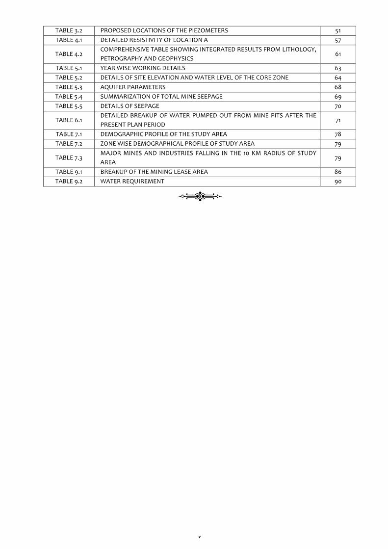
TABLE 3.2 PROPOSED LOCATIONS OF THE PIEZOMETERS 51
TABLE 4.1 DETAILED RESISTIVITY OF LOCATION A 57
TABLE 4.2 COMPREHENSIVE TABLE SHOWING INTEGRATED RESULTS FROM LITHOLOGY,
PETROGRAPHY AND GEOPHYSICS 61
TABLE 5.1 YEAR WISE WORKING DETAILS 63
TABLE 5.2 DETAILS OF SITE ELEVATION AND WATER LEVEL OF THE CORE ZONE 64
TABLE 5.3 AQUIFER PARAMETERS 68
TABLE 5.4 SUMMARIZATION OF TOTAL MINE SEEPAGE 69
TABLE 5.5 DETAILS OF SEEPAGE 70
TABLE 6.1 DETAILED BREAKUP OF WATER PUMPED OUT FROM MINE PITS AFTER THE
PRESENT PLAN PERIOD 71
TABLE 7.1 DEMOGRAPHIC PROFILE OF THE STUDY AREA 78
TABLE 7.2 ZONE WISE DEMOGRAPHICAL PROFILE OF STUDY AREA 79
TABLE 7.3 MAJOR MINES AND INDUSTRIES FALLING IN THE 10 KM RADIUS OF STUDY
AREA 79
TABLE 9.1 BREAKUP OF THE MINING LEASE AREA 86
TABLE 9.2 WATER REQUIREMENT 90

I
SCOPE AND METHODOLOGY
OBJECTIVE: PREPARATION OF COMPREHENSIVE REPORT
1. Physiographic studies of the project site and its surroundings with the help of latest Google
images, site visit, GPS survey etc. which helps in determining its physiographic gradient,
topographic features, geomorphological patterns etc.
2. Primary and secondary data collection i.e. climate and rainfall, soil and topography,
geology, drainage etc. for interpretation.
3. Detailed hydro-geological survey in core and buffer zone including geological formations,
types of aquifer and their hydraulic parameters governing the groundwater regime of the
area.
4. Ground water level monitoring of Pre and Post Monsoon Water Level, fluctuation analysis
of the study area and predicted water level declines for the affected aquifers.
5. Analysis of ground water and surface water quality with its interpretation and quality
issues.
6. Preparation of hydrographs for last 10 years of the study area and its interpretation.
7. To work out quantitative as well as qualitative variations in groundwater with respect to
aerial extent and to find out water balance
8. To observe surface water features and their impact on groundwater balance and
evaluation of present groundwater scenario as well as future course of action for
protecting the natural environment
9. Detailed description of the impacts on environmental values that have occurred, or are
likely to occur, because of any past ground water abstraction.
10. Socio-Economic aspects of the study area with detailed demographic details including the
settlements and population dynamics around project area with their dependency on
sources of water
11. Details of Geophysical studies carried out in and around the project area and results of
Geophysical analysis carried out by Vertical Electrical Sounding (VES) method and its
interpretation.
12. Ground water resources computation of the block in which the project falls by Ground
Water Estimation Committee (GEC 2017).
13. Year wise mine plan including excavation depth, area and computation of mine seepage
and assessment of Radius of Influence.
14. Proposed utilization of pumped water in drinking, irrigation, recharge and other uses.
15. Measures to be adopted for water conservation which include recycling, reuse, treatment,
etc. adopted by the firm along with details of water conservation methods to be adopted.
16. Flow chart of Sewage Treatment Plants existing within the project and details of water
conservation measures to be adopted to reduce/ save the ground water.
********
Comprehensive Hydrogeological Report on ground water conditions in both core and buffer zones for Proposed
Limestone Mine (ML Area: 575.830 ha.) located at Villages: Bairiha, Patarhai & Janardanpur, Tehsil: Rampur
Baghelan, District: Satna (Madhya Pradesh)
M/s. Dalmia Cement (Bharat) Ltd. 1
CHAPTER - 1
GENERAL INTRODUCTION AND PHYSIOGRAPHIC FEATURES
1. BRIEF ABOUT THE PROPOSED PROJECT GIVING LOCATION DETAILS, COORDINATES, GOOGLE/
TOPOSHEET MAPS, ETC. DEMARCATING THE PROJECT AREA.
1. A BRIEF INTRODUCTION ABOUT COMPANY
About Dalmia Cement (Bharat) Limited (DCBL)
DCBL is one of the leading cement producers of India. The group was founded in 1935 by Shri
Jaidayal Dalmia. First Cement Plant of DCBL was established in 1939 at Dalmiapuram, Tamil Nadu,
thus enjoying a heritage of over 81 Years of expertise and experience. The Group currently has
cement plants in Tamil Nadu (Dalmiapuram & Ariyalur), Andhra Pradesh (Kadapa), Meghalaya
(Thangskai) Karnataka (Belgaum), Jharkhand (Bokaro), Assam (Umrangso & Lanka), Odisha
(Rajgangpur & Kapilas) and West Bengal (Midnapur). The Group now controls a cement capacity of
about 27 Million Tonnes & has a strong presence in Southern, Eastern & North East Regions of the
Country.
1. B PROJECT DESCRIPTION
Project Details
The Proposed Limestone Mine of M/s. Dalmia Cement (Bharat) Ltd. is at villages Bairiha, Patrahai &
Janardanpur in Tehsil: Rampur Baghelan district of Satna, Madhya Pradesh. The area is in Vindhyan
Limestone/shale formations, where Limestone is bearing mined from mining lease area of 575.830
Ha.
The company has retained JM Environet Pvt. Ltd which is a CGWA as well as NABET Accredited
Consultant, to evaluate Comprehensive Report for detailed Hydro-geological evaluation studies in
their project premises and around the vicinity of 10 km radius (buffer zone) of their project in order
to obtain NOC for Groundwater abstraction/dewatering from Central Ground Water Authority
(CGWA).
1. C NEED AND PURPOSE OF THE STUDY
Application for obtaining NOC has been submitted for ground water abstraction in the tune of 90 KLD
and mine dewatering in the tune of 329 KLD has been applied vide application no.– 21-
4/1074/MP/MIN/2020dated 31.12.2020. Query regarding the submission of Wetland Authority and
Comprehensive Hydrogeological Report for Core and Buffer Zone has been raised from CGWB via mail
dated 02.01.2021.
Gazette Notification of Ministry of Jal Shakti (Department of Water Resources, River Development
and Ganga Rejuvenation) (Central Ground Water Authority), has been published on dated 24th
September, 2020. As per the notification following conditions need to be followed a. All mining projects irrespective of dewatering shall mandatorily submit COMPREHENSIVE
HYDROGEOLOGICAL REPORTS OF CORE AND BUFFER ZONES in the radius of 2 and 10 sq.km
respectively.
b. In case of dewatering, ground water modelling in 10km radius is mandatory
In order to comply the same, Comprehensive Hydrogeological Report on ground water conditions in
both core and buffer zones is being submitted for processing of NOC.
Comprehensive Hydrogeological Report on ground water conditions in both core and buffer zones for Proposed
Limestone Mine (ML Area: 575.830 ha.) located at Villages: Bairiha, Patarhai & Janardanpur, Tehsil: Rampur
Baghelan, District: Satna (Madhya Pradesh)
M/s. Dalmia Cement (Bharat) Ltd. 2
Comprehensive Study is a process for considering the implications, for people and their environment,
of proposed actions while there is still an opportunity to modify (or even, if appropriate, abandon)
the proposals. It is applied at all levels of decision-making, from policies to specific projects. The main
impact of the project on ground water regime will affect the social and environmental sector. The
main purpose of this report is to assess sensitivity of the baseline hydrological environment and the
potential impacts of the proposed development upon it and proposes mitigation measures in order
to ensure that the potential adverse impacts of the project development on the hydrological
environment will be slight and neutral. It contains essential information:
To assess the risk of water quality impacts from the Project to the groundwater resource.
Implementation of groundwater monitoring and contingency program is a common
requirement of the project
Information collected in this study was used to determine if the Project is located in a
sensitive groundwater area, and to make recommendations
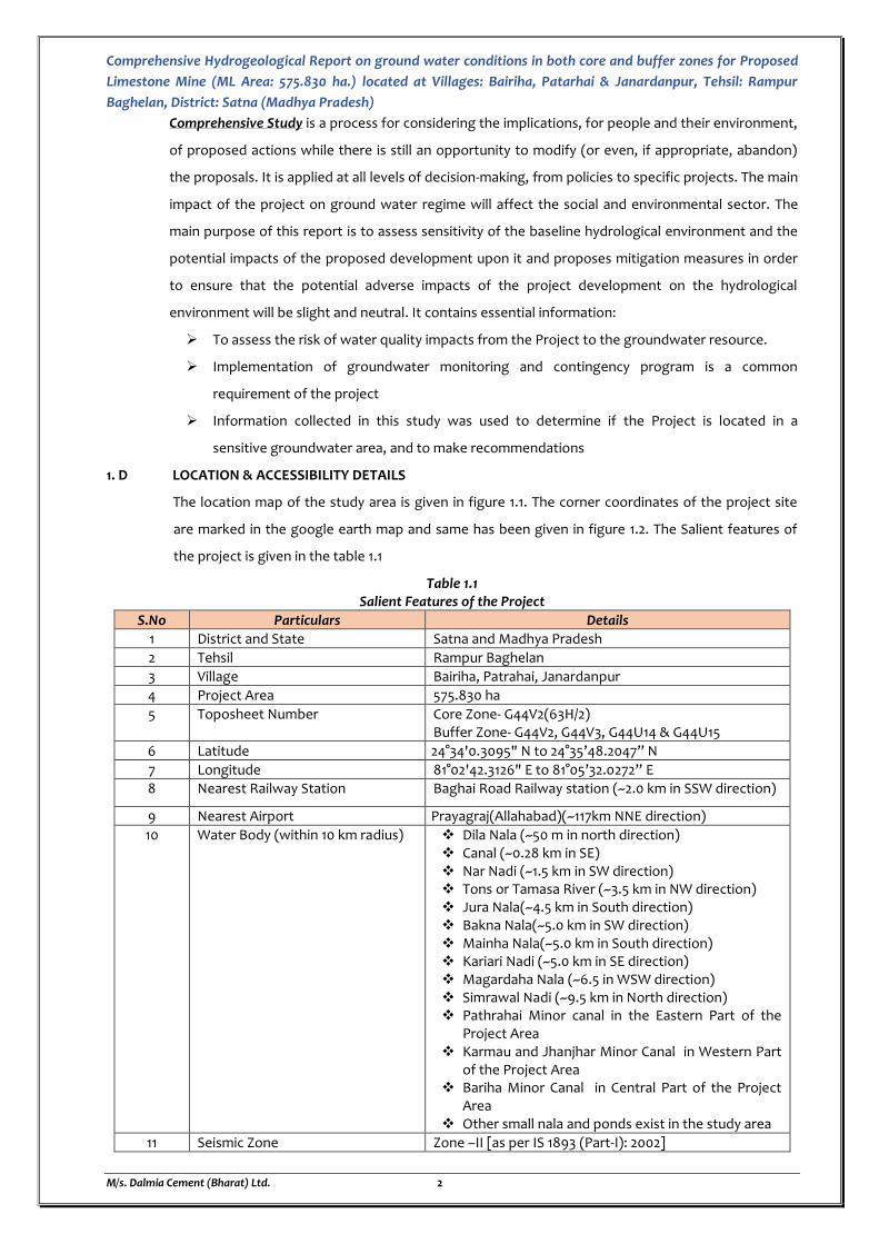
1. D LOCATION & ACCESSIBILITY DETAILS
The location map of the study area is given in figure 1.1. The corner coordinates of the project site
are marked in the google earth map and same has been given in figure 1.2. The Salient features of
the project is given in the table 1.1
Table 1.1 Salient Features of the Project
S.No Particulars Details
1 District and State Satna and Madhya Pradesh
2 Tehsil Rampur Baghelan
3 Village Bairiha, Patrahai, Janardanpur
4 Project Area 575.830 ha
5 Toposheet Number Core Zone- G44V2(63H/2) Buffer Zone- G44V2, G44V3, G44U14 & G44U15
6 Latitude 24°34'0.3095" N to 24°35’48.2047” N
7 Longitude 81°02'42.3126" E to 81°05’32.0272” E
8 Nearest Railway Station Baghai Road Railway station (~2.0 km in SSW direction)
9 Nearest Airport Prayagraj(Allahabad)(~117km NNE direction)
10 Water Body (within 10 km radius) Dila Nala (~50 m in north direction) Canal (~0.28 km in SE) Nar Nadi (~1.5 km in SW direction) Tons or Tamasa River (~3.5 km in NW direction) Jura Nala(~4.5 km in South direction) Bakna Nala(~5.0 km in SW direction) Mainha Nala(~5.0 km in South direction) Kariari Nadi (~5.0 km in SE direction) Magardaha Nala (~6.5 in WSW direction) Simrawal Nadi (~9.5 km in North direction) Pathrahai Minor canal in the Eastern Part of the
Project Area Karmau and Jhanjhar Minor Canal in Western Part
of the Project Area Bariha Minor Canal in Central Part of the Project
Area Other small nala and ponds exist in the study area
11 Seismic Zone Zone –II [as per IS 1893 (Part-I): 2002]
Comprehensive Hydrogeological Report on ground water conditions in both core and buffer zones for Proposed
Limestone Mine (ML Area: 575.830 ha.) located at Villages: Bairiha, Patarhai & Janardanpur, Tehsil: Rampur
Baghelan, District: Satna (Madhya Pradesh)
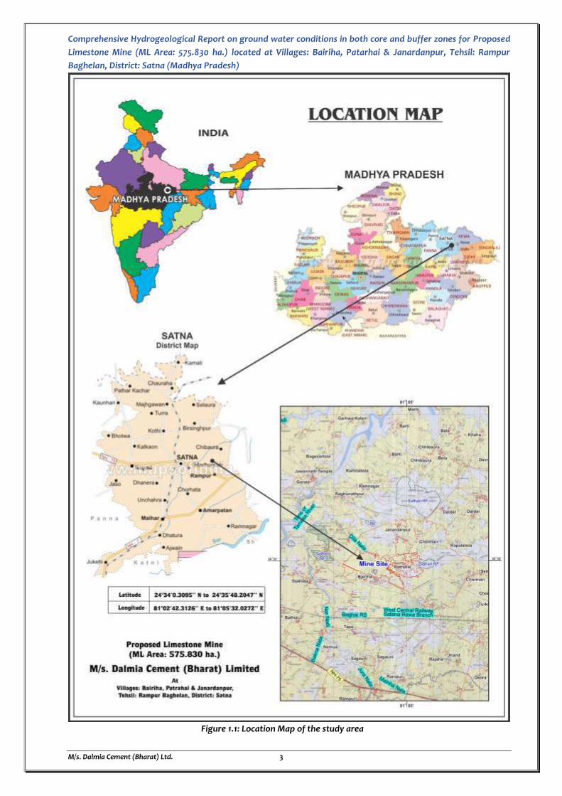
M/s. Dalmia Cement (Bharat) Ltd. 3
Figure 1.1: Location Map of the study area
Comprehensive Hydrogeological Report on ground water conditions in both core and buffer zones for Proposed Limestone Mine (ML Area: 575.830 ha.) located at Villages:
Bairiha, Patarhai & Janardanpur, Tehsil: Rampur Baghelan, District: Satna (Madhya Pradesh)
M/s. Dalmia Cement (Bharat) Ltd. 4
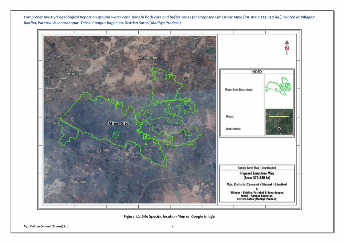
Figure 1.2: Site Specific location Map on Google Image
Comprehensive Hydrogeological Report on ground water conditions in both core and buffer zones for Proposed Limestone Mine (ML Area: 575.830 ha.) located at Villages:
Bairiha, Patarhai & Janardanpur, Tehsil: Rampur Baghelan, District: Satna (Madhya Pradesh)
M/s. Dalmia Cement (Bharat) Ltd. 5
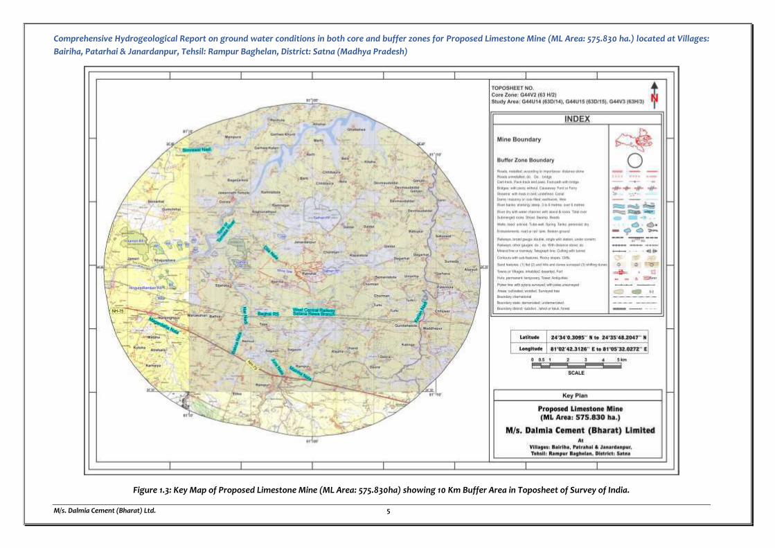
Figure 1.3: Key Map of Proposed Limestone Mine (ML Area: 575.830ha) showing 10 Km Buffer Area in Toposheet of Survey of India.
Comprehensive Hydrogeological Report on ground water conditions in both core and buffer zones for Proposed
Limestone Mine (ML Area: 575.830 ha.) located at Villages: Bairiha, Patarhai & Janardanpur, Tehsil: Rampur
Baghelan, District: Satna (Madhya Pradesh)
M/s. Dalmia Cement (Bharat) Ltd. 6
1.1 LAND USE & LAND COVER OF THE SURROUNDING AREA, PERCENTAGE OF LULC CATEGORIES
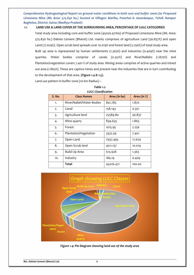
Total study area including core and buffer zone (45026.471ha) of Proposed Limestone Mine (ML Area:
575.830 ha.) Dalmia Cement (Bharat) Ltd. mainly comprises of agriculture Land (56.837%) and open
Land (17.629%). Open scrub land spreads over 10.019% and forest land (2.256%) of total study area.
Built up area is represented by human settlements (1.363%) and industries (0.409%) near the mine
quarries. Water bodies comprise of canals (0.351%) and River/Nallahs (1.870%) and
Plantation/vegetation covers 7.401 % of study area. Mining areas comprise of active quarries and mined
out area (1.865%). These are captive mines and present near the industries that are in turn contributing
to the development of that area. (Figure 1.4 & 1.5).
Land use pattern in buffer zone (10 km Radius) –
Table 1.2
LULC Classification
S. No. Class Names Area (in ha) Area (in %)
1. River/Nallah/Water Bodies 841.783 1.870
2. Canal 158.143 0.351
3. Agriculture land 25589.80 56.837
4. Mine quarry 839.635 1.865
5. Forest 1015.95 2.256
6. Plantation/Vegetation 3332.39 7.401
7. Open Land 7937.495 17.629
8. Open Scrub land 4511.157 10.019
9. Build Up Area 613.928 1.363
10. Industry 184.19 0.409
Total 45026.471 100.00
Figure 1.4: Pie Diagram showing land use of the study area
River/Nallah/Water Bodies
Canal
Agriculture land
Mine quarry
Forest
Plantation/Vegetation
Open Land
Open Scrub land
Build Up Area Industry
Graph showing LULC Classes
Comprehensive Hydrogeological Report on ground water conditions in both core and buffer zones for Proposed Limestone Mine (ML Area: 575.830 ha.) located at Villages:
Bairiha, Patarhai & Janardanpur, Tehsil: Rampur Baghelan, District: Satna (Madhya Pradesh)
M/s. Dalmia Cement (Bharat) Ltd. 7
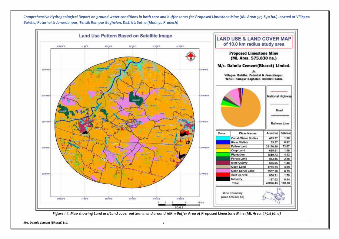
Figure 1.5: Map showing Land use/Land cover pattern in and around 10Km Buffer Area of Proposed Limestone Mine (ML Area: 575.830ha)
Comprehensive Hydrogeological Report on ground water conditions in both core and buffer zones for Proposed
Limestone Mine (ML Area: 575.830 ha.) located at Villages: Bairiha, Patarhai & Janardanpur, Tehsil: Rampur
Baghelan, District: Satna (Madhya Pradesh)
M/s. Dalmia Cement (Bharat) Ltd. 8
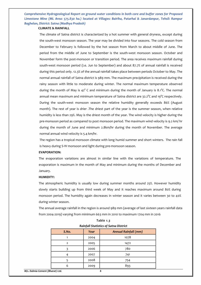
CLIMATE & RAINFALL
The climate of Satna district is characterized by a hot summer with general dryness, except during
the south-west monsoon season. The year may be divided into four seasons. The cold season from
December to February is followed by the hot season from March to about middle of June. The
period from the middle of June to September is the south-west monsoon season. October and
November form the post-monsoon or transition period. The area receives maximum rainfall during
south-west monsoon period (i.e. Jun to September) and about 87.7% of annual rainfall is received
during this period only. 12.3% of the annual rainfall takes place between periods October to May. The
normal annual rainfall of Satna district is 989 mm. The maximum precipitation is received during the
rainy season with little to moderate during winter. The normal maximum temperature observed
during the month of May is 42° C and minimum during the month of January is 8.1°C. The normal
annual mean maximum and minimum temperature of Satna district are 32.2°C and 19°C respectively.
During the south-west monsoon season the relative humidity generally exceeds 86% (August
month). The rest of year is drier .The driest part of the year is the summer season, when relative
humidity is less than 29%. May is the driest month of the year. The wind velocity is higher during the
pre-monsoon period as compared to post monsoon period. The maximum wind velocity is 9.2 km/ hr
during the month of June and minimum 2.8km/hr during the month of November. The average
normal annual wind velocity is 5.4 km/hr.
The region has a tropical monsoon climate with long humid summer and short winters. The rain fall
is heavy during S-W monsoon and light during pre-monsoon season.
EVAPORATION:
The evaporation variations are almost in similar line with the variations of temperature. The
evaporation is maximum in the month of May and minimum during the months of December and
January.
HUMIDITY:
The atmospheric humidity is usually low during summer months around 25%. However humidity
slowly starts building up from third week of May and it reaches maximum around 80% during
monsoon period. The humidity again decreases in winter season and it varies between 30 to 40%
during winter season.
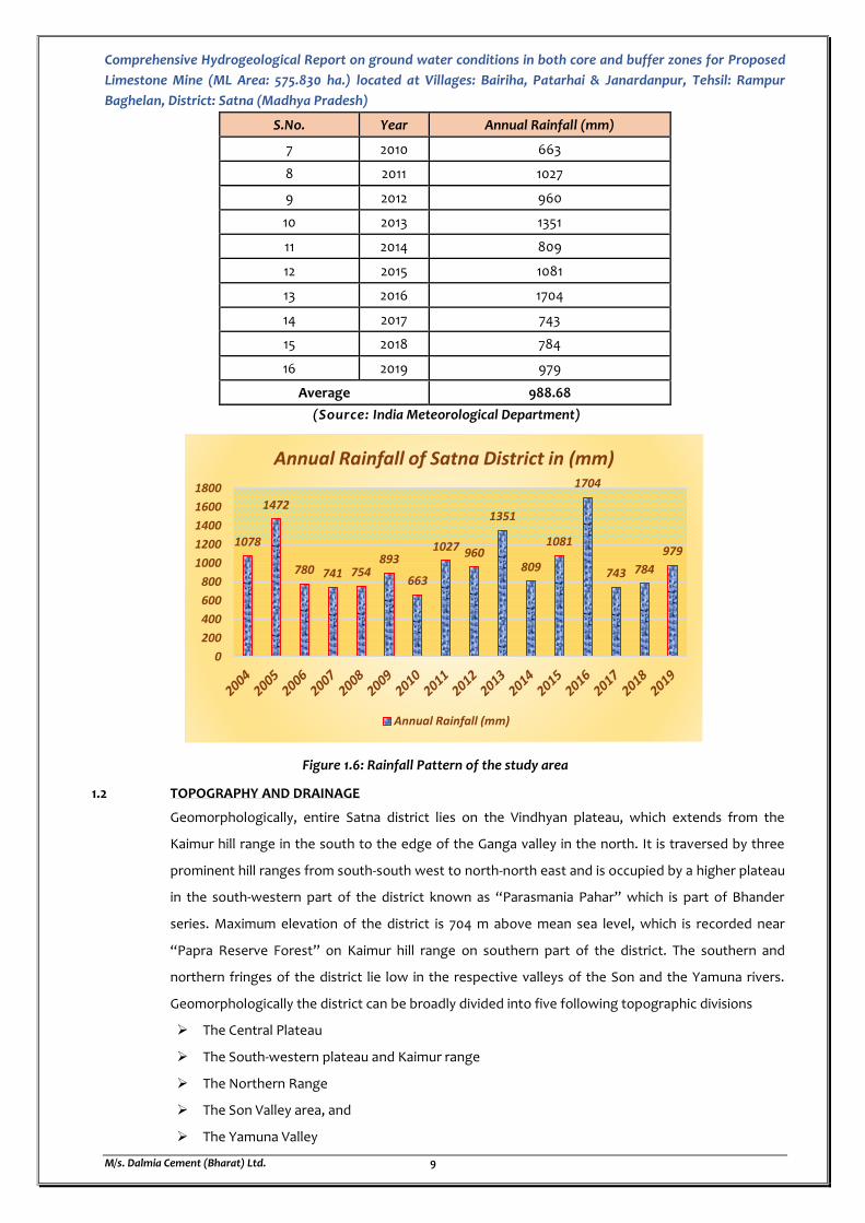
The annual average rainfall in the region is around 989 mm (average of last sixteen years rainfall data
from 2004-2019) varying from minimum 663 mm in 2010 to maximum 1704 mm in 2016
Table 1.3
Rainfall Statistics of Satna District
S.No. Year Annual Rainfall (mm)
1 2004 1078
2 2005 1472
3 2006 780
4 2007 741
5 2008 754
6 2009 893
Comprehensive Hydrogeological Report on ground water conditions in both core and buffer zones for Proposed
Limestone Mine (ML Area: 575.830 ha.) located at Villages: Bairiha, Patarhai & Janardanpur, Tehsil: Rampur
Baghelan, District: Satna (Madhya Pradesh)
M/s. Dalmia Cement (Bharat) Ltd. 9
S.No. Year Annual Rainfall (mm)
7 2010 663
8 2011 1027
9 2012 960
10 2013 1351
11 2014 809
12 2015 1081
13 2016 1704
14 2017 743
15 2018 784
16 2019 979
Average 988.68
(Source: India Meteorological Department)
Figure 1.6: Rainfall Pattern of the study area
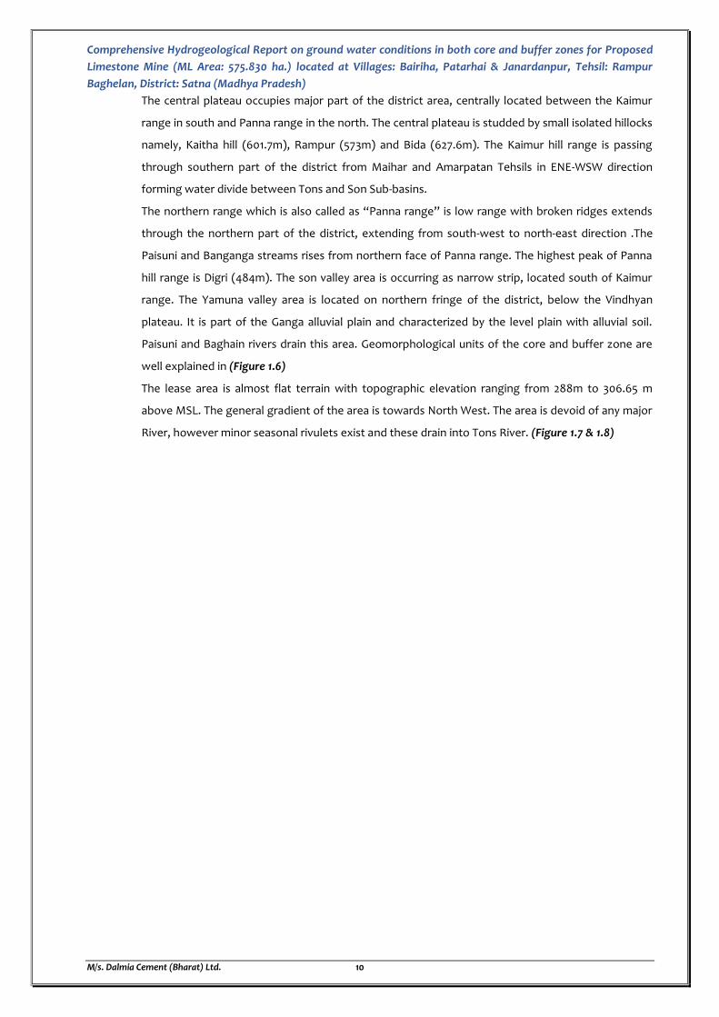
1.2 TOPOGRAPHY AND DRAINAGE
Geomorphologically, entire Satna district lies on the Vindhyan plateau, which extends from the
Kaimur hill range in the south to the edge of the Ganga valley in the north. It is traversed by three
prominent hill ranges from south-south west to north-north east and is occupied by a higher plateau
in the south-western part of the district known as “Parasmania Pahar” which is part of Bhander
series. Maximum elevation of the district is 704 m above mean sea level, which is recorded near
“Papra Reserve Forest” on Kaimur hill range on southern part of the district. The southern and
northern fringes of the district lie low in the respective valleys of the Son and the Yamuna rivers.
Geomorphologically the district can be broadly divided into five following topographic divisions
The Central Plateau
The South-western plateau and Kaimur range
The Northern Range
The Son Valley area, and
The Yamuna Valley
1078
1472
780 741 754893
663
1027 960
1351
809
1081
1704
743 784
979
0
200
400
600
800
1000
1200
1400
1600
1800
Annual Rainfall of Satna District in (mm)
Annual Rainfall (mm)
Comprehensive Hydrogeological Report on ground water conditions in both core and buffer zones for Proposed
Limestone Mine (ML Area: 575.830 ha.) located at Villages: Bairiha, Patarhai & Janardanpur, Tehsil: Rampur
Baghelan, District: Satna (Madhya Pradesh)
M/s. Dalmia Cement (Bharat) Ltd. 10
The central plateau occupies major part of the district area, centrally located between the Kaimur
range in south and Panna range in the north. The central plateau is studded by small isolated hillocks
namely, Kaitha hill (601.7m), Rampur (573m) and Bida (627.6m). The Kaimur hill range is passing
through southern part of the district from Maihar and Amarpatan Tehsils in ENE-WSW direction
forming water divide between Tons and Son Sub-basins.
The northern range which is also called as “Panna range” is low range with broken ridges extends
through the northern part of the district, extending from south-west to north-east direction .The
Paisuni and Banganga streams rises from northern face of Panna range. The highest peak of Panna
hill range is Digri (484m). The son valley area is occurring as narrow strip, located south of Kaimur
range. The Yamuna valley area is located on northern fringe of the district, below the Vindhyan
plateau. It is part of the Ganga alluvial plain and characterized by the level plain with alluvial soil.
Paisuni and Baghain rivers drain this area. Geomorphological units of the core and buffer zone are
well explained in (Figure 1.6)
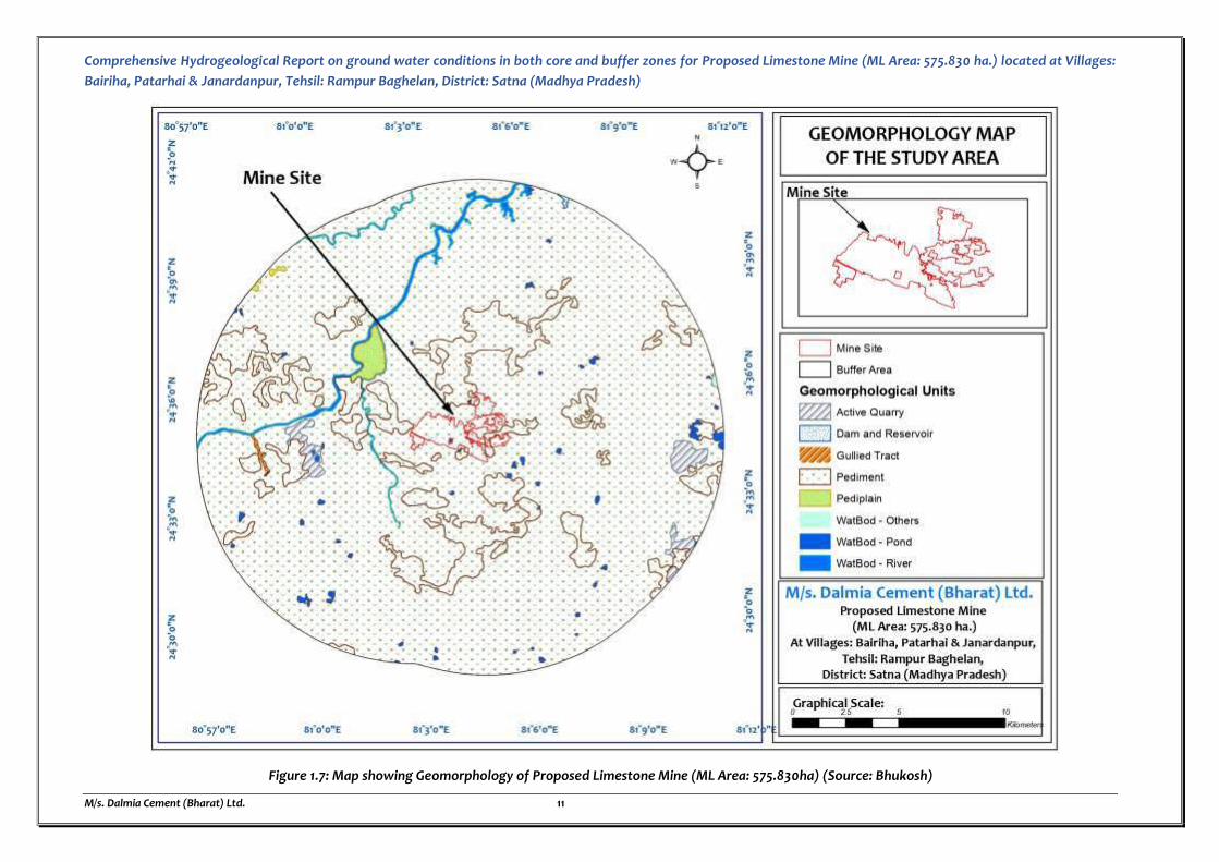
The lease area is almost flat terrain with topographic elevation ranging from 288m to 306.65 m
above MSL. The general gradient of the area is towards North West. The area is devoid of any major
River, however minor seasonal rivulets exist and these drain into Tons River. (Figure 1.7 & 1.8)
Comprehensive Hydrogeological Report on ground water conditions in both core and buffer zones for Proposed Limestone Mine (ML Area: 575.830 ha.) located at Villages:
Bairiha, Patarhai & Janardanpur, Tehsil: Rampur Baghelan, District: Satna (Madhya Pradesh)
M/s. Dalmia Cement (Bharat) Ltd. 11
Figure 1.7: Map showing Geomorphology of Proposed Limestone Mine (ML Area: 575.830ha) (Source: Bhukosh)

Comprehensive Hydrogeological Report on ground water conditions in both core and buffer zones for Proposed Limestone Mine (ML Area: 575.830 ha.) located at Villages:
Bairiha, Patarhai & Janardanpur, Tehsil: Rampur Baghelan, District: Satna (Madhya Pradesh)
M/s. Dalmia Cement (Bharat) Ltd. 12
Figure 1.8: Map showing Contour Elevation of Proposed Limestone Mine (ML Area: 575.830ha) (Source: USGS)

Comprehensive Hydrogeological Report on ground water conditions in both core and buffer zones for Proposed Limestone Mine (ML Area: 575.830 ha.) located at Villages:
Bairiha, Patarhai & Janardanpur, Tehsil: Rampur Baghelan, District: Satna (Madhya Pradesh)
M/s. Dalmia Cement (Bharat) Ltd. 13
Figure 1.9: DEM Map of Proposed Limestone Mine (ML Area: 575.830ha) showing Mine Site (Source: USGS)
Comprehensive Hydrogeological Report on ground water conditions in both core and buffer zones for Proposed
Limestone Mine (ML Area: 575.830 ha.) located at Villages: Bairiha, Patarhai & Janardanpur, Tehsil: Rampur
Baghelan, District: Satna (Madhya Pradesh)
M/s. Dalmia Cement (Bharat) Ltd. 14
DRAINAGE PATTERN
The area is devoid of any major River, however minor seasonal rivulets exist and these drain into Tons
River. Major water bodies like ponds, seasonal nala etc. are excluded from the ML area during grant of
mining lease. A rivulet originating in the upper side of the lease area, joins the Dila Nala which
ultimately merges with Nar Nadi. A seasonal nala namely Dila nala is excluded from the mining lease
area during grant of ML and divide the mining lease in blocks. It flows between the blocks from east
direction to west direction which ultimately merges with Nar Nadi. Nala will not be disturbed. Some
drains originating from SE part of the mining lease area and flowing towards NW direction, ultimately
merges in Dila Nala. Five number of minor/ sub minor Canals are passing/ terminating through the ML
area, diversion of the same is proposed for which demand has been raised by Concerned
Authority/Irrigation Department, Govt. of Madhya Pradesh for issuance of NOC and accordingly Rs.
12.144 crores has been paid by M/s Dalmia Cement (Bharat) Ltd. A rivulet originating in the upper side
of the lease area joins the Dila Nala which ultimately merges with Nar Nadi. These surface features
granted in the ML area, are proposed to be disturbed in due course of mining. The topographic
elevation ranges from 288m to 306.65m above mean sea level. The general gradient of the area is
towards North West. Mining lease has been granted in blocks due to the Village, roads, nallas and
habitation. Appropriate safety barrier as applicable for different features will be left. The local
drainage pattern in the ML area is trellised and dendritic in nature with low drainage density indicating
the formation in the area are comparatively porous and permeable in nature. (Figure 1.10)
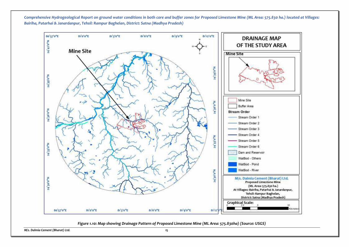
Comprehensive Hydrogeological Report on ground water conditions in both core and buffer zones for Proposed Limestone Mine (ML Area: 575.830 ha.) located at Villages:
Bairiha, Patarhai & Janardanpur, Tehsil: Rampur Baghelan, District: Satna (Madhya Pradesh)
M/s. Dalmia Cement (Bharat) Ltd. 15
Figure 1.10: Map showing Drainage Pattern of Proposed Limestone Mine (ML Area: 575.830ha) (Source: USGS)

Comprehensive Hydrogeological Report on ground water conditions in both core and buffer zones for Proposed
Limestone Mine (ML Area: 575.830 ha.) located at Villages: Bairiha, Patarhai & Janardanpur, Tehsil: Rampur
Baghelan, District: Satna (Madhya Pradesh)
M/s. Dalmia Cement (Bharat) Ltd. 16
1.3 DETAILS OF WETLANDS
A wetland is a distinct ecosystem that is flooded by water, either permanently or seasonally, where
oxygen-free processes prevail. The primary factor that distinguishes wetlands from other land forms
or water bodies is the characteristic vegetation of aquatic plants, adapted to the unique hydric soil.
Any wetland site which has been listed under the Ramsar Convention that aims to conserve it and
promote sustainable use of its natural resources is called a Ramsar Site. As per as Ramsar Site there
is only one Wetlands in Madhya Pradesh namely Bhoj Wetland which is located at a distance of about
253 Km in the North West direction from the Proposed Mine Site. Therefore, certificate regarding the
same is not applicable for this particular proposal. (Figure 1.11)
Figure 1.11: Ramsar Site Map of India showing Wetlands & Mine Site in Madhya Pradesh
(Source: https://blog.forumias.com/wetlands/)
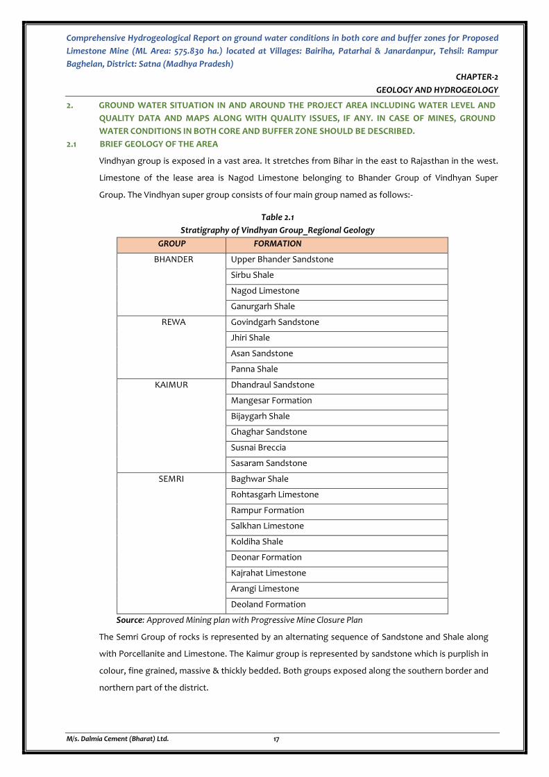
Comprehensive Hydrogeological Report on ground water conditions in both core and buffer zones for Proposed
Limestone Mine (ML Area: 575.830 ha.) located at Villages: Bairiha, Patarhai & Janardanpur, Tehsil: Rampur
Baghelan, District: Satna (Madhya Pradesh)
M/s. Dalmia Cement (Bharat) Ltd. 17
CHAPTER-2
GEOLOGY AND HYDROGEOLOGY
2. GROUND WATER SITUATION IN AND AROUND THE PROJECT AREA INCLUDING WATER LEVEL AND
QUALITY DATA AND MAPS ALONG WITH QUALITY ISSUES, IF ANY. IN CASE OF MINES, GROUND
WATER CONDITIONS IN BOTH CORE AND BUFFER ZONE SHOULD BE DESCRIBED.
2.1 BRIEF GEOLOGY OF THE AREA
Vindhyan group is exposed in a vast area. It stretches from Bihar in the east to Rajasthan in the west.
Limestone of the lease area is Nagod Limestone belonging to Bhander Group of Vindhyan Super
Group. The Vindhyan super group consists of four main group named as follows:-
Table 2.1
Stratigraphy of Vindhyan Group_Regional Geology
GROUP FORMATION
BHANDER Upper Bhander Sandstone
Sirbu Shale
Nagod Limestone
Ganurgarh Shale
REWA Govindgarh Sandstone
Jhiri Shale
Asan Sandstone
Panna Shale
KAIMUR Dhandraul Sandstone
Mangesar Formation
Bijaygarh Shale
Ghaghar Sandstone
Susnai Breccia
Sasaram Sandstone
SEMRI Baghwar Shale
Rohtasgarh Limestone
Rampur Formation
Salkhan Limestone
Koldiha Shale
Deonar Formation
Kajrahat Limestone
Arangi Limestone
Deoland Formation
Source: Approved Mining plan with Progressive Mine Closure Plan
The Semri Group of rocks is represented by an alternating sequence of Sandstone and Shale along
with Porcellanite and Limestone. The Kaimur group is represented by sandstone which is purplish in
colour, fine grained, massive & thickly bedded. Both groups exposed along the southern border and
northern part of the district.
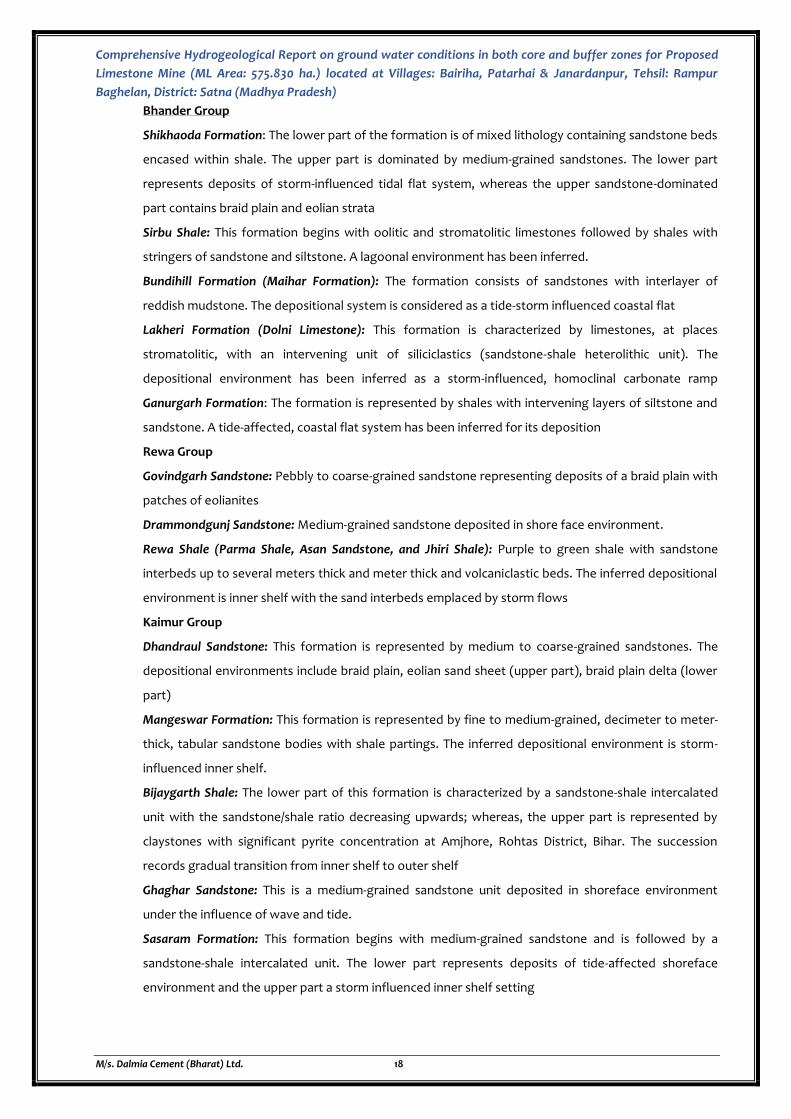
Comprehensive Hydrogeological Report on ground water conditions in both core and buffer zones for Proposed
Limestone Mine (ML Area: 575.830 ha.) located at Villages: Bairiha, Patarhai & Janardanpur, Tehsil: Rampur
Baghelan, District: Satna (Madhya Pradesh)
M/s. Dalmia Cement (Bharat) Ltd. 18
Bhander Group
Shikhaoda Formation: The lower part of the formation is of mixed lithology containing sandstone beds
encased within shale. The upper part is dominated by medium-grained sandstones. The lower part
represents deposits of storm-influenced tidal flat system, whereas the upper sandstone-dominated
part contains braid plain and eolian strata
Sirbu Shale: This formation begins with oolitic and stromatolitic limestones followed by shales with
stringers of sandstone and siltstone. A lagoonal environment has been inferred.
Bundihill Formation (Maihar Formation): The formation consists of sandstones with interlayer of
reddish mudstone. The depositional system is considered as a tide-storm influenced coastal flat
Lakheri Formation (Dolni Limestone): This formation is characterized by limestones, at places
stromatolitic, with an intervening unit of siliciclastics (sandstone-shale heterolithic unit). The
depositional environment has been inferred as a storm-influenced, homoclinal carbonate ramp
Ganurgarh Formation: The formation is represented by shales with intervening layers of siltstone and
sandstone. A tide-affected, coastal flat system has been inferred for its deposition
Rewa Group
Govindgarh Sandstone: Pebbly to coarse-grained sandstone representing deposits of a braid plain with
patches of eolianites
Drammondgunj Sandstone: Medium-grained sandstone deposited in shore face environment.
Rewa Shale (Parma Shale, Asan Sandstone, and Jhiri Shale): Purple to green shale with sandstone
interbeds up to several meters thick and meter thick and volcaniclastic beds. The inferred depositional
environment is inner shelf with the sand interbeds emplaced by storm flows
Kaimur Group
Dhandraul Sandstone: This formation is represented by medium to coarse-grained sandstones. The
depositional environments include braid plain, eolian sand sheet (upper part), braid plain delta (lower
part)
Mangeswar Formation: This formation is represented by fine to medium-grained, decimeter to meter-
thick, tabular sandstone bodies with shale partings. The inferred depositional environment is storm-
influenced inner shelf.
Bijaygarth Shale: The lower part of this formation is characterized by a sandstone-shale intercalated
unit with the sandstone/shale ratio decreasing upwards; whereas, the upper part is represented by
claystones with significant pyrite concentration at Amjhore, Rohtas District, Bihar. The succession
records gradual transition from inner shelf to outer shelf
Ghaghar Sandstone: This is a medium-grained sandstone unit deposited in shoreface environment
under the influence of wave and tide.
Sasaram Formation: This formation begins with medium-grained sandstone and is followed by a
sandstone-shale intercalated unit. The lower part represents deposits of tide-affected shoreface
environment and the upper part a storm influenced inner shelf setting
Comprehensive Hydrogeological Report on ground water conditions in both core and buffer zones for Proposed
Limestone Mine (ML Area: 575.830 ha.) located at Villages: Bairiha, Patarhai & Janardanpur, Tehsil: Rampur
Baghelan, District: Satna (Madhya Pradesh)
M/s. Dalmia Cement (Bharat) Ltd. 19
Semri Group
Rohtas Formation: This formation begins with massive, plane-laminated and/or stromatolitic
limestones followed by an intercalated unit of limestone and shale. In the western part at Jukehi,
Satna District, M.P., the limestones of the formation are overlain by thick (30 m) volcaniclastic
deposits. This volcaniclastic horizon thins towards east. The overall depositional environment is
inferred to be a carbonate platform with a distally steepened ramp.
Rampur Formation: This formation consists of greenish shales with interbeds of sandstone
representing deposits of storm-influenced inner and outer shelf.
Salkhan Formation: This formation is well developed in the eastern part of the Son Valley in Mirzapur
district and is represented by stromatolitic as well as non-stromatolitic limestones. This formation is a
lateral equivalent of Chorhat Formation. A peritidal environment is inferred for its deposition.
Chorhat Formation: This formation is represented by sandstones with and without mud partings and
layers. The formation is well developed in the western part of Son valley in the Chorhat area of Sidhi
District, M.P. The inferred depositional environment varies from shore face to tide-storm influenced
coastal flat. The formation yielded some markings claimed to be of trails of triploblastic metazoans.
Koldaha Formation: The Koldaha Formation begins with a sandstone-shale intercalated unit and
gradually becomes clayey. There are three distinct coarser units within the formation, the bottom-
most of which is conglomeratic containing clasts of the underlying horizons; the other two units are
coarse to medium-grained sandstones. There is also a thin limestone band occurring below the top-
most sandstone unit. The shales of this formation yielded some markings claimed to be of trails of
metazoans. The shaly parts are products inner and outer shelf, whereas the encased coarser clastics
have been interpreted as deposits of fan deltas.
Deonar Formation: The Deonar Formation is entirely represented by volcaniclastic deposits. There are
fine-grained tuffs along with infrequent thicker and coarser volcaniclastic deposited in outer shelf
environment.
Kajrahat Formation: This formation is overwhelmingly represented by limestones, which are at places
stromatolitic. However, a few interbeds of volcaniclastic and siliciclastics have also been recognized.
They dominantly represent peritidal to sub tidal carbonate deposits of a carbonate platform
Arangi Formation: This formation is characterized by sandstone-shale intercalation followed by pure
claystones. The formation also contains a few intercalated horizons of fine-grained volcaniclastic
(tuffs). The overall environment of deposition is inner to outer shelf.
Deoland Formation: This is the bottom-most formation of the Vindhyan Supergroup. It starts with
conglomerates followed by pebbly sandstone and sandstone representing deposits of alluvial fans and
fans deltas.

Comprehensive Hydrogeological Report on ground water conditions in both core and buffer zones for Proposed Limestone Mine (ML Area: 575.830 ha.) located at Villages:
Bairiha, Patarhai & Janardanpur, Tehsil: Rampur Baghelan, District: Satna (Madhya Pradesh)
M/s. Dalmia Cement (Bharat) Ltd. 20
Figure 2.1: Map showing Stratigraphy of Vindhyan Formation with Mine Site marked on the same (Source: GSI)
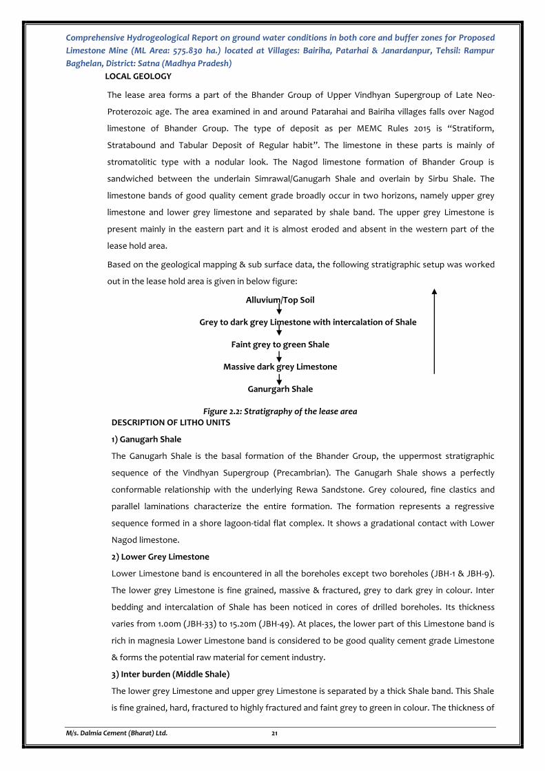
Comprehensive Hydrogeological Report on ground water conditions in both core and buffer zones for Proposed
Limestone Mine (ML Area: 575.830 ha.) located at Villages: Bairiha, Patarhai & Janardanpur, Tehsil: Rampur
Baghelan, District: Satna (Madhya Pradesh)
M/s. Dalmia Cement (Bharat) Ltd. 21
LOCAL GEOLOGY
The lease area forms a part of the Bhander Group of Upper Vindhyan Supergroup of Late Neo-
Proterozoic age. The area examined in and around Patarahai and Bairiha villages falls over Nagod
limestone of Bhander Group. The type of deposit as per MEMC Rules 2015 is “Stratiform,
Stratabound and Tabular Deposit of Regular habit”. The limestone in these parts is mainly of
stromatolitic type with a nodular look. The Nagod limestone formation of Bhander Group is
sandwiched between the underlain Simrawal/Ganugarh Shale and overlain by Sirbu Shale. The
limestone bands of good quality cement grade broadly occur in two horizons, namely upper grey
limestone and lower grey limestone and separated by shale band. The upper grey Limestone is
present mainly in the eastern part and it is almost eroded and absent in the western part of the
lease hold area.
Based on the geological mapping & sub surface data, the following stratigraphic setup was worked
out in the lease hold area is given in below figure:
Alluvium/Top Soil
Grey to dark grey Limestone with intercalation of Shale
Faint grey to green Shale
Massive dark grey Limestone
Ganurgarh Shale
Figure 2.2: Stratigraphy of the lease area DESCRIPTION OF LITHO UNITS
1) Ganugarh Shale
The Ganugarh Shale is the basal formation of the Bhander Group, the uppermost stratigraphic
sequence of the Vindhyan Supergroup (Precambrian). The Ganugarh Shale shows a perfectly
conformable relationship with the underlying Rewa Sandstone. Grey coloured, fine clastics and
parallel laminations characterize the entire formation. The formation represents a regressive
sequence formed in a shore lagoon-tidal flat complex. It shows a gradational contact with Lower
Nagod limestone.
2) Lower Grey Limestone
Lower Limestone band is encountered in all the boreholes except two boreholes (JBH-1 & JBH-9).
The lower grey Limestone is fine grained, massive & fractured, grey to dark grey in colour. Inter
bedding and intercalation of Shale has been noticed in cores of drilled boreholes. Its thickness
varies from 1.00m (JBH-33) to 15.20m (JBH-49). At places, the lower part of this Limestone band is
rich in magnesia Lower Limestone band is considered to be good quality cement grade Limestone
& forms the potential raw material for cement industry.
3) Inter burden (Middle Shale)
The lower grey Limestone and upper grey Limestone is separated by a thick Shale band. This Shale
is fine grained, hard, fractured to highly fractured and faint grey to green in colour. The thickness of

Comprehensive Hydrogeological Report on ground water conditions in both core and buffer zones for Proposed
Limestone Mine (ML Area: 575.830 ha.) located at Villages: Bairiha, Patarhai & Janardanpur, Tehsil: Rampur
Baghelan, District: Satna (Madhya Pradesh)
M/s. Dalmia Cement (Bharat) Ltd. 22
this Shale band varies from 12m (JBH-48) to 30.25m (JBH-2). It has been eroded in western part of
the PL area.
4) Upper Grey Limestone
Exposures of Upper Grey Limestone are found to occur in and around Patarhai village & Bariha
village. The outcrops in and around Janardanpur village is scanty. It is the top band of Limestone
and has been encountered in boreholes mostly falling in and around Patarhai, Bairiha and
Janardapur villages. This band is almost eroded and absent in the rest of PL area. Upper grey
Limestone is stramatolitic, grey to dark grey in colour, fractured with filling of siliceous materials.
The thickness of this Limestone band varies from 0.80m (BH. No.JBH 40) to 8.80m (BH. No.JBH-
9)The critical observation of upper limestone band of the open pits, canal cutting and nala sections
reveals that the upper part of the Limestone is stromatolitic and Limestone occurs just below the
top soil. Stromatolitic limestone is bedded in nature. The bedded limestone, at places, is very finely
bedded, laminated with intercalations of impurities like shale. The presence of shale intercalations
reduces the quality of Limestone.

Comprehensive Hydrogeological Report on ground water conditions in both core and buffer zones for Proposed Limestone Mine (ML Area: 575.830 ha.) located at Villages:
Bairiha, Patarhai & Janardanpur, Tehsil: Rampur Baghelan, District: Satna (Madhya Pradesh)
M/s. Dalmia Cement (Bharat) Ltd. 23
Figure 2.3: Map showing Geology Map of Proposed Limestone Mine (ML Area: 575.830ha) (Source: Bhukosh)
Comprehensive Hydrogeological Report on ground water conditions in both core and buffer zones for Proposed
Limestone Mine (ML Area: 575.830 ha.) located at Villages: Bairiha, Patarhai & Janardanpur, Tehsil: Rampur
Baghelan, District: Satna (Madhya Pradesh)
M/s. Dalmia Cement (Bharat) Ltd. 24
2.2 HYDROGEOLOGY OF THE AREA
Rainfall is the main source of ground water recharge in the Satna district. Various geological
formations ranging in age from Achaeans to Recent occurs in different part of area and contributes to
a complex geological set up in the district. However, Vindhyan are the main rock units of the area,
covering more than 95% of geographical area of the district. Among Vindhyan, both Lower and Upper
Vindhyan represent the area, but Lower Vindhyan mostly occupies the southern part of the area in
Son Sub-basin. A comprehensive hydro geological map is shown in the figure 4.1
Occurrence and movement of ground water in hard rock is essentially by development and
nature of secondary joints and fractures. Solution cavities in limestones also play an important role in
groundwater movement at certain places. Ground water in general occurs under unconfined to semi-
confined conditions. The occurrence and movement of ground water in different lithological units is
majorly controlled by following formations:
Bhander Lime Stone
This unit is hard and compact but jointed and fractured. Along the joints and planes of stratification
“Grikes” and “Solution Cavities” get developed through the process of dissolution of country rock by
circulating ground water. Often cavities are filled with yellow colored plastic clay known as “Terra-
Rosa”. Cavernous Limestone hold good quantity of ground water, but quality may be slightly hard.
General yield potential of Bhander (Nagod) Lime stone is 3 to 12 lps. Exploratory wells drilled at
Kirpalpur (Satna-Anicut), Maihar- Stadium and Jhinna-Nala tapping Limestone aquifers have given
good yields.
Sirbu Shale
Sirbu shale is younger unit of Upper Vindhyan having very thick horizon along Syncline axis. In low-
lying topographic areas and in the weathered mantle, occurrence of ground water is of limited
quantity yet enough to sustain dug wells for domestic/drinking purposes. The brownish red variety is
more productive than the grayish shales. Due to its impervious nature, lots of small ponds are
constructed in Sirbu shales which hold water even during summer season in Maihar and Amarpatan
Blocks. These ponds are also used for production of water-nuts in abundance. General yield potential
of Sirbu shale is 1 to 3 LPs.
Laterite and Alluvium
Laterite is occurring as capping over hillocks on Kaimur/Rewa sandstone which is not important from
ground water occurrence point of view. Alluvial unit comprising fine to medium sand with admixture
of silty clay and gravel offers considerable primary porosity. Though its area is limited in the district
but alluvium of recent age is an important aquifer being developed through open wells and shallow
tube wells in the area. Main occurrence is in northern part of the area between Baboopur and
Chitakoot with variable thickness and approximate average thickness is less than 30 m. Alluvial
Ravines are reported to be developing in the Chitrakoot area due to headwards erosion. Two strips of
alluvium also occur in the district, at foothills of both limbs of Rewa sand stones. Northern alluvial
strip is passing through Singhpur, Jhali, Kothi and Birsinghpur.
Comprehensive Hydrogeological Report on ground water conditions in both core and buffer zones for Proposed
Limestone Mine (ML Area: 575.830 ha.) located at Villages: Bairiha, Patarhai & Janardanpur, Tehsil: Rampur
Baghelan, District: Satna (Madhya Pradesh)
M/s. Dalmia Cement (Bharat) Ltd. 25
Bhander Limestone and Sibru and Simrawal Shale are principal aquifers in the area in which movement
of water is controlled mainly by occurrence of fractures and cracks and occasionally at places by clay
partings in the limestone; however, generally this formation lacks cavities. The formations are
horizontal to sub-horizontal and area not found to be disturbed by any major tectonic disturbances.
The joint planes are irregular in nature. Limestone has been found with solution cavities which is a
common feature in limestone terrain. The bedding planes are prominent and can be recognized easily
and bedding plane foliation can be found at places in the area. The joints are irregular and do not
follow any particular pattern. Folding and faulting are insignificant and the beds area more or less
horizontal. The occurrence and deposition of various rock types is dependent mostly on the
topography and inliers and outliers are common feature in the area. Like other calcareous formations,
lenticular and irregular bedding, cross laminations and mud-cracks have been observed in limestone
bearing area which have given passage to flowing water forming solution cavities.
2.2.1 AQUIFER DESCRIPTION
The chief aquifer units are weathered top soil, limestone and weathered fractured, splintery Sibru
shale formation. The study area is covered with thin soil layer. The weathered Nagod Limestone and
weathered, fractured, splintery Sibru shale formation is acting as shallow water bearing aquifer. The
porosity value of these limestone formations is very low as compared to standard porosity values (10-
20%) and acting as aquitard that yield water slowly. This limestone with poor water holding capacity
allows the movement of water along the gradient/hydraulic gradient of the area.
The limestone formation is massive and well jointed. The permeability of this formation is mainly of
secondary origin i.e. it had developed largely through the network of joints and fracture patterns,
produced by diastrophic forces. The solubility of the rock permits further modification of the
permeability by circulating water. In such cases, permeability would be progressively modified and the
joint network may get so enlarged that some of the main channels may be only partially filled with
water and consequently draw water forms smaller channels except at the time of heavy infiltration. In
such area, water supply from wells would be quite uncertain–wells which tap these large cavities
would yield profuse quantities of water, whereas others constructed in relatively dry rocks may not be
successful. It is, therefore, imperative to locate the large cavities or channels filled with water prior to
sinking wells in such areas.
Depth to water levels in pre-monsoon period ranges between 12 to 15 m bgl while in post-monsoon
season, it ranges between 10 to 12 m bgl. Major part of the study area/buffer zone (more than 70%)
covered by Limestone and Sandstone formation having yield between 1 to 8 Liters per second (LPS).
2.2.2 GROUND WATER FLOW AND AQUIFER INTERACTION
The groundwater movement in and around the project area is mainly controlled by fracture porosity
present in Bagh Beds. Its flow follows the general slope of ground surface in the area. Accordingly, the
direction of groundwater flow in the Proposed Limestone Mine is mainly towards North West direction.
A rivulet originating in the upper side of the lease area joins the Dila Nala which ultimately merges with
Nar Nadi. The topographic elevation ranges from 288m to 306.65m above mean sea level. The general

Comprehensive Hydrogeological Report on ground water conditions in both core and buffer zones for Proposed
Limestone Mine (ML Area: 575.830 ha.) located at Villages: Bairiha, Patarhai & Janardanpur, Tehsil: Rampur
Baghelan, District: Satna (Madhya Pradesh)
M/s. Dalmia Cement (Bharat) Ltd. 26
gradient of the area is towards North West. Protective measures will be taken to safeguard the natural
flowing streams.
Mitigation Measures:
ML area has been granted after excluding the Nallah and same will not be disturbed.
A safety barrier of 50 m will be left on either side of nallah
No erosion wash off will be directly allowed to go to the Natural System as it will be arrested by
constructing Bunds/ Check dams/ check filters/bunds/garland drains/sedimentation ponds etc.
Wherever crossing seasonal water course, culvert / bridge will be constructed for the vehicles
transporting limestone without affecting the natural course of water course.
The surface run off from mine lease area will be channelized to a suitable location (excavated mine
pits or water reservoir) through proper plan of garland drains/storm water drains along with
siltation ponds at regular intervals.
These streamlets are active only during rains and become dry during post monsoon.
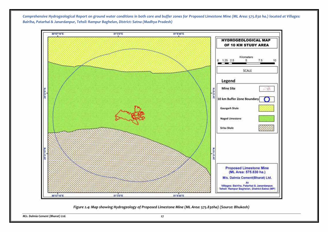
Comprehensive Hydrogeological Report on ground water conditions in both core and buffer zones for Proposed Limestone Mine (ML Area: 575.830 ha.) located at Villages:
Bairiha, Patarhai & Janardanpur, Tehsil: Rampur Baghelan, District: Satna (Madhya Pradesh)
M/s. Dalmia Cement (Bharat) Ltd. 27
Figure 2.4: Map showing Hydrogeology of Proposed Limestone Mine (ML Area: 575.830ha) (Source: Bhukosh)
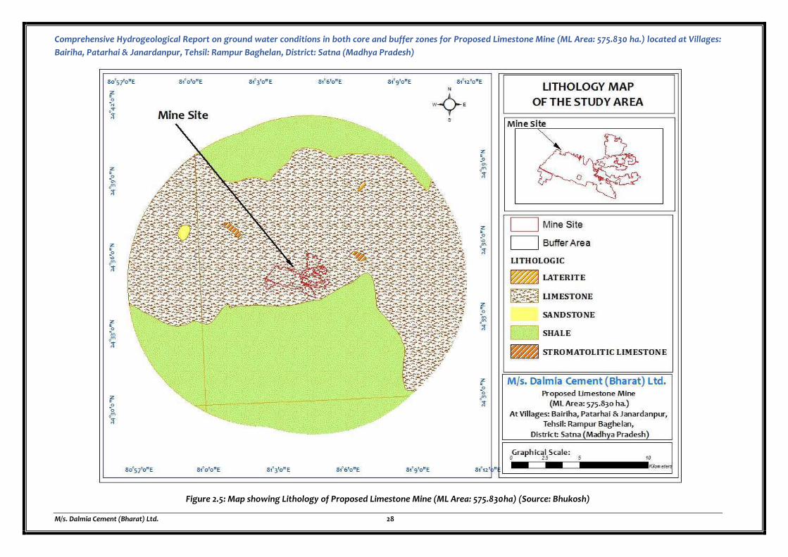
Comprehensive Hydrogeological Report on ground water conditions in both core and buffer zones for Proposed Limestone Mine (ML Area: 575.830 ha.) located at Villages:
Bairiha, Patarhai & Janardanpur, Tehsil: Rampur Baghelan, District: Satna (Madhya Pradesh)
M/s. Dalmia Cement (Bharat) Ltd. 28
Figure 2.5: Map showing Lithology of Proposed Limestone Mine (ML Area: 575.830ha) (Source: Bhukosh)

Comprehensive Hydrogeological Report on ground water conditions in both core and buffer zones for Proposed
Limestone Mine (ML Area: 575.830 ha.) located at Villages: Bairiha, Patarhai & Janardanpur, Tehsil: Rampur
Baghelan, District: Satna (Madhya Pradesh)
M/s. Dalmia Cement (Bharat) Ltd. 29
2.2.3 GROUND WATER LEVEL TREND ANALYSIS
The ground water levels observed over a period provides valuable information on the behavior of
the ground water regime, which is constantly subjected to changes due to recharge and discharge
phenomenon. When the recharge exceeds discharge, there will be a rise in the ground water
storage and vice versa. The decline in water level may be due to increase in draft (for different
purposes) or decrease in precipitation (less recharge to ground water). On the other hand, a rise in
water level may be due to an increase in rainfall and/or due to changes in irrigation practices. From
the pre monsoon and post monsoon depth to water level data collected during May and November
respectively, water level fluctuation were computed. The water level fluctuation between pre
monsoon and post monsoon period of the study area varies from 3 m to 5m.
Details of water level for last 10 years for pre and post monsoon is given with graph.
Figure 2.6: Water level fluctuation graph in last 10 years
DEPTH TO WATER LEVEL_PRE MONSOON (10 YEARS)
On the basis of the depth to water level of the study area, the pre monsoon depth to water level
ranges between 6.33 m bgl to 12.2 m bgl. Pre monsoon depth to water level graph is prepared and
enclosed below:
Figure 2.7: Graph showing trend in water level in last 10 years in pre-monsoon
0
0.5
1
1.5
2
2.5
3
3.5
4
2008 2010 2012 2014 2016 2018 2020
Fluctuation
Linear (Fluctuation)
9.86
11.66 11.25 11.05
9.14
12.210.67 10.8
9.68
6.33
2010 2011 2012 2013 2014 2015 2016 2017 2018 2019
Water Level (mbgl) during Pre- Monsoon season in the study area
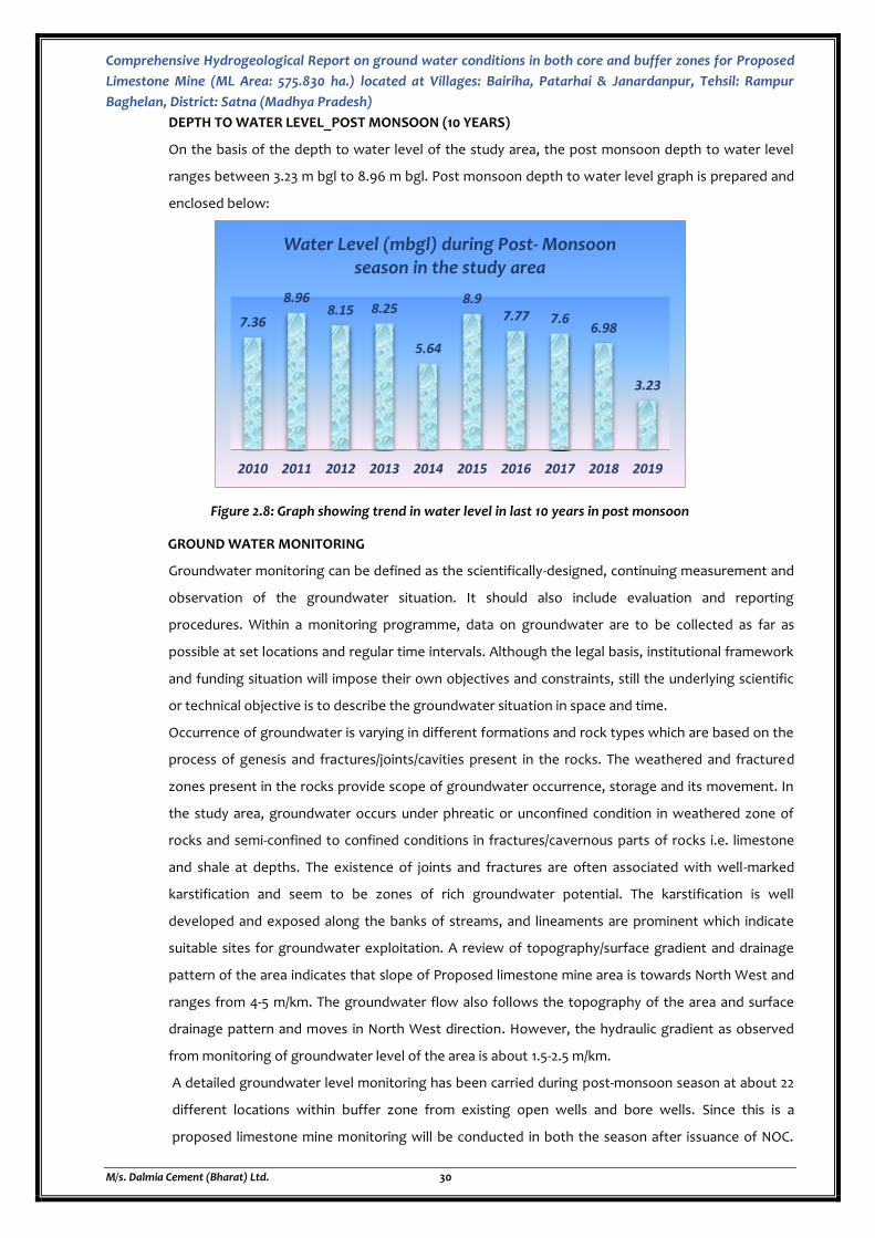
Comprehensive Hydrogeological Report on ground water conditions in both core and buffer zones for Proposed
Limestone Mine (ML Area: 575.830 ha.) located at Villages: Bairiha, Patarhai & Janardanpur, Tehsil: Rampur
Baghelan, District: Satna (Madhya Pradesh)
M/s. Dalmia Cement (Bharat) Ltd. 30
DEPTH TO WATER LEVEL_POST MONSOON (10 YEARS)
On the basis of the depth to water level of the study area, the post monsoon depth to water level
ranges between 3.23 m bgl to 8.96 m bgl. Post monsoon depth to water level graph is prepared and
enclosed below:
Figure 2.8: Graph showing trend in water level in last 10 years in post monsoon
GROUND WATER MONITORING
Groundwater monitoring can be defined as the scientifically-designed, continuing measurement and
observation of the groundwater situation. It should also include evaluation and reporting
procedures. Within a monitoring programme, data on groundwater are to be collected as far as
possible at set locations and regular time intervals. Although the legal basis, institutional framework
and funding situation will impose their own objectives and constraints, still the underlying scientific
or technical objective is to describe the groundwater situation in space and time.
Occurrence of groundwater is varying in different formations and rock types which are based on the
process of genesis and fractures/joints/cavities present in the rocks. The weathered and fractured
zones present in the rocks provide scope of groundwater occurrence, storage and its movement. In
the study area, groundwater occurs under phreatic or unconfined condition in weathered zone of
rocks and semi-confined to confined conditions in fractures/cavernous parts of rocks i.e. limestone
and shale at depths. The existence of joints and fractures are often associated with well-marked
karstification and seem to be zones of rich groundwater potential. The karstification is well
developed and exposed along the banks of streams, and lineaments are prominent which indicate
suitable sites for groundwater exploitation. A review of topography/surface gradient and drainage
pattern of the area indicates that slope of Proposed limestone mine area is towards North West and
ranges from 4-5 m/km. The groundwater flow also follows the topography of the area and surface
drainage pattern and moves in North West direction. However, the hydraulic gradient as observed
from monitoring of groundwater level of the area is about 1.5-2.5 m/km.
A detailed groundwater level monitoring has been carried during post-monsoon season at about 22
different locations within buffer zone from existing open wells and bore wells. Since this is a
proposed limestone mine monitoring will be conducted in both the season after issuance of NOC.
7.36
8.968.15 8.25
5.64
8.97.77 7.6
6.98
3.23
2010 2011 2012 2013 2014 2015 2016 2017 2018 2019
Water Level (mbgl) during Post- Monsoon season in the study area
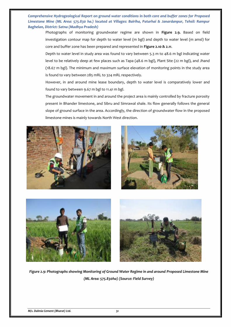
Comprehensive Hydrogeological Report on ground water conditions in both core and buffer zones for Proposed
Limestone Mine (ML Area: 575.830 ha.) located at Villages: Bairiha, Patarhai & Janardanpur, Tehsil: Rampur
Baghelan, District: Satna (Madhya Pradesh)
M/s. Dalmia Cement (Bharat) Ltd. 31
Photographs of monitoring groundwater regime are shown in Figure 2.9. Based on field
investigation contour map for depth to water level (m bgl) and depth to water level (m amsl) for
core and buffer zone has been prepared and represented in Figure 2.10 & 2.11.
Depth to water level in study area was found to vary between 5.3 m to 48.6 m bgl indicating water
level to be relatively deep at few places such as Tapa (48.6 m bgl), Plant Site (22 m bgl), and Jhand
(18.67 m bgl). The minimum and maximum surface elevation of monitoring points in the study area
is found to vary between 285 mRL to 324 mRL respectively.
However, in and around mine lease boundary, depth to water level is comparatively lower and
found to vary between 9.67 m bgl to 11.41 m bgl.
The groundwater movement in and around the project area is mainly controlled by fracture porosity
present in Bhander limestone, and Sibru and Simrawal shale. Its flow generally follows the general
slope of ground surface in the area. Accordingly, the direction of groundwater flow in the proposed
limestone mines is mainly towards North West direction.
Figure 2.9: Photographs showing Monitoring of Ground Water Regime in and around Proposed Limestone Mine
(ML Area: 575.830ha) (Source: Field Survey)
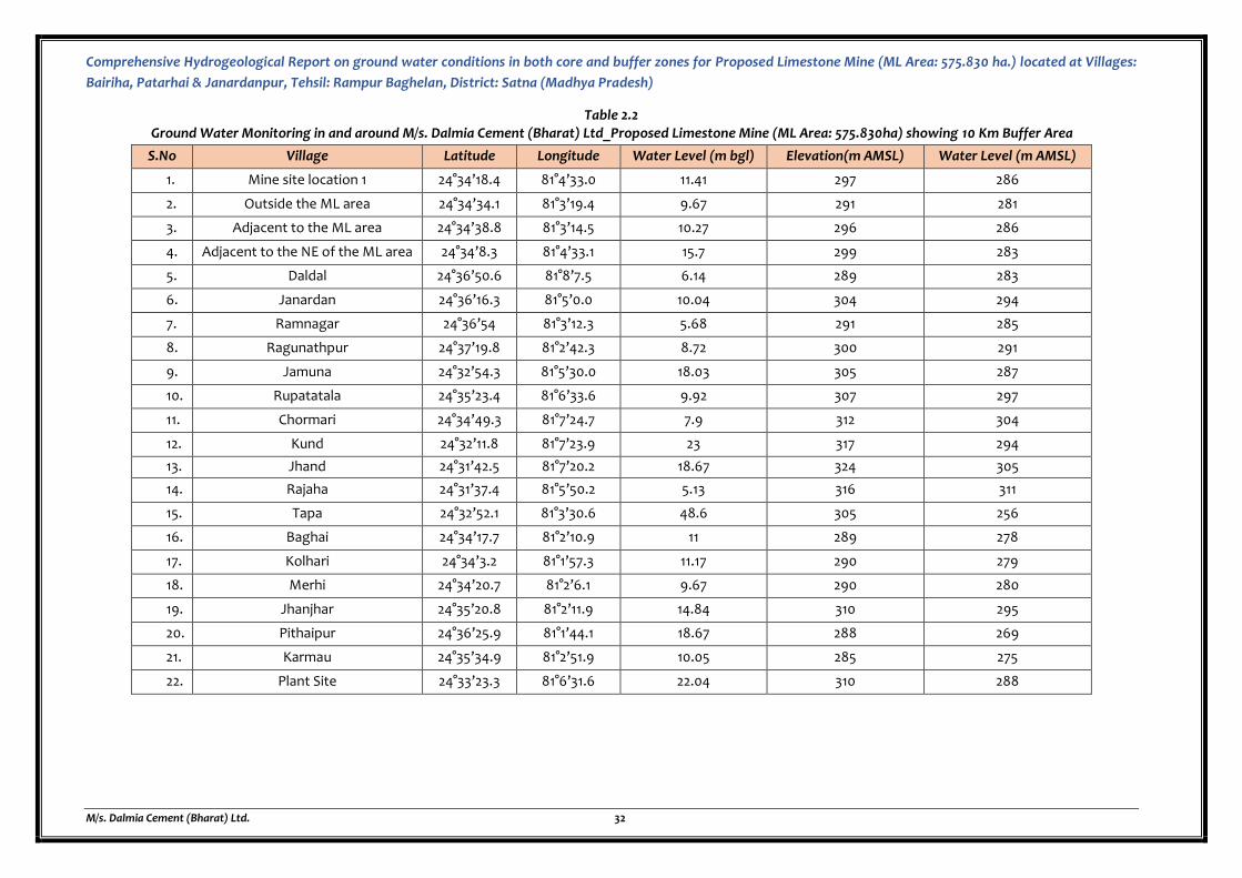
Comprehensive Hydrogeological Report on ground water conditions in both core and buffer zones for Proposed Limestone Mine (ML Area: 575.830 ha.) located at Villages:
Bairiha, Patarhai & Janardanpur, Tehsil: Rampur Baghelan, District: Satna (Madhya Pradesh)
M/s. Dalmia Cement (Bharat) Ltd. 32
Table 2.2 Ground Water Monitoring in and around M/s. Dalmia Cement (Bharat) Ltd_Proposed Limestone Mine (ML Area: 575.830ha) showing 10 Km Buffer Area
S.No Village Latitude Longitude Water Level (m bgl) Elevation(m AMSL) Water Level (m AMSL)
1. Mine site location 1 24°34’18.4 81°4’33.0 11.41 297 286
2. Outside the ML area 24°34’34.1 81°3’19.4 9.67 291 281
3. Adjacent to the ML area 24°34’38.8 81°3’14.5 10.27 296 286
4. Adjacent to the NE of the ML area 24°34’8.3 81°4’33.1 15.7 299 283
5. Daldal 24°36’50.6 81°8’7.5 6.14 289 283
6. Janardan 24°36’16.3 81°5’0.0 10.04 304 294
7. Ramnagar 24°36’54 81°3’12.3 5.68 291 285
8. Ragunathpur 24°37’19.8 81°2’42.3 8.72 300 291
9. Jamuna 24°32’54.3 81°5’30.0 18.03 305 287
10. Rupatatala 24°35’23.4 81°6’33.6 9.92 307 297
11. Chormari 24°34’49.3 81°7’24.7 7.9 312 304
12. Kund 24°32’11.8 81°7’23.9 23 317 294
13. Jhand 24°31’42.5 81°7’20.2 18.67 324 305
14. Rajaha 24°31’37.4 81°5’50.2 5.13 316 311
15. Tapa 24°32’52.1 81°3’30.6 48.6 305 256
16. Baghai 24°34’17.7 81°2’10.9 11 289 278
17. Kolhari 24°34’3.2 81°1’57.3 11.17 290 279
18. Merhi 24°34’20.7 81°2’6.1 9.67 290 280
19. Jhanjhar 24°35’20.8 81°2’11.9 14.84 310 295
20. Pithaipur 24°36’25.9 81°1’44.1 18.67 288 269
21. Karmau 24°35’34.9 81°2’51.9 10.05 285 275
22. Plant Site 24°33’23.3 81°6’31.6 22.04 310 288
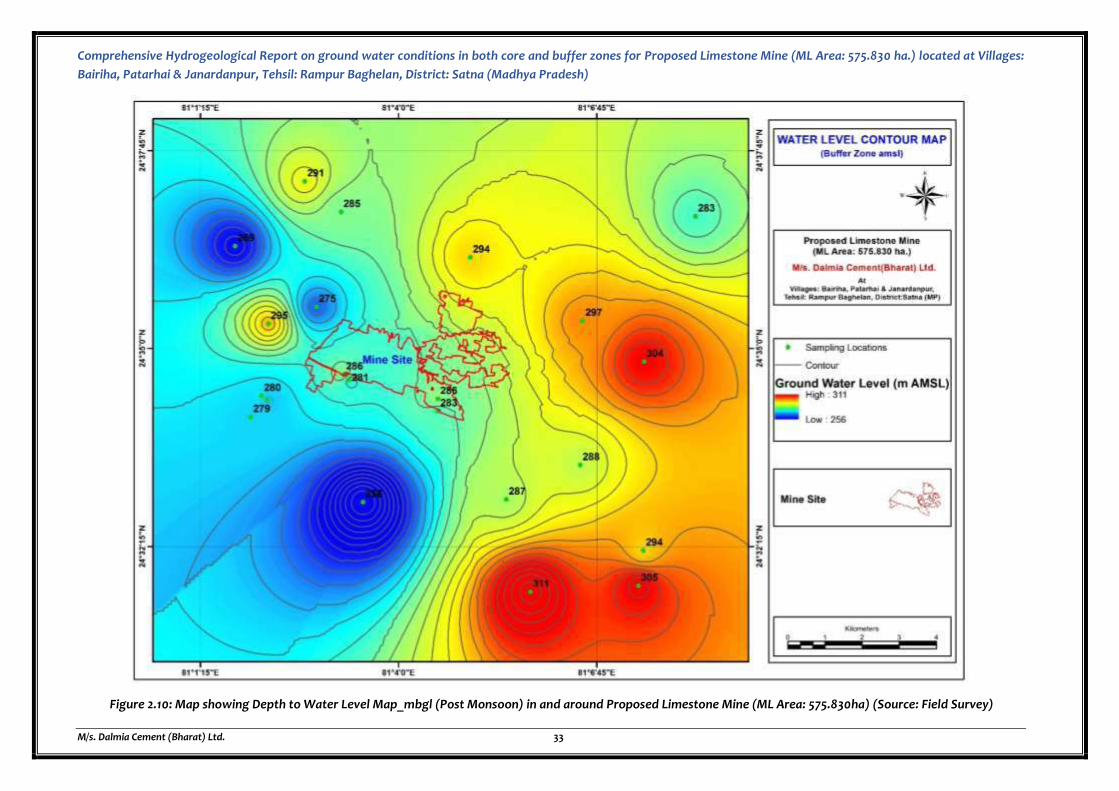
Comprehensive Hydrogeological Report on ground water conditions in both core and buffer zones for Proposed Limestone Mine (ML Area: 575.830 ha.) located at Villages:
Bairiha, Patarhai & Janardanpur, Tehsil: Rampur Baghelan, District: Satna (Madhya Pradesh)
M/s. Dalmia Cement (Bharat) Ltd. 33
Figure 2.10: Map showing Depth to Water Level Map_mbgl (Post Monsoon) in and around Proposed Limestone Mine (ML Area: 575.830ha) (Source: Field Survey)
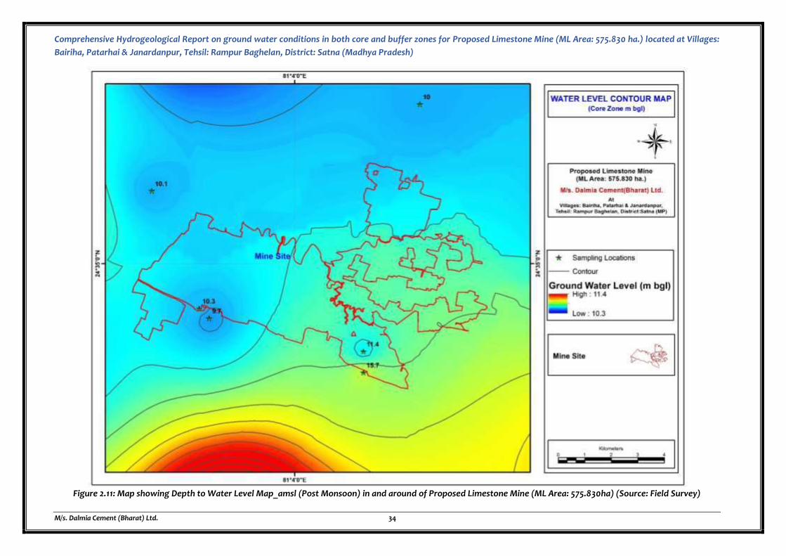
Comprehensive Hydrogeological Report on ground water conditions in both core and buffer zones for Proposed Limestone Mine (ML Area: 575.830 ha.) located at Villages:
Bairiha, Patarhai & Janardanpur, Tehsil: Rampur Baghelan, District: Satna (Madhya Pradesh)
M/s. Dalmia Cement (Bharat) Ltd. 34
Figure 2.11: Map showing Depth to Water Level Map_amsl (Post Monsoon) in and around of Proposed Limestone Mine (ML Area: 575.830ha) (Source: Field Survey)
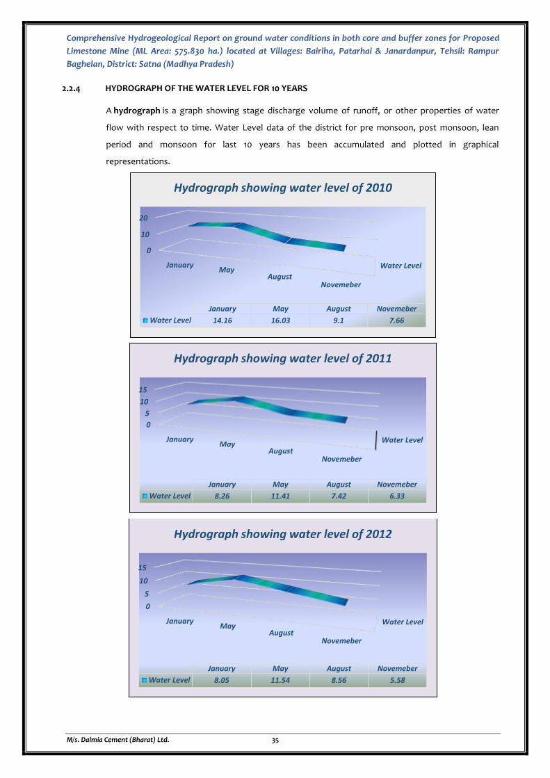
Comprehensive Hydrogeological Report on ground water conditions in both core and buffer zones for Proposed
Limestone Mine (ML Area: 575.830 ha.) located at Villages: Bairiha, Patarhai & Janardanpur, Tehsil: Rampur
Baghelan, District: Satna (Madhya Pradesh)
M/s. Dalmia Cement (Bharat) Ltd. 35
2.2.4 HYDROGRAPH OF THE WATER LEVEL FOR 10 YEARS
A hydrograph is a graph showing stage discharge volume of runoff, or other properties of water
flow with respect to time. Water Level data of the district for pre monsoon, post monsoon, lean
period and monsoon for last 10 years has been accumulated and plotted in graphical
representations.
Water Level
0
10
20
JanuaryMay
AugustNovemeber
January May August Novemeber
Water Level 14.16 16.03 9.1 7.66
Hydrograph showing water level of 2010
Water Level
0
5
10
15
JanuaryMay
AugustNovemeber
January May August Novemeber
Water Level 8.26 11.41 7.42 6.33
Hydrograph showing water level of 2011
Water Level
0
5
10
15
JanuaryMay
AugustNovemeber
January May August Novemeber
Water Level 8.05 11.54 8.56 5.58
Hydrograph showing water level of 2012
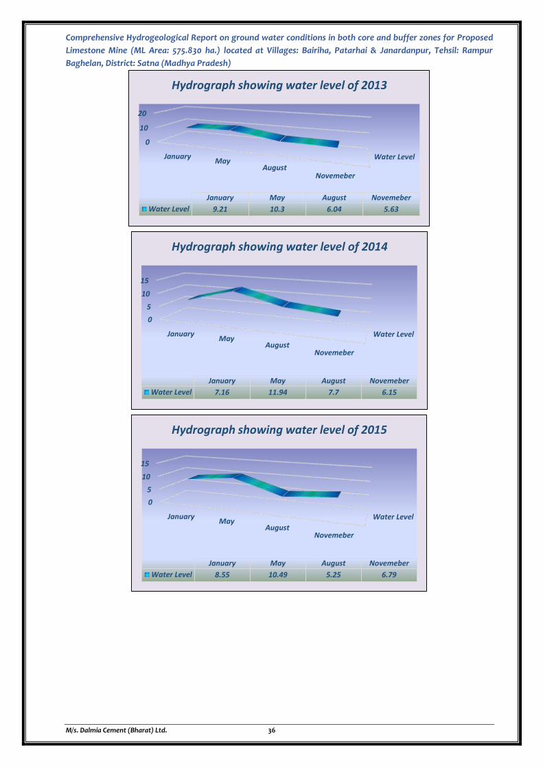
Comprehensive Hydrogeological Report on ground water conditions in both core and buffer zones for Proposed
Limestone Mine (ML Area: 575.830 ha.) located at Villages: Bairiha, Patarhai & Janardanpur, Tehsil: Rampur
Baghelan, District: Satna (Madhya Pradesh)
M/s. Dalmia Cement (Bharat) Ltd. 36
Water Level
0
10
20
JanuaryMay
AugustNovemeber
January May August Novemeber
Water Level 9.21 10.3 6.04 5.63
Hydrograph showing water level of 2013
Water Level
0
5
10
15
JanuaryMay
AugustNovemeber
January May August Novemeber
Water Level 7.16 11.94 7.7 6.15
Hydrograph showing water level of 2014
Water Level
0
5
10
15
JanuaryMay
AugustNovemeber
January May August Novemeber
Water Level 8.55 10.49 5.25 6.79
Hydrograph showing water level of 2015

Comprehensive Hydrogeological Report on ground water conditions in both core and buffer zones for Proposed
Limestone Mine (ML Area: 575.830 ha.) located at Villages: Bairiha, Patarhai & Janardanpur, Tehsil: Rampur
Baghelan, District: Satna (Madhya Pradesh)
M/s. Dalmia Cement (Bharat) Ltd. 37
Water Level
0
10
20
JanuaryMay
AugustNovemeber
January May August Novemeber
Water Level 16.65 12.48 5.32 5.47
Hydrograph showing water level of 2016
Water Level
0
5
10
JanuaryMay
AugustNovemeber
January May August Novemeber
Water Level 5.48 9.3 4.62 4.51
Hydrograph showing water level of 2017
Water Level
0
5
10
15
JanuaryMay
AugustNovemeber
January May August Novemeber
Water Level 7.13 11.59 7.37 5.45
Hydrograph showing water level of 2018

Comprehensive Hydrogeological Report on ground water conditions in both core and buffer zones for Proposed
Limestone Mine (ML Area: 575.830 ha.) located at Villages: Bairiha, Patarhai & Janardanpur, Tehsil: Rampur
Baghelan, District: Satna (Madhya Pradesh)
M/s. Dalmia Cement (Bharat) Ltd. 38
Figure 2.12: Hydrographs showing Water Level of the study area from 2010 to 2019
2.2.5 PREDICTED WATER LEVEL DECLINES FOR AFFECTED AQUIFER
The present mining proposal will abstract ground water in the tune of 90 KLD and there will be
maximum ground water seepage in the plan period and that is in the 5th year in the tune of 329
KLD. Therefore, the total ground water abstraction from the present mining proposal is 419 KLD
and that will be during plan period.
As per CGWA Format this mining project lies in Rampur Baghelan Assessment Block of Satna
District which comes under Semi Critical Category as per CGWB Categorization 2017.
http://cgwb.gov.in/GW-Assessment/Categorization%20of%20AU.pdf
The Mine Site and its 10Km study area falls in hard rock terrain and total ground
water abstraction and dewatering occurs in the range of 419 KLD which is less than
500 KLD, therefore detailed modelling is not applicable for the project as per
CGWA Format for preparation of Comprehensive Hydrogeological Report.
The aquifers have shown a fairly shallower ground water occurrence i.e., up to 12m to 15m of depth
from ground level The positive fluctuation areas, mostly in the range from 3m to 5m.
There will be minor ground water level decline due to presence of industries, mines, domestic and
agricultural draft.
Prediction of future groundwater levels and drying of observation wells was done based on the
following procedure:
The prediction was made based on the assumption that the average long term rates of
rainfall and drafts will remain similar to the general trends observed in the last 10 years.
Accordingly, it is presumed that the general trends and average rate of change of
groundwater levels will be similar to the average of the last 3 decades.
Predictions were estimated for the years 2020, 2030 and 2040.
Bottom elevation was then compared to the predicted future groundwater levels of the
specific observation well.
The procedure was applied for pre and post-monsoon stages separately.
Water Level
0
5
10
15
JanuaryMay
AugustNovemeber
January May August Novemeber
Water Level 11.52 13.79 7.14 6.12
Hydrograph showing water level of 2019

Comprehensive Hydrogeological Report on ground water conditions in both core and buffer zones for Proposed
Limestone Mine (ML Area: 575.830 ha.) located at Villages: Bairiha, Patarhai & Janardanpur, Tehsil: Rampur
Baghelan, District: Satna (Madhya Pradesh)
M/s. Dalmia Cement (Bharat) Ltd. 39
If the bottom elevation was found higher than the predicted level, the observation well was
assumed to become dry by that year.
The predictions give a general indication for the future expected needs of deepening of
existing observation wells and drilling of new ones.
Figure 2.13: Fence Diagram showing the Lithological Layers (Source: CGWB)
2.2.6 GROUND WATER QUALITY
Ground water samples were collected from the available water resources around the mine site. The
samples were collected and tested from different sites. The quality of ground water was studied by
collecting 6 water samples.
The analysis of the samples have been carried out in J.M. EnviroLab Pvt. Ltd. located in Gurgaon, The
lab is NABL certified and has approval from MoEF and state boards.
Details of groundwater sampling locations and their distance as well as directions are given in the
Table 2.3 and Figure 2.14 while results are presented in Table 2.4
Table 2.3
Ground Water Sampling Locations
Station Code Sampling Station Distance from Mine Site
SGWS 1 Proposed Mine Site Core Zone
SGWS 2 Village Jamuna ~1.5 km in SE direction
SGWS 3 Village Jhand ~5.5 km in SSE direction
SGWS 4 Village Bairiha Adjacent in South direction
SGWS 5 Village Janardanpur ~0.5 km in North
SGWS 6 Village Ramnagar ~3.5 km in NNW direction

Comprehensive Hydrogeological Report on ground water conditions in both core and buffer zones for Proposed Limestone Mine (ML Area: 575.830 ha.) located at Villages:
Bairiha, Patarhai & Janardanpur, Tehsil: Rampur Baghelan, District: Satna (Madhya Pradesh)
M/s. Dalmia Cement (Bharat) Ltd. 40
Figure 2.14: Map showing Ground Water Sampling Locations in and around Proposed Limestone Mine (ML Area: 575.830ha) (Source: Field Survey)

Comprehensive Hydrogeological Report on ground water conditions in both core and buffer zones for Proposed Limestone Mine (ML Area: 575.830 ha.) located at Villages:
Bairiha, Patarhai & Janardanpur, Tehsil: Rampur Baghelan, District: Satna (Madhya Pradesh)
M/s. Dalmia Cement (Bharat) Ltd. 41
Table 2.4 (A)
Ground Water Sampling Results of Proposed Limestone Mine (ML Area: 575.830ha) _Post Monsoon
S. No. Parameters Unit Mine Site Village- Jamuna
Village-Jhand
Village- Bairiha
Village- Janardanpur
Village- Ramnagar
Specification as per IS 10500- 2012
Requirement (Acceptable Limit)
Permissible Limit (Max.)
1. pH (at 25°C) - 7.23 7.32 7.42 7.43 7.31 7.54 6.5-8.5 No Relaxation
2. Colour Hazen Unit
BDL(DL 5.0) BDL(DL 5.0) BDL(DL 5.0) BDL(DL 5.0) BDL(DL 5.0) BDL(DL 5.0) 5 15
3. Turbidity NTU BDL(DL 1.0) BDL(DL 1.0) BDL(DL 1.0) BDL(DL 1.0) BDL(DL 1.0) BDL(DL 1.0) 1 5
4. Odour - Agreeable Agreeable Agreeable Agreeable Agreeable Agreeable Agreeable Agreeable
5. Taste - Agreeable Agreeable Agreeable Agreeable Agreeable Agreeable Agreeable Agreeable
6. Total Hardness as CaCO3
mg/l 263 287 302 255 279 233 200 600
7. Calcium as Ca mg/l 70.29 74.2 87.29 70.37 72.17 61.47 75 200
8. Alkalinity as CaCO3
mg/l 155 194.2 228 175.4 209.7 164.6
200 600
9. Chloride as Cl mg/l 17.37 32.26 19.85 27.37 26.85 22.33 250 1000
10. Cyanide as CN mg/l BDL(DL 0.02)
BDL(DL 0.02)
BDL(DL 0.02)
BDL(DL 0.02) BDL(DL 0.02) BDL(DL 0.02) 0.05 No Relaxation
11. Magnesium as Mg
mg/l 21.16 24.69 20.45 19.25 24.06 19.24
30 100
12. Total Dissolved Solids
mg/l 376 439 483 348 468 467
500 2000
13. Sulphate as SO4 mg/l 49.12 69.43 87.48 28.57 73.3 171.56
200 400
14. Fluoride as F mg/l 0.35 0.66 0.71 0.36 0.52 0.72 1 1.5
15. Nitrate as NO3-N mg/l 1.24 1.18 2.84 0.84 0.92 1.12
45 No Relaxation
16. Iron as Fe mg/l 0.07 0.07 0.1 0.05 0.1 0.05
1 No Relaxation
17. Aluminium as Al mg/l BDL (DL 0.03)
BDL (DL 0.03)
BDL (DL 0.03)
BDL (DL 0.03) BDL (DL 0.03) BDL (DL 0.03) 0.03 0.2
18. Boron mg/l BDL (DL 0.20)
BDL (DL 0.20)
BDL (DL 0.20)
BDL (DL 0.20) BDL (DL 0.20) BDL (DL 0.20) 0.5 1
19. Phenolic Compounds
mg/l BDL (DL 0.001)
BDL (DL 0.001)
BDL (DL 0.001)
BDL (DL 0.001)
BDL (DL 0.001)
BDL (DL 0.001)
0.001 0.002
20. Anionic Detergents as
mg/l BDL (DL 0.02)
BDL (DL 0.02)
BDL (DL 0.02)
BDL (DL 0.02) BDL (DL 0.02) BDL (DL 0.02) 0.2 1

Comprehensive Hydrogeological Report on ground water conditions in both core and buffer zones for Proposed Limestone Mine (ML Area: 575.830 ha.) located at Villages:
Bairiha, Patarhai & Janardanpur, Tehsil: Rampur Baghelan, District: Satna (Madhya Pradesh)
M/s. Dalmia Cement (Bharat) Ltd. 42
MBAS
21. Chromium as Cr mg/l BDL(DL 0.0005)
BDL(DL 0.0005)
BDL(DL 0.0005)
BDL(DL 0.0005)
BDL(DL 0.0005)
BDL(DL 0.0005)
0.05 No Relaxation
22. Zinc as Zn mg/l BDL(DL 0.002)
BDL(DL 0.002)
BDL(DL 0.002)
BDL(DL 0.002)
BDL(DL 0.002)
BDL(DL 0.002)
5 15
23. Copper as Cu mg/l BDL (DL 0.02)
BDL (DL 0.02)
BDL (DL 0.02)
BDL (DL 0.02) BDL (DL 0.02) BDL (DL 0.02) 0.05 1.5
24. Manganese as Mn
mg/l BDL (DL 0.10)
BDL (DL 0.10)
BDL (DL 0.10)
BDL (DL 0.10) BDL (DL 0.10) BDL (DL 0.10) 0.1 0.3
25. Cadmium as Cd mg/l BDL (DL 0.002)
BDL (DL 0.002)
BDL (DL 0.002)
BDL (DL 0.002)
BDL (DL 0.002)
BDL (DL 0.002)
0.003 No Relaxation
26. Lead as Pb mg/l BDL ( DL 0.008)
BDL ( DL 0.008)
BDL ( DL 0.008)
BDL ( DL 0.008)
BDL ( DL 0.008)
BDL ( DL 0.008)
0.01 No Relaxation
27. Arsenic as As mg/l BDL (DL 0.002)
BDL (DL 0.002)
BDL (DL 0.002)
BDL (DL 0.002)
BDL (DL 0.002)
BDL (DL 0.002)
0.01 0.05
28. Mercury as Hg mg/l BDL (DL 0.001)
BDL (DL 0.001)
BDL (DL 0.001)
BDL (DL 0.001)
BDL (DL 0.001)
BDL (DL 0.001)
0.001 No Relaxation
29. Sodium as Na mg/l 11.6 15.2 35.5 11.9 14 10.2 -- --
30. Potassium as K mg/l 1.6 1.1 1.7 1.8 2.6 1.3 -- --
31. Nickel mg/l BDL (DL 0.005)
BDL (DL 0.005)
BDL (DL 0.005)
BDL (DL 0.005)
BDL (DL 0.005)
BDL (DL 0.005)
0.02 No Relaxation
32. Conductivity µs/cm 470 549 604 435 585 584
-- --
33. Hexa Chromium as Cr+6
mg/l BDL (DL 0.03)
BDL (DL 0.03)
BDL (DL 0.03)
BDL (DL 0.03) BDL (DL 0.03) BDL (DL 0.03) -- --
34. Phosphate as PO4
mg/l BDL(DL 0.02)
BDL(DL 0.02)
BDL(DL 0.02)
BDL(DL 0.02) BDL(DL 0.02) BDL(DL 0.02) -- --
35 Total Suspended Solid
mg/l BDL (DL 1.0) BDL (DL 1.0) BDL (DL 1.0) BDL (DL 1.0) BDL (DL 1.0) BDL (DL 1.0)
Source: Ground Water Quality Analysis Report BDL – Below Detectable Limit, DL - Detection Level

Comprehensive Hydrogeological Report on ground water conditions in both core and buffer zones for Proposed Limestone Mine (ML Area: 575.830 ha.) located at Villages:
Bairiha, Patarhai & Janardanpur, Tehsil: Rampur Baghelan, District: Satna (Madhya Pradesh)
M/s. Dalmia Cement (Bharat) Ltd. 43
Table 2.4 (B)
Ground Water Sampling Results of Proposed Limestone Mine (ML Area: 575.830ha) _Pre Monsoon
S. No. Parameters Unit Mine Site Village- Jamuna
Village-Jhand
Village- Bairiha
Village- Janardanpur
Village- Ramnagar
Specification as per IS 10500- 2012
Requirement (Acceptable Limit)
Permissible Limit (Max.)
1. pH (at 25°C) - 7.14 7.44 7.68 7.56 7.42 7.38 6.5-8.5 No Relaxation
2. Colour Hazen Unit
BDL(DL 5.0) BDL(DL 5.0) BDL(DL 5.0) BDL(DL 5.0) BDL(DL 5.0) BDL(DL 5.0) 5 15
3. Turbidity NTU BDL(DL 1.0) BDL(DL 1.0) BDL(DL 1.0) BDL(DL 1.0) BDL(DL 1.0) BDL(DL 1.0) 1 5
4. Odour - Agreeable Agreeable Agreeable Agreeable Agreeable Agreeable Agreeable Agreeable
5. Taste - Agreeable Agreeable Agreeable Agreeable Agreeable Agreeable Agreeable Agreeable
6. Total Hardness as CaCO3
mg/l 385 310 308 239 350 210 200 600
7. Calcium as Ca mg/l 73.21 70.74 90.84 77.45 80.36 70.15 75 200
8. Alkalinity as CaCO3
mg/l 198 220.14 235.1 195.2 230.36 155.48
200 600
9. Chloride as Cl mg/l 25.41 35.66 20.15 25.26 25.78 24.73 250 1000
10. Cyanide as CN mg/l BDL(DL 0.02)
BDL(DL 0.02)
BDL(DL 0.02)
BDL(DL 0.02) BDL(DL 0.02) BDL(DL 0.02) 0.05 No Relaxation
11. Magnesium as Mg
mg/l 25.16 23.89 22.48 20.55 28.63 23.46
30 100
12. Total Dissolved Solids
mg/l 350 420 510 387 420 455
500 2000
13. Sulphate as SO4 mg/l 55.32 72.45 90.63 30.75 75.12 165.28
200 400
14. Fluoride as F mg/l 0.39 0.86 0.66 0.54 0.48 0.63 1 1.5
15. Nitrate as NO3-N mg/l 1.78 1.25 3.06 1.13 1.15 1.2
45 No Relaxation
16. Iron as Fe mg/l 0.08 0.01 0.6 0.01 0.3 0.02
1 No Relaxation
17. Aluminium as Al mg/l BDL (DL 0.03)
BDL (DL 0.03)
BDL (DL 0.03)
BDL (DL 0.03) BDL (DL 0.03) BDL (DL 0.03) 0.03 0.2
18. Boron mg/l BDL (DL 0.20)
BDL (DL 0.20)
BDL (DL 0.20)
BDL (DL 0.20) BDL (DL 0.20) BDL (DL 0.20) 0.5 1
19. Phenolic Compounds
mg/l BDL (DL 0.001)
BDL (DL 0.001)
BDL (DL 0.001)
BDL (DL 0.001)
BDL (DL 0.001)
BDL (DL 0.001)
0.001 0.002
20. Anionic Detergents as
mg/l BDL (DL 0.02)
BDL (DL 0.02)
BDL (DL 0.02)
BDL (DL 0.02) BDL (DL 0.02) BDL (DL 0.02) 0.2 1
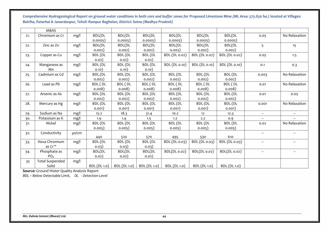
Comprehensive Hydrogeological Report on ground water conditions in both core and buffer zones for Proposed Limestone Mine (ML Area: 575.830 ha.) located at Villages:
Bairiha, Patarhai & Janardanpur, Tehsil: Rampur Baghelan, District: Satna (Madhya Pradesh)
M/s. Dalmia Cement (Bharat) Ltd. 44
MBAS
21. Chromium as Cr mg/l BDL(DL 0.0005)
BDL(DL 0.0005)
BDL(DL 0.0005)
BDL(DL 0.0005)
BDL(DL 0.0005)
BDL(DL 0.0005)
0.05 No Relaxation
22. Zinc as Zn mg/l BDL(DL 0.002)
BDL(DL 0.002)
BDL(DL 0.002)
BDL(DL 0.002)
BDL(DL 0.002)
BDL(DL 0.002)
5 15
23. Copper as Cu mg/l BDL (DL 0.02)
BDL (DL 0.02)
BDL (DL 0.02)
BDL (DL 0.02) BDL (DL 0.02) BDL (DL 0.02) 0.05 1.5
24. Manganese as Mn
mg/l BDL (DL 0.10)
BDL (DL 0.10)
BDL (DL 0.10)
BDL (DL 0.10) BDL (DL 0.10) BDL (DL 0.10) 0.1 0.3
25. Cadmium as Cd mg/l BDL (DL 0.002)
BDL (DL 0.002)
BDL (DL 0.002)
BDL (DL 0.002)
BDL (DL 0.002)
BDL (DL 0.002)
0.003 No Relaxation
26. Lead as Pb mg/l BDL ( DL 0.008)
BDL ( DL 0.008)
BDL ( DL 0.008)
BDL ( DL 0.008)
BDL ( DL 0.008)
BDL ( DL 0.008)
0.01 No Relaxation
27. Arsenic as As mg/l BDL (DL 0.002)
BDL (DL 0.002)
BDL (DL 0.002)
BDL (DL 0.002)
BDL (DL 0.002)
BDL (DL 0.002)
0.01 0.05
28. Mercury as Hg mg/l BDL (DL 0.001)
BDL (DL 0.001)
BDL (DL 0.001)
BDL (DL 0.001)
BDL (DL 0.001)
BDL (DL 0.001)
0.001 No Relaxation
29. Sodium as Na mg/l 15.2 18.3 31.4 10.2 12 12.3 -- --
30. Potassium as K mg/l 1.9 1.4 1.5 1.2 2.2 0.9 -- --
31. Nickel mg/l BDL (DL 0.005)
BDL (DL 0.005)
BDL (DL 0.005)
BDL (DL 0.005)
BDL (DL 0.005)
BDL (DL 0.005)
0.02 No Relaxation
32. Conductivity µs/cm 440 520 570 495 530 610
-- --
33. Hexa Chromium as Cr+6
mg/l BDL (DL 0.03)
BDL (DL 0.03)
BDL (DL 0.03)
BDL (DL 0.03) BDL (DL 0.03) BDL (DL 0.03) -- --
34. Phosphate as PO4
mg/l BDL(DL 0.02)
BDL(DL 0.02)
BDL(DL 0.02)
BDL(DL 0.02) BDL(DL 0.02) BDL(DL 0.02) -- --
35 Total Suspended Solid
mg/l BDL (DL 1.0) BDL (DL 1.0) BDL (DL 1.0) BDL (DL 1.0) BDL (DL 1.0) BDL (DL 1.0)
Source: Ground Water Quality Analysis Report BDL – Below Detectable Limit, DL - Detection Level
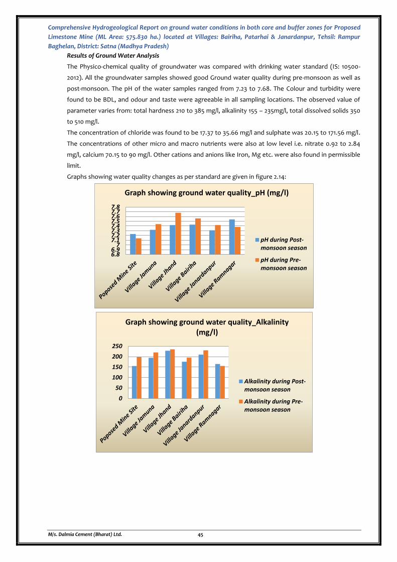
Comprehensive Hydrogeological Report on ground water conditions in both core and buffer zones for Proposed
Limestone Mine (ML Area: 575.830 ha.) located at Villages: Bairiha, Patarhai & Janardanpur, Tehsil: Rampur
Baghelan, District: Satna (Madhya Pradesh)
M/s. Dalmia Cement (Bharat) Ltd. 45
Results of Ground Water Analysis
The Physico-chemical quality of groundwater was compared with drinking water standard (IS: 10500-
2012). All the groundwater samples showed good Ground water quality during pre-monsoon as well as
post-monsoon. The pH of the water samples ranged from 7.23 to 7.68. The Colour and turbidity were
found to be BDL, and odour and taste were agreeable in all sampling locations. The observed value of
parameter varies from: total hardness 210 to 385 mg/l, alkalinity 155 – 235mg/l, total dissolved solids 350
to 510 mg/l.
The concentration of chloride was found to be 17.37 to 35.66 mg/l and sulphate was 20.15 to 171.56 mg/l.
The concentrations of other micro and macro nutrients were also at low level i.e. nitrate 0.92 to 2.84
mg/l, calcium 70.15 to 90 mg/l. Other cations and anions like Iron, Mg etc. were also found in permissible
limit.
Graphs showing water quality changes as per standard are given in figure 2.14:
6.86.9
77.17.27.37.47.57.67.77.8
Graph showing ground water quality_pH (mg/l)
pH during Post-monsoon season
pH during Pre-monsoon season
0
50
100
150
200
250
Graph showing ground water quality_Alkalinity (mg/l)
Alkalinity during Post-monsoon season
Alkalinity during Pre-monsoon season
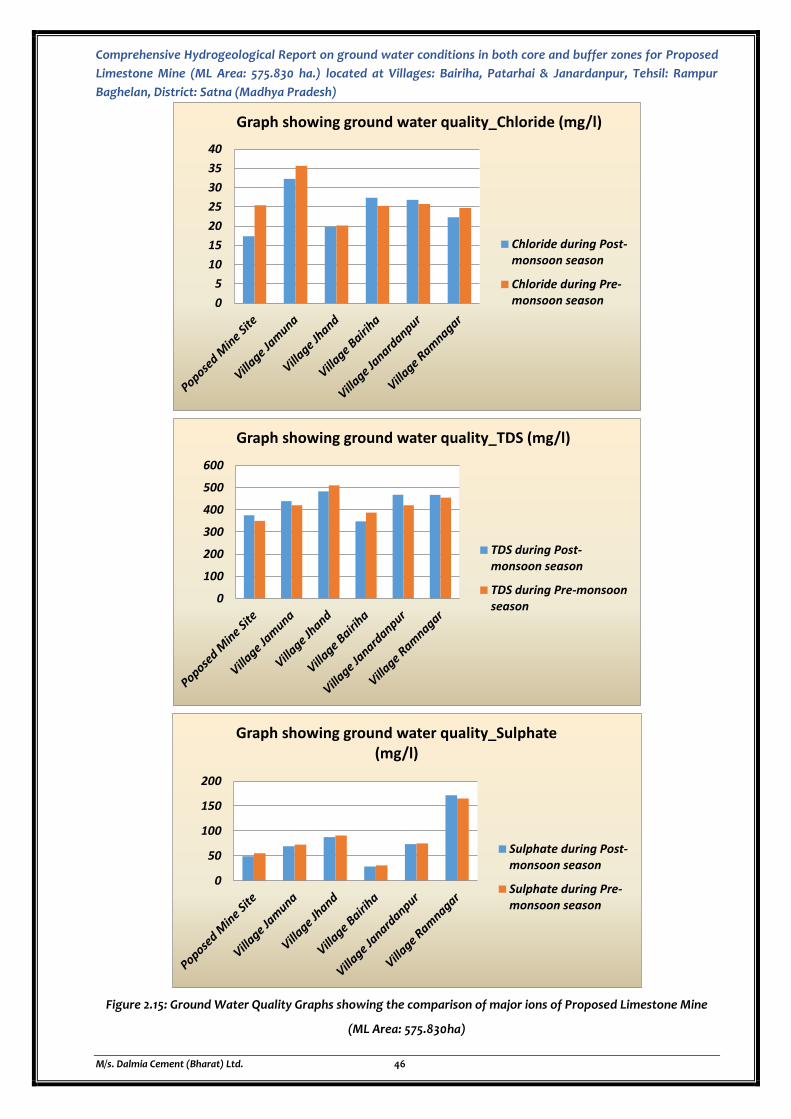
Comprehensive Hydrogeological Report on ground water conditions in both core and buffer zones for Proposed
Limestone Mine (ML Area: 575.830 ha.) located at Villages: Bairiha, Patarhai & Janardanpur, Tehsil: Rampur
Baghelan, District: Satna (Madhya Pradesh)
M/s. Dalmia Cement (Bharat) Ltd. 46
Figure 2.15: Ground Water Quality Graphs showing the comparison of major ions of Proposed Limestone Mine
(ML Area: 575.830ha)
0
5
10
15
20
25
30
35
40
Graph showing ground water quality_Chloride (mg/l)
Chloride during Post-monsoon season
Chloride during Pre-monsoon season
0
100
200
300
400
500
600
Graph showing ground water quality_TDS (mg/l)
TDS during Post-monsoon season
TDS during Pre-monsoonseason
0
50
100
150
200
Graph showing ground water quality_Sulphate (mg/l)
Sulphate during Post-monsoon season
Sulphate during Pre-monsoon season
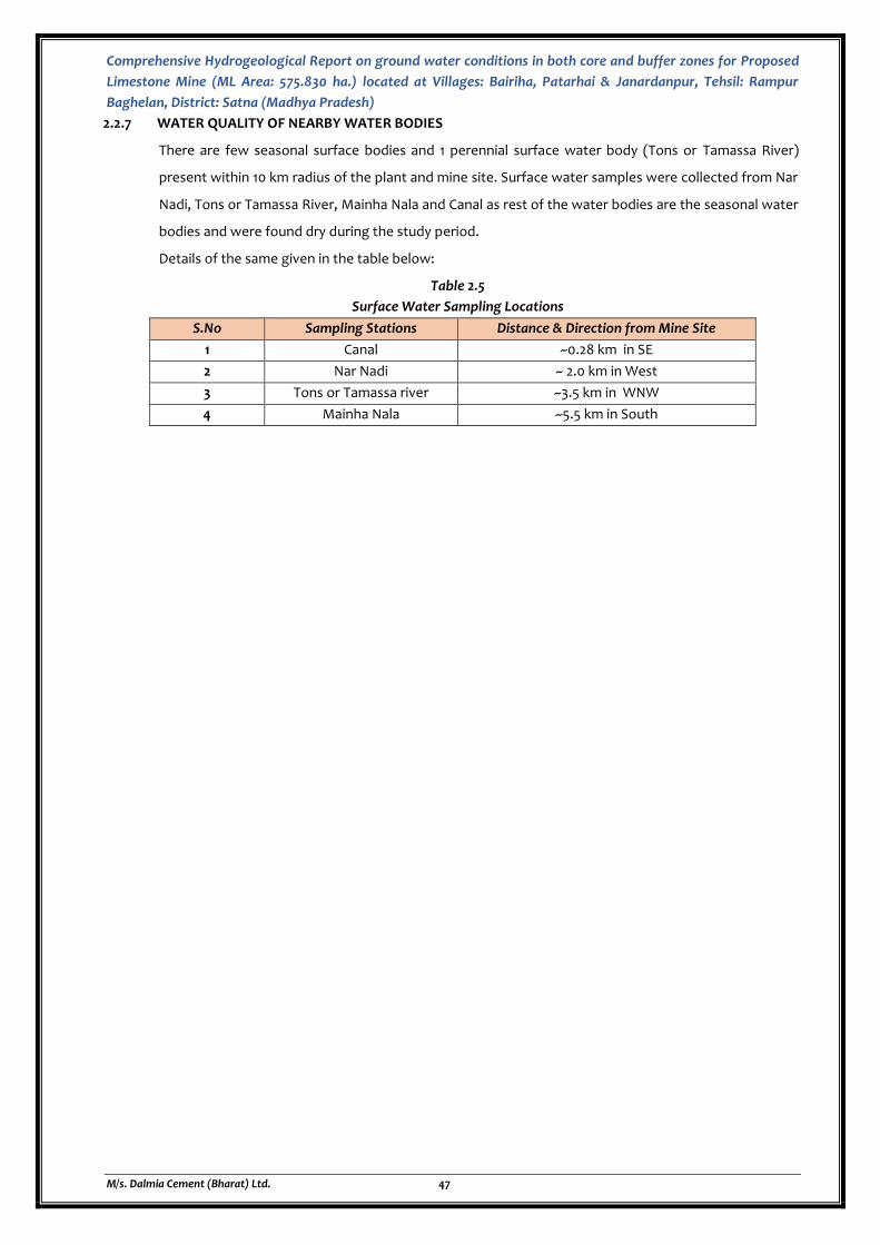
Comprehensive Hydrogeological Report on ground water conditions in both core and buffer zones for Proposed
Limestone Mine (ML Area: 575.830 ha.) located at Villages: Bairiha, Patarhai & Janardanpur, Tehsil: Rampur
Baghelan, District: Satna (Madhya Pradesh)
M/s. Dalmia Cement (Bharat) Ltd. 47
2.2.7 WATER QUALITY OF NEARBY WATER BODIES
There are few seasonal surface bodies and 1 perennial surface water body (Tons or Tamassa River)
present within 10 km radius of the plant and mine site. Surface water samples were collected from Nar
Nadi, Tons or Tamassa River, Mainha Nala and Canal as rest of the water bodies are the seasonal water
bodies and were found dry during the study period.
Details of the same given in the table below:
Table 2.5
Surface Water Sampling Locations
S.No Sampling Stations Distance & Direction from Mine Site
1 Canal ~0.28 km in SE
2 Nar Nadi ~ 2.0 km in West
3 Tons or Tamassa river ~3.5 km in WNW
4 Mainha Nala ~5.5 km in South
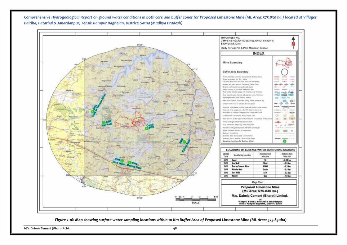
Comprehensive Hydrogeological Report on ground water conditions in both core and buffer zones for Proposed Limestone Mine (ML Area: 575.830 ha.) located at Villages:
Bairiha, Patarhai & Janardanpur, Tehsil: Rampur Baghelan, District: Satna (Madhya Pradesh)
M/s. Dalmia Cement (Bharat) Ltd. 48
Figure 2.16: Map showing surface water sampling locations within 10 Km Buffer Area of Proposed Limestone Mine (ML Area: 575.830ha)
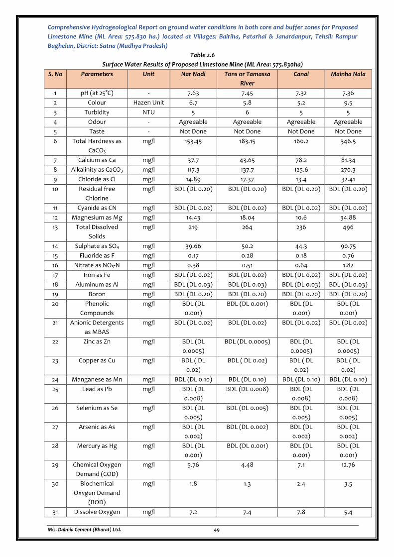
Comprehensive Hydrogeological Report on ground water conditions in both core and buffer zones for Proposed
Limestone Mine (ML Area: 575.830 ha.) located at Villages: Bairiha, Patarhai & Janardanpur, Tehsil: Rampur
Baghelan, District: Satna (Madhya Pradesh)
M/s. Dalmia Cement (Bharat) Ltd. 49
Table 2.6
Surface Water Results of Proposed Limestone Mine (ML Area: 575.830ha)
S. No Parameters Unit Nar Nadi Tons or Tamassa
River
Canal Mainha Nala
1 pH (at 25°C) - 7.63 7.45 7.32 7.36
2 Colour Hazen Unit 6.7 5.8 5.2 9.5
3 Turbidity NTU 5 6 5 5
4 Odour - Agreeable Agreeable Agreeable Agreeable
5 Taste - Not Done Not Done Not Done Not Done
6 Total Hardness as
CaCO3
mg/l 153.45 183.15 160.2 346.5
7 Calcium as Ca mg/l 37.7 43.65 78.2 81.34
8 Alkalinity as CaCO3 mg/l 117.3 137.7 125.6 270.3
9 Chloride as Cl mg/l 14.89 17.37 13.4 32.41
10 Residual free
Chlorine
mg/l BDL (DL 0.20) BDL (DL 0.20) BDL (DL 0.20) BDL (DL 0.20)
11 Cyanide as CN mg/l BDL (DL 0.02) BDL (DL 0.02) BDL (DL 0.02) BDL (DL 0.02)
12 Magnesium as Mg mg/l 14.43 18.04 10.6 34.88
13 Total Dissolved
Solids
mg/l 219 264 236 496
14 Sulphate as SO4 mg/l 39.66 50.2 44.3 90.75
15 Fluoride as F mg/l 0.17 0.28 0.18 0.76
16 Nitrate as NO3-N mg/l 0.38 0.51 0.64 1.82
17 Iron as Fe mg/l BDL (DL 0.02) BDL (DL 0.02) BDL (DL 0.02) BDL (DL 0.02)
18 Aluminum as Al mg/l BDL (DL 0.03) BDL (DL 0.03) BDL (DL 0.03) BDL (DL 0.03)
19 Boron mg/l BDL (DL 0.20) BDL (DL 0.20) BDL (DL 0.20) BDL (DL 0.20)
20 Phenolic
Compounds
mg/l BDL (DL
0.001)
BDL (DL 0.001) BDL (DL
0.001)
BDL (DL
0.001)
21 Anionic Detergents
as MBAS
mg/l BDL (DL 0.02) BDL (DL 0.02) BDL (DL 0.02) BDL (DL 0.02)
22 Zinc as Zn mg/l BDL (DL
0.0005)
BDL (DL 0.0005) BDL (DL
0.0005)
BDL (DL
0.0005)
23 Copper as Cu mg/l BDL ( DL
0.02)
BDL ( DL 0.02) BDL ( DL
0.02)
BDL ( DL
0.02)
24 Manganese as Mn mg/l BDL (DL 0.10) BDL (DL 0.10) BDL (DL 0.10) BDL (DL 0.10)
25 Lead as Pb mg/l BDL (DL
0.008)
BDL (DL 0.008) BDL (DL
0.008)
BDL (DL
0.008)
26 Selenium as Se mg/l BDL (DL
0.005)
BDL (DL 0.005) BDL (DL
0.005)
BDL (DL
0.005)
27 Arsenic as As mg/l BDL (DL
0.002)
BDL (DL 0.002) BDL (DL
0.002)
BDL (DL
0.002)
28 Mercury as Hg mg/l BDL (DL
0.001)
BDL (DL 0.001) BDL (DL
0.001)
BDL (DL
0.001)
29 Chemical Oxygen
Demand (COD)
mg/l 5.76 4.48 7.1 12.76
30 Biochemical
Oxygen Demand
(BOD)
mg/l 1.8 1.3 2.4 3.5
31 Dissolve Oxygen mg/l 7.2 7.4 7.8 5.4
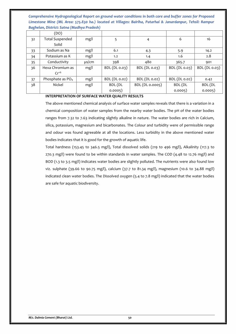
Comprehensive Hydrogeological Report on ground water conditions in both core and buffer zones for Proposed
Limestone Mine (ML Area: 575.830 ha.) located at Villages: Bairiha, Patarhai & Janardanpur, Tehsil: Rampur
Baghelan, District: Satna (Madhya Pradesh)
M/s. Dalmia Cement (Bharat) Ltd. 50
(DO)
32 Total Suspended
Solid
mg/l 5 4 6 16
33 Sodium as Na mg/l 6.1 4.3 5.9 14.2
34 Potassium as K mg/l 1.2 1.4 1.6 2.8
35 Conductivity µs/cm 398 480 365.7 901
36 Hexa Chromium as
Cr+6
mg/l BDL (DL 0.03) BDL (DL 0.03) BDL (DL 0.03) BDL (DL 0.03)
37 Phosphate as PO4 mg/l BDL (DL 0.02) BDL (DL 0.02) BDL (DL 0.02) 0.42
38 Nickel mg/l BDL (DL
0.0005)
BDL (DL 0.0005) BDL (DL
0.0005)
BDL (DL
0.0005)
INTERPRETATION OF SURFACE WATER QUALITY RESULTS
The above mentioned chemical analysis of surface water samples reveals that there is a variation in a
chemical composition of water samples from the nearby water bodies. The pH of the water bodies
ranges from 7.32 to 7.63 indicating slightly alkaline in nature. The water bodies are rich in Calcium,
silica, potassium, magnesium and bicarbonates. The Colour and turbidity were of permissible range
and odour was found agreeable at all the locations. Less turbidity in the above mentioned water
bodies indicates that it is good for the growth of aquatic life.
Total hardness (153.45 to 346.5 mg/l), Total dissolved solids (219 to 496 mg/l), Alkalinity (117.3 to
270.3 mg/l) were found to be within standards in water samples. The COD (4.48 to 12.76 mg/l) and
BOD (1.3 to 3.5 mg/l) indicates water bodies are slightly polluted. The nutrients were also found low
viz. sulphate (39.66 to 90.75 mg/l), calcium (37.7 to 81.34 mg/l), magnesium (10.6 to 34.88 mg/l)
indicated clean water bodies. The Dissolved oxygen (5.4 to 7.8 mg/l) indicated that the water bodies
are safe for aquatic biodiversity.
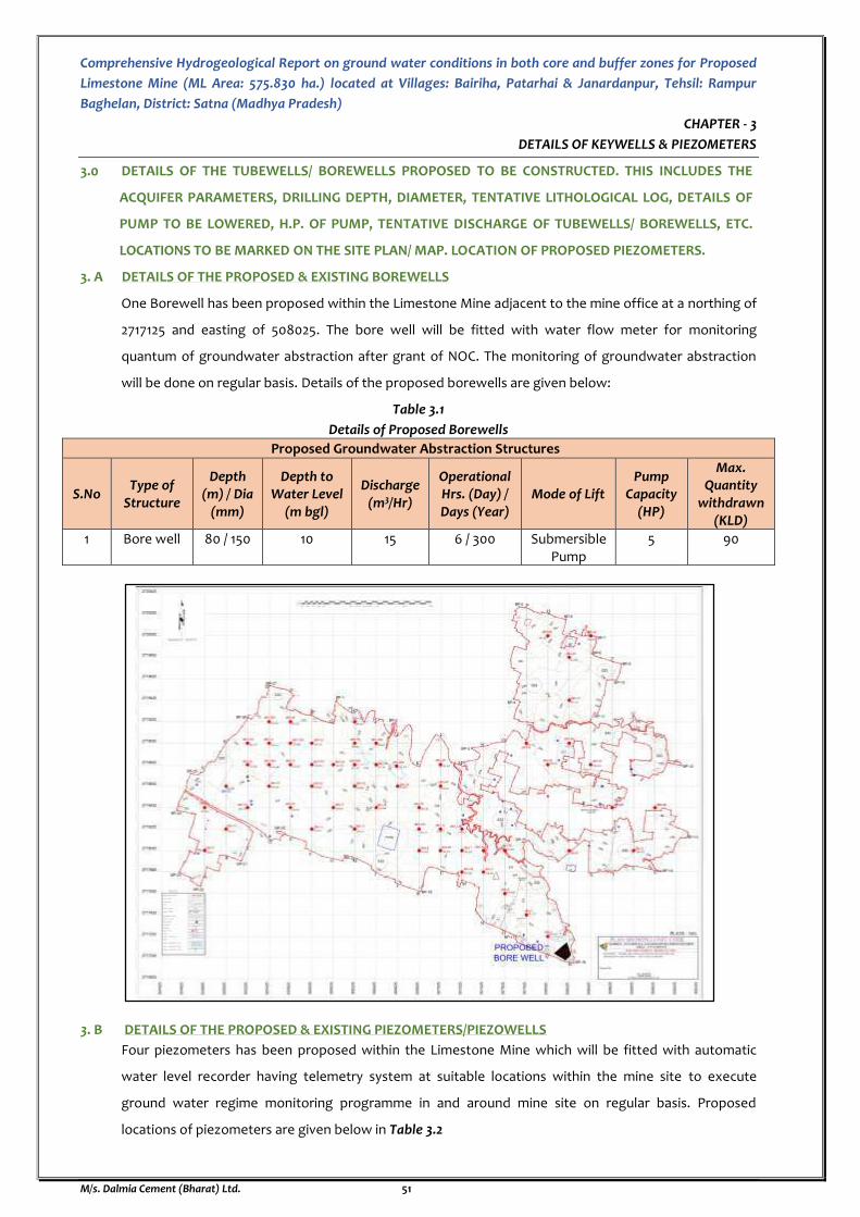
Comprehensive Hydrogeological Report on ground water conditions in both core and buffer zones for Proposed
Limestone Mine (ML Area: 575.830 ha.) located at Villages: Bairiha, Patarhai & Janardanpur, Tehsil: Rampur
Baghelan, District: Satna (Madhya Pradesh)
M/s. Dalmia Cement (Bharat) Ltd. 51
CHAPTER - 3
DETAILS OF KEYWELLS & PIEZOMETERS
3.0 DETAILS OF THE TUBEWELLS/ BOREWELLS PROPOSED TO BE CONSTRUCTED. THIS INCLUDES THE
ACQUIFER PARAMETERS, DRILLING DEPTH, DIAMETER, TENTATIVE LITHOLOGICAL LOG, DETAILS OF
PUMP TO BE LOWERED, H.P. OF PUMP, TENTATIVE DISCHARGE OF TUBEWELLS/ BOREWELLS, ETC.
LOCATIONS TO BE MARKED ON THE SITE PLAN/ MAP. LOCATION OF PROPOSED PIEZOMETERS.
3. A DETAILS OF THE PROPOSED & EXISTING BOREWELLS
One Borewell has been proposed within the Limestone Mine adjacent to the mine office at a northing of
2717125 and easting of 508025. The bore well will be fitted with water flow meter for monitoring
quantum of groundwater abstraction after grant of NOC. The monitoring of groundwater abstraction
will be done on regular basis. Details of the proposed borewells are given below:
Table 3.1
Details of Proposed Borewells
Proposed Groundwater Abstraction Structures
S.No Type of
Structure
Depth (m) / Dia
(mm)
Depth to Water Level
(m bgl)
Discharge (m3/Hr)
Operational Hrs. (Day) / Days (Year)
Mode of Lift Pump
Capacity (HP)
Max. Quantity
withdrawn (KLD)
1 Bore well 80 / 150 10 15 6 / 300 Submersible Pump
5 90
3. B DETAILS OF THE PROPOSED & EXISTING PIEZOMETERS/PIEZOWELLS
Four piezometers has been proposed within the Limestone Mine which will be fitted with automatic
water level recorder having telemetry system at suitable locations within the mine site to execute
ground water regime monitoring programme in and around mine site on regular basis. Proposed
locations of piezometers are given below in Table 3.2
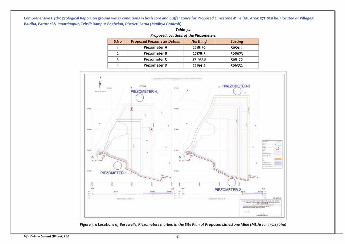
Comprehensive Hydrogeological Report on ground water conditions in both core and buffer zones for Proposed Limestone Mine (ML Area: 575.830 ha.) located at Villages:
Bairiha, Patarhai & Janardanpur, Tehsil: Rampur Baghelan, District: Satna (Madhya Pradesh)
M/s. Dalmia Cement (Bharat) Ltd. 52
Table 3.2
Proposed locations of the Piezometers
S.No Proposed Piezometer Details Northing Easting
1 Piezometer A 2718130 505914
2 Piezometer B 2717813 508073
3 Piezometer C 2719538 508176
4 Piezometer D 2719412 506332
Figure 3.1: Locations of Borewells, Piezometers marked in the Site Plan of Proposed Limestone Mine (ML Area: 575.830ha)
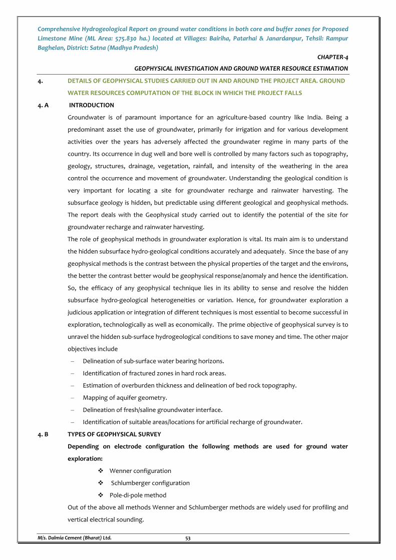
Comprehensive Hydrogeological Report on ground water conditions in both core and buffer zones for Proposed
Limestone Mine (ML Area: 575.830 ha.) located at Villages: Bairiha, Patarhai & Janardanpur, Tehsil: Rampur
Baghelan, District: Satna (Madhya Pradesh)
M/s. Dalmia Cement (Bharat) Ltd. 53
CHAPTER-4
GEOPHYSICAL INVESTIGATION AND GROUND WATER RESOURCE ESTIMATION
4. DETAILS OF GEOPHYSICAL STUDIES CARRIED OUT IN AND AROUND THE PROJECT AREA. GROUND
WATER RESOURCES COMPUTATION OF THE BLOCK IN WHICH THE PROJECT FALLS
4. A INTRODUCTION
Groundwater is of paramount importance for an agriculture-based country like India. Being a
predominant asset the use of groundwater, primarily for irrigation and for various development
activities over the years has adversely affected the groundwater regime in many parts of the
country. Its occurrence in dug well and bore well is controlled by many factors such as topography,
geology, structures, drainage, vegetation, rainfall, and intensity of the weathering in the area
control the occurrence and movement of groundwater. Understanding the geological condition is
very important for locating a site for groundwater recharge and rainwater harvesting. The
subsurface geology is hidden, but predictable using different geological and geophysical methods.
The report deals with the Geophysical study carried out to identify the potential of the site for
groundwater recharge and rainwater harvesting.
The role of geophysical methods in groundwater exploration is vital. Its main aim is to understand
the hidden subsurface hydro-geological conditions accurately and adequately. Since the base of any
geophysical methods is the contrast between the physical properties of the target and the environs,
the better the contrast better would be geophysical response/anomaly and hence the identification.
So, the efficacy of any geophysical technique lies in its ability to sense and resolve the hidden
subsurface hydro-geological heterogeneities or variation. Hence, for groundwater exploration a
judicious application or integration of different techniques is most essential to become successful in
exploration, technologically as well as economically. The prime objective of geophysical survey is to
unravel the hidden sub-surface hydrogeological conditions to save money and time. The other major
objectives include
– Delineation of sub-surface water bearing horizons.
– Identification of fractured zones in hard rock areas.
– Estimation of overburden thickness and delineation of bed rock topography.
– Mapping of aquifer geometry.
– Delineation of fresh/saline groundwater interface.
– Identification of suitable areas/locations for artificial recharge of groundwater.
4. B TYPES OF GEOPHYSICAL SURVEY
Depending on electrode configuration the following methods are used for ground water
exploration:
Wenner configuration
Schlumberger configuration
Pole-di-pole method
Out of the above all methods Wenner and Schlumberger methods are widely used for profiling and
vertical electrical sounding.
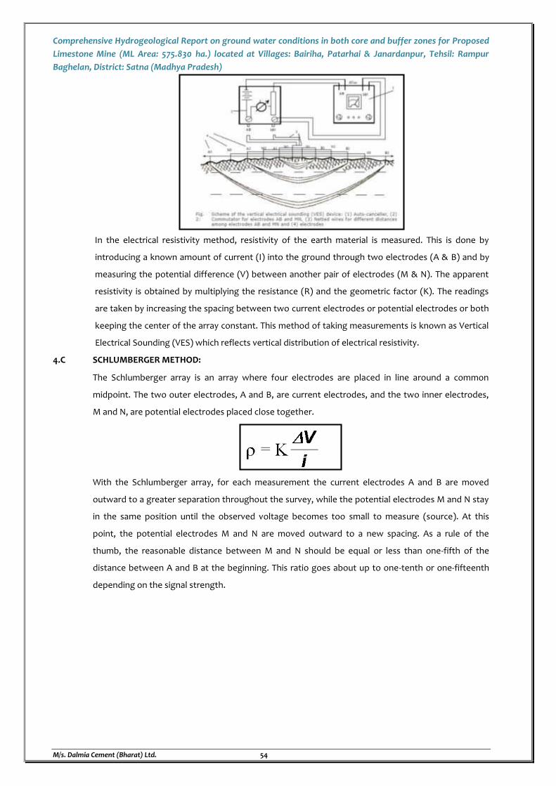
Comprehensive Hydrogeological Report on ground water conditions in both core and buffer zones for Proposed
Limestone Mine (ML Area: 575.830 ha.) located at Villages: Bairiha, Patarhai & Janardanpur, Tehsil: Rampur
Baghelan, District: Satna (Madhya Pradesh)
M/s. Dalmia Cement (Bharat) Ltd. 54
In the electrical resistivity method, resistivity of the earth material is measured. This is done by
introducing a known amount of current (I) into the ground through two electrodes (A & B) and by
measuring the potential difference (V) between another pair of electrodes (M & N). The apparent
resistivity is obtained by multiplying the resistance (R) and the geometric factor (K). The readings
are taken by increasing the spacing between two current electrodes or potential electrodes or both
keeping the center of the array constant. This method of taking measurements is known as Vertical
Electrical Sounding (VES) which reflects vertical distribution of electrical resistivity.
4.C SCHLUMBERGER METHOD:
The Schlumberger array is an array where four electrodes are placed in line around a common
midpoint. The two outer electrodes, A and B, are current electrodes, and the two inner electrodes,
M and N, are potential electrodes placed close together.
With the Schlumberger array, for each measurement the current electrodes A and B are moved
outward to a greater separation throughout the survey, while the potential electrodes M and N stay
in the same position until the observed voltage becomes too small to measure (source). At this
point, the potential electrodes M and N are moved outward to a new spacing. As a rule of the
thumb, the reasonable distance between M and N should be equal or less than one-fifth of the
distance between A and B at the beginning. This ratio goes about up to one-tenth or one-fifteenth
depending on the signal strength.
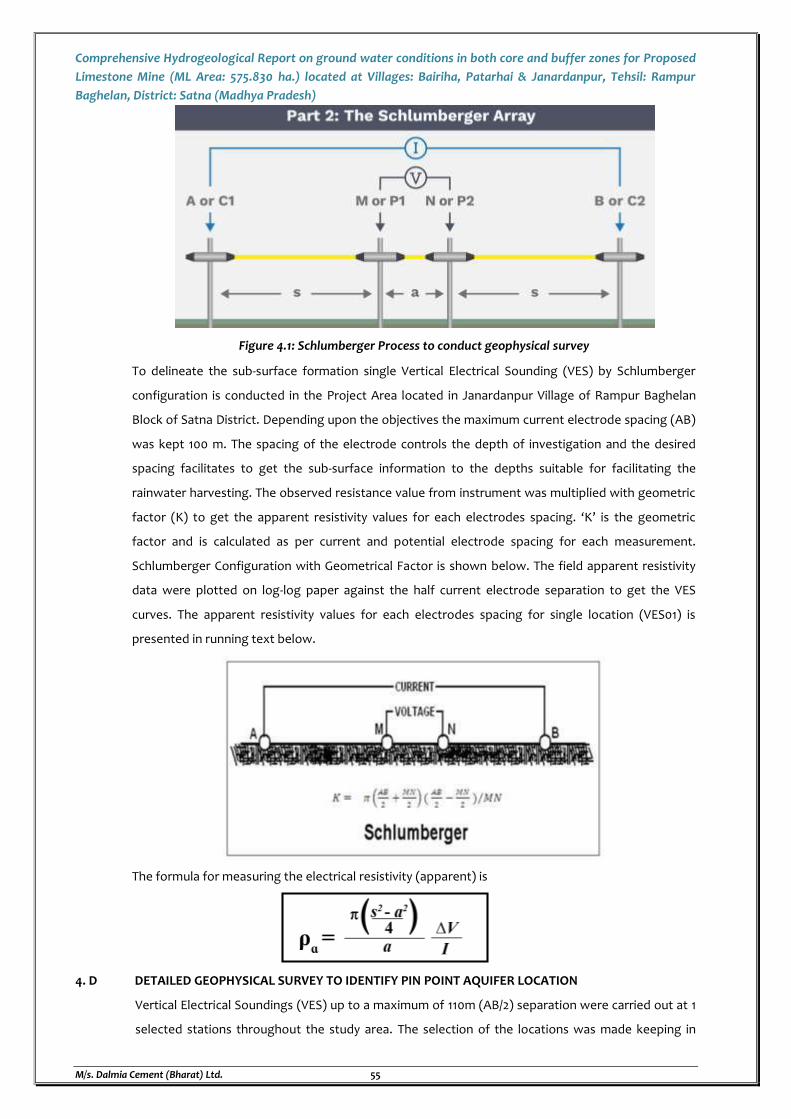
Comprehensive Hydrogeological Report on ground water conditions in both core and buffer zones for Proposed
Limestone Mine (ML Area: 575.830 ha.) located at Villages: Bairiha, Patarhai & Janardanpur, Tehsil: Rampur
Baghelan, District: Satna (Madhya Pradesh)
M/s. Dalmia Cement (Bharat) Ltd. 55
Figure 4.1: Schlumberger Process to conduct geophysical survey
To delineate the sub-surface formation single Vertical Electrical Sounding (VES) by Schlumberger
configuration is conducted in the Project Area located in Janardanpur Village of Rampur Baghelan
Block of Satna District. Depending upon the objectives the maximum current electrode spacing (AB)
was kept 100 m. The spacing of the electrode controls the depth of investigation and the desired
spacing facilitates to get the sub-surface information to the depths suitable for facilitating the
rainwater harvesting. The observed resistance value from instrument was multiplied with geometric
factor (K) to get the apparent resistivity values for each electrodes spacing. ‘K’ is the geometric
factor and is calculated as per current and potential electrode spacing for each measurement.
Schlumberger Configuration with Geometrical Factor is shown below. The field apparent resistivity
data were plotted on log-log paper against the half current electrode separation to get the VES
curves. The apparent resistivity values for each electrodes spacing for single location (VES01) is
presented in running text below.
The formula for measuring the electrical resistivity (apparent) is
4. D DETAILED GEOPHYSICAL SURVEY TO IDENTIFY PIN POINT AQUIFER LOCATION
Vertical Electrical Soundings (VES) up to a maximum of 110m (AB/2) separation were carried out at 1
selected stations throughout the study area. The selection of the locations was made keeping in
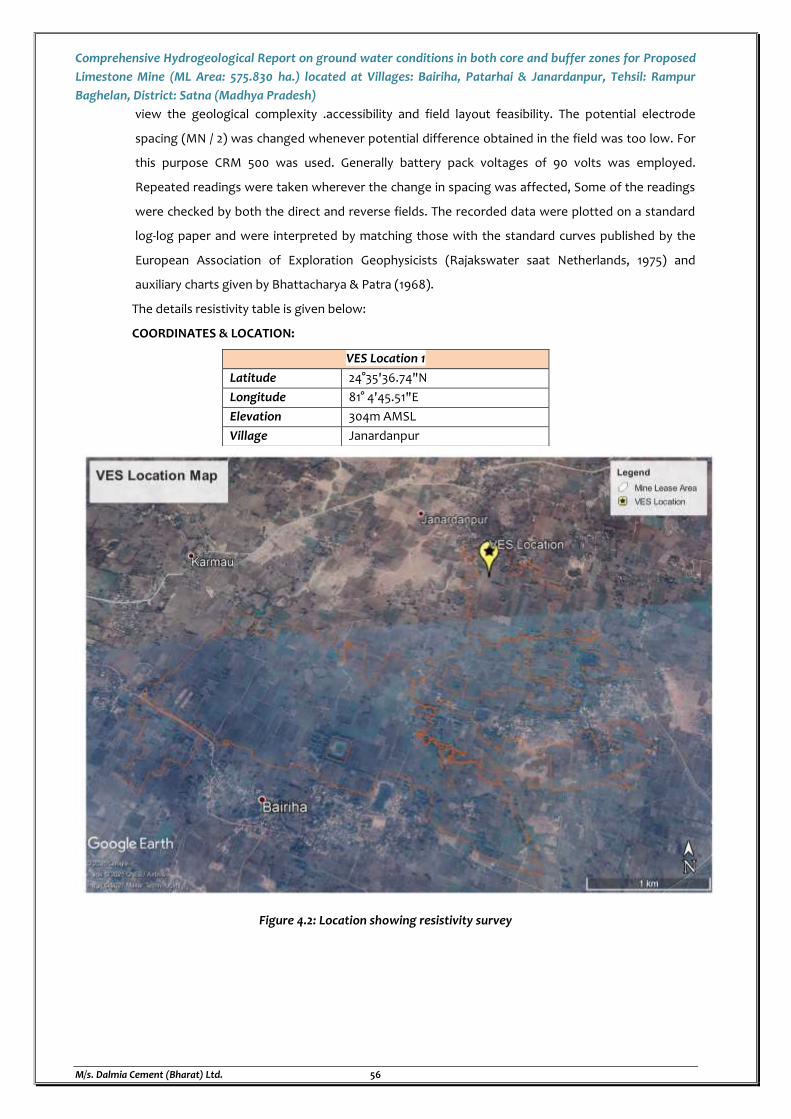
Comprehensive Hydrogeological Report on ground water conditions in both core and buffer zones for Proposed
Limestone Mine (ML Area: 575.830 ha.) located at Villages: Bairiha, Patarhai & Janardanpur, Tehsil: Rampur
Baghelan, District: Satna (Madhya Pradesh)
M/s. Dalmia Cement (Bharat) Ltd. 56
view the geological complexity .accessibility and field layout feasibility. The potential electrode
spacing (MN / 2) was changed whenever potential difference obtained in the field was too low. For
this purpose CRM 500 was used. Generally battery pack voltages of 90 volts was employed.
Repeated readings were taken wherever the change in spacing was affected, Some of the readings
were checked by both the direct and reverse fields. The recorded data were plotted on a standard
log-log paper and were interpreted by matching those with the standard curves published by the
European Association of Exploration Geophysicists (Rajakswater saat Netherlands, 1975) and
auxiliary charts given by Bhattacharya & Patra (1968).
The details resistivity table is given below:
COORDINATES & LOCATION:
VES Location 1
Latitude 24°35'36.74"N
Longitude 81° 4'45.51"E
Elevation 304m AMSL
Village Janardanpur
Figure 4.2: Location showing resistivity survey
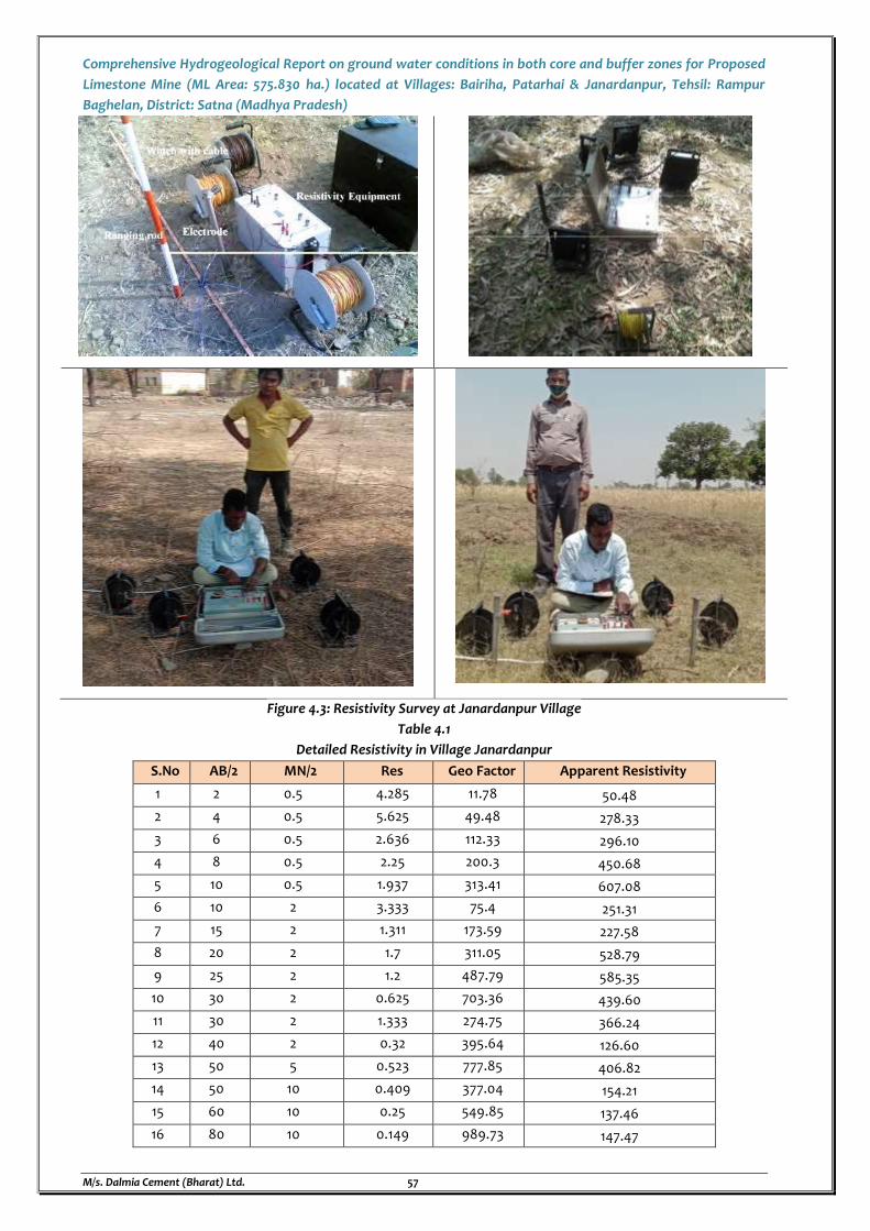
Comprehensive Hydrogeological Report on ground water conditions in both core and buffer zones for Proposed
Limestone Mine (ML Area: 575.830 ha.) located at Villages: Bairiha, Patarhai & Janardanpur, Tehsil: Rampur
Baghelan, District: Satna (Madhya Pradesh)
M/s. Dalmia Cement (Bharat) Ltd. 57
Figure 4.3: Resistivity Survey at Janardanpur Village
Table 4.1
Detailed Resistivity in Village Janardanpur
S.No AB/2 MN/2 Res Geo Factor Apparent Resistivity
1 2 0.5 4.285 11.78 50.48
2 4 0.5 5.625 49.48 278.33
3 6 0.5 2.636 112.33 296.10
4 8 0.5 2.25 200.3 450.68
5 10 0.5 1.937 313.41 607.08
6 10 2 3.333 75.4 251.31
7 15 2 1.311 173.59 227.58
8 20 2 1.7 311.05 528.79
9 25 2 1.2 487.79 585.35
10 30 2 0.625 703.36 439.60
11 30 2 1.333 274.75 366.24
12 40 2 0.32 395.64 126.60
13 50 5 0.523 777.85 406.82
14 50 10 0.409 377.04 154.21
15 60 10 0.25 549.85 137.46
16 80 10 0.149 989.73 147.47
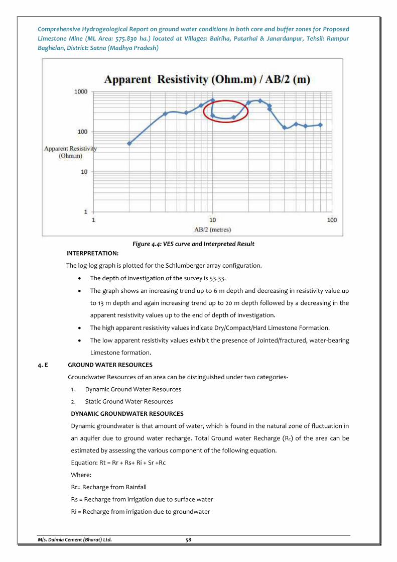
Comprehensive Hydrogeological Report on ground water conditions in both core and buffer zones for Proposed
Limestone Mine (ML Area: 575.830 ha.) located at Villages: Bairiha, Patarhai & Janardanpur, Tehsil: Rampur
Baghelan, District: Satna (Madhya Pradesh)
M/s. Dalmia Cement (Bharat) Ltd. 58
Figure 4.4: VES curve and Interpreted Result
INTERPRETATION:
The log-log graph is plotted for the Schlumberger array configuration.
The depth of investigation of the survey is 53.33.
The graph shows an increasing trend up to 6 m depth and decreasing in resistivity value up
to 13 m depth and again increasing trend up to 20 m depth followed by a decreasing in the
apparent resistivity values up to the end of depth of investigation.
The high apparent resistivity values indicate Dry/Compact/Hard Limestone Formation.
The low apparent resistivity values exhibit the presence of Jointed/fractured, water-bearing
Limestone formation.
4. E GROUND WATER RESOURCES
Groundwater Resources of an area can be distinguished under two categories-
1. Dynamic Ground Water Resources
2. Static Ground Water Resources
DYNAMIC GROUNDWATER RESOURCES
Dynamic groundwater is that amount of water, which is found in the natural zone of fluctuation in
an aquifer due to ground water recharge. Total Ground water Recharge (Rt) of the area can be
estimated by assessing the various component of the following equation.
Equation: Rt = Rr + Rs+ Ri + Sr +Rc
Where:
Rr= Recharge from Rainfall
Rs = Recharge from irrigation due to surface water
Ri = Recharge from irrigation due to groundwater
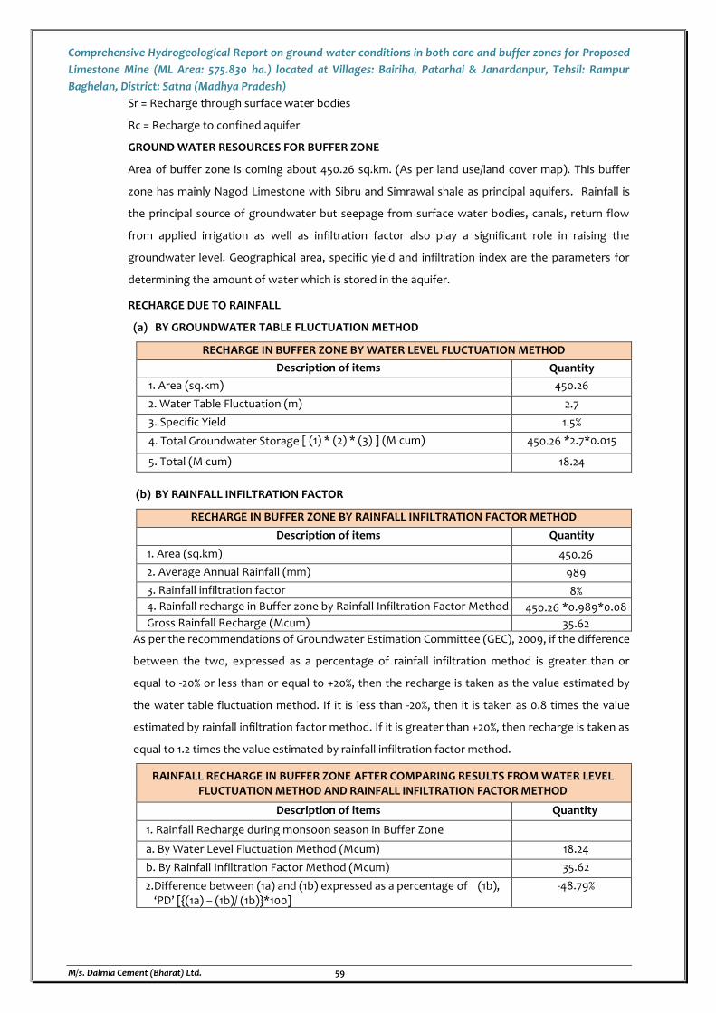
Comprehensive Hydrogeological Report on ground water conditions in both core and buffer zones for Proposed
Limestone Mine (ML Area: 575.830 ha.) located at Villages: Bairiha, Patarhai & Janardanpur, Tehsil: Rampur
Baghelan, District: Satna (Madhya Pradesh)
M/s. Dalmia Cement (Bharat) Ltd. 59
Sr = Recharge through surface water bodies
Rc = Recharge to confined aquifer
GROUND WATER RESOURCES FOR BUFFER ZONE
Area of buffer zone is coming about 450.26 sq.km. (As per land use/land cover map). This buffer
zone has mainly Nagod Limestone with Sibru and Simrawal shale as principal aquifers. Rainfall is
the principal source of groundwater but seepage from surface water bodies, canals, return flow
from applied irrigation as well as infiltration factor also play a significant role in raising the
groundwater level. Geographical area, specific yield and infiltration index are the parameters for
determining the amount of water which is stored in the aquifer.
RECHARGE DUE TO RAINFALL
(a) BY GROUNDWATER TABLE FLUCTUATION METHOD
RECHARGE IN BUFFER ZONE BY WATER LEVEL FLUCTUATION METHOD
Description of items Quantity
1. Area (sq.km) 450.26
2. Water Table Fluctuation (m) 2.7
3. Specific Yield 1.5%
4. Total Groundwater Storage [ (1) * (2) * (3) ] (M cum) 450.26 *2.7*0.015
5. Total (M cum) 18.24
(b) BY RAINFALL INFILTRATION FACTOR
RECHARGE IN BUFFER ZONE BY RAINFALL INFILTRATION FACTOR METHOD
Description of items Quantity
1. Area (sq.km) 450.26
2. Average Annual Rainfall (mm) 989
3. Rainfall infiltration factor 8%
4. Rainfall recharge in Buffer zone by Rainfall Infiltration Factor Method 450.26 *0.989*0.08
Gross Rainfall Recharge (Mcum) 35.62
As per the recommendations of Groundwater Estimation Committee (GEC), 2009, if the difference
between the two, expressed as a percentage of rainfall infiltration method is greater than or
equal to -20% or less than or equal to +20%, then the recharge is taken as the value estimated by
the water table fluctuation method. If it is less than -20%, then it is taken as 0.8 times the value
estimated by rainfall infiltration factor method. If it is greater than +20%, then recharge is taken as
equal to 1.2 times the value estimated by rainfall infiltration factor method.
RAINFALL RECHARGE IN BUFFER ZONE AFTER COMPARING RESULTS FROM WATER LEVEL FLUCTUATION METHOD AND RAINFALL INFILTRATION FACTOR METHOD
Description of items Quantity
1. Rainfall Recharge during monsoon season in Buffer Zone
a. By Water Level Fluctuation Method (Mcum) 18.24
b. By Rainfall Infiltration Factor Method (Mcum) 35.62
2.Difference between (1a) and (1b) expressed as a percentage of (1b), ‘PD’ [{(1a) – (1b)/ (1b)}*100]
-48.79%
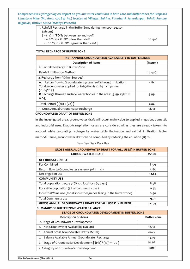
Comprehensive Hydrogeological Report on ground water conditions in both core and buffer zones for Proposed
Limestone Mine (ML Area: 575.830 ha.) located at Villages: Bairiha, Patarhai & Janardanpur, Tehsil: Rampur
Baghelan, District: Satna (Madhya Pradesh)
M/s. Dalmia Cement (Bharat) Ltd. 60
3. Rainfall Recharge in the Buffer Zone during monsoon season (Mcum) [ = (1a) if ‘PD’ is between -20 and +20%
= 0.8 * (1b) if ‘PD’ is less than -20% = 1.20 * (1b) if ‘PD’ is greater than +20% ]
28.496
TOTAL RECHARGE OF BUFFER ZONE
NET ANNUAL GROUNDWATER AVAILABILITY IN BUFFER ZONE
Description of items (Mcum)
1. Rainfall Recharge in Buffer Zone
Rainfall Infiltration Method 28.496
2. Recharge from ‘Other Sources’
A. Return flow to Groundwater system (30%) through Irrigation Total groundwater applied for irrigation is 12.84 mcm/annum (12.84*0.3)
3.85
B Recharge through surface water bodies in the area: (9.99 sq km x 0.04)
3.99
Total Annual [ (2a) + (2b) ] 7.84
3. Gross Annual Groundwater Recharge 36.34
GROUNDWATER DRAFT OF BUFFER ZONE
In the investigated area, groundwater draft will occur mainly due to applied irrigation, domestic
and industrial uses. Evapo-transpiration losses are considered nil as they are already taken into
account while calculating recharge by water table fluctuation and rainfall infiltration factor
method. Hence, groundwater draft can be computed by reducing the equation (B) to:
DtB = DiB DdB + DlB + DinB
GROSS ANNUAL GROUNDWATER DRAFT FOR ‘ALL USES’ IN BUFFER ZONE
GROUNDWATER DRAFT Mcum
NET IRRIGATION USE
For Combined 8.99
Return flow to Groundwater system (30%) (-) 3.85
Net irrigation use 12.84
COMMUNITY USE
Total population 235043 (@ 100 lpcd for 365 days) 8.58
For cattle population (5% of community use): 0.43
Industrial/Mine use (for all industries/mines falling in the buffer zone) 0.90
Total Community use 9.91
GROSS ANNUAL GROUNDWATER DRAFT FOR ‘ALL USES’ IN BUFFER ZONE
22.75
SUMMARY OF BUFFER ZONE WATER BALANCE
STAGE OF GROUNDWATER DEVELOPMENT IN BUFFER ZONE
Description of items Buffer Zone
1. Stage of Groundwater Development
a. Net Groundwater Availability (Mcum) 36.34
b. Annual Gross Groundwater Draft (Mcum) 22.75
c. Balance Available Annual Groundwater Recharge 13.59
d. Stage of Groundwater Development [ {(1b) / (1a)} * 100 ] 62.6%
e. Category of Groundwater Development Safe
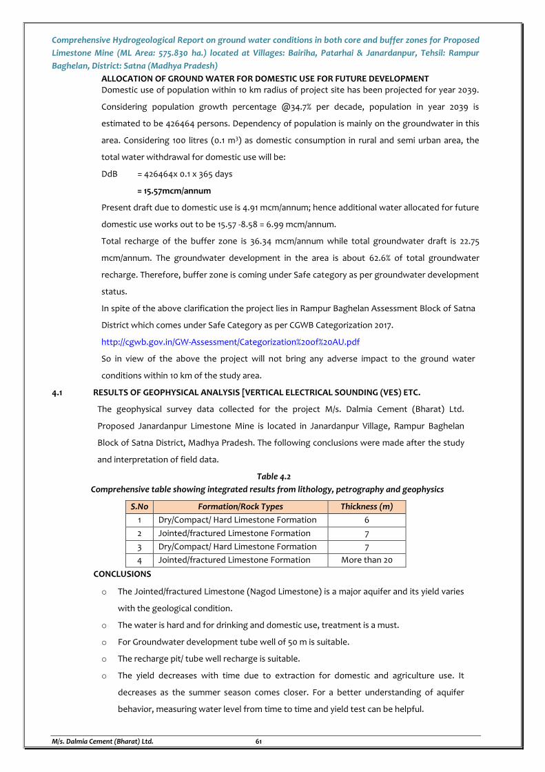
Comprehensive Hydrogeological Report on ground water conditions in both core and buffer zones for Proposed
Limestone Mine (ML Area: 575.830 ha.) located at Villages: Bairiha, Patarhai & Janardanpur, Tehsil: Rampur
Baghelan, District: Satna (Madhya Pradesh)
M/s. Dalmia Cement (Bharat) Ltd. 61
ALLOCATION OF GROUND WATER FOR DOMESTIC USE FOR FUTURE DEVELOPMENT Domestic use of population within 10 km radius of project site has been projected for year 2039.
Considering population growth percentage @34.7% per decade, population in year 2039 is
estimated to be 426464 persons. Dependency of population is mainly on the groundwater in this
area. Considering 100 litres (0.1 m3) as domestic consumption in rural and semi urban area, the
total water withdrawal for domestic use will be:
DdB = 426464x 0.1 x 365 days
= 15.57mcm/annum
Present draft due to domestic use is 4.91 mcm/annum; hence additional water allocated for future
domestic use works out to be 15.57 -8.58 = 6.99 mcm/annum.
Total recharge of the buffer zone is 36.34 mcm/annum while total groundwater draft is 22.75
mcm/annum. The groundwater development in the area is about 62.6% of total groundwater
recharge. Therefore, buffer zone is coming under Safe category as per groundwater development
status.
In spite of the above clarification the project lies in Rampur Baghelan Assessment Block of Satna
District which comes under Safe Category as per CGWB Categorization 2017.
http://cgwb.gov.in/GW-Assessment/Categorization%20of%20AU.pdf
So in view of the above the project will not bring any adverse impact to the ground water
conditions within 10 km of the study area.
4.1 RESULTS OF GEOPHYSICAL ANALYSIS [VERTICAL ELECTRICAL SOUNDING (VES) ETC.
The geophysical survey data collected for the project M/s. Dalmia Cement (Bharat) Ltd.
Proposed Janardanpur Limestone Mine is located in Janardanpur Village, Rampur Baghelan
Block of Satna District, Madhya Pradesh. The following conclusions were made after the study
and interpretation of field data.
Table 4.2
Comprehensive table showing integrated results from lithology, petrography and geophysics
S.No Formation/Rock Types Thickness (m)
1 Dry/Compact/ Hard Limestone Formation 6
2 Jointed/fractured Limestone Formation 7
3 Dry/Compact/ Hard Limestone Formation 7
4 Jointed/fractured Limestone Formation More than 20
CONCLUSIONS
o The Jointed/fractured Limestone (Nagod Limestone) is a major aquifer and its yield varies
with the geological condition.
o The water is hard and for drinking and domestic use, treatment is a must.
o For Groundwater development tube well of 50 m is suitable.
o The recharge pit/ tube well recharge is suitable.
o The yield decreases with time due to extraction for domestic and agriculture use. It
decreases as the summer season comes closer. For a better understanding of aquifer
behavior, measuring water level from time to time and yield test can be helpful.
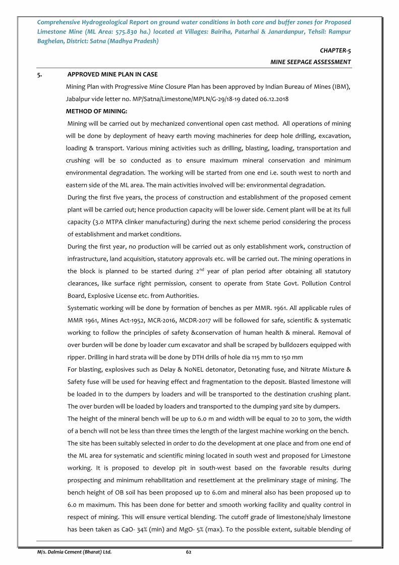
Comprehensive Hydrogeological Report on ground water conditions in both core and buffer zones for Proposed
Limestone Mine (ML Area: 575.830 ha.) located at Villages: Bairiha, Patarhai & Janardanpur, Tehsil: Rampur
Baghelan, District: Satna (Madhya Pradesh)
M/s. Dalmia Cement (Bharat) Ltd. 62
CHAPTER-5
MINE SEEPAGE ASSESSMENT
5. APPROVED MINE PLAN IN CASE
Mining Plan with Progressive Mine Closure Plan has been approved by Indian Bureau of Mines (IBM),
Jabalpur vide letter no. MP/Satna/Limestone/MPLN/G-29/18-19 dated 06.12.2018
METHOD OF MINING:
Mining will be carried out by mechanized conventional open cast method. All operations of mining
will be done by deployment of heavy earth moving machineries for deep hole drilling, excavation,
loading & transport. Various mining activities such as drilling, blasting, loading, transportation and
crushing will be so conducted as to ensure maximum mineral conservation and minimum
environmental degradation. The working will be started from one end i.e. south west to north and
eastern side of the ML area. The main activities involved will be: environmental degradation.
During the first five years, the process of construction and establishment of the proposed cement
plant will be carried out; hence production capacity will be lower side. Cement plant will be at its full
capacity (3.0 MTPA clinker manufacturing) during the next scheme period considering the process
of establishment and market conditions.
During the first year, no production will be carried out as only establishment work, construction of
infrastructure, land acquisition, statutory approvals etc. will be carried out. The mining operations in
the block is planned to be started during 2nd year of plan period after obtaining all statutory
clearances, like surface right permission, consent to operate from State Govt. Pollution Control
Board, Explosive License etc. from Authorities.
Systematic working will be done by formation of benches as per MMR. 1961. All applicable rules of
MMR 1961, Mines Act-1952, MCR-2016, MCDR-2017 will be followed for safe, scientific & systematic
working to follow the principles of safety &conservation of human health & mineral. Removal of
over burden will be done by loader cum excavator and shall be scraped by bulldozers equipped with
ripper. Drilling in hard strata will be done by DTH drills of hole dia 115 mm to 150 mm
For blasting, explosives such as Delay & NoNEL detonator, Detonating fuse, and Nitrate Mixture &
Safety fuse will be used for heaving effect and fragmentation to the deposit. Blasted limestone will
be loaded in to the dumpers by loaders and will be transported to the destination crushing plant.
The over burden will be loaded by loaders and transported to the dumping yard site by dumpers.
The height of the mineral bench will be up to 6.0 m and width will be equal to 20 to 30m, the width
of a bench will not be less than three times the length of the largest machine working on the bench.
The site has been suitably selected in order to do the development at one place and from one end of
the ML area for systematic and scientific mining located in south west and proposed for Limestone
working. It is proposed to develop pit in south-west based on the favorable results during
prospecting and minimum rehabilitation and resettlement at the preliminary stage of mining. The
bench height of OB soil has been proposed up to 6.0m and mineral also has been proposed up to
6.0 m maximum. This has been done for better and smooth working facility and quality control in
respect of mining. This will ensure vertical blending. The cutoff grade of limestone/shaly limestone
has been taken as CaO- 34% (min) and MgO- 5% (max). To the possible extent, suitable blending of

Comprehensive Hydrogeological Report on ground water conditions in both core and buffer zones for Proposed
Limestone Mine (ML Area: 575.830 ha.) located at Villages: Bairiha, Patarhai & Janardanpur, Tehsil: Rampur
Baghelan, District: Satna (Madhya Pradesh)
M/s. Dalmia Cement (Bharat) Ltd. 63
ROM limestone will be done using the stack reclamation in the plant in the best interest of mineral
conservation. No sub-grade mineral will be generated. The cutoff grade will be brought to threshold
value in the best interest of mineral conservation. Drilling and blasting within 300 m from habitation
will be done after taking permission from DGMS as per rules and within 100m rock breaker will be
deployed.
No labour camp is proposed within the lease area as mechanized mining has been proposed. The
soil will be used for cover on protective bunds for plantation in boundary and rest stacked
separately for carpeting of backfilled area. On bund plantation will be raised. The gradient in haul
road will be 1 in 16 while in ramp will be 1 in 10. The OB/ waste generated will be used for preparation
of the ramp to crushing unit having width of 32m including separator in the mid. At the top 100m x
100m level platform will be made for unloading the material in to hopper and turning of dumpers
etc. The capacity of crusher will be 1200 TPH. Material (ROM Limestone) will be unloaded in RCC
Hopper of 100 / 150 cuM with low level sensor. The design of hopper shall be suitable for 3-side
dumping with dust Suppression system. Excavated limestone will be transported to the crusher via
dumpers. And crushed limestone will be transported to the proposed Cement Plant at distance of ~3
km from mine site by covered conveyor belt and may be by road initially till the conveyor belt gets in
operation and during emergency/breakdown situation.
5.1 YEAR WISE MINE PLAN INCLUDING EXCAVATION DEPTH, AREA AND MINE SEEPAGE.
Year wise mining details up to present plan period is given in table 5.1:
Table 5.1
Year Wise Working Details
Period
Total Area
Disturbed by
Mining (Ha)
Number
of
Benches
Top RL Bottom RL Depth of
Mining
Pit Dimensions
Max Length
of Pit (m)
Max Width
of Pit (m)
I Year Developmental Work and Statutory permissions will be taken
II Year 7.626 2 288 279 9 310 310
III Year 15.2608 3 288 273.75 14.25 410 550
IV Year 24.2608 3 288 273 15 530 725
V Year 37.06 3 288 272 16 610 820
Source: Approved Mining Plan with Progressive Mine Closure Plan,
Source: Conceptual Map & AutoCAD Software
According to groundwater level monitoring data, water level is found shallow in the mining lease
area. Depth to water level in and adjacent the mining lease area is found to vary between 10 m to 12m
bgl during post monsoon season on the basis of primary data collected and 12-15 m during pre-
monsoon season on the basis of surveyed data from secondary sources. The mineral availability and
depth of mine working will go up to 16 m bgl in present plan period and up to 23 m bgl in conceptual
period. Hence, there is every possibility of groundwater intersection by mine workings, or
groundwater seepage in the mine pits in the plan period.
The details of site elevation, general ground level, working depth and pre and post monsoon water
level are given in the table 5.2 given below
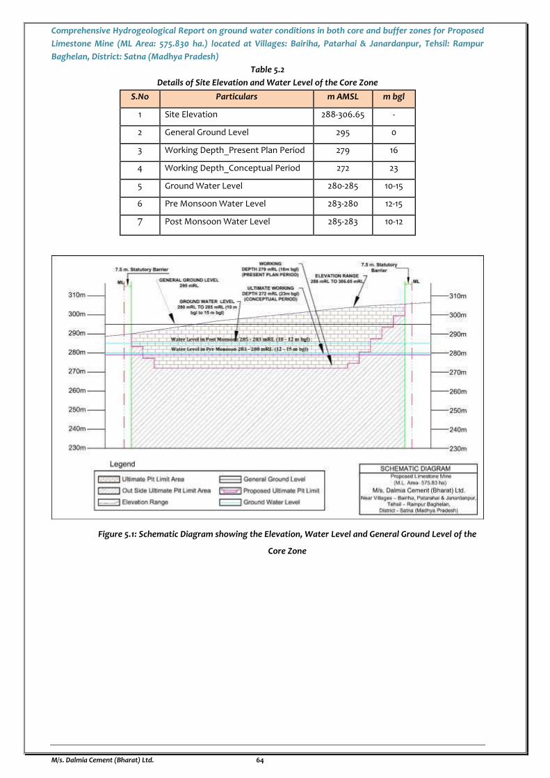
Comprehensive Hydrogeological Report on ground water conditions in both core and buffer zones for Proposed
Limestone Mine (ML Area: 575.830 ha.) located at Villages: Bairiha, Patarhai & Janardanpur, Tehsil: Rampur
Baghelan, District: Satna (Madhya Pradesh)
M/s. Dalmia Cement (Bharat) Ltd. 64
Table 5.2
Details of Site Elevation and Water Level of the Core Zone
S.No Particulars m AMSL m bgl
1 Site Elevation 288-306.65 -
2 General Ground Level 295 0
3 Working Depth_Present Plan Period 279 16
4 Working Depth_Conceptual Period 272 23
5 Ground Water Level 280-285 10-15
6 Pre Monsoon Water Level 283-280 12-15
7 Post Monsoon Water Level 285-283 10-12
Figure 5.1: Schematic Diagram showing the Elevation, Water Level and General Ground Level of the
Core Zone

Comprehensive Hydrogeological Report on ground water conditions in both core and buffer zones for Proposed
Limestone Mine (ML Area: 575.830 ha.) located at Villages: Bairiha, Patarhai & Janardanpur, Tehsil: Rampur
Baghelan, District: Satna (Madhya Pradesh)
M/s. Dalmia Cement (Bharat) Ltd. 65
MINING OPERATIONS AND GROUND WATER DYNAMICS
The impact of mining on ground water is generally described through the standard practice of
prescribing the Environmental Impact Statement (EIS) which should include an assessment of the
potential environmental harm caused by the mining to local groundwater resources. The impact
assessment will define the extent of the area within which groundwater resources are likely to be
affected by the proposed operations to groundwater depletion or recharge, and propose
management options available to monitor and mitigate these effects. The Environmental Impact
Statement (EIS) shall be based on the review of the quality, quantity and significance of groundwater
in the area, together with groundwater use in neighboring areas. The review shall include a survey of
existing groundwater supply facilities (bore wells, or excavations) to the extent of any
environmental harm.
Recognition of groundwater regime in and around the open pit and hydraulic properties of layers in
the mine vicinity is important to control water inflows to mine. To design an effective dewatering
system for an open pit mine, the modelling of water related problems and prediction of water
inflow into a pit is necessary. The results of such simulations would be used to develop an
appropriate water management strategy in order to minimize the operational problems below the
water surface and long-term environmental problems, in the feasibility stage of mine design.
In the mining operations carried out below the water level, mine operators are potentially faced
with two important water-related problems which includes
The amount and pressure of groundwater that could flow into an open pit and
The effect of pore water pressure on the stability of an open pit high wall.
Whenever a mine is operated below the water level, water seepage occurs from the surrounding
layers towards the mining excavation. In order to design an effective drainage scheme for an open
pit mine, prediction of water inflow into the pit is essential. Excavation of a large open-pit mine
below the water level can affect the operational efficiency and economic viability of the mining
operation. The unexpected water flows in large scale may reduce the production, delay the time of
execution and danger the total mine safety (Hanna et al., 1994). When a pit penetrates in an
aquifer, the significant amounts of groundwater flow occur to a pit. Therefore, the large volumes
of water must be pumped to provide a dry mining condition. Figure 5.2 and 5.3 shows the water
inflow components into a pit.
Figure 5.2: Water Inflow Components into an Open Pit
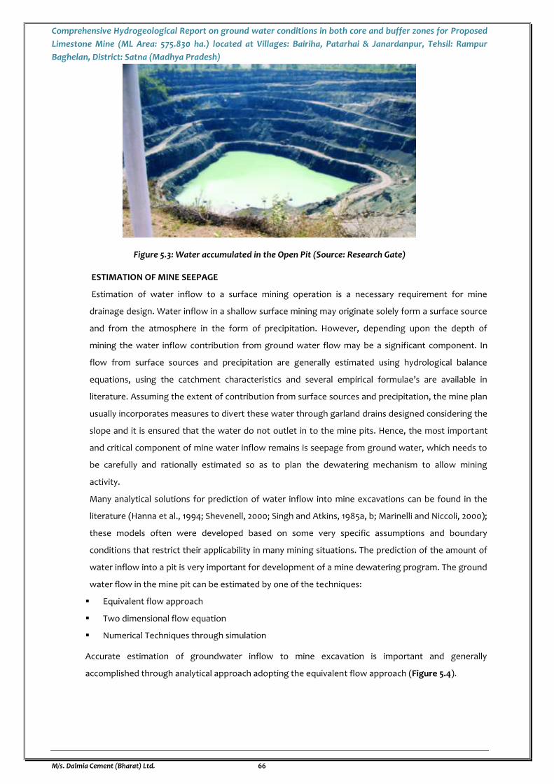
Comprehensive Hydrogeological Report on ground water conditions in both core and buffer zones for Proposed
Limestone Mine (ML Area: 575.830 ha.) located at Villages: Bairiha, Patarhai & Janardanpur, Tehsil: Rampur
Baghelan, District: Satna (Madhya Pradesh)
M/s. Dalmia Cement (Bharat) Ltd. 66
Figure 5.3: Water accumulated in the Open Pit (Source: Research Gate)
ESTIMATION OF MINE SEEPAGE
Estimation of water inflow to a surface mining operation is a necessary requirement for mine
drainage design. Water inflow in a shallow surface mining may originate solely form a surface source
and from the atmosphere in the form of precipitation. However, depending upon the depth of
mining the water inflow contribution from ground water flow may be a significant component. In
flow from surface sources and precipitation are generally estimated using hydrological balance
equations, using the catchment characteristics and several empirical formulae’s are available in
literature. Assuming the extent of contribution from surface sources and precipitation, the mine plan
usually incorporates measures to divert these water through garland drains designed considering the
slope and it is ensured that the water do not outlet in to the mine pits. Hence, the most important
and critical component of mine water inflow remains is seepage from ground water, which needs to
be carefully and rationally estimated so as to plan the dewatering mechanism to allow mining
activity.
Many analytical solutions for prediction of water inflow into mine excavations can be found in the
literature (Hanna et al., 1994; Shevenell, 2000; Singh and Atkins, 1985a, b; Marinelli and Niccoli, 2000);
these models often were developed based on some very specific assumptions and boundary
conditions that restrict their applicability in many mining situations. The prediction of the amount of
water inflow into a pit is very important for development of a mine dewatering program. The ground
water flow in the mine pit can be estimated by one of the techniques:
Equivalent flow approach
Two dimensional flow equation
Numerical Techniques through simulation
Accurate estimation of groundwater inflow to mine excavation is important and generally
accomplished through analytical approach adopting the equivalent flow approach (Figure 5.4).
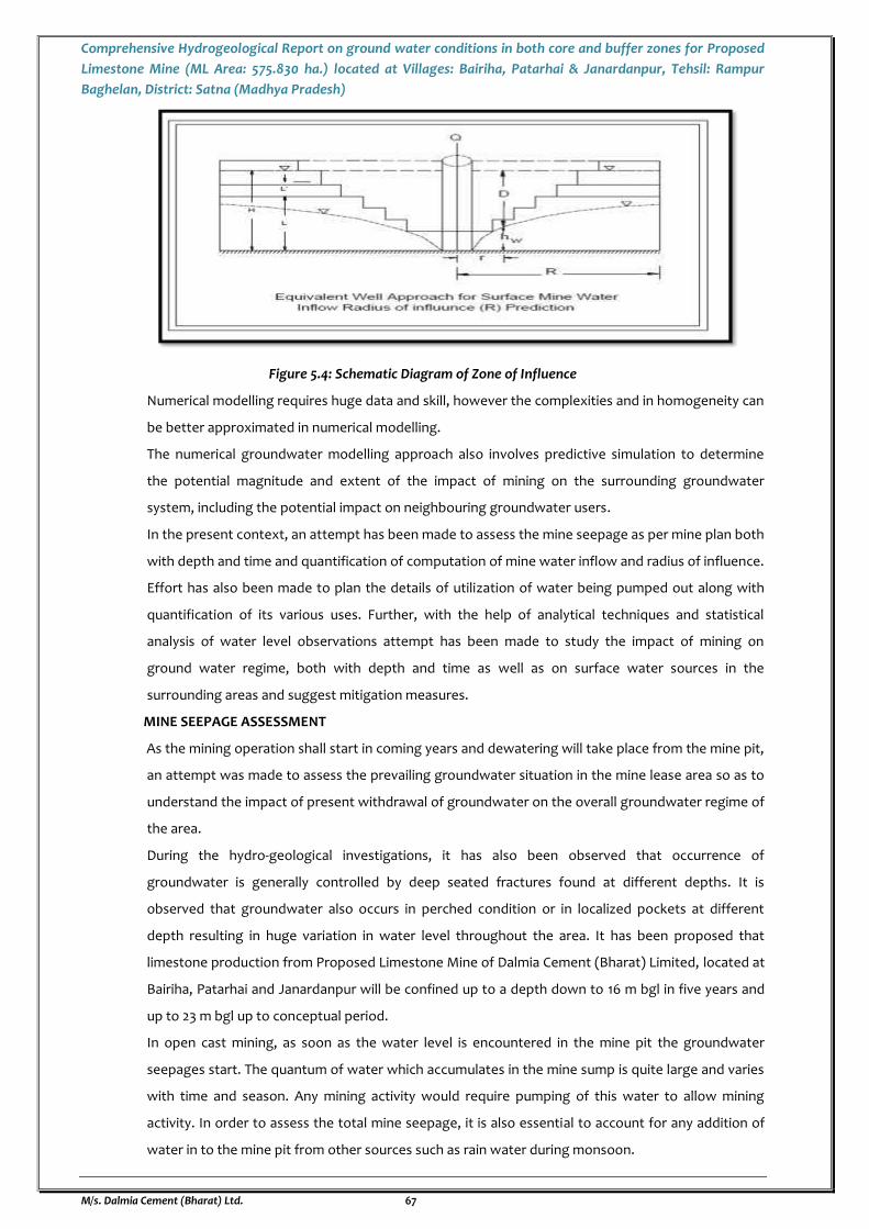
Comprehensive Hydrogeological Report on ground water conditions in both core and buffer zones for Proposed
Limestone Mine (ML Area: 575.830 ha.) located at Villages: Bairiha, Patarhai & Janardanpur, Tehsil: Rampur
Baghelan, District: Satna (Madhya Pradesh)
M/s. Dalmia Cement (Bharat) Ltd. 67
Figure 5.4: Schematic Diagram of Zone of Influence
Numerical modelling requires huge data and skill, however the complexities and in homogeneity can
be better approximated in numerical modelling.
The numerical groundwater modelling approach also involves predictive simulation to determine
the potential magnitude and extent of the impact of mining on the surrounding groundwater
system, including the potential impact on neighbouring groundwater users.
In the present context, an attempt has been made to assess the mine seepage as per mine plan both
with depth and time and quantification of computation of mine water inflow and radius of influence.
Effort has also been made to plan the details of utilization of water being pumped out along with
quantification of its various uses. Further, with the help of analytical techniques and statistical
analysis of water level observations attempt has been made to study the impact of mining on
ground water regime, both with depth and time as well as on surface water sources in the
surrounding areas and suggest mitigation measures.
MINE SEEPAGE ASSESSMENT
As the mining operation shall start in coming years and dewatering will take place from the mine pit,
an attempt was made to assess the prevailing groundwater situation in the mine lease area so as to
understand the impact of present withdrawal of groundwater on the overall groundwater regime of
the area.
During the hydro-geological investigations, it has also been observed that occurrence of
groundwater is generally controlled by deep seated fractures found at different depths. It is
observed that groundwater also occurs in perched condition or in localized pockets at different
depth resulting in huge variation in water level throughout the area. It has been proposed that
limestone production from Proposed Limestone Mine of Dalmia Cement (Bharat) Limited, located at
Bairiha, Patarhai and Janardanpur will be confined up to a depth down to 16 m bgl in five years and
up to 23 m bgl up to conceptual period.
In open cast mining, as soon as the water level is encountered in the mine pit the groundwater
seepages start. The quantum of water which accumulates in the mine sump is quite large and varies
with time and season. Any mining activity would require pumping of this water to allow mining
activity. In order to assess the total mine seepage, it is also essential to account for any addition of
water in to the mine pit from other sources such as rain water during monsoon.
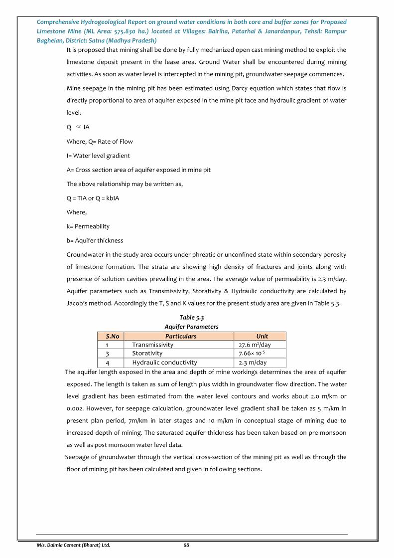
Comprehensive Hydrogeological Report on ground water conditions in both core and buffer zones for Proposed
Limestone Mine (ML Area: 575.830 ha.) located at Villages: Bairiha, Patarhai & Janardanpur, Tehsil: Rampur
Baghelan, District: Satna (Madhya Pradesh)
M/s. Dalmia Cement (Bharat) Ltd. 68
It is proposed that mining shall be done by fully mechanized open cast mining method to exploit the
limestone deposit present in the lease area. Ground Water shall be encountered during mining
activities. As soon as water level is intercepted in the mining pit, groundwater seepage commences.
Mine seepage in the mining pit has been estimated using Darcy equation which states that flow is
directly proportional to area of aquifer exposed in the mine pit face and hydraulic gradient of water
level.
Q ∝ IA
Where, Q= Rate of Flow
I= Water level gradient
A= Cross section area of aquifer exposed in mine pit
The above relationship may be written as,
Q = TIA or Q = kbIA
Where,
k= Permeability
b= Aquifer thickness
Groundwater in the study area occurs under phreatic or unconfined state within secondary porosity
of limestone formation. The strata are showing high density of fractures and joints along with
presence of solution cavities prevailing in the area. The average value of permeability is 2.3 m/day.
Aquifer parameters such as Transmissivity, Storativity & Hydraulic conductivity are calculated by
Jacob’s method. Accordingly the T, S and K values for the present study area are given in Table 5.3.
Table 5.3
Aquifer Parameters
S.No Particulars Unit
1 Transmissivity 27.6 m2/day
3 Storativity 7.66× 10⁻⁵
4 Hydraulic conductivity 2.3 m/day
The aquifer length exposed in the area and depth of mine workings determines the area of aquifer
exposed. The length is taken as sum of length plus width in groundwater flow direction. The water
level gradient has been estimated from the water level contours and works about 2.0 m/km or
0.002. However, for seepage calculation, groundwater level gradient shall be taken as 5 m/km in
present plan period, 7m/km in later stages and 10 m/km in conceptual stage of mining due to
increased depth of mining. The saturated aquifer thickness has been taken based on pre monsoon
as well as post monsoon water level data.
Seepage of groundwater through the vertical cross-section of the mining pit as well as through the
floor of mining pit has been calculated and given in following sections.
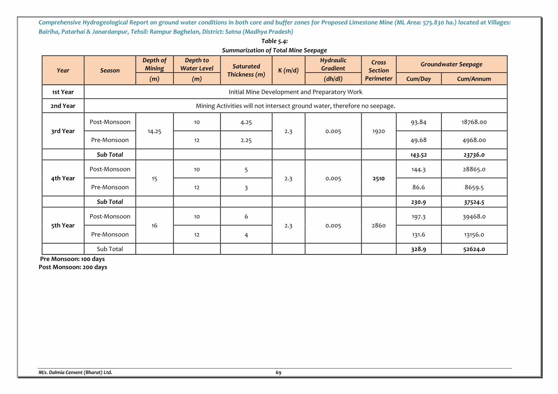
Comprehensive Hydrogeological Report on ground water conditions in both core and buffer zones for Proposed Limestone Mine (ML Area: 575.830 ha.) located at Villages:
Bairiha, Patarhai & Janardanpur, Tehsil: Rampur Baghelan, District: Satna (Madhya Pradesh)
M/s. Dalmia Cement (Bharat) Ltd. 69
Table 5.4:
Summarization of Total Mine Seepage
Year Season
Depth of Mining
Depth to Water Level Saturated
Thickness (m) K (m/d)
Hydraulic Gradient
Cross Section
Perimeter
Groundwater Seepage
(m) (m) (dh/dl) Cum/Day Cum/Annum
1st Year Initial Mine Development and Preparatory Work
2nd Year Mining Activities will not intersect ground water, therefore no seepage.
3rd Year
Post-Monsoon
14.25
10 4.25
2.3 0.005 1920
93.84 18768.00
Pre-Monsoon 12 2.25 49.68 4968.00
Sub Total 143.52 23736.0
4th Year
Post-Monsoon
15
10 5
2.3 0.005 2510
144.3 28865.0
Pre-Monsoon 12 3 86.6 8659.5
Sub Total 230.9 37524.5
5th Year
Post-Monsoon
16
10 6
2.3 0.005 2860
197.3 39468.0
Pre-Monsoon 12 4 131.6 13156.0
Sub Total 328.9 52624.0
Pre Monsoon: 100 days Post Monsoon: 200 days
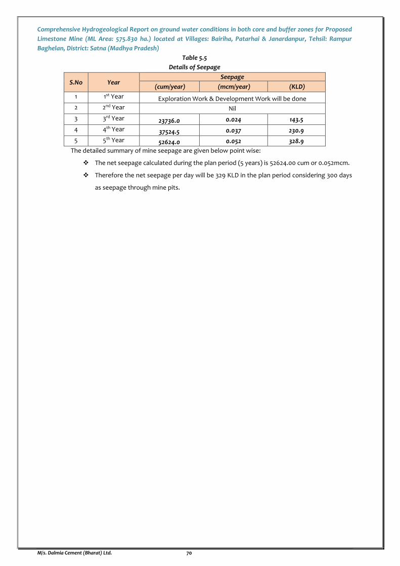
Comprehensive Hydrogeological Report on ground water conditions in both core and buffer zones for Proposed
Limestone Mine (ML Area: 575.830 ha.) located at Villages: Bairiha, Patarhai & Janardanpur, Tehsil: Rampur
Baghelan, District: Satna (Madhya Pradesh)
M/s. Dalmia Cement (Bharat) Ltd. 70
Table 5.5
Details of Seepage
S.No Year Seepage
(cum/year) (mcm/year) (KLD)
1 1st Year Exploration Work & Development Work will be done
2 2nd Year Nil
3 3rd Year 23736.0 0.024 143.5
4 4th Year 37524.5 0.037 230.9
5 5th Year 52624.0 0.052 328.9
The detailed summary of mine seepage are given below point wise:
The net seepage calculated during the plan period (5 years) is 52624.00 cum or 0.052mcm.
Therefore the net seepage per day will be 329 KLD in the plan period considering 300 days
as seepage through mine pits.
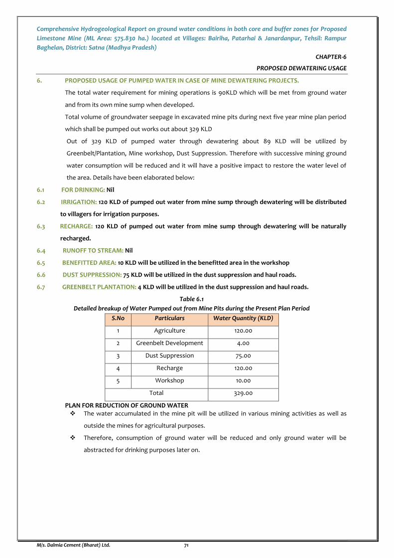
Comprehensive Hydrogeological Report on ground water conditions in both core and buffer zones for Proposed
Limestone Mine (ML Area: 575.830 ha.) located at Villages: Bairiha, Patarhai & Janardanpur, Tehsil: Rampur
Baghelan, District: Satna (Madhya Pradesh)
M/s. Dalmia Cement (Bharat) Ltd. 71
CHAPTER-6
PROPOSED DEWATERING USAGE
6. PROPOSED USAGE OF PUMPED WATER IN CASE OF MINE DEWATERING PROJECTS.
The total water requirement for mining operations is 90KLD which will be met from ground water
and from its own mine sump when developed.
Total volume of groundwater seepage in excavated mine pits during next five year mine plan period
which shall be pumped out works out about 329 KLD
Out of 329 KLD of pumped water through dewatering about 89 KLD will be utilized by
Greenbelt/Plantation, Mine workshop, Dust Suppression. Therefore with successive mining ground
water consumption will be reduced and it will have a positive impact to restore the water level of
the area. Details have been elaborated below:
6.1 FOR DRINKING: Nil
6.2 IRRIGATION: 120 KLD of pumped out water from mine sump through dewatering will be distributed
to villagers for irrigation purposes.
6.3 RECHARGE: 120 KLD of pumped out water from mine sump through dewatering will be naturally
recharged.
6.4 RUNOFF TO STREAM: Nil
6.5 BENEFITTED AREA: 10 KLD will be utilized in the benefitted area in the workshop
6.6 DUST SUPPRESSION: 75 KLD will be utilized in the dust suppression and haul roads.
6.7 GREENBELT PLANTATION: 4 KLD will be utilized in the dust suppression and haul roads.
Table 6.1
Detailed breakup of Water Pumped out from Mine Pits during the Present Plan Period
S.No Particulars Water Quantity (KLD)
1 Agriculture 120.00
2 Greenbelt Development 4.00
3 Dust Suppression 75.00
4 Recharge 120.00
5 Workshop 10.00
Total 329.00
PLAN FOR REDUCTION OF GROUND WATER The water accumulated in the mine pit will be utilized in various mining activities as well as
outside the mines for agricultural purposes.
Therefore, consumption of ground water will be reduced and only ground water will be
abstracted for drinking purposes later on.
Comprehensive Hydrogeological Report on ground water conditions in both core and buffer zones for Proposed
Limestone Mine (ML Area: 575.830 ha.) located at Villages: Bairiha, Patarhai & Janardanpur, Tehsil: Rampur
Baghelan, District: Satna (Madhya Pradesh)
M/s. Dalmia Cement (Bharat) Ltd. 72
CHAPTER-7
IMPACT OF MINING ACTIVITIES ON WATER RESOURCES OF THE AREA
7.0 COMPREHENSIVE ASSESSMENT OF THE IMPACT ON THE GROUND WATER REGIME IN AND AROUND
THE PROJECT AREA HIGHLIGHTING THE RISKS AND PROPOSED MANAGEMENT STRATEGIES
PROPOSED TO OVERCOME ANY SIGNIFICANT ENVIRONMENTAL ISSUES.
The area is devoid of any major River, however minor seasonal rivulets exist and these drain into Tons
River. A rivulet originating in the upper side of the lease area, joins the Dila Nala which ultimately
merges with Nar Nadi. No waste water will be discharged outside ML Area which may contaminate
any surface water body.
7.1 IMPACT ON SURFACE WATER SOURCES
IMPACT OF MINING ON SURFACE WATER
All the mining activity proposed to be carried out in next five years will not interfere anywhere with
the natural drainage pattern. However, to prevent the entry of surface run-off in the active mining pit,
it is proposed to make bund around the pit with soil generated during mining so that rainwater will be
channelized towards temporary unused pit/water reservoir. The surface runoff from OB/waste dump
site along seasonal Nallah (five year plan period) shall be channelized to settling tank through garland
drains. Moreover, no stored water shall be released directly to streams. Clean and clear water will be
discharged through rainwater harvesting pit; check dam also be provided to prevent siltation to
discharge. Hence, there is no possibility of any siltation in natural streams and reduction of vertical
percolation. It is therefore apparent that there is hardly any impact of mining on the surface water
regime.
7.1.1 DIVERSION OF EXISTING CHANNELS [CONSTRUCTED DAM/BARRAGES/WEIR/CANALS/HYDRO-ELECTRIC
PROJECTS]
Five number of minor/ sub minor Canals are passing/ terminating through the ML area, diversion of
the same is proposed for which demand has been raised by Concerned Authority/Irrigation
Department, Govt. of Madhya Pradesh for issuance of NOC and accordingly Rs. 12.144 crores has been
paid by M/s Dalmia Cement (Bharat) Ltd.
Mining Lease LOI was granted after curtailing area falling under habitations, major water bodies like
ponds, seasonal Nallahs etc. and are excluded from the ML Area. Hence, during the course of mining,
no Nallah/stream has been diverted. Whatever surface runoff develops in the lease area by rainfall is
allowed to join the natural drainage system as it was prior to mining activity.
Apart from these mitigation measures will be adopted to control the surface run-off:
Check dams will be constructed at the lowest to settle the sediments.
Retention walls to the dumps are proposed to check the suspended particles rolling down and
chocking the natural drainage system of the area.
Garland drains will be constructed around the dumpsites to check the flow of fines during the
surface runoff.
Retaining wall and garland drain around the waste dump and ore stack shall be constructed for
arresting the solid wash off.
Comprehensive Hydrogeological Report on ground water conditions in both core and buffer zones for Proposed
Limestone Mine (ML Area: 575.830 ha.) located at Villages: Bairiha, Patarhai & Janardanpur, Tehsil: Rampur
Baghelan, District: Satna (Madhya Pradesh)
M/s. Dalmia Cement (Bharat) Ltd. 73
Grasses will also be planted on the dump slope to control the soil erosion.
Catch drains will be constructed at dumps which will have half concrete open pipes followed by
settling tanks to avoid wash offs.
Berms at the outer end of terraces of dumps will be constructed to reduce gully formation due to
rain water wash offs.
To prevent the entry of surface run off in the active mining pit, it is proposed to make bund
around the pit. It is also proposed that temporary bunds with soil or rock will be made at
appropriate site from where water will be channelized towards temporary unused pit/water
reservoir.
Periodical monitoring of ground water quality will be carried out.
7.1.2 CHANGE IN LAND USE [CHANGE IN FLOOD PLAIN, LOTIC & LENTIC SYSTEMS ETC.]
The impact on land use in buffer zone due to mining activities are limited to the acquired leasehold
area would be insignificant. No land degradation would take place on account of opencast mining
operations. Most of the built up structures like the garage, workshop, office building, rest rooms, shall
be dismantled during the mine closure.
At conceptual stage total excavated area will be 467.145 ha, out of which 210.20 ha will be backfilled
and 256.945 ha will be converted into water reservoir which will be developed for Community use. Out
of the backfilled area, 55.92 ha area will be rehabilitated by afforestation and remaining 154.28 ha area
will be developed for agricultural practices. About 105.685 ha land will be covered under plantation &
green belt till conceptual stage (safety zone including safety barrier of 7.5 m along ML boundary).
There is no undisturbed area as about 65.685 ha land under safety barrier along habitation and other
mining constraints will be used for plantation.
As such the impact of mining on the land use pattern of the project area on a long term perspective
shall have no major adverse impact.
7.1.3 CURRENT & POTENTIAL THREATS
As about 329 KLD of ground water will be dewatered during the present plan period and mining will
be carried out at moderate depth of 16m and very limited inflow of water will take place which will
be gainfully utilized, there will not be any stress on the static ground water reserves of the lease area
and long term trend of declining of water levels in immediate vicinity of the mine will get arrested.
7.2 IMPACT OF MINING ON GROUNDWATER
There would not be any adverse impact on the ground water quality due to mining. The
mineral formation do not contain any harmful element, which could percolate into the ground
and pollute the ground water. Hence, no control measures are required.
Garland drains will be provided all around the excavation to prevent flow of surface rainwater and
from surrounding areas in the working pit. The drains shall be of adequate size to carry the storm
water without overflow. The rain water which will get accumulated in working pit will be pumped
out by diesel pump of adequate capacity. The rainwater collected in the excavated out area or in
mine sump shall be collected and utilized for water spraying on haul roads and other dust prone
areas.
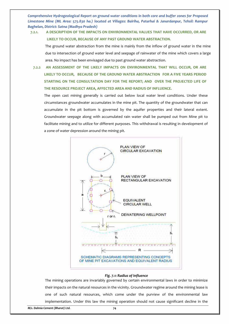
Comprehensive Hydrogeological Report on ground water conditions in both core and buffer zones for Proposed
Limestone Mine (ML Area: 575.830 ha.) located at Villages: Bairiha, Patarhai & Janardanpur, Tehsil: Rampur
Baghelan, District: Satna (Madhya Pradesh)
M/s. Dalmia Cement (Bharat) Ltd. 74
7.2.1. A DESCRIPTION OF THE IMPACTS ON ENVIRONMENTAL VALUES THAT HAVE OCCURRED, OR ARE
LIKELY TO OCCUR, BECAUSE OF ANY PAST GROUND WATER ABSTRACTION.
The ground water abstraction from the mine is mainly from the inflow of ground water in the mine
due to intersection of ground water level and seepage of rainwater of the mine which covers a large
area. No impact has been envisaged due to past ground water abstraction.
7.2.2 AN ASSESSMENT OF THE LIKELY IMPACTS ON ENVIRONMENTAL THAT WILL OCCUR, OR ARE
LIKELY TO OCCUR, BECAUSE OF THE GROUND WATER ABSTRACTION FOR A FIVE YEARS PERIOD
STARTING ON THE CONSULTATION DAY FOR THE REPORT; AND OVER THE PROJECTED LIFE OF
THE RESOURCE PROJECT AREA, AFFECTED AREA AND RADIUS OF INFLUENCE.
The open cast mining generally is carried out below local water level conditions. Under these
circumstances groundwater accumulates in the mine pit. The quantity of the groundwater that can
accumulate in the pit bottom is governed by the aquifer properties and their lateral extent.
Groundwater seepage along with accumulated rain water shall be pumped out from Mine pit to
facilitate mining and to utilize for different purposes. This withdrawal is resulting in development of
a zone of water depression around the mining pit.
Fig. 7.1: Radius of Influence The mining operations are invariably governed by certain environmental laws in order to minimize
their impacts on the natural resources in the vicinity. Groundwater regime around the mining lease is
one of such natural resources, which come under the purview of the environmental law
implementation. Under this law the mining operation should not cause significant decline in the
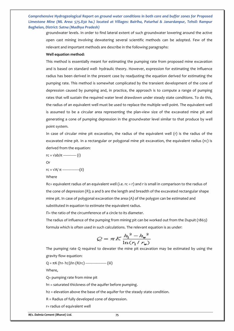
Comprehensive Hydrogeological Report on ground water conditions in both core and buffer zones for Proposed
Limestone Mine (ML Area: 575.830 ha.) located at Villages: Bairiha, Patarhai & Janardanpur, Tehsil: Rampur
Baghelan, District: Satna (Madhya Pradesh)
M/s. Dalmia Cement (Bharat) Ltd. 75
groundwater levels. In order to find lateral extent of such groundwater lowering around the active
open cast mining involving dewatering several scientific methods can be adopted. Few of the
relevant and important methods are describe in the following paragraphs:
Well equation method:
This method is essentially meant for estimating the pumping rate from proposed mine excavation
and is based on standard well- hydraulic theory. However, expression for estimating the influence
radius has been derived in the present case by readjusting the equation derived for estimating the
pumping rate. This method is somewhat complicated by the transient development of the cone of
depression caused by pumping and, in practice, the approach is to compute a range of pumping
rates that will sustain the required water level drawdown under steady state conditions. To do this,
the radius of an equivalent well must be used to replace the multiple well point. The equivalent well
is assumed to be a circular area representing the plan-view size of the excavated mine pit and
generating a cone of pumping depression in the groundwater level similar to that produce by well
point system.
In case of circular mine pit excavation, the radius of the equivalent well (r) is the radius of the
excavated mine pit. In a rectangular or polygonal mine pit excavation, the equivalent radius (rc) is
derived from the equation:
rc = √ab/π ------------- (i)
Or
rc = √A/ π -----------------(ii)
Where
Rc= equivalent radius of an equivalent well (i.e. rc = r) and r is small in comparison to the radius of
the cone of depression (R); a and b are the length and breadth of the excavated rectangular shape
mine pit. In case of polygonal excavation the area (A) of the polygon can be estimated and
substituted in equation to estimate the equivalent radius.
Π= the ratio of the circumference of a circle to its diameter.
The radius of influence of the pumping from mining pit can be worked out from the Dupuit (1863)
formula which is often used in such calculations. The relevant equation is as under:
The pumping rate Q required to dewater the mine pit excavation may be estimated by using the
gravity flow equation:
Q = πK (h1- h2)/In (R/rc) --------------------- (iii)
Where,
Q= pumping rate from mine pit
h1 = saturated thickness of the aquifer before pumping.
h2 = elevation above the base of the aquifer for the steady state condition.
R = Radius of fully developed cone of depression.
r= radius of equivalent well
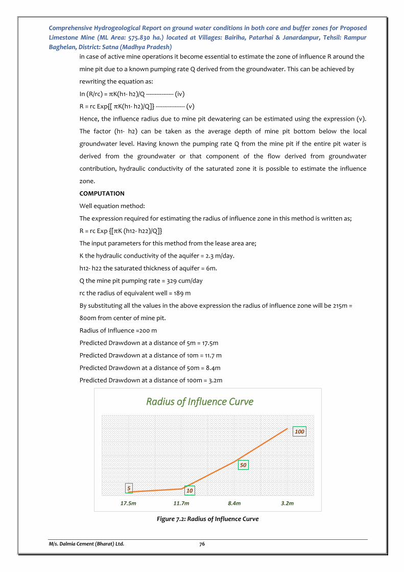
Comprehensive Hydrogeological Report on ground water conditions in both core and buffer zones for Proposed
Limestone Mine (ML Area: 575.830 ha.) located at Villages: Bairiha, Patarhai & Janardanpur, Tehsil: Rampur
Baghelan, District: Satna (Madhya Pradesh)
M/s. Dalmia Cement (Bharat) Ltd. 76
in case of active mine operations it become essential to estimate the zone of influence R around the
mine pit due to a known pumping rate Q derived from the groundwater. This can be achieved by
rewriting the equation as:
In (R/rc) = πK(h1- h2)/Q ---------------- (iv)
R = rc Exp{[ πK(h1- h2)/Q]} ----------------- (v)
Hence, the influence radius due to mine pit dewatering can be estimated using the expression (v).
The factor (h1- h2) can be taken as the average depth of mine pit bottom below the local
groundwater level. Having known the pumping rate Q from the mine pit if the entire pit water is
derived from the groundwater or that component of the flow derived from groundwater
contribution, hydraulic conductivity of the saturated zone it is possible to estimate the influence
zone.
COMPUTATION
Well equation method:
The expression required for estimating the radius of influence zone in this method is written as;
R = rc Exp {[πK (h12- h22)/Q]}
The input parameters for this method from the lease area are;
K the hydraulic conductivity of the aquifer = 2.3 m/day.
h12- h22 the saturated thickness of aquifer = 6m.
Q the mine pit pumping rate = 329 cum/day
rc the radius of equivalent well = 189 m
By substituting all the values in the above expression the radius of influence zone will be 215m =
800m from center of mine pit.
Radius of Influence =200 m
Predicted Drawdown at a distance of 5m = 17.5m
Predicted Drawdown at a distance of 10m = 11.7 m
Predicted Drawdown at a distance of 50m = 8.4m
Predicted Drawdown at a distance of 100m = 3.2m
Figure 7.2: Radius of Influence Curve
5 10
50
100
17.5m 11.7m 8.4m 3.2m
Radius of Influence Curve
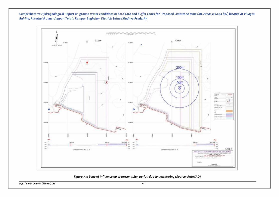
Comprehensive Hydrogeological Report on ground water conditions in both core and buffer zones for Proposed Limestone Mine (ML Area: 575.830 ha.) located at Villages:
Bairiha, Patarhai & Janardanpur, Tehsil: Rampur Baghelan, District: Satna (Madhya Pradesh)
M/s. Dalmia Cement (Bharat) Ltd. 77
Figure 7.3: Zone of Influence up to present plan period due to dewatering (Source: AutoCAD)
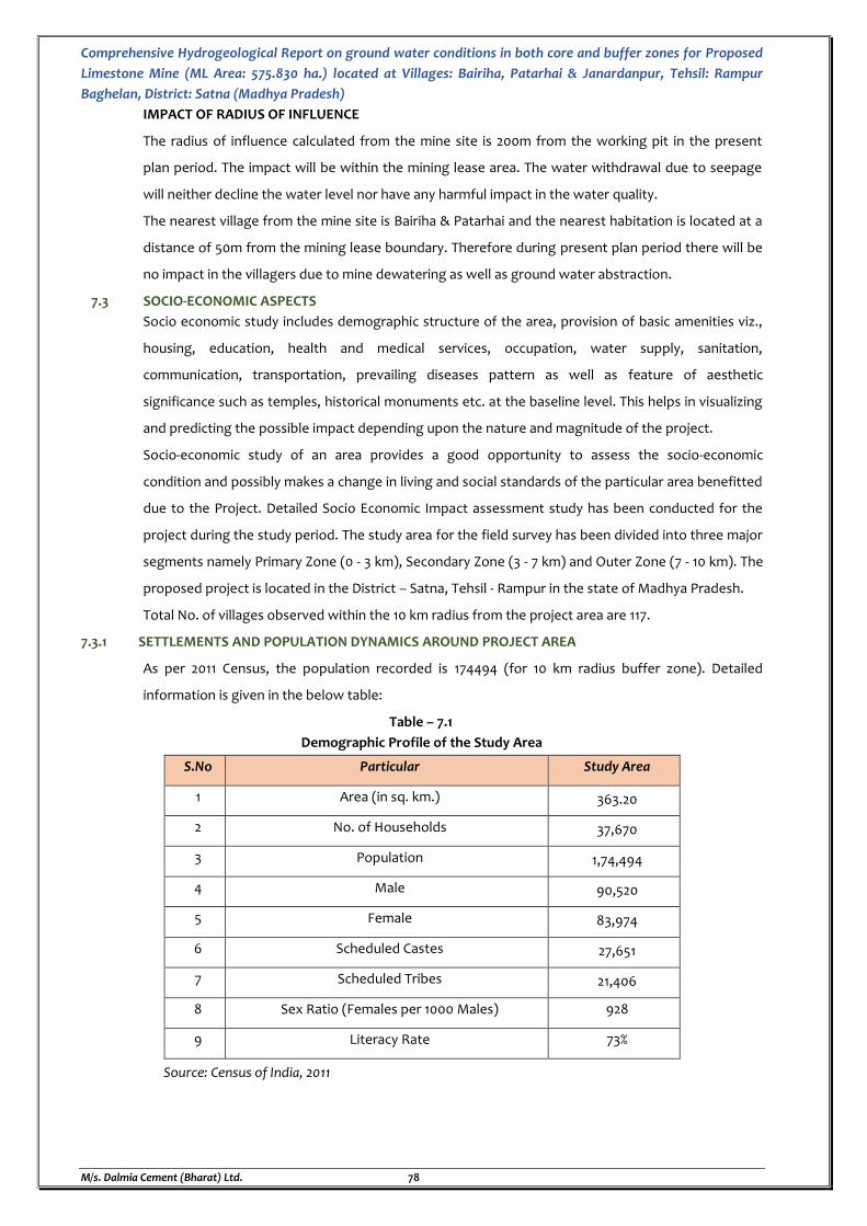
Comprehensive Hydrogeological Report on ground water conditions in both core and buffer zones for Proposed
Limestone Mine (ML Area: 575.830 ha.) located at Villages: Bairiha, Patarhai & Janardanpur, Tehsil: Rampur
Baghelan, District: Satna (Madhya Pradesh)
M/s. Dalmia Cement (Bharat) Ltd. 78
IMPACT OF RADIUS OF INFLUENCE
The radius of influence calculated from the mine site is 200m from the working pit in the present
plan period. The impact will be within the mining lease area. The water withdrawal due to seepage
will neither decline the water level nor have any harmful impact in the water quality.
The nearest village from the mine site is Bairiha & Patarhai and the nearest habitation is located at a
distance of 50m from the mining lease boundary. Therefore during present plan period there will be
no impact in the villagers due to mine dewatering as well as ground water abstraction.
7.3 SOCIO-ECONOMIC ASPECTS
Socio economic study includes demographic structure of the area, provision of basic amenities viz.,
housing, education, health and medical services, occupation, water supply, sanitation,
communication, transportation, prevailing diseases pattern as well as feature of aesthetic
significance such as temples, historical monuments etc. at the baseline level. This helps in visualizing
and predicting the possible impact depending upon the nature and magnitude of the project.
Socio-economic study of an area provides a good opportunity to assess the socio-economic
condition and possibly makes a change in living and social standards of the particular area benefitted
due to the Project. Detailed Socio Economic Impact assessment study has been conducted for the
project during the study period. The study area for the field survey has been divided into three major
segments namely Primary Zone (0 - 3 km), Secondary Zone (3 - 7 km) and Outer Zone (7 - 10 km). The
proposed project is located in the District – Satna, Tehsil - Rampur in the state of Madhya Pradesh.
Total No. of villages observed within the 10 km radius from the project area are 117.
7.3.1 SETTLEMENTS AND POPULATION DYNAMICS AROUND PROJECT AREA
As per 2011 Census, the population recorded is 174494 (for 10 km radius buffer zone). Detailed
information is given in the below table:
Table – 7.1
Demographic Profile of the Study Area
S.No Particular Study Area
1 Area (in sq. km.) 363.20
2 No. of Households 37,670
3 Population 1,74,494
4 Male 90,520
5 Female 83,974
6 Scheduled Castes 27,651
7 Scheduled Tribes 21,406
8 Sex Ratio (Females per 1000 Males) 928
9 Literacy Rate 73%
Source: Census of India, 2011

Comprehensive Hydrogeological Report on ground water conditions in both core and buffer zones for Proposed
Limestone Mine (ML Area: 575.830 ha.) located at Villages: Bairiha, Patarhai & Janardanpur, Tehsil: Rampur
Baghelan, District: Satna (Madhya Pradesh)
M/s. Dalmia Cement (Bharat) Ltd. 79
Table 7.2
Zone Wise Demographical Profile of Study Area
Zone No. of
Villages
Total
Household
Total
Population
Total Male
Population
Total Female
Population Sex Ratio
Primary Zone (0 - 3 Km) 18 7176 33423 17382 16041 923
Secondary Zone (3 - 7 Km) 44 17873 82894 42995 39899 928
Outer Zone (7 - 10 Km) 55 13042 58177 30143 28034 930
Total 117 37670 174494 90520 83974 928
Figure 7.4: Population Distribution
7.3.2 DEPENDENCY ON SOURCES OF WATER [SURFACE OR SUB-SURFACE]
As per the survey conducted, Majority number of villages is connected with the functioned tap
water and also have hand pump for the drinking purpose. The villages were also found having tube
wells. Thus the villagers are availing drinking water generally from the Hand pump, open well and
tap water. The 10 km study area also have Canal running near to the villages Jamuna, Rampur
Baghelan, Naubasta where the water is used for various purpose including Urban drinking water
supply. The landscape of the study area is undulating due to which the ground water is subjected
to rapid runoff leading not only to soil erosion but also to scarcity of water for both agriculture and
drinking purposes. The people face major scarcity of water during summer.
Water resources and facilities available in the study area are given below.
7.3.3 GROUND WATER USES [e.g. IRRIGATION METHOD, NUMBER OF WATERING, WATER SUPPLY ETC.]
There are many industries within the 10 km study area.
Table 7.3
Major Mines and Industries falling in the 10 km radius of study area:
S. No. Name of the Company Direction from the mine boundary
Approx. distance from the mine boundary
Mines
1. Bagahai Limestone Mines SSW ~1 km
2. Hinauti Limestone Mines WSW ~3.90 km
4. Jaypee Limestone Mines E ~8.08 km
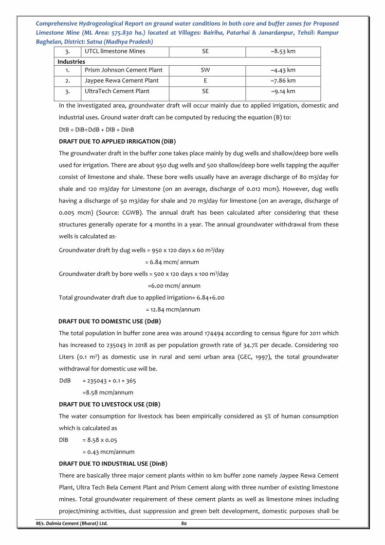
Comprehensive Hydrogeological Report on ground water conditions in both core and buffer zones for Proposed
Limestone Mine (ML Area: 575.830 ha.) located at Villages: Bairiha, Patarhai & Janardanpur, Tehsil: Rampur
Baghelan, District: Satna (Madhya Pradesh)
M/s. Dalmia Cement (Bharat) Ltd. 80
3. UTCL limestone Mines SE ~8.53 km
Industries
1. Prism Johnson Cement Plant SW ~4.43 km
2. Jaypee Rewa Cement Plant E ~7.86 km
3. UltraTech Cement Plant SE ~9.14 km
In the investigated area, groundwater draft will occur mainly due to applied irrigation, domestic and
industrial uses. Ground water draft can be computed by reducing the equation (B) to:
DtB = DiBDdB + DlB + DinB
DRAFT DUE TO APPLIED IRRIGATION (DiB)
The groundwater draft in the buffer zone takes place mainly by dug wells and shallow/deep bore wells
used for irrigation. There are about 950 dug wells and 500 shallow/deep bore wells tapping the aquifer
consist of limestone and shale. These bore wells usually have an average discharge of 80 m3/day for
shale and 120 m3/day for Limestone (on an average, discharge of 0.012 mcm). However, dug wells
having a discharge of 50 m3/day for shale and 70 m3/day for limestone (on an average, discharge of
0.005 mcm) (Source: CGWB). The annual draft has been calculated after considering that these
structures generally operate for 4 months in a year. The annual groundwater withdrawal from these
wells is calculated as-
Groundwater draft by dug wells = 950 x 120 days x 60 m3/day
= 6.84 mcm/ annum
Groundwater draft by bore wells = 500 x 120 days x 100 m3/day
=6.00 mcm/ annum
Total groundwater draft due to applied irrigation= 6.84+6.00
= 12.84 mcm/annum
DRAFT DUE TO DOMESTIC USE (DdB)
The total population in buffer zone area was around 174494 according to census figure for 2011 which
has increased to 235043 in 2018 as per population growth rate of 34.7% per decade. Considering 100
Liters (0.1 m3) as domestic use in rural and semi urban area (GEC, 1997), the total groundwater
withdrawal for domestic use will be.
DdB = 235043 × 0.1 × 365
=8.58 mcm/annum
DRAFT DUE TO LIVESTOCK USE (DlB)
The water consumption for livestock has been empirically considered as 5% of human consumption
which is calculated as
DlB = 8.58 x 0.05
= 0.43 mcm/annum
DRAFT DUE TO INDUSTRIAL USE (DinB)
There are basically three major cement plants within 10 km buffer zone namely Jaypee Rewa Cement
Plant, Ultra Tech Bela Cement Plant and Prism Cement along with three number of existing limestone
mines. Total groundwater requirement of these cement plants as well as limestone mines including
project/mining activities, dust suppression and green belt development, domestic purposes shall be
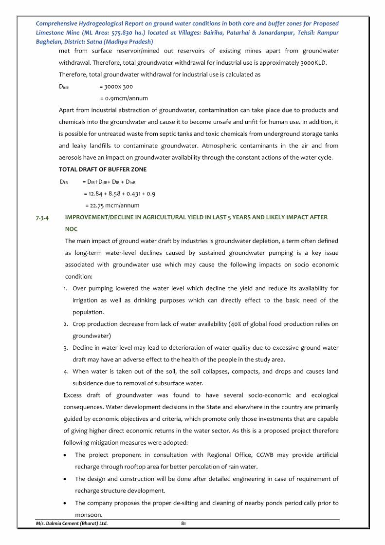
Comprehensive Hydrogeological Report on ground water conditions in both core and buffer zones for Proposed
Limestone Mine (ML Area: 575.830 ha.) located at Villages: Bairiha, Patarhai & Janardanpur, Tehsil: Rampur
Baghelan, District: Satna (Madhya Pradesh)
M/s. Dalmia Cement (Bharat) Ltd. 81
met from surface reservoir/mined out reservoirs of existing mines apart from groundwater
withdrawal. Therefore, total groundwater withdrawal for industrial use is approximately 3000KLD.
Therefore, total groundwater withdrawal for industrial use is calculated as
DinB = 3000x 300
= 0.9mcm/annum
Apart from industrial abstraction of groundwater, contamination can take place due to products and
chemicals into the groundwater and cause it to become unsafe and unfit for human use. In addition, it
is possible for untreated waste from septic tanks and toxic chemicals from underground storage tanks
and leaky landfills to contaminate groundwater. Atmospheric contaminants in the air and from
aerosols have an impact on groundwater availability through the constant actions of the water cycle.
TOTAL DRAFT OF BUFFER ZONE
DtB = DiBDdB+ DlB + DinB
= 12.84 + 8.58 + 0.431 + 0.9
= 22.75 mcm/annum
7.3.4 IMPROVEMENT/DECLINE IN AGRICULTURAL YIELD IN LAST 5 YEARS AND LIKELY IMPACT AFTER
NOC
The main impact of ground water draft by industries is groundwater depletion, a term often defined
as long-term water-level declines caused by sustained groundwater pumping is a key issue
associated with groundwater use which may cause the following impacts on socio economic
condition:
1. Over pumping lowered the water level which decline the yield and reduce its availability for
irrigation as well as drinking purposes which can directly effect to the basic need of the
population.
2. Crop production decrease from lack of water availability (40% of global food production relies on
groundwater)
3. Decline in water level may lead to deterioration of water quality due to excessive ground water
draft may have an adverse effect to the health of the people in the study area.
4. When water is taken out of the soil, the soil collapses, compacts, and drops and causes land
subsidence due to removal of subsurface water.
Excess draft of groundwater was found to have several socio-economic and ecological
consequences. Water development decisions in the State and elsewhere in the country are primarily
guided by economic objectives and criteria, which promote only those investments that are capable
of giving higher direct economic returns in the water sector. As this is a proposed project therefore
following mitigation measures were adopted:
The project proponent in consultation with Regional Office, CGWB may provide artificial
recharge through rooftop area for better percolation of rain water.
The design and construction will be done after detailed engineering in case of requirement of
recharge structure development.
The company proposes the proper de-silting and cleaning of nearby ponds periodically prior to
monsoon.
Comprehensive Hydrogeological Report on ground water conditions in both core and buffer zones for Proposed
Limestone Mine (ML Area: 575.830 ha.) located at Villages: Bairiha, Patarhai & Janardanpur, Tehsil: Rampur
Baghelan, District: Satna (Madhya Pradesh)
M/s. Dalmia Cement (Bharat) Ltd. 82
Mechanical ploughing at the base of the basin.
Addition of organic matter or chemicals to the uppermost layer
The mine will install piezometers fitted with automatic water level recorder having telemetry
system at suitable location and execute ground water regime monitoring programme in and
around the project area on regular basis in consultation with CGWB and as per as NOC
conditions.
The industry will take up area specific plantation program to enhance the recharge measures.
7.3.5. IMPACT OF PROPOSED/EXISTING PROJECT ON LOCAL COMMUNITIES [BASED ON LOCAL
INTERACTIONS (INTERACTIONS MUST BE WITH STAKEHOLDERS LIKE FISHERMEN COMMUNITY,
FARMERS ETC.]
The major impact of the existing project will be on the farmers. As the mining will be carried out at
great depth and very limited inflow of ground water will take place which will be gainfully utilized ,
there will not be any stress on the static ground water reserves of the lease area and long term
trend of declining of water levels in the immediate vicinity of the mine will get arrested. Also, a
recharge program has been proposed, therefore, there is no major impact envisaged due to the
existing mining activity on the local communities.
Rooftop recharge will be practiced within the mine premises. Rainwater harvesting practices
through roof-top shall be carried out and the available run-off from the same will be used for green
belt or dust suppression etc. Therefore, the mine proposes to implement the groundwater recharge
measures by constructing and rejuvenating village ponds within 10 km distance of Project site.
RECOMMENDATIONS AND SUGGESTION
Total water requirement for the proposed mining project will be about 90 KLD which will be sourced
from Ground water & rain water accumulated in mine pit. Total volume of groundwater seepage in
excavated mine pits during next five year mine plan period which shall be pumped out works out
about 329 KLD. Therefor during the next five year plan period the total water withdrawal from the
borewell proposed within the mine to meet its requirement is 135000 cum and that of mine
dewatering from seepage is 296100 cum.
Therefore total quantity of 431100 cum of ground water will be utilized by the mine in the form of
abstraction as well as mine dewatering.
In order to replenish the same about 120KLD of the dewatered quantity will be distributed to the
villagers of the nearby Villages for irrigation purposes which will amount to 180000 cum in the
present plan period (5years), and 120KLD of the dewatered quantity will be naturally recharged
which will amount to 180000 cum in the present plan period (5years).
Therefore the main recommendations and suggestions regarding the present mining proposal are as
follows:
Awareness program about the conservation of ground water resources to make the population
aware.
In order to arrest the declining trends of water levels in the block, the rooftop rainwater
harvesting technology should be adopted and recharge structures may also be constructed in
Comprehensive Hydrogeological Report on ground water conditions in both core and buffer zones for Proposed
Limestone Mine (ML Area: 575.830 ha.) located at Villages: Bairiha, Patarhai & Janardanpur, Tehsil: Rampur
Baghelan, District: Satna (Madhya Pradesh)
M/s. Dalmia Cement (Bharat) Ltd. 83
depression areas where water gets accumulated during rainy season. This will help in enhancing
the recharge to ground water reservoir.
Deepening of nearby ponds and desilting the same for rainwater harvesting and utilization of
the harvested water by the villagers.
The crops consuming less quantity of water may be grown in place of crops requiring more
water.
The abandoned dug wells may be cleaned and should be used for recharging the ground water
by utilizing the surface monsoon runoff.
Cyclic use of canal water and poor quality groundwater.

Comprehensive Hydrogeological Report on ground water conditions in both core and buffer zones for Proposed
Limestone Mine (ML Area: 575.830 ha.) located at Villages: Bairiha, Patarhai & Janardanpur, Tehsil: Rampur
Baghelan, District: Satna (Madhya Pradesh)
M/s. Dalmia Cement (Bharat) Ltd. 84
CHAPTER - 8
WASTE WATER DISPOSAL FOR SALINE WATER
8. PROPOSED MEASURES FOR DISPOSAL OF WASTE WATER BY MINE DRAWING SALINE WATER
As this project is opencast mining for limestone at Villages: Bairiha, Patarhai & Janardanpur, and
Tehsil: Rampur Baghelan, District: Satna (Madhya Pradesh) and this project site does not fall under
saline zone as per CGWA categorization. Therefore, this chapter on disposal of saline water is not
required.
Comprehensive Hydrogeological Report on ground water conditions in both core and buffer zones for Proposed
Limestone Mine (ML Area: 575.830 ha.) located at Villages: Bairiha, Patarhai & Janardanpur, Tehsil: Rampur
Baghelan, District: Satna (Madhya Pradesh)
M/s. Dalmia Cement (Bharat) Ltd. 85
CHAPTER - 9
WATER CONSERVATION METHOD
9. MEASURES TO BE ADOPTED FOR WATER CONSERVATION WHICH INCLUDE RECYCLING, REUSE,
TREATMENT, ETC. THIS INCLUDES THE WATER BALANCE CHART BEING ADOPTED BY THE FIRM
ALONG WITH DETAILS OF WATER CONSERVATION METHODS TO BE ADOPTED.
9.1 BRIEF WRITE UP ALONG WITH CAPACITY AND FLOW CHART OF SEWAGE TREATMENT PLANTS /
EFFLUENT TREATMENT PLANTS / COMBINED EFFLUENT TREATMENT PLANTS EXISTING/ PROPOSED
WITHIN THE PROJECT.
Our ground water and surface water supplies are at risk of overuse in many areas. The demand can
be greater than the amount supplied by rain and snowmelt. Water conservation, wastewater
recycling, and reuse is becoming more important due to increases in:
Demand on potable water resources.
Cost of treating wastewater.
Regulations requiring greater flows for streams and rivers, which reduces irrigation sources.
Demand for sustainable building options.
Sewage Treatment Plant is a plant or installation setup that is used to purify contaminated
substances. These substances may be solid, liquid and semi-solids. The general benefits of STP are as
follows:
STP is proven technology which offers reliable performance at all-time
Sewage treatment plant preserve natural environment against pollution
STP meet the standards for emission of pollutants set by the Government & avoid heavy
penalty
Simple and easy installation, low operation and maintenance of plant
Installation of sewage treatment plant reduces risk to public health and the environment
In a sewage treatment plant, waste or contaminated substances are treated with various means and
produce purified substances that are safe and reusable in the process or discharge to the
environment. DCBL proposes to install a modular STPs of ~8 KLD which is a simple plug in module
which is based on chemical free, hybrid of biological process and the membrane based to treat the
water to the desired quality. Each plant is pre-engineered, pre-assembled, factory tested and comes
in one module. If require, the capacity of the STP can be scaled up by adding additional module.
Material of construction of tanks is MS with FRP / Rubber lined.
Working Principle
The proposed Modular STP can be described as one part of a biological process where small
microbes degrade pollutants before being filtered by a collection of submerged membranes.
Membranes are housed in modules that are, in turn, assembled into cassettes and installed in a tank
(called an MBR). Air introduced through integral diffusers scours membrane surfaces during
filtration, mixes the tank and provides oxygen to the biological process.
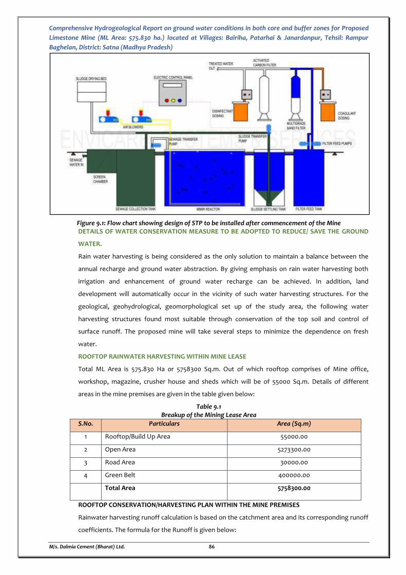
Comprehensive Hydrogeological Report on ground water conditions in both core and buffer zones for Proposed
Limestone Mine (ML Area: 575.830 ha.) located at Villages: Bairiha, Patarhai & Janardanpur, Tehsil: Rampur
Baghelan, District: Satna (Madhya Pradesh)
M/s. Dalmia Cement (Bharat) Ltd. 86
Figure 9.1: Flow chart showing design of STP to be installed after commencement of the Mine DETAILS OF WATER CONSERVATION MEASURE TO BE ADOPTED TO REDUCE/ SAVE THE GROUND
WATER.
Rain water harvesting is being considered as the only solution to maintain a balance between the
annual recharge and ground water abstraction. By giving emphasis on rain water harvesting both
irrigation and enhancement of ground water recharge can be achieved. In addition, land
development will automatically occur in the vicinity of such water harvesting structures. For the
geological, geohydrological, geomorphological set up of the study area, the following water
harvesting structures found most suitable through conservation of the top soil and control of
surface runoff. The proposed mine will take several steps to minimize the dependence on fresh
water.
ROOFTOP RAINWATER HARVESTING WITHIN MINE LEASE
Total ML Area is 575.830 Ha or 5758300 Sq.m. Out of which rooftop comprises of Mine office,
workshop, magazine, crusher house and sheds which will be of 55000 Sq.m. Details of different
areas in the mine premises are given in the table given below:
Table 9.1 Breakup of the Mining Lease Area
S.No. Particulars Area (Sq.m)
1 Rooftop/Build Up Area 55000.00
2 Open Area 5273300.00
3 Road Area 30000.00
4 Green Belt 400000.00
Total Area 5758300.00
ROOFTOP CONSERVATION/HARVESTING PLAN WITHIN THE MINE PREMISES
Rainwater harvesting runoff calculation is based on the catchment area and its corresponding runoff
coefficients. The formula for the Runoff is given below:
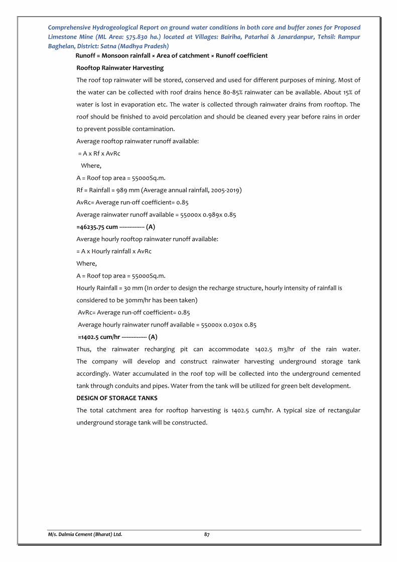
Comprehensive Hydrogeological Report on ground water conditions in both core and buffer zones for Proposed
Limestone Mine (ML Area: 575.830 ha.) located at Villages: Bairiha, Patarhai & Janardanpur, Tehsil: Rampur
Baghelan, District: Satna (Madhya Pradesh)
M/s. Dalmia Cement (Bharat) Ltd. 87
Runoff = Monsoon rainfall × Area of catchment × Runoff coefficient
Rooftop Rainwater Harvesting
The roof top rainwater will be stored, conserved and used for different purposes of mining. Most of
the water can be collected with roof drains hence 80-85% rainwater can be available. About 15% of
water is lost in evaporation etc. The water is collected through rainwater drains from rooftop. The
roof should be finished to avoid percolation and should be cleaned every year before rains in order
to prevent possible contamination.
Average rooftop rainwater runoff available:
= A x Rf x AvRc
Where,
A = Roof top area = 55000Sq.m.
Rf = Rainfall = 989 mm (Average annual rainfall, 2005-2019)
AvRc= Average run-off coefficient= 0.85
Average rainwater runoff available = 55000x 0.989x 0.85
=46235.75 cum --------------- (A)
Average hourly rooftop rainwater runoff available:
= A x Hourly rainfall x AvRc
Where,
A = Roof top area = 55000Sq.m.
Hourly Rainfall = 30 mm (In order to design the recharge structure, hourly intensity of rainfall is
considered to be 30mm/hr has been taken)
AvRc= Average run-off coefficient= 0.85
Average hourly rainwater runoff available = 55000x 0.030x 0.85
=1402.5 cum/hr --------------- (A)
Thus, the rainwater recharging pit can accommodate 1402.5 m3/hr of the rain water.
The company will develop and construct rainwater harvesting underground storage tank
accordingly. Water accumulated in the roof top will be collected into the underground cemented
tank through conduits and pipes. Water from the tank will be utilized for green belt development.
DESIGN OF STORAGE TANKS
The total catchment area for rooftop harvesting is 1402.5 cum/hr. A typical size of rectangular
underground storage tank will be constructed.
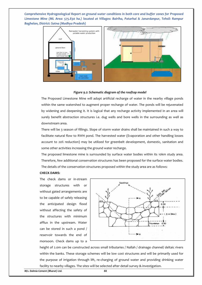
Comprehensive Hydrogeological Report on ground water conditions in both core and buffer zones for Proposed
Limestone Mine (ML Area: 575.830 ha.) located at Villages: Bairiha, Patarhai & Janardanpur, Tehsil: Rampur
Baghelan, District: Satna (Madhya Pradesh)
M/s. Dalmia Cement (Bharat) Ltd. 88
Figure 9.2: Schematic diagram of the rooftop model
The Proposed Limestone Mine will adopt artificial recharge of water in the nearby village ponds
within the same watershed to augment proper recharge of water. The ponds will be rejuvenated
by widening and deepening it. It is logical that any recharge activity implemented in an area will
surely benefit abstraction structures i.e. dug wells and bore wells in the surrounding as well as
downstream area.
There will be 3 season of fillings. Slope of storm water drains shall be maintained in such a way to
facilitate natural flow to RWH pond. The harvested water (Evaporation and other handling losses
account to 20% reduction) may be utilized for greenbelt development, domestic, sanitation and
some other activities increasing the ground water recharge.
The proposed limestone mine is surrounded by surface water bodies within its 10km study area.
Therefore, few additional conservation structures has been proposed for the surface water bodies.
The details of the conservation structures proposed within the study area are as follows:
CHECK DAMS:
The check dams or in-stream
storage structures with or
without gated arrangements are
to be capable of safely releasing
the anticipated design flood
without affecting the safety of
the structures with minimum
afflux in the upstream. Water
can be stored in such a pond /
reservoir towards the end of
monsoon. Check dams up to a
height of 2.0m can be constructed across small tributaries / Nallah / drainage channel/ deltaic rivers
within the banks. These storage schemes will be low cost structures and will be primarily used for
the purpose of irrigation through lift, re-charging of ground water and providing drinking water
facility to nearby villages. The sites will be selected after detail survey & investigation.
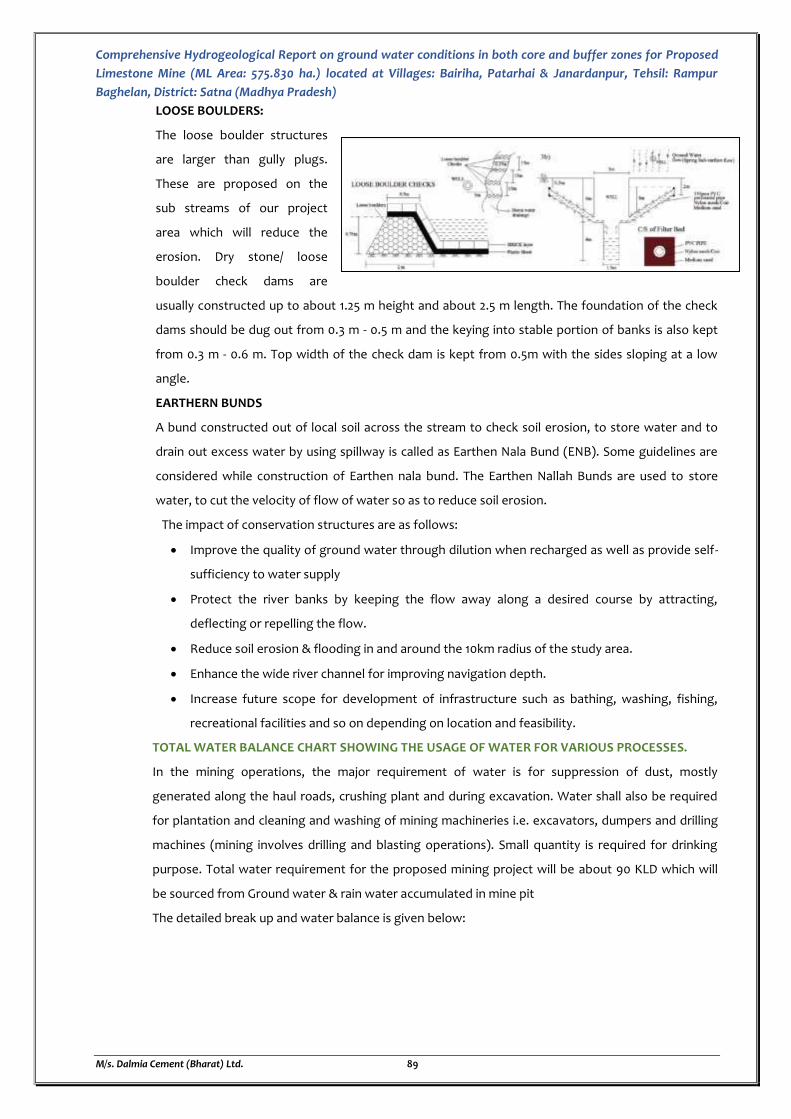
Comprehensive Hydrogeological Report on ground water conditions in both core and buffer zones for Proposed
Limestone Mine (ML Area: 575.830 ha.) located at Villages: Bairiha, Patarhai & Janardanpur, Tehsil: Rampur
Baghelan, District: Satna (Madhya Pradesh)
M/s. Dalmia Cement (Bharat) Ltd. 89
LOOSE BOULDERS:
The loose boulder structures
are larger than gully plugs.
These are proposed on the
sub streams of our project
area which will reduce the
erosion. Dry stone/ loose
boulder check dams are
usually constructed up to about 1.25 m height and about 2.5 m length. The foundation of the check
dams should be dug out from 0.3 m - 0.5 m and the keying into stable portion of banks is also kept
from 0.3 m - 0.6 m. Top width of the check dam is kept from 0.5m with the sides sloping at a low
angle.
EARTHERN BUNDS
A bund constructed out of local soil across the stream to check soil erosion, to store water and to
drain out excess water by using spillway is called as Earthen Nala Bund (ENB). Some guidelines are
considered while construction of Earthen nala bund. The Earthen Nallah Bunds are used to store
water, to cut the velocity of flow of water so as to reduce soil erosion.
The impact of conservation structures are as follows:
Improve the quality of ground water through dilution when recharged as well as provide self-
sufficiency to water supply
Protect the river banks by keeping the flow away along a desired course by attracting,
deflecting or repelling the flow.
Reduce soil erosion & flooding in and around the 10km radius of the study area.
Enhance the wide river channel for improving navigation depth.
Increase future scope for development of infrastructure such as bathing, washing, fishing,
recreational facilities and so on depending on location and feasibility.
TOTAL WATER BALANCE CHART SHOWING THE USAGE OF WATER FOR VARIOUS PROCESSES.
In the mining operations, the major requirement of water is for suppression of dust, mostly
generated along the haul roads, crushing plant and during excavation. Water shall also be required
for plantation and cleaning and washing of mining machineries i.e. excavators, dumpers and drilling
machines (mining involves drilling and blasting operations). Small quantity is required for drinking
purpose. Total water requirement for the proposed mining project will be about 90 KLD which will
be sourced from Ground water & rain water accumulated in mine pit
The detailed break up and water balance is given below:
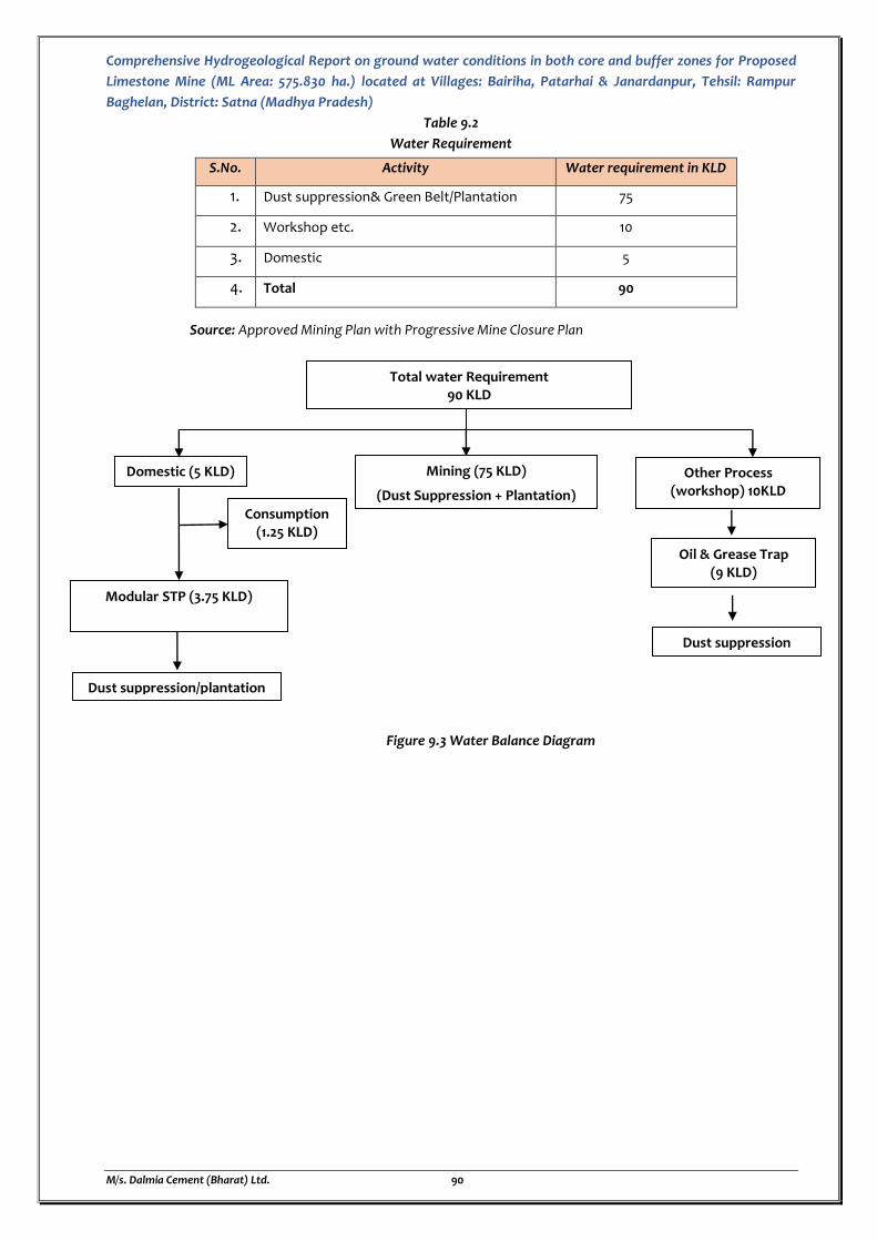
Comprehensive Hydrogeological Report on ground water conditions in both core and buffer zones for Proposed
Limestone Mine (ML Area: 575.830 ha.) located at Villages: Bairiha, Patarhai & Janardanpur, Tehsil: Rampur
Baghelan, District: Satna (Madhya Pradesh)
M/s. Dalmia Cement (Bharat) Ltd. 90
Table 9.2
Water Requirement
Source: Approved Mining Plan with Progressive Mine Closure Plan
Figure 9.3 Water Balance Diagram
S.No. Activity Water requirement in KLD
1. Dust suppression& Green Belt/Plantation 75
2. Workshop etc. 10
3. Domestic 5
4. Total 90
Consumption (1.25 KLD)
Modular STP (3.75 KLD)
Mining (75 KLD)
(Dust Suppression + Plantation)
Other Process (workshop) 10KLD
Domestic (5 KLD)
Total water Requirement 90 KLD
Dust suppression
Oil & Grease Trap (9 KLD)
Dust suppression/plantation
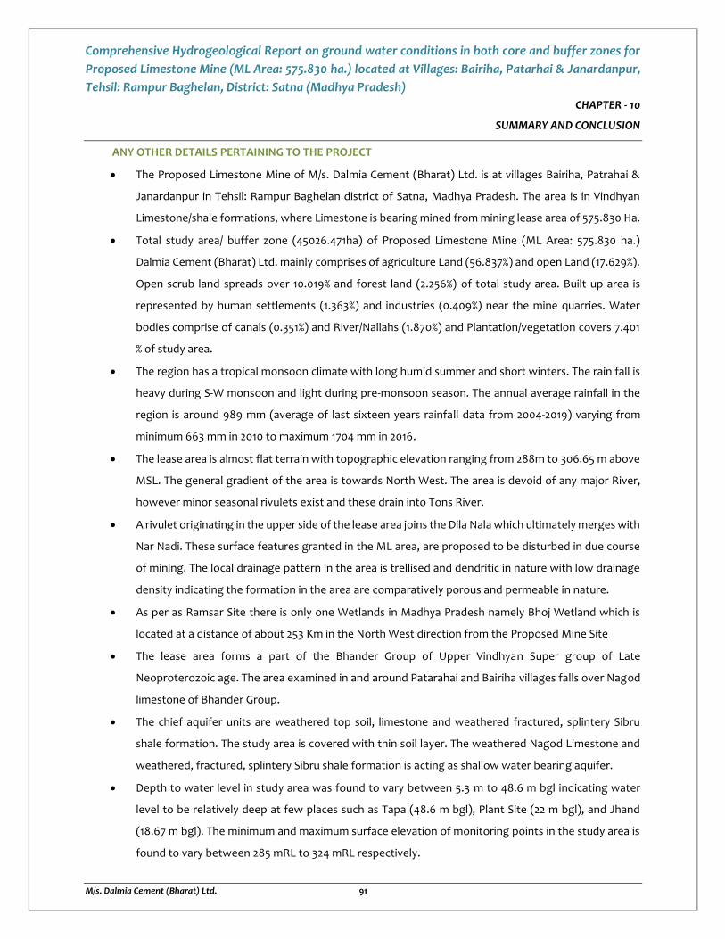
Comprehensive Hydrogeological Report on ground water conditions in both core and buffer zones for
Proposed Limestone Mine (ML Area: 575.830 ha.) located at Villages: Bairiha, Patarhai & Janardanpur,
Tehsil: Rampur Baghelan, District: Satna (Madhya Pradesh)
M/s. Dalmia Cement (Bharat) Ltd. 91
CHAPTER - 10
SUMMARY AND CONCLUSION
ANY OTHER DETAILS PERTAINING TO THE PROJECT
The Proposed Limestone Mine of M/s. Dalmia Cement (Bharat) Ltd. is at villages Bairiha, Patrahai &
Janardanpur in Tehsil: Rampur Baghelan district of Satna, Madhya Pradesh. The area is in Vindhyan
Limestone/shale formations, where Limestone is bearing mined from mining lease area of 575.830 Ha.
Total study area/ buffer zone (45026.471ha) of Proposed Limestone Mine (ML Area: 575.830 ha.)
Dalmia Cement (Bharat) Ltd. mainly comprises of agriculture Land (56.837%) and open Land (17.629%).
Open scrub land spreads over 10.019% and forest land (2.256%) of total study area. Built up area is
represented by human settlements (1.363%) and industries (0.409%) near the mine quarries. Water
bodies comprise of canals (0.351%) and River/Nallahs (1.870%) and Plantation/vegetation covers 7.401
% of study area.
The region has a tropical monsoon climate with long humid summer and short winters. The rain fall is
heavy during S-W monsoon and light during pre-monsoon season. The annual average rainfall in the
region is around 989 mm (average of last sixteen years rainfall data from 2004-2019) varying from
minimum 663 mm in 2010 to maximum 1704 mm in 2016.
The lease area is almost flat terrain with topographic elevation ranging from 288m to 306.65 m above
MSL. The general gradient of the area is towards North West. The area is devoid of any major River,
however minor seasonal rivulets exist and these drain into Tons River.
A rivulet originating in the upper side of the lease area joins the Dila Nala which ultimately merges with
Nar Nadi. These surface features granted in the ML area, are proposed to be disturbed in due course
of mining. The local drainage pattern in the area is trellised and dendritic in nature with low drainage
density indicating the formation in the area are comparatively porous and permeable in nature.
As per as Ramsar Site there is only one Wetlands in Madhya Pradesh namely Bhoj Wetland which is
located at a distance of about 253 Km in the North West direction from the Proposed Mine Site
The lease area forms a part of the Bhander Group of Upper Vindhyan Super group of Late
Neoproterozoic age. The area examined in and around Patarahai and Bairiha villages falls over Nagod
limestone of Bhander Group.
The chief aquifer units are weathered top soil, limestone and weathered fractured, splintery Sibru
shale formation. The study area is covered with thin soil layer. The weathered Nagod Limestone and
weathered, fractured, splintery Sibru shale formation is acting as shallow water bearing aquifer.
Depth to water level in study area was found to vary between 5.3 m to 48.6 m bgl indicating water
level to be relatively deep at few places such as Tapa (48.6 m bgl), Plant Site (22 m bgl), and Jhand
(18.67 m bgl). The minimum and maximum surface elevation of monitoring points in the study area is
found to vary between 285 mRL to 324 mRL respectively.
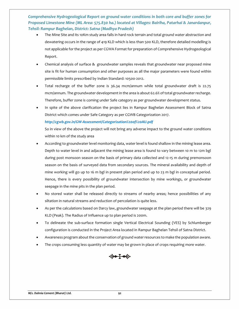
Comprehensive Hydrogeological Report on ground water conditions in both core and buffer zones for
Proposed Limestone Mine (ML Area: 575.830 ha.) located at Villages: Bairiha, Patarhai & Janardanpur,
Tehsil: Rampur Baghelan, District: Satna (Madhya Pradesh)
M/s. Dalmia Cement (Bharat) Ltd. 92
The Mine Site and its 10Km study area falls in hard rock terrain and total ground water abstraction and
dewatering occurs in the range of 419 KLD which is less than 500 KLD, therefore detailed modelling is
not applicable for the project as per CGWA Format for preparation of Comprehensive Hydrogeological
Report.
Chemical analysis of surface & groundwater samples reveals that groundwater near proposed mine
site is fit for human consumption and other purposes as all the major parameters were found within
permissible limits prescribed by Indian Standard: 10500-2012.
Total recharge of the buffer zone is 36.34 mcm/annum while total groundwater draft is 22.75
mcm/annum. The groundwater development in the area is about 62.6% of total groundwater recharge.
Therefore, buffer zone is coming under Safe category as per groundwater development status.
In spite of the above clarification the project lies in Rampur Baghelan Assessment Block of Satna
District which comes under Safe Category as per CGWB Categorization 2017.
http://cgwb.gov.in/GW-Assessment/Categorization%20of%20AU.pdf
So in view of the above the project will not bring any adverse impact to the ground water conditions
within 10 km of the study area
According to groundwater level monitoring data, water level is found shallow in the mining lease area.
Depth to water level in and adjacent the mining lease area is found to vary between 10 m to 12m bgl
during post monsoon season on the basis of primary data collected and 12-15 m during premonsoon
season on the basis of surveyed data from secondary sources. The mineral availability and depth of
mine working will go up to 16 m bgl in present plan period and up to 23 m bgl in conceptual period.
Hence, there is every possibility of groundwater intersection by mine workings, or groundwater
seepage in the mine pits in the plan period.
No stored water shall be released directly to streams of nearby areas; hence possibilities of any
siltation in natural streams and reduction of percolation is quite less.
As per the calculations based on Darcy law, groundwater seepage at the plan period there will be 329
KLD (Peak). The Radius of Influence up to plan period is 200m.
To delineate the sub-surface formation single Vertical Electrical Sounding (VES) by Schlumberger
configuration is conducted in the Project Area located in Rampur Baghelan Tehsil of Satna District.
Awareness program about the conservation of ground water resources to make the population aware.
The crops consuming less quantity of water may be grown in place of crops requiring more water.
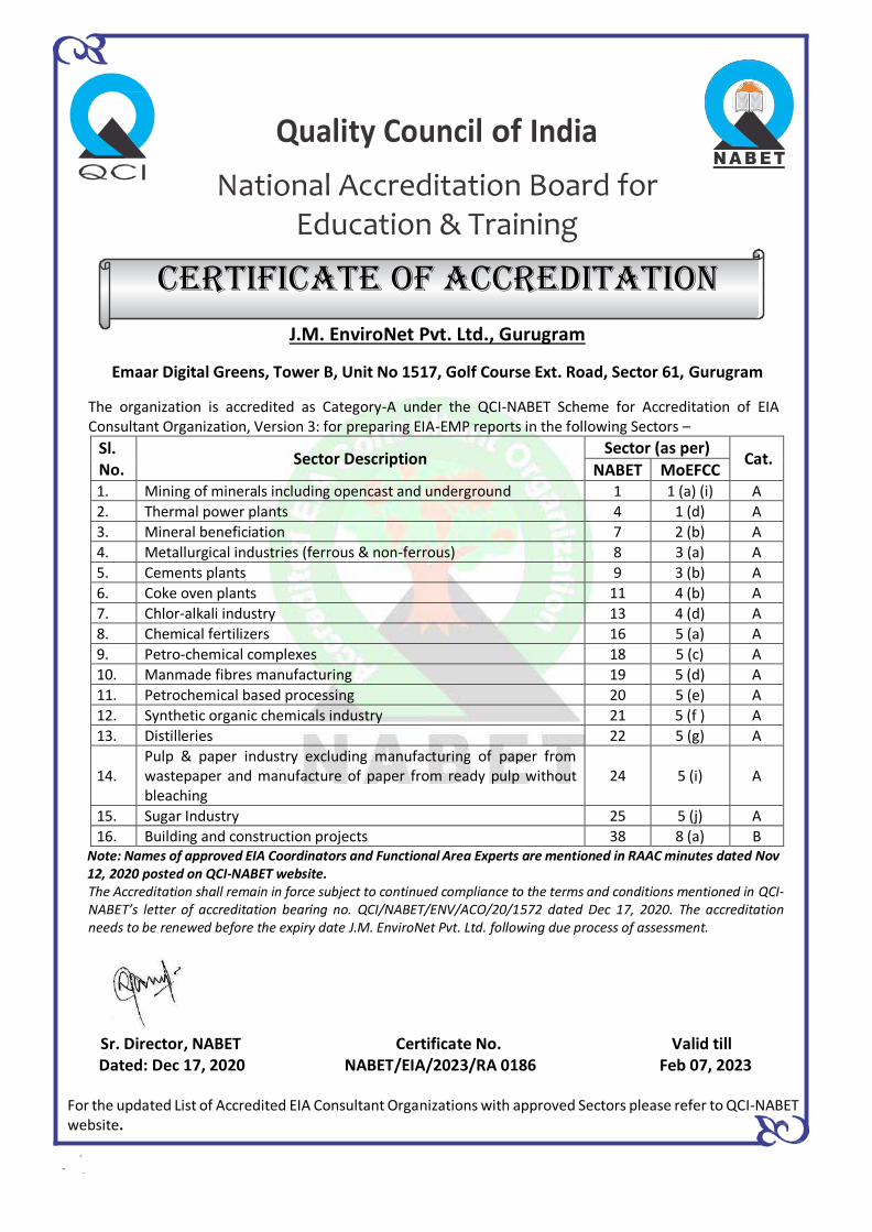
Quality Council of India
National Accreditation Board for Education & Training
Certificate OF Accreditation
J.M. EnviroNet Pvt. Ltd., Gurugram
Emaar Digital Greens, Tower B, Unit No 1517, Golf Course Ext. Road, Sector 61, Gurugram
The organization is accredited as Category-A under the QCI-NABET Scheme for Accreditation of EIA Consultant Organization, Version 3: for preparing EIA-EMP reports in the following Sectors –
Sl. No.
Sector Description Sector (as per)
Cat. NABET MoEFCC
1. Mining of minerals including opencast and underground 1 1 (a) (i) A
2. Thermal power plants 4 1 (d) A
3. Mineral beneficiation 7 2 (b) A
4. Metallurgical industries (ferrous & non-ferrous) 8 3 (a) A
5. Cements plants 9 3 (b) A
6. Coke oven plants 11 4 (b) A
7. Chlor-alkali industry 13 4 (d) A
8. Chemical fertilizers 16 5 (a) A
9. Petro-chemical complexes 18 5 (c) A
10. Manmade fibres manufacturing 19 5 (d) A
11. Petrochemical based processing 20 5 (e) A
12. Synthetic organic chemicals industry 21 5 (f ) A
13. Distilleries 22 5 (g) A
14. Pulp & paper industry excluding manufacturing of paper from wastepaper and manufacture of paper from ready pulp without bleaching
24 5 (i) A
15. Sugar Industry 25 5 (j) A
16. Building and construction projects 38 8 (a) B Note: Names of approved EIA Coordinators and Functional Area Experts are mentioned in RAAC minutes dated Nov 12, 2020 posted on QCI-NABET website. The Accreditation shall remain in force subject to continued compliance to the terms and conditions mentioned in QCI-NABET’s letter of accreditation bearing no. QCI/NABET/ENV/ACO/20/1572 dated Dec 17, 2020. The accreditation needs to be renewed before the expiry date J.M. EnviroNet Pvt. Ltd. following due process of assessment.
Sr. Director, NABET Certificate No. Valid till Dated: Dec 17, 2020 NABET/EIA/2023/RA 0186 Feb 07, 2023 For the updated List of Accredited EIA Consultant Organizations with approved Sectors please refer to QCI-NABET website.
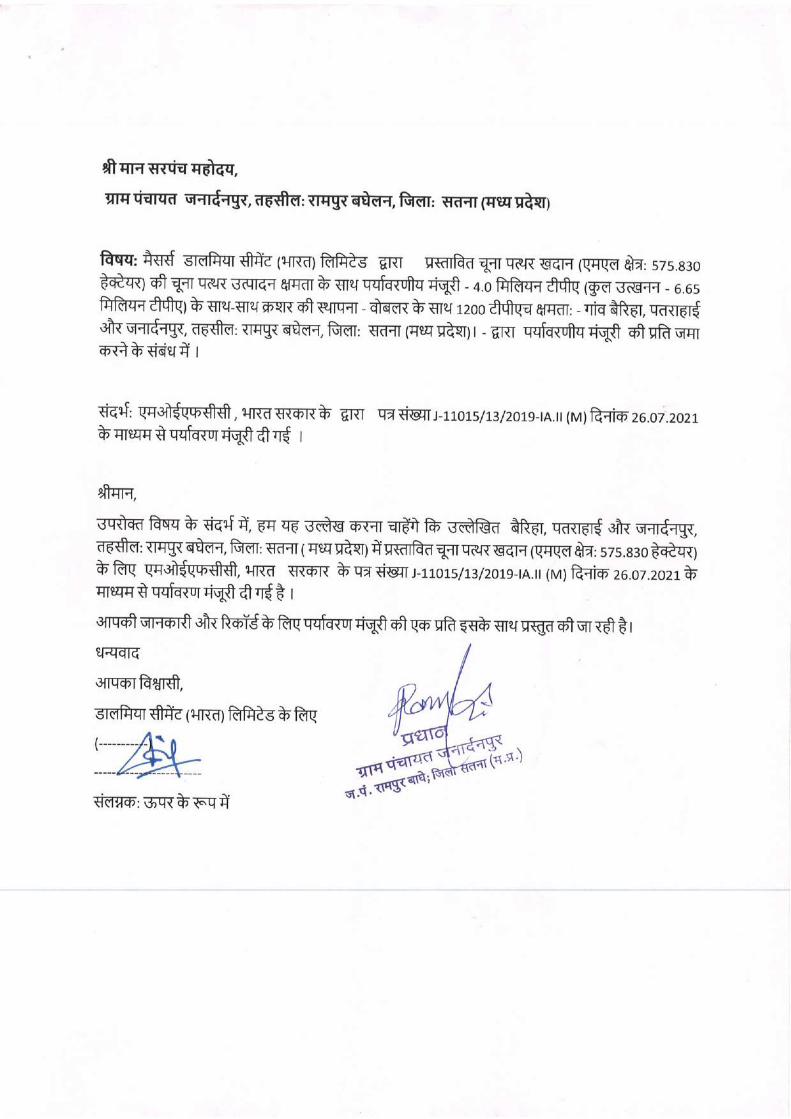
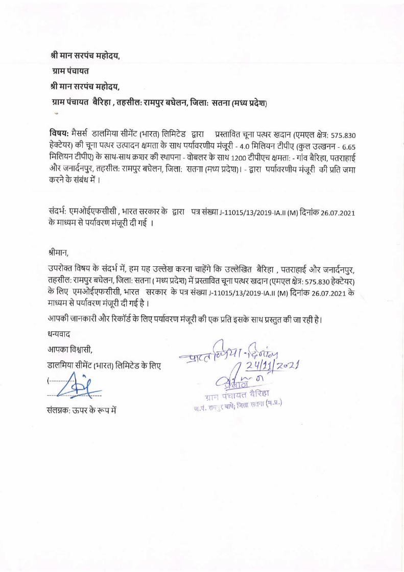
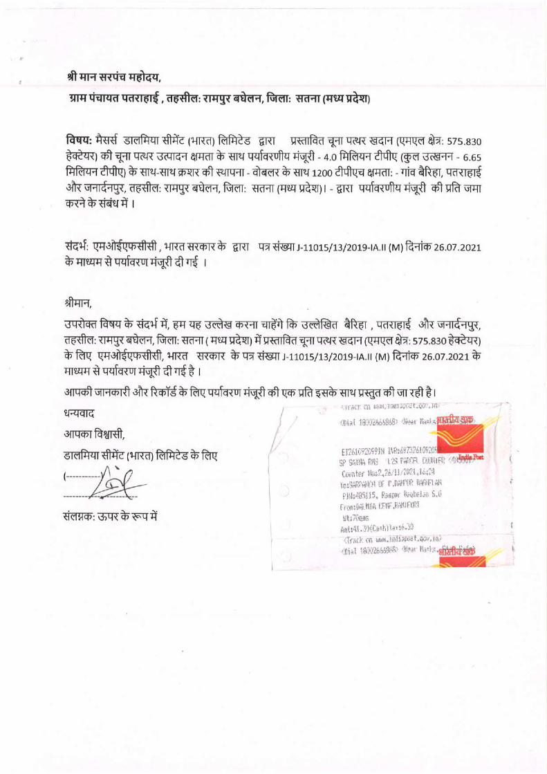
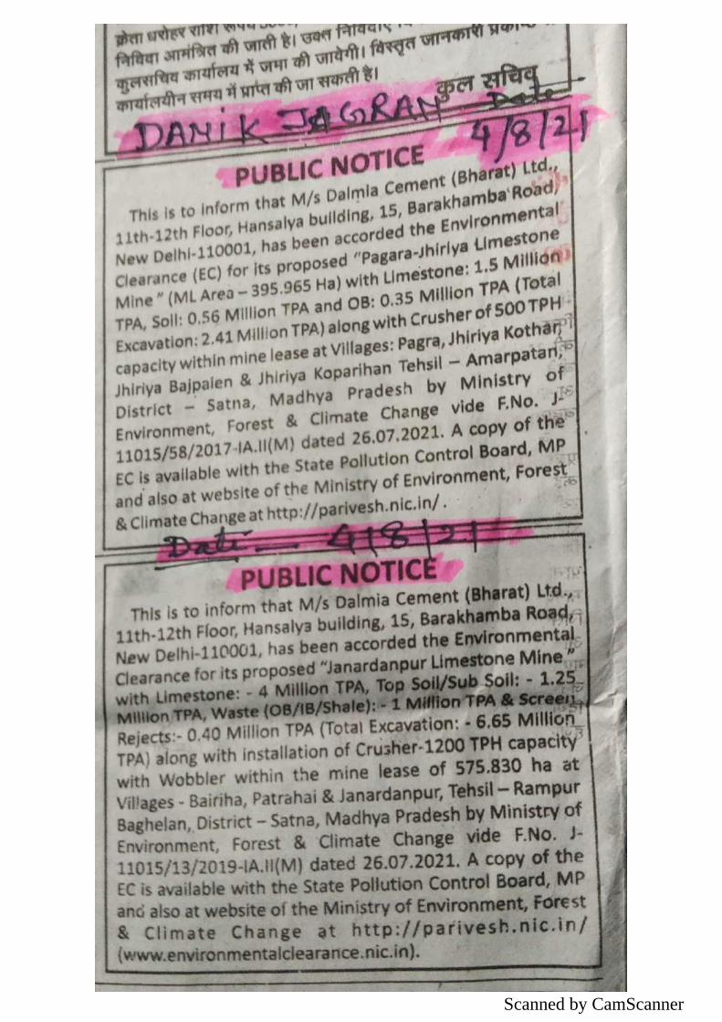
Scanned by CamScanner
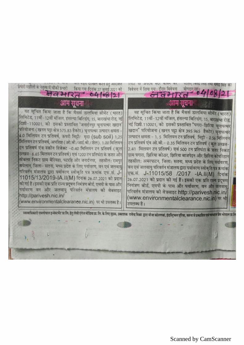
Scanned by CamScanner

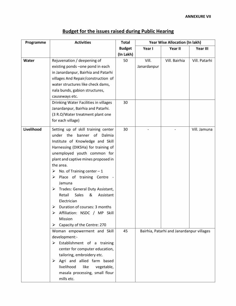
ANNEXURE VII
Budget for the issues raised during Public Hearing
Programme Activities Total
Budget
(In Lakh)
Year Wise Allocation (In lakh)
Year I Year II Year III
Water Rejuvenation / deepening of
existing ponds –one pond in each
in Janardanpur, Bairhia and Patarhi
villages And Repair/construction of
water structures like check dams,
nala bunds, gabion structures,
causeways etc.
50 Vill.
Janardanpur
Vill. Bairhia Vill. Patarhi
Drinking Water Facilities in villages
Janardanpur, Bairhia and Patarhi.
(3 R.O/Water treatment plant one
for each village)
30
Livelihood Setting up of skill training center
under the banner of Dalmia
Institute of Knowledge and Skill
Harnessing (DIKSHa) for training of
unemployed youth common for
plant and captive mines proposed in
the area.
No. of Training center – 1
Place of training Centre -
Jamuna
Trades: General Duty Assistant,
Retail Sales & Assistant
Electrician
Duration of courses: 3 months
Affiliation: NSDC / MP Skill
Mission
Capacity of the Centre: 270
30 - - Vill. Jamuna
Woman empowerment and Skill
development:-
Establishment of a training
center for computer education,
tailoring, embroidery etc.
Agri and allied farm based
livelihood like vegetable,
masala processing, small flour
mills etc.
45 Bairhia, Patarhi and Janardanpur villages
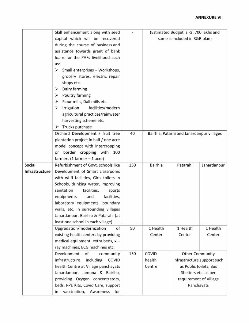
ANNEXURE VII
Skill enhancement along with seed
capital which will be recovered
during the course of business and
assistance towards grant of bank
loans for the PAFs livelihood such
as:
Small enterprises – Workshops,
grocery stores, electric repair
shops etc.
Dairy farming
Poultry farming
Flour mills, Dall mills etc.
Irrigation facilities/modern
agricultural practices/rainwater
harvesting scheme etc.
Trucks purchase
- (Estimated Budget is Rs. 700 lakhs and
same is included in R&R plan)
Orchard Development / fruit tree
plantation project in half / one acre
model concept with intercropping
or border cropping with 100
farmers (1 farmer – 1 acre)
40 Bairhia, Patarhi and Janardanpur villages
Social
Infrastructure
Refurbishment of Govt. schools like
Development of Smart classrooms
with wi-fi facilities, Girls toilets in
Schools, drinking water, improving
sanitation facilities, sports
equipments and facilities,
laboratory equipments, boundary
walls, etc. in surrounding villages
Janardanpur, Bairhia & Patarahi (at
least one school in each village).
150 Bairhia Patarahi Janardanpur
Upgradation/modernization of
existing health centers by providing
medical equipment, extra beds, x –
ray machines, ECG machines etc.
50 1 Health
Center
1 Health
Center
1 Health
Center
Development of community
infrastructure including COVID
health Centre at Village panchayats
Janardanpur, Jamuna & Bairiha,
providing Oxygen concentrators,
beds, PPE Kits, Covid Care, support
in vaccination, Awareness for
150 COVID
health
Centre
Other Community
Infrastructure support such
as Public toilets, Bus
Shelters etc. as per
requirement of Village
Panchayats
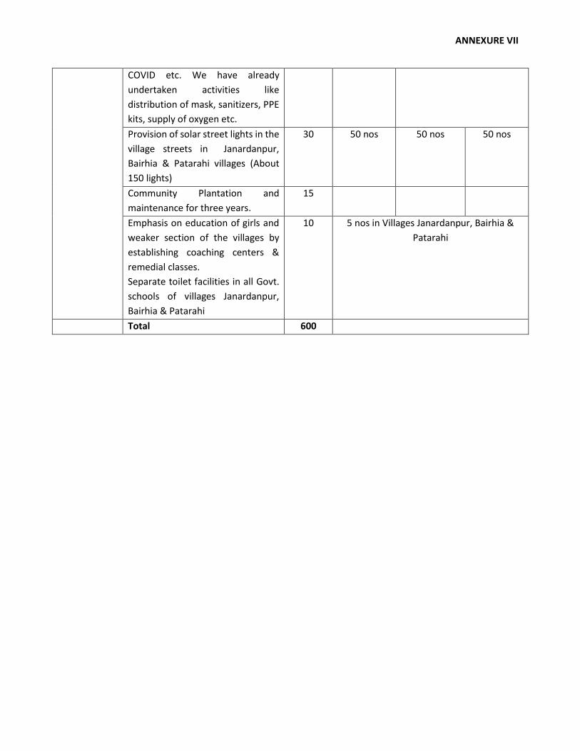
ANNEXURE VII
COVID etc. We have already
undertaken activities like
distribution of mask, sanitizers, PPE
kits, supply of oxygen etc.
Provision of solar street lights in the
village streets in Janardanpur,
Bairhia & Patarahi villages (About
150 lights)
30 50 nos 50 nos 50 nos
Community Plantation and
maintenance for three years.
15
Emphasis on education of girls and
weaker section of the villages by
establishing coaching centers &
remedial classes.
Separate toilet facilities in all Govt.
schools of villages Janardanpur,
Bairhia & Patarahi
10 5 nos in Villages Janardanpur, Bairhia &
Patarahi
Total 600