Embed Size (px)
Citation preview
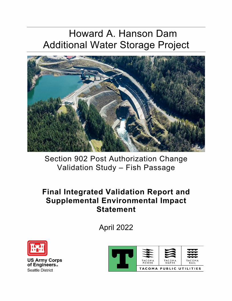
Howard A. Hanson Dam Additional Water Storage Project
Section 902 Post Authorization Change
Validation Study – Fish Passage
Final Integrated Validation Report and Supplemental Environmental Impact
Statement
April 2022

This page intentionally left blank.
Howard A. Hanson Dam Additional Water Storage Project Section 902 Post Authorization Change Validation Study – Fish Passage Final Integrated Validation Report and Supplemental Environmental Impact Statement King County, Washington Responsible Agencies U.S. Army Corps of Engineers, Seattle District Tacoma Public Utilities (Non-federal Sponsor) Contact Ms. Jessie Winkler, Project Manager, or Ms. Nancy Gleason, Environmental Coordinator, [email protected] USACE Seattle District, 4735 East Marginal Way S., Seattle, WA, 98134 Abstract The Howard A. Hanson Dam Additional Water Storage Project (AWSP) was authorized in the Water Resources Development Act of 1999. The Corps had prepared an Environmental Impact Statement (EIS) in 1998 and signed a Record of Decision on July 25, 2001, in compliance with the National Environmental Policy Act. The majority of the features of that authorized project have now been implemented. The U.S. Army Corps of Engineers, Seattle District (Corps) is proposing design changes to the primary feature (i.e., downstream fish passage structure) of the AWSP. This integrated Validation Report/Supplemental Environmental Impact Statement focuses on the cost increases, as compared with the fish passage facility evaluated in the 1998 EIS, associated with that feature. The Corps has evaluated and provided supplemental analysis, as applicable, on the component that has not yet been constructed, and any impacts generated by the modification of the design of the downstream fish passage element of the preferred alternative to the quality of the human environment not identified and evaluated in the 1998 EIS. The Recommended Plan includes a fixed multiport collection structure that would allow fish collection and passage from one or two of a set of five intake ports at multiple water levels as the reservoir elevation changes. Once fish are collected into the multiport structure, downstream fish passage through the dam occurs via the steep slope bypass. Downstream fish passage would improve abundance and productivity of Endangered Species Act-listed Chinook salmon and steelhead in the Green/Duwamish basin and contribute to the survival and recovery of listed Southern Resident killer whales. The 1998 EIS and other project documents are available online at https://www.nws.usace.army.mil/Missions/Environmental/Environmental-Documents/ Sort by date and navigate to 11/19/2021, or sort by basin and navigate to Green-Duwamish River. Estimated Cost to Prepare the Draft and Final SEIS The estimated cost for preparation of the Draft and Final SEIS is $160,000. Public Comment Review Period November 19, 2021 through January 4, 2022
Howard A. Hanson Dam Additional Water Storage Project – April 2022 i
Howard A. Hanson Dam Section 902 Validation Report
TABLE OF CONTENTS *Sections marked with an asterisk are required by the National Environmental Policy Act.
1 Introduction ....................................................................................................................... 1 1.1 Validation Study Purpose and Scope*................................................................... 1 1.2 Authorization ......................................................................................................... 2 1.3 Location and Description of the Study Area* ......................................................... 3 1.4 Description of Authorized Project .......................................................................... 5 1.5 History of Authorized Project ................................................................................. 6 1.6 Purpose and Need for Action* ............................................................................... 8 1.7 Federal Interest ..................................................................................................... 9 1.8 Lead Federal Agency and Non-federal Sponsor ................................................. 10 1.9 Funding Since Authorization ............................................................................... 10 1.10 Changes in Scope of Authorized Project ............................................................. 11 1.11 Changes in Project Purpose ................................................................................ 11 1.12 Changes in Location of Project ........................................................................... 11 1.13 Design Changes .................................................................................................. 11
2 Design Modifications ....................................................................................................... 12 2.1 Design Components and Screening .................................................................... 13 2.2 Fish Passage Design Options ............................................................................. 15 2.3 Evaluation of the Initial Array of Design Options ................................................. 19 2.4 Design Options Eliminated from Further Consideration ...................................... 24 2.5 Final Array of Design Options.............................................................................. 25 2.6 Evaluation and Comparison of Final Array of Design Options ............................ 26 2.7 Tentatively Selected Plan (TSP) .......................................................................... 30
3 Affected Environment and Environmental Consequences of Alternatives ...................... 37 3.1 Alternatives Analyzed for Environmental Effects ................................................. 37 3.2 Submitted Alternatives, Information, and Analyses* ............................................ 38 3.3 Resources Analyzed and Resources Excluded from Detailed Analysis .............. 38 3.4 Climate and Weather ........................................................................................... 41 3.5 Water Management ............................................................................................. 48 3.6 Water Quality ....................................................................................................... 50 3.7 Geology ............................................................................................................... 54 3.8 Wildlife ................................................................................................................. 58 3.9 Fish ...................................................................................................................... 60 3.10 Threatened and Endangered Species ................................................................. 66 3.11 Tribal Treaty Resources ...................................................................................... 69 3.12 Cultural, Historic, and Archaeological Resources ............................................... 71
4 Recommended Plan ........................................................................................................ 74 4.1 Description of the Recommended Plan ............................................................... 74 4.2 Changes in Total Project First Costs ................................................................... 78 4.3 Changes in Project Benefits ................................................................................ 79 4.4 Benefit-Cost Ratio ............................................................................................... 79
Howard A. Hanson Dam Additional Water Storage Project – April 2022 ii
4.5 Operations, Maintenance, Repair, Rehabilitation, and Replacement .................. 79 4.6 Changes in Cost Allocation ................................................................................. 80 4.7 Changes in Cost Apportionment.......................................................................... 82 4.8 Changes in Local Cooperation Requirements ..................................................... 83 4.9 Environmental Considerations in Recommended Changes ................................ 84 4.10 Risk and Uncertainty ........................................................................................... 84 4.11 Real Estate Considerations ................................................................................. 84 4.12 Pre-Construction, Engineering, and Design (PED) Activities .............................. 85 4.13 Phase II Implementation Strategy ....................................................................... 86
5 Environmental Compliance ............................................................................................. 87 5.1 National Environmental Policy Act of 1969 ......................................................... 87 5.2 Endangered Species Act of 1973 ........................................................................ 87 5.3 Clean Water Act of 1972 ..................................................................................... 88 5.4 Coastal Zone Management Act of 1972 .............................................................. 89 5.5 Clean Air Act of 1972 .......................................................................................... 89 5.6 National Historic Preservation Act of 1966, as amended through 2016 .............. 90 5.7 Federal Trust Responsibility ................................................................................ 90 5.8 Fish and Wildlife Coordination Act of 1934.......................................................... 91 5.9 Magnuson-Stevens Fishery Conservation and Management Act of 1976 .......... 91 5.10 Bald and Golden Eagle Protection Act ................................................................ 92 5.11 Migratory Bird Treaty Act of 1918 and Executive Order 13186 Migratory
Bird Habitat Protection ........................................................................................ 92 5.12 Executive Order 13175 Consultation and Coordination with Indian Tribal
Governments ....................................................................................................... 92 5.13 Executive Order 12898 Environmental Justice and Executive Order
14008 Climate Crisis ........................................................................................... 93 5.14 Executive Order 11990 Protection of Wetlands ................................................... 94 5.15 Executive Order 11988 Floodplain Management ................................................ 94 5.16 Executive Order 13045 Protection of Children from Environmental Health
Risks and Safety Risks ........................................................................................ 95 5.17 Executive Order 13990 Protecting Public Health and the Environment and
Restoring Science to Tackle the Climate Crisis................................................... 95
6 Public Involvement, Review, and Consultation ............................................................... 96 6.1 Public Involvement Process ................................................................................ 96 6.2 Tribal Government Consultation and Coordination Process ............................... 97 6.3 Agencies and Persons Consulted* ...................................................................... 97 6.4 List of Preparers* ................................................................................................. 98 6.5 Areas of Unresolved Controversy* ...................................................................... 98
7 Recommendations .......................................................................................................... 99
8 References .................................................................................................................... 100 LIST OF FIGURES Figure 1-1. Location and Vicinity Map of the Green River Drainage Basin. Howard A. Hanson Dam is in the upper sub-watershed (the area identified as Tacoma Municipal Watershed). The upper sub-watershed is the study area for this VR/SEIS. ............................................................. 4 Figure 1-2. Overview of HAHD with major features identified. ...................................................... 5
Howard A. Hanson Dam Additional Water Storage Project – April 2022 iii
Figure 1-3. Fish passage facility excavation. ................................................................................ 7 Figure 2-1. Conceptual drawing of a multiport collection and steep slope bypass structure. NOTE: Revised drawings of the Recommended Plan are presented in Chapter 4 and Appendix B. ................................................................................................................................................. 34 Figure 3-1. Time-series of mean annual temperature (red, left) and annual precipitation (blue, right). Black lines: means of 1950-1999. Dashed line: significant trend in temperature. Precipitation shows no significant trend. (Source: Mauger 2015). .............................................. 42 Figure 3-2. Observed Percent Change in Heavy Precipitation by Region (Source: NCA4 2018) .................................................................................................................................................... 43 Figure 3-3. Mean annual air temperature and precipitation for the Puget Sound region relative to the 1950-1999 average. Dark lines show the mean of an ensemble of model simulations. Light lines show simulations of individual ensemble members. (Source: Mauger 2015; Data: Abatzoglou and Brown 2012) ...................................................................................................... 45 Figure 3-4. Projected Change in the Amount of Precipitation Falling during the Heaviest 1% of Events under Lower and Higher Emissions Scenarios (Source: NCA4 2018) ............................ 46 Figure 3-5. Projections of unregulated mean monthly flow for the Green River, WA. Historical model simulations are in black against the range of future projections (colored shading). Thick colored lines show the average among 10 climate models; different colors distinguish between high and low greenhouse gas scenarios. Top plot: results for mid-century (2050s); bottom plot: end of the century (2080s). (Source: Mauger 2015). .................................................................. 47 Figure 3-6. HAHD reservoir storage volumes and allocations. ................................................... 49 Figure 3-7. Mapped site bedrock geology (USACE 1963). ......................................................... 55 Figure 3-8. Engineering properties of bedrock at HAHD (USACE 1963). ................................... 56 Figure 3-9. Mass wasting near HAHD (Reynolds and Paulson 1999) ........................................ 57 Figure 4-1. 3-D Model of Fish Passage Facility .......................................................................... 74 Figure 4-2. Overview of Fish Passage Facility ............................................................................ 75 Figure 4-3. Multiport Collector with Full Flow Conduits 1, 3, and 5 Shown ................................. 76 Figure 4-4. Multiport Collector with Primary Bypass ................................................................... 77 Figure 4-5. Tunnel Cross Section View ...................................................................................... 77 Figure 4-6. Outfall stilling basin structure. ................................................................................... 78 LIST OF TABLES Table 1-1. Federal Funding History for the AWSP. ..................................................................... 10 Table 2-1. Screening of Components ......................................................................................... 14 Table 2-2. Decision Matrix .......................................................................................................... 22 Table 3-1. Resources considered for detailed analysis and updates to changes in effects........ 39 Table 3-2. Results of a trend analysis on inflow to HAHD reservoir: annual max. and min. mean daily flow and monthly mean flow for 1962-2020. Blue = increasing trend; red = decreasing trend. Statistically significant trends (p-value < 0.05) are in bold boxes. .................................... 44 Table 3-3. Water quality standards for Core Summer Salmonid Habitat water bodies (WAC 173-201A-200). .................................................................................................................................. 51 Table 3-4. Federally listed threatened, endangered, and delisted species that are known to, or have the potential to, occur in the project area. .......................................................................... 67 Table 4-1. Cost Estimations and Authorizations ......................................................................... 78 Table 4-2. BiOp Requirements Cost Allocation .......................................................................... 80 Table 4-3. Ecosystem Restoration Cost Allocation ..................................................................... 81 Table 4-4. M&I Water Supply Cost Allocation ............................................................................. 81 Table 4-5. Cost Allocation Summary .......................................................................................... 82 Table 4-6. Cost Apportionment Methodology ............................................................................. 82 Table 4-7. Cost Apportionment ................................................................................................... 83
Howard A. Hanson Dam Additional Water Storage Project – April 2022 iv
Table 4-8. PED Activities ............................................................................................................ 85 Table 6-1. List of preparers with qualifications and content responsibility. ................................. 98 APPENDICES Appendix A: Environmental Compliance Appendix B: Engineering Appendix C: Cost Engineering Appendix D: Economic Update and 902 Calculation Appendix E: Monitoring and Adaptive Management Plan Framework Appendix F: Real Estate* Appendix G: Public Involvement * Not available for public distribution
Howard A. Hanson Dam Additional Water Storage Project – April 2022 v
ACRONYMS ac-ft Acre-feet APE Area of Potential Effect AWSP Additional Water Storage Project BA Biological assessment BiOp Biological Opinion BMP Best management practice CAA Clean Air Act CE/ICA Cost effectiveness and
incremental cost analysis CEQ Council on Environmental Quality CFR Code of Federal Regulations cfs Cubic feet per second CGR Cougar Dam Corps U.S. Army Corps of Engineers CZMA Coastal Zone Management Act DO Dissolved oxygen Ecology Washington State Department of
Ecology EFH Essential Fish Habitat EIS Environmental Impact Statement ER Engineer Regulation ESA Endangered Species Act FCE Fish collection efficiency FPF Fish passage facility ft/s Feet per second FWCA Fish and Wildlife Coordination Act GCM Global Climate Models GHG Greenhouse gas emissions GMU Game Management Unit GPD Green Peter Dam GRFMCC Green River Flow Management
Coordination Committee HAHD Howard A. Hanson Dam
LWD Large woody debris M&I Municipal and industrial MIS Modular Inclined Screen MIT Muckleshoot Indian Tribe NAAQS National Ambient Air Quality
Standards NEPA National Environmental Policy Act NHPA National Historic Preservation Act NMFS National Marine Fisheries Service NPDES National Pollutant Discharge
Elimination System NRHP National Register of Historic Places NTU Nephelometric turbidity units O&M Operations and maintenance OMRR&R Operations, maintenance, repair,
replacement, and rehabilitation PA Programmatic Agreement PED Pre-construction, engineering, and
design ROD Record of Decision RPA Reasonable and prudent alternative RPM Reasonable and prudent measure SEIS Supplemental Environmental
Impact Statement SRKW Southern Resident killer whale SWE Snow water equivalent TPU Tacoma Public Utilities TSP Tentatively Selected Plan USACE U.S. Army Corps of Engineers USFS U.S. Forest Service USFWS U.S. Fish and Wildlife Service VR Validation Report WDFW Washington Department of Fish
and Wildlife WRDA Water Resources Development Act
Howard A. Hanson Dam Additional Water Storage Project – April 2022 Executive Summary ES-1
EXECUTIVE SUMMARY The Howard A. Hanson Dam (HAHD) is in southeast King County on the Green River near Ravensdale, Washington and was completed in 1962. The project was authorized to provide flood control, fish conservation, irrigation, and municipal and industrial water supply. The U.S. Army Corps of Engineers, Seattle District (Corps [or USACE]) is proposing design changes to the primary feature (i.e., downstream fish passage structure) of the HAHD Additional Water Storage Project (AWSP) originally authorized in Section 101(b)(15) of the Water Resources Development Act (WRDA) of 1999. The Corps prepared an Environmental Impact Statement (EIS) in 1998 and signed a Record of Decision (ROD) on July 25, 2001 for the AWSP in compliance with the National Environmental Policy Act. This integrated Validation Report/Supplemental Environmental Impact Statement (VR/SEIS) focuses on the evaluation of the consequences necessitated by re-design in light of the cost increases associated with the unfinished downstream fish passage structure. The authorized project includes a dual-purpose water supply and ecosystem restoration project implemented in two phases. Phase I has been implemented and raised the conservation pool elevation from 1,147 feet to 1,167 feet. However, the fish passage facility (FPF) included in the Phase I authorization has not been constructed. Phase II of the authorized project, which includes low flow augmentation and water supply components only, has not been implemented. Completion and implementation of Phase II will be contingent on findings from future dam safety evaluations to validate that the Phase II project would not pose unacceptable risks to the downstream public. Future Phase II study and monitoring costs are included in the total project cost estimate presented in this report. If Phase II studies identify potential follow-on construction actions necessary to ensure dam safety, they would need to be addressed at a later date through a follow-on post authorization change effort. Section 902 of the WRDA 1986, as amended, generally allows for increases in authorized total project costs of up to 20% (after accounting for inflation of construction costs) without additional congressional authorization. Estimated total project costs of the HAHD AWSP now exceed the authorized Section 902 limit as defined by the WRDA of 1986. As such, congressional action to increase the total cost limit for the project is required to complete the project as authorized. The project has maintained its original purpose, function and scope, but design refinements have resulted in increased project costs. This report presents a revised cost estimate and updated analysis of the authorized project. The overall purpose for the proposed action is to reassess one component of the AWSP, namely the restoration of downstream fish passage past HAHD as authorized in WRDA 1999 as an ecosystem restoration component. The need for restored fish passage arises from the problem that disconnection and flow regime change have severely reduced the capacity of the watershed to produce salmon and steelhead. One of the specific factors is the disconnection of the portion of the watershed upstream from HAHD. Although an upstream adult fish passage facility has been constructed at the Tacoma Public Utilities’ diversion dam, HAHD remains as a barrier to 45% of the entire basin and 90% of the habitat for coho salmon and steelhead of the Green River. The one remaining unconstructed component of the AWSP Phase I is the FPF, the design of which originally included a movable single port collector with fish lock to shallow slope bypass. The authorized project cannot be completed at a cost below the current Section 902 limit. Updating the design of this unique and complex structure necessitates development of an updated cost estimate; therefore, the purpose of the action is to achieve the fish collection efficiency (FCE) and survival criteria described in the Reasonable and Prudent Alternative (RPA) of the jeopardy 2019 Biological Opinion (BiOp) from the National Marine Fisheries Service using the least-cost method for collection and passage of salmon species. Downstream fish passage would improve abundance and productivity of Endangered Species Act-listed
Howard A. Hanson Dam Additional Water Storage Project – April 2022 Executive Summary ES-2
Chinook salmon and steelhead in the Green/Duwamish basin and contribute to the survival and recovery of listed Southern Resident killer whales. This study has considered potential modifications to the downstream fish passage component of the authorized plan. However, re-formulation of elements of the authorized project related to water supply or ecosystem restoration are not instituted or addressed in this study, as the Phase I water supply components have already been implemented and are outside the study’s scope. As a result of the design refinement process, a Recommended Plan was identified as the least-cost design option that has the highest likelihood of meeting the FCE and survival criteria prescribed in the 2019 BiOp. The FCE criteria is the proportion of fish that are collected by the fish passage facility divided by the total number of fish in the FCE measurement zone (i.e., the forebay) over the performance evaluation period. Compliance with the facility performance criteria requires 98% survival of fish collected and passed through the facility to release downstream of HAHD. The RPA’s criteria require mortality or injury of no more than 2% of the total number of fish collected. A third criteria of overall survival of 75% from head of the reservoir to release point would have no independent influence over which design option was selected and was therefore not used as a deciding factor. Compliance with the BiOp’s RPA 1 requires meeting all three performance criteria for two consecutive years within the first 10 years after construction. The Recommended Plan includes a fixed multiport collection structure that would allow fish collection and passage from one or two of a set of five intake ports at multiple water levels as the reservoir elevation changes. Once fish are collected into the multiport structure, downstream fish passage through the dam occurs via the steep bypass. The passage route connecting the multiport collector to the release site would cut through the left abutment and connect back to the Green River just downstream of the existing stilling basin at HAHD. The bypass pipe(s) include a shallow bend at the base before going horizontal to dissipate energy and slow down water velocities before fish exit the pipe into the river. Finally, the FPF must be able to handle debris that enters the reservoir from upstream sources. Debris typically consists of organic, woody material. A submerged Modular Inclined Screen would allow for an increase to total attraction flow rate. The Corps is confident that the selected fish passage facility will function to meet the BiOp requirements due to 1) considerable research and development on the most important project feature (multiport collector), 2) an emphasis on flexibility and redundancy throughout the design, and 3) extensive research and modeling of hydraulic criteria. The Final VR/SEIS presents the updated cost estimate for the downstream FPF described above as well as updated cost share and cost allocation details of the proposed action. This VR/SEIS has evaluated and provided supplemental analysis, as applicable, on the AWSP Phase I component that has not yet been constructed, and any impacts generated by the modification of the downstream fish passage element of the preferred alternative to the quality of the human environment not identified and evaluated in the 1998 EIS. Design refinements occurring since signing the ROD have been evaluated in this VR/SEIS. The Corps has re-evaluated all resources from the 1998 EIS to assess any that have changed and has documented those that have not changed. Additionally, the Corps has followed current practices to evaluate other resources that were not addressed in the 1998 EIS (e.g., climate change). The 1998 EIS analyzed effects to the upper and lower watershed, but the facility redesign would not change any effects to the lower watershed of restoring fish passage; therefore, the geographical scope of this supplemental analysis is limited to the upper watershed. Environmental considerations for the updated design are limited to effects of the effort to meet the BiOp requirements for FCE and fish survival through the structure as well as overall survival through the reservoir. Chapter 2 describes the formulation and evaluation of design options and

Howard A. Hanson Dam Additional Water Storage Project – April 2022 Executive Summary ES-3
the process that led to the least-cost fish passage design that has the highest likelihood of meeting BiOp requirements. Other environmental considerations are described in Chapter 3 as a supplemental analysis of effects to resources based on the changed design. Finally, Chapter 5 describes how the FPF will comply with all applicable environmental laws, statutes, and regulations. All compensatory mitigation requirements for the AWSP Phase I have been met. Phase II mitigation requirements are consistent with those authorized in the original Chief's Report for the AWSP and include mitigation actions associated with stream habitat, elk forage habitat, upland forest habitat, and wetland riparian zone creation. As part of the public outreach efforts and for compliance with the National Environmental Policy Act, the Corps published a "Notice of Intent (NOI) to Prepare a Supplemental EIS" in the Federal Register on September 20, 2021. On November 19, 2021, the Corps released the Draft VR/SEIS for public review. Documents were made available for public review on the Corps’ website: https://www.nws.usace.army.mil/Missions/Environmental/Environmental-Documents/. The public comment period was open for 45 days from November 19, 2021 through January 4, 2022. The Corps received two comment submittals through electronic mail; these two comment letters came from the Washington Department of Fish and Wildlife (WDFW) and the Environmental Protection Agency (EPA). These two letters are provided in their entirety following the documentation of the Corps’ responses to the public comments in Appendix G. In addition, the Corps has coordinated extensively with the Muckleshoot Indian Tribe throughout the study process including interagency workshops as described in sections 2.3-2.6 of the Final VR/SEIS. Details of the Tribal government consultation and coordination process are available in section 6.2 of the Final VR/SEIS.
Howard A. Hanson Dam Additional Water Storage Project – April 2022 Final Validation Report / Supplemental Environmental Impact Statement 1
1 Introduction The U.S. Army Corps of Engineers, Seattle District (Corps [or USACE]) is proposing design changes to the primary feature (i.e., downstream fish passage structure) of the Howard A. Hanson Dam (HAHD) Additional Water Storage Project (AWSP) originally authorized in the Water Resources Development Act (WRDA) of 1999. The AWSP has maintained its original purpose and scope, but downstream fish passage facility (FPF) design refinements, necessitated by requirements arising from consultation under Section 7 of the Endangered Species Act (ESA), have resulted in increased project costs. This integrated Validation Report/Supplemental Environmental Impact Statement (VR/SEIS) focuses on the cost increases associated with that feature. Section 902 of WRDA 1986, as amended, allows for an increase in the authorized maximum total project cost of up to 20% (after accounting for inflation of construction costs) without additional congressional authorization. Estimated total project costs now exceed the authorized Section 902 limit. Congressional action to increase the total cost limit for the project is required to complete the project as authorized. This report presents a revised cost estimate and updated analysis of the authorized project. Additionally, this report will evaluate and provide supplemental analysis, as applicable, on any impacts generated by the modification of the downstream fish passage element of the preferred alternative to the quality of the human environment not identified and evaluated in the 1998 EIS (USACE 1998) in compliance with the National Environmental Policy Act (NEPA).
1.1 Validation Study Purpose and Scope* This VR/SEIS has been prepared in accordance with Engineer Regulation (ER) 1105-2-100 and 33 Code of Federal Regulations (CFR) 230.13(b) to identify and evaluate post-authorization changes including proposed modifications to the preferred alternative for the downstream fish passage component of the previously authorized HAHD AWSP in King County, Washington. The “action” is defined as updating the design of the FPF to be constructed at HAHD. The need for this action arises from the determination that the design evaluation in the 1998 EIS and the project authorization via WRDA 1999 are not expected to meet the performance criteria in reasonable and prudent alternative (RPA) 1 of the 2019 National Marine Fisheries Service (NMFS) jeopardy Biological Opinion (BiOp), as an RPA necessary to prevent the likelihood of jeopardy to listed species or the destruction or adverse modification of designated critical habitat, as committed by the Seattle District in the required response to that BiOp. The scope of this VR/SEIS will not extend to other elements of the project related to water supply or ecosystem restoration, as those components were not materially altered from the description evaluated in the 1998 EIS and have already been implemented. It should be noted, however, that the updated cost estimate presented in this report does include dam safety study costs as well as mitigation and monitoring costs for the authorized project as described in section 4.13. The scope addresses the second RPA from the NMFS 2019 BiOp, which involves contingent seasonal flow changes to benefit sensitive fish species to be implemented until permanent downstream fish passage is restored. The purpose of the fish passage component of the larger AWSP remains the same as in the original EIS: to successfully pass migrating juvenile fish downstream. This VR/SEIS documents the required cost and economic analyses required to support development of an updated total project cost estimate for the authorized project in accordance with ER 1105-2-100. In addition, this VR/SEIS fulfills the following purposes: (1) describes the environmental resources in the project area; (2) evaluates the environmental effects of the Federal action on these resources; and (3) identifies measures to avoid, minimize, or reduce any negative effects to environmental resources. It is anticipated that the Corps can implement
Howard A. Hanson Dam Additional Water Storage Project – April 2022 Final Validation Report / Supplemental Environmental Impact Statement 2
the portion of the authorized project described in this document as the proposed action without additional NEPA analysis beyond this VR/SEIS. The Council on Environmental Quality (CEQ) Regulations for Implementing the Procedural Provisions of NEPA (40 CFR 1500–1508) and the Corps’ Procedures for Implementing NEPA (33 CFR Part 230) specify that “supplemental NEPA analyses are required if (i) USACE makes substantial changes in the proposed action that are relevant to environmental concerns, or (ii) there are significant new circumstances or information relevant to environmental concerns and bearing on the proposed action or its impacts.” Consistent with 40 CFR 1502.21, the Corps is incorporating by reference the August 1998 Final EIS, which includes the April 1998 Draft EIS as an appendix, to reflect information and analysis that remains unchanged. The scope of the analysis in this document is limited to factors relevant to the proposed FPF redesign portion of the authorized project. The Corps has re-evaluated all resources from the 1998 EIS to assess any conclusions that have changed in anticipation of the execution of this proposed action and will document those that have not changed. Additionally, the Corps has followed current practices to evaluate other resources that were not addressed in the 1998 EIS (e.g., climate change). The 1998 EIS analyzed effects to the upper and lower watershed, but the facility redesign would not change any of the analysis of effects to the lower watershed of restoring downstream fish passage; therefore, the geographical scope of the updated analysis is limited to the upper watershed (see section 1.3 below).
1.2 Authorization The authorization for HAHD, initially named the Eagle Gorge Dam, is in the River and Harbors Act of 1950 (Public Law 516, 81st Congress, 2nd Session, May 17, 1950). The Corps completed construction of HAHD in 1962. In 1997, approval was granted under Section 1135 of the 1986 WRDA, as amended, for an ecosystem restoration project to increase the volume of summer conservation storage. The city of Tacoma was the local sponsor. The project included additional water storage of up to 5,000 acre-feet (ac-ft) for use during summer and fall for downstream low-flow augmentation and a collection of ecosystem restoration actions around the reservoir and tributaries. In 1998, the HAHD AWSP study was completed under Section 216 of the Flood Control Act of 1970, as amended (33 U.S.C. § 426 et seq.). The study initially evaluated how the existing HAHD project could meet water supply needs of Puget Sound residents. In response to a change in Federal policy in 1994 making environmental restoration a higher Federal priority, the study objective was expanded to include environmental (ecosystem) restoration. The AWSP is a phased dual purpose water supply and ecosystem restoration project authorized by Section 101(b)(15) of the WRDA of 1999 (Public Law 106-53) substantially in accordance with the plans, and subject to the conditions, recommended in a final report of the Chief of Engineers dated August 13, 1999. Details of the authorized project are presented in section 1.5. King County and the State of Washington assumed cost-share responsibilities as local interests for the original construction of HAHD. As indicated previously, the original authorized and implemented project purposes were flood control and fish conservation, and the Corps determined that the fish conservation purpose was best implemented by storing water in the spring for the purpose of augmenting stream flows during the summer and fall low-flow season. Ecosystem restoration and water supply were added as project authorities with the AWSP. Subsequent to enactment of the legislative authority, certain elements of the AWSP, including the downstream FPF, were redesignated from cost-shared ecosystem restoration project elements to predominantly Federal-funded project elements to ameliorate the ostensible effects
Howard A. Hanson Dam Additional Water Storage Project – April 2022 Final Validation Report / Supplemental Environmental Impact Statement 3
-- reflected in the 2000 NMFS BiOp supporting initial project authorization – on ESA-listed species and critical habitat.
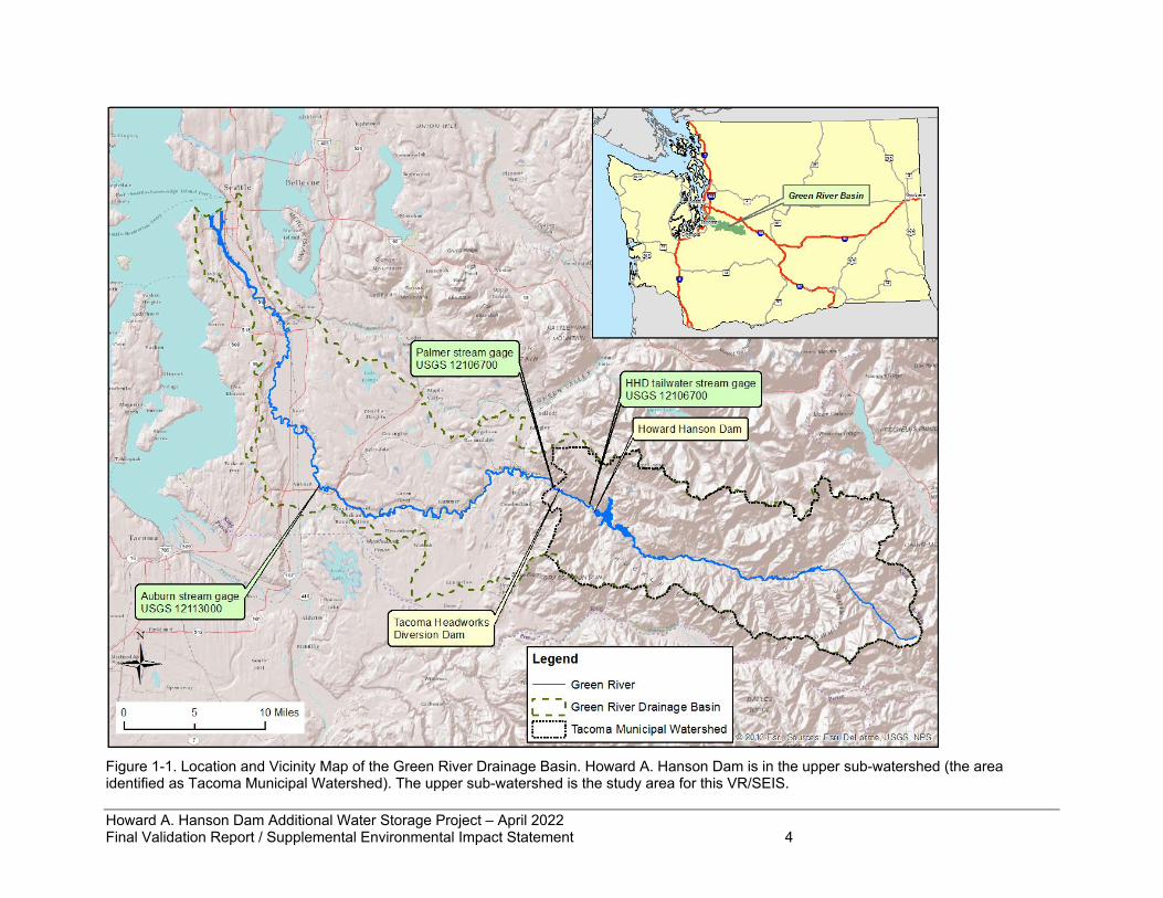
1.3 Location and Description of the Study Area* HAHD is in southeast King County on the Green River near Ravensdale, Washington. The dam is located at river mile (RM) 64.5 in Section 28, Township 21 North, Range 8 East, Willamette Meridian (Figure 1-1). The Green River’s headwaters flow westward from the Cascade crest. Upstream from the reservoir, the river falls over steep, mountainous terrain, restricted by narrow valley walls from its headwaters on Blowout Mountain near Stampede Pass. The dam lies within the Tacoma Public Utilities (TPU) municipal watershed, a primary drinking water supply for the region, and access to much of the 221 square miles of watershed above HAHD is closed to the public. Except for the dam, there is no streamside development in the upper watershed. Aside from the TPU watershed, the rest of the area is under ownership of private timber companies, the Burlington Northern and Santa Fe Railway Company, the Washington State Department of Natural Resources, and the US Forest Service (USFS). USFS land is managed as part of the Mt. Baker-Snoqualmie National Forest. From RM 64.5, the Green River flows west and north from the Cascade Mountains. Downstream of HAHD, the river runs through rural areas and state parks, then development increases as the Green River turns into the Duwamish River. At RM 11 it joins with the Black River to form the Duwamish River, which then empties into Elliott Bay in Puget Sound. The river is often referred to as the Green/Duwamish River. The 1998 EIS identified the entire Green River drainage basin as the study area (Figure 1-1). To describe effects in the 1998 EIS, the study area was divided into the upper and lower sub-watersheds, as shown in Figure 1-1. The study area for this VR/SEIS includes only the upper sub-watershed, which is located downstream to approximately RM 58 at Cumberland-Kanaskat Road SE, downstream from the Palmer stream gage. In Figure 1-1, the area identified as the “Tacoma Municipal Watershed” is considered the upper sub-watershed of Green River, i.e., the study area for this VR/SEIS. The rationale for limiting the geographic scope of analysis is that the AWSP measures have already been implemented except restoring downstream fish passage, which would only have appreciable impacts in the immediate vicinity of HAHD. The broader benefits of restoring salmon populations in the Green/Duwamish watershed have already been addressed in the 1998 EIS. The Corps is incorporating by reference the entire 1998 Feasibility Study and EIS draft and final documents.
Howard A. Hanson Dam Additional Water Storage Project – April 2022 Final Validation Report / Supplemental Environmental Impact Statement 4
Figure 1-1. Location and Vicinity Map of the Green River Drainage Basin. Howard A. Hanson Dam is in the upper sub-watershed (the area identified as Tacoma Municipal Watershed). The upper sub-watershed is the study area for this VR/SEIS.
Howard A. Hanson Dam Additional Water Storage Project – April 2022 Final Validation Report / Supplemental Environmental Impact Statement 5
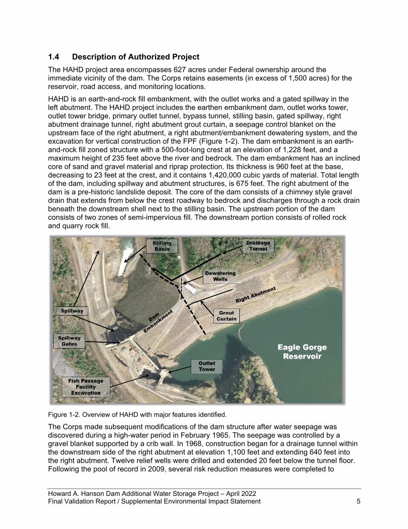
1.4 Description of Authorized Project The HAHD project area encompasses 627 acres under Federal ownership around the immediate vicinity of the dam. The Corps retains easements (in excess of 1,500 acres) for the reservoir, road access, and monitoring locations. HAHD is an earth-and-rock fill embankment, with the outlet works and a gated spillway in the left abutment. The HAHD project includes the earthen embankment dam, outlet works tower, outlet tower bridge, primary outlet tunnel, bypass tunnel, stilling basin, gated spillway, right abutment drainage tunnel, right abutment grout curtain, a seepage control blanket on the upstream face of the right abutment, a right abutment/embankment dewatering system, and the excavation for vertical construction of the FPF (Figure 1-2). The dam embankment is an earth-and-rock fill zoned structure with a 500-foot-long crest at an elevation of 1,228 feet, and a maximum height of 235 feet above the river and bedrock. The dam embankment has an inclined core of sand and gravel material and riprap protection. Its thickness is 960 feet at the base, decreasing to 23 feet at the crest, and it contains 1,420,000 cubic yards of material. Total length of the dam, including spillway and abutment structures, is 675 feet. The right abutment of the dam is a pre-historic landslide deposit. The core of the dam consists of a chimney style gravel drain that extends from below the crest roadway to bedrock and discharges through a rock drain beneath the downstream shell next to the stilling basin. The upstream portion of the dam consists of two zones of semi-impervious fill. The downstream portion consists of rolled rock and quarry rock fill.
Figure 1-2. Overview of HAHD with major features identified.
The Corps made subsequent modifications of the dam structure after water seepage was discovered during a high-water period in February 1965. The seepage was controlled by a gravel blanket supported by a crib wall. In 1968, construction began for a drainage tunnel within the downstream side of the right abutment at elevation 1,100 feet and extending 640 feet into the right abutment. Twelve relief wells were drilled and extended 20 feet below the tunnel floor. Following the pool of record in 2009, several risk reduction measures were completed to
Howard A. Hanson Dam Additional Water Storage Project – April 2022 Final Validation Report / Supplemental Environmental Impact Statement 6
mitigate for potential internal erosion through the right abutment. In 2010, a 450-foot double-row grout curtain was constructed with a top height at elevation 1,206 feet. In 2011, improvements to the right abutment drainage tunnel were completed to provide a properly filtered outlet and a 12-well dewatering system installed to intercept seepage through the right abutment.
1.5 History of Authorized Project The HAHD, initially named the Eagle Gorge Dam (until 1958), was completed in 1962. The project was authorized to provide flood control, fish conservation, irrigation, and municipal and industrial (M&I) water supply. The Corps determined at the time of project implementation that the fish conservation purpose was best executed by storing water in the spring for augmenting stream flows during the summer and fall low flow season. The irrigation and water supply portions of the authorization were deferred and not implemented at the time of construction. When HAHD was constructed, there had been no runs of anadromous fish extending above TPU’s diversion dam since the latter’s construction in 1912; therefore, no provisions for fish passage were built into HAHD. The HAHD continued that isolation of over 106 miles of high-quality river and stream habitat and further blocked the downstream flow of sediment and organic inputs to the lower river. Juvenile hatchery winter steelhead, coho, and fall salmon were planted in the Upper Green River watershed above the dam in multiple increments in the 1980s and 1990s; however, planting ceased in the early 2000s. Outmigrating juvenile fish from these watershed plantings had to traverse the slack water reservoir and locate the deep-water outlets to exit the project. Survival of these juvenile fish has been poor due to the hardships of migrating through unnatural conditions. Since 1989 the Corps has investigated the potential for the project to help meet M&I water supply needs of the Puget Sound area. In 1994, the scope of the study was expanded to include ecosystem restoration. The Corps evaluated multiple reservoir storage alternatives with options for fish passage and other ecosystem restoration features. Single-purpose water supply, dual-purpose water supply, and ecosystem restoration alternatives included full implementation as well as phased implementation. The Corps completed a Final Feasibility Study Report and EIS in 1998 and recommended a dual-purpose water supply/restoration project implemented in phases. The AWSP was authorized in WRDA 1999. The plan recommended in 1998 and authorized in 1999 consists of a dual-purpose phased plan, which would modify HAHD by changing the reservoir operation to allow for raising the level of the reservoir conservation pool for additional water storage and ecosystem restoration. The recommended plan includes two phases:
• Phase I: Storage of 20,000 ac-ft for M&I water supply • Phase II: Additional storage of 2,400 ac-ft for M&I water supply and 9,600 ac-ft for low
flow augmentation Phase I has been implemented; this raised the conservation pool elevation from 1,147 feet to 1,167 feet. However, the FPF included in the Phase I recommendation has not been constructed. Implementation of Phase II is dependent upon the evaluation of the success of Phase I and consensus of the State and Federal resources agencies, the Muckleshoot Indian Tribe (MIT), TPU, and USACE. If Phase II were proposed for implementation, the Corps would conduct an environmental analysis regarding whether additional mitigation features associated with raising the pool to elevation 1,177 feet would be required. This analysis would be coordinated with TPU and MIT as well as the other natural resources agencies. As described in section 4.12, completion and implementation of Phase II will be contingent on findings from future dam safety evaluations to validate that the Phase II project would not pose unacceptable risks to the downstream public. Future Phase II study and monitoring costs are
Howard A. Hanson Dam Additional Water Storage Project – April 2022 Final Validation Report / Supplemental Environmental Impact Statement 7
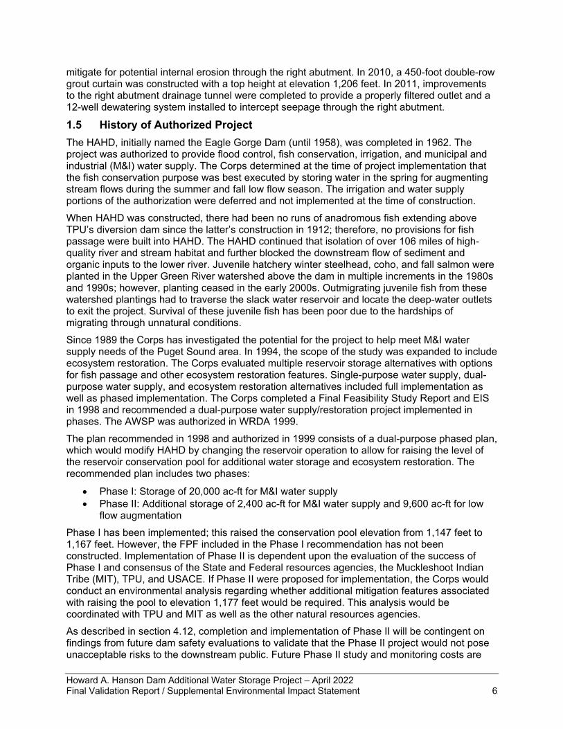
included in the total project cost estimate presented in this report. If future Phase II studies identify potential follow-on construction actions necessary to ensure dam safety, they would need to be addressed at a later date through a follow-on post authorization change effort. Additional information about implementation of the AWSP Phase I and II appears in chapter 6 of the EIS (USACE 1998). Most of the components described in the 1998 EIS for the AWSP have been constructed including the new administration building and maintenance facility, upgraded seawall at the boat launch site, and the powerline upgrade to support the infrastructure. The components include significant ecosystem restoration measures including extensive river and stream habitat projects above the dam and re-establishing downstream movement of gravel and large wood below the dam. To initiate the key feature of the ecosystem restoration, engineering design and construction of a downstream FPF was started in 2003. Construction of the FPF completed to date includes installation of a cofferdam for building in the dry and excavation of the space for the fish collection structure, which is an area approximately 60 feet wide by 180 feet long and approximately 100 feet deep (Figure 1-3). Rock anchors, shotcrete, and drains were installed to stabilize the excavation walls. A soldier pile wall with tieback anchors and permanent concrete facing was used to retain soil along the south side of the FPF excavation. Contractors were able to complete construction of the temporary cofferdam on the left bank of the river just upstream of and connected to HAHD. This cofferdam would serve to separate the construction site from the reservoir during construction of the FPF.
Figure 1-3. Fish passage facility excavation.
As the excavation for the FPF progressed, the Corps continued the design process for the vertical structure portion of the action. This work achieved a 95% level of design for a multiport collector very similar to the design presented later in this document as the Tentatively Selected
Howard A. Hanson Dam Additional Water Storage Project – April 2022 Final Validation Report / Supplemental Environmental Impact Statement 8
Plan (TSP) described in section 2.6. During this detailed design phase, the Corps also produced a new cost estimate for this facility, which revealed the likelihood of insufficient funding. Construction of the downstream FPF was suspended in 2011 due to an anticipated Section 902 cost limit exceedance; all construction was halted, and the cofferdam has remained in place. Continuing activities on site include monitoring to ensure excavation and critical dam structure stability. Automated instrumentation (extensometers, crack meters, piezometers, load cells, liquid level sensors) collect daily readings and manual surveys of inclinometers and inspections of the slopes of the excavation are performed twice yearly. Operation of TPU’s adult collection facility for upstream fish passage of adult salmon and steelhead around the TPU diversion dam and HAHD is the responsibility of TPU. The adult collection facility built for collecting and transporting adult salmon and steelhead was one of several measures that TPU committed to as part of its Habitat Conservation Plan (Measure 1-03), arising out of Tacoma’s municipal water supply operations on the Green River (TPU 2001). The upstream trap and haul facility was completed in 2005 at the diversion dam at RM 61 as the long-term solution for moving adult salmon upstream of both dams. The trap-and-haul facilitates collection of migratory fish by using a ladder at the diversion dam, placing fish in tanker trucks and transporting them upstream to be released above HAHD. Limited operation of the trap-and-haul for testing purposes was initiated soon after completion, including the transport of 1,419 pink salmon above HAHD in 2007 and 72 coho salmon released above HAHD in 2008. The purpose of the latter release was to study fish migration through the reservoir to help determine appropriate future release locations. The release point for adult fish to be transported above the dam is uncertain at this time. Several tributaries feed the reservoir including the North Fork Green River, Gale Creek, and Charley Creek. Consequently, there is a desire to maximize use of all available habitat by releasing adults at the downstream end of the reservoir as opposed to the mainstem Green River upstream of the reservoir. This may have some effect on the number of adult fish that ‘fall back’ and are collected at the downstream fish facility. Decisions on operations for the facility including when the facility will begin adult release will be made in conjunction with Washington Department of Fish and Wildlife (WDFW) and MIT and implemented by TPU. After receiving the February 2019 jeopardy BiOp from NMFS, the Corps initiated implementation of RPA 2. This action is a requirement to be implemented in the interim period between the issuance of the BiOp and the completion of downstream fish passage. The action is a change to operations between October 15 and February 28 each year such that the Corps will conduct flow management operations that reduce outflow rates at the dam to a maximum of 5,000 cubic feet per second (cfs) during most instances of moderately high inflow events. The purpose is to reduce flows downstream of the dam that scour and displace Chinook salmon redds (i.e., salmon egg nests in river gravel) to improve survival during the egg to migrant lifestage.
1.6 Purpose and Need for Action* The overall purpose for the proposed action is to update and finalize the design of an FPF so as to restore downstream fish passage past HAHD, as authorized in WRDA 1999 as a restoration component of the AWSP. The need for restored fish passage arises from the problem, reflected in the conclusions of the 2019 NMFS Biological Opinion, that the existence and operation of HAHD substantially reduces the survival rate of salmon and steelhead that need to pass downstream from the river and tributaries above the dam. One of that Biological Opinion’s specific rationale is HAHD’s effective disconnection of the upper watershed by posing a barrier for downstream fish migration; the watershed upstream from TPU’s diversion dam represents 45% of the entire basin and 90% of the habitat for coho salmon and steelhead of the Green River (Fuersternberg et al. 1996); the area also contains over 106 miles of river and tributary
Howard A. Hanson Dam Additional Water Storage Project – April 2022 Final Validation Report / Supplemental Environmental Impact Statement 9
habitat available for Chinook salmon spawning and rearing. The need for this action arises from the determination that the design evaluation in the 1998 EIS and the project authorization via WRDA 1999 are not expected to meet the performance criteria in RPA 1 of the 2019 BiOp, as an RPA necessary to prevent the likelihood of jeopardy to listed species or the destruction or adverse modification of designated critical habitat, as committed by the Seattle District in the required response to that BiOp. As stated above, the one remaining unconstructed component of the AWSP Phase I is the FPF. As currently designed, the authorized project cannot be completed at a cost below the current Section 902 limit. Updating the design of this unique and complex structure necessitates development of an updated cost estimate; therefore, the purpose of the action described in this document is to achieve the fish collection efficiency (FCE) and survival criteria described in the 2019 BiOp from the NMFS using the least cost method for collection and transport of salmon species. A more complete description of the BiOp criteria is presented in section 2.3. Downstream fish passage would improve abundance and productivity of ESA-listed salmon and steelhead in the Green/Duwamish basin and contribute to the survival and recovery of Southern Resident killer whales (SRKW).
1.7 Federal Interest The Green-Duwamish River is one of the 14 major river tributaries to Puget Sound, draining the slopes of the Cascade Mountain Range and running approximately 90 miles to its mouth in Elliott Bay. The river hosts regionally and nationally significant populations of salmon and steelhead. Since 1913, when TPU’s Headworks Dam was completed, anadromous fish access to the upper watershed has been blocked. Due to that blockage, HAHD was also constructed without fish passage facilities. TPU is ready to use their adult collection facility to transport fish to the upper watershed, but the effort is on hold until the juvenile offspring can successfully migrate downstream past HAHD. Restoration of safe downstream passage will restart the two-way connection around both dams. Restoration of anadromous fish migration and their nutrient delivery in the Green-Duwamish Basin is a critical component of restoring Puget Sound, an estuary of national significance as identified by the Environmental Protection Agency (EPA). The Corps is recommending the installation of the downstream fish passage facility to meet the USACE commitment to comply with RPA 1 of the NMFS 2019 BiOp, to assist in fulfilling Tribal trust responsibilities, and to minimize environmental impacts of civil works projects while maintaining the authorized project purposes of flood risk management and fish conservation. Providing juvenile downstream fish passage in conjunction with returning adult salmon and steelhead to the upper watershed (45% of the total area) would restore the biological connections and marine-derived nutrient delivery via salmon migration. Pacific salmon are a food source for a variety of marine, freshwater, and land animals, and their carcasses provide a source of marine-derived nutrients to freshwater environments after spawning (Cederholm et al. 1999). According to NMFS in their 2019 BiOp, restoration of this salmon migration corridor is predicted to substantially increase salmon and steelhead productivity by providing over 106 miles of high-quality river and tributary habitat in the upper watershed. The restored connection provides access for coho salmon and ESA-listed steelhead to the 90% of their habitat area that was initially disconnected by TPU’s diversion dam and further blocked by construction of HAHD. Coho and steelhead use upper watershed areas, primarily smaller streams and tributaries, much more than other salmon species. Therefore, these two species will gain significantly more area for spawning and rearing compared to what is available in the lower watershed. The project would also increase the ability of ESA-listed Chinook salmon to access substantially more spawning and rearing area in 221 square miles of undeveloped watershed. With the increase in the pink salmon population over the past 20 years, Chinook must compete with them for the limited spawning area in the lower watershed. It is possible that the increase in the pink
Howard A. Hanson Dam Additional Water Storage Project – April 2022 Final Validation Report / Supplemental Environmental Impact Statement 10
salmon population may be causing displacement of Chinook salmon eggs from their redds in the gravel through the pink salmon’s spawning activity. Expanding the range of spawning habitat available would help the productivity of both species. The Green River Chinook population is a high priority salmon run for the ESA-listed SRKW recovery according to Washington’s Governor Inslee, WDFW, and NMFS. The project is expected to increase the population of Chinook salmon, the primary food source for SRKW. The NMFS BiOp provides a one-generation example in which 644 adult salmon would have enough successful offspring to produce 982 returning adults (NMFS 2019). The NMFS BiOp also states that meeting performance standards will likely lead to abundant, self-sustaining populations of Chinook and steelhead, dramatically improving the likelihood for recovery. Restoration of fisheries resources supports the various Tribes’ treaty rights, collectively. Hunting, fishing, and gathering are central to the cultural and economic existence of the Coastal Salish Tribes. Acquisition of food through hunting, fishing, and gathering is part of a complex culture that emphasizes the concept that all of life is interrelated. Fish, wildlife, and other natural resources sustain the cultural and spiritual identity of the community in addition to providing economic stability for present and future generations. Salmon recovery supports Tribal Treaty rights through improving abundance for treaty-protected fishing resources. Finally, salmon are recognized as a keystone species, so when their populations increase, the whole ecosystem sees huge benefits. The downstream FPF at HAHD would restore ecosystem functions and values to a protected watershed; restoring salmon populations will provide for bears, eagles, osprey, river otters, and dozens of other species present in the upper Green River watershed. In fact, restoration actions for all species in the Salmonidae family, as keystone species, can provide direct and indirect benefits for a broad suite of over 130 other native plant and animal species (Cederholm et al. 2000).
1.8 Lead Federal Agency and Non-federal Sponsor USACE is the lead Federal agency conducting this study. The non-federal sponsor for this study is TPU.
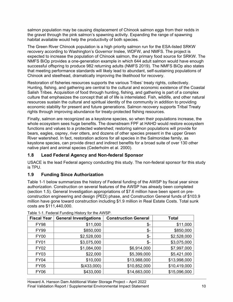
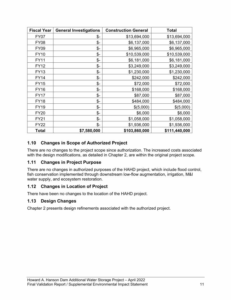
1.9 Funding Since Authorization Table 1-1 below summarizes the history of Federal funding of the AWSP by fiscal year since authorization. Construction on several features of the AWSP has already been completed (section 1.5). General Investigation appropriations of $7.6 million have been spent on pre-construction engineering and design (PED) phase, and Construction General funds of $103.9 million have gone toward construction including $1.9 million in Real Estate Costs. Total sunk costs are $111,440,000. Table 1-1. Federal Funding History for the AWSP. Fiscal Year General Investigations Construction General Total
FY98 $11,000 $- $11,000 FY99 $850,000 $- $850,000 FY00 $2,528,000 $- $2,528,000 FY01 $3,075,000 $- $3,075,000 FY02 $1,084,000 $6,914,000 $7,997,000 FY03 $22,000 $5,399,000 $5,421,000 FY04 $10,000 $13,988,000 $13,998,000 FY05 $(433,000) $10,852,000 $10,419,000 FY06 $433,000 $14,663,000 $15,096,000
Howard A. Hanson Dam Additional Water Storage Project – April 2022 Final Validation Report / Supplemental Environmental Impact Statement 11
Fiscal Year General Investigations Construction General Total FY07 $- $13,694,000 $13,694,000 FY08 $- $6,137,000 $6,137,000 FY09 $- $6,965,000 $6,965,000 FY10 $- $10,539,000 $10,539,000 FY11 $- $6,181,000 $6,181,000 FY12 $- $3,249,000 $3,249,000 FY13 $- $1,230,000 $1,230,000 FY14 $- $242,000 $242,000 FY15 $- $72,000 $72,000 FY16 $- $168,000 $168,000 FY17 $- $87,000 $87,000 FY18 $- $484,000 $484,000 FY19 $- $(5,000) $(5,000) FY20 $- $6,000 $6,000 FY21 $- $1,058,000 $1,058,000 FY22 $- $1,936,000 $1,936,000 Total $7,580,000 $103,860,000 $111,440,000
1.10 Changes in Scope of Authorized Project There are no changes to the project scope since authorization. The increased costs associated with the design modifications, as detailed in Chapter 2, are within the original project scope.
1.11 Changes in Project Purpose There are no changes in authorized purposes of the HAHD project, which include flood control, fish conservation implemented through downstream low-flow augmentation, irrigation, M&I water supply, and ecosystem restoration.
1.12 Changes in Location of Project There have been no changes to the location of the HAHD project.
1.13 Design Changes Chapter 2 presents design refinements associated with the authorized project.
Howard A. Hanson Dam Additional Water Storage Project – April 2022 Final Validation Report / Supplemental Environmental Impact Statement 12
2 Design Modifications This Validation Study focuses on the cost increases associated with the primary feature (i.e., downstream fish passage structure) of the HAHD AWSP originally authorized in the WRDA of 1999. The study considered potential modifications to the downstream fish passage component of the authorized plan, which included a movable single port collector with fish lock to shallow slope bypass. However, this study did not re-formulate elements of the authorized project related to water supply or ecosystem restoration, as those components of the project description were unchanged and have already been implemented. This chapter summarizes the results of the formulation and evaluation process used to support a Section 902 cost update for the fish passage portion of the authorized project. Formulation and evaluation of fish passage design options were driven by the need to meet the collection and passage survival criteria established in the 2019 BiOp (NMFS 2019). The FCE criteria is the proportion of fish that are collected by the FPF divided by the total number of fish in the FCE measurement zone (i.e., the forebay) over the performance evaluation period. Compliance with the BiOp’s RPA 1 requires FCE of 95% or greater for two study years. Compliance with the facility performance criteria requires 98% survival of fish collected and passed through the facility to release downstream of HAHD. The RPA’s criteria require mortality or injury of less than or equal to 2% of the total number of fish collected. The design modification evaluation process started with identification of fish passage design components. First, design components were identified and divided into three categories: collection, passage, and release. One or more components from each category is required to develop a complete fish passage design option. Next, the fish passage design options were comparatively evaluated to identify those projected to have the highest likelihood of achieving the collection and survival performance criteria of RPA 1 of the 2019 BiOp; as reflected in the purpose for the action evaluated in the Validation Study, this factor was weighted most heavily. This projected performance was then evaluated in conjunction with rough-order-of-magnitude estimates of implementation cost, focusing primarily on construction cost but also considering coarse projections of operations, maintenance, repair, replacement, and rehabilitation (OMRR&R) costs (for which less information is currently available) and informed by the degree of confidence in each of these cost estimates. Finally, the evaluation of these qualitative rankings was further refined and validated through overlay of the “Additional Considerations,” which were treated as secondary to the principal two criteria. These considerations included qualitative evaluation of design complexity, dam safety impacts, and multiple other considerations. While the application of some considerations reflected either favorably or unfavorably on some design options, the application of none of these additional considerations individually or in the aggregate influenced selection of the Recommended Plan. Ultimately, formulation and evaluation of design passage options were driven by these narrow key BiOp criteria as well as a qualitative assessment of “additional considerations” pertinent to projected effectiveness in implementation and operation. As such, this study did not use an assessment of Cost Effectiveness and Incremental Cost Analysis (CE/ICA) to evaluate design options based on efficiency of achieving outputs. Instead, the Corps study team ranked facility types according to the design option having the highest estimated likelihood of meeting the established collection and survival criteria outlined in the BiOp (NMFS 2019), and then identified the least-cost passage design option that reflected qualitative appraisal of other considerations that would impact the favorability of the proposed design. The remainder of this chapter presents the results of the evaluation process summarized here.
Howard A. Hanson Dam Additional Water Storage Project – April 2022 Final Validation Report / Supplemental Environmental Impact Statement 13
2.1 Design Components and Screening This section describes the design components and screening process used to develop fish passage design options for HAHD.
2.1.1 Design Components Design components for the study are divided into three categories: collection, passage, and release. One or more components from each category is required to develop a complete fish passage design option. A list of components for each category is described below. Details of these components can be found in Section 2.2. The list of components was identified using past FPF designs developed for the HAHD project as well as newer fish passage facilities being designed or implemented across the region. Collection Components (Fish Collection)
• Single movable collector: Collect fish through a movable single port or adjustable weir
• Multiport collector: Multiport intake structure with ports in the shape of horns at fixed elevations over the range of forebay elevations
• Floating surface collector: Guide nets direct fish into a moveable floating barge structure with attraction flow where fish are collected into a screened chamber. They can be held for transport via truck or barge or guided into a pipe that carries them downstream of the dam.
Passage Components (Connects Collector or Transport to Downstream Release) • Straight shallow slope bypass (over dam): Low gradient, straight channel; would
need to be combined with a fish lock to bring fish to the top of dam, then routed over the dam and extending far downstream before release
• Single shallow slope bypass (left abutment): Lower fish slowly in a long, gradually sloped channel through dam abutment
• Helix (shallow slope bypass): Low gradient, smooth curve that looks like a corkscrew or spiral staircase; intended to lower fish in a compact physical space
• Steep slope bypass: Lower fish quickly to near the tailrace elevation; includes a deceleration channel to reduce velocities to a safe level before releasing fish
• Fish lock: One or more vertical chambers constructed downstream of the collector, with elevation and flow control, to raise or lower fish to an elevation where they could be safety transported to the release; must be combined with another bypass component to complete transport
• Trap and haul: Transport fish via truck to a downstream release point Release Components (Downstream Release)
• Tailrace/downstream channel: Place the bypass outlet in the channel downstream of the stilling basin within the forested reach area
• TPU Diversion dam reach: Use the river access 3.5 miles downstream at the TPU Diversion Dam or areas nearby in this reach of the river to release fish from trap and haul trucks
• Stilling basin (existing dam): Place the bypass outlet in the existing dam stilling basin adjacent to the dam outlet tunnel
Howard A. Hanson Dam Additional Water Storage Project – April 2022 Final Validation Report / Supplemental Environmental Impact Statement 14
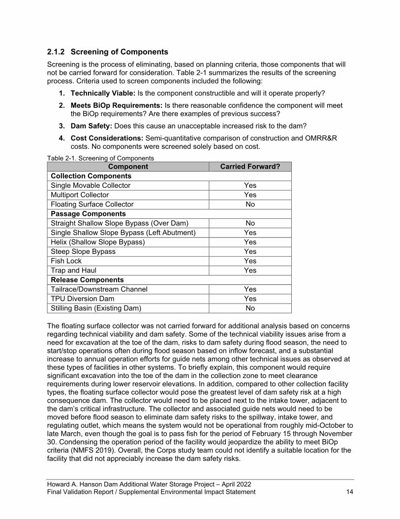
2.1.2 Screening of Components Screening is the process of eliminating, based on planning criteria, those components that will not be carried forward for consideration. Table 2-1 summarizes the results of the screening process. Criteria used to screen components included the following:
1. Technically Viable: Is the component constructible and will it operate properly? 2. Meets BiOp Requirements: Is there reasonable confidence the component will meet
the BiOp requirements? Are there examples of previous success? 3. Dam Safety: Does this cause an unacceptable increased risk to the dam? 4. Cost Considerations: Semi-quantitative comparison of construction and OMRR&R
costs. No components were screened solely based on cost. Table 2-1. Screening of Components
Component Carried Forward? Collection Components Single Movable Collector Yes Multiport Collector Yes Floating Surface Collector No Passage Components Straight Shallow Slope Bypass (Over Dam) No Single Shallow Slope Bypass (Left Abutment) Yes Helix (Shallow Slope Bypass) Yes Steep Slope Bypass Yes Fish Lock Yes Trap and Haul Yes Release Components Tailrace/Downstream Channel Yes TPU Diversion Dam Yes Stilling Basin (Existing Dam) No
The floating surface collector was not carried forward for additional analysis based on concerns regarding technical viability and dam safety. Some of the technical viability issues arise from a need for excavation at the toe of the dam, risks to dam safety during flood season, the need to start/stop operations often during flood season based on inflow forecast, and a substantial increase to annual operation efforts for guide nets among other technical issues as observed at these types of facilities in other systems. To briefly explain, this component would require significant excavation into the toe of the dam in the collection zone to meet clearance requirements during lower reservoir elevations. In addition, compared to other collection facility types, the floating surface collector would pose the greatest level of dam safety risk at a high consequence dam. The collector would need to be placed next to the intake tower, adjacent to the dam’s critical infrastructure. The collector and associated guide nets would need to be moved before flood season to eliminate dam safety risks to the spillway, intake tower, and regulating outlet, which means the system would not be operational from roughly mid-October to late March, even though the goal is to pass fish for the period of February 15 through November 30. Condensing the operation period of the facility would jeopardize the ability to meet BiOp criteria (NMFS 2019). Overall, the Corps study team could not identify a suitable location for the facility that did not appreciably increase the dam safety risks.
Howard A. Hanson Dam Additional Water Storage Project – April 2022 Final Validation Report / Supplemental Environmental Impact Statement 15
The straight, shallow slope bypass over the dam was screened out primarily due to technical complexities that would increase overall cost to implement. The complexity concerns, which would jeopardize the ability of the system to meet BiOp criteria, include the need for fish to be raised to one collection point on the top of the dam using a fish lock, only to be loaded in the shallow bypass and carried back down to the river. This bypass process would create an added delay for fish transport and increase the risk to fish being harmed while in the system. Having to raise the fish to the top of the dam before transport would mean the system is no longer volitional passage and the fish would experience some delay while being lifted in the lock to the collection point. Volitional fish passage, in which fish are allowed to swim on their own around or through structures, has lower stress and better survival results than methods in which fish are captured by mechanical methods and physically transported (Katapodis et al. 2001). NMFS considers volitional passage to be the preferable alternative in most circumstances (NMFS 2008). Using a fish lock would lead to an increased risk of trapping fish in the lock if there were a mechanical failure and exposure to additional mechanical features that have the potential to injure fish. This system requires an approximately 1-mile-long conduit to convey fish back to the river once again increasing the time fish are in the system. Additionally, the Corps study team recommended lowering the fish to a shorter bypass rather than lifting them to a longer bypass. As such, the shortcomings of overall technical complexity of this design option led the Corps study team to screen out this design option at this stage. The stilling basin release site was screened out because the outlet does not provide adequate conditions for safe fish passage. The stilling basin is shallow in summer and more turbulent than preferred at higher flows. This can cause fish to become disoriented after release, which could delay downstream migration making them more susceptible to predation in this reach of river. Additionally, fish may be susceptible to injuries from the turbulent flow in the shallow stilling basin; that is, the “boiling” water against the shallow riverbed of the stilling basin may injure fish and limit their swimming abilities. Disoriented or injured fish may be susceptible to predators (birds or larger fish) in the stilling basin because of compromised swimming abilities. The potential for disorientation and injuries to fish as well as increased probability of predation due to those conditions means the stilling basin release location is so unlikely to meet the BiOp criteria of 98% survival as to warrant elimination from further consideration (NMFS 2019).
2.2 Fish Passage Design Options An array of fish passage design options was formulated through combinations of fish collection, passage, and release components. The Corps study team selected a reasonable range of the most promising options from the list of potential design option combinations. Not all possible iterations or combinations of components were investigated due to the limited scope of the study with focus on a Section 902 cost update only rather than more formal reformulation or evaluation of all possible alternatives. The intent of this process is not to re-formulate all potential alternatives, but to determine the required design modifications to the previously approved plan that meet BiOp requirements at least cost. For any design option to move forward for consideration, the design would need to be at least moderately likely to meet all three BiOp criteria of 95% collection efficiency, 98% survival through the structure, and an overall 75% survival from the head of the reservoir through the release location. The design options determined to be the most likely to meet BiOp requirements at least cost are described below. Design Option 1: Movable Single Port Collector with Fish Lock to Shallow Slope Bypass Fish would be collected through a moveable single port. Dewatering screens are needed to reduce the transport flow and concentrate fish into a lock. The screens would be located in the moveable intake port. The fish lock would consist of one or more chambers and would lower fish
Howard A. Hanson Dam Additional Water Storage Project – April 2022 Final Validation Report / Supplemental Environmental Impact Statement 16
and water to an elevation where they could be safely transported to the tailrace via a shallow slope bypass. The lock chamber would have telescoping weirs or gates at various locations to facilitate a connection with the moving collector. Once a predetermined fish density has been reached or set time for holding fish in the lock has passed, the lock would release the fish and water into a conduit that passes through the left abutment and out to the tailrace. Valves to release water and dissipate energy from the lock would require fish screens. Attraction flow would be discharged through the outlet tunnel, while fish transport flows would be discharged downstream of the stilling basin where fish are released into the river. The exit of the release conduit would require meeting NMFS (2011) release location criteria, which states “Bypass outfalls should be located to minimize predation, be free of eddies and reverse flow, have sufficient depth to avoid injuries at all river and bypass flows, have river velocities that are greater than 4 feet per second (ft/s), and have controls provided for avian predation if necessary” (NMFS 2011). Downstream of the stilling basin would likely be a suitable location. This concept is similar to the HAHD feasibility-level design completed in 1998. Design Option 2: Movable Single Port Collector with Steep Slope Bypass Fish would be collected through a moveable single port. The port is raised or lowered in a submerged wet well as reservoir elevation changes using stoplogs or other mechanism. Dewatering screens would move with the port in a wet well to reduce the transport flow and concentrate fish into a bypass pipe. The passage route connecting the single port to the release site would most likely cut through the left abutment, but it could run along the downstream side of the dam or connect to an existing bypass structure pending further design development. The vertical portion of a steep slope bypass on the downstream side of the left abutment would lower fish quickly to near the tailrace elevation; then with a large bend (radius), the horizontal portion would require a deceleration channel to reduce velocities to a safe level before releasing fish into the tailrace downstream of the stilling basin. Because the single port moves up and down with the forebay elevation, multiple bypass connections would need to be located throughout the elevation range. This may require multiple bypass pipes that connect within the left abutment on the downstream side, or if possible, connect on the upstream side of the dam with only one passage through the left abutment. Fish would pass without delay through the dam. The pipe(s) would include a shallow bend at the bottom or some other feature to dissipate energy and reduce water velocities before release into the river. If dewatering screens are used, attraction flow could be discharged through the outlet tunnel while fish transport flows would be discharged through a separate conduit. The exit of the transport pipe would require meeting NMFS release location criteria. Similar to other design options, location and depth of bypass outfalls should consider risks associated with predation, debris, and appropriate river velocities. Downstream of the stilling basin would likely be the least-cost suitable location. Design Option 3: Fixed Multiport Collector with Fish Lock to Shallow Slope Bypass A fixed multiport collection structure, consisting of a multiport collector with horn-shaped ports at fixed elevations, would allow collection from the forebay at multiple depths. At low forebay elevations, the lower collector horns would be used. As the forebay elevation increases, the lower collector horns would be closed, and the higher elevation collector horns would be opened. Collector horn shaping (flow area, invert elevation) is used to meet desired hydraulic conditions. A multiport collector was proposed for the 95% HAHD FPF design completed in 2012 and provides a good starting place for this design option. The 95% design has five collector horns; depending on forebay elevation either one or two of the horns can be used. Each horn is designed to withdraw up to 600 cfs of water from the reservoir and two horns could operate at once for a total withdrawal of 1,200 cfs of water. Floor-mounted inclined screens with
Howard A. Hanson Dam Additional Water Storage Project – April 2022 Final Validation Report / Supplemental Environmental Impact Statement 17
a bottom center pivot are used to reduce the flow with fish from approximately 600 cfs per horn to approximately 25-35 cfs per horn. The flow requirement for 95% attraction is up to 1,200 cfs, which would be supplied by keeping two of the five horns open. A fish lock to lower fish to the tailrace would consist of one or more chambers where the collector deposits fish and water. Once the predetermined criteria are met (e.g., fish density, maximum hold time), the lock would cycle to release the fish and water into a conduit that passes through the left abutment and out to the tailrace to release fish into the river downstream of the stilling basin. The exit of the transport conduit would require meeting NMFS release location criteria. Similar to other design options, location and depth of bypass outfalls should consider risks associated with predation, debris, and appropriate river velocities. Downstream of the stilling basin would likely be the least-cost suitable location. Design Option 4: Fixed Multiport Collector with Steep Slope Bypass A fixed multiport collection structure, consisting of a multiport collector with horn-shaped ports at fixed elevations, would allow collection from the forebay at multiple depths. At low forebay elevations the lower collector horns would be used. As the forebay elevation increases, the lower collector horns would be closed, and the higher elevation collector horns would be opened. Collector horn shaping (flow area, invert elevation) is used to meet desired hydraulic conditions. A multiport collector was proposed for the 95% HAHD FPF design completed in 2012 and provides a good starting place for this design option. The 95% design has five collector horns; depending on forebay elevation either one or two of the horns can be used. Each horn is designed to withdraw up to 600 cfs of water from the reservoir, and two horns could operate at once for a total withdrawal of 1,200 cfs of water. Floor-mounted inclined screens with a bottom center pivot are used to reduce the flow with fish from approximately 600 cfs per horn to approximately 25-35 cfs per horn; the excess water is drained away while the flow carrying fish moves through the facility. The average total outflow during the fish passage operating season is roughly 1,200 cfs. The fish passage technical committee from previous design efforts determined facility should pass 1,200 cfs as a minimum upper limit, which is achieved by keeping two of the five horns open, to match the historic average total outflow. Once collected through the multiport, downstream fish passage would occur via one or more steep slope bypass pipes. The passage route connecting the multiport to the release site would most likely cut through the left abutment, but it could run along the downstream side of the dam or connect to an existing bypass, regulating outlet, or other structure pending further design development. The pipe(s) would include a shallow bend and deceleration channel at the bottom or some other feature to dissipate energy and reduce water velocities before release into the river. A version of the steep bypass component was included in the 1998 Feasibility Design, which used the same route as the 48-inch bypass and outlet. The exit of the transport pipe would require meeting NMFS release location criteria. Similar to other design options, location and depth of bypass outfalls should consider risks associated with predation, debris, and appropriate river velocities. Downstream of the stilling basin would likely be the least-cost suitable location. Design Option 5: Fixed Multiport Collector with Helix to Shallow Slope Bypass This design option has multiple fixed-elevation horns connected to a helical bypass conduit. At the base of the helix the flow is released to a single mildly sloping pipe that runs through the dam abutment to convey fish to the downstream channel. The horns are equipped with dewatering screens to reduce the amount of flow that must be passed to meet the requirements/criteria for safe fish passage through the helix and bypass pipe. The remaining screened flow (without fish) could be conveyed downstream through another pipe, e.g., through the existing tunnel.
Howard A. Hanson Dam Additional Water Storage Project – April 2022 Final Validation Report / Supplemental Environmental Impact Statement 18
As described above, a multiport collector was proposed for the 95% HAHD FPF design completed in 2012 and provides a good starting place for this design option. The 95% design has five collector horns; depending on forebay elevation either one or two of the horns can be used. Each horn is designed to withdraw up to 600 cfs of water from the reservoir and two horns could operate at once for a total withdrawal of 1,200 cfs of water. With the helix concept, a lower degree of dewatering would be acceptable, i.e., the helix could convey more than 50-70 cfs if it is beneficial for safe fish passage, individual component design, or the physical constraints of the construction site. For this preliminary discussion, the flow rates are assumed to be the same as the 95% HAHD design. A helix structure is under construction at Cle Elum Dam. The Cle Elum helix is designed to convey water flow of 400 cfs in a 4-foot-wide rectangular channel over an elevation drop of approximately 100 feet. The footprint of the Cle Elum helix is approximately 55 feet in diameter. A helix design was considered for a high head bypass for Cougar Dam (CGR). The early conceptual design for the CGR helix included conveying 16 cfs of flow in a 16-inch diameter closed conduit over an elevation drop of up to 158 feet with a footprint of approximately 20 feet by 50 feet. At a flow rate of 25-70 cfs, the size of a helix at HAHD would fall somewhere between the Cle Elum Helix and the CGR concept. It appears that there would be sufficient space at HAHD to fit the multiport collector and helix in the area downstream of the cofferdam structure. Consideration would need to be given to generating sufficient friction loss in the helix to dissipate most of the energy of the hydraulic head of the reservoir. This would require balancing the flow rate, roughness and helix diameter to achieve the needed head loss. A bypass pipe with a 40-inch diameter and slope of approximately 0.5% would meet the NMFS bypass criteria over the 25-70 cfs flow range. The slope and/or pipe size could be adjusted if a different amount of dewatering is preferred. Overall, survivability and performance within the helix system – yet to be constructed or prototype-tested anywhere in the Northwest – remain a central concern for this alternative’s viability. The exit of the bypass pipe of the helix would require meeting NMFS release location criteria. Similar to other design options, location and depth of bypass outfalls should consider risks associated with predation, debris, and appropriate river velocities. Downstream of the stilling basin would likely be the least cost suitable location. Design Option 6: Adjustable Weir with Wet Well An adjustable weir can move to different elevations within the forebay elevation range to pass fish. The major components include an intake and machinery to allow for intake elevation selection. Attraction flows can either be created by pumping flow, or by a gravity fed system. This design option assumes two 6-foot-wide adjustable weirs, potentially with an elliptical shape for more effective collection. Each weir can pass 230 to 650 cfs of flow independently. Depths of weir crests below forebay elevation varies with a range between 4 and 14 feet depending on flow requirements. The adjustable weir with wet well design option does not need a screened dewatering system and is classified as a full flow bypass. This is the only design option considered that is a bypass not requiring a screening system. Each weir is connected to a dedicated wet well 6 feet by 6 feet dimensions. Each wet well can pass the full flow of the individual weirs downward at a velocity between 6.5 and 17.5 ft/s until reaching a large 30-foot radiused base, which transitions the flow horizontally prior to passing the flow control gate. As flow approaches the control gate the wet well gradually contracts to a width of 3 feet. Flow then passes the control gate and enters the conveyance channel. The control gate is a typical tainter gate configured to allow a gradual vertical contraction with anticipated discharge
Howard A. Hanson Dam Additional Water Storage Project – April 2022 Final Validation Report / Supplemental Environmental Impact Statement 19
coefficients at or above 0.85 resulting in gate velocities between 40 and 90 ft/s with shear values lower or comparable to typical spillways of dams on the Columbia and Snake Rivers with known hydraulics and high salmonid survival. Once flow passes the control gate an open channel with mild slope allows for a gradual reduction in velocity over the distance of several hundred feet. Conveyance channel and outfall to tailrace would replicate the design effort of the Bonneville Dam Corner Collector, which has proven performance for downstream fish passage. Lessons from the Corner Collector would be used to closely evaluate slope and channel material. Though some of the hydraulic conditions of this alternative are similar to existing components in other systems, several unknowns remain in the overall functionality, performance, operation, and construction costs. The exit of the conveyance channel would require meeting NMFS release location criteria. Similar to other design options, location and depth of bypass outfalls should consider risks associated with predation, debris, and appropriate river velocities. Downstream of the stilling basin would likely be the least-cost suitable location. The Corps study team added this design option after components were screened and well into the analysis of the design options; therefore, this option is not identified in the screening summarized in section 2.1. Because this option was added midway through the evaluation process, only the permutation most likely to meet BiOp requirements was investigated. Design Option 7: Fixed Multiport Collector with Fish Lock up to Trap and Haul As described above, a multiport collector was proposed for the 95% HAHD FPF design completed in 2012 and provides a good starting place for this design option. The 95% design has five collector horns; depending on forebay elevation either one or two of the horns can be used. Each horn is designed to withdraw up to 600 cfs of water from the reservoir and two horns could operate at once for a total withdrawal of 1,200 cfs of water. Once passed through the multiport collector, fish are then transported to the top of the dam via a lock to a sorting facility. From there fish are transferred to trucks and transported downstream to a release point. The release site would have to meet the NMFS criteria listed above with measures to prevent predation from release of large numbers of fish at a single location. The 95% HAHD design used this method of conveyance for fish around the dam after collection.
2.3 Evaluation of the Initial Array of Design Options A two-part interagency workshop was held to evaluate and compare the array of design options. Over 70 attendees attended the workshop including representatives from Seattle District, Portland District, Walla Walla District, Northwestern Division, and USACE Headquarters as well as external participants from resource agencies, the local Tribe, and other regional stakeholder groups. Workshop activities focused on evaluating the array of fish passage design options for HAHD to meet requirements outlined in the BiOp. While raw workshop materials are not formally packaged as an appendix or other supporting report, this chapter of the VR/SEIS serves as the documentation of workshop discussions and decisions. Workshop participants received a draft version of a decision matrix (described below) as well as a conceptual design and narrative describing each design option (summarized in section 2.2 above). The Corps provided an overview of each design option and also discussed the BiOp criteria that would be used to evaluate design options. After these overview sessions, the workshop focused primarily on discussion of the BiOp criteria since workshop participants were the most qualified to discuss those categories of evaluation criteria. A decision matrix was used to inform evaluation and comparison discussions. The matrix included multiple evaluation criteria including the following:
Howard A. Hanson Dam Additional Water Storage Project – April 2022 Final Validation Report / Supplemental Environmental Impact Statement 20
BiOp’s RPA 1 Requirements • Fish Collection Efficiency (FCE): Proportion of fish that are collected by the FPF
divided by the total number of fish in the FCE measurement zone (i.e., the forebay) over the performance evaluation period; the BiOp requires FCE of 95% or greater for 2 years.
• Facility Performance: 98% survival of fish collected and passed through the facility to release downstream of HAHD; the BiOp requires mortality or injury of less than or equal to 2% of the total number of fish collected.
Cost • Construction Costs: Rough order of magnitude construction costs were developed
based on historical data from projects with similar scope in the Pacific Northwest region. Costs are presented as a range of values given the qualitative nature of the assessment at this stage of the study as well as conceptual level of detail for each design option. Construction costs were based on the materials required for construction (e.g., steel vs. concrete), the number of moving mechanical parts that may require tight tolerances for construction, and overall complexity of design. It should be noted that costs presented in Table 2-2 below do not reflect all major project features and were developed prior to workshop discussions. As a result of the workshop, additional features such as an emergency bypass channel and debris management features were subsequently added to some of the design options in light of the availability of information derived from recent implementation of analogous projects in the Pacific Northwest, ultimately impacting overall cost estimates. As such, ranges of costs are presented below to provide a conceptual estimate of relative construction cost rankings between alternatives.
• OMRR&R Costs: Design options with more moving parts are assumed to have higher operations and maintenance (O&M) requirements. This criterion also includes consideration of additional labor requirements for certain components (e.g., trucking fish for the trap and haul alternative).
• Confidence in Relative Cost Estimate: As described above, costs are presented as a range of values given the qualitative nature of the assessment at this stage of the study as well as conceptual level of detail for each design option. Confidence ratings are based on use of cost estimates developed for previous projects, which have not been updated or refined for this action at this stage of the study. The confidence level reflects how representative the reference features are for this action and how refined the design was (i.e., design options that used the previously developed 2012 95% design had more confidence versus design options that used the concepts or cost estimates that were applied from other regional projects). High or low confidence in a relative cost estimate does not propel or eliminate an alternative on its own but is used as a reference when narrowing in on the preferred alternative.
Additional Considerations • Dam Safety: Consideration of whether the design option increases risk to life safety in
the event of dam failure or an uncontrolled release of water.
• Flexibility and Adaptability: Can the design option be easily refined if modifications are required to meet BiOp criteria? Adaptability includes changes in design later in the process, changes in operations, limited changes in modifying selected features, or larger modifications to the facility if operational changes or other minor alterations are inadequate.
Howard A. Hanson Dam Additional Water Storage Project – April 2022 Final Validation Report / Supplemental Environmental Impact Statement 21
• Dam Operation Impacts: Does the design option potentially impact dam operations (e.g., reservoir control curve or interference with access required for operations)?
• Design Complexity: Consideration of the number of moving parts and connection/interface between different components for each design option.
• Constructability: Consideration of tolerances required, number of unique parts, access to the remote site and construction in a challenging environment.
• Within Scope of Authorized Project: Assessment of whether the design option is similar to the originally authorized project.
The Corps study team used qualitative metrics (e.g., very high, high, medium, low, and very low) and color coding (e.g., red, orange, yellow, and green) for each criterion. Depending on the criterion, a ‘high’ ranking may be favorable (e.g., ‘high’ facility performance – a desired outcome) or unfavorable (e.g., ‘high’ construction cost – a less desirable outcome). Colors were also added because ‘high’ alone may mean favorable or unfavorable depending on criterion. In general, green coloring indicates a more favorable rating for each criterion, such as low construction costs or high flexibility and adaptability. Yellow coloring indicates medium or moderately favorable ratings across all criterions. Orange coloring represents a lower or unfavorable rating for each criterion and red indicates the lowest or most unfavorable rating. The populated decision matrix is presented at Table 2-2. It should be noted that the workshop participants received a draft version of the decision matrix prior to the first interagency workshop. Discussion focused primarily on discussion of the BiOp criteria since workshop participants were the most qualified to discuss those categories of evaluation criteria. However, feedback from workshop participants was captured in the final version of the decision matrix presented below. There was general agreement from workshop participants regarding the relative rankings for the evaluation criteria presented in the table with more emphasis placed on reaching consensus regarding the BiOp evaluation criteria rankings. The design options were evaluated to identify those projected to have the highest likelihood of achieving the collection and survival performance criteria of RPA 1 of the 2019 BiOp; as reflected in the need and purpose for the action evaluated in the Validation Study, this factor was weighted most heavily. The third criteria of overall survival of 75% from head of the reservoir to release point would have no influence over which design option was selected and was therefore not used as a deciding factor. Each design option was evaluated independently for whether it was likely to meet BiOp criteria, was evaluated on its own merits and weaknesses, and given a qualitative probability for meeting criteria. This projected performance was then evaluated in conjunction with rough-order-of-magnitude estimates of implementation cost, focusing primarily on construction cost but also considering coarse projections of OMRR&R costs (for which less information is currently available) and informed by the degree of confidence in each of these cost estimates. Design options were not compared to each other until each characteristic in the decision matrix was independently evaluated. As reflected in Table 2-2, one Design Option (Option #4) scored clearly superior to the others in projected performance in fulfillment of the BiOp criteria as well as in comparatively low implementation cost with a high degree of cost certainty. The evaluation of these rankings was then further refined and validated through overlay of the “Additional Considerations,” which were treated as secondary to the principal two criteria. While the application of some considerations reflected either favorably or unfavorably on some design options, as reflected in Table 2-2 and below, the application of none of these Additional Considerations individually or in the aggregate negated the clear superiority of Design Option #4.
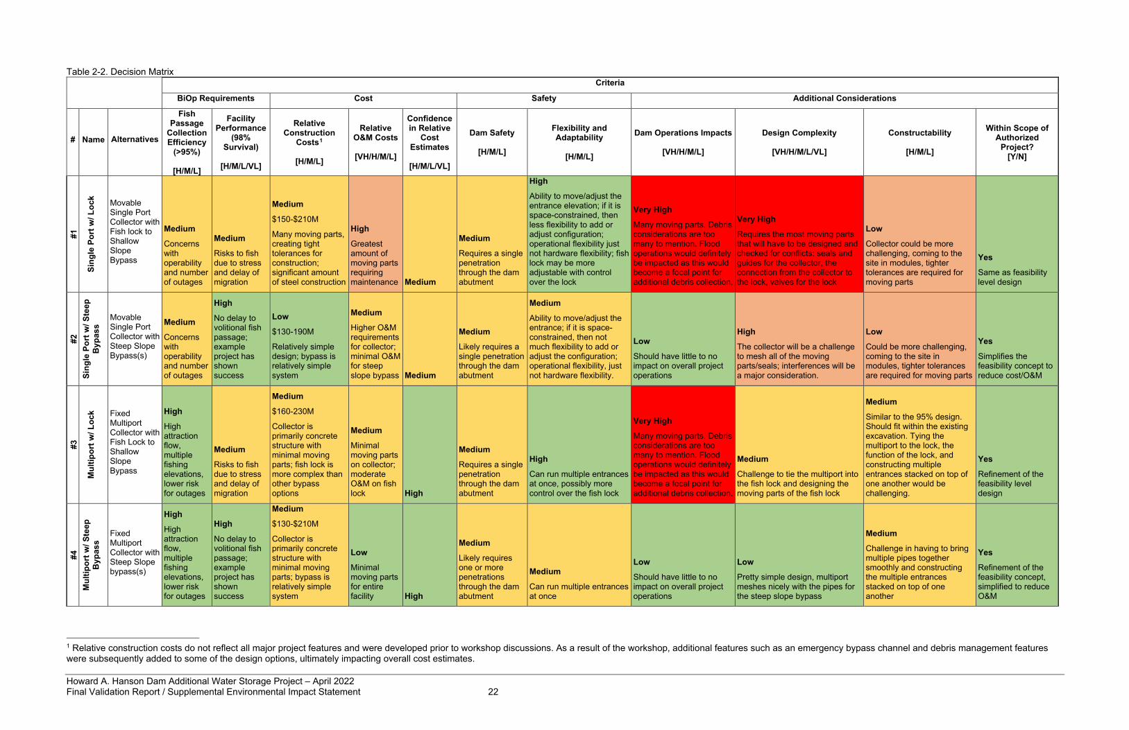
Howard A. Hanson Dam Additional Water Storage Project – April 2022 Final Validation Report / Supplemental Environmental Impact Statement 22
Table 2-2. Decision Matrix
Criteria
BiOp Requirements Cost Safety Additional Considerations
# Name Alternatives
Fish Passage
Collection Efficiency
(>95%)
[H/M/L]
Facility Performance
(98% Survival)
[H/M/L/VL]
Relative Construction
Costs1
[H/M/L]
Relative O&M Costs
[VH/H/M/L]
Confidence in Relative
Cost Estimates
[H/M/L/VL]
Dam Safety
[H/M/L]
Flexibility and Adaptability
[H/M/L]
Dam Operations Impacts
[VH/H/M/L]
Design Complexity
[VH/H/M/L/VL]
Constructability
[H/M/L]
Within Scope of Authorized
Project? [Y/N]
#1
Sing
le P
ort w
/ Loc
k Movable Single Port Collector with Fish lock to Shallow Slope Bypass
Medium
Concerns with operability and number of outages
Medium
Risks to fish due to stress and delay of migration
Medium
$150-$210M
Many moving parts, creating tight tolerances for construction; significant amount of steel construction
High
Greatest amount of moving parts requiring maintenance Medium
Medium
Requires a single penetration through the dam abutment
High
Ability to move/adjust the entrance elevation; if it is space-constrained, then less flexibility to add or adjust configuration; operational flexibility just not hardware flexibility; fish lock may be more adjustable with control over the lock
Very High
Many moving parts. Debris considerations are too many to mention. Flood operations would definitely be impacted as this would become a focal point for additional debris collection.
Very High
Requires the most moving parts that will have to be designed and checked for conflicts: seals and guides for the collector, the connection from the collector to the lock, valves for the lock
Low
Collector could be more challenging, coming to the site in modules, tighter tolerances are required for moving parts
Yes
Same as feasibility level design
#2
Sing
le P
ort w
/ Ste
ep
Byp
ass
Movable Single Port Collector with Steep Slope Bypass(s)
Medium
Concerns with operability and number of outages
High
No delay to volitional fish passage; example project has shown success
Low
$130-190M
Relatively simple design; bypass is relatively simple system
Medium
Higher O&M requirements for collector; minimal O&M for steep slope bypass Medium
Medium
Likely requires a single penetration through the dam abutment
Medium
Ability to move/adjust the entrance; if it is space-constrained, then not much flexibility to add or adjust the configuration; operational flexibility, just not hardware flexibility.
Low
Should have little to no impact on overall project operations
High
The collector will be a challenge to mesh all of the moving parts/seals; interferences will be a major consideration.
Low
Could be more challenging, coming to the site in modules, tighter tolerances are required for moving parts
Yes
Simplifies the feasibility concept to reduce cost/O&M
#3
Mul
tipor
t w/ L
ock Fixed
Multiport Collector with Fish Lock to Shallow Slope Bypass
High
High attraction flow, multiple fishing elevations, lower risk for outages
Medium
Risks to fish due to stress and delay of migration
Medium
$160-230M
Collector is primarily concrete structure with minimal moving parts; fish lock is more complex than other bypass options
Medium
Minimal moving parts on collector; moderate O&M on fish lock High
Medium
Requires a single penetration through the dam abutment
High
Can run multiple entrances at once, possibly more control over the fish lock
Very High
Many moving parts. Debris considerations are too many to mention. Flood operations would definitely be impacted as this would become a focal point for additional debris collection.
Medium
Challenge to tie the multiport into the fish lock and designing the moving parts of the fish lock
Medium
Similar to the 95% design. Should fit within the existing excavation. Tying the multiport to the lock, the function of the lock, and constructing multiple entrances stacked on top of one another would be challenging.
Yes
Refinement of the feasibility level design
#4
Mul
tipor
t w/ S
teep
B
ypas
s
Fixed Multiport Collector with Steep Slope bypass(s)
High
High attraction flow, multiple fishing elevations, lower risk for outages
High
No delay to volitional fish passage; example project has shown success
Medium
$130-$210M
Collector is primarily concrete structure with minimal moving parts; bypass is relatively simple system
Low
Minimal moving parts for entire facility High
Medium
Likely requires one or more penetrations through the dam abutment
Medium
Can run multiple entrances at once
Low
Should have little to no impact on overall project operations
Low
Pretty simple design, multiport meshes nicely with the pipes for the steep slope bypass
Medium
Challenge in having to bring multiple pipes together smoothly and constructing the multiple entrances stacked on top of one another
Yes
Refinement of the feasibility concept, simplified to reduce O&M
1 Relative construction costs do not reflect all major project features and were developed prior to workshop discussions. As a result of the workshop, additional features such as an emergency bypass channel and debris management features were subsequently added to some of the design options, ultimately impacting overall cost estimates.
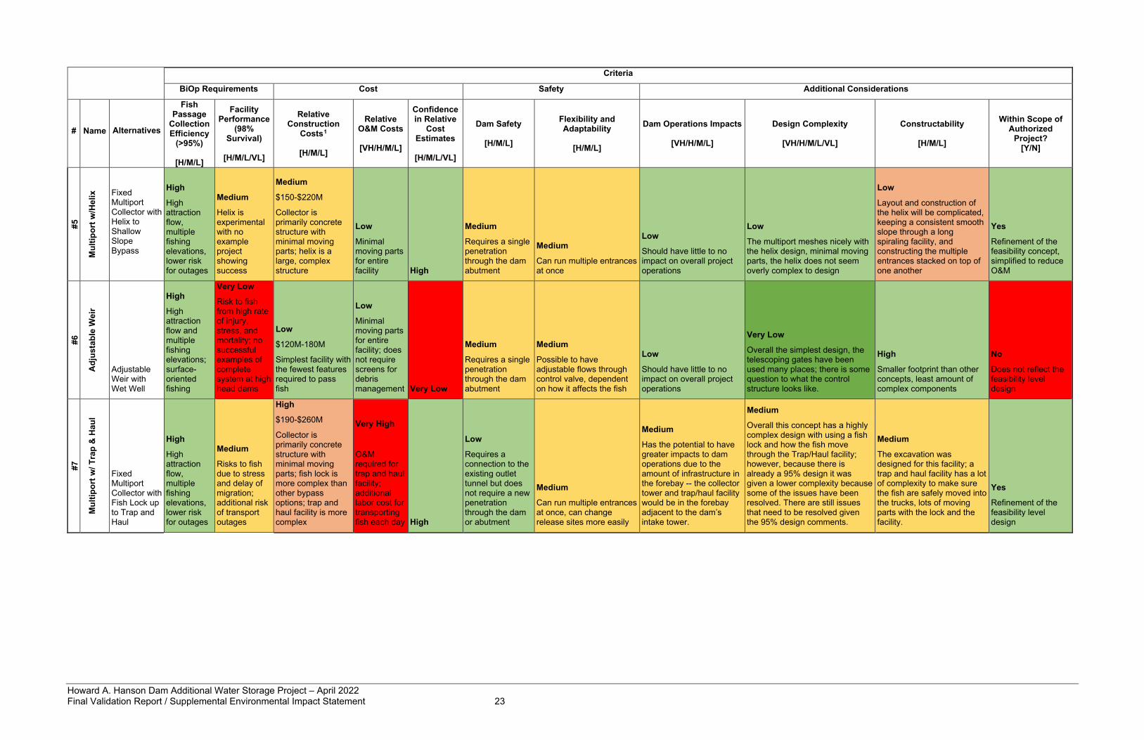
Howard A. Hanson Dam Additional Water Storage Project – April 2022 Final Validation Report / Supplemental Environmental Impact Statement 23
Criteria
BiOp Requirements Cost Safety Additional Considerations
# Name Alternatives
Fish Passage
Collection Efficiency
(>95%)
[H/M/L]
Facility Performance
(98% Survival)
[H/M/L/VL]
Relative Construction
Costs1
[H/M/L]
Relative O&M Costs
[VH/H/M/L]
Confidence in Relative
Cost Estimates
[H/M/L/VL]
Dam Safety
[H/M/L]
Flexibility and Adaptability
[H/M/L]
Dam Operations Impacts
[VH/H/M/L]
Design Complexity
[VH/H/M/L/VL]
Constructability
[H/M/L]
Within Scope of Authorized
Project? [Y/N]
#5
Mul
tipor
t w/H
elix
Fixed Multiport Collector with Helix to Shallow Slope Bypass
High
High attraction flow, multiple fishing elevations, lower risk for outages
Medium
Helix is experimental with no example project showing success
Medium
$150-$220M
Collector is primarily concrete structure with minimal moving parts; helix is a large, complex structure
Low
Minimal moving parts for entire facility High
Medium
Requires a single penetration through the dam abutment
Medium
Can run multiple entrances at once
Low
Should have little to no impact on overall project operations
Low
The multiport meshes nicely with the helix design, minimal moving parts, the helix does not seem overly complex to design
Low
Layout and construction of the helix will be complicated, keeping a consistent smooth slope through a long spiraling facility, and constructing the multiple entrances stacked on top of one another
Yes
Refinement of the feasibility concept, simplified to reduce O&M
#6
Adj
usta
ble
Wei
r
Adjustable Weir with Wet Well
High
High attraction flow and multiple fishing elevations; surface-oriented fishing
Very Low
Risk to fish from high rate of injury, stress, and mortality; no successful examples of complete system at high head dams
Low
$120M-180M
Simplest facility with the fewest features required to pass fish
Low
Minimal moving parts for entire facility; does not require screens for debris management Very Low
Medium
Requires a single penetration through the dam abutment
Medium
Possible to have adjustable flows through control valve, dependent on how it affects the fish
Low
Should have little to no impact on overall project operations
Very Low
Overall the simplest design, the telescoping gates have been used many places; there is some question to what the control structure looks like.
High
Smaller footprint than other concepts, least amount of complex components
No
Does not reflect the feasibility level design
#7
Mul
tipor
t w/ T
rap
& H
aul
Fixed Multiport Collector with Fish Lock up to Trap and Haul
High
High attraction flow, multiple fishing elevations, lower risk for outages
Medium
Risks to fish due to stress and delay of migration; additional risk of transport outages
High
$190-$260M
Collector is primarily concrete structure with minimal moving parts; fish lock is more complex than other bypass options; trap and haul facility is more complex
Very High
O&M required for trap and haul facility; additional labor cost for transporting fish each day High
Low
Requires a connection to the existing outlet tunnel but does not require a new penetration through the dam or abutment
Medium
Can run multiple entrances at once, can change release sites more easily
Medium
Has the potential to have greater impacts to dam operations due to the amount of infrastructure in the forebay -- the collector tower and trap/haul facility would be in the forebay adjacent to the dam’s intake tower.
Medium
Overall this concept has a highly complex design with using a fish lock and how the fish move through the Trap/Haul facility; however, because there is already a 95% design it was given a lower complexity because some of the issues have been resolved. There are still issues that need to be resolved given the 95% design comments.
Medium
The excavation was designed for this facility; a trap and haul facility has a lot of complexity to make sure the fish are safely moved into the trucks, lots of moving parts with the lock and the facility.
Yes
Refinement of the feasibility level design
Howard A. Hanson Dam Additional Water Storage Project – April 2022 Final Validation Report / Supplemental Environmental Impact Statement 24
As a result of workshop discussions and the completed decision matrix, the Corps study team chose to carry forward Design Option 1 (Movable Single Port Collector with Fish Lock to Shallow Slope Bypass) and 4 (Fixed Multiport Collector with Steep Slope Bypass) for additional analysis. It should be noted that the qualitative rankings presented in Table 2-2 informed this screening step; however, discussion and feedback from workshop participants – especially regarding whether each design option meets BiOp requirements – had an important role in this screening step. While Design Option 1 did not compare strongly against the others through application of the evaluation criteria as reflected in the decision matrix, partners and resource agencies expressed a preference for this option during the workshops (see section 2.3), indicating the benefits of collecting fish at the very surface of the water column with a moveable single port offset the concerns with a fish lock, and so it was carried forward for further analysis. While Design Option 4 had similar relative construction costs compared to other design options, it has low relative O&M costs and a high degree in confidence in the cost estimate. This higher degree of certainty stems from using an already developed design for a significant portion of this design option, reducing uncertainty about cost compared to other design options. It should be noted that Design Option 4 and Design Option 5 had similar rankings for relative construction cost, relative O&M costs, and confidence in cost estimates. However, Design Option 5 ranked lower for both facility performance and constructability considerations, leading the team to carry forward Design Option 4 as a more viable option for implementation compared to Design Option 5. Further rationale for screening out design options is presented below.
2.4 Design Options Eliminated from Further Consideration Design Option 2 (Movable Single Port Collector with Steep Slope Bypass) was not carried forward primarily because the movable single port collector would not combine well with the steep slope bypass to create an effective or efficient FPF. Ideally, the steep slope bypass component should be paired with a fixed number of connection points to the collector, which would minimize the number of bypass pipes required for the facility. However, the purpose of the movable single port collector is to provide more flexibility in the connection points. Compared to Design Option 2, Design Option 4 provides the more logical combination by linking the fixed multiport with a small number of fixed connection points to the steep slope bypass. As such, Design Option 4 is more viable to implement from an engineering perspective with a more logical connection between components. Other considerations that led to screening Design Option 2 out at this stage included a lack of redundancy with a single collector, concerns with the number of complex moving systems to keep the movable port operational, and concerns about debris moving into the wet well, which could cause the collector to jam in place. Design Option 3 (Fixed Multiport Collector with Fish Lock to Shallow Slope Bypass) was not carried forward primarily due to concerns about the fish lock meeting the BiOp’s facility performance survival criteria. The use of the fish lock would build in an inherent delay to the fish moving through the facility. In addition, fish may get stranded in the fish lock if there were a lock outage. The lock is also designed with additional screens and valves that could harm fish during operation. Design Option 3 also has a higher O&M cost due to the increased number of components and the required operations of the lock. Although a fish lock is likely a feasible component to support fish passage, design options that provided more volitional passage were favored over Design Option 3. It should be noted that the fish lock was carried forward as a component of Design Option 1 since it has similar flexibility as the movable collector in its ability to connect at any chosen elevation. Design Option 5 (Fixed Multiport Collector with Helix to Shallow Slope Bypass) was not carried forward primarily based on uncertainty associated with the performance of the helix. This
Howard A. Hanson Dam Additional Water Storage Project – April 2022 Final Validation Report / Supplemental Environmental Impact Statement 25
component has not been constructed or tested, and there are no real-world examples of existing structures to evaluate or compare design effectiveness against. In addition, this design option would still require a fixed multiport collection with screens to reduce flows going into the helix. Finally, the cost of this type of FPF would be higher than a steep slope facility due to the size of the helix. Overall, the steep slope component provides the same function as the helix but with a smaller footprint, less expensive cost estimate, and has real-world testing that shows it can meet the BiOp requirements. Design Option 6 (Adjustable Weir with Wet Well) was not carried forward primarily due to concerns about whether this design option would meet BiOp requirements. The survivability concerns with the wet well would exist regardless of the type of collector facility (adjustable weir versus multiport collector). The major concerns raised with this design option were associated with how fish would handle the pressure change from the wet well to the open atmosphere along with other factors. The change in pressure could cause the fish to have embolisms, and fish may not be able to regulate their swimming position; either of these issues could cause injury or death through the passage facility, which would affect the survival rate. Additionally, while having no screens makes this design option simpler than others, the high velocity flow with debris present can be harmful to fish. Furthermore, this design option could produce a high shear zone that causes fish injury. These factors make this option not likely to meet the survival criteria in the BiOp. In addition, concerns were raised with how to mitigate the vibration and noise caused by 600 cfs of water moving through each wet well. This would likely further delay or deter fish from entering the facility, further reducing the likelihood of meeting the BiOp requirements. While the components included in this design option could create the simplest facility with the fewest features required to move fish (i.e., low cost to implement), there are no constructed facilities that could be used as a reference condition for how this design option would successfully pass fish while meeting BiOp criteria. Though all seven alternatives – except Design Option 7, which went through a more extensive design effort – are ranked and compared on a relative and conceptual scale, this option in particular was lacking in background research and expert elicitation prior to the workshops. It may not be the least expensive option to implement due to the high level of uncertainty about design components included in the plan. Significant additional study and research would likely be required to determine if BiOp criteria could be met for this design option, and substantial adjustments to design may be required to ensure requirements of performance and efficiency are met. Therefore, concerns about this design option’s ability to meet BiOp criteria and low confidence in this option being the least-cost fish passage design developed to date led this design option to not be carried forward. Design Option 7 (Fixed Multiport Collector with Fish Lock up to Trap and Haul) was not carried forward primarily due to O&M concerns associated with trapping and hauling fish as well as concerns about time required for fish passage. Maintenance of the trap and haul facility would be significant, plus substantial labor costs would occur with transporting fish each day. The same fish lock concerns raised for Design Option 3 also apply to Design Option 7, as there would be an added delay of loading and hauling fish downstream. Compared to Design Option 3, Design Option 7 also has significant added complexity to the facility to safely move fish from the fish lock to the hauling trucks prior to delivering them safely back to the river. Design Option 7 sees the largest delay to fish in the system and requires the most handling of the fish.
2.5 Final Array of Design Options As a result of workshop discussions as well as evaluation and comparison of the initial array, the final array of design options includes the following:
• Design Option 1: Movable Single Port Collector with Fish Lock to Shallow Slope Bypass • Design Option 4: Fixed Multiport Collector with Steep Slope Bypass
Howard A. Hanson Dam Additional Water Storage Project – April 2022 Final Validation Report / Supplemental Environmental Impact Statement 26
2.6 Evaluation and Comparison of Final Array of Design Options Part one of the interagency workshop discussions resulted in identification of key information needs or data gaps to inform evaluation and comparison of the final array of design options:
1. Justification for transition from a preference for a single moveable port to multiport design during last iteration of study in the early 2000s based on comparison of merits of each design type.
2. Survivability aspects of steep slope design. 3. Debris management considerations for all design options.
These three topics and associated design recommendations are described in more detail in the sub-sections below. In addition to design recommendations based on these topics, the study team evaluated and compared alternatives based on a qualitative evaluation of costs and benefits.
2.6.1 Transition from Single Port to Multiport Design The transition from a preference for a single movable port collector to a fixed multiport fish collector was made between the 35% and 65% design in June and July of 2002 and was due to increasingly complex and expensive design problems regarding the reliability of a hoisted single port fish collector. The most critical concerns identified for the single movable port are the lack of redundancy if the collector is out of operation, the potential for the collector to jam in the well, and the overall reduced reliability of the system due to compiling complexities. In addition, there are six key design considerations that further justify inclusion of a multiport design in the selected fish passage design option:
1. Using the fixed multiport design will reduce construction costs and required excavations. The excavation required for the multiport collector is assumed to be completed after the 2012 construction efforts. The single port would require a deeper and extended excavation beyond what currently exists.
2. Having a fixed structure significantly reduces vibration concerns when passing high flows in the winter.
3. The multiport design will be more reliable with fewer estimated days of downtime per year – as determined in an extensive reliability study of both systems by the PDT in 2002 – and there is redundancy in the system due to it having multiple fish collector ports.
4. The fixed multiport collector will be easier to maintain, as there will be access galleries. Parts will be easier to replace due to the easier access, and most air lines, electrical lines, or hydraulic lines required will no longer be submerged in water, and thus will last longer and it will be easier to spot any maintenance problems they have.
5. The multiport approach will produce additional opportunity for downstream temperature control and will likely maintain higher water quality in outflows from the dam during summer in the river reach immediately below HAHD.
6. Responsiveness and flexibility will be enhanced, as it will be faster to adjust the elevation of the fish collector port with a fixed multiport design. Opening/closing collector horns in the multiport can be done more quickly than moving a single port to different elevations, based on analysis supporting the previous design.
The engineering assessment summarized above, which was completed after the first workshop, supports the transition from the single movable port to the fixed multiport design. Review of the analyses supporting the transition from a single movable port to a multiport collection demonstrated a significant risk that the single movable port collector would not consistently
Howard A. Hanson Dam Additional Water Storage Project – April 2022 Final Validation Report / Supplemental Environmental Impact Statement 27
meet BiOp criteria over extended time due to the lack of reliability – as described in bullets 2,3, and 4 above – and redundancy within the system. The fixed multiport design resolves many of the concerns associated with a single movable port collector and is the recommended fish collection component.
2.6.2 Steep Slope Survivability For Design Option 4, the passage route connecting the multiport collector to the release site requires one or more penetrations through the left abutment. The pipe(s) would transition to a single conduit before (forebay side) or after the dam (downstream side), before entering a large-radius bend into a long, shallow slope at the bottom to dissipate energy and slow down velocities before the release. Stakeholders in the first workshop expressed an interest in more detailed information about testing programs at similar steep slope systems in the Northwest, results of those steep slope studies, and the potential effectiveness of a steep slope bypass at HAHD. USACE Portland District has one project, Green Peter Dam (GPR), where a steep pipe bypass has been constructed and another, CGR, where a steep pipe bypass has been considered in an alternatives study and studied extensively. Data from both projects helped inform the design of the HAHD FPF. The design aims to create hydraulic conditions in the steep slope bypass that would result in similar or improved survivability to that of the GPR studies. GPR had a bypass system that included a collector capable of connecting to one of four 12-inch horizontal pipes, spaced 25 feet apart in elevation, through the concrete dam. Those pipes connected to a single 24-inch steep slope pipe that ran down the downstream face of the dam then transitioned to a shallow slope and discharged into the tailrace. The NMFS fish passage design criteria require velocities in a bypass pipe to be between 6 and 12 ft/s (NMFS 2011). Although water velocities in the GPR steep slope pipe exceeded NMFS criteria, the design of the bypass system, including the transition from steep slope to the horizontal shallow slope, allowed for deceleration of water velocities before the exit into the tailrace. That is, the shallow slope horizontal pipe was designed to be long enough to decelerate the velocities from the steep pipe before discharging into the tailrace. Studies, including use of live fish and Sensor Fish (records hydraulic and environmental conditions experienced by live fish), conducted by Pacific Northwest National Laboratory and Normandeau Associates Inc. during 2012-2017 showed high turbulence in the area of the 24-inch pipe radius and low mean flow depth (2.5 inches) in the 24-inch pipe length (Duncan 2013; Normandeau 2018). Velocity recorded at the slope break was 67-70.5 fps. Additionally, sensor fish used in this study experienced the most (23%) significant shear and strike events at the fish injection (release) system and 24-inch pipe merge (Duncan 2013). With these hydraulic conditions, the studies indicate high rates of survival for juvenile Chinook salmon, steelhead, and young of year steelhead during passage through the bypass system. The HAHD FPF design has greater depths, between 0.46 feet and 1.01 feet, and similar velocities between 50.3 and 78.7 ft/s. More detailed information on the hydraulic parameters of both the GPR study and the HHD FPF design can be found in Hydraulic Appendix B-1. The average rate at which high velocities are slowed is a critical factor for safe downstream passage. The PNNL Sensor Fish studies indicated good deceleration rates downstream of the steep slope, up to 4 ft/s (Duncan 2013; Deng et al 2015, 2016, 2018). The HAHD FPF design aims to keep deceleration rates below this with an average rate of 2.0 ft/s. An exit velocity of 8-10 ft/s is within the NMFS criteria of 12 ft/s before fish exit the pipe. Normandeau evaluated direct injury and 48-hr post-passage survival for smolt-size Chinook salmon and steelhead and fry-size steelhead through the GPR bypass system. Smolt survival (48-hr post-passage) was 99.5% and 98.5% for Chinook salmon and steelhead, respectively, and 98-100% for steelhead fry (Normandeau Associates 2014, 2015, 2016, 2018). Direct injury
Howard A. Hanson Dam Additional Water Storage Project – April 2022 Final Validation Report / Supplemental Environmental Impact Statement 28
(e.g., descaling, bruising, hemorrhaging) to fish within the bypass system during passage ranged between 0-13% (Normandeau Associates 2014, 2015, 2016, 2018). In 2020, USACE Portland District completed an Engineering Documentation Report for bypass at CGR that evaluated a steep pipe bypass through the abutment of the dam. The CGR steep slope bypass alternative included five 16-inch diameter pipes at various elevations that all connected to a single pipe on the downstream face of the dam. Design of the steep pipe included a slope of 69% along the abutment for 600 feet, a 120-foot radius bend at the base, and a transition to a 24-inch outfall pipe. The results from a preliminary 3-dimensional Computational Fluid Dynamics model at CGR indicate a maximum depth-averaged velocity in the bypass around 40 ft/s. Exit velocity is similar to GPR based on the early modeling. Extensive numeric modeling and hydraulic analysis of the pipe transitions and the change from supercritical to subcritical flow within the bypass pipe would be necessary to better understand the hydraulic conditions. Ultimately, a steep slope bypass has potential to be a safe and effective means for downstream passage of juvenile salmonids. If the steep slope bypass is designed with sufficient length and slope so that the water velocities are decelerated gradually from the steep pipe to a shallow slope horizontal pipe before discharging to the tailrace, then mortalities and exposure of fish to injuries such as abrasion, shear, and impacts are minimized. The Corps study team is confident the hydraulic conditions that created favorable survivability results in the GPR studies, such as bypass velocity, water depth in pipe, deceleration rates, and exit velocity, will be achieved at HAHD with a steep slope bypass in place.
2.6.3 Debris Management Concerns were raised in the first interagency workshop about the ability within the multiport design to adequately handle debris. The 95% design for the multiport collector uses a submerged Modular Inclined Screen (MIS) to allow a higher total attraction flow rate. These screens are designed to be cleaned by periodically tilting the screens so accumulated debris can be removed by backflushing. Frequency and effectiveness of backflushing were deemed adequate based on the physical model study from 2001. However, in the intervening years since that 2001 study, operators of fish passage facilities have learned that designers often underestimate debris load impacts at screened fish passage facilities. Corps staff consulted several screened facility operators after the first workshop and confirmed these concerns. In response, the Corps study team gathered information from similar facilities in the region like the TPU facility downstream of HAHD and T.W. Sullivan Hydroelectric Plant on the Willamette River in the Portland area. Based on input from those projects and additional research, the Corps study team analyzed several conceptual features that could be incorporated into the design to improve exclusion and management of incoming debris load. The Corps study team developed a tiered approach consisting of in-place screen cleaning, access to manually clean, and a full flow bypass route as a contingency for unforeseen circumstances. All features would be fully evaluated in design for effectiveness, but the tiered approach, with options for the following features, provides the best opportunity to meet BiOp criteria: Debris Loading
• Existing log booms capture most of the large surface water debris. Modified features, such as a hanging curtain/net, have been effective at some locations in reducing the submerged debris load.
• Trash rack spacing will be investigated. Spacing should be such to exclude debris that cannot pass through the system but be open enough to avoid fish rejection or delay. Potential for automatic rack cleaning systems (rake/brush) will also be evaluated.
Howard A. Hanson Dam Additional Water Storage Project – April 2022 Final Validation Report / Supplemental Environmental Impact Statement 29
• Operational adjustments in the reservoir can flush accumulated debris from the banks through the system during the offseason.
Debris Handling
• In addition to the in-place screen cleaning feature of the original design (screen rotation and backflushing), several other methods of debris removal have been identified. These options vary in effectiveness based on site characteristics and would have to be fully evaluated before any are incorporated, but they demonstrate opportunities to further improve in-place debris management.
• An air burst modification to the MIS would offer increased cleaning frequency without tilting screens. It is a screen cleaning alternative used regularly at some facilities.
• A movable brush cleaning system could be integrated into the MIS and would offer an increased level of cleaning of passive systems.
• A water jet system is a fairly well-established technology with a simple operation but may not have the effectiveness of other in-place cleaning alternatives.
Access
• A modification is proposed to the multiport collector design to each collector horn to protrude farther outward as the elevation decreases. This offset allows for one collector at a time to be taken offline with a single bulkhead slot with two bulkheads traveling into that slot, as opposed to the previous design, which required stoplogs to be lowered in front of each of the collectors below the target.
• After placing upstream bulkheads in one collector, downstream gates would be closed, and the space would be dewatered. This allows for manual maintenance of a single collector while another is in operation. This is not intended to be a daily or weekly operation but provides the ability to perform manual cleaning if other management features have failed.
Full Flow Bypass
• A full flow bypass designed to include fish passage according to NMFS (2011) criteria would significantly reduce biological risk. The configuration and size of the full flow bypass is evolving with the design, but it will include dewatered flow from alternating collectors, and a transition through concrete chutes, controlled at the downstream end by one control gate and one emergency closure gate. Flow would pass through the valves into one of two dedicated full flow bypass channels and would be released in the same vicinity of the primary bypass flow.
• The steep slope primary bypass pipe is identified as the preferred passage route, but the full flow bypass is designed to be operated continuously, which adds flexibility in the case of screen or steep slope maintenance and adjustments.
The list above was developed to 1) reduce the debris load arriving at the MIS, 2) reduce the chance of clogged screens using additional debris handling features, 3) provide access to each horn for manual screen cleaning if needed, and 4) provide a robust alternative full flow bypass system for maintaining fish passage during unforeseen or infrequent circumstances. The exact configuration of this tiered system will need to be analyzed further during Pre-Construction, Engineering, and Design (PED) phase of the project, but these features can address the screen maintenance and access concerns for the multiport collector.
2.6.4 Interagency Workshop, Part II Evaluation of the final array of design options culminated in an interagency workshop (part 2) held in May 2021. Workshop activities focused on targeted discussion of the three topics
Howard A. Hanson Dam Additional Water Storage Project – April 2022 Final Validation Report / Supplemental Environmental Impact Statement 30
flagged for follow-up and summarized above. Prior to the second workshop, participants received read-aheads outlining the study team’s recommendations to address these three topics. An in-depth discussion of each topic occurred during the second workshop. Feedback was captured in additional refinements to the design, debris management plan, and monitoring and adaptive management framework as presented in this report As a result of workshop discussions taking into consideration individualized input from regional experts in fish passage, the Corps study team recommended Design Option 4 (Fixed Multiport Collector with Steep Slope Bypass) as the preferred fish passage design option at HAHD with general support from each of these workshop attendees to continue developing more detailed designs and monitoring/adaptive management plans for this design option.
2.6.5 Cost and Benefits for the Final Array It should be noted that any fish passage design option must meet the collection and passage survival criteria established in the 2019 BiOp. As such, this study did not use an assessment of CE/ICA but rather identified the least-cost passage design option that has the highest likelihood of meeting the established collection and passage survival criteria outlined in the BiOp while also incorporating assessment of “Additional Considerations” pertinent to projected effectiveness in implementation and operation. First, design options were evaluated based on a qualitative review of conceptual cost estimates using existing information. As presented in Table 2-2, Design Option 1 had a conceptual cost estimate of $150-$210 million with a high expected O&M estimate. Design Option 4 had a conceptual cost estimate of $130-$210 million with a low expected O&M estimate. While Design Option 1 was supported by a number of individual external partners and resource agencies during early interagency workshop sessions, it has many design complexities and cost concerns, as outlined in the transition-from-single-to-multiport documentation, including all the moving mechanical parts, tight construction tolerances, and significant steel construction. In addition, this design option has higher O&M requirements compared to Design Option 4, with more moving parts that would require long-term maintenance including the lock and movable port, seals and tracks/guides for the collector, and valves for the fish lock. In comparison, Design Option 4 is a mostly static concrete structure with fewer mechanical components requiring O&M. Based on an evaluation of the conceptual cost estimates, expected O&M requirements, and additional considerations summarized in Table 2-2, Design Option 4 is the least-cost design option among the final array based on available qualitative information. Design options were also evaluated based on their ability to meet BiOp criteria. While both design options could be designed, monitored, and adapted to achieve high rates of fish attraction and survival, it was determined that Design Option 4 has a higher likelihood of meeting BiOp criteria based on evaluation of design features and adaptability of each design option included in the final array, as confirmed through feedback from individual interagency workshop participants. Alternately, Design Option 1 would not consistently meet BiOp criteria due to the expected number of outages during fish passage season.
2.7 Tentatively Selected Plan (TSP) Based on input derived from individual participants in the two interagency workshop discussions, consideration of the rationale for transitioning from a single port to multiport design, evaluation of steep slope bypass survivability, development of a tiered approach to address debris management, as well as conceptual evaluation of design option costs, the Corps study team selected Design Option 4 (Fixed Multiport Collector with Steep Slope Bypass) as the TSP and preferred alternative. The TSP is the least-cost design option has the highest likelihood of meeting the established survival criteria outlined in the BiOp based on the comparative qualitative evaluation described above. The following paragraphs describe design details of the
Howard A. Hanson Dam Additional Water Storage Project – April 2022 Final Validation Report / Supplemental Environmental Impact Statement 31
TSP. After TSP selection, additional analysis occurred to refine the design of the recommended plan. Design details are presented in section 4.1 and Appendix B. As the TSP, Design Option 4 has been carried forward for full evaluation of environmental impacts. Based on information available at this time and taking into consideration the best professional judgment offered by each of a range of internal and external stakeholders and Tribe representatives, each alternative would provide the overall benefits to the environment by passing juvenile fish downstream, with relative advantages, shortcomings, and uncertainties as laid out in this chapter. The Corps is justified in carrying only the TSP (Design Option 4) and the no-action alternative forward for evaluation of environmental effects. The no-action alternative is required by NEPA to ensure that impacts associated with taking no action are compared to the effects associated with reasonable design alternatives. The TSP, however, fulfills the objective of ecosystem restoration and will meet the BiOp's performance criteria for successful fish passage with the highest likelihood of consistent success for fish collection and passage survival. The Corps is confident that the TSP will function to meet the BiOp requirements due to 1) considerable research and development on the most important project feature (multiport collector), 2) an emphasis on flexibility and redundancy throughout the design, and 3) extensive research and modeling of hydraulic criteria. Furthermore, the TSP is the least cost alternative projected to have a reasonable degree of confidence based on available information at this time and would not raise the likelihood of negative incidental consequences for dam safety, adaptability, or undue technical complexity or constructability that were identified for the other alternatives. A fixed multiport collection structure (Figure 2-1) would allow fish collection and passage from a set of five intake ports in the shape of horns at multiple water levels as the reservoir elevation changes. At low forebay elevations, the lower elevation horns would be used. As the forebay elevation increases, the lower elevation horns would be closed, and the higher elevation horns would be opened. Depending on forebay elevation, either one or two of the five horns may be used at one time. The horn shape would be designed to meet desired water flows for fish attraction depending on forebay elevation. Each horn would be designed to withdraw a range of flow from 230 to 600 cfs of water from the reservoir, so two horns could operate at once for a total withdrawal of 1,200 cfs of water. The approximate median discharge between the primary juvenile outmigration period of March-July is 1,200 cfs, meaning the fish passage facility would be passing the majority of flow through the reservoir during outmigration. The ability to pass the full river as attraction flow is a key benefit of this alternative. Inclined screens would be used to reduce the quantity of water that contains fish from approximately 600 cfs per horn to about 25-35 cfs per horn to safely screen and pass fish based on NMFS fish passage design criteria (NMFS 2011). Based on preliminary design, 280 cfs is expected to be the minimum total HAHD outflow needed to operate the FPF, which consists of 230 cfs through the facility and 50 cfs passed through existing outlets to maintain flow in the stilling basin. The FPF will operate with a total flow range from 230 cfs to 1,200 cfs depending on river flow to meet the BiOp requirement of 95% fish attraction into the facility. Once in the multiport collector, fish are conveyed downstream using one or more steep slope bypass pipes. The passage route connecting the multiport collector to the release site will most likely cut through the left abutment, but it could run along the downstream side of the dam or connect to an existing bypass structure pending further design development. Although water velocities in these types of steep slope pipe systems exceed the NMFS fish passage criteria, if the bypass is designed so the velocities are decelerated gradually before discharging to the tailrace, then exposure of fish to shear forces will be minimized. The bypass pipe(s) would include a shallow bend at the base before going horizontal or would use some other feature to dissipate energy and slow down water velocities before release.
Howard A. Hanson Dam Additional Water Storage Project – April 2022 Final Validation Report / Supplemental Environmental Impact Statement 32
The transport pipe exit needs to meet the NMFS bypass fish release location criteria (NMFS 2011), including that it “must be located to minimize predation, be free of eddies, reverse flow, or known predator habitat”. Criteria also states the outfall be at sufficient depth to avoid injuries at all river and bypass flows, have river velocities that are greater than 4 ft/s, and provide controls for avian predation if necessary (NMFS 2011). Lastly, criteria states the maximum bypass outfall velocity be less than 25 ft/s. The reach of river immediately downstream of the stilling basin is a suitable location, though extending the bypass outfall further downstream – to avoid turbulence from the full flow exit – will be investigated in design.
2.7.1 Debris Management for TSP The FPF must be able to handle debris that enters the reservoir from upstream sources. Debris typically consists of organic, woody material. A submerged MIS would likely be used to allow for an increase to total attraction flow rate. These screens are designed to be cleaned by periodically tilting the screens so accumulated debris can be removed by flushing water over the back on the screen surface and out through the full flow bypass. Several features could be incorporated into the eventual design to improve exclusion and management of incoming debris: Incoming Debris
• Existing log booms capture most of the large surface water debris. Modified features, such as a hanging curtain/net, have been effective at some locations in reducing the submerged debris load.
• Trash rack spacing to exclude debris that cannot pass through the system but be open enough to avoid fish rejection or delay.
• Operational adjustments in the reservoir can flush accumulated debris from the banks through the system during the offseason.
Debris Handling
• An air burst modification to the MIS would offer increased cleaning frequency without tilting the screens. It is a screen cleaning alternative used regularly at some facilities.
• A movable brush cleaning system could be integrated into the MIS.
• A water jet system is a well-established technology with a simple operation but may not have the effectiveness of other in-place cleaning alternatives.
Access
• Manual maintenance of a single horn to clear debris. This is not intended to be a daily or weekly operation but provides the ability to perform manual cleaning if other management features have failed.
• To perform maintenance on one collector horn while others are in operation, each horn would protrude farther outward from the dam as the elevation decreases. This offset allows for one horn at a time to be taken offline with a single bulkhead slot with two bulkheads traveling into that slot.
• After placing upstream bulkheads in one horn, downstream gates would be closed, and the space would be dewatered for maintenance.
Full-Flow Bypass
• A full-flow bypass design incorporating fish passage considerations would significantly reduce risk of passage delays due to blockages or adjustments. This is not intended to
Howard A. Hanson Dam Additional Water Storage Project – April 2022 Final Validation Report / Supplemental Environmental Impact Statement 33
be in operation for extended periods, as it does not include all the safety features of the primary fish passage system. However, a full flow bypass offers flexibility and continuous passage in case of screen or steep slope blockages or adjustments.
The list above was developed to 1) reduce the debris load arriving at the MIS, 2) reduce the chance of clogged screens using additional debris handling features, 3) provide access to each horn for manual screen cleaning if needed, and 4) provide a robust alternative full-flow bypass system for maintaining fish passage during unforeseen or infrequent circumstances. The exact configuration of these features will need to be analyzed further during PED phase of the action, but these features can address the screen maintenance and access concerns for the multiport collector.

Howard A. Hanson Dam Additional Water Storage Project – April 2022 Final Validation Report / Supplemental Environmental Impact Statement 34
Figure 2-1. Conceptual drawing of a multiport collection and steep slope bypass structure. NOTE: Revised drawings of the Recommended Plan are presented in Chapter 4 and Appendix B.
2.7.2 Monitoring and Adaptive Management Framework The NMFS (2019) BiOp for HAHD O&M requires post-construction evaluation and that the FPF meets performance criteria for 2 consecutive years within the first 10 years after construction. The Corps will revisit the 1998 EIS Appendix F Chapter 10 Fish Passage Monitoring and Adaptive Management Plan, which is hereby incorporated by reference. Additionally, the Corps will update the monitoring and adaptive management plan to employ a variety of newer research methods and technologies to determine whether the facility is meeting BiOp criteria and where adjustments should be made. Refer to Appendix E of this VR/SEIS, titled “Monitoring and Adaptive Management Plan Framework”, for the draft plan to be fully developed in detail during PED phase. HAHD fish passage must meet the following criteria:
• Overall juvenile fish passage survival rate of 75%, from entry into Eagle Gorge Reservoir to release locations downstream of HAHD.
Howard A. Hanson Dam Additional Water Storage Project – April 2022 Final Validation Report / Supplemental Environmental Impact Statement 35
• 95% collection of fish attracted to the FPF from the FCE line drawn perpendicular to flow approximately 1,000 feet upstream from the FPF’s location in the reservoir.
• 98% survival of all fish through the constructed FPF to release downstream of HAHD.
If these metrics cannot be achieved after the first 2 years of evaluation, then monitoring and adaptive measures will continue for up to 10 years. If facility performance is still not achieved for 2 consecutive years within the first 10 years of operation, then the Corps must request re-initiation of ESA consultation with NMFS.
2.7.3 Cost Refinements It is important to note that costs for the recommended plan have increased since development of conceptual costs estimates. While the cost estimate for the recommended plan is higher than the conceptual cost estimate presented in the decision matrix, the recommended plan is still expected to be the least-cost design option that also meets BiOp criteria. It is expected that costs for other design options would increase proportionally compared to the recommended plan had they been carried forward for further engineering refinement. As such, the Corps is confident that the least cost design option that also meets BiOp criteria was selected even though costs have increased. Initial costs for design options were not developed as an individual or specific estimate. Rather, the costs presented in Table 2-2 were developed as a conglomeration of similar features from other fish passage projects across the Pacific Northwest to support broad discussions regarding design option evaluation and screening. As design continued after TSP selection, it was clear that additional costs would be realized not only for the TSP but for all design options. For example, to address concerns about reliability and safe passage for fish, Design Option 1 would likely require two moveable collectors instead of the one that is included in the concept as presented earlier in this chapter. These cost-driving design details were not identified until after TSP selection, but it logically follows that all design options would require similar refinements to their design and associated cost estimates. In addition, the study team is confident that costs would increase proportionally if a different design option was selected as the TSP and underwent more detailed design. For example, a variation of an outlet structure and tunnel that was added to the TSP design applies to all design options except those that include trapping and hauling. The outlet and tunnel structures would use the same flows requiring structures of similar design – regardless of design option selected – leading to increased costs for those design options. In addition, the TSP design was modified to account for items such as debris management and the downstream release location to ensure the fish passage facility is able to remain operational and safely move fish. These and other similar design refinements led to increased costs for the TSP but would also apply to most of the design concepts. Ultimately, the Corps is confident that the least cost design option that also meets BiOp criteria was selected.
2.7.4 Confidence in Meeting BiOp Criteria The study team’s confidence in meeting the performance requirements of the BiOp (an overall juvenile fish project passage survival rate of 75% from entry into the reservoir to release points downstream of HAHD, 95% collection of fish that approach the FPF, and 98% survival of all fish through the FPF to release points downstream of HAHD) is moderately high based on coordination with NMFS and review of many other studies of fish passage facilities. Results from intensive multi-year fish (juvenile Chinook salmon and steelhead) passage and survival studies conducted at other Corps multi-purpose dams were used to inform the conceptual design of the FPF. Studies with live juvenile salmon and steelhead and Sensor Fish devices
Howard A. Hanson Dam Additional Water Storage Project – April 2022 Final Validation Report / Supplemental Environmental Impact Statement 36
(used to collect environmental and hydraulic conditions experienced by fish during passage) were conducted at two high head dams in the Willamette Basin in Oregon: Green Peter Dam with a steep slope bypass and Cougar Dam with regulating outlets. The results from the multi-year studies indicate high fish survival rates (95-98%) at the Green Peter Dam steep slope bypass. Survival rates ranged from 88-91% at the Cougar Dam regulating outlet. Studies conducted at spillways, with high water velocities and flow, on dams on the Columbia River, indicate survival rates of 95-98% for juvenile salmon and steelhead. The hydraulic data from the Sensor Fish devices used in the studies at the Green Peter steep slope bypass show fish can survive high velocities in a steep slope pipe as long as the water and fish can decelerate horizontally before exiting the bypass into the river. The FPF will be designed to decelerate flow in the bypass downstream of the dam to levels for safe fish passage and survival before water and fish exit the bypass into the river. Studies at the Columbia River and Willamette River dams also show it is possible to attract greater than 90% of fish approaching the dam as long as there is sufficient attraction flow. All flow passing HAHD will go through the FPF, and fish will follow flow; therefore, all or most of the fish in the reservoir and approaching the dam are expected to be attracted to the FPF and pass the dam. Hydraulic engineers will model the flow patterns and directions of currents in the forebay of the dam at different reservoir elevations to inform the design of the FPF. Additionally, baseline studies will be conducted at HAHD to evaluate juvenile fish migration timing, behavior and distribution, attraction into the forebay of the dam, and passage and survival through the dam will inform the engineering design of the FPF. The HAHD engineering design team will continue to use all available information and data from studies at other fish passage facilities and will continue to collect baseline data at HAHD to inform the design of the FPF. All studies and stages of the design will be coordinated with NMFS to elicit their expert input for consideration of integration into the approach and methods.
Howard A. Hanson Dam Additional Water Storage Project – April 2022 Final Validation Report / Supplemental Environmental Impact Statement 37
3 Affected Environment and Environmental Consequences of Alternatives
This chapter presents the affected environment and the environmental consequences of the proposed action of updating the FPF design and proceeding to construction of the facility. This chapter is organized by resource topic, with the status of the affected environment and the potential effects of each alternative described within each resource section. The geographic scope of analysis is limited to the upper watershed around the reservoir and above the dam to an elevation of 1,240 feet (as established in the 1998 EIS) downstream to Cumberland-Kanaskat Road SE. This geographic area is selected because the AWSP measures have already been implemented except restoring downstream fish passage, which would only have appreciable impacts in the immediate vicinity of HAHD. Effects of the project, including those generated by implementation of a downstream FPF, to the lower watershed have already been addressed in the 1998 EIS.
3.1 Alternatives Analyzed for Environmental Effects The Corps is proposing to update the design of the FPF, which was one component of the overall AWSP described in the 1998 EIS. The Corps analyzed the potential environmental effects of each alternative on each resource in that 1998 NEPA document. The only factor not considered is the change to the design for the method of downstream fish passage. The design initially proposed was a movable single port collector with fish lock to shallow slope bypass. The proposed updated design is described in detail in section 2.6; this is a fixed multi-port collection facility with a steep-slope bypass. NEPA regulations require that the review include a no-action alternative to ensure that impacts associated with taking no action are compared to the effects associated with a reasonable range of alternative ways of accomplishing a project’s purpose and need. Each suggested design alternative considered during the interagency workshops would provide the overall benefits to the environment by passing juvenile fish downstream, with relative advantages, shortcomings, and uncertainties as laid out in Chapter 2. The Corps is justified in carrying only the Recommended Plan (Design Option 4) and the no-action alternative forward for evaluation of environmental effects. It is justified to consider a single action alternative as reflecting a reasonable range of alternatives to be carried forward for full evaluation, in light of the intense alternatives screening analysis delineated in sections 2.2 – 2.6, and the fact that this is a Supplemental EIS updating a single design element of a much larger multi-faceted undertaking. The no-action alternative is required by NEPA to ensure that impacts associated with taking no action are compared to the effects associated with reasonable design alternatives. The Recommended Plan, however, fulfills the objective of ecosystem restoration and will meet the BiOp's performance criteria for successful fish passage with the highest likelihood of consistent success for fish collection and passage survival. Furthermore, the Recommended Plan is the least cost alternative projected to have a reasonable degree of confidence based on available information at this time and would not raise the likelihood of negative incidental consequences for dam safety, adaptability, undue technical complexity or constructability. Because the FPF component of the preferred alternative in the 1998 EIS has not yet been constructed, the no-action alternative for comparison in this document is to leave the facility unconstructed and to not restore downstream fish passage at HAHD. Under the no-action alternative, the area that was excavated for constructing a fish passage structure would be filled in with roller-compacted concrete to ensure structural stability of the dam’s outlet tower.
Howard A. Hanson Dam Additional Water Storage Project – April 2022 Final Validation Report / Supplemental Environmental Impact Statement 38
3.2 Submitted Alternatives, Information, and Analyses* As described throughout Chapter 2, two interagency workshops were held to evaluate and screen the array of design options. Over 70 participants attended the workshops including representatives from Seattle District, Portland District, Walla Walla District, Northwestern Division, and USACE Headquarters as well as external participants from resource agencies, the local Tribe, and other regional stakeholder groups. External workshop attendees included the following:
• King County • Muckleshoot Indian Tribe • National Marine Fisheries Service • Pacific Northwest National Laboratory • R2 Resource Consultants • Tacoma Public Utilities • U.S. Bureau of Reclamation • U.S. Fish and Wildlife Service • U.S. Geological Survey • Washington Department of Fish and Wildlife • Water Resource Inventory Area 9 – Watershed Ecosystem Forum
The first interagency workshop was held in December 2020 and focused on evaluating the array of fish passage design options for HAHD to meet requirements outlined in the BiOp. As a result of workshop discussions, the initial array of design options was evaluated and screened to identify the final array of design options. Interagency workshop discussions also resulted in identification of key information needs or data gaps to inform evaluation and comparison of the final array of design options:
1. Justification for transition from single moveable port to multiport design during last iteration of study in the early 2000s.
2. Survivability aspects of steep slope design. 3. Debris management considerations for all design options.
These three topics and associated design recommendations are described in more detail in section 2.5. Evaluation of the final array of design options culminated in a second workshop held in May 2021. Workshop activities focused on targeted discussion of information needs or data gaps to inform evaluation and comparison of the final array of design options. In consideration of these workshop discussions, the Corps study team recommended Design Option 4 (Fixed Multiport Collector with Steep Slope Bypass) as the preferred fish passage design options at HAHD with consensus from workshop attendees to continue developing more detailed designs and monitoring/adaptive management plans for this design option.
3.3 Resources Analyzed and Resources Excluded from Detailed Analysis Considering the proposed action of the design update to the FPF, the Corps revisited the 1998 EIS to determine which resource areas have changed and require updated analysis, then listed those that have not changed. Some resource topics were eliminated from further analysis in this VR/SEIS because effects attributable solely to the proposed action would be negligible, or the design refinements described in the proposed action would not create additional impacts on these resources beyond the scope of those evaluated in the 1998 EIS. The list of resources and rationale for level of analysis appear in Table 3-1. The resource topics excluded from detailed analysis are geography, aesthetics, demographics, housing, transportation, recreation, air
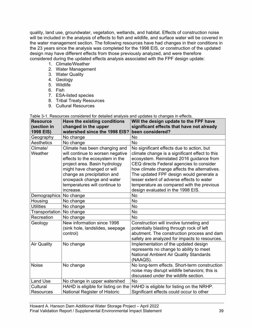
Howard A. Hanson Dam Additional Water Storage Project – April 2022 Final Validation Report / Supplemental Environmental Impact Statement 39
quality, land use, groundwater, vegetation, wetlands, and habitat. Effects of construction noise will be included in the analysis of effects to fish and wildlife, and surface water will be covered in the water management section. The following resources have had changes in their conditions in the 23 years since the analysis was completed for the 1998 EIS, or construction of the updated design may have different effects from those previously analyzed, and were therefore considered during the updated effects analysis associated with the FPF design update:
1. Climate/Weather 2. Water Management 3. Water Quality 4. Geology 5. Wildlife 6. Fish 7. ESA-listed species 8. Tribal Treaty Resources 9. Cultural Resources
Table 3-1. Resources considered for detailed analysis and updates to changes in effects. Resource (section in 1998 EIS)
Have the existing conditions changed in the upper watershed since the 1998 EIS?
Will the design update to the FPF have significant effects that have not already been considered?
Geography No change No Aesthetics No change No Climate/ Weather
Climate has been changing and will continue to worsen negative effects to the ecosystem in the project area. Basin hydrology might have changed or will change as precipitation and snowpack change and water temperatures will continue to increase.
No significant effects due to action, but climate change is a significant effect to this ecosystem. Reinstated 2016 guidance from CEQ directs Federal agencies to consider how climate change affects the alternatives. The updated FPF design would generate a lesser extent of adverse effects to water temperature as compared with the previous design evaluated in the 1998 EIS.
Demographics No change No Housing No change No Utilities No change No Transportation No change No Recreation No change No Geology New information since 1998
(sink hole, landslides, seepage control)
Construction will involve tunneling and potentially blasting through rock of left abutment. The construction process and dam safety are analyzed for impacts to resources.
Air Quality No change Implementation of the updated design represents no change to ability to meet National Ambient Air Quality Standards (NAAQS).
Noise No change No long-term effects. Short-term construction noise may disrupt wildlife behaviors; this is discussed under the wildlife section.
Land Use No change in upper watershed No Cultural Resources
HAHD is eligible for listing on the National Register of Historic
HAHD is eligible for listing on the NRHP. Significant effects could occur to other
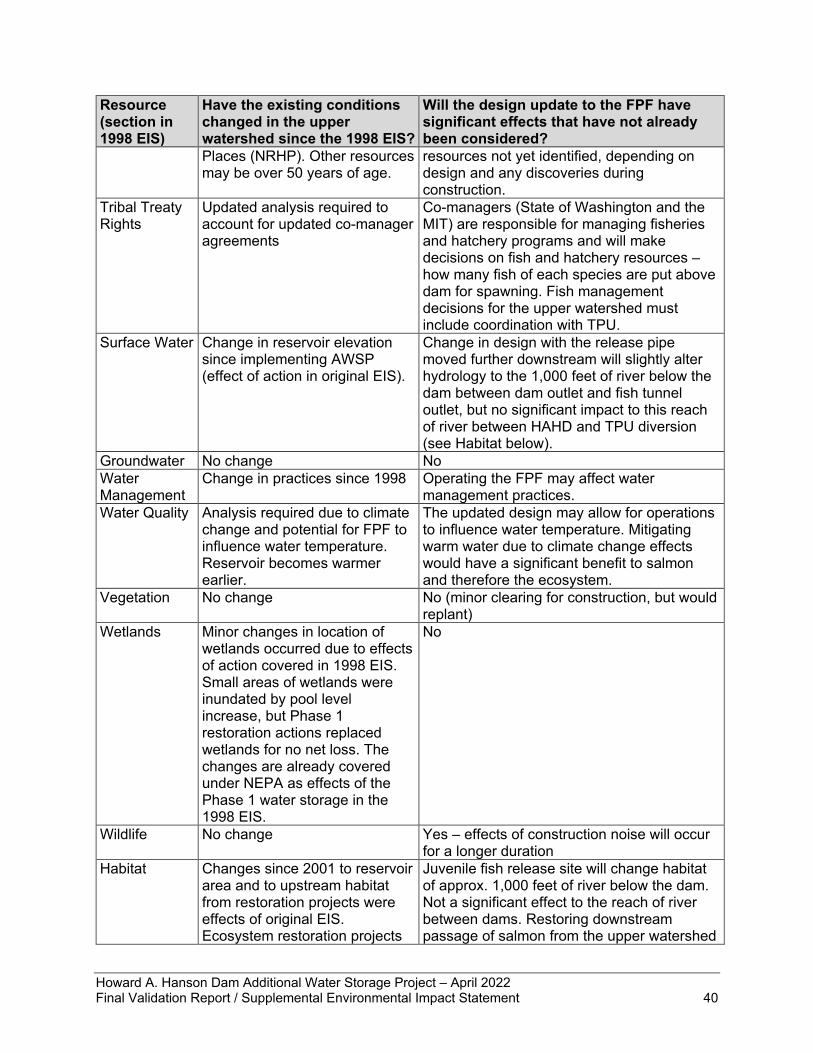
Howard A. Hanson Dam Additional Water Storage Project – April 2022 Final Validation Report / Supplemental Environmental Impact Statement 40
Resource (section in 1998 EIS)
Have the existing conditions changed in the upper watershed since the 1998 EIS?
Will the design update to the FPF have significant effects that have not already been considered?
Places (NRHP). Other resources may be over 50 years of age.
resources not yet identified, depending on design and any discoveries during construction.
Tribal Treaty Rights
Updated analysis required to account for updated co-manager agreements
Co-managers (State of Washington and the MIT) are responsible for managing fisheries and hatchery programs and will make decisions on fish and hatchery resources – how many fish of each species are put above dam for spawning. Fish management decisions for the upper watershed must include coordination with TPU.
Surface Water Change in reservoir elevation since implementing AWSP (effect of action in original EIS).
Change in design with the release pipe moved further downstream will slightly alter hydrology to the 1,000 feet of river below the dam between dam outlet and fish tunnel outlet, but no significant impact to this reach of river between HAHD and TPU diversion (see Habitat below).
Groundwater No change No Water Management
Change in practices since 1998 Operating the FPF may affect water management practices.
Water Quality Analysis required due to climate change and potential for FPF to influence water temperature. Reservoir becomes warmer earlier.
The updated design may allow for operations to influence water temperature. Mitigating warm water due to climate change effects would have a significant benefit to salmon and therefore the ecosystem.
Vegetation No change No (minor clearing for construction, but would replant)
Wetlands Minor changes in location of wetlands occurred due to effects of action covered in 1998 EIS. Small areas of wetlands were inundated by pool level increase, but Phase 1 restoration actions replaced wetlands for no net loss. The changes are already covered under NEPA as effects of the Phase 1 water storage in the 1998 EIS.
No
Wildlife No change Yes – effects of construction noise will occur for a longer duration
Habitat Changes since 2001 to reservoir area and to upstream habitat from restoration projects were effects of original EIS. Ecosystem restoration projects
Juvenile fish release site will change habitat of approx. 1,000 feet of river below the dam. Not a significant effect to the reach of river between dams. Restoring downstream passage of salmon from the upper watershed
Howard A. Hanson Dam Additional Water Storage Project – April 2022 Final Validation Report / Supplemental Environmental Impact Statement 41
Resource (section in 1998 EIS)
Have the existing conditions changed in the upper watershed since the 1998 EIS?
Will the design update to the FPF have significant effects that have not already been considered?
listed in the EIS were constructed 2004-2009
would have only beneficial effects, no significant negative effects.
Fish New information available on fish population in reservoir. Pink salmon population has grown significantly since mid-1990s.
Yes – need to consider increase in pink salmon population, and cutthroat trout as predators.
ESA-listed species
Chinook, steelhead, bull trout, and SRKW have all been listed since the EIS was prepared in the mid-late 1990s.
Yes – will restore ESA-listed salmon and significant prey resource to SRKW, which were not listed until 2006 and new information on their diet is available.
As part of the validation study for the updated design for the FPF, the Corps investigated whether any changes had occurred in the project area regarding the presence of hazardous, toxic, and radioactive waste (HTRW) as well as whether proposed staging and construction support areas contained HTRW. An Environmental Condition of Property (ECP) Report and Phase I Environmental Site Assessment (Phase I ESA) has been prepared to review the environmental history and condition of the proposed construction support areas. The ECP report findings indicate a documented spill of diesel fuel and subsequent remediation of petroleum-contaminated soil at the lower Milepost 3.5 site (which is in USACE ownership). Remedial action is complete and no further cleanup or monitoring is required for this site. With respect to the remainder of the proposed construction support sites, there is no record of releases of hazardous substances or petroleum or disposal of contamination at these locations. Because remediation is complete and because there is no record of further environmental release, the proposed construction support sites can be used as intended and without further consideration with respect to historical environmental contamination. In addition to updating the effects analyses for resources listed in the 1998 EIS, this document will also provide information on how the proposed action complies with legal requirements enacted since 1998. These are provided in chapter 5.
3.4 Climate and Weather Climate and weather were discussed in section 5.1.3 of the Draft EIS (USACE 1998). The western Washington area in the vicinity of HAHD has a typical west coast maritime climate characterized by mild winters and cool summers. Weather in the project area is influenced by the nearby Cascade mountain range, Mount Rainier, and Puget Sound. Prevailing winds from the southwest bring in moist air; winds from the north and northwest bring clearer weather. Reinstated 2016 guidance from CEQ directs Federal agencies to consider how climate change affects a proposed action and the alternatives. The Corps is applying the updated climate change analysis guidance only to the FPF feature of the AWSP as that is the only remaining component of Phase I to be implemented. The following descriptions of potential changes in climate and the effects of the alternatives follow the USACE Climate Policy as described in USACE Engineering Construction Bulletin 2018-14 Guidance for Incorporating Climate Change Impacts to Inland Hydrology in Civil Works Studies, Designs, And Projects (USACE 2018a). When implementation of AWSP Phase II is proposed, further climate change analysis would be applied to that action.
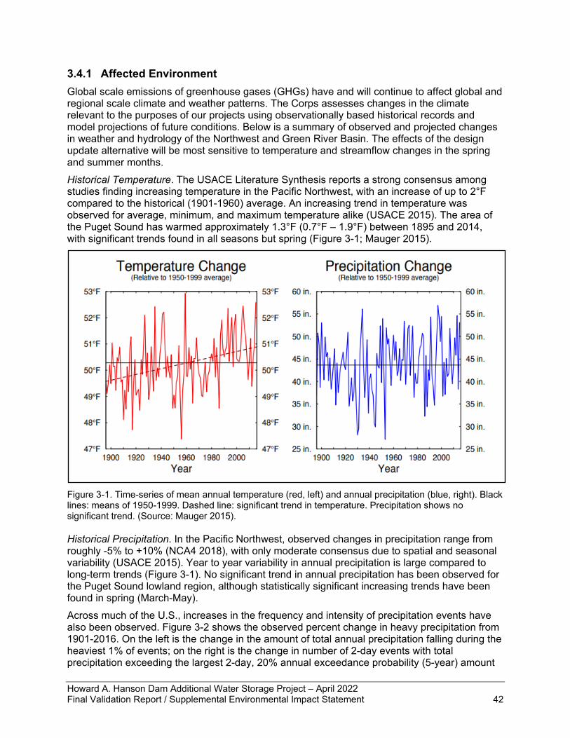
Howard A. Hanson Dam Additional Water Storage Project – April 2022 Final Validation Report / Supplemental Environmental Impact Statement 42
3.4.1 Affected Environment Global scale emissions of greenhouse gases (GHGs) have and will continue to affect global and regional scale climate and weather patterns. The Corps assesses changes in the climate relevant to the purposes of our projects using observationally based historical records and model projections of future conditions. Below is a summary of observed and projected changes in weather and hydrology of the Northwest and Green River Basin. The effects of the design update alternative will be most sensitive to temperature and streamflow changes in the spring and summer months. Historical Temperature. The USACE Literature Synthesis reports a strong consensus among studies finding increasing temperature in the Pacific Northwest, with an increase of up to 2°F compared to the historical (1901-1960) average. An increasing trend in temperature was observed for average, minimum, and maximum temperature alike (USACE 2015). The area of the Puget Sound has warmed approximately 1.3°F (0.7°F – 1.9°F) between 1895 and 2014, with significant trends found in all seasons but spring (Figure 3-1; Mauger 2015).
Figure 3-1. Time-series of mean annual temperature (red, left) and annual precipitation (blue, right). Black lines: means of 1950-1999. Dashed line: significant trend in temperature. Precipitation shows no significant trend. (Source: Mauger 2015). Historical Precipitation. In the Pacific Northwest, observed changes in precipitation range from roughly -5% to +10% (NCA4 2018), with only moderate consensus due to spatial and seasonal variability (USACE 2015). Year to year variability in annual precipitation is large compared to long-term trends (Figure 3-1). No significant trend in annual precipitation has been observed for the Puget Sound lowland region, although statistically significant increasing trends have been found in spring (March-May). Across much of the U.S., increases in the frequency and intensity of precipitation events have also been observed. Figure 3-2 shows the observed percent change in heavy precipitation from 1901-2016. On the left is the change in the amount of total annual precipitation falling during the heaviest 1% of events; on the right is the change in number of 2-day events with total precipitation exceeding the largest 2-day, 20% annual exceedance probability (5-year) amount
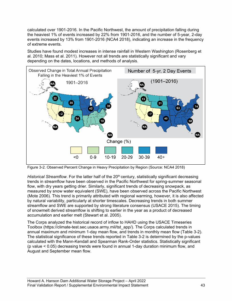
Howard A. Hanson Dam Additional Water Storage Project – April 2022 Final Validation Report / Supplemental Environmental Impact Statement 43
calculated over 1901-2016. In the Pacific Northwest, the amount of precipitation falling during the heaviest 1% of events increased by 22% from 1901-2016, and the number of 5-year, 2-day events increased by 13% from 1901-2016 (NCA4 2018), indicating an increase in the frequency of extreme events. Studies have found modest increases in intense rainfall in Western Washington (Rosenberg et al. 2010; Mass et al. 2011). However not all trends are statistically significant and vary depending on the dates, locations, and methods of analysis.
Figure 3-2. Observed Percent Change in Heavy Precipitation by Region (Source: NCA4 2018) Historical Streamflow. For the latter half of the 20th century, statistically significant decreasing trends in streamflow have been observed in the Pacific Northwest for spring-summer seasonal flow, with dry years getting drier. Similarly, significant trends of decreasing snowpack, as measured by snow water equivalent (SWE), have been observed across the Pacific Northwest (Mote 2006). This trend is primarily attributed with regional warming, however, it is also affected by natural variability, particularly at shorter timescales. Decreasing trends in both summer streamflow and SWE are supported by strong literature consensus (USACE 2015). The timing of snowmelt derived streamflow is shifting to earlier in the year as a product of decreased accumulation and earlier melt (Stewart et al. 2005). The Corps analyzed the historical record of inflow to HAHD using the USACE Timeseries Toolbox (https://climate-test.sec.usace.army.mil/tst_app/). The Corps calculated trends in annual maximum and minimum 1-day mean flow, and trends in monthly mean flow (Table 3-2). The statistical significance of these trends reported in Table 3-2 is determined by the p-values calculated with the Mann-Kendall and Spearman Rank-Order statistics. Statistically significant (p value < 0.05) decreasing trends were found in annual 1-day duration minimum flow, and August and September mean flow.
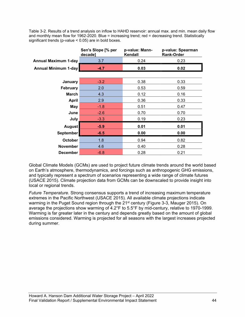
Howard A. Hanson Dam Additional Water Storage Project – April 2022 Final Validation Report / Supplemental Environmental Impact Statement 44
Table 3-2. Results of a trend analysis on inflow to HAHD reservoir: annual max. and min. mean daily flow and monthly mean flow for 1962-2020. Blue = increasing trend; red = decreasing trend. Statistically significant trends (p-value < 0.05) are in bold boxes.
Sen's Slope [% per decade]
p-value: Mann-Kendall
p-value: Spearman Rank-Order
Annual Maximum 1-day 3.7 0.24 0.23
Annual Minimum 1-day -4.7 0.03 0.02
January -3.2 0.38 0.33
February 2.0 0.53 0.59 March 4.3 0.12 0.16
April 2.9 0.36 0.33 May -1.8 0.51 0.47
June -2.6 0.70 0.70 July -3.3 0.19 0.23
August -5.9 0.01 0.01 September -6.5 0.00 0.00
October 1.8 0.94 0.82 November 4.6 0.40 0.28 December -6.8 0.28 0.21
Global Climate Models (GCMs) are used to project future climate trends around the world based on Earth’s atmosphere, thermodynamics, and forcings such as anthropogenic GHG emissions, and typically represent a spectrum of scenarios representing a wide range of climate futures (USACE 2015). Climate projection data from GCMs can be downscaled to provide insight into local or regional trends. Future Temperature. Strong consensus supports a trend of increasing maximum temperature extremes in the Pacific Northwest (USACE 2015). All available climate projections indicate warming in the Puget Sound region through the 21st century (Figure 3-3, Mauger 2015). On average the projections show warming of 4.2°F to 5.5°F by mid-century, relative to 1970-1999. Warming is far greater later in the century and depends greatly based on the amount of global emissions considered. Warming is projected for all seasons with the largest increases projected during summer.
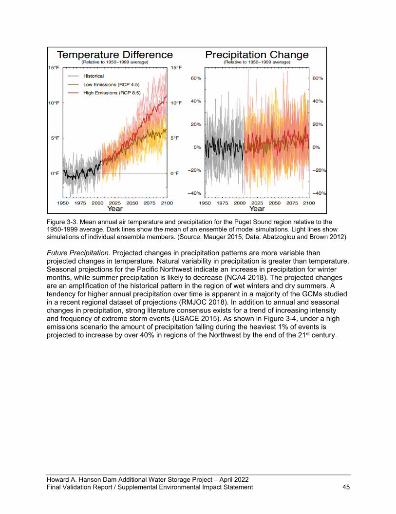
Howard A. Hanson Dam Additional Water Storage Project – April 2022 Final Validation Report / Supplemental Environmental Impact Statement 45
Figure 3-3. Mean annual air temperature and precipitation for the Puget Sound region relative to the 1950-1999 average. Dark lines show the mean of an ensemble of model simulations. Light lines show simulations of individual ensemble members. (Source: Mauger 2015; Data: Abatzoglou and Brown 2012) Future Precipitation. Projected changes in precipitation patterns are more variable than projected changes in temperature. Natural variability in precipitation is greater than temperature. Seasonal projections for the Pacific Northwest indicate an increase in precipitation for winter months, while summer precipitation is likely to decrease (NCA4 2018). The projected changes are an amplification of the historical pattern in the region of wet winters and dry summers. A tendency for higher annual precipitation over time is apparent in a majority of the GCMs studied in a recent regional dataset of projections (RMJOC 2018). In addition to annual and seasonal changes in precipitation, strong literature consensus exists for a trend of increasing intensity and frequency of extreme storm events (USACE 2015). As shown in Figure 3-4, under a high emissions scenario the amount of precipitation falling during the heaviest 1% of events is projected to increase by over 40% in regions of the Northwest by the end of the 21st century.
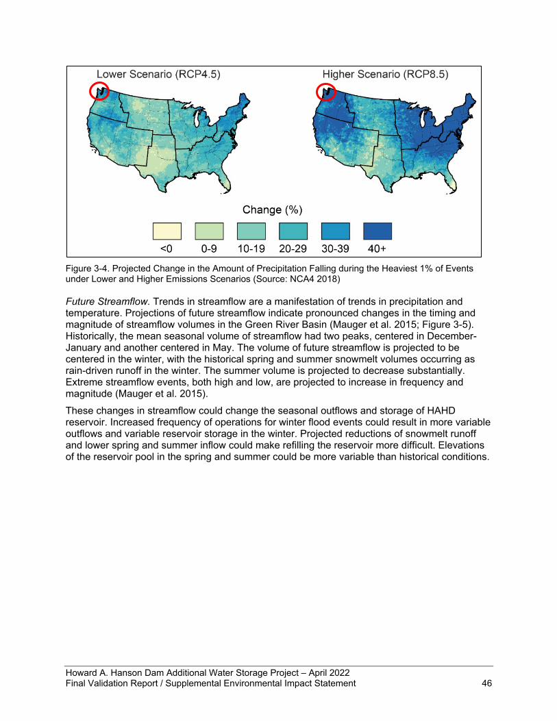
Howard A. Hanson Dam Additional Water Storage Project – April 2022 Final Validation Report / Supplemental Environmental Impact Statement 46
Figure 3-4. Projected Change in the Amount of Precipitation Falling during the Heaviest 1% of Events under Lower and Higher Emissions Scenarios (Source: NCA4 2018) Future Streamflow. Trends in streamflow are a manifestation of trends in precipitation and temperature. Projections of future streamflow indicate pronounced changes in the timing and magnitude of streamflow volumes in the Green River Basin (Mauger et al. 2015; Figure 3-5). Historically, the mean seasonal volume of streamflow had two peaks, centered in December-January and another centered in May. The volume of future streamflow is projected to be centered in the winter, with the historical spring and summer snowmelt volumes occurring as rain-driven runoff in the winter. The summer volume is projected to decrease substantially. Extreme streamflow events, both high and low, are projected to increase in frequency and magnitude (Mauger et al. 2015). These changes in streamflow could change the seasonal outflows and storage of HAHD reservoir. Increased frequency of operations for winter flood events could result in more variable outflows and variable reservoir storage in the winter. Projected reductions of snowmelt runoff and lower spring and summer inflow could make refilling the reservoir more difficult. Elevations of the reservoir pool in the spring and summer could be more variable than historical conditions.
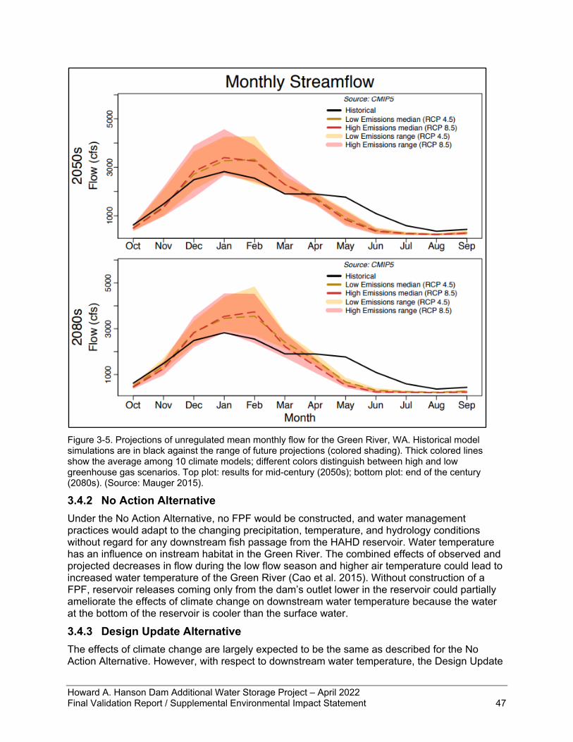
Howard A. Hanson Dam Additional Water Storage Project – April 2022 Final Validation Report / Supplemental Environmental Impact Statement 47
Figure 3-5. Projections of unregulated mean monthly flow for the Green River, WA. Historical model simulations are in black against the range of future projections (colored shading). Thick colored lines show the average among 10 climate models; different colors distinguish between high and low greenhouse gas scenarios. Top plot: results for mid-century (2050s); bottom plot: end of the century (2080s). (Source: Mauger 2015).
3.4.2 No Action Alternative Under the No Action Alternative, no FPF would be constructed, and water management practices would adapt to the changing precipitation, temperature, and hydrology conditions without regard for any downstream fish passage from the HAHD reservoir. Water temperature has an influence on instream habitat in the Green River. The combined effects of observed and projected decreases in flow during the low flow season and higher air temperature could lead to increased water temperature of the Green River (Cao et al. 2015). Without construction of a FPF, reservoir releases coming only from the dam’s outlet lower in the reservoir could partially ameliorate the effects of climate change on downstream water temperature because the water at the bottom of the reservoir is cooler than the surface water.
3.4.3 Design Update Alternative The effects of climate change are largely expected to be the same as described for the No Action Alternative. However, with respect to downstream water temperature, the Design Update
Howard A. Hanson Dam Additional Water Storage Project – April 2022 Final Validation Report / Supplemental Environmental Impact Statement 48
Alternative could exacerbate the effects of climate change on warming downstream water temperature. Water discharged from the surface of the reservoir will be warmer than water discharged from outlets that are at the bottom of the reservoir in the No Action Alternative. This could be partially mitigated by releasing water from collector horns lower in the reservoir in addition to the surface horn at times when there is enough discharge to operate collector horns. The projected effects of climate change resulting in potential reductions in reservoir inflow and reservoir storage could reduce reservoir discharge to a level where only a single outlet could be used or to a level where the FPF is inoperable (see section 3.5.3 for more discussion). The multiport collector design provides greater flexibility in controlling water temperatures compared to the previous design described in the 1998 EIS, which is an improvement as compared with previously evaluated impacts in light of anticipated temperature regime changes caused by climate change. The proposed action would not have a measurable contribution to the GHG emissions measured on a statewide scale (Ecology 2018), nor would the action cause any change to the trend of increasing maximum temperature extremes in the Pacific Northwest (USACE 2015). This type of construction project is not one of the recognized major contributors of GHG emissions (Ecology 2018).
3.5 Water Management The discussion of water management practices for HAHD appears in section 5.8.3 of the Draft EIS (USACE 1998). The Corps has changed water allocation quantities and timing; updates are provided below.
3.5.1 Affected Environment With implementation of the AWSP, HAHD operates for flood risk management, low flow water augmentation, water supply, and ecosystem restoration benefits. Flood risk management for the Green River valley is managed through the impoundment of water from streams and tributaries in the upper watershed into Eagle Gorge Reservoir during the peak flood season, November through February. For flood risk reduction, the reservoir is empty beginning in November. The pool is kept low unless it is storing flood water. In a high flow event, the reservoir can fill quickly. Typically, some volume of the reservoir is used more than once each flood season. The peak pool at HAHD was 1,188 feet in 2009. In the spring, HAHD switches from its primary role (flood storage) to its secondary role (conservation storage for low flow augmentation). The originally authorized summer conservation pool elevation was 1,141 feet. In 1997, a Section 1135 ecosystem restoration project authorized an additional 5,000 ac-ft of water (between elevation 1,141 and 1,147 feet) to be stored during the spring refill above the original authorized fish conservation elevation. The water is used to augment flows for fish resources. Based on the AWSP Phase I plan, the pool was raised to 1,167ft, an additional 20,000 ac-ft, to hold water for municipal water supply for the city of Tacoma. The city of Tacoma diverts its principal municipal water supply from the Green River downstream of HAHD. Figure 3-6 shows the distribution of stored water through AWSP Phase I. To fill HAHD to the full pool, 1,167 feet, water is captured and stored behind the dam from late February through June. The exact rate of refill is adaptively managed with the Green River Flow Management Coordination Committee (GRFMCC), which includes representatives from the MIT, TPU, and other Federal, state, and local agencies. The HAHD pool reaches its peak elevation in the spring, and then it is slowly drawn down through the summer and early fall. Following refill in the summer and early fall, flows from HAHD are regulated to ensure minimum flow targets are met (110 cfs at Palmer and 250 cfs at Auburn). Additional releases are made
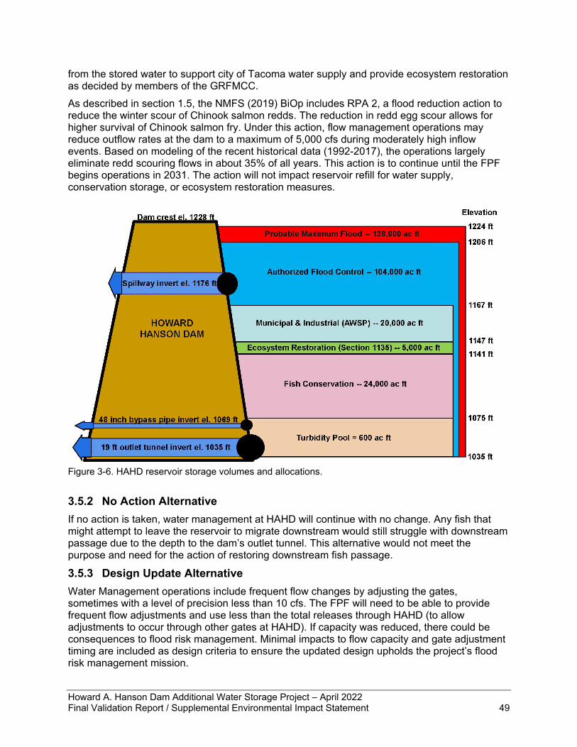
Howard A. Hanson Dam Additional Water Storage Project – April 2022 Final Validation Report / Supplemental Environmental Impact Statement 49
from the stored water to support city of Tacoma water supply and provide ecosystem restoration as decided by members of the GRFMCC. As described in section 1.5, the NMFS (2019) BiOp includes RPA 2, a flood reduction action to reduce the winter scour of Chinook salmon redds. The reduction in redd egg scour allows for higher survival of Chinook salmon fry. Under this action, flow management operations may reduce outflow rates at the dam to a maximum of 5,000 cfs during moderately high inflow events. Based on modeling of the recent historical data (1992-2017), the operations largely eliminate redd scouring flows in about 35% of all years. This action is to continue until the FPF begins operations in 2031. The action will not impact reservoir refill for water supply, conservation storage, or ecosystem restoration measures.
Figure 3-6. HAHD reservoir storage volumes and allocations.
3.5.2 No Action Alternative If no action is taken, water management at HAHD will continue with no change. Any fish that might attempt to leave the reservoir to migrate downstream would still struggle with downstream passage due to the depth to the dam’s outlet tunnel. This alternative would not meet the purpose and need for the action of restoring downstream fish passage.
3.5.3 Design Update Alternative Water Management operations include frequent flow changes by adjusting the gates, sometimes with a level of precision less than 10 cfs. The FPF will need to be able to provide frequent flow adjustments and use less than the total releases through HAHD (to allow adjustments to occur through other gates at HAHD). If capacity was reduced, there could be consequences to flood risk management. Minimal impacts to flow capacity and gate adjustment timing are included as design criteria to ensure the updated design upholds the project’s flood risk management mission.
Howard A. Hanson Dam Additional Water Storage Project – April 2022 Final Validation Report / Supplemental Environmental Impact Statement 50
Climate change may impact basin hydrology, including more extreme winter storms, smaller snowpack, and drier summers. It is possible reservoir refill will become more difficult, which would impact the quantity of water available during low flow conditions. Summer streamflow and reservoir releases may be lower with climate change, which would limit the period that the FPF operates. The FPF may see limitations in total flow available in the late summer. It is assumed that 280 cfs is the minimum total HAHD outflow needed to operate the FPF (based on minimum downstream flow requirements), which consists of 230 cfs through the facility and 50 cfs passed through existing outlets to maintain flow in the stilling basin. Spring and summer releases are determined adaptively with the GRFMCC. During this season, average HAHD releases drop to near 270 cfs late in the summer. Based on data in the last 30 years, the 75th percentile for annual observed minimum flow at HAHD is 280 cfs. Alternatively, this means that there is only a 25% chance in any given year that minimum flows will stay higher than 280 cfs for the entire season. It is possible the FPF will not be operable when releases are less than 280 cfs. However, this is given current adaptive management priorities. It is possible the GRFMCC would use flows differently from historically to maintain FPF operations. If construction of the FPF occurs during the flood season, it will either need to withstand (or be prepared to evacuate) reservoir level increases with the potential to reach full pool, 1,206 feet, in the largest flood events. The highest pool observed peaked at 1,188 feet. During the refill season, construction will need to withstand the full conservation pool of 1,167 feet. Compared to the previously considered design described in the 1998 EIS, this updated design would have no change to the water management regime at HAHD. In addition to completing the FPF, the Corps is proposing to continue implementation of RPA 2 limiting outflows in most instances to 5,000 cfs between October 15 and February 28. This benefit to the earliest lifestage of salmon and steelhead will reduce the continuing impacts of HAHD associated with the amount of time required to implement RPA 1.
3.6 Water Quality Under the Clean Water Act, the Washington State Department of Ecology (Ecology) establishes standards for physical parameters of water, such as temperature, pH level, dissolved oxygen (DO), and turbidity. Temperature has a strong influence on aquatic organisms that can survive and thrive in any particular habitat and can affect numbers, sizes, and distributions of biota. DO is essential for freshwater aquatic life. Low DO levels can have natural causes such as seasonal variations or can be a sign of human‐induced impacts such as excessive runoff of nutrients. Turbidity refers to the clarity or clearness of the water. The greater the amount of total suspended solids in the water, the murkier it appears, and the higher the measured turbidity. Turbidity is regulated because it relates to healthy habitat for fish, invertebrates, and aquatic plants. Waters that do not meet established standards are considered “polluted waters.” Polluted waters are placed on a 303(d) list of threatened and impaired waterbodies that Ecology regularly publishes (in reference to Section 303(d) of the Clean Water Act). Waters with signs of diminished health but still meeting standards are “waters of concern” on the 303(d) list. Ecology classifies water bodies into categories that range from Category 1 (meets tested standards for clean waters) to Category 5 (polluted waters that require a water improvement project). Water quality conditions for the project area are described in section 5.8.4 of the Draft EIS (USACE 1998). The Corps completed a Section 404(b)(1) evaluation to address the substantive compliance issues of the Clean Water Act 404(b)(1) Guidelines (40 CFR §230.12(a)) and the Regulatory Programs of the Corps of Engineers (33 CFR §320.4(a)) for phase I of the AWSP,
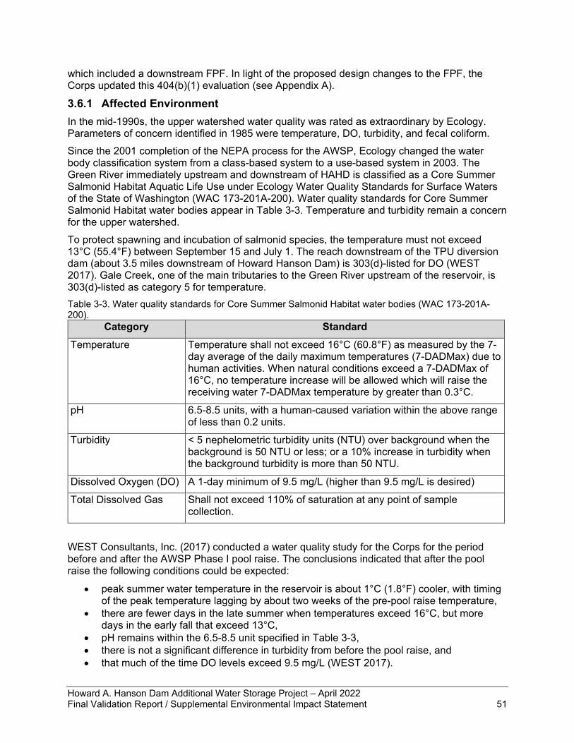
Howard A. Hanson Dam Additional Water Storage Project – April 2022 Final Validation Report / Supplemental Environmental Impact Statement 51
which included a downstream FPF. In light of the proposed design changes to the FPF, the Corps updated this 404(b)(1) evaluation (see Appendix A).
3.6.1 Affected Environment In the mid-1990s, the upper watershed water quality was rated as extraordinary by Ecology. Parameters of concern identified in 1985 were temperature, DO, turbidity, and fecal coliform. Since the 2001 completion of the NEPA process for the AWSP, Ecology changed the water body classification system from a class-based system to a use-based system in 2003. The Green River immediately upstream and downstream of HAHD is classified as a Core Summer Salmonid Habitat Aquatic Life Use under Ecology Water Quality Standards for Surface Waters of the State of Washington (WAC 173-201A-200). Water quality standards for Core Summer Salmonid Habitat water bodies appear in Table 3-3. Temperature and turbidity remain a concern for the upper watershed. To protect spawning and incubation of salmonid species, the temperature must not exceed 13°C (55.4°F) between September 15 and July 1. The reach downstream of the TPU diversion dam (about 3.5 miles downstream of Howard Hanson Dam) is 303(d)-listed for DO (WEST 2017). Gale Creek, one of the main tributaries to the Green River upstream of the reservoir, is 303(d)-listed as category 5 for temperature. Table 3-3. Water quality standards for Core Summer Salmonid Habitat water bodies (WAC 173-201A-200).
Category Standard Temperature Temperature shall not exceed 16°C (60.8°F) as measured by the 7-
day average of the daily maximum temperatures (7-DADMax) due to human activities. When natural conditions exceed a 7-DADMax of 16°C, no temperature increase will be allowed which will raise the receiving water 7-DADMax temperature by greater than 0.3°C.
pH 6.5-8.5 units, with a human-caused variation within the above range of less than 0.2 units.
Turbidity < 5 nephelometric turbidity units (NTU) over background when the background is 50 NTU or less; or a 10% increase in turbidity when the background turbidity is more than 50 NTU.
Dissolved Oxygen (DO) A 1-day minimum of 9.5 mg/L (higher than 9.5 mg/L is desired)
Total Dissolved Gas Shall not exceed 110% of saturation at any point of sample collection.
WEST Consultants, Inc. (2017) conducted a water quality study for the Corps for the period before and after the AWSP Phase I pool raise. The conclusions indicated that after the pool raise the following conditions could be expected:
• peak summer water temperature in the reservoir is about 1°C (1.8°F) cooler, with timing of the peak temperature lagging by about two weeks of the pre-pool raise temperature,
• there are fewer days in the late summer when temperatures exceed 16°C, but more days in the early fall that exceed 13°C,
• pH remains within the 6.5-8.5 unit specified in Table 3-3, • there is not a significant difference in turbidity from before the pool raise, and • that much of the time DO levels exceed 9.5 mg/L (WEST 2017).
Howard A. Hanson Dam Additional Water Storage Project – April 2022 Final Validation Report / Supplemental Environmental Impact Statement 52
It was also noted that there was a statistically significant increasing trend in temperature at the inflow monitoring station (at the far end of the reservoir; WEST 2017). Turbidity has seasonally exceeded “Core Summer Habitat” standards in the Green River above HAHD (USACE 2011). Periods of high turbidity are associated with elevated runoff during periods of heavy rainfall or rapid snowmelt. Per the most recent BiOp (NMFS 2019), the Corps will attempt to keep outflow turbidity below 30 NTU when conducting sediment clearing operations, which is when the Corps gradually lowers the reservoir to achieve a reduction in total quantity of sediment that has accumulated on the upstream side of the dam until a noticeable increase in discharge turbidity is observed. Except for passing high turbidity flows during and shortly after flood events, sediment clearing operations are rare, with the most recent occurring circa 2006. Reservoir drawdown operations occur every year, however, to meet low flow augmentation demands in July-October and to reach a flood control pool of roughly elevation 1,075 feet. The drawdown to the flood control pool elevation is slow and deliberate, as the “turbidity pool” elevation can vary slightly from year to year. Careful monitoring of discharge turbidity occurs as the reservoir approaches empty. A temperature Total Maximum Daily Load Water Quality Improvement Report for the Green River was completed in 2011 (WDOE 2011). Numerous exceedances of state water quality standards have occurred in the Green/Duwamish River watershed, with 17 entries on the 303(d) list for exceedance of the temperature water quality criterion (WDOE 2012). The majority of the 303(d) listings are in the lower river downstream of RM 35; however, two listings are near HAHD including just downstream of the Tacoma Headworks Dam at RM 61 and at Kanaskat-Palmer State Park at RM 57.
3.6.2 No Action Alternative Under the No Action alternative, any trends in water quality parameters in the reservoir and water released from the dam would continue without influence from efforts to provide downstream fish passage. The GRFMCC may take water temperature under consideration when making recommendations on discharges from HAHD. An analysis of whether dam releases could influence river temperatures as far downstream as the 303(d) listing locations for temperatures would need to occur for effective decision making. Under the no-action alternative, the area that was excavated for constructing a fish passage structure would be filled in with roller-compacted concrete to ensure structural stability of the dam’s outlet tower. This work would occur inside the enclosed area behind the cofferdam. The fill would have a minimal temporary risk to water quality parameters of turbidity and pH in the reservoir due to no hydraulic connection other than minimal seepage through seams around the cofferdam components. Water pressure would be from the reservoir toward the cofferdam with no way for the water to move downstream to the river. As the concrete fill is poured, pumps would remove water from the excavation and discharge the water to the sedimentation ponds that were part of the initial construction for stormwater management. Construction would take several months, but the risk to water quality would be of short duration in each layer of fill as the concrete solidifies quickly.
3.6.3 Design Update Alternative Water temperature of the mainstem Green River is a concern for the coldwater fish species native to the Pacific Northwest, particularly the ESA-listed salmonids that may not be able to adapt to climate change fast enough to avoid population impacts. Once operational, the FPF would be releasing water from near the surface of the reservoir, which tends to be warmer than the water at the bottom of the reservoir in August and September due to the establishment of the thermocline throughout the warmer summer months. This warmer water would mix with any water being released from the dam’s outlet tunnel and may influence the river’s temperature
Howard A. Hanson Dam Additional Water Storage Project – April 2022 Final Validation Report / Supplemental Environmental Impact Statement 53
downstream for several miles until water from major tributaries joins the mainstem; the quantity and temperature of contributions from tributaries or riparian shading would mask the influence of warmer water released through the FPF. Other influences on water temperature downstream from the dam such as canopy cover and hyporheic flow would also provide a greater influence on temperature than that from surface water releases from the reservoir. The FPF is designed to operate two adjacent collectors – the two closest to the surface – when inflow exceeds 600 cfs. Operation of non-adjacent collectors could be explored as an adaptive management practice to optimize fishing at reservoir depths that contain fish. Such an operation may also have temperature management benefits. The collector at the lowest elevation could be opened to provide cooler water from the bottom of the reservoir with only minimal risk of increasing downstream turbidity due to mobilizing sediments on the upstream side of the dam. However, no specific design considerations have been evaluated to this point that would affirm the feasibility of such an operation. Similarly, use of the dam’s existing outlet tunnel could be part of a temperature management strategy, which can be evaluated in PED phase. The updated design alternative would have slightly better water temperature control compared to the previously considered design evaluated in the 1998 EIS. None of the temperature effects would extend outside the geographic scope of this evaluation. Construction of the FPF may have short-term and minor effects to water quality below HAHD for approximately 1 mile, based on recent experience with other local large-scale FPF construction. These effects may occur during work on the cofferdam on the upstream side of the dam and during in-stream construction for the outlet structure below the dam. Tremie concrete pours (i.e., underwater concrete pouring) may be necessary, which could affect pH in the river if the water is not contained within a work isolation zone. Construction on the riverbank and in the channel for the FPF outlet structure may have some excavation debris and sediment that enters the river. Turbidity from construction would be expected to meet state water quality standards in all but the most extreme, rare instances. Increased turbidity would only occur during the in-water work window of July 1 through September 30 in each of the 3 to 4 years of construction. Any short-term increases to turbidity would be expected to endure for a few hours or less due to the proposed monitoring schedule and actions to slow or stop work. The effects are expected to be minor because the high-quality habitat is resilient and would recover immediately; additionally, the fish species in this reach of river are accustomed to high levels of turbidity that occur throughout the river during winter storms and would likely seek refuge in the edge habitat away from any narrow plume caused by construction. No mortality is anticipated from construction-related turbidity or pH increases because of experience with similar projects and a comprehensive set of best management practices (BMPs) that would be in place. To provide the greatest possible protection of pH, turbidity, and other water quality parameters, the Corps will have a comprehensive Care and Diversion of Water Plan as well as an Environmental Protection Plan as part of the construction contract documents. The purpose of these documents is to avoid and minimize negative effects to water quality and the environment. The plans will include all BMPs to maximize protection of water quality including those required in the NMFS BiOp. The Corps would obtain and strictly adhere to a Clean Water Act section 401 Water Quality Certification issued by Ecology. No lasting effects to water quality would be expected to result from construction of the bank stabilization for the outlet pipe below HAHD. Ecology’s 401 Water Quality Certification issued in 2002 for the FPF (Order #02SEACR-4581) covered all aspects of construction except for the new proposal to extend a pipe to approximately 800 to 2,000 feet downstream. The previous design assumed the fish transport pipes would use the flood control tunnel. The construction footprint below the ordinary high water mark would be approximately 46,000 square feet (1 acre) and roughly 500 feet of riverbank. This area includes the outfall stilling
Howard A. Hanson Dam Additional Water Storage Project – April 2022 Final Validation Report / Supplemental Environmental Impact Statement 54
basin, scour pool, outfall pipe for the fish, plunge pool, and access along the left bank to the plunge pool. Clearing and grubbing would be limited to only the areas required for access, staging, and construction of the facility components. During construction, vegetation removal could increase stormwater runoff. The Corps would require the contractor to control stormwater to prevent pollutants such as sediment or excess nutrients from entering the river (see section 5.3.2). After the outlet and the supporting crib wall are complete, the site will be replanted with native vegetation. Vegetated riparian zones are a key component of protecting water quality and in rivers and streams in the Pacific Northwest. In addition to work below ordinary high water as described above, an estimated 110,000 square feet (2.5 acres) of impacts would occur on the left bank for access road improvements, drainage improvements, and hillside stabilization. The left bank of the river in this area has significant drainage issues that continue to cause erosion of the hillside. These issues require stabilization (grading and drainage improvements) to prevent damage to the proposed facility. This area is largely a steep hillside that was cleared and stabilized for initial dam construction and continuing operations. The proposed action includes the removal of mature trees and shrubs at the tunnel outlet site. The Corps would replant around the area that must be stabilized for erosion protection. In addition to replanting disturbed areas, the Corps would replace trees and shrubs at a 5-to-1 ratio for riparian area lost to the permanent structure of the deceleration tunnel and outlet. During PED phase, the Corps would identify bare and hardened areas that are opportunities to plant appropriate native vegetation to improve riparian function to ensure no net loss of vegetated riparian zone. All aquatic areas disturbed by construction would be cleaned up and restored immediately after that phase of construction is complete according to the Care and Diversion of Water Plan to be developed during design phase. Final site clean-up and restoration would include ensuring all aquatic areas disturbed by construction have been returned to pre-construction conditions. Final site restoration would include decommissioning and removal of the sedimentation ponds with revegetation of the hill where they lie. The Corps has been continually removing invasive plant species from the area and will continue to do so. Native trees and grasses take over in their place. All new plantings would consist of native species.
3.7 Geology Section 5.3 of the Draft EIS (USACE 1998) describes the geological conditions of HAHD and the surrounding area. At the dam, the Green River Valley is characterized by a present-day canyon made by glacier action and a deeper, older buried channel immediately to the north. The buried channel is deeply cut into rock and then over time was filled, eroded, and partially filled with glacial, stream, and lake-derived materials. Long ago, the north wall of the valley collapsed, creating a large rockslide mass that covered the older valley floor and pushed the Green River against the south valley side where the pre-dam canyon is located.
3.7.1 Affected Environment Since 1998, changes to the geologic environment include construction of the entrance structure and partial excavation for the FPF at the left abutment and seepage remediation measure at the right abutment. In 2009, the project experienced a record flood event and the reservoir pool peaked at an elevation of 1,188.8 feet. In the days following the peak pool, conditions observed at the right abutment indicated that an internal erosion/piping failure mode had possibly initiated. These observations included sediment from a vertical well in the drainage tunnel, a depression on the upstream face of the right abutment, increased water levels along the right abutment, and dye tests indicating rapid movement of water to the drainage tunnel. Subsequent modifications to the project included the addition of twenty additional piezometers, a double-row
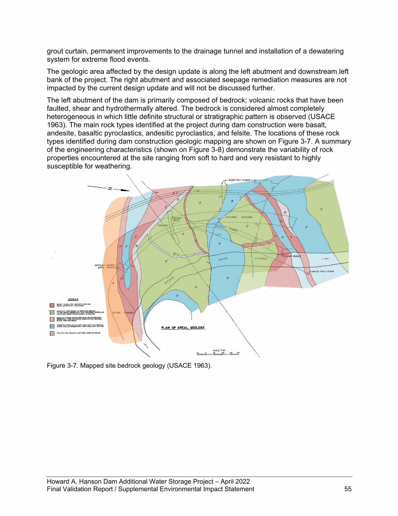
Howard A. Hanson Dam Additional Water Storage Project – April 2022 Final Validation Report / Supplemental Environmental Impact Statement 55
grout curtain, permanent improvements to the drainage tunnel and installation of a dewatering system for extreme flood events. The geologic area affected by the design update is along the left abutment and downstream left bank of the project. The right abutment and associated seepage remediation measures are not impacted by the current design update and will not be discussed further. The left abutment of the dam is primarily composed of bedrock; volcanic rocks that have been faulted, shear and hydrothermally altered. The bedrock is considered almost completely heterogeneous in which little definite structural or stratigraphic pattern is observed (USACE 1963). The main rock types identified at the project during dam construction were basalt, andesite, basaltic pyroclastics, andesitic pyroclastics, and felsite. The locations of these rock types identified during dam construction geologic mapping are shown on Figure 3-7. A summary of the engineering characteristics (shown on Figure 3-8) demonstrate the variability of rock properties encountered at the site ranging from soft to hard and very resistant to highly susceptible for weathering.
Figure 3-7. Mapped site bedrock geology (USACE 1963).
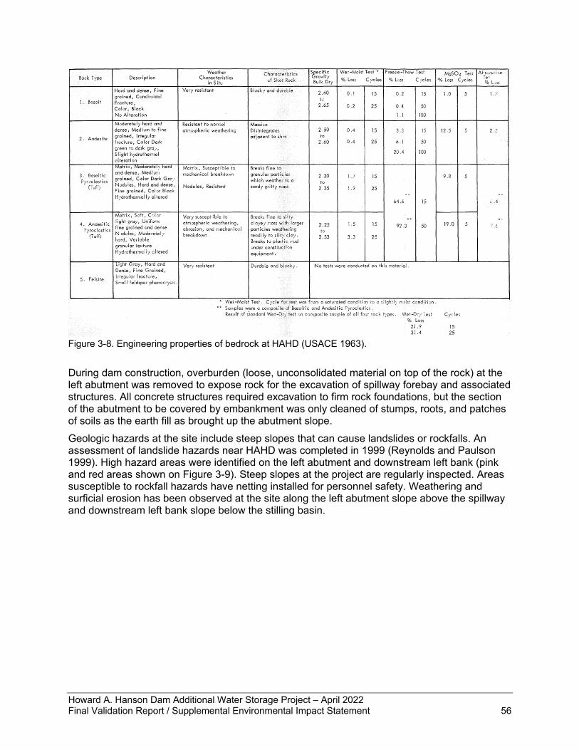
Howard A. Hanson Dam Additional Water Storage Project – April 2022 Final Validation Report / Supplemental Environmental Impact Statement 56
Figure 3-8. Engineering properties of bedrock at HAHD (USACE 1963). During dam construction, overburden (loose, unconsolidated material on top of the rock) at the left abutment was removed to expose rock for the excavation of spillway forebay and associated structures. All concrete structures required excavation to firm rock foundations, but the section of the abutment to be covered by embankment was only cleaned of stumps, roots, and patches of soils as the earth fill as brought up the abutment slope. Geologic hazards at the site include steep slopes that can cause landslides or rockfalls. An assessment of landslide hazards near HAHD was completed in 1999 (Reynolds and Paulson 1999). High hazard areas were identified on the left abutment and downstream left bank (pink and red areas shown on Figure 3-9). Steep slopes at the project are regularly inspected. Areas susceptible to rockfall hazards have netting installed for personnel safety. Weathering and surficial erosion has been observed at the site along the left abutment slope above the spillway and downstream left bank slope below the stilling basin.
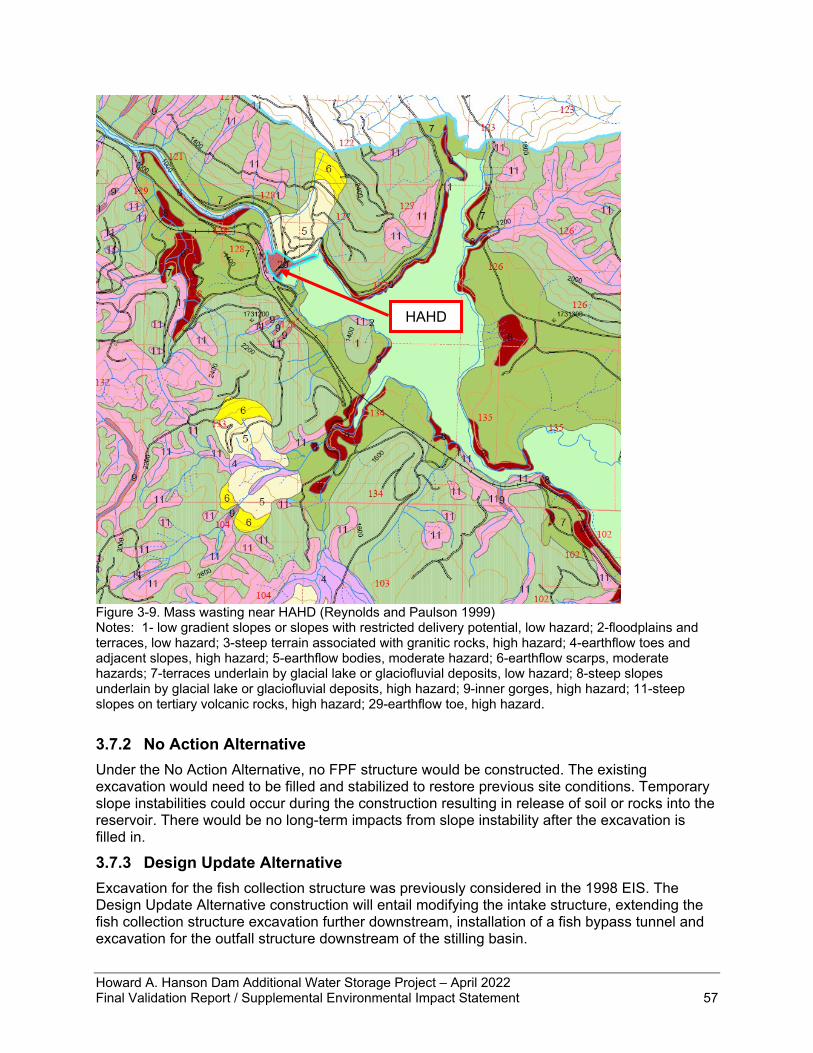
Howard A. Hanson Dam Additional Water Storage Project – April 2022 Final Validation Report / Supplemental Environmental Impact Statement 57
Figure 3-9. Mass wasting near HAHD (Reynolds and Paulson 1999) Notes: 1- low gradient slopes or slopes with restricted delivery potential, low hazard; 2-floodplains and terraces, low hazard; 3-steep terrain associated with granitic rocks, high hazard; 4-earthflow toes and adjacent slopes, high hazard; 5-earthflow bodies, moderate hazard; 6-earthflow scarps, moderate hazards; 7-terraces underlain by glacial lake or glaciofluvial deposits, low hazard; 8-steep slopes underlain by glacial lake or glaciofluvial deposits, high hazard; 9-inner gorges, high hazard; 11-steep slopes on tertiary volcanic rocks, high hazard; 29-earthflow toe, high hazard.
3.7.2 No Action Alternative Under the No Action Alternative, no FPF structure would be constructed. The existing excavation would need to be filled and stabilized to restore previous site conditions. Temporary slope instabilities could occur during the construction resulting in release of soil or rocks into the reservoir. There would be no long-term impacts from slope instability after the excavation is filled in.
3.7.3 Design Update Alternative Excavation for the fish collection structure was previously considered in the 1998 EIS. The Design Update Alternative construction will entail modifying the intake structure, extending the fish collection structure excavation further downstream, installation of a fish bypass tunnel and excavation for the outfall structure downstream of the stilling basin.
HAHD
Howard A. Hanson Dam Additional Water Storage Project – April 2022 Final Validation Report / Supplemental Environmental Impact Statement 58
During future design phases, explorations will be required to characterize the rock mass. Exploration duration could last several months and include borehole installation, in-situ testing, and geologic mapping. Erosion or slope instability risks would be minor during these explorations due to their limited extent. Construction duration of the proposed alternative is estimated at 3 to 4 years. Excavation methods will be similar to those evaluated in the 1998 EIS and previously used and include a combination of blasting and mechanical rock removal. Excavated materials will be hauled to the existing 6-mile disposal site. Dewatering will be used to control water flow into the excavated areas. BMPs will be used to control erosion and runoff during construction. Similar to the previous excavation activities, controlled blasting will be used during excavation to reduce risk to existing structures and the environment. As a frame of reference for purposes of evaluation of anticipated effects, blast vibrations were previously kept below the threshold peak particle velocity of 16 in/sec for protection of concrete structures. Blasting noise (air-overpressure) was to be kept below 133 decibels as measured near the nearest on-site building. Design of the facility will incorporate slope stabilization measures as necessary for the temporary construction period and long-term stability. Similar to previous excavation construction, instrumentation will be installed to monitor excavations and critical dam structures such as the outlet tower, outlet tunnel and spillway. Even with these measures, there is a risk of slope failure during construction that could result in release of soil or rock into the river. The highest risk area would likely be near the outfall structure downstream of the stilling basin where there is known surficial rock weathering and ongoing erosion from the hillside. In the event of a slope failure, construction would halt and the slope stabilized to mitigate for future instabilities.
3.8 Wildlife Section 5.9.1.c of the Draft EIS (USACE 1998) describes wildlife use around HAHD. Wildlife present in the vicinity of HAHD include common species associated with lowland coniferous and deciduous forests of western Washington. Because the upland forests in the project area consist primarily of younger stands, wildlife primarily associated with late successional forests are expected to be uncommon or absent from the area. Since 1998, there has been little change to wildlife resources. Wildlife species common to the west side of the central Cascade mountain range are still frequently observed using the habitat around HAHD and the upper watershed year-round.
3.8.1 Affected Environment Elk (Cervus elaphus) are on and near the HAHD project area throughout the year. HAHD is within the WDFW-established Green River game management unit (GMU) 485 (WDFW 2020). The MIT have conducted studies and monitoring within GMU 485 since 1998 (WDFW 2020). It is common to see radio-collared elk above the dam on easement lands along the river. The current population estimate within GMU 485 is over 600 elk, and permitted hunting is allowed within the upper watershed in designated areas (WDFW 2020) that are not controlled by the Corps. Hunting permits, elk numbers, and hunting seasons are jointly agreed upon by WDFW, TPU, and MIT (WDFW 2020). The main predators of elk in this area are cougar (Puma concolor), black bear (Ursus americanus), and bobcat (Lynx rufus). According to WDFW (2020), the cougar population in the area is stable, and they are the leading cause of mortality of collared elk in the MIT study areas. Additionally, the MIT have estimated black bear density within GMU 485 and 466 as 16.1 bears/100 km2. Other resident large mammals include mule deer (Odocoileus hemionus) and white-tailed deer (Odocoileus virginianus); numerous small mammals such as shrews, mice, squirrel, coyotes
Howard A. Hanson Dam Additional Water Storage Project – April 2022 Final Validation Report / Supplemental Environmental Impact Statement 59
(Canis latrans), raccoons (Procyon lotor), and skunks. Aquatic furbearers including beaver (Castor canadensis) and river otter (Lontra canadensis) are prevalent in the reservoir around the dam and in wood debris storage areas. Notable due to their scarcity, pika (Ochanta princeps) have been observed on the rock slopes along the railroad grade (USACE 1998) and most recently, in 2019 in a rock pile adjacent to the river (E. Niepert, Corps Engineer Research and Development Center, pers. comm. June 9, 2019). Several species of riparian and wetland-dependent amphibians are also present (USACE 1999; TPU 2001; Dickerson et al. 2019). Many of the non-marine avian species recorded in King County are winter migrants. Resident species of ducks and Canada geese (Branta canadensis) nest and rear their young on and around the lake. The project area also hosts wading birds such as great blue herons (Ardea herodias); shorebirds such as killdeer (Charadrius vociferus); substantial populations of nesting raptors including hawks, owls, bald eagles (Haliaeetus leucocephalus), and osprey (Pandion haliaetus); upland game birds such as quail and grouse; multiple woodpecker species; and a myriad of passerine birds. The Eagle Gorge reservoir at HAHD hosts the southernmost nesting pair of common loons (Gavia immer) in the continental U.S. The reservoir provides the favorable conditions of a relatively undisturbed large forest lake with deep inlets and bays, islands, logs, floating debris for nest sites, and with good water quality, adequate forage fish source, and seclusion from intense human activity (Richardson et al. 2000). The Corps and WDFW have worked together for many years to establish appropriate nesting platforms and to monitor successful chick rearing. Common loon is identified as a “Species of Greatest Conservation Need” as well as a Priority Species under WDFW’s programs.
3.8.2 No Action Alternative Under the No Action Alternative, if the Corps did not build the FPF, then wildlife use around HAHD would continue as described in section 3.8.1. Wildlife management by WDFW, TPU, and MIT in the upper watershed around HAHD would not change. Juvenile salmonids would not be available as an additional prey resource for piscivorous wildlife such as wading birds or otters, but that is not likely to have a substantial effect on wildlife populations given the available food sources. The lack of marine-derived nutrients in the upper watershed due to having no spawned-out salmon carcasses would continue to inhibit the vegetation growth potential and nutrient availability to predator and scavenger species.
3.8.3 Design Update Alternative Construction of the FPF would involve a substantially higher level of human activity in the first 1-6 miles of the road and area around HAHD. Construction activities would likely disturb the daily habits of wildlife in the area due to traffic, noise, vegetation clearing, dumping of excavated materials, blasting of bedrock, and other construction-related actions. Noise effects of blasting would last for a longer duration compared to impacts analyzed for the previous facility design because of the additional blasting for excavation of the steep slope bypass and deceleration tunnel through the left bank below HAHD. Construction activity would include a substantial amount of traffic of heavy machinery, large trucks, and workers’ vehicles entering the watershed and transiting the main road from Cumberland-Kanaskat Road SE up to the construction site at the dam. Excavated materials would likely be hauled to 1.5 miles farther up the road to the 6-mile disposal area. All these areas have some daily residential and commercial traffic, but not to the degree that would be required during construction. TPU would inspect all vehicles entering the watershed to ensure cleanliness and avoid introducing noxious weeds into the watershed.
Howard A. Hanson Dam Additional Water Storage Project – April 2022 Final Validation Report / Supplemental Environmental Impact Statement 60
Construction is expected to have a total duration of 3-4 years; however, any in-water work would be performed only during the in-water work window as approved by NMFS. Work inside the excavation behind the cofferdam would be allowed to occur year-round with safety and evacuation measures during peak flood season of November through February. Construction projects of this scale have the potential for 24-hour activity with lights and noise disturbance. The construction method to install the steep-slope bypass is the key component of the updated design relative to analyzing the difference in effects to wildlife compared to the previous design. Construction of the steep-slope bypass through the left abutment would likely require blasting through the bedrock and other soil types to extend the conduit to the outlet site within approximately 800-2,000 feet downstream from the dam. Blasting would have noise and vibration effects that would be alarming to wildlife in the area. Most mammal species would be expected to vacate the immediate construction area. The initial construction for the FPF that occurred in 2005-2011 involved blasting to create the excavation that is now behind the cofferdam. As stated in section 3.7.3 and provided as a frame of reference for purposes of evaluation of anticipated effects, blasting noise was to be kept below 133 decibels as measured near the nearest on-site building. This sound pressure level of 133 decibels is comparable to standing near jackhammers and ambulances. The human activity would cause animals to avoid the area at the onset of construction. The blasting noise would be a further nuisance that would likely cause animals to move farther away. No harm is expected to occur to wildlife from sound exposure because noise attenuates with distance and the wildlife would have moved to a sufficient distance to avoid harm. The timing of the most disruptive activities of construction, such as rock blasting for excavation, would take into consideration the timing and location of the nesting pair of loons and other nesting birds. The common loon pair that return to the HAHD reservoir each year typically arrive in April and establish a nest in May (USACE, unpublished data). Egg laying and chick rearing occur in late May through mid-July when fully feathered chicks are considered a successful brood (Richardson et al. 2000). The in-water work window for protection of fish is July 1 through September 30, so this would also be protective of common loons as they would likely be toward the later stage of fledging chicks in July. Biologists monitor the loon activity each year and would be able to provide guidance on timing of construction activity that would potentially be too disruptive for the loons to tolerate. The Corps will continue the yearly cooperation on loon monitoring with WDFW. The final phase of construction would involve complete site clean-up and restoration of any areas no longer needed as access and staging areas. This would include removal of the sedimentation ponds that were installed for stormwater control on the top of the knoll during the initial phase of construction and restoration of the forested habitat. All areas of disturbed or cleared of vegetation would be replanted with Pacific Northwest native species. Shrub species would be expected to reach maturity 3-7 years after planting while tree species would take 20 years or more to reach mature heights.
3.9 Fish Section 5.9.2.b of the Draft EIS (USACE 1998) discusses fish in the HAHD reservoir. Since 1998, updated information has become available on fish populations in the reservoir, and the 10 habitat restoration projects described in the 1998 EIS have been constructed along the Green River and in tributaries in the upper watershed.
3.9.1 Affected Environment Resident fish common to mountainous rivers are present in the upper watershed, such as cutthroat and brook trout, mountain whitefish, and sculpin. Natural spawning of fish above
Howard A. Hanson Dam Additional Water Storage Project – April 2022 Final Validation Report / Supplemental Environmental Impact Statement 61
HAHD is limited to resident cutthroat, rainbow/steelhead trout, and mountain whitefish. Anadromous salmonids that migrate upstream into the lower reaches of the upper Green River sub-watershed are coho salmon; spring, summer, and fall Chinook salmon; winter and summer steelhead; and pink salmon. Multiple hatcheries contribute to salmonid stocks: mostly the Green River Hatchery (WDFW), some from MIT and WDFW facilities on the river. Stocking of juvenile salmonids, particularly Chinook and coho salmon and steelhead occurred in the upper watershed but was discontinued in the early 2000s due to low survival rates through HAHD. The runs for the salmon/trout species that would arrive at TPU’s adult collection facility are as follows (ESA-listed species are discussed in section 3.10):
• The ESA-listed Puget Sound Chinook salmon in the Green River starts in mid-September and continues through October.
• The ESA-listed winter run of Puget Sound steelhead starts in November and continues through May. There are unlisted hatchery-raised steelhead within the system, and they have a summer run.
• The coho salmon run starts in August and continues through January. • The pink salmon run occurs throughout August.
The Green River chum salmon run starts in November and continues through December, but this species does not migrate upstream far enough to reach the upper watershed. Coastal/Puget Sound bull trout has no established runs within the Green/Duwamish River, but foraging and over-wintering bull trout have been recorded using the lower Green/Duwamish River sub-watershed. Over the past decade, hundreds of thousands up to millions of pink salmon (O. gorbuscha) have begun entering the Green River in odd-numbered years. The increasing pink salmon population provides large amounts of marine-derived nutrients to the Green River feeding the ecosystem and benefiting rearing Chinook salmon. However, it seems Chinook salmon juveniles have lower survival rates when they migrate to Puget Sound concurrently with young-of-the-year pink salmon compared to without pink salmon (Ruggerone and Goetz 2004). It is not clear whether the influx of pink salmon has increased or decreased Chinook salmon productivity overall. The reservoir contains several predators of juvenile salmon including piscivorous fish, various bird species, and river otters. Predator monitoring in 2008 attempted to quantify the potential loss of juvenile anadromous salmon to predatory species at HAHD (Gleason et al. 2014). The primary finding was that the population of around 1,226 cutthroat trout in Eagle Gorge Reservoir that were larger than 350 millimeters would consume approximately 4,104 juvenile salmon annually based on the roughly 1% of cutthroat that ate salmon, although the uncertainties in the estimate leave a broad range of 1,080 to 11,880 based on the meal size of one to 11 fish. Several factors lead to uncertainty in the estimate of total juvenile salmon consumed by cutthroat: fish that have a full stomach may not eat again the following day, prey density varies widely through the migration period, and the population estimates of cutthroat and pink salmon are not precise. Common loon, bald eagle, and river otter are the three predatory wildlife species that consumed the most fish in the 2008 predator study; each consumed more than 0.5 kg of fish daily (Gleason et al. 2014). However, it is unknown what proportion of this fish prey may consist of juvenile salmonids. The research methods were not intensive enough to provide definitive results on timing and location variation in predation risk nor on annual variation in the presence of important avian predators.
Howard A. Hanson Dam Additional Water Storage Project – April 2022 Final Validation Report / Supplemental Environmental Impact Statement 62
Since 1998, the Corps has implemented several restoration and mitigation projects around HAHD to improve salmon habitat conditions. A Section 1135 ecosystem restoration project began in 1998, which added 5,000 ac-ft of water stored in HAHD to augment stream flows to protect steelhead redds (gravel nests where salmon lay their eggs) from dewatering, improve juvenile salmonid summer rearing habitat conditions, and improve spawning conditions for Chinook salmon. The Corps has also initiated implementation of RPA 2, which is a change to operations between October 15 and February 28 each year to reduce outflow rates at the dam to a maximum of 5,000 cfs during moderately high inflow events. The purpose is to reduce flows that scour and displace Chinook salmon and steelhead redds to improve survival during the egg to migrant lifestage. In 2004, the Corps initiated construction of the original design of the downstream FPF adjacent to the control tower at HAHD, which involved extensive excavation and the installation of a cofferdam with a trash rack. This structure adjacent to the dam’s control tower has remained in place since construction was halted in 2009. Although this is a substantial alteration to the rock and gravel shoreline of the reservoir, it represents a tiny portion of the overall shoreline habitat available to aquatic species around the reservoir. None of the fish species present would have used this shoreline habitat for spawning or rearing, and the area has not undergone disturbance since installation of the structure. In addition to stream flows, the amount and type of gravel in a river affects salmon spawning. HAHD prevents gravel from being passed downstream. As part of the AWSP, a project to restore depleted spawning gravels below HAHD began in 2003. In 2004, the Corps initiated an annual wood nourishment project to add large wood debris (LWD) to the site and subsequently create habitat features downstream when the wood is carried away by high flows. Since then, up to 14,000 tons of gravel has been placed annually next to the Green River about a half mile downstream of the TPU diversion dam. The quantity, size gradation, and timing have been adjusted since 2003 to maximize spawning benefits and minimize adverse effects. The gravel is placed on the site, and naturally occurring high winter stream flows, to the extent allowed by HAHD water management, mobilizes and moves gravel downstream. Gravel placement increases the supply of suitable spawning gravel in the reach between the placement site and the upstream end of the Green River Gorge, an area heavily used by spawning Chinook salmon. Total Chinook salmon redd counts river-wide have been declining since the gravel nourishment project was initiated; however, the relative amount of spawning in the headworks reach and immediately downstream of the gravel placement site has increased compared to the rest of the river (USACE 2018b). There are potentially several reasons for this, but it is consistent with more spawning opportunities upstream due to the increased gravel input. Too much fine sediment can negatively affect salmon, including their eggs. Monitoring of fine sediment in downstream river spawning gravel indicates some year-to-year variability. For the most part, data indicate less than 17% fine sediment (less than 0.85 mm) and often less than 12% fines are present in the river depending on the location (USACE 2014). NMFS guidance categorizes 12 to 17% fines in sediment as an at-risk condition, and less than 12% fines as properly functioning (NMFS 1996) indicating that spawning substrate conditions downstream from Headworks Dam are fair to good. In addition to the restoration projects in the upper watershed, the TPU municipal water intake facility has been equipped with a downstream fish passage system since 2006. The facility is capable of passing both juvenile and adult fish. The system is composed of a 120-foot-long by 8-16-foot-tall screen (3/8th inch stainless steel wedge wire) and open channel flume. When fish enter the intake from the river, they enter a stilling basin then pass along the face of the fish screen before moving down the flume and into the plunge pool at the base of the spillway dam. The fish screen was built to NMFS (2011) specification for both sweep and approach velocity to
Howard A. Hanson Dam Additional Water Storage Project – April 2022 Final Validation Report / Supplemental Environmental Impact Statement 63
prevent impingement or entrainment of juvenile salmon. The facility is prepared for safely passing the juvenile salmonids and steelhead kelts that would be passed downstream through a new FPF constructed at HAHD.
3.9.2 No Action Alternative Under the No Action Alternative, if the Corps did not build the FPF, then fish use around HAHD would continue as described in section 3.9.1. Fisheries and fish habitat management by WDFW, TPU, and MIT in the upper watershed around HAHD would not change. The Corps would continue to augment gravel and LWD below HAHD. Juvenile salmonids would not be available as an additional prey resource for piscivorous fish such as cutthroat trout, but that is not likely to have a substantial effect on populations given the available food sources. The lack of marine-derived nutrients in the upper watershed due to having no salmon carcasses would continue to inhibit the vegetation growth potential of riparian and upland forest habitat through direct and indirect nutrient delivery vectors.
3.9.3 Design Update Alternative The environmental effects of restoring fish passage were generally evaluated in the 1998 EIS; this section provides an updated analysis in light of changes since then such as the increase in the pink salmon population and new information on effects of climate change. Construction of the FPF and restoring downstream fish passage for juvenile salmon and steelhead would allow TPU to operate their adult collection facility to return adult spawning salmon and steelhead to the upper watershed. After the completion of the FPF at HAHD, anadromous salmonids would recolonize the upper Green River watershed. This would gain over 100 miles of spawning and rearing habitat for the native anadromous fish species, which include Chinook, coho, and pink salmon; steelhead; and potentially bull trout if they extend their range upstream. The resulting gain in habitat is expected to have significant benefits for restoring the Green River salmon and steelhead populations. Decisions regarding which fish species will be transported from TPU’s adult collection facility will come from WDFW and MIT as the co-managers of fisheries resources. The co-managers would coordinate fisheries resource management with TPU as the owner and operator of the adult collection facility and with NMFS. The 1998 EIS anticipated that Chinook, coho, and steelhead would be transported upstream. Since that time, the pink salmon population has increased substantially. Fisheries resources managers recognized the potential benefits to the upper watershed’s ecosystem from transporting pink salmon; however, the co-managers have not yet determined whether or how many pink salmon they would request TPU to transport upstream. As an interim measure to mitigate the lack of benefits to fish and aquatic species prior to construction of the FPF, the Corps has initiated implementation of RPA 2, which is a change to operations between October 15 and February 28 each year to reduce outflow rates at the dam to a maximum of 5,000 cfs during most moderately high inflow events. The Corps is proposing to continue this water management regime through the required period until the FPF is operational. The effect of the operational change would have measurable increases in salmon egg survival to the migrant fry lifestage in river reaches below the dam. Increasing survival through the fry lifestage has benefits to the overall population numbers as well as providing benefits to other aquatic organisms that feed on juvenile salmon at each lifestage. The design update alternative includes five intake ports in a vertical series on the forebay side of the dam as part of the FPF. These intake ports will be operated to collect and pass juvenile fish through the dam. For any given reservoir elevation, the uppermost intake port will be operated because salmon and steelhead are surface oriented. However, depending on time of year and forebay reservoir elevation, the upper layer of the reservoir may be warmer than lower layers as the thermocline becomes established throughout the summer thereby passing warm
Howard A. Hanson Dam Additional Water Storage Project – April 2022 Final Validation Report / Supplemental Environmental Impact Statement 64
water downstream and potentially contributing to warming of the river immediately downstream. As a measure to maintain cooler river temperatures, the lowest intake port may be operated concurrently with a surface port to pass cooler water from deeper in the reservoir. Additionally, during the initial years of operation, the FPF will be evaluated for fish collection efficiency and passage survival rate, which may include varying operation of the intake ports (i.e., test which intake or intakes should be operated for fish collection to meet BiOp criteria); information acquired during this testing will allow for operating the intakes strategically to collect and pass fish and to influence water temperatures in the river below the dam. The Corps would adhere to an in-water work window of July 1 to September 30 for any work that would need to occur below the wetted perimeter of the reservoir and the river section below the dam. The activity likely to be most disruptive would be the use of explosives to create the transport tunnel. Blasting under water may have temporary effects (noise and vibration) to localized resident fish within the forebay of the dam. The noise and vibrations will most likely scare the resident fish away from the area temporarily. ESA-listed fish are not present upstream of TPU’s diversion dam and therefore will not be affected by any blasting and construction work. Most of this work would occur behind the cofferdam or in the rock along the left bank above water and would therefore not have significant effects to fish in the reservoir. This portion of construction would be substantially more disruptive compared to the previously considered design evaluated in the 1998 EIS and would take approximately 1-2 years to complete. However, permanent effects are not expected because blasting was part of the initial phase of construction to excavate space for the facility and no noticeable differences have occurred to wildlife habits around HAHD according to Operations staff on the project site. The juvenile fish bypass exit (outlet structure) will be located on the left bank of the river. The outlet is expected to be approximately 150 feet long. Construction of the bypass pipe, access road, and outlet structure will require clearing of vegetation along the shore and stabilizing the riverbank. The preliminary design suggests the outlet exit may be just above the river water level with a plunge pool, or more likely an outlet structure (box-like) may have to be constructed on the riverbed. The Corps expects the construction work might need to excavate a short distance of riverbed. The access road would require the Corps to remove approximately 500 linear feet of riparian vegetation above the ordinary high water mark. The construction activities and disturbance (removal of vegetation and disturbance to the riverbed) are expected to have short-term negative effects to a short reach of the river. This outlet structure would be a minor additional disturbance compared to the design previously evaluated, which involved a shallow slope bypass that would still have required some low level of shoreline disturbance for its permanent installation. It is anticipated that the construction activities and change to the short section to the river below the dam will have long-term benefits to ESA-listed fish because the FPF will allow for anadromous salmonids to recolonize the upper Green River watershed. Additionally, any vegetation removed for construction will be replanted after construction, providing shoreline habitat (shade, food, and complex structure) for juvenile fish after exiting the bypass. Prior to replanting and growth to maturity of the replaced vegetation, fish, crustaceans, and other aquatic organisms would have less cover to hide from predators or find food. Nutrient inputs of insects or organic material such as woody debris provided by riparian vegetation would be temporarily reduced along this stretch of river. In addition to replanting disturbed areas, the Corps would replace trees and shrubs at a 5-to-1 ratio for riparian area lost to the permanent structure of the deceleration tunnel and outlet. As replacement plantings grow, the left bank would regain ecological functions. This reach of river between HAHD and TPU’s diversion dam has highly functioning habitat, so outmigrating fish would be expected to be successful at finding food and rearing habitat in this reach. This section of the river between dams is protected from development due to being part of the source of drinking water supply; therefore, its quality as
Howard A. Hanson Dam Additional Water Storage Project – April 2022 Final Validation Report / Supplemental Environmental Impact Statement 65
salmon habitat is expected to remain unchanged following maturity of compensatory mitigation plantings. Predators of juvenile salmon are a concern for outlet site selection during design phase as well as for post-construction changes to the ecosystem. The 1998 EIS discusses the need for predator monitoring. According to NMFS criteria (NMFS 2011), fish passage bypass outfalls should be located to minimize predation by other fish and have controls provided for avian predation if necessary. The TSP as described in section 2.6 recommends placement of the transport pipe outlet immediately downstream from the turbulent flow of the stilling basin as a suitable location. This site will be analyzed for risk of predation and design may be modified to minimize risk of predation by fish and birds. The previous design evaluated in the 1998 EIS would have had the same issue and level of concern for predation at the outlet site. Once the FPF is constructed and juvenile salmon populations are inhabiting the reservoir and river reach between HAHD and TPU’s diversion dam, the Corps plans to monitor the level of predation on those young salmonids as a contingency measure if survival monitoring results indicate the project is not meeting the overall 75% survival criteria in the NMFS 2019 BiOp. While fish-eating birds have been recorded around the reservoir (e.g., loons and mergansers), the primary piscivore of concern is cutthroat trout (Gleason et al. 2014). Dillon (1994) recorded well over 100 cutthroat of the piscivorous size range (i.e., greater than 200mm long) in a 2-mile reach of river between HAHD and TPU’s diversion dam. In addition to the snorkel survey of the river below HAHD (Dillon 1994), the Corps has conducted a pilot study and one full season of a predator study in the reservoir (Gleason et al. 2014). Pending results of further survival studies and predator investigations if necessary, the Corps would work with MIT and WDFW to determine whether predator control measures would be required. This may take the form of structural measures at the transport pipe outlet location or selective cutthroat relocation out of the reservoir and reach between dams. This type of ecosystem management would be a last resort after all other ideas and methods are explored. Based on initial but limited information gathered to date, the current levels of cutthroat and bird populations are not expected to cause substantial decreases in the juvenile salmonid population. In a long-term view of the upper watershed's ecosystem, substantial changes can be expected in the fish assemblage and populations due to the re-introduction of anadromous salmonids into the study area. Tacoma's adult salmon collection facility is designed to collect any upstream migrating adult salmonid species. The fish species expected to arrive are Chinook, coho, steelhead, pink salmon, and rarely bull trout. WDFW and MIT will coordinate with TPU regarding which species are transported upstream to spawn in the upper watershed. The FPF to be constructed at HAHD is designed to pass fish ranging in size from Chinook fry at the smallest to steelhead kelts and potentially adult Chinook at the largest. The timing of outmigration among the various species is expected to occur in February through mid-November with different species passing downstream in different months. The availability of downstream fish passage to resident fish species in the reservoir is not expected to have a substantial effect on these populations of cutthroat and rainbow trout and mountain whitefish. Fish would not be entrained into the facility until they are within close proximity of the intake tower. Therefore, the availability of passage is not expected to deplete reservoir populations. Resident rainbow trout and cutthroat trout may contribute to anadromous life history forms of these species, called steelhead and sea-run cutthroat, respectively. Downstream passage would be volitional and available should these life history forms arise among the resident populations.
Howard A. Hanson Dam Additional Water Storage Project – April 2022 Final Validation Report / Supplemental Environmental Impact Statement 66
For the anadromous fish attempting to migrate downstream, the facility is not expected to accrue large accumulations of fish on the upstream side because fish will be able to go downstream as they approach the intake tower. The design of the facility minimizes the amount of time that passage is unavailable. At least one of the five ports would be open throughout the migration period of mid-February through mid-November. The two primary target species, ESA-listed Chinook salmon and steelhead, have dominant migration periods that do not substantially overlap in the Green River system: Chinook fry migrate in late January through March while steelhead (as well as coho) migrate primarily in late April through June. The primary changes to the upper watershed from re-introduction of the anadromous salmonids could be expected cause a competition for food resources within the reservoir among all the fish that consume aquatic insects and plankton. Adult salmon are no longer eating prior to spawning, so the competition would occur during juvenile outmigration lifestage. Juvenile salmonids consume aquatic insects, and some salmonids consume other fish, for example cutthroat trout and coho salmon are known to eat other smaller fish. While this may shift the bioenergetics of the upper watershed, it is a natural process that occurs throughout the watershed below the two dams. During the early years of re-introduction of the anadromous salmonids, the Corps would monitor the distribution and survival of the target species, primarily the ESA-listed Chinook and steelhead (see Appendix E). As long as these two species are able to quickly transit the reservoir during their downstream migration, minimal conflict should occur and survival is expected to meet the BiOp criteria. In summary, the proposed action would have short-term impacts to localized resident fish populations immediately around the construction area at the dam due to 3-4 years of construction. However, the FPF would have overall long-term significant benefits to fish populations in the Green River.
3.10 Threatened and Endangered Species The Draft EIS (USACE 1998) identifies ESA-listed wildlife species (section 5.9.1.c) and ESA-listed fish (section 5.9.2.c). Since then, species listings have changed in the project area. This VR/SEIS evaluates effects to ESA-listed species from FPF construction and operation.
3.10.1 Affected Environment ESA-listed species recorded or that have the potential to occur around HAHD, or that may be directly or indirectly affected by the proposed action appear in Table 3-4. The status of terrestrial species (bald eagle, northern spotted owl, marbled murrelet, grizzly bear, gray wolf, and Canada lynx) addressed in the 2000 ESA consultation on the continued operation and maintenance O&M of HAHD and implementation of Phase I of the proposed AWSP has not changed (except for the delisting of bald eagle and gray wolf). The USFWS concurred with the Corps determination that the proposed action of the 2000 biological assessment (BA) does not adversely affect these terrestrial species (USFWS 2000). The Corps does not anticipate any changes to the effects analysis presented in 2000 for these species. The 2000 analysis for the above terrestrial species is thus incorporated by reference into this VR/SEIS. These species will not be further considered in this document.
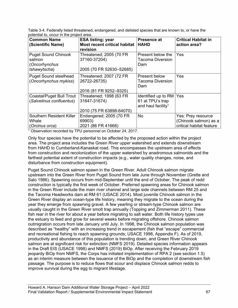
Howard A. Hanson Dam Additional Water Storage Project – April 2022 Final Validation Report / Supplemental Environmental Impact Statement 67
Table 3-4. Federally listed threatened, endangered, and delisted species that are known to, or have the potential to, occur in the project area. Common Name (Scientific Name)
ESA listing; year Most recent critical habitat revision
Presence at HAHD
Critical Habitat in action area?
Puget Sound Chinook salmon (Oncorhynchus tshawytscha)
Threatened; 2005 (70 FR 37160-37204) 2005 (70 FR 52630–52685)
Present below the Tacoma Diversion Dam
Yes
Puget Sound steelhead (Oncorhynchus mykiss)
Threatened; 2007 (72 FR 26722-26735) 2016 (81 FR 9252–9325)
Present below Tacoma Diversion Dam
Yes
Coastal/Puget Bull Trout (Salvelinus confluentus)
Threatened; 1998 (63 FR 31647-31674) 2010 (75 FR 63898-64070)
Identified up to RM 61 at TPU’s trap and haul facility1
Yes
Southern Resident Killer Whale (Orcinus orca)
Endangered; 2005 (70 FR 69903) 2021 (86 FR 41668)
No Yes: Prey resource (Chinook salmon) as a critical habitat feature
1 Observation recorded by TPU personnel on October 24, 2017.
Only four species have the potential to be affected by the proposed action within the project area. The project area includes the Green River upper watershed and extends downstream from HAHD to Cumberland-Kanaskat road. This encompasses the upstream area of effects from construction and recolonization of the upper watershed by anadromous salmonids and the farthest potential extent of construction impacts (e.g., water quality changes, noise, and disturbance from construction equipment). Puget Sound Chinook salmon spawn in the Green River. Adult Chinook salmon migrate upstream into the Green River from Puget Sound from late June through November (Grette and Salo 1986). Spawning occurs from mid-September until the end of October. The peak of redd construction is typically the first week of October. Preferred spawning areas for Chinook salmon in the Green River include the main river channel and large side channels between RM 25 and the Tacoma Headworks dam at RM 61 (USACE 2014). Most juvenile Chinook salmon in the Green River display an ocean-type life history, meaning they migrate to the ocean during the year they emerge from spawning gravel. A few yearling or stream-type Chinook salmon are usually caught in the Green River smolt trap annually (Topping and Zimmerman 2011). These fish rear in the river for about a year before migrating to salt water. Both life history types use the estuary to feed and grow for several weeks before migrating offshore. Chinook salmon outmigration occurs from late January until July. In 1998, the Chinook salmon population was described as “healthy” with an increasing trend in escapement (fish that “escape” commercial and recreational fishing to reach spawning grounds; USACE 1998, Appendix F). As of 2019, productivity and abundance of this population is trending down, and Green River Chinook salmon are at significant risk for extinction (NMFS 2019). Detailed species information appears in the Draft EIS (USACE 1998) and NMFS (2019) BiOp. After receiving the February 2019 jeopardy BiOp from NMFS, the Corps has initiated implementation of RPA 2 (see section 1.5) as an interim measure between the issuance of the BiOp and the completion of downstream fish passage. The purpose is to reduce flows that scour and displace Chinook salmon redds to improve survival during the egg to migrant lifestage.
Howard A. Hanson Dam Additional Water Storage Project – April 2022 Final Validation Report / Supplemental Environmental Impact Statement 68
The Green River supports winter and summer populations of Puget Sound steelhead. The winter stock includes an early run Chambers Creek hatchery-derived population and a later run natural population. The latter natural run population is ESA-listed. The summer stock is entirely hatchery supported. Adults for the ESA-listed winter population typically enter freshwater between November and May (Hard et al. 2007). Spawning begins in March and continues into June with the peak of spawning typically in April. Juveniles are present in the river year-round. They typically hatch in the spring and early summer. The majority remain in the river for 2 years and in the ocean for 2 years (Pautzke and Meigs 1940, Hard et al. 2007). Outmigration timing generally peaks in April or May. In 1998, summer and winter steelhead stocks were described as “healthy” (USACE 1998, Appendix F). However, most Puget Sound steelhead populations, including the Green River, have had severe declines in recent years (Ford et al. 2011). In 2019, adult steelhead escapement levels are substantially lower than in the 1980s and continue to show a downward trend (NMFS 2019). Detailed species information appears in the Draft EIS (USACE 1998) and NMFS (2019) BiOp. Historic accounts indicate a much greater use of the Green River watershed by bull trout in the past, while current use appears to be very limited (USFWS 1999; USFWS 2015). Low numbers of bull trout appear to use the lower Green River, primarily for foraging and potentially overwintering. Bull trout have been documented as far upstream as RM 40, which is 24.5 RM downstream from HAHD (WDFW 2004). During monitoring surveys for the initial AWSP habitat restoration projects, no bull trout were recorded upstream of HAHD (R2 2005) or in the middle Green River (R2 2002). No bull trout stock is recognized in the Green River by WDFW (2004). No documented spawning populations occur either above or below HAHD. One bull trout has been collected at the trap and haul facility at the Tacoma Headworks Dam since operations began in 2007; TPU staff documented this observation on October 24, 2017 (T. Patterson, pers. Comm., 2022).
3.10.2 No Action Alternative Under the No Action Alternative, the FPF would not be built, and the upper watershed would not be colonized by anadromous salmonids. This alternative would fail to meet the purpose and need of restoring downstream fish passage for salmon and steelhead.
3.10.3 Design Update Alternative The proposed action would have overall long-term significant benefits to fish populations in the Green River and would be a significant step toward recovery of Puget Sound Chinook salmon and steelhead. The 3-4 years of construction of the FPF would not have any negative effects to ESA-listed fish species because Chinook salmon, steelhead, and bull trout are not present in the area around HAHD. Additionally, the Corps is proposing to continue implementation of RPA 2 through the required period until the FPF is operational. This action reduces most instances of moderately high outflow rates to a maximum of 5,000 cfs during the Chinook salmon egg incubation period of October 15 through February 28. Controlling the dynamic relationship between river flows and gravel substrate is a direct benefit to Chinook salmon critical habitat physical and biological features that support egg incubation. The effect of the operational change would have measurable increases in salmon egg survival to the migrant fry lifestage. According to NMFS (2019), analysis showed that from 2000 through 2016, redd scour reduction would have potentially added an additional 88 to 727 returning adult spawners. Building the FPF and restoring downstream fish passage for juvenile salmon and steelhead would allow TPU to operate the upstream FPF to return adult spawning salmon and steelhead to the upper watershed. After the completion of the FPF at HAHD, anadromous salmonids would recolonize the upper Green River watershed. This would gain over 100 miles of spawning and rearing habitat for the native anadromous fish species. The resulting gain in habitat is
Howard A. Hanson Dam Additional Water Storage Project – April 2022 Final Validation Report / Supplemental Environmental Impact Statement 69
expected to have significant benefits for restoring the Green River salmon and steelhead populations. Construction of the FPF is anticipated to last for 3-4 years and may require blasting rock under water in the forebay just upstream of the cofferdam and downstream in the tailrace of the dam or on the riverbank adjacent to the river for the juvenile fish bypass and exit into the river. ESA-listed fish would not be affected by any blasting because they are not present in the project area around HAHD. The juvenile fish bypass exit location in the tailrace of the dam has changed since that evaluated in the1998 EIS because of the design update. The bypass exit location has changed from use of the dam’s outlet tunnel as reported in the 1998 EIS to using a steep-slope bypass along the left abutment with an outlet approximately 1,500 feet below the dam in the current design update. This location is not accessible to the public. The bypass exit will be located in flowing water in a forested setting allowing juvenile fish to quickly continue their downstream migration. Additionally, flowing water and overhead cover will allow for juvenile fish to escape aquatic and terrestrial predators far better than if the outlet sent fish into a stagnant pool. Cutthroat trout, a juvenile salmon predator, and mergansers, a fish-eating bird, are present in this stretch of the Green River. Predator monitoring would be implemented downstream of HAHD if the overall survival of 75% criteria is not met; control measures can be applied if predators are observed consuming juvenile salmon and steelhead. The updated design has also changed the collection method from a single port on the upstream side to a multiport collection structure. Juvenile attraction and survival are expected to improve, by meeting the RPA 1 criteria, with changes in the fish attraction and collection compared to a less reliable movable single port, and the downstream passage through the dam. Rebuilding Chinook salmon populations is a critical need throughout the Pacific Northwest due to the specialization of SRKW on Chinook salmon as a prey item. Salmon are the primary prey of Southern Residents throughout the year. Chinook salmon from the Green River are one of the most important prey sources for Southern Residents in Southern Puget Sound because Green River Chinook salmon are at least 5% of their diet, available when food sources are scarce, and adult Chinook salmon presence overlaps with the whales’ range (NOAA and WDFW 2018). Green River Chinook salmon are one feature of SRKW critical habitat and are essential to Southern Resident conservation; however, Green River Chinook salmon have a high risk of extinction. Allowing Chinook salmon to recolonize critical habitat above HAHD is expected to increase Puget Sound Chinook salmon abundance and productivity, which would contribute to the survival and recovery of SRKW.
3.11 Tribal Treaty Resources Section 5.7 of the Draft EIS (USACE 1998) identifies Tribal treaty resources. In addition to responsibilities under the National Historic Preservation Act (NHPA), the Federal Government must consider the effects its actions may have on American Indian traditions and cultural practices. The Federal basis of a Tribe’s legal status rests within the context of U.S. Constitutional provisions for the Federal Government’s powers for treaty making with other sovereign nations, and American Indian Tribes’ inherent sovereignty. The MIT and the Suquamish Indian Tribe have treaty-reserved fishing rights in the Green/Duwamish River and Elliott Bay under the Treaty of Point Elliott of 1855. The Confederated Tribes and Bands of the Yakama Nation have fishing rights to usual and accustomed places in the project area under the Yakima Treaty of 1855.
Howard A. Hanson Dam Additional Water Storage Project – April 2022 Final Validation Report / Supplemental Environmental Impact Statement 70
3.11.1 Affected Environment The 1998 EIS analyzed effects to the upper and lower watershed, and there will be no change to effects in the lower watershed due to the updated design; therefore, this section focuses on the upper watershed and limits the analysis to resources of interest to MIT only. Hunting, fishing, and gathering are central to the cultural and economic existence of the MIT and its members. Acquisition of food through hunting, fishing, and gathering is part of a complex culture that emphasizes the concept that all of life is interrelated. Fish, wildlife, and other natural resources sustain the cultural and spiritual identity of the community in addition to providing economic stability for present and future generations. The primary resources of interest to MIT in the upper watershed are related to elk hunting opportunities and salmon habitat restoration for population recovery. Hunting permits, elk numbers, and hunting seasons are jointly agreed upon by WDFW, TPU, and MIT. Mitigation for impacts of the AWSP to elk habitat were covered in the 1998 EIS and have been fully implemented. The salmon habitat restoration projects were constructed between 2003 and 2009. The remaining work under consideration is to provide the downstream fish passage for anadromous salmon species. The MIT is a treaty Tribe and co-manager with Washington State of salmon harvest under a Harvest Management Plan (PSIT and WDFW 2017). While harvest affects the abundance of salmon and steelhead in the basin, and consequently the number of fish potentially affected by project operations, the plan notes that recovery to substantially higher abundance is primarily dependent on habitat restoration. The Harvest Management Plan is designed to ensure that the expected abundance reductions will avoid reducing the likelihood of survival and recovery of this management unit of Puget Sound Chinook salmon (PSIT and WDFW 2017). The upper Green River watershed spawning and rearing habitat became inaccessible to migrating adult salmon upon the 1912 construction of TPU’s diversion dam. Ecosystem processes, including natural upstream and downstream migration of salmonid species, were further altered and blocked by the 1962 construction of HAHD and reservoir impoundment. TPU has installed a collection and transport facility for adult salmonids; however, lack of viable downstream passage past HAHD means the survival rate of the offspring of those adults would be so low as to cause harm to the population. Downstream passage through TPU’s diversion dam presents no such blockage. The upper Green River represents over 106 miles of high-quality river and stream habitat that can again serve as productive salmon spawning and rearing habitat.
3.11.2 No Action Alternative Under the no-action alternative, downstream fish passage would not be restored, and fisheries resources would continue to degrade. This would fail to restore the valuable treaty-protected resource of the anadromous salmon and steelhead populations. As salmon and steelhead populations continue to decline without the intervention of restoring access to and downstream passage from the Green River’s upper watershed, the resources that shape the cultural and spiritual identity of the MIT would be significantly impacted. The No Action alternative would fail to meet the purpose and need for action.
3.11.3 Design Update Alternative Construction of the FPF and restoring downstream fish passage for juvenile salmon and steelhead would allow TPU to operate the upstream FPF to return adult spawning salmon and steelhead to the upper watershed. This would gain over 100 miles of spawning and rearing habitat for the native anadromous fish species. The resulting gain in habitat is expected to have significant benefits for restoring the Green River salmon populations. A secondary effect would be restoring a critical prey resource for the SRKW population, which is also a part of northwest Native American culture. Restoring salmon populations would mean greater abundance for
Howard A. Hanson Dam Additional Water Storage Project – April 2022 Final Validation Report / Supplemental Environmental Impact Statement 71
MIT's fisheries resources. The proposed restoration of downstream fish passage would have significant benefits to the ecosystem and fisheries resources, which are of economic and cultural value to the MIT. Restoration of fisheries resources supports the various Tribes’ treaty rights, collectively. The 2019 BiOp sets a target for recovery of salmon with the fish collection and survival requirements. These two factors indicate the updated design alternative would have a higher probability of improving fish populations compared to the previous design.
3.12 Cultural, Historic, and Archaeological Resources Section 5.6 of the Draft EIS (USACE 1998) discusses the cultural resources in the study area. The following sections summarize the archaeological and historic preservation work that has been conducted since the 1998 document, providing an updated context for the current action. Since the 1998 EIS, in compliance with the NHPA of 1966, the HAHD was found eligible for listing to the NRHP under Criterion A in 2009.
3.12.1 Affected Environment Since 1998, over 36% of the Green River channel has been systematically investigated for prehistoric cultural resources, mostly situated in the lowland sections that are more than three miles downstream of the dam. At HAHD, the lands adjacent to the Green River immediately downstream of the dam have not been surveyed or tested for archaeological resources. According to the Department of Archaeology and Historic Preservation probability model, the Green River lands at HAHD have a high probability for extant archaeological resources from the historic period and resources related to the ancestors of today’s Native American Tribes. The Corps has made efforts to investigate the HAHD project area for cultural resources. For the 1998 EIS, the Corps conducted two archaeological surveys and one data recovery effort within the 1998 APE. A 900-acre cultural resources survey was conducted for the AWSP; four historic archaeological sites were identified and determined to lack sufficient integrity for eligibility to the NRHP (Lewarch et al. 1996). Additional archaeological and historic archaeological work was conducted within the framework of the 2003 Memorandum of Agreement (MOA) with the Corps, Washington State SHPO, and City of Tacoma as signatories, and the MIT as concurring party (USACE 2003). In 2004, in fulfillment of a stipulation in the 2003 MOA, the Corps conducted excavations for data recovery at two archaeological sites within the HAHD Archaeological District (Walker et al. 2009). The Corps conducted historic property investigations in 2005-2006 (Kent 2011). Three historic archaeological sites were recorded and determined not eligible due to insufficient integrity of their features. None of the ground disturbing activity occurred within the current project APE. Since the 1998 EIS, two archaeological surveys and one National Register Evaluation of historic properties have been conducted within the current project’s APE. None of this work was associated with the HAHD AWSP project. In 2009, the Corps completed an evaluation of HAHD and determined that the dam and its associated infrastructure is eligible for the NRHP under Criterion A based on its significant role in shaping the regional settlement and economic development of the Green River Valley (McCroskey and Storey 2010). A Corps survey of the dam’s right abutment conducted in 2010 was negative for new archaeological resources (Storey 2010). In 2014, the Corps surveyed sections of the access road for the left bank of HAHD resulting in a negative report for archaeological resources (Kanaby 2014). All stipulations of the 2003 MOA have been completed. The MOA created protocols for preserving and protecting archaeological and cultural resources in the development of a Cultural Resources Management Plan. As a result of the MOA, the significance of known archaeological sites within the HAHD archaeological district were assessed for their eligibility to the NRHP. The MOA required the data recovery from known archaeological sites within the HAHD reservoir.
Howard A. Hanson Dam Additional Water Storage Project – April 2022 Final Validation Report / Supplemental Environmental Impact Statement 72
The final stipulation of the MOA enabled the Corps to contract an ethnographic study completed by the MIT in 2013. The APE for the new FPF has been modified from the original 1998 APE. The new APE includes the original portion of the dam located at the Outlet Tower, the earthen dam, and abutments. The APE was expanded to include an area north of the earthen dam that includes access roads and the left bank of the Green River where the FPF outlet pipe will be located. The dam itself is an historic cultural resource. The contributing elements of the dam are from the period of construction from 1958-1962, these include the earthen dam and abutment, the spillway, the outlet works, the old administration building, the historic access road on the old railroad grade, and the monument. Reference Figure 1-2 for location of features. Prehistory and Ethnography Walker’s work (2009), which used chronological period descriptions from Hollenbeck (1987) and Schalk and Taylor (1988), resulted in a regional cultural chronology related to the western Washington Cascades foothills. The Early Period (c. 10,000-5,000 B.P.) is indicative of hunting and gathering activities as evidenced by the technologies found in Olcott sites. The Middle Period (5,000-2,000 B.P) shows a transition from a generalized, to more specialized patterns of subsistence with pronounced differences between the coast and inland regions. A complex system of trade and social interaction between Native American bands and families emerges as artifacts similar in style to those found in eastern Washington are found in the archaeological record. Technology changes with additions of ground stone tools and smaller side-notched points. The Late Period (2,000-250 B.P.) is characterized by a wider selection of ground stone tools, and the presence of small corner notched and triangular points. There are advances in food storage technologies, and plank houses appear in the lower Cedar River and Green River basins. HAHD is located in the traditional territory of several groups of Southern Coast Salish-speaking people, ancestors of the Duwamish, Suquamish, and the Muckleshoot Indian Tribes. The area was also exploited by Sahaptin-speaking peoples – the Klickitat and Yakama who often traveled over the Cascade Mountains from the Columbia plateau area. Historical Settlement and development in the upper Green River basin was related to exploration, logging, and the railroad. In 1883, Virgil G. Bogue conducted a railroad survey for the proposed Northern Pacific Railroad line over Stampede Pass. The first train crossed the pass in 1887 (Benson and Moura 1986). The sites of several historic camps and towns related to logging and the railroad are located within the boundaries of the HAHD project. The first formal requests for flood management from white settlers occurred in 1928. In 1936, the Corps took up the cause and began investigating dam construction, which was temporarily halted by World War II. In 1949, plans were submitted to Congress but temporarily put on hold again until the end of the Korean war. Construction of the dam finally started in 1959. To prepare the site for the dam, the Corps relocated a 13-mile section of the Northern Pacific Railway, installed a 900-foot tunnel to re-route the river, and constructed a coffer dam. The narrow gap of the gorge was then filled with sand, gravel, and earth, and the reservoir began filling in 1961. The dam was a joint funding venture among the Federal Government, Washington State, and King County; it was activated in 1962. By 1958 the dam had been re-named from its historic project name, the Eagle Gorge Dam, to the Howard A. Hanson Dam because Mr. Hanson was the dam’s biggest champion beginning with the original letter for flood assistance in 1928.
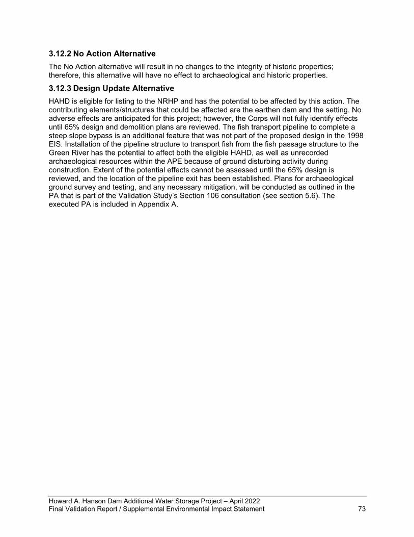
Howard A. Hanson Dam Additional Water Storage Project – April 2022 Final Validation Report / Supplemental Environmental Impact Statement 73
3.12.2 No Action Alternative The No Action alternative will result in no changes to the integrity of historic properties; therefore, this alternative will have no effect to archaeological and historic properties.
3.12.3 Design Update Alternative HAHD is eligible for listing to the NRHP and has the potential to be affected by this action. The contributing elements/structures that could be affected are the earthen dam and the setting. No adverse effects are anticipated for this project; however, the Corps will not fully identify effects until 65% design and demolition plans are reviewed. The fish transport pipeline to complete a steep slope bypass is an additional feature that was not part of the proposed design in the 1998 EIS. Installation of the pipeline structure to transport fish from the fish passage structure to the Green River has the potential to affect both the eligible HAHD, as well as unrecorded archaeological resources within the APE because of ground disturbing activity during construction. Extent of the potential effects cannot be assessed until the 65% design is reviewed, and the location of the pipeline exit has been established. Plans for archaeological ground survey and testing, and any necessary mitigation, will be conducted as outlined in the PA that is part of the Validation Study’s Section 106 consultation (see section 5.6). The executed PA is included in Appendix A.
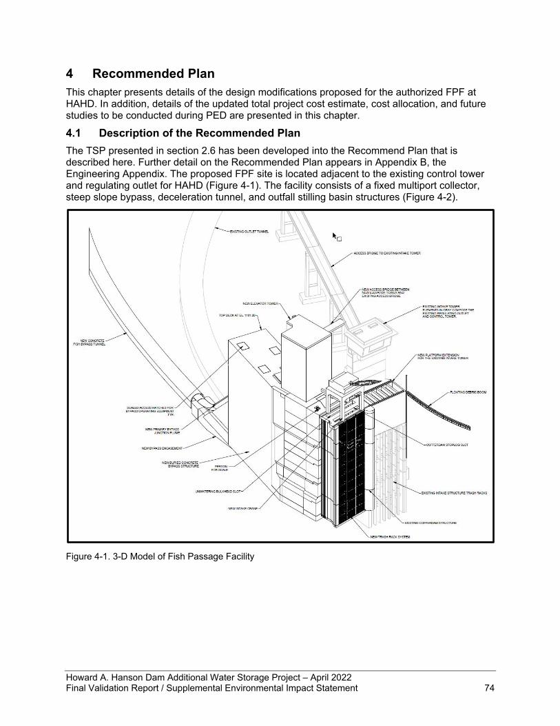
Howard A. Hanson Dam Additional Water Storage Project – April 2022 Final Validation Report / Supplemental Environmental Impact Statement 74
4 Recommended Plan This chapter presents details of the design modifications proposed for the authorized FPF at HAHD. In addition, details of the updated total project cost estimate, cost allocation, and future studies to be conducted during PED are presented in this chapter.
4.1 Description of the Recommended Plan The TSP presented in section 2.6 has been developed into the Recommend Plan that is described here. Further detail on the Recommended Plan appears in Appendix B, the Engineering Appendix. The proposed FPF site is located adjacent to the existing control tower and regulating outlet for HAHD (Figure 4-1). The facility consists of a fixed multiport collector, steep slope bypass, deceleration tunnel, and outfall stilling basin structures (Figure 4-2).
Figure 4-1. 3-D Model of Fish Passage Facility
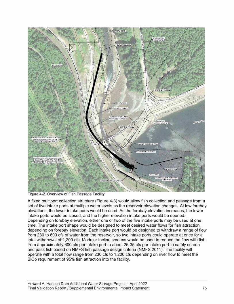
Howard A. Hanson Dam Additional Water Storage Project – April 2022 Final Validation Report / Supplemental Environmental Impact Statement 75
Figure 4-2. Overview of Fish Passage Facility
A fixed multiport collection structure (Figure 4-3) would allow fish collection and passage from a set of five intake ports at multiple water levels as the reservoir elevation changes. At low forebay elevations, the lower intake ports would be used. As the forebay elevation increases, the lower intake ports would be closed, and the higher elevation intake ports would be opened. Depending on forebay elevation, either one or two of the five intake ports may be used at one time. The intake port shape would be designed to meet desired water flows for fish attraction depending on forebay elevation. Each intake port would be designed to withdraw a range of flow from 230 to 600 cfs of water from the reservoir, so two intake ports could operate at once for a total withdrawal of 1,200 cfs. Modular Incline screens would be used to reduce the flow with fish from approximately 600 cfs per intake port to about 25-35 cfs per intake port to safely screen and pass fish based on NMFS fish passage design criteria (NMFS 2011). The facility will operate with a total flow range from 230 cfs to 1,200 cfs depending on river flow to meet the BiOp requirement of 95% fish attraction into the facility.
Howard A. Hanson Dam Additional Water Storage Project – April 2022 Final Validation Report / Supplemental Environmental Impact Statement 76
Figure 4-3. Multiport Collector with Full Flow Conduits 1, 3, and 5 Shown
Once collected into the multiport structure, fish are conveyed downstream through the steep slope bypass. The steep slope bypass consists of the primary bypass and the full flow bypass. The primary bypass has five lateral conduits connected to the intake ports, which merge into a u-shaped junction flume (Figure 4-4). The junction flume drops at a 45-degree angle, conveying the fish down to the deceleration tunnel. The full flow bypass collects the water screened off by the MIS and conveys it through a set of side-by-side concrete conduits to the deceleration tunnel. Ports 1, 3, and 5 connect to one conduit and ports 2 and 4 connect to the other. The full flow bypass is split into two conduits to address concerns of merging the flows in the conduit; only one port from each conduit will be operated at a time. Both the primary and full flow bypass conduits include a shallow bend at the base before connecting to the tunnel; this facilitates a smooth transition and starts decelerating the fish before release.
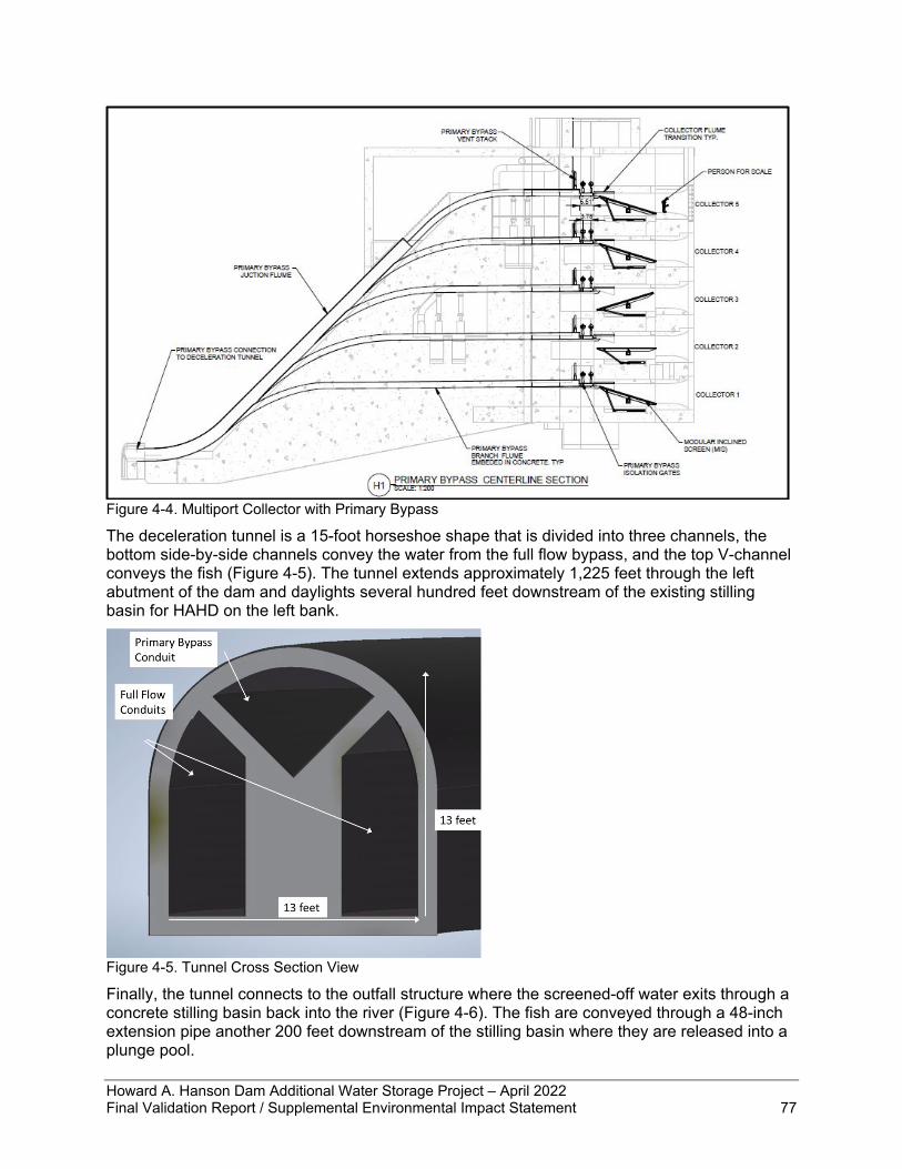
Howard A. Hanson Dam Additional Water Storage Project – April 2022 Final Validation Report / Supplemental Environmental Impact Statement 77
Figure 4-4. Multiport Collector with Primary Bypass
The deceleration tunnel is a 15-foot horseshoe shape that is divided into three channels, the bottom side-by-side channels convey the water from the full flow bypass, and the top V-channel conveys the fish (Figure 4-5). The tunnel extends approximately 1,225 feet through the left abutment of the dam and daylights several hundred feet downstream of the existing stilling basin for HAHD on the left bank.
Figure 4-5. Tunnel Cross Section View Finally, the tunnel connects to the outfall structure where the screened-off water exits through a concrete stilling basin back into the river (Figure 4-6). The fish are conveyed through a 48-inch extension pipe another 200 feet downstream of the stilling basin where they are released into a plunge pool.
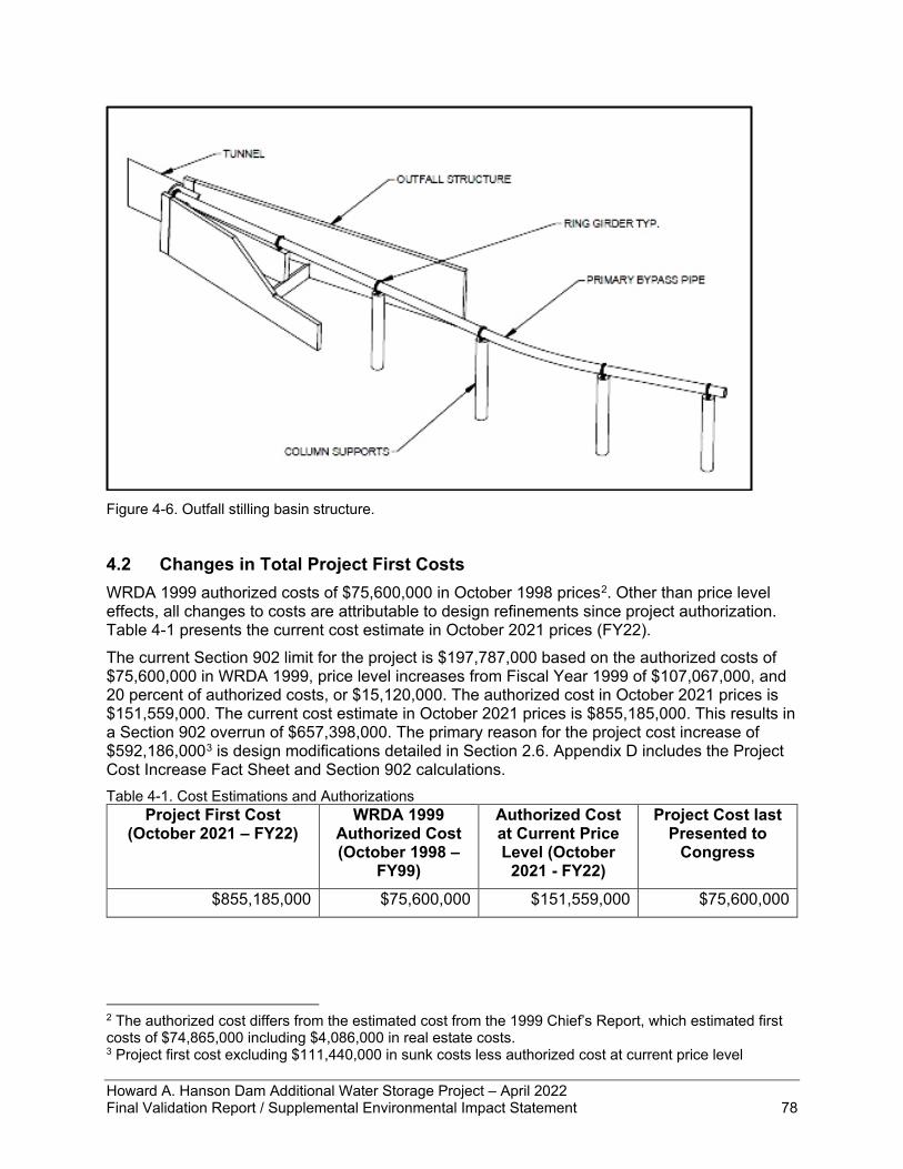
Howard A. Hanson Dam Additional Water Storage Project – April 2022 Final Validation Report / Supplemental Environmental Impact Statement 78
Figure 4-6. Outfall stilling basin structure.
4.2 Changes in Total Project First Costs WRDA 1999 authorized costs of $75,600,000 in October 1998 prices2. Other than price level effects, all changes to costs are attributable to design refinements since project authorization. Table 4-1 presents the current cost estimate in October 2021 prices (FY22). The current Section 902 limit for the project is $197,787,000 based on the authorized costs of $75,600,000 in WRDA 1999, price level increases from Fiscal Year 1999 of $107,067,000, and 20 percent of authorized costs, or $15,120,000. The authorized cost in October 2021 prices is $151,559,000. The current cost estimate in October 2021 prices is $855,185,000. This results in a Section 902 overrun of $657,398,000. The primary reason for the project cost increase of $592,186,0003 is design modifications detailed in Section 2.6. Appendix D includes the Project Cost Increase Fact Sheet and Section 902 calculations. Table 4-1. Cost Estimations and Authorizations
Project First Cost (October 2021 – FY22)
WRDA 1999 Authorized Cost (October 1998 –
FY99)
Authorized Cost at Current Price Level (October
2021 - FY22)
Project Cost last Presented to
Congress
$855,185,000 $75,600,000 $151,559,000 $75,600,000
2 The authorized cost differs from the estimated cost from the 1999 Chief’s Report, which estimated first costs of $74,865,000 including $4,086,000 in real estate costs. 3 Project first cost excluding $111,440,000 in sunk costs less authorized cost at current price level
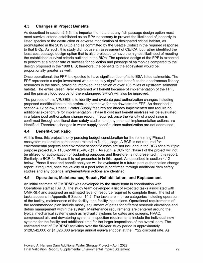
Howard A. Hanson Dam Additional Water Storage Project – April 2022 Final Validation Report / Supplemental Environmental Impact Statement 79
4.3 Changes in Project Benefits As described in section 2.5.5, it is important to note that any fish passage design option must meet survival criteria established as an RPA necessary to prevent the likelihood of jeopardy to listed species or the destruction or adverse modification of designated critical habitat, as promulgated in the 2019 BiOp and as committed by the Seattle District in the required response to that BiOp. As such, this study did not use an assessment of CE/ICA, but rather identified the least-cost passage design option that is also projected to have the highest likelihood of meeting the established survival criteria outlined in the BiOp. The updated design of the FPF is expected to perform at a higher rate of success for collection and passage of salmonids compared to the design proposed in the 1998 EIS; therefore, the benefits to the ecosystem would be proportionally greater as well. Once operational, the FPF is expected to have significant benefits to ESA-listed salmonids. The FPF represents a major investment with an equally significant benefit to the anadromous fishery resources in the basin, providing improved inhabitation of over 106 miles of upstream salmonid habitat. The entire Green River watershed will benefit because of implementation of the FPF, and the primary food source for the endangered SRKW will also be improved. The purpose of this VR/SEIS is to identify and evaluate post-authorization changes including proposed modifications to the preferred alternative for the downstream FPF. As described in section 4.12 below, Phase I Water Supply features are already implemented and require no additional expenditure for implementation. Phase II cost and benefit analyses will be evaluated in a future post authorization change report, if required, once the validity of a pool raise is confirmed through additional dam safety studies and any potential implementation actions are identified. Therefore, changes in water supply benefits since authorization are not addressed.
4.4 Benefit-Cost Ratio At this time, this project is only pursuing budget consideration for the remaining Phase I ecosystem restoration components related to fish passage. A BCR is not required for environmental projects and environment specific costs are not included in the BCR for a multiple purpose project (ER 1105-2-100 (E-46, c.(1)). As such, a BCR for Phase I of the project will not be utilized for authorization or budgeting purposes and therefore, is not presented in this report. Similarly, a BCR for Phase II is not presented in in this report. As described in section 4.12 below, Phase II cost and benefit analyses will be evaluated in a future post authorization change report, if required, once the validity of a pool raise is confirmed through additional dam safety studies and any potential implementation actions are identified.
4.5 Operations, Maintenance, Repair, Rehabilitation, and Replacement An initial estimate of OMRR&R was developed by the study team in coordination with Operations staff at HAHD. The study team developed a list of expected tasks associated with OMRR&R and assigned an estimated level of resource required to complete them. The list of tasks appears in Appendix B Section 14.2. The tasks are in three categories including operation of the facility, maintenance of the facility, and facility inspections. Operational requirements of the recommended plan include mostly adjustment of gates for different reservoir elevations and debris management within the system. Maintenance requirements are centered around the typical mechanical systems such as hydraulic systems for gates and screens, HVAC, compressed air, and dewatering systems. Inspection requirements include the individual new systems for the facility and additional time for the larger inspections of the overall dam. The estimated cost of OMRR&R activities over the 50-year study period is approximately $128,542,000 or $1,026,000 average annual equivalent cost at the FY22 discount rate. As

Howard A. Hanson Dam Additional Water Storage Project – April 2022 Final Validation Report / Supplemental Environmental Impact Statement 80
described in section 4.6.1, OMRR&R costs associated with the FPF up to elevation 1,147 feet are allocated to BiOp requirements.
4.6 Changes in Cost Allocation Section 101(b)(15) of the WRDA of 1999 (Public Law 106-53) allocates HAHD AWSP FPF costs between Ecosystem Restoration and M&I Water Supply. As a result of the BiOp, costs in this report are allocated between BiOp requirements, Ecosystem Restoration, and M&I Water Supply. All costs associated with construction and maintenance of the HAHD AWSP FPF to elevation 1,147 are considered a BiOp requirement. All remaining costs are allocated between Ecosystem Restoration and M&I Water Supply. The following cost allocation uses methodology approved in the July 2003 Project Cooperation Agreement between USACE and the City of Tacoma (USACE 2003b). This section summarizes changes in the cost allocation. Project first costs for the HAHD AWSP FPF are $855,185,000 in October 2021 prices. First costs include sunk costs of $111,440,000, remaining construction costs for a FPF to an elevation of 1,177 feet of $684,460,000, Phase II costs4 of $31,073,000, and adaptive management and monitoring costs for Phase I of $23,334,000 and Phase II of $4,879,000. Average annual equivalent O&M costs are $43,000; average annual equivalent RR&R costs are estimated to be $983,000.
4.6.1 BiOp Requirements Total costs of BiOp requirements equal all costs for FPF construction to an elevation of 1,147 feet, or 97.8% of all FPF construction costs. Phase I adaptive management and monitoring costs are allocated to BiOp Requirements. OMRR&R costs associated with the FPF up to elevation 1,147 feet are allocated to BiOp Requirements5. Table 4-2 summarizes costs allocated to BiOp Requirements and provides the percent of total costs for each cost item. Table 4-2. BiOp Requirements Cost Allocation
BiOp Requirements Cost ($000s) Percent of Cost (%)
FPF Construction $778,390 97.8%
Adaptive Management and Monitoring (Phase I) $23,334 82.7%
Total First Cost Allocation $801,724 93.7%
O&M $43 100% (up to elevation 1,147ft)
RR&R $983 100% (up to elevation 1,147ft)
4.6.2 Ecosystem Restoration The remaining 2.2% of FPF construction costs (100% less 97.8% allocated to BiOp Requirements) are considered joint costs and allocated between ecosystem restoration and M&I Water Supply. Ecosystem restoration accounts for 38.8% of the remaining 2.2% of FPF joint costs, or 0.9% of total FPF construction costs. Phase II adaptive management and monitoring
4 Phase II costs are the sum of Dam Safety Study ($148,000) and Phase II Adaptive Management and Monitoring costs ($4,964,000) 5 There are no anticipated incremental costs associated with OMRR&R from elevation 1,147 to 1,177.
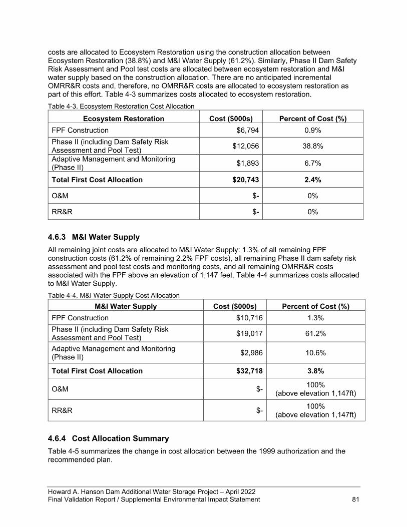
Howard A. Hanson Dam Additional Water Storage Project – April 2022 Final Validation Report / Supplemental Environmental Impact Statement 81
costs are allocated to Ecosystem Restoration using the construction allocation between Ecosystem Restoration (38.8%) and M&I Water Supply (61.2%). Similarly, Phase II Dam Safety Risk Assessment and Pool test costs are allocated between ecosystem restoration and M&I water supply based on the construction allocation. There are no anticipated incremental OMRR&R costs and, therefore, no OMRR&R costs are allocated to ecosystem restoration as part of this effort. Table 4-3 summarizes costs allocated to ecosystem restoration. Table 4-3. Ecosystem Restoration Cost Allocation
Ecosystem Restoration Cost ($000s) Percent of Cost (%) FPF Construction $6,794 0.9% Phase II (including Dam Safety Risk Assessment and Pool Test) $12,056 38.8%
Adaptive Management and Monitoring (Phase II) $1,893 6.7%
Total First Cost Allocation $20,743 2.4%
O&M $- 0%
RR&R $- 0%
4.6.3 M&I Water Supply All remaining joint costs are allocated to M&I Water Supply: 1.3% of all remaining FPF construction costs (61.2% of remaining 2.2% FPF costs), all remaining Phase II dam safety risk assessment and pool test costs and monitoring costs, and all remaining OMRR&R costs associated with the FPF above an elevation of 1,147 feet. Table 4-4 summarizes costs allocated to M&I Water Supply. Table 4-4. M&I Water Supply Cost Allocation
M&I Water Supply Cost ($000s) Percent of Cost (%) FPF Construction $10,716 1.3% Phase II (including Dam Safety Risk Assessment and Pool Test) $19,017 61.2%
Adaptive Management and Monitoring (Phase II) $2,986 10.6%
Total First Cost Allocation $32,718 3.8%
O&M $- 100% (above elevation 1,147ft)
RR&R $- 100% (above elevation 1,147ft)
4.6.4 Cost Allocation Summary Table 4-5 summarizes the change in cost allocation between the 1999 authorization and the recommended plan.
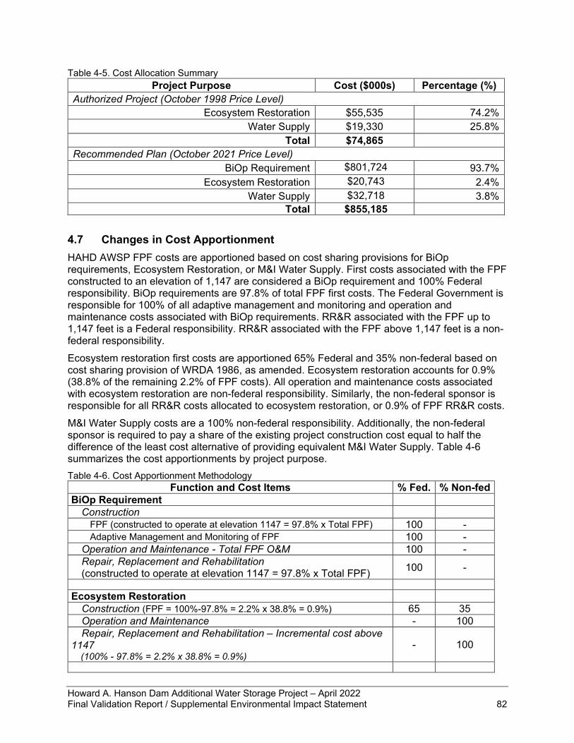
Howard A. Hanson Dam Additional Water Storage Project – April 2022 Final Validation Report / Supplemental Environmental Impact Statement 82
Table 4-5. Cost Allocation Summary Project Purpose Cost ($000s) Percentage (%)
Authorized Project (October 1998 Price Level) Ecosystem Restoration $55,535 74.2%
Water Supply $19,330 25.8% Total $74,865
Recommended Plan (October 2021 Price Level) BiOp Requirement $801,724 93.7%
Ecosystem Restoration $20,743 2.4% Water Supply $32,718 3.8%
Total $855,185
4.7 Changes in Cost Apportionment HAHD AWSP FPF costs are apportioned based on cost sharing provisions for BiOp requirements, Ecosystem Restoration, or M&I Water Supply. First costs associated with the FPF constructed to an elevation of 1,147 are considered a BiOp requirement and 100% Federal responsibility. BiOp requirements are 97.8% of total FPF first costs. The Federal Government is responsible for 100% of all adaptive management and monitoring and operation and maintenance costs associated with BiOp requirements. RR&R associated with the FPF up to 1,147 feet is a Federal responsibility. RR&R associated with the FPF above 1,147 feet is a non-federal responsibility. Ecosystem restoration first costs are apportioned 65% Federal and 35% non-federal based on cost sharing provision of WRDA 1986, as amended. Ecosystem restoration accounts for 0.9% (38.8% of the remaining 2.2% of FPF costs). All operation and maintenance costs associated with ecosystem restoration are non-federal responsibility. Similarly, the non-federal sponsor is responsible for all RR&R costs allocated to ecosystem restoration, or 0.9% of FPF RR&R costs. M&I Water Supply costs are a 100% non-federal responsibility. Additionally, the non-federal sponsor is required to pay a share of the existing project construction cost equal to half the difference of the least cost alternative of providing equivalent M&I Water Supply. Table 4-6 summarizes the cost apportionments by project purpose. Table 4-6. Cost Apportionment Methodology
Function and Cost Items % Fed. % Non-fed BiOp Requirement
Construction FPF (constructed to operate at elevation 1147 = 97.8% x Total FPF) 100 - Adaptive Management and Monitoring of FPF 100 -
Operation and Maintenance - Total FPF O&M 100 - Repair, Replacement and Rehabilitation (constructed to operate at elevation 1147 = 97.8% x Total FPF) 100 -
Ecosystem Restoration
Construction (FPF = 100%-97.8% = 2.2% x 38.8% = 0.9%) 65 35 Operation and Maintenance - 100 Repair, Replacement and Rehabilitation – Incremental cost above
1147 (100% - 97.8% = 2.2% x 38.8% = 0.9%)
- 100
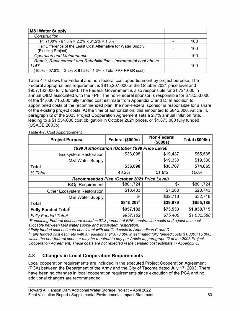
Howard A. Hanson Dam Additional Water Storage Project – April 2022 Final Validation Report / Supplemental Environmental Impact Statement 83
M&I Water Supply Construction
FPF (100% - 97.8% = 2.2% x 61.2% = 1.3%) - 100 Half Difference of the Least Cost Alternative for Water Supply (Existing Project) - 100
Operation and Maintenance - 100 Repair, Replacement and Rehabilitation - Incremental cost above
1147 (100% - 97.8% = 2.2% X 61.2% =1.3% x Total FPF RR&R cost)
- 100
Table 4-7 shows the Federal and non-federal cost apportionment by project purpose. The Federal appropriations requirement is $815,207,000 at the October 2021 price level and $957,182,000 fully funded. The Federal Government is also responsible for $1,721,000 in annual O&M associated with the FPF. The non-Federal sponsor is responsible for $73,533,000 of the $1,030,715,000 fully funded cost estimate from Appendix C and D. In addition to apportioned costs of the recommended plan, the non-Federal sponsor is responsible for a share of the existing project costs. At the time of authorization, this amounted to $842,000. Article III, paragraph I2 of the 2003 Project Cooperation Agreement sets a 2.7% annual inflation rate, leading to a $1,554,000 cost obligation in October 2021 prices, or $1,873,000 fully funded (USACE 2003b). Table 4-7. Cost Apportionment
Project Purpose Federal ($000s) Non-Federal ($000s) Total ($000s)
1999 Authorization (October 1998 Price Level) Ecosystem Restoration $36,098 $19,437 $55,535
M&I Water Supply - $19,330 $19,330 Total $36,098 $38,767 $74,865 % Total 48.2% 51.8% 100%
Recommended Plan (October 2021 Price Level) BiOp Requirement $801,724 $- $801,724
Other Ecosystem Restoration $13,483 $7,260 $20,743 M&I Water Supply $- $32,718 $32,718
Total $815,2071 $39,979 $855,185 Fully Funded Total2 $957,182 $73,533 $1,030,715 Fully Funded Total3 $957,182 $75,406 $1,032,588
1Remaining Federal cost share includes 97.8 percent of FPF construction costs and a joint use cost allocable between M&I water supply and ecosystem restoration. 2 Fully funded cost estimate consistent with certified costs in Appendices C and D. 3 Fully funded cost estimate with an additional $1,873,000 in estimated fully funded costs $1,030,715,000, which the non-federal sponsor may be required to pay per Article III, paragraph I2 of the 2003 Project Cooperation Agreement. These costs are not reflected in the certified cost estimate in Appendix C.
4.8 Changes in Local Cooperation Requirements Local cooperation requirements are included in the executed Project Cooperation Agreement (PCA) between the Department of the Army and the City of Tacoma dated July 17, 2003. There have been no changes in local cooperation requirements since execution of the PCA and no additional changes are recommended.
Howard A. Hanson Dam Additional Water Storage Project – April 2022 Final Validation Report / Supplemental Environmental Impact Statement 84
4.9 Environmental Considerations in Recommended Changes The Corps prepared an EIS in 1998 and signed a Record of Decision (ROD) on July 25, 2001. Design refinements occurring since the signing of the ROD have been evaluated in this VR/SEIS. The Corps has re-evaluated all resources from the 1998 EIS to assess any that have changed and has documented those that have not changed. Additionally, the Corps has followed current practices to evaluate other resources that were not included in the 1998 EIS (e.g., climate change). The 1998 EIS analyzed effects to the upper and lower watershed, but the facility redesign would not change any effects of restoring fish passage to the lower watershed; therefore, the geographical scope of the updated analysis is limited to the upper watershed. Environmental considerations for the updated design primarily arise from the effort to meet the BiOp requirements for collection efficiency and fish survival through the structure as well as overall survival through the reservoir. Chapter 2 describes the formulation and evaluation of design options and the process that led to the least-cost fish passage design that meets BiOp requirements. Other environmental considerations are described throughout Chapter 3 to provide an updated analysis of effects to resources based on the changed design. Chapter 5 describes how the completion of the FPF will comply with all applicable environmental laws, statutes, and regulations. All compensatory mitigation requirements for the AWSP Phase I have been met. Finally, Appendix E references the monitoring and adaptive management plan established in the 1998 EIS and provides the framework for the plan that will be developed during design phase of the FPF.
4.10 Risk and Uncertainty Developing efficient and effective fish passage at a high head dam like HAHD is inherently complex and challenging. Collecting fish from the upper water column for downstream passage at a dam with a pool that varies as much as HAHD is complex, and there are limited analogous structures that can be used to support development of a refined design for this action. As such, cost contingencies in the revised cost estimate reflect the high level of uncertainty associated with design, quantities, construction methods, etc. However, the cost and schedule risk assessment process is designed to adequately capture risk and uncertainty in the cost contingency for the action and the Corps study team is fully evaluating all cost drivers that may impact cost contingency. Additional cost engineering and contingency details are presented in Appendix C. Finally, risk-informed design will be used in accordance with Engineering and Construction Bulletin (ECB) 2019-15 during each phase of design to ensure dam safety concerns are addressed. Per the ECB, a risk-informed approach will be used for all dam and levee designs for new projects, modifications, improvements, rehabilitation, or repairs. Risk assessments are the cornerstone for application of a risk-informed decision-making approach. The results of the risk assessment for this study are presented in Appendix B. The risk assessment identified two potential failure modes associated with the FPF that may increase dam safety risks. The study team has developed numerous risk management strategies including some items that are already incorporated into the FPF design, potential modifications to the design during PED, contractor requirements during construction, and consideration of utilizing the FPF during flood events.
4.11 Real Estate Considerations HAHD is an existing Federal project. The AWSP at HAHD does not require any additional real property acquisitions. The non-federal sponsor, TPU, is required to furnish all lands, easements, rights-of-way, relocations, and disposal (LERRD) for the proposed project. The Corps and TPU own in fee or by reservation all required real property interests that the project will require.
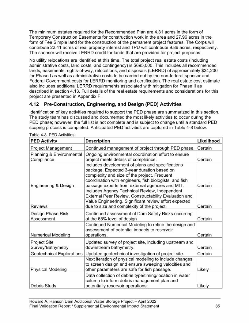
Howard A. Hanson Dam Additional Water Storage Project – April 2022 Final Validation Report / Supplemental Environmental Impact Statement 85
The minimum estates required for the Recommended Plan are 4.31 acres in the form of Temporary Construction Easements for construction work in the area and 27.96 acres in the form of Fee Simple land for the construction of the permanent project features. The Corps will contribute 22.41 acres of real property interest and TPU will contribute 9.86 acres, respectively. The sponsor will receive LERRD credit for lands that are provided for project purposes. No utility relocations are identified at this time. The total project real estate costs (including administrative costs, land costs, and contingency) is $695,000. This includes all recommended lands, easements, rights-of-way, relocations, and disposals (LERRD) of approximately $34,200 for Phase I as well as administrative costs to be carried out by the non-federal sponsor and Federal Government costs for LERRD monitoring and certification. The real estate cost estimate also includes additional LERRD requirements associated with mitigation for Phase II as described in section 4.13. Full details of the real estate requirements and considerations for this project are presented in Appendix F.
4.12 Pre-Construction, Engineering, and Design (PED) Activities Identification of key activities required to support the PED phase are summarized in this section. The study team has discussed and documented the most likely activities to occur during the PED phase; however, the full list is not complete and is subject to change until a standard PED scoping process is completed. Anticipated PED activities are captured in Table 4-8 below. Table 4-8. PED Activities PED Activity Description Likelihood Project Management Continued management of project through PED phase. Certain Planning & Environmental Compliance
Ongoing environmental coordination effort to ensure project meets details of compliance. Certain
Engineering & Design
Includes development of plans and specifications package. Expected 3-year duration based on complexity and size of the project. Frequent coordination with engineers, fish biologists, and fish passage experts from external agencies and MIT. Certain
Reviews
Includes Agency Technical Review, Independent External Peer Review, Constructability Evaluation and Value Engineering. Significant review effort expected due to size and complexity of the project. Certain
Design Phase Risk Assessment
Continued assessment of Dam Safety Risks occurring at the 65% level of design Certain
Numerical Modeling
Continued Numerical Modeling to refine the design and assessment of potential impacts to reservoir operations. Certain
Project Site Survey/Bathymetry
Updated survey of project site, including upstream and downstream bathymetry. Certain
Geotechnical Explorations Updated geotechnical investigation of project site. Certain
Physical Modeling
Next iteration of physical modeling to include changes to screen design and ensure sweeping velocities and other parameters are safe for fish passage. Likely
Debris Study
Data collection of debris type/timing/location in water column to inform debris management plan and potentially reservoir operations. Likely
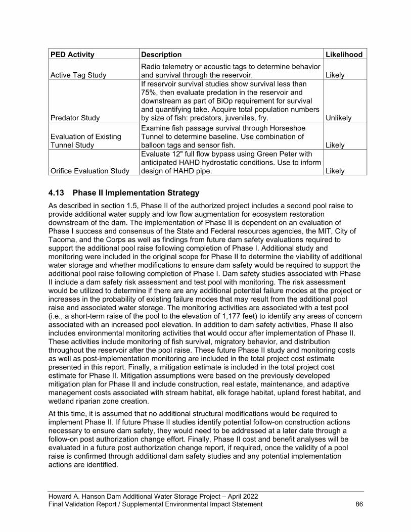
Howard A. Hanson Dam Additional Water Storage Project – April 2022 Final Validation Report / Supplemental Environmental Impact Statement 86
PED Activity Description Likelihood
Active Tag Study Radio telemetry or acoustic tags to determine behavior and survival through the reservoir. Likely
Predator Study
If reservoir survival studies show survival less than 75%, then evaluate predation in the reservoir and downstream as part of BiOp requirement for survival and quantifying take. Acquire total population numbers by size of fish: predators, juveniles, fry. Unlikely
Evaluation of Existing Tunnel Study
Examine fish passage survival through Horseshoe Tunnel to determine baseline. Use combination of balloon tags and sensor fish. Likely
Orifice Evaluation Study
Evaluate 12" full flow bypass using Green Peter with anticipated HAHD hydrostatic conditions. Use to inform design of HAHD pipe. Likely
4.13 Phase II Implementation Strategy As described in section 1.5, Phase II of the authorized project includes a second pool raise to provide additional water supply and low flow augmentation for ecosystem restoration downstream of the dam. The implementation of Phase II is dependent on an evaluation of Phase I success and consensus of the State and Federal resources agencies, the MIT, City of Tacoma, and the Corps as well as findings from future dam safety evaluations required to support the additional pool raise following completion of Phase I. Additional study and monitoring were included in the original scope for Phase II to determine the viability of additional water storage and whether modifications to ensure dam safety would be required to support the additional pool raise following completion of Phase I. Dam safety studies associated with Phase II include a dam safety risk assessment and test pool with monitoring. The risk assessment would be utilized to determine if there are any additional potential failure modes at the project or increases in the probability of existing failure modes that may result from the additional pool raise and associated water storage. The monitoring activities are associated with a test pool (i.e., a short-term raise of the pool to the elevation of 1,177 feet) to identify any areas of concern associated with an increased pool elevation. In addition to dam safety activities, Phase II also includes environmental monitoring activities that would occur after implementation of Phase II. These activities include monitoring of fish survival, migratory behavior, and distribution throughout the reservoir after the pool raise. These future Phase II study and monitoring costs as well as post-implementation monitoring are included in the total project cost estimate presented in this report. Finally, a mitigation estimate is included in the total project cost estimate for Phase II. Mitigation assumptions were based on the previously developed mitigation plan for Phase II and include construction, real estate, maintenance, and adaptive management costs associated with stream habitat, elk forage habitat, upland forest habitat, and wetland riparian zone creation. At this time, it is assumed that no additional structural modifications would be required to implement Phase II. If future Phase II studies identify potential follow-on construction actions necessary to ensure dam safety, they would need to be addressed at a later date through a follow-on post authorization change effort. Finally, Phase II cost and benefit analyses will be evaluated in a future post authorization change report, if required, once the validity of a pool raise is confirmed through additional dam safety studies and any potential implementation actions are identified.
Howard A. Hanson Dam Additional Water Storage Project – April 2022 Final Validation Report / Supplemental Environmental Impact Statement 87
5 Environmental Compliance This chapter provides documentation of how the TSP (agency preferred alternative) complies with all applicable Federal environmental laws, statutes, and executive orders.
5.1 National Environmental Policy Act of 1969 The NEPA (42 U.S.C. § 4321 et seq.) commits Federal agencies to consider, document, and publicly disclose the environmental effects of their actions. The purpose of this VR/SEIS is to inform the public of the nature of potential impacts, solicit public comment, and fulfill the Corps’ documentation requirements under NEPA. By providing an assessment and comparison of impacts associated with the alternatives, NEPA documentation provides a basis for informed decision-making. The action under consideration in this document is the proposal to update the design and to complete construction of the downstream FPF as well as the ongoing management of outflows during the high-flow season until the FPF is constructed. Before preparing the Draft VR/SEIS, the Corps published a Notice of Intent to prepare an SEIS in the Federal Register on September 21, 2021. The Corps published the Draft VR/SEIS for a 45-day public comment period. All public comments received appear with Corps responses in Appendix G of this Final VR/SEIS. If the Corps decides to move forward with the preferred alternative, then following publication of the Final VR/SEIS and a 30-day wait period, the Commander of Northwestern Division would sign an Amended Record of Decision, while the Corps' Director of Civil Works would sign the Director’s Report.
5.2 Endangered Species Act of 1973 The ESA (16 U.S.C. §§ 1531-1544), Section 7(a) requires that Federal agencies consult with NMFS and USFWS, as appropriate, to ensure proposed actions are not likely to jeopardize the continued existence of endangered or threatened species or to adversely modify or destroy their designated critical habitats. In 2000, the Corps consulted with NMFS and USFWS on effects to ESA-listed species from the continued O&M of HAHD and implementation of Phase I of the proposed AWSP. The species evaluated were Puget Sound Chinook salmon (Oncorhynchus tshawytscha), Puget Sound/Coastal bull trout (Salvelinus confluentus), bald eagle (Haliaeetus leucocephalus), northern spotted owl (Strix occidentalis caurina), marbled murrelet (Brachyramphus marmoratus), grizzly bear (Ursus arctos horribilis), gray wolf (Canis lupus), and Canada lynx (Lynx canadensis). BiOps were completed in 2000 by NMFS for Chinook salmon and by USFWS for bull trout. USFWS concluded the project would not likely adversely affect the terrestrial species. Since 2000, several new species listings under the ESA have occurred and new critical habitat designated. Therefore, ESA consultations with NMFS and USFWS were needed to evaluate effects to bull trout critical habitat, steelhead, steelhead critical habitat, SRKW, and SRKW critical habitat. After construction of the downstream FPF as described in the 1998 EIS (USACE 1998) was halted in 2011, the Corps provided a Supplemental BA in 2014 that consulted on continued operations of HAHD and did not include the FPF in the proposed Federal action. The Corps received an updated “jeopardy” BiOp from NMFS in 2019. The 2019 BiOp from NMFS requires the Corps to have an operational FPF by the end of 2030 meeting prescribed performance criteria (RPA 1), as well as make operational adjustments in the interim until downstream fish passage is implemented (RPA 2). In a letter dated March 14, 2019, the Corps met the 60-day response requirement of the ESA implementing regulations and committed to the plan to implement the RPAs and RPMs (see Appendix A).
Howard A. Hanson Dam Additional Water Storage Project – April 2022 Final Validation Report / Supplemental Environmental Impact Statement 88
After substantial coordination with USFWS throughout 2021, the Corps received a non-jeopardy BiOp from USFWS on February 3, 2022, which presumed incorporation into the description of the agency action the two RPAs promulgated in the 2019 NMFS BiOp. The USFWS BiOp contains three reasonable and prudent measures (RPMs); two are regarding minimizing temperature and turbidity during O&M of HAHD while the third RPM requires the Corps to minimize stress, injury, and/or mortality from fish capture associated with collection at and passage through the FPF. The Corps has been coordinating with NMFS throughout the feasibility stage to foster alignment on how to design, build, and operate FPF features to meet BiOp criteria. NMFS continues to provide input into this unique FPF system while the Corps works to gain full support of the consultation agencies later in the design phase.
5.3 Clean Water Act of 1972 The Clean Water Act (33 U.S.C. § 1251 et seq.) requires Federal agencies to protect waters of the U.S. The regulation implementing the Act disallows the placement of dredged or fill material into waters of the United States unless it can be demonstrated that no practicable alternatives are less environmentally damaging. The Sections of the Clean Water Act that apply to the proposal are 401 regarding discharges to waterways, 402 for discharge of stormwater associated with the construction site, and 404 regarding fill material in waters and wetlands.
5.3.1 Section 401 The Corps must seek a water quality certification from the certifying authority as delegated by EPA for any project that involves jurisdictional placement of dredged or fill material in waters of the U.S. or wetlands . Corps policy states that a project recommended for construction authorization must show reasonable assurance that all applicable environmental compliance has been or can be obtained. EPA has delegated authority to Ecology for compliance with Washington State water quality standards. Construction of an FPF was previously approved by Ecology in their September 10, 2002 Order No. 02SEARCR-4581, which provided Clean Water Act Section 401 Certification as well as concurrence with the Corps’ Coastal Zone Management Act (CZMA) Consistency Determination. The 2002 Certification has expired because more than 5 years has elapsed between the date of the issuance of the certification and the date of construction for which the certification was sought. Additionally, the Corps must provide an updated request for certification due to a change in the nature of the fill as defined in the public notice. The Corps initiated the process of seeking Section 401 certification from Ecology in fall of 2021. Ecology provided the new Section 401 certification on March 23, 2022 (see Appendix A).
5.3.2 Section 402 The National Pollutant Discharge Elimination System (NPDES) stormwater program addresses water pollution during activities such as construction by regulating point sources that discharge pollutants to waters of the United States. “Stormwater” means stormwater runoff, snow melt runoff, and surface runoff and drainage. Discharge of stormwater associated with construction activities such as clearing, grading, and excavating, with greater than one acre of ground disturbance, requires compliance with the NPDES Stormwater Program. The EPA has established a program to address stormwater discharges. A NPDES permit contains industry-specific, technology-based, and/or water-quality-based limits, and establish pollutant monitoring and reporting requirements. The Corps will require the construction contractor to obtain an NPDES permit from the U.S. Environmental Protection Agency for work
Howard A. Hanson Dam Additional Water Storage Project – April 2022 Final Validation Report / Supplemental Environmental Impact Statement 89
that will occur on Federal land and obtain an NPDES permit from Ecology for work that will occur on lands owned by Tacoma Public Utilities.
5.3.3 Section 404 The Corps is the regulatory agency that provides individual and general Section 404 permit decisions. Compliance with Section 404 requires public interest review, and it is necessary to avoid negative effects on waters of the U.S. wherever practicable, minimize effects where they are unavoidable, and compensate for effects in some cases. The Corps does not issue itself a Section 404 permit. Instead, the Corps has evaluated potential project-induced effects subject to these regulations in a Section 404(b)(1) Evaluation and public interest review (Appendix A).
5.4 Coastal Zone Management Act of 1972 The CZMA of 1972, as amended (16 U.S.C. §§ 1451-1464) requires Federal agencies to conduct activities in a manner consistent to the maximum extent practicable with the enforceable policies of the approved State Coastal Management Program. Ecology, in their September 10, 2002 Order No. 02SEARCR-4581, provided concurrence with the Corps’ CZMA Consistency Determination submitted in 2001 for the previous fish passage facility design. In evaluating compliance of the updated design with CZMA, the Corps determined the proposed work is consistent to the maximum extent practicable with the enforceable policies of the approved Washington Coastal Zone Management Program. Implementation of RPA 2 for the purpose of benefitting salmon would have direct benefits to uses of the coastal zone. Based on a minor change to the project footprint, the Corps submitted a Supplemental Consistency Determination to Ecology (see Appendix A). Ecology provided a letter of concurrence on March 29, 2022 (included in Appendix A).
5.5 Clean Air Act of 1972 The Clean Air Act (CAA), as amended (42 U.S.C. § 7401, et seq.) prohibits Federal agencies from approving any action that does not conform to an approved state, tribal, or Federal implementation plan. Under the CAA General Conformity Rule (Section 176(c)(4)), Federal agencies are prohibited from approving any action that causes or contributes to a violation of a NAAQS in a nonattainment area. The air-pollutant concentrations in the study area are consistently below the NAAQS. The study area is not in a maintenance or non-attainment area. The two nearest air quality monitoring stations are in North Bend, WA to the north and in Enumclaw, WA to the south of the study area. According to the Puget Sound Clean Air Agency (2020), overall air quality in the Puget Sound region has improved over the past two decades. During construction, vehicles and heavy equipment would generate diesel and gasoline fumes, which can include particulate matter, carbon monoxide, sulfur dioxide, ozone, and dust. Construction workers and HAHD staff would be exposed to these emissions, which can contribute to an increased risk of negative health effects such as lung cancer, chronic respiratory problems, and cardiovascular disease. During PED, measures to minimize emission of air pollutants and exposure to workers will be evaluated and incorporated into the final project design as appropriate. The contractor will identify planned air pollution-generating processes including, but not limited to, spray painting, abrasive blasting, demolition, material handling, fugitive dust, and fugitive emissions. Measures to control particulates may include sprinkling with water, windscreens, and cleaning along haul routes to reduce dirt, dust, and debris from roadways. Equipment measures may include diesel
Howard A. Hanson Dam Additional Water Storage Project – April 2022 Final Validation Report / Supplemental Environmental Impact Statement 90
emission control technology or idling limits. Emissions are not expected to affect implementation of Washington’s CAA implementation plan and would have no lasting effect on the study area. The Corps’ assessment is that implementation of the proposed action’s design changes would have no measurable change to the temporary and minor effects identified in the 1998 EIS, no substantial impact, and would not contribute to a violation of a NAAQS in a nonattainment area.
5.6 National Historic Preservation Act of 1966, as amended through 2016 Historic property means any prehistoric or historic district, site, building, structure, or object included in, or eligible for inclusion in, the NRHP maintained by the Secretary of the Interior. This term includes artifacts, records, and remains that are related to and located within such properties. The term includes properties of traditional religious and cultural importance to an Indian tribe or Native Hawaiian organization and that meet the National Register criteria (36 CFR 80.16(I)(1)). HAHD is documented in the Washington Information System for Architectural and Archaeological Records Data. For the purposes of this VR/SEIS, a new PA has been developed in consultation with the Washington State Department of Archaeology and Historic Preservation, the Advisory Council on Historic Preservation, and the City of Tacoma. The Corps initiated consultation with the Suquamish Indian Tribe and the MIT with an invitation to participate in the development of the PA. The Suquamish Indian Tribe declined to participate indicating it has no cultural resources concerns for this project. No response has been received from the MIT. The new PA addresses the change to the design of the fish passage, the phased Section 106 process, and potential effects to historic properties. The Corps has determined a phased approach to identification and evaluation is the appropriate and necessary process for the agency to meet the requirements of Section 106 of the NHPA under 36 CFR § 800.4(b)(2). Through the execution of a PA with the Advisory Council on Historic Preservation and the State Historic Preservation Officer, the Corps can complete a phased Section 106 compliance pursuant to 36 CFR § 800.4 (b) (2). Because the execution of the PA completes Section 106 compliance for the purposes of this study, it provides a path forward as further design and information become available. The executed PA is included in Appendix A.
5.7 Federal Trust Responsibility The Federal trust responsibility to Native American Tribes arises from the treaties signed between the Tribes and the U.S. Government. Under Article VI, Clause 2 of the U.S. Constitution, treaties with the Tribes are superior to State laws and equal to Federal laws. In these treaties, the U.S. made a set of commitments in exchange for tribal lands. The Supreme Court has held these commitments create a trust relationship between the U.S. and each treaty Tribe and impose upon the Federal Government “moral obligations of the highest responsibility and trust.” The scope of the Federal trust responsibility is broad and incumbent upon all Federal agencies. The U.S. Government has an obligation to protect Tribal land, assets, and resources that it holds in trust for the Tribes and a responsibility to ensure its actions do not abrogate Tribal treaty rights. The Federal Government has a trust responsibility towards all federally recognized Indian Tribes, regardless of treaty status. No interference with treaty rights or other Tribal lands, assets, or resources is anticipated. The proposed restoration of downstream fish passage would have significant benefits to the ecosystem and fisheries resources, which are of economic and cultural value to the MIT and Suquamish Indian Tribe. Restoration of fisheries resources supports Tribal treaty rights.
Howard A. Hanson Dam Additional Water Storage Project – April 2022 Final Validation Report / Supplemental Environmental Impact Statement 91
5.8 Fish and Wildlife Coordination Act of 1934 The Fish and Wildlife Coordination Act (FWCA) of 1934 as amended (16 U.S.C. §§ 661-667e) ensures fish and wildlife conservation is given equal consideration as is given to other features of water-resource development programs. This law provides that whenever any water body is proposed to be impounded, diverted, deepened, or otherwise controlled or modified, the Corps shall consult with the USFWS and NMFS as appropriate, and the agency administering the wildlife resources of the state. Any reports and recommendations of the wildlife agencies shall be included in authorization documents for construction or modification of projects. The Corps consulted with USFWS and NMFS regarding effects to fish and wildlife species during the AWSP feasibility phase in the 1990s. NMFS provided a letter of support for Phase 1 of the AWSP dated March 19, 1996. USFWS provided a Coordination Act Report in 1998. The recommendations of the USFWS for the project, and the Corps' responses to those recommendations appear in section 2.12 of the Draft EIS (USACE 1998). Throughout the current validation study, the Corps has been coordinating with NMFS regarding updating the FPF design; NMFS informally stated no new FWCA coordination is required. The Corps contacted USFWS on November 23, 2021, to provide updated information that the FPF is undergoing a Section 902 validation study and would be seeking re-authorization. On December 1, 2021, USFWS replied that the 1998 FWCA compliance is outdated, and the agency will review the updated proposal. USFWS provided a letter to the Corps on April 15, 2022, reaffirming their support for the conservation recommendations provided in the 1998 Coordination Act Report as well as their 2022 BiOp. In addition, USFWS provided conservation recommendations for the consideration of protection of Pacific lamprey and freshwater mussels during any in-water work in the project area. The Corps has given full consideration to, and will incorporate the justifiable conservation recommendations to the maximum extent practicable into, the pre-construction field surveys and the specifications for construction of the FPF.
5.9 Magnuson-Stevens Fishery Conservation and Management Act of 1976 The Magnuson-Stevens Fishery Conservation and Management Act, (16 U.S.C. § 1801 et seq.) requires Federal agencies to consult with NMFS on activities that may adversely affect Essential Fish Habitat (EFH). The objective of an EFH assessment is to determine whether the proposed action(s) “may adversely affect” designated EFH for relevant commercial, federally managed fisheries species within the proposed action area. The assessment describes conservation measures proposed to avoid, minimize, or otherwise offset potential adverse effects to designated EFH resulting from the proposed action. The project area includes EFH for Chinook salmon, coho salmon, and Puget Sound pink salmon (PFMC 1999). The Corps included an EFH analysis within the 2014 BA and concluded that the action is likely to adversely affect EFH for Chinook and coho salmon. The 2019 BiOp from NMFS concluded that the proposed action of continued O&M of HAHD would adversely affect EFH designated for Pacific salmon by obstructing effective fish passage and diminishing the value of spawning and rearing habitats. However, NMFS expects that the RPA of implementing a permanent downstream fish passage system and the RPMs required in the incidental take statement, in addition to the measures in the proposed action and the interim action of RPA 2, will conserve EFH. Consequently, NMFS adopted those measures as the EFH conservation recommendations. In a letter dated March 14, 2019, the Corps met the 30-day statutory response requirement and committed to the plan to implement the RPAs and RPMs (see Appendix A). Additionally, the Corps reiterated the commitment to the measures that were incorporated into the action as they had been detailed in the 2014 BA (USACE 2014). Therefore, the Corps' action of constructing the downstream FPF as described in this document fulfills compliance with the Magnuson-Stevens Fishery Conservation and Management Act.
Howard A. Hanson Dam Additional Water Storage Project – April 2022 Final Validation Report / Supplemental Environmental Impact Statement 92
5.10 Bald and Golden Eagle Protection Act The Bald and Golden Eagle Protection Act (16 U.S.C. §§ 668-668c) applies to Corps Civil Works projects through the protection of bald and golden eagles from disturbance. Although a bald eagle is frequently seen perched over the south side of the reservoir, no bald or golden eagle nests have been recorded within the project area since surveys began in the 1980s (TPU 2001; WDFW 2021). Construction activities associated with the proposed action have the potential to disturb bald eagles due to the presence of heavy machinery and elevated noise levels. During a meeting between the Corps and USFWS staff on November 10, 2021, USFWS stated that they see no issues with full compliance. The Corps will develop an eagle monitoring plan during the next phase of design and will minimize construction effects by surveying each site for nests and roosts prior to and during construction, and, if nests and/or roosts are nearby, will coordinate with USFWS.
5.11 Migratory Bird Treaty Act of 1918 and Executive Order 13186 Migratory Bird Habitat Protection
The Migratory Bird Treaty Act (16 U.S.C. § 703-712) as amended protects over 800 bird species and their habitat and commits that the U.S. will take measures to protect identified ecosystems of special importance to migratory birds against pollution, detrimental alterations, and other environmental degradations. EO 13186 directs Federal agencies to evaluate the effects of their actions on migratory birds, with emphasis on species of concern, and inform the USFWS of potential negative effects on migratory birds. The Corps informed the USFWS during the development of this VR/SEIS that the proposed action may cause the temporary displacement of birds due to construction noise and the presence of human activity. Loss of vegetation during construction may reduce cover, perching, foraging, and nesting opportunities. Construction of the facility will occur during the general breeding season for migratory birds (April 16–August 15). The Corps would develop BMPs to minimize impacts to migratory birds during the detailed design phase. The timing of the most disruptive activities of construction, such as rock blasting for excavation, would take into consideration the timing and location of the nesting pair of loons and other nesting birds. The Corps would coordinate with USFWS during PED phase as details on construction methods and timing become available. The Corps does not anticipate any direct or deliberate impacts on migratory birds arising as a result of construction of the fish passage facility, and thus has concluded that no take authorization is required. During a meeting between the Corps and USFWS staff on November 10, 2021, USFWS stated that they see no issues with full compliance.
5.12 Executive Order 13175 Consultation and Coordination with Indian Tribal Governments
Executive Order 13175 (November 6, 2000) reaffirmed the Federal Government’s commitment to a government-to-government relationship with Indian tribes and directed Federal agencies to establish procedures to consult and collaborate with tribal governments when new agency regulations would have tribal implications. The Corps has a government-to-government consultation policy to facilitate the interchange between sovereign representatives with respect to agency decisions. In accordance with this Executive Order, the Corps has engaged in regular and meaningful consultation and collaboration with the MIT throughout the course of the analysis to update the design of the FPF. The Corps contacted the MIT in advance of holding the design update workshops (described in chapter 2) to seek and consider tribal perspectives. The MIT provided
Howard A. Hanson Dam Additional Water Storage Project – April 2022 Final Validation Report / Supplemental Environmental Impact Statement 93
input during both workshops and the information is being incorporated into design considerations. The MIT will be notified of each opportunity to review and comment on this VR/SEIS, and coordination will continue throughout design, implementation, and post-construction monitoring phases. In advance of publishing the draft VR/SEIS, the Corps notified the four Native American Tribes with treaty-protected rights to natural resources within the study area, which are recognized as usual and accustomed grounds and stations, in letters dated November 8, 2021. These Tribes included MIT, Suquamish Indian Tribe, Snoqualmie Indian Tribe, and the Confederated Tribes and Bands of the Yakama Nation. Each of the Tribes also received a copy of the draft VR/SEIS on November 18, 2021, for their review and comment. The Corps has not received a response from any of these Tribes. The final VR/SEIS will be provided to the same Tribes.
5.13 Executive Order 12898 Environmental Justice and Executive Order 14008 Climate Crisis
Executive Order 12898, “Federal Actions to Address Environmental Justice in Minority Populations and Low-Income Populations,” provides that each Federal agency shall make achieving environmental justice part of its mission by identifying and addressing disproportionately high and adverse human health or environmental effects of its programs, policies, and activities on minority populations and low-income populations. Environmental justice concerns may arise from impacts on the natural and physical environment, such as human health or ecological impacts on minority populations, low-income populations, and Indian Tribes or from related social or economic impacts. NEPA procedures are important in identifying and addressing environmental justice concerns. To analyze potential effects of construction of the FPF, the Corps used the EPA Environmental Justice Viewer with a 5-mile radius around the construction site to determine whether protected groups are present in the proposed project area to the broadest extent that construction effects would be expected to be detectable. This evaluation found the site has only 78 residents nearby, and the demographic composition of the nearby population is mostly non-minority and above poverty levels (EPA 2021). The proposed action would not disproportionately adversely affect minority or low-income populations nor have any adverse human health impacts. No interaction with other projects would result in any such disproportionate impacts. Tribal governments that are also environmental justice communities in the project area have been engaged and informed about the proposed action. The Corps has determined the action would not directly or through contractual or other arrangements, use criteria, methods, or practices that discriminate on the basis of race, color, or national origin, nor would it have a disproportionate effect on minority or low-income communities. As acknowledged in the EPA comments (see Appendix G), the construction and operation of downstream fish passage at a high-head dam is inherently complex and challenging, and the circumstances of the HAHD lack direct precedent. As such, best available science from which to draw design parameters and operational methodologies has been in continuous development over the interim since the promulgation of the 1998 AWSP EIS, and remains even now a technical arena in a state of progress. Full congressional authorization and appropriation has not been provided for implementation of downstream fish passage capability of the scale and sophistication required at HAHD, and that full authorization is in fact being sought through the justification enumerated in this integrated VR/SEIS. The action analyzed in this VR/SEIS is the change in design necessary to address the peculiar circumstances of downstream fish passage in the upper Green River at HAHD, to the standards reflected in the attraction and performance criteria of the RPA in the NMFS 2019 BiOp. Implementation of the updated design would
Howard A. Hanson Dam Additional Water Storage Project – April 2022 Final Validation Report / Supplemental Environmental Impact Statement 94
generate universally recognized environmental benefits. No mitigation beyond that identified in the 1998 EIS and WRDA 1999 authorization, and predominantly already accomplished, is necessary in connection with the action evaluated in this integrated VR/SEIS, which is implementation of an updated fish passage facility design. Executive Order 14008, “Tackling the Climate Crisis at Home and Abroad”, amends Executive Order 12898 and has updated Federal agencies’ responsibilities for assessing environmental justice consequences of their actions. With its effective date of January 27, 2021, this process of assessing environmental justice impacts was not applied in the 1998 EIS. Because of the geographic breadth of impacts of populations of affected listed salmonid species, the area of analysis for environmental justice purposes also encompasses the lower Green River watershed. The effects of the FPF component of the AWSP, which would restore downstream fish passage of juvenile salmonids, appear to be universally positive for all disadvantaged minority, low-income, and tribal communities throughout the upper and lower portions of the Green River watershed. Thus, the benefits of the action for these communities have been maximized as reflected in the analysis of the selection of the Recommended Plan, and there are no disproportionate adverse impacts imposed on those communities, as compared with the larger reference population, through implementation of downstream fish passage at HAHD.
5.14 Executive Order 11990 Protection of Wetlands Executive Order 11990 entitled Protection of Wetlands (May 24, 1977) requires Federal agencies to take action to avoid adversely impacting wetlands wherever possible, to minimize wetlands destruction and to preserve the values of wetlands, and to prescribe procedures to implement the policies and procedures of this Executive Order. No effects to or loss of wetlands are expected. The proposed action is in compliance with this Order.
5.15 Executive Order 11988 Floodplain Management Executive Order 11988 entitled Floodplain Management (May 24, 1977) as amended by Executive Order 13690 (January 30, 2015) requires Federal agencies to recognize the significant values of floodplains and to consider the public benefits that would be realized from restoring and preserving floodplains. Executive Order 11988 outlines the responsibilities of Federal agencies in the role of floodplain management. Each agency shall evaluate the potential effects of actions on floodplains and should avoid undertaking actions that directly or indirectly induce growth in the floodplain or adversely affect natural floodplain values. It is the general policy of the Corps to formulate projects that, to the extent possible, avoid or minimize adverse impacts associated with the use of the base floodplain and avoid inducing development in the base floodplain unless there is no practicable alternative that meets the project purpose. In the 1998 EIS, the Corps determined the entire project is in compliance with this Order. Executive Order 11988 states that for any activities associated with a critical facility, the 500-year floodplain triggers this Executive Order. As a flood control structure, HAHD is a critical facility. The proposed action is an updated design of the FPF that will be constructed within the confinement of HAHD with a portion of the structure extending a short distance downstream similar to the design analyzed in the 1998 EIS. Therefore, while the facility itself sits within the 500-year floodplain, the proposed action would have no change to the effects already determined to be compliant.
Howard A. Hanson Dam Additional Water Storage Project – April 2022 Final Validation Report / Supplemental Environmental Impact Statement 95
5.16 Executive Order 13045 Protection of Children from Environmental Health Risks and Safety Risks
Executive Order 13045 (April 21, 1997) points out that children may suffer disproportionately from environmental health and safety risks due to their bodily systems still developing at the same time of eating, drinking, and breathing greater quantities in proportion to their size compared to adults. Federal agencies are required to identify and assess environmental health risks that may disproportionately affect children and ensure activities address disproportionate risks to children that result from environmental health or safety risks. The 1998 EIS did not contain documentation of an analysis of effects of the AWSP specifically to children. For the one remaining component of the AWSP to be constructed, the Corps has analyzed the construction site footprint and surrounding area for the potential for construction of the FPF to cause health and safety risks to children. The site where construction activity will occur is more than 5 miles away from any schools, parks, libraries, and grocery stores. Infants and children are not expected to be exposed to any health or safety risks because of the action; therefore, this action has no environmental or safety risks that may disproportionately affect children. The plan is in compliance.
5.17 Executive Order 13990 Protecting Public Health and the Environment and Restoring Science to Tackle the Climate Crisis
Executive Order 13990 (January 20, 2021) reinstates the 2016 CEQ memorandum, “Final Guidance for Federal Departments and Agencies on Consideration of Greenhouse Gas Emissions and the Effects of Climate Change in National Environmental Policy Act Reviews (issued Aug. 1, 2016; withdrawn Apr. 5, 2017; under review Feb. 19, 2021, for revision and update).” The guidance states that when addressing climate change, agencies should consider: (1) The potential effects of a proposed action on climate change as indicated by assessing GHG emissions (e.g., to include, where applicable, carbon sequestration); and (2) the effects of climate change on a proposed action and its environmental impacts. The Corps incorporated this guidance in section 3.4 and determined the proposed action will have no measurable effect on climate change. Effects of climate change on the proposed action and its environmental impacts appear in section 3.4.3. The plan is in compliance.
Howard A. Hanson Dam Additional Water Storage Project – April 2022 Final Validation Report / Supplemental Environmental Impact Statement 96
6 Public Involvement, Review, and Consultation This chapter summarizes public and agency engagement related to this study. Coordination and consultation associated with compliance with specific laws is described in Chapter 5.
6.1 Public Involvement Process Corps Planning Policy and NEPA emphasize public involvement in government actions affecting the environment by requiring the benefits and risks associated with the proposed actions be assessed and publicly disclosed. In accordance with NEPA public involvement requirements (40 C.F.R. § 1506.6) and Corps Planning policy (ER 1105-2-100), the Corps presented opportunities for the public to provide comments, with respect specifically to the impacts of the updated FPF design and interim high-flow-season water management operations, on potentially affected resources, environmental issues to be considered, and the agency’s approach to the analysis. For public outreach, the Corps published a "Notice of Intent to Prepare a Supplemental EIS" in the Federal Register on September 20, 2021. The Corps then published the integrated Draft VR/SEIS for a 45-day public comment period from November 9, 2021 through January 4, 2022. The Corps received two comment submittals through electronic mail from the WDFW and the EPA. In accordance with 40 CFR §1503.4, the Corps considered and addressed these comments. The comments were assessed to determine whether they identified fundamental or technical issues with the Draft VR/SEIS. Examples include technical issues with descriptions of the affected environment, perceived inadequacies with analyses, clarifications regarding the purpose and need, etc. The Corps provided responses to these comments and revised discussions in this Final VR/SEIS where applicable. These comment letters and associated Corps’ responses are provided in Appendix G of the Final VR/SEIS, which will be published prior to finalizing the amended ROD. The following list is a summary of the comments received:
• Concerns with debris management and support of the Corps’ plan to analyze the debris system during the PED phase.
• Ensure that the bypass design velocities decelerate gradually to minimize exposure of fish to shear.
• Evaluate alternative methods for downstream fish collection for monitoring such as an acclimation pond.
• Continue stakeholder coordination through the PED phase. • Describe monitoring and adaptive management of project features including fish
collection efficiency and survival criteria including predation monitoring. • Incorporate a discussion of the impacts of delaying construction as anticipated in the
initial EIS. • Include estimates of the extent and characterization of impacts below the ordinary high
water mark. • Provide additional details on post-construction restoration measures as well as any
compensatory mitigation required under the CWA. • Discuss short-term and temporary impacts to water quality for the multiple years of
proposed construction. • Describe efforts to balance temperature and turbidity during reservoir lowering. • Clarify anticipated fish usage of the river reach below the dam as well as any
adjustments to water release management. • Provide clarification on Tribes consulted and a discussion of incorporation of feedback
from tribal consultation.
Howard A. Hanson Dam Additional Water Storage Project – April 2022 Final Validation Report / Supplemental Environmental Impact Statement 97
• Discuss construction-related air pollutants and measures to minimize air quality impacts on the local environment and decrease exposure to emissions and dust.
6.2 Tribal Government Consultation and Coordination Process The Corps identified four Native American Tribes as having treaty-protected natural resources interest in the study area and notified the Tribes of the proposed action; however, only the MIT responded to an invitation for involvement. The Corps provided information about the proposed Federal action, integrated VR/SEIS, and opportunities for the Tribe to provide information and comment on the project. The Consultation began with inviting MIT to participate in the alternatives selection workshop as described in sections 2.3-2.6. The MIT provided input during both workshops and the information is being incorporated into design considerations. The MIT will be notified of each opportunity to review and comment on this VR/SEIS, and coordination will continue throughout design, implementation, and post-construction monitoring phases. The MIT raised the following concerns during the Validation Study:
1. The new FPF should be designed to support passage of the smallest fish size expected to pass, specifically Chinook and pink salmon fry.
2. Survival of Chinook fry in the reservoir could be too low to support rebuilding the Green River population and should be carefully monitored to determine survival rates with high confidence in the numbers.
3. Post-construction monitoring and contingency actions should be thorough and comprehensive to ensure success of the new facility.
4. Any design changes prior to finalization of designs and changes during the construction process should be reviewed and approved by fish biologists with experience in fish passage projects.
Each of these concerns will be addressed at the appropriate timing during PED phase. The Corps will invite the MIT to collaborate on and review FPF designs. The Corps will also consult with the MIT on study designs for monitoring and adaptive management. Under Section 106 of the NHPA, the Corps is required to consult with any Native American Tribes who may be affected by the Corps’ undertaking, or who may request to be notified of projects within the APE. For the original 1998 EIS, the following Tribes were notified and consulted: the MIT and the Suquamish Indian Tribe. As a result of the previous consultation, the Corps invited the MIT to be a concurring party of the MOA signed in 2003. The Corps has notified the MIT and the Suquamish Indian Tribe of the changes to the scope of the action and invited each Tribe to submit comments. The Suquamish Indian Tribe has submitted a comment to decline their participation in the current PA, and the MIT has not responded.
6.3 Agencies and Persons Consulted* The Corps consulted with individuals represented in the following list of agencies and Tribes during the Validation Study and preparation of this VR/SEIS.
• King County • Muckleshoot Indian Tribe • National Marine Fisheries Service • Pacific Northwest National Laboratory • R2 Resource Consultants • Suquamish Indian Tribe • Tacoma Public Utilities • U.S. Bureau of Reclamation
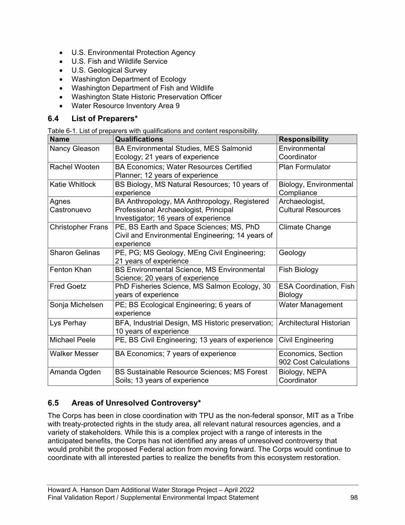
Howard A. Hanson Dam Additional Water Storage Project – April 2022 Final Validation Report / Supplemental Environmental Impact Statement 98
• U.S. Environmental Protection Agency • U.S. Fish and Wildlife Service • U.S. Geological Survey • Washington Department of Ecology • Washington Department of Fish and Wildlife • Washington State Historic Preservation Officer • Water Resource Inventory Area 9
6.4 List of Preparers* Table 6-1. List of preparers with qualifications and content responsibility. Name Qualifications Responsibility Nancy Gleason BA Environmental Studies, MES Salmonid
Ecology; 21 years of experience Environmental Coordinator
Rachel Wooten BA Economics; Water Resources Certified Planner; 12 years of experience
Plan Formulator
Katie Whitlock BS Biology, MS Natural Resources; 10 years of experience
Biology, Environmental Compliance
Agnes Castronuevo
BA Anthropology, MA Anthropology, Registered Professional Archaeologist, Principal Investigator; 16 years of experience
Archaeologist, Cultural Resources
Christopher Frans PE, BS Earth and Space Sciences; MS, PhD Civil and Environmental Engineering; 14 years of experience
Climate Change
Sharon Gelinas PE, PG; MS Geology, MEng Civil Engineering; 21 years of experience
Geology
Fenton Khan BS Environmental Science, MS Environmental Science; 20 years of experience
Fish Biology
Fred Goetz PhD Fisheries Science, MS Salmon Ecology, 30 years of experience
ESA Coordination, Fish Biology
Sonja Michelsen PE; BS Ecological Engineering; 6 years of experience
Water Management
Lys Perhay BFA, Industrial Design, MS Historic preservation; 10 years of experience
Architectural Historian
Michael Peele PE, BS Civil Engineering; 13 years of experience Civil Engineering
Walker Messer BA Economics; 7 years of experience Economics, Section 902 Cost Calculations
Amanda Ogden BS Sustainable Resource Sciences; MS Forest Soils; 13 years of experience
Biology, NEPA Coordinator
6.5 Areas of Unresolved Controversy* The Corps has been in close coordination with TPU as the non-federal sponsor, MIT as a Tribe with treaty-protected rights in the study area, all relevant natural resources agencies, and a variety of stakeholders. While this is a complex project with a range of interests in the anticipated benefits, the Corps has not identified any areas of unresolved controversy that would prohibit the proposed Federal action from moving forward. The Corps would continue to coordinate with all interested parties to realize the benefits from this ecosystem restoration.
Howard A. Hanson Dam Additional Water Storage Project – April 2022 Final Validation Report / Supplemental Environmental Impact Statement 100
7 Recommendations The projected cost estimate for the updated fish passage facility design for the Howard A. Hanson Dam Additional Water Storage Project now exceeds the calculated Section 902 limit as compared with the total project cost authorized in the WRDA 1999 legislative authorization. The authorized project will require a greater expenditure to construct project features compliant with the criteria of RPA 1 of the 2019 BiOp, necessitating an update to the total project cost estimate based on design refinements for the fish passage facility. I recommend that this Validation Report and Supplemental Environmental Impact Statement be approved and transmitted to Congress as a basis for increasing the authorized project cost of the Howard A. Hanson Dam Additional Water Storage Project to $855,185,000 (October 2021 price levels). The recommendations contained herein reflect the information available at this time and current departmental policies governing the formulation of individual projects. They do not reflect program and budgeting priorities inherent in the formulation of the national civil works construction program or the perspective of higher levels within the executive branch. Consequently, the recommendations may be modified before they are transmitted to Congress for authorization and/or implementation funding. However, prior to transmittal to Congress, Tacoma Public Utilities, interested Federal agencies, and other parties will be advised of any significant modifications in the recommendations and will be afforded an opportunity to comment further.
Alexander Bullock Colonel, U.S. Army
District Commander
BULLOCK.ALEXANDER.LAWRENCE.1161324236
Digitally signed by BULLOCK.ALEXANDER.LAWRENCE.1161324236Date: 2022.05.05 11:09:19 -07'00'
Howard A. Hanson Dam Additional Water Storage Project – April 2022 Final Validation Report / Supplemental Environmental Impact Statement 100
8 References Abatzoglou, J.T. and T.J. Brown. 2012. A comparison of statistical downscaling methods suited
for wildfire applications. International Journal of Climatology, 32(5):772-780. doi: http://dx.doi.org/10.1002/joc.2312.
Benson, James R., and Guy F. Moura. 1986. An Archaeological Resources Reconnaissance of Howard A. Hanson Dam Project. Evans-Hamilton, Seattle, for the U.S. Army Corps of Engineers, Seattle District, Contract No. DACW 67-85-D-0028, Work Order 21.
Cao, Q., N. Sun, J. Yearsley, B. Nijssen, and D.P. Lettenmaier. 2016. Climate and land cover effects on the temperature of Puget Sound streams. Hydrological Processes 30(13):2286.
Cederholm, C.J., M.D. Kunze, T. Murota, and A. Sibatani. 1999. Pacific Salmon Carcasses: Essential Contributions of Nutrients and Energy for Aquatic and Terrestrial Ecosystems. Fisheries 24(10): 6-15.
Cederholm, C. J., D. H. Johnson, R. E. Bilby, L.G. Dominguez, A. M. Garrett, W. H. Graeber, E. L. Greda, M. D. Kunze, B.G. Marcot, J. F. Palmisano, R. W. Plotnikoff, W. G. Pearcy, C. A. Simenstad, and P. C. Trotter. 2000. Pacific Salmon and Wildlife - Ecological Contexts, Relationships, and Implications for Management. Special Edition Technical Report, Prepared for D. H. Johnson and T. A. O’Neil (Managing Directors), Wildlife-Habitat Relationships in Oregon and Washington. WDFW, Olympia, Washington.
Deng Z, JP Duncan, JL Arnold, T Fu, and GE Johnson. 2015. Willamette Valley High Head Bypass Downstream Passage Prototype Evaluation: Sensor Fish Evaluation of the Bypass Pipes at Green Peter Dam, 2015. PNNL-24805. Final Report prepared for the U.S. Army Corps of Engineers, Portland District, by Pacific Northwest National Laboratory, Richland, Washington.
Deng Z, JP Duncan, JJ Martinez, F Fu. 2016. Willamette Valley High Head Bypass Downstream Passage Prototype Evaluation: Sensor Fish Evaluation of the Connecting and Bypass Pipes at Green Peter Dam, 2016. PNNL-25953. Prepared for the U.S. Army Corps of Engineers, Portland District, by Pacific Northwest National Laboratory, Richland, Washington.
Deng ZD, JP Duncan, JJ Martinez, and T Fu. 2018. Willamette Valley High Head Bypass Downstream Passage Prototype Evaluation: Sensor Fish Evaluation of the Connecting and Bypass Pipes at Green Peter Dam, 2017. PNNL-27335. Final Report prepared for the U.S. Army Corps of Engineers, Portland District, Portland, Oregon, by Pacific Northwest National Laboratory, Richland, Washington.
Dickerson, D. D., C. T. Theriot, D. S. D'Amato, and K. D. Philley. 2019. Western Toad Breeding Field Surveys: Howard A. Hanson Dam and Mud Mountain Dam, King and Pierce Counties, Washington. A report to USACE, Seattle District. USACE Engineer Research and Development Center, Environmental Laboratory.
Dillon, Jeffrey. 1994. Green River Resident Fish Snorkeling Survey: River Mile 62.5 to 64.5. Prepared for the U.S. Army Corps of Engineers, Seattle District.
Duncan, JP. 2013. Assessment of Passage Conditions Through the Complete 24-in. Downstream Migrant Bypass Pipe at Green Peter Dam Using Sensor Fish. PNNL-22608. Final Report prepared for the U.S. Army Corps of Engineers, Portland District, by Pacific Northwest National Laboratory, Richland, Washington.
Ecology (Washington State Department of Ecology). 2018. Greenhouse gases: 2018 Greenhouse Gas Data. Available online: https://ecology.wa.gov/Air-Climate/Climate-change/Greenhouse-gases/2018-Data. Accessed September 27, 2021.
Howard A. Hanson Dam Additional Water Storage Project – April 2022 Final Validation Report / Supplemental Environmental Impact Statement 101
EPA (Environmental Protection Agency). 2021. EJSCREEN: Environmental Justice Screening and Mapping Tool. Available: https://www.epa.gov/ejscreen Accessed August 26, 2021.
Ford, M.J. (ed.), T. Cooney, P. McElhany, N. Sands, L., et al. 2011. Status review update for Pacific salmon and steelhead listed under the Endangered Species Act: Pacific Northwest. NMFS Technical Memorandum NMFS-NWFSC-113. National Marine Fisheries Service, Northwest Fisheries Science Center, Seattle, WA.
Fuerstenberg, R.R., K. Nelson, and R. Blomquist. 1996. Ecological conditions and limitations to salmonid diversity in the Green River, Washington, USA. Storage, function and process in river ecology. King County Department of Natural Resources, Seattle, WA. 213 pp.
Gleason, Nancy C., Rhonda S. Lucas, and Scott V. Pozarycki. 2014. Fish, Bird, and Mammal Predator Populations and Consumption Rates of Juvenile Salmonids at Howard Hanson Dam, King County, Washington: Results for Baseline Year 2008. On file at U.S. Army Corps of Engineers, Seattle District.
Grette, G.B. and E.O. Salo. 1986. The status of anadromous fishes of the Green/Duwamish River system. Prepared for the US Army Corps of Engineers, Seattle District, by Evans-Hamilton, Inc., Seattle, Washington.
Hard, J.J., J.M. Myers, M.J. Ford, R.G. Cope, G.R. Pess, R.S. Waples, G.A. Winans, B.A. Berejikian, F.W. Waknitz, P.B. Adams. P.A. Bisson, D.E. Campton, and R.R. Reisenbichler. 2007. Status review of Puget Sound steelhead (Oncorhynchus mykiss). U.S. Dept. of Commerce, NOAA Tech. Memo. NMFS-NWFSC-81, 117 pp.
Hollenbeck, J.L. 1987. A Cultural Resource Overview: Prehistory, Ethnography, History Mt. Baker-Snoqualmie National Forest, Pacific Northwest Region, U.S. Forest Service. Copy archived at Washington State Department of Archaeology and Historic Preservation, Olympia.
Kanaby, Kara. 2014. Cultural Resources Assessment for the Howard Hanson Dam Left Bank Drainage Project, King County, Washington. Copy archived at Washington State Department of Archaeology and Historic Preservation, Olympia.
Katapodis, C., J.A. Kells, and M. Acharya. 2001. Nature-like and Conventional Fishways: Alternative Concepts? Canadian Water Resources Journal 26(2):211-232
Kent, Ronald. 2011. Historic Properties Studies for Howard Hanson Dam Additional Water Storage Phase I Stream Habitat Project, Upper Green River Basin. U.S. Army Corps of Engineers, Seattle District.
Mass, C., A. Skalenakis, and M. Warner. 2011. Extreme precipitation over the west coast of North America: Is there a trend? Journal of Hydrometeorology, 12:310–318, doi:10.1175/2010JHM1341.1.
Mauger, G.S., J.H. Casola, H.A. Morgan, R.L. Strauch, B. Jones, B. Curry, T.M. Busch Isaksen, L. Whitely Binder, M.B. Krosby, and A.K. Snover. 2015. State of Knowledge: Climate Change in Puget Sound. Report prepared for the Puget Sound Partnership and the National Oceanic and Atmospheric Administration. Climate Impacts Group, University of Washington, Seattle. doi:10.7915/CIG93777D
Mote, P.W. 2006. Climate-driven variability and trends in mountain snowpack in western North America. Journal of Climate, 19(23):6209-6220.
NCA4. 2018. Impacts, Risks, and Adaptation in the United States: Fourth National Climate Assessment, Volume II. USGCRP. doi: 10.7930/NCA4.2018
Howard A. Hanson Dam Additional Water Storage Project – April 2022 Final Validation Report / Supplemental Environmental Impact Statement 102
McCroskey, Lauren, and Danielle Storey. 2010. Howard A. Hanson Dam: Historic Context and National Register Evaluation of Historic Properties, USACE internal report. Manuscript on file at the Department of Archaeology and Historic Preservation, Olympia.
NMFS (National Marine Fisheries Service). 1996. Coastal Salmon Conservation: Working Guidance for Comprehensive Salmon Restoration Initiatives on the Pacific Coast. U.S. Department of Commerce, National Oceanic and Atmospheric Administration.
NMFS. 2008. Willamette Project Biological Opinion. Available online: https://media.fisheries.noaa.gov/2021-11/willamette-2008-biological-opinion.pdf
NMFS. 2011. Anadromous salmonid passage facility design. NMFS, Northwest Region (NWR), Portland, OR. Available online: https://www.fisheries.noaa.gov/resource/document/anadromous-salmonid-passage-facility-design
NMFS. 2019. Biological Opinion on Howard Hanson Dam, Operations, and Maintenance, Green River (HUC 17110013) King County, Washington. WCR-2014-997. NMFS West Coast Region. February 15, 2019. Available online: https://www.nws.usace.army.mil/Missions/Environmental/Environmental-Documents/
NOAA and WDFW (NOAA Fisheries West Coast Region and Washington Department of Fish and Wildlife). 2018. Southern Resident Killer Whale Priority Chinook Stocks Report. June 22, 2018.
Normandeau Associates, Inc. 2014. Condition of juvenile salmonids passed through the entire length of the 24-in Bypass Pipe at Green Peter Dam. Letter Report prepared for U.S. Army Corps of Engineers Portland District, Portland, OR.
Normandeau Associates, Inc. 2015. Biological Fish Injury and Survival Evaluation at Green Peter Dam, Oregon 2015. Final Report submitted to the U.S. Army Corps of Engineers, Portland District, Portland, Oregon.
Normandeau Associates, Inc. 2016. Biological Fish Injury and Survival Evaluation at Green Peter Dam, Oregon, 2016. Final Report submitted to the U.S. Army Corps of Engineers, Portland District, Portland, Oregon.
Normandeau Associates, Inc. 2018. High Head Passage Evaluation Green Peter, 2017. Final Report Summary submitted to the U.S. Army Corps of Engineers, Portland District
Pautzke, C.F. and R.C. Meigs. 1940. Studies on the Life History of the Puget Sound Steelhead. State of Washington, Department of Game, Seattle. 30 pp.
PFMC (Pacific Fisheries Management Council). 1999. Amendment 14 to the Pacific Coast Salmon Plan. Appendix A: Description and Identification of Essential Fish Habitat, Adverse Impacts and Recommended Conservation Measures for Salmon. Portland, Oregon
PSIT and WDFW (Puget Sound Indian Tribes and Washington Department of Fish and Wildlife). 2017. Comprehensive Management Plan for Puget Sound Chinook: Harvest Management Component. December 1, 2017.
Puget Sound Clean Air Agency. 2020. 2019 Air Quality Data Summary. Available online: https://pscleanair.gov/DocumentCenter/View/4164/Air-Quality-Data-Summary-2019 Accessed August 12, 2021.
R2 (R2 Resource Consultants, Inc.). 2002. Mainstem Middle Green River 2001 Bull Trout Surveys, Final Report. Prepared for the U.S. Army Corps of Engineers.
Howard A. Hanson Dam Additional Water Storage Project – April 2022 Final Validation Report / Supplemental Environmental Impact Statement 103
R2. 2005. Howard Hanson Dam Additional Water Storage Project Phase I Habitat Restoration – Zone 1 Biological Monitoring Final Data Report. Prepared for the U.S. Army Corps of Engineers. February 2005.
Reynolds, P., and K. Paulson. 1999. Draft Landslide Hazard Assessment, Howard Hanson and Smay Creek Watershed Administrative Units, Green River Basin, Kind County, Washington. Revised October 1999.
Richardson, S., D. Hays, R. Spencer, and J. Stofel. 2000. Washington State Status Report for the Common Loon. Washington Department of Fish and Wildlife, Olympia. 53 pp.
RMJOC (River Management Joint Operating Committee). 2018. Climate and Hydrology Datasets for RMJOC Long-Term Planning Studies: Second Edition (RMJOC-II), Part I: Hydroclimate Projections and Analyses. Portland, OR: River Management Joint Operating Committee. https://www.bpa.gov/p/Generation/Hydro/hydro/cc/RMJOC-II-Report-Part-I.pdf.
Rosenberg, E. A., P.W. Keys, D.B. Booth, D. Hartley, J. Burkey, A.C. Steinemann, and D.P. Lettenmaier. 2010. Precipitation extremes and the impacts of climate change on stormwater infrastructure in Washington State. Climatic Change, 102(1-2):319-349.
Ruggerone, G.T. and F. Goetz. 2004. Survival of Puget Sound Chinook salmon (Oncorhynchus tshawytscha) in response to climate-induced competition with pink salmon (Oncorhynchus gorbuscha). Canadian Journal of Fisheries and Aquatic Sciences 61:1756–1770.
Schalk, Randall F. and Richard L. Taylor. 1988. The Archaeology of Chester Morse Lake: The 1986-1987 Investigations for the Cedar Falls Improvement Project. Report submitted to the Seattle Water Department, Contract No. C86-189. Copy archived at the Washington State Department of Archaeology and Historic Preservation, Olympia.
Stein, Alan J. 1999. Renton – Thumbnail History. HistoryLink Essay 688, Available online: https://www.historylink.org/file/688 Accessed August 18, 2021.
Stewart, I., D.R. Cayan, and M.D. Dettinger. 2005. Changes toward earlier streamflow timing across western North America. Journal of Climate 18:1136- 1155.
Storey, Danielle. 2010. A Cultural Resources Inventory for the Howard Hanson Dam Safety Modification. Copy archived at Washington State Department of Archaeology and Historic Preservation, Olympia.
Topping, P. and M. Zimmerman. 2011. Green River Juvenile Salmonid Production Evaluation: 2009 and 2010 Annual Report. Washington Department of Fish and Wildlife Fish Program, Science Division. January 2011. 109 pp.
TPU (Tacoma Public Utilities). 2001. Tacoma Water Habitat Conservation Plan: Green River Water Supply Operations and Watershed Protection (HCP). Prepared by R2 Resource Consultants.
USACE (U.S. Army Corps of Engineers). 1963. Foundation Report, Rock Fill Dam, Spillway and Outlet Works, Howard A. Hanson Dam, Green River Washington.
USACE. 1998. Additional Water Storage Project, Draft Feasibility Report and Environmental Impact Statement. April 1998. Prepared by Seattle District US Army Corps of Engineers. Available online: https://www.nws.usace.army.mil/Missions/Environmental/Environmental-Documents/
USACE. 1999. Howard A. Hanson Dam – Eagle Gorge Reservoir Project Master Plan, Design Memorandum No. 27. USACE, Seattle District. 145 pp.
Howard A. Hanson Dam Additional Water Storage Project – April 2022 Final Validation Report / Supplemental Environmental Impact Statement 104
USACE. 2003a. Memorandum of Agreement among the U.S. Army Corps of Engineers, the City of Tacoma, the Washington State Department of Archaeology and Historic Preservation, Regarding Construction and Operation Activities at the Howard A. Hanson Dam Reservoir, King County, Washington. 2003. Copy archived at Washington State Department of Archaeology and Historic Preservation, Olympia.
USACE. 2003b. Project Cooperation Agreement between the Department of the Army and the City of Tacoma for Modification of the Howard Hanson Dam for Ecosystem Restoration and Municipal & Industrial (M&I) Water Supply. July 2003.
USACE. 2011. Water Control Manual Howard A. Hanson Dam, Green River, Washington. USACE, Seattle District. September 2011. 189 pp.
USACE. 2014. Supplemental Biological Assessment Howard Hanson Dam Continued Operations King County, Washington. USACE, Seattle District. February 2014. 175 pp.
USACE. 2015. Recent US Climate Change and Hydrology Literature Applicable to U.S. Army Corps of Engineers Missions – Water Resources Region 17, Pacific Northwest. Civil Works Technical Report, CWTS 2015-23. September 2015.
USACE. 2018a. Engineering and Construction Bulletin (ECB) No. 2018-14: Guidance for Incorporating Climate Change Impacts to Inland Hydrology in Civil Works Studies, Designs, and Projects. September 2018.
USACE. 2018b. Green River Zone 1 Gravel Nourishment Project: Physical Monitoring and Preliminary Trend Analysis (2003 through 2015). Howard Hanson Dam, Green River, Washington. Final Report. October 2018.
USFWS (U.S. Fish and Wildlife Service). 1999. Endangered and Threatened Wildlife and Plants; Determination of Threatened Status for Bull Trout in the Coterminous United States. 64(210):58910-58933.
USFWS. 2015. Coastal Recovery Unit Implementation Plan for Bull Trout (Salvelinus confluentus). Prepared by Washington Fish and Wildlife Office, Lacey Washington and Oregon Fish and Wildlife Office, Portland, Oregon. September 2015. 160 pp.
Walker, Sarah. 2009. Archaeological investigations at Sites 45KI280 and 45KI281, Howard Hanson Dam Reservoir, King County. Copy archived at Washington State Department of Archaeology and Historic Preservation, Olympia.
WDFW (Washington Department of Fish and Wildlife). 2004. Washington State Salmonid Stock Inventory Bull Trout/Dolly Varden. October 2004. 449 pp.
WDFW. 2020. North Rainier Elk Herd. Wildlife Program, Washington Department of Fish and Wildlife, Olympia. 102 pp.
WDFW. 2021. Priority Habitat and Species: Maps. https://wdfw.wa.gov/species-habitats/at-risk/phs/maps
WDOE (Washington State Department of Ecology). 2011. Green River Temperature Total Maximum Daily Load Water Quality Improvement Report. Publication No. 11-10-046. Washington Dept. of Ecology. Bellevue, WA.
WDOE. 2012. Water quality standards for surface waters of the state of Washington, Chapter 173-201A WAC, Amended May 9, 2011. Pub. No. 06-10-091. Washington Dept. of Ecology
WEST (WEST Consultants, Inc.). 2017. Howard A. Hanson Reservoir Water Quality Report 2002-2015. Prepared April 2017 for USACE Seattle District. 64 pp.


