Embed Size (px)
Citation preview
HoSBstEc tpem-$p&ceAssessment:
An evaluation of community sup-ported public open-space, at theneighbourhood scale.
Marcus WolfeLandscape Architectu re DepartmentFaculty of ArchitectureCopyright Uníversity of Manitoba 2000
This document is submitted as partial fullfulment for thecompletion of a Maste/s Degre'e of Landscape Architec-ture.
THE I.INTVERSITY OF MANTTOBA
FÄCULTY OF' G*RADUATE STUDIES
COPYRIGHT PERMISSION PAGE
Holistic Open-Space Assessment:
An Evaluation of Community Supported Pubtic Open-Space, at the Neighbourhood Scale.
BY
Marcus Wolfe
A ThesislPracticum submÍtted to the Faculfy of Graduate Studies of The University
of Manitoba in partial fulfillment of the requirements of the degree
of
Master of Landscape Architecture
MARCUS \ryOLFE @ 2OOO
Permission has been granted to the LÍbrary of The University of Manitoba to Iend or sellcopies of this thesis/practicum, to the National Library of Canada to microfilm thisthesis/practicum and to lend or sell copies of the film, and to Dissertations Abstractsfnteruational to publish an abstract of this thesis/practicum.
The author reserves other publication rights, and neither this thesis/practic,m norextensive extracts from it may be printed or otherwise reproduced without the author,swritten permission.
Abstract
There is no holistic means to consistently measure and compare the rela-
tionship between humans and the built environment from an architectural per-
spective. Consequently, it is difficult to simultaneously evaluate the physical and
social state of our corrununities, or the impact of changes we make to them.
One approach to making this type of comprehensive evaluation is the
development of a more holistic evaluation tool. This involves several steps. The
first step is an investigation of the methods currently used to assess settlement
form. This includes a discussion of the approaches architects and planners use to
interpret the landscape. Decision theory, functional theory, and a normative theory
are reviewed for their effectiveness at interpreting settlement form and change
process. The second step reviews the use of indicator models for the holistic
assessment of regional and urban Iandscapes. The Barorneter of Sustainability
indicator framework is chosen from a series of four applied indicator tests to be
used as a template for a holistic architectural evaluation model. The resulting
instrurnent, The Barorneter of Open-space measures predetermined indicators of
human and environmental well-being. It is designed to evaluate urban and subur-
ban community supported public open-spaces.
A series of eight community supported open-space projects are assessed
using the Barometer of Open-space. The projects are introduced individually as a
series of monographs. Results are plotted on a comprehensive graph for compari-
son purposes.
The research supports that there is merit in a holistic approach to open-
space assessment and that community-supported design is capable of creating
functional and meaningful places. Additional research, which defines alternative
indicator tests, adapts other presentation methods, and applies statistical evalua-
tion techniques, are all areas for future consideration.
Marcus Wolfe - Holistic Open-space Assessment1

Table of Gontents
Abstract ..............1Glossary .............51. Holistic Assessment of Local Public Open-space.................................7
Objective ......... IAssumptions ..........Method ....................... 9Limitations -.....-................. 10
2. Measurement Approaches ............... 11
Evaluating Open-space ........................ 15Planning and Functional Theories .......................... 15Normative theory ..........,... 17Measuring Progress Towards Sustainability ..... .............. 1 I
Descriptive lndicatorsPerformance lndicators ......-................. 21
lndicators in Practice .......22Performance Measurement ............... ........................ 23Applying Performance Measurements ............ .......26Performance Modeling ......................... 28Assessment Frameworks ................ .......29Framework Selection ....... 31
A. Barometer of Sustainability.............. .................. 32lmplications for use in Open-space Assessments ............ ...-... 35B. ABC Modellmplications for use in Open-space Assessments ............ .......39C. Systems Orientation Method .......40lmplications for use in Open-space Assessments ............ ....... 44D. Dashboards .............. ........................ 46lmplications for use in Open-space Assessments ..-......... ....... 49Presentation Model Selection ............. 51
3. Defining Public Open-space ............. ................55Contemporary Landscapes....... ..55Community Supported Open-space ......................56Grassroots Development Requirements .............. ...................... 58Project Selection .............. 58Defining site characteristics ................ 59Direct Phenomenal Evaluation ...........63lndicator Selection ........... 65lndicator Sources .. 65Avoiding lndicators .........70Evaluating Performance lndicators ..................72
ldentifying Projects ..................... 83Type of Project Reviews ....................... 83Scope of Analysis ............ 84
Marcus Wolfe - Holistic Open-space Assessment2
21
Evaluation Presentation ....................... 84Project 1: Riverdale Community or Warden Park............. ..........86Project 2: Holy Rosary Community Gardens ........88Project 3: Our Lady of Mt. Carmel School Naturalization Project............... 90Project 4: Lester B. Person High School Naturalization Project .................92Project 5: Holy Cross Church Community Garden ..................94Project 6: North Hamilton Community Health Centre Adult Gardens........96Project 7: North Hamilton Community Health Centre Children's Gardens 98Project 8: Mt. Gardens Public School Naturalization Proiect......'.............' 100lnterpreting Results ....... 103Patterns and Trends ....... 103lndicator lndices ............. 104Rating Results ................ 105lndividual lndicator Test ..-.......... ........ 106Summary .-...---.- 107
5. Conclusions and Recommendations .............. 108Recommendations ...................... I I 1
Works Cited .... 115
Appendices
Appendix A The European Sustainability lndex ................. 118Appendix B Friends of the Environment Foundation ........................... 119Appendix C Bellagio Principles .......120Appendix D 5 Pedormance Dimensions ...........123Appendix E Survey Site Questionnaire and Worksheet ....................125
Tables
Table 1 Madagascar's Ecosystem (non-integrated indicators) .................25Table 2 Assessments of pedormance measurement frameworks ...........51Table 3 lndicators of Settlement Form ..................66Table 4 Examples of Excluded lndicators ............. .................71Table 5 Evaluation Conversion Scale ....................73Table 6 a lndicatorTest Table - lndicators of Human Well-Being .............76Table 6 b lndicatorTest Table - lndicators of EcologicalWell-Being ........80
Marcus Wolfe - Holistic Open-space Assessment.t
Fig. 1:Fig.2:Fig. 3:Fig. 4:Fig. 5:Fig. 6:Fig.7:Fig. 8:Fig. 9:Fig. 10:Fig. 11:Fig. 12:Fig. 13:Fig. 14:Fig. 15:Fig. l6:Fig. 17:Fig. 18;Fig. 19:Fig. 20:Fig. 21:Fig.22:Fig. 23:Fig.24:Fig. 25:Fig.27:Fig. 28:Fig. 29:Fig. 30:Fig.31:Fig.32:Fig. 33:Fig. 34:Fig. 35:Fig. 36:Fig. 37:Fig. 38:Fig. 39:Fig. 40:Fig. 41:Fig.42:Fig. 43:
Figures
Schematic of Stream - A .......,....... ......12Schematic of Stream - 8............... ...... 13Schematic of Stream - C ............... ...... 13Photo of Stream .............. 14A Functional lnterpretation of the City .................17The Egg of Sustainability ............... ....._............. 19Pressures-State-Response................ ...................... 19Relationship Between Spatial and Ecological Urban lssues...................... 20Barometer of Sustainability ..........32ABC Model
Graphing ResultsMapping Systems Orientors .............44Dashboard of Sustainability .............. .................... 46Vernacular Factors Affecting Local Community. .......... .......... 61Barometer of Open-space ................ ................-....- 74Warden Park: North Entry. .......... ....... 86Warden Park: Park Context. ...........87Holistic Assessment: Riverdale Community ......87Holy Rosery Site.............. .................... 88Holy Rosery: Site Layout................... ..................... 88Holistic Assessment: Holy Rosary Community Garden. ......89OLMC: Site Layout. .......90OLMC: Site Layout. .......90Holistic Assessment: Our Lady of Mt. Carmel School. .........91LBP: Site.Holistic Assessment: Lester B. Pearson High School................................ 93
........................ 94Holy Cross: Site Layout. .................... 94Holistic Assessment: Holy Cross Church Gardens. ..............95NHCHC Adult Garden: Site. ..............96NHCHC Adult Garden: Site Layout. .....................96NHCHC Adult Garden: Participant. ............... .......97Holistic Assessment: NHCHC Adult Garden. ............97NHCHC Children Garden: Entry Area. ..................99NHCHC Children Garden: Site Layout. ..................... 99Holistic Assessment: NHCHC Children's Garden. .................. 99Mt. Gardens: Site Layout. -...........100Holistic Assessment: MT. Gardens School. ..... 100Barometer of Open-space 4ssessment................. ......102Barometer of Open-space Assessment - Revised..................................... 106Friends of the Environment Logo. ..................... 119
Marcus Wolfe - Holistic Open-space Assessment4
36
GlossarySustainable Development
Holistic
lndicators
lndicator Index or Suite
Framework
Marcus Wolfe - Holistic Open-space Assessment5
"Sustainabie development is development that meets
the needs of the present generation without compro-
mising the ability of future generations to meet their
own needs" ('WCED, i987, 8).
An eclectic grouping of characteristics or phenomena
that represent the vital aspects of a complete system.
Indicators are signs or signals of complex events and
systems. They are bits of information pointing to
characteristics of systems or highlighting what is
happening. Indicators are used to simplify informa-
tion about complex phenomena, such as sustainable
development ... in order to make communication
easier and quantif,rcation possible (City of Winnipeg,
1998,4).
Specific type of indicator presenting highly con-
densed information obtained by aggregating data.
Genelally used in highlevel decision-making
processes which require easy to understand and
conceptualize information. (Hardi, 1997, l0)
A structure or tool to provide support or order to a
group of ideas. When applied to issues a framework
can assist in providing a comprehensive evaluation
and in clarifying many issues. A good framework
helps to provide unique insights into issues. Aframework can be very simple or complex. (City ofWinnipeg, 1998,4)
Governed Landscape Landscapes that are strictly controlled by humans to
the extent that they wouid revert to entirely different
forms if it were not for continued human intervention
(Bertollo, 1998, 5).
Open-space Public and semi-pubic urban or suburban land, which
is intended to function primary as a recreational and/
or agricultural space.
Settlement Form A general term used to describe the physical fabric ofa city. It brings together the sparial disrribution
between the permanent site features such as build-
ings, r'ivers, streets, parks, streets and perhaps
protected natural areas and a general understanding
each features purpose, value or ownership (Lynch,
r98t,4l).
Performance Dimension Certain identifiable characteristics of the perform-
ance of cities which are due primarily to their spatial
qualities and which are measurable scales, along
which different groups will prefer to achieve different
positions (Lynch, 1981, 110).
Marcus Wolfe - Holistic Open-space Assessment6
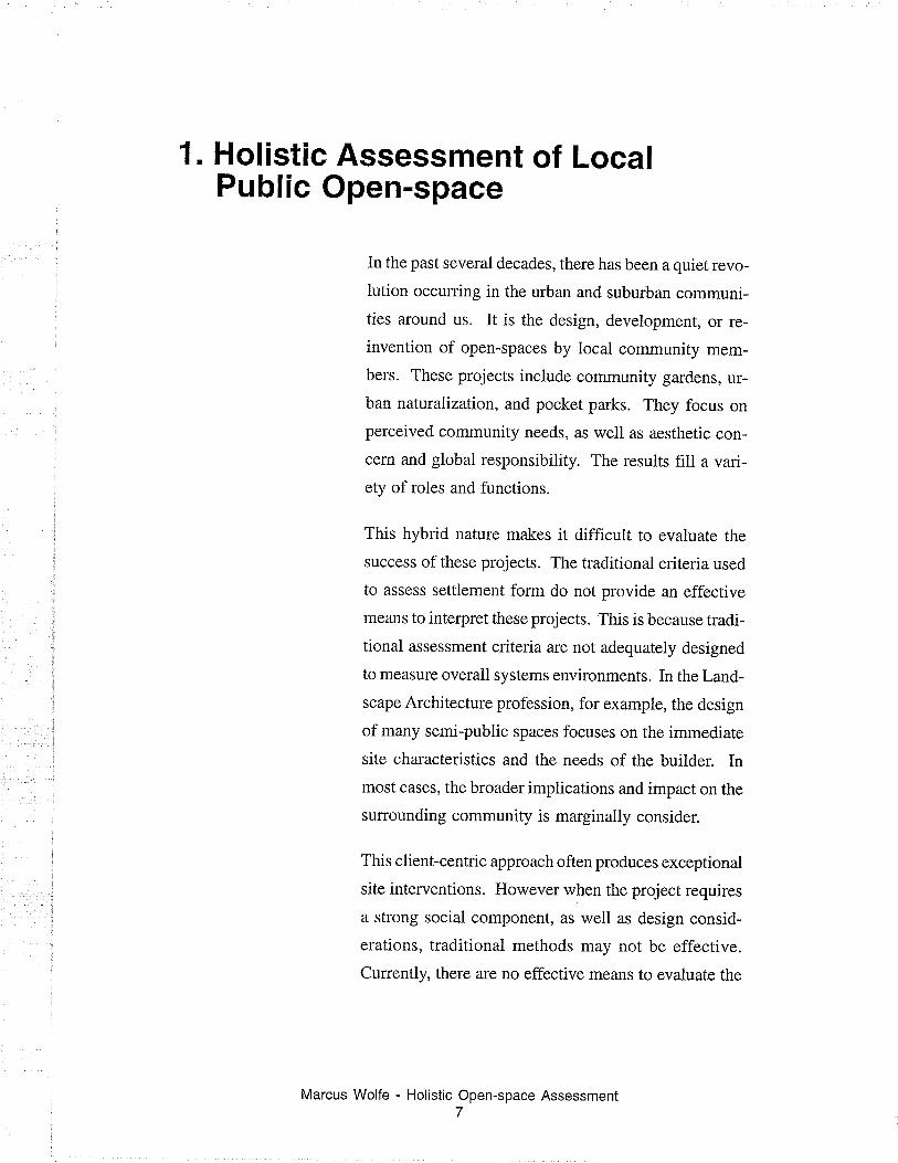
1. Holistic Assessment of LocalPublic Open-space
In the past several decades, there has been a quiet revo-
lution occurring in the urban and suburban communi-
ties around us. It is the design, development, or re-
invention of open-spaces by local community mem-
bers. These projects include community gardens, ur-
ban naturalization, and pocket parks. They focus on
perceived community needs, as well as aesthetic con-
cern and global responsibiiity. The results fill a vari-
ety ofroles and functions.
This hybrid nature makes it difficult to evaluate the
success ofthese projects. The traditional criteria used
to assess settlement form do not provide an effective
means to interpret these projects. This is because tradi-
tional assessment criteria are not adequately designed
to measure overall systems environments. In the Land-
scape Architecture profession, for example, the design
of many semi-public spaces focuses on the immediate
site characteristics and the needs of the builder. In
most cases, the broader implications and impact on the
surrounding community is marginally consider.
This clienrcentric approach often produces exceptional
site interventions. However when the project requires
a strong social component, as well as design consid-
erations, traditional methods may not be effective.
Currently, there are no effective means to evaluate the
Marcus Wolfe - Holistic Open-space Assessment7
site-specific implications of these shortcomings. An
alternative assessment technique is required; if the qual-
ity of community supported open-space is important.
Objective
The objective of this research is to develop and test a
practical measuring instrument, which allows for a con-
sistent and repeatable assessment of open-space
projects, built at the neighbourhood scale. The results
of the assessment provide a more holistic evaluation ofproject characteristics and a means to compare open-
space projects. The assessment process is not intended
to replace traditional design methods or to prognosti-
cate.
Assumptions
There are three assumptions relied on in the followingmethod.
i. The urban or suburban neighbourhood unit is a
complex systems environment. It is the result of the
interactions between human, physical, and natural sys-
tems. Any change to one system will affect the others.
2. Assessing projects will inform stakeholders about
possible design decisions and existing conditions. The
instrument is not a design alternative.
3. Methods used to measure a complex system envi-
ronment for one set of goals can be modified to meas-
ure the same or similar system environment for a differ-
ent set of goals. That is to say, experts from a variety of
Marcus Wolfe - Holistic Open-space Assessment8
disciplines have spent significant time and effort refin-
ing the principles and practice of system assessments.
The basic mechanisms these approaches use are trans-
ferable for related applications.
Method
The study is divided into three sections. A research
phase, an evaluation tool development section, and an
applied testing phase.
The research phase examines existing approaches for
landscape assessment from the perspective of several
different disciplines. Holistic approaches for interpret-
ing landscape conditions used by sustainable devel-
opment researchers, are examined for possible applica-
tion in the assessment of urban open-space.
Findings from the review of approaches provide the
basis to deveiop a more holistic landscape assessment
tool. This tool is used to evaluate urban open-space
settlement form in away, which formalize the assess-
ment of an urban landscape from a human and an envi-
ronmental point of view.
The assessment tool will be applied to a series of eight
open-space projects. Results are plotted and compared.
A concluding discussion considers the merits of using
a holistic open-space assessment evaluation in an ur-
ban open-space environment.
Limitations
Several limitations may exist which will affect the qual-
ity of assessment produced by this research. These
Marcus Wolfe - Holistic Open-space Assessmento
limitations are divided into methodological and de-
sign measurement limitations. The methodological
limitations include:
1. The number of projects assessed may prove too
small to allow for a meaningful analysis of the assess-
ment results.
2. Concentration of the data thlough aggregation may
over or under emphasize the impact of certain site char-
acteristics.
3. Only overtly successful projects may wish to par-
ticipate in a study that is interested in measuring the
success of community supported open-space projects.
Design measurement limitations include:
1. The choice of indicators assessed may not suffi-
ciently capture vital information.
2. The assessment instrument may not be robust enough
to measure a variety of projects.
3. Qualitative research may be interpreted differently
depending on researcher experience and bias.
4. Essential site characteristics and cyclical activities,
such as migratory visits or annuai community events,
may not occur within the allotted observation period
and be ignored by the researcher.
Strategies to manage or limit the impact of these short-
comings will be discussed during the conclusion along
with recommendations for future research.
Marcus Wolfe - Holistic Open-space Assessment10
2. Measurement Approaches
"We measure what we value, and we value whatwe measure."(Meadows, 1998,2).
The success of any public open-space has an environ-
mental design and social acceptance element. Failure
of either of these two elements to meet public expecta-
tion or design requirements, will result in a site which
lacks a 'sense of place' or functions so poorly it be-
comes under-used. In either case, the resuit is the same;
public amenities become wasted space.
Since wasted space can be attributed to design over-
sights and/or social planning issues, it is important to
assess projects on both merits. This requires a holistic
assessment approach. A holistic assessment is one
where an integrated appraisal of the individual study
components is conducted, providing insight into proc-
esses and interactions that are not recognizable when
examining the isolated parts. Not only does the holis-
tic approach provide feedback on system behaviour; itimproves the likelihood of future project wide improve-
ments, ensures long-term accountability, and formal-
izes learning opportunities. Little practical work has
been done to holistically evaluate sites for their ability
to achieve these goals.
There are a number of very good reasons why a holistic
approach to project assessments is not used. Primarily,
most analysis is done by professionals trained in spe-
cific disciplines. Techniques to holistically interpret
pluralistic feature and value assessments have not been
Marcus Wolfe - Holistic.,Open-space Assessment
within the scope of most professional training. Profes-
sional schools and practices stress the need for ad hoc
analysis based on their specific training and experi-
ence. Ad hoc analysis is built to meet the requirements
of the specific situation. It becomes the responsibility
of the researcher to seek information, which in their
opinion, best describes the needs of the situation. Natu-
rally, they will choose to examine areas related to their
own background and expertise.
Ad hoc analysis is far more straightforward, easier to
execute and requires less preparation. However, ad
hoc analysis does not provide an overall integrated
appraisal of the individual study components. For an
integrated appraisal, a holistic assessment and analy-
sis approach is required.
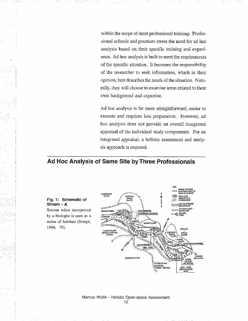
Ad Hoc Analysis of Same Site by Three Professionals
Fig. 1: Schematic ofStream - AStream when interpreted
by a biologist is seen as a
series of habitats (Hough,
r990,70).
KEY
WATER COURSÊooo tNSlnE/\MBEDATIME OF S{JFIr'EY
lUllll! eEoLoro-ii oEPoslTS lN
j,'.i:..i: sTÂw sED
vÁDf¡VE STFEAM
-BEDMÆG|Ntrrrrrr'iffi!ftfu'_Z FALLEN-\NEE
scnug lnEEs
WOODEO 5LOPE
Marcus Wolfe - Holistic Open-space Assessment12
/fìr-rflmsæ
! swE
rsl ñoBrRClt)
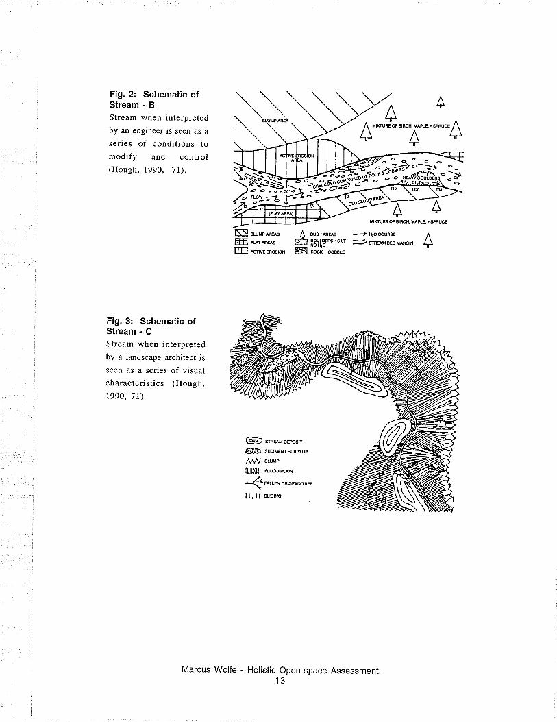
Fig.2: Schematic ofStream - BStream when interpreted
by an engineer is seen as a
series of conditions to
modify and control(Hough, 1990, 7l).
Fig. 3: Schematic ofStream - CStream when interpreted
by a landscape architect is
seen as a series of visual
characteristics (Hough,
1990,7t).
Nl ..ru"^""^"æt# FUT^BAS
ffi -,*."o",on
SUSff AFEAS
EOULDERS + SILTNO r{OROCK+ COABL€
./ a '1,'
fi x'nunJorerncx.u "aa.r"*u"a
AA^1J1l.
-+ li,o couFs€ ^
=? stneru eeo mnorx l)ffil-êl
G.) srneluoenosn
GtÐ sEotMÊNrBU|LDup
ffiffill rLooocr-err
<FAILEH OR DEADTBEE
lllll sutorNo
Marcus Wolfe - Holistic Open-space Assessment13
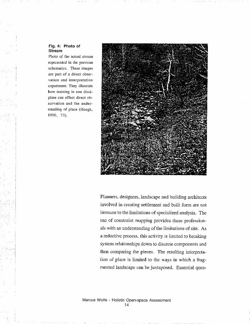
Fig. 4: Photo ofStreamPhoto of the actual stream
represented in the previous
schematics. These images
are part of a direct obser-
vation and interpretation
experiment. They illustrate
how training in one disci-
pline can effect direct ob-
servation and the under-
standing of place (Hough,
1990, 73).
Planners, designers, Iandscape and buiiding architects
involved in creating settlement and built form are not
immune to the iimitations of specialized analysis. The
use of constraint mapping provides these profession-
als with an understanding of the limitations of site. As
a reductive process, this activity is limited to breaking
system relationships down to discrete components and
then comparing the pieces. The resulting intelpreta-
tion of place is limited to the v/ays in which a ftag-
mented landscape can be juxtaposed. Essential ques-
Marcus Wolfe - Holistic Open-space Assessment14
tions about what makes good built form, the success ofdesign decisions and predictions for future site require-
ments often go unanswered.
Evaluating Open-space
Settlement Form*Sometimes referred to as
physical environment. Is
generally referred to as the
large, inter-related, perma-
nent physical objects ofthe city: buildings, streets,
utilities, rails, rivers, per-
haps the trees. To these ob-
jects are attached a miscel-
lany of modifying terms,
referring to their typicaluse, or their quality, or who
owns them... the spatial dis-
tribution of these things is
shown on two-dimensional
maps. (Lynch, 1981, 47).
Thele are several theories of settlement form* which
could be the basis of a holistic site evaluation. Kevin
Lynch uses the limitations of the planning and func-
tional theories as a background to his own, normative
theory of good city form.
Planning and Functional Theor¡es
Planning and functional theories are practiced and stud-
ied extensively; they will be familiar to planners and
architects. Both are primarily concerned with ur-ban
history and development prediction. Planning or de-
cision theory considers the processes and approaches
used to make decisions about city development. Func-
tional theor-ies consider the resulting settlement pat-
tern and how these spatial patterns affect settlement
function.
Lynch recognizes the value of these tools in the crea-
tion and understanding of built form. However, he is
critical of both theories on several points. Primarily he
is concerned that neither can adequately answer nor
respond to a holistic a question such as "what makes a
good city?" (Lynch, 198i, 36).
He explains that municipal planning practice lacks a
strong central agency to guide the comprehensive de-
Marcus Wolfe - Holistic Open-space Assessment15
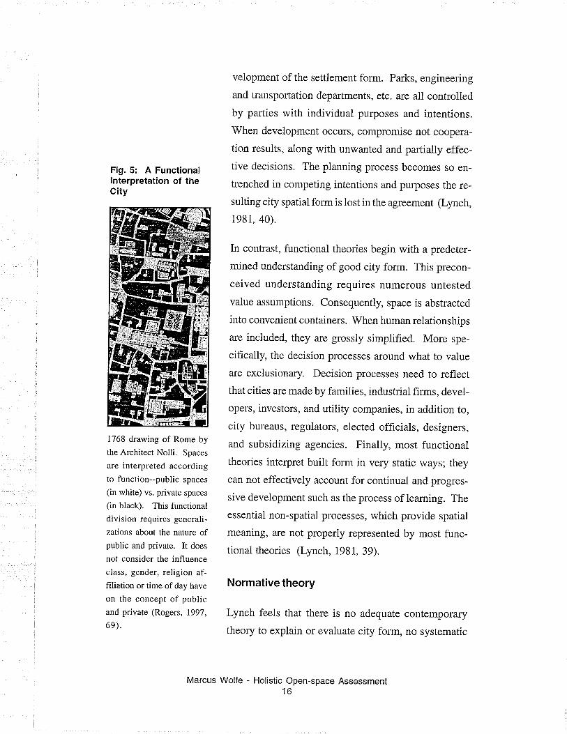
Fig. 5: A Functionallnterpretation of theCity
1768 drawing of Rome by
the Architect Nolli. Spaces
are interpreted according
to function--public spaces
(in white) vs. private spaces
(in black). This functional
division requires generali-
zations about the nature ofpublic and private. It does
not consider the influence
class, gender, religion af-
filiation or time of day have
on the concept of publicand private (Rogers, 1997,
6e).
velopment of the settlement form. Parks, engineering
and transportation departments, etc. are all controlled
by parties with individual purposes and intentions.
When development occurs, compromise not coopera-
tion results, along with unwanted and partially effec-
tive decisions. The planning process becomes so en-
trenched in competing intentions and purposes the re-
sulting city spatial form is lost in the agreement (Lynch,
198i, 40).
In contrast, functional theories begin with a predeter-
mined understanding of good city form. This precon-
ceived understanding requires numerous untested
value assumptions. Consequently, space is abstracted
into convenient containers. When human relationships
are included, they are grossly simplified. More spe-
cifically, the decision processes around what to value
are exclusionary. Decision processes need to reflect
that cities are made by famiiies, industrial firms, devel-
opers, investors, and utility companies, in addition to,
city bureaus, regulators, elected officials, designers,
and subsidizing agencies. Finally, most functional
theories interpret built form in very static ways; they
can not effectively account for continual and progres-
sive development such as the process of learning. The
essential non-spatial processes, which provide spatial
meaning, are not properly represented by most func-
tional theories (Lynch, 1981, 39).
Normative theory
Lynch feels that there is no adequate contemporary
theory to explain or evaluate city form, no systematic
Marcus Wolfe - Holistic Open-space Assessment16
effort to state the general relationships between the
form of place and its overall worth. As an attempt to
account for the non-spatial values we imbue in place,
and the subtle changes to built form which continually
result, he sketches an alternative theory from a norma-
tive perspective. A normative theory is, by nature, a
prescriptive one that is concerned with the rules forcorrect usage.
Lynch does not directly prcsents a testable method or
even titles his theory. Instead, he suggests evaluation
tactics and guidelines for the holistic assessment ofsettlement forms. These suggestions are intended to
ensure the practical use of his theory will avoid cul-
tural biases, genemlizations, and preclusions.
Guidelines are presented as a series of performance di-
mensions to ensure consistent evaluation design. Aperformance dimension is a measurable site character-
istic, which has a spatial and value component. Five
performance guideiines and two points of considera-
tion are presented (see Appendix D). When used col-
lectively, the performance dimensions touch on all the
likely interactions between spatial form and human
processes. Performance guidelines act as a central
agency to coordinate the evaluation of the settlement
form. Unfortunately, Lynch provides no testable
rnethod to evaluate his normative theory, which may
reflect the complexity of holistic measurement.
Marcus Wolfe - Holistic Open-space Assessment17
Measu ring Progress Towards Sustainabil ity
A generation ago, there were no effective means to
evaluate progress towards sustainability or even de-
fine what sustainable development means. Today, there
is still no comprehensive agreement on what sustain-
ability means or the best way to achieve it. (Fanell and
Hart, 1998, 6). There is however, a general interpreta-
tion based on a commonly accepted definition of sus-
tainability. Sustainable development is "development
that meets the needs of the present generations without
compromising the ability of future generations to meet
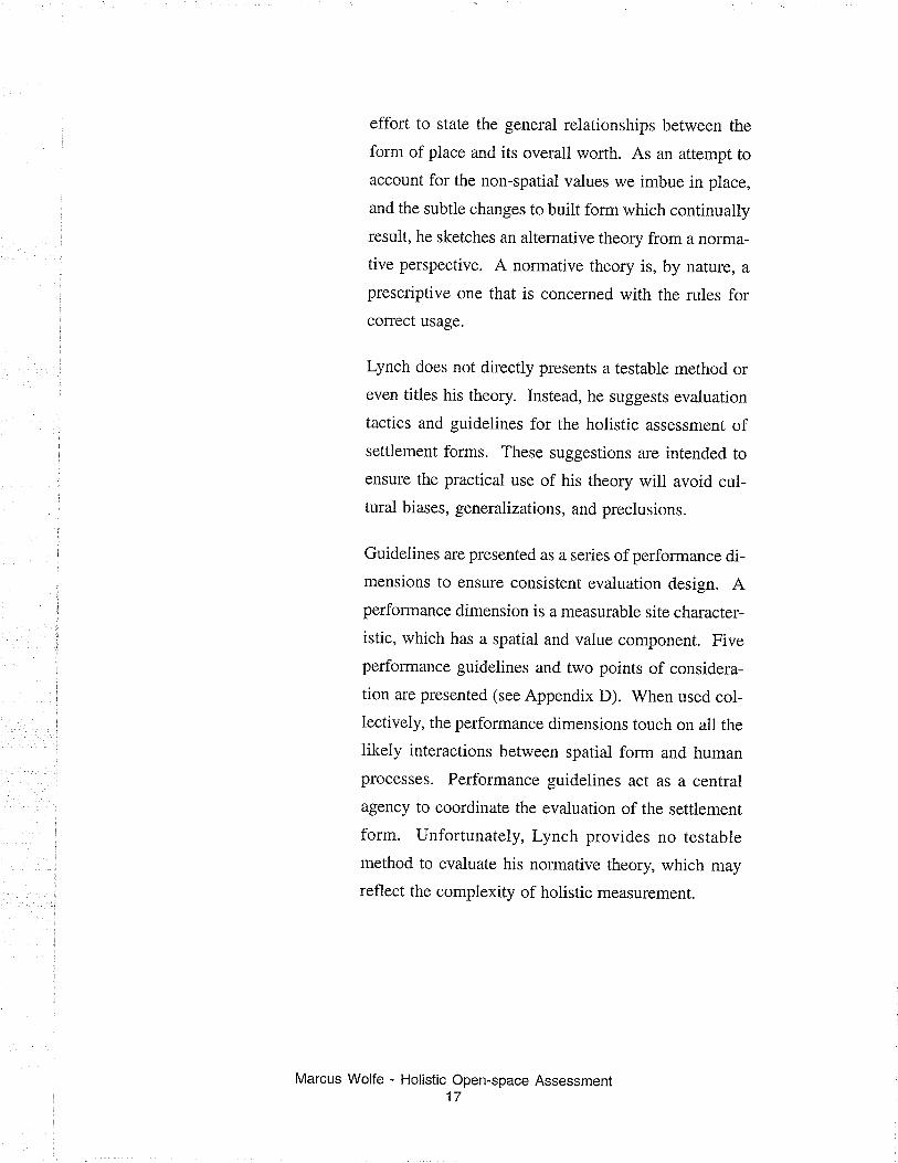
their own needs" (WCED, 1987, 8).
Despite various interpretations and on-going debates
about equity and resource management, it is commonly
held that sustainability must consider the interrelation
between human and ecological weli-being. This inter-
dependent relationship has been illustrated with the
egg of sustainability metaphor. The yolk represents
humans, while the white represents the ecosystem. The
success of one is dependent on the success of the other-.
The system improves only when both the condition ofthe ecosystem and the human condition improve (In-
ternational Development Research Centre, l99g).
Accepting ecological and human interaction as the
basis for sustainability requires a holistic approach to
evaluating sustainability because these systems can
be so dissimilar. Traditional evaluation techniques
employed by researches and policy makers like the
pressures-state-response, which could track the impact
of one event across many systems, was not sufficient.
Pcological well-being
Fig.6: The Egg ofSustainability
Human well-being
(Chimbuya, Sam,
Robert Prescott-Allen,
and Diana Lee-Smith,
2000)
Marcus Wolfe - Holistic Open-space Assessment18
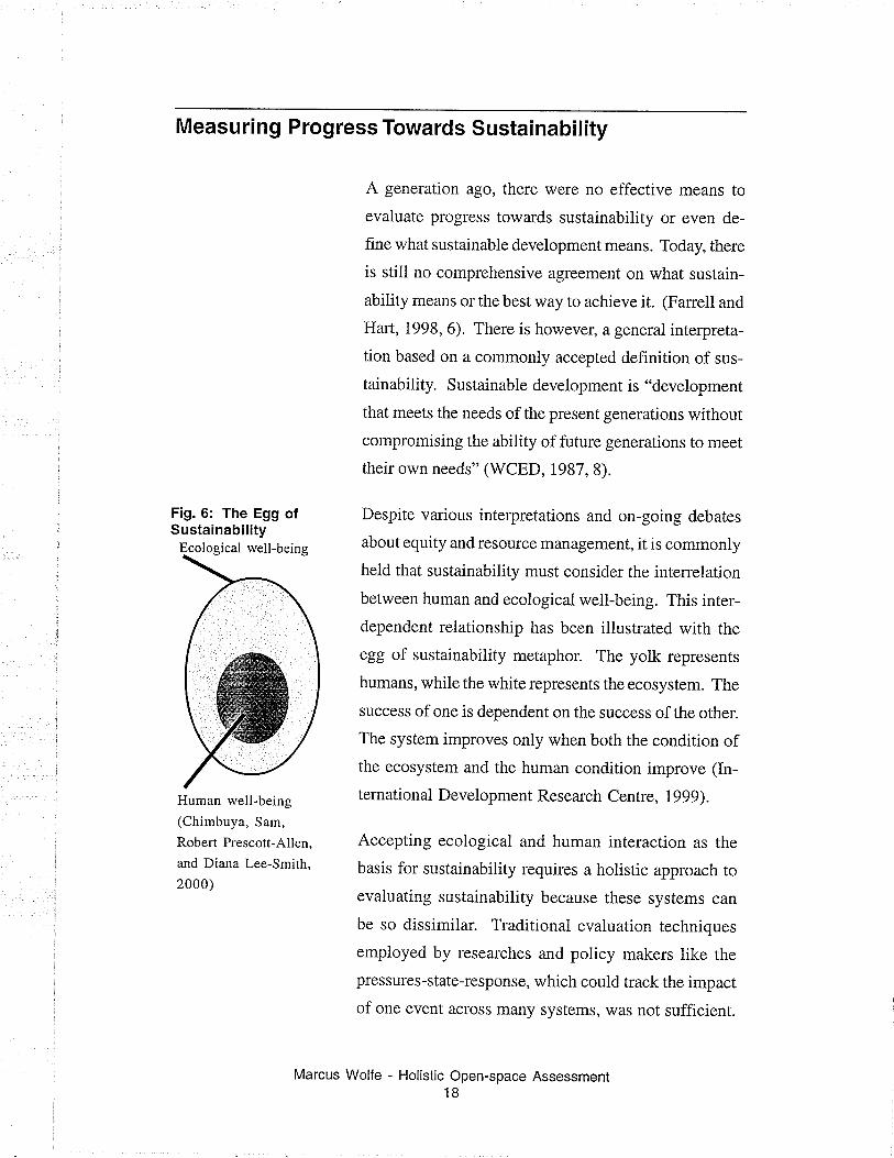
Ftg.7: Pressures-State-ResponseAn example demon-
strating a general frame-
work for a Pressure-
State-Response model
(Hardi and Pinter, 1997,
64).
Pluralistic assessment models that could adequately
address the increased need for broader-based assess-
ment and reporting was required. These new approaches
would need to systematicaliy take into account the
links among ecological, socioeconomic and policy is-
sues (Meadows, 1998, 3).
Many contemporary evaluation techniques are based
on an integrated environmental assessment strategy.
An integrated environmental assessment strives to pro-
duce and communicate relevant information on vital
interactions between the natural environment and hu-
man society (Pintér, Cressman, andZahedi, 1999, ix).
To simplify this complex task, resea¡chers have relied
on social and ecological indicators to describe the state
of the various systems. Selected indicators are then
evaluated. Results are organized into models that de-
scribe systems interactions and provide insight into
the overall systems well-being. It should be noted,
Marcus Wolfe - Holistic Open-space Assessment19
that there are as many variations for indicator selection
and modeling techniques, as there are interpretations
of sustainability. Some of the general trends in indica-
tor use will be discussed in the next section.
SPATIAL FOFMr Raú¡6 ,/ rôvqs deøtrâ[ssüo
. lnqoæ ddndtlôs hJ1 nol gxæsslvcly ¡g ¡,1MsgþøEp8cl lorn9 (nelthq trmmlng u spßwl)r lnrse app€ål ol ¡m€¡qoa (groerdng.
dåf€nCuo sÞ@, hNd¡g b,pþ, €b)a En6uhga nhod.us dryglopm€aE
r Doñslty r.lÀÎGd l0 dod¿l pdñþ/publ¡c UMspon. Fe lãle to ordilfdg lnlEdrùdur6 (ùtìlitíåà úd rÉdr). Dewlôp b.m f€ìd lil€S md Aþld Esen jl6ld sltdsl BelatshûÈlôndnâtúo¡ €nvírom!nls(cfnnwca
p{o!ilon. gGgn sp¡æ noeorle, elc.}. Nil*tllgmgntE b bs stl $slaj.ùg
. Âgs onvircnm6nu øp¡ÈilyENVIRONMENTALMANAGEMENT
. CoordlElo slâlulory aulhølllo9. Eôdralo u¡bsn nuag€nenl (suptlrl doenllßs)
. Hoduæ ppllutlæ Ðd pdfotedsjtos. Bo.oduÉl¡ Fplosslon¡l¡, F¡bfc ¡nd politidans
+ Ecmy qlmtæ¿s lhodÉrrldnggæl
. DoÀlgn lø pBtoskl6nIsüon /otvlffi o¡tslly frtgrÉÍy hngpgrt. Âdævô¡r@d 8poÉ lqpubl¡cuæ orS¡UIoUÂûÊpq¡
. Ftdudâ noñ-€snllâl UÁmêa l¡ìrfmhs r p€rkhg
. EôæÞgo rcuto €nnodlvíty ord pmoaul¡ty. T46 ¡Eflio floÉ
Û1
-t--\*ove), ".HJ.:*r,)l"
SUSTAINABLEURBAN DESIGN
ÞESIGN & DEVELOPMENTa Rebaülllåli$ rlthrrthu r6dôvôlopænt
. Boctdlng olm¡lorl¡ts. ljs6l@lDeterleJs
a Erelrmontqlly Í¡g¡dy mok¡l¡ls ,/ toÈhr¡lqúæ. Þðtodjon gl bùithorltåle
t Shq opénnos lo sdel¡¡blo dçttiloctJ.El lotng. FaÉñmúd88EEÁM a¡dNHEA fÉ6Ar6E
. Enq.¡la robust h¡ildinq fófing
ECOLOGY+ Áffioæio!úølFâlug ddl€8 úd g¡cflÞgo cqunulty
? ProlgC râtùr€l s$elgæd prðsM lmd$¡pe (l¡dividuslity)
i t lû¡lrnfe Hodjvø6itya lncâ¡þ r¡lDÍ¡lcr rotgnilon (lroo plúling)
+ Feduce ruDotl lÞcrtuôble Fovlng. oalur¡l chú¡ols)r Prsaryc lñC¡vldu¡fty ot lÐdgpo .tr¡@tsÌ
r Ga¡oõlow¡36ndait¡os
ENERGYr Pð$¡vo 6okr gåln (ql€¡trrlon. des¡fn. laydl)t ÂwÀblr dnsrgy 3Mff (sdsr, hyúe whd)
r Ádpr.€gporrlÈhcâdsg. E¡.e8ge onefty@næMlls
+ Llidldtmelo (dtÞufaÈe dmloomoôt üoxpo8âd s¡tor 8¡d us n¡tu6l lâBt!re€). E¡@6grùs ol Étú¿ldåyflgñt. Dls@rdgo Êk-trdi¡lfihg úd
Èl@r¿go nÂfu râl wd;lat¡oD
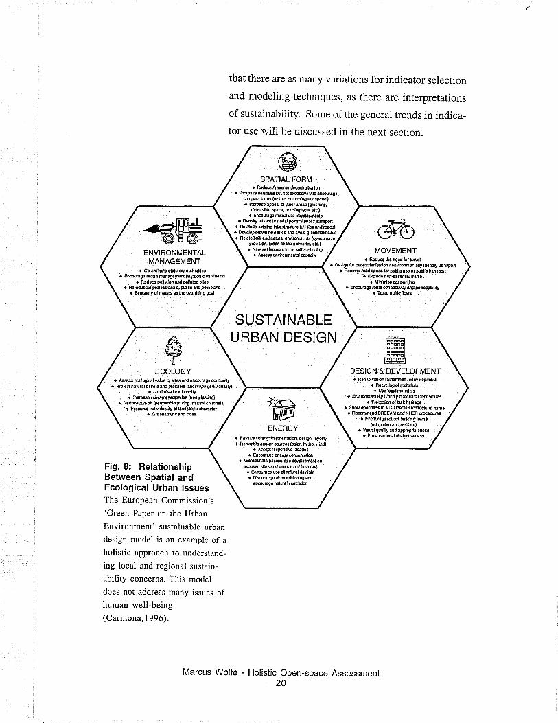
Fig. 8: RelationshipBetween Spatial andEcological Urban lssuesThe European Commission's
'Green Paper on the Urban
Environment' sustainable urban
design model is an example of a
holistic approach to understand-
ing local and regional sustain-
ability concerns. This model
does not address many issues ofhuman well-being(Carmona, I 996).
- Holistic Open-space Assessment20
Marcus Wolfe
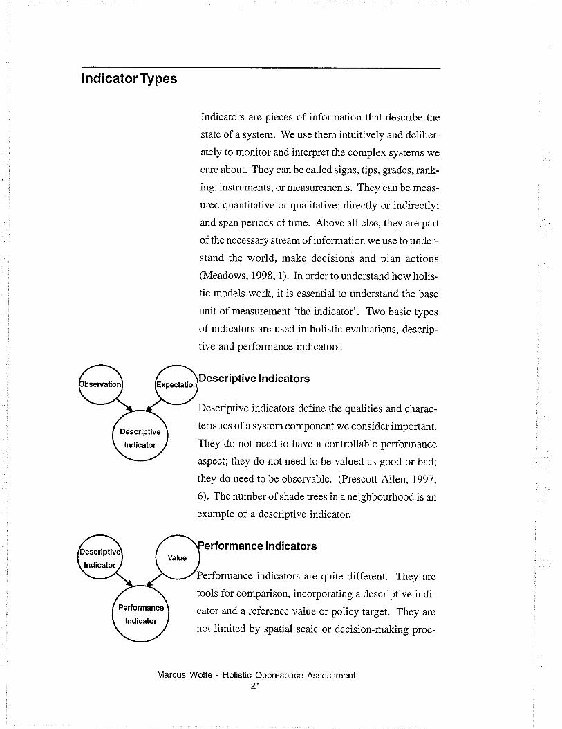
lndicator Types
Indicators are pieces of information that describe the
state of a system. We use them intuitively and deliber-
ately to monitor and interpret the complex systems we
care about. They can be called signs, tips, grades, rank-
ing, instruments, or measurements. They can be meas-
ured quantitative or qualitative; directly or indirectly;
and span periods of time. Above all else, they are part
of the necessary stream of information we use to under-
stand the world, make decisions and plan actions
(Meadows, 1998, 1). In order to understand how holis-
tic models work, it is essential to understand the base
unit of measurement 'the indicator'. Two basic types
of indicators are used in holistic evaluations, descrip-
tive and performance indicators.
ve lndicators
Descriptive indicators define the qualities and charac-
teristics of a system component we consider important.
They do not need to have a controllable performance
aspect; they do not need to be valued as good or bad;
they do need to be observable. (Prescott-Allen, 1997,
6). The number of shade trees in a neighbourhood is an
example of a descriptive indicator.
rformance lndicators
Performance indicators are quite different. They are
tools for comparison, incorporating a descriptive indi-
cator and a reference value or policy target. They are
not limited by spatial scale or decision-making proc-
Marcus Wolfe - Holistic Open-space Assessment21
Value
{oicatol
Pe¡{ormance
lndicator
The Bellagio PrínciplesAn international consensus
of'best practices'forperformance measurement
processes. No similar body
of work has been
developed for use in
landscape design (see
Appendix C).
esses (Hardi, 1997 ,10). For a performance indicator to
be effective, the performance aspect must be a control-
lable, measurable component. The sun rising in the
east each morning is not a performance indicator be-
cause nothing can affect it. The orientation of win-
dows designed to capture the morning sunlight can be
evaluated as effective or ineffective, good or bad. It is
a performance indicator.
Another impoftant aspect to consider when understand-
ing performance indicators is the concept of using per-
formance as a common unit of comparison. Evaluat-
ing all pertinent indicators using a coÍtmon perform-
ance scale allows a traditional unit for comparison,
like money, to be compared with biotic levels in soil, ifa performance value can be assigned to both indica-
tors. The performance value can be boolean, or have a
thousand degrees of variance. It is essential that the
assessed characteristics be rated on a fixed measure-
ment scale to ensure comparisons are consistent
(Prescott-Allen, 1997, 5). This approach, using per-
formance indicators to evaluate otherwise dissimilar
items is similar to Lynch's concept of the performance
dimension, however Lynch's concept is not neariy as
well developed as the performance indicator.
lndicators in Practice
How something is said is as important as what is said:
this is also true of indicators. Indicators need to be
chosen carefully if a relevant description is to be cre-
Marcus Wolfe - Holistic Open-space Assessment22
ated. The following checklist provides a guideline for
the selection of responsible indicators (The Commu-
nity Indicators Handb ook, 1996, 25).
Relevant
meaningful to
Is the indicator describing something
the research or cornmunity members?
Valid - Can the indicator be justified in iogical or
scientific terms?
Credibility - Does the data source reinforce or de-
tract from the indicator's credibility?
Measurable - Is there available data relevant to your
geographic area? Ifthis is notreadily available, aprac-
tical method of data collection or measurement must at
least be possible.
Consistent and reliable - Whar is the likelihood
that this indicator will produce quality data over an
extended period of time?
Comparable - Is the indicator used in other analysis?
Could specific indicator findings be used for compari-
son with other communities and other studies?
Understandable - Will rhe indicarors be easily inrer-
preted by residents of the community? Choose indi-
cators, which are clear and obvious.
Pedormance Measurement
An individual performance indicator can be powerful,
but is not informative. The number of trees infected
with Dutch Elm disease is important, but can not be
Marcus Wolfe - Holistic Open-space Assessment23
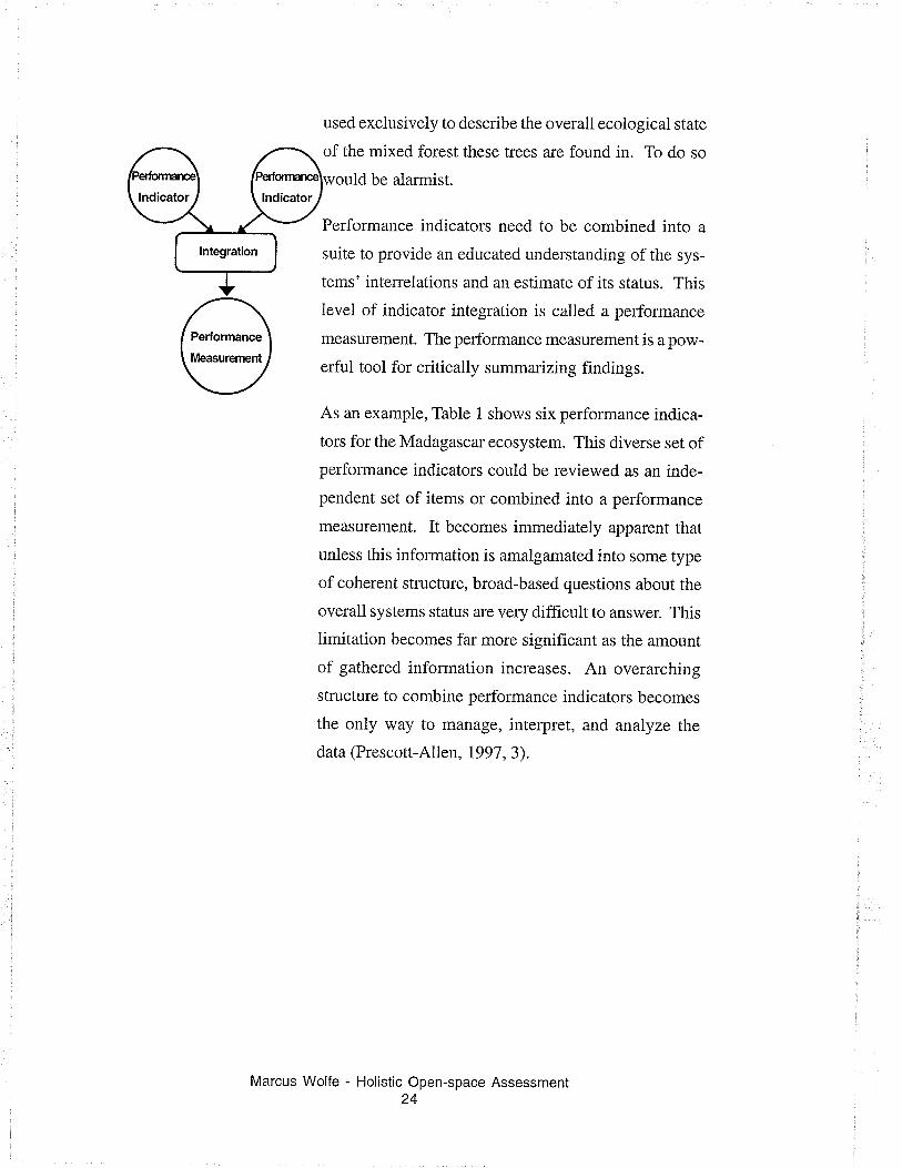
a \ f \ o
Per
suit
tem
lndicator\t lndicatorl,/lntegration
used exclusively to describe the overall ecoiogical state
of the mixed forest these trees are found in. To do so
ld be alarmist.
Performance indicators need to be combined into a
suite to provide an educated understanding of the sys-
tems' interrelations and an estimate of its status. This
level of indicator integration is called a performance
measurement. The performance measurement is a pow-
erful tool for critically summarizing findings.
As an example, Table 1 shows six performance indica-
tors for the Madagascar ecosystem. This diverse set ofperformance indicators could be reviewed as an inde-
pendent set of items or combined into a performance
measurement. It becomes immediately apparent that
unless this information is amalgamated into some type
ofcoherent structure, broad-based questions about the
overall systems status are very diff,rcult to answer. This
limitation becomes far more significant as the amount
of gathered information increases. An overarching
structure to combine performance indicators becomes
the only way to manage, interpret, and analyze the
data (Prescott-Allen, 1997, 3).
Marcus Wolfe - Holistic Open-space Assessmenl24
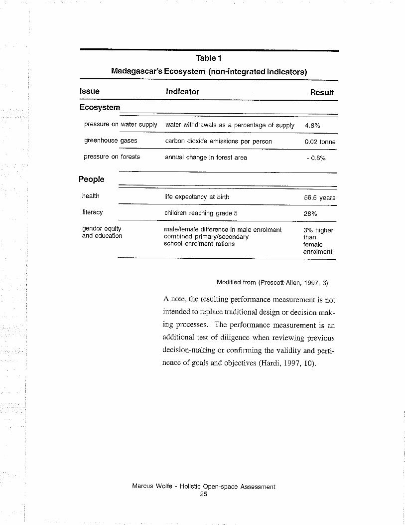
Table 1
Madagascar's Ecosystem (non-integrated indicators)
lssue lndicator Result
Ecosystem
pressure on
greenhouse
water supply water withdrawals as a percentage of supply 4.8%
gases carbon dioxide emissions per person 0.02 tonne
pressure
People
health
literacy
on forests annual change in forest area 0.8%
life expectancy at birlh 56.5 years
children reaching grade 5 28%
gender equityand education
male/female difference in male enrolmentcombined primary/secondaryschool enrolment rations
3% higherthanfemaleenrolment
Modified from (Prescott-Ailen, 1997, g)
A note, the resulting performance measurement is not
intended to replace traditional design or decision mak-
ing plocesses. The performance measurement is an
additional test of diligence when reviewing previous
decision-moking or confirming the validity and perti-
nence of goals and objectives (Hardi, l99l, l0).
Marcus Wolfe - Holistic Open-space Assessment25
Applying Performance Measurements
Rather than develop similar models, from scratch, for
use in the assessment of public open-space, it is sensi-
ble to build upon this existing body of holistic per-
formance measurement research and experience. Sus-
tainable development researchers have had more than
ten years to apply performance measurement to their
progress towards sustainability practices.
How applicable is an indicator method used for assess-
ing urban sustainability, in the assessment of urban
open-space? First, it is important to keep in mind that
descrÌptive indicators, or landscape characteristics, ar e
independent of the values we attach to these landscape
features.
Both sustainable researchers and open-space design-
ers work with the same landscapes and look at many ofthe same features. It then becomes a question of deter-
mining if the values each group is interested in under-
standing are transferabie. If not, the tests and perform-
ance measurement techniques used by sustainability
researches will be of much less direct value.
At a basic level, the values and ideas, which motivate
sustainabie development models, are believed to in-
sure the mutual human and environmental well-being
without compromising the future well-being of the eco-
system. These include social, economic, environmen-
tal and cultural concerns.
Marcus Wolfe - Holistic Open-space Assessment26
Quality of public open-space is motivated by those
ideas and values which use design to provide human
well-being, while balancing the physical characteris-
tics for specific iandscapes. This does not mean that
broad sustainability issues are not important to the land-
scape designer.
Many of the underlying values that motivate sustain-
able development also define public open-spaces de-
sign.
.Both perspectives recognize that our well-being is
connected to the status and well-being of our surtound-
ings.
. Highlight the need for a long-term perspective.
.Recognize that the ultimate success of a project is
governed by all sectors of the community or, in the
case of sustainable development, by society.
The strategic choice of sustainability researchers has
been to evaluate space on an ecological and humanist
basis. The landscape designer's quest to evaluate and
design a site's 'sense of piace', also strives to under-
stand the site in ecological and cultural terms. Both
groups are interested in interpreting landscapes in very
similar ways, yet towards different ends.
Since these disciplines share common subjects of in-
terest, it is conceivable that much of the practical ef-
forts to interpret our progress towards sustainability
may be applicable to the landscape designer's efforts
to interpret a site's 'sense of place'.
Wolfe - Holistic Open-space Assessment27
Marcus
Performance Modeling
A variety of approaches have been developed to assess
the pluralism of values and characteristics which de-
scribe an ecosystem. In systems, which have multipie
values and multiple assessment criteria, the type link-age that is analyzed by functional theorist is not
enough. A framework is often required to manage the
collected information. A framework is a structure or
tool that is used to provide supports or order to a group
of ideas. When applied to a set of systems characteris-
tics or values, a framework can assist in providing a
comprehensive evaluation and in clarifying many is-
sues (City of Winnipeg,7998,4).
How well the framework organizes and presents data
plays a significant role in a researcher's ability to inter-
pret and analyze information. An effective framework
will clarify the scope of analysis and can pr-ovide unique
insight, not available through a segregated examina-
tion of component parts.
Once established, the framework should remain con-
stant. One of the advantages of using a framework is
that when research data is processed, it is converted
into a predetermined scale and format. This gives the
opportunity to easily and consistently overlay multi-
pie evaluations and analyze for trends, patterns, or in-
consistencies. Selecting a framework, which is robust
enough to interpret and manage data sets fiom a vari-
ety of projects is essential if longitudinal or survey
studies are required.
Marcus Wolfe - Holistic Open-space Assessment28
Assessment Frameworks
No single framework has been adopted as the bench-
mark standard for evaiuating sustainable development.
A variety of methods and techniques compete for gen-
eral usage (Farrell and Hart, 1998, 8). As discussed
earlier, most techniques combine a series of predeter-
mined indicators, and then organize the findings within
some sort of presentation framework.
The method used to combine and present data is guided
by two decisions: what one wishes to know and how
one wishes to use the information (Farrell and Hart,
L998,7). In cases where progress towards sustainabil-
ity is evaluated, what one wishes to know often relies
upon the classic definition of sustainable development,
"deveiopment that meets the needs of the present gen-
eration withoutcompromising the ability of future gen-
erations to meet their own needs" (WCED, 1987, 8).
Consequently, there is interest in interpreting the rela-
tionship between human and ecological well-being,
over a period of time. These themes of human and
ecological well-being are present to all the models re-
viewed.
The other factor determining how indicators are evalu-
ated and interpreted is the needs of the intended viewer.
Policymakers, the public, and researchers represent
three basic viewer audiences, each with there own in-
formation requirements.
The policymaker might be thought of as a reader who
wants clear summary information for validating policy
Wolfe - Holistic Open-space Assessment29
Marcus
objectives, evaluation criteria, and targets. They are
seldom interested in personally analyzing data. Nev-
ertheless, they may wish to understanding the tech-
niques invoived in modeling the data. The public has
the most basic needs and generally requires findings
be presented as simple, cleaÍ, unambiguous messages.
Finally, researchers are interested in seeing the raw sup-
porting data and analyzing it for themselves (Farrell
and Hart, 1998,7).
The frameworks reviewed and evaluated for this study
will be intended for use by a policymaker audience
interested in assessing the quality of public-open space.
They will be evaluated on the following criteria (The
Community Indicators Handbook, 1996, 25):
Relevance (to open-space): Is the framewor.k de-
signed to include values or examples about human
well-being, ecological concerns, and design consid-
erations?
Consistency (of assessment): Is the process con-
sistently repeatable over a period of time or across a
series of landscapes?
Readability: Does the presentation of performance
indicators allow for a quick and intuitive interpreta-
tion by the public and policymakers?
Transparency: Witl the reader be able to make a clear
connection between the results and the measured sys-
tem components? This is effected by the processes
used to integrate descriptive indicators and values.
Marcus Wolfe - Holistic Open-space Assessment30
Framework Selection
Four different frameworks used to evaluate progless
towards sustainability are reviewed and evaluated as
potential templates for modeling landscape quality
inquiries.
A.
B.
C.
D.
Barometer of Sustainability
ABC Model
Systems Orientation Method
Dashboard of Sustainability
The models have been chosen becauss they represent
significantly different approaches to assessing and pre-
senting performance evaluations. They have also been
tested in practical applications. A description and the
merits of these different approaches are discussed on a
case-by-case basis in the following section.
Note: the Dashboald of Sustainability has been used inmany appiications, but not formaliy tested for sustain-
ability evaluations.
Marcus Wolfe - Holistic Open-space Assessment31
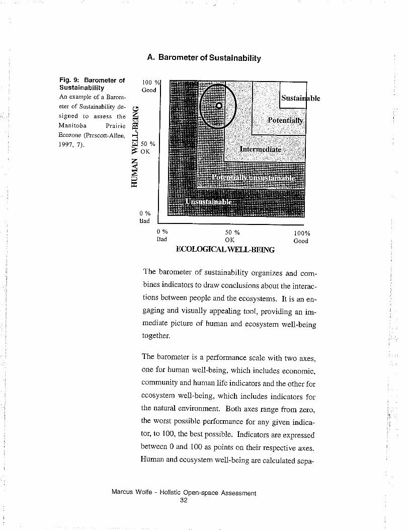
Fig. 9: Barometer ofSustainabilityAn example of a Barom-
eter of Sustainability de-
signed to assess the
Manitoba PrairieEcozone (Prescott-Allen,
1997, 7).
zt¡l(
.lQ 50 o/o
ÈorzàÐ
A. Barometer of Sustainability
100
Good
50%OK
ECOLOGICAL \4IELLBEING
100%Good
The barometer of sustainability organizes and com-
bines indicators to draw conclusions about the interac-
tions between people and the ecosystems. It is an en-
gaging and visually appealing tool, providing an im-mediate picture of human and ecosystem well-being
together.
The barometer is a performance scale with two axes,
one for human well-being, which includes economic,
community and human iife indicators and the other forecosystem well-being, which includes indicators forthe naturai environment. Both axes range from zero,
the worst possible performance for any given indica-
tor, to 100, the best possible. Indicators are expressed
between 0 and 100 as points on their respective axes.
Human and ecosystem well-being are calculated sepa-
Wolfe - Holistic Open-space Assessment32
0%Bad
0 o/o
Bad
Po.tçnt-ially
Marcus
rately to provide performance indicators which pro-
vide x and y graph coordinates. This means that an
improvement in one index does not mask a decline inthe other. The axes approach ensures the worst condi-
tion is graphically represented.
Where these two points intersect determines the per-
formance measurement, which is the level of sustain-
ability. A buffer area around the measurement point is
intended to provide a graphic representation of the
potential error factor. Finally, the presentation graph
includes a series of performance thresholds, i.e. poor,
good, exceiient. This helps give the tool an external
reference for comparison with accepted norms. per-
formance measures can then be grouped in desirabie,
acceptable and unacceptable categories (Manitoba
Environment, 1997, 77).
Advantages
The barometer is a common and ancient tool to moni-
tor and accurately predict climatic change. As an envi-
ronmental messenger, the metaphor of the barometer is
seen as impartial reporter. It responds to changes in asystems state and is not capable of holding partisan
views.
In practice, the Barometer of Sustainability displays
information in a clear and understandable manner. The
graph is a widely accepted presentation format in aca-
demic and business settings, making the results famil-iar and easy to interpret. Relating the x and y axis to
human and ecosystem well-being is easy to understand.
Marcus Wolfe - Holistic Open-space Assessment33
Overlaying multiple evaluations displays clearly dis-
cernable patterns of change and trends. This reinforces
the understanding that human activities and the eco-
system processes are interdependent.
Limitations
To insure successful aggregation of information the
researcher performs considerable interpretation that
may not provide repeatable criteria. The interpreta-
tion process is far from transparent, making it difficult
for the reader to understand the value judgments used
to describe target data. Finally, the ellipsis, which is
graphically used as an interpretive buffer around the
performance measure, may not be equal in other test
environments.
Practical Application
A documented use of the Barometer of Sustainability
is the evaluation of Manitoba's Prairie ecozone. The
purpose of the study was to evaluate reai issues that
concern people and organizations in the ecozone (Gov-
ernment of Manitoba, 2000).
A series of meetings between government experts and
stakehoiders produced 51 human and 54 ecological
indicators. Indicator tests for these 105 indicators were
then created and field tests were made. The results
were evaluated and aggregated to form a performance
measurement which was graphed. Overall performance
was then rated between sustainable and unsustainable
(Gover'nment of Manitoba, 2000).
Wolfe - Holistic Open-space Assessment34
Marcus
lmplications for use in Open-space Assess-
ments
Relevance- High
The Barometer of Sustainability is a highly flexible
assessment tool. It is capable of incorporating a vari-
ety of performance indicator data including the con-
tradictory values held by various stakeholders. Open-
spaces sefve a wide variety of functions and roles, to
evaluate a selies of open-spaces or a single open-space
over a period of time requires an eclectic range of per-
formance measurements.
Consistency - High
Performance indicators and additional weighting con-
trol is determined before evaluations are conducted.
They are not changed or adjusted to suit the character
or conditions of the site. Pre-determined choice ofindicators provides continuity and constancy for the
evaluations. The prescribed weighting system based
on evaluating upper and lower performance guidelines
may not be useful because it requires an established
baseline. This may limit the variety of projects that
can be compared.
Readability- Medium
The visual nature of the graphic presentation is very
straightforward. One point lepresents one project. This
point can be used to reference human and ecological
indices. However, analyzing a project for relevant pur-
Wolfe - Holistic Open-space Assessment35
Marcus
poses, such as quality of design, is not possible with-
out examining the individual performance ratings. Inthe case of a landscape assessment, which serves a va-
riety of functions and is regularly interpreted through
multiple perspectives, this is a limitation.
Transparence - Low
The computations, which provide the performance rat-
ings, are intended to be simple and straightforward rep-
resentations of the performance criterion. To be graphi-
cally represented, these values must then be aggregated
before they are presented. This removes the opportu-
nity to see how individual indicators effect the overall
system. It also may be difficult for the viewer to sepa-
rate a known performance measure of one indicator
against a composite that demonstrates a very different
overall performance rating.
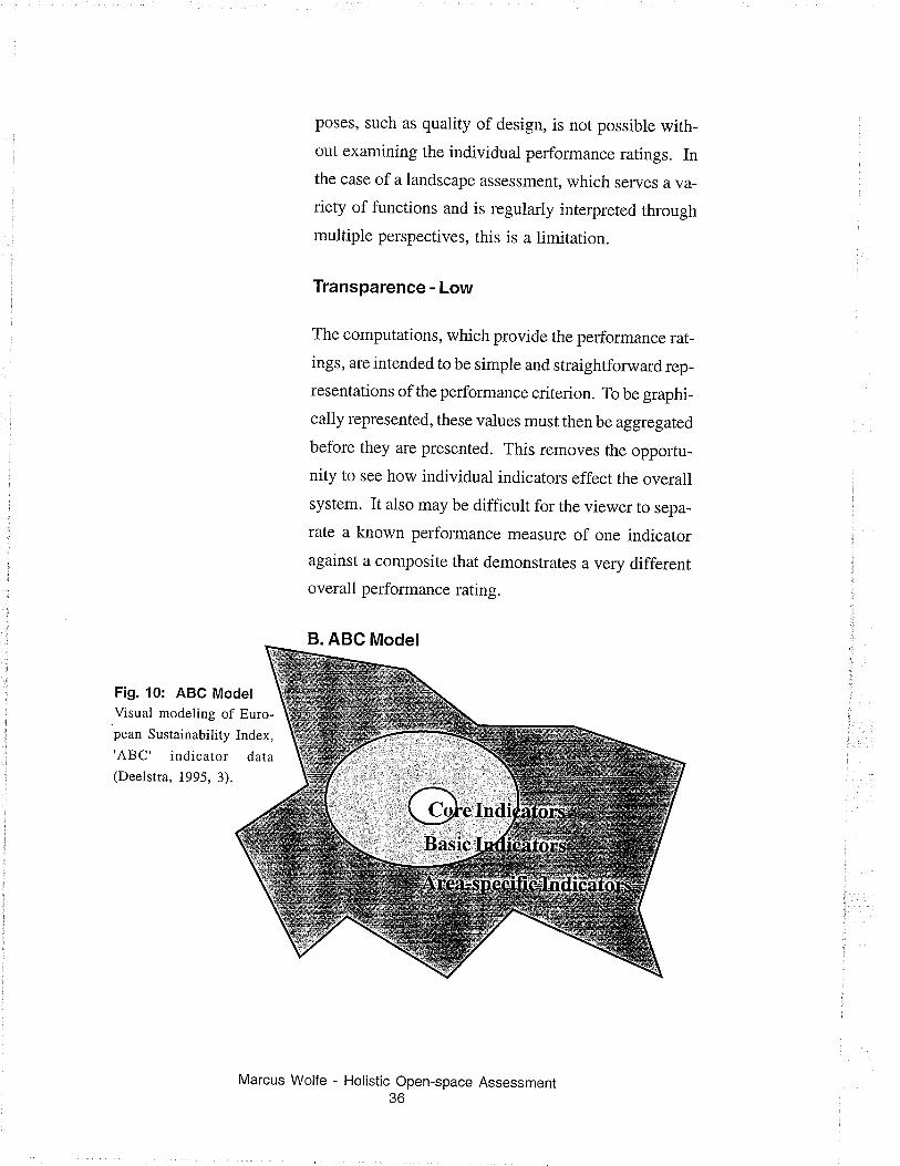
B. ABC Model
Fig. 10: ABC ModelVisual modeling of Euro-pean Sustainability Index,
'ABC' indicator dara
(Deelstra, 1995, 3).
Marcus Wolfe - Holistic Open-space Assessment36
This approach was developed in Europe to reflect an
evolving European Sustainability Index (ESI). The
ESI uses six 'container issues' to describe an image ofan environmentally sustainable city. The container
issues are: healthy air, safe streets, good house keep-
ing, greenery, environmentally compatible manage-
ment, and sustainable use of resources (raw materials,
water, and energy). Aii containers reflect aspects ofsustainability, which are concrete and measurable.
Note: See Appendix A for a more compiete description
of the ESI's indicators (Deelstra, 1995 , 2).
Core and basic indicators are generic, pre-defined and
applied universally. The Area-specific indicators re-
flect specific site issues. Area specific indicators are
chosen to reflect unique local qualities. ABC is an
acronym.
Area-specific Indicator Set- developed by local or-
ganizations and authorities to highlight and evaluate
the specific problems, conditions, or features of the
atea.
Basis Indicator Set - a limited set of indicators, identi-
cal for every city; that can be used for comparison then
allows for a balanced policy toward sustainable devel-
opment.
Core Indicator Set - formed from a small group ofindicators, these indicatols are viewed as essential for
policy development. The core indicators form the Eu-
ropean Sustainability Index and provide minimal in-
formation to measure local sustainability (Deelstra,
1995,9).
Marcus Wolfe - Holistic Open-space Assessment37
Advantages
The model is designed to be applicable to a variety of
contexts. It provides a simple graphic presentation for
interpretation. Choice of Area-specific Indicators are
site dependent and compensate for site variance. This
allows for a diverse set of indicators to be applied. The
nesting relationship, which describes the interactions
between different indicator suites, is clearly graphi-
cally implied.
Limitations
By nesting indicator suites, using aradarmapping tech-
nique (see Figure 10), each indicator is presented as a
discrete evaluation. This presentation approach refer-
ences the egg of sustainability model (see Figure 6).
However, it is very difficult to interpret the interac-
tions between indicator suites. In addition, the Area-
specific indicators are defined on a site by site basis,
and are not necessarily consistent through out the study.
Therefore, it is difficult to be assured that comparable
analyses are being made over time or across sites.
Like all aggregate approaches, it may be difficult to
undelstand the relationship between the indicator and
overall system performance.
Practical Application
The ABC model has been used for a variety of sustain-
ability research studies (Local Sustainability Project,
1995). An important study conducted for the 'Global
Wolfe - Holistic Open-space Assessment38
Marcus
Environmental Outlook' compared I 2 European cities
and produced "an interesting insight into the Euro-
pean situation in general" (Deelstra, 1995,5).
The model was able to organize many descriptive and
performance indicators, providing a clearer picture of
the city's sustainability. However, the cities surveyed
did not feel that the indictors sufficiently described
the communities. Recommendations for revisions to
the assessment criteria were made. This is important
because one of the essential features of the model is the
ability to allow the evaluated community to select up
to a third of the measured indicators. This suggests
that selecting site specific indicators will not ensure a
representative study. The study concludes that cities
feel a better use of this model would be to provide a
fi'amework that allows cities to comparc urban sustain-
ability experiences (Deelstra, 1995, 6).
lmplications for use ¡n Open-space Assess-
ments
Relevance- Low
Cities tested with this model did not find the method
as relevant as they had hoped. Perhaps allowing the
host community to directly contribute to the indicator
suite sets unrealistic results expectations. Regardless,
this suggests the model is not overly relevant to the
end user interested in site specific analysis. In addi-
tion, no distinction is made between how differenttypes
of indicators will be used. Descriptive indicators could
be included that have no effect over the performance
Marcus Wolfe - Holistic Open-space Assessment39
measurement results. This may be misieading and
lelevant to communities interested in developing
evaluating policy and planning decisions.
Consistency- Medium
The A (Area-specific indicators) are determined by the
host community and represent up to 1/3 of the indica-
tors measured. They may be completely different from
site to site, significantly compromising the overall con-
sistency.
Readability- Low
No reference graph is presented and it is difficutt tocompare multiple assessment sessions. In addition,
the relationship between the three indicator suites must
be inferued by the viewer.
Transparency- Medium
It is difficult to separate the performance of one indica-
tor from the overall systems rating. Segregating indi-
cators into the ABC indicator groups is helpful, but
still limited.
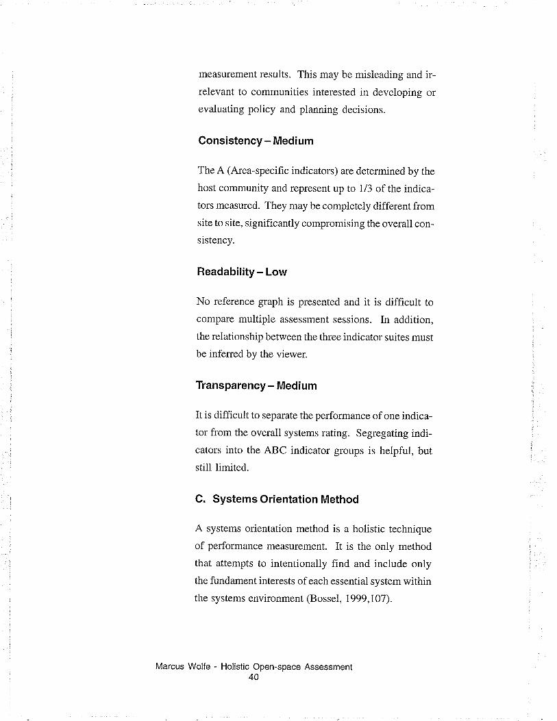
C. Systems Orientation Method
A systems orientation method is a holistic technique
of performance measurement. It is the only method
that attempts to intentionally find and include only
the fundament interests of each essential system within
the systems environment (Bossel, 1999,10'7).
Wolfe - Holistic Open-space Assessment40
1r-
or
Marcus
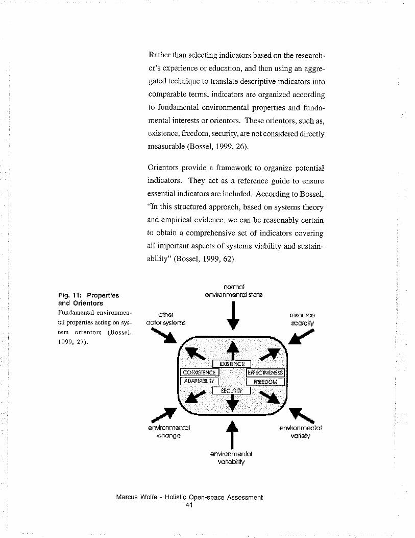
Fig. 11: Propertiesand OrientorsFundamental environmen-
tal properties acting on sys-
tem orientors (Bossel,
1999,27).
st¡'Ìerclor s.¡sle\r
snþlronmÈntolchcrrgs
Marcus Wolfe - Holistic Open-space Assessment41
Rather than selecting indicators based on the research-
er's experience or education, and then using an aggre-
gated technique to translate descriptive indicators into
comparable tems, indicators arc organized according
to fundamental environmental properties and funda-
mental interests or orientors. These orientors, such as,
existence, fi'eedom, secudty, are not considered directly
measurable (Bossel, 1999, 26).
Orientors provide a framework to organize potential
indicators. They act as a reference guide to ensure
essential indicators are included. According to Bossel,
"In this structured approach, based on systems theory
and empirical evidence, we can be reasonably certain
to obtain a comprehensive set of indicators covering
all important aspects of systems viability and sustain-
ability" (Bossel, 1999, 62).
stole
s.{sIems
tút!$s]'ËtlÈË
ngrnrsåenTd¡onrrÉniül
+
tentircnrnssdül
iurlcbßfu
sru,lranmËritolvorleåy
Fig.12: GraphingResultsStar graph showing the
overall condition ofworld in 1950 and
2000. The graph is a
composite of orientors
of human, support sys-
tem, and natural needs
satisfaction (Bossel,
1999, 83).
The technique produces a variety of viable indicators
for any single orientor. Candidate indicators are then
evaiuated through a series of averaging and concentra-
tion techniques to determine which indicators best rep-
resent the target olientor. This approach is used to
ensure that all of the orientors are equally and ad-
equately represented. "Potentially this may minimize
the danger of overlooking essential areas or overem-
phasizing others" (Bossel, 1999, 109).
TÉtå¡ Ë rÈtÈ¡ry1
Once the indicators are selected, they need to be quan-
tif,iable, if they are to be measured. An indicator is
measured by assessing how well it satisfies the require-
ments of the orientor it represents. This is done on a
scale of 0-4. Four represents total satisfaction of the
orientor. Zero represents total dissatisfaction e.g. na-
tional freedom: number of boarder crossings made in a
year compared to the country's population. The re-
sults can be plotted individually or integrated and plot-
ted through a variety of concentration techniques.
t$5ü
Marcus Wolfe - Holistic Open-space Assessment42
Advantages
This is the only performance measurement approach
that provides an intentional framework to collect in-
formation on all of the essential systems of an environ-
ment. Consequently, the product may serve other re-
search and evaluation purposes not initialty intended
by the designers.
The notion of central organizing principles that orient
activities in an ecological system is appealing. If an
underlying structure is inherent to human subsidized
ecological systems, periodic use of this tool will pro-
vide additional quality assurances of more simplistic
in-field performance measurement techniques. It may
also provide insight into the success of new or existing
projects by identifying gaps in the underlying projecr
structure.
Limitations
The idea that there is a complex yet understandable
prototype system upon which all human interactive
systems are based is lofty and complex. The method is
difficult for many to understand; this is compounded
by the complex indicator selection and evaluation proc-
esses.
In practice, a variety of vital informations is essential
for the analysis. Gathering this scope of information is
a complex and resource intensive exercise. Adequate
coliection ofsuch a diverse group ofindicators requires
significant expertise in all system components. A large
research team may be required for an effective assess-
Marcus Wolfe - Holistic Open-space Assessment43
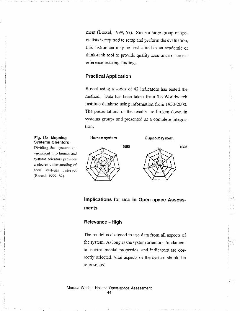
Fig. 13: MappingSystems OrientorsDividing the systems en-
vironment into human and
systems orientors provides
a clearer understanding ofhow systems interact(Bossel, 1999,82).
ment (BosseI, 1999,57). Since alarge group of spe-
cialists is required to setup and perform the evaluation,
this instrument may be best suited as an academic or
think-tank tool to provide quality assurance or cross-
reference existing findings.
Practical Application
Bossel using a series of 42 indicators has tested the
method. Data has been taken from the Worldwatch
Institute database using information from 1950-2000.
The presentations of the results are broken down in
systems groups and presented as a complete integra-
tion.
Þ{u¡npn ,s}¡É.tÉtn &upp*rt syrtncn
lmplications for use ¡n Open-space Assess-
ments
Relevance- High
The model is designed to use data from all aspects ofthe system. As long as the system orientors, fundamen-
tal environmental properties, and indicators are cor-
rectly selected, vital aspects of the system should be
represented.
Marcus Wolfe - Holistic Open-space Assessment44
Consistency- High
The model is very complex, requiring a broad range ofindicator data. As long as the indicator data is ad-
equate, the findings should be consistent.
Readability- Medium
This radial graph presentation is generally readable.
The inclusion of a measurement scale and integration
of the data into a single mapping, presents the data
holistically and greatly reduces the viewers need to
interpret f,rndings. However, the overall interpretation
of the findings is still very subjective and dependent
on the viewer interpretations of a single, yet complex
shape formed by the plotting the indicators.
Transparency- Medium
An effort has been made to present indicator mappings
according to themes or suites, as well as holistically.
This demonstrates that a system orientor evaluation
can be interpreted at various stages of data concentra-
tion, giving the viewer insight into system interactions,
as well as, an evaluation of the overall systems per-
formance.
Until the mapping technique for individual systems is
further developed, functionality will be limited to gen-
eral impressions by those who view the results, and as
an appreciation of a systems architecture by these who
review the underlying evaluation method.
Marcus Wolfe - Holistic Open-space Assessment45
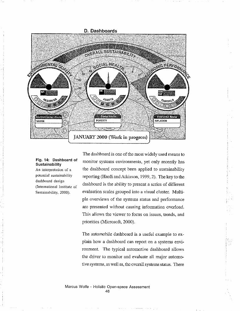
Fig. 14: Dashboard ofSustainabilityAn interpretation of a
potential sustainability
dashboard design
(International Institute ofSustainability, 2000).
D. Dashboards
The dashboard is one of the most widely used means to
monitor systems environments, yet only recently has
the dashboard concept been applied to sustainability
reporting (Hardi andAtkisson,1999,2). Thekey to the
dashboard is the ability to present a series of different
evaluation scales grouped into a visual cluster. Multi-
ple overviews of the systems status and performance
are presented without causing information overload.
This allows the viewer to focus on issues, trends, and
priorities (Microsoft, 2000).
The automobile dashboard is- a useful example to ex-
plain how a dashboard can report on a systems envi-
ronment. The typical automotive dashboard allows
the driver to monitor and evaluate all major automo-
tive systems, as well as, the overall systems status. There
Marcus Wolfe - Holistic Open-space Assessment46
is a variety of different gauges and warning signals
used to accomplish this. Each one is designed to pro-
vide system status or performance feedback on a par-
ticular critical system(s), with an appropriately repre-
sentative graphic interface, at a particular scale. For
example, the emergency brake light indicates that the
emergency brake is engaged and reminds the driver to
release the brake when drjving; otherwise, the braking
system could be damaged. This information could eas-
ily be displayed on a speedometer type dial, however
the amount of information presented would be extra-
neous and gauge would become irrelevant. A well
thought out visual presentation gives the dashboard
credibility and the evaluation clarity.
Advantages
The dashboard is a familiar and well-established per-
formance measurement presentation style. It has been
adopted for use with a variety of systems environments.
The clustering of different status and performance in-
dicators allows the viewer to focus attention on differ-
ent aspects of the system, while gathering an aware-
ness of overall systems performance. 'When gauges are
well designed and reference appropriate source infor-
mation, effective and timely feedback is assured, as
well as, an intuitive understanding of system interac-
tions.
Marcus Wolfe - Holistic Open-space Assessment47
Limitation
While systemic aggregation and holistic performance
measurement can be buiit into the overall design, as inthe Hardi proposal (see Figure L4), the dashboard is
intended to group information by relationship, in con-
centrations the user can readily interpret. When only
one systems environment is being monitored, this may
be preferred. However, when a series of evaluations
need to be compared, the number of aggregates the
user is viewing increases by the number of perform-
ance measurements presented on each dashboard. The
opportunity to see trends and patterns in larger scale
comparisons is lost when too much data is presented.
Practical Application
To date, there is only an agreement about how a sus-
tainability dashboard should be designed and func-
tion. The agreement has been structured as a series ofseven objectives as follows (Hardi andAtkisson,lggg,
2-3):
Audience: The dashboard must be intended foruse by a general audience and by decision-mak-
ers.
Aggregation: A limit has been placed on present-
ing no more then three aggregate clusters, and pos-
sibly an overarching single super-aggregate as
well.
Marcus Wolfe - Holistic Open-space Assessment48
Data Clusters: Only three data themes should be
presented. The three themes can be broken down
into seven sub-themes.
Graphic Presentation: The graphic presentation
should be simple and high-impact, allowing forvarying interpretations.
Stocks and Flows: Stock and flows (or perform-
ance) should both be graphically presented. To
avoid confusion they should be illustrated with
different types of meters such as fuel type gauges
and speedometers.
Alerts and Warnings: The presentation must also
provide warnings of critical thresholds or changes
not visible due to information concentration tech-
niques such as aggregation.
Multimedia: The dashboard should be present-
able thlough a variety of media, too effectively
and efficiently reach the widest audience possi-
ble.
lmplications for use in Open-space Assess-
ments
Relevance - Low
In cases where a single landscape is being monitored,
the dashboard would be highly effective. Indicators
could be clustered according to design considerations,
ecological well-being, community interest, etc. Where
this data is intended to provide a baseline or is being
Wolfe - Holistic Open-space Assessment49
Marcus
compared with a series of sites over a period of time,
the presentation offers too much information and be-
comes far less effective.
Consistency- Medium
If the indicator tests have been weli constructed, con-
sistency should remain high across all sites since allsites will be tested for the same group of indicators.
However, because the viewer is given the opportunity
to interpret the indicator clusters, there is no guarantee
that projects will be interpreted consistently or subjec-
tively.
Readability- Medium
On a case by case basis, the dashboard is very readable,
as long as the viewer is skilled in how to interpret the
data. As the number of dashboards orprojects increase,
it will make the indicator interactions less legible and
less relevant.
Transparency - Medium
Using a performance measurement for multipleaggregations will give the viewer a broader understand-
ing of the performance measurements overall effect.
This is useful in a setting like a landscape, where sys-
tem status is the result of complex and multiple indica-
tor interactions. However, the dashboard does rely ex-
tensively on methods to concentrate information be-
fore presentation. It is unlikeiy that the viewer will be
Marcus Wolfe - Holistic Open-space Assessment50
able to infer the underlying individual
measul€s although these measurements
multiple times during the presentation.
performance
may be used
Presentation Model Selection
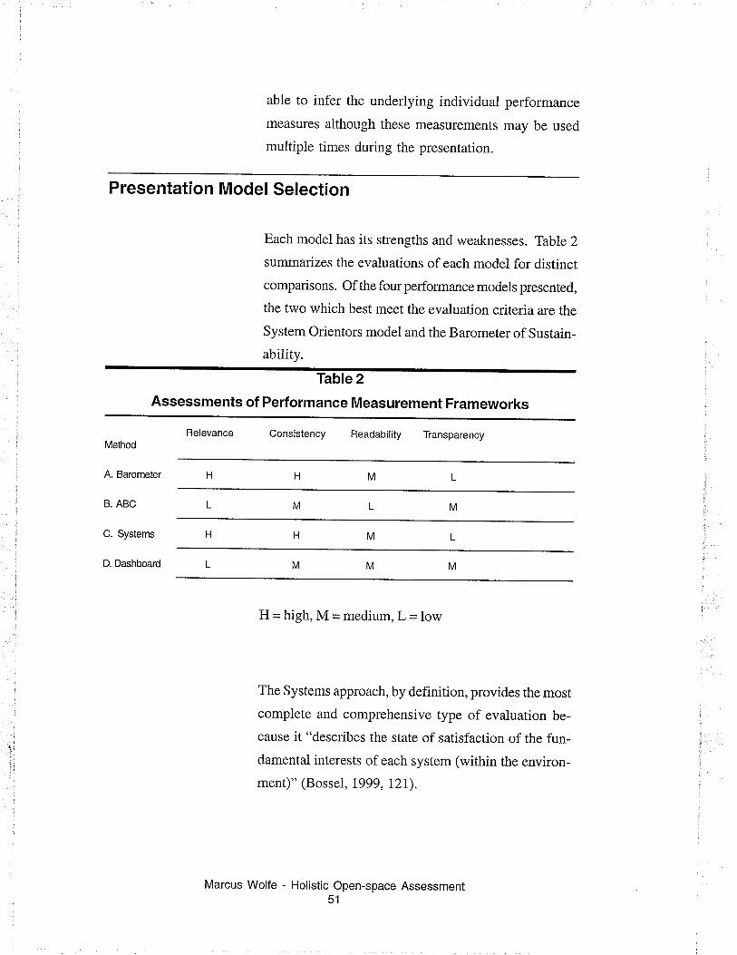
Each model has its strengths and weaknesses. TabIe 2
summarizes the evaluations of each model for distinct
comparisons. Of the fourperformance models presented,
the two which best meet the evaluation criteria are the
System Orientors model and the Barometer of Sustain-
ability.
Table 2
Assessments of Performance Measurement Frameworks
Relevance Consistency Readability TransparencyMethod
A. Barometer
B. ABC
C. Systems
D. Dashboard MMM
)
1;
:.
H = high, M = medium, L = low
The Systems approach, by detinition, provides the most
complete and comprehensive type of evaluation be-
cause it "describes the state of satisfaction of the fun-
damental interests of each system (within the environ-
ment)" (Bossel, 1999, I2I).
Marcus Wolfe - Holistic Open-space Assessment51
Defining an indicator set that represents a complete
cross-section of all the systems in an environment is
not an easy task. It requires detailed knowledge of allthe systems within the environment and an understand-
ing of how each system functions. Achieving this de-
gree of refinement is a complex task, requiring consid-
erable analysis, which may be beyond the scope of allbut a multi-disciplinary research team. According toBossel, "It is essential to bring in a wide spectrum ofknowledge, experience, mental modeis, and social and
environmental concerns to ensure that a comprehen-
sive indicator set is found for a given application"(Bossel, 1999,51).
The complexity of this method is not timited to indica-
tor selection, once the systems, sub-systems, and es-
sential indicators have been identified and selected.
Sufficient resources must be allocated to collect and
evaluate all of the information. Again, this process
requires expertise, and knowledge on the part of the
researchers.
Alternatively, the Barometer of Sustainability can func-
tion within a less rigidly defined indicator suite. Indi-
cators are selected and measured because they meet
the requirements of one of the barometer's two axes
themes; not because they represent a fundamental as-
pect of a related system.
Simplifications of the indicator selection and assess-
ment criterion are a benefit, especially when making
initial or periodic evaluations or involving the public.
With increased simplicity, there is however, the need
Marcus Wolfe - Holistic Open-space Assessment52
for additional diligence in assuring that the systems
being evaluated are sufficiently represented by the se-
lected indicators.
Since this study of public open-space, is intended as a
'trial balloon', to see if a holistic assessment of open-
space is possible, and if so, how effective the chosen
holistic approach is. It seems the best choice for an
organizing and presenting framework is the Barom-
eter. In subsequent studies, when a more complete un-
derstanding of open-space systems interactions are
developed, the Systems Orientor approach may prove
useful to validate the evaluation technique and result-
ing assessments.
Note about the Dashboard model: The dashboard is apresentation technique, combining systems data and
then allowing the viewer to interpret the rcsults and
interactions. Consequently, a dashboard could be used
to present any data combining approach or to display
the results of other modeling techniques. Systems
Orientors' method would particularly benefit from a
dashboard presentation since so many systems are rep-
resented in a Systems Orientor evaluation. However, itis also possible that confusing or ambiguous messages
would be inteqpreted by the viewer because they are
not fully aware of how a particular system functions.
For example, when evaluating the health of an urban
ecosystem, increases in local wildlife population may
validate the efforts of a conservation program that in-
creases a certain type of habitat. The reintroduction ofspecific wildlife population may upset local residents
and reduce the perceived quality of life. One gauge
Marcus Wolfe - Holistic Open-space Assessment53
will be warning of a potential problem, another may
suggest significant improvement. A comprehensive
gauge rating overall well-being may appear unchanged
as the two issues cancel each other out.
Unless the viewer has an intimate knowledge of how
the gauges were developed, evaluated, and presented,
misleading conclusions may be formed. This suggests
that effective use of a dashboar-d model requires a ma-
ture understanding of the environment of the system
being evaluated.
Marcus Wolfe - Holistic Open-space Assessment54
3. Defining Public Open-space
A limitation placed on this study has been the decision
to only study community built public open-spaces.
This section will look at ways public open-spaces can
be defined, the essential characteristics ofthese open-
spaces, and how to apply this understanding to holis-
tic evaluations.
Contemporary Landscapes
Marcus Wolfe - Holistic Open-space Assessment55
The defining characteristic of many landscapes in the
postwar era has been a striking homogeneity in the
appearance and character of settlement form. This is
the result of: a desir-e to surround ourselves within con-
trolled, constructed environments and the standardiza-
tion of design processes, material manufacturing, and
construction techniques.
This condition is especially true in urban and subur-
ban environments, which aÍe constructed almost en-
tirely of spaces created through human effort and pur-
pose (Relph, 1976, 20). These artificial surroundings
are exampies of 'governed' landscapes because they
are controlled by humans to the extent that they would
revert to entirely different forms if it were not for con-
tinued human intervention (Bertollo, 1998, 33).
With this approach to urban place making, there is atremendous focus on built structures and the open-
spaces associated with these buildings. This occurs to
such an extent that most public and semi-public spaces,
such as roadways, parks, and underused lots are left
solely to the development and care of civic agencies or
ignored when ownership cannot be ciearly determined.
Hough interprets the importance of certain buildings
and private spaces as examples of the 'pedigree land-
scape'. Pedigree landscapes hold a high value in the
public mind as an expression of power; hold signifi-
cant aesthetic and civic value; and negate the environ-
ment, symbolizing the separation between town and
country. (Hough, 1984,7)
One exception to a pedigree interpretation of urban
landscape or townscape is the development of commu-
nity supported public open-spaces. These spaces are
often highly pnzed by the local community, yet lack
wider civic importance they are often seen as a way to
r€storc or heal the linkage between the community and
the environment. This speaks to the distinct relation-
ship between people and the communities in which
they live.
Community Supported Open-space
Community supported open-space requires the
citizenry to take an active role in the stewardship ofspecific sites. This involvement is seldom spontane-
ous. Active participation in the creation and mainte-
nance of open-space often occurs as a reaction towards
the perceived state of the community and changes to
the surrounding physical environment.
These reactions can be thought of as either positive or
negative feedback within the neighbourhood system
Marcus Wolfe - Holistic Open-space Assessment56
(Meadows, 1998,30-33). Negative feedback loops are
attempts to reverse the change processes affecting a
system or community. For example, the mature trees in
a iocal park have reached the end of their expected life
span and are now dying. The community chooses to
plant new trees to replace the old ones as an attempt to
maintain the visual character of a local park. A posi-
tive feedback loop is the opposite condition, where a
progression of changes is encouraged and leads to a
new state of balance. A new community garden project
requiles two small garden plots to provide sufficient
space for growing plants. The season proves success-
ful and more people want to participate. The next year,
five plots are prepared. This continues until the entire
site is used for gardening plots.
Regardless of the feedback mechanism, the resulting
interventions are seldom well publicized or docu-
mented and therefore, as an outside observer, diff,rcult
to locate and identify. Directly tracking the activities
of these grassroots groups when no public reporting
stipulations exist is difficult.
It may be easier to track the administrative activities of
the support agencies responsible for supporting project
development. Since many grassroots activities are de-
fined in response to specific concerns, these groups
tend to iack the formal structure or regulations govern-
ing businesses and organizations.
Marcus Wolfe - Holistic Open-space Assessment57
Grassroots Development Requirements
Most development or redevelopment of open-space
requires materials, services, and labour. Services and
labour are often subsidized by the community and sel-
dom supported or tracked by other agencies. Material
requirements are often more difficult for the commu-
nity to directly subsidize. Consequently, there are nu-
merous community and/or environmental conscience
agencies, which provide supplementary funding to al-
low grassroots organizations to purchase materials and
develop projects. Corporate social and environmental
funds, various tiers of government, and non-govern-
mental organizations all provide material funding to
these loosely structured local community initiatives.
Accessing the funding records of these support organi-
zations provides an efficient way to identify and con-
tact candidate projects. This method wili be used to
short-list candidate projects for possible inclusion inthis study.
Project Selection
The term 'open-space' is very ambiguous. The term
could refer to a street corner, a highway, a parking lot, a
park, or a community garden. To simplify the scope ofthe work, only projects, which fulfil a primarily recrea-
tional and/or working function, will be considered forevaluation. The potential case study must also be sup-
ported by the local citizenry.
Marcus Wolfe - Holistic Open-space Assessment58
Local support will be determined by projects which
are of a scale that allows the community to have an
active voice in the design and management of the space,
participate in site maintenance, and contain amenities
that appear to be important to the local community
members. For example, a predominately Italian com-
munity may provide a Bocce ball court as a park amen-
ity or an urAan high population density areamay offer
community gardens.
One important consideration is that these open-spaces
be intended to serve the needs and requirements of the
local community above all else. In practical terms,
projects that serve the needs of those within a lS-minute
walking radius of the site are to be included in the
study. This is seen as a feasible travel distance for most
urban dwellers. Exceptions to this 15-minute rule need
to be considered. Virtual communities like business
parks and schoois may be mostly populated by tempo-
rary residence that only spends certain perÌods of the
day, week, or year at the site. For the purposes of this
study, these circumstances are also considered local
communities. Alternatively in an automotive centric
society, a 15-minute walk might be as great a barrier as
at 4O-minute drive. Considerations for these circum-
stances are not included in the selection criteria forthis study.
Defining Site Characteristics
One approach to defining the characteristics of a site is
to study the relationship between built for-ms. This is a
functional approach and its limitations have been dis-
Marcus Wolfe - Holistic Open-space Assessment59
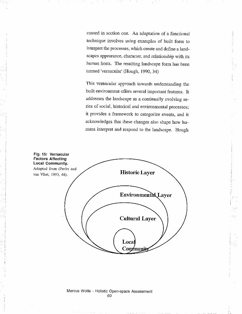
cussed in section one. An adaptation of a functional
technique involves using examples of buitt form to
interpret the processes, which create and define a land-
scapes appearance, character, and relationship with its
human hosts. The resulting landscape form has been
termed'vernacular' (Hough, 1990, 34)
This vernacular approach towards understanding the
built environment offers several important features. Itaddresses the landscape as a continually evolving se-
ries of social, historical and environmental processes;
it provides a framework to categorize events, and itacknowledges that these changes also shape how hu-
mans interpret and respond to the landscape. Hough
Fig. 15: VernacularFactors AffectingLocal Community.Adopted from (Perks and
van Vliet, 1993, 46).
Marcus Wolfe - Holistic Open-space Assessment60
Environmen
Cultural Layer
identifies three primary catalysts effecting the vernacu-
lar -- historic, cultural and environmental factors
(Hough, 1984,1).
In the contemporary city, historic and environmental
factors play marginal roles in the development of the
vernacular. The abundance of cheap energy, the atti-
tude that physicai growth is equated with progress,
and the universality of buitding materials, collectively
mean that design interventions have become largely
independent of setting. The use of recycled materials
shouid be noted as an exception to this trend because
there are few systems dictating the best way to com-
bine and join these materials in consistent, systematic
way. As well, these materials are often found or ob-
tained locally.
This leaves the cultural factors, which do play a sig-
nificant role in the development and character of the
modern city. Social influences can affect the choice ofmaterial, although these materials are still selected from
anarowrange of mass-produced choices. Public trends
also affect the resuiting form through an ever-chang-
ing stream of iconography, concerns for equity and
safety, and shifting opinions about what appears natu-
ral or human-made. All of these cultu¡al influences
play a role in the short and long-term shaping and
remodeling of the urban landscape and urban public
open-space.
Robert Putnam (Putnam, 1995) also emphasizes the
importance culture plays on the relationship between
North American communities and their physical set-
Marcus Wolfe - Holistic Open-space Assessment61
tings. In a series of time budget studies, Putnam indi-
rectly looked at changes to ones 'home place' and the
resulting impact on social interactions. He discovered
that despite a variety of cultural, sociai, and physical
differences, participation in community life has con-
tinualiy declined in the post-war era regardless of eco-
nomic, residential mobitity and suburb anization fac-tors (Putnam,1995). It appears that while we have an
influence on the shape of our neighbourhoods, they
have a limited effect on how we interact with each
other.
The vernacuiar approach to understanding landscape
goes beyond a basic functional inte¡pretation of builtform, by adding the dimension of time to interpret
change processes. In Hough's Out of place, 1990,
evaluating change over time is demonstrated as an im-
portant means to understand how human action, as well
as, natural forces shape and define the landscape.
As an assessment tool, it may not be ideally suited forthe short-term quantitative interpretation of sites within
the contemporary urban landscape -- nor has been in-
tended to do so. Nevertheless, it does confirm the un-
derlying processes that shape the human landscape.
Any evaluation of a iandscape form, including public
open-space, must provide a framework to reference
these processes ifan over all understanding ofthe land-
scape is to be gained.
The landscape interpretation framework used for this
study is based on the Lynch normative model as out-
lined in Section One. It organizes landscape processes
Marcus Wolfe - Holistic Open-space Assessment62
according to five dimensions of settlement form (see
Appendix E). Like Hough's vernacular approach,
Lynch's dimensions provide a structure to organize and
interpret the human and natural factors that contributeto settlement form.
Direct Phenomenal Evaluation
An alternative approach to defining landscape charac_
ter, used extensively in the 1970's, is a direct phenom_
enal approach. In this approach, the actual events oc_
curring in the community are studied and then used as
evidence to quantify and interpret the impact an envi_
ronment has on people, and people on the environ_
ment (Relph, 1976,4). It has a basis in the applied
social studies.
Phenomenological methods rely heavily on direct ac_
tivity observation techniques. The use of cognitivemapping, user mobility studies and time budget stud_
ies are all exampies of the phenomenological approach
to landscape assessment.
Landscape evaluation tests are planned using basic
scientific methodologies, which provide well docu_
mented, repeatable experiments. The resuits are oftenpresented as individual studies, however information
is compiled and aggregated where opportunity and
common interest allow (Scanlan, Igg4,3). Combined
results provide a broader understanding of the envi_
ronment, but should not be seen as a true hoiistic inter_
pretation of piace.
Wolfe - Holistic Open-space Assessment63
Marcus
Phenomenological methods are well suited to a neigh-
bourhood or community scaie because they rely on
direct observation of the environment. According toScanlan these methods can, "Increases your understand-
ing of the processes at work in the neighbourhood,
within the neighbourhood, and allows you to see rela-
tionships between various spatial patterns" (Scanlan,
1984,2). Finally, they offer a means to evaluate the
human and environmental landscape conditions simul-
taneously using elementar!, low cost means availabie
to anyone.
Basic phenomenological methods will be used to evalu-
ate most performance indicators for this study. Find-
ings will then be aggregated on human and ecological
indices and plotted on a version of the Barometer ofSustainability called the Barometer of Open-space. This
will allow direct observation of site characteristics to
be evaluated holistically.
An intermediary step is introduced to organize indica-
tors according to Lynch's dimensions of settlement form.
Organizing indicators according to this framework is a
quick way of confirming that ail aspects of place are
equally represented. If one dimension is represented
by numerous indicator tests and another has none or
few representative tests, it may be necessary to weigh
some indicators more heavily, providing a handicap
for the stronger dimension. Alternatively, weaker tests
Marcus Wolfe - Holistic Open-space Assessment64
can be removed from the
or additional tests added
mension.
over represented dimension,
to the under represented di-
lndicator Selection
Any observation that can be tied to a value could po-
tentially be considered a performance indicator. The
resealchel must discriminate between the observations
they record and the ones they ignore. In an ad hoc
approach, this would happen during the evaluation. In
a prescriptive approach, this is done before the evalua-
tions are conducted. This increases the consistency oftesting and leduces the likelihood that superfluous tests
are being conducted or vital tests are not included. Awell-designed set of indicator tests is required to mini-
mize this effect, as is the choice to combine indicator
data.
For the purposes of this study, the intention is to de-
velop a sufficiently detailed list of indicators, which
will then be combined. The indicators should repre-
sent the most important dimensions of settlement form,
yet be brief enough to allow for the effîcient collection
of data and management of results. The indicator tests
developed here are a first step in defining a definitive
list of performance indicators for community supported
open-space development.
lndicator Sources
A collection of potential indicators has been gathered
from a variety of landscape assessment projects (see
Marcus Wolfe - Holistic Open-space Assessment65
Table 3). The following samples reflect landscape as-
sessments from a variety of different research perspec-
tives. In theory, building on the research from a host ofdifferent disciplines will allow for a more holistic indi-
cator suite than any one individual could create. The
alternative is to organize a multi-disciptinary team to
develop and administer indicator tests. This study willuse the research sampling approach to defining indica-
tors.
Selected assessment tests will be rcviewed, modified
and combined with other tests as required, forming a
new composite suite of performance indicators. The
resulting indicator suite (see Table 6) witl be used spe-
cifically for the evaluation of community supported
open-space. Broader evaluation applications for this
performance measurement suite will not be considered
for this study.
Table 3
lndicators of Settlement Form
(International Development Research Council, i 993)
. (On farms) the complexity of fences indicates the
number of generations of development on the farm.
. The number of outside researchers working in a com-munity is inversely related to the level of concern if itis measured by the amounts of money available to the
community to carry out its own research.
. The evolution of institutions over time and space can
be seen as a predictor, or indicator of social and envi-ronmental change.
Marcus Wolfe - Holistic Open-space Assessment66
' Early signs of increases in social violence are indica-tors of break down in traditional society and economy
often linked to diminishing environmental health.
. Health indicators, such as an increase in infant mor-tality, can signal social and environmental change.
. The presence or absence of species of animals sug-
gest environmental quality. For example, performed inthe soil, the activity of the coionies, the presence ofsongbirds, the existence of life under rocks "Gives asense of the state of life".
(International Downtown Association, 1994)
. Indicatols of place (accessibility): transit mode
split, ridesharing, single occupancy drivers, length ofcommute time, congestion, parking (off street - longterm, short term, on street), turnover rate, bicycle ifindicators of place (amenities/pedestrian friendly):cafe, vendors, farmers markets, street lighting,percent of two ways streets, benches, number ofpedestrian/on key streets during daytime/weekends.
Indicators of place (cleanliness) : streelsidewalkcleaning personal, number of street suites, collection,weed collection, graffiti removal program, plant
maintenance.
.Indicators of people (residents): numbered of residents,
daytime/nighttime census ratio, a diversity income ofresidents, diversity of ethnicity of residents, resident
satisfaction of downtown living.
.Indicators of people (diversity): racial diversity, eth-
nic diversity of activities, generational diversity.
Marcus Wolfe - Holistic Open-space Assessment67
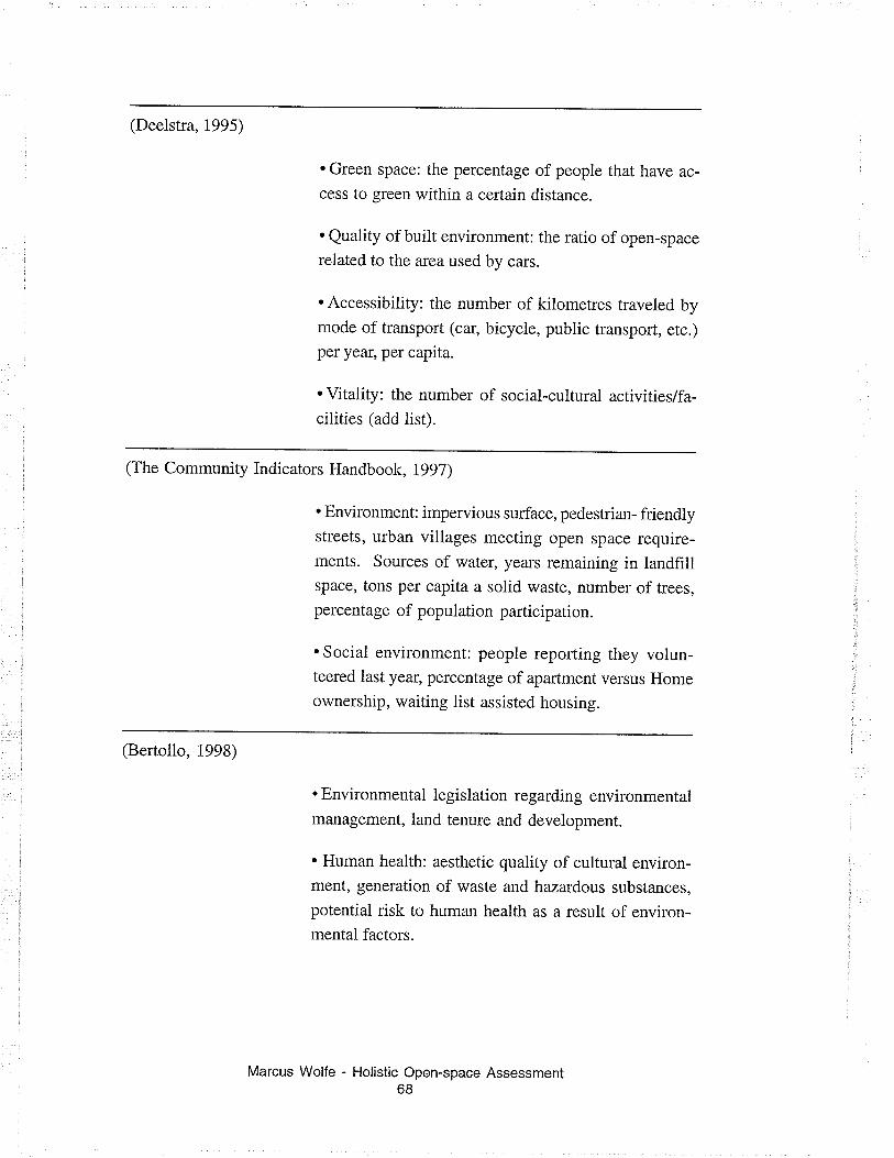
(Deelstra, 1995)
. Green space: the percentage of people that have ac-
cess to green within a certain distance.
. Quality of built environment: the ratio of open-space
related to the area used by cars.
. Accessibility: the number of kilometres traveled bymode of transport (car, bicycle, public transport, etc.)
per year, per capita.
. Vitality: the number of social-cultural activities/fa-cilities (add list).
(The Community Indicators Handbook, 1997)
. Environment: impervious surface, pedestrian- friendlystreets, urban villages meeting open space require-rnents. Sources of water, years remaining in landfillspace, tons per capita a solid waste, number of trees,percentage of population participation.
. Social environment: people reporting they volun-teered last year, percentage of apartment versus Homeownership, waiting list assisted housing.
(Bertollo, 1998)
. Environmental legislation regarding environmentalmanagement, land tenure and development.
. Human health: aesthetic quality of cultural environ-ment, generation of waste and hazardous substances,
potential risk to human health as a result of environ-mental factors.
Marcus Wolfe - Holistic Open-space Assessment68
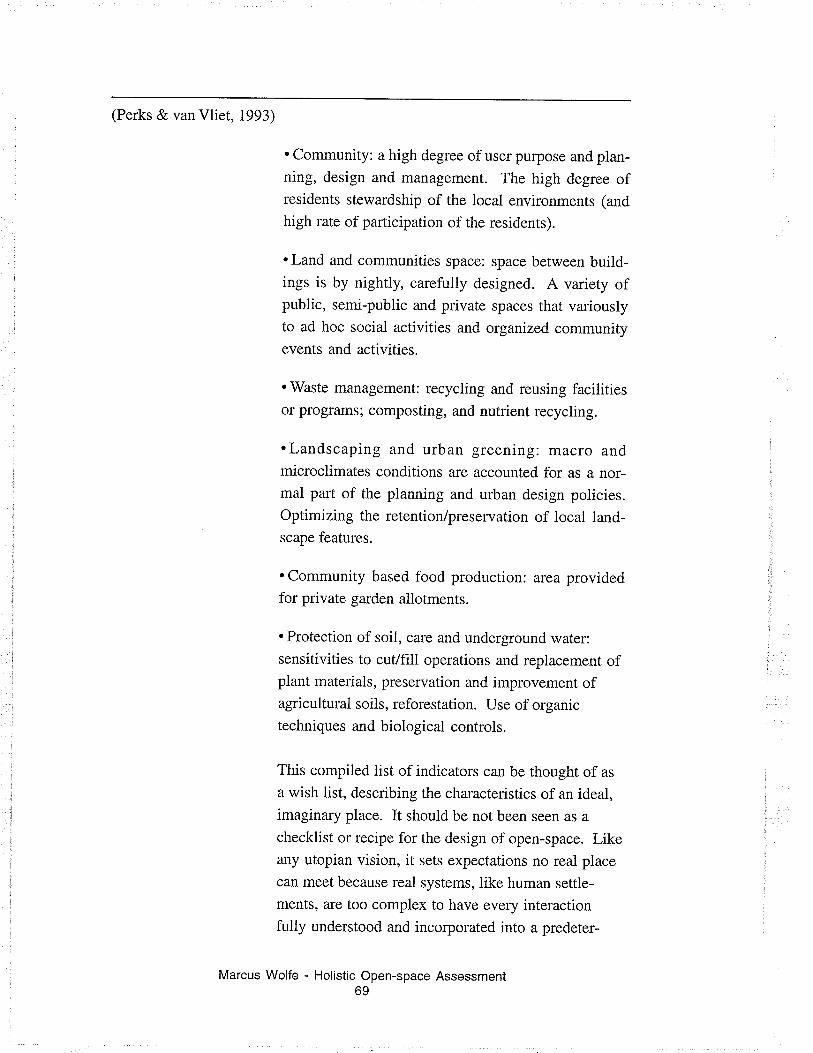
(Perks & van Vliet, 1993)
. Community: a high degree of user pulpose and plan-ning, design and management. The high degree ofresidents stewardship of the local environments (and
high rate of participation of the residenrs).
. Land and communities space: space between build-ings is by nightly, carefully designed. A variety ofpublic, semi-public and private spaces that variouslyto ad hoc social activities and organized communityevents and activities.
. Waste management: recycling and reusing facilitiesor programs; composting, and nutrient recycling.
.Landscaping and urban greening: macro andmicroclimates conditions are accounted for as a nor-mal part of the pianning and urban design policies.Optimizing the retention/preservation of local land-scape featurcs.
. Community based food production: area providedfor private garden allotments.
. Protection of soii, care and underground water:
sensitivities to culfill operations and replacement ofplant materials, preservation and improvement ofagricultural soils, reforestation. Use of organic
techniques and biological controls.
This compiled list of indicators can be thought of as
a wish list, describing the characteristics of an ideal,
imaginary place. It should be not been seen as a
checklist or recipe for the design of open-space. Likeany utopian vision, it sets expectations no real place
can meet because real systems, iike human settle-
ments, are too complex to have every interactionfully understood and incorporated into a predeter-
Marcus Wolfe - Holistic Open-space Assessment69
mined design. Consequently, some of the values
associated with the descriptive indicators are
contradictory. This is the result of describing 'place'
in generic rather then specific terms.
If a generic indicator suite is to be used it needs to
either measure a variety of seemingly contradictory
values or provide a series of performance tests that rep-
resent a continuum of systems interactions.
Performance tests selected for this study will attempt
to evaluate the relationship between people and place
using the first approach. This is intended to make the
tool as general and universaily applicable as possible.
In a case where the value of asphalt multipurpose areas
versus a passive recreational area is the focus of the
evaluation, testing would remain holistic, considering
how the amenity, the asphalt area, effects the essential
dimensions of place, rather then testing specifically
for the presence asphalt courts. Questions that may
pertain to a court site feature may include; percentage
of surface types; physical site accessibility: percent-
age of permeable versus non-permeable surface; and
vandalism. These questions also speak to a range ofother landscape features, contributing to the holistic
understanding of place.
Avoiding lndicators
Some indicators will be intentionally avoided because
they require value judgements, which can not been
confirmed. For example, attributing a high value to
sites with high open-space to user ratios may be prob-
Wolfe - Holistic Open-space Assessment70
Marcus
lematic. The commonly held belief that a low popula-
tion density reduces crime has shaped much of the con-
temporary urban landscape, despite the fact that a uni-
versal relationship between density and crime has never
been clearly established.
The following table provides some examples of indi-
cators which have value components that can not be
generally applied or require values that are unsubstan-
tiated in general use. Avoiding these indicators is also
an attempt to keep the measurement tool as universal
applicable as possible.
Table 4
Examples of Excluded lndicators
Grime reported ' Crime has a relationship to community cohesion, but itdifficult to relate the quality of an open-space to theabsence of crime. Better indicators of safety may reflectlighting schemes, nighttime site usage, or impressions ofsafety.
External financial support ' Financial suppoft from external agencies for start-up ormaintenance is important may really be deferring programinadequacies which will reappear when supporls haveended. This can make a project appear artificially success-ful and cripple the long-term success of a project.
Graffiti ' Graffiti is a complex expression, which has manymeanings. lts presence or absences do not necessarilyreflect the community's relationship with the open-space.
Population Density ' The question'What is the ideal population'is as old assettlement itself. This tool is intended for use with a varietyof land-uses. lt is difficult to generalize a fixed value ordesired population thresholds when the site usage couldvary greatly. Population density on its own is of question-able value. lt may be useful when integrated with otherindicators as a ratio.
Marcus Wolfe - Holistic Open-space Assessment71
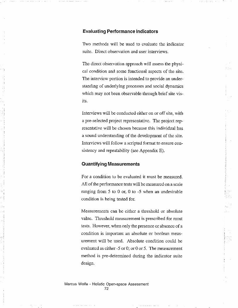
Evaluating Performance lndicators
Two methods will be used to evaluate the indicator
suite. Direct observation and user interviews.
The direct observation approach will assess the physi-
cal condition and some functional aspects of the site.
The interview portion is intended to provide an under-
standing of underlying processes and social dynamics
which may not been observable through brief site vis-
its.
Interviews will be conducted either on or off site, with
a pre-selected project representative. The project rep-
lesentative will be chosen because this individual has
a sound understanding of the development of the site.
Interviews will follow a scripted format to ensure con-
sistency and repeatability (see Appendix E).
Quantifyi n g Measurements
For a condition to be evaluated it must be measured.
All of the performance tests will be measured on a scale
ranging from 5 to 0 or, 0 to -5 when an undesirable
condition is being tested for.
Measurements can be either a threshold or absolute
value. Threshold measurement is prescribed for most
tests. Howeve¡ when only the presence or absence of a
condition is important an absolute or boolean meas-
urement will be used. Absolute condition could be
evaluated as either -5 or 0; or 0 or 5. The measurement
method is pre-determined during the indicator suite
design.
Marcus Wolfe - Holistic Open-space Assessment72
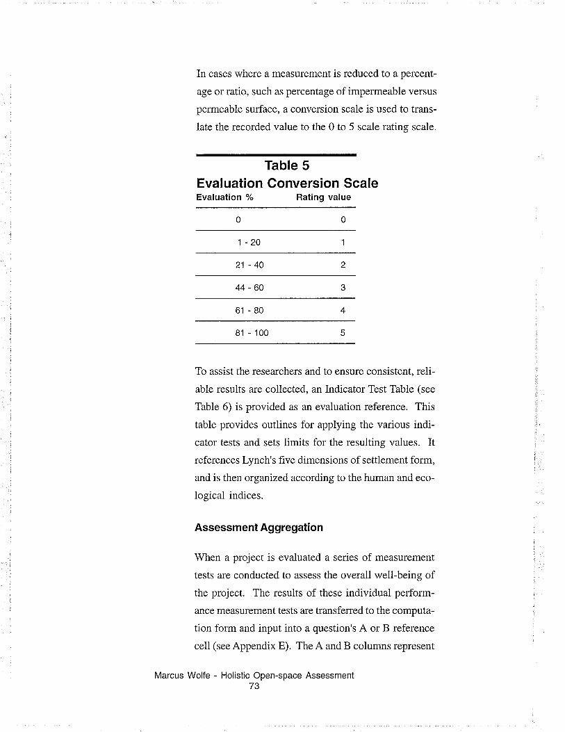
In cases where a measurement is reduced to a percent-
age or ratio, such as percentage of impermeable versus
permeable surface, a conversion scale is used to trans-
late the recorded value to the 0 to 5 scale rating scale.
Table 5Evaluation Conversion ScaleEvaluation % Rating value
1-20
21-40
44-60
61 -80
81 - 100
To assist the researchers and to ensure consistent, reli-
abie results are coilected, an Indicator Test Table (see
Table 6) is provided as an evaluation reference. This
table provides outlines for applying the various indi-
cator tests and sets limits for the resulting values. Itreferences Lynch's five dimensions of settlement form,
and is then organized according to the human and eco-
logical indices.
Assessment Aggregation
When a project is evaluated a series of measurement
tests are conducted to assess the overall well-being of
the project. The results of these individual perform-
ance measurement tests are transferred to the computa-
tion form and input into a question's A or B reference
cell (see Appendix E). The A and B columns represent
Marcus Wolfe - Holistic Open-space Assessment73
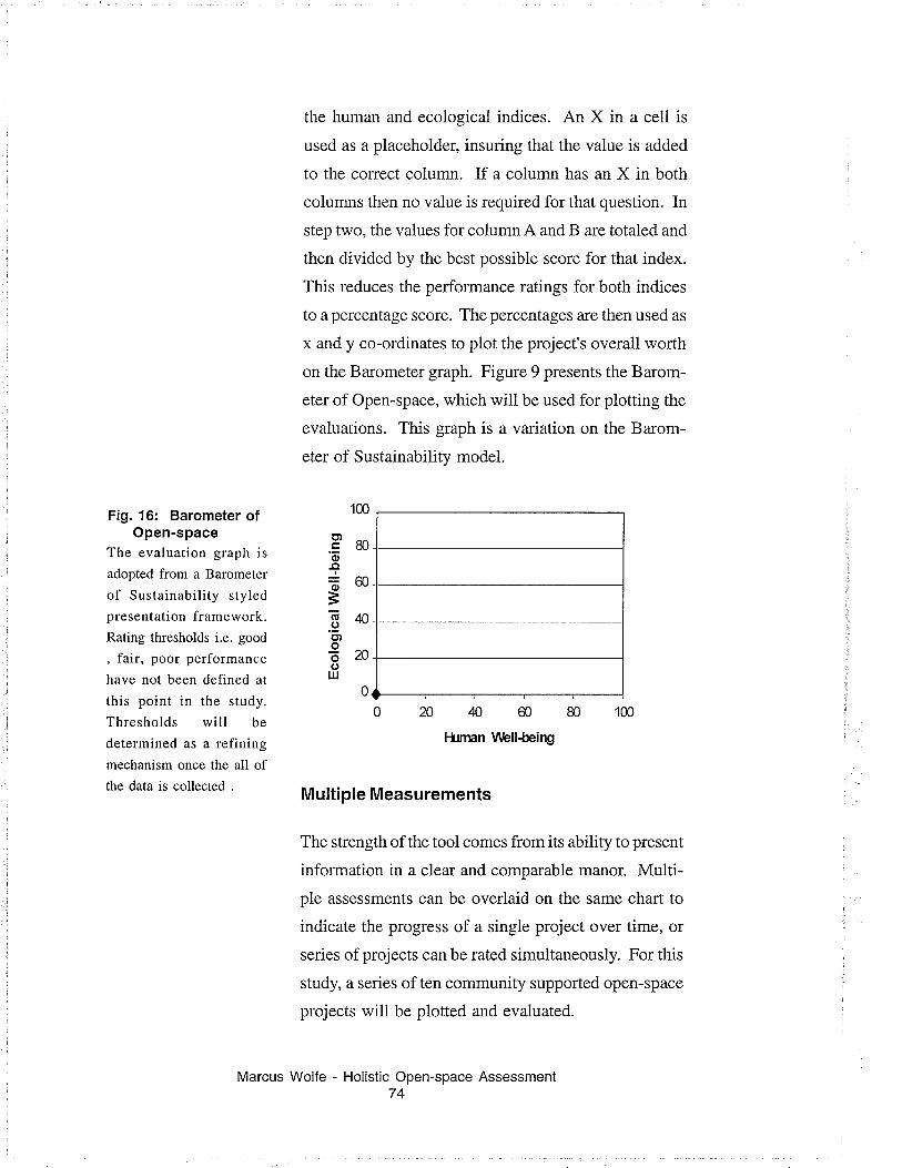
the human and ecological indices. An X in a ceii is
used as a placeholder, insuring that the value is added
to the correct column. If a column has an X in both
columns then no value is required for that question. In
step two, the values for column A and B are totaled and
then divided by the best possible score for that index.
This reduces the performance ratings for both indices
to a percentage score. The percentages are then used as
x and y co-ordinates to plot the project's overall worth
on the Barometer graph. Figure 9 presents the Barom-
eter of Open-space, which will be used for plotting the
evaluations. This graph is a variation on the Barom-
eter of Sustainability model.
020Æ6080Hrtmn V\rbllåeing
Multiple Measurements
The strength of the tool comes from its ability to present
information in a clear and comparable manor. Multi-
ple assessments can be overlaid on the same chart to
indicate the progress of a single project over time, or
series of projects can be rated simultaneousiy. For this
study, a series of ten community supported open-space
projects will be plotted and evaluated.
Marcus Wolfe - Holistic Open-space Assessment74
100Fig. 16: Barometer ofOpen-space
The evaluation graph is
adopted from a Barometer
of Sustainability styledpresentation framework.Rating thresholds i.e. good
, fair, poor performance
have not been defined at
this point in the study.
Thresholds will be
determined as a refiningmechanism once the all ofthe data is collected .
.g 80o
-ct
+60=Eqõ)oõ20olrJ
0
Plotting and comparing a series of projects will give an
indication of the tool's ability to interpret a variety ofdifferent landscape conditions. This speaks to the uni-
versality of the test and indicator suite. If the tool
proves robust and efficient, longitudinal studies on
individual studies may be considered.
Summary
Human and ecological conditions combine to define
and shape settlement form. Keeping this in mind, a
holistic investigation into landscape condition must
also consider the interaction of human and natural sys-
tems.
These interactions and the resulting patterns are often
very subtle. Researchers have used functional and
phenomenological approaches to interpret the land-
scape, especially settlement form. When assessing com-
munity supported open-space, a combined approach,
which applies the direct observation within a
predefined functional framework, seems to offer the
most straightfolward means for evaluation.
Indicators used to report on this framework come from
a variety of sources. Careful examination of potential
indicators is required before a set of performance tests
and evaluation system can be developed.
Once the testing system is developed, projects that meet
the study's scale and function criterion can be evalu-
ated. Results are then plotted on a modification of the
Barometer of Sustainability for presentation and com-
parison.
Marcus Wolfe - Holistic Open-space Assessment

FeL
H -a
D¡mension
Þ
c
Éoã-
{^oaEpo
o
=o
Performance Measure Measuement tesl
Table 6 a
INDICATORTEST TABLE - INDICATORS OF HUMAN WELL-BEING
Pro.¡ect reffecls an intenlional ardplanned purpose or efftrt.
Site swvey - Fogrlation rflit¡¡n a 1S
m¡núe radius.
Presenc€ of a lheme orpurposewt¡dr gu¡des site devdcpment.
lnterview - Before the site wasdevdoped, lvhat orgarìizdimalsteps r¡/ere laken b irsure lledeveloprnent \,rcdd run smoothly?
Rat¡ng
lrf orrnat¡on for conputdions only.
Comrrunity membe/s ¡rvolvemenl inthe dðlning and managêment of lheopeflspace.
hterv¡s,v - ls lhere a gu¡dngpurpose or philosophy organ¡z¡rElhê site layout?
Reference
lntervie\ry - Do any rnemþers of ltìe
E.g. verbal plansrvritten planssketchesdrarvingsscaled plans
TOTAL
localcommurily hdd dfice mboards resporEiUe br danning amanagement dec¡sims which effecllh¡s open-space?
E.g. The site uses only haritageplants popular in the 1930's = 5 pt.
TOTÄL = 5 pr.
pt.pt.
pt.pt.
pt.
E.g. City councillorLocal Foundation
TOTAL
=5pt
:lpt.:lpt.
=5pt.
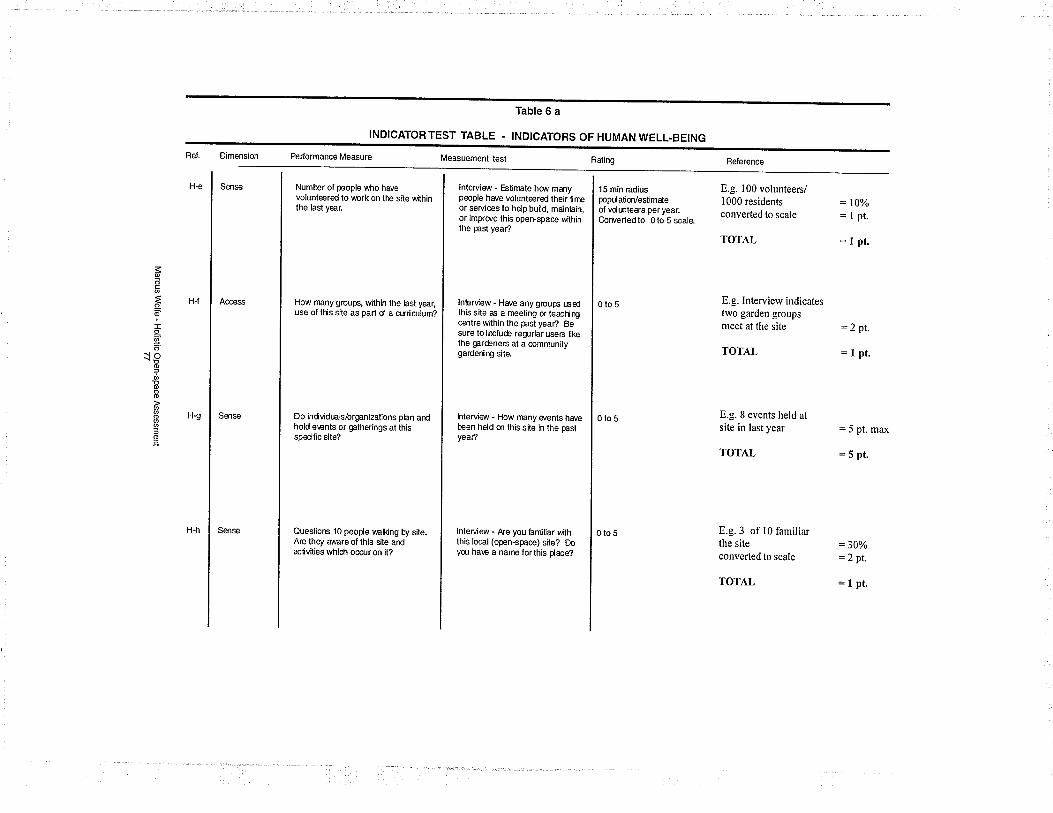
Ref.
H€
Dimensíon
Sense
põc
ã@
I9.Ø'o
-rÈ,aøÞÞ@
oø
=o
Pelormance Measute Measuement test
Table 6 a
INDICATORTEST TABLE - INDICATORS OF HUMAN WELL-BEING
Number ol people v"tlo har'evolunteered to \.(¡ork on tl'E site withinthe lasl year.
H-f Access How rnany group6, within the last yea(use of ttis site as part d a cìJrÌiculum?
Hg Sense
lnterv¡ew - Eslìmate hq ' mÐypeople ha/e volunteered their limeor services to hdp build, mainÞin,or impror'e this openspace wilhinthe past yeaû
Do indvidEls/organ¡zalions plan ardhold e\ents or galherings at th¡sspecific site?
Sense
Rat¡ng
lnterview - Har'e any groups t.6edlhis site as a rneel¡ng or leact¡ngcentrewithin the past yea? Besure lo inclué regurlar users l¡kethe garèners at a communitygardering site.
15 min rad¡uspopúatm/est¡mdeof vdúteers per year.Corverledlo 0lo 5 scale.
Questior6 10 peode valking by s¡teAre they aware of this sitê ardaclivit¡es which ocìcur on it?
lnteruiew - How many er'enls havebeen hdd m this site in the pastyea?
Reference
0to5
E.g. 100 volunteers/I 000 residentsconverted to scale
TOT.4.L
lnteNiew - Æe you familiar withth¡s local (open-space) site? DoyqJ ha\e a name forlhis dace?
0tos
E.g. Intervierv indicatestrvo garden groups
meet at the site :2
TOTÁ.L = I
: t0%=lpt.
=lpt.
0lo 5
E.g. 8 events held atsite in last year
TOTAL
pt.
pt.
E.g. 3 of 10 familiarthe siteconverted to scale
TOTAL
:5 pt. nrax
=5pt.
:30%=2pr.
=1pt.
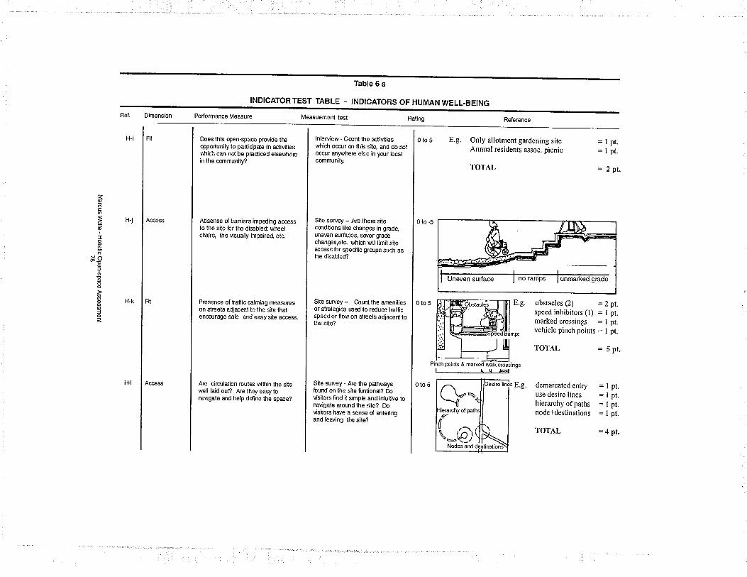
Bef. D¡mension
H-i Frt
Þõ
ÉõI9-
õ'{@̂à,ol
ÞÞo
o
3of
PerformanceMeasure Measuement tesl
Table 6 a
INDICATORTEST TABLE - INDICATORS OF HUMANWELL-BEING
Does this open-space prov¡de ttEopp0rtunily to particípde in activit¡esv.fi¡ch can nd be pracl¡ced elsewñerein the ccmmunity?
H-j Ac€ess Absense d ban¡ers impeding accessto the site br tlE dísabled wfEelcfEirs, lhe visually ¡mpaired etc.
t-t-k Frt
lnterview - Ccünt the aclivitieswhich occur m this site, and do mlocflr anwl'Ere else in yqlr localc6nmunily.
Presence of traffic calming measureson streets aqacent to the site thatencc:rage sab and eæysite access.
H-l
Rat¡ng
Site suruey - Are there sitecmdrt¡ons like cilanges in grade,úre\en surhces, swer gradechanges,etc. which will limit siteaccess for specific grqlps such ashe disabled?
0to5
Are circrlalion routes t/lihin lhe silewel¡ laid out? A¡e lhey easy tonavigate and help ddine the space?
E.g. Only allotment gardening siteAnnual residents assoc. picnic
TOTAL
Ste $rvey - CoLnt lhe arnenit¡esor stÉìteeies used to reduce trafficspeed or flow on slreets adjacer{ lotfE s¡tê?
Reference
Site survey - Are the pdh\4aysfound on the site fmtional? Dovisitors find it sÌmple and ir{uitive torEvigate aromd the site? Dov¡sitors have a sense d enterirEand leaving tfÊ sile?
0to5
=lpt.:lpt.
= 2pt.
Pinch points & markeã
0to5 evo----û
obstacles (2) :Zpt.speed inhibitors (l) = I pt.markedcrossings =lpt.vehicle pinch points = I pt.
TOT.A,L = 5 pt.
(:ø;Nodes and
demarcated entryuse desire lineshierarchy ofpathsnode+destinations
TOTAL
pt.
pt.pt.
pt.
=4pt.
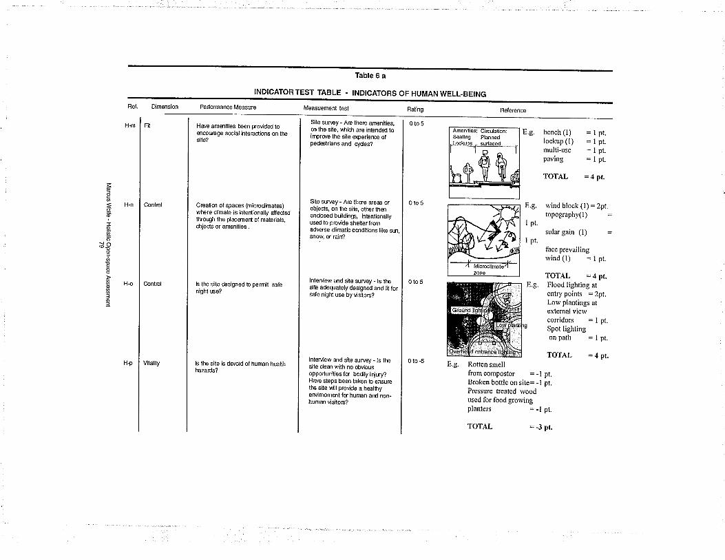
Ref.
H-m
Dimension
Fit
Þ
c
=Õ@
-L{^o5
EÞo
o
3o3
Performance Measure
Have amenities been provided toencourage social interaclions on ttÊsite?
Table 6 a
INDICATORTEST TABLE . INDICATORS
H-n CÆntml C€alim of spaces (microd¡mates)wflere cl¡mate is intent¡onally dfec1edlhrough the dacemerìt of mater¡als,objects or aÍìenilies.
H{
Measuement test
Conlrol
Site sunêy - Are there arnenities,m the site, ,âh¡cñ are inþnded toimpror'e the site êçerierEe ofped€trians and cydes?
b ttE site ésigned to perm¡t safenighl rEe?
H-p
OF HUMAN WELL-BEING
Vitality
Ste swey - Are lhere areas orobiects, on he siþ, other thenenclosed búldings, ¡ntentionallyused to prov¡de shelterfromadverse cl¡matic cmditions l¡ke sm,snow or ra¡n?
Rating
0to5
b ttls site is ds/oid of human heatthl,ìazards?
lnterv¡ew a,ld site suruey - ls llìesite adeWate¡y designed and lit forsde night use by visitors?
Beference
0to5
E.g. bench (1)lockup (l)r¡ulti-usepaving
lnterview and site survey - ls lhesite clean with no obviousopportunilies for bodly iriwy?Have steps been laken to ensurethe sile \Âill provide a healhyervimoment for hunEn and non-human visilors?
0tos
TOTAL = 4 pr.
E.g. rvind block (l):2pt.topography(l)
I pt.
pt.
pt.pt.pt.
I pt.
0lo-5
solar gain (l)
face prevailingwind(l) =1pt.
TOTAL = 4 pt.Flood lighting atentry points = 2pt.Lorv plantings atexternal viervcorridors : I pt.Spot lightingonpath :1pt.
TOTAL = 4 pr.
E.g.
E.g. Rotten smellfrom compostor = -lBroken bottle on site: -lPressure treated woodused for food grorvingplanters = -l
TOTAL
pt.pt.
pt.
= -3 pt.
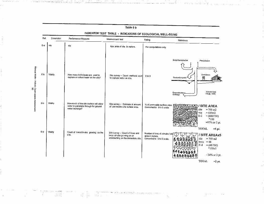
Dimens¡on
Ðõc
ãodr9.
POoJ!Þoo
o
3oJ
Performancê Measure
INDICATORTEST TABLE - INDICATOFS OF ECOLOGICALWELL.BEING
Vitality Hoe many techn¡ques are used tocaptue or collect water on tiÞ s¡te?
Measuement lest
Vitalily
Table 6 b
Apx. area of site in rneters.
How much of he Ste su'face will allowwater to percolate throlgh br grourdwaler recharge?
Vilality
Raling
Site survey - Count rnethods usto capture wder on site.
For computdions only.
Comt of lreegshrLbssite.
Ste $rvey - Eslirnate d arnohtof pern¡eaue site surface area.
Fìeference
gro/v¡ng on the
0to5
EvapolransplEtion
S¡te survey - Count of fees andlarge shrubs growing on orencroaching m the immed¡ate site.
% of pemeauê surhce area.Corvertedto Oto S scale.
Precipitation
recl¡atge
Number of trees & sfuubs /area in metefs.Corvertedto 0to 5 scale.
/ SITE AREAsite =700 m2veg = 680m2E_c = (6s0/700)
* 100
=97%;o or 5 pt.
TOTÁ.L :5 pt.
/ SITE AREAxSsire :700 m2trees = 48E-d = (48/700)
* 100x5
:34%o or 2 pt.
TOTÂL =2 pr.
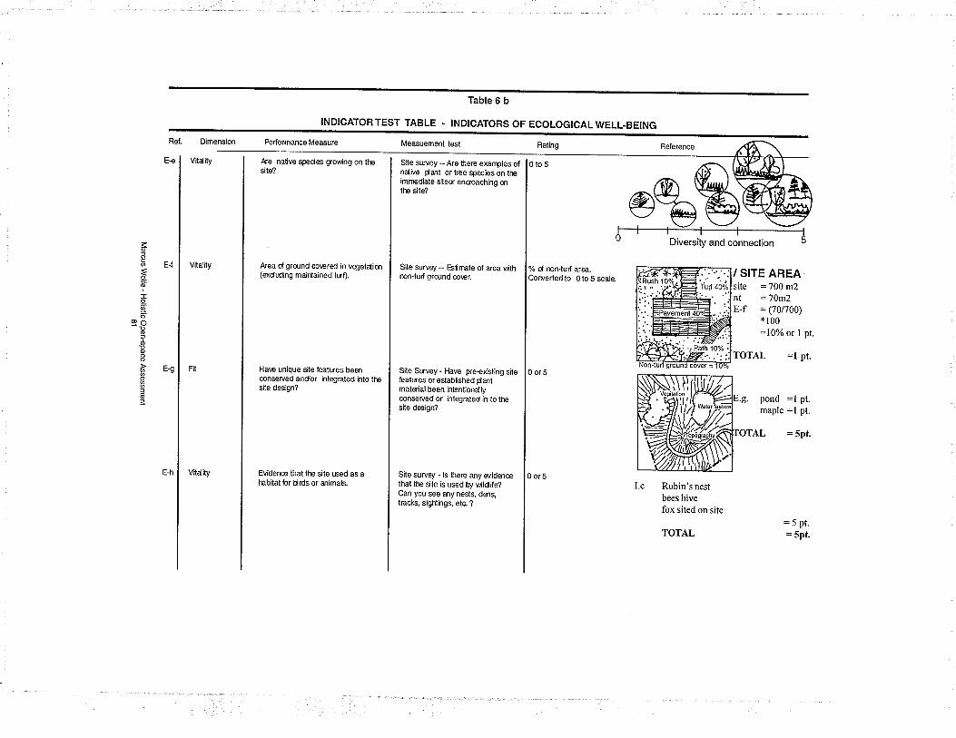
E€
Dimension
Vitality
É
ÉôõI9-õo
9s)o=Þp@
o
3oÞ
Performance Measure
Table 6 b
INDICATORTEST TABLE - INDICATORS OF ECOLOGICALWELL-BEING
Æesite?
nalive species growing on the
Vitality Area d gründ co\,ered in vegetdim(excluding majntained lurf).
E{
Measuement lest
Site srwey -- Are heæ examples olndive dant ortree species on liìeimrnediate siteor encoadling mttþ site?
Ha\€ un¡que site featLres beenconserved andor integrated into t¡Esite des¡gn?
Vitality
Site suruey - Eslimate of area wilhnon-turf grdjnd co\er.
Raling
EviderEe that ttìe site used as afsbitat br tirds or animals.
Site Süvey - Have pre€x¡st¡ng sileÞatLJres or established Cantmaterial been intentionallyconserved or integrated in to ttìesile design?
% d non-turf area.Corvertedto 0to 5 scaie
Referencê
Site survey - ls bere any widarcethat ltþ site is used by wildile?Can you see any nests, dens,tracks, sightings, etc. ?
0 or5
Diversity and connection
0 or5
/ SITE AREAsite :700 m2nt =70m2E_f = (70/700)
* 100:10% or I pt
TOTAL =l pr.
I.e Robin's nestbees hivefox sited on site
TOTAL
pond :l pt.maple :l pt.
TAL = spt.
:5 pt.
= spt.
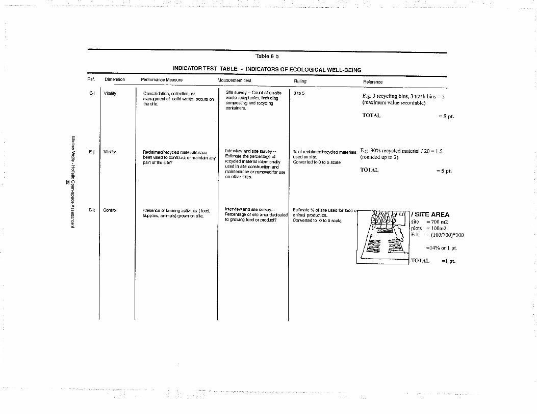
D¡mension
Vitality
Þocãõ-g=oó^of
Þp@
o
3of
Performance Measure
Table 6 b
INDICATORTEST TABLE . INDICATORS OF ECOLOGICALWELL-BEING
Cmsol¡dation, collection, ormanagmert of solid wasle occtjrs onttÞ sìte
E-j Vilalily Reclaimedrecycled maleri als har'ebeen used to corEtruc{ or mainta.¡n anypart of ltÊ sile?
Measuement tesl
Site survey -- Col.nt of on-sitewaste recedades, irdtdirìgcomposting and recyd¡ngcontaineß.
Preserre d farming activities ( food,s(pplies, animals) gro',n m site.
Rat¡ng
lnteMe$/ and sile survey --Eslirnate the percentaæ ofrecycled mater¡al ¡ntentionallyused in site corEûuction andmâ¡ntenance or renìoved for useon otiler sites.
0to5
lrierview and site suney.--Percentage of site area dedcatedto gror,lirE food or prodict?
% of reclaimed,tecycled mderialsused m site.Con\erted lo 0 to 5 scale.
Beference
E.g. 3 recycling bins, 3 træh bins:5(maximum value recordable)
TOTÂL :5 pt.
Est¡mate % of site used for bodanimal prodr¡ctim.C,orverted to 0 lo 5 scale.
E.g. 30% recycled material / 20 : 1.5(rounded up to 2)
TOTAL = 5 pr.
/ SITE AREAsite :700 m2plots :100m2E-k : (100/700)*100
=14%;o or I pt.
TOTAL :l pt.
4. Findings and Discussion
A series of eight projects have been examined in the
course of this study. All of these projects are located inthe communities of Hamilton and Burlington, Ontario.
Both communities have expanding subdivisions, which
are very different in layout and character than their
older core neighbourhoods. Neighbourhood and popu-
lation sizes are roughly the same in both cities.
ldentifying Projects
Potential projects were identified by contacting a vari-
ety of support agencies operating in the area. Such
organizations include The United Way, Friends of the
Environment Foundation, and local community devel-
opment agencies. Representatives from these organi-
zations have provided contact information on projects
their organizations have sponsored or have assessed.
Review of community funding reports by these organi-
zations has played an important roll in locating poten-
tial projects and in contacting project representatives.
Type of Project Reviews
All eight projects reviewed have been initiated by 1o-
cal community members with additional support from
a combination of public and private agencies. Sup-
porting agencies have played a crucial, yet indirect,
role in the planning and development of projects by
providing monies and services when required. In sev-
eral cases, support agencies were involved in site modi-
Marcus Wolfe - Holistic Open-space Assessment83
fication and construction. All of the projects included
were designed to serve the needs of the local commu-
nity, yet they are still accessible to the general public.
Scope of Anatysis
All projects have completed some phase of develop-
ment and have an understanding of how additional
development would be integrated into the existing site
design. Evaluations have been limited to the work as
it stands at the time of evaluation. The analysis of each
project is then, a snapshot ofthe status ofeach project.
This single evaluation can not be used as an absolute
marker of a project's success or failure. Rather the rat-
ing should be seen as a marker along the project's evo-
lution.
Each project has been evaluated in the same manner
using a series of predetermined interview questions
and site evaluation techniques (see Appendix E).
All participants were made aware of the studies pur-
pose and investigation process before they participated.
In all cases, project representatives provided some form
of site tour. Although this was not a required compo-
nent of the study, it did help validate and clarify the
information provided.
Eval uation Presentation
Each project evaluated is presented as a monograph.
The monograph attempts to allow the reader to be-
come moderately more familiar with each project. As
Marcus Wolfe - Holistic Open-space Assessment84

part of the monograph, a holistic evaluation is pre-
sented for each project using the Barometer model.
The holistic rating is aiso presented as part of a com-
posite chart in the discussion of the findings (see Fig-
ure25).
Marcus Wolfe - Holistic Open-space Assessment85
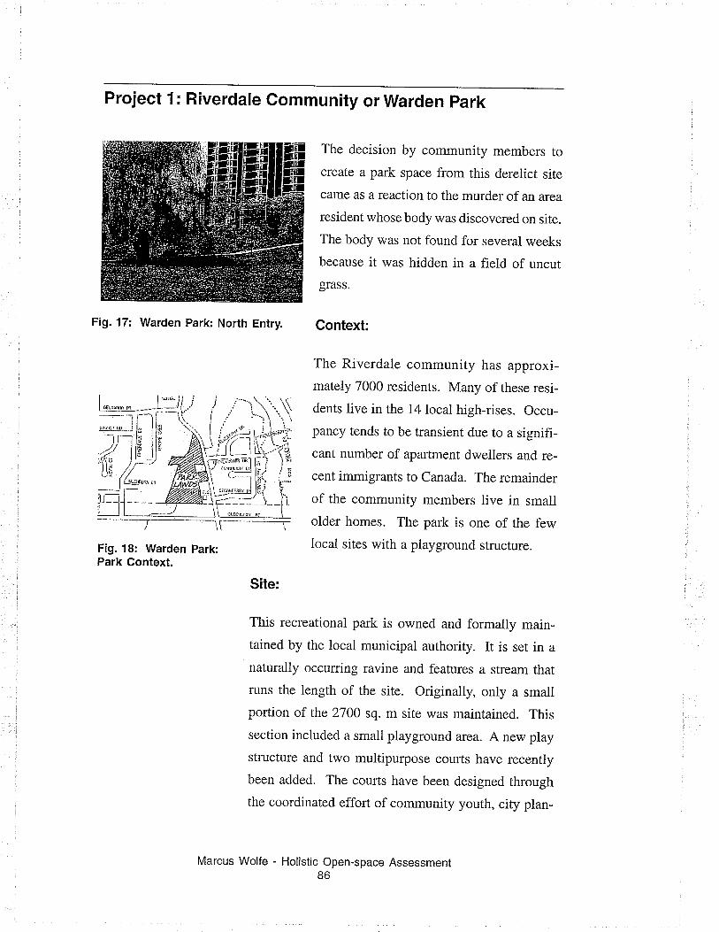
Project 1: Riverdale Gommunity or Warden park
The decision by community members to
create a park space from this derelict site
came as a reaction to the murder of an area
resident whose body was discovered on site.
The body was not found for several weeks
because it was hidden in a field of uncut
grass.
Context;
The Riverdale community has approxi-
mately 7000 residents. Many of these resi-
dents live in the 14 local high-rises. Occu-
pancy tends to be transient due to a signifi-
cant number of apartment dwellers and re-
cent immigrants to Canada. The remainder
of the community members live in small
older homes. The part is one of the few
local sites with a playground structure.
Site:
This recreational park is owned and formally main-
tained by the local municipal authority. It is set in anaturally occurring ravine and features a stream that
runs the length of the site. Originally, only a small
portion of the 2700 sq. m site was maintained. This
section included a small playground arca. A new play
structure and two multipurpose courts have recently
been added. The coufts have been designed through
the coordinated effort of community youth, city plan-
Fig. 17: Warden Park: North Entry.
Fig. 18: Warden Park:Park Context.
Marcus Wolfe - Holistic Open-space Assessment86
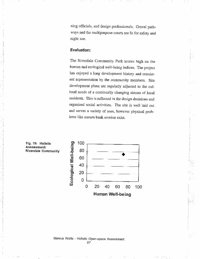
Fig. 19: HolisticAssessment:Riverdale Community
ning officials, and design professionals. Gravel path-
ways and the multipurpose courts are lit for safety and
night use.
Evaluation:
The Riverdale Community Park scores high on the
human and ecological well-being indices. The project
has enjoyed a long development history and consist-
ent representation by the community members. Site
development plans are regularly adjusted to the cul_
tural needs of a continually changing stream of local
residents. This is reflected in the design decisions and
organized social activities. The site is well laid outand serves a variety of uses, however physical prob_
lems like stream bank elosion exist.
100
80
60
40
20
0
20 40 60 80 100
Human Well-being
ct¡
'õ-ctJotsG.9o¡oool¡l
Holistic Open-space Assessment87
Marcus Wolfe
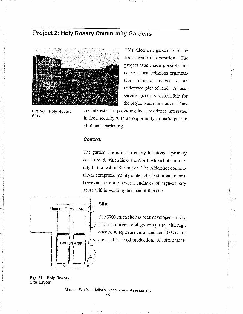
Project 2= Holy Rosary Community Gardens
This allotment garden is in the
first season of operation. The
project was made possible be-
cause a local religious organiza-
tion offered access to an
underused plot of land. A local
service group is responsible for
the project's administration. They
are interested in providing local residence interested
in food security with an opportunity to participate inallotment gardening.
Context:
The garden site is on an empty lot along a primary
access road, which links the North Aldershot commu-
nity to the rest of Burlington. The Aldershot commu-
nity is comprised mainly of detached suburban homes,
however there are several enclaves of high-density
house within walking distance of this site.
Site:
The 5700 sq. m site has been developed strictly
as a utilitarian food growing site, although
only 2000 sq. m arc cultivated and 1000 sq.m
are used for food production. All site ameni-
Fig. 20: Holy RoserySite.
I
Fig. 21: Holy Rosery:Site Layout.
Holistic Open-space Assessment88
Marcus Wolfe
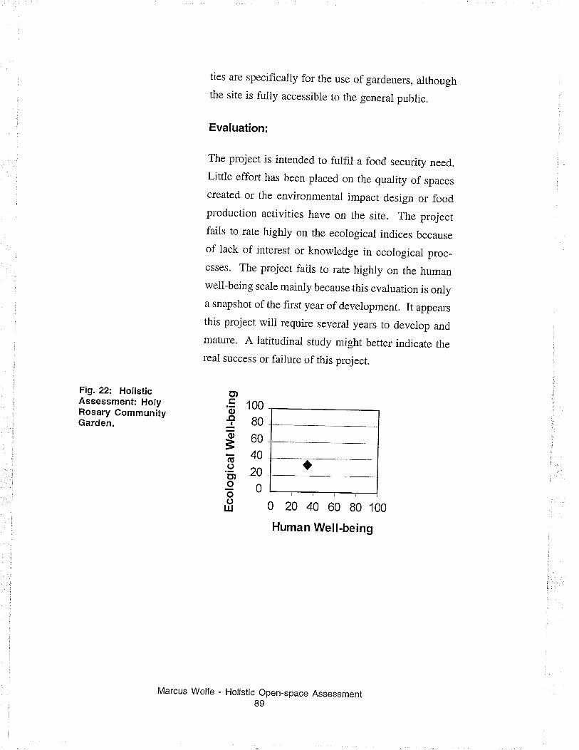
Fig.22: HotisticAssessment: HolyRosary GommunityGarden.
ties are specifically for the use of gardeners, althoughthe site is fully accessible to the general public.
Evaluation:
The project is intended to fulfil a food security need.
Little effort has been placed on the quality of spaces
created or the environmental impact design or foodproduction activities have on the site. The projectfails to rate highiy on the ecoiogical indices because
of lack of interest or knowledge in ecological proc_
esses. The project fails to rate highly on the humanwell-being scale mainly because this evaluation is onlya snapshot of the first year of development. It appears
this project will require several years to develop and
mature. A latirudinal study might better indicate rhe
real success or failure ofthis project.
100
80
60
40
20
0
0 20 40 60 80 100
Human Well-being
o,'õ
Iõ3õ.9o,ooo
IU
Marcus Wolfe - Holistic Open-space Assessment89
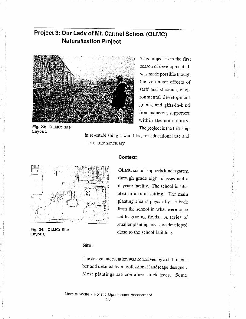
Project 3: Our Lady of Mt. Carmel School (OLMC)Natu ral ization Project
This project is in the first
season of development. Itwas made possible though
the volunteer efforts ofstaff and students, envi-
ronmental development
grants, and gifts-in-kind
from numerous supporters
within the community.
The project is the first step
in re-establishing a wood lot, for educational use and
as a nature sanctuary.
Context:
OLMC school supports kindergarten
through grade eight classes and a
daycare facility. The school is situ-
ated in a rural setting. The main
planting area is physically set back
from the school in what were once
cattle gtazing fieids. A series ofsmaller planting areas are deveioped
close to the school building.
Site:
The design intervention was conceived by a staff mem-
ber and detailed by a professional landscape designer.
Most plantings are container stock trees. Some
Fig. 23: OLMG: SiteLayout.
'/ :
ti rí\,
I
ir
Fig.24: OLMC: SiteLayout.
Marcus Wolfe - Holistic Open-space Assessment90
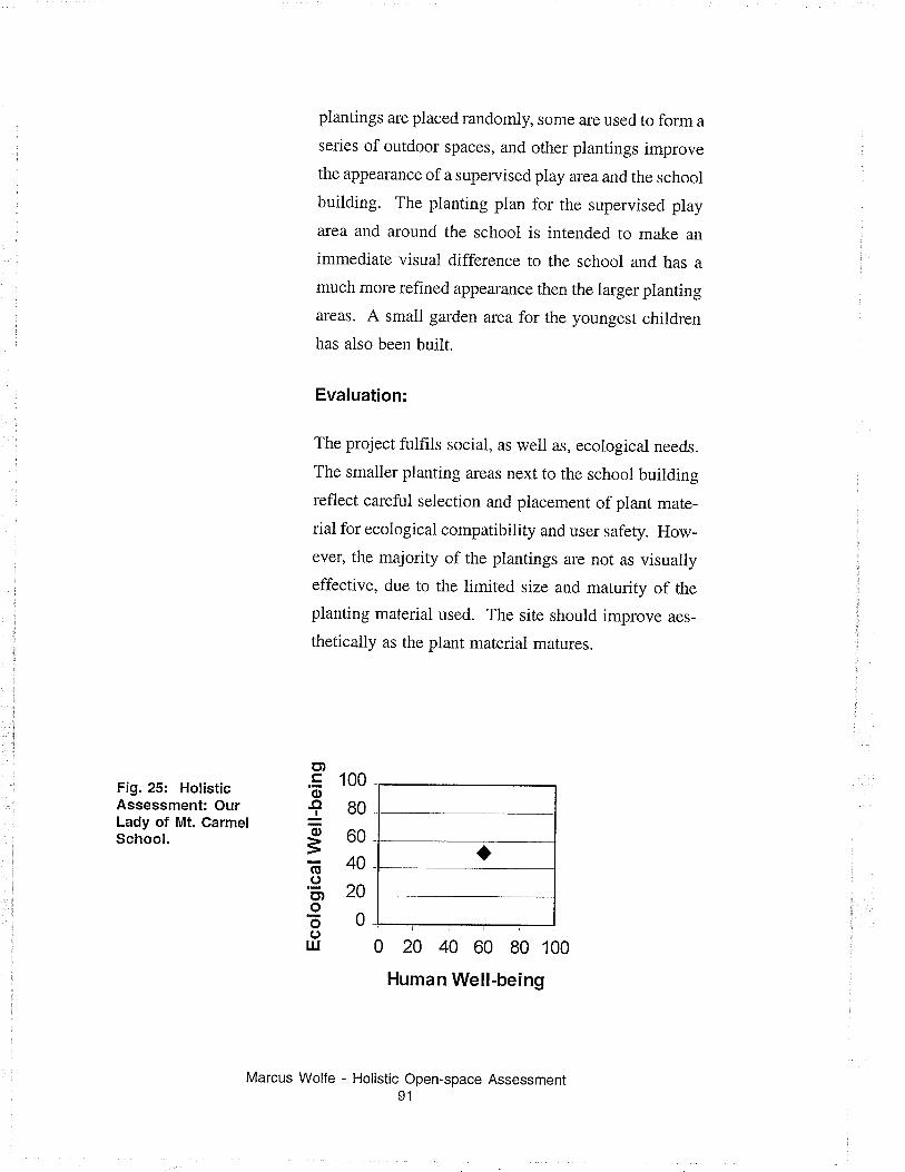
Fig. 25: HolisticAssessment: OurLady of Mt. CarmelSchool.
plantings are placed randomly, some ale used to form a
series of outdoor spaces, and other plantings improve
the appearance of a supervised play area and the school
building. The planting plan for the supervised play
area and around the school is intended to make an
immediate visual difference to the school and has a
much more refined appearance then the larger planting
areas. A small garden area for the youngest children
has also been built.
Evaluation:
The project fulfils social, as weil as, ecological needs.
The smaller planting areas next to the school building
reflect careful seiection and placement of plant mate-
rial for ecological compatibility and user safety. How-
ever, the majority of the plantings are not as visuaily
effective, due to the limited size and maturity of the
planting material used. The site shouid improve aes-
theticaily as the plant material matures.
100
80
60
40
20
0
0 20 40 60 80 100
Human Well-being
o,'õ-o+o
=E.9o,ooo
TU
Marcus Wolfe - Holistic Open-space Assessment91
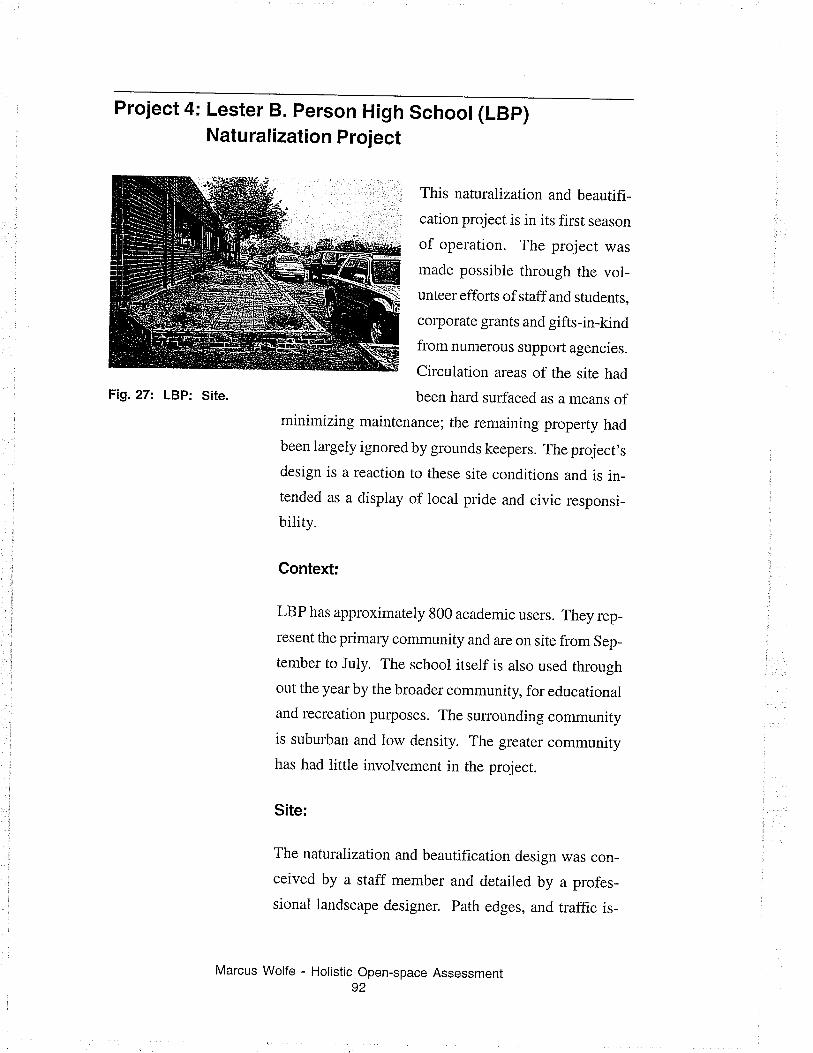
Project 4: Lester B. person High School (LBp)Naturalization Project
This naturahzation and beautifi-
cation project is in its first season
of operation. The project was
made possible through the vol-unteer efforts of staff and students,
corporate grants and gifts-in-kind
from numerous support agencies.
Circulation areas of the site had
been hard surfaced as a means ofminimizing maintenance; the remaining property had
been largely ignored by grounds keepers. The project,s
design is a reaction to these site conditions and is in_
tended as a display of local pride and civic responsi_
bility.
Context:
LBP has approximately 800 academic users. They rep-
resent the primary community and are on site from Sep_
tember to July. The school itself is aiso used through
out the year by the broader community, for educational
and rccreation purposes. The surrounding community
is suburban and low density. The greater community
has had little involvement in the project.
Site:
The naturalization and beautification design was con-
ceived by a staff member and detailed by a profes-
sional landscape designer. Path edges, and traffic is-
Fig.27: LBP: Site.
Marcus Wolfe - Holistic Open-space Assessment92
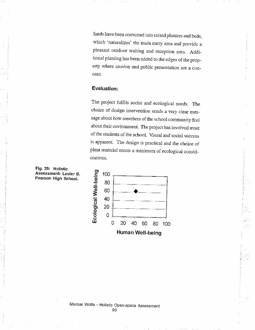
Fig. 28: HotisticAssessment: Lester B.Pearson High School.
lands have been converted into raised planters and beds,which 'naturalizes' the main entry area and provide a
pleasant outdoor waiting and reception ar-ea. Addi_tionai pianting has been added to the edges of the prop_erty where erosion and pubiic presentation are a con_
cern.
Evaluation:
The project fulfiis social and ecological needs. Thechoice of design intervention sends a very clear mes_
sage about how members of the schooi community feelabout their environment. The project has involved mostofthe students ofthe school. Visual and social success
is apparent. The design is practical and the choice ofplant materiai meets a minimum of ecological consid_erations.
100
80
60
40
20
0
0 20 40 60 80 100
Human Well-being
Holistic Open-space Assessment93
o,'õ-c¡Iõ
=E.(,o,oõoUJ
Marcus Wolfe
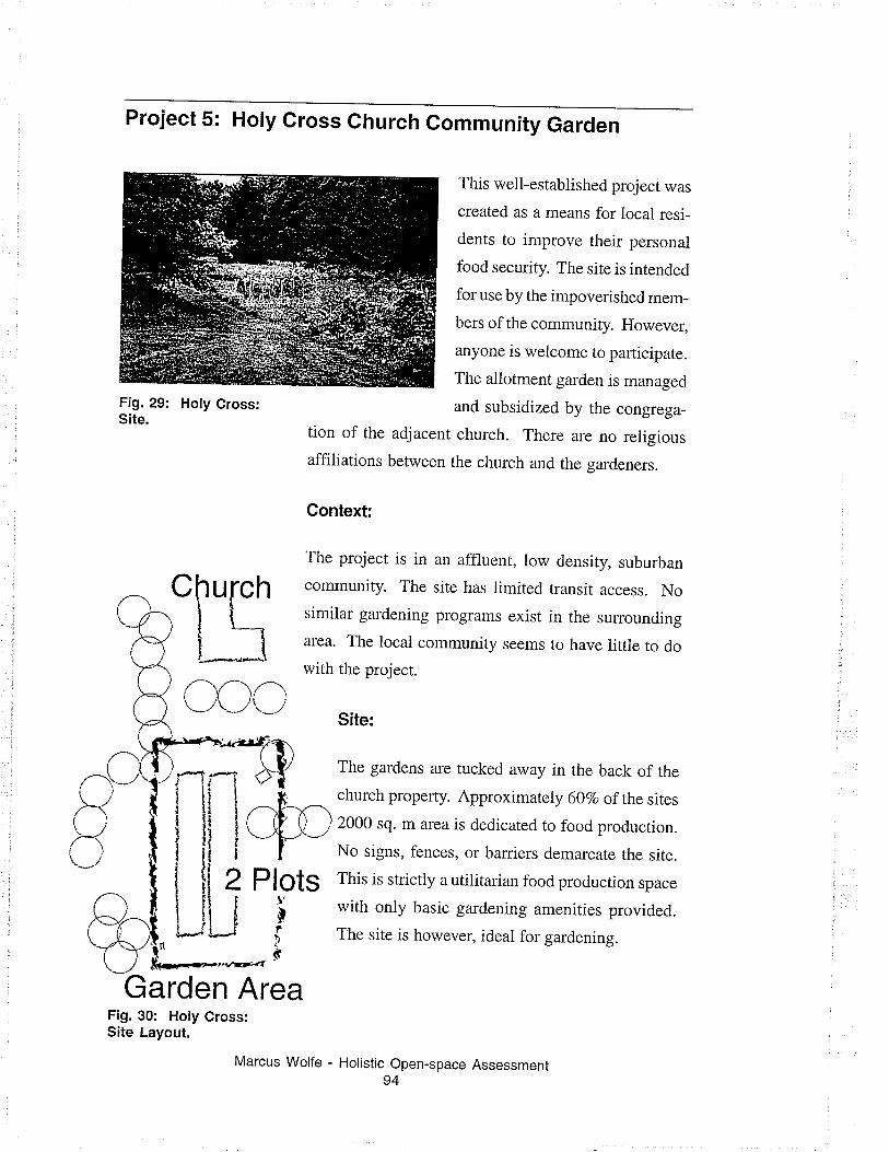
Project 5: Holy Gross church Gommunity Garden
Fig. 29: Holy Cross:Site.
tion of the adjacent
affiliations between
Context:
This well-established projecr was
created as a means for local resi-
dents to improve their personal
food security. The site is intended
for use by the impoverished mem-
bers of the community. However,
anyone is welcome to participate.
The allotment garden is managed
and subsidized by the congrega-
church. There are no religious
the church and the gardeners.
Plots
The project is in an affluent, low density, suburban
community. The site has limited transit access. Nosimilar gardening programs exist in the surrounding
area. The local community seems to have iittle to do
with the project.
Site:
The gardens are tucked away in the back of the
church property. Approximately 60Vo of the sites
2000 sq. m area is dedicated to food production.
No signs, fences, or baniers demarcate the site.
This is strictly a utilitarian food production space
with only basic gardening amenities provided.
The site is however, ideal for gardening.
Garden AreaFig. 30: Holy Cross:Site Layout.
Marcus Wolfe - Holistic Open-space Assessment94
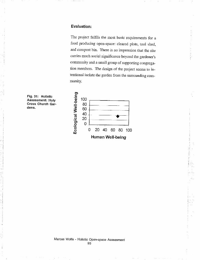
Fig. 31: HolisticAssessment: HolyCross Ghurch Gar-dens.
Evaluation:
The project fulfits the most basic requirements for afood producing open-space: cleared piots, tool shed,
and compost bin. There is no impression that the site
carries much social significance beyond the gardener's
community and a small group of supporting congrega_
tion members. The design of the project seems to in-tentional isolate the garden from the surrounding com-
munity.
0 20 40 60 80 100
Human Well-being
u,
s 100r80g60Ë40.9 20CDoUõolu
Marcus Wolfe - Holistic Open-space Assessment95
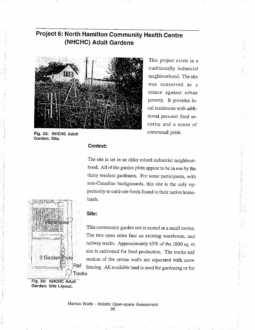
Project 6: North Hamilton(NHGHC) Adutr
Gommunity Health CentreGardens
This project exists in a
traditionally industrial
neighbourhood. The site
was conceived as a
stance against urban
poverty. It provides lo-
cal residences with addi-
tional personal food se-
curity and a sense ofcommunal pride.Fig. 32: NHCHC Adutt
Garden: Site.
NHCHC AdultSite Layout.
Context:
The site is set in an oider mixed industrial neighbour-
hood. All of the garden plots appear to be in use by the
thirty resident gardeners. For some par-ticipants, withnon-Canadian backgrounds, this site is the only op_
portunity to cultivate foods found in their native home-
lands.
Site:
This community garden site is nested in a small ravine.i 1 I hls communrty garden site is nested in a small ravine.
Í i The two open sides face an existing warehouse, and
) i lailway tracks. Approximately 65Vo of the 1g00 sq. mtt¿, i site is cultivated for food production. The tracks andl1
19,: section of the ravine walls are separared wirh snowI ,; Rail fencing. All available land is used for gardening or for{/ Tracks
Marcus Wolfe - Holistic Open-space Assessment96
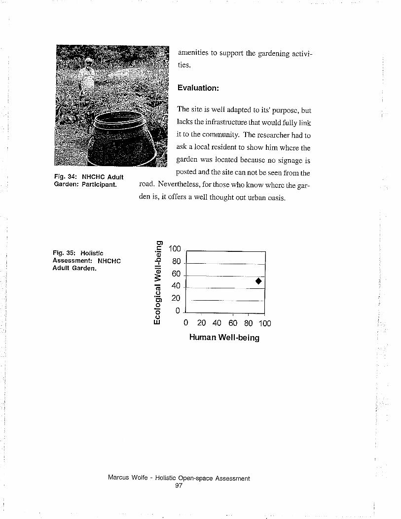
Fig. 34: NHGHC AdultGarden: Participant.
Fig. 35: HolisticAssessment: NHCHCAdult Garden.
amenities to support the gardening activi-
ties.
Evaluation:
The site is well adapted to its'purpose, but
lacks the infrastructure that wouid fuliy linkit to the community. The researcher had to
ask a local resident to show him where the
garden was located because no signage is
posted and the site can not be seen from the
road. Nevertheless, for those who know where the gar-
den is, it offers a well thought out urban oasis.
100
80
60
40
20
0
0 20 40 60 80 100
Human Well-being
o)'õ-a
õ
=õ.9u,oooIU
Holistic Open-space Assessment97
Marcus Wolfe
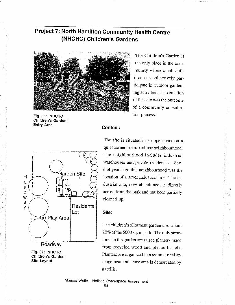
Project 7: North Hamilton community Health Gentre(NHCHC) Children's Gardens
The Children's Garden is
the only place in the com-
munity where small chil-
dren can collectively par-
ticipate in outdoor garden-
ing activities. The creation
of this site was the outcome
of a community consulta-
tion process.
Context:
The site is situated in an open park on aquiet corner in a mixed-use neighbourhood.
The neighbourhood includes industriaiwarehouses and private residences. Sev-
eral years ago this neighbourhood was the
location of a sever industrial fire. The in-
dustrial site, now abandoned, is directly
across from the park and has been partially
cleaned up.
Site:
The children's allotment garden uses about
20Vo of the 5000 sq. mpark. The only srruc-
tures in the garden are raised planters made
from recycled wood and plastic barrels.
Planters are organized in a symmetrical ar-
rangement and entry area is demarcated by
a trellis.
Fig.36: NHCHCChildren's Garden:Entry Area.
Roé,
dWav
Roadway
Fig. 37: NHCHCChildren's Garden:Site Layout.
Holistic Open-space Assessment98
Marcus Wolfe -
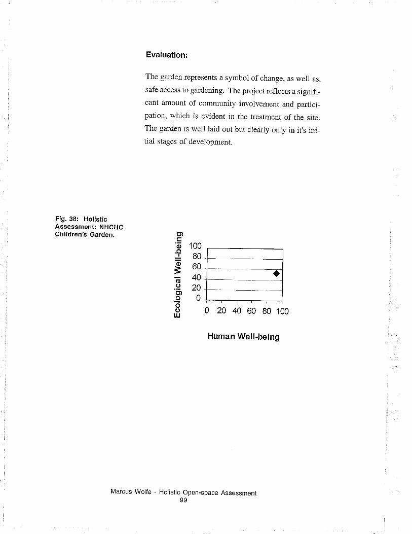
Fig. 38: HolisticAssessment: NHCHCChildren's Garden.
Evaluation:
The garden represents a symbol of change, as weii as,
safe access to gardening. The project reflects a signifi_
cant amount of community invoivement and partici_
pation, which is evident in the treatment of the site.
The garden is well laid out but cleariy only in it's ini_
tiai stages of development.
100
8060
4020
0
Human Well-being
o,'õ-oJõ
=E.9o,oõout
Marcus Wolfe - Holistic Open-space Assessment99
0 20 40 60 80 100
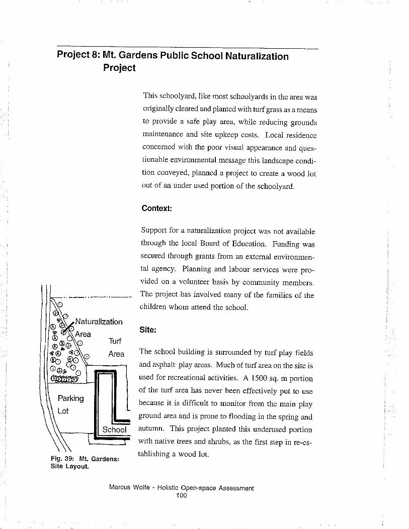
Project 8: Mt. Gardens Public school NaturalizationProject
This schoolyard, iike most schoolyards in the area was
originally cleared and pianted with turf grass as a means
to provide a safe play area, while reducing grounds
maintenance and site upkeep costs. Local residence
concerned with the poor visual appearance and ques-
tionable environmental message this iandscape condi-
tion conveyed, planned a project to create a wood lotout of an under used portion of the schoolyard.
Context:
Support for a naturalization project was not available
through the local Board of Education. Funding was
secured through grants from an external environmen-
tal agency. Planning and iabour services were pro-
vided on a volunteer basis by community members.
The project has involved many of the families of the
children whom attend the school.
Site:
The school building is sumounded by turf play fields
and asphalt play areas. Much of turf area on the site is
used for recreational activities. A 1500 sq. m portion
of the turf alea has never been effectively put to use
because it is difficult to monitor from the main play
ground area and is prone to flooding in the spring and
autumn. This project planted this underused poftion
with native trees and shrubs, as the first step in re-es-
tablishing a wood lot.Fig. 39: Mt. Gardens:Site Layout.
Marcus Wolfe - Holistic Open-space Assessment100
-s^-treo ,Aoooe'o6
Parking
Lot
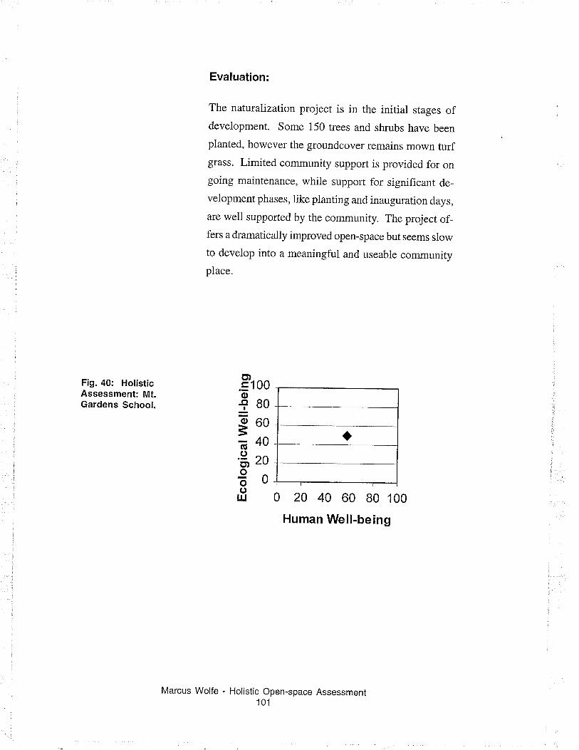
Fig. 40: HolisticAssessment: Mt.Gardens School.
Evaluation:
The naturalization project is in the initial stages ofdevelopment. Some 150 trees and shrubs have been
planted, however the groundcover remains mown turfglass. Limited community support is provided for on
going maintenance, while support for significant de-
velopment phases, like planting and inauguration days,
are well supported by the community. The project of-fers a dramatically improved open-space but seems slow
to develop into a meaningful and useable community
place.
0 20 40 60 B0 100
Human Well-being
õ).= 100of80*- 60
õ40'3' zo
€oouJ
Holistic Open-space Assessment101
Marcus Wolfe
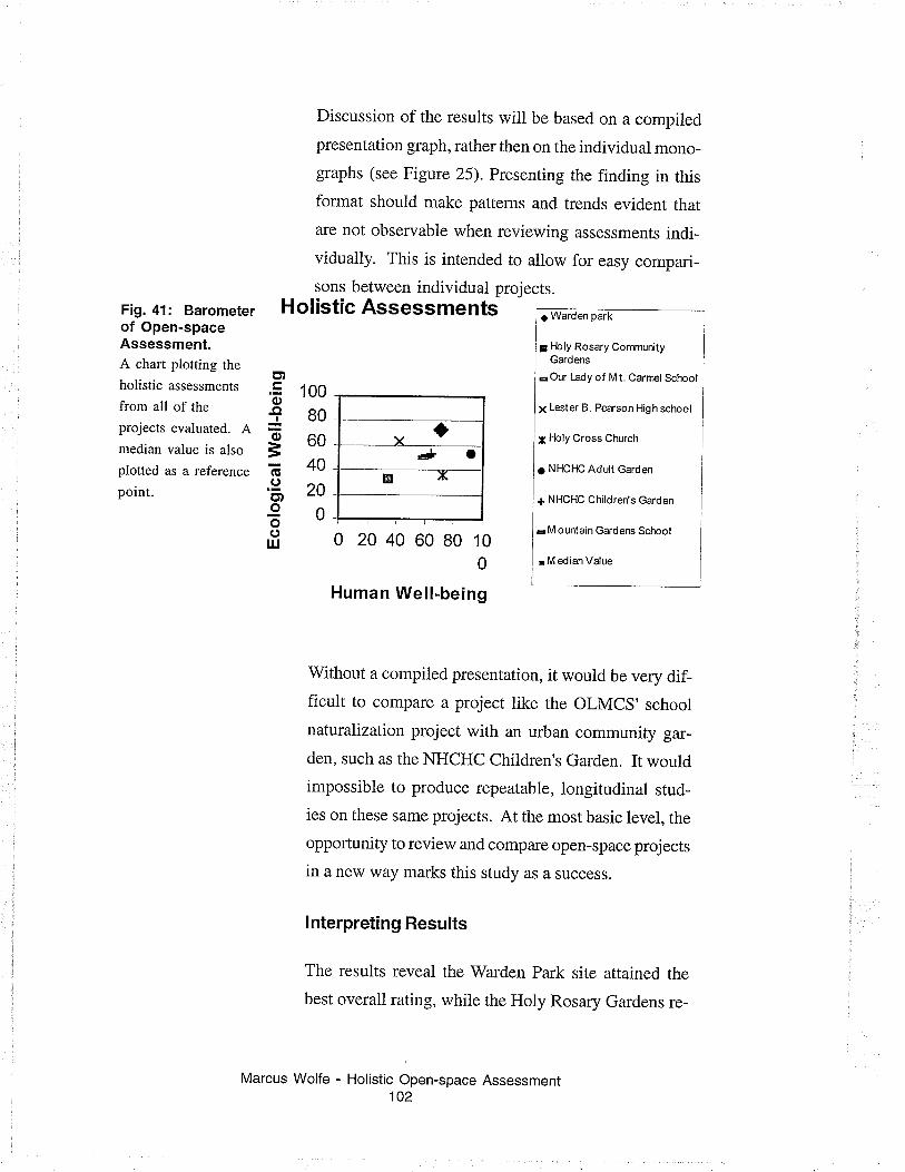
Fig. 41: Barometerof Open-spaceAssessment.A chart plotting the
holistic assessments
from all of the
projects evaluated. Amedian value is also
plotted as a reference
point.
YtÈ* o
ø x
E)
o.oIo
=Ë.9ct,Ioo
IIJ
Discussion of the results will be based on a compiled
presentation graph, rather then on the individual mono-
graphs (see Figure 25). Presenting the finding in this
format should make patterns and trends evident that
are not observabie when reviewing assessments indi-vidually. This is intended to allow for easy compari-
sons between individual projects.Holistic Assessments ¡ Warden park
¡ Floly Rosary CommunityGardens
a Our Lady of M t. Carrnel School
¡ Lester B. Pearson High school
¡ l-bly Cross Church
¡ NHCHC Adult Garden
ç NHCHC Children's Garden
¡ M ountain Gardens School
¡ M edian Value
100
80
60
40
20
0
0 2040 6080100
Human Well-being
Without a compiled presentation, it would be very dif-ficult to compare a project like the OLMCS' school
naturalization project with an urban community gar-
den, such as the NHCHC Children's Garden. It would
impossible to produce repeatable, longitudinal stud-
ies on these same projects. At the most basic level, the
oppoftunity to review and compare open-space projects
in a new way marks this study as a success.
lnterpreting Results
The results reveal the Warden Park site attained the
best overall rating, while the Holy Rosary Gardens re-
Marcus Wolfe - Holistic Open-space Assessment102
ceived the poorest rating. The other projects are dis_
tributed between these two values. This does not nec_
essarily mean that the Warden park site is superior toall other projects.
Each evaluation is a snapshot of the project,s status atone particular instant in time, rather then an absoluterating of worth. since the evaruation sessions wereheld between May and July 2000, it is possible thatprojects with strong seasonai development patterns,like gardening sites, would be at a disadvantage, ifsurveyed before the season had begun or after it hadended. This could be the case for the Holy Rosary site.Seasonal considerations should be considered in fu_
ture evaluations.
Patterns andTrends
Viewing the cluster of results reveais no definitive pat_
terns. The findings appear. to be independent of vari_ables such as: project maturity, site function, or loca_tion. This suggests the indicator test effectively meas_
ures a range of different type of open_space projects, orpossibly, the sample size is too small to define anypatterns. A larger sample size and statistical evalua_
tion would be needed to confirm if any latent patterns
exist within the data set.
lndicator lndices
One of the reasons the barometer method has been cho_
sen is because it offers some degree of data transpar_
ency. This allowance the reader to compare evalua_
Marcus Wolfe - Holistic Open-space Assessment103
tions of projects based on the performance of an indi_viduai index. This provides a greater understanding ofsite without resorting to minutiae of detail.
Results from the human index were not unexpected.
Urban agricultural projects show a modestly higherdegree of well-being than sites with otherprimary func_tions. Holy Rosary Community gardens is the excep_
tion and rates very poorly on both scales. Urban agri_
cuitural projects may rate higher on this index because
successful gardening requires a more consistent on_
site presence then any other type of open_space func_tion and greater opportunity to fosterrelationships withothers.
Comparison of the ecological index provided some_
what surprising and incongruent results. This suggests
probiems with the ecological index. Figure 25 shows
the OLMC's Naturalization project and the Children,sgarden receive very similar ecological ratings. Largenaturalization projects like the OLMC site, whichadded substantial amounts of plant material, that in_
crease habitat size and biotic diversity, should receivemuch higher ecological ratings than a small gardenproject, such as the children's garden. A project inten_
tionally designed to have a minimal impact on theexisting site. If these two projects rate almost equallyon the ecological index, clearly there is a problem withthe validity of the index or the indicator tests report onsomething other than ecological weil_being.
Reviewing the specific ecological indicator tests sug_
gests the second condition is true. Indicator tests for
Marcus Wolfe - Holistic Open-space Assessment104
this index report on things other than the ecologicalaspects of site. The ecological index has acted as acatch allfor ali physicai aspects site, including includesdesign issues, site functionality, and ecology. Further,none of the indicators are designed to directly repofion how the site influences the wider community. Indi_cators are specifically intended to examine how thephysical surroundings and human community interactwith the specific site. A real evaiuation of the ecologi_cal impact would require a substantially different indi_cator test suite. The intention of the instrument was toevaluate the condition of the specif,rc site. With this inmind renaming the ecological well_being index to thephysical site or built design index would be more ap_
proprÌate then redesigning the indicator suite.
Rating Results
The original Barometer of Sustainability uses the samex and y axis values to determine success threshords(See Figure 9). The same rating scale has been appliedhere. The evaluation range is capabie of representing a
variety of different site conditions. All of the projectevaluations fell well within the scale limits, with a
median value of approximately 60.
lndividual lndicatorTest
Most of the indicator tests
ward to gather and appear
were relatively straightfor-
to have produced accurate
Marcus Wolfe - Holistic Open-space Assessment105
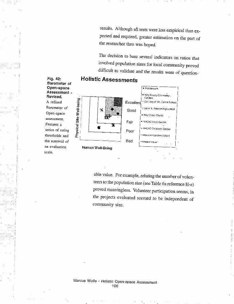
results. Although all tests were less empirical than ex_pected and required, greater estimation on the part ofthe researcher then was hoped.
The decision to base several indicators on ratios thatinvolved population sizes for local community proveddifficult to varidate and the results were of question-
Holistic Assessments. WadÐpak
r HotynosayConmritvGads6
Fig. 42:.Barometer ofOpen-spaceAssessment -Revised.A refined
Barometer ofOpen-space
assessment.
Features a
series of rating
thresholds and
the removal ofan evaluation.
scale.
ct,
o.Cl lr!oiÈioiØi(g¡.9iUtl>.,o-i
Excellen
Good
Fair
Poor
Bad
.* O.r tdy of Mt. Carg Sctuol
)( L6ts 8. p&rsonHighschlol
x Holy Cross Chrdl
. NHCHC Adúr cãdsì
+ NHCHC Cfitdrgl's Gadm
* MoLrtanGãds6 ScfÞot
. MediatVdæ'
Human WelhBeing
able value. For example, relating the number of volun_teers to the population size (see Table 6a reference H_e)proved meaningless. Voiunteer participation seems, inthe projects evaluated seemed to be independent ofcommunity size.
Marcus Wolfe - Holistic Open_space Assessment106
Summary
Overall, the Barometer of Open-space assessment pro-
vides a viable means to evaluate a series of projects by
offering an interpretation of data which cannot be com-
pared though traditional methods of site evaluation.
Once the findings have been reviewed in more detail,
problems arc discovered in the transparency of the re-
sults and with the ecoiogical index. Changes or refine-
ments to the actual presentation method can be made
to account for these problems. The renaming of the
ecological index to the index of structural well-being'
and the addition of performance thresholds are two ofthese changes.
Marcus Wolfe - Holistic Open-space Assessment107
5. Conclusions andRecommendations
The initial question sparking much of this inquiry into
holistic assessment, asked if there is an effective means
to evaluate the quality of open-space by comprehen-
sively assessing the social and design components of a
community supported open-space project.
There appeared no such means readily available to
make this type of inquiry. If a comprehensive project
appraisal was to be conducted, an instrument was re-
quired that could evaluate a range of project condi-
tions and integrate the findings into a more complete
and comparable appraisal. This tooi needed to con-
sider the formal design characteristics of site and the
subtle communal relationships that allow these sites to
be treated as places.
Consequently, an assessment method was designed,
based on an existing holistic assessment tool, which
assesses indicators of human and site specific well-be-
ing. The resulting community supported assessment
tool, The Barometer of Open-space, was field-tested on
a series of eight community supported open-space
projects.
Assessment results did not offer any specific insights
into the benefits of a particular design form, site func-
tion, or site component in creating quality open-spaces.
On the contraty, the analysis suggests a passive recrea-
tional, natulalized, or agrarian iandscape can work
equally well in a variety of different neighbourhood
Wolfe - Holistic Open-space Assessment108
Marcus
settings; if there is strong community leadership be-
hind the development and management of the project.
This assertion is supported by the evaluation results,
which show that most projects provide consistently
higher degrees of human weil-being then physical site
well-being.
The relationship between a strong community network
and project's success is supported by the practices ofsuccessful community supported open-space programs
like Montreal's Community Gardening Association.
The City of Montreal requires a core of local support
be established before the City is willing to provide
their expertise or funding support. This has proved to
be a very successful way of introducing community
supported urban agriculture in a range of neighbour-
hood settings.
A strong community focus does come at a cost. The
design choices and site organization of most projects
reviewed are very pragmatic and do not take full ad-
vantage of site specific design opportunities. It ap-
pears that the interviewed project representatives, for
the most part, have limited knowledge about the physi-
cal aspects of their sites and tend to limit the complex-
ity of site design to reflect their understanding. 'When
tasks require advanced design and building skills, like
the selection of exclusively native plant material or
the construction of a play structure, community activ-
ists are very good at obtaining necessary design and
building services on a voluntary or gift-in-kind basis.
The Lester B. Person project for example, used munici-
pal excavation equipment and received planting plans
Marcus Wolfe - Holistic Open-space Assessment109
from a professional garden designer. Without these
supports, the project would have been considerably
less ambitious.
To improve the quality of physical site well-being,
project developers need to find ways to increase their
awareness of physical site characterístics. A self-ad-
ministered form of the holistic evaluation instrument,
based on the assessment research conducted here, is
one approach to increasing site awareness because the
project developer must first become aware of physical
site indicators, if they are going to evaluate these indi-
cators. An alternative approach to improving aware-
ness of site characteristics is a community service that
educates project developers about physical site issues.
This consultation role would provide an outreach op-
portunity for the environmental design professional
interested in community supported open-space.
Overall, the instlument performs as expected, aliowing
information from a variety of different projects to be
gathered and compared. Including these results in the
development and policy decision process offers project
designers a means to predict the success of proposed
development choices and validate design decisions.
The assessment technique offers the environmental
designer a basis for developing a quality assurance
program, which will give insight into the designer's
strengths and weaknesses. In either case, it is vital to
ensure that the assessment process becomes a consist-
ent and long-term effort, to avoid skewed results.
Marcus Wolfe - Holistic Open-space Assessment110
Recommendations
As addressed in Section 4, the instrument and method
presented have several weaknesses, any of which could
be addressed and improved. Consequently, there are
several directions that additional research could fol-
low to improve the holistic assessment of community
supported open-space and the development of local
open-space.
1. Refinement and testing of alternative presen-
tation methods:
Four ways of aggregating and presenting performance
Íreasurements were considered during the course ofthis study (see Section 3). Applying the findings from
this study, for use with these other presentation meth-
ods would be one way of determining which presenta-
tion method is best suited for which audience.
2. Creation of a definitive, gener¡c su¡te of com-
munity open-space indicators:
In order to fufther develop a generic suite of indicators
for community open-space assessments, the next natu-
ral step, is to invite experts who hold a variety of land-
scape and community perspectives to review, refine,
and expand the existing indicator suite. A working
group of experts will provide additional indicators and
alternative approaches to testing and evaluation. Rec-
ognition that the tests directly reflect the interest and
Marcus Wolfe - Holistic Open-space Assessment111
concerns of a range of disciplines will also increase
instrument credibility as a more holistic tool for land-
scape assessment.
3. Create a design and development support
network:
There are a variety of organizations offering the serv-
ices and supports required by local community devel-
opers. However, many of these developers find it diffi-
cult to initially access these organizations. Conse-
quently, many projects are abandoned due to a lack of
initial support.
The creation of a design and development support net-
work gives an opportunity to improve access to sup-
port agencies by giving local community developers a
forum to share effective development strategies and
design experiences. This simplifies the process of ac-
cessing support agencies and permits developers to
direct more attention towards often-overlooked project
issues like site design.
4. Additional research into settlement form and
the relationsh¡p between site, citizen, and com-
mun¡ty:
This research only scratched the surface ofunderstand-
ing the mechanisms that link community and place.
The research was primariiy intended to see if a holistic
indicator test suite offered a suitable approach for a
more holistic assessment of community supported open-
space. Additional review of research into the areas ofhuman geography, architecture, and ecology may re-
Marcus Wolfe - Holistic Open-space Assessment
veal vital systems relationships not initially consid-
ered in the indicator selection process. These relation-
ships couid be the basis for additional indicator tests.
5. lntegration of remote and statistical informa-
tion:
A conscious effort was made during the instrument's
design process to examine the phenomenological as-
pects of place and processes of community develop-
ment. Very little remote or statistical information was
evaluated because these information sources could not
accurately describe the specific site or community con-
dition at the time of the evaluation.
However, statisticai data about site and community
characteristics are used as part of many other holistic
evaluations to improve the scope and accuracy of an
assessment. When the recommended longitudinal stud-
ies are undertaken, an assessment method, which would
include statistical or remotely gathered indicators,
should be evaluated.
6. Use the indicator suite as preparation for com-
m un¡ty open-space development:
The presented indicator suite (see Appendix E) exem-
plifies many of the important aspects of local open-
space. When the designer or community developer is
aware of all of these factors, they can better understand
how their decisions will affect the quality of the open-
space. They can then make better informed design and
Marcus Wolfe - Holistic Open-space Assessment113
development decisions, producing more meaningful
and functional open-spaces. This use of the indicator
suite is intended to increase the designer's awareness,
not to be used directly as a design tool.
The purpose of this research is to design and test an
instrument that provides a more holistic evaluation ofcommunity supported open-space projects. It is hoped
that pursuing these six recommendations can fufther
the development and refinement of the assessment in-
strument and improve the quality of the open-spaces
the Barometer of Open-space is designed to assess.
Marcus Wolfe - Holistic Open-space Assessment114
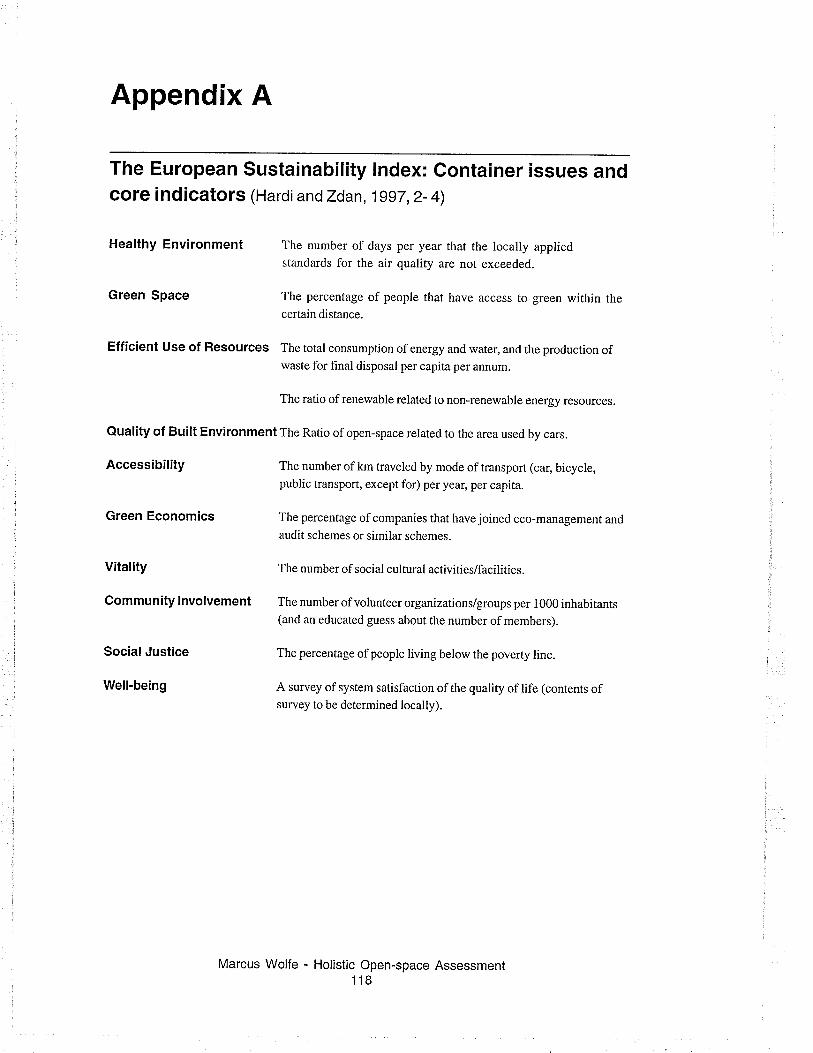
Appendix A
The European Sustainability lndex: Container issues andcore indicators (Hardi andZdan, 1997, 2- 4)
Healthy Environment rhe number of days per year rhat the locally appliedstandards for the air quality are not exceeded.
Green Space The percentage of people that have access to green within thecertain distance.
Efficient Use of Resources The total consumption of energy and water, and the production ofwaste for final disposal per capita per annum.
The ratio of renewable related to non-renewable energy resources.
Quality of Built Environment The Ratio of open-space related to the area used by cars.
Accessibility The number of km traveled by mode of rransporr (car, bicycle,public transport, except for) per yea¡ per capita.
Green Economics The percentage of companies that have joined eco-management and
audit schemes or similar schemes.
Vitality The number of social cultural activities/facilities.
Community lnvolvement The number of volunteer organizations/groups per 1000 inhabitants(and an educated guess about the number of members).
The percentage ofpeople living below the poverty line.
A survey of system satisfaction of the quality of life (contents ofsurvey to be determined locally).
Marcus Wolfe - Holistic Open-space Assessmenl118
SocialJustice
Well-being
Appendix B
Friends of the Environment Foundation
ÆWWffiFnrEms
"Since 1 990, the Friends ofthe Environment Foundation has beenencouraging Canadians to participate in the restoration of their localenv¡ronment. They knewwe needed leaders, people willing to take achance. They knew that making things beiter renews and heals us at thesame time. I urge you to join them in the quest to protect the naturalworld. By supporting the Friends ofthe Environment Foundation you arereserving the place you call home."
(Friends of the Environment, 2000)
of the" , Friends of the Environment Community FundEnvironmentFig. 43: Friends of theEñvironment Logo. The purpose of the Friends of the Environment Com-Friends of the munity Fund is to provide funding support for worth-Environment Foundation
(hrrp://www. fef .cat while community-based initiatives that make a posi-
main.html) provides tive difference to the Canadian environment. Localfunding support for advisory boards, made up of Canada Trust customersinitiatives that make a
positive impacr on rhe and employees, review the apprications and make rec-
Canadian environmenr. ommendations for funding support according to the
established guidelines. Grants will not generally ex-
ceed $10,000. Apptications are reviewed throughout
the year.
The Canada Fund considers projects that:. Protects and preserves the Canadian environment.
. Involves and benef,rts the local community.
. Increases awareness about environmental issues and
responsibilities.
. Makes a positive difference to the health of our envi-
ronment.
. Takes place within the geographic scope of the Com-
munity Fund chapter.
Marcus Wolfe - Holistic Open-space Assessment119
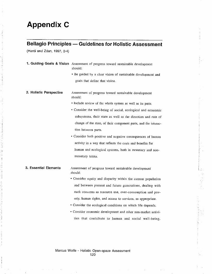
Appendix C
Bellagio Principles - Guidelines for Holistic Assessment(Hardi and Zdan, 1997,2-4)
1. Guiding Goals & Vision Assessment of progress toward sustainable developmentshould:
. Be guided by a clear vision of sustainable development and
goals that define that vision.
2. Holistic Perspective Assessment of progress toward sustainable developmentshould:
. Include review of the whole system as well as its parts.
. Consider the well-being of social, ecological and economic
subsystems, their state as well as the direction and rate of
change of the state, of their component parts, and the interac-
tion between parts.
. Consider both positive and negative consequences of human
activity in a way that reflects the costs and benefits for
human and ecological systems, both in monetary and non-
monetary terms.
Assessment of progress toward sustainable developmentshould:
. Consider equity and disparity within rhe currenr population
and between present and future generations, dealing with
such concerns as resource use, over-consumption and pov-
erty, human rights, and access to services, as appropriate.
. Consider the ecological conditions on which life depends.
. Consider economic development and other non-market activi-
ties that contribute to human and social well-being.
Marcus Wolfe - Holistic Open-space Assessment120
3. Essential Elements
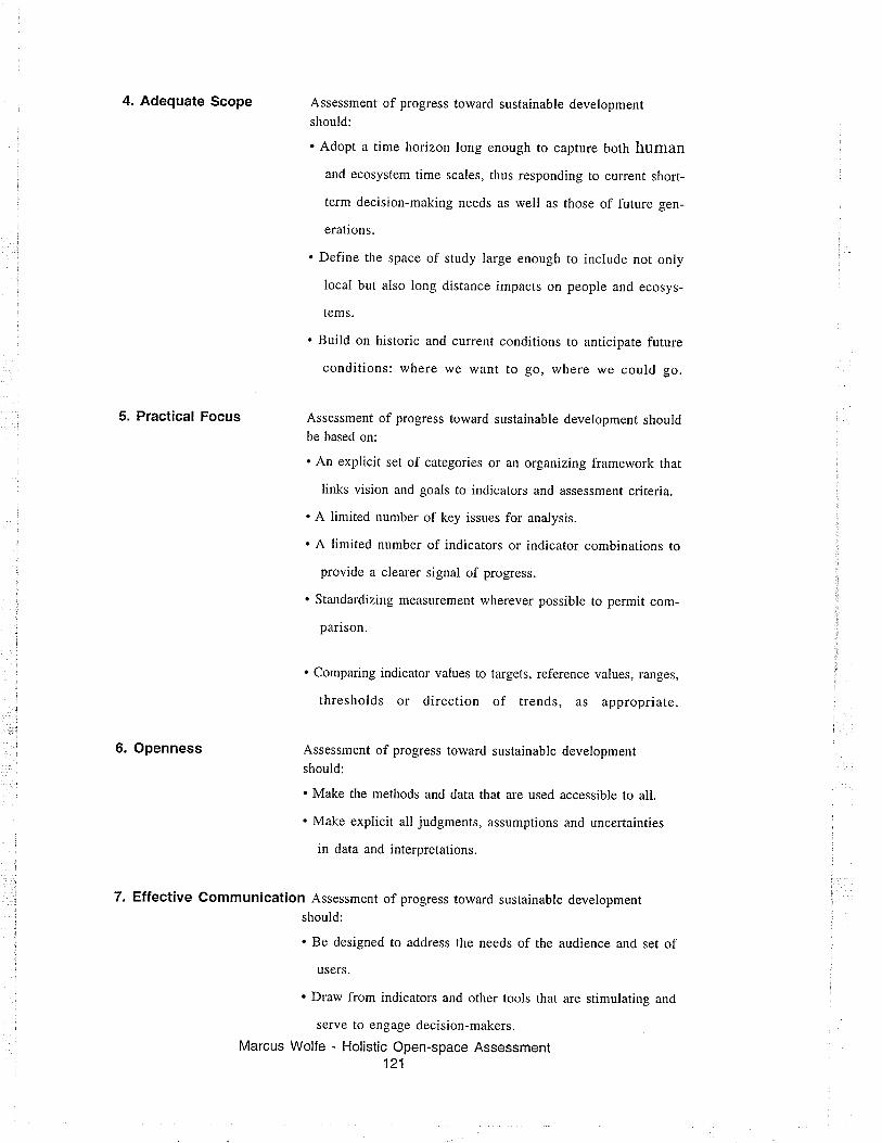
4. Adequate Scope Assessment of progress toward sustainable developmentshould:
. Adopt a time horizon long enough ro capture both human
and ecosystem time scales, thus responding to current short-
term decision-making needs as well as those of future gen-
erations.
. Define the space of study large enough to include not only
local but also long distance impacts on people and ecosys-
tems.
. Build on historic and current conditions to anticipate future
conditions: where we want to go, where we could go.
5. Practical Focus Assessment of progress toward sustainable development shouldbe based on:
. An explicit set of categories or an organizing framework that
links vision and goals to indicators and assessment criteria.
. A limited number of key issues for analysis.
. A limited number of indicators or indicator combinations to
provide a clearer signal of progress.
. Standardizing measurement wherever possible to permit com-
parison.
. Comparing indicator values to targets, reference values, ranges,
thresholds or direction of trends, as appropriate.
6. Openness Assessment of progress toward sustainable developmentshould:
. Make the methods and data that are used accessible to all.
. Make explicit all judgments, assumptions and uncertainties
in data and interpretations.
7. Effective Communication Assessment of progress toward sustainable developmentshould:
. Be designed to address the needs of the audience and set of
users.
. Draw from indicators and other tools that are stimulating and
serve to engage decision-makers.
Marcus Wolfe - Holistic Open-space Assessment121

. aim, from the outset, for simplicity in structure and use of
clear and plain language.
8. Broad Participation Assessment of progress toward sustainable developmentshould:
. Obtain broad representation of key grassroots, professional,
technical and social groups, including youth, women and
indigenous people to ensure recognition of diverse and chang-
ing values.
. Ensure the participation of decision-makers to secure a firm
Iink to adopted policies and resulting action.
9. Ongoing Assessment Assessment of progress toward sustainable developmentshould:
. Develop a capacity for repeated measurement to determine
trends.
. Be iterative, adaptive and responsive to change and uncer-
tainty because systems are complex and change frequently.
. Adjust goals, frameworks and indicators as new insights are
gained.
. Promote development of collective learning and feedback to
decision-making.
10. lnstitutional Capac¡ty Continuity of assessing progress toward sustainable develop-ment should be assured by:
. Clearly assigning responsibility and providing ongoing sup-
port in the decision-making process.
. Providing institutional capacity for data collection, mainte-
nance and documentation.
. Supporting development of local assessment capacity.
Marcus Wolfe - Holistic Open-space Assessment122
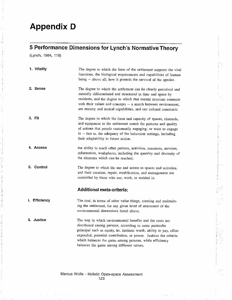
Appendix D
5 Performance Dimensions for(Lynch, 1984, 118)
Lynch's Normative Theory
1. Vitality
2. Sense
3. F¡t
4. Access
5. Control
i. Efficiency
ii. Justice
The degree to which the form of the settlement supports the vitalfunctions, the biological requirements and capabilities of humanbeing -- above all, how it protects the survival of the species.
The degree to which the settlement can be clearly perceived and
mentally differentiated and structured in time and space byresidents, and the degree to which that mental structure connectswith their values and concepts -- a match between environment,are sensory and mental capabilities, and our cultural constructs.
The degree to which the form and capacity of spaces, channels,and equipment in the settlement match the patterns and qualityof actions that people customarily engaging, or want to engage
in -- that is, the adequacy of the behaviour settings, includingtheir adaptability to future action.
the ability to reach other persons, activities, resources, services,information, workplaces, including the quantity and diversity ofthe elements which can be reached.
The degree to which the use and access to spaces and activities,and their creation, repair, modification, and management are
controlled by those who use, work, or resided in.
Additional meta-criteria:
The cost, in terms of other value things, creating and maintain-ìng the settlement, for any given level of attainment of the
environmental dimensions listed above.
The way in which environmental benefits and the costs are
distributed among persons, according to some particularprincipal such as equity, he, intrinsic worth, ability to pay, effortexpended, potential contribution, or power. Justices the criteriawhich balances the gains among persons, while efficiencybalances the gains among different values.
Marcus Wolfe - Holistic Open-space Assessment123
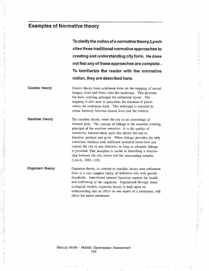
Cosmic theory
Machine theory
Organism theory
Examples of Normative theory
Marcus Wolfe - Holistic Open-space Assessment124
To clarify the notion of a normative theory, Lynch
cites three traditional normative approaches to
creat¡ng and understanding city form. He does
not feel any of these approaches are complete .
To familiarize the reader with the normative
notion, they are described here.
Cosmic theory basis settlement form on the mapping of sacred
images, icons and forms onto the landscape. This providesthe basic ordering principal for settlement layout. Themapping is also used to prescribes the function of places
within the settlement form. This technique is intended tocreate harmony between human lives and the cosmos.
The machine theory, treats the city as an assemblage ofdiscrete parts. The concept of linkage is the essential orderingprincipal of the machine metaphor. It is the quality ofconnection between these parts that allows the city to
function, produce and grow. When linkage provides the onlyconstraint, builders with sufficient technical know-how can
expand the city in any direction, as long as adequate linkageis provided. This metaphor is useful in describing a relation-ship between the city centre and the surrounding suburbs(Lynch, 1984, 118).
Organism theory, in contrast to machine theory sees settlementfbrm as a one complex entity, of definitive size with growththresholds. Interrelated internal functions support the healthand well-being of the organism. Popularized through many
ecological models, organism theory is built upon an
understanding that an effect on one aspect of a settlement, willaffect the entire settlement.

Appendix E
Survey Site Questionnaire and Worksheet
Holistic Open-space Assessment Survey SheetDate:
Assessor:
Contact lnformation
Organization:
Contact:
Phone Number:
Address:
Funding Organization:
Site lnformation
Project Name:
City:
Community:
Description of Open-space:
Marcus Wolfe - Holistic Open-space Assessment125
Orientation Map
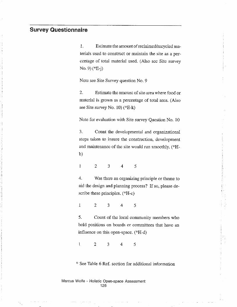
Survey Questionnaire
1. Estimate the amount of reclaimed/recycled ma-
terials used to construct or maintain the site as a per-
centage of total material used. (Also see Site survey
No.9) (*E-j)
Note see Site Survey question No. 9
2. Estimate the amount of site area where food or
material is grown as a percentage of total area. (Also
see Site survey No. 10) (*E-k)
Note for evaluation with Site survey Question No. 10
3. Count the developmental and organizational
steps taken to insure the construction, development
and maintenance of the site would run smoothly. ('*H-
b)
4. Was thele an organizing principle or theme to
aid the design and planning process? If so, please de-
scribe these principles. ('FH-c)
1
5. Count of the local community members who
hold positions on boards or committees that have an
influence on this open-space. ('kH-d)
'r' See Table 6 Ref. section for additional information
Marcus Wolfe - Holistic Open-space Assessment126
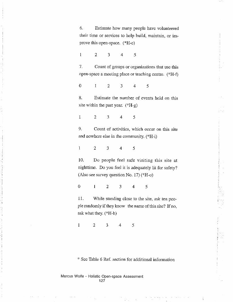
6. Estimate how many people have volunteered
their time or services to help build, maintain, or im-
prove this open-space. (*H-e)
12345
7. Count of groups or organizations that use this
open-space a meeting place or teaching centre. ('FH-Ð
012345
L Estimate the number of events held on this
site within the past year. (*H-g)
12345
9. Count of activities, which occur on this site
and nowhere else in the community. ('kH-Ð
12345
10. Do people feel safe visiting this site at
nighttime. Do you feel it is adequately lit for safety?
(Also see survey question No. 17) ('FH-o)
012345
I 1. While standing close to the site, ask ten peo-
ple randomiy if they know rhe name of this site? If no,
ask what they. (xH-h)
12345
'r' See Table 6 Ref. section for additional information
Marcus Wolfe - Holistic Open-space Assessment127
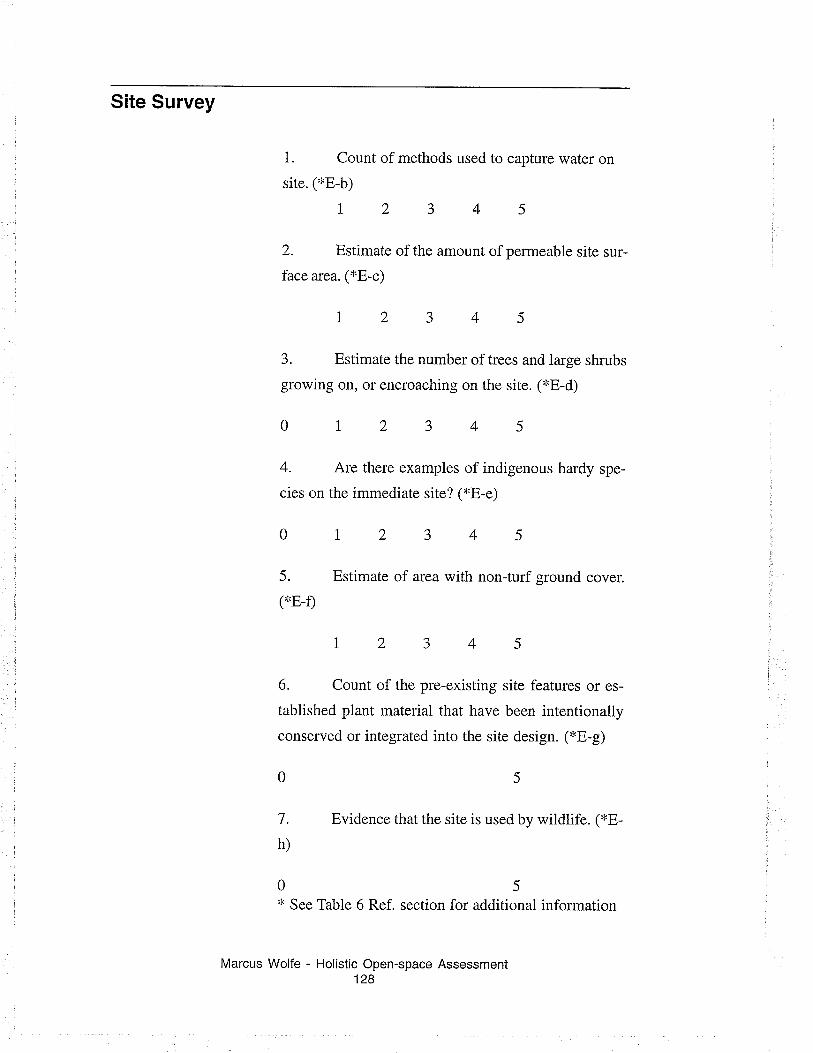
Site Survey
1. Count of methods used to capture water on
site. (*E-b)
12345
2. Estimate of the amount of permeable site sur-
lace arca. (,'E-c)
12345
3. Estimate the number of trees and large shrubs
growing on, or encroaching on the site. (*E-d)
0t2345
4. Are there examples of indigenous hardy spe-
cies on the immediate site? (i'E-e)
0t2345
5. Estimate of area with non-turf ground cover.
('r.E-Ð
t2345
6. Count of the pre-existing site features or es-
tablished plant material that have been intentionally
conserved or integrated into the site design. (*E-g)
7. Evidence that the site is used by wildlife. (r'B-
h)
05'r' See Table 6 Ref. section for additional information
Marcus Wolfe - Holistic Open-space Assessment128
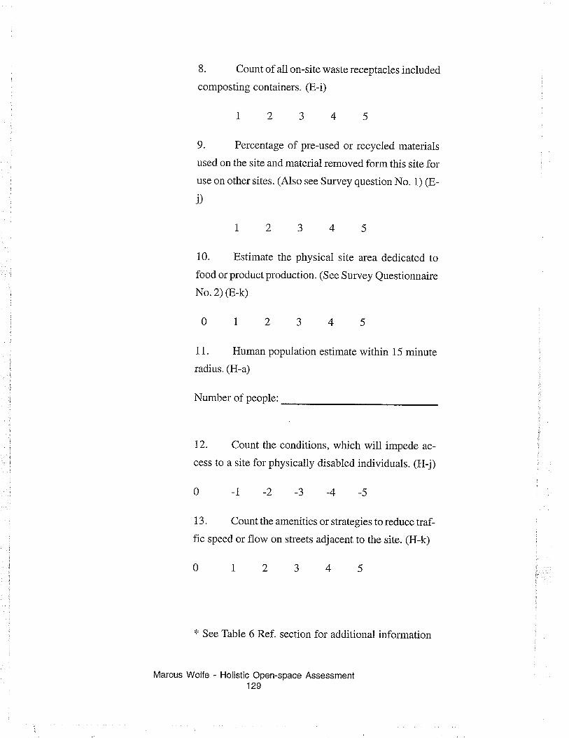
8. Count of all on-site waste receptacles included
composting containers. (E-i)
12345
9. Percentage of pre-used or recycied materials
used on the site and material removed form this site for
use on other sites. (Also see Survey question No. 1) (E-
j)
12345
i0. Estimate the physical site area dedicated to
food or product production. (See Survey Questionnaire
No.2) (E-k)
012345
11. Human population estimate within 15 minute
radius. (H-a)
Number of people:
12. Count the conditions, which will impede ac-
cess to a site for physically disabled individuals. (H-j)
01-2-3-4-5
13. Count the amenities or strategies to reduce traf-
fic speed or flow on streets adjacent to the site. (H-k)
012345
'r' See Table 6 Ref. section for additional information
Marcus Wolfe - Holistic Open-space Assessment129

14. Evaluate pathways for functionality. Are en-
try and exits defined? *H-l)
r2345
15. Count the amenities provided to improve the
site experience for pedestrian and cyclists. (*H-m)
0t2345
16. Count of the areas within the site, which are
used as microclimates--areas which are used because
they are protected from adverse climatic conditions.
('tH-n)
012345
Il. Is the site adequately lit for safe night use?
(Also see related survey questions No. 10 ) ('tH-o)
012345
18. Count the conditions that may cause harm to
humans or animals. ('tH-p)
0-1-2-3
19. Site area in square
-4 -5
metres. ('FE-a)
Site area in square metres:
'r' See Table 6 Ref. section for additional information
Marcus Wolfe - Holistic Open-space Assessment130
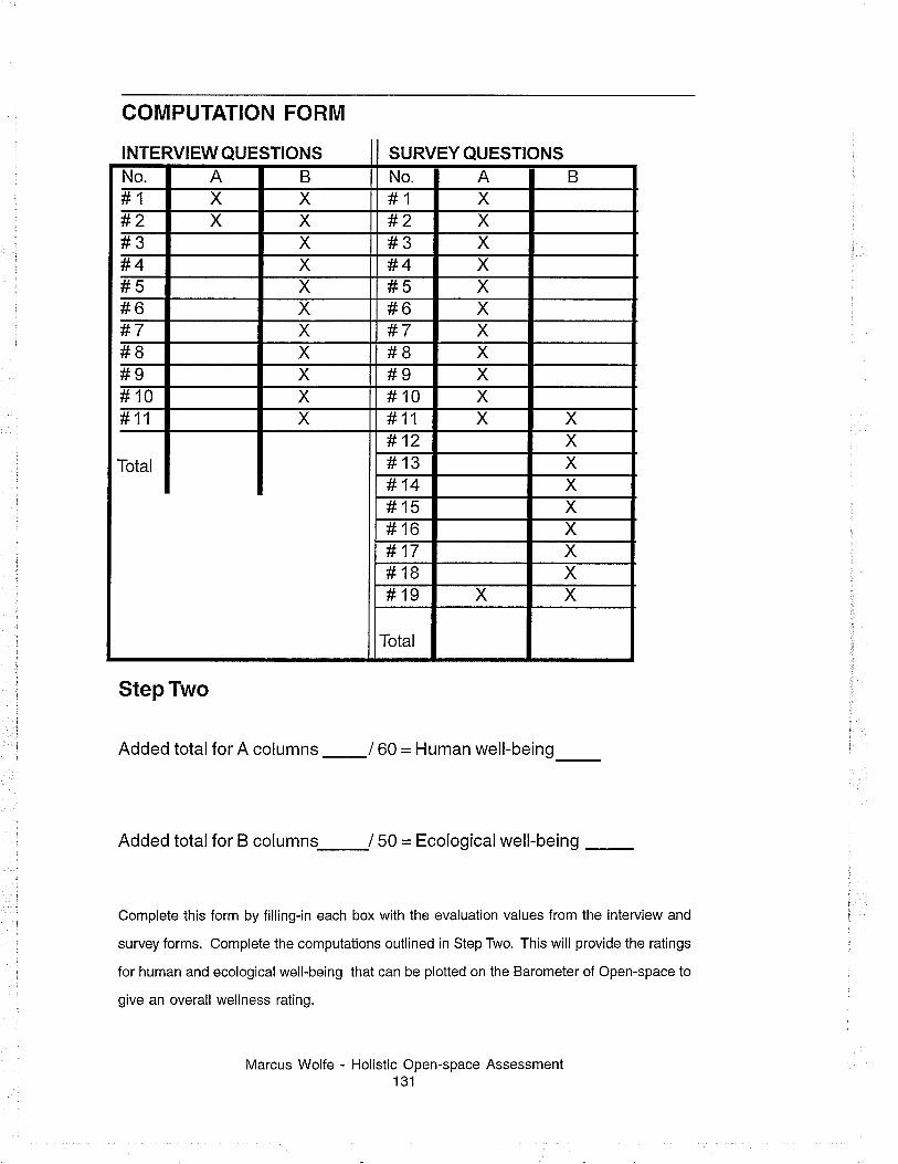
INTERVIEW QUESTIONS SURVEY QUESTIONS
COMPUTATION FORM
Step Two
Added total for A columns _160 = Human well-being
Added total for B columns-/ 50 = Ecologicalwell-being
Complete this form by filling-in each box with the evaluation values from the interview and
survey forms. Complete the computations outlined in Step Two. This will provide the ratings
for human and ecologicalwell-being that can be plotted on the Barometer of Open-space to
give an overall wellness rating.
Marcus Wolfe - Holistic Open-space Assessment131
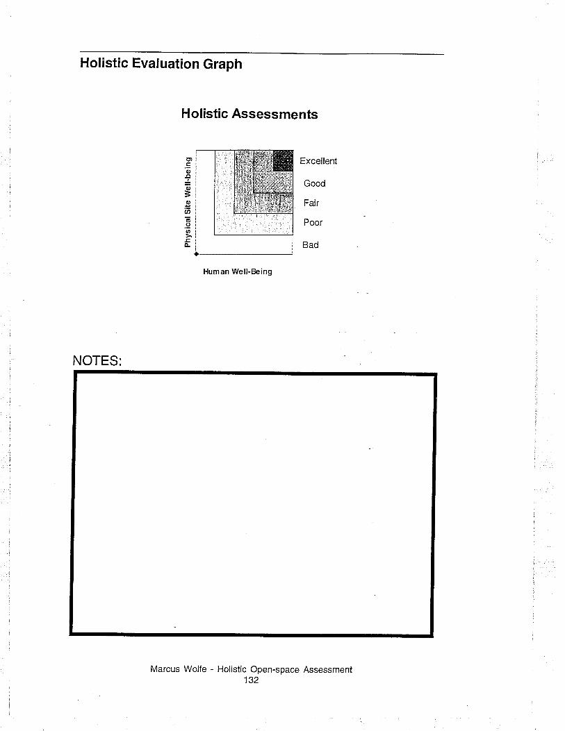
Holistic Evaluation Graph
Holistic Assessments
Excellent
Good
Fair
Poor
Bad
Human Well-Being
NOTES:
Marcus Wolfe - Holistic Open-space Assessment132
Et.E0,
-lo
=c,EØa!-.9IJ'
È


