Embed Size (px)
Citation preview

Hofstaðir2013.Interimreport
Hildur Gestsdóttir & Oddgeir Isaksen
FS533-910116
Reykjavík
2014
2
©Fornleifastofnun Íslands
Bárugötu 3
101 Reykjavík
Sími: 551-1033
Fax: 551-1047
Veffang: [email protected]

3
TableofcontentIntroduction ..................................................................................................................................... 5
Previous seasons. .......................................................................................................................... 5
1999-2004 ............................................................................................................................... 5
2010......................................................................................................................................... 7
2011......................................................................................................................................... 7
2012......................................................................................................................................... 8
Methods ....................................................................................................................................... 9
Results ............................................................................................................................................. 9
Southern area ............................................................................................................................. 10
Post-1717 ............................................................................................................................... 10
1477-1717 ............................................................................................................................. 13
1300-1477 ............................................................................................................................. 14
Pre-1300 ................................................................................................................................ 16
The cemetery ............................................................................................................................. 17
Pre 1300 ................................................................................................................................ 17
Future work ............................................................................................................................... 17
References ...................................................................................................................................... 19
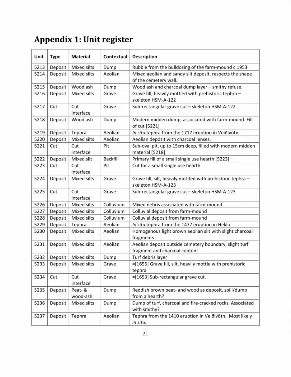
Appendix 1: Unit register ............................................................................................................... 21
Appendix 2: Finds register .............................................................................................................. 24
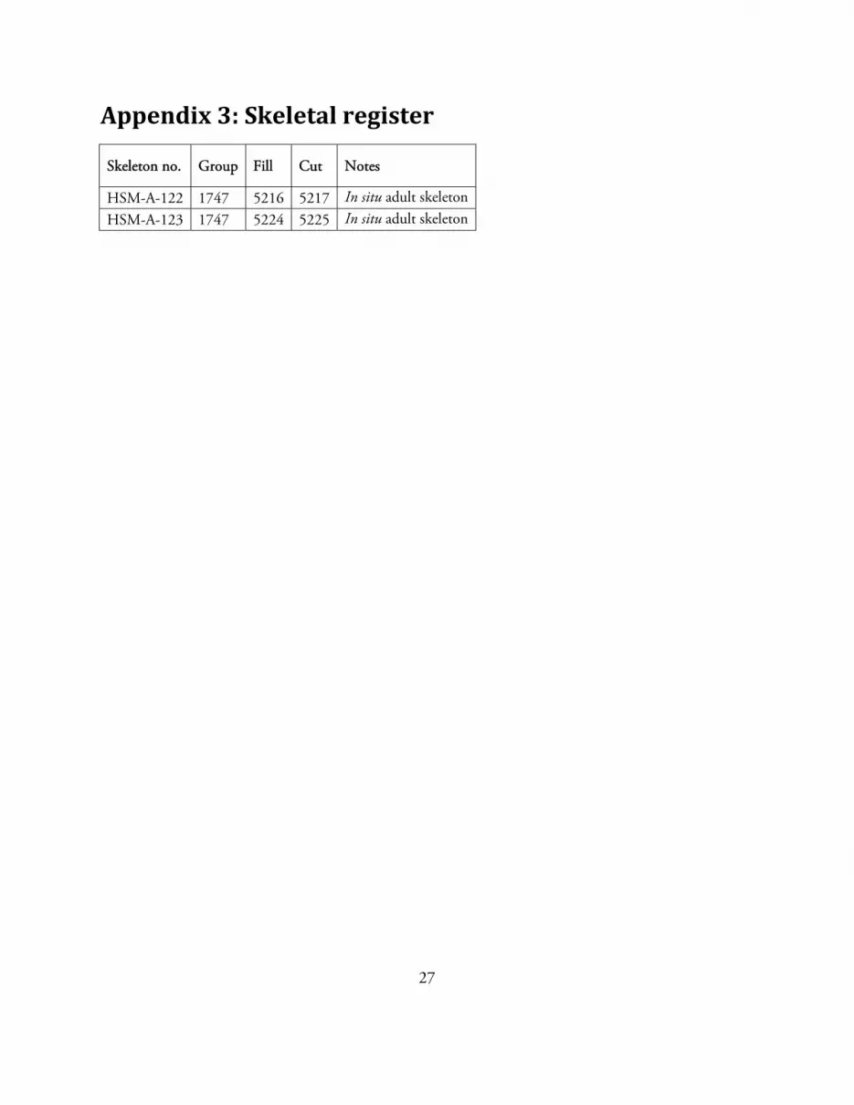
Appendix 3: Skeletal register .......................................................................................................... 27
4
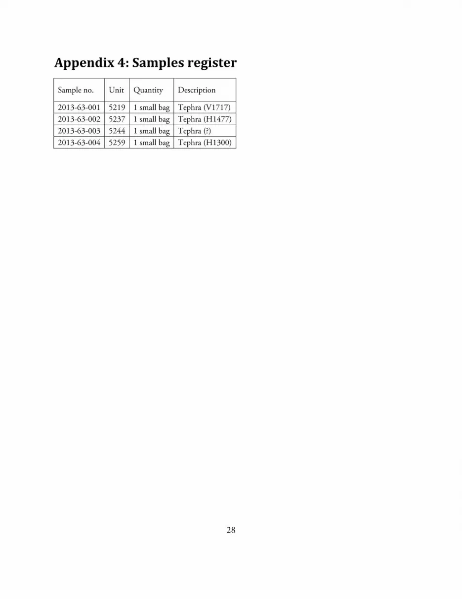
Appendix 4: Samples register .......................................................................................................... 28
Appendix 5: Bibliography for Hofstaðir ......................................................................................... 29
Reports ....................................................................................................................................... 29
Publications ............................................................................................................................... 29
Dissertations/theses .................................................................................................................... 30
Ph.D. ..................................................................................................................................... 30
M.Sc ...................................................................................................................................... 30
M.A. ...................................................................................................................................... 30
B.A. ........................................................................................................................................ 30
Current projects using Hofstaðir skeletons ................................................................................. 31
Ph.D. ..................................................................................................................................... 31
Post-doc ..................................................................................................................................... 31

5
IntroductionThe 2013 excavation season at Hofstaðir was four weeks, from the 5th to the 30th of August. This is
the fourth season since excavations started again in 2010 after a hiatus. Those who took part were
archaeologists Hildur Gestsdóttir (project manager), Oddgeir Isaksen (12th-30th August), Stefán
Ólafsson, Nikola Trbojevic and Liam Lanigan. In addition, Brenda Prehal, a Ph.D. student from
Hunter Collage, City University of New York joined the excavation for one week (12th-19th August).
Funding for the project was provided by Fornminjasjóður and The National Science Foundation
(CIE grant) through Dr. T. McGovern and the North Atlantic Biocultural Organisation (NABO).
Tephrochronology demonstrates that the cemetery at Hofstaðir went out of use before 1300,
although use of the church itself may have continued. The main aim of the investigation is to carry
out a comprehensive investigation of an early medieval church and cemetery, to increase our
understanding and knowledge of church structures and burial practises from the period in Iceland.
With that in mind, the long term aim of the investigation is to excavate the entire cemetery, not only
inside the cemetery boundary, but also outside it to investigate whether there are structural features
located outside it, and in particular whether there are any extramural burials of individuals who for
some reason could not be laid to rest in sacred ground.
Another aim of the project is to carry out intensive osteoarchaeological analysis of the human skeletal
remains. Some research projects have already been carried out using the Hofstaðir skeletal remains.
For detail of these, see Appendix 5.
Previousseasons.
1999‐2004
Archaeological investigations in the cemetery at Hofstaðir started in 1999. Geophysical surveys
revealed a circular boundary, approximately 30m in diameter with an irregularity in its centre. Trial
trenches revealed burials within the boundary, and central structural remains. In 2000 an area
approximately 231m² was opened over the central part of the cemetery, and excavations there carried
on until 2004. During this period the remains of three structures were excavated in the central area.

6
The latest was turf built, post 1477, but had been so severely damaged during levelling of the site in
the mid-20th century that its function remains unknown, although it is most likely the remains of a
smithy (Orri Vésteinsson 1996). This sat on top of two phases of timber churches, the earlier and
slightly larger of these appears to have been in use in the late 10th century, while the later, a stave
church, was constructed some time before 1300. In addition 76 graves which surrounded the
churches were excavated in the area (Hildur Gestsdóttir 1999; 2001; 2002; 2003; 2004; 2006). After
the 2004 season excavations were put on hold for a few years, and resumed in 2010.
Kirkjurúst
0m 10m
Figure 1: Simplified representation of the archaeological remains excavated at Hofstaðir between 1999-2004. The blue skeletons are male, the red female and yellow are children. The light blue are adults of unkown gender.

7
2010
The 2010 season lasted five weeks. It involved continued excavation in the southern part of the
excavation area abandoned in 2004, where the 34 burials which remained were excavated. In
addition, a new area, 491 m², was opened to the north and east of the old excavation area with the
aim of exposing the cemetery boundary seen on the 1999 geophysical survey. By the end of the 2010
season, although the outline of the boundary could be clearly seen, it had not yet been exposed. In
addition, several grave cuts could be identified inside the boundary. Some later remains, associated
with the farm-mound were excavated, including a modern sheet midden and a rubbish pit, probably
originating from the 17th-18th century, and partially reused toward the end of the 19th century
(Hildur Gestsdóttir and Oddgeir Isaksen 2011).
2011
The 2011 field season was three weeks. The burials inside the northern part of the cemetery which
had been exposed at the end of the 2010 season were excavated, seven in total containing the
remains of eight adults. Six of the burials were in situ, while two contained re-deposited skeletons.
One contained a small chest with the commingled remains of two individuals, while one was a small
pit containing the remains of one individual. Outside the cemetery boundary a small midden
situated between the H1300 and V1477 tephras was excavated. It was rich in artefacts and animal
bones. An article detailing the analysis of the latter has already been submitted to the Journal of the
North Atlantic (Oddgeir Isaksen and Hildur Gestsdóttir 2012b; McGovern et al. in press).

8
2012
The 2012 season was two weeks. The focus of the work was on completing the excavation of the area
in the northern and the eastern part of the cemetery, opened in 2010. This involved the excavation
of the cemetery boundary itself, as well as two grave cuts outside the boundary.
The boundary wall was turf built, up to three courses high, and containing the V940 tephra. Its
preservation was varied, although it is in most places around 1 m wide, and between 0.1-0.3 m high.
The turf from the wall was cut from either side of it, so it sat on a small bank of in situ soil, which
Pru
fuskurður, 2
000
Prufuskurður, 2001Ruslahola. 18.-20. öld
Ógrafin áfokslög
Prufuhola D.
Bruun frá 1908
Kirkjugarðsveggur
Kirkjurúst
[5130]
[5166]
[5132]
[5143]
[5172]
[5159][5163]
Öskuhaugur. 14.-15. öld
0m 10m
Figure 2: Simplified plan of the site at the end of the 2011 season.

9
added about 5 cm to its height. A stone-built entrance with a stone pavement was discovered in the
eastern part of the wall.
The two graves excavated were up against the north-eastern border of the boundary, and both
undercut the boundary wall. Only one was found to contain a neonatal skeleton. The other was the
same shape and size as the neonatal burials at the site, but was not found to contain skeletal remains
(Oddgeir Isaksen and Hildur Gestsdóttir 2012b).
Methods
Excavations were carried out using the single context recording method. This involves treating each
unit; deposit or cut, as a unique event in the build-up of the area being investigated. The main aim
is to maintain a good overview of the chronology of the units making up the excavation area as well
as the relationships between different structural elements or phases. Each unit is recorded with
photographs, plans and levels and is given a unique number within a running number system.
During the excavation these units are entered into a flow chart (Harris matrix) which documents the
stratigraphic relationship between the different units. Where necessary, units which are in some way
associated (e.g. belong to the same structure or phase) are grouped together under unique group
numbers. These group numbers are then used when describing within a text the common unit
numbers which belong to them.
Artefacts, samples and buried skeletons discovered during the excavation are similarly recorded using
find, sample and skeletal registers unique numbering system where they are associated with the
unique unit number within which they were recovered (Lucas 2003).
ResultsThere were two phases to the work carried out during the 2013 first of all the opening of the new
area to the south, which involved mainly the excavation of the overburden sealing the remains of the
cemetery and secondly the completion of the excavation of two burials in group [1747]. The
10
following sections will describe the archaeology excavated in these two areas. Artefactual and skeletal
analysis is yet to be carried out. However, registers for these are included in the Appendices.
Southernarea
The following discussion will be divided into phasing based on the in situ tephra at the site.
Post‐1717
Once the overburden had been removed by machine, the outline of the cemetery boundary became
clear, although the wall itself is yet to be exposed. The boundary had been visible on the surface prior
to the levelling of the land in the mid-20th century (Orri Vésteinsson 1996, 86). Previous seasons
have revealed that while the boundary was visible, it appears to have been largely respected through
the centuries, long after the cemetery went out of use, with the major farm-related activity situated
outside the boundary. Aerial photographs taken with a remote controlled helicopter revealed that the
boundary appears not to be circular, but octagonal (see cover photo).
Inside the boundary, immediately below the overburden were the remains of the bulldozing of the
old farm-mound, which lies to the west of the cemetery. As already noted, this was carried out in c.
1950 (Orri Vésteinsson 1996, 72) and appears to have been dumped mainly on the southern side of
the cemetery, within the cemetery boundary. This consisted of a very mixed deposit, up to 40 cm
thick, consisting of turf debris, ash lenses and rocks [5213]. The artefact collection from the deposit;
window and vessel glass, ceramics and rubber support a mid-20th century date. The rubble from the
farm-mound sealed a sandy aeolean deposit, 30 cm thick [5214] which also respected the outline of
the cemetery boundary and appears to represent a period of little use within the cemetery. This in
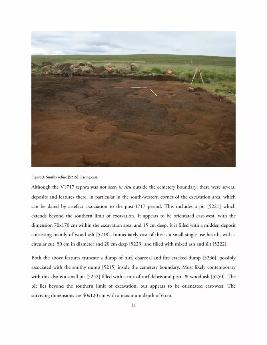
turn sealed a dump, [5215], up to 20 cm thick which consisted of ash and charcoal, with large
amounts of iron slag, indicating that this is a dump from a smithy (see Figure 3). Most of the finds
within the context were copper and iron artefacts. Dump [5215] sealed the in situ tephra from the
1717 eruption in Veiðivötn [5219]. The tephra is quite sparse in Hofstaðir, and in this area was only
found directly underneath the dump, which suggests that it may have been deposited there shortly
after the eruption, thus protecting it from erosion.
11
Figure 3: Smithy refuse [5215]. Facing east.
Although the V1717 tephra was not seen in situ outside the cemetery boundary, there were several
deposits and features there, in particular in the south-western corner of the excavation area, which
can be dated by artefact association to the post-1717 period. This includes a pit [5221] which
extends beyond the southern limit of excavation. It appears to be orientated east-west, with the
dimension 70x170 cm within the excavation area, and 15 cm deep. It is filled with a midden deposit
consisting mainly of wood ash [5218]. Immediately east of this is a small single use hearth, with a
circular cut, 50 cm in diameter and 20 cm deep [5223] and filled with mixed ash and silt [5222].
Both the above features truncate a dump of turf, charcoal and fire cracked dump [5236], possibly
associated with the smithy dump [5215] inside the cemetery boundary. Most likely contemporary
with this also is a small pit [5252] filled with a mix of turf debris and peat- & wood-ash [5250]. The
pit lies beyond the southern limit of excavation, but appears to be orientated east-west. The
surviving dimensions are 40x120 cm with a maximum depth of 6 cm.
12
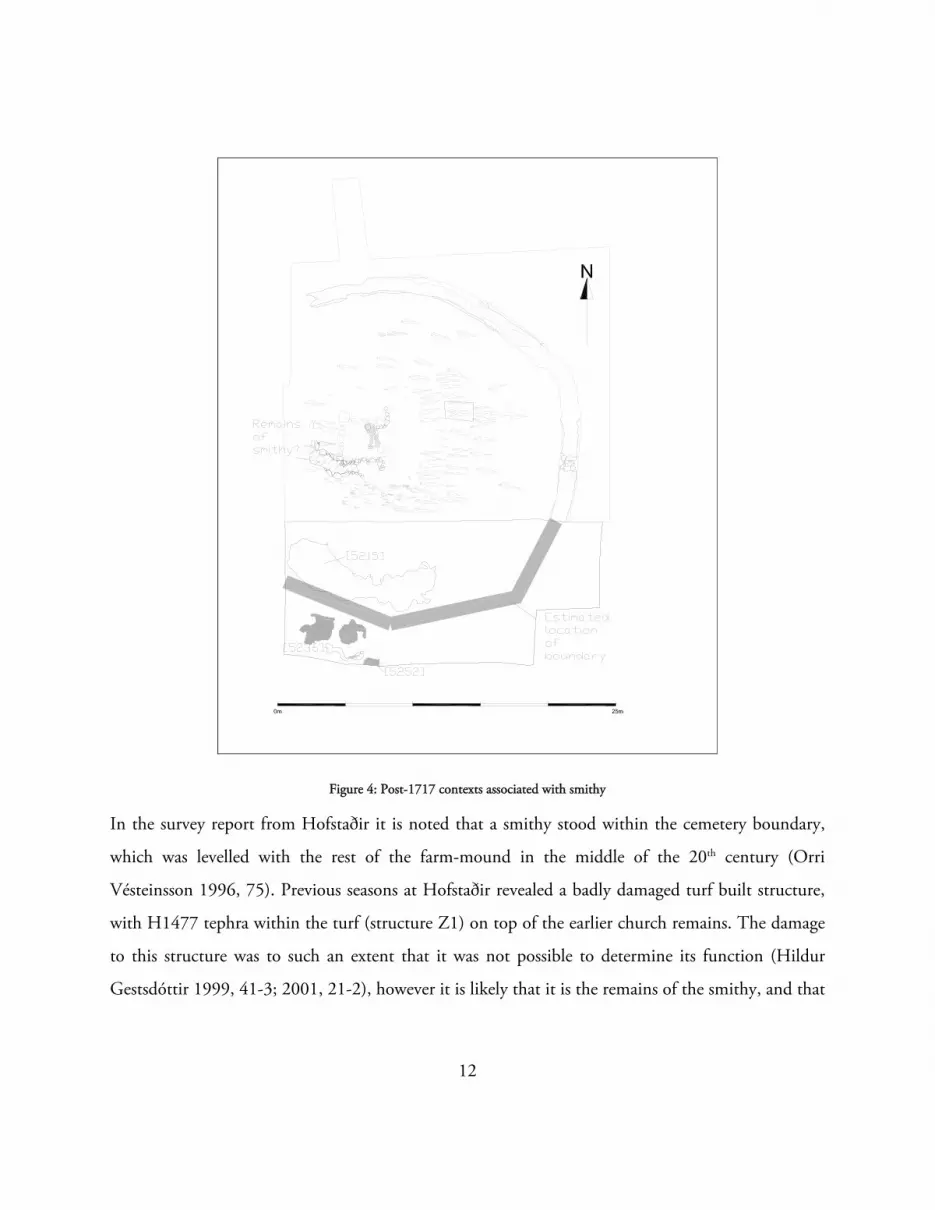
Figure 4: Post-1717 contexts associated with smithy
In the survey report from Hofstaðir it is noted that a smithy stood within the cemetery boundary,
which was levelled with the rest of the farm-mound in the middle of the 20th century (Orri
Vésteinsson 1996, 75). Previous seasons at Hofstaðir revealed a badly damaged turf built structure,
with H1477 tephra within the turf (structure Z1) on top of the earlier church remains. The damage
to this structure was to such an extent that it was not possible to determine its function (Hildur
Gestsdóttir 1999, 41-3; 2001, 21-2), however it is likely that it is the remains of the smithy, and that

13
the smithy dumps, [5215] & [5236], seen in the southern part of the cemetery are associated with
this (see Figure 4).
1477‐1717
The tephra from the 1477 eruption in Hekla [5229] can be found in situ over most of the site (with
the exception of patches in the south-western corner), up to 5cm thick (see Figure 5). The period
between the two tephras (H1477-V1717) appears to be one of very little activity in this part of the
home-field, with the build-up of a single aeolian deposit of silty sand [5220], up to 18 cm thick
inside the cemetery during the period. Lenses of wood-ash and charcoal however give evidence of the
activity on the nearby farm-mound.
Figure 5: In situ V1477. Facing west.
14
1300‐1477
The tephra form the c.1300 eruption in Hekla [5259] is very thin at Hofstaðir, only 1 cm thick. It
was found in situ inside the outline of the cemetery boundary, in the western half of the excavation
area. The period between the two tephras (H1300 and H1477) marks an abandonment phase of the
cemetery, with a series of turf deposits ([5240], [5244], [5248], [5257], [5258] & [5261]) with
intermittent aeolian deposits, with slight turf debris, peat ash and/or charcoal content ([5238],
[5246], [5251], [5254] & [5256]) forming the archaeology inside the central part of the cemetery
(group [5261], see Figure 6). Sealing this was a very patchy tephra deposit, only preserved under a
later turf deposit, [5237], which has been identified as probably the tephra from the 1410 eruption
in Veiðivötn, which has not been identified at Hofstaðir before (Magnús Sigurgeirsson pers. comm.
23rd April 2014). It is probably in situ, although this is not a certainty. Group [5261] together
formed a small mound, around which later contexts (for example the smithy dump [5215]) have
been deposited. Similar turf deposits have been found in other areas within the cemetery after burials
ceased (cf. Hildur Gestsdóttir and Oddgeir Isaksen 2011, 11-2), and have been interpreted as
evidence of levelling or sealing of the cemetery after burials ceased there.

15
Figure 6: Units associated with group [5261]. Black represents turf deposits, while aeolian deposits are grey
Outside the cemetery boundary, the archaeology in this period was marked by a series of small peat-
and wood-ash sheet midden deposits ([5235], [5239], [5242] & [5245]), with intermittent sandy-
silt aeolian deposits ([5231], [5241], [5249], [5253] & [5255]). The thin sheet midden lenses
indicate that this area is on the edge of the activity area of the farm-mound. It is particularly
interesting to note that none of the midden material spills into the cemetery, indicating, as has been
seen in other parts of the cemetery (cf. Hildur Gestsdóttir and Oddgeir Isaksen 2011; Oddgeir
Isaksen and Hildur Gestsdóttir 2012a), that the inhabitant of the farm mound knew of the
cemetery, and avoided disturbing it, by for example, dumping rubbish outside it.

16
Pre‐1300
Only one deposit dating to before the H1300 tephra was excavated in the southern part of the site.
This was a turf deposit, [5260] up to 8cm thick, in the western part of the site, possibly laid down to
level or seal the site after burials ceased there. The removal of this deposit resulted in the exposure of
around 17 grave cuts (which remain as yet unexcavated, see Figure 7) in the western half of the
excavation area.
Figure 7: The black areas represents unexcavated upcast deposits visible at the end of the 2013 season. Most likely grave fill.

17
Thecemetery
Pre1300
A small area (1.3 x 2.1 m) was opened in the eastern part of the cemetery to complete the excavation
of the burials in group [1747] (Hildur Gestsdóttir 2006: 8-9). Two burials were excavated (see
Figure 8 and Figure 9). The earlier of these was grave cut [5225], sub-rectangular oriented east-west,
0.6 x 2.0 m and 0.5 m deep. It contained grave fill [5224], a very mottled mixed silt and skeleton
HSM-A-123 which lay in a supine position with the hands resting on the pelvis. There was no
evidence of a coffin, but ash had been placed on the thoracic and chest area of the individual. This
grave was truncated by grave cut [5217], sub-rectangular orientated east-west, 0.5 x 1.9 m and 0.5 m
deep. It contained grave fill [5216], a very mottled mixed silt, and skeleton HSM-A-122 which lay
in a supine position with the arms bent at the elbows and the hands resting on the abdomen. There
was evidence of the individual having been in a simple wood coffin, of which nothing remained but
wood stains in the soil. A fine black ash had been placed on the chest of the individual. This grave
had in turn been truncated by cut [1649], excavated in a previous season at Hofstaðir, which had
been sealed by the H1300 tephra (Hildur Gestsdóttir 2001: 32).
Futurework
The main focus for the next season at Hofstaðir will be to finish excavating the southern area. This
will involve removing the remaining overburden, both inside and outside the cemetery, and excavate
all the graves in the area.
Once that has been completed, the final area, to the west will be opened (approximately 210m²), to
reveal the remaining part of the cemetery. Geophysical survey of the cemetery indicates that this area
is not dense in burials, although it is likely to be sealed by later farm buildings to some extent. The
aim of the excavation is to avoid these structures as much as is possible.

18
Figure 8: Skeleton HSM-A-122. Facing north-east.
19
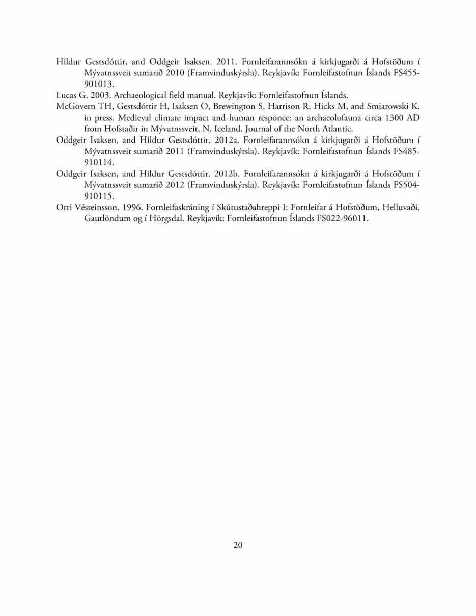
Figure 9: Skeleton HSM-A-123. Facing west.
ReferencesHildur Gestsdóttir. 1999. The medieval churchyard. In: Lucas G, editor. Hofstaðir 1999
Framvinduskýrslur/Interim Reports. Reykjavík: Fornleifastofnun Íslands FS102-91017. p 44-54.
Hildur Gestsdóttir. 2001. The medieval chapel and churchyard. In: Lucas G, editor. Hofstaðir 2000 Framvinduskýrslur/Interim Report. Reykjavík: Fornleifastofnun Íslands FS130-91018. p 21-25.
Hildur Gestsdóttir. 2002. Area Z. In: Lucas G, editor. Hofstaðir 2001 Framvinduskýrslur/Interim report. Reykjavík: Fornleifastofnun Íslands FS167-91019. p 29-34.
Hildur Gestsdóttir. 2003. The chapel. In: Lucas G, editor. Hofstaðir 2002 Framvinduskýrslur/Interim report. Reykjavík: Fornleifastofnun Íslands FS193-910110. p 26-29.
Hildur Gestsdóttir. 2004. Hofstaðir 2003. Framvinduskýrsla/Interim report. Reykjavík: Fornleifastofnun Íslands FS230-910111.
Hildur Gestsdóttir. 2006. Hofstaðir 2004. Interim Report. Reykjavík: Fornleifastofnun Íslands FS311-910112.
20
Hildur Gestsdóttir, and Oddgeir Isaksen. 2011. Fornleifarannsókn á kirkjugarði á Hofstöðum í Mývatnssveit sumarið 2010 (Framvinduskýrsla). Reykjavík: Fornleifastofnun Íslands FS455-901013.
Lucas G. 2003. Archaeological field manual. Reykjavík: Fornleifastofnun Íslands. McGovern TH, Gestsdóttir H, Isaksen O, Brewington S, Harrison R, Hicks M, and Smiarowski K.
in press. Medieval climate impact and human responce: an archaeolofauna circa 1300 AD from Hofstaðir in Mývatnssveit, N. Iceland. Journal of the North Atlantic.
Oddgeir Isaksen, and Hildur Gestsdóttir. 2012a. Fornleifarannsókn á kirkjugarði á Hofstöðum í Mývatnssveit sumarið 2011 (Framvinduskýrsla). Reykjavík: Fornleifastofnun Íslands FS485-910114.
Oddgeir Isaksen, and Hildur Gestsdóttir. 2012b. Fornleifarannsókn á kirkjugarði á Hofstöðum í Mývatnssveit sumarið 2012 (Framvinduskýrsla). Reykjavík: Fornleifastofnun Íslands FS504-910115.
Orri Vésteinsson. 1996. Fornleifaskráning í Skútustaðahreppi I: Fornleifar á Hofstöðum, Helluvaði, Gautlöndum og í Hörgsdal. Reykjavík: Fornleifastofnun Íslands FS022-96011.
21
Appendix1:Unitregister
Unit Type Material Contextual Description
5213 Deposit Mixed silts Dump Rubble from the bulldozing of the farm‐mound c.1953.
5214 Deposit Mixed silts Aeolian Mixed aeolian and sandy silt deposit, respects the shape of the cemetery wall.
5215 Deposit Wood ash Dump Wood ash and charcoal dump layer – smithy refuse.
5216 Deposit Mixed silts Grave Grave fill, heavily mottled with prehistoric tephra – skeleton HSM‐A‐122
5217 Cut Cut interface
Grave Sub‐rectangular grave cut – skeleton HSM‐A‐122
5218 Deposit Wood ash Dump Modern midden dump, associated with farm‐mound. Fill of cut [5221]
5219 Deposit Tephra Aeolian In situ tephra from the 1717 eruption in Veiðivötn
5220 Deposit Mixed silts Aeolian Aeolian deposit with charcoal lenses.
5221 Cut Cut interface
Pit Sub‐oval pit, up to 15cm deep, filled with modern midden material [5218]
5222 Deposit Mixed silt Backfill Primary fill of a small single use hearth [5223]
5223 Cut Cut interface
Pit Cut for a small single use hearth.
5224 Deposit Mixed silts Grave Grave fill, silt, heavily mottled with prehistoric tephra – skeleton HSM‐A‐123
5225 Cut Cut interface
Grave Sub‐rectangular grave cut – skeleton HSM‐A‐123
5226 Deposit Mixed silts Colluvium Mixed debris associated with farm‐mound
5227 Deposit Mixed silts Colluvium Colluvial deposit from farm‐mound
5228 Deposit Mixed silts Colluvium Colluvial deposit from farm‐mound
5229 Deposit Tephra Aeolian In situ tephra from the 1477 eruption in Hekla
5230 Deposit Mixed silts Aeolian Homogenous light brown aeolian silt with slight charcoal fragments
5231 Deposit Mixed silts Aeolian Aeolian deposit outside cemetery boundary, slight turf fragment and charcoal content
5232 Deposit Mixed silts Dump Turf debris layer
5233 Deposit Mixed silts Grave =[1655] Grave fill, silt, heavily mottle with prehistoric tephra
5234 Cut Cut interface
Grave =[1653] Sub‐rectangular grave cut.
5235 Deposit Peat‐ & wood‐ash
Dump Reddish brown peat‐ and wood as deposit, spill/dump from a hearth?
5236 Deposit Mixed silts Dump Dump of turf, charcoal and fire‐cracked rocks. Associated with smithy?
5237 Deposit Tephra Aeolian Tephra from the 1410 eruption in Veiðivötn. Most likely in situ.

22
Unit Type Material Contextual Description
5238 Deposit Mixed silts Aeolian Aeolian deposit with turf flecks inside cemetery
5239 Deposit Peat‐ & wood‐ash
Dump Sheet midden
5240 Deposit Mixed silts Dump Turf deposit within cemetery, associated with levelling of the cemetery after it went out of use?
5241 Deposit Mixed silts Aeolian Aeolian deposit of mixed sandy silts, outside cemetery
boundary
5242 Deposit Peat‐ & wood‐ash
Dump Sheet midden
5243 Deposit Mixed silts Aeolian Aeolian deposit, very uneven surface – possibly due to þúfur
5244 Deposit Mixed silts Dump Turf deposit within the cemetery, possibly associated with the levelling of the area after the cemetery went out of use.
5245 Deposit Peat‐ & wood‐ash
Dump Sheet midden
5246 Deposit Mixed silts Aeolian Aeolian deposit marking abandonment phase inside the cemetery boundary
5247 Deposit Mixed silts Dump Small turf deposit outside cemetery boundary
5248 Deposit Mixed silts Dump Turf deposit within cemetery
5249 Deposit Mixed silts Aeolian Aeolian deposit of sandy silts with slight charcoal content, outside cemetery boundary.
5250 Deposit Wood ash Dump Mix of turf, wood ash and peat ash, fill of pit [5252]
5251 Deposit Mixed silts Aeolian Aeolian deposit with turf patches, inside cemetery
5252 Cut Cut interface
Pit Pit, filled with wood ash [5250]
5253 Deposit Mixed silts Aeolian Aeolian deposit with slight turf fragment and charcoal content, outside cemetery boundary
5254 Deposit Mixed silts Aeolian Aeolian deposit with slight charcoal content, inside cemetery
5255 Deposit Mixed silts Aeolian Dark brown aeolian deposit with some turf fragment content, outside cemetery boundary.
5256 Deposit Mixed silts Aeolian Aeolian deposit with slight charcoal content, inside cemetery
5257 Deposit Mixed silts Dump Turf deposit inside cemetery, levelling deposit?
5258 Deposit Mixed silts Dump Turf deposit inside cemetery, levelling deposit?
5259 Deposit Tephra Aeolian In situ tephra from the c. 1300 eruption in Hekla
5260 Deposit Mixed silts Dump Turf deposit inside cemetery, possible levelling/sealing of the graves once burials ceased in the cemetery
5261 Deposit Mixed silts Dump Turf deposit inside cemetery, levelling deposit?
5261 Group Turf and aeolian deposits sealing burials inside cemetery

23

24
Appendix2:Findsregister
Finds no. Unit Material B/U Type
2013-63-001 Topsoil Fe Bulk Object
2013-63-002 Topsoil Ceramics Bulk Vessel
2013-63-003 Topsoil Cu Bulk Object
2013-63-004 Topsoil Glass Bulk Vessel/window
2013-63-005 Topsoil Leather Unique Object
2013-63-006 5213 Bone Unique Comb
2013-63-007 5213 Ceramics Unique Clay pipe
2013-63-008 5213 Cu alloy Unique Bullet casing
2013-63-009 5213 Fe Bulk Object
2013-63-010 5213 Glass Bulk Window
2013-63-011 5213 Glass Bulk Vessel
2013-63-012 5213 Ceramics Bulk Vessel
2013-63-013 5213 Steatite Unique Vessel
2013-63-014 5213 Rubber Bulk Object
2013-63-015 5213 Flint Unique Flake
2013-63-016 5214 Cu Unique Button
2013-63-017 5214 Fe Bulk Nails/Object
2013-63-018 5214 Ceramics Bulk Vessels
2013-63-019 5214 Glass Bulk Window/vessel
2013-63-020 5215 Cu Unique Rivet
2013-63-021 5215 Cu Unique Rivet
2013-63-022 5215 Cu/textile Unique Button
2013-63-023 5215 Ceramics Bulk Vessel
2013-63-024 5215 Fe Bulk Nails
2013-63-025 5215 Fe Unique Buckle
2013-63-026 5215 Fe Unique Bridle part(?)
2013-63-027 5215 Fe Unique Knife
2013-63-028 5215 Fe Unique Knife
2013-63-029 5215 Fe Unique Buckle
2013-63-030 5215 Fe Unique Buckle
2013-63-031 5215 Fe Unique Buckle
2013-63-032 5215 Fe Unique Object
2013-63-033 5215 Fe Unique Chain link
2013-63-034 5215 Fe Unique Buckle
2013-63-035 5215 Cu Unique Buckle
2013-63-036 5215 Cu Unique Buckle

25
Finds no. Unit Material B/U Type
2013-63-037 5215 Cu Unique Buckle
2013-63-038 5215 Cu Bulk Nails
2013-63-039 5215 Cu Unique Buckle
2013-63-040 5215 Cu Unique Decorative object
2013-63-041 5215 Cu Unique Decorative object
2013-63-042 5215 Cu Unique Broach(?)
2013-63-043 5215 Cu Unique Broach(?)
2013-63-044 5215 Cu Unique Decorative bell(?)
2013-63-045 5215 Cu Unique Button
2013-63-046 5215 Cu Unique Button
2013-63-047 5215 Cu Unique Buckle part
2013-63-048 5215 Cu Unique Buckle part
2013-63-049 5215 Cu Unique Horse shoe
2013-63-050 5218 Cu Unique Decorated clasp
2013-63-051 5218 Cu Unique Rivet
2013-63-052 5215 Textile Unique Object
2013-63-053 5215 Cu Bulk Object
2013-63-054 5215 Fe Bulk Object
2013-63-055 5215 Glass Bulk Window/vessel
2013-63-056 5215 Flint Unique Flake
2013-63-057 5215 Wood Bulk Worked wood
2013-63-058 5218 Ceramics Bulk Vessel
2013-63-059 5218 Glass Bulk Window
2013-63-060 5218 Glass Bulk Vessel
2013-63-061 5218 Fe Bulk Object
2013-63-062 5218 Fe Unique Object
2013-63-063 5218 Obsidian Unique Flake
2013-63-064 5218 Shell Unique Seashell
2013-63-065 5218 Fe Bulk Nails/Object
2013-63-066 5220 Fe Bulk Object
2013-63-067 5220 Cu Bulk Object
2013-63-068 5220 Schist Unique Whetstone
2013-63-069 5229 Cu Unique Nails
2013-63-070 5229 Fe Bulk Nails/Object
2013-63-071 5229 Stone Unique Manuport
2013-63-072 5232 Fe Unique Nails
2013-63-073 5232 Cu Unique Object
2013-63-074 5232 Stone Unique Manuport
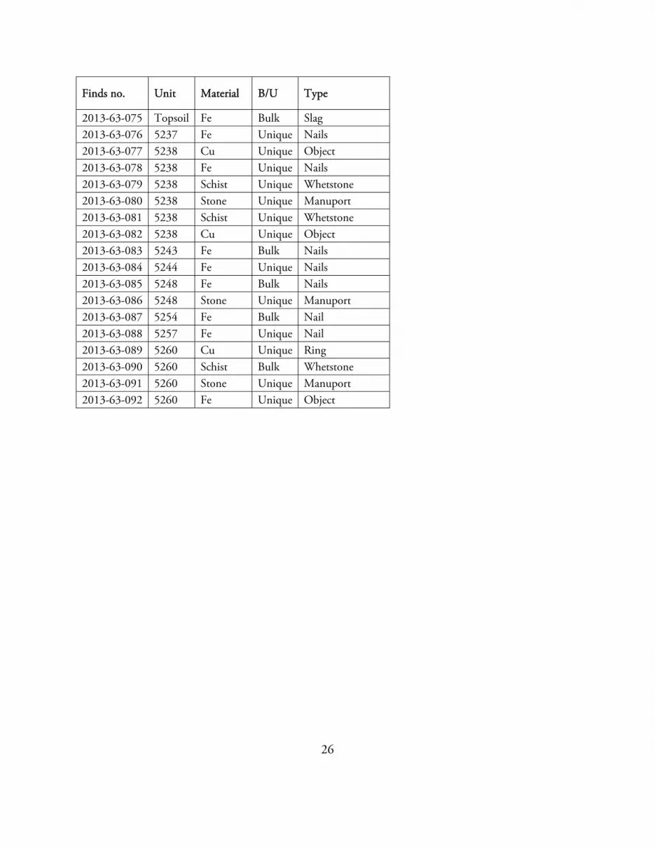
26
Finds no. Unit Material B/U Type
2013-63-075 Topsoil Fe Bulk Slag
2013-63-076 5237 Fe Unique Nails
2013-63-077 5238 Cu Unique Object
2013-63-078 5238 Fe Unique Nails
2013-63-079 5238 Schist Unique Whetstone
2013-63-080 5238 Stone Unique Manuport
2013-63-081 5238 Schist Unique Whetstone
2013-63-082 5238 Cu Unique Object
2013-63-083 5243 Fe Bulk Nails
2013-63-084 5244 Fe Unique Nails
2013-63-085 5248 Fe Bulk Nails
2013-63-086 5248 Stone Unique Manuport
2013-63-087 5254 Fe Bulk Nail
2013-63-088 5257 Fe Unique Nail
2013-63-089 5260 Cu Unique Ring
2013-63-090 5260 Schist Bulk Whetstone
2013-63-091 5260 Stone Unique Manuport
2013-63-092 5260 Fe Unique Object
27
Appendix3:Skeletalregister
Skeleton no. Group Fill Cut Notes
HSM-A-122 1747 5216 5217 In situ adult skeleton
HSM-A-123 1747 5224 5225 In situ adult skeleton
28
Appendix4:Samplesregister
Sample no. Unit Quantity Description
2013-63-001 5219 1 small bag Tephra (V1717)
2013-63-002 5237 1 small bag Tephra (H1477)
2013-63-003 5244 1 small bag Tephra (?)
2013-63-004 5259 1 small bag Tephra (H1300)
29
Appendix5:BibliographyforHofstaðir
Reports
Hildur Gestsdóttir. 1999. The Medieval Churchyard. in Lucas, G. (ed.) Hofstaðir 1999. Framvinduskýrslur / Interim Reports. Fornleifastofnun Íslands: FS102-91017: 44-54.
Hildur Gestsdóttir. 2001. The Medieval Chapel and Churchyard. In Lucas, G. (ed.) Hofstaðir 2000. Farmvinduskýrslur / Interim Report. Fornleifastofnun Íslands: FS130-91018; 21-25.
Hildur Gestsdóttir. 2002. Area Z. Lucas, G. (ed.) Hofstaðir 2001. Framvinduskýrslur / Interim Report. Fornleifastofnun Íslands: FS167-91019: 29-34.
Hildur Gestsdóttir. 2003. The Chapel. In Lucas, G. (ed.). Hofstaðir 2002. Framvinduskýrslur / Interim Report. Fornleifastofnun Íslands: FS193-910110: 26-29.
Hildur Gestsdóttir. 2004. Hofstaðir 2003. Framvinduskýrsla / Interim Report. Fornleifastofnun
Íslands: FS230-910111. Hildur Gestsdóttir. 2006. Hofstaðir 2004. Interim Report. Fornleifastofnun Íslands: FS311-910112.
Hildur Gestsdóttir & Oddgeir Isaksen. 2011. Fornleifarannsókn á kirkjugarði á Hofstöðum í Mývatnssveit sumarið 2010 (Framvinduskýrsla). Fornleifastofnun Íslands: FS455-910113.
Oddgeir Isaksen & Hildur Gestsdóttir. 2012a. Fornleifarannsókn á kirkjugarði á Hofstöðum í Mývatnssveit sumarið 2011 (Framvinduskýrsla). Fornleifastofnun Íslands: FS485-910114.
Oddgeir Isaksen & Hildur Gestsdóttir. 2012b. Fornleifarannsókn á kirkjugarði á Hofstöðum í Mývatnssveit sumarið 2012 (Framvinduskýrsla). Fornleifastofnun Íslands: FS504-910115.
Orri Vésteinsson. 1996. Fornleifaskráning í Skútustaðahreppi I: Fornleifar á Hofstöðum, Helluvaði, Gautlöndum og í Hörgsdal. Fornleifastofnun Íslands: FS022-96011
Publications
Hildur Gestsdóttir 2009. Sögur af beinagrindum. Árbók Hins íslenzka fornleifafélags 2008-2009:
123-142. Hildur Gestsdóttir & Guðmundur I. Eyjólfsson. 2005. Mergæxli í fornri beinagrind frá Hofstöðum í
Mývatnssveit. Læknablaðið 91: 505-9.
Horsley, T.J. & Dockrill, S.J. 2002. A preliminary assessment of the use of routing geophysical techniques for the location, characterisation and interpretation of buried archaeology in Iceland. Archaeologia Islandica 2: 10-33.
Lanigan, L.T. & Bartlett, D.W. 2013. Erosive tooth wear in relation to a subarctic diet in Medieval Iceland. Archives of Oral Biology 58(10): 1450-6.
McGovern, T.H., Gestsdóttir, H., Isaksen, O., Brewington, S., Harrison, R., Hicks, M. & Smiarowski, K. (in press). Medieval climate impact and human response: an archaeofauna circa 1300 AD from Hofstaðir in Mývatnssveit, N. Iceland. Journal of the North Atlantic.
Sayle, K.L., Cook, G.T., Ascough, P.L., Gestsdóttir, H., Hamilton, W.D. & McGovern, T.H. (in press). Utilisation of ∂13C, ∂15N and ∂34S analysis to understand 14C-dating anomalies within a late Viking Age community in north-east Iceland. Radiocarbon.
30
Dissertations/theses
Ph.D.
Hildur Gestsdóttir. 2013 Osteoarthritis in Iceland. An archaeological study. (Unpublished Ph.D.
thesis: University of Iceland). Horsley, T.J. 2004. The potential of geophysical prospection techniques for archaeological field evaluation
in Iceland. (Unpublished Ph.D. thesis: University of Bradford).
M.Sc
Lanigan, L.T. 2011. Acid erosion in the dental enamel of an early Medieval Icelandic population. (Unpublished MSc dissertation: University College London).
Jeffries E. 2011. The archaeology of children in northern Iceland: An analysis of the infant assemblages from Hofstaðir and Keldudalur. (Unpublished MSc dissertation: University of Sheffield)
M.A.
Ragnheiður Gló Gylfadóttir. 2008. „Þegar á unga aldri lifi ég enn…” Barnafornleifafræði: Greftrun barna á kaþólskum tíma á Íslandi. (Unpublished MA dissertation: University of Iceland).
B.A.
Kristín Halla Baldvinsdóttir. 2008. Aska og viðarkol í gröfum á Íslandi. Greining ösku og viðarkola á mannabeinum og í gröfum. (Unpublished BA dissertation: University of Iceland).
Lilja Laufey Davíðsdóttir. 2008. Grafið en ekki gleymt: gerðir handastellinga í íslenskum gröfum og nýting þeirra til afstæðra aldursgreininga. (Unpublished BA dissertation: University of Iceland).

31
CurrentprojectsusingHofstaðirskeletons
Ph.D.
Cecilia Collins Interpreting the prevalence of ear disease and maxillary sinusitis in medieval Iceland: an evaluation of adult and subadult skeletons using computed tomography, microscopy and endoscopy. (Ph.D. University of Reading).
Ashot Margaryan Population genomics of Vikings. (Ph.D. University of Copenhagen).
Post‐doc
Dr. Kerry Sayle Utilisation of δ13C, δ15N and δ34S analyses to understand 14C-dating anomalies within a Viking Age community in north-east Iceland. (Post-doc University of Glasgow, Scottish Universities Environmental Research Centre).


