Embed Size (px)
Citation preview
Government of Nepal
District Transport
Master Plan (DTMP)
Ministry of Federal Affairs
and Local Development
Department of Local Infrastructure
Development and Agricultural
Roads (DOLIDAR)
District Development Committee,
Myagdi
September, 2013
FINAL REPORT
VOLUME-II ANNEXES
Prepared by the North Star Engineering Consultant (P) Ltd for the District Development Committee
(DDC) and District Technical Office (DTO), Myagdi with Technical Assistance from the Department of
Local Infrastructure and Agricultural Roads (DOLIDAR), Ministry of Federal Affairs and Local
Development and grant supported by DFID
i
FOREWORD
ii
ACKNOWLEDGEMENTS
The District Transport Master Plan of Myagdi District has been prepared for RTI Sector
Maintenance Pilot, DoLIDAR under the Contract Agreement between RTI Sector
Maintenance Pilot and North Star Engineering Consultant (P) Ltd. (Contract No: RTI Sector
DTMP/001/2012 amendment no. 1) to carry out the task of preparing of DTMP of Myagdi
District of Nepal. We would like to convey our indebtedness to RTI Sector Maintenance Pilot
for entrusting us the responsibility to carry out the task of preparing of DTMP of Myagdi
District.
We would like to express our sincere gratitude to the Project Coordinator Mr. Ganga Bahadur
Basnet (SDE), and Team leader Mr. Michael Green, DTL Mr. Dilli Prakash Sitaula and Er.
Manoj Krishna Shrestha of RTI Sector Maintenance Pilot whose valuable co-operation and
suggestions guided us to accomplish the agreed task to this level. We would also like to
express our sincere thanks to LDO of Myagdi DDC, Mr. Bishnu Prasad Sharma, Planning
officer, Social Development Officer, Information officer, DTO Chief, Engineers, Sub-
engineers and other staffs of DDC and DTO offices, Myagdi for their extended help and
regular support; and coordination at different levels while working at the field level.
The local leaders and local people from Myagdi district are also thankful for their help and
suggestion for the selection and identification of the DRCN. We hope, this prepared DTMP of
Myagdi District will be very helpful and a valuable guideline for the planning and development
of effective and systematic transport network in Myagdi District.
_____________________
Dhruba Raj Tripathi
Managing Director
North Star Engineering Consultant
iii
EXECUTIVE SUMMARY
Myagdi District is located in Dhaulagiri Zone of the Western Development Region of Nepal. It
borders with Manang, Kaski and Parbat districts to the East, Baglung and Rukum districts to
the West, Dolpa and Mustang districts to the North and Baglung district to the South.
Topographically, Myagdi district entails 28°20' - 28°47' latitude and 83° 08' - 83°53'
longitudes. Geopolitically, the district is administratively divided into one electoral
constituencies 11 Illakas which consist of 41 VDCs. Each VDC is divided into 9 Wards.
The total area of the district is 2,297.06 sq km. Geographically, 56% of area is lies in high-
hill, 36% area lies in mountain and remaining 8% area lies in plain valley land of Myagdi
district. The lowest elevation point is 792 meter lies on Ratnechaur VDC and the highest
elevation point is 8,167 meter of mount Dhaulagiri from mean sea level. Elevation of District
Headquarters Myagdi is 860 m.
Subsistence agriculture farming, mainly small scale livestock is the main source of
occupation and livelihood of the majority of the population, with 86% of the population active
in this sector. Due to low level of agricultural production, the majority of the households face
acute food shortages for a large part of the year.
The district inventory identified just over 567 km of roads, including 40 km of strategic roads
and 525 km of rural roads and 2 km Urban roads. In coordination with the DTICC and DDC,
21 rural roads with a length of 206 km were identified as making up the district road core
network (DRCN), and the remaining 319 km were classified as village roads. The existing
DRCN roads link up 24 of the 41 VDC headquarters. Almost all of the DRCN roads are
earthen fair-weather roads.
Road Class Total length Black Top Gravel Earthen
Strategic Roads 39.99 8.60 31.39
Urban Roads 2.00 2.00
Rural Roads 525.73 - 4.73 521.00
Total 567.72 2.00 13.33 552.39
Annual conservation costs are estimated at NPR 63.9 million based on the first year, and will
be updated in the AAMP based on actual annual maintenance needs as determined in the
annual road condition survey. For the full five-year period the conservation costs will come to
NPR 319.5 million. An analysis of the road network identified the need for improvement of all
the DRCN roads in order to bring them to a maintainable all-weather standard and provide
them with a proper road surface for existing traffic volumes. The required improvements and
their estimated costs are listed below.
iv
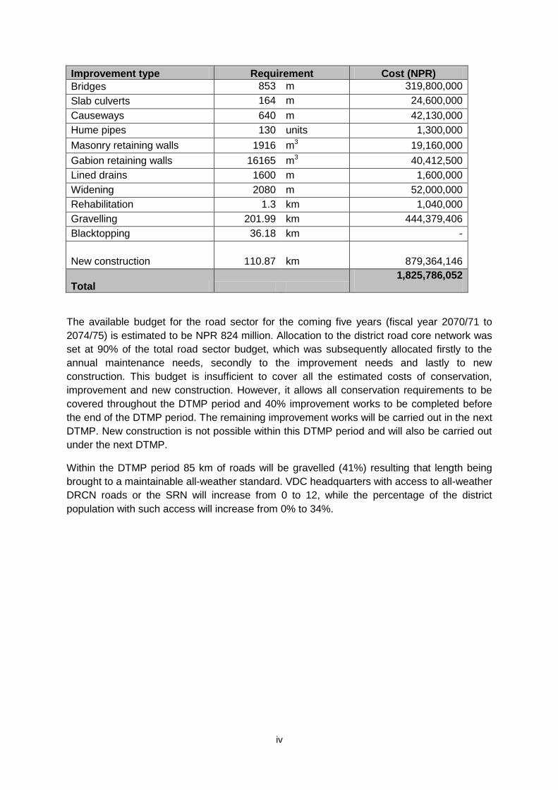
Improvement type Requirement Cost (NPR)
Bridges 853 m 319,800,000
Slab culverts 164 m 24,600,000
Causeways 640 m 42,130,000
Hume pipes 130 units 1,300,000
Masonry retaining walls 1916 m3 19,160,000
Gabion retaining walls 16165 m3 40,412,500
Lined drains 1600 m 1,600,000
Widening 2080 m 52,000,000
Rehabilitation 1.3 km 1,040,000
Gravelling 201.99 km 444,379,406
Blacktopping 36.18 km -
New construction
110.87 km 879,364,146
Total
1,825,786,052
The available budget for the road sector for the coming five years (fiscal year 2070/71 to
2074/75) is estimated to be NPR 824 million. Allocation to the district road core network was
set at 90% of the total road sector budget, which was subsequently allocated firstly to the
annual maintenance needs, secondly to the improvement needs and lastly to new
construction. This budget is insufficient to cover all the estimated costs of conservation,
improvement and new construction. However, it allows all conservation requirements to be
covered throughout the DTMP period and 40% improvement works to be completed before
the end of the DTMP period. The remaining improvement works will be carried out in the next
DTMP. New construction is not possible within this DTMP period and will also be carried out
under the next DTMP.
Within the DTMP period 85 km of roads will be gravelled (41%) resulting that length being
brought to a maintainable all-weather standard. VDC headquarters with access to all-weather
DRCN roads or the SRN will increase from 0 to 12, while the percentage of the district
population with such access will increase from 0% to 34%.
v
ABBREVIATIONS
AAMP Annual Asset Management Plan
ARMP Annual Road Maintenance Plan
BT Black Top
DDC District Development Committee
DOLIDAR Department of Local Infrastructure Development and Agriculture Road
DOR Department of Road
DTICC District Transport Infrastructure Coordination Committee
DTMP District Transport Master Plan
DTPP District Transport Perspective Plan
GIS Geographical Information system
GPS Global Positioning System
GON Government of Nepal
GR Gravel
Km Kilometer
LGCDP Local Governance and Community Development Programme
LRBP Local Road Bridge Project
MLD Ministry of Local Development
NPR Nepali Rupees
PCU Passenger Car Unit
RAP Rural Access Programme
RCIW Rural Community Infrastructure Works
SWAp Sector Wide Approach
VDC Village Development Committee
VPD Vehicle Per Day
vi
CONTENTS
FOREWORD ........................................................................................................................... i
ACKNOWLEDGEMENTS ...................................................................................................... ii
EXECUTIVE SUMMARY ....................................................................................................... iii
ABBREVIATIONS .................................................................................................................. v
CONTENTS .......................................................................................................................... vi
1. Introduction ...................................................................................................................... 1
2. District road core network (DRCN) ................................................................................. 3 2.1 Total road network ...................................................................................................... 3 2.2 National Highways and Feeder Roads ........................................................................ 3 2.3 District Road Core Network ......................................................................................... 3 2.4 Village roads ............................................................................................................... 5
3. District Transport Perspective Plan (DTPP) ................................................................... 8 3.1 Conservation ............................................................................................................... 8 3.2 Improvement ............................................................................................................... 9 3.3 New construction ...................................................................................................... 13 3.4 District Transport Perspective Plan ........................................................................... 14
4. Cost estimation .............................................................................................................. 18 4.1 Conservation ............................................................................................................. 18 4.2 Improvement ............................................................................................................. 19 4.3 New construction ...................................................................................................... 21 4.4 DTPP costs ............................................................................................................... 21
5. Ranking .......................................................................................................................... 23 5.1 Conservation ............................................................................................................. 23 5.2 Improvement ............................................................................................................. 24 5.3 New construction ...................................................................................................... 24
6. District Transport Master Plan (DTMP) ......................................................................... 26 6.1 Five Year Projected Financial resources ................................................................... 26 6.2 Budget allocation ...................................................................................................... 26 6.3 DTMP outputs ........................................................................................................... 30 6.4 DTMP outcome ......................................................................................................... 30
Annex 1 GIS FILE PROJECTION AND COORDINATE SYSTEM ..................................... 33
Annex 2 TRAFFIC DATA ................................................................................................... 34
Annex 3 POPULATION SERVED ...................................................................................... 35
Annex 4 LOCATION OF PROPOSED INTERVENTIONS .................................................. 37
Annex 5 OVERALL ROAD INVENTORY ........................................................................... 39
Annex 6 PHOTOGRAPHS ................................................................................................. 43
Annex 7 MINUTES ............................................................................................................. 47
vii
TABLES
Table 2.1.1 Road length in Myagdi district (km) ................................................................ 3 Table 2.2.1 National Highways and Feeder Roads in Myagdi district (km) ........................ 3 Table 2.3.1 Road length in Myagdi District (km) ................................................................ 4 Table 2.3.2 District Road Core Network in Myagdi District (km) ........................................ 4 Table 3.1.1 Conservation requirements ............................................................................ 9 Table 3.2.1 Sections of the district road core network requiring rehabilitation ..................10 Table 3.2.2 Sections of the district road core network requiring gravelling .......................10 Table 3.2.3 Required cross drainage structures ...............................................................11 Table 3.2.4 Required protective structures .......................................................................12 Table 3.2.5 Sections of the District Road Core Network requiring widening .....................12 Table 3.2.6 Sections of the district road core network requiring blacktopping ...................13 Table 3.3.1 Sections of the district road core network requiring new construction ............13 Table 3.4.1 District Transport Perspective Plan ...............................................................15 Table 4.1.1 Standard unit costs for conservation .............................................................18 Table 4.1.2 Estimated conservation costs for the first year (NPR ‘000) ............................18 Table 4.2.1 Standard unit costs for improvement activities ...............................................19 Table 4.2.2 Cost estimate for improvement measures (NPR ‘000) ...................................20 Table 4.3.1 Standard unit costs for new construction .......................................................21 Table 4.3.2 Cost Estimate for new construction (NPR ‘000) .............................................21 Table 4.4.1 DTPP Costs (NPR ‘000) ................................................................................22 Table 5.1.1 Ranking of Conservation works (NPR ‘000) ..................................................23 Table 5.2.1 Ranking of improvement works (NPR ‘000) ...................................................24 Table 5.3.1 Ranking of construction works (NPR ‘000) ....................................................24 Table 6.1.1 Estimated funding levels (roads) for next five years (in NPR ‘000) ................26 Table 6.2.1 Investment Plan ............................................................................................27 Table 6.3.1 DTMP output .................................................................................................30 Table 6.4.1 Standard of DRCN roads...............................................................................30 Table 6.4.2 Population with access to road network .........................................................31
FIGURES
Figure 1 : Map of Nepal indicating Myagdi district .............................................................. 1 Figure 2 : Total Road Inventory Map for Myagdi District ..................................................... 6 Figure 3 : District Road Core Network (DRCN) Map .......................................................... 7 Figure 4 : District Transport Perspective Plan (DTPP) .......................................................17 Figure 5 : District Road Sector Budget Allocation ..............................................................27 Figure 6 : District Transport Master Plan (DTMP) ..............................................................32
1
1. INTRODUCTION
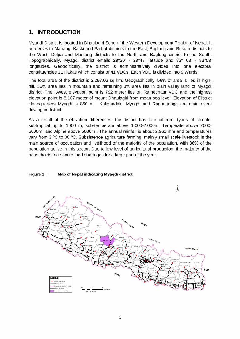
Myagdi District is located in Dhaulagiri Zone of the Western Development Region of Nepal. It
borders with Manang, Kaski and Parbat districts to the East, Baglung and Rukum districts to
the West, Dolpa and Mustang districts to the North and Baglung district to the South.
Topographically, Myagdi district entails 28°20' - 28°47' latitude and 83° 08' - 83°53'
longitudes. Geopolitically, the district is administratively divided into one electoral
constituencies 11 Illakas which consist of 41 VDCs. Each VDC is divided into 9 Wards.
The total area of the district is 2,297.06 sq km. Geographically, 56% of area is lies in high-
hill, 36% area lies in mountain and remaining 8% area lies in plain valley land of Myagdi
district. The lowest elevation point is 792 meter lies on Ratnechaur VDC and the highest
elevation point is 8,167 meter of mount Dhaulagiri from mean sea level. Elevation of District
Headquarters Myagdi is 860 m. Kaligandaki, Myagdi and Raghuganga are main rivers
flowing in district.
As a result of the elevation differences, the district has four different types of climate:
subtropical up to 1000 m, sub-temperate above 1,000-2,000m, Temperate above 2000-
5000m and Alpine above 5000m . The annual rainfall is about 2,960 mm and temperatures
vary from 3 ºC to 30 ºC. Subsistence agriculture farming, mainly small scale livestock is the
main source of occupation and livelihood of the majority of the population, with 86% of the
population active in this sector. Due to low level of agricultural production, the majority of the
households face acute food shortages for a large part of the year.
Figure 1 : Map of Nepal indicating Myagdi district
2
According to the National Census 2011, the total population of the district is 112,077
comprising 62,043 female (55%) and 50,034 male (45%) residing in 27,727 households.
Myagdi district has an average population density of around 49 people per square km. The
average family size is 4. Life expectancy of the people is 66 years. The average literacy rate
is about 67.39% (60.91% female and 75.42% male are literate). Myagdi district has a multi
ethnic composition with Magar, Chhetri, Kami, Chhantyal, Brahman, Sarki, Damai, Thakuri,
Newar, Thakali, Gurung and others. The common language using for communication is
Nepali and other languages are Magar, Chhantyal, Newar, Thakali and Gurung.
There are numerous district and village roads. From the field study, it has been observed that
most of them are in fair weather condition. Most of these roads have been constructed using
excavator without proper planning and engineering design.
The study team has found Myagdi district in a relatively better transport situation. This district
has an easy surface transport connection with major market and commercial city like
Pokhara of Kaski district. Two adjacent districts’ Headquarters Kushma of Parbat and
Baglung bazaar of Baglung district are connected by all weather blacktop road with Myagdi.
However, most of the rural roads are in poor condition and need to be improved /upgraded
for safe and reliable journey.
The district has access to the Pokhara-Baglung Highway. A feeder road, 13 km in length
between the district headquarters Beni and Maldhunga of Parbat is recently upgraded to
bituminous standard by DOR. The Kaligandaki corridor is under construction and will cross
the Myagdi district and links with the Korala of Tibet via Jomsom.
3
2. DISTRICT ROAD CORE NETWORK (DRCN)
This chapter gives an overview of the existing roads in Myagdi district, distinguishing
between strategic roads and rural roads. It goes on to identify those rural roads that make up
the district road core network (DRCN) that will form the basis for this DTMP. The remaining
rural roads are classified as village roads.
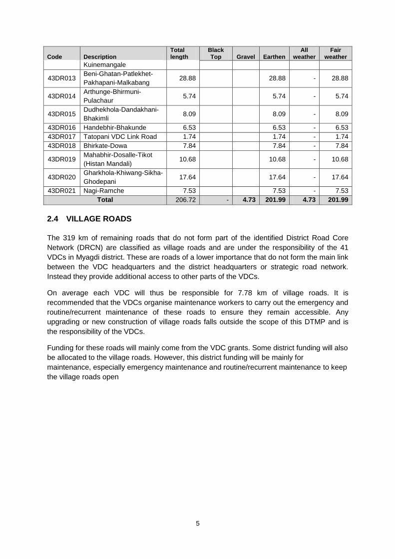
2.1 TOTAL ROAD NETWORK
Myagdi district has an estimated road network of 567 kilometres, including 40 km of strategic
roads managed by DoR and 525 km of rural roads and 2 km urban roads managed by
Myagdi DDC and the VDCs. A strategic road, Beni-Jomsom and all of the rural roads have
an earthen surface. Other strategic road Baglung-Beni has gravel surface and urban road at
Beni bazaar has blacktop surface. A map of the total road network in Myagdi district is shown
in figure 2 at the end of this chapter.
Table 2.1.1 Road length in Myagdi district (km)
Road Class Total length Black Top Gravel Earthen
Strategic Roads 39.99 8.60
- 31.39
Urban Roads 2.00 2.00
Rural Roads 525.73
-
4.73
- 521.00
Total 567.72 2.00 13.33 552.39
2.2 NATIONAL HIGHWAYS AND FEEDER ROADS
Myagdi district has no highway but the existing feeder roads are being developed as North
South highway (Kaligandaki Corridor) by DoR and will be the part of this highway in future.
There are two feeder roads of total 40 km. Baglung-Beni feeder road has gravel surface and
Beni-Jomsom feeder road has earthen surface.
Table 2.2.1 National Highways and Feeder Roads in Myagdi district (km)
Code Description Total length Black Top Gravel Earthen
F042
Baglung-Beni (Ratnechaur-Beni
section)
8.60 8.60
F042 Beni-Jomsom ( Beni-Dana section) 31.39 31.39
Total 39.99 0.00 8.60 31.39
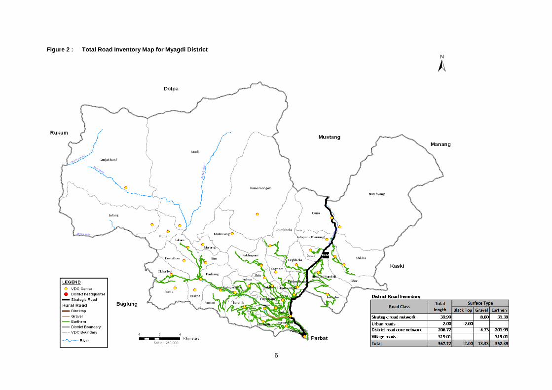
2.3 DISTRICT ROAD CORE NETWORK
As part of the preparation of this DTMP, the District Road Core Network (DRCN) was
identified together with the DTICC and DDC. This DRCN is the minimum network that allows
all VDC headquarters to be connected with the strategic road network and the district
headquarters, either directly or through other VDCs. In the selection of the DRCN roads,
4
account was taken of the road conditions and the existing traffic levels. The identified DRCN
roads were subsequently provided with road codes according to national standards.
The resulting District Road Core Network in Myagdi district is shown in Figure 3 at the end of
this chapter. The DRCN consists of 21 district roads with a total length of 206 km. The
remaining 319 km of existing rural roads and 2 km urban road are not considered to be
DRCN roads and are classified as village roads and urban road under the responsibility of
the VDCs. Almost all DRCN roads are currently earthen roads and are considered fair-
weather only (Table 2.3.1). A complete list of the DRCN roads and their characteristics is
provided in Table 2.3.1.
Table 2.3.1 Road length in Myagdi District (km)
Road Class Total length Black Top Gravel Earthen
Strategic road network 39.99
- 8.60 31.39
Highways
-
Feeder roads 39.99
- 8.60 31.39
Urban roads 2.00 2.00
-
-
District road core network 206.72
- 4.73 201.99
Village roads 319.01
-
- 319.01
Total 567.72 2.00 13.33 552.39
Table 2.3.2 District Road Core Network in Myagdi District (km)
Code Description Total length
Black Top Gravel Earthen
All weather
Fair weather
43DR001 Beni-Darbang-Dharapani-
Muna-Lulang-Gurjakhani 36.18
4.73 31.45 4.73 31.45
43DR002 Khara-Marang 1.66
1.66 - 1.66
43DR003 Khara-Bima 5.28
5.28 - 5.28
43DR004 Darbang-Khara-Takam 5.24
5.24 - 5.24
43DR005 Darbang-Devisthan 2.21
2.21 - 2.21
43DR006 Darbang-Phulbari-
Okharbot 7.41
7.41 - 7.41
43DR007 Phulbari-Ruma 1.93
1.93 - 1.93
43DR008 Babiyachaur-Neta-Pakhu
(Arman) 4.21
4.21 - 4.21
43DR009 Sima-Kotrabang-
Painyupata-Kuhun 9.38
9.38 - 9.38
43DR010 Galeshwor-Piple-
Bhagwati-Begkhola 14.21
14.21 - 14.21
43DR011 Handebhir-Bagarphant-
Surkemela-Baranja 17.04
17.04 - 17.04
43DR012 Piple-Mauwaphant-
Dagnam-Chimkhola-7.29
7.29 - 7.29
5
Code Description Total length
Black Top Gravel Earthen
All weather
Fair weather
Kuinemangale
43DR013 Beni-Ghatan-Patlekhet-
Pakhapani-Malkabang 28.88
28.88 - 28.88
43DR014 Arthunge-Bhirmuni-
Pulachaur 5.74
5.74 - 5.74
43DR015 Dudhekhola-Dandakhani-
Bhakimli 8.09
8.09 - 8.09
43DR016 Handebhir-Bhakunde 6.53
6.53 - 6.53
43DR017 Tatopani VDC Link Road 1.74
1.74 - 1.74
43DR018 Bhirkate-Dowa 7.84
7.84 - 7.84
43DR019 Mahabhir-Dosalle-Tikot
(Histan Mandali) 10.68
10.68 - 10.68
43DR020 Gharkhola-Khiwang-Sikha-
Ghodepani 17.64
17.64 - 17.64
43DR021 Nagi-Ramche 7.53
7.53 - 7.53
Total 206.72 - 4.73 201.99 4.73 201.99
2.4 VILLAGE ROADS
The 319 km of remaining roads that do not form part of the identified District Road Core
Network (DRCN) are classified as village roads and are under the responsibility of the 41
VDCs in Myagdi district. These are roads of a lower importance that do not form the main link
between the VDC headquarters and the district headquarters or strategic road network.
Instead they provide additional access to other parts of the VDCs.
On average each VDC will thus be responsible for 7.78 km of village roads. It is
recommended that the VDCs organise maintenance workers to carry out the emergency and
routine/recurrent maintenance of these roads to ensure they remain accessible. Any
upgrading or new construction of village roads falls outside the scope of this DTMP and is
the responsibility of the VDCs.
Funding for these roads will mainly come from the VDC grants. Some district funding will also
be allocated to the village roads. However, this district funding will be mainly for
maintenance, especially emergency maintenance and routine/recurrent maintenance to keep
the village roads open
6
Figure 2 : Total Road Inventory Map for Myagdi District
7
Figure 3 : District Road Core Network (DRCN) Map
8
3. DISTRICT TRANSPORT PERSPECTIVE PLAN (DTPP)
This chapter looks at the required interventions regarding conservation, improvement and
new construction of the district road core network. It provides a complete list of all works
required in the DRCN, which together form the District Transport Perspective Plan (DTPP).
For the works forming part of the DTPP, chapter 4 will subsequently provide cost estimation,
while chapter 5 will rank the works according to priority and chapter 6 will select those priority
works that can be carried out in the next 5 years and thus form part of the District Transport
Master Plan (DTMP).
3.1 CONSERVATION
Conservation refers to the actions required to repair a road and keep it in good and passable
condition. For DTMP planning purposes standard costs per kilometre for each maintenance
type are applied to the entire district road core network, whereby for certain maintenance
types distinction is made according to the surface type of the road. Identification of the actual
maintenance requirements of each road is made annually in the ARMP. Conservation
activities include:
1. Emergency maintenance - Basic repairs aimed at removing landslides and repairing damage to the road that inhibit the proper use of the road and make it impassable. This mainly takes place during and after the rainy season. A provisional lump sum is reserved for the entire district road core network based on the network length. Allocation to specific road sections is based on the actual need for clearing landslides or repairing washouts and cuts in the road.
2. Routine maintenance - General maintenance of the road aimed at preventing damage by ensuring the proper working of the different road elements (retaining walls, drainage system, carriageway, etc.) and cutting vegetation. This is carried out each year on a more or less continuous basis. Routine maintenance is required for the entire district road core network. The specific requirements for routine maintenance are determined on an annual basis through the road condition survey and defined in the ARMP.
3. Recurrent maintenance - Repairs of minor damage to the road surface and road structures to bring them back to good condition. This is generally carried out once or twice a year. Recurrent maintenance is required for the entire district road core network, whereby distinction is made according to the surface type. The specific requirements for recurrent maintenance are determined on an annual basis through the road condition survey and defined in the ARMP.
4. Periodic maintenance - Larger repairs to the road largely aimed at renewing the road surface through regravelling, resealing or overlays. It is generally carried out with several years interval. Although periodic maintenance is only required for specific sections of the district road core network, a lump sum allocation is made for the entire district road core network based on average annual requirements, distinguishing between different surface types. The specific periodic maintenance requirements are determined on an annual basis through the annual road condition survey and defined in the ARMP.
The length of roads to be included under each conservation type for the first year is indicated
below. This is basically the entire district road core network as far as it does not require
rehabilitation.
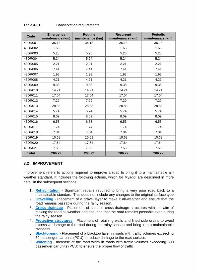
9
Table 3.1.1 Conservation requirements
Code Emergency
maintenance (km) Routine
maintenance (km) Recurrent
maintenance (km) Periodic
maintenance (km)
43DR001 36.18 36.18 36.18 36.18
43DR002 1.66 1.66 1.66 1.66
43DR003 5.28 5.28 5.28 5.28
43DR004 5.24 5.24 5.24 5.24
43DR005 2.21 2.21 2.21 2.21
43DR006 7.41 7.41 7.41 7.41
43DR007 1.93 1.93 1.93 1.93
43DR008 4.21 4.21 4.21 4.21
43DR009 9.38 9.38 9.38 9.38
43DR010 14.21 14.21 14.21 14.21
43DR011 17.04 17.04 17.04 17.04
43DR012 7.29 7.29 7.29 7.29
43DR013 28.88 28.88 28.88 28.88
43DR014 5.74 5.74 5.74 5.74
43DR015 8.09 8.09 8.09 8.09
43DR016 6.53 6.53 6.53 6.53
43DR017 1.74 1.74 1.74 1.74
43DR018 7.84 7.84 7.84 7.84
43DR019 10.68 10.68 10.68 10.68
43DR020 17.64 17.64 17.64 17.64
43DR021 7.53 7.53 7.53 7.53
Total 206.72 206.72 206.72 206.72
3.2 IMPROVEMENT
Improvement refers to actions required to improve a road to bring it to a maintainable all-
weather standard. It includes the following actions, which for Myagdi are described in more
detail in the subsequent sections.
1. Rehabilitation - Significant repairs required to bring a very poor road back to a maintainable standard. This does not include any changes to the original surface type.
2. Gravelling - Placement of a gravel layer to make it all-weather and ensure that the road remains passable during the rainy season.
3. Cross drainage - Placement of suitable cross-drainage structures with the aim of making the road all-weather and ensuring that the road remains passable even during the rainy season
4. Protective structures - Placement of retaining walls and lined side drains to avoid excessive damage to the road during the rainy season and bring it to a maintainable standard.
5. Blacktopping - Placement of a blacktop layer in roads with traffic volumes exceeding 50 passenger car units (PCU) to reduce damage to the road surface.
6. Widening - Increase of the road width in roads with traffic volumes exceeding 500 passenger car units (PCU) to ensure the proper flow of traffic.
10
3.2.1 REHABILITATION
Two roads are identified for rehabilitation in the district road core network.
Table 3.2.1 Sections of the district road core network requiring rehabilitation
Code Description Total length (km) Rehabilitation (km)
43DR005 Darbang-Devisthan 2.21 0.55
43DR006 Darbang-Phulbari-Okharbot 7.41 0.75
Total 206.72 1.30
3.2.2 GRAVELLING
As the entire district road core network needs to be brought to an all-weather status,
gravelling of the road surface is required for all the earthen sections in the DRCN. Total 202
km DRCN need to be gravelled in Myagdi district which is given in table 3.2.2 below.
Table 3.2.2 Sections of the district road core network requiring gravelling
Code Description Total length
(km) Gravelling (km)
43DR001 Beni-Darbang-Dharapani-Muna-Lulang-Gurjakhani 36.18 31.45
43DR002 Khara-Marang 1.66 1.66
43DR003 Khara-Bima 5.28 5.28
43DR004 Darbang-Khara-Takam 5.24 5.24
43DR005 Darbang-Devisthan 2.21 2.21
43DR006 Darbang-Phulbari-Okharbot 7.41 7.41
43DR007 Phulbari-Ruma 1.93 1.93
43DR008 Babiyachaur-Pipalbot-Pakhu (Arman) 4.21 4.21
43DR009 Sima-Kotrabang-Painyupata-Kuhun 9.38 9.38
43DR010 Galeshwor-Piple-Bhagwati-Begkhola 14.21 14.21
43DR011 Handebhir-Bagarphant-Surkemela-Baranja 17.04 17.04
43DR012
Piple-Mauwaphant-Dagnam-Chimkhola-
Kuinemangale 7.29 7.29
43DR013 Beni-Ghatan-Patlekhet-Pakhapani-Malkabang 28.88 28.88
43DR014 Arthunge-Bhirmuni-Pulachaur 5.74 5.74
43DR015 Dudhekhola-Dandakhani-Bhakimli 8.09 8.09
43DR016 Handebhir-Bhakunde 6.53 6.53
43DR017 Tatopani VDC Link Road 1.74 1.74
43DR018 Bhirkate-Dowa 7.84 7.84
43DR019 Mahabhir-Dosalle-Tikot (Histan Mandali) 10.68 10.68
43DR020 Gharkhola-Khiwang-Sikha-Ghodepani 17.64 17.64
43DR021 Nagi-Ramche 7.53 7.53
Total 201.99
3.2.3 CROSS DRAINAGE
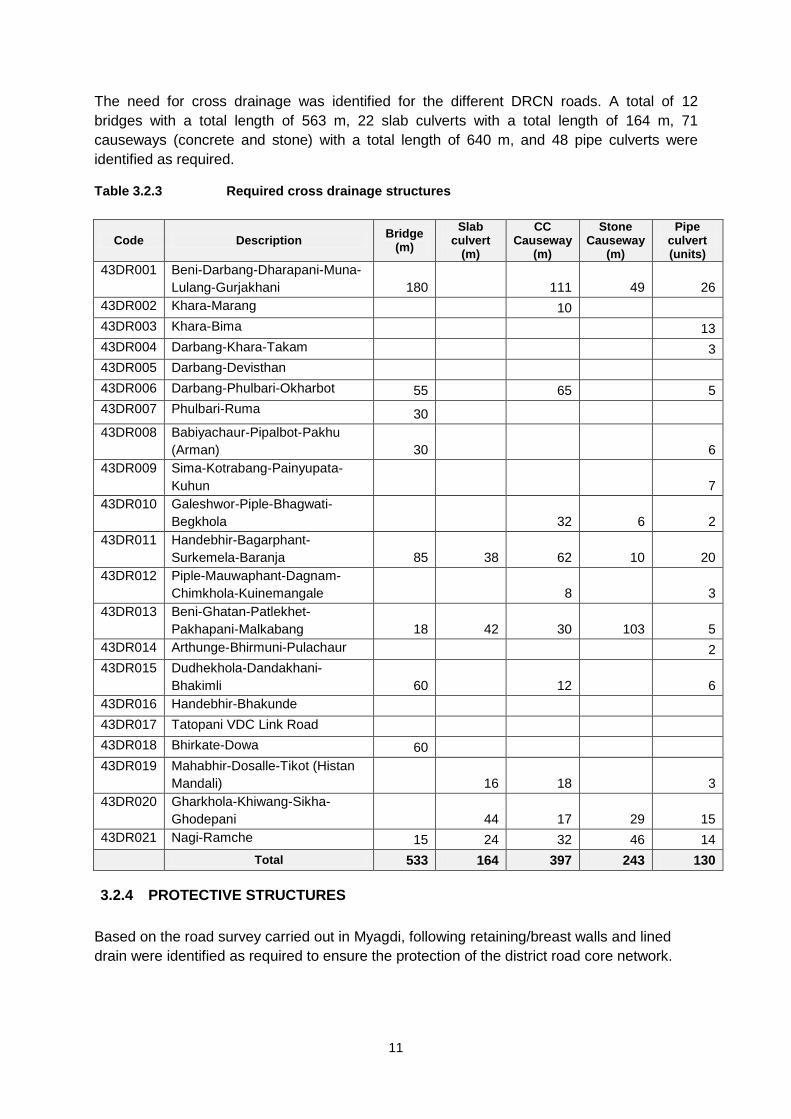
11
The need for cross drainage was identified for the different DRCN roads. A total of 12
bridges with a total length of 563 m, 22 slab culverts with a total length of 164 m, 71
causeways (concrete and stone) with a total length of 640 m, and 48 pipe culverts were
identified as required.
Table 3.2.3 Required cross drainage structures
Code Description Bridge
(m)
Slab culvert
(m)
CC Causeway
(m)
Stone Causeway
(m)
Pipe culvert (units)
43DR001 Beni-Darbang-Dharapani-Muna-
Lulang-Gurjakhani 180 111 49 26
43DR002 Khara-Marang 10
43DR003 Khara-Bima 13
43DR004 Darbang-Khara-Takam 3
43DR005 Darbang-Devisthan
43DR006 Darbang-Phulbari-Okharbot 55 65 5
43DR007 Phulbari-Ruma 30
43DR008 Babiyachaur-Pipalbot-Pakhu
(Arman) 30 6
43DR009 Sima-Kotrabang-Painyupata-
Kuhun 7
43DR010 Galeshwor-Piple-Bhagwati-
Begkhola 32 6 2
43DR011 Handebhir-Bagarphant-
Surkemela-Baranja 85 38 62 10 20
43DR012 Piple-Mauwaphant-Dagnam-
Chimkhola-Kuinemangale 8 3
43DR013 Beni-Ghatan-Patlekhet-
Pakhapani-Malkabang 18 42 30 103 5
43DR014 Arthunge-Bhirmuni-Pulachaur 2
43DR015 Dudhekhola-Dandakhani-
Bhakimli 60 12 6
43DR016 Handebhir-Bhakunde
43DR017 Tatopani VDC Link Road
43DR018 Bhirkate-Dowa 60
43DR019 Mahabhir-Dosalle-Tikot (Histan
Mandali) 16 18 3
43DR020 Gharkhola-Khiwang-Sikha-
Ghodepani 44 17 29 15
43DR021 Nagi-Ramche 15 24 32 46 14
Total 533 164 397 243 130
3.2.4 PROTECTIVE STRUCTURES
Based on the road survey carried out in Myagdi, following retaining/breast walls and lined
drain were identified as required to ensure the protection of the district road core network.
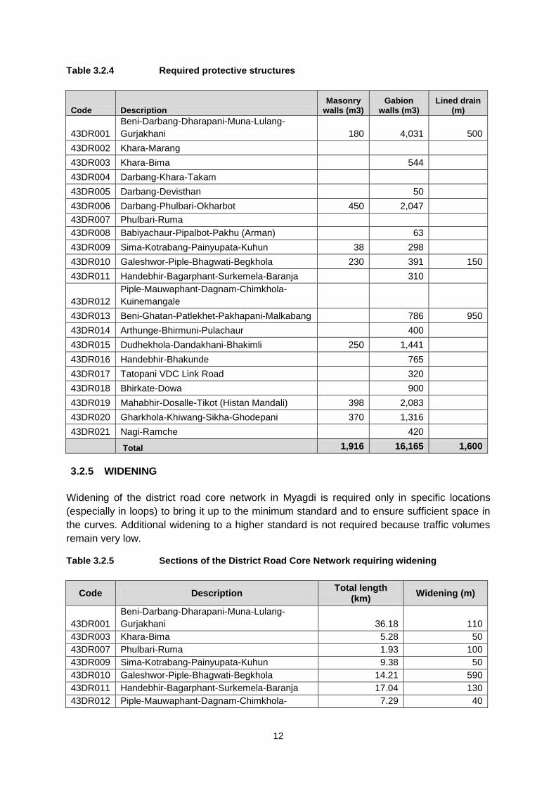
12
Table 3.2.4 Required protective structures
Code Description Masonry
walls (m3) Gabion
walls (m3) Lined drain
(m)
43DR001
Beni-Darbang-Dharapani-Muna-Lulang-
Gurjakhani 180 4,031 500
43DR002 Khara-Marang
43DR003 Khara-Bima 544
43DR004 Darbang-Khara-Takam
43DR005 Darbang-Devisthan 50
43DR006 Darbang-Phulbari-Okharbot 450 2,047
43DR007 Phulbari-Ruma
43DR008 Babiyachaur-Pipalbot-Pakhu (Arman) 63
43DR009 Sima-Kotrabang-Painyupata-Kuhun 38 298
43DR010 Galeshwor-Piple-Bhagwati-Begkhola 230 391 150
43DR011 Handebhir-Bagarphant-Surkemela-Baranja 310
43DR012
Piple-Mauwaphant-Dagnam-Chimkhola-
Kuinemangale
43DR013 Beni-Ghatan-Patlekhet-Pakhapani-Malkabang 786 950
43DR014 Arthunge-Bhirmuni-Pulachaur 400
43DR015 Dudhekhola-Dandakhani-Bhakimli 250 1,441
43DR016 Handebhir-Bhakunde 765
43DR017 Tatopani VDC Link Road 320
43DR018 Bhirkate-Dowa 900
43DR019 Mahabhir-Dosalle-Tikot (Histan Mandali) 398 2,083
43DR020 Gharkhola-Khiwang-Sikha-Ghodepani 370 1,316
43DR021 Nagi-Ramche 420
Total 1,916 16,165 1,600
3.2.5 WIDENING
Widening of the district road core network in Myagdi is required only in specific locations
(especially in loops) to bring it up to the minimum standard and to ensure sufficient space in
the curves. Additional widening to a higher standard is not required because traffic volumes
remain very low.
Table 3.2.5 Sections of the District Road Core Network requiring widening
Code Description Total length
(km) Widening (m)
43DR001
Beni-Darbang-Dharapani-Muna-Lulang-
Gurjakhani 36.18 110
43DR003 Khara-Bima 5.28 50
43DR007 Phulbari-Ruma 1.93 100
43DR009 Sima-Kotrabang-Painyupata-Kuhun 9.38 50
43DR010 Galeshwor-Piple-Bhagwati-Begkhola 14.21 590
43DR011 Handebhir-Bagarphant-Surkemela-Baranja 17.04 130
43DR012 Piple-Mauwaphant-Dagnam-Chimkhola- 7.29 40
13
Code Description Total length
(km) Widening (m)
Kuinemangale
43DR013 Beni-Ghatan-Patlekhet-Pakhapani-Malkabang 28.88 295
43DR014 Arthunge-Bhirmuni-Pulachaur 5.74 30
43DR015 Dudhekhola-Dandakhani-Bhakimli 8.09 250
43DR017 Tatopani VDC Link Road 1.74 40
43DR018 Bhirkate-Dowa 7.84 120
43DR019 Mahabhir-Dosalle-Tikot (Histan Mandali) 10.68 50
43DR020 Gharkhola-Khiwang-Sikha-Ghodepani 17.64 110
43DR021 Nagi-Ramche 7.53 115
Total 2,080
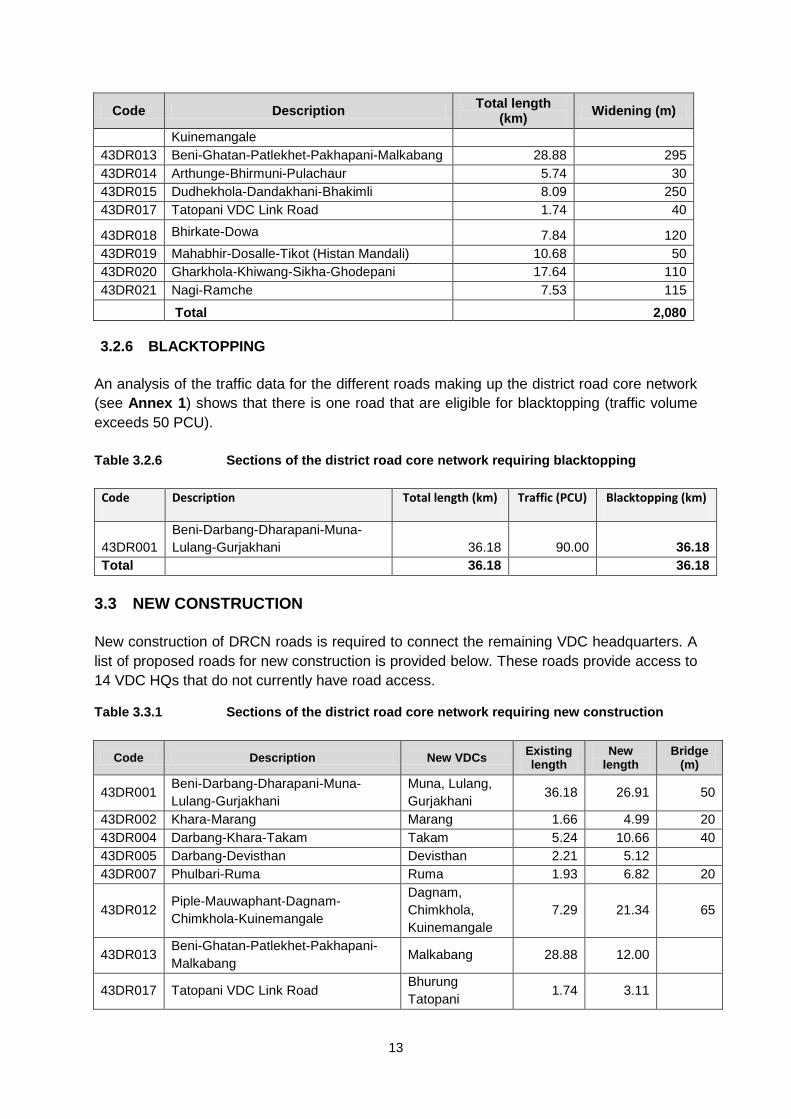
3.2.6 BLACKTOPPING
An analysis of the traffic data for the different roads making up the district road core network
(see Annex 1) shows that there is one road that are eligible for blacktopping (traffic volume
exceeds 50 PCU).
Table 3.2.6 Sections of the district road core network requiring blacktopping
Code Description Total length (km) Traffic (PCU) Blacktopping (km)
43DR001
Beni-Darbang-Dharapani-Muna-
Lulang-Gurjakhani 36.18 90.00 36.18
Total 36.18 36.18
3.3 NEW CONSTRUCTION
New construction of DRCN roads is required to connect the remaining VDC headquarters. A
list of proposed roads for new construction is provided below. These roads provide access to
14 VDC HQs that do not currently have road access.
Table 3.3.1 Sections of the district road core network requiring new construction
Code Description New VDCs Existing length
New length
Bridge (m)
43DR001 Beni-Darbang-Dharapani-Muna-
Lulang-Gurjakhani
Muna, Lulang,
Gurjakhani 36.18 26.91 50
43DR002 Khara-Marang Marang 1.66 4.99 20
43DR004 Darbang-Khara-Takam Takam 5.24 10.66 40
43DR005 Darbang-Devisthan Devisthan 2.21 5.12
43DR007 Phulbari-Ruma Ruma 1.93 6.82 20
43DR012 Piple-Mauwaphant-Dagnam-
Chimkhola-Kuinemangale
Dagnam,
Chimkhola,
Kuinemangale
7.29 21.34 65
43DR013 Beni-Ghatan-Patlekhet-Pakhapani-
Malkabang Malkabang 28.88 12.00
43DR017 Tatopani VDC Link Road Bhurung
Tatopani 1.74 3.11
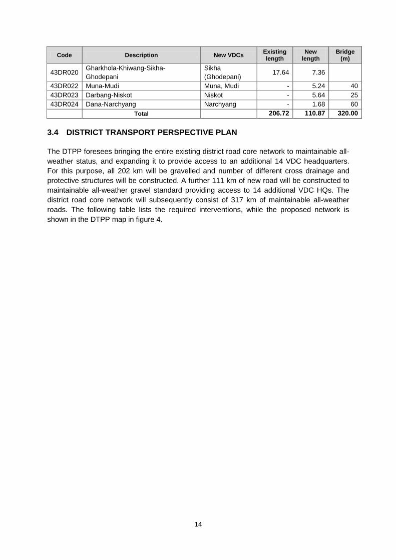
14
Code Description New VDCs Existing length
New length
Bridge (m)
43DR020 Gharkhola-Khiwang-Sikha-
Ghodepani
Sikha
(Ghodepani) 17.64 7.36
43DR022 Muna-Mudi Muna, Mudi - 5.24 40
43DR023 Darbang-Niskot Niskot - 5.64 25
43DR024 Dana-Narchyang Narchyang - 1.68 60
Total
206.72 110.87 320.00
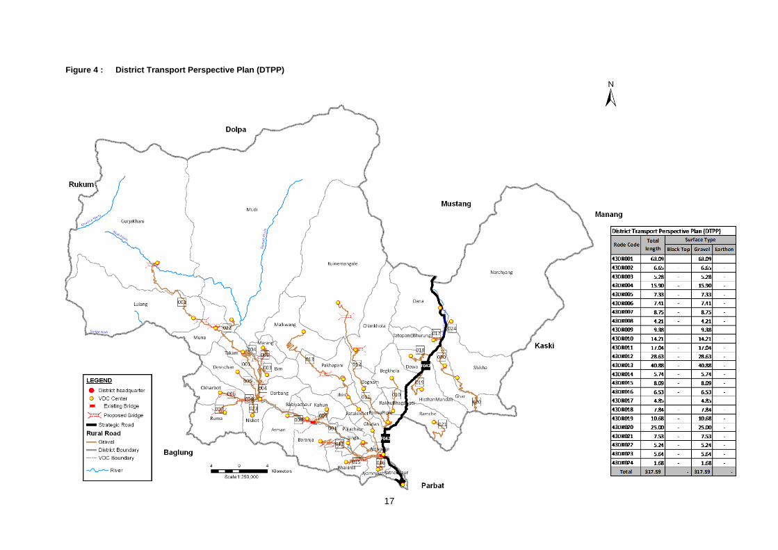
3.4 DISTRICT TRANSPORT PERSPECTIVE PLAN
The DTPP foresees bringing the entire existing district road core network to maintainable all-
weather status, and expanding it to provide access to an additional 14 VDC headquarters.
For this purpose, all 202 km will be gravelled and number of different cross drainage and
protective structures will be constructed. A further 111 km of new road will be constructed to
maintainable all-weather gravel standard providing access to 14 additional VDC HQs. The
district road core network will subsequently consist of 317 km of maintainable all-weather
roads. The following table lists the required interventions, while the proposed network is
shown in the DTPP map in figure 4.
15
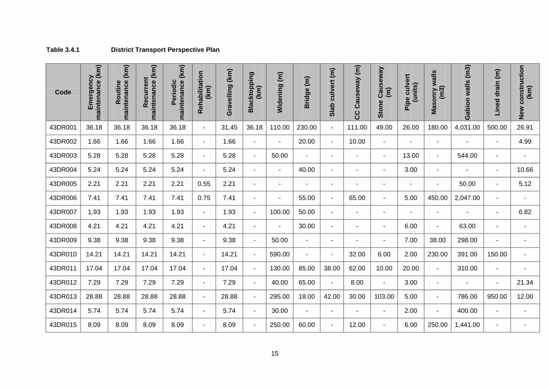
Table 3.4.1 District Transport Perspective Plan
Code E
merg
en
cy
main
ten
an
ce
(km
)
Ro
uti
ne
main
ten
an
ce
(km
)
Recu
rren
t
main
ten
an
ce
(km
)
Peri
od
ic
main
ten
an
ce
(km
)
Reh
ab
ilit
ati
on
(km
)
Gra
vell
ing
(km
)
Bla
ckto
pp
ing
(km
)
Wid
en
ing
(m
)
Bri
dg
e (
m)
Sla
b c
ulv
ert
(m
)
CC
Cau
sew
ay (
m)
Sto
ne C
au
sew
ay
(m)
Pip
e c
ulv
ert
(un
its)
Maso
nry
wall
s
(m3)
Gab
ion
walls (
m3)
Lin
ed
dra
in (
m)
New
co
nstr
ucti
on
(km
)
43DR001 36.18 36.18 36.18 36.18 - 31.45 36.18 110.00 230.00 - 111.00 49.00 26.00 180.00 4,031.00 500.00 26.91
43DR002 1.66 1.66 1.66 1.66 - 1.66 - - 20.00 - 10.00 - - - - - 4.99
43DR003 5.28 5.28 5.28 5.28 - 5.28 - 50.00 - - - - 13.00 - 544.00 - -
43DR004 5.24 5.24 5.24 5.24 - 5.24 - - 40.00 - - - 3.00 - - - 10.66
43DR005 2.21 2.21 2.21 2.21 0.55 2.21 - - - - - - - - 50.00 - 5.12
43DR006 7.41 7.41 7.41 7.41 0.75 7.41 - - 55.00 - 65.00 - 5.00 450.00 2,047.00 - -
43DR007 1.93 1.93 1.93 1.93 - 1.93 - 100.00 50.00 - - - - - - - 6.82
43DR008 4.21 4.21 4.21 4.21 - 4.21 - - 30.00 - - - 6.00 - 63.00 - -
43DR009 9.38 9.38 9.38 9.38 - 9.38 - 50.00 - - - - 7.00 38.00 298.00 - -
43DR010 14.21 14.21 14.21 14.21 - 14.21 - 590.00 - - 32.00 6.00 2.00 230.00 391.00 150.00 -
43DR011 17.04 17.04 17.04 17.04 - 17.04 - 130.00 85.00 38.00 62.00 10.00 20.00 - 310.00 - -
43DR012 7.29 7.29 7.29 7.29 - 7.29 - 40.00 65.00 - 8.00 - 3.00 - - - 21.34
43DR013 28.88 28.88 28.88 28.88 - 28.88 - 295.00 18.00 42.00 30.00 103.00 5.00 - 786.00 950.00 12.00
43DR014 5.74 5.74 5.74 5.74 - 5.74 - 30.00 - - - - 2.00 - 400.00 - -
43DR015 8.09 8.09 8.09 8.09 - 8.09 - 250.00 60.00 - 12.00 - 6.00 250.00 1,441.00 - -
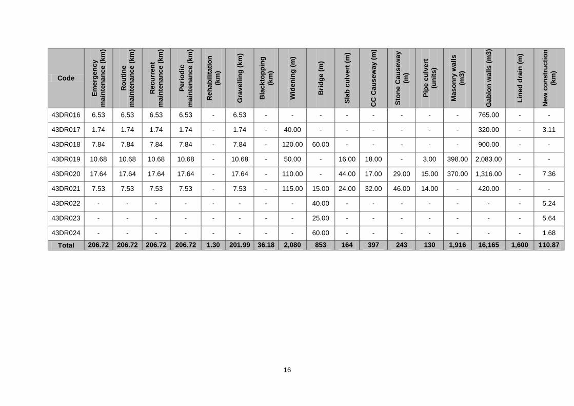
16
Code
Em
erg
en
cy
main
ten
an
ce
(km
)
Ro
uti
ne
main
ten
an
ce
(km
)
Recu
rren
t
main
ten
an
ce
(km
)
Peri
od
ic
main
ten
an
ce
(km
)
Reh
ab
ilit
ati
on
(km
)
Gra
vell
ing
(km
)
Bla
ckto
pp
ing
(km
)
Wid
en
ing
(m
)
Bri
dg
e (
m)
Sla
b c
ulv
ert
(m
)
CC
Cau
sew
ay (
m)
Sto
ne C
au
sew
ay
(m)
Pip
e c
ulv
ert
(un
its)
Maso
nry
wall
s
(m3)
Gab
ion
walls (
m3)
Lin
ed
dra
in (
m)
New
co
nstr
ucti
on
(km
)
43DR016 6.53 6.53 6.53 6.53 - 6.53 - - - - - - - - 765.00 - -
43DR017 1.74 1.74 1.74 1.74 - 1.74 - 40.00 - - - - - - 320.00 - 3.11
43DR018 7.84 7.84 7.84 7.84 - 7.84 - 120.00 60.00 - - - - - 900.00 - -
43DR019 10.68 10.68 10.68 10.68 - 10.68 - 50.00 - 16.00 18.00 - 3.00 398.00 2,083.00 - -
43DR020 17.64 17.64 17.64 17.64 - 17.64 - 110.00 - 44.00 17.00 29.00 15.00 370.00 1,316.00 - 7.36
43DR021 7.53 7.53 7.53 7.53 - 7.53 - 115.00 15.00 24.00 32.00 46.00 14.00 - 420.00 - -
43DR022 - - - - - - - - 40.00 - - - - - - - 5.24
43DR023 - - - - - - - - 25.00 - - - - - - - 5.64
43DR024 - - - - - - - - 60.00 - - - - - - - 1.68
Total 206.72 206.72 206.72 206.72 1.30 201.99 36.18 2,080 853 164 397 243 130 1,916 16,165 1,600 110.87
17
Figure 4 : District Transport Perspective Plan (DTPP)
18
4. COST ESTIMATION
For the cost estimation, standard costs for the different activities required have been
referred. For the conservation activities this results in an estimation of annual costs, while for
improvement and new construction activities these results in an estimation of the total costs
required.
4.1 CONSERVATION
The costs of the required conservation measures have been calculated using the following
standard costs. These standard costs have been applied to the entire district road core
network, whereby distinction is made based on the surface type in the case of recurrent and
periodic maintenance. It must be noted here that the standard costs for periodic maintenance
are the average annual costs, but that the cost for applying periodic maintenance in a
specific section every several years will be higher (the cumulative cost of several years). The
estimated costs for the first year are presented below, while the costs for subsequent years
will vary slightly as road surface types change as a result of improvements. Detailed cost
estimations for the actual maintenance needs in any given year will be presented in the
AAMP.
Table 4.1.1 Standard unit costs for conservation
Activity Unit
Unit cost
(NPR/km)
Emergency maintenance km 30,000
Routine maintenance km 20,000
Recurrent maintenance (blacktop) km 500,000
Recurrent maintenance (gravel) km 400,000
Recurrent maintenance (earthen) km 250,000
Periodic maintenance (blacktop) km 200,000
Periodic maintenance (gravel) km 250,000
For the first year the estimated costs for conservation of the DRCN come to NPR 63.9
millions. Based on this cost for the first year, the costs for conservation of the DRCN for the
next 5 years are estimated at NPR 319.5 million. These costs will change slightly as the
roads are improved and the standard conservation costs change. This will be updated in the
ARMP on an annual basis.
Table 4.1.2 Estimated conservation costs for the first year (NPR ‘000)
Code
Tota
l le
ngt
h (
km)
Bla
ckto
p (
km)
Gra
vel (
km)
Eart
he
n (
km)
Eme
rge
ncy
mai
nte
nan
ce
Ro
uti
ne
mai
nte
nan
ce
Re
curr
en
t
mai
nte
nan
ce
(bla
ckto
p)
Re
curr
en
t
mai
nte
nan
ce
(gra
vel)
Re
curr
en
t
mai
nte
nan
ce
(ear
the
n)
Pe
rio
dic
mai
nte
nan
ce
(bla
ckto
p)
Pe
rio
dic
mai
nte
nan
ce
(gra
vel)
Tota
l fir
st y
ear
co
st
Tota
l 5-y
ear
co
st
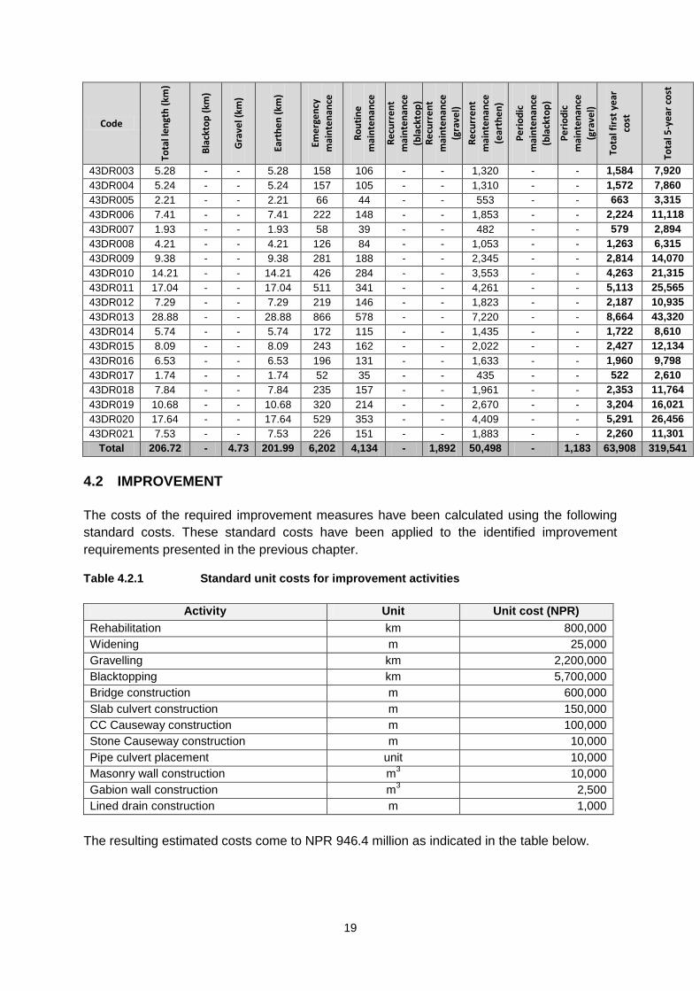
43DR001 36.18 - 4.73 31.45 1,085 724 - 1,892 7,863 - 1,183 12,746 63,730
43DR002 1.66 - - 1.66 50 33 - - 415 - - 498 2,490
19
Code
Tota
l le
ngt
h (
km)
Bla
ckto
p (
km)
Gra
vel (
km)
Eart
he
n (
km)
Eme
rge
ncy
mai
nte
nan
ce
Ro
uti
ne
mai
nte
nan
ce
Re
curr
en
t
mai
nte
nan
ce
(bla
ckto
p)
Re
curr
en
t
mai
nte
nan
ce
(gra
vel)
Re
curr
en
t
mai
nte
nan
ce
(ear
the
n)
Pe
rio
dic
mai
nte
nan
ce
(bla
ckto
p)
Pe
rio
dic
mai
nte
nan
ce
(gra
vel)
Tota
l fir
st y
ear
co
st
Tota
l 5-y
ear
co
st
43DR003 5.28 - - 5.28 158 106 - - 1,320 - - 1,584 7,920
43DR004 5.24 - - 5.24 157 105 - - 1,310 - - 1,572 7,860
43DR005 2.21 - - 2.21 66 44 - - 553 - - 663 3,315
43DR006 7.41 - - 7.41 222 148 - - 1,853 - - 2,224 11,118
43DR007 1.93 - - 1.93 58 39 - - 482 - - 579 2,894
43DR008 4.21 - - 4.21 126 84 - - 1,053 - - 1,263 6,315
43DR009 9.38 - - 9.38 281 188 - - 2,345 - - 2,814 14,070
43DR010 14.21 - - 14.21 426 284 - - 3,553 - - 4,263 21,315
43DR011 17.04 - - 17.04 511 341 - - 4,261 - - 5,113 25,565
43DR012 7.29 - - 7.29 219 146 - - 1,823 - - 2,187 10,935
43DR013 28.88 - - 28.88 866 578 - - 7,220 - - 8,664 43,320
43DR014 5.74 - - 5.74 172 115 - - 1,435 - - 1,722 8,610
43DR015 8.09 - - 8.09 243 162 - - 2,022 - - 2,427 12,134
43DR016 6.53 - - 6.53 196 131 - - 1,633 - - 1,960 9,798
43DR017 1.74 - - 1.74 52 35 - - 435 - - 522 2,610
43DR018 7.84 - - 7.84 235 157 - - 1,961 - - 2,353 11,764
43DR019 10.68 - - 10.68 320 214 - - 2,670 - - 3,204 16,021
43DR020 17.64 - - 17.64 529 353 - - 4,409 - - 5,291 26,456
43DR021 7.53 - - 7.53 226 151 - - 1,883 - - 2,260 11,301
Total 206.72 - 4.73 201.99 6,202 4,134 - 1,892 50,498 - 1,183 63,908 319,541
4.2 IMPROVEMENT
The costs of the required improvement measures have been calculated using the following
standard costs. These standard costs have been applied to the identified improvement
requirements presented in the previous chapter.
Table 4.2.1 Standard unit costs for improvement activities
Activity Unit Unit cost (NPR)
Rehabilitation km 800,000
Widening m 25,000
Gravelling km 2,200,000
Blacktopping km 5,700,000
Bridge construction m 600,000
Slab culvert construction m 150,000
CC Causeway construction m 100,000
Stone Causeway construction m 10,000
Pipe culvert placement unit 10,000
Masonry wall construction m3 10,000
Gabion wall construction m3 2,500
Lined drain construction m 1,000
The resulting estimated costs come to NPR 946.4 million as indicated in the table below.
20
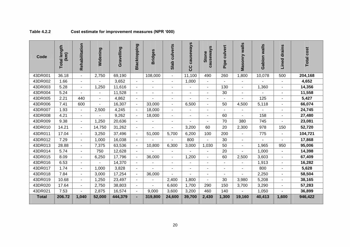
Table 4.2.2 Cost estimate for improvement measures (NPR ‘000)
Code T
ota
l le
ng
th
(km
)
Reh
ab
ilit
ati
on
Wid
en
ing
Gra
vell
ing
Bla
ckto
pp
ing
Bri
dg
es
Sla
b c
ulv
ert
s
CC
cau
sew
ay
s
Sto
ne
cau
sew
ays
Pip
e c
ulv
ert
Maso
nry
wall
s
Gab
ion
walls
Lin
ed
dra
ins
To
tal co
st
43DR001 36.18 - 2,750 69,190
108,000 - 11,100 490 260 1,800 10,078 500 204,168
43DR002 1.66 - - 3,652 - - - 1,000 - - - - - 4,652
43DR003 5.28 - 1,250 11,616 - - - - - 130 - 1,360 - 14,356
43DR004 5.24 - - 11,528 - - - - - 30 - - - 11,558
43DR005 2.21 440 - 4,862 - - - - - - - 125 - 5,427
43DR006 7.41 600 - 16,307 - 33,000 - 6,500 - 50 4,500 5,118 - 66,074
43DR007 1.93 - 2,500 4,245 - 18,000 - - - - - - - 24,745
43DR008 4.21 - - 9,262 - 18,000 - - - 60 - 158 - 27,480
43DR009 9.38 - 1,250 20,636 - - - - - 70 380 745 - 23,081
43DR010 14.21 - 14,750 31,262 - - - 3,200 60 20 2,300 978 150 52,720
43DR011 17.04 - 3,250 37,496 - 51,000 5,700 6,200 100 200 - 775 - 104,721
43DR012 7.29 - 1,000 16,038 - - - 800 - 30 - - - 17,868
43DR013 28.88 - 7,375 63,536 - 10,800 6,300 3,000 1,030 50 - 1,965 950 95,006
43DR014 5.74 - 750 12,628 - - - - - 20 - 1,000 - 14,398
43DR015 8.09 - 6,250 17,796 - 36,000 - 1,200 - 60 2,500 3,603 - 67,409
43DR016 6.53 - - 14,370 - - - - - - - 1,913 - 16,282
43DR017 1.74 - 1,000 3,828 - - - - - - - 800 - 5,628
43DR018 7.84 - 3,000 17,254 - 36,000 - - - - - 2,250 - 58,504
43DR019 10.68 - 1,250 23,497 - - 2,400 1,800 - 30 3,980 5,208 - 38,165
43DR020 17.64 - 2,750 38,803 - - 6,600 1,700 290 150 3,700 3,290 - 57,283
43DR021 7.53 - 2,875 16,574 - 9,000 3,600 3,200 460 140 - 1,050 - 36,899
Total 206.72 1,040 52,000 444,379 - 319,800 24,600 39,700 2,430 1,300 19,160 40,413 1,600 946,422
21
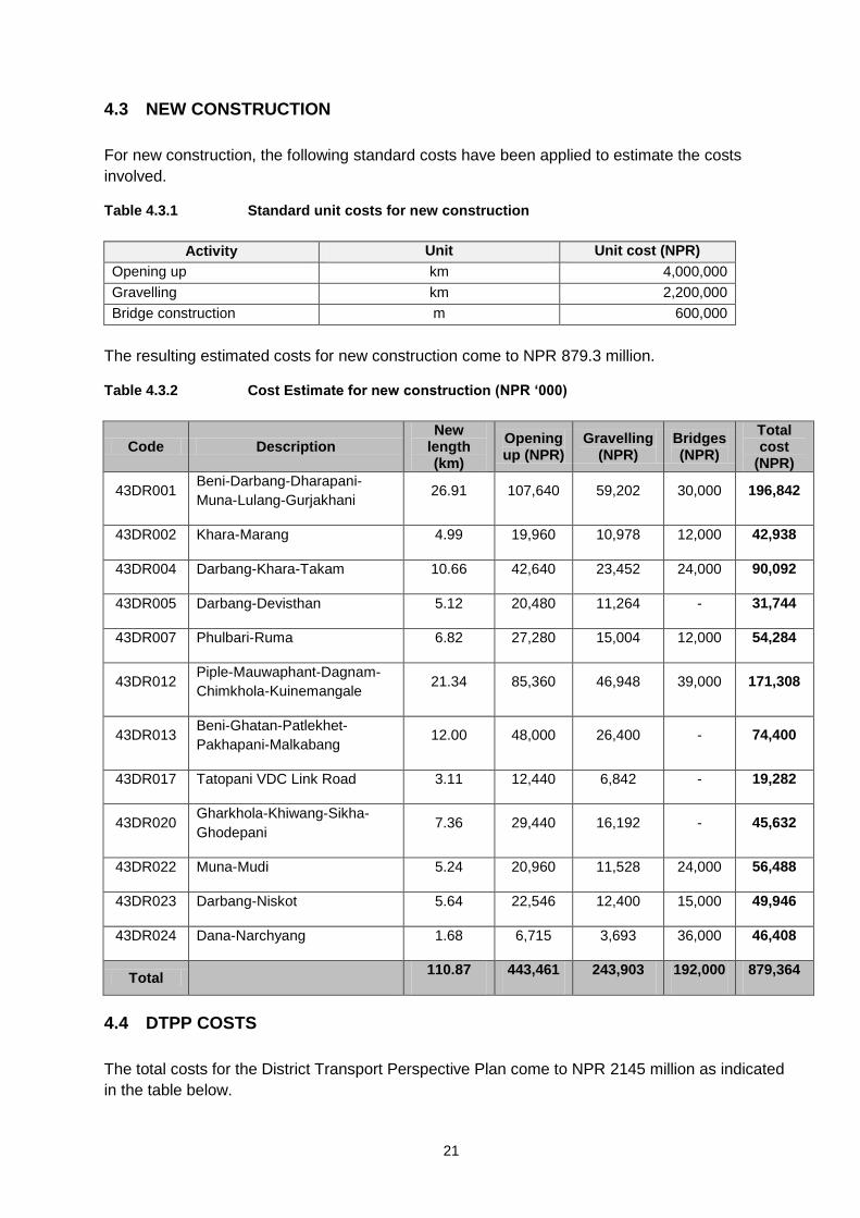
4.3 NEW CONSTRUCTION
For new construction, the following standard costs have been applied to estimate the costs
involved.
Table 4.3.1 Standard unit costs for new construction
Activity Unit Unit cost (NPR)
Opening up km 4,000,000
Gravelling km 2,200,000
Bridge construction m 600,000
The resulting estimated costs for new construction come to NPR 879.3 million.
Table 4.3.2 Cost Estimate for new construction (NPR ‘000)
Code Description New
length (km)
Opening up (NPR)
Gravelling (NPR)
Bridges (NPR)
Total cost
(NPR)
43DR001 Beni-Darbang-Dharapani-
Muna-Lulang-Gurjakhani 26.91 107,640 59,202 30,000 196,842
43DR002 Khara-Marang 4.99 19,960 10,978 12,000 42,938
43DR004 Darbang-Khara-Takam 10.66 42,640 23,452 24,000 90,092
43DR005 Darbang-Devisthan 5.12 20,480 11,264 - 31,744
43DR007 Phulbari-Ruma 6.82 27,280 15,004 12,000 54,284
43DR012 Piple-Mauwaphant-Dagnam-
Chimkhola-Kuinemangale 21.34 85,360 46,948 39,000 171,308
43DR013 Beni-Ghatan-Patlekhet-
Pakhapani-Malkabang 12.00 48,000 26,400 - 74,400
43DR017 Tatopani VDC Link Road 3.11 12,440 6,842 - 19,282
43DR020 Gharkhola-Khiwang-Sikha-
Ghodepani 7.36 29,440 16,192 - 45,632
43DR022 Muna-Mudi 5.24 20,960 11,528 24,000 56,488
43DR023 Darbang-Niskot 5.64 22,546 12,400 15,000 49,946
43DR024 Dana-Narchyang 1.68 6,715 3,693 36,000 46,408
Total
110.87 443,461 243,903 192,000 879,364
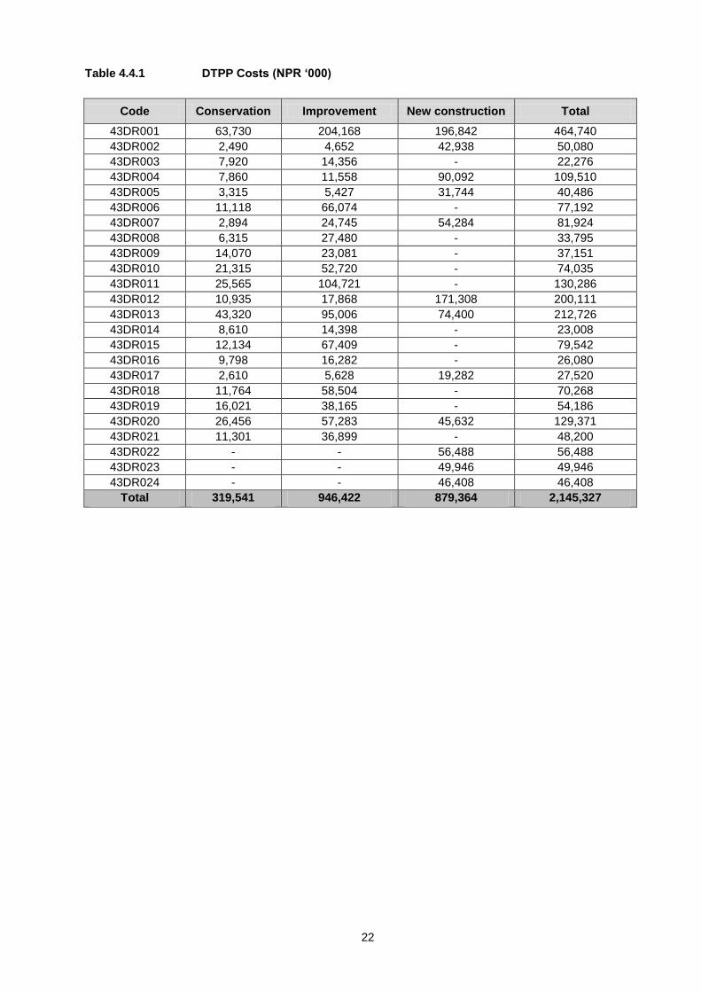
4.4 DTPP COSTS
The total costs for the District Transport Perspective Plan come to NPR 2145 million as indicated
in the table below.
22
Table 4.4.1 DTPP Costs (NPR ‘000)
Code Conservation Improvement New construction Total
43DR001 63,730 204,168 196,842 464,740
43DR002 2,490 4,652 42,938 50,080
43DR003 7,920 14,356 - 22,276
43DR004 7,860 11,558 90,092 109,510
43DR005 3,315 5,427 31,744 40,486
43DR006 11,118 66,074 - 77,192
43DR007 2,894 24,745 54,284 81,924
43DR008 6,315 27,480 - 33,795
43DR009 14,070 23,081 - 37,151
43DR010 21,315 52,720 - 74,035
43DR011 25,565 104,721 - 130,286
43DR012 10,935 17,868 171,308 200,111
43DR013 43,320 95,006 74,400 212,726
43DR014 8,610 14,398 - 23,008
43DR015 12,134 67,409 - 79,542
43DR016 9,798 16,282 - 26,080
43DR017 2,610 5,628 19,282 27,520
43DR018 11,764 58,504 - 70,268
43DR019 16,021 38,165 - 54,186
43DR020 26,456 57,283 45,632 129,371
43DR021 11,301 36,899 - 48,200
43DR022 - - 56,488 56,488
43DR023 - - 49,946 49,946
43DR024 - - 46,408 46,408
Total 319,541 946,422 879,364 2,145,327
23
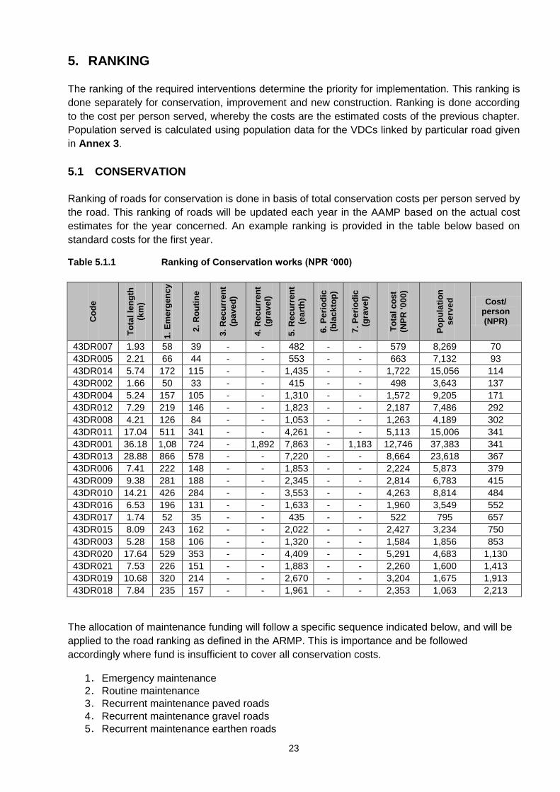
5. RANKING
The ranking of the required interventions determine the priority for implementation. This ranking is
done separately for conservation, improvement and new construction. Ranking is done according
to the cost per person served, whereby the costs are the estimated costs of the previous chapter.
Population served is calculated using population data for the VDCs linked by particular road given
in Annex 3.
5.1 CONSERVATION
Ranking of roads for conservation is done in basis of total conservation costs per person served by
the road. This ranking of roads will be updated each year in the AAMP based on the actual cost
estimates for the year concerned. An example ranking is provided in the table below based on
standard costs for the first year.
Table 5.1.1 Ranking of Conservation works (NPR ‘000)
Co
de
To
tal
len
gth
(km
)
1.
Em
erg
en
cy
2.
Ro
uti
ne
3.
Rec
urr
en
t
(pa
ve
d)
4.
Rec
urr
en
t
(gra
ve
l)
5.
Rec
urr
en
t
(ea
rth
)
6.
Pe
rio
dic
(bla
ck
top
)
7.
Pe
rio
dic
(gra
ve
l)
To
tal
co
st
(NP
R '0
00
)
Po
pu
lati
on
se
rve
d
Cost/ person (NPR)
43DR007 1.93 58 39 - - 482 - - 579 8,269 70
43DR005 2.21 66 44 - - 553 - - 663 7,132 93
43DR014 5.74 172 115 - - 1,435 - - 1,722 15,056 114
43DR002 1.66 50 33 - - 415 - - 498 3,643 137
43DR004 5.24 157 105 - - 1,310 - - 1,572 9,205 171
43DR012 7.29 219 146 - - 1,823 - - 2,187 7,486 292
43DR008 4.21 126 84 - - 1,053 - - 1,263 4,189 302
43DR011 17.04 511 341 - - 4,261 - - 5,113 15,006 341
43DR001 36.18 1,08
5
724 - 1,892 7,863 - 1,183 12,746 37,383 341
43DR013 28.88 866 578 - - 7,220 - - 8,664 23,618 367
43DR006 7.41 222 148 - - 1,853 - - 2,224 5,873 379
43DR009 9.38 281 188 - - 2,345 - - 2,814 6,783 415
43DR010 14.21 426 284 - - 3,553 - - 4,263 8,814 484
43DR016 6.53 196 131 - - 1,633 - - 1,960 3,549 552
43DR017 1.74 52 35 - - 435 - - 522 795 657
43DR015 8.09 243 162 - - 2,022 - - 2,427 3,234 750
43DR003 5.28 158 106 - - 1,320 - - 1,584 1,856 853
43DR020 17.64 529 353 - - 4,409 - - 5,291 4,683 1,130
43DR021 7.53 226 151 - - 1,883 - - 2,260 1,600 1,413
43DR019 10.68 320 214 - - 2,670 - - 3,204 1,675 1,913
43DR018 7.84 235 157 - - 1,961 - - 2,353 1,063 2,213
The allocation of maintenance funding will follow a specific sequence indicated below, and will be
applied to the road ranking as defined in the ARMP. This is importance and be followed
accordingly where fund is insufficient to cover all conservation costs.
1. Emergency maintenance
2. Routine maintenance
3. Recurrent maintenance paved roads
4. Recurrent maintenance gravel roads
5. Recurrent maintenance earthen roads
24
6. Periodic maintenance blacktop roads
7. Periodic maintenance gravel roads
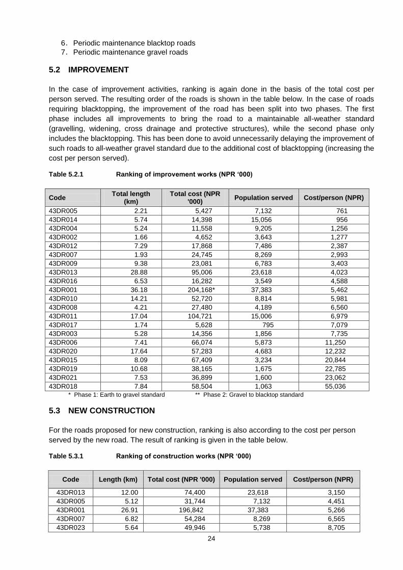
5.2 IMPROVEMENT
In the case of improvement activities, ranking is again done in the basis of the total cost per
person served. The resulting order of the roads is shown in the table below. In the case of roads
requiring blacktopping, the improvement of the road has been split into two phases. The first
phase includes all improvements to bring the road to a maintainable all-weather standard
(gravelling, widening, cross drainage and protective structures), while the second phase only
includes the blacktopping. This has been done to avoid unnecessarily delaying the improvement of
such roads to all-weather gravel standard due to the additional cost of blacktopping (increasing the
cost per person served).
Table 5.2.1 Ranking of improvement works (NPR ‘000)
Code Total length
(km) Total cost (NPR
'000) Population served Cost/person (NPR)
43DR005 2.21 5,427 7,132 761
43DR014 5.74 14,398 15,056 956
43DR004 5.24 11,558 9,205 1,256
43DR002 1.66 4,652 3,643 1,277
43DR012 7.29 17,868 7,486 2,387
43DR007 1.93 24,745 8,269 2,993
43DR009 9.38 23,081 6,783 3,403
43DR013 28.88 95,006 23,618 4,023
43DR016 6.53 16,282 3,549 4,588
43DR001 36.18 204,168* 37,383 5,462
43DR010 14.21 52,720 8,814 5,981
43DR008 4.21 27,480 4,189 6,560
43DR011 17.04 104,721 15,006 6,979
43DR017 1.74 5,628 795 7,079
43DR003 5.28 14,356 1,856 7,735
43DR006 7.41 66,074 5,873 11,250
43DR020 17.64 57,283 4,683 12,232
43DR015 8.09 67,409 3,234 20,844
43DR019 10.68 38,165 1,675 22,785
43DR021 7.53 36,899 1,600 23,062
43DR018 7.84 58,504 1,063 55,036
* Phase 1: Earth to gravel standard ** Phase 2: Gravel to blacktop standard
5.3 NEW CONSTRUCTION
For the roads proposed for new construction, ranking is also according to the cost per person
served by the new road. The result of ranking is given in the table below.
Table 5.3.1 Ranking of construction works (NPR ‘000)
Code Length (km) Total cost (NPR '000) Population served Cost/person (NPR)
43DR013 12.00 74,400 23,618 3,150
43DR005 5.12 31,744 7,132 4,451
43DR001 26.91 196,842 37,383 5,266
43DR007 6.82 54,284 8,269 6,565
43DR023 5.64 49,946 5,738 8,705
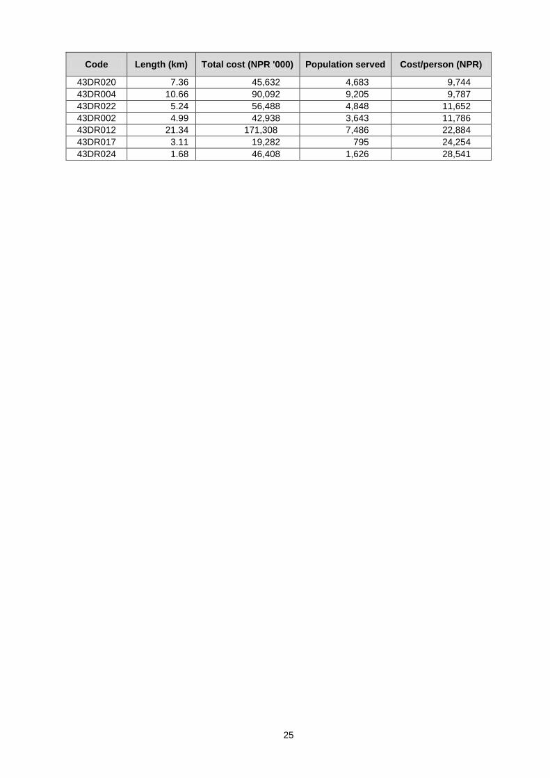
25
Code Length (km) Total cost (NPR '000) Population served Cost/person (NPR)
43DR020 7.36 45,632 4,683 9,744
43DR004 10.66 90,092 9,205 9,787
43DR022 5.24 56,488 4,848 11,652
43DR002 4.99 42,938 3,643 11,786
43DR012 21.34 171,308 7,486 22,884
43DR017 3.11 19,282 795 24,254
43DR024 1.68 46,408 1,626 28,541
26
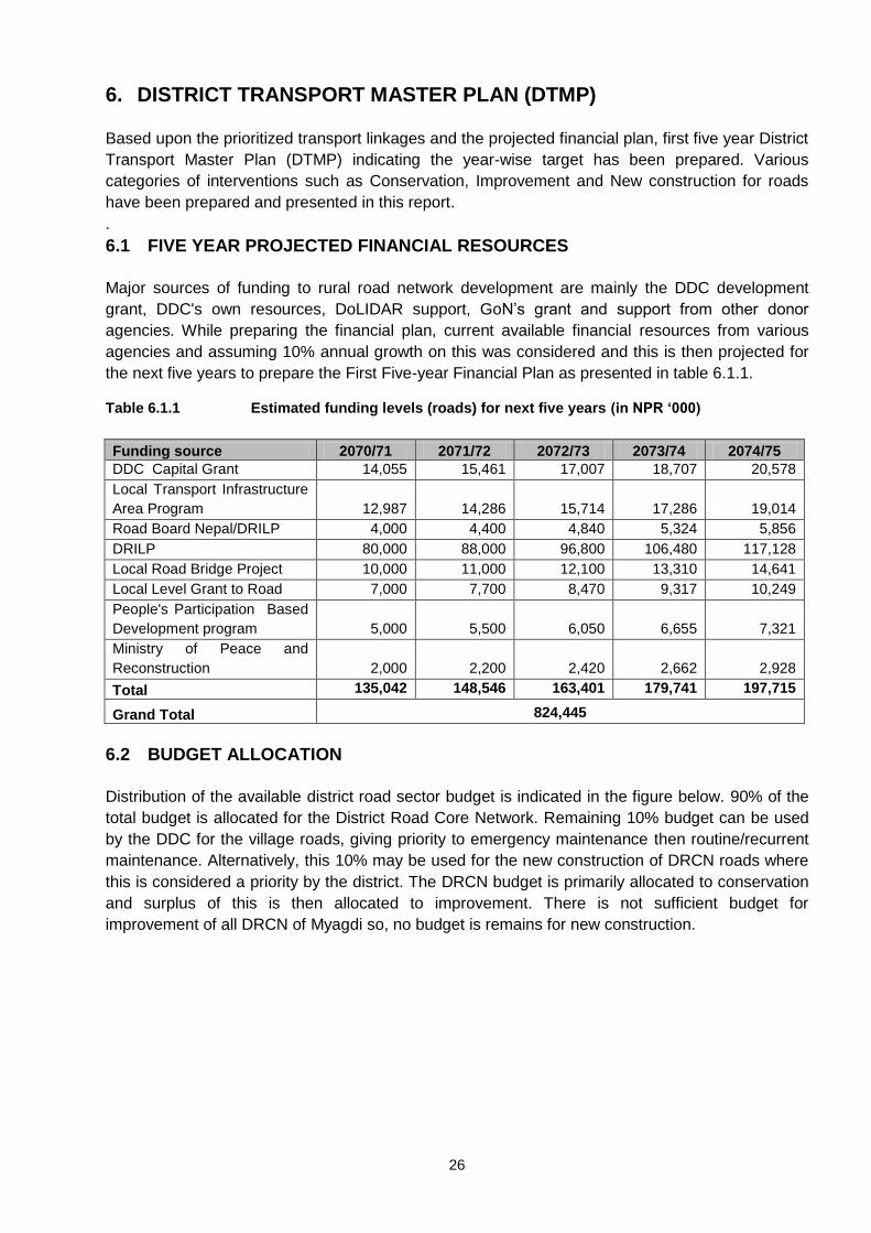
6. DISTRICT TRANSPORT MASTER PLAN (DTMP)
Based upon the prioritized transport linkages and the projected financial plan, first five year District
Transport Master Plan (DTMP) indicating the year-wise target has been prepared. Various
categories of interventions such as Conservation, Improvement and New construction for roads
have been prepared and presented in this report.
.
6.1 FIVE YEAR PROJECTED FINANCIAL RESOURCES
Major sources of funding to rural road network development are mainly the DDC development
grant, DDC's own resources, DoLIDAR support, GoN’s grant and support from other donor
agencies. While preparing the financial plan, current available financial resources from various
agencies and assuming 10% annual growth on this was considered and this is then projected for
the next five years to prepare the First Five-year Financial Plan as presented in table 6.1.1.
Table 6.1.1 Estimated funding levels (roads) for next five years (in NPR ‘000)
Funding source 2070/71 2071/72 2072/73 2073/74 2074/75
DDC Capital Grant 14,055 15,461 17,007 18,707 20,578
Local Transport Infrastructure
Area Program 12,987 14,286 15,714 17,286 19,014
Road Board Nepal/DRILP 4,000 4,400 4,840 5,324 5,856
DRILP 80,000 88,000 96,800 106,480 117,128
Local Road Bridge Project 10,000 11,000 12,100 13,310 14,641
Local Level Grant to Road 7,000 7,700 8,470 9,317 10,249
People's Participation Based
Development program 5,000 5,500 6,050 6,655 7,321
Ministry of Peace and
Reconstruction 2,000 2,200 2,420 2,662 2,928
Total 135,042 148,546 163,401 179,741 197,715
Grand Total 824,445
6.2 BUDGET ALLOCATION
Distribution of the available district road sector budget is indicated in the figure below. 90% of the
total budget is allocated for the District Road Core Network. Remaining 10% budget can be used
by the DDC for the village roads, giving priority to emergency maintenance then routine/recurrent
maintenance. Alternatively, this 10% may be used for the new construction of DRCN roads where
this is considered a priority by the district. The DRCN budget is primarily allocated to conservation
and surplus of this is then allocated to improvement. There is not sufficient budget for
improvement of all DRCN of Myagdi so, no budget is remains for new construction.
27
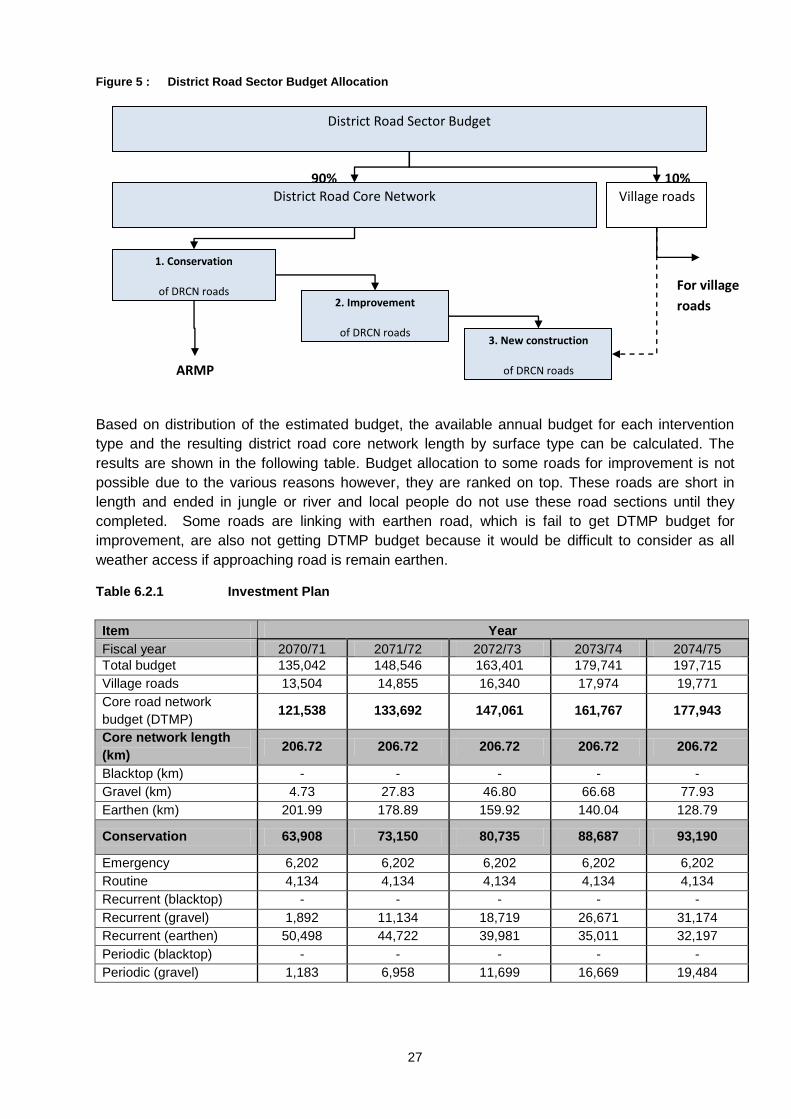
Figure 5 : District Road Sector Budget Allocation
Based on distribution of the estimated budget, the available annual budget for each intervention
type and the resulting district road core network length by surface type can be calculated. The
results are shown in the following table. Budget allocation to some roads for improvement is not
possible due to the various reasons however, they are ranked on top. These roads are short in
length and ended in jungle or river and local people do not use these road sections until they
completed. Some roads are linking with earthen road, which is fail to get DTMP budget for
improvement, are also not getting DTMP budget because it would be difficult to consider as all
weather access if approaching road is remain earthen.
Table 6.2.1 Investment Plan
Item Year
Fiscal year 2070/71 2071/72 2072/73 2073/74 2074/75
Total budget 135,042 148,546 163,401 179,741 197,715
Village roads 13,504 14,855 16,340 17,974 19,771
Core road network
budget (DTMP) 121,538 133,692 147,061 161,767 177,943
Core network length
(km) 206.72 206.72 206.72 206.72 206.72
Blacktop (km) - - - - -
Gravel (km) 4.73 27.83 46.80 66.68 77.93
Earthen (km) 201.99 178.89 159.92 140.04 128.79
Conservation 63,908 73,150 80,735 88,687 93,190
Emergency 6,202 6,202 6,202 6,202 6,202
Routine 4,134 4,134 4,134 4,134 4,134
Recurrent (blacktop) - - - - -
Recurrent (gravel) 1,892 11,134 18,719 26,671 31,174
Recurrent (earthen) 50,498 44,722 39,981 35,011 32,197
Periodic (blacktop) - - - - -
Periodic (gravel) 1,183 6,958 11,699 16,669 19,484
District Road Sector Budget
District Road Core Network
DTMP
Village roads 10%
90%
1. Conservation
of DRCN roads
ARMP
2. Improvement
of DRCN roads
3. New construction
of DRCN roads
For village
roads
28
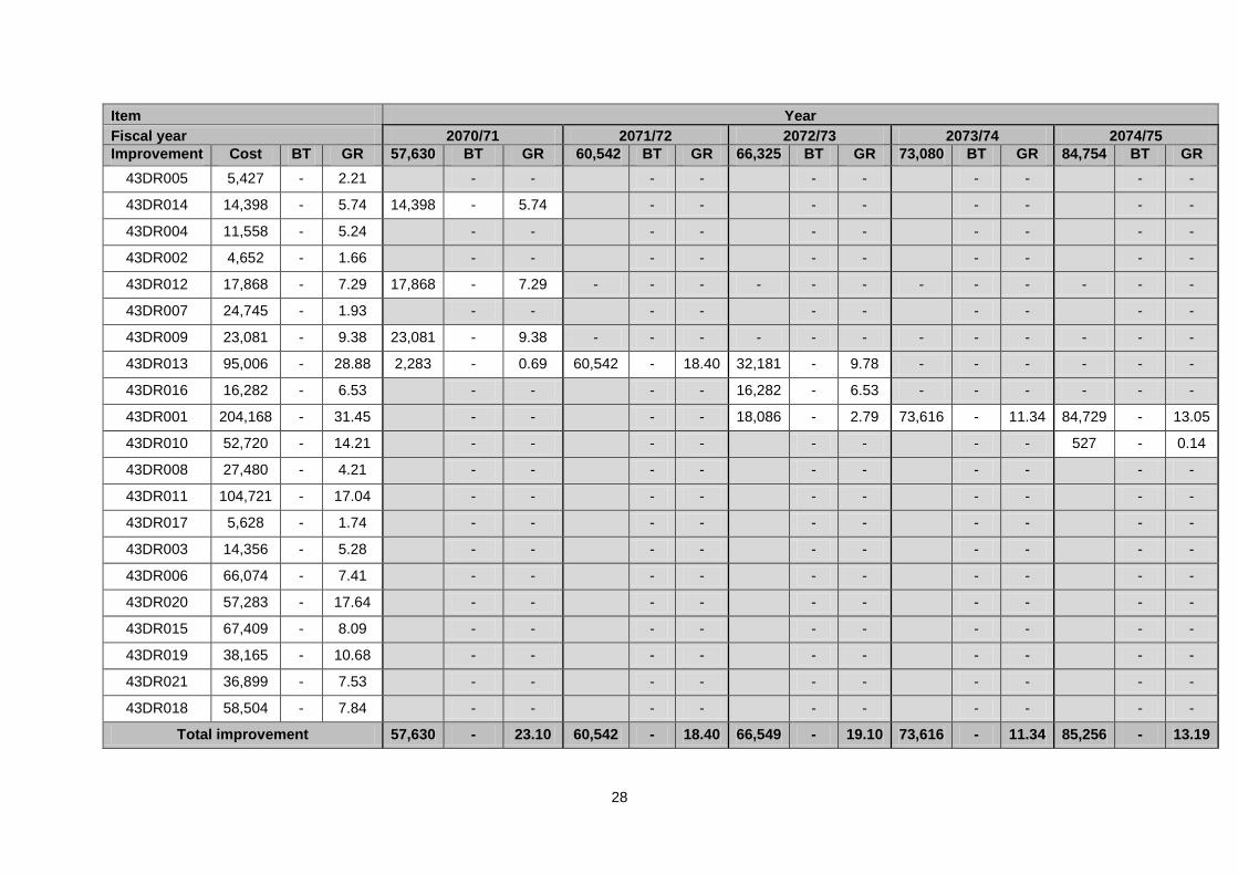
Item Year
Fiscal year 2070/71 2071/72 2072/73 2073/74 2074/75
Improvement Cost BT GR 57,630 BT GR 60,542 BT GR 66,325 BT GR 73,080 BT GR 84,754 BT GR
43DR005 5,427 - 2.21
- -
- -
- -
- -
- -
43DR014 14,398 - 5.74 14,398 - 5.74
- -
- -
- -
- -
43DR004 11,558 - 5.24
- -
- -
- -
- -
- -
43DR002 4,652 - 1.66
- -
- -
- -
- -
- -
43DR012 17,868 - 7.29 17,868 - 7.29 - - - - - - - - - - - -
43DR007 24,745 - 1.93
- -
- -
- -
- -
- -
43DR009 23,081 - 9.38 23,081 - 9.38 - - - - - - - - - - - -
43DR013 95,006 - 28.88 2,283 - 0.69 60,542 - 18.40 32,181 - 9.78 - - - - - -
43DR016 16,282 - 6.53
- -
- - 16,282 - 6.53 - - - - - -
43DR001 204,168 - 31.45
- -
- - 18,086 - 2.79 73,616 - 11.34 84,729 - 13.05
43DR010 52,720 - 14.21
- -
- -
- -
- - 527 - 0.14
43DR008 27,480 - 4.21
- -
- -
- -
- -
- -
43DR011 104,721 - 17.04
- -
- -
- -
- -
- -
43DR017 5,628 - 1.74
- -
- -
- -
- -
- -
43DR003 14,356 - 5.28
- -
- -
- -
- -
- -
43DR006 66,074 - 7.41
- -
- -
- -
- -
- -
43DR020 57,283 - 17.64
- -
- -
- -
- -
- -
43DR015 67,409 - 8.09
- -
- -
- -
- -
- -
43DR019 38,165 - 10.68
- -
- -
- -
- -
- -
43DR021 36,899 - 7.53
- -
- -
- -
- -
- -
43DR018 58,504 - 7.84
- -
- -
- -
- -
- -
Total improvement 57,630 - 23.10 60,542 - 18.40 66,549 - 19.10 73,616 - 11.34 85,256 - 13.19
29
Item Year
Fiscal year 2070/71 2071/72 2072/73 2073/74 2074/75
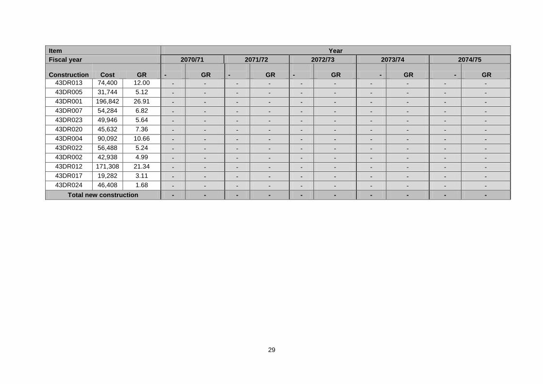
Construction Cost GR - GR
- GR
- GR - GR - GR
43DR013 74,400 12.00 - - - - - - - - - -
43DR005 31,744 5.12 - - - - - - - - - -
43DR001 196,842 26.91 - - - - - - - - - -
43DR007 54,284 6.82 - - - - - - - - - -
43DR023 49,946 5.64 - - - - - - - - - -
43DR020 45,632 7.36 - - - - - - - - - -
43DR004 90,092 10.66 - - - - - - - - - -
43DR022 56,488 5.24 - - - - - - - - - -
43DR002 42,938 4.99 - - - - - - - - - -
43DR012 171,308 21.34 - - - - - - - - - -
43DR017 19,282 3.11 - - - - - - - - - -
43DR024 46,408 1.68 - - - - - - - - - -
Total new construction - - - - - - - - - -
30
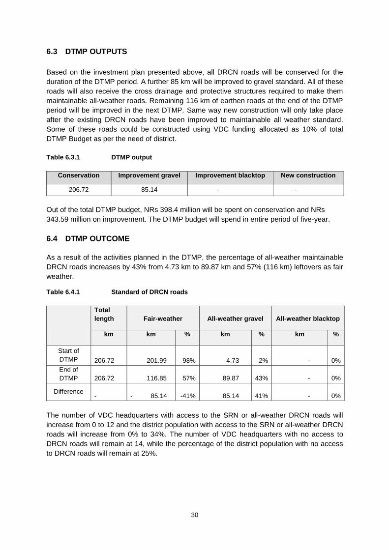
6.3 DTMP OUTPUTS
Based on the investment plan presented above, all DRCN roads will be conserved for the
duration of the DTMP period. A further 85 km will be improved to gravel standard. All of these
roads will also receive the cross drainage and protective structures required to make them
maintainable all-weather roads. Remaining 116 km of earthen roads at the end of the DTMP
period will be improved in the next DTMP. Same way new construction will only take place
after the existing DRCN roads have been improved to maintainable all weather standard.
Some of these roads could be constructed using VDC funding allocated as 10% of total
DTMP Budget as per the need of district.
Table 6.3.1 DTMP output
Conservation Improvement gravel Improvement blacktop New construction
206.72 85.14 - -
Out of the total DTMP budget, NRs 398.4 million will be spent on conservation and NRs
343.59 million on improvement. The DTMP budget will spend in entire period of five-year.
6.4 DTMP OUTCOME
As a result of the activities planned in the DTMP, the percentage of all-weather maintainable
DRCN roads increases by 43% from 4.73 km to 89.87 km and 57% (116 km) leftovers as fair
weather.
Table 6.4.1 Standard of DRCN roads
Total
length Fair-weather All-weather gravel All-weather blacktop
km km % km % km %
Start of
DTMP
206.72 201.99 98% 4.73 2% - 0%
End of
DTMP
206.72 116.85 57% 89.87 43% - 0%
Difference
- - 85.14 -41% 85.14 41% - 0%
The number of VDC headquarters with access to the SRN or all-weather DRCN roads will
increase from 0 to 12 and the district population with access to the SRN or all-weather DRCN
roads will increase from 0% to 34%. The number of VDC headquarters with no access to
DRCN roads will remain at 14, while the percentage of the district population with no access
to DRCN roads will remain at 25%.
31
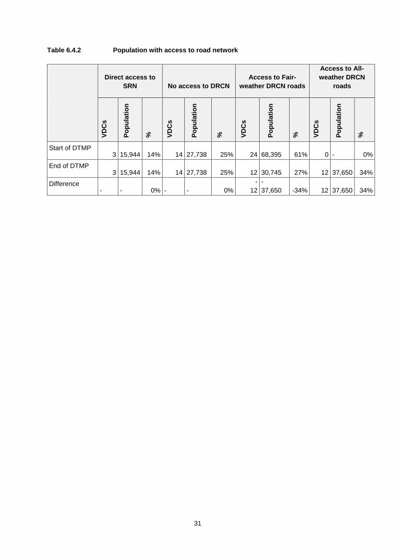
Table 6.4.2 Population with access to road network
Direct access to
SRN No access to DRCN
Access to Fair-
weather DRCN roads
Access to All-
weather DRCN
roads
VD
Cs
Po
pu
lati
on
%
VD
Cs
Po
pu
lati
on
%
VD
Cs
Po
pu
lati
on
%
VD
Cs
Po
pu
lati
on
%
Start of DTMP 3
15,944 14% 14
27,738 25% 24
68,395 61% 0
- 0%
End of DTMP 3
15,944 14% 14
27,738 25% 12
30,745 27% 12
37,650 34%
Difference
-
- 0%
-
- 0%
-
12
-
37,650 -34% 12
37,650 34%
32
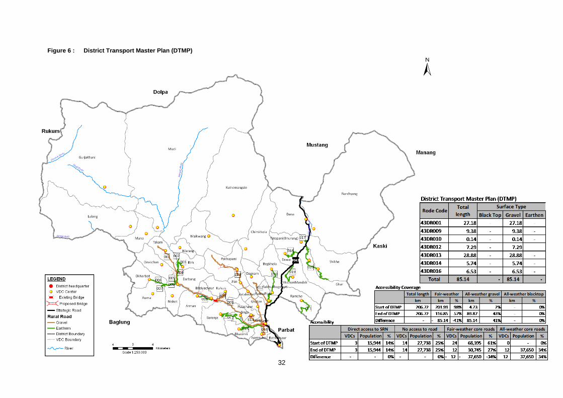
Figure 6 : District Transport Master Plan (DTMP)

33
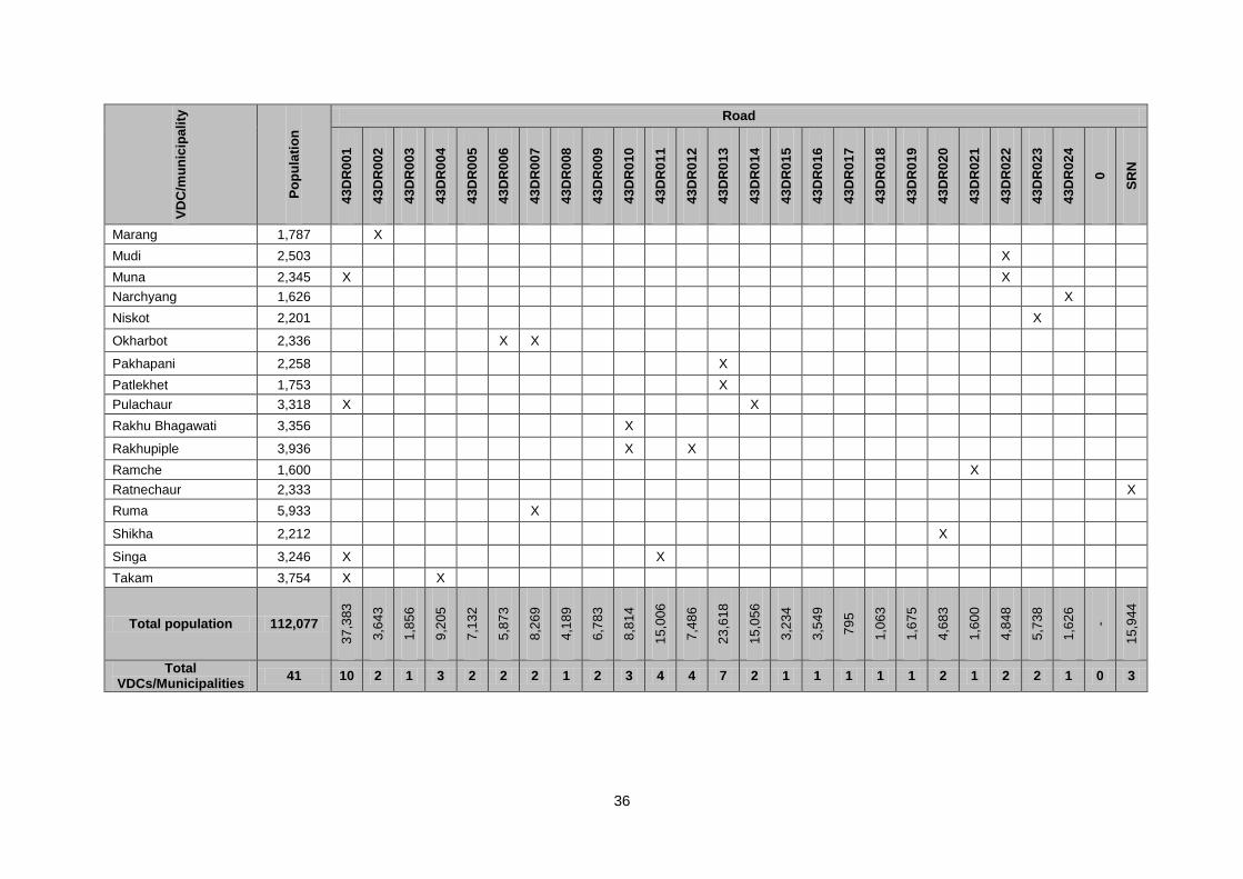
ANNEX 1 GIS FILE PROJECTION AND COORDINATE SYSTEM
GPS Setting
Grid: Lat/Long hdd.ddd and Datum Indian Bangaladesh and Unit in metric system has been considered in GPS during field survey. Garmin Etrex 30 GPS receiver was used in GPS field survey. Defining the coordinate systems and reprojecting data in ArcGIS We can define a coordinate system for data using the following options in ArcGIS using the
Define Projection tool in the Data Management toolbox. If the data has a coordinate system
definition, but it does not match the typical coordinate system used by an organization, we
can reproject the data using the Project tool in the Data Management toolbox. We need to
use the corresponding projection parameters while defining the coordinate system or
reprojecting the data.
Projection and coordinate System used in GIS Shape file
• Projection type: Conformal (preserving shape)
• Projected coordinate system: Transverse Mercator
• Parameters of the coordinate system:
• False_Easting: 500000
• False_Northing: 0
• Central_Meridian: 84 for Central of Nepal
• Scale_Factor: 0.9999
• Latitude_Of_Origin: 0
• Spheroid: Everest 1830
• Associated Geographic Coordinate System: Everest-India and Nepal.prj under Asia
34
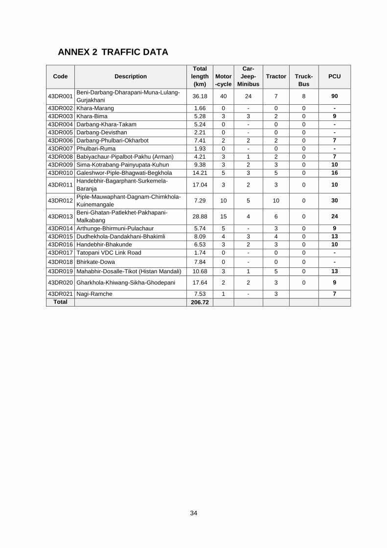
ANNEX 2 TRAFFIC DATA
Code Description
Total
length
(km)
Motor
-cycle
Car-
Jeep-
Minibus
Tractor Truck-
Bus
PCU
43DR001 Beni-Darbang-Dharapani-Muna-Lulang-
Gurjakhani 36.18 40 24 7 8 90
43DR002 Khara-Marang 1.66 0 - 0 0 -
43DR003 Khara-Bima 5.28 3 3 2 0 9
43DR004 Darbang-Khara-Takam 5.24 0 - 0 0 -
43DR005 Darbang-Devisthan 2.21 0 - 0 0 -
43DR006 Darbang-Phulbari-Okharbot 7.41 2 2 2 0 7
43DR007 Phulbari-Ruma 1.93 0 - 0 0 -
43DR008 Babiyachaur-Pipalbot-Pakhu (Arman) 4.21 3 1 2 0 7
43DR009 Sima-Kotrabang-Painyupata-Kuhun 9.38 3 2 3 0 10
43DR010 Galeshwor-Piple-Bhagwati-Begkhola 14.21 5 3 5 0 16
43DR011 Handebhir-Bagarphant-Surkemela-
Baranja 17.04 3 2 3 0 10
43DR012 Piple-Mauwaphant-Dagnam-Chimkhola-
Kuinemangale 7.29 10 5 10 0 30
43DR013 Beni-Ghatan-Patlekhet-Pakhapani-
Malkabang 28.88 15 4 6 0 24
43DR014 Arthunge-Bhirmuni-Pulachaur 5.74 5 - 3 0 9
43DR015 Dudhekhola-Dandakhani-Bhakimli 8.09 4 3 4 0 13
43DR016 Handebhir-Bhakunde 6.53 3 2 3 0 10
43DR017 Tatopani VDC Link Road 1.74 0 - 0 0 -
43DR018 Bhirkate-Dowa 7.84 0 - 0 0 -
43DR019 Mahabhir-Dosalle-Tikot (Histan Mandali) 10.68 3 1 5 0 13
43DR020 Gharkhola-Khiwang-Sikha-Ghodepani 17.64 2 2 3 0 9
43DR021 Nagi-Ramche 7.53 1 - 3 7
Total 206.72
35
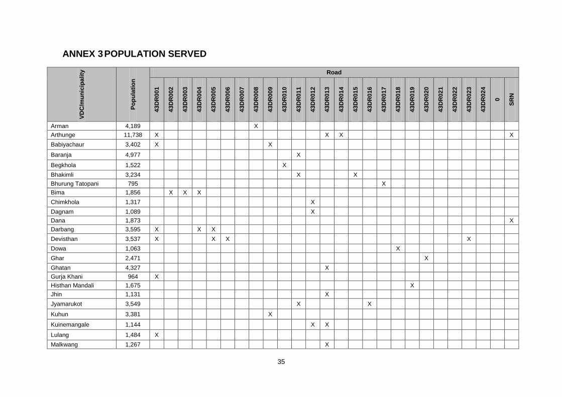
ANNEX 3 POPULATION SERVED
VD
C/m
un
icip
ali
ty
Po
pu
lati
on
Road
43
DR
00
1
43
DR
00
2
43
DR
00
3
43
DR
00
4
43
DR
00
5
43
DR
00
6
43
DR
00
7
43
DR
00
8
43
DR
00
9
43
DR
01
0
43
DR
01
1
43
DR
01
2
43
DR
01
3
43
DR
01
4
43
DR
01
5
43
DR
01
6
43
DR
01
7
43
DR
01
8
43
DR
01
9
43
DR
02
0
43
DR
02
1
43
DR
02
2
43
DR
02
3
43
DR
02
4
0
SR
N
Arman 4,189
X
Arthunge 11,738 X
X X
X
Babiyachaur 3,402 X
X
Baranja 4,977
X
Begkhola 1,522
X
Bhakimli 3,234
X
X
Bhurung Tatopani 795
X
Bima 1,856
X X X
Chimkhola 1,317
X
Dagnam 1,089
X
Dana 1,873
X
Darbang 3,595 X
X X
Devisthan 3,537 X
X X
X
Dowa 1,063
X
Ghar 2,471
X
Ghatan 4,327
X
Gurja Khani 964 X
Histhan Mandali 1,675
X
Jhin 1,131
X
Jyamarukot 3,549
X
X
Kuhun 3,381
X
Kuinemangale 1,144
X X
Lulang 1,484 X
Malkwang 1,267
X
36
VD
C/m
un
icip
ali
ty
Po
pu
lati
on
Road
43
DR
00
1
43
DR
00
2
43
DR
00
3
43
DR
00
4
43
DR
00
5
43
DR
00
6
43
DR
00
7
43
DR
00
8
43
DR
00
9
43
DR
01
0
43
DR
01
1
43
DR
01
2
43
DR
01
3
43
DR
01
4
43
DR
01
5
43
DR
01
6
43
DR
01
7
43
DR
01
8
43
DR
01
9
43
DR
02
0
43
DR
02
1
43
DR
02
2
43
DR
02
3
43
DR
02
4
0
SR
N
Marang 1,787
X
Mudi 2,503
X
Muna 2,345 X
X
Narchyang 1,626
X
Niskot 2,201
X
Okharbot 2,336
X X
Pakhapani 2,258
X
Patlekhet 1,753
X
Pulachaur 3,318 X
X
Rakhu Bhagawati 3,356
X
Rakhupiple 3,936
X
X
Ramche 1,600
X
Ratnechaur 2,333
X
Ruma 5,933
X
Shikha 2,212
X
Singa 3,246 X
X
Takam 3,754 X
X
Total population 112,077
37
,383
3,6
43
1,8
56
9,2
05
7,1
32
5,8
73
8,2
69
4,1
89
6,7
83
8,8
14
15
,006
7,4
86
23
,618
15
,056
3,2
34
3,5
49
79
5
1,0
63
1,6
75
4,6
83
1,6
00
4,8
48
5,7
38
1,6
26
-
15
,944
Total VDCs/Municipalities
41 10 2 1 3 2 2 2 1 2 3 4 4 7 2 1 1 1 1 1 2 1 2 2 1 0 3
37
ANNEX 4 LOCATION OF PROPOSED INTERVENTIONS
Road code
Road Name
Le
ng
th (
km
)
Sta
rt c
ha
ina
ge
(k
m)
or
X-c
oo
rdin
ate
En
d c
ha
ina
ge (
km
) o
r
Y-c
oo
rdin
ate
Reh
ab
ilit
ati
on
(k
m)
Gra
ve
llin
g (
km
)
Bla
ck
top
pin
g (
km
)
Wid
en
ing
(m
)
Bri
dg
e (
m)
Sla
b c
ulv
ert
(m
)
CC
Ca
us
ew
ay
(m
)
Sto
ne
Ca
use
wa
y (
m)
Pip
e c
ulv
ert
(u
nit
s)
Ma
so
nry
wall
s (
m3
)
Ga
bio
n w
all
s (
m3
)
Lin
ed
dra
in (
m)
43DR001
Beni-Darbang-Dharapani-Muna-Lulang-
Gurjakhani 36.18 0 31.5 36.2 110.0 230.0 0.0 111.0 49.0 26.0 180.0 4031.0 500.0
43DR002 Khara-Marang 1.66 0 1.7 0.0 0.0 20.0 0.0 10.0 0.0 0.0 0.0 0.0 0.0
43DR003 Khara-Bima 5.28 0 5.3 0.0 50.0 0.0 0.0 0.0 0.0 13.0 0.0 544.0 0.0
43DR004 Darbang-Khara-Takam 5.24 0 5.2 0.0 0.0 40.0 0.0 0.0 0.0 3.0 0.0 0.0 0.0
43DR005 Darbang-Devisthan 2.21 0.55 2.2 0.0 0.0 0.0 0.0 0.0 0.0 0.0 0.0 50.0 0.0
43DR006 Darbang-Phulbari-Okharbot 7.4121 0.75 7.4 0.0 0.0 55.0 0.0 65.0 0.0 5.0 450.0 2047.0 0.0
43DR007 Phulbari-Ruma 1.9296 0 1.9 0.0 100.0 50.0 0.0 0.0 0.0 0.0 0.0 0.0 0.0
43DR008 Babiyachaur-Pipalbot-Pakhu (Arman) 4.21 0 4.2 0.0 0.0 30.0 0.0 0.0 0.0 6.0 0.0 63.0 0.0
43DR009 Sima-Kotrabang-Painyupata-Kuhun 9.38 0 9.4 0.0 50.0 0.0 0.0 0.0 0.0 7.0 38.0 298.0 0.0
43DR010 Galeshwor-Piple-Bhagwati-Begkhola 14.21 0 14.2 0.0 590.0 0.0 0.0 32.0 6.0 2.0 230.0 391.0 150.0
43DR011
Handebhir-Bagarphant-Surkemela-
Baranja 17.044 0 17.0 0.0 130.0 85.0 38.0 62.0 10.0 20.0 0.0 310.0 0.0
43DR012
Piple-Mauwaphant-Dagnam-Chimkhola-
Kuinemangale 7.29 0 7.3 0.0 40.0 65.0 0.0 8.0 0.0 3.0 0.0 0.0 0.0
43DR013
Beni-Ghatan-Patlekhet-Pakhapani-
Malkabang 28.88 0 28.9 0.0 295.0 18.0 42.0 30.0 103.0 5.0 0.0 786.0 950.0
43DR014 Arthunge-Bhirmuni-Pulachaur 5.74 0 5.7 0.0 30.0 0.0 0.0 0.0 0.0 2.0 0.0 400.0 0.0
43DR015 Dudhekhola-Dandakhani-Bhakimli 8.0891 0 8.1 0.0 250.0 60.0 0.0 12.0 0.0 6.0 250.0 1441.0 0.0
43DR016 Handebhir-Bhakunde 6.5317 0 6.5 0.0 0.0 0.0 0.0 0.0 0.0 0.0 0.0 765.0 0.0
43DR017 Tatopani VDC Link Road 1.74 0 1.7 0.0 40.0 0.0 0.0 0.0 0.0 0.0 0.0 320.0 0.0
43DR018 Bhirkate-Dowa 7.8426 0 7.8 0.0 120.0 60.0 0.0 0.0 0.0 0.0 0.0 900.0 0.0
43DR019 Mahabhir-Dosalle-Tikot (Histan Mandali) 10.681 0 10.7 0.0 50.0 0.0 16.0 18.0 0.0 3.0 398.0 2083.0 0.0
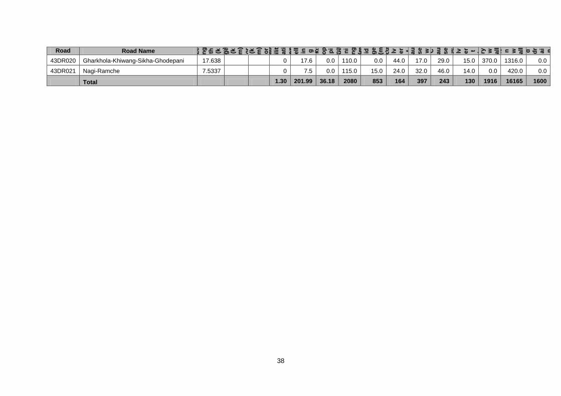
38
Road code
Road Name Le
ng
th
(k m)
St
ar t ch ai
na
ge
(k m)
or
X-
co
or
di
na
te
E nd
ch ai
na
ge
(k m)
or
Y-
co
or
di
na
te
R eh
ab
ilit
ati
on
(k m)
Gr
av
ell in g
(k m)
Bl
ac kt
op pi
ng
(k m)
Wi
de
ni
ng
(m ) Br
id ge
(m ) Sl
ab
cu lv er t (m ) C C
C au
se w ay
(m ) St
on e
C au
se w ay
(m ) Pi
pe
cu lv er t (u nit s)
M as
on
ry
w all s
(m 3)
G ab io n
w all s
(m 3)
Li
ne d
dr
ai n
(m )
43DR020 Gharkhola-Khiwang-Sikha-Ghodepani 17.638 0 17.6 0.0 110.0 0.0 44.0 17.0 29.0 15.0 370.0 1316.0 0.0
43DR021 Nagi-Ramche 7.5337 0 7.5 0.0 115.0 15.0 24.0 32.0 46.0 14.0 0.0 420.0 0.0
Total 1.30 201.99 36.18 2080 853 164 397 243 130 1916 16165 1600
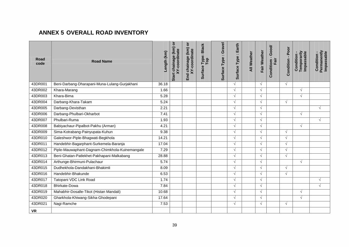
39
ANNEX 5 OVERALL ROAD INVENTORY
Road code
Road Name
Le
ng
th (
km
)
Sta
rt c
ha
ina
ge
(k
m)
or
XY
-co
ord
ina
te
En
d c
ha
ina
ge (
km
) o
r
XY
-co
ord
ina
te
Su
rfa
ce
Typ
e:
Bla
ck
To
p
Su
rfa
ce
Typ
e :
Gra
ve
l
Su
rfa
ce
Typ
e :
Ea
rth
All
We
ath
er
Fa
ir W
ea
the
r
Co
nd
itio
m -
Go
od
/
Fa
ir
Co
nd
itio
n -
Po
or
Co
nd
itio
n -
Te
mp
ora
rily
Imp
ass
ab
le
Co
nd
itio
n -
Pe
rma
ne
ntl
y
Imp
ass
ab
le
43DR001 Beni-Darbang-Dharapani-Muna-Lulang-Gurjakhani 36.18 √ √ √
43DR002 Khara-Marang 1.66 √ √ √
43DR003 Khara-Bima 5.28 √ √ √
43DR004 Darbang-Khara-Takam 5.24 √ √ √
43DR005 Darbang-Devisthan 2.21 √ √ √
43DR006 Darbang-Phulbari-Okharbot 7.41 √ √ √
43DR007 Phulbari-Ruma 1.93 √ √ √
43DR008 Babiyachaur-Pipalbot-Pakhu (Arman) 4.21 √ √ √
43DR009 Sima-Kotrabang-Painyupata-Kuhun 9.38 √ √ √ 43DR010 Galeshwor-Piple-Bhagwati-Begkhola 14.21 √ √ √
43DR011 Handebhir-Bagarphant-Surkemela-Baranja 17.04 √ √ √
43DR012 Piple-Mauwaphant-Dagnam-Chimkhola-Kuinemangale 7.29 √ √ √
43DR013 Beni-Ghatan-Patlekhet-Pakhapani-Malkabang 28.88 √ √ √
43DR014 Arthunge-Bhirmuni-Pulachaur 5.74 √ √ √
43DR015 Dudhekhola-Dandakhani-Bhakimli 8.09 √ √ √
43DR016 Handebhir-Bhakunde 6.53 √ √ √
43DR017 Tatopani VDC Link Road 1.74 √ √ √
43DR018 Bhirkate-Dowa 7.84 √ √ √
43DR019 Mahabhir-Dosalle-Tikot (Histan Mandali) 10.68 √ √ √
43DR020 Gharkhola-Khiwang-Sikha-Ghodepani 17.64 √ √ √
43DR021 Nagi-Ramche 7.53 √ √ √
VR
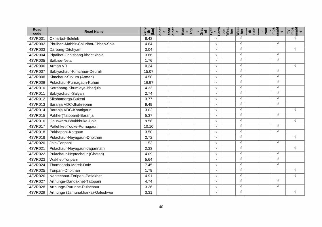
40
Road code
Road Name
Le
ng
th
(km
)
Sta
rt
ch
ai
na
ge
(km
)
or
XY
-
co
or
din
at
e
En
d
ch
ai
na
ge
(km
)
or
XY
-
co
or
din
at
e
Su
rfa
ce
Ty
pe
:
Bla
c
k
To
p
Su
rfa
ce
Ty
pe
:
Gra
v
el
Su
rfa
ce
Ty
pe
:
Ea
rth
All
We
at
he
r F
air
We
at
he
r
Co
nd
itio
m
-
Go
o
d/
Fa
ir
Co
nd
itio
n
-
Po
or
Co
nd
itio
n
-
Te
m
po
rar
ily
Imp
a
ss
ab
l
e
Co
nd
itio
n
-
Pe
rm
an
en
tly
Imp
a
ss
ab
l
e
43VR001 Okharbot-Solelek 8.43 √ √ √
43VR002 Phulbari-Mabhir-Chiuribot-Chhap-Sole 4.84 √ √ √
43VR003 Darbang-Ditchyam 3.04 √ √ √
43VR004 Pipalbot-Chhisbang-khoptikhola 3.66 √ √ √
43VR005 Satbise-Neta 1.76 √ √ √
43VR006 Arman VR 0.24 √ √ √
43VR007 Babiyachaur-Kimchaur-Deurali 15.07 √ √ √
43VR008 Kimchaur-Sirkum (Arman) 4.58 √ √ √
43VR009 Pulachaur-Purnagaun-Kuhun 16.97 √ √ √
43VR010 Kotrabang-Khumlaya-Bharjula 4.33 √ √ √
43VR011 Babiyachaur-Salyan 2.74 √ √ √
43VR012 Sikshamarga-Bukeni 3.77 √ √ √
43VR013 Baranja VDC-Jhakrepani 9.49 √ √ √
43VR014 Baranja VDC-Khanigaun 3.02 √ √ √
43VR015 Pakher(Tatopani)-Baranja 5.37 √ √ √
43VR016 Gauswara-Bhukbhuke-Dole 9.58 √ √ √
43VR017 Patlehket-Todke-Purnagaun 10.10 √ √ √
43VR018 Pakhapani-Kotgaun 3.50 √ √ √
43VR019 Pulachaur-Nayagaun-Dholthan 2.72 √ √ √
43VR020 Jhin-Toripani 1.53 √ √ √
43VR021 Pulachaur-Nayagaun-Jagannath 2.33 √ √ √
43VR022 Pulachaur-Neptechaur (Ghatan) 4.09 √ √ √
43VR023 Wakhet-Toripani 5.64 √ √ √
43VR024 Thamdanda-Marek-Dole 7.45 √ √ √
43VR025 Toripani-Dholthan 1.79 √ √ √
43VR026 Neptechaur-Toripani-Patlekhet 4.91 √ √ √
43VR027 Arthunge-Dandakhet-Tatopani 4.74 √ √ √
43VR028 Arthunge-Purunne-Pulachaur 3.26 √ √ √
43VR029 Arthunge (Jamunakharka)-Galeshwor 3.31 √ √ √
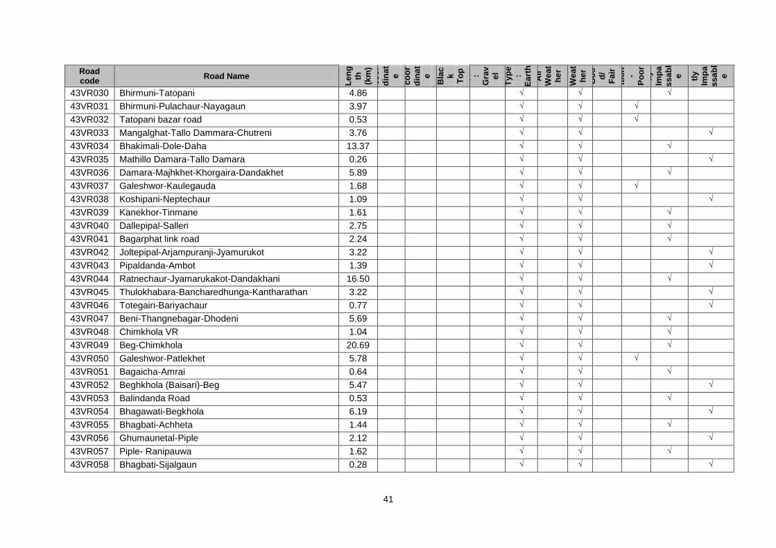
41
Road code
Road Name
Le
ng
th
(km
)
Sta
rt
ch
ai
na
ge
(km
)
or
XY
-
co
or
din
at
e
En
d
ch
ai
na
ge
(km
)
or
XY
-
co
or
din
at
e
Su
rfa
ce
Ty
pe
:
Bla
c
k
To
p
Su
rfa
ce
Ty
pe
:
Gra
v
el
Su
rfa
ce
Ty
pe
:
Ea
rth
All
We
at
he
r F
air
We
at
he
r
Co
nd
itio
m
-
Go
o
d/
Fa
ir
Co
nd
itio
n
-
Po
or
Co
nd
itio
n
-
Te
m
po
rar
ily
Imp
a
ss
ab
l
e
Co
nd
itio
n
-
Pe
rm
an
en
tly
Imp
a
ss
ab
l
e
43VR030 Bhirmuni-Tatopani 4.86 √ √ √
43VR031 Bhirmuni-Pulachaur-Nayagaun 3.97 √ √ √
43VR032 Tatopani bazar road 0.53 √ √ √
43VR033 Mangalghat-Tallo Dammara-Chutreni 3.76 √ √ √
43VR034 Bhakimali-Dole-Daha 13.37 √ √ √
43VR035 Mathillo Damara-Tallo Damara 0.26 √ √ √
43VR036 Damara-Majhkhet-Khorgaira-Dandakhet 5.89 √ √ √
43VR037 Galeshwor-Kaulegauda 1.68 √ √ √
43VR038 Koshipani-Neptechaur 1.09 √ √ √
43VR039 Kanekhor-Tinmane 1.61 √ √ √
43VR040 Dallepipal-Salleri 2.75 √ √ √
43VR041 Bagarphat link road 2.24 √ √ √
43VR042 Joltepipal-Arjampuranji-Jyamurukot 3.22 √ √ √
43VR043 Pipaldanda-Ambot 1.39 √ √ √
43VR044 Ratnechaur-Jyamarukakot-Dandakhani 16.50 √ √ √
43VR045 Thulokhabara-Bancharedhunga-Kantharathan 3.22 √ √ √
43VR046 Totegairi-Bariyachaur 0.77 √ √ √
43VR047 Beni-Thangnebagar-Dhodeni 5.69 √ √ √
43VR048 Chimkhola VR 1.04 √ √ √
43VR049 Beg-Chimkhola 20.69 √ √ √
43VR050 Galeshwor-Patlekhet 5.78 √ √ √
43VR051 Bagaicha-Amrai 0.64 √ √ √
43VR052 Beghkhola (Baisari)-Beg 5.47 √ √ √
43VR053 Balindanda Road 0.53 √ √ √
43VR054 Bhagawati-Begkhola 6.19 √ √ √
43VR055 Bhagbati-Achheta 1.44 √ √ √
43VR056 Ghumaunetal-Piple 2.12 √ √ √
43VR057 Piple- Ranipauwa 1.62 √ √ √
43VR058 Bhagbati-Sijalgaun 0.28 √ √ √
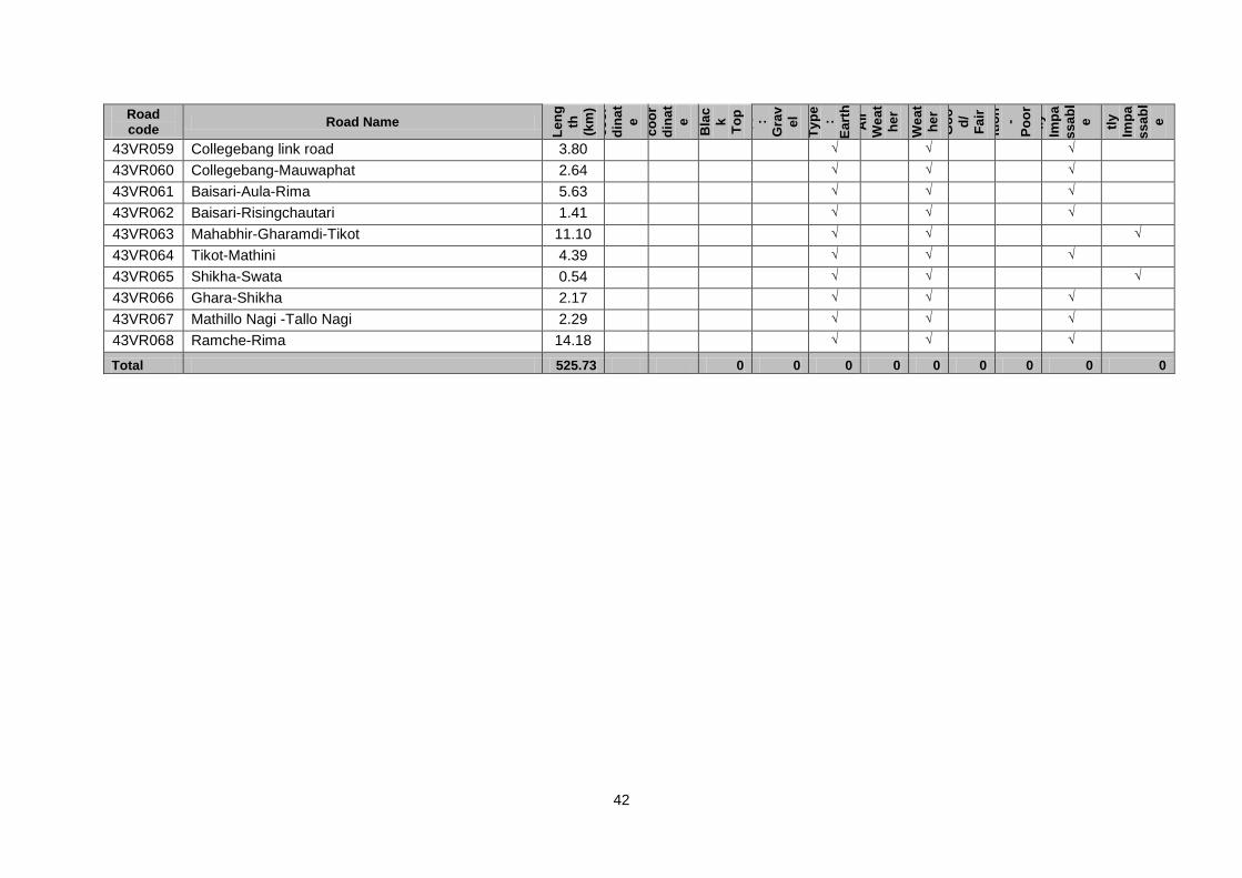
42
Road code
Road Name
Le
ng
th
(km
)
Sta
rt
ch
ai
na
ge
(km
)
or
XY
-
co
or
din
at
e
En
d
ch
ai
na
ge
(km
)
or
XY
-
co
or
din
at
e
Su
rfa
ce
Ty
pe
:
Bla
c
k
To
p
Su
rfa
ce
Ty
pe
:
Gra
v
el
Su
rfa
ce
Ty
pe
:
Ea
rth
All
We
at
he
r F
air
We
at
he
r
Co
nd
itio
m
-
Go
o
d/
Fa
ir
Co
nd
itio
n
-
Po
or
Co
nd
itio
n
-
Te
m
po
rar
ily
Imp
a
ss
ab
l
e
Co
nd
itio
n
-
Pe
rm
an
en
tly
Imp
a
ss
ab
l
e
43VR059 Collegebang link road 3.80 √ √ √
43VR060 Collegebang-Mauwaphat 2.64 √ √ √
43VR061 Baisari-Aula-Rima 5.63 √ √ √
43VR062 Baisari-Risingchautari 1.41 √ √ √
43VR063 Mahabhir-Gharamdi-Tikot 11.10 √ √ √
43VR064 Tikot-Mathini 4.39 √ √ √
43VR065 Shikha-Swata 0.54 √ √ √
43VR066 Ghara-Shikha 2.17 √ √ √
43VR067 Mathillo Nagi -Tallo Nagi 2.29 √ √ √
43VR068 Ramche-Rima 14.18 √ √ √
Total 525.73 0 0 0 0 0 0 0 0 0
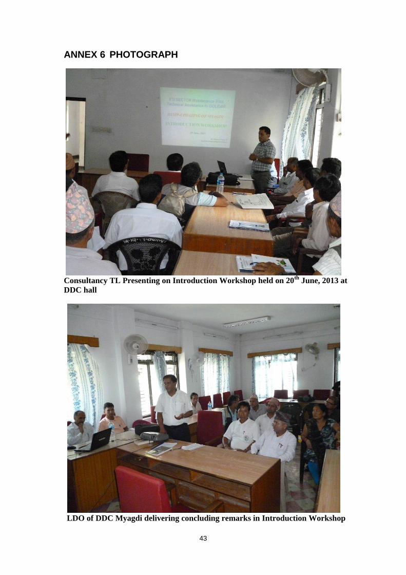
43
ANNEX 6 PHOTOGRAPH
Consultancy TL Presenting on Introduction Workshop held on 20
th June, 2013 at
DDC hall
LDO of DDC Myagdi delivering concluding remarks in Introduction Workshop
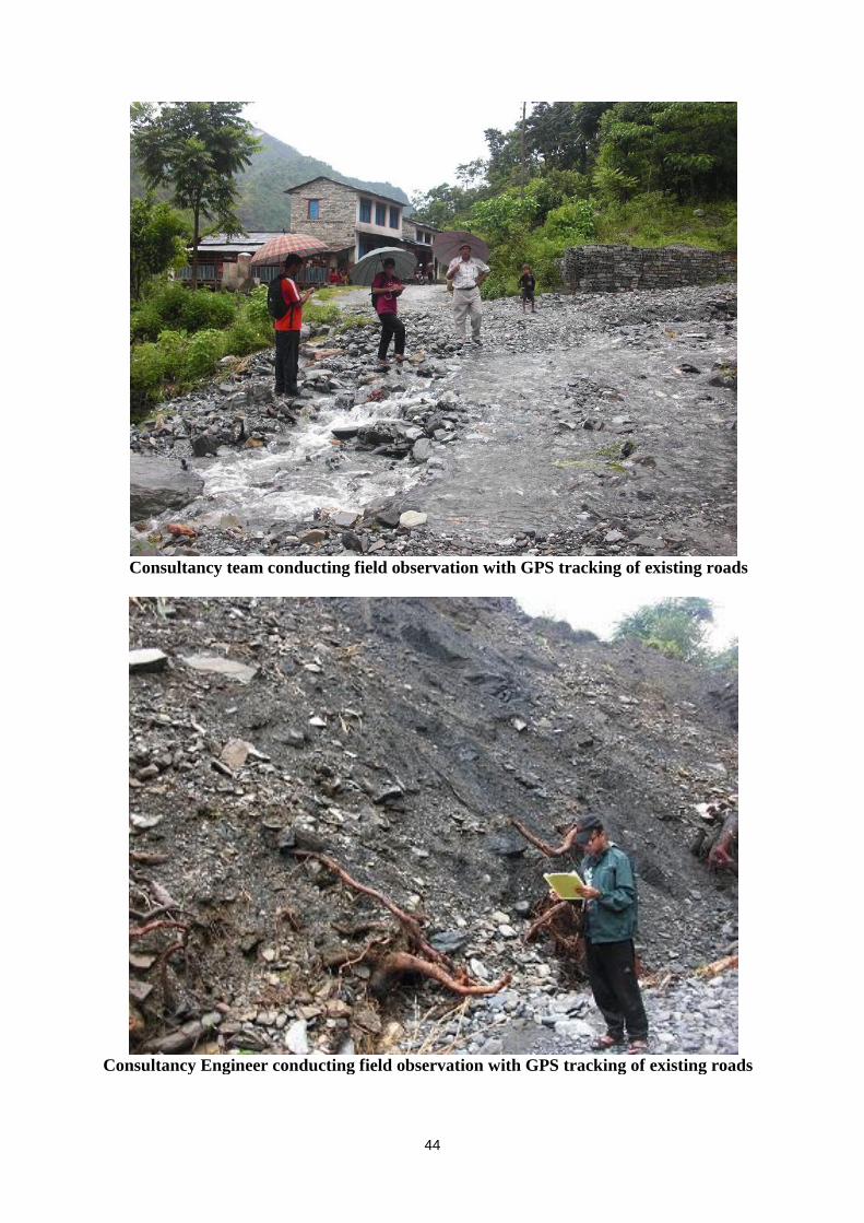
44
Consultancy team conducting field observation with GPS tracking of existing roads
Consultancy Engineer conducting field observation with GPS tracking of existing roads
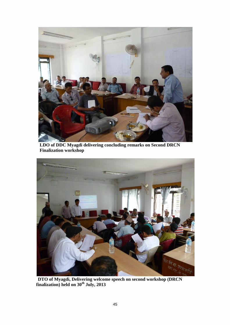
45
LDO of DDC Myagdi delivering concluding remarks on Second DRCN
Finalization workshop
DTO of Myagdi, Delivering welcome speech on second workshop (DRCN
finalization) held on 30th
July, 2013
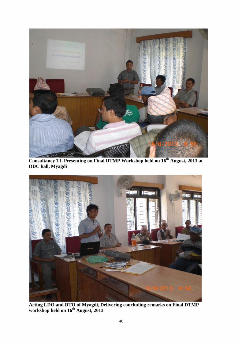
46
Consultancy TL Presenting on Final DTMP Workshop held on 16
th August, 2013 at
DDC hall, Myagdi
Acting LDO and DTO of Myagdi, Delivering concluding remarks on Final DTMP
workshop held on 16th
August, 2013
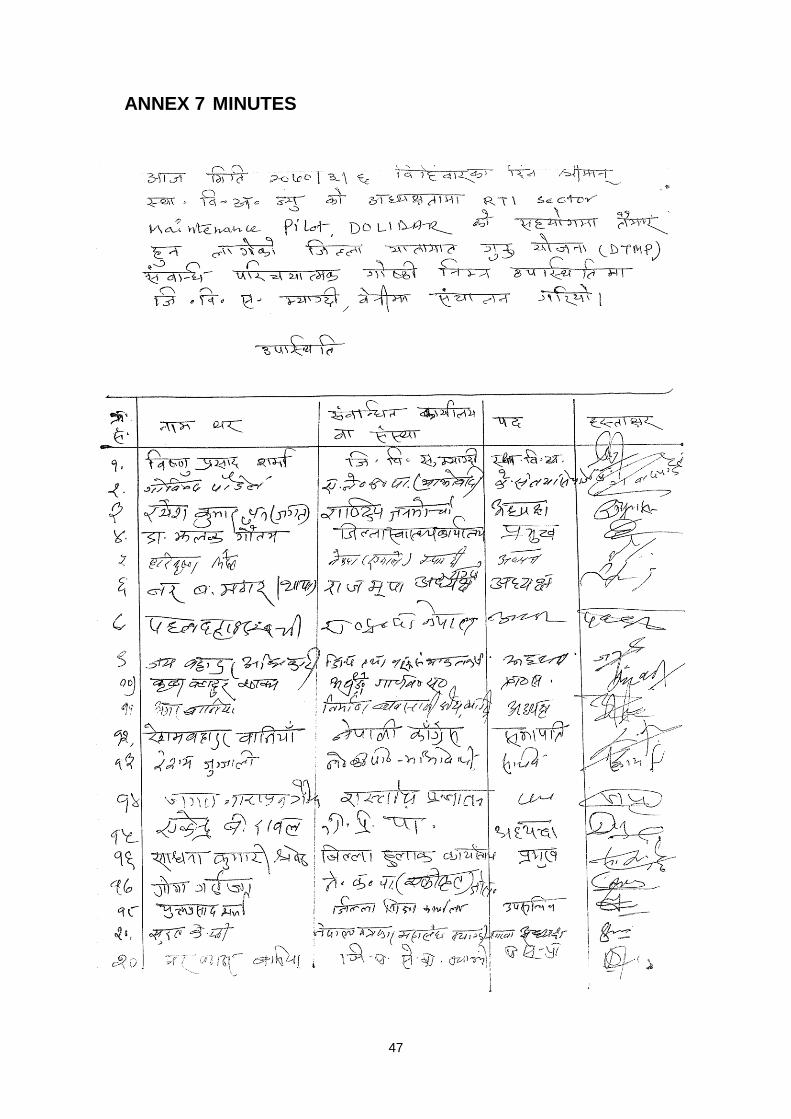
47
ANNEX 7 MINUTES
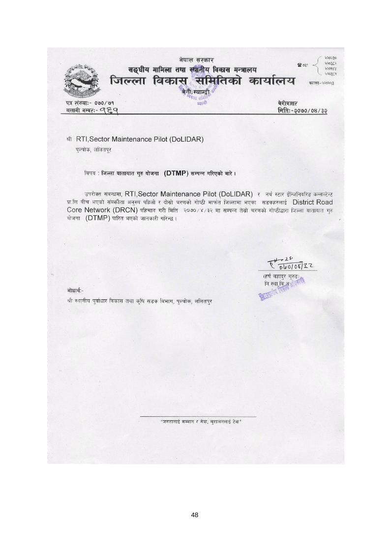
48