Embed Size (px)
Citation preview

GEOLOGY OF THE TAVAN HAR AREA, GOBI,MONGOLIA
ROBERT J. CARSON, Whitman CollegeB. BAYANMÖNH, Mongolian University of Science and Technology
A. BAYASGALAN, Mongolian University of Science and TechnologyCARI L. JOHNSON, University of Utah
KEVIN R. POGUE, Whitman CollegeKARL W. WEGMANN, Washington Division of Geology and Earth Resources
INTRODUCTIONKeck research projects have occurred in manynations, but this was the first to have a goal offostering cross-cultural communicationbetween American and foreign students andfaculty, using geoscience as common groundfor exchange. A total of ten Mongolianstudents and nine American studentsparticipated in the research, which wassupervised by two Mongolian and fourAmerican geologists. In addition, ProfessorCh. Minjin of Mongolian University ofScience and Technology spent the first weekwith us and led the reconnaissanceinvestigations.Tavan Har, our area of study, is bound bylatitudes 43°40’ and 44°10’N and longitudes109°15’ and 110°15’E in southeasternMongolia. This 5000-km2 area lies toward theeast end of the Gobi (Desert) about 100 kmnorth of China. This is the general vicinitywhere from 1922 to 1930 Roy ChapmanAndrews led expeditions which foundmammal and dinosaur fossils, includingdinosaur eggs.Precipitation in Mongolia decreases fromnorth to south. South of Ulaanbaatar there issteppe and, closer to China, desert. Wecrossed no rivers south of the Tull Gol, whichflows west through the capital. Streamsflowed only briefly after the few rainstormswe experienced (August is Mongolia’s wettest
month). Strong winds blew much of the time.Daytime temperatures were 20-40°C, with thenights much cooler. Our base camp (figure 1),located at 43°55’13”N, 109° 25’45”E, was inan area of Paleozoic argillite with limey andsandy lenses and layers.
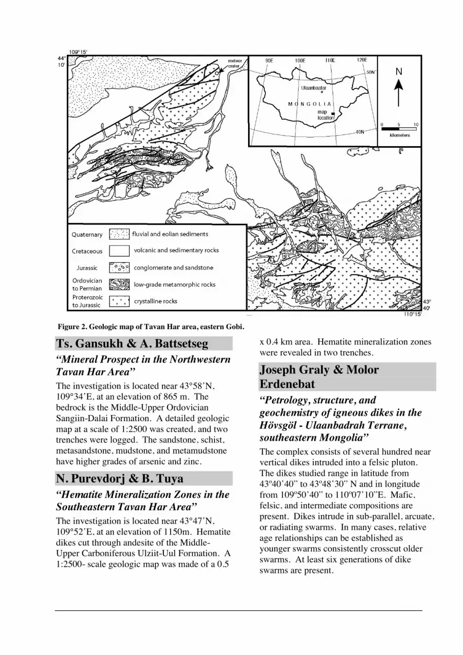
GEOLOGIC SETTINGMongolia is made of many terranes, whichwere continental fragments, island arcs, andsea floor. These terranes were caught in a viceas the Siberian craton and North China blockcame together beginning in the Paleozoic.Our research area included two terranes. Thenorthern Ulaan-Uul terrane consists ofProterozoic (?) igneous and metamorphicrocks. The southern Hövsgöl-Ulaanbadrahterrane includes: Paleozoic sedimentary rocksand volcanics; Devonian (?) andCarboniferous intrusives; and Jurassicconglomerate (with sandstone) andgranite/granodiorite. The two terranes areintruded by Permiangranite/granodiorite/diorite.Late Jurassic and Early Cretaceous riftingresulted in subsidence and the accumulation offluvial and lacustrine sediments (host of an oilfield near the study area) as well as basalticand rhyolitic volcanism. The area is overlainby flat-lying Upper Cretaceous sandstone andmudstone. Relative stability in the Cenozoicled to the development of extensivepediments. The widespread bedrock and regs

(surfaces with desert pavement) areinterrupted by scattered dune fields and ameteor impact crater. See figures 2 and 3 for asimplified geologic map and stratigraphiccolumn, respectively.
STUDENT PROJECTSKate D. Krug“Petrologic and Field Analysis of theTavan Har Intrusive/MetamorphicComplex, Southeast Gobi Desert,Mongolia”Medium grade metamorphic rocks of multiplelithologies crop out in the Tavan Har area.The rocks were previously mapped asbasement material composed of greenschist,gabbro, and gneiss. Traverses of ten valleysand ridges showed the lithologies to include:greenschist/stone, gabbro, granite, diorite,gneiss, and multiple generations of felsicintrusives. We created a cross-section withNW-SE trending transects through the range.The cross-section expresses the fieldrelationships between units. The second
generation of felsic intrusives crosscuts allother units in the field, making it theconstraining unit for the Tavan Har suite ofcrystalline rocks.
Megan Berney Roberts & KhuutTsetsegmaa“Suspected Carboniferous Rocks ofTavan Har Region, SoutheasternMongolia”The Zuun Gashuun Formation in the TavanHar area of the eastern Gobi consists offossiliferous marble, argillite, and quartzite.The formation was originally mapped asOrdovician, but the abundance and size of thecrinoids in addition to a spiriferid brachiopodprovide evidence that the rocks areCarboniferous. Other fossils in the areainclude bryozoans, corals, and algae. Thelithologies and fossils indicate that the rockswere probably deposited on a low relief, felsicmicroplate that was subject to oscillatingshallow carbonate seas.
Figure 1. Base camp at Tavan Har. The four-wheel-drive vehicles are parked to the right of thestorage ger and cook tent. The hills in the middle ground are mostly Paleozoic argillite. In thebackground is an extensive Quaternary pediment.
Ts. Gansukh & A. Battsetseg“Mineral Prospect in the NorthwesternTavan Har Area”The investigation is located near 43°58’N,109°34’E, at an elevation of 865 m. Thebedrock is the Middle-Upper OrdovicianSangiin-Dalai Formation. A detailed geologicmap at a scale of 1:2500 was created, and twotrenches were logged. The sandstone, schist,metasandstone, mudstone, and metamudstonehave higher grades of arsenic and zinc.
N. Purevdorj & B. Tuya“Hematite Mineralization Zones in theSoutheastern Tavan Har Area”The investigation is located near 43°47’N,109°52’E, at an elevation of 1150m. Hematitedikes cut through andesite of the Middle-Upper Carboniferous Ulziit-Uul Formation. A1:2500- scale geologic map was made of a 0.5
x 0.4 km area. Hematite mineralization zoneswere revealed in two trenches.
Joseph Graly & MolorErdenebat“Petrology, structure, andgeochemistry of igneous dikes in theHövsgöl - Ulaanbadrah Terrane,southeastern Mongolia”The complex consists of several hundred nearvertical dikes intruded into a felsic pluton.The dikes studied range in latitude from43º40’40” to 43º48’30” N and in longitudefrom 109º50’40” to 110º07’10”E. Mafic,felsic, and intermediate compositions arepresent. Dikes intrude in sub-parallel, arcuate,or radiating swarms. In many cases, relativeage relationships can be established asyounger swarms consistently crosscut olderswarms. At least six generations of dikeswarms are present.
Figure 2. Geologic map of Tavan Har area, eastern Gobi.
Sarah Davidson & HashgerelBat-Erdene“Sedimentology of the Cretaceousintercontinental rift sequence in TavanHar, southern Mongolia”Uplift and subsidence related to a LateJurassic - Early Cretaceous intercontinentalrift event led to sediment deposition thatincludes eolian, lacustrine, and deltaic facies.All units in the area are non-marine, andconsist primarily of conglomerates, lacustrinesequences, and volcanic rocks. The earliestsynrift deposits are marked by coarseconglomerates with primarily volcanic andmetasedimentary lithologies, as well as basaltand ash beds. Later synrift units includelacustrine and additional volcanic deposition.Synrift units are typically slightly folded, andare uncomformably overlain by undeformedpostrift sediments. Postrift sediments aregenerally terrestrial conglomerates and
sandstones. Detailed descriptions of theseunits can help us understand changes insediment provenance, paleogeography anddepositional environments throughout therifting event.
Justin Gosses & Hashgerel Bat-Erdene"Sedimentology of the TsagantsavFormation, Tavan Har, SoutheasternMongolia"The Tsagantsav! Formation, one of severalCretaceous rift formations in southeasternMongolia and northern China, is of earliestCretaceous age.! It overlaps uncomformablyand is faulted against Proterozoic andPaleozoic rocks.! The basal unit of theTsagantsav, a conglomerate, originates fromlocal basement material. It is overlain bylacustrine sediments,!including shales,sandstones, and water-laid tuffs.! Many of thelacustrine deposits exhibit decimeter scalecycles of calcareous sandstone, calcareousshale, and non-calcareous shale.! The shalescontain mollusk, gastropod, fish, and plantfossils.! These lacustrine deposits, beinginterbedded with basalt and exhibiting rapidfacies changes both laterally andstratigraphically, support the interpretation ofthe Tsagantsav as a lacustrine syn-riftenvironment.
Phillip Kast & NuramkhanManchuk“New Evidence for QuaternaryFaulting in Southeast Mongolia”The first known Quaternary fault in southeastMongolia is located in the Tavan Har area. Itis unusually wide, displaying a shear zonewith gouge and breccia over 400 m in width.The combination of ductile and brittleshearing observed suggest a long history ofmovement. The fault may reactivate theboundary between the Ulan-Uul and Hövsgöl-Ulaanbadrah terranes, placed in the area byprevious mapping. Over 15 km of the faulttrace has been mapped: it trends northeast-southwest, then, further northeast, curves totrend east-west. Crosscutting relationshipsobserved in two trenches suggest Quaternary
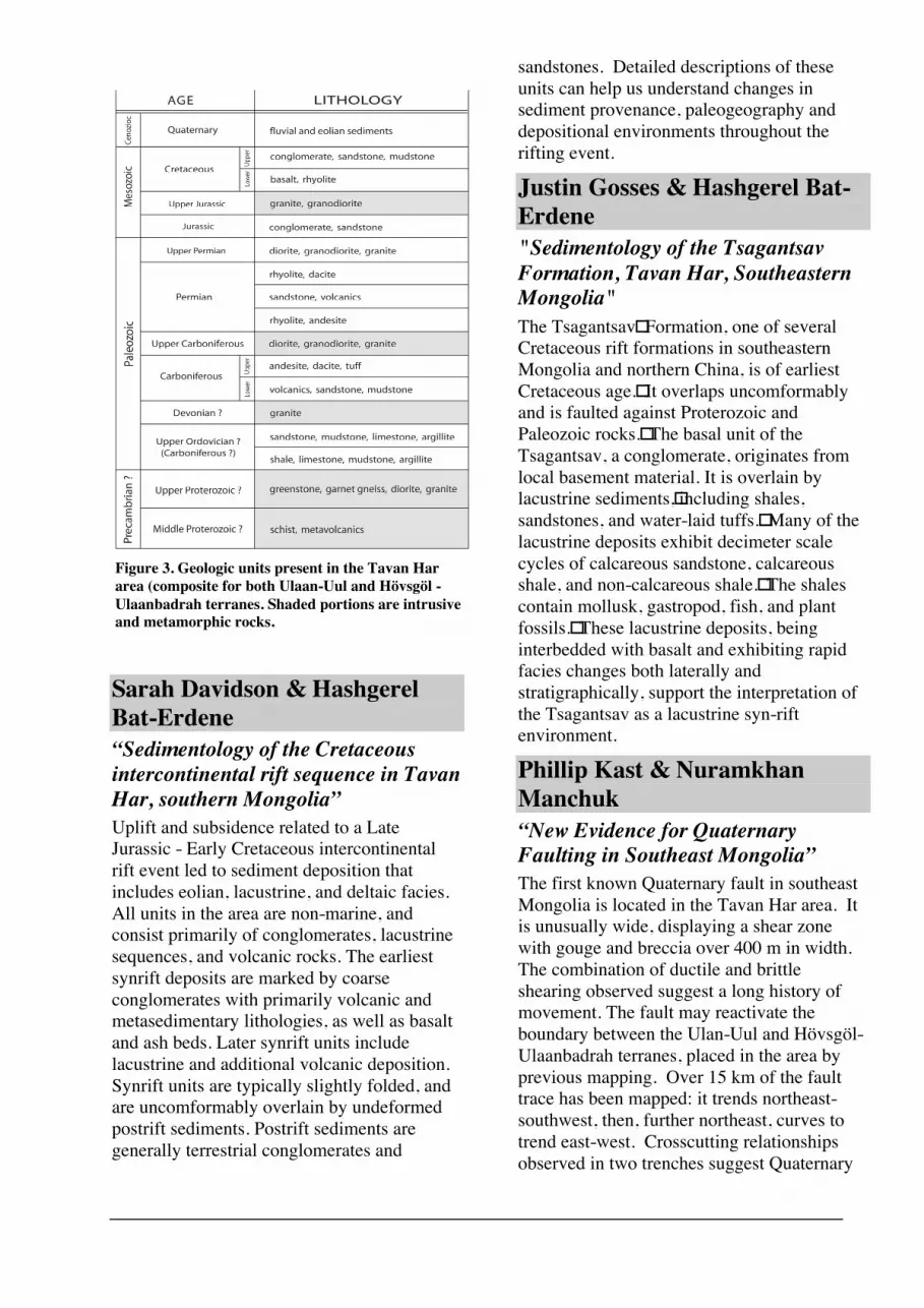
Figure 3. Geologic units present in the Tavan Hararea (composite for both Ulaan-Uul and Hövsgöl -Ulaanbadrah terranes. Shaded portions are intrusiveand metamorphic rocks.

motion. Several lines of evidence suggest left-oblique motion. Air photos may reveal offsetstreams and large scale features related toterrane suturing.
Peter Anderson and MagsarjarOchirbat“The Tavan Har Impact Crater,Eastern Gobi, Mongolia”The impact crater of the northeastern TavanHar region is located in greenschist faciesmetamorphic rocks with both felsic and maficprotoliths. The crater has a diameter of 1.75km and covers an area of 137 hectares. Atleast two episodes of deformation haveaffected the country rock, the first deformationevent forming a foliation plane that is parallelto subparallel to bedding. The seconddeformation event folded foliation andproduced spaced axial plane fracturecleavages. The two foliations produce anintersection lineation which, when viewed inthe structure, shows the beds to be generallystriking northeast-southwest and overturnedon the northeastern rim of the crater. Thelineations on the northwest and southeast rimsof the crater dip away from the crater centerand are support for the impact origin of thecrater. Dikes of various lithologies wereintruded after the deformation events andstrike parallel to foliation. Scattered outcropsof breccia with calcareous cement are possibledikes related to the impact.
Jonah Stinson & ErdenebatOdontuya“Seif Dunes of the Eastern Gobi,Mongolia”Seif dunes (Figure 4), a sinuous variety oflongitudinal sand dunes, are located along thesoutheastern rim of the Tavan Har crater in theGobi of southeastern Mongolia. Peaks of theeroded crater rim act like a snow fence tocause deposition of sand downwind of thecrater, resulting in a number of one-kilometer-long dunes running subparallel to one anotherat S80°E. This orientation reveals the area’sprevailing wind direction, which is alsoindicated by the orientation of grooves insand-abraded bedrock on the crater rim.
Although the dominant wind direction is fromthe west, bimodal seasonal winds from thenorth and south preserve sinuous morphologyby changing the steepest slip faces from sideto side and “wagging the tails” of the dunes.Satellite imagery reveals a large area ofunconsolidated sediment to the northwest thatis considered the likely source area for thesedunes.
Kate Ritley & ErdenebatOdontuya“Yardangs and Dome Dunes ofMongolia’s Gobi”Northeast of Tavan Har is a 5-km2 areacharacterized by yardangs, dome dunes, andother eolian features. The yardangs, which areaerodynamic, wind sculpted hills, are erodedfrom Upper Cretaceous cross-bedded, weaklyconsolidated sandstone and mudstone, and areoriented along a northwest-southeast axis,with a steep northwest side and a gentlysloping southeast side. Yardangs typicallyindicate uni- or bidirectional winds. However,abutting the yardangs are numerous domedunes, which indicate highly variable winddirections, as evidenced by beds dipping in alldirections within the dunes. These domedunes are also transitional to other types ofdunes, such as longitudinal dunes with longaxes in a northwest-southeast direction. Otherwind-related landforms in this area include the
Figure 4. Seifs (longitudinal dunes) in the Tavan Harmeteor crater. The bedrock rim of the crater isgreenschist facies metamorphic rocks with felsic andmafic protoliths.

following: coppice dunes, or vegetated sandmounds, which appear to be positive feedbackfeatures; vegetation-anchored sand pedestals;inactive, semi-consolidated dunes undergoingerosion; and desert pavements. The yardangsand longitudinal dunes indicate dominantwinds from the northwest, yet the dome dunessuggest highly variable winds.
MAJOR SCIENTIFICACCOMPLISHMENTS
1. The Proterozoic (?) igneous andmetamorphic rocks have greater diversity thanpreviously recognized: mafic, intermediate,and felsic plutonic, volcanic, and medium-grade metamorphic lithologies.
2. Based on macrofossils in limestonepods, much of the argillite, formerly believedto be Ordovician, is Carboniferous.
3. The Lower Cretaceous rift-related rocksinclude a diverse suite of lithologies (fluvialand debris-flow conglomerates, lacustrinemudstones and carbonates, and air-fall tephra)and fossils (fish, bivalves, gastropods, andplants).
4. Based on cleavage orientation andprobable impact breccia, the Tavan Har craterwith an uplifted rim is the result of meteorimpact.
5. The fault system trending northeastacross the northwestern Tavan Har areaincludes an active fault (late Quaternarymovement, mostly strike-slip).
6. The Tavan Har area has a variety ofeolian landforms including yardangs, sand-blasted bedrock, “desert pavement”,ventifacts, and longitudinal and dome dunes;these features indicate a prevailing wind fromthe west, with secondary north, south, andprobably east winds.