Embed Size (px)
Citation preview

Geology and Cement Raw Materials of the Windy Creek Area Alaska
GEOLOGICAL SURVEY BULLETIN 1039-D

Geology and Cement Raw Materials of the Windy Creek Area AlaskaBy R. M. MOXHAM, R. A. ECKHART, and E. H. COBB
INVESTIGATIONS OF CONSTRUCTION MATERIALS IN ALASKA
GEOLOGICAL SURVEY BULLETIN 1039-D
Description of pre-Devonian to Late Cretaceous geohgy, including three limestone deposits
UNITED STATES GOVERNMENT PRINTING OFFICE, WASHINGTON : 1959
UNITED STATES DEPARTMENT OF THE INTERIOR
FRED A. SEATON, Secretary
GEOLOGICAL SURVEY
Thomas B. Nolan, Director
For sale by the Superintendent of Documents, U.S. Government Printing Office Washington 25, D.C.
CONTENTS
PageAbstract- _________________________________________________________ 67Introduction. _____________________________________________________ 67
Location of area._______-______________________________________ 68Previous investigations,________________________________________ 68Present investigation.__________________________________________ 68Acknowledgments. _____________________________________________ 70
Geography _ _____________________________________________________ 70Topography and drainage_________-_____________________________ 70Climate....,__________________________________________________ 72Vegetation.. __________________________________________________ 72Accessibility. __________________________________________________ 73
General geology..__________________________________________________ 73Pre-Devonian rocks..__--______--____-___-_-______-_____--_____ 73Devonian system______________________________________________ 74Devonian (?) system.___________________________________________ 78Triassic system._______________________________________________ 79Triassic(?) system..____________________________________________ 80Jurassic(?) system.____________________________________________ 81Cretaceous system.____________________________________________ 82
Cantwell formation________________________________________ 82Quaternary system.____________________________________________ 82Igneous rocks________________________________________________ 83
Cement raw materials..____________________________________________ 84Limestone ____________________________________________________ 84
Deposit l_.__________________________________-_____-_-_-__ 85Deposit 2_._______________________________________________ 87Deposit 3_._____________________________________________ 88Other deposits--__-________-_-_____________-_-_____-------- 91
Argillaceous materials._____-_________________-_-__-_-__----_--_ 92Pre-Devonian rocks._______--________________--____---_-_-_ 92Devonian system._________________________________________ 92Jurassic(?) system._-_-_____________________---____-------_ 94
Chert-__--________:___-_______________________-______--__---- 94Potential cement composition___________________________________ 95
Literature cited..__________________________________________________ 97Index_____________________________________________________________ 99
ILLUSTKATIONS
PLATE 11. Geologic maps and sections of Windy Creek area, Alaska.- In pocket
Page FIGURE 13. Index map of south-central Alaska..-_____________________ 69
14. Fault zone in Foggy Pass _____________-___--__-_-----_-- 7615. Northeastern part of Windy Creek area____-_-------------- 7716. Limestone deposit 2__.__________________________________ 8717. Headwaters of West Fork of Windy Creek-___--___-------- 89
in

IV CONTENTS
TABLES
Page
TABLE 1. Chemical requirements for type II portland cement.---_-___ 852. Chemical analyses of surface samples of limestone deposit 1__ 863. Chemical analyses of samples of limestone deposit 2...______ 884. Chemical analyses of samples of limestone deposit 3--._-_-__ 915. Summary of data pertaining to argillaceous materials.--.---- 936. Chemical analyses of argillaceous materials,________________ 937. Calculations of potential cement composition..------------- 97

INVESTIGATIONS OF CONSTRUCTION MATERIALS IN ALASKA
GEOLOGY AND CEMENT RAW MATERIALS OF THE WINDY CREEK AREA, ALASKA
By R. M. MOXHAM, R. A. ECKHART, and E. H. COBB
ABSTRACT
The Windy Creek area, on the south flank of the Alaska Range, is within a geosynclinal belt that contains clastic and calcareous rocks ranging in age from pre-Devonian to Late Cretaceous. The major geologic structures in the area are oriented parallel to the regional easterly to northeasterly trend of the Alaska Range. Steeply dipping folded strata of Mesozoic age occupy the south ern part of the area and have been downthrown against Devonian rocks on the north by a major fault zone that crosses the center of the area.
Two limestone deposits of Devonian and Devonian (?) age are of adequate size and chemical quality for cement-manufacturing purposes. They are located 7 and 11 miles, respectively, west of the Alaska Railroad. A third limestone deposit of large size but of inferior quality lies 1 mile west of the railroad. Argillaceous rocks, which occur in both the pre-Devonian, Devonian, and Juras sic (?) systems, are found in many parts of the area. Chert of Triassic age, possibly of some value as a high-silica component, occurs along the Alaska Railroad near Windy station.
INTRODUCTION
All the portland cement and other limestone products used by the construction industry in Alaska at the present time (1956) are imported from the continental United States. Interest has been shown in the possibility of local manufacture of these materials, particularly since the surge in construction that began in the early 1940's.
As the principal population centers and the most highly devel oped transportation systems are in south-central Alaska, the search for suitable raw materials for cement production has been concen trated in this region, especially in the Alaska Railroad belt. Three general localities in the railroad belt have received consideration as possible sources of cement materials (Waring, 1947; Rutledge and others, 1953; and Moxham and Eckhart, 1956), but the Windy Creek area, in the northern part of the belt, has been studied in
67
68 INVESTIGATIONS OF CONSTRUCTION MATERIALS IN ALASKA
more detail than the other potential sites, largely because of the proximity of limestone to the railroad.
The purpose of this report is to describe the principal geologic features of the Windy Creek area, with particular emphasis on those rock types of potential value in the manufacture of portland cement.
LOCATION OF AREA
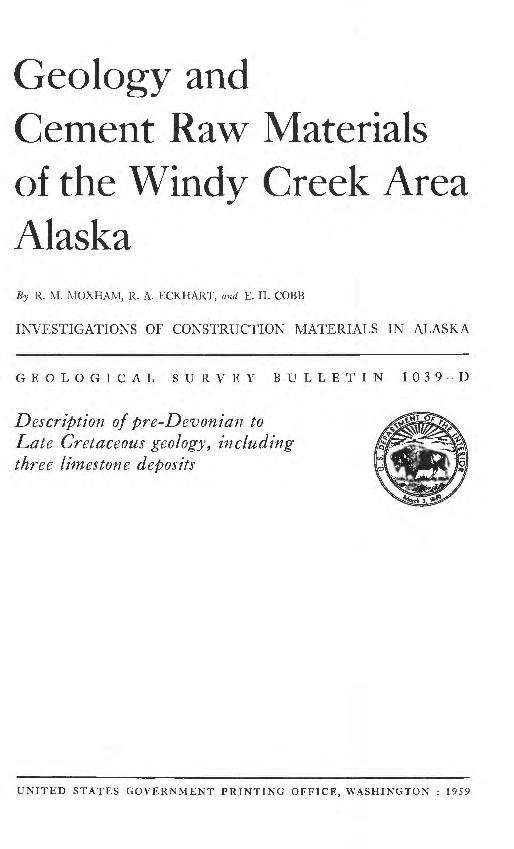
The Windy Creek area is on the south flank of the Alaska Range, in south-central Alaska (fig. 13). The area lies across the Alaska Railroad and is in part within the southeastern limits of Mount McKinley National Park. Mount McKinley is about 70 miles south west of the center of the area described in this report.
The limits of the Windy Creek area have been arbitrarily chosen; they are represented by lat*63°22' and 63°29'30" and long 148° 48' and 149°18' (pi. 11). About 145 square miles are included in this area.
PREVIOUS INVESTIGATIONS
In 1898, G. H. Eldridge (1900) and Robert Muldrow of the IT. S. Geological Survey ascended Susitna River and its tributary drain age, crossed to Jack River at the east limit of the Windy Creek area, and traversed downstream along Jack and Nenana Rivers to Yanert Fork. Their brief descriptions of the rocks exposed along these streams were the first recorded geological observations made in the Windy Creek area.
The first systematic topographic and geologic survey was made in 1913. A party, under the direction of F. H. Moffit (1915), worked westward along the south flank of the Alaska Range from the Delta River country to Jack River, and mapped the geology on a recon naissance scale.
In 1930 the geologic mapping of the south side of the Alaska Range was extended to the West Fork of Chulitna River by Capps (1932) who completed reconnaissance coverage of the area de scribed in the present report.
The following year, Waring (1947) briefly examined and sampled four exposures of limestone between Little Windy Creek and the Alaska Railroad, west of Windy station, in connection with an in vestigation of nonmetallic minerals in the Alaska Railroad belt.
PRESENT INVESTIGATION
The present study of the Windy Creek area, for the purpose of investigating potential cement raw materials, began in 1947. In that year Cobb mapped in detail the limestones between Little Windy Creek and the railroad. Surface samples were collected from

GEOLOGY AND CEMENT RAW MATERIALS, WINDY CREEK AREA 69
PIGUKE 13. Index map of south-central Alaska showing location of Windy Creek area.
two of the larger, more accessible limestone deposits. R. E. Fellows of the Geological Survey made a brief field investigation in 1949 to integrate coredrilling data, furnished by the U. S. Bureau of Mines, with the geological studies and to sample deposits of argil laceous materials that crop out near the railroad and in the lower Windy Creek basin.

70 INVESTIGATIONS OF CONSTRUCTION MATERIALS IN ALASKA
Chemical analyses of the limestone samples and cores made by the Geological Survey and the Bureau of Mines, respectively, in 1947-49 indicated that the principal limestone deposits in the area east of Little Windy Creek are not of uniform chemical character. Although this condition might not preclude the use of restricted parts of the deposits for cement manufacture, it seemed desirable to determine whether other, more suitable limestone deposits exist elsewhere in the Windy Creek area. In July 1950, a brief recon naissance of the Windy Creek drainage basin west of Little Windy Creek was undertaken, the principal objectives being to locate and sample all limestone bodies of potential commercial size and to sam ple the more accessible deposits of argillaceous materials. Two limestone deposits of adequate tonnage were mapped and sampled and several deposits of argillaceous materials were investigated. The present bulletin supersedes a brief open-file report describing this investigation (Moxham and others, 1951).
The geological investigations in the Windy Creek area described above were confined to detailed studies of relatively small portions of the eastern part of the area and reconnaissance surveys of the western part. Hence, in 1951, additional fieldwork was undertaken to determine more precisely the location and distribution of poten tial cement raw materials in the western part of the area, and, in sofar as time permitted, to attempt to integrate the previous de tailed studies with the areal geology. The fieldwork in 1951 was carried out between May 28 and July 10 by R. M. Moxham and R. A. Eckhart, geologists, and W. A. Bakke and R. A. Wilkens, field assistants. In the brief time available for this work it was possible only to map the major geologic units in reconnaissance fash ion, and in many localities it was necessary to supplement direct field observations by photogeologic methods.
ACKNOWLEDGEMENTS
The authors gratefully acknowledge the courtesies extended by Mr. Jack West and the late Mr. John E. Carlson of Cant well, Mr. Claude Rogers of the Alaska Road Commission, and the Alaska Railroad. Chemical analyses were made by R. K. Bailey, S. M. Berthold, H. M. Hymen, L. E. Reichen, L. I. Shapiro, and A. C. Ylisidis of the Geological Survey, and by A. A. Hanks, Inc.
GEOGRAPHY
TOPOGRAPHY AND DRAINAGE
The Windy Creek area includes parts of two physiographic divi sions, the Alaska Range and the Broad Pass depression (Wahrhaf- tig, 1958). West of long 149°10' W. the crest of the Alaska Range
GEOLOGY AND CEMENT RAW MATERIALS, WINDY CREEK AREA 71
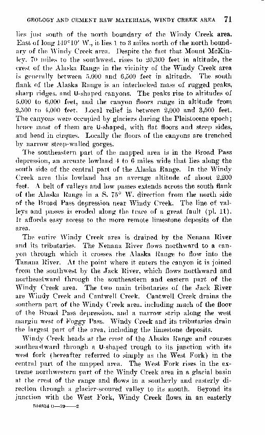
lies just south of the north boundary of the Windy Creek area. East of long 149° 10' W., it lies 1 to 3 miles north of the north bound ary of the Windy Creek area. Despite the fact that Mount McKin- ley, 70 miles to the southwest, rises to 20,300 feet in altitude, the crest of the Alaska Range in the vicinity of the Windy Creek area is generally between 5,000 and 6,500 feet in altitude. The south flank of the Alaska Range is an interlocked mass of rugged peaks, sharp ridges, and U-shaped canyons. The peaks rise to altitudes of 5,000 to 6,000 feet, and the canyon floors range in altitude from 2,500 to 4,000 feet. Local relief is between 2,000 and 3,500 feet. The canyons were occupied by glaciers during the Pleistocene epoch; hence most of them are U-shaped, with flat floors and steep sides, and head in cirques. Locally the floors of the canyons are trenched by narrow steep-walled gorges.
The southeastern part of the mapped area is in the Broad Pass depression, an arcuate lowland 4 to 6 miles wide that lies along the south side of the central part of the Alaska Range. In the Windy Creek area this lowland has an average altitude of about 2,200 feet. A belt of valleys and low passes extends across the south flank of the Alaska Range in a S. 75° W. direction from the north side of the Broad Pass depression near Windy Creek. The line of val leys and passes is eroded along the trace of a great fault (pi. 11). It affords easy access to the more remote limestone deposits of the area.
The entire Windy Creek area is drained by the Nenana River and its tributaries. The Nenana River flows northward to a can yon through which it crosses the Alaska Range to flow into the Tanana River. At the point where it enters the canyon it is joined from the southwest by the Jack River, which flows northward and northeastward through the southeastern and eastern part of the Windy Creek area. The two main tributaries of the Jack River are Windy Creek and Cantwell Creek. Cantwell Creek drains the southern part of the Windy Creek area, including much of the floor of the Broad Pass depression, and a narrow strip along the west margin west of Foggy Pass. Windy Creek and its tributaries drain the largest part of the area, including the limestone deposits.
Windy Creek heads at the crest of the Alaska Range and courses southeastward through a U-shaped trough to its junction with its west fork (hereafter referred to simply as the West Fork) in the central part of the mapped area. The West Fork rises in the ex treme northwestern part of the Windy Creek area in a glacial basin at the crest of the range and flows in a southerly and easterly di rection through a glacier-scoured valley to its mouth. Beyond its junction with the West Fork, Windy Creek flows in an easterly
504834 O 59 2

72 INVESTIGATIONS OF CONSTRUCTION MATERIALS IN ALASKA
direction across part of the Broad Pass depression to enter the Jack River.
Numerous boulders and a generally steep gradient prevent the use of boats of any kind on Windy Creek and the West Fork. Dur ing periods of high water in the spring and immediately after rain storms in the summer months, Windy Creek below its junction with the West Fork may be difficult to ford on foot. Crossing during most of the rest of the summer, however, can be made without trouble.
CLIMATE
No weather records are kept at any locality in the Windy Creek area, but the data collected by the Civil Aeronautics Administra tion (U.S. Weather Bureau, 1955) at Summit, a short distance south of the area, give some indication of the climatic conditions that prevail in this region. The average annual temperature at Summit is 25°F with the average for the period June through August be ing 50°F and for the period December through February 5° F. Total precipitation is about 22 inches; an annual average of 113 inches of snowfall was recorded during the period 1950-54. Freez ing temperatures may ordinarily be expected as late as May and as early as August, with the first ice occurring usually in October and the breakup in May.
The average seasonal temperatures in the Windy Creek area, as elsewhere in central Alaska, range widely, from the fifties in sum mer to the minus tens (°F) in winter. The Alaska Range forms a barrier across the path of the northward flow of Pacific air up the Susitna-Chulitna lowland, and as the moisture-laden air is driven upward, the seaward flank of the range receives an abnormal amount of precipitation. The dissimilar growth of glaciers on opposite flanks of the range reflect the difference in precipitation; those to the south of the crest are larger in size and number. How ever, the report area and its immediate environs are somewhat anomalous in that the development of glaciers is relatively poor, perhaps owing to the lower average altitude of the crest of the range in this vicinity or to some other local topographic condition that controls the airflow and precipitation.
VEGETATION
Timberline in the Windy Creek area is about 2,800 feet in alti tude, so that the growth of timber, mainly spruce and cottonwood, is restricted largely to the lowlands in the southeastern part of the area and to narrow strips along Windy Creek and its principal tributaries. The junction of Windy Creek and the West Fork

GEOLOGY AND CEMENT RAW MATERIALS, WINDY CREEK AREA 73
marks in general the westward extent of timber growth. Beyond this point, and locally above the 2,800-foot altitude, there is some scrubby growth, mainly cottonwood, willow, and alder. Most of the stream valleys below timberline are heavily overgrown with brush and shrubs, mostly willow and alder.
ACCESSIBILITY
The eastern part of the area is accessible by rail and air. Cant- well, in the southeastern part of the area, is 205 miles by rail from Anchorage and 151 miles from Fairbanks. A small airstrip at Cant well will accommodate single-engine planes. Flagstop airline connection with Anchorage and Fairbanks is available at Summit, 7 miles by road south of Cantwell.
The eastern part of the Windy Creek area is accessible by road from Anchorage and Fairbanks. Two tractor trails give access to the valley of Windy Creek from Cantwell. One extends to the mouth of Windy Creek; the other runs westward to a National Park Service shelter cabin on Windy Creek, about 5 miles above its mouth. The valleys of Windy Creek and the West Fork offer no serious obstacle to tractor travel beyond the trail's end until the headwater gorges are reached.
GENERAL GEOLOGY
The area of this report is in the axial region of the Alaska Range geosyncline, a major arcuate tectonic element in a belt of subsidence that probably has been operative since early Paleozoic time. Sedimentary rocks in the area, predominantly clastic beds deposited in a marine environment, range in age from pre-Devonian to Late Cretaceous and are intruded by and interbedded with ande- sitic volcanic rocks of probable Triassic age. Granitic batholithic intrusives, sills, and dikes, emplaced during the Paleocene(?) orog eny, cut the sedimentary and volcanic units in the western part of the Windy Creek area.
PRE-DEVONIAN BOCKS
The oldest part of the geologic succession in the area mapped consists of pre-Devonian rocks that crop out on the south flank of the first ridge southwest of the junction of Windy Creek and the West Fork. Red, green, and buff argillite and shale are the pre dominant rock types and are quite dissimilar in appearance to any other strata observed in the report area.
On the south the pre-Devonian rocks abut the great fault zone that transects the entire Windy Creek area, and are upthrown
74 INVESTIGATIONS OF CONSTRUCTION MATERIALS IN ALASKA
against Jurassic ( I ) strata. The brightly colored pre-Devonian strata dip steeply southward, apparently constituting the south limb of an overturned fold, as they give way in a northerly direc tion to rocks of Devonian age. Evidence from which to determine the structural relationship adjacent to the great fault zone is con cealed in the report area by alluvium and by glacial and glacio- fluvial deposits. Capps (1932) made observations in the Chulitna River area to the west that led him to conclude that the narrow belt of rocks that include the highly colored argillite and shale immediately adjacent to the fault zone definitely underlie the De vonian rocks. Capps mapped an outcrop of the pre-Devonian rocks sslong the north side of Foggy Pass in the Windy Creek area, but the present writers have shown only Devonian strata here, owing to the presence of conglomerate that appears to be closely akin to the coarse clastic sediments found in the belt of Devonian east of Foggy Pass. The thickness of the pre-Devonian rocks in the mapped area is about 1,500 feet.
DEVONIAN SYSTEM
Closely folded metamorphosed marine strata of Devonian age crop out in a generally eastward-trending belt across the central part of the Windy Creek area. The rocks consist mainly of argillite, lime stone, conglomerate, graywacke, slate, greenstone, and quartzite. The strata are characterized by abrupt lateral and stratigraphic discon tinuities, so that in most localities individual beds are neither very thick nor laterally persistent. In the western part of the area the rocks are made up chiefly of conglomerate interbedded with argillite, graywacke, and a little limestone. Conglomerate beds that range from 2 to 60 feet in thickness are found throughout the section. Most of them are dark colored and are composed chiefly of black chert, argillite, and quartz particles, ranging in size from coarse grit to pebbles several inches in diameter, in a siliceous matrix. Toward the east the clastic sediments tend to become finer in texture, lime stone becomes more abundant, and some greenstone, tuff, and quartz ite are found.
Most of the limestone beds are relatively thin and discontinuous. In a few areas they are as much as 500 feet thick, but the average thickness is probably nearer 50 feet. The limestones are generally gray or, locally, buff on weathered surfaces and black or dark gray where fresh. The rock is mainly very dense and fine grained in texture, although locally it is coarser grained where recrystallized. The calcareous strata have been thoroughly shattered by intense dynamic metamorphic action, and the rock is reticulated by calcite- filled fractures. At most places the original bedding of the lime-
GEOLOGY AND CEMENT RAW MATERIALS, WINDY CREEK AREA 75
stone is obscured by secondary structural features to such an extent that the rocks are massive.
Argillite is common in the eastern part of the area. The beds are brown to black and are generally thin. In many parts of the area the argillite has been crumpled, sheared, and intricately faulted both as a result of regional metamorphic action and, locally, as a result of stresses along the faults that bound the unit on the north and south.
Fossils are scarce in these strata, except for a few poorly preserved specimens in the limestone beds at several localities. Most of the fossils are sufficiently silicified to become etched in relief on weath ered surfaces; very little of the freshly broken rock shows any trace of organic remains. Collections were made at two locations, shown on figure 2. The fossils consist largely of corals but also include stromatoporoids and bryozoa. The collections contain the follow ing forms:
Locality
12
Collection
47-ACb-7650-AMx-101 50-AMx-102 50-AMx-103 50-AMx-104 50-AMx-105
Fossil
Tryplasma sp., Amphipora sp.
Cladopora sp., pseudamplexoid coral, stromatoporoids. pseudamplexoid coral. Coenitest sp., unidentified horn coral. Cladopora sp., stromatoporoids. Coenites sp., unidentified bryozoan.
The fossil identifications were made by Jean M. Berdan, of the U. S. Geological Survey, who reports as follows:
Lot 47-ACb-76 differs from the other collections in containing the horn coral Tryplasma, which is most abundant in the Silurian but has been reported from the Middle Devonian of Germany (Etheridge, R., Geol. Survey of New South Wales, Mem. 13, p. 44, 1907). This collection also contains a block with differ ent lithology from that containing the horn corals in which there are rodlike objects which appear to be Amphipora, a form of stromatoporoid occurring in the Middle and possibly also in the Upper Devonian. The * * * collection * * * was made from talus so that more than one horizon may be represented. Lots 50-AMx-101 through 105 contain horn corals wrhich agree with the subfamily Pseudamplexinae described by Stumm (Geol. Soc. America Mem. 40, p. 47-48, 1949) in possessing subcylindrical corallites with radially arranged septa, no fossula, and a septal dilation wrhich suppresses the dissepiments in the periph eral zone. However, this subfamily is described as containing simple corals only, and some of those in the material at hand appear to be weak faciculate. These corals are associated with the tabulate coral Cladopora and with lamel lar and encrusting stromatoporoids. Twro collections contains a tabulate coral referable to Coenites and one an unidentified bryozoan. All these forms range from Silurian through the Middle Devonian but * * * similar material (from this area) has been identified as Middle Devonian, and this is probably the best age assignment possible at present.
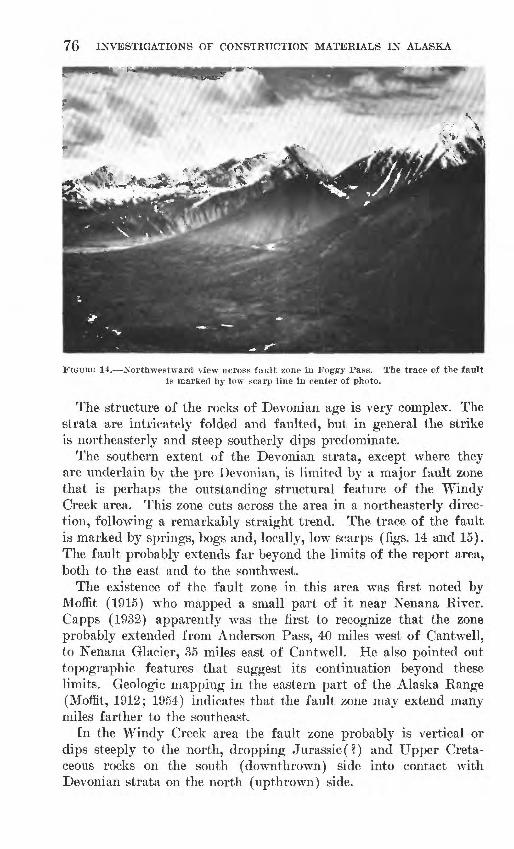
FIGURE 14. Northwestward view across fault zone in Foggy Pass. The trace of the fault is marked by low scarp line in center of photo.
The structure of the rocks of Devonian age is very complex. The strata are intricately folded and faulted, but in general the strike is northeasterly and steep southerly dips predominate.
The southern extent of the Devonian strata, except where they are underlain by the pre-Devonian, is limited by a major fault zone that is perhaps the outstanding structural feature of the Windy Creek area. This zone cuts across the area in a northeasterly direc tion, following a remarkably straight trend. The trace of the fault is marked by springs, bogs and, locally, low scarps (figs. 14 and 15). The fault probably extends far beyond the limits of the report area, both to the east and to the southwest.
The existence of the fault zone in this area was first noted by Moffit (1915) who mapped a small part of it near Nenana River. Capps (1932) apparently was the first to recognize that the zone probably extended from Anderson Pass, 40 miles west of Cantwell, to Nenana Glacier, 35 miles east of Cantwell. He also pointed out topographic features that suggest its continuation beyond these limits. Geologic mapping in the eastern part of the Alaska Range (Moffit, 1912; 1954) indicates that the fault zone may extend many miles farther to the southeast.
In the Windy Creek area the fault zone probably is vertical or dips steeply to the north, dropping Jurassic(?) and Upper Creta ceous rocks on the south (downthrown) side into contact with Devonian strata on the north (upthrown) side.

FIG
URE
1
5.
Aer
ial
view
of
no
rthe
aste
rn
par
t of
W
indy
C
reek
ar
ea.
Lim
esto
ne d
epos
it
1 is
loc
ated
at
A.
The
tra
ce o
f th
e m
ajor
fau
ltzo
ne b
etw
een
Dev
onia
n an
d M
esoz
oic
rock
s is
dis
cern
ible
bet
wee
n po
ints
B a
nd C
.

78
The northern extent of the Devonian rocks west of Little Windy Creek probably is limited by another nearly vertical fault which has brought them into contact with younger beds of possible Devon ian age. In the western part of the area, the line of displacement is clearly marked on the aerial photo (fig. 15) by northeastward- to eastward-oriented drainage, and an alinement of similarly oriented passes extends from a point at least several miles beyond the western limit of mapping eastward almost to the junction of Windy Creek and the West Fork. Eastward from this junction the structural relation is more obscure and the location of the fault between Windy and Little Windy Creeks has accordingly been questioned on figure 2. East of Little Windy Creek the aerial photos show no displacement of the Triassic rocks that presumably overlie the Devonian section, but whether the Devonian rocks are faulted beneath the Triassic is open to question. Indeed, the location of the Devonian-Triassic contact itself is questionable, as noted in the discussion of the Trias sic system (p. 80).
Because of the complex folding and faulting, the thickness of the Devonian rocks can only be estimated to be about 3,000 feet.
DEVONIAN(P) SYSTEM
North of, and in fault contact with, the Devonian rocks west of Little Windy Creek is a succession of reddish-weathering, folded and metamorphosed thin-bedded shaly limestone, argillite, gray- wacke, and shale. This sequence is here referred to as of Devon ian (?) age although no fossil evidence of this age has been found. East of Little Windy Creek recognized Devonian rocks are un- conformably( ?) overlain by sedimentary rocks of Triassic age. On the basis of the lithologic dissimilarity of the reddish-weathering sequence and the Triassic section and of the structural relationship of the reddish-weathering strata to Devonian rocks west of the Windy Creek area, an age designation of Devonian (?) seems most appropriate.
The Devonian (?) rocks crop out in the headwaters of the Windy Creek and the West Fork drainage basins. In contrast to the rocks of the accepted Devonian, the Devonian (?) strata appear to be nearly free of conglomerate and contain a greater percentage of calcareous rocks. The strata consist of closely folded, metamor phosed sedimentary beds, primarily limestone, graywacke, argillite, and shale. These beds, with the exception of the more massive lime stones, are generally dark colored where fresh, characteristically weathering to shades of reddish brown. The limestone generally tend to be argillaceous and with one notable exception are thin bed ded, locally schistose, strata.

GEOLOGY AND CEMENT RAW MATERIALS, WINDY CREEK AREA 79
The most impressive lithologic unit of the Devonian (?) strata is a massive limestone that crops out in an eastward-trending belt across the headwaters of the West Fork. It is quite persistent laterally along the strike, extending for at least 20 miles west of the West Fork and two miles eastward. The limestone is blue gray to black, is locally banded, and weathers to a light gray. Most of it is very dense and has a fine-grained texture. In some localities the rock is quite hard and breaks with a conchoidal fracture. Cal- cite reticulation is abundant.
Although wide variations occur in the attitude of individual beds the limestone body as a whole probably stands nearly vertical. The limestone attains a maximum thickness of about 2,600 feet in the valley of the West Fork; its outcrop thins markedly to the east and somewhat less so to the west.
North of the massive limestone and overlying it are interbedded limestone, argillite, and shale, which dip steeply to the north. Simi lar rocks, closely folded and faulted but generally dipping steeply to gently southward, lie south of the massive limestone; they prob ably belong to the same stratigraphic sequence as those north of the massive limestone. If this interpretation is correct, the major struc tural feature of the Devonian (?) strata in the headwaters of the West Fork is an eastward-trending anticline, although other com plex folds are superimposed upon the major structure. The axis of the structure follows the outcrop of the massive limestone so that this geologic unit may represent both limbs of a closely compressed fold.
Only a rough estimate of the thickness of the Devonian (?) rocks can be made, but it appears that as much as 8,000 feet may be present in the western part of the Windy Creek area. The massive limestone is probably about 1,300 feet thick stratigraphically.
TRIASSIC SYSTEM
East of Little Windy Creek, rocks of Triassic age overlie the Devonian. Here the lower part- of the Triassic section consists of 1,000 to 2,000 feet of argillite, limestone, conglomerate, chert, green stone, and slate which strike in a northeasterly to easterly direction and dip steeply both to the north and to the south. The lithology of the lower part of the section is quite similar to the underlying rocks of Devonian age, so that the position of the boundary be tween the systems is open to question. The location of the boundary shown in plate 11 is based on the evidence of fossil collections 47-ACb-76 and 47-ACb-78 (p. 80) and the predominance of green stone in the younger system. The stratigraphic and structural re lationships of the Triassic rocks with the underlying rocks of
504834 O 59 3
80 INVESTIGATIONS OF CONSTRUCTION MATERIALS IN ALASKA
Devonian age are not clear, but the boundary is probably an un conformity.
No Triassic rocks had previously been mapped in this part of the Alaska Range, but they had been seen in adjacent areas. Near the crest of the range north and west of the Windy Creek area Capps recognized greenstone, slate, and chert between known De vonian rocks and overlying Cretaceous rocks, but in the absence of any evidence to the contrary he included them with underlying strata of Devonian age. Limestone of Triassic age interbedded with greenstone and other volcanic rocks has been found elsewhere on the south flank of the range. On the West Fork of Chulitna River, about 20 miles southwest of the Windy Creek area, Ross (1933, p. 298) mapped limestone and argillite of Triassic age which overlie rocks of Permian age, and in the Valdez Creek area, about 40 miles to the east, Moffit (1915, p. 33) found limestone of Triassic age interbedded with greenstone.
Greenstone, chert, and phyllite lie unconformably beneath the Cantwell formation in the headwater of Yanert Fork, northeast of the Windy Creek area. Apparently these rocks are similar in lithology to those that underlie the Cantwell formation west of Nenana River; they are probably Triassic in age (Wahrhaftig, 1958, pi. 4).
In 1947 E. H. Cobb made two collections of fossils from a lime stone bed near the west end of the ridge between Bain and Windy Creeks. The identifications given below are by Ralph W. Imlay:
Locality
3
Collection
47-ACb-78
47-ACb-79
Remarks
Contains the pelecypods Megalodus(1) and Mysidia which are characteristic of the Upper Triassic.
Contains a belemnite that is definitely Mesozoic but not well enough preserved to identify generically.
TRIASSIC (?) SYSTEM
The foregoing description of Triassic rocks outside of the Windy Creek area indicates that greenstone and other volcanic rocks are common constituents of the Triassic strata. In the area of this report, the narrow belt of predominantly sedimentary rocks of Tri assic age is overlain on the north by a thick sequence of andesitic and basaltic greenstone sills and extrusive rocks that occupy the northeastern part of the mapped area and have been designated as Triassic (?) in age. In general they dip to the north at a moderate angle, perhaps averaging 20°-30°.
GEOLOGY AND CEMENT RAW MATERIALS, WINDY CREEK AREA 81
Altered greenstone extrusive masses interbedded with tuffs crop out in the area west of Cantwell. Their stratigraphic relationship to the Jurassic rocks on the north has not been established, as the bedding of both units appears to be nearly vertical in the contact areas. In the extreme southeastern part of the greenstone outcrop area, some of the flows when viewed from a distance appear to dip gently to the south and to strike northeastward. They are tenta tively correlated with the Triassic (?) greenstone that crops out in the northeastern part of the area.
JURASSIC (?) SYSTEM
A belt of steeply dipping metamorphosed sedimentary strata, ten tatively assigned a Jurassic (?) age, crops out between the major fault zone that trends northeastward across the central part of the area and the intrusive and volcanic rocks which border the Windy Creek area on the south. In the western part of the area the pre dominant constituents are argillite and slate, with some conglomer ate, which are cut by felsic dikes and sills, although the igneous rocks are not abundant. The slate and argillite are mostly black; the conglomerate is dark brown to black; it is composed chiefly of black chert, dark argillite, and white quartz pebbles set in a dark brown matrix. In the eastern part of the Jurassic(?) belt, the clastic sediments become much coarser with graywacke predomi nating.
In most of the Windy Creek area the rocks of Jurassic (?) age are cut off on the north by the major fault zone, but in the extreme western part they are overlain by the Upper Cretaceous Cantwell formation. The complexity of the structure in this area obscures the stratigraphic relationship of the rocks of Jurassic (?) age with the Cantwell rocks, but there may be an angular unconformity be tween the Cantwell formation and the underlying strata, as found on the north side of the Alaska Range (Capps, 1932, p. 269).
In general the Jurassic (?) rocks strike slightly north of east and are closely folded, with steep dips to the north and south.
The total thickness of the Jurassic (?) system on the south side of the central part of the Alaska Range has been estimated to be as much as 5,000 feet (Capps, 1940, p. Ill), but in all probability only the upper 4,000 feet is present in the Windy Creek area.
No fossils have been found in the Jurassic (?) rocks in the Windy Creek area, and in the absence of other conclusive evidence the age assignment remains the same as that determined by Capps (1940, p. Ill); he based the age of these rocks on a relatively long range correlation with the argillite of known Jurassic age found near the West Fork of the Chulitna River.

82 INVESTIGATIONS OF CONSTRUCTION MATERIALS IN ALASKA
CRETACEOUS SYSTEM
CANTWELL, FORMATION
The Cantwell formation, a nonmarine sequence of Late Creta ceous age, has a relatively wide distribution on the south side of the Alaska Range in the region southwest of the area of this report. The belt that it occupies, however, narrows to the northeast so that only a small part of the lower Cantwell section, in the western Windy Creek area, represents the easternmost extent of the forma tion south of the major fault zone. The Cantwell formation in the Windy Creek area consists primarily of dark-colored coarse massive conglomerate and argillite, which are locally cut by sills and dikes varying widely in chemical composition. The conglomerate is com posed chiefly of pebbles and cobbles of limestone, argillite, slate, and chert, that range in size to as much as 6 inches in diameter. The general trend of the beds of the Cantwell formation is N. 60°-80°E., and their attitude is nearly vertical.
On the north the rocks of the Cantwell formation are cut off by the major fault zone, and to the south they are underlain by black argillite of Jurassic(?) age. The total thickness of the Cantwell formation in the Windy Creek area probably does not exceed 1,500 feet.
No fossils were found in the rocks of the Cantwell formation in this area. Ten miles east of the mouth of Jack River, Moffit (1915, p. 48) collected fossil plants of Eocene age from shale and sand stone interbedded with conglomerate, which he considered to be part of the Cantwell formation. However, it is recognized that the Cantwell formation on the north side of the range is definitely older than coal-bearing sediments in that area that also are of Eocene age. In 1936, Capps collected fossil plants from rocks of the Cantwell formation on the north side of the range which were determined to be of Cretaceous age. Although the few fossil col lections that have been made from the Cantwell formation present conflicting evidence, an age assignment of Late Cretaceous appears to be the most acceptable at the present time.
QUATERNARY SYSTEM
A detailed description of the Quaternary geology of the central part of the Alaska range is given by Wahrhaftig (1958).
The Pleistocene epoch marked the inception of widespread and intense glaciation of the Alaska Range, culminating in the accumu lation of such an extent of glacial ice that only the higher peaks of the range protruded. The gradual wane from the last advance has continued into Recent time, although the remaining glaciers in

GEOLOGY AND CEMENT RAW MATERIALS, WINDY CREEK AREA 83
the Windy Creek area are small in comparison to the impressive ice flows that occupy the valleys draining the range farther west.
The glaciers not only modified the preglacial landforms; they also laid down deposits of glacial and glaciofluvial material in the low land of the lower Windy Creek drainage basin. At their western limit the deposits are probably only a few feet thick. Eastward the glacial deposits thicken markedly, attaining a thickness of about 60 feet in the Windy Creek Valley 3 miles downstream from the mouth of the West Fork. The full thickness of the glacial deposits, resting on Jurassic(?) bedrock, is well exposed at this locality.
In the extreme eastern part of the mapped area, about 1 mile west of the Alaska Railroad, travertine is being deposited by spring water emanating from the fault zone that limits the Devonian rocks on the south.
IGNEOUS BOCKS
The Triassic (?) greenstone has been described in the previous discussion of the bedded rocks (p. 80).
In the northwestern part of the area the Devonian (?) strata have been intruded by an igneous complex ranging in composition from medium-grained diorite to an ophitic gabbro, with the more mafic compositions predominating. The contact with the Devon ian (?) rocks in most places is inclined steeply to the north. In the peripheral areas the intruded beds are cut by dikes and sills, mostly felsic, and the host rock is locally silicified.
In all probability more than one period of intrusion was involved, but the principal igneous activity of batholithic magnitude prob ably took place in post-Cantwell, that is, Late Cretaceous or Paleo- cene time. This conclusion is based upon observations made in the region north of the Windy Creek area, where the igneous mass cuts the Cantwell formation of Cretaceous age but is overlain by coal- bearing strata of Eocene age. Farther west, however, large masses of granitic rock are overlain by rocks of the Cantwell formation, indicating that major intrusive activity took place in the Alaska Range geosyncline both before and after the deposition of the Cantwell formation.
In the southwestern part of the area the Jurassic (?) argillites and slates have been intruded by a light-gray coarse-grained quartz diorite. The rock has a porphyritic texture in most places, with euhedral orthoclase crystals as much as l1/^ inches in length. The contact with the host rock dips moderately to steeply southward, approximately parallel to the local attitude of the enclosing strata. This intrusion is correlated with the post-Cantwell igneous rocks in the northwestern part of the area.
84 INVESTIGATIONS OF CONSTRUCTION MATERIALS IN ALASKA
CEMENT RAW MATERIALS
In order to evaluate the mineral resources of the Windy Creek area in relation to the problem of a cement supply, it will be nec essary not only to examine the structure, lithology, size, and acces sibility of the individual deposits of potential raw materials, but also to take into consideration their chemical composition. The cement industry today must manufacture a product that will meet exacting chemical and physical standards, so that detailed knowl edge of the chemical composition of the raw materials is a funda mental requirement. Deleterious substances in any potential com ponent may well eliminate it from further consideration, even though all other geologic factors pertaining to its exploitation are favorable.
The chemical restrictions that apply to the various cement raw materials are governed to a certain extent by the type of cement to be produced. The chemical requirements formulated by the Amer ican Society for Testing Materials (1950, p. 1-4) for portland cement type II (which is employed for general construction pur poses) are given in table 1. It is possible to control cement com position in part, and within certain limits, through adjustment of the ratio of the raw components, adjustment of the burning time or temperature, or both, and the use of supplemental iron and silica components. However, magnesia and the alkalies, which have un desirable chemical characteristics, may require flotation or other special treatment to bring them within acceptable limits and there fore are usually regarded as undesirable substances as far as the raw materials are concerned.
As each component of the raw mix, including the fuel combustion residue, contributes to the composition of the end product, it would not be possible to arrive at an upper limit of magnesia or alkali content for any particular raw component that would be applica ble in all instances. However, with raw components of the general chemical composition of those found in the Windy Creek area, an upper limit of magnesia content of 3 percent probably would be applicable to the limestone, which would ordinarily be the major contributor of this compound. The alkalies can be dealt with only in very general qualitative terms, inasmuch as they would volatilize to an unknown extent under actual kiln operation. The maximum permissible amount in the cement, according to Federal specifica tions (table 1), is 0.6 percent (total Na2O plus 0.658 K2O) ; this figure may be used as a guide in the evaluation of the ingredients.
LIMESTONE
Limestone occurs at several localities in the belt of Devonian, Devonian (?), and Triassic rocks that crosses the Windy Creek area in an eastward direction. Deposits of commercial size have been
GEOLOGY AND CEMENT RAW MATERIALS, WINDY CREEK AREA 85
found in three general areas: (1) between the valley of Little Windy Creek and the Alaska Railroad, (2) on the ridge southwest of the junction of the West Fork with Windy Creek, and (3) in the head water area of the West Fork. These three principal limestone de posits in the Windy Creek area are designated as deposits 1, 2, and 3. Their locations are shown on plate 11.
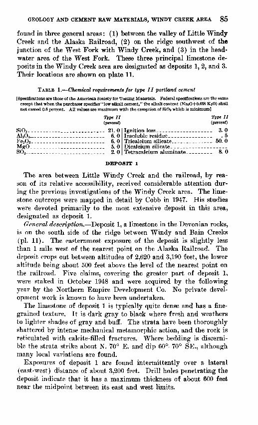
TABLE 1. Chemical requirements for type II portland cement
[Specifications are those of the American Society for Testing Materials. Federal specifications are the same except that when the purchaser specifies "low alkali cement," the alkali content (NasO+0.658 K^O) shall not exceed 0.6 percent. All values are maximum with the exception of SiOi which is minimum]
Type II (percent)
SiO2 __________________________ 21.0A12O3 ___.__..______..._.___. 6. 0Fe8O8 -~- - - _.-------- 6. 0MgO______________.__________ 5.0SO8_ -- ___ 2.0
Type II (percent)
Ignition loss_-_-___-_____-_-_-_ 3. 0Insoluble residue.______________ .5Tricalcium silicate.________--_-_ 50. 0Dicalcium silicate. ___________-__----Tetracalcium aluminate_________ 8. 0
DEPOSIT 1
The area between Little Windy Creek and the railroad, by rea son of its relative accessibility, received considerable attention dur ing the previous investigations of the Windy Creek area. The lime stone outcrops were mapped in detail by Cobb in 1947. His studies were devoted primarily to the most extensive deposit in this area, designated as deposit 1.
General description. Deposit 1, a limestone in the Devonian rocks, is on the south side of the ridge between Windy and Bain Creeks (pi. 11). The easternmost exposure of the deposit is slightly less than 1 mile west of the nearest point on the Alaska Railroad. The deposit crops out between altitudes of 2,620 and 3,190 feet, the lower altitude being about 500 feet above the level of the nearest point on the railroad. Five claims, covering the greater part of deposit 1, were staked in October 1948 and were acquired by the following year by the Northern Empire Development Co. No private devel opment work is known to have been undertaken.
The limestone of deposit 1 is typically quite dense and has a fine grained texture. It is dark gray to black where fresh and weathers to lighter shades of gray and buff. The strata have been thoroughly shattered by intense mechanical metamorphic action, and the rock is reticulated with calcite-filled fractures. Where bedding is discerni ble the strata strike about N. 70° E. and dip 60°-70° SE., although many local variations are found.
Exposures of deposit 1 are found intermittently over a lateral (east-west) distance of about 3,200 feet. Drill holes penetrating the deposit indicate that it has a maximum thickness of about 600 feet near the midpoint between its east and west limits.
86 INVESTIGATION'S OF CONSTRUCTION MATERIALS IN ALASKA
The southward extent of the limestone is concealed by talus, gla cial deposits, and vegetation, but presumably the strata are termi nated on the south near the major zone of faulting which brings the rocks of Devonian age into contact with those of Jurassic(?) age. On the north the limestone is underlain by greenish to black calcareous schist.
Sampling. Fifteen samples were taken across exposures of de posit 1 along lines normal to the strike. Each sample consisted of fresh chips collected at 8-inch intervals. Locations of the samples are shown on plate 11, and results of the chemical analyses of the samples are given in table 2.
Core drilling. Core drilling and chemical analyses to determine the subsurface continuity, extent, and composition of deposit 1 were undertaken by the U. S. Bureau of Mines in 1948-50. Eleven holes, totaling 3,048 feet, were drilled. The location of the holes is shown on plate 11. The diamond-drill cores were analyzed in great detail by the Bureau of Mines and the results have been reported by Rutledge and others (1953).
Chemical composition. The magnesia content of deposit 1 is er ratic and undesirably high in many of the surface samples (table 2). Analyses of the Bureau of Mines drill cores also show the magnesia to range from 0.3 to 17.15 percent. Some stratigraphic zoning of the magnesia is suggested by the distribution of the compound in the rocks penetrated by drilling, but a comparison of the core analy ses with those of the surface samples shows little correlation when the suggested zoning at the drill-hole level is projected to the sur face. In the area tested by drilling, more than half the limestone has an average magnesia content exceeding the arbitrary 3 percent limit.
TABLE 2. Chemical analyses of surface samples of limestone deposit 1
[Analyst. R. K. Bailey]
Sample
535456585960616263646566676869
HC1 insolubles
0.76.96
1.38.84.84.76
1.941.04.80
4.904.862.842.421.781.72
R20s
0.26.18.25.18.24.26.24.12.24.24. 30.30.20.22.18
CaO
44.7647.0846.4651.9249.2644.8446.0649.3246.5052.5851.9653.2251.9653.2452.20
MgO
9.667.527.663.294.949.047.645.307.92.68
1.021.052.331.582.42
COz 1
45.3745.0745.1544.2944.1844.9444.4044.3745.0042.0442.6142.8444.0443.5243.43
P20 5
0.04.02.03.02
2.012.012.012.012.012.012.012.012.012.012.01
Total
100. 85100.83100.93100. 5499.4799.85
100.29100. 16100. 47100. 45100. 76100.26100.96100. 3599.96
1 Calculated from CaO and MgO.2 The PiOs may be less than .01 percent but was present in appreciable amounts and was designated as
being 0.01 percent.
GEOLOGY AND CEMENT RAW MATERIALS, WINDY CREEK AREA 87
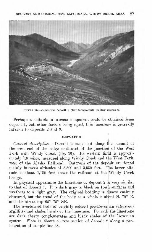
FIGURE 16. Limestone deposit 2 (left foreground) looking westward.
Perhaps a suitable calcareous component could be Obtained from deposit 1, but, other factors being equal, this limestone is generally inferior to deposits 2 and 3. ,
IDEPOSIT 2
General description. Deposit 2 crops out along the summit of the west end of the ridge southwest of the junction of the West Fork with Windy Creek (fig. 16). Its western limEt is approxi mately 7.8 miles, measured along Windy Creek and the West Fork, west of the Alaska Railroad. Outcrops of the deposit are found mainly between altitudes of 3,300 and 3,550 feet. The lower alti tude is about 1,180 feet above the railroad at the 'Windy Creek bridge.
In physical appearance the limestone of deposit 2 is very similar to that of deposit 1. It is dark gray to black on fresh surfaces and weathers to a light gray. The original bedding is ajlmost entirely obscured, but the trend of the body as a whole is al^out N. 70° E. and the strata dip 65°-75° SE.
The overturned beds of brightly colored pre-Devonlian calcareous argillites and shales lie above the limestone. Beneath) the limestone are dark cherty conglomerates and black shales of the Devonian system. Plate 11 shows a cross section of deposit 2 along a pro longation of sample line 38.
88 INVESTIGATIONS OF CONSTRUCTION MATERIALS IN ALASKA
Sampling. Six samples composed of fresh chips taken at 5-foot intervals were collected along lines normal to the strike. Sampled localities are shown on plate 11.
Chemical composition. Results of the chemical analyses of the samples (table 3) indicate that the deposit is remarkably uniform in composition. Sample 30, taken across the west end of the de posit, contains 3.2 percent magnesia, which is slightly in excess of the arbitrary limit, but the weighted-average magnesia content of all the samples is only 1.3 percent. The weighted average of the alkali content is 0.16 percent.
If the surface sampling is representative of the deposit as a whole, it would appear that the deposit would be chemically ac ceptable as far as content of magnesia and alkalies is concerned.
Estimated available limestone,. Deposit 2 is assumed to have an average thickness of 300 feet over a lateral extent of 4,800 feet and to dip 70° S. It is estimated that about 6 million short tons of limestone could be removed by quarrying to a 50-foot depth.
TABLE 3. Chemical analyses of samples of limestone deposit 2
[Analysts: L. I. Shapiro, L. E. Reichen, and S. M. Berthold. Na2O, K2O, and PzOs determined by flame photometer; all other determinations by rapid colorimetric and titrimetric procedures]
Sample
30 32 34 36 38 39
Volume-^ average
Labora tory No.
1911 C 1912 C 1913 C 1914 C
weighted
SiO2
1.4 1.5 1.4 2.2 1.5 1.1
1.5
AhO3
0.00 .30 .30
2.4 .46 .00
0.5
Fe2O3
0.2 .16 .30 .30 .32 .2
0.2
MgO
3.2 1.1-07
1.5 .07
2.5
1.3
CaO
51.2 52.8 54.1 51.5 54.0 52.0
52.8
Na2O
0.1 .29 .16 .17 .11 .1
0.1
K2O
0.1 .12 .11 .14 .13 .1
0.1
P2O5
0-1 .00 .02 .01 .02 .1
0.04
SOs
0.08 .06 .08 .08
0.08
Igni tion loss
43.3 43.3 43.5 42.8 43.1 43.4
43.2
Total
99.6 99.7
100.0 101.1 99.8 99.5
99.8
DEPOSIT 3
General description. Deposit 3 includes part of a bed of massive limestone that is thicker and of greater lateral extent than any others in the Windy Creek area. It crops out along an eastward- trending belt that crosses the valley of the West Fork at the junc tion of the principal headwater tributaries (pi. 11 and fig. 17). This massive limestone unit of the Devonian (?) system was first mapped on a reconnaissance scale and described by Capps (1932, p. 253), who traced its outcrops from the head of Windy Creek west ward along the crest and southern slopes of the Alaska Range for a distance of about 20 miles.
A sketch map of the deposit was made by the Geological Survey in 1950 (Moxham and others, 1951, fig. 10), and samples of the principal outcrops were collected and analyzed. The boundaries of
GEOLOGY AND CEMENT RAW MATERIALS, WINDY CREEK AREA 89
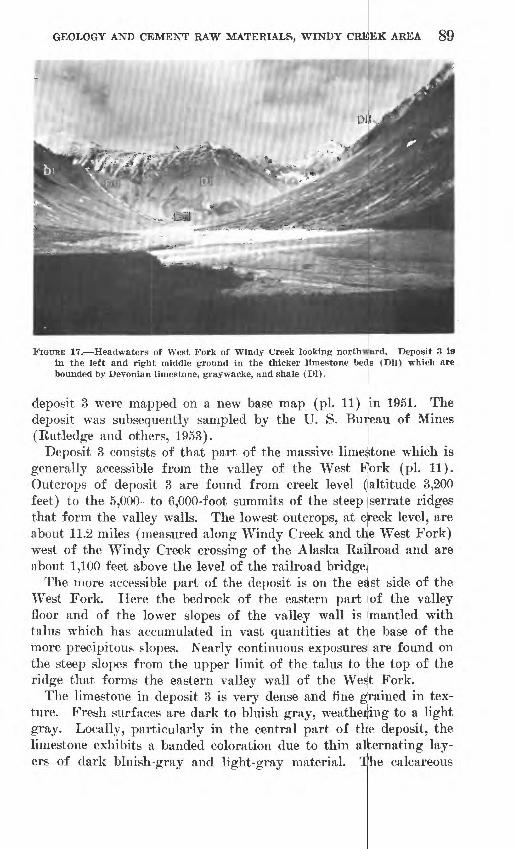
FIGURE 17. Headwaters of West Fork of Windy Creek looking northward. Deposit 3 is in the left and right middle ground in the thicker limestone beds (Dll) which are bounded by Devonian limestone, graywacke, and shale (Dl).
deposit 3 were mapped on a new base map (pi. 11) in 1951. Thedeposit was subsequently sampled by the U. S. Bureau of Mines (Rutledge and others, 1953).
Deposit 3 consists of that part of the massive limestone which is generally accessible from the valley of the West Plork (pi. 11). Outcrops of deposit 3 are found from creek level (altitude 3,200 feet) to the 5,000- to 6,000-foot summits of the steep serrate ridges that form the valley walls. The lowest outcrops, at cteek level, are about 11.2 miles (measured along Windy Creek and the West Fork) west of the Windy Creek crossing of the Alaska Railroad and are about 1,100 feet above the level of the railroad bridge.|
The more accessible part of the deposit is on the edst side of the West Fork. Here the bedrock of the eastern part lof the valley floor and of the lower slopes of the valley wall is imantled with talus which has accumulated in vast quantities at ttye base of the more precipitous slopes. Nearly continuous exposures are found on the steep slopes from the upper limit of the talus to the top of the ridge that forms the eastern valley wall of the Wes!t Fork.
The limestone in deposit 3 is very dense and fine gjrained in tex ture. Fresh surfaces are dark to bluish gray, weathering to a light gray. Locally, particularly in the central part of the deposit, the limestone exhibits a banded coloration due to thin alternating lay ers of dark bluish-gray and light-gray material. The calcareous

90 INVESTIGATIONS OF CONSTRUCTION MATERIALS IN ALASKA
strata are closely folded and locally are intricately contorted, but in genera] the degree of shattering appears to be less than that seen in deposits 1 and 2. The attitudes of individual beds vary greatly, but the general impression is that the limestone body as a whole stands nearly vertical. The general trend of the deposit is easterly.
Deposit 3 has an outcrop width of about 3,000 feet at its widest extent in the valley of the West Fork, but a stratigraphic thickness of not more than half that figure if the structural interpretation is correct that is, that both limbs of a closely compressed fold are represented.
Plate 11 includes a longitudinal section through deposit 3.Sampling. In 1950 the U. S. Geological Survey collected samples
of the limestone along lines generally normal to the strike near creek level in the valley of the West Fork. The material comprised fresh chips collected at about 5-foot intervals. Additional samples were taken at higher altitudes, where accessible, on the east side of the valley. The sampled localities are shown on plate 11.
That part of deposit 3 east of the West Fork was sampled in detail by the U. S. Bureau of Mines in 1951 and the results are given in the report by Rutledge and others (1953).
Chemical composition. The bedrock of deposit 3 on the east side of the West Fork is not as uniform in chemical composition as de posit 2. The alumina and iron vary over a considerable range as does the ratio between these two compounds in particular samples. The average magnesia and alkali content is well within the required limits. The Bureau of Mines analyses indicate that the belt of talus at the foot of the east valley wall is of similar character to the bed rock throughout approximately the northern half of the talus deposit. South of the midway point the chemical composition tends to be somewhat erratic, with a generally lower lime content prevail ing. Samples collected on the west side of the West Fork are gen erally more uniform chemically than those on the east; the alumina and iron content is lower as is the alumina: iron ratio.
Estimated available limestone. The estimated available limestone has been divided into two categories, talus and bedrock. The ap proximate distribution of the talus and its inferred cross-sectional configuration are given in plate 11. By use of these data the north ern half of the talus deposit is estimated to include about 8 million tons of limestone. The bedrock on the east side of the West Fork between creek level and an arbitrarily chosen altitude of 4,000 feet would comprise roughly 180 million tons of limestone, based upon the longitudinal section shown in plate 11. Probably about 10 mil lion short tons lie west of the West Fork above creek level.

GEOLOGY AND CEMENT RAW MATERIALS, WINDY CREEK AREA 91
TABLE 4. Chemical analyses of samples of limestone deposit 3
[Analysts: L. I. Shapiro, L. E. Reichen, and S. M. Berthold, NajO, KaO, and PiOi determined by flame photometer; all other determinations by rapid titrimetric and colorimetric procedures]
Sample
491492493494495496497498499501502503504541542543544545546547548549
54105411
551555559561562563564565566567568569
5610
Labora tory No.
501920 C501921 C1922 C1923 C1924 C1925 C1926 C1927 C1928 C1929 C1930 C1931 C1932 C1933 C1934 C1935 C1936 C1937 C1938 C1939 C1940 C1941 C
1952 C1953 C1954 C1942 C1943 C1944 C1945 C1946 C1947 C1948 C1949 C1950 C1951 C
SiO2
7.13.52.18.66.25.46.0
25.56.63.27.95.25.93.92.72.22.23.05.94.34.24.03.84.9
16.212.516.46.57.76.15.54.27.32.44.32.63.4
AbOs
2.32.3.80
2.5.95
1.1.64
5.61.1.31
1.3.80
1.0.59.29.00.21.83.69
1.91.41.6.79
1.42.52.43.3.4.6
1.3.6.6.4.3.4.1.5
Fe2O 3
0.19.78.32.80.40.46.45
2.1.41.34.85.78.64.19.19.18.30.30.40.27.19.24.16.11
1.21.32.0.4.4.6.4.3.3.2.1.1.2
MgO
1.42.91.41.01.01.81.32.01.9.83
2.48.02.12.0.77.76.51.75
1.61.11.21.21.0.60
1.21.31.21.61.31.92.51.11.0.6
1.3.4
1.8
CaO
48.547.953.047.750.050.350.133.550.153.146.943.448.450.753.153.753.652.850.350.751.051.051.851.443.645.942.349.648.849.049.551.449.453.252.054.251.0
Na2O
0.22.30.50.83.38.62.37
1.3.59.21.63.33.18.23.20.20.20.24.37.32.28.26.30.26
1.1.60.82.3.3.3.3.2.4.2.2.1.3
KsO
0.11.12.13.28.13.19.19.70.20.07.16.08.09.15.11.10.08.08.11.10.09.08.11.08.31.47.62.1.1.2.1.1.1.1.1.1.1
P 20S
0.03.01.01.03.02.01.02.06.00.01.03.01.02.01.01.01.01.01.01.01.01.01.01.01.09.04.04.1.1.1.1.1.1.1.1.1.1
SOs
0.84.32.24
1.16.41.35.51.64.61.19.30.11.16.18.08.12.08.09.33.30.12.13.10.29.68.43.10.00.2.4.2.2.3.1.00.00.2
Igni tion loss
38.842.442.638.240.640.440.428.239.641.939.441.840.542.142.642.842.542.440.742.642.042.141.841.334.635.032.241.039.640.041.341.640.042.642.243.142.1
Total
99.5100.5101.1101.1100.1100.6100.099.6
101.1100.299.9
100.599.0
100.0100.0100.199.7
100.5100.4101.6100.5100.699.9
100.4101.599.999.0
100.099.199.9
100.599.899.399.8
100.7100.899.7
OTHER DEPOSITS
Limestone deposits have been found in many other localities in the Windy Creek area but they are generally regarded as inferior to deposits 2 and 3, owing to some aspect of their chemical quality, size, or accessibility.
A deposit comparable in size to deposit 1 is intersected by the valley of Little Windy Creek (pi. 11). The material was sampled by Cobb in 194Y and by the Bureau of Mines in 1949. The Geo logical Survey sample locations are shown on plate 11. The analyti cal results, given below, indicate that about half of the limestone contains excessive amounts of magnesia.
Insolubles
r oMeO--_---_
In sampleC55
3.88. 39
52. 041. 66
[Analyst: R. K. Bailey]
In sample In sampleC56 C55
2. 64. 18
50. 143. 98
CO2 -- ------- 42.56P2O5 ---------- .05
Total- _-_- 100.58
In sampleC56
43. 86. 01
100. 81

92 INVESTIGATIONS OF CONSTRUCTION MATERIALS IN ALASKA
Several other deposits shown on plate 11 in the area between Little Windy Creek and the railroad were sampled by the Bureau of Mines in 1949 and some appear to be acceptable, insofar as the magnesia con tent is concerned, but the quantity of material is generally regarded as insufficient or the deposits are relatively inaccessible.
Two limestone beds averaging 40 feet in thickness crop out along the upper valley slopes on the north side of Windy Creek, west of Little Windy Creek. A chemical analysis of sample 5, which was taken across the thickest part of one of the beds (pi. 11), is given below:
[Analyst: L. I. Shapiro]
Si02 _ _____________A12 O3 _Feg08 . _._.______._MgO_--_-__ __.CaO-__----_______Na,O__ --__----_
__________ 4.3. 1
___________ .5___________ 15.8_--____.-__ 34.4
. 1
K2O____--______--__-P2O5
Total------------
. 1________ .2---___-. 44.4
________ 99.9
ARGILLACEOUS MATERIALS
The argillaceous component of a cement manufactured from ma terials available in the Windy Creek area probably would consti tute 15 to 20 percent of the raw mix.
Argillaceous rocks of pre-Devonian, Devonian, and Jurassic(?) age at several localities were examined and samples were collected during the present investigation. A brief description of the various lithologic types is included in table 5, which summarizes the results of the investigation. The locations of the deposits are shown on plate 11 and chemical analyses of the samples are given in table 6.
PRE-DEVONIAN ROCKS
Samples 43 and 45 represent a red, green, and yellow mottled calcareous argillite of pre-Devonian age which crops out on the submmit of the ridge southwest of the mouth of the West Fork. The strata are south of and adjoin the limestone of deposit 2 and dip moderately to steeply to the southeast. They are exposed for a lateral distance of about 2,000 feet along the crest of the ridge. It is estimated that the beds are about 200 feet thick. Only a very thin soil mantle covers the bedrock in most of the area.
DEVONIAN SYSTEM
The abrupt lateral and stratigraphic discontinuities that charac terize the rocks of Devonian age are such that most lithologic units are not very persistent. A few exceptions, however, were found in

GEOLOGY AND CEMENT RAW MATERIALS, WINDY CREEK AREA 93
the central and western part of the outcrop area of rocks of De vonian age.
Samples 6 and 17 (possibly from the same part of the section) were collected from a brown to black crumpled argillite that crops out in two gullies cut into the steep north valley slopes of Windy Creek (pi. 11). The strata in general dip steeply to the southeast, although there are many local variations. The maximum exposed thickness at locality 6 is about 400 feet. The lateral extent of the beds is concealed by soil and vegetation, but the overburden is prob ably not more than 2 or 3 feet thick in most places.
TABLE 5. Summary of data pertaining to argillaceous materials
Sample
C-l, C-2.- . .302.. ..........
304.__. .....
305--
307.-
308.. 309.... .
310.- 311-. 318-- .
6.- 17. 26-- .43,45
48-. 51... -
Year collected
1949
1949
1949
1949
19491949
194919491949
1950195019501950
19501950
Description
stone with pyrite in small cubes and irregular grains.
claystone with small carbon- nate veinlets and pyrite cubes.
limonite on cleavage faces.
what platy, with limonite on cleavage faces.
stone.
claystone.
calcareous argillite.
Attitude of beds
N. 80° E. 35° N-N. 55° E. 55° SE.
N. 55° E. 55° SE.
N. 55° E. 55° SE.
N. 60° E. 85° SE.
N. 70° E. 55° SE.
N.50°E.;55°NW_N.70°E.;67°NW.N. 60° E. 60° SE.
N.75°E.;80°NW.E. W.; 70° SE ..N. 80° E. 75° SE.N. 50° E. 70° SE.
N. 74° W.; 80° S-.
Strati- graphic
thickness (feet)
10
145
50
20
5025
604570
400100100200
140400
Estimated material available
(tons)
6,500
266,000
163,000
10,600
67,00019,500
37,00016,00077,000
100,00040,00040,000
450,000
130,000300,000
TABLE 6. Chemical analyses of argillaceous materials[Analysts: A. A. Hanks, Inc.*; A. C. Vlisidis and L. I. Shapiro. NajO, KzO, and PaOs determined by
flame photometer; all other determinations by rapid colorimetric and titrimetric procedures]
Sample
C-l... ..C-2......302*.. ..304*.. ._305*.....307*..-__308*. .309*-. ___310*-....311*_.___318*.. 6.. 17-- .26_..____43-.- 45-. -48...--51...
Laborato ry No.
10373103741037510376103771037810379
1937 C
1939 C1940 C
1916 C1917 C
Si0 2
60.6162.0977.3070.5970.9164.8664.5861.8560.61
70.3162.4fi4 962.941 Q
47.669.364.4
AljOa
i K 74
16.369 KQ
IQ 07
13.7316.6316.37IQ 1 E
14 7917.751 K QA
U Q
17 0
14.715.6
FeaOs
7 017 QQ
5 41
6.436.096.715.077 99.
6.607.444.064 0
5.76.04 S4.23.86.0
MgO
4 CO
5.152 El
2 79
2 4ft
1.76
3 QA
5 CA
4.102 931 9i ^1.32.12.6
QA
1.0
CaO
1 2990
.51
.401 ^Q
1.66SI
S on96
.413 0
.721.0
19 9U K
.722 f\
NasO
97.65.71.46
2.531.161.421.251.55.28.85.9484
1.7
QO
1.4
K 2O
O E.Q
.75
.43
.57
.37
.61
.72
.65
.70
.68
.21
2.71.5
2 69 7
P206
.141.4.13.14.12.11.15
SO 3
0.55.30.35.12.10.15.18.07.67
.19
.99
.34
Ignition loss
2.214.204.754.585.255.276.514.174.857.95.96.6
16.914.25.44.5

94 INVESTIGATIONS OF CONSTRUCTION MATERIALS IN ALASKA
Sample 48 was collected from a brown to black argillite which crops out for a distance of about 300 feet along the south side of the West Fork from creek level to an altitude of about 2,900 feet. The beds strike N. 55° E. and dip 20° SE. A stratigraphic thick ness of about 140 feet is exposed.
JURASSIC(?) SYSTEM
The largest deposit of argillaceous material in the Windy Creek area is represented by the argillite of Jurassic(?) age which un derlies the conglomerate of the Cant well formation at locality 51 in the western part of the area. Here the argillite of Jurassic (?) age is well exposed in a northward-flowing tributary which enters the West Fork near the east end of Foggy Pass (pi. 11). The strata are primarily black argillite but include a few layers of graywacke and conglomerate; the beds have been cut by felsic dikes in a few localities; the strata strike about N. 75° W. and dip 80° S. Sample 51 represents a stratigraphic thickness of about 400 feet of argillite. This general lithology persists laterally at least as far as the west ern limit of the mapped area. To the east the sedimentary beds become increasingly coarse and contain much more graywacke.
Rocks of Jurassic (?) age crop out immediately west of the Alaska Railroad between Windy Creek and Cantwell. The beds are com posed chiefly of metamorphosed argillaceous sediments and minor amounts of limestone. In several localities the beds have been cut by dikes of granitic or dioritic composition. The strata of Juras sic (?) age dip moderately to steeply northward and strike about N. 80° E. In 1948, Gates and Cobb sampled a shale member exposed in an outcrop along the west side of the Alaska Railroad (localities C-l and C-2, pi. 11) 1 mile southeast of Windy Creek. The sam ple was composed of material collected at 2-foot intervals over a distance of 375 feet along the railroad.
An additional sample of this material (311) was collected by R. E. Fellows in 1949.
Other outcrops of argillaceous rocks, rather limited in size, are along lower Windy and Little Windy Creeks and the Alaska Rail road. At most of these localities the deposits are mantled by a thick overburden of glacial outwash except where they are exposed by the stream erosion. The locations of samples collected by Fel lows in 1949 are shown on plate 11 and briefly described in table 5.
CHERT
Modern cement-manufacturing processes require very close con trol of the chemical composition of the raw mix in order to pro duce a uniform product that will meet rigorous specifications. The
GEOLOGY AND CEMENT RAW MATERIALS, WINDY CREEK AREA 95
most common practice is to adjust the composition of the raw mix by the addition of a high-iron and (or) a high-silica component In appropriate quantities to attain a cement of desired chemical composition. Mill scale and pyrite cinder are commonly used as high-iron components; silica sand, quartz, and quartzite comprise the principal high-silica materials.
No high-iron materials are known in the Windy Creek or adja cent areas, but chert that occurs in the northeastern part of the area might be chemically suitable as a high-silica component. The chert beds, probably of Triassic age, crop out adjacent to the Alaska Railroad about two-thirds of a mile north of Windy station. The rock is black, locally weathering to a rusty hue. To the north the chert is overlain or intruded by greenstone.
The beds have a stratigraphic thickness of about 60 feet and are exposed along the strike for at least 100 feet in a southwesterly direction from the railroad right-of-way.
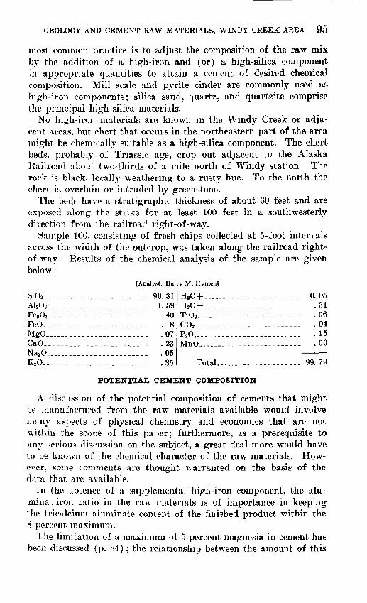
Sample 100, consisting of fresh chips collected at 5-foot intervals across the width of the outcrop, was taken along the railroad right- of-way. Results of the chemical analysis of the sample are given below:
[Analyst: Harry M. Hymen]
SiO. - _____________________ 96. 31A1203- Fe2O3 - FeO- MgO. CaO_. Na2O_ K2 O__
315940180723uo 35
H.O + --------H.O- ... ________TiO__ - ---_C02 ___ __________P,0, -- -_ MnO ___ _________
Total ... _____
__________ 0.05__________ .31__ __ _ .06__ _-_--_ . 04___ _____ . 15__ ______ .00
_ ______ 99. 79
POTENTIAL CEMENT COMPOSITION
A discussion of the potential composition of cements that might be manufactured from the raw materials available would involve many aspects of physical chemistry and economics that are not within the scope of this paper; furthermore, as a prerequisite to any serious discussion on the subject, a great deal more would have to be known of the chemical character of the raw materials. How ever, some comments are thought. warranted on the basis of the data that are available.
In the absence of a supplemental high-iron component, the alu mina : iron ratio in the raw materials is of importance in keeping the tricalcium aluminate content of the finished product within the 8 percent maximum.
The limitation of a maximum of 5 percent magnesia in cement has been discussed (p. 84); the relationship between the amount of this

96 INVESTIGATIONS OF CONSTRUCTION MATERIALS IN ALASKA
compound in the raw materials and the cement composition is straightforward. The extent to which the alkali content of cement is harmful is a matter of controversy. In addition, because the alkalies will volatilize to a certain extent during burning, the alkali content in the raw ingredients is difficult to assess. In the compu tations given below no such losses are assumed, so the alkali con tent of the cements shown probably approaches maximum values.
It has been pointed out that the magnesia content of deposit 1 varies widely and in many localities is excessive (p. 86). The use fulness of this deposit will depend on various economic factors and will not be discussed further here.
Deposit 2 is remarkably uniform in chemical composition if the few surface samples taken are representative of the deposit as a whole. The material is probably superior in this respect to any other in the Windy Creek area. The alumina: iron ratio of the weighted average of the samples is 2.5:1, but the amounts of these compounds are very low. The magnesia and alkalies are likewise low.
The massive Devonian (?) limestone, of which deposit 3 is a part, offers enormous reserves, but is the most remote from the Alaska Railroad and the present highway network. The magnesia presents no problem and for the most part the alkalies are within reasonable limits, although there may be local exceptions.
On the east side of the West Fork, the alumina and iron content of the limestone is somewhat varied and computations of potential cement composition based on the weighted average of the samples, with different argillaceous components, indicated a slightly excessive tricalcium aluminate content. Computations based on the average composition of the samples from the central part of the deposit (locality 561-560) showed the limestone was satisfactory.
Generally, the argillaceous materials are satisfactory except for their alkali content. Except at locality 302 the alkali content is somewhat high, but for reasons mentioned above (p. 84) the ex tent to which this is undesirable will not be discussed here.
Two potential cement compositions are given below. Mix 1 con sists of 78 percent limestone from deposit 2 (weighted average of samples), 20 percent shale from locality 302 (table 6), and 2 percent Healy River coal ash. The composition of the coal ash is the aver age of five samples from the New Suntrana mine (Selvig and Gib- son, 19-15). Mix 2 is 83 percent limestone from deposit 3 (average of samples 561-5610), 15 percent shale from locality 302, and 2 percent coal ash. The computations were made in accordance with the method of Bogue (1947). The amounts of the synthetic com pounds were computed as required by the American Society for Testing Materials (1950).

GEOLOGY AND CEMENT RAW MATERIALS, WINDY CREEK AREA 97
TABLE 7. Calculations of potential cement composition
Si03 _______________A1203 --------------FeaOa-------------- -CaO-_____--_--_-____MgO --------------Na2 O . _____-______K20_. ____---__-______P2 0«_.__ __.._ _ _SOa------ -
In mix 1
25. 94. 12.0
62. 42. 3.3. 3
1 9
In mix 2
24. 7q A1. 6
64. 12. 3
. 5
. 3
2. 0
Total_ __ ____---
Tricalcium silicate
Tetracalcium alumino-
In mix l
. 6
99. 8
21. 358.2
7. 5
6. 1
In mix 2
. 6
99. 5
42. 339. 0
6. 3
4.9
LITERATURE CITED
American Society for Testing Materials, 1950, 1949 Book of standards: pt. 3. Bogue, R. H., 1947, The chemistry of portland cement: New York, Rheinhold
Publishing Corp. Capps, S. R., 1932, The eastern portion of Mount McKinley National Park: U.S.
Geol. Survey Bull. 836-D. _____ 1940, Geology of the Alaska Railroad region: U.S. Geol. Survey
Bull. 907. Eldridge, G. H., 1900, A reconnaissance in the Susitna basin and adjoining
territory: U.S. Geol. Survey 20th ann. rept, pt. 7, p. 1-29. Moffit, F. H., 1912, Headwater regions of Gulkana and Susitna Rivers, Alaska:
U.S. Geol. Survey Bull. 498._____ 1915, The Broad Pass region, Alaska: U.S. Geol. Survey Bull. 608. _____ 1954, Geology of the eastern part of the Alaska Range and adjacent
area: U.S. Geol. Survey Bull. 989-D. Moxham, R. M., West, W. S., and Nelson, A. E., 1951, Cement raw materials
available to the Windy Creek area, Alaska: U.S. Geol. Survey open-filereport, 38 p., 12 figs.
Moxham, R. M., and Eckhart, R. A., 1956, Marl deposits in the Knik Armarea, Alaska: U.S. Geol. Survey Bull. 1039-A.
Ross, Clyde P., 1933, Mineral deposits near the West Fork of the ChulitnaRiver, Alaska: U.S. Geol. Survey Bull. 849-E.
Rutledge, F. H., Thorne, R. L., Kerns, W. H., and Mulligan, J. J., 1953, Non- metallic deposits accessible to the Alaska Railroad as possible sources ofraw materials for the construction industry: U.S. Bureau of Mines', Rept.of Inv. 4932.
Selvig, W. A., and Gibson, F. H., 1945, Analyses of ash from coals of theUnited States: U.S. Bureau of Mines Tech. Paper 679.
United States Weather Bureau, 1955, Climatological data, annual summary:Washington, U.S. Government Printing Office, v. 23, no. 13.
Wahrhaftig, Clyde, 1958, Quaternary geology of the Nenana River valley andadjacent parts of the Alaska Range: U.S. Geol. Survey Prof. Paper 293-A.
Waring, G. A., 1947, Nonmetalliferous deposits in the Alaska Railroad belt:U.S. Geol. Survey Circ. 18.

INDEX
Page6773Accessibility, area studied. -___-_.._
limestone deposit 3- _....__.___. 89Acknowledgments -----_____-_---_._. 70Alaska Railroad belt, argillaceous materials
sampled. -_---______---_ 69location of argillite__-_ -_____-__-_ ._ 94location of chert beds. _--_----..._._.._ 95location of limestone deposits _ _________ 85, 87, 89search for cement raw materials.-- ______ 67, 68
Alaska Range, boundary of Windy Creek area. 70-71 Cantwell formation... ____________________ 82effect on temperature__-_-________-_______ 72geologic mapping, ________________________ 68intrusive activity__. ______________________ 83limestone deposit 3 _________ ___________ 88Pleistocene glaciation. ____________________ 82-83Triassic limestone.. ______________________ 80
Alkali content, in cement composition_.______ 84, 96Alumina : iron ratio, in cement composition... 95, 96 Analyses, argillite. ___________________________ 93
chert.. _______________________ ___ ______ 95indication of chemical character of lime
stone deposits... _________________ 70limestone___________________________ 86,88,91,92
Anchorage, rail and airline connection, _ ______ 73Anderson Pass, fault zone_ ___________________ 76Argillite, analyses.-- __-___-_--_ 93
as cement raw material. __________________ 92-94Cretaceous _______________________________ 82Devonian_ ___________________ 74,75,78,79,92-94Jurassic.- -__ _ 81,83,94pre-Devonian _____________________ 73-74,87,92Triassic _________________________________ 79,80
Bailey, R. K., analyses by. __________________ 86,91Berdan, Jean M., fossils identified by.. ______ 75Berthold, S. M., analyses by... __________._.. 88,91Broad Pass, relation to area studied, ..._.. _ 71
Cantwell, airstrip ____________________________ 73location of Jurassic argillite- ______________ 94
Cantwell Creek, tributary to Jack River. ____ 71Cantwell formation, character, distribution,
and age___________ ____._____---_-- 82relation to igneous rocks_ _________________ 83relation to Jurassic system. _ ______________ 81
Cement composition, potential from availablematerials. _______________--------_ 95-97
Chert, analyses... ____________________________ 95cement raw material..,. _________________ 94-95Triassic _________________________________ 80
Chulitna River area, geologic mapping. __ ___ 6£pre-Devonian rocks----_--__-_______------ 74West Fork, Triassic limestone and argil
lite. ________._______-_.._____--_-- 80
Climate..______________________ _____________obb, E. H., fossils collected by____ _________omposition, chemical, of limestone deposits..
Core drilling of limestone deposits. __ Cretaceous rocks, Cantwell formation.
Page72
82
Devonian rocks, age__,_ ___ _ 75, 78character and distribution________ 74-75, 78-79structure--------.----. ___,_______----___ 76,79limestone as cement raw material-.----.-- 85-87
Drainage_____________________________________ 70-72
Fairbanks, rail and airline connection.,-----. 73Fault zone, limit of Devonian strata__-_-___- 76, 78
relation to Cantwell formation __________ 82relation to Jurassic rocks ___________-_-- 81
Fieldwork_______ ________-__--_-____-__---_--- 70Foggy Pass, drained by Cantwell Creek---___ 71
pre-Devonian rocks.-----,,.,-____--,--.- 74Fossils, Cretaceous- ---.-.---------------- - 82
Devonian. __-_ __- -- - 75Eocene..--------------------------------- 82Triassic.----------- - --- -- - 80
Geography._ -- --- 70-73Olaciation, Pleistocene...----------------- 71,82-83Glaciers, affected by difference in precipita
tion.. -_-_- __-- -- 72Greenstone, Triassic.--------------------- 80,81
Hanks, A. A., Inc., analysesby____ 93 Hymen, Harry M., analyses by___- .- 95
Igneous rocks____ _ - -_ ------ 83Imlay, Ralph W., fossils identified by - 80 Introduction.----- ------- _ - ------ 67-70
Jack River, Eocene fossils.- 82previous investigations ------------ 68relation to Windy Creek area. 71
Jurassic rocks.__-_--- ____ - ------ 81
Limestone, analyses.------ ------- 86,88,91,92Devonian...--- 74,78,79,85-87,88-91 estimated amount available -------------- 88,90location of deposits of commercial size.. - _ 85,
87,88-89 Triassic.------------------------------ 79-80
Limestone deposit, other.- 91-92Limestone deposit I.. ------------ 85-87Limestone deposit 2__- ___-__ ------------ 87-88Limestone deposit 3 ------------ 88-91Literature cited-.--------------------- ---- 9?Location of area.__------- ----------------- 68
99

100 INDEX
PageMagnesia content, cement composition. __. 84, 95-96
limestone deposit 1__.-- __-_ - __. 86 Mount McKinley National Park, location of
area studied _ - _ 68
Nenana Glacier, fault zone - -Nenana River, drainage of area.
fault zone--- _ ____________previous investigations
Paleocene igneous activity._- _ - _ 83 Phyllite, Triassic ___-___-. --____ . 80Pleistocene glaciation._.................. 71, 82-83Precipitation.___________.__...._ 72Pre-Devonian rocks-..._-__- ____-- _ 73-74Present investigation____._____..._ 68-70 Previous investigations. __-.--_-_-_-. 68 Purpose of report----____---------_---------_- 68
Quaternary rocks..-..-.-.--------...------_ 82-83
Reichen, L. E., analyses by-_._-___ _. 88,91 Relief..----- ---------------------- 71
Sampling of limestone deposits ___ _ _Search for cement raw materials_............. 67Shale, Devonian.--,____................ 78, 79
Pre-Devonian___.-...--_____........... 73-74
PageShapiro, L. I., analyses by_ ------- 88,91,92,93Slate, Jurassic... -__-- _ -... _ . ____ . __ 81 Source of construction materials for Alaska. . . 67 Standards, chemical and physical, cement
products-.-..-. - _ _ --------- 84,85Summit , average annual temperature --------- 72Susitna River, previous investigation?- 68
Tanana River, relation to Nenana River. _ _ __ 71Temperature.--. _____ .__-_.-_ _____ ... 72 Timberline, altitude -- ____________ 72 Topography _-.._.-.-----------.-_----_----- 70-72Travertine.... __________________ 83Triassic rocks __ ______________. __-_-_. 79-81
U.S. Bureau of Mines, limestone depositssampled by_ ---------- 86,89,90,91,92
Vegetation. ___.....-----.---___-_--_----.---- 72-73 Vlisidis, A. C., analyses by _ -_____-_----- 93
West Fork, Windy Creek, location of limestone deposits. _... _ ----------- 85,87
Windy Creek, direction of flow.. ............. 71-72
Yanert Fork, previous investigations _ 68

Investigations of Construction Materials in Alaska
GEOLOGICAL SURVEY BULLETIN 1039
This bulletin was printed as separate chapters A-D
UNITED STATES GOVERNMENT PRINTING OFFICE, WASHINGTON : 1959

UNITED STATES DEPARTMENT OF THE INTERIOR
FRED A. SEATON, Secretary
GEOLOGICAL SURVEY
Thomas B. Nolan, Director
The U. S. Geological Survey Library has cataloged this publication as follows:
U. S. Geological Survey.Investigations of construction materials in Alaska. Wash
ington, U. S. Govt, Print, Off., 1959.iii, 100 p. illus., maps (part fold., part col., in pocket) diagrs., tables.
25 cm. (Its Bulletin 1039)The chapters were printed separately as Bulletin 1039A-1039D.Bibliographies included.CONTENTS. Marl deposits in the Knik Arm area, Alaska, by R. M.
Moxham and R. A. Eckhart. Occurrence of diatomaceous earth near Kenai, Alaska, by G. Plafker. Haydite raw material in the Kings River, Sutton, and Lawing areas, Alaska, by R. A. Eckhart and G. Plafker. Geology and cement raw materials of the Windy Creek area. Alaska, by R. M. Moxham, R. A. Eckhart, and E. H. Cobb.
1. Building materials. 2. Geology, Economic Alaska. i. Mox ham, Robert Morgan. 1919- n. Title. (Series)
[QE75.B9 no. 1039] G S 59-235
CONTENTS
[The letters in parentheses preceding the titles are those used to designate the papers for separate publication]
(A) Marl deposits in the Knik Arm area, Alaska, by R. M. Moxham andR. A. Eckhart_____________________________________________ 1
(B) Occurrence of diatomaceous earth near Kenai, Alaska, by GeorgePlafker_______-_-___- __-_-_--_--__---_ ------- ---- 25
(C) Haydite raw material in the Kings River, Sutton, and Lawing areas,Alaska, by R. A. Eckhart and George Plafker____________________ 33
(D) Geology and cement raw materials of the Windy Creek area, Alaska,by R. M. Moxham, R. A. Eckhart, and E. H. Cobb_-_._______-._ 67
ni
U.S. GOVERNMENT PRINTING OFFICE : It59 O S04834