Embed Size (px)
Citation preview
The Coordination Committee formed by GR No. Abhyas - 2116/(Pra.Kra.43/16) SD - 4 Dated 25.4.2016 has given approval to prescribe this textbook in its meeting held on 3.3.2017
STANDARD NINE
GEOGRAPHY
Maharashtra State Bureau of Textbook Production andCurriculum Research, Pune.
The digital textbook can be obtained through DIKSHA APP on a smartphone by using the Q. R. Code given on title page of the textbook and useful audio-visual teaching-learning material of the relevant lesson will be available through the Q. R. Code given in each lesson of this textbook.
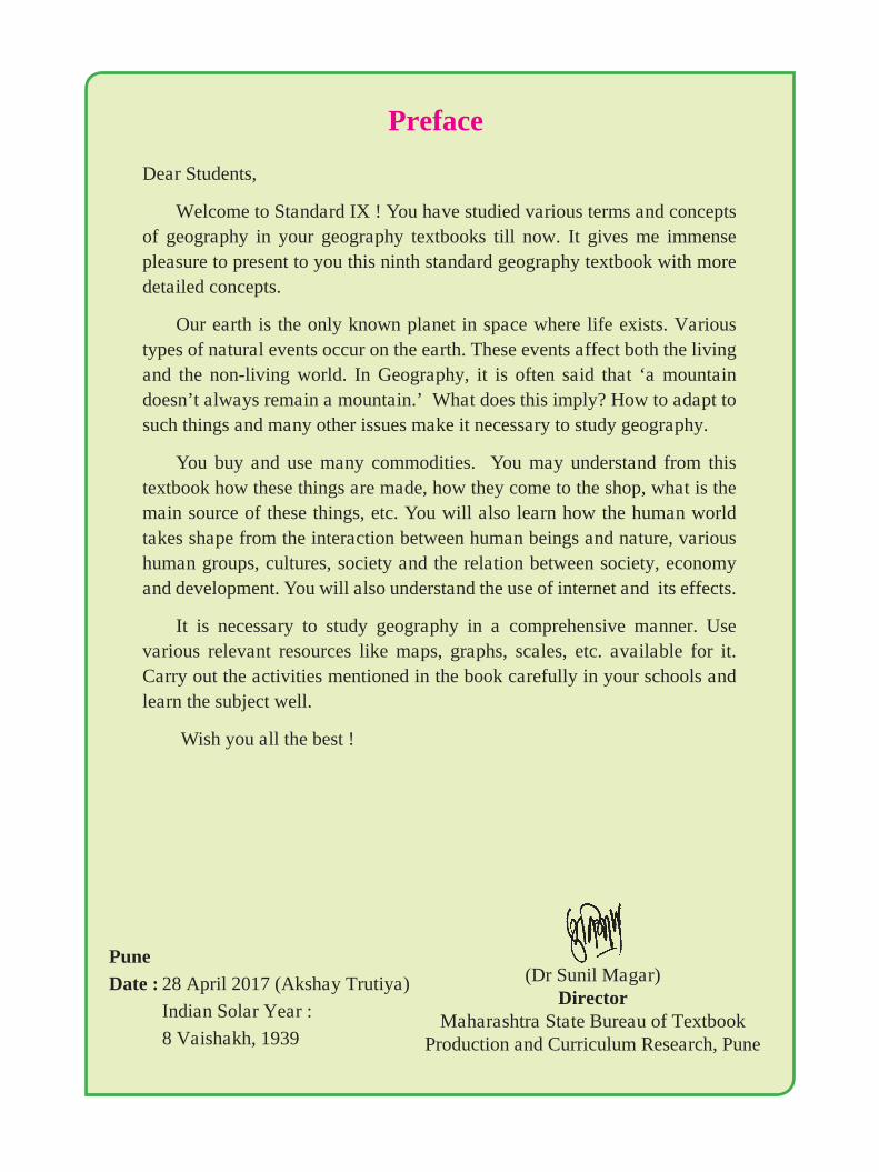
Dear Students,
Welcome to Standard IX ! You have studied various terms and concepts of geography in your geography textbooks till now. It gives me immense pleasure to present to you this ninth standard geography textbook with more detailed concepts.
Our earth is the only known planet in space where life exists. Various types of natural events occur on the earth. These events affect both the living and the non-living world. In Geography, it is often said that ‘a mountain doesn’t always remain a mountain.’ What does this imply? How to adapt to such things and many other issues make it necessary to study geography.
You buy and use many commodities. You may understand from this textbook how these things are made, how they come to the shop, what is the main source of these things, etc. You will also learn how the human world takes shape from the interaction between human beings and nature, various human groups, cultures, society and the relation between society, economy and development. You will also understand the use of internet and its effects.
It is necessary to study geography in a comprehensive manner. Use various relevant resources like maps, graphs, scales, etc. available for it. Carry out the activities mentioned in the book carefully in your schools and learn the subject well.
Wish you all the best !
(Dr Sunil Magar)Director
Maharashtra State Bureau of Textbook Production and Curriculum Research, Pune
Preface
Pune
Date : 28 April 2017 (Akshay Trutiya)
Indian Solar Year :
8 Vaishakh, 1939
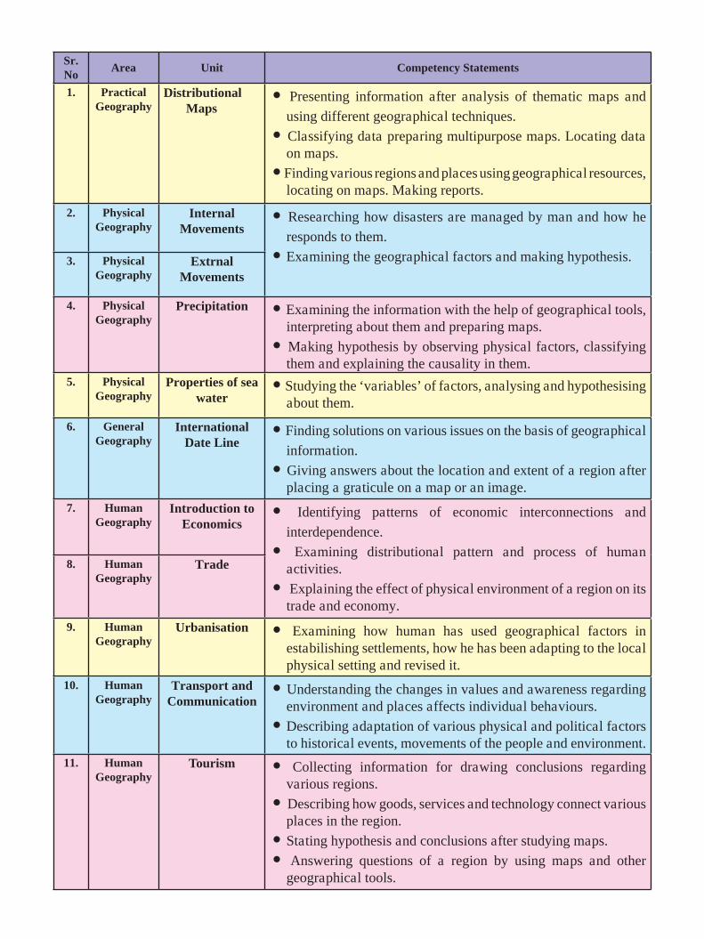
Sr. No
Area Unit Competency Statements
1. Practical Geography
Distributional Maps
� Presenting information after analysis of thematic maps and
using different geographical techniques.
� Classifying data preparing multipurpose maps. Locating data on maps.
� Finding various regions and places using geographical resources, locating on maps. Making reports.
2. Physical Geography
Internal Movements
� Researching how disasters are managed by man and how he
responds to them.
� Examining the geographical factors and making hypothesis. 3. Physical Geography
ExtrnalMovements
4. Physical Geography
Precipitation � Examining the information with the help of geographical tools, interpreting about them and preparing maps.
� Making hypothesis by observing physical factors, classifying them and explaining the causality in them.
5. Physical Geography
Properties of sea water
� Studying the ‘variables’ of factors, analysing and hypothesising about them.
6. General Geography
International Date Line
� Finding solutions on various issues on the basis of geographical
information.
� Giving answers about the location and extent of a region after placing a graticule on a map or an image.
7. HumanGeography
Introduction to Economics
� Identifying patterns of economic interconnections and
interdependence.
� Examining distributional pattern and process of human activities.
� Explaining the effect of physical environment of a region on its trade and economy.
8. HumanGeography
Trade
9. HumanGeography
Urbanisation � Examining how human has used geographical factors in estabilishing settlements, how he has been adapting to the local physical setting and revised it.
10. HumanGeography
Transport and Communication
� Understanding the changes in values and awareness regarding environment and places affects individual behaviours.
� Describing adaptation of various physical and political factors to historical events, movements of the people and environment.
11. HumanGeography
Tourism � Collecting information for drawing conclusions regarding various regions.
� Describing how goods, services and technology connect various places in the region.
� Stating hypothesis and conclusions after studying maps.
� Answering questions of a region by using maps and other geographical tools.
For TeachersP To begin with, get familiar with the
textbook yourself.
P Please plan carefully and independently for the activities in each chapter. Please do not teach without planning.
P The teaching-learning interactions, processes and participation of all students is very necessary and so is your active guidance.
P Please use the geographical teaching aids in the school as required for the appropriate understanding of the subject. It is necessary to use the globe, the maps of the World, India and the State, atlases, etc.
P Though the number of chapters has been reduced the number of periods required for each chapter has been given a thought. Abstract concepts are difficult to follow and therefore you are expected to use the given number of periods fully. Do not finish the chapter in short. This will help the students to assimilate the content without feeling the ‘burden of learning’.
P Like other social sciences, geographical concepts too are not easy to understand. Major concepts of geography have a scientific base and they deal with abstractions. Encourage group work, learning through each other’s help, etc. Facilitate peer learning as much as possible by reorganizing the class structure frequently.
P You will find that the character ‘Globee’ appears in different boxes and instructions given in the chapters. Please ensure that it
- For Students -
The character ‘Globee’ will meet you in every chapter. Have you guessed who
he is ? He will help in the various tasks you are expected to do. Try to follow
his instructions.
helps to create interest in the subject.
O The present book has been prepared for constructivist and activity-based teaching. Please do not teach the lessons in the book by just reading them aloud.
P Follow the order of the chapters as given in the contents because the concepts have been introduced in a graded manner to facilitate knowledge-building.
P Do not use the boxes titled ‘Do you know?’ for evaluation.
P Give instructions to students regarding using a pencil for activities in the book.
P A glossary is given at the end of the book. Detailed information of important geographical terms / concepts in the chapters is given in this glossary. The words are given alphabetically. The words included in the glossary are enclosed in blue highlights in the chapters, e.g. (Thematic Maps) (Lesson 1, Page1)
P Some websites have been given for reference at the end of the chapter and the glossary. Also, a list of references used is also given. You as well as the students are expected to use these references. These references will surely help you to go beyond the textbook. Please bear in mind that extra reading is always helpful for understanding any subject in depth.
P Use thought-provoking, activity-oriented, open-ended, multiple choice questions for evaluation. Some examples are given at the end of the chapters in the ‘exercises’.
P Use QR Code given in the textbook.
DISCLAIMER Note : All attempts have been made to contact copy righters (©) but we have not heard from them. We will be pleased to acknowledge the copy right holder (s) in our next edition if we learn from them.
S.O.I. Note : The following foot notes are applicable : (1) © Government of India, Copyright : 2017. (2) The responsibility for the correctness of internal details rests with the publisher. (3) The territorial waters of India extend into the sea to a distance of twelve nautical miles measured from the appropriate base line. (4) The administrative headquarters of Chandigarh, Haryana and Punjab are at Chandigarh. (5) The interstate boundaries amongst Arunachal Pradesh, Assam and Meghalaya shown on these maps are as interpreted from the “North-Eastern Areas (Reorganisation) Act. 1971,” but have yet to be verified. (6) The exernal boundaries and coastlines of India agree with the Record/Master Copy certified by Survey of India. (7) The state boundaries between Uttarakhand & Uttar Pradesh, Bihar & Jharkhand and Chattisgarh & Madhya Pradesh have not been verified by the Governments concerned. (8) The spellings of names in these maps, have been taken from various sources.
Front Cover : Landforms produced by physical processes - exfoliated rocks, Beaches, Sea cave, Columnar basalt and biological weathering because of tree roots (in the background)
Back Cover : V-shaped valley, retail seller, man-made cave in hard rocks, Wholesale seller, Seif dunes.
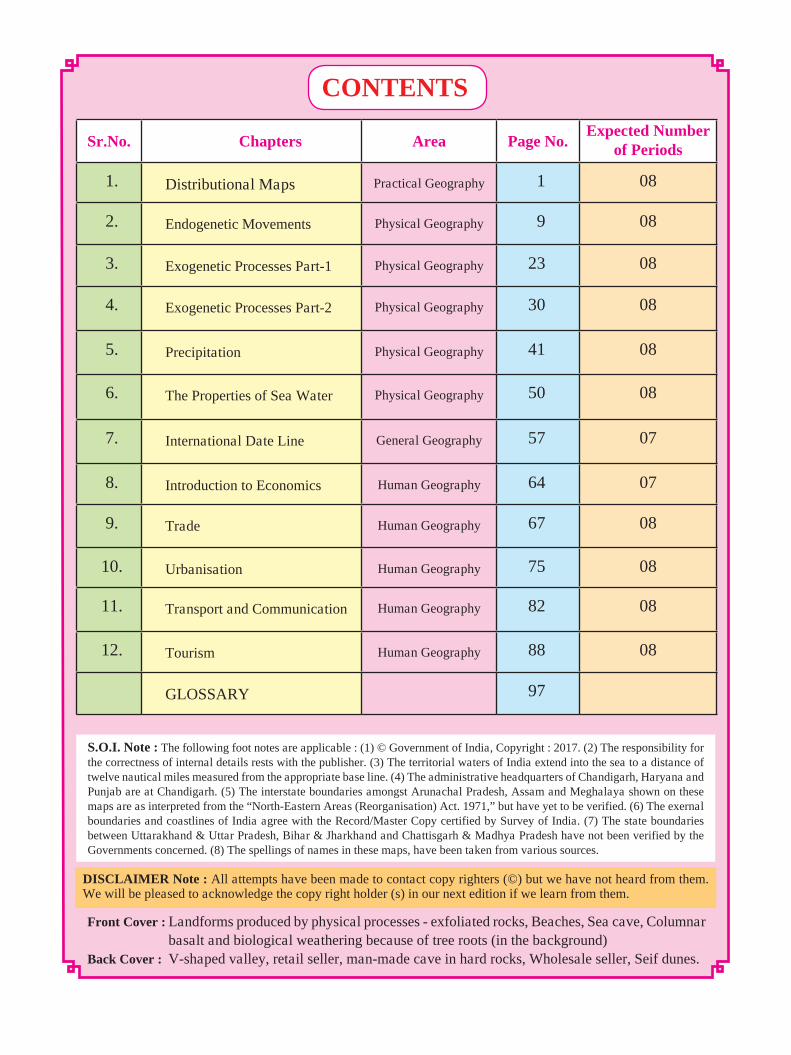
Sr.No. Chapters Area Page No. Expected Number
of Periods
1. Distributional Maps Practical Geography 1 08
2. Endogenetic Movements Physical Geography 9 08
3. Exogenetic Processes Part-1 Physical Geography 23 08
4. Exogenetic Processes Part-2 Physical Geography 30 08
5. Precipitation Physical Geography 41 08
6. The Properties of Sea Water Physical Geography 50 08
7. International Date Line General Geography 57 07
8. Introduction to Economics Human Geography 64 07
9. Trade Human Geography 67 08
10. Urbanisation Human Geography 75 08
11. Transport and Communication Human Geography 82 08
12. Tourism Human Geography 88 08
GLOSSARY 97
CONTENTS
1
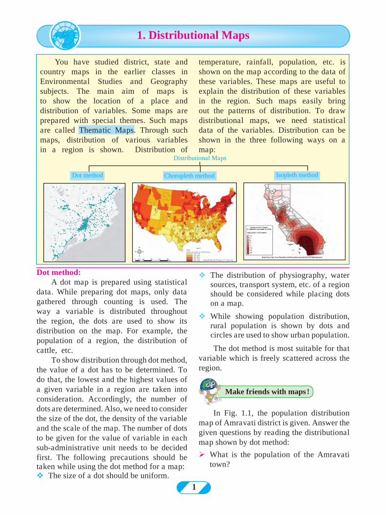
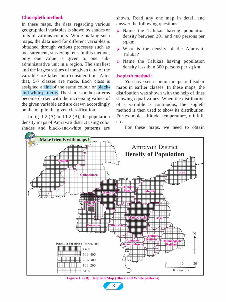
Dot method: A dot map is prepared using statistical
data. While preparing dot maps, only data gathered through counting is used. The way a variable is distributed throughout the region, the dots are used to show its distribution on the map. For example, the population of a region, the distribution of cattle, etc.
To show distribution through dot method, the value of a dot has to be determined. To do that, the lowest and the highest values of a given variable in a region are taken into consideration. Accordingly, the number of dots are determined. Also, we need to consider the size of the dot, the density of the variable and the scale of the map. The number of dots to be given for the value of variable in each sub-administrative unit needs to be decided first. The following precautions should be taken while using the dot method for a map: vThe size of a dot should be uniform.
vThe distribution of physiography, water sources, transport system, etc. of a region should be considered while placing dots on a map.
vWhile showing population distribution, rural population is shown by dots and circles are used to show urban population.
The dot method is most suitable for that variable which is freely scattered across the region.
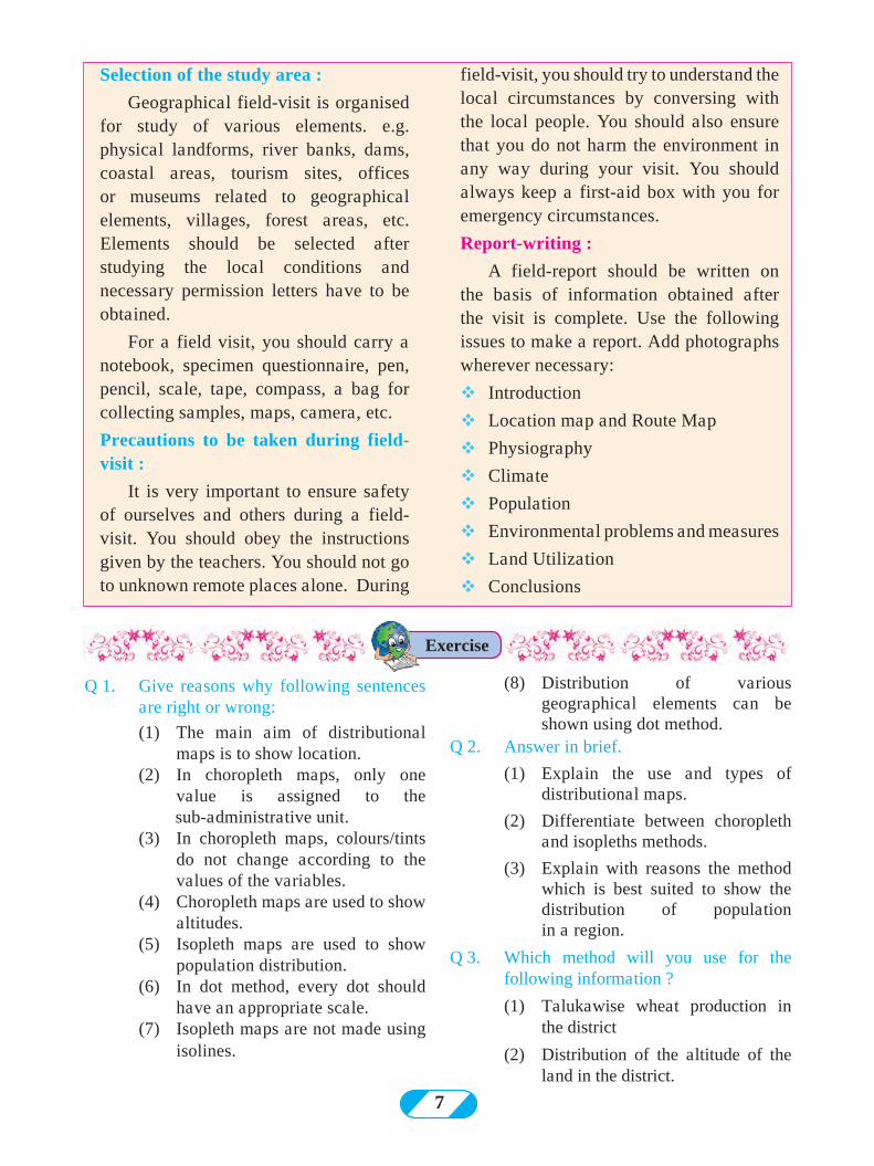
In Fig. 1.1, the population distribution map of Amravati district is given. Answer the given questions by reading the distributional map shown by dot method:
ØWhat is the population of the Amravati town?
temperature, rainfall, population, etc. is shown on the map according to the data of these variables. These maps are useful to explain the distribution of these variables in the region. Such maps easily bring out the patterns of distribution. To draw distributional maps, we need statistical data of the variables. Distribution can be shown in the three following ways on a map:
Make friends with maps !
1. Distributional Maps
Distributional Maps
Dot method Choropleth method Isopleth method
You have studied district, state and country maps in the earlier classes in Environmental Studies and Geography subjects. The main aim of maps is to show the location of a place and distribution of variables. Some maps are prepared with special themes. Such maps are called Thematic Maps. Through such maps, distribution of various variables in a region is shown. Distribution of
2
Figure 1.1 : Dot method map
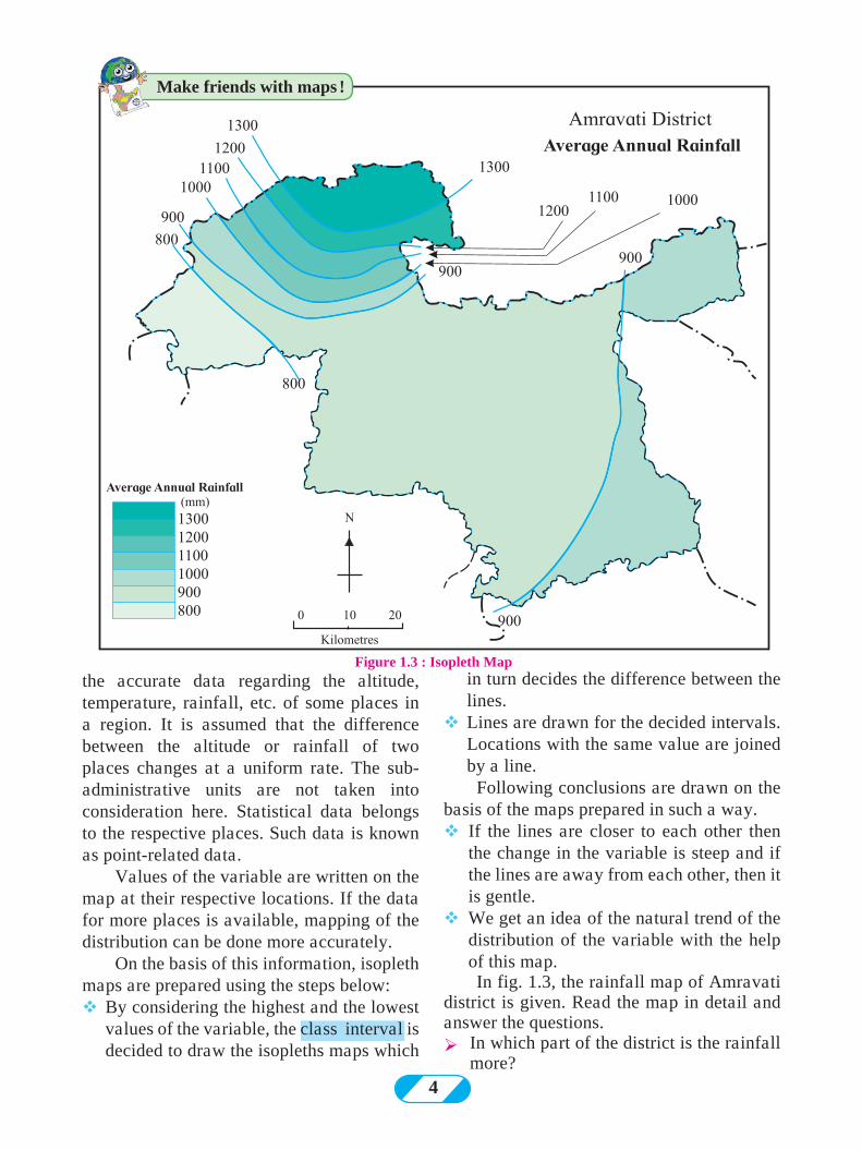
Figure 1.2 (A) : Choropleth map (tints)
ØName the place having population of 1 lakh on the map.
ØWhich part of the map shows sparse distribution of population?
3
shown. Read any one map in detail and answer the following questions:
Ø Name the Talukas having population density between 301 and 400 persons per sq.km.
Ø What is the density of the Amravati Taluka?
Ø Name the Talukas having population density less than 300 persons per sq.km.
Isopleth method :You have seen contour maps and isobar
maps in earlier classes. In these maps, the distribution was shown with the help of lines showing equal values. When the distribution of a variable is continuous, the isopleth method is then used to show its distribution. For example, altitude, temperature, rainfall, etc.
For these maps, we need to obtain
Figure 1.2 (B) : Isopleth Map (Black and White patterns)
Make friends with maps !
Choropleth method:
In these maps, the data regarding various geographical variables is shown by shades or tints of various colours. While making such maps, the data used for different variables is obtained through various processes such as measurement, surveying, etc. In this method, only one value is given to one sub-administrative unit in a region. The smallest and the largest values of the given data of the variable are taken into consideration. After that, 5-7 classes are made. Each class is assigned a tint of the same colour or black-and-white patterns. The shades or the patterns become darker with the increasing values of the given variable and are drawn accordingly on the map in the given classification.
In fig. 1.2 (A) and 1.2 (B), the population density maps of Amravati district using color shades and black-and-white patterns are
4
the accurate data regarding the altitude, temperature, rainfall, etc. of some places in a region. It is assumed that the difference between the altitude or rainfall of two places changes at a uniform rate. The sub-administrative units are not taken into consideration here. Statistical data belongs to the respective places. Such data is known as point-related data.
Values of the variable are written on the map at their respective locations. If the data for more places is available, mapping of the distribution can be done more accurately.
On the basis of this information, isopleth maps are prepared using the steps below: vBy considering the highest and the lowest
values of the variable, the class interval is decided to draw the isopleths maps which
Figure 1.3 : Isopleth Mapin turn decides the difference between the lines.
vLines are drawn for the decided intervals. Locations with the same value are joined by a line.
Following conclusions are drawn on the basis of the maps prepared in such a way.vIf the lines are closer to each other then
the change in the variable is steep and if the lines are away from each other, then it is gentle.
vWe get an idea of the natural trend of the distribution of the variable with the help of this map.In fig. 1.3, the rainfall map of Amravati
district is given. Read the map in detail and answer the questions.ØIn which part of the district is the rainfall
more?
Make friends with maps !
5
ØIn which direction is the rainfall decreasing?
ØWhat is the lowest value of the rainfall in the district?
Figure 1.5 : Rainfall
Read the maps given in fig. 1.4 and 1.5 and answer the questions.
ØIn which direction is the rainfall more in the district?
ØIn which direction is the rainfall decreasing?
ØWhich class shows low rainfall category in the district?
ØWhich class shows high rainfall category in the district?
ØWhich method has been used in preparing this map?
ØIn which direction is the density of population decreasing?
ØName the Talukas with population density less than 200.
ØName the Talukas having population density between 200 and 400
ØName the Talukas with population density more than 400.
ØIn which direction are the Talukas having higher density of population located in the district?
ØWhich method has been used in preparing this map?
Now we will prepare a map using dot method. Carry out the following activity.
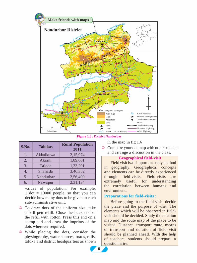
ÜSee the map of Nandurbar given in fig. 1.6 carefully. Draw it on another paper or tracing paper along with its taluka and district boundaries.
ÜNow see the population table given along the map. On the basis of the statistical data, decide the value of the dots considering the highest and the lowest
Make friends with maps !
Try this.
Figure 1.4 : Density of population
6
values of population. For example, 1 dot = 10000 people, so that you can decide how many dots to be given to each sub-administrative unit.
ÜTo draw dots of the uniform size, take a ball pen refill. Close the back end of the refill with cotton. Press this end on a stamp-pad and draw the imprints of the dots wherever required.
ÜWhile placing the dots, consider the physiography, water sources, roads, rails, taluka and district headquarters as shown
Figure 1.6 : District Nandurbar
S.No. TalukasRural Population
20111. Akkalkuwa 2,15,9742. Akrani 1,89,6613. Taloda 1,33,2914. Shahada 3,46,3525. Nandurbar 2,56,4096. Nawapur 2,31,134
in the map in fig 1.6ÜCompare your dot map with other students
and arrange a discussion in the class.Geographical field-visit
Field visit is an important study method in geography. Geographical concepts and elements can be directly experienced through field-visits. Field-visits are extremely useful for understanding the correlation between humans and environment. Preparations for field-visits : Before going to the field-visit, decide the place and the purpose of visit. The elements which will be observed in field-visit should be decided. Study the location map and the route map of the place to be visited. Distance, transport route, means of transport and duration of field visit should be planned ahead. With the help of teachers, students should prepare a questionnaire.
Make friends with maps !
7
Q 1. Give reasons why following sentences are right or wrong:
(1) The main aim of distributional maps is to show location.
(2) In choropleth maps, only one value is assigned to the sub-administrative unit.
(3) In choropleth maps, colours/tints do not change according to the values of the variables.
(4) Choropleth maps are used to show altitudes.
(5) Isopleth maps are used to show population distribution.
(6) In dot method, every dot should have an appropriate scale.
(7) Isopleth maps are not made using isolines.
(8) Distribution of various geographical elements can be shown using dot method.
Q 2. Answer in brief.
(1) Explain the use and types of distributional maps.
(2) Differentiate between choropleth and isopleths methods.
(3) Explain with reasons the method which is best suited to show the distribution of population in a region.
Q 3. Which method will you use for the following information ?
(1) Talukawise wheat production in the district
(2) Distribution of the altitude of the land in the district.
Selection of the study area :
Geographical field-visit is organised for study of various elements. e.g. physical landforms, river banks, dams, coastal areas, tourism sites, offices or museums related to geographical elements, villages, forest areas, etc. Elements should be selected after studying the local conditions and necessary permission letters have to be obtained.
For a field visit, you should carry a notebook, specimen questionnaire, pen, pencil, scale, tape, compass, a bag for collecting samples, maps, camera, etc.
Precautions to be taken during field-visit :
It is very important to ensure safety of ourselves and others during a field-visit. You should obey the instructions given by the teachers. You should not go to unknown remote places alone. During
field-visit, you should try to understand the local circumstances by conversing with the local people. You should also ensure that you do not harm the environment in any way during your visit. You should always keep a first-aid box with you for emergency circumstances.
Report-writing :
A field-report should be written on the basis of information obtained after the visit is complete. Use the following issues to make a report. Add photographs wherever necessary:
vIntroduction
vLocation map and Route Map
vPhysiography
vClimate
vPopulation
vEnvironmental problems and measures
vLand Utilization
vConclusions
Exercise
8
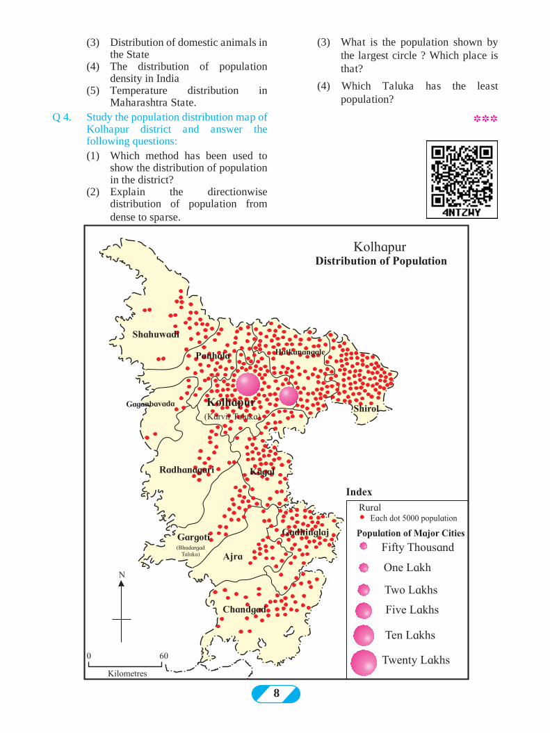
(3) What is the population shown by the largest circle ? Which place is that?
(4) Which Taluka has the least population?
***
(3) Distribution of domestic animals in the State
(4) The distribution of population density in India
(5) Temperature distribution in Maharashtra State.
Q 4. Study the population distribution map of Kolhapur district and answer the following questions:
(1) Which method has been used to show the distribution of population in the district?
(2) Explain the directionwise distribution of population from dense to sparse.
9
Read the following news. Observe the photograph and answer the questions.
| What caused the large-scale casualities?
| What was the magnitude of the earthquake?
| Which country was the most affected by this earthquake?
| Where was the epicenter of the earthquake?
| Which are the other affected areas ?
| At what depth was the focus located?
| What kind of damage is seen because of the earthquake?
| According to you, what could be the reason behind the earthquake?
| Have you ever experienced a similar earthquake? Discuss.
Various natural events occur on the earth from time to time e.g. floods, storms, snowfall extreme rainfall, etc. Similarly, because of the movements below the earth’s surface, natural events like earthquakes and volcanic eruptions occur. For the organisms living on earth, these
Figure 2.2 (A)
events are disastrous. There is loss of life and property because of natural calamities. In this lesson we will get introduced to these endogenetic (internal) movements.
(Note for teachers: The steps in the activities are important. Make sure every student participates.
Lead the students to the topic through discussion.)
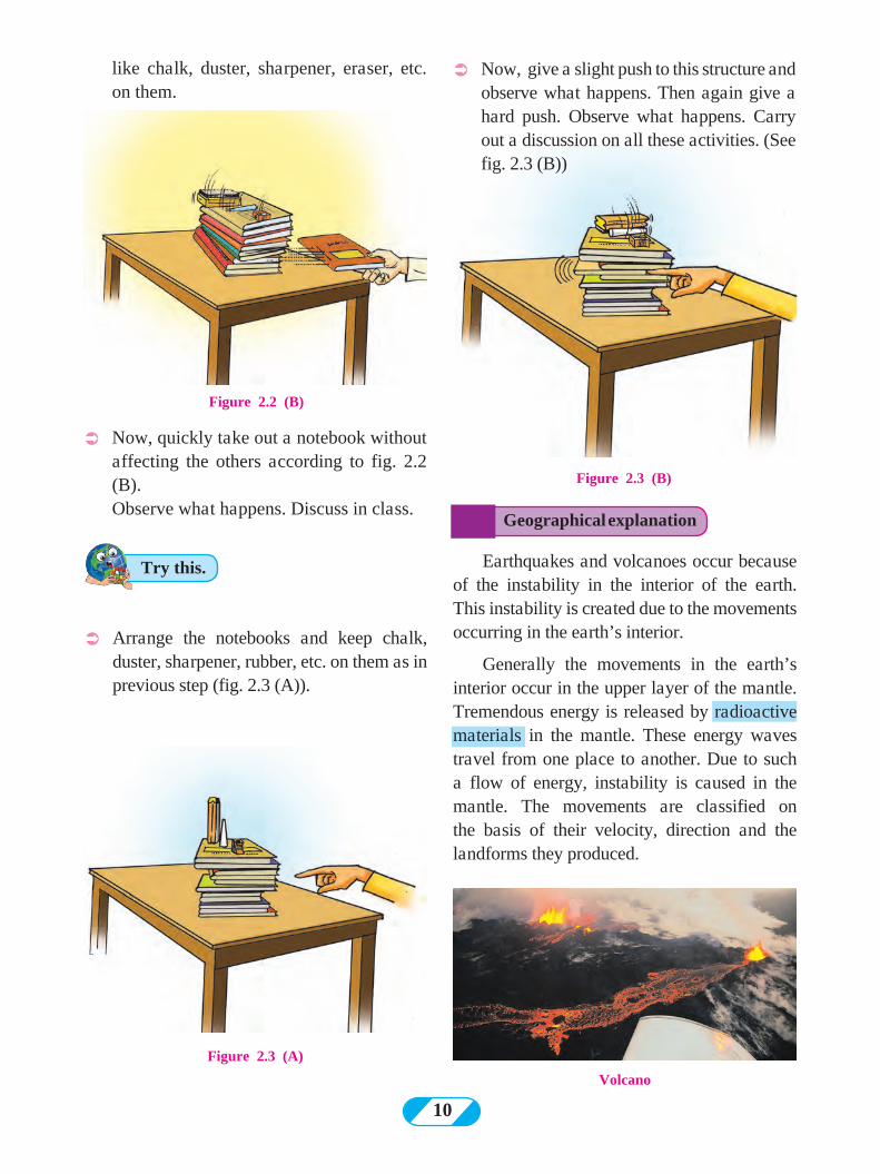
ÜAs shown in fig 2.2 (A), arrange your notebooks on each other. Place 3-4 objects
Try this.
Can you tell ?
2. Endogenetic Movements
Figure 2.1 : Newspaper Snippet
Kathmandu : 25 Apr (PTI) A powerful earthquake measuring 7.9 on Richter scale struck Nepal today, nearly 1500 people were killed and over 1000 people were injured in the disaster.The quake and a series of serious aftershocks delivered a severe blow to Nepal. The tremors were also felt across vast stretches of east and northeast India. It was also felt in China, Bhutan and as far as Pakistan and Bangladesh.The earthquake with epicentre at Lamjung, around 80 kilometers northwest of Kathmandu, had its impact in several cities in Bihar, West Bengal and Uttar Pradesh.
The initial report said the tremor measured 7.9-magnitude. It said the quake hit at 11:40 am local time at a shallow depth of 11 km. ‘‘There were 17 major aftershocks measuring over 5 in the next two and half hours,” said an officer of the National Seismological Centre.Another aftershock measuring 6.6 hit within 80 minutes of the quake. This is the largest earthquake in Nepal after 80 years. India has sent rescue teams immediately.
Powerful earthquake rocks Nepal, nearly 1500 killed
¢ Focus 11 km deep¢ 17 more shocks after 2 big tremors¢ Duration ranging from 30 sec to 2 min¢ India, Bangladesh and Pakistan also experience tremors ¢ 22 States in India feel the tremors
NEPAL DEVASTATED 7.9 Richter Scale 11.40 am_________6.6 Richter scale 12.19 pm
Epicenter : Lamjung ( Nepal)
2 BIG TREMORS
No of Dead : India 53, Tibet 12, Bangladesh 2
10
Figure 2.3 (A)
Volcano
Figure 2.3 (B)
Figure 2.2 (B)
like chalk, duster, sharpener, eraser, etc. on them.
ÜNow, quickly take out a notebook without affecting the others according to fig. 2.2 (B).
Observe what happens. Discuss in class.
ÜArrange the notebooks and keep chalk, duster, sharpener, rubber, etc. on them as in previous step (fig. 2.3 (A)).
ÜNow, give a slight push to this structure and observe what happens. Then again give a hard push. Observe what happens. Carry out a discussion on all these activities. (See fig. 2.3 (B))
Geographical explanation
Try this. Earthquakes and volcanoes occur because of the instability in the interior of the earth. This instability is created due to the movements occurring in the earth’s interior.
Generally the movements in the earth’s interior occur in the upper layer of the mantle. Tremendous energy is released by radioactive materials in the mantle. These energy waves travel from one place to another. Due to such a flow of energy, instability is caused in the mantle. The movements are classified on the basis of their velocity, direction and the landforms they produced.
11
Figure 2.5 (A)
Figure 2.5 (B)
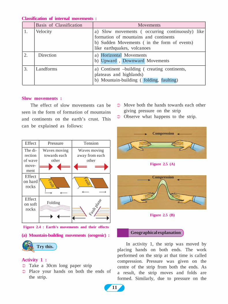
Slow movements :
The effect of slow movements can be
seen in the form of formation of mountains
and continents on the earth’s crust. This
can be explained as follows:
Figure 2.4 : Earth's movements and their effects
Activity 1 : ÜTake a 30cm long paper stripÜPlace your hands on both the ends of
the strip.
ÜMove both the hands towards each other giving pressure on the strip
ÜObserve what happens to the strip.
Effect Pressure Tension
The di-rection of wave move-ment
Waves moving towards each
other
Waves moving away from each
other
Effect on hard rocks
Effecton soft rocks
Compression
Compression
In activity 1, the strip was moved by placing hands on both ends. The work performed on the strip at that time is called compression. Pressure was given on the centre of the strip from both the ends. As a result, the strip moves and folds are formed. Similarly, due to pressure on the
Geographical explanation
Try this.
Folding
Fault
Fault
Faul
t pla
ne
(a) Mountain-building movements (orogenic) :
Classification of internal movements :
Basis of Classification Movements1. Velocity a) Slow movements ( occurring continuously) like
formation of mountains and continentsb) Sudden Movements ( in the form of events) like earthquakes, volcanoes
2. Direction a) Horizontal Movementsb) Upward , Downward Movements
3. Landforms a) Continent –building ( creating continents, plateaus and highlands)b) Mountain-building ( folding, faulting)
12
Figure 2.8 (A)
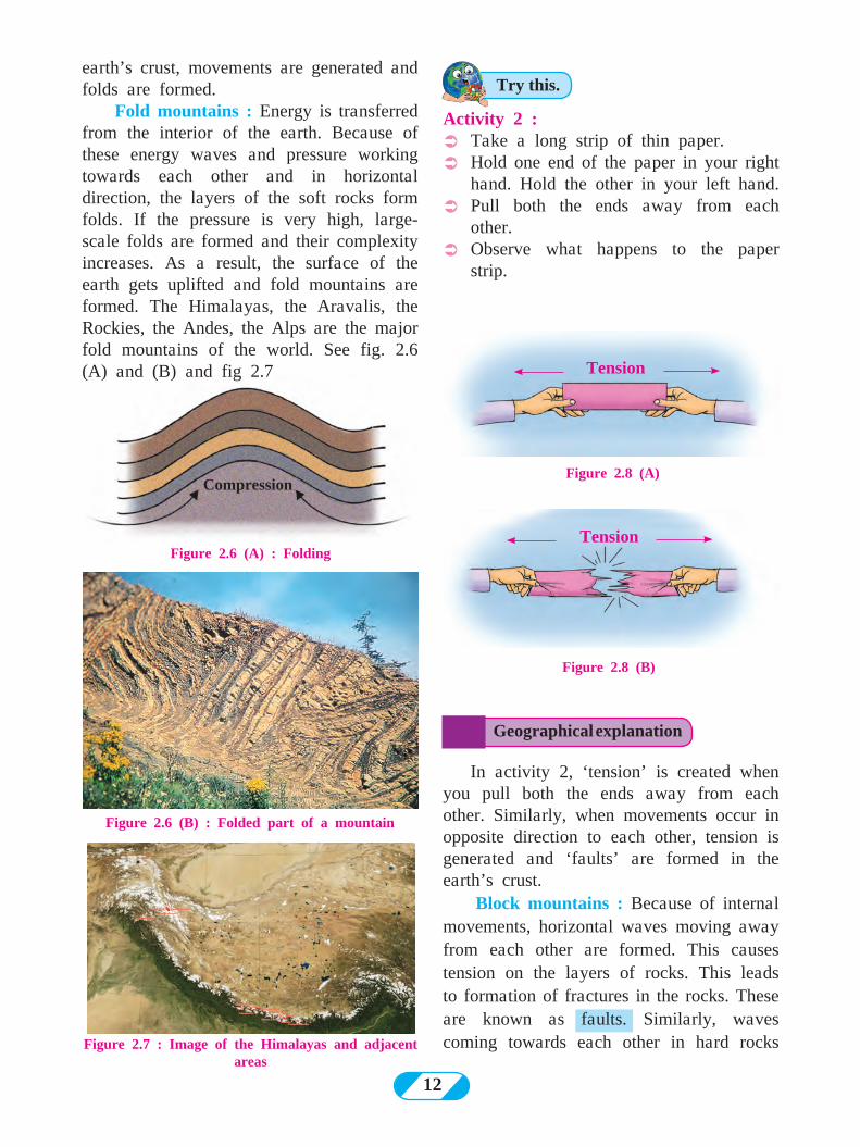
Figure 2.6 (B) : Folded part of a mountain
Activity 2 : ÜTake a long strip of thin paper. ÜHold one end of the paper in your right
hand. Hold the other in your left hand. ÜPull both the ends away from each
other. ÜObserve what happens to the paper
strip.
Figure 2.7 : Image of the Himalayas and adjacent areas
Figure 2.6 (A) : Folding
Figure 2.8 (B)
Tension
Tension
Compression
earth’s crust, movements are generated and folds are formed.
Fold mountains : Energy is transferred from the interior of the earth. Because of these energy waves and pressure working towards each other and in horizontal direction, the layers of the soft rocks form folds. If the pressure is very high, large-scale folds are formed and their complexity increases. As a result, the surface of the earth gets uplifted and fold mountains are formed. The Himalayas, the Aravalis, the Rockies, the Andes, the Alps are the major fold mountains of the world. See fig. 2.6 (A) and (B) and fig 2.7
Geographical explanation
Try this.
In activity 2, ‘tension’ is created when you pull both the ends away from each other. Similarly, when movements occur in opposite direction to each other, tension is generated and ‘faults’ are formed in the earth’s crust.
Block mountains : Because of internal movements, horizontal waves moving away from each other are formed. This causes tension on the layers of rocks. This leads to formation of fractures in the rocks. These are known as faults. Similarly, waves coming towards each other in hard rocks
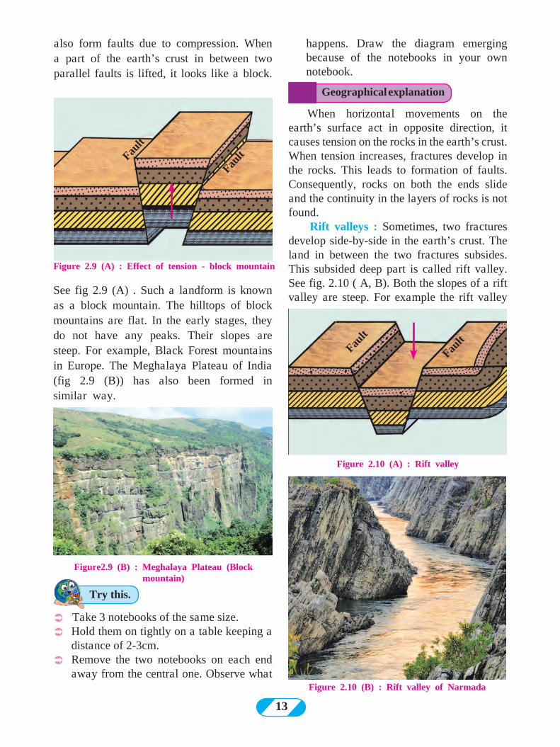
13
also form faults due to compression. When a part of the earth’s crust in between two parallel faults is lifted, it looks like a block.
Figure 2.9 (A) : Effect of tension - block mountain
happens. Draw the diagram emerging because of the notebooks in your own notebook.
Figure2.9 (B) : Meghalaya Plateau (Block mountain)
When horizontal movements on the earth’s surface act in opposite direction, it causes tension on the rocks in the earth’s crust. When tension increases, fractures develop in the rocks. This leads to formation of faults. Consequently, rocks on both the ends slide and the continuity in the layers of rocks is not found.
Rift valleys : Sometimes, two fractures develop side-by-side in the earth’s crust. The land in between the two fractures subsides. This subsided deep part is called rift valley. See fig. 2.10 ( A, B). Both the slopes of a rift valley are steep. For example the rift valley
See fig 2.9 (A) . Such a landform is known as a block mountain. The hilltops of block mountains are flat. In the early stages, they do not have any peaks. Their slopes are steep. For example, Black Forest mountains in Europe. The Meghalaya Plateau of India (fig 2.9 (B)) has also been formed in similar way.
Ü Take 3 notebooks of the same size. ÜHold them on tightly on a table keeping a
distance of 2-3cm. ÜRemove the two notebooks on each end
away from the central one. Observe what Figure 2.10 (B) : Rift valley of Narmada
Fault
Fault
Figure 2.10 (A) : Rift valley
Fault
Fault
Geographical explanation
Try this.
14
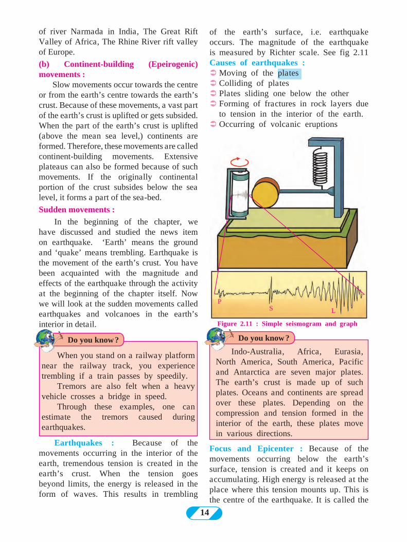
of the earth’s surface, i.e. earthquake occurs. The magnitude of the earthquake is measured by Richter scale. See fig 2.11 Causes of earthquakes : ÜMoving of the platesÜColliding of platesÜPlates sliding one below the otherÜForming of fractures in rock layers due
to tension in the interior of the earth.ÜOccurring of volcanic eruptions
Figure 2.11 : Simple seismogram and graph
PLS
of river Narmada in India, The Great Rift Valley of Africa, The Rhine River rift valley of Europe.
(b) Continent-building (Epeirogenic) movements : Slow movements occur towards the centre or from the earth’s centre towards the earth’s crust. Because of these movements, a vast part of the earth’s crust is uplifted or gets subsided. When the part of the earth’s crust is uplifted (above the mean sea level,) continents are formed. Therefore, these movements are called continent-building movements. Extensive plateaus can also be formed because of such movements. If the originally continental portion of the crust subsides below the sea level, it forms a part of the sea-bed.
Sudden movements :
In the beginning of the chapter, we have discussed and studied the news item on earthquake. ‘Earth’ means the ground and ‘quake’ means trembling. Earthquake is the movement of the earth’s crust. You have been acquainted with the magnitude and effects of the earthquake through the activity at the beginning of the chapter itself. Now we will look at the sudden movements called earthquakes and volcanoes in the earth’s interior in detail.
Earthquakes : Because of the movements occurring in the interior of the earth, tremendous tension is created in the earth’s crust. When the tension goes beyond limits, the energy is released in the form of waves. This results in trembling
Focus and Epicenter : Because of the movements occurring below the earth’s surface, tension is created and it keeps on accumulating. High energy is released at the place where this tension mounts up. This is the centre of the earthquake. It is called the
Do you know ?Do you know ?
When you stand on a railway platform near the railway track, you experience trembling if a train passes by speedily.
Tremors are also felt when a heavy vehicle crosses a bridge in speed.
Through these examples, one can estimate the tremors caused during earthquakes.
Indo-Australia, Africa, Eurasia, North America, South America, Pacific and Antarctica are seven major plates. The earth’s crust is made up of such plates. Oceans and continents are spread over these plates. Depending on the compression and tension formed in the interior of the earth, these plates move in various directions.
15
focus or hypocenter. Energy waves scatter in all directions from this centre. The place on the earth’s surface where these energy waves reach first is called the epicenter of the earthquake. It is the nearest place on the earth’s surface from the focus and it experiences the first tremor. The epicenter is perpendicular to the focus.
lesser than the P waves. The particles lying in the way of these waves move up and down in the direction of energy transfer. These waves can travel only through the solid medium. They get absorbed as they enter the liquid medium. The buildings on the earth’s surface move up and down because of these waves. These are more destructive than the P waves.
(3) Surface or ‘L’ waves : These waves are generated after the main P and S waves reach the epicenter. They travel in the direction of the circumference of the earth along the crust. They are highly destructive. Seismogram : Through this instrument, a graph showing movement of seismic waves (Seismograph) can be generated. After studying this graph, the magnitude of the earthquake is known. Fig.2.11 shows a simple seismogram and a seismograph prepared from it. Now with the help of modern technology, advanced seismograms have been designed. With their help, even micro-seismic waves can also be measured.
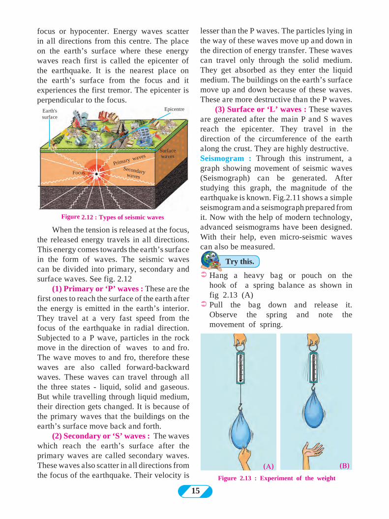
When the tension is released at the focus, the released energy travels in all directions. This energy comes towards the earth’s surface in the form of waves. The seismic waves can be divided into primary, secondary and surface waves. See fig. 2.12
(1) Primary or ‘P’ waves : These are the first ones to reach the surface of the earth after the energy is emitted in the earth’s interior. They travel at a very fast speed from the focus of the earthquake in radial direction. Subjected to a P wave, particles in the rock move in the direction of waves to and fro. The wave moves to and fro, therefore these waves are also called forward-backward waves. These waves can travel through all the three states - liquid, solid and gaseous. But while travelling through liquid medium, their direction gets changed. It is because of the primary waves that the buildings on the earth’s surface move back and forth.
(2) Secondary or ‘S’ waves : The waves which reach the earth’s surface after the primary waves are called secondary waves. These waves also scatter in all directions from the focus of the earthquake. Their velocity is
ÜHang a heavy bag or pouch on the hook of a spring balance as shown in fig 2.13 (A)
ÜPull the bag down and release it. Observe the spring and note the movement of spring.
Figure 2.12 : Types of seismic waves
Earth's surface
Epicentre
Surface waves
Primary waves
Secondary wavesFocus
(A) (B)Figure 2.13 : Experiment of the weight
Try this.
16
Figure 2.15 : Experiment of Rangoli
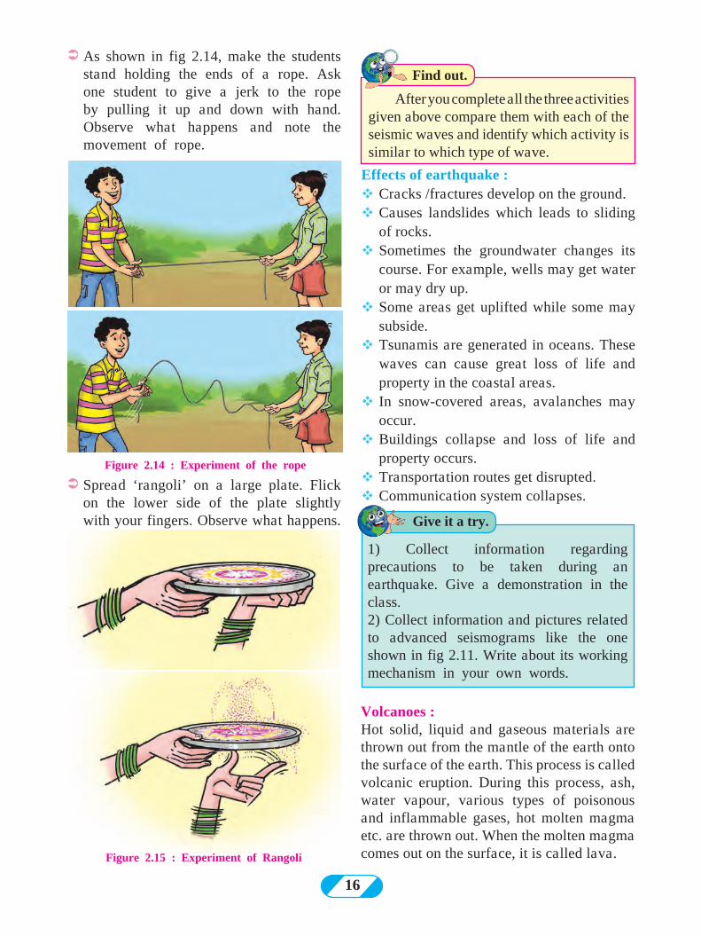
ÜAs shown in fig 2.14, make the students stand holding the ends of a rope. Ask one student to give a jerk to the rope by pulling it up and down with hand. Observe what happens and note the movement of rope.
ÜSpread ‘rangoli’ on a large plate. Flick on the lower side of the plate slightly with your fingers. Observe what happens.
After you complete all the three activities given above compare them with each of the seismic waves and identify which activity is similar to which type of wave.
Effects of earthquake :vCracks /fractures develop on the ground. vCauses landslides which leads to sliding
of rocks.vSometimes the groundwater changes its
course. For example, wells may get water or may dry up.
vSome areas get uplifted while some may subside.
vTsunamis are generated in oceans. These waves can cause great loss of life and property in the coastal areas.
vIn snow-covered areas, avalanches may occur.
vBuildings collapse and loss of life and property occurs.
vTransportation routes get disrupted.vCommunication system collapses.
Find out.
Volcanoes :Hot solid, liquid and gaseous materials are thrown out from the mantle of the earth onto the surface of the earth. This process is called volcanic eruption. During this process, ash, water vapour, various types of poisonous and inflammable gases, hot molten magma etc. are thrown out. When the molten magma comes out on the surface, it is called lava.
Figure 2.14 : Experiment of the rope
Give it a try.
1) Collect information regarding precautions to be taken during an earthquake. Give a demonstration in the class.2) Collect information and pictures related to advanced seismograms like the one shown in fig 2.11. Write about its working mechanism in your own words.
17
Figure 2.16 : Central or Conical Volcano
Figure 2.17 : Fissure type volcano
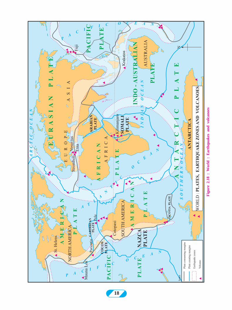
Read fig 2.18 and answer the questions. As a supplementary material to this exercise, take help from a globe or a physical map of the world.
Ø Examine the plate boundaries in the given map and write the names of the plates.
Ø On which side of the continents of North and South America are the earthquake-prone zones located? Which mountains are located there?
Ø In which mountainous zone in Asia does the earthquake-prone zone lie?
Ø In which region are the volcanoes concentrated in Africa? What could be the reason?
Ø Correlate earthquake regions, distribution of volcanoes and plate boundaries.
By looking at fig 2.18 you will understand that plate boundaries are directly related to areas of earthquakes and volcanoes. Most
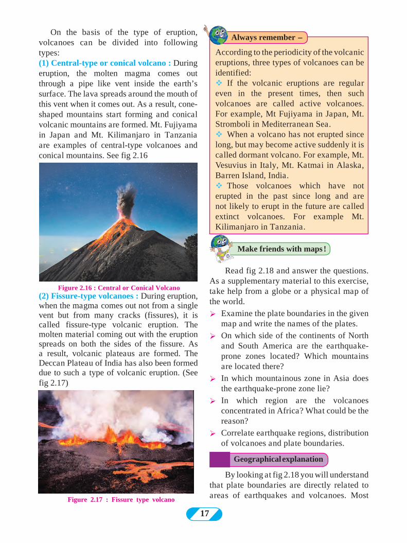
On the basis of the type of eruption, volcanoes can be divided into following types: (1) Central-type or conical volcano : During eruption, the molten magma comes out through a pipe like vent inside the earth’s surface. The lava spreads around the mouth of this vent when it comes out. As a result, cone-shaped mountains start forming and conical volcanic mountains are formed. Mt. Fujiyama in Japan and Mt. Kilimanjaro in Tanzania are examples of central-type volcanoes and conical mountains. See fig 2.16
(2) Fissure-type volcanoes : During eruption, when the magma comes out not from a single vent but from many cracks (fissures), it is called fissure-type volcanic eruption. The molten material coming out with the eruption spreads on both the sides of the fissure. As a result, volcanic plateaus are formed. The Deccan Plateau of India has also been formed due to such a type of volcanic eruption. (See fig 2.17)
Make friends with maps !
Geographical explanation
Always remember -
According to the periodicity of the volcanic eruptions, three types of volcanoes can be identified: vIf the volcanic eruptions are regular even in the present times, then such volcanoes are called active volcanoes. For example, Mt Fujiyama in Japan, Mt. Stromboli in Mediterranean Sea.vWhen a volcano has not erupted since long, but may become active suddenly it is called dormant volcano. For example, Mt. Vesuvius in Italy, Mt. Katmai in Alaska, Barren Island, India.vThose volcanoes which have not erupted in the past since long and are not likely to erupt in the future are called extinct volcanoes. For example Mt. Kilimanjaro in Tanzania.
18
Fig
ure
2.18
: W
orld
: E
arth
quak
es a
nd v
olca
noes
19
of the volcanoes are located on the plate boundaries. Similarly, the earthquake zones are also seen in the border areas. The part of the plate boundary which slides under the crust subdues. There is loss of material. Such boundaries are called plate consuming (subduction) boundaries. In areas, where new material is coming up onto the earth’s crust, they are called plate creating (constructive) boundaries. Both the processes happen continuously. They are shown in the map in fig. 2.18
Effects of volcanoes :
vLoss of life and property vSometimes tsunamis get generated
due to volcanic eruptions occurring below ocean floors.
vDust, smoke, ash, gases, water vapour, etc. remain in the atmosphere for a long time. This may create imbalance in the environment.
vLand may become fertile due to volcanic ash.
vMany minerals are found near the earth’s surface because of lava.
vNew land is formed due to volcanic eruption or at times, an island may even disappear.
vLakes are formed at the mouth of the craters of dead volcanoes when rain water accumulates in them.
Effect of Earthquake Sahyadri : Layers of lava deposition due to volcanic eruption
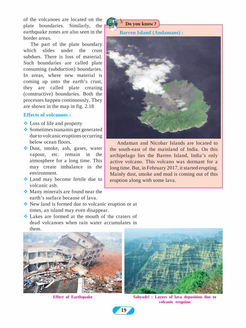
Andaman and Nicobar Islands are located to the south-east of the mainland of India. On this archipelago lies the Barren Island, India’s only active volcano. This volcano was dormant for a long time. But, in February 2017, it started erupting. Mainly dust, smoke and mud is coming out of this eruption along with some lava.
Do you know ?
Barren Island (Andamans) :
20
Q 1. Tick in front of the correct option P (a) On which of the following are slow
movements in the earth’s interior dependent?
Landforms Velocity Direction (b) When waves divert from each
other, what do they create Compression Tension Mountain (c) For the formation of a rift valley,
which of the following processes should occur in the earth’s crust?
Compression Tension Weathering (d) Which of these is a fold mountain? The Satpudas The Himalayas The Western Ghats (e) The formation of extensive plateaus
is a result of which type of movements ?
Mountain-building Continent-building Horizontal Q 2. Give geographical reasons. (a) Buildings collapsed at the foothills
of the Himalayas because of an earthquake. Before collapsing they were moving forward and backward.
(b) There is a difference in the formation of the Meghalaya Plateau and the Deccan Plateau.
(c) Most of the volcanoes are found on the plate boundaries.
(d) The Barren Island is becoming conical in shape.
(e) Volcanic eruptions can cause earthquakes.
Q 3. Identify and name the internal movement. (a) Tsunamis are generated in coastal
areas. (b) The Himalayas are an example of
fold mountains. (c) Molten magma is thrown out of the
earth’s mantle. (d) Rift valley is formed because of
faulting.Q 4. Arrange the following statements in
chronological order in which an earthquake occurs.
(a) The earth’s surface vibrates (b) The plates suddenly move. (c) Due to the movements in the
mantle, compression goes on increasing.
(d) Along the weak points ( faultlines) rocks break apart.
(e) Stored energy is released in the form of seismic waves.
Q 5. Distinguish between - (a) Block Mountain and Fold Mountain (b) Primary and Secondary Seismic
Waves (c) Earthquakes and volcanoes
Q 6. Answer in brief (a) Give reasons why an earthquake
occurs. (b) Which type of movements have led
to the formation of the major fold mountains in the world?
(c) How is the magnitude of the earthquake related to the collapse of houses
(d) What are the effects of earthquakes on the earth’s surface and human life?
(e) Explain the types of seismic waves. (f) Explain the types of volcanoes on
the basis of periodicity of eruption with examples.
Q 7. Show the epicentre, focus and the primary, secondary and surface waves of an earthquake with the help of a neat labelled diagram.
Q 8. Show the following on a given outline map of the world.
(a) Mt. Kilimanjaro (b) Mid-Atlantic Earthquake zone (c) Mt. Fuji (d) Krakatoa (e) Mt. Vesuvius
Exercise
21
22
Activity: (1) Make a model showing the central and
fissure type volcanoes.
(2) Gather information through internet about earthquakes which have occurred in India in the past 10 years on the basis of the following points.
***
Date TimeMagnitude
(Richter Scale)
EpicentreDepth (In
Kilometers)Area affected Loss/Damage caused
Conclusion :
23
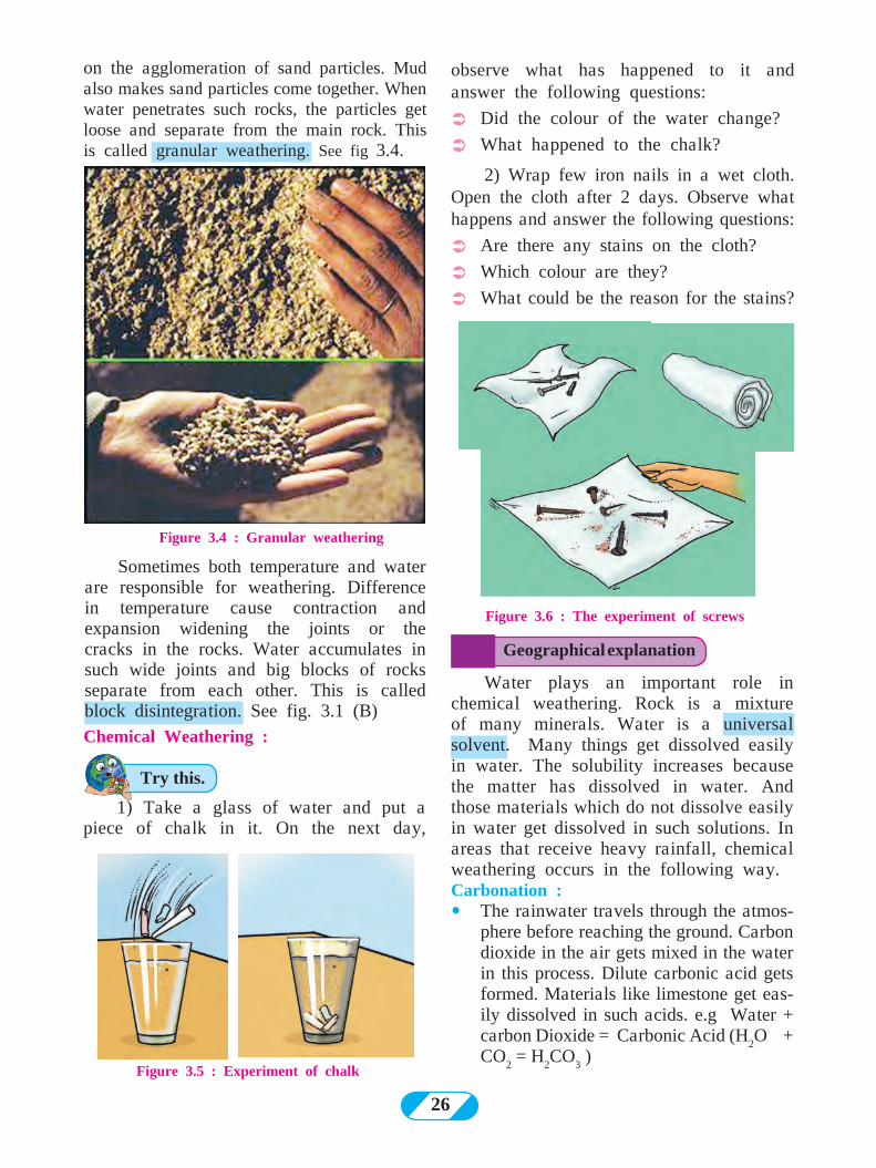
See the given pictures. Observe the physical appearance of the rocks in each picture. You can see that rocks are broken, fractured and have holes in them. In a picture you can also see that the statue has been deformed. Why are the rocks in such a condition? Think about them and briefly tell the reasons you can think of. Discuss the reasons. Check with the teachers if your reasons are relevant.
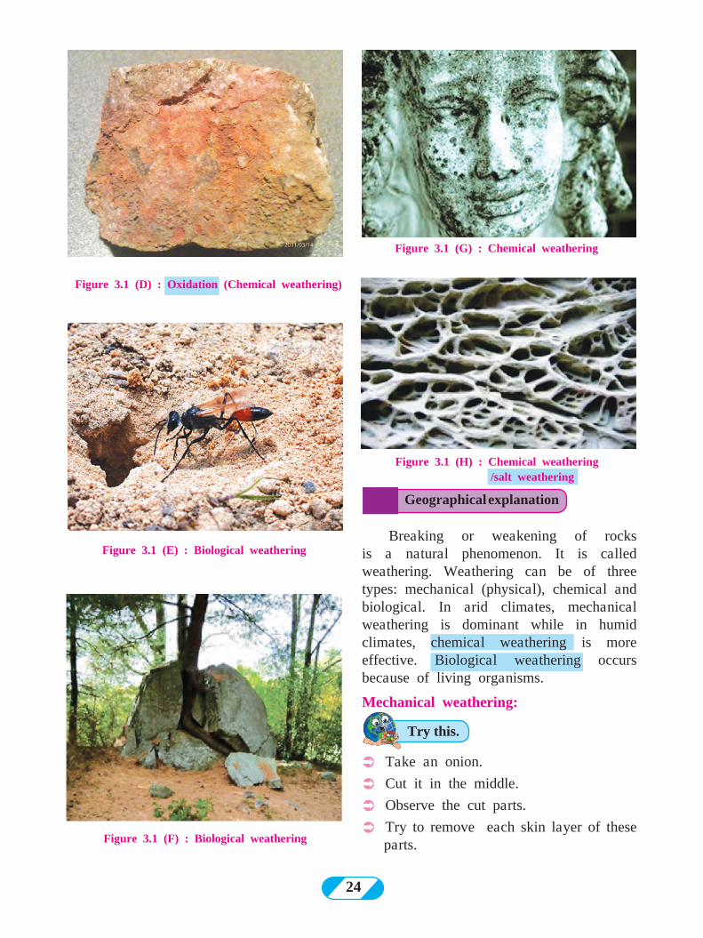
Figure 3.1 (B) : Block disintegration
(mechanical weathering)Can you tell ?
Do you know ?
3. Exogenetic Processes Part- I
Landforms formed on the earth’s surface as a result of internal movements are called primary and secondary landforms. For example continents, mountains, plateaus, plains, etc.
Because of the external processes like weathering, erosion, transportation and deposition, the primary and secondary landforms give way to the tertiary landforms. For example, valleys, sand dunes, delta, U-shaped valleys, etc.
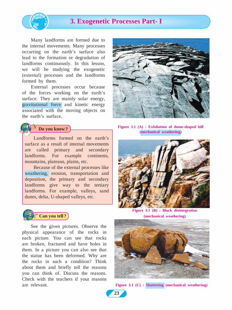
Figure 3.1 (A) : Exfoliation of dome-shaped hill (mechanical weathering)
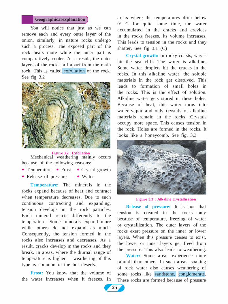
Figure 3.1 (C) : Shattering (mechanical weathering)
Many landforms are formed due to the internal movements. Many processes occurring on the earth’s surface also lead to the formation or degradation of landforms continuously. In this lesson, we will be studying the exogenetic (external) processes and the landforms formed by them.
External processes occur because of the forces working on the earth’s surface. They are mainly solar energy, gravitational force and kinetic energy associated with the moving objects on the earth’s surface.
24
Figure 3.1 (H) : Chemical weathering /salt weathering
Figure 3.1 (E) : Biological weathering
Figure 3.1 (F) : Biological weathering
Figure 3.1 (G) : Chemical weathering
ÜTake an onion.
ÜCut it in the middle.
ÜObserve the cut parts.
ÜTry to remove each skin layer of these parts.
Geographical explanation
Try this.
Figure 3.1 (D) : Oxidation (Chemical weathering)
Breaking or weakening of rocks is a natural phenomenon. It is called weathering. Weathering can be of three types: mechanical (physical), chemical and biological. In arid climates, mechanical weathering is dominant while in humid climates, chemical weathering is more effective. Biological weathering occurs because of living organisms.
Mechanical weathering:
25
areas where the temperatures drop below 0o C for quite some time, the water accumulated in the cracks and crevices in the rocks freezes. Its volume increases. This leads to tension in the rocks and they shatter. See fig 3.1 (C)
Crystal growth: In rocky coasts, waves hit the sea cliff. The water is alkaline. Some water droplets hit the cracks in the rocks. In this alkaline water, the soluble materials in the rock get dissolved. This leads to formation of small holes in the rocks. This is the effect of solution. Alkaline water gets stored in these holes. Because of heat, this water turns into water vapor and only crystals of alkaline materials remain in the rocks. Crystals occupy more space. This causes tension in the rock. Holes are formed in the rocks. It looks like a honeycomb. See fig. 3.3
Mechanical weathering mainly occurs because of the following reasons:
� Temperature � Frost � Crystal growth
� Release of pressure � Water
Temperature: The minerals in the rocks expand because of heat and contract when temperature decreases. Due to such continuous contracting and expanding, tension develops in the rock particles. Each mineral reacts differently to the temperature. Some minerals expand more while others do not expand as much. Consequently, the tension formed in the rocks also increases and decreases. As a result, cracks develop in the rocks and they break. In areas, where the diurnal range of temperature is higher, weathering of this type is common in the hot deserts.
Frost: You know that the volume of the water increases when it freezes. In
Figure 3.3 : Alkaline crystallization
Figure 3.2 : Exfoliation
Geographical explanation
You will notice that just as we can remove each and every outer layer of the onion, similarly, in nature rocks undergo such a process. The exposed part of the rock heats more while the inner part is comparatively cooler. As a result, the outer layers of the rocks fall apart from the main rock. This is called exfoliation of the rock. See fig 3.2
Release of pressure: It is not that tension is created in the rocks only because of temperature, freezing of water or crystallization. The outer layers of the rocks exert pressure on the inner or lower layers. When this pressure ceases to exist, the lower or inner layers get freed from the pressure. This also leads to weathering.
Water: Some areas experience more rainfall than others. In such areas, soaking of rock water also causes weathering of some rocks like sandstone, conglomerate. These rocks are formed because of pressure
26
on the agglomeration of sand particles. Mud also makes sand particles come together. When water penetrates such rocks, the particles get loose and separate from the main rock. This is called granular weathering. See fig 3.4.
Figure 3.5 : Experiment of chalk
Figure 3.6 : The experiment of screws
Figure 3.4 : Granular weathering
1) Take a glass of water and put a piece of chalk in it. On the next day,
Chemical Weathering :
Geographical explanation
Try this.
observe what has happened to it and answer the following questions:
ÜDid the colour of the water change?
ÜWhat happened to the chalk?
2) Wrap few iron nails in a wet cloth. Open the cloth after 2 days. Observe what happens and answer the following questions:
ÜAre there any stains on the cloth?
ÜWhich colour are they?
ÜWhat could be the reason for the stains?
Water plays an important role in chemical weathering. Rock is a mixture of many minerals. Water is a universal solvent. Many things get dissolved easily in water. The solubility increases because the matter has dissolved in water. And those materials which do not dissolve easily in water get dissolved in such solutions. In areas that receive heavy rainfall, chemical weathering occurs in the following way.Carbonation :� The rainwater travels through the atmos-
phere before reaching the ground. Carbon dioxide in the air gets mixed in the water in this process. Dilute carbonic acid gets formed. Materials like limestone get eas-ily dissolved in such acids. e.g Water + carbon Dioxide = Carbonic Acid (H
2O +
CO2 = H
2CO
3 )
Sometimes both temperature and water are responsible for weathering. Difference in temperature cause contraction and expansion widening the joints or the cracks in the rocks. Water accumulates in such wide joints and big blocks of rocks separate from each other. This is called block disintegration. See fig. 3.1 (B)
27
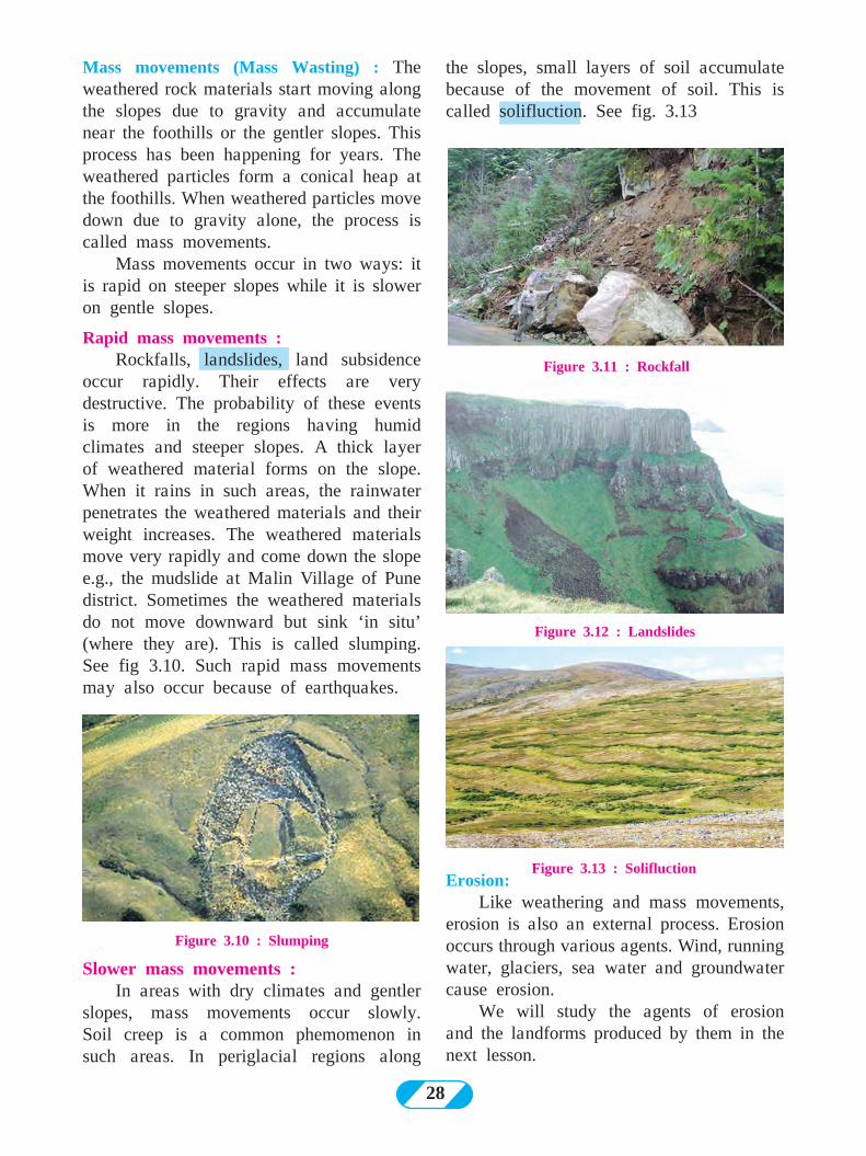
because of the roots of the trees. As the roots grow bigger, they create tension in the rocks and start breaking them. See fig. 3.8.
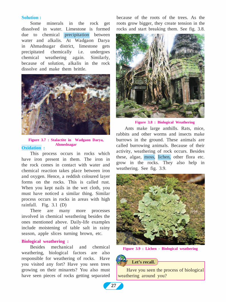
Figure 3.7 : Stalactite in Wadgaon Darya, Ahmednagar
Oxidation :This process occurs in rocks which
have iron present in them. The iron in the rock comes in contact with water and chemical reaction takes place between iron and oxygen. Hence, a reddish coloured layer forms on the rocks. This is called rust. When you kept nails in the wet cloth, you must have noticed a similar thing. Similar process occurs in rocks in areas with high rainfall. Fig. 3.1 (D)
There are many more processes involved in chemical weathering besides the ones mentioned above. Daily-life examples include moistening of table salt in rainy season, apple slices turning brown, etc.
Biological weathering : Besides mechanical and chemical
weathering, biological factors are also responsible for weathering of rocks. Have you visited any fort? Have you seen trees growing on their minarets? You also must have seen pieces of rocks getting separated
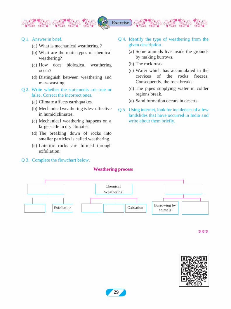
Figure 3.8 : Biological Weathering
Figure 3.9 : Lichen - Biological weathering
Have you seen the process of biological weathering around you?
Solution :Some minerals in the rock get
dissolved in water. Limestone is formed due to chemical precipitation between water and alkalis. At Wadgaon Darya in Ahmadnagar district, limestone gets precipitated chemically i.e. undergoes chemical weathering again. Similarly, because of solution, alkalis in the rock dissolve and make them brittle.
Ants make large anthills. Rats, mice, rabbits and other worms and insects make burrows in the ground. These animals are called burrowing animals. Because of their activity, weathering of rock occurs. Besides these, algae, moss, lichen, other flora etc. grow in the rocks. They also help in weathering. See fig. 3.9.
Let’s recall.
28
Figure 3.11 : Rockfall
Figure 3.12 : Landslides
Figure 3.13 : Solifluction
Figure 3.10 : Slumping
Erosion:Like weathering and mass movements,
erosion is also an external process. Erosion occurs through various agents. Wind, running water, glaciers, sea water and groundwater cause erosion.
We will study the agents of erosion and the landforms produced by them in the next lesson.
Slower mass movements : In areas with dry climates and gentler
slopes, mass movements occur slowly. Soil creep is a common phemomenon in such areas. In periglacial regions along
the slopes, small layers of soil accumulate because of the movement of soil. This is called solifluction. See fig. 3.13
Mass movements (Mass Wasting) : The weathered rock materials start moving along the slopes due to gravity and accumulate near the foothills or the gentler slopes. This process has been happening for years. The weathered particles form a conical heap at the foothills. When weathered particles move down due to gravity alone, the process is called mass movements.
Mass movements occur in two ways: it is rapid on steeper slopes while it is slower on gentle slopes.
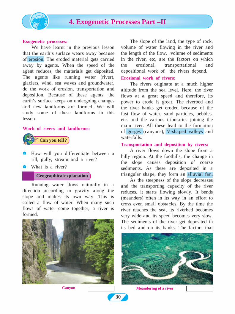
Rapid mass movements :Rockfalls, landslides, land subsidence
occur rapidly. Their effects are very destructive. The probability of these events is more in the regions having humid climates and steeper slopes. A thick layer of weathered material forms on the slope. When it rains in such areas, the rainwater penetrates the weathered materials and their weight increases. The weathered materials move very rapidly and come down the slope e.g., the mudslide at Malin Village of Pune district. Sometimes the weathered materials do not move downward but sink ‘in situ’ (where they are). This is called slumping. See fig 3.10. Such rapid mass movements may also occur because of earthquakes.
29
Q 1. Answer in brief.
(a) What is mechanical weathering ?
(b) What are the main types of chemical weathering?
(c) How does biological weathering occur?
(d) Distinguish between weathering and mass wasting.
Q 2. Write whether the statements are true or false. Correct the incorrect ones.
(a) Climate affects earthquakes.
(b) Mechanical weathering is less effective in humid climates.
(c) Mechanical weathering happens on a large scale in dry climates.
(d) The breaking down of rocks into smaller particles is called weathering.
(e) Lateritic rocks are formed through exfoliation.
Q 3. Complete the flowchart below.
Q 4. Identify the type of weathering from the given description.
(a) Some animals live inside the grounds by making burrows.
(b) The rock rusts.
(c) Water which has accumulated in the crevices of the rocks freezes. Consequently, the rock breaks.
(d) The pipes supplying water in colder regions break.
(e) Sand formation occurs in deserts
Q 5. Using internet, look for incidences of a few landslides that have occurred in India and write about them briefly.
Weathering process
Chemical
Weathering
OxidationExfoliationBurrowing by
animals
Exercise
***
30
Canyon Meandering of a river
Work of rivers and landforms:
| How will you differentiate between a rill, gully, stream and a river?
| What is a river?
Running water flows naturally in a direction according to gravity along the slope and makes its own way. This is called a flow of water. When many such flows of water come together, a river is formed.
Geographical explanation
Can you tell ?
4. Exogenetic Processes Part –II
Exogenetic processes:We have learnt in the previous lesson
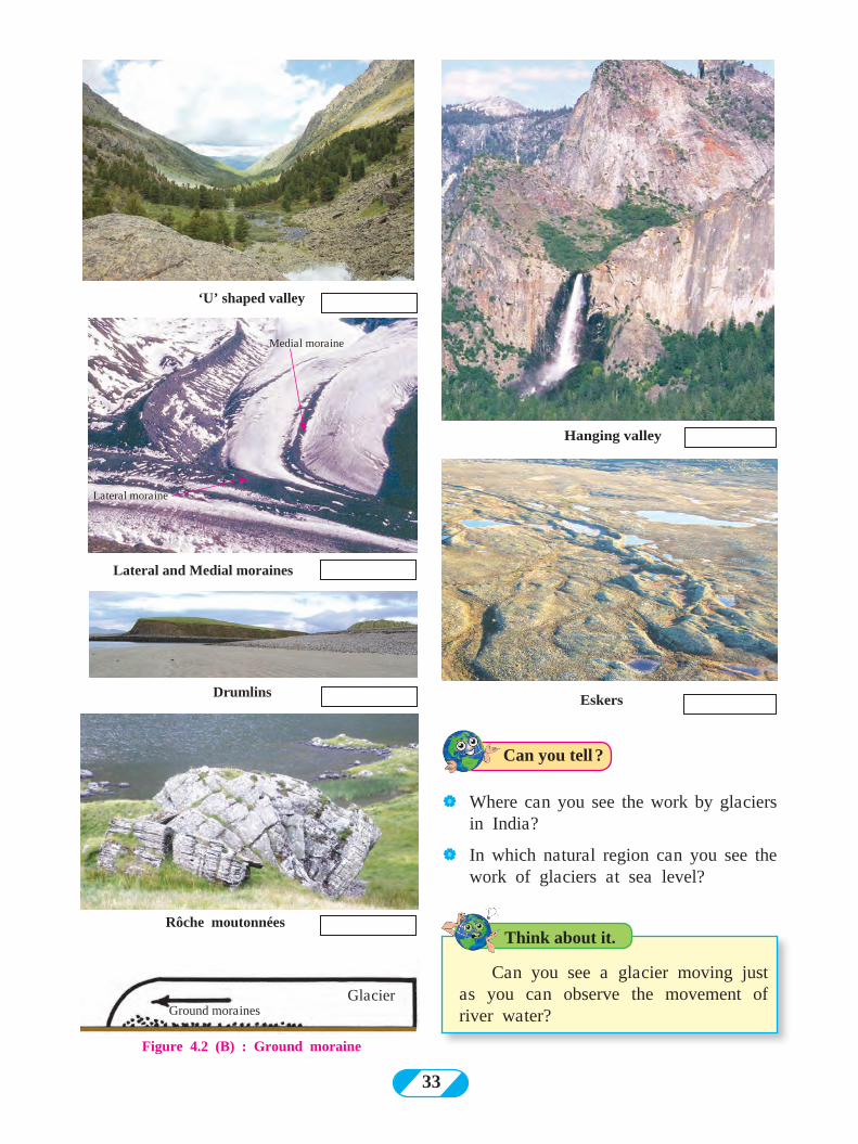
that the earth’s surface wears away because of erosion. The eroded material gets carried away by agents. When the speed of the agent reduces, the materials get deposited. The agents like running water (river), glaciers, wind, sea waves and groundwater, do the work of erosion, transportation and deposition. Because of these agents, the earth’s surface keeps on undergoing changes and new landforms are formed. We will study some of these landforms in this lesson.
The slope of the land, the type of rock, volume of water flowing in the river and the length of the flow, volume of sediments in the river, etc, are the factors on which the erosional, transportational and depositional work of the rivers depend.
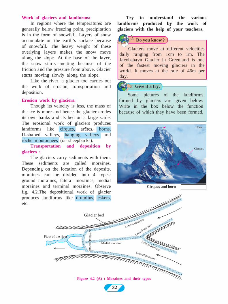
Erosional work of rivers:The rivers originate at a much higher
altitude from the sea level. Here, the river flows at a great speed and therefore, its power to erode is great. The riverbed and the river banks get eroded because of the fast flow of water, sand particles, pebbles. etc. and the various tributaries joining the main river. All these lead to the formation of gorges (canyons), V-shaped valleys and waterfalls.
Transportation and deposition by rivers:A river flows down the slope from a
hilly region. At the foothills, the change in the slope causes deposition of coarse sediments. As these are deposited in a triangular shape, they form an alluvial fan.
As the steepness of the slope decreases and the transporting capacity of the river reduces, it starts flowing slowly. It bends (meanders) often in its way in an effort to cross even small obstacles. By the time the river reaches the sea, its riverbed becomes very wide and its speed becomes very slow. The sediments of the river get deposited in its bed and on its banks. The factors that
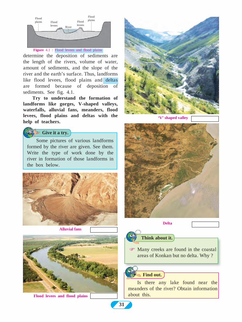
31
determine the deposition of sediments are the length of the rivers, volume of water, amount of sediments, and the slope of the river and the earth’s surface. Thus, landforms like flood levees, flood plains and deltas are formed because of deposition of sediments. See fig. 4.1.
Try to understand the formation of landforms like gorges, V-shaped valleys, waterfalls, alluvial fans, meanders, flood levees, flood plains and deltas with the help of teachers.
Flood levees and flood plains
‘V’ shaped valley
Flood plains
River
Flood plains
Flood levees
Flood levees
Delta
Alluvial fans
Find out.
Is there any lake found near the meanders of the river? Obtain information about this.
Think about it.
Give it a try.
FMany creeks are found in the coastal areas of Konkan but no delta. Why ?
Some pictures of various landforms formed by the river are given. See them. Write the type of work done by the river in formation of those landforms in the box below.
Figure 4.1 : Flood levees and flood plains
32
Term
inal moraine
Lateral moraine
Lateral m
oraine
Glacier bed
Flow of the river
Medial moraineLateral moraine
Lateral moraine
Figure 4.2 (A) : Moraines and their types
Cirques and horn
Horn
Cirques
Try to understand the various landforms produced by the work of glaciers with the help of your teachers.
Do you know ?
Give it a try.
Some pictures of the landforms formed by glaciers are given below. Write in the box below the function because of which they have been formed.
Glaciers move at different velocities daily ranging from 1cm to 1m. The Jacobshavn Glacier in Greenland is one of the fastest moving glaciers in the world. It moves at the rate of 46m per day.
Work of glaciers and landforms: In regions where the temperatures are
generally below freezing point, precipitation is in the form of snowfall. Layers of snow accumulate on the earth’s surface because of snowfall. The heavy weight of these overlying layers makes the snow move along the slope. At the base of the layer, the snow starts melting because of the friction and the pressure from above. Glacier starts moving slowly along the slope.
Like the river, a glacier too carries out the work of erosion, transportation and deposition.
Erosion work by glaciers:Though its velocity is less, the mass of
the ice is more and hence the glacier erodes its own banks and its bed on a large scale. The erosional work of glaciers produces landforms like cirques, arêtes, horns, U-shaped valleys, hanging valleys and rôche moutonnées (or sheepbacks).
Transportation and deposition by glaciers :
The glaciers carry sediments with them. These sediments are called moraines. Depending on the location of the deposits, moraines can be divided into 4 types: ground moraines, lateral moraines, medial moraines and terminal moraines. Observe fig. 4.2.The depositional work of glacier produces landforms like drumlins, eskers, etc.
33
‘U’ shaped valley
EskersDrumlins
Hanging valley
Rôche moutonnées
Figure 4.2 (B) : Ground moraine
GlacierGround moraines
Lateral and Medial moraines
Medial moraine
Lateral moraine
| Where can you see the work by glaciers in India?
| In which natural region can you see the work of glaciers at sea level?
Can you tell ?
Think about it.
Can you see a glacier moving just as you can observe the movement of river water?
34
Mushroom rock
Ripple marks
Soft rocks
Hard rocks
Direction of windFigure 4.3 : Yardangs
Try to understand the various landforms produced by the work of winds with the help of your teachers.
Give it a try.
Some pictures of landforms produced by the work of the winds are given below. See the pictures and write in the box whether they have been formed by erosion or deposition.
Sand dune (Barchan)
Depositional work of winds:Sand particles that blow with the wind
are of different shapes and sizes. Those particles which are very fine are carried over larger distances while the larger ones get transported to shorter distances only. These sand particles get deposited in deserts and semi-arid climates. As a result, specific landforms are formed. Sand dunes, barchans, seifs, ripple marks, loess plains, etc. are formed by wind deposition.
Work of the wind and the landforms produced:
You have learnt earlier that the movement of air is called wind. Wind is a gaseous agent of erosion. The erosional, transportational and depositional work of wind is more prominent in deserts and semi-arid regions. As mechanical weathering occurs on a large scale here, powdered rock and sand spreads over a large area. There is hardly any obstacle in the transportational work of the wind. Sand particles also get transported along with the wind and they are carried over longer distances and get deposited where the speed of the wind reduces. In this way the wind does the work of erosion, transportation and deposition.Erosional work of wind:
Wind carries small sand particles, small pebbles, etc. along with it. These particles cause erosion along rocks coming in the way due to friction. This leads to formation of mushroom rocks, deflation hollows, yardangs, etc. See fig 4.3.
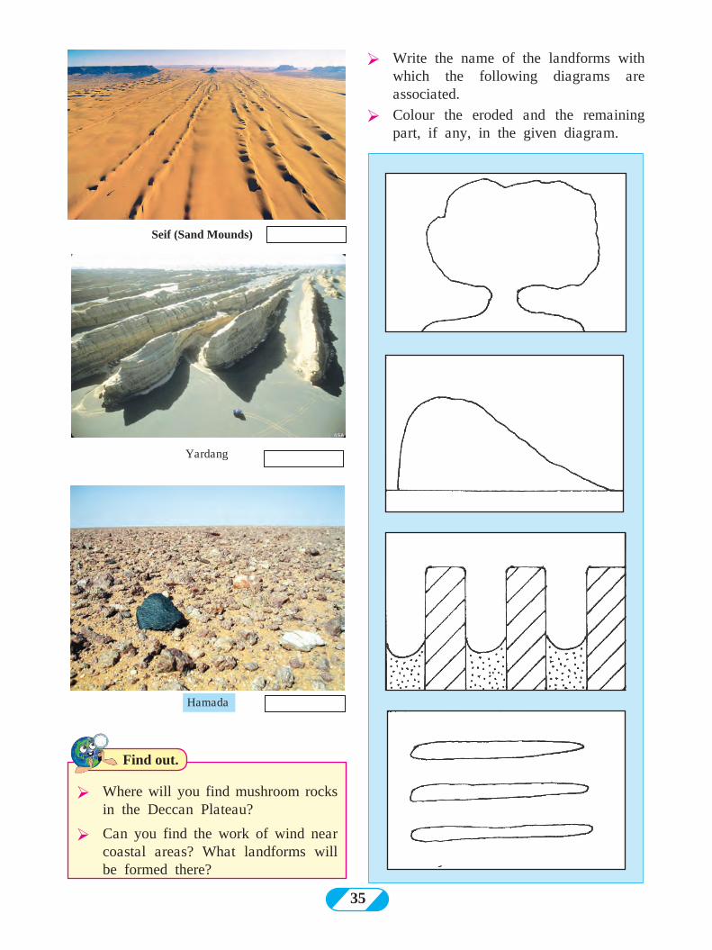
35
Yardang
Seif (Sand Mounds)
Ø Where will you find mushroom rocks in the Deccan Plateau?
Ø Can you find the work of wind near coastal areas? What landforms will be formed there?
Ø Write the name of the landforms with which the following diagrams are associated.
Ø Colour the eroded and the remaining part, if any, in the given diagram.
Hamada
Find out.
36
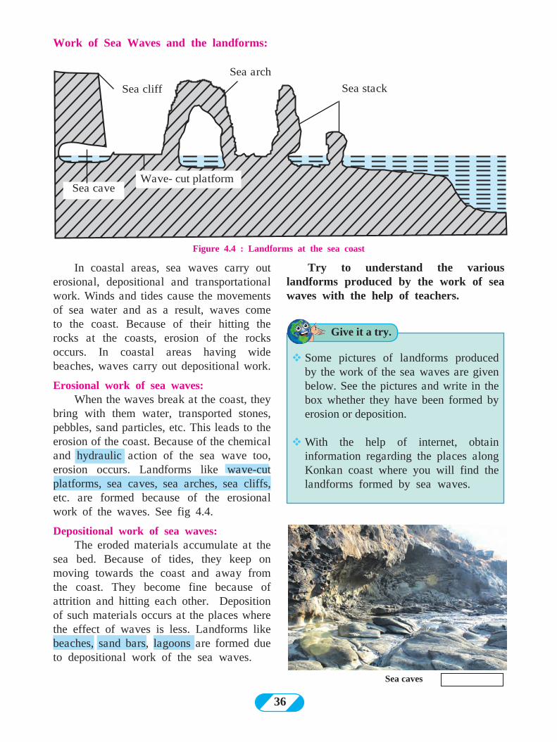
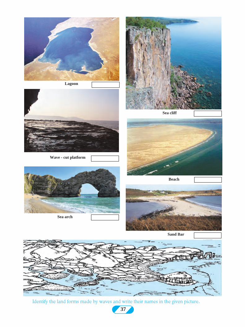
Work of Sea Waves and the landforms:
Sea cliff
Sea arch
Sea stack
Wave- cut platformSea cave
Figure 4.4 : Landforms at the sea coast
Sea caves
Try to understand the various landforms produced by the work of sea waves with the help of teachers.
Give it a try.
vSome pictures of landforms produced by the work of the sea waves are given below. See the pictures and write in the box whether they have been formed by erosion or deposition.
vWith the help of internet, obtain information regarding the places along Konkan coast where you will find the landforms formed by sea waves.
In coastal areas, sea waves carry out erosional, depositional and transportational work. Winds and tides cause the movements of sea water and as a result, waves come to the coast. Because of their hitting the rocks at the coasts, erosion of the rocks occurs. In coastal areas having wide beaches, waves carry out depositional work.
Erosional work of sea waves:When the waves break at the coast, they
bring with them water, transported stones, pebbles, sand particles, etc. This leads to the erosion of the coast. Because of the chemical and hydraulic action of the sea wave too, erosion occurs. Landforms like wave-cut platforms, sea caves, sea arches, sea cliffs, etc. are formed because of the erosional work of the waves. See fig 4.4.
Depositional work of sea waves: The eroded materials accumulate at the
sea bed. Because of tides, they keep on moving towards the coast and away from the coast. They become fine because of attrition and hitting each other. Deposition of such materials occurs at the places where the effect of waves is less. Landforms like beaches, sand bars, lagoons are formed due to depositional work of the sea waves.
37
Sea arch
Sand Bar
Sea cliff
Wave - cut platform
Beach
Lagoon
Identify the land forms made by waves and write their names in the given picture.
38
Sinkhole
Stalactite and stalagmite and caveØ Where are limestone caves, stalactites and stalagmites found in Maharashtra?
Ø Why are the landforms formed in limestone called Karst?
Find out.
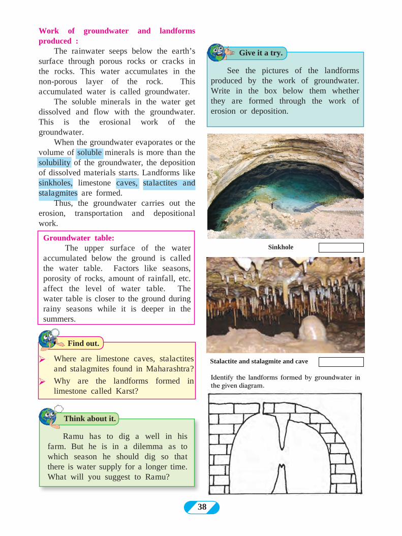
Identify the landforms formed by groundwater in the given diagram.
Groundwater table: The upper surface of the water
accumulated below the ground is called the water table. Factors like seasons, porosity of rocks, amount of rainfall, etc. affect the level of water table. The water table is closer to the ground during rainy seasons while it is deeper in the summers.
Think about it.
Give it a try.
Ramu has to dig a well in his farm. But he is in a dilemma as to which season he should dig so that there is water supply for a longer time. What will you suggest to Ramu?
See the pictures of the landforms produced by the work of groundwater. Write in the box below them whether they are formed through the work of erosion or deposition.
Work of groundwater and landforms produced :
The rainwater seeps below the earth’s surface through porous rocks or cracks in the rocks. This water accumulates in the non-porous layer of the rock. This accumulated water is called groundwater.
The soluble minerals in the water get dissolved and flow with the groundwater. This is the erosional work of the groundwater.
When the groundwater evaporates or the volume of soluble minerals is more than the solubility of the groundwater, the deposition of dissolved materials starts. Landforms like sinkholes, limestone caves, stalactites and stalagmites are formed.
Thus, the groundwater carries out the erosion, transportation and depositional work.
39
Q 1. Rewrite the correct statement : (1) The temperature range helps
the wind in its work. (2) River’s work is more prominent than
other agents of erosion in desert regions. (3) The work of groundwater is effective
in the area with soft rocks. (4) The work of wind is not limited like
river, glacier or the sea waves and takes place everywhere.
Q 2. Correct and rewrite the incorrect statements :
(1) The ice on the lateral side of the glacier moves faster than the ice at the base.
(2) The depositional work by rivers happens because of gentle slope, reduced speed and transported sediments.
(3) A river flows at a faster speed than the glacier.
(4) The speed of the glacier is more on both the banks than in the middle.
Q 3. Identify the wrong pair : (1) Deposition - V–shaped valley (2) Transport - Ripple Marks (3) Erosion - Mushroom Rocks
Q 4. Identify and name the landforms
in the following diagrams :
Q 5. Complete the following table by classifying the landforms according to their agents of erosion.
(waterfall, delta, cirque, arête, barchans, moraine, pothole, mushroom rock, sinkholes, beach, pillars, lagoons)
Rivers Wind Glacier Sea Waves Ground-water
Q 6. Answer the following questions in brief. (1) List the landforms that are a result of
the erosional work of the rivers. (2) Which agent is responsible for
formation of stalactites and stalagmites and where are they formed?
(3) List the landforms that are produced by the depositional work of the sea waves .
(4) Name the types of moraines.
Activity : (1) Go to a river bank or a sea coast and
observe the erosional, depositional and transportational work done by them.
(2) Make a collage of pictures of land forms by collecting them from magazines and newspapers.
Exercise
Think about it.
Which agent has the most kinetic energy of all - wind, river or glacier?
40
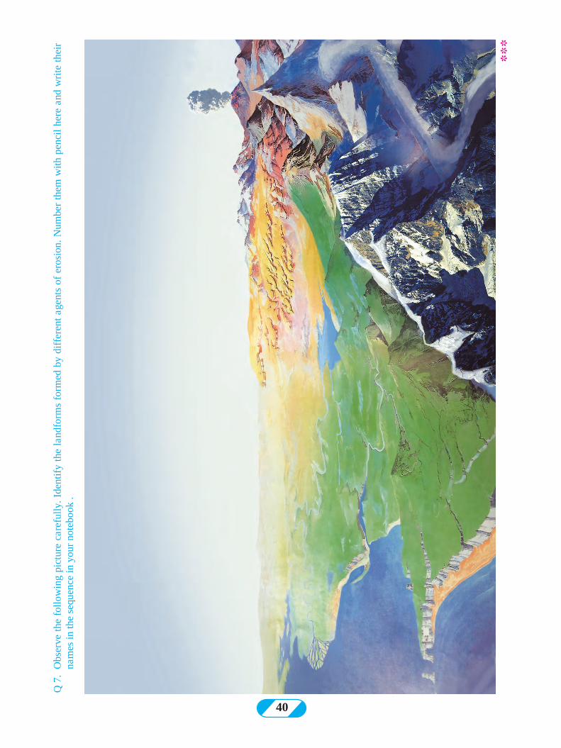
Q 7
. O
bser
ve t
he f
ollo
win
g pi
ctur
e ca
refu
lly. I
dent
ify
the
land
form
s fo
rmed
by
diff
eren
t ag
ents
of
eros
ion.
Num
ber
them
with
pen
cil
here
and
wri
te t
heir
na
mes
in th
e se
quen
ce in
you
r no
tebo
ok .
**
*
41
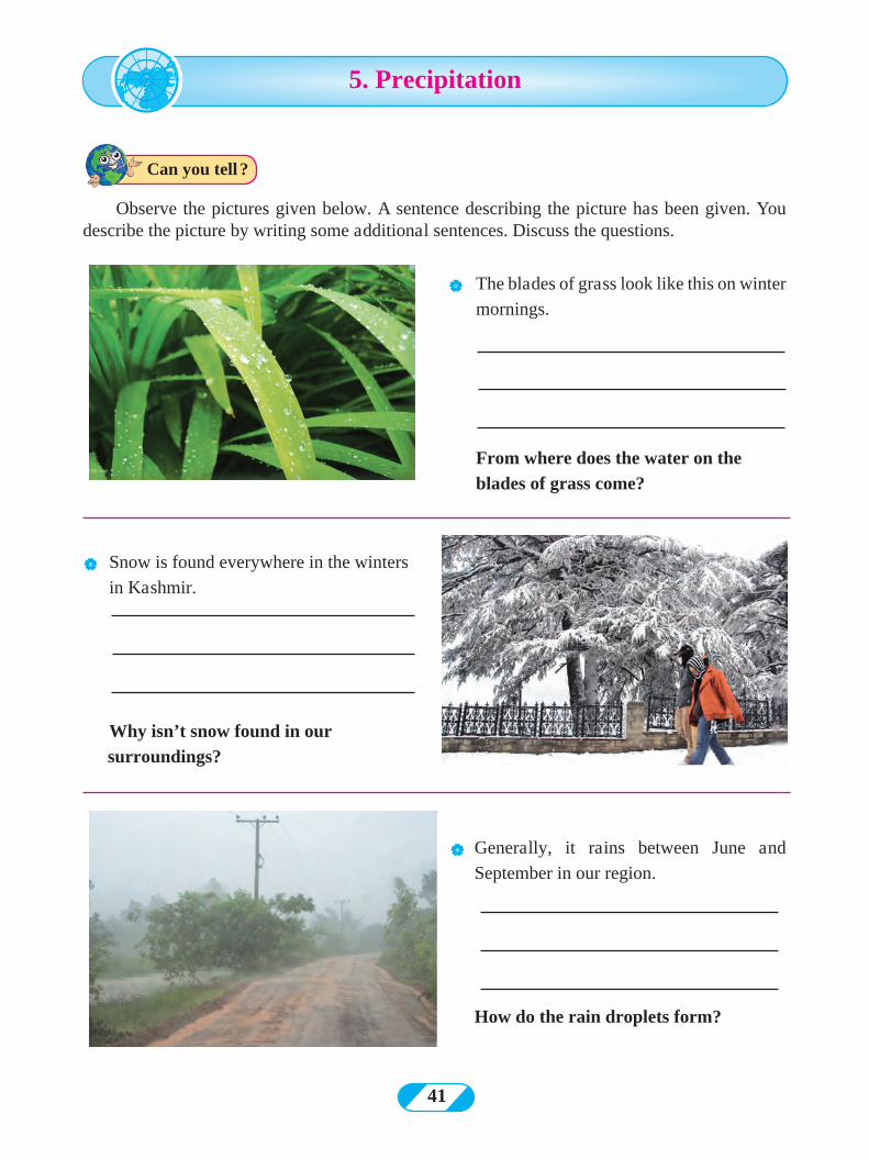
Observe the pictures given below. A sentence describing the picture has been given. You describe the picture by writing some additional sentences. Discuss the questions.
| The blades of grass look like this on winter
mornings.
From where does the water on the
blades of grass come?
| Snow is found everywhere in the winters
in Kashmir.
Why isn’t snow found in our
surroundings?
| Generally, it rains between June and
September in our region.
How do the rain droplets form?
Can you tell ?
5. Precipitation

42
| In London, there is fog like this till the
afternoons in the winters.
Why don’t we have fog like this till afternoons in the winters in our region?
| Sometimes hailstones destroy the standing
crops in the fields.
Why don't we get hailstones frequently ?
70.8% part of the earth's surface is full of water. The distribution of this water is very uneven. At some places, the water storage is limited while it is ample at other places. We see/experience the different forms of condensation as shown in the pictures above and in fig 5.1. These forms of condensation occur due to the water vapour in the atmosphere.
As the atmospheric conditions change, we see changes in the forms of condensation. On winter mornings, we find dew. In areas located at higher altitudes, snowfall occurs; while it rains in other places. Some places experience dense fog while some experience hailstones suddenly and face crop destruction. Precipitation:
Water falls in the solid or liquid state from the clouds to the ground. Snow, hailstones, rainfall are the major forms of precipitation. See the images in fig.5.1.
Figure 5.1 : Forms of Precipitation / Condensation
Geographical explanation
43
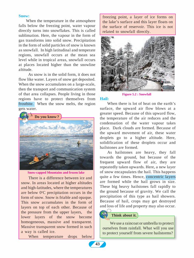
Snow: When the temperature in the atmosphere
falls below the freezing point, water vapour directly turns into snowflakes. This is called sublimation. Here, the vapour in the form of gas transforms into solid snow. Precipitation in the form of solid particles of snow is known as snowfall. In high latitudinal and temperate regions, snowfall occurs at the mean sea level while in tropical areas, snowfall occurs at places located higher than the snowline altitude.
As snow is in the solid form, it does not flow like water. Layers of snow get deposited. When the snow accumulates on a large-scale, then the transport and communication system of that area collapses. People living in those regions have to protect themselves from frostbite. When the snow melts, the region gets water.
Figure 5.2 : Snowfall
Think about it.
There is a difference between ice and snow. In areas located at higher altitudes and high-latitudes, where the temperatures are below 0oC precipitation occurs in the form of snow. Snow is friable and opaque. This snow accumulates in the form of layers on top of each other. Because of the pressure from the upper layers, the lower layers of the snow become homogeneous, massive and transparent. Massive transparent snow formed in such a way is called ice.
When temperature drops below
Snow-capped Mountains and frozen lake
freezing point, a layer of ice forms on the lake’s surface and this layer floats on the surface of reservoir. This ice is not related to snowfall directly.
We use a raincoat or umbrella to protect ourselves from rainfall. What will you use to protect yourself from severe hailstorms?
Hail: When there is lot of heat on the earth’s
surface, the upward air flow blows at a greater speed. Because of this upward flow, the temperature of the air reduces and the condensation of the water vapour takes place. Dark clouds are formed. Because of the upward movement of air, these water droplets go to a higher altitude. Here, solidification of these droplets occur and hailstones are formed.
As hailstones are heavy, they fall towards the ground, but because of the frequent upward flow of air, they are repeatedly taken upwards. Here, a new layer of snow encapsulates the hail. This happens quite a few times. Hence, concentric layers are formed while the hail grows in size. These big heavy hailstones fall rapidly to the ground because of gravity. We call the precipitation of this type as hail showers. Because of hail, crops may get destroyed and loss of life and property may also occur.
Do you know ?
44
Hails occur in summers in India, Africa and in some parts of South East Asia. Hails do not occur in equatorial areas because of the heat in the atmosphere. Hails do not occur in cold zones because of lack of upward flow.
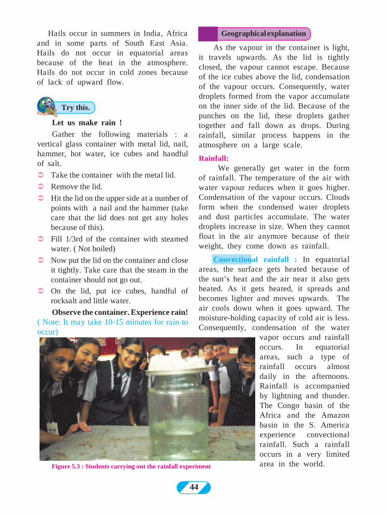
Let us make rain !
Gather the following materials : a vertical glass container with metal lid, nail, hammer, hot water, ice cubes and handful of salt.
ÜTake the container with the metal lid.
ÜRemove the lid.
ÜHit the lid on the upper side at a number of points with a nail and the hammer (take care that the lid does not get any holes because of this).
ÜFill 1/3rd of the container with steamed water. ( Not boiled)
ÜNow put the lid on the container and close it tightly. Take care that the steam in the container should not go out.
ÜOn the lid, put ice cubes, handful of rocksalt and little water.
Observe the container. Experience rain!( Note: It may take 10-15 minutes for rain to occur)
Figure 5.3 : Students carrying out the rainfall experiment
Geographical explanation
Try this.
As the vapour in the container is light, it travels upwards. As the lid is tightly closed, the vapour cannot escape. Because of the ice cubes above the lid, condensation of the vapour occurs. Consequently, water droplets formed from the vapor accumulate on the inner side of the lid. Because of the punches on the lid, these droplets gather together and fall down as drops. During rainfall, similar process happens in the atmosphere on a large scale.
Rainfall: We generally get water in the form
of rainfall. The temperature of the air with water vapour reduces when it goes higher. Condensation of the vapour occurs. Clouds form when the condensed water droplets and dust particles accumulate. The water droplets increase in size. When they cannot float in the air anymore because of their weight, they come down as rainfall.
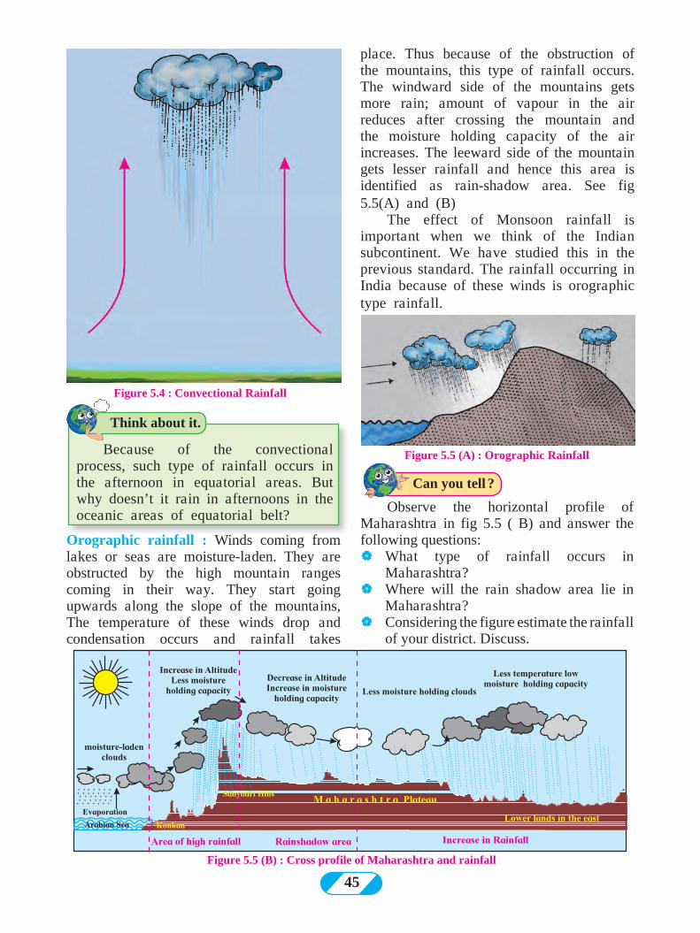
Convectional rainfall : In equatorial areas, the surface gets heated because of the sun’s heat and the air near it also gets heated. As it gets heated, it spreads and becomes lighter and moves upwards. The air cools down when it goes upward. The moisture-holding capacity of cold air is less. Consequently, condensation of the water
vapor occurs and rainfall occurs. In equatorial areas, such a type of rainfall occurs almost daily in the afternoons. Rainfall is accompanied by lightning and thunder. The Congo basin of the Africa and the Amazon basin in the S. America experience convectional rainfall. Such a rainfall occurs in a very limited area in the world.
45
Figure 5.4 : Convectional Rainfall
Figure 5.5 (B) : Cross profile of Maharashtra and rainfall
Orographic rainfall : Winds coming from lakes or seas are moisture-laden. They are obstructed by the high mountain ranges coming in their way. They start going upwards along the slope of the mountains, The temperature of these winds drop and condensation occurs and rainfall takes
Observe the horizontal profile of Maharashtra in fig 5.5 ( B) and answer the following questions: |What type of rainfall occurs in
Maharashtra? |Where will the rain shadow area lie in
Maharashtra? |Considering the figure estimate the rainfall
of your district. Discuss.
Figure 5.5 (A) : Orographic Rainfall
place. Thus because of the obstruction of the mountains, this type of rainfall occurs. The windward side of the mountains gets more rain; amount of vapour in the air reduces after crossing the mountain and the moisture holding capacity of the air increases. The leeward side of the mountain gets lesser rainfall and hence this area is identified as rain-shadow area. See fig 5.5(A) and (B)
The effect of Monsoon rainfall is important when we think of the Indian subcontinent. We have studied this in the previous standard. The rainfall occurring in India because of these winds is orographic type rainfall.
Can you tell ?
Think about it.
Because of the convectional process, such type of rainfall occurs in the afternoon in equatorial areas. But why doesn’t it rain in afternoons in the oceanic areas of equatorial belt?
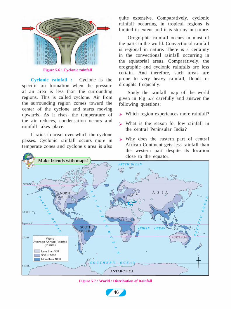
46
Figure 5.7 : World : Distribution of Rainfall
quite extensive. Comparatively, cyclonic rainfall occurring in tropical regions is limited in extent and it is stormy in nature.
Orographic rainfall occurs in most of the parts in the world. Convectional rainfall is regional in nature. There is a certainty in the convectional rainfall occurring in the equatorial areas. Comparatively, the orographic and cyclonic rainfalls are less certain. And therefore, such areas are prone to very heavy rainfall, floods or droughts frequently.
Study the rainfall map of the world given in Fig 5.7 carefully and answer the following questions:
Ø Which region experiences more rainfall?
Ø What is the reason for low rainfall in the central Peninsular India?
Ø Why does the eastern part of central African Continent gets less rainfall than the western part despite its location close to the equator.
Cyclonic rainfall : Cyclone is the specific air formation when the pressure at an area is less than the surrounding regions. This is called cyclone. Air from the surrounding region comes toward the center of the cyclone and starts moving upwards. As it rises, the temperature of the air reduces, condensation occurs and rainfall takes place.
It rains in areas over which the cyclone passes. Cyclonic rainfall occurs more in temperate zones and cyclone’s area is also
Figure 5.6 : Cyclonic rainfall
Make friends with maps !
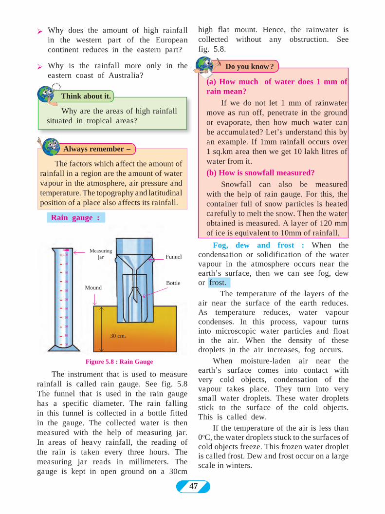
47
high flat mount. Hence, the rainwater is collected without any obstruction. See fig. 5.8.
Figure 5.8 : Rain Gauge
Rain gauge :
Funnel
Bottle
30 cm.
Measuring jar
Mound
100
90
80
70
60
50
40
30
20
10
00
mm
Ø Why does the amount of high rainfall in the western part of the European continent reduces in the eastern part?
Ø Why is the rainfall more only in the eastern coast of Australia?
The instrument that is used to measure rainfall is called rain gauge. See fig. 5.8 The funnel that is used in the rain gauge has a specific diameter. The rain falling in this funnel is collected in a bottle fitted in the gauge. The collected water is then measured with the help of measuring jar. In areas of heavy rainfall, the reading of the rain is taken every three hours. The measuring jar reads in millimeters. The gauge is kept in open ground on a 30cm
Think about it.
Always remember -
Do you know ?
Why are the areas of high rainfall situated in tropical areas?
The factors which affect the amount of rainfall in a region are the amount of water vapour in the atmosphere, air pressure and temperature. The topography and latitudinal position of a place also affects its rainfall.
(a) How much of water does 1 mm of rain mean?
If we do not let 1 mm of rainwater move as run off, penetrate in the ground or evaporate, then how much water can be accumulated? Let’s understand this by an example. If 1mm rainfall occurs over 1 sq.km area then we get 10 lakh litres of water from it.
(b) How is snowfall measured?
Snowfall can also be measured with the help of rain gauge. For this, the container full of snow particles is heated carefully to melt the snow. Then the water obtained is measured. A layer of 120 mm of ice is equivalent to 10mm of rainfall.
Fog, dew and frost : When the condensation or solidification of the water vapour in the atmosphere occurs near the earth’s surface, then we can see fog, dew or frost.
The temperature of the layers of the air near the surface of the earth reduces. As temperature reduces, water vapour condenses. In this process, vapour turns into microscopic water particles and float in the air. When the density of these droplets in the air increases, fog occurs.
When moisture-laden air near the earth’s surface comes into contact with very cold objects, condensation of the vapour takes place. They turn into very small water droplets. These water droplets stick to the surface of the cold objects. This is called dew.
If the temperature of the air is less than 0oC, the water droplets stuck to the surfaces of cold objects freeze. This frozen water droplet is called frost. Dew and frost occur on a large scale in winters.
48
Q1 Identify the precipitation type with the help of the description given:
(a) It is the main source of the water that you use. Sometimes it is torrential and sometimes continuous. Most of the agriculture in India is dependent on it.
(b) It seems as if water droplets are floating in the atmosphere. In London, one cannot see the Sun till the afternoon during winters because of this phenomenon.
(c) It never precipitates like this in equatorial areas. Precipitation in the solid form sometimes causes damage to the crops.
may take place in such conditions. Trains, flights and other transport services may have to be cancelled. Frost is harmful to crops and causes accident if spread on the road. Fog and dew damage some crops by spreading diseases while it may be beneficial to some crops.
Acid rain : Because of air pollution in industrial areas, various gases get mixed in the air. Different acids are created when the water vapour in the air reacts chemically with these gases. Such as nitric acid, sulphuric acid, etc.
Precipitation of water with dissolved acids reach the ground. Such rainfall is called ‘acid rain’. These rain are harmful to living organisms as well as the non-living objects
Effects of precipitation : The main source of potable water available on the earth is precipitation. As excessive rainfall is destructive so is the absence of rain. Floods may occur because of heavy rainfall causing loss of life and property. If precipitation does not take place, then conditions of drought arise. There is a shortfall of food and food may have to be imported. Farmers’ condition becomes grave. A country’s economy gets affected.
Economy of an agrarian country like India is dependent on agriculture. Agriculture in India to a large extent is dependent on the Monsoons. Hence, the rainfall in India is important to the whole country. A good rainfall at the right time increases crop production while untimely rain can cause damage to the crops. The rainfall in India is quite erratic.
Visibility reduces because of highly dense fog. It affects the means of trasportation like roads, railways, waterways and the airways. Accidents
(d) A white cotton like layer spreads on the earth’s surface. Because of this form of precipitation, the State of Jammu and Kashmir has to change its capital in winters. In Maharashtra, it does not precipitate like this.
Q2 Look at the following pictures and identify the correct rainfall type.
Figure (A)
Give it a try.
Obtain information regarding ill-effects of acid rain.
Exercise
49
Figure (C)
Figure (B)
Q 3. Look at the figures above and answer the following questions:
(1) In fig B, on which side of the mountain
is it raining more?
(2) Shade the rain shadow region in fig B and name it.
(3) What is the difference between A and C?
(4) Stormy winds and floods are associated with which rainfall type?
(5) What type of rainfall occurs in Singapore?
Q 4. Identify the odd man out :
(1) Orographic rainfall, acid rain, cyclonic rainfall, convectional rainfall
(2) Snowfall, rainfall, hailstones, dew
(3) Thermometer, rain gauge, anemometer, measuring jar
Q 5. Answer in brief:
(1) In what ways does precipitation occur on the earth?
(2) Comment on the rainfall occuring in the rain shadow area.
(3) Which type of rainfall occurs in most of the world? Why?
(4) If condensation occurs closer to the earth’s surface, what types of forms become visible?
(5) What precautions should be taken while measuring rainfall?
Q 6. Distinguish between -
(1) Dew and frost
(2) Snow and hail
Activity :
Using the rain gauge in your school, measure the rainfall continuously for one week occurring in your surroundings. Make a bar graph using computers to show the amount of rainfall on the basis of the data obtained.
***
DeeJelee&Ûee ceeie&
Photograph of wettest place on earth with rain gauge
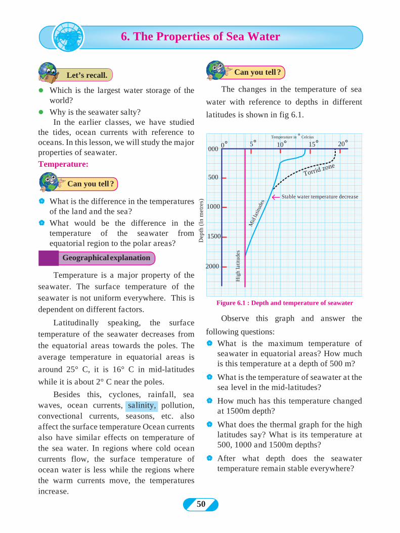
50
l Which is the largest water storage of the world?
l Why is the seawater salty? In the earlier classes, we have studied
the tides, ocean currents with reference to oceans. In this lesson, we will study the major properties of seawater.
Temperature:
| What is the difference in the temperatures of the land and the sea?
| What would be the difference in the temperature of the seawater from equatorial region to the polar areas?
The changes in the temperature of sea
water with reference to depths in different
latitudes is shown in fig 6.1.
Observe this graph and answer the
following questions:
| What is the maximum temperature of seawater in equatorial areas? How much is this temperature at a depth of 500 m?
| What is the temperature of seawater at the sea level in the mid-latitudes?
| How much has this temperature changed at 1500m depth?
| What does the thermal graph for the high latitudes say? What is its temperature at 500, 1000 and 1500m depths?
| After what depth does the seawater temperature remain stable everywhere?
Figure 6.1 : Depth and temperature of seawater
Temperature in ° Celcius
Mid
latit
udes
Hig
h la
titu
des
Stable water temperature decrease
Torrid zone
Dep
th (
In m
etre
s)
5°0°
500
000
1000
1500
2000
10° 15° 20°
6. The Properties of Sea Water
Geographical explanation
Can you tell ?
Can you tell ?
Temperature is a major property of the seawater. The surface temperature of the seawater is not uniform everywhere. This is dependent on different factors.
Latitudinally speaking, the surface temperature of the seawater decreases from the equatorial areas towards the poles. The average temperature in equatorial areas is
around 25° C, it is 16° C in mid-latitudes
while it is about 2° C near the poles.
Besides this, cyclones, rainfall, sea waves, ocean currents, salinity, pollution, convectional currents, seasons, etc. also affect the surface temperature Ocean currents also have similar effects on temperature of the sea water. In regions where cold ocean currents flow, the surface temperature of ocean water is less while the regions where the warm currents move, the temperatures increase.
Let’s recall.
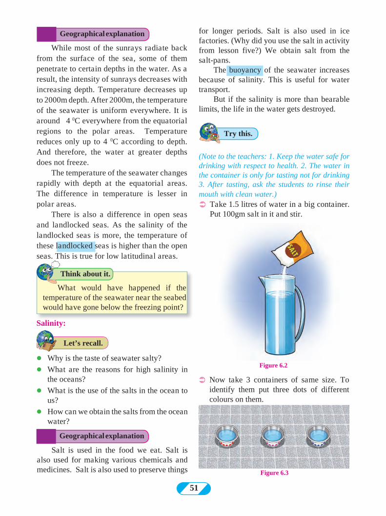
51
Figure 6.2l Why is the taste of seawater salty?
l What are the reasons for high salinity in the oceans?
l What is the use of the salts in the ocean to us?
l How can we obtain the salts from the ocean water?
Salinity:
(Note to the teachers: 1. Keep the water safe for drinking with respect to health. 2. The water in the container is only for tasting not for drinking 3. After tasting, ask the students to rinse their mouth with clean water.) ÜTake 1.5 litres of water in a big container.
Put 100gm salt in it and stir.
Salt is used in the food we eat. Salt is also used for making various chemicals and medicines. Salt is also used to preserve things
ÜNow take 3 containers of same size. To identify them put three dots of different colours on them.
Figure 6.3
What would have happened if the temperature of the seawater near the seabed would have gone below the freezing point?
Geographical explanation
Geographical explanation
Try this.
Think about it.
While most of the sunrays radiate back from the surface of the sea, some of them penetrate to certain depths in the water. As a result, the intensity of sunrays decreases with increasing depth. Temperature decreases up to 2000m depth. After 2000m, the temperature of the seawater is uniform everywhere. It is around 4 0C everywhere from the equatorial regions to the polar areas. Temperature reduces only up to 4 0C according to depth. And therefore, the water at greater depths does not freeze.
The temperature of the seawater changes rapidly with depth at the equatorial areas. The difference in temperature is lesser in polar areas.
There is also a difference in open seas and landlocked seas. As the salinity of the landlocked seas is more, the temperature of these landlocked seas is higher than the open seas. This is true for low latitudinal areas.
for longer periods. Salt is also used in ice factories. (Why did you use the salt in activity from lesson five?) We obtain salt from the salt-pans.
The buoyancy of the seawater increases because of salinity. This is useful for water transport.
But if the salinity is more than bearable limits, the life in the water gets destroyed.
Let’s recall.
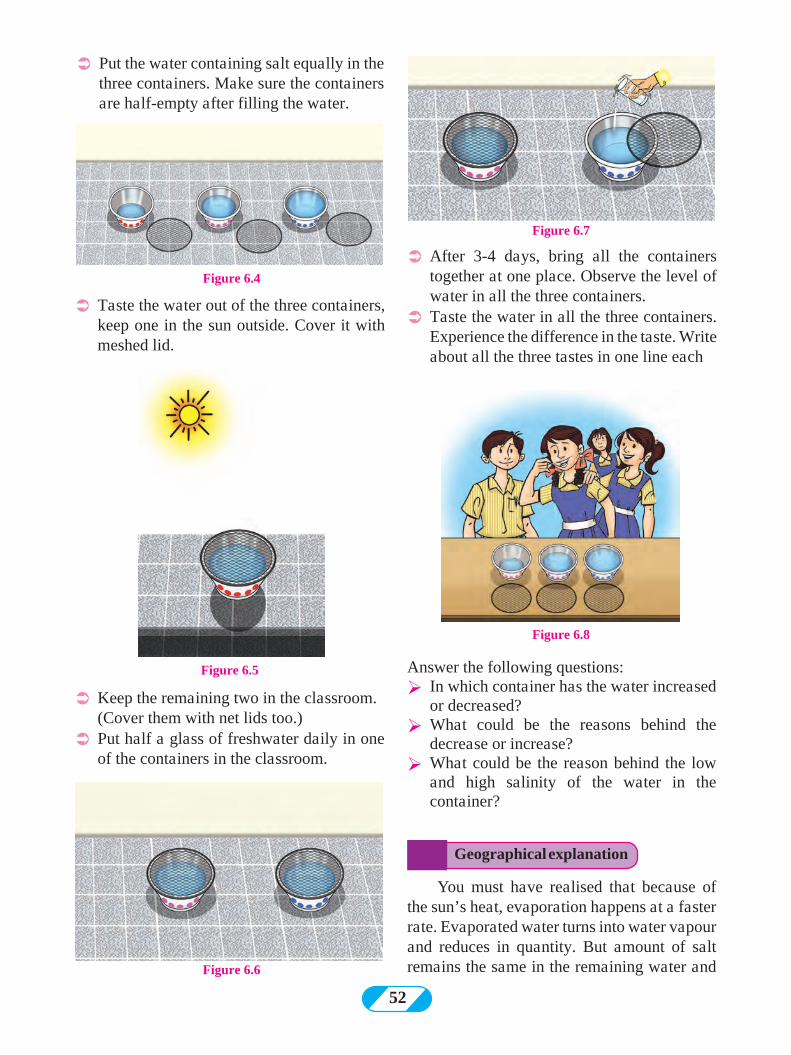
52
Figure 6.4
Figure 6.5
Figure 6.6
Figure 6.7
Figure 6.8
ÜPut the water containing salt equally in the three containers. Make sure the containers are half-empty after filling the water.
ÜTaste the water out of the three containers, keep one in the sun outside. Cover it with meshed lid.
ÜKeep the remaining two in the classroom. (Cover them with net lids too.) ÜPut half a glass of freshwater daily in one
of the containers in the classroom.
ÜAfter 3-4 days, bring all the containers together at one place. Observe the level of water in all the three containers.
ÜTaste the water in all the three containers. Experience the difference in the taste. Write about all the three tastes in one line each
Answer the following questions:Ø In which container has the water increased
or decreased? Ø What could be the reasons behind the
decrease or increase?Ø What could be the reason behind the low
and high salinity of the water in the container?
You must have realised that because of the sun’s heat, evaporation happens at a faster rate. Evaporated water turns into water vapour and reduces in quantity. But amount of salt remains the same in the remaining water and
Geographical explanation
53
therefore the salinity of the water increases. vIn seas where the rate of evaporation is high
than the supply of freshwater salinity is high.
vIn seas where the supply of freshwater exceeds the rate of evaporation, salinity is low.
vSalinity is not affected much in seas where both the supply of freshwater and evaporation of water is low.
See fig. 6.9. Observe the map and answer
the following questions:
Ø What is the salinity around the tropics?
Ø Which region has the least salinity?
Ø Which ocean has salinity more than 37‰?
Ø What are the reasons of differences in salinity on a global level? Discuss in the class.
Figure 6.9 : Salinity of the sea water
How is the salinity of the seawater measured?
The weight of all dissolved salts in water in ratio of parts per thousand of water is called the salinity of seawater. For example, if the weight of dissolved salts in 1000g ( 1 kg) of seawater is 40g, then the salinity is 40‰ i.e. 40 per thousand parts. Hydrometer, refractometer and salinometer are also used to measure salinity.Think about it.
Always remember -
Make friends with maps !
If we collect all the salts in the ocean, its weight will be 120 million tonnes. If we spread it on the earth, it will form a 150m thick layer (almost equivalent to a 40-storeyed building). From where have these salts come in the sea?
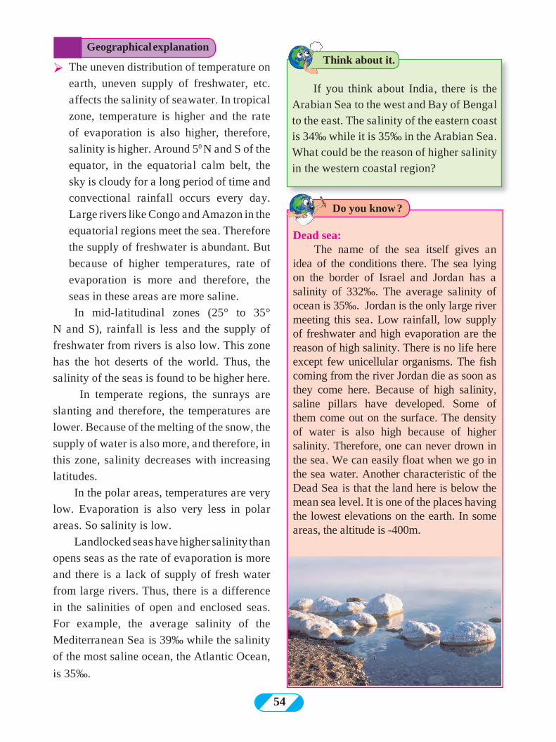
54
Ø The uneven distribution of temperature on
earth, uneven supply of freshwater, etc.
affects the salinity of seawater. In tropical
zone, temperature is higher and the rate
of evaporation is also higher, therefore,
salinity is higher. Around 50 N and S of the
equator, in the equatorial calm belt, the
sky is cloudy for a long period of time and
convectional rainfall occurs every day.
Large rivers like Congo and Amazon in the
equatorial regions meet the sea. Therefore
the supply of freshwater is abundant. But
because of higher temperatures, rate of
evaporation is more and therefore, the
seas in these areas are more saline.
In mid-latitudinal zones (25° to 35°
N and S), rainfall is less and the supply of
freshwater from rivers is also low. This zone
has the hot deserts of the world. Thus, the
salinity of the seas is found to be higher here.
In temperate regions, the sunrays are
slanting and therefore, the temperatures are
lower. Because of the melting of the snow, the
supply of water is also more, and therefore, in
this zone, salinity decreases with increasing
latitudes.
In the polar areas, temperatures are very
low. Evaporation is also very less in polar
areas. So salinity is low.
Landlocked seas have higher salinity than
opens seas as the rate of evaporation is more
and there is a lack of supply of fresh water
from large rivers. Thus, there is a difference
in the salinities of open and enclosed seas.
For example, the average salinity of the
Mediterranean Sea is 39‰ while the salinity
of the most saline ocean, the Atlantic Ocean,
is 35‰.
If you think about India, there is the Arabian Sea to the west and Bay of Bengal to the east. The salinity of the eastern coast is 34‰ while it is 35‰ in the Arabian Sea. What could be the reason of higher salinity in the western coastal region?
Dead sea: The name of the sea itself gives an
idea of the conditions there. The sea lying on the border of Israel and Jordan has a salinity of 332‰. The average salinity of ocean is 35‰. Jordan is the only large river meeting this sea. Low rainfall, low supply of freshwater and high evaporation are the reason of high salinity. There is no life here except few unicellular organisms. The fish coming from the river Jordan die as soon as they come here. Because of high salinity, saline pillars have developed. Some of them come out on the surface. The density of water is also high because of higher salinity. Therefore, one can never drown in the sea. We can easily float when we go in the sea water. Another characteristic of the Dead Sea is that the land here is below the mean sea level. It is one of the places having the lowest elevations on the earth. In some areas, the altitude is -400m.
Geographical explanationThink about it.
Do you know ?
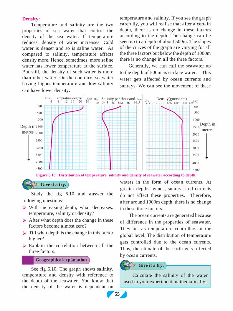
55
Density:Temperature and salinity are the two
properties of sea water that control the density of the sea water. If temperature reduces, density of water increases. Cold water is denser and so is saline water. As compared to salinity, temperature affects density more. Hence, sometimes, more saline water has lower temperature at the surface. But still, the density of such water is more than other water. On the contrary, seawater having higher temperature and low salinity
can have lower density.
temperature and salinity. If you see the graph carefully, you will realise that after a certain depth, there is no change in these factors according to the depth. The change can be seen up to a depth of about 500m. The slopes of the curves of the graph are varying for all the three factors but below the depth of 1000m there is no change in all the three factors.
Generally, we can call the seawater up to the depth of 500m as surface water. This water gets affected by ocean currents and sunrays. We can see the movement of these
Study the fig 6.10 and answer the
following questions:
Ø With increasing depth, what decreases: temperature, salinity or density?
Ø After what depth does the change in these factors become almost zero?
Ø Till what depth is the change in this factor higher?
Ø Explain the correlation between all the three factors.
Figure 6.10 : Distribution of temperature, salinity and density of seawater according to depth.
Temprature degree °
Depth in metres
4Low Low Low
High HighHigh35.5 363534 34.5 1.023 1.024 1.025 1.026 1.027 1.028 1.02936.58 12
500 500
1000 1000
1500 1500
2000 2000
2500 2500
3000 3000
3500 3500
4000 40004500 4500
16 20 24Density(gm/cu.cm)Salinity per thousand
000 000
waters in the form of ocean currents. At greater depths, winds, sunrays and currents do not affect these properties. Therefore, after around 1000m depth, there is no change in these three factors.
The ocean currents are generated because of difference in the properties of seawater. They act as temperature controllers at the global level. The distribution of temperature gets controlled due to the ocean currents. Thus, the climate of the earth gets affected by ocean currents.
Geographical explanation
Give it a try.
Depth in metres
See fig 6.10. The graph shows salinity, temperature and density with reference to the depth of the seawater. You know that the density of the water is dependent on
Give it a try.
Calculate the salinity of the water used in your experiment mathematically.
56
Q1. Tick the correct box according to the salinity of the ocean water P
(a) Slanting sunrays, melting snow
(b) Cloudy sky, rainfall throughout the year
(c) Clear skies for the most part, perpendicular sunrays
(d) Less supply of freshwater, desert area around
(e) Low temperatures, ample supply of river water
(f) Continental location, desert around, low rainfall
High Medium Low
Salinity
Q2. Give reasons. (a) Salinity is low in the land-locked
Baltic Sea. (b) There is higher salinity in the northern
Red Sea while lower in the southern. (c) Oceans located at the same latitude
do not have same salinity. (d) With increasing depth, the temperature
of sea water decreases to a certain limit.
(e) There are more salt-pans on the Western coast of India than its eastern coast.
(f) Salinity increases in the mid- latitudinal zones.
Q3. Answer the following questions. (a) What are the factors affecting the
salinity of the sea water? (b) Explain the distribution of salinity
around the Tropic of Cancer and tropic of Capricorn.
(c) What are the factors affecting the temperature of the sea water?
(d) Explain the changes occurring in the temperature of sea water according to the depth.
(e) Name the factors affecting salinity.
Q4. Explain how temperature affects the following.
(a) the density of sea water
(b) the salinity of sea water Activity:
Complete the table showing the salinity of open and land-locked seas.
Evaporation of water Supply of freshwater
Region Latitude Solar Energy Rainfall River water Snow water Average salinity
Equatorial
Tropical
Temperate
Polar
0° to 15°
15° to 35°
35° to 65°
65° to 90°
High --------Low
--------
Perennial Seasonal
----------------
High ----------------
low
---------------
ample
34‰37‰33‰31‰
Landlocked Sea Solar Energy Rainfall River water Snow water Average salinity
Mediterranean Sea
Red Sea
Baltic Sea
Dead Sea
Caspian Sea
Great Salt lake
High
-------
low
-------
-------
medium
low
------
------
Very less
------
------
low
---------
Medium
Very less
-------
-------
-------
-------
-------
-------
-------
-------
39‰
41‰
7‰
332‰
155‰
220‰
***
Exercise
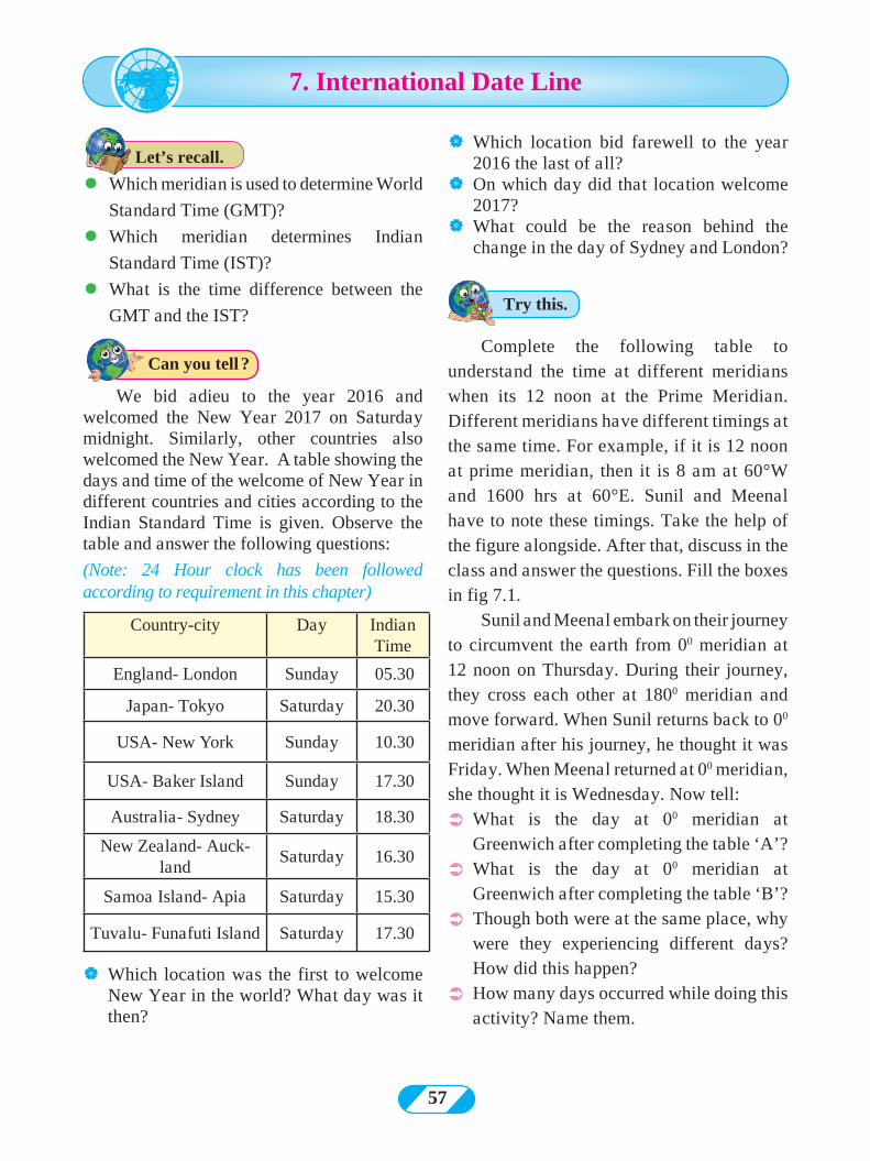
57
l Which meridian is used to determine World
Standard Time (GMT)?
l Which meridian determines Indian
Standard Time (IST)?
l What is the time difference between the
GMT and the IST?
| Which location bid farewell to the year 2016 the last of all?
| On which day did that location welcome 2017?
| What could be the reason behind the change in the day of Sydney and London?
We bid adieu to the year 2016 and welcomed the New Year 2017 on Saturday midnight. Similarly, other countries also welcomed the New Year. A table showing the days and time of the welcome of New Year in different countries and cities according to the Indian Standard Time is given. Observe the table and answer the following questions:
(Note: 24 Hour clock has been followed according to requirement in this chapter)
Country-city Day Indian Time
England- London Sunday 05.30
Japan- Tokyo Saturday 20.30
USA- New York Sunday 10.30
USA- Baker Island Sunday 17.30
Australia- Sydney Saturday 18.30
New Zealand- Auck-land
Saturday 16.30
Samoa Island- Apia Saturday 15.30
Tuvalu- Funafuti Island Saturday 17.30
| Which location was the first to welcome New Year in the world? What day was it then?
Complete the following table to understand the time at different meridians when its 12 noon at the Prime Meridian. Different meridians have different timings at the same time. For example, if it is 12 noon at prime meridian, then it is 8 am at 60°W and 1600 hrs at 60°E. Sunil and Meenal have to note these timings. Take the help of the figure alongside. After that, discuss in the class and answer the questions. Fill the boxes in fig 7.1.
Sunil and Meenal embark on their journey to circumvent the earth from 00 meridian at 12 noon on Thursday. During their journey, they cross each other at 1800 meridian and move forward. When Sunil returns back to 00 meridian after his journey, he thought it was Friday. When Meenal returned at 00 meridian, she thought it is Wednesday. Now tell:
Ü What is the day at 00 meridian at Greenwich after completing the table ‘A’?
Ü What is the day at 00 meridian at Greenwich after completing the table ‘B’?
Ü Though both were at the same place, why were they experiencing different days? How did this happen?
Ü How many days occurred while doing this activity? Name them.
7. International Date Line
Try this.
Can you tell ?
Let’s recall.
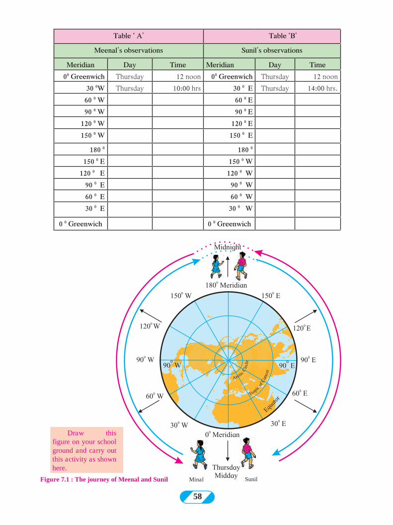
58
Figure 7.1 : The journey of Meenal and Sunil Minal Sunil
Table ‘ A’ Table ‘B’
Meenal’s observations Sunil’s observations
Meridian Day Time Meridian Day Time00 Greenwich Thursday 12 noon 00 Greenwich Thursday 12 noon
30 0W Thursday 10:00 hrs 30 0 E Thursday 14:00 hrs. 60 0 W 60 0 E90 0 W 90 0 E
120 0 W 120 0 E150 0 W 150 0 E
180 0 180 0
150 0 E 150 0 W120 0 E 120 0 W
90 0 E 90 0 W60 0 E 60 0 W 30 0 E 30 0 W
0 0 Greenwich 0 0 Greenwich
Draw this figure on your school ground and carry out this activity as shown here.
59
00 meridian, then according to her it should be Wednesday afternoon.
There is a debate between Meenal and Sunil when they meet after their respective journeys. According to Meenal, it should be Wednesday and according to Sunil, it should be Friday. Then where does Thursday go? The following method was used to come to a solution.
Solution to the confusion of days:
When you cross the 1800 meridian, some precautions need to be taken. Meridian of 1800
is reached after 12 hours from Prime Meridian, if you go from east or west. Accordingly, an adjustment or change in day and time is made. According to the convention, the start (and end) of a date is considered to be at 1800 meridian. Therefore, the following points were taken into consideration while drawing the International Date Line. (IDL)
(1) The direction of travel
(2) The current day and date
While travelling from Japan to America, we need to consider the existing day and date even after crossing the IDL. For example, if it is Thursday 25th December, then Thursday 25th December only should be considered.
On the contrary, while going from America to Japan, and crossing the IDL, one needs to add a day to the date. So if it is Thursday, 25th December then it will be Friday, 26th December. It will be clear from the following example and fig 7.2
l Shyamrao left for America (which lies to the east of the IDL) from Japan (from the west of the IDL) on 1st at 1 pm on Monday. After travelling for 24 hours in a flight, he reached America and saw the date there. It was Monday 1st, 1 pm in the afternoon.
l Shyamrao left for Japan (to the West of IDL) from America (from the East of IDL) on Friday 5th at 12 noon. He reached Japan after 24 hours flight and the date was Saturday 6th
12 noon.
Earth’s rotation, revolution, the sunrise, the sunset are natural phenomena. Man has studied the rotation speed, direction and shape of the earth and prepared the chronometric (time-keeping) systems for his own purpose. Considering the shape of the earth, he defined graticule on the earth. He coordinated between the time of the earth’s rotation and the meridians of the graticule.The earth takes 24 hours to make one rotation. (Earth takes 24 hours to make a round of 3600 around itself).
Earth rotates from west to east. Therefore, in terms of time the eastern part of the earth is ahead of the western part. Keeping this in mind, let’s think about Sunil’s journey. Sunil is moving towards the east. Therefore, the time will move ahead at different meridians. For example, at 900 E meridian, it will be Thursday 6 pm. Sunil moves eastwards and according to him, it will be Thursday midnight 12 at 1800 meridian. According to him, as he continues, it will be Friday after he crosses the 1800 meridian. At 900 W, it will be Friday 6 a.m. and therefore after the full round of the earth when Sunil meets Meenal at 00 meridian, it will be Friday afternoon 12 pm.
Now consider Meenal’s journey. As she moves westwards, she will see that time is moving backward. For example, at 300 W, it will be 10.00 hrs in the morning on Thursday, while it will be 8 am on Thursday at 600 W, and it will be 12 midnight at 1800 meridian. If Meenal continues ahead, then it will Wednesday 6 pm at 900 E. When she will complete her full journey and return back to
F Which day is correct: Wednesday in
Table ‘A’ or Friday in Table ‘B’? Why?
Geographical explanation
Think about it.
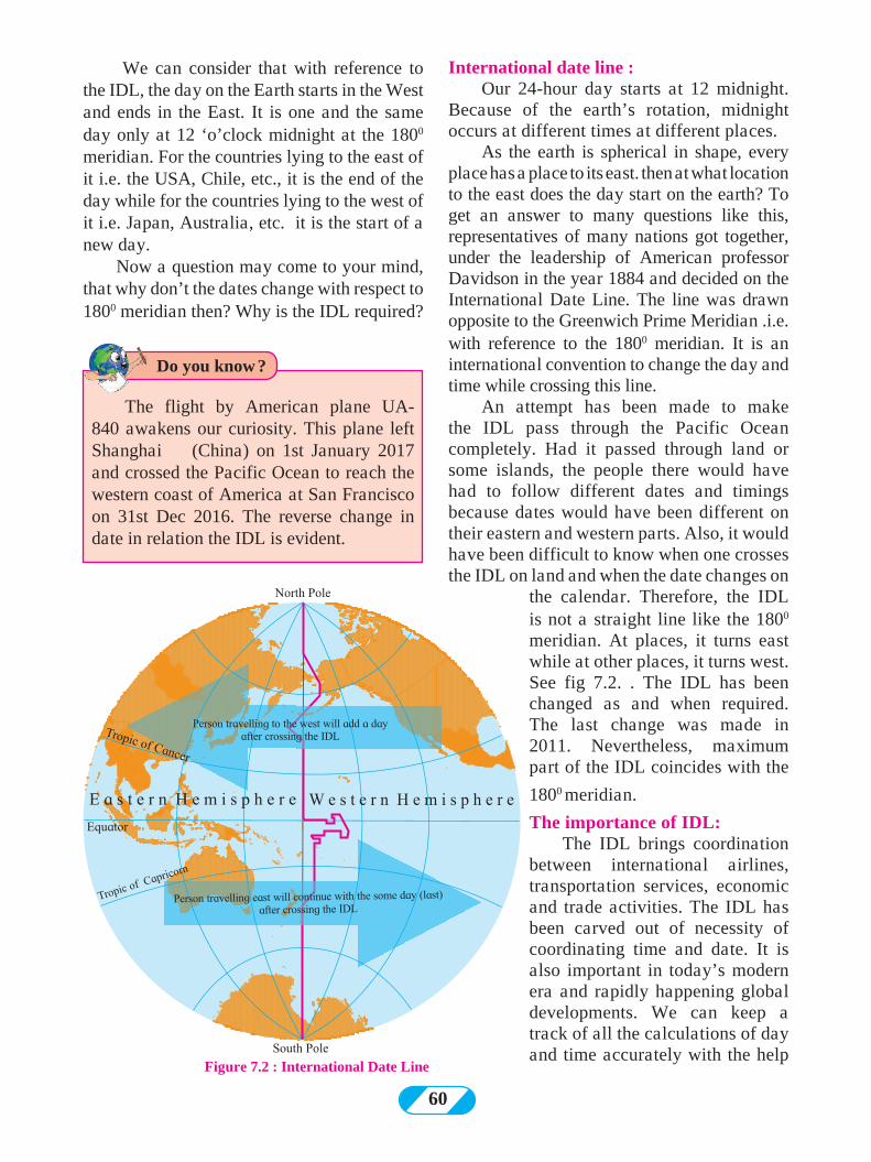
60
We can consider that with reference to the IDL, the day on the Earth starts in the West and ends in the East. It is one and the same day only at 12 ‘o’clock midnight at the 1800 meridian. For the countries lying to the east of it i.e. the USA, Chile, etc., it is the end of the day while for the countries lying to the west of it i.e. Japan, Australia, etc. it is the start of a new day.
Now a question may come to your mind, that why don’t the dates change with respect to 1800 meridian then? Why is the IDL required?
International date line : Our 24-hour day starts at 12 midnight.
Because of the earth’s rotation, midnight occurs at different times at different places.
As the earth is spherical in shape, every place has a place to its east. then at what location to the east does the day start on the earth? To get an answer to many questions like this, representatives of many nations got together, under the leadership of American professor Davidson in the year 1884 and decided on the International Date Line. The line was drawn opposite to the Greenwich Prime Meridian .i.e. with reference to the 1800 meridian. It is an international convention to change the day and time while crossing this line.
An attempt has been made to make the IDL pass through the Pacific Ocean completely. Had it passed through land or some islands, the people there would have had to follow different dates and timings because dates would have been different on their eastern and western parts. Also, it would have been difficult to know when one crosses the IDL on land and when the date changes on
the calendar. Therefore, the IDL is not a straight line like the 1800 meridian. At places, it turns east while at other places, it turns west. See fig 7.2. . The IDL has been changed as and when required. The last change was made in 2011. Nevertheless, maximum part of the IDL coincides with the
1800 meridian.
The importance of IDL:The IDL brings coordination
between international airlines, transportation services, economic and trade activities. The IDL has been carved out of necessity of coordinating time and date. It is also important in today’s modern era and rapidly happening global developments. We can keep a track of all the calculations of day and time accurately with the help
Figure 7.2 : International Date Line
The flight by American plane UA-840 awakens our curiosity. This plane left Shanghai (China) on 1st January 2017 and crossed the Pacific Ocean to reach the western coast of America at San Francisco on 31st Dec 2016. The reverse change in date in relation the IDL is evident.
Do you know ?
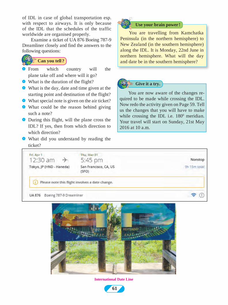
61
of IDL in case of global transportation esp. with respect to airways. It is only because of the IDL that the schedules of the traffic worldwide are organised properly.
Examine a ticket of UA 876 Boeing 787-9 Dreamliner closely and find the answers to the following questions:
| From which country will the plane take off and where will it go?
| What is the duration of the flight?| What is the day, date and time given at the
starting point and destination of the flight?| What special note is given on the air ticket?| What could be the reason behind giving
such a note?| During this flight, will the plane cross the
IDL? If yes, then from which direction to which direction?
| What did you understand by reading the ticket?
You are travelling from Kamchatka Peninsula (in the northern hemisphere) to New Zealand (in the southern hemisphere) along the IDL. It is Monday, 22nd June in northern hemisphere. What will the day and date be in the southern hemisphere?
You are now aware of the changes re-quired to be made while crossing the IDL. Now redo the activity given on Page 59. Tell us the changes that you will have to make while crossing the IDL i.e. 1800 meridian. Your travel will start on Sunday, 21st May 2016 at 10 a.m.
International Date Line
Give it a try.
Use your brain power !
Can you tell ?
62
Q 3. Give geographical reasons
(1) IDL is proving to be very useful in today’s times
(2) The day starts in Pacific Ocean on the earth
Q 4. Write in brief:
(1) What considerations have been made while deciding the IDL?
(2) While crossing the IDL, what changes will you make?
(3) Why is the IDL not a straight line like the 1800 meridian?
(4) Why doesn’t the IDL pass through land?
(5) Why is the IDL considered with respect to the 1800 meridian only?
Q 5. Using an atlas, tell in which of the following routes the IDL will be crossed and show them on the map.
(1) Mumbai- London- New York- Los Angeles- Tokyo
(2) Delhi- Kolkata- Singapore- Melbourne
(3) Kolkata- Hong Kong- Tokyo- San Francisco
(4) Chennai-Singapore- Tokyo- Sydney- Santiago
(5) Delhi-London-New York
***
Q 2. Select the correct option :
(1) While crossing the IDL, a person will have to add one day when travelling from
(a) East to West
(b) West to East
(c) South to North
(d) North to South
(2) If it is Wednesday 10 a.m. at 150 E meridian, then what will be the time at IDL?
(a) Wednesday 6 a.m.
(b) Wednesday 9 p.m.
(c) Thursday 2 p.m.
(d) Thursday 6 p.m.
(3) According to the international convention, at which meridian does the day and date change occurs?
(a) 00 (b) 900 E
(c) 900 W (d) 1800
(4) At which direction of the IDL does a new day start immediately?
(a) East (b) West
(c) North (d) South
(5) IDL brings coordination in which of the following?
(a) GPS system
(b) Defence departments
(c) Transportation schedules
(d) Determining the hemisphere
Q 1. Two boxes in different hemispheres are given in the following diagram. The IDL passes through both the boxes. In one box,
(A) 1500 W Meridian, 1500 E Meridian Monday, 15th August
(B) 800 W Meridian 1700 E Meridian Sunday 25 December
the meridian, day and date is given. Find the day and date for the other box.
IDL
Exercise
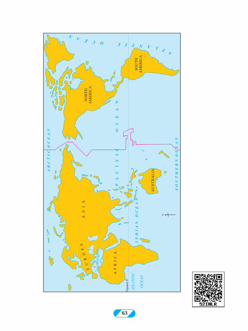
63
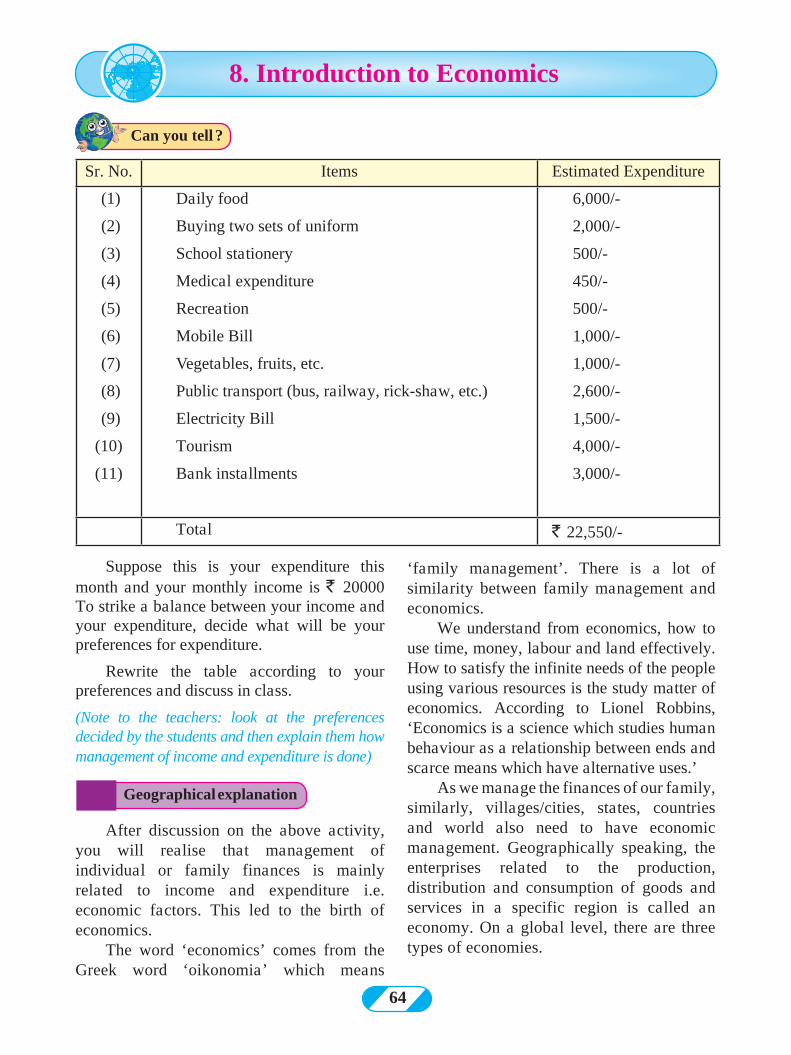
64
8. Introduction to Economics
Suppose this is your expenditure this month and your monthly income is ` 20000 To strike a balance between your income and your expenditure, decide what will be your preferences for expenditure.
Rewrite the table according to your preferences and discuss in class.
(Note to the teachers: look at the preferences decided by the students and then explain them how management of income and expenditure is done)
‘family management’. There is a lot of similarity between family management and economics.
We understand from economics, how to use time, money, labour and land effectively. How to satisfy the infinite needs of the people using various resources is the study matter of economics. According to Lionel Robbins, ‘Economics is a science which studies human behaviour as a relationship between ends and scarce means which have alternative uses.’
As we manage the finances of our family, similarly, villages/cities, states, countries and world also need to have economic management. Geographically speaking, the enterprises related to the production, distribution and consumption of goods and services in a specific region is called an economy. On a global level, there are three types of economies.
After discussion on the above activity, you will realise that management of individual or family finances is mainly related to income and expenditure i.e. economic factors. This led to the birth of economics.
The word ‘economics’ comes from the Greek word ‘oikonomia’ which means
Sr. No. Items Estimated Expenditure
(1)
(2)
(3)
(4)
(5)
(6)
(7)
(8)
(9)
(10)
(11)
Daily food
Buying two sets of uniform
School stationery
Medical expenditure
Recreation
Mobile Bill
Vegetables, fruits, etc.
Public transport (bus, railway, rick-shaw, etc.)
Electricity Bill
Tourism
Bank installments
6,000/-
2,000/-
500/-
450/-
500/-
1,000/-
1,000/-
2,600/-
1,500/-
4,000/-
3,000/-
Total ` 22,550/-
Geographical explanation
Can you tell ?
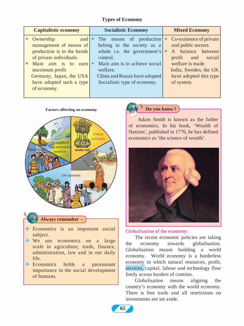
65
TYPES OF ECONOMIES.Capitalistic economy Socialistic Economy Mixed Economy
� Ownership and management of means of production is in the hands of private individuals.
� Main aim is to earn maximum profit
Germany, Japan, the USA have adopted such a type of economy.
� The means of production belong to the society as a whole i.e. the government’s control.
� Main aim is to achieve social welfare.
China and Russia have adopted Socialistic type of economy.
� Co-existence of private and public sectors
� A balance between profit and social welfare is made
India, Sweden, the UK have adopted this type of system.
Factors affecting an economy
Geographical Area and natural
resources
Political sovereignty
Population
Occupations
Adam Smith is known as the father of economics. In his book, ‘Wealth of Nations’, published in 1776, he has defined economics as ‘the science of wealth’.
vEconomics is an important social subject.
vWe use economics on a large scale in agriculture, trade, finance, administration, law and in our daily life.
vEconomics holds a paramount importance in the social development of humans.
Always remember -
Do you know ?
Globalisation of the economy:The recent economic policies are taking
the economy towards globalisation. Globalisation means building a world economy. World economy is a borderless economy in which natural resources, profit, services, capital, labour and technology flow freely across borders of contries.
Globalisation means aligning the country’s economy with the world economy. There is free trade and all restrictions on investments are set aside.
Types of Economy
66
vDeciding for whom the goods will be produced
Thus, an economy strives to create a balance between limited resources and unlimited needs.
Q (1) explain the types of economies by filling correct information in the place of questions in the circle.
?
?
??
? ?
?
??
Achieving social welfare
India, Sweden and U
nited Kingdom
Man
agem
ent i
n priv
ate h
ands
Q (2) Give an explanation :
(1) Economy begins at home.
(2) India’s economy is of mixed type.
(3) On the basis of economies, we can
divide countries into three groupes.
Q (3) Write the following questions in one
line:
(1) To which economic factor is the
management of individual or family
finances related?
(2) From which Greek word is the term
‘Economics’ derived?
(3) In capitalistic economy, to whom
does the ownership and management
of means of production belong?
(4) What do you mean by globalisation?
Activity:
(1) Obtain information about the contribution of any Indian economist in Economics and present in the class.
(2) Consider the income and expenditure of your family and make an account sheet for it.
***
The functions of an economy :Every country has a different economy. Neverthless, the main functions of economy are similar. Some of the main functions of the economy are as follows :vDeciding the product and quantity of its
productionvMinimise the production costs as much as
possiblevDistribution of national income according
to social and economic justicevMaking appropriate provisions for the
economic needs of the future.
Exercise
Can you do it ?
Suppose you are the finance minister of an agrarian country. Giving priority to overall development of the country, make a five-point programme.
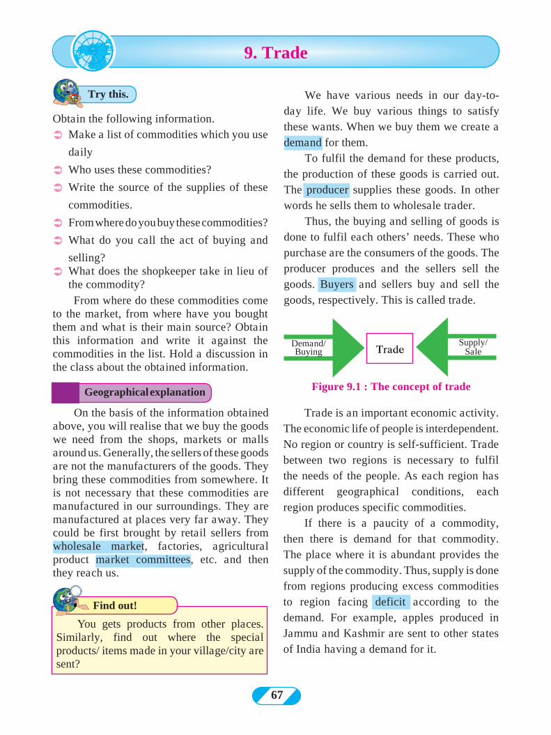
67
Trade is an important economic activity. The economic life of people is interdependent. No region or country is self-sufficient. Trade between two regions is necessary to fulfil the needs of the people. As each region has different geographical conditions, each region produces specific commodities.
If there is a paucity of a commodity, then there is demand for that commodity. The place where it is abundant provides the supply of the commodity. Thus, supply is done from regions producing excess commodities to region facing deficit according to the demand. For example, apples produced in Jammu and Kashmir are sent to other states of India having a demand for it.
Find out!
Obtain the following information.
Ü Make a list of commodities which you use
daily
Ü Who uses these commodities?
Ü Write the source of the supplies of these
commodities.
Ü From where do you buy these commodities?
Ü What do you call the act of buying and
selling?Ü What does the shopkeeper take in lieu of
the commodity?From where do these commodities come
to the market, from where have you bought them and what is their main source? Obtain this information and write it against the commodities in the list. Hold a discussion in the class about the obtained information.
You gets products from other places. Similarly, find out where the special products/ items made in your village/city are sent?
9. Trade
Trade Demand/Buying
Supply/Sale
Figure 9.1 : The concept of tradeGeographical explanation
Try this. We have various needs in our day-to-day life. We buy various things to satisfy these wants. When we buy them we create a demand for them.
To fulfil the demand for these products, the production of these goods is carried out. The producer supplies these goods. In other words he sells them to wholesale trader.
Thus, the buying and selling of goods is done to fulfil each others’ needs. These who purchase are the consumers of the goods. The producer produces and the sellers sell the goods. Buyers and sellers buy and sell the goods, respectively. This is called trade.
On the basis of the information obtained above, you will realise that we buy the goods we need from the shops, markets or malls around us. Generally, the sellers of these goods are not the manufacturers of the goods. They bring these commodities from somewhere. It is not necessary that these commodities are manufactured in our surroundings. They are manufactured at places very far away. They could be first brought by retail sellers from wholesale market, factories, agricultural product market committees, etc. and then they reach us.
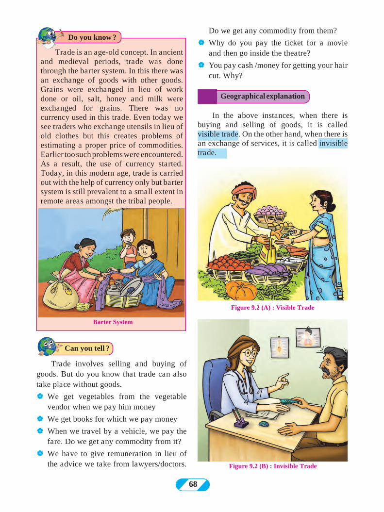
68
Trade involves selling and buying of goods. But do you know that trade can also take place without goods.
| We get vegetables from the vegetable vendor when we pay him money
| We get books for which we pay money
| When we travel by a vehicle, we pay the fare. Do we get any commodity from it?
| We have to give remuneration in lieu of the advice we take from lawyers/doctors.
Figure 9.2 (A) : Visible Trade
Figure 9.2 (B) : Invisible Trade
Trade is an age-old concept. In ancient and medieval periods, trade was done through the barter system. In this there was an exchange of goods with other goods. Grains were exchanged in lieu of work done or oil, salt, honey and milk were exchanged for grains. There was no currency used in this trade. Even today we see traders who exchange utensils in lieu of old clothes but this creates problems of estimating a proper price of commodities. Earlier too such problems were encountered. As a result, the use of currency started. Today, in this modern age, trade is carried out with the help of currency only but barter system is still prevalent to a small extent in remote areas amongst the tribal people.
Barter System
Geographical explanation
Can you tell ?
Do you know ?Do we get any commodity from them?
| Why do you pay the ticket for a movie and then go inside the theatre?
| You pay cash /money for getting your hair cut. Why?
In the above instances, when there is buying and selling of goods, it is called visible trade. On the other hand, when there is an exchange of services, it is called invisible trade.
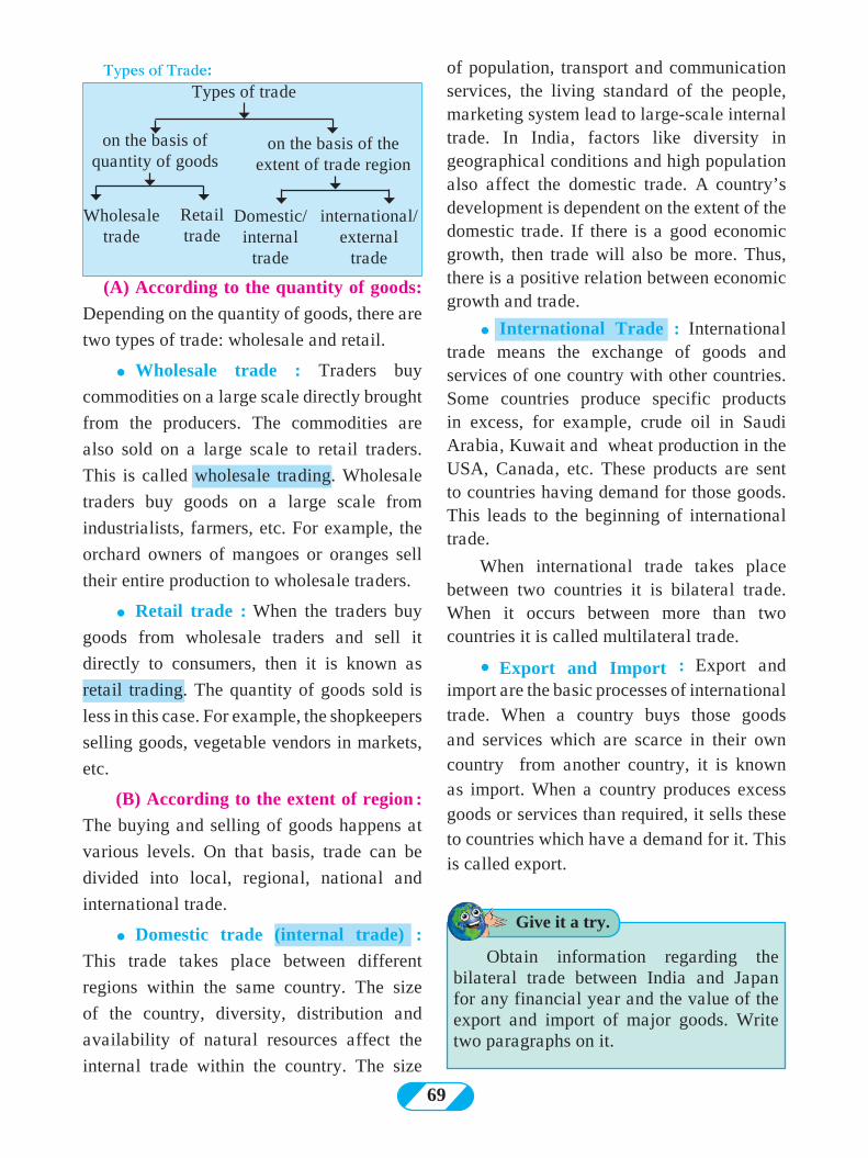
69
of population, transport and communication services, the living standard of the people, marketing system lead to large-scale internal trade. In India, factors like diversity in geographical conditions and high population also affect the domestic trade. A country’s development is dependent on the extent of the domestic trade. If there is a good economic growth, then trade will also be more. Thus, there is a positive relation between economic growth and trade.
� International Trade : International trade means the exchange of goods and services of one country with other countries. Some countries produce specific products in excess, for example, crude oil in Saudi Arabia, Kuwait and wheat production in the USA, Canada, etc. These products are sent to countries having demand for those goods. This leads to the beginning of international trade.
When international trade takes place between two countries it is bilateral trade. When it occurs between more than two countries it is called multilateral trade.
� Export and Import : Export and import are the basic processes of international trade. When a country buys those goods and services which are scarce in their own country from another country, it is known as import. When a country produces excess goods or services than required, it sells these to countries which have a demand for it. This is called export.
Types of trade
on the basis of quantity of goods
Domestic/internal
trade
international/external
trade
Retail trade
Wholesale trade
on the basis of the extent of trade region
Types of Trade:
Obtain information regarding the bilateral trade between India and Japan for any financial year and the value of the export and import of major goods. Write two paragraphs on it.
Give it a try.
(A) According to the quantity of goods:
Depending on the quantity of goods, there are
two types of trade: wholesale and retail.
� Wholesale trade : Traders buy
commodities on a large scale directly brought
from the producers. The commodities are
also sold on a large scale to retail traders.
This is called wholesale trading. Wholesale
traders buy goods on a large scale from
industrialists, farmers, etc. For example, the
orchard owners of mangoes or oranges sell
their entire production to wholesale traders.
� Retail trade : When the traders buy
goods from wholesale traders and sell it
directly to consumers, then it is known as
retail trading. The quantity of goods sold is
less in this case. For example, the shopkeepers
selling goods, vegetable vendors in markets,
etc.
(B) According to the extent of region :
The buying and selling of goods happens at
various levels. On that basis, trade can be
divided into local, regional, national and
international trade.
� Domestic trade (internal trade) :
This trade takes place between different
regions within the same country. The size
of the country, diversity, distribution and
availability of natural resources affect the
internal trade within the country. The size
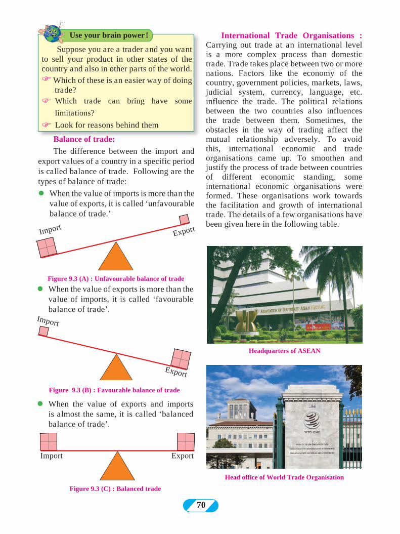
70
Import
Export
Figure 9.3 (B) : Favourable balance of trade
ImportExport
Figure 9.3 (A) : Unfavourable balance of trade
lWhen the value of exports and imports is almost the same, it is called ‘balanced balance of trade’.
Figure 9.3 (C) : Balanced trade
Import Export
International Trade Organisations : Carrying out trade at an international level is a more complex process than domestic trade. Trade takes place between two or more nations. Factors like the economy of the country, government policies, markets, laws, judicial system, currency, language, etc. influence the trade. The political relations between the two countries also influences the trade between them. Sometimes, the obstacles in the way of trading affect the mutual relationship adversely. To avoid this, international economic and trade organisations came up. To smoothen and justify the process of trade between countries of different economic standing, some international economic organisations were formed. These organisations work towards the facilitation and growth of international trade. The details of a few organisations have been given here in the following table.
lWhen the value of exports is more than the value of imports, it is called ‘favourable balance of trade’.
Headquarters of ASEAN
Head office of World Trade Organisation
Suppose you are a trader and you want to sell your product in other states of the country and also in other parts of the world.F Which of these is an easier way of doing trade?
F Which trade can bring have some
limitations?
F Look for reasons behind them
Use your brain power !
Balance of trade:
The difference between the import and export values of a country in a specific period is called balance of trade. Following are the types of balance of trade:
lWhen the value of imports is more than the value of exports, it is called ‘unfavourable balance of trade.’
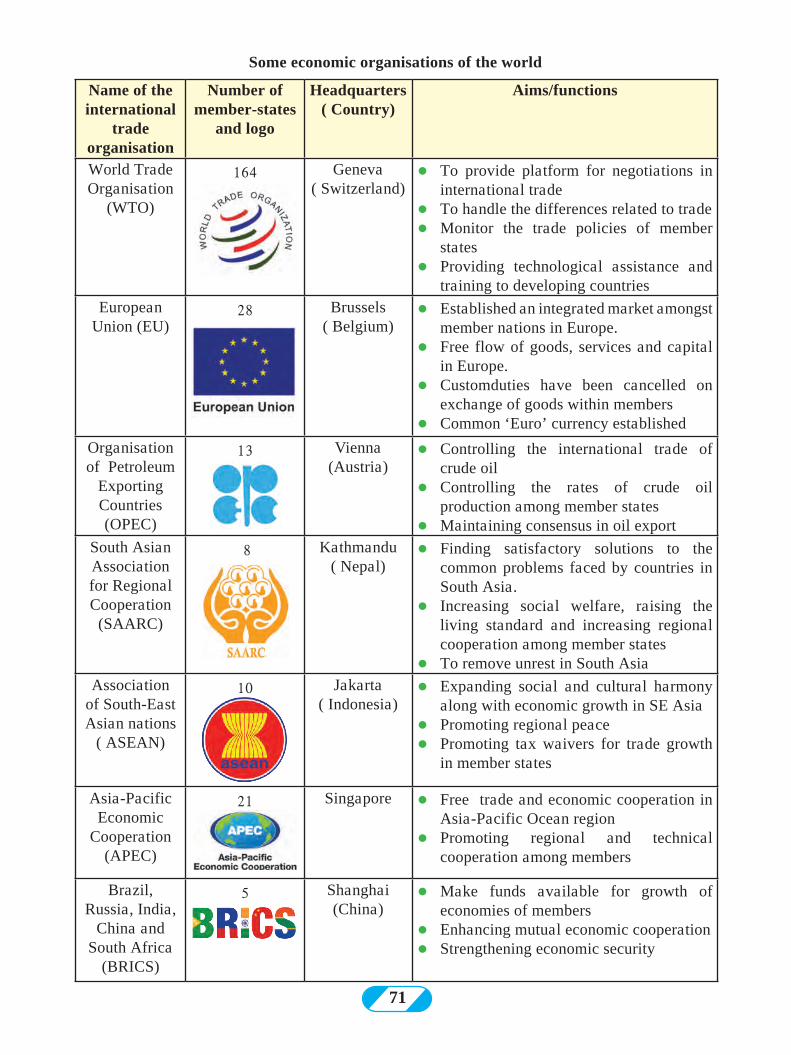
71
Name of the international
trade organisation
Number of member-states
and logo
Headquarters ( Country)
Aims/functions
World Trade Organisation
(WTO)
164 Geneva ( Switzerland)
lTo provide platform for negotiations in international trade
lTo handle the differences related to tradelMonitor the trade policies of member
stateslProviding technological assistance and
training to developing countries European
Union (EU) 28 Brussels
( Belgium) lEstablished an integrated market amongst
member nations in Europe.lFree flow of goods, services and capital
in Europe.lCustomduties have been cancelled on
exchange of goods within memberslCommon ‘Euro’ currency established
Organisation of Petroleum
Exporting Countries (OPEC)
13 Vienna (Austria)
lControlling the international trade of crude oil
lControlling the rates of crude oil production among member states
lMaintaining consensus in oil export South Asian Association for Regional Cooperation
(SAARC)
8 Kathmandu ( Nepal)
lFinding satisfactory solutions to the common problems faced by countries in South Asia.
lIncreasing social welfare, raising the living standard and increasing regional cooperation among member states
lTo remove unrest in South AsiaAssociation
of South-East Asian nations
( ASEAN)
10 Jakarta ( Indonesia)
lExpanding social and cultural harmony along with economic growth in SE Asia
lPromoting regional peace lPromoting tax waivers for trade growth
in member states
Asia-Pacific Economic
Cooperation(APEC)
21 Singapore lFree trade and economic cooperation in Asia-Pacific Ocean region
lPromoting regional and technical cooperation among members
Brazil, Russia, India,
China and South Africa
(BRICS)
5 Shanghai (China)
lMake funds available for growth of economies of members
lEnhancing mutual economic cooperationlStrengthening economic security
Some economic organisations of the world
72
Find out the names of the member-states of the following organisations with the help of internet. Show these member nations on the outline map given in fig 9.4 using different colour for each organisation. � OPEC member - countries.� SAARC member countries.
supermarket in the town. Looking at the quality of his product, they advertised the farm product and kept it for sale in the mall. Today, Dhondiba’s commodities are being sold for higher prices than before.
| Why did Dhondiba’s commodities start getting higher price?
| What did Dhondiba’s son do for that?| What measures would you suggest to the
farmers near you so that their agricultural products fetch a good price?
Marketing :
Figure 9.4 : World Political : Outline map
With a lot of hard work Dhondiba used to grow the best varieties of vegetables and other agricultural commodities. But his products could not fetch a good price. His college going son, saw this situation and he first packed the commodities nicely after cleaning them neatly. Then he contacted the
An appropriate presentation of any commodity is indispensable. The price of the commodity is determined by its quality, its grading and how it is presented before the customer. Dhondiba’s commodities lacked this. Dhondiba’s son recognised it and adapted necessary changes on time. Thus, when we take similar measures for industrial and agricultural products, then the value of the commodity increases from the customers’
FWhat will happen if there is only one currency used in the whole world?
Geographical explanation
Can you tell ?
Think about it.
Make friends with maps !
N
0 5000 km
73
view. Thus, the product fetches a good price and also demand for the product increases.
A list of few goods you regularly use at home is given here. Write the name of the product, the manufacturer name and the source of information in front of it.
S.
No.Goods that you use
Name
of the
Company
Source of
information
1Tooth paste/
powder 2 Tea or coffee 3 Bathing soap 4 Hair oil 5 Biscuits
After answering the questions above, you must have realised that it is necessary. To have good quality product. Also, its advertisement affects us. Everyone doesn’t possess knowledge about every product but when we see others using that product or if we see the advertisement about the product, when we enquire about it or see it in the market, it occurs to us that we need to use this product and we buy it. All this is possible because of marketing. Good marketing promotes business.
Basmati
Whole, broken, Dubar, etc.
Name of the company, Logo, Number.
Details about the quality of production - Price, Advertisement, Distribution
Attractive packaging
Rice
Example.,
An invisible flow develops when a product goes from producer to consumer. The commercial functions involved in this flow are collectively called marketing. The price of a commodity, sales promotion, advertising and distribution are the major components of marketing
ProductionClassificationBrandingLabellingPackaging
CommodityPrice Promotions Distribution
Importance of marketing :Modern industrial social fabric,
globalization and availability of abundant choices/alternatives of the products is the structure of today’s business world. In this context, the existence of marketing system for trade is very important. Through marketing, one can increase business systematically. The production can be distributed all at once on a large scale. The product can reach a large number of consumers. The selling price of the product also increases. Also, defective products can be recalled from the market. Therefore, in today’s era, marketing is a vital part of trading systems.
Advertisements making the customers feel the need to buy the goods are on the rise. Reaching maximum customers, attracting consumers to the products and making consumers buy the products are the objectives behind them.
In recent times, information technology and media have affected the marketing systems deeply. Because of the revolution in the field of information technology, the whole world has become a big market. Through internet we can get information about the production taking place in various countries. This makes numerous options available to the customers. It is due to internet that customers can use facilities like ‘online trading’, ‘e-marketing’, etc.
Try this.
Always remember -
74
If a product is advertised using incorrect information, fraudulent means or making exaggerated statements to cheat the consumers, pointing out the shortcomings of the competitors, then advertisements tend to lose our trust many a times. Therefore, while advertising, it is necessary to follow rules and regulations. The consumers should also
beware of such advertisements. That is why the Consumer Protection Act has been enacted.
It is necessary that the consumer recognises his own needs and buys goods at reasonable rates.
Q 1. Classify the trade taking place between following regions :
(A) Maharashtra and Punjab (B) India and Japan (C) Lasalgaon and Pune (D) China and Canada (E) India and European Union
Q 2. Write the correct word- Import or Export- for the following :
(A) India buys crude oil from the Middle-East Asian countries.
(B) Wheat is sent to Asian countries from
Canada. (C) Japan sends machine parts to APEC
countries.
Q 3. Correct and rewrite the wrong statements :
(A) India is a self-sufficient country. (B) The place where there is excess
production does not have demand for those products.
(C) International trade processes are easier than local trade.
(D) SAARC works towards economic development and enhancing the social and cultural harmony of the South- East Asian countries.
Q 4. Identify and write the type of trade: (A) Srushti brought sugar from the grocery
shop. (B) The traders from Surat bought cotton
from the farmers of Maharashtra. (C) Sameer has exported pomegranates
from his farms to Australia. (D) Sadabhau bought 10 sacks of wheat
and 5 sacks of rice from Market Yard for selling in his own shop.
Q 5. Write answers in short:
(A) Create a flowchart showing the types of trade
(B) Explain the difference in types of balances of trade.
(C) State the objectives of WTO. (D) What is the difference between the
OPEC and APEC in terms of their functions?
(E) Write the functions of the important trade organisations in Asia.
(F) What is the importance of marketing from farmers ‘point of view’?
Q 6. In the following table, export-import of some countries in the year 2014-15 is given in million U.S. dollars. Make a compound bar graph of the given statistical information. Read the bar diagram carefully and comment upon the balance of payments of the respective countries.
Country Export Import
ChinaIndia Brazil USA
2143272190
1510
1960380241
2380
Activity: Carry out the following activity with the help and guidance of teachers:Prepare a good advertisement for any product. Make sure your advertisement gets maximum appreciation from the class.
***
Exercise
75
[A dialogue between a farmer (Tatya) in a village and his son (Suresh) is given here. Read it carefully and hold a discussion on the following questions]Tatya : Suresh, I will come late to the field
today. You go ahead. Suresh : But father, today I was thinking of
going to the factory.Tatya : Why?Suresh : I think I should work in that factory.Tatya : Work in the factory? For what?Suresh : Father, if I work in the factory,
I will get a monthly salary. If I work overtime, I will get additional money. Also, I will get bonus in Diwali.
Tatya : But what about our fields?Suresh : I will also look after the field
simultaneously. Tatya : All that is fine but will you be able
to manage all this? Suresh : Tatya, I will look after all that, you
don’t worry. We should think of the future now. Our village will change drastically from what it looks now.
Tatya : What changes are you talking about?
Suresh : Oh, Tatya, recall your past. Remember the earlier village. How small was our village! And look at our village today! Today there is factory near our village. Our field is near the village. Because of the factory, roads will develop and facilities like hospitals, school and colleges, administrative offices will come up. Huge buildings will stand tall in the village. People from outside will come and stay here. The sprawl of the village will increase. Village will develop.
Answer the following questions:| Why is Suresh thinking of going to the
factory for work? | What is Tatya worried about?| What changes does Suresh think will occur
in the village?| What other changes do you think will occur
in the village?
You will notice that because of the factory near the village, the occupation of the people of the village has started changing. More and more people from outside come and start living in the village, transport, hotels, restaurants, messes, retail shops, medical services, etc. start developing. As a result, the basic structure of the village starts changing.
Looking at our country, agriculture is the main occupation in rural areas. Agriculture and its allied occupations are being followed since times immemorial. But now, various industries have started coming up in rural areas. For example, factories, mills, energy plants, multi-purpose projects, etc. People come from the surrounding regions to work here and thus the population of the village increases. To fulfil their needs, other services also develope like medical facilities, food, hospitals, recreation, etc. Consequently, the extent of the village grows and the form of earlier village changes.
The Gram Panchayat providing public services to the village gives way to Municipal council or Municipal Corporation. These bodies provide the different basic services to the citizens like drinking water, roads, transportation, sewerage network, street lighting, etc. Besides these, other facilities like town planning, recreation facilities, tourist
10. Urbanisation
Geographical explanation
Can you tell ?
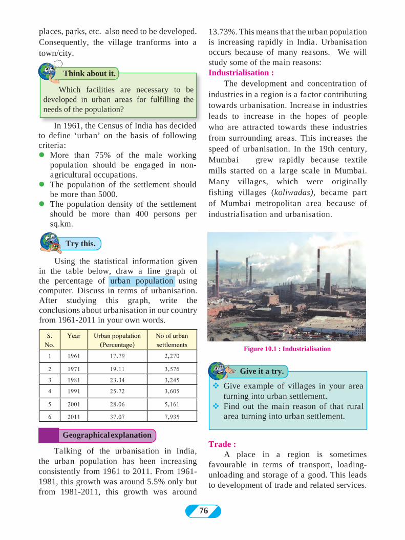
76
13.73%. This means that the urban population is increasing rapidly in India. Urbanisation occurs because of many reasons. We will study some of the main reasons:Industrialisation :
The development and concentration of industries in a region is a factor contributing towards urbanisation. Increase in industries leads to increase in the hopes of people who are attracted towards these industries from surrounding areas. This increases the speed of urbanisation. In the 19th century, Mumbai grew rapidly because textile mills started on a large scale in Mumbai. Many villages, which were originally fishing villages (koliwadas), became part of Mumbai metropolitan area because of industrialisation and urbanisation.
Figure 10.1 : Industrialisation
Talking of the urbanisation in India, the urban population has been increasing consistently from 1961 to 2011. From 1961- 1981, this growth was around 5.5% only but from 1981-2011, this growth was around
Trade :A place in a region is sometimes
favourable in terms of transport, loading-unloading and storage of a good. This leads to development of trade and related services.
vGive example of villages in your area turning into urban settlement.
vFind out the main reason of that rural area turning into urban settlement.
Geographical explanation
Try this.
Which facilities are necessary to be developed in urban areas for fulfilling the needs of the population?
Think about it.
Give it a try.
places, parks, etc. also need to be developed. Consequently, the village tranforms into a town/city.
In 1961, the Census of India has decided to define ‘urban’ on the basis of following criteria:lMore than 75% of the male working
population should be engaged in non-agricultural occupations.
lThe population of the settlement should be more than 5000.
lThe population density of the settlement should be more than 400 persons per sq.km.
Using the statistical information given in the table below, draw a line graph of the percentage of urban population using computer. Discuss in terms of urbanisation. After studying this graph, write the conclusions about urbanisation in our country from 1961-2011 in your own words.
S. No.
Year Urban population (Percentage)
No of urban settlements
1 1961 17.79 2,270
2 1971 19.11 3,576
3 1981 23.34 3,245
4 1991 25.72 3,605
5 2001 28.06 5,161
6 2011 37.07 7,935
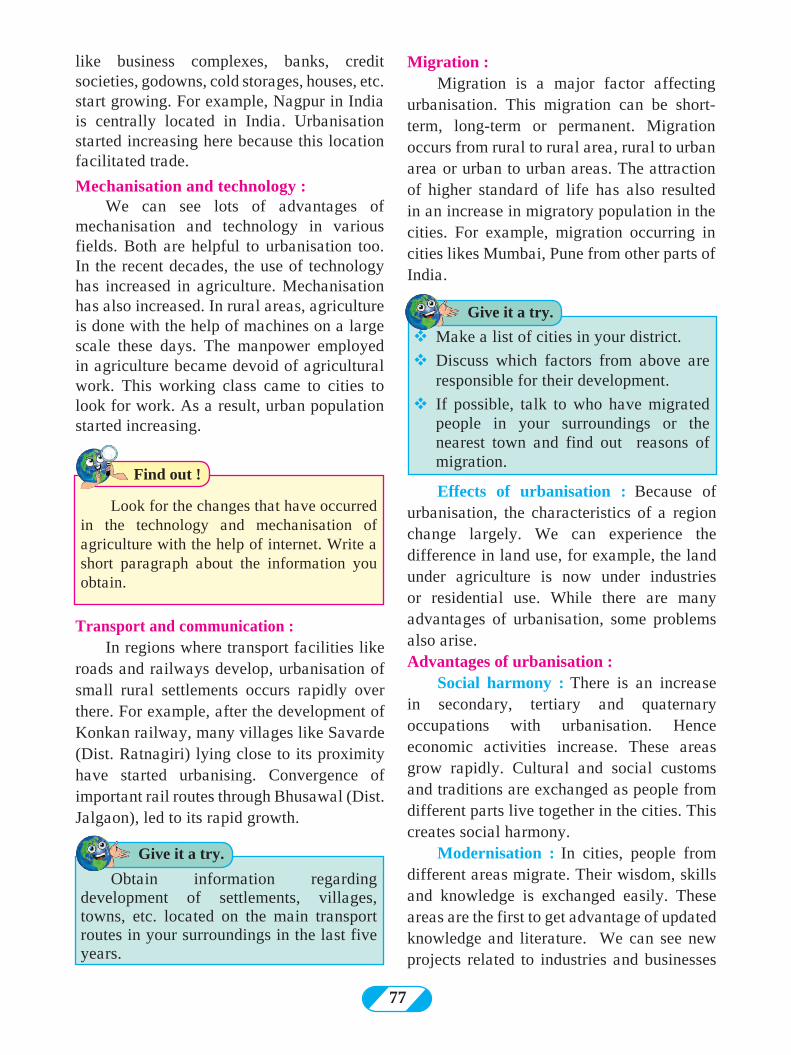
77
Find out !
Look for the changes that have occurred in the technology and mechanisation of agriculture with the help of internet. Write a short paragraph about the information you obtain.
like business complexes, banks, credit societies, godowns, cold storages, houses, etc. start growing. For example, Nagpur in India is centrally located in India. Urbanisation started increasing here because this location facilitated trade.
Mechanisation and technology :We can see lots of advantages of
mechanisation and technology in various fields. Both are helpful to urbanisation too. In the recent decades, the use of technology has increased in agriculture. Mechanisation has also increased. In rural areas, agriculture is done with the help of machines on a large scale these days. The manpower employed in agriculture became devoid of agricultural work. This working class came to cities to look for work. As a result, urban population started increasing.
Migration :Migration is a major factor affecting
urbanisation. This migration can be short-term, long-term or permanent. Migration occurs from rural to rural area, rural to urban area or urban to urban areas. The attraction of higher standard of life has also resulted in an increase in migratory population in the cities. For example, migration occurring in cities likes Mumbai, Pune from other parts of India.
Transport and communication :In regions where transport facilities like
roads and railways develop, urbanisation of small rural settlements occurs rapidly over there. For example, after the development of Konkan railway, many villages like Savarde (Dist. Ratnagiri) lying close to its proximity have started urbanising. Convergence of important rail routes through Bhusawal (Dist. Jalgaon), led to its rapid growth.
Effects of urbanisation : Because of urbanisation, the characteristics of a region change largely. We can experience the difference in land use, for example, the land under agriculture is now under industries or residential use. While there are many advantages of urbanisation, some problems also arise. Advantages of urbanisation :
Social harmony : There is an increase in secondary, tertiary and quaternary occupations with urbanisation. Hence economic activities increase. These areas grow rapidly. Cultural and social customs and traditions are exchanged as people from different parts live together in the cities. This creates social harmony.
Modernisation : In cities, people from different areas migrate. Their wisdom, skills and knowledge is exchanged easily. These areas are the first to get advantage of updated knowledge and literature. We can see new projects related to industries and businesses
Obtain information regarding development of settlements, villages, towns, etc. located on the main transport routes in your surroundings in the last five years.
vMake a list of cities in your district.
vDiscuss which factors from above are responsible for their development.
v If possible, talk to who have migrated people in your surroundings or the nearest town and find out reasons of migration.
Give it a try.
Give it a try.
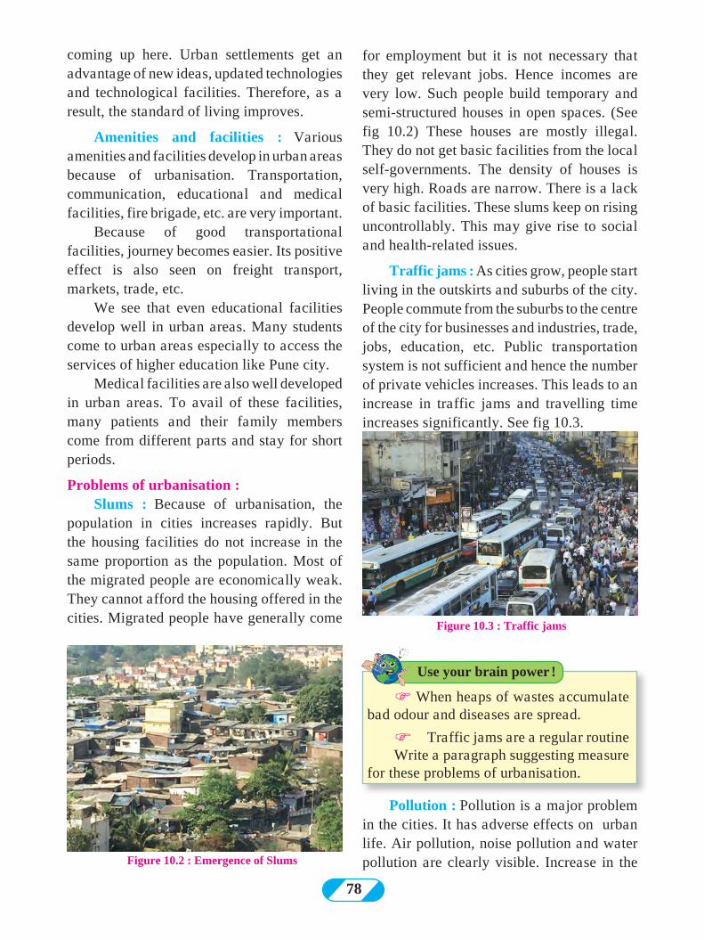
78
coming up here. Urban settlements get an advantage of new ideas, updated technologies and technological facilities. Therefore, as a result, the standard of living improves.
Amenities and facilities : Various amenities and facilities develop in urban areas because of urbanisation. Transportation, communication, educational and medical facilities, fire brigade, etc. are very important.
Because of good transportational facilities, journey becomes easier. Its positive effect is also seen on freight transport, markets, trade, etc.
We see that even educational facilities develop well in urban areas. Many students come to urban areas especially to access the services of higher education like Pune city.
Medical facilities are also well developed in urban areas. To avail of these facilities, many patients and their family members come from different parts and stay for short periods.
Problems of urbanisation :Slums : Because of urbanisation, the
population in cities increases rapidly. But the housing facilities do not increase in the same proportion as the population. Most of the migrated people are economically weak. They cannot afford the housing offered in the cities. Migrated people have generally come
for employment but it is not necessary that they get relevant jobs. Hence incomes are very low. Such people build temporary and semi-structured houses in open spaces. (See fig 10.2) These houses are mostly illegal. They do not get basic facilities from the local self-governments. The density of houses is very high. Roads are narrow. There is a lack of basic facilities. These slums keep on rising uncontrollably. This may give rise to social and health-related issues.
Traffic jams : As cities grow, people start living in the outskirts and suburbs of the city. People commute from the suburbs to the centre of the city for businesses and industries, trade, jobs, education, etc. Public transportation system is not sufficient and hence the number of private vehicles increases. This leads to an increase in traffic jams and travelling time increases significantly. See fig 10.3.
Figure 10.2 : Emergence of Slums
Figure 10.3 : Traffic jams
Pollution : Pollution is a major problem in the cities. It has adverse effects on urban life. Air pollution, noise pollution and water pollution are clearly visible. Increase in the
F When heaps of wastes accumulate bad odour and diseases are spread.
FTraffic jams are a regular routineWrite a paragraph suggesting measure
for these problems of urbanisation.
Use your brain power !
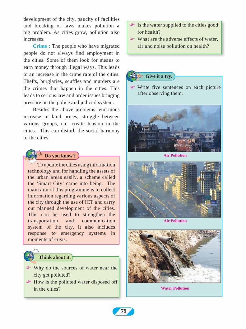
79
To update the cities using information technology and for handling the assets of the urban areas easily, a scheme called the ‘Smart City’ came into being. The main aim of this programme is to collect information regarding various aspects of the city through the use of ICT and carry out planned development of the cities. This can be used to strengthen the transportation and communication system of the city. It also includes response to emergency systems in moments of crisis.
F Why do the sources of water near the city get polluted?
F How is the polluted water disposed off in the cities?
F Write five sentences on each picture after observing them.
Water Pollution
Air Pollution
Air Pollution
Think about it.
Do you know ?
Give it a try.
development of the city, paucity of facilities and breaking of laws makes pollution a big problem. As cities grow, pollution also increases.
Crime : The people who have migrated people do not always find employment in the cities. Some of them look for means to earn money through illegal ways. This leads to an increase in the crime rate of the cities. Thefts, burglaries, scuffles and murders are the crimes that happen in the cities. This leads to serious law and order issues bringing pressure on the police and judicial system.
Besides the above problems, enormous increase in land prices, struggle between various groups, etc. create tension in the cities. This can disturb the social harmony of the cities.
F Is the water supplied to the cities good for health?
F What are the adverse effects of water, air and noise pollution on health?
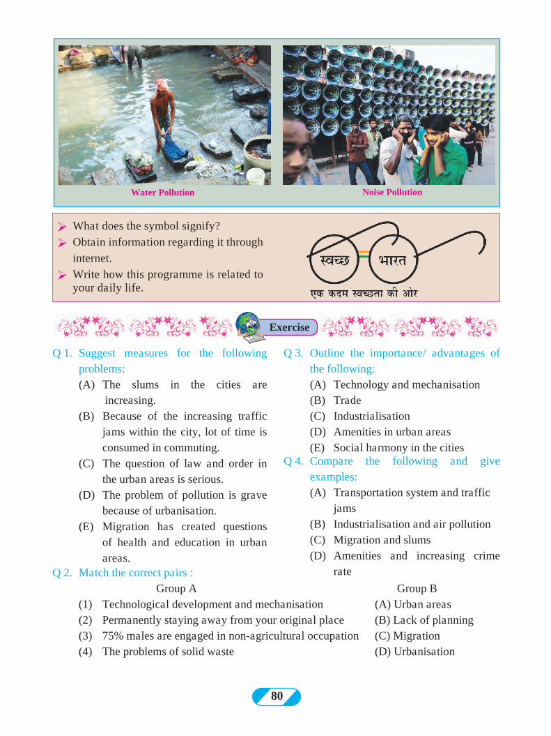
80
Q 1. Suggest measures for the following problems:
(A) The slums in the cities are increasing.
(B) Because of the increasing traffic jams within the city, lot of time is consumed in commuting.
(C) The question of law and order in the urban areas is serious.
(D) The problem of pollution is grave because of urbanisation.
(E) Migration has created questions of health and education in urban areas.
Q 3. Outline the importance/ advantages of the following:
(A) Technology and mechanisation (B) Trade (C) Industrialisation (D) Amenities in urban areas (E) Social harmony in the citiesQ 4. Compare the following and give
examples: (A) Transportation system and traffic
jams (B) Industrialisation and air pollution (C) Migration and slums (D) Amenities and increasing crime
rate Q 2. Match the correct pairs : Group A Group B (1) Technological development and mechanisation (A) Urban areas (2) Permanently staying away from your original place (B) Lack of planning (3) 75% males are engaged in non-agricultural occupation (C) Migration (4) The problems of solid waste (D) Urbanisation
Water Pollution Noise Pollution
Ø What does the symbol signify?
Ø Obtain information regarding it through
internet.
Ø Write how this programme is related to your daily life.
Exercise
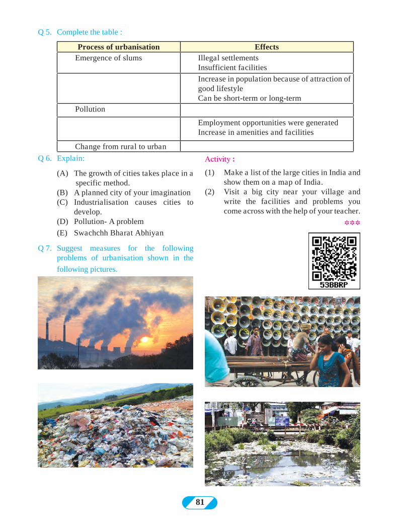
81
Q 5. Complete the table :
Process of urbanisation Effects Emergence of slums Illegal settlements
Insufficient facilities
Increase in population because of attraction of good lifestyle Can be short-term or long-term
Pollution
Employment opportunities were generated Increase in amenities and facilities
Change from rural to urban
Q 6. Explain:
(A) The growth of cities takes place in a specific method.
(B) A planned city of your imagination (C) Industrialisation causes cities to
develop. (D) Pollution- A problem
(E) Swachchh Bharat Abhiyan
Q 7. Suggest measures for the following problems of urbanisation shown in the
following pictures.
Activity :
(1) Make a list of the large cities in India and show them on a map of India.
(2) Visit a big city near your village and write the facilities and problems you come across with the help of your teacher.
***
82
Complete the following table:
Transport route
Means of transport
Used for
Roadways Rickshaw Passengers Roadways Truck
Metro Water-ways
Helicopter Airways
SubmarineWater-ways
Freight
Mules
RailwaysPipelines
Surat-Bhusawal Railway line passes through the district.
| You have to go to Singapore from your village/town. You have ten days to do the same.
We have given some specific conditions. In this context, tell with reasons which means of transport and route will you take? | You have to reach Bhopal from
Nagpur due to some emergency.| You have to reach Kanyakumari
carrying the message of cleanliness. There is no time limit for it.
| Send the Alphonso mangoes from Konkan to Arab countries.
| Indrayani variety of rice has to be exported from Pune to Cape Town of South Africa at low cost.
| Large-scale production of vegetables in Nandurbar has taken place but is not fetching a good price. The Nagpur-Surat National Highway and the
You must have realised that while travelling or transporting goods, we have to consider many things. If there are many ways and means of transport available, then we can think about those alternatives. There are roadways, railways, waterways, airways and pipelines by which transportation can be done.
Following factors should be kept in mind while selecting the routes and the means of transport.
11. Transport and Communication
factors to be considered for transportation
distance
duration routes andmeans
cost
time
productsclimate
market
physiography
If we consider the above mentioned factors, then our time and money is saved during the journey or transport. Travelling becomes comfortable. Transport is done without any damage to the goods. The selling price to be paid by the customer is not decided by the cost of production only. It is decided by the transport cost and the production cost. The transport of freight should be done rapidly and safely. The price of the good can be kept low if the transportation is affordable.
Transportation is a basic infrastructure. Development of transportation infrastructure is an indicator of the development of the country or that region. The reforms in transport sector enhance the dynamicity of freight and passengers in a region. Also, industries and markets develop.
Geographical explanation
Can you tell ?
Let’s recall.
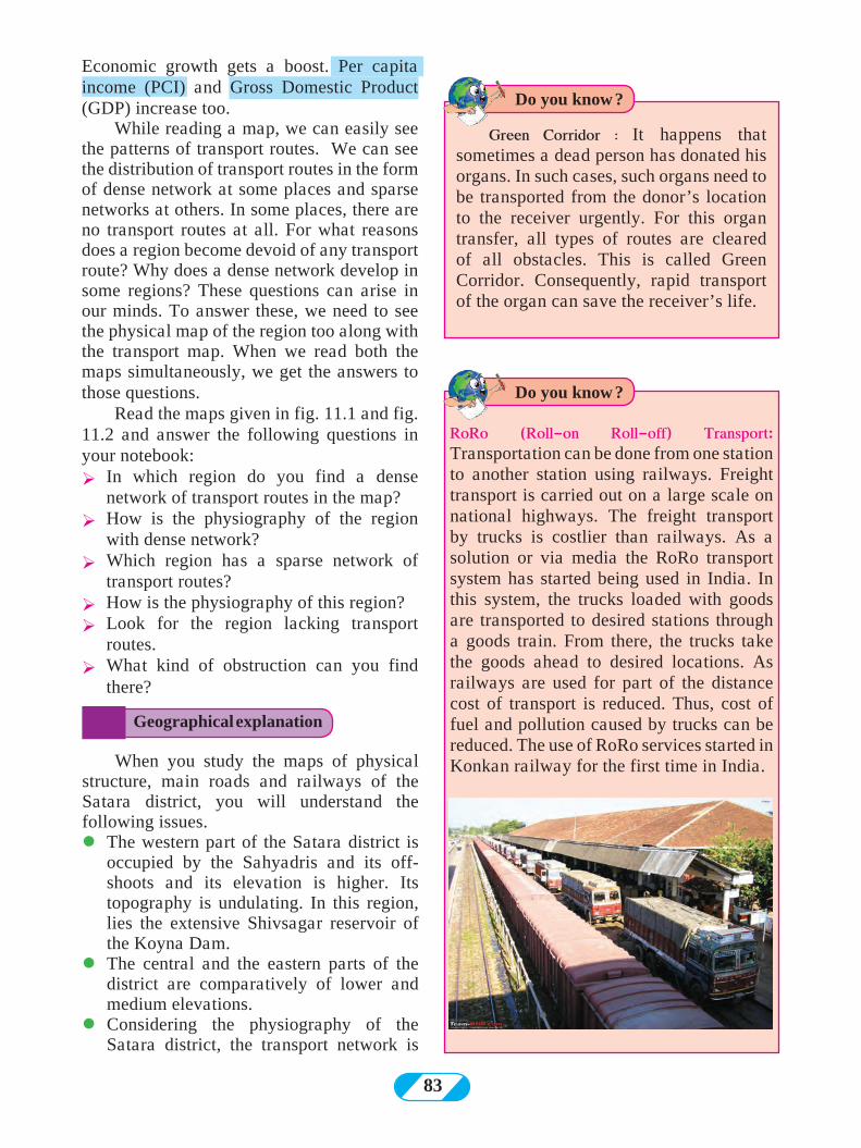
83
When you study the maps of physical structure, main roads and railways of the Satara district, you will understand the following issues.lThe western part of the Satara district is
occupied by the Sahyadris and its off-shoots and its elevation is higher. Its topography is undulating. In this region, lies the extensive Shivsagar reservoir of the Koyna Dam.
lThe central and the eastern parts of the district are comparatively of lower and medium elevations.
l Considering the physiography of the Satara district, the transport network is
Green Corridor ः It happens that sometimes a dead person has donated his organs. In such cases, such organs need to be transported from the donor’s location to the receiver urgently. For this organ transfer, all types of routes are cleared of all obstacles. This is called Green Corridor. Consequently, rapid transport of the organ can save the receiver’s life.
RoRo (Roll-on Roll-off) Transport: Transportation can be done from one station to another station using railways. Freight transport is carried out on a large scale on national highways. The freight transport by trucks is costlier than railways. As a solution or via media the RoRo transport system has started being used in India. In this system, the trucks loaded with goods are transported to desired stations through a goods train. From there, the trucks take the goods ahead to desired locations. As railways are used for part of the distance cost of transport is reduced. Thus, cost of fuel and pollution caused by trucks can be reduced. The use of RoRo services started in Konkan railway for the first time in India.
Geographical explanation
Do you know ?
Do you know ?
Economic growth gets a boost. Per capita income (PCI) and Gross Domestic Product (GDP) increase too.
While reading a map, we can easily see the patterns of transport routes. We can see the distribution of transport routes in the form of dense network at some places and sparse networks at others. In some places, there are no transport routes at all. For what reasons does a region become devoid of any transport route? Why does a dense network develop in some regions? These questions can arise in our minds. To answer these, we need to see the physical map of the region too along with the transport map. When we read both the maps simultaneously, we get the answers to those questions.
Read the maps given in fig. 11.1 and fig. 11.2 and answer the following questions in your notebook: Ø In which region do you find a dense
network of transport routes in the map?Ø How is the physiography of the region
with dense network?Ø Which region has a sparse network of
transport routes?Ø How is the physiography of this region?Ø Look for the region lacking transport
routes.Ø What kind of obstruction can you find
there?
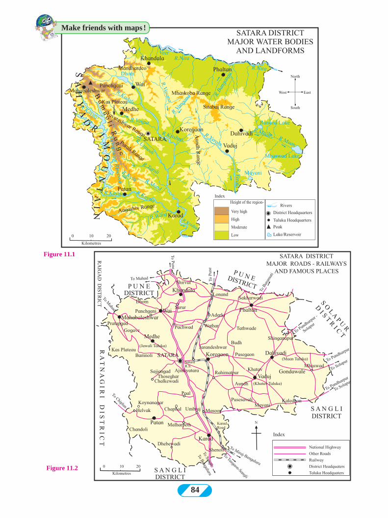
84
Figure 11.1
Figure 11.2
Make friends with maps !
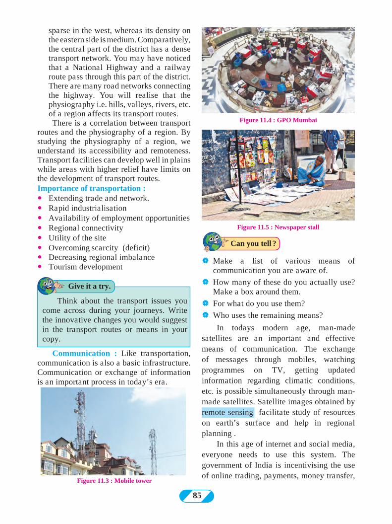
85
| Make a list of various means of communication you are aware of.
| How many of these do you actually use? Make a box around them.
| For what do you use them?
| Who uses the remaining means?
In todays modern age, man-made satellites are an important and effective means of communication. The exchange of messages through mobiles, watching programmes on TV, getting updated information regarding climatic conditions, etc. is possible simultaneously through man-made satellites. Satellite images obtained by remote sensing facilitate study of resources on earth’s surface and help in regional planning .
In this age of internet and social media, everyone needs to use this system. The government of India is incentivising the use of online trading, payments, money transfer,
sparse in the west, whereas its density on the eastern side is medium. Comparatively, the central part of the district has a dense transport network. You may have noticed that a National Highway and a railway route pass through this part of the district. There are many road networks connecting the highway. You will realise that the physiography i.e. hills, valleys, rivers, etc. of a region affects its transport routes.There is a correlation between transport
routes and the physiography of a region. By studying the physiography of a region, we understand its accessibility and remoteness. Transport facilities can develop well in plains while areas with higher relief have limits on the development of transport routes.Importance of transportation :� Extending trade and network.� Rapid industrialisation� Availability of employment opportunities� Regional connectivity� Utility of the site� Overcoming scarcity (deficit)� Decreasing regional imbalance � Tourism development
Figure 11.4 : GPO Mumbai
Figure 11.5 : Newspaper stall
Communication : Like transportation, communication is also a basic infrastructure. Communication or exchange of information is an important process in today’s era.
Figure 11.3 : Mobile tower
Think about the transport issues you come across during your journeys. Write the innovative changes you would suggest in the transport routes or means in your copy.
Can you tell ?
Give it a try.
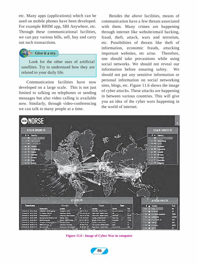
86
etc. Many apps (applications) which can be used on mobile phones have been developed. For example BHIM app, SBI Anywhere, etc. Through these communicational facilities, we can pay various bills, sell, buy and carry out such transactions.
Besides the above facilities, means of communication have a few threats associated with them. Many crimes are happening through internet like website/email hacking, fraud, theft, attack, wars and terrorism, etc. Possibilities of threats like theft of information, economic frauds, attacking important websites, etc arise. Therefore, one should take precautions while using social networks. We should not reveal our information before ensuring safety. We should not put any sensitive information or personal information on social networking sites, blogs, etc. Figure 11.6 shows the image of cyber attacks. These attacks are happening in between various countries. This will give you an idea of the cyber wars happening in the world of internet.
Figure 11.6 : Image of Cyber War in computer
Communication facilities have now developed on a large scale. This is not just limited to talking on telephones or sending messages but also video calling is available now. Similarly, through video-conferencing we can talk to many people at a time.
Look for the other uses of artificial satellites. Try to understand how they are related to your daily life.
Give it a try.
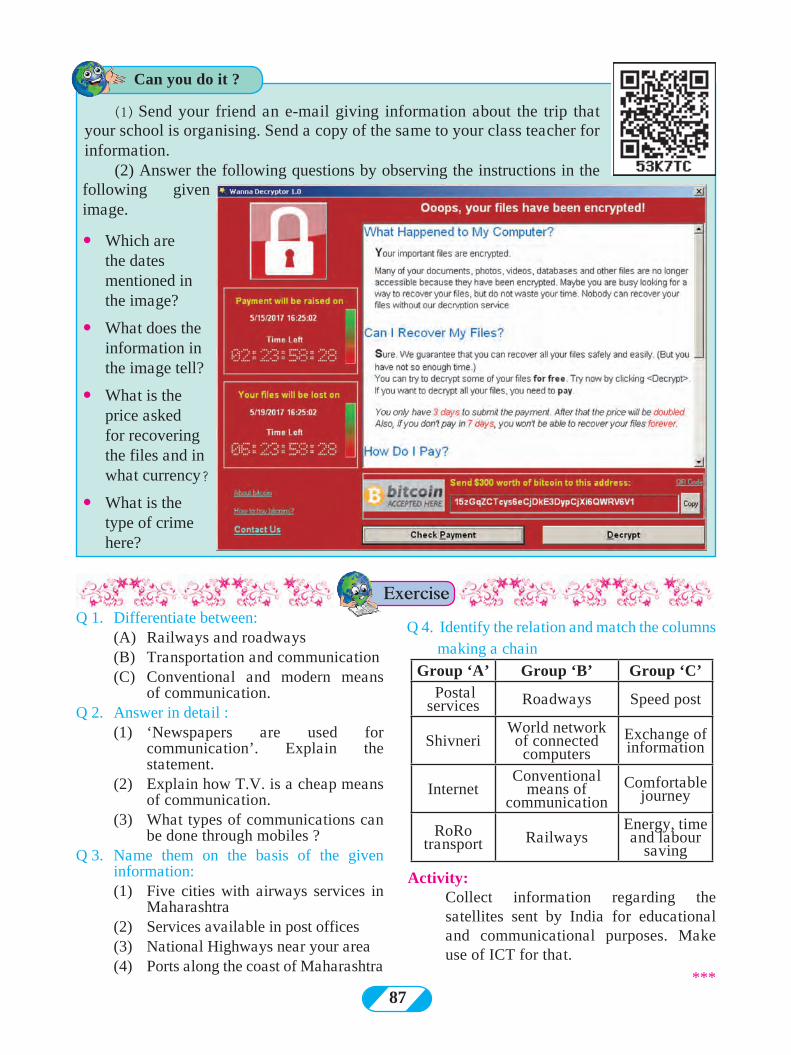
87
Q 1. Differentiate between: (A) Railways and roadways (B) Transportation and communication (C) Conventional and modern means
of communication.Q 2. Answer in detail : (1) ‘Newspapers are used for
communication’. Explain the statement.
(2) Explain how T.V. is a cheap means of communication.
(3) What types of communications can be done through mobiles ?
Q 3. Name them on the basis of the given information:
(1) Five cities with airways services in Maharashtra
(2) Services available in post offices (3) National Highways near your area (4) Ports along the coast of Maharashtra
Q 4. Identify the relation and match the columns making a chain
Group ‘A’ Group ‘B’ Group ‘C’ Postal services Roadways Speed post
ShivneriWorld network of connected computers
Exchange of information
InternetConventional
means of communication
Comfortable journey
RoRo transport Railways
Energy, time and labour
saving
Activity: Collect information regarding the
satellites sent by India for educational and communicational purposes. Make use of ICT for that.
***
Exercise
Can you do it ?
(1) Send your friend an e-mail giving information about the trip that your school is organising. Send a copy of the same to your class teacher for information.
(2) Answer the following questions by observing the instructions in the following given image.
�Which are the dates mentioned in the image?
� What does the information in the image tell?
� What is the price asked for recovering the files and in what currency?
� What is the type of crime here?
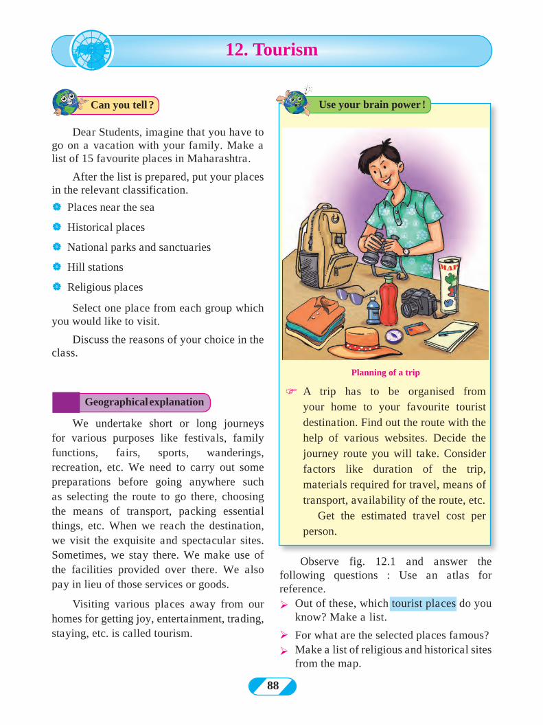
88
Dear Students, imagine that you have to go on a vacation with your family. Make a list of 15 favourite places in Maharashtra.
After the list is prepared, put your places in the relevant classification.
| Places near the sea
| Historical places
| National parks and sanctuaries
| Hill stations
| Religious places
Select one place from each group which you would like to visit.
Discuss the reasons of your choice in the class.
12. Tourism
We undertake short or long journeys for various purposes like festivals, family functions, fairs, sports, wanderings, recreation, etc. We need to carry out some preparations before going anywhere such as selecting the route to go there, choosing the means of transport, packing essential things, etc. When we reach the destination, we visit the exquisite and spectacular sites. Sometimes, we stay there. We make use of the facilities provided over there. We also pay in lieu of those services or goods.
Visiting various places away from our homes for getting joy, entertainment, trading, staying, etc. is called tourism.
Planning of a trip
F A trip has to be organised from your home to your favourite tourist destination. Find out the route with the help of various websites. Decide the journey route you will take. Consider factors like duration of the trip, materials required for travel, means of transport, availability of the route, etc.
Get the estimated travel cost per person.
Geographical explanation
Use your brain power !Can you tell ?
Observe fig. 12.1 and answer the following questions : Use an atlas for reference.
Ø Out of these, which tourist places do you know? Make a list.
ØFor what are the selected places famous?
Ø Make a list of religious and historical sites from the map.
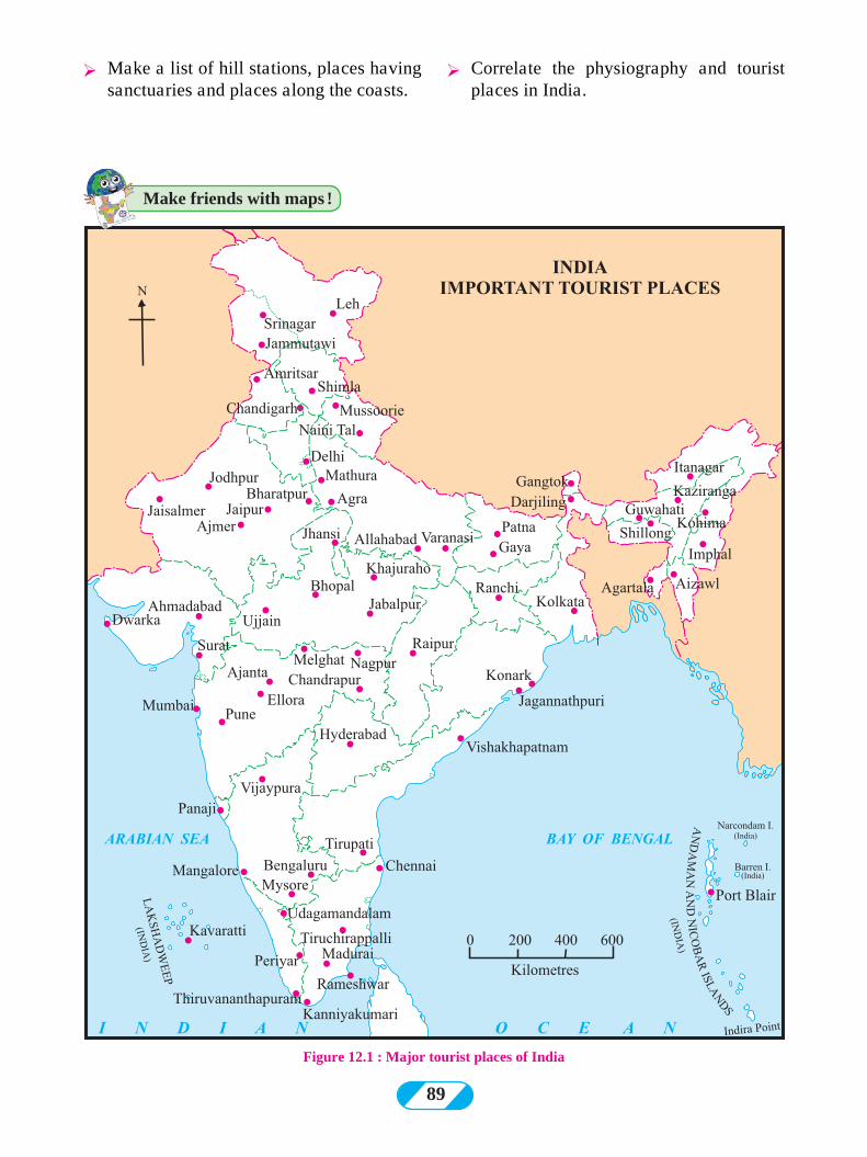
89
Figure 12.1 : Major tourist places of India
Ø Make a list of hill stations, places having sanctuaries and places along the coasts.
Make friends with maps !
Ø Correlate the physiography and tourist places in India.
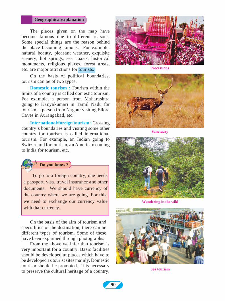
90
The places given on the map have become famous due to different reasons. Some special things are the reason behind the place becoming famous. For example, natural beauty, pleasant weather, exquisite scenery, hot springs, sea coasts, historical monuments, religious places, forest areas, etc. are major attractions for tourists.
On the basis of political boundaries, tourism can be of two types:
Domestic tourism : Tourism within the limits of a country is called domestic tourism. For example, a person from Maharashtra going to Kanyakumari in Tamil Nadu for tourism, a person from Nagpur visiting Ellora Caves in Aurangabad, etc.
International/foreign tourism : Crossing country’s boundaries and visiting some other country for tourism is called international tourism. For example, an Indian going to Switzerland for tourism, an American coming to India for tourism, etc.
On the basis of the aim of tourism and specialities of the destination, there can be different types of tourism. Some of these have been explained through photographs.
From the above we infer that tourism is very important for a country. Basic facilities should be developed at places which have to be developed as tourist sites mainly. Domestic tourism should be promoted. It is necessary to preserve the cultural heritage of a country.
Processions
Sanctuary
Wandering in the wild
Sea tourism
To go to a foreign country, one needs a passport, visa, travel insurance and other documents. We should have currency of the country where we are going. For this, we need to exchange our currency value with that currency.
Geographical explanation
Do you know ?
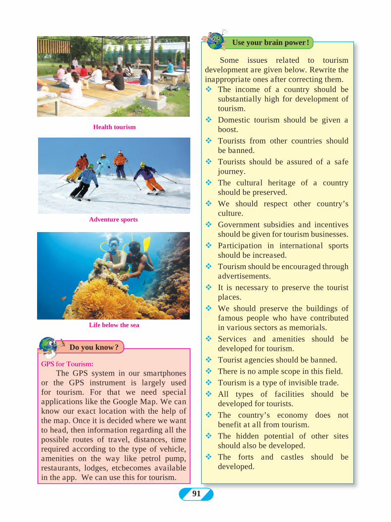
91
Health tourism
Life below the sea
Adventure sports
GPS for Tourism:The GPS system in our smartphones
or the GPS instrument is largely used for tourism. For that we need special applications like the Google Map. We can know our exact location with the help of the map. Once it is decided where we want to head, then information regarding all the possible routes of travel, distances, time required according to the type of vehicle, amenities on the way like petrol pump, restaurants, lodges, etcbecomes available in the app. We can use this for tourism.
Some issues related to tourism development are given below. Rewrite the inappropriate ones after correcting them.vThe income of a country should be
substantially high for development of tourism.
vDomestic tourism should be given a boost.
vTourists from other countries should be banned.
vTourists should be assured of a safe journey.
vThe cultural heritage of a country should be preserved.
vWe should respect other country’s culture.
vGovernment subsidies and incentives should be given for tourism businesses.
vParticipation in international sports should be increased.
vTourism should be encouraged through advertisements.
vIt is necessary to preserve the tourist places.
vWe should preserve the buildings of famous people who have contributed in various sectors as memorials.
vServices and amenities should be developed for tourism.
vTourist agencies should be banned.vThere is no ample scope in this field.vTourism is a type of invisible trade.vAll types of facilities should be
developed for tourists.vThe country’s economy does not
benefit at all from tourism.vThe hidden potential of other sites
should also be developed.vThe forts and castles should be
developed.
Use your brain power !
Do you know ?
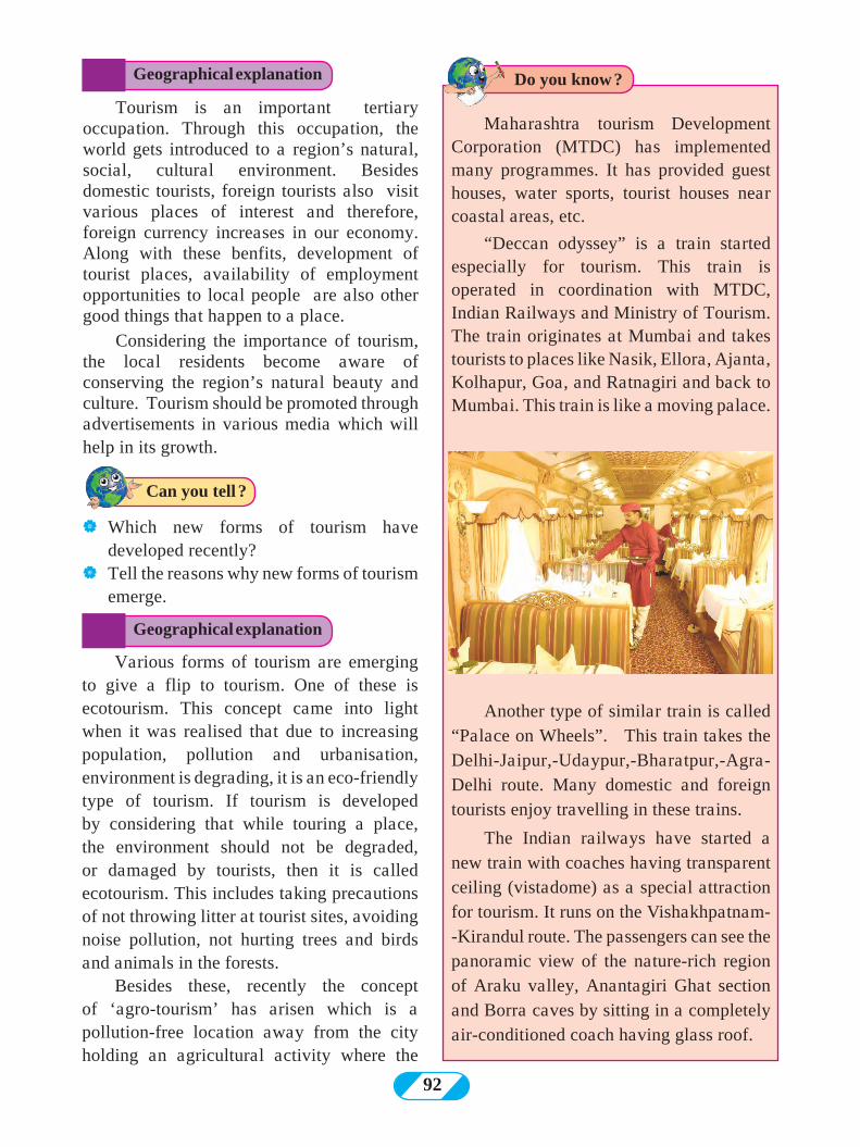
92
Tourism is an important tertiary occupation. Through this occupation, the world gets introduced to a region’s natural, social, cultural environment. Besides domestic tourists, foreign tourists also visit various places of interest and therefore, foreign currency increases in our economy. Along with these benfits, development of tourist places, availability of employment opportunities to local people are also other good things that happen to a place.
Considering the importance of tourism, the local residents become aware of conserving the region’s natural beauty and culture. Tourism should be promoted through advertisements in various media which will help in its growth.
Various forms of tourism are emerging to give a flip to tourism. One of these is ecotourism. This concept came into light when it was realised that due to increasing population, pollution and urbanisation, environment is degrading, it is an eco-friendly type of tourism. If tourism is developed by considering that while touring a place, the environment should not be degraded, or damaged by tourists, then it is called ecotourism. This includes taking precautions of not throwing litter at tourist sites, avoiding noise pollution, not hurting trees and birds and animals in the forests.
Besides these, recently the concept of ‘agro-tourism’ has arisen which is a pollution-free location away from the city holding an agricultural activity where the
Maharashtra tourism Development Corporation (MTDC) has implemented many programmes. It has provided guest houses, water sports, tourist houses near coastal areas, etc.
“Deccan odyssey” is a train started especially for tourism. This train is operated in coordination with MTDC, Indian Railways and Ministry of Tourism. The train originates at Mumbai and takes tourists to places like Nasik, Ellora, Ajanta, Kolhapur, Goa, and Ratnagiri and back to Mumbai. This train is like a moving palace.
Another type of similar train is called “Palace on Wheels”. This train takes the Delhi-Jaipur,-Udaypur,-Bharatpur,-Agra- Delhi route. Many domestic and foreign tourists enjoy travelling in these trains.
The Indian railways have started a new train with coaches having transparent ceiling (vistadome) as a special attraction for tourism. It runs on the Vishakhpatnam--Kirandul route. The passengers can see the panoramic view of the nature-rich region of Araku valley, Anantagiri Ghat section and Borra caves by sitting in a completely air-conditioned coach having glass roof.
Geographical explanation
Geographical explanation
Can you tell ?
Do you know ?
| Which new forms of tourism have developed recently?
| Tell the reasons why new forms of tourism emerge.
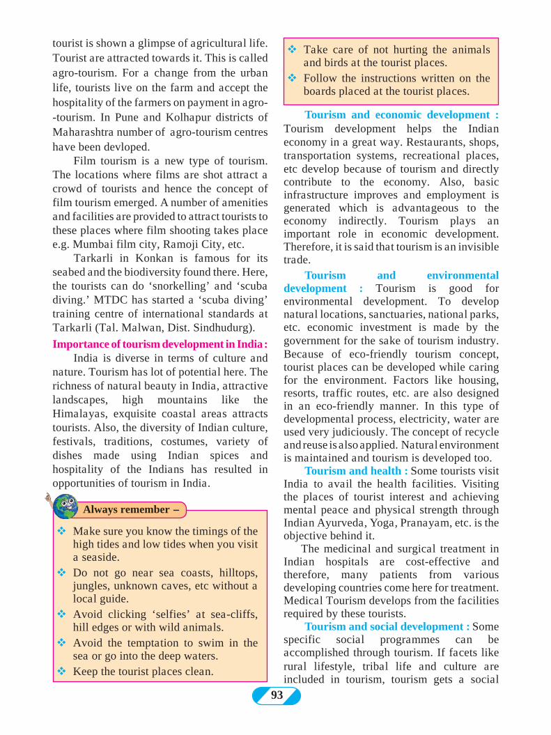
93
tourist is shown a glimpse of agricultural life. Tourist are attracted towards it. This is called agro-tourism. For a change from the urban life, tourists live on the farm and accept the hospitality of the farmers on payment in agro--tourism. In Pune and Kolhapur districts of Maharashtra number of agro-tourism centres have been devloped.
Film tourism is a new type of tourism. The locations where films are shot attract a crowd of tourists and hence the concept of film tourism emerged. A number of amenities and facilities are provided to attract tourists to these places where film shooting takes place e.g. Mumbai film city, Ramoji City, etc.
Tarkarli in Konkan is famous for its seabed and the biodiversity found there. Here, the tourists can do ‘snorkelling’ and ‘scuba diving.’ MTDC has started a ‘scuba diving’ training centre of international standards at Tarkarli (Tal. Malwan, Dist. Sindhudurg).
Importance of tourism development in India :India is diverse in terms of culture and
nature. Tourism has lot of potential here. The richness of natural beauty in India, attractive landscapes, high mountains like the Himalayas, exquisite coastal areas attracts tourists. Also, the diversity of Indian culture, festivals, traditions, costumes, variety of dishes made using Indian spices and hospitality of the Indians has resulted in opportunities of tourism in India.
Tourism and economic development : Tourism development helps the Indian economy in a great way. Restaurants, shops, transportation systems, recreational places, etc develop because of tourism and directly contribute to the economy. Also, basic infrastructure improves and employment is generated which is advantageous to the economy indirectly. Tourism plays an important role in economic development. Therefore, it is said that tourism is an invisible trade.
Tourism and environmental development : Tourism is good for environmental development. To develop natural locations, sanctuaries, national parks, etc. economic investment is made by the government for the sake of tourism industry. Because of eco-friendly tourism concept, tourist places can be developed while caring for the environment. Factors like housing, resorts, traffic routes, etc. are also designed in an eco-friendly manner. In this type of developmental process, electricity, water are used very judiciously. The concept of recycle and reuse is also applied. Natural environment is maintained and tourism is developed too.
Tourism and health : Some tourists visit India to avail the health facilities. Visiting the places of tourist interest and achieving mental peace and physical strength through Indian Ayurveda, Yoga, Pranayam, etc. is the objective behind it. The medicinal and surgical treatment in Indian hospitals are cost-effective and therefore, many patients from various developing countries come here for treatment. Medical Tourism develops from the facilities required by these tourists.
Tourism and social development : Some specific social programmes can be accomplished through tourism. If facets like rural lifestyle, tribal life and culture are included in tourism, tourism gets a social
vMake sure you know the timings of the high tides and low tides when you visit a seaside.
vDo not go near sea coasts, hilltops, jungles, unknown caves, etc without a local guide.
vAvoid clicking ‘selfies’ at sea-cliffs, hill edges or with wild animals.
vAvoid the temptation to swim in the sea or go into the deep waters.
vKeep the tourist places clean.
vTake care of not hurting the animals and birds at the tourist places.
vFollow the instructions written on the boards placed at the tourist places.
Always remember -
94
Q 1 Identify the type of tourism from the statement.
(A) Hemant Kumar went to Mexico to learn about the architectural skills of the Mayan culture
(B) Portuguese tourists had come to Goa to participate in the Goa Carnival.
(C) To seek treatment in a naturopathy centre, John and Amar went to Kerala.
(D) Pundalikrao accomplished the Char Dham Yatra with his family
(E) Rameshwari from Pune went to enjoy Hurda ( Roasted Grain) party and learn about modern and traditional methods of agriculture
(F) Sayyed family went to Ajmer
We saw the various types of tourism. Just think, can we go into the space for tourism? What will we have to do for that? Where can we go? Present your ideas in the form of pictures or paragraphs, etc.
Exercise
Think about it.dimension and the neglected components of the society can be included in development. The tribal life in Melghat of Maharashtra and visit to model villages like ‘Anandwan’ project of the social activist Baba Amte, Ralegansiddhi, Hiwre Bazaar, etc. creates social consciousness and gives a flip to development there.
There is a great potential for the development of such a type of tourism in India. In future, tourism will be an important factor in the Indian economy.
Durgah.
Q 2 Match the columns identifying the correlation. Make a chain.
Group ‘ A’ Group ‘B’ Group ‘ C’
(1) Tadoba (1) Madhya Pradesh (1) Lake
(2) Bird Sancturay (2) Agra (2) Butterflies
(3) Sanjay Gandhi National Park (3) Manipur (3) Kailash caves
(4) Taj Mahal (4) Nannaj (4) Film city
(5) Ramoji Film City (5) Ellora (5) World famous wonder
(6) Radhanagari (6) Mumbai (6) Ancient cave-paintings
(7) Bimbetka (7) Hyderabad (7) Great Indian Bustard (Maaldhok)
(8) Ancient Caves (8) Kolhapur (8) Kanheri Caves
(9) Eaglenest wildlife Sanctuary (9) Chandrapur (9) Bison
(10) Loktak (10) Arunachal Pradesh (10) Tiger
Q 3 Answer in brief.
1) Differentiate between religious and cultural tourism.
2) What are the objectives of tourism? 3) Explain the environmental effects of
tourism. 4) What opportunities develop with
development of tourism? 5) Suggest measures after explaining the
problems arising at the tourist places. 6) Explain with reason the places of
interest that can be developed as tourist centres in your district.
7) Local people get employment due to
tourism. Give reasons. Q 4 Make a notice board containing
instructions for the tourists at a tourist place.
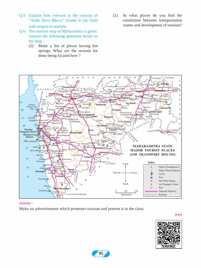
95
Q 5 Explain how relevant is the concept of “Atithi Devo Bhava” (Guest is our God)
with respect to tourism.Q 6 The tourism map of Maharashtra is given.
Answer the following questions based on the map.
(1) Make a list of places having hot springs. What are the reasons for these being located here ?
(2) At what places do you find the correlation between transportation routes and development of tourism?
Activity :Make an advertisement which promotes tourism and present it in the class.
***
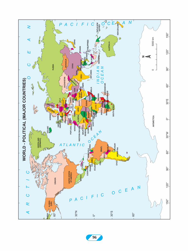
96
97
� Alluvial fans : When a river enters the plain area after crossing the mountainous area, its speed reduces drastically and the sediments brought down with it get deposited at the river bed. This deposition looks like a fan and therefore it is called alluvial fans. These alluvial fans can be seen in semi-arid regions. At the foothills of the Himalayas, esp. after crossing the Siwalik ranges, rivers enter the North Indian plains. Such plains are formed here. eg. alluvial fans formed by river Kosi.
� Arch : Where headlands extend well into the sea, they get eroded and sea arches are formed. They are found mostly in the regions having soft sedimentary rocks like sandstone or limestone. Waves hit the base of the headland on both the sides. The base part is eroded and with time, sea arch is formed.
� Barchan : A crescent shaped sand dune. The convex side of this dune is the windward side, while the concave side is opposite the flow of the wind. The windward convex side has gentle slope while concave side is steep. When the winds carrying sand particles slow down or come across an obstacle, deposition takes places and heaps of sand develop. The flow of the wind diverts at the heap and wind starts blowing from both the sides of the heap. Sand starts moving ahead along the direction of the wind and the heap gets a crescent shape. The windward side of the barchan keeps receiving sand particles and therefore, ripple marks are visible on this slope.
� Beaches : Land between two headlands. Because of the headlands, coast is somewhat protected from the onslaught of the waves. Waves coming to the coast undergo refraction continuously Because of this refraction, waves converge at the headlands. While they diverge
between two headlands. Consequently, the energy stored in them also bifurcates, the transporting ability also get reduced and the sediments get deposited between the two headlands. As the process takes place continuously on a large scale, beaches are formed by deposition of sand. Beaches are generally concave to the sea.
� Biological weathering : Weathering caused due to living organisms.
� Black and white patterns : Various patterns of black color used to show sub-divisions of a region on a map
� Block Disintegration : Weathering happening due to water entering the crevices and joints of rocks. Mainly the joints or crevices broaden and blocks of rocks separate.
� Buoyancy : The force of a liquid acting in a vertical direction which opposes sinking of a floating object. With increasing density of the liquid, buoyant force increases.
� Buyer : Consumer who pays in exchange of a good or service
� Caves : Open hollow space formed beneath the ground through natural process is called cave. Caves are formed due to chemical weathering of rocks. We find many small and large caves in limestone regions. Stalactites and stalagmites are formed inside these caves. Caves are also formed in regions other than limestone landscapes. Sea caves are formed due to chemical weathering and erosional work of the waves. Caves can be man-made too e.g. the caves of Ajanta and Ellora.
� Chemical Weathering : Weathering occuring through chemical reactions. This weathering happens in regions of humid climates. Major processes include carbonisation, solution, oxidation, etc. In
Detailed meanings of geographical terms
GLOSSARY
98
equatorial areas, Chemical weathering happens upto considerable depths.
� Choropleth Method : A method of preparing distributional maps. Area-related (polygonal) statistical information is used in this method. One value is assigned to the whole region (division). Different tints of colors are used for different values and the map is prepared accordingly.
� Cirque and Horn : Landforms produced due to erosional work of glaciers. Both the landforms are produced in the areas where the glaciers originate. After snowfall, the snow doesn’t start flowing immediately like water, it gets deposited. It deposits more at the base than the slopes. When many layers of snow get deposited, the lower layers face pressure from above and turn into ice. While turning into ice and and because of pressure, some ice at the bottom turns into water due to friction. This water starts flowing along the slope. This flow is the starting point of glacier. Ice on the slope also starts moving downwards. Friction causes the slopes fo the mountains to become steep. Moving ice gets deposited at the foothills. Weathering by melted water leads to deepening basal portion. Such deepened portions at the base of slopes are called cirques. The cirque and the mountain behind it with steep slope together look like a big ‘armchair’ and therefore, cirques are often called gigantic armchairs. If cirques develop on all the sides of the mountains slopes, then the summit of the mountain looks like a horn. This is called horn. ‘Matterhorn’ in the Alps along the borders of Italy and Switzerland in Europe is the world famous example of horn.
� Class Interval : The difference between the higher boundary and the lower boundary of a class is called class interval. While making choropleth or isopleth maps, 5-7 classes are made considering the maximum and minimum
values of a variable.
� Colour tints : Colours are used to show various types of regions on thematic maps. In choropleth or isopleth maps, various tints of the same colour are used. These tints are dependent on values. Regions with lesser values are shown by lighter tints while higher valves are represented by darker tints.
� Concentrive layers : When hails are formed, they move up and down continuously because of upward movement of air currents. As they go to higher attitude, a new layer of ice gets deposited around it. As this happens frequently, many layer get deposited on top of each other. Such layers are called concentric layers.
� Conglomerate : The pebbles in the sediments at the bottom of the river consolidate together because of mud and rock gets formed when such material is subjected to pressure. The pebbles in it are easily visible.
� Convection current : A flow in which movement occurs in upward, downward and circular directions like the flow in boiling water
� Deficit : Situation arising when supply is less than its demand.
� Delta : Landform formed due to the depositional work of rivers at its mouth. In the lower course of the river, the flow of the river is very slow but the volume of water has increased. Sediments brought with the flow get deposited in the river bed itself and the flow of the river gets divided into many channels. These are known as braided channels. Later, where the river meets the sea, the sea waves somewhat oppose the river flow and therefore, a large amount of deposition of sediments occurs. Many channels form out of the main river and meet the sea independently. Such channels are known as distributaries. The
Detailed meanings of geographical terms
99
part between two distributaries is made up of sediments. The seaward side is broader while the landward side tapers. This looks like a triangle and therefore it is known as delta.
� Demand : The measure of goods/services which consumers are ready to buy at a specific price is called demand. The price of the goods or services can change according to demand.
� Dot Method : A method used in preparing distributional maps. In this method, data obtained through counting is used e.g. population, cattle count, etc. While preparing such maps, factors which affect the distribution of an element like physiography of a region, transportation routes, river systems, etc. have to be taken into consideration.
� Downward movement : Going at a lower level. The movement of a material taking place in a downward direction. Such types of movements occur in the interior of the earth
� Drumlin : Hills formed due to deposition of moraines. They are generally egg-shaped . If there are many hills of this type in a region, then such a region is called egg-basket
� Erosion : Wearing away of rocks by different agents. The rocks are eroded continuously by the wind, rivers, glaciers, the sea waves and groundwater. The wearing takes place mainly because of the kinetic energy generated during the movement of the agents. Kinetic energy is dependent on the mass and the velocity of the moving material.
� Eskers : Narrow, long, winding ridges produced through deposition of moraines
� Exfoliation : Mechanical weathering taking place ¬due to the 'peeling' away of outer layers of rock. Rocks get heated due to sun’s heat. Granular tension develops in the rock because of alternate contraction and expansion of minerals in the rock. The upper/
outer layer of the rock gets affected the most. So successive layers come out with time.
� Fault : Because of interior movements of the earth, rocks undergo tension and develop fractures. Such fractures are called faults. Faults can also develop when due to extreme pressure in folding as the folds break.
� Flood levees and flood plains : Landforms formed due to depositional work of rivers. When the level of water in the river channel increases, it overflows and waterspreads to nearby areas. This is called flooding. When the river is flooding, a large amount of sediment comes out with the flow. Heavy sediments are found towards the bottom of the river while suspended particles are scattered all over. Suspended sediments get deposited to the places where the flood waters reach perpendicular to the flow of the river. This region is called flood plain. The coarse sediments carried by the flood water gets deposited at the banks and as continuous process of deposition occurs at the bank, its level increases. Levees parallel to the river flow are formed close to the bank. These are called flood levees.
� Folding : Due to the movements occuring in the mantle of the earth, the crust faces pressure and gets folded. This process is called folding.
� Frost : Particles of snow formed from sublimation of water vapor at the surface. These are seen on the plant leaves, window panes, etc
� Frostbite : Freezing of skin and its upper tissues because of very cold temperatures. Tourists going to snow-covered regions face frostbites many a time. Generally, it affects hands, legs and skin of the face. Severe frostbite can affect skin, tissues and can even reach the bones.
� Gorge : Deep and narrow valley. The slopes of gorges are steep and almost vertical .
Detailed meanings of geographical terms
100
� Granular Weathering : Weathering of rock particles by breaking into granules esp in rocks like sandstone, conglomerate when the cementing material weakens and the joined particles become loose and come off.
� Gravitational force : An object which has mass attracts other objects having mass. This force of attraction is called gravitational force. The object which has more mass has more force. Gravitational force is dependent upon the masses of the objects and the distance between them.
� Gross Domestic Product (GDP) : It is the sum of all productions in all sectors in an economy in one year. The goods and services produced in the primary , secondary and tertiary occupations are considered for the GDP. The value of production of GDP in monetary value is the national income of the country.
� Hamada : A landform found in the desert regions. They are mainly in the form of tall, dry, rocky plateaus in desert regions. Because the sand has been carried away in the process of transportation, there is less sand on them and mainly pebbles are found on the plateaus.
� Hanging Valley : Landform produced due to erosional work of glaciers. The amount of snow in a tributary glacier is less compared to the main glacier. Consequently, erosion happens at a lower scale. In the main glacier, snow is accumulated to full height in its bed. When the main and the tributary glaciers meet, the height of snow is the same rather than the heights of their beds. The bottom of the tributary glacier is at higher level than the bottom of the main glacier. When snow melts, the difference in height of their bases becomes visible. The valley of the tributary glacier is higher and appears like it is hanging over the valley of the main glacier. Therefore, such a
valley is called hanging valley.
� Horizon : The line where the sky and the land appear to meet. When the celestial bodies like the sun and the moon appear on this line, it is said that they have risen and when they disappear, it is said that they have set.
� Hydraulic : Related to liquid. erosion caused due to pressure of liquid. Such erosion can be seen by the waves in coastal areas. Waves rise up at the rocky coasts. The air in the deeper part gets trapped. When the waves break and hits the rocks, the trapped air is freed in an explosive manner. Tremendous energy is released in this process and this wears away the rock at its base.
� Internal Trade : Exchange of goods and services within the sub-divisions of a region.
� International Date Line (IDL) : An imaginary line which approximately follows 180° meridian. Travelers have to change the date and time while crossing the IDL. While travelling to the east, i.e. going from Asia- Australia to the continents of Americas the last day and date is accepted i.e. the ongoing date is carried forward. But while travelling from the American continents towards Asia-Austrrlia i.e towards the west, travelers need to add one day and take the next day and date. The line goes completely through the ocean.
� International Trade : Trade between countries. Also known as export-import trade. This can be bilateral or multi-lateral. Goods produced in a country are exported to or imported by another country by paying its cost.
� Invisible Trade : A trade in which exchange of goods does not occur. Service trade is an example of invisible trade. Tourism is also a type of invisible trade.
Detailed meanings of geographical terms
101
� Isopleth Method : A method of drawing maps. Point-related statistical data is used in this method. This means that statistical data belongs to a place. This method is used for the variables whose distribution is continuous, e.g. rainfall, temperature, etc.
� Lagoon : Lagoons are commonly divided into coastal lagoons and atoll lagoons. Both the types of lagoon lakes are shallow and are separated from the main sea. Tides have no influence over them. Waves are also not very high. Coastal lagoons are formed due to deposition of sand. Atolls are separated from the main sea because of coral reefs
� Land locked : Surrounded by land. (1) Seas that are not connected to any ocen. They are called land-locked seas like Aral Caspian. (2) Countries which do not have any coast are also called land-locked countries like Nepal, Bhutan etc.
� Landslide : Weathered rocks accumulate on the slopes of hills on a large scale. As this heap is somewhat brittle, water penetrates in it during rainy season. As a result, the mass of the heap increases and it starts moving towards the foothills. The speed of moving material increases and in no time a big rock and heap of soil comes down the hill. Landslides also occur due to eartquakes.
� Lichen : One of the primary plants formed out of the coming together of fungus and algae. It generally grows on the rocks, walls and trunks of the trees.
� Market Committees : Market Committees have been established to facilitate sale of the products by producess and buying by traders at one place. As farming is done in extensive areas, the marketing of the form products through market committees becomes feasible.
� Mechanical Weathering : Wearing away of rocks due to contact with the physical
environment is called mechanical weathering. This includes processes mainly thermal tension, crystallization, release of pressure, etc.
� Moss : Small flowerless plants, they always grow in moist shaded locations. They can be seen on the trunks of trees in the humid climates.
� Mushroom Rock : Landform formed due to erosional work of wind.
� Oxidation : A type of chemical weathering. When oxygen reacts with iron in the rock, rust is formed. Reaction of any element with oxygen is called oxidation.
� Per Capita Income : The ratio between the total population of the country and the total national production is called Per capita income.
� Plates : The crust floats on the mantle but the crust is not continuous. It is separated into small and large piece. These pieces float over the mantle and also move independently. There pieces are called plates.
� Precipitation (in chemistry) : Solidification of a previously dissolved substance from a solution. Through chemical weathering processes like carbonation and solution, alkalis in the rock get carried away with water in soluble form. When water evaporates, these alkalis accumulate at a place in solid form. When this happens it is said that alkalis have been precipitated. The stalactites and stalagmites formed in limestone landscape are a result of precipitation
� Producer : One who produces. One who obtains products with the help of natural or artificial processes is called producer.
� Radioactive substances : In elements with higher atomic numbers, that are invisible, highly penetrating and emitting spontaneously.
Detailed meanings of geographical terms
102
high quality radiations. Such substances are called radioactive substances. For example, uranium, thorium, radium, etc.
� Rain Gauge : Instrument to measure the amount of rainfall. In a simple rain gauge, the collected rain water is measured by a measuring jar. Through a self-recording rain gauge a graph for rainfall the whole day or during a specific period gets drawn.
� Remote Sensing : Obtaining information regarding any place or an object without actually establishing direct contact with it is called Remote Sensing. In this technique, information regarding the earth’s surface is obtained through aerial photography or satellite sensors. Such information is used to study natural resources.
� Retailers : The link between wholesale traders and consumers or customers. Retail traders buy goods from wholesale traders and make them available to the consumers.
� Ripple Marks : When water flows or wind blows over loose sand, the sand towards the bottom is pulled or pushed in the direction of flow, wave like structures of sand are formed on sand perpendicular to the flow. These ripple marks are seen on beaches in coastal areas or towards the windward side of the barchans.
� Roche Moutonnee : Landform found in the glacier bed. It is formed due to erosional work of glocier. The passage of glacier ice over underlying rock the up slope side smooth while the down slope side becomes rough because of weathering by melted water. This is called roche moutonnee.
� Salinity : The amount of salt in water. The amount of salt in the sea water is expressed in parts per thousand. Generally, the salinity of the sea is 35% which means that 1000gm of water contains 35 gm of salt.
� Salt Weathering : This type of weathering is mainly seen on the rocky coasts. When waves break at the coast, their water droplets hit the sea cliffs. In this saline water, the soluble materials in the rocks get dissolved and small holes are formed in the rocks. This is the effect of solution. Through these holes, saline water enters the rock. After evaporation of water, the salts remain in the rocks itself. When they undergo crystallization, crystals grow and occupy more space. These creates tension in the rock. The holes get enlarged. This gives the cliff an appearance of honeycomb and hence this type of weathering is called honeycomb weathering.
� Sand bar : Many landforms are produced due to deposition of sand on the sea coasts. Beach is one of them. The waves carry away the sand on the beaches. But this sand is not carried too far; it starts forming keep usage the an is land parallel to the beach at a distance from the lowest level of low tide. With time, these islands become larger and a series of islands get formed. Such island get connected to each other to form a sand bar. As there bars are parallel to the beach, they may give rise to lagoon lakes.
� Sandstone : Rock made up of sand. It is a type of sedimentary rock.
� Sand dune : Landform produced due to the deposition work of wind. Such landforms are produced in arid regions or along sea coasts. According to their shape, sand dunes can be divided into two major types : Barchans and seifs.
� Sea Cave : Caves are formed when sea waves hit the foot of the sea cliffs. Except few examples, these caves are not very deep.
� Sea Cliff : Landform formed by erosional work of sea waves. Sometimes the hills extend upto the sea coasts; the waves hit its
Detailed meanings of geographical terms
103
base continuously. The rocks at the foot of the cliff start eroding. Consequently, the upper rocks fall down as their foundation gets lost suddenly. This leads to formation of sea cliff. Mostly, wave-cut platforms are seen at the base of the sea cliff.
� Seif : In Arabic, seif means sword. Such sand dunes are narrow and spread to a long distance. They resemble swords and are therefore named so. They are parallel to the direction of the wind blowing. They taper towards the wind direction. Their slopes are somewhat symmetrical and crests are sharp. In Rub-al-khali desert of Saudi Arabia and deserts in Iran, seifs are visible even up to 200 km
� Services : Type of human occupation. In this, trade or production of goods does not occur. The people engaged in this occupation provide various services to the people like teachers, lawyers, doctors, etc.
� Shattering : A type of mechanical weathering. In temperate zones where temperature falls below zero, water in the crevices of the rocks freezes. Frozen water needs more space and this leads to breaking of rocks. Their shattered pieces spread here and there
� Sink hole : A landform produced mainly in limestone region due to erosion. Limestone, contains soluble materials in greater amounts. Such materials dissolve in water and are carried away by water. This process leads to formation of caves in this region. With time, the roof of the cave collapses and only a hole is visible on the ground. Such a hole produced naturally in the ground is called sink hole. The water that flows on the surface meet appears to get lost in there holes.
� Solifluction : Mass movement occurring slowly. In peri - glacial areas, where temperatures are below zero degrees for
a period, processes of freezing of water and melting of snow occurs continuously. Solifluction occurs here mainly
� Solubility : The capacity of a liquid to dissolve other materials in itself.
� Soluble : A material which can set dissolved.
� Stalactite and Stalagmites : Pillars formed from alkaline deposits in the caves in limestone areas. Salts brought by flowing groundwater deposit in the caves when water evaporates. When alkalis deposit, pillars start growing either from the roof down or floor up of the cave. Those which grow from the roof towards the flood are called stalactites while those which grow from the ground towards the roof are called stalagmites Bora caves in Vishakhapatnam district in Andhra Pradesh are one of the major limestone caves in India.
� Thematic Maps : Maps drawn to display the geographical distribution of one or more variables.
� Tourist : Traveller who visits various places for recreation and stays there for some time.
� Tourist-places : Sites which attract tourists natural, historical, religious places. Tourists visits such places.
� Upward Movements : The movement of a material to a higher level in a vertical direction. Such movements occur in the earth’s interiors.
� Universal solvent : A solvent in which many soluble materials can get dissolved. As water can dissolve number of materials, it is known as a universal solvent.
� Urban population : The number of people living in urban areas. Most of them are engaged in secondary or tertiary occupations
� V shaped Valley : Landform produced due to erosional work of rivers. A V-shaped river valley is formed near the origin of the river or in its upper course. Vertical erosion
Detailed meanings of geographical terms
104
occurs rapidly near the river. Comparatively the headward erosion is lesser. And therefore its elevation is higher. But the riverbed starts deepening. Consequently, it gets the shape of the alphabet ‘V’
� Visible Trade : The type of trade in which goods are bought and sold or a trade in which the exchanged goods can be seen is known as visible trade
� Wave-cut platform : Landform formed due to hitting of waves at the coast. Such platforms are formed at the base of the sea cliffs generally.
� Weathering : The process by which rocks become weak. Three types of weathering are mechanical, chemical and biological.
� Wholesale Market : The market where producers sell their products to big traders. At these markets, traders or consumers who want to buy in retail do not turn up generally.
� Yardang : Landform formed due to the dual work of erosion and transportation by the wind. It is formed due to friction and carrying away of original rock or homogenous sediments. It looks like a toppled boat. The slope of the windward side is steep while the leeward side has a gentle slope. If the region has hard and soft rocks, then the part with soft rocks appears like trough while hard rock appears like a mound.
Reference Material : � Physical Geography- A. N. Strahler� Living in the Environment- G. T. Miller� A Dictionary of Geography- Monkhouse� Physical Geography in Diagrams- R.B. Bunnett� Encyclopaedia Britannica Vol.- 5 and 21� Population Geography- Dr S. B. Sawant� मराठी विशिकोश खंड- १,४,९,१७ ि १८� प्ाकृविक भूगोल- प्ा. दािे ि सौ. दािे� इंग्रजी-मराठी शबदकोश- J. T. Molesworth and T. Candy� भारिीय अर्थवयिसरा- डॉ. देसाई, डॉ. सौ भालेराि
Websites for reference :
� http://www.kidsgeog.com� http://www.wikihow.com� http://www.wikipedia.org� http://www.latlong.net� http://www.ecokids.ca� http://www.ucar.edu� http://www.bbc.co.uk/schools� http://www.globalsecurity.org� http://www.nakedeyesplanets.com� http://www.windy.com� http://science.nationalgeographic.com� http://en.wikipedia.org� http://geography.about.com� http://earthguide.uced.edu
Detailed meanings of geographical terms