Embed Size (px)
Citation preview
GeographyLeaving Certificate
1 Geography | Leaving Certificate |
Subject: Leaving Certificate Geography
Teacher: James Campbell
LESSON 1-2
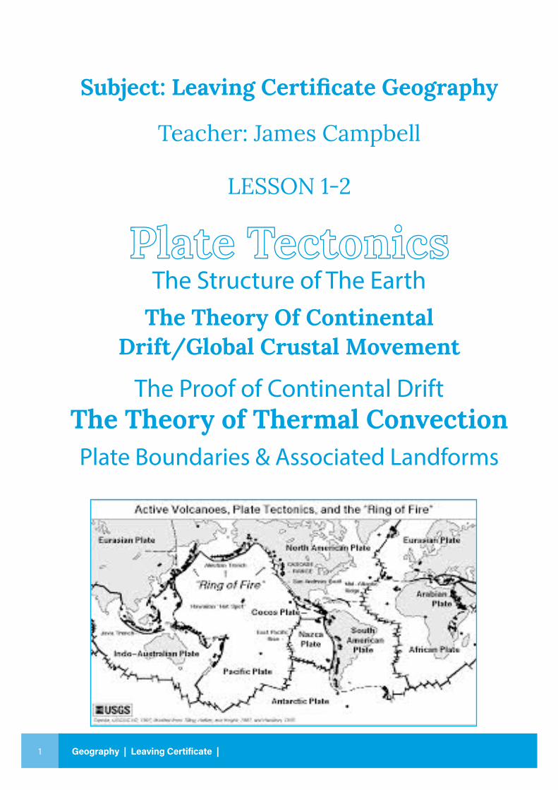
Plate TectonicsThe Structure of The Earth
The Theory Of Continental Drift/Global Crustal Movement
The Proof of Continental DriftThe Theory of Thermal ConvectionPlate Boundaries & Associated Landforms
2
Geo
grap
hy |
Leav
ing
Cert
ifica
te L
ESSO
N 1
-2
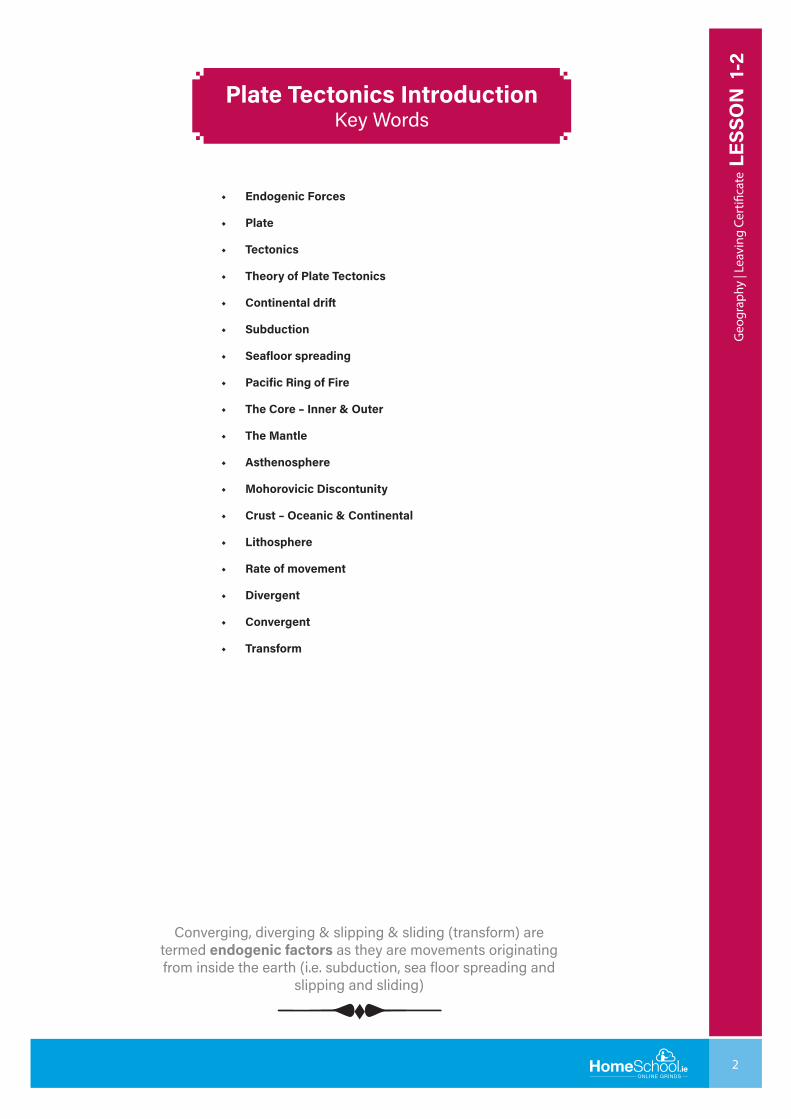
Plate Tectonics IntroductionKey Words
◆ Endogenic Forces
◆ Plate
◆ Tectonics
◆ Theory of Plate Tectonics
◆ Continental drift
◆ Subduction
◆ Seafloor spreading
◆ Pacific Ring of Fire
◆ The Core – Inner & Outer
◆ The Mantle
◆ Asthenosphere
◆ Mohorovicic Discontunity
◆ Crust – Oceanic & Continental
◆ Lithosphere
◆ Rate of movement
◆ Divergent
◆ Convergent
◆ Transform
Converging, diverging & slipping & sliding (transform) are termed endogenic factors as they are movements originating from inside the earth (i.e. subduction, sea floor spreading and
slipping and sliding)
3 Geography | Leaving Certificate |
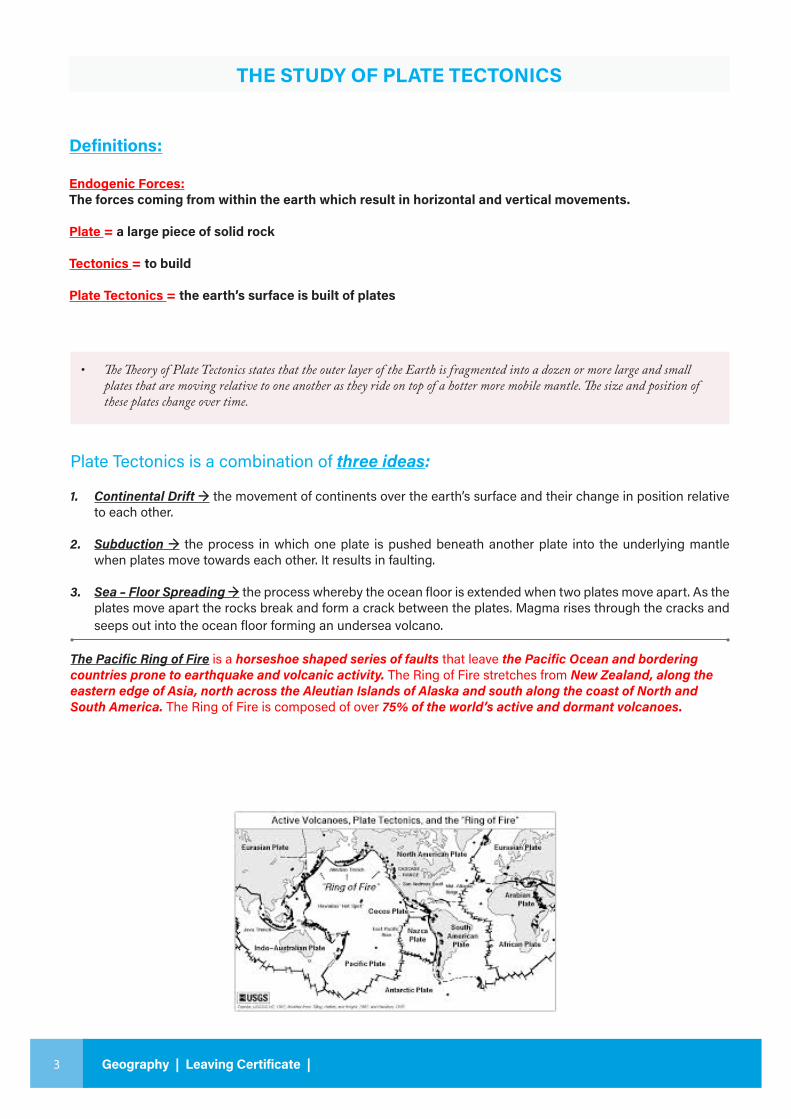
THE STUDY OF PLATE TECTONICS
Definitions:
Endogenic Forces:The forces coming from within the earth which result in horizontal and vertical movements.
Plate = a large piece of solid rock
Tectonics = to build
Plate Tectonics = the earth’s surface is built of plates
• The Theory of Plate Tectonics states that the outer layer of the Earth is fragmented into a dozen or more large and smallplates that are moving relative to one another as they ride on top of a hotter more mobile mantle. The size and position ofthese plates change over time.
Plate Tectonics is a combination of three ideas:
1. Continental Drift → the movement of continents over the earth’s surface and their change in position relativeto each other.
2. Subduction → the process in which one plate is pushed beneath another plate into the underlying mantlewhen plates move towards each other. It results in faulting.
3. Sea – Floor Spreading → the process whereby the ocean floor is extended when two plates move apart. As theplates move apart the rocks break and form a crack between the plates. Magma rises through the cracks andseeps out into the ocean floor forming an undersea volcano.
The Pacific Ring of Fire is a horseshoe shaped series of faults that leave the Pacific Ocean and bordering countries prone to earthquake and volcanic activity. The Ring of Fire stretches from New Zealand, along the eastern edge of Asia, north across the Aleutian Islands of Alaska and south along the coast of North and South America. The Ring of Fire is composed of over 75% of the world’s active and dormant volcanoes.
4
Geo
grap
hy |
Leav
ing
Cert
ifica
te L
ESSO
N 1
-2THE FOLLOWING CONCEPTS NEED TO BE KNOWN FOR THE SHORT QUESTIONS
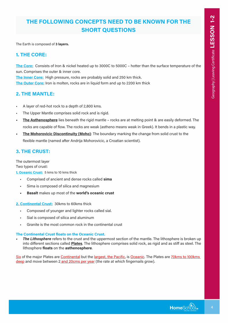
The Earth is composed of 3 layers.
1. THE CORE:
The Core: Consists of Iron & nickel heated up to 3000C to 5000C – hotter than the surface temperature of the sun. Comprises the outer & inner core.The Inner Core: High pressure, rocks are probably solid and 250 km thick.The Outer Core: Iron is molten, rocks are in liquid form and up to 2200 km thick
2. THE MANTLE:
• A layer of red-hot rock to a depth of 2,800 kms.
• The Upper Mantle comprises solid rock and is rigid.
• The Asthenosphere lies beneath the rigid mantle – rocks are at melting point & are easily deformed. The
rocks are capable of flow. The rocks are weak (astheno means weak in Greek). It bends in a plastic way.
• The Mohorovicic Discontinuity (Moho): The boundary marking the change from solid crust to the
flexible mantle (named after Andrija Mohorovicic, a Croatian scientist).
3. THE CRUST:
The outermost layerTwo types of crust:1. Oceanic Crust: 5 kms to 10 kms thick
• Comprised of ancient and dense rocks called sima
• Sima is composed of silica and magnesium
• Basalt makes up most of the world’s oceanic crust
2. Continental Crust: 30kms to 60kms thick
• Composed of younger and lighter rocks called sial.
• Sial is composed of silica and aluminum
• Granite is the most common rock in the continental crust
The Continental Crust floats on the Oceanic Crust.• The Lithosphere refers to the crust and the uppermost section of the mantle. The lithosphere is broken up
into different sections called Plates. The lithosphere comprises solid rock, as rigid and as stiff as steel. Thelithosphere floats on the asthenosphere.
Six of the major Plates are Continental but the largest, the Pacific, is Oceanic. The Plates are 70kms to 100kms deep and move between 2 and 20cms per year (the rate at which fingernails grow).
5 Geography | Leaving Certificate |
A Cross Section of The Earth
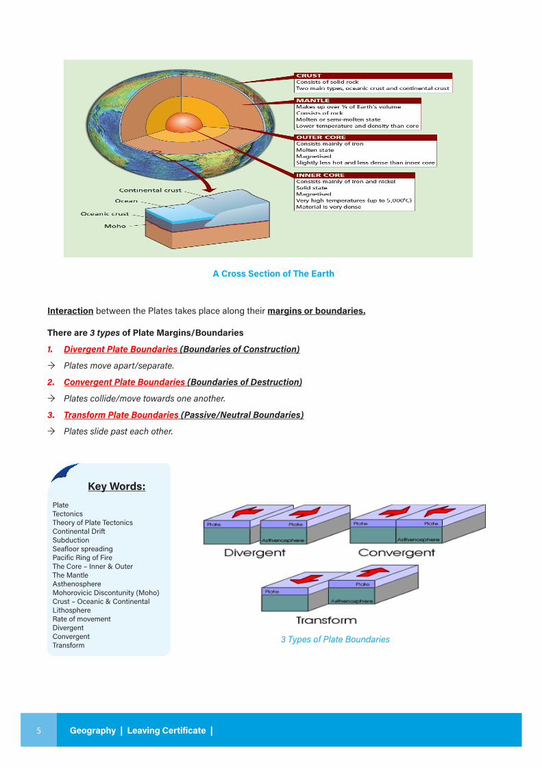
Interaction between the Plates takes place along their margins or boundaries.
There are 3 types of Plate Margins/Boundaries
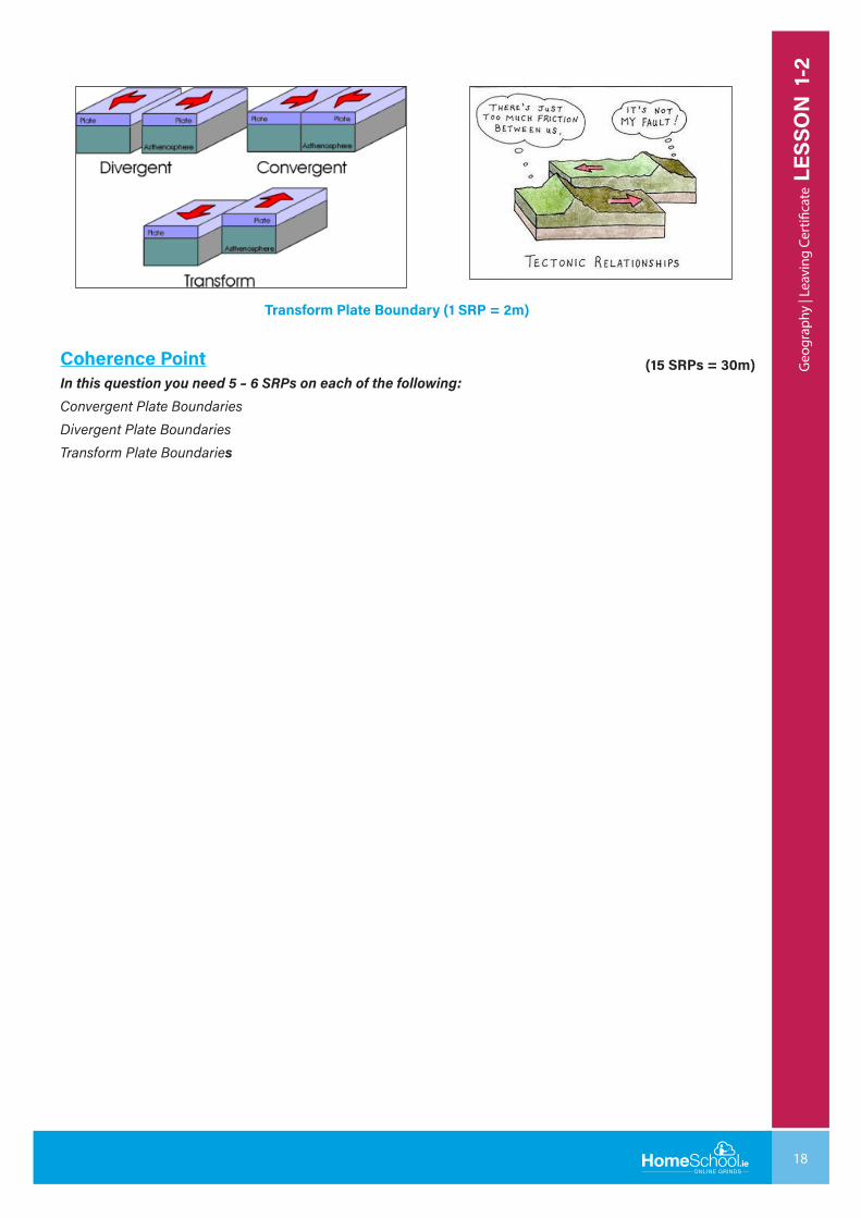
1. Divergent Plate Boundaries (Boundaries of Construction)
→ Plates move apart/separate.
2. Convergent Plate Boundaries (Boundaries of Destruction)
→ Plates collide/move towards one another.
3. Transform Plate Boundaries (Passive/Neutral Boundaries)
→ Plates slide past each other.
3 Types of Plate Boundaries
Key Words:PlateTectonicsTheory of Plate TectonicsContinental DriftSubductionSeafloor spreadingPacific Ring of FireThe Core – Inner & OuterThe MantleAsthenosphereMohorovicic Discontunity (Moho)Crust – Oceanic & ContinentalLithosphereRate of movementDivergentConvergentTransform
6
Geo
grap
hy |
Leav
ing
Cert
ifica
te L
ESSO
N 1
-2SAMPLE QUESTION 1: WITH THE AID OF LABELLED DIAGRAMS DISCUSS THE PROCESS OF GLOBAL CRUSTAL PLATE MOVEMENT?
(30M)
This question requires a minimum of 15 SRPs
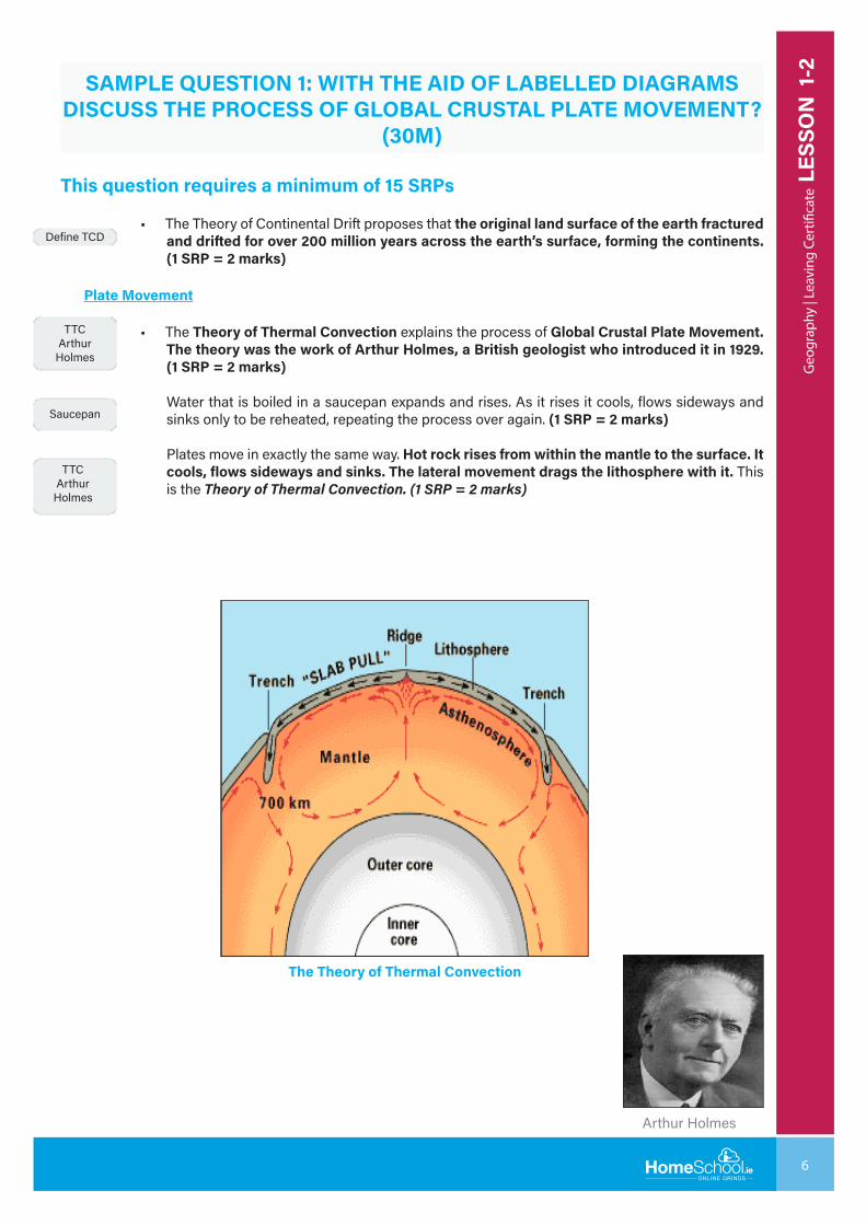
• The Theory of Continental Drift proposes that the original land surface of the earth fracturedand drifted for over 200 million years across the earth’s surface, forming the continents.(1 SRP = 2 marks)
Plate Movement
• The Theory of Thermal Convection explains the process of Global Crustal Plate Movement.The theory was the work of Arthur Holmes, a British geologist who introduced it in 1929.(1 SRP = 2 marks)
Water that is boiled in a saucepan expands and rises. As it rises it cools, flows sideways andsinks only to be reheated, repeating the process over again. (1 SRP = 2 marks)
Plates move in exactly the same way. Hot rock rises from within the mantle to the surface. Itcools, flows sideways and sinks. The lateral movement drags the lithosphere with it. Thisis the Theory of Thermal Convection. (1 SRP = 2 marks)
Define TCD
Define TCD
TTCArthur
Holmes
TTCArthur
Holmes
Saucepan
The Theory of Thermal Convection
Arthur Holmes
7 Geography | Leaving Certificate |
Alfred Wegener
Animals walked
Glossopteris
Glossopteris
Tropical Plant Fossils
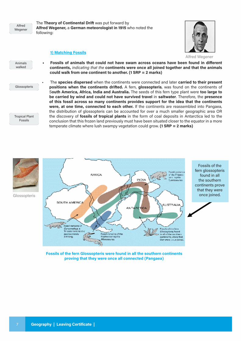
The Theory of Continental Drift was put forward by Alfred Wegener, a German meteorologist in 1915 who noted the following:
Alfred Wegener 1) Matching Fossils
• Fossils of animals that could not have swam across oceans have been found in different continents, indicating that the continents were once all joined together and that the animals could walk from one continent to another. (1 SRP = 2 marks)
• The species dispersed when the continents were connected and later carried to their present positions when the continents drifted. A fern, glossopteris, was found on the continents of South America, Africa, India and Australia. The seeds of this fern type plant were too large to be carried by wind and could not have survived travel in saltwater. Therefore, the presence of this fossil across so many continents provides support for the idea that the continents were, at one time, connected to each other. If the continents are reassembled into Pangaea, the distribution of glossopteris can be accounted for over a much smaller geographic area OR the discovery of fossils of tropical plants in the form of coal deposits in Antarctica led to the conclusion that this frozen land previously must have been situated closer to the equator in a more temperate climate where lush swampy vegetation could grow. (1 SRP = 2 marks)
Fossils of the fern glossopteris
found in all the southern
continents prove that they were once joined.Glossopteris
Fossils of the fern Glossopteris were found in all the southern continents proving that they were once all connected (Pangaea)
8
Geo
grap
hy |
Leav
ing
Cert
ifica
te L
ESSO
N 1
-2
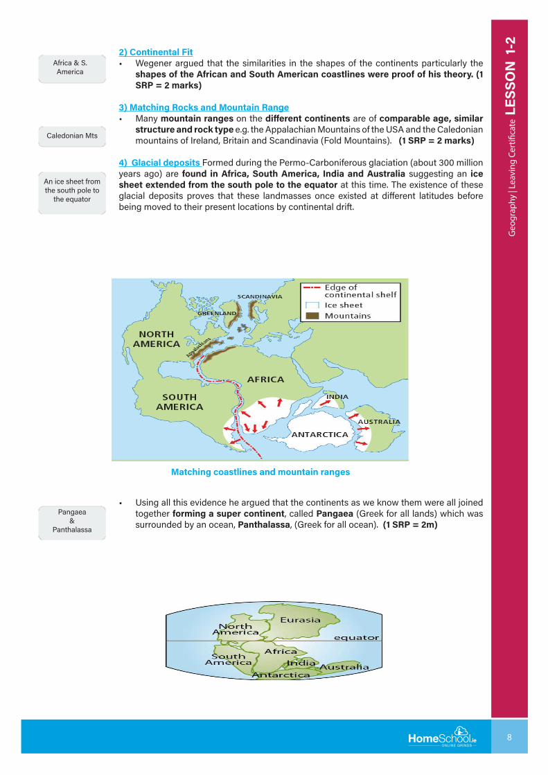
Matching coastlines and mountain ranges
2) Continental Fit• Wegener argued that the similarities in the shapes of the continents particularly the
shapes of the African and South American coastlines were proof of his theory. (1 SRP = 2 marks)
3) Matching Rocks and Mountain Range• Many mountain ranges on the different continents are of comparable age, similar
structure and rock type e.g. the Appalachian Mountains of the USA and the Caledonian mountains of Ireland, Britain and Scandinavia (Fold Mountains). (1 SRP = 2 marks)
4) Glacial deposits Formed during the Permo-Carboniferous glaciation (about 300 million years ago) are found in Africa, South America, India and Australia suggesting an ice sheet extended from the south pole to the equator at this time. The existence of these glacial deposits proves that these landmasses once existed at different latitudes before being moved to their present locations by continental drift.
• Using all this evidence he argued that the continents as we know them were all joined together forming a super continent, called Pangaea (Greek for all lands) which was surrounded by an ocean, Panthalassa, (Greek for all ocean). (1 SRP = 2m)
Africa & S. America
Caledonian Mts
An ice sheet from the south pole to
the equator
Pangaea&
Panthalassa
9 Geography | Leaving Certificate |
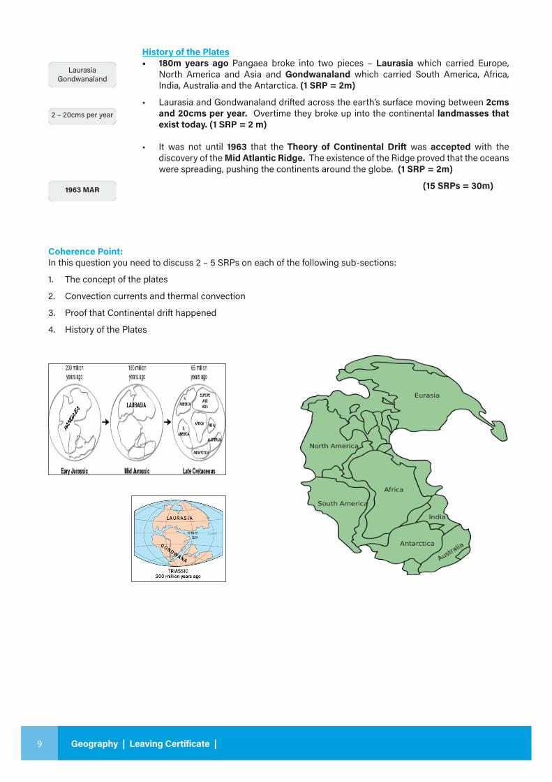
History of the Plates• 180m years ago Pangaea broke into two pieces – Laurasia which carried Europe,
North America and Asia and Gondwanaland which carried South America, Africa, India, Australia and the Antarctica. (1 SRP = 2m)
• Laurasia and Gondwanaland drifted across the earth’s surface moving between 2cmsand 20cms per year. Overtime they broke up into the continental landmasses thatexist today. (1 SRP = 2 m)
• It was not until 1963 that the Theory of Continental Drift was accepted with thediscovery of the Mid Atlantic Ridge. The existence of the Ridge proved that the oceanswere spreading, pushing the continents around the globe. (1 SRP = 2m)
(15 SRPs = 30m)
LaurasiaGondwanaland
2 – 20cms per year
1963 MAR
Coherence Point: In this question you need to discuss 2 – 5 SRPs on each of the following sub-sections:
1. The concept of the plates
2. Convection currents and thermal convection
3. Proof that Continental drift happened
4. History of the Plates
10
Geo
grap
hy |
Leav
ing
Cert
ifica
te L
ESSO
N 1
-2
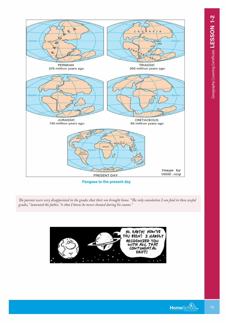
Pangaea to the present day
The parents were very disappointed in the grades that their son brought home. “The only consolation I can find in these awful grades,” lamented the father, “is that I know he never cheated during his exams.”
11 Geography | Leaving Certificate |
SAMPLE QUESTION 2: WITH THE AID OF A DIAGRAM EXPLAIN WHAT HAPPENS AT A DIVERGENT PLATE BOUNDARY. IN YOUR ANSWER
REFER TO ASSOCIATED LANDFORMS? (30m)
This question requires a minimum of 15 SRPs
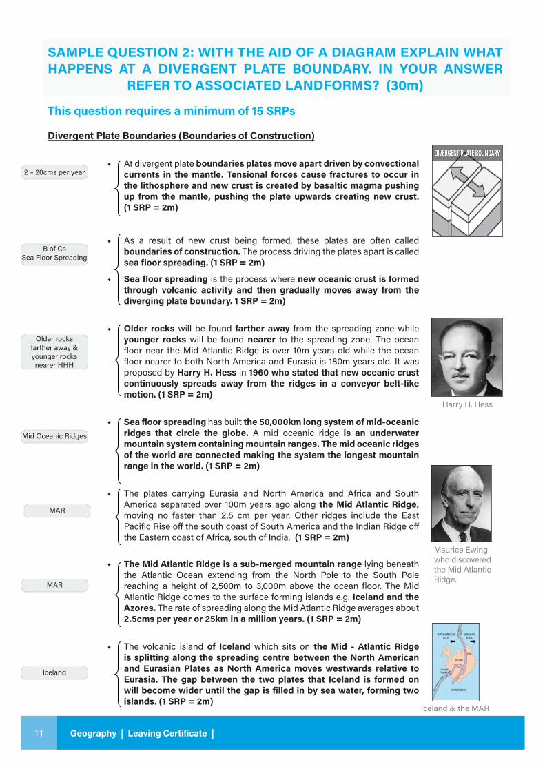
Divergent Plate Boundaries (Boundaries of Construction)
Iceland
Harry H. Hess
Maurice Ewing who discovered the Mid Atlantic Ridge.
◆ At divergent plate boundaries plates move apart driven by convectional currents in the mantle. Tensional forces cause fractures to occur in the lithosphere and new crust is created by basaltic magma pushing up from the mantle, pushing the plate upwards creating new crust. (1 SRP = 2m)
◆ As a result of new crust being formed, these plates are often called boundaries of construction. The process driving the plates apart is called sea floor spreading. (1 SRP = 2m)
◆ Sea floor spreading is the process where new oceanic crust is formed through volcanic activity and then gradually moves away from the diverging plate boundary. 1 SRP = 2m)
◆ Older rocks will be found farther away from the spreading zone while younger rocks will be found nearer to the spreading zone. The ocean floor near the Mid Atlantic Ridge is over 10m years old while the ocean floor nearer to both North America and Eurasia is 180m years old. It was proposed by Harry H. Hess in 1960 who stated that new oceanic crust continuously spreads away from the ridges in a conveyor belt-like motion. (1 SRP = 2m)
◆ Sea floor spreading has built the 50,000km long system of mid-oceanic ridges that circle the globe. A mid oceanic ridge is an underwater mountain system containing mountain ranges. The mid oceanic ridges of the world are connected making the system the longest mountain range in the world. (1 SRP = 2m)
◆ The plates carrying Eurasia and North America and Africa and South America separated over 100m years ago along the Mid Atlantic Ridge, moving no faster than 2.5 cm per year. Other ridges include the East Pacific Rise off the south coast of South America and the Indian Ridge off the Eastern coast of Africa, south of India. (1 SRP = 2m)
◆ The Mid Atlantic Ridge is a sub-merged mountain range lying beneath the Atlantic Ocean extending from the North Pole to the South Pole reaching a height of 2,500m to 3,000m above the ocean floor. The Mid Atlantic Ridge comes to the surface forming islands e.g. Iceland and the Azores. The rate of spreading along the Mid Atlantic Ridge averages about 2.5cms per year or 25km in a million years. (1 SRP = 2m)
◆ The volcanic island of Iceland which sits on the Mid - Atlantic Ridge is splitting along the spreading centre between the North American and Eurasian Plates as North America moves westwards relative to Eurasia. The gap between the two plates that Iceland is formed on will become wider until the gap is filled in by sea water, forming two islands. (1 SRP = 2m)
2 – 20cms per year
B of CsSea Floor Spreading
Older rocks farther away & younger rocks nearer HHH
Mid Oceanic Ridges
MAR
MAR
Iceland & the MAR
12
Geo
grap
hy |
Leav
ing
Cert
ifica
te L
ESSO
N 1
-2
Rift
E A R
Black Smoker
Glacial Material
Ocean sediment
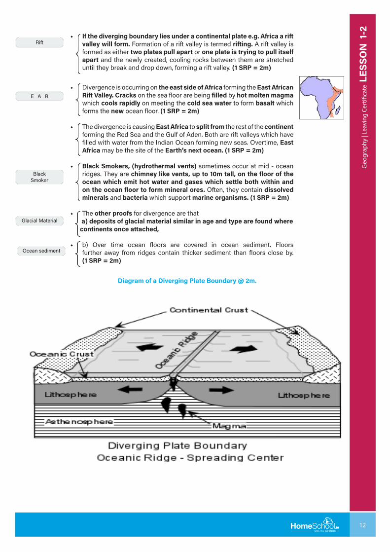
◆ If the diverging boundary lies under a continental plate e.g. Africa a rift valley will form. Formation of a rift valley is termed rifting. A rift valley is formed as either two plates pull apart or one plate is trying to pull itself apart and the newly created, cooling rocks between them are stretched until they break and drop down, forming a rift valley. (1 SRP = 2m)
◆ Divergence is occurring on the east side of Africa forming the East African Rift Valley. Cracks on the sea floor are being filled by hot molten magma which cools rapidly on meeting the cold sea water to form basalt which forms the new ocean floor. (1 SRP = 2m)
◆ The divergence is causing East Africa to split from the rest of the continent forming the Red Sea and the Gulf of Aden. Both are rift valleys which have filled with water from the Indian Ocean forming new seas. Overtime, East Africa may be the site of the Earth’s next ocean. (1 SRP = 2m)
◆ Black Smokers, (hydrothermal vents) sometimes occur at mid - ocean ridges. They are chimney like vents, up to 10m tall, on the floor of the ocean which emit hot water and gases which settle both within and on the ocean floor to form mineral ores. Often, they contain dissolved minerals and bacteria which support marine organisms. (1 SRP = 2m)
◆ The other proofs for divergence are that a) deposits of glacial material similar in age and type are found where continents once attached,
◆ b) Over time ocean floors are covered in ocean sediment. Floors further away from ridges contain thicker sediment than floors close by. (1 SRP = 2m)
Diagram of a Diverging Plate Boundary @ 2m.
13 Geography | Leaving Certificate |
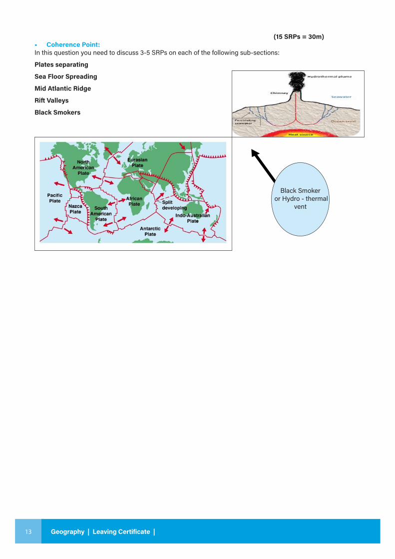
(15 SRPs = 30m)• Coherence Point: In this question you need to discuss 3-5 SRPs on each of the following sub-sections:
Plates separating
Sea Floor Spreading
Mid Atlantic Ridge
Rift Valleys
Black Smokers
Black Smoker or Hydro - thermal
vent
14
Geo
grap
hy |
Leav
ing
Cert
ifica
te L
ESSO
N 1
-2
TrenchesPlate heats up &
meltsWater & gases
Island arcs = a curved chain of volcanic islands
Subduction
Mariana
Offshore Islands/Island Arcs
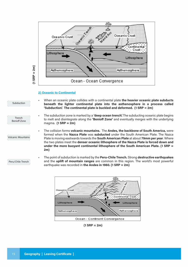
1) Oceanic to Oceanic
• When two oceanic plates collide e.g. the fast-moving Pacific Plate and the slower moving Philippines Plate the heavier plate is subducted under the other. (1 SRP = 2m)
• The collision destroys the crust forming long deep narrow oceanic trenches. As the heavier plate is pulled downwards it heats up and melts forcing the subducting plate to release trapped water and other gases which make their way upwards causing chemical reactions that melt the mantle above the subducting plate. This hot melted rock, magma, makes its way upwards onto the ocean surface in the form of a volcanic eruption forming offshore islands or island arcs e.g. Japan, the Aleutian Islands in the North Pacific Ocean, the Marianas Islands in the South Pacific Ocean and the Caribbean Volcanic island chain. (1 SRP = 2m)
• The Mariana Trench has formed where the Pacific Plate collides with the Philippines Plate. The Challenger Deep, at the southern end of the Marianas Trench plunges deeper into the Earth’s interior than Mt. Everest. The Mariana Trench is 11kms deep – so deep that Mount Everest (8kms+) would fit comfortably into the Mariana Trench. (1 SRP = 2m)
WHAT HAPPENS AT A CONVERGENT PLATE BOUNDARY. IN YOUR ANSWER REFER TO ASSOCIATED LANDFORMS (30m)
This question requires 15 SRPs Convergent Plate Boundaries (Boundaries of Destruction)
◆ The size of the earth has not changed over the past 600m years. The unchanging size means that the crust must be destroyed at about the same rate as it is being created. This recycling of crust takes place along converging plate boundaries. (1 SRP = 2m)
◆ At convergent plate boundaries plates collide. They are often called boundaries of destruction. Part of the lithosphere is forced downward into the mantle while other parts of it may be forced upward, forming mountains. (1 SRP = 2m)
◆ When two plates collide, the heavier plate is pulled downwards along the Benioff Zone (Hugo Benioff, an American Seismologist) beneath the other. This process is called subduction. The subduction zone is the point at which subduction occurs. (1 SRP = 2m)
◆ There are 3 types of Plate Convergence:
Recycling
CollisionBoundaries of Destruction
Benioff Zone & Subduction
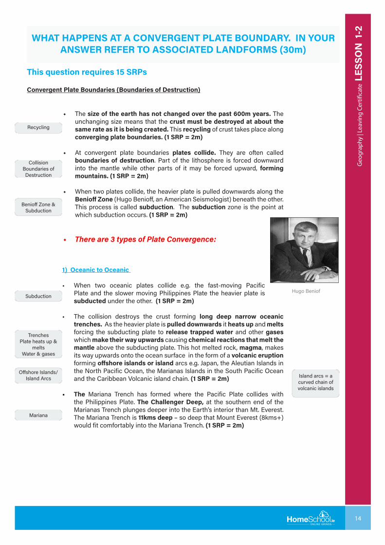
Hugo Beniof
15 Geography | Leaving Certificate |
(1 S
RP
= 2
m)
2) Oceanic to Continental
• When an oceanic plate collides with a continental plate the heavier oceanic plate subducts beneath the lighter continental plate into the asthenosphere in a process called ‘Subduction’. The continental plate is buckled and deformed. (1 SRP = 2m)
• The subduction zone is marked by a ‘deep ocean trench’. The subducting oceanic plate begins to melt and disintegrate along the ‘Benioff Zone’ and eventually merges with the underlying magma. (1 SRP = 2m)
• The collision forms volcanic mountains. The Andes, the backbone of South America, were formed when the Nazca Plate was subducted under the South American Plate. The Nazca Plate is moving eastwards towards the South American Plate at about 79mm per year. Where the two plates meet the denser oceanic lithosphere of the Nazca Plate is forced down and under the more buoyant continental lithosphere of the South American Plate. (1 SRP = 2m)
• The point of subduction is marked by the Peru-Chile Trench. Strong destructive earthquakes and the uplift of mountain ranges are common in this region. The world’s most powerful earthquake was recorded in the Andes in 1960. (1 SRP = 2m)
Subduction
TrenchBenioff Zone
Volcanic Mountains
Peru/Chile Trench
(1 SRP = 2m)
16
Geo
grap
hy |
Leav
ing
Cert
ifica
te L
ESSO
N 1
-23) Continental to Continental
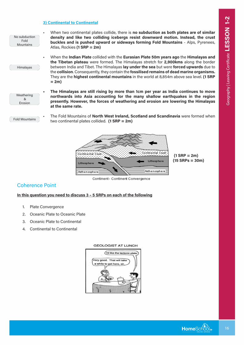
• When two continental plates collide, there is no subduction as both plates are of similar density and like two colliding icebergs resist downward motion. Instead, the crust buckles and is pushed upward or sideways forming Fold Mountains - Alps, Pyrenees, Atlas, Rockies (1 SRP = 2m)
• When the Indian Plate collided with the Eurasian Plate 50m years ago the Himalayas and the Tibetan plateau were formed. The Himalayas stretch for 2,900kms along the border between India and Tibet. The Himalayas lay under the sea but were forced upwards due to the collision. Consequently, they contain the fossilised remains of dead marine organisms. They are the highest continental mountains in the world at 8,854m above sea level. (1 SRP = 2m)
• The Himalayas are still rising by more than 1cm per year as India continues to move northwards into Asia accounting for the many shallow earthquakes in the region presently. However, the forces of weathering and erosion are lowering the Himalayas at the same rate.
• The Fold Mountains of North West Ireland, Scotland and Scandinavia were formed when two continental plates collided. (1 SRP = 2m)
No subductionFold
Mountains
Weathering &
Erosion
Himalayas
Fold Mountains
(1 SRP = 2m)(15 SRPs = 30m)
Coherence Point
In this question you need to discuss 3 – 5 SRPs on each of the following
1. Plate Convergence
2. Oceanic Plate to Oceanic Plate
3. Oceanic Plate to Continental
4. Continental to Continental
17 Geography | Leaving Certificate |
SAMPLE QUESTION 4: WITH THE AID OF DIAGRAMS EXAMINE WHAT HAPPENS AT THREE DIFFERENT TYPES OF PLATE BOUNDARIES?
(30m)This question requires 15 SRPs
(Note: In this question you must include 5- 6 SRPs from each of the previous two questions i.e. divergent and convergent plate boundaries and 5 SRPs from Transform plate boundaries)
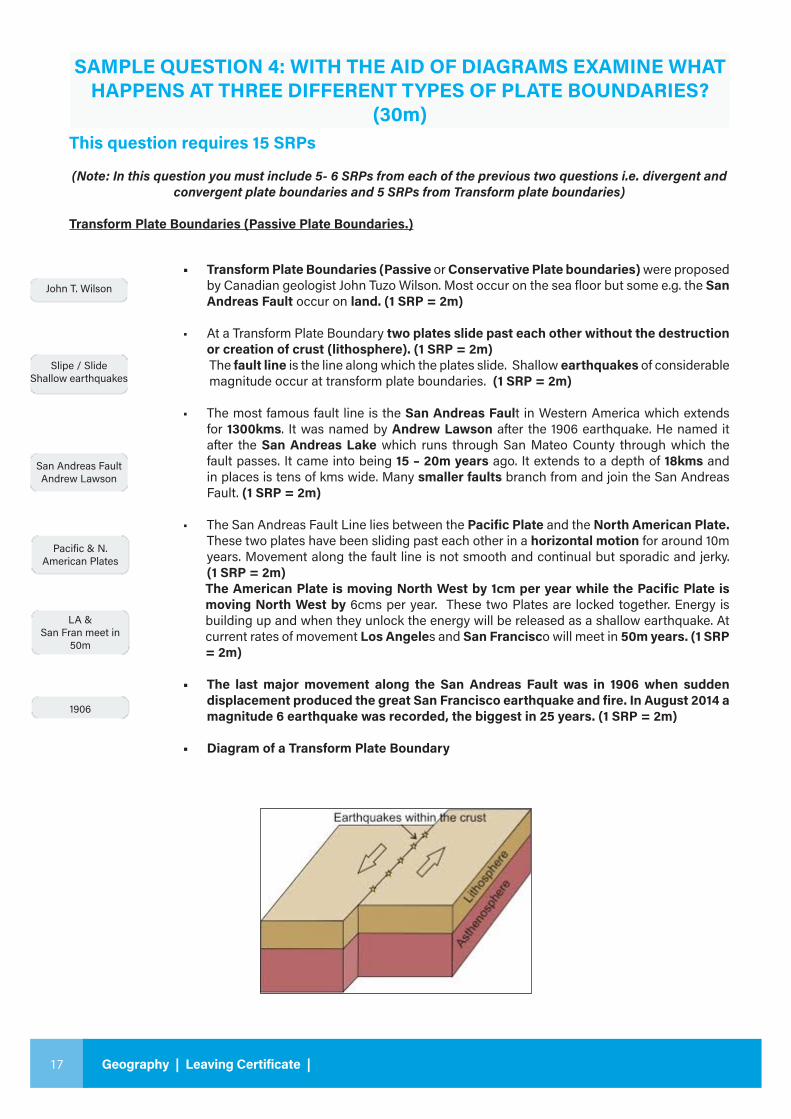
Transform Plate Boundaries (Passive Plate Boundaries.)
• Transform Plate Boundaries (Passive or Conservative Plate boundaries) were proposed by Canadian geologist John Tuzo Wilson. Most occur on the sea floor but some e.g. the San Andreas Fault occur on land. (1 SRP = 2m)
• At a Transform Plate Boundary two plates slide past each other without the destruction or creation of crust (lithosphere). (1 SRP = 2m)The fault line is the line along which the plates slide. Shallow earthquakes of considerable magnitude occur at transform plate boundaries. (1 SRP = 2m)
• The most famous fault line is the San Andreas Fault in Western America which extends for 1300kms. It was named by Andrew Lawson after the 1906 earthquake. He named it after the San Andreas Lake which runs through San Mateo County through which the fault passes. It came into being 15 – 20m years ago. It extends to a depth of 18kms and in places is tens of kms wide. Many smaller faults branch from and join the San Andreas Fault. (1 SRP = 2m)
• The San Andreas Fault Line lies between the Pacific Plate and the North American Plate. These two plates have been sliding past each other in a horizontal motion for around 10m years. Movement along the fault line is not smooth and continual but sporadic and jerky. (1 SRP = 2m) The American Plate is moving North West by 1cm per year while the Pacific Plate is moving North West by 6cms per year. These two Plates are locked together. Energy is building up and when they unlock the energy will be released as a shallow earthquake. At current rates of movement Los Angeles and San Francisco will meet in 50m years. (1 SRP = 2m)
• The last major movement along the San Andreas Fault was in 1906 when sudden displacement produced the great San Francisco earthquake and fire. In August 2014 a magnitude 6 earthquake was recorded, the biggest in 25 years. (1 SRP = 2m)
• Diagram of a Transform Plate Boundary
John T. Wilson
Slipe / SlideShallow earthquakes
San Andreas FaultAndrew Lawson
Pacific & N. American Plates
LA & San Fran meet in
50m
1906
18
Geo
grap
hy |
Leav
ing
Cert
ifica
te L
ESSO
N 1
-2
Transform Plate Boundary (1 SRP = 2m)
Coherence PointIn this question you need 5 – 6 SRPs on each of the following:Convergent Plate BoundariesDivergent Plate BoundariesTransform Plate Boundaries
(15 SRPs = 30m)
19 Geography | Leaving Certificate |
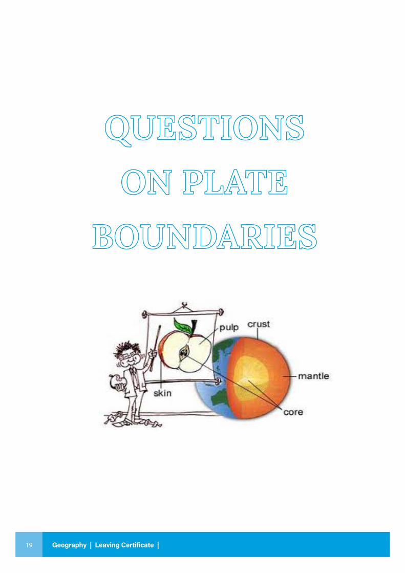
QUESTIONS ON PLATE
BOUNDARIES
20
Geo
grap
hy |
Leav
ing
Cert
ifica
te L
ESSO
N 1
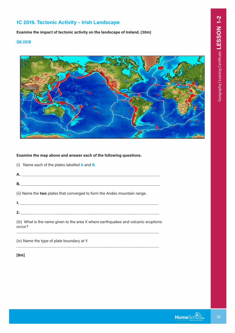
-21C 2019. Tectonic Activity – Irish Landscape
Examine the impact of tectonic activity on the landscape of Ireland. (30m)
Q6 2018
Examine the map above and answer each of the following questions.
(i) Name each of the plates labelled A and B.
A. __________________________________________________________________
B. __________________________________________________________________
(ii) Name the two plates that converged to form the Andes mountain range.
1. __________________________________________________________________
2. __________________________________________________________________
(iii) What is the name given to the area X where earthquakes and volcanic eruptionsoccur?____________________________________________________________________
(iv) Name the type of plate boundary at Y.____________________________________________________________________
[8m]
21 Geography | Leaving Certificate |
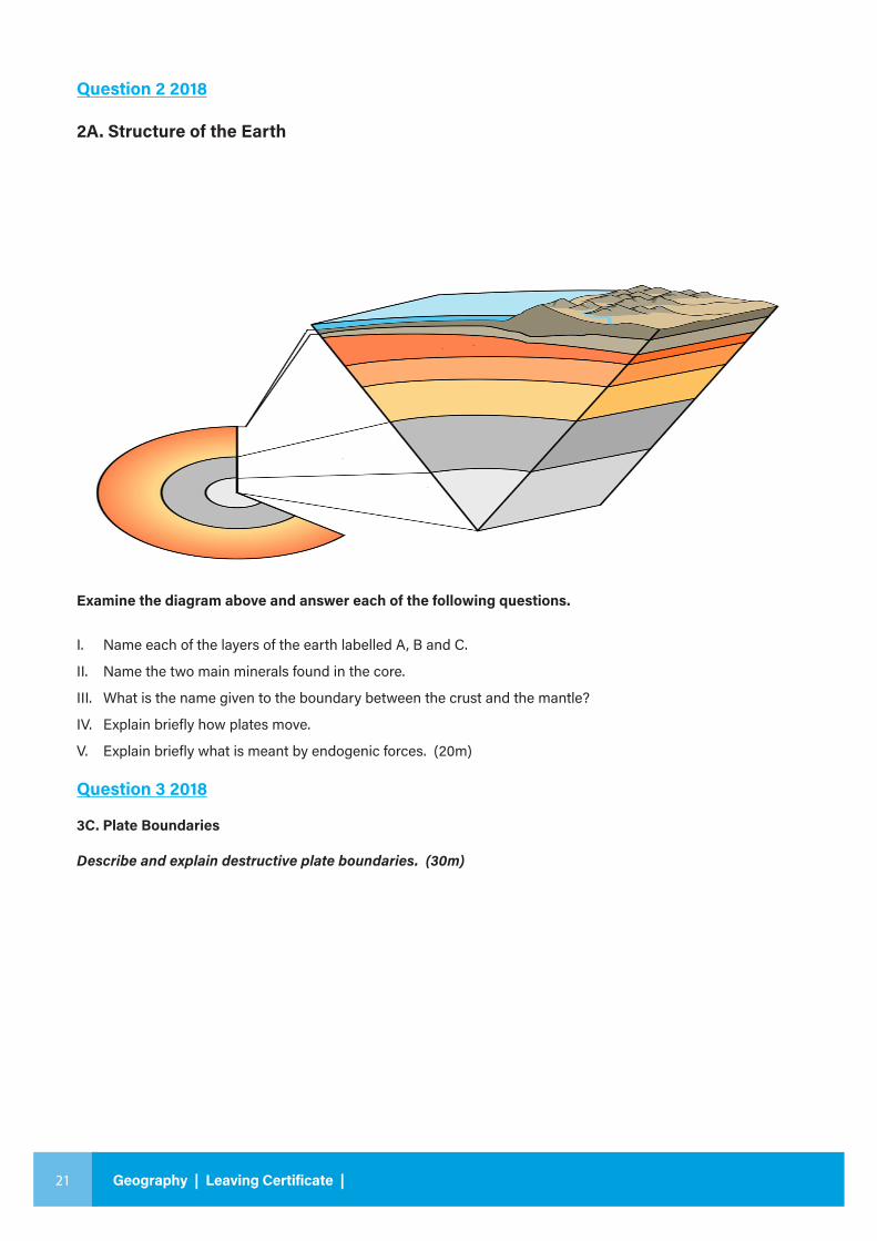
Question 2 2018
2A. Structure of the Earth
Examine the diagram above and answer each of the following questions.
I. Name each of the layers of the earth labelled A, B and C.
II. Name the two main minerals found in the core.
III. What is the name given to the boundary between the crust and the mantle?
IV. Explain briefly how plates move.
V. Explain briefly what is meant by endogenic forces. (20m)
Question 3 2018
3C. Plate Boundaries
Describe and explain destructive plate boundaries. (30m)
22
Geo
grap
hy |
Leav
ing
Cert
ifica
te L
ESSO
N 1
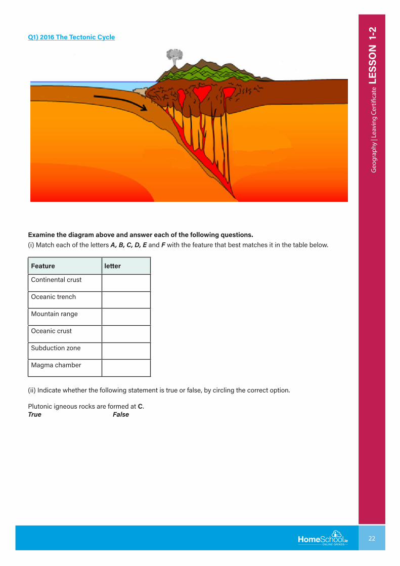
-2Q1) 2016 The Tectonic Cycle
Examine the diagram above and answer each of the following questions.(i) Match each of the letters A, B, C, D, E and F with the feature that best matches it in the table below.
Feature letter
Continental crust
Oceanic trench
Mountain range
Oceanic crust
Subduction zone
Magma chamber
(ii) Indicate whether the following statement is true or false, by circling the correct option.
Plutonic igneous rocks are formed at C.True False
23 Geography | Leaving Certificate |
[8m)
Q3) C 2016 Constructive Plate Boundaries
Discuss the geographical distribution and the impacts of constructive plate boundaries. [30m]
24
Geo
grap
hy |
Leav
ing
Cert
ifica
te L
ESSO
N 1
-2
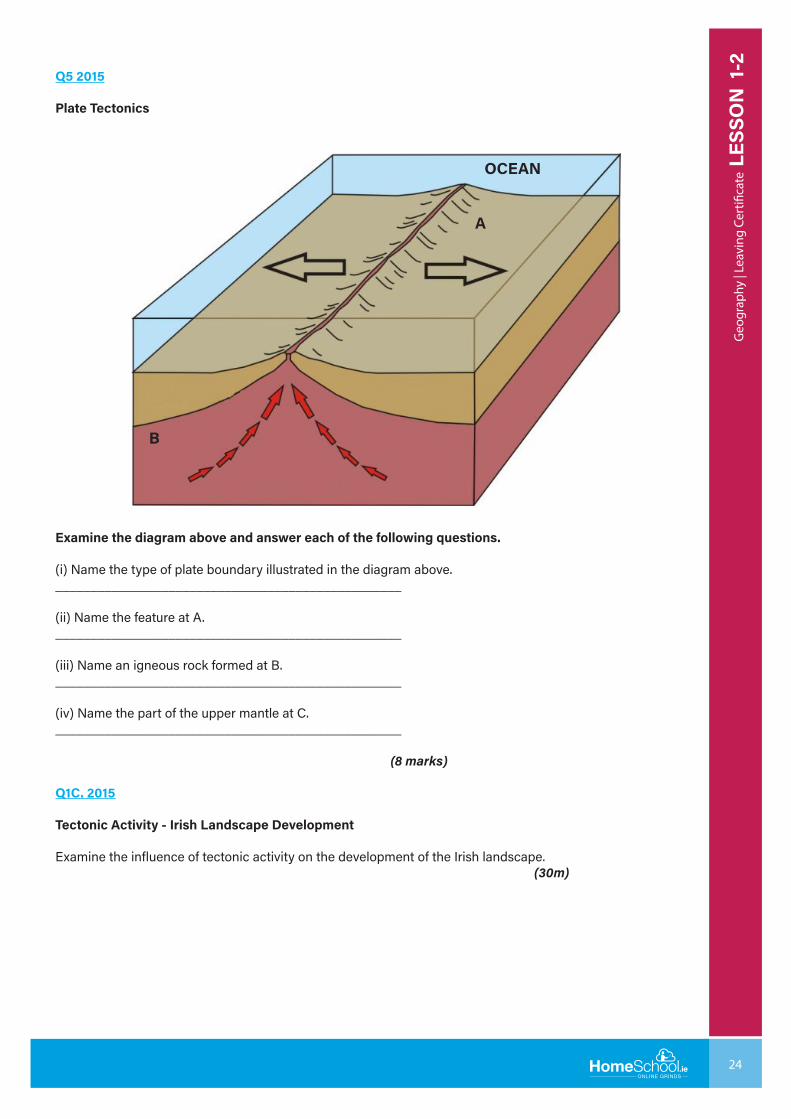
Q5 2015
Plate Tectonics
OCEAN
A
B
Examine the diagram above and answer each of the following questions.
(i) Name the type of plate boundary illustrated in the diagram above._________________________________________________
(ii) Name the feature at A._________________________________________________
(iii) Name an igneous rock formed at B._________________________________________________
(iv) Name the part of the upper mantle at C._________________________________________________ (8 marks)
Q1C. 2015
Tectonic Activity - Irish Landscape Development
Examine the influence of tectonic activity on the development of the Irish landscape. (30m)
25 Geography | Leaving Certificate |
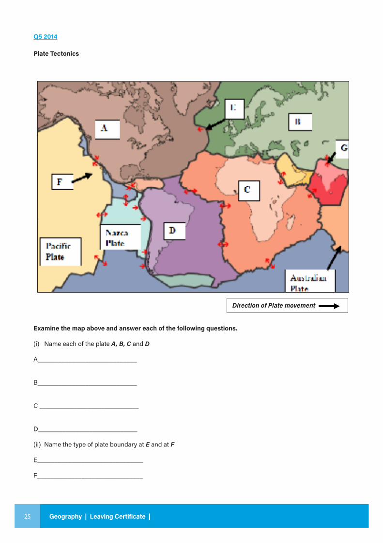
Q5 2014
Plate Tectonics
Direction of Plate movement
Examine the map above and answer each of the following questions.
(i) Name each of the plate A, B, C and D
A_____________________________
B_____________________________
C _____________________________
D_____________________________
(ii) Name the type of plate boundary at E and at F
E_______________________________
F_______________________________
26
Geo
grap
hy |
Leav
ing
Cert
ifica
te L
ESSO
N 1
-2(iii) Circle the correct option in each of the following statements.
Volcanic mountains are formed at E True False
Fold mountains are formed at G True False
(8m)Q3 2014
Plate Tectonics
B Describe and explain destructive plate boundaries.
27 Geography | Leaving Certificate |
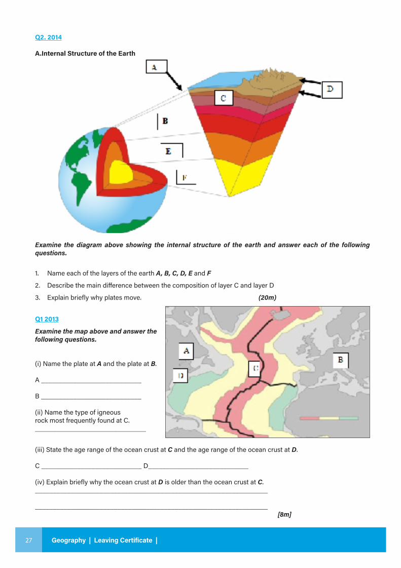
Q2. 2014
A.Internal Structure of the Earth
Examine the diagram above showing the internal structure of the earth and answer each of the following questions.
1. Name each of the layers of the earth A, B, C, D, E and F
2. Describe the main difference between the composition of layer C and layer D
3. Explain briefly why plates move. (20m)
Q1 2013
Examine the map above and answer thefollowing questions.
(i) Name the plate at A and the plate at B.
A ____________________________
B ____________________________
(ii) Name the type of igneousrock most frequently found at C._______________________________
(iii) State the age range of the ocean crust at C and the age range of the ocean crust at D.
C ____________________________ D____________________________
(iv) Explain briefly why the ocean crust at D is older than the ocean crust at C._________________________________________________________________
_________________________________________________________________[8m]
28
Geo
grap
hy |
Leav
ing
Cert
ifica
te L
ESSO
N 1
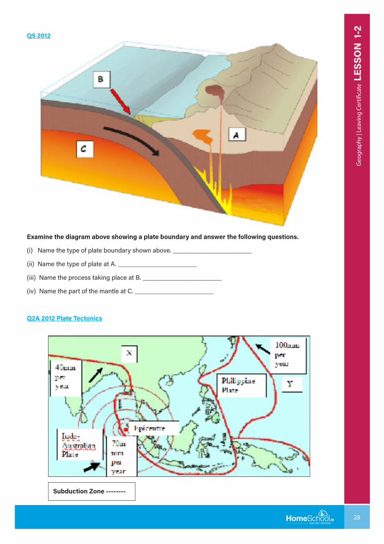
-2Q5 2012
Examine the diagram above showing a plate boundary and answer the following questions.
(i) Name the type of plate boundary shown above. _______________________
(ii) Name the type of plate at A. _______________________
(iii) Name the process taking place at B. _______________________
(iv) Name the part of the mantle at C. _______________________
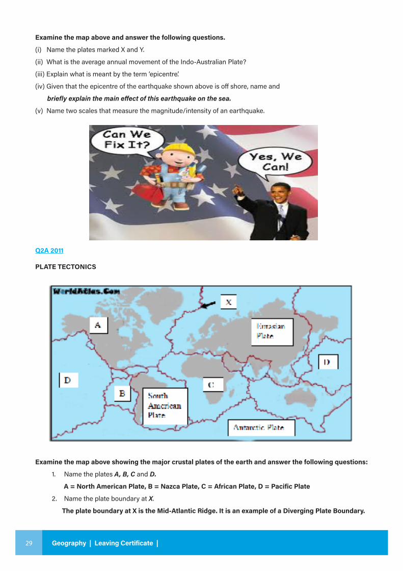
Q2A 2012 Plate Tectonics
Subduction Zone --------
29 Geography | Leaving Certificate |
Examine the map above and answer the following questions.
(i) Name the plates marked X and Y.
(ii) What is the average annual movement of the Indo-Australian Plate?
(iii) Explain what is meant by the term ‘epicentre’.
(iv) Given that the epicentre of the earthquake shown above is off shore, name and
briefly explain the main effect of this earthquake on the sea.
(v) Name two scales that measure the magnitude/intensity of an earthquake.
Q2A 2011
PLATE TECTONICS
Examine the map above showing the major crustal plates of the earth and answer the following questions:
1. Name the plates A, B, C and D.
A = North American Plate, B = Nazca Plate, C = African Plate, D = Pacific Plate
2. Name the plate boundary at X.
The plate boundary at X is the Mid-Atlantic Ridge. It is an example of a Diverging Plate Boundary.
30
Geo
grap
hy |
Leav
ing
Cert
ifica
te L
ESSO
N 1
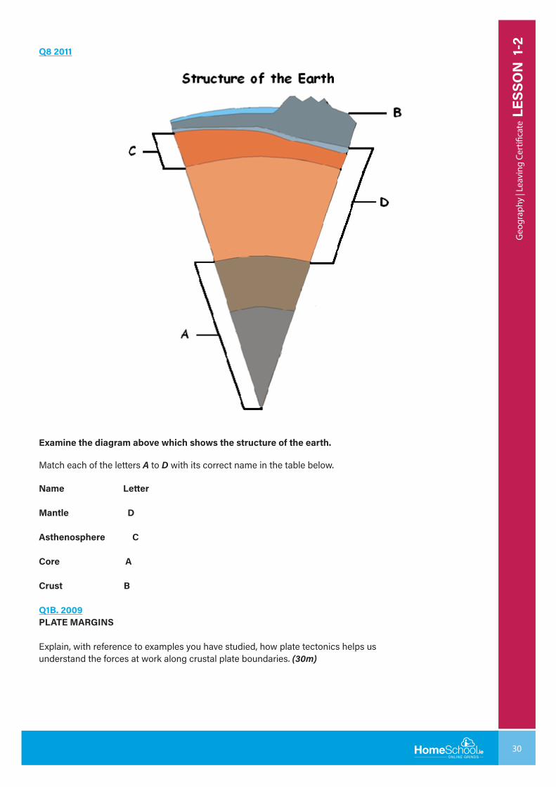
-2Q8 2011
Examine the diagram above which shows the structure of the earth.
Match each of the letters A to D with its correct name in the table below.
Name Letter
Mantle D
Asthenosphere C
Core A
Crust B
Q1B. 2009PLATE MARGINS
Explain, with reference to examples you have studied, how plate tectonics helps us understand the forces at work along crustal plate boundaries. (30m)
31 Geography | Leaving Certificate |
Q 2 2009A. CRUSTAL PLATES
Examine the map above, showing the major crustal plates of the Earth. In your answer book answer the following:
i. Name the volcanic island at L. ICELAND
ii. Which term constructive or destructive best describes the plate boundary M? CONSTRUCTIVE
iii. Name the plate at N. EURASIAN PLATE
iv. Which of the following statements is False?
O. As the plates move apart (very slowly) magma rises from the mantle. TRUE
P. Convection currents inside the Earth cause the earth’s plates to move apart. TRUE
Q. The North American Plate moves eastwards. FALSE
R. Volcanoes often form at plate boundaries. TRUE (20m)
[20m]
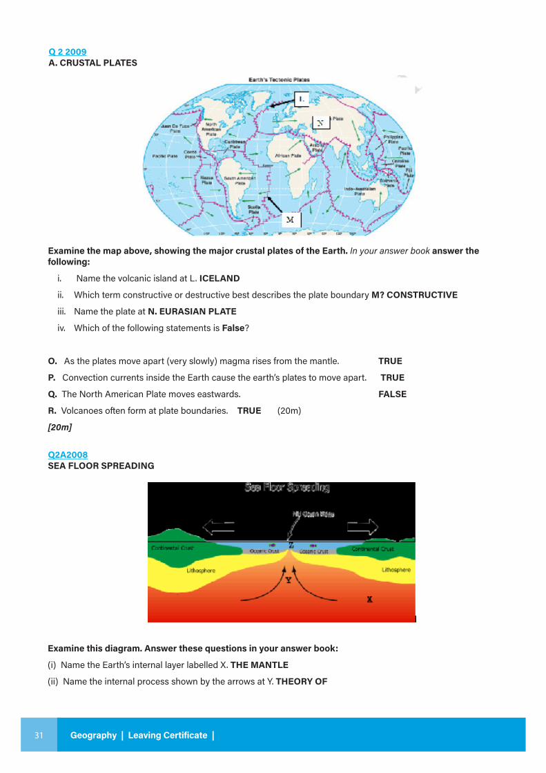
Q2A2008SEA FLOOR SPREADING
Examine this diagram. Answer these questions in your answer book:
(i) Name the Earth’s internal layer labelled X. THE MANTLE
(ii) Name the internal process shown by the arrows at Y. THEORY OF
32
Geo
grap
hy |
Leav
ing
Cert
ifica
te L
ESSO
N 1
-2THERMAL CONVECTION
(iii) Name one mid-ocean ridge which you have studied. THE MID-ATLANTIC RIDGE
(iv) Name the type of plate boundary shown at Z. A DIVERGENT PLATE BOUNDARY(20m)
Q1B 2007PLATE BOUNDARIES
“Plate boundaries are zones where crust is both created and destroyed”.
Examine the above statement, with reference to examples you have studied.
[30m]
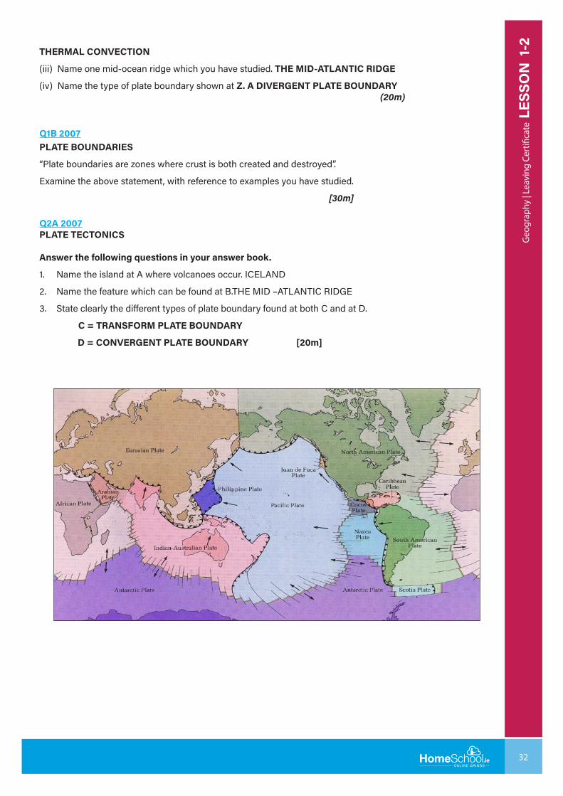
Q2A 2007PLATE TECTONICS
Answer the following questions in your answer book.
1. Name the island at A where volcanoes occur. ICELAND
2. Name the feature which can be found at B.THE MID –ATLANTIC RIDGE
3. State clearly the different types of plate boundary found at both C and at D.
C = TRANSFORM PLATE BOUNDARY
D = CONVERGENT PLATE BOUNDARY [20m]


