Embed Size (px)
Citation preview

U. von Rad á U. Berner á G. Delisle á H. Doose-RolinskiN. Fechner á P. Linke á A. LuÈ ckge á H. A. RoeserR. Schmaljohann á M. WiedickeSONNE 122/130 Scienti®c Parties
Gas and ¯uid venting at the Makran accretionary wedge off Pakistan
Received: 14 June 1999 /Revision accepted: 6 February 2000
Abstract The Makran accretionary complex shows adistinct bottom-simulating re¯ector, indicating a thickgas-hydrate-bearing horizon between the deformationalfront and about 1350 m water depth which seals o� theupward ¯ow of gas-charged ¯uids. A ®eld of presentlyinactive mud diapirs with elevations up to 65 m wasdiscovered in the abyssal plain seawards of the defor-mation front, suggesting that in the past conditions werefavorable for periodic but localized vigorous mud dia-pirism. Regional destabilization of the gas hydrateleading to focused ¯ow was observed where deep-pene-trating, active faults reach the base of the gas-hydratelayer, as in a deeply incised submarine canyon (2100±
2500 m water depth). At this location we discoveredseeps of methane and H2S-rich ¯uids associated withchemoautotrophic vent faunas (e.g., Calyptogena sp.).Driven by the accretionary wedge dynamics, the land-ward part of the gas-hydrate layer below the Makranmargin is being progressively uplifted. Due to reducedhydrostatic pressure and rising ocean bottom-watertemperatures, gas hydrates are progressively destabilizedand dissociated into hydrate water, methane and H2S.Sediment temperatures lie outside the methane stability®eld wherever water depth is less than 800 m. Above thisdepth, upward migration of ¯uids to the sea¯oor is un-impeded, thus explaining the abundance of randomlydistributed gas seeps observed at water depths of 350 to800 m.
Introduction
The processes of tectonic dewatering and degassing ofsediments undergoing compression at convergent mar-gins have been studied in many of the world's subduc-tion zones, especially around the eastern Paci®c Ocean(e.g., Kahn et al. 1996; Bohrmann et al. 1998; Suesset al. 1998). The thickly sedimented Makran accretion-ary wedge formed at the active boundary of the oceanicArabian plate which is being subducted below the con-tinental Eurasian plate. It is characterized by a veryshallow angle of subduction (<2°), a thickness of>7 km of sediments due to high terrigenous sedimen-tation (about 0.2±>1 m/ka), moderate convergencerates (5 cm/a), and the extreme width (>500 km) of theaccretionary complex (e.g., White 1982, 1983). Thesubmarine part of this accretionary complex forms theconvergent Makran continental margin o� Pakistan. Itis characterized by a narrow shelf (commonly <25 kmwide) and a steep, about 90-km-wide continental slopeleading into the Oman abyssal plain (>3000 m waterdepth). The continental slope consists of a sequence of
Geo-Marine Letters (2000) 20: 10±19 Ó Springer-Verlag 2000
U. von Rad (&) á U. Berner á G. Delisle á H. Doose-RolinskiN. Fechner á A. LuÈ ckge á H. A. Roeser á M. WiedickeBGR, P.O. Box 510153, 30631 Hannover, Germanye-mail: [email protected]
P. LinkeGEOMAR, Wischhofstr. 1±3, 24148 Kiel, Germany
R. SchmaljohannInstitut fuÈ r Meereskunde, DuÈ sternbrooker Weg 20,24105 Kiel, Germany
SONNE 122/130 Scienti®c PartiesM. Block á V. Damm á J. Erbacher á J. Fritsch á B. HarazimJ. Poggenburg á G. Scheeder á B. SchreckenbergerBGR, P.O. Box 510153, 30631 Hannover, Germany
N. von MirbachGEOMAR, Wischhofstr. 1±3, 24148 Kiel, Germany
M. Drews á S. WalterInstitut fuÈ r Meereskunde, DuÈ sternbrooker Weg 20,24105 Kiel, Germany
A. Ali Khan á A. Inam á M. Tahir á A. R. TabrezNational Institute of Oceanography, 47 S.T., Karachi, Pakistan
A. H. Cheema á M. PervazHydrocarbon Development Institute of Pakistan,P.O. Box 1308, Islamabad, Pakistan
M. AshrafO�ce of Deputy Hydrographer of Pakistan Navy,11 Liaquat Barracks, Karachi, Pakistan

frontally accreted thrust slices which are cut by erosivesubmarine canyons, and which are morphologically ex-pressed as long, narrow and steep accretionary ridgesseparated by ponded slope basins (Kukowski et al., inpress).
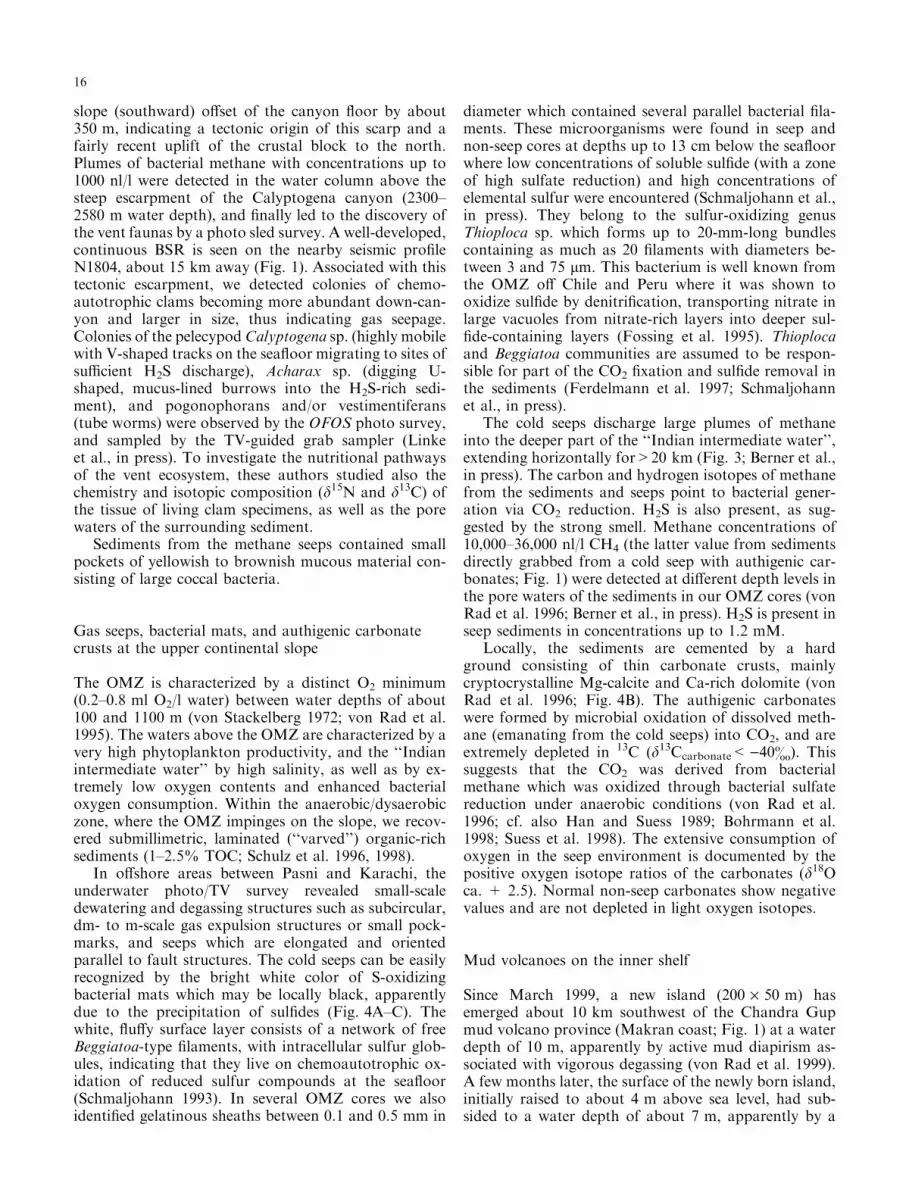
The SONNE cruises SO 122/130 (MAKRAN I andII) were co-operative geophysical/geological/geochemi-cal projects led by the Bundesanstalt fuÈ r Geowissens-chaften und Rohsto�e (BGR, Hannover), whichinvestigated the Makran accretionary wedge o� Paki-stan (Fig. 1) with the following objectives: (1) thestructure and origin of the accretionary wedge; (2) thesearch for submarine gas seeps, vents of ¯uids, and gashydrates, and the detailed sampling of ``cold-seep'' sites;(3) the study of biological communities, the metabolicactivities of methane/H2S-oxidizing bacteria, and spe-ci®c chemoautotrophic vent biota associated with thesegas seeps; (4) the carbon cycle, and the preservation anddiagenetic alteration of organic matter within a mon-soon-controlled high-productivity area; and (5) the high-resolution variability of the paleoceanography andpaleoclimate during the past 75,000 years, which is
particularly well recorded in the laminated sedimentsequences of the oxygen-minimum-zone (OMZ).
The tectonic structure of the o�shore part of the ac-tive Makran margin was studied by the University ofCambridge in the 1980s (e.g., White 1982, 1983; Whiteand Louden 1983), and in August±October 1997 by theBGR, GEOMAR (Kiel) and the University of Bremen(SONNE cruises SO 122, 123 and 124; Flueh et al. 1997;Roeser et al. 1997; Villinger et al. 1998). The geological/geochemical SONNE cruise SO 130 (April±May 1998)was carried out by the BGR (von Rad et al. 1998) in co-operation with the National Institute of Oceanography(NIO, Karachi), GEOMAR, the Institut fuÈ r Meeresunde(Kiel), and the Hydrocarbon Development Institute ofPakistan (HDIP, Islamabad).
In this paper, we summarize our results on the tec-tonic dewatering and degassing processes in the Makranaccretionary wedge, using water-column, sea¯oor andsubsurface data obtained during recent cruises of theGerman RV SONNE. More detailed data and inter-pretations of the origin of hydrocarbon gases in sedi-ments and in the water column are presented by Berneret al. (in press). Data on the geochemical and biologicalmanifestations of ¯uid venting are to be found in Linkeet al. (in press), and Schmaljohann et al. (in press) de-scribe the Thioploca bacterial mats in the OMZ. Wie-dicke et al. (in press) deal with the origin of the muddiapirs at the front of the Makran accretionary complex,and Kukowski et al. (in press) report on the
62°E 63°E 64°E 65°E 66°E
25°N
N
Mu
rr
ay
R.
Dasht Rive
r
Sha
diKau
r R.
Basul R
.P
ora
liR
.Hingol River
Hab R.
Karachi
OrmaraPasniGwadar
Jiwani
200
200
500
500
1000
1000
1000
1500
2000
1500
1500
2500
2000
2000
2000
2500
2000
3000
2500
2500
3000
3000
B
A
N18
04
12
2-1
2
Th Th Th
MAC
OAP
Shallow gas seeps in OMZ
Inactive diapir field
MAC
OAP
Makran Accretionary Complex
Oman Abyssal Plain
Proto-deformational Frontal Fold
Deformation Front
Important on- and offshoremud volcanoes
Chandra Gup
Cold Seepswith authigenic
carbonates
Th Thioploca communities
core location
Gas seeps/ventsCalyptogena
Canyon
30°N
20°
10°
0°
10°S
40°E 50° 60° 70° 80° 90°E
Karachi
INDIAARABIA
Arabian Sea
MakranPAK.
Fig. 1 Areas covered by the SO 122/130 cruises with main discover-ies. Note the investigated o�shore mud volcano southwest of ChandraGup. Inset Map showing the northern Arabian Sea. Line A-B Seismicpro®le SO 122-04A (see Fig. 2). Shaded areas BSRs along seismicpro®les N1804 (SHELL), SO 122-12, and SO 122-04A. Open circleswith dots Core locations of cruise SO 130
11

morphotectonic and structural analyses of the swath-bathymetric and Parasound data.
Methods
The sea¯oor and sediments along the Makran conti-nental slope o� Pakistan were investigated during theSO 130 cruise in great detail (Fig. 1), using the swathmapping system Hydrosweep and the high-resolution3.5-kHz pro®ling system Parasound. We studied espe-cially the area o� Gwadar/Pasni (about 63°E), a shelf todeep-sea transect southwest of Ormara, and a transectsouthwest of Karachi. A detailed swath-bathymetricsurvey between Pasni and Gwadar, including Parasoundpro®ling, was already available from the SO 123 cruise(Kukowski et al., in press).
During the SONNE cruise SO 122, the structure ofthe Makran accretionary wedge and Murray ridge wasstudied by multi-channel re¯ection seismic, magnetic,gravimetric and bathymetric surveys (Roeser et al. 1997).The seismic pro®les were near-trace processed by band-pass ®ltering (9±60 Hz in the upper part, 6±35 Hz in thedeeper part) with automatic gain control (AGC; 750 ms).
The sub-sea¯oor depth of the bottom-simulating-re-¯ector (BSR) in our seismic pro®les was calculated byusing an average two-way travel time (TWT) velocity of1900 m/s. Heat-¯ow density values were derived from(1) the temperature gradient across the gas-hydrate zone(the water temperature at the sea¯oor and the sedimenttemperature at the BSR using the phase diagram of gashydrates are known) and (2) an assumed thermal con-ductivity value of 1.2 W m)1 K)1 for the gas-hydratezone (Delisle et al. 1998).
The occurrence of an OMZ was delimited by con-ductance-temperature-depth (CTD) measurements, byanalyzing the oxygen content in water samples with aSeabird oxygen probe, and by chemical analyses.
As the randomly distributed, dm- to m-scale cold-seep sites are di�cult to locate, a pre-selection ofstructurally prospective areas was carried out, usingswath-bathymetric (Kukowski et al., in press) and high-resolution seismic (Parasound) data. Within these areas,potential gas seeps were located with the photo-TV sledOFOS (15 tracks) by looking for conspicuous occur-rences of white bacterial mats which characterize ventsites within the OMZ, and typical vent macrofauna (e.g.,Calyptogena sp.) along the lower slope (>2000 m). Wealso searched for anomalous concentrations of dissolvedmethane in the seawater derived from sea¯oor venting,and in pelagic phytoplankton and zooplankton particles.At 16 stations rosette-water samplers connected to theCTD probe were used to map the vertical and lateralextent of methane plumes in the water column in orderto detect the location of cold seeps at the sea¯oor. Hy-drocarbon gases dissolved in the water samples wereextracted, and the molecular composition was analyzedonboard by means of a gas chromatograph, specialattention being paid to methane concentrations (mea-
sured in nl/l or ppb). Sediment samples were frozen inliquid nitrogen immediately after recovering and cuttingthe cores, and later analyzed. Stable carbon-isotope ra-tios of methane (d13C and dD) were measured subse-quently at the BGR (for a detailed description of themethods and discussion of analytical errors, see Berneret al., in press).
In order to study the ¯uid ¯ow and gas-dischargerate, we employed GEOMAR's vent sampler (VESP) at12 stations (for a detailed description of the method, seeLinke et al. 1994). The TV-guided VESP was mainlyused for sampling the gas and measuring its dischargerate but, in addition, a short attached gravity corerprovided undisturbed surface samples for microbiologi-cal (see Schmaljohann et al. in press) and paleontologi-cal/ sedimentological/geochemical studies. The watersamples were split for the analyses of oxygen, methane,H2S, microbial numbers and activity. We used twoVESPs for the deployment of a benthic chamber on acold seep at the sea¯oor. The instrument was towedapprox. 2±3 m above the sea¯oor, and deployed whensigns of seepage became visible (e.g., near clam coloniesand bacterial mats).
For obtaining seep samples, vent faunas, bacterialmats and carbonate precipitates, we used a large TV-guided grab sampler. Sediment cores were analyzed forgas content, and used for microbiological and geo-chemical investigations.
Authigenic carbonate crusts were studied by opticalscanning electron microscope analysis and X-ray dif-fraction (lithofacies, paragenesis, mineralogy) as well asX-ray ¯uorescence (geochemistry) and stable isotope(d13C and d18O) analysis. A detailed description of themethods is provided by von Rad et al. (1996).
Results
Morphology and structure
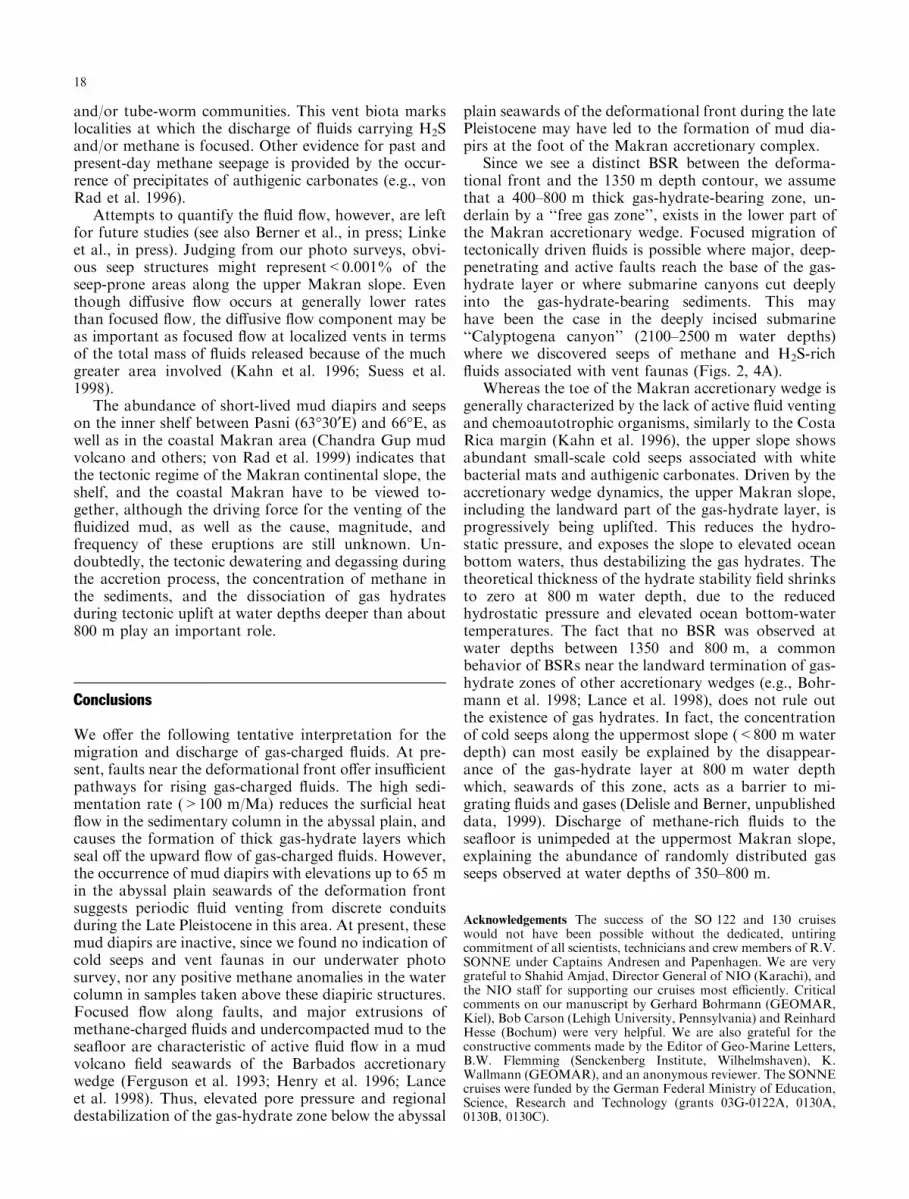
A distinct BSR (Fig. 2) which marks the phase boundarybetween free gas and gas hydrates was observed betweenabout 62° and 65°30¢E, about 0.5±0.8 s (TWT) or ca.600±800 m below the sea¯oor. Sediments overlying theBSR are usually rich in gas hydrates (White and Louden1983; Henriet and Mienert 1998). This is supported bythe detection of methane-rich plumes in the water col-umn at 300, 600±800, and 2100±2500 m water depths,thus indicating locations of sea¯oor venting (Fig. 3).
The BSR extends from seawards of the deformationfront at 3000 m water depth across the continental slopeto a water depth of about 1350 m (Figs. 1, 2, 3). Abovethis water depth, the BSR disappears in the seismicimage. The theoretical limit of the gas-hydrate zone is ata water depth of about 800 m, below which sedimenttemperatures start to fall into the gas-hydrate stability®eld. The multi-channel seismic line SO 122-04A(Fig. 2) shows that, seawards of the deformation front,the oceanic basement dips towards the accretionary
12

Fig. 2A, B Part of multi-channel seismic pro®le SO 122-04A. A Linedrawing; B original record of framed area in A. Note the ``nascentridge'', the accretionary ridges 1±4, the slope basins, and the distinct
bottom-simulating-re¯ector (BSR) indicating the base of the gas-hydrate zone. BSRs (or bright spots) seawards of the deformationfront are indistinct due to subparallel abyssal plain re¯ectors
13

wedge. Bathymetrically, the dip is masked by up to 7 km(5.6 s TWT) of sediments, no trench being visible. Belowthe accretionary complex, the top of the subductingoceanic crust cannot be clearly identi®ed in our seismicrecords. Between about 62°20¢ and 63°40¢E and sea-wards of the deformation front of the Makran margin,we observe an elongate, about 70 km-long bulge ofslightly folded and diagonally faulted sediments (Fig. 1).This prominent ``frontal fold'' (Figs. 1, 2) is a ``proto-deformational zone'' being formed by compression atthe foot of the accretionary complex and elevated about100 m above the Oman abyssal plain (White 1982, 1983;White and Louden 1983).
Further to the north, the continental slope is char-acterized by imbricate thrust slices indicated by ®ve longand narrow accretionary ridges which become succes-sively older upslope (Kukowski et al., in press). Theseaward ¯anks of these ridges form 200±1000 m high, E-W striking escarpments. The ridges are formed by north-dipping, overthrust and stacked fault blocks, and areseparated by ``piggy-back'' (slope) basins which were®lled with ponded turbidites.
Inactive diapir ®eld
A ®eld of several mud diapirs, with elevations of a fewmeters to 65 m above the abyssal plain, was discoveredat 3000 m water depth between the ®rst accretionary
ridge and the proto-deformational frontal fold (Figs. 1,3). The mud diapirs are de®ned by their morphology(cone-shaped seamounts), their seismically transparentsubsurface structure in the Parasound pro®les, their in-ternal structure, and the high gas content in our sedi-ment cores. The shape of these mud diapirs can be bestcompared with the ``conical mounds'' at the foot of theBarbados accretionary wedge, being formed by mudexpulsion through discrete conduits (Henry et al. 1996).A photo sled survey across the highest mud diapir didnot show any indication of the presence of seep struc-tures or vent faunas, suggesting that the diapir is pres-ently inactive. This was con®rmed by water samplesyielding only background levels of methane. An 11.7-m-long piston core, however, showed very high methaneconcentrations (>40,000 nl/l) and very strong degassingwithin its basal two meters, suggesting that we havereached a high level of gas concentration (see Discussionbelow).
Deep-water seeps and vent fauna
On the ¯oor of a submarine canyon cut 600±800 m intothe lower slope sediments of the third accretionary ridgeo� Ormara (Fig. 1), we discovered characteristic as-semblages of thiotrophic (H2S-metabolizing) vent or-ganisms (e.g., Lance et al. 1998; Suess et al. 1998) withsymbiotic, H2S-oxidizing bacteria (Figs. 3, 4D). This isthe ®rst evidence at the Makran margin for a typicalchemoautotrophic, deep-sea, cold-seep environmentwhich is sustained by su�cient oxygen in the bottomwaters and focused discharge of H2S and methane-rich¯uids (Linke et al., in press). A detailed survey of thisso-called ``Calyptogena canyon'' revealed a steep down-
B
A
A
Inactive
mud diapir
field
Oman
Abyssal
Plain
Protodeform.
Ridge
(frontal fold)
?
?
?
B D E
Local CH /H S-seeps
at major faults with
&
4 2
Calyptogena
pogonophorids
Mud volcanoes
on shelf
Mud volcanoes
on land (Chandra Gup etc.)
500
1000
1500
2000
2500
3000
3500
Abundant
gas seeps with mats
of sulfide-oxidizing
bacteria ( )Thioploca
C
10 km
OMZ CH -plumes4
12
34
5
Gas Hydrates
BSR
Accretionary Ridges/Slope Basins
?
Fig. 3 Schematic cross section of the Makran accretionary marginwith locations of mud diapirs, gas seeps, and distribution of methaneplumes in the water column with maximum concentrations beingabout 500±600 nl/l. OMZ Oxygen-minimum zone; BSR bottom-simulating-re¯ector. (Modi®ed after Berner et al., in press)
14

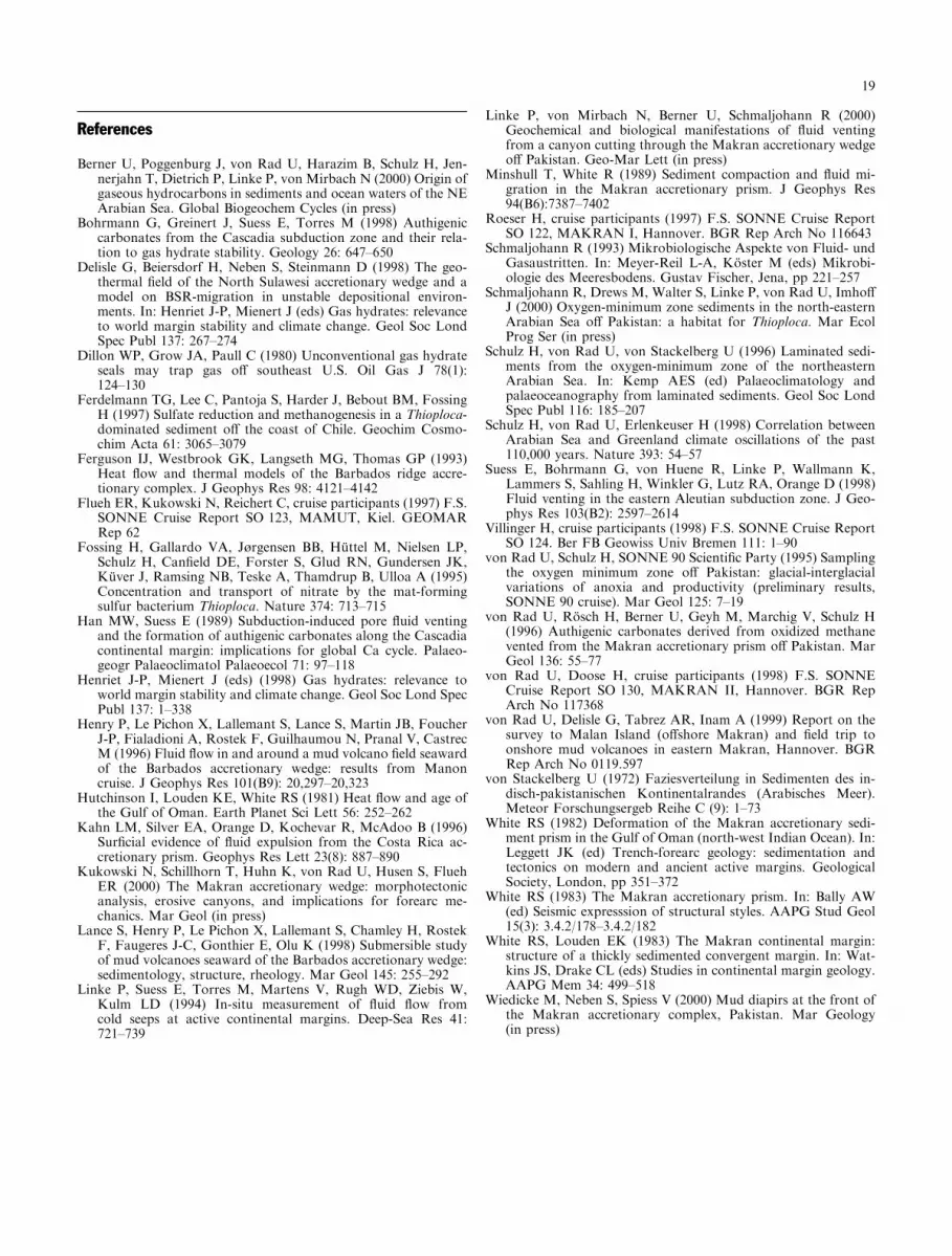
Fig. 4A±D Underwater photographs showing bacterial mats, pock-mark, methane seep, authigenic carbonate crust, and Calyptogenavent fauna. A White bacterial mat with black sul®dic spots on steepupper continental slope o� Pasni (SO 130-265FS-252, water depth400 m). B Small pockmark of about 80 cm diameter with methaneseep, white bacterial mat, and authigenic carbonate crust on upperslope west of Karachi (SO 90-57FS-144, water depth 861 m).Reprinted from von Rad et al. (1996) Authigenic carbonates ... o�
Pakistan. Marine Geology 136, p 62, Fig. 4B, copyright ElsevierScience (with permission). C Small white bacterial mat at foot of50 cm escarpment (slope-parallel fault) at steep faulted upper slopesoutheast of Pasni (SO 130-265FS-252, 646 m water depth).D Calyptogena vent fauna (note migrating tracks) near steep fault-controlled escarpment in ``Calyptogena canyon'' (SO 130-317FS,lower slope, water depth 2350 m)
15
slope (southward) o�set of the canyon ¯oor by about350 m, indicating a tectonic origin of this scarp and afairly recent uplift of the crustal block to the north.Plumes of bacterial methane with concentrations up to1000 nl/l were detected in the water column above thesteep escarpment of the Calyptogena canyon (2300±2580 m water depth), and ®nally led to the discovery ofthe vent faunas by a photo sled survey. A well-developed,continuous BSR is seen on the nearby seismic pro®leN1804, about 15 km away (Fig. 1). Associated with thistectonic escarpment, we detected colonies of chemo-autotrophic clams becoming more abundant down-can-yon and larger in size, thus indicating gas seepage.Colonies of the pelecypodCalyptogena sp. (highly mobilewith V-shaped tracks on the sea¯oor migrating to sites ofsu�cient H2S discharge), Acharax sp. (digging U-shaped, mucus-lined burrows into the H2S-rich sedi-ment), and pogonophorans and/or vestimentiferans(tube worms) were observed by the OFOS photo survey,and sampled by the TV-guided grab sampler (Linkeet al., in press). To investigate the nutritional pathwaysof the vent ecosystem, these authors studied also thechemistry and isotopic composition (d15N and d13C) ofthe tissue of living clam specimens, as well as the porewaters of the surrounding sediment.
Sediments from the methane seeps contained smallpockets of yellowish to brownish mucous material con-sisting of large coccal bacteria.
Gas seeps, bacterial mats, and authigenic carbonatecrusts at the upper continental slope
The OMZ is characterized by a distinct O2 minimum(0.2±0.8 ml O2/l water) between water depths of about100 and 1100 m (von Stackelberg 1972; von Rad et al.1995). The waters above the OMZ are characterized by avery high phytoplankton productivity, and the ``Indianintermediate water'' by high salinity, as well as by ex-tremely low oxygen contents and enhanced bacterialoxygen consumption. Within the anaerobic/dysaerobiczone, where the OMZ impinges on the slope, we recov-ered submillimetric, laminated (``varved'') organic-richsediments (1±2.5% TOC; Schulz et al. 1996, 1998).
In o�shore areas between Pasni and Karachi, theunderwater photo/TV survey revealed small-scaledewatering and degassing structures such as subcircular,dm- to m-scale gas expulsion structures or small pock-marks, and seeps which are elongated and orientedparallel to fault structures. The cold seeps can be easilyrecognized by the bright white color of S-oxidizingbacterial mats which may be locally black, apparentlydue to the precipitation of sul®des (Fig. 4A±C). Thewhite, ¯u�y surface layer consists of a network of freeBeggiatoa-type ®laments, with intracellular sulfur glob-ules, indicating that they live on chemoautotrophic ox-idation of reduced sulfur compounds at the sea¯oor(Schmaljohann 1993). In several OMZ cores we alsoidenti®ed gelatinous sheaths between 0.1 and 0.5 mm in
diameter which contained several parallel bacterial ®la-ments. These microorganisms were found in seep andnon-seep cores at depths up to 13 cm below the sea¯oorwhere low concentrations of soluble sul®de (with a zoneof high sulfate reduction) and high concentrations ofelemental sulfur were encountered (Schmaljohann et al.,in press). They belong to the sulfur-oxidizing genusThioploca sp. which forms up to 20-mm-long bundlescontaining as much as 20 ®laments with diameters be-tween 3 and 75 lm. This bacterium is well known fromthe OMZ o� Chile and Peru where it was shown tooxidize sul®de by denitri®cation, transporting nitrate inlarge vacuoles from nitrate-rich layers into deeper sul-®de-containing layers (Fossing et al. 1995). Thioplocaand Beggiatoa communities are assumed to be respon-sible for part of the CO2 ®xation and sul®de removal inthe sediments (Ferdelmann et al. 1997; Schmaljohannet al., in press).
The cold seeps discharge large plumes of methaneinto the deeper part of the ``Indian intermediate water'',extending horizontally for>20 km (Fig. 3; Berner et al.,in press). The carbon and hydrogen isotopes of methanefrom the sediments and seeps point to bacterial gener-ation via CO2 reduction. H2S is also present, as sug-gested by the strong smell. Methane concentrations of10,000±36,000 nl/l CH4 (the latter value from sedimentsdirectly grabbed from a cold seep with authigenic car-bonates; Fig. 1) were detected at di�erent depth levels inthe pore waters of the sediments in our OMZ cores (vonRad et al. 1996; Berner et al., in press). H2S is present inseep sediments in concentrations up to 1.2 mM.
Locally, the sediments are cemented by a hardground consisting of thin carbonate crusts, mainlycryptocrystalline Mg-calcite and Ca-rich dolomite (vonRad et al. 1996; Fig. 4B). The authigenic carbonateswere formed by microbial oxidation of dissolved meth-ane (emanating from the cold seeps) into CO2, and areextremely depleted in 13C (d13Ccarbonate<)40&). Thissuggests that the CO2 was derived from bacterialmethane which was oxidized through bacterial sulfatereduction under anaerobic conditions (von Rad et al.1996; cf. also Han and Suess 1989; Bohrmann et al.1998; Suess et al. 1998). The extensive consumption ofoxygen in the seep environment is documented by thepositive oxygen isotope ratios of the carbonates (d18Oca. + 2.5). Normal non-seep carbonates show negativevalues and are not depleted in light oxygen isotopes.
Mud volcanoes on the inner shelf
Since March 1999, a new island (200 ´ 50 m) hasemerged about 10 km southwest of the Chandra Gupmud volcano province (Makran coast; Fig. 1) at a waterdepth of 10 m, apparently by active mud diapirism as-sociated with vigorous degassing (von Rad et al. 1999).A few months later, the surface of the newly born island,initially raised to about 4 m above sea level, had sub-sided to a water depth of about 7 m, apparently by a
16

combination of wave erosion during the summer mon-soon and rapid subsidence of the base of the island afterthe vigorous expulsion of large quantities of gas-charged, overpressurized mud (see Discussion below).
Discussion
The origin of the mud diapirs at the front of the accre-tionary complex is enigmatic. Any hypothesis must ex-plain two facts which appear contradictory, these being(1) the obvious existence of conspicuous ``conicalmounds'' (up to 65 m in elevation) proven by morphol-ogy and subsurface structure, i.e. the seismically trans-parent zones produced by the destruction or masking ofprimary layering by the rise of gas-charged ¯uids andmud; and (2) the obvious lack of any recent diapiricactivity, as shown by the low methane concentrations inthe water column above the diapirs, and the lack of anyseep structures, bacterial mats and/or vent faunas on themound. Stratigraphic investigations (Wiedicke et al., inpress) indicate that the sedimentation rate in the nearbyabyssal plain was quite high (about 110 cm/ka), and thatthe large mud diapir must have been inactive (or onlyweakly active) for the past 10±20 ka. Possibly, the maingenerating process was compaction-driven dewatering ofthe rapidly deposited abyssal plain sediments during theaccretion (Minshull and White 1989), with a vigorousphase of localized mud discharge limited to a relativelyshort period during the late Pleistocene (Wiedicke et al.,in press). Later, the ascent of gas-charged ¯uids andmud ceased, either because the mud diapirs were``sealed'' by the formation of gas hydrates, or becausegas discharge is highly episodic, or because the locus ofactive mud diapirism had migrated further seawards tothe proto-deformational zone at the present-day toe ofthe accretionary wedge. The ``gas-hydrate seal hypoth-esis'' is still speculative, and only based on the presenceof very high methane concentrations at the base of two10±12-m-long cores. On the one hand, these might rep-resent former gas-hydrate bearing sediments which cur-rently act as seal for ¯uid transport of methane withinthe mud diapir but which were dissociated during thetransport of the cores to the sea surface and the periodthe cores remained on deck before being opened. On theother hand, early diagenesis might have produced highdissolved methane concentrations in the pore ¯uids un-der hydrostatic pressure at 3000 m water depth, leadingto strong degassing after core recovery (K. Wallmann,personal communication, 1999). Since no chloride con-tents were determined in the pore water, this questionremains open. Although our seismic records (Fig. 2)show clear evidence that the BSR can be traced from the®rst accretionary ridge downslope into the abyssal plain,no unambiguous geophysical information is available onthe upper boundary of the gas-hydrate zone.
The high contents of organic matter buried in therapidly deposited (>1 m/ka) slope sediments of the
Makran margin, especially in the OMZ (>1% TOC),are due to high primary productivity in the surface wa-ters and enhanced organic matter preservation (von Radet al. 1995; Schulz et al. 1996). The buried organicmatter is the source for the microbially formed methanein the subsurface which, under favorable p/T conditions,is transformed into extensive gas-hydrate cements. Thus,the methane ¯ux into the ocean waters is controlled byprimary production in the surface waters, the preserva-tion of organic matter during its transport to the sea-¯oor, and the dissociation of gas hydrates close to theupper limit of their stability, especially on the upperslope (850±350 m water depths).
The outgassing from underlying gas-hydrate deposits,due to decreasing lithostatic/hydrostatic pressure andrising temperature in upthrusted sediments withinaccretionary complexes, is a well-known phenomenon(e.g., Suess et al. 1998). In general, dewatering of thesediments is impeded by the low permeability of the gas-hydrate-bearing zone (Dillon et al. 1980), as well as bythe low permeability of hemipelagic sediments and au-thigenic carbonates. In a focused way, gas-charged ¯uids(probably with elevated temperatures) may escape alongfaults which penetrate the gas-hydrate zone. Continuousdeformation along the accretionary ridges landwards ofthe deformation front o�ers conditions favorable for thedevelopment of such faults. Also, erosive submarinecanyons cut into the gas-hydrate-bearing layers. The¯uid and gas escape from the sediments at the Makranmargin is concentrated in shallow-water regions (i.e.along the upper continental slope at 800±300 m waterdepth adjacent to the landward termination of the gas-hydrate zone, based on the stability ®eld of gas hydrates)as well as on the inner shelf and on land, revealed by thecurrently active, well-known mud volcanoes in thecoastal Makran area (Fig. 3). This is di�erent from EastPaci®c margins such as the Aleutian margin where themain discharge was observed at the lowermost part ofthe accretionary complex (Suess et al. 1998).
As discussed above in Methods, we calculated heat-¯ow values along the seismic pro®les. Including the heat-¯ow data of Hutchinson et al. (1981), we compiled amap of terrestrial heat ¯ow. Between the deformationfront and the ``frontal fold'' we found typical heat-¯owvalues of about 40 mW/m2, rising to higher values(>45 mW/m2) further upslope. This is consistent withheat-¯ow values of about 40 mW/m2 between the secondand fourth accretionary ridge measured by Villingeret al. (1998).
The vent faunas and high gas contents found in the``Calyptogena canyon'' may be associated with thecanyon cutting>100 m deep into the gas-hydrate-bear-ing zone, and with deep faults cutting into the sedimentsand forming conduits for free methane and hydrogensul®de gas through the gas-hydrate zone.
Direct evidence for the composition of gas-charged¯uids migrating towards the sediment surface comesfrom locally signi®cant zones of white bacterial mats,colonies of chemoautotrophic clams (Calyptogena sp.),
17
and/or tube-worm communities. This vent biota markslocalities at which the discharge of ¯uids carrying H2Sand/or methane is focused. Other evidence for past andpresent-day methane seepage is provided by the occur-rence of precipitates of authigenic carbonates (e.g., vonRad et al. 1996).
Attempts to quantify the ¯uid ¯ow, however, are leftfor future studies (see also Berner et al., in press; Linkeet al., in press). Judging from our photo surveys, obvi-ous seep structures might represent<0.001% of theseep-prone areas along the upper Makran slope. Eventhough di�usive ¯ow occurs at generally lower ratesthan focused ¯ow, the di�usive ¯ow component may beas important as focused ¯ow at localized vents in termsof the total mass of ¯uids released because of the muchgreater area involved (Kahn et al. 1996; Suess et al.1998).
The abundance of short-lived mud diapirs and seepson the inner shelf between Pasni (63°30¢E) and 66°E, aswell as in the coastal Makran area (Chandra Gup mudvolcano and others; von Rad et al. 1999) indicates thatthe tectonic regime of the Makran continental slope, theshelf, and the coastal Makran have to be viewed to-gether, although the driving force for the venting of the¯uidized mud, as well as the cause, magnitude, andfrequency of these eruptions are still unknown. Un-doubtedly, the tectonic dewatering and degassing duringthe accretion process, the concentration of methane inthe sediments, and the dissociation of gas hydratesduring tectonic uplift at water depths deeper than about800 m play an important role.
Conclusions
We o�er the following tentative interpretation for themigration and discharge of gas-charged ¯uids. At pre-sent, faults near the deformational front o�er insu�cientpathways for rising gas-charged ¯uids. The high sedi-mentation rate (>100 m/Ma) reduces the sur®cial heat¯ow in the sedimentary column in the abyssal plain, andcauses the formation of thick gas-hydrate layers whichseal o� the upward ¯ow of gas-charged ¯uids. However,the occurrence of mud diapirs with elevations up to 65 min the abyssal plain seawards of the deformation frontsuggests periodic ¯uid venting from discrete conduitsduring the Late Pleistocene in this area. At present, thesemud diapirs are inactive, since we found no indication ofcold seeps and vent faunas in our underwater photosurvey, nor any positive methane anomalies in the watercolumn in samples taken above these diapiric structures.Focused ¯ow along faults, and major extrusions ofmethane-charged ¯uids and undercompacted mud to thesea¯oor are characteristic of active ¯uid ¯ow in a mudvolcano ®eld seawards of the Barbados accretionarywedge (Ferguson et al. 1993; Henry et al. 1996; Lanceet al. 1998). Thus, elevated pore pressure and regionaldestabilization of the gas-hydrate zone below the abyssal
plain seawards of the deformational front during the latePleistocene may have led to the formation of mud dia-pirs at the foot of the Makran accretionary complex.
Since we see a distinct BSR between the deforma-tional front and the 1350 m depth contour, we assumethat a 400±800 m thick gas-hydrate-bearing zone, un-derlain by a ``free gas zone'', exists in the lower part ofthe Makran accretionary wedge. Focused migration oftectonically driven ¯uids is possible where major, deep-penetrating and active faults reach the base of the gas-hydrate layer or where submarine canyons cut deeplyinto the gas-hydrate-bearing sediments. This mayhave been the case in the deeply incised submarine``Calyptogena canyon'' (2100±2500 m water depths)where we discovered seeps of methane and H2S-rich¯uids associated with vent faunas (Figs. 2, 4A).
Whereas the toe of the Makran accretionary wedge isgenerally characterized by the lack of active ¯uid ventingand chemoautotrophic organisms, similarly to the CostaRica margin (Kahn et al. 1996), the upper slope showsabundant small-scale cold seeps associated with whitebacterial mats and authigenic carbonates. Driven by theaccretionary wedge dynamics, the upper Makran slope,including the landward part of the gas-hydrate layer, isprogressively being uplifted. This reduces the hydro-static pressure, and exposes the slope to elevated oceanbottom waters, thus destabilizing the gas hydrates. Thetheoretical thickness of the hydrate stability ®eld shrinksto zero at 800 m water depth, due to the reducedhydrostatic pressure and elevated ocean bottom-watertemperatures. The fact that no BSR was observed atwater depths between 1350 and 800 m, a commonbehavior of BSRs near the landward termination of gas-hydrate zones of other accretionary wedges (e.g., Bohr-mann et al. 1998; Lance et al. 1998), does not rule outthe existence of gas hydrates. In fact, the concentrationof cold seeps along the uppermost slope (<800 m waterdepth) can most easily be explained by the disappear-ance of the gas-hydrate layer at 800 m water depthwhich, seawards of this zone, acts as a barrier to mi-grating ¯uids and gases (Delisle and Berner, unpublisheddata, 1999). Discharge of methane-rich ¯uids to thesea¯oor is unimpeded at the uppermost Makran slope,explaining the abundance of randomly distributed gasseeps observed at water depths of 350±800 m.
Acknowledgements The success of the SO 122 and 130 cruiseswould not have been possible without the dedicated, untiringcommitment of all scientists, technicians and crew members of R.V.SONNE under Captains Andresen and Papenhagen. We are verygrateful to Shahid Amjad, Director General of NIO (Karachi), andthe NIO sta� for supporting our cruises most e�ciently. Criticalcomments on our manuscript by Gerhard Bohrmann (GEOMAR,Kiel), Bob Carson (Lehigh University, Pennsylvania) and ReinhardHesse (Bochum) were very helpful. We are also grateful for theconstructive comments made by the Editor of Geo-Marine Letters,B.W. Flemming (Senckenberg Institute, Wilhelmshaven), K.Wallmann (GEOMAR), and an anonymous reviewer. The SONNEcruises were funded by the German Federal Ministry of Education,Science, Research and Technology (grants 03G-0122A, 0130A,0130B, 0130C).
18
References
Berner U, Poggenburg J, von Rad U, Harazim B, Schulz H, Jen-nerjahn T, Dietrich P, Linke P, von Mirbach N (2000) Origin ofgaseous hydrocarbons in sediments and ocean waters of the NEArabian Sea. Global Biogeochem Cycles (in press)
Bohrmann G, Greinert J, Suess E, Torres M (1998) Authigeniccarbonates from the Cascadia subduction zone and their rela-tion to gas hydrate stability. Geology 26: 647±650
Delisle G, Beiersdorf H, Neben S, Steinmann D (1998) The geo-thermal ®eld of the North Sulawesi accretionary wedge and amodel on BSR-migration in unstable depositional environ-ments. In: Henriet J-P, Mienert J (eds) Gas hydrates: relevanceto world margin stability and climate change. Geol Soc LondSpec Publ 137: 267±274
Dillon WP, Grow JA, Paull C (1980) Unconventional gas hydrateseals may trap gas o� southeast U.S. Oil Gas J 78(1):124±130
Ferdelmann TG, Lee C, Pantoja S, Harder J, Bebout BM, FossingH (1997) Sulfate reduction and methanogenesis in a Thioploca-dominated sediment o� the coast of Chile. Geochim Cosmo-chim Acta 61: 3065±3079
Ferguson IJ, Westbrook GK, Langseth MG, Thomas GP (1993)Heat ¯ow and thermal models of the Barbados ridge accre-tionary complex. J Geophys Res 98: 4121±4142
Flueh ER, Kukowski N, Reichert C, cruise participants (1997) F.S.SONNE Cruise Report SO 123, MAMUT, Kiel. GEOMARRep 62
Fossing H, Gallardo VA, Jùrgensen BB, HuÈ ttel M, Nielsen LP,Schulz H, Can®eld DE, Forster S, Glud RN, Gundersen JK,KuÈ ver J, Ramsing NB, Teske A, Thamdrup B, Ulloa A (1995)Concentration and transport of nitrate by the mat-formingsulfur bacterium Thioploca. Nature 374: 713±715
Han MW, Suess E (1989) Subduction-induced pore ¯uid ventingand the formation of authigenic carbonates along the Cascadiacontinental margin: implications for global Ca cycle. Palaeo-geogr Palaeoclimatol Palaeoecol 71: 97±118
Henriet J-P, Mienert J (eds) (1998) Gas hydrates: relevance toworld margin stability and climate change. Geol Soc Lond SpecPubl 137: 1±338
Henry P, Le Pichon X, Lallemant S, Lance S, Martin JB, FoucherJ-P, Fialadioni A, Rostek F, Guilhaumou N, Pranal V, CastrecM (1996) Fluid ¯ow in and around a mud volcano ®eld seawardof the Barbados accretionary wedge: results from Manoncruise. J Geophys Res 101(B9): 20,297±20,323
Hutchinson I, Louden KE, White RS (1981) Heat ¯ow and age ofthe Gulf of Oman. Earth Planet Sci Lett 56: 252±262
Kahn LM, Silver EA, Orange D, Kochevar R, McAdoo B (1996)Sur®cial evidence of ¯uid expulsion from the Costa Rica ac-cretionary prism. Geophys Res Lett 23(8): 887±890
Kukowski N, Schillhorn T, Huhn K, von Rad U, Husen S, FluehER (2000) The Makran accretionary wedge: morphotectonicanalysis, erosive canyons, and implications for forearc me-chanics. Mar Geol (in press)
Lance S, Henry P, Le Pichon X, Lallemant S, Chamley H, RostekF, Faugeres J-C, Gonthier E, Olu K (1998) Submersible studyof mud volcanoes seaward of the Barbados accretionary wedge:sedimentology, structure, rheology. Mar Geol 145: 255±292
Linke P, Suess E, Torres M, Martens V, Rugh WD, Ziebis W,Kulm LD (1994) In-situ measurement of ¯uid ¯ow fromcold seeps at active continental margins. Deep-Sea Res 41:721±739
Linke P, von Mirbach N, Berner U, Schmaljohann R (2000)Geochemical and biological manifestations of ¯uid ventingfrom a canyon cutting through the Makran accretionary wedgeo� Pakistan. Geo-Mar Lett (in press)
Minshull T, White R (1989) Sediment compaction and ¯uid mi-gration in the Makran accretionary prism. J Geophys Res94(B6):7387±7402
Roeser H, cruise participants (1997) F.S. SONNE Cruise ReportSO 122, MAKRAN I, Hannover. BGR Rep Arch No 116643
Schmaljohann R (1993) Mikrobiologische Aspekte von Fluid- undGasaustritten. In: Meyer-Reil L-A, KoÈ ster M (eds) Mikrobi-ologie des Meeresbodens. Gustav Fischer, Jena, pp 221±257
Schmaljohann R, Drews M, Walter S, Linke P, von Rad U, Imho�J (2000) Oxygen-minimum zone sediments in the north-easternArabian Sea o� Pakistan: a habitat for Thioploca. Mar EcolProg Ser (in press)
Schulz H, von Rad U, von Stackelberg U (1996) Laminated sedi-ments from the oxygen-minimum zone of the northeasternArabian Sea. In: Kemp AES (ed) Palaeoclimatology andpalaeoceanography from laminated sediments. Geol Soc LondSpec Publ 116: 185±207
Schulz H, von Rad U, Erlenkeuser H (1998) Correlation betweenArabian Sea and Greenland climate oscillations of the past110,000 years. Nature 393: 54±57
Suess E, Bohrmann G, von Huene R, Linke P, Wallmann K,Lammers S, Sahling H, Winkler G, Lutz RA, Orange D (1998)Fluid venting in the eastern Aleutian subduction zone. J Geo-phys Res 103(B2): 2597±2614
Villinger H, cruise participants (1998) F.S. SONNE Cruise ReportSO 124. Ber FB Geowiss Univ Bremen 111: 1±90
von Rad U, Schulz H, SONNE 90 Scienti®c Party (1995) Samplingthe oxygen minimum zone o� Pakistan: glacial-interglacialvariations of anoxia and productivity (preliminary results,SONNE 90 cruise). Mar Geol 125: 7±19
von Rad U, RoÈ sch H, Berner U, Geyh M, Marchig V, Schulz H(1996) Authigenic carbonates derived from oxidized methanevented from the Makran accretionary prism o� Pakistan. MarGeol 136: 55±77
von Rad U, Doose H, cruise participants (1998) F.S. SONNECruise Report SO 130, MAKRAN II, Hannover. BGR RepArch No 117368
von Rad U, Delisle G, Tabrez AR, Inam A (1999) Report on thesurvey to Malan Island (o�shore Makran) and ®eld trip toonshore mud volcanoes in eastern Makran, Hannover. BGRRep Arch No 0119.597
von Stackelberg U (1972) Faziesverteilung in Sedimenten des in-disch-pakistanischen Kontinentalrandes (Arabisches Meer).Meteor Forschungsergeb Reihe C (9): 1±73
White RS (1982) Deformation of the Makran accretionary sedi-ment prism in the Gulf of Oman (north-west Indian Ocean). In:Leggett JK (ed) Trench-forearc geology: sedimentation andtectonics on modern and ancient active margins. GeologicalSociety, London, pp 351±372
White RS (1983) The Makran accretionary prism. In: Bally AW(ed) Seismic expresssion of structural styles. AAPG Stud Geol15(3): 3.4.2/178±3.4.2/182
White RS, Louden EK (1983) The Makran continental margin:structure of a thickly sedimented convergent margin. In: Wat-kins JS, Drake CL (eds) Studies in continental margin geology.AAPG Mem 34: 499±518
Wiedicke M, Neben S, Spiess V (2000) Mud diapirs at the front ofthe Makran accretionary complex, Pakistan. Mar Geology(in press)
19


