Embed Size (px)
Citation preview
Army 2020 Force Structure Realignment Programmatic Environmental Assessment January 2013
Chapter 4, Section 4.1: Fort Benning, Georgia 4.1-1
4.1 FORT BENNING, GEORGIA 1
4.1.1 Introduction 2
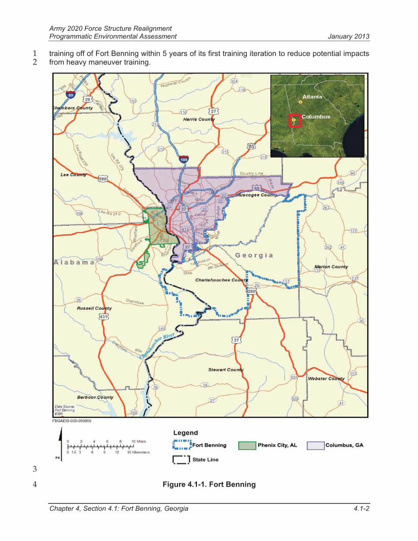
Fort Benning is located in west Georgia and east Alabama, and consists of approximately 3
182,000 acres (Figure 4.1-1). Fort Benning land is used for a variety of military training and 4
garrison support activities. Of the currently-owned property, approximately 141,500 acres are 5
primarily designated for training and maneuver areas. Fort Benning is immediately adjacent to 6
the communities of Columbus and Cusseta, Georgia and Phenix City, Alabama. 7
Fort Benning is home to the Maneuver Center of Excellence (MCoE). As part of the 2005 BRAC 8
actions, the Armor School was relocated from Fort Knox, Kentucky to Fort Benning. This 9
relocation consolidated the Infantry and Armor Centers and Schools to create the MCoE for 10
ground forces training at Fort Benning. 11
Fort Benning conducts Professional Military Education courses for Armor and Infantry officer 12
and non-commissioned officer educational development, Infantry, Armor and Cavalry Soldier 13
Basic Combat and Advanced Individual Training (AIT), Airborne (parachute) Training, Ranger 14
Training as well as 25 functional Training Courses. Fort Benning’s major tenant units are the 3rd15
ABCT 3rd Infantry Division (3-3rd ABCT) and two battalions, and the Regimental Headquarters of 16
the 75th Ranger Regiment. The units of the Armor School include the 194th Armor Training 17
Brigade and the 316th Cavalry Brigade. 18
Fort Benning has a well developed and highly used range infrastructure with several unique 19
ranges supporting Special Operations Command units. Overall units training on Fort Benning 20
conduct an average of 117 daily training missions. The construction and operation of numerous 21
new ranges and training facilities were required to support the arrival of the Armor School and 22
associated training requirements. Fort Benning has a total of 86 live-fire and 9 non-live-fire 23
ranges with the surface danger zone acreage of over 15,800 acres. The arrival of the Armor 24
School has increased the already high demand for new and existing ranges and maneuver 25
lands as over 50 percent of TRADOCs institutional training requirements in 19 MCoE, 86 26
Infantry, and 53 Armor training programs that occur 5-6 days per week for 50 weeks annually. 27
Fort Benning is also facing challenges from growing adjacent urbanization, and from federal and 28
state environmental regulations. 29
The competition for training lands and compliance with environmental regulations have 30
increased the utilization of limited range and training areas. At the current operational tempo, 31
the 3-3rd ABCT and its supporting units represent about 35 percent of Fort Benning’s annual 32
requirement for live-fire and maneuver training requirements. The 3-3rd ABCT requires the use 33
of the Digital MPRC and various other heavy ranges about 240 days and 180 nights annually. 34
The usage competes with newly assigned Armor School training for both live-fire and maneuver 35
training. 36
Currently, the Army is undergoing a study to assess environmental and socioeconomic impacts 37
of the acquisition of additional training lands in proximity to Fort Benning. The Training Land 38
Expansion Program (TLEP) Draft Environmental Impact Statement (DEIS) was published in 39
May 2011 for comment per the requirements of the NEPA. The TLEP Final EIS and final 40
decision on land purchase is deferred until more information is available on Army fiscal and 41
force realignments. This PEA assumes that only current Fort Benning land would be available 42
for Army 2020 alternatives. 43
In May of 2009, during consultation with the USFWS on the MCoE Proposed Action, Fort 44
Benning received a Jeopardy Biological Opinion from the USFWS. A requirement of the 45
Jeopardy Biological Opinion was the relocation of the Army Reconnaissance Course (ARC) field 46
Army 2020 Force Structure Realignment Programmatic Environmental Assessment January 2013
Chapter 4, Section 4.1: Fort Benning, Georgia 4.1-2
training off of Fort Benning within 5 years of its first training iteration to reduce potential impacts 1
from heavy maneuver training. 2
3
Figure 4.1-1. Fort Benning 4
Army 2020 Force Structure Realignment Programmatic Environmental Assessment January 2013
Chapter 4, Section 4.1: Fort Benning, Georgia 4.1-3
The first iteration of ARC training occurred in October of 2011. The Armor School is working 1
closely with Fort Benning biologists to assess potential impacts of training exercises on the red-2
cockaded woodpecker (RCW) population. If Fort Benning loses units with substantial maneuver 3
land requirements as a result of the implementation of Alternative 1, training activities 4
associated with the ARC could conceivably remain on the installation pending further 5
consultation with the USFWS. 6
4.1.1.1 Valued Environmental Components 7
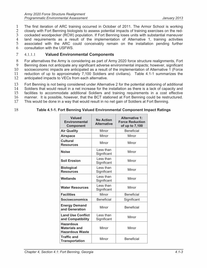
For alternatives the Army is considering as part of Army 2020 force structure realignments, Fort 8
Benning does not anticipate any significant adverse environmental impacts; however, significant 9
socioeconomic impacts are anticipated as a result of the implementation of Alternative 1 (Force 10
reduction of up to approximately 7,100 Soldiers and civilians). Table 4.1-1 summarizes the 11
anticipated impacts to VECs from each alternative. 12
Fort Benning is not being considered under Alternative 2 for the potential stationing of additional 13
Soldiers that would result in a net increase for the installation as there is a lack of capacity and 14
facilities to accommodate additional Soldiers and training requirements in a cost effective 15
manner. It is possible, however, that the BCT stationed at Fort Benning could be restructured. 16
This would be done in a way that would result in no net gain of Soldiers at Fort Benning. 17
Table 4.1-1. Fort Benning Valued Environmental Component Impact Ratings 18
ValuedEnvironmental
Component
No Action Alternative
Alternative 1: Force Reduction
of up to 7,100
Air Quality Minor Beneficial
Airspace Minor Minor
Cultural Resources
Minor Minor
Noise Less than Significant
Minor
Soil Erosion Less than Significant
Minor
BiologicalResources
Less than Significant
Minor
Wetlands Less than Significant
Minor
Water Resources Less than Significant
Minor
Facilities Minor Beneficial
Socioeconomics Beneficial Significant
Energy Demand and Generation
Minor Beneficial
Land Use Conflict and Compatibility
Less than Significant
Minor
Hazardous Materials and Hazardous Waste
Minor Minor
Traffic and Transportation
Minor Beneficial
Army 2020 Force Structure Realignment Programmatic Environmental Assessment January 2013
Chapter 4, Section 4.1: Fort Benning, Georgia 4.1-4
4.1.2 Air Quality 1
4.1.2.1 Affected Environment 2
The installation’s cantonment areas, training areas, and maneuver areas are included in the 3
project area. The air emission’s ROI at Fort Benning is the multi-county airshed to include 4
Muscogee, Chattahoochee, Russell, Lee, Harris, Talbot, and Marion counties. These counties 5
are presently designated by the EPA as in attainment for all required standards for criteria 6
pollutants (except lead in a limited area off post in Muscogee County around a battery plant 7
[USACE, 2009]).8
At this time, the region is considered to be in attainment for ozone (O3), based on the 2008 9
primary and secondary standards. Motor vehicles (mobile sources) are a primary contributor to 10
ground-level O3 levels in Georgia. 11
Per the provisions of the CAA, the EPA is required to review the standards every 5 years (next 12
review slated for 2013) and both the primary and secondary standards for O3 are anticipated to 13
be revised down to levels that may lead the EPA to designate parts or all of the ROI/airshed as 14
nonattainment. This area designation will likely include at least a part of Fort Benning. Because 15
of this growing concern, further efforts at the state and local level, including reduction planning, 16
may be required to reverse the trend ahead of the EPA’s data analysis for designating O317
nonattainment. Fort Benning would be required to assess actions for general conformity should 18
the area be designated nonattainment for O3.19
Fort Benning also generates area emissions from prescribed fire activities as part of their 20
ongoing ecosystem management program (USACE, 2009). Prescribed burning is the largest 21
single source of criteria pollutant emissions on the installation (Fort Benning 2010); however, it 22
is a critical management tool for fire-dependent natural communities, RCW habitat and training 23
area management. Prescribed burning events on the installation would continue based on a 3 24
year rotational schedule across the installation (Fort Benning, 2001). 25
The Georgia and Alabama Forestry Commissions administer each state’s Smoke Management 26
Plans, which detail the states’ basic frameworks of procedures and requirements for managing 27
smoke from prescribed fires. The purpose of each Smoke Management Plan is to minimize the 28
public health and environmental impacts of smoke intrusion into populated areas from fires; to 29
avoid significant deterioration of air quality and potential CAA violations; and to avoid visibility 30
impacts in Class I PSD areas (GFC, 2008). The closest Class I PSD areas are the Sipsey 31
Wilderness Area, Alabama and Okefenokee Wilderness areas, Georgia, both of which are over 32
150 miles away from the installation. Fort Benning’s prescribed burning activities are conducted 33
in full compliance with these plans. 34
4.1.2.2 Environmental Consequences 35
No Action Alternative 36
Fort Benning anticipates a minor adverse impact to air quality. The Fort Benning ROI is 37
currently in attainment for all criteria pollutants. Any new construction with the potential for 38
emission sources would be required to be included on the installation’s Title V permit. If Fort 39
Benning is within a county designated as nonattainment after the 2013 standard review by the 40
EPA, future projects beyond that date would need General Conformity analysis and revision to 41
the Title V permit. 42
Alternative 1: Force Reduction (up to 7,100 Soldiers and Army Civilians) 43
Fort Benning anticipates a minor beneficial environmental impact on air quality for the 44
installation and surrounding communities. A decrease in operations and maintenance activities 45
Army 2020 Force Structure Realignment Programmatic Environmental Assessment January 2013
Chapter 4, Section 4.1: Fort Benning, Georgia 4.1-5
would be a minor beneficial impact, and would likely have a beneficial impact to regional air 1
quality. The anticipated decrease in operations and maintenance activities would most likely 2
have no effect on Class I PSD areas. Since more than 50 percent of ground level O3 in the 3
State of Georgia comes from vehicle exhaust, it is reasonable to suggest that a reduction in the 4
number of vehicles associated with the loss of approximately 7,100 Soldiers, civilians, and their 5
Families would reduce the local levels of O3 somewhat, although emission levels are dependant 6
not only upon reduction in number of vehicles but also upon the miles driven and vehicle type. 7
Demolition of facilities may have short-term, minor adverse air impacts, but would result in long-8
term, reduced combustion emissions, also reducing O3 precursors. It is anticipated that 9
combustion emissions from stationary sources would decrease with the relocation of units into 10
newer facilities and the demolition of older facilities. 11
4.1.3 Airspace 12
4.1.3.1 Affected Environment 13
Lawson Army Airfield is the hub for all military aircraft operations in and around Fort Benning, 14
with an average of 35,000 take-off and landing operations per year (ATSCOM DA FORM 3479-15
6-R). Fort Benning units train with helicopters, fixed wing aircraft and UASs throughout the year 16
at varying frequency and complexity. Most fixed- and rotary-wing tactical aircraft operate out of 17
Lawson Army Airfield, a designated Force Projection Platform. A major portion of the aircraft 18
operations out of Lawson Army Airfield, located at the Southwest corner of Fort Benning, 19
involves airborne jump training. Ranger training uses a combination of both fixed-wing and 20
rotary wing aircraft. Other training events involve small to large scale military training exercises 21
which bring in large and medium size fixed wing cargo aircraft, high performance jets, 22
helicopters, UAS, and other special purpose aircraft throughout the year. 23
All of these aircraft operations use different classes of airspace designated by the FAA. The 24
classes of airspace designated for Fort Benning are described briefly below. 25
Lawson Class D Airspace: controlled airspace to terminal visual and instrument flight 26
routes at airports that have a control tower; 27
ASO GA E2 Class E Airspace: the surface area designated for an airport; 28
Regulatory Special Use Airspace – Restricted Area (R) 3002A through G: 29
designated to contain artillery, mortars, missiles, and rockets; 30
Non-regulatory Special Use Airspace – Benning MOA: airspace area designated air 31
combat maneuvers, air intercepts, acrobatics, etc.; and 32
Military Training Routes – Slow Routes 38 and 39: visual flight routes that are33
designated for low-altitude tactical training. 34
The FAA is the controlling agency charged by Congress to administer in the public interest as 35
necessary to ensure the safety of aircraft and its efficient use. Although the FAA must protect 36
the public's right of freedom of transit through the airspace, full consideration shall be given to 37
all airspace users, to include national defense; commercial and general aviation; and space 38
operations. Overall, Fort Benning is responsible for approximately 768 cubic nautical miles of 39
airspace in and around the designated military installation. Currently, the 3-3rd ABCT operates 40
Shadow Tactical Unmanned Aircraft System (RQ-7B) in the SUA. 41
There are also several commercial and small private airports in the area surrounding Fort 42
Benning that are published in the FAA Airport Registry under the Airport Master Record and 43
Reports. These include the following airports: Columbus Metropolitan, Raju, Jones Light 44
Aviation, Peterson Field, Weedon Field, Sehoy, Flying C s Plantation, and Finkley Farm just to 45
Army 2020 Force Structure Realignment Programmatic Environmental Assessment January 2013
Chapter 4, Section 4.1: Fort Benning, Georgia 4.1-6
name a few. The region surrounding Fort Benning contains federal airways as this location is 1
near many major regional and international air carrier hubs, including Hartsfield-Jackson Atlanta 2
International, Macon Middle Georgia Regional, and Albany Southwest Regional. Fort Benning’s 3
designated SUA reduces the likelihood of interaction between military aircraft and public, 4
private, or commercial aircraft. UAS vehicles are not allowed to operate outside restricted 5
airspace because they do not have “see and avoid” capability. Training is currently conducted 6
within designated SUA and is conducted within a restricted operating zone which allows 7
unencumbered training flights to meet mission essential training goals. 8
4.1.3.2 Environmental Consequences 9
No Action Alternative 10
Minor adverse impacts to airspace use are anticipated under the No Action Alternative. There is 11
the potential for airspace use conflicts between military and private pilots. UASs would continue 12
to be used at the current operational tempo. Use of airspace would continue to be managed 13
through scheduling and balancing needs with airspace availability. 14
Alternative 1: Force Reduction (up to 7,100 Soldiers and Army Civilians) 15
Minor adverse impacts to airspace use are anticipated as a result of the implementation of 16
Alternative 1. There is the potential for airspace use conflicts between military and private 17
pilots. Loss of a ABCT could potentially reduce the number of UASs in operation at Fort 18
Benning. There would be no change in SUA requirements. 19
4.1.4 Cultural Resources 20
4.1.4.1 Affected Environment 21
Cultural resources found within the boundaries of Fort Benning include: archaeological 22
resources, architectural resources and historic districts, and Native American resources. There 23
are 13 federally recognized Tribes affiliated with the Fort Benning area, of which 10 participate 24
in consultation on a bi-annual basis. Management of cultural resources on Fort Benning is 25
accomplished through the installation’s Integrated Cultural Resources Management Plan (Fort 26
Benning, 2008). Fort Benning has adopted the Army Alternate Procedures for implementing 27
Section 106 of the NHPA in an effort to improve efficiency in the installation’s cultural resources 28
management. The Historic Properties Component established procedures for evaluation of 29
potential effect on historic properties and combining Section 106 consultation with the NEPA 30
process. 31
Most cultural resources on Fort Benning have been evaluated for eligibility on the NRHP. 32
Those that have not yet been evaluated are considered eligible until they can be evaluated. No 33
properties of religious or cultural significance to the Tribes have been identified on the 34
installation. 35
4.1.4.2 Environmental Consequences 36
No Action Alternative 37
Minor adverse impacts are anticipated on cultural resources under the No Action Alternative. 38
Heavy equipment and tracked vehicles used for off-road maneuvers, and other training could 39
potentially have adverse impacts on archaeological resources. Fort Benning personnel provide 40
maps demarcating cultural resource locations in the training areas for Soldier informational 41
awareness and avoidance. There are also training restrictions and guidelines within these areas 42
to minimize impacts in these areas, (e.g., no digging). Building demolition and renovation are 43
not part of the No Action Alternative; therefore, there would be no adverse impacts from those 44
actions. 45
Army 2020 Force Structure Realignment Programmatic Environmental Assessment January 2013
Chapter 4, Section 4.1: Fort Benning, Georgia 4.1-7
Alternative 1: Force Reduction (up to 7,100 Soldiers and Army Civilians) 1
Minor adverse impacts are anticipated on cultural resources as a result of implementation of 2
Alternative 1. With a decrease of Soldiers and civilians and the potential for units to be relocated 3
to newly vacated facilities, some older buildings on the installation may be programmed for 4
demolition. The adverse impacts from demolition of buildings that are eligible for the NRHP 5
would be mitigated, in accordance with the ICRMP and Army Alternate Procedures. At this time, 6
it is unknown what buildings would be identified for demolition. 7
Fort Benning anticipates that a decrease in Soldier strength would decrease the training 8
operational tempo and Soldier traffic near archaeological sites; this would reduce potential 9
impacts to those resources within the training and range areas. 10
4.1.5 Noise 11
4.1.5.1 Affected Environment 12
The greatest amount of noise disturbance from Fort Benning is generated from large caliber 13
weapons firing mainly from M1 tank, M2 Bradley Fighting Vehicles, 120mm (millimeter) mortars 14
and 155mm howitzers. Noise is also generated from fixed- and rotary-winged aircraft 15
maneuvers, artillery, various pyrotechnic devices and specialized combat vehicles. Currently, 16
an incompatible NZ III extends into Muscogee and Marion counties where rural residences and 17
communities are located on the northern and eastern boundaries of the installation. Additionally, 18
NZ II extends off post to include Muscogee, Marion, and Talbot counties. 19
On-post noise impacts have been identified primarily with Family housing. Family housing areas 20
are affected by both NZ II and III noise levels for both small and large caliber weapons. 21
Currently, there are approximately 96 installation housing units within the NZ III noise contour. 22
In 2003, Fort Benning installed a Blast Analysis and Measurement monitoring sensor site 23
system along the installation boundary. The eight noise monitors are used to verify noise levels 24
when complaints have been received from the public. Data from these monitors can help the 25
installation plan, schedule, and effectively adjust military training exercises to reduce impacts to 26
the community’s noise sensitive receptors. The installation’s Public Affairs Office notifies the 27
public of training activities involving firing events through public notices issued to local media 28
outlets, local governments, and the Fort Benning public website. 29
Noise from training activities also has the potential to affect wildlife and threatened and 30
endangered species. For example, some training restrictions and conditions are required to 31
minimize adverse impacts to the RCW population (Fort Benning, 2001). Some noise generating 32
training activities, (e.g., artillery and hand grenade simulators and firing of small caliber 33
weapons), are limited by scheduling restrictions when occurring within RCW cluster boundaries. 34
Other training activities, (e.g., live-fire and incendiary devices), are prohibited altogether within 35
RCW cluster boundaries. Over the past 30 years, several research projects have assessed the 36
potential effects of military noise, primarily from large-caliber ranges and artillery simulators, on 37
certain elements of RCW fitness (USACE, 2008). Generally, the results of these works have 38
demonstrated that noise events (particularly those historic and relatively constant) from military 39
activities have little to no effect on RCW reproductive success. 40
4.1.5.2 Environmental Consequences 41
No Action Alternative 42
Less than significant (moderate adverse) impacts are anticipated due to NZ II and III from 43
operational noise overlapping areas with sensitive noise receptors on and off post. As a result of 44
BRAC/Transformation actions, a number of new small and large arms ranges were constructed 45
Army 2020 Force Structure Realignment Programmatic Environmental Assessment January 2013
Chapter 4, Section 4.1: Fort Benning, Georgia 4.1-8
to meet mission training requirements. Current NZ II and III noise contours for small and large 1
caliber weapons are not anticipated to change. Mitigation measures in place to minimize 2
operational noise impacts include noise complaint reporting procedures for the public and 3
posting training schedules for the public when large caliber and/or night-time training events 4
occur. 5
Alternative 1: Force Reduction (up to 7,100 Soldiers and Army Civilians) 6
Short-term, minor adverse noise impacts could result from renovation, and or demolition 7
activities that would be identified for the relocation of units on the installation. Impacts from 8
these activities would be localized and would dissipate after renovation or demolition is 9
complete.10
Long-term, minor adverse noise impacts would still be associated with training activities on the 11
installation. Noise generated from firing ranges and maneuver areas is not anticipated to 12
change current NZ contours; however, the anticipated decrease in operational tempo would 13
result in less frequent large caliber weapons fire associated with heavy brigade training 14
activities, and may decrease the frequency of night-time training exercises. 15
Potential noise impacts to the natural environment would also decrease with a reduction of 16
Soldier strength. The anticipated decrease in operational tempo would reduce the number of 17
wheeled and heavy vehicles, Soldier foot-traffic, and use of other military equipment within 18
RCW cluster boundaries.19
4.1.6 Soil Erosion 20
4.1.6.1 Affected Environment 21
Most of Fort Benning is located south of the Fall Line, which is defined by the overlap of Coastal 22
Plain strata on top of Piedmont rocks. Along the Fall Line Sandhills, crystalline rocks of the 23
Piedmont are overlain by marine or fluvial sediments, resulting in varied topography. The 24
topography across the installation is variable, with generally flat areas along the Chattahoochee 25
River and steeper upland slopes farther inland. Elevations on Fort Benning range from about 26
170 to 750 feet above MSL. 27
The six soil associations found at Fort Benning are highly weathered Ultisols of Coastal Plain 28
origin. All soils in the north have a sandy surface and loamy subsoil, and are highly permeable 29
and droughty. The soils in the southwestern part of the installation have a higher water holding 30
capacity, and are loamy sand and clay loam sands. Many soils also have a clayey subsoil. The 31
majority of Fort Benning soils have been identified as highly erodible (USACE, 2009). 32
Projects involving land disturbance over 1 acre require a stormwater construction permit which 33
would include Best Management Practices (BMPs) to reduce and minimize impacts associated 34
with stormwater runoff, erosion, sedimentation and pollutants. Other projects less than 1 acre 35
may fall under construction BMPs required under the National Pollutant Discharge Elimination 36
System (NPDES) Municipal Separate Storm Sewer System (MS4) permit. 37
Approximately 300 new water crossings, culverts and bridges for military vehicles have been 38
constructed as a result of the BRAC/Transformation construction program. The crossings have 39
been established along range and training area roads and include concrete-reinforced tank trail 40
beds through streams and wetlands to minimize impacts to water resources. Additional 41
minimization measures include the design and construction of sediment basins to prevent 42
sedimentation impacts to surface waters and wetlands within heavy maneuver training areas. 43
There is a potential for adverse impacts to water resources due to increased sedimentation 44
directly related to heavy maneuver training. 45
Army 2020 Force Structure Realignment Programmatic Environmental Assessment January 2013
Chapter 4, Section 4.1: Fort Benning, Georgia 4.1-9
4.1.6.2 Environmental Consequences 1
No Action Alternative 2
Fort Benning anticipates less than significant (moderate adverse) impacts in training areas due 3
to the number of tracked and wheeled vehicles that are currently on the installation. Off-road 4
heavy maneuver training exercises are anticipated to cause the most adverse impact due to the 5
use of tracked vehicles in areas with highly erodible soils. Fort Benning anticipates that the high 6
utilization of maneuver lands by the Armor School and the 3-3rd ABCT could adversely impact 7
soils and increase soil erosion rates. Fort Benning also anticipates that road networks would be 8
susceptible to increased erosion rates due to high traffic volumes of wheeled, heavy, and 9
tracked vehicles traveling to and from training areas. 10
With the current operational tempo, both on and off-road maneuver areas have less time to 11
naturally recover from training activities. Consequently, training areas could exhibit more soil 12
and vegetation disturbance and become more degraded. This degradation of maneuver areas 13
and road networks would incur high maintenance costs, and could potentially render some 14
training areas unusable for periods of time until training area maintenance activities could be 15
completed.16
Erosion and sedimentation concerns represent a substantial threat to long-term viable usage of 17
Good Hope Maneuver Training Area (GHMTA), where the Armor Basic Officer Leaders Course 18
mounted maneuver training is conducted. Highly erodible soil and steep slopes provide 19
indications of potentially serious runoff issues that left unmitigated, would jeopardize training in 20
the maneuver boxes established within the GHMTA. 21
Fort Benning and the MCoE are aggressively pursuing proactive, preemptive actions to mitigate 22
the risks to the GHMTA to include programming of projects for sedimentation basins, check 23
dams, and rip rap swales in and along stream buffer zones to prevent surface runoff 24
sedimentation into streams. Several low water crossings have inadequate approaches on steep 25
slopes and require supplemental upgrades. Without the upgrades (i.e., extended approaches 26
with articulated concrete “rumble strips”), tracks would not discard soils prior to entering the 27
stream and maneuver damage, with increased erosion, would occur requiring maintenance and 28
repairs based on the extent and location of the damage. 29
Alternative 1: Force Reduction (up to 7,100 Soldiers and Army Civilians) 30
Fort Benning anticipates a minor adverse impact to soils with the loss of up to 7,100 Soldiers 31
and civilians. The loss of a ABCT and other Combat Support units would be anticipated to 32
lessen soil erosion and sedimentation potential, but there remains the potential for soil erosion 33
impacts even if these force structure decisions were made. The reduction in wheeled and 34
tracked vehicles, and other heavy equipment traffic on- and off-road, could reduce the impacts 35
on soils and erosion with an anticipated decrease in frequency of training activities. The terrain 36
could show reduced impacts from the vehicle maneuvers, turns and traction from mechanized 37
maneuvering on the installation. These maneuver areas would still be prone to soil erosion 38
depending on the training mission and primary training locations of those remaining units. 39
A reduction in Soldier strength could result in more effective maintenance operations due to a 40
decrease in training intensity and more access to training lands for repair and maintenance 41
activities. This would be anticipated to enhance the sustainability of training lands throughout 42
Fort Benning. Areas designated specifically for off-road, heavy maneuvers with tracked vehicles 43
(e.g., Armor School), would still experience adverse impacts to soils. When adequately funded, 44
the ITAM program helps sustain training lands via maintenance projects to correct soil erosion 45
problems in heavy maneuver areas. 46
Army 2020 Force Structure Realignment Programmatic Environmental Assessment January 2013
Chapter 4, Section 4.1: Fort Benning, Georgia 4.1-10
4.1.7 Biological Resources (Vegetation, Wildlife, Threatened and Endangered 1
Species) 2
4.1.7.1 Affected Environment 3
Federal and state threatened and endangered species are known to occur at Fort Benning. Four 4
federally-listed species within the boundaries of Fort Benning and include the RCW 5
(endangered), Wood Stork (endangered), American Alligator (threatened – similarity of 6
appearance), and Relict Trillium (endangered). While the Bald Eagle has been delisted, it is still 7
protected under other federal laws, and has been known to nest along the Chattahoochee River 8
on Fort Benning. State-listed species include the Gopher Tortoise (threatened and proposed for 9
federal listing), Barbour’s Map Turtle (threatened), Alligator Snapping Turtle (threatened), and 10
the Blue Stripe Shiner (threatened). In addition, there are 11 state-listed plant species present 11
within the boundaries of Fort Benning (USACE, 2009). 12
In May 2009, Fort Benning received a Jeopardy Biological Opinion from the USFWS related to 13
the MCoE Biological Assessment. The Jeopardy Biological Opinion outlines specific criteria that 14
must be met in order for the installation to proceed with the actions associated with BRAC and 15
MCoE, including RCW impact minimization measures. 16
One criterion outlined in the Jeopardy Biological Opinion was the relocation of the ARC field 17
training off the Fort Benning footprint within 5 years of its first training iteration. The 18
requirements to move the ARC was based on the heavy maneuver training initially proposed by 19
the Armor School and the associated potential impacts to RCWs from heavy mechanized 20
training. The ARC training plans have changed substantially from what had originally been 21
proposed and analyzed in the Jeopardy Biological Opinion, to involve fewer days in the training 22
areas and limited use of tracked vehicles. 23
The first iteration of ARC training occurred in October 2011. The Armor School is working 24
closely with Fort Benning biologists to monitor potential impacts of training exercises on the 25
RCW population. If Fort Benning force structure is reduced as a result of the implementation of 26
Alternative 1; thereby, potentially reducing impacts to the RCW population, training activities 27
associated with the ARC could possibly remain on the installation after reinitiating consultation 28
with USFWS. 29
The threatened and endangered species recorded on the installation are managed in 30
accordance with the installation Integrated Natural Resources Management Plan (INRMP) and 31
Endangered Species Management Components; and with the requirements identified within 32
Biological Opinions issued by the USFWS. 33
All birds on Fort Benning except pigeons, starlings and English sparrows (non-native species) 34
are protected under the Migratory Bird Treaty Act (MBTA); however, state regulations allow 35
hunting of certain game species. Fort Benning manages and conserves migratory bird species 36
through its INRMP. There are approximately 150 species of birds protected under the MBTA 37
present on the installation either seasonally or year round. Most of these species are breeding 38
residents or neo-tropical migrants for which the typical breeding season is spring through 39
summer. There are potentially 16 species occurring on Fort Benning considered Species of 40
Concern based on Partners in Flight and Landbird Population Estimates. Fort Benning is 41
currently cooperating with federal, state, and private organizations in gathering information on 42
many migratory bird species in this region. There would be negligible impacts to migratory bird 43
species as a result of either alternative. 44
Army 2020 Force Structure Realignment Programmatic Environmental Assessment January 2013
Chapter 4, Section 4.1: Fort Benning, Georgia 4.1-11
4.1.7.2 Environmental Consequences 1
No Action Alternative 2
Fort Benning anticipates less than significant (moderate adverse) impacts to threatened and 3
endangered species, particularly the RCW. Although there are specific mitigation criteria for 4
training events, (e.g., no live-fire or heavy mechanized training within RCW cluster boundaries), 5
it has yet to be determined if current training loads would incur any additional impacts to 6
threatened and endangered species, especially by harassment. It is also possible that training 7
impacts may be less than previously anticipated, which could lead to fewer restrictions on 8
training in the future. There would also a potential for moderate adverse effects to vegetation 9
and wildlife. Continued adherence to the INRMP, Biological Opinions and regulatory 10
requirements would minimize impacts. 11
Alternative 1: Force Reduction (up to 7,100 Soldiers and Army Civilians) 12
Minor adverse impacts are anticipated as a result of the implementation of Alternative 1. Fort 13
Benning anticipates that the loss of a ABCT would decrease the frequency and intensity of 14
heavy mechanized training on the installation, and reduce potential impacts to vegetation, 15
wildlife, and threatened and endangered species. 16
Generally, a training reduction could result in reduced impacts to the RCW and its habitat. Fort 17
Benning anticipates that a reduction in the frequency of heavy mechanized training in RCW 18
habitat would decrease the potential for adverse effects to the RCW population due to 19
harassment. This determination would require a more in-depth analysis, however, as it is highly 20
dependent upon the type, location and operational tempo of training. Reorganization of units 21
and their training areas would undergo evaluation to identify any potentially new or reduced 22
impacts to the RCW population and other threatened and endangered species. If additional 23
impacts to federal threatened and endangered species are identified, an issuance of an 24
incidental take permit may be warranted, while reduced impacts may warrant fewer incidental 25
takes than previously determined. This would require further consultation with USFWS. 26
4.1.8 Wetlands 27
4.1.8.1 Affected Environment 28
Fort Benning contains approximately 17,000 acres wetlands based on NWI and jurisdictional 29
wetland delineation. Wetlands on Fort Benning include cypress-tupelo, wood stream swamps, 30
and gum-oak dominated wetlands (USACE, 2009). Currently, all heavy maneuver training 31
activities on Fort Benning avoid wetlands to the degree possible. Additionally, Fort Benning 32
personnel have demarcated buffer zones adjacent to delineated wetlands in some heavy 33
maneuver training areas for Soldier awareness and avoidance. 34
Wetlands identified as jurisdictional are specifically protected under Section 404 of the CWA. 35
Section 404 permits would be required for construction-related unavoidable impacts to 36
jurisdictional wetlands. 37
4.1.8.2 Environmental Consequences 38
No Action Alternative 39
Less than significant (moderate adverse) impacts to wetlands are anticipated under the No 40
Action Alternative due to the ABCT and the Armor School operational tempo including use of 41
heavy equipment and tracked vehicles. Ranges and training areas are monitored to ensure that 42
there are no significant impacts to wetlands. 43
Army 2020 Force Structure Realignment Programmatic Environmental Assessment January 2013
Chapter 4, Section 4.1: Fort Benning, Georgia 4.1-12
Alternative 1: Force Reduction (up to 7,100 Soldiers and Army Civilians) 1
Minor adverse impacts to installation wetlands are anticipated as a result of the implementation 2
of Alternative 1. As discussed in Section 4.1.6., any reduction in Soldier strength would 3
decrease the number of tracked and wheeled vehicles in areas that may have wetlands and the 4
potential impacts of increased sedimentation caused by training. The frequency of dismounted 5
training activities in wetland areas would be anticipated to decrease. 6
Fort Benning anticipates that the reduction of heavy mechanized training events would reduce 7
the potential for adverse impacts to wetlands. Specific wetland impacts cannot be determined 8
because it is dependent upon location, type and operational tempo of remaining training after 9
any reduction. Generally, wetland areas are not preferred for heavy maneuver training, but it is 10
likely that rearrangement of remaining units to the training areas would reduce potential impacts 11
to wetlands. 12
How the Armor School and other tenant units on Fort Benning would utilize current training 13
areas after a force reduction would require further analysis to assess any potentially new 14
impacts to wetlands. It is unlikely that there would be any wetland impacts from renovation or 15
demolition; however, Fort Benning would identify any wetland impacts and would obtain 16
appropriate wetland permits where applicable. 17
4.1.9 Water Resources 18
4.1.9.1 Affected Environment 19
Groundwater. Fort Benning is located within the Coastal Plain hydrogeologic province. The 20
principal groundwater source for Fort Benning is the Cretaceous aquifer system. The recharge 21
area for this aquifer is the Sand Hill cantonment area (Fort Benning, 2004). Aquifers in this area 22
typically have the capacity to yield about 50 gallons per minute (gpm) of water near the Fall 23
Line, but yields increase to approximately 700 gpm near the southern installation boundary 24
(USACE, 2009). 25
Water Supply. Fort Benning receives the majority of its potable water supply from surface 26
water sources, primarily the Chattahoochee River. The installation’s potable water supply 27
system was privatized in September 2004 and is owned and operated by Columbus Water 28
Works (CWW). As a result of BRAC, water infrastructure has been expanded and upgraded 29
throughout the installation. For the more remote training areas, potable water is supplied by a 30
number of drilled wells or transported via transport trailers. 31
Wastewater. Fort Benning’s wastewater system was privatized in September 2004. The 32
ownership, operation, system, and facilities are the responsibility of CWW. As a result of BRAC, 33
sewer infrastructure across the installation has undergone extensive expansion and upgrades. 34
Fort Benning’s two wastewater treatment plants (WWTPs) have been replaced with comparable 35
service from CWW. The CWW WWTP has been replaced and expanded to handle a maximum 36
of 17.3 million gallons per day (mgd) (USACE, 2009).37
Stormwater. Stormwater discharge in main post drains directly into the Chattahoochee River 38
through a storm drain system. Stormwater from the satellite cantonment areas of Harmony 39
Church, Kelley Hill and Sand Hill, as well as the training compartments, drain directly or 40
indirectly into nearby surface water bodies. Other stormwater on the installation drains via 41
culverts, ditches, swales, and natural seepage and overland flow. 42
Surface water resources on the installation are subject to contamination from soil sedimentation, 43
oil spills, pesticide residue, and untreated sewage bypasses. These potential pollution sources 44
are controlled and minimized by implementation of installation spill contingency plans, 45
Army 2020 Force Structure Realignment Programmatic Environmental Assessment January 2013
Chapter 4, Section 4.1: Fort Benning, Georgia 4.1-13
stormwater pollution control plans, and adherence to applicable laws and regulations. There are 1
several impaired streams located near or on Fort Benning. 2
4.1.9.2 Environmental Consequences 3
No Action Alternative 4
Less than significant (moderate adverse) impacts to water resources are anticipated under the 5
No Action Alternative. As discussed in Section 4.1.6, the installation anticipates some 6
sedimentation impacts to surface waters due to the heavy maneuver training activities of the 3-7
3rd ABCT and the Armor School. As the majority of Fort Benning is characterized as having 8
highly erodible soils, the frequency of training activities reduces the maintenance and recovery 9
times for heavy maneuver areas. This lack of recovery time increases the potential for sediment 10
to impact water resources. Although minimization measures have been implemented in heavy 11
maneuver areas, the current operational tempo increases the need for maintenance of the 12
training areas, water crossings, and sediment basins. Effective maintenance of maneuver areas 13
and the minimization of impacts to water resources would be a long-term issue at Fort Benning. 14
Negligible impacts are anticipated to groundwater, water supply and wastewater. 15
Alternative 1: Force Reduction (up to 7,100 Soldiers and Army Civilians) 16
Minor adverse impacts to water resources are anticipated as a result of the implementation of 17
Alternative 1. With force reduction and associated heavy equipment and other vehicles of the 18
ABCT, Fort Benning anticipates a reduction in off-road heavy maneuver training events. This 19
reduction in training intensity and frequency would allow more recovery time and maintenance 20
functions to be performed. In turn, maneuver training areas would be more sustainable, which 21
would decrease the potential for sedimentation. Due to the high erosion potential of Fort 22
Benning soils, there still exists the potential for impacts from sedimentation from training 23
activities, especially off-road heavy maneuver training. Ranges and training areas are monitored 24
to ensure that there are no significant impacts to wetlands. 25
There would be a minor beneficial impact to groundwater, water supply and wastewater. A 26
reduction in Soldiers, civilians and their Families would lessen the demand for potable water 27
and reduce the amount of wastewater to be processed. 28
4.1.10 Facilities 29
4.1.10.1 Affected Environment 30
The cantonment areas at Fort Benning have been developed into a wide variety of land uses 31
that comprise the elements necessary for a complete urban-style community. As a result of 32
BRAC Transformation actions and the establishment of the MCoE, a combination of 33
redevelopment (e.g., renovation), development, and expansion has occurred within the four 34
cantonment areas: Main post, Kelley Hill, Sand Hill, and Harmony Church. Training assets, in 35
the form of ranges and maneuver areas, are found throughout the installation. 36
The 400-acre Kelley Hill cantonment area is located 3 miles east of main post. Current land use, 37
which is fairly concentrated, includes unaccompanied personnel housing, community, and 38
maintenance facilities. Kelley Hill is the current command and control center for the 3-3rd ABCT, 39
which is the only ABCT stationed on Fort Benning. Combat/Combat Support Soldiers and 40
civilians are located throughout the installation. Some equipment maintenance facilities are 41
outdated and undersized to accommodate current requirements. 42
There are various indoor and outdoor recreation opportunities across the installation. These 43
facilities include golf courses, campgrounds, a marina, bowling centers, swimming pools, and 44
gymnasiums. Hunting and fishing are common activities on post. Other community support 45
Army 2020 Force Structure Realignment Programmatic Environmental Assessment January 2013
Chapter 4, Section 4.1: Fort Benning, Georgia 4.1-14
services include Martin Army Hospital, Warrior in Transition facility, child development centers, 1
commissary, and post exchange. Other training and community support facilities are addressed 2
in other sections. 3
4.1.10.2 Environmental Consequences 4
No Action Alternative 5
Fort Benning anticipates a minor adverse impact for training facilities across the installation. 6
During 2011, Fort Benning estimated a 26 percent increase in Soldier training loads post-BRAC 7
Transformation actions. Scheduling conflicts have been identified for training in range and 8
maneuver areas based on the current operational tempo. Although training requirements are 9
being met, some adjustments in scheduling and facilities use must be made to accommodate all 10
of the units training at Fort Benning. This also impacts Range Operations available manpower in 11
servicing and maintenance of training facilities and the scheduling of required environmental 12
mitigation and checks on adjacent ranges and training areas. The use of borrowed military 13
manpower is required to augment manning shortfalls in the Range Operations further depleting 14
the assigned and available Cadre/Soldier strengths of assigned tenant units. 15
There would be no impacts to support facilities such as training classrooms, motorpools, or 16
equipment maintenance facilities. These facilities would continue to be fully utilized to support 17
the training mission. The demand for recreation, medical, and support facilities would not 18
change. 19
Alternative 1: Force Reduction (up to 7,100 Soldiers and Army Civilians) 20
Minor beneficial impacts to training facilities are anticipated as a result of the implementation of 21
Alternative 1. A decrease in Soldier strength would reduce potential conflicts in training 22
scheduling and improve availability of training facilities for remaining units. Additionally, a 23
reduction in the frequency of training exercises would be beneficial for maintaining ranges and 24
training areas and thereby improving sustainability of those facilities. A decrease in training 25
operational tempo and related heavy equipment of a ABCT would be beneficial for the 26
maintenance and sustainability of roadways and off-road maneuver areas. 27
With a decrease of Soldiers and civilians and the potential for units to be relocated to newly 28
vacated facilities, various older buildings on the installation may be programmed for demolition. 29
Demolition of older structures would be a long-term beneficial effect. Many facilities on Fort 30
Benning are energy inefficient and outdated, and do not efficiently support current training 31
mission and equipment (e.g., some maintenance facilities are undersized for current heavy and 32
tracked vehicles.) The demolition of older facilities would result in a reduction of maintenance 33
costs, and a reduction in the number of buildings containing asbestos and LBP. 34
Currently, there is a high demand for recreation, medical, and support facilities. It is anticipated 35
that the demand for these services would be reduced to a more sustainable level as a result of 36
this alternative. 37
4.1.11 Socioeconomics 38
4.1.11.1 Affected Environment 39
Fort Benning is located in the Columbus Georgia-Alabama (GA-AL) Metropolitan Statistical Area 40
(MSA), which includes Muscogee, Chattahoochee, Harris, and Marion counties in Georgia, and 41
Russell County in Alabama. The ROI evaluated in this socioeconomic analysis consists of the 42
Columbus GA-AL MSA; and for the purposes of this analysis Talbot County, Georgia, and Lee 43
County, Alabama was added. The geographic extent of the ROI for this analysis includes the 44
residential distribution of the installation’s military, civilian, and contractor personnel, and their 45
Army 2020 Force Structure Realignment Programmatic Environmental Assessment January 2013
Chapter 4, Section 4.1: Fort Benning, Georgia 4.1-15
Families; and the locations of businesses that provide goods and services to the installation and 1
its population. This ROI constitutes the vast majority of potential socioeconomic impacts from 2
force restructuring proposed for Fort Benning. Data for the Columbus GA-AL MSA is included 3
in the discussion as this data includes the most recent economic conditions for a vast majority of 4
the ROI. 5
Population and Demographics. This section provides information regarding the installation 6
and ROI population. Total installation daily population (including Active Army, civilians, PCS 7
students and trainees) is approximately 39,250 people (HQDA, 2012), though this does not 8
include military dependents. Fort Benning Soldiers and employee households include another 9
estimated 40,200 Family members (spouses and dependent children). The total population of 10
Fort Benning full-time Soldiers, civilians, trainees, and dependents is estimated to be 11
approximately 79,450 people. This does not include the military retiree population within the 12
ROI, which is estimated to be 10,900 (USACE, 2011). The military retiree population is not 13
anticipated to be directly affected by the Proposed Action or alternatives. 14
Of the total military employee population (Soldiers, students, trainees, Army civilian employees) 15
of approximately 39,250 people, approximately 14,100 of these are full-time uniformed Soldiers 16
or PCS students and approximately 4,250 are full-time Army civilian employees. The total 17
working population of daily full-time Army Soldiers and government civilian employees is 18
18,344. Fort Benning’s population of students and trainees fluctuates, but currently averages 19
approximately 20,900 students. 20
Approximately 12,700 Soldiers and their dependents live on Fort Benning. The rest of the 21
military personnel that work or train at Fort Benning and their dependents, an estimated 66,700, 22
live off-post in the surrounding communities within the ROI. 23
The ROI population is 310,000, which does not include the residents of Fort Benning. As Fort 24
Benning is federal property, its permanent party residents were not included in the 2010 ROI 25
census data as Muscogee or Chattahoochee county residents, though they technically reside 26
within the geographic confines of those counties. Compared to 2000, the 2010 population in 27
Harris and Marion counties increased by more than 20 percent, while the off-post population of 28
Chattahoochee County decreased by more than 20 percent, mainly attributable to the 29
continuing trend of relocation of individuals within the county to areas that are closer to the 30
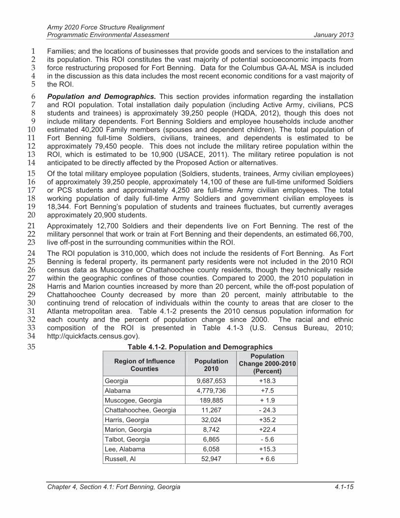
Atlanta metropolitan area. Table 4.1-2 presents the 2010 census population information for 31
each county and the percent of population change since 2000. The racial and ethnic 32
composition of the ROI is presented in Table 4.1-3 (U.S. Census Bureau, 2010; 33
http://quickfacts.census.gov). 34
Table 4.1-2. Population and Demographics 35
Region of Influence Counties
Population2010
PopulationChange 2000-2010
(Percent)
Georgia 9,687,653 +18.3
Alabama 4,779,736 +7.5
Muscogee, Georgia 189,885 + 1.9
Chattahoochee, Georgia 11,267 - 24.3
Harris, Georgia 32,024 +35.2
Marion, Georgia 8,742 +22.4
Talbot, Georgia 6,865 - 5.6
Lee, Alabama 6,058 +15.3
Russell, Al 52,947 + 6.6
Army 2020 Force Structure Realignment Programmatic Environmental Assessment January 2013
Chapter 4, Section 4.1: Fort Benning, Georgia 4.1-16
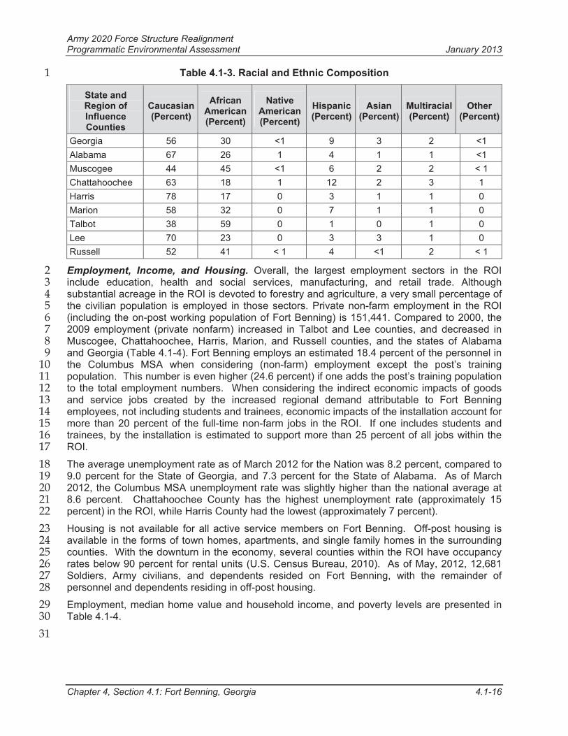
Table 4.1-3. Racial and Ethnic Composition1
State and Region of InfluenceCounties
Caucasian (Percent)
African American(Percent)
Native American(Percent)
Hispanic(Percent)
Asian(Percent)
Multiracial(Percent)
Other (Percent)
Georgia 56 30 <1 9 3 2 <1
Alabama 67 26 1 4 1 1 <1
Muscogee 44 45 <1 6 2 2 < 1
Chattahoochee 63 18 1 12 2 3 1
Harris 78 17 0 3 1 1 0
Marion 58 32 0 7 1 1 0
Talbot 38 59 0 1 0 1 0
Lee 70 23 0 3 3 1 0
Russell 52 41 < 1 4 <1 2 < 1
Employment, Income, and Housing. Overall, the largest employment sectors in the ROI 2
include education, health and social services, manufacturing, and retail trade. Although 3
substantial acreage in the ROI is devoted to forestry and agriculture, a very small percentage of 4
the civilian population is employed in those sectors. Private non-farm employment in the ROI 5
(including the on-post working population of Fort Benning) is 151,441. Compared to 2000, the 6
2009 employment (private nonfarm) increased in Talbot and Lee counties, and decreased in 7
Muscogee, Chattahoochee, Harris, Marion, and Russell counties, and the states of Alabama 8
and Georgia (Table 4.1-4). Fort Benning employs an estimated 18.4 percent of the personnel in 9
the Columbus MSA when considering (non-farm) employment except the post’s training 10
population. This number is even higher (24.6 percent) if one adds the post’s training population 11
to the total employment numbers. When considering the indirect economic impacts of goods 12
and service jobs created by the increased regional demand attributable to Fort Benning 13
employees, not including students and trainees, economic impacts of the installation account for 14
more than 20 percent of the full-time non-farm jobs in the ROI. If one includes students and 15
trainees, by the installation is estimated to support more than 25 percent of all jobs within the 16
ROI.17
The average unemployment rate as of March 2012 for the Nation was 8.2 percent, compared to 18
9.0 percent for the State of Georgia, and 7.3 percent for the State of Alabama. As of March 19
2012, the Columbus MSA unemployment rate was slightly higher than the national average at 20
8.6 percent. Chattahoochee County has the highest unemployment rate (approximately 15 21
percent) in the ROI, while Harris County had the lowest (approximately 7 percent). 22
Housing is not available for all active service members on Fort Benning. Off-post housing is 23
available in the forms of town homes, apartments, and single family homes in the surrounding 24
counties. With the downturn in the economy, several counties within the ROI have occupancy 25
rates below 90 percent for rental units (U.S. Census Bureau, 2010). As of May, 2012, 12,681 26
Soldiers, Army civilians, and dependents resided on Fort Benning, with the remainder of 27
personnel and dependents residing in off-post housing. 28
Employment, median home value and household income, and poverty levels are presented in 29
Table 4.1-4. 30
31
Army 2020 Force Structure Realignment Programmatic Environmental Assessment January 2013
Chapter 4, Section 4.1: Fort Benning, Georgia 4.1-17
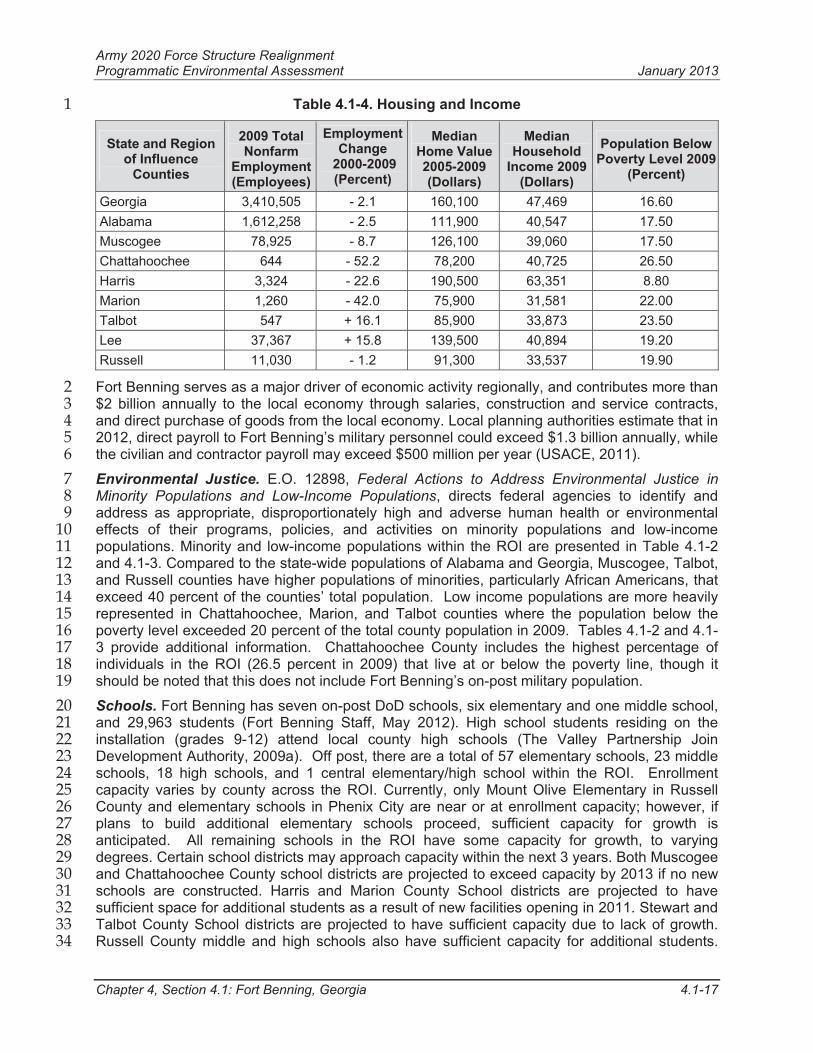
Table 4.1-4. Housing and Income 1
State and Region of Influence
Counties
2009 Total Nonfarm
Employment (Employees)
Employment Change
2000-2009 (Percent)
MedianHome Value 2005-2009 (Dollars)
MedianHousehold
Income 2009 (Dollars)
Population Below Poverty Level 2009
(Percent)
Georgia 3,410,505 - 2.1 160,100 47,469 16.60
Alabama 1,612,258 - 2.5 111,900 40,547 17.50
Muscogee 78,925 - 8.7 126,100 39,060 17.50
Chattahoochee 644 - 52.2 78,200 40,725 26.50
Harris 3,324 - 22.6 190,500 63,351 8.80
Marion 1,260 - 42.0 75,900 31,581 22.00
Talbot 547 + 16.1 85,900 33,873 23.50
Lee 37,367 + 15.8 139,500 40,894 19.20
Russell 11,030 - 1.2 91,300 33,537 19.90
Fort Benning serves as a major driver of economic activity regionally, and contributes more than 2
$2 billion annually to the local economy through salaries, construction and service contracts, 3
and direct purchase of goods from the local economy. Local planning authorities estimate that in 4
2012, direct payroll to Fort Benning’s military personnel could exceed $1.3 billion annually, while 5
the civilian and contractor payroll may exceed $500 million per year (USACE, 2011). 6
Environmental Justice. E.O. 12898, Federal Actions to Address Environmental Justice in 7
Minority Populations and Low-Income Populations, directs federal agencies to identify and 8
address as appropriate, disproportionately high and adverse human health or environmental 9
effects of their programs, policies, and activities on minority populations and low-income 10
populations. Minority and low-income populations within the ROI are presented in Table 4.1-2 11
and 4.1-3. Compared to the state-wide populations of Alabama and Georgia, Muscogee, Talbot, 12
and Russell counties have higher populations of minorities, particularly African Americans, that 13
exceed 40 percent of the counties’ total population. Low income populations are more heavily 14
represented in Chattahoochee, Marion, and Talbot counties where the population below the 15
poverty level exceeded 20 percent of the total county population in 2009. Tables 4.1-2 and 4.1-16
3 provide additional information. Chattahoochee County includes the highest percentage of 17
individuals in the ROI (26.5 percent in 2009) that live at or below the poverty line, though it 18
should be noted that this does not include Fort Benning’s on-post military population. 19
Schools. Fort Benning has seven on-post DoD schools, six elementary and one middle school, 20
and 29,963 students (Fort Benning Staff, May 2012). High school students residing on the 21
installation (grades 9-12) attend local county high schools (The Valley Partnership Join 22
Development Authority, 2009a). Off post, there are a total of 57 elementary schools, 23 middle 23
schools, 18 high schools, and 1 central elementary/high school within the ROI. Enrollment 24
capacity varies by county across the ROI. Currently, only Mount Olive Elementary in Russell 25
County and elementary schools in Phenix City are near or at enrollment capacity; however, if 26
plans to build additional elementary schools proceed, sufficient capacity for growth is 27
anticipated. All remaining schools in the ROI have some capacity for growth, to varying 28
degrees. Certain school districts may approach capacity within the next 3 years. Both Muscogee 29
and Chattahoochee County school districts are projected to exceed capacity by 2013 if no new 30
schools are constructed. Harris and Marion County School districts are projected to have 31
sufficient space for additional students as a result of new facilities opening in 2011. Stewart and 32
Talbot County School districts are projected to have sufficient capacity due to lack of growth. 33
Russell County middle and high schools also have sufficient capacity for additional students. 34
Army 2020 Force Structure Realignment Programmatic Environmental Assessment January 2013
Chapter 4, Section 4.1: Fort Benning, Georgia 4.1-18
Webster County High School has excess capacity, while the elementary/middle school is 1
categorized as just below capacity (USACE, 2011). 2
Public Safety and Social Services. The Provost Marshal provides on-post law enforcement 3
services. Off post, there are approximately 1,000 law enforcement officers in the ROI (USACE, 4
2011). Fort Benning’s Fire Department provides on-post fire protection. In addition, it has 5
Memoranda of Understanding to provide fire assistance in times of increased need with fire 6
departments in Phenix City, the City of Columbus, and Chattahoochee County. No Memoranda 7
of Understanding exists between Fort Benning and the fire departments in Lee, Marion, Harris, 8
or Talbot counties. Muscogee County and Phenix City Fire departments have 342 and 58 paid 9
fire-fighters, respectively (USACE, 2011). Russell, Chattahoochee, Harris, Marion, and Talbot 10
counties are serviced solely by volunteer fire departments that can experience resource and 11
staffing deficiencies in less populated areas. Lee County is serviced by a combination of 12
volunteer fire departments and municipal fire departments. 13
The U.S. Army Medical Department Activity provides medical care to an eligible patient 14
population in excess of 72,000 beneficiaries (U.S. Army Medical Department, 2010), though 15
many of these potential beneficiaries receive medical treatment through private sources using 16
different military health care options under TRICARE. Medical services are highly concentrated 17
within the Columbus MSA and are notably deficient in rural areas. 18
4.1.11.2 Environmental Consequences 19
No Action Alternative 20
There would be no change to socioeconomic conditions anticipated under the No Action 21
Alternative. Fort Benning would continue to have the same levels of economic and social 22
impacts on employment, housing, schools, and public services. No additional impacts would be 23
anticipated beyond those beneficial and adverse socioeconomic impacts currently being 24
experienced within the ROI. 25
Alternative 1: Force Reduction (up to 7,1001 Soldiers and Army Civilians) 26
Economic Impacts. Alternative 1 would result in the loss of up to 7,100 military employees 27
(Soldier and Army civilian employees), each with an average annual income of $41,830. In 28
addition, this alternative would affect an estimated 3,950 spouses and 6,791 dependent 29
children, for a total estimated potential impact to 10,741 dependents. The total population of 30
military employees and their dependents directly affected by Alternative 1 would be projected to 31
be 17,815. 32
Based on the EIFS analysis, there would be significant socioeconomic impacts for population 33
loss within the ROI for this alternative. There would be no significant impacts for sales volume, 34
income, or employment, though these values would all experience declines within the ROI. The 35
range of values that would represent a significant economic impact in accordance with the EIFS 36
model are presented in Table 4.1-5, along with the predicted percentages for Alternative 1. 37
Table 4.1-6 presents the projected economic impacts to the region for Alternative 1 as assessed 38
by the Army’s EIFS model. 39
1 Calculations used a number of 7,074 Soldiers and civilians for estimating socioeconomic impacts. This number was derived by
assuming the loss of Fort Benning’s ABCT, as well as 30 percent of the installation's non-BCT Soldiers and up to 15 percent of thecivilian workforce. As discussed in Chapter 3, this number is rounded to the nearest hundred personnel when discussing impacts ofAlternative 1.
Army 2020 Force Structure Realignment Programmatic Environmental Assessment January 2013
Chapter 4, Section 4.1: Fort Benning, Georgia 4.1-19
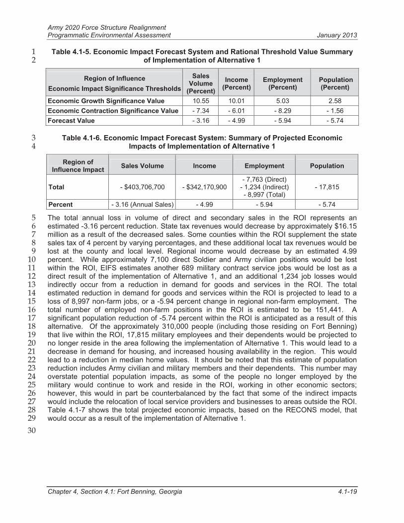
Table 4.1-5. Economic Impact Forecast System and Rational Threshold Value Summary 1
of Implementation of Alternative 1 2
Region of Influence
Economic Impact Significance Thresholds
SalesVolume
(Percent)
Income(Percent)
Employment (Percent)
Population (Percent)
Economic Growth Significance Value 10.55 10.01 5.03 2.58
Economic Contraction Significance Value - 7.34 - 6.01 - 8.29 - 1.56
Forecast Value - 3.16 - 4.99 - 5.94 - 5.74
Table 4.1-6. Economic Impact Forecast System: Summary of Projected Economic 3
Impacts of Implementation of Alternative 1 4
Region of Influence Impact
Sales Volume Income Employment Population
Total - $403,706,700 - $342,170,900- 7,763 (Direct)
- 1,234 (Indirect)- 8,997 (Total)
- 17,815
Percent - 3.16 (Annual Sales) - 4.99 - 5.94 - 5.74
The total annual loss in volume of direct and secondary sales in the ROI represents an 5
estimated -3.16 percent reduction. State tax revenues would decrease by approximately $16.15 6
million as a result of the decreased sales. Some counties within the ROI supplement the state 7
sales tax of 4 percent by varying percentages, and these additional local tax revenues would be 8
lost at the county and local level. Regional income would decrease by an estimated 4.99 9
percent. While approximately 7,100 direct Soldier and Army civilian positions would be lost 10
within the ROI, EIFS estimates another 689 military contract service jobs would be lost as a 11
direct result of the implementation of Alternative 1, and an additional 1,234 job losses would 12
indirectly occur from a reduction in demand for goods and services in the ROI. The total 13
estimated reduction in demand for goods and services within the ROI is projected to lead to a 14
loss of 8,997 non-farm jobs, or a -5.94 percent change in regional non-farm employment. The 15
total number of employed non-farm positions in the ROI is estimated to be 151,441. A 16
significant population reduction of -5.74 percent within the ROI is anticipated as a result of this 17
alternative. Of the approximately 310,000 people (including those residing on Fort Benning) 18
that live within the ROI, 17,815 military employees and their dependents would be projected to 19
no longer reside in the area following the implementation of Alternative 1. This would lead to a 20
decrease in demand for housing, and increased housing availability in the region. This would 21
lead to a reduction in median home values. It should be noted that this estimate of population 22
reduction includes Army civilian and military members and their dependents. This number may 23
overstate potential population impacts, as some of the people no longer employed by the 24
military would continue to work and reside in the ROI, working in other economic sectors; 25
however, this would in part be counterbalanced by the fact that some of the indirect impacts 26
would include the relocation of local service providers and businesses to areas outside the ROI. 27
Table 4.1-7 shows the total projected economic impacts, based on the RECONS model, that 28
would occur as a result of the implementation of Alternative 1. 29
30
Army 2020 Force Structure Realignment Programmatic Environmental Assessment January 2013
Chapter 4, Section 4.1: Fort Benning, Georgia 4.1-20
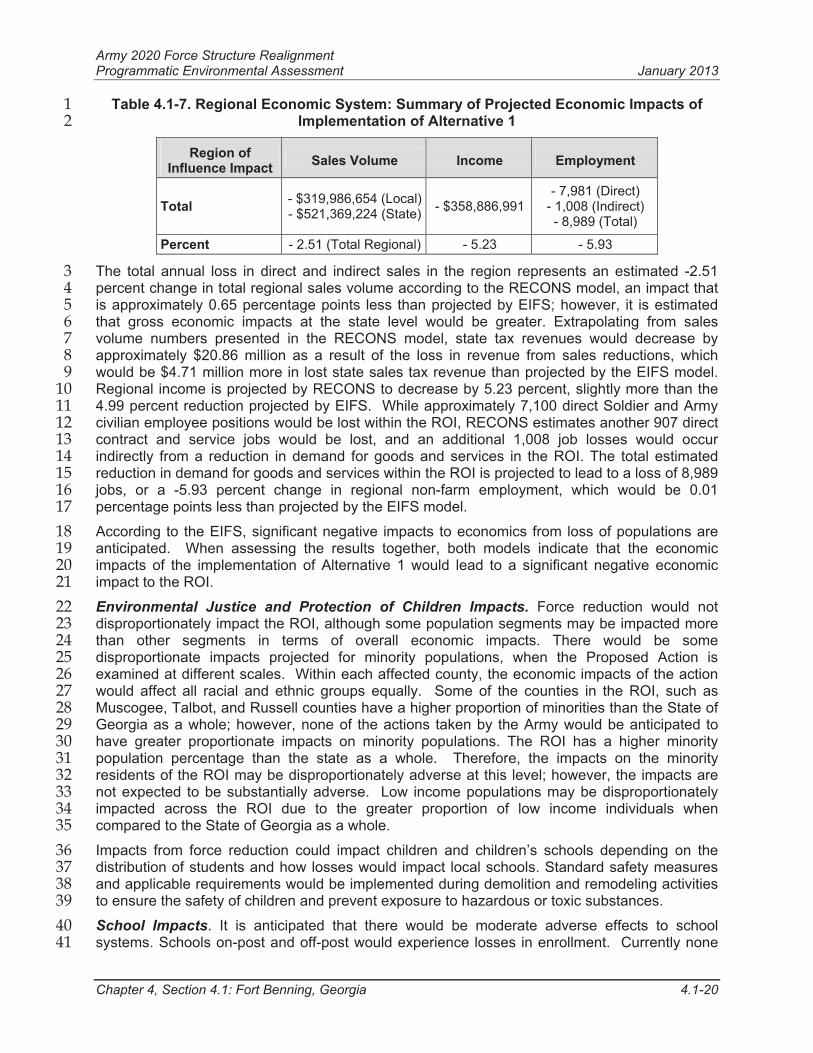
Table 4.1-7. Regional Economic System: Summary of Projected Economic Impacts of 1
Implementation of Alternative 12
Region of Influence Impact
Sales Volume Income Employment
Total- $319,986,654 (Local)- $521,369,224 (State)
- $358,886,991- 7,981 (Direct)
- 1,008 (Indirect)- 8,989 (Total)
Percent - 2.51 (Total Regional) - 5.23 - 5.93
The total annual loss in direct and indirect sales in the region represents an estimated -2.51 3
percent change in total regional sales volume according to the RECONS model, an impact that 4
is approximately 0.65 percentage points less than projected by EIFS; however, it is estimated 5
that gross economic impacts at the state level would be greater. Extrapolating from sales 6
volume numbers presented in the RECONS model, state tax revenues would decrease by 7
approximately $20.86 million as a result of the loss in revenue from sales reductions, which 8
would be $4.71 million more in lost state sales tax revenue than projected by the EIFS model. 9
Regional income is projected by RECONS to decrease by 5.23 percent, slightly more than the 10
4.99 percent reduction projected by EIFS. While approximately 7,100 direct Soldier and Army 11
civilian employee positions would be lost within the ROI, RECONS estimates another 907 direct 12
contract and service jobs would be lost, and an additional 1,008 job losses would occur 13
indirectly from a reduction in demand for goods and services in the ROI. The total estimated 14
reduction in demand for goods and services within the ROI is projected to lead to a loss of 8,989 15
jobs, or a -5.93 percent change in regional non-farm employment, which would be 0.01 16
percentage points less than projected by the EIFS model. 17
According to the EIFS, significant negative impacts to economics from loss of populations are 18
anticipated. When assessing the results together, both models indicate that the economic 19
impacts of the implementation of Alternative 1 would lead to a significant negative economic 20
impact to the ROI. 21
Environmental Justice and Protection of Children Impacts. Force reduction would not 22
disproportionately impact the ROI, although some population segments may be impacted more 23
than other segments in terms of overall economic impacts. There would be some 24
disproportionate impacts projected for minority populations, when the Proposed Action is 25
examined at different scales. Within each affected county, the economic impacts of the action 26
would affect all racial and ethnic groups equally. Some of the counties in the ROI, such as 27
Muscogee, Talbot, and Russell counties have a higher proportion of minorities than the State of 28
Georgia as a whole; however, none of the actions taken by the Army would be anticipated to 29
have greater proportionate impacts on minority populations. The ROI has a higher minority 30
population percentage than the state as a whole. Therefore, the impacts on the minority 31
residents of the ROI may be disproportionately adverse at this level; however, the impacts are 32
not expected to be substantially adverse. Low income populations may be disproportionately 33
impacted across the ROI due to the greater proportion of low income individuals when 34
compared to the State of Georgia as a whole.35
Impacts from force reduction could impact children and children’s schools depending on the 36
distribution of students and how losses would impact local schools. Standard safety measures 37
and applicable requirements would be implemented during demolition and remodeling activities 38
to ensure the safety of children and prevent exposure to hazardous or toxic substances. 39
School Impacts. It is anticipated that there would be moderate adverse effects to school 40
systems. Schools on-post and off-post would experience losses in enrollment. Currently none 41
Army 2020 Force Structure Realignment Programmatic Environmental Assessment January 2013
Chapter 4, Section 4.1: Fort Benning, Georgia 4.1-21
of the counties within the ROI are over capacity, although Russell and Harris County public 1
schools are close to their capacity (USACE, 2011). The reduction of Soldiers on Fort Benning 2
would result in a loss of Federal Impact Aid dollars in the ROI; however, actual projected dollar 3
amounts cannot be determined at this time due to the variability of appropriated dollars from 4
year to year, and the actual number of school-age children for military and civilian Families. 5
Schools receiving Federal Impact Aid dollars would be negatively impacted through monies that 6
would no longer be received to supplement costs of schooling military children. The amount of 7
aid a school receives is based on the number of federal students the district supports in relation 8
to the total district student population. Total Federal Impact Aid varies each year depending on 9
congressional appropriations, but in general has ranged from $250 to $2,000 per student 10
(USACE, 2007). 11
Alternative 1 may have positive impacts in some of the school systems, particularly in Russell, 12
Muscogee, and Chattahoochee counties where student enrollment is closer to the total schools 13
capacity. Within these counties, implementation of Alternative 1 could lead to a reduction in 14
class sizes and a reduction in student to teacher ratios. Alternative 1 would also reduce student 15
enrollment at Fort Benning’s on-post elementary and middle schools. In terms of special needs 16
military children receiving support from the State of Georgia, Federal Impact Aid does not cover 17
the full cost of these students. Alternative 1 would reduce the state economic burden for costs 18
not covered by Federal Impact Aid for these students. 19
Safety and Public and Social Services Impacts. There would be no anticipated impacts to 20
public safety resulting from implementation of Alternative 1, as all applicable regulations and 21
Memoranda of Understanding would continue to be implemented. 22
4.1.12 Energy Demand and Generation 23
4.1.12.1 Affected Environment 24
Fort Benning’s energy needs are currently met by a combination of electric power and natural 25
gas. As a result of utility privatization, the electric system is owned and operated by Flint 26
Electric, and the natural gas system is owned and operated by Atmos Energy. The Energy 27
Policy Act of 2005 (EPACT) states that each federal facility has to reduce energy consumption 28
by 2 percent each year. Fort Benning is committed to comply with the EPACT.29
Electricity. Most electric power is supplied to Fort Benning from substations that supply power 30
to cantonment areas, Family housing, and other developed areas of the installation. Low-31
capacity electrical service is supplied to ranges and training areas in more remote sections of 32
the installation.33
Natural Gas. Natural gas supplies the majority of non-mobile fuel requirements at the 34
installation. Propane is the main energy source for the training areas, and is used as backup to 35
the natural gas supply. A peak shaving plant augments natural gas supply during high 36
demands. Distribution lines serve the cantonment areas and Family housing. 37
4.1.12.2 Environmental Consequences 38
No Action Alternative 39
Minor adverse impacts are anticipated on energy demand. The continued use of out-dated, 40
energy inefficient facilities could hinder Fort Benning’s requirement to reduce energy 41
consumption. Some older facilities may require renovations to improve energy efficiency to 42
achieve EPACT requirements.43
44
Army 2020 Force Structure Realignment Programmatic Environmental Assessment January 2013
Chapter 4, Section 4.1: Fort Benning, Georgia 4.1-22
Alternative 1: Force Reduction (up to 7,100 Soldiers and Army Civilians) 1
Minor beneficial impacts on energy demand are anticipated as the installation would be better 2
positioned to meet EPACT goals. Fort Benning anticipates an overall reduction in energy 3
consumption with the loss of a ABCT and the realignment of tenant units to occupy recently 4
constructed, energy-efficient facilities. Fort Benning anticipates that older, energy inefficient 5
facilities would be demolished. Some utility infrastructure may be demolished or no longer 6
utilized in association with building demolition. 7
4.1.13 Land Use Conflicts and Compatibility 8
4.1.13.1 Affected Environment 9
Fort Benning covers approximately 182,000 acres in portions of Muscogee, Chattahoochee, and 10
Russell counties. Fort Benning training lands consist of drop zones, landing zones, dudded and 11
non-dudded impact areas, ranges, and maneuver areas. Maneuver areas are throughout the 12
installation, and landing and drop zones are scattered throughout. 13
Land use conflicts and compatibility issues result from encroachment by the surrounding 14
communities. Land uses immediately adjacent to the installation consist of residential, 15
agricultural and timber, industrial, and open space. Residential encroachment adjacent to the 16
installation causes concern due to potential incompatibility. Communities near Fort Benning are 17
required by the State of Georgia to coordinate with Fort Benning on any proposed zoning 18
decisions for land that is within 3,000 feet of the installation (Georgia Code 36-66-6). The 19
decision-making process enables zoning changes to be compatible with nearby military land 20
use. 21
Fort Benning produces various impacts that can affect the quality of life in surrounding 22
communities. Examples of these impacts include smoke from prescribed burns, the risk of an 23
aircraft accident, and noise from small and large arms firing. To assist the communities in the 24
land use zoning decisions, the Joint Land Use Study (JLUS) describes the land use and NZs 25
that the Army uses to estimate the impacts from encroachment (The Valley Partnership, 2008). 26
Through JLUS, the installation closely works with the community to develop cooperative 27
approaches for reducing adverse impacts of conflicting land uses. 28
The Army also addresses encroachment issues and promotes natural resource conservation 29
through the Army Compatible Use Buffer (ACUB) program. An implementation strategy of the 30
ACUB program is to acquire conservation easements or other land interests that prohibit 31
incompatible development in perpetuity. While the ACUB program prohibits urban development, 32
it accommodates compatible uses such as farming and forestry that do not pose a risk of 33
encroachment to installation training activities. The ACUB program also expands conservation 34
of natural resources, and management of threatened and endangered species to properties 35
outside of Fort Benning. 36
Lands that are not used for training at Fort Benning are used to support cantonment functions. 37
Approximately 8,850 acres, main post is the largest and most developed of the cantonment 38
areas. It includes the MCoE and Garrison Headquarters, Infantry and Armor Schools, Cuartels 39
barracks complex, Martin Army Community Hospital, Post Exchange, Commissary, and various 40
Family housing areas. Lawson Army Airfield is located in the southernmost portion of main 41
post. The areas of main post adjacent to the Chattahoochee River and Upatoi Creek are largely 42
green space. Family housing and outdoor recreation dominate the northern portion of main 43
post. The densely developed core of main post includes unaccompanied personnel housing, 44
community facilities, training facilities, supply and storage, maintenance, industrial, and medical 45
land uses. 46
Army 2020 Force Structure Realignment Programmatic Environmental Assessment January 2013
Chapter 4, Section 4.1: Fort Benning, Georgia 4.1-23
There are three additional distinct cantonment areas on Fort Benning as discussed below: 1
Harmony Church. The Harmony Church cantonment area lies 5 miles southeast of 2
main post and south of U.S. Highway 27. Harmony Church has seen the greatest 3
change and growth with the establishment of the MCoE. Harmony Church is now the 4
home of the Armor School, Ranger Training Brigade, the 81st Regional Readiness 5
Command Equipment Concentration Site, 197th Infantry Brigade, and the Continental 6
U.S. Replacement Center. The 775-acre Harmony Church cantonment area supports a 7
diverse assortment of facilities including unaccompanied housing, vehicle maintenance 8
shops, training, motor pools, administration buildings, and outdoor recreation land uses. 9
Kelley Hill. The 400-acre Kelley Hill cantonment area is located 3 miles east of main 10
post. Current land use, which is fairly concentrated, includes unaccompanied personnel 11
housing, community, and maintenance facilities. Kelley Hill is the current command and 12
control center for the 3-3rd ABCT, which is the only ABCT stationed on Fort Benning. The 13
3-3rd ABCT consists of a Brigade Headquarters and six battalions: two combined arms 14
Battalions, one Reconnaissance Squadron, one Field Artillery Battalion, one Brigade 15
Special Troops Battalion, and one Brigade Support Battalion and is manned with 16
approximately 3,750 Soldiers). 17
Sand Hill. The 2,510-acre Sand Hill cantonment area is located 4 miles northeast of 18
main post. Land use in this cantonment area includes Family housing, unaccompanied 19
personnel housing, training, and community facilities. 20
4.1.13.2 Environmental Consequences 21
No Action Alternative 22
Fort Benning anticipates less than significant (moderate adverse) impacts to land use 23
compatibility. With the current operational tempo of live-fire and night-time training events, the 24
encroachment of communities along Fort Benning’s boundary could cause conflicts in land use. 25
This conflict is primarily due to noise generated by training exercises and the proximity of 26
sensitive noise receptors as discussed in Section 4.1.5. Land use conflicts also are caused by 27
prescribed burning which can generate smoke and particulate matter that is not compatible with 28
some adjacent land uses. Prescribed burning is required for training area sustainment and to 29
maintain RCW habitat. Fort Benning’s ACUB and JLUS programs attempt to mitigate these 30
potential impacts to the surrounding communities. 31
Within the installation boundary, cantonment areas and training lands have been planned in a 32
logistical manner to support the training mission and Soldier needs. With the recent actions of 33
BRAC/Transformation and the establishment of the MCoE, current availability of land for new 34
construction and development of training areas is minimal. 35
Alternative 1: Force Reduction (up to 7,100 Soldiers and Army Civilians) 36
Minor adverse effects to land use are anticipated with a reduction in Soldier strength. A 37
decrease in Soldier strength would not change land use on post. It is anticipated that the 38
frequency of large arms firing event and night-time training exercises would decrease; however, 39
current noise contours would not be expected to change. Fort Benning would continue the JLUS 40
and ACUB programs to minimize potential land use conflicts between training on post and the 41
surrounding community. 42
Army 2020 Force Structure Realignment Programmatic Environmental Assessment January 2013
Chapter 4, Section 4.1: Fort Benning, Georgia 4.1-24
4.1.14 Hazardous Materials and Hazardous Waste 1
4.1.14.1 Affected Environment 2
At Fort Benning, hazardous materials and hazardous waste are subject to applicable RCRA 3
regulations. This includes the use, storage, transport, and disposal of hazardous materials and 4
wastes. Through the combined efforts of several offices at Fort Benning, programs have been 5
established to control the entry of hazardous substances to the installation; to safely manage 6
their handling and transportation within the installation; to inform military and civilian employees 7
of their dangers; to minimize the risk of human exposure and release to the environment 8
associated with these substances; and to dispose of these substances in an environmentally 9
sound manner when they are no longer useful (USACE, 2007). 10
Routine operations on Fort Benning require the use of a variety of hazardous materials, 11
including petroleum products, solvents, cleaning agents, paints, adhesives, and other products 12
necessary to perform vehicle and equipment maintenance, military training activities, installation 13
upkeep, and administrative and housing functions. Toxic substances commonly occurring on 14
Army installations include asbestos, LBP, PCBs, and radon. Routine operations across the 15
installation generate a variety of hazardous wastes, including various solvents; paints; 16
antifreeze; aerosols; contaminated filters, rags and absorbents; weapon cleaning patches and 17
sludges; and some items managed as universal wastes, such as used batteries and fluorescent 18
light tubes (USACE, 2007). Fort Benning has numerous underground storage tanks (USTs) and 19
above ground storage tanks across the installation, primarily in the cantonment areas. 20
Fort Benning has several plans in place to help manage hazardous materials and waste 21
including an installation Spill Contingency Plan; Spill Prevention, Control, and Countermeasures 22
(SPCC) Plan; Stormwater Pollution Prevention Plan (SWPPP); and Hazardous Waste 23
Management Plan (HWMP). Fort Benning has no active municipal solid waste landfills; 24
however, there are several closed landfills on post. There is one inert landfill used for storm 25
generated debris, such as trees and brush. 26
4.1.14.2 Environmental Consequences 27
No Action Alternative 28
Minor adverse impacts would be anticipated are under the No Action Alternative. The MCoE 29
would continue the use and generation of hazardous materials and wastes on Fort Benning 30
(e.g., motor pools and military equipment requiring maintenance) in accordance with all 31
applicable laws, regulations and plans. Types and quantities of hazardous wastes generated 32
have been accommodated by the existing hazardous waste management system. Due to the 33
higher number of Soldiers and support activities as a result of this alternative, the potential for 34
spills is higher than that of Alternative 1. 35
Alternative 1: Force Reduction (up to 7,100 Soldiers and Army Civilians) 36
Minor adverse impacts would be anticipated as a result of the implementation of Alternative 1. It 37
is also anticipated that Fort Benning would decrease its storage and use of hazardous materials 38
that are used during training exercises. Hazardous wastes generated would decrease in 39
volume as vehicle and equipment maintenance activities decrease with a decrease in Soldiers 40
and civilians. Due to the reduced numbers of ABCT Soldiers and support activities, the potential 41
for spills would be somewhat reduced during training and maintenance activities. Waste 42
collection, storage, and disposal processes would remain mostly unchanged, although the 43
quantities may be reduced. There may be the potential for a short-term increase in solid and 44
hazardous waste generation resulting from building renovation or demolition of vacated 45
facilities; this may include removal of above ground storage tanks or USTs. Fort Benning would 46
Army 2020 Force Structure Realignment Programmatic Environmental Assessment January 2013
Chapter 4, Section 4.1: Fort Benning, Georgia 4.1-25
minimize any negative impacts by following all applicable laws, regulations and Fort Benning 1
plans.2
4.1.15 Traffic and Transportation 3
4.1.15.1 Affected Environment 4
Fort Benning is located in the western part of Georgia and the eastern part of Alabama. Local 5
communities include Columbus, Georgia and Phenix City, Alabama. Major road routes in the 6
region include Interstate (I) 185, and U.S. Routes 27, 280, and 431, and Georgia State Routes 1 7
and 26. 8
4.1.15.2 Environmental Consequences9
No Action Alternative 10
Minor adverse impacts are anticipated under the No Action Alternative. Traffic studies prepared 11
for analysis in Fort Benning's BRAC and MCoE EIS identified LOS deficiencies within the 12
installation. Mitigation measures to widen roads, improve intersections, and encourage use of 13
travel demand management tools were implemented to minimize significant impacts to traffic 14
and transportation both on and off post. Even with these mitigation measures, the number of 15
personal and work vehicles associated with Fort Benning would continue to cause some traffic 16
congestion. 17
Alternative 1: Force Reduction (up to 7,100 Soldiers and Army Civilians) 18
Minor beneficial impacts are anticipated on traffic and transportation systems. With the 19
departure of Soldiers, civilians, and their Family members, Fort Benning anticipates a decrease 20
in traffic congestion and improvements in LOS on the installation and neighboring communities. 21
The population decrease may have a minor reduction of risk to the safety of motorist, 22
pedestrians and bicyclists. 23
4.1.16 Cumulative Effects 24
The ROI for the cumulative analysis consists of the Columbus GA-AL MSA; Talbot, Stewart and 25
Webster counties, Georgia, and Lee County, Alabama. The geographic extent of the ROI 26
includes all counties surrounding or nearby Fort Benning that may be impacted by regional 27
projects listed below. Cumulative effects include Army-related activities at Fort Benning and 28
community activities in the ROI. The effects of past and present actions were included in the 29
discussion of the affected environment and their impacts were taken into account under the 30
direct impacts discussion. 31
Reasonably Foreseeable Future Projects on Fort Benning 32
Training Land Expansion Program to acquire up to 82,800 acres of additional training 33
lands near Fort Benning (approximately FY 2012 to 2017); 34
Relocation of the ARC field training off the current Fort Benning footprint (planned 35
completion by FY 2016); 36
Construction of a ground-source community loop heat transfer utility system on Sand Hill 37
(proposed for FY 2013); 38
Construction of a new Army Lodge on main post (proposed to begin in FY 2012), and 39
implementation of the Army's Privatization of Army Lodging (PAL) at Fort Benning 40
(proposed for no earlier than FY 2014); and41
Implementation of maneuver training improvements (low-water crossings, stream bank 42
hardening, and other projects) within the GHMTA.43
Army 2020 Force Structure Realignment Programmatic Environmental Assessment January 2013
Chapter 4, Section 4.1: Fort Benning, Georgia 4.1-26
Reasonably Foreseeable Future Projects outside of Fort Benning 1
Columbus and Phenix City Riverwalk Expansion; 2
Benning Technology Park, located adjacent to I-185 and Victory Drive, to provide office 3
space and research and development centers for information technology and defense 4
contractors; 5
14th Amendment Highway Corridor which is a Department of Transportation Study of a 6
proposed highway to extend from Augusta, Georgia to Natchez, Mississippi, servicing 7
intermediate cities of Macon and Columbus, Georgia, and Montgomery, Alabama. 8
General urban growth; which includes several small housing and strip mall development 9
projects, and rehabilitating existing structures to support expanding surrounding 10
communities; and 11
Various road improvement projects as identified in the Transportation Improvement 12
Program for Columbus and Phenix City. 13
Potential incremental effects from the proposed force realignment and reduction at Fort Benning 14
are anticipated to have a significant cumulative, adverse effect to regional economics, and 15
negligible effects to other socioeconomic factors (including environmental justice and protection 16
of children). The community has planned for growth associated with moving the Armor School 17
to Fort Benning and establishing the MCoE. The adjustment to a substantial loss of personnel 18
likely would involve the re-evaluation of proposed projects. The renovation and demolition of 19
Fort Benning facilities that would no longer be utilized would have only a very minor and 20
temporary beneficial impact on regional economics. No current or future projects for growth 21
have been identified that would off-set the long-term, adverse effects from the partial loss of 22
direct and indirect economic activity that Fort Benning currently provides the entire region. 23
Fort Benning would also re-evaluate the need for land acquisition as proposed in the TLEP. 24
With the loss of an ABCT, the competition for training facilities such as heavy maneuver land 25
would be reduced from current demand. The re-evaluation may indicate that either a smaller 26
TLEP land acquisition of approximately 25,000 acres would be needed, or may result in no land 27
acquisition being pursued under TLEP for the foreseeable future. The TLEP DEIS indicated 28
that there may be a positive regional economic impact from the larger land acquisition due to 29
land purchase and relocation activities over several years. Some comments received on the 30
TLEP DEIS, however, indicate community concerns about significant economic losses for the 31
counties involved. With the information available to date, the Army cannot determine the 32
potential economic impacts related to a reduced or no TLEP land acquisition. 33
The potential cumulative effects on the natural environment resources would be reduced to 34
minor adverse or beneficial as a result of the implementation of Alternative 1. Fort Benning 35
would coordinate with USFWS to determine how the changed impacts to threatened and 36
endangered species, especially the RCW, may result in changes in training and management 37
actions. Fort Benning would re-evaluate the need to relocate the ARC training off post and 38
would coordinate with USFWS on options. 39
If the communities in the Fort Benning region scaled back, fewer environmental impacts may be 40
anticipated. Demolition or renovation of facilities on post and in the community are not 41
anticipated to cause any negative cumulative impacts and instead may result in more energy 42
efficiencies for regional beneficial cumulative impacts. 43
Overall, the potential cumulative impacts of Alternative 1 at Fort Benning is anticipated to be 44
significant adverse for economics, and generally reduced impacts, ranging from minor adverse 45
to beneficial, for natural and cultural resources. 46


