Embed Size (px)
Citation preview
FORMOSAT-3/COS MIC Space craft Con stel la tion Sys tem, Mis sionRe sults, and Pros pect for Fol low-On Mission
Chen-Joe Fong1, 2, *, Nick L. Yen 2, Chung-Huei Chu 2, Shan-Kuo Yang 2, Wen-Tzong Shiau 2,Cheng-Yung Huang 2, 6, Sien Chi1, 3, Shao-Shing Chen 2, Yuei-An Liou 4, and Ying-Hwa Kuo 5
1De part ment of Pho ton ics and In sti tute of Elec tro-Op ti cal En gi neer ing, Na tional Chiao-Tung Uni ver sity (NCTU),Hsinchu, Tai wan 300, ROC
2 Na tional Space Or ga ni za tion (NSPO), Hsinchu, Tai wan 300, ROC
3 De part ment of Elec tri cal En gi neer ing, Yuan Ze Uni ver sity, Chung-Li, Tai wan 320, ROC4 Cen ter for Space and Re mote Sens ing Re search, Na tional Cen tral Uni ver sity (NCU), Chung-Li, Tai wan 320, ROC
5 Uni ver sity Cor po ra tion for At mo spheric Re search, Boul der, Col o rado 80307-3000, USA6 In sti tute for Sci en tific Re search, Boston Col lege, Mas sa chu setts, USA
Re ceived 27 June 2007, ac cepted 3 January 2008
AB STRACT
The FORMOSAT-3/COS MIC space craft con stel la tion con sist ing of six LEO sat el lites is the world’s first op er a tional GPS
Ra dio Occultation (RO) mis sion. The mis sion is jointly de vel oped by Tai wan’s Na tional Space Or ga ni za tion (NSPO) and the
United States’ UCAR in col lab o ra tion with NSF, USAF, NOAA, NASA, NASA’s Jet Pro pul sion Lab o ra tory, and the US Na val
Re search Lab o ra tory. The FORMOSAT-3/COS MIC sat el lites were suc cess fully launched from Vandenberg US AFB in
Cal i for nia at 0140 UTC 15 April 2006 into the same or bit plane of the des ig nated 516 km al ti tude. The mis sion goal is to de ploy
the six sat el lites into six or bit planes at 800 km al ti tude with a 30-de gree sep a ra tion for evenly dis trib uted global cov er age. All
six FORMOSAT-3/COS MIC sat el lites are cur rently main tain ing a sat is fac tory good state-of-health. Five out of six sat el lites
have reached their fi nal mis sion or bit of 800 km as of No vem ber 2007. The data as re ceived by FORMOSAT-3/COS MIC
sat el lites con stel la tion have been pro cessed in near real time into 2500 good ion o spheric pro files and 1800 good at mo spheric
pro files per day. These have out num bered the world wide ra dio sondes (~900 mostly over land) launched from the ground per
day. The pro cessed at mo spheric RO data have been as sim i lated into the Nu mer i cal Weather Pre dic tion (NWP) mod els for
real-time weather pre dic tion and ty phoon/hur ri cane fore cast ing by many ma jor weather cen ters in the world. This pa per
de scribes the FORMOSAT-3/COS MIC sat el lite con stel la tion sys tem per for mance and the mission results that span the period
from April 2006 to October 2007; and reviews the prospect of a future follow-on mission.
Key words: FORMOSAT-3, COS MIC, GPS ra dio occultation, Re mote sens ing, Con stel la tion de ploy ment, Or bit rais ing, Sat el lite,Op er a tion challenges
Ci ta tion: Fong, C. J., N. L. Yen, C. H. Chu, S. K. Yang, W. T. Shiau, C. Y. Huang, S. Chi, S. S. Chen, Y. A. Liou, and Y. H. Kuo, 2009: FORMOSAT-3/COS MIC space craft con stel la tion sys tem, mis sion re sults, and pros pect for fol low-on mis sion. Terr. Atmos. Ocean. Sci., 20, 1-19, doi: 10.3319/TAO.2008.01.03.01(F3C)
1. IN TRO DUC TION
Ra dio Occultation (RO) tech niques have been used in
outer space to probe plan e tary ion o spheres and at mo spheres
for over four de cades. In the early 1960s, sci ence teams at
JPL/NASA and Stan ford Uni ver sity de vel oped one-way and
two-way ra dio occultation tech niques, re spec tively, to probe
Mars. The com bined tech niques have since been used to probe
the at mo sphere of al most ev ery planet and their moons in
the so lar sys tem (Fjeldbo and Eshleman 1965; Kliore et al.
1965; Mel bourne et al. 1994; Yunck et al. 2000).
The GPS/MET ex per i ment (1995 - 1997) car ried aboard
the NASA-spon sored MICROLAB I sat el lite showed that
the at mo spheric limb-sound ing tech nique us ing ra dio sig -
nals trans mit ted from GPS sat el lites of fers cer tain ad van -
tages over the tra di tional pas sive mi cro wave ra di om e try
mea sure ment. The GPS/MET ex per i ment be came the first
Terr. Atmos. Ocean. Sci., Vol. 20, No. 1, 1-19, February 2009 doi: 10.3319/TAO.2008.01.03.01(F3C)
* Cor re spond ing au thorE-mail: [email protected]
“proof-of-con cept” ra dio occultation mis sion to Earth (Kur -
sinski et al. 1996; Ware et al. 1996; Rocken et al. 1997). The
suc cess of the GPS/MET mis sion en gen dered a se ries of
other space mis sions be tween 1999 and 2002: Den mark’s
Oers ted; South Af rica’s Sunsat; Ar gen tina’s SAC-C; Ger -
many’s CHAMP; and the joint US-Ger man twin GRACE
sat el lites. The GPS RO sound ing data are shown to be of
high ac cu racy and high ver ti cal res o lu tion (Yunck et al.
2000; Wickert et al. 2001; Liou et al. 2002; Pavelyev et al.
2002; Hajj et al. 2004).
These mis sions pro vide im por tant mile stones in the
evolution of GPS RO tech niques (Kursinski et al. 2000;
Sokolovskiy et al. 2006), the de vel op ment of the GPS
ground track ing net work and the data pro cess ing fa cil i ties.
How ever, they are lim ited in terms of the spa tial and tem -
poral cov er age and can not pro duce suf fi cient data glob ally
to meet near real-time fore cast re quire ments. All these mis -
sions set the stage for a fol low-on Con stel la tion Ob serv ing
Sys tems for Me te o rol ogy, Ion o sphere, and Cli mate (COS -
MIC) mis sion, also known as the FORMOSAT-3/COS MIC
mis sion. The joint Tai wan-US FORMOSAT-3/COS MIC
mis sion pro vides a quan tum leap in terms of the data vol ume
and the data qual ity and be comes the first op er a tional GPS
RO con stel la tion in the world (Anthes et al. 2000; Hajj et al.
2000; Rocken et al. 2000).
The pri mary goal of the FORMOSAT-3/COS MIC mis -
sion is to ob tain in near real time ver ti cal pro files of tem per a -
ture, pres sure, refractivity, and wa ter va por in the neu tral
atmosphere, and elec tron den sity in the ion o sphere with
global cov er age at var i ous al ti tudes (Liou et al. 2007). The
RO mea sure ments taken dur ing the five-year mis sion pro -
duce about 2500 soundings per day, thus gen er at ing ex ten -
sive in for ma tion to sup port op er a tional global weather pre -
dic tion, cli mate change mon i tor ing, ion o spheric phe no -
mena, space weather re search, and es ti ma tions of con nec -
tions of me te o ro log i cal and ion o spheric pro cesses with re -
gard to so lar ac tiv ity.
2. FORMOSAT-3/COS MIC MIS SION OVER VIEW
Ta ble 1 shows the FORMOSAT-3/COS MIC Mis sion
Char ac ter is tics. The FORMOSAT-3/COS MIC mis sion in -
volves the launch and the sep a ra tion of six Low-Earth Or bit
(LEO) sat el lites us ing an in-stack con fig u ra tion housed in a
USAF Mi no taur Launch Ve hi cle to de ploy in the same or bit
plane of the des ig nated 516 km cir cu lar or bit al ti tude (Yen et
al. 2006; Fong et al. 2007a, b, 2008a, b, c).
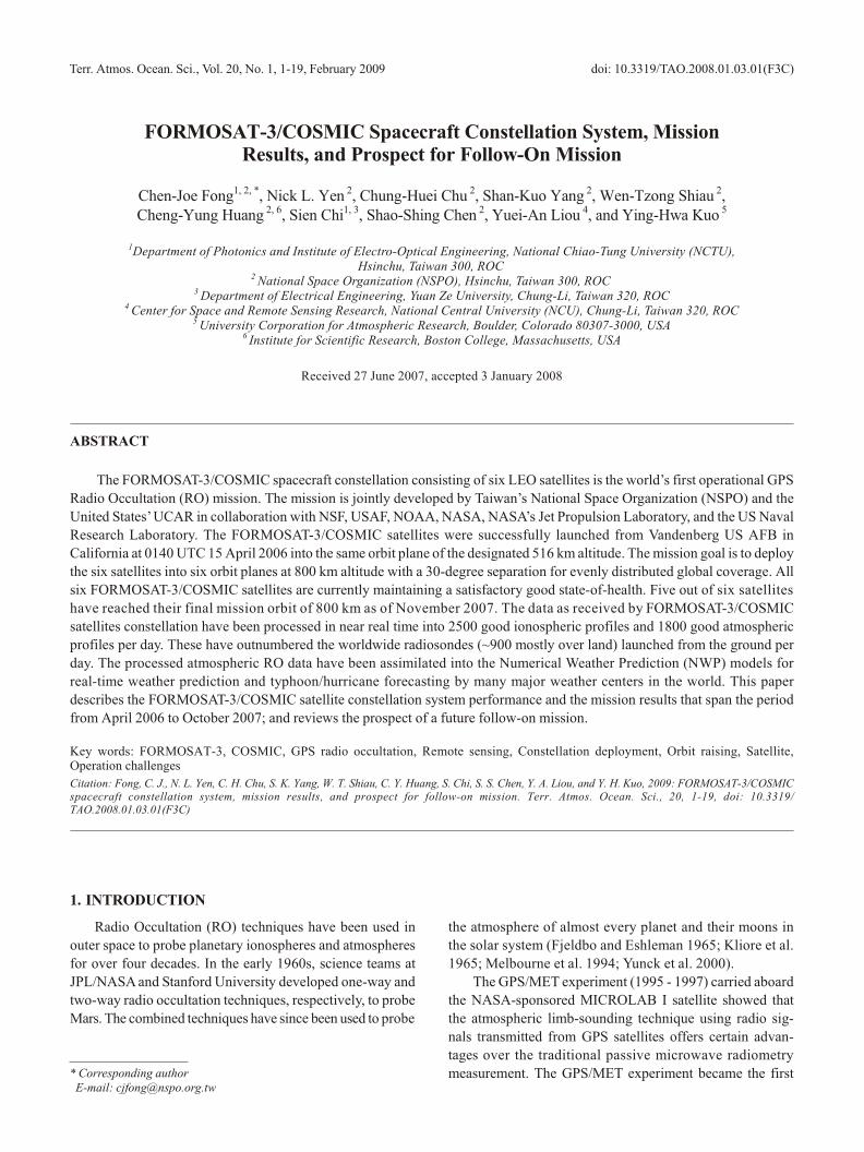
Fig ure 1 shows the FORMOSAT-3/COS MIC con stel la -
tion sys tem ar chi tec ture. The FORMOSAT-3/COS MIC con -
stel la tion of six sat el lites was suc cess fully launched on 15
April 2006. Fol low ing the com ple tion of the six sat el lites’
in-or bit check out ac tiv i ties, the sat el lite be gan the con stel la -
tion mis sion by op er at ing the three onboard pay loads at the
park ing or bit. The six sat el lites in ter act with the GPS sat el -
lites us ing the RO tech nique and com mu ni cate with the
ground com mu ni ca tion net work (GCN). The down loaded
GPS oc cult ed sound ing data of the planet Earth’s at mo -
sphere and ion o sphere is fur ther routed to the data pro cess -
ing cen ters in the US and Tai wan (Wu et al. 2006).
2.1 Space Seg ment
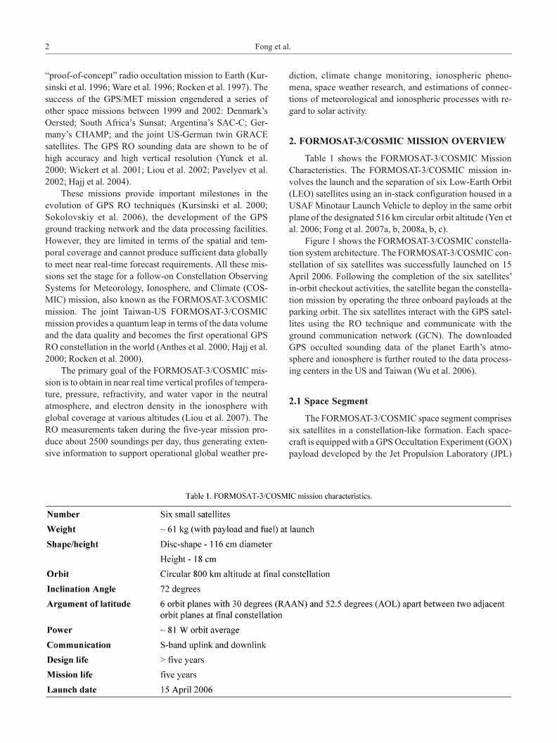
The FORMOSAT-3/COS MIC space seg ment com prises
six sat el lites in a con stel la tion-like for ma tion. Each space -
craft is equipped with a GPS Occultation Ex per i ment (GOX)
pay load de vel oped by the Jet Pro pul sion Lab o ra tory (JPL)
2 Fong et al.
and built by Broad Reach En gi neer ing, a Tiny Ion o spheric
Pho tom e ter (TIP) by Na val Re search Lab o ra tory (NRL),
and a Tri-Band Bea con trans mit ter (TBB) also by NRL.
Figure 2 il lus trates the space craft in a de ployed con fig u ra -
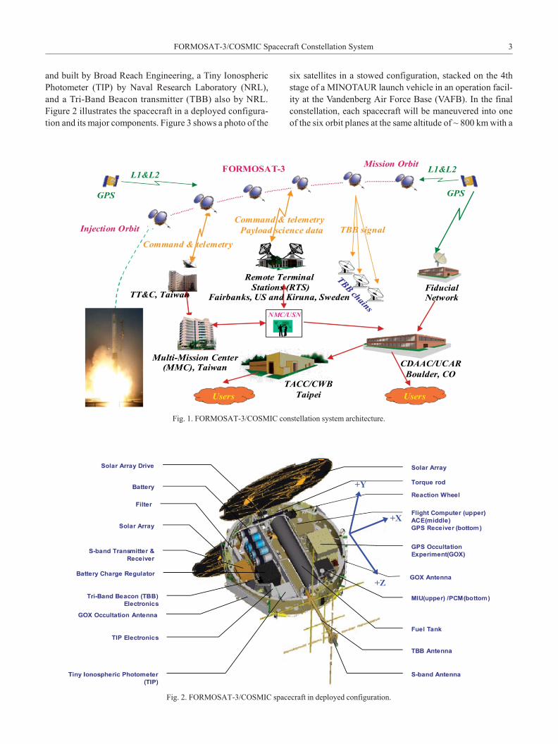
tion and its ma jor com po nents. Fig ure 3 shows a photo of the
six sat el lites in a stowed con fig u ra tion, stacked on the 4th
stage of a MI NO TAUR launch ve hi cle in an op er a tion fa cil -
ity at the Vandenberg Air Force Base (VAFB). In the fi nal
con stel la tion, each space craft will be ma neu vered into one
of the six or bit planes at the same al ti tude of ~ 800 km with a
FORMOSAT-3/COS MIC Space craft Con stel la tion Sys tem 3
Fig. 1. FORMOSAT-3/COS MIC con stel la tion sys tem ar chi tec ture.
Fig. 2. FORMOSAT-3/COS MIC space craft in de ployed con fig u ra tion.
con stant 72-de gree in cli na tion. The space craft or bits are
phased ~30 de grees apart in as cend ing node and 52.5 de -
grees apart in Ar gu ment of Lat i tude (AOL).
2.2 Ground Seg ment
The FORMOSAT-3/COS MIC ground seg ment con sists
of the Space craft Op er a tions Multi-Mis sion Cen ter (MMC)
in Tai wan, four TT&C (Te lem e try, Track ing and Com mand)
Ground Sta tions, two Data Re ceiv ing and Pro cess ing Cen -
ters, and the Fiducial Net work. There are two TT&C Lo cal
Track ing Sta tions (LTS), one lo cated in Chungli and the
other in Tainan, Tai wan, re spec tively; both LTSs have been
up graded and are ca pa ble of sup port ing the mis sion for Tai -
wan passes. There are two Re mote Ter mi nal Sta tions (RTS)
at high lat i tude. One is lo cated at Fair banks at Alaska, and
the other one is lo cated at Kiruna, Swe den. These two RTS
TT&C Sta tions are the pri mary sta tions to ef fec tively sup -
port the passes of the FORMOSAT-3/COS MIC sat el lites at
72-de gree in cli na tion. In ad di tion, Ha waii and Aus tra lia
RTSs and Tai wan LTSs may be used as backup sta tions to
the pri mary TT&C sta tions for ad di tional data dumps and/or
space craft emer gen cies.
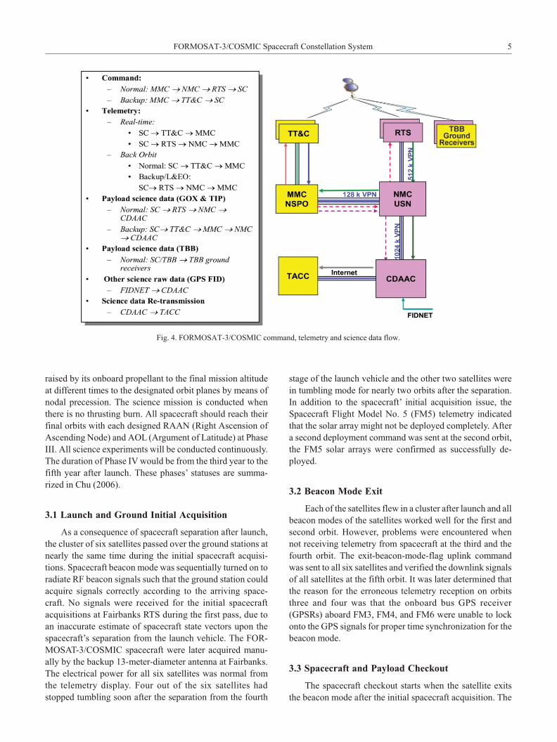
The Com mand, Te lem e try and Sci ence data flow of the
mis sion are shown in Fig. 4. NSPO’s MMC uses the real-
time te lem e try and the back or bit te lem e try to mon i tor, con -
trol, and man age the space craft’s state-of-health (SOH).
The downlinked sci ence data is trans mit ted from the RTS
via the NMC/USN (Net work Man age ment Cen ter/Uni ver -
sal Space Net work) to the two Data Re ceiv ing and Pro -
cessing Cen ters: (1) CDAAC (COS MIC Data Anal y sis and
Archive Cen ter) which is lo cated at Boul der, Col o rado,
USA; and (2) TACC (Tai wan Anal y sis Cen ter for COS -
MIC) lo cated at the Cen tral Weather Bu reau (CWB) in Tai -
wan. The Fiducial GPS data is com bined with the oc cult ed
and ref er enc ing GPS data from the GOX pay load to re -
move clock er rors. All col lected sci ence data are pro cessed
and ar chived by CDAAC/TACC and then trans ferred to the
us ers for var i ous data ap pli ca tions. Some of the pro cessed
re sults are then passed to the Na tional En vi ron men tal Sa -
tellite, Data, and In for ma tion Ser vice (NESDIS) at NOAA
and fur ther routed to the weather cen ters through out the
world in clud ing the Joint Cen ter for Sat el lite Data As sim i -
la tion (JSCDA), Na tional Cen ters for En vi ron ment Pre dic -
tion (NCEP), Eu ro pean Cen tre for Me dium-range Weather
Fore cast (ECMWF), CWB, UK Me te o ro log i cal Of fice
(UKMO), Ja pan Me te o ro log i cal Agency (JMA), Air Force
Weather Agency (AFWA), Ca na dian Me te o ro log i cal Cen -
tre (Can ada Met), Meteo France, etc. And they are made
ready for as sim i la tion into weather pre dic tion mod els (Kuo
et al. 2000, 2004). The data is pro vided to weather cen ters
within 180 min utes of on-or bit col lec tion in or der to be as -
sim i lated into the op er a tional weather fore cast model (Wu
et al. 2006; Yen et al. 2006).
3. CON STEL LA TION MIS SION OP ER A TIONS
The con stel la tion mis sion op er a tions are di vided into
four phases. Phase I is the Launch and Early Or bit (L&EO)
phase, Phase II is the con stel la tion de ploy ment phase, Phase
III is the fi nal con stel la tion phase, and Phase IV is the ex -
tended mis sion phase. Phase I in cludes launch, sep a ra tion,
ground ini tial ac qui si tion, space craft check out, and pay load
check out. Dur ing the Phase II time pe riod, the space craft is
4 Fong et al.
Fig. 3. Six FORMOSAT-3/COS MIC sat el lites stacked on the mi no taur launch ve hi cle.
raised by its onboard pro pel lant to the fi nal mis sion al ti tude
at dif fer ent times to the des ig nated or bit planes by means of
nodal pre ces sion. The sci ence mis sion is con ducted when
there is no thrust ing burn. All space craft should reach their
fi nal or bits with each de signed RAAN (Right As cen sion of
As cend ing Node) and AOL (Ar gu ment of Lat i tude) at Phase
III. All sci ence ex per i ments will be con ducted con tin u ously.
The du ra tion of Phase IV would be from the third year to the
fifth year af ter launch. These phases’ sta tuses are sum ma -
rized in Chu (2006).
3.1 Launch and Ground Ini tial Ac qui si tion
As a con se quence of space craft sep a ra tion af ter launch,
the clus ter of six sat el lites passed over the ground sta tions at
nearly the same time dur ing the ini tial space craft ac qui si -
tions. Space craft bea con mode was se quen tially turned on to
ra di ate RF bea con sig nals such that the ground sta tion could
ac quire sig nals cor rectly ac cord ing to the ar riv ing space -
craft. No sig nals were re ceived for the ini tial space craft
acquisitions at Fair banks RTS dur ing the first pass, due to
an in ac cu rate es ti mate of space craft state vec tors upon the
space craft’s sep a ra tion from the launch ve hi cle. The FOR -
MOSAT-3/COS MIC space craft were later ac quired man u -
ally by the backup 13-me ter-di am e ter an tenna at Fair banks.
The elec tri cal power for all six sat el lites was nor mal from
the te lem e try dis play. Four out of the six sat el lites had
stopped tum bling soon af ter the sep a ra tion from the fourth
stage of the launch ve hi cle and the other two sat el lites were
in tum bling mode for nearly two or bits af ter the sep a ra tion.
In ad di tion to the space craft’ ini tial ac qui si tion is sue, the
Space craft Flight Model No. 5 (FM5) te lem e try in di cated
that the so lar ar ray might not be de ployed com pletely. Af ter
a sec ond de ploy ment com mand was sent at the sec ond or bit,
the FM5 so lar ar rays were con firmed as suc cess fully de -
ployed.
3.2 Bea con Mode Exit
Each of the sat el lites flew in a clus ter af ter launch and all
bea con modes of the sat el lites worked well for the first and
sec ond or bit. How ever, prob lems were en coun tered when
not re ceiv ing te lem e try from space craft at the third and the
fourth or bit. The exit-bea con-mode-flag uplink com mand
was sent to all six sat el lites and ver i fied the downlink sig nals
of all sat el lites at the fifth or bit. It was later de ter mined that
the rea son for the er ro ne ous te lem e try re cep tion on or bits
three and four was that the onboard bus GPS re ceiver
(GPSRs) aboard FM3, FM4, and FM6 were un able to lock
onto the GPS sig nals for proper time syn chro ni za tion for the
bea con mode.
3.3 Space craft and Pay load Check out
The space craft check out starts when the sat el lite ex its
the bea con mode af ter the ini tial space craft ac qui si tion. The
FORMOSAT-3/COS MIC Space craft Con stel la tion Sys tem 5
Fig. 4. FORMOSAT-3/COS MIC com mand, te lem e try and sci ence data flow.
flight soft ware con fig u ra tions were checked and con firmed
as nor mal on all six sat el lites, ini tially; later the nav i ga tion
anom a lies that were at trib uted to the er ro ne ous GPSR be -
hav iours ap peared at Launch plus three (L + 3) days. It was
not pos si ble to iso late the root cause of these er ro ne ous GPS
be hav iours. How ever, an al ter na tive res o lu tion of feed ing
the known state vec tor to each space craft via uplink com -
mands reg u larly was able to stop the GPS-re lated nav i ga tion
anom a lies. All six sat el lites were ready to power on the pay -
load at L + 6 days. The GOX pay load of each space craft was
pow ered on first at L + 6 days, the TIP pay load on at L + 8
days, and TBB pay load on at L + 13 days respectively, ac -
cord ing to the operation in-orbit checkout plan.
3.4 Con stel la tion De ploy ment
Dur ing the Con stel la tion De ploy ment phase the sat el -
lites were sep a rated se quen tially from the same in jec tion or -
bit. The sat el lites needed to per form or bit trans fers us ing
their onboard pro pel lants at dif fer ent times in or der to
achieve the des ig nated sep a rate or bital planes through the
nodal pre ces sion. The nodal pre ces sion is a well-known
grav ity phe nom e non where the or bital plane drifts (i.e.,
RAAN pre ces sion) due to the Earth’s oblateness.
With the in cli na tion an gle of 72 de grees and the ec cen -
tric ity of 0, the con stel la tion de ploy ment (DW in de gree) can
be ex pressed by:
DW @ -6.3804 ´ 1013 D(a-7/2) × Dt (1)
where “a” is the semi-ma jor axis of the or bit al ti tude in km
and “Dt” is the de ploy ment time pe riod in days. In other
words, the space craft with dif fer ent al ti tudes will have
different or bital plane drift rates. For ex am ple, two or bit
planes will drift apart 0.3 de grees per day when the two
satellites have a 300 ki lo me ters dif fer ence in al ti tude.
3.5 Ar gu ment of Lat i tude (AOL) Fi nal Phas ing
Each ground sta tion can sup port one pass from an el e va -
tion an gle of +10 to -10 de grees. If there are two sat el lites
fly ing over the same ground sta tion at the same time, the
ground sta tion can only sup port one sat el lite un less there are
spe cial ar range ments made. There fore, in ad di tion to the
RAAN de ploy ment, a 52.5-de gree phas ing on Ar gu ment of
Lat i tude (AOL) must be im ple mented to as sure that one-
orbit worth of occultation sci ence data can be sent to the
receiving sta tions. There is no need to have sep a ra tion burns
to do the phas ing on the AOL. The strat egy is to per form the
AOL phas ing ad just ment for each space craft in con junc tion
with the or bit ma noeuv ring of that space craft when it ap -
proaches the fi nal mis sion al ti tude. For ex am ple, the AOL
phas ing ad just ment for FM 2 and FM 6 with re spect to FM5
(the first space craft reached 800 km al ti tude) be gan when
FM2 and FM6 were raised to 780 and 720 km, re spec tively.
The sep a ra tion an gles in both RAAN and AOL phas ing of
each space craft are achieved at the same time by de tailed
thrust ing ac tiv i ties planned dur ing the fi nal ap proach (Fong
et al. 2006, 2007a, b, 2008a; Yen et al. 2006).
3.6 Fi nal Con stel la tion and Ex tended Mis sion Phase
The fi nal con stel la tion of FORMOSAT-3/COS MIC will
have six or bit planes. Each or bit is at an al ti tude of 800 km
and in cli na tion an gle of 72 de grees. The sep a ra tion an gle
among or bit planes is 30 de grees and the AOL sep a ra tion be -
tween sat el lites in ad ja cent or bit planes is 52.5 de grees. The
fi nal con stel la tion set up al lows the six sat el lites to col lect
2500+ at mo spheric sound ing data on an average per day,
worldwide.
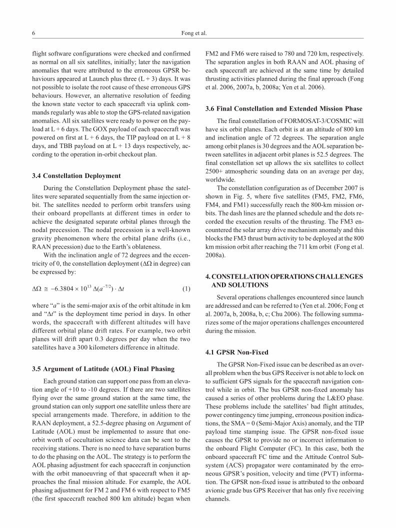
The con stel la tion con fig u ra tion as of De cem ber 2007 is
shown in Fig. 5, where five sat el lites (FM5, FM2, FM6,
FM4, and FM1) suc cess fully reach the 800-km mis sion or -
bits. The dash lines are the planned sched ule and the dots re -
corded the ex e cu tion re sults of the thrust ing. The FM3 en -
coun tered the so lar ar ray drive mech a nism anom aly and this
blocks the FM3 thrust burn ac tiv ity to be de ployed at the 800
km mis sion or bit af ter reach ing the 711 km orbit (Fong et al.
2008a).
4. CON STEL LA TION OP ER A TIONS CHAL LENGESAND SO LU TIONS
Sev eral op er a tions chal lenges en coun tered since launch
are ad dressed and can be re ferred to (Yen et al. 2006; Fong et
al. 2007a, b, 2008a, b, c; Chu 2006). The fol low ing sum ma -
rizes some of the ma jor op er a tions chal lenges en coun tered
dur ing the mis sion.
4.1 GPSR Non-Fixed
The GPSR Non-Fixed is sue can be de scribed as an over -
all prob lem when the bus GPS Re ceiver is not able to lock on
to suf fi cient GPS sig nals for the space craft nav i ga tion con -
trol while in or bit. The bus GPSR non-fixed anom aly has
caused a se ries of other prob lems dur ing the L&EO phase.
These prob lems in clude the sat el lites’ bad flight at ti tudes,
power con tin gency time jump ing, er ro ne ous po si tion in di ca -
tions, the SMA = 0 (Semi-Ma jor Axis) anom aly, and the TIP
pay load time stamp ing is sue. The GPSR non-fixed is sue
causes the GPSR to pro vide no or in cor rect in for ma tion to
the onboard Flight Com puter (FC). In this case, both the
onboard space craft FC time and the At ti tude Con trol Sub -
sys tem (ACS) prop a ga tor were con tam i nated by the er ro -
neous GPSR’s po si tion, ve loc ity and time (PVT) in for ma -
tion. The GPSR non-fixed is sue is at trib uted to the onboard
avi onic grade bus GPS Re ceiver that has only five re ceiv ing
chan nels.
6 Fong et al.
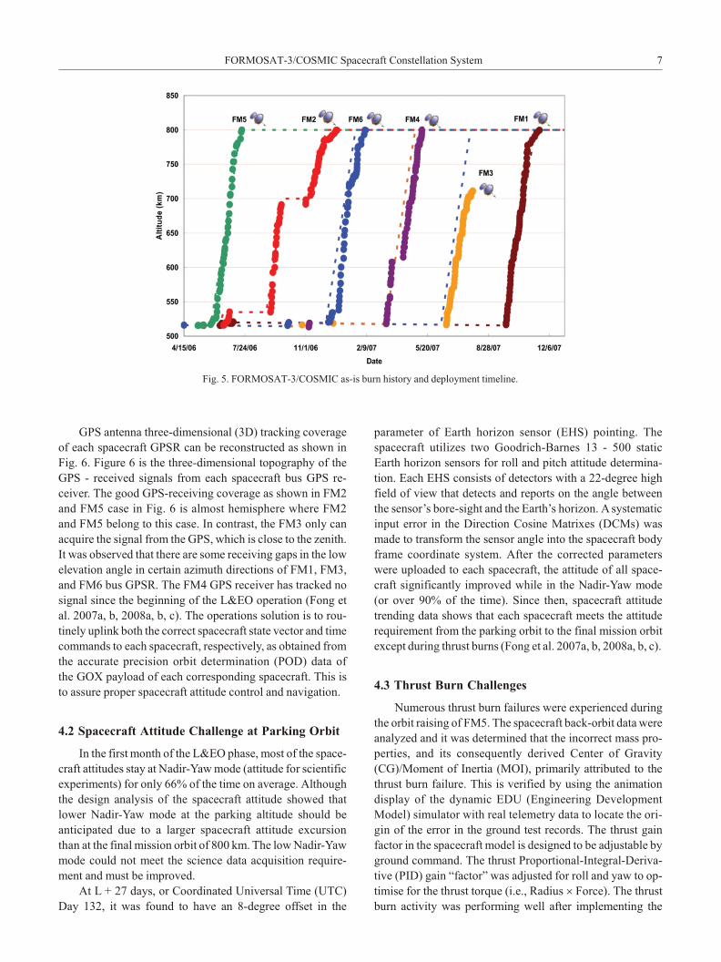
GPS an tenna three-di men sional (3D) track ing cov er age
of each space craft GPSR can be re con structed as shown in
Fig. 6. Fig ure 6 is the three-di men sional to pog ra phy of the
GPS - re ceived sig nals from each space craft bus GPS re -
ceiver. The good GPS-re ceiv ing cov er age as shown in FM2
and FM5 case in Fig. 6 is al most hemi sphere where FM2
and FM5 be long to this case. In con trast, the FM3 only can
ac quire the sig nal from the GPS, which is close to the ze nith.
It was ob served that there are some re ceiv ing gaps in the low
el e va tion an gle in cer tain az i muth di rec tions of FM1, FM3,
and FM6 bus GPSR. The FM4 GPS re ceiver has tracked no
sig nal since the be gin ning of the L&EO op er a tion (Fong et
al. 2007a, b, 2008a, b, c). The op er a tions so lu tion is to rou -
tinely uplink both the cor rect space craft state vec tor and time
com mands to each space craft, re spec tively, as ob tained from
the ac cu rate pre ci sion or bit de ter mi na tion (POD) data of
the GOX pay load of each cor re spond ing space craft. This is
to as sure proper space craft at ti tude con trol and nav i ga tion.
4.2 Space craft At ti tude Chal lenge at Park ing Or bit
In the first month of the L&EO phase, most of the space -
craft at ti tudes stay at Na dir-Yaw mode (at ti tude for sci en tific
ex per i ments) for only 66% of the time on av er age. Al though
the de sign anal y sis of the space craft at ti tude showed that
lower Na dir-Yaw mode at the park ing al ti tude should be
anticipated due to a larger space craft at ti tude ex cur sion
than at the fi nal mis sion or bit of 800 km. The low Na dir-Yaw
mode could not meet the sci ence data ac qui si tion re quire -
ment and must be im proved.
At L + 27 days, or Co or di nated Uni ver sal Time (UTC)
Day 132, it was found to have an 8-de gree off set in the
parameter of Earth ho ri zon sen sor (EHS) point ing. The
space craft uti lizes two Good rich-Barnes 13 - 500 static
Earth ho ri zon sen sors for roll and pitch at ti tude de ter mi na -
tion. Each EHS con sists of de tec tors with a 22-de gree high
field of view that de tects and re ports on the an gle be tween
the sen sor’s bore-sight and the Earth’s ho ri zon. A sys tem atic
in put er ror in the Di rec tion Co sine Ma trixes (DCMs) was
made to trans form the sen sor an gle into the space craft body
frame co or di nate sys tem. Af ter the cor rected pa ram e ters
were up loaded to each space craft, the at ti tude of all space -
craft sig nif i cantly im proved while in the Na dir-Yaw mode
(or over 90% of the time). Since then, space craft at ti tude
trending data shows that each space craft meets the at ti tude
re quire ment from the park ing or bit to the fi nal mis sion or bit
ex cept dur ing thrust burns (Fong et al. 2007a, b, 2008a, b, c).
4.3 Thrust Burn Chal lenges
Nu mer ous thrust burn fail ures were ex pe ri enced dur ing
the or bit rais ing of FM5. The space craft back-or bit data were
an a lyzed and it was de ter mined that the in cor rect mass pro -
perties, and its con se quently de rived Cen ter of Grav ity
(CG)/Mo ment of In er tia (MOI), pri mar ily at trib uted to the
thrust burn fail ure. This is ver i fied by us ing the an i ma tion
dis play of the dy namic EDU (En gi neer ing De vel op ment
Model) sim u la tor with real te lem e try data to lo cate the or i -
gin of the er ror in the ground test re cords. The thrust gain
fac tor in the space craft model is de signed to be ad just able by
ground com mand. The thrust Pro por tional-In te gral-De riv a -
tive (PID) gain “fac tor” was ad justed for roll and yaw to op -
ti mise for the thrust torque (i.e., Ra dius ´ Force). The thrust
burn ac tiv ity was per form ing well af ter im ple ment ing the
FORMOSAT-3/COS MIC Space craft Con stel la tion Sys tem 7
Fig. 5. FORMOSAT-3/COS MIC as-is burn his tory and de ploy ment timeline.
fine tun ing of the PID. The im pact of the thrust burn fail ure
in di cated that the full burn ini ti ated by rou tine pro cess as
planned could not be per formed. This has caused the or bit
trans fer ac tiv i ties of the first space craft, FM5, at a more pro -
longed sched ule than planned.
Dur ing the fol low-on FM2 and FM6 thrust burns, po orer
suc cess rates (~ 50%) were en coun tered when the thrust ing
occurred dur ing the space craft’s sun lit pe ri ods, but near 100%
suc cess rates were achieved when the thrust ing oc curred when
the space craft was in eclipse. Two dif fer ent al go rithms were
used in the space craft ACS de sign de pend ing upon num bers
of Co sine Sun Sen sors (CSSs) to gen er ate a sun vec tor for the
space craft At ti tude Ref er ence Sys tem (ARS) to per form at ti -
tude con trol. How ever, one of the al go rithms gen er ates an un -
re li able sun vec tor when mea sure ment dis con ti nu ity dur ing the
tran si tion to sun less flight and causes the ARS to gen er ate a
large pseudo at ti tude tran sient in ci dent. The les son learned
from this ob ser va tion is to per form the thrust burn at space -
craft lo cal eclipse pe riod when pos si ble to elim i nate er ro ne -
ous CSS in put to the ACS th rust ing con trol sys tem.
4.4 Con stel la tion Plan Evo lu tion
The mis sion op er a tion plan changes as time passes. The
con stel la tion plan, the GOX op er a tion plan, the TIP op er a -
tion plan, and the TBB op er a tion plan have been changed to
better fit the sci ence goals. Orig i nally, there were two pairs
of tan dem flight for FM2 and FM3, and FM4 and FM5, re -
spec tively, dur ing the ini tial con stel la tion de ploy ment
phase. The pur pose of the tan dem flight is to un der take ad di -
tional geo detic re search. How ever, as the space craft FM3
and FM4 have been very close to gether since the sep a ra tion
from the launch ve hi cle, the data as gen er ated from April to
Oc to ber could be used for ge od esy re search at the park ing
or bit of 516 km with out ex e cut ing the tan dem flights as
sched uled (Hwang et al. 2006). In stead, the con stel la tion
plan was changed to in crease sci ence data dumps for the
trop i cal storms (ty phoons and hur ri canes, etc.) pre dic tion
fore cast stud ies dur ing the In ten sive Op er at ing Phase (IOP)
cam paign be tween July and No vem ber 2006.
The orig i nal con stel la tion plan at an 800 km or bit with
24-de gree sep a ra tion planes was for a shorter de ploy ment
time con sid er ation (13 months af ter launch), but this is not
fa vour able for ion o spheric mon i tor ing and cli mate sea sonal
vari abil ity study ing due to non-uni form cov er age glob ally.
A shorter du ra tion to com plete the con stel la tion de ploy ment
was planned orig i nally be cause the pay load in stru ment was
de signed to “fo cus” at 800 km mis sion or bit. On one hand,
8 Fong et al.
Fig. 6. Space craft bus GPSR 3D track ing cov er age of GPS sat el lites.
the data qual ity of the early phase (mostly at a lower or bit)
was de ter mined to be sur pris ingly better than an tic i pated,
and the sat el lite con stel la tion de ploy ment time be came a
lesser con cern. On the other hand, sci en tists from Tai wan
and the US co her ently fa vored the 30-de gree sep a ra tion with
a ~6 month lon ger sat el lite con stel la tion de ploy ment du ra -
tion over 24-de gree sep a ra tion for glob ally uni form cov er -
age in lo cal so lar time (LST). This con stel la tion de ploy ment
plan change re flects that an integral teamwork among the
operations team and data users leads to a greater mission
success.
The con stel la tion de ploy ment plan change from a 24-
de gree sep a ra tion to 30-de gree sep a ra tion was made af ter
the com ple tion of the FM5 or bit trans fer and dur ing the FM2
or bit rais ing. The de ci sion was made to put the FM2 or bit
trans fer on hold in Oc to ber 2006 to al low FM2 to fur ther
sep a rate from FM5. The com ple tion of the fi nal con stel la -
tion con se quently shifted from May to De cem ber 2007 (Yen
et al. 2006; Liou et al. 2007).
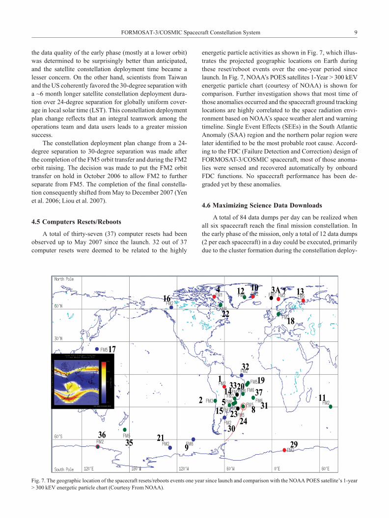
4.5 Com put ers Re sets/Reboots
A to tal of thirty-seven (37) com puter re sets had been
observed up to May 2007 since the launch. 32 out of 37
computer re sets were deemed to be re lated to the highly
energetic par ti cle ac tiv i ties as shown in Fig. 7, which il lus -
trates the pro jected geo graphic lo ca tions on Earth dur ing
these re set/re boot events over the one-year pe riod since
launch. In Fig. 7, NOAA’s POES sat el lites 1-Year > 300 kEV
en er getic par ti cle chart (cour tesy of NOAA) is shown for
com par i son. Fur ther in ves ti ga tion shows that most time of
those anom a lies oc curred and the space craft ground track ing
lo ca tions are highly cor re lated to the space ra di a tion en vi -
ron ment based on NOAA’s space weather alert and warn ing
timeline. Sin gle Event Ef fects (SEEs) in the South At lan tic
Anom aly (SAA) re gion and the north ern po lar re gion were
later iden ti fied to be the most prob a ble root cause. Ac cord -
ing to the FDC (Fail ure De tec tion and Cor rec tion) de sign of
FORMOSAT-3/COS MIC space craft, most of those anom a -
lies were sensed and re cov ered au to mat i cally by onboard
FDC func tions. No space craft per for mance has been de -
graded yet by these anom a lies.
4.6 Max i miz ing Sci ence Data Down loads
A to tal of 84 data dumps per day can be re al ized when
all six space craft reach the fi nal mis sion con stel la tion. In
the early phase of the mis sion, only a to tal of 12 data dumps
(2 per each space craft) in a day could be ex e cuted, pri mar ily
due to the clus ter for ma tion dur ing the con stel la tion de ploy -
FORMOSAT-3/COS MIC Space craft Con stel la tion Sys tem 9
Fig. 7. The geo graphic lo ca tion of the space craft re sets/reboots events one year since launch and com par i son with the NOAA POES sat el lite’s 1-year
> 300 kEV en er getic par ti cle chart (Cour tesy From NOAA).
ment phase. The GOX firm ware was up graded to im prove
the qual ity and the quan tity of the sci ence data as the sat el lite
con stel la tion con fig u ra tion (such as al ti tudes, field of views,
etc.) changed. In par al lel, op ti mi za tion ef forts were im ple -
mented to the space craft op er a tions pro cesses, the ground
soft ware, the ground con trol auto scripts, and the space craft
fly ing for ma tion, etc. to max i mize the num ber of sci ence
data dumps per day. Cur rently there are around 66 dumps on
av er age per day, a dra matic in crease from the 12 dumps a
day as orig i nally planned (Fong et al. 2007a, b, 2008a, b, c).
4.7 Data Over flow Is sue
The space craft sci ence data are tem po rarily stored in a
128 Mbyte Solid State Re corder (SSR). The GOX pay load
is con fig ured as GOX-A for pri mary and GOX-B for re -
dundancy. GOX-A and GOX-B is sep a rately al lo cated a
32 Mbytes mem ory space (or about a three or bit ca pac ity)
each in the SSR. GOX data would have an over-wrap ping
is sue when the data is not dumped within ev ery third con -
tact with the sched uled RTS. The 32-Mbyte GOX stor age
me m ory should n’t be an is sue for an evenly spaced sat el lite
con stel la tion at the fi nal mis sion or bit. How ever, in the
L&EO phase, nar row ing the GOX an tenna field of view to
con trol the data vol ume is one way to avoid data loss due to
the over-wrap ping in the SSR when the sched uled RTS is
lim ited to re ceive the data dumps. In ten tion ally dump ing
the sci ence data into space is an other way to pre vent the
over- wrap ping is sue from oc cur ring dur ing the L&EO
phase. There is still a small per cent age of sci ence data
dumped into space dur ing the space craft thrust ing ac tiv i -
ties that de mand al lo cated RTS sup ports (Fong et al. 2006,
2007a, b, 2008a, b, c).
4.8 GOX Data Gap ping Is sue
It was ob served and iden ti fied that 29% of data drop outs
from the re trieved sci ence RO data was belong to the GOX
data gap ping is sues. Af ter in ves ti gat ing those ques tion able
raw data, we found out the same data drop outs pat tern was
also ob served dur ing the ground End-To-End (ETE) tests but
the on-or bit re sults are much worse now. It is also sum ma -
rized that there would be data gap ping is sue in the GOX sci -
ence data when dump ing the space craft te lem e try data and
sci ence data si mul ta neously. As a re sult of sev eral on- or bit
ex per i ments, the GOX data gaps is sue will be dis ap peared if
the space craft te lem e try data dump ing is per formed sep a -
rately from the GOX data dump ing. This new scheme has res -
cued 70% of those sci ence data with data gap ping is sue. We
also found out that if the sci ence data is down loaded alone,
even a typ i cal rou tine dump with a ~0.04% data drop outs will
causes an 8% RO data gap ping. The op er a tions team de cides
to make the same sci ence data dump twice rou tinely. Prac ti -
cally, these two dumps will not drop the same data pack ets so
it can make up for any data drop outs. Even through this dou -
ble dumps scheme will in crease lo cal data stor age mem o ries
and dou ble the data trans fer time from ground sta tion to the
data anal y sis cen ters, it is still wor thy to saved the 8% sci -
ence data even tu ally (Fong et al. 2007a, b, 2008a, b, c).
5. SPACE CRAFT CON STEL LA TION SYS TEMON-OR BIT PER FOR MANCE
The space craft sub sys tems and the state of space craft
health as of 15 April 2007 are sum ma rized be low, af ter a
year in or bit. Un like a sin gle space craft mis sion, the
FORMOSAT-3/COS MIC sat el lite con stel la tion pro vides a
unique op por tu nity to as sess the per for mance of mul ti ple
space craft at the same time (Patel et al. 1999; Fong et al.
2006, 2007a, b, 2008a, b, c).
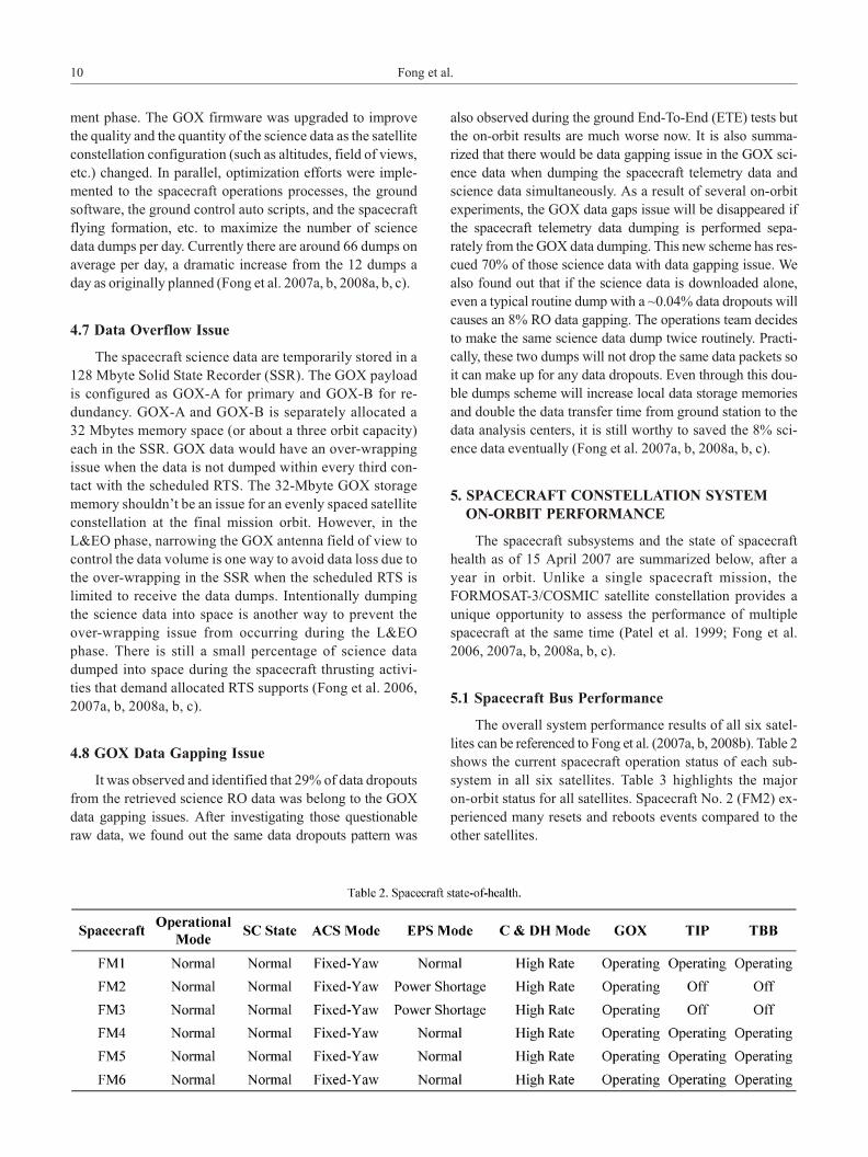
5.1 Space craft Bus Per for mance
The over all sys tem per for mance re sults of all six sat el -
lites can be ref er enced to Fong et al. (2007a, b, 2008b). Ta ble 2
shows the cur rent space craft op er a tion sta tus of each sub -
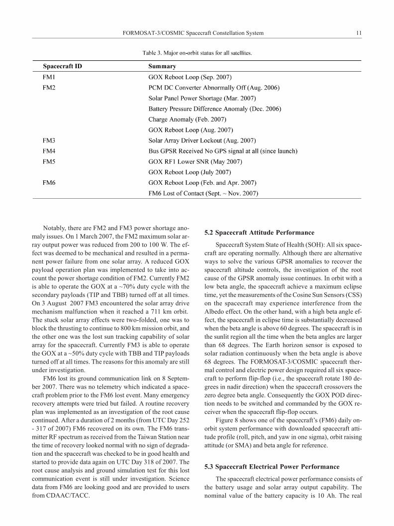
system in all six sat el lites. Ta ble 3 high lights the ma jor
on-or bit sta tus for all sat el lites. Space craft No. 2 (FM2) ex -
pe ri enced many re sets and reboots events com pared to the
other sat el lites.
10 Fong et al.
No ta bly, there are FM2 and FM3 power short age ano -
m aly is sues. On 1 March 2007, the FM2 max i mum so lar ar -
ray out put power was re duced from 200 to 100 W. The ef -
fect was deemed to be me chan i cal and re sulted in a per ma -
nent power fail ure from one so lar ar ray. A re duced GOX
pay load op er a tion plan was im ple mented to take into ac -
count the power short age con di tion of FM2. Cur rently FM2
is able to op er ate the GOX at a ~70% duty cy cle with the
sec ond ary pay loads (TIP and TBB) turned off at all times.
On 3 Au gust 2007 FM3 en coun tered the so lar ar ray drive
mech a nism mal func tion when it reached a 711 km or bit.
The stuck so lar ar ray ef fects were two-folded, one was to
block the thrust ing to con tinue to 800 km mis sion or bit, and
the other one was the lost sun track ing ca pa bil ity of so lar
ar ray for the space craft. Cur rently FM3 is able to op er ate
the GOX at a ~50% duty cy cle with TBB and TIP pay loads
turned off at all times. The rea sons for this anom aly are still
un der in ves ti ga tion.
FM6 lost its ground com mu ni ca tion link on 8 Sep tem -
ber 2007. There was no te lem e try which in di cated a space -
craft prob lem prior to the FM6 lost event. Many emer gency
re cov ery at tempts were tried but failed. A rou tine re cov ery
plan was im ple mented as an in ves ti ga tion of the root cause
con tin ued. Af ter a du ra tion of 2 months (from UTC Day 252
- 317 of 2007) FM6 re cov ered on its own. The FM6 trans -
mit ter RF spec trum as re ceived from the Tai wan Sta tion near
the time of re cov ery looked nor mal with no sign of deg ra da -
tion and the space craft was checked to be in good health and
started to pro vide data again on UTC Day 318 of 2007. The
root cause anal y sis and ground sim u la tion test for this lost
com mu ni ca tion event is still un der in ves ti ga tion. Sci ence
data from FM6 are look ing good and are pro vided to us ers
from CDAAC/TACC.
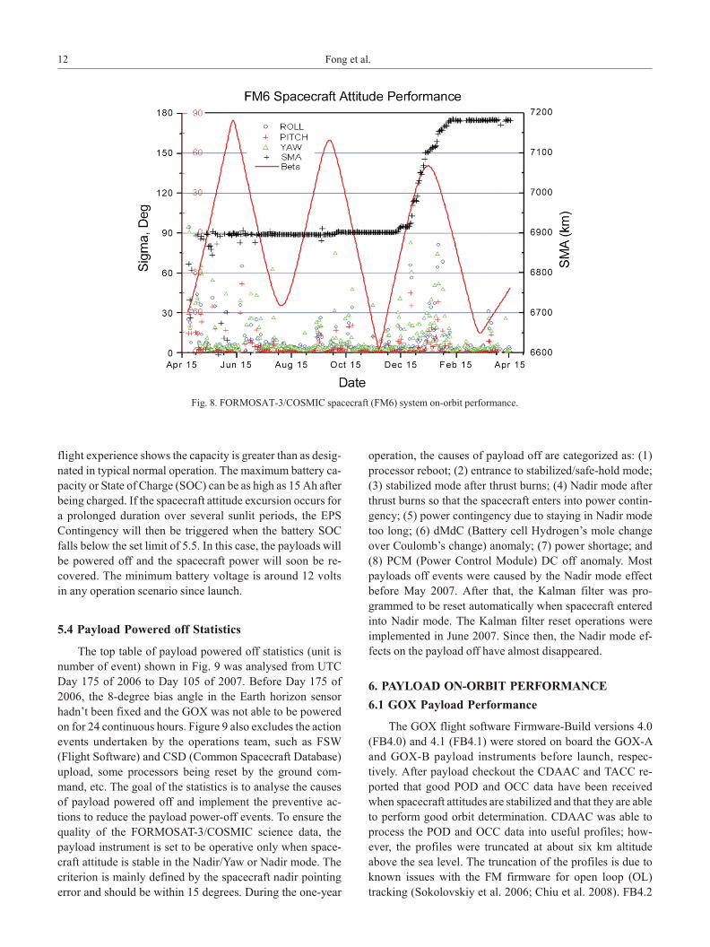
5.2 Space craft At ti tude Per for mance
Space craft Sys tem State of Health (SOH): All six space -
craft are op er at ing nor mally. Al though there are al ter na tive
ways to solve the var i ous GPSR anom a lies to re cover the
space craft al ti tude con trols, the in ves ti ga tion of the root
cause of the GPSR anom aly is sue con tin ues. In or bit with a
low beta an gle, the space craft achieve a max i mum eclipse
time, yet the mea sure ments of the Co sine Sun Sen sors (CSS)
on the space craft may ex pe ri ence in ter fer ence from the
Albedo ef fect. On the other hand, with a high beta an gle ef -
fect, the space craft in eclipse time is sub stan tially de creased
when the beta an gle is above 60 de grees. The space craft is in
the sun lit re gion all the time when the beta an gles are larger
than 68 de grees. The Earth ho ri zon sen sor is ex posed to
solar ra di a tion con tin u ously when the beta an gle is above
68 de grees. The FORMOSAT-3/COS MIC space craft ther -
mal con trol and elec tric power de sign re quired all six space -
craft to per form flip-flop (i.e., the space craft ro tate 180 de -
grees in na dir di rec tion) when the space craft cross overs the
zero de gree beta an gle. Con se quently the GOX POD di rec -
tion needs to be switched and com manded by the GOX re -
ceiver when the space craft flip-flop oc curs.
Fig ure 8 shows one of the space craft’s (FM6) daily on-
or bit sys tem per for mance with down loaded space craft at ti -
tude pro file (roll, pitch, and yaw in one sigma), or bit rais ing
at ti tude (or SMA) and beta an gle for reference.
5.3 Space craft Elec tri cal Power Per for mance
The space craft elec tri cal power per for mance con sists of
the bat tery us age and so lar ar ray out put ca pa bil ity. The
nominal value of the bat tery ca pac ity is 10 Ah. The real
FORMOSAT-3/COS MIC Space craft Con stel la tion Sys tem 11
flight experience shows the ca pac ity is greater than as des ig -
nated in typ i cal nor mal op er a tion. The max i mum bat tery ca -
pac ity or State of Charge (SOC) can be as high as 15 Ah af ter
be ing charged. If the space craft at ti tude ex cur sion oc curs for
a pro longed du ra tion over sev eral sun lit pe ri ods, the EPS
Con tin gency will then be trig gered when the bat tery SOC
falls be low the set limit of 5.5. In this case, the pay loads will
be pow ered off and the space craft power will soon be re -
covered. The min i mum bat tery volt age is around 12 volts
in any op er a tion sce nario since launch.
5.4 Pay load Pow ered off Sta tis tics
The top ta ble of pay load pow ered off sta tis tics (unit is
num ber of event) shown in Fig. 9 was ana lysed from UTC
Day 175 of 2006 to Day 105 of 2007. Be fore Day 175 of
2006, the 8-de gree bias an gle in the Earth ho ri zon sen sor
had n’t been fixed and the GOX was not able to be pow ered
on for 24 con tin u ous hours. Fig ure 9 also ex cludes the ac tion
events un der taken by the op er a tions team, such as FSW
(Flight Soft ware) and CSD (Com mon Space craft Da ta base)
up load, some pro ces sors be ing re set by the ground com -
mand, etc. The goal of the sta tis tics is to ana lyse the causes
of pay load pow ered off and im ple ment the pre ven tive ac -
tions to re duce the pay load power-off events. To en sure the
qual ity of the FORMOSAT-3/COS MIC sci ence data, the
pay load in stru ment is set to be op er a tive only when space -
craft at ti tude is sta ble in the Na dir/Yaw or Na dir mode. The
cri te rion is mainly de fined by the space craft na dir point ing
er ror and should be within 15 de grees. Dur ing the one-year
op er a tion, the causes of pay load off are cat e go rized as: (1)
pro ces sor re boot; (2) en trance to sta bi lized/safe-hold mode;
(3) sta bi lized mode af ter thrust burns; (4) Na dir mode af ter
thrust burns so that the space craft en ters into power con tin -
gency; (5) power con tin gency due to stay ing in Na dir mode
too long; (6) dMdC (Bat tery cell Hy dro gen’s mole change
over Cou lomb’s change) anom aly; (7) power short age; and
(8) PCM (Power Con trol Mod ule) DC off anom aly. Most
pay loads off events were caused by the Na dir mode ef fect
be fore May 2007. Af ter that, the Kalman fil ter was pro -
grammed to be re set au to mat i cally when space craft en tered
into Na dir mode. The Kalman fil ter re set op er a tions were
im ple mented in June 2007. Since then, the Na dir mode ef -
fects on the pay load off have al most dis ap peared.
6. PAY LOAD ON-OR BIT PER FOR MANCE
6.1 GOX Pay load Per for mance
The GOX flight soft ware Firm ware-Build ver sions 4.0
(FB4.0) and 4.1 (FB4.1) were stored on board the GOX-A
and GOX-B pay load in stru ments be fore launch, re spec -
tively. Af ter pay load check out the CDAAC and TACC re -
ported that good POD and OCC data have been re ceived
when space craft at ti tudes are sta bi lized and that they are able
to per form good or bit de ter mi na tion. CDAAC was able to
pro cess the POD and OCC data into use ful pro files; how -
ever, the pro files were trun cated at about six km al ti tude
above the sea level. The trun ca tion of the pro files is due to
known is sues with the FM firm ware for open loop (OL)
track ing (Sokolovskiy et al. 2006; Chiu et al. 2008). FB4.2
12 Fong et al.
Fig. 8. FORMOSAT-3/COS MIC space craft (FM6) sys tem on-or bit per for mance.

and soon FB4.2.1 were later gen er ated and were up loaded to
the space craft in early June and July 2006, re spec tively.
FB4.2 was built to avoid POD log ging un nec es sary data and
to ex clude oc cult ing sat el lites to be used for nav i ga tion so -
lution. FB4.2.1 was built to fix some bugs found in FB4.2
and ad just some pa ram e ters in the firm ware. Those in clude
the im prove ment to the P2(L2) phase’s res o lu tion and mod i -
fi ca tion on the for ward POD sched ul ing func tion to help
rising ion o spheric occultations to start ear lier at lower al ti -
tudes and some fixes cor rect on off set and the drift er ror in
the open loop model for ris ing occultation func tion. The FB
4.2.1 was fur ther mod i fied to limit the az i muth an gle in the
firm ware to 50 de grees for proper GOX op er a tions.
The lat est GOX firm ware ver sion on all six GOX pay -
load in stru ments is Flight Build ver sion 4.3. This ver sion
was up loaded to the GOX pay load in stru ments in Feb ru ary
2007. The main changes in FB 4.3 in clude (1) max i miz ing
az i muth win dows of occultation an ten nas from 45 to 75 de -
grees; (2) ter mi nat ing ris ing occultations later at the des ig -
nated height; (3) fix ing the Az/El re port ing log mes sage; and
(4) im prov ing the mes sage for mat con sis tency. The GOX
firm ware Flight Build ver sion 4.4 was up loaded only to the
GOX that had a re boot loop anom aly is sue. The main pur -
pose of FB4.4 was to let GOX choose the for ward POD
antenna as the default POD antenna.
Fig ure 10 shows the one-year RF Sig nal-to-Noise (SNR)
per for mances on four GOX an ten nas (POD1, POD2, OCC1,
and OCC2) of each GOX pay load in stru ments in all six
satellites. The def i ni tion of the daily SNR value shown in
these fig ures (Figs. 10a to f) is the bot tom limit of the top
90% SNR value of all the tracked GPS sat el lites’ sig nal SNR
val ues re ceived by that par tic u lar an tenna on that day. In
these fig ures only data re ceived af ter 13 July (Day 194 of
2006) us ing FB4.2.1 was up loaded for eval u a tion.
By look ing at the P2 SNR value first, it can be seen that
the value shifts up for a cer tain pe riod time (around three
months), and then shifts down again and keeps to an other
value for an other time pe riod. The main rea son for that is the
space craft is re quired to per form a “flip-flop” when the
space craft cross overs the zero de gree beta an gle as de -
scribed in Sec tion 5.2 of this pa per. From the fig ures, it
seems that CA and P2 SNR on both of the OCC1 and OCC2
an ten nas all show a trend of deg ra da tion in SNR val ues be -
fore FB4.3 was up loaded. How ever, af ter a de tailed anal y sis
it is seen that the de crease in SNR value is mainly due to the
con fig u ra tion changes of pa ram e ter on both of the OCC
aft-ward and for ward an ten nas. The occultation win dows on
all six GOX pay load in stru ments were ad justed from 30
(orig i nally) to 70 de grees, and the dates of change and
changes in the win dow value are in di cated in the fig ures.
The trend in SNR for the date af ter FB4.3 was up loaded did
not show any sign of deg ra da tion at all from the avail able
data.
The SNR value for OCC1 on space craft No. 3 (FM3), as
FORMOSAT-3/COS MIC Space craft Con stel la tion Sys tem 13
Fig. 9. One-year sta tis tics re sults of pay load off phe nom e non on all six sat el lites.
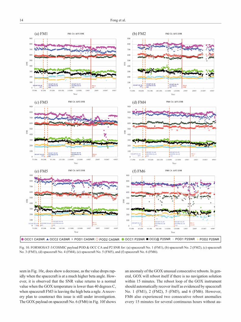
seen in Fig. 10c, does show a de crease, as the value drops rap -
idly when the space craft is at a much higher beta an gle. How -
ever, it is ob served that the SNR value re turns to a nor mal
value when the GOX tem per a ture is lower than 40 de grees C,
when space craft FM3 is leav ing the high beta a ngle. A re cov -
ery plan to coun ter act this is sue is still un der in vestigation.
The GOX pay load on space craft No. 6 (FM6) in Fig. 10f shows
an anom aly of the GOX un usual con sec u tive reboots. In gen -
eral, GOX will re boot it self if there is no nav i ga tion so lu tion
within 15 min utes. The re boot loop of the GOX in stru ment
should au to mat i cally re cover it self as ev i denced by space craft
No. 1 (FM1), 2 (FM2), 5 (FM5), and 6 (FM6). How ever,
FM6 also ex pe ri enced two con sec u tive re boot anom a lies
ev ery 15 min utes for sev eral con tin u ous hours with out au -
14 Fong et al.
Fig. 10. FORMOSAT-3/COS MIC pay load POD & OCC CA and P2 SNR for: (a) space craft No. 1 (FM1), (b) space craft No. 2 (FM2), (c) space craft
No. 3 (FM3), (d) space craft No. 4 (FM4), (e) space craft No. 5 (FM5), and (f) space craft No. 6 (FM6).
(a) FM1 (b) FM2
(c) FM3 (d) FM4
(e) FM5 (f) FM6
to matic re cov ery in Feb ru ary and in April of 2007. The root
cause was pre lim i nar ily iden ti fied as the low sig nal-to-noise
ra tio of the nav i ga tion an tenna when the space craft en tered
into a beta an gle be tween 0 and -30 de grees. A new firm ware
build ver sion 4.4 (FB 4.4) was loaded in June 2007 and the re -
boot loop has since ceased (Fong et al. 2007b).
6.2 TIP Pay load Per for mance
The TIP pay load is an ion o spheric pho tom e ter for ob -
serv ing the Earth’s nat u rally oc cur ring far-ul tra vi o let air -
glow to char ac ter ize the ion o sphere and neu tral at mo sphere.
The TIP counts ul tra vi o let pho tons emit ted from the F2 layer
of the at mo sphere di rectly be low the space craft. The TIP
mis sion is planned to oc cur dur ing the or bit eclipse pe riod.
Like the GOX, TIP data is also stored in the SSR/PC. The
col lected data are pe ri od i cally dumped to the ground station
via an S-Band RF downlink.
All TIPs are op er at ing nor mally ex cept the dis abled
FM2 and FM3 TIP op er a tion be cause of the power short age
is sue. The TIP pay load anom a lies in clude a TIP in stru ment
ini tial iza tion is sue, a time stamp is sue due to bus GPSR
non-fixed is sue; a TIP night-time op er a tion start ing too early
is sue; and a time la bel ling is sue (Anthes et al. 2008).
7. PRE LIM I NARY SAT EL LITE CON STEL LA TIONMIS SION RESULTS
In the early phase of the FORMOSAT-3/COS MIC mis -
sion, the sat el lites were in close for ma tion and pro vided an
op por tu nity to test the pre ci sion of the GPS RO mea sure -
ments. Tai wan’s sci ence teams con ducted an In tense Ob ser -
va tion Pe riod (IOP) cam paign be tween May and No vem ber
of 2006 to cross-val i date RO data with other ob ser va tions
(ground-based ra dio sondes, other weather sat el lites, air -
plane dropsondes, bal loons, ra dars, ionosondes, digisonde,
etc.). Sci en tists from other na tions, such as the US, Ja pan,
and Ko rea also con ducted sim i lar IOP cam paigns. The pre -
sen ta tion pack age of early re sults and IOP cam paigns dur ing
this pe riod could be found on the NSPO website (NSPO
2006).
7.1 The First RO Soundings
The first elec tron den sity pro files were ob tained on the
sixth day af ter launch (L + 6 days), and the first at mo spheric
occultation event and pro file were re ceived and pro cessed
at L + 8 days by FM1 and FM4. These two sat el lites were
roughly a few hun dred ki lo me ters apart which cor re spond to
a dis tance sep a ra tion for the RO soundings of about 1.5 km.
The close agree ment of the two FORMOSAT-3/COS MIC
RO soundings dem on strates the pre ci sion of the GPS ra dio
occultation tech nique (Anthes et al. 2008).
The close prox im ity of the FORMOSAT-3/COS MIC
sat el lites fly ing in clus ter con fig u ra tion af ter sep a ra tion pro -
vided a unique op por tu nity to es ti mate the pre ci sion of the
GPS ra dio occultation re mote sens ing tech nique based upon
closely col lo cated occultations (< 10 km sep a ra tion of tan -
gent points). From the UCAR’s pre lim i nary es ti mates the
RMS dif fer ence of refractivity be tween 10 and 20 km al ti -
tude was less than 0.2% due to smaller sep a ra tion of the
occultation pairs and due to par al lel occultation planes. In
the lower tro po sphere, the max i mal RMS was ~0.8% at 2 km
al ti tude and de creased abruptly to ~0.2% be tween six and
eight km al ti tude. The RMS dif fer ence of elec tron den sity in
the ion o sphere be tween 150 and 500 km al ti tude for col lo -
cated occultations is about 103 cm-3. For de tails re fer to
Schreiner et al. (2007).
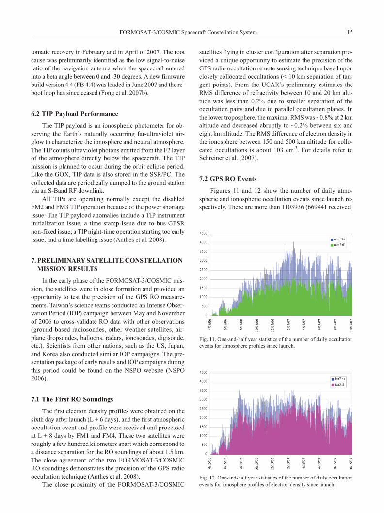
7.2 GPS RO Events
Fig ures 11 and 12 show the num ber of daily at mo -
spheric and ion o spheric occultation events since launch re -
spec tively. There are more than 1103936 (669441 re ceived)
FORMOSAT-3/COS MIC Space craft Con stel la tion Sys tem 15
Fig. 11. One-and-half year sta tis tics of the num ber of daily occultation
events for at mo sphere pro files since launch.
Fig. 12. One-and-half year sta tis tics of the num ber of daily occultation
events for ion o sphere pro files of elec tron den sity since launch.
at mo spheric pro files and 1252629 (933616 re ceived) ion o -
spheric pro files gen er ated by TACC/CDAAC for out side
dis tri bu tion through 15 Oc to ber 2007. The “atmphs” in
Fig. 11 means the num ber of ex cess phase files that were
gen er ated and also rep re sent the at mo spheric RO events can
be ob served by FORMOSAT-3/COS MIC sat el lites; “ion -
phs” in di cates ion o spheric RO events as shown in Fig. 12.
As seen in Fig. 11, ~37% ver ti cal at mo spheric pro files of the
to tal events can not be re trieved, and com pared to ~25% for
ion o spheric pro files in Fig. 12. Fig ures 11 and 12 show that
the data as re ceived by FORMOSAT-3/COS MIC sat el lites at
cur rent con stel la tion have been post pro cessed in near real
time into 2500 good ion o spheric pro files and 1800 good
atmospheric pro files per day, re spec tively. These have out -
num bered the world wide ra dio sondes (~900 mostly over
land) launched from the ground per day. The occultation
events col lected by the cur rent FORMOSAT-3/COS MIC
con stel la tion have achieved ~80% of the mis sion goal of
2500 events per day.
The mis sion-planned goal of 2500 or more daily pro files
may be dif fi cult to ac com plish. The main rea sons for the an -
tic i pated lower num ber are: (1) FM2 and FM3 is sched uled
at re duced GOX op er a tion duty cy cle due to the power short -
age is sue as de scribed in Sec tion 5.1; (2) to avoid SSR re -
ceiver mem ory over flow, some of the GOX sci ence data are
sched uled and dumped into space (not to a ground sta tion),
and for ever lost; (3) dur ing or bit el e va tion, pre cise or bit de -
ter mi na tion is im pos si ble and RO data can not be pro cessed;
(4) sci ence data gaps in high-rate data packet and need fur -
ther man ual pro cess ing; and (5) poor data qual ity, short
Fiducial data, or im per fectly re trieval meth ods. NSPO is
cur rently work ing with UCAR and the sci ence teams to re -
solve these is sues and try to pro vide the best qual ity and
max i mum RO num bers for the sci ence user com mu nity. The
mis sion team is still striv ing to meet the 2500 soundings per
day goal when these sat el lites get to their fi nal sat el lite con -
stel la tion con fig u ra tion and re main ing data qual ity is sues
resolved.
7.3 Sci ence Data Dis sem i na tion
Through a joint ef fort by the NSPO and UCAR, raw
data and data prod ucts have been dis sem i nated to the in ter -
na tional com mu nity in near real time (un der three hours) via
TACC/CDAAC since Au gust 2006. Sev eral global weather
op er a tional cen ters (e.g., ECMWF, NCEP, UKMO Meteo
France, and CWB) have started in te grat ing FORMOSAT-
3/COS MIC data for op er a tional use, and have re ported en -
cour ag ing re sults. Re search groups have also been per -
forming ex per i ments to as sess the im pact of FORMOSAT-
3/COS MIC data on global/re gional weather anal y sis and
pre dic tion, in clud ing trop i cal cy clone pre dic tions. From
TACC and CDAAC website data, the num ber of reg is tered
data us ers be tween Au gust 2006 and Au gust 2007 ex ceeded
537 in 42 coun tries (CDAAC website; TACC website).
8. PROS PECTS FOR FOL LOW-ON (FO) MIS SION
The FORMOSAT-3/COS MIC sat el lite con stel la tion
mea sures the phase de lay of a GPS sig nal from the six small
sat el lites to ob tain the at mo spheric pa ram e ters. It is an tic i -
pated that there will be 2500+ soundings per day, glob ally
dis trib uted, when the fi nal con stel la tion con fig u ra tion is
reached. As an aug ment ing fol low-on mis sion, three im -
prove ments would fur ther strengthen the cur rent mis sion.
The first as pect is to en hance the ca pa bil ity of the GPS re -
ceiv ers to ac com mo date sig nals from GLONASS and Ga -
lileo in ad di tion to the GPS sat el lites. Sec ond, with ad di tion
of more sat el lites a more densely pop u lated global sat el lite
con stel la tion would better serve a va ri ety of fol low-on
needs. Fi nally, op ti miz ing the sat el lite con stel la tion for ma -
tion would bal ance re gional cov er age at dif fer ent lat i tudes.
Cur rently, there are about 30 op er a tional USAF GPS.
When the GOX re ceiv ers can re ceive the data from both
GPS and GLONASS, the occultation num ber can be in -
creased by a fac tor of 1.8. When Ga li leo is also con sid ered,
the occultation num ber can be in creased by a fac tor of 2.9. It
is an ef fec tive way to in crease the to tal RO soundings with -
out in creas ing the num ber of sat el lites. The con stel la tion
for ma tion can be op ti mized de pend ing on the num ber of
satellites that are con sid ered in the fol low-on mis sion to
optimize the re gional needs of the global cov er age. The
satellite con stel la tion op ti mi za tion may in clude the or bit
plane in cli na tions, the sep a ra tion an gles, and the num ber of
sat el lites on each or bit plane. The al ti tude of the con stel la -
tion is not a sys tem driver for occultation since the oc -
cultation an tenna can be tuned based on the cho sen al ti tude.
As a mat ter of fact, cost is an other dom i nant fac tor in the
num ber of sat el lites and the sat el lite con stel la tion for ma tion,
this is sue will not be dis cussed in this pa per.
The in cli na tion an gle and the or bit plane should have an
im pact on the occultation dis tri bu tion in terms of lat i tude
cov er age. For easy il lus tra tion, the pa ram e ters of FOR -
MOSAT- 3/COS MIC are used as the base line, ex cept for the
in cli na tion an gle. The to tal occultation num ber per sat el lite
per day is about 420. The in cli na tion an gles of 0, 24, 48, 72,
and 98.6 de grees in an 800-km al ti tude or bit are cal cu lated
and the re sults are shown in Fig. 13a. There are 75 soundings
at a lat i tude of five de grees and 8 soundings at a lat i tude of
twenty-five de grees as shown in Fig 13a, re spec tively. The
occultation num ber dis tri bu tion is al most sym met ri cal for
the North ern Hemi sphere and the South ern Hemi sphere in
spite of the in cli na tion an gles. A low in cli na tion or bit can
col lect more RO data at a low lat i tude, and high in cli na tion
or bit at a high lat i tude. There fore, the re gional needs can be
met by tai lor ing the in cli na tion of the sat el lite clus ter con -
stel la tion. In fact, the rep re sented area of the RO events at a
low lat i tude is larger than that of a high lat i tude per de gree
16 Fong et al.
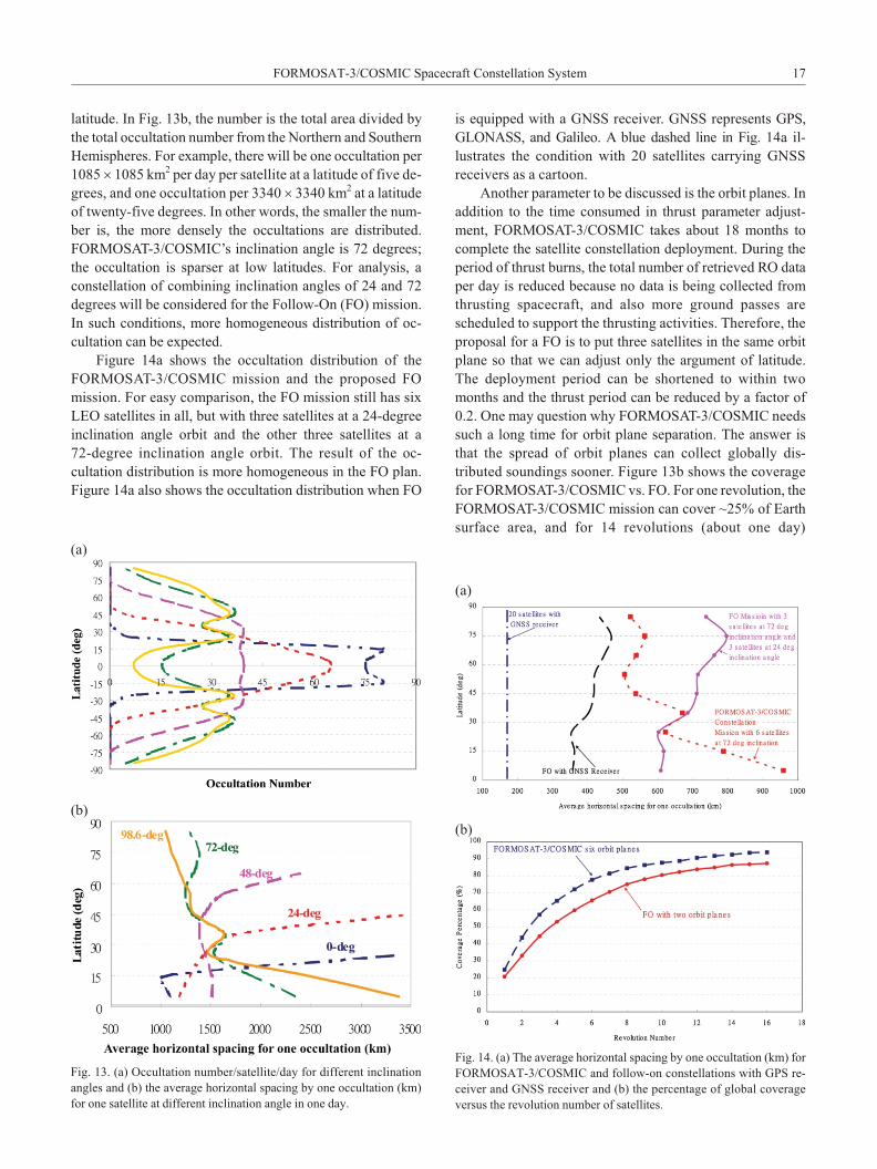
lat i tude. In Fig. 13b, the num ber is the to tal area di vided by
the to tal occultation num ber from the North ern and South ern
Hemi spheres. For ex am ple, there will be one occultation per
1085 ́ 1085 km2 per day per satellite at a lat i tude of five de -
grees, and one occultation per 3340 ́ 3340 km2 at a lat i tude
of twenty-five de grees. In other words, the smaller the num -
ber is, the more densely the occultations are dis trib uted.
FORMOSAT-3/COS MIC’s in cli na tion an gle is 72 de grees;
the occultation is sparser at low lat i tudes. For anal y sis, a
con stel la tion of com bin ing in cli na tion an gles of 24 and 72
de grees will be con sid ered for the Fol low-On (FO) mis sion.
In such con di tions, more ho mo ge neous dis tri bu tion of oc -
cultation can be ex pected.
Fig ure 14a shows the occultation dis tri bu tion of the
FORMOSAT-3/COS MIC mis sion and the pro posed FO
mission. For easy com par i son, the FO mis sion still has six
LEO sat el lites in all, but with three sat el lites at a 24-de gree
in cli na tion an gle or bit and the other three sat el lites at a
72-de gree in cli na tion an gle or bit. The re sult of the oc -
cultation dis tri bu tion is more ho mo ge neous in the FO plan.
Fig ure 14a also shows the occultation dis tri bu tion when FO
is equipped with a GNSS re ceiver. GNSS rep re sents GPS,
GLONASS, and Ga li leo. A blue dashed line in Fig. 14a il -
lustrates the con di tion with 20 sat el lites car ry ing GNSS
receivers as a car toon.
An other pa ram e ter to be dis cussed is the or bit planes. In
ad di tion to the time con sumed in thrust pa ram e ter ad just -
ment, FORMOSAT-3/COS MIC takes about 18 months to
com plete the sat el lite con stel la tion de ploy ment. Dur ing the
pe riod of thrust burns, the to tal num ber of re trieved RO data
per day is re duced be cause no data is be ing col lected from
thrust ing space craft, and also more ground passes are
scheduled to sup port the thrust ing ac tiv i ties. There fore, the
proposal for a FO is to put three sat el lites in the same or bit
plane so that we can ad just only the ar gu ment of lat i tude.
The de ploy ment pe riod can be short ened to within two
months and the thrust pe riod can be re duced by a fac tor of
0.2. One may ques tion why FORMOSAT-3/COS MIC needs
such a long time for or bit plane sep a ra tion. The an swer is
that the spread of or bit planes can col lect glob ally dis -
tributed soundings sooner. Fig ure 13b shows the cov er age
for FORMOSAT-3/COS MIC vs. FO. For one rev o lu tion, the
FORMOSAT-3/COS MIC mis sion can cover ~25% of Earth
sur face area, and for 14 rev o lu tions (about one day)
FORMOSAT-3/COS MIC Space craft Con stel la tion Sys tem 17
Fig. 14. (a) The av er age hor i zon tal spac ing by one occultation (km) for
FORMOSAT-3/COS MIC and fol low-on con stel la tions with GPS re -
ceiver and GNSS re ceiver and (b) the per cent age of global cov er age
ver sus the rev o lu tion num ber of sat el lites.
(a)
(b)
Fig. 13. (a) Occultation num ber/sat el lite/day for dif fer ent in cli na tion
an gles and (b) the av er age hor i zon tal spac ing by one occultation (km)
for one sat el lite at dif fer ent in cli na tion an gle in one day.
(a)
(b)
FORMOSAT-3/COS MIC can cover ~92% of Earth sur face
area. The def i ni tion of the cov er age is the per cent age of the
grid. One grid is 10 de grees lat i tude by 10 de grees lon gi tude.
If the occultation oc curs at the same grid, it is re garded as
one grid. Con cern ing the cov er age, six or bit planes are al -
ways better than two or bit planes. The FORMOSAT-3/COS -
MIC mis sion is con tem po rar ily unique and the ben e fits of
the RO tech nique have been proved in many ap pli ca tions, as
has the pos i tive im pact to weather fore cast sys tems. Many
or ga ni za tions in sev eral coun tries are con tem plat ing or pro -
pos ing RO space pro jects to con tinue the sim i lar FOR -
MOSAT-3/COS MIC mis sion. As the FO pro ceeds, the
United States, Eu rope, In dia, and Ko rea are also de vel op ing
the next gen er a tion RO mis sions.
9. CON CLU SION
In ad di tion to the op er a tion of the six sat el lites, the
on-or bit space craft sys tem per for mances is mon i tored,
tracked, and eval u ated con stantly by NSPO’s op er a tion
team. The re lated op er a tions pro cess, firm ware, ground soft -
ware, and auto script mod i fi ca tion or up grades are re quired
to im prove the qual ity of the mis sion op er a tions. The ini tial
mis sion re sults, in clud ing the IOP cam paign us ing in no va -
tive RO tech nol ogy by re search ers world wide, and the
global weather pre dic tion cen ters, have shown sig nif i cant
pos i tive im pact. With the world’s first dem on stra tion of near
real time sat el lite con stel la tion op er a tions, the suc cess of the
FORMOSAT-3/COS MIC mis sion ini ti ates a new age for
operational GPS RO soundings for mon i tor ing and fore -
cast ing of ter res trial weather, space weather, and a suite of
re lated Earth sci ence pur suits. The FORMOSAT-3/COS -
MIC mis sion dem on strates an in no va tive ap proach of cli -
mate change mon i tor ing.
Ac knowl edge ments The au thors wish to ex press their grat i -
tude for the con tri bu tions of the FORMOSAT-3/COS MIC
pro gram team, the mis sion op er a tion team, the flight op er a -
tion team, the ground op er a tion team, the con stel la tion de -
ploy ment team, the anom aly res o lu tion team, the Tai wan sci -
ence teams, and the co op er a tion of NSC, CWB, NSF, UCAR,
NCAR, JPL/NASA, NRL, USAF, NOAA, and Or bital.
REF ER ENCES
Anthes, R. A., C. Rocken, and Y. H. Kuo, 2000: Ap pli ca tion of
COS MIC to me te o rol ogy and cli mate. Terr. Atmos. Ocean.
Sci., 11, 115-156.
Anthes, R. A., P. A. Bernhardt, Y. Chen, L. Cucurull, K. F.
Dymond, D. Ector, S. B. Healy, S. P. Ho, D. C. Hunt, Y. H.
Kuo, H. Liu, K. Man ning, C. McCormick, T. K. Meehan,
W. J. Randel, C. Rocken, W. S. Schreiner, S. V. Soko -
lovskiy, S. Syndergaard, D. C. Thomp son, K. E. Trenberth,
T. K. Wee, N. L. Yen, and Z. Zeng, 2008: The COS -
MIC/FORMOSAT-3 Mis sion: Early Re sults. Bull. Amer.
Meteor. Soc., 89, 313-333, doi:10.1175/BAMS-89-3-313.
[Link]
CDAAC (COS MIC Data Anal y sis and Ar chive Cen ter),
http://cos mic-io.cos mic.ucar.edu/cdaac/in dex.html.
Chiu, T. C., Y. A. Liou, W. H. Yeh, and C. Y. Huang, 2008:
NCURO data re trieval al go rithm in FORMOSAT-3 GPS
ra dio con stel la tion mis sion. IEEE Trans. Geosci. Re mote
Sens., 46, doi: 10.1109/TGRS.2008.2005038. [Link]
Chu, C. H., 2006: FORMOSAT-3 Mis sion Op er a tion Plan,
RS3- PLAN-0001_0101, NSPO, 98 pp.
Chu, C. H., S. K. Yang, C. J. Fong, N. Yen, T. Y. Liu, W. J. Chen,
D. Hawes, Y. A. Liou, and Y. H. Kuo, 2007: The Most
Accu rate and Sta ble Space-Borne Thermometers- FOR -
MOSAT- 3/COS MIC Con stel la tion, 2007 Small Sat el lite
Con fer ence, SSC07-VII-1.
Fjeldbo, G. and V. R. Eshleman, 1965: The bistatic ra dar-
occultation method for the study of plan e tary at mo spheres.
J. Geophys. Res., 70, 3217-3225, doi:10.1029/JZ070i013
p03217. [Link]
Fong, C. J., V. Chu, T. C. Kuo, C. R. Chen, J. J. Yeh, Y. Hsu, C.
T. Lin, R. Lo, M. Yeh, and A. Shiau, 2006: FORMOSAT-3
In-Or bit Check out Re port, RS3-RPT-0045_0000, NSPO,
103 pp.
Fong, C. J., N. Yen, V. Chu, S. S. Chen, and S. Chi, 2007a: Op -
er a tions Chal lenges from the FORMOSAT-3/COS MIC
Con stel la tion for Global Earth Weather Mon i tor ing. Aero -
space Con fer ence, 2007 IEEE.
Fong, C. J., C. Y. Huang, V. Chu, A. Shiau, E. Yang, N. Yen, S.
S. Chao, D. Hawes, Y. H. Kuo, Y. A. Liou, and S. Chi,
2007b: Mis sion Re sults from FORMOSAT-3/COS MIC
Con stel la tion Sys tem, AIAA Space 2007 Con fer ence and
Ex po si tion, AIAA-2007-6086.
Fong, C. J., A. Shiau, T. Lin, T. C. Kuo, C. H. Chu, S. K. Yang,
N. Yen, S. S. Chen, C. Y. Huang, Y. H. Kuo, Y. A. Liou,
and S. Chi, 2008a: Con stel la tion De ploy ment for FOR -
MOSAT-3/COS MIC Mis sion. IEEE Trans. Geosci. Re -
mote Sens., 46, 3367-3379, doi: 10.1109/TGRS.2008.
2005202. [Link]
Fong, C. J., S. K. Yang, V. Chu, J. Yeh, T. Lin, T. C. Kuo, T. Y.
Liu, N. Yen, S. S. Chen, C. Y. Huang, Y. H. Kuo, Y. A.
Liou, and S. Chi, 2008b: FORMOSAT-3/COS MIC Con -
stel la tion Space craft Sys tem per for mance: Af ter one year
in or bit, IEEE Trans. Geosci. Re mote Sens., 46, 3380-
3394, doi: 10.1109/TGRS.2008.2005203. [Link]
Fong, C. J., C. Y. Huang, V. Chu, N. Yen, Y. H. Kuo, Y. A. Liou,
and S. Chi, 2008c: Mis sion re sults from FORMOSAT-3/
COS MIC Con stel la tion Sys tem. AIAA J. Spacecr. Rock -
ets, 45, 1293-1302, doi: 10.2514/1.34427. [Link]
Hajj, G. A., L. C. Lee, X. Pi, L. J. Romans, W. S. Schreiner, P. R.
Straus, and C. Wang, 2000: COS MIC GPS ion o spheric
sens ing and space weather. Terr. Atmos. Ocean. Sci ., 11,
235-272.
Hajj, G. A., C. O. Ao, B. A. Iijima, D. Kuang, E. R. Kursinski,
A. J. Mannucci, T. K. Meehan, L. J. Romans, M. de la T.
18 Fong et al.
Juarez, and T. P. Yunck, 2004: CHAMP and SAC-C at mo -
spheric occultation re sults and inter com par i sons. J.
Geophys. Res., 109, D06109.1-D06109.24, doi: 10.1029/
2003JD003909. [Link]
Hwang, C., T. P. Tseng, T. J. Lin, C. L. Fu, and D. Svehla, 2006:
Pre cise or bit de ter mi na tion for FORMOSAT-3/COS MIC
and grav ity ap pli ca tion, Fall Meet ing, Amer i can Geo -
physical Un ion, San Fran cisco, De cem ber 11-15, 2006.
Kliore, A. J., D. L. Cain, G. S. Levy, V. R. Eshleman, G.
Fjeldbo, and F. D. Drake, 1965: Occultation ex per i ment:
Re sults of the first di rect mea sure ment of Mars’ at mo -
sphere and ion o sphere. Sci ence, 149, 1243-1248, doi:
10.1126/sci ence.149.3689.1243. [Link]
Kuo, Y. H., S. Sokolovskiy, R. Anthes, and V. Vandenberghe,
2000: As sim i la tion of GPS ra dio occultation data for nu -
mer i cal weather pre dic tion. Terr. Atmos. Ocean. Sci ., 11,
157-186.
Kuo, Y. H., T. K. Wee, S. Sokolovskiy, C. Rocken, W.
Schreiner, D. Hunt, and R. A. Anthes, 2004: In ver sion and
er ror es ti ma tion of GPS ra dio occultation data. J. Me -
teorol. Soc. Jpn., 82, 507-531, doi:10.2151/jmsj.2004.507.
[Link]
Kursinski, E. R., G. A. Hajj, S. S. Leroy, and B. Herman, 2000:
The GPS occultation tech nique. Terr. Atmos. Ocean. Sci .,
11, 53-114.
Kursinski, E. R., G. A. Hajj, W. I. Bertiger, S. S. Leroy, T. K.
Meehan, L. J. Romans, J. T. Schofield, D. J. McCleese, W.
G. Mel bourne, C. L. Thorn ton, T. P. Yunck, J. R. Eyre, and
R. N. Nagatani, 1996: Ini tial re sults of ra dio occultation
ob ser va tions of Earth’s at mo sphere us ing the Global Po si -
tion ing Sys tem. Sci ence, 271, 1107-1110, doi:10.1126/sci -
ence.271.5252.1107. [Link]
Liou, Y. A., A. G. Pavelyev, C. Y. Huang, K. Igarashi, and K.
Hocke, 2002: Si mul ta neous ob ser va tion of the ver ti cal
gra di ents of refractivity in the at mo sphere and elec tron
den sity in the lower ion o sphere by ra dio occultation am pli -
tude method. Geophys. Res. Lett., 29, 1937, 43.1-43.4, doi:
10.1029/2002GL015155. [Link]
Liou, Y. A., A. G. Pavelyev, S. F. Liu, N. Yen, C. Y. Huang, and
C. J. Fong, 2007: FORMOSAT-3 GPS ra dio occultation
mis sion: Pre lim i nary re sults. IEEE Trans. Geosci. Re mote
Sens., 45, 3813-3826, doi: 10.1109/TGRS.2007.903365.
[Link]
Mel bourne, W. G., E. S. Da vis, C. B. Duncan, G. A. Hajj, K. R.
Hardy, E. R. Kursinski, T. K. Meehan, L. E. Young, and T.
P. Yunck, 1994: The Ap pli ca tion of Spaceborne GPS to
Atmospheric Limb Sound ing and Global Change Mon i -
toring, JPL Pub. 94-18, 147 pp.
NSPO (Na tional Space Or ga ni za tion), 2006: Data Pack age of
FORMOSAT-3/COS MIC Work shop 2006 - Early Re sults
and IOP Cam paigns, http://www.nspo.org.tw/2005e
/projects/project3/.
Patel, B. T., S. Schroll, and A. Lewin, 1999: On-Or bit Per for -
mance of the ORBCOMM Space craft Con stel la tion, 13th
AIAA/USU Con fer ence on Small Sat el lites, SSC99- IV-6.
Pavelyev, A. G., Y. A. Liou, C. Reigber, J. Wickert, K. Igarashi,
K. Hocke, and C. Y. Huang, 2002: GPS ra dio ho log ra phy
as a tool for re mote sens ing of the at mo sphere and me so -
sphere from space. GPS Solut., 6, 100-108, doi: 10.1007/
s10291- 002-0025-3. [Link]
Rocken, C., R. Anthes, M. Exner, D. Hunt, S. Sokolovskiy, R.
Ware, M. Gorbunov, W. Schreiner, D. Feng, B. Herman, Y.
H. Kuo, and X. Zou, 1997: Anal y sis and val i da tion of
GPS/MET data in the neu tral at mo sphere. J. Geophys.
Res., 102, 29849-29866, doi:10.1029/97JD02400. [Link]
Rocken, C., Y. H. Kuo, W. S. Schreiner, D. Hunt, S. Soko -
lovskiy, and C. McCormick, 2000: COS MIC sys tem de -
scrip tion. Terr. Atmos. Ocean. Sci ., 11, 21-54.
Schreiner, W., C. Rocken, S. Sokolovskiy, S. Syndergaard, and
D. Hunt, 2007: Es ti mates of the pre ci sion of GPS ra dio
occultations from the COS MIC/FORMOSAT-3 mis sion.
Geophys. Res. Lett., 34, L04808.1-L04808.5, doi: 10.1029/
2006GL027557. [Link]
Sokolovskiy, S., C. Rocken, D. Hunt, W. Schreiner, J. John son,
D. Mas ters, and S. Esterhuizen, 2006: GPS pro fil ing of the
lower tro po sphere from space: In ver sion and de mod u la -
tion of the open-loop ra dio occultation sig nals. Geophys.
Res. Lett., 33, L14816.1-L14816.5, doi: 10.1029/2006GL
026112. [Link]
TACC (Tai wan Anal y sis Cen ter for COS MIC), http://tacc
.cwb.gov.tw/en/in dex.htm.
Ware, R., M. Exner, D. Feng, M. Gorbunov, K. Hardy, B.
Herman, Y. Kuo, T. Meehan, W. Mel bourne, C. Rocken,
W. Schreiner, S. Sokolovskiy, F. Solheim, X. Zou, R.
Anthes, S. Businger, and K. Trenberth, 1996: GPS sound -
ing of the at mo sphere from low Earth Or bit: Pre lim i nary
re sults. Bull. Amer. Meteor. Soc ., 77, 19-40, doi: 10.117/
1520-0477(1996)077<0019:GSOTAF>2.0.CO;2. [Link]
Wickert, J., C. Reigber, G. Beyerle, R. Konig, C. Marquardt, T.
Schmidt, L. Grunwaldt, R. Ga las, T. K. Meehan, W. G.
Mel bourne, and K. Hocke, 2001: At mo sphere sound ing by
GPS ra dio occultation: First re sults from CHAMP. Geo -
phys. Res. Lett., 28, 3263-3266, doi: 10.1029/2001GL
013117. [Link]
Wu, B. H., C. J. Fong, C. Y. Huang, Y. A. Liou, N. Yen, and P.
Chen, 2006: FORMOSAT-3/COS MIC mis sion to global
earth weather mon i tor ing, op er a tion, and TACC/CDAAC
post-pro cess ing, 86th AMS An nual Meeting.
Yen, N., C. J. Fong, V. Chu, A. Hsiao, T. Tsai, and C. Y. Huang,
2006: FORMOSAT-3/COS MIC Mis sion To Global Earth
Weather Mon i tor ing: Early Or bit, Or bit Trans fer And Mis -
sion Op er a tion Over view,” FORMOSAT-3/COS MIC Data
Us ers Work shop.
Yunck, T. P., C. H. Liu, and R. Ware, 2000: A his tory of GPS
sound ing. Terr. Atmos. Ocean. Sci ., 11, 1-20.
FORMOSAT-3/COS MIC Space craft Con stel la tion Sys tem 19