Embed Size (px)
Citation preview
FORESTRY
CAREER DEVELOPMENT EVENT
RULES AND REGULATIONS
TEAM COMPETITION
ALABAMA FFA ASSOCIATION
Page 1 of 32
TABLE OF CONTENTS
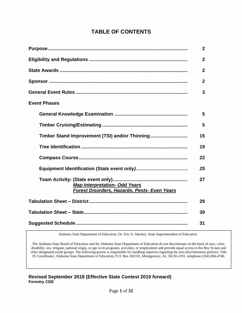
Purpose ......................................................................................................... 2 Eligibility and Regulations .......................................................................... 2 State Awards ................................................................................................ 2 Sponsor ........................................................................................................ 2 General Event Rules .................................................................................... 3 Event Phases General Knowledge Examination ....................................................... 5 Timber Cruising/Estimating ................................................................ 5 Timber Stand Improvement (TSI) and/or Thinning ............................ 15 Tree Identification ................................................................................ 19 Compass Course .................................................................................. 22 Equipment Identification (State event only)…………………………… 25 Team Activity: (State event only) ........................................................ 27 Map Interpretation- Odd Years Forest Disorders, Hazards, Pests- Even Years Tabulation Sheet – District .......................................................................... 29 Tabulation Sheet – State .............................................................................. 30 Suggested Schedule .................................................................................... 31
Revised September 2018 (Effective State Contest 2019 forward) Forestry CDE
Alabama State Department of Education, Dr. Eric G. Mackey, State Superintendent of Education
The Alabama State Board of Education and the Alabama State Department of Education do not discriminate on the basis of race, color,
disability, sex, religion, national origin, or age in its programs, activities, or employment and provide equal access to the Boy Scouts and
other designated youth groups. The following person is responsible for handling inquiries regarding the non-discrimination policies: Title
IX Coordinator, Alabama State Department of Education, P.O. Box 302101, Montgomery, AL 36130-2101, telephone (334) 694-4746.
Page 2 of 32
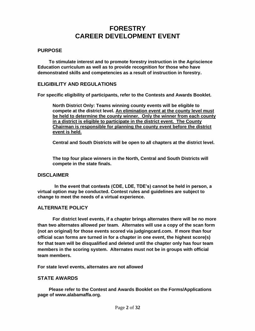
FORESTRY CAREER DEVELOPMENT EVENT
PURPOSE To stimulate interest and to promote forestry instruction in the Agriscience Education curriculum as well as to provide recognition for those who have
demonstrated skills and competencies as a result of instruction in forestry. ELIGIBILITY AND REGULATIONS For specific eligibility of participants, refer to the Contests and Awards Booklet.
North District Only: Teams winning county events will be eligible to compete at the district level. An elimination event at the county level must be held to determine the county winner. Only the winner from each county in a district is eligible to participate in the district event. The County Chairman is responsible for planning the county event before the district event is held.
Central and South Districts will be open to all chapters at the district level.
The top four place winners in the North, Central and South Districts will compete in the state finals.
DISCLAIMER In the event that contests (CDE, LDE, TDE’s) cannot be held in person, a virtual option may be conducted. Contest rules and guidelines are subject to change to meet the needs of a virtual experience.
ALTERNATE POLICY
For district level events, if a chapter brings alternates there will be no more
than two alternates allowed per team. Alternates will use a copy of the scan form
(not an original) for those events scored via judgingcard.com. If more than four
official scan forms are turned in for a chapter in one event, the highest score(s)
for that team will be disqualified and deleted until the chapter only has four team
members in the scoring system. Alternates must not be in groups with official
team members.
For state level events, alternates are not allowed
STATE AWARDS Please refer to the Contest and Awards Booklet on the Forms/Applications page of www.alabamaffa.org.
Page 3 of 32
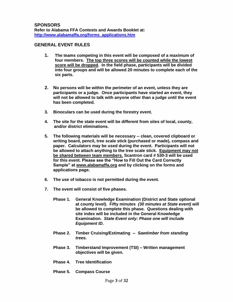
SPONSORS Refer to Alabama FFA Contests and Awards Booklet at: http://www.alabamaffa.org/forms_applications.htm
GENERAL EVENT RULES
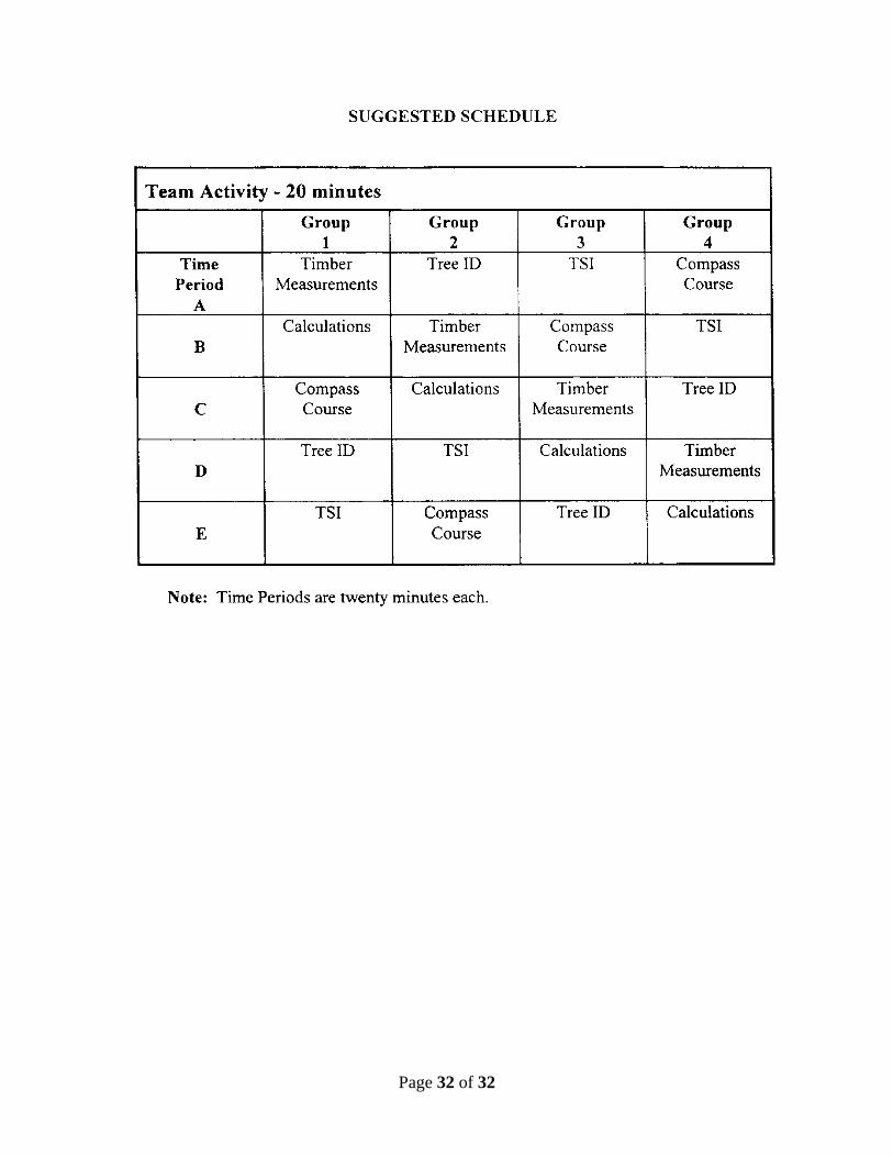
1. The teams competing in this event will be composed of a maximum of four members. The top three scores will be counted while the lowest score will be dropped. In the field phase, participants will be divided into four groups and will be allowed 20 minutes to complete each of the six parts.
2. No persons will be within the perimeter of an event, unless they are participants or a judge. Once participants have started an event, they will not be allowed to talk with anyone other than a judge until the event has been completed.
3. Binoculars can be used during the forestry event.
4. The site for the state event will be different from sites of local, county, and/or district eliminations. 5. The following materials will be necessary -- clean, covered clipboard or
writing board, pencil, tree scale stick (purchased or made), compass and paper. Calculators may be used during the event. Participants will not be allowed to attach anything to the tree scale stick. Equipment may not be shared between team members. Scantron card # 530-3 will be used for this event. Please see the “How to Fill Out the Card Correctly Sample” at www.alabamaffa.org and by clicking on the forms and applications page.
6. The use of tobacco is not permitted during the event. 7. The event will consist of five phases.
Phase 1. General Knowledge Examination (District and State optional
at county level). Fifty minutes (30 minutes at State event) will be allowed to complete this phase. Questions dealing with site index will be included in the General Knowledge Examination. State Event only: Phase one will include Equipment ID.
Phase 2. Timber Cruising/Estimating -- Sawtimber from standing
trees. Phase 3. Timberstand Improvement (TSI) – Written management objectives will be given. Phase 4. Tree Identification Phase 5. Compass Course
Page 4 of 32
Phase 6. Team Activity (State only): Map Interpretation (Odd years)
Forest Disorders, Hazards, Pests (Even years)
Note: In years that forest disorders, hazards, and pests will be given, judges may use the Forestry Disorders section of the scorecard. (Twenty tree disorders may be given or 10 disorders and 10 equipment ID.)
8. Tree measurements will be made by the official judges with a diameter
tape and either a clinometer or abney level. Officials will round ½” diameters DOWN. Example: A tree that measures exactly 10.5 will be recorded as a 10” DBH.
9. The official study guides are 100 Forest Trees of Alabama, Developing
Farm Woodlands in Alabama, and FFA Forestry Test Bank.
10. Team Tie Breakers: A. If a tie exists, the team with the highest combined cruising score
(top 3 scorers) will be the winner. B. If a tie still exists, the team with the highest combined tree I.D. score
(top 3 scorers) will be the winner.
C. If a tie still exists, the team with the highest combined TSI score (top 3 scorers) will be the winner.
11. Individual Tie Breakers: A. The individual with the highest cruising score will be the winner.
B. If a tie still exists, the individual with the highest tree I.D. score will be the winner.
C. If a tie still exists, the individual with the highest TSI score will be the winner.
12. Notice! Written management objectives will be given for TSI. 13. The written test and team activity will be given on the scheduled day.
The field portion will be conducted in the morning of the scheduled day, weather permitting. If cancelled due to weather, the field portion will be conducted at 8:00 a.m. on the following day. The decision to cancel the field portion will be made by a representative of Agriscience Education and the official judges.
14. Compasses cannot be used to help determine tree height.
15. Participants are not allowed to touch or move the stakes in the compass
course phase of the event.
16. Any participant who intentionally alters or molest/manipulate any portion of the contest will be disqualified from all portions of the contest. Examples include, but are not limited to removing plates from trees, touching compass and pacing stakes, etc. All judges/officials rulings are final.
17. Plants can be handled as long as there is no damage to them.
Page 5 of 32
18. Participation by “alternates” (other than 4th member drop score) in
County and District events is left to the discretion of the officials involved. Only official team members (3 + 1 drop score) will be allowed to participate in the State event.
19. Cell phones and other electronic devices (other than standard pocket
calculators) are NOT to be used during the event. If a cell phone is seen or heard in the possession of a competitor, that individual student will be disqualified from competition and receive a score of zero.
20. Competitors must enter and bubble their name on the scorecard or they
will receive a score of zero. Judges will not attempt to figure out who the card belongs to.
EVENT PHASES Phase 1 -- GENERAL KNOWLEDGE EXAMINATION Fifty (50) objective-type, multiple-choice questions will be selected from areas of the forestry industry. This phase of the event will test the participant’s knowledge and understanding of basic principles of forestry. Each participant will be allowed 50 minutes (30 minutes at State Event) to complete this phase of the event. Each answer has a value of two points for a total maximum score of 100 points on the written test. The written test is optional at the county level and is mandatory (required) at the district and state levels. Questions will be taken from the reference, FFA Forestry Test Bank. Site index will be addressed in the General Knowledge Examination. (Example: interpreting a site index chart.) State Event only: Phase one will include Equipment ID.
Phase 2A -- TIMBER CRUISING/ESTIMATING 1. A tree scale stick will be used. The tree scale stick may be purchased commercially or homemade.
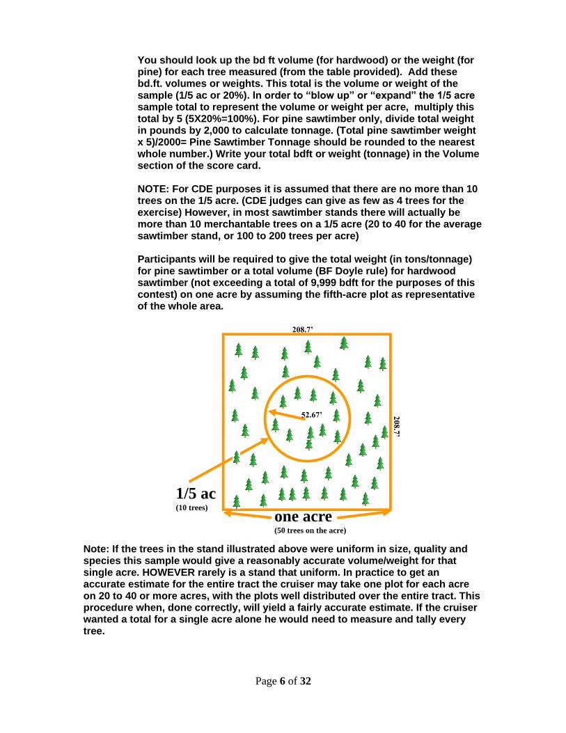
2. A plot will be selected for sawtimber, weight (pine) or volume (hardwood) estimation. Event administrators should select sites that do not have dense stands in order for participants to have sufficient time to measure all marked trees. A plot will consist of a range of 8-10 trees. If more than 10 sawtimber trees are on the plot, then a less dense stand should be selected. It is not necessary to have 10 trees in a plot, but 10 will be the maximum. Explanation of the Timber cruising procedure:
In the timber cruising exercise portion of the Forestry event we assume the 4 to 10 trees to be measured are on a 1/5 acre plot (20% SAMPLE) on a one acre tract.
Page 6 of 32
You should look up the bd ft volume (for hardwood) or the weight (for pine) for each tree measured (from the table provided). Add these bd.ft. volumes or weights. This total is the volume or weight of the sample (1/5 ac or 20%). In order to “blow up” or “expand” the 1/5 acre sample total to represent the volume or weight per acre, multiply this total by 5 (5X20%=100%). For pine sawtimber only, divide total weight in pounds by 2,000 to calculate tonnage. (Total pine sawtimber weight x 5)/2000= Pine Sawtimber Tonnage should be rounded to the nearest whole number.) Write your total bdft or weight (tonnage) in the Volume section of the score card. NOTE: For CDE purposes it is assumed that there are no more than 10 trees on the 1/5 acre. (CDE judges can give as few as 4 trees for the exercise) However, in most sawtimber stands there will actually be more than 10 merchantable trees on a 1/5 acre (20 to 40 for the average sawtimber stand, or 100 to 200 trees per acre) Participants will be required to give the total weight (in tons/tonnage) for pine sawtimber or a total volume (BF Doyle rule) for hardwood sawtimber (not exceeding a total of 9,999 bdft for the purposes of this contest) on one acre by assuming the fifth-acre plot as representative of the whole area.
one acre(50 trees on the acre)
52.67’
1/5 ac(10 trees)
20
8.7
’
208.7’
Note: If the trees in the stand illustrated above were uniform in size, quality and species this sample would give a reasonably accurate volume/weight for that single acre. HOWEVER rarely is a stand that uniform. In practice to get an accurate estimate for the entire tract the cruiser may take one plot for each acre on 20 to 40 or more acres, with the plots well distributed over the entire tract. This procedure when, done correctly, will yield a fairly accurate estimate. If the cruiser wanted a total for a single acre alone he would need to measure and tally every tree.
Page 7 of 32
3. Participants will be given 20 minutes to measure the diameter and height of trees, followed immediately by a 20-minute period to complete weight or volume calculations. No talking during the
calculation period.
4. Using a scale stick, each participant will measure pre-numbered trees on a 1/5 acre plot for tree volume and/or weight. The participant must record the D.B.H. to the nearest inch and the merchantable height of each tree. Height is rounded down to the nearest 8' half-log.
Height No. of Logs Height No. of Logs 16 1 16-23 1 24 1½ 24-31 1½ 32 2 32-39 2 40 2½ 40-47 2½ 48 3 48-55 3 56 3½ 56-63 3½ 64 4 64-71 4 72 4½ 72-79 4½ 80 5 80-87 5
The minimum log will be 10 inches D.B.H. and 1 log merchantable. All designated trees must be measured and recorded.
5. Each tree weight for pine will be found in the pounds per tree (Table 1).
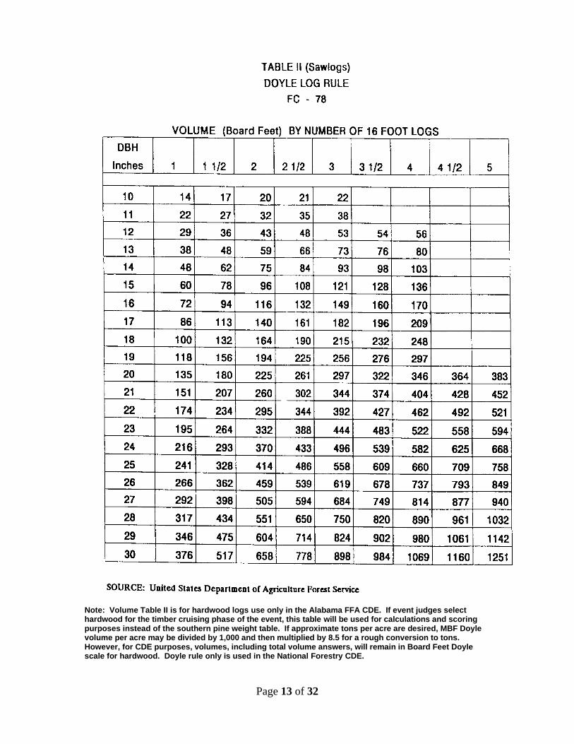
Or each tree volume (BF Doyle) for hardwood (Table II). The appropriate table will be furnished at the event. The weight table is shown on page 12. Record pine sawlog weights as found in the table; OR hardwood volumes will be recorded from the BF Doyle volume table (Table II page 13). Total all sawlog weights or volumes after all trees have been estimated.
6. Three points will be awarded for each correct D.B.H. and number of 16' logs. 7. Forty points will be allowed for the correct total pine sawtimber weight
(in tons) or hardwood volume (BF Doyle rule) per acre. REMEMBER -- the total weight OR volume will be the weight OR volume on the representative one acre (five times the total weight OR volume of the 1/5 acre plot). If pine sawtimber, divide weight in pounds by 2,000 to calculate tonnage. (Total pine sawtimber weight in pounds x 5)/2000= Pine Sawtimber Tonnage. Tonnage should be rounded to the nearest whole number.)
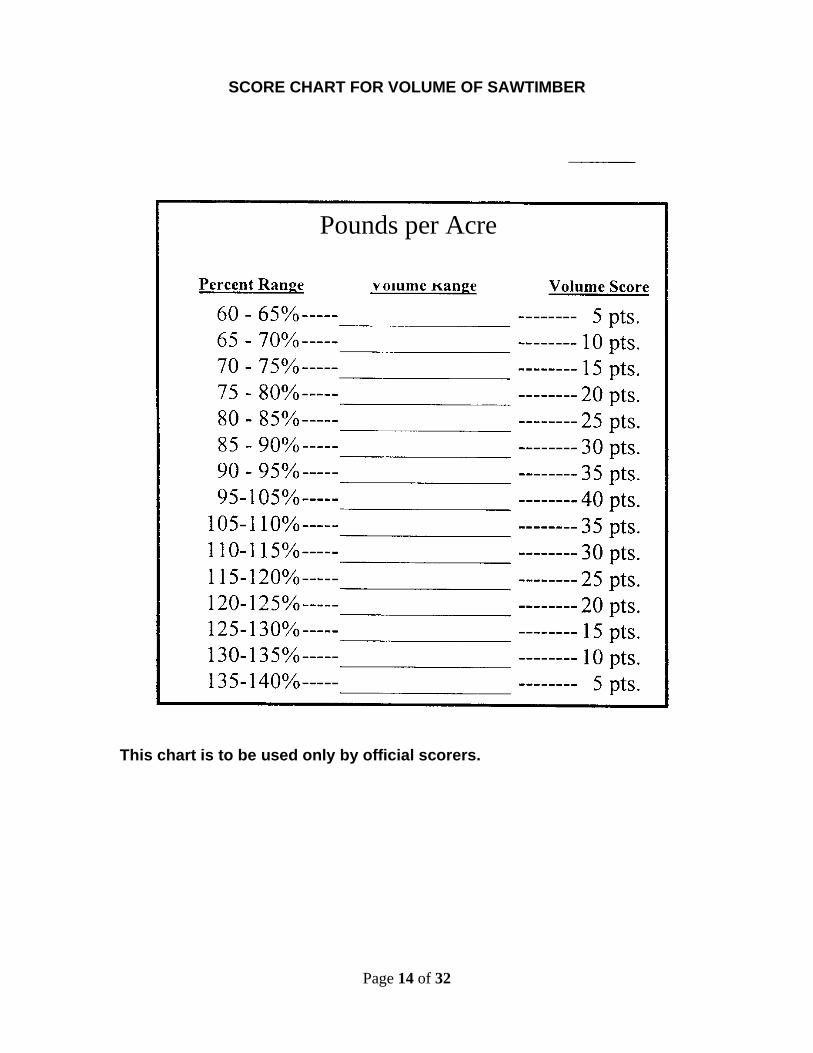
8. Five (5) points will be deducted for each 5% plus or minus from the correct measured weight or volume. (See Score Card on pages 12-13) 9. It is recommended that event officials use 9" white paper plates to identify sawtimber trees.

Page 8 of 32
10. Event officials will not select trees that the log tables or score cards will not accommodate (Tables I and II).
Page 9 of 32
MEASUREMENT OF STANDING TREES STUDY GUIDE PURPOSE: Standing trees are measured to obtain an estimate of the amount of
various products which might be cut from the tree. This is done to have an idea of what weight or volume is present. Most timber sales are based on weight (tons). All forest properties must have some estimate of total weight (tons) on the tract, weight (tons) per acre, and weight (tons) by product so that the forest manager can decide the course of his/her future actions.
PRODUCTS: Forest products which may be measured are poles and piling,
sawlogs, veneer logs, pulpwood, and fence posts. METHOD Since all trees are basically a part of a cylinder, they have diameter and
height which may be measured. Diameter of standing trees is measured at 4½ feet above ground level standing on the uphill side of the tree. This is abbreviated as D.B.H. (diameter breast high). The way to determine diameter will be explained in detail later. Height of a standing tree might be measured as total, the entire height from ground line to the top, or merchantable. This is a variable point, depending on the product which might be cut. If a tree might make a pole or piling, the height used will be measured in feet, by multiples of 5'. The top diameter is fixed by certain specifications. If a tree is to be cut into logs, the lengths cut will vary, depending on the demand of the mill to which the logs will go. This is true of sawlogs, as well as veneer logs. As a result, total merchantable lengths will vary. For this event, trees suitable for logs will have a top limiting diameter of 8" (for CDE purposes disregarding whirls and limbs and other defects).
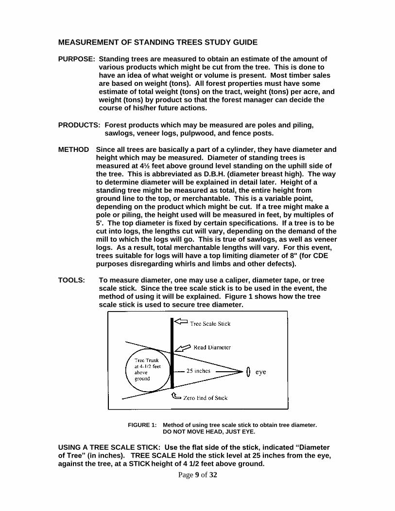
TOOLS: To measure diameter, one may use a caliper, diameter tape, or tree
scale stick. Since the tree scale stick is to be used in the event, the method of using it will be explained. Figure 1 shows how the tree scale stick is used to secure tree diameter.
FIGURE 1: Method of using tree scale stick to obtain tree diameter. DO NOT MOVE HEAD, JUST EYE.
USING A TREE SCALE STICK: Use the flat side of the stick, indicated “Diameter of Tree” (in inches). TREE SCALE Hold the stick level at 25 inches from the eye, against the tree, at a STICK height of 4 1/2 feet above ground.
Page 10 of 32
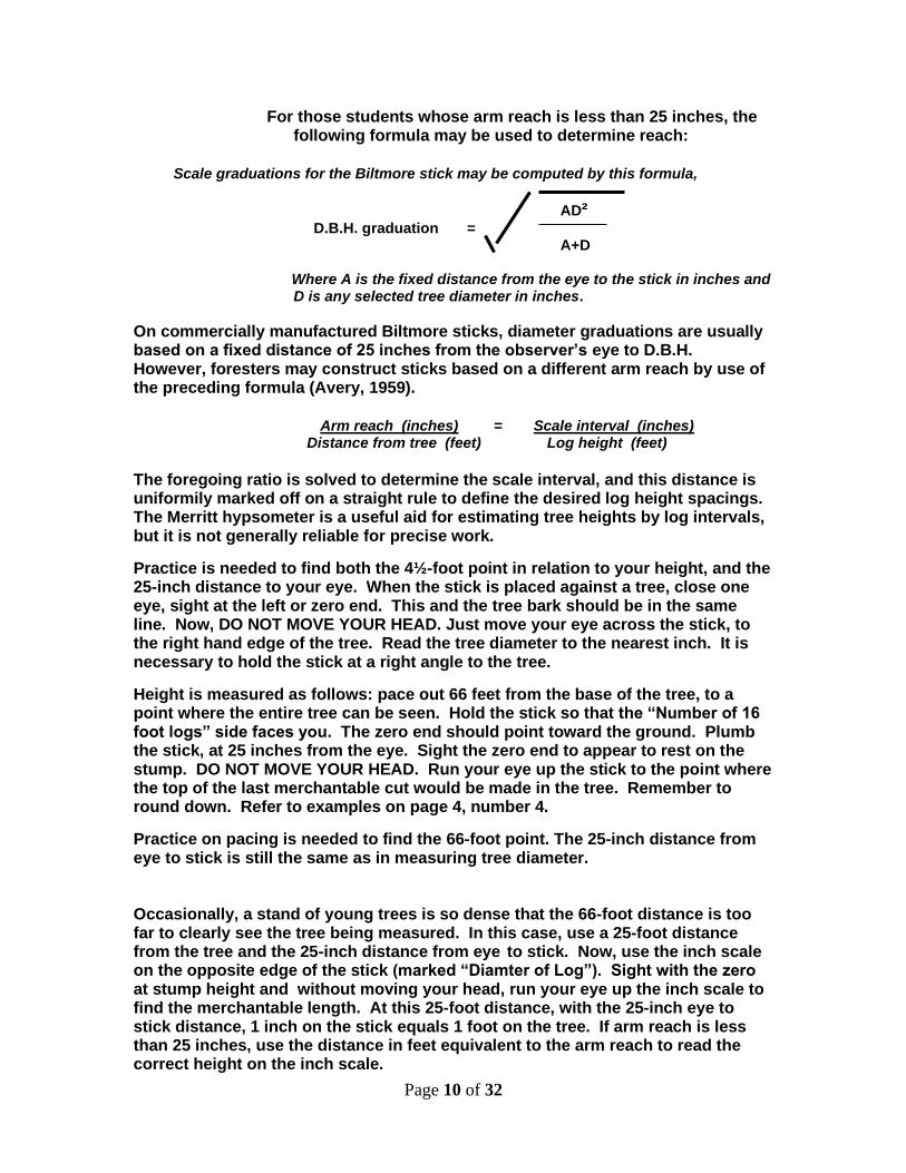
For those students whose arm reach is less than 25 inches, the following formula may be used to determine reach:
Scale graduations for the Biltmore stick may be computed by this formula,
AD² D.B.H. graduation = A+D Where A is the fixed distance from the eye to the stick in inches and D is any selected tree diameter in inches.
On commercially manufactured Biltmore sticks, diameter graduations are usually based on a fixed distance of 25 inches from the observer’s eye to D.B.H. However, foresters may construct sticks based on a different arm reach by use of the preceding formula (Avery, 1959).
Arm reach (inches) = Scale interval (inches) Distance from tree (feet) Log height (feet) The foregoing ratio is solved to determine the scale interval, and this distance is uniformily marked off on a straight rule to define the desired log height spacings. The Merritt hypsometer is a useful aid for estimating tree heights by log intervals, but it is not generally reliable for precise work.
Practice is needed to find both the 4½-foot point in relation to your height, and the 25-inch distance to your eye. When the stick is placed against a tree, close one eye, sight at the left or zero end. This and the tree bark should be in the same line. Now, DO NOT MOVE YOUR HEAD. Just move your eye across the stick, to the right hand edge of the tree. Read the tree diameter to the nearest inch. It is necessary to hold the stick at a right angle to the tree.
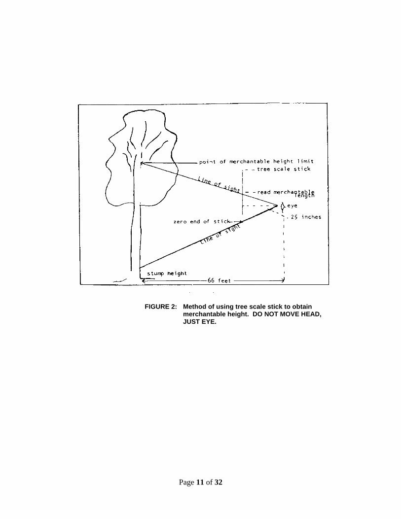
Height is measured as follows: pace out 66 feet from the base of the tree, to a point where the entire tree can be seen. Hold the stick so that the “Number of 16 foot logs” side faces you. The zero end should point toward the ground. Plumb the stick, at 25 inches from the eye. Sight the zero end to appear to rest on the stump. DO NOT MOVE YOUR HEAD. Run your eye up the stick to the point where the top of the last merchantable cut would be made in the tree. Remember to round down. Refer to examples on page 4, number 4.
Practice on pacing is needed to find the 66-foot point. The 25-inch distance from eye to stick is still the same as in measuring tree diameter. Occasionally, a stand of young trees is so dense that the 66-foot distance is too far to clearly see the tree being measured. In this case, use a 25-foot distance from the tree and the 25-inch distance from eye to stick. Now, use the inch scale on the opposite edge of the stick (marked “Diamter of Log”). Sight with the zero at stump height and without moving your head, run your eye up the inch scale to find the merchantable length. At this 25-foot distance, with the 25-inch eye to stick distance, 1 inch on the stick equals 1 foot on the tree. If arm reach is less than 25 inches, use the distance in feet equivalent to the arm reach to read the correct height on the inch scale.
Page 11 of 32
FIGURE 2: Method of using tree scale stick to obtain merchantable height. DO NOT MOVE HEAD, JUST EYE.
Page 12 of 32
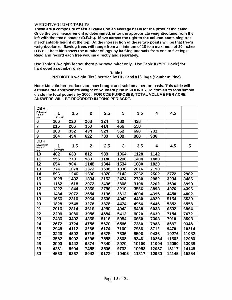
WEIGHT/VOLUME TABLES These are a composite of actual values on an average basis for the product indicated. Once the tree measurement is determined, enter the appropriate weight/volume from the left with the tree diameter (D.B.H.). Move across the right to the column containing tree merchantable height at the top. At the intersection of these two points will be that tree’s weight/volume. Sawlog trees will range from a minimum of 10 to a maximum of 30 inches D.B.H. The table shows the number of logs by half-log intervals from one to five logs. Read and record each tree volume directly and separately. Use Table 1 (weight) for southern pine sawtimber only. Use Table II (MBF Doyle) for hardwood sawtimber only.
Table I PREDICTED weight (lbs.) per tree by DBH and #16’ logs (Southern Pine)
Note: Most timber products are now bought and sold on a per ton basis. This table will estimate the approximate weight of Southern pine in POUNDS. To convert to tons simply divide the total pounds by 2000. FOR CDE PURPOSES, TOTAL VOLUME PER ACRE ANSWERS WILL BE RECORDED IN TONS PER ACRE.
DBH Pulpwood To a 4” top
1
(16” logs)
1.5
2
2.5
3
3.5
4
4.5
6 166 220 268 324 380 428
7 216 286 350 414 466 558
8 268 352 434 524 552 690 732
9 364 494 622 730 808 908 936
DBH Sawtimber to an 8” top
1
(16’ logs)
1.5
2
2.5
3
3.5
4
4.5
5
10 462 638 812 938 1064 1128 1142
11 556 770 980 1140 1298 1404 1480
12 654 904 1148 1344 1534 1680 1820
13 774 1074 1372 1606 1838 2016 2190
14 896 1246 1596 1870 2142 2352 2562 2772 2982
15 1028 1432 1834 2152 2474 2730 2982 3234 3486
16 1162 1618 2072 2436 2808 3108 3202 3696 3990
17 1322 1844 2356 2786 3210 3556 3898 4076 4396
18 1484 2072 2654 3136 3612 4004 4396 4458 4802
19 1656 2310 2964 3506 4042 4480 4920 5154 5530
20 1828 2548 3276 3878 4474 4956 5446 5852 6558
21 2016 2814 3616 4280 4942 5488 6038 6502 6964
22 2206 3080 3956 4684 5412 6020 6630 7154 7672
23 2436 3402 4356 5116 5984 6650 7308 7910 8508
24 2672 3724 4756 5670 6566 7280 7988 8667 9346
25 2946 4112 3236 6174 7100 7938 8712 9470 10214
26 3226 4502 5718 6678 7636 8596 9436 10276 11082
27 3562 5002 6296 7558 8308 9348 10264 11382 12060
28 3900 5442 6874 7840 8970 10100 11094 12090 13038
29 4231 5904 7458 8506 9732 10958 12037 13117 14146
30 4563 6367 8042 9172 10495 11817 12980 14145 15254
Page 13 of 32
Note: Volume Table II is for hardwood logs use only in the Alabama FFA CDE. If event judges select hardwood for the timber cruising phase of the event, this table will be used for calculations and scoring purposes instead of the southern pine weight table. If approximate tons per acre are desired, MBF Doyle volume per acre may be divided by 1,000 and then multiplied by 8.5 for a rough conversion to tons. However, for CDE purposes, volumes, including total volume answers, will remain in Board Feet Doyle scale for hardwood. Doyle rule only is used in the National Forestry CDE.
Page 14 of 32
SCORE CHART FOR VOLUME OF SAWTIMBER
This chart is to be used only by official scorers.
Pounds per Acre
Page 15 of 32
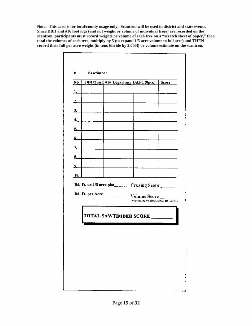
Note: This card is for local/county usage only. Scantron will be used in district and state events.
Since DBH and #16 foot logs (and not weight or volume of individual trees) are recorded on the
scantron, participants must record weights or volume of each tree on a “scratch sheet of paper,” then
total the volumes of each tree, multiply by 5 (to expand 1/5 acre volume to full acre) and THEN
record their full per acre weight (in tons [divide by 2,000]) or volume estimate on the scantron.
Page 16 of 32
Phase 3 -- TIMBER STAND IMPROVEMENT (TSI) AND/OR THINNING 1. A management objective must be in writing. 2. Twenty five (25) trees will be selected and designated for use in this
portion of the event. All twenty five trees selected should be within a 1/5 acre plot (52’8” radius).
3. The 25 trees selected will represent a timber stand that needs either
thinning or some TSI work. The participants will be given a “situation” concerning the forest management objectives of this imaginary stand. All trees, including unmarked trees, within the TSI area will be considered as part of the stand. Information that will help the participants with their decisions will include such things as wildlife habitat considerations, markets available, present condition of the stand, and the final goal of the management plan. Other information may be offered in order to help make the proper decisions.
4. Participants will have only 3 options for each of the 25 trees. The
Practicum 1 section will be used to complete this activity. The options will be:
A. Harvest -- Utilize the tree. B. Leave -- This tree will remain in the stand for a good reason. C. Deaden -- (Undesirable tree, not merchantable or beneficial to
wildlife, should be deadened or cut down and left in woods)
5. Four points will be allowed for each correct decision for a total of 100 points. 6. Participants will be given 20 minutes to make their decision in TSI.
TIMBER STAND IMPROVEMENT (TSI) AND/OR THINNING
STUDY GUIDE PURPOSE: Exercising proper judgment in removing poor quality trees from your timber stands at the opportune time is essential to the overall health, vigor, and value of your forests. THINNING: You should thin (harvest) overstocked woods or those which are becoming crowded in order to give the remaining trees more space in which to grow in size and value.
Page 17 of 32
METHOD 1. Determine which species of trees you want to harvest.
Trees will be marked for harvest if they are merchantable, will not help the landowner meet his objective(s), and are interfering with the growth of better trees. Trees that will not survive until the next cutting cycle should be harvested regardless of spacing unless they are useful for non-economic objectives. Minimum merchantable size is 5.0 inches DBH and twelve feet in height to a 4.0 inch top unless otherwise specified in the written “situation”. Maximum merchantable size for particular product classifications is unlimited unless so specified. Large trees may be considered unmerchantable if they are hollow or decayed throughout the majority of the main stem. All species are considered merchantable for any and all product classifications unless otherwise specified in the written “situation”.
2. Determine which species of trees you want to leave.
Trees will be marked leave, that are either considered “crop” trees that will remain in the stand until the final harvest or the next cutting cycle or will in some other way help the landowner achieve his management objective(s).
3. Determine which species of trees you want to deaden.
Trees should be deadened that are not merchantable, will not help achieve the management objective(s), and are interfering with the growth of better trees.
TSI : Timber stand improvement will eliminate woody vegetation, undesirable species and commercially cull trees that prevent or restrict the growth and development of desired trees and forage plants. Only those trees that are harmful to the orderly execution of your management plans should be deadened. Often low grade or undesirable species of hardwood can be sold. This approach should be considered with the assistance of a Forester before TSI work is started. Also, some cull trees and low quality species may be considered from the wildlife standpoint.
The participants will be given a situation concerning the forest management objectives of the stand selected. This information will be given to participants at the site before they start. Information that will be needed to help participants in their decisions will include:
• Markets available (ex: minimum dbh or merchantable heights, species requirements, pulpwood, tie-logs, saw-logs, etc.)
• Wildlife considerations (big-game, small game, quail, turkey, etc.)
• Present condition of the stand
• Management plan (ex: primary and secondary objectives) Landowner management objectives for TSI WRITTEN management objective shall include one of the following:
Page 18 of 32
1. Landowner wants to manage on a selective sustained yield basis (no final
clear-cut)
OR 2. Landowner wants to manage on an even aged basis (the stand will be
clear-cut at some point in the future.
In either case the approximate age of the overstory shall be given. If the stand is to managed on an uneven aged basis then the approximate age the stand will be harvested (clearcut) shall be given Example: This stand is approx. 20 years old and the landowners wants to clearcut and replant at age 35. Management objective shall include a primary objective and any secondary objectives of the landowner (in order of importance) Secondary objectives are NOT necessarily required. Possible landowner objectives could include,
1. Economic return
2. Wildlife (either in general or by species)
3. Aesthetics
4. Recreation (this could include hunting, hiking, camping, bird watching etc.)
5. Watershed protection: especially if all or part of the TSI area is within a
perennial riparian (35 feet or less from the steambank)
Example: The landowner’s primary objective is economic return from the production of timber. His secondary objective is wildlife, especially deer and turkey. Minimum merchantability size should be included in the management objective. If not otherwise stated a minimum of 4.6 (5” diameter class) at DBH and at least 16’ to a 3” top should be considered minimum for both pine and hardwood. Maximum merchantability size: If economic return is an objective any pine that has reached a maximum desirable merchantability should be harvested. (22” DBH unless otherwise stated in the objectives.) No maximum merchantability for Hardwood unless stated in the objectives) Oversize pines should only be left if tree in question happens to be growing directly on a perennial streambank. Wildlife Trees Keep in mind that trees left for wildlife need to be large enough to produce significant amounts of mast (seed) BEFORE the final harvest, (if there is to be one) (don’t leave a 2 ft. oak if you plan to clear-cut and plant in 10 years) Which tree species should be favored Depends on what type of wildlife the landowner has in mind (in the objectives) For Deer consider the following (in order of preference) White Oaks (including Post And Chestnut oak) Red Oaks Persimmon
Page 19 of 32
For Turkey consider the following: (in order of preference) White Oaks (including Post And Chestnut oak) Red Oaks (especially Water oak) Beech Dogwood Persimmon Cherry Mulberry Blackgum If one of the objectives is wildlife in general (or specific cavity nesters such as squirrel, raccoon and wood duck) is an objective consider leaving trees with hollows or cavities. Sweetgum may be considered a wildlife tree if the objective is wildlife in general or quail specifically. Hickory also may be considered for wildlife in general or for squirrel specifically. If the TSI area or a part of it is within 35 feet of a live stream the SMZ guidelines must be considered. Only 50% of the overstory may be removed from the SMZ area. NO TREES that are actually on the stream bank or in the stream channel are to be removed. Oftentimes harvesting inside an SMZ in a mixed stand involves harvesting the mature pine and leaving the hardwood
Phase 4 -- TREE IDENTIFICATION
Page 20 of 32
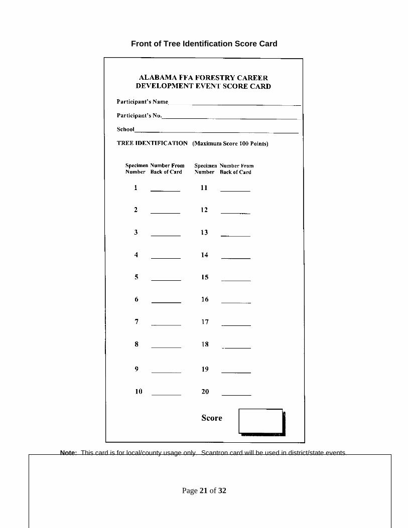
1. Participants will be required to identify 20 species from those listed. The
same species may be used more than once on the same event. Participants will be judged on the accuracy of identification.
The Tree Identification Score Card has been revised. The front is shown on page 18 and back on page 19. Participants will simply write the number representing the tree species as listed on the back of the card. Participants will no longer be required to spell the name of the tree.
2. Five points will be given for each correct answer.
3. If a live specimen is not available potted trees, cuttings, and or branches may be used.
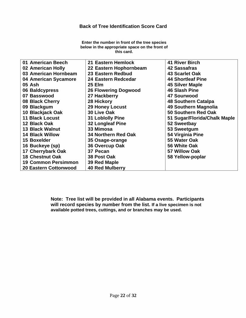
SPECIES
01 American Beech 02 American Holly 03 American Hornbeam 04 American Sycamore 05 Ash 06 Baldcypress 07 Basswood 08 Black Cherry 09 Blackgum 10 Blackjack Oak 11 Black Locust 12 Black Oak 13 Black Walnut 14 Black Willow 15 Boxelder 16 Buckeye (sp) 17 Cherrybark Oak 18 Chestnut Oak 19 Common Persimmon 20 Eastern Cottonwood
21 Eastern Hemlock 22 Eastern Hophornbeam 23 Eastern Redbud 24 Eastern Redcedar 25 Elm 26 Flowering Dogwood 27 Hackberry 28 Hickory 29 Honey Locust 30 Live Oak 31 Loblolly Pine 32 Longleaf Pine 33 Mimosa 34 Northern Red Oak 35 Osage-orange 36 Overcup Oak 37 Pecan 38 Post Oak 39 Red Maple 40 Red Mulberry
41 River Birch 42 Sassafras 43 Scarlet Oak 44 Shortleaf Pine 45 Silver Maple 46 Slash Pine 47 Sourwood 48 Southern Catalpa 49 Southern Magnolia 50 Southern Red Oak 51 Sugar/Florida/Chalk Maple 52 Sweetbay 53 Sweetgum 54 Virginia Pine 55 Water Oak 56 White Oak 57 Willow Oak 58 Yellow-poplar
NOTE: Only these trees will be considered. The study guide for the Tree Identification phase is 100 Forest Trees of Alabama. Some species may not appear in the 100 Forest Trees of Alabama study material.
Page 21 of 32
Front of Tree Identification Score Card
Note: This card is for local/county usage only. Scantron card will be used in district/state events.
Page 22 of 32
Back of Tree Identification Score Card
Enter the number in front of the tree species below in the appropriate space on the front of
this card.
01 American Beech 02 American Holly 03 American Hornbeam 04 American Sycamore 05 Ash 06 Baldcypress 07 Basswood 08 Black Cherry 09 Blackgum 10 Blackjack Oak 11 Black Locust 12 Black Oak 13 Black Walnut 14 Black Willow 15 Boxelder 16 Buckeye (sp) 17 Cherrybark Oak 18 Chestnut Oak 19 Common Persimmon 20 Eastern Cottonwood
21 Eastern Hemlock 22 Eastern Hophornbeam 23 Eastern Redbud 24 Eastern Redcedar 25 Elm 26 Flowering Dogwood 27 Hackberry 28 Hickory 29 Honey Locust 30 Live Oak 31 Loblolly Pine 32 Longleaf Pine 33 Mimosa 34 Northern Red Oak 35 Osage-orange 36 Overcup Oak 37 Pecan 38 Post Oak 39 Red Maple 40 Red Mulberry
41 River Birch 42 Sassafras 43 Scarlet Oak 44 Shortleaf Pine 45 Silver Maple 46 Slash Pine 47 Sourwood 48 Southern Catalpa 49 Southern Magnolia 50 Southern Red Oak 51 Sugar/Florida/Chalk Maple 52 Sweetbay 53 Sweetgum 54 Virginia Pine 55 Water Oak 56 White Oak 57 Willow Oak 58 Yellow-poplar
Note: Tree list will be provided in all Alabama events. Participants will record species by number from the list. If a live specimen is not available potted trees, cuttings, and or branches may be used.
Page 23 of 32
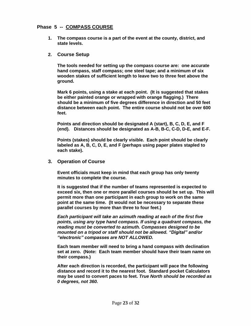
Phase 5 -- COMPASS COURSE 1. The compass course is a part of the event at the county, district, and
state levels.
2. Course Setup
The tools needed for setting up the compass course are: one accurate hand compass, staff compass; one steel tape; and a minimum of six wooden stakes of sufficient length to leave two to three feet above the ground.
Mark 6 points, using a stake at each point. (It is suggested that stakes be either painted orange or wrapped with orange flagging.) There should be a minimum of five degrees difference in direction and 50 feet distance between each point. The entire course should not be over 600 feet.
Points and direction should be designated A (start), B, C, D, E, and F (end). Distances should be designated as A-B, B-C, C-D, D-E, and E-F.
Points (stakes) should be clearly visible. Each point should be clearly labeled as A, B, C, D, E, and F (perhaps using paper plates stapled to each stake).
3. Operation of Course
Event officials must keep in mind that each group has only twenty minutes to complete the course.
It is suggested that if the number of teams represented is expected to exceed six, then one or more parallel courses should be set up. This will permit more than one participant in each group to work on the same point at the same time. (It would not be necessary to separate these parallel courses by more than three to four feet.)
Each participant will take an azimuth reading at each of the first five points, using any type hand compass. If using a quadrant compass, the reading must be converted to azimuth. Compasses designed to be mounted on a tripod or staff should not be allowed. “Digital” and/or “electronic” compasses are NOT ALLOWED.
Each team member will need to bring a hand compass with declination set at zero. (Note: Each team member should have their team name on their compass.)
After each direction is recorded, the participant will pace the following distance and record it to the nearest foot. Standard pocket Calculators may be used to convert paces to feet. True North should be recorded as 0 degrees, not 360.
Page 24 of 32
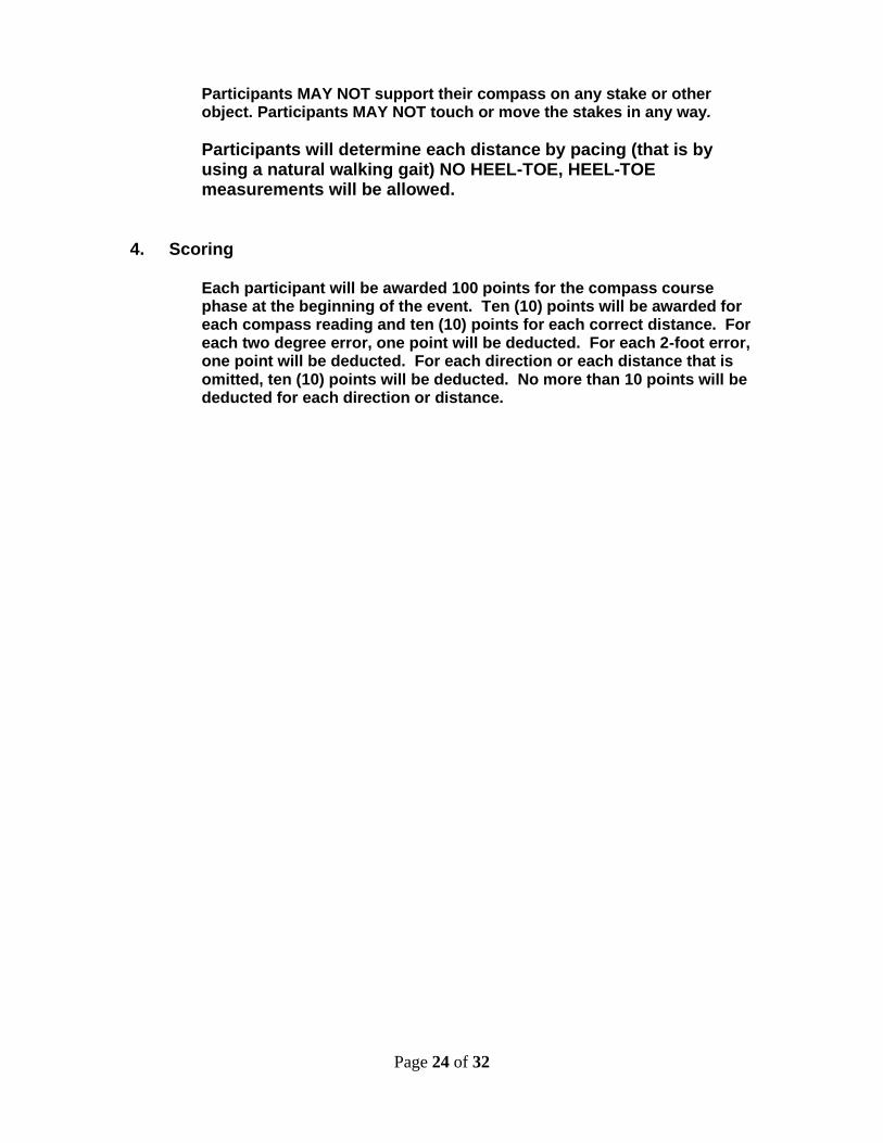
Participants MAY NOT support their compass on any stake or other object. Participants MAY NOT touch or move the stakes in any way.
Participants will determine each distance by pacing (that is by using a natural walking gait) NO HEEL-TOE, HEEL-TOE measurements will be allowed.
4. Scoring
Each participant will be awarded 100 points for the compass course phase at the beginning of the event. Ten (10) points will be awarded for each compass reading and ten (10) points for each correct distance. For each two degree error, one point will be deducted. For each 2-foot error, one point will be deducted. For each direction or each distance that is omitted, ten (10) points will be deducted. No more than 10 points will be deducted for each direction or distance.
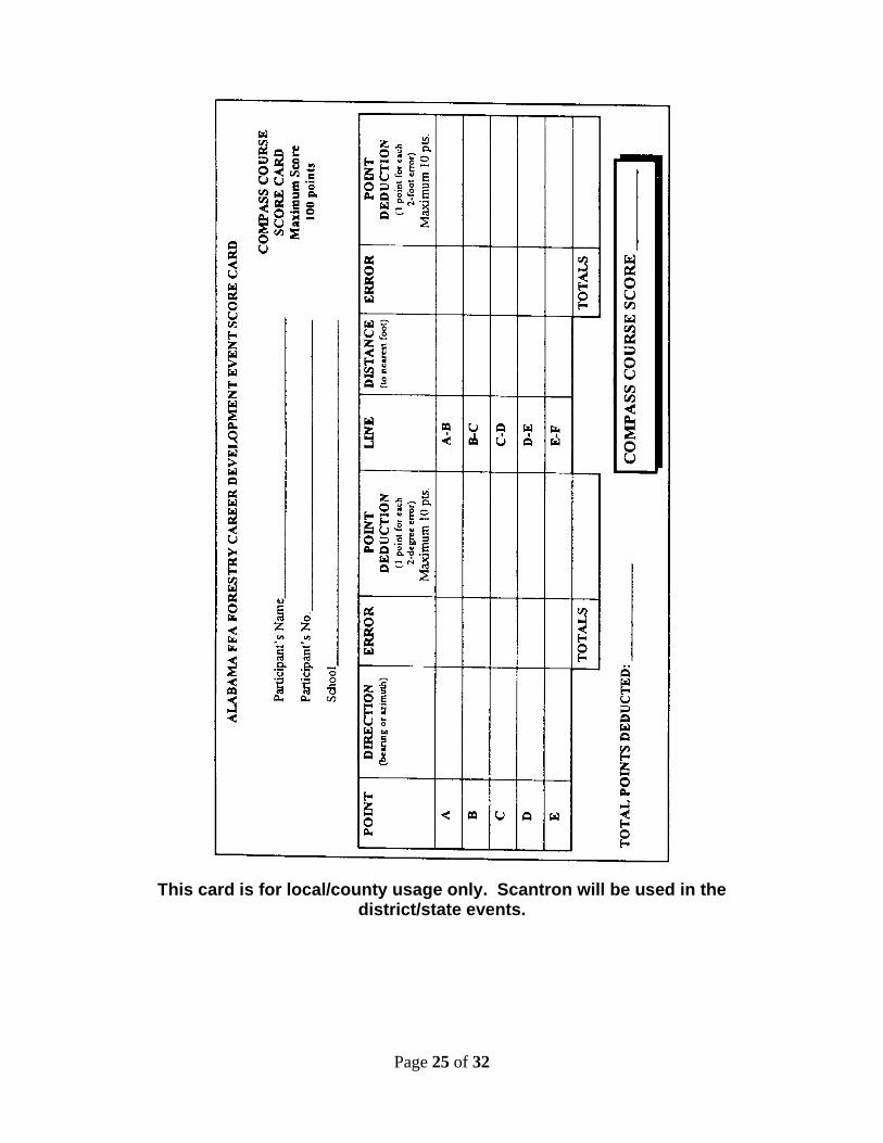
Page 25 of 32
This card is for local/county usage only. Scantron will be used in the
district/state events.
Page 26 of 32
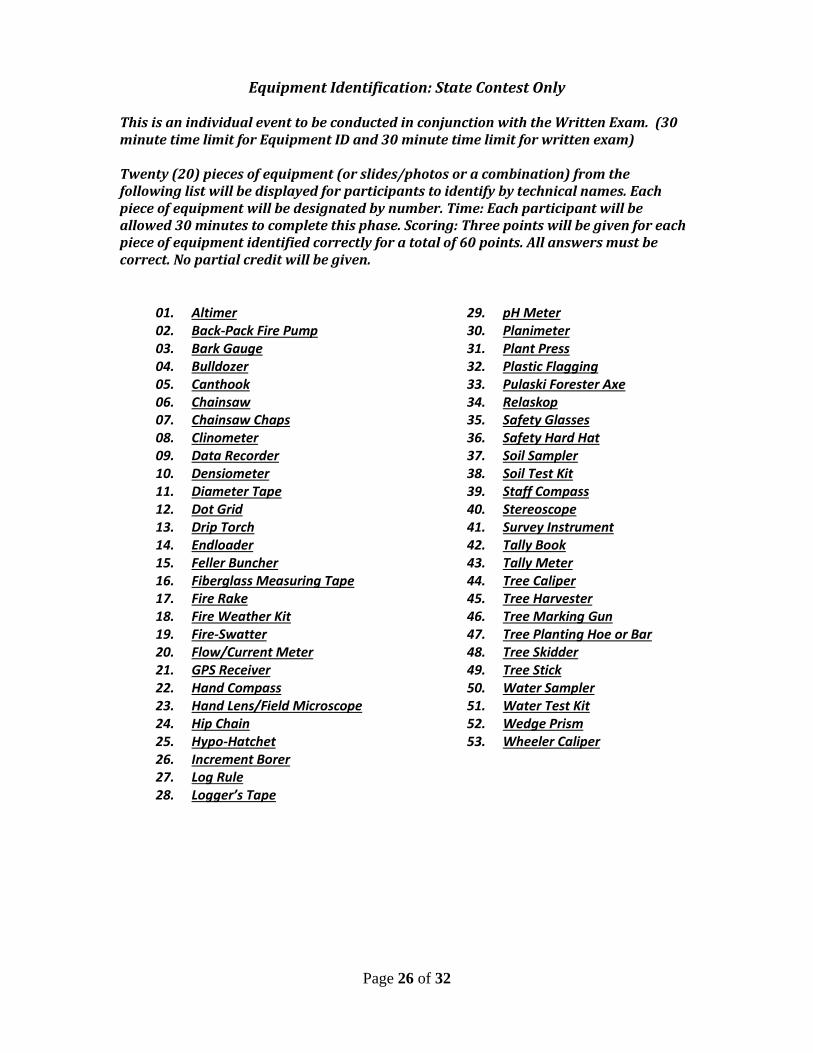
Equipment Identification: State Contest Only This is an individual event to be conducted in conjunction with the Written Exam. (30 minute time limit for Equipment ID and 30 minute time limit for written exam) Twenty (20) pieces of equipment (or slides/photos or a combination) from the following list will be displayed for participants to identify by technical names. Each piece of equipment will be designated by number. Time: Each participant will be allowed 30 minutes to complete this phase. Scoring: Three points will be given for each piece of equipment identified correctly for a total of 60 points. All answers must be correct. No partial credit will be given.
01. Altimer 02. Back-Pack Fire Pump 03. Bark Gauge 04. Bulldozer 05. Canthook 06. Chainsaw 07. Chainsaw Chaps 08. Clinometer 09. Data Recorder 10. Densiometer 11. Diameter Tape 12. Dot Grid 13. Drip Torch 14. Endloader 15. Feller Buncher 16. Fiberglass Measuring Tape 17. Fire Rake 18. Fire Weather Kit 19. Fire-Swatter 20. Flow/Current Meter 21. GPS Receiver 22. Hand Compass 23. Hand Lens/Field Microscope 24. Hip Chain 25. Hypo-Hatchet 26. Increment Borer 27. Log Rule 28. Logger’s Tape
29. pH Meter 30. Planimeter 31. Plant Press 32. Plastic Flagging 33. Pulaski Forester Axe 34. Relaskop 35. Safety Glasses 36. Safety Hard Hat 37. Soil Sampler 38. Soil Test Kit 39. Staff Compass 40. Stereoscope 41. Survey Instrument 42. Tally Book 43. Tally Meter 44. Tree Caliper 45. Tree Harvester 46. Tree Marking Gun 47. Tree Planting Hoe or Bar 48. Tree Skidder 49. Tree Stick 50. Water Sampler 51. Water Test Kit 52. Wedge Prism 53. Wheeler Caliper
Page 27 of 32
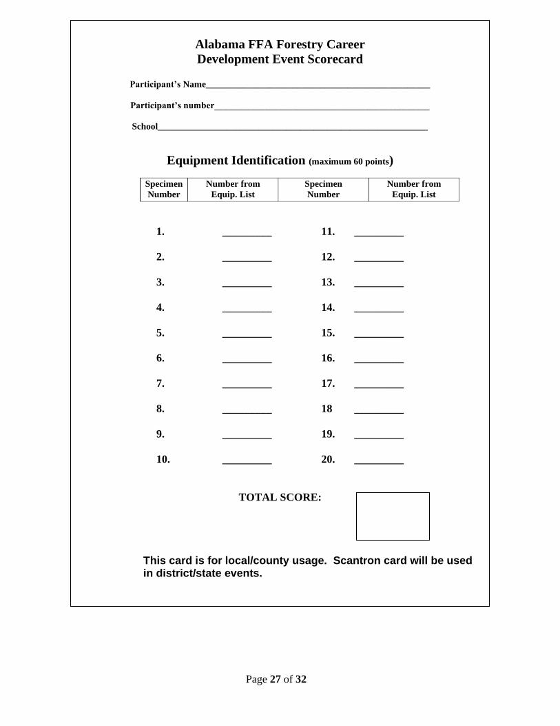
Alabama FFA Forestry Career
Development Event Scorecard
Participant’s Name_________________________________________________
Participant’s number_______________________________________________
School___________________________________________________________
Equipment Identification (maximum 60 points)
Specimen
Number
Number from
Equip. List
Specimen
Number
Number from
Equip. List
1. _________ 11. _________
2. _________ 12. _________
3. _________ 13. _________
4. _________ 14. _________
5. _________ 15. _________
6. _________ 16. _________
7. _________ 17. _________
8. _________ 18 _________
9. _________ 19. _________
10. _________ 20. _________
TOTAL SCORE:
This card is for local/county usage. Scantron card will be used in district/state events.
Page 28 of 32
TEAM ACTIVITY: MAP INTERPRETATION (Odd number years)
This team activity will be conducted at the State level only. All teams will be required to participate.
1. Participants will be furnished a United States Geological Survey topographic map
with specific points marked to be identified. The participant shall know legal description, recognize topographic map symbols, understand the meaning of map symbols and size and location of 20 acres or more in a section.
2. Ten points on a map will be clearly marked with a number or arrow pointing to
the section, symbol, or area on the map to be identified. Examples:
(1)What is the legal description of the area boxed? (2)What is the item located a this point? (3)What is the acreage of the area enclosed? (4)In what section is the city of Marshall located?
3. Legal descriptions will be written or described according to the following: NW Northwest T Township SE Southeast R Range S Section (640 acres) ¼ Quarter of section (160 acres)
4. SCORING: Ten questions or problems will be completed. The ten questions or
problems will be multiple-choice with four (4) possible answers. Ten points will be awarded for each correct answer.
REFERENCES:
The U.S. Department of Interior Geological Survey Topographic Map information and Symbols Key. Available from: Map Distribution, U. S. Geological Survey, Box 25286, Federal Center, Denver, CO 80223.
*How to teach with Topographic Map ($12.95) *Your Way with Map and Compass Orienteering ($8.95) *Be Expert with Map and Compass ($17.25) *All Available through “Ben Meadows Co.” or “Forestry Suppliers”
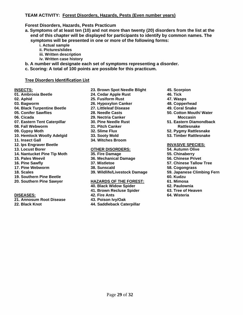
Page 29 of 32
TEAM ACTIVITY: Forest Disorders, Hazards, Pests (Even number years) Forest Disorders, Hazards, Pests Practicum a. Symptoms of at least ten (10) and not more than twenty (20) disorders from the list at the
end of this chapter will be displayed for participants to identify by common names. The symptoms will be presented in one or more of the following forms:
i. Actual sample ii. Pictures/slides iii. Written description iv. Written case history
b. A number will designate each set of symptoms representing a disorder. c. Scoring: A total of 100 points are possible for this practicum.
Tree Disorders Identification List
INSECTS: 01. Ambrosia Beetle 02. Aphid 03. Bagworm 04. Black Turpentine Beetle 05. Conifer Sawflies 06. Cicada 07. Eastern Tent Caterpillar 08. Fall Webworm 09. Gypsy Moth 10. Hemlock Woolly Adelgid 11. Insect Gall 12. Ips Engraver Beetle 13. Locust Borer 14. Nantucket Pine Tip Moth 15. Pales Weevil 16. Pine Sawfly 17. Pine Webworm 18. Scales 19. Southern Pine Beetle 20. Southern Pine Sawyer DISEASES: 21. Annosum Root Disease 22. Black Knot
23. Brown Spot Needle Blight 24. Cedar Apple Rust 25. Fusiform Rust 26. Hypoxylon Canker 27. Littleleaf Disease 28. Needle Casts 29. Nectria Canker 30. Pine Needle Rust 31. Pitch Canker 32. Slime Flux 33. Sooty Mold 34. Witches Broom OTHER DISORDERS: 35. Fire Damage 36. Mechanical Damage 37. Mistletoe 38. Sunscald 39. Wildlife/Livestock Damage HAZARDS OF THE FOREST: 40. Black Widow Spider 41. Brown Recluse Spider 42. Fire Ants 43. Poison Ivy/Oak 44. Saddleback Caterpillar
45. Scorpion 46. Tick 47. Wasps 48. Copperhead 49. Coral Snake 50. Cotton Mouth/ Water
Moccasin 51. Eastern Diamondback
Rattlesnake 52. Pygmy Rattlesnake 53. Timber Rattlesnake INVASIVE SPECIES: 54. Autumn Olive 55. Chinaberry 56. Chinese Privet 57. Chinese Tallow Tree 58. Cogongrass 59. Japanese Climbing Fern 60. Kudzu 61. Mimosa 62. Paulownia 63. Tree of Heaven 64. Wisteria
Page 30 of 32
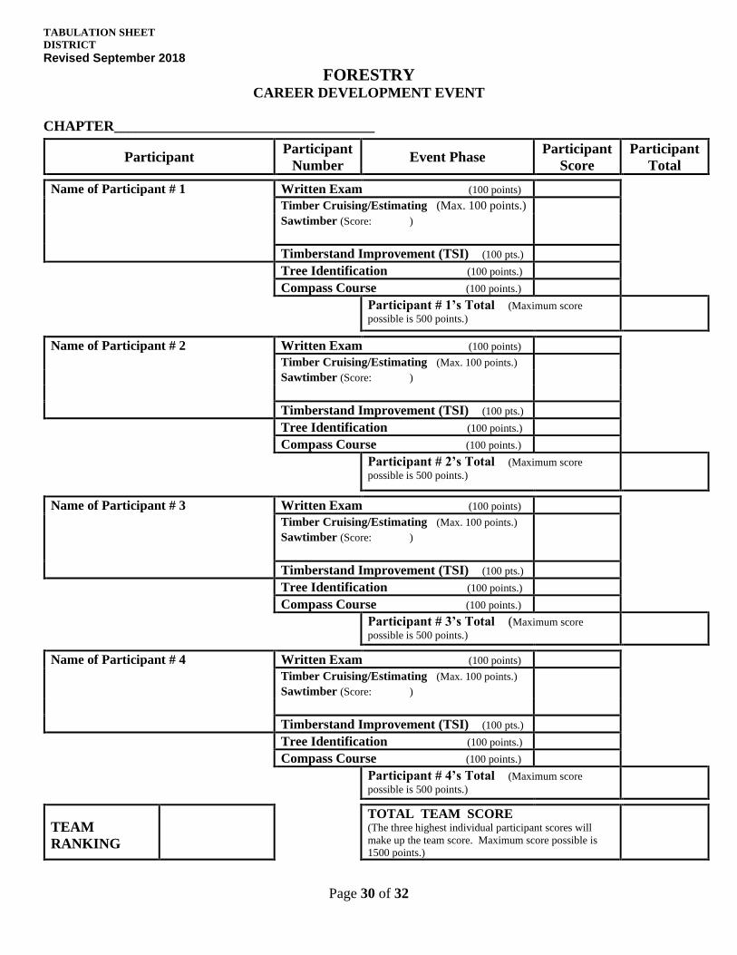
TABULATION SHEET
DISTRICT
Revised September 2018
FORESTRY CAREER DEVELOPMENT EVENT
CHAPTER____________________________________
Participant Participant
Number
Event Phase Participant
Score
Participant
Total
Name of Participant # 1 Written Exam (100 points)
Timber Cruising/Estimating (Max. 100 points.)
Sawtimber (Score: )
Timberstand Improvement (TSI) (100 pts.)
Tree Identification (100 points.)
Compass Course (100 points.)
Participant # 1’s Total (Maximum score
possible is 500 points.)
Name of Participant # 2 Written Exam (100 points)
Timber Cruising/Estimating (Max. 100 points.)
Sawtimber (Score: )
Timberstand Improvement (TSI) (100 pts.)
Tree Identification (100 points.)
Compass Course (100 points.)
Participant # 2’s Total (Maximum score
possible is 500 points.)
Name of Participant # 3 Written Exam (100 points)
Timber Cruising/Estimating (Max. 100 points.)
Sawtimber (Score: )
Timberstand Improvement (TSI) (100 pts.)
Tree Identification (100 points.)
Compass Course (100 points.)
Participant # 3’s Total (Maximum score
possible is 500 points.)
Name of Participant # 4 Written Exam (100 points)
Timber Cruising/Estimating (Max. 100 points.)
Sawtimber (Score: )
Timberstand Improvement (TSI) (100 pts.)
Tree Identification (100 points.)
Compass Course (100 points.)
Participant # 4’s Total (Maximum score
possible is 500 points.)
TEAM
RANKING
TOTAL TEAM SCORE (The three highest individual participant scores will
make up the team score. Maximum score possible is
1500 points.)
Page 31 of 32
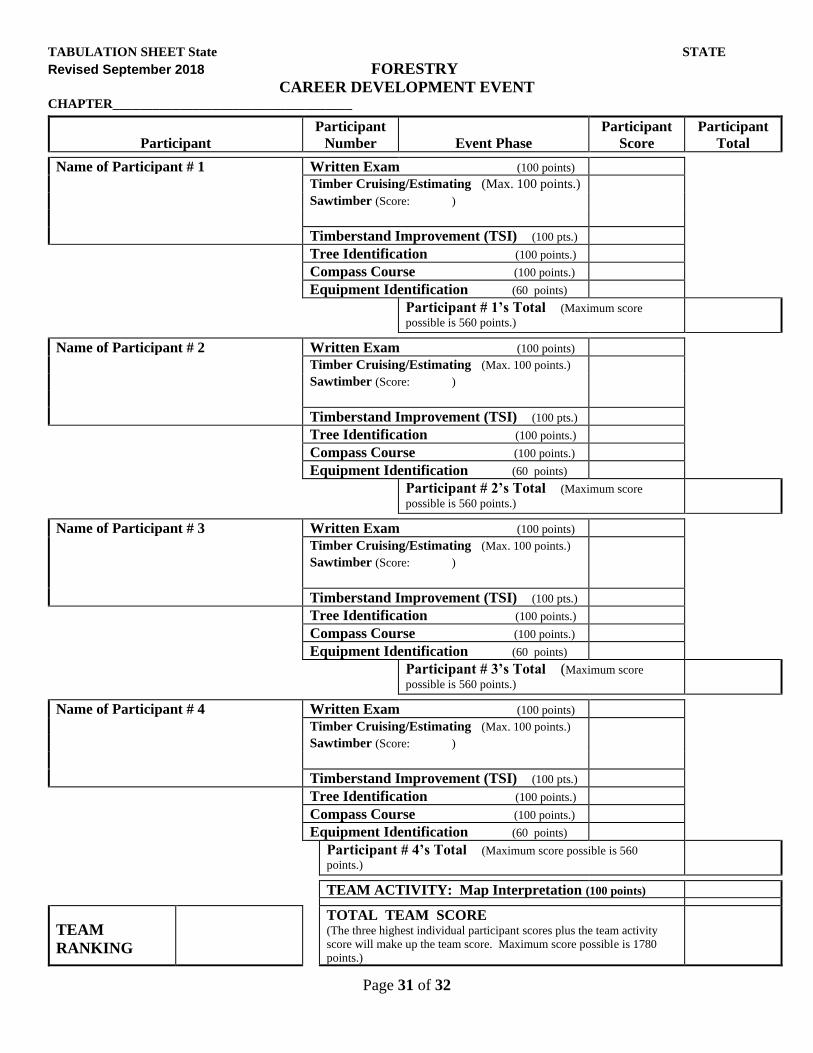
TABULATION SHEET State STATE
Revised September 2018 FORESTRY
CAREER DEVELOPMENT EVENT
CHAPTER____________________________________
Participant
Participant
Number
Event Phase
Participant
Score
Participant
Total
Name of Participant # 1 Written Exam (100 points)
Timber Cruising/Estimating (Max. 100 points.)
Sawtimber (Score: )
Timberstand Improvement (TSI) (100 pts.)
Tree Identification (100 points.)
Compass Course (100 points.)
Equipment Identification (60 points)
Participant # 1’s Total (Maximum score
possible is 560 points.)
Name of Participant # 2 Written Exam (100 points)
Timber Cruising/Estimating (Max. 100 points.)
Sawtimber (Score: )
Timberstand Improvement (TSI) (100 pts.)
Tree Identification (100 points.)
Compass Course (100 points.)
Equipment Identification (60 points)
Participant # 2’s Total (Maximum score
possible is 560 points.)
Name of Participant # 3 Written Exam (100 points)
Timber Cruising/Estimating (Max. 100 points.)
Sawtimber (Score: )
Timberstand Improvement (TSI) (100 pts.)
Tree Identification (100 points.)
Compass Course (100 points.)
Equipment Identification (60 points)
Participant # 3’s Total (Maximum score
possible is 560 points.)
Name of Participant # 4 Written Exam (100 points)
Timber Cruising/Estimating (Max. 100 points.)
Sawtimber (Score: )
Timberstand Improvement (TSI) (100 pts.)
Tree Identification (100 points.)
Compass Course (100 points.)
Equipment Identification (60 points)
Participant # 4’s Total (Maximum score possible is 560
points.)
TEAM ACTIVITY: Map Interpretation (100 points)
TEAM
RANKING
TOTAL TEAM SCORE (The three highest individual participant scores plus the team activity
score will make up the team score. Maximum score possible is 1780
points.)
Page 32 of 32


