Embed Size (px)
Citation preview
Final Report of the Twenty-EighthAntarctic Treaty Consultative Meeting


ANTARCTIC TREATYCONSULTATIVE MEETING
Final Reportof the Twenty-Eighth
Meeting
Stockholm, Sweden, 6 – 17 June 2005
Antarctic Treaty Consultative Meeting (28th:2005:Stockholm)
Final Report of the Twenty-Eighth Antarctic Treaty Consultative Meeting. - BuenosAires: Antarctic Treaty Secretariat, 2005.700 p.; 26x18 cm.
ISBN 987-22458-1-9
1. International Law - Environmental Aspects. 3. Environmental Law - Antarctica.4. Environmental Law, International. 5. Environmental Protection - Antarctica. 6.Antarctic Treaty System.
DDC 341.762 5

7
CONTENTS
Acronyms and Abbreviations 11
I. FINAL REPORT 13
II. MEASURES, DECISIONS AND RESOLUTIONS 57
A. Measures 59Measure 1 (2005): Annex VI to the Protocol on Environmental Protection 61
Annex VI - Liability Arising from Environmental Emergencies 63Measure 2 (2005): Antarctic Specially Protected Areas - Designations and Management Plans 73
Annex A: ASPA 101 - Taylor Rookery, Mac. Robertson Land, East Antarctica 77Annex B: ASPA 102 - Rookery Islands, Mac. Robertson Land, East Antarctica 91Annex C: ASPA 103 - Ardery Island and Odbert Island, Budd Coast, Wilkes Land,
East Antarctica 105Annex D: ASPA 119 - Davis Valley and Forlidas Pond, Dufek Massif 123Annex E: ASPA 120 - Pointe-Géologie, Terre Adélie 139Annex F: ASPA 132 - Potter Peninsula 147Annex G: ASPA 133 - Harmony Point 157Annex H: ASPA 149 - Cape Shirreff and San Telmo Island, Livingston Island,
South Shetland Islands 167Annex I: ASPA 155 - Cape Evans, Ross Island 189Annex J: ASPA 157 - Backdoor Bay, Cape Royds, Ross Island 199Annex K: ASPA 158 - Hut Point, Ross Island 209Annex L: ASPA 159 - Cape Adare 217Annex M: ASPA 163 - Dakshin Gangotri Glacier, Dronning Maud Land 227Annex N: ASPA 164 - Scullin and Murray Monoliths, Mac. Robertson Land,
East Antarctica 239Measure 3 (2005): Antarctic Specially Managed Area and Antarctic Specially Protected
Areas - Deception Island 255Management Plan for ASMA 4 - Deception Island 257
Appendix 1: ASPA 140 - Parts of Deception Island, South Shetland Islands. 269Appendix 2: ASPA 145 - Port Foster, Deception Island 287Appendix 3: Conservation Strategy for HSM 71 - Whalers Bay, Deception Island 293Appendix 4: Code of Conduct for the Deception Island ASMA 4 Facilities Zone 309Appendix 5: Code of Conduct for Visitors to Deception Island 315Appendix 6: Alert Scheme and Escape Strategy for volcanic eruptions on
Deception Island 323Measure 4 (2005): Antarctic Specially Protected Areas - Extension of Expiry Dates 327Measure 5 (2005): Antarctic Historic Sites and Monuments - Lillie Marleen Hut and
Amundsen’s Tent 329
8
B. Decisions 331Decision 1 (2005): Annex VI on Liability Arising from Environmental Emergencies 333Decision 2 (2005): Decision confirming the recognition of Ukraine as a Consultative Party 335Decision 3 (2005): Amendments to the Rules of Procedure 337
Annex: Rules of Procedure (2005) 339Decision 4 (2005): Consultative Party Status 347Decision 5 (2005): Appointment of External Auditor 349Decision 6 (2005): Amendment to Financial Regulations for the Secretariat of the
Antarctic Treaty 353Decision 7 (2005): Approval of the Work Programme and Budget of the Secretariat 355
Work Programme 2005/6 357Appendix 1: Budget 2005/6 361Appendix 2: Forecast Budget 2006/7 364Appendix 3: Contribution Scale 2006/7 365Appendix 4: Salary Scale 2005/6 366
Decision 8 (2005): Use of Heavy Fuel Oil (HFO) in Antarctica 367Decision 9 (2005): Marine Protected Areas and other areas of interest to CCAMLR 369Decision 10 (2005): Establishment of an Electronic Information Exchange System 371
C. Resolutions 373Resolution 1 (2005): Environmental Impact Assessment - Circulation of Information 375Resolution 2 (2005): Practical Guidelines for Developing and Designing Environmental
Monitoring Programs in Antarctica 377Annex: Practical Guidelines 379
Resolution 3 (2005): Fuel Storage and Handling 403Resolution 4 (2005): Updating of Guidelines for Environmental Impact Assessment
in Antarctica 405Annex: Guidelines for Environmental Impact Assessment in Antarctica 407
Resolution 5 (2005): Resolution on Site Guidelines for Visitors 429 Annex: List of current Site Guidelines 430Resolution 6 (2005): Antarctic Post Visit Site Report Form 431 Annex: Post-Visit Report Form 432Resolution 7 (2005): Biological Prospecting in Antarctica 435
III. OPENING AND CLOSING ADDRESSES AND REPORTS 437
D. Opening and Closing Addresses 439Opening Address by Minister for Foreign Affairs of Sweden, Ms. Laila Freivalds 441Opening Address by Ambassador Hans Corell, ATCM Chairman 443Concluding Remarks by Ambassador Hans Corell 447
E. Report of the Committee for Environmental Protection (CEP VIII) 451Annex 1: Welcome speech by Ms. Lena Sommestad, Minister for the Environment
of Sweden 485
9
Annex 2: Agenda and final list of documents 487Annex 3: CEP national contact points 493Annex 4: Internet addresses (urls) where annual report information is published in
accordance with Article 17 of the Protocol 497Annex 5: Report of the Open-ended Contact Group discussing the ‘Must-do’ tasks
of the CEP 499Annex 6: Aide memoire: CEP - The way forward 501Annex 7: Guidelines for Environmental Impact Assessment in Antarctica 503Annex 8: Guidelines for CEP consideration of proposals for new and revised
designations of Antarctic Specially Protected Species under Annex II of the Protocol 505Annex 9: Terms of Reference for the ICG on Environmental Monitoring and Reporting 509
Appendix 1: CEP advice to the ATCM on the draft CEE contained in WP 19 & IP 66(United Kingdom) 511
Appendix 2: CEP advice to the ATCM on the draft CEE contained in IP 30(Germany) 513
Appendix 3: List of ASPA and ASMA Management Plans referred by the CEP to theATCM for adoption 515
Appendix 4: List of Historic Sites and Monuments referred by the CEP to theATCM for adoption 517
Appendix 5: CEP IX Provisional Agenda 519
F. Reports pursuant to Recommendation XIII-2 521Report of the USA as Depositary of the Antarctic Treaty and the Environment Protocol 523Report by Australia as Depositary for the Convention on the Conservation of Antarctic
Marine Living Resources (CCAMLR) 535Report by Australia as Depositary for the Agreement on the Conservation of Albatrosses
and Petrels (ACAP) 537Report by the UK as Depositary for the Convention for the Conservation of Antarctic Seals
(CCAS) 539Report by the CCAMLR Observer 543SCAR Report 549
Appendix 1: Membership of SCAR 558Appendix 2: SCAR Contact Details 559Appendix 3: New SCAR structure 561Appendix 4: The Scar Scientific Research Programmes 563Appendix 5: SCAR’s Action and Expert Groups 567Appendix 6: List of Acronyms 570
COMNAP Report 573Appendix 1: Terms of Reference (TORs) and Membership of COMNAP Committees,
Working Groups, Coordinating Groups and Networks 583Appendix 2: Details of the 37 year-round stations operated by the National Antarctic
Programs in the Antarctic Treaty area 593
10
G. Reports pursuant to Article III-2 of the Antarctic Treaty 597Report of the Antarctic and Southern Ocean Coalition (ASOC) 599Report by IUCN 605Report of the International Association of Antarctica Tour Operators (IAATO) 2004-2005 609
Appendix A: IAATO Pre-Season Antarctic Checklist 2004-2005 Season 618Appendix B: 2004-2005 Expedition Leader and Ship’s Officers Seasonal Instructions 622Appendix C: Partial list of Donations for 2004-2005 627Appendix D: Partial List of Science Support and Transport by IAATO Vessels
in 2004-2005 629Report by the International Hydrographic Organization (IHO) 631
Annex A: Status of INT Chart production in Antarctic waters (April 2005) 635Annex B: Proposed Maritime Shipping Routes in the Antarctic Peninsula 637
IV. ADDITIONAL DOCUMENTS 639
H. Additional Documents 641Statement of the Member States of the European Union in the Working Group on Liability 643Remarks by the Chairman of the XXVIII ATCM at the SCAR Presentation 645
I. Message from the XXVIII ATCM to Stations in the Antarctic 647
J. Preliminary Agenda for ATCM XXIX 649
K. List of Documents 651Working Papers 653Information Papers 661
L. List of Participants 671Consultative Parties 673Non Consultative Parties 677Observers 679Experts 681Invited Guests 681
M. National Contact Points 683Consultative Parties 685Non Consultative Parties 691Observers 695Experts 697
11
ACRONYMS AND ABBREVIATIONS
ACAP Agreement on the Conservation of Albatrosses and PetrelsASOC Antarctic and Southern Ocean CoalitionASMA Antarctic Specially Managed AreaASPA Antarctic Specially Protected AreaATS Antarctic Treaty System; Antarctic Treaty SecretariatATCM Antarctic Treaty Consultative MeetingATCP Antarctic Treaty Consultative PartyCCAMLR Convention for the Conservation of Antarctic Marine Living
ResourcesCCAS Convention for the Conservation of Antarctic SealsCEE Comprehensive Environmental EvaluationCEP Committee for Environmental ProtectionCOMNAP Council of Managers of National Antarctic ProgrammesEIA Environmental Impact AssessmentHCA Hydrographic Committee on AntarcticaHSM Historic Site and MonumentIAATO International Association of Antarctica Tour OperatorsICG Intersessional Contact GroupICSU International Council for ScienceIEE Initial Environmental EvaluationIHO International Hydrographic OrganizationIMO International Maritime OrganizationIOC Intergovernmental Oceanographic CommissionIP Information PaperIPY International Polar YearIPO IPY Program OfficeIUCN International Union for Conservation of Nature and Natural Resources
– The World Conservation UnionSATCM Special Antarctic Treaty Consultative MeetingSCAR Scientific Committee on Antarctic ResearchSDR Special Drawing RightSPA Specially Protected AreaSSSI Site of Special Scientific InterestUNEP United Nations Environment ProgrammeWG Working GroupWMO World Meteorological OrganizationWP Working PaperWTO World Tourism OrganizationWWF Worldwide Fund for Nature

PART I
FINAL REPORT

15
Final Report of the Twenty-Eighth Antarctic TreatyConsultative Meeting
Stockholm, Sweden, 6 – 17 June 2005
(1) Pursuant to Article IX of the Antarctic Treaty, Representatives of the ConsultativeParties (Argentina, Australia, Belgium, Brazil, Bulgaria, Chile, China, Ecuador, Finland,France, Germany, India, Italy, Japan, the Republic of Korea, the Netherlands, NewZealand, Norway, Peru, Poland, the Russian Federation, South Africa, Spain, Sweden,Ukraine, the United Kingdom of Great Britain and Northern Ireland, the UnitedStates of America and Uruguay) met in Stockholm from 6 to 17 June 2005, for thepurpose of exchanging information, holding consultations, and considering andrecommending to their governments measures in furtherance of the principles andobjectives of the Treaty.
(2) The Meeting was also attended by Delegations of the following Contracting Partiesto the Antarctic Treaty which are not Consultative Parties: Canada, the CzechRepublic, Denmark, Estonia, Greece, Hungary, Romania, Slovakia, and Switzerland.A delegation from Malaysia was present by invitation of the XXVII ATCM to observethe Meeting.
(3) In accordance with Rules 2 and 31 of the Rules of Procedure, Observers from theCommission for the Conservation of Antarctic Marine Living Resources (CCAMLR),the Scientific Committee on Antarctic Research (SCAR), and the Council of Managersof National Antarctic Programs (COMNAP) attended the Meeting.
(4) In accordance with Rule 39 of the Rules of Procedure, Experts from the followingInternational Organizations and Non-Governmental Organizations were invited toattend the Meeting: the Antarctic and Southern Ocean Coalition (ASOC), theInternational Association of Antarctica Tour Operators (IAATO), the InternationalHydrographic Organization (IHO) the International Maritime Organization (IMO),the Intergovernmental Oceanographic Comission (IOC), the World ConservationUnion (IUCN), the World Tourism Organization (WTO), the World MeteorologicalOrganization (WMO) and the United Nations Environment Programme (UNEP).
(5) The information requirements of the host country towards the Contracting Parties,Observers and Experts were fulfilled by Secretariat Circular Notes, letters and througha website with an open as well as a password protected area.
I. FINAL REPORT
16
Item 1: Opening of the Meeting
(6) In accordance with Rules 5 and 6 of the Rules of Procedure, Ambassador GregerWidgren, Head of the Swedish Delegation, opened the Meeting and proposedAmbassador Hans Corell as Chair of the ATCM. The proposal was accepted. TheChair made an opening statement in which he stressed the Antarctic spirit, a spirit ofcooperation and persistence that developed during the first era of Antarcticexplorations. As highest priorities for the XXVIII ATCM Ambassador Corell mentionedthe conclusion of the negotiations on the Liability Annex to the Environment Protocoland the issues of tourism and bio-prospecting.
(7) The Consultative Meeting was inaugurated by the Swedish Minister of Foreign Affairs,Ms. Laila Freivalds. In her address the Minister referred to the long and intenserelation of Sweden with Antarctica. Sweden had adhered to the Antarctic Treaty in1984, and emphasizes international cooperation in its polar research program, whichcovers both the Arctic and the Antarctic regions. The Minister also stressed theexample of Antarctica, the first and only demilitarized continent, for the cause ofworld peace. She referred to the fact that this was the first ATCM to be prepared bythe host government in cooperation with the Antarctic Treaty Secretariat, andexpressed the hope that the XXVIII ATCM would be able to adopt the Annex onLiability to the Environment Protocol. The Minister’s speech is included in Annex Dof this Report.
Item 2: Election of Officers and Creation of Working Groups
(8) Dr. Mike Richardson, Head of the Delegation of the United Kingdom (host countryof the XXIX ATCM) was elected Vice-Chair. Ambassador Folke Löfgren wasappointed Secretary General, and Mr. Stig Berglind was appointed Deputy SecretaryGeneral of the Meeting. In accordance with Rule 7 of the Rules of Procedure, Mr.Jan Huber, Executive Secretary of the Antarctic Treaty Secretariat, acted as Secretaryof the Meeting.
(9) Four Working Groups were established: (i) a Working Group on Legal and InstitutionalAffairs, (ii) a Working Group on Operational Matters, (iii) a Working Group on theLiability Annex and (iv) a Working Group on Tourism and Non-GovernmentalActivities.
(10) The following Chairs of the Working Groups were elected:
i) Legal and Institutional WG: Professor Olav Orheim of Norwayii) Operational Matters WG: Dr. José Retamales of Chileiii) Liability WG: Ambassador Don MacKay of New Zealandiv) Tourism WG: Mr. Michel Trinquier of France

FINAL REPORT
17
Item 3: Adoption of the Agenda and Allocation of Items
(11) The following Agenda was adopted:
1. Opening of the meeting.2. Election of Officers and creation of Working Groups.3. Adoption of the Agenda and allocation of items.4. Operation of the Antarctic Treaty System: Reports by Parties, Observers
and Experts.5. Operation of the Antarctic Treaty System: General matters.6. Operation of the Antarctic Treaty System: Review of the Secretariat’s
situation.7. Report of the Committee for Environmental Protection.8. The Question of Liability as referred to in Article 16 of the Protocol.9. Safety and Operations in Antarctica.10. Relevance of Developments in the Arctic and in the Antarctic.11. The International Polar Year 2007/2008.12. Tourism and Non-Governmental Activities in the Antarctic Treaty Area.13. Inspections under the Antarctic Treaty/Protocol.14. Science Issues, particularly scientific co-operation and facilitation.15. Operational issues.16. Education issues.17. Exchange of Information.18. Biological Prospecting in Antarctica.19. Preparation of the XXIX Meeting.
(12) The Meeting adopted the following allocation of agenda items:
- Plenary: Items 1, 2, 3, 4, 7 & 19- Liability Working Group: Item 8- Legal and Institutional Working Group: Items 5, 6, 17 & 18- Tourism and Non-Governmental Activities Working Group: Item 12- Operational Working Group: Items 9, 10, 11, 13, 14, 15, 16
The Meeting also decided to allocate draft instruments arising out of the work of theCEP, the Tourism Working Group and the Operational Working Group to the Legaland Institutional Working group for consideration of their legal and institutional aspects.
Item 4: Operation of the Antarctic Treaty System: Reports by Parties, Observersand Experts
(13) Pursuant to Recommendation XIII-2, the Meeting received reports from:
I. FINAL REPORT
18
- The United States Government as the Depositary of the Antarctic Treaty;- The Australian Government as the Depositary of the Convention on the
Conservation of the Antarctic Marine Living Resources (CCAMLR);- The Australian Government as the Depositary of the Agreement on the
Conservation of Albatrosses and Petrels (ACAP);- The United Kingdom Government as the Depositary of the Convention for
the Conservation of Antarctic Seals (CCAS);- The Commission for the Conservation of Antarctic Marine Living Resources
(CCAMLR);- The Scientific Committee on Antarctic Research (SCAR);- The Council of Managers of National Antarctic Programs (COMNAP).
These reports are reproduced at Annex F.
(14) Pursuant to Article III-2 of the Antarctic Treaty, the Meeting also received reportsfrom:
- The Antarctic and Southern Ocean Coalition (ASOC);- The World Conservation Union (IUCN);- The International Association of Antarctica Tour Operators (IAATO);- The International Hydrographical Organization (IHO);
These reports are reproduced at Annex G.
(15) The United States in its capacity as Depositary reported on the status of the AntarcticTreaty and the Environment Protocol. The Meeting welcomed the news that theCzech Republic deposited its instrument of ratification of the Protocol on EnvironmentalProtection on August 24, 2004. The Depositary drew the attention of the Partiesconcerned to the fact that a number of persons designated as Arbitrators in accordancewith Article 2(1) of the Schedule to the Protocol on Environmental Protection arenearing the end of their term, since they were designated in the year 2000.
(16) Australia in its capacity as the Depositary for the Convention on the Conservation ofthe Antarctic Marine Living Resources (CCAMLR) reported that since the 27th
ATCM, Mauritius has acceded to the Convention.
(17) In its capacity as the Depositary for the Agreement on the Conservation of Albatrossesand Petrels (ACAP) Australia reported the accession of Peru. Chile informed theMeeting that it had also acceded.
(18) The United Kingdom, as Depositary of the Convention for the Conservation ofAntarctic Seals (CCAS), reported that in recent years no new accessions to theConvention have occurred. The UK reminded the Parties to the Convention thatcurrently not all the required information is being provided. Neither is it being providedon time or with any regularity. The accuracy of the CCAS figures is therefore beingcompromised.

FINAL REPORT
19
(19) The President of SCAR introduced his report, describing the re-organisation of itscommittees to increase its effectiveness, the five new scientific programmes and itscapacity building initiatives.
(20) Introducing its report, the representative of COMNAP gave a description of how theCouncil works, mainly through technical groups, to support the cooperation withinthe framework of the Antarctic Treaty System with practical information exchangedthrough the national programs.
(21) In introducing his report as observer to the ATCM, the Executive Secretary of theCommission for the Conservation Antarctic Marine Living Resources (CCAMLR)emphasized the following points:
- the illegal, unreported and unregulated (IUU) fishing of Dissostichus spp.(Toothfish) had declined considerably in the past season;
- the Catch Documentation Scheme for Dissostichus spp. had been furtherdeveloped, as had the centralized vessel monitoring system (c-VMS);
- an electronic Catch Documentation Scheme (eCDS) was being developed.
(22) These developments were welcomed by the ATCM. At the same time, one delegationremarked that, although there had been a decline in the IUU fishing of Toothfish, theestimated amount of the IUU catch was still larger than the legal catch, so theParties and the Commission were not in a position to relax their efforts to fight thispractice.
(23) ASOC introduced IP 108, Report of the Antarctic and Southern Ocean Coalition(ASOC). The ASOC Representative emphasized that although regulation of tourismis now being given serious consideration, significant elements of commercial tourismstill await substantive discussion. ASOC attached great importance to the approvalof Annex VI on Liability. Likewise, ASOC expressed the wish that the ATCM wouldconsider the questions relating to Lake Vostok, bio-prospecting and the InternationalPolar Year.
(24) IAATO introduced IP 95 Rev 1, Report of the International Association ofAntarctica Tour Operators 2004-2005. IAATO remains committed to the safeand responsible management of Antarctic tourism and noted a number ofaccomplishments during the 2004/05 season. Amongst others, these included theinstallation of its tourism database, a draft accreditation scheme, the translation ofRecommendation XVIII-1 into 9 languages (available on the IAATO web site) anda detailed site-use analysis. IAATO also noted fruitful cooperation with COMNAP,IHO and other organisations.
(25) In IP 18, Report by the International Hydrographical Organization (IHO) on“Cooperation in Hydrographic Surveying and Charting of Antarctic Waters”,the IHO emphasized the progress made in the production of INT charts of Antarcticwaters and recommended increased hydrographic surveying activities by the Member
I. FINAL REPORT
20
States. The Hydrographic Committee on Antarctica has set up a Hydrographic SurveyProgramme Working Group to intensify hydrographic survey activity in Antarctica.These activities are carried out in close cooperation with the Consultative Parties,COMNAP and IAATO. Argentina reserved its position on the Antarctic toponymsinvolved.
(26) The Meeting acknowledged the progress made in the production of INT Charts andendorsed the recommendations in the IHO Report. The Meeting also expressed itssupport for the activity of the Hydrographic Committee on Antarctica (HCA) andthe work of the Hydrographic Survey Programme Working Group and invited MemberStates to increase their hydrographic survey activities in Antarctica. Furthermore,the Meeting urged the IHO to consider further its proposal for Maritime ShippingRoutes in the Antarctic Peninsula and Ross Sea areas as an IPY initiative. Such aproposal would be important for reducing risks from shipping activities in AntarcticTreaty waters.
Item 5: Operation of the Antarctic Treaty System: General matters
Item 5 (a). Confirmation of the Recognition of Ukraine as a Consultative Party
(27) Since the XXVII ATCM, in its recognition of Ukraine as a Consultative Party, hadnot followed the procedure agreed to earlier, namely by way of a Decision of theATCM, the Meeting adopted Decision 2 (2005) Decision confirming the recognitionof Ukraine as a Consultative Party.
Item 5 (b). Intersessional Consultation
(28) Japan introduced WP 46 and WP 56 on intersessional consultation procedures, IP103 on the scope of intersessional consultation and IP 120 with a corrected text ofthe Rules of Procedure. Japan noted that there was a general consensus at theXXVII ATCM on the need for a procedure by which the Executive Secretary canconsult the Consultative Parties if he/she has to take actions for which under Measure1 (2003) and related instruments he/she needs authorisation from the ATCM andwhich cannot wait until the next ATCM. The procedure should be:
- Simple, in the sense that the Executive Secretary should be able to contactthe Consultative Parties directly;
- Efficient, in the sense that electronic means of communication should be used;- Accountable to the Consultative Parties (the Executive Secretary should
report to the ATCM all cases of intersessional consultation);- Restricted (the procedure should be used only for those issues for which
consultation or authorisation is legally required and which cannot wait untilthe next ATCM); and
- Based on a consensus of all Consultative Parties.
FINAL REPORT
21
(29) WP 46 included a draft Rule 46 for the Rules of Procedure, and WP 56, which wasco-sponsored by a number of Consultative Parties, included a revised draft for Rule46. Rule 46 would prescribe the procedure to be used by the Executive Secretary forintersessional consultations.
(30) A number of Parties supported the proposal by Japan and other co-sponsoring Parties.However, one Party raised concerns about the legal consequences of such a procedure,which could imply that the ATCM existed during the intersessional period. It pointedout that the ATCM only exists during its annual meetings. Also raised was the questionof what would be the status of any decisions arrived at through the intersessionalconsultation process. Other delegations stressed that these decisions would not havethe status of Decisions of the ATCM and that, in any case, they would have to bereported to the ATCM following the consultation process.
(31) Japan presented a revised text of Rule 46 on intersessional consultation proceduresand stressed that nothing had been changed in substance, but that the intent of thetext was now clearer. The Meeting agreed to adopt Decision 3 (2005) Amendmentsto the Rules of Procedure.
Item 5 (c). Attendance of non-Party states in the ATCM
(32) The United Kingdom introduced WP 55, which contained XXVI ATCM/WP 18 onthe subject of the attendance of non-Party States to the ATCM. Since the Rules ofProcedure had changed in the meantime, the detailed changes in the Rules ofProcedure proposed in XXVI ATCM/WP18 had been omitted from WP 55. TheUnited Kingdom emphasized the benefits that the opening up of meetings to non-Party States had brought to CCAMLR, where states that had been invited as observershad later acceded to CCAMLR and even become full members. There was a largedifference between this practice and that of the ATCM, which had been invitingMalaysia during the last few years to observe the Meeting, but without a regularprocedure. The ATCM needed to regularize this situation.
(33) On the same topic, Chile introduced WP 54. Chile considered it a priority that thosecountries interested in conducting activities within the framework of the AntarcticTreaty System become Parties to the Antarctic Treaty. Accordingly, it proposed anamendment of the Rules of Procedure to permit attendance by non-Party Stateswith an interest in the Antarctic.
(34) There was general agreement on the need for the ATCM to adopt an open attitudetowards non-Party States, and support from many Parties for the proposal to adopta procedure dealing with their attendance to the meetings. One Party reiterated itsopposition stated at the XXVI ATCM to formal changes in the present ATCM Rulesof Procedure. That Party stated that the Antarctic Treaty System provides a clearprocedure for states to join, namely by acceding to the Antarctic Treaty. Some concernwas also expressed at the possibility of states using a possible observer status topostpone acceding to the Treaty indefinitely.
I. FINAL REPORT
22
(35) The Meeting concluded that the Antarctic Treaty System has always been and remainsan open system, which welcomes non-Party states to join it. There is no consensusto now adopt formal procedures regulating the attendance of non-Party states at theATCM. At the same time it was accepted that the informal practice of the last fewyears of inviting a specific non-Party state to observe the Meeting could continue.
Item 5 (d). Consultative Status
(36) The United Kingdom introduced WP 57, which was aimed at closing a possibleambiguity in Article 22 (4) of the Environmental Protocol, which requires that aParty is only entitled to appoint representatives to participate in Antarctic TreatyConsultative Meetings if it has ratified, accepted, approved or acceded to the Protocol.There is a possibility that Article 22 (4) could be interpreted to require only adherenceto the Protocol and Annexes I - IV, whereas other Articles of the Protocol, namelyArticles 9 (1) and 9 (2), make it clear that other Annexes (V and now VI) will, onceeffective, form an integral part of the Protocol. Therefore, Decision 2 (1997), whichsets out the procedure whereby the entitlement of a Party to appoint representativesto participate in the ATCM is recognized, needed to be amended to make clear thatthe requirement of Article 22 (4) is that the Party in question not only has ratified,accepted, approved or acceded to the Protocol and Annexes I - IV, but also that ithas approved all other Annexes which have been adopted subsequently and havebecome effective. The Meeting agreed to the proposal and adopted Decision 4 (2005)Consultative Party Status.
Item 5 (e). Review of recommendations
(37) The Executive Secretary reminded the Meeting of Paragraph 54 of the Final Reportof ATCM XXVII, which had deferred the adoption of a Decision concerning thelegal status of past recommendations on protected areas to the XXVIII ATCM,since there were uncertainties as to the status of various recommendations and as tothe terminology to be used in describing the status of these recommendations. Therehad been no developments on this issue in the intervening time, and experience fromrecent years had shown that, although the importance of achieving more clarityabout the status of recommendations had been stressed more than once by the ATCM,the pressure of other, more urgent business had so far always prevented a thoroughconsideration of this matter during the annual meeting.
(38) The Secretariat was developing the documentation that would be necessary for thiswork, which involves consideration of complex legal issues. Considering the lack oftime during the regular meetings, the ATCM might consider the possibility of organizingan intersessional workshop on this issue with the legal experts of the ConsultativeParties.
(39) Parties generally recognized the importance of dealing with the question of the statusof recommendations and the complexity of the issues involved, but there was somehesitation to now spend much time and work on this question. Parties stressed the
FINAL REPORT
23
importance of preparing decisions on this matter with thoroughness and care forusing the right terminology. The request of the CEP for the establishment of a registerof the status of protected area management plans and review dates on the CEP andATS websites (Paragraph 187 of the CEP VIII Report) was also recalled. TheMeeting was reminded of its earlier agreement that Parties, when making a proposal,should review past recommendations, measures, decisions and resolutions on thesame subject carefully to determine if any will cease to be effective upon adoption/approval of their proposal (Paragraph 20 of the XXVI ATCM Final Report). TheMeeting decided that the subject would have to be addressed more thoroughly at asubsequent ATCM, and that the following documentation should be circulated by theSecretariat in good time before ATCM XXIX, and include at a minimum:
- The full text of each recommendation the status of which is in question;- Subsequent recommendations which may have had an operative effect on
the preceding recommendation; and- Identification of the issues to be addressed.
After the ATCM has had an opportunity to review this material it will decide how toproceed.
Item 5 (f). Document Guidelines
(40) WP 43 on the document handling guidelines led to a discussion on the appropriatenessof the Secretariat submitting Working Papers. The Meeting agreed that paperssubmitted by the Secretariat should be termed ‘Secretariat Papers’, with sequentialnumbering. These papers should be confined to either administrative matters withinthe purview of the Secretariat, or issues where the ATCM had directed the Secretariatto prepare documents. Secretariat Papers should always be made available in all thefour languages. The next ATCM might consider formally amending the Rules ofProcedure to provide for this new category of papers.
(41) On the guidelines proposed in the paper, the Meeting felt that this issue might bebetter dealt with in a manual to be developed by the Secretariat before the XXIXATCM.
Item 5 (g). Enquiry Procedure Article 18
(42) Chile introduced WP 53 on the enquiry procedure of Article 18 of the EnvironmentalProtocol. The purpose of this paper, which has been introduced in different forms atearlier meetings, is to carry out a commitment made in the Final Act of the XISpecial Antarctic Treaty Consultative Meeting (Madrid, October 1991). This was toelaborate an enquiry procedure according to the provisions of Article 18 of theEnvironmental Protocol in order to facilitate the resolution of disputes over theinterpretation of Article 3 regarding the environmental principles to be consideredwhen planning or conducting activities in the Antarctic Treaty area. In addition to ageneral explanation of the background, WP 53 contained two specific proposals to
I. FINAL REPORT
24
carry out this commitment: a draft Enquiry Procedure and a proposal for the CEP todevelop a Guide for the Application of Article 3. Chile proposed to set up a WorkingGroup to further consider the issue and develop a procedure.
(43) Delegations asked what kind of specific questions the proposed Enquiry procedurewould deal with, and whether there were not existing mechanisms that could be usedto deal with questions regarding Article 3 of the Environmental Protocol. Chileundertook to try to clarify the paper in this regard, and introduce it again at asubsequent ATCM.
Item 5 (h). Review of Annex II of the Environmental Protocol
(44) The Meeting considered the review of Annex II to the Protocol. It was recalledthere had been debate at CEP VII around fundamental issues such as the scope ofthe revised Annex. Several delegations said there was not time at this meeting toengage in deep discussion over this issue, and that there was a need to have aclearer understanding in order to move forward. The Meeting agreed that the reviewof Annex II should be revisited at ATCM XXIX. Some delegations expressed concernthat the CEP had discussed policy and legal matters rather than only scientific andtechnical issues and drafted substantial proposals for revised texts, and said that theCEP should not engage in redrafting of annexes in the future. The Chair of the CEPadvised that the CEP was not currently engaging in review of other annexes.
Item 5 (i). Reinstatement of the environment
(45) The Netherlands introduced WP 72 Scientific issues relating to the implementationof measures of reinstatement of the environment. Many delegations were of theview that it would be useful if the CEP could consider the practicality, in the AntarcticTreaty Area, of such measures. In that context those Delegations believed that itwould also be desirable if SCAR, in conjunction with COMNAP, and any otherexpert bodies could submit, as soon as feasible to the CEP papers on scientific andtechnical issues relating to measures aiming to repair or remediate damaged ordestroyed components of the environment. Some other Delegations considered suchexamination as premature and emphasised the importance of evaluating theimplementation of Annex VI and the related Decision.
Item 5 (j). Other matters
(46) The Meeting took note of the appointment by Chile of Arbitrators according to Article2 (1) of the Schedule to the Environmental Protocol, as reported in IP 111.
(47) The Argentine delegation had noticed that document IP 65 makes reference to shipsflying an alleged flag not recognized by the Argentine Republic, and to allegedauthorities that are not recognized by the Argentine Republic. In that respect, theArgentine Government believed it appropriate to recall that the Malvinas, SouthGeorgia and South Sandwich Islands, as well as the surrounding waters, are part of
FINAL REPORT
25
the Argentine national territory. Being unlawfully occupied by the United Kingdomof Great Britain and North Ireland, those islands are subject to a sovereignty disputebetween both countries that has been recognized by several internationalorganizations. Therefore, the Argentine government rejected reference to the allegedflag and to the alleged authorities, as well as to the incorrect references to the legaland territorial status of the Malvinas, South Georgia and South Sandwich Islands andthe surrounding waters, made at the meeting.
(48) In response the United Kingdom indicated that it had no doubt about its sovereigntyof the Falkland Islands, South Georgia and the South Sandwich Islands and theirsurrounding maritime areas. In that regard the United Kingdom had no doubt aboutthe right of the Government of the Falkland Islands to operate a shipping register forUnited Kingdom-flagged vessels.
(49) The Argentine delegation rejected the statement by the United Kingdom and reiteratedits position. At the same time, it stated that any extra-Antarctic references in documentsshould be avoided in order to make discussions easier during the meetings.
Item 6: Operation of the Antarctic Treaty System: Situation of the Secretariat
Item 6 (a). Report 2004/5
(50) The Executive Secretary introduced WP 44 containing the report of the activities ofthe Secretariat in the financial year 2004/05 and a financial report. The first fewmonths after his arrival in Buenos Aires had been devoted mainly to the recruitmentof personnel, making general financial arrangements and setting up the IT infrastructureof the Secretariat. From February 2005 a basic operational setup had been functioning,and in the months since then the emphasis of the work of the Secretariat had beenvery much on the preparation of the XXVIII ATCM. The Executive Secretarystressed the development in a very short time of a data base of the documents of theXXVIII ATCM, which had already led to a much more flexible and accessible interfaceto the documents in the web page for the Meeting.
(51) He drew the attention of the Meeting to the passages in the report concerning thediscrepancy between the Staff Regulations of the Secretariat and the HeadquartersAgreement with regard to the application of Argentine labour and social welfarelaw. It was noted that it was unfortunate that such a serious discrepancy wasdiscovered in agreements that had only been negotiated two years ago with the fullinvolvement of the host government. The Meeting agreed that the issue should besolved by amending the Staff Regulations, and that the Secretariat should prepare adraft of such amendments before the next ATCM with an explanation of why theyare necessary under Argentine law. Such a draft should be provided to Parties ingood time, well before the next meeting.
I. FINAL REPORT
26
(52) On the financial report, the Executive Secretary pointed out that the ATCM had notyet appointed the External Auditor of the Secretariat. According to Regulation 11.1of the Financial Regulations this has to be the Auditor-General or equivalent statutoryagency from a Consultative Party. Argentina introduced WP 68, in which theComptroller’s Office of the Argentine Government (Sindicatura General de la Nación,SIGEN) is proposed as External Auditor. SIGEN is the statutory agency most suitablefor this task, with full capability for all the aspects of an external audit of theSecretariat’s account, and it is ready to undertake the task. While welcoming theproposal, the Meeting felt that the terms of reference proposed by SIGEN were toobroad, since they not only included the financial audit required under the FinancialRegulations, but also reviews of information technology and legal issues which wouldbe more properly carried out by the ATCM separately. The Meeting adopted Decision5 (2005) Appointment of External Auditor, in which SIGEN is appointed the externalauditor for a period of two years with a mandate to carry out a yearly financial auditof the Secretariat’s financial account and to report on its findings to the ATCM.
(53) The Meeting noted and welcomed the report of the Secretariat. It was felt, however,that not enough information was given in some respects, e.g. with regard to travelexpenses. The Meeting would like to have a clear listing of all travels with theirpurpose and a report of the results achieved. It was also remarked that not only inthe financial report but also in the text part of the report it should be indicated clearlyin which places there was a deviation from the programme agreed by the ATCM,with an explanation. The Executive Secretary promised to make the desiredimprovements in the next report of the Secretariat.
(54) Delegations asked about the tasks in the report which had been left blank. TheExecutive Secretary responded that, since the Secretariat had only been operationalfrom February and the report covered the year ending in March, no activity hadtaken place yet under some tasks. He was confident that in next year’s report therewould be an account of work done to carry out all tasks mandated to the Secretariat.
(55) One delegation commented on the troubles the Secretariat had had with regard tothe application of certain foreign exchange charges to the foreign remittances of theSecretariat, which were felt by the Secretariat and by the Consultative Parties to bein contravention of the Headquarters Agreement, and from which exemption wasobtained after some months of negotiations. Would the exemption which was grantedonly apply to the bank where the Secretariat had its dollar account, the Banco de laNación Argentina (BNA), or would it apply also to a situation in which the Secretariatdecided to switch its account to another bank? If this would not be the case, therewould be a question as to the freedom of the Secretariat, which is provided for in theHeadquarters Agreement, to choose the most efficient and suitable bank. In practice,there had been long delays, even up to months, in the transmission of funds from theParties to the account of the Secretariat in Buenos Aires, so the question of thechoice of banks was an important one.
FINAL REPORT
27
(56) On the problems with the transmission of funds, the Executive Secretary referred tothe fact that Argentina was not a completely open foreign currency market, andtherefore dollar remittances cannot go directly to BNA in Buenos Aires, but have tobe made to BNA New York, which then forwards these remittances to BuenosAires. This causes a lot of problems in practice. This, and the fact that the automaticSWIFT system for international remittances sometimes provided little space for theidentification of the Party remitting the money, was the reason why the Secretariathad urged Parties to email to the Secretariat with all details of their remittances onthe day they made them. This procedure would enable the Secretariat to trace theremittances as quickly as possible. The question whether the exemption from certainforeign exchange regulations would also be applicable to the Secretariat if it chose tohave its dollar account at another bank the Executive Secretary was unable to answer,so it was then put to the delegation of the host country of the Secretariat. TheArgentine delegation stated that BNA was a very competitive bank, but that itundertook to provide an answer to this question in due course.
(57) In connection with the financial affairs of the Secretariat, the CCAMLR Observerinformed the Meeting that the balance of funds held by CCAMLR for the AntarcticTreaty Secretariat had now been transferred to the account of the Secretariat inBuenos Aires, and that the bank account used for collecting contributions for theSecretariat would be closed at 30 June 2005.
(58) A delegation drew attention to the fact that, according to the list of contributions for2004 in Annex I of the report some Consultative Parties had so far not made anycontribution. The Executive Secretary confirmed that the list in the report wascomplete and that there had been no other contributions in the meantime. The UScontribution pledged for 2004 would be received in short order. Delegations stressedthe moral obligation of the Consultative Parties to pay their contributions, as otherwisethe establishment of the Secretariat would be severely hampered. Russia announcedthat it expected to pay its contribution for 2005 in 2006, together with its contributionfor 2006. Poland stated that it would pay its contribution for 2004 and 2005 this yearor the beginning of next year. Belgium stated that payment of the contribution it hadpledged for 2004 had been blocked at the last stage because of legal difficulties, butthat its contribution would be paid in 2005. Spain said that its voluntary contributionhad been the second one to be received for the year 2004, and that its contributionfor 2005 would be made during this year. Uruguay explained that there had been aneconomic crisis in Uruguay in 2002, from which the country was only now recovering,but that it hoped its contribution would be paid in due course. Bulgaria stated that ithad paid its contribution for 2005. Finland and Norway expressed their appreciationof the explanations made by Parties who had not paid in 2004, and accordinglyannounced that they would pay their contribution for 2005 soon after this meeting.
(59) In connection with the Financial Report, Australia raised the matter of an inconsistencyin the Financial Regulations. The regulations provide for a Working Capital Fund toensure continuity in the Secretariat’s operations, but it is not clear whether the ATCMcould transfer a surplus in the budget to the Working Capital Fund. It was proposed

I. FINAL REPORT
28
to amend Regulation 6.2 (a) to provide that the Working Capital Fund shall initially befinanced up to the specified level by a transfer from the General Fund, and thereafterfrom the fund determined appropriate by the ATCM. Decision 6 (2005) Amendmentsto Financial Regulations for the Secretariat of the Antarctic Treaty was adoptedby the Meeting.
(60) The Meeting expressed its appreciation to the Executive Secretary for the efficientand swift setup of the Secretariat.
Item 6 (b). Programme 2005/06
(61) Introducing WP 45, containing the Secretariat’s Programme for the year 2005/6, theExecutive Secretary explained that as in last year’s programme and report, theproposed activities of the Secretariat had been arranged under the different tasksmandated to the Secretariat in Measure 1 (2003). Many tasks have an element ofdata management in them, and the establishment of the databases needed for thesetasks would occupy a large part of the Secretariat’s work. For that reason, theProgramme included a proposal to recruit a full time Information Technology Officerto strengthen the Secretariat’s capabilities in that field. As the publication of the FinalReport and other documents would also require extra manpower, it was also proposedto recruit an editorial assistant. The staff foreseen at the end of this year would beroughly of the size originally planned, although the positions originally planned ofFinancial Manager and Office Manager had been felt to be not needed for an officeof the size of the Secretariat.
(62) As to financial matters, the Executive Secretary pointed out that, if the Parties wouldmake contributions at the same rate as in the preceding year, the budget would beroughly in balance. The programme included a proposal to set up a Special Fund todeal with the contribution for 2004 of the United States, which was in the form of agrant to strengthen the database development and documentary infrastructure. TheForecast Budget for 2006/07 (Annex 2) was compiled taking into account the inflationrates from the World Economic Outlook, namely 1.9% (the figure for industrialcountries as a whole) for the international costs and 7.1% (the figure for Argentina)for the local costs of the Secretariat. The salary scale in Annex 4 had been calculatedusing the inflation rates indicated in the Forecast Budget approved last year, namely3% for the international amounts and 6% for the local amounts.
(63) One delegation questioned the proposal to set up a Special Fund to deal with the UScontribution for 2004, as the contribution was not additional, but in lieu of the regularcontribution. This might set an unfortunate precedent for other Parties. After somediscussion, the Meeting concluded that the proposal could be approved to deal with aspecial situation in the start-up phase of the Secretariat, but that this should not beseen as a precedent to handle regular contributions.
(64) The Meeting considered the Executive Secretary’s attendance at meetings, in thecontext of the Draft Work Programme for 2005/2006. One delegation said that the
FINAL REPORT
29
Secretariat’s attendance at meetings of other relevant bodies, including within heAntarctic Treaty System, was an important way to raise its profile. It was noted thatthe CCAMLR Commission could only invite States and organizations, so the ExecutiveSecretary of CCAMLR would need to issue a personal invitation to the ExecutiveSecretary of the Secretariat of the Antarctic Treaty System.
(65) The Meeting agreed that within the current financial year the Executive Secretarywould attend the annual meeting of COMNAP and would visit the CCAMLRSecretariat at the time of the annual meeting of the CCAMLR Commission.Furthermore, in relation to a letter received at the Secretariat of the Antarctic Treatyfrom ICSU/WMO inviting an ATCM observer to the IPY Joint Committee, the ATCMagreed for the Executive Secretary to attend on behalf of the Antarctic TreatySecretariat and report back to the ATCM.
(66) His attendance at any other meetings would need to be agreed by the ConsultativeParties using the intersessional consultation procedure in Rule 46 of the Rules ofProcedure.
(67) With regard to the attendance at international meetings or any other event involvingofficial international travel it was agreed to adopt the following guidelines for theExecutive Secretary and Secretariat staff to follow as far as practicable. The ExecutiveSecretary and the Secretariat staff should:
a) only attend a meeting at the invitation of that meeting, or its representatives;b) obtain the agreement of the ATCM in advance of attending the meeting or
event, either in the annual work programme, or consult the ConsultativeParties intersessionally in accordance with Rule 46;
c) not represent or speak on behalf of the ATCM or Consultative Partieswithout their express approval; and
d) provide a report on attendance at the meeting or event to the ATCPsproviding detail on information conveyed and relevant meeting or eventoutcomes.
(68) Several delegations raised the point of the methodology, by which the forecast budgetfor 2006/07 was prepared, which was the same as that in Decision 2 (2004), namelyto take the full cost of interpretation and translation of the annual meeting, about US$400.000 at the present, into account, even though in practice the host country willcontinue to pay these costs in the period of provisional application of Measure 1(2003). This methodology means a structural accumulation of surpluses. If provisionshould be made to absorb the cost increases that the coming into effect of Measure1 (2003) would bring with it, it would be better to put the sum required into a SpecialFund for this purpose, and remove the funds for interpretation and translation of theannual meeting from the Forecast Budget. The Meeting agreed and decided to includein its decision on the work programme and budget provisions to set up both theSpecial Fund agreed above (paragraph (63)) and the Special Fund to provide for the
I. FINAL REPORT
30
cost of interpretation and translation of the annual meeting following the coming intoeffect of Measure 1 (2003).
(69) A revised version of the Work Programme of the Secretariat was prepared andapproved in Decision 7 (2005) Approval of the Work Program and budget of theSecretariat.
(70) It was pointed out that, since the financial year runs from April to March, whereasthe ATCM usually takes place in the Northern Hemisphere summer, the Meetingneeds to look ahead to the programme of work of the next year as well as that of thecurrent year. The Meeting requested the Secretariat to provide ATCM XXIX with aforward work plan well as with a forecast budget for 2007-8.
Item 7: Report of the Committee for Environmental Protection
(71) The Chair of the CEP, Dr Tony Press, presented the Report of CEP VIII to ATCMXXVIII and noted that the CEP had formally welcomed the Czech Republic to theCEP table, the Republic having ratified the Protocol on 25 August 2004.
(72) The Chair advised that the CEP had considered 37 Working Papers and 61 InformationPapers, including 19 management plans for Antarctic Specially Protected Areas, 3for Antarctic Specially Managed Areas, and two proposals for additions to the list ofHistoric Sites and Monuments. All papers considered are listed in Annex 2 to theCEP Report to ATCM XXVIII (Annex E).
(73) The Committee had agreed to the Secretariat providing a template on the Secretariatwebsite to assist with the consistent submission and presentation of Annual Reportsunder Article 17 of the Protocol, and also to the Secretariat assisting in the productionof the annual list of IEEs and CEEs by developing a searchable database. The CEPrecommended to the ATCM that Resolution 6 (1995) be reviewed in the light of theestablishment of the Secretariat and to change the reporting year from 1 January -31 December to 1 April - 31 March annually to ensure that each CEP Meeting canconsider activities undertaken in the preceding Austral summer.
(74) It was also considered that the Secretariat could assist the CEP and the ATCM bypublishing information on the status of protected area management plans, and bymaking CEP meeting documents available via a searchable database.
(75) The CEP Chair reported that the CEP had considered the matter of its formal workingagenda and the likely future scenarios for its work. The outcomes of discussions onwhat CEP must do under the Protocol and CEP Rules of Procedure, and what majorissues face it now and in the future are found at Annexes 5 and 6 of the report ofCEP VIII, as guides for future discussion.
FINAL REPORT
31
(76) The Committee agreed to establish a steering committee, consisting of the chairmanof the CEP, the two CEP Vice-Chairs, the Antarctic Treaty Secretariat, and the hostof CEP IX, to prepare for a substantive discussion of the strategic issues facing theCEP at CEP IX and to stimulate continued discussions during the intersessional period.The United Kingdom, as host of CEP IX, offered to hold a workshop immediatelybefore CEP IX on these issues.
(77) The CEP recommended the Management plans at Appendix 3 of the Report of CEPVIII for adoption by the ATCM. It was also recommended that the ATCM add twosites to the List of Historic Sites and Monuments (Appendix 4 of the Report of CEPVIII). The CEP also requested the ATCM to consider extending the duration ofmanagement plans which are due to expire in the near future.
(78) Two draft CEEs from the United Kingdom with respect to Halley VI (WP019) andGermany with respect to Neumayer III (IP030) were considered. The CEPconsidered that the draft CEEs provided comprehensive descriptions and evaluationsof the proposed activities and their likely environmental impacts, and were consistentwith the requirements of Annex I of the Protocol. The CEP’s advice to the ATCMon the draft CEEs is contained in Appendices 1 and 2 to the CEP Report. The ATCMendorsed the CEP’s advice.
(79) New Zealand noted that the CEP had considered two CEEs relating to similaractivities. However the conclusions drawn in relation to the environmental impactsof these activities were different.
(80) Germany advised the Meeting that the process for evaluation of its CEE was not yetcompleted and that therefore the assessment made in relation to its proposed activitywas not yet finalized and that the final version of the CEE would incorporateappropriate terminology regarding the significance of the environmental impacts.
(81) The Committee discussed the ‘Guidelines for Environmental Impact Assessment inAntarctica’ (1999), and the work of the ICG on this matter. The CEP had adoptedthe revised Guidelines at Annex 7 to the Report of CEP VIII and recommended, asa consequence, that Resolution 1 (1999) be amended by the ATCM.
(82) The Meeting noted that the CEP also discussed the matter of Specially ProtectedSpecies. The CEP agreed to adopt the Guidelines for CEP Consideration of Proposalsfor New and Revised Designations of Antarctic Specially Protected Species underAnnex II of the Protocol. The ATCM endorsed the guidelines found at Annex 8 tothe Report of CEP VIII.
(83) Relevant matters contained in two inspection reports were also discussed. The CEPhad noted that some bulk fuel facilities currently lacked secondary containment orwere provided with inadequate bunding. The CEP recommended that the ATCMadopt a Resolution on the issue of fuel storage and handling.
I. FINAL REPORT
32
(84) The CEP reported that it had considered recommendations on Heavy Fuel Oil onboard ships south of 60 degrees south, and recommended that the ATCM ask theIMO to examine mechanisms for restricting the use of HFO in Antarctic waters.
(85) The CEP reported also that it had considered reports from ICGs on the State ofAntarctic Environment Reporting and Biological Monitoring, and had agreed thatfurther intersessional work on Environmental Monitoring and Reporting would beundertaken (convened by Dr Yves Frenot of France). The CEP recommended thatthe Practical Guidelines for Environmental Monitoring in WP 26 (COMNAP) beendorsed by the ATCM and made available to all Parties for use in conjunction withthe Environmental Monitoring Handbook. The ATCM endorsed these guidelines.
(86) The Meeting noted that the CEP had re-elected Ms Anna Carin Thomer (Sweden)to a second term as Vice-Chair, and had elected Dr Yves Frenot (France) to theposition of second Vice-Chair.
(87) The CEP proposed to the ATCM the agenda for CEP IX contained at Appendix 5 tothe CEP Report.
(88) It was noted that when approving regulations regarding the management plans forspecially protected areas it would also be necessary to have good quality maps availablefor subsequent reproduction.
(89) In respect of Resolution 2 Practical Guidelines for Developing and DesigningEnvironmental Monitoring Programs in Antarctica the CCAMLR observer notedthat the CCAMLR Ecosystem Program applies standard data collection methods tomonitor various Antarctic marine ecosystem indicators. Such data have been accruedover many years and could complement similar information collected subject to theabove Resolution.
(90) Germany agreed that prior to tabling a draft Management Plan for Fildes Peninsulaand Ardley Island (King George Island) and following a proposal by Chile anInternational Working Group should be established, composed of those Parties withstations and/or huts in the area, Parties with an interest in the area as well as Observersto the Antarctic Treaty. This group will discuss the issues related to the DraftManagement Plan. With this purpose, Germany will carry out two internationalworkshops, one in September 2005 and another one in January/February 2006, inorder to convene the participants on this issue.
(91) The United Kingdom also noted that the representation of the ATCM at CCAMLRshould be discussed as at present the ATCM is not formally represented at CCAMLRmeetings. It was agreed that this issue required further discussion.
(92) The UK introduced a draft Decision regarding the interaction between the ATCMand the CCAMLR on protected areas with marine components. This was a technicalrevision of the understanding agreed upon in 1997/98.
FINAL REPORT
33
(93) The Meeting noted the proposed revision to the agenda of the CEP IX and approved it.
(94) The Meeting adopted the following measures, decisions and resolutions, arising fromthe advice of CEP VIII:
- Measure 2 (2005) Antarctic Specially Protected Areas: Designations andManagement Plans
- Measure 3 (2005) Antarctic Specially Managed Area and Antarctic SpeciallyProtected Areas: Designation and Management Plans: Deception Island
- Measure 4 (2005) Antarctic Specially Protected Areas: Extension of ExpiryDates
- Measure 5 (2005) Antarctic Historic Sites and Monuments: Lillie MarleenHut and Amundsen’s Tent
- Decision 8 (2005) Use of Heavy Fuel Oil (HFO) in Antarctica- Decision 9 (2005) Marine Protected Areas and Other Areas of Interest to
CCAMLR- Resolution 1 (2005) Environmental Impact Assessment: Circulation of
Information- Resolution 2 (2005) Practical Guidelines for Developing and Designing
Environmental Monitoring Programs in Antarctica- Resolution 3 (2005) Fuel Storage and Handling- Resolution 4 (2005) Updating of Guidelines for Environmental Impact
Assessment in Antarctica.
(95) The ATCM Chair thanked the Chairman of the CEP for his efficient leadership ofthe Committee noting the importance of the issues discussed at the meeting.
Item 8: The Question of Liability as referred to in Article 16 of the Protocol
(96) The Working Group on Liability had before it the Chair’s Revised Personal Draftof 2 June 2004 (WP 47), the Chairman’s Report on Informal ConsultationsConvened in New York from 13 to 15 April 2005 (IP 109), together with Outcomesof the Informal Consultations Convened in New York from 13 to 15 April 2005(WP 48), and Drafting and Other Proposals Presented to the InformalConsultations Convened in New York from 13 to 15 April 2005 Which RequireFurther Consideration (WP 49). Further revisions of the Chair´s draft were producedduring the meeting as WP 48 Rev. 1, WP 48 Rev. 2 and WP 48 Rev. 2/Corr 1.
(97) Discussions on draft Article 9 were conducted under the coordination of Mr MarkSimonoff (USA), on the basis of the revised text from the New York intersessional(WP 48).
(98) The Working Group established an open-ended Drafting Committee, composed ofrepresentatives from each of the four language groups, in order to review and finalise
I. FINAL REPORT
34
the text of the draft Annex. The Drafting Committee was chaired by Mr RenéLefeber (Netherlands). The draft Annex was revised and reported back by theDrafting Committee as WP 48 Rev. 3.
(99) There was general agreement that it was appropriate to include a preamble in thedraft Annex, notwithstanding the fact that a preamble had not been included in anyof the existing Annexes, in order to set the Annex in the context of certain keyconsiderations such as “the importance of preventing, minimising, and containing theimpact of environmental emergencies on the Antarctic environment”, the provisionsof Article IV of the Antarctic Treaty, Articles 8, 15 and 16 of the Protocol, thepriority accorded to the preservation of Antarctic for scientific research, and Decision3 (2001).
(100) In the context of discussion on draft Article 1, concerning the scope of the Annex,many delegations emphasised the importance of the widest possible scope ofapplication for the Annex. In respect of draft Article 1 in the Chairman’s reviseddraft of 2 June 2004 (WP 47), several delegations noted that it might not be appropriatefor application of the Annex to be dependent on the way in which States Partiesinterpreted Article VII(5). Other delegations objected to a broad approach, notingthat the obligation to take response action contained in Article 15 of the Protocol waslimited to activities for which notification was required under Article VII(5). Inresponse, others noted that the obligation under Article 16 of the Protocol appliedmore broadly to activities taking place in the Antarctic Treaty Area and covered bythe Protocol.
(101) In particular, several delegations proposed that the Annex should not be applied tothe activities of fishing vessels, expressing the view that the relationship between theProtocol and activities covered by CCAMLR was regulated by the Protocol togetherwith the Madrid Final Act, and that the issue was better addressed in that context.Several delegations were of the opposite view, and expressed their disappointmentthat it had not been possible to obtain agreement to include within the Annexenvironmental emergencies arising from the activities of such vessels, particularlygiven the number of such vessels operating in the Antarctic Treaty Area. Thesedelegations expressed disagreement with the interpretation that such situations wereadequately regulated by CCAMLR and so fell outside Article 16 of the Protocol. Itwas accordingly agreed to include a specific provision providing for other activitiesto be included within the scope of the Annex in the future, through the amendmentprocedure set out in draft Article 13.
(102) It was considered that all tourist vessels, including those not landing tourists inAntarctica, should be covered by the Annex, in order to avoid any doubt in light ofpossible differing interpretations of Article VII(5), and there was general support toamend draft Article 1 accordingly. In this context it was also proposed that it wouldbe appropriate in the future to consider specifically including the overflight of touristaircraft within the Annex.
FINAL REPORT
35
(103) As regards draft Article 2(b) containing the definition of "environmental emergency”,there was general agreement that the definition of “environmental emergency”contained in the Chairman’s revised draft of 2 June 2004 (WP 47) should be amendedto read “´Environmental emergency` means any accidental event which has occurredand which results in, or imminently threatens to result in,…”. It was also generallyagreed to amend the draft definition to clarify that the Annex would only apply toaccidental events that had occurred after the Annex has become effective.
(104) There was extensive discussion of draft Articles 2(c) and (d) containing the definitionsof “operator” and “operator of a Party”, and general support for the proposal toseparate the definitions into separate paragraphs. The definition of “operator” wasfurther refined in order to make clear that it was not intended to include individualscarrying out, but not organising or responsible for, activities in the Antarctic Treatyarea (such as, for example, the Captain of a vessel in that capacity, or individualmembers of an organised tourist expedition). It was also made clear that the term“operator” was not intended to include a juridical person that was a contractor orsubcontractor acting on behalf of a State operator. It was understood that environmentalemergencies arising from the activities of such juridical persons would be addressedthrough the provisions of the Annex relating to State operators.
(105) In relation to draft Article 2(f) containing the definition of “response action”, therewas general agreement to replace “to prevent” with “to avoid” in order to clarifythat this definition applied to measures taken to avoid the impact of an environmentalemergency that had already occurred, not the broader concept of preventativemeasures as provided for in draft Article 3.
(106) In this context, some concern was expressed with the inclusion of clean up measuresin the draft definition. However, it was emphasised that the reference to clean upwas in the context of measures to “avoid, minimise or contain the impact” of anenvironmental emergency, and was qualified by the references to “reasonablemeasures” and “appropriate circumstances” elsewhere in the definition. In addition,several delegations emphasised that the reference to clean up measures representeda careful compromise. In this context, some delegations expressed their disappointmentthat it had not been possible to reach agreement to include restorative or restitutionarymeasures within the definition.
(107) In the context of draft Article 5, there was support for a proposal to include anadditional paragraph 1(bis) (WP 49), with the intention of enhancing notification ofenvironmental emergencies and exchange of information in order to better enablerapid and appropriate response action to be taken. Several delegations suggestedthat it was not necessary to create a specific obligation to provide such notification,and that this issue could be better addressed through another mechanism, such as aResolution. In this context, it was noted that the issue had already been addressed inthe context of the general reference to notification procedures in draft Article 4(3).It was also noted that it would be appropriate to expand Resolution 6 (2003) to
I. FINAL REPORT
36
include the exchange of such information. It was accordingly agreed that it was notnecessary to include paragraph 1(bis) in the text.
(108) In respect of draft Article 6(2) regarding the liability of an operator in a situationwhere no response action had been taken, there was considerable discussion of theneed to maintain maximum flexibility in the drafting of this article, given that themechanism used to implement the obligation would vary significantly amongst States.There was general agreement to distinguish between the situation of a State andnon-State operator. It was emphasised, however, that notwithstanding the particularmechanism to be adopted, it was important that the amount of payment to be madeinto the fund should reflect as much as possible the costs of the response action thatshould have been taken. The view was also expressed that payment into the fundshould not be deemed as having a punitive element.
(109) Also in the context of this draft article, it was noted that the expression “should havetaken prompt and effective response action but did not” was intended to encompassthree situations: where no response action had been taken; where response actionhad been taken but it was not prompt; or where response action had been taken butit was not effective.
(110) In the context of the discussion on draft Article 7, the Netherlands, on behalf of theParties that were also members of the European Union, made a statement confirmingthe understanding that only a State Party might bring an action under draft Article6(1) (a copy of this statement is attached at Annex H). Accordingly, the text proposedin ATCM XXVII / WP 34 was withdrawn.
(111) In respect of draft Article 7(1), it was also understood that multiple actions would notbe brought by the same Party against a single operator.
(112) In respect of draft Article 8, for the purposes of insurability, a view was expressedthat it was important to replicate the standard IMO defences from liability, as well asan exemption for acts of terrorism. It was noted in response that the specific contextof the draft Annex might make the replication of all such defences inappropriate. Aspecific proposal was made however to include an additional exemption to coverenvironmental emergencies arising from situations of armed conflict or terrorism(WP 49). In this context, it was noted that such an exemption was included in severalexisting maritime liability conventions, and that insurance would not be available tocover liability in such circumstances. Several delegations expressed hesitation withregard to the proposal, noting that there was no accepted definition of “terrorism”,and that the exemption for armed conflict was unnecessary given that Antarcticahad been preserved for peaceful purposes under the Antarctic Treaty. It was ultimatelyagreed to include an exemption regarding terrorism or acts of belligerency. It wasalso agreed to include a requirement that the operator asserting an exemption wouldhave the burden to prove it.
FINAL REPORT
37
(113) Also in the context of draft Article 8, there was general agreement that it was notappropriate to provide a specific exemption from liability for scientific activities. Inthis regard, however, it was noted by some delegations that in circumstances wherean environmental emergency had been caused by a scientific activity, the amount ofcompensation for which an operator might be liable should take account of that fact.Some concern was also expressed that the text was taking an unduly commercialapproach.
(114) In respect of draft Article 9(1), it was considered that the limits of liability in the caseof an environmental emergency arising from an event involving a ship should reflectthe limits of liability contained in the 1996 Protocol to the Convention on the Limitationof Liability for Maritime Claims (LLMC). In this context, regard was had to thebenefit of compatibility between the draft Annex and existing liability regimes forinsurance purposes.
(115) An appropriate savings clause was inserted into this article to clarify the relationshipbetween the draft Annex and the liability or right to limit liability under existinginternational regimes limiting liability in respect of States that were Party to thoseregimes. In this context it was understood that under draft Article 7 a non-Stateoperator would generally be sued for liability pursuant to draft Article 6(1) in thecourts of the Party where the operator was incorporated or had its principal place ofbusiness or his or her habitual place of residence. A Party as a State operator wouldnot be subject to any actions in a Party’s domestic courts.
(116) In respect of draft Article 9(1)(b), several delegations supported the adoption of ahigher limit of 4 million Special Drawing Rights (SDR) in respect of a land-basedenvironmental emergency, given the special nature of the Antarctic environment. Onthe other hand, several delegations supported a lower limit of 2 million SDR, andemphasised the importance of basing the limit of liability in respect of a land-basedenvironmental emergency on the worst case scenario figures advised by COMNAP,taking account of the potential that higher limits could unreasonably deter legitimateactivities such as scientific research.
(117) Regarding draft Article 9(3) in response to a concern raised by a delegation, it wasnoted that the reference to “committed with the intent to cause such emergency, orrecklessly and with knowledge that such emergency would probably result” wasintended to ensure that the limits of liability were only excluded in the most seriouscircumstances of culpability; that is, where the harm was either done intentionally orwith such recklessness and knowledge that it almost equated to intention.
(118) In the context of draft Article 9(5)(b) defining ‘Special Drawing Rights’, there wasdiscussion of whether it was necessary to specify a date for conversion of SDR intonational currency. The group concluded that Article 9 itself did not need to specify adate or method for ascertaining that date. However, Parties should provide a methodfor ascertaining the date of SDR conversion in their national laws implementing theAnnex, with regard to actions specified in draft Article 7(1) and the enforcement

I. FINAL REPORT
38
mechanism in draft Article 7(3). In respect of actions specified in draft Article 7(1)there was much support for specifying in national law the date of judgment as thedate of conversion. In respect of arbitration under draft Articles 7(4) or 7(5), therewas support for the notion that the date of conversion would best be determined inthe context of the applicable procedure, and that in the case that liability under theseprovisions was resolved by recourse by an arbitral tribunal, the date of conversionmight best be the date of the award.
(119) Regarding Article 11, with respect to the obligation to require operators to maintainadequate insurance or similar financial guarantee, it was emphasised that it wasimportant to ensure that satisfactory insurance would be available in order to enablethe Annex to operate effectively and to ensure that legitimate activities were notunintentionally or unreasonably deterred.
(120) In that context, advice was provided regarding the unavailability of insurance coverfor environmental emergencies arising from armed conflict or terrorism. The pointwas also made that, should Parties decide to implement the liability under draft Article6(2) by way of criminal sanction, it would in many cases be very difficult for operatorsto obtain insurance against such liability. There was general agreement therefore toamend draft Article 11 to clarify that the obligation to require insurance was mandatoryonly in respect of liability under draft Article 6(1), but that Parties could choose alsoto require insurance in respect of liability under draft Article 6(2) if they so wished.
(121) One delegation also expressed the view that the requirement for compulsory insurancefor land-based activities might endanger the entry into force of the Annex since – atleast for the time being – insurance covering the liability for land based activitiesunder the Annex seemed not to be available. Taking into account the uncertainty asto whether such insurance would be available in the future, and acknowledging inparticular the interests of operators and the insurance industry in insurance beingavailable and the liability limit of 3 million SDR, that delegation was prepared toaccept the requirement under draft Article 11(1) in order not to hinder adoption ofthe Annex.
(122) Some delegations expressed hesitation that, given the breadth of the proposed definitionof “ship”, the limits of liability in draft Article 9(1) would also apply to very smallvessels such as yachts and landing craft, which would be most unlikely to create anenvironmental emergency within the definition of the Annex and proposed that suchvessels be exempted from the obligation to maintain insurance. In this context, it wasnoted that under the existing insurance market it could be difficult or prohibitive forsuch vessels to obtain insurance to the prescribed limit. It was noted however, thatsome very small vessels such as liferafts or tenders would be included within theinsurance cover obtained for the primary vessel.
(123) In respect of draft Article 12, it was generally accepted that there should be noautomatic right to receive reimbursement from the fund, and that the ATCM wouldretain the discretion in all cases whether or not to approve applications for
FINAL REPORT
39
reimbursement. The structure of the draft article was amended in order better toreflect this approach.
(124) There was no objection to the proposal that draft Article 12(3) in the Chairman’srevised draft of 2 June 2004 (WP 47) should be deleted, on the basis that any otherfunction for the fund lay outside the scope of the Annex.
(125) The Meeting adopted Measure 1 (2005) Annex VI to the Protocol on EnvironmentalProtection to the Antarctic Treaty – “Liability Arising From EnvironmentalEmergencies”.
(126) Bearing in mind Decision 3 (2001), and the view of several delegations that the draftAnnex did not completely discharge the obligations under Article 16 of the Protocol,the Meeting also adopted Decision 1 (2005) Annex VI on Liability Arising fromEnvironmental Emergencies to the Protocol on Environmental Protection to theAntarctic Treaty, in order to record the intention to review on an annual basis stepstowards entry into force of the Annex and to take a decision not later than 5 yearsafter the adoption of the Annex on the establishment of a time-frame for the resumptionof negotiations, in accordance with Article 16, to elaborate further rules and proceduresas may be necessary relating to liability for damage arising from activities takingplace in the Antarctic Treaty Area and covered by the Protocol.
(127) The Meeting congratulated Ambassador Don McKay who directed this discussionwith incredible patience and skill.
(128) Argentina stressed that adoption of the Liability Annex had been achieved thanks toconsensus which is the golden rule in Antarctic cooperation. It also thanked the workdone by Professor Francesco Francioni, Rudi Wolfrum, and many others who havemade it possible for the Antarctic Treaty Meeting to arrive at this conclusion.
(129) Australia warmly welcomed the adoption of Annex VI and congratulated AmbassadorDon McKay and the host country.
(130) The United States joined in welcoming this great achievement, considering it a truemilestone in the Antarctic cooperation.
(131) Sweden expressed its warm appreciation as host country of the XXVIII ATCM forthe adoption of Annex VI at this meeting.
(132) Ambassador Don McKay remarked that it had been a very long process and thatvery many people had been involved. He said that the spirit of camaraderie andflexibility shown during the years of negotiations had been essential to provide solutionsand to enable the ATCM to get consensus on this issue. Ambassador McKay alsothanked Sweden for the huge effort it had made to wrap this issue up during thismeeting.

I. FINAL REPORT
40
Item 9: Safety and Operations in Antarctica
(133) COMNAP introduced IP 67 Rev 1 The use of Heavy Fuel Oil in Antarctic Waters.The paper was presented as a response to a request at XXVII ATCM. COMNAPand IAATO had conducted a survey on the fuel used in the Antarctic Treaty area byships currently operated or chartered by their members. The survey collected fuelinformation on 50 of the 72 ships operated by their members. None of the 50 shipssurveyed carries Heavy Grade Oil in the Antarctic Treaty Area. Of the 50 ships:
- 6 ships carry Intermediate Fuel Oil IFO-180- 2 ships carry lighter Intermediate Fuel Oil IFO – 040 and- The remaining 42 ships carry a range of lighter fuel such as Diesel, Marine
Gas Oil (MGO) or Marine Diesel Oil (MDO).
Fuel information was available for 3 of the 5 other ships (non-COMNAP and non-IAATO) known to operate in the Antarctic Treaty area. One of those three ships isunderstood to carry Heavy Grade Oil in the Antarctic Treaty area.
(134) France asked for a minor correction to be made to WP 41 Proposal to submit aproposal to IMO to ban the presence of Heavy Fuel Oil (HFO) on board shipssouth of 60o South, believing that the HFO tanker referred to in the document asErika was in fact the tanker Prestige.
(135) The Meeting took note that the topic of Heavy Fuel Oil had been well-covered in theCEP and that a decision had been agreed by the Meeting.
(136) Germany reported on an aircraft accident with a Dornier 228-101 aircraft (POLAR4)which occurred at Rothera Research Station (UK) on 25 January 2005 during itsnorthbound demobilization flight at the end of the 2004/2005 season. Two of thecrew had been slightly injured. However, the aircraft sustained substantial structuraldamage to its landing gear and the fuselage. Consequently POLAR4 was dismantledand removed by vessel from Antarctica. Germany expressed their thanks to the UKand to the staff at Rothera Research Station for the very efficient assistance andhelpful arrangements. Likewise the support provided by South Africa was highlyappreciated. All international emergency assistance and coordination had workedvery well and Germany considered it an excellent example of international cooperation.
(137) China expressed its gratitude towards the assistance received from the USAconcerning the rescue of a member of a Chinese expedition travelling to Dome A inDecember 2004. Russia and Ukraine also expressed gratitude for internationalassistance received during emergency situations and expressed willingness to helpother countries in similar situations.
(138) The UK introduced IP 38 Report on the research study undertaken by the UKinvestigating interactions between Humans and Leopard Seals in Antarctica.At last year’s ATCM the UK informed the Meeting of the death of a marine biologist,

FINAL REPORT
41
attacked and drowned by a Leopard Seal at Rothera Research Station in July 2003.Since this tragic incident the BAS had changed its diving procedures. A full report ofthe research study and the new procedures being used by BAS will be provided toCOMNAP.
Item 10: Relevance of Developments in the Arctic and in the Antarctic
(139) Sweden pointed out that it was disappointed to see little discussion on the links betweenthe Arctic and the Antarctic and stressed the importance of both regions. In thisregard IPY should be seen as an opportunity to develop bi-polar links. Sweden wantedto bring the issue forward to the next meeting of the ATCM.
Item 11: The International Polar Year 2007/2008
(140) SCAR introduced IP 94 Progress implementing the International Polar Year 2007-08. An IPY Programme Office (IPO) has been established by ICSU and WMO atthe British Antarctic Survey, Cambridge. Dr David Carlson has been appointed byICSU and WMO as Director of the IPO.
(141) COMNAP expressed its strong interest in the progress made in the elaboration ofseveral scientific programs by the Parties. Besides, it emphasized the need for having– as soon as possible – knowledge of the main projects proposed in order to be ableto coordinate the field facilities required for implementation of projects.
(142) New Zealand thanked SCAR and Dr Carlson, as well as COMNAP, for their updates,and noted the excellent progress being made in planning for the IPY. New Zealandrequested more detailed updates on the planning for IPY at the next ATCM.
(143) Japan introduced its IP 106 Outreach activity on the Polar Research in conjunctionwith IPY 2007-2008.
(144) Australia introduced IP 115 Census of Antarctic Marine Life – A SCAR-supportedfield activity for IPY 2007/08.
(145) Australia explained that the Census of Antarctic Marine Life is a 5-year projectconducted under the umbrella of the Census of Marine Life, and has alreadycommenced. Funds for scientific coordination have been obtained from the Alfred P.Sloan Foundation (New York). The project would create a baseline of data on thebasis of which future assessment of change in the Southern Ocean could be made.The website for the project is www.caml.aq.
(146) France stated they were concerned that IPY will have a large media impact andattract more tourists to Antarctica. It stressed the importance of being prepared for
I. FINAL REPORT
42
the number of tourists that might be coming, and suggested that this question shouldbe considered by the Tourism Working Group, as well as by the CEP.
(147) IAATO thanked France for raising concerns over increased activity in this regard thatmay occur during IPY. IAATO members are indeed receiving requests to providelogistic support from Parties and NGOs for IPY research programmes. IAATO sharesFrance’s concerns about increased activity and will work closely with the CEP so thatthere is good co-operation and management during the period leading to IPY.
(148) The Russian Federation introduced IP 45 on the activities to prepare for the IPY2007/08. Russia explained that a national committee is already working on IPYactivities and offered to collaborate with other Parties on IPY projects.
(149) ASOC thanked the Russian Federation for information on the plans for IPY. ASOCasked for an update about plans for drilling at the sub-glacial lake Vostok.
(150) The Russian Federation responded that the plans are in accordance with the decisionsand agreements reached at ATCM XXVI (Madrid) and that national permission fordrilling another 50 meters of ice had been given. In 2005-2006 the drilling in Vostokwould therefore be continued for another 50 meters of ice. This would not imply anypenetration into the water region of the Vostok Lake.
(151) The ATCM noted the excellent progress made in the planning for IPY and reaffirmedits support for this exciting science initiative. Parties are urged to include the IPYcore projects related to the Antarctic in national research programmes and to providefinancial and logistic support for their implementation.
(152) The following Information Papers were also submitted under Agenda Item 11: IP 34(Australia) and IP 104 (ASOC).
Item 12: Tourism and Non-Governmental Activities in the Antarctic Treaty Area
(153) The issues discussed under this agenda item were divided into four broad categories:
- Site specific guidelines;- Land-based tourism;- Creation of areas of special tourist interest; and- Accreditation.
(154) Uruguay submitted IP 56 Visitors Programme to the “Artigas” Antarctic ScientificBase in which it described the programme as a selective, restricted programme thatsupports scientific projects and is conducted in a responsible manner in compliancewith environmental and safety principles.
FINAL REPORT
43
(155) IAATO introduced IP 82, IAATO overview of Antarctic Tourism 2004-2005Antarctic Season and IP 95 Rev.1, Report of the International Association ofAntarctica Tour Operators 2004/2005. It underlined that cooperation is good bothwith members and non-members, and that it tries to include non-member vessels inits schedules and lists of vessels. With respect to the increase in Antarctic tourism,the data needs to be interpreted with caution given improvements in data collectionover the past three years. IAATO also pointed out that one should be careful in usingoverall figures of tourism in Antarctica, since cruising and overflights do not have thesame potential environmental impact as land-based tourism. It underlined theimportance of government, tour operators and NGOs working closely together.Operators presently come from 13 different countries and IAATO urged delegationsto make sure that operators based in their countries follow national regulation. IAATOforesees a further increase in Antarctic tourism. It has the structure to handle theincrease, but would welcome governmental regulation where appropriate.
(156) ASOC introduced IP 119 Antarctic Tourism Graphics: an Overview of TourismActivities in the Antarctic Treaty Area. The document reviewed graphically thetype, level, geographical distribution and trends in tourism activities in 2003-04 season,based on IAATO and Instituto Fueguino de Turismo (InFueTur) statistical data,Antarctic Treaty System documents and peer-reviewed academic journals. The totalnumber of passengers, staff and crew entering the Antarctic Treaty Area during the2003-04 season was over 43,000. Ten maps were produced showing the distributionof activities, the ten most visited sites in the region, the distribution of camping, climbing,diving and kayaking activities, the distribution of Historic Sites and Monuments (HSMs)visited by tourists and the global spread of the Antarctic tourism industry as reflectedby the states in which tourists originate, Antarctic tourist operators are located, andships engaged in Antarctic tourism are flagged.
(157) The UK introduced WP 31 Site Guidelines for Land-Based Tourist-Visited Sitesnoting that the texts of the four Site Guidelines attached to it had also been tabled atATCMs XXVI and XXVII where they had been the subject of examination. TheUK indicated two modifications had now been addressed in WP 31. The Guidelineswere now addressed by a proposed free-standing Resolution, rather than the formerproposal to amend Recommendation XVIII-I. In addition a derogation to addressyachts had been included.
(158) The Meeting welcomed the proposal which would provide for specific managementprescriptions for these sites. The Meeting agreed however that the more genericterm ‘visitor’ was more appropriate than ‘tourist’. Such a change would ensureconsistency with Recommendation XVIII-I and address all who visited such sitesfor recreational purposes.
(159) The Meeting stressed the need for the Site Guidelines to retain flexibility. It was feltimportant that the Guidelines must be dynamic. They must be able to be modifiedwith relative ease to meet changing environmental circumstances or changing patterns
I. FINAL REPORT
44
of visitor pressure. In addition the Meeting believed it important that such Guidelinesshould be disseminated to as wide an audience as possible, especially among visitors.
(160) Accordingly Resolution 5 (2005) Resolution on Site Guidelines, was adopted.Furthermore the Meeting requested the Secretariat to incorporate the Site Guidelinesas adopted on its website and to publish them both in hard-copy and electronic (e.g.CD-ROM) formats.
(161) Recalling the Report of the CEP, the Meeting mandated the Chairman of the CEP toestablish an ICG with a nominated convenor to review, prior to ATCM XXIX, anyfurther Site Guideline proposals as well as the Site Guideline texts already adopted.It was agreed that Site Guidelines should thereafter be kept under review by theCEP, and modified accordingly. In that regard the Meeting indicated that there wouldbe virtue in the intersessional review process also examining IP 81 Site GuidelinesAnalysis and IP 90 IAATO Site Specific Guidelines in the Antarctic Peninsula.
(162) IAATO presented IP 89 Proposed Amendments to the Standard Post-Visit SiteReports Form by the International Association of Antarctica Tour Operators(IAATO). These site reports forms are compliant with Recommendation XVIII-1and Resolution XIX-3. The amendments allowed for the inclusion of additional touristactivities and for direct input into the IAATO database which generates the overalltourism statistics.
(163) The Meeting welcomed IAATO’s proposal noting that an amendment of these formscould not be done without a new Resolution replacing Resolution XIX-3. The Meetingapproved the proposed amendments to the form and, accordingly, Resolution 6 (2005)Antarctic Post Visit Site Report Form, was adopted.
(164) The issue of land-based tourism was introduced by WP 038 Protection ofAntarctica’s Intrinsic Values: Policy on Non-Government Activities presentedby Australia. It stressed that permanent land-based tourism facilities were notconsistent with Antarctica’s designation as a “natural reserve devoted to peace andscience” and brought with them a number of concerns. Those concerns includedinconsistencies between such developments and the designation of Antarctica as anatural reserve, the undesirability of any tourist activity that would have more thanminor or transitory impact on the Antarctic environment, likely impacts on wildernessand aesthetic values of Antarctica, and the requirement to accord priority to scientificresearch.
(165) New Zealand, which had submitted a document on the same issue and to the sameeffect, WP 12 Land Based Tourism in Antarctica, congratulated Australia andconfirmed support for its proposal. New Zealand stressed that science was givenpriority over other activities in the Antarctic Treaty and in the Protocol and that therequirement for a “no more than minor or transitory impact” had to be the rule fortourism. Permanent facilities such as hotels would contravene the principles of theProtocol and tourist infrastructure could seriously affect national program activities.

FINAL REPORT
45
Responsibility for the regulation of tourism should not be left in the hands of thetourism industry.
(166) Germany introduced IP 20 The Admissibility of Land Based Tourism in Antarcticaunder International Law. Taking a legal approach it concluded that land basedtourism requiring the establishment of permanent tourist facilities on the Antarcticcontinent was incompatible with the meaning and purpose of the Treaty System onthe Antarctic continent. A few delegations declared that they would draw differentlegal conclusions with regard to certain contents of the paper.
(167) Delegates agreed that they shared concerns about the undesirable possibleconsequences of the development of such permanent and semi-permanentinfrastructure. Some delegations were aware of proposals or expressions of interestin building Antarctic facilities for tourism, and many viewed it as likely that TreatyParties would face more proposals in the near future.
(168) Some delegates also emphasised the importance of referring to the obligations inArticle 3.3 of the Protocol in their entirety and noted that the correct wording is nowreflected in the Preamble to Annex VI on Liability.
(169) After discussions on these issues it was acknowleged that tourism was not a prohibitedactivity in Antarctica, but that the issue of land based tourism involving permanentinfrastructure in the Antarctic needed to be addressed.
(170) Some delegations favoured the adoption of new binding regulations prohibiting suchactivities, whereas some others believed that these activities could be controlledthrough existing instruments such as Environmental Impact Assessment proceduresdefined in Article 8 of and Annex I to the Protocol. Some delegations remindedParties of the compliance obligations in Article 13 of the Protocol. Following furtherdiscussions, a number of Parties proposed a Resolution on this issue, but a consensuswas not reached.
(171) While many delegations were prepared to recommend that Parties implement theEnvironmental Protocol in such a way as to prevent the construction of infrastructureto support activities primarily for the conduct or support of tourism, some requesteda more in-depth analysis, and felt the ATCM should devote more time to discuss theissue before deciding whether or not to take binding actions. Several delegationsexpressed concerns about the limited time to “close the door” on such developments.Various delegations stated however that under their current domestic laws it wasdifficult to prohibit permanent and semi-permanent facilities for tourism and othernon-governmental activities. One delegation proposed that it was open to the Partiesto voluntarily decline to authorise any applications to construct permanent land-basedinfrastructure to support tourism and non-governmental activities. There was strongsupport for this approach pending the conclusion of further discussions on this matter.
(172) The Meeting agreed to re-visit this matter at ATCM XXIX.

I. FINAL REPORT
46
(173) ASOC introduced IP 71 on Some Legal Issues Posed by Antarctic Tourism which,it suggested, included matters of jurisdiction, use or usufructuary rights and propertyrights. In relation to the last, ASOC pointed to the purported sale of real estate on themoon as a possible indicator that present legal assumptions may be challenged bypractice. ASOC concluded by proposing a series of responses by Parties, includingparticular efforts to ensure that no basis for private property or use rights werecreated domestically, in states’ Antarctic practices, or through ATCM documentssuch as protected area management plans.
(174) The Russian Federation introduced IP 48 On Possible Regulation of Non-Governmental Activity in the Antarctic Treaty Area. It stressed that regulationshould be extended to all non-governmental activities and not confined to tourism. Itdrew the attention of the Meeting to the existence of “carriers” that refused to takeresponsibility for the actions in the Antarctic of the persons they transported thereand did not lodge any impact evaluation or request permits for those.
(175) France introduced IP 12 Creation of Areas of Special Tourist Interest, noting thatthe issue had already been discussed in 1972, and stressed that the increase in tourismmay bring Parties to considering limiting tourism to certain areas. The Meetingwelcomed this paper and agreed that such an option should be kept in mind whendealing with the regulation of tourism.
(176) Uruguay submitted IP 13 Organisational Aspects Contributing to theEstablishment of an Antarctic Tourism Accreditation System which referred toregulating and monitoring functions of the Parties.
(177) The UK introduced WP 18 Report of the Intersessional Contact Group onAccreditation Scheme for Antarctic Tour Operators, noting that creation of thatgroup had probably been premature as some political issues needed to be solvedfirst. The group had not been able to reach agreement on important points, includingon whether an accreditation scheme should be voluntary or compulsory. It was noteven able to agree on whether there was a need for adopting a scheme or whetherexisting procedures could be used. In this context the UK proposed that IAATOpresent its IP 96 An Update on IAATO´s Accreditation and Audit Scheme.
(178) IAATO presented IP 96 consisting of a brief summary of the development of itsaccreditation scheme and its plan to trial test the process during the 2005-06 season.IAATO’s accreditation scheme addresses the growth of tourism within IAATO andAntarctica in general. It formalizes IAATO’s existing guiding principles, establishesa formal compliance mechanism and ensures best practices.
(179) Several delegations complimented IAATO on the comprehensive work. Somedelegations expressed interest in contributing comments to IAATO’s draft documentand participating in the future development of this process. IAATO agreed to keepthose delegations informed on the process and will circulate a draft for comment tothose delegations.
FINAL REPORT
47
(180) In discussing the development by IAATO of an industry approach to accreditation,the Meeting agreed that there be consultations between interested delegations andIAATO in the period before ATCM XXIX. One delegation said that intersessionalconsultations would not be appropriate for settling the policy approach, and anotherqueried the status of such consultations. The Meeting welcomed the proposal byAustralia that this not be an intersessional contact group but that IAATO wouldprovide copies of its proposal, as it is drafted, with a view to keeping interesteddelegations informed of progress in their thinking. While delegations may be invitedto make suggestions, responsibility for the proposal would remain with IAATO andIAATO would present a proposal on accreditation to ATCM XXIX for detailedconsideration, when the ATCM would discuss all options for accreditation.
Item 13: Inspections under the Antarctic Treaty/Protocol
(181) The United Kingdom introduced WP 32 Report of Joint Inspections under ArticleVII of the Antarctic Treaty and Article 14 of the Environmental Protocol regardinga report of a joint inspection carried out by the UK, Australia and Peru under ArticleVII of the Antarctic Treaty and Article 14 of the Environmental Protocol. Theinspection was in the Antarctic Peninsula region. Speaking on behalf of Peru andAustralia, and extending thanks to these countries for their participation and cooperationin the inspection, the UK stated that many of the elements of the Working Paper hadalready been addressed by the CEP (Paragraph 42-59 of the CEP Report refers).The joint inspection had visited nine permanent stations, five summer stations, onestation under construction, five Historic Sites and Monuments, one tourist vessel,and three unoccupied stations.
(182) The UK explained that in accordance with Article 14 of the Environmental Protocolthe inspection reports of the individual stations had been circulated to the Partiesconcerned for comments. This had been very useful in checking facts.
(183) The UK also highlighted the following recommendations made in the Working Paper:
a) that Parties, particularly those whose stations in Antarctica are in closeproximity, should ensure that they liaise and co-operate on scientific research,as appropriate, to ensure that duplication of science is minimized andscientific priorities are addressed in the most effective manner;
b) that SCAR, in furtherance of the above, should consider undertaking an in-situ audit of scientific research in Antarctica;
c) that Parties should prepare detailed reports on their stations and otherfacilities in Antarctica. Such reports should be in the format of the InspectionChecklist adopted by the ATCM, reviewed and updated regularly, and placedon the website of both the Antarctic Treaty Secretariat and COMNAP.
d) that Parties should prepare, and make publicly available policy statementson tourism in relation to their Antarctic stations.
I. FINAL REPORT
48
(184) The UK also desired to draw attention to the issue of unoccupied stations. The UKrecommended that Parties which own unoccupied stations should consider optionsfor them which might include their re-use, removal, transfer to another Party orconservation as a Historic Site and Monument.
(185) Ecuador explained that the Maldonado station was a summer base. An expeditionhad been carried out there during summer of 2004 as described in Information PapersIP 82 and IP 83. Ecuador remarked that information about the expedition and thescientific research are posted on the web as described in IP 88.
(186) Australia explained that it was a strong supporter of the Inspection System providedby the Antarctic Treaty. As Australia, due to geographical reasons, generally focusesits Antarctic-related activities on the eastern part of the continent, it has found itdifficult to take part in international inspection programmes in the past. Therefore,the joint inspection with the UK and Peru had been important, enabling Australia toparticipate and learn about activities in the Antarctic Peninsula at first-hand. Australiaendorsed the use of joint inspections by Parties, since it underscores the spirit ofinternational co-operation in the Antarctic Treaty System.
(187) Uruguay congratulated the inspection team on its work, and commented that ECAREstation has been continuously visited since its transfer from the UK. Furthermore, thesite has been cleaned up, with more than 30 m3 waste from past activities having beenremoved. During this year, extreme adverse meteorological conditions prevented thestation from being repaired. In spite of this, cargo and supplies were left at the ArtigasBase, and it is planned to continue repairing ECARE station next summer season.
(188) Argentina thanked the inspection team for the report. Argentina considered thatthere are in the report some minor mistakes in relation to the inspection of Argentinebases. Argentina stated that there are no references to military ranks in the names ofits bases, and that the Brown Base had been classified as unoccupied although it hadbeen occupied only a few days before the inspection. One of the Observers lackedthe correct accreditation from their Government and this, although probably anadministrative mistake, was inconsistent with the requirements of the Antarctic Treaty.All information of the Argentine Antarctic program is available on its web sitewww.antartida.gov.ar. Argentina said that important scientific data collection andsampling does not have to be done by scientists, and that qualified technicians makeimportant contributions to research. 40% of its scientific work is done in cooperationwith other Parties.
(189) In relation to the recommendation regarding guidelines on tourism at Antarctic stations,Argentina noted that Parties have different policies on tourism for their Antarcticstations and therefore different guidelines. Argentina’s experience is that touroperators have always respected the guidelines established by IAATO. Argentinaexplained that the recommendation that SCAR should conduct an audit should becarefully considered in the ATCM if it is intended to make a change in the InspectionSystem.
FINAL REPORT
49
(190) Spain expressed its gratitude for the manner in which the base inspections had beencarried out and voiced strong support for international cooperation. As an example,Spain drew attention to the cooperation it has with Argentina, Uruguay, Chile, andBulgaria. Spain supported Argentina’s statement that one member of the inspectionteam lacked proper accreditation, and agreed that an audit by SCAR had to bediscussed further.
(191) New Zealand welcomed the high quality and comprehensive coverage of the reportand noted that it provided a useful snapshot of stations in the Peninsula. New Zealandalso referred to the inspection of the non-governmental base on Nelson Island occupiedby Czech nationals. New Zealand noted that the Czech Republic had now introduceddomestic legislation to give effect to the Environmental Protocol, and sought advicefrom the Czech Republic as to whether this station would now be subject to theprovisions of that legislation.
(192) SCAR noted with interest the recommendation in the inspection report as well as thevarious comments by the Parties, that it should carry out an in-situ audit. Therecommendation, and the various views expressed, will be considered carefully bySCAR. However, SCAR noted that such an audit would be virtually impossible tocarry out given the large number of stations in Antarctica and their widely dispersedlocation.
(193) Ukraine expressed its gratitude for the recommendations in the inspection report,which it is following up and implementing.
(194) Bulgaria noted that the suggestions put forth by the inspection report would be usefulfor its Antarctic programme. Like Spain, it stressed the excellent internationalcooperation in the Antarctic Peninsula, without which Bulgaria’s programme wouldnot be able to exist.
(195) Chile referred to the recommendations in the Inspection report regarding the EduardoFrei Station and regretted that the inspection team did not visit the station to collectinformation. Chile explained that every activity at Frei had been sanctioned by theChilean National Environmental Agency and this information is available on the web(www.conama.cl and www.e-seia.cl).
(196) The UK pointed out that the inspection could only provide a snapshot of activities inthe Antarctic Peninsula. Since the intention was to make the inspection report as fairand objective as possible, the UK was very grateful for the comments made byseveral Parties. In relation to the recommendation on tourism, this was aimed atmaking tourism policies for Antarctic stations more transparent and widely available.
(197) Australia submitted WP 16 Scott Base and McMurdo Station: Report of aninspection under Article VII of the Antarctic Treaty and Article 14 of the Protocolon Environmental Protection. It had already provided a summary of the report tothe CEP.
I. FINAL REPORT
50
(198) Australia reported that there was full compliance with the provisions of the AntarcticTreaty at both stations inspected.
Item 14: Science Issues, particularly scientific co-operation and facilitation
(199) SCAR reported that WP 33 De-listing Antarctic Specially Protected Species andWP 34 Proposal to list a Species as a Specially Protected Species under AnnexII had been reviewed at the CEP and therefore should not be discussed under this item.
(200) Romania introduced IP 61 Romanian Scientific Antarctic Activities in cooperationwith China, Russia and Belgium and IP 62 Romanian Scientific Antarctic Activities2005-06: Scientific Programme Summary in cooperation with Australia andstressed that it had undertaken these activities in order to become a ConsultativeParty. Romania further mentioned their scientific cooperation with China, consistingof ten different projects.
(201) Australia explained it had just signed a cooperative agreement with Romania givingRomania access to the Law Base in the Larsemann Hills.
(202) Uruguay introduced IP 57 Campaign of the Military Geographic Service inAntarctica and IP 55 1st Symposium about Scientific Research and Activities inAntarctica, referring to the work on cartography developed in the Collins Glacier, agreat participation of young scientists and implementation of SCAR recommendationsand IPY general principles.
(203) SCAR introduced IP 85 Biodiversity in the Antarctic on the issue of bio-diversity inrelation to its concern over the establishment of non-native species in Antarctica. Itdiscussed recommendations on which measures to implement (with regard to ships,cargo, tourism and other pathways to Antarctica) to avoid such a development. SCARmentioned that they foresaw continued discussion on this matter with COMNAP.
(204) Ukraine introduced IP 100 Possibilities for environmental changes in monitoringwith the assistance of tourist ship cruises staff/passenger photography in theAntarctic Peninsula Region and expressed its hope that IAATO would be willing tocooperate on this issue.
(205) The UK referred to IP 85 Bio-diversity in the Antarctic by SCAR and congratulatedSCAR for their presentation and paper. According to many delegates the presentationmade by SCAR was of excellent standard. The UK requested that SCAR resubmitits paper to the next ATCM as a working paper to the CEP. The UK asked forclarification of the proposal in the paper to develop an Antarctic Conservation Strategy.
(206) SCAR explained that the present Conservation Strategy for Antarctica was basedon IUCN and SCAR thinking of almost 20 years ago. Over the years much hadhappened and SCAR had now started to update the strategy. In this work SCAR
FINAL REPORT
51
would work closely with the ATCM, CCAMLR, ACAP and others to develop a“holistic” approach to dealing with conservation issues in Antarctica. Conservationscience was today a major activity worldwide and it was important that Antarcticadid not lag behind.
(207) Chile expressed support for the UK proposal of a continued discussion of IP 85 Bio-diversity in the Antarctic by SCAR at the next ATCM and introduced IP 112Scientific Expedition to the South Pole 2004 thanking the UK and the US fortheir support in the activities conducted.
(208) The Netherlands congratulated Australia and Romania on their Law-Racovita Station.According to the Dutch delegation such agreement underlines that there are alternativeways to achieve Consultative Status in the ATS by smaller countries without enoughcapabilities of their own, through the joint use of existing infrastructure. This alternativewas applied by the Netherlands when it became a Consultative Party to the ATSsome 15 years ago, without operating their own station.
(209) Argentina introduced IP 86 Ciencia Argentina en la Antartida describing Argentineanactivities carried out during 100 years of scientific activities in Antarctica.
(210) The Russian Federation presented IP 46 Results of Investigations under thesubprogram, study and research of the Antarctic, of the federal program WorldOcean in 2004 mentioning that its research program consisted of 14 projects. Russiahighlighted results with regard to temperature trends in the eastern and westernregions of Antarctica that contradicted the view of a general global warming. Russiaalso mentioned proposals for further work on the sub glacial Lake Vostok.
(211) Ecuador introduced IP 87 Report of the scientific research during the IX expedition8 December 2003-24 February 2004 and IP 88 Guia Geologica de losalrededores de la Estacion Cientifica Ecuatoriana Pedro Vicente Maldonado.Ecuador reported that among other things the expedition had produced a geologicalguide to the area aimed at enabling a comparative geological study between Patagoniaand Antarctica, preparing it as a teaching tool for students.
(212) The following Information Papers were also submitted under Agenda Item 14: IP 1(Poland); IP 5 (Brazil); IP 14 (India); IP 33 (Australia); IP 69 (SCAR); IP 91 (China);IP 99 (Ukraine); IP 104 (ASOC); and IP 118 (Republic of Korea).
Item 15: Operational issues
(213) Russia introduced WP 14, Proposed Improvements to measures designated toprevent Environmental Damage in Antarctica, indicating that in their view loopholesexist with regard to the issuing of permits for non-governmental expeditions travellingto Antarctica. Russia proposed that there should be mandatory exchange of informationon any activities that any Party has authorized to take place in Antarctica. Their
I. FINAL REPORT
52
experience had showed that many non-governmental expeditions go to Antarcticadespite not having obtained the required permits. They stressed that their proposalwas an idea aimed at stimulating discussion to enable a formal proposal to be presentedby Russia at the next ATCM meeting.
(214) The UK expressed concern over the risk for duplication of work considering existingprocedures with regard to exchange of information and stressed that the UK alreadyprovided all necessary information on non-governmental expeditions authorised by theUK to go to Antarctica. The UK referred to IP 15 presented by Germany and theNetherlands on the issue of creating an on line discussion forum for national permittingauthorities. The UK underlined that this would provide an excellent way of finding outabout whether non-governmental expeditions had been permitted or not.
(215) Germany, the Netherlands and Japan thanked Russia for their proposal and reiteratedthat the issue should be further discussed at the next ATCM. Japan further noted thesame concern as the UK.
(216) Argentina agreed with the UK and thanked the Russian Federation for its work andpointed out that there are difficulties when private operators provide transport fortourists. In such cases one can not determine whether these people are scientists ortourists. Argentina mentioned that they had experience of non-governmentalexpeditions asking for humanitarian assistance in Antarctica. In such a situation itwas impossible to deny assistance even though such expedition may not haveappropriate permits. Argentina agreed with Russia and the UK that better toolsneeded to be developed.
(217) COMNAP commented that the outcome of this discussion could have far reachingconsequences for national operators and expressed its willingness to assist inimplementing any system that Parties might find appropriate.
(218) Germany briefly informed the Meeting of current engineering planning and provideda hand-out on the logistics concept for “Neumayer III” to all interested Parties.
(219) Belgium introduced IP 73 New Belgian research station in the Sor Rondane,Antarctica, 2004 - 05 BELARE site survey expedition, and stated that following aGovernment decision in 2004 a survey expedition had been carried out in November-December last year. Belgium would now commence its work on a draft CEE to bepresented at the next ATCM.
(220) Japan offered to collaborate with Belgium in their upcoming activities on Antarctica.
(221) India introduced IP 14 India’s Antarctic Science Programme 2004-05 stating thattheir Antarctic programme was multi-institutional and multi-disciplinary and theywelcomed the participation of other countries.
(222) India introduced IP 80 India’s Endeavor for a new Research Station in Antarctica– a Report.
FINAL REPORT
53
(223) The United States thanked India for its advance notice of plans concerning its AntarcticProgram in the Larsemann Hills area, noting WP 27 Rev I Draft Antarctic SpeciallyManaged Area (ASMA Management Plan for the Larsemann Hills, EastAntarctica) submitted by Australia, China and Russia. India was encouraged tocollaborate in this effort to develop the ASMA.
(224) UK thanked Belgium and India for their information papers and commented that amajor recommendation of the UK/Australia/Peru joint inspection report concernedthe building of new stations in Antarctica. This recommendation stated that theconstruction of stations at previously unoccupied sites in Antarctica should beminimized. The UK hoped that both Belgium and India would take account of thisrecommendation and address it when preparing the draft CEEs for their proposednew stations.
(225) The following Working Papers were also submitted under Agenda Item 15: WP 33(SCAR); and WP 34 (SCAR).
(226) The following Information Papers were also submitted under Agenda Item 15: IP 19(South Africa); IP 50 (Sweden); IP 51 (Sweden); IP 69 (SCAR); IP 79 (Ecuador);IP 91 (China); IP 92 (China); and IP 113 (Chile).
Item 16: Education issues
(227) The following Information Papers were submitted under Agenda Item 16: IP 34(Australia); IP 55 (Uruguay); IP 78 (Ecuador); IP 104 (ASOC); IP 106 (Japan); andIP 114 (Chile).
Item 17: Exchange of Information
(228) Australia presented WP 29 containing the findings of the intersessional contact groupthat had been set up during the last ATCM.
(229) One delegation wondered whether the formalized information exchange procedureshould not only include information covered by Articles III and VII of the Treaty, butalso such subjects as information on permitted activities and Parties’ regulations atlarge. Australia found this a helpful intervention. The ICG had become aware thatthere were additional requirements, but had made the decision not to address theseissues, since they were not included in the Terms of Reference, and limited theirdiscussions to information to be exchanged according to Resolution 6 (2001).
(230) Another delegation was concerned that there was no proper estimation of costsfrom an expanded, comprehensive database, and concluded that the ATCM neededto know the costs before approving such a proposal. It was further noted that various
I. FINAL REPORT
54
processes are in progress within the Antarctic “family”. Questions were also raisedregarding specific details of the proposal.
(231) COMNAP informed the Meeting that it was reviewing all its information systemsfor its internal exchange of operational information. These processes have somesimilarity with the information exchange system proposed for the ATCM. All programsdeveloped by the COMNAP were based on open source software and would bemade available to other parties in the Antarctic system. A report on COMNAPsystems and future developments was in preparation and would be circulated.COMNAP believed that the programs are not expensive to develop but that theParties would need to analyse and define their requirements. Australia pointed outthat several items already included in the budget of the Secretariat were relevant inthis matter.
(232) The Meeting agreed that a new system was needed, that information will be submittedelectronically, that consultation with other organizations will take place, and that theSecretariat should be charged to develop the system before the next ATCM. TheParties attached great importance to the design criteria identified in WP 29 andexpressed the expectation that the desired system meet those criteria. Parties alsoagreed that the Secretariat should take into account appropriate existing systems inorder to ensure that the desired system is developed in the most cost-effective mannerpossible. Decision 10 (2005) Establishment of an Electronic Information ExchangeSystem was adopted.
Item 18: Biological Prospecting
(233) New Zealand presented WP 13 on Biological Prospecting in Antarctica. Sweden,the co-author of WP 13, underlined the point that the focus on Article III did notmean that other articles of the Treaty or the Protocol were considered any lessimportant in relation to this issue. All regulations need to be considered.
(234) Spain presented IP 8, which was largely scientific, but underscored the eventualnegative impacts of biological prospecting in its conclusion. In Spain, pharmaceuticalcompanies are already researching on drugs based on Antarctic material. Spain foundit to be logical to first approach the subject on a legal basis and therefore supportedWP13 and was ready to co-sponsor the draft resolution attached to it. UNEP presentedIP 93 on Recent Developments in Biological Prospecting Relevant to Antarctica.The paper highlights developments in five international fora, including the newlyestablished UN General Assembly Ad Hoc Open-ended Informal Working Groupand the Ad Hoc Open-ended Working group on Access and Benefit Sharing of theConvention on Biological Diversity.
(235) There was wide-ranging discussion on the issue of biological prospecting. Manydelegations expressed support for the draft Resolution proposed by New Zealand
FINAL REPORT
55
and Sweden, as it provided a good starting point for the ATCM’s discussions ofbiological prospecting. Some expressed concern about the lack of a definition ofbiological prospecting, while others felt it was not necessary to have a specificdefinition at this point. It was underscored that other international groups – includinga UN working group – were working on the same theme. Some delegations wantedto wait for the work of these other groups, while others thought it was important forthe Antarctic Treaty System to take the lead on the question of biological prospectingin Antarctica. The Meeting approved Resolution 7 (2005) Biological Prospectingin Antarctica.
Item 19: Preparation of the XXIX Meeting
Item 19 (a). Date and Place
(236) The Meeting welcomed the kind invitation of the Government of the United Kingdomto host the XXIX Consultative Meeting in Edinburgh, June 12-23, 2006.
Item 19 (b). Invitation of International and Non-Governmental Organisations
(237) The ATCM approved the participation of ACAP at CEP IX.
(238) In accordance with the established practice, the Meeting agreed that the followingorganizations having scientific or technical interest in Antarctica should be invited tosend experts to attend the ATCM: ACAP, ASOC, IAATO, IHO, IMO, IOC, IPYProgramme Office, IUCN, UNEP, WMO and WTO.
Item 19 (c). Invitation to Third States
(239) The ATCM decided to invite the Malaysian Government to send representatives toobserve the XXIX Meeting.
Item 19 (d). Preparation of the Agenda for the XXIX ATCM
(240) The Netherlands introduced WP 71 that addressed Article VII, paragraph 5 of theAntarctic Treaty as a spin-off from the liability discussion, while explaining that theissue is not limited to the question of liability. It aimed at drawing up an indicative listof activities covered by this article and to discuss this as a separate agenda item atthe next ATCM. Parties agreed that this was an issue and that it could be useful todiscuss it at the next ATCM. There was however, disagreement on whether it shouldbe a separate agenda item.
(241) The Meeting approved a preliminary agenda for the XXIX ATCM. This is attachedas Annex K.

I. FINAL REPORT
56
Item 19 (e). SCAR’s verbal presentation
(242) Taking into account the valuable oral presentations at the previous ATCM’s, theMeeting decided to invite SCAR to make another verbal presentation on scientificissues relevant to the XXIX ATCM.
(243) The Meeting decided to send a message to the stations in Antarctica. The text of themessage is reproduced as Annex J.
(244) The draft Final Report was adopted by the Consultative Parties and the Meetingwas closed on 17 June 2005.
57
PART II
MEASURES, DECISIONSAND RESOLUTIONS

ANNEX A
MEASURES


61
Measure 1 (2005)
Annex VI to the Protocol on Environmental Protectionto the Antarctic Treaty: Liability Arising From
Environmental Emergencies
The Representatives,
Recommend to their Governments that:
i. The Annex attached to this Measure form Annex VI on Liability Arising FromEnvironmental Emergencies to the Protocol on Environmental Protection to the Antarctic Treaty;
ii. The Annex become effective upon the date on which this Measure has been approvedby all Consultative Parties entitled to attend the XXVIIIth Antarctic Treaty ConsultativeMeeting.
Attachment: Annex VI to the Protocol on Environmental Protection to the Antarctic Treaty.

II. MEASURES
MEASURE 1 - ANNEX
63
Annex VI to the Protocol on Environmental Protectionto the Antarctic Treaty
Liability Arising From Environmental Emergencies
Preamble
The Parties,
Recognising the importance of preventing, minimising and containing the impact ofenvironmental emergencies on the Antarctic environment and dependent and associatedecosystems;
Recalling Article 3 of the Protocol, in particular that activities shall be planned and conductedin the Antarctic Treaty area so as to accord priority to scientific research and to preservethe value of Antarctica as an area for the conduct of such research;
Recalling the obligation in Article 15 of the Protocol to provide for prompt and effectiveresponse action to environmental emergencies, and to establish contingency plans for responseto incidents with potential adverse effects on the Antarctic environment or dependent andassociated ecosystems;
Recalling Article 16 of the Protocol under which the Parties to the Protocol undertookconsistent with the objectives of the Protocol for the comprehensive protection of the Antarcticenvironment and dependent and associated ecosystems to elaborate, in one or more Annexesto the Protocol, rules and procedures relating to liability for damage arising from activitiestaking place in the Antarctic Treaty area and covered by the Protocol;
Noting further Decision 3 (2001) of the XXIVth Antarctic Treaty Consultative Meetingregarding the elaboration of an Annex on the liability aspects of environmental emergencies,as a step in the establishment of a liability regime in accordance with Article 16 of theProtocol;
Having regard to Article IV of the Antarctic Treaty and Article 8 of the Protocol;
Have agreed as follows:
64
II. MEASURES
Article 1
Scope
This Annex shall apply to environmental emergencies in the Antarctic Treaty area whichrelate to scientific research programmes, tourism and all other governmental and non-governmental activities in the Antarctic Treaty area for which advance notice is requiredunder Article VII(5) of the Antarctic Treaty, including associated logistic support activities.Measures and plans for preventing and responding to such emergencies are also included inthis Annex. It shall apply to all tourist vessels that enter the Antarctic Treaty area. It shallalso apply to environmental emergencies in the Antarctic Treaty area which relate to othervessels and activities as may be decided in accordance with Article 13.
Article 2
Definitions
For the purposes of this Annex:
(a) “Decision” means a Decision adopted pursuant to the Rules of Procedure of AntarcticTreaty Consultative Meetings and referred to in Decision 1 (1995) of the XIXth AntarcticTreaty Consultative Meeting;
(b) “Environmental emergency” means any accidental event that has occurred, havingtaken place after the entry into force of this Annex, and that results in, or imminently threatensto result in, any significant and harmful impact on the Antarctic environment;
(c) “Operator” means any natural or juridical person, whether governmental or non-governmental, which organises activities to be carried out in the Antarctic Treaty area. Anoperator does not include a natural person who is an employee, contractor, subcontractor, oragent of, or who is in the service of, a natural or juridical person, whether governmental ornon-governmental, which organises activities to be carried out in the Antarctic Treaty area,and does not include a juridical person that is a contractor or subcontractor acting on behalfof a State operator;
(d) “Operator of the Party” means an operator that organises, in that Party’s territory,activities to be carried out in the Antarctic Treaty area, and:
(i) those activities are subject to authorisation by that Party for the Antarctic Treatyarea; or
(ii) in the case of a Party which does not formally authorise activities for theAntarctic Treaty area, those activities are subject to a comparable regulatory processby that Party.
The terms “its operator”, “Party of the operator”, and “Party of that operator” shall beinterpreted in accordance with this definition;

65
ANNEX VI: LIABILITY
(e) “Reasonable”, as applied to preventative measures and response action, means measuresor actions which are appropriate, practicable, proportionate and based on the availability ofobjective criteria and information, including:
(i) risks to the Antarctic environment, and the rate of its natural recovery;
(ii) risks to human life and safety; and
(iii) technological and economic feasibility;
(f) “Response action” means reasonable measures taken after an environmental emergencyhas occurred to avoid, minimise or contain the impact of that environmental emergency,which to that end may include clean-up in appropriate circumstances, and includes determiningthe extent of that emergency and its impact;
(g) “The Parties” means the States for which this Annex has become effective in accordancewith Article 9 of the Protocol.
Article 3
Preventative Measures
1. Each Party shall require its operators to undertake reasonable preventative measuresthat are designed to reduce the risk of environmental emergencies and their potential adverseimpact.
2. Preventative measures may include:
(a) specialised structures or equipment incorporated into the design and constructionof facilities and means of transportation;
(b) specialised procedures incorporated into the operation or maintenance offacilities and means of transportation; and
(c) specialised training of personnel.
Article 4
Contingency Plans
1. Each Party shall require its operators to:
(a) establish contingency plans for responses to incidents with potential adverseimpacts on the Antarctic environment or dependent and associated ecosystems; and
(b) co-operate in the formulation and implementation of such contingency plans.
2. Contingency plans shall include, when appropriate, the following components:
66
II. MEASURES
(a) procedures for conducting an assessment of the nature of the incident;
(b) notification procedures;
(c) identification and mobilisation of resources;
(d) response plans;
(e) training;
(f) record keeping; and
(g) demobilisation.
3. Each Party shall establish and implement procedures for immediate notification of, andco-operative responses to, environmental emergencies, and shall promote the use ofnotification procedures and co-operative response procedures by its operators that causeenvironmental emergencies.
Article 5
Response Action
1. Each Party shall require each of its operators to take prompt and effective responseaction to environmental emergencies arising from the activities of that operator.
2. In the event that an operator does not take prompt and effective response action, theParty of that operator and other Parties are encouraged to take such action, including throughtheir agents and operators specifically authorised by them to take such action on their behalf.
3. (a) Other Parties wishing to take response action to an environmental emergencypursuant to paragraph 2 above shall notify their intention to the Party of the operatorand the Secretariat of the Antarctic Treaty beforehand with a view to the Party ofthe operator taking response action itself, except where a threat of significant andharmful impact to the Antarctic environment is imminent and it would be reasonablein all the circumstances to take immediate response action, in which case they shallnotify the Party of the operator and the Secretariat of the Antarctic Treaty as soonas possible.
(b) Such other Parties shall not take response action to an environmental emergencypursuant to paragraph 2 above, unless a threat of significant and harmful impact tothe Antarctic environment is imminent and it would be reasonable in all thecircumstances to take immediate response action, or the Party of the operator hasfailed within a reasonable time to notify the Secretariat of the Antarctic Treaty thatit will take the response action itself, or where that response action has not beentaken within a reasonable time after such notification.
67
ANNEX VI: LIABILITY
(c) In the case that the Party of the operator takes response action itself, but is willingto be assisted by another Party or Parties, the Party of the operator shall coordinatethe response action.
4. However, where it is unclear which, if any, Party is the Party of the operator or itappears that there may be more than one such Party, any Party taking response action shallmake best endeavours to consult as appropriate and shall, where practicable, notify theSecretariat of the Antarctic Treaty of the circumstances.
5. Parties taking response action shall consult and coordinate their action with all otherParties taking response action, carrying out activities in the vicinity of the environmentalemergency, or otherwise impacted by the environmental emergency, and shall, wherepracticable, take into account all relevant expert guidance which has been provided bypermanent observer delegations to the Antarctic Treaty Consultative Meeting, by otherorganisations, or by other relevant experts.
Article 6
Liability
1. An operator that fails to take prompt and effective response action to environmentalemergencies arising from its activities shall be liable to pay the costs of response actiontaken by Parties pursuant to Article 5(2) to such Parties.
2. (a) When a State operator should have taken prompt and effective response actionbut did not, and no response action was taken by any Party, the State operator shallbe liable to pay the costs of the response action which should have been undertaken,into the fund referred to in Article 12.
(b) When a non-State operator should have taken prompt and effective responseaction but did not, and no response action was taken by any Party, the non-Stateoperator shall be liable to pay an amount of money that reflects as much as possiblethe costs of the response action that should have been taken. Such money is to bepaid directly to the fund referred to in Article 12, to the Party of that operator or tothe Party that enforces the mechanism referred to in Article 7(3). A Party receivingsuch money shall make best efforts to make a contribution to the fund referred to inArticle 12 which at least equals the money received from the operator.
3. Liability shall be strict.
4. When an environmental emergency arises from the activities of two or more operators,they shall be jointly and severally liable, except that an operator which establishes that onlypart of the environmental emergency results from its activities shall be liable in respect ofthat part only.
68
II. MEASURES
5. Notwithstanding that a Party is liable under this Article for its failure to provide forprompt and effective response action to environmental emergencies caused by its warships,naval auxiliaries, or other ships or aircraft owned or operated by it and used, for the timebeing, only on government non-commercial service, nothing in this Annex is intended toaffect the sovereign immunity under international law of such warships, naval auxiliaries, orother ships or aircraft.
Article 7
Actions
1. Only a Party that has taken response action pursuant to Article 5(2) may bring anaction against a non-State operator for liability pursuant to Article 6(1) and such action maybe brought in the courts of not more than one Party where the operator is incorporated orhas its principal place of business or his or her habitual place of residence. However, shouldthe operator not be incorporated in a Party or have its principal place of business or his orher habitual place of residence in a Party, the action may be brought in the courts of theParty of the operator within the meaning of Article 2(d). Such actions for compensationshall be brought within three years of the commencement of the response action or withinthree years of the date on which the Party bringing the action knew or ought reasonably tohave known the identity of the operator, whichever is later. In no event shall an actionagainst a non-State operator be commenced later than 15 years after the commencement ofthe response action.
2. Each Party shall ensure that its courts possess the necessary jurisdiction to entertainactions under paragraph 1 above.
3. Each Party shall ensure that there is a mechanism in place under its domestic law forthe enforcement of Article 6(2)(b) with respect to any of its non-State operators within themeaning of Article 2(d), as well as where possible with respect to any non-State operatorthat is incorporated or has its principal place of business or his or her habitual place ofresidence in that Party. Each Party shall inform all other Parties of this mechanism inaccordance with Article 13(3) of the Protocol. Where there are multiple Parties that arecapable of enforcing Article 6(2)(b) against any given non-State operator under this paragraph,such Parties should consult amongst themselves as to which Party should take enforcementaction. The mechanism referred to in this paragraph shall not be invoked later than 15 yearsafter the date the Party seeking to invoke the mechanism became aware of the environmentalemergency.
4. The liability of a Party as a State operator under Article 6(1) shall be resolved only inaccordance with any enquiry procedure which may be established by the Parties, theprovisions of Articles 18, 19 and 20 of the Protocol and, as applicable, the Schedule to theProtocol on Arbitration.
5. (a) The liability of a Party as a State operator under Article 6(2)(a) shall be resolvedonly by the Antarctic Treaty Consultative Meeting and, should the question remain
69
ANNEX VI: LIABILITY
unresolved, only in accordance with any enquiry procedure which may be establishedby the Parties, the provisions of Articles 18, 19 and 20 of the Protocol and, asapplicable, the Schedule to the Protocol on Arbitration.
(b) The costs of the response action which should have been undertaken and wasnot, to be paid by a State operator into the fund referred to in Article 12, shall beapproved by means of a Decision. The Antarctic Treaty Consultative Meetingshould seek the advice of the Committee on Environmental Protection as appropriate.
6. Under this Annex, the provisions of Articles 19(4), 19(5), and 20(1) of the Protocol,and, as applicable, the Schedule to the Protocol on Arbitration, are only applicable to liabilityof a Party as a State operator for compensation for response action that has been undertakento an environmental emergency or for payment into the fund.
Article 8
Exemptions from Liability
1. An operator shall not be liable pursuant to Article 6 if it proves that the environmentalemergency was caused by:
(a) an act or omission necessary to protect human life or safety;
(b) an event constituting in the circumstances of Antarctica a natural disaster ofan exceptional character, which could not have been reasonably foreseen, eithergenerally or in the particular case, provided all reasonable preventative measureshave been taken that are designed to reduce the risk of environmental emergenciesand their potential adverse impact;
(c) an act of terrorism; or
(d) an act of belligerency against the activities of the operator.
2. A Party, or its agents or operators specifically authorised by it to take such action on itsbehalf, shall not be liable for an environmental emergency resulting from response actiontaken by it pursuant to Article 5(2) to the extent that such response action was reasonable inall the circumstances.
Article 9
Limits of Liability
1. The maximum amount for which each operator may be liable under Article 6(1) orArticle 6(2), in respect of each environmental emergency, shall be as follows:
(a) for an environmental emergency arising from an event involving a ship:
70
II. MEASURES
(i) one million SDR for a ship with a tonnage not exceeding 2,000 tons;
(ii) for a ship with a tonnage in excess thereof, the following amount inaddition to that referred to in (i) above:
- for each ton from 2,001 to 30,000 tons, 400 SDR;- for each ton from 30,001 to 70,000 tons, 300 SDR; and- for each ton in excess of 70,000 tons, 200 SDR;
(b) for an environmental emergency arising from an event which does not involvea ship, three million SDR.
2. (a) Notwithstanding paragraph 1(a) above, this Annex shall not affect:
(i) the liability or right to limit liability under any applicable internationallimitation of liability treaty; or
(ii) the application of a reservation made under any such treaty to excludethe application of the limits therein for certain claims;
provided that the applicable limits are at least as high as the following: for a ship witha tonnage not exceeding 2,000 tons, one million SDR; and for a ship with a tonnagein excess thereof, in addition, for a ship with a tonnage between 2,001 and 30,000 tons,400 SDR for each ton; for a ship with a tonnage from 30,001 to 70,000 tons, 300 SDRfor each ton; and for each ton in excess of 70,000 tons, 200 SDR for each ton.
(b) Nothing in subparagraph (a) above shall affect either the limits of liability setout in paragraph 1(a) above that apply to a Party as a State operator, or the rightsand obligations of Parties that are not parties to any such treaty as mentioned above,or the application of Article 7(1) and Article 7(2).
3. Liability shall not be limited if it is proved that the environmental emergency resultedfrom an act or omission of the operator, committed with the intent to cause such emergency,or recklessly and with knowledge that such emergency would probably result.
4. The Antarctic Treaty Consultative Meeting shall review the limits in paragraphs 1(a)and 1(b) above every three years, or sooner at the request of any Party. Any amendmentsto these limits, which shall be determined after consultation amongst the Parties and on thebasis of advice including scientific and technical advice, shall be made under the procedureset out in Article 13(2).
5. For the purpose of this Article:
(a) “ship” means a vessel of any type whatsoever operating in the marineenvironment and includes hydrofoil boats, air-cushion vehicles, submersibles, floatingcraft and fixed or floating platforms;
(b) “SDR” means the Special Drawing Rights as defined by the InternationalMonetary Fund;

71
ANNEX VI: LIABILITY
(c) a ship’s tonnage shall be the gross tonnage calculated in accordance with thetonnage measurement rules contained in Annex I of the International Convention onTonnage Measurement of Ships, 1969.
Article 10
State Liability
A Party shall not be liable for the failure of an operator, other than its State operators, to takeresponse action to the extent that that Party took appropriate measures within its competence,including the adoption of laws and regulations, administrative actions and enforcementmeasures, to ensure compliance with this Annex.
Article 11
Insurance and Other Financial Security
1. Each Party shall require its operators to maintain adequate insurance or other financialsecurity, such as the guarantee of a bank or similar financial institution, to cover liabilityunder Article 6(1) up to the applicable limits set out in Article 9(1) and Article 9(2).
2. Each Party may require its operators to maintain adequate insurance or other financialsecurity, such as the guarantee of a bank or similar financial institution, to cover liabilityunder Article 6(2) up to the applicable limits set out in Article 9(1) and Article 9(2).
3. Notwithstanding paragraphs 1 and 2 above, a Party may maintain self-insurance inrespect of its State operators, including those carrying out activities in the furtherance ofscientific research.
Article 12
The Fund
1. The Secretariat of the Antarctic Treaty shall maintain and administer a fund, inaccordance with Decisions including terms of reference to be adopted by the Parties, toprovide, inter alia, for the reimbursement of the reasonable and justified costs incurred bya Party or Parties in taking response action pursuant to Article 5(2).
2. Any Party or Parties may make a proposal to the Antarctic Treaty Consultative Meetingfor reimbursement to be paid from the fund. Such a proposal may be approved by theAntarctic Treaty Consultative Meeting, in which case it shall be approved by way of aDecision. The Antarctic Treaty Consultative Meeting may seek the advice of the Committeeof Environmental Protection on such a proposal, as appropriate.
72
II. MEASURES
3. Special circumstances and criteria, such as: the fact that the responsible operator wasan operator of the Party seeking reimbursement; the identity of the responsible operatorremaining unknown or not subject to the provisions of this Annex; the unforeseen failure ofthe relevant insurance company or financial institution; or an exemption in Article 8 applying,shall be duly taken into account by the Antarctic Treaty Consultative Meeting under paragraph2 above.
4. Any State or person may make voluntary contributions to the fund.
Article 13
Amendment or Modification
1. This Annex may be amended or modified by a Measure adopted in accordance withArticle IX(1) of the Antarctic Treaty.
2. In the case of a Measure pursuant to Article 9(4), and in any other case unless theMeasure in question specifies otherwise, the amendment or modification shall be deemed tohave been approved, and shall become effective, one year after the close of the AntarcticTreaty Consultative Meeting at which it was adopted, unless one or more Antarctic TreatyConsultative Parties notifies the Depositary, within that time period, that it wishes anyextension of that period or that it is unable to approve the Measure.
3. Any amendment or modification of this Annex which becomes effective in accordancewith paragraph 1 or 2 above shall thereafter become effective as to any other Party whennotice of approval by it has been received by the Depositary.
73
MEASURE 2
Measure 2 (2005)
Antarctic Specially Protected Areas:Designations and Management Plans
The Representatives,
Recalling Articles 3, 5 and 6 of Annex V to the Protocol on Environmental Protection to theAntarctic Treaty, providing for the designation of Antarctic Specially Protected Areas andapproval of Management Plans for those Areas;
Recalling
- Recommendation IV-1 (1966), which designated Taylor Rookery as SpeciallyProtected Area (“SPA”) No. 1;
- Recommendation IV-2 (1966), which designated Rookery Islands as SPA No. 2;
- Recommendation IV-3 (1966), which designated Ardery Island and Odbert Island asSPA No. 3;
- Recommendation IV-11 (1966), which designated Cape Shirreff as SPA No. 11;
- Recommendation XIII-8 (1985), which designated Potter Peninsula as Site of SpecialScientific Interest (“SSSI”) No. 13 and Harmony Point as SSSI No. 14;
- Recommendation XV-7 (1989), which redesignated SPA No. 11 (Cape Shirreff) asSSSI No. 32;
- Recommendation XVI-9 (1991), which designated Forlidas Pond and Davis ValleyPonds as SPA No. 23;
- Measure 3 (1995), which designated Pointe-Géologie Archipelago as SPA No. 24;
- Measure 2 (1997), which designated the Cape Evans site containing HistoricalMonuments 16 and 17 as SPA No. 25;
- Measure 1 (1998), which designated the Cape Royds site, containing HistoricalMonument 15, as SPA No. 27, Hut Point, containing Historical Monument No. 18, asSPA No. 28, and Cape Adare, containing Historical Monument No. 22, as SPA No. 29;
- Recommendation XVII-2 (1992) and Measure 3 (1997), which contained reviseddescriptions and management plans for SPA No. 1, 2 and 3, SSSI No. 13 and SSSINo. 14;
74
II. MEASURES
- Resolution 7 (1995), Resolution 3 (1996) and Measure 2 (2000) which extended thedates of expiry of SSSI No. 13, 14 and 32;
- Decision 1 (2002) which renamed and renumbered these Areas and Sites as AntarcticSpecially Protected Areas;
Noting that the Committee for Environmental Protection has advised that two areas, namelyDakshin Gangotri Glacier, Dronning Maud Land and Scullin and Murray Monoliths, Mac.Robertson Land be designated as new Antarctic Specially Protected Areas, and has endorsedthe Management Plans annexed to this Measure;
Recognising that these areas support outstanding environmental, scientific, historic, aestheticor wilderness values, or ongoing or planned scientific research, and would benefit fromspecial protection;
Desiring to approve Management Plans for these areas, and to replace the ManagementPlans for Antarctic Specially Protected Areas No. 101, 102, 103, 119, 120, 132, 133, 149,155, 157, 158, and 159 with revised and updated Management Plans;
Noting that ASPA No. 149 contains marine areas and that the Commission for theConservation of Antarctic Marine Living Resources approved the revised ManagementPlan for this Area at its 23rd meeting;
Recommend to their Governments the following Measure for approval in accordance withparagraph 1 of Article 6 of Annex V to the Protocol on Environmental Protection:
That:
1. the following be designated as Antarctic Specially Protected Areas:
(a) Antarctic Specially Protected Area No. 163: Dakshin Gangotri Glacier, DronningMaud Land; and
(b) Antarctic Specially Protected Area No. 164: Scullin and Murray Monoliths, Mac.Robertson Land, East Antarctica;
2. the Management Plans for the following Areas, which are annexed to this Measure, beapproved:
(a) Antarctic Specially Protected Area No. 101: Taylor Rookery, Mac. Robertson Land,East Antarctica;
(b) Antarctic Specially Protected Area No. 102: Rookery Islands, Mac. Robertson Land,East Antarctica;
(c) Antarctic Specially Protected Area No. 103: Ardery Island and Odbert Island, BuddCoast, Wilkes Land, East Antarctica;
75
MEASURE 2
(d) Antarctic Specially Protected Area No. 119: Davis Valley and Forlidas Pond, DufekMassif;
(e) Antarctic Specially Protected Area No. 120: Pointe-Géologie, Terre Adélie;
(f) Antarctic Specially Protected Area No. 132: Potter Peninsula;
(g) Antarctic Specially Protected Area No. 133: Harmony Point;
(h) Antarctic Specially Protected Area No. 149: Cape Shirreff and San Telmo Island,Livingston Island, South Shetland Islands;
(i) Antarctic Specially Protected Area No. 155: Cape Evans, Ross Island;
(j) Antarctic Specially Protected Area No. 157: Backdoor Bay, Cape Royds, Ross Island;
(k) Antarctic Specially Protected Area No. 158: Hut Point, Ross Island;
(l) Antarctic Specially Protected Area No. 159: Cape Adare;
(m)Antarctic Specially Protected Area No. 163: Dakshin Gangotri Glacier, DronningMaud Land; and
(n) Antarctic Specially Protected Area No. 164: Scullin and Murray Monoliths, Mac.Robertson Land, East Antarctica;
3. all prior management plans for Antarctic Specially Protected Areas No. 101, 102, 103,119, 120, 132, 133, 149, 155, 157, 158, and 159 shall cease to be effective, or, if any suchplans have not yet become effective, they are hereby withdrawn.

II. MEASURES
77
MEASURE 2 - ANNEX A
Management Plan for Antarctic Specially Protected Area No. 101
TAYLOR ROOKERY, MAC. ROBERTSON LAND
Introduction
Taylor Rookery (67°26’S; 60°50’E, Map A) was originally designated as Specially Protected Area No.1, in accordance with the Agreed Measures for the Conservation of Antarctic Fauna and Flora,through Recommendation IV-I (1966), after a proposal by Australia. The Area was originally designatedon the grounds that Taylor Rookery contains a colony of Emperor Penguins (Aptenodytes forsteri),which is the largest of two known colonies of this species located entirely on land. A revised descriptionand management plan for the Area was adopted by Recommendation XVII-2 (1992) to accord with therevised format for Area Descriptions and Management Plans of Article 5 of Annex V to the Protocolon Environmental Protection to the Antarctic Treaty, adopted under Recommendation XVI-10 (1991).In accordance with Resolution XX-5 (1996) the site was redesignated and renumbered as AntarcticSpecially Protected Area (ASPA) No. 101.
This revised Management Plan reaffirms the scientific values of the original designation.
1. Description of Values to be Protected
Taylor Rookery contains the largest Emperor penguin colony (Map B) known on land; almost allother emperor penguin colonies are located on sea ice. The number of breeding pairs at the colonyhas ranged from 2462 in 1989 to 3307 in 1990 and has averaged approximately 3000 over 15 years from1988 to 2002. The rookery is important because of long-term monitoring of the population of thepenguins (since 1954). The colony is ideal for counting since it is surrounded by small rocky hillswhich make it possible to observe every bird without entering the breeding area. A photographiccensus program has been carried out annually since 1988, and it is believed that this method hasresulted in almost complete accuracy of counting.
2. Aims and Objectives
Management at Taylor Rookery aims to:
• avoid degradation of, or substantial risk to, the values of the Area by preventing unnecessaryhuman disturbance;
• allow research on the ecosystem and physical environment, particularly on the avifauna,provided it is for compelling reasons which cannot be served elsewhere;
• minimise the possibility of introduction of pathogens which may cause disease in birdpopulations within the Area;
• minimise the possibility of introduction of alien plants, animals and microbes to the Area;• gather data on the population status of the emperor penguin colony on a regular basis;• allow visits for management purposes in support of the aims of the management plan.
78
II. MEASURES
3. Management Activities
The following management activities will be undertaken to protect the values of the Area:
• signs illustrating the location and boundaries, with clear statements of entry restrictions,shall be placed at appropriate locations on the boundary of the Area to help avoid inadvertententry;
• information on the location of the Area (stating special restrictions that apply) shall bedisplayed prominently, and a copy of this Management Plan shall be kept available, atadjacent operational research/field stations and will be provided to ships visiting the vicinity;
• markers, signs or structures erected within the Area for scientific or management purposesshall be secured and maintained in good condition and removed when no longer required;
• abandoned equipment or materials shall be removed to the maximum extent possible provideddoing so does not adversely impact on the values of the Area;
• visits shall be made to the Area as necessary (not less than once every five years) to assesswhether the Area continues to serve the purposes for which it was designated and to ensurethat management activities are adequate; and
• the Management Plan shall be reviewed at least every five years and updated as required.
4. Period of Designation
Designated for an indefinite period.
5. Maps
The following maps are enclosed for illustrating the Area and the proposed plan:
• Map A: East Antarctica, Mac. Robertson Land, Location of Antarctic Specially ProtectedArea No. 101, Taylor Rookery. The inset map indicates the location in relation to the Antarcticcontinent.Map Specifications: Projection: Lambert Conical Conformal; Horizontal Datum: WGS84;Vertical Datum: Mean Sea Level
• Map B: Antarctic Specially Protected Area No. 101, Taylor Rookery, showing EmperorPenguin Colony.Map Specifications: Horizontal Datum: WGS84; Vertical Datum: Mean Sea Level
• Map C: Antarctic Specially Protected Area No. 101, Taylor Rookery, showing Area in greaterdetail with landing and camping sites.Map Specifications: Horizontal Datum: WGS84; Vertical Datum: Mean Sea Level
6. Description of the Area
6(i) Geographical co-ordinates, boundary markers and natural features
Taylor Rookery Antarctic Specially Protected Area consists of the whole of the northernmost rockexposure on the east side of Taylor Glacier, Mac. Robertson Land (67°26’S; 60°50’E). The rookery islocated on a low lying rock outcrop in the south-west corner of a bay formed by Taylor Glacier to the
79
ASPA 101: TAYLOR ROOKERY
west, the polar ice cap to the south and the islands of the Colbeck Archipelago to the east. The Areais surrounded by sea ice to the north and east. The area is some 90 kilometres west of Mawsonstation.
There is ice-free terrain adjacent to the glacier on the western boundary and to the south the rockrises steeply to meet the ice of the plateau. The rock itself forms a horseshoe around a central flatarea of exposed rock and moraine. This area is covered with snow in winter and is occupied by theemperor penguins. The compressed snow melts in summer to form a shallow lake and stream whichexits to the north-east. The sides of the horseshoe are rounded ridges of rock which are bare andsmoothed by ice. Otherwise the terrain is rough and dissected with cracks and fissures. The averageheight of the ridges is about 30 metres.
The area also has a raised beach which is typical of several found along the coast of Mac. RobertsonLand. The beach is composed of locally derived pebbles, cobbles and boulders between 1 cm and 1m across. It slopes upwards from the shoreline to a well defined platform several metres broad and 3to 6 m above sea level. The Area is readily defined by its natural features.
Climate
Limited data exists for the meteorology of the Area. Conditions are probably similar to those of theMawson station area where the mean monthly temperatures range from +0.1°C in January to -18.8°Cin August, with extreme temperatures ranging from +10.6°C to -36.0°C. The mean annual wind speedis 10.9 m per second with frequent prolonged periods of strong south-easterly katabatic winds fromthe ice cap with mean wind speeds over 25 m per second and gusts often exceeding 50 m per second.Local sections of the coast vary in their exposure to strong winds and it is possible that slightly lowermean windspeed may exist at Taylor Rookery. Other characteristics of the weather are high cloudinessthroughout the year, very low humidity, low precipitation and frequent periods of strong winds,drifting snow and low visibility associated with the passage of major low pressure systems.
Geology and Soils
The rocks at Taylor Rookery are metamorphic and probably formed from ancient metamorphicsedimentary rocks. They are mapped as garnet-biotite-quartz-felspar gneiss, granite and migmatite.The metamorphic rocks are intruded by charnockite which has yielded an isotopic age of 100 millionyears, thus defining a minimum age for the metamorphic rocks. Numerous shear zones intersect thebanded metamorphic rocks and there are recognised traces of an old erosion surface at about 60 maltitude.
Vegetation
The flora of the Taylor Rookery consists of at least ten species of lichen (Table 1) and an unknownnumber of terrestrial and freshwater algae. No mosses have been recorded from the Area. The flora iscomparable with the twenty six species of lichen and three species of moss, 20 of which are found onnearby Chapman Ridge and 16 from Cape Bruce on the western side of Taylor Glacier. The rock typesare not conducive to colonization by lichens. Most of the lichens occurring at Taylor Rookery growon the higher outcrops at the southern end where weathering is least.

80
II. MEASURES
LICHENS
Pseudephebe minuscula Lecidea phillipsiana
Buellia frigida Physcia caesia
Caloplaca citrina Xanthoria elegans
Candelariella flava Xanthoria mawsonii
Rhizoplaca melanophthalma Lecanora expectans
Table 1. Plants recorded from Taylor Rookery.
Birds
The breeding site is a north-facing amphitheatre formed by the tongue of the Taylor Glacier to thewest and rocky hills to the east. The penguins breed mainly on a saucer shaped depression of rockand gravel to the south of the headland, and to a lesser extent on the surface of a frozen melt lake atthe northern side. Both areas are level and for most of the breeding season are covered withcompressed snow on which the birds huddle to incubate during winter.
First hatchlings have been observed from mid July which suggests mid May as the onset of laying.Fledglings depart the colony from mid December to mid January and leave during the day when theweather is the warmest and the katabatic wind has subsided. Adult birds and fledglings head in a N-NE direction towards a polynya about 62 km from the colony. This ice edge reduces to approximately25 km by mid January. The polynya appears to be a permanent feature of the Mawson Coast.
The size of the adult population appears to have remained relatively stable during the countingperiod. Numbers of adults ranged from 2462 in 1989 to 3307 in 1990 and averaged 3019 ± 267 over the15 years from 1988 to 2000, with a very slight downward trend. During 2001 and 2002 the number ofincubating birds appears to have recovered (Figure 1).
Figure 1. Numbers of breeding pairs of Emperor penguins at Taylor Glacier, 1988-2002.Vertical axis shows number of breeding pairs of birds. Horizontal axis shows bird count year.
81
ASPA 101: TAYLOR ROOKERY
6(ii) Special Zones within the Area
There are no special zones within the Area.
6(iii) Location of Structures within and adjacent to the Area
There are no known structures within the Area. A four-berth refuge is located in the ColbeckArchipelago, approximately 5 kilometres to the north-east of the Area (see Map B). Mawson station(67°36' S and 62°53' E) is approximately 90 kilometres to the east.
6(iv) Location of other Protected Areas in the vicinity
ASPA No. 102 Rookery Islands, Mac. Robertson Land, East Antarctica, (67°36’36.7" S and62°32’06.7" E) is located approximately 80 kilometres east of Taylor Rookery and 10 kilometres westof Mawson station.
7. Permit Conditions
Entry into the Area is prohibited except in accordance with a Permit issued by an appropriate nationalauthority. Conditions for issuing a Permit to enter the Area are that:
• it is issued only for compelling scientific reasons that cannot be served elsewhere, in particularfor scientific study of the avifauna and ecosystem of the Area, or for essential managementpurposes consistent with plan objectives;
• the actions permitted will not jeopardise the values of the Area;• the actions permitted are in accordance with the management plan;• the Permit, or an authorised copy, shall be carried within the Area;• a visit report shall be supplied to the authority named in the Permit;• permits shall be issued for a finite period; and• the appropriate authority should be notified of any activities or measures undertaken that
were not included in the authorised Permit.
7(i) Access to and Movement within or over the Area
Whenever possible, access should be from sea ice to the east of Colbeck Archipelago, to avoiddisturbance to the birds by crossing their pathways from the rookery to the sea (see Map B). Personsin the vicinity of the Area should also be aware of the penguins’ pathways and take care to minimisedisturbance.
Travel to the Area may be by oversnow vehicle, which is generally only possible during the period 1May to 25 December, or by helicopter. Vehicle entry to the Area is prohibited. Oversnow vehiclesused for transport to the Area are to be left outside the Area, to the east, and entry must be by foot.The approach route for vehicles is marked on Map B.
The following conditions apply to the use of helicopters:
• helicopters are to approach the Area from the east over the sea ice and, where sea iceconditions permit, land outside the Area, with access being by foot (see Map B);
• overflight of the rookery is prohibited;
82
II. MEASURES
• when landing outside the Area, helicopters should not land, take off or fly within 500 metresof the rookery;
• if landing inside the Area is essential due to sea ice conditions, helicopters should land inthe north-east of the Area at the point marked “H”, where a headland to the south obscuresthe colony from view (see Map B);
• helicopters approaching to land in the Area must fly as low as possible over the sea ice toavoid disturbing the colony; and
• helicopters are not to be refuelled within the Area.
There are no marked pedestrian routes within the Area. Unless disturbance is authorised by permit,pedestrians should keep well away from the penguins. Movement in and around the Area shouldavoid crossing the access routes used by the birds.
7(ii) Activities which are or may be conducted within the Area, including restrictions on timeand place
The penguins are particularly sensitive to disturbance during the following periods:
• from mid-May to mid-July, when they are incubating eggs; and• from mid-July to mid-December, when adults are feeding chicks, and the chicks fledge.
Penguins are known to be present at the rookery during every month except February, when norecorded human visits to the rookery have been made. Restrictions therefore apply year-round.
The emperor penguin colony is ideal for counting. Normally the best vantage point for viewing andphotographing the penguins is a rocky headland which runs adjacent to Taylor Glacier, on thewestern side of the rookery. The ideal time for a census is from 22 June to 5 July, since during this timeonly incubating males are present, each representing one breeding pair. An ongoing photographiccensus program has been carried out by the Australian Antarctic program since 1988.
Other activities which may be conducted in the Area:
• Compelling scientific research which cannot be undertaken elsewhere and which will notjeopardise the avifauna or the ecosystem of the Area.
• Essential management activities, including monitoring.• Sampling, which should be the minimum required for the approved research programs.
7(iii) Installation, modification or removal of structures
Any structures erected or installed within the Area are to be specified in a Permit. Scientific markersand equipment must be secured and maintained in good condition, clearly identifying the permittingcountry, name of principal investigator and year of installation. All such items should be made ofmaterials that pose minimum risk of harm to fauna and flora or of contamination of the Area.
A condition of the Permit shall be that equipment associated with the approved activity shall beremoved on or before completion of the activity. Details of markers and equipment left in situ (GPSlocations, description, tags, etc. and expected “use by date”) should be reported to the permittingauthority.
83
ASPA 101: TAYLOR ROOKERY
Temporary field huts if permitted, should be placed well away from the penguin colony at the point tothe north-east of the Area, where a headland to the south obscures the colony from view (Map C).
7(iv) Location of field camps
A four-berth refuge is located in the Colbeck Archipelago, approximately 5 kilometres to the north-east of the Area (see Map B).
Camping is permitted within the Area and should be well away from the penguin colony, at the pointto the north-east of the Area where a headland to the south obscures the colony from view (Map C).
7(v) Restrictions on materials and organisms which may be brought into the Area
• No poultry products, including dried food containing egg powder, are to be taken into theArea.
• No depots of food or other supplies are to be left within the Area beyond the season forwhich they are required.
• No living animals, plant material or microorganisms shall be deliberately introduced into theArea and precautions shall be taken against accidental introductions.
• No herbicides or pesticides shall be brought into the Area. Any other chemicals, includingradio-nuclides or stable isotopes, which may be introduced for scientific or managementpurposes specified in a Permit, shall be removed from the Area at or before the conclusion ofthe activity for which the Permit was granted.
• Fuel is not to be stored in the Area unless required for essential purposes connected withthe activity for which the Permit has been granted. All such fuel shall be removed at theconclusion of the permitted activity. Permanent fuel depots are not permitted.
• All material introduced shall be for a stated period only, shall be removed at or before theconclusion of that stated period, and shall be stored and handled so as to minimise the riskof environment impacts.
7(vi) Taking of, or harmful interference with, native flora and fauna
Taking of, or harmful interference with, native flora and fauna is prohibited, except in accordance witha Permit. Where taking or harmful interference with animals is involved this should, as a minimumstandard, be in accordance with the SCAR Code of Conduct for the Use of Animals for ScientificPurposes in Antarctica.
7(vii) Collection and removal of anything not brought into the Area by the Permit Holder
Material may be collected or removed from the Area only in accordance with a permit and should belimited to the minimum necessary to meet scientific or management needs.
Material of human origin likely to compromise the values of the Area, and which was not brought intothe Area by the Permit Holder or otherwise authorised, may be removed unless the impact of theremoval is likely to be greater than leaving the material in situ: if this is the case the appropriateAuthority must be notified and approval obtained.
7(viii) Disposal of waste
All wastes, including all human wastes, shall be removed from the Area.
84
II. MEASURES
7(ix) Measures that may be necessary to ensure that the aims and objectives of the ManagementPlan can continue to be met
• Permits may be granted to enter the Area to carry out biological monitoring and Areainspection activities, which may involve the collection of samples for analysis or review; theerection or maintenance of scientific equipment and structures, and signposts; or for otherprotective measures.
• Any specific sites of long-term monitoring shall be appropriately marked and a GPS positionobtained for lodgement with the Antarctic Data Directory System through the appropriateNational Authority.
• Ornithological research shall be limited to activities that are non-invasive and non-disruptiveto the breeding birds present within the Area. Surveys, including aerial photographs for thepurposes of population census, shall have a high priority.
• Visitors shall take special precautions against the introduction of alien organisms to theArea. Of particular concern are pathogenic, microbial or vegetation introductions sourcedfrom soils, flora or fauna at other Antarctic sites, including research stations, or from regionsoutside Antarctica. To minimise the risk of introductions, before entering the Area, visitorsshall thoroughly clean footwear and any equipment to be used in the Area, particularlysampling equipment and markers.
7(x) Requirements for reports
Visit reports shall provide detailed information on all census data; locations of any new colonies ornests not previously recorded, as texts and maps; a brief summary of research findings; copies of allphotographs taken of the ASPA; and comments indicating measures taken to ensure compliancewith permit conditions.
The report may make recommendations relevant to the management of the Area, in particular as towhether the values for which the ASPA was designated are being adequately protected and whethermanagement measures are effective.
The report should be submitted as soon as practicable after the visit to the ASPA has been completed,but no later than six months after the visit has occurred. A copy of the report should be madeavailable to the permit issuing authority and the Australian Antarctic Division (if different) for thepurposes of reviewing the management plan in accordance with the Antarctic Treaty systemrequirements. Reports should include a completed SCAR Visit Report, or such information as requiredby national laws. The permitting authority should maintain a record of the report for an indefiniteperiod and shall make this available to SCAR, CCAMLR, COMNAP, and to interested parties uponrequest.
7(xi) Emergency provision
Exceptions to restrictions outlined in the management plan are in an emergency as specified in Article11 of Annex V to the Protocol on Environmental Protection to the Antarctic Treaty (the MadridProtocol).
8. Supporting Documentation
Budd, G.M. (1961): The biotopes of emperor penguin rookeries. In: Emu, 61, 171-189.

85
ASPA 101: TAYLOR ROOKERY
Budd, G.M. (1962): Population studies in rookeries of the Emperor Penguin Aptenodytes forsteri.Proceedings of the Zoological Society, London 139, 365-388.
Filson, R.B. (1966): The lichens and mosses of Mac. Robertson Land. Melbourne: Dep. Ext. Affairs,Australia (Antarc. Div.).
Horne, R.S.C. (1983): The distribution of penguin breeding colonies on the Australian AntarcticTerritory, Heard Island, the McDonald Islands and Macquarie Island. ANARE Res. Notes No. 9.
Kirkwood, R. and Robertson, G. (1997): Seasonal change in the foraging ecology of Emperor penguinson the Mawson Coast, Antarctica. Marine Ecology Progress Series 156: 205-223.
Kirkwood, R. and Robertson, G. (1997): The energy assimilation efficiency of emperor penguins,Aptenodytes forsteri, fed a diet of Antarctic krill, Euphausia superba. Physiological Zoology 70: 27-32.
Kirkwood, R. and Robertson, G. (1997): The foraging ecology of female emperor penguins in winter.Ecological Monographs 67: 155-176.
Kirkwood, R. and Robertson, G. (1999): The occurrence and purpose of huddling by Emperorpenguins during foraging trips. Emu 99: 40-45.
Longton, R. E. (1988): Biology of polar bryophytes and lichens, Cambridge University Press,Cambridge, 307-309.
Melick, D. R., Hovenden, M. J., & Seppelt, R. D. (1994): Phytogeography of of bryophyte and lichenvegetation in the Windmill Islands, Wilkes Land, Continental Antarctica. Vegetatio 111: 71-87.
Øvstedal, D. O., and Lewis Smith, R. I. (2001): Lichens of Antarctica and South Georgia: A Guide totheir Identification and Ecology, Cambridge University Press, Cambridge.
Robertson, G. (1990): Huddles. Australian Geographic, 20: 76-94.
Robertson, G. (1992): Population Size and Breeding Success of Emperor Penguins Aptenodytesforsteri at the Auster and Taylor Glacier Colonies, Mawson Coast, Antarctica. Emu. 92: 62-71.
Robertson, G. and Newgrain, K. (1992): Efficacy of the tritiated water and 22Na turnover methods inestimating food and energy intake by Emperor penguins Aptenodytes forsteri. Physiological Zoology,65: 933-951.
Robertson, Graham G. (1994): The Foraging Ecology of Emperor Penguins (Aptenodytes Forsteri)at two Mawson Coast Colonies, Antarctica. PhD Thesis, University of Tasmania.
Robertson, G., Williams, R. Green, K. and Robertson, L. (1994): Diet composition of Emperorpenguin chicks Aptenodytes forsteri at two Mawson Coast colonies, Antarctica. Ibis, 136: 19-31
Robertson, G. (1995): The foraging ecology of Emperor penguins Aptenodytes forsteri at two MawsonCoast colonies, Antarctica. ANARE Reports 138, 139.
Schwerdtfeger, W. (1970): The climate of the Antarctic. In: Climates of the Polar Regions (ed. S.Orvig), pp. 253-355.
Schwerdtfeger, W. (1984): Weather and climate of the Antarctic. In: Climates of the Polar Regions(ed. S. Orvig), p. 261.
Streten, N.A. (1990): A review of the climate of Mawson – a representative strong wind site in EastAntarctica. Antarctic Science 2, 79-89.
Trail, D.S. (1970): ANARE 1961 Geological traverses on the Mac. Robertson Land and Kemp LandCoast. Rept. Bur. Miner. Resour. Geol. Geophys. Aust. No. 135.
86
II. MEASURES
Trail, D.S., McLeod, I.R., Cook, P.J., and Wallis, G.R. (1967): Geological investigations by theAustralian National Antarctic Research Expeditions 1965. Rept. Bur. Miner. Resour. Geol. Geophys.Aust. No. 118.
Wienecke, B., Kirkwood, R., Robertson, G. (2004): Pre-moult foraging trips and moult locations ofEmperor penguins at the Mawson Coast. Polar Biology 27: 83-91.
Wienecke, B.C., Robertson, G. (1997): Foraging space of emperor penguins Aptenodytes forsteri inAntarctic shelf waters in winter. Marine Ecology Progress Series 159: 249-263.
Wienecke, B. C. and Robertson, G. (1997): Foraging space of Emperor penguins Aptenodytesforsteri in Antarctic shelf waters in winter. Marine Ecology Progress Series 159: 249-263.
Willing, R.L. (1958): Australian discoveries of Emperor penguin rookeries in Antarctica during1954-57. Nature, London, 182, 1393-1394.

87
ASPA 101: TAYLOR ROOKERY

88
II. MEASURES
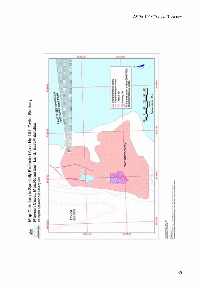
89
ASPA 101: TAYLOR ROOKERY

II. MEASURES
MEASURE 2 - ANNEX B
91
Management Plan for Antarctic Specially Protected Area No. 102
ROOKERY ISLANDS, HOLME BAY, MAC ROBERTSON LAND
Introduction
The Rookery Islands (67°36’36.7" S, 62°32’06.7" E, Map A) were originally designated as SpeciallyProtected Area No. 2, in accordance with the Agreed Measures for the Conservation of AntarcticFauna and Flora, through Recommendation IV-II (1966), after a proposal by Australia.
The Area was originally designated on the grounds that the Rookery Islands contain breedingcolonies of all six bird species resident in the Mawson area, two of which, the southern giant petrel(Macronectes giganteus) and the Cape petrel (Daption capensis), occur nowhere else in the region,and that it is of scientific importance to safeguard this unusual assemblage of six species and topreserve a sample of the habitat.
A revised description and management plan for the Area was adopted by Recommendation XVII-2(1992) to accord with the revised format for Area Descriptions and Management Plans of Article 5 ofAnnex V to the Protocol on Environmental Protection to the Antarctic Treaty, adopted underRecommendation XVI-10 (1991). In accordance with Resolution XX-5 (1996) the site was redesignatedand renumbered as Antarctic Specially Protected Area (ASPA) No. 102.
This revised Management Plan reaffirms the scientific values of the original designation.
1. Description of Values to be Protected
The Rookery Islands are a group of small islands and rocks in the western part of Holme Bay, lying tothe north of the Masson and David Ranges in Mac. Robertson Land, East Antarctica, at 67°36’36.7" Sand 62°32’06.7" E.
The Rookery Islands contain breeding colonies of six bird species resident in the Mawson area:Adélie penguin (Pygoscelis adeliae), Cape petrel (Daption capense), snow petrel (Pagodroma nivea),southern giant petrel (Macronectes giganteus), Wilson’s storm petrel (Oceanites oceanicus) and theAntarctic skua (Catharacta maccormicki). The southern giant petrel breeds nowhere else in theregion. The designation of the Area aims to safeguard this unusual association of six species andensure the preservation of a representative offshore island habitat (Map B).
The Rookery Islands provide a representative sample of the offshore island habitats occurring alongthe coast of Mac. Robertson land.
The southern giant petrel (Macronectes giganteus) has a world population of approximately 62,000individuals and is inferred to have sustained a population reduction of at least 20% over the last 60years. The species is in continued rapid decline. Giganteus Island in the Rookery Islands group isone of only four known breeding localities of southern giant petrels around the coastline of continentalAntarctica. The other three continental breeding colonies are located near the Australian stations ofCasey (66°13’S 110°11’E), (Frazier Islands) and Davis (68º35’S, 77º58’E) (Hawker Island), and near theFrench station Dumont d’Urville (66º40’S, 140º01’E) in Terre Adélie. The current population forcontinental Antarctica is estimated at approximately 290 pairs, comprised of 3 pairs on Giganteus
II. MEASURES
92
Island, 25 pairs on Hawker Island, 16 pairs at Pointe Géologie archipelago (Terre Adélie) and 248 pairson the Frazier Islands. Southern giant petrels on the Antarctic continent comprise less than 1% of theglobal breeding population.
Southern giant petrels are widespread in more northerly latitudes, breeding on islands to the north-west of the Antarctic Peninsula and on islands of the Scotia Ridge. However, it is important that itshould be protected at the southern limit of its breeding range.
2. Aims and Objectives
Management of the Rookery Islands aims to:
• avoid degradation of, or substantial risk to, the values of the Area by preventing unnecessaryhuman disturbance to the Area;
• allow scientific research on the ecosystem and physical environment, particularly on theavifauna, provided it is for compelling reasons which cannot be served elsewhere;
• minimise the possibility of introduction of pathogens which may cause disease in birdpopulations within the Area;
• minimise the possibility of introduction of alien plants, animals and microbes to the Area;• minimise human disturbance to southern giant petrels on Giganteus Island to assist
stabilisation and recovery of the population;• conserve Giganteus Island as a reference area for future comparative studies with other
breeding populations of southern giant petrels;• preserve the Giganteus Island, henceforth, as a highly restricted area by limiting human
visitation to the island during the southern giant petrel breeding season;• gather data on the population status of the bird species on a regular basis; and on a restricted
basis for southern giant petrels; and• allow visits for management purposes in support of the aims of the management plan.
3. Management Activities
The following management activities shall be undertaken to protect the values of the Area:
• information on the location of the Area (stating special restrictions that apply) shall bedisplayed prominently, and a copy of this Management Plan shall be kept available, atadjacent operational research/field stations and will be provided to ships visiting the vicinity;
• markers, signs or structures erected within the Area for scientific or management purposesshall be secured and maintained in good condition and removed when no longer required;
• abandoned equipment or materials shall be removed to the maximum extent possible provideddoing so does not adversely impact on the values of the Area;
• the Area shall be visited as necessary, and no less than once every five years to assesswhether it continues to serve the purposes for which it was designated and to ensure thatmanagement activities are adequate;
• one research visit shall be allowed to Giganteus Island in each 5 year period, to enablecensus and monitoring of breeding populations. These visits are to be conducted by twopeople, one of whom should be a bird biologist associated with an approved nationalprogram(s) or who has had previous field experience with southern giant petrels;

ASPA 102: ROOKERY ISLANDS
93
• clothing, particularly footwear, and field equipment shall be appropriately cleaned beforeentering the Area; and
• the Management Plan shall be reviewed at least every five years.
4. Period of Designation
Designation is for an indefinite period.
5. Maps
• Map A: East Antartica, Mac. Robertson Land, showing the location of the Rookery IslandsAntarctic Specially Protected Area No 102, and protected areas within the region. The insetmap indicates the location in relation to the Antarctic continent.Map specifications: Projection: UTM Zone 49; Horizontal Datum: WGS84
• Map B: East Antartica, Mac. Robertson Land, Rookery Islands Antarctic Specially ProtectedArea No 102. Distribution of nesting seabirds on the Rookery IslandsMap Specifications: Projection: UTM Zone 49; Horizontal Datum: WGS84
• Map C: East Antartica, Mac. Robertson Land, Rookery Islands Antarctic Specially ProtectedArea No 102. Distribution of nesting seabirds on Giganteus Island.Map Specifications: Projection: UTM Zone 49; Horizontal Datum: WGS84
6. Description of the Area
6(i) Geographical co-ordinates, boundary markers and natural features
The Rookery Islands are a small group of approximately 75 small islands and rocks in the south-westpart of Holme Bay, Mac. Robertson Land, about 10 km to the west of the Australian station Mawson.The Area comprises the rocks and islands lying within a rectangle enclosed by following coordinates:
1 62°28’01"E 67°33’45"S
2 62°34’37"E 67°33’47"S
3 62°28’02"E 67°38’10"S
4 62°34’39"E 67°38’11"S
The general location of the Area is latitude 67°37’00.1"S, longitude 62°33’00.0"E, this is the midpointof the area and is approximately 10 kilometres from Mawson station. There are no boundary markersdelimiting the site.
Rookery Islands range in size from small rocks which barely remain above water at high tide to thelarger members of the group which include Giganteus Island (approximately 400 m long, 400 m wideand 30 m high) and Rookery Island, the highest of the group, with an altitude of 62 m, and of similararea, but slightly more elongate. Raised beaches are evident on Giganteus Island.
II. MEASURES
94
Geology and soils
The Rookery Islands are outcrops of the Mawson charnockite, a rock type which occurs over an areaof at least 2000 square kilometres along the coast of Mac. Robertson Land. The charnockites of theRookery Islands are the fine grained variant and are comparatively poor in the mineral hypersthenebut rich in garnet and biotite. The charnockites enclose abundant bands and lenses of hornfels,garnetiferous quartz and felspar-rich gneisses. There are also a number of pegmatic dykes which cutacross the charnockite rocks.
Climate
Limited data exist for the meteorology of the Area. Conditions are probably similar to those of theMawson station area where the mean monthly temperature ranges from +0.1°C in January to -18.8°Cin August, with extreme temperatures ranging from +10.6°C to -36.0°C. The mean annual wind speedis 10.9 m per second with frequent prolonged periods of strong south-easterly katabatic winds fromthe ice cap at mean speeds over 25 m per second and gusts often exceeding 50 m per second. Meanwind speed decreases seaward with distance from the icecap, but is unlikely to be much lower at theRookery Islands which lie quite close to the coast. Other general characteristics of the coastalAntarctic climate to which these islands are likely to be subjected are high cloudiness throughoutthe year, very low absolute humidity, low precipitation and frequent periods of intensified winds,drifting snow and low visibility associated with the passage of major low pressure systems.
Vegetation
No mosses or lichens have been located on any of the Rookery Islands. There are some terrestrialalgae but no taxonomic identifications made. Most of the smaller islands and rocks are covered withsea spray in winter and are sometimes scoured by rafted sea ice in winter and spring. It is consideredunlikely that species of moss or lichen could become established.
Inland waters
There are no freshwater bodies on the Rookery Islands.
Birds
Six species of birds breed on the Rookery Islands: Adelie penguin (Pygoscelis adeliae), Cape petrel(Dation capensis), snow petrel (Pagodroma nivea), southern giant petrel (Macronectes giganteus),Wilson’s storm petrel (Oceanites oceanicus) and the south polar skua (Catharacta maccormicki).
The giant petrels nest on Giganteus Island (Map C) but the colony is marginal and in danger ofextinction. A total of 16 incubating birds were recorded in 1958 and 13 in 1967. However, only twonests were present in 1972, 4 in 1973, 2 in 1977, 1 in 1981, and 2 in 1982. There were 3 pairs in 2001. Thenests of shallow mounds of stones are built on broad gravel patches on the raised beaches. The areahas many old nests and several appear to be rebuilt each year but there is no evidence that theycontained eggs.
Cape petrels bred on Rookery Island, a small island known as Pintado Island and located 300 m north-west of Giganteus Island, and on another small island just to the south of Pintado Island. The numberof breeding pairs on each island is very small with 7 nests on Rookery Island, 12 nests on PintadoIsland in 1958. No counts of nests with eggs have been made since 1958, although the numbers ofadults present recorded subsequently are 69 in 1977, 48 in 1981, and 28 in 1982.
ASPA 102: ROOKERY ISLANDS
95
Snow petrels nest on Giganteus Island and are believed to breed on Rookery Island. The Wilson’sstorm petrel is frequently seen flying around the islands and is thought to breed on a number of thelarger islands in the group, although no nests have been recorded.
Adelie penguins breed on 13 of the islands. The largest populations occur on Giganteus Island,where 4850 pairs were counted in December 1971, and on Rookery Island. A total of 33,000 adultswere present on 10 of the islands on 17 December 1972. The number of nests was not determined.
The Cape petrel is also a rare breeding species in these islands although it is not rare in the region.Larger breeding colonies occur along the rock outcrops near Forbes Glacier 8 km to the west, and onScullen and Murray Monoliths 100 km to the east.
6(ii) Restricted Zones within the Area
Giganteus Island is a restricted zone to afford high level of protection to southern giant petrels. Entryis restricted and may only be permitted under conditions contained elsewhere in this managementplan.
6(iii) Location of Structures within the Area
There are no structures within or adjacent to the Area and none are to be erected.
6(iv) Location of other Protected Areas in close proximity
Antarctic Specially Protected Area No. 101 Taylor Rookery, Mac. Robertson Land, East Antarctica,(67°26’S; 60°50’E) is located approximately 80 kilometres to the west.
7. Permit Conditions
Entry into the Area is prohibited except in accordance with a Permit issued by an appropriate nationalauthority. Entry to Giganteus Island is not permitted at any time unless in accordance with conditionsoutlined below. National Antarctic Programs operating in the region shall consult with each other toensure that the frequency of visits does not exceed that permitted in the Management Plan. Conditionsfor issuing a Permit to enter the Area are that:
• it is issued only for compelling scientific reasons that cannot be served elsewhere, in particularfor scientific study of the avifauna and ecosystem of the Area, or for essential managementpurposes consistent with plan objectives such as inspection, maintenance or review;
• the actions permitted will not jeopardise the values of the Area;• any management activities are in support of the objectives of the management plan;• the actions permitted are in accordance with the management plan;• the Permit, or an authorised copy, shall be carried within the Area;• a visit report shall be supplied to the authority named in the Permit;• permits shall be issued for a stated period;• the appropriate authority should be notified of any activities/measures undertaken that
were not included in the authorised Permit.
II. MEASURES
96
Additional conditions in relation to Giganteus Island Restricted Zone:
a. Permits to enter may be issued for the non-breeding period for southern giant petrels,specifically from 1 May to 30 September.
b. During any 5 year period, only one Permit may be issued for the southern giant petrelbreeding period (1 October to 30 April), for the purpose of conducting a southern giantpetrel census. The Permit issuing authority is to refer to the provision under the fifth dotpoint of section 3 of this management plan when issuing a Permit.
c. Censuses are to be conducted from outside the southern giant petrel colony whereverpracticable. In most cases there are vantage points from where the nesting birds may becounted.
d. The maximum time to be spent on Giganteus Island is 6 hours in total; however this maycomprise several visits to the islands.
e. Only the two persons named in the Permit may be ashore within the Area at any time. Thevehicle operator and others should remain at the shoreline.
7(i) Access to, and movement within or over the Area
Within the Area travel may be by oversnow vehicles (depending on sea ice conditions). Visitors mustensure that vehicles are taken no closer than 250 metres from concentrations of birds. Vehicles areprohibited on the islands, and must be left at the shoreline. Movement on the islands is by foot only.
Access to Giganteus Island is prohibited except for the purpose of monitoring the southern giantpetrels or for activities which may be conducted without threat to their population status. As thebreeding colony is close to the point of local extinction and the birds are easily disturbed, the numberof persons granted entry for this purpose must be strictly limited and include an experiencedornithologist.
Persons shall not approach closer than is necessary to obtain census data or biological data fromany nesting southern giant petrels, and in no case closer than 20m.
As aircraft may provide the only viable access to the islands, and as the islands are small in size,aircraft may land within 500 metres of breeding colonies except those of southern giant petrels onGiganteus Island, where landing during the southern giant petrel season is prohibited. Overflight ofthe islands is prohibited except where essential for scientific purposes. Such overflight is to be at analtitude of no less than 610 metres. Permission to land an aircraft may be granted for essentialscientific purposes only if it can be demonstrated that disturbance will be minimal.
Aircraft may be used subject to the following conditions which apply to Giganteus Island:
• aircraft operations within 2500ft (750m) horizontally and vertically of the islands for singleengine aircraft and 5000ft (1500m) horizontally and vertically for double-engine aircraft, areprohibited during the breeding season for Southern Giant Petrels (1 October to 30 April).
• aircraft (including helicopter) overflights for aerial photography within the distances specifiedabove are allowed at intervals of 5 years, consistent with guidelines to reduce disturbance.
• No refuelling is permitted within the Area.
7(ii) Activities which are, or may be conducted within the Area, including restrictions on time andplace
The following activities may be conducted within the Area as authorised in a Permit:
ASPA 102: ROOKERY ISLANDS
97
• scientific research consistent with the Management Plan for the Area that will not jeopardisethe values for which the Area has been designated or the ecosystems of the Area;
• compelling management activities, including monitoring; and• sampling, which should be the minimum required for approved research programs.
7(iii) Installation, modification, or removal of structures
• Structures shall not be erected within the Area except as specified in a Permit and permanentstructures or installations are prohibited.
• Small temporary refuges, hides, blinds or screens may be constructed for the purpose ofscientific study of the avifauna.
• Installation (including site selection), removal, modification or maintenance of structuresshall be undertaken in a manner that minimises disturbance to breeding birds.
• All scientific equipment or markers installed within the Area must be clearly identified bycountry, name of the principal investigator and year of installation. All such items should bemade of materials that pose minimal risk of harm to bird populations or of contamination ofthe Area. Permits will require the removal of specific structures, equipment or markers beforethe permit expiry date.
7(iv) Location of field camps
• Camping is prohibited in the Rookery Islands ASPA except in an emergency.
7(v) Restrictions on materials and organisms that may be brought into the Area
• No poultry products, including dried food containing egg powder, are to be taken into theArea.
• No depots of food or other supplies are to be left within the Area beyond the season forwhich they are required.
• No living animals, plant material or microorganisms shall be deliberately introduced into theArea and precautions shall be taken against accidental introductions.
• No herbicides or pesticides shall be brought into the Area. Any other chemicals, includingradio-nuclides or stable isotopes, which may be introduced for scientific or managementpurposes specified in a Permit, shall be removed from the Area at or before the conclusion ofthe activity for which the Permit was granted.
• Fuel is not to be stored in the Area unless required for essential purposes connected withthe activity for which the Permit has been granted. Permanent fuel depots are not permitted.
• All material introduced shall be for a stated period only, shall be removed at or before theconclusion of that stated period, and shall be stored and handled so that risk of introductionto the environment is minimized.
7(vi) Taking of, or harmful interference with, native flora and fauna
• Taking of, or harmful interference with, native flora and fauna is prohibited, except inaccordance with a Permit. Where taking or harmful interference with animals is involved thisshould, as a minimum standard, be in accordance with the SCAR Code of Conduct for theUse of Animals for Scientific Purposes in Antarctica.
• Disturbance of southern giant petrels should be avoided at all times.
II. MEASURES
98
7(vii) Collection or removal of anything not brought into the Area by the Permit holder
• Material may only be collected or removed from the Area as authorised in a Permit andshould be limited to the minimum necessary to meet scientific or management needs.
• Material of human origin likely to compromise the values of the Area, which was not broughtinto the Area by the Permit holder or otherwise authorised, may be removed unless theimpact of the removal is likely to be greater than leaving the material in situ. If such materialis found the appropriate Authority must be notified.
7(viii) Disposal of waste
• No wastes, including human wastes, are to be deposited or left in the Area.
7(ix) Measures that may be necessary to ensure that the aims and objectives of the managementplan continue to be met
• Permits may be granted to enter the Area to carry out biological monitoring and Areainspection activities, which may involve the collection of samples for analysis or review; theerection or maintenance of scientific equipment and structures, and signposts; or for otherprotective measures.
• Any specific sites of long-term monitoring shall be appropriately marked and a GPS positionobtained for lodgement with the Antarctic Data Directory System through the appropriatenational authority.
• Ornithological research shall be limited to activities that are non-invasive and non-disruptiveto the breeding seabirds present within the Area. Surveys, including aerial photographs forthe purposes of population census, shall have a high priority.
• To help maintain the ecological and scientific values of the Area, visitors shall take specialprecautions against introductions of non-indigenous organisms. Of particular concern arepathogenic, microbial or vegetation introductions sourced from soils, flora and fauna atother Antarctic sites, including research stations, or from regions outside Antarctica. Tominimise the risk of introductions, before entering the Area visitors shall thoroughly cleanfootwear and any equipment, particularly sampling equipment and markers to be used in theArea.
• A census of southern giant petrels on Giganteus Island should be conducted in each 5 yearperiod. Censuses of other species may be undertaken during this visit provided no additionaldisturbance is caused to the southern giant petrels.
• The maximum length of time to be spent at Giganteus Island to conduct a bird census is 6hours in total.
• Novel GPS data shall be obtained for specific sites of long-term monitoring for lodgementwith the Antarctic Data Directory System through the appropriate national authority.
• On Giganteus Island, to reduce disturbance to wildlife, noise levels including verbalcommunication is to be kept to a minimum. The use of motor-driven tools and any otheractivity likely to generate noise and thereby cause disturbance to nesting birds is prohibitedwithin the Area during the breeding period for southern giant petrels (1 October to 30 April).
7(x) Requirements for reports
Parties should ensure that the principal Permit Holder for each permit issued submits to the appropriatenational authority a report on activities undertaken. Such reports should include, as appropriate, the
ASPA 102: ROOKERY ISLANDS
99
information identified in the Visit Report form suggested by SCAR. Parties should maintain a recordof such activities and, in the Annual Exchange of Information, and should provide summarydescriptions of activities conducted by persons subject to their jurisdiction, which should be insufficient detail to allow evaluation of the effectiveness of the Management Plan.
Parties should, wherever possible, deposit originals or copies of such original reports in a publiclyaccessible archive to maintain a record of usage, to be considered in any review of the ManagementPlan and in organising the use of the Area. A copy of the report should be forwarded to the Partyresponsible for development of the Management Plan (Australia) to assist in management of theArea, and the monitoring of bird populations. Visit reports should provide detailed information oncensus data, locations of any new colonies or nests not previously recorded, a brief summary ofresearch findings and copies of photographs taken of the Area.
7(xi) Emergency provision
Exceptions to restrictions outlined in the management plan are in emergency as specified in Article 11of Annex V to the Protocol on Environmental Protection to the Antarctic Treaty (the Madrid Protocol).
8. Supporting Documentation
Australian Antarctic Division: Environmental Code of Conduct for Australian Field Activities,Environmental Management and Audit Unit, Australian Antarctic Division.
Cowan, A.N. (1981): Size variation in the snow petrel. Notornis 28: 169-188.
Cowan, A.N. (1979): Giant Petrels at Casey. Australian Bird Watcher 8: 66-67.
Crohn, P.W. (1959): A contribution to the geology and glaciology of the western part of the AustralianAntarctic Territory. Bull. Bur. Miner. Resour. Geol. Geophys. Aust. No. 52.
Croxall, J.P., Steele, W.K., McInnes, S.J., Prince, P.A. (1995): Breeding Distribution of the SnowPetrel Pagodroma nivea. Marine Ornithology 23: 69-99.
Environment Australia (2001): Recovery Plan for Albatrosses and Giant Petrels. Prepared by WildlifeScientific Advice, Natural Heritage Division in consultation with the Albatross and Giant PetrelRecovery Team, Canberra.
Garnett, S.T., Crowley, G.M. (2000): The Action Plan for Australian Birds 2000. Commonwealth ofAustralia, Environment Australia, Canberra
Horne, R.S.C. (1983): The distribution of penguin breeding colonies on the Australian AntarcticTerritory, Heard Island, the McDonald Island, and Macquarie Island. ANARE Res. Notes, No. 9.
Kizaki, K. (1972): Sequence of metamorphism and deformation in the Mawson Charnockite of EastAntarctica. In Antarctic Geology and Geophysics (ed. R.J. Adie), pp. 527-530. Oslo: Universitetsforlaget,
Ingham, S.E. (1959): Banding of Giant Petrels by the Australian National Antarctic ResearchExpeditions, 1955-58. Emu 59: 189-200.
Jouventin, P., Weimerskirch, H. (1991): Changes in the population size and demography of southernseabirds: management implications. In: Perrins, C.M., Lebreton, J.-D. and Hirons, G.J.M. Birdpopulation studies: Relevance to conservation and management. Oxford University Press: 297-314.
Orton, M.N. (1963): Movements of young Giant Petrels bred in Antarctica. Emu 63: 260.
II. MEASURES
100
Patterson D.L., Woehler, E.J., Croxall, J.P., Cooper, J., Poncet, S., Fraser, W.R. (in press): Breedingdistribution and population status of the Northern Giant Petrel Macronectes halli and the SouthernGiant Petrel M. giganteus. Marine Ornithology.
Sheraton, J.W. (1982): Origin of charnockitic rock of Mac. Robertson Land. In: Antarctic Geoscience(ed. C.C. Craddock), pp. 487-489.
Stattersfield, A.J., Capper, D.R. (2000): Threatened Birds of the World. Birdlife International, LynxPublications.
Trail, D.S. (1970): ANARE 1961 Geological traverses on the Mac. Robertson and Kemp Land Coast.Rept. Bur. Miner. Resour. Geol. Geophys. Aust. No 135.
Trail, D.S., McLeod, I.R., Cook, P.J. & Wallis, G.R. (1967): Geological investigations by the AustralianNational Antarctic Research Expeditions 1965. Rept. Bur. Miner. Resour. Geol. Geophys. Aust. No.118.
van Franeker, J.A., Gavrilo, M., Mehlum, F., Veit, R.R., Woehler, E.J. (1999): Distribution andAbundance of the Antarctic Petrel. Waterbirds 22: 14-28.
Woehler E.J., Croxall J.P. (1997): The status and trends of Antarctic and subantarctic seabirds.Marine Ornithology 25: 43-66.
Woehler, E.J., Johnstone, G.W. (1991): Status and Conservation of the Seabirds of the AustralianAntarctic Territory. In: Croxall, J.P. (ed.) Seabird Status and Conservation: A Supplement. ICBPTechnical Publication No.11: 279-308.
Woehler, E.J., Riddle, M.J. (2001): Long-term population trends in Southern Giant Petrels in theSouthern Indian Ocean. Poster presented at 8th SCAR Biology Symposium, Amsterdam.
Woehler, E.J., Riddle, M.J., Ribic, C.A. (2001): Long-term population trends in Southern GiantPetrels in East Antarctica. Proceedings 8th SCAR Biology Symposium, Amsterdam.
Woehler, E.J., Slip, D.J., Robertson, L.M., Fullagar, P.J., Burton, H.R. (1991): The distribution,abundance and status of Adélie Penguins Pygoscelis adeliae at the Windmill Islands, Wilkes Land,Antarctica. Marine Ornithology 19(1): 1-17.
Woehler, E.J., Cooper, J., Croxall, J.P., Fraser, W.R., Kooyman, G.L., Miller, G.D., Nel, D.C., Patterson,D.L., Peter, H-U, Ribic, C.A., Salwicka, K., Trivelpiece, W.Z., Wiemerskirch, H. (2001): A StatisticalAssessment of the Status and Trends of Antarctic and Subantarctic Seabirds. SCAR/CCAMLR/NSF, 43.
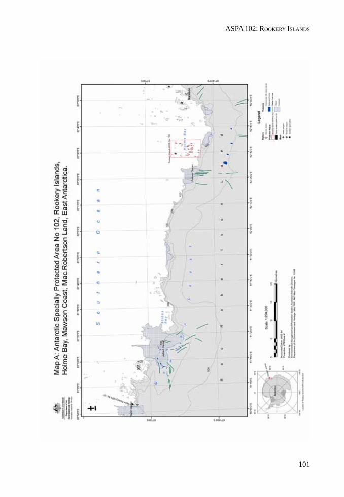
ASPA 102: ROOKERY ISLANDS
101
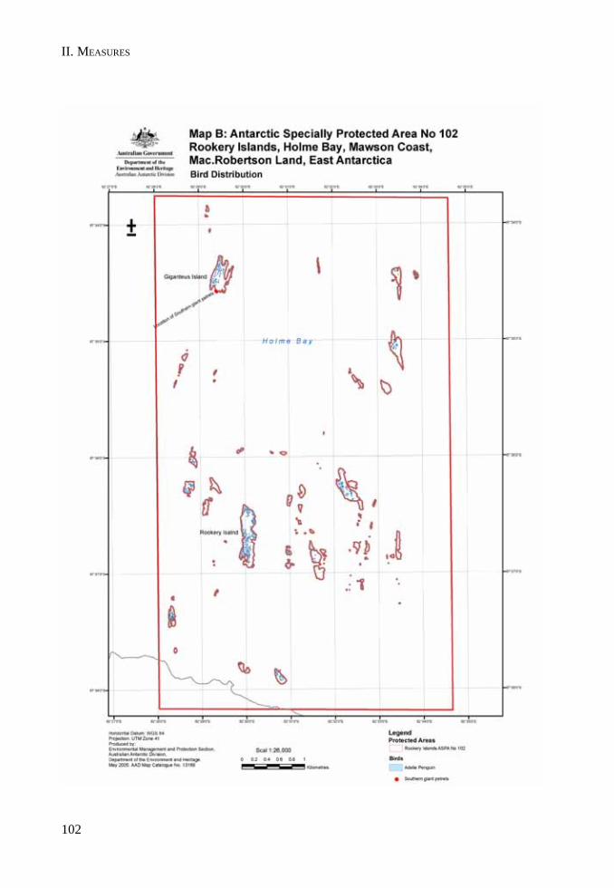
II. MEASURES
102
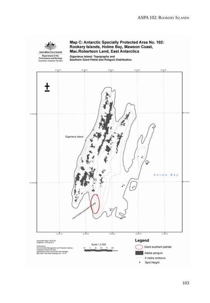
ASPA 102: ROOKERY ISLANDS
103

II. MEASURES

MEASURE 2 - ANNEX C
105
Management Plan for Antarctic Specially Protected Area No. 103
ARDERY ISLAND AND ODBERT ISLAND, BUDD COAST
Introduction
Ardery Island and Odbert Island (66°22’S, 110°28’E and 66°22’S, 110°33’E, Map A) were originallydesignated as Specially Protected Area (SPA) No. 3 in accordance with the Agreed Measures for theConservation of Antarctic Fauna and Flora, through Recommendation IV-III (1966), after a proposalby Australia.
The Area was designated on the grounds that the islands support several breeding species of petreland provide an example of their habitat and that of the Antarctic Petrel (Thalassoica antarctica) andthe Southern Fulmar (Fulmarus glacialoides), both of particular scientific interest.
A revised description and management plan for the Area was adopted by Recommendation XVII-2(1992) to accord with the format for Area Descriptions and Management Plans of Article 5 of AnnexV to the Protocol on Environmental Protection to the Antarctic Treaty, adopted under RecommendationXVI-10 (1991). In accordance with Resolution XX-5 (1996) the site was redesignated and renumberedas Antarctic Specially Protected Area (ASPA) No. 103.
This revised Management Plan reaffirms the scientific values of the original designation.
1. Description of Values to be Protected
Ardery Island and Odbert Island (Map B and C) support several breeding species of petrel. There isno other readily accessible place in eastern Antarctica where the four genera of fulmarine petrels(Thalassoica antarctica, Fulmarus glacialoides, Daption capense and Pagodroma nivea) breed inthe same place in sufficient numbers to allow comparative study. Study of these four genera at onelocation is of high ecological importance in understanding and monitoring the Southern Oceanecosystem.
It is believed that Ardery Island is unique insofar as it is the only area in the Antarctic which harbourstwo different subspecies of snow petrels. Studies on morphological or ecological differences betweenthese two subspecies are not possible anywhere else. In addition both islands have breedingpopulations of Wilson’s storm petrels (Oceanites oceanicus) and Antarctic skuas (Catharactamaccormicki) and Odbert Island supports breeding populations of Adélie penguins (Pygoscelisadeliae).
2. Aims and Objectives
Management of the Ardery Island and Odbert Islands ASPA aims to:
• avoid degradation of, or substantial risk to, the values of the Area by preventing unnecessaryhuman disturbance;
• allow scientific research on the ecosystem and physical environment, particularly on theavifauna, provided it is for compelling reasons which cannot be served elsewhere;

II. MEASURES
106
• minimise the possibility of introduction of pathogens which may cause disease in birdpopulations within the Area;
• minimise the possibility of introduction of alien plants, animals and microbes to the Area;• gather data on the population status of the bird species on a regular basis;• allow visits for management purposes in support of the aims of the management plan.
3. Management Activities
The following management activities shall be undertaken to protect the values of the Area:
• signs illustrating the location and boundary of the Area, with clear statements of entryrestrictions, shall be placed at appropriate locations on the boundary of the Area to helpavoid inadvertent entry;
• information on the location of the Area (stating special restrictions that apply) shall bedisplayed prominently, and a copy of this Management Plan shall be kept available, at theadjacent Casey station and will be provided to ships visiting the vicinity;
• markers, signs or structures erected within the Area for scientific or management purposesshall be secured and maintained in good condition and removed when no longer required;
• abandoned equipment or materials shall be removed to the maximum extent possible provideddoing so does not adversely impact on the values of the Area;
• the Area shall be visited as necessary, and no less than once every five years, to assesswhether it continues to serve the purposes for which it was designated, and to ensure thatmanagement activities are adequate; and
• the Management Plan shall be reviewed at least every five years.
4. Period of Designation
Designation is for an indefinite period.
5. Maps
• Map A: East Antarctica, Wilks Land, Location of Antarctic Specially Protected Area ArderyIsland and Odbert Island, ASPA No 103. The inset map indicates the location in relation tothe Antarctic continent.Map Specifications: Projection: Lambert Conical Conformal; Horizontal Datum: WGS84;Vertical Datum: Mean Sea Level
• Map B: Antarctic Specially Protected Area, Ardery Island and Odbert Island, ASPA No 103,showing species distribution at Ardery Island.Map Specifications: Horizontal Datum: WGS84; Vertical Datum: Mean Sea Level
• Map C: Antarctic Specially Protected Area, Ardery Island and Odbert Island, ASPA No 103,showing species distribution at Odbert Island.Map Specifications: Horizontal Datum: WGS84; Vertical Datum: Mean Sea Level
• Map D: Antarctic Specially Protected Area, Ardery Island and Odbert Island, ASPA No 103,showing air and sea approach for Ardery Island and Odbert Island.
ASPA 103: ARDERY AND ODBERT ISLANDS
107
Map Specifications: Horizontal Datum: WGS84; Vertical Datum: Mean Sea Level
6. Description of the Area
6(i) Geographical co-ordinates, boundary markers and natural features
Ardery island (66°22’S, 110°28’E) and Odbert island (66°22’S, 110°33’E) are among the southernmostof the Windmill Islands, lying in the south of Vincennes Bay, off the Budd Coast of Wilkes Land,Eastern Antarctica.
Topography
Ardery Island and Odbert Island are located 5 km and 0.6 km, respectively to the west of RobinsonRidge, south of Casey station.
Odbert Island is approximately 2.5 km long and 0.5 km wide. It has a rocky coast which rises steeplyfrom the sea to a plateau. The highest point is 100 m altitude. The plateau is dissected by a series ofvalleys which run to the south from the high flat rim on the northern side. These valleys are snowcovered in winter. The hill tops remain essentially ice and snow free. In some years, the islandremains joined to Robinson Ridge on the mainland by sea ice.
Ardery Island is a steep ice free island approximately 1 km long and 0.5 km wide, with an east-westorientation. The highest point is 113 m above sea level.
The terrain on both islands is rugged and dissected by fissures. The cliffs are fractured and havenarrow exposed ledges which in summer are occupied by nesting sea birds. On the hillsides andplateau region, the exposed rock is ice-smoothed and the valley floors are covered with moraine. Theislands have undergone isostatic rebound. Moraine and solifluction debris is abundant at heights inexcess of 30 metres above mean sea level but considerably less at lower altitudes.
Geology
The Windmill Islands region represent one of the eastern most outcrops of a Mesoproterozoic low-pressure granulite facies terrain that extends west to the Bunger Hills and further to the Archaeancomplexes in Princess Elizabeth Land, to minor exposures in the east in the Dumont d’Urville area andin Commonwealth Bay. The total outcrop areas do not exceed more than a few square kilometres. TheMesoproterozoic outcrop of the Windmill Islands and the Archaean complexes of Princess ElizabethLand are two of the few major areas in East Antarctica that can be directly correlated with an Australianequivalent in a Gondwana reconstruction. The Mesoproterozoic facies terrain comprise a series ofmigmatitic metapelites and metapsammites interlayered with mafic to ultramafic and felsic sequenceswith rare calc-silicates, large partial melt bodies (Windmill Island supacrustals), undeformed granite,charnockite, gabbro, pegmatite, aplites and cut by easterly-trending late dolerite dykes.
Ardery Island and Odbert Island are part of the southern gradation of a metamorphic grade transitionwhich separates the northern part of the Windmill Islands region from the southern part. Themetamorphic grade ranges from amphibolite facies, sillimanite-biotite orthoclase in the north at ClarkPeninsula, through biotite-cordierite-almandine granulite, to hornblende-orthopyroxene granulite atBrowning Peninsula in the south.
Ardery Island and Odbert Island together with Robinson Ridge, Holl Island, Peterson Island and theBrowning Peninsula are similar geologically and are composed of Ardery charnockite. Charnockitesare of granitic composition but were formed under anhydrous conditions. The Ardery Charnockite of
II. MEASURES
108
Ardery Island and Odbert Island intrudes the Windmill metamorphics and consists of a modalassemblage of quartz + plagioclase + microline + orthopyroxene + biotite + clinopyroxene hornblendewith opaques and minor zircon and apatite. An isotopic age of about 1200 million years for theArdery charnockite has been established. The charnockite is prone to deep weathering and crumblesreadily because of its mineral assemblage, whereas the metamorphic sequences of the northerly partsof the region have a much more stable mineral assemblage and crystalline structure. This differencehas a significant influence on the distribution of vegetation in the Windmill Islands region with thenorthern rock types providing a more suitable substrate for slow growing lichens.
Soils on the islands are poorly developed and consist of little more than rock flour, moraine anderoded material. Some soils contain small amounts of organic matter derived from excreta and feathersfrom the seabirds.
Glaciation
The Windmill Islands region was glaciated during the Late Pleistocene. The southern region of theWindmill Islands was deglaciated by 8000 corr. yr B.P., and the northern region, including BaileyPeninsula deglaciated by 5500 corr. yr B.P. Isostatic uplift has occurred at a rate of between 0.5 and0.6 m/100 yr, with the upper mean marine limit, featured as ice-pushed ridges, being observed atnearby Robinson Ridge at approximately 28.5 metres.
Meteorology
The climate of the Windmill Islands region is frigid-Antarctic. Conditions at Ardery Island andOdbert Island are probably similar to those of the Casey station area approximately 12 km to thenorth. Meteorological data for the period 1957 to 1983 from Casey station (altitude 32 m) on BaileyPeninsula show mean temperatures for the warmest and coldest months of 0.3 and -14.9°C, respectively,with extreme temperatures ranging from 9.2 to -41°C. Mean annual temperature for the period was –9.3°C.
The climate is dry with a mean annual snowfall of 195 mm year-1 (rainfall equivalent), precipitation asrain has been recorded in the summer. However, within the last decade the mean annual temperaturehas decreased to –9.1°C and the mean annual snowfall has increased to 230 mm year-1 (rainfallequivalent).
There is an annual average of 96 days with gale-force winds, which are predominantly easterly indirection, off the polar ice cap. Blizzards are frequent especially during winter. Snowfall is commonduring the winter, but the extremely strong winds scour the exposed areas. On most hill crests in thearea snow gathers in the lee of rock outcrops and in depressions in the substratum. Further down theslopes snow forms deeper drifts.
Biological Features
Terrestrial
The flora of Odbert Island consists of three moss species, eleven lichen species (Table 1) and anunknown number of terrestrial and freshwater algae. The most extensive development of lichens istowards the highest elevations of the southern parts of the island in an area of ice-fractured bedrock.The algae occur in tarns, soil seepage areas and soil. Stands of Prasiola and other green algae andcyanobacteria occur below snow drifts downslope from penguin colonies towards the western partof the island.
The flora of Ardery Island comprises several species of lichen similar to those found on OdbertIsland.
ASPA 103: ARDERY AND ODBERT ISLANDS
109
The only recorded invertebrates are ectoparasites of birds. Ardery Island is the type locality for theAntarctic flea Glaciopsyllus antarcticus, associate with the nests of Southern fulmars.
MOSSESBryum pseudotriquetrum (Hedw.) Gaertn., Meyer & Scherb.
Ceratodon purpureus (Hedw.) Brid.
Schistidium antarcticum (= Grimmia antarctici) (Card.) L.I.Savicz & Smirnova
LICHENSBuellia frigida (Darb.)
Buellia soredians Filson
Buellia sp.Caloplaca athallina Darb.
Caloplaca citrina (Hoffm.) Th. Fr.
Candelariella flava (C.W.Dodge & Baker) Castello & Nimis
Rhizoplaca melanophthalma (Ram.) Leuck. et Poelt
Rinodina olivaceobrunnea Dodge & Baker
Umbilicaria decussata (Vill.) Zahlbr.
Xanthoria mawsonii Dodge.
Usnea antarctica Du Rietz
ALGAEPrasiola crispa (Lightfoot) Kützing
Prasiococcus sp.
Table 1. List of mosses, lichens and algae recorded from Odbert Island.
Lakes
Cold monomictic lakes and ponds occur throughout the Windmill Islands region in bedrockdepressions and are usually ice-free during January and February. Nutrient rich lakes are found nearthe coast in close proximity to penguin colonies or abandoned colonies. Sterile lakes are locatedfurther inland and are fed by meltwater and local precipitation. On Ardery Island and Odbert Islandthere are a number of small tarns which are frozen in winter and filled with melt water in summer. Manyof the tarns are ephemeral, drying out towards the end of summer. Other tarns located below snowbanks are fed continuously by melt water.
Birds and Seals
Odbert island supports breeding populations of Adélie penguins (Pygoscelis adeliae), Cape petrels(Daption capensis), snow petrels (Pagodroma nivea), Southern fulmars (Fulmarus glacialoides),Wilson’s storm petrels (Oceanites oceanicus), and south polar skuas (Catharacta maccormicki).Ardery island supports a similar population of the same species except for Adélie penguins. TheGiant petrel (Macronectes giganteus) which breed on the Frazier Islands approximately 23 km to thenorth-west is the only species breeding in the Windmill Islands which does not breed in eitherArdery Island and Odbert Island.
No seals are found on Ardery Island and Odbert Island although Weddell seals (Leptonychotesweddellii) are frequently observed on the sea ice around them. The main pupping area is about 3 kmto the south-east between Herring Island and the Antarctic mainland. In this area disturbance of thesea ice caused by movement of the Peterson Glacier ensures open water and easy access to food.About 100 pups are born annually in the region. Elephant seals (Mirounga leonina) haul out a little
II. MEASURES
110
farther to the south on Petersen Island and on the Browning Peninsula. The numbers of these seals,which are mostly mature males, have been increasing with up to 100 seen annually. A few femaleshave been observed.
Adélie Penguin (Pygoscelis adeliae)
Two large colonies of Adélie Penguins are present on Odbert Island. In 1985 an estimate of between5,000 and 10,000 breeding pairs was made for the two colonies on the Island. Eggs start to be laidbefore the middle of November, the first chicks hatch around mid-December, and juveniles commenceleaving the colony in early February. Although Adélie Penguins regularly come ashore on ArderyIsland, none nest there.
Southern Fulmar (Fulmarus glacialoides)
The total population of Southern Fulmars in the Area is estimated at about 5000 breeding pairs. Thereare approximately 3000 occupied Southern Fulmar sites on Ardery Island, the largest colonies beinglocated on the northern cliffs and around the eastern tip of the island. On Odbert Island most of the2000 sites are concentrated in two large colonies on Haun Bluff and in the central north.
Southern Fulmars breed colonially on or near the cliffs and ravines. Nests were situated on small cliffledges but also on large nearly flat terraces, some birds nest in the open, others in deep crevices orbetween loose rocks. First eggs appear at the beginning of December and most are laid within thenext 10 days. Hatching commences in the third week of January and chicks fledge by mid-March.
Antarctic Petrel (Thalassoica antarctica)
On Ardery Island about 275 apparently occupied Antarctic Petrel nest sites have been located. Thelargest colony, on Northern Plateau, contains at least 150 sites in the main area and some 25 sites insmaller groups around. On Odbert Island 34 nests are located in a small area off the central northerncliffs. The total population has been estimated at just over 300 breeding pairs.
Most nests of Antarctic Petrels are situated on plateau-like areas or gently sloping sections of steepcliffs on the Northern Plateau, and smaller colonies around Soucek Ravine. Nests are situated veryclose together; isolated nesting on small ledges appears to be avoided. In late November the firstAntarctic Petrels return from their pre-laying exodus and within the following week most birds havereturned to lay their eggs. First hatchlings appear in the second week of January, fledging commencesin late February to early March, and all chicks have left before the middle of March.
Cape Petrel (Daption capense)
Approximately 600 Cape Petrel occupied sites have been located on Ardery Island, mostly in smallcolonies on the northern cliffs. Scattered nests are present on both sides of Snowie Mountain. Thereare approximately 100 to 200 nesting sites on Odbert Island mostly located around the Fulmar colonies.The total population of the Cape Petrel in the Area is estimated at about 750 breeding pairs.
Cape Petrels prefer nesting sites sheltered by slightly overhanging rocks and substantial cover fromthe back and if possible the sides. Most nests were found in less steep parts of cliffs or along the topedges of cliffs both in colonies and small scattered groups. After returning from the pre-layingexodus, eggs start to be laid late in November, and hatching commences in the second week ofJanuary. Most chicks have fledged by the first week of March.
ASPA 103: ARDERY AND ODBERT ISLANDS
111
Snow Petrel (Pagodroma nivea)
The total population of Snow Petrels in the Area is estimated at over 1,100 breeding pairs. Anestimated 1000 Snow petrel nesting sites were located on Ardery Island in 1990, mostly on the slopesof Snowie Mountain. Snow Petrels appear to be less abundant on Odbert Island than on Ardery withan estimate of between 100 and 1000 nesting sites. In 2003 an estimate of 752 active nests was madefor Ardery Island and 824 for Odbert Island.
The Snow Petrels breed in crevices or in holes between loose rocks. Although the level of protectionof nests varies considerably, these specific requirements prevent colonial nesting in many cases.Isolated nests may be found anywhere, and within colonies of other species. Suitable Snow Petrelhabitat also harbours colonies of Wilson’s Storm Petrels. Egg laying varies between concentrationsof nests, with laying occurring within the first three weeks of December, and chicks hatching from themiddle of January onwards. All are fledged in the first two weeks of March.
Wilson’s Storm Petrel (Oceanites oceanicus)
Wilson’s Storm Petrels are widely distributed, and nest in all suitable rocky areas within the Area. Anestimated 1000 nesting sites have been documented for Ardery Island. The population for OdbertIsland has been estimated at between 1000 and 2000 pairs, at a lower density than that of Arderyisland because of the general spread of suitable rock nesting areas.
Wilson’s Storm Petrels breed in deep, narrow holes. First eggs are usually observed commencing thethird week of December.
South Polar Skua (Catharacta maccormicki)
In 1984/85, ten pairs of South Polar Skua bred on Ardery Island and possibly three more pairs heldterritories. A similar number was present in 1986/87, although only seven pairs produced eggs.Odbert Island probably had between 10 and 20 pairs. The distribution of South Polar Skua nests onArdery Island reflects their dependence on petrels. Most pairs have observation points close topetrel nests, from which they can observe their food territory on the bird cliffs. On Odbert Islandmost nests were near the penguin rookeries.
Nests are shallow hollows in gravel, either fully in the open on flat ground or slightly protected bysurrounding rocks. Territories and nest locations appear to be stable from year to year; near a nestthere are usually several depressions of previous nests. Egg laying dates vary considerably, thoughmost are concentrated around late November to early December. The first chicks are observed in thelast days of December, and juveniles begin to fly by mid February.
Non-breeding bird species
Emperor Penguins (Aptenodytes forsteri) do not breed in the Casey area but straggling birds havebeen observed near Casey station and even far inland. A Chinstrap Penguin (Pygoscelis antarctica)was observed in January 1987 in the Adélie Penguin rookery on Whitney Point, north of Casey.Southern Giant Petrels (Macronectes giganteus), both adults and immatures, are regular visitors toArdery Island. In favourable winds they fly along the bird cliffs in search of food. The species breedson the Frazier Islands, 23 kilometres to the north-east. An emaciated juvenile Blue Petrel (Halobaenacaerulea) arrived at Casey in March 1987. In November 1984 an adult Dominican Gull (Larusdominicanus) was observed in the Casey area. Groups of terns, possibly Arctic Tern (Sternaparadisea), have been observed in the Casey area in 1984/ 85 and in 1986/87, when a few groups ofup to 100 birds were seen and heard high in the air in March.
II. MEASURES
112
6(ii) Restricted Zones within the Area
There are no restricted zones within the Area.
6(iii) Location of Structures within the Area
There are no permanent structures within the Area and none are to be erected.
6(iv) Location of other Protected Areas within close proximity
The following Protected Areas are located in the vicinity of Ardery Island and Odbert Island (seeMap A):
• North-east Bailey Peninsula (66°17’S, 110°32’E) (ASPA No 135) approximately 12 km northof Ardery Island and Odbert Island;
• Clark Peninsula (66°15’S, 110°36’E) (ASPA No 136), approximately 16 km north of ArderyIsland and Odbert Island;
• Frazier Islands (66°13’S 110°11’E) (ASPA No 160), approximately 23 km north-east of ArderyIsland and Odbert Island.
7. Permit conditions
Entry into the Area is prohibited except in accordance with a Permit issued by an appropriate nationalauthority. Conditions for issuing a Permit to enter the Area are that:
• it is issued only for compelling scientific reasons that cannot be served elsewhere, in particularfor scientific study of the avifauna and ecosystem of the Area, or for essential managementpurposes consistent with plan objectives such as inspection, maintenance or review;
• the actions permitted will not jeopardise the values of the Area;• any management activities are in support of the objectives of the management plan;• the actions permitted are in accordance with the management plan;• the Permit, or an authorised copy, shall be carried within the Area;• a visit report shall be supplied to the authority named in the Permit;• permits shall be issued for a stated period; and• the appropriate authority should be notified of any activities/measures undertaken that
were not included in the authorised Permit.
7(i) Access to and movement within or over the Area
Travel to the island should be by foot, over-snow vehicle or boat where possible. Over-snowvehicles used to visit the islands must be left at the shoreline and movement within the area shouldbe by foot.
Defined landing sites for access by sea and helicopter to Ardery and Odbert Islands are shown onMap D. On Ardery Island the preferred boat landing site is at Robertson Landing where there arethree rock anchors present to tie down a boat or other equipment. All three boat landing sites markedfor Ardery Island on Map D are within 200 metres of colonies of birds, however they represent theonly safe landing sites on the island and landings must be undertaken carefully so as to avoid
ASPA 103: ARDERY AND ODBERT ISLANDS
113
disturbance to the birds. There are no defined pedestrian routes within the Area, however pedestriansshould avoid disturbance of the birds at all times.
If access to the islands is not possible by sea or over sea ice, then helicopters may be used subjectto the following conditions:
• overflight of the islands should be avoided at all times, except where it is considered essentialfor scientific purposes. In these instances, overflight must be at an altitude or horizontaldistance of no less than 500 metres;
• during the breeding season of penguins and petrels, defined here as the period from 1November to 1 April, helicopter movement to the islands should be kept to a minimum;
• refuelling is not to take place within the Area;• only personnel who are required to carry out work in the Area should leave the helicopter;• the approach to Ardery Island should be at a high altitude and from a southern direction as
the lowest densities of birds are on the southern cliffs (see Maps B and D);• the approach to Odbert Island should preferably be from the south, avoiding cliff areas
because of the nesting petrels (see Map C).
7(ii) Activities which are, or may be conducted within the Area, including restrictions on time andplace
The following activities may be conducted within the Area as authorised in a Permit:
• compelling scientific research consistent with the Management Plan for the Area that willnot jeopardise the values for which the Area has been designated or the ecosystems of theArea;
• essential management activities, including monitoring; and• sampling, which should be the minimum required for approved research programs.
7(iii) Installation, modification or removal of structures
• No permanent structures are to be erected in the Area.• Any structures erected or installed within the Area are to be specified in a Permit.• Scientific markers and equipment must be secured and maintained in good condition, clearly
identifying the permitting country, name of principal investigator and year of installation. Allsuch items should be made of materials that pose minimum risk of contamination of the Area.
• A condition of the Permit shall be the removal of equipment associated with scientificresearch before the Permit for that research expires. Details of markers and equipment left insitu (GPS locations, description, tags, etc. and expected “use by date”) should be reportedto the permitting Authority.
• When permitted, the installation of a field hut on Ardery Island must take place before 1November when the breeding season commences, and removal after 1 April when fledglingshave departed. Installation and removal should be by over-snow transport unless sea-iceconditions prevent this.
7(iv) Location of field camps
• Camping is prohibited on Odbert Island except in emergencies.
II. MEASURES
114
• If required for field work, a hut may be erected on Ardery Island at the point specified on MapB. There are 8 solid rock anchors available at this location. There is a refuge hut “RobinsonRidge Hut”, on the mainland, located on Robinson Ridge (66°22.4’S 110°35.2’E), approximately800 m west of Odbert Island.
7(v) Restrictions on materials and organisms that may be brought into the Area
• No poultry products, including dried food containing egg powder, are to be taken into theArea.
• No depots of food or other supplies are to be left within the Area beyond the season forwhich they are required.
• No living animals, plant material or microorganisms shall be deliberately introduced into theArea and precautions shall be taken against accidental introductions.
• No herbicides or pesticides shall be brought into the Area. Any other chemicals, includingradio-nuclides or stable isotopes, which may be introduced for scientific or managementpurposes specified in a Permit, shall be removed from the Area at or before the conclusion ofthe activity for which the Permit was granted.
• Fuel is not to be stored in the Area unless required for essential purposes connected withthe activity for which the Permit has been granted. Permanent fuel depots are not permitted.
• All material introduced shall be for a stated period only, shall be removed at or before theconclusion of that stated period, and shall be stored and handled so that the risk of theirintroduction to the environment is minimized.
7(vi) Taking of or harmful interference with native flora and fauna
• Taking of or harmful interference with native flora and fauna is prohibited, except inaccordance with a Permit.
• Where taking of or harmful interference with animals is involved this should, as a minimumstandard, be in accordance with the SCAR Code of Conduct for the Use of Animals forScientific Purposes in Antarctica.
7(vii) Collection or removal of anything not brought into the Area by the Permit Holder
• Material may only be collected or removed from the Area as authorised in a Permit andshould be limited to the minimum necessary to meet scientific or management needs.
• Material of human origin likely to compromise the values of the Area, which was not broughtinto the Area by the Permit Holder or otherwise authorised, may be removed unless theimpact of the removal is likely to be greater than leaving the material in situ. Hif such materialis found the appropriate Authority must be notified.
7(viii) Disposal of waste
• No wastes, including human wastes, are to be deposited or left in the Area.
7(ix) Measures that may be necessary to ensure that the aims and objectives of the ManagementPlan continue to be met
• Permits may be granted to enter the Area to carry out biological monitoring and Areainspection activities, which may involve the collection of samples for analysis or review; the
ASPA 103: ARDERY AND ODBERT ISLANDS
115
erection or maintenance of scientific equipment, structures and signposts; or for otherprotective measures.
• Any specific sites of long-term monitoring shall be appropriately marked and a GPS positionobtained for lodgement with the Antarctic Data Directory System through the appropriateNational Authority.
• Ornithological research shall be limited to activities that are non-invasive and non-disruptiveto the breeding seabirds present within the ASPA. Surveys, including aerial photographsfor the purposes of population census, shall have a high priority.
• To help maintain the ecological and scientific values of the Area, visitors shall take specialprecautions against introductions. Of particular concern are pathogenic, microbial orvegetation introductions sourced from soils, flora and fauna at other Antarctic sites, includingresearch stations, or from regions outside Antarctica. To minimise the risk of introductions,before entering the Area, visitors shall thoroughly clean footwear and any equipment,particularly sampling equipment and markers to be used in the Area.
7(x) Requirement for reports
• Parties should ensure that the principal Permit Holder for each Permit submits to theappropriate national authority a report on activities undertaken. Such reports should include,as appropriate, the information identified in the Visit Report form suggested by SCAR.
• Parties should maintain a record of such activities and, in the Annual Exchange of Information,should provide summary descriptions of activities conducted by persons subject to theirjurisdiction, which should be in sufficient detail to allow evaluation of the effectiveness ofthe Plan of Management.
• Parties should, wherever possible, deposit originals or copies of such original reports in apublicly accessible archive to maintain a record of usage, to be considered in any review ofthe Plan of Management and in organising the use of the Area. A copy of the report shouldbe forwarded to the National Party responsible for development of the Management Plan(Australia) to assist in management of the Area, and monitoring of bird populations.Additionally, visit reports should provide detailed information on census data, locations ofany new colonies or nests not previously recorded, a brief summary of research findingsand copies of photographs taken of the Area.
7(xi) Emergency provision
Exceptions to restrictions outlined in the Management Plan are permitted in cases of emergency asspecified in Article 11 of Annex V to the Protocol on Environmental Protection to the Antarctic Treaty(the Madrid Protocol).
8. Supporting documentation
Australian Antarctic Division (2005): Environmental Code of Conduct for Australian Field Activities,Environmental Management and Audit Unit, Australian Antarctic Division.
Blight, D.F. & Oliver, R.L. (1977): The metamorphic geology of the Windmill Islands, Antarctica, apreliminary account. J. Geol. Soc. Aust, 22, 145-158.
Blight, D.F. & Oliver, R.L. (1982): Aspects of the history of the geological history of the WindmillIslands, Antarctica. In: Antarctic Geoscience (ed. C.C. Craddock), pp. 445-454.
II. MEASURES
116
Cowan, A.N. (1979): Ornithological studies at Casey, Antarctica, 1977-1978. Aust. Bird Watcher, 8,69.
Cowan, A.N. (1981): Size variation in the snow petrel. Notornis 28: 169-188.
Croxall, J.P., Steele, W.K., McInnes, S.J., Prince, P.A. (1995): Breeding Distribution of the SnowPetrel Pagodroma nivea. Marine Ornithology 23: 69-99.
Filson, R.B. (1974): Studies on Antarctic lichens II: Lichens from the Windmill Islands, Wilkes Land.Muelleria, 3, 9.
Goodwin, I.D. (1993): Holocene Deglaciation, Sea-Level Change, and the Emergence of the WindmillIslands, Budd Coast, Antarctica. Quaternary Research 40: 70-80.
Horne, R. (1983): The distribution of penguin breeding colonies on the Australian Antarctic Territory,Heard Island, the McDonald Islands and Macquarie Island. ANARE Res. Notes No. 9.
Jouventin, P., Weimerskirch, H. (1991): Changes in the population size and demography of southernseabirds: management implications. In: Perrins, C.M., Lebreton, J.-D. and Hirons, G.J.M. Birdpopulation studies: Relevance to conservation and management, 297-314.
Keage, P. (1982): Location of Adélie penguin colonies, Windmill Islands. Notornis, 29, 340-341.
Luders, D.J. (1977): Behaviour of Antarctic petrels and Antarctic fulmars before laying. Emu, 77,208.
McLeod, I.R. & Gregory, C.M. (1967): Geological investigations along the Antarctic coast betweenlongitudes 108°E and 166°E. Rept. Bur. Miner. Resour. Geol. Geophys. Aust. No. 78, pp. 30-31.
Melick, D.R., Hovenden. M.J., Seppelt, R.D. (1994): Phytogeography of bryophyte and lichenvegetation in the Windmill Islands, Wilkes Land, Continental Antarctica. Vegetatio 111: 71-87.
Murray, M.D., Orton, M.N. & Penny, R.L. (1972): Recoveries of silver-grey petrels banded onArdery Island, Windmill Islands, Antarctica. Aust. Bird Bander, 10.
Murray M.D., Luders D.J. (1990): Faunistic studies at the Windmill Islands, Wilkes Land, EastAntarctica, 1959-80. ANARE Research Notes 73: 1-45.
Orton, M. R. (1963): A brief survey of the fauna of the Windmill Islands, Wilkes Land, Antarctica.Emu, 63, 14.
Paul, E., Stüwe, K., Teasdale, J., Worley, B. (1995): Structural and metamorphic geology of theWindmill Islands, east Antarctica: field evidence for repeated tectonothermal activity. AustralianJournal of Earth Sciences 42: 453-469.
Phillpot, H.R. (1967): Selected surface climate data for Antarctic stations. Commonwealth of Australia:Bureau of Meteorology.
Robertson, R. (1961): Geology of the Windmill Islands, Antarctica. IGY Bulletin 43: 5-8.
Robertson , R. (1961): Preliminary report on the bedrock geology of the Windmill Islands. In: Reportson the Geological Observations 1956-60. IEY Glaciol. Reprt. No. 4, (IEY World Data Centre 4:Glaciology). New York, American Geographical Society.
Schwerdtfeger, W. (1970): The climate of the Antarctic. In: Climate of Polar Regions (ed. S. Orvig),pp. 253-355.
Schwerdtfeger, W. (1984): Weather and Climate of the Antarctic. In: Climate of Polar Regionsp.261.
ASPA 103: ARDERY AND ODBERT ISLANDS
117
Smit, F.G.A.M. & Dunnet, G.M. (1962): A new genus and species of flea from Antarctica, (Siphonaptera:Ceratophyllidae). Pacific Insect, 4(4), 895-903.
Williams, I.S., Compston W., Collerson K.D., Arriens, P.A. & Lovering J.F. (1983): A Reassessmentof the age of the Windmill metamorphics, Casey area. In: Antarctic Earth Science (ed. R.L. Oliver,P.R. James & J.B. Jago), pp. 73-76. Canberra: Australian Academy of Sciences.
Woehler E.J., Croxall J.P. (1997): The status and trends of Antarctic and subantarctic seabirds.Marine Ornithology 25: 43-66.
Woehler, E.J., Johnstone, G.W. (1991): Status and Conservation of the Seabirds of the AustralianAntarctic Territory. In Croxall, J.P. (ed.) Seabird Status and Conservation: A Supplement. ICBPTechnical Publication No. 11: 279-308.
Woehler, E.J., Slip, D.J., Robertson, L.M., Fullagar, P.J., Burton, H.R. (1991): The distribution,abundance and status of Adélie Penguins Pygoscelis adeliae at the Windmill Islands, Wilkes Land,Antarctica. Marine Ornithology 19(1): 1-17.
Woehler, E.J., Cooper, J., Croxall, J.P., Fraser, W.R., Kooyman, G.L., Miller, G.D., Nel, D.C., Patterson,D.L., Peter, H-U, Ribic, C.A., Salwicka, K., Trivelpiece, W.Z., Wiemerskirch, H. (2001): A StatisticalAssessment of the Status and Trends of Antarctic and Subantarctic Seabirds. SCAR/CCAMLR/NSF,p.43.
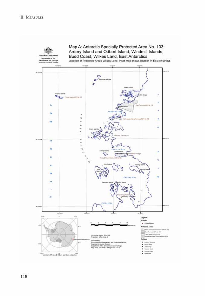
II. MEASURES
118
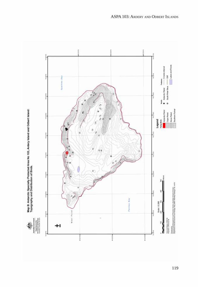
ASPA 103: ARDERY AND ODBERT ISLANDS
119
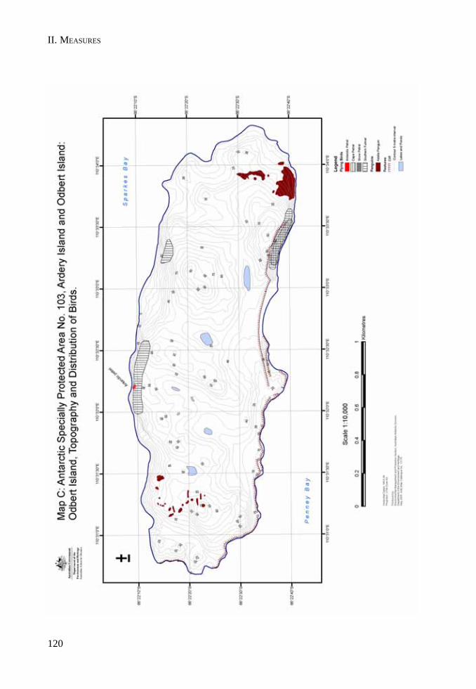
II. MEASURES
120
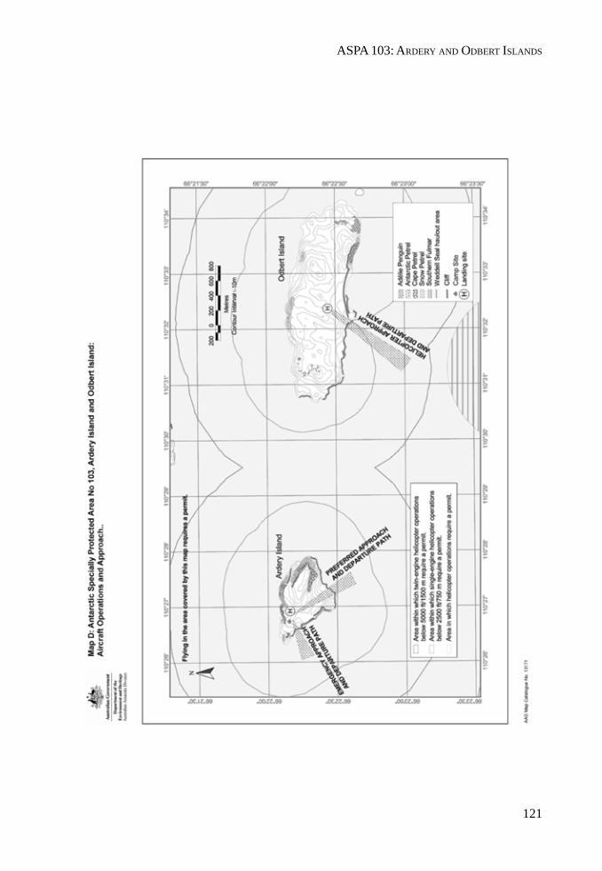
ASPA 103: ARDERY AND ODBERT ISLANDS
121

II. MEASURES
MEASURE 2 - ANNEX D
123
Management Plan for Antarctic Specially Protected Area No. 119
DAVIS VALLEY AND FORLIDAS POND, DUFEK MASSIF
1. Description of Values to be Protected
Forlidas Pond (82°27’28"S, 51°16’48"W) and several ponds along the northern ice margin of theDavis Valley (82°27’30"S, 51°05’W), in the Dufek Massif, Pensacola Mountains, were originallydesignated as a Specially Protected Area through Recommendation XVI-9 (1991, SPA No. 23) after aproposal by the United States of America. The Area was designated on the grounds that it “containssome of the most southerly freshwater ponds known in Antarctica containing plant life” which“should be protected as examples of unique near-pristine freshwater ecosystems and theircatchments”. The original Area comprised two sections approximately 500 m apart with a combinedtotal area of around 6 km2. It included Forlidas Pond and the meltwater ponds along the ice margin atthe northern limit of the Davis Valley. The site has been rarely visited and until recently there hasbeen little information available on the ecosystems within the Area.
This Management Plan reaffirms the original reason for designation of the Area, recognizing theponds and their associated plant life as pristine examples of a southerly freshwater habitat. However,following a field visit made in December 2003 (Hodgson and Convey, 2004) the values identified forspecial protection and the boundaries for the Area have been expanded as described below.
The Davis Valley and the adjacent ice-free valleys is one of the most southerly ‘dry valley’ systemsin Antarctica and, as of May 2005, is the most southerly protected area in Antarctica. While occupyingan area of only 53 km2, which is less than 1% of the area of the McMurdo Dry Valleys, the Areanevertheless contains the largest ice-free valley system found south of 80°S in the 90ºW-0º-90ºE halfof Antarctica. Moreover, it is the only area known in this part of Antarctica where the geomorphologypreserves such a detailed record of past glacial history. Some ice-free areas around the Weddell Searegion have scattered erratics and sometimes moraines, but the assemblage of drift limits, moraines,and abundant quartz-bearing erratics in the Davis Valley and associated valleys is unique and rare.The location of the Dufek Massif close to the junction between the western and the eastern Antarcticice sheets also makes this site particularly valuable for the collection of data that can be used toconstrain parameters such as the past thickness and dynamics of this sector of the Antarctic icesheet. Such data are potentially extremely valuable for understanding the response of the Antarcticice sheet to climate change. The Area therefore has exceptional and unique scientific value for theinterpretation of past glacial events and climate in this part of Antarctica and it is important that thisvalue is maintained.
The terrestrial ecology of the Area is impoverished but is also highly unusual, with lake and meltwaterstream environments and their associated biota being rare this far south in Antarctica. As such, theyprovide unique opportunities for the scientific study of biological communities near the extreme limitof the occurrence of these environments. Vegetation appears to be limited to cyanobacterial matsand a very sparse occurrence of small crustose lichens. The cyanobacterial mat growth in the terrestriallocations is surprisingly extensive, and represents the best examples of this community type knownthis far south. The cyanobacterial community appears to survive in at least three distinct environments:
• in the permanent water bodies;• in exposed terrestrial locations, particularly at the boundaries of sorted polygons; and• in a series of former or seasonally dry pond beds on ice-free ground in the Davis Valley.
II. MEASURES
124
No arthropods or nematodes have thus far been detected in samples taken from within the Area, andthe invertebrate fauna in the Area is unusually sparse. This characteristic distinguishes the Areafrom more northerly ice-free valley systems such as those at the Ablation Valley – Ganymede Heights(ASPA No. 147), Alexander Island, or at the McMurdo Dry Valleys (ASMA No. 2), where suchcommunities are present. Rotifers and tardigrades have been extracted from samples taken within theArea, with the greatest numbers occurring within the former pond beds in the Davis Valley, althoughtheir diversity and abundance is also extremely limited compared with more northerly Antarctic sites(Hodgson and Convey, 2004). Further analyses of the samples obtained and identification of all taxapresent are in progress, and are expected to make an important contribution to the understanding ofbiogeographical relationships between the different regions of Antarctica.
The Area is extremely isolated and difficult to access, and as a result has been visited by only a smallnumber of people. Reports indicate that small field parties visited the Area in December 1957, in the1965-66 and 1973-74 austral summer seasons, in December 1978 and in December 2003. The totalnumber of people having visited probably numbers less than 50, with visits generally limited to aperiod of a few weeks or days. No structures or installations have been built within the Area, and asfar as is known all equipment brought into the Area has subsequently been removed. While Hodgsonand Convey (2004) reported evidence of a very limited number of human footprints and several oldsoil pit excavations, the Area has been exposed to few opportunities for direct human impact. TheArea is believed to be one of the most pristine ice-free valley systems in Antarctica, and is thereforeconsidered to possess outstanding potential as a reference area for microbiological studies, and it isimportant that these values receive long-term protection.
The site possesses outstanding wilderness and aesthetic values. The dry and weathered brownvalleys of the Area are surrounded by extensive ice-fields, the margins of which fringe the valleyswith dry based glacial ice of a deep blue hue. This abrupt and dramatic blue-ice margin stands in starkcontrast to the stony and barren ice-free landscape of the valleys, and aesthetically is extremelystriking in appearance. One of the original explorers of this area in 1957 recalled “the excitement wefelt at being the first people to view and enter this magnificently scenic, pristine area.” (Behrendt,1998: 354). Further examples of descriptions of the Area by visitors are: “[the blue ice] was toweringover us ~ 150 feet – a large wave of blue. It was like being in a tidal wave that was held in suspensionas we walked under it…” (Reynolds, field notes, 1978), and “I still cannot find adequate superlativesto describe the features, whether large or small, biologic or physical… [Of the] many settings thatstretch the imagination…in my experience none match the northern side of the Dufek Massif, withDavis Valley as its crown jewel.” (Reynolds, pers. comm., 2000); “the most unusual [landscape] Ihave ever seen on any of the seven continents.” (Boyer, pers. comm., 2000); “Probably the singlemost remarkable environment I’ve been, either in Antarctica or elsewhere” (Convey, pers. comm.,2004). Burt (2004) described the region simply as “inspiringly awesome”.
The boundaries of the Area have been revised to include the entire ice-free region centered on theDavis Valley, including the adjacent valleys and Forlidas Pond. In general, the margins of thesurrounding ice sheets form the new boundary of the Area, resulting in special protection of theregion as an integrated ice-free unit that more closely approximates the valley catchments. The fullcatchments of the surrounding glaciers that flow into these valleys extend considerable distancesfrom the ice-free area and do not possess many of the values related to the purpose of specialprotection, and are therefore excluded from the Area.
2. Aims and Objectives
Management at Forlidas Pond and Davis Valley ponds aims to:
ASPA 119: DAVIS VALLEY AND FORLIDAS POND
125
• avoid degradation of, or substantial risk to, the values of the Area by preventing unnecessaryhuman disturbance and sampling in the Area;
• preserve the ecosystem as an area largely undisturbed by human activities;• preserve the almost pristine ecosystem for its potential as a biological reference area;• allow scientific research on the natural ecosystem and physical environment within the Area
provided it is for compelling reasons which cannot be served elsewhere;• minimize the possibility of introduction of alien plants, animals and microbes to the Area;
and• allow visits for management purposes in support of the aims of the Management Plan.
3. Management Activities
The following management activities shall be undertaken to protect the values of the Area:
• Markers, signs or other structures erected within the Area for scientific or managementpurposes shall be secured and maintained in good condition and removed when no longernecessary.
• Visits shall be made as necessary to assess whether the Area continues to serve the purposesfor which it was designated and to ensure management and maintenance measures areadequate.
4. Period of Designation
Designated for an indefinite period of time.
5. Maps
• Map 1: Davis Valley and Forlidas Pond, ASPA No. 119, Dufek Massif, Pensacola Mountains:Location Map.Map Specifications: Projection: Lambert Conformal Conic; Standard parallels: 1st 82°S; 2nd83°S; Central Meridian: 51°W; Latitude of Origin: 81°S; Spheroid: WGS84.Inset: the location of the Pensacola Mountains and Map 1 in Antarctica.
• Map 2: Davis Valley and Forlidas Pond, ASPA No. 119: Topographic map and protected areaboundary.Map Specifications: Projection: Lambert Conformal Conic; Standard parallels: 1st 82°S; 2nd83°S; Central Meridian: 51°W; Latitude of Origin: 81°S; Spheroid: WGS84; Vertical datum:WGS84. EGM96 MSL height differential –21 m. Contour interval 25 m. Topographic datagenerated by digital orthophoto and photogrammetric techniques from USGS aerialphotography (TMA400, TMA908, TMA909 (1958) and TMA1498 (1964)) by the Mappingand Geographic Information Centre, British Antarctic Survey (Cziferszky et al. 2004). Accuracyestimates: horizontal: ±1 m; vertical: ±2 m, declining towards the south away from availableground control points. Area beyond orthophoto coverage northwest of Forlidas Pond ismapped from a georectified Terra ASTER satellite image acquired 9 November 2002. Elevationdata are unavailable in this region and it is therefore of reduced spatial accuracy.

II. MEASURES
126
6. Description of the Area
6(i) Geographical coordinates, boundary markers and natural features
General description
Davis Valley ( 82°28’30"S, 51°05’W) and Forlidas Pond (82°27’28"S, 51°16’48"W) are situated in thenorth-eastern Dufek Massif, Pensacola Mountains, part of the Transantarctic Mountain range. TheDufek Massif is situated approximately mid-way between the Support Force Glacier and the FoundationIce Stream, two of the major glaciers draining northwards from the Polar Plateau into the Ronne andFilchner Ice Shelves. Approximately 60 km to the southeast is the Forrestal Range (also part of thePensacola Mountains), which is separated from the Dufek Massif by the Sallee Snowfield. The FordIce Piedmont separates the Dufek Massif from the Ronne and Filchner Ice Shelves, about 50 km to thenorthwest and 70 km to the northeast respectively.
The Davis Valley is approximately five kilometers wide and seven kilometers long, with its northernextent defined by the blue ice lobes that form part of the southern margin of the Ford Ice Piedmont.It is bounded in the east by Wujek Ridge and Mount Pavlovskogo (1074 m), flanked on the outer sideby a glacier draining north from the Sallee Snowfield to the Ford Ice Piedmont. The western extent ofthe valley is defined by Clemons Spur, Angels Peak (964 m) and Forlidas Ridge. The Edge Glacierextends approximately 4 km into the Davis Valley from the Sallee Snowfield. The southern DavisValley is dominated by Mount Beljakova (1240 m), on the northwestern margin of the Sallee Snowfield.Several smaller valleys exist in the west of the Area, adjacent to the prominent Preslik Spur andForlidas Ridge. Almost 75% of the region enclosed by the large surrounding ice fields is ice-free,comprising 39 km2 of ice-free ground in total, with the remainder of the area covered by the EdgeGlacier, other permanent bodies of snow / ice and several small ponds.
Forlidas Pond occupies a small unnamed dry valley separated from the Davis Valley by a tributaryridge extending north from Forlidas Ridge. Other ponds within the Area occur at various locationsalong the blue ice margin of the Ford Ice Piedmont, at the snout of the Edge Glacier, and at the footof an ice lobe in the west below Angels Peak.
Boundary
The Area comprises all of the Davis Valley and the immediately adjacent ice-free valleys, includingseveral of the valley glaciers within these catchments. The boundary predominantly follows themargins of the surrounding ice fields of the Ford Ice Piedmont and Sallee Snowfield, which enclosethe ice-free area that is considered to be of outstanding value. The northern boundary extendsparallel to and 500 m north from the southern margin of the Ford Ice Piedmont in the Davis Valley andin the adjacent valley containing Forlidas Pond. This is in order to provide an additional buffer ofprotection around the freshwater bodies of value along this glacier margin. The eastern boundaryfollows the ice margin east of Wujek Ridge from the Ford Ice Piedmont to Mount Pavlovskogo. Thesoutheastern boundary extends from Mount Pavlovskogo across the Sallee Snowfield and the upperslopes of the Edge Glacier, following areas of outcrop where they exist, and again across the SalleeSnowfield to Mount Beljakova. The southern and western boundaries of the Area follow the marginsof the permanent ice. The boundary encompasses a total area of 57.2 km2.
Boundary markers have not been installed in the Area because of its remoteness, the limitedopportunities for visits and the practical difficulties of maintenance. Moreover, the margins of thepermanent ice fields are generally sharply defined and form a visually obvious boundary aroundmost of the Area.

ASPA 119: DAVIS VALLEY AND FORLIDAS POND
127
Meteorology
Several estimates of mean annual surface air temperature have been made in the Dufek Massif regionfrom measurements taken in ice bores or crevasses at around 10 m depth. A measurement of –24.96°Cwas obtained 32 km due north of Forlidas Pond on the Ford Ice Piedmont in December 1957 (Pit 12,Map 1) (Aughenbaugh et al., 1958). Another estimate of -9°C was made in December 1978 in theEnchanted Valley (Map 1), measured in a crevasse at 8 m depth (Boyer, pers. comm., 2000).
Detailed meteorological data for the Area itself are limited to records collected over two weeks in2003. Hodgson and Convey (2004) measured temperature and relative humidity over snow and rocksurfaces at their sampling sites within the Area from 3-15 December 2003, with data recorded at 30-minute intervals. Temperatures over snow ranged from a maximum of +12.8ºC to a minimum of –14.5ºC, with an average over the period of –0.56ºC. Temperatures over rock ranged from a maximum of+16.0ºC to a minimum of –8.6ºC, with an average over the period of +0.93ºC (data over rock were onlyrecorded from 3-11 December 2003). Relative humidity recorded over snow ranged from a maximum of80.4% to a minimum of 10.8%, with an average over the period of 42.6%. Over rock surfaces (from 3-11 December 2003), relative humidity ranged from a maximum of 80.9% to a minimum of 5.6%, with anaverage over the period of 38.7%.
Data on windspeeds and directions within the Area are not available. While the ice-free area possessesmany features related to wind erosion, there is some evidence to suggest that windspeeds in thelocality are currently not especially high. For example, ice and snow surfaces were observed aslargely free of wind-blown debris, and terrestrial cyanobacterial mats exist in-tact in exposed locationsin the dry valleys (Hodgson and Convey, 2004). No precipitation data are available, although the bareice and rock surfaces and low average relative humidity recorded by Hodgson and Convey (2004)attest to a dry environment of low precipitation.
Geology, geomorphology and Soils
The Dufek Massif is characterized by layered bands of cumulate rock belonging to the Dufek intrusion,thought to be one of the largest layered gabbro intrusions in the world (Behrendt et al., 1974; 1980;Ferris et al., 1998). This is exposed in the Davis Valley as the light- to medium-gray, medium-grainedAughenbaugh gabbro, which is the lowest exposed part of the Middle Jurassic Dufek intrusion (Fordet al., 1978).
The Davis Valley primarily consists of minimally weathered talus and glacial till of both local andexotic origin. In particular there appears to be an abundance of erratics of Dover Sandstone, one ofseveral metasedimentary layers disrupted by the Dufek intrusion. An extensive glacialgeomorphological record is evident, showing at least three major glacial and two major interglacialevents (Boyer, 1979). Features include overlapping valley-glacier moraines, ice sheet moraines, lakeshorelines, lateral glacial channels, ice eroded surfaces, well-developed patterned ground and erratics.The complex glacial, glaciofluvial and lacustrine history provides evidence for very old sub-polar ortemperate-type valley glaciation, a former ice sheet level as much as 400 m higher than today, and themultiple advance and retreat of local alpine ice since the last major ice advance (Boyer, 1979; Hodgsonand Convey, 2004). Measurements made of the geomorphology and samples taken by Hodgson andConvey (2004) will be used to establish a glacial chronology for the region and to constrain past icesheet thickness. This research aims to establish how the chronology in this region correlates withthat for other parts of Antarctica, and in particular whether it matches that for the McMurdo DryValleys (million-year time-scales) or whether the record is entirely Late Quaternary (millennial time-scales). As such, the site is considered to be extremely important for climate and ice-sheet historyresearch, since it is the only site known where such an extensive and well-developed suite ofgeomorphological features is present in this part of Antarctica and this far south.
II. MEASURES
128
Soils are not well-developed in the Area and generally lack a significant organic component. Parker etal. (1982) collected a soil that was light brown in color, resulting from gravel weathering predominantlyto muscovite. The soil comprised sand (81%) with silt (14%) and clay (5%), a composition differentfrom other sites in the Pensacola Mountains where the clay proportions of six samples ranges from0.4% to 1.6%. The soil sample from the Davis Valley had a pH of 6.4 (Parker, et al., 1982).
Lakes, ponds and streams
Forlidas Pond is a perennially frozen, shallow, round lake that was estimated to be approximately 100m in diameter in 1957 (Behrendt, 1998). In December 2003 the lake was measured by Hodgson andConvey (2004) as 90.3 m in diameter from shoreline to shoreline on a transect azimuth of 306º (magnetic).At this time it was frozen almost completely to its base, with a thin layer of hypersaline slush at thelake bottom, and a freshwater meltwater moat that was partly ice free and partly covered by 10-15 cmof ice (Hodgson and Convey, 2004). Depth was measured as between 1.63 to 1.83 m, and averageconductivity and temperature was 142.02 mS cm-1 and -7.67ºC respectively. The salinity of the bottom-water in Forlidas Pond is thus around four times greater than seawater. Hodgson and Convey (2004)data report a remnant pro-glacial lake near the margin of the Ford Ice Piedmont, 900 m from ForlidasPond. Their data also show evidence of a series of former shorelines up to 144 m from and 17 m higherthan the present level of Forlidas Pond. Boyer (pers. comm., 2000) reported that a second pond wasvisible in this valley in 1978 from the vantage of Forlidas Ridge, which probably refers to an ephemeralmeltwater pond that occurs where the valley meets the Ford Ice Piedmont.
A series of small meltwater ponds occurs along the blue-ice margin of the northern Davis Valley. Twowere observed at 82º 27.4’S, 50º 58’W and 82º 27.5’S, 51º 02’W in 1978, although their exact size,depth and other physical characteristics are unknown (Boyer, pers. comm. 2000). Two further pondswere described and mapped in this vicinity in December 2003, located at 82º 27.5’S, 51º 05.5’W and82º 27.55' S, 51º 07' W (Map 2) (Hodgson and Convey, 2004). A pro-glacial pond was also observed in1978 at the margin of the ice sheet in the west of the Area below Angels Peak (Map 1: 82º29.6’S,51º14’W), although its physical characteristics are unknown (Boyer, pers. comm., 2000). The pro-glacial lake at the snout of the Edge Glacier is the largest within the Area, but it differs from the othersin that, apart from at the margins where moats form seasonally, it is permanently frozen to the bottom.Cyanobacterial mat development in this lake is therefore limited to the perimeter and adjacent shoreline.
Little information exists on streams within the Area. Dry stream channels and water erosion featuresare evident within the ice-free area, although only small glacial melt streams on the Edge Glacier havethus far been reported as flowing in December (Hodgson and Convey, 2004). The apparent lack ofmelt streams may be because all visits to date have been made in the month of December, possiblybefore streams become more active. The presence of sizeable lake moats, the temperatures recordedby Hodgson and Convey (2004), as well as the biological and the geomorphological evidence,suggest that it is probable that at least some streams become active later in the season from meltingsnow, although perhaps not on an annual basis.
Biology
Visible biota is extremely limited within the Area, and vegetation appears to be restricted tocyanobacterial mats, found both in lakes and in patches on the surface of ice-free ground, and a verysparse occurrence of small crustose lichens. Previous anecdotal reports of the possible occurrenceof mosses within the Area could not be substantiated by Hodgson and Convey (2004), and it isprobable that the rich cyanobacterial mat growth was earlier mistaken for bryophytes by non-specialists. Neuburg et al. (1959) observed yellow and black lichens growing sparsely in shelteredplaces in the Davis Valley, while Hodgson and Convey (2004) observed several lichen forms growingdeep within the crevices of boulders, although species observed have not yet been identified.
ASPA 119: DAVIS VALLEY AND FORLIDAS POND
129
The cyanobacterial community appears to survive in at least three distinct environments:
a. in the permanent water bodies, particularly at the bottom and moat of Forlidas Pond and atthe bottom and edges of the shallow ponds near the northern ice margin in the Davis Valley,which are extensively covered by a red-brown cyanobacterial mat. Cyanobacterial mat growthis also evident in the moat and seasonally wetted perimeter of the proglacial lake at the snoutof the Edge Glacier;
b. in exposed terrestrial locations, particularly at the edge of larger rocks forming the boundaryof sorted polygons, where a foliose mid-brown form has developed to depths of at least 10-15 cm;
c. in a series of former dry pond beds in the Davis Valley, which have extensive areas of almostcontinuous cyanobacterial mat on the former pool floors (two of up to c. 50 m in diameter).These depressions tend to accumulate winter snow which later ablates, providing a protectedand moist environment where the cyanobacterial community can grow in relatively greaterabundance than elsewhere.
Of the cyanobacterial community growing in permanent water bodies, Neuburg et al. (1959) identifiedcyanobacteria growing on the bottom of Forlidas Pond as Phormidium incrustatum and P. retzii.Hodgson and Convey (2004) characterized the mat at Forlidas Pond as red-brown in color, and notedthat sheets of mat regularly become detached from the bottom and gradually move up through theice, both here and at other ponds. Sometimes meltwater forms around the fragments within the ice asthey move upwards, also carrying faunal (tardigrade, rotifer) communities with them. The aquaticcyanobacterial mats in the permanent ponds were actively photosynthesising, as evidenced by gasbubbles trapped against the lower ice surfaces. On reaching the surface, mat material is blown intomoats or onto the local shoreline, or further afield. Cyanobacterial mats have formed and survive onthe shoreline above the lake ice level, and may become flooded as lake water levels vary over theseason and meltwater seeps into the ponds. Fossil examples of this type of mat were also foundburied under boulders and flat stones between the present and previous (higher) shorelines ofseveral of the ponds (Hodgson and Convey, 2004).
The second form of cyanobacterial community was particularly well-developed at a proglacial lakebed and in the mid-valley floor in the valley containing Forlidas Pond, and in Davis Valley near a largesnow gully (path of the ephemeral meltwater stream) descending into the lake at the snout of theEdge Glacier (Hodgson and Convey, 2004). Nearly all of these mats observed were dry, althoughthose near to melting snow were damp and lower thalli were often deep green in color. Sporadic snowmelt was considered the most likely main source of water for these mats, at least in Forlidas Valley.
The third growth form of cyanobacterial mat occurs in the Davis Valley in a series of at least fourformer or dry pond beds between the Ford Ice Piedmont margin and the most recent retreat morainecrossing the valley, and a further pond bed is present on top of a large moraine on the eastern side ofthe valley. Extensive areas of dried cyanobacterial mat occur on the former pool beds, with two beingalmost continuous and of up to c. 50 m in diameter. The growth form also occurs in many of theadjacent small gullies between polygons or other cryoturbation features, which often have theappearance of temporary drainage features. Extractions from samples taken from within these areaswere found to yield the greatest numbers of rotifers and tardigrades of any taken within the Area,showing these areas to be biologically productive, which necessitates a source of liquid water. InDecember 2003 very little snow was evident on the valley floor, prompting Hodgson and Convey(2004) to reason that the source of moisture may be from a considerable increase in melt later in theseason flowing off the local ice sheet in the upper valley, or from local ice-cored moraines. Althoughthis process was not occurring during their visit, footprints and shallow soil survey pits remainingfrom one of the previous parties (i.e. 25-46 years old) indicated that some ground was moist or
II. MEASURES
130
waterlogged at the time of the earlier visit. Seasonal inundation by liquid water would explain theextensiveness and integrity of this cyanobacterial community, and its apparent resilience to thepotential ravages of polar winds, as well as the relative abundance of invertebrates extracted fromsamples taken from within these areas.
The invertebrate fauna within the Area is impoverished, with both the diversity and abundance oforganisms being extremely limited compared to more northerly Antarctic sites (Hodgson and Convey,2004). The invertebrate communities consist of rotifers and tardigrades, with a complete absence ofnematodes or arthropods from samples taken, even from the most biologically productive siteswithin the Area. Extractions generated predominantly rotifers, with more limited number of tardigrades,and numbers for both were very low in comparison with similar extractions from other Antarcticlocations. Surprisingly, the most productive sites for these organisms were not the aquatic environmentsof the permanent lakes, but the former pond beds in the Davis Valley as noted above. Research on themicrobial biology of the Area is continuing, with samples collected being examined by a team ofmicrobiologists, protozoologists and molecular biologists at the British Antarctic Survey (Hodgsonand Convey, 2004). These studies are expected to provide an integrated overview of the microbialecology of this site near the extreme limit of terrestrial habitats in the world.
Viable yeast species have been recorded in the soil, along with the algae Oscillatoria sp., Trebouxiasp. and Heterococcus sp. (Parker et al., 1982). Chasmoendolithic microorganisms have been recordedin rocks in the Dufek Massif (Friedmann, 1977), although Hodgson and Convey (2004) found noevidence of their presence within the Area and noted that rock-types most favorable for the occurrenceof endolithic organisms are not widespread.
Human activities and impact
There have been few visits to the Area and human impacts are believed to be minimal (Table 1).Because of its remoteness and the infrequency of visits, it is one of the few ice-free areas of Antarcticawhere the compiled record of past human activity at the site is almost complete. The almost pristinecondition of the environment contributes to the extremely high value of the Area and is an importantreason for its special protection.
The key characteristics of visits recorded to the Area are summarized in Table 1, which should beupdated as required (see Section 7(x)). Past camps have generally been on the ice sheet outside ofthe Area. Previous parties removed all wastes from the Area, with the possible exception of smallquantities of human wastes. In 2003 all wastes including all human wastes were removed, both fromwithin the Area and from the party’s adjacent campsite on the Ford Ice Piedmont (Map 2). Hodgsonand Convey (2004) noted that in December 2003 the evidence of previous visits was limited to anumber of footprints and several shallow soil excavations in the Davis Valley.
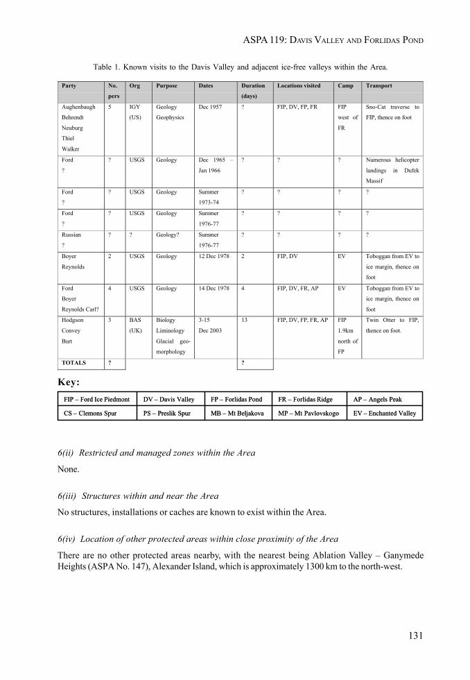
ASPA 119: DAVIS VALLEY AND FORLIDAS POND
131
Table 1. Known visits to the Davis Valley and adjacent ice-free valleys within the Area.
EV – Enchanted ValleyMP – Mt PavlovskogoMB – Mt BeljakovaPS – Preslik SpurCS – Clemons Spur
AP – Angels PeakFR – Forlidas RidgeFP – Forlidas PondDV – Davis ValleyFIP – Ford Ice Piedmont
EV – Enchanted ValleyMP – Mt PavlovskogoMB – Mt BeljakovaPS – Preslik SpurCS – Clemons Spur
AP – Angels PeakFR – Forlidas RidgeFP – Forlidas PondDV – Davis ValleyFIP – Ford Ice Piedmont
Party No.
pers
Org Purpose Dates Duration
(days)
Locations visited Camp Transport
Aughenbaugh
Behrendt
Neuburg
Thiel
Walker
5 IGY
(US)
Geology
Geophysics
Dec 1957 ? FIP, DV, FP, FR FIP
west of
FR
Sno-Cat traverse to
FIP, thence on foot
Ford
?
? USGS Geology Dec 1965 –
Jan 1966
? ? ? Numerous helicopter
landings in Dufek
Massif
Ford
?
? USGS Geology Summer
1973-74
? ? ? ?
Ford
?
? USGS Geology Summer
1976-77
? ? ? ?
Russian
?
? ? Geology? Summer
1976-77
? ? ? ?
Boyer
Reynolds
2 USGS Geology 12 Dec 1978 2 FIP, DV EV Toboggan from EV to
ice margin, thence on
foot
Ford
Boyer
Reynolds Carl?
4 USGS Geology 14 Dec 1978 4 FIP, DV, FR, AP EV Toboggan from EV to
ice margin, thence on
foot
Hodgson
Convey
Burt
3 BAS
(UK)
Biology
Liminology
Glacial geo-
morphology
3-15
Dec 2003
13 FIP, DV, FP, FR, AP FIP
1.9km
north of
FP
Twin Otter to FIP,
thence on foot.
TOTALS ? ?
Key:
6(ii) Restricted and managed zones within the Area
None.
6(iii) Structures within and near the Area
No structures, installations or caches are known to exist within the Area.
6(iv) Location of other protected areas within close proximity of the Area
There are no other protected areas nearby, with the nearest being Ablation Valley – GanymedeHeights (ASPA No. 147), Alexander Island, which is approximately 1300 km to the north-west.
II. MEASURES
132
7. Permit conditions
Entry into the Area is prohibited except in accordance with a Permit issued by an appropriate nationalauthority. Conditions for issuing a Permit to enter the Area are that:
• it is issued only for compelling scientific reasons that cannot be served elsewhere, or foressential management purposes consistent with plan objectives such as inspection or review;
• the actions permitted will not jeopardize the physical, ecological, scientific or aesthetic andwilderness values of the Area, nor the pristine value of the Area and its potential as a largelyundisturbed biological reference site;
• any management activities are in support of the objectives of the Management Plan;• the actions permitted are in accordance with the Management Plan;• the Permit, or a copy, shall be carried within the Area;• a visit report shall be supplied to the authority, or authorities, named in the Permit;• permits shall be issued for a stated period.
7(i) Access to and movement within the Area
• Landing of aircraft is prohibited within the Area and overflight below 100 m above groundlevel is prohibited.
• Vehicles are prohibited within the Area.• Access into and movement within the Area shall be on foot.• No special restrictions apply to the means of access, or air or land routes used, to move to
and from the icefields surrounding the boundaries of the Area.• Access into the Area should be at a practicable point close to sites of study to minimize the
amount of the Area that needs to be traversed. The terrain and crevassing generally makessuch access most practical from the Ford Ice Piedmont in the north.
• Pedestrian routes should avoid lakes, ponds, former pond beds, stream beds, areas of dampground and areas of soft sediments or sedimentary features. Care should be exercised toavoid damage to any areas of cyanobacterial mat growth, in particular to the extensive areasfound in former pond beds in Davis Valley.
• Pedestrian traffic should be kept to the minimum necessary consistent with the objectives ofany permitted activities and every reasonable effort should be made to minimize effects.
7(ii) Activities that are or may be conducted in the Area, including restrictions on time or place
• Research that will not jeopardize the scientific or ecosystem values of the Area, or itspristine value and potential as a reference site, and which cannot be served elsewhere;
• Essential management activities, including monitoring;• The appropriate authority should be notified of any activities/measures undertaken that
were not included in the authorized Permit.
7(iii) Installation, modification or removal of structures
• Structures shall not be erected within the Area except as specified in a Permit.• Permanent structures are prohibited.• All scientific equipment installed in the Area must be approved by Permit.
ASPA 119: DAVIS VALLEY AND FORLIDAS POND
133
• Should equipment be intended to remain within the Area for a duration of more than oneseason it shall clearly be identified by country, name of the principal investigator and yearof installation. All such items should be made of materials that pose minimal risk ofcontamination of the Area.
• Removal of structures, equipment or markers for which the period specified in the Permit hasexpired shall be a condition of the Permit.
7(iv) Location of field camps
• Camping within the Area is prohibited.• Suitable camp sites have been proven to the north and west of the Area on the Ford Ice
Piedmont (Map 2), and also in the Enchanted Valley (Map 1).
7(v) Restrictions on materials and organisms which can be brought into the Area
• No living animals, plant material or microorganisms shall be deliberately introduced into theArea and the precautions listed in 7(ix) below shall be taken against accidental introductions.
• No herbicides or pesticides shall be brought into the Area.• Any other chemicals, including radio-nuclides or stable isotopes, which may be introduced
for scientific or management purposes specified in the Permit, shall be removed from theArea at or before the conclusion of the activity for which the Permit was granted.
• Fuel is not to be stored in the Area, unless specifically authorized by Permit for scientific ormanagement purposes.
• Anything introduced shall be for a stated period only, shall be removed at or before theconclusion of that stated period, and shall be stored and handled so that risk of theirintroduction into the environment is minimized.
• If release occurs which is likely to compromise the values of the Area, removal is encouragedonly where the impact of removal is not likely to be greater than that of leaving the materialin situ.
• The appropriate authority should be notified of any materials released and not removed thatwere not included in the authorized Permit.
7(vi) Taking or harmful interference with native flora or fauna
• Taking or harmful interference with native flora or fauna is prohibited, except in accordancewith a separate permit issued under Article 3 of Annex II to the Madrid Protocol by theappropriate national authority specifically for that purpose. Where animal taking or harmfulinterference is involved this should, as a minimum standard, be in accordance with theSCAR Code of Conduct for the Use of Animals for Scientific Purposes in Antarctica.
7(vii) Collection or removal of anything not brought into the Area by the Permit Holder
• Material may be collected or removed from the Area only in accordance with a Permit andshould be limited to the minimum necessary to meet scientific or management needs. Permitsshall not be granted if there is a reasonable concern that the sampling proposed would take,remove or damage such quantities of soil, native flora or fauna that their distribution orabundance within the Area would be significantly affected.
II. MEASURES
134
• Material of human origin likely to compromise the values of the Area, which was not broughtinto the Area by the Permit Holder or otherwise authorized, may be removed unless theimpact of removal is likely to be greater than leaving the material in situ: if this is the case theappropriate authority should be notified.
7(viii) Disposal of waste
• All wastes, including water used for any human purpose and including all human wastes,shall be removed from the Area. Individuals or groups shall carry appropriate containers forhuman waste and gray water so that they may be safely transported and removed from theArea.
7(ix) Measures that are necessary to ensure that the aims and objectives of the Management Plancan continue to be met
• Permits may be granted to enter the Area to carry out biological monitoring and site inspectionactivities, which may involve the collection of limited samples for analysis or review, or forprotective measures.
• Any specific sites of long-term monitoring shall be appropriately marked.• To help maintain the ecological and scientific values derived from the relatively low level of
human impact at Davis Valley and Forlidas Pond, visitors shall take special precautionsagainst introductions. Of concern are microbial, invertebrate or plant introductions sourcedfrom other Antarctic sites, including stations, or from regions outside Antarctica. To minimizethe risk of introductions, visitors shall thoroughly clean footwear and any equipment to beused in the area – particularly sampling equipment and markers – before entering the Area.
• To reduce the risk of microbial contamination, the exposed surfaces of footwear, samplingequipment and markers should be sterilized before use within the Area. Sterilization shouldbe by an acceptable method, such as by washing in 70% ethanol solution in water or in acommercially available solution such as ‘Virkon’.
• A comprehensive Code of Conduct and Guidelines for Conduct of Scientific Research havebeen developed for use within the McMurdo Dry Valleys (ASMA No. 2), much of which isrelevant as guidance for activities within the dry valley system in this region. Visitors shallconsult these guidelines and should apply them where appropriate to the conduct of scientificresearch and other activities within the Area.
7(x) Requirements for reports
• Parties should ensure that the principal holder for each Permit issued submits to the appropriateauthority a report describing the activities undertaken. Such reports should include, asappropriate, the information identified in the Visit Report form suggested by SCAR.
• Parties should maintain a record of such activities and, in the Annual Exchange of Information,should provide summary descriptions of activities conducted by persons subject to theirjurisdiction, which should be in sufficient detail to allow evaluation of the effectiveness ofthe Management Plan.
• Parties should, wherever possible, deposit originals or copies of such original reports in apublicly accessible archive to maintain a record of usage, to be used both in any review ofthe Management Plan and in organizing the scientific use of the Area.
ASPA 119: DAVIS VALLEY AND FORLIDAS POND
135
8. Supporting Documentation
Aughenbaugh, N., Neuburg, H. and Walker P. (1958): Report 825-1-Part I, October 1958, USNC-IGYAntarctic Glaciological Data Field Work 1957 and 1958. Ohio State University Research Foundation.Source: World Data Center for Glaciology at Boulder, Colorado. (ftp://sidads.colorado.edu/pub/DATASETS/AGDC/antarctic_10m_temps/ells-filchner_57.txt).
Behrendt, J.C., Henderson, J.R., Meister, L. and Rambo, W.K. (1974): Geophysical investigationsof the Pensacola Mountains and Adjacent Glacierized areas of Antarctica. U.S. Geological SurveyProfessional Paper 844.
Behrendt, J.C., Drewry, D.J., Jankowski, E., and Grim, M.S. (1980): Aeromagnetic and radio echoice-sounding measurements show much greater area of the Dufek intrusion, Antarctica. Science209: 1014-1017.
Behrendt, J.C. (1998): Innocents on the Ice; a memoir of Antarctic Exploration, 1957. UniversityPress of Colorado, Boulder.
Boyer, S.J. (1979): Glacial geologic observations in the Dufek Massif and Forrestal Range, 1978-79.Antarctic Journal of the United States 14 (5): 46-48.
Burt, R. (2004). Travel Report - Sledge Bravo 2003-2004. SAGES-10K & BIRESA: Field trip to thelakes and dry valleys in the Dufek Massif and the Shackleton Mountains. Unpublished BAS InternalReport Ref. R/2003/K1. British Antarctic Survey, Cambridge.
Cziferszky, A., Fox, A., Hodgson, D. and Convey, P. (2004): Unpublished topographic base map forDavis Valley, Dufek Massif, Pensacola Mountains. Mapping and Geographic Information Centre,British Antarctic Survey, Cambridge.
Ferris, J., Johnson, A. and Storey, B. (1998): Form and extent of the Dufek intrusion, Antarctica,from newly compiled aeromagnetic data. Earth and Planetary Science Letters 154: 185-202.
Ford, A.B. (1976): Stratigraphy of the layered gabbroic Dufek intrusion, Antarctica. Contributionsto stratigraphy: Geological Survey Bulletin 1405-D.
Ford, A.B., Schmidt, D.L. and Boyd, W.W. (1978): Geologic map of the Davis Valley quadrangle andpart of the Cordiner Peaks quadrangle, Pensacola Mountains, Antarctica. U.S Geologic SurveyAntarctic Geological Map A-10.
Ford, A.B. (1990): The Dufek intrusion of Antarctica. Antarctic Research Series 51. AmericanGeophysical Union, Washington, DC.: 15-32.
Friedmann, E.I. (1977): Microorganisms in Antarctic desert rocks from dry valleys and Dufek Massif.Antarctic Journal of the United States 12 (5): 26-29.
Hodgson, D. and Convey, P. 2004. Scientific Report - Sledge Bravo (2003-2004): BAS Signals inAntarctica of Past Global Changes: Dufek Massif – Pensacola Mountains; Mount Gass – ShackletonMountains. DRAFT. Unpublished BAS Internal Report Ref. R/2003/NT1. British Antarctic Survey,Cambridge.
Neuburg, H., Theil, E., Walker, P.T., Behrendt, J.C and Aughenbaugh, N.B. (1959): The Filchner IceShelf. Annals of the Association of American Geographers 49: 110-119.
Parker, B.C., Boyer, S., Allnutt, F.C.T., Seaburg, K.G., Wharton, R.A. and Simmons, G.M. (1982):Soils from the Pensacola Mountains, Antarctica: physical, chemical and biological characteristics.Soil Biology and Biochemistry 14: 265-271.
Parker, B.C., Ford, A.B., Allnutt, T., Bishop, B. and Wendt, S. (1977): Baseline microbiological datafor soils of the Dufek Massif. Antarctic Journal of the United States 12 (5): 24-26.
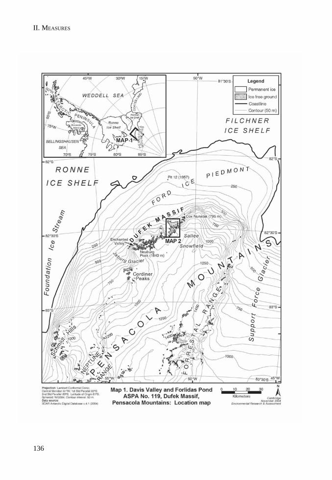
II. MEASURES
136
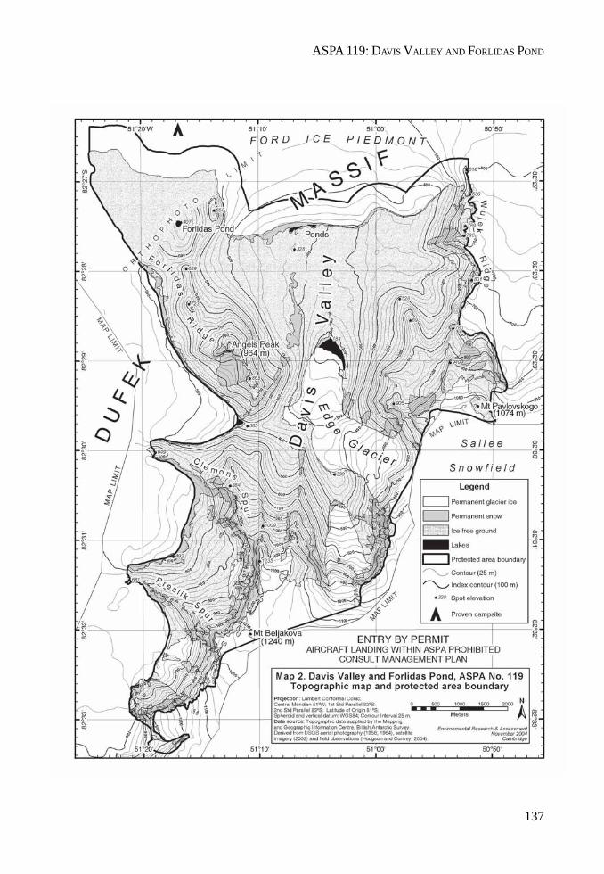
ASPA 119: DAVIS VALLEY AND FORLIDAS POND
137

II. MEASURES
MEASURE 2 - ANNEX E
139
Management Plan for Antarctic Specially Protected Area No. 120
POINTE-GÉOLOGIE ARCHIPELAGO, TERRE ADÉLIE
Jean Rostand, Le Mauguen (former Alexis Carrel), Lamarckand Claude Bernard Islands, The Good Doctor’s Nunatak
and breeding site of Emperor Penguins
1. Description of Values to be Protected
In 1995, four islands, a nunatak and a breeding ground for emperor penguins were classified as anAntarctic Specially Protected Area (Measure 3 (1995), XIX ATCM, Seoul) because they were arepresentative example of terrestrial Antarctic ecosystems from a biological, geological and aestheticsperspective. A species of marine mammal, the Weddell seal (Leptonychotes weddelli) and variousspecies of birds breed in the area: emperor penguin (Aptenodytes forsteri); Antarctic skua (Catharactamaccormicki); Adélie penguins (Pygoscelis adeliae); Wilson’s petrel (Oceanites oceanicus); giantpetrel (Macronectes giganteus); snow petrel (Pagodrama nivea), cape petrel (Daption capense).
Well-marked hills display asymmetrical transverse profiles with gently dipping northern slopescompared to the steeper southern ones. The terrain is affected by numerous cracks and fracturesleading to very rough surfaces. The basement rocks consist mainly of sillimanite, cordierite andgarnet-rich gneisses which are intruded by abundant dikes of pink anatexites. The lowest parts of theislands are covered by morainic boulders with a heterogenous granulometry (from a few cm to morethan a m across).
Long-term research and monitoring programs of birds and marine mammals have been going on for along time already (since 1952 or 1964 according to the species). A database implemented in 1981 isdirected by the Centre d’Etudes Biologiques de Chize (CEBC-CNRS). Human scientific presence maybe estimated at around 4 people for a few hours, twice a month in the protected area.
Among the approximately 30 emperor penguin breeding sites on record, this is the only one locatedadjacent to a permanent station. It is therefore a providential spot to study this species and itsenvironment.
2. Aims and Objectives
Management of the Cape Géologie Specially Protected Area aims at:
• preventing disturbance in the area due to the proximity of the station;• preventing disturbance in the area due to the growing number of cruising ships: although
the 335 registered tourists visiting the Dumont d’Urville station over the past five yearshave caused no visible impact on the environment, especially on the avifauna, stringentprotection measures must be taken;
• allowing research of a compelling scientific nature which cannot be carried out elsewhere;• avoiding any major changes to the structure and composition of flora and fauna and the
association of different species of vertebrates harbored in the area, which is one of the mostrepresentative for both faunistic and scientific interest on Adélie Coast;

II. MEASURES
140
• permit scientific research in the field of marine and terrestrial biology, i.e., ethology, ecology,physiology and biochemistry, especially projects related to demographic monitoring andimpact assessment of surrounding human activities, including tourism;
• permit research in geology with particular attention to the scheduling of visits when thermo-mechanical sampling means are required.
3. Management Activities
The present management plan is kept under periodical review to ensure that the values of theAntarctic Specially Protected Area are wholly protected. Any activity carried out in the area undergoesan environmental impact assessment before being undertaken.
4. Period of Designation
The Area remains an Antarctic Specially Protected Area (ASPA) for an indefinite period.
5. Maps
The Cape Geology Archipelago map shows the boundaries of the Antarctic Specially Protected Areainside the archipelago with dotted lines.

ASPA 120: POINTE-GÉOLOGIE
141
Carte 1. Location of terre Adélie in the Antarctic.
Archipel de Pointe
Dumont D’Urville
-Géologie

II. MEASURES
142

ASPA 120: POINTE-GÉOLOGIE
143
6. Description of the Area
6(i) Geographic coordinates, boundary markers and natural features
The Jean Rostand, Le Mauguen (formerly Alexis Carrel), Lamarck and Claude Bernard islands, the‘Bon Docteur’ Nunatak and the Emperor penguins breeding colony are located in the heart of theCape Geology Archipelago, coastal area of Adélie Coast (66°39’30" - 66°40’30"S; 140°- 140°02’E).
Table 1. Annual breeding area of seabird couples on the Specially Protected Area (SPA). The populationbreeding within the SPA is being compared to that of the Cape Geology (PG) population (Micol &Jouventin, 2001. Long term population trends in seven Antarctic seabirds at Cape Geology (TerreAdélie). Polar Biology 24:175-185; Thomas, 1986. L’effectif des oiseaux nicheurs de l’archipel deCape Geology (Terre Adélie) et son évolution au cours des trente dernières années. L’oiseau RFO56:349-368, pour les pétrels de Wilson*).
Table 2. Presence of birds on breeding grounds.
Islands Emperor penguin
Adelie penguin
South Polar skua
Snow petrel
Cape petrel
Wilson’s storm petrel *
Southern giant petrel
C. Bernard -- 5033 5 169 248 178 --
Lamarck -- 1479 1 34 36 45 --
J. Rostand -- 6825 5 98 32 35 6
Le Mauguen (formerly Alexis Carrel)
-- 4991 10 23 2 72
Nunatak --- 2520 2 7 -- 41 --
Emperor penguin 2740 -- -- -- -- -- --
TOTAL 2740 20848 23 331 318 371 6
% SPA/PG 100 58 62 38 70 31 75
Emperor penguin
Adelie penguin
South Polar skua
Snow petrel Cape petrel Wilson’s storm petrel *
Southern giant petrel
First arrival
March October October September October November July
First egg laying
May November November November November December October
Last departure
January March March March March March April
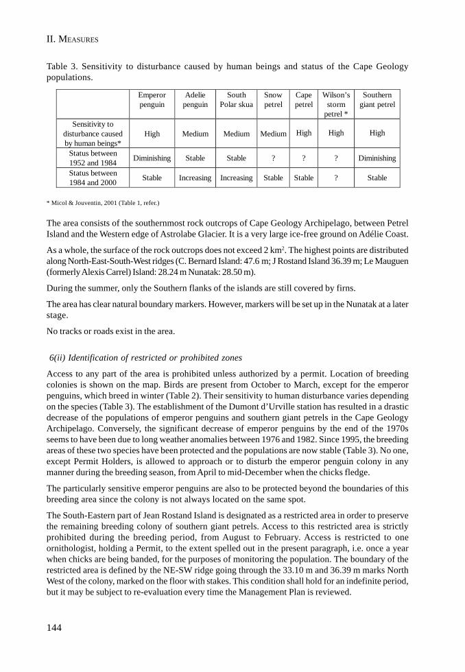
II. MEASURES
144
Table 3. Sensitivity to disturbance caused by human beings and status of the Cape Geologypopulations.
* Micol & Jouventin, 2001 (Table 1, refer.)
The area consists of the southernmost rock outcrops of Cape Geology Archipelago, between PetrelIsland and the Western edge of Astrolabe Glacier. It is a very large ice-free ground on Adélie Coast.
As a whole, the surface of the rock outcrops does not exceed 2 km2. The highest points are distributedalong North-East-South-West ridges (C. Bernard Island: 47.6 m; J Rostand Island 36.39 m; Le Mauguen(formerly Alexis Carrel) Island: 28.24 m Nunatak: 28.50 m).
During the summer, only the Southern flanks of the islands are still covered by firns.
The area has clear natural boundary markers. However, markers will be set up in the Nunatak at a laterstage.
No tracks or roads exist in the area.
6(ii) Identification of restricted or prohibited zones
Access to any part of the area is prohibited unless authorized by a permit. Location of breedingcolonies is shown on the map. Birds are present from October to March, except for the emperorpenguins, which breed in winter (Table 2). Their sensitivity to human disturbance varies dependingon the species (Table 3). The establishment of the Dumont d’Urville station has resulted in a drasticdecrease of the populations of emperor penguins and southern giant petrels in the Cape GeologyArchipelago. Conversely, the significant decrease of emperor penguins by the end of the 1970sseems to have been due to long weather anomalies between 1976 and 1982. Since 1995, the breedingareas of these two species have been protected and the populations are now stable (Table 3). No one,except Permit Holders, is allowed to approach or to disturb the emperor penguin colony in anymanner during the breeding season, from April to mid-December when the chicks fledge.
The particularly sensitive emperor penguins are also to be protected beyond the boundaries of thisbreeding area since the colony is not always located on the same spot.
The South-Eastern part of Jean Rostand Island is designated as a restricted area in order to preservethe remaining breeding colony of southern giant petrels. Access to this restricted area is strictlyprohibited during the breeding period, from August to February. Access is restricted to oneornithologist, holding a Permit, to the extent spelled out in the present paragraph, i.e. once a yearwhen chicks are being banded, for the purposes of monitoring the population. The boundary of therestricted area is defined by the NE-SW ridge going through the 33.10 m and 36.39 m marks NorthWest of the colony, marked on the floor with stakes. This condition shall hold for an indefinite period,but it may be subject to re-evaluation every time the Management Plan is reviewed.
Emperor penguin
Adelie penguin
South Polar skua
Snow petrel
Cape petrel
Wilson’s storm
petrel *
Southern giant petrel
Sensitivity to disturbance caused by human beings*
High Medium Medium Medium
High
High
High
Status between 1952 and 1984 Diminishing Stable Stable ? ? ? Diminishing
Status between 1984 and 2000 Stable Increasing Increasing Stable Stable ? Stable

ASPA 120: POINTE-GÉOLOGIE
145
6(iii) Location of structures in the Area
Prévost hut and a shelter are located on Rostand Island. There are no other buildings anywhere elsein the Area.
7. Permit Conditions
• Entry into the Area is prohibited except in accordance with a Permit issued by an appropriatenational authority.
• Permits may be granted to carry out various scientific research, site monitoring or inspectionactivities entailing sampling of biological material or animals in small quantities. For eachsingle entry and length of stay, permits will authorize the scope of the tasks to be undertaken,their time-span and the maximum number of people commissioned to enter the Area.
7(i) Access to and movement within the Area
• No helicopters or terrestrial vehicles are authorized within the Area.• No overflights over the Area, either by helicopters or other airplanes are authorized.• Access to the Area is only permitted by foot or by zodiacs (in summer). However, very rare
departures of terrestrial vehicles from the Nunatak are allowed, but only when sea-iceconditions hinder from proceeding otherwise and with special attention to the presence ofbirds in the Area.
• Access to the Area is restricted to ornithologists holding a Permit and to the 2 or 3 peoplewho must accompany them for safety reasons.
• Access to and movement within the Area shall, in any case, be limited, in order to avoidunnecessary disturbance to birds, especially by crossing their pathways and to ensure thatbreeding areas or their access are not damaged or endangered.
7(ii) Activities which are or may be conducted within the Area, including restrictions on time andplace
• compelling scientific activities which cannot be conducted elsewhere and essentialmanagement activities provided special care is bestowed on both the emperor penguins andthe southern giant petrels located in the restricted area (see para 6.ii);
• visitors granted access to the Area by a Permit shall ensure that their visit will cause nodisturbances to the monitoring programs under way.
7(iii) Installation, modification or removal of structures
• No structures are to be erected or scientific equipment installed in the Area except forcompelling scientific reasons or management activities as authorized by the competentauthorities in the framework of the urbanistic and public domaniality regulations in force.
7(iv) The location of field camps
• Only safety tents should be erected when security reasons so require it provided allprecautions have been taken in order to avoid damaging or disturbing the fauna.

II. MEASURES
146
7(v) Restriction on materials and organisms which may be brought into the Area
• According to the provisions set forth in Annex II to the Madrid Protocol, no living animalsor plant materials, poultry products, including dried eggs, shall be introduced into the Area.
• No chemicals shall be brought into the Area, except chemicals which may be introduced fora compelling scientific purpose as specified in the Permit. Any chemical introduced shall beremoved from the Area at or before the conclusion of the activity for which the Permit wasgranted
• Fuel, food and other materials are not to be stored in the Area, unless required for compellingpurposes connected with the activity for which the Permit has been granted. Such materialsare to be removed when no longer required. Permanent storage is not permitted.
7(vi) The taking of or harmful interference with flora and fauna
• Taking of or harmful interference with native flora and fauna is prohibited except in accordancewith a Permit. If an activity is determined as having less than a minor or transitory impact, itshould be carried out in accordance with the SCAR Code of Conduct for the Use of Animalsfor Scientific Purposes in Antarctica, as a minimum standard.
7(vii) The collection or removal of anything not brought into the Area by the Permit Holder
• Collection or removal of anything not brought into the Area by a Permit Holder is prohibitedunless otherwise specified in the Permit for scientific or management purposes.
• Debris of manmade origin may be removed from the Area and dead or pathological specimensof fauna or flora may be removed for laboratory examination.
7(viii) Disposal of waste
• All waste produced, except for waste water, must be removed from the Area.
7(ix) Measures that may be necessary to ensure that the aims and objectives of the ManagementPlan can continue to be met
• Visits to the Area shall be restricted to scientific and management objectives only.
7(x) Requirements for reports of visits to the Area
• Parties should ensure that the principal Holder of each Permit issued submits to the appropriateauthority a report describing the activities undertaken. Such reports should include, asappropriate, the information identified in the Visit Report form suggested by SCAR.
• Parties should maintain a record of such activities and, in the Annual Exchange of Information,should provide summary descriptions of activities conducted by persons subject to theirjurisdiction, in sufficient detail to allow evaluation of the effectiveness of the ManagementPlan. Parties should, wherever possible, deposit original or copies of such original reports ina publicly accessible archive to maintain a record of usage, to be taken into considerationboth when reviewing the Management Plan and when organizing the scientific manipulationof the Area.

MEASURE 2 - ANNEX F
147
Management Plan for Antarctic Specially Protected Area No. 132
POTTER PENINSULA, KING GEORGE ISLAND (ISLA 25 DE MAYO),SOUTH SHETLAND ISLANDS
1. Description of Values to be Protected
This area was originally designated as Site of Special Scientific Interest No. 13 in Antarctic TreatyConsultative Meeting (ATCM) Recommendation XIII-8 after a proposal by Argentina, because of itsdiverse and extensive vegetation and fauna, which constitutes a representative sample of the Antarcticecosystem.
During the XXI Antarctic Treaty Consultative Meeting (Christchurch, 1997), a revised ManagementPlan was adopted for the Area, following the format established by Annex V to the Madrid Protocoland according to Measure 3 (1997). During the XXV Antarctic Treaty Consultative Meeting (Warsaw,2002) and once the Annex entered into force, the Site of Special Scientific Interest No. 13 became, byvirtue of Measure 1 (2002), Antarctic Specially Protected Area No. 132.
The original goals for designating this Area are still relevant. The coastal areas host important birdcolonies, marine mammal breeding areas and diverse vegetal species. Scientific research programs onthe breeding ecology of elephant seals and birds have are being carried out in the area since 1982.These include the Commission for the Conservation of Antarctic Marine Living Resources (CCAMLR)Ecosystem Monitoring Program, as well as basic research that must be developed without interferencefrom other activities. The anthropic disturbance could jeopardize the long term studies carried outthere, especially during the breeding season.
2. Aims and Objectives
Management of ASPA No. 132 aims at:
• avoiding major changes in the structure and composition of the flora and fauna communities;• preventing unnecessary human disturbance;• permitting the development of the scientific research that cannot be carried out elsewhere,
as well as the continuity of ongoing long term biological studies established in the Area;and
• permitting the development of any other scientific research provided it does not compromisethe values for which the Area is being protected.
3. Management Activities
The following management activities will be undertaken to protect the values of the Area:
• the staff to be posted at Jubany Base will be specifically trained on the conditions of theManagement Plan;
II. MEASURES
148
• the circulation will only take place on vegetation-free areas and taking a wide berth from thefauna, except when the scientific projects specifically mention otherwise and provided thecorresponding harmful interference permits have been issued;
• collection of samples will be limited to the minimum required for the authorized scientificresearch plans;
• visits shall be made as necessary to ensure management and maintenance measures areadequate; and
• all markers, signs and structures erected within the Area for scientific or management purposeswill be properly secured and maintained in good condition.
4. Period of Designation
Designated for an indefinite period.
5. Maps
Maps 1 and 3 are attached at the end of the present Management Plan as annexes. Map 1 shows thelocation of Potter Peninsula (25 de Mayo/King George Island) in relation to the Antarctic Peninsula.Map 2 shows the location of the Potter Peninsula in relation to the 25 de Mayo/King George Islandand Nelson Island. Map 3 shows the Protected Area in greater detail. Map 4 shows the distributionof bird and mammal concentrations in the ASPA.
6. Description of the Area
6(i) Geographical coordinates, boundary markers and natural features
Geographical coordinates and boundaries
This Area is located on the east coast of Bahía Guardia Nacional / Maxwell Bay, southwest of KingGeorge (25 de Mayo/Rey Jorge) Island, between the southern tip of Mirounga Point (Northwest ofPotter Peninsula) and the outcrop known as “Spur 7”, on the northeastern border of Stranger Point.The area occupies all of the coastal strip up to the border of the cliff, which reaches heights of 15-50m. This coastal strip has a variable width, stretching up to 500 m from the shore at low tide waterlevels. The area is mainly made of raised beaches, largely covered with mid-size pebbles, basalticstructures and lateral and terminal moraines. The shoreline is very irregular and it has a number ofsmall bays shaped among rocky headlands.
Natural features
The area encompasses important scientific values due to the presence of groups of breeding elephantseals (Hydrurga leptonyx), and non-breeding groups of Antarctic fur seals (Arctocephalus gazella)and occasionally of Weddell seals (Leptonychotes weddelli), crabeater seals (Lobodoncarcinophagus) and leopard seals. During the breeding season there are around 500 elephant sealsaround, and during the fledging season, between 200 and 600. The non-breeding groups of Antarcticfur seals can add up to 300 individuals, although that figure may vary considerably from one year tothe next.
ASPA 132: POTTER PENINSULA
149
Also present are significant colonies of gentoo penguins (Pygoscelis papua) and Adélie penguins(Pygoscelis adeliae), each of them with an approximate population of 4,000 pairs. Penguin coloniesare mainly distributed around Stranger Point, from the vicinity of Elefante refuge to Spur 7. Within theASPA, the population of storm petrels (by large Oceanites oceanicus and, to a much lesser extent,the Fregetta tropica) reaches some 200 pairs. Antarctic terns (Sterna vittata), southern giant petrels(Macronectes giganteus) and skuas (Catharacta sp.) also breed in the area, although their populationsare, in all cases, less than 100 pairs each. Southern giant petrels nesting sites concentrate on thewestern side of the ASPA. As some of the nesting sites around Potter peninsula change their positionover time, population figures are estimations and may introduce some degree of inaccuracy, dependingon the year considered.
Map 4 shows the distribution of mammal concentrations, penguin colonies and southern giant petrelnesting sites in the ASPA. Due to the above mentioned variability of nesting sites, the fact that someof them are widely scattered around the ASPA, and the scale of the map, the position of other birdcolonies were not included in Map 4.
There is a relatively abundant development of vegetal communities in the Area, dominated by lichens,especially in the boulder area close to the beaches and mosses, on the flat surfaces of formerbeaches. The long term research and monitoring programs could be jeopardized by accidentalanthropical disturbance, which might end up by destroying the vegetation and the soils, as well asthe disturbance of nesting birds and breeding mammals.
6(ii) Restricted zones within the Area
None.
6(iii) Location of structures within the Area
There is a small Argentine refuge (called Elefante) located around 1,000 m northeast from PointStranger, often used as a resting area by groups of scientists. The refuge occupies a surface ofaround 25 m² and its capacity has been calculated for 2.
Outside the Area there is also a small shelter (called Albatros), on the cliff overlooking the easternshore, around 50 m high from the beach and less than one km E-SE from the Elefante Refuge. As faras Jubany Base facilities are concerned, they are located around 500 m from the access area to theASPA, from the inner portion of Potter Cove.
Likewise, there are two signs, both of them on Mirounga Point, warning about the entrance to theProtected Area.
6(iv) Location of other Protected Areas within close proximity
• ASPA No. 125, Fildes Peninsula, King George Island (25 de Mayo/Rey Jorge), South Shetlandislands lies about 20km to the east.
• ASPA No. 128, Western Shore of Admiralty Bay, King George Island (25 de Mayo/ReyJorge), South Shetland Islands lies about 10 km northeast.
• ASPA No. 133, Harmony Point, Nelson Island, lies about 30 km west-southwest.
II. MEASURES
150
7. Permit Conditions
Entry into the Area is prohibited except in accordance with a Permit issued by appropriate nationalauthorities.
Conditions for issuing a Permit to enter the Area are that:
• it is issued only for scientific purposes, in accordance with the objectives of the ManagementPlan that cannot be served elsewhere;
• the actions permitted will not jeopardize the natural ecological system in the Area;• any management activities (inspection, maintenance or revision) are in support of the
objectives of the Management Plan;• the actions permitted are in accordance with this Management Plan;• the Permit, or authorized copy, is carried by the main scientist authorized to enter the Area;
and• a report be supplied to the appropriate national authority mentioned in the Permit.
7(i) Access to and movements within the Area
• Any access to the Area will be possible with a Permit delivered by an appropriate nationalauthority, and it will only be issued for activities in agreement with the present ManagementPlan.
• Access to the Area will preferably be on foot. Access to the area is possible from thenorthern tip, close to the Jubany base helipad, or behind the southern slope of the ThreeBrothers hill. Access to the Area by sea onto the beaches should be avoided when there isfauna present, especially during the breeding season.
• No vehicles whatsoever are allowed to circulate inside the Area, with the exception of thoseindispensable for maintaining the shelter. In such a case, access to the ASPA will be througha gentle slope close to the Albatros refuge, and vehicles should be driven avoiding vegetatedareas and bird and mammal concentrations. As far as practicable, maintenance activitiesshould be limited to non-breeding seasons.
• Operation of aircraft over the ASPA shall follow, as a minimum standard, the provisionscontained in Resolution 2 (2004), “Guidelines for the operation of aircraft over bird colonies”.As a general rule, no aircraft is allowed to fly over the ASPA below 610 m (2000 ft), except incases of emergency or aeronavigational safety.
• If deemed necessary, and only based on scientific and conservation reasons, access tocertain bird nesting sites and mammal colonies may include more restricted conditions betweenthe end of October and the beginning of December. This period is considered particularlysensitive because it is concomitant with the egg-laying of the penguins and breast feedingof the elephant seals.
• Tourism or any other recreational activity is not permitted. Movements within the Area willbe made without disturbing the fauna and flora, especially during the breeding season.
7(ii) Activities which are or may be conducted within the Area including restrictions on time andplace
• scientific research which cannot be conducted elsewhere and which will not jeopardize thenatural ecosystem of the Area.
ASPA 132: POTTER PENINSULA
151
• essential management activities, including monitoring.
7(iii) Installation, modification or removal of structures
• No additional structures are to be erected in the Area, or scientific equipment installed,except for essential scientific or management activities, and with a proper Permit.
• Any scientific equipment to be installed in the Area, as well as any research device, shall beapproved in a Permit and clearly labelled, indicating the country, name of principal investigatorand year of installation. All such items should be made of materials that pose minimal risk ofcontamination of the Area or risk of disturbing the vegetation or the fauna.
• No research traces are to remain once the Permit has expired. If a specific project cannot befinished within the timeframe specified in the Permit, an extension of the validity of thePermit shall be requested, authorizing those elements to remain there.
7(iv) Location of field camps
• The Parties using the Area will normally be accommodated at Jubany Base.• When necessary for scientific reasons, the Elefante shelter (located inside the Area) may be
used, or the Albatros shelter (outside the Area, though very close).• Tents will be allowed only to store scientific instruments or equipment or if they are to be
used as an observation post.
7(v) Restriction on material and organisms which may be brought into the Area
• No living animals or plant material shall be deliberately introduced into the Area.• No uncooked poultry products shall be introduced into the Area.• No herbicides or pesticides shall be brought into the Area. Any other chemicals, which shall
be introduced with the corresponding Permit, shall be removed from the Area at or before theconclusion of the activity for which the Permit was granted. The purpose and type ofchemicals shall be documented as well as possible for other scientists to be informed.
• Fuel, food and other material are not to be stored in the Area, unless required for essentialpurposes connected with the activity for which the Permit has been granted, provided it isstored inside the shelter or close to it.
7(vi) Taking or harmful interference with native flora and fauna
• All forms of taking or harmful interference are prohibited, except in accordance with a Permit.Where an activity involves taking or harmful interference, it should be carried out inaccordance with the SCAR Code of Conduct for Use of Animals for Scientific Purposes inAntarctica, as a minimum standard.
• Information on taking and harmful interference will be duly exchanged through the AntarcticTreaty Information Exchange system and its record shall, as a minimum standard, be lodgedwith the Antarctic Master Directory or, in Argentina, at the National Antarctic Data Center(Centro de Datos Nacionales Antárticos).
• Scientists who take samples of any kind will provide evidence that they are familiar withprior taking of samples in order to minimize the risk of a potential duplication.
II. MEASURES
152
7(vii) Collection or removal of anything not brought into the Area by the Permit Holder
• Any material of the Area may be collected and/or removed from the Area only according toa Permit. Removal of dead biological specimens for scientific purposes must not exceedlevels that deteriorate the nutritional base of local scavengers and with the sole purpose ofperforming pathological analyses.
7(viii) Disposal of waste
• All non-physiological waste shall be removed from the Area. Wastewater and liquid domesticwaste may be dumped into the sea, in accordance with Article 5 of Annex III to the MadridProtocol.
• Waste generated as a consequence of research activities carried out in the Area may betemporarily stored next to the Elefante shelter awaiting removal. Such waste must be stowedaway according to Annex III to the Madrid Protocol, labeled as trash and secured againstaccidental loss.
7(ix) Measures that may be necessary to ensure that the aims and objectives of the ManagementPlan continue to be met
• Permits may be granted to enter the Area to carry out biological monitoring and site inspectionactivities, including the collection of plant material and animals for scientific purposes, toerect or maintain notice boards and any other management measures.
• All scientific structures and instrumentation, including research markers, installed in theArea must be authorized in a permit and clearly identified by country, name of principalresearcher and year of installation.
• Research markers and structures must be removed at or before the expiry of the Permit. Ifspecific scientific projects cannot be concluded within the permitted time, applications mustbe made for an extension to leave the items in situ.
• When it is necessary for scientific purposes, signs can be installed at the locations whereexperiments are being carried out.
7(x) Requirements for reports
The principal Permit Holder for each Permit issued shall submit a report of activities conducted in theArea once the activity has been finalized. Such a report shall use the form submitted together withthe Permit, and then sent to the authority that issued the Permit. The records of ASPA permits andpost-visit reports will be Exchanged with the other Consultative Parties, as part of the InformationExchange system, as specified in Article 1 of Annex V. Such reports should be stored and madeaccessible to all interested Parties, SCAR, CCAMLR, and COMNAP, to provide the necessaryinformation on human activities within the Area needed for proper management to be carried out.
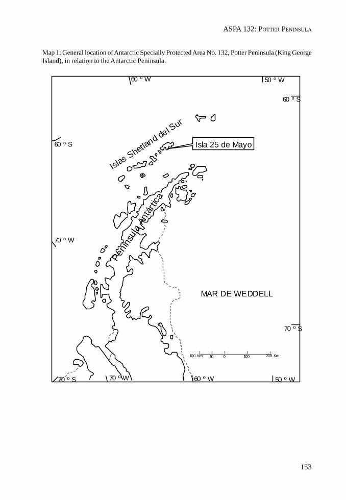
ASPA 132: POTTER PENINSULA
153
Map 1: General location of Antarctic Specially Protected Area No. 132, Potter Peninsula (King GeorgeIsland), in relation to the Antarctic Peninsula.
100 Km 50 0 100 200 Km
60 º W 50 º W
60 º S
60 º S
70 º W
70 º S 70 º W 60 º W 50 º W
70 º S
MAR DE WEDDELL
Islas Shetland del SurPe
nínsu
la An
tártic
aIsla 25 de Mayo
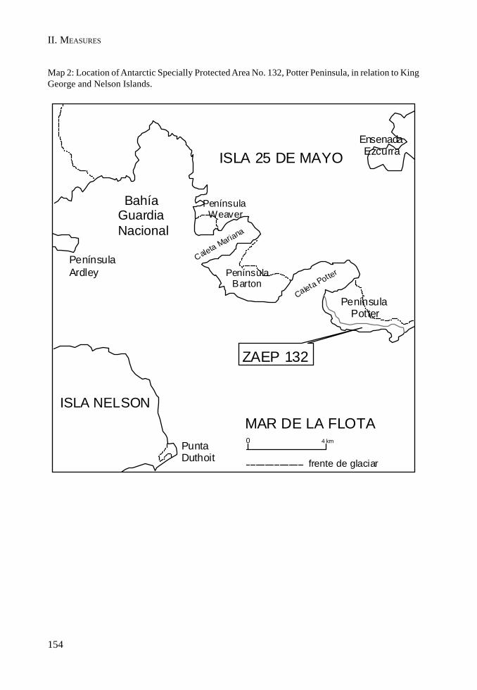
II. MEASURES
154
Map 2: Location of Antarctic Specially Protected Area No. 132, Potter Peninsula, in relation to KingGeorge and Nelson Islands.
ISLA NELSONMAR DE LA FLOTA
ISLA 25 DE MAYO
ZAEP 132
Bahía Guardia Nacional
frente de glaciar
PenínsulaArdley Península
Barton
Península Weaver
EnsenadaEzcurra
PuntaDuthoit
Caleta Mariana
Caleta Pot ter
Península Potter
0 4 km
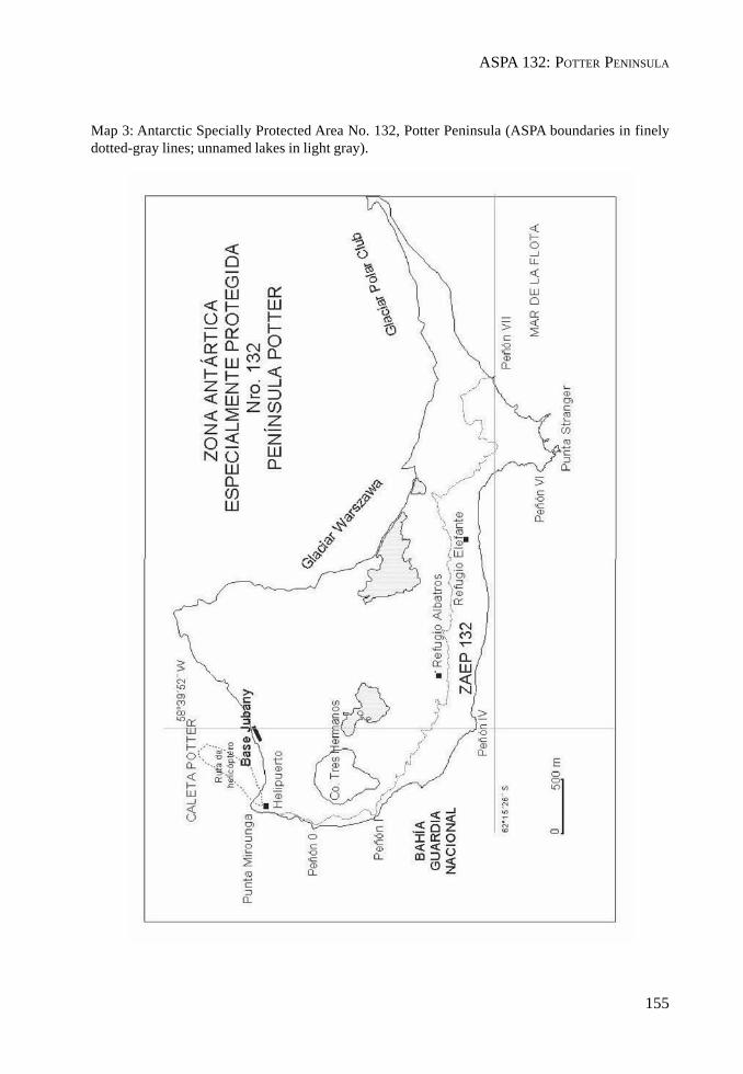
ASPA 132: POTTER PENINSULA
155
Map 3: Antarctic Specially Protected Area No. 132, Potter Peninsula (ASPA boundaries in finelydotted-gray lines; unnamed lakes in light gray).
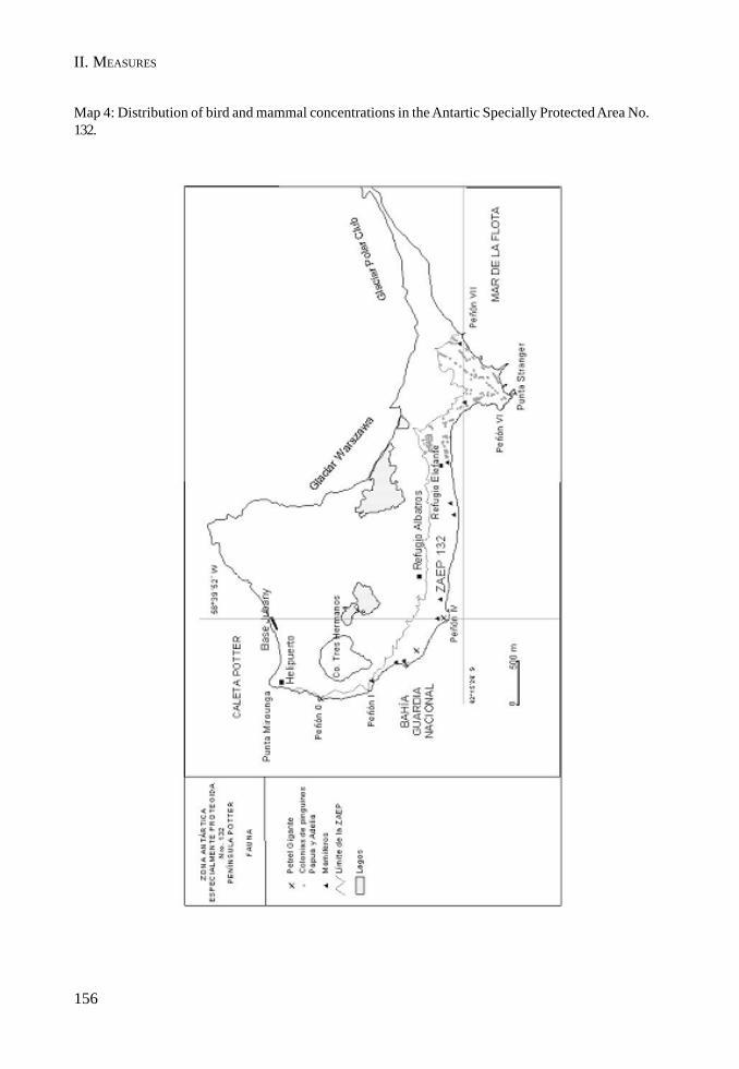
II. MEASURES
156
Map 4: Distribution of bird and mammal concentrations in the Antartic Specially Protected Area No.132.
MEASURE 2 - ANNEX G
157
Management Plan for Antarctic Specially Protected Area No. 133
HARMONY POINT, NELSON ISLAND, SOUTH SHETLAND ISLANDS
1. Description of Values to be Protected
This Area (62° 18’ S; 59° 14’ W) was originally designated as Site of Special Scientific Interest (SSSI)No. 14 in Antarctic Treaty Consultative Meeting (ATCM) Recommendation XIII-8 after a proposal byArgentina and Chile, because of its diverse bird community and extensive and varied terrestrialvegetation cover.
During the XXI Antarctic Treaty Consultative Meeting (Christchurch, 1997), a revised ManagementPlan was adopted for the Area, following the format established by Annex V to the Madrid Protocoland according to Measure 3 (1997). During the XXV Antarctic Treaty Consultative Meeting (Warsaw,2002) and once the Annex entered into force, the Site of Special Scientific Interest No. 14 became, byvirtue of Measure 1 (2002), Antarctic Specially Protected Area No. 133.
The values to be protected in the Area are related to the composition and biological diversity of thesite. The Area is an excellent example of the maritime Antarctic communities of birds and landecosystems present in the South Shetland Islands, allowing to carry out long term research programswithout damage or harmful interference.
Ice-free land supports large breeding colonies of 12 seabird species, among which we find one of thelargest single colonies of chinstrap penguin (Pygoscelis antarctica) of Antarctica. The Area supportsa large giant petrel colony (Macronectes giganteus) colony, a species which is highly sensitive toany kind of human disturbance and is decreasing in many sites in Antarctica. The seabird coloniesare still important for scientific purposes. There is copious vegetation that has grown over differenttypes of soils and characterized by the presence of moss, lichens and fungi. To a lesser extent, it ispossible to find two species of vascular plants. As vegetation is one of the factors responsible forsoil formation, in protecting the Area one makes sure the development of future research linked to thesoils and the flora present in the Area are guaranteed.
2. Aims and Objectives
Management of ASPA No. 133 aims at:
• preserving the community of birds and the terrestrial ecosystem;• preventing unnecessary human disturbance;• permitting scientific research on birds and the terrestrial ecosystem without any interferences,
in order to provide a baseline for the study of natural variability; and• permitting the development of any other scientific research provided it does not compromise
the values for which the Area is being protected.
3. Management Activities
The following management activities will be undertaken to protect the values of the Area:
II. MEASURES
158
• the staff to be posted at Harmony Point will be specifically trained on the conditions of theManagement Plan;
• the circulation will only take place on vegetation-free areas and taking a wide berth from thefauna, except when the scientific projects specifically mention otherwise and provided thecorresponding harmful interference permits have been issued;
• collection of samples will be limited to the minimum required for the authorized scientificresearch plans;
• visits shall be made as necessary to ensure management and maintenance measures areadequate; and
• all markers, signs and structures erected within the Area for scientific or management purposeswill be properly secured and maintained in good condition.
4. Period of Designation
Designated for an indefinite period.
5. Maps
Maps 1 and 3 are attached at the end of the present Management Plan. Map 1 shows the location ofNelson Island in relation to the South Shetland Islands and the Antarctic Peninsula. Map 2 shows thelocation of ASPA No. 133 on Nelson Island. Map 3 shows the extent of the Area, including HarmonyPoint and the Toe, while Map 4 shows the distribution of bird concentrations at Harmony Point.
6. Description of the Area
6(i) Geographical coordinates, boundary markers and natural features
Geographical coordinates and boundaries
This Area is located on the west coast of Nelson Island, between King George (25 de Mayo/ReyJorge) Island to the Northeast and Robert Island to the Southwest (62° 18’ S; 59° 14’ W) and includesHarmony Point and the Toe, the adjacent ice and surrounding marine zone within the rectangleshows on Maps 2 and 3.
Natural features
Geomorphologically, Harmony Point presents three well defined units: an andesitic plateau, coastaland shelf outcrops and ancient sea levels. The plateau reaches 40 m above sea level and its area iscovered by detritus resulting from the action of erosion agents on andesitic rocks, with a well-developed vegetation of mosses and lichens.
There are three successive raised paleobeaches, between the coast and the glacier. The paleobeachesare defined by pebble accumulations of variable height in some instances and the development ofsoil in others.
Lakes and streams with a limited flow appear on the undulations. Some isolated andesitic rocks andancient nunataks can be seen outside the limits of the glacier, evidencing that the past extension ofthe glacier covered Harmony Point.
ASPA 133: HARMONY POINT
159
The Area holds breeding colonies of 12 species: 3347 pairs of gentoo penguins (Pygoscelis papua),89685 pairs of chinstrap penguins (Pygoscelis antarctica), 746 pairs of southern giant petrels(Macronectes giganteus), 479 pairs of cape petrel (Daption capense), 45 pairs of blue eyed shag(Phalacrocorax atriceps), 144 pairs of snowy sheathbill (Chionis alba), 71 pairs of skuas (61 pairs ofAntarctic skuas (Catharacta antarctica) and 11 of Polar skuas), 128 pairs of Dominican gull (Larusdominicanus) and between 100 and 150 individuals of Antarctic terns (Sterna vittata).
Other seabirds nesting in the Area are the Wilson’s storm petrel (Oceanites oceanicus) and the black-bellied storm petrel (Fregetta tropica). Together they represent around 1000 pairs. Map 4 shows thedistribution of bird concentrations at Harmony Point.
There are usually 3 species of mammals in the Area: the Weddell seal (Leptonychotes weddelli), theelephant seal (Mirounga leonina) and the Antarctic fur seal (Arctocephalus gazella). Occasionallysome individual crabeater seals (Lobodon carcinophagus) have also been seen. The number ofmammals in the area varies. The maximum numbers of Antarctic fur seals, Weddell seals and elephantseals are 320, 550 and 100 respectively. The Weddell seals usually breed in the Area in high figures,reaching up to 60 females with their pups in a single season. Births of fur and elephant seals havealso been recorded, although the numbers there are much lower.
There are some extensive areas covered by a very rich and diverse development of bryophytes andlichen-dominated plant communities (presently being classified), including, although to a lesserdegree, two vascular plant species (Deschampsia antarctica and Colobanthus quitensis), especiallyin the areas less affected by recent anthropic perturbation or breeding activities. Moss turfsubformations are located in wind protected and moist places, whilst lichen-dominated subformationsoccur in places with a high wind exposure. Five soil orders have been identified so far in the Area,according to the taxonomic system: Soil Taxonomy (1999): Histosols (Hydric Cryfibrists), Entisols(Lithic Criorthents), Spodosols (Oxiaquic Humicryods), Mollisols (Lithic Haplocryolls) and Inceptisols(Lithic Eutrocryepts e Histic Cryaquepts).
6(ii) Restricted zones within the Area
There are no prohibited zones within the Area, but access to bird breeding areas should be restrictedduring the breeding season (September to March). In order to avoid damage to the vegetation,access on foot should take place on sectors deprived of vegetal coverage.
6(iii) Location of structures within the Area
There is a small refuge used by the scientific teams, and a storage building (with approximate surfacesof 30 m² and 12 m² respectively). The installations are used only during spring and summer. There isa Chilean radio beacon for navigating at the westernmost tip of Harmony Point and an Argentine oneat the Toe.
6(iv) Location of other Protected Areas within close proximity
• ASPA No. 112, Coppermine Peninsula, Robert Island, South Shetland Islands lies about 30km south west.
• ASPA No. 125, Fildes Peninsula, King George Island (25 de Mayo/Rey Jorge), South ShetlandIslands lies about 23 km north-north-east.
• ASPA No. 128, Western Shore of Admiralty Bay, King George Island (25 de Mayo/ReyJorge), South Shetland Islands lies about 45 km east-north-east.

II. MEASURES
160
• ASPA No. 132, Potter Peninsula, King George Island (25 de Mayo/Rey Jorge), South ShetlandIslands lies about 30 km east-north-east.
7. Permit Conditions
Entry into the Area is prohibited except in accordance with a Permit issued by appropriate nationalauthorities.
Conditions for issuing a Permit to enter the Area are that:
• it is issued only for scientific purposes, in accordance with the objectives of the ManagementPlan that cannot be served elsewhere;
• the actions permitted will not jeopardize the natural ecological system in the Area;• any management activities (inspection, maintenance or revision) are in support of the
objectives of the Management Plan;• the actions permitted are in accordance with this Management Plan;• the Permit, or authorized copy, is carried by the main scientist authorized to enter the Area;
and• a report be supplied to the appropriate national authority mentioned in the Permit.
7(i) Access to and movements within the Area
• Any access to the Area will be possible with a Permit delivered by an appropriate nationalauthority, and it will only be issued for activities in agreement with the present ManagementPlan.
• Access to Harmony Point area will preferably take place from the sea. The appropriatelanding site is almost in front of the shelter, at the end of the cove, on a well protected sandbeach with no significant presence of fauna. Access to the navigation beacon located in thewest most tip of Harmony Point is only permitted by boat, with landings taking place at thesouth of the beacon. No access points are specified for the Toe although access is limited toinflatable boats.
• Small aircraft are allowed to land on the glacier, and helicopters are entitled to land but theymust not fly over the Area, especially the bird breeding areas. Approach for landing is totake place over the sea, and the landing spot is to be close to the shelter. Map 3 shows theflight path. Operation of aircraft over the ASPA shall follow, as a minimum standard, theprovisions contained in Resolution 2 (2004), “Guidelines for the operation of aircraft overbird colonies”. As a general rule, no aircraft is allowed to fly over the ASPA below 610 m(2000 ft), except for accessing the Area as specified above and in cases of emergency.
• Tourism and any other recreational activities are not allowed. Movements within the Areaare to take place on pre-established routes, particularly during the breeding season. Vehiclesare prohibited in the Area.
7(ii) Activities which are or may be conducted within the Area including restrictions on time andplace
• scientific research which cannot be conducted elsewhere and which will not jeopardize theecosystem of the Area;
• essential management activities, including monitoring.

ASPA 133: HARMONY POINT
161
7(iii) Installation, modification or removal of structures
• No additional structures are to be erected in the Area, or scientific equipment installed,except for essential scientific or management activities, and with a proper Permit.
• Any scientific equipment to be installed in the Area, as well as any research artifact, shall beapproved in a Permit and clearly labeled, indicating the country, name of principal investigatorand year of installation. All such items should be made of materials that pose minimal risk ofcontamination of the Area or risk of disturbing the vegetation or the fauna.
• No research traces are to remain once the Permit has expired. If a specific project cannot befinished within the timeframe specified in the Permit, an extension of the validity of thePermit shall be requested, authorizing those elements to remain there.
7(iv) Location of field camps
• If it is necessary to install tents they will have to be located in the immediate vicinity of theexisting shelter. No other locations shall be used for this purpose, in order to restrict thehuman impact.
• Such an exclusion is not valid for installing tents with scientific instruments or materials, orthose that are used as an observation base.
7(v) Restriction on material and organisms which may be brought into the Area
• No living animals or plant material shall be deliberately introduced into the Area.• No herbicides or pesticides shall be brought into the Area. Any other chemicals, which shall
be introduced with the corresponding Permit, shall be removed from the Area at or before theconclusion of the activity for which the Permit was granted. The purpose and type ofchemicals shall be documented as well as possible for other scientists to be informed.
• Fuel, food and other material are not to be stored in the Area, unless required for essentialpurposes connected with the activity for which the Permit has been granted, provided it isstored inside the shelter or close to it.
7(vi) Taking or harmful interference with native flora and fauna
• All forms of taking or harmful interference are prohibited, except in accordance with a Permit.Where an activity involves taking or harmful interference, it should be carried out inaccordance with the SCAR Code of Conduct for Use of Animals for Scientific Purposes inAntarctica, as a minimum standard.
• Information on taking and harmful interference will be duly exchanged through the AntarcticTreaty Information Exchange System and its record shall, as a minimum standard, be lodgedwith the Antarctic Master Directory or, in Argentina, at the National Antarctic Data Center(Centro de Datos Nacionales Antárticos).
• Scientists who take samples of any kind will provide evidence that they are familiar withprior taking of samples in order to minimize the risk of a potential duplication.
7(vii) Collection or removal of anything not brought into the area by the Permit Holder
• Any material of the Area may be collected and/or removed from the Area only according toa permit. Removal of dead biological specimens for scientific purposes must not exceed
II. MEASURES
162
levels that deteriorate the nutritional base of local scavengers and with the sole purpose ofperforming pathological analyses.
7(viii) Disposal of waste
• All non-physiological waste shall be removed from the Area. Wastewater and liquid domesticwaste may be dumped into the sea, in accordance with Article 5 of Annex III to the MadridProtocol.
• Waste generated as a consequence of research activities carried out in the Area may betemporarily stored next to the shelter awaiting removal. Such waste must be stowed awayaccording to Annex III to the Madrid Protocol, labeled as trash and secured against accidentalloss.
7(ix) Measures that may be necessary to ensure that the aims and objectives of the ManagementPlan continue to be met
• Permits may be granted to enter the Area to carry out biological monitoring and site inspectionactivities, including the collection of plant material and animals for scientific purposes, toerect or maintain notice boards and any other management measures.
• All scientific structures and instrumentation, including research markers, installed in theArea must be authorized in a Permit and clearly identified by country, name of principalresearcher and year of installation. Research markers and structures must be removed at orbefore the expiry of the Permit.
• If specific scientific projects cannot be concluded within the permitted time, applicationsmust be made for an extension to leave the items in situ. When it is necessary for scientificpurposes, signs can be installed at the locations where experiments are being carried out.
7(x) Requirements for reports
The principal Permit Holder for each Permit issued shall submit a report of activities conducted in theArea once the activity has been finalized. Such a report shall use the form submitted together withthe Permit, and then sent to the authority that issued the Permit. The records of ASPA permits andpost-visit reports will be exchanged with the other Consultative Parties, as part of the InformationExchange System, as specified in Article 1 of Annex V. Such reports should be stored and madeaccessible to all interested Parties, SCAR, CCAMLR and COMNAP, to provide the necessaryinformation on human activities within the Area needed for proper management to be carried out.
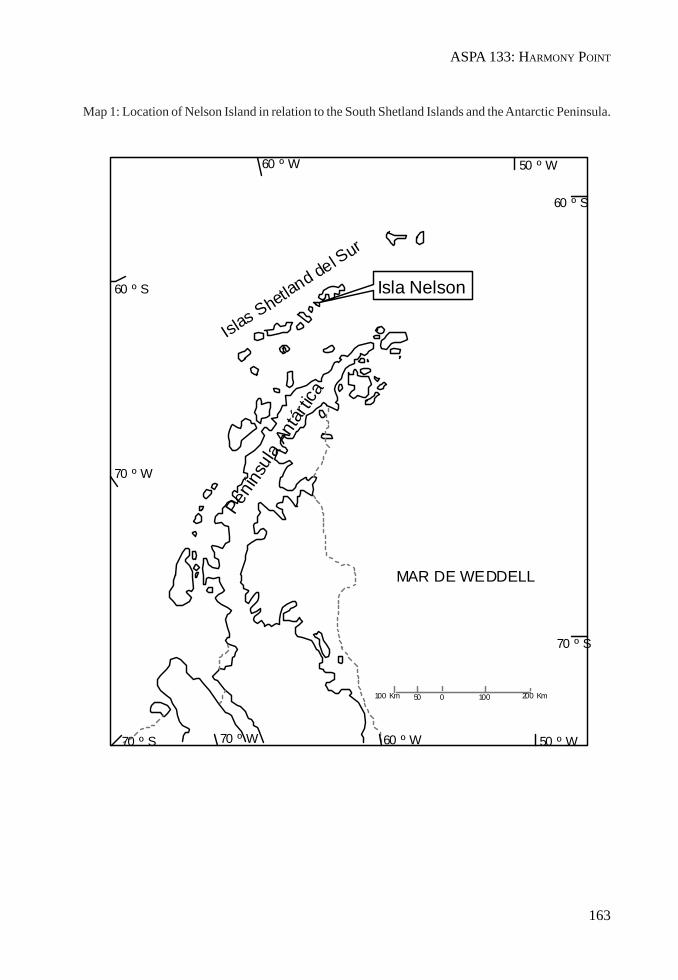
ASPA 133: HARMONY POINT
163
Map 1: Location of Nelson Island in relation to the South Shetland Islands and the Antarctic Peninsula.
100 Km 50 0 100 200 Km
60 º W 50 º W
60 º S
60 º S
70 º W
70 º S 70 º W 60 º W 50 º W
70 º S
MAR DE WEDDELL
Islas Shetland del SurPe
nínsu
la An
tártic
aIsla Nelson

II. MEASURES
164
Map 2: Location of Antarctic Specially Protected Area No. 133 on Nelson Island.

ASPA 133: HARMONY POINT
165
Map 3: Details of Antarctic Specially Protected Area No. 133, including Harmony Point and the Toe.
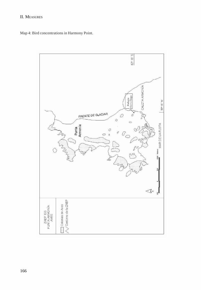
II. MEASURES
166
Map 4: Bird concentrations in Harmony Point.
MEASURE 2 - ANNEX H
167
Management Plan for Antarctic Specially Protected Area No. 149
CAPE SHIRREFFAND SAN TELMO ISLAND, LIVINGSTON ISLAND,SOUTH SHETLAND ISLANDS
1. Description of values to be protected
Cape Shirreff (62°27’30" S, 60°47’17" W, a peninsula of approximately 3.1 km2), Livingston Island,South Shetland Islands, was originally designated as Specially Protected Area (SPA) No.11 throughRecommendation IV-11 (1966) following the initiative of Chile in the light of results from the firstcensus of Pinnipedia carried out in the South Shetland Islands (Aguayo and Torres, 1966). Formalproposal of the SPA was made by the United States of America. The Area included the ice-freeground of the Cape Shirreff peninsula north of the Livingston Island ice cap margin. Values protectedunder the original designation included the diversity of plant and animal life, many invertebrates, asubstantial population of southern elephant seals (Mirounga leonina) and a small colony of Antarcticfur seals (Arctocephalus gazella).
Following designation, the size of the Cape Shirreff Antarctic fur seal colony increased to a level atwhich biological research could be undertaken without threatening continued increase. A survey ofthe South Shetland Islands and the Antarctic Peninsula identified Cape Shirreff – San Telmo Island asthe most suitable site to monitor Antarctic fur seal colonies that could be affected by fisheries aroundthe South Shetland Islands. In order to accommodate the monitoring program the SPA wasredesignated as Site of Special Scientific Interest (SSSI) No. 32 through Recommendation XV-7 (1989)following a joint proposal by Chile, the United Kingdom and the United States of America. Designationwas on the grounds that the “presence of both Antarctic fur seal and penguin colonies, and of krillfisheries within the foraging range of these species, make this a critical site for inclusion in theecosystem monitoring network being established to help meet the objectives of the Convention onthe Conservation of Antarctic Marine Living Resources (CCAMLR). The purpose of the designationis to allow planned research and monitoring to proceed, while avoiding or reducing, to the greatestextent possible, other activities which could interfere with or affect the results of the research andmonitoring programme or alter the natural features of the Site”. The boundaries were enlarged to includeSan Telmo Island and associated nearby islets. Following a proposal prepared by Chile and USA, theArea was subsequently designated as CCAMLR Ecosystem Monitoring Program (CEMP) Site No. 2through CCAMLR Conservation Measure 82/XIII (1994), with boundaries identical to SSSI No. 32.
The current Management Plan reaffirms the exceptional scientific and monitoring values associatedwith the large and diverse populations of seabirds and pinnipeds which breed within the Area, and inparticular those of the Antarctic fur seal colony. The Antarctic fur seal colony is the largest in theAntarctic Peninsula region and is the most southerly that is large enough to study growth, survival,diet, reproduction parameters: it numbered around 20,000 individuals in 2003-2004. Monitoring ofthe Antarctic fur seal colony began in 1965 (Aguayo and Torres, 1966; 1967) and seasonal data areavailable from 1991, making this one of the longest continuous Antarctic fur seal monitoring programs.As part of the CEMP, monitoring is established to detect and avoid possible adverse effects offisheries on dependant species such as pinnipeds and seabirds, as well as target species such asAntarctic krill (Euphausia superba). Long-term studies are assessing and monitoring the survival,feeding ecology, growth, condition, reproduction, behavior, vital rates, and abundance of pinnipedsand seabirds that breed within the Area. Data from these studies will be compared alongside
168
II. MEASURES
environmental and other biological data and fisheries statistics in order to help identify possiblecause-effect relationships between fisheries and pinniped and seabird populations.
In 2001 imprints of megaflora were discovered in rocks incorporated within moraines of the LivingstonIsland glacier (Palma-Heldt et al., in review 2004) (Map 2). The fossiliferous rocks are of two differentages, and early interpretations suggest the rocks may assist understanding relationships betweennearby fossil localities at Williams Point and Byers Peninsula, also on Livingston Island (Map 1).Studies of the fossils are on-going and it is important that they are protected from over-sampling.
The original values of the protected area associated with the plant and invertebrate communitiescannot be confirmed as primary reasons for special protection of the Area because there is a lack ofdata available describing the communities.
The boundaries of the Area designated under Recommendation XV-7 have been revised in thisManagement Plan to include a larger marine component and also to incorporate the two new siteswhere plant fossils were discovered (Maps 1 and 2). The designated Area (9.7 km2) comprises theentire Cape Shirreff peninsula north of the permanent Livingston Island ice cap, the San Telmo Islandgroup, and the surrounding and intervening marine area enclosed within 100 m of the coast of theCape Shirreff peninsula and of the outer islets of the San Telmo Island group. The boundary extendsfrom the San Telmo Island group to the south of Mercury Bluff, and includes the adjacent part of theLivingston Island permanent ice cap where the fossil discoveries were recently made.
2. Aims and objectives
Management at Cape Shirreff aims to:
• avoid degradation of, or substantial risk to, the values of the Area by preventing unnecessaryhuman disturbance;
• avoid activities that would harm or interfere with CEMP research and monitoring activities;• allow scientific research on the ecosystem and physical environment in the Area associated
with the CEMP;• allow other scientific research within the Area provided it is for compelling reasons which
cannot be served elsewhere and provided it will not compromise the values for which theArea is protected;
• allow archaeological research and measures for artifact protection, while protecting thehistoric artifacts present within the Area from unnecessary destruction, disturbance, orremoval;
• minimize the possibility of introduction of alien plants, animals and microbes to the Area;and
• allow visits for management purposes in support of the aims of the management plan.
3. Management activities
The following management activities shall be undertaken to protect the values of the Area:
• Copies of this management plan, including maps of the Area, shall be made available at thefollowing locations:a. accommodation facilities at Cape Shirreff;b. Saint Kliment Ohridski Station (Bulgaria), Hurd Peninsula, Livingston Island;

169
ASPA 149: CAPE SHIRREFF AND SAN TELMO ISLAND
c. Arturo Prat Station (Chile), Discovery Bay/Chile Bay, Greenwich Island; andd. Base Juan Carlos I (Spain), Hurd Peninsula, Livingston Island.
• A sign showing the location and boundaries of the Area with clear statements of entryrestrictions should be placed at Módulo Beach to help avoid inadvertent entry.
• Markers, signs or other structures erected within the Area for scientific or managementpurposes shall be secured and maintained in good condition.
• Visits shall be made as necessary (no less than once every five years) to assess whether theArea continues to serve the purposes for which it was designated and to ensure managementand maintenance measures are adequate.
4. Period of Designation
Designated for an indefinite period.
5. Maps
• Map 1: Cape Shirreff and San Telmo Island, ASPA No. 149, in relation to Livingston Island,showing the location of Base Juan Carlos I (Spain) and Saint Kliment Ohridiski Station(Bulgaria), and the location of the closest protected area, Byers Peninsula (ASPA No. 126),also on Livingston Island.Map specifications: Projection: Lambert Conformal Conic; Spheroid: WGS84; Standardparallels: 1st 60°00' S; 2nd 64°00' S; Central Meridian: 60°45' W; Latitude of Origin: 62°00'S; Horizontal accuracy: < ±200 m. Bathymetric contour interval 50 m and 500 m; verticalaccuracy unknown. Data sources: land features from SCAR Antarctic Digital Database v.4.0 (2002); bathymetry supplied by D. Demer & AMLR, NOAA, USA (2002).Inset: the location of Map 1 in relation to the South Shetland Islands and the AntarcticPeninsula.
• Map 2: Cape Shirreff and San Telmo Island, ASPA No. 149, protected area boundary andaccess guidelines.Map specifications: as per Map 1, except the vertical contour interval is 10 m and thehorizontal accuracy is expected to be greater than ±5 m. Data source: from digital datasupplied by Instituto Antártico Chileno (INACH) (2002) (Torres et al., 2001).
• Map 3: Cape Shirreff, ASPA No. 149: breeding wildlife and human features.Map specifications and data source: as per Map 2 with the exception of the vertical contourinterval, which is 5 m.
6. Description of the Area
6(i) Geographical coordinates, boundary markers and natural features
General description
Cape Shirreff (62°27’30" S, 60°47’17" W) is situated on the northern coast of Livingston Island, thesecond largest of the South Shetland Islands, between Barclay Bay and Hero Bay (Map 1). The capelies at the northern extremity of an ice-free peninsula of low-lying, hilly relief. To the west of the
170
II. MEASURES
peninsula lies Shirreff Cove, to the east Black Point, and to the south lies the permanent ice cap ofLivingston Island. The peninsula has an area of approximately 3.1 km², being 2.6 km from north tosouth and ranging from 0.5 to 1.5 km from east to west. The interior of the peninsula comprises aseries of raised beaches and both rounded and steep-sided hills, rising to a high point at Toqui Hill(82 m) in the central northern part of the peninsula. The western coast is formed by almost continuouscliffs 10 to 15 m high, while the eastern coast has extensive sand and gravel beaches.
A small group of low-lying, rocky islets lie approximately 1200 m west of the Cape Shirreff peninsula,forming the western enclosure of Shirreff Cove. San Telmo Island, the largest of the group, is 950 min length, up to 200 m in width, and of approximately 0.1 km² in area. There is a sand and pebble beachon the southeastern coast of San Telmo Island, separated from a sand beach to the north by twoirregular cliffs and narrow pebble beaches.
Boundaries
The designated Area comprises the entire Cape Shirreff peninsula north of the permanent LivingstonIsland ice cap, the San Telmo Island group, and the surrounding and intervening marine area (Map 2).The marine boundary encloses an area that extends 100 m from, and parallel to, the outer coastline ofthe Cape Shirreff peninsula and the San Telmo Island group. In the north, the marine boundaryextends from the northwestern extremity of the Cape Shirreff peninsula to the southwest for 1.4 km tothe San Telmo Island group, enclosing the intervening sea within Shirreff Cove. The westernboundary extends southwards for 1.8 km from 62°28' S to 62°29' S, passing around the western shoreof a small island and proceeding a further 1.2 km south-east to the shore of Livingston Island at62°28’30" S, which is approximately 300 m south of Mercury Bluff. From this point on the coast, thesouthern boundary extends approximately 300 m due east to 60°49' W, from where it proceeds in anortheasterly direction parallel to the coast for approximately 2 km to the ice sheet margin at 60°47' W.The southern boundary then extends due east for 600 m to the eastern coast. The eastern boundaryis marine, following the eastern coastline 100 m from the shore. The boundary encompasses an areaof 9.7 km² (Map 2).
Meteorology
Meteorological records for Cape Shirreff have been collected for a number of years by Chilean andUS scientists. Data for recent summer seasons (4 Dec - 24 Feb, 1998-99, 1999-2000 and 2000-01)recorded a mean daily air temperature of between 2.0°C and 2.5°C (Goebel et al. 2000; 2001). Precipitationrecorded in these seasons (21 Dec - 24 Feb) ranged from 56.0 mm (recorded on 36 days in 2000-01) to59.6 mm (recorded on 43 days in 1998-99). Year-round meteorological data have not been collected atCape Shirreff. The peninsula is snow-covered for much of the year, but is usually mostly snow-freeby the end of the summer. The peninsula is particularly exposed to weather from the Drake Passagein the north and northwest, the directions from which winds prevail.
Geology, Geomorphology and soils
The geology at Cape Shirreff has not been studied in detail. The Cape Shirreff peninsula ispredominantly a raised marine platform, 46 to 53 m above sea level, formed of inclined lava flowsbelonging to the Younger Volcanic Group of the Middle Jurassic to Lower Cretaceous (Bonner andSmith, 1985). The rocks are volcanic and volcaniclastic, including greenish andesite, basalt lavas,tuffs and agglomerates. The bedrock is largely covered by weathered rock and glacial deposits. Twolower platforms, covered with rounded water-worn pebbles, occur at elevations of approximately 7-9 m and 12-15 m a.s.l (Hobbs, 1968).
A fossilized wood specimen belonging to the Araucariaceae family (Araucarioxylon sp.) was recordedfrom Cape Shirreff (Torres, 1993). It is similar to fossils found at Byers Peninsula (ASPA No. 126), a
171
ASPA 149: CAPE SHIRREFF AND SAN TELMO ISLAND
site with rich fossil flora and fauna 20 km to the southwest. Several fossil specimens have also beenfound at the northern extremity of the Cape Shirreff peninsula. In 2001-02 fossiliferous rocks of twodifferent ages were discovered incorporated within frontal and lateral moraines of the LivingstonIsland glacier (Palma-Heldt et al., in review 2004) (Map 2). Rocks in the first group are assigned to theCarnian-Lias (Upper Triassic-Lower Jurassic), and the dominant plant taxa are Cladophlebis oblongaHalle, C. antarctica Nathorst, Taeniopteris Brongniart, Goeppertella neuqueniana Herbst,Coniopteris cf. hymenophylloides Brongniart, Sphenopteris metzgerioides Harris, and S. anderssoniiHalle. The second group consists of rocks assigned to the Lower Cretaceous, and is dominated byconifers from the Araucareaceae Family and Ptilophyllum acutifolium Morris.
There is little information on the soils of Cape Shirreff. They are mainly fine ash and scoria and arehighly porous. The soils support a sparse vegetation and are enriched by bird and seal colonieswhich inhabit the Area.
Streams and lakes
There is one permanent lake on Cape Shirreff, located north and at the base of Toqui Hill (Map 3). Thelake is approximately 2-3 m deep and 12 m long at full capacity, diminishing in size after February(Torres, 1995). Moss banks grow on surrounding slopes. There are also several ephemeral ponds andstreams on the peninsula, fed by snow-melt, especially in January and February. The largest of thestreams is found draining southwestern slopes toward the coast at Yamana Beach.
Vegetation and invertebrates
Although a comprehensive survey of the vegetation communities at Cape Shirreff has not beenundertaken, Cape Shirreff appears to be less well vegetated than many other sites in the SouthShetland Islands. Observations to date have recorded one grass, five species of moss, six of lichen,one fungi and one nitrophilous macroalgae (Torres, 1995).
Patches of Antarctic hairgrass (Deschampsia antarctica) can be found in some valleys, often growingwith mosses. Mosses are predominantly found inland from the coast. In a valley running northwestfrom Half Moon Beach, there is a moderately well-developed wet moss carpet of Warnstorfia laculosa(=Calliergidium austro-stramineum, also =Calliergon sarmentosum) (Bonner 1989, in Heap, 1994).In areas with better drainage, Sanionia uncinata (=Drepanocladus uncinatus) and Polytrichastrumalpinum (=Polytrichum alpinum) are found. The raised beach areas and some higher plateaus haveextensive stands of the foliose nitrophilous macroalga Prasiola crispa, which is characteristic ofareas enriched by animal excreta and has been observed to replace moss-lichen associations damagedby fur seals (Bonner 1989, in Heap, 1994).
The six lichen species thus far described at Cape Shirreff are Caloplaca spp, Umbilicaria antarctica,Usnea antarctica, U. fasciata, Xanthoria candelaria and X. elegans. The fruticose speciesUmbilicaria antarctica, Usnea antarctica and U. fasciata form dense growths on cliff faces and onthe tops of steep rocks (Bonner 1989, in Heap, 1994). The bright yellow and orange crustose lichensCaloplaca spp, Xanthoria candelaria and X. elegans are common beneath bird colonies and arealso present with the fruticose species. The identity of the single recorded fungal species is unknown.
The invertebrate fauna at Cape Shirreff has not been described.
Breeding birds
The avifauna of Cape Shirreff is diverse, with ten species known to breed within the Area, and severalnon-breeding species present. Chinstrap (Pygoscelis antarctica) and gentoo (P. papua) penguinsbreed within the Area; Adélie penguins (P. adeliae) have not been observed to breed on CapeShirreff or San Telmo Island, although are widely distributed throughout the region. Both the chinstrap
172
II. MEASURES
and gentoo penguins are found in small colonies on the northeastern and northwestern coasts ofCape Shirreff peninsula (Map 3). In 2000-01 there were 29 active breeding sub-colonies – 16 chinstrap,seven gentoo, and six with both species (Taft et al. 2001) – although the number of the sub-coloniesand their composition show some inter-annual variation. In general, the chinstrap penguins nest onhigher escarpments, although are also found breeding on small promontories near the shore. Gentoopenguins tend to breed on more gentle slopes and rounded promontories. Data available on penguinnumbers are presented in Table 1.
Several other species breed within the Area (Map 3), although data on numbers are intermittent. Kelpgulls (Larus domincanus) and brown skuas (Catharacta loennbergi) nest in abundance along theentire coastline of the Area. In 2000 there were 25 and 22 breeding pairs of these species respectively(Wayne Trivelpiece, U.S. Antarctic Marine Living Resources Program, pers. comm. 2000; Saxer et al.2003; Shill et al. 2003; Taft et al. 2001). Sheathbills (Chionis alba) nest in two places: one pair hasbeen recorded nesting on the western coast of the Cape Shirreff peninsula; a second pair has beenobserved breeding among rocks at the northern beach on San Telmo Island, near an Antarctic fur sealbreeding site (Daniel Torres, Instituto Antartico Chileno, pers. comm. 2002). Antarctic terns (Sternavittata) breed in several locations, which have been observed to vary from year to year. Since 1990-91 a small colony of approximately 11 pairs of Antarctic shags (Phalacrocorax [atriceps]bransfieldensis) has been observed breeding on Yeco Rocks, on the western coast of the peninsula(Torres, 1995). Cape petrels (Daption capense) breed on cliffs on the western coast of the Area; 14pairs were recorded in January 1993, nine in January 1994, three in January 1995 and eight in 1999.Wilson’s storm petrels (Oceanites oceanicus) also breed on the western coast of the Area. Black-bellied storm petrels (Fregetta tropica) have been observed to breed near the field camp on theeastern coast. A large number of non-breeding southern giant petrels (Macronectes giganteus)frequent the Area in the summer, although a report of a breeding colony on the peninsula (Bonner1989, in Heap 1994) is incorrect (Daniel Torres, Instituto Antartico Chileno, pers. comm. 2002). Otherbird species recorded but not breeding within the Area include macaroni penguins (Eudypteschrysolophus), king penguins (Aptenodytes patagonicus) snow petrels (Pagadroma nivea), white-rumped sandpipers (Calidris fuscicollis), black-necked swan (Cygnus melanocorypha), and theheron Bubulcus ibis (Torres, 1995; Olavarría et al., 1999).
Table 1: Chinstrap (Pygoscelis antarctica) and gentoo (P. papua) penguin numbers at Cape Shirreff.
Year Chinstrap (pairs) Gentoo (pairs) Source1958 2000 (N31) 200-500 (N11) Croxall and Kirkwood, 19791981 2164 (A4) 843 (A4) Sallaberry and Schlatter, 1983 21987 5200 (A3) 300 (N4) Woehler, 19931997 6907 (N1) 682 (N1) Hucke-Gaete et al. 1997a1999-00 7744 (N1) 922 (N1) AMLR data, Carten et al. 20012000-01 7212 (N1) 1043 (N1) AMLR data, Taft et al. 2001
1. Alphanumeric code refers to the type of count, as in Woehler (1993).2. Reported data did not specify species. It has been assumed that the higher number referred to Chinstrap penguins. Data were reportedas individuals, which have been halved to derive ‘pairs’ in the table.
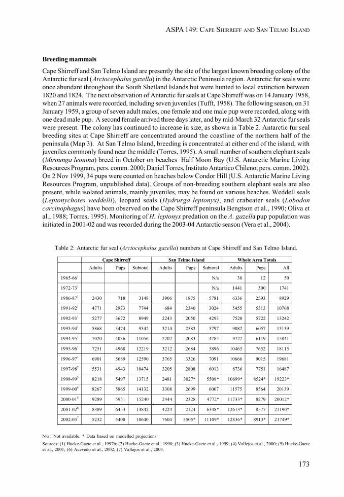
173
ASPA 149: CAPE SHIRREFF AND SAN TELMO ISLAND
Breeding mammals
Cape Shirreff and San Telmo Island are presently the site of the largest known breeding colony of theAntarctic fur seal (Arctocephalus gazella) in the Antarctic Peninsula region. Antarctic fur seals wereonce abundant throughout the South Shetland Islands but were hunted to local extinction between1820 and 1824. The next observation of Antarctic fur seals at Cape Shirreff was on 14 January 1958,when 27 animals were recorded, including seven juveniles (Tufft, 1958). The following season, on 31January 1959, a group of seven adult males, one female and one male pup were recorded, along withone dead male pup. A second female arrived three days later, and by mid-March 32 Antarctic fur sealswere present. The colony has continued to increase in size, as shown in Table 2. Antarctic fur sealbreeding sites at Cape Shirreff are concentrated around the coastline of the northern half of thepeninsula (Map 3). At San Telmo Island, breeding is concentrated at either end of the island, withjuveniles commonly found near the middle (Torres, 1995). A small number of southern elephant seals(Mirounga leonina) breed in October on beaches Half Moon Bay (U.S. Antarctic Marine LivingResources Program, pers. comm. 2000; Daniel Torres, Instituto Antartico Chileno, pers. comm. 2002).On 2 Nov 1999, 34 pups were counted on beaches below Condor Hill (U.S. Antarctic Marine LivingResources Program, unpublished data). Groups of non-breeding southern elephant seals are alsopresent, while isolated animals, mainly juveniles, may be found on various beaches. Weddell seals(Leptonychotes weddelli), leopard seals (Hydrurga leptonyx), and crabeater seals (Lobodoncarcinophagus) have been observed on the Cape Shirreff peninsula Bengtson et al., 1990; Oliva etal., 1988; Torres, 1995). Monitoring of H. leptonyx predation on the A. gazella pup population wasinitiated in 2001-02 and was recorded during the 2003-04 Antarctic season (Vera et al., 2004).
Table 2: Antarctic fur seal (Arctocephalus gazella) numbers at Cape Shirreff and San Telmo Island.
Cape Shirreff San Telmo Island Whole Area TotalsAdults Pups Subtotal Adults Pups Subtotal Adults Pups All
1965-661 N/a 38 12 50
1972-731 N/a 1441 300 1741
1986-871 2430 718 3148 3906 1875 5781 6336 2593 8929
1991-921 4771 2973 7744 684 2340 3024 5455 5313 10768
1992-931 5277 3672 8949 2243 2050 4293 7520 5722 13242
1993-941 5868 3474 9342 3214 2583 5797 9082 6057 15139
1994-951 7020 4036 11056 2702 2083 4785 9722 6119 15841
1995-961 7251 4968 12219 3212 2684 5896 10463 7652 18115
1996-971 6901 5689 12590 3765 3326 7091 10666 9015 19681
1997-982 5531 4943 10474 3205 2808 6013 8736 7751 16487
1998-993 8218 5497 13715 2481 3027* 5508* 10699* 8524* 19223*
1999-004 8267 5865 14132 3308 2699 6007 11575 8564 20139
2000-015 9289 5951 15240 2444 2328 4772* 11733* 8279 20012*
2001-026 8389 6453 14842 4224 2124 6348* 12613* 8577 21190*
2002-037 5232 5408 10640 7604 3505* 11109* 12836* 8913* 21749*
N/a : Not available. * Data based on modelled projections.Sources: (1) Hucke-Gaete et al., 1997b; (2) Hucke-Gaete et al., 1998; (3) Hucke-Gaete et al., 1999; (4) Vallejos et al., 2000; (5) Hucke-Gaeteet al., 2001; (6) Acevedo et al., 2002; (7) Vallejos et al., 2003.
174
II. MEASURES
Marine environment
The seafloor surrounding the Cape Shirreff peninsula slopes relatively gently from the coast, reachingdepths of 50 m approximately 2-3 km from the shore and 100 m at about 6-11 km (Map 1). Thisrelatively shallow and broad submarine ridge extends to the NW for about 24 km before droppingmore steeply at the continental shelf edge. The ridge is about 20 km in width and flanked either sideby canyons reaching depths of around 300-400 m. Little published information is available on thenearshore marine environment within the Area. There is abundant macroalgae present in the intertidalzone. The limpet Nacella concinna is common, as elsewhere in the South Shetland Islands.
Historical features
Intensive sealing at Cape Shirreff between 1820 and 1824 exterminated almost the entire localpopulations of Antarctic fur seals and southern elephant seals (Smith and Simpson, 1987). In January1821 60–75 British sealers were recorded living ashore at Cape Shirreff and 95,000 skins were takenduring the 1821-22 season. Evidence of the sealers’ occupation remains, with ruins of at least onesealers’ hut in the northwestern region of the peninsula, and the shoreline of several bays is litteredwith timbers and sections of wrecked sealers’ vessels. Other evidence of sealing activity includes theremains of stoves, pieces of glass bottles, a wooden harpoon, and a handcrafted bone figure, etc.(Torres and Aguayo, 1993). Fildes (1821) reported that sealers found spars and an anchor stock fromthe Spanish ship San Telmo on Half Moon Beach around the time she was lost. The ship sank in theDrake Passage at around 62°S on 4 September 1819, with 644 persons aboard (Headland, 1989;Pinochet de la Barra, 1991). These were possibly the first people to die in Antarctica, and the eventremains the greatest single loss of life yet to occur south of 60°S. A cairn has been erected on thenorthwestern coast of Cape Shirreff peninsula to commemorate the loss, which is designated asHistoric Monument No. 59 (Map 3).
The remains of a camp were found close to the site of present camp facilities (Torres and Aguayo,1993). On the evidence of the script on items found at the site, the camp is believed to be of Russianorigin and date from the 1940-50s, although its exact origins have yet to be determined. Items foundinclude parts of an antenna, electrical wires, tools, boots, nails, battery cells, canned food, and awooden box covered by a pyramid of stones. Several notes in Russian, dating from later visits, werefound in this box.
In January 1985 a human skull was found at Yamana Beach (Torres, 1992), determined to be that of ayoung woman (Constantinescu and Torres, 1995). In January 1987 part of a human femur was foundon the ground surface nearby, inland from Yamana Beach. After a careful surface survey, no otherremains were evident at that time. However, in January 1991, another part of a femur was found inclose proximity to the site of the earlier (1987) find. In January 1993 an archaeological survey wascarried out in the area, although no further human remains were found. The original samples weredated as from approximately 175 years BP, and it was hypothesised they belong to a single individual;DNA analyses are planned to determine whether this is the case (Torres, 1999).
Human activities and impact
The modern era of human activity at Cape Shirreff has been largely confined to science. During thepast three decades, the population of Antarctic fur seals in the South Shetland Islands grew to a levelat which tagging and other research could be undertaken without threatening the continued existenceand growth of the local population. Chilean studies on Cape Shirreff began in 1965 (Aguayo andTorres, 1966, 1967), with a more intensive program initiated by Chilean scientists in 1982, including anongoing Antarctic fur seal tagging program (Cattan et al., 1982; Torres, 1984; Oliva et al., 1987).United States investigators have conducted pinniped and seabird surveys at Cape Shirreff and SanTelmo Island since 1986-87 (Bengtson et al., 1990).
175
ASPA 149: CAPE SHIRREFF AND SAN TELMO ISLAND
Marine environment
The seafloor surrounding the Cape Shirreff peninsula slopes relatively gently from the coast, reachingdepths of 50 m approximately 2-3 km from the shore and 100 m at about 6-11 km (Map 1). Thisrelatively shallow and broad submarine ridge extends to the NW for about 24 km before droppingmore steeply at the continental shelf edge. The ridge is about 20 km in width and flanked either sideby canyons reaching depths of around 300-400 m. Little published information is available on thenearshore marine environment within the Area. There is abundant macroalgae present in the intertidalzone. The limpet Nacella concinna is common, as elsewhere in the South Shetland Islands.
Historical features
Intensive sealing at Cape Shirreff between 1820 and 1824 exterminated almost the entire localpopulations of Antarctic fur seals and southern elephant seals (Smith and Simpson, 1987). In January1821 60–75 British sealers were recorded living ashore at Cape Shirreff and 95,000 skins were takenduring the 1821-22 season. Evidence of the sealers’ occupation remains, with ruins of at least onesealers’ hut in the northwestern region of the peninsula, and the shoreline of several bays is litteredwith timbers and sections of wrecked sealers’ vessels. Other evidence of sealing activity includes theremains of stoves, pieces of glass bottles, a wooden harpoon, and a handcrafted bone figure, etc.(Torres and Aguayo, 1993). Fildes (1821) reported that sealers found spars and an anchor stock fromthe Spanish ship San Telmo on Half Moon Beach around the time she was lost. The ship sank in theDrake Passage at around 62°S on 4 September 1819, with 644 persons aboard (Headland, 1989;Pinochet de la Barra, 1991). These were possibly the first people to die in Antarctica, and the eventremains the greatest single loss of life yet to occur south of 60°S. A cairn has been erected on thenorthwestern coast of Cape Shirreff peninsula to commemorate the loss, which is designated asHistoric Monument No. 59 (Map 3).
The remains of a camp were found close to the site of present camp facilities (Torres and Aguayo,1993). On the evidence of the script on items found at the site, the camp is believed to be of Russianorigin and date from the 1940-50s, although its exact origins have yet to be determined. Items foundinclude parts of an antenna, electrical wires, tools, boots, nails, battery cells, canned food, and awooden box covered by a pyramid of stones. Several notes in Russian, dating from later visits, werefound in this box.
In January 1985 a human skull was found at Yamana Beach (Torres, 1992), determined to be that of ayoung woman (Constantinescu and Torres, 1995). In January 1987 part of a human femur was foundon the ground surface nearby, inland from Yamana Beach. After a careful surface survey, no otherremains were evident at that time. However, in January 1991, another part of a femur was found inclose proximity to the site of the earlier (1987) find. In January 1993 an archaeological survey wascarried out in the area, although no further human remains were found. The original samples weredated as from approximately 175 years BP, and it was hypothesised they belong to a single individual;DNA analyses are planned to determine whether this is the case (Torres, 1999).
Human activities and impact
The modern era of human activity at Cape Shirreff has been largely confined to science. During thepast three decades, the population of Antarctic fur seals in the South Shetland Islands grew to a levelat which tagging and other research could be undertaken without threatening the continued existenceand growth of the local population. Chilean studies on Cape Shirreff began in 1965 (Aguayo andTorres, 1966, 1967), with a more intensive program initiated by Chilean scientists in 1982, including anongoing Antarctic fur seal tagging program (Cattan et al., 1982; Torres, 1984; Oliva et al., 1987).United States investigators have conducted pinniped and seabird surveys at Cape Shirreff and SanTelmo Island since 1986-87 (Bengtson et al., 1990).

176
II. MEASURES
CEMP studies at Cape Shirreff began in the mid-1980s, initiated by Chilean and US scientists. CapeShirreff was designated as a CEMP Site in 1994 to protect the site from damage or disturbance thatcould adversely affect long-term CEMP monitoring. As part of the CEMP, long-term studies areassessing and monitoring the feeding ecology, growth and condition, reproductive success, behavior,vital rates, and abundance of pinnipeds and seabirds that breed in the Area. The results of thesestudies will be compared with environmental data, offshore sampling data, and fishery statistics toidentify possible cause-effect relationships between krill fisheries and pinniped and seabirdpopulations.
Brucella and herpes virus antibodies were detected in tissue samples taken from Antarctic fur sealsat Cape Shirreff over summer seasons from 1998-2001, and Brucella antibodies were also detected inWeddell seal tissue (Blank et al, 1999; Blank et al., 2001a & b). Studies on the mortality of A. gazellapups from diseases began in the 2003-04 Antarctic season (Torres and Valdenegro, 2004).
Plastic rubbish was first reported at Cape Shirreff by Torres and Gajardo (1985), and marine debrismonitoring studies have been carried out regularly since 1992 (Torres and Jorquera, 1995). Recentsurveys have yielded large numbers of articles, mostly of plastic. For example, the 2000-01 seasonsurvey recorded a total of 1,774 articles with a total weight of 124.5 kg, almost 98% of which were ofplastic and the remainder being of glass, metal and paper. These quantities are comparable to the1996-97 survey (Torres et al. 1997). It is significant that 34% of the plastic items found in 2000-01 werepacking bands, representing approximately 589 bands. Of these, 40 were uncut and another 48 hadbeen knotted into a loop, in contravention of CCAMLR Conservation Measure 63/XV and Annex IVof the Madrid Protocol. Several articles found in this survey were oiled, and some plastic articleswere partially burnt. Antarctic fur seal entanglement in marine debris has been recorded frequently atCape Shirreff (Torres, 1990; Hucke-Gaete et al. 1997c), primarily in fishing equipment such as nylonropes, net fragments and packing bands. Between 1987-97 a total of 20 Antarctic fur seals wererecorded with ‘neck collars’. Plastic fibers are also found in kelp gull and chinstrap penguin nests(Torres and Jorquera, 1992), as well as those of sheathbills (Torres and Jorquera, 1994).
6(ii) Restricted and managed zones within the Area
None.
6(iii) Structures within and near the Area
A semi-permanent summer-only research camp has been established on the eastern coast of the CapeShirreff peninsula, located at the base of Condor Hill (62°28’12" S, 60°46’17" W) (Map 3). Buildingsfor the camp remain in situ year-round. In 2001 the camp comprised a four-person fiberglass cabin(Chile), known as ‘Guillermo Mann’, and three additional small buildings with accommodation for sixknown as Cape Shirreff Field Station (US). The Chilean cabin was installed in 1990-91, while the UScamp was established in 1996-97. Toilet facilities and storage areas are also present, and tents areerected seasonally nearby as required. The remains of a camp, believed to be of Russian origin, arepresent near the Chilean and US camps. In other parts of the peninsula, sparse evidence may befound of 19th Century sealers’ camps (Smith and Simpson, 1987; Torres, 1993; Stehberg and Lucero,1996). A cairn (Historic Monument No. 59) has been erected on Gaviota Hill on the northwesterncoast to commemorate the loss of those aboard the San Telmo in 1819 (Map 3). In 1998-99 a 5x7 m birdobservation / emergency hut (62°27’41" S, 60°47’28" W) was installed by US scientists on thenorthern slopes of Enrique Hill above Bahamonde Beach, close to the penguin colonies (Map 3).

177
ASPA 149: CAPE SHIRREFF AND SAN TELMO ISLAND
6(iv) Location of other protected areas within close proximity of the Area
The nearest protected areas to Cape Shirreff are Byers Peninsula (ASPA No. 126), which lies about 20km to the southwest; Port Foster (ASPA No. 145, Deception Island) and other parts of DeceptionIsland (ASPA No. 140), which are approximately 30 km to the south; and ‘Chile Bay’ (Discovery Bay)(ASPA No. 144), which lies about 30 km to the east at Greenwich Island (Map 1). CEMP Site No. 1 SealIslands (60°59’S, 55°23’W), the only other CEMP site in the vicinity, is located 325 km to the northeast,7 km north of Elephant Island.
7. Permit conditions
Entry into the Area is prohibited except in accordance with a Permit issued by an appropriate nationalauthority. Conditions for issuing a Permit to enter the Area are that:
• it is issued only for scientific study associated with the CEMP, or for compelling scientificreasons that cannot be served elsewhere; or
• it is issued for essential management purposes consistent with plan objectives such asinspection, maintenance or review;
• the actions permitted will not jeopardize the values of the Area;• any management activities are in support of the objectives of the Management Plan;• the actions permitted are in accordance with the Management Plan;• the Permit, or an authorized copy, shall be carried within the Area;• a visit report shall be supplied to the authority named in the Permit;• permits shall be issued for a stated period.
7(i) Access to and movement within the Area
Access to the Area shall be by small boat, by helicopter, on foot or by vehicle.
BOAT ACCESS
Access by small boats should be at either of the following locations (Map 2):
• the eastern coast of the peninsula at El Módulo Beach, 300 m north of the camp facilities,where a deep channel enables relatively easy access;
• the northern end of Half Moon Beach, on the eastern coast of the peninsula;• the northern end of Yámana Beach, on the western coast (suitable at high tide only);• the southern end of the northern beach on San Telmo Island.
Access by small boat at other locations around the coast is allowed, provided this is consistent withthe purposes for which a Permit has been granted. Two anchorages have been identified close to theArea; 1600 m north-east of the main camp facilities and approximately 800 m north of San TelmoIsland [note: these remain in need of confirmation – positions in the CEMP plan do not conform withthose on CEMP maps]. Visitors should, where practicable, avoid landing where pinniped or seabirdcolonies are present on or near the coast.
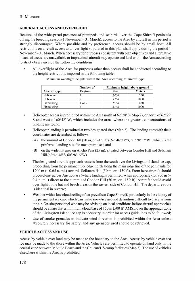
178
II. MEASURES
AIRCRAFT ACCESS AND OVERFLIGHT
Because of the widespread presence of pinnipeds and seabirds over the Cape Shirreff peninsuladuring the breeding season (1 November – 31 March), access to the Area by aircraft in this period isstrongly discouraged. Where possible and by preference, access should be by small boat. Allrestrictions on aircraft access and overflight stipulated in this plan shall apply during the period 1November – 31 March. When necessary for purposes consistent with plan objectives and alternativemeans of access are unavailable or impractical, aircraft may operate and land within the Area accordingto strict observance of the following conditions:
• All overflight of the Area for purposes other than access shall be conducted according tothe height restrictions imposed in the following table:
Minimum overflight heights within the Area according to aircraft type
Minimum height above groundAircraft type
Number of Engines Feet Meters
Helicopter 1 2460 750Helicopter 2 3300 1000Fixed-wing 1 or 2 1500 450Fixed-wing 4 3300 1000
• Helicopter access is prohibited within the Area north of 62°28' S (Map 2), or north of 62°29'S and west of 60°48' W, which includes the areas where the greatest concentrations ofwildlife are found;
• Helicopter landing is permitted at two designated sites (Map 2). The landing sites with theircoordinates are described as follows:(A) the summit of Condor Hill (50 m, or ~150 ft) (62°46’27"S, 60°28’17"W), which is the
preferred landing site for most purposes; and(B) on the wide flat area on Ancho Pass (25 m), situated between Condor Hill and Selknam
Hill (62°46’48"S, 60°28’16"W).
• The designated aircraft approach route is from the south over the Livingston Island ice cap,proceeding from the permanent ice edge north along the main ridgeline of the peninsula for1200 m (~ 0.65 n. mi.) towards Selknam Hill (50 m, or ~150 ft). From here aircraft shouldproceed east across Ancho Pass (where landing is permitted, when appropriate) for 700 m (~0.4 n. mi.) direct to the summit of Condor Hill (50 m, or ~150 ft). Aircraft should avoidoverflight of the hut and beach areas on the eastern side of Condor Hill. The departure routeis identical in reverse;
• Weather with a low cloud ceiling often prevails at Cape Shirreff, particularly in the vicinity ofthe permanent ice cap, which can make snow/ice ground definition difficult to discern fromthe air. On-site personnel who may be advising on local conditions before aircraft approachesshould be aware that a minimum cloud base of 150 m (500 ft) AMSL over the approach zoneof the Livingston Island ice cap is necessary in order for access guidelines to be followed;
• Use of smoke grenades to indicate wind direction is prohibited within the Area unlessabsolutely necessary for safety, and any grenades used should be retrieved.
VEHICLE ACCESS AND USE
Access by vehicle over land may be made to the boundary to the Area. Access by vehicle over seaice may be made to the shore within the Area. Vehicles are permitted to operate on land only in thecoastal zone between Módulo Beach and the Chilean/US camp facilities (Map 3). The use of vehicleselsewhere within the Area is prohibited.
179
ASPA 149: CAPE SHIRREFF AND SAN TELMO ISLAND
FOOT ACCESS AND MOVEMENT WITHIN THE AREA
With the exception of the restricted use of vehicles described above, movement on land within theArea shall be on foot. Pilots, air, boat or vehicle crew, or other people in aircraft, boats, or vehicles areprohibited from moving on foot beyond the immediate vicinity of their landing site or the hut facilitiesunless specifically authorised by Permit. Visitors should move carefully so as to minimize disturbanceto flora, fauna, and soils, and should walk on snow or rocky terrain if practical, but taking care not todamage lichens. Pedestrian traffic should be kept to the minimum consistent with the objectives ofany permitted activities and every reasonable effort should be made to minimize effects.
7(ii) Activities that are or may be conducted in the Area, including restrictions on time or place
• Scientific research that will not jeopardize the values of the Area, in particular those associatedwith the CEMP;
• Essential management activities, including monitoring;• Restrictions on times and places at which activities may be conducted apply within the
Area, and are specified in the relevant sections of this management plan;• The appropriate authority should be notified of any activities/measures undertaken that
were not included in the authorized Permit.
7(iii) Installation, modification or removal of structures
• Structures shall not be erected within the Area except as specified in a Permit.• The principal camp facilities shall be limited to the area within 200 m of the existing Chilean
and US field camps (Map 3).• Small temporary hides, blinds or screens may be constructed for the purpose of facilitating
scientific study of the fauna.• All structures, scientific equipment or markers installed in the Area must be approved by
Permit for a specified period, and adequately identified by country, name of the responsibleinvestigator or agency, and year of installation. All such items should be made of materialsthat pose minimal risk of harm to fauna or of contamination of the Area. Installation,maintenance, modification or removal of structures shall be undertaken in a manner thatminimizes disturbance to flora and fauna, preferably avoiding the main breeding season (1November–1 March).
• Removal of structures, equipment, hides or markers for which the period specified in thePermit has expired shall be a condition of the Permit.
7(iv) Location of field camps
• Camping is permitted within 200 m of the facilities of the Chilean and US field camps, on theeastern coast of the Cape Shirreff peninsula (Map 3).
• The US bird observation hut on the northern slopes of Enrique Hill (62°27’41" S, 60°47’28"W) may be used for temporary overnight camping for research purposes, although shouldnot be used as a semi-permanent camp.
• Camping is permitted on San Telmo Island when necessary for purposes consistent withplan objectives. The preferred camping location is at the southern end of the northernbeach on the island.
• Camping is prohibited elsewhere within the Area.
180
II. MEASURES
7(v) Restrictions on materials and organisms which can be brought into the Area
• No living animals, plant material or microorganisms shall be deliberately introduced into theArea and the precautions listed in 7(ix) below shall be taken against accidental introductions.
• Dressed poultry should be free of disease or infection before shipment to the Area and, ifintroduced to the Area for food, all parts and wastes of poultry shall be completely removedfrom the Area and incinerated or boiled long enough to kill any potentially infective bacteriaor viruses.
• No herbicides or pesticides shall be brought into the Area.• Any other chemicals, including radio-nuclides or stable isotopes, which may be introduced
for scientific or management purposes specified in the Permit, shall be removed from theArea at or before the conclusion of the activity for which the Permit was granted.
• Fuel is not to be stored in the Area, unless specifically authorized by Permit for scientific ormanagement purposes.
• Anything introduced shall be for a stated period only, shall be removed at or before theconclusion of that stated period, and shall be stored and handled so that risk of theirintroduction into the environment is minimized.
• If release occurs which is likely to compromise the values of the Area, removal is encouragedonly where the impact of removal is not likely to be greater than that of leaving the materialin situ.
7(vi) Taking or harmful interference with native flora or fauna
• Taking or harmful interference with native flora or fauna is prohibited, except by Permitissued in accordance with Annex II to the Protocol on Environmental Protection to theAntarctic Treaty.
• Where taking or harmful interference with animals is involved, the SCAR Code of Conductfor the Use of Animals for Scientific Purposes in Antarctica should be used as a minimumstandard. CEMP research programs in progress within the Area should be consulted beforeother Permits for taking or harmful interference with animals are granted.
7(vii) Collection or removal of anything not brought into the Area by the Permit holder
• Collection or removal of anything not brought into the Area by the Permit holder shall onlybe in accordance with a Permit and should be limited to the minimum necessary to meetscientific or management needs.
• Anything of human origin likely to compromise the values of the Area, which was notbrought into the Area by the Permit Holder or otherwise authorized, may be removed unlessthe impact of removal is likely to be greater than leaving.
7(viii) Disposal of waste
• All wastes shall be removed from the Area, except human wastes, which may be removedfrom the Area or disposed of into the sea.
181
ASPA 149: CAPE SHIRREFF AND SAN TELMO ISLAND
7(ix) Measures that are necessary to ensure that the aims and objectives of the Management Plancan continue to be met
• Permits may be granted to enter the Area to carry out biological monitoring and site inspectionactivities, which may involve the collection of limited samples for analysis or review, or forprotective measures.
• Any specific sites of long-term monitoring that are vulnerable to inadvertent disturbanceshould be appropriately marked.
• To help maintain the scientific values found at Cape Shirreff and San Telmo Island visitorsshall take special precautions against introductions. Of concern are pathogenic, microbialor plant introductions sourced from other Antarctic sites, including stations, or from regionsoutside Antarctica. Visitors shall ensure that sampling equipment or markers brought intothe Area are clean. To the maximum extent practicable, footwear and other equipment usedor brought into the Area (including backpacks, carry-bags and tents) shall be thoroughlycleaned before entering the Area.
• To avoid interference with long-term research and monitoring activities or possibleduplication of effort, persons planning new projects within the Area should consult withestablished programs working at Cape Shirreff, such as those of Chile and the US, beforeinitiating the work.
• In view of the fact that geological sampling is both permanent and of cumulative impact,visitors removing geological samples from the Area shall complete a record describing thegeological type, quantity and location of samples taken, which should, at a minimum, bedeposited with their National Antarctic Data Centre or with the Antarctic Master Directory.
7(x) Requirements for reports
• Parties should ensure that the principal holder for each Permit issued submits to theappropriate authority a report describing the activities undertaken. Such reports shouldinclude, as appropriate, the information identified in the Visit Report form suggested bySCAR.
• Parties should maintain a record of such activities and, in the Annual Exchange of Information,should provide summary descriptions of activities conducted by persons subject to theirjurisdiction, which should be in sufficient detail to allow evaluation of the effectiveness ofthe Management Plan. Parties should, wherever possible, deposit originals or copies ofsuch original reports in a publicly accessible archive to maintain a record of usage, to beused both in any review of the management plan and in organizing the scientific use of theArea.
8. References Documents
Acevedo, J., Vallejos, V., Vargas, R., Torres, J.P. and Torres, D. 2002. Informe científico. ECAXXXVIII (2001/2002). Proyecto INACH 018 “Estudios ecológicos sobre el lobo fino antártico,Arctocephalus gazella”, cabo Shirreff, isla Livingston, Shetland del Sur, Antártica. Ministerio deRelaciones Exteriores, Instituto Antártico Chileno. Nº Ingreso 642/710, 11.ABR.2002.
Agnew, A.J. 1997. Review: the CCAMLR Ecosystem Monitoring Programme. Antarctic Science 9(3): 235-242.
182
II. MEASURES
Aguayo, A. 1978. The present status of the Antarctic fur seal Arctocephalus gazella at the SouthShetland Islands. Polar Record 19: 167-176.
Aguayo, A. and Torres, D. 1966. A first census of Pinnipedia in the South Shetland Islands and otherobservations on marine mammals. In: SCAR / SCOR / IAPO / IUBS Symposium on AntarcticOceanography, Santiago, Chile, 13-16 September 1966, Section 4: Coastal Waters: 166 168.
Aguayo, A. and Torres, D. 1967. Observaciones sobre mamiferos marinos durante la Vigésima ComisiónAntártica Chilena. Primer censo de pinípedos en las Islas Shetland del Sur. Revta. Biol. Mar., 13(1):1 57.
Aguayo, A. and Torres, D. 1993. Análisis de los censos de Arctocephalus gazella efectuados en elSitio de Especial Interés Científico No. 32, isla Livingston, Antártica. Serie Científica InstitutoAntártico Chileno 43: 87-91.
Bengston, J.L., Ferm, L.M., Härkönen, T.J. and Stewart, B.S. 1990. Abundance of Antarctic furseals in the South Shetland Islands, Antarctica, during the 1986/87 austral summer. In: Kerry, K. andHempel, G. (Eds). Antarctic Ecosystems, Proceedings of the Fifth SCAR Symposium on AntarcticBiology. Springer Verlag, Berlin: 265 270.
Blank, O., Retamal, P., Torres D. and Abalos, P. 1999. First record of Brucella spp. antibodies inArctocephalus gazella and Leptonychotes weddelli from Cape Shirreff, Livingston Island, Antarctica.(SC-CAMLR-XVIII/BG/17.) CCAMLR Scientific Abstracts: 5.
Blank, O., Retamal, P., Abalos P. and Torres, D. 2001a. Additional data on anti-Brucella antibodiesin Arctocephalus gazella from Cape Shirreff, Livingston Island, Antarctica. CCAMLR Science 8(2001): 147-154.
Blank, O., Montt, J.M., Celedón M. and Torres, D. 2001b. Herpes virus antobodies in Arctocephalusgazella from Cape Shirreff, Livingston Island, Antarctica. WG-EMM- 01/59.
Bonner, W.N. and Smith, R.I.L. (Eds) 1985. Conservation areas in the Antarctic. SCAR, Cambridge:59-63.
Carten, T.M., Taft, M., Trivelpiece W.Z. and Holt, R.S. 2001. Seabird research at Cape Shirreff,Livingston Island, Antarctica, 1999/2000. In: Lipsky, J. (ed) AMLR (Antarctic Marine Living Resources)1999-2000 Field Season Report, Ch. 7. Antarctic Ecosystem Research Division, Southwest FisheriesScience Center, La Jolla, California.
Cattan, P., Yánez, J., Torres, D., Gajardo, M. and Cárdenas, J. 1982. Censo, marcaje y estructurapoblacional del lobo fino antártico Arctocephalus gazella (Peters, 1875) en las islas Shetland del Sur,Chile. Serie Científica Instituto Antártico Chileno 29: 31 38.
CCAMLR, 1997. Management plan for the protection of Cape Shirreff and the San Telmo Islands,South Shetland Islands, as a site included in the CCAMLR Ecosystem Monitoring Program. In:Schedule of Conservation Measures in Force 1996/97: 51-64.
Constantinescu, F. and Torres, D. 1995. Análisis bioantropológico de un cráneo humano hallado encabo Shirreff, isla Livingston, Antártica. Ser. Cient. INACH 45: 89-99.
Croxall, J.P. and Kirkwood, E.D. 1979. The distribution of penguins on the Antarctic Peninsula andthe islands of the Scotia Sea. British Antarctic Survey, Cambridge.
Everett, K.R. 1971. Observations on the glacial history of Livingston Island. Arctic 24(1): 41-50.
Fildes, R. 1821. A journal of a voyage from Liverpool towards New South Shetland on a sealing andsea elephant adventure kept on board Brig Robert of Liverpool, Robert Fildes, 13 August - 26 December1821. MS 101/1, Scott Polar Research Institute, Cambridge.
183
ASPA 149: CAPE SHIRREFF AND SAN TELMO ISLAND
Goebel, M.E., Rutishauser, M., Parker, B., Banks, A., Costa, D.P., Gales, N. and Holt, R.S. 2001a.Pinniped research at Cape Shirreff, Livingston Island, Antarctica, 1999/2000. In: Lipsky, J. (ed) AMLR(Antarctic Marine Living Resources) 1999-2000 Field Season Report, Ch. 8. Antarctic EcosystemResearch Division, Southwest Fisheries Science Center, La Jolla, California.
Goebel, M.E., Parker, B., Banks, A., Costa, D.P., Pister, B. and Holt, R.S. 2001b. Pinniped researchat Cape Shirreff, Livingston Island, Antarctica, 2000/2001. In: Lipsky, J. (ed) AMLR (Antarctic MarineLiving Resources) 2000-01 Field Season Report, Ch. 8. Antarctic Ecosystem Research Division,Southwest Fisheries Science Center, La Jolla, California.
Garcia, M., Aguayo, A. and Torres, D. 1995. Aspectos conductuales de los machos de lobo finoantartico, Arctocephalus gazella en Cabo Shirreff, isla Livingston, Antártica, durante la fase deapareamiento. Serie Científica Instituto Antártico Chileno 45: 101-112.
Harris, C.M. 2001. Revision of management plans for Antarctic protected areas originally proposedby the United States of America and the United Kingdom: Field visit report. Internal report for theNational Science Foundation, US, and the Foreign and Commonwealth Office, UK. EnvironmentalResearch and Assessment, Cambridge.
Headland, R. 1989. Chronological list of Antarctic expeditions and related historical events. CambridgeUniversity Press, Cambridge.
Heap, J. (ed) 1994. Handbook of the Antarctic Treaty System. 8th Edn. U.S. Department of State,Washington.
Hobbs, G.J. 1968. The geology of the South Shetland Islands. IV. The geology of Livingston Island.British Antarctic Survey Scientific Reports 47.
Hucke-Gaete, R., Acevedo, J., Osman, L., Vargas, R., Blank, O. and Torres, D. 2001. Informe científico.ECA XXXVII (2000/2001). Proyecto 018 “Estudios ecológicos sobre el lobo fino antártico,Arctocephalus gazella”, cabo Shirreff, isla Livingston, Shetland del Sur, Antártica.
Hucke-Gaete, R., Torres, D., Aguayo, A., and Vallejos, V. 1998. Decline of Arctocephalus gazellapopulation at SSSI No. 32, South Shetlands, Antarctica (1997/98 season): a discussion of possiblecauses. WG-EMM-98/17. August 1998. Kochin. 10: 16–19
Hucke-Gaete, R, Torres, D., and Vallejos, V. 1997a. Population size and distribution of Pygoscelisantarctica and P. papua at Cape Shirreff, Livingston Island, Antarctica (1996/97 Season). CCAMLRWG-EMM-97/62.
Hucke-Gaete, R, Torres, D., Vallejos, V. and Aguayo, A. 1997b. Population size and distribution ofArctocephalus gazella at SSSI No. 32, Livingston Island, Antarctica (1996/97 Season). CCAMLRWG-EMM-97/62.
Hucke-Gaete, R, Torres, D., and Vallejos, V. 1997c. Entanglement of Antarctic fur seals, Arctocephalusgazella, by marine debris at Cape Shirreff and San Telmo Islets, Livingston Island, Antarctica:1998-1997. Serie Científica Instituto Antártico Chileno 47: 123-135.
Olavarría, C., Coria, N., Schlatter, R., Hucke-Gaete, R., Vallejos, V., Godoy, C., Torres D. andAguayo, A. 1999. Cisnes de cuello negro, Cygnus melanocoripha (Molina, 1782) en el área de lasislas Shetland del Sur y península Antártica. Serie Científica Instituto Antártico Chileno 49: 79-87.
Oliva, D., Durán, R, Gajardo, M. and Torres, D. 1987. Numerical changes in the population of theAntarctic fur seal Arctocephalus gazella at two localities of the South Shetland Islands. SerieCientífica Instituto Antártico Chileno 36: 135-144.
184
II. MEASURES
Oliva, D., Durán, R, Gajardo, M. and Torres, D. 1988. Population structure and harem size groups ofthe Antarctic fur seal Arctocephalus gazella Cape Shirreff, Livingston Island, South Shetland Islands.Meeting of the SCAR Group of Specialists on Seals, Hobart, Tasmania, Australia. Biomass ReportSeries, 59: 39.
Palma-Heldt, S., Leppe, M., Fernandoy, F. and Moisan, P. [in review 2004]. Mesozoic paleoflora fromCape Shirreff, Livingston Island, Antactic Peninsula. Submited to Antarctic Science in October2003.
Pinochet de la Barra, O. 1991. El misterio del “San Telmo”. ¿Náufragos españoles pisaron porprimera vez la Antártida? Revista Historia (Madrid), 16(18): 31-36.
Sallaberry, M. and Schlatter, R. 1983. Estimacíon del número de pingüinos en el Archipiélago de lasShetland del Sur. Serie Científica Instituto Antártico Chileno 30: 87-91.
Saxer, I.M., Scheffler, D.A., and Trivelpiece W.Z. 2003. Seabird research at Cape Shirreff. In: Lipsky,J. (ed) AMLR (Antarctic Marine Living Resources) 2001/2002 Field Season Report. Ch. 6. AntarcticEcosystem Research Division, Southwest Fisheries Science Center, La Jolla, California. NOAA-TM-NMFS-SWFSC-350.
Shill, L.F., Antolos, M., and Trivelpiece W.Z. 2003. Seabird research at Cape Shirreff. In: Lipsky, J.(ed) AMLR (Antarctic Marine Living Resources) 2002/2003 Field Season Report, Ch. 6. AntarcticEcosystem Research Division, Southwest Fisheries Science Center, La Jolla, California. NOAA-TM-NMFS-SWFSC-355.
Smith, R.I.L. and Simpson, H.W. 1987. Early Nineteeth Century sealers’ refuges on LivingstonIsland, South Shetland Islands. British Antarctic Survey Bulletin 74: 49-72.
Stehberg, R. and V. Lucero, 1996. Excavaciones arqueológicas en playa Yámana, cabo Shirreff, islaLivingston, Shetland del Sur, Antártica. Serie Científica Instituto Antártico Chileno 46: 59-81.
Taft, M.R., Saxer, I.M., and Trivelpiece W.Z 2001. Seabird research at Cape Shirreff, LivingstonIsland, Antarctica, 2000/2001. In: Lipsky, J. (ed) AMLR (Antarctic Marine Living Resources) 2000-01 Field Season Report, Ch. 7. Antarctic Ecosystem Research Division, Southwest Fisheries ScienceCenter, La Jolla, California. NOAA-TM-NMFS-SWFSC-314.
Torres, D. 1984. Síntesis de actividades, resultados y proyecciones de las investigaciones chilenassobre pinípedos antarcticos. Boletín Antártico Chileno 4(1): 33-34.
Torres, D. 1990. Collares plásticos en lobos finos antárticos: Otra evidencia de contaminación.Boletín Antártico Chileno 10(1): 20-22 .
Torres, D. 1992. ¿Cráneo indígena en cabo Shirreff? Un estudio en desarrollo. Boletín AntárticoChileno 11(2): 2-6.
Torres, D. 1994. Synthesis of CEMP activities carried out at Cape Shirreff. Report to CCAMLR WG-CEMP 94/28.
Torres, D. 1995. Antecedentes y proyecciones científicas de los estudios en el SEIC No. 32 y SitioCEMP “Cabo Shirreff e islotes San Telmo”, isla Livingston, Antártica. Serie Científica InstitutoAntártico Chileno 45: 143-169.
Torres, D. 1999. Observations on ca. 175-Year Old Human Remains from Antarctica (Cape Shirreff,Livingston Island, South Shetlands). International Journal of Circumpolar Health 58: 72-83.
Torres, D. and Aguayo, A. 1993. Impacto antrópico en cabo Shirreff, isla Livingston, Antártica. SerieCientífica Instituto Antártico Chileno 43: 93-108.
185
ASPA 149: CAPE SHIRREFF AND SAN TELMO ISLAND
Torres, D. and Gajardo, M. 1985. Información preliminar sobre desechos plásticos hallados en caboShirreff, isla Livingston, Shetland del Sur, Chile. Boletín Antártico Chileno 5(2): 12-13.
Torres, D. and Jorquera, D. 1992. Analysis of Marine Debris found at Cape Shirreff, LivingstonIsland, South Shetlands, Antarctica. SC-CAMLR/BG/7, 12 pp. CCAMLR, Hobart, Australia.
Torres, D. and Jorquera, D. 1994. Marine Debris Collected at Cape Shirreff, Livinston Island, duringthe Antarctic Season 1993/94. CCMALR-XIII/BG/17, 10 pp. 18 October 1994. Hobart, Australia.
Torres, D. and Jorquera, D. 1995. Línea de base para el seguimiento de los desechos marinos encabo Shirreff, isla Livingston, Antártica. Serie Científica Instituto Antártico Chileno 45: 131-141.
Torres, D., Jaña, R., Encina, L., and Vicuña, P. 2001. Cartografía digital de cabo Shirreff, islaLivingston, Antártica: un avance importante. Boletín Antártico Chileno 20 (2): 4-6.
Torres, D., Jorquera, D., Vallejos, V., Hucke-Gaete, R. and Zarate, S. 1997. Beach debris survey atCape Shirreff, Livingston Island, during the Antarctic season 1996/97. Serie Científica InstitutoAntártico Chileno 47: 137-147.
Torres, D.E. and Valdenegro V. 2004. Nuevos registros de mortalidad y necropsias de cachorros delobo fino antártico, Arctocephalus gazella, en cabo Shirreff, sila Livingston, Antártica. BoletínAntártico Chileno 23 (1).
Torres, D., Vallejos, V., Acevedo, J., Hucke-Gaete, R. and Zarate, S. 1998. Registros biologicosatípico en cabo Shirreff, isla Livingston, Antártica. Boletín Antártico Chileno 17 (1): 17-19.
Torres, D., Vallejos, V., Acevedo, J., Blank, O., Hucke-Gaete, R. and Tirado, S. 1999. Actividadesrealizadas en cabo Shirreff, isla Livingston, en temporada 1998/99. Boletín Antártico Chileno 18 (1):29-32.
Torres, T. 1993. Primer hallazgo de madera fósil en Cabo Shirreff, isla Livingston, Antártica. SerieCientífica Instituto Antártico Chileno 43: 31-39.
Tufft, R. 1958. Preliminary biology report Livingston Island summer survey. Unpublished BritishAntarctic Survey report, BAS Archives Ref. AD6/2D/1957/N2.
Vallejos,V., Acevedo, J., Blank, O., Osman, L. and Torres, D. 2000. Informe científico-logístico. ECAXXXVI (1999/2000). Proyecto 018 “Estudios ecológicos sobre el lobo fino antártico, Arctocephalusgazella”, cabo Shirreff, archipiélago de las Shetland del Sur, Antártica. Ministerio de RelacionesExteriores, Instituto Antártico Chileno. Nº Ingreso 642/712, 19 ABR.2000.
Vallejos, V., Osman, L., Vargas, R., Vera, C. and Torres, D. 2003. Informe científico. ECA XXXIX(2002/2003). Proyecto INACH 018 “Estudios ecológicos sobre el lobo fino antártico, Arctocephalusgazella”, cabo Shirreff, isla Livingston, Shetland del Sur, Antártica. Ministerio de Relaciones Exteriores,Instituto Antártico Chileno.
Vera, C., Vargas, R. and Torres, D. 2004. El impacto de la foca leopardo en la población de cachorrosde lobo fino antártico en cabo Shirreff, Antártica, durante la temporada 2003/2004. Boletín AntárticoChileno 23 (1).
Woehler, E.J. (ed) 1993. The distribution and abundance of Antarctic and sub-Antarctic penguins.SCAR, Cambridge.
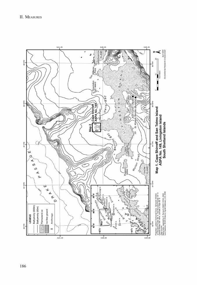
186
II. MEASURES
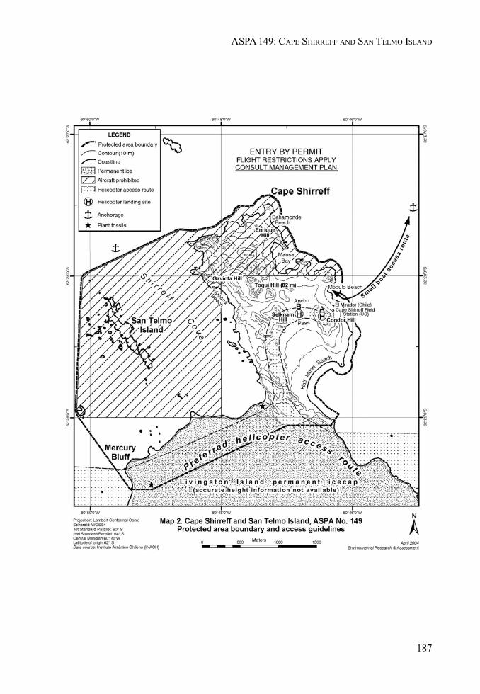
187
ASPA 149: CAPE SHIRREFF AND SAN TELMO ISLAND
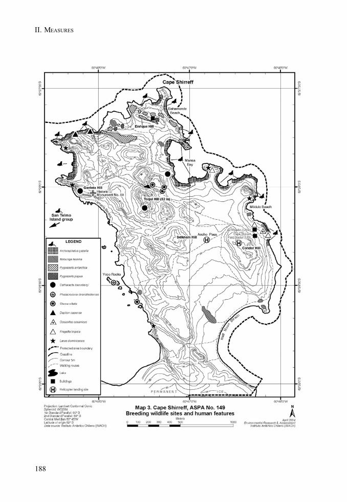
II. MEASURES
188
MEASURE 2 - ANNEX I
189
Management Plan for Antarctic Specially Protected Area No. 155
CAPE EVANS, ROSS ISLAND
(including Historic Sites and Monuments Nos. 16 and 17,the historic Terra Nova hut of Captain R F Scott and its precincts)
1. Description of Values to be Protected
The significant historic value of this Area was formally recognised when it was listed as Historic Siteand Monument No 16 and 17 in Recommendation 9 (1972). An area containing both sites wasdesignated as Specially Protected Area No. 25 in Measure 2 (1997) and redesignated as AntarcticSpecially Protected Area 155 in Decision 1 (2002).
The Terra Nova hut (Historic Site and Monument No. 16) is the largest of the historic huts in theRoss Sea region. It was built in January 1911 by the British Antarctic Terra Nova Expedition of 1910-1913, led by Captain Robert Falcon Scott, RN. It was subsequently used as a base by the Ross Seaparty of Sir Ernest Shackleton’s Imperial Trans-Antarctic Expedition of 1914-1917.
Historic Site and Monument No. 17 contains the Cross on Wind Vane Hill, (erected in the memory ofthree members of Shackleton’s Ross Sea party who died in 1916). In addition to this, the anchors ofthe ship Aurora from the Imperial Trans-Antarctic Expedition, an instrument shelter, several supplydumps and dog kennels, and numerous artefacts are distributed around the site.
Some of the earliest advances in the study of earth sciences, meteorology, flora and fauna areassociated with the Terra Nova Expedition based at this site. The data collected can provide a benchmark against which to compare current measurements. The history of these activities and thecontribution they have made to the understanding and awareness of Antarctica therefore contributeto both the historic and scientific value of the site.
The Cape Evans site is one of the principal sites of early human activity in Antarctica. It is animportant symbol of the Heroic Age of Antarctic exploration, and as such, has considerable historicalsignificance.
2. Aims and Objectives
The aim of this Management Plan is to provide protection for the Area and its features so that itsvalues can be preserved. The objectives of the Plan are to:
• avoid degradation of, or substantial risk to, the values of the Area;• maintain the historic values of the area through planned conservation work which may
include:a. an annual ‘on-site’ maintenance programme,b. a programme of monitoring the condition of artefacts and structures, and the factors
which affect them, andc. conservation of artefacts to be conducted on and off site;
190
II. MEASURES
• allow management activities which support the protection of the values and features of theArea including:a. mapping and otherwise recording the disposition of historic items in the hut
environs, andb. recording other relevant historic data; and
• prevent unnecessary human disturbance to the Area, its features and artefacts throughmanaged access to the Terra Nova hut.
3. Management Activities
The following management activities will be undertaken to protect the values of the Area:
• A regular programme of conservation work shall be undertaken on the Terra Nova hut andassociated artefacts in the Area.
• Systematic monitoring shall be put in place to assess the impacts of present visitor limits,and the results and any related management recommendations included in reviews of thisManagement Plan.
• Visits shall be made as necessary for management purposes.• National Antarctic Programmes operating in, or those with an interest in, the Area shall
consult together with a view to ensuring the above management activities are implemented.
4. Period of designation
Designated for an indefinite period.
5. Maps
• Map A: Cape Evans regional map. This map shows the boundaries of the proposed AntarcticSpecially Protected Areas with significant topographical features, approaches, field campsites and helicopter landing sites. It also shows the approximate location of significanthistorical items within the area. Inset: Ross Island showing sites of nearby protected areasand stations.
• Map B: Cape Evans site map. This map shows the approximate location of specific historicartefacts and sites within the Area.
6. Description of the Area
6(i) Geographical co-ordinates boundary markers and natural features
Cape Evans is a small, triangular shaped, ice-free area in the south west of Ross Island, 10 kilometresto the south of Cape Royds and 22 kilometres to the north of Hut Point Peninsula on Ross Island.The ice-free area is composed of till-covered basalt bedrock. The designated Area is located on thenorth western coast of Cape Evans adjacent to Home Beach and centred on Scott’s Terra Nova hut.
191
ASPA 155: CAPE EVANS
The boundaries of the ASPA are:
• South: a line extending east from a point at 77º 38' 15.47" S, 166º 25' 9.48" E – 20 metres southof the cross on Wind Vane Hill;
• South/west: a line from the reference point above extended to follow the crest of the small ridgedescending in a north westerly direction to the shoreline at 77º 38' 11.50" S, 166º 24' 49.47" E;
• North/west: by the shoreline of Home Beach;• North/east: by the line of the outlet stream from Skua Lake to Home Beach at 77º 38' 4.89" S,
166º 25' 13.46" E;• East: by the line extending south from the western edge of Skua Lake at 77º 38' 5.96" S, 166º
25' 35.74" E – to intersect with the southern boundary at 77º 38' 15.48" S, 166º 25' 35.68" E.
Skuas (Catharacta maccormicki) nest on Cape Evans and Adelie penguins (Pygoscelis adeliae)from the rookery at Cape Royds may occasionally transit the Area. Weddell seals have also beenseen hauled up on Home Beach.
6(ii) Access to the Area
When safe conditions exist, vehicle approach to the Area can be made across the sea ice. Vehiclesshould not be taken onto the land. During open water, landings by boat may be made directly in frontof the hut at Home Beach. Helicopter landings may be made at either of the existing designatedlanding sites marked on Maps 1 and 2. One site is approximately 100 metres to the north of the hut,just outside the Area. The other is located adjacent to the New Zealand refuge hut approximately 250metres beyond the south western boundary of the Area.
6(iii) Location of structures within and adjacent to the Area
All structures located within the Area are of historic origin, although a temporary, modern protectiveenclosure around the magnetic hut remains in place. A major feature of the Area is Scott’s Terra Novahut located on the north western coast of Cape Evans at Home Beach. The hut is surrounded bymany historic relics including the anchors from the Aurora, dog skeletons, instrument shelters, dogline, meteorological screen, fuel dump, magnetic hut, coal, stores, rubbish dumps and flag pole. Amemorial cross to three members of Shackleton’s Ross Sea party of 1914-1917 stands on West VaneHill. All these features are included within the boundaries of the Area.
A New Zealand refuge hut, camp site and helicopter landing site are situated approximately 250 m tothe south west of the Area.
The Greenpeace year-round World Park Base was sited to the north east of Scott’s hut from 1987 to1992. No visible sign of the base remains.
6(iv) Location of other Protected Areas in the vicinity
• ASPA 121 (previously SSSI No. 1) and• ASPA 157 (SPA No. 27), Cape Royds are 10 kilometres north of Cape Evans.• ASPA 122 (SSSI No. 2), Arrival Heights and• ASPA 158 (SPA No. 28), Hut Point are approximately 20 kilometres south of Cape Evans at
Hut Point Peninsula.• ASPA 130 (SSSI No. 11), Tramway Ridge is approximately 20 kilometres east of Cape Evans.
All sites are located on Ross Island.
192
II. MEASURES
6(v) Special Zones within the Area
There are no special zones within the Area.
7. Terms and Conditions for Entry Permits
Entry to the Area is prohibited except in accordance with a Permit. Permits shall be issued only byappropriate national authorities and may contain both general and specific conditions. A Permit maybe issued by a national authority to cover a number of visits in a season. Parties operating in theArea shall consult together and with groups and organisations interested in visiting the Area toensure that visitor numbers are not exceeded.
Permits to enter the site may be issued for a stated period for:
• activities related to conservation, research and/or monitoring purposes;• management activities in support of the objectives of the Plan;• activities related to educational or recreational activities including tourism, providing they
do not conflict with the objectives of this Plan.
7(i) Access to and movement within or over the Area
• Control of movement within the Area is necessary to prevent damage caused by crowdingaround the many vulnerable features within the Area. The maximum number in the Area atany time (including guides and those within the hut) shall be: 40 people.
• Control of numbers within the hut is necessary to prevent damage caused by crowdingaround the many vulnerable features within the hut. The maximum number within the hut atany time (including guides) shall be: 12 people.
• Avoidance of cumulative impacts on the interior of the hut requires an annual limit on visitornumbers. The effects of the current visitor levels (average 1489 per year between 1998 and2004) suggest that a significant increase could cause significant adverse impacts. Themaximum annual number of visitors shall be: 2,000 people.
• These limits have been set based on current visitor levels and on the best advice availablefrom conservation advisory agencies (which include conservators, archaeologists, historians,museologists and other heritage protection professionals). The limits are based on theproposition that any significant increase in the current level of visitor numbers would bedetrimental to the values to be protected. An ongoing monitoring programme to assess theeffects of visitors is required to provide the basis for future reviews of the ManagementPlan, in particular whether the current limits on numbers of visitors are appropriate.
• Adequate supervision of visits to the Area is necessary to prevent damage caused bycrowding and by actions inconsistent with the Code of Conduct set out in section 7(ii). Alltourism, educational and recreational visits must be supervised by an experienced guidenominated by the operator (refer section 7(ix)).
• Helicopter landings are prohibited within the Area as they have the potential to damage thesite by blowing scoria and ice particles and to accelerate the abrasion of the hut andsurrounding artefacts. Vehicles are prohibited within the Area. Refer to 6(ii) for recommendedapproaches and landing sites.
193
ASPA 155: CAPE EVANS
7(ii) Activities which may be conducted within the Area
Activities which may be conducted within the Area include:
• visits for conservation purposes;• educational and/or recreational visits including tourism; and• scientific activity which does not detract from the values of the Area.
Visitors should adhere to the following Code of Conduct, except where conservation, research,monitoring or management activities specified in the Permit require otherwise:
• To reduce floor abrasion, thoroughly clean grit and scoria, ice and snow from boots usingthe brushes provided before entering the hut;
• Remove any clothing made wet by sea water, and any sea ice crystals from boots, as saltparticles accelerate corrosion of metal objects;
• Do not touch, move or sit on any items or furniture in the huts - handling artefacts causesdamage;
• As many areas are cramped and artefacts can be accidentally bumped, do not wear packsinside;
• When moving around the sites, take great care not to tread on any items which may beobscured by snow;
• Use of combustion style lanterns, naked flames or smoking in or around the huts is strictlyforbidden as fire is a major risk; and
• Visits should be recorded in the book provided. This allows times and levels of visitation tobe correlated with temperature and humidity data automatically logged inside the hut.
7(iii) Installation, modification or removal of structures
• No new structures are to be erected in the Area, or scientific equipment installed, except forconservation activities as specified in section 3.
• No historic structure shall be removed from the Area, unless specified in a Permit issued inaccordance with the provisions of section 7(vii).
7(iv) Location of field camps
• Use of the historic hut for living purposes is not permitted. Camping is prohibited in theArea under any circumstances.
• An existing field camp site is associated with the two New Zealand field shelters located250 m south west of the Area and should be used by all parties intending to camp in thisarea.
7(v) Restrictions on materials and organisms which may be brought to the Area
• No living animals, plant material, micro-organisms or soil shall be introduced to the Area. Nofood products shall be taken into the Area.
• Chemicals may only be introduced for permitted scientific or conservation purposes.Chemicals (including fuel) or other materials are not to be left in the Area, unless required foressential purposes connected with the conservation of the historic structures or associatedrelics.
194
II. MEASURES
• All materials are to be removed when no longer required and before a date to be specified inthe relevant Permit.
7(vi) Taking or harmful interference with native flora and fauna
• This activity is prohibited except in accordance with a Permit issued by the appropriatenational authority specifically for that purpose under Article 3, Annex II to the Protocol onEnvironmental Protection.
• Where animal taking or harmful interference is involved, this should, as a minimum standard,be in accordance with the SCAR Code of Conduct for the Use of Animals for ScientificPurposes in Antarctica.
7(vii) Collection or removal of anything not imported by the Permit Holder
• Material may be collected and removed from the Area for conservation reasons consistentwith the objectives of this Plan only when specified in a Permit issued by the appropriatenational authority.
• Materials which pose a threat to the environment or human health may be removed from theArea for disposal, in accordance with a Permit, where they meet one or more of the followingcriteria:(i) the artefact presents a threat to the environment, wildlife or human health and safety;(ii) it is in such poor condition that it is not reasonably possible to conserve it;(iii) it does not contribute in any significant way to our understanding of the hut, its
occupants or the history of Antarctica;(iv) it does not contribute to, or it detracts from, the visual qualities of the site or the hut,
and/or;(v) it is not a unique or rare item;
and where such action is:(i) undertaken by parties with appropriate heritage conservation expertise; and(ii) part of an overall plan for conservation work at the site.
• National authorities should ensure that any removal of artefacts and assessment against theabove criteria is carried out by personnel with appropriate heritage conservation expertise.
• Artefacts judged to be of high historic value, which cannot be conserved on site withcurrently available techniques, may be removed in accordance with a Permit for storage in acontrolled environment until such time as they can safely be returned to the Area.
• Samples of soil and other natural materials may be removed for scientific purposes only inaccordance with an appropriate Permit.
7(viii) Disposal of waste
• All human waste, grey water and other waste generated by work parties or visitors shall beremoved from the Area.
195
ASPA 155: CAPE EVANS
7(ix) Measures that may be necessary to ensure that the aims and objectives of the ManagementPlan continue to be met
• The Permit, or an authorised copy, shall be carried within the Area.• Information on the requirements of this Plan shall be provided to all visitors.• The Code of Conduct set out in section 7(ii) shall be followed by all visitors, except where
conservation, research, monitoring or management purposes require otherwise.• Operators facilitating educational and recreational visits (including tourism) to the Area
shall, prior to commencement of the summer season, nominate people with a workingknowledge of both the site and this Management Plan to act as guides during visits.
• All educational and recreational visits (including tourism) shall be supervised by a nominatedguide, who is responsible for briefing visitors on the code of conduct and ensuring it iscomplied with.
• Parties shall consult and coordinate to develop skills and resources, particularly thoserelated to conservation techniques, to assist with the protection of the Area’s values.
7(x) Requirements for Reports
Parties shall ensure that the principal holder for each Permit issued submits to the appropriateauthority a report describing the activities undertaken. Such reports shall include, as appropriate,the information identified in the Visit Report provided in Appendix 4 of Resolution 2 (1998). Inaddition, any removal of materials in accordance with section 7(vii) shall be detailed, including thereason for removal and the current location of the items or the date of disposal. Any return of suchitems to the site shall also be reported.
Parties shall maintain a record of activities within the Area and, in the Annual Exchange of Information,shall provide summary descriptions of activities conducted by persons subject to their jurisdiction,in sufficient detail to allow an evaluation of the effectiveness of the Management Plan. Partiesshould wherever possible deposit originals or copies of such reports in a publicly accessible archiveto maintain a record of visitation, to be used both for review of the Management Plan and in managingfurther visitation to the site.
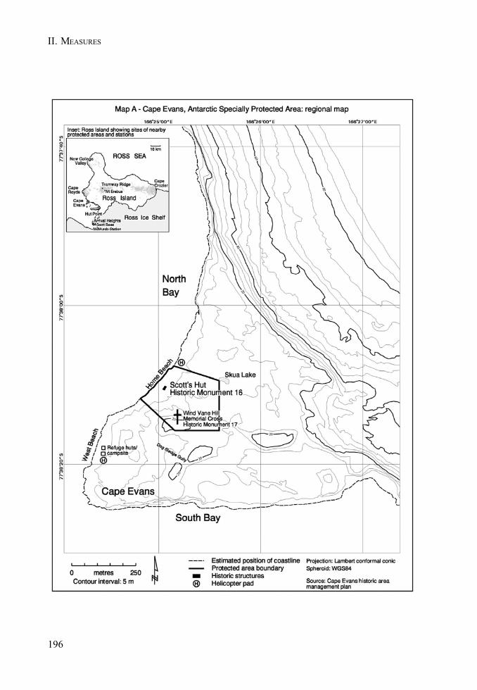
196
II. MEASURES
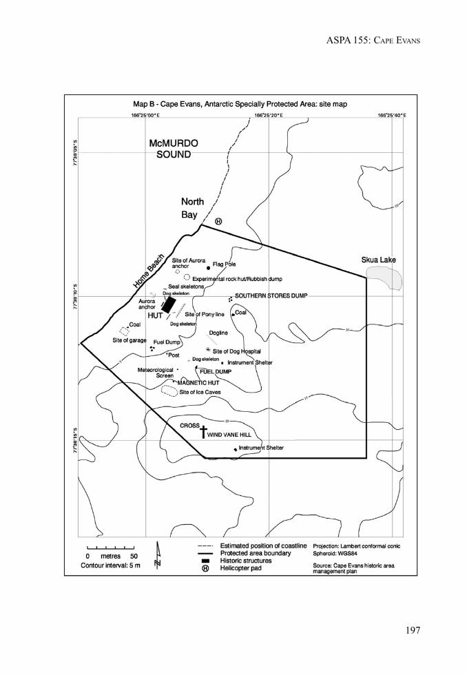
197
ASPA 155: CAPE EVANS

II. MEASURES
MEASURE 2 - ANNEX J
199
Management Plan for Antarctic Specially Protected Area No. 157
BACKDOOR BAY, CAPE ROYDS, ROSS ISLAND
(including Historic Site and Monument No. 15,the historic hut of Sir Ernest Shackleton and its precincts)
1. Description of Values to be Protected
The significant historic value of this Area was formally recognised when it was listed as Historic Siteand Monument No. 15 in Recommendation 9 (1972). It was designated as Specially Protected AreaNo. 27 in Measure 1 (1998) and redesignated as Antarctic Specially Protected Area (ASPA) 157 inDecision 1 (2002).
The hut on which this Area is centred was built in February 1908 by the British Antarctic (Nimrod)Expedition of 1907-1909 which was led by Sir Ernest Shackleton. It was also periodically used by theRoss Sea Party of Shackleton’s Imperial Trans-Antarctic Expedition of 1914-1917.
Structures associated with the hut include stables, kennels, a latrine and a garage created for the firstmotor vehicle in Antarctica. Other significant relics in the Area include an instrument shelter, supplydepots, and a rubbish site. Numerous additional artefacts are distributed around the Area.
Cape Royds is one of the principal areas of early human activity in Antarctica. It is an importantsymbol of the Heroic Age of Antarctic exploration and, as such, has considerable historical significance.Some of the earliest advances in the study of earth sciences, meteorology, flora and fauna in Antarcticaare associated with the Nimrod Expedition which was based at this site. The history of theseactivities and the contribution they have made to the understanding and awareness of Antarcticagive this Area significant scientific, aesthetic and historic values.
2. Aims and Objectives
The aim of the Management Plan is to provide protection for the Area and its features so that itsvalues can be preserved. The objectives of the Plan are to:
• avoid degradation of, or substantial risk to, the values of the Area;• maintain the historic values of the Area through planned conservation work which may
include:a. an annual ‘on-site’ maintenance programme,b. a programme of monitoring the condition of artefacts and structures, and the factors
which affect them, andc. a programme of conservation of artefacts conducted on and off site;
• allow management activities which support the protection of the values and features of theArea including:a. mapping and otherwise recording the disposition of historic items in the hut environs, andb. recording other relevant historic data;
• prevent unnecessary human disturbance to the Area, its features and artefacts throughmanaged access to the Nimrod hut.

200
II. MEASURES
3. Management Activities
The following management activities will be undertaken to protect the values of the Area:
• A regular programme of conservation work shall be undertaken on the Nimrod hut andassociated artefacts in the Area.
• Visits shall be made as necessary for management purposes.• Systematic monitoring shall be put in place to assess the impacts of present visitor limits,
and the results and any related management recommendations included in reviews of thisManagement Plan.
• National Antarctic Programmes operating in, or those with an interest in, the Area shallconsult together with a view to ensuring the above management activities are implemented.
4. Period of designation
Designated for an indefinite period.
5. Maps
• Map A: Cape Royds regional map. This map shows the location of the Area in relation toASPA 121 and significant topographic features in the vicinity. Inset: shows the position ofthe site in relation to other protected sites on Ross Island.
• Map B: Cape Royds Area map. This map shows the boundaries of the Area and the adjacentASPA 121. Also shown are the approaches, field camp and helicopter landing sites.
6. Description of the Area
6(i) Geographical coordinates, boundary markers and natural features
Cape Royds is an ice free area at the western extremity of Ross Island, approximately 40 kilometres tothe south of Cape Bird and 35 kilometres to the north of Hut Point Peninsula on Ross Island. The icefree area is composed of till covered basalt bedrock. The designated Area is located to the north eastof Cape Royds adjacent to Backdoor Bay. It is immediately to the east of ASPA 121, an Adéliepenguin rookery. The Area is centred on Shackleton’s Nimrod expedition hut.
The boundaries of the Area are:
• South and East, by the shoreline of the eastern coast of Cape Royds including Arrival andBackdoor Bays;
• West, by a line following the boundary of ASPA 121 from the coastline at Arrival Bay to asignpost (77°31´ 12.6" S, 166° 10´ 01.3" E) and then continuing to follow the boundary ofASPA 121 for 40 m in a northeast direction;
• Northwest, by a line extending in a northwest direction from the boundary of ASPA 121 andfollowing the shore of a small lake to the NW of Pony Lake and then along a gully leading toa point at 77° 33´ 7.5" S, 166° 10´ 13" E; and
• North, by a line extended due east from a point at 77° 33´ 7.5" S, 166° 10´ 13" E to the coastlineof Backdoor Bay.
201
ASPA 157: BACKDOOR BAY
Adélie penguins (Pygoscelis adeliae) from the adjacent colony at Cape Royds often transit theArea. Skuas (Catharacta maccormicki) nest in the vicinity.
6(ii) Access to the Area
Access to the Area should be made on foot from Backdoor Bay or the helicopter landing sites usingthe routes shown in Map B. Landings by boat (when there is open water), or vehicle (when safe seaice conditions exist), may be made in Backdoor Bay. Care should be taken to avoid the marine extentof ASPA 121 (see Map A). Helicopter landings may be made at the designated landing sites markedon Map B. The primary (and preferred) site is approximately 100 metres north of the Area. Asecondary landing site is located 30 metres north of the Area and should be avoided from the start ofNovember until the start of March, when the nearby Adélie penguin colony is occupied.
6(iii) Location of structures within and adjacent to the Area
Apart from a Treaty plaque, all structures within the Area are of historic origin. A major feature of theArea is Shackleton’s Nimrod expedition hut located in a sheltered basin. The hut is surrounded bymany other historic relics including an instrument shelter, supply depots, and a dump site. Numerousadditional artefacts are distributed around the site.
A New Zealand refuge hut and camp site are located at the north west corner of the ASPA.
6(iv) Location of other Protected Areas in the vicinity
• ASPA121 (previously SSSI No. 1), Cape Royds is immediately adjacent to this Area.• ASPA 122 (SSSI No. 2), Arrival Heights and• ASPA 158 (SPA No. 28), Hut Point are approximately 30 kilometres south of Cape Royds at
Hut Point Peninsula.• ASPA 130 (SSSI No. 11), Tramway Ridge is 20 kilometres east of Cape Royds.• ASPA 116 (SSSI No. 10, SPA No. 20), New College Valley is located 35 kilometres north in the
vicinity of Cape Bird.• ASPA 155 (SPA No. 25), Cape Evans is 12 kilometres south.• ASPA 156 (SPA No. 26), Lewis Bay is 36 kilometres to the north east.
All sites are located on Ross Island.
6 (v) Special Zones within the Area
There are no special zones within the Area.
7. Terms and Conditions for Entry Permits
Entry to the Area is prohibited except in accordance with a Permit. Permits shall be issued only byappropriate national authorities and may contain both general and specific conditions. A Permit maybe issued by a national authority to cover a number of visits in a season. Parties operating in theArea shall consult together and with groups and organisations interested in visiting the Area toensure that visitor numbers are not exceeded.

202
II. MEASURES
Permits to enter the site may be issued for a stated period for:
• activities related to conservation, research and/or monitoring purposes;• management activities in support of the objectives of this Plan; and• activities related to educational or recreational activities including tourism, providing they
do not conflict with the objectives of this Plan.
7(i) Access to and movement within or over the Area
• Control of movement within the Area is necessary to prevent damage caused by crowdingaround the many vulnerable features within the Area. The maximum number in the Area atany time (including those within the hut) shall be: 40 people.
• Control of numbers within the hut is necessary to prevent damage caused by crowdingaround the many vulnerable features within the hut. The maximum number within the hut atany time (including guides) shall be: 8 people.
• Avoidance of cumulative impacts on the interior of the hut requires an annual limit on visitornumbers. The effects of current visitor levels (average 1020 per year between 1998 and 2004)suggest that an increase of more than 100% could cause significant adverse impacts. Theannual maximum number of visitors shall be: 2000 people.
• These limits have been based on current visitor levels and on the best advice available fromconservation advisory agencies (which include conservators, archaeologists, historians,museologists and other heritage protection professionals). The limits are based on theproposition that any significant increase in the current level of visitors would be detrimentalto the values to be protected. An ongoing monitoring programme to assess the effect ofvisitors is required to provide the basis for future reviews of the Management Plan, inparticular whether the current limits on numbers of visitors are appropriate.
• Adequate supervision of visits to the Area is necessary to prevent damage caused bycrowding and by actions inconsistent with the Code of Conduct set out in section 7(vii). Alltourism, educational and recreational visits must be supervised by an experienced guidenominated by the operator (refer section 7(ix)).
• Helicopter landings are prohibited within the Area as they have the potential to damage thesite by blowing scoria and ice particles and to accelerate the abrasion of the hut andsurrounding artefacts. Vehicles are prohibited within the Area. Refer to 6(ii) for recommendedapproaches and landing sites.
7(ii) Activities which may be conducted within the Area
Activities which may be conducted within the Area include:
• visits for conservation purposes;• educational and/or recreational visits including tourism;• scientific activity which does not detract from the values of the Area.
Visitors should adhere to the following Code of Conduct, except where conservation, research,monitoring or management activities specified in the Permit require otherwise:
• Thoroughly clean grit and scoria, ice and snow from boots using the brushes providedbefore entering the hut to reduce floor abrasion;
• Remove any clothing made wet by sea water, and any sea ice crystals from boots, as saltparticles accelerate corrosion of metal objects;
203
ASPA 157: BACKDOOR BAY
• Do not touch, move or sit on any items or furniture in the huts - handling artefacts causesdamage;
• As many areas are cramped and artefacts can be accidentally bumped, do not wear packsinside;
• When moving around the sites, take great care not to tread on any items which may beobscured by snow;
• Use of combustion style lanterns, naked flames or smoking in or around the huts is prohibited,as fire is a major risk; and
• Visits should be recorded in the book provided. This allows times and levels of visitation tobe correlated with temperature and humidity data automatically logged inside the hut.
7(iii) Installation, modification or removal of structures
• No new structures are to be erected in the Area, or scientific equipment installed, except forconservation or scientific activities that do not detract from the values of the Area asspecified in 1.
• No historic structure shall be removed from the Area, unless specified in a Permit issued inaccordance with the provisions of section 7(vii).
7(iv) Location of field camps
• Use of the historic hut for living purposes is not permitted. Camping is prohibited within theArea under any circumstances.
• An existing field camp site and a New Zealand shelter is located at the north western boundaryof the Area (see Map B).
7(v) Restrictions on materials and organisms which may be brought into the Area
• No living animals, plant material, soil or micro-organisms shall be introduced to the Area. Nofood products shall be taken into the Area.
• Chemicals may only be introduced for permitted scientific or conservation purposes.Chemicals (including fuel) or other materials are not to be left in the Area, unless required foressential purposes connected with the conservation of the historic structures or the associatedrelics.
• All materials are to be removed when no longer required and before a date to be specified inthe relevant Permit.
7(vi) Taking or harmful interference with native flora and fauna
• This activity is prohibited except in accordance with a permit issued by the appropriatenational authority specifically for that purpose under Article 3, Annex II to the Protocol onEnvironmental Protection.
• Where animal taking or harmful interference is involved, this should, as a minimum standard,be in accordance with the SCAR Code of Conduct for the Use of Animals for ScientificPurposes in Antarctica.
204
II. MEASURES
7(vii) Collection of anything not imported by the Permit Holder
• Material may be collected and removed from the Area for conservation reasons consistentwith the objectives of this Plan only when specified in a Permit issued by the appropriatenational authority.
• Materials which pose a threat to the environment or human health may be removed from theArea for disposal, in accordance with a Permit, where they meet one or more of the followingcriteria:(i) the artefact presents a threat to the environment, wildlife or human health and safety;(ii) it is in such poor condition that it is not reasonably possible to conserve it;(iii) it does not contribute in any significant way to our understanding of the hut, its
occupants or the history of Antarctica;(iv) it does not contribute to, or it detracts from, the visual qualities of the site or the hut;
and/or(v) it is not a unique or rare item;
and where such action is:(i) undertaken by parties with appropriate heritage conservation expertise; and(ii) part of an overall plan for conservation work at the site.
National authorities should ensure that any removal of artefacts and assessment against the abovecriteria is carried out by personnel with appropriate heritage conservation expertise.
Artefacts judged to be of high historic value, which cannot be conserved on site with currentlyavailable techniques, may be removed in accordance with a Permit for storage in a controlledenvironment until such time as they can safely be returned to the Area.
7(viii) Disposal of waste
• All human waste, grey water and other waste generated by work parties or visitors shall beremoved from the Area.
7(ix) Measures that may be necessary to ensure that the aims and objectives of the Plan continueto be met
• The Permit, or an authorised copy, shall be carried within the Area.• Information on the requirements of this Plan shall be provided to all visitors.• The Code of Conduct set out in section 7(ii) shall be followed by all visitors, except where
conservation, research, monitoring or management purposes require otherwise.• Operators facilitating educational and recreational visits (including tourism) to the Area
should prior to commencement of the summer season, nominate people with a workingknowledge of both the site and this Management Plan to act as guides during visits.
• All educational and recreational visits should be supervised by a nominated guide, who isresponsible for briefing visitors on the code of conduct and ensuring it is complied with.
• Parties should consult and coordinate to develop skills and resources, particularly thoserelated to conservation techniques, to assist with the protection of the Area’s values.

205
ASPA 157: BACKDOOR BAY
7(x) Requirements for reports
Parties shall ensure that the principal holder for each Permit issued submits to the appropriateauthority a report describing the activities undertaken. Such reports shall include, as appropriate,the information identified in the Visit Report Form provided in Appendix 4 of Resolution 2 (1998). Inaddition, any removal of materials in accordance with section 7(viii) shall be detailed, including thereason for removal and the current location of the items or the date of disposal. Any return of suchitems to the site shall also be reported.
Parties shall maintain a record of activities within the Area and, in the Annual Exchange of Information,shall provide summary descriptions of activities conducted by persons subject to their jurisdiction,in sufficient detail to allow evaluation of the effectiveness of the Management Plan. Parties shouldwherever possible deposit originals or copies of such reports in a publicly accessible archive tomaintain a record of visitation, to be used both for review of the Management Plan and in managingfurther visitation to the site.
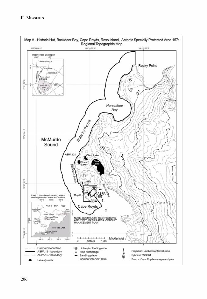
206
II. MEASURES
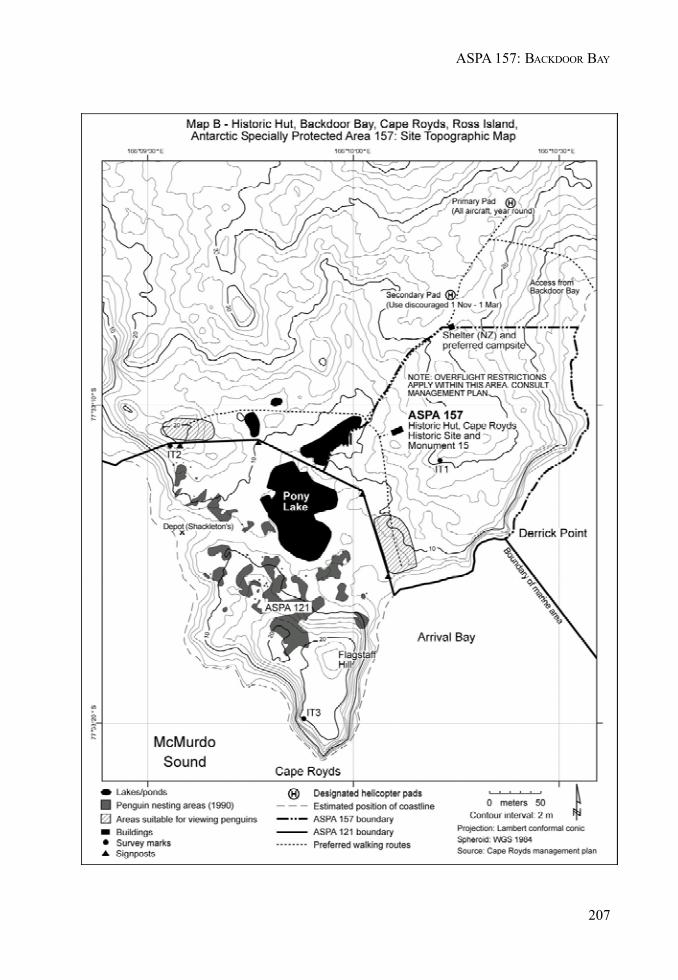
207
ASPA 157: BACKDOOR BAY

II. MEASURES
MEASURE 2 - ANNEX K
209
Management Plan for Antarctic Specially Protected Area No. 158
HUT POINT, ROSS ISLAND
(including Historic Site and Monument No. 18, the historic Discovery hut of Captain R F Scott)
1. Description of Values to be Protected
The significant historic value of this Area was formally recognised when it was designated as HistoricSite and Monument No. 18 in Recommendation 9 (1972). It was designated as Specially ProtectedArea No. 28 in Measure 1 (1998) and redesignated as Antarctic Specially Protected Area 158 inDecision 1 (2002).
The hut was built in February 1902 during the National Antarctic (Discovery) Expedition of 1901-1904, led by Captain Robert Falcon Scott who later found it a valuable advance staging point forjourneys on the “Barrier” during his 1910-1913 expedition. It was also used by Sir Ernest Shackletonduring the 1907-1909 British Antarctic Expedition and later by his stranded Ross Sea Party during theImperial Trans-Antarctic Expedition of 1914-1917. This building was prefabricated in Australia to an‘outback’ design with verandahs on three sides.
The Hut Point site is one of the principal sites of early human activity in Antarctica. It is an importantsymbol of the Heroic Age of Antarctic exploration and, as such, has considerable historical significance.Some of the earliest advances in the study of earth sciences, meteorology, flora and fauna in Antarcticaare associated with the Discovery Expedition based at this site. The history of these activities andthe contribution they have made to the understanding and awareness of Antarctica give this Areasignificant scientific, aesthetic and historic values.
2. Aims and Objectives
The aim of the Management Plan is to provide protection for the Area and its features so that itsvalues can be preserved. The objectives of the Plan are to:
• avoid degradation of, or substantial risk to, the values of the Area;• maintain the historic values of the Area through planned conservation work which may
include:a. an annual ‘on-site’ maintenance programme,b. a programme of monitoring the condition of artefacts and structures, and the factors
which affect them, andc. a programme of conservation of artefacts conducted on and off site;
• allow management activities which support the protection of the values and features of theArea including recording of any relevant historic data; and
• prevent unnecessary human disturbance to the Area, its features and artefacts throughmanaged access to the Discovery hut.
210
II. MEASURES
3. Management Activities
• A regular programme of conservation work shall be undertaken on the Discovery hut andassociated artefacts in the Area;
• Visits shall be made as necessary for management purposes;• Systematic monitoring shall be put in place to assess the impacts of present visitor limits,
and the results and any related management recommendations included in reviews of thisManagement Plan;
• National Antarctic Programmes operating in, or those with an interest in, the Area shallconsult together with a view to ensuring the above management activities are implemented.
4. Period of Designation
Designated for an indefinite period.
5. Maps
• Map A: Hut Point regional map. This map shows the wider environs of the Area withsignificant topographic features and the adjacent US McMurdo Station. Inset: shows theposition of the site in relation to other protected sites on Ross Island.
• Map B: Hut Point site map. This map shows the location of the historic hut, Vince’s crossand other detail of the immediate environs.
6. Description of the Area
6(i) Geographical coordinates, boundary markers and natural features
Hut Point is a small ice free area protruding south west from the Hut Point Peninsula and situated tothe west of the United States McMurdo Station. The designated Area consists solely of the structureof the hut which is situated near the south western extremity of Hut Point.
6(ii) Access to the Area
There are no designated helicopter landings sites in the vicinity of the hut as helicopters have thepotential to damage the hut by blowing scoria and ice particles and to accelerate the abrasion of thehut and surrounding artefacts. Vehicles may approach the hut along the road leading from the UnitedStates McMurdo Station, or from the sea ice when safe conditions exist. During open water, landingsby boat may be made to the north of the hut.
6(iii) Location of structures within and adjacent to the Area
The designated Area consists solely of the structure of the historic Discovery hut. Historic Site andMonument No. 17, a cross to the memory of G.T. Vince (a member of the Discovery expedition whodied in the vicinity), is situated approximately 75 metres west of the hut.
211
ASPA 158: HUT POINT
6(iv) Location of other Protected Areas in the vicinity
• ASPA 121 (previously SSSI No. 1) and• ASPA 158 (SPA No. 28), Cape Royds, are 32 kilometres north of Hut Point.• ASPA 122 (SSSI No. 2), Arrival Heights, is 2 kilometres north of Hut Point on Hut Point
Peninsula.• ASPA 155 (SPA No. 25), Cape Evans, is 22 kilometres to the north of Hut Point.
All sites are located on Ross Island.
6(v) Special Zones within the Area
There are no special zones within the Area.
7. Terms and Conditions for Entry Permits
Entry to the Area is prohibited except in accordance with a Permit. Permits shall be issued only byappropriate national authorities and may contain both general and specific conditions. A Permit maybe issued by a national authority to cover a number of visits in a season. Parties operating in theArea shall consult together and with groups and organisations interested in visiting the Area toensure that visitor numbers are not exceeded.
Permits to enter the site may be issued for a stated period for:
• activities related to conservation, research and/or monitoring purposes;• management activities in support of the objectives of this Plan; and• activities related to educational or recreational activities including tourism, providing they
do not conflict with the objectives of this Plan.
7(i) Access to and movement within or over the Area
• Control of numbers within the hut is necessary to prevent damage caused by crowdingaround the many vulnerable features within the hut. The maximum number within the hut atany time (including guides) shall be: 8 people.
• Avoidance of cumulative impacts on the interior of the hut require an annual limit on visitornumbers. The effects of current visitor levels (average 1033 per year between 1998 and 2004)suggest that an increase of more than 100% could cause significant adverse impacts. Theannual maximum number of visitors shall be: 2000 people.
• These limits have been based on current visitor levels and on the best advice available fromconservation advisory agencies (which include conservators, archaeologists, historians,museologists and other heritage protection professionals). The limits are based on theproposition that any significant increase in the current level of visitors would be detrimentalto the values to be protected. An ongoing monitoring programme to assess the effect ofvisitors is required to provide the basis for future reviews of the Management Plan, inparticular whether the current limits on numbers of visitors to the area are appropriate.
• Adequate supervision of visits to the Area is necessary to prevent damage caused bycrowding and by actions inconsistent with the Code of Conduct set out in section 7(ii). Alltourism, educational and recreational visits must be supervised by an experienced guidenominated by the operator (refer section 7(ix)).

212
II. MEASURES
7(ii) Activities which may be conducted within the Area
Activities which may be conducted within the Area include:
• visits for conservation purposes;• educational and/or recreational visits including tourism;• scientific activity which does not detract from the values of the Area.
Visitors should adhere to the following Code of Conduct, except where conservation, research,monitoring or management activities specified in the Permit require otherwise:
• Thoroughly clean grit and scoria, ice and snow from boots using the brushes providedbefore entering the hut to reduce floor abrasion;
• Remove any clothing made wet by sea water, and any sea ice crystals from boots, as saltparticles accelerate corrosion of metal objects;
• Do not touch, move or sit on any items or furniture in the huts - handling artefacts causesdamage;
• As many areas are cramped and artefacts can be accidentally bumped, do not wear packsinside.
• When moving around the sites, take great care not to tread on any items which may beobscured by snow;
• Use of combustion style lanterns, naked flames or smoking in or around the huts is prohibited,as fire is a major risk; and
• Visits should be recorded in the book provided. This allows times and levels of visitation tobe correlated with temperature and humidity data automatically logged inside the hut.
7(iii) Installation, modification or removal of structures
• No alteration to the structure shall be made, except for conservation purposes or scientificactivities that do not detract from the values of the Area as specified in 1. No historicstructure shall be removed from the Area, unless specified in a Permit issues in accordancewith the provisions of section 7(viii).
7(iv) Location of field camps
• Use of the historic hut for living purposes is not permitted.
7(v) Restrictions on materials and organisms which may be brought into the Area
• No living animals, or material, soil or micro-organisms shall be introduced to the Area.• No food products shall be taken into the Area.• Chemicals may only be introduced for permitted scientific or conservation purposes.
Chemicals (including fuel) or other materials are not to be left in the Area, unless required foressential purposes connected with the conservation of the historic structure or the associatedrelics. All materials are to be removed when no longer required and before a date to bespecified in the relevant Permit.
7(vi) Taking or harmful interference with native flora and fauna
• There are no native flora or fauna within the designated Area.
213
ASPA 158: HUT POINT
7(vii) Collection of anything not imported by the Permit Holder
• Material may be collected and removed from the Area for conservation reasons consistentwith the objectives of this Plan only when specified in a Permit issued by the appropriatenational authority.
• Materials which pose a threat to the environment or human health may be removed from theArea for disposal, in accordance with a Permit, where they meet one or more of the followingcriteria:(i) the artefact presents a threat to the environment, wildlife or human health and safety;(ii) it is in such poor condition that it is not reasonably possible to conserve it;(iii) it does not contribute in any significant way to our understanding of the hut, its
occupants or the history of Antarctica;(iv) it does not contribute to, or it detracts from, the visual qualities of the site or the hut,
and/or;(v) it is not a unique or rare item;
and where such action is:(i) undertaken by parties with appropriate heritage conservation expertise; and(ii) part of an overall plan for conservation work at the site.
• National authorities should ensure that any removal of artefacts and assessment against theabove criteria is carried out by personnel with appropriate heritage conservation expertise.
• Artefacts judged to be of high historic value, which cannot be conserved on site withcurrently available techniques, may be removed in accordance with a Permit for storage in acontrolled environment until such time as they can safely be returned to the Area.
7(viii) Disposal of waste
• All human waste, grey water and other waste generated by work parties or visitors shall beremoved from the Area.
7(ix) Measures that may be necessary to ensure that the aims and objectives of the plan continue tobe met
• The Permit, or an authorised copy, shall be carried within the Area.• Information on the requirements of this Plan shall be provided to all visitors.• The Code of Conduct set out in section 7(ii) shall be followed by all visitors, except where
conservation, research, monitoring or management purposes require otherwise.• Operators facilitating educational and recreational visits (including tourism) to the Area
shall, prior to commencement of the summer season, nominate people with a workingknowledge of both the site and this Management Plan to act as guides during visits.
• All educational and recreational visits (including tourism) shall be supervised by a nominatedguide, who is responsible for briefing visitors on the code of conduct and ensuring it iscomplied with.
• Parties shall consult and coordinate to develop skills and resources, particularly thoserelated to conservation techniques, to assist with the protection of the Area’s values.
214
II. MEASURES
7(x) Requirements for reports
Parties shall ensure that the principal holder for each Permit issued submits to the appropriateauthority a report describing the activities undertaken. Such reports shall include, as appropriate,the information identified in the Visit Report Form provided in Appendix 4 of Resolution 2 (1998). Inaddition, any removal of materials in accordance with section 8(viii) shall be detailed, including thereason for removal and the current location of the items or the date of disposal. Any return of suchitems to the site shall also be reported.
Parties shall maintain a record of activities within the Area and, in the Annual Exchange of Information,shall provide summary descriptions of activities conducted by persons subject to their jurisdiction,in sufficient detail to allow evaluation of the effectiveness of the Management Plan. Parties shouldwherever possible deposit originals or copies of such reports in a publicly accessible archive tomaintain a record of visitation, to be used both for review of the Management Plan and in managingfurther visitation to the site.

215
ASPA 158: HUT POINT
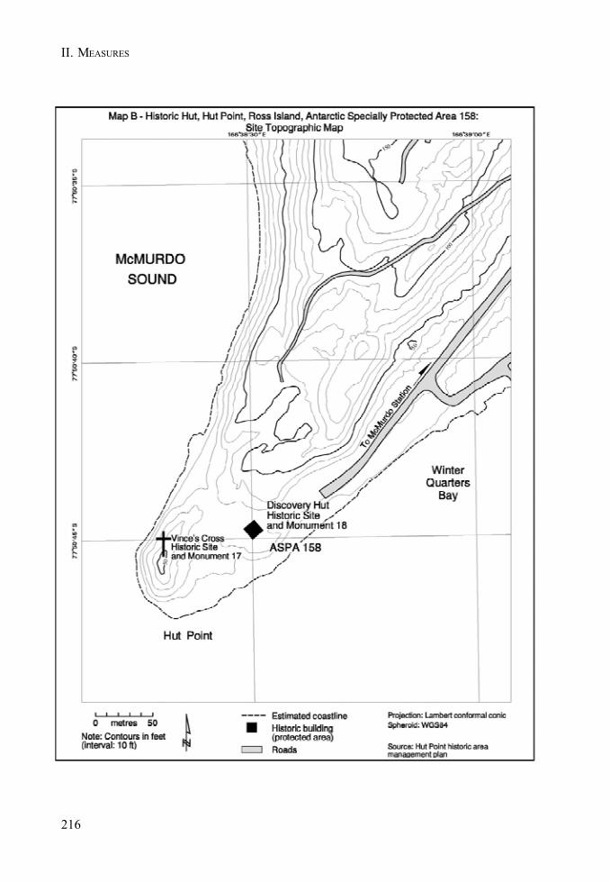
II. MEASURES
216
MEASURE 2 - ANNEX L
217
Management Plan for Antarctic Specially Protected Area No. 159
CAPE ADARE, BORCHGREVINK COAST
(including Historic Site and Monument No. 22,the historic huts of Carsten Borchgrevink and Scott’s Northern Party and their precincts)
1. Description of Values to be Protected
The historic value of this Area was formally recognized when it was listed as Historic Site andMonument No. 22 in Recommendation VII-9 (1972). It was designated as Specially Protected AreaNo. 29 in Measure 1 (1998) and redesignated as Antarctic Specially Protected Area (ASPA) 159 inDecision 1 (2002).
There are three main structures in the Area. Two were built in February 1899 during the BritishAntarctic (Southern Cross) Expedition led by C.E. Borchgrevink (1898-1900). One hut served as aliving hut and the other as a store. They were used for the first winter spent on the Antarcticcontinent.
Scott’s Northern Party hut is situated 30 metres to the north of Borchgrevink’s hut. It consists of thecollapsing remains of a third hut built in February 1911 for the Northern Party led by V.L.A. Campbellof R.F. Scott’s British Antarctic (Terra Nova) Expedition (1910-1913), which wintered there in 1911.
In addition to these features there are numerous other historic relics located in the Area. Theseinclude stores depots, a latrine structure, two anchors from the ship Southern Cross, an ice anchorfrom the ship Terra Nova, and supplies of coal briquettes. Other historic items within the Area areburied in guano.
Cape Adare is one of the principal sites of early human activity in Antarctica. It is an importantsymbol of the Heroic Age of Antarctic exploration and, as such, has considerable historical significance.Some of the earliest advances in the study of earth sciences, meteorology, flora and fauna in Antarcticaare associated with the two earliest expeditions based at this site. The history of these activities andthe contribution they have made to the understanding and awareness of Antarctica give this Areasignificant scientific, aesthetic and historic values.
2. Aims and Objectives
The aim of the Management Plan is to provide protection for the Area and its features so that itsvalues can be preserved. The objectives of the Plan are to:
• avoid degradation of, or substantial risk to, the values of the Area;• maintain the historic values of the Area through planned conservation work which may
include:a. ‘on-site’ maintenance,b. monitoring the condition of artefacts and structures, and the factors which affect
them, andc. conservation of artefacts to be conducted on and off site;
218
II. MEASURES
• allow management activities which support the protection of the values and features of theArea including:a. mapping and otherwise recording the disposition of historic items in the hut environs,
andb. recording other relevant historic data; and
• prevent unnecessary human disturbance to the Area, its features and artefacts throughmanaged access to Borchgrevink’s hut.
3. Management Activities
• A programme of conservation work shall be undertaken on the Southern Cross hut andassociated structures and artefacts in the Area.
• Visits shall be made as necessary for management purposes.• Systematic monitoring shall be put in place to assess the impacts of present visitor limits,
and the results and any related management recommendations included in reviews of thisManagement Plan. National Antarctic Programmes operating in, or those with an interest in,the Area shall consult together with a view to ensuring the above management activities areimplemented.
4. Period of Designation
Designated for an indefinite period.
5. Maps
• Map A: Cape Adare regional map. This map shows the Cape Adare region along with theboundaries of the Area with significant topographic features. It also shows the approximatelocation of significant historical items within the Area.
• Map B: Cape Adare site map. This map shows the approximate location of specific historicrelics and structures within the Area.
6. Description of the Area
6(i) Geographical coordinates, boundary markers and natural features
Cape Adare is a generally ice free, prominent volcanic headland, at the northern extremity of VictoriaLand, which marks the western approaches to the Ross Sea. The Area is located to the south west ofthe Cape on the southern shore of Ridley Beach, which encloses a large, flat, triangular area ofshingle.
The whole of the flat area and the lower western slopes of the Adare Peninsula are occupied by oneof the largest Adélie penguin (Pygoscelis adeliae) rookeries in Antarctica. Penguins have almostcompletely occupied the Area and the need to avoid disturbance often restricts access to the huts.
The boundaries of the ASPA are:
• North, an east-west line drawn 50 metres north of the Northern Party Hut;
219
ASPA 159: CAPE ADARE
• East, a north-south line drawn 50 metres to the west of Borchgrevink’s stores hut;• West, a north-south line drawn 50 metres to the east of Borchgrevink’s living hut; and• South, the shoreline of Ridley Beach.
Skuas (Catharacta maccormicki) nest in the vicinity and Weddell seals also haul up along thebeach.
6(ii) Access to the Area
There are no designated helicopter pads in the vicinity of the Area. Helicopter landings should beavoided as for most of the summer season it is difficult to operate helicopters without causingdisturbance to penguins and skuas. Landings from the sea by boat, or vehicles travelling on the seaice, may be made directly onto the beach as ice and surf conditions allow. From the beach, access tothe Area is by foot. Care must be taken to avoid damage to artefacts in the Area and disturbance tobirds nesting on and around the structures.
6(ii) Location of structures within and adjacent to the Area
Apart from a Treaty plaque all structures within the Area are of historic origin. Major features of theArea include Borchgrevink’s Southern Cross expedition living hut and the unroofed stores hut.Scott’s Northern Party hut is situated 30 metres to the north of Borchgrevink’s living hut and is in astate of collapse.
In addition to these structures there are many other historic relics distributed around the Area.These include stores depots, a latrine structure, two anchors from the ship Southern Cross, an iceanchor from the ship Terra Nova, and supplies of coal. Many of these items are either partly orcompletely covered in the guano of the Adélie penguins which also occupy the Area.
The grave (Historic Site and Monument No. 23) of Nicolai Hanson (biologist with the Southern Crossexpedition) is located approximately 1.5 km north east of historic huts. It is marked by a large boulderwith an iron cross, a brass plaque and a white cross marked out in quartz pebbles.
6(iii) Location of other Protected Areas in the vicinity
The nearest ASPA is 106 (previously SPA 7), approximately 115 km to the south, on the western sideof Cape Hallett.
6(iv) Special Zones within the Area
There are no special zones within the Area.
7. Permit Conditions
Entry to the Area is prohibited except in accordance with a Permit.
Permits shall be issued only by appropriate national authorities and may contain both general andspecific conditions. A Permit may be issued by a national authority to cover a number of visits in aseason. Parties operating in the Area shall consult together and with groups and organisationsinterested in visiting the Area to ensure that visitor numbers are not exceeded.

220
II. MEASURES
Permits to enter the site may be issued for a stated period for:
• activities related to conservation, research and/or monitoring purposes;• management activities in support of the objectives of this Plan; and• activities related to educational or recreational activities including tourism, providing they
do not conflict with the objectives of this Plan.
7(i) Access to and movement within the Area
• Control of movement within the Area is necessary to prevent disturbance to wildlife anddamage caused by crowding around the many vulnerable historic features within the Area.The maximum number in the Area at any time (including those within the hut) shall be: 40people.
• Control of numbers within Borchgrevink’s hut is necessary to prevent damage caused bycrowding around the many vulnerable features within the hut. The maximum number withinthe hut at any time (including guides) shall be: 4 people.
• Avoidance of cumulative impacts on the interior of Borchgrevink’s hut requires an annuallimit on visitor numbers. The number of visitors to the hut varies considerably from year toyear but the effect of visitors to other Ross Sea area historic huts suggests that similar limitsshould apply. The annual maximum number of visitors shall be: 2000 people.
• These limits have been based on current visitor levels and on the best advice available fromconservation advisory agencies (which include conservators, archaeologists, historians,museologists and other heritage protection professionals). The limits are based on theproposition that any significant increase in the current level of visitors would be detrimentalto the values to be protected. An ongoing monitoring programme to assess the effect ofvisitors is required to provide the basis for future reviews of the management plan, inparticular whether the limits on number of visitors are appropriate.
• Adequate supervision of visits to the Area is necessary to prevent damage caused bycrowding and by actions inconsistent with the Code of Conduct set out in section 7(ii). Alltourism, educational and recreational visits must be supervised by an experienced guidenominated by the operator (refer section 7(ix)).
• Helicopter landings are prohibited within the Area.• Vehicles are prohibited within the Area.
7(ii) Activities which may be conducted within the Area
Activities which may be conducted within the Area include:
• visits for conservation purposes;• educational and/or recreational visits including tourism; and• scientific activity which does not detract from the values of the Area.
Visitors should adhere to the following Code of Conduct, except where conservation, research,monitoring or management activities specified in the Permit require otherwise:
• Thoroughly clean grit and scoria, ice and snow from boots using the brushes providedbefore entering the hut to reduce floor abrasion;
• Remove any clothing made wet by sea water, and any sea ice crystals from boots, as saltparticles accelerate corrosion of metal objects;
221
ASPA 159: CAPE ADARE
• Do not touch, move or sit on any items or furniture in the huts - handling artefacts causesdamage;
• As many areas are cramped and artefacts can be accidentally bumped, do not wear packsinside;
• When moving around the sites, take great care not to tread on any items which may beobscured by snow;
• Use of combustion style lanterns, naked flames or smoking in or around the huts is prohibited,as fire is a major risk; and
• Visits should be recorded in the book provided. This allows times and levels of visitation tobe correlated with temperature and humidity data automatically logged inside the hut.
7(iii) Installation, modification or removal of structures
• No new structures are to be erected in the Area, or scientific equipment installed, except forconservation or scientific activities that do not detract from the values of the Area asspecified in 1.
• No historic structure shall be removed from the Area, unless specified in a Permit issued inaccordance with the provisions of section 7(vii).
7(iv) Location of field camps
• Use of the historic hut, or other structures in the Area, for living purposes is not permitted.• Camping is prohibited within the Area under any circumstances.
7(v) Restrictions on materials and organisms which may be brought into the Area
• No living animals, plant material, soil or micro-organisms shall be introduced to the Area.• No food products shall be taken into the Area.• Chemicals may only be introduced for permitted scientific or conservation purposes.
Chemicals (including fuel) or other materials are not to be left in the Area, unless required foressential purposes connected with the conservation of the historic structures or the associatedrelics. All materials are to be removed when no longer required and before a date to bespecified in the Permit.
7(vi) Taking or harmful interference with native flora and fauna
• This activity is prohibited except in accordance with a permit issued by the appropriatenational authority specifically for that purpose under Article 3, Annex II to the Protocol onEnvironmental Protection.
• Where animal taking or harmful interference is involved, this should, as a minimum standard,be in accordance with the SCAR Code of Conduct for the Use of Animals for ScientificPurposes in Antarctica.
7(vii) Collection of anything not imported by the Permit Holder
• Material may be collected and removed from the Area for conservation reasons consistentwith the objectives of this Plan only when specified in a Permit issued by the appropriatenational authority.
222
II. MEASURES
• Materials which pose a threat to the environment or human health may be removed from theArea for disposal, in accordance with a Permit, where they meet one or more of the followingcriteria:(i) the artefact presents a threat to the environment, wildlife or human health and safety;(ii) it is in such poor condition that it is not reasonably possible to conserve it;(iii) it does not contribute in any significant way to our understanding of the hut, its
occupants or the history of Antarctica;(iv) it does not contribute to, or it detracts from, the visual qualities of the site or the hut,
and/or;(v) it is not a unique or rare item;
and where such action is:(i) undertaken by parties with appropriate heritage conservation expertise; and(ii) part of an overall plan for conservation work at the site.
National authorities should ensure that any removal of artefacts and assessment against the abovecriteria is carried out by personnel with appropriate heritage conservation expertise.
Artefacts judged to be of high historic value, which cannot be conserved on site with currentlyavailable techniques, may be removed in accordance with a Permit for storage in a controlledenvironment until such time as they can safely be returned to the Area.
7(viii) Disposal of waste
• All human waste, grey water and other waste generated by work parties or visitors shall beremoved from the Area.
7(ix) Measures that may be necessary to ensure that the aims and objectives of the plan continue tobe met
• The Permit, or an authorised copy, shall be carried within the Area.• Information on the requirements of this Plan shall be provided to all visitors.• The Code of Conduct set out in section 7(ii) shall be followed by all visitors, except where
conservation, research, monitoring or management purposes require otherwise.• Operators facilitating educational and recreational visits (including tourism) to the Area
shall, prior to commencement of the summer season, nominate people with a workingknowledge of both the site and this Management Plan to act as guides during visits.
• All educational and recreational visits (including tourism) shall be supervised by a nominatedguide, who is responsible for briefing visitors on the code of conduct and ensuring it iscomplied with.
• Parties shall consult and coordinate to develop skills and resources, particularly thoserelated to conservation techniques, to assist with the protection of the Area’s values.
7(x) Requirements for reports
Parties shall ensure that the principal holder for each Permit issued submits to the appropriateauthority a report describing the activities undertaken. Such reports shall include, as appropriate,the information identified in the Visit Report Form provided in Appendix 4 of Resolution 2 (1998). Inaddition, any removal of materials in accordance with section 8(viii) shall be detailed, including the
223
ASPA 159: CAPE ADARE
reason for removal and the current location of the items or the date of disposal. Any return of suchitems to the site shall also be reported.
Parties shall maintain a record of such activities and, in the Annual Exchange of Information, shallprovide summary descriptions of activities conducted by persons subject to their jurisdiction, insufficient detail to allow evaluation of the effectiveness of the Management Plan. Parties shouldwherever possible deposit originals or copies of such reports in a publicly accessible archive tomaintain a record of visitation, to be used both for review of the Management Plan and in managingfurther visitation to the site.
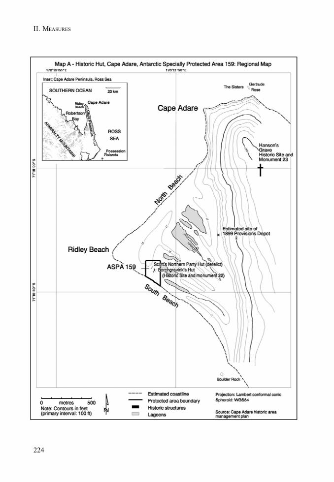
224
II. MEASURES
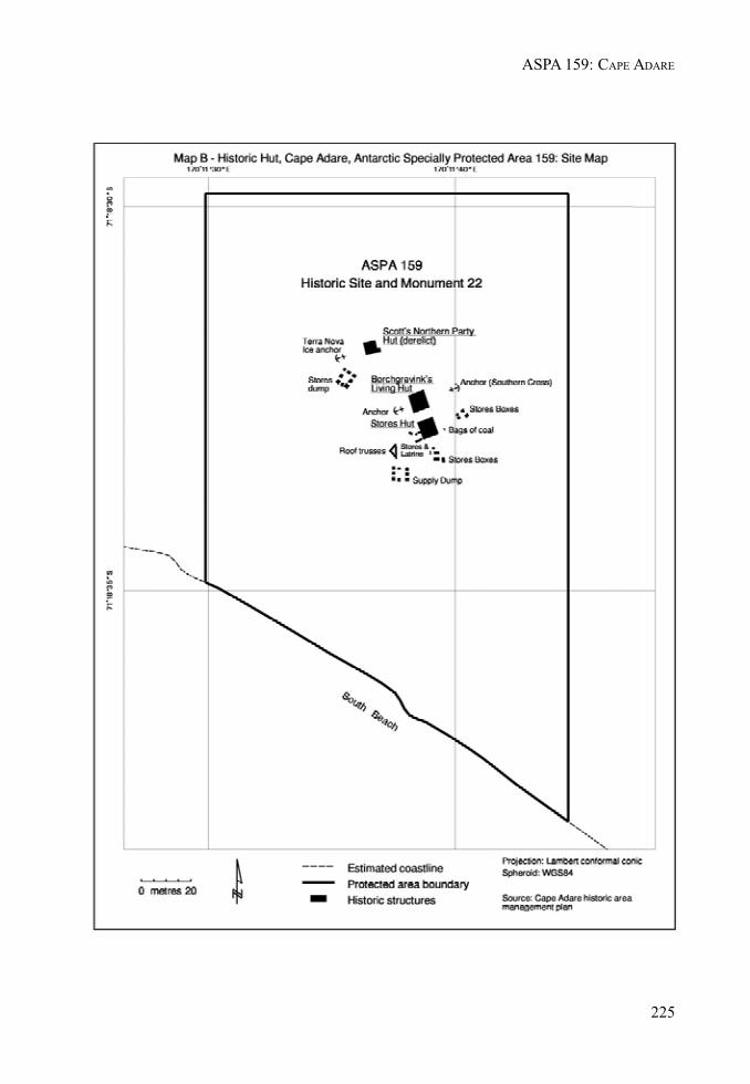
225
ASPA 159: CAPE ADARE

II. MEASURES
MEASURE 2 - ANNEX M
227
Management Plan for Antarctic Specially Protected Area No. 163
DAKSHIN GANGOTRI GLACIER, DRONNING MAUD LAND
Introduction
In accordance with the provisions of Annex V to the Protocol on Environmental Protection to theAntarctica on Treaty Area Protection and Management, India initiated a review of the managementplans for the Antarctic Specially Protected Area: Dakshin Gangotri Glacier, Dronning Maud Land.This ASPA is renamed from the previous Specially Protected Area and Site of Special ScientificInterest (SSSI) in accordance with Decision 1 (2002) of the XXV ATCM at Warsaw.
1. Description of values to be protected
Historic Value
Dakshin Gangotri Glacier is a small tongue of polar continental ice sheet, overriding the SchirmacherOasis of central Dronning Maud Land (CDML). It was identified by the second Indian AntarcticExpedition in 1983 and since then its snout is being monitored continuously.
Scientific Value
With the availability of this vast amount of data for the past two decades, it has become a valuablesite for observing the changes in the movement of the Antarctic ice sheet under the impact of globalwarming. The area has primary scientific importance for glaciologists and environmental scientists.Due to the scientific values of the Area and the nature of the research, it is protected as an AntarcticSpecially Protected Area consistent with Articles 2, 3, 5 and 6 of Annex V to the Protocol onEnvironmental Protection to the Antarctic Treaty, to prevent interference with ongoing plannedscientific investigations.
Environmental Value
In the designated Area exploration shows the faunal diversity and ecology of the moss-inhabitingterrestrial invertebrate fauna and it is also extensively explored lichenologically. Schirmacher Oasis isalso an important area for the algal and cyanobacterial flora diversity. Terrestrial mosses are quitewidespread in the Schirmacher Oasis colonizing a range of habitats. The bryophytes, because of theirpoikilohydric nature and alternative strategy of adaptation, are one of the very few plant groups whichgrow in Antarctica. As such their role in habitat modification, nutrient cycling, primary production andproviding shelter and security to associated invertebrate animals, for example the bryobionts,bryophiles, bryoxenes assume a particular significance. Bryophytes have been reported in SchirmacherOasis (divided in Eastern, Central and Western Schirmacher). Lichens, fungi, algae and bacteria havealso been reported in the Area. Distribution of algae and cyanobacteria flora of fresh water streams ofthe Oasis at the designated area are studied. Examination of algae and cyanobacteria is conducted inthe glacier-melt water stream. The species reported are G. magma, Chaemosiphon subglobosus,Oscillatoria limosa, O. limnetica, P. frigidum, P. autumnale, Nostoc commune, N. punctiforme,Calothrix gracilis, C. brevissima, Uronema sp., and Cosmarium leave. Among the cyanobacteriaencountered in the stream of Schirmacher Oasis, contribution by N2 –fixing species might play a
228
II. MEASURES
significant role in nitrogen economy of the ecosystem through N2–fixation. Studies on polar Skuas arealso conducted at Schirmacher Oasis and their nesting and breeding success is reported around thedesignated place.
2. Aims and Objectives
Management at Dakshin Gangotri Glacier aims to:
• Avoid degradation of values of the Area by preventing undue human disturbance;• Allow glaciological and environmental scientific research, while ensuring protection of
observational accuracy from any sort of man-made inputs;• Ensure that peripheral points along the snout are not adversely affected by human activity
in the Area;• Maintain the Area as a reference marker for studying the movement patterns of this part of
the Antarctic ice-sheet under the influence of global warming;• Allow visits for management purposes in support of the aims of the Management Plan for
the Area.
3. Management Activities
The following management activities will be undertaken to protect the values of the Area:
• A detailed map showing the location & boundaries of the Area and stating the specialrestrictions that apply will be displayed prominently at Maitri (India) and Novolazarevskaya(Russia) research stations; copies of this management plan shall also be made available atboth the stations.
• Two signs displaying the location and boundaries of the Area with clear statements of entryrestrictions shall be placed on prominent rocks near both the entrance points to the valley,the eastern end and the south-eastern end; to help avoid inadvertent entry.
• Copies of this management plan along with location and boundary maps of the Area will beprovided to all the visiting ships/aircraft.
• Markers, signs, cairns and other structures erected within the Area for scientific andmanagement purposes will be secured and maintained in good condition, and will be removedwhen no longer necessary.
• Visits shall be made as necessary (at least once every year) to assess whether the Areacontinues to serve the purposes for which it was designated and to ensure that maintenanceand management are adequate.
• The management plan shall be reviewed no less than once every five years and updated asrequired.
4. Period of Designation
The ASPA is designated for an indefinite period.
229
ASPA 163: DAKSHIN GANGOTRI GLACIER
5. Maps
The following maps and photographs are enclosed for illustrating the Area and the ManagementPlan:
• Map 1: Location of Schirmacher Oasis in central Dronning Maud Land, East Antarctica.• Map 2: Map of Schirmacher Oasis, showing locations of Maitri Research Station (India)
and Novolazarevskaya Research Station (Russia).• Map 3: Classification and Numbering of Lakes of Schirmacher Oasis (after Ravindra et al,
2001).• Map 4: Topographic map of the Area (contour interval 10 m).• Map 5: Paths of Fossil Glaciers in Schirmacher Oasis (after Beg et al, 2000).• Map 6: Aerial view of the Dakshin Gangotri Glacier Snout.
6. Description of the Area
6(i) Geographical coordinates, boundary markers and natural features
Schirmacher Oasis is a rocky hill range, about 17 km long in E-W trend (bounded by Eastern longitudes11° 22' 40" and 11° 54' 20") and about 0.7 km to 3.3 km wide (bounded by Southern latitudes 70° 43' 50"and 70° 46' 40"). Its elevation varies from 0 to 228 m above the msl. It is a part of central DronningMaud Land in Eastern Antarctica. The Area is a fragment of the western part of Schirmacher Oasis.
The Area is bounded by the Eastern longitudes 11° 33' 30" and 11° 36' 30" and by the Southernlatitudes 70° 44' 10" and 70° 45' 30". The Area is 4.53 sq. km in aerial extent. The northeastern andnorthwestern corners of the Area are on shelf-ice, while the southwestern extremity is on polar ice-sheet. The southeastern end lies on a rocky outcrop.
Topographically, the Area can be divided into four distinct units–the southern continental ice-sheet,rocky hill slopes, a vast central proglacial lake (Lake-B7, Sbrosovoye Lake) and northern undulatoryshelf ice.
The southernmost ice-sheet is bare ‘blue ice’, descending from 180 m contour to 10 m contour at thesnout of the Glacier. It is crevassed and crisscrossed by NE-SW to NNE-SSW trending fractures.Two small and ephemeral supraglacial streams flow over the snout in a NNE direction.
The rocky terrain is uneven and has the minimum width of the Schirmacher Oasis at the snout point;less than 50 m only. The eastern and western sides of the hills slope towards the snout, making a widevalley. The contours descend from 150 m to msl at the northern margin of the rock outcrops.
The central part of the Area is occupied by Lake B7. It is a lake of glacial origin. The dimensions of thelake are about 500 m x 300 m.
The northernmost part of the Area comprises shelf ice with pressure ridges, fractures and crevasses.The contact between shelf ice and eastern rocky slopes is marked by a prominent 3-km long, NNE-SSW trending lineament. The fractures in the ice are also aligned parallel to this lineament.
Schirmacher Oasis exposes a granulite to amphibolite facies metamorphic terrain. The rock types arerepresented by charnockites, enderbites, garnet-sillimanite, gneisses, garnet-biotite gneisses,quartzofeldspathic augen gneisses with some foliated lamprophyres, amphibolites, dolerite,metagabbro and metabasalt. The rock suites dominantly fall under Grenvillean (1000 Ma) and Pan-African (550 Ma) events. Three phases of deformation are distinct.
230
II. MEASURES
The Area comprises mostly charnockite-Khondalite type of rocks (quartz-garnet-sillimanite-perthite±graphite gneisses) with some interlayering of garnet-sillimanite quartzites, calc silicategneisses and mafic granulites. Two sets of faults (N30E and N50E) are quite prominent. One suchmajor fault runs from the north-eastern corner of the Area; cutting all the three geomorphologicalunits–shelf ice, rocks and continental ice-sheet.
Meteorological data from the nearby Indian Research Station Maitri shows that the Area has a drypolar climate. The extreme temperatures for the warmest and the coldest months range between 7.4 to-34.8°C. The mean annual temperature is -10.2°C. December is the warmest month of the year andAugust is the coldest. The blizzards touch a gale speed of 90 to 95 knots; the mean annual windspeed is 18 knots. The dominant wind direction is E-SE. Snowfall is quite frequent during the wintermonths, but gale force winds scrub the rocky surfaces clean and snow deposition is widespread onthe leeward side of the hillocks.
Glaciological observations from 1983 to 1996 were carried out by surveys from two fixed points (‘G’and ‘H’) using EDM or theodolite. The results showed that the Glacier is steadily receding every yearat an average recession rate of 70 cm per annum.
In 1996, to enhance the accuracy of the observations, 19 peripheral points were marked encircling thesnout of the Glacier. The average annual recession in the years 1997 to 2002 was 48.7 cm, 74.9 cm, 69.5cm, 65.8 cm and 62.7 cm, respectively.
This translates into an overall average recession of 65.3 per annum for the period 1996-2002; which isin conformity with the observations for the previous period (1983 – 1996) of a recession rate of 7meters per decade.
6(ii) Restricted and managed zones within the Area
Along the periphery of the Dakshin Gangotri Glacier, 19 observation points have been marked inFebruary 1996. With reference to these points it has become possible to record the movement of theGlacier within an accuracy of 1 cm. Precise monitoring on cm-scale is also available for the years 1996-2002. Access to this zone should be restricted. It is proposed that a 100m radius all along theperiphery of the Glacier should have limited admittance to protect the accuracy of scientificobservations.
6(iii) Structures within and near the Area
There are no structures present in the Area, apart from two cairns (‘G’ and ‘H’) marking the sites usedfor glaciological and topographical surveys.
In future, some signs and cairns will be erected notifying the protected status of the Area.
6(iv) Location of other Protected Areas within close proximity of the Area
In the entire Schirmacher Oasis, there are no other protected areas.
231
ASPA 163: DAKSHIN GANGOTRI GLACIER
7. Permit Conditions
7(i) Access to and movement within the Area
Entry into the Area shall be prohibited except in accordance with a permit issued by an appropriatenational authority as designated under Article 7 of Annex V to the Protocol on Environmental Protectionto the Antarctic Treaty.
A permit to enter the Area may only be issued for scientific research, or for essential managementpurposes consistent with the Management Plan’s objectives and provisions; with the condition thatthe actions permitted will not jeopardize the scientific and environmental values of the Area and willnot interfere with ongoing scientific studies.
7(ii) Activities that are or may be conducted within the Area, including restrictions on time orplace
The following activities may be conducted within the Area:
• Scientific research programmes consistent with the Management Plan for the Area, includingthe values for which the Area has been designated; which cannot be carried out elsewhereand which will not jeopardize the ecosystem of the Area.
• Essential management activities, including monitoring.
7(iii) Installation, modification or removal of structures
No structures are to be erected within the Area except as specified in a permit. Any equipment shouldnot be installed if it is not essential for scientific research or for management activities, and it must beauthorized in a permit. All scientific equipment installed in the Area must be clearly identified bycountry, name of principal investigator, year of installation and expected date of completion of thestudy. Details are to be included in the visit report. All such equipment should be made of materialsthat pose minimum risk of contamination and must be removed at the completion of the study.Removal of specific equipment for which the permit has expired shall be a condition of the permit.
7(iv) Location of field camps
Camping is not allowed in the Area. The field parties can camp either east of “Lake Kalika” at “VK-Ground” or beyond the western limit of the Area.
7(v) Restriction on materials and organisms, which can be brought into the Area
No living animals, plant material or microorganism shall be deliberately introduced into the Area andprecautions shall be taken against accidental introductions.
No pesticides, herbicides, chemicals, radio-isotopes shall be brought into the Area, other than thosepermitted for scientific or management purposes. And these authorized agents shall be removed fromthe Area at the conclusion of the activity.
Fuel is not to be stored in the Area unless connected with authorized activity. Permanent depots arenot to be built in the Area.
All material taken into the Area shall be for a stated period only and shall be removed at or before theconclusion of that stated period.

232
II. MEASURES
7(vi) Taking or harmful interference with native flora and fauna
Any interference with the native flora and fauna of the Area shall be in accordance with therequirements of the Protocol on Environmental Protection to the Antarctic Treaty, 1991, Annex II,Article 3. Where taking or harmful interference with animals is involved, SCAR Code of Conduct forUse of Animals for Scientific Purposes in Antarctica should be used as a minimum standard.
7(vii) Collection or removal of anything not brought into the Area by the Permit holder
Material may only be collected or removed from the Area as specified in the permit and should belimited to the minimum necessary to meet scientific or management requirements.
7(viii) Disposal of Waste
All waste, including human wastes, shall be removed from the Area.
7(ix) Measures that are necessary to ensure that the aims and objectives of the management plancan continue to be met
Permits may be granted to enter the Area to carry out biological monitoring and area inspectionactivities.
Specific sites of long-term monitoring shall be appropriately marked and GPS positions will be obtainedfor records with the Antarctic Data Directory System through the appropriate national authority.
8. Requirements for Reports
The principal permit holder for the permit issued shall submit to the appropriate national authority avisit report describing the activities undertaken. Reports are due and shall be submitted as soon aspossible after the expiration of the permit, and include the types of information contained in SCARvisit report form or as required by national laws. The authority will maintain a record of such activitiesand make this accessible to interested Parties.
Supporting Bibliography
ASTHANA, R., GAUR, M.P. AND CHATURVEDI, A. (1996): Notes on Pattern of Snow Accumulation/ablation on ice shelf and Secular Movement of Dakshin Gangotri Glacier Snout in Central DronningMaud Land, East Antarctica. In: scientific Report of the Twelfth Indian Scientific Expedition toAntarctica, Tech. Pub. No. 10 D.O.D., Govt. of India, New Delhi, pp.111-122.
BEG, M.J., PRASAD, A.V.K. AND CHATURVEDI, A. (2000): Interim Report on Glaciological Studiesin the Austral Summer of 19th Indian Antarctic Expedition. Submitted for publication in: ScientificReport of Nineteenth Indian Expedition to Antarctica, Tech. Pub. No. 17, D.O.D., Govt. of India, NewDelhi, pp. 121-126.
BEJARNIYA, B.R., RAVIKANT,V. AND KUNDU, A., (2000): Glaciological Studies in SchirmacherHill and on Ice Shelf during XIV Antarctica Expedition. In: Scientific Report of Sixteenth IndianExpedition to Antarctica, Tech. Pub. No. 14, D.O.D., Govt. of India, New Delhi, pp. 121-126.
CHATURVEDI, A., SINGH, A., GAUR, M.P., KRISHNAMURTHY, K.V., AND BEG, M.J., (1999): Aconfirmation of Polar Glacial Recession by Monitoring the Snout of Dakshin Gangotri Glacier in
233
ASPA 163: DAKSHIN GANGOTRI GLACIER
Schirmacher Range. In: Scientific Report of Fifteenth Indian Expedition to Antarctica, Tech. Pub. No.13, D.O.D., Govt. of India, New Delhi, pp. 321-336.
D’SOUZA, M.J. AND KUNDU, A., (2000): Glaciological studies during the Seventeenth AntarcticExpedition. In: Scientific Report of Seventeenth Indian Expedition to Antarctica, Tech. Pub. No. 15,D.O.D., Govt. of India, New Delhi, pp.67-72.
KASHYAP, A.K. (1988.): Studies on Algal flora of Schirmacher Oasis, Dronning Maud land, Antarctica. In: proceedings of Workshop on Antarctic Studies, D.O.D.,CSIR, Govt. of India, New Delhi, pp.435-439
KAUL, M.K., SINGH, R.K., SRIVASTAVA, D., MUKERJI, S. AND JAYARAM, S. (1998): Observationson the Changes in the Snout of Dakshin Gangotri Glacier, Antarctica. In: Scientific Report of the FifthIndian Expedition to Antarctica, Tech. Pub. No. 5, D.O.D., Govt. of India, New Delhi, pp. 205-209.
KAUL, M.K., CHAKRABORTY, S.K. AND RAINA, V.K. (1985): A Note on the snout of the DakshinGangotri Glacier, Antarctica. In: Scientific Report of Second Indian Expedition to Antarctica, Tech.Pub. No. 2, D.O.D., Govt. of India, New Delhi, pp. 91-93.
MUKERJI, S., RAVIKANT, V., BEJARNIYA, B.R., OBEROI, L.K. AND NAUTIYAL, S.C. (1995): ANote on the Glaciological Studies Carried Out During Eleventh Indian Expedition to Antarctica. In:Scientific Report of Eleventh Indian Expedition to Antarctica, Tech. Pub. No. 9, D.O.D., Govt. of India,New Delhi, pp. 153-162.
PANDEY K.D., KASHYAP A.K. (1995): Diversity of Algal Flora in Six Fresh Water Streams ofScirmacher Oasis, Antarctica. In Scientific Report of Tenth Indian Expedition to Antarctica, Tech.Pub. No. 8, D.O.D., Govt. of India, New Delhi, pp. 218-229.
RAVINDRA, R. (2001): Geomorphology of Schirmacher Oasis, East Antarctica. Proc. Symp. onSnow, Ice and Glaciers, Geol. Sur. India, Spl. Pub. No. 53, pp. 379-390.
RAVINDRA, R., CHATURVEDI, A. AND BEG, M.J. (2001): Melt Water Lakes of Schirmacher Oasis- Their Genetic Aspects and Classification. In: Advances in Marine and Antarctic Science, Ed.Sahu, DB and Pandey, PC, Dariyaganj, New Delhi, pp. 301-313.
RAVINDRA, R., SRIVASTAVA, V.K., SHARMA, B.L., DEY, A. AND BEDI, A.K. (1994):Monitoringof Icebergs in Antarctic Waters and a Note on the Secular Movement of Dakshin Gangotri Glacier. In:Scientific Report of Ninth Indian Expedition to Antarctica, Tech. Pub. No. 6, D.O.D., Govt. of India,New Delhi, pp. 239-250.
SINGH D.K., SEMWAL R.C., (2000): Bryoflora of Schirmacher Oasis,East Antarctica: A PreliminaryStudy. In: Scientific Report of Sixteenth Indian Expedition to Antarctica, Tech. Pub. No. 14, D.O.D.,Govt. of India, New Delhi, pp.173-186
VENKATARAMAN K. (1998): Studies on Phylum Tardigrada and Other Associated Fauna, SouthPolar Skua and Bird and Mamal Ligging During 1994-1995 Expedition. In: Scientific Report of FourteenthIndian Expedition to Antarctica, Tech. Pub. No. 12, D.O.D., Govt. of India, New Delhi, pp.220-243
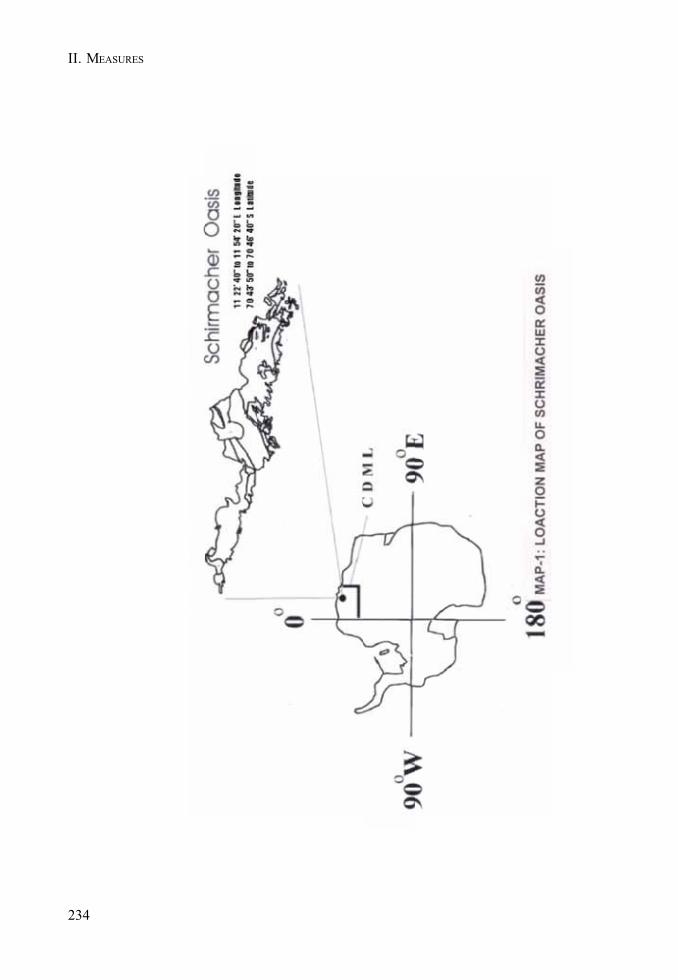
234
II. MEASURES

235
ASPA 163: DAKSHIN GANGOTRI GLACIER
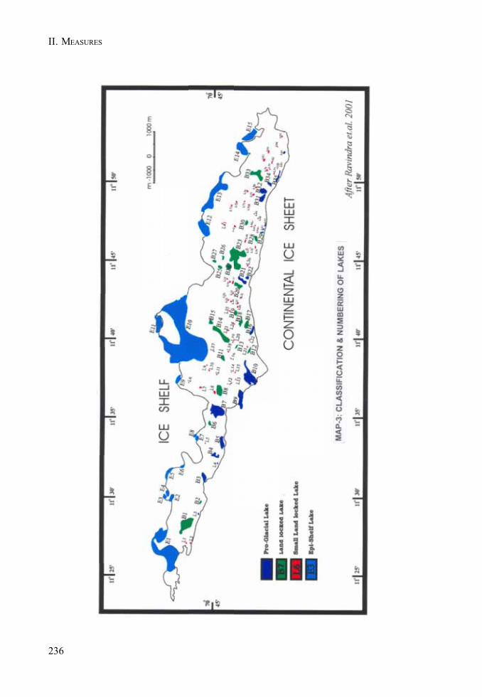
236
II. MEASURES
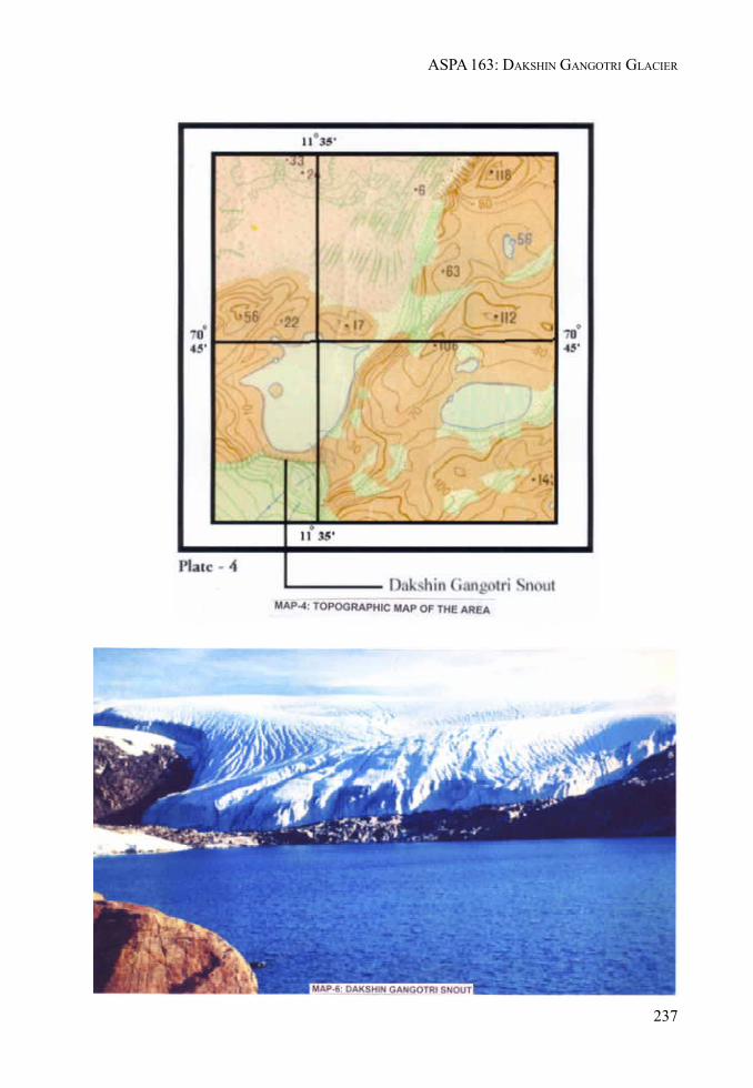
237
ASPA 163: DAKSHIN GANGOTRI GLACIER
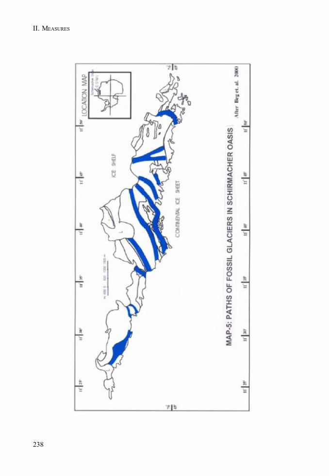
II. MEASURES
238

MEASURE 2 - ANNEX N
239
Management Plan for Antarctic Specially Protected Area No. 164
SCULLIN AND MURRAYMONOLITHS, MAC ROBERTSON LAND,EAST ANTARCTICA
1. Description of Values to be Protected
Scullin and Murray Monoliths (67° 47’S 66° 42’E and 67° 47’S 66° 53’E) hold the greatest concentrationof breeding seabird colonies in East Antarctica, including the second largest colony of Antarcticpetrels Thalassoica antarctica. The Scullin and Murray Monoliths ASPA is a breeding locality for atleast 160,000 pairs of Antarctic petrels from a minimum estimated global total of approximately half amillion pairs (van Franeker et al. 1999). Scullin Monolith was recently recognised as a candidateImportant Bird Area (IBA) using IUCN/BirdLife International criteria on known breeding populationsby the SCAR Bird Biology subcommittee in mid-2002 (SCAR unpubl. data).
Adélie penguin colonies occupy the lower slopes of both monoliths, extending almost to the foreshore.Approximately 50,000 pairs nest on Scullin Monolith and a further 20,000 pairs on Murray Monolith.This represents approximately 10% of the Adélie penguin breeding population for East Antarcticaand approximately 3% of the global population.
Many of the ocean-facing slopes of both monoliths are used for breeding by petrels. Extensivebreeding colonies of four species of petrels occupy many of the steeper, higher-altitude slopes ofboth monoliths. The Antarctic petrel colony on Scullin Monolith is second in population only to thecolony at Svarthameren in the Mühlig Hofmannfjella, in Dronning Maud Land. South Polar skuasnest throughout the ASPA, making use of the high density of breeding seabirds as prey during theirbreeding season. (See Figure A and Photograph A).
While larger colonies of seabirds are known from elsewhere in East Antarctica (e.g. the Rauer Group),it is the extensive populations (total known breeding population conservatively estimated at 230,000pairs equivalent to a minimum of 460,000 individual breeding seabirds) and rich species diversity(seven breeding species) within the very small ice-free areas of Scullin and Murray Monoliths(estimated ice free area of 1.9 and 0.9 km2, respectively, total of 2.8 km2) that make these the greatestconcentration and one of the most diverse seabird breeding localities known from East Antarctica(Appendix 1).
There are no data on population trends available, and the census and survey data collected in 1986/87 serve as baseline data for all future ornithological work in the Area. Some limited census data werecollected from Reference Breeding Groups (RBGs) established in the mid 1980s to monitor the Antarcticpetrel population; there have been no surveys of these RBGs for more than a decade. Many Adéliepenguin breeding populations throughout East Antarctica have increased in the last 20 or so years,and it is likely that the Adélie penguin population within the Scullin and Murray Monoliths ASPA isgreater than the 70,000 pairs reported from 1986/87. Further, it is likely that the 1986/87 census under-estimated the breeding population of Antarctic petrels, given the census occurred late in the breedingseason.
Aesthetic and wilderness values
In addition to the outstanding ecological and scientific values already identified, the Area possessesoutstanding aesthetic values in the geomorphology of the two Monoliths and the spectacular natureof the glaciers descending from the Continental plateau that flow around the Monoliths ending in

240
II. MEASURES
calving glaciers. The near-vertical aspects of both Monoliths dropping to the sea, used by a highnumber of seabirds for nesting, represent an unique landscape in the Antarctic. The very largebreeding assemblage of undisturbed seabirds in a setting of high aesthetic and wilderness valueswarrants the highest level of protection.
Human history
Recorded visits to Scullin and Murray Monoliths are few. Scullin and Murray Monoliths were firstvisited during the second BANZARE voyage in 1930-31, on 13th February 1931 (Grenfell Price 1962,Fletcher 1984). A brief landing was made at Scullin Monolith on 26 February 1936 from the R.R.S.William Scoresby, when an ascent was made to a height of several hundred metres (Rayner 1940). Alanding by the Norwegian, Lars Christensen was made on 30 January 1937, when Scullin Monolithwas visited (Christensen 1938, 1939). Australian National Antarctic Research Expeditions (ANARE)personnel have made few visits to the Area from Mawson station, approximately 160 km to the west.The only recorded stay within the Area was a six-day visit (1 - 6 February 1987), when comprehensiveornithological surveys were conducted (Alonso et al. 1987). A fibreglass ‘Apple’ refuge wasestablished within the ASPA for this visit, and as of 13 October 2002, was intact. The first visit by acommercial tourist vessel to the Area was made on 10 December 1992, when passengers were landedat Scullin and Murray Monoliths. Brief tourist visits were made to Scullin Monolith on 7 December1997, to Scullin and Murray Monoliths on 8 January 1998 and, Scullin and Murray Monoliths on 18December 2002. Compared to many sites in East Antarctica, Scullin and Murray Monoliths have beenvisited infrequently, and with the one known exception, all visits have been brief (less than a day).Further, with little activity conducted during those visits, the Area, and in particular the avifauna, isof particular value as a relatively undisturbed area suitable for use in the future as a reference site forother areas that experience a greater level of human visitation and extent of activities.
Nomenclature
Mawson named both Monoliths during the second BANZARE voyage. Murray Monolith was namedafter Sir George Murray, Chief Justice of South Australia, Chancellor of the University of Adelaideand a patron of the Expedition, while Scullin Monolith was named after James H. Scullin, PrimeMinister of Australia from 1929-31.
2. Aims and Objectives
The high concentration and diversity of the ASPA’s avifauna requires management strategies thatwill limit the potential for human activities within the Area to affect the values to be protected. Allhuman activities within the Scullin and Murray Monoliths ASPA will be managed and coordinated to:
• preserve Scullin and Murray Monoliths henceforth as a restricted Area with the goal ofensuring ecosystem integrity and the concomitant minimisation of environmental impactsof human activities;
• avoid degradation to, or substantial risk to, the values of the ASPA by preventingunnecessary human disturbance and activities within the ASPA, and maintain the undisturbednature of the ASPA to permit its use in future as a reference area;
• permit and facilitate scientific research activities within the ASPA, in particular on the avifauna,while ensuring that the breeding populations are protected through the restriction on thefrequency of visits and the types of activities undertaken. Research proposed for the ASPAwill be on the basis that it can not be undertaken elsewhere. Non-ornithological research or

241
ASPA 164: SCULLIN AND MURRAY MONOLITHS
activities within the Area must not affect the ornithological values of the ASPA and shouldbe limited to areas outside breeding colonies or nesting sites whenever possible;
• prohibit non-research visits to the ASPA during the summer seabird breeding season;• prohibit the construction or installation of semi-permanent accommodation in the ASPA (i.e.
extending beyond the end of one seabird breeding season);• prohibit flying of any aircraft within the ASPA during the summer breeding season (1 October
to 31 March for the purposes of this Management Plan);• accord high priority to the collection of seabird census data from representative sample
areas, reference breeding colonies (RBGs) or of whole breeding populations. These censusdata will be major determinants in, and contributions to, future revisions of the managementstrategy for the ASPA;
• accord high priority to the collection of biological survey data, in particular flora andinvertebrate surveys. These survey data will be incorporated into future revisions of themanagement strategy for the Antarctic Specially Protected Area No. 164;
• minimise the potential for introduction of alien plants, animals and micro-organisms to theASPA reducing the potential for the introduction of avian pathogens is a primary concern.
3. Management Activities
The following management activities will be undertaken to protect the values of the ASPA:
• allow visits for management purposes that address the conservation and ongoing assessmentof values, including the identification of new values or the recognition of values no longerpresent (ie incorporating a dynamic set of values that reflect biological processes within theArea);
• permit research visits to conduct censuses of seabird breeding populations, includingmapping of colonies and nest sites. Visits to assess populations or to undertake aerialphotography of the colonies shall be undertaken as necessary (preferably no less than onevisit every five years);
• markers, signs and other indicators of the Area’s extent shall not be erected, maintaining theaesthetic values and undisturbed nature of the Area;
• clothing (and in particular all footwear) and field equipment shall be cleaned before and afterentering the Area. Research equipment shall be disinfected where possible and appropriate,to prevent possible introductions to, or contamination of, the Area;
• information on the Scullin and Murray Monoliths ASPA, including restrictions, shall beproduced and displayed prominently at Davis and Mawson stations. Copies of thisManagement Plan will be made available at both stations and via the internet. Copies of theManagement Plan will be made available for all visitors;
• visits will be permitted as necessary to facilitate research activities in accordance with thestated aims of the management of the ASPA;
• national Antarctic programs operating in the vicinity or intending to visit the Area shallconsult together to ensure that the ASPA is not visited more than once every five (5) years,or that research projects do not overlap or conflict;
• permit visits to remove fuel, grey water, the Apple refuge and associated materials currentlystored within the ASPA.
242
II. MEASURES
4. Period of Designation
The Area is designated for an indefinite period.
5. Maps and Photographs
• Map A: East Antarctica, Mac. Robertson Land, Location of Antarctic Specially ProtectedArea Scullin and Murray Monoliths, ASPA No. 165.Inset Map: indicates the location in relation to the Antarctic continent.Map Specifications: Projection: Lambert Conical Conformal; Horizontal Datum: WGS84;Vertical Datum: Mean Sea Level.
• Map B: Antarctic Specially Protected Area Scullin and Murray Monoliths, ASPA No. 165.Showing protected area at Scullin Monolith.Map Specifications: Horizontal Datum: WGS84; Vertical Datum: Mean Sea Level.
• Map C: Antarctic Specially Protected Area, Scullin and Murray Monoliths, ASPA No. 165.Showing protected area at Murray Monolith.Map Specifications: Horizontal Datum: WGS84; Vertical Datum: Mean Sea Level.
• Map D: Antarctic Specially Protected Area, Scullin and Murray Monoliths, ASPA No. 165,Showing Helicopter Approach for Scullin Monolith.Map Specifications: Horizontal Datum: WGS84; Vertical Datum: Mean Sea Level.
• Photograph A: Oblique aerial photograph of Scullin Monolith with seabird colonies shown,2003.
6. Description of the Area
6(i) Geographical coordinates, boundary markers and natural features
Scullin Monolith (67° 47’S, 66° 42’E) and Murray Monolith (67° 47’S, 66° 53’E) are situated on thecoast of Mac. Robertson Land approximately 160 km east of Mawson station (Map A). Scullin andMurray Monoliths are approximately 7 km apart and abut the sea at the edge of the continental icesheet. The coastline to the west and east, and between the Monoliths, consists of ice cliffs 30 - 40 mhigh; the Antarctic plateau rising steeply from there to the south. Scullin Monolith is a crescent-shaped massif whose highest point is 433 m ASL. It encloses a broad north-facing cove with anentrance approximately 2 km wide. The upper slopes of the Monolith are everywhere precipitous, butin the lower 100 m the slope eases in many parts and these areas are strewn with boulders and largestones. Elsewhere in the lower parts the rock face falls sheer to the sea, and there are some screeslopes.
The walls of Murray Monolith rise at between 70° and 80° from the sea to a dome-shaped summit at243 m ASL. On the western side of the Monolith, the lower slopes drop to a coastal platform. Thereare several other rock outcrops inland of the Monolith, and these are included in the ASPA. Theprotected area extends over all ice-free areas associated with the two Monoliths, including a fewsmall islets and rocks.
The Scullin and Murray Monoliths ASPA comprises two sectors:
• Scullin Monolith: the boundary commences at a coordinate on the coastline at 67°47’01"S,66°40’31"E (A), then in a southerly direction to a coordinate at 67°48’03"S, 66°40’26"E (B),
243
ASPA 164: SCULLIN AND MURRAY MONOLITHS
east to a coordinate at 67°48’06"S, 66°44’33"E (C) then north to a coordinate on the coast at67°46’41"S, 66°44’37"E (D), then west following the coast line at the low tide mark to thecoordinate 67°48’03"S, 66°40’26"E (A). See Map B.
• Murray Monolith: the boundary commences at a coordinate on the coastline at 67°46’29"S,66°51’01"E (A), then in a southerly direction to a coordinate at 67°48’03"S, 66°50’55"E (B),east to a coordinate at 67°48’05"S, 66°53’51"E (C) then north to a coordinate on the coast at67°46’42"S, 66°53’59"E (D), then west following the coast line at the low tide mark to thecoordinate 67°46’29"S, 66°51’01"E (A). See Map C.
Geology
The geology of the two Monoliths is poorly known, as they have been neither the subject ofdedicated study (but see Tilley 1940) nor specific geological mapping. What is known is summarisedbriefly in Tingey (1991). The geology of the Monoliths appears to be similar in general terms to thatof the region around Mawson. The rocks consist dominantly of high grade-granulite facies gneissesof metasedimentary origin, including some sapphirine bearing rocks. The metamorphism occurred inanhydrous conditions probably at about 1000Ma. Arriens (unpublished data; see Tingey 1991)determined ages of 1075 and 829Ma for the metamorphic age of the gneisses from Scullin Monolithbut ages elsewhere as great as 1254Ma and as young as 625Ma have been documented. Metamorphisminvolved sedimentary rocks initially of Proterozoic age. These metamorphic basement rocks wereintruded at about 920-985Ma by the Mawson Charnockite a form of granite characterised by presenceof orthopyroxene, and common in this region. It forms the faces of the monoliths. Takigami et al.(1992) recorded an age of 433 and 450Ma which may reflect a later influence of the ‘500 Ma or Pan-African event’ recorded widely throughout Gondwana. The margins of the Monoliths contain somesediment carried by the icesheet and deposited by melting ice. The source cannot be specified but itmay contain recycled material from farther inland and could perhaps provide evidence of some of thegeology beneath the ice.
Vegetation
The flora reported from Scullin Monolith is given in Appendix 3, based on visits in 1972 and 1987. Allspecies of lichens and moss found on Scullin Monolith occur elsewhere in Mac. Robertson Land(Filson 1966, Bergstrom and Seppelt 1990). Vegetation on Scullin Monolith is restricted mainly to thewestern plateau and associated nunataks. The coastal slopes are generally devoid of vegetation dueto high levels of seabird guano. The distribution of vegetation on the western plateau is influencedby microtopography that controls the extent of exposure and moisture availability.
Other biota
No invertebrates have been recorded from Scullin and Murray Monoliths. A leopard seal (Hydrurgaleptonyx) was sighted during the 1936 visit (Rayner 1940) and several Weddell seals (Leptonychotesweddellii) were observed during the 1997 and 1998 visits (PG Quilty, pers. comm.); no furtherobservations of biota have been reported. Appendix 2.
6(ii) Restricted and managed zones within the Area
During the summer breeding season (1 October to 31 March), access to all areas occupied by, oradjacent to, colonies or nesting sites of seabirds shall be restricted. Ornithological research asauthorised by permit may be conducted within the seabird colonies. Non-ornithological researchmay be conducted in the Area during the summer breeding season if it does not disturb nesting birds.Non-scientific visits and landings within the Area are prohibited during the summer breeding season.
244
II. MEASURES
6(iii) Structures within and near the Area
As of 13 October 2002, a fibreglass ‘Apple’ refuge is situated on the southwestern summit ridge ofScullin Monolith. There are four (4) 200-litre drums of helicopter fuel and one (1) empty 200-litre drumas well as the (reported) remains of a food cache (1985/86 vintage). It is intended that all of thismaterial be removed from the Area at the first opportunity.
6(iv) Location of other protected areas within close proximity of the Area
There are two ASPAs located to the west of Scullin and Murray Monoliths; Rookery Islands AntarcticSpecially Protected Area No. 102 is approximately 180 km to the west (c.20 km west of Mawson), andTaylor Rookery Antarctic Specially Protected Area No. 101 approximately 75 km further west of theASPA No. 102.
7. Permit conditions
Entry to the Area is prohibited except in accordance with a Permit issued by an appropriate nationalauthority. Any Treaty Party wishing to conduct research within the Area should contact the AustralianAntarctic Division to ensure that the frequency of visits does not exceed that permitted in theManagement Plan (the current level deemed to be appropriate is no more than one visit every five (5)years). Permits to enter the Area may be issued during the non-breeding period, specifically from 1April to 30 September, for compelling scientific research that cannot be undertaken elsewhere, or foressential management purposes consistent with the objectives and provisions of the ManagementPlan. Permits are only to be issued for research that will not jeopardise the ecological or scientificvalues of the Area, interfere with existing scientific studies, or impact on the ecological integrity ofthe Area.
Activities permitted within the Area include those addressing management needs such as inspectionand the review of the Management Plan.
Restrictions listed within this document must be incorporated into permit conditions.
Conditions that must be included in the Permit are provisions that the issuing authority may includeadditional conditions, consistent with the objectives and provisions of the Management Plan. ThePrincipal Permit Holder for each Permit issued shall submit to the Permit issuing authority a visitreport detailing all activities undertaken within the Area.
Permits issued to enter the Area shall include the following requirements:
• the Permit or an authorised copy shall be carried at all times when within the Area;• a Visit Report shall be supplied to the appropriate national authority at the conclusion of the
permitted activity;• the types of activities and specific periods for which they are authorised shall be specified.
Activities not detailed on the Permit are prohibited. Permits shall be issued for a singleseason only, and will not allow entry to the Area for more than 120 days; and
• specification of the minimum number of people required to undertake the permitted activitieswithin the Area. No more than 10 people are to be within the Area at any time during thebreeding season, and no more than 15 for the remainder of the year.
7(i) Access to and movement within or over the Area
• vehicles are prohibited within the Area during the summer breeding season;
245
ASPA 164: SCULLIN AND MURRAY MONOLITHS
• access to the Area for researchers and management-related visits shall be by inflatablerubber boats, over-snow/ice vehicles or by helicopters. Movement by visitors within theArea shall be by foot only;
• access to the Area for all other (non-research, non-management) visits is restricted to shorelineapproaches by inflatable rubber boats, with no landings permitted;
• inflatable boats used to approach the Area must be operated at or below five (5) knots within500 m of the shore. No approach within fifty (50) metres from shore shall be permitted;
• any movement within the Area shall observe the minimum specified approach distances fornesting birds (Appendix 4); closer approach may be allowed specifically under permit;
• to reduce disturbance to wildlife, noise levels including verbal communication are to be keptto a minimum. The use of motor-driven tools and any other activity likely to generate loudnoise and thereby cause disturbance to nesting birds shall not be allowed within the Areaduring the summer seabird breeding season (1 October to 31 March).
Aircraft may be used to enter the Area subject to the following conditions:
• there shall be no overflights of the Area below 1500 m (twin-engine aircraft) and below 750m (single-engine) during the breeding season (1 October to 31 March);
• refuelling is not to take place within the Area;• landings within the period 1 October to 31 March shall only occur at the designated landing
site and only by single-engine aircraft;• helicopter overflights for aerial photography are permitted subject to overflight altitude
conditions specified above;• helicopters shall approach the landing site from the south-west (as shown by the approved
flight corridor in Appendix 5). Under no circumstances are aircraft to fly within the ScullinMonolith amphitheatre during the breeding season;
• there are no restrictions on the operation of aircraft outside the breeding season (1 Octoberto 31 March).
Exemptions from any or all of the above conditions are only permitted in emergency.
7(ii) Activities that are, or may be conducted within the Area, including restrictions on time andplace
The following activities may be conducted within the Area between 1 October and 31 March asauthorised by permit:
• scientific research and essential management activities consistent with this ManagementPlan that do not affect the values of the Area or its ecosystem integrity;
• compelling scientific research that cannot be undertaken elsewhere, including the initiationor continuance of ongoing monitoring programmes.
The following activities may be conducted within the Area between 1 April and 30 September asauthorised by permit:
• scientific research that does not impact or interfere upon the values identified in theManagement Plan, either in the short term or the long term;
• management activities consistent with the aims of this Management Plan.
246
II. MEASURES
7(iii) Installation, modification, or removal of structures
No permanent structures are to be erected within the Area.
7(iv) Location of field camps
Temporary camps for field parties are permitted within the Area, but must be placed as far fromseabird colonies and nesting sites as is practicable without compromising visitor safety. Camps shallbe established for the minimum time necessary to undertake approved activities and shall not beallowed to remain from one seabird breeding season to the next.
7(v) Restrictions on materials and organisms that may be brought into the Area
• A small amount of fuel is permitted within the Area for field parties for cooking purposes.Fuel is not to be stored unattended within the Area. Aircraft and IRB refuelling within theArea is prohibited.
• No poultry products, including dried foods containing egg powder, are to be taken into theArea.
• No herbicides or pesticides are to be taken into the Area.• All chemicals required for research purposes must be approved by Permit, and shall be
removed at or before the conclusion of the permitted activity to which they relate. Theimportation and use of radio-nucleides and stable isotopes within the Area is prohibited.
• The highest level precautions shall be employed to prevent the introduction to the Area ofmicro-organisms, including pathogens. No living organisms shall be deliberately introducedto the Area. Clothing (and in particular all footwear) and field equipment shall be cleanedbefore entering the Area. Research equipment shall be disinfected where possible andappropriate, to prevent possible contamination of the Area.
7(vi) Taking of or harmful interference with native flora and fauna
Taking of, or harmful interference with, native flora and fauna are prohibited unless specificallyauthorised by permit issued in accordance with Article 3 of Annex II to the Protocol on EnvironmentalProtection to the Antarctic Treaty. Disturbance to wildlife should be avoided at all times.
7(vii) Collection or removal of anything not brought into the Area by the Permit Holder
Material of human origin likely to compromise the values of the ASPA, which was not brought intothe Area by the Permit Holder or was otherwise authorised, may be removed unless the impact of theremoval is likely to be greater than leaving the material in situ. If such material is found the AustralianAntarctic Division and the Permit Issuing Authority (if different) shall be notified if possible whilethe field party is present within the Area.
Specimens of natural material may only be collected or removed from the ASPA as authorised in aPermit and should be limited to the minimum necessary to meet scientific or management needs.
7(viii) Disposal of waste
No wastes, including human wastes, are to be left within the Area. Wastes from field parties shall bestored in such a manner to prevent wildlife (e.g. skuas) scavenging until such time as the wastes can
247
ASPA 164: SCULLIN AND MURRAY MONOLITHS
be disposed or removed. Wastes are to be removed no later than the departure of the field party.Human wastes and grey water may be disposed into the sea.
7(ix) Measures that may be necessary to ensure that the aims and objectives of the ManagementPlan continue to be met
• The maximum number of people within the Area at any time during the breeding season (1October to 31 March) is 10. There will be a maximum of 15 people for all other times of theyear.
• Ornithological research shall be limited to activities that are non-invasive and non-disruptiveto the breeding seabirds present within the Area. Surveys, including aerial photographs forthe purposes of population census, shall have a high priority.
• All GPS, survey and census data collected by field parties visiting the Area shall be madeavailable to the Permit Issuing Authority and the Australian Antarctic Division (if different).
• These data shall be lodged in the Antarctic Master Data Directory through the AustralianAntarctic Data Centre.
7(x) Requirements for reports
All visit reports shall provide detailed information on all census data, locations of any new coloniesor nests not previously recorded, as texts and maps; a brief summary of research findings, copies ofall photographs taken of the Area, and comments indicating measures taken to ensure compliancewith permit conditions. Where appropriate, the report may make recommendations relevant to themanagement of the Area, in particular, as to whether the values for which it was designated are beingadequately protected and whether management measures are effective.
The report should be submitted as soon as practicable after the visit to the Area has been completed,but no later than six months after the visit has occurred. A copy of the report should be madeavailable to the Permit Issuing Authority and the Australian Antarctic Division (if different) for thepurposes of reviewing the Management Plan in accordance with the Antarctic Treaty systemrequirements. Reports should include a completed SCAR Visit Report, or such information as requiredby national laws. The Permit Issuing Authority should maintain a record of the report for an indefiniteperiod and shall make it available to SCAR, CCAMLR, COMNAP, and to interested parties if requested.
8. Supporting documentation
Alonso J.C., Johnstone G.W., Hindell M., Osborne P. & Guard R. (1987): Las aves del MonolitoScullin, Antártida oriental (67° 47’S, 66° 42’E). In: Castellvi J (ed) Actas del Segundo symposiumEspanol de estudios antarcticos, pp. 375-386, Madrid.
Christensen L. (1938): My last expedition to the Antarctic 1936 - 1937. JG Tanum, Oslo. ChristensenL 1939. Charting the Antarctic. Polar Times 8, 7-10.
Filson R.B. (1966): The lichens and mosses of Mac. Robertson Land. ANARE Scientific ReportsB(II) Botany.
Takigami Y., Funaki M. & Tokieda K. (1992): 40Ar-39Ar geochronological studies on somepaleomagnetic samples of East Antarctica. in Y. Yoshida et al. (editors) Recent Progress in AntarcticEarth Science,. pp 61-66, Tokyo, Terra Scientific Publishing Co.
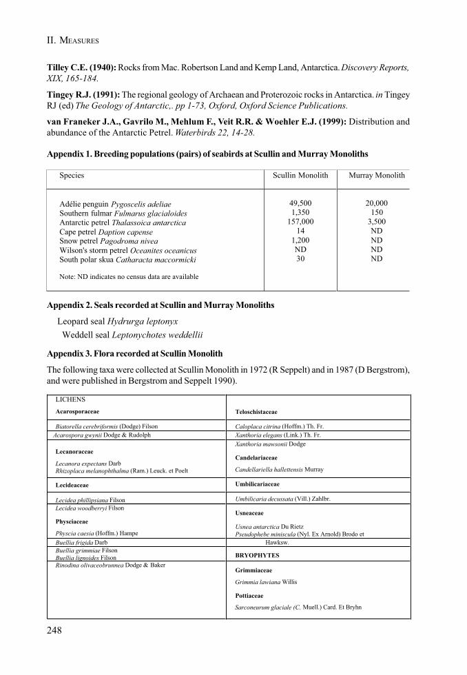
248
II. MEASURES
Tilley C.E. (1940): Rocks from Mac. Robertson Land and Kemp Land, Antarctica. Discovery Reports,XIX, 165-184.
Tingey R.J. (1991): The regional geology of Archaean and Proterozoic rocks in Antarctica. in TingeyRJ (ed) The Geology of Antarctic,. pp 1-73, Oxford, Oxford Science Publications.
van Franeker J.A., Gavrilo M., Mehlum F., Veit R.R. & Woehler E.J. (1999): Distribution andabundance of the Antarctic Petrel. Waterbirds 22, 14-28.
Appendix 1. Breeding populations (pairs) of seabirds at Scullin and Murray Monoliths
Species Scullin Monolith Murray Monolith
Adélie penguin Pygoscelis adeliaeSouthern fulmar Fulmarus glacialoidesAntarctic petrel Thalassoica antarcticaCape petrel Daption capenseSnow petrel Pagodroma niveaWilson's storm petrel Oceanites oceanicusSouth polar skua Catharacta maccormicki
Note: ND indicates no census data are available
49,5001,350
157,00014
1,200ND30
20,000150
3,500NDNDNDND
Appendix 2. Seals recorded at Scullin and Murray Monoliths
Leopard seal Hydrurga leptonyx Weddell seal Leptonychotes weddellii
Appendix 3. Flora recorded at Scullin Monolith
The following taxa were collected at Scullin Monolith in 1972 (R Seppelt) and in 1987 (D Bergstrom),and were published in Bergstrom and Seppelt 1990).
LICHENS
Acarosporaceae Teloschistaceae
Biatorella cerebriformis (Dodge) Filson Caloplaca citrina (Hoffm.) Th. Fr.Acarospora gwynii Dodge & Rudolph Xanthoria elegans (Link.) Th. Fr.
Lecanoraceae
Lecanora expectans DarbRhizoplaca melanophthalma (Ram.) Leuck. et Poelt
Xanthoria mawsonii Dodge
Candelariaceae
Candellariella hallettensis Murray
Lecideaceae Umbilicariaceae
Lecidea phillipsiana Filson Umbilicaria decussata (Vill.) Zahlbr.Lecidea woodberryi Filson
Physciaceae
Physcia caesia (Hoffm.) Hampe
Usneaceae
Usnea antarctica Du RietzPseudophebe miniscula (Nyl. Ex Arnold) Brodo et
Buellia frigida Darb Hawksw.Buellia grimmiae FilsonBuellia lignoides Filson BRYOPHYTESRinodina olivaceobrunnea Dodge & Baker
Grimmiaceae
Grimmia lawiana Willis
Pottiaceae
Sarconeurum glaciale (C. Muell.) Card. Et Bryhn
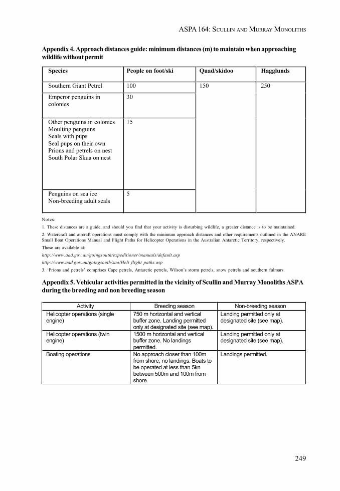
249
ASPA 164: SCULLIN AND MURRAY MONOLITHS
Appendix 4. Approach distances guide: minimum distances (m) to maintain when approachingwildlife without permit
Notes:1. These distances are a guide, and should you find that your activity is disturbing wildlife, a greater distance is to be maintained.2. Watercraft and aircraft operations must comply with the minimum approach distances and other requirements outlined in the ANARESmall Boat Operations Manual and Flight Paths for Helicopter Operations in the Australian Antarctic Territory, respectively.These are available at:http://www.aad.gov.au/goingsouth/expeditioner/manuals/default.asphttp://www.aad.gov.au/goingsouth/sao/Heli flight paths.asp3. ‘Prions and petrels’ comprises Cape petrels, Antarctic petrels, Wilson’s storm petrels, snow petrels and southern fulmars.
Appendix 5. Vehicular activities permitted in the vicinity of Scullin and Murray Monoliths ASPAduring the breeding and non breeding season
Species People on foot/ski Quad/skidoo Hagglunds
Southern Giant Petrel 100
Emperor penguins incolonies
30
Other penguins in coloniesMoulting penguinsSeals with pupsSeal pups on their ownPrions and petrels on nestSouth Polar Skua on nest
15
Penguins on sea iceNon-breeding adult seals
5
150 250
Activity Breeding season Non-breeding seasonHelicopter operations (singleengine)
750 m horizontal and verticalbuffer zone. Landing permittedonly at designated site (see map).
Landing permitted only atdesignated site (see map).
Helicopter operations (twinengine)
1500 m horizontal and verticalbuffer zone. No landingspermitted.
Landing permitted only atdesignated site (see map).
Boating operations No approach closer than 100mfrom shore, no landings. Boats tobe operated at less than 5knbetween 500m and 100m fromshore.
Landings permitted.
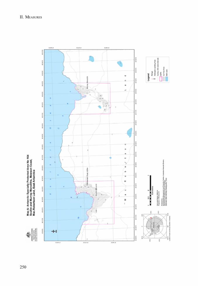
250
II. MEASURES

251
ASPA 164: SCULLIN AND MURRAY MONOLITHS

252
II. MEASURES
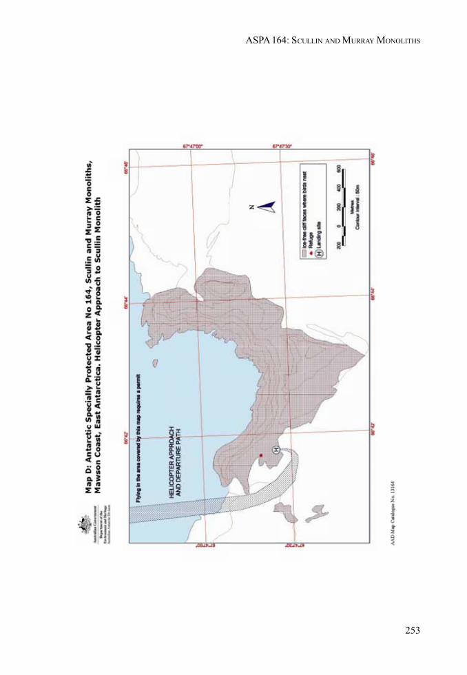
253
ASPA 164: SCULLIN AND MURRAY MONOLITHS

254
II. MEASURES
255
ASPA 164: SCULLIN AND MURRAY MONOLITHS
Measure 3 (2005)
Antarctic Specially Managed Area and Antarctic SpeciallyProtected Areas: Designation and Management Plans:
Deception Island
The Representatives,
Recalling Articles 3, 4, 5 and 6 of Annex V to the Protocol on Environmental Protection tothe Antarctic Treaty (the Protocol), providing for the designation of Antarctic SpeciallyProtected Areas (ASPA) and Antarctic Specially Managed Areas (ASMA) and the approvalof Management Plans for those Areas;
Recalling Article 8 of Annex V to the Protocol regarding Historic Sites and Monuments(HSM);
Recalling Recommendation XIII-8 (1985) which designated Shores of Port Foster, DeceptionIsland as Site of Special Scientific Interest (SSSI) No. 21 and annexed a Management Planfor it; and Decision 1 (2002) which renamed and renumbered it as ASPA No. 140: Parts ofDeception Island;
Recalling Recommendation XIV-5 (1987) which designated Port Foster, Deception Islandas SSSI No. 27 and annexed a Management Plan for it; and Decision 1 (2002) whichrenumbered it as ASPA No. 145;
Recalling Measure 3 (2003) which revised and updated the “List of Historical Sites andMonuments” in which HSM No. 71: Whalers Bay, Deception Island, and HSM No. 76:Base Pedro Aguirre Cedra Station, are listed;
Noting that the Committee for Environmental Protection has advised that Deception Islandbe designated as an ASMA and has endorsed the Management Plan annexed to this Measure;
Recognising that Deception Island is an area where activities are being conducted, in whichit is desirable to plan and co-ordinate activities, avoid possible conflicts, improve co-operationbetween Parties and avoid possible environmental impacts;
Desiring to designate Deception Island as an ASMA, within which ASPA No. 140, ASPANo. 145, HSM No. 71 and HSM No. 76 are located, and to approve a Management Plan forthe Area;
Desiring also to amend the Management Plans for ASPA No. 140 and ASPA No. 145, torevise the boundaries of ASPA No. 140 and to update the content of both Plans;
256
II. MEASURES
Noting that Deception Island contains marine areas and that the Commission for theConservation of Antarctic Marine Living Resources approved the Management Plan forthis area at its 23rd meeting;
Recommend to their Governments the following Measure for approval in accordance withparagraph 1 of Article 6 of Annex V to the Protocol on Environmental Protection to theAntarctic Treaty:
That:
1. Deception Island, South Shetland Islands be designated as Antarctic SpeciallyManaged Area No. 4;
2. the Management Plan for Antarctic Specially Managed Area No. 4: Deception Island,South Shetland Islands, contained in the Annex to this Measure, be approved;
3. the revised Management Plan for ASPA No. 140: Parts of Deception Island, containedin Appendix 1 to the Annex to this Measure, be approved;
4. the revised Management Plan for ASPA No. 145: Port Foster, Deception Island,contained in Appendix 2 to the Annex to this Measure, be approved;
5. the Management Plan for ASPA No. 140: Parts of Deception Island, annexed toRecommendation XIII-8 (1985), shall cease to be effective;
6. the Management Plan for ASPA No. 145: Port Foster, Deception Island, annexed toRecommendation XIV-5 (1987), shall cease to be effective.
257
MEASURE 3 - ANNEX
Deception Island
Management Package
Introduction
Deception Island is a unique Antarctic island with important natural, scientific, historic,educational, aesthetic and wilderness values.
Over the years, different parts of the island have been given legal protection under theAntarctic Treaty following piecemeal proposals, but no coherent strategy had been formulatedfor protecting the whole island. In 2000, an integrated strategy for the management ofactivities there was agreed by Argentina, Chile, Norway, Spain and the UK.
This strategy recommended an island-wide approach. Deception Island would be proposedas an Antarctic Specially Managed Area (ASMA) comprising a matrix of Antarctic SpeciallyProtected Areas (ASPAs), Historic Sites and Monuments (HSMs), and further zones inwhich activities would be subject to a code of conduct.
In March 2001, the Instituto Antártico Chileno hosted a workshop in Santiago to progressthe Management Plan for Deception Island. The Deception Island working group was widenedto include the USA, as well as the Antarctic and Southern Ocean Coalition (ASOC) and theInternational Association of Antarctica Tour Operators (IAATO) as advisors to the group.
During February 2002, the Dirreción Nacional del Antártico (Argentina) hosted an expeditionto the island at Decepción Station. Representatives from the six National AntarcticProgrammes, as well as ASOC and IAATO, participated. The overall goal of the expeditionwas to undertake baseline survey fieldwork to assist with the joint preparation by the sixAntarctic Treaty Consultative Parties of a Management Package for Deception Island.
Following further extensive consultation, this Management Package for Deception Islandwas produced. Its aim is to conserve and protect the unique environment of DeceptionIsland, whilst managing the variety of competing demands placed upon it, including science,tourism, and the conservation of its natural and historic values. It also aims to safeguardthose working on, or visiting, the island.
Information Papers submitted to the CEP (XII SATCM/IP8, XXIV ATCM/IP63, XXVATCM/IP28 and XXVI ATCM/IP48) give further detail of the extensive consultation andsite investigations which have resulted in the production of this Management Package forDeception Island.
258
II. MEASURES
Management Plan for Antarctic Specially Managed Area No. 4
DECEPTION ISLAND, SOUTH SHETLAND ISLANDS
Latitude 62°57’S, longitude 60°38’W
1. Values to be protected and activities to be managed
Deception Island (latitude 62°57’S, longitude 60°38’W), South Shetland Islands, is an unique Antarcticisland with important natural, scientific, historic, educational, aesthetic and wilderness values.
i. Natural value
• Deception Island is one of only two volcanoes in the Antarctic at which eruptions havebeen observed. It was responsible for numerous ash layers dispersed across the SouthShetland Islands, Bransfield Strait and the Scotia Sea. Ash from the island has even beenrecorded in an ice core at the South Pole. The volcano erupted during two short periodsduring the 20th century, most recently between 1967-1970. It contains a restless caldera thatis actively deforming. It is therefore likely that Deception Island will witness further eruptionsin the future.
• The Area has an exceptionally important flora, including at least 18 species which have notbeen recorded elsewhere in the Antarctic. No other Antarctic area is comparable. Of particularimportance are the very small, unique biological communities associated with the island’sgeothermal areas, and the most extensive known community of the flowering plant Antarcticpearlwort (Colobanthus quitensis).
• Eight species of seabird breed on the island, including the worlds largest colony of chinstrappenguins (Pygoscelis antarctica).
• The benthic habitat of Port Foster is of ecological interest due to the natural perturbationscaused by volcanic activity.
ii. Scientific value and activities
• The Area is of outstanding scientific interest, in particular for studies in geoscience andbiological science. It offers the rare opportunity to study the effects of environmental changeon an ecosystem, and the dynamics of the ecosystem as it recovers from natural disturbance.
• Long term seismological and biological data-sets have been collected at Decepción Station(Argentina) and Gabriel de Castilla Station (Spain).
iii. Historic value
• The Area has had a long history of human activity since c.1820, including exploration,sealing, whaling, aviation and scientific research, and as such has played a significant rolein Antarctic affairs.
259
ASMA 4: DECEPTION ISLAND
• At Whalers Bay, the Norwegian Hektor whaling station, the cemetery and other artefacts,some of which pre-date the whaling station, are the most significant whaling remains in theAntarctic. The British ‘Base B’, which was established in the abandoned whaling station,was the first base of the secret World War II expedition ‘Operation Tabarin’, the forerunnerto the British Antarctic Survey. As such, it was one of the earliest permanent researchstations in Antarctica. The whaler remains and Base B are listed as Historic Site and Monument(HSM) No. 71. Appendix 3 contains the Conservation Strategy for HSM No. 71.
• The remains of the Chilean Presidente Pedro Aguirre Cerda Station at Pendulum Cove arelisted as HSM No. 76. Meteorological and volcanological studies were undertaken at thebase from 1955 until its destruction by volcanic eruptions in 1967 and 1969.
v. Aesthetic value
• Deception Island’s flooded caldera, its ‘horse-shoe’ shape and linear glaciated easterncoastline, its barren volcanic slopes, steaming beaches and ash-layered glaciers provide anunique Antarctic landscape.
iv. Educational and Tourism activities
• Deception Island is the only place in the world where vessels can sail directly into the centreof a restless volcanic caldera, providing the opportunity for visitors to learn about volcanoesand other aspects of the natural world, as well as early Antarctic exploration, whaling andscience. Deception Island is also one of the most frequently visited sites in Antarctica bytourists.
2. Aims and objectives
The main aim of this Management Package is to conserve and protect the unique and outstandingenvironment of Deception Island, whilst managing the variety of competing demands placed upon it,including science, tourism, and the conservation of its natural and historic values. It also aims toprotect the safety of those working on, or visiting the island.
The objectives of management at Deception Island are to:
• assist in the planning and co-ordination of activities in the Area, encourage co-operationbetween Antarctic Treaty Parties and other stakeholders, and manage potential or actualconflicts of interest between different activities, including science, logistics and tourism;
• avoid unnecessary degradation, by human disturbance, to the unique natural values of theArea;
• minimise the possibility of non-native species being introduced through human activities;• prevent unnecessary disturbance, destruction or removal of historic buildings, structures
and artefacts;• safeguard those working in or near to, or visiting, the Area from the significant volcanic risk;• manage visitation to this unique Island, and promote an awareness, through education, of
its significance.
260
II. MEASURES
3. Management activities
To achieve the aims and objectives of this Management Plan, the following management activitieswill be undertaken:
• Parties with an active interest in the Area should establish a Deception Island ManagementGroup to:- oversee the co-ordination of activities in the Area;- facilitate communication between those working in, or visiting, the Area;- maintain a record of activities in the Area;- disseminate information and educational material on the significance of Deception
Island to those visiting, or working there;- monitor the site to investigate cumulative impacts;- oversee the implementation of this Management Plan, and revise it when necessary.
• a general island-wide Code of Conduct for activities in the Area is included in this ASMAManagement Plan (see Section 9). Further site-specific Codes of Conduct are included inthe Conservation Strategy for Whalers Bay HSM No.71 (Appendix 3), as well the Code ofConduct for the Facilities Zone (Appendix 4), and the Code of Conduct for Visitors (Appendix5). These Codes of Conduct should be used to guide activities in the Area;
• National Antarctic Programmes operating within the Area should ensure that their personnelare briefed on, and are aware of, the requirements of this Management Plan and supportingdocumentation;
• tour operators visiting the Area should ensure that their staff, crew and passengers arebriefed on, and are aware of, the requirements of this Management Plan and supportingdocumentation;
• signs and markers will be erected where necessary and appropriate to show the boundariesof ASPAs and other zones, such as the location of scientific activities. Signs and markerswill be well designed to be informative and obvious, yet unobtrusive. They will also besecured and maintained in good condition, and removed when no longer necessary;
• the volcanic alert scheme (as at Appendix 6) will be implemented. It, and the emergencyevacuation plan, will be kept under review;
• copies of this Management Plan and supporting documentation, in English and Spanish,will be made available at Decepción Station (Argentina), and Gabriel de Castilla Station(Spain). In addition, the Deception Island Management Group should encourage NationalAntarctic Operators, tour companies and, as far as practicable, yacht operators visiting theArea, to have available copies of this Management Plan when they visit the Area;
• visits should be made to the Area as necessary (no less than once every 5 years) by membersof the Deception Island Management Group to ensure that the requirements of theManagement Plan are being met.
4. Period of designation
Designated for an indefinite period of time.
261
ASMA 4: DECEPTION ISLAND
5. Description of the Area
i. General description, including geographical co-ordinates, boundary markers and natural featuresthat delineate the area.
General description
Deception Island (latitude 62°57’S, longitude 60°38’W) is situated in the Bransfield Strait at thesouthern end of the South Shetland Islands, off the north-west coast of the Antarctic Peninsula(Figures 1 and 2). The boundary of the ASMA is defined as the outer coastline of the island abovethe low tide water level. It includes the waters and seabed of Port Foster to the north of a line drawnacross Neptunes Bellows between Entrance Point and Cathedral Crags (Figure 3). No boundarymarkers are required for the ASMA, as the coast is clearly defined and visually obvious.
Geology, geomorphology and volcanic activity
Deception Island is an active basaltic volcano. It has a submerged basal diameter of approximately 30km and rises to 1.5 km above the sea floor. The volcano has a large flooded caldera, giving the islanda distinctive horseshoe shape broken only on the south-eastern side by Neptunes Bellows, a narrowshallow passage about 500 m wide.
The eruption which formed the caldera occurred possibly 10,000 years ago. A large scale, violentlyexplosive eruption evacuated about 30 km3of molten rock so rapidly that the volcano summit regioncollapsed to form the Port Foster caldera. Associated ashfalls and tsunamis had a significantenvironmental impact on the northern Antarctic Peninsula region. The volcano was particularlyactive during the late 18th and 19th centuries, when numerous eruptions occurred. By contrast, 20th
century eruptions were restricted to two short periods, around 1906–1910 and 1967–1970. In 1992,seismic activity on Deception Island was accompanied by ground deformation and increasedgroundwater temperatures around Decepción Station.
The volcano has since returned to its normal, essentially quiescent state. However, the floor of PortFoster is rising at a geologically rapid rate (approximately 30 cm per annum). Together with the recordof historical eruptions and the presence of long lived areas of geothermal activity, it is classified asa restless caldera with a significant volcanic risk.
Approximately 57% of the island is covered by permanent glaciers, many of which are overlain withvolcanic ash. Mounds and low ridges of glacially transported debris (moraines) are present aroundthe margins of the glaciers.
An almost complete ring of hills, rising to 539 m at Mount Pond, encircles the sunken interior of PortFoster, and is the principal drainage divide on the island. Ephemeral springs flow toward the outerand inner coast. Several lakes are located on the inner divide of the watershed.
Climate
The climate of Deception Island is polar maritime. Mean annual air temperature at sea level is –2.9°C.Extreme monthly temperatures range from 11°C to – 28 °C. Precipitation, which falls on more than 50%of summer days, is high, with a mean annual equivalent of rainfall of approximately 500 mm. Prevailingwinds are from the north-east and west.

262
II. MEASURES
Marine ecology
The marine ecology of Port Foster has been significantly influenced by volcanic activity and sedimentdeposition. ASPA No. 145, comprising two sub-sites, is located in the Area. The Management Planfor ASPA 145, contained in Appendix 2, gives further detail of the marine ecology of Port Foster.
Flora
Deception Island is an unique and exceptionally important botanical site. The flora includes at least18 species of moss, liverwort and lichen which have not been recorded elsewhere in the Antarctic.Small communities, which include rare species and unique associations of taxa, grow at a number ofgeothermal areas on the island, some of which have fumaroles. Furthermore, the most extensiveknown concentration of Antarctic pearlwort (Colobanthus quitensis) is located between Baily Headand South East Point.
In many areas, ground surfaces created by the 1967-70 eruptions are being colonized rapidly, probablyenhanced by the increasing summer temperatures now occurring in the Antarctic Peninsula.
ASPA No. 140, comprising 11 sub-sites, is located in the Area. The Management Plan for ASPA No.140 is contained in Appendix 1. This gives further detail of the flora of Deception Island.
Invertebrates
Recorded terrestrial and freshwater invertebrates on Deception Island include 18 species of Acarina(mite), 1 species of Diptera (fly), 3 species of Tardigrada (tardigrade), 9 species of Collembola(springtail), 3 freshwater Crustacea (crustacean), 14 Nematoda (nematode), 1 Gastrotricha(gastrotrich) and 5 Rotifera (rotifer).
Birds
Eight species of bird breed within the Area. The most numerous is the chinstrap penguin (Pygoscelisantarctica), with an estimated 140,000 to 191,000 breeding pairs. The largest rookery is at Baily Head,with an estimated 100,000 breeding pairs. Macaroni penguins (Eudyptes chrysolophus) occasionallynest in small numbers on the island, their southernmost breeding limit. Brown skuas (Catharactaantarctica lonnbergi), kelp gulls (Larus dominicanus), cape petrels (Daption capensis), Wilson’sstorm-petrels (Oceanites oceanicus), Antarctic terns (Sterna vittata) and snowy sheathbills (Chionisalba) also breed within the Area.
Mammals
Deception Island has no breeding mammals. Antarctic fur seals (Arctocephalus gazella), Weddell seals(Leptonychotes weddelli), crabeater seals (Lobodon carcinophagus), southern elephant seals(Mirounga leonina) and leopard seals (Hydrurga leptonyx) haul out on the beaches of the inner and outer coast.
ii. Structures within the Area
Decepción Station (Argentina) (latitude 62º58’ 20”S, longitude 60º 41’40”W) is situated on the southernshore of Fumarole Bay. Gabriel de Castilla Station (Spain) (latitude 62º58’40”S, longitude 60º40’30”W)is located approximately 1km to the south-east. Further details on both stations are contained in theFacilities Zone Code of Conduct (Appendix 4).
The remains of Hektor Whaling Station (Norway) and other remains which pre-date the whalingstation, the Whalers Cemetery and the former British ‘Base B’ (Historic Site and Monument (HSM)No. 71) are located at Whalers Bay (see Appendix 3). A number of steam boilers from the whaling
263
ASMA 4: DECEPTION ISLAND
station can be found washed up on the southwest coast of Port Foster. The remains of the ChileanPresidente Pedro Aguirre Cerda Station (HSM No. 76) is located at Pendulum Cove. A derelict woodenrefuge hut is located approximately 1 km to the south-west of HSM No.76.
A light beacon, maintained by the Chilean Navy, is located on Collins Point. A collapsed light tower,dating from the whaling era, is below it. The remains of a further light tower dating from the whalingera is located at South East Point.
The stern of the Southern Hunter, a whale-catcher belonging to the Christian Salvesen Company,which foundered on Ravn Rock, Neptunes Bellows in 1956, remains on the unnamed beach to thewest of Entrance Point.
A number of beacons and cairns marking sites used for topographical survey are present within theArea.
6. Protected areas and managed zones within the Area
Figure 3 shows the location of the following ASPAs, HSMs, Facility Zone and other sites with specialmanagement provisions within the Area.
• ASPA No. 140, comprising 11 terrestrial sites;• ASPA No. 145, comprising 2 marine sites within Port Foster;• HSM No. 71, the remains of Hektor Whaling Station and other remains which pre-date the
whaling station, the Whalers Cemetery and ‘Base B’, Whalers Bay;• HSM No. 7, the remains of Pedro Aguirre Cerda Station, Pendulum Cove;• A Facilities Zone, located on the west side of Port Foster, which includes Decepción Station
and Gabriel de Castilla Station;• Three further sites requiring special management provisions are also located at Pendulum
Cove, Baily Head and an unnamed beach at the eastern end of Telefon Bay.
7. Maps
Map 1: The location of Deception Island ASMA No. 4 in relation to the Antarctic Peninsula
Map 2: Deception Island - topography
Map 3: Deception Island Antarctic Specially Managed Area No 4
8. Supporting Documents
This Management Plan includes the following supporting documents as appendices:
• Management Plan for Antarctic Specially Protected Area No. 140 (Appendix 1)• Management Plan for Antarctic Specially Protected Area No. 145 (Appendix 2)• Conservation Strategy for HSM No. 71, Whalers Bay (Appendix 3)• Code of Conduct for Facilities Zone (Appendix 4)• Code of Conduct for visitors at Deception Island (Appendix 5)• Alert Scheme and Escape Strategy for volcanic eruptions on Deception Island (Appendix 6)
264
II. MEASURES
9. General Code of Conduct
i. Volcanic risk
All activities undertaken within the Area should be planned and conducted taking into account thesignificant risk to human life posed by the threat of volcanic eruption (see Appendix 6).
ii. Access to and movement within the Area
Access to the Area is generally by ship or yacht, with landings usually taking place by small boat, orless frequently by helicopter.
Vessels arriving in or departing from Port Foster should announce over VHF Marine Channel 16 theintended time and direction of passage through Neptunes Bellows.
Ships may transit ASPA 145, but anchoring within either of the two sub-sites should be avoidedexcept in compelling circumstances.
There are no restrictions on landings on any beaches outside the protected areas covered in Section6, although recommended landing sites are shown in Figure 3. Boat landings should avoid disturbingbirds and seals. Extreme caution should be exercised when attempting landings on the outer coastowing to the significant swell and submerged rocks.
Recommended landing sites for helicopters are shown in Figure 3.
Movement within the area should generally be on foot. All-Terrain Vehicles may also be used withcare for scientific support or logistical purposes along the beaches outside of ASPA 140. All movementshould be undertaken carefully to minimise disturbance to animals, soil and vegetated areas, and notdamage or dislodge flora.
iii. Activities that are or may be conducted within the Area, including restrictions on time or place
• scientific research, or the logistical support of scientific research, which will not jeopardisethe values of the Area;
• management activities, including the restoration of historic buildings, clean-up of abandonedwork-sites, and monitoring the implementation of this Management Plan;
• tourist or private expedition visits consistent with the Codes of Conduct for Visitors(Appendix 5) and the provisions of this Management Plan;
Further restrictions apply to activities within ASPA 140 and ASPA 145 (see Appendices 1 and 2).
iv. Installation, modification or removal of structures
Site selection, installation, modification or removal of temporary refuges, hides, or tents should beundertaken in a manner that does not compromise the values of the Area.
Scientific equipment installed in the Area should be clearly identified by country, name of principalinvestigator, contact details, and date of installation. All such items should be made of materials thatpose minimal risk of contamination to the area. All equipment and associated materials should beremoved when no longer in use.
265
ASMA 4: DECEPTION ISLAND
v. Location of field camps
Field camps should be located on non-vegetated sites, such as on barren ash plains, slopes orbeaches, or on thick snow or ice cover when practicable, and should also avoid concentrations ofmammals or breeding birds. Field camps should also avoid areas of geothermally heated ground orfumaroles. Similarly, campsites should avoid dry lake or stream beds. Previously occupied campsitesshould be re-used where appropriate.
Figure 3 shows the recommended sites for field camps within the Area.
vi. Taking or harmful interference with native flora or fauna
Taking or harmful interference with native flora or fauna is prohibited, except by Permit issued inaccordance with Annex II to the Protocol on Environmental Protection to the Antarctic Treaty(1998). Where taking or harmful interference with animals for scientific purposes is involved, theSCAR Code of Conduct for the Use of Animals for Scientific Purposes in Antarctica should be usedas a minimum standard.
vii. Collection or removal of anything not brought into the Area
Material should only be removed from the area for scientific, management, conservation orarcheological purposes, and should be limited to the minimum necessary to fulfill those needs.
viii. The disposal of waste
All wastes other than human wastes and domestic liquid waste shall be removed from the Area.Human and domestic liquid wastes from stations or field camps may be disposed of to Port Fosterbelow the high water mark, and not within the boundaries of ASPA No. 145. Freshwater streams orlakes, or vegetated areas, shall not be used to dispose of human wastes.
ix. Requirement for reports
Reports of activities within the Area, which are not already covered under existing reportingrequirements should be made available to the Chair of the Deception Island Management Group.
10. Advance exchange of information
• IAATO should, as far as practicable, provide the Chair of the Deception Island ManagementGroup with details of scheduled visits by IAATO-registered vessels. Tour operators notaffiliated to IAATO should also inform the Chair of the Deception Island ManagementGroup of planned visits.
• All National Antarctic Programmes should, as far as practicable, notify the Chair of theDeception Island Management Group of the location, expected duration, and any specialconsiderations related to the deployment of field parties, scientific instrumentation orbotanical quadrats at the four sites commonly visited by tourists (Whalers Bay, PendulumCove, Baily Head or the eastern end of Telefon Bay). This information will be relayed toIAATO (and as far as practicable to non-IAATO members).

266
II. MEASURES
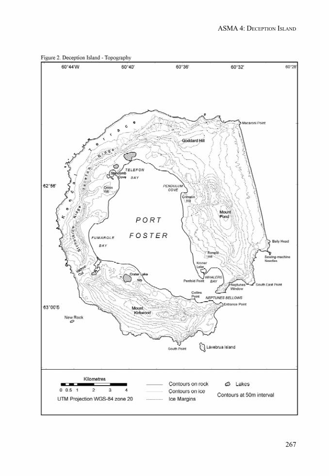
267
ASMA 4: DECEPTION ISLAND
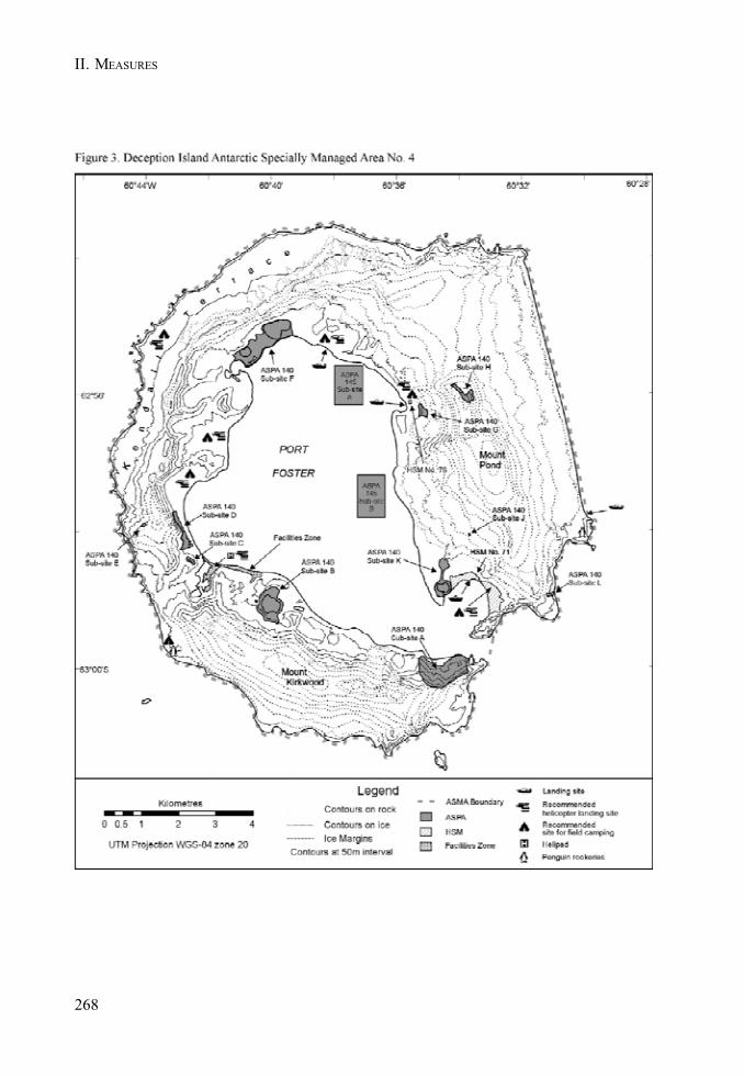
268
II. MEASURES
269
MEASURE 3 - ANNEX - APPENDIX 1
Management Plan for Antarctic Specially Protected Area No. 140
PARTS OF DECEPTION ISLAND,SOUTH SHETLAND ISLANDS
1. Description of values to be protected
Deception Island (latitude 62o57’S, longitude 60o38’W) is an active volcano. Recent eruptions occurringin 1967, 1969 and 1970 (Baker et al. 1975) altered many of the topographical features of the island andcreated new, and locally transient, surfaces for the colonisation of plants and other terrestrial biota(Collins 1969, Cameron & Benoit 1970, Lewis Smith 1984a, b). There are a number of sites of geothermalactivity, some with fumaroles (Smellie et al. 2002).
The flora of the island is unique in Antarctic terms, particularly where associated with these geothermalareas, but also because of the recently formed surfaces which provide known-age habitats for thestudy of colonisation and other dynamic ecological processes by terrestrial organisms (LewisSmith 1988).
Five small sites around the coast of Port Foster were adopted under Recommendation XIII–8 (ATCMXIII, Brussels, 1985) as Site of Special Scientific Interest No. 21 on the grounds that “DeceptionIsland is exceptional because of its volcanic activity, having had major eruptions in 1967, 1969 and1970. Parts of the island were completely destroyed, new areas were created, and others were coveredby varying depths of ash. Few areas of the interior were unaffected. The island offers uniqueopportunities to study colonization processes in an Antarctic environment.”
Following a detailed botanical survey of the island in 2002, the values specified in the originaldesignation were reaffirmed and considerably augmented. The survey identified 11 sub-sites ofunique botanical interest.
Those interests were:
• The island has the greatest number of rare1 and extremely rare2 plant species of any site inthe Antarctic. 28 of the 54 mosses recorded on the island, 4 of the 8 liverworts and 14 of theca. 75 lichen are considered to be rare or extremely rare. Appendix A lists the plant speciesclassed as rare or extremely rare in the Antarctic Treaty Area, which occur on DeceptionIsland. These represent 25%, 17% and ca. 4% of the total number of mosses, liverworts andlichens, respectively, known from the Antarctic (Aptroot & van der Knaap 1993, Bednarek-Ochyra et al. 2000, Ochyra et al. in press, Øvstedal & Lewis Smith 2001). 13 species of moss(including two endemics), 2 species of liverwort and 3 species of lichen growing on DeceptionIsland have not been recorded elsewhere in the Antarctic. No other site in the Antarctic iscomparable. This suggests that there is a significant deposition of immigrant propagules(by wind and seabirds), particularly of southern South American provenance, over theAntarctic, which becomes established only where favourable germinating conditions prevail(e.g. the heat and moisture provided around fumaroles) (Lewis Smith 1984a, b). Such sitesare unique in the Antarctic Treaty Area.
1 Known to grow at a few localities in the Antarctic and often in small quantity.2 Known to grow at only one or two localities in the Antarctic.
270
II. MEASURES
• The more stable geothermal areas, some of which have fumaroles issuing steam andsulphurous gas, have developed bryophyte communities of varying complexity and density,each with a distinct and unique flora. Most of these areas were created during the 1967-70series of eruptions, but at least one (Mt. Pond) predates that period. Species growing closeto active vents are continuously subjected to temperatures between 30oC to 50oC, therebyposing important questions regarding their physiological tolerance.
• Areas of volcanic ash, mudflows, scoria and lapilli deposited between 1967 and 1970 provideunique known-age surfaces. These are currently being colonised by vegetation and otherterrestrial biota, allowing the dynamics of immigration and colonisation to be monitored.These areas are unstable and subject to wind and water erosion, so exposing some areas tocontinual surface change and a cycle of re-colonisation.
• Kroner Lake, the only intertidal lagoon with hot springs in Antarctica, supports a uniquecommunity of brackish-water algae.
• Several sites within the Area, unaffected by ash deposits during the 1967-70 eruptions,support long-established mature communities with diverse vegetation and are typical of theolder stable ecosystems on the island.
• The largest known stand of Antarctic pearlwort (Colobanthus quitensis), one of only twoflowering plants in the Antarctic, is located within the Area. After being virtually eradicatedby burial in ash during the 1967 eruption, it has recovered and is now spreading at anunprecedented rate within and beyond the original site. This correlates with the currenttrend in regional climate change, particularly increasing temperature.
2. Aims and objectives
Management of the Area aims to:
• preserve each site for its potential scientific research value, particularly monitoring floristicand ecological change, colonisation processes and community development;
• avoid degradation of the botanical, vulcanological, or geomorphological values of the Areaby preventing unnecessary human disturbance;
• minimise potential conflicts of interest within the Area between scientists of differentdisciplines (e.g. biologists and vulcanologists), and between scientists and tourists;
• minimise the possibility of the introduction of alien plants and other biota to the Area byhuman activities;
• ensure that the flora is not adversely affected by excessive sampling within the Area;• allow research within the Area of a compelling scientific nature which cannot be served
elsewhere, and which is consistent with the objectives of this Management Plan;• allow visits for management purposes and to resurvey the state of the botanical values for
which each site has been designated, in support of the aims of this Management Plan.
3. Management activities
The following management activities shall be undertaken to protect the values of the Area:
• each of the botanical sub-sites shall be clearly marked with signs and boundary markers,where practicable;
271
ASPA 140: PARTS OF DECEPTION ISLAND
• visits shall be made as necessary to assess whether the individual sites continue to servethe purposes for which they were designated and to ensure management and maintenancemeasures are adequate;
• markers, signs or other structures erected within each site for scientific or managementpurposes shall be secured and maintained in good condition, and removed when no longernecessary;
• equipment or materials shall be removed from the sites once no longer required;• a map showing the location of each sub-site on Deception Island (stating any special
restrictions that apply) shall be displayed prominently at Gabriel de Castilla Station (Spain)and Decepción Station (Argentina). Copies of the Management Plan shall be freely availableand carried aboard all vessels planning visits to the island.
4. Period of designation
Designated for an indefinite period.
5. Maps
Figure 1: Antarctic Specially Protected Area No.140, Deception Island, showing the location of sub-sites A – L (Scale 1:100 000).
Figures 1a–d: Topographic Maps of Antarctic Specially Protected Area No.140 showing sub-sites A-L (Scale 1: 25000).
6. Description of the Area
6 (i) Geographical coordinates, boundary markers and natural features
The Area comprises 11 sub-sites, shown in Maps 1 and 1a-1d. This fragmented distribution ischaracteristic of the vegetation cover of Deception Island. Because of the patchy nature of stableand moist substrata not subjected to erosion, the vegetation has a very disjunct distribution and isconsequently restricted to widely scattered, and often very small, habitats.
The sub-sites are lettered A to L (but excluding I), in a clockwise direction from the south-west of thecaldera and referred to by the most prominent named geographical feature associated with each Site.
Site A - Collins Point: The north-facing slopes between Collins Point and the unnamed point 1.15 kmto the east (0.6 km west of Entrance Point), directly opposite Fildes Point, and extending from theback of the beach to a ridge from 0.5 and 1 km inland from the shoreline. The eastern boundary of SiteA runs due south from the shore, following the outline of a ridge to an elevation of 184 m. Thewestern boundary extends from Collins Point, following a ridge due south to an elevation of 145 m.The southern boundary follows the arcuate ridge crest running from east to west, following a line ofsummits (172, 223 and 214 m) joining points 184 and 145 m. The beach area, including the CollinsPoint light beacon (maintained by the Chilean Navy), to the 10 m contour is excluded from the site.
The site contains some of the best examples of the island’s longest established vegetation, largelyunaffected by the recent eruptions, with high species diversity and several Antarctic rarities, some inconsiderable abundance. A few small plants of Colobanthus quitensis have very recently becomeestablished, while the large liverwort Marchantia berteroana is a fairly recent and spreading colonist.

272
II. MEASURES
Site B - Crater Lake: This site extends from the foot of the northern slope of the broad valley ca. 300m north of Crater Lake to the slope ca. 300 m south of the south side of the lake, including the lake,to the ridge lines of the crater ca. 50 m to the west and east of the lake, and lower scree ca. 10 m southof the shoreline at the south-west corner of the Site. The principal area of botanical interest lies ona scoria-covered lava tongue above the south-east of the lake, up to the 50 m contour. The site wasunaffected by the recent eruptions.
The extensive, virtually monospecific, moss carpet (Sanionia uncinata), on the floor of the northernvalley, is one of the largest continuously vegetated stands on the island. The vegetation on thescoria tongue has a diverse cryptogamic flora, including several Antarctic rarities, and exceptionaldevelopment of turf-forming moss, dominated by one relatively common species (Polytrichastrumalpinum). Of particular interest is that it reproduces sexually in great abundance here. Sporophytesof this species are not known in such profusion in this, or any other moss, anywhere else in theAntarctic.
Site C - Unnamed hill, southern end of Fumarole Bay: A narrow line of fumaroles extending ca. 30-40 x 3 m along the gently sloping summit ridge at ca. 105-107 m elevation on the unnamed hill abovethe north-west side of the unnamed intertidal lagoon northwest of Decepción Station (Argentina) atthe southern end of Fumarole Bay. Commencing 10 m WNW of the summit cairn, the site extends ina rectangular strip along the ridge crest 5 m beyond the outermost fumaroles all around the Site.Access to the cairn is not restricted.
Several rare species of moss, some unique to the island, colonise the heated soil crust close to theline of vents.
Site D - Fumarole Bay: The unstable moist scree slopes below the precipitous lava cliffs on the eastside of the southern end of Stonethrow Ridge to the break of slope beyond the beach west of mid-Fumarole Bay. The site has a complex geology and contains the most diverse flora on the island,including several Antarctic rarities. It was unaffected by the recent eruptions.
The southern boundary of the site extends from a prominent massive yellow tuff boulder at the backof the beach above a shallow pool, westwards to the foot of the southernmost yellowish tuff cliff faceabove central Fumarole Bay. The eastern boundary runs northwards along the break-of-slope at theback of the beach for 1 km to a prominent outcrop of grey lava just north of a crimson lava cliff. Thenorthern boundary extends from this point westwards to the foot of the Stonethrow Ridge cliffs. Thewestern boundary follows the 75 m contour. The flat beach area from the shore, including a prominentinter-tidal fumarole, to the break-of-slope is excluded from the site.
Site E - West Stonethrow Ridge: The site is a red scoria cone lying at ca. 270 m altitude, ca. 600 msouth-south-west of the highest point on Stonethrow Ridge (330 m), west of central Fumarole Bay. Itcomprises two parts, each with fumaroles, the total area covering about 400 m2. The boundaryextends to 5 m beyond all evidence of geothermal activity.
This site possesses several very rare mosses, liverworts and lichens, two of the dominant speciesbeing a liverwort (Clasmatocolea grandiflora) and lichen (Stereocaulon condensatum), neither ofwhich is known elsewhere in Antarctica. Photographs taken in the mid-1980s indicate that thedevelopment and diversity of this vegetation has advanced considerably. A skua nest (also noted in1993) occupies the main site. These birds may be responsible for introducing some of the plants fromTierra del Fuego, notably the dominant liverwort.
Site F - Telefon Bay: The site extends from the north shore of the lagoon at the south-west of TelefonBay to the south of the “new island” hill, northwards to the north shoreline of the large unnamed lakeat the northern end of Telefon Bay, and thence to the shore of the bay following approximately the 10m contour of a low north-south trending ridge. The north-western boundary is 20 m from the break-
273
ASPA 140: PARTS OF DECEPTION ISLAND
of-slope below the prominent low cliff of crimson lava; this allows an access route skirting aroundthe west and southern end of the larger of the two lakes.
This site incorporates several features created during the 1967 eruption in Telefon Bay, and includesthe low flat land extending from the prominent hill on the south-eastern side to the steep slopes andlava outcrops ca. 0.5 km inland to the steep slope and lava cliffs below the north-eastern end ofStonethrow Ridge. The hill was created as a new island in 1967, but is now joined to the main islandby the aforementioned ash plain. About 0.5 km north of the lagoon in the south-west of Telefon Baythere is a small shallow lake, while at the northern end of the plain there is a large deep lake. This lakeis separated from the sea in Port Foster by a ca. 50 m long isthmus barely 2 m high and 2 m wide. Ithas been used as the main pedestrian access along this part of coastline, and is extremely vulnerableto erosion. If it is breached it will be quickly eroded further by high tides and storms, allowing thelake to become inter-tidal and profoundly altering its geochemistry and microbiota. The shoreline ofTelefon Bay is excluded to allow access past the site.
The main feature of botanical interest is that all surfaces within the site date from 1967, therebyallowing accurate monitoring of colonisation by plants and other biota. The site has a generallybarren appearance, but close inspection reveals an abundance of inconspicuous mosses and lichens.In the absence of geothermal activity here, colonisation processes may be related to aspects of thecurrent trend in climate change. Although species diversity is low, the developing communities aretypical of non-heated habitats throughout the island.
Site G - Pendulum Cove: The site comprises the very uneven gentle slope of very coarse grey,crimson, red scoria and occasional disintegrating blocks of yellowish tuff overlying a dead glacier,due east of Crimson Hill and ca. 0.5-0.8 km south-east of Pendulum Cove. It extends ca. 500 m uphill,from west to east and from ca. 50 to 100 m altitude, and is ca. 500 m wide. It was created largely by the1969 eruption. Geothermal activity was recorded during a survey in 1987, with substantial heat beingemitted from crevices amongst scoria. There was no such evidence in 2002.
The Site boundary encloses the undulating “plateau”, an area of ca. 0.25 km2. There are no naturalfeatures to delineate this area, but the boundary follows the break-of-slope between the plateau andthe steep slopes rising to it.
Although vegetation is very sparse, this known-age site is being colonised by numerous moss andlichen species. Two of the mosses (Racomitrium lanuginosum and R. heterostichoides) are uniqueboth on the island and in the Antarctic, and both are very rare here. Several other mosses areAntarctic rarities.
Site H - Mt. Pond: Lying ca. 1.25-1.5 km north-north-west of Mount Pond summit, this extensive areaof geothermal activity extends ca. 150 x 50 m on the gently sloping upper part of a broad ridge at ca.485 to 500 m elevation (Lewis Smith 1988). At the northern end of the site there are numerousinconspicuous fumarole vents in low mounds of very fine, compacted baked soil. The upper, southern,part of the site is close to a large rime dome at 512 m, in the lee of which (at ca. 500-505 m) arenumerous active fumaroles, also surrounded by fine, compacted baked soil, on a steep, moist, shelteredslope. The extensive areas of heated ground surrounding the fumaroles comprise a fine soil with asoft crust which is extremely vulnerable to pedestrian damage. There are several stands of dense,thick (up to 10 cm) bryophyte vegetation associated with these areas. The adjacent yellowish tuffoutcrops support a different community of mosses and lichens.
This is an outstanding site of botanical interest, unique in the Antarctic. It possesses several mossspecies which are either unique to the Antarctic or are extremely rare in Antarctica. The developmentof the moss turf (Dicranella hookeri and Philonotis polymorpha) in the main upper part of the siteis exceptional, and two or more species have colonised profusely since last inspected in 1994. Thelarge liverwort Marchantia berteroana is rapidly colonising the warm moist soil crust at the periphery

274
II. MEASURES
of the moss stands. At least one species of toadstool fungus also occur amongst the moss, thehighest known record for these organisms in Antarctica. A totally different community of mosses andlichens occurs on the rock outcrops, and also includes several extremely rare species (notablySchistidium andinum and S. praemorsum).
Site J - ‘Perchue Cone’: The boundary includes all of the ash and cinder cone referred to as ‘PerchueCone’. This ash cone lies ca. 0.5 km east-north-east and comprises a very narrow line of fumarolesand adjacent heated ground on the west-facing slope at ca. 160-170 m elevation. The geothermalarea covers ca. 25 x 10 m, and the fine ash and lapilli surface of the entire slope is very vulnerable topedestrian damage.
The site contains several mosses that are extremely rare in Antarctica. Photographic evidence suggeststhat the extent of moss colonisation has decreased since the mid-1980s.
Site K - Ronald Hill to Kroner Lake: This site includes the circular flat plain of the crater immediatelyto the south of Ronald Hill, and extends along the prominent broad shallow outwash gulley with alow bank on either side, leading southwards from here to Kroner Lake. The substratum throughoutthe area is consolidated mud, fine ash and lapilli deposited by the lahar during the 1969 eruption. Partof the site, notably the gulley, remains geothermally active. The site also includes the intertidalgeothermal lagoon (Kroner Lake) as it is part of the same volcanological feature. This small, shallow,circular, brackish crater lake was broached by the sea during the 1980’s, and is now the onlygeothermally heated lagoon in the Antarctic. The boundary surrounds the crater basin, valley andKroner Lake. A corridor below Ronald Hill, from the break-of-slope to the lowermost massive bouldersabout 10-20 m beyond, remains outside the boundary to allow access past the Area.
The surfaces of this site are of known-age and are being colonised by numerous moss, liverwort andlichen species, several of which are extremely rare in the Antarctic (e.g. the mosses Notoligotrichumtrichodon and Polytrichastrum longisetum, and a rare lichen, Peltigera didactyla, is colonising >1ha of the crater floor). The geothermal northern intertidal shore of Kroner Lake possesses an uniquecommunity of algae.
Site L - South East Point: An east-west trending rocky ridge ca. 0.5 km north of South East Point,extending from the top of the sea cliff (ca. 20 m altitude) westwards for ca. 250 m, to a point about 30m altitude. The north edge of the ridge is a low vertical lava outcrop, giving way to a steep unstableslope leading to the floor of a gully parallel to the ridge. The south side of the site is the gentlysloping ridge crest covered with ash and lapilli. The site extends 50 m north and south of the lavaoutcrop.
This site has the most extensive population of Antarctic pearlwort (Colobanthus quitensis) known inthe Antarctic. It was the largest population before the 1967 eruption (Longton 1967), covering ca. 300m2, but was almost completely destroyed by ash burial. It gradually recovered, but since about 1985-1990 there has been a massive increase in seedling establishment and the population has expandeddownwind (westwards, uphill). It is now very abundant in an area of ca. 2 ha. It is also remarkable forthe absence of the other native vascular plant, Antarctic hairgrass (Deschampsia antarctica), almostalways associated with this plant. Photographs of the Site immediately after the eruption revealedalmost total loss of lichens, but these too have recolonised rapidly and extensively, the large bushyUsnea antarctica being particularly abundant and attaining a considerable size after the relativelyshort period since recolonisation. The cryptogamic flora of the site is generally sparse and typical ofmost of the island. The site is particularly important for monitoring the reproduction and spread ofthe pearlwort in a known-age site.

275
ASPA 140: PARTS OF DECEPTION ISLAND
6(ii) Restricted and managed zones within the Area
In Site F, the narrow isthmus separating the large unnamed lake from Port Foster shall be avoided.Pedestrians should use the beach to bypass the isthmus. The isthmus is friable and extremelyvulnerable to erosion. If it is breached it will be quickly eroded further by high tides and storms,allowing the lake to become inter-tidal and profoundly altering its geochemistry and microbiota.
6(iii) Structures within or near to the Site
At Site A, there are six 50 x 50 cm plots marked with wooden corner stakes, although not all of the fourstakes per plot remain. These were established by the British Antarctic Survey in 1969 to monitorchanges in the vegetation in subsequent years (Collins 1969); data were obtained in 1969 and 2002.These markers should be maintained.
Other structures near to the Area are listed in the ASMA Management Plan for Deception Island.
6(iv) Location of other protected areas within close proximity of the Area
ASPA 145 comprises 2 sub-sites of benthic importance within Port Foster.
7. Permit conditions
Entry into the Area is prohibited except in accordance with a Permit issued by an appropriate nationalauthority. Conditions for issuing a Permit to enter the Area are that:
• it is issued only for compelling scientific reasons which cannot be served elsewhere, or foressential management purposes such as inspection, maintenance or review;
• the actions permitted will not jeopardise the floristic, ecological or scientific values of theArea;
• any management activities are in support of the aims and objectives of this ManagementPlan;
• the actions permitted are in accordance with this Management Plan;• the Permit, or an authorised copy, must be carried within the area;• a visit report shall be supplied to the authority named in the Permit, and to the Chair of the
Deception Island Management Group;• permits shall be issued for a stated period;• the appropriate authority should be notified of any activities/measures undertaken that
were not included in the authorised Permit.
7(i) Access to and movement within the Area
Helicopter landings or the use of vehicles are prohibited within ASPA 140. The Management Plan forDeception Island ASMA shows recommended helicopter landing sites on Deception Island. Accessto the sites shall be by foot or small boat. Access to Site F (Telefon Bay) shall avoid the isthmusreferred to in section 6 (ii). Movement within the sites shall also be on foot. Rowing boats arepermitted for sampling purposes in the lakes in Sites B (Crater Lake) and F (Telefon Bay), and thelagoon in Site J (Kroner Lake).
All movement shall be undertaken carefully so as to minimise disturbance to soil and vegetation.
276
II. MEASURES
7(ii) Activities which are or may be conducted within the Area, including restrictions on time andplace
• compelling scientific research which cannot be undertaken elsewhere and which will notjeopardise the flora and ecology of the Area.
• essential management activities, including monitoring.
7(iii) Installation, modification or removal of structures
Structures shall not be erected within the Area except as specified in a Permit. All scientific equipment,botanical quadrats or other markers installed in the Area must be approved by Permit and clearlyidentified by country, name of the principal investigator and year of installation. All such itemsshould be made of materials that pose minimal risk of contamination of the Area.
At Site A (Collins Point), the existing staked plots should be maintained to allow continued monitoringof vegetation change since 1969. At Site K, any wind-blown debris from the Hektor Whaling Stationand Base B shall be removed.
7(iv) Location of field camps
Camping is not permitted within the Area. The ASMA Management Plan for Deception Island showsrecommended sites for field camps on the island, but outside ASPA140.
7(v) Restrictions on materials and organisms which may be brought into the Site
No living animals, plant material or microorganisms shall be deliberately introduced into the Area. Noherbicides or pesticides shall be brought into the Area. Any other chemicals, including radionuclidesor stable isotopes, which may be introduced for scientific or management purposes specified in thepermit, shall be removed from the Area at or before the conclusion of the activity for which the permitwas granted.
To ensure that the floristic and ecological values of the Area are maintained, special precautions shallbe taken against accidentally introducing microbes, invertebrates or plants from other Antarcticsites, including stations, or from regions outside Antarctica. All sampling equipment or markersbrought into the Area shall be cleaned or sterilised. To the maximum extent practicable, footwear andother equipment used or brought into the Area (including bags or backpacks) shall be thoroughlycleaned before entering the Area.
No poultry or egg products shall be taken into the Area.
Fuel, food and other materials are not to be deposited within the site, unless authorised by Permit forspecific scientific or management purposes. Permanent depots are not permitted. All materialsintroduced shall be for a stated period only, shall be removed at or before the conclusion of the statedperiod, and shall be stored and handled so that risk of their introduction into the environment isminimised. If release occurs which is likely to compromise the values of the Area, removal is encouragedonly where the impact of removal is not likely to be greater than that of leaving the material in situ.The appropriate authority shall be notified of any materials released and not removed that were notincluded in the authorised Permit.

277
ASPA 140: PARTS OF DECEPTION ISLAND
7(vi) Taking of or harmful interference with native flora and fauna
Taking or harmful interference with native flora or fauna is prohibited, except by Permit issued inaccordance with Annex II to the Protocol on Environmental Protection to the Antarctic Treaty.Where taking of or harmful interference with animals is involved, the SCAR Code of Conduct for theUse of Animals for Scientific Purposes in Antarctica should be used as a minimum standard.
7(vii) Collection and removal of anything not brought into the Area by the Permit holder
Material of a biological, geological (including soil and lake sediment), or hydrological nature may becollected or removed from the Area only in accordance with a Permit and should be limited to theminimum necessary to meet scientific or management needs. Permits shall not be granted if there isreasonable concern that the sampling proposed would take, remove or damage such quantities ofsoil, sediment, flora or fauna that their distribution or abundance within the Area would be significantlyaffected. Material of human origin likely to compromise the values of the Area, which was notbrought into the Area by the Permit Holder or otherwise authorised, may be removed unless theimpact of removal is likely to be greater than leaving the material in situ; if this is the case theappropriate authority should be notified.
7(viii) Disposal of waste
All wastes shall be removed from the Area. In order to avoid anthropogenic microbial and nutrientenrichment of soils, no solid or liquid human waste should be deposited within the Area. Humanwastes may be disposed of within Port Foster, but avoiding ASPA 145.
7(ix) Measures that may be necessary to ensure that the aims and objectives of the ManagementPlan continue to be met
• Permits may be granted to enter the Area to carry out biological, vulcanological or seismicmonitoring and site inspection activities. Biological activities may involve the collection ofsmall amounts of plant or soil material or small numbers of invertebrate animals for analysisor review.
• Any long-term monitoring sites shall be appropriately marked and the markers or signsmaintained.
7(x) Requirements for reports
The principal Permit Holder for each issued Permit shall submit to the appropriate authority a reportdescribing the activities conducted in the Site.
Such reports should include, as appropriate, the information identified in the Visit Report formsuggested by SCAR. Parties should maintain a record of such activities and, in the Annual Exchangeof Information, should provide summary descriptions of activities conducted by persons subject totheir jurisdiction, which should be in sufficient detail to allow evaluation of the effectiveness of theManagement Plan. Parties should, wherever possible, deposit originals or copies of such originalreports in a publicly accessible archive to maintain a record of usage, to be used both in any reviewof the Management Plan and in organising the scientific use of the Site.
278
II. MEASURES
List of References
Aptroot, A. and van der Knaap, W.O. 1993. The lichen flora of Deception Island, South ShetlandIslands. Nova Hedwigia, 56, 183-192.
Bednarek-Ochyra, H., Váòa, J., Ochyra, R. and Lewis Smith, R.I. 2000. The Liverwort Flora ofAntarctica. Polish Academy of Sciences, Krakow, 236 pp.
Cameron, R.E. and Benoit, R.E. 1970. Microbial and ecological investigations of recent cinder cones,Deception Island, Antarctica – a preliminary report. Ecology, 51, 802-809.
Collins, N.J. 1969. The effects of volcanic activity on the vegetation of Deception Island. BritishAntarctic Survey Bulletin, 21, 79-94.
Lewis Smith, R.I. 1984a. Colonization and recovery by cryptogams following recent volcanic activityon Deception Island, South Shetland Islands. British Antarctic Survey Bulletin, 62, 25-51.
Lewis Smith, R.I. 1984b. Colonization by bryophytes following recent volcanic activity on anAntarctic island. Journal of the Hattori Botanical Laboratory, 56, 53-63.
Lewis Smith, R.I. 1988. Botanical survey of Deception Island. British Antarctic Survey Bulletin, 80,129-136.
Longton, R.E. 1967. Vegetation in the maritime Antarctic. In Smith, J.E., Editor, A discussion of theterrestrial Antarctic ecosystem. Philosophical Transactions of the Royal Society of London, B, 252,213-235.
Ochyra, R., Bednarek-Ochyra, H. and Lewis Smith, R.I. The Moss Flora of Antarctica. In prep.Cambridge University Press, Cambridge.
Øvstedal, D.O. and Lewis Smith, R.I. 2001. Lichens of Antarctica and South Georgia. A Guide totheir Identification and Ecology. Cambridge University Press, Cambridge, 411 pp.
Smellie, J.L., López-Martínez, J., Headland, R.K., Hernández-Cifuentes, Maestro, A., Miller, I.L., Rey,J., Serrano, E., Somoza, L. and Thomson, J.W. 2002. Geology and geomorphology of DeceptionIsland, 78 pp. BAS GEOMAP Series, Sheets 6-A and 6-B, 1:25,000, British Antarctic Survey, Cambridge.
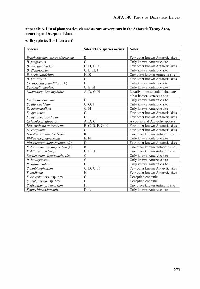
279
ASPA 140: PARTS OF DECEPTION ISLAND
Appendix A. List of plant species, classed as rare or very rare in the Antarctic Treaty Area,occurring on Deception Island
A. Bryophytes (L = Liverwort)
Species Sites where species occurs Notes
Brachythecium austroglareosum D Few other known Antarctic sitesB. fuegianum G Only known Antarctic siteBryum amblyodon C, D, G, K Few other known Antarctic sitesB. dichotomum C, E, H, J Only known Antarctic siteB. orbiculatifolium H, K One other known Antarctic siteB. pallescens D Few other known Antarctic sitesCryptochila grandiflora (L) E Only known Antarctic siteDicranella hookeri C, E, H Only known Antarctic siteDidymodon brachyphillus A, D, G, H Locally more abundant than any
other known Antarctic siteDitrichum conicum E Only known Antarctic siteD. ditrichoideum C, G, J Only known Antarctic siteD. heteromallum C, H Only known Antarctic siteD. hyalinum G Few other known Antarctic sitesD. hyalinocuspidatum G Few other known Antarctic sitesGrimmia plagiopodia A, D, G A continental Antarctic speciesHymenoloma antarcticum B, C, D, E, G, K Few other known Antarctic sitesH. crispulum G Few other known Antarctic sitesNotoligotrichum trichodon K One other known Antarctic sitePhilonotis polymorpha E, H Only known Antarctic sitePlatyneurum jungermannioides D Few other known Antarctic sitesPolytrichastrum longisetum (L) K One other known Antarctic sitePohlia wahlenbergii C, E, H One other known Antarctic siteRacomitrium heterostichoides G Only known Antarctic siteR. lanuginosum G Only known Antarctic siteR. subsecundum C Only known Antarctic siteS. amblyophyllum C, D, G, H Few other known Antarctic sitesS. andinum H Few other known Antarctic sitesS. deceptionensis sp. nov. C Deception endemicS. leptoneurum sp. nov. D Deception endemicSchistidium praemorsum H One other known Antarctic siteSyntrichia andersonii D, L Only known Antarctic site
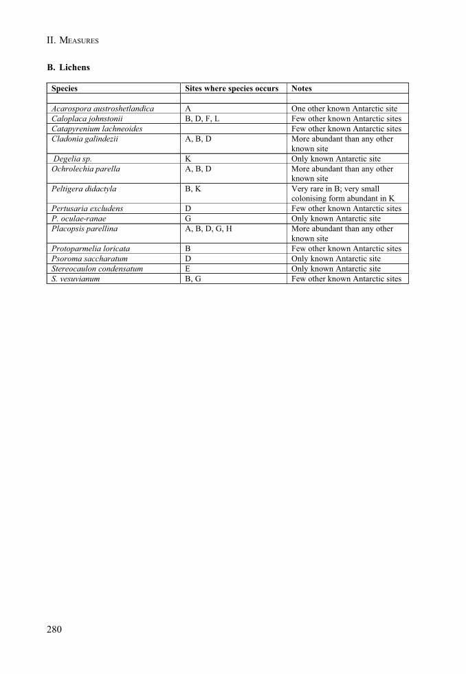
280
II. MEASURES
B. Lichens
Species Sites where species occurs Notes
Acarospora austroshetlandica A One other known Antarctic siteCaloplaca johnstonii B, D, F, L Few other known Antarctic sitesCatapyrenium lachneoides Few other known Antarctic sitesCladonia galindezii A, B, D More abundant than any other
known site Degelia sp. K Only known Antarctic siteOchrolechia parella A, B, D More abundant than any other
known sitePeltigera didactyla B, K Very rare in B; very small
colonising form abundant in KPertusaria excludens D Few other known Antarctic sitesP. oculae-ranae G Only known Antarctic sitePlacopsis parellina A, B, D, G, H More abundant than any other
known siteProtoparmelia loricata B Few other known Antarctic sitesPsoroma saccharatum D Only known Antarctic siteStereocaulon condensatum E Only known Antarctic siteS. vesuvianum B, G Few other known Antarctic sites
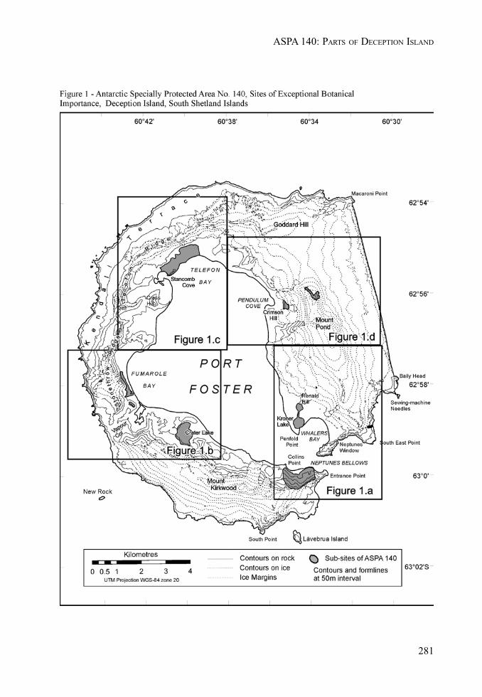
281
ASPA 140: PARTS OF DECEPTION ISLAND

282
II. MEASURES
283
ASPA 140: PARTS OF DECEPTION ISLAND

284
II. MEASURES
285
ASPA 140: PARTS OF DECEPTION ISLAND

II. MEASURES
287
MEASURE 3 - ANNEX - APPENDIX 2
Management Plan for Antarctic Specially Protected Area No. 145
PORT FOSTER, DECEPTION ISLAND, SOUTH SHETLAND ISLANDS
1. Description of values to be protected
These two sub areas were originally designated as SSSI N° 27 by Rec. XIV-5 of October 6, 1987 aftera proposal by Chile.
Values protected under original designation included the diversity of benthic fauna on two differentkinds of sea bottom substrates. The original research about the ecological process of recolonizationafter volcanic eruption needed protection from the risk of undue interference.
Deception Island is a caldera formed by subsidence of a group of Cenozoic volcanoes superimposedalong radial faults. Port Foster is an almost entirely enclosed body of water, receiving large volumesof fresh water during periods of melt. In several places there is geothermal activity.
The area is of exceptional ecological interest because of its actively volcanic character. The twohabitat areas are subject to long-term research programs and the purpose in designating them is, asfar as possible, to reduce the risk of accidental interference that could jeopardize these scientificinvestigations.
2. Aims and objectives
The management of Port Foster aims to:
• Avoid degradation or substantial risk to the values of the area by preventing unnecessaryhuman disturbance.
• Allow scientific research on the marine benthic system, ensuring protection from interference.
3. Management activities
The following management activities shall be undertaken to ensure the protection of the values ofthe area:
• Preparation and distribution of a map showing the location of the area, with explicit statementof the special restrictions that apply. This map shall be available at the Deception IslandStations and to visitors.
• Periodical visits and assessment of the effectiveness of the protection.• Sampling of benthic fauna to verify that the values for which the site was originally designated
remain valid.
4. Period of designation
Designated for two years.
288
II. MEASURES
5. Maps
Map 1: Port Foster, showing bathymetry, and the location of sub-sites A and B.
6. Description of the area
6(i) Geographical coordinates
Benthic habitat A: between 50 and 150 m depths and the coordinates: lat 62°55.5’S long 60°38’00"W,lat 62°56.2’S long 60°37’00"W.
Benthic habitat B: between 100 and 150 m depths and the coordinate: lat 62°57.2’S long 60°37’20"W,lat 62°57.9’S long 60°36’20"W.
6(ii) Physical features
The bottom of habitat A consists of coarse to medium-sized, poorly sorted volcanic sedimentsincluding scoria and lapilli, and that of habitat B of medium to fine, better sorted volcanic ash.Volcanic sediments are at least 30 cm thick, on both habitats. Soft bottom habitats are low on waterdissolved oxygen.
Water temperature, near Benthic habitat A, may fluctuate widely depending on circulation and due tounder-water hot springs in the neighboring area.
6(iii) Biological features
Benthic fauna was severely impacted by the volcanic eruption of 1967, due to volcanic ash and highconcentrations of dissolved toxic compounds.
Following the volcanic eruption of December 1967 at Deception Island, a long-term program ofresearch was initiated at Port Foster to study the mechanism and paths of the re-establishment of thebenthic communities. Community studies to observe biota changes, including other relevant studiesto meet the requirements of long-term biological monitoring programs, are performed periodically.
The most conspicuous macrofauna in dredge samples include the nemerteans Lineus sp andParaborlasia corrugatus, the isopod Serolis kemp: the bivalve Yoldia eightsii, the echinoids Abatusagassizizi and Sterechinus neumayeri, the asteroids Lysasterias perrieri and Odontaster validus,the ophiuroid Ophionotus victoriae and the holothurian Ypsilothuria sp. The composition of thebenthic assemblages has varied greatly since the volcanic eruption of December 1967.
Soft bottom habitat predominant groups are: Polichaeta, Bivalvia, Nemertina, Cumacea andAmphipoda.
Hard bottom habitat predominant groups are: Echinoderms, Amphipoda and Tunicata.
6 (iv) Location of other protected areas within close proximity
ASPA 140 comprises eleven small sub-sites of unique and important vegetation on Deception Island.Also, in the vicinity of Pendulum Cove is HSM 76, the remains of Pedro Aguirre Cerda Station. HSM71 at Whalers Bay comprises the remains of Hektor Whaling station, other artefacts which predatethe whaling station, and the remains of ‘Base B’ (UK).
Other protected areas in the vicinity are ASPA Nº 126 Byers Peninsula approximately 40 km northwestand ASPA Nº 149 Cape Shirreff, both on Livingston Island.
289
ASPA 145: PORT FOSTER, DECEPTION ISLAND
7. Permit conditions
Conditions for issuing a sampling permit:
• It is issued only for scientific study of the marine benthic system and geology of the area, orfor compelling scientific reasons that cannot be served elsewhere.
• It is issued for essential management purposes consistent with management plan objectivessuch as inspection or review.
• The actions permitted will not jeopardize the ecological or geological scientific values of thearea.
• A visit report shall be supplied to the authority named in the Permit, as well as to the Chairof the Deception Island Management Group.
• Permits shall be issued for a stated period.
7(i) Access to and movement within the area
Although access points as such are not designated, free passage of ships through these areas is notin any way prejudiced. Movement in shallow waters should be undertaken carefully so as to minimizethe probability of disturbing bottom fauna and flora.
7(ii) Activities that may be conducted
• Scientific research other than that disturbing benthic habitats and communities.• Essential management activities, including monitoring.
7(iii) Scientific sampling
Samples from benthic habitats should be taken only for compelling scientific purposes.
7(iv) Other restrictions
The dumping of waste from ships and bottom trawling shall be avoided. Anchoring shall be avoidedexcept in compelling circumstances. Siting of bottom devices should be avoided.
7(v) Taking or harmful interference with native flora and fauna
Taking or harmful interference with native flora and fauna is prohibited, except by permit issued inaccordance with Annex II to the Protocol on Environmental Protection to the Antarctic Treaty. Wheretaking of animals for scientific purposes is involved, the SCAR Code of Conduct for the Use ofAnimals for scientific Purposes in Antarctica should be used as a minimum standard.
7(vi) Waste disposal
Disposal of all waste, including human waste, is prohibited in this area.
7(vii) Measures that are necessary to ensure that the aims and objectives of the management plancan continue to be met
Access to the area by permit to carry out site inspection and monitoring; this may involve collectionof benthos samples for analysis and review of protective measures.
290
II. MEASURES
7(viii) Requirements for reports
Parties should ensure that the principal holder for each Permit issued submits to the appropriateauthority, and to the Chair of the Deception Island Management Group, a report of the activitiesundertaken. This report shall be submitted no later than six months after the visit. Such reportsshould be stored and made available to interested parties, SCAR, CCAMLR and COMNAP ifrequested, to ensure good management.
Bibliography
Gallardo,V.A., and J.Castillo, 1970 Quantitative observations on benthic macrofauna of Port Foster(Deception I.), Chile Bay (Greenwich I.). In: Antarctic Ecology 1:242-243 (Ed) M.Holdgate. AcademicPress London N.York.
Gallardo,V.A. 1987 The sublitoral macrofaunal benthos of the Antarctic shelf. EnvironmentInternational 13:71-81
Retamal, M., R. Quintana, and F. Neira. 1970. Análisis cuali y cuantitativo de las comunidadesbentónicas en Bahia Foster, I.Decepción. Ser.Cient.INACH 29:5-15
Valenzuela, E., L. Chavez, F. Munizaga. 1970. Actividad Volcánica en Isla Decepción. Ser. Cient.INACH 1(1):25-39.
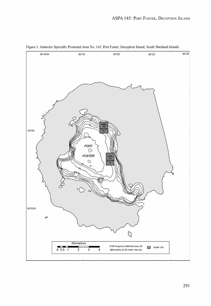
291
ASPA 145: PORT FOSTER, DECEPTION ISLAND

II. MEASURES
293
MEASURE 3 - ANNEX - APPENDIX 3
Conservation Strategy for Historic Site and Monument No. 71,Whalers Bay, Deception Island
1. Introduction
1.1 General background
Historic Site and Monument No 71, Whalers Bay (latitude 62° 59’S, longitude 60° 34’W), islocated on Deception Island, South Shetland Islands, Antarctica.
The buildings, structures and other artefacts on the shore of Whalers Bay, which date fromthe period 1906– 931, represent the most significant whaling remains in the Antarctic. Otherbuildings, structures and artefacts of the British ‘Base B’ represent an important aspect of thescientific history of the area (1944-1969).
The remains of the Norwegian Hektor whaling station at Whalers Bay were originally listed asHistoric Site and Monument No. 71 in ATCM Measure 4 (1995) based on a proposal by Chileand Norway. The extent of the historic site was expanded in 2003 by means of ATCM Measure3 (2003) (see Section 3).
1.2 Brief historical background (1906-1969)
During the 1906-07 austral summer, the Norwegian Captain Adolfus Andresen, founder of theSociedad Ballenera de Magallanes, Chile, began whaling at Deception Island. Whalers Bayserved as a sheltered anchorage for factory ships that processed whale blubber. In 1908 acemetery was established here. The cemetery was partly buried and partly swept away duringa volcanic eruption in 1969, at which time it comprised 35 graves and a memorial to ten menwho were lost at sea (only one body was recovered). In 1912, a Norwegian company,Aktieselskabet Hektor, established the shore-based whaling station in Whalers Bay. Hektorwhaling station operated until 1931.
During the 1943-44 austral summer, the UK established a permanent base (Base B) in part ofthe abandoned whaling station. Base B was operated as a British scientific station, latterly bythe British Antarctic Survey, until 1969, when it was severely damaged by a mud and ash flowcaused by a volcanic eruption, and was abandoned.
The Attachment A contains further detail on the history of Whalers Bay, including abibliography.
1.3 Aim and objectives of the conservation strategy
The overall aim of the conservation strategy is to protect the values of Whalers Bay HistoricSite. The objectives are to:
• Maintain and preserve the cultural heritage and the historic values of the site withinthe constraints of natural processes. Minor restoration and conservation work will beconsidered, whilst it is recognised that natural processes will continue to cause thedeterioration of buildings, structures and other artefacts over time.
• Prevent unnecessary human disturbance to the site, its features and artifacts. Everyeffort shall be made to ensure that human activity at the site does not diminish itshistoric values. Any damage, removal or destruction of buildings or structures is
294
II. MEASURES
prohibited in accordance with Article 8 (4) of Annex V to the Protocol on EnvironmentalProtection to the Antarctic Treaty.
• Permit ongoing clean up of debris. Large quantities of waste are present in andaround the buildings at Whalers Bay. Wind-scattered debris is present throughout thesite. There is also hazardous waste present, including diesel fuel and asbestos. Amajor clean up of loose debris and waste, identified by conservation and environmentalexperts as not forming an important part of the historic remains, was undertaken inApril 2004. Furthermore, a program of ongoing clean–up of debris resulting from thegradual deterioration of the structures, will be instigated.
• Educate visitors to understand, respect and care for the historic values of the site.Whalers Bay Historic Site is one of the most visited sites in Antarctica. Information onthe historic significance of the site, and the need to conserve its values, will be madeavailable to visitors.
• Protect the natural environment of the site. Whalers Bay is an integral part of theunique natural environment of Deception Island. Activities at the site should beundertaken in such a way that minimises any environmental impact.
2. Parties undertaking management
Chile, Norway and the UK shall consult within the wider Deception Island ManagementGroup to ensure that the provisions of this conservation strategy are implemented and its aimis met.
3. Description of the site
The site comprises all pre-1970 remains on the shore of Whalers Bay, including those from theearly whaling period (1906-12) initiated by Captain Adolfus Andresen of the SociedadBallenera de Magallanes, Chile; the remains of the Norwegian Hektor Whaling Stationestablished in 1912 and all artefacts associated with its operation until 1931; the site of acemetery with 35 burials and a memorial to ten men lost at sea; and the remains from the periodof British scientific and mapping activity (1944-1969). The site also acknowledges andcommemorates the historic value of other events that occurred there, from which nothingremains.
3.1 Site boundary
Figure 1 shows the boundary of the Whalers Bay Historic Site. It comprises most of the beachat Whalers Bay from Neptunes Window to the former BAS aircraft hangar. Boundary markers,which would detract from the aesthetic value of the site, have not been erected. Figure 1 alsoshows the major historic buildings and structures at the site.
3.2 Historic remains
Table 1 summarises the main buildings, facilities and other structures at the site. More detailedinformation about these historic structures is provided in Attachment B and their location isshown on Figure 1.
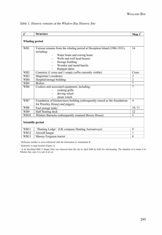
295
WHALERS BAY
#1 Structure Map 12
Whaling period
WB1 Various remains from the whaling period at Deception Island (1906-1931),including:
- Water boats and rowing boats- Wells and well head houses- Storage building- Wooden and metal barrels- Rampart dams
14
WB2 Cemetery (1 cross and 1 empty coffin currently visible) CrossWB3 Magistrate’s residence 3WB4 Hospital/storage building 2WB5 Boilers 7WB6 Cookers and associated equipment, including:
- cooking grills- driving wheel- steam winch
7
WB7 Foundation of kitchen/mess building (subsequently reused as the foundationsfor Priestley House) and piggery
4
WB8 Fuel storage tanks3 10, 11WB9 Half floating dock 12WB10 Whalers Barracks (subsequently renamed Biscoe House) 5
Scientific period
WB11 ‘Hunting Lodge’ (UK company Hunting Aerosurveys) 9WB12 Aircraft hangar 1WB13 Massey Ferguson tractor 6
Table 1: Historic remains at the Whalers Bay Historic Site
1 Reference number is cross-referenced with the information in Attachment B.2 Reference to map location (Figure 1).3 A de Havilland DHC-3 Single Otter was removed from the site in April 2004 by BAS for safe-keeping. The intention is to return it toWhalers Bay once it is safe to do so.
296
II. MEASURES
3.3 Natural environment
The 1967 volcanic eruption on Deception Island resulted in the deposition of a 1-5 cm layer ofash over Whalers Bay, whilst the 1969 eruption caused a lahar (mud slide) which partly buriedthe site. Geologically important, and fragile fluvial terraces are located to the north of thewhaling station.
The immediate area to the west of the Historic Site, including Kroner Lake, the Ronald Hillcrater plain and the valley connecting them, is designated as part of ASPA 140 due to itsexceptional botanical and limnological importance.
Further areas of botanical importance are located within the Historic Site. These include ageothermally active scoria outcrop to the east of the whaling station, around the ‘HuntingLodge’, inside the two accessible whale oil tanks, around the site of the cemetery, and on thecliffs and massive boulders at Cathedral Crags and Neptunes Window. Elsewhere, timber andiron structures, bricks and mortar, are colonised by various crustose lichens, all of which arecommon on natural substrata on the island.
Kelp gulls (Larus dominicanus) and Antarctic Terns (Sterna vittata) breed at Whalers Bay,and Cape petrels (Daption capensis) nest in Cathedral Crags, overlooking the site.
4. Management of the site
4.1 Access to, and movement within, the site
• The recommended landing site is directly in front of the whalers’ boilers (see Figure 1).• Motorized vehicles are only to be used within the HSM for scientific, conservation or
clean-up activities (e.g. removal of waste).• Access to buildings or other structures including boilers and tanks, is prohibited
unless for management purposes, or for shelter in an emergency.• Helicopter landings, where necessary for conservation or management purposes, should
only take place in the designated landing site (shown in Figure 1) to avoid dangersassociated with loose debris and to prevent damaging structures or causing disturbanceto wildlife.
• Field camps for scientific or management purposes should be established in the areato the east of the half floating dock as indicated in the map provided in Attachment B.The use of buildings for camping purposes is prohibited except in an emergency.
4.2 Installation, modification and removal of structures
• In accordance with Article 8 of Annex V to the Protocol on Environmental Protection tothe Antarctic Treaty (1998), the historic structures, facilities and artefacts at the siteare not to be damaged, removed or destroyed. Graffiti considered to be of historicimportance should not be removed. New graffiti should not be added.
• Conservation and/or restoration work agreed by the Parties undertaking managementmay be carried out. Work on the buildings and structures may be necessary to renderthem safe or to prevent damage to the environment.
• No new buildings or other structures (apart from interpretative material agreed byChile, Norway and the UK, in consultation with the wider Deception Island ManagementGroup) are to be erected at the site.
297
WHALERS BAY
• Historic remains and artefacts found at other locations on Deception Island, orelsewhere, which originate from Whalers Bay may be returned to the site after dueconsideration by those Parties undertaking management.
4.3 Visitor guidelines
The general guidelines, outlined in Code of Conduct for Visitors to Deception Island, apply toall visitors, including visits by commercial tour operators (IAATO and non-IAATO affiliated),private expeditions and National Antarctic Programme staff when undertaking recreationalvisits. In addition, the following site-specific guidelines apply:
• Stay on the seaward side of the station remains, the water boats, and the piles of barrelstaves, in order to avoid the geologically important, and fragile, fluvial terraces locatedto the north of the whaling station.
• Do not go beyond the western end of the airplane hangar in order to avoid entry intoASPA 140 (Site K).
• Do not enter buildings or tanks or sit or climb on the boats.• Approach oil and fuel tanks with caution. The foundations are vulnerable to erosion
and the tanks are at risk of collapse.• Beware of flying debris in windy conditions.• Visitors to Neptunes Window should proceed along the beach on the seaward side of
the waterboats. They should then walk up the slope towards the ‘window’ in single fileand remaining on existing paths. Extreme caution should be exercised along the steepand friable edge of Neptunes Window. Follow existing paths back down to the beach.Visitors should not attempt to traverse the scree slope to the south, below CathedralCrags, which is susceptible to rockfalls.
4.4 Information
• An informative sign, agreed by the Parties undertaking management, will be located atthe recommended landing site. Appropriate and necessary signs advising visitors ofany health and safety issues will also be considered.
• Memorial plaques (e.g. listing the names of those buried in the cemetery, orcommemorating Captain Adolfus Andresen) may also be located within the site.
• Boundary markers are not considered necessary, as they would detract from theaesthetic value of the site. The boundary generally follows clearly visible naturalfeatures.
• The Parties undertaking management will disseminate further information about thesignificance of the historic site and the need to conserve its values.
4.5 Reporting
The following records are to be maintained by the Parties undertaking management:
• number of tourists landing at the site;• number of scientists and associated logistics personnel visiting the site;• conservation and clean-up work carried out; and• site inspection reports, including reports and photographs on the condition of the
historic remains.

298
II. MEASURES

299
WHALERS BAY
Attachment A: Brief historic overview of Whalers Bay, Deception Island
Deception Island was first visited by British and United States sealers in the austral summer 1820-21.
In 1905 the Norwegian Adolfus Amandus Andresen established the Chilean whaling companySociedad Ballenera de Magallanes in Punta Arenas, having moved there from Norway in 1894.During the 1906-07 season he anchored his floating factory ship Gobernador Bories in Whalers Bayand thereby started an extensive use of the bay for whale processing.
In 1908, a cemetery was established for those who lost their lives at, or near to, Deception Island.
The processing method used by the factory ships was inefficient and wastage was high. In the 1912-1913 season, the Stipendiary Magistrate reported 3,000 rotting carcasses in the harbour. In an attemptto reduce this wastage, a 21 year licence was issued to the whaling company HvalfangerselskabetHektor A/S of Tønsberg for the establishment of a shore-based whaling station at Whalers Bay. Theland station was established for processing the carcasses that had already been flensed and discardedfrom the floating whale factories. As part of the agreement, the company brought a prefabricatedwooden house from Norway for the British magistrate, which was of the same type as the barracksused by the factory workers.
The global slump in whale oil prices, and the introduction of pelagic whaling factory ships, heraldedthe end of shore-based operations at Deception Island. The station was abandoned as it stood on 26April 1931, after which it was used as a source of materials for other expeditions and bases on theAntarctic Peninsula (e.g. Port Lockroy).
In November 1928, the Australian Sir Hubert Wilkins and the Canadian Carl Ben Eielson undertookthe first powered flight in the Antarctic, taking off from the flat beach at Whalers Bay. In 1934-35Lincoln Ellsworth (USA) assembled his aircraft the Polar Star there, but was frustrated by badweather and moved his plane to Dundee Island for his successful trans-Antarctic flight.
In January 1936, the British Graham Land Expedition, led by John Rymill, visited Deception Island onthe schooner Penola. Timber collected from the abandoned whaling station was used for theconstruction of the expedition’s winter headquarters at Debenham Islands.
In 1941, the Royal Navy’s HMS Queen of Bermuda destroyed remaining fuel stocks at the station todeny them to enemy ships that were attacking and capturing Norwegian whaling vessels in theSouthern Ocean.
During the 1943-1944 austral summer, the Royal Navy, as part of the British Government’s secret“Operation Tabarin”, established a small permanent British base in part of the abandoned whalingstation. “Operation Tabarin” was terminated in 1945 and the station was handed over to theorganisation that is now the British Antarctic Survey (BAS).
During the summers of 1955-56 and 1956-57, the UK company Hunting Aerosurveys Ltd. conductedvertical air photography of the South Shetland Islands and the northern Antarctic Peninsula withCanso flying boats based at Whalers Bay. A total of 116,000 km2 of previously unmapped terrain werephotographed.
In 1957, HRH Prince Philip visited Base B, Deception Island, aboard the Royal Yacht Britannia.
In 1969, the remains of Hektor Whaling Station, Base B and the Whalers cemetery were partiallydestroyed and buried by a lahar resulting from a volcanic eruption. The station was abandoned, andWhalers Bay has not been reoccupied since then.
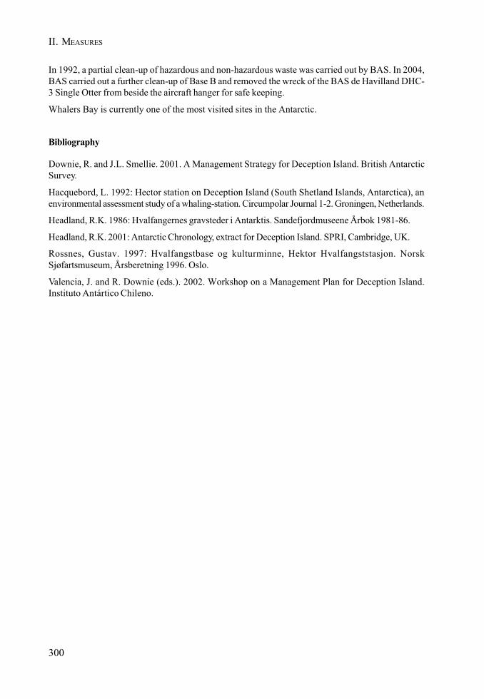
300
II. MEASURES
In 1992, a partial clean-up of hazardous and non-hazardous waste was carried out by BAS. In 2004,BAS carried out a further clean-up of Base B and removed the wreck of the BAS de Havilland DHC-3 Single Otter from beside the aircraft hanger for safe keeping.
Whalers Bay is currently one of the most visited sites in the Antarctic.
Bibliography
Downie, R. and J.L. Smellie. 2001. A Management Strategy for Deception Island. British AntarcticSurvey.
Hacquebord, L. 1992: Hector station on Deception Island (South Shetland Islands, Antarctica), anenvironmental assessment study of a whaling-station. Circumpolar Journal 1-2. Groningen, Netherlands.
Headland, R.K. 1986: Hvalfangernes gravsteder i Antarktis. Sandefjordmuseene Årbok 1981-86.
Headland, R.K. 2001: Antarctic Chronology, extract for Deception Island. SPRI, Cambridge, UK.
Rossnes, Gustav. 1997: Hvalfangstbase og kulturminne, Hektor Hvalfangststasjon. NorskSjøfartsmuseum, Årsberetning 1996. Oslo.
Valencia, J. and R. Downie (eds.). 2002. Workshop on a Management Plan for Deception Island.Instituto Antártico Chileno.
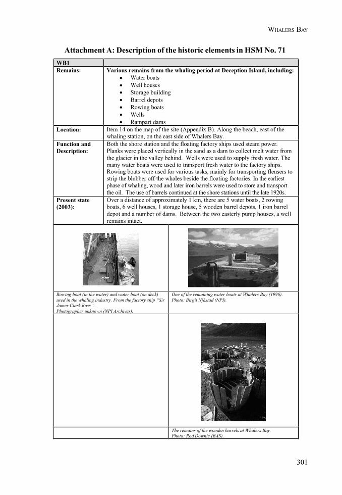
301
WHALERS BAY
Attachment A: Description of the historic elements in HSM No. 71WB1Remains: Various remains from the whaling period at Deception Island, including:
• Water boats• Well houses• Storage building• Barrel depots• Rowing boats• Wells• Rampart dams
Location: Item 14 on the map of the site (Appendix B). Along the beach, east of thewhaling station, on the east side of Whalers Bay.
Function andDescription:
Both the shore station and the floating factory ships used steam power.Planks were placed vertically in the sand as a dam to collect melt water fromthe glacier in the valley behind. Wells were used to supply fresh water. Themany water boats were used to transport fresh water to the factory ships.Rowing boats were used for various tasks, mainly for transporting flensers tostrip the blubber off the whales beside the floating factories. In the earliestphase of whaling, wood and later iron barrels were used to store and transportthe oil. The use of barrels continued at the shore stations until the late 1920s.
Present state(2003):
Over a distance of approximately 1 km, there are 5 water boats, 2 rowingboats, 6 well houses, 1 storage house, 5 wooden barrel depots, 1 iron barreldepot and a number of dams. Between the two easterly pump houses, a wellremains intact.
Rowing boat (in the water) and water boat (on deck)used in the whaling industry. From the factory ship “SirJames Clark Ross”.Photographer unknown (NPI Archives).
One of the remaining water boats at Whalers Bay (1996).Photo: Birgit Njåstad (NPI).
The remains of the wooden barrels at Whalers Bay.Photo: Rod Downie (BAS).
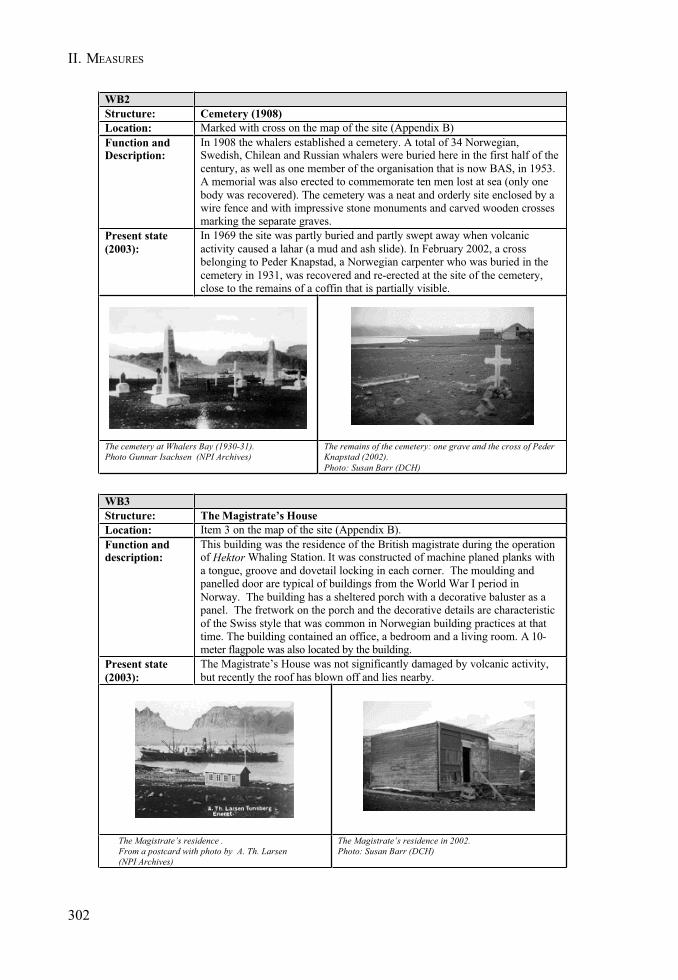
302
II. MEASURES
WB2Structure: Cemetery (1908)Location: Marked with cross on the map of the site (Appendix B)Function andDescription:
In 1908 the whalers established a cemetery. A total of 34 Norwegian,Swedish, Chilean and Russian whalers were buried here in the first half of thecentury, as well as one member of the organisation that is now BAS, in 1953.A memorial was also erected to commemorate ten men lost at sea (only onebody was recovered). The cemetery was a neat and orderly site enclosed by awire fence and with impressive stone monuments and carved wooden crossesmarking the separate graves.
Present state(2003):
In 1969 the site was partly buried and partly swept away when volcanicactivity caused a lahar (a mud and ash slide). In February 2002, a crossbelonging to Peder Knapstad, a Norwegian carpenter who was buried in thecemetery in 1931, was recovered and re-erected at the site of the cemetery,close to the remains of a coffin that is partially visible.
The cemetery at Whalers Bay (1930-31).Photo Gunnar Isachsen (NPI Archives)
The remains of the cemetery: one grave and the cross of PederKnapstad (2002).Photo: Susan Barr (DCH)
WB3Structure: The Magistrate’s HouseLocation: Item 3 on the map of the site (Appendix B).Function anddescription:
This building was the residence of the British magistrate during the operationof Hektor Whaling Station. It was constructed of machine planed planks witha tongue, groove and dovetail locking in each corner. The moulding andpanelled door are typical of buildings from the World War I period inNorway. The building has a sheltered porch with a decorative baluster as apanel. The fretwork on the porch and the decorative details are characteristicof the Swiss style that was common in Norwegian building practices at thattime. The building contained an office, a bedroom and a living room. A 10-meter flagpole was also located by the building.
Present state(2003):
The Magistrate’s House was not significantly damaged by volcanic activity,but recently the roof has blown off and lies nearby.
The Magistrate’s residence .From a postcard with photo by A. Th. Larsen(NPI Archives)
The Magistrate’s residence in 2002.Photo: Susan Barr (DCH)
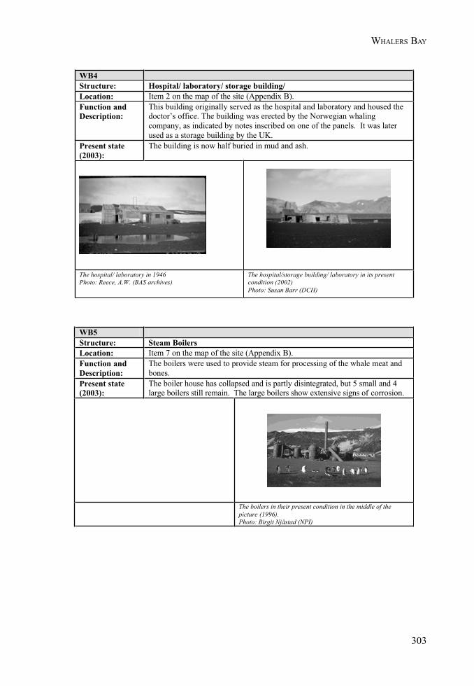
303
WHALERS BAY
WB4Structure: Hospital/ laboratory/ storage building/Location: Item 2 on the map of the site (Appendix B).Function andDescription:
This building originally served as the hospital and laboratory and housed thedoctor’s office. The building was erected by the Norwegian whalingcompany, as indicated by notes inscribed on one of the panels. It was laterused as a storage building by the UK.
Present state(2003):
The building is now half buried in mud and ash.
The hospital/ laboratory in 1946Photo: Reece, A.W. (BAS archives)
The hospital/storage building/ laboratory in its presentcondition (2002)Photo: Susan Barr (DCH)
WB5Structure: Steam Boilers Location: Item 7 on the map of the site (Appendix B).Function andDescription:
The boilers were used to provide steam for processing of the whale meat and bones.
Present state (2003):
The boiler house has collapsed and is partly disintegrated, but 5 small and 4 large boilers still remain. The large boilers show extensive signs of corrosion.
The boilers in their present condition in the middle of the picture (1996).Photo: Birgit Njåstad (NPI)
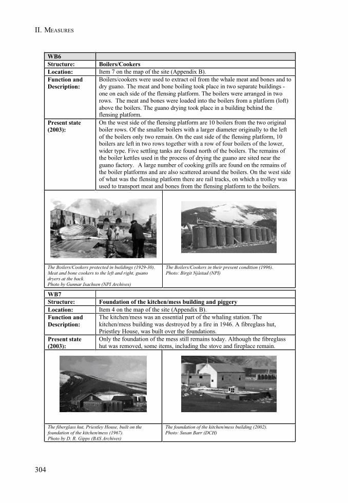
304
II. MEASURES
WB6Structure: Boilers/CookersLocation: Item 7 on the map of the site (Appendix B).Function andDescription:
Boilers/cookers were used to extract oil from the whale meat and bones and to dry guano. The meat and bone boiling took place in two separate buildings -one on each side of the flensing platform. The boilers were arranged in two rows. The meat and bones were loaded into the boilers from a platform (loft) above the boilers. The guano drying took place in a building behind the flensing platform.
Present state (2003):
On the west side of the flensing platform are 10 boilers from the two original boiler rows. Of the smaller boilers with a larger diameter originally to the left of the boilers only two remain. On the east side of the flensing platform, 10 boilers are left in two rows together with a row of four boilers of the lower, wider type. Five settling tanks are found north of the boilers. The remains of the boiler kettles used in the process of drying the guano are sited near the guano factory. A large number of cooking grills are found on the remains of the boiler platforms and are also scattered around the boilers. On the west side of what was the flensing platform there are rail tracks, on which a trolley was used to transport meat and bones from the flensing platform to the boilers.
The Boilers/Cookers protected in buildings (1929-30).Meat and bone cookers to the left and right, guano dryers at the back.Photo by Gunnar Isachsen (NPI Archives)
The Boilers/Cookers in their present condition (1996).Photo: Birgit Njåstad (NPI)
WB7Structure: Foundation of the kitchen/mess building and piggeryLocation: Item 4 on the map of the site (Appendix B).Function andDescription:
The kitchen/mess was an essential part of the whaling station. Thekitchen/mess building was destroyed by a fire in 1946. A fibreglass hut,Priestley House, was built over the foundations.
Present state(2003):
Only the foundation of the mess still remains today. Although the fibreglasshut was removed, some items, including the stove and fireplace remain.
The fiberglass hut, Priestley House, built on thefoundation of the kitchen/mess (1967).Photo by D. R. Gipps (BAS Archives)
The foundation of the kitchen/mess building (2002).Photo: Susan Barr (DCH)
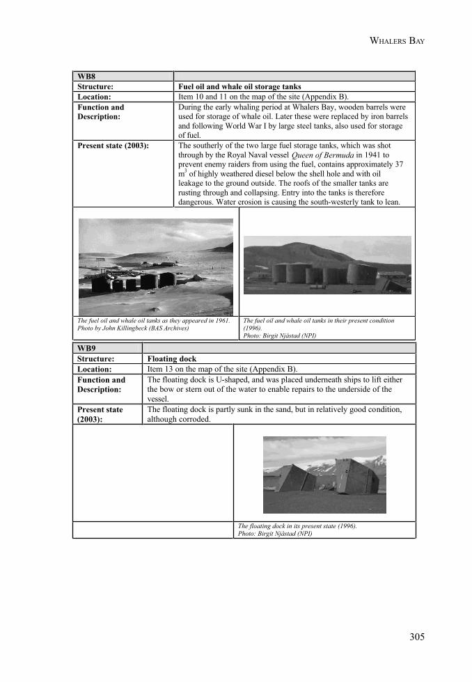
305
WHALERS BAY
WB8Structure: Fuel oil and whale oil storage tanksLocation: Item 10 and 11 on the map of the site (Appendix B).Function and Description:
During the early whaling period at Whalers Bay, wooden barrels were used for storage of whale oil. Later these were replaced by iron barrels and following World War I by large steel tanks, also used for storage of fuel.
Present state (2003): The southerly of the two large fuel storage tanks, which was shot through by the Royal Naval vessel Queen of Bermuda in 1941 to prevent enemy raiders from using the fuel, contains approximately 37 m3 of highly weathered diesel below the shell hole and with oil leakage to the ground outside. The roofs of the smaller tanks are rusting through and collapsing. Entry into the tanks is therefore dangerous. Water erosion is causing the south-westerly tank to lean.
The fuel oil and whale oil tanks as they appeared in 1961.Photo by John Killingbeck (BAS Archives)
The fuel oil and whale oil tanks in their present condition (1996).Photo: Birgit Njåstad (NPI)
WB9Structure: Floating dockLocation: Item 13 on the map of the site (Appendix B).Function andDescription:
The floating dock is U-shaped, and was placed underneath ships to lift either the bow or stern out of the water to enable repairs to the underside of the vessel.
Present state (2003):
The floating dock is partly sunk in the sand, but in relatively good condition,although corroded.
The floating dock in its present state (1996).Photo: Birgit Njåstad (NPI)
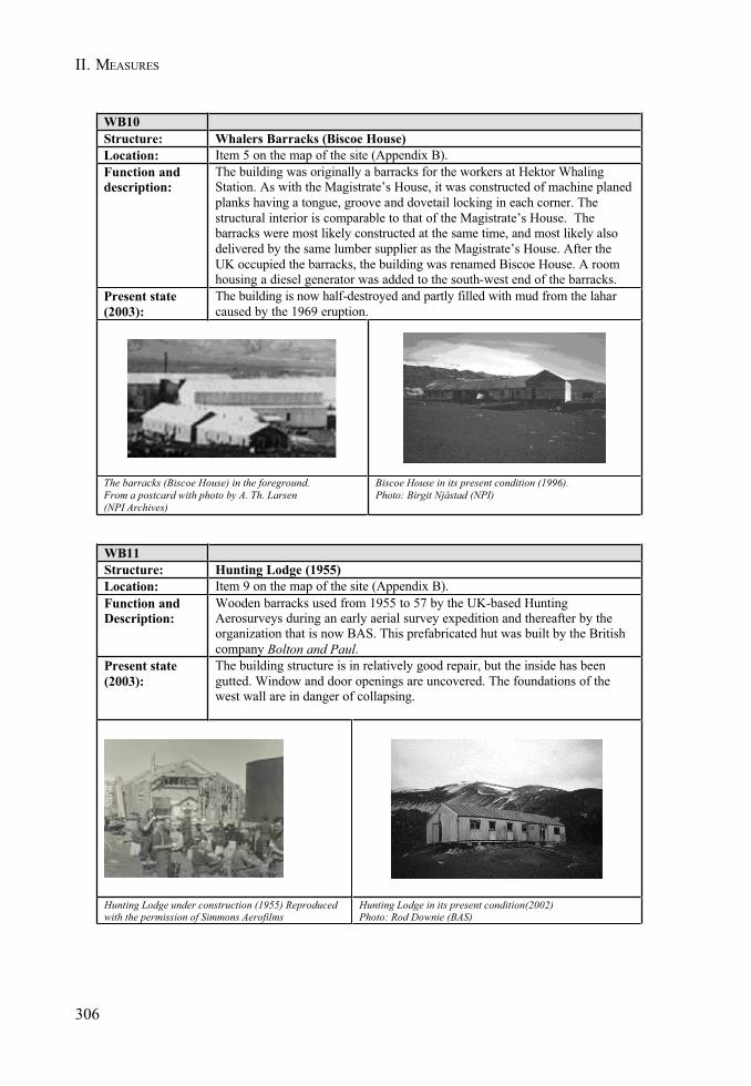
306
II. MEASURES
WB10Structure: Whalers Barracks (Biscoe House) Location: Item 5 on the map of the site (Appendix B).Function and description:
The building was originally a barracks for the workers at Hektor Whaling Station. As with the Magistrate’s House, it was constructed of machine planedplanks having a tongue, groove and dovetail locking in each corner. The structural interior is comparable to that of the Magistrate’s House. The barracks were most likely constructed at the same time, and most likely also delivered by the same lumber supplier as the Magistrate’s House. After the UK occupied the barracks, the building was renamed Biscoe House. A room housing a diesel generator was added to the south-west end of the barracks.
Present state (2003):
The building is now half-destroyed and partly filled with mud from the laharcaused by the 1969 eruption.
The barracks (Biscoe House) in the foreground.From a postcard with photo by A. Th. Larsen (NPI Archives)
Biscoe House in its present condition (1996).Photo: Birgit Njåstad (NPI)
WB11Structure: Hunting Lodge (1955)Location: Item 9 on the map of the site (Appendix B).Function andDescription:
Wooden barracks used from 1955 to 57 by the UK-based HuntingAerosurveys during an early aerial survey expedition and thereafter by theorganization that is now BAS. This prefabricated hut was built by the Britishcompany Bolton and Paul.
Present state(2003):
The building structure is in relatively good repair, but the inside has beengutted. Window and door openings are uncovered. The foundations of thewest wall are in danger of collapsing.
Hunting Lodge under construction (1955) Reproducedwith the permission of Simmons Aerofilms
Hunting Lodge in its present condition(2002)Photo: Rod Downie (BAS)
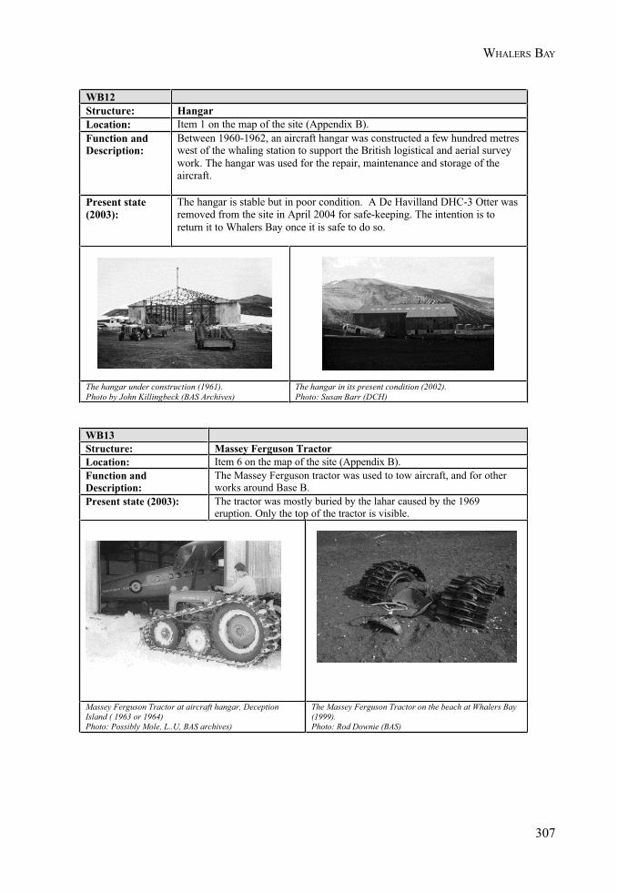
307
WHALERS BAY
WB12Structure: HangarLocation: Item 1 on the map of the site (Appendix B).Function andDescription:
Between 1960-1962, an aircraft hangar was constructed a few hundred metreswest of the whaling station to support the British logistical and aerial surveywork. The hangar was used for the repair, maintenance and storage of theaircraft.
Present state(2003):
The hangar is stable but in poor condition. A De Havilland DHC-3 Otter wasremoved from the site in April 2004 for safe-keeping. The intention is toreturn it to Whalers Bay once it is safe to do so.
The hangar under construction (1961).Photo by John Killingbeck (BAS Archives)
The hangar in its present condition (2002).Photo: Susan Barr (DCH)
WB13Structure: Massey Ferguson TractorLocation: Item 6 on the map of the site (Appendix B).Function and Description:
The Massey Ferguson tractor was used to tow aircraft, and for other works around Base B.
Present state (2003): The tractor was mostly buried by the lahar caused by the 1969 eruption. Only the top of the tractor is visible.
Massey Ferguson Tractor at aircraft hangar, Deception Island ( 1963 or 1964)Photo: Possibly Mole, L..U, BAS archives)
The Massey Ferguson Tractor on the beach at Whalers Bay (1999).Photo: Rod Downie (BAS)

II. MEASURES
309
MEASURE 3 - ANNEX - APPENDIX 4
Code of Conduct for the Deception Island ASMA 4 Facilities Zone,including Decepción Station (Argentina) and Gabriel de Castilla Station (Spain)
1. Introduction
The Deception Island ASMA includes a Facilities Zone within which is located Decepción Station(Argentina) and Gabriel de Castilla Station (Spain). Figure 1 shows the extent of the Facilities Zone,which includes the two stations, the surrounding beach area, and a small unnamed lake to the westof Crater Lake from which freshwater is extracted. Activities within this zone are to be undertaken inline with this Code of Conduct, the aims of which are to:
• encourage the pursuit of scientific investigation on Deception Island, including theestablishment and maintenance of appropriate supporting infrastructure;
• preserve the natural, scientific and cultural values of the Facilities Zone;• safeguard the health and safety of station personnel.
This Code of Conduct summarises existing station procedures, a copy of which is available (Spanishlanguage version only) at Decepción and Gabriel de Castilla stations.
Staff and visitors will be made aware of the contents of this Code of Conduct during pre-deploymenttraining programmes and briefing sessions on board ship prior to arrival at the station.
A copy of the complete Deception Island ASMA Management Package will be kept at DecepciónStation and Gabriel de Castilla Station, where relevant maps and information posters about theASMA will also be displayed.
2. Buildings and services
2.1 Buildings
• An Environmental Impact Assessment (EIA) must be undertaken for the constructionof any new permanent station buildings in line with Annex I to the EnvironmentalProtocol.
• An EIA must also be undertaken for the quarrying of rock to maintain existing buildings, inline with Annex I to the Environmental Protocol, as well as with the prior approval of thenational authorities of Argentina (Decepción Station) or Spain (Gabriel de Castilla Station).
• Consideration will be given to reusing existing sites when practicable, in order tominimise disturbance.
• Buildings are to be maintained in good condition. Buildings not currently in use are tobe routinely checked, and assessed for likely removal.
• Work-sites are to be kept as neat as possible.
2.2 Power Generation
• Maintain generators in good condition, and undertake routine inspections, so as tominimise emissions and possible fuel leaks.
• Ensure economy in power consumption and hence fuel usage and emissions.• The use of renewable energy sources will be encouraged, where appropriate.
310
II. MEASURES
2.3 Water Supply
• Handling or disposing of wastes, fuel or other chemicals within the stations’ watercatchment area is prohibited.
• Use of vehicles within the water catchment area will only be for essential purposes.• Ensure that regular tests of water quality, as well as routine cleaning of water holding
tanks, are conducted.• Regulate water consumption, so as to avoid unnecessary extraction.
3. Fuel handling
• The integrity of bulk fuel storage facilities, supply lines, pumps, reels and other fuelhandling equipment will be regularly inspected.
• At both stations, fuel storage includes secondary containment. Drummed fuel shouldbe stored inside. Storage areas should, as far as practicable, be properly ventilated,and sited away from electrical services. Storage facilities should also be sited awayfrom accommodation facilities for safety reasons.
• All practicable measures will be undertaken to avoid fuel spills, in particular duringfuel transfer (e.g. ship to shore transfer by pipeline or zodiac, refuelling day tanks).
• Any fuel, oil or lubricant spills will be reported immediately to the Station Leader, andsubsequently to the National Authority.
• Ensure that adequate and sufficient spill response equipment (e.g. absorbents) is keptin a known location and available to deal with any spills.
• Station personnel will be trained in how to use spill response equipment. Trainingexercises will be undertaken at the beginning of each season.
• In case of fuel spills, response actions will be undertaken in line with the Oil SpillContingency Plan held at each station.
• Oily wastes will be packaged in appropriate containers and disposed of according tostation procedures.
4. Fire prevention and fire-fighting
• Signs indicating no-smoking areas, and flammable substances, will be displayed asappropriate.
• Fire fighting equipment will be available at fuel storage sites and elsewhere. Suchequipment will be clearly marked.
5. Waste Management
• Waste management, including waste reduction and the provision of equipment andappropriate packaging material, will be considered in the planning and conducting toall activities at Decepción and Gabriel de Castilla stations.
• All station personnel will be instructed on the provisions of Annex III to theEnvironmental Protocol.
• A waste management co-ordinator will be appointed at each station.
311
FACILITIES CODE OF CONDUCT
• Wastes will be segregated at source and stored safely on site prior to removal. Aftereach summer season, wastes generated at Decepción and Gabriel de Castilla stationswill be removed from the Antarctic Treaty Area.
• Regular tests of water effluents discharged into Port Foster will be undertaken.• Any substances that may adversely affect the working of effluent treatment plants will
not be disposed of through the drainage system (including toilets and wash basins).• Cleaning up past waste disposal sites on land and abandoned work sites will be
considered a priority, except where removal would result in more adverse environmentalimpacts than leaving the structure or waste material in situ.
• Personnel from both stations should periodically participate in clean-up activitieswithin the facilities area, so as to minimise any scattered wastes around the stations.
• At the end of each summer season, activities connected to clean-up and removal ofwastes will be reported to the appropriate national authority.
6. Other Operational Issues
6.1 Communications
• The installation of permanent or temporary aerials is to be carefully considered throughthe environmental evaluation procedures in place.
• VHF Marine Channel 16 will be monitored.• All station personnel leaving the Facilities Zone must be equipped with a VHF radio.
6.2 Use of vehicles and small boats
• Vehicles should only be used around and between the stations when necessary.• Keep to established tracks within the station area where practicable.• Refuelling and servicing of vehicles will be carried out at the facilities provided for
these purposes. Every effort should be made to avoid spills during refuelling andservicing.
• Do not use vehicles close to sensitive scientific equipment, across flora or nearconcentrations of fauna, or unnecessarily within the water-catchment area.
• Small boats operating out of Decepción or Gabriel de Castilla Station are only to beused within Port Foster, when weather conditions allow, and principally for scientificand logistic reasons. No small boats will be used outside Port Foster. Avoid the use ofsmall boats close to cliffs and/or glaciers, to avoid rock or ice falls.
• When operating one boat, a second boat will be on stand-by, at the Station, forimmediate support in an emergency.
• Small boats will be operated by at least two people. Essential equipment will includeboating immersion suits, life jackets and VHF radios.
6.3 Aircraft Operations
• Helicopters will generally take off from and land at the helipad at Decepción Station.Occasionally, operational reasons may require them to take off from, or land at, otherappropriate locations within the Facilities Zone.
312
II. MEASURES
6.4 Field travel
• All wastes from field parties, except for human wastes (faeces, urine and grey water)will be returned to the stations for safe disposal.
• The Station Leader and/or the Station Environment Officer will brief field parties onenvironmental management in the field, the location of protected areas, and theprovisions of the ASMA Management Plan.
• No uncooked poultry products will be used by field parties.• All field parties will be equipped with VHF radios.
7. Protected Areas
• Three terrestrial sub-sites of ASPA No. 140 (Site B - Crater Lake, Site C - Unnamed hill,southern end of Fumarole Bay, and Site D - Fumarole Bay), are located close to theFacilities Zone. Station personnel will be made aware of the location of, and restrictionson access to, all protected areas on Deception Island. Information about these protectedareas, including a map showing their location, will be prominently displayed at bothstations.
8. Flora and fauna
• Any activity involving the taking of, or harmful interference with, native flora or fauna(as defined in Annex II to the Protocol) is prohibited unless authorised by a permitissued by the appropriate authority.
• An appropriate distance is to be maintained from birds or seals which is safe andavoids causing them disturbance.
• Staff and visitors are to walk slowly and carefully when near wildlife, in particularavoiding birds which are nesting, moulting, crèching or returning from foraging trips.Give ‘right of way’ to wildlife at all times.
• Birds are not to be fed on waste food scraps from the stations. Food wastes will besecured to prevent scavenging by birds.
• All reasonable precautions will be taken to avoid the introduction of micro-organismsand any other non-native species, or species from other Antarctic sites.
• The introduction of herbicides, pesticides or other harmful substances is prohibited.• At the end of each summer season, a report on activities involving the taking of, or
harmful interference with, native flora and fauna will be forwarded to the appropriatenational authorities.
9. Tourist visits to the Facilities Zone
• Any visits to Decepción Station (Argentina) or Gabriel de Castilla Station (Spain) mayonly be undertaken at the discretion of the respective Station Leader. Contact can bemade via VHF Marine Channel 16. Visits will only be allowed if they do not interferewith scientific or logistical work.
• Visits are to be undertaken in line with Recommendation XVIII-1.

313
FACILITIES CODE OF CONDUCT
• Station Leaders will co-ordinate visits to stations with Expedition Leaders.• Visitors will be informed about the principles of this Code of Conduct, as well as the
ASMA Management Plan.• The station leader will appoint a guide (English speaking, when appropriate and
possible), to escort visitors around the station, in order to ensure compliance with themeasures included in this Code of Conduct.
• The national authorities operating Decepción or Gabriel de Castilla Stations will informIAATO of any increase in the risk of volcanic eruption. The stations shall notify anyships in the area of any immediate danger.
10. Co-operation and sharing of resources
• Both stations will co-ordinate and periodically conduct joint emergency evacuation,oil spill response and fire-fighting exercises.

314
II. MEASURES
315
MEASURE 3 - ANNEX - APPENDIX 5
Code of Conduct for Visitors to Deception Island
1. Introduction
This code of conduct has been produced for commercial tour operators (IAATO and non-IAATO affiliated), private expeditions and National Antarctic Programme staff whenundertaking recreational visits to Deception Island.
There are four sites on Deception Island which may generally be visited: Whalers Bay, BailyHead, Pendulum Cove, and Telefon Bay (east). Stancomb Cove, in Telefon Bay, is also used asan anchorage for yachts. Visits to Decepción Station (Argentina) and Gabriel de CastillaStation (Spain) are only permitted by prior agreement with the respective Station Leaders.Tourist or recreational visits to other sites on the island are discouraged.
2. General Guidelines
The following general guidelines apply to all the above sites visited on Deception Island:
• Visits are to be undertaken in line with the Management Plan for Deception IslandASMA 4 and with Recommendation XVIII -1.
• All visits must be planned and conducted taking into account the significant risk tohuman life posed by the threat of volcanic eruption.
• Expedition Leaders of cruise ships and Masters of national programme support vesselsare encouraged to exchange itineraries in order to avoid two ships unintentionallyconverging on a site simultaneously.
• Vessels approaching or departing from Port Foster must announce over VHF MarineChannel 16 the intended time and direction of passage through Neptunes Bellows.
• For commercial cruise operators, no more than 100 passengers may be ashore at a siteat any time, accompanied by a minimum of one member of the expedition staff for every20 passengers.
• Do not walk on vegetation such as moss or lichen. The flora of Deception Island is ofexceptional scientific importance. Walking on the alga Prasiola crispa (associatedwith penguin colonies) is permissible as it will not cause it any adverse disturbance.
• Maintain an appropriate distance from birds or seals which is safe and does not causethem disturbance. As a general rule, maintain a distance of 5 metres. Where practicable,keep at least 15 metres away from fur seals.
• In order to prevent biological introductions, carefully wash boots and clean clothes,bags, tripods and walking sticks before landing.
• Do not leave any litter.• Do not take biological or geological souvenirs or disturb artefacts.• Do not write or draw graffiti on any man-made structure or natural surface.• Scientific equipment is routinely deployed during the austral summer by National
Antarctic Programmes at a number of locations on Deception Island. The SpanishAntarctic Programme deploy equipment for important and necessary seismic monitoring.Such equipment is highly sensitive to disturbance. At least 20 metres must be maintained
316
II. MEASURES
from seismic monitoring equipment, which will be marked with a red flag. This distanceis under examination - any revisions will be provided as necessary.
• Do not touch or disturb other types of scientific instruments or markers (e.g. woodenstakes marking botanical plots).
• Do not touch or disturb field depots or other equipment stored by National AntarcticProgrammes.
3. Site Specific Guidelines
3.1 Whalers Bay (latitude 62°59’S, longitude 60°34’W)
Whalers Bay is the most visited site on Deception Island, and one of the most visited sites inthe Antarctic. It is a small bay immediately to the east after passing into Port Foster throughNeptunes Bellows. It was named by the French explorer Jean-Baptiste Charcot because of thewhaling activity that took place there. The site includes the remains of the Norwegian HektorWhaling Station, the site of the cemetery and the abandoned British ‘Base B’, as well as thewhaling remains along the length of the beach, some of which pre-date the whaling station.Appendix 3, Conservation Strategy for Whalers Bay Historic Site and Monument No. 71,contains further information about Whalers Bay.
• Visits to Whalers Bay must be undertaken in line with the Conservation Strategy forWhalers Bay Historic Site and Monument No 71.
3.2 Pendulum Cove (latitude 62º56’S, longitude 60º36’W)
Pendulum Cove (see figure 1) is a small cove on the north east side of Port Foster. It wasnamed by Henry Foster of the British Royal Naval vessel HMS Chanticleer who, in 1828,undertook magnetic observations there using pendulums. The gently sloping ash and cinderbeach leads to the remains of the abandoned Presidente Pedro Aguirre Cerda Station (Chile),Historic Site and Monument No. 76, which was destroyed by a volcanic eruption in 1967.Thermal springs along the shallow shoreline of Pendulum Cove offer visitors the opportunityto ‘bathe’ in warm water.
• Water temperatures in excess of 70° C have been recorded at Pendulum Cove. Bathersare to be made aware of the potential risk of scalding. Expedition staff should carefullychoose a ‘bathing area’ for passengers where the hot water mixes with the cooler sea-water.
• Shoes or boots should be worn when entering the water to avoid scalding ones feet.• Educational visits to Historic Site and Monument No. 76 are welcomed. The remains
are a dramatic visual representation of the force of a volcanic eruption. At least onemember of the expedition staff is to be present at the site during visits. For safetyreasons, large groups of visitors are not to approach the site simultaneously. Do notgo inland beyond the station ruins.
• Equipment is routinely deployed by the Spanish Antarctic programme for importantand necessary seismic monitoring at Pendulum Cove. A distance of 20 metres must bemaintained from seismic monitoring equipment, which will be marked with a red flag.
• Do not walk on vegetated areas. Elsewhere, tread gently to avoid disturbing groundsurfaces which may host inconspicuous biota.
317
VISITORS CODE OF CONDUCT
• The slope to the south east of HSM No. 76 is designated as Site G of ASPA 140 andmust not be entered without a permit issued by the appropriate National Authority.This surface, created during the 1969 eruption, is being colonized by numerous mossand lichen species. Two species of moss that grow here are not found anywhere elsein the Antarctic.
3.3 Baily Head (latitude 62º58’S, longitude 60º30’W)
Baily Head (see figure 2) is a rocky headland exposed to the Bransfield Strait on the south eastcoast of Deception Island. It was named after Francis Baily, the English astronomer whoreported on Foster’s magnetic observations at Pendulum Cove. The site comprises the southernend of a long linear beach which runs along most of the eastern side of Deception Island, anda narrow valley that rises steeply inland to a semi-circular ridgeline, giving the impression ofa natural ‘amphitheatre’. It is bounded to the north by a large glacier and to the south by thecliffs of Baily Head. A substantial melt-stream runs through the centre of the valley during theaustral summer.
Within this unnamed valley, and to the south of it, is one of the largest colonies of chinstrappenguins (Pygoscelis antarctica) in Antarctica - it is estimated that 100,000 pairs breed here.Brown skuas (Catharacta antarctica lonnbergi), cape petrels (Daption capensis) and snowysheathbills (Chionis alba) also nest at Baily Head. Antarctic fur seals (Arctocephalus gazella)haul out along the beach in large numbers during the austral summer.
• No more than 350 visitors are to land at Baily Head in any one day.• Total visiting time is not to exceed 6 hours in any one day.• Staff and visitors are to exercise extreme caution when undertaking landings by small
boat - such landings may be hazardous due to the swell resulting from the steeplysloping beach.
• Maintain a safe distance from the rock cliffs and the glacier front to avoid falling rockor ice.
• Maintain an appropriate and safe distance from birds or seals which does not causethem disturbance. Remain outside the natural ‘boundary’ of discrete colonies.
• Walk slowly and carefully when near to penguins, in particular when birds are nesting,moulting, crèching or returning from foraging trips. Give ‘right of way’ to penguins atall times.
• Hiking between Baily Head and Whalers Bay is discouraged because of environmentaland safety concerns.
3.4 Telefon Bay (east) (latitude 62º56’S, longitude 60º40’W)
Telefon Bay (see figure 3) was named after the whaling vessel Telefon which was moored inthe bay for repairs in 1909 by Adolfus Amandus Andresen, founder of the company SociedadBallenera de Magallanes. At the easternmost end of Telefon Bay a gently sloping beach leadsto a shallow valley which rises sharply to the rim of an unnamed volcanic crater.
• Exercise extreme caution when approaching the steep edge of the crater lip. The soil isfriable and may collapse underfoot.

318
II. MEASURES
3.5 Decepción Station (Argentina) and Gabriel de Castilla Station (Spain)
Visits to Decepción Station (Argentina) and Gabriel de Castilla Station (Spain) may only beundertaken with the prior agreement of the appropriate Station Leader. Visits to the stationsmust be undertaken in line with the Code of Conduct for the Deception Island Facilities Zone(Appendix 4).
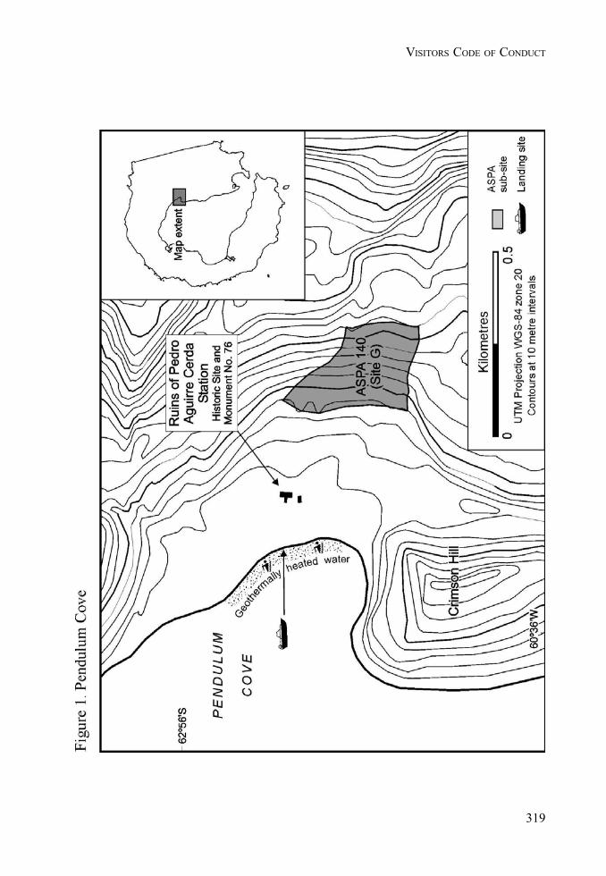
319
VISITORS CODE OF CONDUCT
320
II. MEASURES
321
VISITORS CODE OF CONDUCT

II. MEASURES
323
MEASURE 3 - ANNEX - APPENDIX 6
Alert Scheme and Escape Strategy for volcanic eruptions on Deception Island1
Spanish seismologists monitor seismographs on the island for about three months each year (generallybetween late November and late February). That period also corresponds to the major period ofhuman activity on the island.
The schematic arrangement presented in Table 1 is adapted from that used by the Alaska VolcanoObservatory (United States Geological Survey;
http://www.avo.alaska.edu/avo4/updates/color_code.html).
This type of scheme is well suited to Deception Island.
Masters of vessels intending to enter Deception Island, or pilots of aircraft flying near to the island,should pay attention to any bulletins on the current state of activity of the volcano that are issuedfrom Gabriel de Castilla Station (Spain), or by an appropriate spokesperson representing a nationalAntarctic programme operating in the Antarctic (e.g. Argentine Antarctic Institute, British AntarcticSurvey, National Science Foundation (USA) or Spanish Antarctic Programme).
Table 1. Alert scheme for eruptions on Deception Island (modified after system used by USGSAlaska Volcano Observatory).
Colour code Alert state DescriptionGREEN No eruption is anticipated. Volcano is quiet, in dormant state. Normal
seismicity and fumarolic activity occurring. Thisis the normal alert state for Deception Island.
YELLOW An eruption is possible in thenext few weeks and may occurwith little or no additionalwarning.
Volcano is restless; an eruption may occur.Increased levels of small earthquakes detectedlocally and/or increased volcanic gas emissions.
ORANGE Explosive eruption occurring oris possible within a few days andmay occur with little or nowarning. Ash plume(s) notexpected to reach10,000 m above sea level.
Volcano in eruption, or eruption may occur atany time. Increased numbers and/or magnitudesof local earthquakes. Extrusion of lava flows(non-explosive eruption) may be occurring.
RED Major explosive eruption is inprogress or expected within 24hours. Large ash plume(s)expected to exceed 10,000 mabove sea level.
Significant eruption is occurring or majorexplosive activity expected at any time. Strongearthquake activity detected even at distantmonitoring stations.
1 Adapted from Smellie, J.L. (2002) Volcanic Hazard. In: Smellie, J.L., López-Martínez, J., Headland, R.K., Hernández-Cifuentes, Maestro,A., Miller, I.L., Rey, J., Serrano, E., Somoza, L. and Thomson, J.W. 2002. Geology and geomorphology of Deception Island, 78 pp. BASGEOMAP Series, Sheets 6-A and 6-B, 1:25,000, British Antarctic Survey, Cambridge.
324
II. MEASURES
Escape strategy in case of a volcanic eruption on Deception Island
This escape strategy is based on the premise that eruptions will be similar to those documented in1967-1970, i.e. with a limited geographical impact on the island (code orange alert state; Table 1). Asudden collapse of the caldera could result in a much more serious eruption, with potentiallydevastating effects on anyone on the island at the time. Escape from the island during a calderacollapse eruption is unlikely. However, the probability of this is very low and it would likely bepreceded by significant precursory activity, particularly widespread ground inflation and associatedearthquakes, during several days or weeks prior to the eruption. However, any eruptions can takeplace with relatively little immediate warning.
1. Inner coast areas are likely to be hazardous because of ash fall, possible pyroclastic surges(within c. 2 km of an eruption centre), tsunami and irregular rapid tidal oscillations. Tidaleffects are likely to be pronounced by water ramping onto beaches, and they may preventthe use of inner coast beaches for boat uplift. People may therefore have to be uplifted fromthe outer coast.
2. If ships are present within Port Foster when an eruption occurs, they should depart theisland immediately, ideally after uplifting all people ashore. Masters of vessels should observeextreme caution whilst departing Neptunes Bellows because of tidal rips and surges, whichare enhanced at the narrow shallow entrance channel. Masters of vessels should also beaware of Ravn Rock, which is located at Neptunes Bellows, and the possibility of rockfallsfrom Cathedral Crags.
3. All rescuing vessels and helicopters should avoid passing through or under the eruptionclouds because of the damaging effects of gritty ash particles on machinery.
4. Escape routes to the outer coast of the island are shown in Figure 1 of Appendix 6. Allescape routes from the inner bay to the outer coast are strenuous, both climbing up onto thecaldera rim and (in most cases) descending again on the outside. The caldera wall is steep(impassable cliff in places) and covered in highly mobile scree. It is impossible to useground vehicles (e.g. ATVs) to transport people out of the caldera. Although exit routes arepassable for ATVs at two places, much skill and local knowledge of the routes are requiredand the routes are impassable to ATVs carrying a passenger.
5. All routes to the outer coast will take hours to complete, ranging from about 2 hours for theeasiest route (Whalers Bay to Baily Head) to 3 or 4 hours (or more) if the unnamed bay on thenorth coast or at Macaroni Point are the only options. These are minima and based on timeslikely to be taken by young relatively fit persons. The routes are physically arduous as mostsurfaces are yielding (mainly composed of coarse ash and lapilli). Exhaustion is likely andshould be anticipated, even in fit persons. Descending to beaches on the outer coast is alsogenerally difficult because of steep slopes. Apart from routes shown from Goddard Hill toMacaroni Point and the unnamed bay on the north coast (Figure 1), there are no recommendedsafe routes over snow and ice. Because of important difficulties peculiar to glaciers (e.g.crevasses, whiteout, slippery surfaces), other glacier travel should be avoided unless withtrained guides using suitable equipment (e.g. ice axes, ropes, harnesses). Such equipmentis unlikely to be readily available in an emergency.
6. Helicopter uplifts may be the best option as most of the outer coast beaches are narrow,bouldery and shelve steeply into deeper water, causing beach surf even on calm days. Somebeaches (e.g. north of Punta de la Descubierta) also have a submerged offshore bar hazardousto small boats. If wind conditions are suitable, it may be possible to uplift people byhelicopter from the inner coast. The most appropriate action can be judged at the time.Although helicopter uplifts can probably be effected, with variable difficulty, almostanywhere, the best areas are shown in Figure 1 of Appendix 6.

325
VOLCANIC ALERT

II. MEASURES
327
Measure 4 (2005)
Antarctic Specially Protected Areas:Extension of Expiry Dates
The Representatives,
Recalling Articles 3, 5 and 6 of Annex V to the Protocol on Environmental Protection to theAntarctic Treaty (the Protocol), providing for the designation of Antarctic Specially ProtectedAreas and approval of Management Plans for those Areas;
Recalling Recommendations VIII-4 (1975), XIV-5 (1987) and XVI-2 (1991), Measure 2(2000) and Measure 3 (2001);
Recalling Decision 1 (2002) which renamed and renumbered Areas and Sites as AntarcticSpecially Protected Areas;
Noting that the expiry date for certain Management Plans for Antarctic Specially ProtectedAreas is 31 December 2005, but wishing to continue to protect these Areas until such timethat their respective Management Plans have been revised in accordance with Annex V ofthe Protocol,
Recommend to their Governments the following Measure for approval in accordance withparagraph 1 of Article 6 of Annex V to the Protocol:
that the date of expiry of the following Management Plans be extended until 31December 2010:
(a) Antarctic Specially Protected Area 125: Fildes Peninsula, King George Island,South Shetland Islands;
(b) Antarctic Specially Protected Area 127: Haswell Island;
(c) Antarctic Specially Protected Area 144: Chile Bay (Discovery Bay), GreenwichIsland;
(d) Antarctic Specially Protected Area 146: South Bay, Doumer Island, PalmerArchipelago; and
(e) Antarctic Specially Protected Area 150: Ardley Island, Maxwell Bay, King GeorgeIsland.

II. MEASURES
329
Measure 5 (2005)
Antarctic Historic Sites and Monuments:Lillie Marleen Hut and Amundsen’s Tent
The Representatives,
Recalling the requirements of Article 8 of Annex V to the Protocol on EnvironmentalProtection to the Antarctic Treaty (the Protocol) to maintain a list of current Historic Sitesand Monuments and that such sites shall not be damaged, removed or destroyed;
Recalling Measure 3 (2003) which revised and updated the “List of Historic Sites andMonuments”;
Desiring to add the following two sites to that list;
Recommend to their Governments the following Measure for approval in accordance withparagraph 2 of Article 8 of Annex V to the Protocol:
That the following sites be added to the “List of Historic Sites and Monuments” annexed toMeasure 3 (2003):
(a) No. 79: Lillie Marleen Hut, Mt. Dockery, Everett Range, Northern Victoria Land.Lillie Marleen Hut was erected to support the work of the German Antarctic NorthernVictoria Land Expedition (GANOVEX I) of 1979/1980. The hut, a bivouac containermade of prefabricated fiberglass units insulated with polyurethane foam, was namedafter the Lillie Glacier and the song “Lillie Marleen”. The hut is closely associatedwith the dramatic sinking of the expedition ship “Gotland II” during GANOVEX IIin December 1981.Location: 71º12’S, 164º31’EOriginal proposing Party: GermanyParty undertaking management: Germany
(b) No. 80: Amundsen’s TentThe tent was erected at 90º by the Norwegian group of explorers led by RoaldAmundsen on their arrival at the South Pole on 14 December 1911. The tent iscurrently buried underneath the snow and ice in the vicinity of the South Pole.Location: In the vicinity of 90ºSOriginal proposing Party: NorwayParty undertaking management: Norway

ANNEX B
DECISIONS

333
Decision 1 (2005)
Annex VI on Liability Arising from EnvironmentalEmergencies to the Protocol on Environmental Protection
to the Antarctic Treaty
The Representatives,
Welcoming the adoption of Measure 1 (2005);
Recalling the undertaking in Article 16 of the Protocol on Environmental Protection to theAntarctic Treaty;
Recalling Decision 3 (2001) of the XXIVth Antarctic Treaty Consultative Meeting regardingthe elaboration of an Annex on the liability aspects of environmental emergencies, as a stepin the establishment of a liability regime in accordance with Article 16 of the Protocol;
Decide:
1. to evaluate annually, from the adoption of Annex VI to the Protocol, progress towardsits becoming effective in accordance with Article IX of the Antarctic Treaty, and whataction may be necessary and appropriate to encourage Parties to approve the Annex in atimely fashion;
2. not later than five years from the adoption of the Annex, in light of the evaluationpursuant to paragraph 1 above, to take a decision on the establishment of a time-frame forthe resumption of negotiations, in accordance with Article 16 of the Protocol, to elaboratefurther rules and procedures as may be necessary relating to liability for damage arisingfrom activities taking place in the Antarctic Treaty area and covered by the Protocol.

II. DECISIONS
335
Decision 2 (2005)
Decision confirming the recognition of Ukraineas a Consultative Party
The Representatives,
Recalling that Ukraine acceded to the Antarctic Treaty on 28 October 1992 in accordancewith Article XIII;
Recalling further the notification of Ukraine setting forth its view that it has met therequirements of Article IX Paragraph 2 of the Antarctic Treaty by conducting substantialscientific research in Antarctica, and its intent to approve measures adopted under Article IX;
Recalling Decision 2 (1997);
Recalling also Paragraph 43 of the Final Report of ATCM XXVI with regard to Ukraine’snotification of its interest to achieve Consultative Party status and the decision of that Meetingin Paragraph 44 to include the matter in the agenda of ATCM XXVII;
Noting that Parties are encouraged to approve measures adopted at earlier ATCMs;
Noting the entry into force of the Protocol on Environmental Protection to the AntarcticTreaty on 14 January 1998 and the deposit by Ukraine of its instrument of accession to theProtocol on 25 May 2001, and that the Protocol entered into force for Ukraine on 24 June2001, thus fulfilling the requirement of Article 22.4 of the Protocol;
Recalling the decision of the XXVIIth ATCM, recorded in Paragraph 57 of the Final Reportof that meeting, that Ukraine had met the requirements of Article IX Paragraph 2 of theAntarctic Treaty and Decision 2 (1997) and was therefore accepted as a ConsultativeParty;
Having ascertained, in accordance with Article X of the Antarctic Treaty, on the basis ofthe information provided about scientific expeditions and research carried out, that the activitiesof Ukraine are in accordance with the principles and purposes of the Treaty,
Affirm their acknowledgement made at the XXVIIth ATCM and reflected in Paragraph 57of the Final Report of that meeting that Ukraine has fulfilled the requirements established inArticle IX, Paragraph 2 of the Antarctic Treaty and that, as a consequence, as of June 4
336
II. DECISIONS
2004 Ukraine is entitled, during such time as it continues in accordance with Article IX,Paragraph 2 of the Treaty to demonstrate its interest in Antarctica by conducting substantialscientific research there, to appoint representatives in order to participate in the ConsultativeMeeting provided for in Article IX, Paragraph 1 of the Treaty; and thereby warmly welcomeUkraine as a participant in such meetings.
337
RULES OF PROCEDURE
Decision 3 (2005)
Amendments to the Rules of Procedure
The Representatives,
Recalling Decision 1 (2004) containing the revised Rules of Procedure of the AntarcticTreaty Consultative Meeting;
Recalling Measure 1 (2003), and especially Article 3.3, which establishes that during theintersessional periods the Executive Secretary of the Antarctic Treaty Secretariat shall consultin a manner to be prescribed in the Rules of Procedure;
Desiring to amend the Rules of Procedure to provide a procedure for intersessionalconsultation;
Decide that the “Revised Rules of Procedure (2005)” annexed to this Decision shall replacethe existing Rules of Procedure for Antarctic Treaty Consultative Meetings.

II. DECISIONS
339
DECISION 3 - ANNEX
REVISED RULES OF PROCEDURE (2005)
1. Meetings held pursuant to Article IX of the Antarctic Treaty shall be known asAntarctic Treaty Consultative Meetings. Contracting Parties entitled to participatein those Meetings shall be referred to as “Consultative Parties”; other ContractingParties which may have been invited to attend those Meetings shall be referred toas “non Consultative Parties”. The Executive Secretary of the Secretariat of theAntarctic Treaty shall be referred to as the “Executive Secretary”.
2. The Representatives of the Commission for the Conservation of Antarctic MarineLiving Resources, the Scientific Committee on Antarctic Research and the Councilof Managers of National Antarctic Programs, invited to attend those Meetings inaccordance with Rule 31, shall be referred to as “Observers.”
Representation
3. Each Consultative Party shall be represented by a delegation composed of aRepresentative and such Alternate Representatives, Advisers and other persons aseach State may deem necessary. Each non-Consultative Party which has been invitedto attend a Consultative Meeting shall be represented by a delegation composed ofa Representative and such other persons as it may deem necessary within suchnumerical limit as may from time to time be determined by the Host Government inconsultation with the Consultative Parties. The Commission for the Conservationof Antarctic Marine Living Resources, the Scientific Committee on AntarcticResearch and the Council of Managers of National Antarctic Programs shall berepresented by their respective Chairman or President, or other persons appointedto this end. The names of members of delegations and of the observers shall becommunicated to the Host Government prior to the opening of the Meeting.
4. The order of precedence of the delegations shall be in accordance with the alphabetin the language of the Host Government, all delegations of non-Consultative Partiesfollowing after those of Consultative Parties, and all delegations of observers followingafter non-Consultative Parties.
Officers
5. A Representative of the Host Government shall be the Temporary Chairman of theMeeting and shall preside until the Meeting elects a Chairman.
6. At its inaugural session, a Chairman from one of the Consultative Parties shall beelected. The other Representatives of Consultative Parties shall serve as ViceChairmen of the Meeting in order of precedence. The Chairman normally shallpreside at all plenary sessions. If he is absent from any session or part thereof, theVice Chairmen, rotating on the basis of the order of precedence as established byRule 4, shall preside during each such session.
340
II. DECISIONS
Secretariat
7. The Executive Secretary shall act as Secretary to the Meeting. He or she shall beresponsible, with the assistance of the Host Government, for providing secretariatservices for the meeting, as provided in Article 2 of Measure 1 (2003), as provisionallyapplied by Decision 2 (2003) until Measure 1 becomes effective.
Sessions
8. The opening plenary session shall be held in public, other sessions shall be held inprivate, unless the Meeting shall determine otherwise.
Committees and Working Groups
9. The Meeting, to facilitate its work, may establish such committees as it may deemnecessary for the performance of its functions, defining their terms of reference.
10. The committees shall operate under the Rules of Procedure of the Meeting, exceptwhere they are inapplicable.
11. Working groups may be established by the Meeting or its committees.
Conduct of Business
12. A quorum shall be constituted by two thirds of the Representatives of ConsultativeParties participating in the Meeting.
13. The Chairman shall exercise the powers of his office in accordance with customarypractice. He shall see to the observance of the Rules of Procedure and themaintenance of proper order. The Chairman, in the exercise of his functions, remainsunder the authority of the Meeting.
14. Subject to Rule 28, no Representative may address the Meeting without havingpreviously obtained the permission of the Chairman and the Chairman shall callupon speakers in the order in which they signify their desire to speak. The Chairmanmay call a speaker to order if his remarks are not relevant to the subject underdiscussion.
15. During the discussion of any matter, a Representative of a Consultative Party mayrise to a point of order and the point of order shall be decided immediately by theChairman in accordance with the Rules of Procedure. A Representative of aConsultative Party may appeal against the ruling of the Chairman. The appeal shallbe put to a vote immediately, and the Chairman’s ruling shall stand unless over ruledby a majority of the Representatives of Consultative Parties present and voting. ARepresentative of a Consultative party rising to a point of order shall not speak onthe substance of the matter under discussion.
341
RULES OF PROCEDURE
16. The Meeting may limit the time to be allotted to each speaker, and the number oftimes he may speak on any subject. When the debate is thus limited and aRepresentative has spoken his allotted time, the Chairman shall call him to orderwithout delay.
17. During the discussion of any matter, a Representative of a Consultative Party maymove the adjournment of the debate on the item under discussion. In addition to theproposer of the motion, Representatives of two Consultative Parties may speak infavour of, and two against, the motion, after which the motion shall be put to thevote immediately. The Chairman may limit the time to be allowed to speakers underthis Rule.
18. A Representative of a Consultative Party may at any time move the closure of thedebate in the item under discussion, whether or not any other Representative hassignified his wish to speak. Permission to speak on the closure of the debate shall beaccorded only to Representatives of two Consultative Parties opposing the closure,after which the motion shall be put to the vote immediately. If the Meeting is infavour of the closure, the Chairman shall declare the closure of the debate. TheChairman may limit the time to be allowed to speakers under this Rule. (This Ruleshall not apply to debate in committees.)
19. During the discussion of any matter, a Representative of a Consultative Party maymove the suspension or adjournment of the Meeting. Such motions shall not bedebated, but shall be put to the vote immediately. The Chairman may limit the timeto be allowed to the speaker moving the suspension or adjournment of the Meeting.
20. Subject to Rule 15, the following motions shall have precedence in the followingorder over all other proposals or motions before the Meeting:
a) to suspend the Meeting;
b) to adjourn the Meeting;
c) to adjourn the debate on the item under discussion;
d) for the closure of the debate on the item under discussion.
21. Decisions of the Meeting on all matters of procedure shall be taken by a majority ofthe Representatives of Consultative Parties participating in the Meeting, each ofwhom shall have one vote.
Languages
22. English, French, Russian and Spanish shall be the official languages of the Meeting.
342
II. DECISIONS
23. Any Representative may speak in a language other than the official languages.However, in such cases he shall provide for interpretation into one of the officiallanguages.
Measures, Decisions, and Resolutions and Final Report
24. Without prejudice to Rule 21, Measures, Decisions and Resolutions, as referred toin Decision 1 (1995), shall be adopted by the Representatives of all ConsultativeParties present and will thereafter be subject to the provisions of Decision 1 (1995).
25. The final report shall also contain a brief account of the proceedings of the Meeting.It will be approved by a majority of the Representatives of Consultative Partiespresent and shall be transmitted by the Executive Secretary to Governments of allConsultative and non Consultative Parties which have been invited to take part inthe Meeting for their consideration.
26. Notwithstanding Rule 25, the Executive Secretary, immediately following the closureof the Consultative Meeting, shall notify all Consultative Parties of all Measures,Decisions and Resolutions taken and send them authenticated copies of the definitivetexts in an appropriate language of the Meeting. In respect to a Measure adoptedunder the procedures of Article 6 or 8 of Annex V of the Protocol, the respectivenotification shall also include the time period for approval of that Measure.
Non-Consultative Parties
27. Representatives of non-Consultative Parties, if invited to attend a ConsultativeMeeting, may be present at:
a) all plenary sessions of the Meeting; and
b) all formal Committees or Working Groups, comprising all Consultative Parties,unless a Representative of a Consultative Party requests otherwise in anyparticular case.
28. The relevant Chairman may invite a Representative of a non-Consultative Party toaddress the Meeting, Committee or Working group which he is attending, unless aRepresentative of a Consultative Party requests otherwise. The Chairman shall atany time give priority to Representatives of Consultative Parties who signify theirdesire to speak and may, in inviting Representatives of non Consultative Parties toaddress the Meeting, limit the time to be allotted to each speaker and the number oftimes he may speak on any subject.
29. Non-Consultative Parties are not entitled to participate in the taking of decisions.
343
RULES OF PROCEDURE
30.
a) Non Consultative Parties may submit documents to the Secretariat for distributionto the Meeting as information documents. Such documents shall be relevant tomatters under Committee consideration at the Meeting.
b) Unless a Representative of a Consultative Party requests otherwise suchdocuments shall be available only in the language or languages in which theywere submitted.
Antarctic Treaty System Observers
31. The observers referred to in Rule 2 shall attend the Meetings for the specific purposeof reporting on:
a) in the case of the Commission for the Conservation of Antarctic Marine LivingResources, developments in its area of competence.
b) in the case of the Scientific Committee on Antarctic Research:
i) the general proceedings of SCAR;
ii) matters within the competence of SCAR under the Convention for theConservation of Antarctic Seals;
iii) such publications and reports as may have been published or preparedin accordance with Recommendations IX 19 and VI 9 respectively.
c) in the case of the Council of Managers of National Antarctic Programs, theactivities within its area of competence.
32. Observers may be present at:
a) the plenary sessions of the Meeting at which the respective Report is considered;
b) formal committees or working groups, comprising all Contracting Parties at whichthe respective Report is considered, unless a Representative of a ConsultativeParty requests otherwise in any particular case.
33. Following the presentation of the pertinent Report, the relevant Chairman may invitethe observer to address the Meeting at which it is being considered once again,unless a Representative of a Consultative Party requests otherwise. The Chairmanmay allot a time limit for such interventions.
34. Observers are not entitled to participate in the taking of decisions.
35. Observers may submit their Report and/or documents relevant to matters containedtherein to the Secretariat, for distribution to the Meeting as working papers.
344
II. DECISIONS
Agenda for Consultative Meetings
36. At the end of each Consultative Meeting, the Host Government of that Meetingshall prepare a preliminary agenda for the next Consultative Meeting. If approvedby the Meeting, the preliminary agenda or the next Meeting shall be annexed to theFinal Report of the Meeting.
37. Any Contracting Party may propose supplementary items for the preliminary agendaby informing the Host Government for the forthcoming Consultative Meeting nolater than 180 days before the beginning of the Meeting; each proposal shall beaccompanied by an explanatory memorandum. The Host Government shall drawthe attention of all Contracting Parties to this Rule no later than 210 days before theMeeting.
38. The Host Government shall prepare a provisional agenda for the Consultative Meeting.The provisional agenda shall contain:
a) all items on the preliminary agenda decided in accordance with Rule 36; and
b) all items the inclusion of which has been requested by a Contracting Party pursuantto Rule 37.
Not later than 120 days before the Meeting, the Host Government shall transmit toall the Contracting Parties the provisional agenda, together with explanatorymemoranda and any other papers related thereto.
Experts from International Organisations
39. At the end of each Consultative Meeting, the Meeting shall decide which internationalorganisations having a scientific or technical interest in Antarctica shall be invited todesignate an expert to attend the forthcoming Meeting in order to assist it in itssubstantive work.
40. Any Contracting Party may thereafter propose that an invitation be extended toother international organisations having a scientific or technical interest in Antarcticato assist the Meeting in its substantive work; each such proposal shall be submittedto the Host Government for that Meeting not later than 180 days before the beginningof the Meeting and shall be accompanied by a memorandum setting out the basis forthe proposal.
41. The Host Government shall transmit these proposals to all Contracting Parties inaccordance with the procedure in Rule 38. Any Consultative Party which wishes toobject to a proposal shall do so not less than 90 days before the Meeting.
42. Unless such an objection has been received, the Host Government shall extendinvitations to international organisations identified in accordance with Rules 39 and40 and shall request each international organisation to communicate the name of the
345
RULES OF PROCEDURE
designated expert to the Host Government prior to the opening of the Meeting. Allsuch experts may attend the Meeting during consideration of all items, except forthose items relating to the operation of the Antarctic Treaty System which areidentified by the previous Meeting or upon adoption of the agenda.
43. The relevant Chairman, with the agreement of all the Consultative Parties, mayinvite an expert to address the meeting he is attending. The Chairman shall at anytime give priority to Representatives of Consultative Parties or non ConsultativeParties or observers referred to in Rule 31 who signify their desire to speak, andmay in inviting an expert to address the Meeting limit the time to be allotted to himand the number of times he may speak on any subject.
44. Experts are not entitled to participate in the taking of decisions.
45.
a) Experts may, in respect of the relevant agenda item, submit documents to theSecretariat for distribution to the Meeting as information documents.
b) Unless a Representative of a Consultative Party requests otherwise, suchdocuments shall be available only in the language or languages in which theywere submitted.
46. Intersessionally, the Executive Secretary shall, within his/her competence asestablished under Measure 1 (2003) and associated instruments that govern theoperation of the Secretariat, consult the Consultative Parties, when legally requiredto do so under relevant instruments of the ATCM and when the exigencies of thecircumstances require action to be taken before the opening of the next ATCM,using the following procedure:
a) The Executive Secretary shall transmit the relevant information and any proposedaction to all Consultative Parties through contact persons designated by them,indicating an appropriate date by which responses are requested;
b) The Executive Secretary shall ensure that all Consultative Parties acknowledgethe receipt of such transmission, and shall also ensure the list of contact personsis current;
c) Each Consultative Party shall consider the matter and communicate their reply,if any, to the Executive Secretary through their respective contact person by thespecified date;
d) The Executive Secretary after informing the Consultative Parties of the resultof the consultations, may proceed to take the proposed action if no ConsultativeParty has objected; and
346
II. DECISIONS
e) The Executive Secretary shall keep a record of the intersessional consultations,including their results and the actions taken by him/her and shall reflect theseresults and actions in his/her report to the ATCM for its review.
Amendments
47. These Rules of Procedure may be amended by a two thirds majority of theRepresentatives of Consultative Parties participating in the Meeting. This Rule shallnot apply to Rules 24, 27, 29, 34, 39-42, 44, and 46, amendments of which shallrequire the approval of the Representatives of all Consultative Parties present at theMeeting.
347
RULES OF PROCEDURE
Decision 4 (2005)
Consultative Party Status
The Representatives,
Recognising the need for a procedure of consultation in the event that another state, havingacceded to the Antarctic Treaty, should notify the Depositary Government that it considersit is entitled to appoint Representatives to participate in Antarctic Treaty ConsultativeMeetings;
Recalling their obligation under Article X of the Antarctic Treaty to exert appropriate efforts,consistent with the Charter of the United Nations, to the end that no one engages in anactivity in Antarctica contrary to the principles or purposes of the Treaty;
Recognising that the entitlement of an acceding state to appoint Representatives to participatein Antarctic Treaty Consultative Meetings (ATCM) under Article IX.2 of the AntarcticTreaty depends on such a state demonstrating its interest in Antarctica by conductingsubstantial scientific research activities there, such as the establishment of a scientific stationor the dispatch of a scientific expedition;
Recalling their obligation under Article 22.4 of the Protocol on Environmental Protection tothe Antarctic Treaty (the Protocol) not to act upon a notification regarding the entitlement ofa Contracting Party to the Antarctic Treaty to appoint representatives to participate in theATCM unless the Contracting Party has first ratified, accepted, approved or acceded to theProtocol;
Emphasising the importance of Contracting Parties to the Antarctic Treaty that are seekingconsultative status approving all Annexes to the Protocol that have become effective;
Recalling the decision of the First Special Antarctic Treaty Consultative Meeting (1977)and the amendments made to that decision by Decision 2 (1997);
Recalling also the Guidelines on Notification with respect to Consultative Status agreed atthe XIVth ATCM;
Conscious of the adoption, subsequent to the adoption of the Protocol, of Annex V to theProtocol on Area Protection and Management and Annex VI to the Protocol on LiabilityArising from Environmental Emergencies;
Noting that Annex V to the Protocol has become effective;
348
II. DECISIONS
Decide that:
1. An acceding state which considers itself entitled to appoint Representatives in accordancewith Article IX.2 of the Antarctic Treaty shall notify the Depositary Government for theAntarctic Treaty of this view and shall provide information concerning its activities in theAntarctic, in particular the content and objectives of its scientific programme. The DepositaryGovernment should forthwith communicate for evaluation the foregoing notification andinformation to all other Consultative Parties.
2. Consultative Parties, in exercising the obligation placed on them by Article X of theTreaty, shall examine the information about its activities supplied by such an acceding state,may conduct any appropriate enquiries (including the exercising of their right of inspectionin accordance with Article VII of the Treaty) and may, through the Depositary Government,urge such a state to make a declaration of intent to approve the Recommendations andMeasures adopted at ATCM in pursuance of the Treaty and subsequently approved by allthe Contracting Parties whose Representatives were entitled to participate in those meetings.Consultative Parties may, through the Depositary Government, invite the acceding state toconsider approval of the other Recommendations and Measures.
3. The Government which is to host the next ATCM shall, in the context of its preparationof the Provisional Agenda for the ATCM in accordance with Rule 38 of the Rules ofProcedure, include an appropriate item in the Provisional Agenda for consideration of thenotification.
4. The ATCM shall determine, on the basis of all information available to it, whether toacknowledge that the acceding state in question has met the requirements of Article IX.2 ofthe Antarctic Treaty and of Article 22.4 of the Protocol, including whether the accedingstate has approved all Annexes to the Protocol that have become effective. The ATCMshall also take into account the Guidelines on Notification with respect to Consultative Status.If agreed by the Representatives of all the Consultative Parties, such acknowledgementshall be recorded in a Decision of the ATCM and be notified by the host Government to theacceding state.
5. The procedure set out in paragraphs 1 to 4 above may be modified only by a unanimousdecision of Consultative Parties.
6. The decision of the First Special Consultative Meeting (1977) and Decision 2 (1997)shall cease to be operative.
7. The Guidelines on Notification with respect to Consultative Status agreed at the XIVthATCM shall remain unchanged.
349
RULES OF PROCEDURE
Decision 5 (2005)
Appointment of External Auditor
The Representatives,
Recalling the Financial Regulations for the Secretariat of the Antarctic Treaty contained inDecision 4 (2003), and in particular Regulation 11 (External Audit),
Considering that the Antarctic Treaty Secretariat carries out most of its financial transactionsin Argentina and that detailed bookkeeping and accounting regulations are specific to eachcountry,
Considering the proposal of Argentina to appoint the Comptroller’s Office of the ArgentineGovernment (Sindicatura General de la Nación, SIGEN) external auditor of the Secretariat,
Decide:
1. to appoint the Comptroller’s Office of the Argentine Government (Sindicatura Generalde la Nación, SIGEN) external auditor of the Antarctic Treaty Secretariat for aterm of two years, in accordance with Regulation 11.1;
2. to accept the proposal by SIGEN to perform an external audit in accordance withRegulation 11.3 and the Annex to this Decision, at the fee indicated.

II. DECISIONS
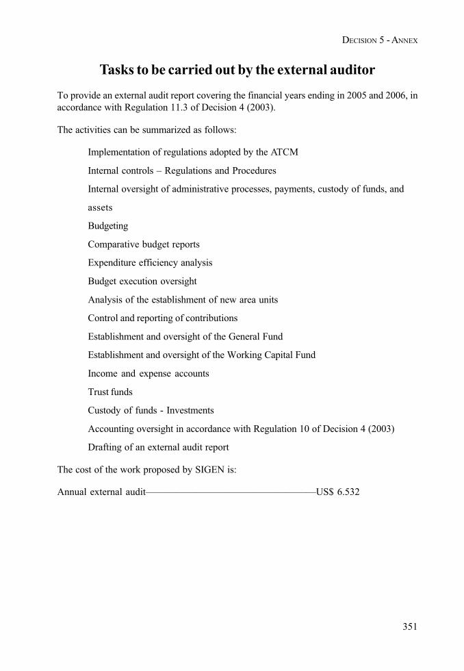
351
DECISION 5 - ANNEX
Tasks to be carried out by the external auditor
To provide an external audit report covering the financial years ending in 2005 and 2006, inaccordance with Regulation 11.3 of Decision 4 (2003).
The activities can be summarized as follows:
Implementation of regulations adopted by the ATCM
Internal controls – Regulations and Procedures
Internal oversight of administrative processes, payments, custody of funds, and
assets
Budgeting
Comparative budget reports
Expenditure efficiency analysis
Budget execution oversight
Analysis of the establishment of new area units
Control and reporting of contributions
Establishment and oversight of the General Fund
Establishment and oversight of the Working Capital Fund
Income and expense accounts
Trust funds
Custody of funds - Investments
Accounting oversight in accordance with Regulation 10 of Decision 4 (2003)
Drafting of an external audit report
The cost of the work proposed by SIGEN is:
Annual external audit—————————————————US$ 6.532

II. DECISIONS
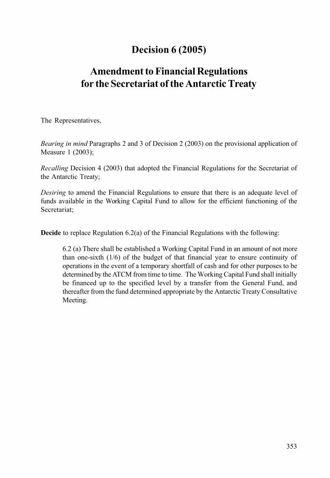
353
Decision 6 (2005)
Amendment to Financial Regulationsfor the Secretariat of the Antarctic Treaty
The Representatives,
Bearing in mind Paragraphs 2 and 3 of Decision 2 (2003) on the provisional application ofMeasure 1 (2003);
Recalling Decision 4 (2003) that adopted the Financial Regulations for the Secretariat ofthe Antarctic Treaty;
Desiring to amend the Financial Regulations to ensure that there is an adequate level offunds available in the Working Capital Fund to allow for the efficient functioning of theSecretariat;
Decide to replace Regulation 6.2(a) of the Financial Regulations with the following:
6.2 (a) There shall be established a Working Capital Fund in an amount of not morethan one-sixth (1/6) of the budget of that financial year to ensure continuity ofoperations in the event of a temporary shortfall of cash and for other purposes to bedetermined by the ATCM from time to time. The Working Capital Fund shall initiallybe financed up to the specified level by a transfer from the General Fund, andthereafter from the fund determined appropriate by the Antarctic Treaty ConsultativeMeeting.

II. DECISIONS
355
Decision 7 (2005)
Approval of the Work Programme and Budgetof the Secretariat
The Representatives,
Recalling Measure 1 (2003) of the XXVIth ATCM on the establishment of the Secretariatof the Antarctic Treaty (the Secretariat);
Recalling also Decision 2 (2003) on the provisional application of Measure 1 (2003); and
Bearing in mind the Financial Regulations for the Secretariat of the Antarctic Treaty adoptedby Decision 4 (2003);
Noting especially the provisions of Regulation 6.3 of the Financial Regulations relating tothe surplus;
Decide:
1. To approve the budget and work programme of the Secretariat for 2005/06 annexedto this Decision;
2. To approve the expenditure of up to one quarter of the forecast budget for 2006/07,annexed to this Decision, in the 2006/07 financial year subject to the availability ofsufficient funds;
3. To transfer $ 400.000 from the surplus of the financial year 2004/05 to a SpecialFund established according to the provisions of Regulation 6.2(d) of the FinancialRegulations, to be used to defray the expenses of interpretation and translation ofthe first Antarctic Treaty Consultative Meeting to be held after the entry into effectof Measure 1 (2003).
4. To use the contribution of the United States for 2004 to set up a Special Fund for thepurpose of strengthening the Secretariat’s database development and documentaryinfrastructure.

II. DECISIONS
357
DECISION 7 - ANNEX
1 In the period between 1 April and the date of the ATCM the Secretariat is financed on a continuing basis according to Regulation 4.2 ofthe Financial Regulations.
Work Programme 2005/6
Introduction
This Work Programme outlines the activities proposed for the Secretariat in the financial year 2005/6 (1 April 2005 to 31 March 2006)1. It is accompanied by the following appendices:
Appendix 1: Draft budget 2005/6, arranged by appropriations and by outputs
Appendix 2: Forecast budget 2006/7
Appendix 3: Contribution scale 2006/7
Appendix 4: Salary scale 2005/6
The Programme and the accompanying budget figures are based on Forecast Budget for 2005/6(Decision 2 (2004), Attachment 4) and the actual work experience of the initial period from September1st 2004. During these few initial months our main effort was devoted to set up the infrastructure ofthe ATS and to recruit the staff considered necessary for this starting period.
The financial year 2005/6 is the first regular financial year for the Secretariat; the financial year 2004/5 started in September 2004 and only contained seven months.
Management
The basic establishment needs of the Secretariat in terms of recruitment of personnel, acquisition ofequipment, IT development have been filled. The priority tasks for this year are now the preparationof the 28th ATCM and 29th ATCM, publication of the Final Reports, building up the ATS website, andthe development of data infrastructure in support of the web page and the various data managementtasks assigned to the Secretariat. Specific tasks will also depend on the decisions taken by the 28th
ATCM.
Administrative/technical staff
At the beginning of the financial year the permanent staff consisted of the Executive Secretary, theAssistant Executive Officer, one Information Officer and a Secretary/Administrative Assistant. Otherpersonnel (data entry, translation and accounting assistants) are hired on a part time basis to dealwith tasks which do not amount to a full day’s work or which have a temporary character. Specifictechnical assistance (such as web and database design) is also contracted out.
In order to strengthen the Secretariat’s capacity to handle data management tasks expected to beassigned by the ATCM it will be necessary to recruit a person with good technical qualifications asIT Officer. For the preparation of Final Reports, Handbooks, guidelines, newsletters etc. we plan torecruit an Editor. These staff will be recruited in the same way as the earlier administrative/technicalstaff, that is, by the publication of vacancy notices in the English language newspaper the BuenosAires Herald. The Consultative Parties will be informed of the vacancies. The permanent staff will besupplemented by part-time staff in fields such as accounting, translation, and data input, and bytrainees from Argentina and abroad for shorter periods and specific projects.
358
II. DECISIONS
Financial matters
The budget has been compiled using the figures in the Forecast Budget, with some adjustments onthe basis of the actual experience of the Secretariat so far. Assuming that the Consultative Parties willmake assessed voluntary contributions at the same rate as the previous year, the budget will beroughly in balance.
The United States intends to make its contribution for 2004 in the form of a restricted grant of US$30.000 to strengthen the Secretariat’s database development and documentary infrastructure. It isproposed that a Special Fund be set up according to Regulation 6.2 (d) of the Financial Regulationsto deal with this contribution, which will be used for the items Computers, Software Development andDocumentation Material.
Specific Tasks
Section headings refer to the paragraphs of Art. 2 of Measure 1 (2003).
(a) Preparation for the 28th ATCM and CEP 8
The secretariat has assumed the responsibility for preparing the agenda and gathering and collatingthe working and information papers for the 28th ATCM and publishing them on the restricted area ofthe ATS website. The web site for the 28th ATCM has been operational from April 22nd 2005. Use of adatabase of meta-data on the papers allows easier multilingual access and quicker updating of theinformation. Similar technology will be used for providing access to the ATCM recommendationsand other documents.
The Secretariat has assumed responsibility for the contracting of the translation and interpretationfor the ATCM. The contract has been granted, as in the past years, to the team of Mr. BernardPonette. The Swedish Government as host of the 28th ATCM will reimburse the Secretariat for thecosts of translation and interpretation during the meeting, and the pre-meeting translation and editingand publication of the Final Report are included in the Secretariat budget.
(b) Support intersessional work of the ATCM and the CEP
The secretariat will provide support in the organization of any intersessional meetings planned bythe ATCM.
(c) Facilitate exchange of information required under the Antarctic Treaty and the Protocol
The Secretariat will support work to improve the efficiency and transparency of the exchange ofinformation among the Consultative Parties as required under the Antarctic Treaty and the EnvironmentProtocol. In the set-up of the Secretariat databases and website, provision is being made for facilitiesfor the exchange of information through the website. The specific activities to be undertaken on thisregard are subject to the decisions that the ATCM will take on this matter.
(d) Co-ordination and contact with other elements of the Antarctic Treaty System, and otherrelevant international bodies and organizations
Under the guidance of the ATCM the Executive Secretary in the current financial year will attend theannual meeting of COMNAP and visit the CCAMLR Secretariat at the time of the annual meeting ofthe CCAMLR Commission, as well as attending such other meetings as agreed to by the AntarcticTreaty Consultative Parties pursuant to Rule 46.
359
ATS WORK PROGRAMME
(e) Development and maintenance of databases
The data model set up for the documents of the 28th ATCM will be further developed to include therecommendations, Measures, Decisions and Resolutions of the previous ATCMs, the contact pointsof the ATCP and other Antarctic organizations and, depending on the decisions of the ATCM, otherdata relevant to the tasks of the Secretariat.
(f) Circulation amongst the Parties relevant information and disseminate information on activitiesin Antarctica
The Secretariat and its website will function as a clearinghouse for information on the Parties’ activitiesand relevant developments in Antarctica. It will include links to all other relevant websites. Informationwill be circulated also through circulars, notes, and newsletters.
(g) Collection, maintenance and publication of ATCM/CEP records
Consultative Parties that have hosted ATCM’s have been be asked to provide the Secretariat withauthentic copies of all reports of the ATCM’s and other meetings they have hosted, so that theSecretariat will become a complete and reliable repository of the documents of the ATCM. Therecommendations, measures, decisions and resolutions of the ATCM will be digitized if electroniccopies of them don’t exist yet. With these records, the database of ATCM recommendations, whichis almost complete as far as the English language documents are concerned, will be expanded toinclude the other language versions of the documents. At a later stage, Working Papers and InformationPapers of the recent meetings will also be added. The database will be made available through theATS website before the 29th ATCM.
(h) Facilitate the availability of information about the Antarctic Treaty system
The Secretariat will continue with improvement of the visibility of the Antarctic Treaty Systemthrough its website, through the ATS newsletter and through pamphlets, and other publicity activities.Publication and distribution of guidelines adopted by the ATCM and versions of the ATCM documentsoriented towards the general public are also being considered.
(i) Preparation of reports on the Secretariat’s activities
Under this heading falls the task of preparing the reports and budgets of the Secretariat for theATCM.
(j) Assisting the review of past Recommendations and Measures
The examination and review of past Recommendations and Measures of the ATCM, which is atpresent focusing on the Protected Area System, will be assisted by the Secretariat. Although thiswork is essential to preserve the integrity and effectiveness of the system of ATCM rule-making,during the annual meeting there usually is not enough time for the legal experts of the ConsultativeParties to focus on this. The ATCM might consider the possibility of holding a workshop at theSecretariat with experts from the Consultative Parties to prepare a decision during the 29th ATCM.
(k) Maintenance and updating of the Antarctic Treaty System Handbook
The Secretariat is considering publishing the Antarctic treaty handbook in separate volumes insteadof in one volume. A possible design might be as follows:
Vol. 1 Basic Texts and Operation of the ATCM and CEP
Vol. 2 Environmental Protection
360
II. DECISIONS
Vol. 3 Operational and Scientific Matters
Vol. 4 Tourism and non-governmental activities
Vol. 5 Recommendations, Measures, Decisions and Resolutions
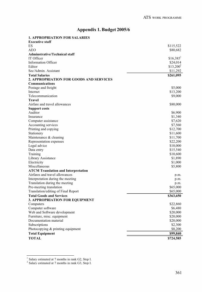
361
ATS WORK PROGRAMME
Appendix 1. Budget 2005/61. APPROPRIATION FOR SALARIESExecutive staffES $115,522AEO $80,682Adminstrative/Technical staffIT Officer $16,3851
Information Officer $24,014Editor $13,2002
Sec/Admin. Assistant $11,292Total Salaries $261,0952. APPROPRIATION FOR GOODS AND SERVICESCommunicationsPostage and freight $5,000Internet $13,200Telecommunication $9,000TravelAirfare and travel allowances $80,000Support costsAuditor $6,900Insurance $1,340Computer assistance $7,620Accounting services $7,560Printing and copying $12,700Stationery $11,600Maintenance & cleaning $11,700Representation expenses $22,200Legal advice $10,000Data entry $15,540Training $10,600Library Assistance $1,890Electricity $1,000Miscellaneous $5,800ATCM Translation and InterpretationAirfares and travel allowances p.m.Interpretation during the meeting p.m.Translation during the meeting p.m.Pre-meeting translation $65,000Translation/editing of Final Report $65,000Total Goods and Services $363,6503. APPROPRIATION FOR EQUIPMENTComputers $22,860Computer software $6,480Web and Software development $20,000Furniture, misc. equipment $20,000Documentation material $20,000Subscriptions $2,300Photocopying & printing equipment $8,200Total Equipment $99,840TOTAL $724,585
1 Salary estimated at 7 months in rank G2, Step I.2 Salary estimated at 7 months in rank G3, Step I.

362
II. DECISIONS
Budget 2005/6 (Outputs)
A. MANAGEMENTExecutive Secretary (70%) $80,865Assistant Executive Officer (60%) $48,409
$129,274B. GENERAL SUPPORTSalariesIT Officer (20%) $3,277Sec/Admin. Assistant (70%) $7,904Editor (20%) $2,640
$13,821Goods and servicesPostage & Freight $5,000Internet $13,200Telecommunications $9,000Auditor $6,900Insurance $1,340Computer asistance $7,620Printing and copying (25%) $3,175Maintenance & cleaning $11,700Stationery $11,600Representation expenses $22,200Training $10,600Airfare and travel allowances (40%) $32,000Legal Advice $10,000Electricity $1,000Accounting services (60%) $4,536Miscellaneous $5,800
$155,671EquipmentComputers $22,860Computer software $6,480Furniture, misc. equipment $20,000Documentation material $20,000Subscriptions $2,300Photocopying & printing equipment $8,200
$79,840C. TASKS(a) Preparation and organization of ATCM/CEPExecutive Secretary (10 %) $11,552Assistant Executive Officer (10%) $8,068Information Officer (20%) $4,803Web and software development (20%) $4,000Airfares and travel allowances (30%) $24,000Airfare for translators and interpreters p.m.Interpretation during the meeting p.m.Translation during the meeting p.m.Printing and copying (50%) $6,350Pre-ATCM translation $65,000Translation/editing of Final Report $65,000
$188,773(b) Support intersessional work of the ATCM and the CEP
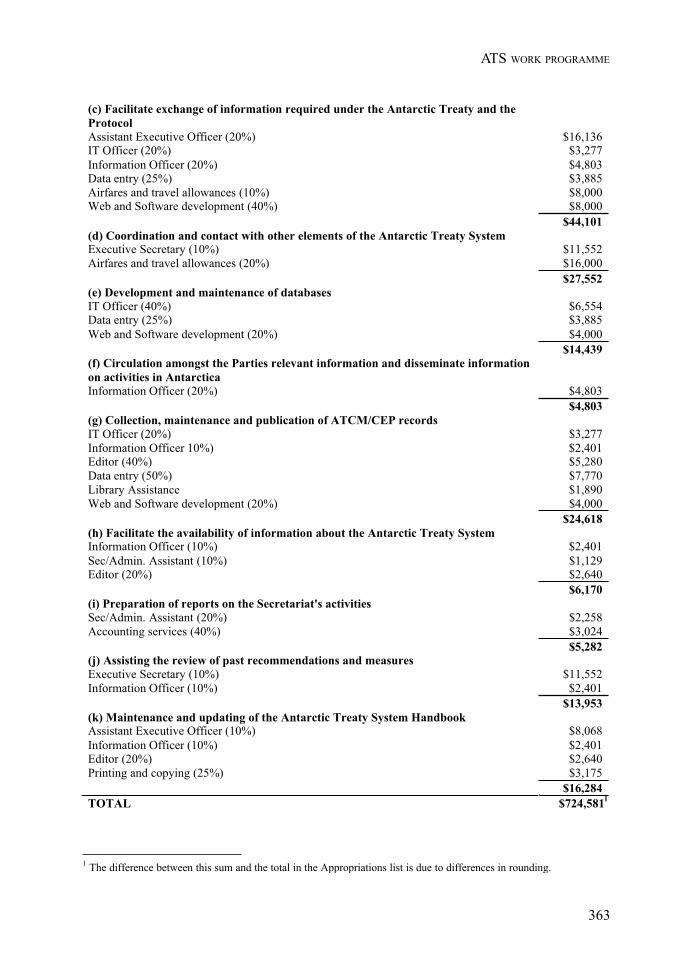
363
ATS WORK PROGRAMME
(c) Facilitate exchange of information required under the Antarctic Treaty and theProtocolAssistant Executive Officer (20%) $16,136IT Officer (20%) $3,277Information Officer (20%) $4,803Data entry (25%) $3,885Airfares and travel allowances (10%) $8,000Web and Software development (40%) $8,000
$44,101(d) Coordination and contact with other elements of the Antarctic Treaty SystemExecutive Secretary (10%) $11,552Airfares and travel allowances (20%) $16,000
$27,552(e) Development and maintenance of databasesIT Officer (40%) $6,554Data entry (25%) $3,885Web and Software development (20%) $4,000
$14,439(f) Circulation amongst the Parties relevant information and disseminate informationon activities in AntarcticaInformation Officer (20%) $4,803
$4,803(g) Collection, maintenance and publication of ATCM/CEP recordsIT Officer (20%) $3,277Information Officer 10%) $2,401Editor (40%) $5,280Data entry (50%) $7,770Library Assistance $1,890Web and Software development (20%) $4,000
$24,618(h) Facilitate the availability of information about the Antarctic Treaty SystemInformation Officer (10%) $2,401Sec/Admin. Assistant (10%) $1,129Editor (20%) $2,640
$6,170(i) Preparation of reports on the Secretariat's activitiesSec/Admin. Assistant (20%) $2,258Accounting services (40%) $3,024
$5,282(j) Assisting the review of past recommendations and measuresExecutive Secretary (10%) $11,552Information Officer (10%) $2,401
$13,953(k) Maintenance and updating of the Antarctic Treaty System HandbookAssistant Executive Officer (10%) $8,068Information Officer (10%) $2,401Editor (20%) $2,640Printing and copying (25%) $3,175
$16,284TOTAL $724,5811
1 The difference between this sum and the total in the Appropriations list is due to differences in rounding.
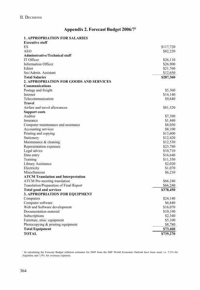
364
II. DECISIONS
Appendix 2. Forecast Budget 2006/71
1. APPROPRIATION FOR SALARIESExecutive staffES $117,720AEO $82,220Adminstrative/Technical staffIT Officer $26,110Information Officer $26,900Editor $21,760Sec/Admin. Assistant $12,650Total Salaries $287,3602. APPROPRIATION FOR GOODS AND SERVICESCommunicationsPostage and freight $5,360Internet $14,140Telecommunication $9,640TravelAirfare and travel allowances $81,520Support costsAuditor $7,390Insurance $1,440Computer maintenance and assistance $8,050Accounting services $8,100Printing and copying $13,600Stationery $12,420Maintenance & cleaning $12,530Representation expenses $23,780Legal advice $10,710Data entry $16,640Training $11,350Library Assistance $2,020Electricity $1,070Miscellaneous $6,210ATCM Translation and InterpretationATCM Pre-meeting translation $66,240Translation/Preparation of Final Report $66,240Total good and services $378,4503. APPROPRIATION FOR EQUIPMENTComputers $24,140Computer software $6,840Web and Software development $16,070Documentation material $10,190Subscriptions $2,340Furniture, misc. equipment $5,100Photocopying & printing equipment $8,780Total Equipment $73,460TOTAL $739,270
1 In calculating the Forecast Budget inflation estimates for 2005 from the IMF World Economic Outlook have been used, i.e. 7,1% forArgentina and 1,9% for overseas expenses.
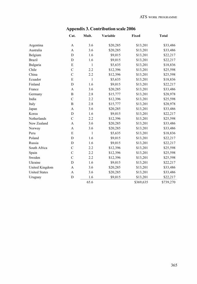
365
ATS WORK PROGRAMME
Appendix 3. Contribution scale 2006Cat. Mult. Variable Fixed Total
Argentina A 3.6 $20,285 $13,201 $33,486Australia A 3.6 $20,285 $13,201 $33,486Belgium D 1.6 $9,015 $13,201 $22,217Brazil D 1.6 $9,015 $13,201 $22,217Bulgaria E 1 $5,635 $13,201 $18,836Chile C 2.2 $12,396 $13,201 $25,598China C 2.2 $12,396 $13,201 $25,598Ecuador E 1 $5,635 $13,201 $18,836Finland D 1.6 $9,015 $13,201 $22,217France A 3.6 $20,285 $13,201 $33,486Germany B 2.8 $15,777 $13,201 $28,978India C 2.2 $12,396 $13,201 $25,598Italy B 2.8 $15,777 $13,201 $28,978Japan A 3.6 $20,285 $13,201 $33,486Korea D 1.6 $9,015 $13,201 $22,217Netherlands C 2.2 $12,396 $13,201 $25,598New Zealand A 3.6 $20,285 $13,201 $33,486Norway A 3.6 $20,285 $13,201 $33,486Peru E 1 $5,635 $13,201 $18,836Poland D 1.6 $9,015 $13,201 $22,217Russia D 1.6 $9,015 $13,201 $22,217South Africa C 2.2 $12,396 $13,201 $25,598Spain C 2.2 $12,396 $13,201 $25,598Sweden C 2.2 $12,396 $13,201 $25,598Ukraine D 1.6 $9,015 $13,201 $22,217United Kingdom A 3.6 $20,285 $13,201 $33,486United States A 3.6 $20,285 $13,201 $33,486Uruguay D 1.6 $9,015 $13,201 $22,217
65.6 $369,635 $739,270

366
II. DECISIONS
App
endi
x 4.
Sal
ary
Scal
e 200
5/6

367
ATS WORK PROGRAMME
Decision 8 (2005)
Use of Heavy Fuel Oil (HFO) in Antarctica
The Representatives:
Recalling Article 3 of the Environmental Protocol to the Antarctic Treaty which requiresthat activities in the Antarctic Treaty area shall be planned and conducted so as to limitadverse impacts on the Antarctic environment,
Recalling also the requirements of Annex IV to the Environmental Protocol on Preventionof Marine Pollution,
Aware of the potential for adverse impact which a release of Heavy Fuel Oil (HFO) couldhave on the Antarctic marine environment,
Considering that the International Maritime Organization is the competent organization todeal with shipping regulations,
Decide to:
Address a request through the Chair of ATCM XXVIII to the International MaritimeOrganization to examine mechanisms for restricting the use of Heavy Fuel Oil (definingHFO in accordance to MARPOL Regulation 13 H definition of Heavy Grade Oil as all fuelsof higher number than Intermediate Fuel Oil 180 (IFO-180)) in Antarctic waters, taking intoaccount:
• the relatively high risk of fuel release in the Antarctic Treaty area due to conditions such as icebergs, sea-ice, and uncharted waters; and
• the high potential of environmental impacts associated with a spill and emission ofHFO in the Antarctic Treaty area.

II. DECISIONS
369
Decision 9 (2005)
Marine Protected Areas and other areasof interest to CCAMLR
The Representatives,
Noting the requirements in Article 6(1) and 6(2) of Annex V to the Protocol of EnvironmentalProtection to the Antarctic Treaty that the prior approval of the Commission of the Conventionon the Conservation of Antarctic Marine Living Resources (CCAMLR) must be obtainedon proposal for Antarctic Specially Protected Areas or Antarctic Specially Managed Areaswhich contain marine areas;
Recalling that ATCM XXI agreed to transmit a draft text addressing criteria for MarineAreas to CCAMLR for its consideration;
Recalling also the endorsement of that draft text by CCAMLR at its XVIth Meeting, andits adoption as Decision 4 (1998) of ATCM XXII;
Noting that Decision 4 (1998) set out procedures to be followed pending the entry into forceof the Annex V, which is now in force;
Desiring to adopt updated procedures;
Decide:
1) That for the purpose of the implementation of Article 6.2 of the EnvironmentalProtocol, draft management plans that contain marine areas which require a priorapproval of CCAMLR are those:
a) in which there is actual harvesting or potential capability of harvesting of marineliving resources which might be affected by site designation; or
b) for which there are provisions specified in a draft management plan which mightprevent or restrict CCAMLR related activities.
2) That proposals for designations of Antarctic Specially Protected Areas or AntarcticSpecially Managed Areas which meet the criteria of Paragraph 1 above shall besubmitted to CCAMLR for its consideration before any decision is taken on theproposal relating to marine areas.

370
II. DECISIONS
3) Furthermore that any other proposed designations which might have implicationsfor CCAMLR Ecosystem Monitoring Programme (CEMP) sites shall also besubmitted to CCAMLR for its consideration.
4) That this decision shall replace Decision 4 (1998), which shall cease to be operative.
371
ATS WORK PROGRAMME
Decision 10 (2005)
Establishment of an ElectronicInformation Exchange System
The Representatives,
Recalling Article III.1(a) and Article VII.5 of the Antarctic Treaty;
Conscious of the obligations within the Protocol on Environmental Protection to the AntarcticTreaty and its Annexes to exchange information;
Conscious also of Resolution 6 (2001) and other commitments that the Parties have madewith respect to keeping each other informed by regular or occasional exchanges;
Desiring to ensure that the exchange of information between the Parties is conducted inthe most efficient and timely way, and that the ATCM has available to it the best availableinformation on which to base it decisions;
Decide that the Secretariat of the Antarctic Treaty shall, in consultation with other relevantorganizations of the Antarctic Treaty System, begin development of an electronic informationexchange system and report to ATCM XXIX on its progress.

ANNEX C
RESOLUTIONS

375
Resolution 1 (2005)
Environmental Impact Assessment:Circulation of Information
The Representatives,
Recalling Articles III and VII of the Antarctic Treaty and Articles 3, 6.2 and 17 of theProtocol on Environmental Protection to the Antarctic Treaty;
Noting that Annex I to the Protocol creates obligations to exchange information annually,including information on Initial Environmental Evaluations and Comprehensive EnvironmentalEvaluations;
Noting that the requirements for the exchange of information have been further developedin numerous measures of the Antarctic Treaty Consultative Meetings;
Taking into account the establishment of the Secretariat of the Antarctic Treaty;
Conscious of Resolution 6 (1995), which states that the procedures on circulation ofinformation should be reviewed following the establishment of a permanent Secretariat;
Desirous that such information should be easily accessible and in a comprehensive anduniform format so that the scale and trend of activities and developments in Antarctica canbe readily monitored;
Recommend that:
1) Their Governments should provide the Secretariat of the Antarctic Treaty with a listof the Initial Environmental Evaluations and Comprehensive EnvironmentalEvaluations prepared by or submitted to them during the period from April 1 of theprevious year to March 31 prior to the ATCM.
2) The above list should, at a minimum, contain the following information: a shortdescription of the development or activity; the type of environmental impactassessment undertaken (IEE or CEE); the location (name, latitude, and longitude)of the activity; the organisation responsible for the EIA; and any decision takenfollowing consideration of the environmental impact assessment.
376
II. RESOLUTIONS
3) A copy in electronic format of these documents should also be submitted wherepossible.
4) The lists should be collated by the Secretariat, posted on the ATS website and circulatedas an information paper to the ATCM and thereafter, if the ATCM so agrees, bepublished as an Annex to the final Report of the ATCM.

377
Resolution 2 (2005)
Practical Guidelines for Developing and DesigningEnvironmental Monitoring Programs in Antarctica
The Representatives,
Conscious that there has been an increased focus on the need for environmental monitoringamong national Antarctic programs;
Noting the need of having standardized techniques to develop monitoring programs whichare scientifically sound, practical and cost effective;
Noting also the need of a proper methodology to be followed when designing a monitoringprogram;
Considering that a unified approach to environmental monitoring will contribute to thecontinued protection of the Antarctic environment;
Recommend that:
1. the Practical Guidelines for Developing and Designing EnvironmentalMonitoring Programs in Antarctica annexed to this Resolution be made availablefor use by those engaged in the preparation of monitoring Programs in Antarctica;
2. these guidelines be used in conjunction with the COMNAP/SCAR AntarcticEnvironmental Handbook.

II. RESOLUTIONS
379
RESOLUTION 2. ANNEX
Practical Guidelines for Developing and DesigningEnvironmental Monitoring Programmes in Antarctica
January 2005This document has been developed for the Council of Managers of National AntarcticPrograms (COMNAP) by its Antarctic Environmental Officers Network (AEON). Up-to-date versions of this document can be found on the COMNAP web site athttp://www.comnap.aq

II. RESOLUTIONS
381
GUIDELINES FOR MONITORING
FOREWORD
Environmental monitoring has been an important focus of the Council of Managers of NationalAntarctic Programmes’ (COMNAP) work since the mid-1990s. Recent initiatives withinthe Antarctic Treaty system and within the Scientific Committee on Antarctic Research(SCAR) and COMNAP, as well as ongoing experience in the practical implementation ofthe Environmental Protocol to the Antarctic Treaty, have each advanced the understandingof the issues related to environmental monitoring in Antarctica.
During the 1999 meeting of COMNAP in Goa, India, the Antarctic Environmental OfficersNetwork (AEON) arranged a workshop with the aim of following up and facilitatingdiscussions on the issue of environmental monitoring of science and operational activities inAntarctica.
This workshop identified several steps in the process of developing, designing and implementingenvironmental monitoring programmes, and looked at areas where there may be gaps in thecurrent documentation and information available to operators. Although information existson these matters the workshop noted that much of it is not widely available, and is notwritten as practical guidelines that are readily understandable by operators.
Following the discussion, the workshop recommended that practical guidelines for developingand designing an environmental monitoring programme be prepared. Terms of Referencewere then prepared, and the document developed reflects the intentions of these Terms ofReference.
The document has passed through several drafts in its development. The drafts have beencirculated and reviewed by members of AEON. Comments have been incorporated to arriveat the final format and content.
This coordinated effort to provide practical monitoring guidelines should assist all nationalprogrammes, but particularly those with more limited resources and who do not currentlyhave a systematic monitoring programme in place. Ultimately, a unified approach toenvironmental monitoring will assist the continued protection of resources and values, and inminimising human impacts on the Antarctic continent.
Gérard JugieChair, Council of Managers of National Antarctic Programmes (COMNAP)
January 2005
382
II. RESOLUTIONS
LIST OF ACRONYMS
AEON Antarctic Environmental Officers NetworkASMA Antarctic Specially Managed AreaASPA Antarctic Specially Protected AreaATCM Antarctic Treaty Consultative MeetingBOD Biological Oxygen DemandCEP Committee for Environmental ProtectionCOD Chemical Oxygen DemandCOMNAP Council of Managers of National Antarctic ProgrammesDO Dissolved OxygenEIA Environmental Impact AssessmentGIS Geographical Information SystemIAATO International Association of Antarctica Tour OperatorsPAH Polycyclic Aromatic Hydrocarbon(s)PCB Polychlorinated BiphenylsPM10 Particulate up to 10 microns in diameterSCAR Scientific Committee on Antarctic ResearchSS Suspended SolidsTOC Total Organic CarbonTSS Total Suspended SolidsTPH Total Petroleum Hydrocarbons

383
GUIDELINES FOR MONITORING
GLOSSARY OF TERMS
Action: Any step taken as part of an activity.Activity: An event or process resulting from, or associated with, the presence of humans in Antarctica,
and/or which may lead to the presence of humans in Antarctica.Baseline monitoring: Collection of data and information from a particular site, ahead of an activity
taking place that is predicted to have certain impacts on the site.Cumulative Impact: The combined impact of past, present and reasonably foreseeable activities.
These activities may occur over time and space and can be additive, interactive or synergistic.Direct Impact: A change in environmental components that results from direct cause-effect
consequences of interaction between the exposed environment and outputs.Exposure: The process of interaction between an identified potential output and an environmental
element or value.Impact: A change in the values or resources attributable to a human activity. It is the consequence of
an agent of change, not the agent itself.Indicator: Indicators are measures of physical, chemical, biological or socio-economic factors which
best represent the key elements of the environment. They capture, focus and condense informationabout complex environments for management, monitoring and reporting purposes. To be effectiveindicators must be scientifically credible.
Indirect indicator: Signs or symptoms of changes in features not directly related to the environmentalfeature, but which potentially may impact the environmental features. Output indicators indicatechanges in outputs (emission, fuel spills, noise) that may impact the environment. Complianceindicators indicate changes in compliance with environmental legislation, which then indirectlymay have consequences for the environment.
Indirect Impact: A change in environmental components that results from interactions between theenvironment and other impacts (direct or indirect).
Mitigation: The use of practice, procedure or technology to minimise or prevent impacts associatedwith proposed activities.
Monitoring: Consists of standardised measurements or observations of key parameters (outputsand environmental variables) over time, their statistical evaluation and reporting on the state ofthe environment in order to define quality and trends.
Output: A physical change or an entity imposed on or released to the environment as a result of anaction or an activity.
Parameter: A measurable variable for an indicator.Remediation: The steps taken after impacts have occurred to promote, as much as possible, the
return of the environment to its original condition.Unavoidable Impact: An impact for which no further mitigation is possible.Value: The worth, merit or importance of something (environmental value: the worth, merit or
importance of an environmental feature).
384
II. RESOLUTIONS
SECTION 1: Introduction to the Guidelines
1.1 Why Monitor in Antarctica?
The primary obligations for undertaking monitoring in Antarctica are set out in the Protocol onEnvironmental Protection to the Antarctic Treaty (the Protocol). These requirements are summarisedin Appendix 1, and include the verification of predicted impacts linked to specific activities andmonitoring for unforseen impacts and environmental change in Antarctica generally.
The issue of environmental monitoring was substantively discussed at ATCM XV (1989) andRecommendation XV-5 was the result (reproduced at Appendix 1). Further consideration of the issueat ATCM XVI (1991) led to the convening of a Meeting of Experts in Buenos Aires in June 1992.ATCM XVII considered the report of the Meeting of Experts and adopted Recommendation XVII-1(reproduced at Appendix 1). ATCM XVII also proposed the convening of a workshop to pursue theissue of environmental monitoring further. In July 1996 the Scientific Committee on Antarctic Research(SCAR) and the Council of Managers of National Antarctic Programmes (COMNAP) published theresults of two workshops entitled “Monitoring of Environmental Impacts from Science and Operationsin Antarctica” (Kennicutt et al, 1996).
As a result of those workshops two further documents were proposed:
• a technical handbook of standardised monitoring methods, and• a practical guide to monitoring in Antarctica.
The technical handbook was published by COMNAP and SCAR in May 2000 as the “COMNAP/SCAR Antarctic Environmental Monitoring Handbook”.
The present “Practical Guidelines for Developing and Designing Environmental MonitoringProgrammes in Antarctica” fulfill the second proposal of preparing a practical guide to monitoring inAntarctica. It is recommended that it be used in conjunction with the handbook.
1.2 Objectives of these Guidelines
The objective of these guidelines is to provide practical advice to national Antarctic operators indeveloping and designing environmental monitoring programmes, by:
a. Setting out a practical approach to designing environmental monitoring programmes inAntarctica, with examples;
b. Bringing together various sources of monitoring information into a single reference document;and
c. Providing clear and understandable advice.
1.3 How to use these Guidelines
These Guidelines have been structured so as to provide a common approach to the design ofmonitoring programmes in Antarctica that can be used by national Antarctic operators that are:
• New signatories to the Environmental Protocol;• Wishing to review existing or long-term monitoring programmes;• Looking to establish new monitoring programmes for specific activities.
The guidelines can be used for a range of monitoring needs including:
• Meeting the monitoring requirements of the Environmental Protocol;
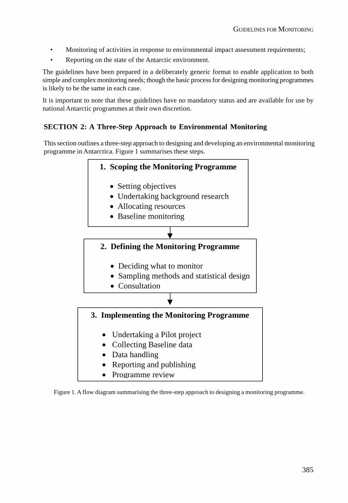
385
GUIDELINES FOR MONITORING
• Monitoring of activities in response to environmental impact assessment requirements;• Reporting on the state of the Antarctic environment.
The guidelines have been prepared in a deliberately generic format to enable application to bothsimple and complex monitoring needs; though the basic process for designing monitoring programmesis likely to be the same in each case.
It is important to note that these guidelines have no mandatory status and are available for use bynational Antarctic programmes at their own discretion.
SECTION 2: A Three-Step Approach to Environmental Monitoring
This section outlines a three-step approach to designing and developing an environmental monitoringprogramme in Antarctica. Figure 1 summarises these steps.
Figure 1. A flow diagram summarising the three-step approach to designing a monitoring programme.
1. Scoping the Monitoring Programme
• Setting objectives• Undertaking background research• Allocating resources• Baseline monitoring
2. Defining the Monitoring Programme
• Deciding what to monitor• Sampling methods and statistical design• Consultation
3. Implementing the Monitoring Programme
• Undertaking a Pilot project• Collecting Baseline data• Data handling• Reporting and publishing• Programme review
386
II. RESOLUTIONS
2.1 STEP 1: Scoping the monitoring programme
This section describes the preparatory work that is necessary prior to undertaking any monitoringprogramme. It is important to undertake this step in a thorough manner to ensure that an effectivemonitoring programme can be developed.
2.1.1 Setting objectives
All monitoring programmes should have clearly defined objectives, which must be agreed at theoutset. Objectives should be meaningful, achievable, and concise. They need to identify what is tobe achieved and over what time period. Objectives also need to make sense to those responsible fordesigning and implementing the monitoring programme, and to senior managers who may need totake action as a result of the findings of the monitoring programme.
Example for Setting Objectives
National Programme Alpha has decided to undertake an environmental monitoringprogramme for its Alpha Station. Having been assigned the task of developing and designinga monitoring programme, the Alpha Environmental Manager implemented the followingprocess to set the objectives of the programme:
1. A review of all environmental policy documents and reports relevant to the AlphaNational Programme was conducted.
2. A small brainstorming meeting of relevant personnel (managers and operators) washeld to identify possible objectives of the environmental monitoring programme atStation Alpha.
3. Based on outcomes from the brainstorming meeting the Environmental Managerdeveloped a set of draft objectives.
4. The draft objectives were reviewed and revised by relevant personnel (managers andoperators) and were revised accordingly.
5. The following objectives were established for the environmental monitoringprogramme:- To demonstrate compliance with the requirements of the Environmental Protocol- To capture information that may show environmental changes/impacts around
the Alpha Station that may result from station and related field activities- To undertake the monitoring for a period of five years before conducting a major
review of the programme- To utilise existing equipment, station personnel and scientists as much as
possible without appointing additional staff to minimise costs- To amend the structure and processes in the organisation to ensure monitoring
information is used as a part of management decisions.

387
GUIDELINES FOR MONITORING
2.1.2 Background Research
Having defined the objectives for monitoring it is essential to gather relevant information that willassist with the design of the monitoring programme. The following sets out the key issues that needto be addressed.
Existing data and research
A key issue will be to determine what is already known about the area to be monitored. The followingquestions may assist in meeting this need:
• Is there any scientific or environmental research being conducted in the area to be monitoredthat may provide useful data?
• What information and data has been, or is being collected at, or near to the area to bemonitored?
• Are there any existing environmental monitoring programmes with similar aims beingconducted by other national Antarctic programmes?
• Is there any data available prior to any human activity in the region that could be usefulbaseline data?
• What are the information gaps? What is not known about the area?• Is there a need for baseline data collection to be undertaken? Will it be important to collect
basic information about the site before implementing a larger-scale monitoring programme?• Are there any environmental reports, or environmental impact assessments for the area to
be monitored?
Environmental features within the monitoring area
When collecting background information about the area to be monitored it is particularly importantto build up a picture of the key environmental features that are found in the area of interest. Thisinformation will be essential when considering what to monitor (Step 2 of these guidelines). Figure 2highlights key environmental features that might typically be found either singularly or in combination.
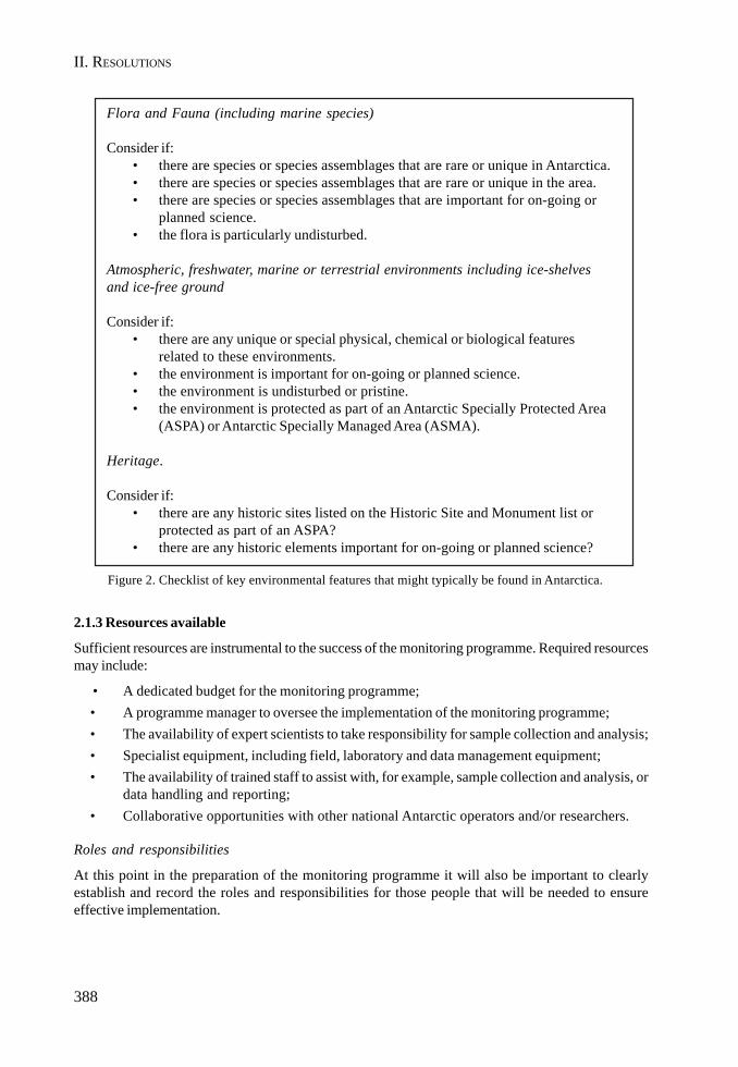
388
II. RESOLUTIONS
Flora and Fauna (including marine species)
Consider if:• there are species or species assemblages that are rare or unique in Antarctica.• there are species or species assemblages that are rare or unique in the area.• there are species or species assemblages that are important for on-going or
planned science.• the flora is particularly undisturbed.
Atmospheric, freshwater, marine or terrestrial environments including ice-shelvesand ice-free ground
Consider if:• there are any unique or special physical, chemical or biological features
related to these environments.• the environment is important for on-going or planned science.• the environment is undisturbed or pristine.• the environment is protected as part of an Antarctic Specially Protected Area
(ASPA) or Antarctic Specially Managed Area (ASMA).
Heritage.
Consider if:• there are any historic sites listed on the Historic Site and Monument list or
protected as part of an ASPA?• there are any historic elements important for on-going or planned science?
Figure 2. Checklist of key environmental features that might typically be found in Antarctica.
2.1.3 Resources available
Sufficient resources are instrumental to the success of the monitoring programme. Required resourcesmay include:
• A dedicated budget for the monitoring programme;• A programme manager to oversee the implementation of the monitoring programme;• The availability of expert scientists to take responsibility for sample collection and analysis;• Specialist equipment, including field, laboratory and data management equipment;• The availability of trained staff to assist with, for example, sample collection and analysis, or
data handling and reporting;• Collaborative opportunities with other national Antarctic operators and/or researchers.
Roles and responsibilities
At this point in the preparation of the monitoring programme it will also be important to clearlyestablish and record the roles and responsibilities for those people that will be needed to ensureeffective implementation.
389
GUIDELINES FOR MONITORING
2.1.4 Baseline Monitoring
Baseline monitoring is undertaken ahead of a particular activity commencing. The primary purpose ofbaseline monitoring is to establish a data set of pre-impact conditions of the site or area in question.
Example for Baseline Monitoring:
National Programme Bravo wants to establish an ice runway near its existing station. TheEnvironmental Impact Assessment for the runway has identified the need for an environmentalmonitoring programme for the life of the runway to ensure environmental impacts aremonitored and mitigated. Baseline data for the runway site will need to be gathered onsurface snow and ice quality prior to operation of the runway in order to compare futuredata during operation of the runway.
2.2 STEP 2: Defining the programme
Completing the data and information gathering exercises highlighted in Step 1 should assist inproviding a clear understanding of what is known about the site and what resources are available toimplement a monitoring programme. The next step is to define the boundaries of the monitoringprogramme by identifying what needs to be monitored, and the techniques to be used.
2.2.1 Deciding what to monitor
Deciding what to monitor is an essential stage in the process, if the monitoring programme is to meetits stated objectives. Deciding what to monitor will be influenced by a number of factors. Theseinclude:
• The key environmental features of the area to be monitored (determined through Step 1);• The predicted or known impacts of an activity for which monitoring may be required (for
example as determined through an EIA);• Practical and technical issues, such as the ease with which samples can be taken and/or
analysed.
Prioritisation
Prioritisation or ranking will need to be undertaken particularly when values and impacts are of toolarge a number to be adequately monitored within available resources.
The prioritisation of values and impacts that are the most critical should be based on the work carriedout in Step 1 using the judgement of relevant experts. Rank the findings, noting that the highestpriority in terms of a monitoring programme should be those values that are the most sensitive, thosemost likely to be significantly impacted, those that are most important to protect, or a combination ofthese factors.
Choosing relevant indicators
An indicator is defined as: signs or symptoms of changes, potentially due to numerous factors, in anenvironmental feature or features. Some examples of indicators are shown in Table 1.

390
II. RESOLUTIONS
Choosing what parameters to measure to detect changes in the indicators
When the most appropriate indicators have been selected it is important to decide on the parametersto measure. There are usually numerous parameters that could be measured for each indicator chosen,and therefore these need to be carefully selected. There are several factors that may influence thechoice of parameters, for example, the cost of sampling/analysis, and the level of expertise needed tosample. Consideration should also be given to ensuring comparability with monitoring programmesconducted elsewhere, especially if these are in the near vicinity. Table 1 also gives examples ofparameters for the various indicators listed. The COMNAP/SCAR Antarctic Environmental MonitoringHandbook should be consulted as a primary reference.
SCAR/COMNAP 1996 have recommended that the following criteria be used when selectingparameters:
The parameters must:
• Have the potential to exhibit changes in excess of limits of detection;• Be directly relatable to a testable hypothesis;• Be known or measurable above natural variability (i.e. background levels);• Give information from which management decisions can be made;• Be able to sustain the monitoring activity;• Be able to be sampled within logistical and time constraints;• Be measurable on samples that can be transported without deterioration or be measurable
on-site in the field;• Be amenable to quality assurance procedures including demonstrable precision, accuracy
and reproducibility.
It is also desirable that the parameters:
• Be measurable by cost effective, simple and standard procedures (if the procedures are non-standard intercalibrations are essential);
• Be strongly related by what is believed to be a causal link to a particular activity or process;• Be a direct measure of change in a value of concern;• Permit generalisations about causative agents;• Be definable in terms of limits beyond which changes are judged to be deleterious, and• Be measurable without conflicting with scientific activities.
Finally, make sure that the chosen indicators can be readily measured and are achievable within theavailable resources.
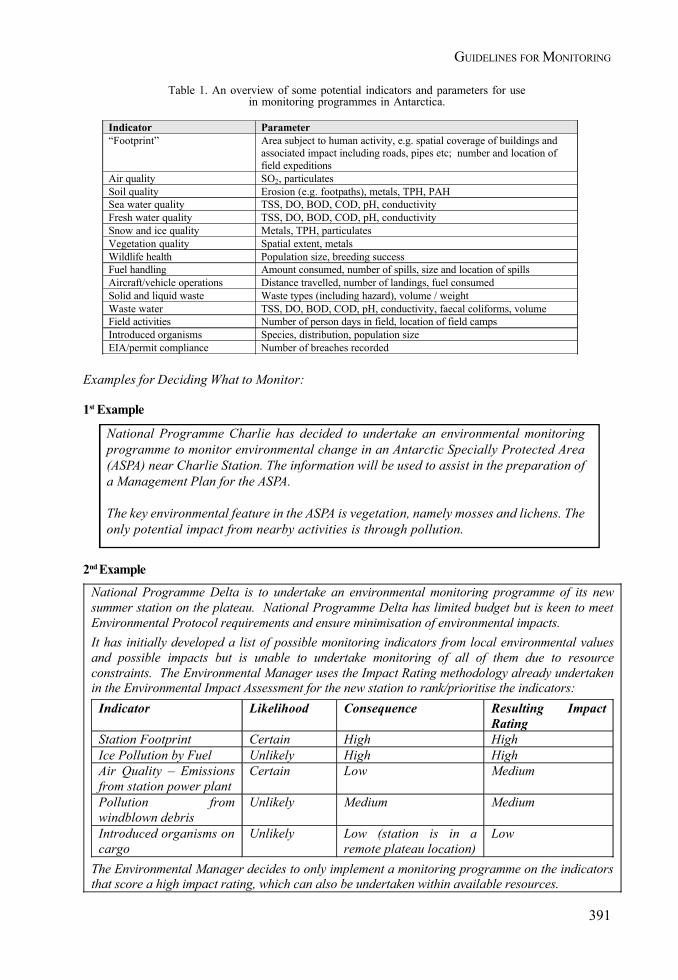
391
GUIDELINES FOR MONITORING
Examples for Deciding What to Monitor:
1st Example
National Programme Charlie has decided to undertake an environmental monitoringprogramme to monitor environmental change in an Antarctic Specially Protected Area(ASPA) near Charlie Station. The information will be used to assist in the preparation ofa Management Plan for the ASPA.
The key environmental feature in the ASPA is vegetation, namely mosses and lichens. Theonly potential impact from nearby activities is through pollution.
Indicator Parameter “Footprint” Area subject to human activity, e.g. spatial coverage of buildings and
associated impact including roads, pipes etc; number and location of field expeditions
Air quality SO2, particulates Soil quality Erosion (e.g. footpaths), metals, TPH, PAH Sea water quality TSS, DO, BOD, COD, pH, conductivity Fresh water quality TSS, DO, BOD, COD, pH, conductivity Snow and ice quality Metals, TPH, particulates Vegetation quality Spatial extent, metals Wildlife health Population size, breeding success Fuel handling Amount consumed, number of spills, size and location of spills Aircraft/vehicle operations Distance travelled, number of landings, fuel consumed Solid and liquid waste Waste types (including hazard), volume / weight Waste water TSS, DO, BOD, COD, pH, conductivity, faecal coliforms, volume Field activities Number of person days in field, location of field camps Introduced organisms Species, distribution, population size EIA/permit compliance Number of breaches recorded
2nd Example
National Programme Delta is to undertake an environmental monitoring programme of its new summer station on the plateau. National Programme Delta has limited budget but is keen to meet Environmental Protocol requirements and ensure minimisation of environmental impacts. It has initially developed a list of possible monitoring indicators from local environmental values and possible impacts but is unable to undertake monitoring of all of them due to resource constraints. The Environmental Manager uses the Impact Rating methodology already undertaken in the Environmental Impact Assessment for the new station to rank/prioritise the indicators:
Indicator Likelihood Consequence Resulting Impact Rating
Station Footprint Certain High High Ice Pollution by Fuel Unlikely High High Air Quality – Emissions from station power plant
Certain Low Medium
Pollution from windblown debris
Unlikely Medium Medium
Introduced organisms on cargo
Unlikely Low (station is in a remote plateau location)
Low
The Environmental Manager decides to only implement a monitoring programme on the indicators that score a high impact rating, which can also be undertaken within available resources.
Table 1. An overview of some potential indicators and parameters for usein monitoring programmes in Antarctica.

392
II. RESOLUTIONS
2.2.2 Sampling methods and statistical design
It is important to ensure that the sampling methods and statistical design follow recognised scientificprocedures. In this regard SCAR / COMNAP (1996) have recommended a series of basic tenets thatneed to be followed for the statistical design of monitoring programmes:
i. Have a clear question. The thought process should be:question ->hypothesis ->indicators ->parameters ->model ->statistics and tests of hypothesis -
>interpretation.
ii. Have controls. These should be both spatial and temporal where appropriate.
iii. Have a balanced design, e.g. the same number of replicate samples at each time and place.
iv. Have replicates randomly allocated.
v. Conduct preliminary sampling (pilot study) in order to do the following (vi – ix):
vi. Assess the sampling methods to ensure they are efficient and do not introduce bias into thestudy. Adequate quality assurance must be applied from initial sample collection, throughtransport to the laboratory, and during the analysis.
vii. Estimate error variability and necessary sampling effort to achieve the desired power.
viii. Determine natural environmental patterns to be incorporated into the study design (e.g.stratification).
ix. If statistical analysis assumptions are not satisfied (they probably will not be) then transformvariable before analysis, use nonparametric methods or use simulation or randomisationmethods.
Once specific parameters have been selected, technical requirements that need to be followed inorder to measure the chosen parameters, need to be identified. The COMNAP/SCAR AntarcticEnvironmental Monitoring Handbook should be consulted when carrying out this step in the process.
2.2.3 Consultation
As a final step in the planning phase of the monitoring programme, it is important to consult withrelevant stakeholders (scientists, logistics staff, managers, permitting authority etc) to ensure thatthe proposed monitoring programme meets the objectives identified in Step 1, and can effectively beresourced and implemented.
Example for Consultation
The Environmental Manager from National Programme Echo has prepared a draft monitoringprogramme for its shipping activities. The Environmental Manager undertakes widespreadconsultation with managers, maritime associations and the shipping companies to ensurethe programme is realistic prior to implementation. As a result of consultation theEnvironmental Manager discovers that the maritime association already undertakesmonitoring of one the indicators, and is pleased to provide data free of charge, savingthousands of dollars on the programme.
393
GUIDELINES FOR MONITORING
2.3 STEP 3: Implementing the programme
2.3.1 Pilot project
If circumstances allow, consideration might be given to undertaking a pilot study to test theeffectiveness of the indicators and parameters chosen. This could include taking a small set ofsamples for analysis to test both sampling and laboratory methodologies.
Example of a pilot study
National Programme Hotel undertakes the first year of its monitoring programme as a pilotstudy to ensure its effectiveness prior to full commitment and expenditure. As a result of thepilot study it discovers that it cannot retrieve sufficient water quality samples at one of themonitoring locations to achieve required statistical rigour due to unsafe sea ice conditions.National Programme Hotel amends its monitoring locations as a result of the pilot study toensure reliable and continuous water quality data can be gathered.
2.3.2 Baseline monitoring
It will be important to collect baseline data in circumstances where, for example, very little is knownabout the site to be monitored, or in those cases when some degree of impact is expected. Collectionof baseline data may take some time (e.g. it may be necessary to collect baseline data over a fullAntarctic season, or even over a full annual cycle. As such adequate time may need to be factoredinto the monitoring programme to ensure that sufficient baseline data can be collected.
2.3.3 Data handling (collection, storage and analysis)
The data collected through the monitoring programme must be analysed in order to assess whetherthe monitoring goals are being achieved. Relevant experts and scientists should be consulted ininterpreting the data. It may be useful to establish a small group of relevant experts/scientists withresponsibility for assessing and reporting on the monitoring information.
For more detailed assistance with data handling reference is made to Chapter 3 of the COMNAP/SCAR Antarctic Environmental Monitoring Handbook and to Section 11 of the SCAR report 1996.
It is also noted that in the future a State of the Environment Reporting system may be developed bythe Committee for Environmental Protection (CEP) for centralised data management of keyenvironmental indicators. As such standardised reporting and data handling methods will be importantto ensure comparability of data collected from various sources.
In addition it is recommended that the expertise of the Joint Committee on Antarctic Data Management(JCADM - www.jcadm.scar.org) be considered for data management needs.
Example for Data Handling
Tourist Operator Foxtrot has decided to implement an environmental monitoringprogramme for all of its tours. It establishes a data handling system on its internet site,using password access to allow its Voyage Leaders to input data on a weekly basis.

394
II. RESOLUTIONS
2.3.4 Reporting and publishing
It is recommended that the results of environmental monitoring programmes in Antarctica should bemade available to other operators and interested scientists for data comparison and knowledgesharing. Options include:
• Publishing in operational and environmental journals or peer-reviewed scientific journals;• Informing the CEP by means of Information Papers;• Making information available via COMNAP reporting procedures and website (refer to
COMNAP database of environmental programmes);• Publishing on national programme websites;• Provision of data and information to the CEP’s State of the environment reporting system.
Example for Reporting and Publishing
Tourist Operator Foxtrot stores its environmental management data on an internet site.It has developed a computer programme that automatically compiles and sends a monthlyreport to its national regulator. The Tourist Operator also uses the data to compile ayearly report that it forwards to IAATO for their information. In turn IAATO makes theinformation available to the CEP and the ATCM by means of annual reporting to themeetings.
2.3.5 Programme review
Individual national programmes should periodically review any proposed monitoring programme,and, as noted above, the results of such reviews shared amongst national operators. It is recommendedthat review and critical evaluation focus on each of three phases of the monitoring activity: datacollection, data analysis and use of the results in management decisions.
Data collection
The sampling process should be reviewed to ensure that:
• The original design of sampling location, frequency, replication and measured variables isbeing followed consistently. If costs, operational difficulties, changing technologies, etc.are limiting the intended design, appropriate changes must be put in place;
• The quality of the data is as originally specified.
Once analysis has begun, data collection should also be reviewed to ensure that the design isadequate and that the collected information is meeting the objectives of the monitoring programme.
It is also worth remembering that changes in the objectives/testable hypotheses may be required asnew insights, or new activities, and/or technologies occur.
Data analysis and use
Data collection and analyses are intended to provide decision-makers with sound scientific informationfrom which environmental management decisions are made. Therefore programme review shouldconsider:
• If the data and the results of the monitoring are providing managers with the informationthat was envisaged in the original designs. If not adjustments must be made;
395
GUIDELINES FOR MONITORING
National Programme Golf undertakes its biannual review of its monitoring programme forits station. As part of its review it discovers that incineration is no longer undertaken onstation, significantly improving air quality emissions. It revises its ranking/prioritisationof indicators and determines that air quality emissions is no longer a high ranking issue.It decides to cease all air quality monitoring, as the data no longer provides any managementbenefit.
• Whether management’s use of the data has resulted in a measurable decrease in humanimpact.
Review mechanism
For small scale monitoring programmes, review is likely to be conducted by the environmental manageror the monitoring programme supervisor. For larger scale or longer-term monitoring programmesprogramme evaluation/review is best undertaken by external peer review, which may includerepresentatives from other national operators. Such peer review should be undertaken by individualswith relevant scientific, logistical or policy expertise.
Additional issues, which may also need to be factored into the programme review, include resourceuse and allocation, reporting procedures, and publication opportunities.
Example for Review of the Monitoring Programme
REFERENCES
AEON. 1999. “Environmental Monitoring and Environmental Impact Assessment”. Workshop report.Available on www.comnap.aq.
Committee for Environmental Protection (CEP). 1999. “Guidelines for Environmental ImpactAssessment in Antarctica”. Available on www.cep.aq.
COMNAP. 1998. “Summary of Environmental Monitoring Activities in Antarctica”. Available in archiveversion and updated version on www.comnap.aq.
COMNAP/SCAR. 2000. “Antarctic Environmental Monitoring Handbook”. Available onwww.comnap.aq.
SCAR/COMNAP. 1996. “Monitoring of Environmental Impacts from Science and Operations inAntarctica”. Workshop reports. Available on www.comnap.aq.
The Protocol on Environmental Protection to the Antarctic Treaty (1991). Available on www.cep.aqand www.ats.org.ar.
The Antarctic Master Directory (AMD) has been established at http://gcmd.nasa.gov/Data/portals/amd/ by the Joint Committee on Antarctic Data Management (JCADM) www.jcadm.scar.org forAntarctic Treaty nations to lodge metadata records.
396
II. RESOLUTIONS
APPENDICES
Appendix I: Monitoring requirements of the Environmental Protocol to the Antarctic Treaty; text ofRecommendations XV-5 and XVII-1.
Appendix I:
Requirements of the Protocol on Environmental Protection to the Antarctica Treaty (theProtocol)
As indicated above, the Protocol, which came into force in 1998, is the principle basis for determiningmonitoring requirements in Antarctica.
Article 3(1) of the Protocol sets out key environmental principles for all operations in Antarctica andstates that the fundamental considerations in the planning and conduct of all activities in the AntarcticaTreaty area shall be, “The protection of the Antarctic environment and dependent and associatedecosystems and the intrinsic value of Antarctica, including its wilderness and aesthetic values andits value as an area for the conduct of scientific research, in particular research essential tounderstanding the global environment...”
Against this background Article 3 of the Protocol specifically identifies monitoring as key to theevaluation of impacts of all activities in that:
Article 3(2)(c) states:
“Activities in the Antarctic Treaty area shall be planned and conducted on the basis ofinformation sufficient to allow prior assessments of, and informed judgments about, theirpossible impacts on the Antarctic environment and dependent and associated ecosystemsand on the value of Antarctica for the conduct of scientific research; such judgments shalltake full account of:
(v) whether there exists the capacity to monitor key environmental parameters and ecosystemcomponents so as to identify and provide early warning of any adverse effects of theactivity and to provide for such modification of operating procedures as may be necessaryin the light of the results of monitoring or increased knowledge of the Antarctic environmentand dependent and associated ecosystems;”
Article 3(2)(d) states:
“regular and effective monitoring shall take place to allow assessment of the impacts ofongoing activities, including the verification of predicted impacts;”
Article 3(2)(e) states:
“regular and effective monitoring shall take place to facilitate early detection of the possibleunforeseen effects of activities carried on both within and outside the Antarctic Treaty areaon the Antarctic environment and dependent and associated ecosystems.”
397
GUIDELINES FOR MONITORING
Furthermore, monitoring is specifically identified in Annex I to the Protocol as a key element inrespect of assessing the environmental impacts of activities in Antarctica:
• In respect of preparation of Comprehensive Environmental Evaluations (CEEs) Article 3(2)(g)of Annex I provides for “identification of measures, including monitoring programmes,that could be taken to minimise or mitigate impacts of the proposed activity and to detectunforeseen impacts and that could provide early warning of any adverse effects of theactivity as well as to deal promptly and effectively with accidents.”
• Article 5 of Annex I states:1. “Procedures shall be put in place, including appropriate monitoring of key
environmental indicators, to assess and verify the impact of any activity that proceedsfollowing the completion of a Comprehensive Environmental Evaluation.
2. The procedures referred to in paragraph 1 above and in Article 2(2) [activitiesproceeding on the basis of an Initial Environmental Evaluation] shall be designedto provide a regular and verifiable record of the impacts of the activity in order, interalia to:
a. Enable assessments to be made of the extent to which such impacts areconsistent with the Protocol, and
b. Provide information useful for minimising or mitigating impacts, and whereappropriate, information on the need for suspension, cancellation ormodification of the activity.”
Whilst not explicitly stated, monitoring is also likely to be a primary means of meeting additionalrequirements of the Protocol:
• Annex II sets out provisions for the conservation of Antarctic fauna and flora, and Article6(1)(b) of Annex II requires Parties to make arrangements for “obtaining and exchanginginformation as to the status of native mammals, birds, plants and invertebrates in theAntarctica Treaty area, and the extent to which any species or population needs protection”.
• Annex III sets out provisions for waste disposal and waste management, and, in respect ofwaste management planning Article 8 of Annex III requires Parties to “prepare and annuallyreview and update its waste management plans, …specifying…current and plannedarrangements for analysing the environmental effects of wastes and waste management”(Article 8(2)(c)).
• Annex V sets out provisions in relation to Antarctic Specially Protected Areas and AntarcticSpecially Managed Areas. Article 10(1)(b) of Annex V requires Parties to make arrangementsfor “obtaining and exchanging information on any significant change or damage to anyAntarctic Specially Managed Areas, Antarctic Specially Protected Areas or Historic Siteor Monument”.
It is also noted that two of the primary functions of the Committee for Environmental Protection, asset out in Article 12 of the Protocol, are “to provide advice (to the ATCM) on:
• the state of the Antarctic environment (Article 12(1)(j)); and• the need for scientific research, including environmental monitoring, related to the
implementation of this Protocol (Article 12(1)(k))”.

398
II. RESOLUTIONS
RECOMMENDATION XV-5
HUMAN IMPACT ON THE ANTARCTIC ENVIRONMENT:ENVIRONMENTAL MONITORING IN ANTARCTICA
The Representatives,
Recognising that, because of its relatively pristine state, Antarctica provides an important naturallaboratory to obtain baseline information on Antarctic environments and for detecting and monitoringsome of the effects of human activities on the global environments and ecosystems upon which thewelfare and survival of the human species depends;
Recognising also that scientific research, related logistic support activities, tourism, natural resourcesexploration and development, and other human activities in Antarctica could have local, regional orglobal environmental effects, or compromise the scientific value of Antarctica;
Recalling the Scientific Committee on Antarctic Research (SCAR) response to RecommendationXII-3 and Recommendation XIV-2, which call upon the Antarctic Treaty Consultative Parties toestablish programmes for detecting and monitoring the effects of human activities on key componentsof Antarctic Ecosystems;
Conscious that determining cause-effect relationships between certain human activities and observedchanges in Antarctic environments will require knowledge of natural variation in Antarcticenvironments and accurate record of such things as the types and quantities of fuels used to supplyheat and light to Antarctic station and to operate aircraft and land vehicles in Antarctica;
Aware of the ecosystem monitoring programme being developed to help meet the objectives of theConvention on the Conservation of Antarctic Marine Living Resources;
Desiring to identify and initiate cooperative, long-term monitoring programmes necessary to verifythe predicted effects and to detect and quantify the possible unforeseen effects of human activitieson the Antarctic environment; and
Recognising that the design and implementation of integrated, comprehensive and cost-effectiveenvironmental monitoring programmes in Antarctica service both scientific and environmentalprotection purposes;
Recommend to their Governments that:
1. They encourage their national Antarctic programmes, individually and collectively, to continueand, as appropriate expand programmes in Antarctica aimed at detecting and monitoringglobal environmental change, including its effects on the ozone layer over Antarctica, effectson Antarctic terrestrial, marine and atmospheric environments and dependent and associatedecosystems as well as effects on Antarctic living resources.
2. They undertake, individually and collectively to establish environmental monitoringprogrammes to verify the predicted effects and to detect the possible unforeseen effects onAntarctic environments and living resources of activities in the Antarctic Treaty area,including:(a) Waste disposal;(b) Contamination by oil or other hazardous or toxic substances;
399
GUIDELINES FOR MONITORING
(c) Construction and operation of stations, field camps, and related ship, aircraft andother logistic support facilities;
(d) Conduct of science programmes;(e) Recreational activities;(f) Those affecting the purposes of designated protected areas.
3. They take such steps as necessary to maintain accurate records of the activities of theirnational programmes in Antarctica, including, among other things, maintaining accuraterecords of the types and quantities of fuels and other materials transported to and used tosupport their national programmes in Antarctica, the types and quantities of materialssubsequently removed from Antarctica, and the types and quantities of materials disposedof in Antarctica by various means, bearing in mind Recommendation XV-3.
4. They convene, in accordance with Recommendation IV-24, a meeting of experts to considerand provide advice on:(a) The types of cooperative, long-term monitoring programmes that would be useful for
detecting, quantifying, monitoring, and determining the likely causes of observedchanges in air quality, snow and water quality, and other key feature of Antarcticenvironments and living resources;
(b) On the methods that should be used to collect, report, store, exchange, and analyseneeded data; and
(c) On where and how frequently various environmental parameters should be measured.
To this end, they invite SCAR through their national committees, to consider and provideadvice on the above matters.
5. They exchange information and establish cooperative working relations with thoseSpecialised Agencies of the United Nations and other international organisations having ascientific or technical interest in Antarctica that are engaged in the planning andimplementation of related scientific research and environmental monitoring programmes.
400
II. RESOLUTIONS
RECOMMENDATION XVII-1
ENVIRONMENTAL MONITORING AND DATA MANAGEMENT
The Representatives,
Recalling Recommendations XV-5, XV-16, XV-12 and paragraphs 106-109 of the Report of the XVIthATCM;
Noting the report and the valuable work of the First Meeting of Experts on Environmental Monitoringin Antarctica (XVII ATCM/INFO 9) and the recommendation sent forth in the afore mentioned report;
Noting that better data management can improve the quality of Antarctic Environmental Monitoring,operations and science;
Noting additionally the report by SCAR-COMNAP (XVII ATCM/WP5) describing actions that couldbe taken to develop a coordinated data management system with the intent to improve thecomparability and accessibility of both scientific and environmental data being collected by nationalprogrammes, as called for by ATCM Recommendations XIII-5 and XV-16;
Recognising that, in the Final Act of the Protocol on Environmental Protection to the AntarcticTreaty, it was agreed that it was desirable to ensure effective implementation at an early date; andthat paragraph 69 of the Report of the XVIth ATCM exhorts the Consultative Parties to ratify theprotocol as soon as possible, and that meanwhile efforts also should be made to implement theprovisions of the Annexes as rapidly and completely as possible;
Acknowledging that in order to meet the requirements of the Protocol on Environmental Protectionto the Antarctic Treaty that calls, under Articles 3.2(d) and 3.2(e) for regular and effective monitoring,to allow assessment of the adverse impacts of human activities, it is necessary to focus environmentimpact monitoring particularly on anthropogenic effects at a local level;
Aware that once established, the Committee for Environmental Protection may offer its advice onthese measures, consistent with its terms of reference as provided for in the Protocol;
Aware that applied monitoring can be expensive and may require long term commitment and that anyenvironmental monitoring should be scientifically defensible, practicable and cost-effective;
Recommend to their Governments that they:
1. Through their SCAR National Committees request SCAR to consider and provide adviceon:i. The types of long-term programmes, if any, necessary to verify that human activities
(such as tourism, scientific research or other activities) do not have significant adverseeffects on birds, seals and plants; and
ii. Emission standards that should be established to ensure that the combustion of fossilfuels and incineration of waste do not contaminate the Antarctic atmosphere, terrestrial,ice, aquatic or marine environments in a way that would compromise their scientificvalues;
2. As their COMNAP Representatives in consultation with SCAR to establish researchprogrammes at a representative subset of facilities in Antarctica to determine how differenttypes and sizes of facilities in different localities (e.g. coastal and inland station on rocks andon ice shelves) affect the Antarctic environment;
401
GUIDELINES FOR MONITORING
3. Provide a list of the Antarctic data sets being compiled and archived by their nationals andmake this list available to other Parties, SCAR and COMNAP, as soon as possible, to formthe basis for the development of an Antarctic Data Directory;
4. Establish, as appropriate, national arrangements for obtaining expert advice on the types ofdata products and data access mechanisms which would best meet both the basic scientificrequirements and long-term environmental monitoring requirements.

II. RESOLUTIONS
403
Resolution 3 (2005)
Fuel Storage and Handling
The Representatives,
Recalling Article 3 of the Environmental Protocol which requires that activities in the AntarcticTreaty area shall be planned and conducted so as to limit adverse impacts on the Antarcticenvironment;
Noting the importance which Article 14 of the Protocol attaches to inspections in accordancewith Article VII of the Antarctic Treaty as a way to promote the protection of the Antarcticenvironment and dependent and associated ecosystems;
Noting also that the issue of fuel storage and handling has been raised in several reports ofinspections under Article VII of the Antarctic Treaty and has been noted by the CEP on anumber of occasions;
Conscious of the importance of bringing the issue of fuel storage and handling to the attentionof the Treaty Parties;
Recommend:
1. That their Governments either replace bulk fuel facilities currently lacking secondarycontainment with double-skinned tanks or provide them with adequate bunding, andhave adequate oil spill contingency plans in place;
2. That COMNAP consider undertaking a further assessment of fuel handling and storagefacilities and procedures in Antarctica with a view to issuing a set of clearrecommendations to operators.

II. RESOLUTIONS
405
Resolution 4 (2005)
Updating of Guidelines for EnvironmentalImpact Assessment in Antarctica
The Representatives,
Noting that under Resolution 1 (1999) the ATCM adopted Guidelines for EnvironmentalImpact Assessment;
Conscious of the need for these guidelines to better address the possible cumulative impactsarising from multiple activities at multiple locations undertaken by one or more national orprivate operator;
Considering the revision by the Committee of Environmental Protection of these guidelines;
Recommend that the Guidelines for Environmental Impact Assessment adopted byResolution 1 (1999) be replaced by the amended guidelines attached to this text.

II. RESOLUTIONS
407
RESOLUTION 4. ANNEX
Guidelines for Environmental ImpactAssessment in Antarctica
1. Introduction
The Madrid Protocol, in Article 3, establishes a number of environmental principles which can beconsidered a guide to environmental protection in Antarctica and its dependent and associatedecosystems. Among such principles, those stated under paragraph C express the necessity of collectingsufficient information “to allow prior assessments of, and informed judgements about, their possibleimpacts on the Antarctic environment and dependent and associated ecosystems and on the valueof Antarctica for the conduct of scientific research”. In addition, it states that “such judgements shalltake account of:
i) the scope of the activity, including its area, duration and intensity;
ii) the cumulative impacts of the activity, both by itself and in combination with otheractivities in the Antarctic Treaty Area;
iii) whether the activity will detrimentally affect any other activity in the Antarctic TreatyArea;
iv) whether technology and procedures are available to provide for environmentally safeoperations;
v) whether there exists the capacity to monitor key environmental parameters and ecosystemcomponents so as to identify and provide early warning of any adverse effects of theactivity and to provide for such modification of operating procedures as may benecessary in the light of the results of monitoring or increased knowledge of the Antarcticenvironment and dependent and associated ecosystems; and
vi) whether there exists the capacity to respond promptly and effectively to accidents,particularly those with potential environmental effects”
Article 8 of the Protocol introduces the term Environmental Impact Assessment and provides threecategories of environmental impacts (less than, equal to and more than minor or transitory), accordingto their significance. The Article also requires that assessment of planned activities to be undertakenin Antarctica, subject to the procedures set out in Annex I.
Annex I of the Protocol provides a more comprehensive explanation of the different impact categoriesand establishes a set of basic principles to conduct an EIA for planned activities in Antarctica.
In addition, it sets up a preliminary stage for assessing the environmental impact of Antarctic activities,which is intended to determine if an impact produced by a certain activity is less than minor ortransitory or not. Such determination must be accomplished through the appropriate nationalprocedures.
According to the results of the preliminary stage, the activity can either:
• proceed (if the predicted impacts of the activity are likely to be less than minor ortransitory); or
408
II. RESOLUTIONS
• be preceded by a an Initial Environmental Evaluation (IEE), if predicted impacts are likely tobe minor or transitory; or
• be preceded by a Comprehensive Environmental Evaluation (CEE), if the predicted impactsare to be more than minor or transitory.
Although the key to decide whether an activity shall be preceded by an IEE or a CEE is the conceptof “minor or transitory impact”, no agreement on this term has so far been reached (contributionsto this subject can be found in XX ATCM/IP 2, New Zealand; XXI ATCM/WP 35, New Zealand; XXIATCM/IP 55, Argentina, XXII ATCM/IP 66 , Russia and XXII ATCM/WP 19, Australia, among others).The difficulty with defining “minor and transitory impact” thus far appear to be due to thedependence of a number of variables associated with each activity and each environmental context.Therefore the interpretation of this term will need to be made on a case by case site specific basis. Asa consequence, this document does not focus on seeking a clear definition of “minor or transitoryimpact”, but rather is an attempt to provide basic elements for the development of the EIA process.
Article 8 and Annex I of the Protocol on Environmental Protection to the Antarctic Treaty set out therequirements for Environmental Impact Assessments (EIAs) for proposed activities in Antarctica.These Guidelines to EIA in Antarctica do not amend, modify or interpret the requirements set out inArticle 8 and Annex I of the Environmental Protocol, or the requirements of national legislation whichmay include procedures and guidelines for the preparation of EIAs in Antarctica. These Guidelineshave been produced to assist those preparing EIAs for proposed activities in Antarctica.
2. Objectives
The general objective of these guidelines is to achieve transparency and effectiveness in assessingenvironmental impacts during the planning stages of possible activities in Antarctica, as well asconsistency of approach in fulfilling the obligations of the Protocol.
Specifically, the guidelines aim to:
• assist proponents of activities who may have little experience of EIA in Antarctica;
• assist in determining the proper level of EIA document (according to the Protocol) to beprepared;
• facilitate co-operation and co-ordination in EIA for joint activities;
• facilitate comparison of EIAs for similar activities and/or environmental conditions;
• provide advice to operators other than ATCPs;
• assist in the retrospective analysis of cumulative impacts for specific sites;
• initiate a process of continuous improvement of EIA.
3. The EIA Process
The EIA is a process having the ultimate objective of providing decision makers with an indication ofthe likely environmental consequences of a proposed activity (figure 1).
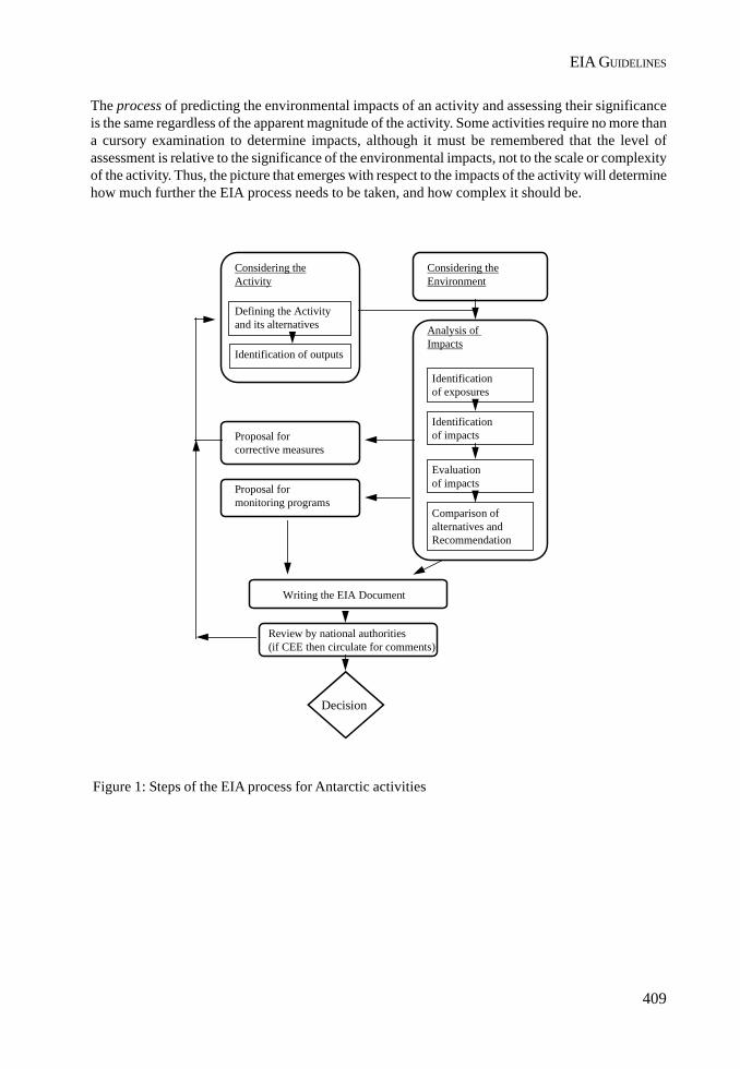
409
EIA GUIDELINES
Analysis of Impacts
Identification of exposures
Identificationof impacts
Evaluation of impacts
Comparison ofalternatives andRecommendation
Proposal forcorrective measures
Proposal formonitoring programs
Writing the EIA Document
Review by national authorities(if CEE then circulate for comments)
Decision
Considering theActivity
Defining the Activityand its alternatives
Identification of outputs
Considering theEnvironment
The process of predicting the environmental impacts of an activity and assessing their significanceis the same regardless of the apparent magnitude of the activity. Some activities require no more thana cursory examination to determine impacts, although it must be remembered that the level ofassessment is relative to the significance of the environmental impacts, not to the scale or complexityof the activity. Thus, the picture that emerges with respect to the impacts of the activity will determinehow much further the EIA process needs to be taken, and how complex it should be.
Figure 1: Steps of the EIA process for Antarctic activities

410
II. RESOLUTIONS
Those persons responsible for an Environmental Impact Assessment Process need to ensure thatthey consult as widely as is reasonably necessary and possible in order that the best availableinformation and professional advice contribute to the outcome. A number of different participantsmay be involved throughout this process, ranging from those who are involved in the details ofnearly all parts of the process (e.g. environmental officer, proponent of the activity) to those who arethe technical experts who provide input in particular subjects of the process (e.g. researchers, logisticpersonnel, others with experience at the location or in a particular activity). In addition, EIAs undertakenin Antarctica for planned activities may represent a valuable source of information. At this respect, itshould be pointed out that an updated list of EIAs is presented every ATCM, according to ResolutionXIX-6. The Antarctic Data Directory System (ADDS) can also represent an helpful source of metadata.
3.1. Considering the activity
3.1.1. Defining the activity
An activity is an event or process resulting from (or associated with) the presence of humans in theAntarctic, and/or which may lead to the presence of humans in Antarctica. An activity may consist ofseveral actions, e.g. an ice drilling activity may require actions such as the transport of equipment,establishment of a field camp, power generation for drilling, fuel management, drilling operation,waste management, etc. An activity should be analysed by considering all phases involved (e.g.construction, operation and potential dismantling or decommissioning phases).
The activity and the individual actions should be defined through a planning process which considersthe physical, technical and economic aspects of the proposed project and its alternatives. Consultationwith relevant experts to identify all these aspects is an important part of this initial scoping process.It is important to accurately define all aspects of the activity which could have environmental impacts.The rest of the EIA process relies on this initial description, which should occur during the planningprocess.
The following aspects of the proposed activity and its alternatives should be clearly identified:
• the purpose of and the need for the activity;
• the principal characteristics of the activity that might cause impact on the environment; forinstance: design characteristics; construction requirements (types of material, technologies,energy, size of any installation, personnel, temporary constructions, etc.); transportationrequirements (e.g. types, numbers and frequency of use of vehicles, fuel types); type(according to Annex III of the Protocol) and volume of wastes generated through differentphases of the activity and their final disposition; dismantling of temporary constructions;decommissioning the activity if necessary; as well as those aspects that will result from theoperational phase of the activity;
• the relationship of the proposed activity to relevant previous or current activities;
• a description of the activity’s location and geographical area, indicating access roads, etc.Using maps will ease the evaluation process and, therefore, will be useful in the EIAdocumentation;

411
EIA GUIDELINES
• timing of the activity (including range of calendar dates for construction time, as well asoverall duration, periods of operation of the activity and decommissioning. This may besignificant with respect to wildlife breeding cycles, for example.);
• location of the activity with regard to areas with special management requirements (SPA,SSSI, HSM, CCAMLR CEMP sites, already proposed ASPAs and/or ASMAs, etc.);
• precautionary measures that are integral to the project including during the construction,operational and decommissioning phases.
Careful consideration is required to determine the full scope of the activity so that the impacts can beproperly assessed. This is necessary to avoid preparing a number of separate EIAs on actions whichindicate an apparent low impact, when in fact, taken in its entirety, the activity actually has potentialfor impacts of much greater significance. This particularly common where a number of activities takeplace at the same site either spatially and/or temporally. Where activities are to be undertaken at siteswhich are visited repeatedly by one or more operators the cumulative effects of past, current andplanned activities should be taken into consideration.
In identifying spatial and temporal boundaries for the EIA proponents should identify other activitiesoccurring in the region within the EIA framework.
When defining an Antarctic activity, experience gained in similar projects undertaken within andoutside the Antarctic Treaty System Area (e.g. the Arctic) may be an additional and valuable sourceof information.
Once the activity is defined, any subsequent changes to the activity must be clearly identified andaddressed according to when they occur in the EIA process (e.g. if the change occurs once the EIAdocument is completed, then an amendment to the EIA or a rewrite of the document may be necessarydepending on how significant the change is). In every case it is important that the change and itsimplications (in terms of impacts) is assessed in the same manner as other impacts previously identifiedin the EIA process.
3.1.2. Alternatives to the activity
Both the proposed activity and possible alternatives should be examined in concert so that a decisionmaker can more easily compare the potential impacts. Both the environmental and scientificconsequences should be considered during the evaluation.
Examples of alternatives for consideration include:
• use of different locations or sites for the activity;
• use of different technologies, in order to reduce the outputs (or the intensity of the outputs)of the activity;
• use of pre-existing facilities; and
• different timing for the activity.

412
II. RESOLUTIONS
The alternative of not proceeding with the proposed activity (i.e. the “no-action” alternative) shouldalways be included in any analysis of environmental impacts of the proposed activity.
3.1.3. Identification of outputs of the activity
An output is a physical change (e.g. movement of sediments by vehicle passage, noise) or an entity(e.g. emissions, an introduced species) imposed on or released to the environment as the result of anaction or an activity. Outputs can also be defined as by-products of the activity (or action) and caninclude emissions, dust, mechanical action on substrate, fuel spills, noise, light, electromagneticradiation, wastes, heat, introductions of alien species, etc.
Note that a single action may generate several different outputs (for example the use of vehicles maycause soil compaction, emissions, noise, visual interference etc.) and that the same type of outputmay be generated by different actions of a single activity, (for example in an ice drilling activityemissions may come from the use of vehicles, drilling operations, power generation, etc.).
When planning an activity the outputs of the proposed activity should be considered together withthe outputs arising from past, present, and future activities. Therefore, potential for additive, synergisticor antagonistic interactions between outputs (thus resulting in possible significant environmentalimpacts) has to be considered.
It is also important to identify and consider outputs resulting from the activitie of ractions of otherproponents that can contribute to cumulative effects.
Systematising outputs and actions in a matrix format may be helpful in this process. The examplebelow, taken from “Monitoring of Environmental Impacts from Science and Operations inAntarctica”(SCAR/COMNAP, 1996), illustrates a potential situation (e.g. actions and outputsassociated with a station complex).
Outputs may vary across different alternatives. That is there may not be a single set of outputs, butrather multiple sets if the alternatives are significantly different from one another.
The geographical spread of an output has to be accurately estimated in order to determine to whatextent the environment is exposed.
OUTPUTS
ACTIONS Air emissions(incl. Dust)
Wastes Noise Fuel spills Mechanicalaction
Heat
Vehicles X - X X X XPowergeneration
X - X X - X
Building X X X X X -Fuel storage - - - X - -

413
EIA GUIDELINES
3.2. Considering the environment
Consideration of the environment requires the characterisation of all relevant physical, biological,chemical and anthropic elements or values in a given area, where and when an activity is proposed.Relevant means all those aspects of the environment that the proposed activity might influence orwhich might influence the activity.
Such information should be quantitative (e.g., heavy metal concentration on organisms or onriver flows, a bird population size) where available and appropriate. In many cases qualitativedescriptions (e.g., aesthetic value of a landscape) may have to be used. Maps, publications,research results and researchers are different sources of information to be identified and takeninto account.
Consideration of the existing environment should include:
• recognition of the special status accorded to Antarctica by the ATS, including its status asa natural reserve devoted to peace and science;
• the physical and biological features that could be affected directly or indirectly, including:
- the physical characteristics (topography, bathymetry, geology, geomorphology, soils,hydrology, meteorology, glaciology etc.);
- the biota (e.g. inventories of plant and animal species, populations and communities, andother important features such as the presence of breeding grounds.); and
- any dependent and related populations (e.g. bird nesting areas related to feeding areas);
• natural variations in environmental conditions that could occur on a diurnal, seasonal,annual and/or interannual timescale;
• information about the spatial and temporal variability of the environmental sensitivity (e.g.differences in impacts when an area is snow covered compared to when it is not);
• current trends in natural processes such as population growth or spread of particular species,geological or hydrological phenomena;
• the reliability of the data (e.g. anecdotal, historical, scientific, etc.);
• aspects of the environment which have been changed, or may be changing as the result ofother current or previous activities;
• recognition of management action taken/required to address or minimise the cumulativeimpacts of past and present activities;
• special values of the area (if previously identified);
• the existence of areas potentially subject to indirect and cumulative impacts;
• the influence that the activity may exert on dependent and associated ecosystems;
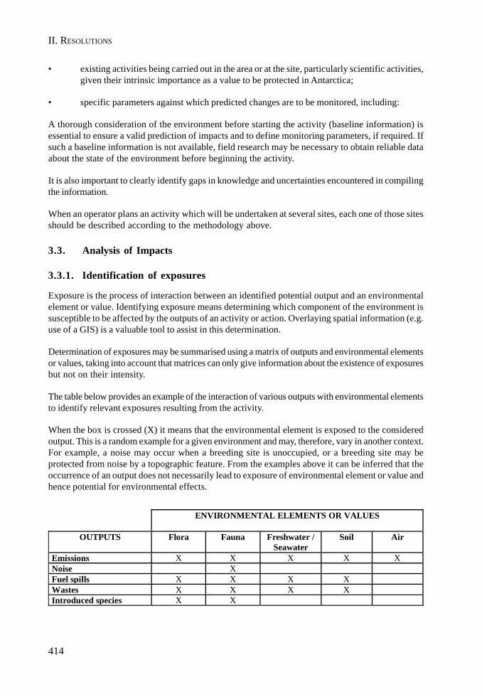
414
II. RESOLUTIONS
• existing activities being carried out in the area or at the site, particularly scientific activities,given their intrinsic importance as a value to be protected in Antarctica;
• specific parameters against which predicted changes are to be monitored, including:
A thorough consideration of the environment before starting the activity (baseline information) isessential to ensure a valid prediction of impacts and to define monitoring parameters, if required. Ifsuch a baseline information is not available, field research may be necessary to obtain reliable dataabout the state of the environment before beginning the activity.
It is also important to clearly identify gaps in knowledge and uncertainties encountered in compilingthe information.
When an operator plans an activity which will be undertaken at several sites, each one of those sitesshould be described according to the methodology above.
3.3. Analysis of Impacts
3.3.1. Identification of exposures
Exposure is the process of interaction between an identified potential output and an environmentalelement or value. Identifying exposure means determining which component of the environment issusceptible to be affected by the outputs of an activity or action. Overlaying spatial information (e.g.use of a GIS) is a valuable tool to assist in this determination.
Determination of exposures may be summarised using a matrix of outputs and environmental elementsor values, taking into account that matrices can only give information about the existence of exposuresbut not on their intensity.
The table below provides an example of the interaction of various outputs with environmental elementsto identify relevant exposures resulting from the activity.
When the box is crossed (X) it means that the environmental element is exposed to the consideredoutput. This is a random example for a given environment and may, therefore, vary in another context.For example, a noise may occur when a breeding site is unoccupied, or a breeding site may beprotected from noise by a topographic feature. From the examples above it can be inferred that theoccurrence of an output does not necessarily lead to exposure of environmental element or value andhence potential for environmental effects.
ENVIRONMENTAL ELEMENTS OR VALUES
OUTPUTS Flora Fauna Freshwater /Seawater
Soil Air
Emissions X X X X XNoise XFuel spills X X X XWastes X X X XIntroduced species X X

415
EIA GUIDELINES
Correct identification of the intensity of exposure is a crucial step in making a reliable prediction ofimpacts. Some elements contributing to that identification are:
• Temporal variation. The exposure of an environmental element or value may change with theseason in which the activity takes place, as climate cycles, breeding patterns, etc. maychange over time.
• Cause-effect relationships between outputs and environmental elements or values must bedetermined, especially in cases where the relationships are indirect, or an element or value isexposed to outputs from numerous sources, or repeatedly from the same source.
3.3.2. Impact identification
An impact (synonym: effect) is a change in the values or resources attributable to a human activity.It is the consequence (e.g. reduced plant cover) of an agent of change, not the agent itself (e.g.increase of trampling). Impact may also be defined as the result of the interaction between an outputand an environmental value or resource.
The identification of environmental impacts consists of the characterisation of all changes inenvironmental elements or values exposed to the outputs of a given set of activities. The identificationtask requires that evaluators are able to determine the important cause-effect relationships betweenthe activities and the environmental elements or values. Only when the impact is identified can anevaluation be made of its significance.
An impact may be identified by its nature, spatial extent, intensity, duration, reversibility and lag time.
Nature: type of change imposed on the environment due to the activity (e.g. contamination, erosion,mortality).
Spatial extent: area or volume where changes are likely to be detectable.
Intensity: a measure of the amount of change imposed on the environment due to the activity (it canbe measured, or estimated, through, e.g. number of species or individuals effected, concentration ofa given pollutant in a waterbody, rates of erosion, rates of mortality, etc.).
Duration: period of time during which changes in the environment are likely to occur.
Reversibility: possibility of the system to return to its initial environmental conditions once animpact is produced.
Lag time: time span between the moment outputs are released to or imposed on the environmentand the moment impacts occur.
In addition, a proper impact identification should also enable a distinction between direct, indirectand cumulative impacts.
A direct impact is a change in environmental components that results from direct cause-effectconsequences of interaction between the exposed environment and outputs (e.g. decrease of alimpet population due to an oil spill). An indirect impact is a change in environmental componentsthat results from interactions between the environment and other impacts – direct or indirect – (e.g.
416
II. RESOLUTIONS
alteration in seagull population due to a decrease in limpet population which, in turn, was caused byan oil spill).
A cumulative impact is the combined impact of past, present, and reasonably foreseeable activities.These activities may occur over time and space and can be additive or interactive/synergistic (e.g.decrease of limpet population due to the combined effect of oil discharges by base and shipoperations). Cumulative impacts can often be one of the hardest impact categories to adequatelyidentify in the EIA process. When attempting to identify cumulative impacts it is important to considerboth spatial and temporal aspects and to identify other activities which have and could occur at thesame site or within the same area.
Several methods exist to identify impacts such as: overlay maps, checklists, matrices, etc. The choiceof the methodology will depend on the character of the activity and the environment that is likely tobe affected. Recognition should be given to relevant scientific data, where this exists, and to theresults of monitoring programs.
3.3.3. Impact Evaluation
The purpose of impact evaluation is to assign relative significance to predicted impacts associatedwith an activity (and the various identified alternatives).
Significance: It is a value judgement about the severity and importance of a change in a givenenvironment or environmental value.
According to the Madrid Protocol, impacts shall be evaluated by taking into account three levels ofsignificance:
• less than minor or transitory impact;
• minor or transitory impact; or
• more than minor or transitory impact.
The interpretation of these terms should be made on a case by case site specific basis. However itmay be useful to consider how similar impacts have been judged in earlier EIAs at similar sites and/or for similar types of activities.
An inherent consideration to judging significance is that it may have a rather subjective componentand this fact should be acknowledged. Where an impact has the possibility of being significant,several experts should be consulted to achieve a view as objective as possible.. This is particularlyimportant either if there is a reliance on incomplete data or if there are gaps in the knowledge.
Judging significance should not be based solely on direct impacts, but must also take account ofpossible indirect and cumulative impacts. This evaluation should determine the magnitude andsignificance of cumulative effects.
The significance of the unavoidable impacts (those impacts for which no further mitigation is possible)represents an important consideration for the decision maker in deciding whether, on balance, anactivity is justified.
417
EIA GUIDELINES
Some problems can arise when evaluating impacts, due to misunderstanding or overlooking someaspects of the process of evaluating impacts. These can include for example:
• confusing duration of the impact with duration of the activity;
• confusing outputs of activities with impacts;
• limiting the analysis to direct impacts, without consideration of indirect and cumulativeimpacts.
3.4. Comparison of impacts
When the project has been assessed with respect to environmental impacts it is necessary to summariseand aggregate the significant impacts for the various alternatives in a form suitable for communicationto the decision makers. From such an aggregation of information a comparison among alternativescan be easily made.
3.5. Proposal for corrective measures
Corrective measures are composed of all steps conducted to decrease, avoid, or eliminate any of thecomponents of an impact. It can be considered a process of feedback, and should occur throughoutthe EIA process, not simply as a final step. Corrective measures include mitigation and remediationactions.
Mitigation is the use of practice, procedure or technology to minimise or to prevent impacts associatedwith proposed activities. The modification of any aspect of the activity (and hence the considerationof outputs and the environmental exposure) as well as the establishment of supervision proceduresrepresent effective ways of mitigation.
Mitigation measures will vary according to the activity and the characteristics of the environment ,and may include:
• developing on site control procedures (e.g. recommended methods for waste disposal);
• establishing the best time for the activity (e.g. to avoid the breeding season of penguins);
• providing environmental education and training to personnel, or contractors, involved inthe activity;
• ensuring adequate on site supervision of the activity by senior project staff or environmentalspecialists.
Remediation consists of the steps taken after impacts have occurred to promote, as much as possible,the return of the environment to its original condition.
The final version of the activity to be assessed must incorporate all corrective measures, includingthose associated with mitigation and remediation actions. Impact avoidance, as a form of mitigation,may contribute to minimising monitoring, reducing remediation costs and generally contribute alsoto maintaining the existing state of the environment.
418
II. RESOLUTIONS
When considering mitigation and remediation measures, the following issues should be addressed:
• making a clear distinction between mitigation and remediation measures;
• clearly defining the state of the environment that is being aimed for through such measures;
• considering that new, unforeseen impacts may appear as a result of inadequate implementationof proposed mitigation measures;
• noting that the environment may not always be capable of returning to its original condition,even when remediation actions are implemented;
• considering that a given corrective measure may interact antagonistically or synergicallywith other corrective measures.
3.6. Proposal for Monitoring Programs
Monitoring consists of standardised measurements or observations of key parameters (outputs andenvironmental variables) over time, their statistical evaluation and reporting on the state of theenvironment in order to define quality and trends. For the EIA process, monitoring should be orientedtowards confirming the accuracy of predictions about environmental impacts of the activity, and todetect unforeseen impacts or impacts more significant than expected. Given this, it may be useful toset environmental thresholds or standards for an activity that monitoring results are assessed against.If these thresholds are exceeded, then a review or re-analysis would be required of assumptions maderegarding the environmental impacts or of management systems related to the activity.
Monitoring may also include any other procedures that can be used to assess and verify the predictedimpacts of the activity. Where measurement of specific parameters is not necessary or appropriate,assessment and verification procedures could include maintaining a log of the activity that actuallyoccurred, and of changes in the nature of the activity where they were significantly different fromthose described in the EIA. This information can be useful for further minimising or mitigatingimpacts, and, where appropriate, for modifying, suspending or even cancelling all or part of theactivity.
Monitoring is not about the measurement of everything in a haphazard approach to detect changebut about precise measurement of a few target species, processes, or other indicators, carefullyselected on the basis of scientifically sound predetermined criteria. Where a number of proponentsare conducting activities at the same sites they should give consideration to establishing jointregional monitoring programs.
The process of selecting key indicators should be accomplished during the activity’s planning stage,once outputs have been identified, the environment has been considered and associated impactshave been assessed, while monitoring environmental parameters generally should start before thecommencement of the activity if adequate baseline information is not available.
Planning or undertaking monitoring activities may be hindered by a number of situations:
• leaving the planning of monitoring programs until the activity is in progress;
• monitoring activities can be costly, especially for multi-year projects and activities;
419
EIA GUIDELINES
• some assumptions about the environmental impacts of an activity cannot be tested;
• failure to follow through with monitoring;
• failure to distinguish between natural and human-induced variability in environmentalparameters.
4. Writing the EIA Document
The outcome of an EIA is a formal document, which presents all the relevant information about theEIA process. The EIA document represents a fundamental link between the EIA process and decisionmakers seeing that conclusions stemming from the EIA process will assist decision makers to considerthe environmental aspects of the proposed activity.
Four bodies of information arise from an EIA process: methodology, data, results and conclusionsderived from them. Since results and conclusions are of particular interest for decision makers, thesechapters should be written in an accessible language, avoiding very technical terms. The use ofgraphical information, such as maps, tables and graphs, is an effective way of improvingcommunication.
The size and level of detail in the document will depend on the significance of the environmentalimpacts that have been identified throughout the EIA process. Thus, Annex I to the Protocol establishestwo formats to document it: Initial Environmental Evaluation (IEE) and Comprehensive EnvironmentalEvaluation (CEE), for which the Protocol requires the presentation of different volumes of information(Annex I, Articles 2 and 3).
Unless it has been determined that an activity will have less than a minor or transitory impact or it hasalready been determined that a Comprehensive Environmental Evaluation is needed, an InitialEnvironmental Evaluation (IEE) shall be prepared. If the EIA process indicates that a proposedactivity is likely to have more than a minor or transitory impact a Comprehensive EnvironmentalEvaluation must be prepared.
According to Annex I requirements a draft CEE shall be prepared first, which shall be circulated to allParties as well as to CEP for comments. Once comments and suggestions have been incorporated, afinal CEE is circulated to all Parties.
The following table summarises the steps to be considered throughout the EIA process (which areexplained in Section 3 of the present guidelines). It also lists the requirements stemming from AnnexI that should be included in an EIA document. In the case of IEE, some of the marked items are notspecifically mentioned in Annex I, Article 2. However, their inclusion in the IEE document is oftenuseful to communicate the results of the process in a transparent manner. These items weredistinguished in the table with an X.
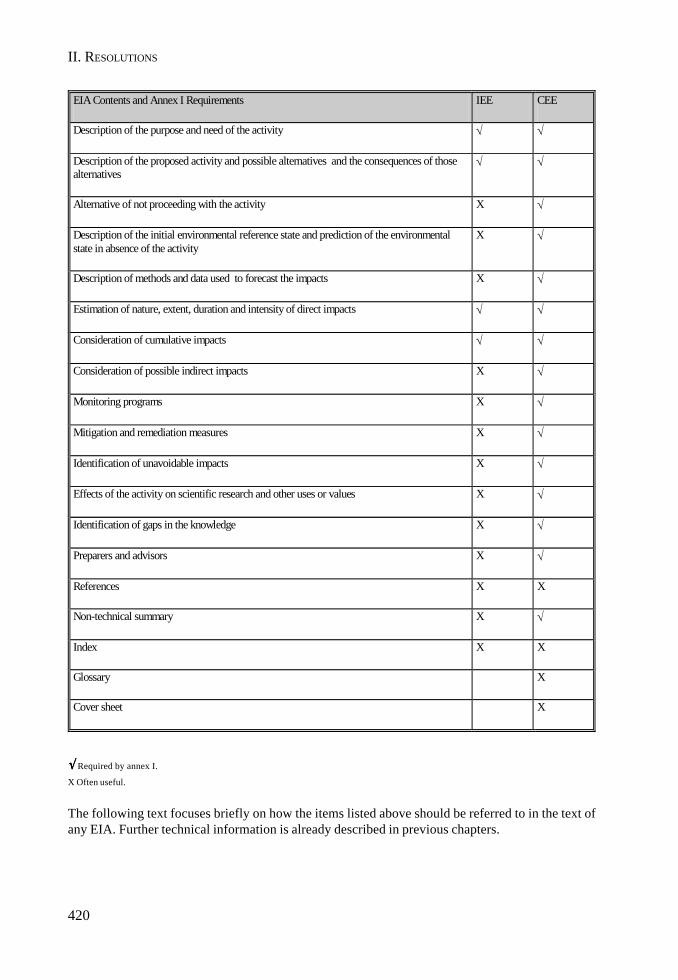
420
II. RESOLUTIONS
√√√√√ Required by annex I.
X Often useful.
The following text focuses briefly on how the items listed above should be referred to in the text ofany EIA. Further technical information is already described in previous chapters.
EIA Contents and Annex I Requirements IEE CEE
Description of the purpose and need of the activity √ √
Description of the proposed activity and possible alternatives and the consequences of those alternatives
√ √
Alternative of not proceeding with the activity X √
Description of the initial environmental reference state and prediction of the environmental state in absence of the activity
X √
Description of methods and data used to forecast the impacts X √
Estimation of nature, extent, duration and intensity of direct impacts √ √
Consideration of cumulative impacts √ √
Consideration of possible indirect impacts X √
Monitoring programs X √
Mitigation and remediation measures X √
Identification of unavoidable impacts X √
Effects of the activity on scientific research and other uses or values X √
Identification of gaps in the knowledge X √
Preparers and advisors X √
References X X
Non-technical summary X √
Index X X
Glossary X
Cover sheet X
421
EIA GUIDELINES
Description of the Purpose and Need for the Proposed Activity
This section should include a brief description of the proposed activity and an explanation of theintent of the activity. It should include sufficient detail to make it clear why the activity is beingproposed including the need for the activity to proceed. It should also provide details on the processby which the scope of the activity was defined. This will help ensure that the full scope of the activityhas been included so that impacts can be properly assessed. If a formal process was used to accomplishthis (a formal meeting or solicitation of input from the public or other groups), that process and itsresults should be discussed here.
Description of the proposed activity and possible alternatives and the consequences of thosealternatives
This section should include a detailed description of the proposed activity as well as reasonablealternatives. The first alternative to be described would be the proposed activity. The descriptionshould be as comprehensive and detailed as possible (see section 3.1).
It may be useful to provide a comparison of alternatives in this section. For instance, for a newresearch station, alternatives might include differences in the size of the station and the number ofpersons that could be accommodated. These differences would mean different quantities of materialsrequired, fuels consumed and emissions or wastes generated. Tables showing appropriate comparisonscan be very helpful to the reader of the document.
Alternative of not proceeding with the activity
The alternative of not proceeding with the proposed activity (i.e. the “no-action” alternative) shouldbe described to highlight the pros and cons of not conducting the activity. Although the Protocolonly requires its inclusion in CEEs, it is useful to also include the “no-action” alternative in the textof IEEs in order to better justify the need for proceeding with the activity.
Description of the initial environmental reference state and prediction of the environmental statein absence of the activity
Such a description should not be limited to a characterisation of the relevant physical, biological,chemical and anthropic elements of the environment, but should also take into account the existenceand behaviour of dynamic trends and processes in order to predict the state of the environment inabsence of the activity. A proper description of the initial environmental reference state provideselements against which changes are to be compared.
Description of methods and data used to forecast the impacts
The purpose of this section is to explain and, if necessary, defend the design of the assessment andthen provide enough detail that a further evaluator can understand and reproduce the procedure.Careful writing of the methodology is critically important because it determines that results can bereproducible and/or comparable.
Estimation of nature, extent, duration and intensity of impacts (including consideration of possibleindirect and cumulative impacts).
This section contains the results of analyses of impacts, which includes a clear description ofidentified exposures as well as the identification of impact aspects, in terms of their nature, spatial
422
II. RESOLUTIONS
extent, intensity, duration, reversibility and lag time. It must clearly establish the significance assignedto each impact and the justification for such assignment. In addition, and to summarise this section,the inclusion of a table showing the environmental impacts on each environmental component canbe very helpful.
Special attention must be paid to the consideration of possible indirect and cumulative impacts,since cause-effect relationship determining the existence of such impacts usually exhibit a higherdegree of complexity.
Monitoring programs
When necessary, this section should clearly define monitoring objectives, set testable hypotheses,choose key parameters to be monitored, assess data collection methods, design statistical samplingprogram, and decide on frequency and timing of data collection/recording. Implementation of suchmonitoring programs is a further step that may begin after the planning of the activity has beencompleted, even though the activity has not actually been initiated.
Mitigation and remediation measures
Since mitigation and remediation measures usually aim to correct some aspects of the activity,communication of these measures must be concrete, pointing out the proposed actions and theirtiming, as well as the benefits associated to each individual measure. It is often useful to include thissection in the text of IEEs.
Identification of unavoidable impacts
Recognition of the existence of unavoidable impacts should be included within any impact analysis.Consideration of such impacts is of great importance given that the occurrence of unavoidableimpacts may affect the decision on whether to proceed with the proposed activity.
Effects of the activity on scientific research and other uses or values
Taking into account that the Protocol designates Antarctica as an area devoted to peace and science,the effects of the proposed activity on ongoing scientific research, or on the potential of a site tofuture scientific research, must be a fundamental consideration when the impact analysis is carriedout.
Identification of gaps in the knowledge
Existing bodies of knowledge (i.e. empirical, theoretical, or anecdotal data and information) are usedto support the assessment process. Nonetheless, these bodies of knowledge may be incomplete ormay be surrounded by varying degrees of uncertainty. It is critical to identify explicitly in the assessmentwhere such incompleteness or uncertainty exists; and how this has been factored into the assessmentprocess. This disclosure can be useful in assessment by clearly identifying where more knowledge isneeded.
Preparers and Advisors
This section provides a list of those experts who were consulted in preparing the assessment, theirareas of expertise, and appropriate contact information. It should also list the persons who wereresponsible for the actual preparation of the document. This information is useful to reviewers and

423
EIA GUIDELINES
decision makers to ensure that the appropriate expertise was brought to bear on the analyses neededto assess the type and degree of impact from the proposed activity. It is also useful information forfuture assessments on similar activities or issues.
References
This section should list any references used in preparing the evaluation. They may include researchor other scientific papers used in the analysis of impacts or monitoring data used to establishbaseline conditions in the area where the activity is proposed. They may also include otherenvironmental assessments of similar activities at other or similar locations.
Index
As an EIA document may be fairly large , an index is a very helpful aid to the reader.
Glossary
This section provides a list of terms and definitions as well as abbreviations that are helpful to thereader, especially if the terms are not commonly understood.
Cover Sheet
The CEE should contain a title page or cover sheet that lists the name and address of the person ororganization who prepared the CEE and the address to which comments should be sent (for the draftdocument only).
Non-Technical Summary
The CEE must contain a non-technical summary of the contents of the document. This summaryshould be written in an accessible language and include pertinent information on the purpose andneed for the proposed activity, the issues and alternatives considered, the existing environment, andthe impacts associated with each alternative. A non-technical summary might also be useful for anIEE.
Finally, in either case (IEE or CEE) a number of considerations about writing the EIA documentshould be taken into account, such as:
• avoidance of including irrelevant descriptive information;
• documenting all relevant steps of the process;
• clearly describing the impact identification methodology;
• clearly distinguishing between results (identification of impacts, mitigation measures, etc.)and final value judgement of significance;
• properly connecting results and conclusions.
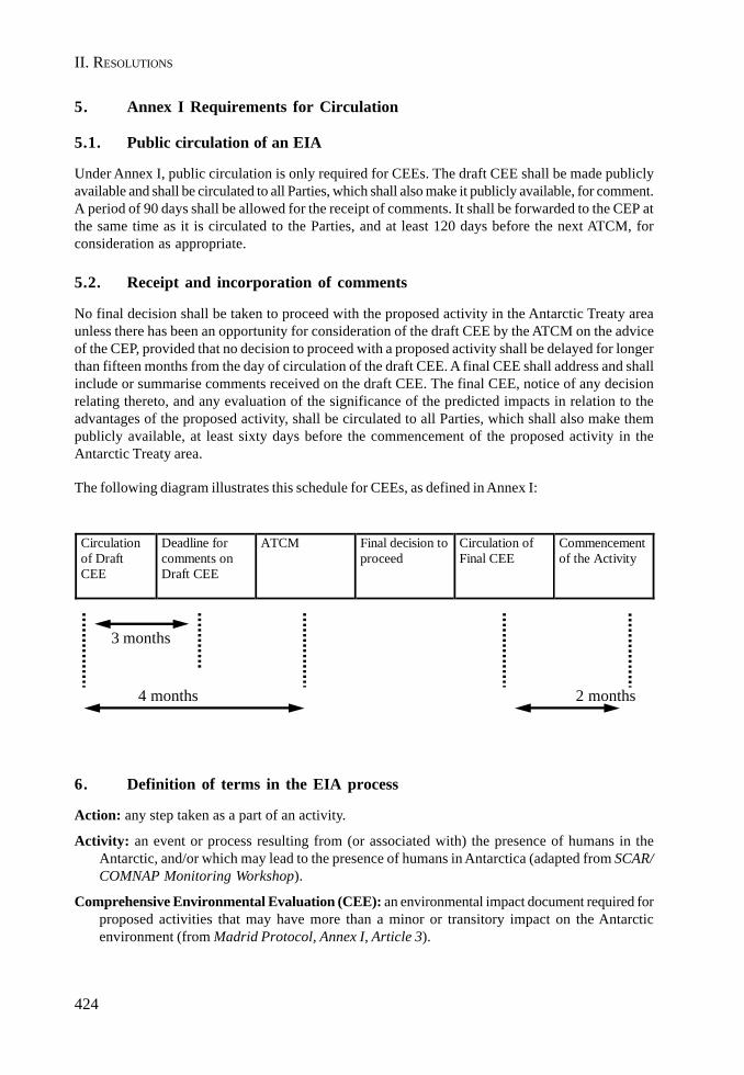
424
II. RESOLUTIONS
5. Annex I Requirements for Circulation
5.1. Public circulation of an EIA
Under Annex I, public circulation is only required for CEEs. The draft CEE shall be made publiclyavailable and shall be circulated to all Parties, which shall also make it publicly available, for comment.A period of 90 days shall be allowed for the receipt of comments. It shall be forwarded to the CEP atthe same time as it is circulated to the Parties, and at least 120 days before the next ATCM, forconsideration as appropriate.
5.2. Receipt and incorporation of comments
No final decision shall be taken to proceed with the proposed activity in the Antarctic Treaty areaunless there has been an opportunity for consideration of the draft CEE by the ATCM on the adviceof the CEP, provided that no decision to proceed with a proposed activity shall be delayed for longerthan fifteen months from the day of circulation of the draft CEE. A final CEE shall address and shallinclude or summarise comments received on the draft CEE. The final CEE, notice of any decisionrelating thereto, and any evaluation of the significance of the predicted impacts in relation to theadvantages of the proposed activity, shall be circulated to all Parties, which shall also make thempublicly available, at least sixty days before the commencement of the proposed activity in theAntarctic Treaty area.
The following diagram illustrates this schedule for CEEs, as defined in Annex I:
3 months
4 months 2 months
Circulation of Draft CEE
Deadline for comments on Draft CEE
ATCM Final decision to proceed
Circulation of Final CEE
Commencement of the Activity
6. Definition of terms in the EIA process
Action: any step taken as a part of an activity.
Activity: an event or process resulting from (or associated with) the presence of humans in theAntarctic, and/or which may lead to the presence of humans in Antarctica (adapted from SCAR/COMNAP Monitoring Workshop).
Comprehensive Environmental Evaluation (CEE): an environmental impact document required forproposed activities that may have more than a minor or transitory impact on the Antarcticenvironment (from Madrid Protocol, Annex I, Article 3).

425
EIA GUIDELINES
Cumulative Impact: the combined impact of past, present, and reasonably foreseeable activities.These activities may occur over time and space and can be additive or interactive/synergistic(adapted from IUCN Cumulative Impacts Workshop). These activities may involve visits bymultiple operators or repeated visits to the same site by the same operator.
Direct Impact: a change in environmental components that results from direct cause-effectconsequences of interaction between the exposed environment and outputs (from Guidelinesfor EIA in the Arctic).
Environmental Impact Assessment (EIA): a process for identifying, predicting, evaluating andmitigating the biophysical, social and other relevant effects of proposed projects and physicalactivities prior to major decisions and commitments being made (from Guidelines EIA in theArctic).
Exposure: the process of interaction between an identified potential output and an environmentalelement or value (adapted from SCAR/COMNAP Monitoring Workshop).
Impact: a change in the values or resources attributable to a human activity. It is the consequence(e.g. reduced plant cover) of an agent of change, not the agent itself (e.g. increase of trampling).Synonym: effect (from SCAR/COMNAP Monitoring Workshop).
Indirect Impact: a change in environmental components that results from interactions between theenvironment and other impacts (direct or indirect). (From Guidelines for EIA in the Arctic.)
Initial Environmental Evaluation (IEE): an environmental impact document required for proposedactivities that may have a minor or transitory impact on the Antarctic environment (from MadridProtocol, Annex I, Article 2).
Mitigation: the use of practice, procedure or technology to minimise or to prevent impacts associatedwith proposed activities. (COMNAP Practical Guidelines.)
Monitoring: consists of standardised measurements or observations of key parameters (outputsand environmental variables) over time, their statistical evaluation and reporting on the state ofthe environment in order to define quality and trends (adapted from SCAR/COMNAP MonitoringWorkshop).
Operator: individuals or organisations undertaking activities from which impacts arise.
Output: a physical change (e.g. movement of sediments by vehicle passage, noise) or an entity (e.g.emissions, an introduced species) imposed on or released to the environment as the result of anaction or an activity. (SCAR/COMNAP Monitoring Workshop.)
Preliminary Stage (PS): a process that considers the level of environmental impacts of proposedactivities -before their commencement- referred to in Article 8 of the Protocol, in accordance withappropriate national procedures (from Madrid Protocol, Annex I, Article 1).
Proponent: an individual or a national program advocating the activity and responsible for thepreparation of the EIA document.
Remediation: consists of the steps taken after impacts have occurred to promote, as much as possible,the return of the environment to its original condition.
Unavoidable Impact: an impact for which no further mitigation is possible.

426
II. RESOLUTIONS
7. References
ARCTIC ENVIRONMENTAL PROTECTION STRATEGY. 1997. Guidelines for Environmental ImpactsAssessment (EIA) in the Arctic. Sustainable Development and Utilisation. Finnish Ministry ofthe Environment, Finland, 50 pp.
ATCPs. 1991. Protocol on Environmental Protection to the Antarctic Treaty (plus annexes). 11th
Antarctic Treaty Special Consultative Meeting. Madrid, 22-30 April, 17-23 June 1991.
COMNAP. 1992. The Antarctic Environmental Assessment Process, Practical Guidelines. Bologna(Italy) June 20, 1991, revised Washington D.C. (USA), March 4, 1992.
FOREIGN AND COMMONWEALTH OFFICE. 1995. Guide to Environmental Impact Assessment ofActivities in Antarctica. Polar Regions Section, South Atlantic and Antarctic Department, London.
IUCN - The World Conservation Union. 1996. Cumulative Environmental Impacts in Antarctica.Minimisation and Management. Edited by M. de Poorter and J.C. Dalziell. Washington, D.C.,USA. 145 pp.
MINISTRY OF FOREIGN AFFAIRS AND TRADE. 1997. Guidelines and Procedures for Visitors to theRoss Sea Region. Ministry of Foreign Affairs and Trade. New Zealand.
SCAR/COMNAP. 1996. Monitoring of Environmental Impacts from Science and Operations inAntarctica. Workshop report. 43 pp and Annexes, 1996 Workshops.
XX ATCM/IP 2, Developing and Understanding of Minor or Transitory, submitted by New Zealand.
XXI ATCM/IP 55, Elementos para la Interpretación de los Procedimientos de Evaluación de ImpactoAmbiental contenidos en el Anexo I del Protocolo de Madrid, submitted by Argentina.
XXI ATCM/WP 35, Further understanding of the term Minor or Transitory, submitted by New Zealand.
XXII ATCM/IP 66, Application of the “minor or transitory impacts” criterion of EIA in differentregions of Antarctica, submitted by Russian Federation.
XXII ATCM/WP 19, Environmental Impact Assessment. The role of EIA Guidelines in understanding“Minor or Transitory”, submitted by Australia.
8. Acronyms
ADDB: Antarctic Digital DatabaseASMA: Antarctic Specially Managed AreaASPA: Antarctic Specially Protected AreaATCM: Antarctic Treaty Consultative MeetingATCP: Antarctic Treaty Consultative PartyATS: Antarctic Treaty SystemCCAMLR: Commission for the Conservation of Antarctic Marine Living ResourcesCEE: Comprehensive Environmental EvaluationCEMP: CCAMLR Ecosystem Monitoring ProgramCEP: Committee of Environmental ProtectionCOMNAP: Council of Managers of National Antarctic ProgrammesEIA: Environmental Impact Assessment
427
EIA GUIDELINES
GIS: Geographical Information SystemGOSEAC: SCAR Group of Specialists on Environmental Affairs and ConservationHSM: Historic Sites and MonumentsIEE: Initial Environmental EvaluationIUCN: International Union for the Conservation of Nature (World Conservation Union)SCAR: Scientific Committee of Antarctic ResearchSPA: Specially Protected AreaSSSI: Site of Special Scientific Interest

II. RESOLUTIONS
429
Resolution 5 (2005)
Resolution on Site Guidelines for Visitors
The Representatives,
Recognising the continuing trend in the increase of tourism activities in Antarctica;
Noting that certain specific sites provide the principal focus for visitors;
Noting further that such sites are, to varying degrees, visited frequently by tour operatorsthereby increasing the potential for visitor-related pressures at such sites;
Confirming that the term “visitors” does not include scientists conducting research withinsuch sites, or individuals engaged in official governmental activities;
Desiring to ensure that the management of visitors within such sites is tailored to theirenvironmental values and sensitivities, and should be achieved through non-mandatory means;
Recognising the need for tour operators and visitors to have practical guidance on howthey should conduct their activities within such sites;
Believing that such guidance will enhance the provisions set out in Recommendation XVIII–1 (Guidance for those Organising and Conducting Tourism and Non-Governmental Activitiesin the Antarctic);
Believing further that the management of visitor sites must be able to respond readily tochanging circumstances such as increased tourist pressure, or demonstrable environmentalimpact;
Recommend that:
1) a list of sites subject to “Site Guidelines”, adopted by the ATCM, be attached to thisResolution as an Appendix;
2) the Antarctic Treaty Secretariat be requested to place the texts of such “SiteGuidelines”, as adopted by the ATCM, on the website of the Secretariat, as well aspublishing, as appropriate, the Guidelines in a hard copy compendium and CD-ROM.Furthermore, the Secretariat is requested to ensure wide dissemination, especiallyamong tour operators, of such Site Guidelines;

430
II. RESOLUTIONS
3) administrative procedures be introduced to ensure that the texts of Site Guidelinescan be modified readily to reflect readily changing environmental circumstances;
4) any proposed amendment to existing Site Guidelines should be discussed by theCEP which should advise the ATCM accordingly. If such advice is endorsed by theATCM then the Antarctic Treaty Secretariat would be mandated to make thenecessary changes to the texts of Site Guidelines on the website and, as appropriate,in any other forms in which the Guidelines have been published;
5) the Governments urge all those intending to visit such sites that they are fullyconversant with, and adhere to, the advice in the relevant Site Guidelines as publishedby the Secretariat.
Annex to Resolution 5 (2005)
List of current Site Guidelines:
1. Penguin Island (Lat. 62º 06’S; Long. 57º 54’W);2. Aitcho Islands (Lat. 62º 24’S; Long. 59º 47’W);3. Cuverville Island (Lat. 64º 41’S; Long. 62º 38’W); and4. Jougla Point, Wiencke Island (Lat. 64º 49’S; Long. 63º 30’W).
431
EIA GUIDELINES
Resolution 6 (2005)
Antarctic Post Visit Site Report Form
The Representatives,
Recalling Resolution 3 (1995), which agreed there would be an advantage in standardisedreporting of information on tourism and non-governmental activity in Antarctica;
Noting that Attachment A to Recommendation XVIII-1 outlines the requirements for advancenotice of tourism and non-governmental activities, and that Resolution 3 (1995) outlinesrequirements for Post Activity Reports;
Recalling Resolution 3 (1997), which sets out a standard form for Advance Notificationand Post Visit Reporting on Tourism and Non-Governmental reporting;
Noting the convenience of obtaining consistent information that will facilitate analysis of thescope, frequency and intensity of tourism and non-governmental activities;
Recommend that the attached revised standard Post Visit Site Report Form for Tourismand Non-Governmental Activities in Antarctica be used.

432
II. RESOLUTIONS
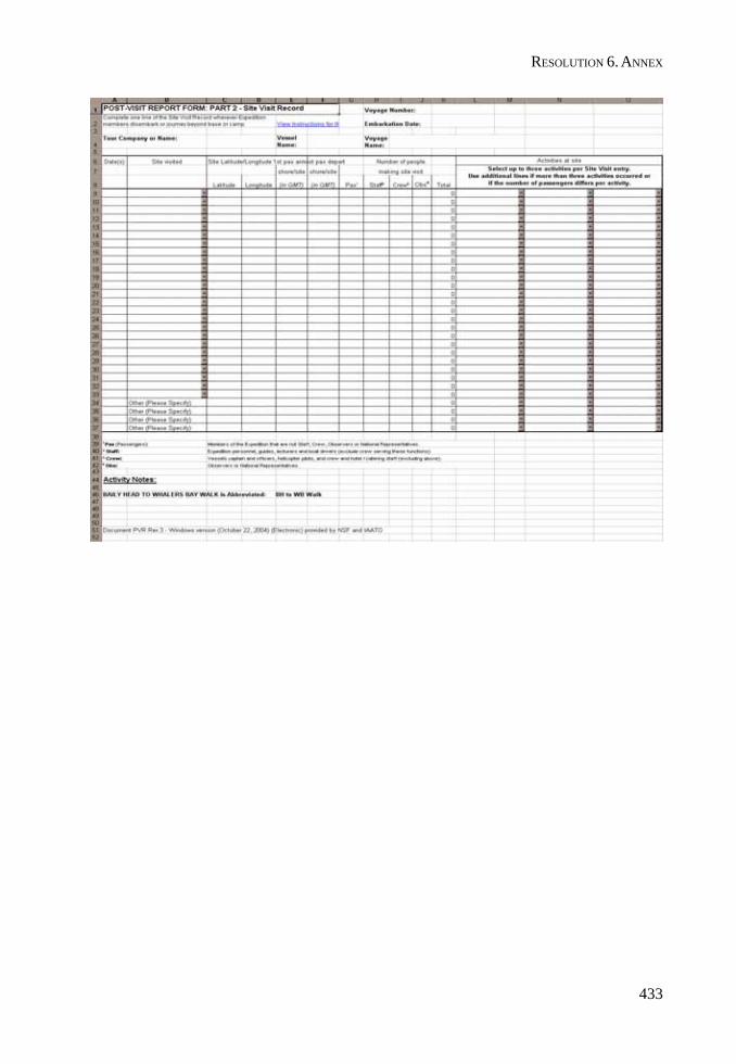
433
RESOLUTION 6. ANNEX

II. RESOLUTIONS
435
Resolution 7 (2005)
Biological Prospecting in Antarctica
The Representatives,
Convinced of the benefits of scientific research in the field of biological prospecting for theprogress of humankind;
Recalling Article III(1)(c) of the Antarctic Treaty, which provides that scientific observationsand results from Antarctica shall be exchanged and made freely available;
Recalling the Protocol on Environmental Protection to the Antarctic Treaty, including Article2, as well as Article 3, which provides for the regulation of activities in the Antarctic Treatyarea to be planned and conducted so as to limit adverse impacts on the Antarctic environmentand dependent and associated ecosystems;
Bearing in mind ongoing discussions in other international fora on aspects of biologicalprospecting, including efforts to develop and clarify the nature and definition of such activities;
Reaffirming the importance of Article III(1) of the Antarctic Treaty with regard to scientificactivities relating to biological prospecting, in that, to the greatest extent feasible andpracticable:
(a) information regarding plans for scientific programs in Antarctica shall beexchanged to permit maximum economy and efficiency of operations;
(b) scientific personnel shall be exchanged in Antarctica between expeditions andstations;
(c) scientific observations and results from Antarctica shall be exchanged and madefreely available;
Recommend that:
1) their governments draw to the attention of their national Antarctic programmes andother research institutes engaged in Antarctic biological prospecting activities theprovisions of Article III(1) of the Antarctic Treaty;
2) their governments continue to keep under review the question of biological prospectingin the Antarctic Treaty Area, and exchange on an annual basis information andviews relating to that question as appropriate.
PART III
OPENING AND CLOSINGADDRESSES AND REPORTS
FROM XXVIII ATCM

ANNEX D
OPENING AND CLOSING ADDRESSES

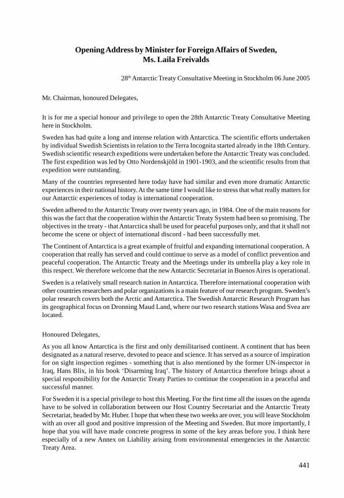
441
Opening Address by Minister for Foreign Affairs of Sweden,Ms. Laila Freivalds
28th Antarctic Treaty Consultative Meeting in Stockholm 06 June 2005
Mr. Chairman, honoured Delegates,
It is for me a special honour and privilege to open the 28th Antarctic Treaty Consultative Meetinghere in Stockholm.
Sweden has had quite a long and intense relation with Antarctica. The scientific efforts undertakenby individual Swedish Scientists in relation to the Terra Incognita started already in the 18th Century.Swedish scientific research expeditions were undertaken before the Antarctic Treaty was concluded.The first expedition was led by Otto Nordenskjöld in 1901-1903, and the scientific results from thatexpedition were outstanding.
Many of the countries represented here today have had similar and even more dramatic Antarcticexperiences in their national history. At the same time I would like to stress that what really matters forour Antarctic experiences of today is international cooperation.
Sweden adhered to the Antarctic Treaty over twenty years ago, in 1984. One of the main reasons forthis was the fact that the cooperation within the Antarctic Treaty System had been so promising. Theobjectives in the treaty - that Antarctica shall be used for peaceful purposes only, and that it shall notbecome the scene or object of international discord - had been successfully met.
The Continent of Antarctica is a great example of fruitful and expanding international cooperation. Acooperation that really has served and could continue to serve as a model of conflict prevention andpeaceful cooperation. The Antarctic Treaty and the Meetings under its umbrella play a key role inthis respect. We therefore welcome that the new Antarctic Secretariat in Buenos Aires is operational.
Sweden is a relatively small research nation in Antarctica. Therefore international cooperation withother countries researchers and polar organizations is a main feature of our research program. Sweden’spolar research covers both the Arctic and Antarctica. The Swedish Antarctic Research Program hasits geographical focus on Dronning Maud Land, where our two research stations Wasa and Svea arelocated.
Honoured Delegates,
As you all know Antarctica is the first and only demilitarised continent. A continent that has beendesignated as a natural reserve, devoted to peace and science. It has served as a source of inspirationfor on sight inspection regimes - something that is also mentioned by the former UN-inspector inIraq, Hans Blix, in his book ‘Disarming Iraq’. The history of Antarctica therefore brings about aspecial responsibility for the Antarctic Treaty Parties to continue the cooperation in a peaceful andsuccessful manner.
For Sweden it is a special privilege to host this Meeting. For the first time all the issues on the agendahave to be solved in collaboration between our Host Country Secretariat and the Antarctic TreatySecretariat, headed by Mr. Huber. I hope that when these two weeks are over, you will leave Stockholmwith an over all good and positive impression of the Meeting and Sweden. But more importantly, Ihope that you will have made concrete progress in some of the key areas before you. I think hereespecially of a new Annex on Liability arising from environmental emergencies in the AntarcticTreaty Area.

442
III. OPENING AND CLOSING ADDRESSES
I understand that Delegations are now very close to a final agreement. If this is accomplished itwould certainly contribute to prevent detrimental effects arising from environmental emergencies inAntarctic. But there are also other items on the Agenda before you where more progress is needed.
Environmental protection has always been a central theme of the cooperation between the AntarcticTreaty Parties. Our common and challenging task is to manage this extraordinary continent for thebenefit of our common environment - and for future generations. The Antarctic Continent is ourlargest joint nature reserve. But the continent can also give us a unique perspective and knowledgeregarding today’s global environmental hazards. You all have an important task before you when younow start the first week of the Meeting, with crucial environmental issues on the agenda.
With these words it is my pleasure to declare the 28th Antarctic Treaty Consultative Meeting open,and I wish you every success in your important work.

443
OPENING ADDRESS
Opening Address by Ambassador Hans Corell,Chairman of the Meeting
Stockholm, 6 June 2005
Distinguished Delegates,
It is a great honour for me to accept your electing me Chairman of the 28th Antarctic Treaty ConsultativeMeeting.
On a personal note, may I add that I am very pleased to be involved with Antarctica again. During mytenure in the United Nations over the past ten years, I was deeply involved with the Law of the Sea,including with the establishment of the three institutions of the UN Convention on the Law of theSea, but not with Antarctica since it is not within the mandate of the UN Office of Legal Affairs.
I can assure you that my colleagues and I will do our utmost to make this Meeting a fruitful and agood one – a Meeting that will take matters forward in the very special spirit that is the hallmark of ourcooperation relating to the Antarctic.
This Meeting brings with it a new element: an operational Secretariat under Executive Secretary JanHuber. It was established last year, but it is the first time the Secretariat it is operational at one of ourMeetings. I look forward with great expectations to a gratifying and enjoyable cooperation with JanHuber and his colleagues. And I know that Folke Löfgren, Secretary General of the Host CountrySecretariat, and his team have already developed a very good cooperation with them.
One thing is clear: the mere mentioning of Antarctica brings about an immediate reaction amongthose who listen. And it is almost always positive. It is true that the Antarctic represents extreme coldand eternal ice – and yet! Antarctica is something great and – hopefully – eternal. It also reminds usof the ongoing and unrelenting struggle of human beings to gain knowledge and to widen theirhorizons.
There were many heroes. The Antarctic has been and still is the scene of many adventures and boldenterprises. The stories and legends are many. And many are those have passed them on. Even morenumerous are those who have been fascinated by this continent, the last one to be discovered. It wasknown to humankind only at the beginning of the 19th century.
As is well known, Admiral Teodor von Bellingshausen is claimed to be the explorer who first sightedthe ice shelf of the Antarctic continent – a continent without human life but so full of other things.Still ice time. Extreme climatic conditions. Everything so extraordinary and thrilling.
This enormous continent was examined and mapped step-by-step. Initially, focus was on explorationand whaling and sealing and the like. This is understandable. However, at an early stage, alsoresearch and the efforts to gain knowledge and insight came to the forefront, and soon there was anincreasing presence of scientists among those who undertook travels to the Antarctic.
As a matter of fact, the first among them, Captain James Cook, had a number of scientists on boardwhen, in 1774, he reached the icebergs and was forced to turn. On board this ship there was also aSwedish scientist, Anders Sparrman, a disciple of Linnaeus.
When hearing “Antarctica”, most people see before them the enormous width of snow, the glaciersand the high mountains that here and there rise over the kilometre thick inland-ice. They see thewealth of creatures: penguins, seals, whales and the extraordinary conditions of life that has developedin this the coldest, driest and probably highest continent.
444
III. OPENING AND CLOSING ADDRESSES
Sweden’s first contribution to Antarctic research is of an early date. Otto Nordenskjöld’s expeditionin 1901-03 nearly perished but was miraculously saved by an Argentinean relief expedition on boardthe corvette Uruguay.
In this endeavour more than hundred years ago tremendous courage and determination wasdemonstrated. It should be regarded as an early expression of the Antarctic Spirit. It was ademonstration of a spirit of cooperation and preparedness to extend assistance of a kind that growsstronger and natural in situations where the outdoor impediments and threats are as extreme as theyare in Antarctica.
Over the years, this cooperation has developed and refined. The Antarctic Treaty is a continuationof this spirit, and it is the same spirit that has characterized earlier Meetings and which will characterizealso the present one.
The Antarctic Treaty has existed for about half a century. It is an outflow of what I just mentioned: adetermination to create something new and extraordinary out of this continent of the extreme.
It was the advances in connection with the International Geophysical Year 1957-58 that made itpossible to reach an agreement on the Antarctic Treaty. Military and strategic interests were putaside. At a time when the world was plagued by Cuban and Berlin crises and similar hardships, theconditions developed for a particularly well functioning model for international cooperation. This weknow, because the Antarctic Treaty regime has handled many crises and developed its own dynamic,its own way of producing solutions.
Unfortunately, the success of the cooperation of the Antarctic Treaty is little known. In a sense it isa model and it has functioned well in spite of tensions. Conflicts have been resolved and managed.The Treaty deserves much more attention than it gets, and the spirit for which it is stands should bedemonstrated also in other fields.
The Convention on the Protection of Antarctic Marine Living Resources (CCAMLR) was the firstinternational agreement in which principles like those on ecological balance and the precautionaryprinciple were set out. It was a matter of attaining a sustainable use of the resources of the sea. Theseprinciples are now the cornerstones of all ensuing conventions on fisheries administration.
In 1991, the Protocol on Environmental Protection to the Antarctic Treaty was elaborated, which inthe same way provides an elaborate regime with respect the conditions for all activities in Antarctica.Mineral resources must not be exploited. All activities must be examined and their environmentalconsequences must be examined. Rules exist on what is permissible: on permission to visit Antarctica,on how to manage garbage and residual products, etc.
Today, environmental issues are certainly very much in the focus of the media and the general public.The climate change! What does it mean? What are the consequences of the quick melting of the ices?Is this just a natural change, such as researchers have been able to establish and which haveoccurred many times in the past, or is it something new, something special, disquieting, threatening?
Environmental protection has always been a central theme of the cooperation between the Parties tothe Antarctic Treaty. As with previous Meetings, the workload for the Committee for EnvironmentalProtection (CEP) is substantial. There are over 80 working papers and information papers submittedfor consideration. Many important issues are on the Committee’s agenda, among them considerationof the environmental impacts associated with the construction and operation of two new researchstations and further development of a system for reporting on the state of the Antarctic environment.
Additionally, the CEP has undertaken to review its work to date, with the intent of considering itsmethod of operation and its strategic directions and future work. This issue is likely to prompt
445
OPENING ADDRESS
spirited discussion among CEP Members, who take seriously their responsibilities for protecting theAntarctic environment.
On Wednesday this week, the Scientific Committee on Antarctic Research (SCAR) will arrange apresentation at 11 am, which will be held in presence of His Majesty the King of Sweden.
So, the environmental issues are central and will be given great attention in various ways in the daysahead.
In the Environmental Protocol the Parties have agreed to regulate questions of responsibility andliability for activities in the Antarctic Treaty Area. This is a particularly complex chapter. However, itwould seem that the Parties are now very close to a common view and a decision. As the hostcountry, Sweden has accorded these questions highest priority. Let us hope that the Meeting willsucceed and that we will be able to announce that the Parties have been able to agree upon a specialprotocol to regulate these issues.
There are other areas with high priority. One is tourism in Antarctica. This tourism is steadily growingafter a decline in the wake of 11 September 2001. There are many issues here for the Parties to discussand problems to solve.
The question of bio-prospecting has been raised at previous Antarctic Treaty Meetings. The CEPhas noted that the phenomenon raised “many legal and political issues”. This important matter istherefore on the agenda also at this Meeting.
The new Secretariat in Buenos Aires has just started functioning. This Meeting has been planned bythe members of the Secretariat in cooperation with those responsible here in Sweden. An importanttask for the Parties is to support the Secretariat so that it can become an effective and efficient toolto assist them in their future work.
We have two weeks of intense labour ahead of us, starting today the 6th of June – Sweden’s NationalDay. However, we have seen to it that there are breaks in the schedule for some time to be togetherand to get further information about what is now happening on the Antarctic continent.
A particularly important ingredient in meetings that deal with as vast areas of work as yours is thecontacts and the connections that are established during the meetings and not least outside theconference rooms. There is a creative dynamic here, which in itself is invaluable for the work and forthe good results.
As the delegates will notice, we have located the Meeting in an environment where there are severalmuseums. Presently, there are a number of exhibitions relating to Antarctica. We hope that you willfind the opportunity to visit those exhibitions.
Once again, let me thank you for the confidence that you have given me to preside over this Meeting.I will do my utmost so that we can move ahead and so that also during this Meeting we can developthe Treaty regime. Above all, we must continue working indefatigably in the Antarctic Spirit.
Thank you for your attention!

III. OPENING AND CLOSING ADDRESSES
447
Concluding Remarks by Ambassador Hans Corell,Chairman of the Meeting
Stockholm, 17 June 2005
Distinguished Delegates,
The 28th Antarctic Treaty Consultative Meeting is now coming to an end. It has been an honour anda great pleasure to chair the Meeting. I believe that we all agree that we have accomplished what weset out to do, and matters have been advanced in the special way that is a feature of the Antarcticcooperation. In short, the Meeting has been very fruitful.
After an intense first week, the Committee for Environmental Protection (CEP) presented acomprehensive report, bringing the environmental issues forward. Since these issues are central inthe Antarctic Treaty System they have been given great attention in various ways during the Meeting.I would, in particular, like to stress the importance of the decision to commence elaborating a strategyfor the future work of the CEP.
This achievement is of course an effort in which all delegations can and should take pride. But,needless to say, the Chairman of CEP, Dr Anthony Press, deserves special recognition for the way inwhich he guided the Committee through a busy agenda. We also thank Professor Dr. Jörn Thiede, thePresident of SCAR, and Professor Steven Chown for their very interesting presentations in thepresence of His Majesty King Carl XVI Gustaf.
An event that we all looked forward to with great expectations was the adoption of Annex VI onLiability Arising from Environmental Emergencies to the Protocol on Environmental Protection to theAntarctic Treaty. The finalization of this Annex is a major achievement of this Meeting. We aregrateful to all who have contributed to this work over the years. Our special thanks go to AmbassadorDon MacKay, who skilfully guided the Working Group on Liability to this successful result.
We are particularly grateful that Ambassador MacKay organized and generously hosted anintersessional meeting in April in spite of the fact that he is presently the very busy Chairman of theFifth Committee of the United Nations General Assembly. I believe that the April meeting in New Yorkgreatly contributed to ATCM being able to adopt Annex VI here in Stockholm.
Special thanks also to Mr. Rene Léfeber, the Chairman of the Drafting Group, and to Mr. MarkSimonoff, who chaired the sub-group on Article 9 of Annex VI.
We are also grateful to Mr. Michel Trinquier for chairing the Working Group on Tourism, to ProfessorOlav Orheim for chairing the Working Group on Legal and Institutional Matters, this time with anextended mandate to review all draft instruments before they go before the Plenary, and to Dr JoséRetamales for chairing the Working Group on Operational Matters. They all contributed in differentrespects to the successful outcome of the 28th ATCM.
My personal and sincere thanks go to the Heads of Delegation who faithfully participated in meetingsboth before and during the formal Meeting. I think that these gatherings were most helpful for theprocess as a whole.
The same applies to the Bureau which met whenever there was a need. I also think that it was a goodidea to invite representatives from the Host Government of the 29th ATCM to the meetings of theBureau. The idea was of course to make sure that Dr Mike Richardson and the future head of the newHost County Secretariat, Mr. Paul Davies, and their colleagues should gain information that may beuseful when they organize next year’s Meeting.
448
III. OPENING AND CLOSING ADDRESSES
We now welcome the presence at this Plenary Meeting of Mr. Robert Culshaw, Director of theAmericas & Overseas Territories in the Foreign & Commonwealth Office.
We are grateful to the Observers and the Experts for participating in the Meeting and for sharing theirviews and experiences with us.
We are also very grateful for the assistance given to the Meeting by Mr. Jan Huber, the ExecutiveSecretary, and his team. This was the first time they participated in a Meeting in their new capacity,and I think the experience bodes well for the future.
I would also like to thank Ambassador Greger Widgren and my other colleagues in the Swedishdelegation for their support. Needless to say, I am also most grateful to the Secretary General of theHost Country Secretariat, Ambassador Folke Löfgren, and his team. They have worked hard for along time to make this Meeting an accomplishment, and I think that it is fair to say that they havesucceeded.
We were happy to note that many delegates have taken the time to participate in the social programtoo, including the visits to the Museum of Natural History and the Icebreaker Oden. These events areimportant also in the sense that the participants have extra opportunities to discuss matters relatingto the Meeting and to get to know each other better.
As in the past, we are indebted to Mr. Bernard Ponette and his very competent team of translatorsand interpreters. Without them, we simply could not have achieved what we did. Their performancealso testifies to the value of high quality speediness and continuity.
We also thank our technicians and all the many who have assisted us, be it in our midst or behind thescenes: security, catering, personnel from the museum, attachés, conference pilots and the officers atthe friendly helpdesk and the internet café.
The exhibition by Dr Fred Goldberg and his Post Office were delightful components of the Meetingand gave it a historic touch. The same holds true for Pablo Wainschenker’s film. We are grateful toboth of them.
We should also not forget the media. Hopefully, the successful cooperation within the framework ofthe Antarctic Treaty is better known now to the general public, since both national and internationalmedia followed the Meeting. Our special thanks to Mr. Stig Berglind, who served as Liaison Officer.
Allow me to make a few personal remarks relating to one particular issue, namely the ConsultativeParties’ Contributions. The reason that I raise the topic is that I have practical experience, in particularfrom the mid-1990s, of managing a department within the United Nations Secretariat at a time whenassessed contributions were not forthcoming as they should have. This caused much extra work andfrustration within the Organization and, in particular, the Secretariat.
The effective operation of the Secretariat is of course a matter of utmost importance to us all. I nowsincerely hope that all Contracting Parties will in the well-known “Antarctic Spirit” support theSecretariat by fully paying their contributions and – even better – by approving Measure 1 (2003),thereby putting its legal and budgetary framework in place.
Distinguished Delegates,
Before I declare this Meeting closed, let me add the following.
We should take pride in our achievements. But more important is to look forward and to focus on ourfuture work. This work should be seen in a larger perspective – as an important contribution to themaintenance of international peace and security, the mandate of the United Nations.
449
CLOSING ADDRESS
At the opening and closing of the United Nations General Assembly, there is a recurrent item on theagenda: Minute of silent prayer or meditation. The same procedure is observed at the meetings of theAssembly of States Parties to the United Nations Convention on the Law of the Sea.
I am not suggesting that you should adopt the same procedure in the ATCM. But on this occasion,because of a very special coincidence, I propose that the Meeting should observe a moment ofstillness before the gavel falls.
Upon leaving the United Nations in March 2004, after ten years as the Legal Counsel of theOrganization, I presented the Secretary-General with a gift – a piece of music that I had composed forhim: “Secretary-General Kofi Annan’s Prayer for Peace”.
There is an explanation to the title, but it is not necessary to relate it here. Suffice it to say that theprayer has no words. Hopefully, the music can be understood by all, and those who listen are free toadd in their minds in any language words of their own.
But why, do you ask, play this music on this occasion? The reason is very simple. I wrote the musicfor the Great Highland Bagpipe. So, not only will the music give room for silent prayer or meditation– it will also point forward to the challenges at the Meeting next year in Edinburgh.
We thank the Government of the United Kingdom for offering to host the next ATCM in Scotland.From personal experience over many years I know that you will be met by something that is a hallmarkof that country: hospitality and friendship. And, if you are lucky, you may also be greeted by thepipes!
Let us now observe a moment of stillness while we listen to “Secretary-General
Kofi Annan’s Prayer for Peace”. The music is performed by pipers from the Pipes & Drums of the 1st
Royal Engineers in Stockholm.
[The music is tuned in – and fades out.]
The 28th Antarctic Treaty Consultative Meeting is closed!

ANNEX E
REPORT OF THE COMMITTEEFOR ENVIRONMENTAL PROTECTION
(CEP VIII)

453
REPORT OF THE COMMITTEE FORENVIRONMENTAL PROTECTION
CEP VIII
STOCKHOLM 6-10 JUNE 2005
ITEM 1: Opening of the Meeting
(1) The CEP Chair, Dr Tony Press (Australia), opened the meeting on Monday 6 June2005.
(2) A welcome speech was given by the Swedish Minister for the Environment, MsLena Sommestad (see Annex 1). Ms Sommestad stressed the importance of the Protocolon Environmental Protection to the Antarctic Treaty and pointed out that the value of workdone by the CEP cannot be overestimated.
(3) The Chair thanked Sweden for arranging and hosting the meeting, and thanked theSecretariat of the Antarctic Treaty for its important work to administer the submission ofpapers and the Meeting website.
(4) The Chair formally welcomed the Czech Republic to the Meeting table as a CEPMember, having ratified the Protocol on 25 August 2004.
(5) The Chair also thanked Mr Tito Acero for his contributions as a CEP Representative,and congratulated Mr Acero on his appointment as Assistant Executive Officer in theSecretariat.
(6) The Committee was saddened to learn of the death of Mr Chris Badenhorst, a long-serving member of the South African delegation to the CEP and the ATCM.
ITEM 2: Adoption of the Agenda
(7) The Committee adopted the provisional agenda, as agreed at CEP VII, and thework plan circulated in CEP Circular 3/2005.
(8) The Committee also agreed to the allocation of papers to agenda items, as proposedin CEP Circular 3/2005.
(9) The Committee considered 37 Working Papers and 62 Information Papers (Annex 2).
454
III. CEP REPORT
ITEM 3: Operation of the CEP
(10) The list of CEP contact points was updated (Annex 3).
The CEP’s work and strategic directions
(11) The Chair recalled discussions held at CEP VII on the CEP’s future work, and theCommittee’s decision that the issue should be further discussed at CEP VIII.
(12) Argentina introduced WP 9 The Committee on Environmental Protection of theAntarctic Treaty: An Overview and Likely Future Scenarios, reviewing the main issuesthe Committee has dealt with during its first seven years of operation, and suggesting futurescenarios.
(13) Chile commented on the observation in WP 9 that relatively little attention has beengiven by the CEP to Protocol Annexes III and IV to date, suggesting that this issue shouldbe examined.
(14) Sweden introduced WP 1 Working Paper to initiate a strategic discussion onfuture environmental challenges in Antarctica and its dependent and associatedecosystems, noting that the CEP now finds itself at a mature stage of development, with aworkload that is growing in volume, scope and complexity.
(15) Sweden suggested that the Committee needs to adopt a more strategic andsystematic approach to its work, in order to be able to meet this challenge and fulfil itsobligations to the ATCM. This was reflected in the presentation on tools given by Sweden asan introduction to its Working Paper.
(16) The Chair suggested a three-part approach to the discussion of WP 1 and WP 9,bearing in mind Articles 3 and 12 of the Protocol, and the importance of the Committee’sinteractions with other bodies:
• as an issue-based approach taking account of issues which straddle more thanone Annex;
• the nature and growth of human activities and their relationship to the environment;
• the effectiveness of current CEP work practices.
(17) Many Members expressed their appreciation to Argentina and Sweden for introducingthese papers, as an excellent basis for discussion of this important issue.
(18) Brazil suggested that, in order to improve the Committee’s effectiveness andefficiency, a coordinated thematic approach be adopted to address the pressures on theAntarctic environment, and responses to them.

455
CEP VIII REPORT
(19) Germany highlighted the growing importance of intersessional work in allowing amore considered approach to issues than is possible during the annual CEP meeting. Germanyalso stressed the need for the Committee’s roles to be clearly identified, for timely responseto the ATCM, and for cooperation with other ATS bodies.
(20) France stressed the importance of not censuring or limiting debate within the CEP,even if other groups within the ATCM or the ATS are working on similar issues.
(21) The United Kingdom stressed also the need to take stock of the expanding work ofthe CEP, and the importance of continuing outreach by encouraging the involvement of newCommittee Members.
(22) CCAMLR commented that similar discussions and debate had been held by itsMembers over many years, and noted the effectiveness of thematic workshops to discusssuch matters.
(23) Argentina stressed the need for databases of environmental indicators and thepossibility of obtaining information from other bodies, for example SCAR.
(24) The United Kingdom noted that the CEP is principally an advisory committee to theATCM, and must undertake many tasks to fulfil that role. It would be appropriate to identifythose tasks which the CEP must do, and then to determine what capacity remains for otherwork to be included in the Committee’s strategic work program.
(25) Norway suggested that two key issues require discussion: (1) increasing activity inthe Antarctic; and (2) increasing CEP workload. Norway suggested that such discussionsmay lead to revised CEP Rules of Procedure.
(26) ASOC suggested that one component of the CEP’s task could be to develop aninventory of the types of activities undertaken in Antarctica. ASOC referred to IP 74Development Pressures on the Antarctic Wilderness as a preliminary contribution to suchan inventory.
(27) Two open-ended contact groups were established to discuss two aspects of this issue:
• the tasks that the CEP must do, as a result of analysis of the Protocol and CEPRules of Procedure ; and
• the major issues facing the CEP currently and in the future.
(28) The conclusions of the open-ended contact group that discussed the first aspect areat Annex 5. The Committee accepted this as a useful contribution to the ongoing discussionon this issue.
(29) A record of the discussions of the second open-ended contact group is given in theaide memoire at Annex 6.
456
III. CEP REPORT
(30) As a result of these discussions, the Committee agreed to establish a steeringcommittee to prepare for a substantive discussion of the strategic issues facing the CEP atCEP IX and to stimulate continuing discussions during the intersessional period of the strategicissues facing the CEP. The steering committee comprised the Chair, both Vice-Chairs, theSecretariat and the host of CEP IX (the United Kingdom).
(31) The United Kingdom noted that, as the host of CEP IX, it would be happy toinvestigate options for a pre-CEP workshop to assist further discussion of this issue.
(32) This offer was warmly welcomed by the Committee.
CEP interaction with the Secretariat
(33) The Secretariat proposed several ways in which it could assist the CEP, including by:
• providing a template on the Secretariat website to assist with the consistentsubmission and presentation of Annual Reports under Article 17 of the Protocol.The Secretariat could provide a collation of Annual Report information at eachMeeting;
• assisting in the production of an annual list of IEEs/CEEs under Resolution 6(1995)(which was to be reviewed following the establishment of the Secretariat) bydeveloping a searchable database. It was also suggested that the reporting periodbe changed from the calendar year to the period 1 April to 31 March, to ensurethat each Meeting could consider activities undertaken in the preceding australsummer;
• publishing information on the status of protected area management plans;
• transferring the CEP website to the Secretariat website following CEP IX, andpresenting the website in the four Antarctic Treaty languages;
• making previous CEP meeting documents available via a searchable database.
(34) The Secretariat also welcomed further suggestions from Members.
(35) The meeting thanked the Secretariat for the offers of assistance and asked that itdevelop the annual reporting template for its consideration at CEP IX.
ITEM 4: Compliance with the Protocol on Environmental Protection
4a) General matters
(36) The Chair recalled CEP Circular 3/2005, which proposed that the Committee considerthe environmental aspects of Antarctic Treaty inspection reports. Acknowledging therequirements under Article 14 of the Protocol, the Committee agreed to add considerationof inspection reports to the CEP agenda as a standing item.
457
CEP VIII REPORT
(37) Australia introduced WP 16 Scott Base and McMurdo Station: Report of anInspection under Article VIII of the Antarctic Treaty and Article 14 of the Protocol onEnvironmental Protection, submitted under ATCM Agenda Item 18. The inspection teamhad been warmly welcomed by New Zealand and United States station personnel andAustralia thanked both Parties for their assistance.
(38) The inspection team had observed full compliance with the Protocol at all sitesvisited. Australia noted the considerable effort expended in maximising environmentalperformance, such as attention to waste management and sewage treatment, proceduresfor fuel storage and transfer, cleanup of past sites, environmental education programs andcooperation between the two Parties with facilities in the region.
(39) The United States thanked Australia for the report and noted that it had also completedinspection checklists for its South Pole and Palmer stations. It has committed to updatingthese checklists each year and promoted the checklist as a useful management tool.
(40) New Zealand also thanked Australia and noted that inspections are beneficial forimproving station operations. It had already acted on some of the comments from theAustralian inspection team, as well as those received from Finland in 2004.
(41) COMNAP noted that it had previously committed to make information available onits website to meet the requirements of the Antarctic Treaty inspection checklist and therequirements of Resolution 6(2001). It noted that this is a work in progress.
(42) The United Kingdom introduced WP 32 Report of Joint Inspections under ArticleVII of the Antarctic Treaty and Article 14 of the Environmental Protocol (United Kingdom,Peru, Australia), reporting on joint inspections undertaken from HMS Endurance in Februaryand March 2005.
(43) The inspection covered nine permanent (year-round) stations, five summer-onlystations, three unoccupied stations, one station under construction, five Historic Sites andMonuments and one tourist vessel. In addition, five further unoccupied stations were overflownby helicopter, but were not visited.
(44) The United Kingdom noted that the inspection report contained six conclusions ofrelevance to the work of the CEP, relating to: the significant number of abandoned orunoccupied stations; fuel storage and transfer; Environmental Impact Assessment (EIA)procedures; protection of flora and fauna; area protection and management; andenvironmental monitoring.
(45) The United Kingdom highlighted three of the report’s recommendations relevant tothe work of the Committee:
• That construction of stations at previously unoccupied sites in Antarctica shouldbe minimised and any such new sites should be located with a view to optimisingscience, whilst minimising environmental impacts.
458
III. CEP REPORT
• That Parties, particularly those that have recently acquired status within theAntarctic Treaty System, should consider joint operations in Antarctica, therebyminimising the environmental impact of constructing new facilities.
• That bulk fuel facilities currently lacking secondary containment should bereplaced either with double-skinned tanks, or provided with adequate bunding.Also, Parties should have in place oil spill contingency plans and COMNAPshould consider undertaking a further assessment of fuel handling and storagefacilities and procedures in Antarctica with a view to issuing a set of clearrecommendations to operators.
(46) Australia expressed gratitude to the United Kingdom for the opportunity to takepart in the inspection and to gain valuable experience with operations on the AntarcticPeninsula. It encouraged cooperation in the conduct of inspections.
(47) Peru, Spain, Argentina, Bulgaria, Chile, China, Brazil and the Russian Federationeach thanked the inspection team and noted the professional manner in which the inspectionshad been undertaken.
(48) Peru said that in addition to the cooperation shown during the inspections theywould ask the Meeting to conclude that this is a situational diagnosis on how it undertook itsactivities in Antarctica.
(49) Argentina noted that work was in fact being done at its unoccupied station onmaintenance and environmental protection shortly before the inspection was undertakenand that the station is not unoccupied on a permanent basis. Argentina indicated that itwould take notice of all the inspection report’s observations.
(50) Bulgaria found the report’s recommendations on how to develop its base in thefuture very useful. It suggested that a good example of cooperation is the sharing of logisticsbetween the Spanish and Bulgarian bases.
(51) China noted that it attaches great importance to environmental protection and scientificresearch, but acknowledged that there are some problems with the infrastructure at GreatWall Station. It has plans to improve this infrastructure.
(52) Brazil suggested an element of caution when drawing conclusions as the result ofshort station inspections. It noted that work at its Admiralty Bay station focuses onenvironmental monitoring, despite the suggestions in the report that there is no consistent orfocussed approach to monitoring.
(53) Chile noted that its stations were closed down when inspected, but these are occupiedon the basis of the needs of its science program. For example, one station had been occupiedup to the day before the inspection visit. It is concerned to ensure environmental protectionand noted that it is undertaking a process to renew fuel storage tanks.
459
CEP VIII REPORT
(54) ASOC welcomed the work done by the inspection teams, but was disappointed tonote similarities with the findings by ASOC member Greenpeace between the 1980s andthe late 1990s, such as poor fuel storage and handling practices and the little or no evidenceof the EIA process at stations.
(55) COMNAP recognised that fuel storage and handling is a major concern and notedthat the issue is on its agenda for future work. COMNAP noted the excellent work by theUnited Kingdom on oil spill contingency training. COMNAP indicated that it would undertakean analysis of fuel storage and handling practices and report findings to the next meeting.
(56) New Zealand welcomed the inspection report and raised three points:
• Regarding the issue of abandoned and unoccupied stations, it recalled therequirements of Annex III, Article 8 to develop programs for cleaning upabandoned work sites, and to prepare an inventory of sites of past activities. Itsuggested Members may wish to come forward with this information.
• National programs should be encouraged to look at means of improving provisionsfor safe fuel storage and transfer.
• The CEP could address the issue of introduced species as part of its futurework.
(57) Norway welcomed both inspection reports and agreed with recommendationsregarding cooperation between Parties. It suggested that this issue would fit well into theCEP’s strategic discussions, for example on cumulative impacts.
(58) Norway also noted that the issue of fuel storage and handling had been raised inseveral inspection reports and noted by the Committee on a number of occasions. Norwaysuggested that it was now important to bring the issue of fuel storage and handling to theattention of the Treaty Parties.
(59) The CEP endorsed all three recommendations raised by the United Kingdom andfurthermore accepted Norway’s suggestion that the CEP ask the ATCM to adopt a Resolutionon the issue of fuel storage and handling.
(60) ASOC introduced IP 74 Development Pressures on the Antarctic Wilderness,asking the Committee to note the recommendations in the paper and welcoming discussionsunder Agenda Item 3 of strategic environmental assessment.
(61) France introduced IP 9 Rapport annuel présenté par la France conformément àl’article 17 du Protocole au Traité sur l’Antarctique relatif à la protection del’environnement 2005 and IP 10 Mise en Oeuvre du Protocole de Madrid Relatif a laProtection de l’environnement en Antarctique.
(62) Annex 4 provides a list of internet addresses where Annual Report information ispublished in accordance with Article 17 of the Protocol. The following Information Papers
460
III. CEP REPORT
containing annual reports were also submitted: IP 2 (South Africa), IP 7 (Spain), IP 21(Belgium), IP 26 (New Zealand), IP 39 (Italy), IP 65 (United Kingdom), IP 84 (China), IP101 (Ukraine), IP 102 (Japan), IP 110 (Chile), IP 116 (Korea, Republic of).
(63) The following Information Papers were also submitted under Agenda Item 4a: IP 4(United States); IP 43 (Czech Republic); IP 51 (Sweden); IP 73 (Belgium); IP 80 (India).
4b) Consideration of Draft CEEs forwarded to the CEP in accordance withparagraph 4 of Article 3 of the Protocol
(64) The Committee considered two draft CEEs.
i) Halley VI
(65) The United Kingdom delivered an audio-visual presentation to introduce WP 19Draft Comprehensive Environmental Evaluation (CEE) Proposed Construction andOperation of Halley VI Research Station, Brunt Ice Shelf, Caird Coast, Antarctica andthe complementary IP 66 of the same title.
(66) The draft CEE was produced by the United Kingdom and circulated in February2005 after approval by the UK Government. It is intended that construction take placebetween 2006/07 and 2007/08, and that the station have a life of at least 25 years.
(67) The United Kingdom noted in its presentation that Halley Station is one of the mostimportant research sites in Antarctica, being where the ozone hole was first discovered, andcontributing to continuous datasets developed over the past 50 years.
(68) The United Kingdom further noted that a competition was being held to design thenew station. Three designs had been short-listed and a final selection was expected to bemade by early July 2005.
(69) The presentation covered the major environmental impacts considered in the DraftCEE, including: air pollution and particulate deposition from atmospheric emissions; disposalof grey water and human wastes and abandoned materials buried under the snow; andcontamination of snow and ice by minor fuel spills and leaks.
(70) The presentation also covered the mitigation measures planned to reduce theseimpacts: reduction in the number of people on station, both in summer and winter; the use ofnew technologies to reduce environmental impact; and a design life of at least 25 years, andthe ability of the station to be easily removed when required.
(71) In summary, the draft CEE concluded that:
• the construction and operation of Halley VI will have more than a minor ortransitory environmental impact;
461
CEP VIII REPORT
• the implementation of the preventative and mitigation measures outlined in thedraft CEE will reduce impacts;
• the overall impact of Halley VI will be substantially less than Halley V; and
• the importance to global science of the construction and operation of Halley VIoutweighs the impact the station will have on the Antarctic environment andfully justifies the activity proceeding.
(72) The United Kingdom advised that hard copies of the draft CEE are available, aswell as copies on CD and on the web: www.antarctica.ac.uk/halleyvi/cee.html
(73) The meeting thanked the United Kingdom for the comprehensive papers andpresentation.
(74) In response to a question from France on the proposed use of renewable energy atHalley VI, the United Kingdom noted that this is being addressed in the short-listed proposals,in particular the use of passive solar heating.
(75) Referring to IP 105, Japan commented that, based on experience at Syowa Stationit is important to maintain good monitoring records for waste disposed at, and removed from,Antarctic stations.
(76) Germany noted that it had forwarded comments received through its domesticconsultation process on the draft CEE to the United Kingdom, and further that:
• a decision has yet to be made on which station design will be used;
• commentary on contingency planning for fuel spills may be useful; and
• the document does not contain a discussion of the supply logistics to be usedduring the construction phase.
(77) The United Kingdom thanked France, Japan and Germany for their comments. TheUnited Kingdom noted that all facilities above the snow surface at Halley V will either berecycled or reused at Halley VI or will be demolished and removed from Antarctica in 2009/10. Also, all hazardous materials will be removed from the sub-surface tunnels. The demolitionand removal of Halley V will be the subject of a separate EIA.
(78) New Zealand commended the United Kingdom on the environmental criteria usedin the station design competition and welcomed the novel approach to the selection of thestation design. New Zealand considered, however, that this approach complicates the CEEprocess, and perhaps introduces some uncertainty about likely environmental impacts. NewZealand asked whether the final CEE addressing those uncertainties would be circulatedfor comment.
(79) The United Kingdom agreed that it had taken a novel approach and that timing ofthe competition had prevented the inclusion of the successful design in the document presented
462
III. CEP REPORT
to the Meeting. As a result, it was the intention of the UK that the final CEE would be madeavailable to Members via the BAS website www.antarctica.ac.uk/halleyvi/cee.html forcomment before next year’s ATCM.
(80) Norway congratulated the United Kingdom on their draft CEE, remarking that forcontinental Antarctica there is no problem of proliferation of infrastructure and that theimportant scientific work undertaken at Halley and other similar continental stations in relativelyunexplored parts of Antarctica warrants their existence.
(81) The Chair noted the Committee’s agreement that the draft CEE provides acomprehensive description and evaluation of the proposed activity and likely environmentalimpacts, and is therefore consistent with the requirements to Annex I to the Protocol.
(82) The CEP’s advice to the ATCM on the draft CEE for ‘Proposed Construction andOperation of Halley VI Research Station’ is contained in Appendix 1.
ii) Neumayer
(83) Germany delivered an audio-visual presentation to introduce IP 30 Draft ComprehensiveEnvironmental Evaluation (CEE). Rebuild and Operation of the Wintering Station NeumayerIII and Retrogradation of the Present Neumayer Station II, noting that the document hadbeen circulated to Members and was also available in hard copy.
(84) The presentation provided an overview of the current operations and scientific activitiesat Neumayer II Station, and introduced the plans for the establishment of Neumayer III.
(85) Germany thanked New Zealand for the most helpful comments on the draft CEE.Germany further advised that:
• Neumayer II station must be replaced by 2008 as it is becoming progressivelyburied in snow and will not remain safe for habitation.
• Neumayer III would be Germany’s third overwintering station on the floatingEkström Ice Shelf.
• The ice shelf moves northward at about 150 metres per year but the new stationis unlikely to approach the Atka Bay emperor penguin colony.
• Neumayer III will utilise existing resupply sites on the edge of the ice shelf.
• The station will have a greater floor space than the present station to accommodateadditional laboratories and observatories.
• The new station incorporates hydraulic legs which can lift the station as snowaccumulates, to ensure that the buildings remain above the snow level, andenabling the removal of all components of the station at the end of its lifetime.
• It is expected that the new station will be ready for operation in 2008, and that itwill have a lifetime of over 25 years.
463
CEP VIII REPORT
(86) Germany made specific reference to the importance of the extensive meteorologicalprogram undertaken at Neumayer II, which is to be continued at Neumayer III, includingclimate and atmospheric studies which contribute to many international data collection andmonitoring networks.
(87) Germany elaborated on its plan to increase the use of wind energy to supply thenew station, noting that waste heat from the diesel powered generators will provide heatand freshwater for the station. Waste water will be treated biologically and by UV sterilisation,and the resulting treated water disposed of below the ice/snow surface. Sewage sludge willbe removed from the Antarctic Treaty area.
(88) All scientific materials from Neumayer II will be moved to the new station, and theonly material to be left at the old site will be iron tubes which are deeply buried. Germanyconsidered that the fuel used by vehicles to remove these items would have a greaterenvironmental impact than leaving them in situ.
(89) In conclusion, Germany stated that their ambition was to see Neumayer III as anintegral part of the network of permanent wintering research stations in continental Antarctica.
(90) Many Members thanked Germany for their clear and comprehensive presentationon the proposed activity.
(91) In response to a question from Australia, Germany indicated that Neumayer IIIwould normally support a winter staff of nine, including four scientists.
(92) Norway noted that it was encouraging to witness the continued presence of researchstations such as Halley VI and Neumayer III in important yet isolated locations on theAntarctic continent, and the value to science of increased cooperation between such stations.
(93) The United Kingdom thanked Germany for its excellent cooperation during theprocess to plan and establish Neumayer III and Halley VI, and particularly for hosting threeUnited Kingdom design teams.
(94) In response to a question from New Zealand regarding the proposed use ofrenewable energy, Germany advised that Neumayer II was one of the first stations inAntarctica to use wind energy, and that it intends to increase the current supply rate of 20 %in Neumayer III. Germany would also investigate ways of using photovoltaic solar panels.
(95) The Chair referred to the existence of an energy management network withinCOMNAP, and welcomed the introduction to Antarctica of new techniques and technologiessuch as those proposed by Germany for Neumayer III.
(96) Australia asked Germany to clarify the conclusion of IP 30, which did not use thelanguage of the Environmental Protocol as the basis of its conclusion.
(97) The assessment of the operator, using the terminology of the Protocol, is that theproposed activity would have a minor or transitory impact on the environment.

464
III. CEP REPORT
(98) Some Members expressed their concern that this was a different conclusion to thatof the UK CEE despite the very similar nature of the activities in question.
(99) The Chair noted the Committee’s agreement that the draft CEE provides acomprehensive description and evaluation of the proposed activity and likely environmentalimpacts, and is therefore consistent with the requirements of Annex I of the Protocol.
(100) The CEP’s advice to the ATCM on the draft CEE for ‘Rebuild and Operation of theWintering Station Neumayer III and Retrogradation of the Present Neumayer II’ is containedin Appendix 2.
(101) Germany thanked the United Kingdom for its close cooperation and noted that theproduction of the two CEEs could be viewed as a combined effort.
(102) The Chair thanked the United Kingdom and Germany for their presentations, notingthat the preparation of these thorough documents and the conduct of the projects are excellentexamples of the international cooperation that characterises the Antarctic Treaty System.
4c) Other matters covered by Annex I (Environmental Impact Assessment)
(103) Norway introduced WP 40 Assessment of environmental impacts of satellitefacility at Troll and the accompanying IP 72 Initial Environmental Evaluation for theestablishment of a satellite reception and command facility (TrollSat) and a NorwegianInstitute for Air Research (NILU) Laboratory as an integral part of the Troll Station inDronning Maud Land, Antarctica.
(104) Norway recalled that matters relating to the Troll station and airstrip had beendiscussed at length at previous meetings. It noted that subsequent developments have led toa proposal by the Norwegian Space Centre to develop an additional satellite facility, whichis likely to be in operation by the start of austral winter 2006. The proposal raises questionsof principle regarding the question of cumulative environmental impacts and level ofenvironmental assessment.
(105) In response to a question from India, Norway indicated that the satellite facilitywould be able to acquire data from many satellites, particularly the European MetSat andthe United States’ Orbital Viewer, and would also contribute to the Galileo satellite network.
(106) New Zealand welcomed Norway’s transparent approach to informing the Committeeof this proposal, noted that it highlighted issues of cumulative impacts, and suggested that anappropriate course of action may be to reconsider the original CEE in the light of the newinformation to see if the conclusions change.
(107) Norway thanked the Members for their comments, and noted that the project is onthe borderline between levels of assessment. It noted the different conclusions reached inthe environmental impact assessments for the United Kingdom and German stations andrecalled the previous feeling of the Committee that more examples of CEEs were required

465
CEP VIII REPORT
to help assist determine the appropriate level of assessment for activities. The issue ofcumulative impacts required further consideration in this case.
(108) Australia introduced WP 30 Report of the ICG Established to Update the‘Guidelines for Environmental Impact Assessment in Antarctica’ (1999), noting that thistask had arisen from WP 28 submitted by Argentina at CEP VII. The ICG had reviewed theguidelines and suggested changes to ensure that cumulative impacts are explicitly addressed.
(109) IAATO complimented Australia on its work to tackle this difficult task. It noted thatUnited States NSF in cooperation with IAATO had collected tourism data from 1989-2003.Since then IAATO provided tourism information for the database. Tourism reports from1989 can be found on the IAATO website www.iaato.org. In response to the paper’scomments regarding sensitivity analysis, IAATO noted that it had conducted sensitivityanalyses since 2003 and adopted guidelines based on site sensitivities. It also noted that anylist of IEEs would not be complete because some Parties require only preliminary assessmentsfor tourist activities.
(110) ASOC thanked Australia for coordinating the ICG work and noted that someparticipants had indicated the need for operators to conduct joint or regional environmentalimpact assessments, which ties in with the strategic discussions under Agenda Item 3.
(111) The Committee adopted, with minor changes, the amended Guidelines at AttachmentA to WP 30. The amended Guidelines are at Annex 7.
(112) The Committee Members discussed the other recommendations raised in WP 30,and agreed to:
• ask the Secretariat to establish an electronic database of IEEs/CEEs and reportback to the next meeting;
• address the issue of monitoring and reporting baseline data as part of theenvironmental monitoring and reporting ICG;
• gratefully accept an offer by COMNAP to liaise with the CEP about developinga mechanism to respond to reports of environmental incidents at its annualmeeting;
• also gratefully accept New Zealand’s offer to work on the development of amethodology to assist proponents in identifying all the steps/information requiredin assessing cumulative impacts.
(113) ASOC presented IP 59 A Note on the Vulnerability of Cetaceans in AntarcticWaters to Noise Pollution.
(114) The Committee recalled earlier discussions of this important issue, agreed that itwarranted further consideration, and agreed that it should be a topic for substantive discussionat CEP IX. The Committee also looked forward to receiving at that meeting SCAR’s paperreviewing available information on marine acoustics as foreshadowed at CEP VII.

466
III. CEP REPORT
(115) Brazil presented IP 6 Environmental Impact Assessment on the Padre BalduínoRambo Refuge’s Dismantlement, describing the process undertaken to minimiseenvironmental impacts when dismantling and removing the refuge.
(116) Italy presented IP 40 Talos Dome Ice Core Project (TALDICE): InitialEnvironmental Evaluation for Recovering a Deep Ice Core at Talos Dome, EastAntarctica: Comments from CEP Contact Points, noting that it had decided to go aheadwith an IEE for the activity.
(117) The following Information Papers were also submitted under Agenda Item 4c: IP17 (Brazil); IP 23 (South Africa); IP 42 (Czech Republic); IP 58 (Uruguay); IP 75 (CzechRepublic); IP 83 (China); IP 107 (Australia).
4d) Matters covered by Annex II (Conservation of Antarctic Fauna and Flora)
(118) The Chair recalled that CEP VII had agreed that Specially Protected Species shouldbe an important topic for discussion at CEP VIII, and that SCAR had offered to bring to themeeting proposals for listing and delisting species.
(119) SCAR presented WP 34 Proposal to List a Species as a Specially ProtectedSpecies under Annex II, noting that this paper represents the continuation of a processcommenced with the presentation by Argentina of WP 17 at CEP III.
(120) WP 34 proposed how the IUCN endangerment criteria could be applied to birdspecies breeding or foraging in the Antarctic Treaty area, providing suggestions for a possibleprocedure, and including a model framework presenting data for the southern giant petrel.
(121) SCAR also presented WP 33 De-listing Antarctic Specially ProtectedSpecies, recommending the IUCN criteria for endangerment for determining the need forconservation measures in the Antarctic context. It also recommended that Arctocephalustropicalis (sub-Antarctic fur seal) and Arctocephalus gazella (Antarctic fur seal) be removedfrom Appendix A of Annex II on the basis of the current population estimates, the annualtrend, the geographical area inhabited, and the lack of any threats to the species.
(122) To ensure that proposals for Specially Protected Species are handled in a consistentmanner, the Committee developed Guidelines for CEP Consideration of Proposals forNew and Revised Designations of Antarctic Specially Protected Species under AnnexII to the Protocol which are included at Annex 8. The Committee thanked all contributorsover recent years for their work to develop the procedures.
(123) CCAMLR observed that the Guidelines had been developed to address thedesignation of protected species within the provisions of the Annex II version applicable atthe time of CEP VIII. It noted that any changes to Annex II in the future may necessitate areview of the Guidelines.
467
CEP VIII REPORT
(124) The Committee asked SCAR to assess the species noted in WP 34 as candidatesfor listing (southern giant petrel and macaroni penguin) using the new guidelines.
(125) SCAR agreed to undertake this work and report back to CEP IX. It also requestedthe CEP’s advice on the proposal in WP 33 to delist two fur seal species.
(126) A number of Members were of the view that, on the basis of the paper presentedby SCAR, the two species of fur seal warranted delisting; other Members considered thatthe proposal required further consideration.
(127) On the basis of that discussion, and to ensure consistency with the new guidelinesand to include all available data, the Committee asked SCAR to submit to CEP IX a revisionof the proposal for delisting the two fur seal species in accordance with the new guidelines.The Chair agreed to seek CCAMLR’s views on the delisting proposal and the United Kingdomagreed to consult with CCAS.
(128) SCAR noted that, by CEP IX, it could also provide information and data in relationto the Ross seal.
Quarantine
(129) Australia introduced WP 28 Measures to address the unintentional introductionand spread of non-native biota and disease to the Antarctic Treaty Area, recalling thatthe intent of Article 4 of the Protocol is that unintentional introductions of non-native speciesto the Antarctic Treaty Area will be minimised.
(130) This issue had been raised in several papers previously submitted to the CEP, and isone of global concern, as also raised in IP 63 Introduction of Non-native Species, Parasitesand Diseases (IUCN) and IP 97 Update on Boot and Clothing DecontaminationGuidelines and the Introduction and Detection of Diseases in Antarctic Wildlife: IAATO’sperspective (IAATO).
(131) Australia highlighted the difficulty and cost of eradicating introduced species andnoted that no formal assessment has been undertaken of the risks in the Antarctic context.Increasing visitation to Antarctica, combined with a more benign climate due to globalwarming, is likely to increase the opportunity for non-native species to arrive and becomeestablished. Australia also emphasised similar concerns regarding transfer of species betweenAntarctic sites.
(132) Many Members thanked Australia for bringing a paper on this important matter tothe CEP.
(133) COMNAP raised the issue of the introduction of marine species in ballast water,noting that the IMO had established guidelines to address this issue. A COMNAP surveycaptured the practices of 40 of the 72 vessels of the combined COMNAP-IAATO fleet andthe results are deemed representative of current practices. Of those 40 vessels, 35 vessels
468
III. CEP REPORT
do not discharge any ballast water in the Treaty area, 3 vessels do not discharge any ballastwater brought from outside the Treaty area, and 2 vessels only exchange ballast water inthe open ocean. COMNAP provided this information to the Committee as IP 121 The useof Ballast Water in Antarctica.
(134) France stated that the introduction of non-native species may be the main threat tobiodiversity in Antarctica. Through human activity and climate change the risk increases asthe possibility for reproduction of alien species increases, particularly near the Antarcticcoast.
(135) IUCN welcomed Australia’s initiative and noted that harmful alien species are aglobal problem and that prevention and precaution are the key. The IUCN guidelines forpreventing the introduction of alien species can be found on its website.
(136) Regarding ballast water, Norway noted that it is encouraging that relatively fewships are disposing ballast water in the Antarctic Treaty Area. Norway also noted that thisissue is of global concern, and referred to the International Convention for the Control andManagement of Ships’ Ballast Waters and Sediments, 2004. Norway suggested thatconsideration should be given to voluntary application of the Convention within the AntarcticTreaty, as the implementation of the Convention in general may take some time. Norwaysuggested that this may be an issue for further consideration at CEP IX.
(137) There was general agreement among Members with the Norwegian proposalregarding the ballast water Convention.
(138) In supporting this, the United Kingdom noted that the Convention provided foradditional measures for certain areas and offered to develop practical guidelines for ballastwater exchange in the Antarctic Treaty area, in consultation with other interested Partiesand appropriate experts, for consideration at the next meeting.
(139) New Zealand noted that hull fouling may also be a significant factor in the transferof foreign organisms to Antarctica.
(140) Many Members agreed that there were several matters of concern with regard tothe broad issues of quarantine and the introduction of non-native species, and that thesematters warrant the further detailed consideration of the Committee, based on expert scientificadvice, such as from SCAR.
(141) New Zealand also noted that it had undertaken some work on the topic of quarantineand the introduction of non-native species over the last six months domestically and plannedto undertake a workshop before the next meeting to discuss related issues. It would behappy to expand the scope of the workshop to address the points noted in WP 28, to welcomethe attendance of CEP Members, and to time the workshop to facilitate maximumparticipation.
(142) The Committee warmly welcomed New Zealand’s proposal and agreed that theworkshop would help develop the proposals outlined in WP 28.

469
CEP VIII REPORT
(143) Germany noted that a working group under the Convention on Biological Diversityhad been working for some time on this issue.
(144) SCAR indicated that it has been interested in invasive species over recent yearsand that it has programs studying relevant questions, such as the potential pathways foralien arrivals. SCAR also said that it had new information indicating that hull fouling isprobably a bigger problem than ballast water in Antarctic waters and it will bring a paper tothe next meeting. SCAR offered to provide further expert advice on the issue.
4e) Matters covered by Annex III (Waste Disposal and Waste Management)
(145) The United Kingdom introduced IP 37 Reducing Sewage Pollution in the AntarcticMarine Environment Using a Sewage Treatment Plant, describing an environmentalmonitoring study to determine the effectiveness of a sewage treatment plant installed atRothera Research Station. The results show that the microbiological pollution in the near-shore marine environment had decreased significantly since the plant had become operational.
(146) Japan introduced IP 105 Four-year program for clean-up at Syowa Stationreporting on its current and planned efforts to clean up old waste dumps at Syowa Station.
(147) Sweden introduced IP 47 Waste Water Treatment in Antarctic. A Feasibility Studyfor Grey Water Treatment at Wasa Station, and offered to report back to CEP IX withfindings.
(148) The Russian Federation introduced IP 47 Evacuation of AN-3T aircraft from theAmundsen-Scott station, reporting on the cooperative efforts to successfully remove thefully-fuelled aircraft – a potential environmental hazard – from the Amundsen-Scott Stationin the 2004/05 season. This aircraft of a Russian non-government expedition had been at theUS station because of technical problems since 2002. The Russian Federation gratefullyacknowledged the assistance of the United States Antarctic Program.
4f) Matters covered by Annex IV (Prevention of Marine Pollution)
(149) Norway introduced WP 41 Proposal to submit a proposal to IMO to ban thepresence of Heavy Fuel Oil (HFO) on board ships south of 60 degrees south, suggestingthe CEP recommend to the ATCM that it propose to the IMO a ban on the use of HeavyFuel Oil (HFO) by ships in Antarctic waters (south of 60°S, the area declared as a SpecialArea under Annexes I and V of the MARPOL 73/78 Convention).
(150) COMNAP introduced IP 67 The Use of Heavy Fuel Oil in Antarctic Waters. Itnoted that no ships in the COMNAP-IAATO fleet currently use HFO in Antarctic waters.
(151) There was general agreement in the Committee regarding the risks associated withHFO in Antarctica and the need to consider mechanisms to avoid environmental impactsdue to release of such substances. Many Members agreed that restrictions on use would beappropriate. One Member noted that preventive measures and contingency plans could be

470
III. CEP REPORT
instituted as a control mechanism to avoid release of any fuels in Antarctic waters instead ofbanning the use of HFO, but it was also suggested that these mechanisms could beimplemented in parallel.
(152) Based on the discussion the CEP agreed to recommend that the ATCM ask IMO toexamine mechanisms for restricting the use of HFO (defining HFO in accordance toMARPOL Regulation 13 H definition of Heavy Grade Oil as all fuels heavier thanIntermediate Fuel Oil 180 (IFO-180)) in Antarctic waters in light of :
• the level of risk of fuel release being relatively high in Antarctica due to conditionssuch as icebergs, sea-ice, uncharted waters; and
• the high potential environmental impact associated with a spill and emission ofHFO in Antarctica.
(153) Some Members noted the need to raise with other international organisationsassociated with the Antarctic Treaty area the question of restrictions regarding HFO use.
(154) The Chair noted his intention to report on this issue to the Scientific Committee ofCCAMLR and to request the ATCM to refer the issue to the CCAMLR Commission itselfand to other bodies with operations or interests in Antarctic waters.
(155) Chile introduced WP 52 Marine Debris: Global and Regional Impacts, outliningthe harmful effects of marine debris and suggesting measures to prevent and reduce marinedebris, which is a complex issue of global concern. The paper included several items for theCommittee’s consideration.
(156) IAATO shared Chile’s concerns regarding marine debris but, in response to therecommendation that IAATO tour operators develop a code of conduct for their vessels,indicated that all of its members follow IAATO standard operating procedures for shipactivities, which specifically prohibit any dumping of waste or any other products. This isconsistent with the Protocol, is documented in all operators’ EIAs and exceeds therequirements of MARPOL V. IAATO does not, therefore, see the need for further codes ofconduct, which in any case should be applied to all vessels, not just tour operators.
(157) Spain raised also the issue of biocide paint as another type of marine pollution,noting that the IMO had adopted resolution on this issue in 1999 and 2001.
(158) CCAMLR noted that it had collected substantial data on marine debris collectedover many years and agreed to provide examples of data sheets to promote consistency ofdata collection, with possible application in the SAER.
(159) The Committee thanked CCAMLR for the offer of this information and agreed todiscuss the issue further at CEP IX.
(160) In response to Chile’s other recommendations, the Committee agreed to note, withparticular regard to the requirements of Article 5, Annex IV:
471
CEP VIII REPORT
• that marine debris is an issue warranting the attention of Antarctic nationaloperators and tour operators;
• that CCAMLR should be supported in sustaining, improving and expanding itsmonitoring of debris;
• that consideration should be given to including a section on marine debris in anyfuture State of the Environment Report; and
• that there would be value in the development of educational strategies and actions,taking into account the International Polar Year.
4g) Matters covered by Annex V (Area Protection and Management)
i) Draft management plans which have been reviewed by ICG and which the CEPmay decide to recommend to the ATCM for approval
(161) The Committee considered eight Working Papers containing Annex V managementplans under this category:
• WP 5 Final Revised Management Plan for ASPA 149 Cape Shirreff andSan Telmo Island, Livingston Island, South Shetland Islands (United States).The United States thanked Parties for their comments in the ICG. CCAMLRnoted that it had considered and approved the management plan.
• WP 7 Revision of Management plan for ASPA No. 133 (Harmony Point)(Argentina, Chile).
• WP 8 Revision of Management plan for ASPA 132 (PotterPeninsula) (Argentina).
• WP 20 (Rev 1) Deception Island Antarctic Specially Managed Area (ASMA)Management Package (Argentina, Chile, Norway, Spain, United Kingdom,United States). This package comprised ASPA 140, ASPA 145, and ASMA andassociated management provisions. The United Kingdom noted with gratitudethe efforts since 1999 of all other proponents of the management plan, as wellas that of ASOC and IAATO. CCAMLR has considered and approved themarine component of the Management Package (ASPA 145). The period ofdesignation for ASPA 145 has been revised to two years, to allow further thoroughreview of this site and the plan was slightly amended to take into account minorchanges suggested by New Zealand.
• WP 21 (Rev 1) Antarctic Specially Protected Area No. 120 Revisedmanagement plan Cape Geology archipelago (France). The plan was slightlyamended to take into account minor changes suggested by the United Kingdom.
• WP 25 Antarctic Protected Areas System Proposed Management Plan forDakshin Gangotri Glacier, Dronning Maud Land, Antarctic SpeciallyProtected Area (ASPA) No. 163 and accompanying WP 24 Intersessional
472
III. CEP REPORT
Contact Group to Consider Antarctic Specially Protected Area at DakshinGangotri Glacier, Dronning Maud Land – Convener’s report (India).
• WP 35 Review of the Admiralty Bay Antarctic Specially Managed AreaManagement Plan (ASMA No. 1) (Brazil, Poland).
• WP 36 Antarctic Protected Areas System Management Plan for Scullin andMurray Monoliths, Mac. Robertson Land, East Antarctica AntarcticSpecially Protected Area No. 164 (Australia).
(162) The Committee agreed that, as the draft Admiralty Bay ASMA management planhad not previously been considered by the CEP, and had been substantially revised since theversion adopted in principle at ATCM XX prior to the entry into force of Annex V, the draftplan should be referred for consideration by an intersessional contact group convened byBrazil, and consideration also by CCAMLR if appropriate.
(163) Noting that the other nine management plans had been considered by ICGs andrevised to take into account comments received, the Committee agreed to refer them to theATCM for approval. A list of these plans is contained in Appendix 3.
ii) Draft revised management plans which have not been reviewed by an ICG
(164) The Committee considered five Working Papers containing ASPA or ASMAmanagement plans under this category:
• WP 4 Draft Revised Management Plan for ASPA 119 Davis Valley andForlidas Pond, Dufek Massif (United States).
• WP 15 Revised Management Plan for Antarctic Specially Protected Area127 Haswell Island (Haswell Island and Adjacent Emperor Penguin Rookeryon Fast Ice) (Russian Federation).
• WP 17 Antarctic Protected Area System: Review of Antarctic SpeciallyProtected Areas 155, 157, 158 and 159 (New Zealand).
• WP 37 (Rev 1) Revision of Management Plan for Antarctic SpeciallyProtected Area No. 150 (Ardley Island) (Chile).
• WP 42 Antarctic Protected Areas System: Revised Management Plans for:Antarctic Specially Protected Area No. 101 Taylor Rookery, Mac. RobertsonLand, East Antarctica, Antarctic Specially Protected Area No. 102 RookeryIslands, Mac. Robertson Land, East Antarctica, and Antarctic SpeciallyProtected Area No. 103 Ardery Island and Odbert Island, Budd Coast,Wilkes Land, East Antarctica (Australia).
(165) There was some uncertainty concerning the currency of bird population datapresented in the management plan for ASPA 127. Following informal discussions withinterested Parties and Observers, the Russian Federation agreed that the necessary

473
CEP VIII REPORT
amendments to the management plan could not be made during the meeting. The Committeetherefore decided to refer the management plan for consideration by an intersessional contactgroup convened by the Russian Federation, reporting back to CEP IX.
(166) Following discussion with other Members, Chile decided that the management planfor ASPA 150 should be referred for review by an ICG convened by Chile and resubmittedto the next meeting. On the other hand, an intersessional contact group may, in the future,develop an ASMA at Fildes Peninsula and opportunities for feedback may arise. Therefore,Chile requested that the period of designation for the existing management plan be extendedfor three years.
(167) The Committee agreed to request the ATCM to extend the period of designation forthe management plan for ASPA 150 for three years.
(168) Noting the appropriate changes that had been made to the remaining eightmanagement plans during their revision, the Committee agreed to refer those managementplans to the ATCM for approval. A list of those management plans is at Appendix 3.
iii) New draft management plans for protected/managed areas
(169) The Committee considered the following three Working Papers containing ASPAor ASMA management plans under this category:
• WP 6 Draft Management Plan for ASMA? Amundsen-Scott South PoleStation, South Pole (United States).
• WP 22 Proposal for Classifying Historical Site No. 46 Port Martin (AdelieCoast) (66°49’ S / 141°23’ E) as a Specially Protected Area ManagementPlan (France).
• WP 27 (Rev 1) Draft Antarctic Specially Managed Area (ASMA) ManagementPlan for the Larsemann Hills, East Antarctica (Australia, China, RussianFederation).
(170) In response to WP 27 (Rev 1), India referred to IP 80, submitted under AgendaItem 4a, on the proposed site for the new Indian research base, located in the LarsemannHills.
(171) The Committee agreed to refer these management plans for consideration byintersessional contact groups convened respectively by the United States, France andAustralia. It noted that France had foreshadowed the inclusion of the landing rock of DumontD’Urville as an historical site.
(172) The Committee agreed that the intersessional contact groups consideringmanagement plans should operate in accordance with the Terms of Reference agreed atCEP VII and detailed in Annex 4 to the CEP VII Final Report.
474
III. CEP REPORT
(173) The Chair welcomed the proposal of two more ASMA management plans andindicated that it is encouraging to see that this provision of the Protocol has come to maturity.
iv) Other matters related to Area Protection and Management
(174) New Zealand spoke to an audio-visual presentation introducing WP 2 SystematicEnvironmental Protection in Antarctica: A draft Systematic Environmental-GeographicFramework for Antarctica created using Environmental Domains Analysis and IP 44Environmental Domain Analysis for the Antarctic Continent, updating the Committee onits ongoing work to develop a systematic environmental-geographic framework as requiredby Annex V.
(175) The presentation indicated that a process of computer analysis been undertaken,using seven continent-wide datasets to define layers of classification of various numbers(groups) of Environments, also referred to as ‘environmental domains’ on the land masses.A classification involving 20 Environments was illustrated for potential application on acontinental scale. New Zealand noted that future work planned included further analysis tofinalise classification levels, including a 100 Environment classification for use in ice-freeareas, review and documentation of classification layers, and an examination of therepresentativeness of existing ASPAs in the light of the draft classification.
(176) Many Members thanked New Zealand for this exciting and useful work, which hasbeen developed and improved over many years.
(177) The Russian Federation noted that the classification could look back at previousanalyses, such as those undertaken in the 1960s, in an attempt to define categories of naturezones. It also noted that it could be useful to define a classification for Antarctic oases andto differentiate both between shore and near-shore areas, and between eastern and westernAntarctic ice sheets.
(178) Chile shared some of the views of the Russian Federation, noting that the 19th
century regional concept of Antarctica is still applicable today, but noted that this newclassification should serve as an important tool for protected areas.
(179) The United Kingdom noted some early results of the classification that might beuseful for science (e.g. ice shelves vulnerable to climate change) or management (e.g. useof information technology). It encouraged New Zealand to bring to CEP IX an analysis ofhow existing protected areas fit into the new classification, particularly conclusions aboutunder-representation.
(180) Australia indicated that it would be keen to participate in further development ofthis work and that it would look at the possibility of how to include biological data, whichcould be very valuable to the analysis.
(181) Argentina also indicated its willingness to share necessary data.
475
CEP VIII REPORT
(182) The Committee accepted each of the recommendations outlined in WP 2 by:
• looking forward with interest to an update from New Zealand at CEP IX on thefurther development of a systematic environmental-geographic framework,including a finer-scale classification for ice-free land environments (“oases”);
• requesting that SCAR review the “proof of concept” classification layer; and
• requesting national programs to contribute to the data layers used in the analysiswhere practical.
(183) SCAR indicated that it would be happy to review New Zealand’s work and may beable to provide other data being prepared in the SCAR system, such as improved geologicalinformation and remotely-sensed data.
(184) ASOC hoped that a similar type of classification could be applied to the Antarcticmarine environment.
(185) New Zealand introduced WP 11 A Review of the Antarctic protected Areas Systemand accompanying IP 29 with the same title, noting that this work was undertaken to supportthe SAER work but merited presentation to the Committee as a separate Working Paper.
(186) Many Members congratulated New Zealand on a very useful and comprehensivereview.
(187) In response to the recommendations outlined in WP 11, the Committee agreed to:
• acknowledge that the systematic environmental-geographic framework presentedin WP 2 provides an excellent tool for ensuring a more systematic spread ofprotected areas;
• use the Antarctic Protected Areas Information Archive to maintain an up todate online archive of protected area management plans;
• establish a register of the status of protected area management plans and reviewdates on the CEP and ATS websites;
• include in Working Papers introducing new or revised draft management plans acomment reflecting how the area complements the system of protected areasas a whole;
• note that it would be useful to review the Guide to the preparation of ManagementPlans for Antarctic Specially Protected Areas and the Guidelines forImplementation of the Framework for Protected Areas set forth in Article 3,Annex V of the Environmental Protocol and consider at CEP IX when it wouldbe appropriate to do so;
476
III. CEP REPORT
• consider, as part of the review of the protected area guidelines mentioned abovethe need for management plans to include a clear statement of the primaryreason for designation;
• encourage Parties responsible for those plans not yet in Annex V format torevise them accordingly, as required by Resolution 1 (1998) and Resolution 2(2002);
• encourage Parties responsible for management plans that have not been reviewedfor 5 or more years to undertake reviews and any subsequent plan revisions;and
• consider also the separate list of protected area recommendations outlined inAnnex 5 to the CEP III Final Report when assessing the future work of the CEPas discussed under Agenda Item 3.
(188) The United Kingdom confirmed that it is currently updating the management planfor Moe Island, which was recommended under Resolution 9 (1995) as a useful model toassist with the preparation of new and revised management plans.
(189) Germany presented WP 3 Antarctic Protected Areas System: Lillie Marleen Hut,Mt. Dockery, Everett Range, northern Victoria Land, Antarctica. Proposal for Inclusionin the Antarctic Treaty List of Historic Sites and Monuments. It noted that the hut hadplayed an important role in the dramatic, but unsuccessful attempt to prevent the sinking ofthe expedition ship Gotland II.
(190) Norway presented WP 39 Listing of the Amundsen Tent on the List of HistoricSites and Monuments, stating that, while the exact location of the hut is unknown, it hasgreat historic heritage value and remains a symbol of one of the last great natural conquests.The paper included comments on the threats to the tent and considers that it should beprotected. As the exact location is not known, unintentional damage would not be considereda breach of the management provisions.
(191) In response to a question from Australia regarding how the site would be delimited,Norway noted that it is possible to calculate ice drift and thereby narrow down the potentiallocation of the tent, and indicated that further consideration would be given to this matter.
(192) The Committee agreed to refer the two sites to the ATCM for inclusion on the list ofHistoric Sites and Monuments. A list is included in Appendix 4.
(193) The Committee also agreed that future nominations should include an assessmentagainst the criteria for listing historic sites and monuments outlined in Resolution 8 (1995).
(194) Ukraine presented IP 98 Draft proposal for discussion to Antarctic ProtectedAreas System - Antarctic Specially Managed Area No XX “Petermann Island, WilhelmArchipelago, Antarctic Peninsula”, seeking to identify Parties interested in discussingwhether ASMA designation of this site is appropriate.
477
CEP VIII REPORT
(195) Germany introduced IP 16 Progress Report on the Research Project “Riskassessment for Fildes Peninsula and Ardley Island and the development of managementplans for designation as Antarctic Specially Protected or Managed Areas”. It providedan update on the project, noting the excellent cooperation of other Parties in the area throughan informal coordination group, and indicating its intent to submit a draft ASMA plan forconsideration at CEP IX.
(196) The Chair referred briefly to WP 31 Site Guidelines for Land-Based Tourist-Visited Sites (Australia, United Kingdom, United States), noting that the paper was notsubmitted for the Committee’s consideration, but that it includes a proposal that, if endorsedby ATCM, would require the CEP to undertake an intersessional review of several siteguidelines.
(197) The Committee agreed that, if required, it would be appropriate for the Chair toestablish an ICG out of session and to nominate its convenor.
(198) Recalling that the current management plan for Ardley Island is due to expire laterthis year, and noting that the revised ASPA management plan has been referred to an ICG,the CEP requested the ATCM to consider extending the life of management plans which aredue to expire.
(199) Australia noted that, as a result of discussions at CEP VII, it had established anonline discussion forum which had been used for intersessional discussion of draft managementplans. Australia requested feedback from Parties so that the discussion forum could beimproved for future use.
(200) The United Kingdom commended Australia for developing the forum, and notedthat its success was reflected in the way in which consideration of draft management plansprogressed on the floor during the Meeting. The United Kingdom encouraged the furtheruse of the discussion forum by Members.
(201) The following Information Papers were also submitted under Agenda Item 4g: IP27 (New Zealand); IP 28 (Italy, New Zealand, United States); IP 41 (Italy); IP 64 (IUCN).
ITEM 5: Environmental Monitoring
(202) France introduced WP 23 Progress report of the CEP Intersessional ContactGroup on Environmental Monitoring. It summarised the methodology used for the ICG,which had included representatives from 13 Parties, two Observers and one NGO.
(203) Over the intersessional period, the ICG had reviewed previous works by CEP/ATCM and SCAR/COMNAP on environmental monitoring, agreed on definitions for keyterms, agreed on desired characteristics for environmental indicators, agreed on the maintenets for the design of monitoring programs and had discussed the difficulty of monitoringevery site of human activity in Antarctica and the need to compare the impacts of activitiesin contrasted situations.
478
III. CEP REPORT
(204) France noted that the recent SCAR/COMNAP workshop on Biological Monitoringwill provide a sound basis to make progress in these issues, but that further intersessionalwork is needed in order to produce a final report to the next CEP meeting.
(205) France reported back to the Committee on discussions held out of session to considerthe direction of ongoing intersessional work on environmental monitoring and state of theAntarctic environment reporting. It noted that the goal of such work could be to use existingdocumentation by CEP and COMNAP and the results of the SCAR/COMNAP workshopto see how progress can be made to develop a system for addressing state of the Antarcticenvironment reporting.
(206) The Committee agreed that such intersessional work would be highly valuable andagreed to convene an ICG operating under the terms of reference given at Annex 9 andreporting back to CEP IX.
(207) In response to the second term of reference for the ICG, CCAMLR noted that itcould make available data obtained through its programs to collect marine debris data andother information collected within the CCAMLR Ecosystem Monitoring Program.
(208) The Chair thanked CCAMLR and suggested that it may be useful for an ICGmember to attend the Scientific Committee of CCAMLR to promote the exchange of scientificinformation.
(209) COMNAP noted that it had been active in last year’s state of the Antarcticenvironment reporting ICG and recalled that many indicators are directly linked to nationalprogram information. It will continue to look into how to effectively provide this informationto the CEP.
(210) SCAR stated that the results of the Texas workshop would be discussed at theCOMNAP/SCAR Executive meeting in July. The report would be available to the ICG fordiscussion. SCAR and COMNAP will provide a paper to the next CEP meeting on anyissues arising.
(211) COMNAP introduced WP 26 Working Paper on “Practical Guidelines forDeveloping and Designing Environmental Monitoring Programmes in Antarctica”,presenting standardised techniques for monitoring in Antarctica and proposing that theseguidelines be used in conjunction with the SCAR/COMNAP Environmental MonitoringHandbook (2000).
(212) The Committee thanked COMNAP for its work to develop the practical guidelines,and accepted the recommendations in WP 26 by agreeing to recommend that the ATCMendorse them and make them available to all Parties for use in conjunction with theEnvironmental Monitoring Handbook.
(213) The United States presented IP 22 Antarctic Site Inventory: 1994-2005, providingan annual report of results from the Antarctic Site Inventory project and noting that 639visits have now been made to 93 Antarctic Peninsula locations.
479
CEP VIII REPORT
(214) Several Parties welcomed the report by the United States and noted the usefulnessof the substantial work undertaken over a number of years. It was hoped that the provisionsof annual reports to the CEP would continue.
(215) New Zealand suggested that this body of data on visitor impacts could feed into themonitoring and state of the Antarctic environmental reporting work of the CEP. It alsoexpressed interest in establishing some parallel scheme in other sectors in Antarctica tocontribute to a continent-wide approach.
(216) Uruguay submitted IP 52 Initial Improvements to Biological Monitoring in theUruguayan “Artigas” Base, which referred to the use of indigenous organisms as biologicalindicators in the light of experience in temperate climates. Uruguay also expressed itscongratulations to SCAR and COMNAP for the Texas Workshop.
(217) Uruguay also submitted IP 54 Magnetic Surveys at B.C.A.A., Second State, March2005, providing information on improvements to the magnetic survey instrument built byUruguayan technicians, and on the possibility of contributing to the scientific topics andprinciples established for the IPY in 2007/08.
(218) Other papers submitted under Agenda Item 5 included:
• IP 69 Biological Monitoring of Human Impacts in the Antarctic (SCAR)
• IP 76 Environmental Monitoring of the Indian Permanent Station-Maitri inPursuant to the Protocol on Environmental Protection to the Antarctic Treaty(India)
ITEM 6: State of the Antarctic Environment Report
(219) New Zealand delivered an audio-visual presentation to introduce WP 10 State ofthe Antarctic Environment Reporting System: Report of the Intersessional ContactGroup, providing an update on the status of the work of the ICG convened by New Zealandand Australia.
(220) Key issues raised during the ICG included the need for:
• indicator selection to be robust, systematic and meet CEP needs;
• custodian support for, and input to, the system; and
• critical assessment of the system by the CEP and others.
(221) New Zealand stressed that the system is still under development and that furtherintersessional work is required to develop the framework and criteria for indicator selection,to identify additional relevant indicators and to engage key observer organisations. NewZealand proposed that an ICG be established to continue the work.
480
III. CEP REPORT
(222) Several Members thanked New Zealand and Australia for leading this work duringthe intersessional period.
(223) COMNAP noted that many of the indicators to be used concern operational mattersand indicated COMNAP’s commitment to helping Members to provide data for use in theSAER. Most of this data exists currently, as a result of the exchange of informationrequirements of Resolution 6 (2001) but there remains a need to improve methods for collationand provision of information to CEP.
(224) France noted some similarities and overlapping interests of the SAER ICG with thework of the ICG on environmental monitoring.
(225) As indicated under Agenda Item 5, the Committee decided to combine its work onenvironmental monitoring and State of the Antarctic Environment Reporting, and agreed toconvene an ICG on environmental monitoring and reporting operating under the terms ofreference given at Annex 9.
(226) ASOC presented IP 104 The Antarctic and Climate Change, which summarisesthe results of climate-related research in the Antarctic during the past few years. ASOCnoted that it is particularly appropriate for Antarctic Treaty member states to use thisinformation, derived from their own research, as a basis for taking action to avoid dangerousclimate change, and called on Parties that have not ratified the Kyoto Protocol to reconsidertheir positions.
ITEM 7: Biological Prospecting
(227) The Committee noted that, while one Information Paper had been submitted underthis Agenda Item (IP 93 Recent Developments in Biological Prospecting Relevant toAntarctica (UNEP)), it would undergo substantive discussion under ATCM Agenda Item18 Biological Prospecting.
ITEM 8: Emergency Response and Contingency Planning
(228) No papers were introduced under this Agenda Item.
(229) France indicated that, while no papers had been submitted to CEP on this topic atthis meeting, the issue is one of importance and it proposed to submit a Working Paper onrisks and response for substantive discussion at CEP IX.
(230) The Committee recalled earlier discussions of fuel storage and transfer proceduresraised in the inspection reports presented under Agenda Item 4a, and looked forward toreceiving further information from COMNAP on this matter at the next meeting.

481
CEP VIII REPORT
ITEM 9: Data and Exchange of Information
(231) Germany introduced IP 15 Establishment of an Antarctic Discussion Forum ofCompetent Authorities on behalf of itself and the Netherlands. Germany noted that mostParties to the Protocol have an authority responsible for administering domestic Antarcticlegislation. It suggested developing a forum of such competent authorities to promotediscussion on issues related to the implementation of the Protocol, noting that such a groupwould not replace existing bodies, such as the Antarctic Environment Officers Network.Germany invited interested Parties to indicate their interest in being involved in such a forumby providing contact details.
(232) COMNAP clarified the role of the Antarctic Environment Officers Network(AEON), a COMNAP technical group responsible for advising COMNAP on practicalenvironmental issues and, as such, confirmed that AEON does not address the types of theissues outlined in IP 15.
(233) There was agreement among Members to the proposal by Germany and theNetherlands to establish this discussion forum. The Committee accepted Australia’s offer tomake an online discussion forum available for this purpose.
ITEM 10: Cooperation with Other Organisations
(234) The Chair introduced IP 32 Progress with the Implementation of the Agreementon the Conservation of Albatrosses and Petrels (ACAP): Report to ATCM XXVIII &CEP VIII from the ACAP Interim Secretariat Hosted by the Australian Government, onbehalf of the depositary for the Agreement. It was noted that the first meeting of Partieshad been held in Hobart in 2004 and that Australia would host both the interim and permanentsecretariat to the agreement. The report highlighted ACAP’s desire to work with and assistATCM and CEP, particularly with respect to seabird conservation.
(235) The Committee agreed to ask the ATCM to invite ACAP to attend CEP as anObserver under Rule 4 of the CEP Rules of Procedure.
(236) France noted that it had finalised legislation in May this year to enable it to ratifyACAP.
(237) The Chair introduced IP 36 Report of the CEP Observer to the twenty thirdmeeting of the scientific committee to CCAMLR, 25 to 29 October 2004, noting in particularthe agreement by the CCAMLR Scientific Committee to hold a workshop on marine protectedareas, which is directly relevant to the work of the CEP. The report also noted:
• that around 13,000 tons of toothfish were legally caught in the Convention areain the 2004/05 season;
482
III. CEP REPORT
• that eight countries intend to fish for krill in 2005/06 and there are indicationsthat the krill fishery will expand (noting that this fishery is interesting and relevantto the CEP as a keystone of the Antarctic ecosystem);
• that the total catch in the CCAMLR area is low compared to the estimated totalallowable catch, but the number of applications to fish in the Convention Area isrising;
• that the Working Group on Ecosystem Monitoring and Management hadconsidered three management plans for ASPAs referred by the CEP;
• the increasing numbers of seals taken as bycatch in the legal fishery;
• that increased bycatch of seabird species associated with illegal fishing in theConvention area is still a major concern;
• the tremendous success of the fishing methodologies detailed in ConservationMeasures in significantly reducing seabird bycatch in the legal fishery; and
• the apparent decline in the estimated illegal catch of toothfish, probably as aresult increased law enforcement in exclusive economic zones and the successof the catch documentation scheme.
(238) The Chair also noted that the work of the Scientific Committee is highly relevant tothe work of the CEP and he believes that the level of cooperation between the two bodieswill increase in the future.
(239) The United States informed Members about the CCAMLR Commission’s discussionsin recent years regarding marine protected areas as a means of furthering the objectives ofthe Convention. At a recent meeting, it was decided that a Steering Committee be establishedto plan a CCAMLR workshop on marine protected areas to be held from August 29 –September 1 in Washington.
(240) The United States agreed to make a presentation to Members on the outcomes ofthe workshop at the next meeting.
(241) In response to a question from Germany of whether the Committee should showconcern about the potential increased catch in the krill fishery, CCAMLR noted that thereare measures in place to ensure that any expansion of the fishery would be managed inaccordance with the principles of the Convention, such as triggers for spreading catchlocations and requirements for research and reporting.
(242) The International Hydrographic Office advised that it will produce updatedhydrographic charts during the International Polar Year. While this will require increasedshipping activity, it is expected to improve maritime safety and therefore have overallenvironmental benefits.
483
CEP VIII REPORT
ITEM 11: Election of Officers
(243) The Committee enthusiastically agreed to re-elect Ms Anna Carin Thomer to asecond term as Vice-Chair.
(244) The Committee also enthusiastically elected Dr Yves Frenot of France to the positionof second Vice-Chair.
(245) Ms Thomer and Dr Frenot each thanked the Members for the confidence theyhave shown and indicated that they look forward to working with the Committee and Chairin their capacities as Vice-Chair.
(246) The Chair reminded Members that CEP IX would be the second year of his secondterm as Chair. As required by the Rules of Procedure, the next meeting would be his last asChair. The Chair therefore noted that an election would take place at the next meeting andencouraged Members to consider a suitable replacement to take up the role at the conclusionof CEP IX.
ITEM 12: Preparation for CEP IX
(247) The Committee adopted the agenda for CEP IX contained at Appendix 5.
ITEM 13: Adoption of the Report
(248) The Committee adopted the draft Report.
ITEM 14: Closing of the Meeting
(249) The Chair thanked the Members for a fabulous meeting, which had covered a largenumber of papers on a wide range of issues, and also for the business-like manner in whichthe meeting had been conducted.
(250) The Members also thanked the Chair for directing a productive and efficient meeting.
(251) The Chair closed the Meeting and thanked the Members, Observers interpreters,translators, Secretariat and rapporteurs.

III. CEP REPORT
485
CEP REPORT - ANNEX 1
Annex 1
Welcome speech by Ms Lena Sommestad, Minister for the Environment,at the opening of the Committee of Environmental Protection meeting
(CEP VIII) in Stockholm on 6 June 2005
Your Excellencies,
Ladies and Gentlemen,
It is a great pleasure for me, on behalf of the Swedish Ministry for Sustainable Development, towelcome you all to Sweden and Stockholm for the 8th meeting of the Antarctic Treaty’s Committee onEnvironmental Protection.
In February this year I had the great honour to visit Antarctica. I was invited by my Norwegiancolleague, Mr Knut Arild Hareide, Minister for the Environment, to participate in the inauguration byQueen Sonja of the new and modern year-round Troll station, as well as the inauguration of the newrunway, Troll Airfield, in the Dronning Maud Land part of Antarctica. This was indeed a very interestingand rewarding experience for me, as it was my first ever visit to Antarctica. The visit gave meincreased insight and knowledge regarding research and the special conditions on the earth’s thirdlargest continent. Antarctica is a natural reserve, devoted to peace and science, which it is ourresponsibility to manage together. Moreover, it is a source of much valuable information on the stateof and trends for the global environment.
The Environment Protocol is very important. The Protocol as a tool and the work done by theCommittee on Environmental Protection can not be overestimated.
A strategic discussion on future environmental challenges in Antarctica and its dependent andassociated ecosystems is on your agenda, as a result of Sweden’s initiative at last year’s meeting. Inthat perspective, what environmental challenges do we foresee for Antarctica, in the short and longrun? Some questions that I think are important to raise are:
• How should the CEP communicate its findings to us ministers concerned, and to civil society?• How can I and my fellow ministers in the Member States help in taking action, based on the
important findings of the CEP?• And finally, how can this help move the global environmental agenda forward?
I believe that the outcome of a discussion about these and other very strategic issues – futurechallenges and priorities – will be very important for the CEP.
The connection between the Arctic and Antarctica will be manifest in the International Polar Year,which is to focus on both polar regions in a global context. I would therefore like to highlight thebipolar linkages – similarities and differences in, for example, environmental pressure in the Arcticand in Antarctica. It is my hope that increased international research will focus on connections suchas climate change and transport of chemicals, which we will hear more about at a lunch seminararranged by Sweden on Friday. Let me take a few minutes to suggest a few thoughts.
The earth’s climate is changing. The global temperature is now rising. Trends and patterns of changein recent decades indicate that human influences are evident. The findings of the Arctic ClimateImpact Assessment (ACIA) show that the Arctic average temperature has risen at almost twice therate of the global mean temperature in the past few decades. The widespread melting of glaciers and

486
III. CEP REPORT
sea ice provides additional evidence of strong Arctic warming. These trends are projected to accelerateduring this century, due to ongoing increases in concentrations of greenhouse gases in the earth’satmosphere. While most greenhouse gas emissions do not primarily originate in the Arctic, they areprojected to bring wide-ranging changes and impacts to the Arctic.
So, why am I bringing this up when it is the South Pole area – Antarctica – that will be on your agendain the days ahead? The answer of course lies in the increasingly important bipolar linkages. InAntarctica, too, the temperature has risen more than expected. Research shows that the Antarctic iceshelves are melting, and they are also being torn loose and drifting out into the sea at a higher speedthan earlier expected. Climate processes unique to the Arctic and Antarctica have significant effects,not only on the regional polar climate, but also globally.
Climate change is taking place within the context of many other ongoing pressures, which is anotherbipolar link I would like to highlight. The ozone hole was first discovered in Antarctica in the 1970s.It then became clear that the ozone layer over Antarctica was being depleted by chemicals, eventhough they were not produced there. This made it evident that chemical contaminants could enterthe polar areas by air. Ocean currents also bring substances from a long way off. Traces of suchchemicals have actually been found in penguins in Antarctica, for example. In the Arctic, severalassessments have shown further evidence of such transboundary contamination.
We have also recently learned that diseases such as bird flu can be transmitted by migratory birds.To understand the ecology and correctly assess the role of microorganisms – across the entirespectrum from wildlife biodiversity to the epidemiology of human diseases – it is important to take abipolar view.
I believe that we need instruments to help us trace global environmental changes so that we havereliable early warning systems. Monitoring programmes are of the greatest importance for researchand action, and I hope they will come further into focus when planning future international researchprogrammes. Another instrument is assessments, where for example cumulative impacts are evaluated.We should be sure to benefit from such instruments.
I believe that addressing issues like these is an important task for the Committee on EnvironmentalProtection, the CEP. The State of the Antarctic Environment Reporting System, SAER, is a positiveway forward. However, we still need to enhance the work with assessments.
I eagerly look forward to hearing the results of the CEP meeting.
Ladies and Gentlemen, I hope that this important meeting will be a great success for you all and I wishyou every luck in the tasks ahead. Despite your tight work programme, let me remind you to also taketime off to enjoy and explore Stockholm and its surroundings, and perhaps take one of the manycruises out to our beautiful archipelago. Thank you.
487
CEP REPORT. ANNEX 2
Annex 2
CEP VIII Agenda and Final List of Documents
Item 1: Opening of the Meeting
Item 2: Adoption of the Agenda
Item 3: Operation of the CEP
Paper No. Title Submitted By
Item 4: Compliance with the Protocol on Environmental Protection
4a) General matters
WP 001 Working Paper to initiate a strategic discussion on future environmental challenges in Antarctica and its dependent and associated ecosystems
Sweden
WP 009 The Committee on Environmental Protection of the Antarctic Treaty: An overview and likely future scenarios
Argentina
IP 074 Development pressures on the Antarctic wilderness ASOC
WP 016 Scott Base and Mc Murdo Station: report of an inspection underArticle vii of the Antarctic Treaty and Article 14 of the Protocolon Environmental Protection (submitted under ATCM Item 18)
Australia
WP 032 Report of joint inspections under Article vii of the AntarcticTreaty and article 14 of the Environmental Protocol (submittedunder ATCM Item 18)
Australia, Peru, UnitedKingdom
IP 002 Annual report pursuant to the Protocol on EnvironmentalProtection to the Antarctic Treaty
South Africa
IP 004 Renewable energy use at field camps in Antarctica United StatesIP 007 Informe anual de España de acuerdo con el Artículo 17 del
Protocolo al Tratado Antártico Sobre Protección del MedioAmbiente
Spain
IP 009 Rapport annuel présenté par la France conformément à l’article 17du Protocole au Traité sur l’Antarctique relatif à la protection del’environnement 2005
France
IP 010 Mise en oeuvre du Protocole de Madrid Relatif a la Protection del’Environnement en Antarctique
France
IP 021 Annual report pursuant to the Protocol on EnvironmentalProtection to the Antarctic Treaty
Belgium
IP 026 Annual report of New Zealand pursuant to Article 17 of theProtocol on Environmental Protection to the Antarctic Treaty
New Zealand
IP 039 Annual report pursuant to Article 17 of the Protocol onEnvironmental Protection to the Antarctic Treaty
Italy
IP 043 ACT of August 6, 2003 on Antarctica and on amendment to somelaws
Czech Republic
IP 051 Wind power in antarctica. A feasibility study for Wasa SwedenIP 053 Informe anual de acuerdo al Artículo 17 del Protocolo al tratado
antártico sobre la protección del medio ambiente Periodo 2004- 05Uruguay
IP 065 Report on the implementation of the Protocol on EnvironmentalProtection as required by Article 17 of the Protocol
United Kingdom
IP 073 New Belgian research station in the Sør Rondane, Antarctica,2004-2005 BELARE site survey expedition
Belgium
488
III. CEP REPORT
Paper No. Title Submitted By
4b) Consideration of Draft CEEs forwarded to the CEPin accordance with paragraph 4 of article 3 of Annex I of the Protocol
IP 074 Development pressures on the Antarctic wilderness ASOCIP 080 India’s endeavour for a new research Station in Antarctica- a
report India
IP 084 Annual report of China pursuant to Article 17 of the Protocol onEnvironmental Protection to the Antarctic Treaty
China
IP 101 Annual report pursuant to Article 17 of the Protocol onEnvironmental Protection to the Antarctic Treaty. The Ukraine(2005)
Ukraine
IP 102 Annual report pursuant to the Article 17 of the Protocol onEnvironmental Protection to the Antarctic Treaty Japan 2004/2005Season
Japan
IP 104 The Antarctic and climate change ASOCIP 110 Informe anual de acuerdo al Artículo 17 del Protocolo al Tratado
Antártico Sobre Protección del Medio AmbienteChile
IP 116 Annual report to the Protocol on Environmental Protection to theAntarctic Treaty
Korea, Republic of
WP 019 Draft Comprehensive Environmental Evaluation (CEE) Proposedconstruction and operation of Halley VI Research Station, BruntIce Shelf, Caird Coast, Antarctica
United Kingdom
IP 025 ANDRILL – The Approved McMurdo Sound Portfolio Projects.Final CEE update
Germany, Italy, NewZealand, United States
IP 030 Draft Comprehensive Environmental Evaluation (CEE) Rebuildand operation of the wintering Station Neumayer III andretrogradation of the present Neumayer Station II
Germany
IP 066 Draft Comprehensive Environmental Evaluation (CEE) Proposedconstruction and operation of Halley VI Research Station, BruntIce Shelf, Caird Coast, Antarctica
United Kingdom
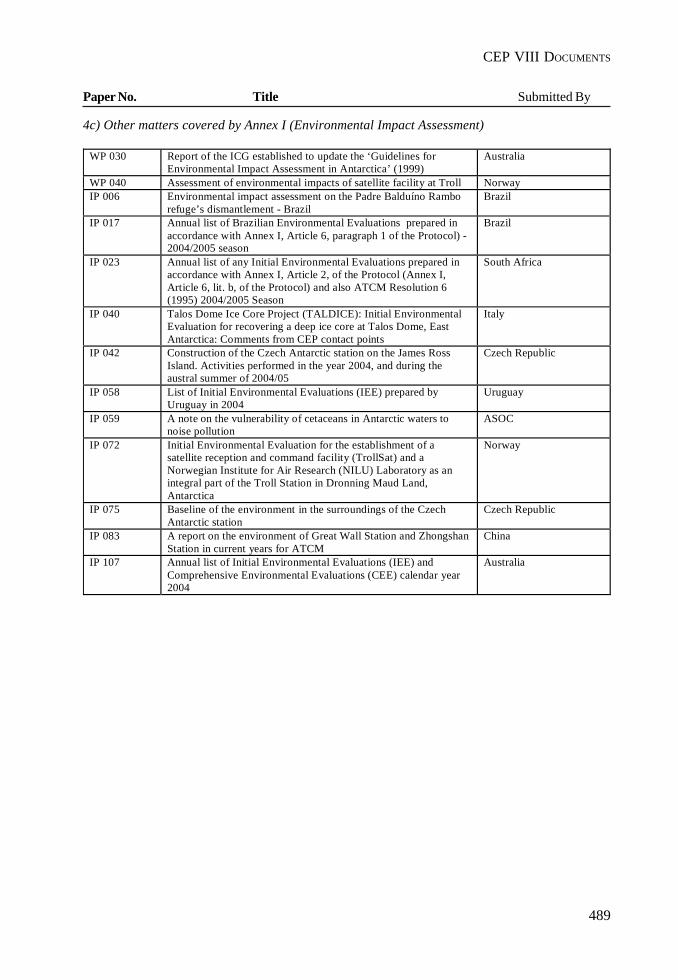
489
CEP VIII DOCUMENTS
Paper No. Title Submitted By
4c) Other matters covered by Annex I (Environmental Impact Assessment)
WP 030 Report of the ICG established to update the ‘Guidelines forEnvironmental Impact Assessment in Antarctica’ (1999)
Australia
WP 040 Assessment of environmental impacts of satellite facility at Troll NorwayIP 006 Environmental impact assessment on the Padre Balduíno Rambo
refuge’s dismantlement - BrazilBrazil
IP 017 Annual list of Brazilian Environmental Evaluations prepared inaccordance with Annex I, Article 6, paragraph 1 of the Protocol) -2004/2005 season
Brazil
IP 023 Annual list of any Initial Environmental Evaluations prepared inaccordance with Annex I, Article 2, of the Protocol (Annex I,Article 6, lit. b, of the Protocol) and also ATCM Resolution 6(1995) 2004/2005 Season
South Africa
IP 040 Talos Dome Ice Core Project (TALDICE): Initial EnvironmentalEvaluation for recovering a deep ice core at Talos Dome, EastAntarctica: Comments from CEP contact points
Italy
IP 042 Construction of the Czech Antarctic station on the James RossIsland. Activities performed in the year 2004, and during theaustral summer of 2004/05
Czech Republic
IP 058 List of Initial Environmental Evaluations (IEE) prepared byUruguay in 2004
Uruguay
IP 059 A note on the vulnerability of cetaceans in Antarctic waters tonoise pollution
ASOC
IP 072 Initial Environmental Evaluation for the establishment of asatellite reception and command facility (TrollSat) and aNorwegian Institute for Air Research (NILU) Laboratory as anintegral part of the Troll Station in Dronning Maud Land,Antarctica
Norway
IP 075 Baseline of the environment in the surroundings of the CzechAntarctic station
Czech Republic
IP 083 A report on the environment of Great Wall Station and ZhongshanStation in current years for ATCM
China
IP 107 Annual list of Initial Environmental Evaluations (IEE) andComprehensive Environmental Evaluations (CEE) calendar year2004
Australia
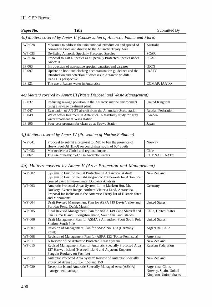
490
III. CEP REPORT
Paper No. Title Submitted By
4d) Matters covered by Annex II (Conservation of Antarctic Fauna and Flora)
4e) Matters covered by Annex III (Waste Disposal and Waste Management)
4f) Matters covered by Annex IV (Prevention of Marine Pollution)
4g) Matters covered by Annex V (Area Protection and Management)
WP 028 Measures to address the unintentional introduction and spread of non-native biota and disease to the Antarctic Treaty Area
Australia
WP 033 De-listing Antarctic Specially Protected Species SCAR WP 034 Proposal to List a Species as a Specially Protected Species under
Annex II SCAR
IP 063 Introduction of non-native species, parasites and diseases IUCN IP 097 Update on boot and clothing decontamination guidelines and the
introduction and detection of diseases in Antarctic wildlife: IAATO’s perspective
IAATO
IP 121 The use of ballast water in Antarctica COMAP, IAATO
IP 037 Reducing sewage pollution in the Antarctic marine environment using a sewage treatment plant
United Kingdom
IP 047 Evacuation of AN-3T aircraft from the Amundsen-Scott station Russian Federation IP 049 Waste water treatment in Antarctica. A feasibility study for grey
water treatment at Wasa station Sweden
IP 105 Four-year program for clean-up at Syowa Station Japan
WP 041 Proposal to submit a proposal to IMO to ban the presence of Heavy Fuel Oil (HFO) on board ships south of 60o South
Norway
WP 052 Marine debris: Global and regional impacts Chile IP 067 The use of heavy fuel oil in Antarctic waters COMNAP, IAATO
WP 002 Systematic Environmental Protection in Antarctica: A draftSystematic Environmental-Geographic Framework for Antarcticacreated using Environmental Domains Analysis
New Zealand
WP 003 Antarctic Protected Areas System: Lillie Marleen Hut, Mt.Dockery, Everett Range, northern Victoria Land, Antarctica.Proposal for inclusion in the Antarctic Treaty list of Historic Sitesand Monuments
Germany
WP 004 Draft Revised Management Plan for ASPA 119 Davis Valley andForlidas Pond, Dufek Massif
United States
WP 005 Final Revised Management Plan for ASPA 149 Cape Shirreff andSan Telmo Island, Livingston Island, South Shetland Islands
Chile, United States
WP 006 Draft Management Plan for ASMA ? Amundsen-Scott South PoleStation, South Pole
United States
WP 007 Revision of Management Plan for ASPA No. 133 (HarmonyPoint)
Argentina, Chile
WP 008 Revision of Management Plan for ASPA 132 (Potter Peninsula) ArgentinaWP 011 A Review of the Antarctic Protected Areas System New ZealandWP 015 Revised Management Plan for Antarctic Specially Protected Area
127 Haswell Island (Haswell Island and Adjacent EmperorPenguin Rookery on Fast Ice)
Russian Federation
WP 017 Antarctic Protected Area System: Review of Antarctic SpeciallyProtected Areas 155, 157, 158 and 159
New Zealand
WP 020 Deception Island Antarctic Specially Managed Area (ASMA)management package
Argentina, Chile,Norway, Spain, UnitedKingdom, United States
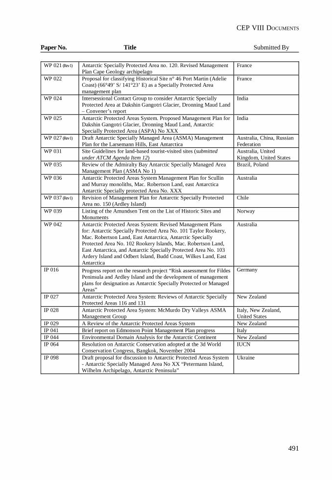
491
CEP VIII DOCUMENTS
Paper No. Title Submitted By
WP 021 (Rev 1) Antarctic Specially Protected Area no. 120. Revised ManagementPlan Cape Geology archipelago
France
WP 022 Proposal for classifying Historical Site n° 46 Port Martin (AdelieCoast) (66°49’ S/ 141°23’ E) as a Specially Protected Areamanagement plan
France
WP 024 Intersessional Contact Group to consider Antarctic SpeciallyProtected Area at Dakshin Gangotri Glacier, Dronning Maud Land– Convener’s report
India
WP 025 Antarctic Protected Areas System. Proposed Management Plan forDakshin Gangotri Glacier, Dronning Maud Land, AntarcticSpecially Protected Area (ASPA) No XXX
India
WP 027 (Rev 1) Draft Antarctic Specially Managed Area (ASMA) ManagementPlan for the Larsemann Hills, East Antarctica
Australia, China, RussianFederation
WP 031 Site Guidelines for land-based tourist-visited sites (submittedunder ATCM Agenda Item 12)
Australia, UnitedKingdom, United States
WP 035 Review of the Admiralty Bay Antarctic Specially Managed AreaManagement Plan (ASMA No 1)
Brazil, Poland
WP 036 Antarctic Protected Areas System Management Plan for Scullinand Murray monoliths, Mac. Robertson Land, east AntarcticaAntarctic Specially protected Area No. XXX
Australia
WP 037 (Rev 1) Revision of Management Plan for Antarctic Specially ProtectedArea no. 150 (Ardley Island)
Chile
WP 039 Listing of the Amundsen Tent on the List of Historic Sites andMonuments
Norway
WP 042 Antarctic Protected Areas System: Revised Management Plansfor: Antarctic Specially Protected Area No. 101 Taylor Rookery,Mac. Robertson Land, East Antarctica, Antarctic SpeciallyProtected Area No. 102 Rookery Islands, Mac. Robertson Land,East Antarctica, and Antarctic Specially Protected Area No. 103Ardery Island and Odbert Island, Budd Coast, Wilkes Land, EastAntarctica
Australia
IP 016 Progress report on the research project “Risk assessment for FildesPeninsula and Ardley Island and the development of managementplans for designation as Antarctic Specially Protected or ManagedAreas”
Germany
IP 027 Antarctic Protected Area System: Reviews of Antarctic SpeciallyProtected Areas 116 and 131
New Zealand
IP 028 Antarctic Protected Area System: McMurdo Dry Valleys ASMAManagement Group
Italy, New Zealand,United States
IP 029 A Review of the Antarctic Protected Areas System New ZealandIP 041 Brief report on Edmonson Point Management Plan progress ItalyIP 044 Environmental Domain Analysis for the Antarctic Continent New ZealandIP 064 Resolution on Antarctic Conservation adopted at the 3d World
Conservation Congress, Bangkok, November 2004IUCN
IP 098 Draft proposal for discussion to Antarctic Protected Areas System- Antarctic Specially Managed Area No XX “Petermann Island,Wilhelm Archipelago, Antarctic Peninsula”
Ukraine
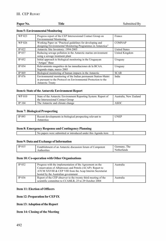
492
III. CEP REPORT
Paper No. Title Submitted By
Item 11: Election of Officers
Item 12: Preparation for CEP IX
Item 13: Adoption of the Report
Item 14: Closing of the Meeting
Item 5: Environmental Monitoring
Item 6: State of the Antarctic Environment Report
Item 7: Biological Prospecting
Item 8: Emergency Response and Contingency Planning
Item 9: Data and Exchange of Information
Item 10: Co-operation with Other Organisations
WP 023 Progress report of the CEP Intersessional Contact Group on Environmental Monitoring
France
WP 026 Working Paper on “Practical guidelines for developing and designing Environmental Monitoring Programmes in Antarctica”
COMNAP
IP 022 Antarctic Site Inventory: 1994-2005 United States IP 037 Reducing sewage pollution in the Antarctic marine environment
using a sewage treatment plant United Kingdom
IP 052 Initial approach to biological monitoring in the Uruguayan “Artigas” Base
Uruguay
IP 054 Relevamiento magnético de las inmediaciones de la BCAA. Segunda etapa, marzo 2005
Uruguay
IP 069 Biological monitoring of human impacts in the Antarctic SCAR IP 076 Environmental monitoring of the Indian permanent Station-Maitri
in pursuant to the Protocol on Environmental Protection to the Antarctic Treaty
India
WP 010 State of the Antarctic Environment Reporting System: Report of the Intersessional Contact Group
Australia, New Zealand
IP 104 The Antarctic and climate change ASOC
IP 093 Recent developments in biological prospecting relevant to Antarctica
UNEP
No papers were submitted or introduced under this Agenda item
IP 032 Progress with the implementation of the Agreement on the Conservation of Albatrosses and Petrels (ACAP): Report to ATCM XXVIII & CEP VIII from the Acap Interim Secretariat hosted by the Australian government
Australia
IP 036 Report of the CEP observer to the twenty third meeting of the scientific committee to CCAMLR, 25 to 29 October 2004
Australia
IP 015 Establishment of an Antarctic discussion forum of Competent Authorities
Germany, The Netherlands
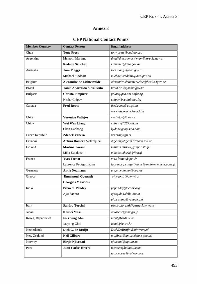
493
CEP REPORT. ANNEX 3
Annex 3
CEP National Contact PointsMember Country Contact Person Email address
Chair Tony Press [email protected]
Argentina Memolli Mariano
Rodolfo Sánchez
[email protected] / [email protected]
Australia Tom Maggs
Michael Stoddart
Belgium Alexandre de Lichtervelde [email protected]
Brazil Tania Aparecida Silva Brito [email protected]
Bulgaria Christo Pimpirev
Nesho Chipev
Canada Fred Roots [email protected]
www.ats.org.ar/aeoi.htm
Chile Verónica Vallejos [email protected]
China Wei Wen Liang
Chen Danhong
Czech Republic Zdenek Venera [email protected]
Ecuador Arturo Romero Velázquez [email protected]
Finland Markus Tarasti
Mika Kalakoski
France Yves Frenot
Laurence Petitguillaume
Germany Antje Neumann [email protected]
Greece Emmanuel Gounaris
Georgios Makridis
India Prem C. Pandey
Ajai Saxena
Italy Sandro Torcini [email protected]
Japan Kousei Masu [email protected]
Korea, Republic of In-Young Ahn
Jaeyong Choi
Netherlands Dick C. de Bruijn [email protected]
New Zealand Neil Gilbert [email protected]
Norway Birgit Njaastad [email protected]
Peru Juan Carlos Rivera [email protected]

494
III. CEP REPORT
Poland Stanislaw Rakusa-Suszczewski [email protected]
Romania Teodor Gheroghe-Negoita [email protected]
Russian Federation Valery Lukin
Valery Martyshchenko
South Africa Henry Valentine [email protected]
Spain Manuel Catalan [email protected]
Sweden Johan Sidenmark
Anna Carin Thomer
Marianne Lillieskold
Ukraine Gennady Milinevsky [email protected]
United Kingdom John Shears
Jane Rumble
United States of America Polly Penhale
Fabio Saturni
Uruguay Aldo Felici [email protected]
Observers 4a
Observer Contact person Email address
Estonia Mart Saarso
Enn Kaup
Observers 4b
Observer Contact Person Email address
CCAMLR Edith Fanta [email protected]
COMNAP Antoine Guichard
Gérard Jugie (Chairman)
SCAR Peter Clarkson [email protected]
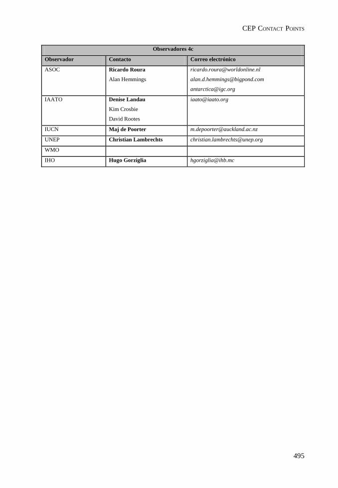
495
CEP CONTACT POINTS
Observadores 4c
Observador Contacto Correo electrónico
ASOC Ricardo Roura
Alan Hemmings
IAATO Denise Landau
Kim Crosbie
David Rootes
IUCN Maj de Poorter [email protected]
UNEP Christian Lambrechts [email protected]
WMO
IHO Hugo Gorziglia [email protected]

III. CEP REPORT
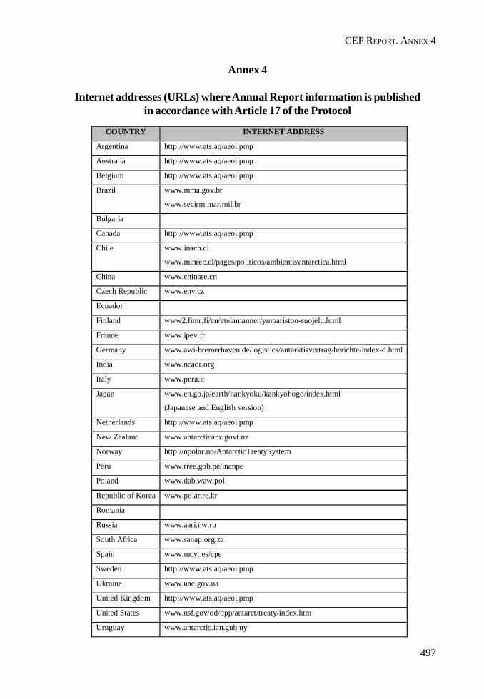
497
CEP REPORT. ANNEX 4
Annex 4
Internet addresses (URLs) where Annual Report information is publishedin accordance with Article 17 of the Protocol
COUNTRY INTERNET ADDRESS
Argentina http://www.ats.aq/aeoi.pmp
Australia http://www.ats.aq/aeoi.pmp
Belgium http://www.ats.aq/aeoi.pmp
Brazil www.mma.gov.br
www.secirm.mar.mil.br
Bulgaria
Canada http://www.ats.aq/aeoi.pmp
Chile www.inach.cl
www.minrec.cl/pages/politicos/ambiente/antarctica.html
China www.chinare.cn
Czech Republic www.env.cz
Ecuador
Finland www2.fimr.fi/en/etelamanner/ympariston-suojelu.html
France www.ipev.fr
Germany www.awi-bremerhaven.de/logistics/antarktisvertrag/berichte/index-d.html
India www.ncaor.org
Italy www.pnra.it
Japan www.en.go.jp/earth/nankyoku/kankyohogo/index.html
(Japanese and English version)
Netherlands http://www.ats.aq/aeoi.pmp
New Zealand www.antarcticanz.govt.nz
Norway http://npolar.no/AntarcticTreatySystem
Peru www.rree.gob.pe/inanpe
Poland www.dab.waw.pol
Republic of Korea www.polar.re.kr
Romania
Russia www.aari.nw.ru
South Africa www.sanap.org.za
Spain www.mcyt.es/cpe
Sweden http://www.ats.aq/aeoi.pmp
Ukraine www.uac.gov.ua
United Kingdom http://www.ats.aq/aeoi.pmp
United States www.nsf.gov/od/opp/antarct/treaty/index.htm
Uruguay www.antarctic.ian.gub.uy

III. CEP REPORT
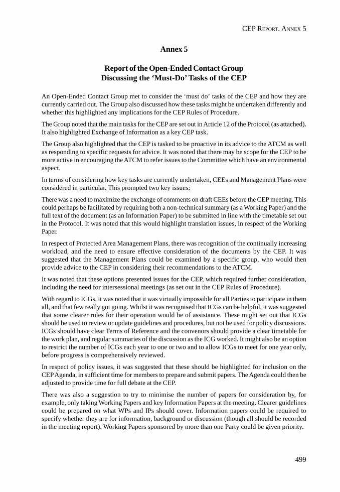
499
CEP REPORT. ANNEX 5
Annex 5
Report of the Open-Ended Contact GroupDiscussing the ‘Must-Do’ Tasks of the CEP
An Open-Ended Contact Group met to consider the ‘must do’ tasks of the CEP and how they arecurrently carried out. The Group also discussed how these tasks might be undertaken differently andwhether this highlighted any implications for the CEP Rules of Procedure.
The Group noted that the main tasks for the CEP are set out in Article 12 of the Protocol (as attached).It also highlighted Exchange of Information as a key CEP task.
The Group also highlighted that the CEP is tasked to be proactive in its advice to the ATCM as wellas responding to specific requests for advice. It was noted that there may be scope for the CEP to bemore active in encouraging the ATCM to refer issues to the Committee which have an environmentalaspect.
In terms of considering how key tasks are currently undertaken, CEEs and Management Plans wereconsidered in particular. This prompted two key issues:
There was a need to maximize the exchange of comments on draft CEEs before the CEP meeting. Thiscould perhaps be facilitated by requiring both a non-technical summary (as a Working Paper) and thefull text of the document (as an Information Paper) to be submitted in line with the timetable set outin the Protocol. It was noted that this would highlight translation issues, in respect of the WorkingPaper.
In respect of Protected Area Management Plans, there was recognition of the continually increasingworkload, and the need to ensure effective consideration of the documents by the CEP. It wassuggested that the Management Plans could be examined by a specific group, who would thenprovide advice to the CEP in considering their recommendations to the ATCM.
It was noted that these options presented issues for the CEP, which required further consideration,including the need for intersessional meetings (as set out in the CEP Rules of Procedure).
With regard to ICGs, it was noted that it was virtually impossible for all Parties to participate in themall, and that few really got going. Whilst it was recognised that ICGs can be helpful, it was suggestedthat some clearer rules for their operation would be of assistance. These might set out that ICGsshould be used to review or update guidelines and procedures, but not be used for policy discussions.ICGs should have clear Terms of Reference and the convenors should provide a clear timetable forthe work plan, and regular summaries of the discussion as the ICG worked. It might also be an optionto restrict the number of ICGs each year to one or two and to allow ICGs to meet for one year only,before progress is comprehensively reviewed.
In respect of policy issues, it was suggested that these should be highlighted for inclusion on theCEP Agenda, in sufficient time for members to prepare and submit papers. The Agenda could then beadjusted to provide time for full debate at the CEP.
There was also a suggestion to try to minimise the number of papers for consideration by, forexample, only taking Working Papers and key Information Papers at the meeting. Clearer guidelinescould be prepared on what WPs and IPs should cover. Information papers could be required tospecify whether they are for information, background or discussion (though all should be recordedin the meeting report). Working Papers sponsored by more than one Party could be given priority.
500
III. CEP REPORT
It was suggested that the Chair and Vice Chairs could discuss the priority of Agenda items, and thenorder the Working Papers to set out a timetabled work plan for each meeting (as the Chair hadprovided for this year).
Finally, the Group was mindful of the need to engage all parties and suggested that a CEP Handbookbe prepared to include all existing CEP procedures and agreed guidelines. The Chair and Vice Chaircould also undertake to liaise with all Parties to consider further options for maximising contributionsin the meeting.
LIST OF CEP “MUST DO” TASKS
Fulfill requirements set out in Article 12 of the Protocol, including:
- Effectiveness of Measures;- Provide advice to ATCM on environmental issues relating to Protocol and prepare advice
for ATCM as requested;- Provide advice on application and implementation of the EIA procedures, including
consideration of CEEs;- Procedures for situations requiring urgent action, including response action to environmental
emergencies;- Operation and further elaboration of Antarctic Protected Area System, including proposing,
revising and considering Protected Area Management Plans and Historical Sites andMonuments;
- Inspection procedures;- State of Antarctic Environment;- Consultation with SCAR, CCAMLR Scientific Committee and other relevant scientific,
environmental and technical organizations.
501
CEP REPORT. ANNEX 6
Annex 6
Aide memoire
CEP- THE WAY FORWARD
RATIONALE
• This aide memoire represents the combined thoughts of CEP members, with commitmentand energy. These issues have concerned members for some time.
• CEP is now a mature body – it is time for us to review who we are, what we do, how we do it,and take a new, informed, and updated look at the Antarctic environment.
• The exercise is totally within the CEP charter under articles 11 and 12 of the Protocol.• The CEP has considered the condition, pressures, and responses to those pressures• Members intend to develop aspirational goals for the CEP.• A core goal is to maintain and if possible improve the state of the Antarctic environment.• We will take a precautionary approach to environmental issues.• We want to become proactive to the protection of the Antarctic environment.
MAJOR THEMES
Environmental
• The International Polar Year, and what it means for the Antarctic environment and the CEP.• Human footprint in Antarctica:
- the carrying capacity - of the Antarctic region overall, and within it - both regionallyand locally;
- research and logistic support activities on land and at sea: establishment; management;removal; cooperation; temporary bases;
- tourism and related non-governmental activities.
• Global environmental pressures, including climate change.• Bipolar aspects – what can we learn from the Arctic experience?• Monitoring, reporting and responding to the state of the Antarctic environment.• Outreach: communication to civil society and policy makers.• Science in management: how do we get the information we need.
Administrative
• Relationships within the ATS (including with the ATCM) and outside the ATS.• Appropriate tools to do our work: the Protocol and its annexes; resolutions etc; procedures,
guidelines, rules of procedure.
502
III. CEP REPORT
• A structured approach to our business: efficient, targeted, transparent- a forward work plan for the next 5 – 10 years;- meetings and agenda structured to allow major focus on major issues;- one day of each meeting dedicated to strategic environmental issues on a thematic
basis, as well as procedures;- an agenda and rules of procedure which facilitate our work;- standing groups to address routine issues, eg management plans;- develop longer term objectives for the protection of the Antarctic environment.
503
CEP REPORT. ANNEX 7
Annex 7
Guidelines for Environmental Impact Assessment in Antarctica
See Annex to Resolution 4, page 407.

III. CEP REPORT
505
CEP REPORT. ANNEX 8
Annex 8
Guidelines for CEP Consideration of Proposals for New and RevisedDesignations of Antarctic Specially Protected Species
under Annex II of the Protocol
1 Proposals for new designations or revision of existing designations of species as AntarcticSpecially Protected Species (ASPS), in accordance with Appendix A to Annex II to theProtocol, may be submitted by any Party, the CEP or SCAR to the CEP for consideration atits next meeting. Such proposals should include scientific justification and, for newdesignations, a draft Action Plan (using the attached template as a guideline), to the extentpossible with available data and knowledge.
2 On receipt of a proposal, the CEP should invite the Scientific Committee on Antarctic Research(SCAR) to assess the status of the species, if SCAR has not already made such an assessmentas part of the proposal.
3 SCAR should use the most up-to-date IUCN criteria (consulting with appropriate experts inIUCN and elsewhere) to assess the risk of extinction of the species. Such assessmentsshould, as a priority, take account of the global status and trends of the species, though thestatus and trends of the species at regional or local levels may also need to be assessed.
4 For new designations:a. If SCAR’s assessment determines that the species is at significant risk of extinction
(e.g. the conservation status is determined to be “vulnerable” or higher), then the CEPshould recommend SPS designation to the ATCM and initiate a process to finalise theAction Plan for the species, in accordance with the guideline. The proponent shouldplay a co-ordinating role.
b. The CEP should determine whether other authorities or organisations have a role inprotective action and should consult accordingly (e.g. for species of interest to theCommission for the Conservation of Antarctic Marine Living Resources (CCAMLR)or the Agreement for the Conservation of Albatrosses and Petrels (ACAP) the CEPshould forward the proposal and the draft Action Plan, and any advice from SCAR, toCCAMLR or ACAP for advice on practical measures to provide special protection).
c. The Action Plan should be finalised taking account of advice from any authority ororganisation as appropriate, and reported to the next meeting of the CEP by thecoordinator.
5 For existing designations:a. If SCAR’s assessment determines that the species remains at significant risk of
extinction, then the species should retain its SPS designation and an Action Planshould be produced.
b. If SCAR’s assessment determines that the species is no longer at a significant risk ofextinction, the CEP should assess the implications of removing the species from thelist of Specially Protected Species with particular regard to potential future threats tothe species and specific mechanisms that might be needed to manage them.
6 The CEP should make a recommendation to the ATCM as to whether the species meritsSpecially Protected Species status, including the Action Plan as appropriate, andarrangements for monitoring the implementation of the Plan and modifying it when necessary.

III. CEP REPORT
507
SPECIALLY PROTECTED SPECIES
Guideline template of an Action Plan for a species proposed for designationas an Antarctic Specially Protected Species
PROTECTION ACTION PLAN FOR XXX YYY
Table of Contents
Summary
1. Introduction
Brief overview of:
a) species reproductive and foraging ecology (e.g. life history)b) past and present distribution including critical habitatc) population trends (e.g. past, present, future estimates)d) conservation statuse) agents of decline/threats (including uncertainties and potential future threats)f) past and current management/conservation measuresg) legal framework under Environmental Protocol/Antarctic Treaty System
2. Goals and objectives (examples)
Overall goal: to downgrade threatened status/degree of endangerment by reducing threats to adultsand critical stages of the life cycle
Specific objectives:
a) Quantify and reduce threats to survival of breeding populationb) Quantify and reduce threats to reproductive successc) Develop or maintain existing monitoring of populationsd) Educate base staff and other relevant human agenciese) Assess and revise Action Plan every 5 years
3. Actions
This would include specific actions to be taken, who should do the work, performance measures, andprioritization if necessary
a) Management of threats to survival (e.g. prevention of individual adult mortality)b) Management of threats to reproductive success (e.g. restrictions on approach to breeding
areas, prohibition of destructive sampling)c) Management of critical habitat (e.g. establishment of protected areas)d) Research on agents of decline, population dynamics, distribution, management techniques
and effectivenesse) Monitoring of key populations or life cycle stagesf) Education and awarenessg) International agreements (including consultation with relevant international organisations
on appropriate action outside the Antarctic Treaty Area)
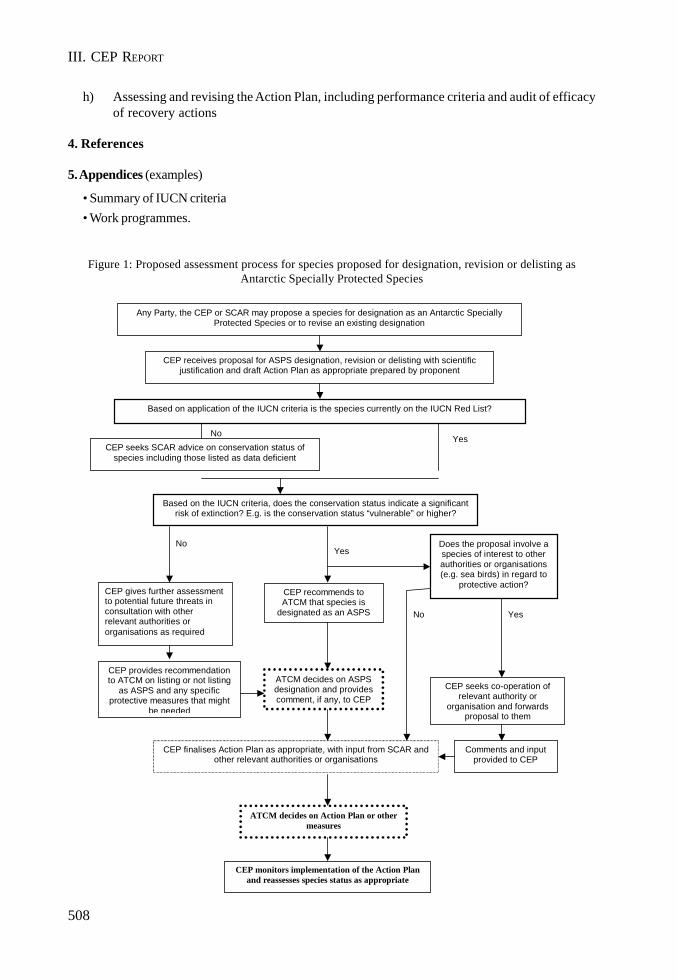
508
III. CEP REPORT
h) Assessing and revising the Action Plan, including performance criteria and audit of efficacyof recovery actions
4. References
5. Appendices (examples)
• Summary of IUCN criteria• Work programmes.
Figure 1: Proposed assessment process for species proposed for designation, revision or delisting asAntarctic Specially Protected Species
CEP receives proposal for ASPS designation, revision or delisting with scientific justification and draft Action Plan as appropriate prepared by proponent
Any Party, the CEP or SCAR may propose a species for designation as an Antarctic Specially Protected Species or to revise an existing designation
Based on application of the IUCN criteria is the species currently on the IUCN Red List?
CEP gives further assessment to potential future threats in consultation with other relevant authorities or organisations as required
Based on the IUCN criteria, does the conservation status indicate a significant risk of extinction? E.g. is the conservation status “vulnerable” or higher?
Does the proposal involve a species of interest to other authorities or organisations (e.g. sea birds) in regard to
protective action?
CEP seeks co-operation of relevant authority or
organisation and forwards proposal to them
CEP finalises Action Plan as appropriate, with input from SCAR and other relevant authorities or organisations
CEP provides recommendation to ATCM on listing or not listing
as ASPS and any specific protective measures that might
be needed
Comments and input provided to CEP
Yes
Yes No
Yes
CEP recommends to ATCM that species is
designated as an ASPS
ATCM decides on ASPS designation and provides comment, if any, to CEP
No
CEP seeks SCAR advice on conservation status of species including those listed as data deficient
No
ATCM decides on Action Plan or other measures
CEP monitors implementation of the Action Plan and reassesses species status as appropriate

509
CEP REPORT. ANNEX 9
Annex 9
Terms of Reference for ICG – “Environmental Monitoring and Reporting”
In views of CEP’s endorsement of COMNAP paper “Practical Guidelines for Developing and DesigningEnvironmental Monitoring Programmes in Antarctica” (WP 26), and the progress made by ICGs on“Environmental Monitoring” and “State of Antarctic Environment Reporting” (SAER), the CEP agreedto establish a single ICG to further develop practices and procedures in Environmental Monitoringand Reporting. It will address the following Terms of Reference:
1. Propose a preliminary list of environmental indicators and associated parameters which canbest indicate the impact of human activities in Antarctica on populations, habitats and othersensitive areas directly, indirectly or cumulatively impacted. Special attention will be paid tothe previous works by CEP/ATCM and COMNAP on environmental monitoring in Antarcticaand to the outputs of the recent SCAR / COMNAP / NSF workshop on the “PracticalBiological Indicators of Human Impacts in Antarctica”.
2. Work with CCAMLR to examine the desirability of including marine debris and other datainto CEP’s SAER system.
3. Display these indicators using CEP’s SAER system in order to analyse the potential value ofthis system for both reporting and monitoring of the state of the environment in Antarctica.
4. Provide a report to CEP IX on the development of Environmental Monitoring and Reportingin Antarctica.
Convener: Dr Yves Frenot ([email protected])

III. CEP REPORT
511
CEP REPORT. APPENDIX 1
Appendix 1
CEP Advice to ATCM XXVIII on the Draft CEEContained in ATCM XXVIII-WP 19 & IP 66 (United Kingdom)
The Committee for Environmental Protection,
With regard to the draft Comprehensive Environmental Evaluation for the Proposed Constructionand Operation of Halley VI Research Station, Brunt Ice Shelf, Caird Coast, Antarctica;
Having fully considered the draft CEE circulated by the United Kingdom on 04 February 2005, asreported in paragraphs 65 to 82 of the CEP VIII Final Report, and
Having noted the comments provided by the Parties to the United Kingdom, and the response of theUnited Kingdom to those comments,
Provides the following advice to the ATCM:
The draft CEE and the process followed by the United Kingdom conform to the requirementsof Article 3 of Annex 1 to the Environmental Protocol;
The draft CEE is well-structured and comprehensive and provides an appropriate assessmentof the impacts of the proposed project;
The information contained in the draft CEE supports its conclusion, that the proposed activitywill have a more than minor or transitory impact on the Antarctic environment, but that theglobal scientific importance to be gained by the construction and operation of Halley VIoutweighs the impact the station will have on the Antarctic environment and fully justifies theactivity proceeding;
While the draft CEE addresses the construction of a new research station based on threepossible alternative designs, the Committee feels that the document nonetheless appropriatelyassesses the likely environmental impacts of the overall design objectives, and that whicheverof the three designs is chosen, there will be a significant reduction in the overall impactcompared to that at the current Halley V research station.
The CEP recommends that the ATCM endorse these views.

III. CEP REPORT
513
CEP REPORT. APPENDIX 2
Appendix 2
CEP Advice to ATCM XXVIII on the Draft CEEContained in ATCM XXVIII-IP 30 (Germany)
The Committee for Environmental Protection,
With regard to the draft Comprehensive Environmental Evaluation for the Rebuild and Operation ofthe Wintering Station Neumayer III and Retrogradation of the Present Neumayer Station II;
Having fully considered the draft CEE circulated by Germany on 11 January 2005, as reported inparagraphs 83 to 102 of the CEP VIII Final Report, and
Having noted the comments provided by the Parties to Germany, and the response of Germany tothose comments,
Noting also that the draft CEE has yet to be approved by the German competent authority, which willfinalise its decision on the level of predicted impacts of the activity after considering the commentsmade by Parties,
Provides the following advice to the ATCM:
The draft CEE and the process followed by Germany conform to the requirements of Article 3of Annex 1 to the Environmental Protocol;
The draft CEE is well-structured and appropriately comprehensive;
A CEE is the appropriate level of assessment for this project.
The CEP recommends that the ATCM endorse these views.

III. CEP REPORT
515
CEP REPORT. APPENDIX 3
Appendix 3
List of ASPA and ASMA Management PlansReferred by the CEP to the ATCM for Adoption
Antarctic Specially Protected Areas
• ASPA No. 101 Taylor Rookery, Mac. Robertson Land• ASPA No. 102 Rookery Islands, Holme Bay, Mac. Robertson Land• ASPA No. 103 Ardery Island and Odbert Island, Budd Coast• ASPA No. 119 Forlidas Pond and Davis Valley, Dufek Massif• ASPA No. 120 Pointe-Géologie Archipelago, Terre Adélie• ASPA No. 132 Potter Peninsula, King George Island, South Shetland Islands• ASPA No. 133 Harmony Point, Nelson Island, South Shetland Islands• ASPA No. 140 Parts of Deception Island, South Shetland Islands*• ASPA No. 145 Port Foster, Deception Island, South Shetland Islands*• ASPA No. 149 Cape Shirreff and San Telmo Island, Livingston Island, South Shetland Islands• ASPA No. 155 Cape Evans, Ross Island• ASPA No. 157 Backdoor Bay, Cape Royds, Ross Island• ASPA No. 158 Hut Point, Ross Island• ASPA No. 159 Cape Adare, Borchgrevink Coast• ASPA No. 163 Dakshin Gangotri Glacier, Dronning Maud Land• ASPA No. 164 Scullin and Murray Monoliths, Mac. Robertson Land, East Antarctica
Antarctic Specially Managed Areas
• ASMA No. 4 Deception Island*
* These management plans are part of the broader “Deception Island Management Package

III. CEP REPORT
517
CEP REPORT. APPENDIX 4
Appendix 4
List of Historic Sites and MonumentsReferred by the CEP to the ATCM for Adoption
• Lillie Marleen Hut, Mt. Dockery, Everett Range, northern Victoria Land, Antarctica• Amundsen Tent

III. CEP REPORT

519
CEP REPORT. APPENDIX 5
Appendix 5
CEP IX Provisional Agenda
1. Opening of the Meeting2. Adoption of the Agenda3. Strategic Discussions on the Future Work of the CEP4. Operation of the CEP5. International Polar Year6. Environmental Impact Assessment
• Draft Comprehensive Environmental Evaluations• Other EIA Matters
7. Area Protection and Management8. Conservation of Antarctic Flora and Fauna9. Environmental Monitoring and Reporting10. Inspection Reports11. Waste Management12. Prevention of Marine Pollution13. Cooperation with Other Organisations14. General Matters15. Election of Officers16. Preparation for Next Meeting17. Adoption of the Report18. Closing of the Meeting

ANNEX F
REPORTS PURSUANT TORECOMMENDATION XIII-2

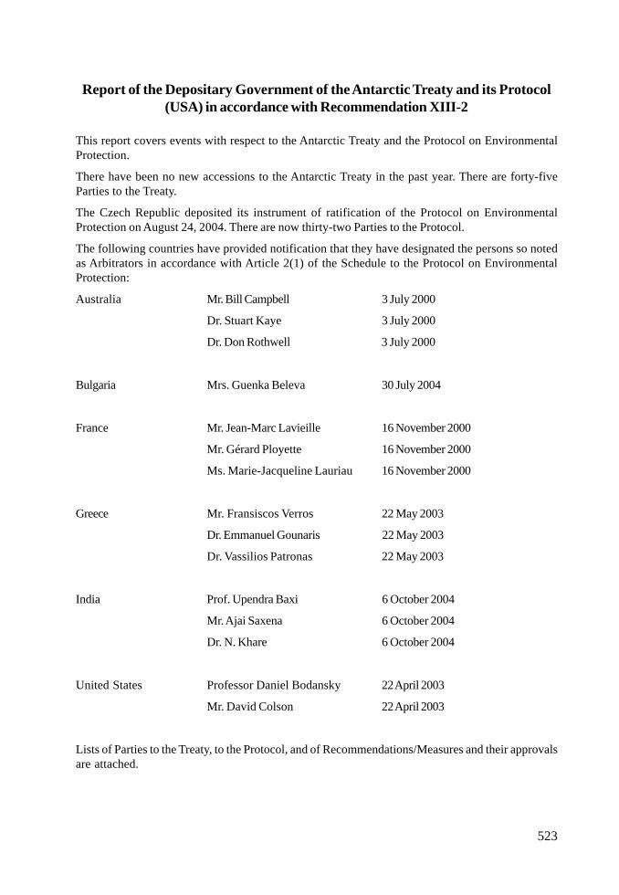
523
Report of the Depositary Government of the Antarctic Treaty and its Protocol(USA) in accordance with Recommendation XIII-2
This report covers events with respect to the Antarctic Treaty and the Protocol on EnvironmentalProtection.
There have been no new accessions to the Antarctic Treaty in the past year. There are forty-fiveParties to the Treaty.
The Czech Republic deposited its instrument of ratification of the Protocol on EnvironmentalProtection on August 24, 2004. There are now thirty-two Parties to the Protocol.
The following countries have provided notification that they have designated the persons so notedas Arbitrators in accordance with Article 2(1) of the Schedule to the Protocol on EnvironmentalProtection:
Australia Mr. Bill Campbell 3 July 2000
Dr. Stuart Kaye 3 July 2000
Dr. Don Rothwell 3 July 2000
Bulgaria Mrs. Guenka Beleva 30 July 2004
France Mr. Jean-Marc Lavieille 16 November 2000
Mr. Gérard Ployette 16 November 2000
Ms. Marie-Jacqueline Lauriau 16 November 2000
Greece Mr. Fransiscos Verros 22 May 2003
Dr. Emmanuel Gounaris 22 May 2003
Dr. Vassilios Patronas 22 May 2003
India Prof. Upendra Baxi 6 October 2004
Mr. Ajai Saxena 6 October 2004
Dr. N. Khare 6 October 2004
United States Professor Daniel Bodansky 22 April 2003
Mr. David Colson 22 April 2003
Lists of Parties to the Treaty, to the Protocol, and of Recommendations/Measures and their approvalsare attached.

III. REPORTS
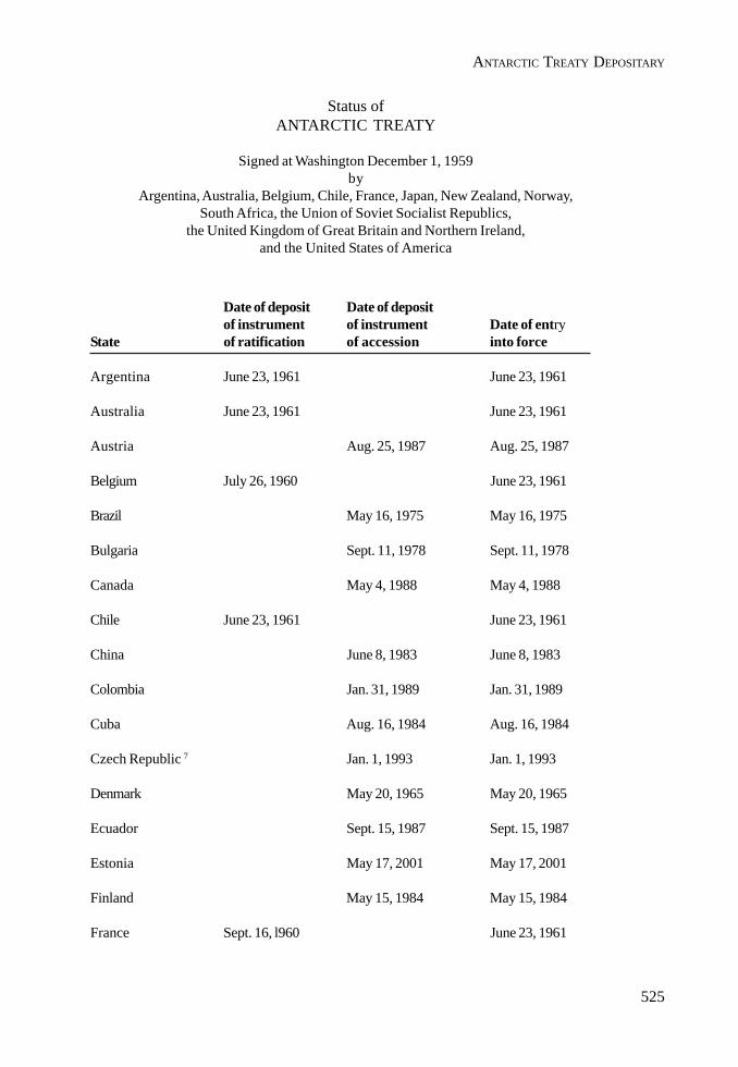
525
ANTARCTIC TREATY DEPOSITARY
Status ofANTARCTIC TREATY
Signed at Washington December 1, 1959by
Argentina, Australia, Belgium, Chile, France, Japan, New Zealand, Norway,South Africa, the Union of Soviet Socialist Republics,
the United Kingdom of Great Britain and Northern Ireland,and the United States of America
Date of deposit Date of depositof instrument of instrument Date of entry
State of ratification of accession into force
Argentina June 23, 1961 June 23, 1961
Australia June 23, 1961 June 23, 1961
Austria Aug. 25, 1987 Aug. 25, 1987
Belgium July 26, 1960 June 23, 1961
Brazil May 16, 1975 May 16, 1975
Bulgaria Sept. 11, 1978 Sept. 11, 1978
Canada May 4, 1988 May 4, 1988
Chile June 23, 1961 June 23, 1961
China June 8, 1983 June 8, 1983
Colombia Jan. 31, 1989 Jan. 31, 1989
Cuba Aug. 16, 1984 Aug. 16, 1984
Czech Republic 7 Jan. 1, 1993 Jan. 1, 1993
Denmark May 20, 1965 May 20, 1965
Ecuador Sept. 15, 1987 Sept. 15, 1987
Estonia May 17, 2001 May 17, 2001
Finland May 15, 1984 May 15, 1984
France Sept. 16, l960 June 23, 1961

526
III. REPORTS
Date of deposit Date of depositof instrument of instrument Date of entry
State of ratification of accession into force
Germany 1 Feb. 5, 1979 Feb. 5, 1979
Greece Jan. 8, 1987 Jan. 8, 1987
Guatemala July 31, 1991 July 31, 1991
Hungary Jan. 27, 1984 Jan. 27, 1984
India Aug. 19, 1983 Aug. 19, 1983
Italy Mar. 18, 1981 Mar. 18, 1981
Japan Aug. 4, 1960 June 23, 1961
Korea, DPR of Jan. 21, 1987 Jan. 21, 1987
Korea, Rep. of Nov. 28, 1986 Nov. 28, 1986
Netherlands Mar. 30, 1967 2 Mar. 30, 1967
New Zealand Nov. 1, 1960 June 23, 1961
Norway Aug. 24, 1960 June 23, 1961
Papua New Guinea Mar. 16, 1981 5 Sept. 16, 1975 6
Peru Apr. 10, 1981 Apr. 10, 1981
Poland June 8, 1961 June 23, 1961
Romania Sept. 15, 1971 3 Sept. 15, 1971
Russian Federation Nov. 2, 1960 June 23, 1961
Slovak Republic 7 Jan. 1, 1993 Jan. 1, 1993
South Africa June 21, 1960 June 23, 1961
Spain Mar. 31, 1982 Mar. 31, 1982
Sweden Apr. 24, 1984 Apr. 24, 1984
Switzerland Nov. 15, 1990 Nov. 15, 1990
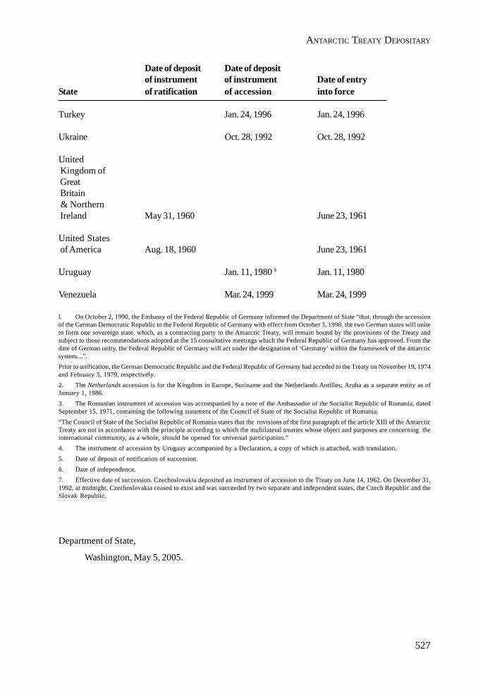
527
ANTARCTIC TREATY DEPOSITARY
Date of deposit Date of depositof instrument of instrument Date of entry
State of ratification of accession into force
Turkey Jan. 24, 1996 Jan. 24, 1996
Ukraine Oct. 28, 1992 Oct. 28, 1992
United Kingdom of Great Britain & Northern Ireland May 31, 1960 June 23, 1961
United States of America Aug. 18, 1960 June 23, 1961
Uruguay Jan. 11, 1980 4 Jan. 11, 1980
Venezuela Mar. 24, 1999 Mar. 24, 1999
l. On October 2, 1990, the Embassy of the Federal Republic of Germany informed the Department of State “that, through the accessionof the German Democratic Republic to the Federal Republic of Germany with effect from October 3, 1990, the two German states will uniteto form one sovereign state, which, as a contracting party to the Antarctic Treaty, will remain bound by the provisions of the Treaty andsubject to those recommendations adopted at the 15 consultative meetings which the Federal Republic of Germany has approved. From thedate of German unity, the Federal Republic of Germany will act under the designation of ‘Germany’ within the framework of the antarcticsystem....”.Prior to unification, the German Democratic Republic and the Federal Republic of Germany had acceded to the Treaty on November 19, 1974and February 5, 1979, respectively.2. The Netherlands accession is for the Kingdom in Europe, Suriname and the Netherlands Antilles; Aruba as a separate entity as ofJanuary 1, 1986.3. The Romanian instrument of accession was accompanied by a note of the Ambassador of the Socialist Republic of Romania, datedSeptember 15, 1971, containing the following statement of the Council of State of the Socialist Republic of Romania:“The Council of State of the Socialist Republic of Romania states that the rovisions of the first paragraph of the article XIII of the AntarcticTreaty are not in accordance with the principle according to which the multilateral treaties whose object and purposes are concerning theinternational community, as a whole, should be opened for universal participation.”4. The instrument of accession by Uruguay accompanied by a Declaration, a copy of which is attached, with translation.5. Date of deposit of notification of succession.6. Date of independence.7. Effective date of succession. Czechoslovakia deposited an instrument of accession to the Treaty on June 14, 1962. On December 31,1992, at midnight, Czechoslovakia ceased to exist and was succeeded by two separate and independent states, the Czech Republic and theSlovak Republic.
Department of State,
Washington, May 5, 2005.
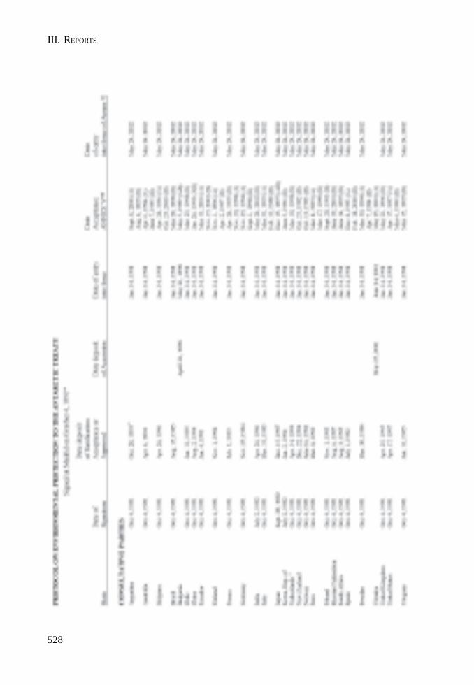
528
III. REPORTS
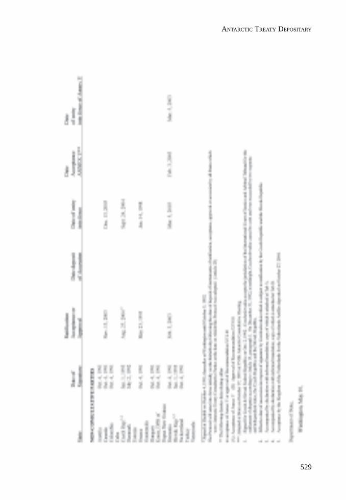
529
ANTARCTIC TREATY DEPOSITARY

530
III. REPORTS
531
ANTARCTIC TREATY DEPOSITARY

532
III. REPORTS
533
ANTARCTIC TREATY DEPOSITARY
534
III. REPORTS
535
Report by the head of the Australian Delegation in his capacityas representative of the depositary Government for the Convention
on the Conservation of Antarctic Marine Living Resourcesto the Twenty-Eighth Antarctic Treaty Consultative Meeting
1. Australia, as depositary Government to the Convention on the Conservation of AntarcticMarine Living Resources 1980 (the Convention) is pleased to report to the Twenty-EighthAntarctic Treaty Consultative Meeting on the status of the Convention.
2. Australia advises the Antarctic Treaty Parties that, since the Twenty-Seventh AntarcticTreaty Consultative Meeting, Mauritius deposited its instrument of accession to theConvention in accordance with Article XXIX(1) of the Convention on 2 September 2004.The Convention entered into force for Mauritius in accordance with Article XXVIII(2) of theConvention on 2 October 2004.
3. Australia further advises the Antarctic Treaty Parties that, since the Twenty-Seventh AntarcticTreaty Consultative Meeting, no States have become members of the Commission for theConservation of Antarctic Marine Living Resources, in accordance with Article VII(2) of theConvention.
4. A copy of the status list for the Convention is available to States Parties to the Conventionupon request to the Treaties Secretariat of the Department of Foreign Affairs and Trade,conveyed through Australian diplomatic missions, as well as via the internet on theAustralian Treaties Database at the following internet address:
http://www.austlii.edu.au/au/other/dfat/treaty_list/deposity/CCAMLR.html

III. REPORTS
537
Report by the Head of the Australian Delegationin his capacity as representative of the depositary Government
for the Agreement on the Conservation of Albatrosses and Petrelsto the Twenty-Eighth Antarctic Treaty Consultative Meeting
1. Australia, as depositary Government to the Agreement on the Conservation of Albatrossesand Petrels (the Agreement) is pleased to report to the Twenty-Eighth Antarctic TreatyConsultative Meeting on the status of the Agreement.
2. Australia advises the Antarctic Treaty Parties that, since the Twenty-Seventh AntarcticTreaty Consultative Meeting, Peru deposited its instrument of ratification of the Agreementin accordance with Article XV of the Agreement on 17 May 2005. In accordance with ArticleXVI of the Agreement, the Agreement will enter into force for Peru on 1 August 2005.
3. This brings the number of States Parties to the Agreement to seven. A copy of the status listfor the Agreement is available to States Parties to the Agreement upon request to the TreatiesSecretariat of the Department of Foreign Affairs and Trade, conveyed through Australiandiplomatic missions, as well as via the internet on the Agreement website at the followinginternet address:
http://www.acap.aq/acap/parties

III. REPORTS
539
Report submitted to Antarctic Treaty Consultative Meeting XXVIIIby the depositary Government for the Convention for the Conservation
of Antarctic Seals in Accordance with Recommendation XIII-2, paragraph 2 (d)
Submitted by the United Kingdom
This report covers events regarding the Convention for the Conservation of Antarctic Seals (CCAS)for the reporting year 1 March 2003 to 29 February 2004.
The summary at Annex A lists all capturing and killing of Antarctic seals by Contracting Parties toCCAS during the reporting period. A report of events in the 2004 – 2005 year will be submitted toATCM XXIX, once the June 2005 deadline for exchange of information has passed.
The United Kingdom would like to remind Contracting Parties to CCAS that the reporting period forthe Exchange of Information is from 1 March to the end of February each year. The reporting periodwas changed to the above dates during the September 1988 Meeting to Review the Operation of theConvention. This is documented in Paragraph 19(a) of the Report of that Meeting.
The Exchange of Information, referred to in Paragraph 6(a) in the Annex to the Convention, should besubmitted to other Contracting Parties and to SCAR by 30 June each year, including nil returns.Currently, not all the information required in paragraph 6(a) is being provided. Neither is it beingprovided on time or with any regularity. The accuracy of the CCAS figures is therefore beingcompromised.
Since ATCM XXIII there have been no accessions to CCAS. A list of countries which were originalsignatories to the Convention, and countries which have subsequently acceded is attached to thisreport (Annex B).

540
III. REPORTS
ANNEX B
CONVENTION FOR THE CONSERVATION OF ANTARCTIC SEALS (CCAS)
London, 1 June – 31 December 1972
(The Convention entered into force on 11 March 1978)
ANNEX A
CONVENTION FOR THE CONSERVATION OF ANTARCTIC SEALS (CCAS)
Synopsis of reporting in accordance with Article 5 and the Annex of the Convention: Capturing and killingof seals during the period 1 March 2002 to 28 February 2003.
* No report received.a All Elephant seals.b All Antarctic Fur seals.c All Weddell seals (single mortality: a female did not survive the anaesthetic, in spite of being given the appropriate antidote).d Up to 1000 Weddell, 800 Crabeater, 500 Antarctic Fur, 400 Leopard, and 75 Ross seals.All reported capturing was for scientific research.
Contracting Party Antarctic Seals Captured Antarctic Seals KilledArgentina 215a NilAustralia Nil NilBelgium* - -Brazil* - -Canada Nil NilChile 700b NilFrance* - -Germany 19c 1c
Italy* - -Japan* - -Norway Nil NilRussia* - -Poland Nil NilSouth Africa* - -United Kingdom Nil NilUnited States of America 2775d Nil
State Date of Signature Date of deposit (Ratificationor Acceptance)
Argentina1 9 June 1972 7 March 1978Australia 5 October 1972 1 July 1987Belgium 9 June 1972 9 February 1978Chile1 28 December 1972 7 February 1980France2 19 December 1972 19 February 1975Japan 28 December 1972 28 August 1980Norway 9 June 1972 10 December 1973Russia1,2,4 9 June 1972 8 February 1978South Africa 9 June 1972 15 August 1972United Kingdom2 9 June 1972 10 September 19743
United States of America2 28 June 1972 19 January 1977
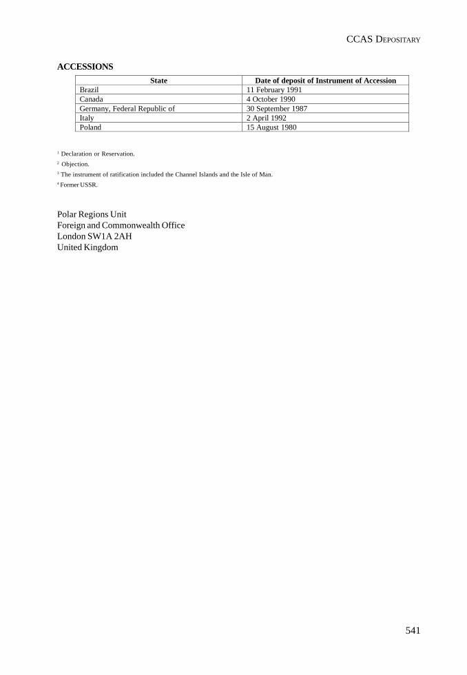
541
CCAS DEPOSITARY
ACCESSIONS
1 Declaration or Reservation.2 Objection.3 The instrument of ratification included the Channel Islands and the Isle of Man.4 Former USSR.
Polar Regions UnitForeign and Commonwealth OfficeLondon SW1A 2AHUnited Kingdom
State Date of deposit of Instrument of AccessionBrazil 11 February 1991Canada 4 October 1990Germany, Federal Republic of 30 September 1987Italy 2 April 1992Poland 15 August 1980

III. REPORTS
543
Report by the CCAMLR Observerat the Twenty-Eighth Antarctic Treaty Consultative Meeting
1. During its Twenty-Third Meeting (25 October to 5 November 2004), the Commission for theConservation of Antarctic Marine Living Resources (CCAMLR) addressed a number ofroutine matters as well some specific issues. The most notable of the latter included:• Illegal, unreported and unregulated (IUU) fishing in the Convention Area;• Implementation of the Catch Documentation Scheme (CDS) for Dissostichus spp.;• Further development of a centralized vessel monitoring system (c-VMS);• Compilation of a list of vessels engaged in IUU fishing;• Implementation of an electronic-based catch document system (e-CDS);• Further development of ecosystem management, including decision making;• Elimination of seabird by-catch in longline fisheries; and• Co-operation with various international organizations including the FAO, ATCM and
CITES.
2. These issues are relevant to several items on the agendas of ATCM-28 and CEP-VIII.
CCAMLR Fisheries in 2003-2004
3. Fisheries in the CAMLR Convention Area during 2003-2004 targeted Patagonianand Antarctic Toothfish (Dissostichus eleginoides and D. mawsoni), mackerel icefish(Champsocephalus gunnari) and krill (Euphausia superba).
4. The reported finfish catch was 13, 698 tonnes in 2003/2004, compared to 28, 568 tonnes in2002/2003. Dissostichus spp. (Toothfish), predominantly from longlining, accounted for 10966 tonnes in 2002/2003, compared to 24, 137 tonnes in the previous season. It is believedthat, in addition to reported catches, some 15, 922 tonnes of Dissostichus spp were taken asa result of IUU fishing in the Convention Area during 2003/2004, compared with 28, 577tonnes in 2002/2003. The total global catch for Toothfish in 2002/03 was estimated at 52, 714tonnes
5. The reported catch of krill in 2003/2004 was 102, 112 tonnes until 3 October 2004, comparedto 117, 728 tonnes in the previous season. The annual krill catch has remained relativelystable since 1992/93 in the range 80, 000 to 120, 000 tonnes. The projected krill catch for the2004/2005 season may be as much as 60% higher than in 2003/2004 season.
6. The Commission adopted conservation measures for all fisheries being conducted in the2004/20,05 season, as well as general measures for regulating fishing activities and reportingfisheries information from the Convention Area. These are published in the Schedule ofConservation Measures in Force – 2004/2005, available from the CCAMLR Secretariat or onwebsite: http://www.ccamlr.org.
Illegal, Unreported and Unregulated (IUU) Fishing in the Convention Area
7. IUU fishing for Patagonian Toothfish (Dissostichus eleginoides) in the Convention Areahas been a major issue for the Commission since 1997. CCAMLR attaches high priority toeliminating such fishing. It continues to develop and implement an integrated suite ofadministrative, political and enforcement-related measures aimed at addressing the problemin the Convention Area and at ensuring that fishing in closely adjacent areas adheres tointernational best practice.
544
III. REPORTS
8. CCAMLR annually reviews Members’ implementation of enforcement-related measures andevaluates their performance in combating IUU fishing in the Convention Area.
9. The above initiatives have taken place against a background of ongoing and vigorousaction by individual CCAMLR Contracting Parties to combat IUU fishing in areas undertheir national jurisdiction.
10. In addition to the Catch Documentation Scheme (CDS) for Dissostichus spp. (see paragraphs15-24 below) and measures to manage specific fisheries directly (e.g. the setting of catchlimits and other conditions affecting fishing), CCAMLR conservation and managementmeasures include:• The CCAMLR System of Inspection;• Scheme to Promote Compliance by both Contracting and Non-Contracting Party
Vessels, including provisions for compiling a list of IUU vessels;• Licensing and Inspection Obligations of Contracting Parties with regard to their Flag
Vessels Operating in the Convention Area;• Procedures for port inspections of vessels carrying Toothfish;• Marking of Fishing Vessels and Fishing Gear;• Automated Satellite-Linked Vessel Monitoring Systems (VMS); and• Various Resolutions – (a) “Banning Driftnet Fishing in the Convention Area”, (b)
“Harvesting Species Occurring Both within and Outside the Convention Area”, (c)“Implementation of the CDS by Acceding States and Non-Contracting Parties”, (d)“Use of Ports not Implementing the CDS”, (e) “Application of VMS in the CDS”, (f)“Use of VMS and Other Measures to Verify CDS Catch Data for Areas Outside theConvention Area, Especially FAO Statistical Area 51; (g) “Harvesting of D. eleginoidesin Areas Outside Coastal State Jurisdiction Adjacent to the Convention Area in FAOStatistical Areas 51 and 57, and (h) “Vessels Flying Flags of Non-Compliance and IceStrengthening Standards in High Latitude Fisheries”.
11. To facilitate exchange of relevant information amongst its Members, CCAMLR maintains adatabase on vessels known to have fished in contravention of CCAMLR ConservationMeasures. Such vessels are incorporated into an official “CCAMLR IUU Vessel List”.CCAMLR has also initiated a centralized, satellite-based vessel monitoring system (c-VMS)in the CCAMLR Secretariat.
12. CCAMLR has welcomed the entry into force of a number of international instruments andcontinues to urge its Members to accept, ratify and implement these.
13. CCAMLR continues to provide input into the FAO’s work on IUU fishing and encouragesall its Members to participate in this work to ensure that a comprehensive and integratedinternational approach to the problem is developed (see also paragraphs 39 to 41 below).
14. CCAMLR interacts with various other international and regional fisheries organisations,especially those with responsibility for waters adjacent to the Convention Area, in theexchange of information on issues such as IUU fishing and other matters relevant to CCAMLR(e.g. seabird by-catch, see paragraph 32 below).
CCAMLR Catch Documentation Scheme for Dissostichus spp.
15. Implementation of the CDS (which became binding on CCAMLR Members on 7 May 2000)has been one of the most important steps taken by CCAMLR to address IUU fishing in theConvention Area. The Scheme is designed to track Toothfish landings and trade flows fromcatches in the Area and, where possible, adjacent waters. It strives to identify the origin of
545
CCAMLR OBSERVER
Toothfish entering the markets of all Parties to the Scheme to facilitate determination ofwhether catches in the Convention Area are taken in a manner consistent with CCAMLR’sConservation Measures.
16. During 2003/04, development of the CDS continued, with:• Further development of an electronically-based CDS;• Refinement of explanatory memoranda on CDS implementation; and• Development of various other enforcement measures (see paragraph 10 above).
17. Non-Contracting Parties cooperating in CDS implementation, or partial implementation,include the People’s Republic of China, Republic of Mauritius, Republic of Seychelles andthe Republic of Singapore. Positive contacts continue with a number of other Non-ContractingParties, most of which participate in Toothfish trade. In October 2004, Mauritius formallyacceded to the CAMLR Convention.
18. By January 2005, more than 26,750 Dissostichus Catch Documents (DCDs) had been issued.These included 10,000 Landing, 15,000 Export and 1,600 Re-Export Documents. Copies ofthese are verified whenever a shipment of Toothfish is traded to allow all Contracting andCDS Parties (fishing or not fishing for Toothfish) to track trade across their borders.
19. CDS information is processed and analyzed to assess the volume and location of Toothfishtrade. It also gives some indication of fish taken legally and provides a barrier to fish takenillegally entering the marketplace.
20. The CCAMLR Secretariat has developed a system to process, store and access CDSinformation. The relevant information is available in close to real-time on the CCAMLRWebsite to allow CDS participants to assess the veracity of reported Toothfish landings.Widening application of the e-CDS illustrates CCAMLR’s commitment to improving theCDS’ effective implementation overall.
21. There is evidence to indicate that introduction of the CDS has made trading in illegally-caught fish less profitable since such higher prices are generally paid for fish accompaniedby valid DCDs.
22. CCAMLR not only promotes on-going use of the CDS, it also provides information on itsimplementation to various intergovernmental and non-governmental fisheries, environmentaland scientific organizations. These include: FAO, IOC, IWC, SCAR, SCOR, NAFO, ICCAT,FFA, CCSBT, SPC, I-ATTC, WTO, ASOC, IUCN and UNEP.
23. CCAMLR fully endorses development of uniform catch documentation and reportingmeasures that make use of appropriate technologies (as demonstrated by CCAMLR’sdevelopment of the e-CDS noted in paragraph 20 above). It also continues to improve co-operation with the WTO and World Customs Organization (WCO), particularlyimplementation of harmonized customs codes for Toothfish products.
24. Various resolutions identified in paragraph 11 are aimed at improving the CDS’s broaderapplication and CCAMLR continues its efforts to improve co-operation with CITES in respectof broadening the CDS’ implementation.
Development of an Integrated Fisheries Management Framework
25. CCAMLR continues to pursue the development of an integrated fisheries managementframework. Fishery Plans are now available for all the krill, icefish and Toothfish fisheries inthe Convention Area.
546
III. REPORTS
Ecosystem Management and Decision Making
26. The CCAMLR Ecosystem Monitoring Programme (CEMP) collects long-term data on variousAntarctic marine ecosystem components as well as the environment. Such data are used toprovide annual assessments of ecosystem status. Advice on long-term ecosystem trendsand changes can then be incorporated into management advice.
27. The CCAMLR scientific community continues to explore ways in which ecosystem advice(such as described in paragraph 26 above) can be formally incorporated into managementdecisions. Plausible ecosystem models were reviewed at a workshop in mid-2004 and effortsto study functional relationships between krill and its dominant predators continue. Otherworkshops in 2004 examined – (a) application of small-scale management units as a means tostudy relationships between krill, krill predators and the fishery, and (b) set the stage for animportant workshop in mid-2005 to consider ecosystem-based decision rules to be appliedas part of CCAMLR ecosystem and precautionary management approach.
Seabird By-catch in Longline and Trawl Fisheries
28. Over the past few years CCAMLR has taken a leading role in implementing measures toreduce seabird mortality during longline fishing. Many of CCAMLR’s measures, particularlythe provisions of Conservation Measure 25-03 (first adopted in 1992 as Conservation Measure29), have been incorporated into the FAO International Plan of Action for Reducing IncidentalCatch of Seabirds in Longline Fisheries (IPOA-Seabirds) adopted by COFI. A number ofCCAMLR Members have also developed and implemented national plans of action to addressthe seabird by-catch issue.
29. Compliance with the provisions of CCAMLR Conservation Measure 25-02 has improved tosuch an extent that seabird by-catch levels in regulated fisheries in the Convention Area arenow extremely low. However, there is still considerable concern about the levels of such by-catch attributable to the IUU fishery. Furthermore, many of the important species breedingin the Convention Area (particularly albatrosses and petrels) remain affected by high levelsof mortality associated with longline fishing on a global basis. To this extent, CCAMLR hasurged its Members to support the entry into force of the Agreement on the Conservation ofAlbatrosses and Petrels (ACAP) and CCAMLR was an official observer to the first Meetingof Parties to this Agreement in November 2004.
30. CCAMLR’s efforts to reduce seabird by-catch continue to strive for:• Compulsory placement of international and scientific observers on board all vessels
licensed to fish in the Convention Area;• Full compliance with mitigation measures set out in CCAMLR Conservation Measure
25-02, especially suitable line weighting, and• Continuing development of underwater longline setting devices.
31. CCAMLR also monitors incidental by-catch of seabirds and marine mammals in trawl fisheriesfor krill and finfish. Conservation Measure 25-03 has been substantially revised to includeregulations on offal disposal, cleaning of nets before shooting and minimizing the time thatthe net is lying on the surface. This Measure encourages Members to develop gearconfigurations to minimize the probability of birds encountering the part of the net to whichthey are most vulnerable.
32. CCAMLR exchanges information with various international fisheries and conservationorganizations on the prevention of seabird incidental mortality during fishing operations,the state of Antarctic seabird populations, incidental catches of seabirds in these fisheries,CCAMLR experience with mitigating techniques and the formulation of associated
547
CCAMLR OBSERVER
conservation action. Emphasis is also being given to high seas areas adjacent to theConvention Area and to species falling within CCAMLR’s management remit. In the latterregard, CCAMLR has approached a number of other Regional Fisheries Organizations(RFO’s) (particularly those managing tuna, such as ICCAT, IOTC and CCSBT) in an effort tosecure more global information on incidental by-catch of seabird species breeding in theConvention Area. It should be noted that many of these organizations do not mandate thecollection of such data.
Co-Operation with Non-CCAMLR Contracting Parties (NCPs)
33. In applying the CDS, CCAMLR has done much to encourage, and liaise with, various NCPsconsidered to have an interest in CCAMLR’s work or in the resources that it manages. Suchencouragement has included inviting NCPs to attend and participate in CCAMLR meetings.
34. The above does not only promote transparency in CCAMLR’s activities, but has also enabledthe Commission’s membership and work to expand. A clear example of the former wasevidenced by Mauritius becoming an acceding party to the Convention in October 2004.
35. Co-operation with NCPs assists CCAMLR to manage better the resources for which it isresponsible. Not only is awareness of CCAMLR Conservation Measures enhanced, theorganization’s status as a regional management body of repute is promoted in keeping withthe more global responsibilities of a number of recent environmental/fisheries agreements(most notably the United Nations Fish Stock Agreement which entered into force in December2001).
36. CCAMLR is considering ways that Developing States can be encouraged to participate inits work and be invited to the Commission’s meetings. The accessing of financial supportfrom a special UN system trust fund for this purpose is being actively pursued.
CCAMLR Rules of Data Access
37. CCAMLR has revised its rules governing access to, and use of, data held in its Database.Copies of the new rules are available from the CCAMLR Secretariat (email:[email protected]) or on the CCAMLR Website (http://www.ccamlr.org).
CCAMLR Educational Package
38. CCAMLR is finalizing its development of a web-based educational package.
Co-Operation with Other International Organizations
39. FAO is one of several international organizations explicitly referred to in Article XXIII of theConvention, as an organization with which CCAMLR should cooperate. Both the CCAMLRCommission and Scientific Committee continue to enjoy a productive cooperative workingrelationship with FAO in general and with several FAO-sponsored activities such as thework of the Coordinating Working Party on Fisheries Statistics (CWP), the Sub-Committeeon Fish Trade and the Meeting of the Regional Fisheries Bodies, in particular.
40. As highlighted in past years, CCAMLR continues development of an institutional plan ofaction to address IUU fishing (CPOA-IUU) consistent with that produced by FAO andoutlined in FAO Technical Guidelines for Responsible Fisheries No. 9.
Co-Operation with the ATCM
41. CCAMLR has expressed satisfaction in the growing co-operation between CCAMLR, andthe ATCM/CEP.
548
III. REPORTS
42. The CCAMLR Secretariat continues to provide assistance to the Antarctic Treaty Secretariatin Buenos Aires and that Secretariat’s Executive Secretary visited the CCAMLR Secretariatand annual meeting in November 2004. Subject to Paragraph 8 of ATCM-XXVI Decision 2,CCAMLR continues to administer voluntary financial contributions to the Treaty Secretariatuntil funds are formally transferred to that Secretariat subject to the above Decision.
43. CCAMLR has expressed interest and has kept abreast of the CEP’s current debate on AntarcticProtected Species as well as on development of a State of Antarctic Environment Reporting.
44. In accordance with Article 6(2) of Annex V to the Protocol, CCAMLR has considered andapproved the following two proposals for Antarctic Specially Protested Areas (ASPAs)which contain marine components:(i) the Management Plan for ASPA No. 149, Cape Shirreff and San Telmo Island, Livingston
Island, South Shetlands Islands; and (ii) the Management Plan for ASPA No. 145, Port Foster, Deception Island, South Shetland
Islands.
45. In addition, the CCAMLR Scientific Committee has discussed the status of a possible newASPA at Edmonson Point as proposed by Italy. The proposal was received too late to beconsidered at the 2004 meeting of the Working Group on Ecosystem Monitoring andManagement Advisory Subgroup on Protected Areas. Despite positive support for theproposed management plan, the Scientific Committee could not reach consensus on whetherit could recommend that the plan be approved (SC-CAMLR-XXIII, paragraphs 3.58 to 3.65attached). Thus, there will be a year’s delay before the Scientific Committee and Commissionwill be in a position to provide advice to the ATCM.
46. CCAMLR will continue its work on improving the current procedures for the review ofATCM management plans containing marine areas submitted to CCAMLR for approval,particularly focusing on ways to avoid procedural delays.
47. CCAMLR’s Advisory Subgroup on Protected Areas continues its work on developing adviceon draft ASPA and ASMA management plans which have been forwarded to CCAMLR bythe ATCM following the procedures agreed some years ago. It will also consider the matterof marine protected areas under Article IX.2 (g) of the CAMLR Convention at a workshopplanned for mid-2005.

549
CCAMLR OBSERVER
SCAR Report to XXVIII ATCM
1. SCAR and its Role in Relation to the Antarctic Treaty
SCAR, the Scientific Committee on Antarctic Research, is the principal organization dealing withAntarctic scientific research (see http://www.scar.org). It is the authoritative voice on Antarcticscientific research from the ionosphere to the mantle, from bacteria to seals, from the ice sheet to thedeep sea floor, on the role of Antarctica in the Earth System, and on astronomy from Antarctica.
SCAR is an interdisciplinary committee of the Internatinal Council for Science (ICSU). Formed in1958, SCAR was charged with “furthering the coordination of scientific activity in Antarctica, witha view to framing a scientific programme of circumpolar scope and significance”. In this role SCARinherited the mantle of the Antarctic component of the International Geophysical Year for 1957-58(IGY).
SCAR area of interest includes Antarctica, its offshore islands, and the surrounding Southern Oceanincluding the Antarctic Circumpolar Current, the northern boundary of which is the SubantarcticFront. Subantarctic islands that lie north of the Subantarctic Front and yet fall into SCAR’s area ofinterest include: Ile Amsterdam, Ile St Paul, Macquarie Island and Gough Island.
SCAR has Observer status within the Antarctic Treaty System, and provides advice and responds torequests in the form of Information Papers and Working Papers to the annual Antarctic TreatyConsultative Meeting (ATCM) and the Committee for Environmental Protection (CEP).
SCAR’s remit has evolved in part because of the development of the Antarctic Treaty System. Whenthe Antarctic Treaty came into force in 1961, SCAR accepted the task of being the primary source ofobjective, independent scientific advice to the Antarctic Treaty Parties through the biennial AntarcticTreaty Consultative Meeting (ATCM), and was granted the status of Observer to the ATCM.Subsequently, some of the tasks formerly addressed by SCAR were taken up by organizations of theAntarctic Treaty System. For instance, in 1982, under the Convention on the Conservation of AntarcticMarine Living Resources (CCAMLR), the Antarctic Treaty Consultative Parties created a Commissionand a Scientific Committee to oversee the development of an ecosystem-wide approach to managementof the waters south of the Antarctic Convergence. In 1991, the Protocol on Environmental Protectionto the Antarctic Treaty was concluded to apply environmental protection principles to human activitiesin Antarctica. The Protocol required the formation of a Committee for Environmental Protection (CEP)to advise the ATCM on the implementation of the Protocol.
A change in SCAR’s remit took place in 1988, when the newly created Council of Managers ofNational Antarctic Programmes (COMNAP) took over the coordination of the management andlogistics of the National Antarctic Research Programmes operating there, a task formerly carried outby the SCAR Working Group on Logistics.
SCAR’s Members are representatives of national organizations adhering to ICSU, or nominated bynational organizations adhering to ICSU. SCAR’s membership has changed from the original 12countries to 28 Full Members and 4 Associate Members (nations with an interest in becoming fullmembers).
Despite the changes over the years, there is still an essential requirement for the internationalcoordination of science in the Antarctic region and the provision of objective state-of-the-art scientificadvice from an independent organization. SCAR continues to play a unique and crucial role incontributing to the scientific understanding of the south polar region of the planet. Under SCAR’sleadership, and within the framework of SCAR Scientific Research Programmes, SCAR Members and
550
III. REPORTS
their national scientific communities increase scientific knowledge about Antarctica and understandingof the processes taking place there on and under the land surface, in the atmosphere and the ocean,in the ice and in outer space. Studies by SCAR scientists increasingly show how Antarctic processescontribute to the working of the Earth System, and vice versa, and of how the south polar environmentis influenced by human activities originating both within and outside the region. They also indicatewhat needs to be done to safeguard the environment. In addition, through the provision of relevantinformation, assessments and advice to the ATCM, SCAR helps policy makers meet internationalcommitments in the Antarctic. SCAR continues its leading role in international efforts to monitor andprotect the environment, by providing critical information on the role of Antarctica in global warming,climate change and sea-level rise, and on the effects of climate change on living organisms. It isaxiomatic that improved scientific understanding demands free and unrestricted geographic accessto the region, and the free and unrestricted exchange of scientific data and information.
2. Delivering Science in the 21st Century
At its 28th session, in Bremerhaven, during October 2004, SCAR completed the restructuring thatbegan with an independent review commissioned in April 1999. The principal changes are as follows(roman numerals (i) through (x), below):
i. SCAR has converted its Secretariat to an Executive Office run by an Executive Director, DrC Summerhayes, formerly of UNESCO;
ii. SCAR has adopted a new Constitution and Rules of Procedure, which embrace a new vision,mission and objectives.
The Vision is“To establish through scientific research and international cooperation abroad understanding of the nature of Antarctica, the role of Antarctica in theEarth System, and the effects of global change on Antarctica.”
The Mission is“To be the leading independent organization for facilitating and coordinatingAntarctic research, and for identifying issues emerging from greater scientificunderstanding of the region that should be brought to the attention of policymakers”.
Five Main Objectives provide a new focus on achieving this mission:• to initiate, develop, and co-ordinate high quality international scientific research
in the Antarctic region, and on the role of the Antarctic region in the Earthsystem;
• to provide objective and independent scientific advice to the Antarctic TreatyConsultative Meetings and other organizations on issues of science andconservation affecting the management of Antarctica and the Southern Ocean;
• to facilitate free and unrestricted access to Antarctic scientific data andinformation;
• to develop scientific capacity in all SCAR Members, especially with respect toyounger scientists, and to promote the incorporation of Antarctic science ineducation at all levels;
• to communicate scientific information about the Antarctic region to the public.
551
SCAR
In developing the processes and structures to reach these objectives there are twoobjectives that underpin the way forward:
• to improve the effectiveness, efficiency and flexibility of the structure, workingmechanisms and practices of SCAR;
• to increase funding to match requirements, and to maintain a healthy fundingstream.
iii. SCAR has created a modern science framework of Standing Scientific Groups on Geosciences,Life Sciences, and Physical Sciences, with interdisciplinary cross linkages between them;
iv. SCAR has focused its major scientific research on a limited number of major strategic scientificquestions of global scientific interest, many of which also have considerable socio-economicsignificance;
v. SCAR has reorganized its meetings to give National Delegates greater contact with thescience, and has introduced a major biennial open science conference;
vi. SCAR has expanded its geographical remit to include the Southern Ocean from the Antarcticcoast north to the Subantarctic Front, to recognize the important role of the AntarcticCircumpolar Current;
vii. SCAR has published a Strategic Plan (2004–10) to specify how it proposes to achieve itsnew mission and objectives;
viii. SCAR has considerably improved its communications both internally and externally, with anew web page, a quarterly newsletter (starting in January 2005), posters and PowerPointpresentations; hits on the web site reached 62,000 in March 2005, up from 16,700 in January2004;
ix. SCAR is changing, and will continue to change, in response to the changing demands ofscience and policy, and in the interests of efficiency and effectiveness.
x. SCAR is requesting a significant increase in contributions from Members, to compensatefor inflation over the past decade, and to provide the support essential for the effectivefunctioning of the Executive Office, the effective implementation of its new scientific researchprogrammes, and effective interaction with the Antarctic Treaty System;
3. The International Polar Year (2007-2008)
SCAR will make a significant contribution to the proposed International Polar Year (IPY) (1 March2007 – 1 March 2009). During 2004, SCAR made significant contributions to the activities of ICSU’sIPY Planning Group and its development of the “Framework for the IPY”. Subsequently, the SCARExecutive Director has been appointed an ex officio member of the new ICSU/WMO Joint Committeeon the IPY, which will steer the IPY process, and which will include several SCAR scientists. SCAR’sfive Scientific Research Programmes (SRPs), described below, prepared Expressions of Interest (EoIs)for submission to the IPY selection process by the end of 2004. At the first meeting of the JointCommittee (March 2005) the SCAR SRPs were designated lead projects for substantial subsets of the850 EoIs submitted.

552
III. REPORTS
4. New Developments
SCAR held its first Open Science Conference on 26–28 July 2004, in Bremen, with the title “Antarcticaand the Southern Ocean in the Global System”. Around 1000 people registered for the meeting, whichprovided important opportunities to develop cross-disciplinary links.
The Conference was part of the XXVIII SCAR Meeting, which was held in two parts, in Bremen inJuly, and in Bremerhaven in October. The SCAR and COMNAP Executive Committees held a jointmeeting in Bremen in July.
The SCAR Delegates, meeting in October, approved plans for a new set of five major ScientificResearch Programmes (SRPs) that will be SCAR’s scientific flagships for the next 5–10 years. Theyare:
• Antarctica and the Global Climate System (AGCS) a study of the modern ocean-atmosphere-ice system;
• Antarctic Climate Evolution (ACE) a study of climate change over the past 34 million yearssince glaciation began;
• Evolution and Biodiversity in the Antarctic (EBA) a study of the response of life to change;• Subglacial Antarctic Lake Exploration (SALE) a study of the chemistry and biology of long
buried lakes beneath the ice sheet;• Interhemispheric Conjugacy Effects in Solar-Terrestrial and Aeronomy Research (ICESTAR)
a study of how the Earth’s outer atmosphere responds to the changing impact of the solarwind at both poles.
Brief descriptions of the programmes are given in Appendix 4. Most of the activities contributing tothese programmes will be funded nationally. SCAR’s international coordination will add value tonational efforts. Scientists interested in participating in and contributing to the 5 scientific researchprogrammes are invited to contact the SCAR Secretariat ([email protected]).
SCAR also supports a variety of other scientific activities in which value is added to national effortsthrough international cooperation. These activities are coordinated by Action Groups operating forshort periods, and Expert Groups where more time is needed to achieve success. Brief descriptions ofthese activities are given in Appendix 5.
SCAR’s activities will make significant contributions to achieving the goals of the International PolarYear (IPY) (2007–09). During 2004 SCAR had considerable input into the IPY Science andImplementation Plans prepared by ICSU and WMO. From the end of 2004 onwards, SCAR will be amember ex officio of the Joint ICSU-WMO Steering Committee for the IPY, and will work with partnerorganizations to influence the development of the IPY.
SCAR’s Standing Committee on the Antarctic Treaty System will work closely with the StandingScientific Groups and the Executive Committee to bring key scientific issues to the attention of theAntarctic Treaty Consultative Meeting.
5. Highlights of Scientific Coordination Activities
This report gives selected examples and is not exhaustive.

553
SCAR
5.1 Scientific Research Programmes
During the year, SCAR’s Standing Scientific Groups (SSGs) put considerable effort into developingthe five new Scientific Research Programmes. All five programmes were evaluated by external reviews,on the basis of which they were approved by the Delegates for start up at the beginning of 2005.
Determining the extent of environment change across the Antarctic in recent decades is a highpriority activity. The SSG on Physical Sciences (SSG-PS) contributed to this work through the creationof a number of new data sets of key environmental variables. Analyses of these data sets haveresulted in assessments of climatic change over the Antarctic since the IGY in 1957–58. Details ofsome of these data sets are given below under the various Action and Expert Groups. A majorconclusion is that there has been a complex pattern of change across the Antarctic over the last 50years with the Antarctic Peninsula warming more than anywhere else on Earth while the rest of thecontinent has shown little change.
Recognizing that Southern Ocean biodiversity is an important and significant component of theWorld marine biodiversity, and that a large part of the Southern Ocean biodiversity remains unknown,in particular in the deep sea, the SSG on Life Sciences (SSG-LS) agreed to co-sponsor a SouthernOcean component of the global Census of Marine Life (CoML). To that end it formed a new ActionGroup on a Census on Antarctic Marine Life (CAML) to take this initiative forward as a contributionto EBA. The Group is led by Michael Stoddart of the Australian Antarctic Division, and has beenawarded a start-up grant of US$525,000 by the Alfred P Sloan Foundation.
The SSG-LS is also developing a Marine Biodiversity Information Network (MarBIN) that willcontribute to the compilation, dissemination, and integration of fundamental information on theAntarctic marine biodiversity for scientific, monitoring, management and conservation purposes.This will be connected to the CoML’s Ocean Biodiversity Information System (OBIS).
The evolution of climate is the focus of attention of the newly approved Antarctic Climate Evolution(ACE) programme within the SSG on Geosciences. Initial work by the ACE team has been publishedas a set of 13 papers in a Special Issue of Global and Planetary Change 45 (pages 1–332) in 2005,with an introduction on “Long-term changes in Southern high-latitude ice sheets and climate, theCenozoic history” by the editors, F Florindo, D M Harwood and G S Wilson. ACE is placing a highpriority on following up the work of the ANTIME project (part of the former GLOCHANT programme)that focused on the Antarctic environment during the Last Glacial Maximum.
Planning for exploration of a new scientific frontier, subglacial lakes, has continued under the aegisof the SSG on Geosciences through the newly approved Subglacial Antarctic Lake Environments(SALE) Scientific Research Programme, following the initial work of the Group of Specialists onSubglacial Antarctic Lake Exploration (SALEGOS). Much of the effort has been devoted to planningdrilling activities that will avoid contaminating the lake environments. Plans are being made to startdrilling into some of the smaller subglacial lakes during the forthcoming International Polar Year.
5.2 Action and Expert Groups
Recognizing the need to invest more effort in understanding the role of the Southern Ocean inclimate and biodiversity, SCAR now co-sponsors much Southern Ocean research with globalprogrammes having Antarctic interests, through recent joint agreements with the World ClimateResearch Programme and with the Global Ocean Ecosystem Dynamics programme (GLOBEC). As afurther step in this direction, SCAR upgraded its Action Group on Oceanography to an Expert Group,which complements the activities of other groups active in the Southern Ocean. It will be managed inconcert with SCOR and iAnZone.
554
III. REPORTS
SCAR is working with the space agencies and UN agencies through the Partnership for an IntegratedGlobal Observing Strategy (IGOS) to devise a bi-polar programme to improve observations of thecryosphere.
The MOSAK Action Group carried out a modelling study that has produced a new, improved highresolution near surface wind field for the Antarctic. This will be of value in studies of blowing snow,sea ice advection and the investigation of katabatic winds.
The Expert Group of Operational Meteorology has worked with COMNAP to produce an InternationalAntarctic Weather Forecasting Handbook. The WMO provided funding for a hardcopy version thatis being distributed to all nations active in the Antarctic.
The READER Action Group has produced a new, improved database of mean, Antarctic tropospheric/stratospheric temperatures, winds and heights from surface observations and radiosonde ascents(http://www.antarctica.ac.uk/met/READER/).
Significant new astronomical results have been obtained from the Amundsen-Scott South Pole Station,including measurements of the Cosmic Microwave Background Radiation (CMBR) and galactic/interstellar emission in a sub-millimetre diapason, as well as infrared observations of the Milky Way.More than 50 refereed papers have come from these data, and the cosmic microwave backgroundpolarization has been measured for the first time from the Antarctic.
The ASPeCT Expert Group has continued to develop its database of sea ice parameters from in-situship observations. Data from 81 voyages were added over the last two years. The data archive hasbeen used in a number of studies, including comparisons with satellite ice edge location to determineseasonal variability in the reliability in the satellite estimates, comparisons with sea ice-ocean modelsand the development of a circumpolar climatology of area-averaged albedo.
The ITASE Expert Group collected more than 240 firn cores (for a total of 7,000 m) and about 20,000 kmof snow radar, resulting in numerous publications. In addition ITASE developed multi-centennialscale proxies for sea ice, regional temperature, and major atmospheric circulation features plus newcontinental scale maps depicting the distribution of major chemical species over the ice sheet.
In the Life Sciences, the Expert Group on Human Biology and Medicine came to the conclusion thatit would operate more effectively if it amalgamated with the COMNAP group MEDINET. Discussionson this merger are ongoing.
The research programme EVOLANTA published the proceedings of one of their workshops as aspecial issue of Antarctic Science (16, No. 1, March 2004).
The research programme RiSCC completed three successful field campaigns:
1. the three island study (Marion, Kerguelen, and Heard islands);2. the Antarctic Peninsula transect (Netherlands – United Kingdom); and3. the Latitudinal Gradient Project in Victoria Land (New Zealand – Italy – United States). The
RiSCC community is also planning research in the Arctic, the Northern RiSCC, to be hostedby Canada.
The EASIZ programme was successfully terminated with a closing symposium in September 2004 inCroatia. The proceedings will be published in a special issue of Deep Sea Research.
The SSG Geosciences Action Group on Communication and Outreach (COG) plays an essential rolein gathering, collating and disseminating geospatial and geoscientific information for the benefit ofthe entire Antarctic research community. This is achieved through the SSG on Geosciences websitehttp://www.geoscience.scar.org and through Georeach, the geosciences newsletter which can bedownloaded from the website. In addition, the SSG on Geosciences has a listserver with 134 subscribers
555
SCAR
and listservers have also been established for the Expert Groups on Geodetic Infrastructure inAntarctica (GIANT), on Antarctic Neotectonics (ANTEC), and on the Antarctic Digital MagneticAnomaly Project (ADMAP).
A new Action Group on Marine Survey Coordination has been established to improve coordinationof planned marine surveys within the Antarctic community.
The SSG on Geosciences has upgraded some of its short term Action Groups to longer term ExpertGroups.
The Action Group on Permafrost has been up-graded to a longer-term Expert Group on Permafrostand Periglacial Environments that will address science questions pertaining to the age and history ofAntarctic permafrost, landscape dynamics and evolution (including erosion, ground ice formation,patterned ground).
Similarly, the former Action Group on Geographic Information has been changed to an Expert Groupthat will create an Antarctic Spatial Data Infrastructure (ANTSDI) by integrating and coordinatingAntarctic mapping and GIS programmes to provide a fundamental geographical base for all Antarcticresearch.
The former Action Group on Geodetic Infrastructure of Antarctica (GIANT) has also been convertedto an Expert Group that will continue to define an accurate geodetic reference frame. This is essentialfor all scientists undertaking mapping application and geodynamics studies in Antarctica. The ExpertGroup will continue its activity for better planning of Geodetical and Geophysical Observatories, andto enhance continental and global data processing.
The Action Group on the Antarctic Digital Magnetic Anomaly Project (ADMAP) has also been up-graded to an Expert Group to maintain the database and make it a permanent tool available to thescientific community.
A new Expert Group on the International Bathymetric Chart of the Southern Ocean (IBCSO) willdevelop new compilations of bathymetric data for inclusion in the Chart.
The former Group of Specialists on Antarctic Neotectonics (ANTEC), established in 1998 to promoteand coordinate multidisciplinary, multinational research relevant to Antarctic neotectonics, has beenchanged to an Expert Group. In conjunction with the ISMASS programme of the SSG on PhysicalSciences, the Expert Group presented a thematic set of 21 papers on “Ice Sheets and Neotectonics”that was published in a Special Issue of Global and Planetary Change 42 (pages 1–326) in 2004,including an editorial by T S James, T H Jacka, A Morelli and R Dietrich.
6. Future Plans
This report gives selected examples and is not exhaustive.
6.1 Scientific Coordination
The first priority is implementation of the five newly approved Scientific Research Programmes. Thefirst task is to draft Implementation Plans for the five new programmes. These will be complete for themeeting of the SCAR Executive in July.
The Steering Committee for the AGCS SRP will meet in Cambridge, UK over 27 June – 1 July 2005.
The meeting of the SALE SRP will be held in Vienna, 22–23 April 2005, in association with theEuropean Geophysical Union meeting.
556
III. REPORTS
The ACE SRP meeting will also be held in Vienna, on 25 April 2005.
The first ICESTAR workshop will be held in Spring 2005. This will focus on data portal/virtual-observatory specifications, identification and metadata description of all available Antarctic data onthe Internet for ICESTAR and identification of available value-added products on- and off-line andprioritization of the data and products based on their science merit.
The Implementation Plan for the EBA SRP will be completed, following a draft, written during aworkshop in Cambridge in March 2005, during the IX SCAR International Biology Symposium, whichwill be held in Curitiba, Brazil, 25 –29 July 2005. These highly successful symposia bring togetherover 75% of the biologists currently active in the Antarctic and Southern Ocean environment. Furtherinformation on this symposium can be found at: http://www.nioo.knaw.nl/projects/scarlsssg/ Priorto the symposium, several workshops will be held including, among others, on Antarctic Conservationmatters.
SCAR will also maintain the key activities of its Action and Expert Groups. A detailed record of theactivities of these groups during 2005 can be found under EVENTS on the SCAR web page. Theefforts of the Action Group on Marine Acoustics, which is investigating the relationship betweennoise in the ocean and the behaviour of cetaceans, and which resulted in a report to the XXVIIATCM, is continuing, as a means of providing scientific advice to the ATCM.
Several activities are planned as part of the European Geophysical Union (EGU) meeting in Vienna inApril, or as part of the American Geophysical Union (AGU) Assembly in New Orleans (23–27 May2005) or the AGU fall meeting in San Francisco (December 2005).
SCAR will continue to provide inputs to the IPY process through its membership of the ICSU/WMOJoint Committee for the IPY. In addition, its Scientific Research Programmes will plan their leadershipof subsets of the Expressions of Interest received by the IPY planners, and by the end of June 2005will convert these EoIs into full proposals for IPY endorsement.
Key meetings in 2005 include:
1. SCAR–COMNAP Workshop on Practical Biological Indicators of Human Impacts inAntarctica, 16–18 March 2005, College Station, USA; to assess biological indicators ofhuman impact and advise on implementing meaningful monitoring programmes in Antarctica.
2. Continental drilling 2005: A Decade of Progress and Opportunities for the Future; 30 March– 1 April 2005, Potsdam, Germany.
3. Climate and Cryosphere (CliC) 1st Science Conference; 11–15 April 2005, Beijing, China.4. SCAR Workshop on Antarctic Conservation in the 21st Century, 23–25 May 2005,
Stellensbosch, South Africa.5. Southern Ocean Implementation Panel Meeting; 27–30 June 2005 Cambridge, UK; to discuss
modes of variability and the IPY.6. SCAR IX International Biology Symposium; 25–29 July 2005, Curitiba, Brazil.7. International Association of Meteorology and Atmospheric Sciences Meeting; 2–11 August
2005, Beijing, China; to discuss Climate, Variability and Change in the Polar Regions: Causalityand Prediction.
8. SCAR will co-sponsor special IAG/IAPSO sessions on “Oceanography and geodesy inpolar regions” and on “Ocean interactions with sea ice, polynyas, ice shelves, and icebergs”as part of the IAPSO/IABO Symposium, 22–26 August 2005, Cairns, Australia.
9. International Conference on Glacial Sedimentary Processes and Products; August 2005,Aberystwyth, UK.

557
SCAR
10. Sixth International Conference on Geomorphology; 7–11 September 2005, Zaragoza, Spain;to discuss Antarctic Geomorphology.
11. Third International Conference on the Oceanography of the Ross Sea; 10–14 October 2005,Venice, Italy.
12. International Symposium on Sea Ice; 4–9 December 2005, Dunedin, New Zealand.
6.2 Developing Scientific Capacity
The Antarctic research programmes of SCAR Member nations vary greatly in their size and capacity.Some have scientific communities that are large, scientifically advanced and long standing. Othershave relatively small and new Antarctic science communities that are still developing. To enable all inthe SCAR family to participate in, contribute to and benefit from SCAR’s activities, it is incumbent onSCAR to work with appropriate national agencies to help to enhance the research capacity of all of itsMembers and Associate Members. This requirement has become more pressing with the significantincrease in SCAR Membership in recent years. SCAR is in the process of developing a strategy forcapacity building. One aspect of the potential capacity building programme that is already active isthe SCAR Fellowship Programme, which provides a small number of annual awards. SCAR alsoarranges training workshops. For example, the MOSAK Action Group proposes to hold a workshopon the Antarctic wind field in early 2006 in Kuala Lumpur, Malaysia.
SCAR hopes that the nations participating in the ATCM will work actively with SCAR to support thisscientific capacity building programme as it develops in the coming years.
7. Concluding Remarks
SCAR continues to play a central role in the development of scientific understanding in the Antarcticregion. This role will be enhanced in future by SCAR’s involvement at the heart of the planningprocess for the International Polar Year. SCAR’s five new Scientific Research Programmes will makea major contribution to, and will help to lead the development of, the International Polar Year in theregion. SCAR is keen to continue to play a major role as the scientific partner to the ATCM, and thedriver for scientific research performed to acceptable scientific standards.
558
III. REPORTS
Appendix 1
MEMBERSHIP OF SCAR
Full members: Date of admission to Date of admission toAssociate Membership Full Membership
Argentina 3 February 1958Australia 3 February 1958Belgium 3 February 1958Chile 3 February 1958France 3 February 1958Japan 3 February 1958New Zealand 3 February 1958Norway 3 February 1958South Africa 3 February 1958Russia (formerly Union of Soviet Socialist Republics) 3 February 1958United Kingdom 3 February 1958United States of America 3 February 1958Germany (including former German Democratic Republic) 22 May 1978Poland 22 May 1978India 1 October 1984Brazil 1 October 1984China 23 June 1986Sweden (24 March 1987) 12 September 1988Italy (19 May 1987) 12 September 1988Uruguay (29 July 1987) 12 September 1988Spain (15 January 1987) 23 July 1990Netherlands (20 May 1987) 23 July 1990Korea, Republic of (18 December 1987) 23 July 1990Finland (1 July 1988) 23 July 1990Ecuador (12 September 1988) 15 June 1992Canada (5 September 1994) 27 July 1999Peru (14 April 1987) 22 July 2002Switzerland (16 June 1987) 3 October 2004
Associate Members:Pakistan 15 June 1992Ukraine 5 September 1994Bulgaria 5 March 1995Malaysia 3 October 2004
ICSU Union Members
IGUInternational Geographical UnionIUBSInternational Union of Biological SciencesIUGGInternational Union of Geodesy and GeophysicsIUGSInternational Union of Geological SciencesIUPACInternational Union of Pure and Applied ChemistryIUPSInternational Union of Physiological SciencesURSIUnion Radio Scientifique Internationale
559
SCAR
Appendix 2
SCAR Executive Committee
President
Professor Dr J Thiede
Alfred-Wegener-Institut für Polar- und Meeresforschung,Building E–3221, Am Handelschafen, D-27570 Bremerhaven, Germany
E-mail: [email protected]
Vice-Presidents
Professor J López-Martínez
Departamento Geología y Geoquímica,Universidad Autónoma de Madrid, Facultad de Ciencias, Madrid 28049, Spain
E-mail: [email protected]
Dr C Howard-Williams
National Institute of Water and Atmospheric Research,Box 8602, Christchurch, New Zealand
E-mail: [email protected]
Professor M C Kennicutt II
Director Sustainable Development,Office of the Vice President for Research, 1112 TAMU, College Station,TX 77843-1112, United States
E-mail: [email protected]
Dr H Shimamura
National Institute of Polar Research (NIPR)Kaga 1-9-10, Itabashi, Tokyo 173-8515, Japan
E-mail: [email protected]
SCAR Secretariat
Executive Director
Dr C P Summerhayes
E-mail: [email protected]
Executive Secretary
Dr P D Clarkson
E-mail: [email protected]
SCAR Secretariat, Scott Polar Research Institute, Lensfield Road, Cambridge,
CB2 1ER, United Kingdom
560
III. REPORTS
SCAR Chief Officers
Standing Scientific Groups
Geosciences
Professor A Capra
DIASS Department,Polytechinc of Bari, Viale del Turismo n.8, 74100 – Taranto, Italy
E-mail: [email protected]
Life Sciences
Dr A H L Huiskes
Netherlands Institute of Ecology,Unit for Polar Ecology, PO Box 140, 4400 AC Yerseke, Netherlands
E-mail: [email protected]
Physical Sciences
Dr J Turner
British Antarctic Survey,High Cross, Madingley Road, Cambridge CB3 0ET, United Kingdom
E-mail: [email protected]
Standing Committees
Antarctic Treaty System
Professor D W H Walton
British Antarctic Survey,High Cross, Madingley Road, Cambridge CB3 0ET, United Kingdom
E-mail: [email protected]
Finance
Professor M C Kennicutt II
Director Sustainable Development, Office of the Vice President for Research, 1112 TAMU, CollegeStation, TX 77843–1112, United States
E-mail: [email protected]
SCAR–COMNAP Joint Committee on Antarctic Data Management
Dr T de Bruin
Royal Netherlands Institute for Sea Research (NIOZ),PO Box 59, 1790 AB Den Burg, Texel, The Netherlands
E-mail: [email protected]
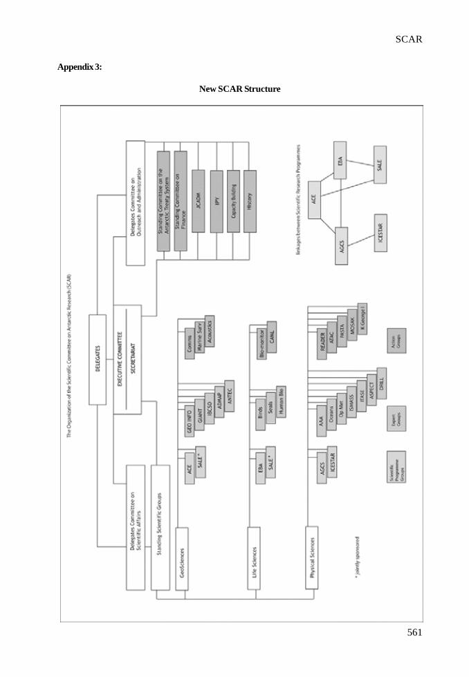
561
SCAR
Appendix 3:
New SCAR Structure

562
III. REPORTS
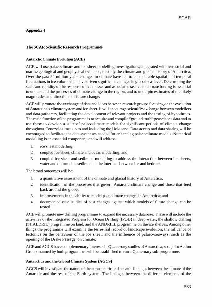
563
SCAR
Appendix 4
The SCAR Scientific Research Programmes
Antarctic Climate Evolution (ACE)
ACE will use palaeoclimate and ice sheet-modelling investigations, integrated with terrestrial andmarine geological and geophysical evidence, to study the climate and glacial history of Antarctica.Over the past 34 million years changes in climate have led to considerable spatial and temporalfluctuations in ice volume that have driven significant changes in global sea-level. Determining thescale and rapidity of the response of ice masses and associated sea ice to climate forcing is essentialto understand the processes of climate change in the region, and to underpin estimates of the likelymagnitudes and directions of future change.
ACE will promote the exchange of data and ideas between research groups focusing on the evolutionof Antarctica’s climate system and ice sheet. It will encourage scientific exchange between modellersand data gatherers, facilitating the development of relevant projects and the testing of hypotheses.The main function of the programme is to acquire and compile “ground truth” geoscience data and touse these to develop a suite of palaeoclimate models for significant periods of climate changethroughout Cenozoic times up to and including the Holocene. Data access and data sharing will beencouraged to facilitate the data syntheses needed for enhancing palaeoclimate models. Numericalmodelling is an essential component, and will address:
1. ice sheet modelling;2. coupled ice-sheet, climate and ocean modelling; and3. coupled ice sheet and sediment modelling to address the interaction between ice sheets,
water and deformable sediment at the interface between ice and bedrock.
The broad outcomes will be:
1. a quantitative assessment of the climate and glacial history of Antarctica;2. identification of the processes that govern Antarctic climate change and those that feed
back around the globe;3. improvements in the ability to model past climate changes in Antarctica; and4. documented case studies of past changes against which models of future change can be
tested.
ACE will promote new drilling programmes to expand the necessary database. These will include theactivities of the Integrated Program for Ocean Drilling (IPOD) in deep water, the shallow drilling(SHALDRIL) programme on land, and the ANDRILL programme on the ice shelves. Among otherthings the programme will examine the terrestrial record of landscape evolution; the influence oftectonics on the behaviour of the ice sheet; and the influence of palaeo-seaways, such as theopening of the Drake Passage, on climate.
ACE and AGCS have complementary interests in Quaternary studies of Antarctica, so a joint ActionGroup manned by both programmes will be established to run a Quaternary sub-programme.
Antarctica and the Global Climate System (AGCS)
AGCS will investigate the nature of the atmospheric and oceanic linkages between the climate of theAntarctic and the rest of the Earth system. The linkages between the different elements of the
564
III. REPORTS
Antarctic climate system are highly non-linear and it is necessary to understand the behaviour ofand interactions between the atmospheric, oceanic and cryospheric elements of the system if pastchange is to be explained and we are to have confidence in future predictions. A study of this kindhas only recently become feasible with the advent of sufficient high-resolution in-situ data and icecore records, and the development of numerical modeling tools to the point where they can representrealistically the closely coupled atmosphere-ocean processes that control long-term climate variability.
The work requires a combination of modern, instrumented records of atmospheric and oceanicconditions, and the climate signals held within ice cores, to understand fully past and future climatevariability and change in the Antarctic as a result of natural and anthropogenic forcing. AGCS willfocus on the last 6,000 years, since the mid-Holocene warm period, and will develop forecasts to 100years in the future. Records that capture abrupt climate change over the past few glacial/interglacialcycles will also be studied, in association with the ACE programme (see below).
AGCS will use existing deep and shallow ice cores, satellite data, the output of global and regionalcoupled atmosphere-ocean climate models, and in-situ meteorological and oceanic data to understandhow signals of tropical and mid-latitude climate variability reach the Antarctic, and high latitudeclimate signals are exported northwards. It will emphasize synthesis and integration of existing datasets and model outputs, although some new ice core and oceanographic data will be collected.
AGCS will contain four closely linked themes reflecting significant gaps in our knowledge:
1. Decadal time scale variability in the Antarctic climate system, to investigate ocean-atmosphere coupling and the role of the El Niño-Southern Oscillation in modulating theAntarctic climate;
2. Global and regional climate signals in shallow and deep ice cores, to establish betterquantitative relationships between ice core data and measures of tropical, mid- and highlatitude climate variability;
3. Natural and anthropogenic forcing on the Antarctic climate system, including theproduction of regional-scale estimates of expected climate change over Antarctica duringthe next 100 years, to be able to distinguish natural variability from anthropogenic activityand to understand how global climate change will be expressed in the Antarctic; and
4. The export of Antarctic climate signals, to examine how climate changes in the Antarcticcan influence conditions at more northerly latitudes.
The research will be carried out in an interdisciplinary way through a close collaboration betweenmeteorologists, climatologists, glaciologists, oceanographers and ice chemists, who will integrateobservational and modelling activities.
A key deliverable will be the production of regional and Antarctic-wide climate predictions coveringthe next 100 years.
Evolution and Biodiversity in the Antarctic (EBA): the response of life to change
A major challenge facing humankind is the management of the Earth System to ensure a sustainablehuman future. Managing the environment requires understanding the functioning of all parts of theEarth System in the context of both natural and anthropogenic change. That understanding mustencompass Antarctica and the Southern Ocean and their biota, including knowledge of the way inwhich life has evolved in those environments, and the ways in which it is likely to change, which inturn demands an integrated, interdisciplinary investigation of the structure and functioning of livingsystems in the region.
565
SCAR
EBA will provide a platform for the kinds of interactions amongst disciplines and researchers that areessential to understand the evolution of biodiversity in the region and the responses andcontributions of that biodiversity to the Earth System. By doing so, it will fill a major void inunderstanding of the role of biodiversity in the Earth System.
The overall aims of EBA are to understand the evolution and diversity of life in the Antarctic, todetermine how these have influenced the properties and dynamics of present Antarctic and SouthernOcean ecosystems, and to make predictions on how organisms and communities will respond tocurrent and future environmental change. EBA will integrate work on marine, terrestrial and limneticecosystems in a manner never before attempted, covering an entire biome. By comparing the outcomesof parallel evolutionary processes over a range of Antarctic environments, fundamental insights canbe obtained into evolution, and the ways in which life responds to change, from the molecular to thewhole organism level and ultimately to biome level. EBA will be complementary to many ongoingnational programmes that cannot attempt an ambitious study individually.
Antarctic ecosystems offer unique examples of how both structure and function have evolved, andthe likely responses of species and ecosystems to change induced by a wide variety of natural andanthropogenic processes, as well as the ways in which their responses feed back to influence theseprocesses.
EBA will use a range of modern techniques and a multidisciplinary approach to explore the evolutionaryhistory of the modern Antarctic biota, examine how modern biological diversity in Antarctica influenceshow present-day ecosystems function, and attempt to predict how the biota may respond to futureenvironmental change. It will integrate the major realms of Antarctic biology into a cohesive picturefor the first time, and contribute to evolutionary theory and understanding of global ecology andbiological diversity. More specifically, EBA will examine:
1. The evolutionary history of the Antarctic biota.2. Evolutionary adaptations to the Antarctic environment.3. Patterns of gene flow within, into and out from the Antarctic, and their consequences for
population dynamics.4. Patterns and diversity of organisms, ecosystems and habitats in Antarctica, together with
the ecological and evolutionary processes that control these.5. The impact of past, current and predicted environmental change on biodiversity and the
consequences for Antarctic marine, freshwater and terrestrial ecosystem function.
The programme will integrate research across a wide variety of fields, from functional genomics andmolecular systematics to ecosystem science and modelling, and will draw on and contribute informationto a wide rage of related fields, such as climate modelling and tectonics.
Interhemispheric Conjugacy Effects in Solar-Terrestrial and Aeronomy Research (ICESTAR)
ICESTAR will address some key questions about the interaction of the solar wind with the Earth’souter atmosphere, so as to quantify the key mechanisms of indirect coupling between the Sun andthe Earth at high latitudes; to determine how solar variability is amplified through those couplings;and to determine the temporal evolution of atmospheric change caused by solar coupling. Muchremains to be learned about how the solar forcing can affect the atmosphere, especially at highlatitudes where the solar wind-driven processes are most influential.
ICESTAR will also investigate possible influences of the changing Sun (i.e., its irradiance and magneticmoment) and the geospace environment on polar climate and weather. ICESTAR addresses the factthat important gaps remain in our understanding of the solar wind-magnetosphere-ionosphereinteraction. We do not know enough about the changes and dynamics of the Earth’s magnetosphere

566
III. REPORTS
under extreme solar wind conditions, i.e., during strong geomagnetic storms and as a consequence ofsolar activity such as coronal mass ejections.
In order to obtain a deep understanding of the mechanisms responsible for energy transfer from thesolar wind into the geospace environment, simultaneous consideration is needed of variousgeophysical phenomena occurring over both the northern and southern Polar Regions. ICESTARwill both enable and conduct focused scientific research on the upper atmosphere above the Antarcticand on how that region of space ties in with the global system. The programme will strive forinternational coordination of interhemispheric research in the areas of solar-terrestrial physics andpolar aeronomy, promoting exchange of research ideas, and sharing experimental data from variousarrays of geophysical instrumentation deployed over the Polar Regions and in near-Earth space.
ICESTAR aims:
1. to identify and quantify various mechanisms that control interhemispheric regionaldifferences and commonalities in the electrodynamics and plasma dynamics of the Earth’smagnetosphere-ionosphere coupling system, and in the aeronomy of the upper atmosphereover the Arctic and Antarctic; and
2. to create a data portal that will link together a large number of geophysical databasesincluding both data serving applications and visualization tools, so as to enable a systemsview of the polar upper atmosphere. Creation of the ICESTAR data portal to facilitate thesharing and interpretation of global geospace datasets will encourage the collaboration ofresearchers by sharing data and the interpretation of the results.
Subglacial Antarctic Lake Environments (SALE)
SALE serves as the international focal point of SCAR’s activities to promote, facilitate, and championcooperation and collaboration in the exploration and study of subglacial environments in Antarctica.
The overarching scientific objectives of SALE are:
1. to understand the formation and evolution of subglacial lake processes and environments;2. to determine the origins, evolution and maintenance of life in subglacial lake environments;
and3. to understand the limnology and palaeoclimate history recorded in subglacial lake sediments.
To explore the complex interplay of biological, geological, chemical, glaciological, and physicalprocesses within subglacial lake environments an international, interdisciplinary plan for coordinatedresearch and study is essential. The three objectives can only be accomplished by integrated andcoordinated phases of discovery and hypotheses driven research over at least a ten-year period.
Major areas of research will be:
1. Functional Genomics and Phylogenetics (eg to determine the genetic diversity in the watercolumns and benthic sediments of subglacial lakes);
2. Limnology (eg to establish the geochemical and isotopic composition of selected lake waterconstituents to determine their role in biological processes, water column stability, and toestablish the age of subglacial lake water);
3. Geophysics (eg to understand the tectonic and ice sheet setting of subglacial lakes throughgeological analysis of geophysical data);
4. Glaciology (eg to understand the interrelation between ice sheet processes and lake watercirculation);
567
SCAR
Appendix 5
SCAR’s Action and Expert Groups
Geosciences SSG
Action Group on “Communication and Outreach” (COG): to provide information on Antarcticgeoscientific research to the scientific and community and the wider public.
Action Group on “Acoustics in the Marine Environment”: to consider the effects on marine mammalsof noise created by marine scientific activities (such as echo-sounding and airgun surveys).
Action Group (Cross-SSG) on “Antarctic Treaty and Committee for Environmental Protection (CEP)”:to communicate with SCAR representative at the CEP and ATCM to bring matters of concern to theCEP and Treaty to the SSG-G for advice and to identify areas of concern in geosciences and geospatialinformation, raise them in Antarctic Treaty System (ATS) fora, and provide scientific advice.
Action Group on “Marine Survey Coordination”: to develop mechanisms for improved communicationabout planned marine surveys within the Antarctic community.
Expert Group on “Geographical Information” (EGGI): to create an Antarctic Spatial Data Infrastructure(ANTSDI) by: providing Antarctic fundamental geographic information products and policies insupport of all SCAR science programmes and operations management and the global user; integratingand coordinating Antarctic mapping and GIS programmes; promoting an open standards approachto support free and unrestricted data access; promoting capacity building towards sound Antarcticgeographic data management within all SCAR nations; and promoting to COMNAP the data andproducts that the EGGI produces.
Expert Group on “Permafrost and Periglacial Environments” (EGPPE): to provide coordination,communication and exchange of data amongst Antarctic permafrost researchers within SCAR andIPA and promote interaction and collaboration with SCAR and IPA working groups; to collect andcollate spatial data on permafrost and cryosols and contribute to databases for Antarctic soils,permafrost and ground ice conditions including the active layer; to develop and promote monitoring/observation protocols and networks; to promote international cooperation and facilitate collaborativefield research; and to address key science questions pertaining to permafrost.
Expert Group on “Geodetic Infrastructure of Antarctica” (GIANT): to provide a common geodeticreference system for all Antarctic scientists and operators; to contribute to global geodesy for thestudy of the physical processes of the earth and the maintenance of the precise terrestrial referenceframe; to provide information for monitoring the horizontal and vertical motion of the Antarctic.
5. Geology and Cenozoic Palaeoclimate (eg to use palaeoenvironmental data to determine lakeand ice sheet histories, and evaluate temporal changes in Cenozoic palaeoclimate relative tothose histories determined from Antarctic marginal sequences and global Cenozoic proxyrecords).
The technological challenges and environmental stewardship issues of under ice drilling cannot beunderestimated, so SALE will also advise the international community not only on scientific issuesbut also on technology issues relevant to subglacial lake exploration, including environmentalconcerns and safeguards.

568
III. REPORTS
Expert Group on “Antarctic Neotectonics” (ANTEC): to promote and coordinate multidisciplinary,multinational research relevant to Antarctic neotectonics; to identify ‘target sites’ where there is aneed for deployment of geodetic and seismic stations and arrays, and airborne, marine and fieldcampaigns; to encourage and coordinate the installation of instruments at permanent sites and inregional networks (GPS, gravity, seismic) for focused studies in target areas; and to promote andcoordinate sharing of instrumentation, logistics, and data.
Expert Group on “Antarctic Digital Magnetic Anomaly Project “(ADMAP): to produce a coordinatedeffort for: compiling the existing magnetic data acquired by various institutions; coordinating protocolsfor data distribution; serving as a reference for future survey planning; archiving and maintainingthe magnetic anomaly data base of Antarctica.
Expert Group on “International Bathymetric Chart of the Southern Ocean” (IBCSO): to act as thesteering group for production of a revised chart of the bathymetry of the Southern Ocean, inconjunction with the IHO and GEBCO.
Life Sciences SSG
Action Group on “Global International Waters Assessment” (GIWA): to provide the informationrequired for a Global Waters Assessment for Area 66: Antarctica.
Action Group on “Best Practices for Conservation”: to review and establish current best practicesfor conservation in an Antarctic context.
Action Group on Biological Monitoring: to organize a workshop on this topic, in order to produce a(set of) protocol(s) for biological monitoring activities for environmental management purposes.
Action Group for the “Census of Marine Life” (CoML): to act as a scientific steering committee forthe Southern Ocean component of the global CoML programme.
Expert Group on: “Birds”: to provide long-term data on avian populations in the region; to encourage,coordinate and support research on seabirds; to contribute to their conservation; and to providescientific advice to SCAR.
Expert Group on “Seals”: to provide information on the status of seal stocks as required by theConvention for the Conservation of Antarctic Seals (CCAS); to encourage research and informationexchange on this group of animals; and to provide advice to SCAR.
Expert Group on “Human Biology and Medicine”: to provide a forum for medical, physiopathological,behavioural, clinical, and biological scientists; to promote high quality research in polar humanbiology in association with appropriate international scientific organizations; to encourage cooperationin the continued evolution of high quality healthcare and the prevention of injury and disease in theAntarctic; and to promote the full use of the unique environment of the Antarctic to allow understandingof major health problems in extreme environments in particular, and in mankind in general.
Physical Sciences SSG
Action Group on: “Plateau Astronomy Site Testing in Antarctica” (PASTA): to coordinate the effortsto properly characterize the conditions available at various sites on the Antarctic plateau, deliveringand compiling the required site testing data.
Action Group on “Modelling and Observational Studies of Antarctic Katabatic Winds” (MOSAK):to analyze, understand and model katabatic wind events, and to develop a new map of katabatic winddistribution and strength over the Antarctic ice sheet.
569
SCAR
Action Group (Cross-SSG) on Coordination of Scientific Activities on King George Island: to encouragedifferent national groups on King Gorge Island to share information about their research plans, so asto avoid unnecessary duplication of costly activities.
Expert Group on “SCAR and Oceanography”: - to facilitate coordination between the physicaloceanographic research groups currently active and those planning research in the Southern Ocean;to encourage an inter-disciplinary approach to Southern Ocean observations, modelling and research,recognizing the inter- dependence of physical, chemical and biological processes in the ocean atpresent and in the past; to identify historical and reference data set of value to researchers, focusinginitially on physical oceanography data; to encourage the exchange of information with operationalagencies.
Expert Group on “Antarctic and Astronomy and Astrophysics” (AAA): to coordinate efforts toexplore the potential for astronomical observations in the Antarctic.
Expert Group on “Operational Meteorology in the Antarctic”: to liaise with WMO over observingstandards, the use of new data/model fields and weather forecasting in the Antarctic; to maintainslinks with COMNAP/SCALOP; and to provide scientific advice to WMO on Antarctic meteorology.
Expert Group on “Ice Sheet Mass Balance and Sea Level” (ISMASS): to understand the relationshipbetween Ice Sheet Mass Balance and Sea Level, by determining the present accumulation rate overthe entire ice sheet and measuring ice thickness and velocities at the grounding zone of the ice sheetand glaciers.
Expert Group on Ice Drilling Technology: to facilitate communication among international ice drillingcommunities; to create an international forum for strategic development of new ice drilling andborehole testing concepts and technologies and continued improvement of existing technologies; toprovide a pool of expertise to address SCAR issues related to ice drilling and coring; and to enhanceinternational cooperation and communication on large- and small-scale ice core recovery projects.
570
III. REPORTS
Appendix 6
List of AcronymsAAA Antarctic and Astronomy and AstrophysicsACE Antarctic Climate EvolutionADMAP Antarctic Digital Magnetic Anomaly ProjectAGCS Antarctica in the Global Climate SystemAGU American Geophysical UnionANDRILL Antarctic Geological Drilling ProjectANTEC Antarctic NeotectonicsANTIME Late Quaternary Sedimentary Record of Antarctic Ice Margin EvolutionANTSDI Antarctic Spatial Data InfrastructureAPTIC Antarctic Peninsula Tropospheric-Ionospheric CouplingASPeCT Antarctic Sea-Ice Processes and ClimateATAC Antarctic Tropospheric Aerosols and their Role in ClimateATCM Antarctic Treaty Consultative MeetingCAML Census of Antarctic Marine LifeCEP Committee for Environmental ProtectionCliC Climate and Cryosphere ProgrammeCMBR Cosmic Microwave Background RadiationCOG Communication and OutreachCoML Census of Marine LifeCOMNAP Council of Managers of National Antarctic ProgrammesEASIZ Ecology of the Antarctic Sea-Ice ZoneEBA Evolution and Biodiversity in the AntarcticEGGI Expert Group on Geographical InformationEGGPE Expert Group on Permafrost and Periglacial EnvironmentsEGU European Geophysical UnionEoI Expression of InterestEVOLANTA Evolutionary Biology of Antarctic OrganismsGIANT Geodetic Infrastructure for AntarcticaGIS Geographic Information SystemsGIWA Global International Waters AssessmentGLOBEC Global Ocean Ecosystems DynamicsGLOCHANT Group of Specialists on Global Change and the AntarcticGPS Global Positioning SystemIABO International Association of Biological OceanographyIAG International Association of GeodesyIAnZone International (Coordination of Oceanographic Research within the) Antarctic ZoneIAPSO International Association for the Physical Sciences of the OceanIBCSO International Bathymetric Chart of the Southern OceanICESTAR Inter-hemispheric Conjugacy Effects in Solar-Terrestrial and Aeronomy ResearchICSU International Council for ScienceIGOS Integrated Global Observing StrategyIGU International Geographical UnionIGY International Geophysical YearIPA International Permafrost AssociationIPOD Integrated Program for Ocean DrillingIPY International Polar YearISMASS Ice Sheet Mass Balance and Sea-LevelITASE International Trans-Antarctic Scientific ExpeditionIUBS International Union of Biological SciencesIUGG International Union of Geodesy and GeophysicsIUGS International Union of Geological SciencesIUPAC International Union of Pure and Applied ChemistryIUPS International Union of Physiological SciencesJCADM Joint Committee on Antarctic Data ManagementMADREP Middle Atmosphere Dynamics and Relativistic Electron PrecipitationMarBIN Marine Biodiversity Information NetworkMEDINET Medical NetworkMOSAK Modelling and Observational Studies of Antarctic Katabatic Winds
571
SCAR
OBIS Ocean Biodiversity Information SystemPASTA Plateau Astronomy Site Testing in AntarcticaPPE Permafrost and Periglacial EnvironmentsREADER Reference Antarctic Data for Environmental ResearchRiSCC Regional Sensitivity to Climate Change in Antarctic Terrestrial and Limnetic EcosystemsSALE Subglacial Antarctic Lake EnvironmentsSALEGOS Subglacial Antarctic Lake Exploration Group of SpecialistsSCALOP Standing Committee on Antarctic Logistics and OperationsSCAR Scientific Committee on Antarctic ResearchSCOR Scientific Committee on Oceanic ResearchSHALDRIL Shallow DrillingSRP Scientific Research ProgrammeSSG Standing Scientific GroupSSG-G SSG on GeosciencesSSG-LS SSG on Life SciencesSSG-PS SSG on Physical SciencesUN United NationsUNESCO United Nations Educational, Scientific and Cultural OrganizationURSI Union Radio Scientifique InternationaleWMO World Meteorological Organization

III. REPORTS
573
COMNAP Report to ATCM XXVIII
INTRODUCTION
1. COMNAP, the Council of Managers of National Antarctic Programs, was established in1988 and currently brings together the National Programs from 29 countries. The “NationalAntarctic Programs” are those agencies tasked by their government to implement and managetheir national activities in Antarctica.
2. COMNAP membership is open to the National Programs of Antarctic Treaty Parties havingratified the Protocol on Environmental Protection to the Antarctic Treaty (the MadridProtocol). The application for membership of a 30th member was accepted at the 2004 COMNAPannual meeting and the National Program from Estonia will officially join COMNAP when itsgovernment formally ratifies the Madrid Protocol.
3. The primary function and activities of COMNAP are related to the exchange of practical,operational information with a view to improving the way all National Programs can fulfiltheir various missions, from the support of the Antarctic continent’s governance to thesupport of Antarctic research to the protection of the Antarctic region’s environment.
COMNAP’S ROLE AND MODE OF OPERATION
4. COMNAP serves as a forum in which the directors, logistics managers and other membersof the National Programs develop practices that improve the effectiveness and safety oftheir activities pursuant to the Antarctic Treaty and the associated Madrid Protocol. Thismostly involves the exchange of practical, operational information and includes mutualsupport in the design, ongoing improvement and operation of Antarctic facilities and transportinfrastructure.
5. A substantial part of that infrastructure comprises year-round stations, a fleet of ships anda number of airfields and aircraft. In 2005, the National Programs together operate in theAntarctic Treaty area 37 year-round stations with a combined winter average population of1030 and a peak summer population of 3427 persons. A list of these stations is provided inAppendix 2. The National Programs currently operate or charter in the Antarctic Treaty areaa fleet of 39 vessels ranging from 1,400 to 40,000 tons displacement.
6. COMNAP includes a permanent Standing Committee on Antarctic Logistics and Operations(SCALOP) and a number of other groups (Committees, Working Groups, Coordinating Groupsand Networks) focused on various areas of expertise. The bulk of COMNAP’s work isachieved through the routine, core activities of these ‘groups’. This provides for continuousexchange of information, providing ongoing, multi-directional capacity building and a vehiclefor addressing a wide range or issues, sometimes very technical, but always with practicalapplications in the support of Antarctic Programs. ppendix 1 provides an insight into theseroutine activities by listing the current terms of reference, tasks and membership of thesegroups.
7. A COMNAP Executive Committee (EXCOM) is responsible for COMNAP matters betweenfull meetings of the Council. It includes the COMNAP Chair, three COMNAP memberrepresentatives, the chair of SCALOP and, as a non-voting member, the Executive Secretary.The retiring chair remains on the Committee as an additional member for one year aftercompletion of her/his term. Gérard Jugie of the French National Program became the new
574
III. REPORTS
chair of COMNAP in July 2004, succeeding Karl Erb of the US National Program who hadserved his three year term.
8. The work of COMNAP is supported by a secretariat that provides organisational andcoordination support. This includes provision of a common communications supportinfrastructure, central information repository and point of contact. A COMNAP ExecutiveSecretary, working under and with the COMNAP Chair, is responsible for the operation ofthe secretariat and for maintaining coordination between the members. As secretary to theorganisation, the Executive Secretary is also responsible for compliance with all relevantrules and requirements and for maintaining an appropriate, productive working relationshipwith all stakeholders in the interest of both COMNAP and the Antarctic Treaty System.
CURRENT AND RECENT ACTIVITIES RELATED TO ATS WORK
9. As part of its responsibilities to the Antarctic Treaty System (ATS), COMNAP providesinput to ATS discussions derived from its operational experience and its continuous worktowards improved operations and practices. Some of this input can be in response to direct,specific requests from an Antarctic Treaty Consultative Meeting (ATCM) or a meeting ofthe Committee for Environmental Protection (CEP). COMNAP is committed to serve its rolein the ATS by providing practical, technical and non-political advice.
10. As and when appropriate COMNAP contributes to the work of ATCM-mandatedintersessional work and collaborates with the Antarctic Treaty Secretariat on practical,operational issues such as the exchange of information.
Practical Guidelines for Developing and Designing Environmental Monitoring Programs inAntarctica
11. ATCM XVIII (Kyoto - 1994) requested COMNAP and SCAR to conduct technical workshopsto develop an approach to monitoring which would be scientifically sound, practical andcost effective. Two workshops were held and resulted in a report on the Monitoring ofEnvironmental Impacts from Science and Operations in Antarctica (July 1996). To meetone of the key recommendations of the report, COMNAP and SCAR jointly prepared andpublished the Antarctic Environmental Monitoring Handbook (May 2000) which providesguidance on standard techniques and methodologies for monitoring a first tier of physicaland chemical indicators in Antarctica.
12. COMNAP continued to work on practical aspects of monitoring and, having identified gapsin the current documentation and information available to operators, tasked its AntarcticEnvironmental Officers Network (AEON) with preparing Practical Guidelines for Developingand Designing an Environmental Monitoring Programme in Antarctica. Following theexcellent work by AEON and considerable effort on the part of several National Programs,COMNAP endorsed and published the Guidelines in January 2005. The guidelines areavailable on the public access section of the COMNAP web site.
13. The guidelines, to be used in conjunction with the Antarctic Environmental MonitoringHandbook (May 2000), do not attempt to prescribe what indicators should be monitored.They instead attempt to provide a methodology that can be followed when designing amonitoring program and include several practical examples to assist in clarifying the proposedmethodology. It is anticipated that the guidelines should assist all National Programs, butparticularly those with more limited resources.

575
COMNAP
14. Ultimately, a unified approach to environmental monitoring will assist the continued protectionof resources and values, and in minimising human impacts on the Antarctic environment.
15. COMNAP is presenting the Practical Guidelines for Developing and Designing anEnvironmental Monitoring Programme in Antarctica to CEP VIII in Working PaperATCMXXVIII-WP026 and recommends that the CEP endorse the practical guidelines andmake them also available through the CEP web site.
Biological Monitoring of Human Impacts in the Antarctic
16. At the time the July 1996 report on the Monitoring of Environmental Impacts from Scienceand Operations in Antarctica and the May 2000 Antarctic Environmental MonitoringHandbook were prepared it was estimated that there was not a sufficient scientific basis topropose indicators or methods for biological monitoring. The handbook was restricted tophysical and chemical monitoring. The issue of biological monitoring was to be revisitedonce more data were available.
17. SCAR and COMNAP decided in 2004 to organise a joint workshop to revisit the issue ofbiological monitoring. Funded by the US National Science Foundation, SCAR and COMNAPthe workshop was held on 16-18 March 2005 in Bryan-College Station, Texas, with 44participants from 14 countries.
18. The workshop was very successful and a draft report will be presented to both SCAR andCOMNAP for their consideration in July 2005. The two organisations will provide furtherinformation on the workshop outcomes and subsequent actions to the 2006 ATCM XXIX.
Heavy Fuel Oil
19. ATCM XXVIII (Cape Town – 2004) discussed the possibility of a prohibition on the use ofheavy oils south of 60 degrees South and requested COMNAP, in consultation with IAATO,(…) to report to ATCM on the present and planned use of heavy fuel in ships operating inAntarctic waters by national operators and by the tourism industry.
20. COMNAP, through its Working Group on Ship Operations (SHIPOPS), and the InternationalAssociation of Antarctica Tour Operators (IAATO) conducted a survey on the fuel carriedin the Antarctic Treaty area on ships currently operated or chartered by their members. Thetwo organisations also prepared a technical note on operational and regulatory aspects ofthe use of fuel on board ships in the area.
21. COMNAP and IAATO are presenting the results of this work to ATCM XXVIII in InformationPaper ATCMXXVIII-IP067 on The Use of Heavy Fuel Oil in Antarctic Waters.
22. The combined COMNAP-IAATO fleet of 72 ships makes the bulk of the ships operating inthe Antarctic Treaty area, with only 5 other ships known to operate in the area, excludingprivate yachts which in any case are not expected to carry heavy fuels.
23. The survey collected information on 50 of the 72 ships, or 70% of the combined COMNAP-IAATO fleet, deemed representative of both the current and planned state of practices forthat fleet. None of the 50 ships does carry Heavy Grade Oil in the Antarctic Treaty Area.
24. Fuel information was available for 3 of the 5 other ships known to operate in the AntarcticTreaty area outside of the combined COMNAP-IAATO fleet. One of those 3 ships, registeredin the Marshall Islands, is understood to carry Heavy Grade Oil in the Antarctic Treaty Area.
Ballast Water
25. ATCM XXVIII (Cape Town – 2004) discussed the possible introduction of non-nativeorganisms into Antarctic waters through the discharge of ballast water and requested

576
III. REPORTS
SCAR, with the support of other appropriate organisations, to investigate the environmentaland technical issues associated with the question of ballast water.
26. COMNAP, through its Working Group on Ship Operations (SHIPOPS), and the InternationalAssociation of Antarctica Tour Operators (IAATO) conducted a survey on the ballast waterpractices in the Antarctic Treaty area of ships currently operated or chartered by theirmembers. The two organisations prepared a technical note including results of the surveyand some relevant information on technical issues associated with ballast water and providedthis note to SCAR in support of their ongoing work on the issue.
27. The survey captured the practices of 40 of the 72 vessels of the combined COMNAP-IAATO fleet and the results are deemed representative of current practices. Of those 40vessels:• 35 vessels (87.5%) do not discharge any ballast water in the Treaty area;• 3 vessels (7.5%) do not discharge any ballast water brought from outside the Treaty
area; and• 2 vessels (5%) only exchange ballast water in the open ocean;
State of the Antarctic Environment Reporting
28. The COMNAP Secretariat participated to the work of the intersessional contact group (ICG)on State of the Antarctic Environment Reporting (SAER). While it did not feel qualified todiscuss the validity or merit of various indicators, it is committed to assist to the maximumextent possible in facilitating the provision of operational information. COMNAP is currentlyre-designing and developing its information systems, including data collection andaggregation. This is done with the SAER and the ATS Exchange of Information requirementsin mind and COMNAP is committed to finding ways to provide the required operationalinformation in an efficient, timely and reliable manner.
Review of the Process for Exchange of Information
29. The COMNAP Secretariat participated to the work of the ICG on the Review of the Processfor Exchange of Information. COMNAP welcomes the positive, pragmatic approach of theICG members and supports their recommendation of the development of an electronic AntarcticTreaty Information Exchange (ATIE) system as described in Working Paper ATCMXXVIII-WP029. Such a system should become an invaluable tool to provide the ATCM and otherstakeholders with quality, timely information in support of the Antarctic Treaty System.
30. COMNAP is committed to liaising with the Antarctic Treaty Secretariat to assist in suchdevelopment as appropriate, and to designing its own systems so that they can interfacewith the new ATIE system in a way that will benefit both COMNAP members and the ATCM.
Collaboration with the Antarctic Treaty Secretariat
31. COMNAP has established through its secretariat a good working relationship with theAntarctic Treaty Secretariat and the COMNAP Executive Secretary took advantage of ameeting in South-America to visit the Treaty Secretariat in Buenos-Aires in October 2004.This was the occasion of productive meetings on how both secretariats could work togetherwith specific sessions addressing the issues of the State of the Antarctic Environment andthe Antarctic Treaty Information Exchange under Resolution 6 (2001).
32. COMNAP looks forward to its secretariat developing a long-standing, productive relationshipwith the Treaty Secretariat, when and as appropriate, to better support their respectivememberships and the Antarctic Treaty System.
577
COMNAP
Support of the International Polar Year (IPY) 2007-2008
33. As requested by ATCM Resolution 2 (2003) COMNAP has engaged in the preparation ofthe forthcoming International Polar Year (2007-2008). It has created an IPY CoordinatingGroup (IPYCG) that coordinates COMNAP’s involvement in IPY preparations and maintainscontact with the main stakeholders, including members of the International Council ofScientific Unions (ICSU) IPY Planning Group, officials of the World MeteorologicalOrganization (WMO) and members of the Scientific Committee on Antarctic Research (SCAR),the International Arctic Science Committee (IASC) and the Forum of Arctic Research Operators(FARO).
34. The COMNAP focus up to now has been primarily to develop full awareness amongstNational Programs of planning efforts underway in the science community while conveyingto the science community the support potentially available from the National Programs fortheir projects, including planning requirements and both logistical and time constraints.
35. As part of this last effort, COMNAP has conducted through IPYCG an assessment on theavailability of ship support during the IPY. The survey gives an overview of plans andoptions regarding ship transports and ship based research in the Antarctic area during theIPY period (2 winter and 2 summer seasons), as well as a picture of in which sectors the shipsare expected to operate. COMNAP Working Group on Air Operations (AIROPS) is also inthe process of completing a similar assessment on the availability of aircraft support.
36. While some deadlines for support proposals for that period have already passed, COMNAPand IPYCG will endeavour to work with all stakeholders on finding the best ways the NationalPrograms can work together to support IPY core projects once they have been fully identifiedand developed.
37. COMNAP will include in its upcoming annual meeting COMNAP XVII, July 2005, two majorsessions focused on the IPY: a one-day workshop on Education, Outreach andCommunication (EOC) organised by COMNAP Information Officers Network INFONET anda half-day COMNAP plenary session dedicated to the IPY organised by IPYCG.
38. The EOC workshop will be a small, focused interactive workshop that will explore EOCopportunities in relation to the IPY and identify if and how COMNAP can and shouldengage in IPY EOC activities.
39. The COMNAP IPY plenary session will provide a forum for National Programs to discusstheir IPY plans and work together on how to coordinate their activities and operationalcapabilities to better support IPY projects.
40. In that respect, it is worth noting that a number of COMNAP groups are currently workingin parallel, as part of their routine activities, on some very practical issues with potentialtangible benefits for the IPY, as illustrated by the two following examples. COMNAP MedicalOfficers Network, MEDINET is working on common standards for medical screening for theinterchange of personnel between National Programs. SCALOP organised in July 2004 itsbiennial Symposium on Antarctic Logistics and Operations on the theme “towards theInternational Polar Year and beyond”.
OTHER COMNAP TASKS AND ACTIVITIES
COMNAP Meetings and Events
41. ‘COMNAP XVI’, the 2004 annual general meeting, was held in Bremen, Germany, from 25 to30 July 2004. It was hosted by the COMNAP member for Germany, the Alfred Wegener
578
III. REPORTS
Institute, in conjunction with SCAR’s bi-annual meeting ‘SCAR XXVIII’. In addition to twofull days of plenary sessions and parallel meetings of all groups, the 2004 annual generalmeeting included (1) a half-day workshop on energy management, (2) a series of meetings todiscuss preparations for the International Polar Year (IPY), addressing both collaborationwith the IPY organising committee and SCAR and collaboration between national programsto support IPY projects and (3) a joint meeting of the COMNAP and SCAR Executives.
42. COMNAP XVI included a Symposium on Antarctic Logistics and Operations on the theme“towards the International Polar Year and beyond”. The main topics addressed in thesymposium were:• new transportation technologies and applications;• technology to enable science;• technology to reduce environmental impact;• ergonomic issues related to polar work;• latest developments in energy storage.
43. A number of intersessional meetings were held, including (1) a meeting of those COMNAPmembers attending the 2004 ATCM in Cape Town, South-Africa, in June 2004 and (2) a two-day meeting of the COMNAP Executive Committee in Punta Arenas, Chile, in October 2004to finalise the conclusions and results of the 2004 annual general meeting and the work planfor 2004/2005.
44. A number of COMNAP group officers ended their term at the meeting. Chair of the WorkingGroup on Air Operations (AIROPS) John Pye of the UK National Program was succeeded byValery Klokov of the Russian Program. Chair of the Working Group on Ship Operations(SHIPOPS) Hartwig Gernandt of the German Program was succeeded by Manuel Catalan ofthe Spanish Program. Coordinator of the Information Officers Network Luciano Blasi of theItalian Program was succeeded by Jan Stel of the Dutch Program. Coordinator of the TrainingOfficers Network (TRAINET) Richard Mulligan of the Australian Program was succeededby Patricio Eberhard of the Chilean Program. Member representatives on the ExecutiveCommittee Okitsugu Watanabe of the Japanese Program and Gérard Jugie of the FrenchProgram were succeeded by Yeadong Kim of the Korean Program and Henry Valentine of theSouth African Program. COMNAP Chair Karl Erb of the US Program was succeeded byGérard Jugie of the French Program.
45. Later in the year, Coordinator of the Antarctic Environmental Officers Network (AEON)Shaun Walsh of the Australian Program was succeeded by Rebecca Roper-Gee of the NewZealand Program.
46. ‘COMNAP XVII’, the 2005 annual general meeting, will be held from 12 to 15 July 2005 inSofia, Bulgaria. Hosted by the COMNAP member for Bulgaria, the Bulgarian AntarcticInstitute, the meeting is scheduled to also include (1) a workshop of the Medical OfficersNetwork MEDINET, (2) a workshop of the Information Officers Network INFONET, (3) anumber of specific sessions on preparations for and support of the IPY and (4) a jointmeeting of the COMNAP and SCAR Executives.
Operational Publications
47. COMNAP publishes a number of operational publications in support of Antarctic operations,in particular in support of safety and best environmental practice. In June 2005 was publishedPractical Guidelines for Developing and Designing an Environmental MonitoringProgramme in Antarctica, the result of considerable work by COMNAP’s AntarcticEnvironmental Officers Network (AEON). This publication is available for download from
579
COMNAP
the public access of the COMNAP web site where latest versions of most COMNAPpublications can be found.
48. COMNAP publishes and regularly updates the Antarctic Flight Information Manual (AFIM)which contains exhaustive information on Antarctic airfields and on procedures to contactand access these airfields. It covers airfields operated by both National Programs and privateoperators affiliated with the International Association of Antarctica Tour Operators (IAATO).The manual is published as a tool towards safe air operations in Antarctica as per ATCMRecommendation XV-20 and as such is provided by the COMNAP Secretariat to allorganisations or individuals requesting a copy, for a nominal fee destined to assist withprinting costs and with the significant cost of the manual’s ongoing maintenance.
49. To address a number of concerns about recent unannounced and unauthorised access toAntarctica by air, COMNAP inserted a new preamble in the last AFIM update, released inJanuary 2005. Prepared in consultation with the Antarctic Treaty Secretariat, the preamble isintended to clarify conditions of access to Antarctica including the existence of variouslegal instruments and authorisation procedures adopted by the states party to the AntarcticTreaty.
50. Most COMNAP publications are intended for as wide a distribution as possible to contributeto operational safety and best practice in the Antarctic. Most of these publications are madeavailable free of charge, unrestricted download from the COMNAP web site and we arelooking at other ways of facilitating and promoting the distribution and use of thesepublications. This may include releasing publications under alternative licences such asCreative Commons licences which facilitate and promote redistribution and reuse of thepublications content. A possible licence would be the Creative Commons Attribution Share-Alike 2.0 licence (see http://creativecommons.org/licences/by-sa/2.0).
General Information Publications
51. COMNAP is also publishing some general interest information about its activities,installations and logistics and its place in the Antarctic Treaty System. It currently includes:• a brochure, available in the four official Antarctic Treaty languages;• a range of online information accessible on the COMNAP web site.
This should be progressively integrated and synchronised with the various exchange ofinformation and reporting requirements of the Antarctic Treaty• a ‘COMNAP Book’ on National Programs.
Initially published in 2003 with the support of the French National Program, this bookprovided information on a large number of National Programs and the locations they wereoperating from. It is intended to become a ‘living book’ with regular updates and the availabilityof online versions;• a soon-to-be-released map of the Antarctic showing all year-round stations operated
by National Programs in the Antarctic Treaty Area.
It includes tabular information on stations including geographic coordinates, year of opening,average winter and peak summer population as well as tabular information on membership ofthe various organisations of the Antarctic Treaty System. Low resolution elements of thismap are used in Appendix 2.
580
III. REPORTS
Hydrographic Committee on Antarctica
52. The International Hydrographic Organisation (IHO) Hydrographic Committee on Antarctica(HCA) is responsible for hydrographic surveying and nautical charting matters inInternational Region M, the Antarctic Treaty Area. Membership is open to any IHO MemberState whose government has acceded to the Antarctic Treaty and which contributesresources and/or data to IHO INT chart coverage of Region M. Observer status is openamongst others to any national or international organisation, and to individual experts,having professional involvement in hydrographic surveying or nautical charting in RegionM either by contributing to those activities, or by providing support to those activities, oras users of derived products. COMNAP, along with IAATO and SCAR, has observer statusat the HCA.
53. The work and objectives of the HCA are very much in line with COMNAP’s efforts onimproving the effectiveness and safety of operations in Antarctica and the chair of COMNAPWorking Group on Ship Operations (SHIPOPS) participated to the 2004 meeting of HCA towork on how COMNAP could best contribute to the HCA.
54. COMNAP and IAATO members currently operate in the Antarctic Treaty area a combinedfleet of 72 ships, with 39 ships for National Programs and 33 for IAATO members. This iscertainly the bulk of the ships operating in the Antarctic Treaty area with only 5 other shipsknown to operate in that area. COMNAP will continue to work with the HCA and IAATO tosee how ships of their fleet can be best used on a ‘ships of opportunity’ basis to support theneeds for surveying, charting and establishing terrestrial Aids to Navigation (AtNs).
Ongoing Surveys
55. COMNAP is regularly conducting a number of surveys amongst its members, generallyfocused on specific needs relevant to the work of one of COMNAP groups. It generallyincludes one-off surveys such as the recent surveys on ship fuel and ballast water practicesand ongoing surveys updated on an annual cycle such as the surveys on station energyuse and on the interactions between National Programs and non-government activities.
56. Work is currently under way to integrate those surveys into an efficient, unified surveymanagement system for collecting and updating survey information. This is intended to notonly make the survey process much more structured and efficient but also maximise the useand reuse of data for a range of applications, avoid duplication and inconsistencies andallow automated or semi-automated aggregation of data, including data from separate surveys.
57. It is worth noting that the survey management system could also end-up exchanging selected,appropriate fields of information with any electronic information exchange system set-up bythe Antarctic Treaty Secretariat in support of information exchange under Resolution 6(2001), as well as providing aggregate indicator information to the State of the AntarcticEnvironment Reporting (SAER) system.
58. Due to time and resource constraints, development of the new survey management systemdelayed the annual updates of the surveys on energy and on interaction with non-governmentactivities. These updates will be completed as soon as practical using the new system andthe results will be provided to upcoming Treaty meetings.
IT Support Infrastructure
59. COMNAP has engaged in a comprehensive review and re-development of its IT supportinfrastructure, the guiding principles being to:

581
COMNAP
• simplify and reduce the amount of time and resources required from members toparticipate in COMNAP group activities and to report information required by COMNAPor the Antarctic Treaty System;
• maximise the use and reuse of information provided through the COMNAP system, byCOMNAP, individual National Programs and, when and as appropriate, otherorganisations;
• provide tools that are consistent with and support COMNAP organisational structure,terms of reference and practical needs;
• support the creation of a comprehensive and useable ‘corporate memory’ archiverepository, recognising that COMNAP’s best and most fragile asset is constituted byindividual members of the National Programs and their knowledge and experience;
• base the systems on open standards, open formats and robust open source software.It provides in the long term the best chance of successfully implementing, maintainingand further developing a useful system for COMNAP able to exchange data with thesystems of other organisations. It will also make it possible for National Programs andother stakeholders to freely use parts or all of the tools developed without restrictionsor ongoing licence fees, and modify them as needed. It is worth noting that the conceptof ‘open standards, open formats and open source software’ is very much aligned withthe values of the Antarctic Treaty System and there is probably great potential forboth to effectively support each other.
60. As illustrated in a number of sections of the present report, this development of the ITsupport infrastructure has implications and potential for a number of COMNAP activitiesand missions, including interaction and collaboration with a number of stakeholders onprojects such as the ATS Exchange of Information, the State of the Antarctic EnvironmentReporting, the work of the Hydrographic Committee on Antarctica and the support of theInternational Polar Year.
61. The first element of this new infrastructure is a group collaboration portal that will manage,structure and support the work of COMNAP’s various groups while providing them with anarchive repository of their resources, discussions and reports. It is currently under finaltesting and validation phase.
COMNAP Secretariat Operation
62. The COMNAP Secretariat operates from an office located in Hobart, Tasmania, Australiaprovided at no charge by the secretariat’s supporting organisation, the Tasmanian StateGovernment through its office of Antarctic affairs ‘Antarctic Tasmania’. This invaluablesupport has now been provided since 1997 and the current support agreement runs untilSeptember 2009. The free support provided by Antarctic Tasmania includes a range of officeequipment and administrative support, notably through accounting and auditing services.COMNAP is very thankful for Antarctic Tasmania’s support which allows its secretariat tooperate very efficiently in a quality, supportive environment.
63. The COMNAP Secretariat is in the process of consolidating all business systems andprocedures to increase its capacity to support COMNAP effectively. This will provide furtheroperational efficiencies and systems that are more scaleable and responsive to change. Itdoes involve better structuring and documentation of processes to provide increasedtransparency and to facilitate possible changes in staff or office location. This is part of alarger overhaul of COMNAP’s organisation and work processes. Ultimately, the objective isto put COMNAP in a better position to serve its members and the Antarctic Treaty System
582
III. REPORTS
by integrating into its operations the latest standards of corporate governance andmanagement.
64. A simple, recent example is the complete overhaul of COMNAP’s budgeting and accountingprocedures. These now follow the latest international accounting principles and accountstructures and moved from a January-December budgeting and reporting period to a July-June period better aligned with the annual work cycle of COMNAP and its groups. The newprocedures are more portable, more transparent, more scaleable and allow for a streamlinedbudgeting-reporting-auditing process.
Member Participation and Capacity Building
65. COMNAP is exploring and about to trial a number of ways to facilitate member participationin meetings and intersessional group work, especially for members that do not routinely useEnglish as a working language. COMNAP cannot properly achieve its goals if a number ofmembers cannot adequately participate to the debates and contribute their valuable skills,experience and views. A number of new meeting procedures will be trialled at the upcomingannual meeting COMNAP XVII in Sofia, intended to provide more visual and printed material,longer in advance. The new IT support infrastructure will provide more intuitive user interfacesrelying more on clear, logical workflow and on graphics and less on detailed wording. Amultilingual interface may be considered for a number of important tools when made possibleand practical by the platforms used. The platform used for the new group collaborationportal already includes natively an extensive multi-lingual and multi-alphabet capability.
66. Capacity building between National Programs is already implicit within COMNAP objectivesand terms of reference and is embedded in the structure and procedures of the organisation.Increased member participation as described above will also contribute to improve capacitybuilding, as will the new IT support infrastructure. This capacity building is naturally focusedon increasing each program’s ability to manage and carry-out their operations, ultimately tothe benefit of all stakeholders that rely on these Antarctic operations for any of their activities.

583
COMNAP
Appendix 1
COMNAP Groups
Terms of Reference (TORs), Tasks and Membership (“Groups” include Committees, Working Groups,Coordinating Groups and Networks) as at 07 May 2005.
Notes: Tasks indicated are tasks for the period July-2004 to June-2005, that is between the 2004annual meeting COMNAP XVI to the 2005 annual meeting COMNAP XVII. Some of these tasks mayhave been completed already. The origin shown is the 2-letter ISO 3166-1-alpha-2 country code of theNational Antarctic Program that person is affiliated with.
COMMITTEES
Executive Committee (EXCOM)Name (Function) Term Origin Group Role, Terms of Reference (TORs), TasksGérard Jugie (Chair)Chair 08-2004 to 07-2007
FR
Jorge Berguño (Rep)Rep 08-2003 to 07-2006
CL
Yeadong Kim (Rep)Rep 08-2004 to 07-2007
KR
Henry Valentine(Rep)Rep 08-2004 to 07-2007
ZA
Karl Erb (Past Chair)Past Chair 08-2004 to 07-2005
US
Kim Pitt (Acting SCALOP Chair)Acting SCALOP Chair to 07-2005
AU
Non-voting member:Antoine Guichard (Exec Sec)Exec Sec 10-2003 to 09-2009
n/a
EXCOM is responsible for COMNAP matters betweenCouncil meetings that are chaired by the CouncilChairperson.
The Committee has a membership comprising• the Council Chairperson (‘Chair’),• three COMNAP representatives (‘Rep’),• the SCALOP Chairperson (‘SCALOP Chair’)
and• the Executive Secretary (‘Exec Sec’).
In addition, the retiring council chairperson (‘Past Chair’)remains on the Committee for one year following his/herretirement. The term of COMNAP members on theCommittee is three years.
The Executive Secretary is secretary to both COMNAPand EXCOM and is a non-voting member of EXCOM.

584
III. REPORTS
Standing Committee on Antarctic Logistics and Operations (SCALOP)Kim Pitt (Acting Chair)Acting Chair to 07-2005
AU
Membership of SCALOPcomprises the director/manager oflogistics and operations of eachNational Antarctic Program.
TORs• Provide COMNAP with technical advice on Antarctic
logistics and operations;• Investigate and, where necessary, arrange for research
on operational problems identified by COMNAP andits working groups, and
• Address technical and operational matters of mutualinterest to other national operators.
• On behalf of COMNAP – monitor, review, report andadvise on AINMR
Tasks• Establish an AINMR standard reporting format
for the web site.• Conduct inter-sessional work for possible further
discussion at COMNAP XVII on:(1) what are the opportunities for SCALOP tocapitalize on the theme of the Bremensymposium to work at the direction of COMNAPon IPY matters and to proactively seek ways toassist and advise(2) where do we want SCALOP to be in ten yearstime? What would the membership wishSCALOP to have achieved by 2015?(3) is there potential for IPY exchange ofoperations and logistic personnel?
Joint SCAR-COMNAP Steering Committee for Antarctic Data Management (STADM)TBA (SCAR) (Chair) n/aTBA (SCAR) n/aAnders Karlqvist (COMNAP)to 07-2005
SE
Ex-officio guest(s) to parts of theCommittee’s meetings:Taco de Bruin (JCADM ChiefOfficer)
n/a
TORs (under review)• Oversee the work of the Joint Committee on
Antarctic Data Management (JCADM) to ensurethat the Antarctic Master Directory (AMD) willmeet the needs of the scientific community and isprogressively achieving increased utilisation.
• Evaluate reports on the development of the AMD(providing feedback to JCADM) and advise theSCAR/COMNAP executive committees onwhether to make payments to the Global ChangeMaster Directory (GCMD) according to theirdelivery against JCADM requirements.
Tasks (under consideration)• Evaluate extent to which JCADM addresses IPY
data management needs.
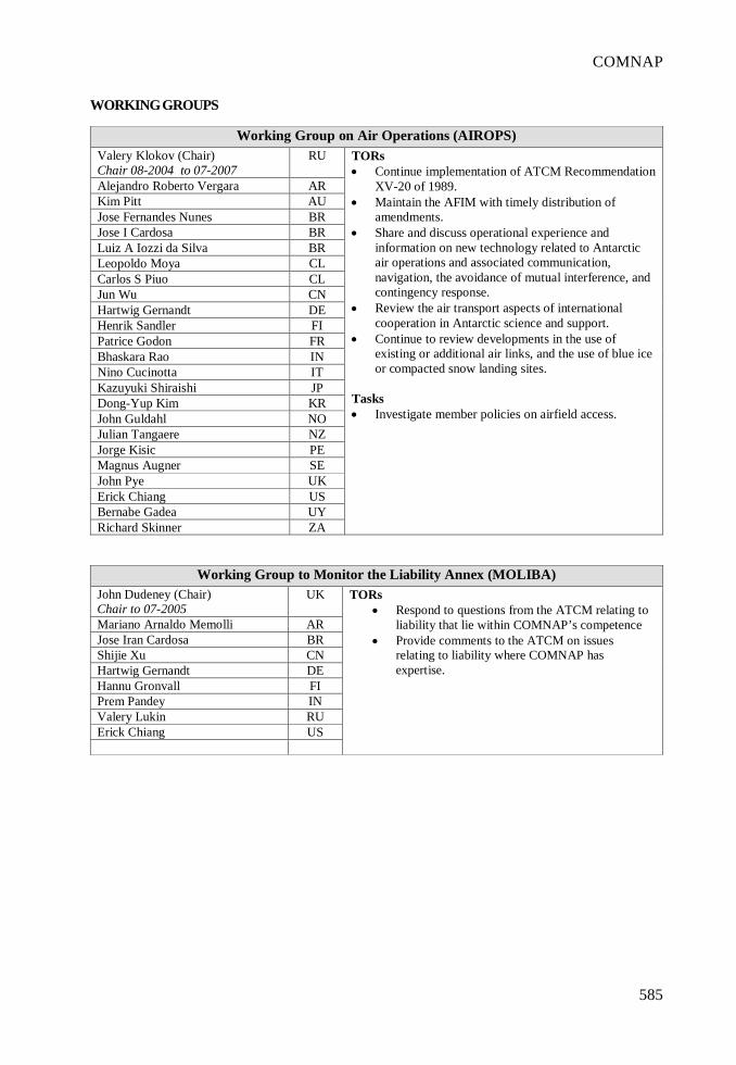
585
COMNAP
WORKING GROUPS
Working Group on Air Operations (AIROPS)Valery Klokov (Chair)Chair 08-2004 to 07-2007
RU
Alejandro Roberto Vergara ARKim Pitt AUJose Fernandes Nunes BRJose I Cardosa BRLuiz A Iozzi da Silva BRLeopoldo Moya CLCarlos S Piuo CLJun Wu CNHartwig Gernandt DEHenrik Sandler FIPatrice Godon FRBhaskara Rao INNino Cucinotta ITKazuyuki Shiraishi JPDong-Yup Kim KRJohn Guldahl NOJulian Tangaere NZJorge Kisic PEMagnus Augner SEJohn Pye UKErick Chiang USBernabe Gadea UYRichard Skinner ZA
TORs• Continue implementation of ATCM Recommendation
XV-20 of 1989.• Maintain the AFIM with timely distribution of
amendments.• Share and discuss operational experience and
information on new technology related to Antarcticair operations and associated communication,navigation, the avoidance of mutual interference, andcontingency response.
• Review the air transport aspects of internationalcooperation in Antarctic science and support.
• Continue to review developments in the use ofexisting or additional air links, and the use of blue iceor compacted snow landing sites.
Tasks• Investigate member policies on airfield access.
Working Group to Monitor the Liability Annex (MOLIBA)John Dudeney (Chair)Chair to 07-2005
UK
Mariano Arnaldo Memolli ARJose Iran Cardosa BRShijie Xu CNHartwig Gernandt DEHannu Gronvall FIPrem Pandey INValery Lukin RUErick Chiang US
TORs• Respond to questions from the ATCM relating to
liability that lie within COMNAP’s competence• Provide comments to the ATCM on issues
relating to liability where COMNAP hasexpertise.
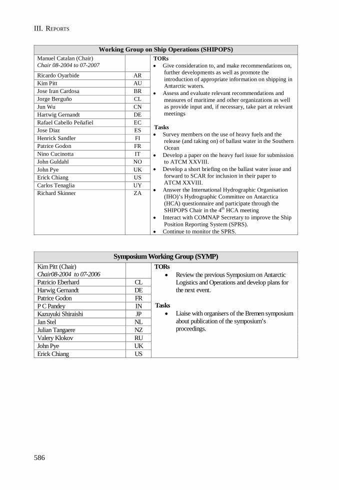
586
III. REPORTS
Working Group on Ship Operations (SHIPOPS)Manuel Catalan (Chair)Chair 08-2004 to 07-2007
Ricardo Oyarbide ARKim Pitt AUJose Iran Cardosa BRJorge Berguño CLJun Wu CNHartwig Gernandt DERafael Cabello Peñafiel ECJose Diaz ESHenrick Sandler FIPatrice Godon FRNino Cucinotta ITJohn Guldahl NOJohn Pye UKErick Chiang USCarlos Tenaglia UYRichard Skinner ZA
TORs• Give consideration to, and make recommendations on,
further developments as well as promote theintroduction of appropriate information on shipping inAntarctic waters.
• Assess and evaluate relevant recommendations andmeasures of maritime and other organizations as wellas provide input and, if necessary, take part at relevantmeetings
Tasks• Survey members on the use of heavy fuels and the
release (and taking on) of ballast water in the SouthernOcean
• Develop a paper on the heavy fuel issue for submissionto ATCM XXVIII.
• Develop a short briefing on the ballast water issue andforward to SCAR for inclusion in their paper toATCM XXVIII.
• Answer the International Hydrographic Organisation(IHO)’s Hydrographic Committee on Antarctica(HCA) questionnaire and participate through theSHIPOPS Chair in the 4th HCA meeting
• Interact with COMNAP Secretary to improve the ShipPosition Reporting System (SPRS).
• Continue to monitor the SPRS.
Symposium Working Group (SYMP)Kim Pitt (Chair)Chair08-2004 to 07-2006Patricio Eberhard CLHarwig Gernandt DEPatrice Godon FRP C Pandey INKazuyuki Shiraishi JPJan Stel NLJulian Tangaere NZValery Klokov RUJohn Pye UKErick Chiang US
TORs• Review the previous Symposium on Antarctic
Logistics and Operations and develop plans forthe next event.
Tasks• Liaise with organisers of the Bremen symposium
about publication of the symposium’sproceedings.
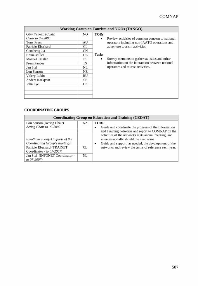
587
COMNAP
COORDINATING GROUPS
Working Group on Tourism and NGOs (TANGO)Olav Orheim (Chair)Chair to 07-2006
NO
Tony Press AUPatricio Eberhard CLGenzheng Jia CNHeinz Miller DEManuel Catalan ESPrem Pandey INJan Stel NLLou Sanson NZValery Lukin RUAnders Karlqvist SEJohn Pye UK
TORs• Review activities of common concern to national
operators including non-IAATO operations andadventure tourism activities.
Tasks• Survey members to gather statistics and other
information on the interaction between nationaloperators and tourist activities.
Coordinating Group on Education and Training (CEDAT)Lou Sanson (Acting Chair)Acting Chair to 07-2005
NZ
Ex-officio guest(s) to parts of theCoordinating Group’s meetings:Patricio Eberhard (TRAINETCoordinator - to 07-2007)
CL
Jan Stel (INFONET Coordinator -to 07-2007)
NL
TORs• Guide and coordinate the progress of the Information
and Training networks and report to COMNAP on theactivities of the networks at its annual meeting, andinter-sessionally should the need arise.
• Guide and support, as needed, the development of thenetworks and review the terms of reference each year.
588
III. REPORTS
Coordinating Group on Energy Management (CENMAN)David Blake (Chair)Chair 08-2003 to 07-2006
UK
Patrice Godon FRJulian Tangaere NZ
Ex-officio guest(s) to parts of theCoordinating Group’s meetings:Chris Paterson (ENMANETCoordinator - to 07-2006)
AU
TORs• Develop goals and provide guidance on the
development of energy management practiceswith a view to reducing environmental impactsand reliance on fossil fuels.
• Monitor the progress of the Energy ManagementNetwork (ENMANET) and report to COMNAPon the activities of the network at its annualmeeting, and inter-sessionally should the needarise; and
• Review the terms of reference and tasks eachyear.
Tasks• Identify high priority technology issues beyond
energy management that COMNAP shouldstudy.
Medical Coordinating Group (COMED)Gérard Jugie (Acting Chair)Acting Chair to 07-2005Kim Pitt AUErick Chiang US
Ex-officio guest(s) to parts of theCoordinating Group’s meetings:Claude Bachelard (MEDINETCoordinator - to 07-2006)
FR
TORs• Task and oversee the work of Medical Network
(MEDINET)• Report to COMNAP on the activities of the
network at its annual meeting.• Review the terms of reference and tasks each
year.
589
COMNAP
Environmental Coordinating Group (ECG)Lou Sanson (Chair)Chair08-2003 to 07-2006
NZ
Tony Press AUHeinz Miller DEHenry Valentine ZA
Ex-officio guest(s) to parts of theCoordinating Group’s meetings:Rebecca Roper-Gee (AEONCoordinator – to 07-2008)
NZ
TORs• Provide liaison between COMNAP/SCALOP and the
Antarctic Environmental Officers Network (AEON).• Direct the development and preparation of responses
to COMNAP requests with copies of all charges toAEON to be sent electronically to all MNAPs..
• Report to COMNAP on the activities of the networkat the annual meeting, and inter-sessionally, as issuesarise.
• Develop methods for coordination of monitoringactivities to avoid wasteful duplication and ensureeffective use of resources.
Tasks• Assist AEON with the revision of the Practical
Guidelines on Environmental Monitoring.• Provide liaison between COMNAP and the
organisers of the Biological Monitoring Workshop• Coordinate preparations of a an information paper
reporting on the Biological Monitoring Workshop toATCMXXVIII or ATCMXXIX.
IPY Coordinating Group (IPYCG)Anders Karlqvist (Chair)Chair to 07-2007
SE
Patricio Eberhard CLYaedong Kim KRValery Lukin RUHenry Valentine ZA
TORs• Encourage multi-national logistical partnerships
and the integration of technologicaldevelopments to advance the scientific goalsestablished for IPY
• Track progress by the virtual IPY Network(IPYNET), consisting of all members of theAMEN list, in developing new or strengtheningexisting partnerships or in advancingtechnological developments in furtherance ofIPY goals
• Review the IPYCG terms of reference at eachannual meeting.
Tasks• Develop a draft report on the above activities for
consideration by EXCOM and the COMNAPmembership, for eventual submission to ATCMXXVIII.
• Report to COMNAP at COMNAP XVII in Sofia.
590
III. REPORTS
NETWORKS
Antarctic Environment Officers Network (AEON)Rebecca Roper-Gee (Coordinator)Coordinator to 07-2008
NZ
Rodolfo Sánchez ARNesho Chipev BGMaaike Vancauwenberghe BETania Brito BROlav Loken CAPatricio Eberhard CLWang Yong CNJoachim Ploetz DEJose Moran ECJavier Martinez Aranzaba ESMika Kalakoski FIYves Frenot FRPrem Pandey INSandro Torcini ITKenji Ishizawa JPIn-Young Ahn KRKaren Kooi-de Bruyne NLBirgit Njaastad NOStanislaw Rakusa-Suszczewski PLVictor Pomelov RUJohan Sidenmark SESveta Kovalyonok UARod Downie UKAldo Felici UYHenry Valentine ZA
TORs• Exchange information and ideas about practical
and technical environmental issues on Antarctica.• Promote mutual understanding among Network
members on the practical application of theEnvironmental Protocol to national programs.
• Respond to requests from COMNAP for adviceon environmental issues.
Tasks• Complete the revision of the Practical
Guidelines on Environmental Monitoring thatwill be submitted to CEP VIII.
591
COMNAP
Energy Management Network (ENMANET)Chris Paterson (Coordinator)Coordinator to 07-2006
AU
Luis Eduardo Lopez ARDavid Domenech CLSaad El Naggar DEJordi Sorribas ESHenrik Sandler FIAlain Pierre FRTVP Bhaskara Rao INCamillo Calvaresi ITKenji Ishizawa JPPeter Brookman NZFernando Jiminez PEUlf Hedman SEDaniel Ressia UYHenry Valentine ZA
TORs• Determine the extent to which national Antarctic
programs effectively utilise energy managementand conservation processes. This includes theemployment of both conventional and alternativeenergy technologies. Specifically the workinggroup shall examine:• the type of systems employed;• the maximum and average power output of
the systems;• the capital and operating costs; and• problems encountered in operation, if any.
• Facilitate the exchange of operating experienceand encourage cooperative projects in energymanagement; identify other technical areasmeriting attention.
Antarctic Information Officers Network (INFONET)Jan Stel (Coordinator)Coordinator to 07-2007
NL
Sergio Policastro ARJose Iran Cardosa BRBonni Hrycyk CAPatricio Eberhard CLShijie Xu CNMacarete Pauls DEManuel Catalán ESHenrik Sandler FIYves Frenot FRPrem Pandey INNino Cucinotta ITKazuyuki Shiraishi JPYounho Lee KRJohn Guldahl NOEmma Reid NZStanislaw Rakusa-Suszczewski PLKatarzyna Salwicka PLValery Lukin RUMagnus Augner SEGennadi Milinevsky UALinda Capper UKBernabe Gadea UYHenry Valentine ZA
TORs• Exchange information and experience on information
and education programs.• Promote initiatives between NAPs in order to
develop and facilitate closer cooperation.
592
III. REPORTS
Medical Network (MEDINET)Claude Bachelard (Coordinator)Coordinator to 07-2006
FR
Sergio Mendes Garrido ARJeff Ayton AUMaaike Vancauwenberghe BENestor Miranda BRFrancisco Junior BRPeng Xie CNAntonio Bendala Ayuso ESVeikko Kujala FIEberhard Kohlberg DEFabio Catalano ITYusei IkedaHaruo Mikami
JP
Daison Kim KRJonathan Pascoe NZJohn Guldahl NOArturo Villena PELui Cloque Pacheco PEGennady Gorbunov RUKrister Eklad SEMoisejenko Yevgen UAIain Grant UKRoberto Lagomar-Sino UYL J Smith ZA
TORs• Exchange information and experience on medical
support in national Antarctic programs.• Promote initiatives between national Antarctic
programs in order to develop and facilitate closercooperation.
• Respond to requests from COMNAP for advice onmedical issues.
Tasks1. Prepare and disseminate a common format for the
presentation of summer medical standards and medicalinformation (This will include the categorisation ofmedical standards, for example by location, type ofactivity undertaken, duration, age of personnel).
2. Establish common standards for medical screening forthe interchange of personnel between nationalprograms.
3. Establish a database of current national programmedical capabilities, including:- facilities and equipment;- staffing, level of skills and medical fitnessrequirements for medical personnel; and- formats for medical information for use in medivacs.
4. Consider baseline and standardised procedures onabove capabilities.
5. Establish an anonymised database of medical events.6. Share medical aspects of “Major Incident Plans”.7. Develop guidelines for management of altitude
sickness prevention and treatment in Antarctica.
Training Network (TRAINET)Patricio Eberhard (Coordinator)Coordinator to 07-2007
CL
Richard Mulligan AUVictor Figueroa ARJose Iran Cardoso BRBonni Hrycyk CAWang Yong CNHartwig Gernandt DEManuel Catalan ESMika Kalakoski FIPrem Pandey INCostanza Pagni ITJan Stel NLJulian Tangaere NZJohn Guldahl NOVictor Pomelov RUSimon Gill UKBrian Stone USAlbert Lluberas UYRichard Skinner ZA
TORs• Exchange information and experience on training
programs including manuals, techniques, proceduresand training aids; and
• Promote initiatives between national programs inorder to develop and facilitate closer cooperation.

593
COMNAP
594
III. REPORTS
595
COMNAP

ANNEX G
REPORTS PURSUANT TO ARTICLE III-2OF THE ANTARCTIC TREATY


599
Report of the Antarctic and Southern Ocean Coalition (ASOC)
ATCM XXVIII
I. Introduction
ASOC extends its formal thanks to the Government of Sweden for hosting this ATCM.
We look forward to this meeting adopting a new Annex to the Protocol setting out rules and proceduresregarding emergency response action and liability for failing to do so, based on the fruitfulintersessional meeting held last in New York in April, at which ASOC was pleased to participate. Ifconcluded and adopted in Stockholm, this will be another historic milestone in the development ofthe Antarctic Treaty System (ATS).
ASOC calls upon all Parties, Observers and Experts at this XXVIII ATCM to rededicate themselves toensuring comprehensive implementation of the Protocol, and concerted efforts to ensure thecomprehensive protection of the entire Antarctic and Southern Ocean environment, as the commonheritage of all humankind, by using all of the relevant structures and institutions of the ATS in a fullycooperative and synergistic way. In this context, it is exciting that CCAMLR is about to embark on aprocess of giving serious consideration to creating Marine Protected Areas. ASOC believes thatthere is a significant continuing role for the CEP, particularly in relation to use of Annex V of theProtocol, in those discussions over the next few years and hopes that useful working mechanisms toallow this will be elaborated.
II. ASOC Worldwide
• ASOC maintains a Secretariat in Washington DC, USA – and a global website (http://www.asoc.org), which contains all ASOC papers produced in recent years, a list of staff andmember groups, and links to many other relevant sites, including national programs andSCAR.
• A European branch of ASOC, Stichting Antarctica Network, was registered in The Netherlandsin September 2004.
• ASOC campaigns are coordinated by a team of specialised representatives located in: Asia(Seoul, South Korea), Australia-New Zealand (Canberra, Australia), Europe (Amsterdam,The Netherlands), South America (Puerto Madryn, Argentina), and Southern Africa (CapeTown, South Africa).
III. ASOC Information Papers for XXVIII ATCM
In addition to this report, ASOC has tabled four Information Papers and is putting one forward jointlywith UNEP:
1. A Note On The Vulnerability Of Cetaceans In Antarctic Waters To Noise Pollution (XXVIIIATCM /IP059)
2. Some Legal Issues Posed By Antarctic Tourism (XXVIII ATCM/IP071)3. Development Pressures on the Antarctic Wilderness (XXVIII ATCM/IP074)

600
III. REPORTS
4. The Antarctic and Climate Change (XXVIII ATCM/IP104)5. Antarctic tourism graphics - tabled jointly with UNEP - (XXVIII ATCM/IP?)
IV. Key Issues for XXVIII ATCM
1. Antarctic Tourism
ASOC is encouraged that regulation of tourism is now being given serious consideration. However,significant elements of commercial tourism – elements which we believe must be considered in anyregulatory structure to be agreed by Parties – still require substantive discussion. These elementsinclude strategic consideration of the overall scale and trajectory of commercial tourism in Antarctica,the acceptability of particular types of activity, and the risks posed to the stability of the AntarcticTreaty System as a result of some legal uncertainties surrounding these activities. We look to see theopening of discussion on at least some of these at XXVIII ATCM in Stockholm.
It is important that Parties take substantive steps over the next few ATCMs towards an appropriatelegally-based regulatory structure for this burgeoning industry.
ASOC was pleased to participate in the useful ICG on accreditation led by the UK. Like many Parties,ASOC sees accreditation as a positive mechanism. However, we see it as merely one mechanism, andnot a sufficient basis for the regulation of commercial tourism in Antarctica.
For this ATCM ASOC has tabled an Information Paper addressing some legal issues posed bytourism, including jurisdiction in relation to tourism operations, property rights, and usufructuaryrights.
A second Information Paper, tabled jointly with UNEP, presents a series of maps that provide ageographic overview of Antarctic tourism. The maps show the distribution of tourism activities,including tourist numbers and activities, and the countries that are more involved in the tourismindustry as sources of passengers, location of tourism companies, or where vessels engaged inAntarctic tourism are flagged.
2. Liability
Progress on the long-awaited Liability regime is essential. It is greatly encouraging that an Annex onResponse Action and Liability for damage to the Antarctic environment may now be within grasp atthis ATCM. ASOC commends Parties for their efforts, and thanks the chair of the Working Group, Mr.Don MacKay for his diligence in guiding this important work. We encourage Parties to complete andadopt this Annex via a Measure in Stockholm. This will be an historic step toward meeting the Partieslegal obligations under Articles 15 and 16 of the Protocol. ASOC believes that there may need to befurther coverage in order to meet all of the obligations of the Protocol, and accordingly we lookforward to an appropriate “bridging” framework in this Annex which would leave open the possibilityof future annexes.
3. Sustainable Environmental Management
Several initiatives underway address key mechanisms under the Protocol for the sustainableenvironmental management of Antarctica and its dependent and associated ecosystems, including amore effective and complete implementation of Annexes I and V of the Protocol. ASOC supportsmany of these initiatives and has actively contributed to some of them, as described below. However,we note that there are many challenges ahead and gaps still to cover, particularly concerning consistentimplementation of the Protocol by all Parties, the protection of the Antarctic marine environment, and
601
ASOC
the growing pressure of research and commercial activities on the Antarctic region, including inhitherto remote areas.
Since XXVII ATCM/CEP VII ASOC has participated in the Intersessional Contact Groups dealingwith updating EIA guidelines for cumulative impacts and with environmental monitoring. ASOC ispleased with the depth of the discussion in these groups. However, there remain key issues that needaddressing by the CEP in order to ensure a more effective assessment and monitoring of cumulativeimpacts. This may require establishing mechanisms for sharing of information among operatorsworking in the same parts of Antarctica, including willingness to prepare joint or regional EIAs.
In addition, ASOC has contributed to the work of the international co-ordination group overseeingthe German research project “Risk assessment for Fildes Peninsula and Ardley Island and thedevelopment of management plans for designation as Antarctic Specially Protected or ManagedAreas”. In this connection, ASOC has produced a compilation of observations made by ASOC-member Greenpeace at several sites on Fildes Peninsula between the late 1980s and the late 1990s.The resulting report, Environmental Reports of Fildes Peninsula, 1988-1997: Benchmarks forEnvironmental Management, is available on request.
ASOC hopes that the experience on Fildes Peninsula, where development pressures and the sprawlof research bases have resulted in significant environmental damage that quite possibly cannot bejustified by the corresponding scientific output, will inform developments elsewhere in the Antarcticso that the errors of the past are not repeated again now that the Antarctic Environmental Protocolhas entered into force. This is particularly relevant in view of the numerous infrastructure projects inAntarctica currently underway, as described in ASOC paper XXVIII ATCM/IP074, including thosethat may arise as a result of the forthcoming, and important, International Polar Year.
In this context, ASOC welcomes Sweden’s call for a strategic discussion on future environmentalchallenges in Antarctica and its dependent and associated ecosystems. ASOC looks forwards to asuitable discussion of both generic and specific issues of sustainable environmental managementunder the Protocol during the meetings of the CEP and the ATCM.
4. Antarctic Subglacial Lake Exploration and Research
ASOC continues to encourage all Parties involved in subglacial lake exploration and research toadhere to the guiding principles of subglacial lake exploration enunciated at the SCAR/COMNAPCambridge 1999 workshop and subsequently adopted by SCAR. These principles include that researchshould be internationally coordinated, multi- and interdisciplinary in scope, and that the design andexecution of the program has non-contaminating techniques and minimum disturbance as fundamentalconsiderations throughout the process.
In the particular case of Lake Vostok, ASOC submits that consideration should be given to at least atemporary designation as a ‘protected area’ under Annex V of the Protocol.
5. Biological Prospecting
ASOC looks forward to a robust discussion of Biological Prospecting in the Legal and InstitutionalWorking Group and in the CEP. We urge that the Parties utilize the Precautionary Principle on thisissue, and establish a formal mechanism for dealing with potential commercial bio-prospecting issuesbefore conflict arises, including appropriate regulatory procedures.
6. International Polar Year 2007
ASOC looks forward to participating in the International Polar Year 2007-08. ASOC encourages allAntarctic Treaty states to ensure that the IPY 2007-2008 leaves a legacy of environmentally

602
III. REPORTS
responsible scientific practice that is compatible with the designation, objectives and principles ofthe Antarctic Treaty and its Environmental Protocol, and international sustainability principles.
V. Broader Antarctic Environmental Issues
1. Southern Ocean Fisheries
ASOC was again an active NGO Observer at XXIII CCAMLR, where it became apparent that the lackof adequate enforcement of conservation measures continues to be a serious challenge for CCAMLR.Illegal, Unregulated and Unreported (IUU) fishing for toothfish remains at unsustainable levels,including unregulated catches in Areas 47, 51 and 57, outside the Convention Area. Sightings overthe last four months of several vessels not licensed to fish in the Convention Area, operating justoutside CCAMLR waters, are a worrying signal that the unregulated plunder of toothfish stocks inthe Southern Ocean continues, and that CCAMLR currently lacks the mechanisms to put an end tothis situation.
ASOC welcomes the adoption, at XXIII CCAMLR, of a centralised Vessel Monitoring System (VMS).While this is an important step forward, currently VMS is only required within the Convention Areaand not throughout the whole fishing trip, making it possible for vessels to avoid CCAMLR controlsfor an important part of their operations. Other important opportunities for strengthening CCAMLRenforcement were missed at CCAMLR XXIII, such as the adoption of an electronic CatchDocumentation Scheme (eCDS). Although this system has been on successful trial for the twoprevious seasons, CCAMLR Members as a whole could still not agree to implement a compulsoryeCDS for all toothfish shipments.
In addition to the measures outlined above, available mechanisms include cooperative use of satelliteimagery in order to pinpoint and track IUU fishing vessels, coupled to vigorous use of enforcementvessels and various port-state enforcement options. DNA testing of toothfish imports by port stateon a random basis is another tool that may be used to control illegal trade. Some CCAMLR Parties arealready using some of these measures with good results, which proves that illegal toothfish fishingand trade can be eradicated if the political will exists to use the available technologies. ASOC urgesthis ATCM to send a strong signal that the Parties are prepared to take the necessary political stepsto shut down the illegal pirate fishery within three years, by greatly increasing the cooperative use ofenforcement assets available to the governments as a group.
ASOC has updated its IUU vessel ‘Red List’1 to continue assisting governments and interestedparties in identifying and scrutinising vessels that may be involved in IUU fishing in the SouthernOcean.
Some important fisheries management decisions recently taken by the Commission are worryinglylacking the precautionary, ecosystem-based management approaches mandated by Article II of theConvention:
• At XXIII CCAMLR, the Scientific Committee was unable to provide scientific advice to theCommission in relation to the toothfish fishery in Area 48.3, and the catch limit finallyestablished by the Commission was far from precautionary.
• Concerning Antarctic krill fishing, information tabled at XXIII CCAMLR clearly indicatesthat this fishery is subject to growing interest from an increasing number of states, and thatnew technologies are being used that could change the economics of the fishery in a veryshort time. The operations of a vessel flagged to a non-CCAMLR state raised concerns thatthis fishery, which is currently not subject to VMS or to CCAMLR’s System of Scientific
603
ASOC
Observation, might be attracting the attention of IUU operators. In spite of this, and of thefact that a rapid expansion of the krill fishery would have important adverse impacts on theAntarctic food chain, no progress was made at XXIII CCAMLR in tightening controls inrelation to this fishery, nor in the subdivision of precautionary catch limits among SmallScale Management Units (SSMUs).
ASOC welcomes the progress made at XXIII CCAMLR towards establishing a CCAMLR strategy onMarine Protected Areas (MPAs). ASOC hope that the first MPA workshop will be convened beforeXXIV CCAMLR, and hopes that this workshop, unlike the recent CCAMLR Symposium in Valdivia(Chile), will be open to proposals and participation by experts from the broader scientific and NGOcommunities. ASOC would be pleased to participate in this meeting.
One of the greatest and most immediate threats presently facing the Antarctic environment – whichthe Protocol seeks to secure – is posed by unsustainable fishing in the Southern Ocean, particularlyas a result of IUU operations. It is therefore both appropriate and necessary for the ATCM toseriously address the pressing need to adopt and implement an adequately controlled, precautionarymanagement of Antarctica’s marine resources, and for responses to be taken by ATCPs both jointlyand at national levels. This includes the establishment of a representative network on MPAs in theSouthern Ocean, a goal that is consistent with CCAMLR’s conservation and management principlesand with Annex V to the Madrid Protocol.
2. Agreement on the Conservation of Albatrosses and Petrels
ASOC participated at the first meeting of Parties to the Agreement on the Conservation of Albatrossesand Petrels (ACAP). ASOC encourages all ACAP Range States, particularly those who are alsoParties to ATS treaties that have not yet ratified this agreement, to do so as soon as possible. At thesame time ASOC also recommends that both the ATCM and CCAMLR propose concrete mechanismsfor co-operation with the ACAP Secretariat.
3. Marine Acoustic Technology
At recent ATCM and CCAMLR meetings, ASOC has raised the issue of acoustic pollution in theAntarctic Treaty Area, and the potential impacts the technologies producing the noise has on themarine environment at all levels of the ecosystem. We have submitted a further Information Paperthis year to provide Delegates with information on recent scientific, legal and political developments,as well as a short commentary and recommendations. We hope this could lead to agreement in CEPVIII on a first set of concrete recommendations to the ATCM to address acoustic pollution in theSouthern Ocean and to minimize its impacts on the marine environment.
4. Revision of IUCN’s Antarctic Conservation Strategy
ASOC was represented at the first meeting held by SCAR and IUCN to revise the IUCN AntarcticConservation Strategy, in Stellenbosch, South Africa last month. This is an important exercise, giventhe unique role played by IUCN, with its membership structure comprising governments, agencies ofgovernment with conservation or environmental mandates, non-governmental organizations, scientistsand lawyers. In this context, ASOC notes the new Resolution on Antarctic Conservation adopted atthe Third World Conservation Congress in Bangkok in November 2004, which is being introduced atthis meeting in an Information Paper from IUCN.1
1 Available at www.asoc.org

III. REPORTS
605
Report by IUCN Submitted to the XXVIII ATCM
IUCN extends its formal thanks to the Government of Sweden for hosting this Antarctic TreatyConsultative Meeting.
The World Conservation Union brings together 82 States, 111 government agencies, more than 800non-governmental organizations (NGOs) in a unique worldwide membership. In addition, more than10,000 internationally-recognised scientists and experts from more than 180 countries volunteer theirservices to its six global commissions. Its 1000 staff members in offices around the world are workingon some 500 projects. IUCN’s mission is “to influence, encourage and assist societies throughoutthe world to conserve the integrity and diversity of nature and to ensure that any use of naturalresources is equitable and ecologically sustainable”.
IUCN has a long standing interest in Antarctic Conservation and welcomes the opportunity to assistParties in their deliberations at the 28th ATCM.
1. IUCN Resolution on Antarctica and the Southern Ocean (November 2004)
The World Conservation Congress is the general assembly of IUCN members, which takes placeevery three to four years. The 3d IUCN World Conservation Congress took place in Bangkok,Thailand, in November 2004, and passed a Resolution on Antarctica and the Southern Ocean. Thefull text is provided in ATCM 28-IP64.
2. Antarctic and Southern Ocean Marine Protected Areas
With the coming into force in May 2002 of Annex V of the Antarctic Treaty’s Environmental Protocol,there is now an explicit legal basis for the adoption of binding measures for the conservation ofAntarctic Specially Protected Areas and Antarctic Specially Managed Areas throughout the treatyarea. The Convention for the Conservation of Antarctic Marine Living Resources also containsstrong conservation-oriented provisions for the opening and closing of areas for the purpose ofscientific study or conservation. Thus Antarctica and the Southern Ocean provide an excellenttesting ground from which to build experience for the development and management of MPAsbeyond national jurisdiction. Such pilot cases can commence now, rather than waiting for thedevelopment of informal arrangements or formal legal agreements under the Convention on BiologicalDiversity or UNCLOS.
In November 2004, the Commission for the Conservation of Antarctic Living Marine Resources(CCAMLR) agreed to convene a technical workshop to discuss approaches to establishing MPAs inthe Southern Ocean, including high seas areas.
Also in November 2004, IUCN’s World Conservation Congress in Bangkok, Thailand adopted aresolution urging all Parties to the Environmental Protocol and CCAMLR to take steps to develop acomprehensive network of protected areas with special urgency being given to protecting marinehabitats and biological diversity, and to provide comprehensive protection of the whole of the RossSea using a combination of Antarctic Specially Managed Areas and Antarctic Specially ProtectedAreas.
The CBD Secretariat recently commissioned two background papers with funding from the EuropeanCommunity on marine protected areas beyond national jurisdiction that may be of interest to thediscussion of Marine Protected Areas in the ATS context, and that can be made available. One is a
606
III. REPORTS
study of scientific information on biodiversity in marine areas beyond the limits of national jurisdiction(UNEP/CBD.WG-PA/INF/1) and the other a study on legal aspects for the establishment of marineprotected areas in marine areas beyond the limits of national jurisdiction (UNEP/CBD/WGF-PA/INF/2). The background legal study was prepared by IUCN’s Global Marine Programme in conjunctionwith the IUCN WCPA Task Force on High Seas Marine Protected Areas.
These papers highlight the importance of Antarctica and the Southern Ocean as an area of highspecies richness that is already equipped with a functional legal framework for conservation actionon the high seas. The scientific background paper notes that a preliminary survey of prioritybiodiversity areas includes seamounts in the Southern Ocean Convergence Zone and marine areasbeyond national jurisdiction adjacent to islands in the Southern Ocean, among others. The legalpaper highlights the importance of the Protocol to the Antarctic Treaty on Environmental ProtectionAnnex V, as well as the conservation powers inherent in the Convention of the Conservation ofAntarctic Marine Living Resources as frameworks already allowing for the establishment of protectedareas in marine areas beyond national jurisdiction.
IUCN encourages the ATCM and its Committee on Environmental Protection to continue its traditionof promoting environmental conservation in Antarctica and the Southern Ocean by taking an activerole with respect to promoting high seas MPAs within the region. The development of MPAs as amanagement and conservation tool in Antarctica and the Southern Ocean would enable the next steptowards true ecosystem management of one of the earth’s last relatively pristine large marineecosystems. This would help cement the ATCM’s role as the most progressive conservation bodyand as perhaps the best model for other areas of the world’s oceans.
IUCN’s Global Marine Programme, WCPA High Seas MPA Task Force, and Antarctic AdvisoryCommittee would be pleased to develop additional background material on opportunities and prioritiesfor high seas MPAs in Antarctica and the Southern Ocean, should the Committee find this of value.
3. Bioprospecting
IUCN recently produced a background paper “Bioprospecting marine resources: Conservationconcerns and management implications” which can be provided to ATS discussion on this subject.Some points of interest are worth repeating here to assist in the discussion of this agenda item in theAntarctic and Southern Ocean context:
• The lack of information about the habitat of the targeted species, the viability of thepopulation, life-history characteristics and their distribution and abundance leads touncertainty in conservation and management.
• Initial collections for screening purposes are reported to require relatively small amounts ofmarine organisms. The reality is that collection processes are very poorly documented, andconfidentiality agreements that are common for such surveys complicate access to suchinformation.
• Currently, sample size in initial screening collections may be limited to 0.5-1 kg. However,even this mass of tissue can be harmful to local marine populations of species whosedistribution is unknown and may be very restricted geographically.
• When a bio-product has proved to present interesting and promising properties, thecommercial source of choice for the pharmaceutical industry is its synthesis, which allowsthe company to control all aspects of production. But, unlike terrestrial bio-compounds,many bioactive marine natural products, particularly those used in the pharmaceutical field,are extremely complex in structure, and require intensive multi-step processes that are not
607
IUCN
amenable to economic, industrial-scale synthesis. The supply of sufficient quantities of thesource organism (biomass supply) has been recognised as a major limitation in thedevelopment of marine bioproducts. In the development phase, if the compounds cannot besynthesised or obtained by fermentation technology, they can only be obtained throughharvesting from the wild.
• The sample size of a marine organism collected for screening purposes is generally on theorder of grams or kilograms of wet weight. However, the quantities required for thedevelopment phase and in clinical trials are on the order of tons or thousands of tons(estimations of biomass needed for the development of a Halichondrin from Lissodendoryxsp. is about 5000 tons), because bioactive products are normally present at very low yieldsin the source organism. In many cases the natural abundance of source organisms will notsupport product development based on wild harvesting.
• One challenge is the use of the term “bioprospecting”. While different papers and publicationsagree on the essence of what bioprospecting is, they differ on how far ‘bioprospecting’extends down the path toward commercialisation. In dealing with marine genetic resourcesbeyond national jurisdiction, the chain of activities involved in the development of marinebio-products may require further clarification so that management approaches can ensureconservation and sustainable use of the natural resources.
• The above mentioned resolution adopted at IUCN’s World Conservation Congress inBangkok encourages Parties to the Antarctic Treaty and to CCAMLR to examine and resolvethe legal and environmental issues surrounding bioprospecting and to regulate this activityif it is to be permitted in Antarctica and the Southern Ocean; IUCN welcomes the opportunityto assist in these developments.
4. Introduction of Non-native Species, Parasites and Diseases
Globally, harmful non-native species, including but not limited to pathogens, are a major threat tobiological diversity. At a global scale, the natural biogeographical barriers of oceans, mountains,rivers and deserts provided the isolation essential for unique species and ecosystems to evolve.Now these barriers increasingly lose their effectiveness - as economic globalisation has resulted inan exponential increase in the deliberate or accidental movement of organisms from one part of theworld to another through trade, transport, travel and tourism. While the majority of non-nativespecies may never develop “invasiveness”, those that do have been absolutely devastating (e.g. seewww.issg.org). The Antarctic, in spite of its remoteness and “inhospitable” environment is notimmune from this threat, both in terrestrial and marine environments. The IUCN ‘Guidelines for thePrevention of Biodiversity Loss caused by Alien Invasive species” can be accessed on line:
English http://www.iucn.org/themes/ssc/pubs/policy/invasivesEng.htm
Spanish http://www.iucn.org/themes/ssc/pubs/policy/invasivesSp.htm
French http://www.iucn.org/themes/ssc/pubs/policy/invasivesFr.htm
IUCN defines Alien species (non-native, non-indigenous, foreign, exotic) as “a species, subspecies,or lower taxon occurring outside of its natural range (past or present) and dispersal potential (i.e.outside the range it occupies naturally or could not occupy without direct or indirect introduction orcare by humans) and includes any part, gametes or propagule of such species that might survive andsubsequently reproduce.”
IUCN defines Alien invasive species (invasive alien species, environmental pests) as “an alienspecies which becomes established in natural or semi-natural ecosystems or habitat, is an agent of
608
III. REPORTS
change, and threatens native biological diversity”. In the context of the Antarctic, it must be notedthat in addition to biodiversity , other Aspecific Antarctic values are at risk, notably wilderness orintrinsic values. Those threats include more than impacts on biodiversity only, including changes to“pristineness”, affecting the “existence value”, and last but not least, interfering with scientificvalues. It can therefore be argued that the need for preventative and precautionary action againstalien (= non native) species is even more obvious in the Antarctic.
Several recent studies documents species introductions into Antarctic and Southern Ocean waters.The likelihood of transport of invasive species into the Southern Ocean may increase in future as aconsequence of the growth of tourism, fisheries and science activities in the region. It is also possiblethat global change, particularly global warming, may increase the rate of successful establishment ofalien species by reducing differences in environmental conditions between donor and recipientenvironments. Marine debris, and shipping are the two major vectors for marine species introductionsinto the Southern Ocean and deserve an increasing attention. IUCN strongly recommends furtheractions within the framework of the Treaty to prevent species introductions, particularly in themarine environment in order to conserve the integrity of the unique Antarctic system.
IUCN would warmly welcome the opportunity to contribute to the further development of practicaland/or institutional solutions to this threat to Antarctic biological and other values, through itsAntarctic Advisory Committee and Its Invasive Species Specialist Group (of the Species SurvivalCommission), we are hopeful that intersessional work on the Introduction of Non-native Species,Parasites and Diseases can further address this challenge.
5. Antarctic Conservation Strategy
As part of the World Conservation Strategy developed by the IUCN during the 1980s there was aneed to develop a regional policy for Antarctica. The IUCN Commission on National Parks andProtected Areas (CNPPA), in 1987 produced a publication entitled Conserving the Natural Heritageof the Antarctic Realm. In 1989, the Director General established a working group to respond to thecall for the preparation of a strategy for Antarctic conservation. The resulting document Strategy forAntarctic Conservation was published in 1991, after revision in the light of the discussions held atthe IUCN General Assembly. This has provided an over-arching framework for Antarctic conservationfor the last 15 years. But conservation and environmental management are dynamic and developingfields and a review of the Strategy has been initiated in a process involving SCAR, IUCN, and otherinterested parties.
609
IUCN
Report of the International Association of Antarctica Tour Operators2004-2005 Under Article III (2) of the Antarctic Treaty
The International Association of Antarctica Tour Operators (IAATO) is pleased to present a report ofits activities to ATCM XXVIII, Stockholm, Sweden June 6-17, 2005, in relation to Article III (2) of theAntarctic Treaty.
IAATO is a member organization founded by seven companies in 1991 to advocate, promote andpractice safe and environmentally responsible private-sector travel to the Antarctic. During the 2004-2005 season IAATO had 70 Members, and as of May 5, 2005, the Association grew to 78 Membersduring the annual meeting. Overall tourism numbers reached at least 30,232, including seaborne, airoverflights and land-based tourism. Despite the increase in tourists, numbers of vessels and aircraftoperations the season went smoothly and IAATO Members continued to support establishedpractices that have proved to be effective and offer a strong degree of protection to the areas visited.IAATO operators are mostly business competitors of one another yet they are willing to work closelytogether to develop and impose best practices upon themselves. For industry to agree to set limits israre in today’s world and there is no other model that has been as successful as IAATO’s for the last15 years continuously. As an Association, IAATO seeks to raise the operational standards of Membersand the industry as a whole. To do so requires an infrastructure, a forum and a time and economiccommitment by each company.
IAATO has continued to focus its activities in several key areas including:
• providing a forum for Members to resource information needed to effectively manage theirindividual operations but yet plan strategically with all other operators. This is done throughregular email network and by maintaining useful documents on the website and at theannual meeting;.
• uploading a new and user friendly, quick-loading IAATO website;• activating the IAATO Tourism Database and successfully uploading all available Post Visit
Site Reports into the database. 2003-2004 tourism statistics were computed and posted onIAATO’s website. The database has additional capability that is used to compile all company,vessel and activity information and track IAATO’s activities. IAATO posted over 60 differentdata reports on tourism statistics on www.iaato.org as a matter of interest to the generalpublic. The 2004-2005 data will be available in July;
• improvements were made to the Standard Post Visit Site Report Form in order to be moreinclusive of all tourism activities and data collection (See ATCM XXVIII, IP 89);
• IAATO made available to the public on the IAATO website Visitor Guidelines.(Recommendation XVIII-1 in English, German, Italian, Spanish, French, Dutch, Japanese,Chinese and Russian.) IAATO has always used these guidelines but with only the exceptionof a few languages all were hard copies versus computer versions;
• updated the “Seasonal Operational Procedures” found on the Members-Only page of thewebsite to assure greater protection of the Antarctic;
• commissioned a computer programming company to design an automated ship schedulethat individual companies can input their itineraries directly on line and make changes to asoften as needed prior to the season. This will improve efficiency, safety, and overallcommunication prior to the season. When more cost efficient communication networks areinstalled on all vessels, companies can access ship schedules from the vessel. IAATO alsohas been liaising with COMNAP to be “more inclusive” of all ships operating in Antarctica;
610
III. REPORTS
• promote Vessel and Aircraft Coordination by using an all inclusive ship schedule, vessel calldata and emergency response list. This list is shared with COMNAP and those NationalAntarctic Programs that interact with tour operators on a regular basis throughout theseason;
• continued use of the IAATO Member Emergency Medical Evacuation Response (EMER)action plan;
• adherence to the IAATO Site Specific Guidelines (ATCM XXVI IP72) established in 2003.Thirty-two sites were identified and limits set accordingly. IAATO also has trial tested fortwo years ten Site Specific Guidelines prepared by the United Kingdom (four of which weresubmitted to ATCM XXVI and ATCM XXVII/WP26 and to ATCM XXVIII) to evaluate theireffectiveness to address impacts and concern towards growth in the tourism industry. IAATOwill provide a separate paper to ATCM XXVIII on Site Guidelines and the findings of ourresults;
• continued to support all methods necessary to eliminate the potential spreading of Antarcticdiseases and translocation of species;
• participation in several Intersessional Working Groups (ICG’s) ;• participation in international meetings and liaising with National Antarctic Programs,
government agencies of the sub-Antarctic island groups, and scientific and environmentalorganizations as needed;
• closely coordinated with Provisional Members in their start-up operations and offered supportto companies who have employees new to the business;
• created an IAATO Newsletter which can be found on line at www.iaato.org;• established additional sound business practices to improve the capability to promote IAATO
as a worldwide resource for Antarctic tourism;• commissioned a project to analyze 5 years of visits to sites in the Antarctic Peninsula (See
ATCM XXVIII IP 81);• furthered work on the proposed IAATO internal Accreditation Scheme as per (See ATCM
XXVII IP 69).
1. IAATO Membership and Activities
1.1 Founded by seven private tour operators in 1991, the International Association of AntarcticaTour Operators had 70 Members during the 2004-2005 season from Argentina, Australia,Belgium, Canada, Chile, France, Germany, Italy, Netherlands, New Zealand, Norway, UnitedKingdom, United States. A Membership Directory can be found on the IAATO web site atwww.iaato.org. IAATO’s fiscal year runs from July 1-June 30 of each year which is alsoconsistent with an Antarctic operating season.
1.2 Members during 2004-2005 are:
29 Full Members: Abercrombie and Kent, Inc./Atholl Shipping Corporation, Adventure Associates,Adventure Network International/Antarctic Logistics & Expeditions, Antarctica XXI, AuroraExpeditions, Cheesemans’ Ecology Safaris, Clipper Cruise Line/New World Ship ManagementCompany LLC, Crystal Cruises, Inc., Expeditions Inc., Golden Fleece Expeditions Ltd., Hapag LloydKreuzfahrten, Heritage Expeditions, Holland America Line, Lindblad Expeditions, Mountain Travel-Sobek, Oceanwide Expeditions, Ofotens og Vesteraalens Dampskibsselskab ASA, Pelagic Expeditions,Peregrine Shipping, Polar Star Expeditions, Princess Cruises, Quark Expeditions, ResidenSea, Saga
611
IAATO
Shipping Company Ltd, Thika Travel, Travel Dynamics International, Victor Emanuel Nature Tours,WildWings, and Zegrahm Expeditions Inc.
Full Members included one land-based operator, ship operators, companies that charter ships and/ororganize groups to Antarctica and companies that reserve space from other ship operators.
9 Provisional Members: Antarpply, Antarctic Horizons, Antarctic Shipping, Compagnie des Iles DuPonant, DAP Antartica, Elegant Cruises and Tours, Fathom Expeditions, Tooluka Ltd., and plantoursand Partner GmbH.
Provisional Members included a land/sea-based operator, ship operators, small vessel/yacht operators,a company that charters vessels from existing Members and a land based operator.
32 Associate Members: Adventure Life Journeys, Amazing Cruises and Travel, Inc., AntarcticaTasmania, Inc., Asteria Expeditions, Beluga Expeditions & Adventures BV, C&O Tours S.A., CroydonTravel, Cruceros Australis, ExpeditionTrips.com, Falkland Conservation, the Falkland Islands CompanyLtd Shipping Agency, Falkland Islands Tourism Galapagos Travel, Grand Nord-Grand Large,Helicopters New Zealand Ltd, Inspire, Journey Latin America, Lan Chile, Lone Ranger, Navalia s.r.l.,Patagonia World, Radisson Seven Seas Cruises, Ship to Shore Inc./shopAntarctica.com, Sintec Tur,Students On Ice, Sulivan Shipping Services Limited, TAMIC S.A., Tauck World Discovery, TucanTravel Pty Ltd., Waterline Yahcts, West Point Island, World Expeditions.
Associate Members are travel companies, government offices, conservation groups and ship agenciesthat reserve space on Full and Provisional Member vessels and/or aircraft or offer support servicesto the tour operators, or are involved in conservation work. IAATO also had one private yacht as anAssociate member. The owners found it useful to use IAATO’s resources when planning theirAntarctic trip, filing Advance Notification and their Initial Environmental Evaluation.*Note: For the 2005-2006 season IAATO Membership will include the following additional 8 Members, G.A.P. Adventures, Orion ExpeditionCruises, Le Sourire, Ocean Expeditions, Rederij Bark Europa, Sea, Ice & Mountains Adventures, Kotick Charters Ltd and Latitude Océan.Six out of the 8 companies are sailing vessel/yacht operators.
1.3 Membership Categories
During the 2004-2005 season, IAATO had Members in each of the following Membership categories:1. Organizers of expedition ships that carry less than 200 passengers or small sailing vessels
that carry less than 12 passengers. The limit of 100 passengers ashore at one site at one timeapplies. (22 Members)
2. Organizers of vessels carrying 200-500 passengers who are making passenger landings.Stringent restrictions on landing activities of time and place apply. The limit of 100 passengerson shore at one site at one time also applies. (4 Members)
3. Organizers of cruise ships making no landings (cruise only). Cruise ships carrying more than500 passengers are not permitted to make any landings. (3 Members)
4. Organizers of land-based operations. (2 Members)5. Organizers of air operations with over-flights only. (2 Members)6. Organizers of air/cruise operations. (1 Member)7. Companies in support of Antarctic tourism. (36 Members)
*Note: Full, Provisional, and Probational status occurs within categories 1-7.
1.4 Bylaws Changes: There were minor Bylaws Changes during 2004-2005. IAATO Bylaws andObjectives can be found on line at www.iaato.org.

612
III. REPORTS
2. 2004-2005 Statistics
2.1 IAATO Member Activities
From November 2004 to March 2005, a total of 16,955 passengers/tourists landed in theAntarctic on 29 commercially organized expedition vessels, 130 passengers/touristsparticipated in a fly cruise program and 878 land-based tourists flew, skied, climbed, campedor simply participated in day or overnight trips to Antarctica. In addition, 4,358 touriststravelled on three (IAATO-Member) large cruise only vessels (on 4 departures), and 462passengers/tourists participated in air over flights to Antarctica.An all inclusive overview of the Antarctic tourism industry can be found in the IAATOOverview of Antarctic Tourism (ATCM XXVIII-IP82).
2.2 Tourism numbers increased during the 2004-2005 season from the previous season. Data ontourism activities and actual numbers of non-IAATO operators has become more readilyavailable over the years and, therefore, overall numbers are higher this year not only becauseof additional statistical data being available, but also because of an increase in the Antarctictourism industry as a whole.
3. Participation in Organized Meetings during 2004-2005
3.1 IAATO held its 16th General Meeting, May 2-5, 2005 in Hamburg, Germany. A total of 111participants attended which included 84 people representing 49 Member companies and ournew Provisional Member applicants, one non-IAATO operator plus 25 representatives fromgovernments, universities, conservation and private research organizations.
Several Members once again sponsored the attendance of their expedition team. Participatingwere 8 Captains and 12 Expedition Leaders. It is essential that our field personnel are broughtinto the discussions as they add a reality check into all discussions and final decisions.We were pleased that Mr. Jan Huber from the Antarctic Treaty Secretariat (ATS) was able tojoin us for the first time and all our members look forward to future cooperation with the ATS.IAATO appreciates the participation by respective governments and non governmentalorganizations. The following governments sent representatives: the German Foreign Ministryoffice, Umweltbundesamt (Federal Environmental Agency-Germany), Swedish TourismAuthority, Australian Antarctic Division, United Kingdom Foreign and Commonwealth office,British Antarctic Survey, United States-Office of Polar Programs, National Science Foundation,and Raytheon Polar Services. During the last decade approximately 65% of the nationalitiesof the tourists’ visting Antarctica come from the United States, Germany, the United Kingdomand Australia. IAATO was pleased that the corresponding governments were present. IAATOencourages government interactions with tour operators and considers it very importantthat governments share their concerns with operators. Other organizations/universities inattendance included the United Kingdom Antarctic Heritage Trust, and the Antarctic ResearchTrust, University of Jena, Southampton Institute, and the United Kingdom HydrographicOffice.IAATO Members appreciated the participation of the Executive Secretary of the ArcticExpeditions Cruise Operator’s Organization (AECO) in our annual meeting in order to betteraddress Arctic (particularly Svalbard) concerns since some IAATO members operate inSvalbard but are not members of AECO. The input from the Governor of Svalbard’s officeand World Wildlife Fund-Arctic and Spitsbergen Travel added yet another polar element to

613
IAATO
the work that IAATO considers. AECO used this opportunity to hold one meeting duringthe evening and during one luncheon concurrently.The complete agenda can be found on IAATO’s web site at www.iaato.org under informationpapers. Included in this year’s agenda was a discussion on IAATO business (new members,members changing categories, review of observer reports, committee reports, committeediscussions, International Polar Year), station visits, landings and site guidelines, futurecomputerized versions of ship schedules, quality reporting on post visit site reports, marineoperators issues, supervision of staff, passengers, crew, marine-related topics, updatedfrom the United Kingdom Hydrographic Office (UKHO), accreditation, environmental impactassessments, updates from Port Lockroy, human impacts on King George Island, AECO,Arctic conservation and research proposals.IAATO will most likely hold its 17th General Meeting in the United States in May 2006 (finaldates to be decided). Interested parties that would like to attend or participate shouldcontact the IAATO Secretariat at [email protected].
3.2 IAATO had several representatives at the COMNAP/SCAR meeting in Bremen in July 2004.Overall it was an impressive meeting with very important and positive interactions betweennational operators and the science community. IAATO attended parts of the COMNAP-TANGO and the Air Operations working groups.
3.3 IAATO was very pleased to send one participant to the IHO/IHB Meeting in Greece inSeptember 2004. IAATO supports and encourages the work the IHO is doing on improvingcharting and navigational aids in Antarctica and other parts of the world. Safety and navigationare extremely important concerns to vessel operators who feel that improved charting willgreatly reduce the risk of accidents and potential environmental damage. The focused workdone by the Antarctic Committee of this group is valuable for all ship operators.
3.4 IAATO sent one representative to Bryan, Texas to attend the NSF/SCAR/COMNAPEnvironmental Monitoring Meeting. The meeting was an excellent forum for discussingvarious biological indicators and looking at future ways to further identify cumulative impactsas a result of human activity in Antarctica.
3.5 IAATO valued the time spent with the informal working group of liability representatives inNew York City, April 2005, and applauds this group in its efforts to move liability forward atATCM XXVIII.
3.6 Several IAATO Members met with their various governments during the last year to discusstourism issues in the Antarctic and Arctic. Members felt that these meetings proved extremelyuseful. IAATO encourages Parties to interact with their resident tour operators wheneverpossible so that both stakeholders can gain a better understanding of each other’s concerns.
4. Field Coordination
4.1 IAATO compiles seasonal updated information; including vessel call data, a comprehensiveship schedule, emergency contact information, expedition leader schedules, and yearlyseasonal operational procedures. During the 2004-2005 season there was heavy icethroughout parts of the Antarctic Peninsula for most of the season. This situation trulytested the abilities of the ships to communicate with each other and find suitable landingsites while still maintaining the one ship at one site at one time principle, given the icerestrictions, particularly in the Lemaire Channel and surrounding areas. The shipssuccessfully maintained IAATO’s operating philosophy despite the growth in tourism.

614
III. REPORTS
4.2 IAATO’s comprehensive directory of vessel call data and ship schedules are shared withCOMNAP and other government office to encourage improved communication andoperational coordination. COMNAP’s MINIATOM is an extremely useful tool for touroperators trying to contact stations or government vessels. As IAATO vessels transportnumerous scientists and support personnel to Antarctica each year in addition to requestingtourist visits to stations, it is helpful when station contact information is up-to-date forcommunication, planning and emergency purposes. IAATO also encourages COMNAP tohave an emergency call list of commercial operators to contact in case of emergencies.
4.3 Expedition leaders and ship’s officers circulate advance day-to-day itineraries and maintainregular contact throughout the season to coordinate site visits and exchange generalinformation such as ice conditions, weather, landing recommendations, and concern aboutpotential environmental impacts, etc. A key factor in managing Antarctic tourism andmitigating potential environmental impact is to ensure that no two ships land passengers atthe same place at the same time. An example of the annual instructions to ships’ captains,radio officers and expedition leaders is included as Appendix A.
4.4 Details on IAATO’s Emergency Medical Evacuation Response plan (EMER) have beenpresented at previous ATCMs. IAATO Member Aerovias DAP offered this service forMembers during the 2004-2005 season. Aerovias DAP performed a total of two touristmedical evacuations for members from King George Island to Punta Arenas.
5. Environmental Impact Assessment
5.1 Argentina, Australia, Canada, Chile, France, Germany, The Netherlands, New Zealand, Norway,United Kingdom and United States received Environmental Impact Assessments (EIA’s)from Members operating vessels or land-based programs.
5.2 IAATO is concerned about non-IAATO operator activities, the Association urges ContractingParties to ensure that obligations of the Environmental Protocol are being met and thatEnvironmental Impact Assessments are being submitted and that detailed mitigation measuresare included.
5.3 IAATO would also request that when non-IAATO operators submit EIA’s that referenceIAATO’s operational procedures contact IAATO for verification. It is not possible fornon-IAATO operators to have the breadth or understanding of the numerous operatingstrategies IAATO has developed over the years.
6. Procedures to Prevent the Introduction of Alien Organisms
6.1 For the past six seasons, IAATO’s Boot and Clothing Decontamination RecommendedGuidelines and Translocation of Diseases Protocol have proven to be effective. Theseguidelines unofficially have been operative for the last twelve years by most Members. PastATCM papers have included this important guideline. Both the above-mentioned guidelineshave been tabled previously as attachments at SATCM XII, ATCM XXIV, ATCM XXV andXXVII (in IAATO’s Annual Reports). A separate paper has been tabled to ATCM XXVIII onthis subject matter.
6.2 For the past five seasons, IAATO has used a standard protocol to report any high mortalityincidents and to avoid the introduction and translocation of alien diseases. The only reportedincident was at Cooper Bay in South Georgia due to Avian Cholera. (See page 10, Section 13.)
615
IAATO
7. Reporting of Tourism and Non-governmental Activities and Data Base
7.1 Antarctic tour operators use the standard Post Visit Site Report form. IAATO modified thereport slightly and changes have been submitted separately to reflect the increased numberof activities. IAATO encourages the use of the revised form and discontinue the use ofoutdated reporting forms. IAATO proposes to ATCM the adoption of the changes made byIAATO to the form. (ATCM XXVIII IP 89.)
7.2 IAATO continues to support the use of this single form, which reduces the burden ofpaperwork and facilitates the study of the scope, frequency and intensity of tourist activities.IAATO would like to encourage Parties to send IAATO a copy of any forms received fromnon-IAATO operators in order for the data to be incorporated into IAATO’s “Overview ofTourism” and the IAATO tourism data base. This will provide for greater transparency of alltourist activities and will further the ability to address cumulative impact issues. IAATO’sdata base will be able to access information from these forms and analyze, if necessary,statistics on site visitation.
8. Implementation of Recommendation XVIII-1 (Guidance for Those Organisingand Conducting Tourism and non-Governmental Activities in the Antarctic andGuidance for Visitors to the Antarctic) and Other Guidelines
Recommendation XVIII-1, “Guidance for Those Organising and Conducting Tourism andnon-Governmental Activities in the Antarctic” is provided to inform Members of keyobligations and procedures to be followed.
8.1 IAATO is concerned about tourists travelling on non-IAATO vessels visiting the Antarcticwho may not be aware of the Environmental Protocol and its obligations. Some of thesevessels visit stations throughout the Antarctic Peninsula and it would be practical if stationleaders were able to raise these issues with sailing vessel/yacht operators.
8.2 IAATO’s standard operating procedures for implementing Recommendation XVIII-1 includethe following:
• Mandatory briefings on each tour ship prior to arrival in the Antarctic. This presentationconsists of the IAATO slide or PowerPoint presentation. This presentation can beviewed on line at www.iaato.org under “Guidance for Visitors” on the home page.Most expedition leaders will however enhance the presentation with additional slides.
• Passengers, ships’ command, crew and expedition staff receive paper copies ofRecommendation XVIII-1 “Guidance for Visitors to the Antarctic.” Some companiesdistribute this document in pre-season materials in advance of departure, some onboard the ship. In addition to receiving copies of the Recommendation, all passengersand ship’s personnel are required to attend the briefing.
• Guidelines are available on the open pages on the IAATO website in English, Chinese(Mandarin), Dutch, French, German, Italian, Japanese, Russian and Spanish.
8.3 In addition, IAATO Members continue to use IAATO and/or company adopted guidelineswhich include: marine wildlife watching, site specific information, kayak, mountain climbing,camping, scuba, helicopter, Zodiac, Remote Operated Vehicle (ROV), boot and clothingdecontamination and disease protocols.
616
III. REPORTS
9. Emergency Response Action and Contingency Planning
9.1 At IAATO’s 14th General Meeting (2003) the IAATO-Wide Emergency Contingency Planwas agreed upon. This plan was submitted as a separate paper to ATCM XXVI/IP69.Operational focus referenced in this paper is part of the yearly checklist members are askedto include each season. The information on vessels shared amongst Members in the plan isessential for effective response action.
9.2 IAATO continues to update data on tour vessels’ specifications and other information thatwould contribute to assisting in case of an emergency. Information is being added to theIAATO database for future reference.
9.3 Members have Shipboard Oil Pollution Emergency Plans (SOPEP) in place on their vesselsthat satisfy Regulation 26 of Annex I of MARPOL. A “Special Antarctic Addendum” to theSOPEP was developed by IAATO and distributed to Members for implementation andcomment in 1998 (ATCM XXII/IP104). While the Addendum has no legal status, it includesnotice to contact Antarctic stations in the vicinity of any marine pollution incident, alongwith appropriate national authorities.
9.4 The IAATO-wide EMER plan has been in place for at least the past seven seasons in orderto reduce the need to impact scientific stations in the Antarctic Peninsula with tourism-related medical problems. A standard medical information checklist is available for newMembers in order to ensure adequate medical supplies are available on board vessels.
10. Scientific and Information Support
Members continue to provide logistic and scientific support to National Antarctic Programsand to the sub-Antarctic Islands, providing a cost-effective resource for the scientificcommunity. During the 2004-2005 season, scientists, support personnel and gear from variousNational Antarctic and Sub Antarctic Programs were provided transport to and from stations,field sites and gateway ports. A partial list of scientific support is included as Appendix D.Further descriptions are noted below.
Specific requests for logistic or other support should be made to Members or the IAATOSecretariat. For a complete Membership directory, please refer to the IAATO web site atwww.iaato.org.
11. Conservation Research, Academic and Scientific Support
Members and their passengers continued the tradition of direct financial contributions tomany organizations active in Antarctica. Appendix C provides a partial list of donations.
12. Observers On Board Member Vessels
IAATO requires Provisional and Probational Members to carry an observer before they areeligible to apply for Full Membership. During the 2004-2005 season, IAATO appointed 5observers to sail on Provisional Member vessels and one land-based operation. IAATOprefers to use a qualified National Program observer from the country in which the companyis registered. When not available, IAATO will appoint an appropriate person with broad
617
IAATO
experience in Antarctic and or related matters. IAATO has a checklist for observers, whichhas been tabled at ATCM XXIV/IP-73 and ATCM XXV/IP74. In addition, ATCM XIXResolution 5 (1995) Antarctic Treaty Inspection Checklists is also provided to the appointedobserver. IAATO vessels have been carrying observers since 1991.
13. With Thanks — Cooperation with National Programs
The following provided assistance and operational guidelines to IAATO during the 2004-2005 season, for which Members are grateful:
• to ALL Antarctic and sub-Antarctic station and island personnel who have welcomed ourgroups and provided a friendly, educational and rewarding experiences for tourists;
• Chile: For the use of the runway at Marsh/Frei for medical emergencies in conjunction withMember Aerovias DAP;
• United Kingdom: United Kingdom Foreign and Commonwealth Office, British AntarcticSurvey, Port Lockroy, and U.K. Antarctic Heritage Trust, Sub Antarctic Islands personneland others for making visits an extremely educational and enjoyable experience and forproviding Members with comprehensive guidelines for visits to BAS stations. IAATO isgrateful for the U.K.’s support in limiting visits to stations to Members;
• Palmer, McMurdo and South Pole Station personnel for hosting organized visits throughoutthe season;
• others we might have missed.
Appendices
A. IAATO Pre-Season Antarctic Checklist 2004-2005 Season
B. 2004-2005 Expedition Leader and Ship’s Officers Seasonal Instructions
C. Partial list of Donations for 2004-2005
D. Partial List of Science Support and Transport by IAATO Vessels in 2004-2005
618
III. REPORTS
Appendix AIAATO Pre-Season Antarctic Checklist
2004-2005 Season(August 5, 2004 version)
Seasonal Documents
• Expedition Leader and Ship’s Officers Season Instructions: Memorandum to AntarcticCaptains, Expedition Leaders and Radio Officers and IAATO Office Personnel
• Antarctic Communications Directory (COMNAP MINI-ATOM-Available October 2004)• IAATO Vessel Call Data, 2004-2005 (available by October 2004)• IAATO Ship Schedules (available by October 2004)• Approved 2004-2005 Palmer Station Cruise Ship Visits• Copy of Organizer’s Environmental Impact Assessment (varies by organizer)• Copy of all relevant permits (i.e. waste management permit, hut permit etc if appropriate)• Expedition Leader’s/Staff Resource Notebook• IAATO Emergency and Medical Response Contingency Plan (EMER) (Signed copy)• Additional Documents can be found on the IAATO members only section of the website
Reporting Requirements
• Post-Visit Report, Part 1 (Expedition Record) and Part 2 (Site Visit Record) 2004-2005 version(available in October 2004)
• Incident Reporting Form (IAATO Website)• Whale Collision Reporting Form (IAATO website)• End of Trip/Season Report that includes: Scientists transported, funds raised and any other
relevant observations
Operating Guidelines
• Antarctic Peninsula Region Landing Sites (with Longitude and Latitude)• ATCM Recommendation XVIII-1 (English, Spanish, French, Russian, German, Japanese,
Italian, Chinese)• IAATO Slide Presentation, Safety and Conservation Briefing• CCAMLR Marine Debris in Antarctic Waters (placard)• Help Stop Toothfish Poaching• Introduction and Detection of Diseases in Antarctic Wildlife• IAATO Boot and Clothing Decontamination Guidelines• Virkon-Research findings have demonstrated the effectiveness of Virkon S as a boot wash
to reduce the risk of inadvertent transmission of pathological micro-organisms on boots inthe Antarctic.
619
IAATO
• IAATO Wildlife Watching Guidelines• Camping Guidelines, Kayak Guidelines, ROV Guidelines, Helicopter Guidelines for companies
operating these activities• Site Selection Criteria• Radio Call Log• Memo Explaining Vessel Call Data• IAATO Emergency Contingency Planning• ATCM XXVII Resolution 2 (2004) Guidelines for the Operation of Aircraft near Concentrations
of Birds in the Antarctic• Resolution 4 (2004) Guidelines On Contingency Planning, Insurance And Other Matters For
Tourist And Other Non-Governmental Activities In The Antarctic Treaty Area• ATCM XXVII Decision 4 Guidelines For Ships Operating in Arctic and Antarctic Ice Covered
Waters• ATCM XXVII Measure 2 Revised Management Plans for several areas. (IAATO will distribute
when completed by the ATCM XXVII Secretariat)
Site Specific Guidelines
• IAATO Site Guidelines• U.K. Working Paper 26 from ATCM XXVI and ATCM XXVII-Site Specific Guidelines for
Penguin Island, Aitcho Islands, Jougla Point, Cuverville Island• Additional Site Specific Guidelines for: Hannah Point, Turret Point, Yankee Harbour, Neko
Harbor, Pleneau Island, Petermann Island, Paulet Island (produced by the United Kingdomto be used on a trial basis).
Procedures for Visiting Stations
• Procedures for Tourist or Non-Governmental Expeditions Re•uesting a Visit to BAS ResearchStations or Historic Sites (IAATO website)
• Site Guidelines for Base A, Port Lockroy, Historic Site and Monument No 61 (IAATO website)• Palmer Station Guidelines (3 parts)
Sub Antarctic Islands
• *Note for purposes of the ATCM report, this section was not included.
Resources
• Oceanites Compendium of Antarctic Peninsula Visitor Sites (July 2003 version)

620
III. REPORTS
• Updated List of Protected Areas (2003 was the latest version)• Handbook of the Antarctic Treaty System 2002 (http://www.state.gov/g/oes/rls/rpts/ant/)• Updated List of Protected Areas (2003)-(Note from IAATO: will circulate updated version if
published)• Relevant Management Plans for specific Antarctic tourist landing sites• Appropriate and Relevant Domestic Legislation, per company, per country. For example, for
US Companies, the US Antarctic Conservation Act 1978, public law 95-541 as Amended bythe Antarctic Science, Tourism and Conservation Act of 1996 (Public Law 104-227) necessaryfor vessels carrying US Citizens. See ATCM XXV IP85 Regulatory Mechanisms That AddressAntarctic Tourism for a list of domestic legislation for a complete list of domestic legislations.Other countries such as Argentina, Australia, Germany, Japan, New Zealand, United Kingdometc. all have domestic legislation
• Convention on the Conservation of Antarctic Marine Living Resources (1980)• Convention on the Conservation of Antarctic Seals (1972)• Protocol on Environmental Protection of the Antarctic Treaty (1991)• Albatross and Long Line Fisheries Lecture and Fund Raising information• General Medical Information, Parts I, II and III (IAATO Website)
Inspection and Observer Checklist
• ATCM XIX 1995 Resolution 5, Antarctic Treaty Inspection Checklist for Tourist Ships• IAATO Observers Checklist for Provisional and Probational Members
Tourism Statistics and Information
Antarctic Tourism statistics, graphs and charts compiled by IAATO and NSF
The Following ATCM XXVII Papers should be Available for Reference
• ATCM XXVII, Cape Town, South Africa, 2004 http://www.ats.org.ar/27atcm/e/index.htm• ATCM XXVII IP 63 Overview of Tourism by IAATO• ATCM XXVII IP 68 Report of the International Association of Antarctica Tour Operators
(IAATO) (2003-2004)• ATCM XXVII IP 69 IAATO’s Formalization of an Accreditation Scheme and Internal Audit
Process and the Associations’ views on an ATCM Accreditation Scheme• ATCM XXVII WP 13 Deception Island Antarctic Specially Managed Area (ASMA)
Management Package (*Note this plan has not been approved, only submitted for approvaland is now in an intersessional working group discussion but there is useful information init)
• Measures 2-Additional agreed revised management plans agreed to at this meeting include:McMurdo Dry Valleys Antarctic Specially Managed Area Management Plans, ManagementPlans for Cape Denison, Commonwealth Bay, George V Land, East Antarctica, RevisedManagement Plans for ASPA 113, Litchfield Island, Arthur Harbour, Anvers Island, ASPA122 Arrival Heights, Hut Point Peninsula, ASPA 13, Biscoe Point, Anvers Island, ASPA 149,Cape Shirreff, Livingston Island, South Shetland Islands
621
IAATO
ATCM XXVI, Madrid, 2003
• ATCM XXVI IP 71 IAATO Overview of Tourism• ATCM XXVI IP 72 Site Specific Guidelines 2003 in the Antarctic Peninsula• ATCM XXVI IP 78 Report of the International Association of Antarctica Tour Operators
(IAATO 2002-2003)• ATCM XXVI IP 69 IAATO Wide Emergency Contingency Planning 2003-2004
ATCM XXV, Warsaw, 2002
• ATCM XXV IP 85 Regulatory Mechanisms That Address Antarctic Tourism• ATCM XXV IP 72 Guidelines For Tourist Operations In Antarctica
Tourism Statistics for the previous season 2002-2003 can be found on the IAATO website under“Tourism Statistics.” Statistics for 2003-2004 will be posted as soon as they are available. The newIAATO database has been structured so that data will be input directly from the reports which willallow us to run numerous data that was not possible in the past.
Note: Data was posted in October 2004.
622
III. REPORTS
Appendix BExpedition Leader and Ship’s Officers
Seasonal Instructions-2004-2005 Season(August 1, 2004 version)
TO: All IAATO Office Representatives, Antarctic Captains, Expedition Leaders and Radio Officers
The following information is included in order to further guide the exchange of information amongvessels, and to assist with co-ordination of itineraries and to facilitate the end of season reporting.Note this plan is subject to change. If a change is required an update will be sent.
Exchange of Itineraries
• IAATO members agree to exchange itineraries and coordinate schedules. This is a keyfactor in self-regulation, monitoring of activities and also in effective emergency response.
• Consult the IAATO schedule to determine which vessels will be in your cruising area.Specific landing sites noted on the schedule are given landing priority as agreed to at theIAATO Annual 15th General Meeting, 2004. Expedition Leaders were asked to input day today itineraries prior to the season. The final IAATO schedule that will be issued in October2004 will have landing priorities. Any other changes or updates after this need to be donedirectly between the vessels.
• Itineraries must be communicated between vessels directly and not rely on corporate officesonce the season begins.
• Be sure to also exchange environmental information and management recommendations forindividual landing sites or other notices with your colleagues as the season progresses.
• Once again, a decision was made at the IAATO Annual 15th Meeting, 2004 to not rely on oruse the In.Fue.Tur schedule and use only the IAATO schedule as the primary schedule. AllFull Members present agreed to this.
Itinerary Changes
• If your final itinerary changes, circulate by GMDSS, Telex by broadcast mode or radio or fax.Confirm during Radio Chat time at 1930. (Please note that few tour vessels have regular real-time exchange of e-mail.) Since all ships are supposed to be equipped with a GMDSS radiostation, they should be able to scan a frequency in the 6310 KZ band (24 hrs). By usingbroadcast mode (one way) ships can send itineraries, ice information and other informationas needed. These transmissions will be picked up by all vessels and should be able to printout the incoming message immediately.
• To avoid conflicts, notify vessels in the region of any changes in planned itinerary as soonas practicable.
• Notification should be by GMDSS radio telex first then INM-C, fax, telex, VHF or HF (seebelow).
• Notify any vessel of intention to cancel a landing. Due to itinerary changes, weather, ice etcanother vessel would appreciate having an additional landing option.
623
IAATO
Landing Priority
• In general, priority is given to what is listed on the official IAATO schedule. Landing siteswere pre- agreed prior to the season and resolved by all companies accordingly.
• In the event of conflict, expedition leaders should co-ordinate between themselves todetermine priority, which is best accomplished through negotiation via HF or VHF.
• Please resolve any conflicts equitably. It is assumed that vessels visiting a site with someregularity will give way to a vessel that is not but any number of factors may come into play.
• Two vessels are not to land at the same place at the same time and, to avoid any potentialenvironmental impacts, efforts should be made to spread out visits over time.
Station Visits
• Expedition Leaders must provide 72-hour notice to station leaders of any planned stationvisit.
• Follow individual procedures determined by national programs/station leaders.• Provide timely notice of cancellation, generally 48 hours in advance.• Please include any additional station contact information, standard procedures or incidents
involving stations, ships or government personnel in your voyage report to the home office.
Station Guidelines for Palmer, Rothera, Signy and Port Lockroy, Base A
• Visits to Palmer Station are not allowed on Sundays and preferably not on Saturdays. AllPalmer visits have been prearranged. Any changes, please advise Palmer as soon as possible.There is an official Palmer Station schedule issued each season. Provide Palmer Station with72 hours notice even though you have a prearranged visit. See Palmer Station Guidelines forfurther information.
• Visits to British Stations (Rothera, Signy, Halley) have also been pre-arranged as perprocedures by British Antarctic Survey.
• Port Lockroy: Base A has a specific visitation policy and site-specific guidelines providedby British Antarctic Survey. Please read these guidelines carefully.
Channel 16
• Channel 16 is used for hailing purposes only, NOT general communication.• After making contact, immediately switch to another channel to continue conversation.• Expedition Leaders should periodically review radio etiquette with staff. The airwaves during
the height of the season in the Peninsula have been crowded, which is an issue with IAATOmembers and potentially with research stations. Take care to follow standard internationalprocedures.
IAATO Radio Schedule
• IAATO members have agreed to implement a once daily radio schedule at 1930.
624
III. REPORTS
• Suggested HF hailing frequencies are: 4146 (1°), 6224 (2°)-SSB, 8294 (3°), to be finalized byradio officers during the season based on experience. Use 6224 whenever possible.
• Expedition leaders and or an appointed staff member should make use of this schedulewhenever VHF communication is impossible for exchange information. This will reducecommunication costs.
• Switch to another frequency for any extended conversation when talking on the above-mentioned HF (4146°, 6224°).
• Avoid long conversations over the radio if possible.• Protocol for the 1930 chat time: All parties wanting to sort out schedules should make
themselves known. Sort all itinerary business first and reschedule any other discussions fora later time. Anyone who simply wants to “chat” should find another time and frequency.ELs not available to talk at this time should appoint another individual to monitor in case aship is trying to reach you.
• It is extremely important to not chatter on HF. In years past many EL’s or staff simply did notlisten to the chat channel because there were too many lengthy conversations. This channelmust be open at 1930 for vessel scheduling and for communication of emergency situations.Again, if you need or want to chat longer, establish a different time and frequency.
• Vessels equipped with HF-Tlx should scan 6310.0 Khz TX/RX 24 hours.
Radio Log On, GMDSS Communication
• Each vessel should report the noon position (Ushuaia local time for the Peninsula Region)to each other via GMDSS radio telex or INM-C. Each radio officer should record thisinformation.
• IAATO Radio Log On: At the beginning of the season, ships should use the Radio Log Formand sign off when they have established contact with a specific ship. At the end of theseason, the Log should be sent to IAATO together with all the Post Visit Site Reports forevaluation.
• GMDSS (Global Maritime Distress Safety System) is the only reliable means of communicationand it should be used daily by all ships.
• Since not all ships are equipped with GMDSS for all coverage, A1, A2, A3 and A4, shipswithout full coverage can only reliably communicate via INMARSAT-C. Therefore it isimportant for each ship to pre-establish by what means they will be communicating witheach other. The INM-C and the pre-established GMDSS radio telex frequency will allowships to share information daily. In an emergency, it is the only reliable means ofcommunication.
• For additional information reference the agreed IAATO Wide Emergency ContingencyPlanning Agreement, 14th General Meeting, 2003 and ATCM XXVI Information Paper 69 onContingency Planning.
EMER (Emergency and Medical Evacuation Response)
• Review the IAATO Emergency Contingency Plan included in your briefing package.• The reporting scheme indicated above is an integral part of emergency response. Please
ensure that it is followed and report any difficulties to your home office.
625
IAATO
Post-Visit Reporting
The Process
• Following Antarctic Treaty recommendations, complete Part 1 and Part 2 of the standardPost-Visit Site Report for every expedition. The 2004-2005 version of the form should be theONLY form completed for Antarctica. At the end of each voyage return the form and acomputer disc to the home office. It is preferable that the form is emailed to IAATO and USNSF after each trip; however some companies prefer to review the forms first. It is thereforethe company’s responsibility to forward the form as soon as possible to IAATO and NSFand not wait until the end of the season. Email to [email protected] and to [email protected].
• Always submit a computer version and hard copy of each form. Information gleaned fromthis form is tabulated and circulated internationally by the National Science Foundation,USA and by IAATO in the form of statistics and input into the tourism database. IAATOrecommends that the Ship, individual EL’s and each home office keep copies of each PostVisit Site Report. In.Fue.Tur in Ushuaia also requests a copy of this form in order for them tocompile their tourism information.
• EL’s, please note that this information is used for tourism statistics that are tabled worldwide.Please do not hastily fill this out. If you have questions, consult your home office.
• We cannot accept hand written forms. All forms must be typed and on the official EXCELformat. If the form is not compatible with the computers on board ship notify your companyrepresentative immediately.
• Do not wait until the end of the season to send forms to IAATO and NSF and to yournational authority. Due to the increased number of vessels during the season we need thereports periodically throughout the season.
The Standard Post Visit Site Report Form
• The form is in EXCEL Format. Drop down menus have been created to make it easier for allconcerned. Spend some time learning how to fill the form out on the computer. The formdoes not need an original signature. EL’s can type their name directly on the form.
• Do not include South Georgia or any other landing site outside of the Antarctic Treaty Areaor north of 60ºS landing site information on this form. There is a separate form for SouthGeorgia.
• Please note guests of the company, guest lecturers, and other “non-revenue passengers”should be reported as passengers for the purposes of this report unless they have specificstaff roles ashore. In general, those responsible for supervising passenger operations ashorethat report to the expedition leader are considered staff. Hotel staff, catering, chefs anddeckhands are included as crew members, not staff, unless they are guiding tourists ashoreand in Zodiacs.
• The standard list of “Antarctic Peninsula Region Landing Sites” and any new sites visitedduring the 2003-2004 season for Part 2 have been incorporated into the drop down menus. Ifthose sites are not included then please note them as new sites and we’ll add them to the listnext year. Please correct duplications or inconsistencies. In general, the most specific placename is used. Most all the landing sites are in the drop down menus. For new sites, type inthe name of the site, latitude and longitude at the bottom. It may mean that your list oflanding sites will not be in chronological date order. Make additions to the list of landingsites as necessary.
626
III. REPORTS
• Do NOT add additional rows to either the nationalities or to the sites — use a separate sheetif you don’t have enough space.
• Record one line item per each activity. For example, if at one site you are conducting multipleactivities (boat landing, scuba driving, kayaking etc, make sure each activity is recordedseparately). For example if 10 people are kayaking while 80 people are ashore, make sure yourreport reflects that.
• The 2004-2005 form will be completed prior to the start of the season and there will beadditional instructions provided by our computer advisor at that time.
• It is important to fill out these forms correctly otherwise they will not import into the database.
End of Season Reports
• At the end of the season each company is responsible for providing IAATO with a finalreport.
• Assure that both an electronic copy and hard copy of the Post Visit Site Report Forms arecorrect and have been sent to IAATO and NSF and your national authority.
• Science Assist and Transport: Provide information on the number, nationality of each scientistor group and the destination to where the transport occurred.
• List any donations or funds raised on board for environmental or cultural causes (i.e. Savethe Albatross, Bird Life International, Orca Project, Antarctic Heritage Trust, Scott PolarResearch Institute, Allied Whale Campaign etc.). List to whom it was sent and the dollar,Euro etc amount sent. All this information is incorporated into IAATO’s annual report. Fordetailed information see ATCM XXVII IP 68, IAATO Annual Report.
• Report any significant environmental impacts or changes that the officers, expedition staffnoticed during the season.
• Report any type of problem with any Non- IAATO Member or Scientific Vessel or theirpassengers. If digital pictures are available please include.
• Submit the required incident report form to IAATO if there had been a problem. Use eitherthe Whale report form or the Incident Report Form.
• Suggest ways of improving operational logistics and additional methods for minimizingenvironmental and potential cumulative impacts.
Have a safe and successful Antarctic season and if you have any questions please do not be afraidto ask.
Enjoy,
Denise Landau
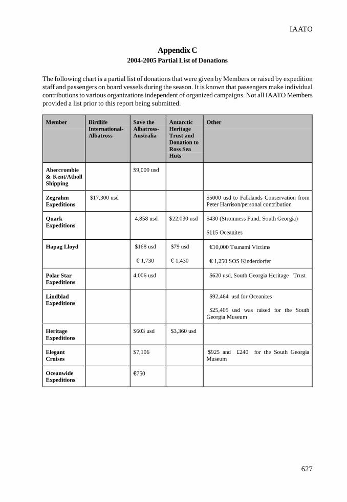
627
IAATO
Appendix C2004-2005 Partial List of Donations
The following chart is a partial list of donations that were given by Members or raised by expeditionstaff and passengers on board vessels during the season. It is known that passengers make individualcontributions to various organizations independent of organized campaigns. Not all IAATO Membersprovided a list prior to this report being submitted.
Member BirdlifeInternational-Albatross
Save theAlbatross-Australia
AntarcticHeritageTrust andDonation toRoss SeaHuts
Other
Abercrombie& Kent/AthollShipping
$9,000 usd
ZegrahmExpeditions
$17,300 usd $5000 usd to Falklands Conservation fromPeter Harrison/personal contribution
QuarkExpeditions
4,858 usd $22,030 usd $430 (Stromness Fund, South Georgia)
$115 Oceanites
Hapag Lloyd $168 usd
€ 1,730
$79 usd
€ 1,430
€10,000 Tsunami Victims
€ 1,250 SOS Kinderdorfer
Polar StarExpeditions
4,006 usd $620 usd, South Georgia Heritage Trust
LindbladExpeditions
$92,464 usd for Oceanites
$25,405 usd was raised for the SouthGeorgia Museum
HeritageExpeditions
$603 usd $3,360 usd
ElegantCruises
$7,106 $925 and £240 for the South GeorgiaMuseum
OceanwideExpeditions
€750

628
III. REPORTS
Total
Albatross 46,215.40 usd
Antarctic Heritage Trust 27,299.40 usd
South Georgia Museum 27,067.20 usd
Oceanites 92,579 usd
Falklands Conservation 5,000 usd
Tsunami Victims 12,000 usd
Kinderdorfer 1,600 usd
Total 211,762 usd
• The total is based on conversion rate of 1 •=1.28 usd• At least 2 expedition staff also donated paintings for donation to an auction at the Royal
Society of Protection of Birds in the UK which raised substantial funds for Albatrossprotection.
• The amounts do not include all vessels or private donations that tourists have made once athome. Many ships provide their passengers with a list of organizations of whom to donateto. In addition other organizations benefit indirectly from passengers donations.
• The information included above is based on what was provided to the IAATO Secretariat.
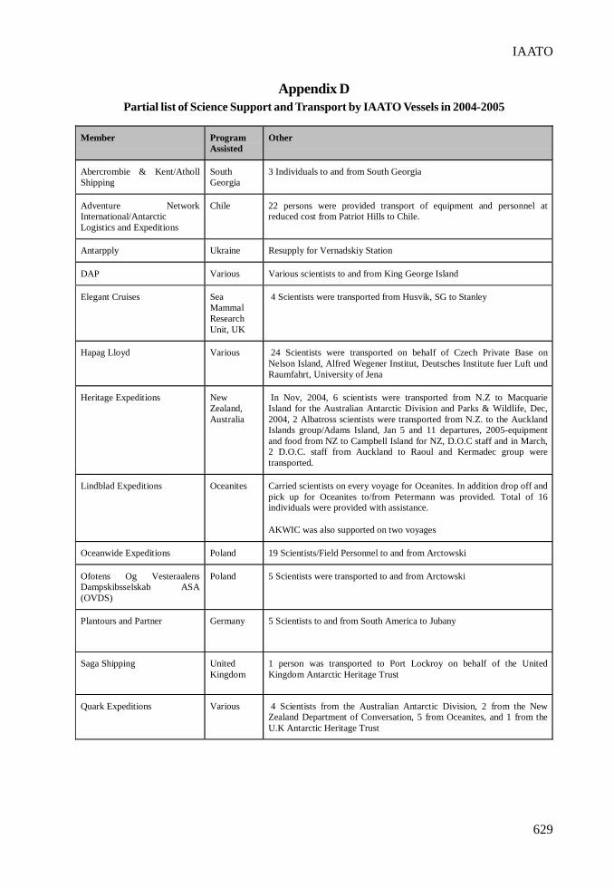
629
IAATO
Appendix DPartial list of Science Support and Transport by IAATO Vessels in 2004-2005
Member ProgramAssisted
Other
Abercrombie & Kent/AthollShipping
SouthGeorgia
3 Individuals to and from South Georgia
Adventure NetworkInternational/AntarcticLogistics and Expeditions
Chile 22 persons were provided transport of equipment and personnel atreduced cost from Patriot Hills to Chile.
Antarpply Ukraine Resupply for Vernadskiy Station
DAP Various Various scientists to and from King George Island
Elegant Cruises SeaMammalResearchUnit, UK
4 Scientists were transported from Husvik, SG to Stanley
Hapag Lloyd Various 24 Scientists were transported on behalf of Czech Private Base onNelson Island, Alfred Wegener Institut, Deutsches Institute fuer Luft undRaumfahrt, University of Jena
Heritage Expeditions NewZealand,Australia
In Nov, 2004, 6 scientists were transported from N.Z to MacquarieIsland for the Australian Antarctic Division and Parks & Wildlife, Dec,2004, 2 Albatross scientists were transported from N.Z. to the AucklandIslands group/Adams Island, Jan 5 and 11 departures, 2005-equipmentand food from NZ to Campbell Island for NZ, D.O.C staff and in March,2 D.O.C. staff from Auckland to Raoul and Kermadec group weretransported.
Lindblad Expeditions Oceanites Carried scientists on every voyage for Oceanites. In addition drop off andpick up for Oceanites to/from Petermann was provided. Total of 16individuals were provided with assistance.
AKWIC was also supported on two voyages
Oceanwide Expeditions Poland 19 Scientists/Field Personnel to and from Arctowski
Ofotens Og VesteraalensDampskibsselskab ASA(OVDS)
Poland 5 Scientists were transported to and from Arctowski
Plantours and Partner Germany 5 Scientists to and from South America to Jubany
Saga Shipping UnitedKingdom
1 person was transported to Port Lockroy on behalf of the UnitedKingdom Antarctic Heritage Trust
Quark Expeditions Various 4 Scientists from the Australian Antarctic Division, 2 from the NewZealand Department of Conversation, 5 from Oceanites, and 1 from theU.K Antarctic Heritage Trust

III. REPORTS

631
Report by the International Hydrographic Organization (IHO)on “Cooperation in Hydrographic Surveying and Charting
of Antarctic Waters”
Introduction
I would like to take this opportunity, to thank the authorities of the Antarctic Treaty System (ATS) forhaving invited the IHO. Once again the International Hydrographic Organization (IHO) is honouredto report to the Antarctic Treaty Consultative Meeting (ATCM) on the Cooperation in HydrographicSurveying and Charting of Antarctic Waters. This report covers the period between the XXVIIth andXXVIII ATCMs.
IHO Member States are well aware of their responsibility to improve safety of life at sea, safety ofnavigation and the protection of the marine environment in Antarctica. The coordination to facilitateNational Hydrographic Services to provide updated and reliable hydro-cartographic products isexecuted by the Hydrographic Committee on Antarctica, a committee that meets once a year to keeptrack on these efforts.
The recommendations the IHO submitted to the XXVIIth ATCM in Cape Town last year were fullyendorsed. This expression of support has been very well received by the IHO, specially by itsHydrographic Committee on Antarctica.
The IHO Hydrographic Committee on Antarctica
We would like to provide a brief report on the work done by the Hydrographic Committee on Antarctica(HCA) that met in September 2004. Amongst other technical topics, the following issues werediscussed:
a) the progress made in the scheming and production of international (INT) Charts;b) the setting up of a Hydrographic Survey Programme Working Group;c) the need to get some guidance on the establishment of terrestrial Aids to Navigation in
Antarctica;d) the need to keep updated the IHO S-55 Publication “Worldwide Status of Hydrographic
Surveying and Nautical Charting”; ande) cooperation with other international organizations.
As regard to the INT Chart production, out of 91 INT charts contained in the cartographic scheme, 45have already been published (see Annex A). That means that there has been an approximate 50%increase since last year. Some of these charts, over 5, are already also available as electronic charts(ENC).
When preparing this report I recall that during the last ATCM I was requested to indicate when thecomplete cartographic scheme would be ready, and really that is a very difficult question to answerin the light of the growing new requirements. The HCA received a very interesting proposal fromIAATO, for the inclusion of 11 new INT charts in the IHO INT chart scheme for the AntarcticPeninsula. These new charts would cover areas of great tourism interest and will facilitate saferoperations. The HCA is considering the request and has become aware that requests for new additions

632
III. REPORTS
cannot be ignored. After the subject is studied, the HCA will identify the MS responsible for theproduction of the newly accepted charts.
The idea to set up a Hydrographic Survey Programme Working Group (HSPWG) has its roots on theneed to improve effectiveness by establishing priorities. As a secondary benefit, the outcome couldprovide an indication to MS willing and aiming to take advantage of the International Polar Year(2008-2009) to orient their efforts on concrete needs. More information is provided below, under aspecial paragraph on the objectives and progress made by the HSPWG.
Proposals to establish terrestrial Aids to Navigation (AtNs) in Antarctica, where there exists potentialrisk for navigation, were offered by COMNAP. As a result, a list of those AtNs which have beenrecommended so far is maintained on the IHO website (www.iho.shom.fr > Reg Hydro Commissions> HCA). Interestingly, it was suggested that DGPS stations could be set up in the Antarctic Peninsulaand that three stations would probably provide reasonable coverage.
The updating and maintenance of IHO Publication S-55 “Worldwide Status of Hydrographic Surveyingand Nautical Charting” is considered vital to properly assess the actual situation regarding thesetwo aspects, “surveying” and “charting”, and to monitor its progress thereafter. S-55 consistsessentially of a standardized database which is kept on the IHO website, and is updated as MSsprovide new entries. This information serves as a useful resource for strategic planning, decision-making and the international coordination of a work program, and will assist in properly prioritisingthe work to be done. Therefore priority should be assigned to keep this publication updated.
Cooperation with other organizations has significantly improved, and representatives of IAATO,COMNAP, SCAR, IOC and IMO attended the 2004 HCA meeting.
• It has to be highlighted that cooperation with IAATO and COMNAP is extremely fruitful. Inaddition to their contribution to improving the INT Chart Scheme and identifying AtNs inAntarctica, as reported above, IAATO has kindly expressed its willingness to contributewith ships of opportunity to improve the level of hydrographic information gathering.
• Additionally, SCAR, IOC and IHO have joined their efforts in sponsoring the InternationalBathymetric Chart of the Southern Ocean (IBCSO) project, which was launched in July 2004.The intention is to built a 2.5 km grid bathymetric database for all waters south of 60°S.
• IHO and IMO continue to cooperate on improving the quality and availability of hydrographicinformation for operation in remote areas. Further plan are to develop relevant guidelines /requirements by 2006, to ensure the safety of navigation in remote areas and this work willinvolve a review of availability of international AtNs for vessels operating in remote areas.
Objectives of and Progress made by the HCA Hydrographic Survey ProgrammeWorking Group (HSPWG)
As mentioned above, the HCA considered that there was a need to develop a hydrographic surveyplan for Antarctic waters, taking into consideration the requirements to complete the INT chartscheme. The objectives of HSPWG are the followings:
1. Establish prioritised HCA Statement of Survey Requirements:a. Identify special regional geographical factors e.g. ice cover; significant changes in
shelf ice edge; complex bottom topography.b. Identify Maritime Shipping Routes and port/site calls and derive usage category (A =
frequent; B = regular; C = infrequent), verifying INT chart coverage and availability.c. Identify and categorise existing coverage from S-59.
633
IHO
d. Develop assessment criteria and produce a prioritised statement of areas requiringsurvey.
e. Compare national prioritised lists of survey intentions and rolling programmes withthe HCA statement. Provide advice to national hydrographic and marine scientificresearch programming authorities to avoid duplication and to utilise spare capacity.Liaise with COMNAP, SCAR and IAATO to utilise ships of opportunity.
2. Develop guidelines, complementing S-44, for gathering and submitting surveyingobservations in ships of opportunity1.
3. Promote and co-ordinate hydrographic activity for maximum output duringthe International Polar Year (2007-2008) by advocacy for an IPY HydrographicInitiative:a. To develop a scheme for fully surveyed marine corridors in Antarctic Peninsula [and
Ross Sea].b. To seek support of IMO, IOC, ATCM, and IPY Planning Committee.c. To develop a plan for survey and charting of marine corridors.d. To seek national programming authorities’ cooperation and involvement in implementing
the plan.e. To identify tasks for ships of opportunity. To include options for states without polar
vessels to provide surveyors and equipment.
Progress so far achieved includes:
• assessment criteria to prioritise areas requiring surveys mainly around Antarctica, and theidentification of maritime shipping routes;
• a scheme for a main corridor round the Antarctic Peninsula, labelled “Proposed MaritimeShipping Routes” (see Annex B);
• development of Guidelines for the collection of hydrographic information by tours vessels(intended for IAATO and COMNAP when finalized).
Conclusions
1. There has been good coordination and cooperation between the IHO and other internationalorganizations interested in the Antarctica. The progress made and underway is greatly dueto joint efforts. All seems to have a common understanding of the importance of conductinghydrographic surveys and making available reliable nautical charts. These two elementsconstitute the key factor for executing any activity in Antarctica, and therefore deservespriority.
2. The availability of INT Charts, from 29 last year to 45 nowadays, is a clear indication of theprogress achieved so far by the IHO. Nevertheless, the survey of the Antarctic waterscannot be avoided and charts will be available only if Member States allocate resources andpriority to do so. The potential increase in number of INT charts should constitute a warningsign to enhance national priorities and mobilization of resources.
1 The term “Ships of opportunity” refers to ships other than those deployed for Hydrographic surveying for nautical charting purposes,e.g. cruise, research or re-supply vessels.
634
III. REPORTS
3. The setting up of an HCA Hydrographic Survey Programme Working Group should helpidentifying the best practice to take advantage of the existing possibilities to foster the INTchart coverage.
Proposal
It is recommended that the XXVIIIth ATCM:
1. accepts the IHO Report;2. acknowledges the progress made in the production of INT charts;3. expresses support for the activities the HCA is conducting with its HydrographicSurvey Programme Working Group;4. considers inviting Members States to increase the hydrographic survey activity in Antarctica.
Monaco, May 2005
635
IHO
ANNEX “A”STATUS OF INT CHART PRODUCTION IN ANTARCTIC WATERS
(April 2005)
INT No. Producer Date
Last Edition Scale
1:
INT No. Producer Date
Last Edition Scale
1:
900 NZ 1998 2 000 000 9041 RU 1999 100 000
904 NO 2002 2 000 000 9042 RU 1999 12 500
906 GB 2004 2 000 000 9050 RU 1999 500 000
907 GB 2000 2 000 000 9051 RU 1998 200 000
9005 IT 2000 50 000 9056 ZA 2005 300 000
9006 NZ 2003 50 000 9061 GB 2004 200 000
9007 NZ 2003 60 000 9102 CL 2003 10 000
9008 NZ 2003 200 000 9106 GB 1996 60 000
9009 NZ 2004 500 000 9109 GB 1999 25 000
9010 RU 2000 500 000 9120 AR 2004 50 000
9011 RU 2000 200 000 9121 ES 1998 35 000
9014 AU 2002 25 000 9122 CL 1998 20 000
9015 FR 2004 500 000 9141 GB 2004 50 000
9016 FR 2003 100 000 9142 AR 2005 10 000
9017 FR 2002 20 000 9150 BR 1999 200 000
9020 AU 1998 500 000 9153 GB & AR 2004 150 000
9021 AU Proj. 2006 50 000 9154 GB & AR 2002 150 000
9025 RU 1999 500 000 9155 CL 2003 150 000
9026 RU 1999 200 000 9156 AR 2005 150 000
9027 RU 1999 10 000 9158 GB 2003 150 000
9030 AU 1992 500 000 9159 GB Proj. 2006 150 000
9031 AU 2002 500 000 9160 GB Proj. 2006 150 000
9032 AU 2003 12 500 9163 GB 2005 150 000
9033 AU 1991 500 000 9170 AR 1997 500 000
9035 AU 1993 500 000 9172 RU 1999 500 000
9036 AU 2005 25 000
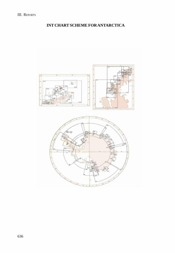
636
III. REPORTS
INT CHART SCHEME FOR ANTARCTICA

637
IHO
ANNEX “B”
PART IV
ADDITIONAL DOCUMENTSFROM XXVIII ATCM

ANNEX H
ADDITIONAL DOCUMENTS

ANNEX H
643
Statement of the Member States of the European Union that are alsoAntarctic Treaty Consultative Parties in the Working Group on Liability
of the XXVIII Antarctic Treaty Consultative Meeting(See Paragraph 110 of the Final Report)
Mr. Chairman, dear colleagues,
On behalf of the Member States of the European Union that are also Antarctic Treaty ConsultativeParties, the Netherlands recalls working paper XXVII ATCM/WP-34 and the relating statement itmade during the XXVII ATCM. We sought your indulgence, understanding and assistance withrespect to a question that stems from developments in Community law. These developments relate tothe division of competence between the European Community and the Member States of the EuropeanUnion in respect of some matters governed by the draft annex, namely some of the provisions onactions for compensation. Since the entry into force of a Community Regulation on jurisdiction andthe recognition and enforcement of judgments in civil and commercial matters, the jurisdiction ofdomestic courts within the European Community in those matters is governed by the relevantprovisions of that Regulation. In order to safeguard the integrity of the said Regulation, the Councilof the European Union has requested the Member States of the European Union that are alsoAntarctic Treaty Consultative Parties to ensure that the relevant Community rules continue to apply.
The discussions on the provisions on actions for compensation at the XXVII ATCM were fruitfuland have further clarified the meaning of these provisions. We have further reflected on the matter inlight of these discussions and the amendments made to these provisions. It has appeared during theXXVII ATCM that only a State Party can take response action pursuant to draft Article 5.2 and bringan action pursuant to draft Article 7.1. This understanding is reflected in the Final Report of theXXVII ATCM where the Chair of our Working Group noted general support that actions could onlybe brought by State Parties and, in this connection, also noted that there was a general understandingthat only State Parties could take response action pursuant to draft Article 5.2 (para.150). Hence, theattribution of jurisdiction to domestic courts pursuant to draft Article 7.1 does not relate to civil andcommercial matters under the Regulation.
Although the general understanding of this Working Group would seem to be inherent in the versionof the draft annex that was circulated at the end of the XXVII ATCM, it could be further clarified byexplicating that only State Parties can bring an action under draft Article 7.1. Such clarification wouldeliminate the risk that a domestic court permits agents and operators that have been specificallyauthorized by a State Party to take response action on their behalf under draft Article 5.2 to bring adirect action under draft Article 7.1. A proposal to that end has been discussed intersessionally andis reflected in a document, circulated by the Chair of our Working Group after the consultations inNew York from 13 to 15 April, that contains revised draft articles reflecting the general consensus inthe consultations.1 Since this proposal reflects the general understanding of the Working Group onLiability at the XXVII ATCM, as noted in the Final Report of that meeting, we hope it is supported byour colleagues so that we can put this matter aside.
Thank you for your attention.
1The following proposal for the first sentence of draft Article 7.1 has been circulated: Only a Party that has taken response action pursuantto Article 5(2) may bring an action against a non-State operator for liability pursuant to Article 6(1) and such action may only be broughtin the courts of the Party where the operator is incorporated or has its principal place of business or his or her habitual place of residence.

IV. ADDITIONAL DOCUMENTS
ANNEX H
645
Remarks by Ambassador Hans Corell,Chairman of the XXVIIII Antarctic Treaty Consultative Meeting,
at the presentation by the Scientific Committee on Antarctic Research
Stockholm, 8 June 2005
Your Majesty,Distinguished participants,
May I, in my capacity as chairman of the Antarctic Treaty Consultative Meeting (ATCM), greet youall warmly welcome to this presentation by the Scientific Committee on Antarctic Research (SCAR).
SCAR is an inter-disciplinary committee of the International Council for Science (ICSU) and is chargedwith initiating, developing and coordinating high quality international scientific research in theAntarctic region, and on the role of the Antarctic region in the Earth system.
We are glad to have among us the President of SCAR, Professor Dr. Jörn Thiede. He is accompaniedby Professor Steven Chown. We are looking forward to their presentations.
We are of course particularly honoured by the presence of His Majesty King Carl Gustaf.
His Majesty’s presence is not a coincidence. It is based on a genuine interest in environment andmatters of the kind we are engaged in. I am sure Professor Thiede knows more about His Majesty’sinterest than I do.
By way of example, I can mention that only a few days ago. His Majesty - together with his daughterCrown Princess Victoria, Crown Prince Frederik of Denmark and a group of fifteen internationalscientists - participated in the 7th Royal Colloquium, which was held on board the Icebreaker Oden.We are going to visit this icebreaker on Friday this week.
The participants in the colloquium, which was hosted by His Majesty, explored the scientific andpolicy implications of an “Arctic under Stress: A Thawing Tundra”.
Allow me to quote the following from a statement that the participants elaborated and which theycalled “The Oden Declaration”:
“The Arctic is now experiencing particularly rapid and severe climate change. Over the next 100years, Arctic climate change is expected to accelerate, contributing to major physical, ecological,social, and economic changes, many of which are already apparent. Changes in the Arctic climate willaffect the rest of the world through increased global warming and rising sea levels.
There is strong scientific evidence that these changes are beyond natural variability and aresignificantly influenced by human activities. These changes in the global environment carry risks forhuman well-being, especially for use of natural resources, such as fresh water. In many cases adaptationwill be necessary, although difficult and costly. However, in low lying areas, such as some smallisland states, adaptation will be impossible. It is clear that we ourselves are changing the environmentupon which we depend.
The scientific evidence is now strong enough, and the consequences for human well-being seriousenough, that global change should be discussed, debated and addressed by societies around theworld. We hope that the scientific discussions at this Royal Colloquium will help to inform this globaldebate.”
I thought it appropriate to share this information with you. But now our focus should shift from theArtic to Antarctica!
Professor Thiede, you have the floor! You are most welcome!

IV. ADDITIONAL DOCUMENTS
ANNEX I
647
Message from the XXVIII ATCM to Stations in the Antarctic
The twenty-eight Antarctic Treaty Consultative Meeting (XXVIII ATCM) was hosted by the SwedishGovernment in Stockholm from 6 June (the Swedish National Day) to 17 June 2005.
The inaugural speech, delivered by the Swedish Minister for Foreign Affairs, Ms. Laila Freivalds,noted that Antarctica demonstrates a great example of fruitful and expanding international co-operation that serves as a model of conflict prevention and peaceful collaboration. Since Sweden isa relatively small research nation in Antarctica, international co-operation with other countries’researchers and polar organizations is a main feature of our research program. Sweden’s polar researchcovers both the Arctic and Antarctica. The Swedish Antarctic Research Program has its geographicalfocus on Dronning Maud Land, where our two research stations, Wasa and Svea, are located.
We welcome that the new Antarctic Treaty Secretariat in Buenos Aires is operational and are gratefulto Mr. Jan Huber, the Executive Secretary, and his team for assisting the Meeting for the first time intheir new capacity.
The Committeee for Environmental Protection (CEP) delivered a comprehensive report, bringing theenvironmental issues forward. Particularly important is the decision to commence elaborating astrategy for the future work of the Committee. This achievement is an effort in which all delegationsshould take pride, but the Chairman of CEP, Dr Tony Press (Australia), deserves special recognitionfor the way in which he guided the Committee through a busy agenda.
A major achievement of the Meeting was the finalization of Annex VI to the Protocol on EnvironmentalProtection. We are grateful to all who have contributed to this work over the years. Our specialthanks go to Ambassador Don MacKay (New Zealand), who skilfully guided the Working Group onLiability to this successful result.
From Stockholm (situated nearly 60 degrees N) the Delegations participating in the XXVIII ConsultativeMeeting send their compliments to all those personnel wintering in the Antarctic. The Delegationsexpress their gratitude to those men and women for their unrelenting efforts to widen mankind’shorizons while maintaining the spirit of the Antarctic Treaty on the unique continent (situated from60 degrees S and onwards) to which the Treaty applies.
Hans CorellAmbassadorChairman of the XXVIII ATCM

IV. ADDITIONAL DOCUMENTS
ANNEX J
649
Preliminary Agenda for ATCM XXIX
1. Opening of the meeting.
2. Election of Officers and creation of Working Groups.
3. Adoption of the Agenda and allocation of items.
4. Operation of the Antarctic Treaty System: Reports by Parties, Observers and Experts.
5. Operation of the Antarctic Treaty System: General matters.
6. Operation of the Antarctic Treaty System: Review of the Secretariat’s situation.
7. Report of the Committee for Environmental Protection.
8. Liability: Implementation of Decision 1 (2005).
9. Safety and Operations in Antarctica.
10. Relevance of Developments in the Arctic and in the Antarctic.
11. The International Polar Year 2007/2008.
12. Tourism and Non-Governmental Activities in the Antarctic Treaty Area.
13. Inspections under the Antarctic Treaty and the Environment Protocol.
14. Science Issues, particularly scientific co-operation and facilitation.
15. Operational issues.
16. Education issues.
17. Exchange of Information.
18. Biological Prospecting in Antarctica.
19. Adoption of the Final Report.
20. Preparation of the XXX Meeting.

ANNEX K
LIST OF DOCUMENTS

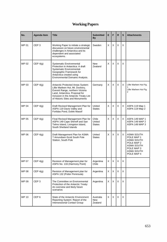
653
Working Papers
No. Agenda Item Title Submitted By
E F R S Attachments
WP 01 CEP 3
Working Paper to initiate a strategic discussion on future environmental challenges in Antarctica and its dependent and associated ecosystems.
Sweden X X X X
WP 02 CEP 4(g) Systematic Environmental Protection in Antarctica: A draft Systematic Environmental-Geographic Framework for Antarctica created using Environmental Domains Analysis.
New Zealand
X X X X
WP 03 CEP 4(g) Antarctic Protected Areas System: Lillie Marleen Hut, Mt. Dockery, Everett Range, northern Victoria Land, Antarctica. Proposal for Inclusion in the Antarctic Treaty List of Historic Sites and Monuments
Germany
X X X X Lillie Marleen Hut Fig. 1 Lillie Marleen Hut Fig. 2
WP 04 CEP 4(g) Draft Revised Management Plan for ASPA 119 Davis Valley and Forlidas Pond, Dufek Massif
United States
X X X X ASPA 119 Map 1 ASPA 119 Map 2
WP 05 CEP 4(g) Final Revised Management Plan for ASPA 149 Cape Shirreff and San Telmo Island, Livingston Island, South Shetland Islands
Chile United States
X X X X ASPA 149 MAP 1 ASPA 149 MAP 2 ASPA 149 MAP 3
WP 06 CEP 4(g) Draft Management Plan for ASMA ? Amundsen-Scott South Pole Station, South Pole
United States
X X X X ASMA SOUTH POLE MAP 1 ASMA SOUTH POLE MAP 2 ASMA SOUTH POLE MAP 3 ASMA SOUTH POLE MAP 4
WP 07 CEP 4(g) Revision of Management plan for ASPA No. 133 (Harmony Point)
Argentina Chile
X X X X
WP 08 CEP 4(g) Revision of Management plan for ASPA 132 (Potter Peninsula)
Argentina X X X X
WP 09 CEP 3 The Committee on Environmental Protection of the Antarctic Treaty: An overview and likely future scenarios
Argentina X X X X
WP 10 CEP 6 State of the Antarctic Environment Reporting System: Report of the Intersessional Contact Group
Australia New Zealand
X X X X
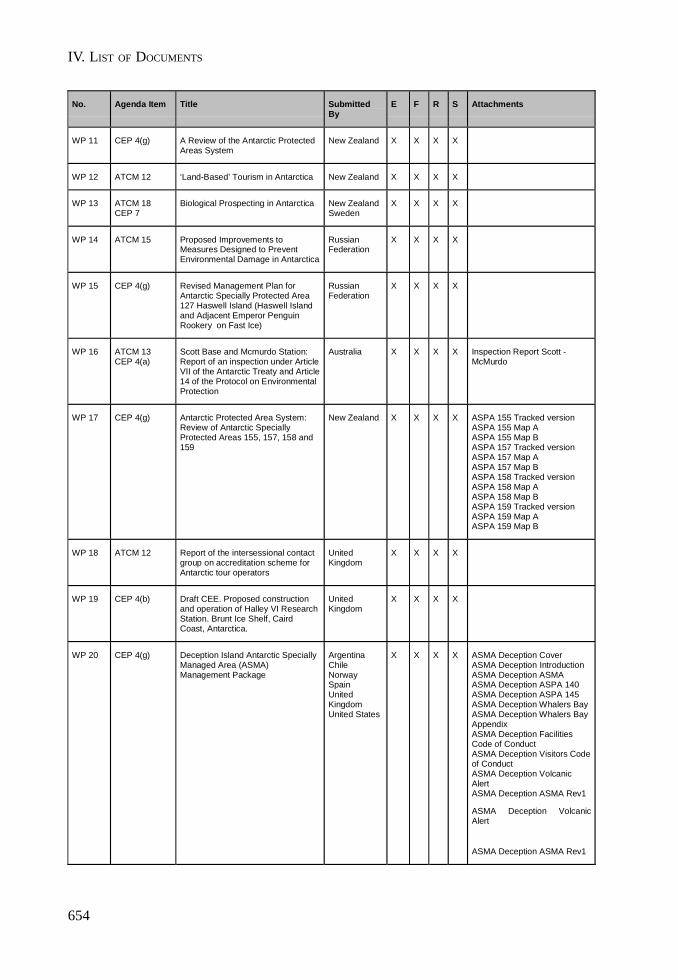
IV. LIST OF DOCUMENTS
654
No. Agenda Item Title SubmittedBy
E F R S Attachments
WP 11 CEP 4(g) A Review of the Antarctic ProtectedAreas System
New Zealand X X X X
WP 12 ATCM 12 ‘Land-Based’ Tourism in Antarctica New Zealand X X X X
WP 13 ATCM 18CEP 7
Biological Prospecting in Antarctica New ZealandSweden
X X X X
WP 14 ATCM 15 Proposed Improvements toMeasures Designed to PreventEnvironmental Damage in Antarctica
RussianFederation
X X X X
WP 15 CEP 4(g) Revised Management Plan forAntarctic Specially Protected Area127 Haswell Island (Haswell Islandand Adjacent Emperor PenguinRookery on Fast Ice)
RussianFederation
X X X X
WP 16 ATCM 13CEP 4(a)
Scott Base and Mcmurdo Station:Report of an inspection under ArticleVII of the Antarctic Treaty and Article14 of the Protocol on EnvironmentalProtection
Australia X X X X Inspection Report Scott -McMurdo
WP 17 CEP 4(g) Antarctic Protected Area System:Review of Antarctic SpeciallyProtected Areas 155, 157, 158 and159
New Zealand X X X X ASPA 155 Tracked versionASPA 155 Map AASPA 155 Map BASPA 157 Tracked versionASPA 157 Map AASPA 157 Map BASPA 158 Tracked versionASPA 158 Map AASPA 158 Map BASPA 159 Tracked versionASPA 159 Map AASPA 159 Map B
WP 18 ATCM 12 Report of the intersessional contactgroup on accreditation scheme forAntarctic tour operators
UnitedKingdom
X X X X
WP 19 CEP 4(b) Draft CEE. Proposed constructionand operation of Halley VI ResearchStation. Brunt Ice Shelf, CairdCoast, Antarctica.
UnitedKingdom
X X X X
WP 20 CEP 4(g) Deception Island Antarctic SpeciallyManaged Area (ASMA)Management Package
ArgentinaChileNorwaySpainUnitedKingdomUnited States
X X X X ASMA Deception CoverASMA Deception IntroductionASMA Deception ASMAASMA Deception ASPA 140ASMA Deception ASPA 145ASMA Deception Whalers BayASMA Deception Whalers BayAppendixASMA Deception FacilitiesCode of ConductASMA Deception Visitors Codeof ConductASMA Deception VolcanicAlertASMA Deception ASMA Rev1
ASMA Deception VolcanicAlert
ASMA Deception ASMA Rev1
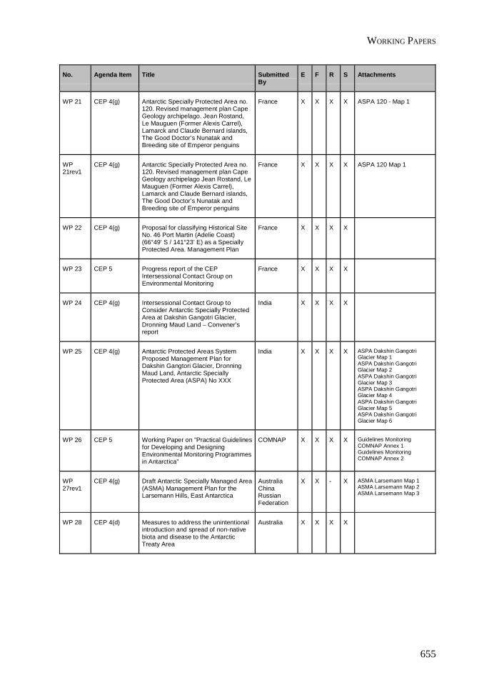
WORKING PAPERS
655
No. Agenda Item Title SubmittedBy
E F R S Attachments
WP 21 CEP 4(g) Antarctic Specially Protected Area no.120. Revised management plan CapeGeology archipelago. Jean Rostand,Le Mauguen (Former Alexis Carrel),Lamarck and Claude Bernard islands,The Good Doctor’s Nunatak andBreeding site of Emperor penguins
France X X X X ASPA 120 - Map 1
WP21rev1
CEP 4(g) Antarctic Specially Protected Area no.120. Revised management plan CapeGeology archipelago Jean Rostand, LeMauguen (Former Alexis Carrel),Lamarck and Claude Bernard islands,The Good Doctor’s Nunatak andBreeding site of Emperor penguins
France X X X X ASPA 120 Map 1
WP 22 CEP 4(g) Proposal for classifying Historical SiteNo. 46 Port Martin (Adelie Coast)(66°49’ S / 141°23’ E) as a SpeciallyProtected Area. Management Plan
France X X X X
WP 23 CEP 5 Progress report of the CEPIntersessional Contact Group onEnvironmental Monitoring
France X X X X
WP 24 CEP 4(g) Intersessional Contact Group toConsider Antarctic Specially ProtectedArea at Dakshin Gangotri Glacier,Dronning Maud Land – Convener’sreport
India X X X X
WP 25 CEP 4(g) Antarctic Protected Areas SystemProposed Management Plan forDakshin Gangtori Glacier, DronningMaud Land, Antarctic SpeciallyProtected Area (ASPA) No XXX
India X X X X ASPA Dakshin GangotriGlacier Map 1ASPA Dakshin GangotriGlacier Map 2ASPA Dakshin GangotriGlacier Map 3ASPA Dakshin GangotriGlacier Map 4ASPA Dakshin GangotriGlacier Map 5ASPA Dakshin GangotriGlacier Map 6
WP 26 CEP 5 Working Paper on ”Practical Guidelinesfor Developing and DesigningEnvironmental Monitoring Programmesin Antarctica”
COMNAP X X X X Guidelines MonitoringCOMNAP Annex 1Guidelines MonitoringCOMNAP Annex 2
WP27rev1
CEP 4(g) Draft Antarctic Specially Managed Area(ASMA) Management Plan for theLarsemann Hills, East Antarctica
AustraliaChinaRussianFederation
X X - X ASMA Larsemann Map 1ASMA Larsemann Map 2ASMA Larsemann Map 3
WP 28 CEP 4(d) Measures to address the unintentionalintroduction and spread of non-nativebiota and disease to the AntarcticTreaty Area
Australia X X X X
IV. LIST OF DOCUMENTS
656
No. Agenda Item Title SubmittedBy
E F R S Attachments
WP 29 ATCM 17 Report of the Intersessional ContactGroup reviewing the process forexchange of information
Australia X X X X
WP 30 CEP 4(c) Report of the ICG Established toUpdate the ‘Guidelines forEnvironmental Impact Assessment inAntarctica’ (1999)
Australia X X X X Guidelines for EIA withamendments
WP 31 ATCM 12CEP 4(g)
Site Guidelines for Land-BasedTourist-Visited Sites
UnitedKingdomAustraliaUnitedStates
X X X X Site Guidelines
WP31rev1
ATCM 12 Site Guidelines for Land-BasedTourist-Visited Sites
UnitedKingdomAustraliaUnitedStates
X X X X SITE GUIDELINESFOR LAND-BASEDTOURIST-VISITEDSITES
WP 32 ATCM 13CEP 4(a)
Report of Joint Inspections underArticle VII of the Antarctic Treaty andArticle 14 of the EnvironmentalProtocol
UnitedKingdomAustraliaPeru
X X X X
WP 33 ATCM 14ATCM 15CEP 4(d)
De-listing Antarctic Specially ProtectedSpecies
SCAR X X X X
WP 34 ATCM 14ATCM 15CEP 4(d)
Proposal to List a Species as aSpecially Protected Species underAnnex II
SCAR X X X X
WP 35 CEP 4(g) Review of the Admiralty Bay AntarcticSpecially Managed Area ManagementPlan (ASMA No. 1)
BrazilPoland
X X - X ASMA 1 - Figure 1ASMA 1 - Figure 2ASMA 1 - Figure 3ASMA 1 - Figure 4ASMA 1 - Figure 5AASMA 1 - Figure 5BASMA 1 - Figure 5CASMA 1 - Figure 6
WP 36 CEP 4(g) Antarctic Protected Areas System.Management Plan for Scullin andMurray Monoliths, Mac RobertsonLand, east Antarctica AntarcticSpecially protected Area No. XXX
Australia X X X X Scullin Murray Map AScullin Murray Map BScullin Murray Map CScullin Murray Map DScullin MurrayPhotograph A
WP 37 CEP 4(g) Revision of Management Plan forAntarctic Specially Protected Area No.150 (Ardley Island)
Chile X X X X

WORKING PAPERS
657
No. Agenda Item Title SubmittedBy
E F R S Attachments
WP37rev1
CEP 4(g) Revision of Management Plan forAntarctic Specially Protected Area No.150 (Ardley Island)
Chile X X X X
WP 38 ATCM 12 Protection of Antarctica's intrinsicvalues: Policy on non-governmentactivities
Australia X X X X
WP 39 CEP 4(g) Listing of the Amundsen Tent on theList of Historic Sites and Monuments
Norway X X - X
WP 40 CEP 4(c) Assessment of environmental impactsof satellite facility at Troll
Norway X X X X
WP 41 ATCM 9 CEP 4(f) Proposal to submit a proposal to IMOto ban the presence of Heavy Fuel Oil(HFO) on board ships south of 60ºSouth
Norway X X X X
WP41rev1
ATCM 9 CEP 4(f) Proposal to submit a proposal to IMOto ban the presence of Heavy Fuel Oil(HFO) on board ships south of 60ºSouth
Norway X X X X
WP 42 CEP 4(g) Antarctic Protected Areas System:Revised Management Plans for::ASPA No. 101 Taylor Rookery, Mac.Robertson Land, East Antarctica,ASPA No. 102 Rookery Islands, Mac.Robertson Land, East Antarctica andASPA No. 103 Ardery Island andOdbert Island, Budd.
Australia X X - X Revised Plan ASPA101Revised Plan ASPA102Revised Plan ASPA103ASPA 101 Map AASPA 101 Map BASPA 101 Map CASPA 102 Map AASPA 102 Map BASPA 102 Map CASPA 103 Map AASPA 103 Map BASPA 103 Map CASPA 103 Map D
WP 43 ATCM 5 Guidelines for the Submission andDistribution of Documents to theAntarctic Treaty Consultative Meetingsand the Committee on EnvironmentalProtection
ATS X X X X
WP 44 ATCM 6 Antarctic Treaty Secretariat Report 1September 2004 – 31 March 2005
ATS X X X X Antarctic TreatySecretariat FinancialReport 2004 - 2005
WP 45 ATCM 6 Antarctic Treaty Secretariat. DraftWork Programme 2005/6
ATS X X X X
WP45rev1
ATCM 6 Antarctic Treaty Secretariat. DraftWork Programme for 2005/6
ATS X X X X

IV. LIST OF DOCUMENTS
658
No. Agenda Item Title SubmittedBy
E F R S Attachments
WP 46 ATCM 5 Intersessional Consultation Process AustraliaJapan
X X X X
WP 47 ATCM 8 Revised Chairman’s Draft of Annex VIto the Protocol on EnvironmentalProtection to the Antarctic Treaty –“Liability for EnvironmentalEmergencies”
NewZealand
X X X X
WP 48 ATCM 8 Outcomes of informal consultationsconvened by the Chairman of theWorking Group on Liability in New Yorkfrom 13 to 15 April 2005
NewZealand
X X X X
WP48rev1
ATCM 8 Draft Annex VI to the Protocol onEnvironmental Protection to theAntarctic Treaty
NewZealand
X X X X
WP48rev2
ATCM 8 Chairman’s Revised Draft of Annex VIto the Protocol on EnvironmentalProtection to the Antarctic Treaty –“Liability for EnvironmentalEmergencies” and Draft Decision toAccompany the Adoption of the Text
NewZealand
X X X X
WP48rev3
ATCM 8 Revised Chair’s Text 8 June 2005 NewZealand
X - X - Draft Annex VI to theProtocol onEnvironmentalProtection to theAntarctic Treaty
WP 49 ATCM 8 Drafting and other proposals presentedto the informal consultations convenedin New York from 13 to 15 April 2005,which require further consideration
NewZealand
X X X X
WP 50 ATCM 5 Draft decision confirming therecognition of Ukraine as aConsultative Party
ATS X X X X
WP50rev1
ATCM 5 Decision confirming the recognition ofUkraine as a Consultative Party
ATS X X X X
WP 51 ATCM 3 Preliminary Agenda and WorkSchedule for ATCM XXVIII
ATS X X X X
WP51rev1
ATCM 3 Agenda and Work Schedule for ATCMXXVIII
ATS X X X X
WORKING PAPERS
659
No. Agenda Item Title SubmittedBy
E F R S Attachments
WP51rev2
ATCM 3 Agenda and Work Schedule forATCM XXVIII
ATS X X X X
WP51rev3
ATCM 3 Agenda and Work Schedule forATCM XXVIII
ATS X - - -
WP51rev4
ATCM 3 Preliminary Agenda and WorkSchedule for ATCM XXVIII
ATS X - - -
WP51rev5
ATCM 3 Preliminary Agenda and WorkSchedule for ATCM XXVIII
ATS X - - -
WP51rev6
ATCM 3 Preliminary Agenda and WorkSchedule for ATCM XXVIII
ATS X - - -
WP 52 CEP 4(f) Marine Debris: Global and RegionalImpacts
Chile X X - X
WP 53 ATCM 5 The enquiry procedure of Article 18 Chile X X X X
WP 54 ATCM 5 Proposed amendment to the Rulesof Procedure for Antarctic TreatyConsultative Meetings Decision 1(2004). Participation of thirdcountries in Antarctic TreatyConsultative Meetings
Chile X X X X
WP 55 ATCM 5 The Attendance of non-Party Statesat Consultative Meetings: Aproposed change to the Rules ofProcedures of the ATCM.
UnitedKingdom
X X X X
WP 56 ATCM 5 Proposed amendments to the Rulesof Procedure (2004)
AustraliaGermanyJapanPeruSwedenUnitedKingdomUnitedStates
X X X X
WP 57 ATCM 5 Consultative Status UnitedKingdom
X X X X
WP 58-67
(Interim WPs containing texts ofmeasures also available elsewhere)
WP 68 ATCM 6 External audit of the AntarcticTreaty Secretariat
Argentina X - - X
IV. LIST OF DOCUMENTS
660
No. Agenda Item Title SubmittedBy
E F R S Attachments
WP 69 ATCM 8 Measure XXX (2005) Annex VI to theProtocol on Environmental Protectionto the Antarctic Treaty. Liability ArisingFrom Environmental Emergencies
NewZealand
X X X X Annex VI to the Protocol onEnvironmental Protection to theAntarctic Treaty. Liability ArisingFrom EnvironmentalEmergencies
WP 70 ATCM 7 Decision XXX (2005) Annex VI onLiability Arising from EnvironmentalEmergencies to the Protocol onEnvironmental Protection to theAntarctic Treaty
NewZealand
X X X X
WP 71 ATCM 19 Draft Decision XXX (2005).Identification of activities covered byArticle VII(5) of the Antarctic Treaty
BelgiumChileFranceGermanyItalyNetherlandsSouth Africa
X X X X
WP 72 ATCM 8 Draft Resolution XXX (2005). Scientificissues relating to the implementationof measures of reinstatement of theenvironment
BelgiumChileFinlandFranceGermanyItalyNetherlandsNorwaySouth AfricaSpainSweden
X X X X

WORKING PAPERS
661
Information Papers
No. Agenda Item Title SubmittedBy
E F R S Attachments
IP 01 ATCM 14 Polish Contributions to the Coastaland Shelf Ecosystem Program(Maritime Antarctica).
Poland X - - -
IP 02 CEP 4(a) Annual Report pursuant to theProtocol on Environmental Protectionto the Antarctic Treaty
South Africa X - - -
IP 03 ATCM 4 Report by the CCAMLR Observer athe Twenty-Eighth Antarctic TreatyConsultative Meeting
CCAMLR X - - -
IP 04 CEP 4(a) Renewable Energy Use at FieldCamps in Antarctica
UnitedStates
X - - -
IP 05 ATCM 14 Scientific activities list for 2005-2006Season
Brazil X - - -
IP 06 CEP 4(c) Environmental Impact Assessment onthe Padre Balduino Rambo Refuge'sdismantlement - Brazil
Brazil X - - -
IP 07 CEP 4(a) Informe anual de España de acuerdocon el Artículo 17 del Protocolo alTratado Antártico sobre Proteccióndel Medio Ambiente
Spain - - - X
IP 08 ATCM 18CEP 7
Biological Prospecting in Antarctica Spain X - - X
IP 09 CEP 4(a) Rapport annuel présenté par laFrance conformément à l’article 17 duProtocole au Traité sur l’Antarctiquerelatif à la protectiondel’environnement 2005
France - X - -
IP 10 CEP 4(a) MISE EN OEUVRE DU PROTOCOLEDE MADRID RELATIF A LAPROTECTION DEL’ENVIRONNEMENT ENANTARCTIQUE
France - X - -
IP 11 ATCM 12 Consolidation of Regulations onTourism and Non-GovernmentalActivities in Antarctica
France X X - -
IP 12 ATCM 12 Creation of “Areas of Special TouristInterest”
France X X - -
IP 13 ATCM 12 Aspectos organizativoscontribuyentes al establecimiento deun Sistema de Acreditación deTurismo Antártico
Uruguay - - - X
IP 14 ATCM 14 India's Antactic Science Programme2004-05
India X - - -
IV. LIST OF DOCUMENTS
662
No. Agenda Item Title SubmittedBy
E F R S Attachments
IP 15 ATCM 17CEP 9
Establishment of an AntarcticDiscussion Forum of CompetentAuthorities
GermanyNetherlands
X X - X
IP 16 CEP 4(g) Progress Report on the ResearchProject “Risk assessment for FildesPeninsula and Ardley Island and thedevelopment of management plansfor designation as Antarctic SpeciallyProtected or Managed Areas”
Germany X X - X Fildes Peninsula -Figure 1Fildes Peninsula -Figure 2Fildes Peninsula -Figure 3
IP 17 CEP 4(c) Annual list of Brazilian EnvironmentalEvaluations prepared in accordancewith Annex I, Article 6, Paragraph 1 ofthe Protocol - 2004/2005 Season
Brazil X - - -
IP 18 ATCM 4 Report by the InternationalHydrographic Organization (IHO) on“Cooperation in HydrographicSurveying and Charting of AntarcticWaters”
IHO X X - X
IP 19 ATCM 15 Towards the creation of a MarineProtecte Area around South Africa'sSub-Antarctic Prince Edward Islands
South Africa X - - -
IP 20 ATCM 12 The admissibility of land-basedtourism in Antarctica underinternational law
Germany X - - -
IP 21 CEP 4(a) Annual Report pursuant to theProtocol on Environmental Protectionto the Antarctic Treaty
Belgium X - - -
IP 22 ATCM 12CEP 5
Antarctic Site Inventory: 1994-2005 UnitedStates
X - - -
IP 23 CEP 4(c) Annual List of any InitialEnvironmental Evaluations preparedin accordance with Annex I, Article 2,of the Protocol (Annex I, Article 6, lit.b, of the Protocol) and also ATCMResolution 6 (1995) 2004/2005Season
South Africa X - - -
IP 24 ATCM 4 Report of the Depositary Governmentof the Antarctic Treaty and its Protocol(USA) in accordance withRecommendation XIII-2
UnitedStates
X - - - Status TreatyStatus ProtocolStatus Measures
IP24rev1
ATCM 4 Report of the Depositary Governmentof the Antarctic Treaty and its Protocol(USA) in accordance withRecommendation XIII-2
UnitedStates
X - - - Status TreatyStatus ProtocolStatus Measures
IP 25 CEP 4(b) ANDRILL – The Approved McMurdoSound Portfolio Projects. Final CEEupdate
GermanyItalyNewZealandUnitedStates
X - - -
INFORMATION PAPERS
663
No. Agenda Item Title SubmittedBy
E F R S Attachments
IP 26 CEP 4(a) Annual Report of New Zealandpursuant to Article 17 of the Protocolon Environmental Protection to theAntarctic Treaty
NewZealand
X - - -
IP 27 CEP 4(g) Antarctic Protected Area System:Reviews of Antarctic SpeciallyProtected Areas 116 and 131
NewZealand
X - - -
IP 28 CEP 4(g) Antarctic Protected Area System:McMurdo Dry Valleys ASMAManagement Group
ItalyNewZealandUnitedStates
X - - -
IP 29 CEP 4(g) A Review of the Antarctic ProtectedAreas System
NewZealand
X - - -
IP 28 CEP 4(g) Antarctic Protected Area System:McMurdo Dry Valleys ASMAManagement Group
ItalyNewZealandUnitedStates
X - - -
IP 29 CEP 4(g) A Review of the Antarctic ProtectedAreas System
NewZealand
X - - -
IP 30 CEP 4(b) Draft Comprehensive EnvironmentalEvaluation (CEE) Rebuild andOperation of the Wintering StationNeumayer III and Retrogradation ofthe Present Neumayer Station II
Germany X - - -
IP 31 ATCM 4 Report by the Head of the AustralianDelegation in his capacity asRepresentative of the DepositaryGovernment for the Convention on theConservation of Antarctic MarineLiving Resources to the Twenty-Eighth Antarctic Treaty ConsultativeMeeting
Australia X - - -
IP 32 ATCM 4 Progress with the implementation ofthe Agreement on the Conservation ofAlbatrosses and Petrels (ACAP):Report to ATCM XXVIII & CEP VIIIfrom the ACAP Interim Secretariathosted by the Australian Government
Australia X - - -
IP 33 ATCM 14 Highlights of the Australian AntarcticScience Program 2004/2005
Australia X - - -
IP 34 ATCM 11ATCM 16
The Development of an InternationalAntarctic Institute – A Joint venturebetween the University of Tasmaniaand international partner institutions
Australia X - - -
IP 35rev1 ATCM 4 Report by the Head of the AustralianDelegation in his capacity asRepresentative of the DepositaryGovernment for the Agreement on theConservation of Albatrosses andPetrels to the Twenty-Eight AntarcticTreaty Consultative Meeting
Australia X - - -
IV. LIST OF DOCUMENTS
664
No. Agenda Item Title SubmittedBy
E F R S Attachments
IP 36 CEP 10 Report of the CEP Observer to thetwenty third meeting of the scientificcommittee to CCAMLR, 25 to 29October 2004
Australia X - - -
IP 37 CEP 4(e)CEP 5
Reducing sewage pollution in theAntarctic marine environment using asewage treatment plant
UnitedKingdom
X - - -
IP 38 ATCM 9 Report on the research studyundertaken by the UK investigatinginteractions between humans andleopard seals in Antarctica
UnitedKingdom
X - - -
IP 39 CEP 4(a) Annual Report pursuant to Article 17of the Protocol on EnvironmentalProtection to the Antarctic Treaty
Italy X - - -
IP 40 CEP 4(c) Talos Dome Ice Core Project(TALDICE): Initial EnvironmentalEvaluation for Recovering a Deep IceCore at Talos Dome, East Antarctica:Comments from CEP Contact Points.
Italy X - - -
IP 41 CEP 4(g) Brief report on Edmonson PointManagement Plan progress
Italy X - - -
IP 42 CEP 4(c) Construction of the Czech Antarcticstation on the James Ross IslandActivities performed in the year 2004,and during the austral summer of2004/05
CzechRepublic
X - - -
IP 43 CEP 4(a) ACT of August 6, 2003 on Antarcticaand on amendment to some laws
CzechRepublic
X - - -
IP 44 CEP 4(g) Environmental Domain Analysis forthe Antarctic Continent
NewZealand
X - - - EnvironmentalDomain Analysis forthe AntarcticContinent
IP 45 ATCM 11 Activity of the Russian Federation forpreparation and holding of theInternational Polar Year 2007/08
RussianFederation
X - - -
IP 46 ATCM 14 Results of investigations under thesubprogram "Study and Reserch ofthe Antarctic" of the Federal Program"World Ocean" in 2004
RussianFederation
X - - -
IP 47 ATCM 12CEP 4(e)
Evacuation of AN-3T aircraft from theAmundsen-Scott station
RussianFederation
X - - -
IP 48 ATCM 8ATCM 12
On possible regulation on non-governmental activity in the AntarcticTreaty area
RussianFederation
X - - -
IP 49 CEP 4(e) Waste water treatment in Antarctica. Afeasibility study for grey watertreatment at Wasa station
Sweden X - - -
INFORMATION PAPERS
665
No. Agenda Item Title SubmittedBy
E F R S Attachments
IP 50 ATCM 15 Communication in polar regions. Astudy to guide and aid organizers andparticipants of Polar expeditions
Sweden X - - -
IP 51 ATCM 15CEP 4(a)
Wind power in Antarctica. A feasibilitystudy for Wasa
Sweden X - - -
IP 52 CEP 5 Initial Approach to BiologicalMonitoring in the Uruguayan “Artigas”Base
Uruguay X - - X
IP 53 CEP 4(a) Informe anual de acuerdo con elArtículo 17 del Protocolo al TratadoAntártico sobre la Protección delMedio Ambiente
Uruguay - - - X
IP 54 CEP 5 Relevamiento magnético de lasinmediaciones de la BCAA. Segundaetapa, marzo 2005
Uruguay - - - X
IP 55 ATCM 16 1er. Simposio sobre Actividades eInvestigación Científica en la Antártida
Uruguay - - - X
IP 56 ATCM 12 Visitors Programme to the "Artigas"Antarctic Scientific Base (BCAA)
Uruguay X - - X
IP 57 ATCM 14 Campaña 2005 del ServicioGeográfico Militar en la Antártida
Uruguay - - - X
IP 58 CEP 4(c) List of Initial EnvironmentalEvaluations (IEE) prepared byUruguay in 2004
Uruguay X - - -
IP 59 CEP 4(c) A Note On The Vulnerability OfCetaceans In Antarctic Waters ToNoise Pollution
ASOC X - - -
IP 60 ATCM 4 Retrospection in Antarctica. Report ofthe Delegation of Romania
Romania X - - -
IP 61 ATCM 14 Romanian Scientific AntarcticActivities in cooperation with China,Russian Federation and Belgium
Romania X - - -
IP 62 ATCM 14 Romanian Scientific AntarcticActivities 2005-2006. ScientificProgram Summary in cooperation withAustralia
Romania X - - -
IP 63 CEP 4(d) Introduction of Non-native Species,Parasites and Diseases
IUCN X - - -
IP 64 ATCM 4CEP 4(g)
Resolution on Antarctic Conservationadopted at the 3d World ConservationCongress, Bangkok, November 2004
IUCN X - - -
IP 65 CEP 4(a) Report on the implementation of theProtocol on Environmental Protectionas required by Article 17 of theProtocol
UnitedKingdom
X - - -
IV. LIST OF DOCUMENTS
666
No. Agenda Item Title SubmittedBy
E F R S Attachments
IP 66 CEP 4(b) Draft Comprehensive EnvironmentalEvaluation (CEE). ProposedConstruction and Operation of HalleyVI Research Station, Brunt Ice Shelf,Caird Coast, Antarctica
UnitedKingdom
X - - - Full version of draftCEE
IP 67 ATCM 9CEP 4(f)
The Use of Heavy Fuel Oil in AntarcticWaters
COMNAPIAATO
X - - -
IP67rev1
ATCM 9CEP 4(f)
The Use of Heavy Fuel Oil in AntarcticWaters
COMNAPIAATO
X - - -
IP 68 ATCM 4 SCAR Report to XXVIII ATCM SCAR X - - - SCAR Report to XXVIIIATCM
IP 69 ATCM 14ATCM 15CEP 5
Biological Monitoring of HumanImpacts in the Antarctic
SCAR X - - -
IP 70 ATCM 17 9th Joint (SCAR-COMNAP) Committeeon Antarctic Data Management(JCADM 9. Buenos Aires, September12-16 2005)
Argentina X X - X
IP 71 ATCM 12 Some legal issues posed by Antarctictourism
ASOC X - - -
IP 72 CEP 4(c) Initial Environmental Evaluation forthe establishment of a satellitereception and command facility(TrollSat) and a Norwegian Institutefor Air Research (NILU) Laboratory asan integral part of the Troll Station inDronning Maud Land, Antarctica
Norway X - - - IEE TrollSat and NILU
IP 73 ATCM 15CEP 4(a)
New Belgian research station in theSør Rondane, Antarctica, 2004-2005BELARE site survey expedition
Belgium X - - -
IP 74 CEP 3CEP 4(a)
Development Pressures on theAntarctic Wilderness
ASOC X - - -
IP 75 CEP 4(c) Baseline of the environment in thesurroundings of the Czech Antarcticstation
CzechRepublic
X - - -
IP 76 CEP 5 Environmental monitoring of theIndian Permanent Station Maitri inpursuant to the Protocol onEnvironmental Protection to theAntarctic Treaty
India X - - -
IP 77 ATCM 4 Report submitted to Antarctic TreatyConsultative Meeting XXVIII by theDepositary Government for theConvention for the Conservation ofAntarctic Seals in accordance withRecommendation XIII-2, Paragraph2(d)
UnitedKingdom
X - - -
INFORMATION PAPERS
667
No. Agenda Item Title SubmittedBy
E F R S Attachments
IP77rev1
ATCM 4 Report submitted to Antarctic TreatyConsultative Meeting XXVIII by theDepositary Government for theConvention for the Conservation ofAntarctic Seals in accordance withRecommendation XIII-2, Paragraph2(d)
UnitedKingdom
X - - -
IP 78 ATCM 16ATCM 17
Diseño e implementación de la páginaWEB del Instituto AntárticoEcuatoriano (INAE)
Ecuador - - - X
IP 79 ATCM 15 Decreto Ejecutivo de la creación delInstituto Antártico Ecuatoriano
Ecuador - - - X
IP 80 ATCM 15CEP 4(a)
India’s endeavour for a new researchStation in Antarctica- a report
India X - - -
IP 81 ATCM 12 Site Guidelines Analysis IAATO X - - -
IP 82 ATCM 12 IAATO Overview of Antarctic Tourism.2004-2005 Antarctic Season
IAATO X - - -
IP 83 CEP 4(c) A Report on The Environment ofGreat Wall Station and ZhongshanStation In current years for ATCM
China X - - -
IP 84 CEP 4(a) Annual Report of China pursuant toArticle 17 of the Protocol onEnvironmental Protection to theAntarctic Treaty
China X - - -
IP 85 ATCM 14 Biodiversity in the Antarctic SCAR X - - -
IP 86 ATCM 14 Ciencia Argentina en la Antártida Argentina - - - X
IP 87 ATCM 14 Report of the scientific researchduring the IX Expedition (AdvanceReport) 8 December 2003 - 24February 2004
Ecuador X - - -
IP 88 ATCM 14 Guía Geológica de los alrededores dela Estación Científica Ecuatoriana‘’Pedro Vicente Maldonado’’(PEVIMA)
Ecuador - - - X Guía Geológica
IP 89 ATCM 12 Proposed Amendments to theStandard Post Visit Site Report Formby the International Association ofAntarctic Tour Operators (IAATO)
IAATO X - - -
IP 90 ATCM 12 IAATO Site Specific Guidelines in theAntarctic Peninsula
IAATO X - - -
IP 91 ATCM 14ATCM 15
The Chinese National Antarctic InlandExpedition to Dome A
China X - - -
IP 92 ATCM 15 Report on the air rescuing a ChineseExpeditioner by American airplanefrom South Pole Station
China X - - -
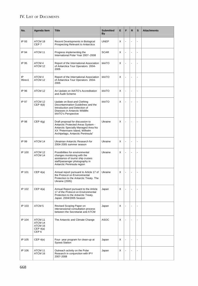
IV. LIST OF DOCUMENTS
668
No. Agenda Item Title SubmittedBy
E F R S Attachments
IP 93 ATCM 18CEP 7
Recent Developments in BiologicalProspecting Relevant to Antarctica
UNEP X - - -
IP 94 ATCM 11 Progress implementing theInternational Polar Year 2007–2008
SCAR X - - -
IP 95 ATCM 4ATCM 12
Report of the International Associationof Antarctica Tour Operators 2004-2005
IAATO X - - -
IP95rev1
ATCM 4ATCM 12
Report of the International Associationof Antarctica Tour Operators 2004-2005
IAATO X - - -
IP 96 ATCM 12 An Update on IAATO’s Accreditationand Audit Scheme
IAATO X - - -
IP 97 ATCM 12CEP 4(d)
Update on Boot and ClothingDecontamination Guidelines and theIntroduction and Detection ofDiseases in Antarctic Wildlife:IAATO’s Perspective
IAATO X - - -
IP 98 CEP 4(g) Draft proposal for discussion toAntarctic Protected Areas System -Antarctic Specially Managed Area NoXX “Petermann Island, WilhelmArchipelago, Antarctic Peninsula”
Ukraine X - - -
IP 99 ATCM 14 Ukrainian Antarctic Research for2004-2005 summer season
Ukraine X - - -
IP 100 ATCM 12ATCM 14
Possibilities for environmentalchanges monitoring with theassistance of tourist ship cruisesstaff/passenger photography inAntarctic Peninsula region
Ukraine X - - -
IP 101 CEP 4(a) Annual report pursuant to Article 17 ofthe Protocol on EnvironmentalProtection to the Antarctic Treaty. TheUkraine (2005)
Ukraine X - - -
IP 102 CEP 4(a) Annual Report pursuant to the Article17 of the Protocol on EnvironmentalProtection to the Antarctic Treaty.Japan. 2004/2005 Season
Japan X - - -
IP 103 ATCM 5 Revised Scoping Paper onintersessional consultation processbetween the Secretariat and ATCM
Japan X - - -
IP 104 ATCM 11ATCM 14ATCM 16CEP 4(a)CEP 6
The Antarctic and Climate Change ASOC X - - -
IP 105 CEP 4(e) Four- year program for clean-up atSyowa Station
Japan X - - -
IP 106 ATCM 11ATCM 16
Outreach activity on the PolarResearch in conjunction with IPY2007-2008
Japan X - - -
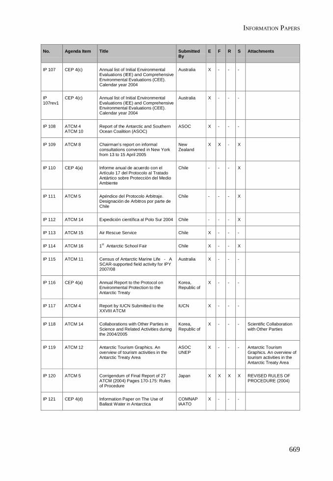
INFORMATION PAPERS
669
No. Agenda Item Title SubmittedBy
E F R S Attachments
IP 107 CEP 4(c) Annual list of Initial EnvironmentalEvaluations (IEE) and ComprehensiveEnvironmental Evaluations (CEE).Calendar year 2004
Australia X - - -
IP107rev1
CEP 4(c) Annual list of Initial EnvironmentalEvaluations (IEE) and ComprehensiveEnvironmental Evaluations (CEE).Calendar year 2004
Australia X - - -
IP 108 ATCM 4ATCM 10
Report of the Antarctic and SouthernOcean Coalition (ASOC)
ASOC X - - -
IP 109 ATCM 8 Chairman’s report on informalconsultations convened in New Yorkfrom 13 to 15 April 2005
NewZealand
X X - X
IP 110 CEP 4(a) Informe anual de acuerdo con elArtículo 17 del Protocolo al TratadoAntártico sobre Protección del MedioAmbiente
Chile - - - X
IP 111 ATCM 5 Apéndice del Protocolo Arbitraje.Designación de Arbitros por parte deChile
Chile - - - X
IP 112 ATCM 14 Expedición científica al Polo Sur 2004 Chile - - - X
IP 113 ATCM 15 Air Rescue Service Chile X - - -
IP 114 ATCM 16 1st Antarctic School Fair Chile X - - X
IP 115 ATCM 11 Census of Antarctic Marine Life - ASCAR-supported field activity for IPY2007/08
Australia X - - -
IP 116 CEP 4(a) Annual Report to the Protocol onEnvironmental Protection to theAntarctic Treaty
Korea,Republic of
X - - -
IP 117 ATCM 4 Report by IUCN Submitted to theXXVIII ATCM
IUCN X - - -
IP 118 ATCM 14 Collaborations with Other Parties inScience and Related Activities duringthe 2004/2005
Korea,Republic of
X - - - Scientific Collaborationwith Other Parties
IP 119 ATCM 12 Antarctic Tourism Graphics. Anoverview of tourism activities in theAntarctic Treaty Area
ASOCUNEP
X - - - Antarctic TourismGraphics. An overview oftourism activities in theAntarctic Treaty Area
IP 120 ATCM 5 Corrigendum of Final Report of 27ATCM (2004) Pages 170-175: Rulesof Procedure
Japan X X X X REVISED RULES OFPROCEDURE (2004)
IP 121 CEP 4(d) Information Paper on The Use ofBallast Water in Antarctica
COMNAPIAATO
X - - -
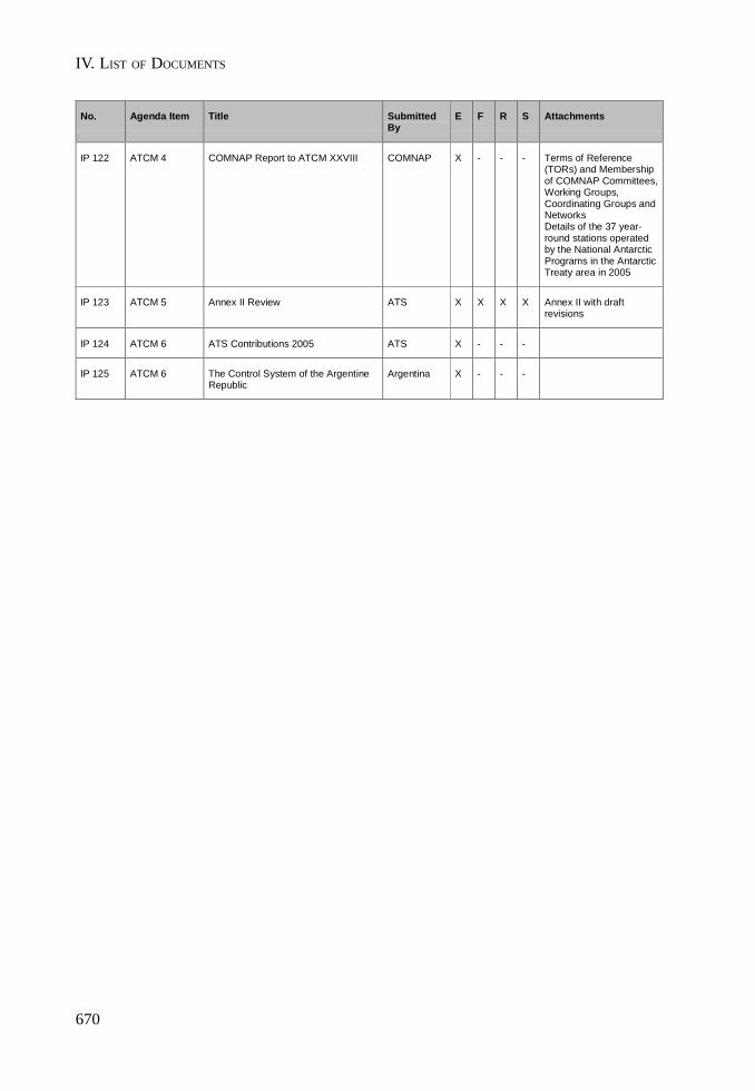
IV. LIST OF DOCUMENTS
670
No. Agenda Item Title SubmittedBy
E F R S Attachments
IP 122 ATCM 4 COMNAP Report to ATCM XXVIII COMNAP X - - - Terms of Reference(TORs) and Membershipof COMNAP Committees,Working Groups,Coordinating Groups andNetworksDetails of the 37 year-round stations operatedby the National AntarcticPrograms in the AntarcticTreaty area in 2005
IP 123 ATCM 5 Annex II Review ATS X X X X Annex II with draftrevisions
IP 124 ATCM 6 ATS Contributions 2005 ATS X - - -
IP 125 ATCM 6 The Control System of the ArgentineRepublic
Argentina X - - -
INFORMATION PAPERS
671
ANNEX L
LIST OF PARTICIPANTS

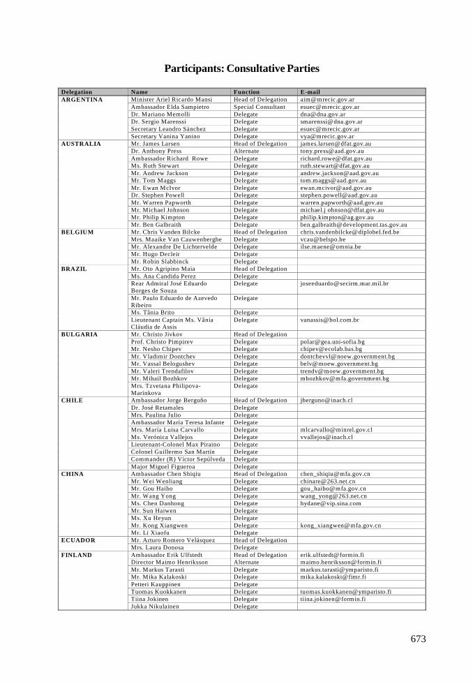
673
Participants: Consultative Parties
Delegation Name Function E-mailMinister Ariel Ricardo Mansi Head of Delegation [email protected] Elda Sampietro Special Consultant [email protected]. Mariano Memolli Delegate [email protected]. Sergio Marenssi Delegate [email protected] Leandro Sánchez Delegate [email protected]
ARGENTINA
Secretary Vanina Yanino Delegate [email protected]. James Larsen Head of Delegation [email protected]. Anthony Press Alternate [email protected] Richard Rowe Delegate [email protected]. Ruth Stewart Delegate [email protected]. Andrew Jackson Delegate [email protected]. Tom Maggs Delegate [email protected]. Ewan McIvor Delegate [email protected]. Stephen Powell Delegate [email protected]. Warren Papworth Delegate [email protected]. Michael Johnson Delegate michael.j [email protected]. Philip Kimpton Delegate [email protected]
AUSTRALIA
Mr. Ben Galbraith Delegate [email protected]. Chris Vanden Bilcke Head of Delegation [email protected]. Maaike Van Cauwenberghe Delegate [email protected]. Alexandre De Lichtervelde Delegate [email protected]. Hugo Decleir Delegate
BELGIUM
Mr. Robin Slabbinck DelegateMr. Oto Agripino Maia Head of DelegationMs. Ana Candida Perez DelegateRear Admiral José EduardoBorges de Souza
Delegate [email protected]
Mr. Paulo Eduardo de AzevedoRibeiro
Delegate
Ms. Tânia Brito Delegate
BRAZIL
Lieutenant Captain Ms. VâniaCláudia de Assis
Delegate [email protected]
Mr. Christo Jivkov Head of DelegationProf. Christo Pimpirev Delegate [email protected]. Nesho Chipev Delegate [email protected]. Vladimir Dontchev Delegate [email protected]. Vassal Belogushev Delegate [email protected]. Valeri Trendafilov Delegate [email protected]. Mihail Bozhkov Delegate [email protected]
BULGARIA
Mrs. Tzvetana Philipova-Marinkova
Delegate
Ambassador Jorge Berguño Head of Delegation [email protected]. José Retamales DelegateMrs. Paulina Julio DelegateAmbassador María Teresa Infante DelegateMrs. María Luisa Carvallo Delegate [email protected]. Verónica Vallejos Delegate [email protected] Max Piraino DelegateColonel Guillermo San Martín DelegateCommander (R) Víctor Sepúlveda Delegate
CHILE
Major Miguel Figueroa DelegateAmbassador Chen Shiqiu Head of Delegation [email protected]. Wei Wenliang Delegate [email protected]. Gou Haibo Delegate [email protected]. Wang Yong Delegate [email protected]. Chen Danhong Delegate [email protected]. Sun Haiwen DelegateMs. Xu Heyun DelegateMr. Kong Xiangwen Delegate [email protected]
CHINA
Mr. Li Xiaofu DelegateMr. Arturo Romero Velásquez Head of DelegationECUADORMrs. Laura Donosa DelegateAmbassador Erik Ulfstedt Head of Delegation [email protected] Maimo Henriksson Alternate [email protected]. Markus Tarasti Delegate [email protected]. Mika Kalakoski Delegate [email protected] Kauppinen DelegateTuomas Kuokkanen Delegate [email protected] Jokinen Delegate [email protected]
FINLAND
Jukka Nikulainen Delegate
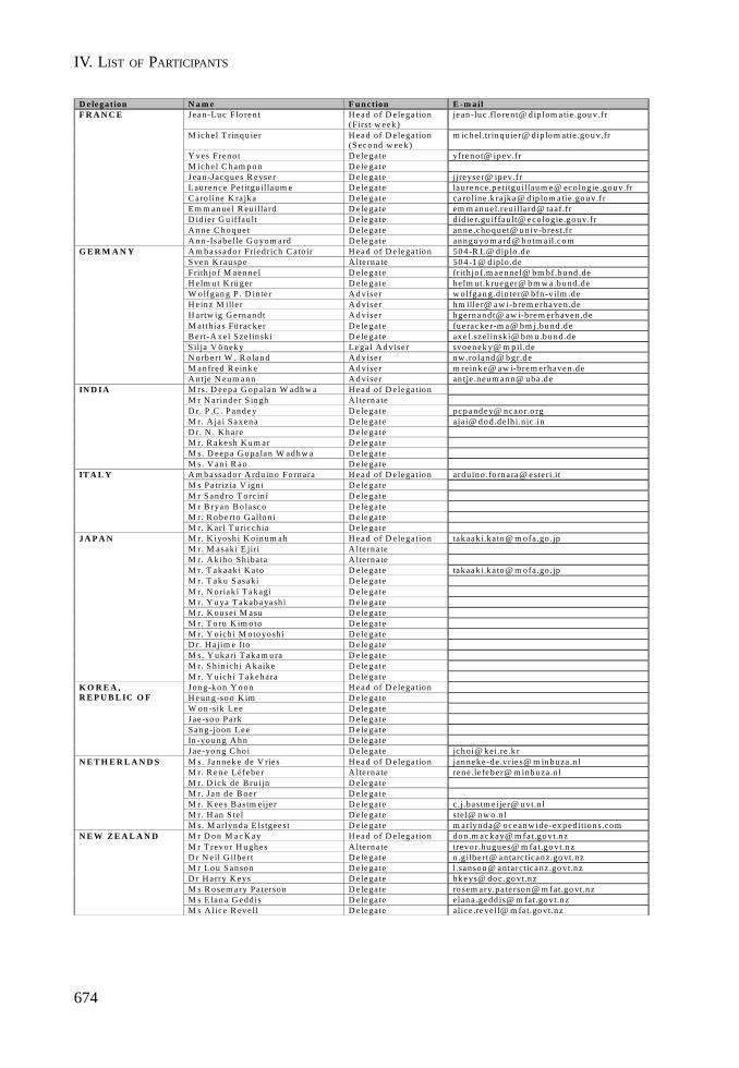
IV. LIST OF PARTICIPANTS
674
D elega tion N a m e F u n ction E -m a ilJean -Luc Flo ren t H ead of D e lega tio n
(First w eek )jean -lu c .flo rent@ d ip lom a tie .gou v.fr
M ich e l T rinqu ie r H ead of D e lega tio n(S econd w eek )
m ic h el.trin q uie r@ diplo m atie .go u v.fr
Y ves Fren o t D e legate yfren o t@ ip ev.frM ich e l C ham p o n D elegateJean -Jacques R eyse r D e legate jjreyse r@ ipev.frLau ren ce Petitgu illaum e D elegate lau rence .p etitguillaum e@ eco logie .gouv.frC a ro line K ra jka D e legate ca roline .k rajk a@ dip lom a tie .gouv.frE m m anue l R euilla rd D e legate em m an ue l.reuilla rd@ taaf.frD id ier G u iffau lt D e legate did ie r.gu iffau lt@ eco logie .gouv.frA n ne C hoque t D e legate anne .choquet@ univ-b re st.fr
F R A N C E
A nn-Isabe lle G u yom ard D e legate annguyom ard@ ho tm a il.comA m bassado r Fried rich C atoir H ead of D e lega tio n 504 -R L@ dip lo .d eS ve n K rau sp e A lte rn a te 50 4 -1 @ diplo .d eFrith jo f M aenne l D e legate frith jof.m aennel@ bm bf.bund .deH e lm u t K rü ger D e legate he lm ut.k rueger@ b m w a .bund .deW o lfgan g P . D in te r A d viser w o lfgan g.din te r@ bfn -vilm .deH e in z M ille r A d viser hm ille r@ aw i-b rem erh aven .d eH artw ig G ern an dt A d viser hge rn an dt@ aw i-brem erh aven.d eM atth ia s Fü racker D e legate fu e racke r-m a@ bm j.bund .deB ert-A xel Szelin ski D e legate axe l.szelin ski@ bm u.bund .deS ilja V öneky Le ga l A d viser svo en ek y@ m p il.deN o rb e rt W . R o land A d viser nw .ro land@ bgr.deM anfred R e inke A d viser m re inke@ aw i-brem erh aven.de
G E R M A N Y
A n tje N eum ann A d viser an tje .neum ann@ uba .deM rs. D eep a G o p alan W adh w a H ead of D e lega tio nM r N arind e r S ingh A lte rna teD r. P .C . P and e y D e legate pcp and ey@ n cao r.o rgM r. A ja i Saxena D e legate ajai@ dod.delhi.n ic .inD r. N . K h are D e legateM r. R akesh K u m ar D e legateM s. D eepa G o pa lan W adhw a D e legate
IN D IA
M s. V an i R ao D e legateA m bassado r A rdu ino Fo rn ara H ead of D e lega tio n ard uino.fo rna ra@ este ri.itM s P a triz ia V ign i D e legateM r S and ro T orc in i D e legateM r B ryan B o la sco D e legateM r. R obe rto G allon i D e legate
IT A L Y
M r. K arl T u ricchia D e legateM r. K iyo sh i K oin um ah H ead of D e lega tio n takaaki.k a to@ m o fa.go .jpM r. M asaki E jiri A lte rn a teM r. A kiho Sh iba ta A lte rn a teM r. T ak aak i K ato D e legate tak aaki.k a to @ m o fa.go .jpM r. T ak u S asaki D e legateM r. N oriak i T ak agi D e legateM r. Y u ya T akab ayash i D e legateM r. K ou sei M asu D e legateM r. T o ru K im o to D e legateM r. Y oich i M o to yo sh i D e legateD r. H a jim e Ito D e legateM s. Y uk a ri T akam u ra D e legateM r. S h in ich i A k aike D e legate
J A P A N
M r. Y uich i T akehara D e legateJon g-k o n Y o on H ead of D e lega tio nH eun g -so o K im D elegateW o n -sik Lee D e legateJae -so o P ark D e legateS ang-jo on Lee D e legateIn -youn g A h n D e legate
K O R E A ,R E P U B L IC O F
Jae -yo n g C ho i D e legate jchoi@ kei.re .k rM s. Janneke de V rie s H ead of D e lega tio n janneke-d e.vrie s@ m inbuza .n lM r. R ene Léfebe r A lte rna te rene.le feber@ m inbuza.nlM r. D ick de Bru ijn D e legateM r. Jan d e B oe r D e legateM r. K ees B astm eije r D e legate c.j.ba stm e ijer@ u vt.n lM r. H an S tel D e legate ste l@ n w o .n l
N E T H E R L A N D S
M s. M arlynda E lstgeest D e legate m arlynda@ oceanw ide -exped itions.comM r D on M ac K ay H ead of D e lega tio n don .m ackay@ m fa t.go vt.n zM r T revo r H u gh es A lte rn a te trevo r.hu gu es@ m fa t.go vt.n zD r N e il G ilbe rt D e legate n .gilb e rt@ an ta rc ticanz.go vt.nzM r Lo u S an son D e legate l.sanso n @ antarcticanz.go vt.n zD r H arry K eys D e legate hk e ys@ do c .go vt.n zM s R o sem ary Pa terson D e legate ro sem ary.pa te rson@ m fat.go vt.nzM s E lan a G edd is D e legate elan a .gedd is@ m fat.go vt.n z
N E W Z E A L A N D
M s A lice R eve ll D e legate alice .revell@ m fa t.go vt.nz
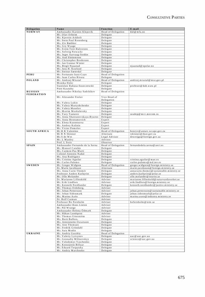
CONSULTATIVE PARTIES
675
D elega tion N a m e F u n ction E -m a ilA m b assad o r K arsten K lep svik H ead of D e lega tio n kk l@ m fa.noM r. O lav O rh e im D e legateM s. K je rstin A sk h o lt D e le gateM r. S te in P au l R o sen be rg D e le gateM s. Z iv B ø dtk er D e legateM s. G ry W aage D e legateM r. S ve in T o re H alvo rsen D e le gateM s. So lve ig N o w acki D e legateM s. In ger A a rva ag -Sto kk e D e legateM s. A ud S le ttem o en D e legateM r. C h ris to p he r B ro d e rsen D e legateM r. Jan G u nn a r W in ter D e legateM s. B irg it N ja asta d D e legate nja asta d @ n po lar.n oM r. Jens H . K o e foed D e legate
N O R W A Y
M r. S te in ar S æ te rd al D e legateM r. Fo rtu na to Isasi-C a yo H ead of D e lega tio nP E R UM r. Ju an C arlo s R ive ra D e legateM r. A nd rze j M iszta l H ead of D e lega tio n an d rze j.m iszta l@ m sz.go v.p lM o n ik a E k le r D e le gateS ta n islaw R aku sa-S u szczew sk i D e legate pro fe so r@ d ab .w aw .pl
P O L A N D
P io tr K aszu b a D e legateA m b a ssad o r N ik o la y S ad c h ik ov H e a d of D e lega tio n
M r. A le xa n d er Fro lov V ice H e a d o fD e legatio n
M r. V alery Lukin D e legateM r. V alery M artysh chen ko D e legateM r. V alery M aso lo v D e legateM r. M ax im M o sk alevsk y D e legateM r. Y ury T sa tu rov D e legate se a de p @ m cc .m eco m .ruM s. A nn a S h ato un o v sk a ya -B yu rn o D e le gateM s. A nn a B estram o vic h E x p ertM s. E le na K u zn etso va E x p ertM r. A nd re y K a lin in E x p ert
R U S S IA NF E D E R A T IO N
M r. V ic to r Po m e lo v E x p ertM r H R V a lentin e H ead of D e lega tio n hen ryv@ an ta rc .w cape .go v.zaM r R N S kin ne r A lte rn a te rsk in ne r@ d ea t.gov.zaM s S d e W et Le ga l A d visor de w e tjgs@ fo re ign .go v.zaM r. L M anle y A d visor
S O U T H A F R IC A
P ro f. L Fe ris O b serve rA m b a ssad o r Ferna n d o de la S ern a H e a d of D e lega tio n fe rn a n do d ela .se rna@ ae ci.e sM r. M an u e l C a ta lán D e legateM s. C arm en-P az M arti D e legateC o lo n el A n to n io N ad al D e le gateM s. A na R o d rígue z D e le gateM s. C ris tin a A gu ila r D e le gate cris tina .a gu ila r@ m ae.e s
S P A IN
M r. C a rlo s P alom o D e legate ca rlo s.pa lom o @ m d.ie o .e sM r. G rege r W id gren H ead of D e lega tio n gre ge r.w id gren @ fore ign .m in istry.seD r. M arie Jac o b sson A lte rn a te m arie .ja co b sso n@ fo re ign .m in istry.seM s. A nn a C a rin T h om é r D e legate an n a ca rin .th o m e r@ su sta in able .m in istry.seP ro fe sso r A n de rs K arlq vist D e le gate an d e rs .k arlq vist@ po la r.seM r. O lle M elan d e r D e le gate olle .m e lan der@ tou ris t.seD r. M aria n ne Lillie sk ö ld A d viser m aria n ne.lil liesk old @ n atu rvard sve rk e t.seM r. E rik Lind fors A d viser erik .lin d fo rs@ fo reign .m inistry.seM r. K en n eth N o rd lan d er D e le gate ke n n eth .n ord la nd e r@ ju stic e .m in istry.seM r. T h o m a s O rd e be rg, A d viserM r. Jo h an P e ttersso n A d viser jo h an .p e ttersso n@ su sta in a ble .m inistry.seM r. Jo h an S iden m a rk D e le gate jo h an .sid e n m ark @ p ola r.seM s. M arin a A x é n A d viser m a rin a .a x en @ in du stry.m in istry.seD r. R o lf C a rm an A d viserP ro fe sso r B o Fern ho lm A d viser bo fern ho lm @ n rm .seA m b a ssad o r H an s L in ton A d viserM r. P å l W ran ge A d viserA m b a ssad o r H elena Ö d m ark D e legateM r. H åk a n Lun d q uist A d viserM r. T h o m a s U tterströ m A d viserM s. B erit B a lfo rs, D e legateM s. A nto iene tte O sca rsson D e legateM s. A nn T h o m sen D e le gateM r. Fred rik G rön d a hl D e legate
S W E D E N
M s. Sa ra M o din D e legateM r. A nd riy G u rzh iy H e a d of D e lega tio nM r. V aleriy L ytv yn o v D e legate ua c @ u a c.go v.u aM r. G en n ad iy M ilin evsk yy D e legate sc ien ce@ uac .gov.u aM r. V olod ym yr V aschen k o D e legateM r. K on stantin B illya r D e legateM r. E d u a rd T e rp ytsk y D e legate
U K R A IN E
M r. A nd riy M arch enk o D e legate
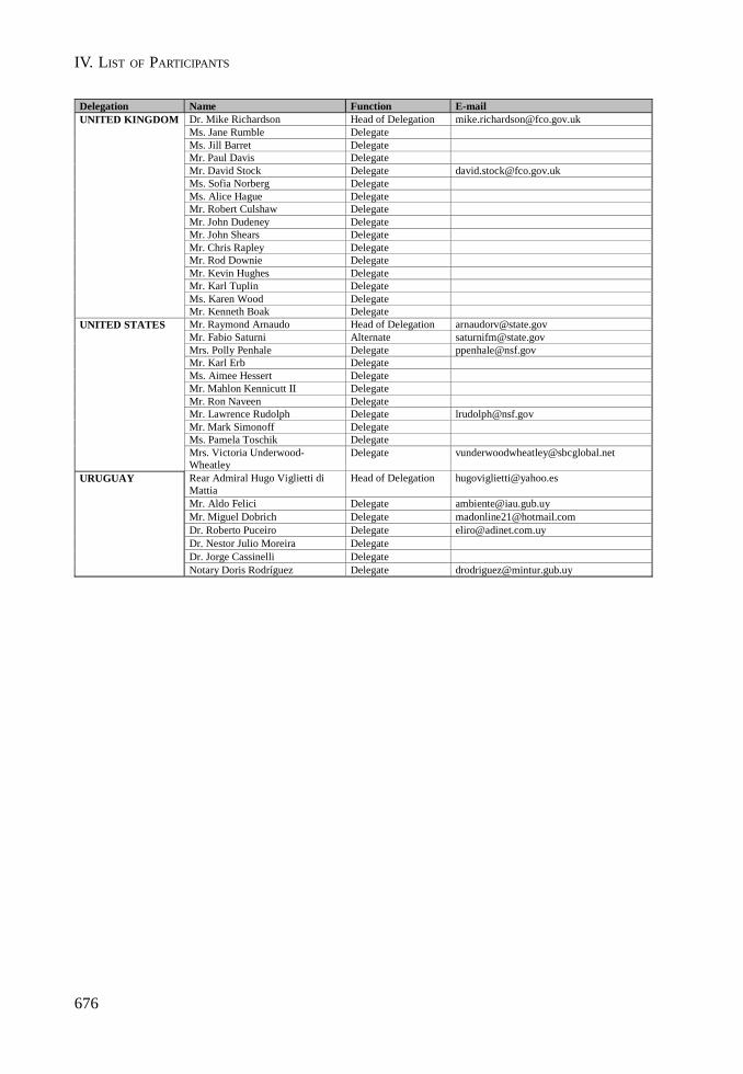
IV. LIST OF PARTICIPANTS
676
Delegation Name Function E-mailDr. Mike Richardson Head of Delegation [email protected]. Jane Rumble DelegateMs. Jill Barret DelegateMr. Paul Davis DelegateMr. David Stock Delegate [email protected]. Sofia Norberg DelegateMs. Alice Hague DelegateMr. Robert Culshaw DelegateMr. John Dudeney DelegateMr. John Shears DelegateMr. Chris Rapley DelegateMr. Rod Downie DelegateMr. Kevin Hughes DelegateMr. Karl Tuplin DelegateMs. Karen Wood Delegate
UNITED KINGDOM
Mr. Kenneth Boak DelegateMr. Raymond Arnaudo Head of Delegation [email protected]. Fabio Saturni Alternate [email protected]. Polly Penhale Delegate [email protected]. Karl Erb DelegateMs. Aimee Hessert DelegateMr. Mahlon Kennicutt II DelegateMr. Ron Naveen DelegateMr. Lawrence Rudolph Delegate [email protected]. Mark Simonoff DelegateMs. Pamela Toschik Delegate
UNITED STATES
Mrs. Victoria Underwood-Wheatley
Delegate [email protected]
Rear Admiral Hugo Viglietti diMattia
Head of Delegation [email protected]
Mr. Aldo Felici Delegate [email protected]. Miguel Dobrich Delegate [email protected]. Roberto Puceiro Delegate [email protected]. Nestor Julio Moreira DelegateDr. Jorge Cassinelli Delegate
URUGUAY
Notary Doris Rodríguez Delegate [email protected]

CONSULTATIVE PARTIES
677
Participants: Non Consultative Parties
Delegation Name Function E-mailKimberley Ferguson Head of DelegationLorenz Friedlaender DelegateKenneth Macartney DelegateKimberly Phillips Delegate
CANADA
Dr. Aili Käärik DelegateMr. Jan ČíŽek Head of DelegationMr. Pavel Sladky AlternateMr. Pavel Prošek DelegateMr. Petr Mixa Delegate
CZECH REPUBLIC
Mr. Ondřej Vícha DelegateDENMARK Mrs. Lone Anderse Head of Delegation
Mr. Mart Saarso Head of DelegationMr Jüri Kahn Delegate
ESTONIA
Ms Maija Tasa DelegateGREECE Colonel George Macridis Head of DelegationHUNGARY Mr. Tamas Kiraly Head of Delegation
Dr. Teodor Gheorghe Negoita Head of Delegation [email protected]. Ciprian Popa, DelegateDr. Florica Toparceanu DelegateMr. Daniel Iftimescu DelegateDr. Gabriela Bahrim Delegate
ROMANIA
Mr. Daniel Ionita DelegateSLOVAKIA Eva Surkova Head of Delegation [email protected]
Mrs. Evelyne Gerber Head of Delegation [email protected]. Markus Börlin Delegate
SWITZERLAND
Valérie Diserens Delegate

IV. LIST OF PARTICIPANTS

679
Participants: Observers
Delegation Name Function E-mailDr Denzil G M Miller Head of Delegation [email protected] Edith Fanta DelegateMr. Gérard Jugie Head of Delegation [email protected]. Antoine Guichard Alternate [email protected] David W H Walton Head of Delegation [email protected] Jörn Thiede Delegate [email protected] Colin P Summerhayes Delegate [email protected] Steven L Chown Delegate [email protected] Peter D Clarkson Delegate [email protected] Marzena I Kaczmarsk Delegate [email protected]
SCAR
Dr David Carlson Delegate [email protected]

IV. LIST OF PARTICIPANTS
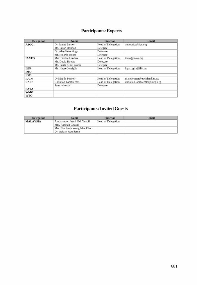
681
Participants: Experts
Participants: Invited Guests
Delegation Name Function E-mailDr. James Barnes Head of Delegation [email protected]. Sarah Dolman DelegateDr. Alan Hemmings Delegate
ASOC
Mr. Ricardo Roura DelegateMrs. Denise Landau Head of Delegation [email protected]. David Rootes Delegate
IAATO
Ms. Paula Kim Crosbie DelegateIHO Mr. Hugo Gorziglia Head of Delegation [email protected] Dr Maj de Poorter Head of Delegation [email protected]
Christian Lambrechts Head of Delegation [email protected] Johnston Delegate
PATAWMOWTO
Delegation Name Function E-mailAmbassador Jasmi Md. Yusoff Head of DelegationMrs. Razinah GhazaliMrs. Nur Izzah Wong Mee Choo
MALAYSIA
Dr. Azizan Abu Sama

ANNEX M
NATIONAL CONTACT POINTS

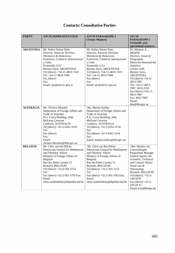
685
Contacts: Consultative Parties
PARTY ATCM REPRESENTATIVE ATCM PARAGRAPH 3(Treaty Matters)
ATCMPARAGRAPH 5(Scientific andoperational matters)
ARGENTINA Mr. Ruben Nestor PattoDirector, Antarctic DivisionMinisterio de RelacionesExteriores, Comercio Internacionaly CultoEsmeralda 1212Buenos Aires, ARGENTINATel (direct): +54-11-4819-7419Tel: +54-11-4819-7000Fax (direct)Fax:Email: [email protected]
Mr. Ruben Nestor PattoDirector, Antarctic DivisionMinisterio de RelacionesExteriores, Comercio Internacionaly CultoEsmeralda 1212Buenos Aires, ARGENTINATel (direct): +54-11-4819-7419Tel: +54-11-4819-7000Fax (direct)Fax:Email: [email protected]
Dr. Mariano A.MemolliDirector, AntarcticProgrammeDirección Nacional delAntárticoCerrito 1248Buenos Aires,ARGENTINATel (direct):+54-11-4813-7807Tel: +54-11-4813-7807, 4816-2352Fax (direct) +54-11-4813-7807Fax: 4813-7807Email:[email protected]
AUSTRALIA Mr. Christos MoraitisDepartment of Foreign Affairs andTrade of AustraliaR.G. Casey Building, JohnMcEwan CrescentCanberra, AUSTRALIATel (direct): +61-2-6261-3103Tel:Fax (direct)Fax:Email:[email protected]
Ms. Marina TsirbasDepartment of Foreign Affairs andTrade of AustraliaR.G. Casey Building, JohnMcEwan CrescentCanberra, AUSTRALIATel (direct): +61-2-6261-3718Tel:Fax (direct) +61-2-6261 2144Fax:Email: [email protected]
BELGIUM Mr. Chris van den BilckeDirectorate General for Multilateraland Thematic AffairsMinistry of Foreign Affairs ofBelgiumRue des Petits Carmes 15Brussels, BELGIUMTel (direct): +32-2-501-3712Tel:Fax (direct) +32-2-501-3703 Fax:Email:[email protected]
Mr. Chris van den BilckeDirectorate General for Multilateraland Thematic AffairsMinistry of Foreign Affairs ofBelgiumRue des Petits Carmes 15Brussels, BELGIUMTel (direct): +32-2-501-3712Tel:Fax (direct) +32-2-501-3703 Fax:Email:[email protected]
Mw. Maaike vanCauwenbergheProgramme ManagerFederal Agency forScientific, Technicaland Cultural AffairsStraat van deWetenschapBrussels, BELGIUMTel (direct): +32-2-238-3678Fax (direct) +32-2-230-59 12Email:[email protected]
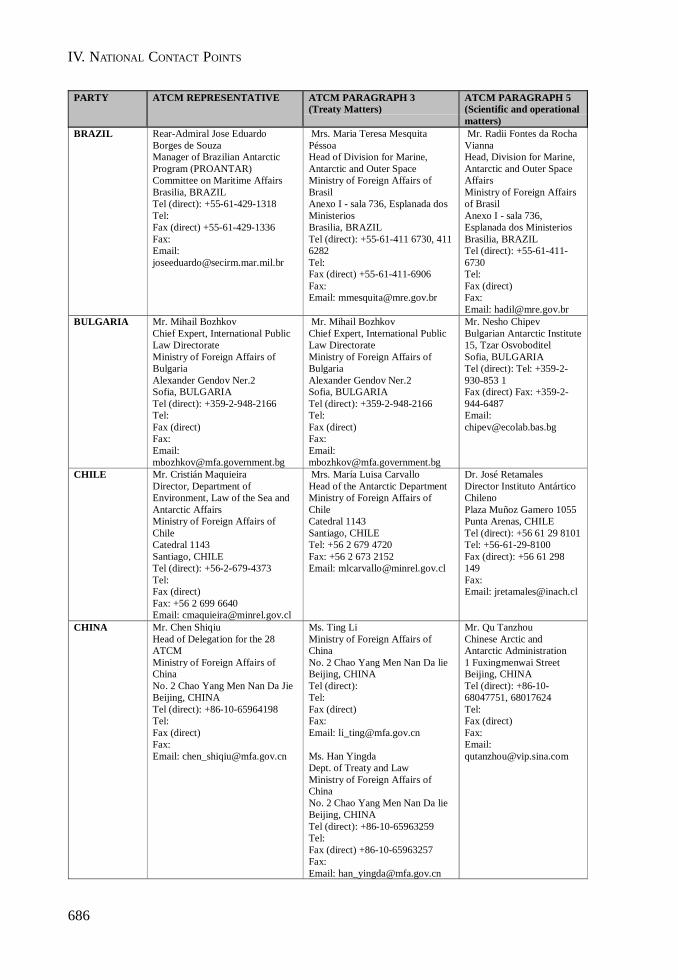
IV. NATIONAL CONTACT POINTS
686
PARTY ATCM REPRESENTATIVE ATCM PARAGRAPH 3(Treaty Matters)
ATCM PARAGRAPH 5(Scientific and operationalmatters)
BRAZIL Rear-Admiral Jose EduardoBorges de SouzaManager of Brazilian AntarcticProgram (PROANTAR)Committee on Maritime AffairsBrasilia, BRAZILTel (direct): +55-61-429-1318Tel:Fax (direct) +55-61-429-1336Fax:Email:[email protected]
Mrs. Maria Teresa MesquitaPéssoaHead of Division for Marine,Antarctic and Outer SpaceMinistry of Foreign Affairs ofBrasilAnexo I - sala 736, Esplanada dosMinisteriosBrasilia, BRAZILTel (direct): +55-61-411 6730, 4116282Tel:Fax (direct) +55-61-411-6906Fax:Email: [email protected]
Mr. Radii Fontes da RochaViannaHead, Division for Marine,Antarctic and Outer SpaceAffairsMinistry of Foreign Affairsof BrasilAnexo I - sala 736,Esplanada dos MinisteriosBrasilia, BRAZILTel (direct): +55-61-411-6730Tel:Fax (direct)Fax:Email: [email protected]
BULGARIA Mr. Mihail BozhkovChief Expert, International PublicLaw DirectorateMinistry of Foreign Affairs ofBulgariaAlexander Gendov Ner.2Sofia, BULGARIATel (direct): +359-2-948-2166Tel:Fax (direct)Fax:Email:[email protected]
Mr. Mihail BozhkovChief Expert, International PublicLaw DirectorateMinistry of Foreign Affairs ofBulgariaAlexander Gendov Ner.2Sofia, BULGARIATel (direct): +359-2-948-2166Tel:Fax (direct)Fax:Email:[email protected]
Mr. Nesho ChipevBulgarian Antarctic Institute15, Tzar OsvoboditelSofia, BULGARIATel (direct): Tel: +359-2-930-853 1Fax (direct) Fax: +359-2-944-6487Email:[email protected]
CHILE Mr. Cristián MaquieiraDirector, Department ofEnvironment, Law of the Sea andAntarctic AffairsMinistry of Foreign Affairs ofChileCatedral 1143Santiago, CHILETel (direct): +56-2-679-4373Tel:Fax (direct)Fax: +56 2 699 6640Email: [email protected]
Mrs. María Luisa CarvalloHead of the Antarctic DepartmentMinistry of Foreign Affairs ofChileCatedral 1143Santiago, CHILETel: +56 2 679 4720Fax: +56 2 673 2152Email: [email protected]
Dr. José RetamalesDirector Instituto AntárticoChilenoPlaza Muñoz Gamero 1055Punta Arenas, CHILETel (direct): +56 61 29 8101Tel: +56-61-29-8100Fax (direct): +56 61 298149Fax:Email: [email protected]
CHINA Mr. Chen ShiqiuHead of Delegation for the 28ATCMMinistry of Foreign Affairs ofChinaNo. 2 Chao Yang Men Nan Da JieBeijing, CHINATel (direct): +86-10-65964198Tel:Fax (direct)Fax:Email: [email protected]
Ms. Ting LiMinistry of Foreign Affairs ofChinaNo. 2 Chao Yang Men Nan Da lieBeijing, CHINATel (direct):Tel:Fax (direct)Fax:Email: [email protected]
Ms. Han YingdaDept. of Treaty and LawMinistry of Foreign Affairs ofChinaNo. 2 Chao Yang Men Nan Da lieBeijing, CHINATel (direct): +86-10-65963259Tel:Fax (direct) +86-10-65963257Fax:Email: [email protected]
Mr. Qu TanzhouChinese Arctic andAntarctic Administration1 Fuxingmenwai StreetBeijing, CHINATel (direct): +86-10-68047751, 68017624Tel:Fax (direct)Fax:Email:[email protected]
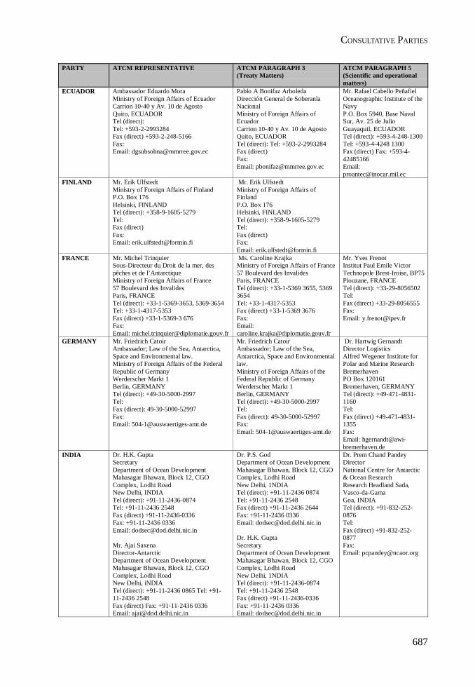
CONSULTATIVE PARTIES
687
PARTY ATCM REPRESENTATIVE ATCM PARAGRAPH 3(Treaty Matters)
ATCM PARAGRAPH 5(Scientific and operationalmatters)
ECUADOR Ambassador Eduardo MoraMinistry of Foreign Affairs of EcuadorCarrion 10-40 y Av. 10 de AgostoQuito, ECUADORTel (direct):Tel: +593-2-2993284Fax (direct) +593-2-248-5166Fax:Email: [email protected]
Pablo A Bonifaz ArboledaDirección General de SoberanlaNacionalMinistry of Foreign Affairs ofEcuadorCarrion 10-40 y Av. 10 de AgostoQuito, ECUADORTel (direct): Tel: +593-2-2993284Fax (direct)Fax:Email: [email protected]
Mr. Rafael Cabello PeñafielOceanographic Institute of theNavyP.O. Box 5940, Base NavalSur, Av. 25 de JulioGuayaquil, ECUADORTel (direct): +593-4-248-1300Tel: +593-4-4248 1300Fax (direct) Fax: +593-4-42485166Email:[email protected]
FINLAND Mr. Erik UlfstedtMinistry of Foreign Affairs of FinlandP.O. Box 176Helsinki, FINLANDTel (direct): +358-9-1605-5279Tel:Fax (direct)Fax:Email: [email protected]
Mr. Erik UlfstedtMinistry of Foreign Affairs ofFinlandP.O. Box 176Helsinki, FINLANDTel (direct): +358-9-1605-5279Tel:Fax (direct)Fax:Email: [email protected]
FRANCE Mr. Michel TrinquierSous-Directeur du Droit de la mer, despêches et de l’AntarctiqueMinistry of Foreign Affairs of France57 Boulevard des InvalidesParis, FRANCETel (direct): +33-1-5369-3653, 5369-3654Tel: +33-1-4317-5353Fax (direct) +33-1-5369-3 676Fax:Email: [email protected]
Ms. Caroline KrajkaMinistry of Foreign Affairs of France57 Boulevard des InvalidesParis, FRANCETel (direct): +33-1-5369 3655, 53693654Tel: +33-1-4317-5353Fax (direct) +33-1-5369 3676Fax:Email:[email protected]
Mr. Yves FrenotInstitut Paul Emile VictorTechnopole Brest-Iroise, BP75Plouzane, FRANCETel (direct): +33-29-8056502Tel:Fax (direct) +33-29-8056555Fax:Email: [email protected]
GERMANY Mr. Friedrich CatoirAmbassador; Law of the Sea, Antarctica,Space and Environmental law.Ministry of Foreign Affairs of the FederalRepublic of GermanyWerderscher Markt 1Berlin, GERMANYTel (direct): +49-30-5000-2997Tel:Fax (direct): 49-30-5000-52997Fax:Email: [email protected]
Mr. Friedrich CatoirAmbassador; Law of the Sea,Antarctica, Space and Environmentallaw.Ministry of Foreign Affairs of theFederal Republic of GermanyWerderscher Markt 1Berlin, GERMANYTel (direct): +49-30-5000-2997Tel:Fax (direct): 49-30-5000-52997Fax:Email: [email protected]
Dr. Hartwig GernandtDirector LogisticsAlfred Wegener Institute forPolar and Marine ResearchBremerhavenPO Box 120161Bremerhaven, GERMANYTel (direct): +49-471-4831-1160Tel:Fax (direct) +49-471-4831-1355Fax:Email: [email protected]
INDIA Dr. H.K. GuptaSecretaryDepartment of Ocean DevelopmentMahasagar Bhawan, Block 12, CGOComplex, Lodhi RoadNew Delhi, INDIATel (direct): +91-11-2436-0874Tel: +91-11-2436 2548Fax (direct) +91-11-2436-0336Fax: +91-11-2436 0336Email: [email protected]
Mr. Ajai SaxenaDirector-AntarcticDepartment of Ocean DevelopmentMahasagar Bhawan, Block 12, CGOComplex, Lodhi RoadNew Delhi, iNDIATel (direct): +91-11-2436 0865 Tel: +91-11-2436 2548Fax (direct) Fax: +91-11-2436 0336Email: [email protected]
Dr. P.S. GodDepartment of Ocean DevelopmentMahasagar Bhawan, Block 12, CGOComplex, Lodhi RoadNew Delhi, 1NDIATel (direct): +91-11-2436 0874Tel: +91-11-2436 2548Fax (direct) +91-11-2436 2644Fax: +91-11-2436 0336Email: [email protected]
Dr. H.K. GuptaSecretaryDepartment of Ocean DevelopmentMahasagar Bhawan, Block 12, CGOComplex, Lodhi RoadNew Delhi, 1NDIATel (direct): +91-11-2436-0874Tel: +91-11-2436 2548Fax (direct) +91-11-2436-0336Fax: +91-11-2436 0336Email: [email protected]
Dr. Prem Chand PandeyDirectorNational Centre for Antarctic& Ocean ResearchResearch Headland Sada,Vasco-da-GamaGoa, INDIATel (direct): +91-832-252-0876Tel:Fax (direct) +91-832-252-0877Fax:Email: [email protected]

IV. NATIONAL CONTACT POINTS
688
PARTY ATCM REPRESENTATIVE ATCM PARAGRAPH 3(Treaty Matters)
ATCM PARAGRAPH 5(Scientific and operational matters)
ITALY Ambassador Arduino FornaraMinistry of Foreign Affairs of ItalyPiazzale della Farnesina, 1Rome, ITALYTel (direct): +39-06-369 1 8261Tel:Fax (direct)Fax:Email: [email protected]
Ms. Simone LandiniMinistry of Foreign Affairs of ItalyPiazzale della Farnesina, 1Rome, ITALYTel (direct): +39-06-3691-4668Tel:Fax (direct) +39-06-3691-5159Fax:Email: [email protected]
Ms. Simone LandiniMinistry of Foreign Affairs of ItalyPiazzale della Farnesina, 1Rome, ITALYTel (direct): +39-06-3691-4668Tel:Fax (direct) +39-06-3691-5159Fax:Email: [email protected]
Mr. Nino CucinottaENEA Consortium for theimpelementation of the NationalProgramme of Antarctic ResearchVia Anguillarese, 301Roma, ITALYTel (direct):Tel:Fax (direct)Fax:Email: [email protected]
Mr. Pietro GiulianiItalian National Agency for NewTechnologies, Energy and theEnvironmentRome, ITALYTel (direct):Tel:Fax (direct)Fax:Email: [email protected]
JAPAN Koichi ItoDirector, Global Environment DivisionMinistry of Foreign Affairs of JapanKasumigaseki 2-2-1, Chiyoda-kuTokyo, JAPANTel (direct):Tel: +81-3-3580-3311, 3581-1905Fax (direct)Fax:Email: [email protected]
Mr. Takaaki KatoGlobal Environment DivisionMinistry of Foreign Affairs ofJapanKasumigaseki 2-2-1, Chiyoda-kuTokyo, JAPANTel (direct): +81-3-5501 8245 Tel:+81-3-3580-3311, 3581-1905Fax (direct) +81-3-5501-8244 Fax:Email: [email protected]
KOREA,REPUBLICOF
Mr. Hai-ung JungDirector-General Treaties BureauMinistry of Foreign Affairs of KoreaSeoul, KOREATel (direct): +82-2-2100-7503Tel:Fax (direct)Fax:Email: [email protected]
Jaeyong ChoiKorea Ocean Research andDevelopment InstituteP.O. Box 29Seoul, KOREATel (direct):Tel: +82-2-406 5820Fax (direct)Fax:Email: [email protected]
NEWZEALAND
Mr. Trcvor HughesHead, Antarctic Policy UnitMinistry of Foreign Affairs and Trade ofNew Zealand195 Lambton Quay, Private BagWellington, NEW ZEALANDTel (direct): +64-4-439-8570Tel:Fax (direct) +64-4-439-8 103Fax:Email: [email protected]
Mr. Trevor HughesHead, Antarctic Policy UnitMinistry of Foreign Affairs andTrade of New Zealand195 Lambton Quay, Private BagWellington, NEW ZEALANDTel (direct): +64-4-439-8570Tel:Fax (direct) +64-4-439-8 103Fax:Email:[email protected]
Ms. Alice RevellMinistry of Foreign Affairs andTrade of New Zealand195 Lambton Quay, Private BagWellillgton, NEW ZEALANDTel (direct):Tel:Fax (direct)Fax:Email: [email protected]
Lou SansonChief ExecutiveAntarctica New ZealandOrchard Road, Private Bag 4745Christchurch, NEW ZEALANDTel (direct): +64-3-358-0209Tel: +64-3-358-0200Fax (direct) +64-3-358-0211Fax:Email: [email protected]
NORWAY Mr. Karsten KlepsvikRoyal Ministry of Foreign Affairs ofNorway7. Juni Plassen/Victoria Terrasse, P.O. Box8114 DEP.Oslo, NORWAYTel (direct): +47-2224 3428Tel: +47-2224-3600Fax (direct) +47-2224-9580Fax:Email: [email protected]
Nir. Karsten KlepsvikRoyal Ministry of Foreign Affairsof Norway7. Juni Plassen/Victoria Terrasse,P.O. Box 8114 DEP.Oslo, NORWAYTel (direct): +47-2224 3428Tel: +47-2224-3600Fax (direct) +47-2224-9580Fax:Email: [email protected]
Ms. Birgit NjaastadNorwegian Polar InstituteP.O. Box 399Tromsø, NORWAYTel (direct): +47-7902-2612Tel:Fax (direct)Fax:Email: [email protected]

CONSULTATIVE PARTIES
689
PARTY ATCM REPRESENTATIVE ATCM PARAGRAPH 3(Treaty Matters)
ATCM PARAGRAPH 5(Scientific and operationalmatters)
PERU Mr. Hugo de ZelaMinistry of Foreign Affairs of PeruJiron Ucayali 337Lima, PERUTel (direct): +51-1-311-2651Tel:Fax (direct) +51-1-311-2659Fax:Email: [email protected]
Mr. Victor MatallanaExecutive SecretaryPeruvian Antarctic InstituteJiron Ucayalí 259 - 5to PisoLima, PERUTel (direct): +51-1-311-2595Tel: +51-1-311-2596Fax (direct) +51-1-426-7124Fax: +51- 1-+5 1-1-426-7124Email:[email protected]
POLAND Mr. Andrzej MisztalMinistry of Foreign Affairs of PolandWarszawa, POLANDTel (direct): +48-22-523-9424Tel:Fax (direct)Fax:Email: [email protected]
Mr. Andrzej MisztalMinistry of Foreign Affairs ofPolandWarszawa, POLANDTel (direct): +48-22-523-9424Tel:Fax (direct)Fax:Email:[email protected]
Prof. Dr. Stanislaw Rakusa-SuszczewskiDirectorDepartment of Antarctic Biology& Arctowski StationUI. Ustrzyska 10/11Warszawa, POLANDTel (direct):Tel: +48-22-846-3383Fax (direct) Fax: +48-22-846 1912Email: [email protected]
RUSSIANFEDERATION
Mr. Pavel G. DzyubenkoLegal DepartmentMinistry of Foreign Affairs of theRussian FederationSmolenskaya-Sennaya P1. 32/34Moscow, RUSSIATel (direct): +7-95-241-7718Tel:Fax (direct) +7-95-241-1166Fax:Email: [email protected]
Mr. Pavel G. DzyubenkoLegal DepartmentMinistry of Foreign Affairs ofthe Russian FederationSmolenskaya-Sennaya P1.32/34Moscow, RUSSIATel (direct): +7-95-241-7718Tel:Fax (direct) +7-95-241-1166Fax:Email: [email protected]
Mr. Yury TsaturovFirst Deputy HeadFederal Service forHydrometeorology andEnvironmental MonitoringNovovagankovsky Street No. 12Moscow, RUSSIATel (direct): +7-95-252-2729Tel:Fax (direct) +7-95-252-2700Fax:Email: [email protected]
SOUTHAFRICA
Mr. Henry ValentineDirector Antarctica and IslandsDepartmentEnvironmental Affairs and TourismP.O. Box 8172Roggebaai, SOUTH-AFRICATel (direct): +27-21-405-9404Tel:Fax (direct)Fax:Email: [email protected]
Mr. Henry ValentineDirector Antarctica andIslands DepartmentEnvironmental Affairs andTourismP.O. Box 8172Roggebaai, SOUTH-AFRICATel (direct): +27-21-405-9404Tel:Fax (direct)Fax:Email:[email protected]
Mr. Henry ValentineDirector Antarctica and IslandsDepartmentEnvironmental Affairs andTourismP.O. Box 8172Roggebaai, SOUTH-AFRICATel (direct): +27-21-405-9404Tel:Fax (direct)Fax:Email:[email protected]
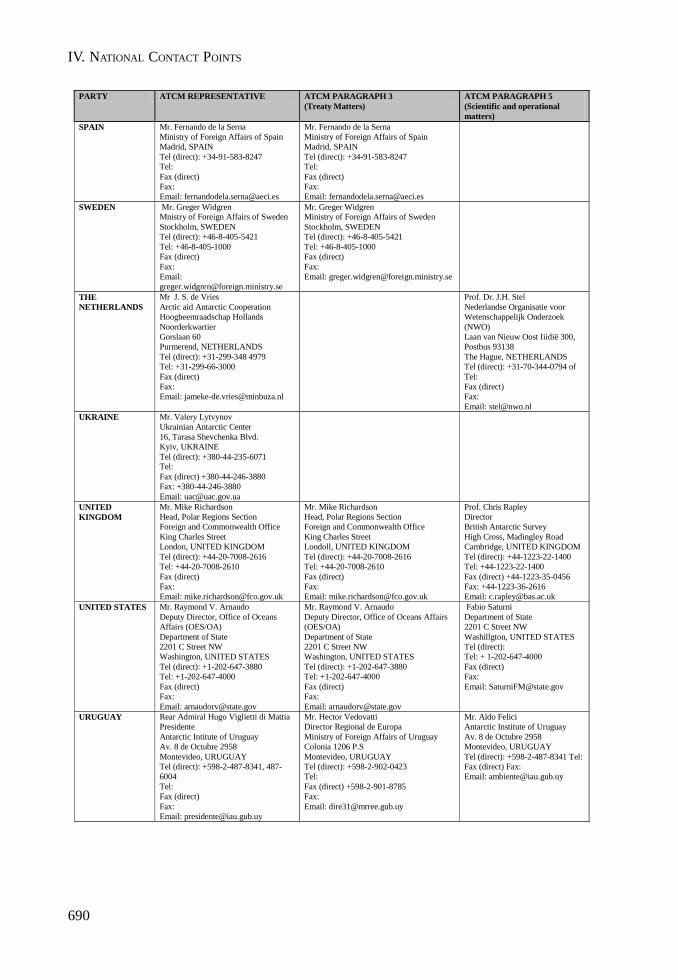
IV. NATIONAL CONTACT POINTS
690
PARTY ATCM REPRESENTATIVE ATCM PARAGRAPH 3 (Treaty Matters)
ATCM PARAGRAPH 5 (Scientific and operational matters)
SPAIN Mr. Fernando de la Serna Ministry of Foreign Affairs of Spain Madrid, SPAIN Tel (direct): +34-91-583-8247 Tel: Fax (direct) Fax: Email: [email protected]
Mr. Fernando de la Serna Ministry of Foreign Affairs of Spain Madrid, SPAIN Tel (direct): +34-91-583-8247 Tel: Fax (direct) Fax: Email: [email protected]
SWEDEN Mr. Greger Widgren Mnistry of Foreign Affairs of Sweden Stockholm, SWEDEN Tel (direct): +46-8-405-5421 Tel: +46-8-405-1000 Fax (direct) Fax: Email: [email protected]
Mr. Greger Widgren Ministry of Foreign Affairs of Sweden Stockholm, SWEDEN Tel (direct): +46-8-405-5421 Tel: +46-8-405-1000 Fax (direct) Fax: Email: [email protected]
THE NETHERLANDS
Mr J. S. de Vries Arctic aid Antarctic Cooperation Hoogheemraadschap Hollands Noorderkwartier Gorslaan 60 Purmerend, NETHERLANDS Tel (direct): +31-299-348 4979 Tel: +31-299-66-3000 Fax (direct) Fax: Email: [email protected]
Prof. Dr. J.H. Stel Nederlandse Organisatie voor Wetenschappelijk Onderzoek (NWO) Laan van Nieuw Oost Iiidië 300, Postbus 93138 The Hague, NETHERLANDS Tel (direct): +31-70-344-0794 of Tel: Fax (direct) Fax: Email: [email protected]
UKRAINE Mr. Valery Lytvynov Ukrainian Antarctic Center 16, Tarasa Shevchenka Blvd. Kyiv, UKRAINE Tel (direct): +380-44-235-6071 Tel: Fax (direct) +380-44-246-3880 Fax: +380-44-246-3880 Email: [email protected]
UNITED KINGDOM
Mr. Mike Richardson Head, Polar Regions Section Foreign and Commonwealth Office King Charles Street London, UNITED KINGDOM Tel (direct): +44-20-7008-2616 Tel: +44-20-7008-2610 Fax (direct) Fax: Email: [email protected]
Mr. Mike Richardson Head, Polar Regions Section Foreign and Commonwealth Office King Charles Street Londoll, UNITED KINGDOM Tel (direct): +44-20-7008-2616 Tel: +44-20-7008-2610 Fax (direct) Fax: Email: [email protected]
Prof. Chris Rapley Director British Antarctic Survey High Cross, Madingley Road Cambridge, UNITED KINGDOM Tel (direct): +44-1223-22-1400 Tel: +44-1223-22-1400 Fax (direct) +44-1223-35-0456 Fax: +44-1223-36-2616 Email: [email protected]
UNITED STATES Mr. Raymond V. Arnaudo Deputy Director, Office of Oceans Affairs (OES/OA) Department of State 2201 C Street NW Washington, UNITED STATES Tel (direct): +1-202-647-3880 Tel: +1-202-647-4000 Fax (direct) Fax: Email: [email protected]
Mr. Raymond V. Arnaudo Deputy Director, Office of Oceans Affairs (OES/OA) Department of State 2201 C Street NW Washington, UNITED STATES Tel (direct): +1-202-647-3880 Tel: +1-202-647-4000 Fax (direct) Fax: Email: [email protected]
Fabio Saturni Department of State 2201 C Street NW Washillgton, UNITED STATES Tel (direct): Tel: + 1-202-647-4000 Fax (direct) Fax: Email: [email protected]
URUGUAY Rear Admiral Hugo Viglietti di Mattia Presidente Antarctic Intitute of Uruguay Av. 8 de Octubre 2958 Montevideo, URUGUAY Tel (direct): +598-2-487-8341, 487-6004 Tel: Fax (direct) Fax: Email: [email protected]
Mr. Hector Vedovatti Director Regional de Europa Ministry of Foreign Affairs of Uruguay Colonia 1206 P.S Montevideo, URUGUAY Tel (direct): +598-2-902-0423 Tel: Fax (direct) +598-2-901-8785 Fax: Email: [email protected]
Mr. Aldo Felici Antarctic Institute of Uruguay Av. 8 de Octubre 2958 Montevideo, URUGUAY Tel (direct): +598-2-487-8341 Tel: Fax (direct) Fax: Email: [email protected]
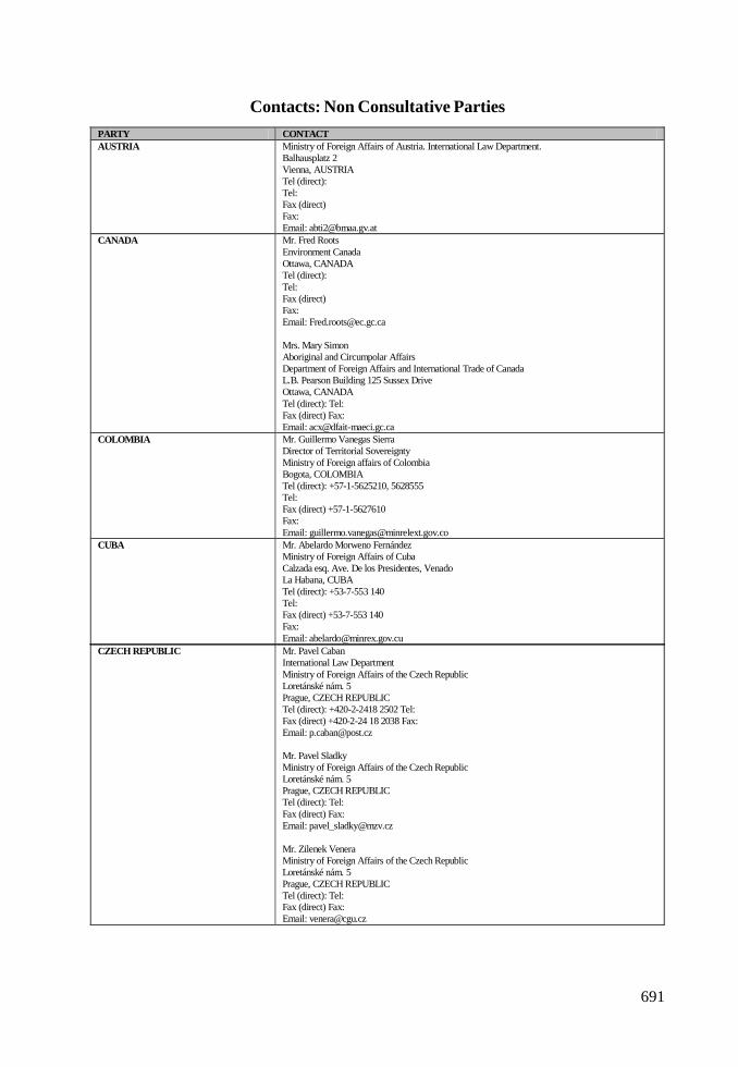
691
Contacts: Non Consultative PartiesPARTY CONTACT AUSTRIA Ministry of Foreign Affairs of Austria. International Law Department.
Balhausplatz 2 Vienna, AUSTRIA Tel (direct): Tel: Fax (direct) Fax: Email: [email protected]
CANADA Mr. Fred Roots Environment Canada Ottawa, CANADA Tel (direct): Tel: Fax (direct) Fax: Email: [email protected] Mrs. Mary Simon Aboriginal and Circumpolar Affairs Department of Foreign Affairs and International Trade of Canada L.B. Pearson Building 125 Sussex Drive Ottawa, CANADA Tel (direct): Tel: Fax (direct) Fax: Email: [email protected]
COLOMBIA Mr. Guillermo Vanegas Sierra Director of Territorial Sovereignty Ministry of Foreign affairs of Colombia Bogota, COLOMBIA Tel (direct): +57-1-5625210, 5628555 Tel: Fax (direct) +57-1-5627610 Fax: Email: [email protected]
CUBA Mr. Abelardo Morweno Fernández Ministry of Foreign Affairs of Cuba Calzada esq. Ave. De los Presidentes, Venado La Habana, CUBA Tel (direct): +53-7-553 140 Tel: Fax (direct) +53-7-553 140 Fax: Email: [email protected]
CZECH REPUBLIC Mr. Pavel Caban International Law Department Ministry of Foreign Affairs of the Czech Republic Loretánské nám. 5 Prague, CZECH REPUBLIC Tel (direct): +420-2-2418 2502 Tel: Fax (direct) +420-2-24 18 2038 Fax: Email: [email protected] Mr. Pavel Sladky Ministry of Foreign Affairs of the Czech Republic Loretánské nám. 5 Prague, CZECH REPUBLIC Tel (direct): Tel: Fax (direct) Fax: Email: [email protected] Mr. Zilenek Venera Ministry of Foreign Affairs of the Czech Republic Loretánské nám. 5 Prague, CZECH REPUBLIC Tel (direct): Tel: Fax (direct) Fax: Email: [email protected]

IV. NATIONAL CONTACT POINTS
692
GUATEMALA Amb. Mrs. Carla Rodriguez Direccion General de Relaciones Intemacionales Multilaterales y Económicas Ministry of Foreign Affairs of Guatemala Guatemala, GUATEMALA Tel (direct): Tel: +502-2-348-0000 Fax (direct) Fax: Email: [email protected]
HUNGARY Mr. Tamás Csaba Department International Law Ministry of Foreign Affairs of Hungary Nagy Imre tér 4. V. em Budapest, HUNGARY Tel (direct): +36-1-458 1142 Tel: Fax (direct) +36-1-458 1091 Fax: Email: [email protected]
KOREA D.P.R. OF Mr. 11 Uwang Ulioc Embassy of Democratic People’s Republic of Korea in Sweden Norra Kungsvagen 39, Lidingo Stockholm, SWEDEN Tel (direct): +46-8-767 38 36 Tel: Fax (direct) +46-8-767 38 35 Fax: Email: [email protected]
PAPUA NEW GUINEA Office of the Prime Minister of Papua New Guinea Morauta House, P0 Box 639 Waigani, PAPUA NEW GUiNEA Tel (direct): Tel: +675-327-6525 Fax (direct) Fax: +675-323-3 943 Email: [email protected] Papua New Guinea High Commission in England London, UNITED KINGDOM Tel (direct): Tel: Fax (direct) Fax: Email: [email protected]
ROMANIA Mr. Teodor Negoita Romanian Center of Polar Research Bucharest, ROMANIA Tel (direct): Tel: +40-1-641-2987 Fax (direct) Fax: +40-1-3 12 1009 Email: [email protected]
PARTY CONTACT DENMARK Mr. Jorgen Liljen-Jensen
Law of the Sea and Antarctic Affairs Ministry of Foreign Affairs of Denmark Plads 2 Copenhagen, DENMARK Tel (direct): Tel: Fax (direct Fax: Email: [email protected]
ESTONIA Mr. Mart Saarso Responsible for Antarctic Affairs Ministry of Foreign Affairs of Estonia Islandivaljak 1 Tallin, ESTONIA Tel (direct): +372-63 1 7013 Tel: Fax (direct) +372-63 1 7097 Fax: Email: [email protected]
GREECE Dr. Emmanuel Gounaris Ministry of Foreign Affairs of Greece 3 B 1 Direction Academas St. Athens, GREECE Tel (direct): Tel: Fax (direct) Fax: +30-01-201 368 2235 Email: [email protected]
NON CONSULTATIVE PARTIES
693
PARTY CONTACT SLOVAKIA JUDr. Eva Surkova
International Law Department Ministry of Foreign Affairs of Slovak Republic Hlboká cesta 2 Bratislava, SLOVAKIA Tel (direct): +421-2-5978 3717 Tel: Fax (direct) Fax: Email: [email protected]
SWITZERLAND Mrs. Evelyne Gerber Direction du Droit International Public Federal Department of Foreign Affairs of Switzerland Bundesgasse 18 Berne, SWITZERLAND Tel (direct): +41-31-322 3169 Tel: Fax (direct) +41-31-322 1647 Fax: Email: [email protected]
TURKEY Ms. Zeynep Savas Environmental Department Ministry of Foreign Affairs of Turkey Balgat 06100 Ankara, TURKEY Tel (direct): Tel: Fax (direct) Fax: Email:
VENEZUELA Ministry of Foreign Affairs of Venezuela Caracas, VENEZUELA Tel (direct): Tel: Fax (direct) Fax: Email: [email protected]

IV. NATIONAL CONTACT POINTS

695
Contacts: Observers
ORGANISATION CONTACT CCAMLR Dr. Denzil G.M. Miller
Executive Secretary CCAMLR P.O. Box 213, North Hobart, 137 Harrington Street Hobart, AUSTRALIA Tel (direct): +61-3-6321-0366 Tel: Fax (direct) +61-3-6324-9965 Fax: Email: [email protected] Julie Catchpole CCAMLR P.O. Box 213, North Hobart, 137 Harrington Street Hobart, AUSTRALIA Tel (direct): Tel: Fax (direct) Fax: Email: [email protected]
COMNAP Mr. Antoine Guichard Executive Secretary COMNAP Suit 25, Salamanca Square, GPO BOX 824 Hobart, AUSTRALIA Tel (direct): Tel: +61-3-6233-5498 Fax (direct) Fax: +61-3-+61-3-6233 5497 Email: [email protected] Dr. Gerard Jugie Chairman COMNAP Suit 25, Salamanca Square, GPO BOX 824 Hobart, AUSTRALIA Tel (direct): Tel: +61-3-6233-5498 Fax (direct) Fax: +61-3-+61-3-6233 5497 Email: [email protected]
SCAR Mr. Peter Clarkson Secretary, S.C.A.R. Scientific Committee on Antarctic Research Scott Polar Research Institute, Lensfield Road Cambridge, UNITED KINGDOM Tel (direct): Tel: +44-1223-33-6550 Fax (direct) Fax: Email: [email protected]

IV. NATIONAL CONTACT POINTS
697
Contacts: Experts
ORGANISATION CONTACT ASOC Mr. Jim Barnes
ASOC Antarctic and Southern Ocean Coalition 1630 Connecticut Ave. NW. Third Floor Washington, UNITED STATES Tel (direct): Tel: +1-202-234-2480 Fax (direct) Fax: + 1-202-387-4823 Email: [email protected]
IAATO Mrs. Denise Landau Executive Director IAATO International Association of Antarctica Tour Operators P0 BOX 2178 Basalt, UNITED STATES Tel (direct): Tel: Fax (direct) Fax: Email: [email protected]
IHO Mr. Hugo Gorziglia Director 2 IHO International Hydrographic Organization 4 quai Antoine ler, B.P.445 Monaco, MONACO Tel (direct): Tel: +377-93-10 81 00 Fax (direct) ax: +377-93-10-8140 Email: [email protected]
IMO International Maritime Organization London, UNITED KINGDOM Tel (direct): Tel: +44-20-7357611 Fax (direct) Fax: +44-20-171-5873210 Email: [email protected]
IOC Mr. Patricio Bernal IOC Intergovernmental Oceanographic Commission Paris, FRANCE Tel (direct): Tel: +33-1-4568 1000 Fax (direct) Fax: +33-1-4567 1690 Email: [email protected]
IUCN Ms. Maj de Poorter IUCN International Union for Conservation of Natural Resources Gland, SWITZERLAND Tel (direct): Tel: Fax (direct) Fax: Email: [email protected] Mr. Alan Hemmings IUCN International Union for Conservation of Natural Resources Gland, SWITZERLAND Tel (direct): Tel: Fax (direct) Fax: Email: [email protected]
PATA PATA Pacific Asia Travel Association Bangkok, THAILAND Tel (direct): Tel: Fax (direct) Fax: Email:
IV. NATIONAL CONTACT POINTS
698
ORGANISATION CONTACT UNEP Mr. Christian Lambrechts
UNEP United Nations Environmental Program Nairobi, KENIA Tel (direct): Tel: +254-2-623 470 Fax (direct) Fax: +254-2-623 846 Email: [email protected]
WMO Mr. Ron Hutchinson WMO World Meteorological Organization Geneva, SWITZERLAND Tel (direct): Tel: Fax (direct) Fax: Email: [email protected]
WTO WTO World Tourism Organization Madrid, SPAIN Tel (direct): Tel: +34-91-567 8100 Fax (direct) Fax: +34-91-571-3733 Email: [email protected]


