Embed Size (px)
Citation preview

McKay River Thermal Project
Scheme No. 11461 Performance Report
June 29, 2021
Everest Canadian Resources
1

OUTLINE
1.1 Project background
1.2 Subsurface Overview Related to Resource Evaluation and Recovery
1.3 Surface Operations, Compliance, and Issues Not Related to Resource Evaluation and Recovery
2

PROJECT BACKGROUND
Everest Canadian Resources
3

PROJECT BACKGROUND
• McKay River Project was previously owned and operated by Southern Pacific Resource Corp.
• November 2010 - Receives project approval:
• EPEA Approval No. 255245-00-00
• Oil Sands Conservation Act Approval No. 11461
• Approved Capacity 12,000 bbl/d oil treating
• In January 2015, Southern Pacific Resources, previous owner of STP – McKay, was granted protection under the CCAA and subsequently entered Receivership in June 2015
• Due to the depressed commodity price environment and high operating costs at the time, production was shut-in, and the Receiver initiated and completed a warm-hibernation program by August 2015
• Project was officially transferred to Everest Canadian Resources on February 2019
4

• Everest Canadian Resources (ECR) – McKay is a 12,000 bpd Name Plate, Steam-Assisted-Gravity-Drainage (“SAGD”) facility.
• Located 45 km northwest of Fort McMurray on an approved 10.5 section development area within a larger acreage block
• Project Area is 10.5 sections in Township 91, Range 14, W4M and Township 91, Range 15, W4M
• Development Area is 1.25 Sections in Township 91, Range 14, W4M
PROJECT BACKGROUND
5

• Current approved development includes four well pads (101 to 104)
• The initial development is west of the MacKay River and includes well pads 101 & 102
• Process Facility existing capacity of 12,000 bbld oil and 37,400 bbldsteam
PROJECT BACKGROUND
6

SUBSURFACE
Everest Canadian Resources
7

TABLE OF CONTENTS
1.2 SUBSURFACE
• GEOLOGY & GEOSICENCE
• HEAVE MONITORING & CAPROCK
• DRILLING & COMPLETIONS
• OBSERVATION WELLS
• SCHEME PERFORMANCE
• SUBSURFACE FUTURE PLANS 8

GEOLOGY&
GEOSICENCE
Everest Canadian Resources
9

Everest Canadian ResourcesREGIONAL GEOLOGY - MCMURRAY
10

Everest Canadian ResourcesAPPROVAL AREA
• Approval Area
• 10.5 Sections (27 Km2)
• Approval Area OBIP
• 92.1 x 10⁶ m3 (579 MMbbl)
• Seismic
• 5.1 m2 3D seismic coverage
3D (5.1Km2 )Seismic Coverage
8 Observation wells
11

Everest Canadian ResourcesAPPROVAL AREA STRATIGRAPHY
12

Everest Canadian ResourcesAPPROVAL AREA Reservoir Properties
13

Everest Canadian ResourcesAPPROVAL AREA CROSS SECTION
14
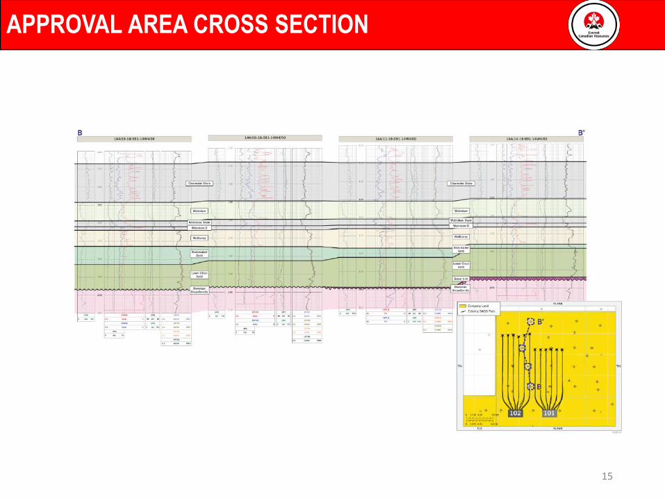
Everest Canadian ResourcesAPPROVAL AREA CROSS SECTION
15

Everest Canadian ResourcesAPPROVAL AREA CROSS SECTION
16

Everest Canadian ResourcesAPPROVAL AREA STRUCTURE
17

Everest Canadian ResourcesAPPROVAL AREA STRUCTURE
18

Everest Canadian ResourcesAPPROVAL AREA CONTINUOUS NET PAY
McMurray Continuous Net Bitumen Pay
19

Everest Canadian ResourcesAPPROVAL AREA TYPE CURVE
20

Everest Canadian Resources
Basal Unit (non-Pay)• Non-Producible Facies Common on
Pad 1• Terrestrial Depositional
Environment• Typically GR>75, Density Porosity <
27%, Resistivity < 20 ohms• Porosity and Permeability – no
sample, very low value by visual. Saturation - Negligible
• North section of Pad 1 producers encountered this facies.
100-10-18-091-14W4 100-04-18-091-14W4
Clean Sand• Producible Facies Common on Pad 1 and Pad 2• Estuarial Channelized Depositional Environment• Rare Bioturbation• Typically < 5% mud• Vertical Permeability Range – 2000mD to 4000mD• Fine to Medium grained• Porosity of 33% or better• Saturations of 75-90%• Locally Common Facies on Pad 1 and Pad 2
Top McMurray
Top McMurray
Approval Area Bitumen Pay Facies
21

Everest Canadian Resources
Bioturbated Sand• Producible Facies Found in McKay• Marginal-Marine Depositional
Environment• Typically <15% fines (mud)• Vertical Permeability Range –
250mD to 475mD• Porosity of 32 – 36%• Saturations of 50-70%• Locally Facies within Pad 3
1AA-07-18-091-14W41AA-09-18-091-14W4
Bioturbated Sand• Producible Facies Found in McKay• Marginal-Marine Depositional Environment• Common Bioturbation • Typically 15 - 30% fines (mud)• Vertical Permeability Range – 150 mD to 300 mD• Porosity of 30-34%• Saturations of 55-70%• Only encountered on Pad 1 wells
Top McMurray
Top McMurray
Approval Area Bitumen Pay Facies
22

Everest Canadian Resources
100-02-18-091-14W4 100-05-18-091-14W4
Interbedded Sand• Producible Facies Found in McKay• Marginal-Marine Depositional
Environment• Common Bioturbation• Typically 15-30% fines (mud)• Vertical Permeability Range – 400mD to
1500mD• Porosity of 31-34%• Saturations of 60-80%• Interbeds form permeability baffles that
decrease oil rates and increase SOR’s• Facies Found on Pad 1
Interbedded Sand• Producible Facies Common in
McKay• Marginal-Marine Depositional
Environment• Rare - common Bioturbation by
various trace fossils• Typically <15% fines (mud)• Permeability Range – 400mD to
2000mD• Porosity of 32 - 36%• Saturations of 65-85%• Locally Common Facies in McKay
Top McMurray
Top McMurray
Approval Area Bitumen Pay Facies
23

Everest Canadian ResourcesAPPROVAL AREA BITUMEN PAY FACIES SUMMARY
24

Everest Canadian ResourcesBITUMEN PAY FACIES PATTERN ON PAD 1 & 2
1A
A-0
2-18-0
91-1
4W4
10
0-02-1
8-09
1-14W
41
AA
-07-1
8-09
1-14W
41
AA
-07-1
8-09
1-1
4W
4
Top
Base
PAD
1 P
AY
FAC
IES
PATT
ERN
10
0-0
5-1
8-091
-14W
4
Top
PAD
2 P
AY
FAC
IES
PATT
ERN
1A
A-1
1-1
8-0
91
-14W
4
Base
25

Everest Canadian ResourcesAPPROVAL AREA PETROGRAPHICAL ANALYSIS
Upper Reservoir (Bioturbated)
• Very Fine to Fine grained (<180 um)
• Moderately sorted, Subangular with elongate grains
• Framework consists of quartz, common chert, siltstones with some
feldspars
• Clays are within the microporosity of the chert, but also exist within
the pore spaces. Pore space has 10% clay in the pore space.
• XRD: Analysis shows 86% qtz, 4% K-feldspar, 2% Plagioclase, 1%
dolomite, 1% pyrite and 6% total clay.
Main Reservoir
• Fine to Medium grained (180-250 um)
• Moderately sorted, Subrounded with elongate and spherical
grains
• Framework consists of quartz, chert, siltstones with some
feldspars
• Similar clays with less interstitial clay found in the rock matrix.
• XRD: Analysis shows 93% qtz, 2% K-feldspar, 1% pyrite and
4% total clay.
Core Analysis/Thin Section
AA/04-17-91-14w4
26

Everest Canadian ResourcesAPPROVAL AREA RESERVOIR QUALITY COMPARISON
Reservoir Quality Comparison
27

Everest Canadian ResourcesPAD 1 & PAD 2 RESERVES
Ø = Average porosity from the SAGD reservoir interval
S = Average bitumen saturation from the SAGD reservoir interval
A = Drainage Area
H = Average Pay Thickness
OBIP = Original Bitumen In-Place and measured in 106m3 units
OBIP = A x H x Ø x S
Pad# Well Pairs
Drainage Box Area A (m2)
Average Pay Thickness H (m)
Average Porosity
ø (%)Average Sauturation
So (%)Average Vertical
Permeability (mD)Average Horizontal Permeability (mD)
OBIP (106 m3)
PBIP (106 m3)
Total Recovery to Date (%)
Estmated Ultimate Recovery (%)
Pad 1 5 540,000 20 31 74 1598 2210 2.5 2.2 1.9 59
Pad 2 6 720,000 20 32 78 2323 3137 3.6 3.2 6.2 65
28

HEAVE MONITORING&
CAPROCK INTEGRITY
Everest Canadian Resources
29

SURFACE MONITORING (HEAVE MONUMENTS)
• 35 Corner reflectors were installed in 2012
• The Surface monitoring started in March 2012
• Based on historical, between 2012 and 2015, cumulative movement of the surface since SAGD operations started was insignificant, ranged between -10 mm (subsidence) and 38 mm (heave).
• Everest did not conduct Heave or other surface monitoring between February 2019 and April 2021 (Everest did not conduct performance between April – August, 2020 since Covid – 19).
30

CAPROCK INTEGRITY
• No change in Caprock integrity
• AER approved Maximum Operating Pressure (MOP) of 2,450 kPa.
• McKay met all AER conditions and information requests and received approval in 2011
• Caprock integrity studies was focused on:
• Core and geological log evaluations
• No fault planes observed on logs or in core.
• No borehole breakouts/drilling induced fractures observed from 17 HMI logs.
• Laboratory testing (reservoir & geomechanical)
• Low permeability caprock.
• Geomechanical properties derived from lab testing.
• Mini-frac testing for characterizing in situ stress state
• Mini-frac tests conducted at 2 wells.
• Geomechanical simulation (Taurus Reservoir Solutions)
• 2,450 kPa operating pressure is conservative
31

MINI-FRAC TESTS AND FRACTURE PRESSURE
• Mini-Frac Tests
• Mini-frac tests completed at wells 5-16 and 1-18
• Stress gradient results are consistent and similar to those expected in the Athabasca Oil Sands.
• Vertical stress gradient is ~21.5 kPa/m.
126 Clearwater Shale 2520 20.0
140 Clearwater Shale 2760 19.7
155 Wabiskaw Shale 2710 17.5
174 McMurray Sandstone 2900 16.7
Well 5-16-91-14W4 Date March 2009
Depth
(m TVD)Lithology
Minimum
Stress (kPa)
Minimum Stress
Gradient (kPa/m)
131 Clearwater Shale
138 Clearwater Shale 2900 21.0
147 Wabiskaw Sandstone 3060 20.8
156 Wabiskaw Shale 3250 20.8
164 Upper McMurray Sandstone 3300 20.1
186 McMurray Sandstone 3060 16.5
Date April 2011
No Breakdown
Depth
(m TVD)Lithology
Minimum
Stress (kPa)
Minimum Stress
Gradient (kPa/m)
Well 1-18-91-14W4
• Fracture Pressure
• Assessment of minimum fracture pressure (Smin) at the base of the Clearwater Formation using mini-frac test results.
• Smin from both wells 5-16 and 1-18 were consistent.
• Smin fracture pressure at the base of the Clearwater Formation caprock was between ~2,860 kPa and ~ 3,020 kPa.
(m) (kPa/m) (kPa)
5-16 145 19.7 2857
1-18 144 21.0 3024
Note: Base of Clearwater Formation caprock determined from 1-18 well log.
Depth to
Caprock BaseFracture Gradient
Smin Fracture
PressureWell
32

MINI-FRAC TESTS AND FRACTURE PRESSURE
Caprock – Clearwater MemberCaprock – Wabiskaw Shale
01-18-091-14W4/0
Wabiskaw Reservoir
Wabiskaw Shale
McMurray Oilsands
Clearwater Shale
Caprock – mini-frac
Oilsands – mini-frac
33

CAPROCK INTEGRITY- MONITORING
• Clearwater Formation:
• 6 vertical, nested observation wells measuring pressure and temperature.
• Wabiskaw Member:
• 1 horizontal well measuring temperature and pressure
• Surface heave monitoring program
• Blanket Gas system to monitor bottomhole injection pressures.
34

DRILLING
&
COMPLETIONS
Everest Canadian Resources
35

WELL LAYOUT
• Approved Development area outlined in blue
• Drilled to date (black):
• Pad 101 (6 pairs) → 800 m Hz
• Pad 102 (6 pairs) → ~ 1,000 m Hz
• Wabiskaw observation well (lies above 1P1)
• Approved Pads (red):
• Pad 103 (6 pairs)
• Pad 104 (6 pairs)
36

WELLS COMPLETION SCHEMATICS
• Initial Wells completion design
• Six installations in production wells
• All production wells are equipped for gas lift
• Coil tubing with temperature instrumentation is run to toe.
• ICD Installation Producer (Gas Lift)
• Six installations in production wells
• All production wells are equipped for gas lift
• Coil tubing with temperature instrumentation is run to toe.
37

OBSERVATION WELLS
Everest Canadian Resources
38

OBSERVATION WELLS
• 6 Vertical, Nested Observation Wells:
• Pressure and temperature measurements
extending from McMurray to Clearwater
Formations
• 10-18 and12-18 wells have experienced 1 TC
failure each. 5-18 has experienced 4 TC
failures.
• Horizontal Observation Well:
• Wabiskaw Member
• Temperature/Pressure measurements
Pad 102 Pad 101
39
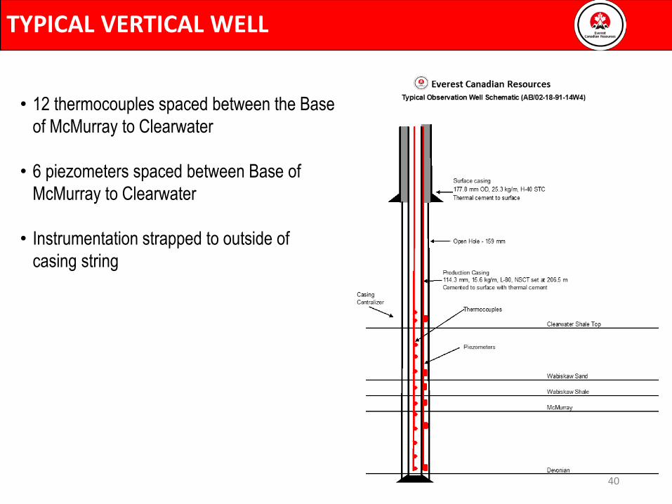
TYPICAL VERTICAL WELL
• 12 thermocouples spaced between the Base
of McMurray to Clearwater
• 6 piezometers spaced between Base of
McMurray to Clearwater
• Instrumentation strapped to outside of
casing string
40

VERTICAL WELL
41

VERTICAL WELL
42

VERTICAL WELL
43

VERTICAL WELL
44

VERTICAL WELL
45

VERTICAL WELL
ELEV_KB:470.9AB/10-18-091-14W4/0RIG_DATE : 2/28/2011
AB/10-18-091-14W4
46

HORIZONTAL WABISKAW OBSERVATION WELL
• Horizontal observation well designed and drilled in Wabiskaw formation for potential future
production from zone
47

SCHEME PERFORMANCE
Everest Canadian Resources
48

Scheme Performance
0
10
20
30
40
50
60
70
80
90
100
0
200
400
600
800
1000
1200
1400
1600
1800
2000
Oct-20 Nov-20 Dec-20 Jan-21
iSO
R, c
SOR
, WSR
, m3
/m3
Bit
um
en, S
team
, Wat
er R
ate,
m3
/d
Month
Field Performance
Bitumen Water Steam iSOR cSOR WSR # of Pairs
49

WELLPAIR CURRENT STATUS
Pad 101 and 102 Schematic Sections
50

WELLPAIR CURRENT STATUS
51

WELLPAIR CURRENT STATUS
52

COMMISSIONING AND STARTUP
• Pad 102 was started September 2020
• Pad 101 was started early February 2021.
53

SUBSURFACE FUTURE PLANS
Everest Canadian Resources
54

SUBSURFACE FUTURE PLANS
• Continue with Pad 102 and Pad 101 wellpairs rampup throughout 2021 until SAGD rampupis completed
• Drilling Plans Medium to Long Term
• Pads 101 and 102 Downspacing
• Down-spacing amendment application fully approved by AER
• Capacity for 12 additional well pairs (infills) on existing Pads 101 and 102
• Pads 103 and 104 are currently approved (with 100 m spacing/Six Pairs), an amendment will be submitted to the AER to reduce spacing increase well count
55

Everest Canadian Resources
SURFACE OPERATIONS
56

CENTRAL PROCESSING FACILITY PLOT PLAN
57

SIMPLIFIED FACILITY SCHEMATIC
58

MEASUREMENT AND REPORTING
• General
• Everest’s current EPEA expires on October 30, 2021 and a new EPEA approval is currently being worked on.
• MARP approved: No updates
• EPAP Declaration time-line
▪ Company becomes Operator of Record on June 2020 and chooses March as the Declaration month.
▪ Trial year: June 1, 2020 to May 31, 2021
▪ Official Declaration period: April 1, 2021 to March 31, 2021
▪ Annual Declaration will be submitted: Q1, 2022
• Well Production / Injection Volumes
▪ Well test separator liquid meters have been reinstalled and certified
▪ Well production will be prorated from bulk scheme production using intermittent test data via dedicated test separators on Pads 101 (5 pairs)and 102 (6 pairs).
▪ Wells will meet or exceed the current minimum well test requirements per Directive 17
▪ Manual samples will be taken to determine bitumen, water, solids and chloride content and have proven reliable and repeatable.
59

WATER SOURCES & USES
• Water Act licence amendment No. 00262149-02-00 was granted on April 06, 2020 extending the licence expiry date to April 5, 2025
• Fresh Water Uses - make-up water for the project to be drawn from the McKay Channel Empress Formation. Details on the Water Act license are as follows:
60

ENVIRONMENTAL SUMMARY
• AER Commercial Scheme Approval No. 11461 - no compliance issues
• EPEA Approvals all main approvals have been transferred to Everest:
• EPEA Approval 255245-00-00
• EPEA Approval 255245-00-01
• EPEA Approval 255245-00-02
• EPEA Approval 287052-00-00
• Water Act Diversion Licence Amended No. 00262149-02-00 – extended to April 5, 2025 -no compliance issues
61

ENVIRONMENTAL SUMMARY
• EPEA approval 287052-00-00 (Wastewater System)
• We are currently using holding tanks for our sewage and having it trucked off site for disposal.
• An extension(File No. 287052-00-03, Application No. 005-287052) has been issued on April 28,
2021 and the expiry is extended to May 1, 2022.
62

SURFACE FUTURE PLANS
• Everest Canadian Resources top priority is to re-establish safe, compliant and steady-state operations
• Plans include but not limited to:
• CPF
• Pursue optimization opportunities
• Wellpads
• Wellpad 102 → Continue with optimization and complete SAGD rampup
• Wellpad 101 → Continue with optimization and complete SAGD rampup
63


