Embed Size (px)
Citation preview
Central Issaquah Subarea Plan Draft Environmental Impact Statement
1‐1 March 2012ICF 00363.11
Chapter 1 Environmental Summary
1.1 Introduction The future of Central Issaquah is currently directed by the City of Issaquah Comprehensive Plan (Comprehensive Plan) (City of Issaquah 2010) and related implementing regulations. The City of Issaquah (City) has entered into a new planning process to more directly and fully address future land use, urban design, transportation, parks and other activities in Central Issaquah. The planning area includes over 1,100 acres located in the center of Issaquah bisected by Interstate 90 (I‐90) . The City proposes adoption of the Central Issaquah Plan (CIP) and associated zoning amendments, transfer of development rights (TDR), program amendments and other development regulations that would allow for long‐term redevelopment of the area from a parking‐dominated suburban commercial area to an urban, pedestrian‐oriented, mixed‐use area with investment in transit, nonmotorized facilities, parks, and other civic uses.
In addition, the City is considering two tools consistent with the State Environmental Policy Act (SEPA) rules that proactively identify impacts and mitigation measures to facilitate growth consistent with the CIP: the planned action ordinance and the mixed use/residential infill exemption.
Planned Action Ordinance. A planned action provides more detailed environmental analysis during formulation of planning proposals rather than at the project permit review stage. The basic steps in designating a planned action are to prepare an environmental impact statement (EIS), designate the planned action area and projects by ordinance and review permit applications for consistency with the ordinance. Future development proposals consistent with the planned ordinance do not have to undergo an environmental threshold determination, and are not subject to SEPA appeals when consistent with the planned action ordinance including specified mitigation measures. Planned actions still need to meet City of Issaquah development regulations and to obtain necessary permits. The City is considering designating a planned action for two locations in and around the I‐90/State Route 900 (SR 900) interchange where the greatest intensity of development is anticipated:
In 2011, the City adopted a Development Agreement with Rowley Properties Inc. for the redevelopment of approximately 101 gross acres within the CIP’s “core growth center” (Chapter 2, Figure 2‐1). A separate EIS was prepared for the area covered by the development agreement and related planned action ordinance. This area is referred as Planned Action Area 1.
Planned Action Area 2 is the remainder of the core growth center (Chapter 2, Figure 2‐1).
Mixed Use/Residential Infill Exemption. Cities planning under the Growth Management Act (GMA) may use an EIS prepared for their comprehensive or subarea plans to exempt residential or mixed‐use projects from additional SEPA review where the existing density and intensity of use is presently lower than called for in the comprehensive plan. The infill exemption will apply to all areas outside the planned action areas where mixed use and residential uses are planned.
City of Issaquah Chapter 1. Environmental Summary
Central Issaquah Subarea Plan Draft Environmental Impact Statement
1‐2 March 2012ICF 00363.11
The City is also considering TDR program amendments and using the facilitated environmental review process of the planned action and SEPA infill exemption to promote redevelopment of receiving sites and protection of sending sites. As part of a federal grant administered by the Washington State Department of Commerce, the City is considering expanding its TDR program to add more sending areas in King County. Adjustments to regulations governing receiving sites are being considered through the CIP and this planned action EIS process. By providing for a planned action and infill exemption, this EIS provides upfront environmental review of future TDR actions.
This chapter provides a summary of the Draft EIS for the CIP proposal. It briefly describes the proposal and alternatives and contains an overview of significant environmental impacts identified for the alternatives. Please see Chapter 2 for a more detailed description of the proposal and alternatives and Chapter 3 for a detailed presentation of impacts of the proposal and alternatives as well as mitigation measures and significant unavoidable adverse impacts remaining after mitigation. Chapter 4 provides references used in the Draft EIS; Chapter 5 includes a distribution list of EIS recipients.
1.2 Study Areas The CIP study area has been broken down into three geographic areas to allow the EIS analysis to distinguish the planned action areas from the broader programmatic analysis in the balance of the CIP study area (see Chapter 2, Figure 2‐1 for more information):
Planned Action Area 1 – Hyla Crossing and Rowley Center (approximately 101 gross acres). Planned Action Area 1 includes Hyla Crossing and Rowley Center sites. In December 2011 the City adopted a development agreement and separate planned action ordinance for this area. It is being included in the CIP EIS for a cumulative analysis together with the rest of the CIP study area.
Planned Action Area 2 – Core Growth Center Remainder (approximately 365 gross acres). Planned Action Area 2 consists of the remaining property around the four quadrants of the I‐90 and SR 900 interchange and is. The City is proposing to adopt a separate planned action ordinance for this portion of the “core.”
Area Outside of the Planned Actions (approximately 663 gross acres). The balance of the CIP study area would be eligible for a SEPA mixed use/residential infill exemption; to put this into effect, the City would amend its SEPA rules.
1.3 Proposal and Alternatives The City proposes to adopt the CIP and associated zoning amendments, TDR program amendments, and other development regulations to transform the CIP study area from a collection of suburban strip malls into an urban, pedestrian‐oriented, mixed‐use area with investment in transit, nonmotorized facilities, parks, and other civic uses.
Alternatives that illustrate different means to achieve the proposal are described below:
No Action Alternative Current Comprehensive Plan/Zoning (SEPA required);
Action Alternative 1—Task Force Recommendation; and
Action Alternative 2—Core Growth Center.
City of Issaquah Chapter 1. Environmental Summary
Central Issaquah Subarea Plan Draft Environmental Impact Statement
1‐3 March 2012ICF 00363.11
1.3.1 No Action Alternative 1—Current Comprehensive Plan/Zoning
SEPA requires that an EIS study a “no action” alternative. For this EIS, the No Action Alternative consists of retaining the City’s current plans and regulations for the CIP study area. The existing Comprehensive Plan land use map would remain as adopted and the primary land use designations in the CIP study area—Retail, Commercial and Urban Village—would remain unchanged. Zoning for the CIP study area is based on the Comprehensive Plan and would also remain the same under the No Action Alternative. Over 80% of Central Issaquah is zoned Retail, Professional Office or Intensive Commercial. Existing development standards for the CIP study area support the current suburban development pattern with relatively low densities (the average floor area ratio or FAR1 in the CIP study area is 0.25, which means on average, building space is equal to about 25% of the lot area). This suburban land use pattern is supported by relatively high parking requirements; nearly 75% of the developed land area in the CIP study area is currently used for surface parking lots.
Existing land use policies and development standards would allow the amount of development in the CIP study area to increase over present conditions in the 20‐year planning period. The number of residential units could increase from approximately 750 dwellings today to 2,750 total units, a net increase of 2,000 dwelling units. The amount of allowed future commercial floor area is estimated at 11.8 million square feet of commercial development including 6.3 million square feet under current conditions.
1.3.2 Action Alternative 1—Task Force Recommendations
Action Alternative 1—Task Force Recommendations (Action Alternative 1) is based on recommendations made by the Central Issaquah Task Force (Task Force) and envisions the CIP study area’s existing strip malls and parking lots transforming into pedestrian‐oriented neighborhoods with a mixture of urban density housing, office and retail uses with under‐building or structured parking, served with multimodal transportation improvements.
New design and development standards would be adopted for the CIP study area that would allow higher density (with FARs ranging from 2.0 to 5.0), additional building height up to 150 feet in some, but not all of Central Issaquah, and reduced parking and increased impervious surface standards over present zoning standards. Ten distinct land use/zoning districts would be established, each with a unique vision and design and development standards specific to each vision. The City is considering several development incentives to facilitate Action Alternative 1 including TDRs, a planned action ordinance, and a SEPA mixed use/residential infill exemption.
Action Alternative 1 includes approximately 2,900 new residential units above the existing 750 dwellings, for a total of 3,650 dwelling units. Action Alternative 1 would result in a total of 15.2 million square feet of commercial development including 6.3 million square feet of existing space.
1.3.3 Action Alternative 2—Core Growth Center
Action Alternative 2—Core Growth Center (Action Alternative 2) assumes that most of the urban redevelopment would be focused in the 461‐acre urban core of the CIP study area. In particular, this alternative would provide significantly more housing in the core and in the CIP as a whole. This
1 The total square feet of a building divided by the total square feet of the lot.
City of Issaquah Chapter 1. Environmental Summary
Central Issaquah Subarea Plan Draft Environmental Impact Statement
1‐4 March 2012ICF 00363.11
alternative anticipates an average of 15 residential units per acre within the core or approximately 7,185 new dwelling units; in addition, about 1,315 units are planned outside the core. This would result in a total dwelling unit count of 8,500 including 750 existing units.
The growth evaluated in this alternative is consistent with the Puget Sound Regional Council’s Regional Center criteria and would support the application for a Regional Growth Center Designation.2 If the City chose not to pursue the Regional Center designation at a regional scale, the alternative would still focus growth and public infrastructure investment into the core area. Under this alternative, approximately 12.3 million square feet of commercial space total would be present in Central Issaquah; the majority of which would be located in the urban core. This includes 6.3 million square feet of existing space. Growth would support and be supported by multimodal transportation improvements. Like Action Alternative 1, the vision for Action Alternative 2 is based on the Task Force recommendations. However, Action Alternative 2 land use goals, development incentives and public investment would encourage pedestrian‐oriented, mixed use redevelopment more quickly in the urban core.
As with Action Alternative 1, the City is considering several development incentives to facilitate Action Alternative 2 including TDRs, a planned action ordinance, and a SEPA mixed use/residential infill exemption.
This alternative is based on preliminary draft subarea plans for the CIP study area as developed in August 2011. It also recognizes draft development standards that have continued to evolve since August 2011. As the CIP subarea plan and regulations evolve through the public process, the preferred plan will ultimately be addressed in the Final EIS as described in Section 2.5, Future Alternatives.
1.3.4 Alternatives Comparison
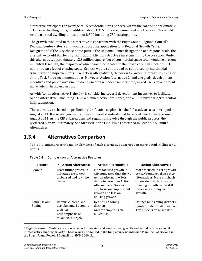
Table 1‐1 summarizes the major elements of each alternative described in more detail in Chapter 2 of this EIS.
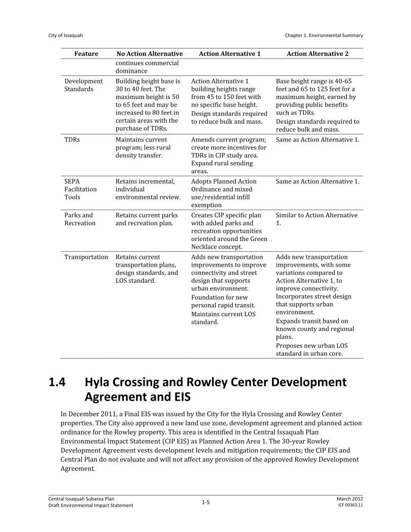
Table 1‐1. Comparison of Alternative Features
Feature No Action Alternative Action Alternative 1 Action Alternative 2
Growth Least future growth in CIP study area. Most disbursed and low rise pattern.
More focused growth in CIP study area than the No Action Alternative; less dense in core than Action Alternative 2. Greater emphasis on employment growth and less on housing growth.
More focused in core growth center boundary than other alternatives. More emphasis on residential density and housing growth, while still increasing employment growth.
Land Use and Zoning
Retains current land use plan and 11 zoning districts. Less emphasis on mixed use; largely
Defines 12 zoning districts. Greater emphasis on mixed use.
Defines nine zoning districts. Similar to Action Alternative 1 with focus on mixed use.
2 Regional Growth Centers are areas of focus for housing and employment growth and would receive regional infrastructure funding priority. These would be adopted in the King County Countywide Planning Policies and in the Puget Sound Regional Council’s VISION 2040 plan.
City of Issaquah Chapter 1. Environmental Summary
Central Issaquah Subarea Plan Draft Environmental Impact Statement
1‐5 March 2012ICF 00363.11
Feature No Action Alternative Action Alternative 1 Action Alternative 2 continues commercial dominance
Development Standards
Building height base is 30 to 40 feet. The maximum height is 50 to 65 feet and may be increased to 80 feet in certain areas with the purchase of TDRs.
Action Alternative 1 building heights range from 45 to 150 feet with no specific base height. Design standards required to reduce bulk and mass.
Base height range is 40‐65 feet and 65 to 125 feet for a maximum height, earned by providing public benefits such as TDRs. Design standards required to reduce bulk and mass.
TDRs Maintains current program; less rural density transfer.
Amends current program; create more incentives for TDRs in CIP study area. Expand rural sending areas.
Same as Action Alternative 1.
SEPA Facilitation Tools
Retains incremental, individual environmental review.
Adopts Planned Action Ordinance and mixed use/residential infill exemption
Same as Action Alternative 1.
Parks and Recreation
Retains current parks and recreation plan.
Creates CIP specific plan with added parks and recreation opportunities oriented around the Green Necklace concept.
Similar to Action Alternative 1.
Transportation Retains current transportation plans, design standards, and LOS standard.
Adds new transportation improvements to improve connectivity and street design that supports urban environment. Foundation for new personal rapid transit. Maintains current LOS standard.
Adds new transportation improvements, with some variations compared to Action Alternative 1, to improve connectivity. Incorporates street design that supports urban environment. Expands transit based on known county and regional plans. Proposes new urban LOS standard in urban core.
1.4 Hyla Crossing and Rowley Center Development Agreement and EIS
In December 2011, a Final EIS was issued by the City for the Hyla Crossing and Rowley Center properties. The City also approved a new land use zone, development agreement and planned action ordinance for the Rowley property. This area is identified in the Central Issaquah Plan Environmental Impact Statement (CIP EIS) as Planned Action Area 1. The 30‐year Rowley Development Agreement vests development levels and mitigation requirements; the CIP EIS and Central Plan do not evaluate and will not affect any provision of the approved Rowley Development Agreement.
City of Issaquah Chapter 1. Environmental Summary
Central Issaquah Subarea Plan Draft Environmental Impact Statement
1‐6 March 2012ICF 00363.11
Preparation of the Rowley Development Agreement and related EIS were well underway when the CIP EIS alternatives were scoped in July 2011. However, this CIP EIS has considered the Hyla Crossing and Rowley Center Project Planned Action EIS in the following ways:
The No Action Alternatives in both EISs take the same approach. Both consider impacts based on build‐out according to the existing Comprehensive Plan and Zoning and provide a common future “baseline” and lower bookend of development levels from which to measure impacts.
The Core Growth Center, Action Alternative 2, is the upper bookend of the CIP Alternatives. It assumes the growth consistent with the Preferred Alternative identified in the Hyla Crossing and Rowley Center Project Planned Action EIS, which ultimately was the alternative, approved in the Rowley Development Agreement and planned action ordinance.3
The CIP EIS references appropriate environmental information about Planned Action Area 1 from the Hyla Crossing and Rowley Center Project Planned Action EIS.
For these reasons, the CIP EIS is consistent with the prior planning and approvals for the Rowley property (Planned Action Area 1). However, because the Alternatives’ land use maps for the CIP EIS were prepared prior to approval of the Rowley Development Agreement, they do not reflect the land use map designation and zoning approved in the final development agreement. This inconsistency will be clarified in the CIP Final EIS later this summer when the maps for CIP Preferred Alternative are prepared and include the land use map designation and zoning approved in the development agreement for Planned Action Area 1.
1.5 Environmental Review
1.5.1 EIS Process and Purpose
The purpose of the environmental review in the EIS is to provide an analysis of the probable natural and built environment impacts of the Proposal and Alternatives and to identify appropriate mitigation measures. This Draft EIS is being made available to City decision makers, other agencies, and the public for review and comment for 30 days (see Fact Sheet). Following the comment period, the City will prepare a Final EIS that responds to comments and describes a preferred alternative that may be similar to a Draft EIS alternative or is in the range of studied alternatives.
SEPA (RCW 43.21C) requires government officials to consider the environmental consequences of actions they are about to take and better or less damaging ways to accomplish these proposals. The officials must consider whether the Proposal will have a probable significant adverse environmental impact on the natural and built environment.
The EIS considers potential environmental impacts in CIP study area at a programmatic level of detail. The adoption of comprehensive plans or other long‐range planning activities such as a subarea plan is classified by SEPA as a nonproject (i.e., programmatic) action. A nonproject action is defined as an action that is broader than a single site‐specific project, and involves decisions on policies, plans, and programs. An EIS for a nonproject proposal does not require site‐specific
3 The CIP EIS middle alternative – Task Force Recommendations – is based on work by the CIP Task Force for over a year prior to the approval of the agreements and ordinances for Planned Action Area 1. While the mix of uses is not the same as that approved in the Hyla Crossing and Rowley Center Project Planned Action it reflects the discussions of the Task Force at the time.
City of Issaquah Chapter 1. Environmental Summary
Central Issaquah Subarea Plan Draft Environmental Impact Statement
1‐7 March 2012ICF 00363.11
analyses; instead, the EIS discusses impacts and alternatives appropriate to the scope of the nonproject proposal and to the level of planning for the proposal (WAC 197‐11‐442).
Further, portions of the study area that are considered for a planned action and infill exemption are highlighted, and sufficient analysis and mitigation measures are proposed to allow future project expedited environmental review when consistent with ordinance thresholds and mitigation measures.
1.5.2 Prior Environmental Review
Recent SEPA analysis in the CIP study area includes the separate Hyla Crossing and Rowley Center Project Planned Action Draft Environmental Impact Statement issued August 2011 and Hyla Crossing and Rowley Center Project Planned Action Final Environmental Impact Statement issued November 2011. Where appropriate, information from these documents is summarized in this EIS.
1.5.3 Scope of EIS Review
Pursuant to SEPA Rules (WAC 197‐11‐408), the City requested public and agency comment on the scope of the Draft EIS. This was accomplished through publication of a Determination of Significance (DS)/Scoping Notice on in June 22, 2011 (see Appendix A of the Draft EIS). Interested citizens, agencies, organizations, and affected tribes were invited to submit comments on the scope of the DEIS during the scoping period, which closed on July 22, 2011. During this period, the City solicited public comment through a July 13, 2011 open house meeting.
This EIS analyzes, at a programmatic level, the potential impacts on the following elements of the environment identified through the scoping process.
Air Quality,
Water Resources/Stormwater,
Natural Environment,
Land Use (both patterns and policies),
Aesthetics,
Transportation, and
Public Services and Utilities
1.5.4 SEPA Tools
1.5.4.1 Planned Action
The City proposes to designate a portion of the CIP study area (Planned Action Area 2) as a planned action, pursuant to SEPA and implementing rules. According to Washington Administrative Code (WAC) 197‐11‐164, a planned action is defined as a project that has the following characteristics:
is designated a planned action by ordinance;
has had significant environmental impacts addressed in an EIS;
City of Issaquah Chapter 1. Environmental Summary
Central Issaquah Subarea Plan Draft Environmental Impact Statement
1‐8 March 2012ICF 00363.11
has been prepared in conjunction with a comprehensive plan, subarea plan, master planned development, a phased project, or with subsequent or implementing projects of any of these categories;
is located within an urban growth area;
is not an essential public facility; and
is consistent with an adopted comprehensive plan.
Review of a planned action is intended to be simpler and more focused than for other projects. If the planned action ordinance is adopted, the City would follow the applicable procedures contained in the ordinance to determine if the proposed project impacts are consistent with the Planned Action EIS. When a permit application and environmental checklist are submitted for a project that is being proposed as a planned action project, the City must first verify the following:
The project meets the description of any project(s) designated as a planned action by ordinance or resolution.
The probable significant adverse environmental impacts were adequately addressed in the EIS.
The project includes any conditions or mitigation measures outlined in the ordinance or resolution.
If the project meets the above requirements, the project qualifies as a planned action project and a SEPA threshold determination is not required. However, the following City actions (i.e., the permit process) are still applicable (this permit process is illustrated in scoping materials in Appendix A):
The project must continue through the City’s permit process pursuant to any notices and other requirements contained in the City’s development regulations.
The project must still be analyzed for consistency with the City’s zoning and development regulations.
Designation of a planned action project does not limit the City from using other authority (e.g., a conditional use permit) to place conditions on a project. The City may still use applicable laws or regulations to impose conditions on a project qualifying as a planned action project.
Public notice for a planned action project is tied to the underlying permit. If notice is otherwise required for the underlying permit, then the notice will indicate that the project qualifies as a planned action.
The manner in which the City would monitor the development levels approved in the Planned Action Area would likely be as follows:
Determine if the proposed land uses are within categories of land use studied in the EIS,
Establish the maximum development potential within the Planned Action Area as reviewed in the EIS. Development potential can be expressed in terms of total vehicle trips, square feet of development, or other methods.
As specific development is proposed, deduct from the Planned Action Area’s development potential. The planned action ordinance would establish how methods of measuring projected development capacity relate to one another if more than one method is used.
City of Issaquah Chapter 1. Environmental Summary
Central Issaquah Subarea Plan Draft Environmental Impact Statement
1‐9 March 2012ICF 00363.11
Appendix B contains a draft of the planned action ordinance including the information on the draft process and the parameters used to determine consistency with EIS assumptions.
1.5.4.2 Infill Exemption
SEPA allows a categorical exemption for new residential or mixed use development if the development is within a UGA and current density/intensity of use is lower than called for in the goals and polices of the comprehensive plan, provided the plan was previously subjected to environmental analysis through an EIS. This mixed use/infill exemption is proposed for application in Areas Outside of the Planned Actions. The criteria for the exemption are listed below.
Must be limited to new residential or mixed use development within a designated UGA.
Existing density/intensity of use in the UGA must be lower than that called for in the comprehensive plan.
An EIS must have been completed for the adoption of the comprehensive plan.
Proposed development must not exceed the density/intensity of use called for in the comprehensive plan.
It is anticipated that the SEPA exemption will be administered generally according to the steps shown below.
Create a “bank” of dwelling units and square footage/employees assumed and/or of traffic trips.
Individual residential/mixed use development proposals within the defined location may use trips up to the maximum in the “bank” on a first‐come first‐served basis.
Like the general SEPA thresholds for minor new construction, the mixed use/infill exemption will not apply in the following circumstances.
The proposal is a segment of a proposal that contains both exempt and non‐exempt actions.
The jurisdiction determines that the proposal includes a series of non‐exempt actions that cumulatively have a probable significant adverse impact.
The proposal is in a critical area where the jurisdiction has eliminated categorical exemptions for proposals in critical areas.
Additional guidelines may apply. A draft of the infill exemption regulations is provided in Appendix B.
1.6 Potential Impacts
1.6.1 Summary by Topic
This section summarizes impacts by environmental topic. For a complete description, please see Chapter 3, Affected Environment, Impacts, and Mitigation. Additional comparisons of impacts by alternative are shown in Section 1.6.2.
City of Issaquah Chapter 1. Environmental Summary
Central Issaquah Subarea Plan Draft Environmental Impact Statement
1‐10 March 2012ICF 00363.11
1.6.1.1 Air Quality/Greenhouse Gas Emissions
Current air quality regulations would prevent new developments and commercial facilities within the CIP study area from generating unacceptable air pollutant emissions that would affect nearby areas during construction or operation. Because all of the alternatives would increase population and commercial space in the CIP study area, the air pollutant emissions generated within the CIP study area are expected to increase. Similarly, regional vehicle miles traveled (VMT) by vehicles used City residents and those who work in the City would also increase in the CIP study area, along with the tailpipe emissions generated by those vehicles. However, the VMT generated by the new homes and businesses in the CIP study area would be a small fraction of the overall VMT generated within the Puget Sound region, so it is unlikely that any of the alternatives would significantly affect regional air quality.
GHG emissions in the CIP study area would increase for all alternatives as a result of increased population and business growth. However, on a per‐dwelling and per‐square‐foot basis, the GHG emissions in the City have historically been much lower than the county‐wide average. Therefore, for all alternatives the GHG emission increase within the CIP would likely be more than offset by avoidance of the higher GHG emissions that otherwise would have occurred elsewhere in the Puget Sound region. Therefore, GHG impacts caused by increased development in the CIP study area would not be significant.
1.6.1.2 Water Resources/Stormwater
Redevelopment in the CIP study area is expected to improve water quality for all alternatives in comparison to existing conditions. Improved water quality is expected because redevelopment would include stormwater treatment for areas that are currently impervious, but do not have treatment or do not have treatment to modern standards. Any increase in pollutants generated because of an increase in impervious cover associated with the redevelopment allowed in all alternatives would be more than offset by having a greater amount of total runoff from the area treated with modern BMPs.
For this analysis, proposed zoning was used to estimate future impervious land cover. This was compared to existing impervious land cover and soils in the CIP study area, and current stormwater treatment regulations were used to make a general projection of how future redevelopment under each alternative could affect stormwater quality. These impervious surface calculations are shown in Section 1.6.2 and vary by alternative. Generally, increases in impervious surfaces could be offset to some degree by the implementation of critical area buffers as redevelopment occurs, added park space, and streetscape improvements.
It was assumed that ground‐disturbing construction activities associated with redevelopment would require construction‐related erosion‐control BMPs and other pollution prevention measures using the current City requirements. Construction‐related activities have the potential to contribute pollutants to runoff and the construction BMPs would be implemented to reduce pollutants and minimize risk. Given the programmatic nature of this analysis, all alternatives would have similar potential for construction‐related water‐quality impacts because all alternatives would include similar amounts of ground‐disturbing construction activity and would employ the same erosion control BMPs and pollution prevention methods.
City of Issaquah Chapter 1. Environmental Summary
Central Issaquah Subarea Plan Draft Environmental Impact Statement
1‐11 March 2012ICF 00363.11
1.6.1.3 Natural Resources
Because a large proportion of the CIP study area is either currently developed, or protected through existing regulations, changes in natural resources would be modest under either alternative. However, redevelopment could result in higher building density and greater impervious surface area under either action alternative. Impervious surface area would be highest under Action Alternative 2. However, stormwater management would limit the effects of impervious surface area on stream habitat and water quality. Riparian buffers would be maintained under all alternatives, and the wildlife habitat and migration corridors that they support would continue under all alternatives.
1.6.1.4 Land Use
Analysis in this section finds that the existing suburban character of the area would change to a higher density development under all alternatives. All alternatives would affect the area as a result of redevelopment. The action alternatives would result in more impacts as they both would increase land use density and intensity and building heights and bulk. Both action alternatives would result in increased employment and housing opportunities within the CIP study area. Some land use impacts would be common under both action alternatives, such as impacts from construction and redevelopment activities, and operational impacts such as changes and displacement of businesses to fit in the mixed‐use, pedestrian‐oriented character. The action alternatives would also affect existing plans and policies because the higher land use intensity would not be consistent with the existing land use assumptions in the City’s Comprehensive Plan.
Both action alternatives would mitigate adverse impacts on land use by incorporating plan features such as improved built environment with mixed‐use and pedestrian activities, superior building design, enhanced streetscape and natural environment, and improved public facilities and multimodal transportation. Increased housing and employment within the CIP study area would itself mitigate development impacts because this would reduce traffic and create a live‐work environment. The action alternatives reduce the impact of increased urbanization by promoting the Green Necklace concept to provide for open space and improve ecological functions over existing conditions.
Both action alternatives incorporate policies and development standards that would improve the overall land use pattern of the CIP study area. Action Alternative 2 includes specific goals and policies to mitigate development impacts. In general, these goals and policies are consistent with the current Comprehensive Plan's goals and policies. The growth assumptions are consistent with the regional planning goals as well. The land use assumptions under the action alternatives would be incorporated in the Comprehensive Plan and zoning documents during the adoption process that would ensure consistency. The proposed design standards for the CIP study area and all relevant municipal codes would ensure additional mitigation. Additional mitigation measures are also recommended in this section. In general, all adverse impacts resulting from the action alternatives could be mitigated.
1.6.1.5 Aesthetics
The impact analysis finds that the overall visual character would be changed under all alternatives because the CIP study area would largely redevelop. All alternatives, and particularly the action alternatives, would increase building heights and bulk. In the two action alternatives, developments
City of Issaquah Chapter 1. Environmental Summary
Central Issaquah Subarea Plan Draft Environmental Impact Statement
1‐12 March 2012ICF 00363.11
would result in high intensity, compact, and pedestrian‐oriented mixed‐use environment. Some impacts would be common in both action alternatives, such as impacts from construction and redevelopment activities, operational impact such as changes and displacement of businesses to fit in the mixed‐use pedestrian‐oriented character, and overall shift in the visual character from auto‐oriented suburban to pedestrian‐oriented mixed‐use environment.
Adverse impacts on aesthetics would be mitigated by the incorporated plan features such as improved built environment with mixed‐use and pedestrian activities, superior building design, enhanced streetscape and improved natural environment. The plan mitigates the impact of increased urbanization as it places the Green Necklace within the urban area that improves ecological functions over existing condition. Both action alternatives incorporate policies and development standards that would improve the aesthetic condition of the CIP study area. Action Alternative 2 has identified specific policies aimed to improve the visual quality of the area. The proposed design standards for the CIP study area and all relevant municipal codes would ensure additional mitigation.
In addition to mitigations that are part of the action alternatives and current regulations, other mitigation measures can be considered such as adding specificity in certain development standards, introducing standards for Mountains To Sound Greenway overlay, identifying and preserving specific view corridors, and introducing incentives to promote green roofs. Overall, all adverse impacts on aesthetic can be mitigated as discussed in this section.
1.6.1.6 Transportation
Future development of land use within the Subarea that occurs under the No Action Alternative will cause traffic volumes on all roads within and into the Subarea to increase significantly in the No Action Alternative compared to existing conditions. With changes in land use development and additional roadway and nonmotorized infrastructure assumed in Action Alternative 1 that helps support increased transit usage, traffic volumes at roads into the CIP study area would stay relatively the same as the No Action Alternative. New road connections in the Pickering area created in Action Alternative 1 cause traffic volumes to decrease at some key bottleneck locations within the Subarea, such as SR 900 at I‐90 and East Lake Sammamish Parkway at SE 56th Street. The combination of mixed‐use development with a higher residential component concentrated in the Core Growth Center area in Action Alternative 2 causes traffic volumes at roads within and into the Subarea to be slightly lower than in both the No Action Alternative and Action Alternative 1.
Impacts to intersections within the CIP study area are highest in the No Action Alternative, with 19 intersections failing the City’s concurrency threshold of LOS D. In addition, travel time along all major arterials within the CIP study area increases anywhere from 18% to 149% in the No Action Alternative compared to existing conditions. In Action Alternative 1, the number of intersections that fails the City’s concurrency threshold decreases to 5 locations, and all intersections decrease in average delay per vehicle compared to the No Action Alternative. Travel times along most major arterials decreases by 20% to 46% in Action Alternative 1 when compared to the No Action Alternative, except for NW Gilman Boulevard. Action Alternative 2 has the least amount of impacts to intersections, with only 2 locations failing the City’s concurrency threshold. Travel times along most major arterials are lower in Action Alternative 2 when compared to the No Action Alternative or Action Alternative 1.
City of Issaquah Chapter 1. Environmental Summary
Central Issaquah Subarea Plan Draft Environmental Impact Statement
1‐13 March 2012ICF 00363.11
The No Action Alternative would cause construction impacts associated with the completion of all 14 projects within the City’s 2011‐2016 TIP by the horizon year of 2030. However, there would be additional construction impacts in both Action Alternative 1 and 2 related to the completion of 17 additional transportation projects assumed to be completed by the same horizon year of 2030.
1.6.1.7 Public Services and Utilities
In general, all public services and utilities would experience an increase in demand for service. Action Alternative 2, having the greatest growth, is expected to result in the greatest service demand, followed by Action Alternative 1. While the No Action Alternative is largely addressed in current City plans, not all functional plans have anticipated the same level of growth that is expected with the No Action Alternative. Regular capital improvement plan updates together with impact fees and other mitigation measures can mitigate impacts. In addition, the Green Necklace concept can mitigate some parks and recreation impacts.
1.6.2 Summary of Impacts by Alternative
Table 1‐2 summarizes unique impacts of each alternative by environmental topic. The discussion is intentionally brief, and the reader is encouraged to read the full discussion of impacts in Chapter 3, Affected Environment, Impacts, and Mitigation, in the context of the affected environment and impact analysis. Mitigation measures would be applied as noted in Section 1.6 and Chapter 3, Affected Environment, Impacts, and Mitigation.
City of Issaquah Chapter 1. Environmental Summary
Central Issaquah Subarea Plan Draft Environmental Impact Statement
1‐14 March 2012ICF 00363.11
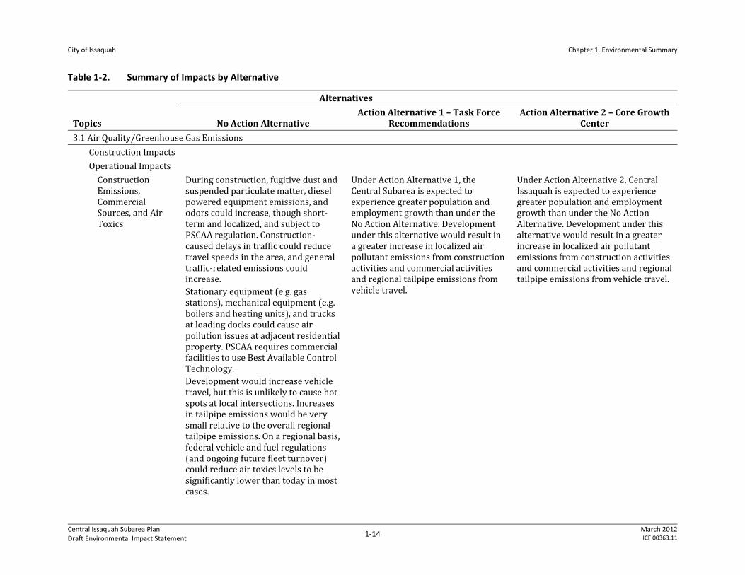
Table 1‐2. Summary of Impacts by Alternative
Topics
Alternatives
No Action Alternative Action Alternative 1 – Task Force
Recommendations Action Alternative 2 – Core Growth
Center
3.1 Air Quality/Greenhouse Gas Emissions
Construction Impacts
Operational Impacts
Construction Emissions, Commercial Sources, and Air Toxics
During construction, fugitive dust and suspended particulate matter, diesel powered equipment emissions, and odors could increase, though short‐term and localized, and subject to PSCAA regulation. Construction‐caused delays in traffic could reduce travel speeds in the area, and general traffic‐related emissions could increase. Stationary equipment (e.g. gas stations), mechanical equipment (e.g. boilers and heating units), and trucks at loading docks could cause air pollution issues at adjacent residential property. PSCAA requires commercial facilities to use Best Available Control Technology. Development would increase vehicle travel, but this is unlikely to cause hot spots at local intersections. Increases in tailpipe emissions would be very small relative to the overall regional tailpipe emissions. On a regional basis, federal vehicle and fuel regulations (and ongoing future fleet turnover) could reduce air toxics levels to be significantly lower than today in most cases.
Under Action Alternative 1, the Central Subarea is expected to experience greater population and employment growth than under the No Action Alternative. Development under this alternative would result in a greater increase in localized air pollutant emissions from construction activities and commercial activities and regional tailpipe emissions from vehicle travel.
Under Action Alternative 2, Central Issaquah is expected to experience greater population and employment growth than under the No Action Alternative. Development under this alternative would result in a greater increase in localized air pollutant emissions from construction activities and commercial activities and regional tailpipe emissions from vehicle travel.
City of Issaquah Chapter 1. Environmental Summary
Central Issaquah Subarea Plan Draft Environmental Impact Statement
1‐15 March 2012ICF 00363.11
Topics
Alternatives
No Action Alternative Action Alternative 1 – Task Force
Recommendations Action Alternative 2 – Core Growth
Center
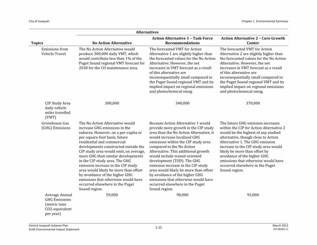
Emissions from Vehicle Travel
The No Action Alternative would produce 300,000 daily VMT, which would contribute less than 1% of the Puget Sound regional VMT forecast for 2030 for the CO maintenance area.
The forecasted VMT for Action Alternative 1 are slightly higher than the forecasted values for the No Action Alternative. However, the net increases in VMT forecast as a result of this alternative are inconsequentially small compared to the Puget Sound regional VMT and its implied impact on regional emissions and photochemical smog.
The forecasted VMT for Action Alternative 2 are slightly higher than the forecasted values for the No Action Alternative. However, the net increases in VMT forecast as a result of this alternative are inconsequentially small compared to the Puget Sound regional VMT and its implied impact on regional emissions and photochemical smog.
CIP Study Area daily vehicle miles travelled (VMT)
300,000 340,000 370,000
Greenhouse Gas (GHG) Emissions
The No Action Alternative would increase GHG emissions in the subarea. However, on a per‐capita or per‐square‐foot basis, future residential and commercial developments constructed outside the CIP study area would emit, on average, more GHG than similar developments in the CIP study area. The GHG emission increase in the CIP study area would likely be more than offset by avoidance of the higher GHG emissions that otherwise would have occurred elsewhere in the Puget Sound region.
Because Action Alternative 1 would provide more growth in the CIP study area than the No Action Alternative, it would increase localized GHG emissions within the CIP study area compared to the No Action Alternative. This additional growth would include transit oriented development (TOD). The GHG emission increase in the CIP study area would likely be more than offset by avoidance of the higher GHG emissions that otherwise would have occurred elsewhere in the Puget Sound region.
The future GHG emission increases within the CIP for Action Alternative 2 would be the highest of any studied alternative, though close to Action Alternative 1. The GHG emission increase in the CIP study area would likely be more than offset by avoidance of the higher GHG emissions that otherwise would have occurred elsewhere in the Puget Sound region.
Average Annual GHG Emissions (metric tons CO2‐equivalent per year)
59,000 90,000 93,000
City of Issaquah Chapter 1. Environmental Summary
Central Issaquah Subarea Plan Draft Environmental Impact Statement
1‐16 March 2012ICF 00363.11
Topics
Alternatives
No Action Alternative Action Alternative 1 – Task Force
Recommendations Action Alternative 2 – Core Growth
Center
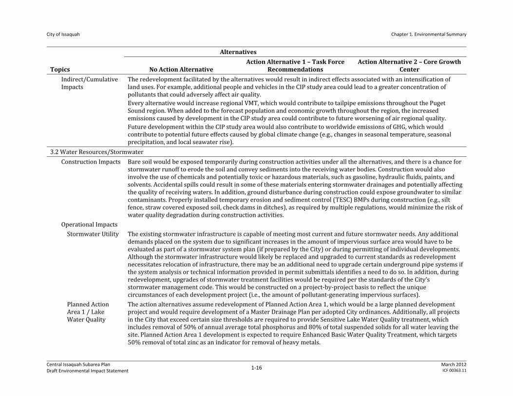
Indirect/Cumulative Impacts
The redevelopment facilitated by the alternatives would result in indirect effects associated with an intensification of land uses. For example, additional people and vehicles in the CIP study area could lead to a greater concentration of pollutants that could adversely affect air quality. Every alternative would increase regional VMT, which would contribute to tailpipe emissions throughout the Puget Sound region. When added to the forecast population and economic growth throughout the region, the increased emissions caused by development in the CIP study area could contribute to future worsening of air regional quality. Future development within the CIP study area would also contribute to worldwide emissions of GHG, which would contribute to potential future effects caused by global climate change (e.g., changes in seasonal temperature, seasonal precipitation, and local seawater rise).
3.2 Water Resources/Stormwater
Construction Impacts Bare soil would be exposed temporarily during construction activities under all the alternatives, and there is a chance for stormwater runoff to erode the soil and convey sediments into the receiving water bodies. Construction would also involve the use of chemicals and potentially toxic or hazardous materials, such as gasoline, hydraulic fluids, paints, and solvents. Accidental spills could result in some of these materials entering stormwater drainages and potentially affecting the quality of receiving waters. In addition, ground disturbance during construction could expose groundwater to similar contaminants. Properly installed temporary erosion and sediment control (TESC) BMPs during construction (e.g., silt fence, straw covered exposed soil, check dams in ditches), as required by multiple regulations, would minimize the risk of water quality degradation during construction activities.
Operational Impacts
Stormwater Utility The existing stormwater infrastructure is capable of meeting most current and future stormwater needs. Any additional demands placed on the system due to significant increases in the amount of impervious surface area would have to be evaluated as part of a stormwater system plan (if prepared by the City) or during permitting of individual developments. Although the stormwater infrastructure would likely be replaced and upgraded to current standards as redevelopment necessitates relocation of infrastructure, there may be an additional need to upgrade certain underground pipe systems if the system analysis or technical information provided in permit submittals identifies a need to do so. In addition, during redevelopment, upgrades of stormwater treatment facilities would be required per the standards of the City’s stormwater management code. This would be constructed on a project‐by‐project basis to reflect the unique circumstances of each development project (i.e., the amount of pollutant‐generating impervious surfaces).
Planned Action Area 1 / Lake Water Quality
The action alternatives assume redevelopment of Planned Action Area 1, which would be a large planned development project and would require development of a Master Drainage Plan per adopted City ordinances. Additionally, all projects in the City that exceed certain size thresholds are required to provide Sensitive Lake Water Quality treatment, which includes removal of 50% of annual average total phosphorus and 80% of total suspended solids for all water leaving the site. Planned Action Area 1 development is expected to require Enhanced Basic Water Quality Treatment, which targets 50% removal of total zinc as an indicator for removal of heavy metals.
City of Issaquah Chapter 1. Environmental Summary
Central Issaquah Subarea Plan Draft Environmental Impact Statement
1‐17 March 2012ICF 00363.11
Topics
Alternatives
No Action Alternative Action Alternative 1 – Task Force
Recommendations Action Alternative 2 – Core Growth
Center
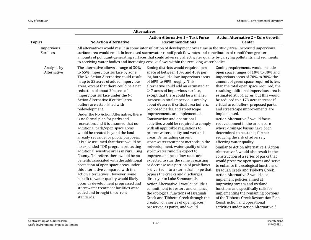
Impervious Surfaces
All alternatives would result in some intensification of development over time in the study area. Increased impervious surface area would result in increased stormwater runoff peak flow rates and contribution of runoff from greater amounts of pollutant‐generating surfaces that could adversely affect water quality by carrying pollutants and sediments to receiving water bodies and increasing erosive flows within the receiving water bodies.
Analysis by Alternative
The alternative allows a range of 30% to 65% impervious surface by zone. The No Action Alternative could result in up to 53 acres of added impervious areas, except that there could be a net reduction of about 20 acres of impervious surface under the No Action Alternative if critical area buffers are established with redevelopment. Under the No Action Alternative, there is no formal plan for parks and recreation, and it is assumed that no additional park/open space areas would be created beyond the land already set aside for public purposes. It is also assumed that there would be no expanded TDR program protecting additional sensitive areas in rural King County. Therefore, there would be no benefits associated with the additional protection of open space areas under this alternative compared with the action alternatives. However, some benefit to water quality would likely occur as development progressed and stormwater treatment facilities were added and brought to current standards.
Zoning districts would require open space of between 10% and 40% per lot, but would allow impervious areas of 60% to 90% roughly. This alternative could add an estimated at 247 acres of impervious surface, except that there could be a smaller increase in total impervious area by about 69 acres if critical area buffers, proposed parks, and streetscape improvements are implemented. Construction and operational activities would be required to comply with all applicable regulations to protect water quality and wetland areas. By including current stormwater treatment methods in the redevelopment, water quality of the stormwater runoff is expect to improve, and peak flow rates are expected to stay the same as existing or decrease as a portion of peak flows is diverted into a storm drain pipe that bypass the creeks and discharges directly into Lake Sammamish. Action Alternative 1 would include a commitment to restore and enhance the ecological functions of Issaquah Creek and Tibbetts Creek through the creation of a series of open spaces preserved as parks, and would
Zoning requirements would include open space ranges of 10% to 30% and impervious areas of 70% to 90%; the amount of green space required is less than the total open space required; the resulting additional impervious area is estimated at 351 acres, but this would be reduced to a 173‐acre increase if critical area buffers, proposed parks, and streetscape improvements are implemented. Action Alternative 2 would focus redevelopment in the urban core where drainage basins have been determined to be stable, further reducing the risk of adversely affecting water quality. Similar to Action Alternative 1, Action Alternative 2 would also result in the construction of a series of parks that would preserve open spaces and serve to enhance the ecological functions of Issaquah Creek and Tibbetts Creek. Action Alternative 2 would also implement policies aimed at improving stream and wetland functions and specifically calls for implementing the remaining portions of the Tibbetts Creek Restoration Plan. Construction and operational activities under Action Alternative 2

City of Issaquah Chapter 1. Environmental Summary
Central Issaquah Subarea Plan Draft Environmental Impact Statement
1‐18 March 2012ICF 00363.11
Topics
Alternatives
No Action Alternative Action Alternative 1 – Task Force
Recommendations Action Alternative 2 – Core Growth
Center promote other parks as well. In addition, Action Alternative 1 would provide for TDRs from additional designated sending sites in rural King County to the CIP study area. By promoting landscaping in the public realm and limiting further development in public open space or critical environmental areas such as parks, wetlands, and forested areas, vegetated ground cover and soils could help to intercept stormwater runoff from impervious surface area to decrease erosion and pollutants to the receiving surface water bodies.
would also be required to comply with all applicable regulations to protect water quality and wetlands. By including current stormwater treatment methods in the redevelopment, water quality of the stormwater runoff is expected to improve, and peak flow rates are expected to stay the same as existing or decrease. Action Alternative 2 would also provide for additional park areas and for TDRs from new sending sites in rural King County to the CIP study area, with similar benefits as described for Action Alternative 1.
Indirect/Cumulative Impacts
The redevelopment facilitated by the alternatives would result in indirect effects associated with an intensification of land uses. For example, additional people and vehicles in the study area could lead to a greater concentration of pollutants that could adversely affect water quality. In addition, indirect effects on aquatic plants and animals associated could also occur as a result of being affected by adverse water quality. Because all of the alternatives have the potential to result in adverse effects on water resources associated primarily with increased stormwater from redevelopment, there is a potential for cumulative effects on water quality to occur. Specifically, increases in pollutant and sediment loading can further degrade water quality in receiving waters. However, as noted above, water quality in the study area would likely be improved as a result of the future redevelopment facilitated by the action alternatives. This is because future redevelopment would be subject to comply with the most current applicable regulations that would result in improved water treatment facilities where there is currently significant impervious surface area but minimal treatment of runoff. In addition, it has been determined that much of the study area is comprised of stable drainage basins (Booth et al. 2011). This means that future redevelopment can discharge stormwater runoff at the same rate as existing developed areas, and the receiving streams would not be adversely impacted (e.g., erosion and sediment loading would not increase). All future redevelopment would be required to comply with applicable regulations enforced by the City to ensure that adequate detention was provided.
3.3 Natural Resources
Construction Impacts Under all of the alternatives construction could occur that would require ground disturbance and would temporarily increase the potential for sediment erosion and transport to streams and wetlands. However, all construction would be required to meet local building standards and National Pollutant Discharge and Elimination System (NPDES) construction permit requirements.
City of Issaquah Chapter 1. Environmental Summary
Central Issaquah Subarea Plan Draft Environmental Impact Statement
1‐19 March 2012ICF 00363.11
Topics
Alternatives
No Action Alternative Action Alternative 1 – Task Force
Recommendations Action Alternative 2 – Core Growth
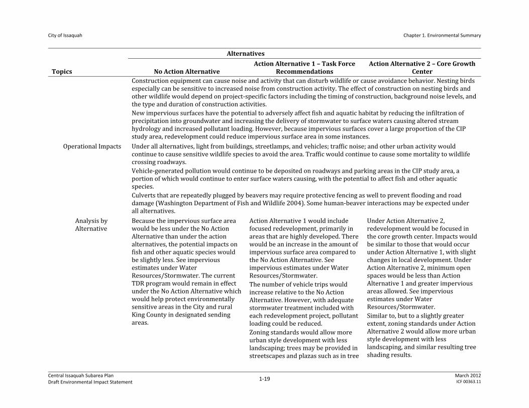
Center Construction equipment can cause noise and activity that can disturb wildlife or cause avoidance behavior. Nesting birds especially can be sensitive to increased noise from construction activity. The effect of construction on nesting birds and other wildlife would depend on project‐specific factors including the timing of construction, background noise levels, and the type and duration of construction activities. New impervious surfaces have the potential to adversely affect fish and aquatic habitat by reducing the infiltration of precipitation into groundwater and increasing the delivery of stormwater to surface waters causing altered stream hydrology and increased pollutant loading. However, because impervious surfaces cover a large proportion of the CIP study area, redevelopment could reduce impervious surface area in some instances.
Operational Impacts Under all alternatives, light from buildings, streetlamps, and vehicles; traffic noise; and other urban activity would continue to cause sensitive wildlife species to avoid the area. Traffic would continue to cause some mortality to wildlife crossing roadways. Vehicle‐generated pollution would continue to be deposited on roadways and parking areas in the CIP study area, a portion of which would continue to enter surface waters causing, with the potential to affect fish and other aquatic species. Culverts that are repeatedly plugged by beavers may require protective fencing as well to prevent flooding and road damage (Washington Department of Fish and Wildlife 2004). Some human‐beaver interactions may be expected under all alternatives.
Analysis by Alternative
Because the impervious surface area would be less under the No Action Alternative than under the action alternatives, the potential impacts on fish and other aquatic species would be slightly less. See impervious estimates under Water Resources/Stormwater. The current TDR program would remain in effect under the No Action Alternative which would help protect environmentally sensitive areas in the City and rural King County in designated sending areas.
Action Alternative 1 would include focused redevelopment, primarily in areas that are highly developed. There would be an increase in the amount of impervious surface area compared to the No Action Alternative. See impervious estimates under Water Resources/Stormwater. The number of vehicle trips would increase relative to the No Action Alternative. However, with adequate stormwater treatment included with each redevelopment project, pollutant loading could be reduced. Zoning standards would allow more urban style development with less landscaping; trees may be provided in streetscapes and plazas such as in tree
Under Action Alternative 2, redevelopment would be focused in the core growth center. Impacts would be similar to those that would occur under Action Alternative 1, with slight changes in local development. Under Action Alternative 2, minimum open spaces would be less than Action Alternative 1 and greater impervious areas allowed. See impervious estimates under Water Resources/Stormwater. Similar to, but to a slightly greater extent, zoning standards under Action Alternative 2 would allow more urban style development with less landscaping, and similar resulting tree shading results.
City of Issaquah Chapter 1. Environmental Summary
Central Issaquah Subarea Plan Draft Environmental Impact Statement
1‐20 March 2012ICF 00363.11
Topics
Alternatives
No Action Alternative Action Alternative 1 – Task Force
Recommendations Action Alternative 2 – Core Growth
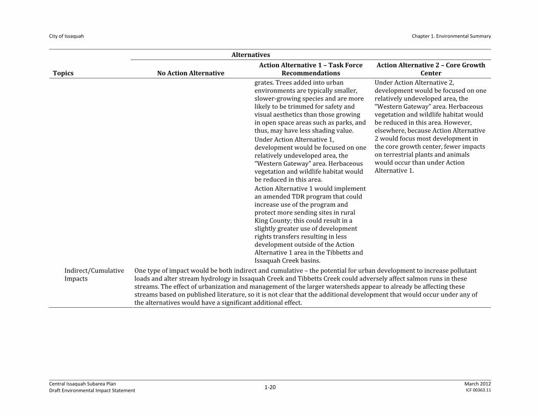
Center grates. Trees added into urban environments are typically smaller, slower‐growing species and are more likely to be trimmed for safety and visual aesthetics than those growing in open space areas such as parks, and thus, may have less shading value. Under Action Alternative 1, development would be focused on one relatively undeveloped area, the “Western Gateway” area. Herbaceous vegetation and wildlife habitat would be reduced in this area. Action Alternative 1 would implement an amended TDR program that could increase use of the program and protect more sending sites in rural King County; this could result in a slightly greater use of development rights transfers resulting in less development outside of the Action Alternative 1 area in the Tibbetts and Issaquah Creek basins.
Under Action Alternative 2, development would be focused on one relatively undeveloped area, the “Western Gateway” area. Herbaceous vegetation and wildlife habitat would be reduced in this area. However, elsewhere, because Action Alternative 2 would focus most development in the core growth center, fewer impacts on terrestrial plants and animals would occur than under Action Alternative 1.
Indirect/Cumulative Impacts
One type of impact would be both indirect and cumulative – the potential for urban development to increase pollutant loads and alter stream hydrology in Issaquah Creek and Tibbetts Creek could adversely affect salmon runs in these streams. The effect of urbanization and management of the larger watersheds appear to already be affecting these streams based on published literature, so it is not clear that the additional development that would occur under any of the alternatives would have a significant additional effect.
City of Issaquah Chapter 1. Environmental Summary
Central Issaquah Subarea Plan Draft Environmental Impact Statement
1‐21 March 2012ICF 00363.11
Topics
Alternatives
No Action Alternative Action Alternative 1 – Task Force
Recommendations Action Alternative 2 – Core Growth
Center
3.4 Land Use
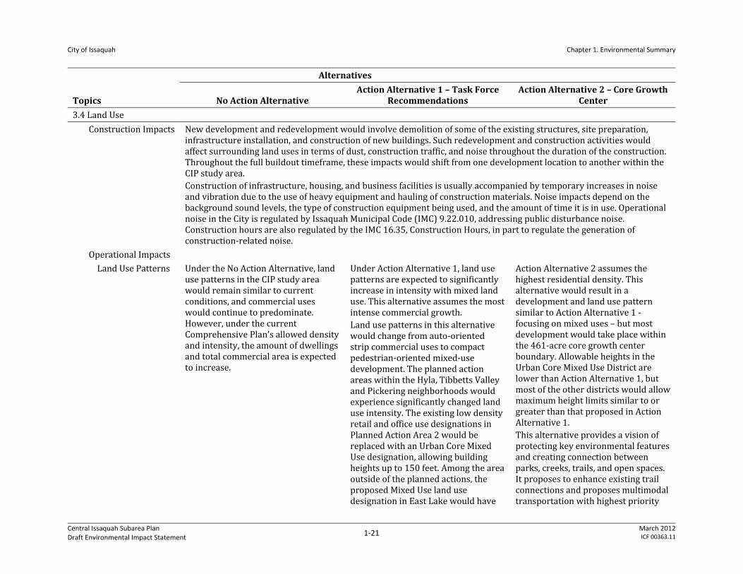
Construction Impacts New development and redevelopment would involve demolition of some of the existing structures, site preparation, infrastructure installation, and construction of new buildings. Such redevelopment and construction activities would affect surrounding land uses in terms of dust, construction traffic, and noise throughout the duration of the construction. Throughout the full buildout timeframe, these impacts would shift from one development location to another within the CIP study area. Construction of infrastructure, housing, and business facilities is usually accompanied by temporary increases in noise and vibration due to the use of heavy equipment and hauling of construction materials. Noise impacts depend on the background sound levels, the type of construction equipment being used, and the amount of time it is in use. Operational noise in the City is regulated by Issaquah Municipal Code (IMC) 9.22.010, addressing public disturbance noise. Construction hours are also regulated by the IMC 16.35, Construction Hours, in part to regulate the generation of construction‐related noise.
Operational Impacts
Land Use Patterns Under the No Action Alternative, land use patterns in the CIP study area would remain similar to current conditions, and commercial uses would continue to predominate. However, under the current Comprehensive Plan’s allowed density and intensity, the amount of dwellings and total commercial area is expected to increase.
Under Action Alternative 1, land use patterns are expected to significantly increase in intensity with mixed land use. This alternative assumes the most intense commercial growth. Land use patterns in this alternative would change from auto‐oriented strip commercial uses to compact pedestrian‐oriented mixed‐use development. The planned action areas within the Hyla, Tibbetts Valley and Pickering neighborhoods would experience significantly changed land use intensity. The existing low density retail and office use designations in Planned Action Area 2 would be replaced with an Urban Core Mixed Use designation, allowing building heights up to 150 feet. Among the area outside of the planned actions, the proposed Mixed Use land use designation in East Lake would have
Action Alternative 2 assumes the highest residential density. This alternative would result in a development and land use pattern similar to Action Alternative 1 ‐ focusing on mixed uses – but most development would take place within the 461‐acre core growth center boundary. Allowable heights in the Urban Core Mixed Use District are lower than Action Alternative 1, but most of the other districts would allow maximum height limits similar to or greater than that proposed in Action Alternative 1. This alternative provides a vision of protecting key environmental features and creating connection between parks, creeks, trails, and open spaces. It proposes to enhance existing trail connections and proposes multimodal transportation with highest priority
City of Issaquah Chapter 1. Environmental Summary
Central Issaquah Subarea Plan Draft Environmental Impact Statement
1‐22 March 2012ICF 00363.11
Topics
Alternatives
No Action Alternative Action Alternative 1 – Task Force
Recommendations Action Alternative 2 – Core Growth
Center the higher impact because of the 125‐foot allowable building height and availability of redevelopable land. Action Alternative 1 proposes the Green Necklace concept around its urban core, enhances existing parks and trails and proposes new parks and trail connections. This would connect Tibbetts Creek, Tibbetts Valley Park, Issaquah Creek, and Lake Sammamish State Park.
for transit and pedestrian mobility.
Land Use Compatibility
The current zoning and development regulations would guide the development character and heights are allowed up to 65 feet. Overall, building heights and bulk would be lower than the action alternatives. The City’s TDR program would increase development intensity within the CIP study area. This alternative would not require Comprehensive Plan amendments to the land use plan, or development regulation amendments.
Action Alternative 1 would have a greater likelihood of mixed uses than presently found. Redevelopment would particularly differ in terms of building form, height, bulk, and intensity. While the CIP study area transitions from a suburban to urban development pattern, there would be incompatibility between existing and new developments in terms of scale, building height, sidewalk width from one block or development to another. This alternative proposes a gradual increase in building height and bulk from the edge of the CIP study area to the center at the Urban Core. Therefore, the redeveloped scenario would have less incompatibility at the boundaries of the CIP study area with the surrounding land uses. The current TDR program could be used, which would further increase development intensity within the CIP
Similar to Action Alternative 1, Action Alternative 2 would also allow similar land uses that currently exist in the CIP study area, such as commercial, office, restaurants etc., though differing from the existing development pattern in terms of building form, height, bulk, and intensity. As discussed under Action Alternative 1, while this area transitions, there would be incompatibility between existing and new developments. Since most of the growth is expected to happen within the core growth center, the area outside of the planned actions would see relatively less development and may retain the existing suburban character for a longer timeframe than within the core growth center. An enhanced TDR program can be used in this alternative. Action Alternative 2 has identified base and maximum building heights for
City of Issaquah Chapter 1. Environmental Summary
Central Issaquah Subarea Plan Draft Environmental Impact Statement
1‐23 March 2012ICF 00363.11
Topics
Alternatives
No Action Alternative Action Alternative 1 – Task Force
Recommendations Action Alternative 2 – Core Growth
Center study area as most of the area contains receiving sites. This alternative would require Comprehensive Plan amendments to establish new land use designations. A new set of development standards would have to be adopted in the municipal code to implement new land use designations.
districts; its strategic growth and infrastructure investment would make more sites in this area eligible to receive TDR density. This alternative would require Comprehensive Plan amendments regarding new land use designations and a new set of development standards to implement them.
Employment and Housing Mix
Under the No Action Alternative, the CIP study area contributes nearly all of the City's planned employment capacity and a significant share of capacity to meet the citywide housing target.
Action Alternative 1 proposes the most intense commercial growth. Redevelopment under this alternative would see mixed‐use housing development in most of the neighborhoods. The addition of housing in the land use mix is expected to improve Central Issaquah’s economic vitality and support local businesses. Higher density and proximity between housing and jobs could attract more employers and businesses. The City has already demonstrated that it can meet the growth targets under the No Action Alternative. Alternative 1 would increase the City’s growth capacity above its targets, and would provide additional assurance that the Comprehensive Plan can provide capacity for future growth.
This alternative proposes moderate employment growth compared to Action Alternative 1 but offers the most intense residential growth. Additional capacity proposed in Action Alternative 2 would add significantly to the growth capacity of the City’s Comprehensive Plan and more than meet the City’s citywide growth target alone.
Plans and Policies Since the No Action Alternative is built on the City’s current Comprehensive Plan and existing regulatory framework, this alternative is not expected to alter plan and policy
The action alternatives—while consistent with most of the relevant goals and policies discussed previously—would be inconsistent with the Comprehensive Plan future land use map, density per acre and development character envisioned. The growth allocation under Action Alternative 1 is higher (2,900 units) than Comprehensive Plan’s estimated growth (2,000 units). Action
City of Issaquah Chapter 1. Environmental Summary
Central Issaquah Subarea Plan Draft Environmental Impact Statement
1‐24 March 2012ICF 00363.11
Topics
Alternatives
No Action Alternative Action Alternative 1 – Task Force
Recommendations Action Alternative 2 – Core Growth
Center consistency (however, see Section 3.7 of this EIS for a discussion of functional infrastructure plans).
Alternative 2 allocates a much higher housing growth (7,750 units) than the Comprehensive Plan’s estimate. Both Action Alternative 1 and Action Alternative 2 would provide additional assurance that the Comprehensive Plan can accommodate capacity for future growth. However, the Comprehensive Plan’s policies and assumptions would have to be revised and consistency and compatibility among all Comprehensive Plan elements would need to be maintained as required by GMA. Following is the list of possible impacts on the Comprehensive Plan and policies. Both action alternatives would require amendments to the adopted land use map. Land use for Planned Action Area 1 has already been changed to Urban Village during the 2010 amendment process, and development standards have been defined at the time of the development agreement and planned action ordinance approved in December 2011.
With the additional growth, the City’s Capital Facilities and Transportation Elements need to be updated to provide for appropriate capital improvement projects.
There would be impact on capital improvement plans. The 6‐year Capital Improvement Plan and Transportation Improvement Plan would need to be updated to match the City’s investment decision in the CIP study area.
The Comprehensive Plan Housing Element would also need to be updated to address additional dwelling units proposed under both action alternatives.
The City’s zoning map and development regulations would have to be revised to match with the appropriate land use designation.
The existing street classification system would have to be revised to incorporate proposed standards for the CIP study area.
Indirect/Cumulative Impacts
Over time the redevelopment under the action alternatives would transform the suburban nature of the CIP study area into an employment and mixed use center for the City. The intense development could increase impervious surface area on parcels, but it would focus more landscaping in the public realm, for example rights of way and public parks. Intense development would impact household and community lifestyles by introducing a live‐work‐play environment. While most of the targeted growth would be experienced within the CIP study area, other portions of the City could experience mixed use forms of development, although not at the same intensity. All studied alternatives propose lower heights and intensities at the southern and eastern portions of the CIP study area abutting other established neighborhoods.
City of Issaquah Chapter 1. Environmental Summary
Central Issaquah Subarea Plan Draft Environmental Impact Statement
1‐25 March 2012ICF 00363.11
Topics
Alternatives
No Action Alternative Action Alternative 1 – Task Force
Recommendations Action Alternative 2 – Core Growth
Center
3.5 Aesthetics
Construction Impacts As part of the potential redevelopment activities, there could be demolition of some of the existing structures, site preparation, infrastructure development, and construction of new buildings. Such redevelopment and construction activities would affect the visual character of the surrounding area throughout the duration of the construction. Throughout the full buildout timeframe, these impacts would shift from one development location to another within the CIP study area.
Operational Impacts
Visual Character Visual character under the No Action Alternative would primarily remain similar to current conditions. However, since the current regulations allow more building height and mixed use developments in some part of the CIP study area, the overall character would show increased density and building height under the full development capacity.
Development intensity is expected to increase significantly with mixed‐use developments. The suburban visual character would be altered with taller buildings, and surface parking would be replaced with structured parking. More intense development is expected around the SR‐900 and I‐90 interchange as opposed to outlying neighborhoods. There would be a stronger visual relationship between buildings and streetscape. The new compact pedestrian‐friendly mixed‐use environment would require wider sidewalks, street trees, street furnishings, and more human‐scaled visual details. Buildings would have prominent entrance, human scale signage, and canopies. Therefore, developments under this alternative would significantly change the visual character of the built environment. This alternative proposes the Green Necklace of open space and natural resources enhancing existing parks and trails and proposes new parks and trail connections. The visual impact
Similar to Action Alternative 1, the development intensity is expected to increase significantly with mixed use developments. The suburban visual character with strip commercial developments would be altered with mixed use development in taller buildings. The existing surface parking would be replaced with structured parking. Developments would include pedestrian‐oriented compact mixed‐use buildings. Action Alternative 2 assumes more residential density within the core growth area than Action Alternative 1. Because of higher residential density, the visual character of the area would demonstrate more pedestrian‐scale features and human activities. Similar to Action Alternative 1, this alternative proposes the Green Necklace of open space and natural resources around its “urban core” with similar visual effects. There would also be a variety of open spaces, e.g. urban plazas and courtyards.
City of Issaquah Chapter 1. Environmental Summary
Central Issaquah Subarea Plan Draft Environmental Impact Statement
1‐26 March 2012ICF 00363.11
Topics
Alternatives
No Action Alternative Action Alternative 1 – Task Force
Recommendations Action Alternative 2 – Core Growth
Center would be seen in wider trails, and connection of natural trails with urban areas. There would also be a variety of open spaces in the form of urban plazas and courtyards.
Height and Bulk Building heights would remain between 30 feet to 65 feet under the current regulations. Most of the existing single‐story commercial buildings are developed below their maximum allowable building height; therefore, over time redevelopment could result into increase in height and bulk though less than for action alternatives. Overall, buildings would show little variation in mass under full buildout condition. Due to the uniform building height throughout the area, transition with the vicinity of the CIP study area consisting of parks, open space, residential, and other low height structures would be abrupt.
Proposed height limits would range from 45 feet up to 150 feet. Because of the FAR limitations, the maximum heights proposed under Action Alternative 1 could not be applied throughout the entire site. Instead, there would be a variation in building height to concentrate maximum building height in one or two areas within the site. Overall, new developments would show significant increase in height and bulk compared to the No Action Alternative and Action Alternative 2. The most significant change would be visible in the Pickering and Tibbetts Valley neighborhoods where 65 feet building height under the No Action Alternative and 125 feet building height under Action Alternative 2 would be topped by building heights of 150 feet under Action Alternative 1. Building heights would graduate from 150 feet at the center to 125 feet in the Hyla and East Lake neighborhoods, 65 feet in the adjacent Sammamish, Darst Park and Gilman (portion) neighborhoods and finally to 45 feet in the outlying Western Gateway, Old Route 10, and Service
Proposed height limits under this alternative would range between 65 feet at the outlying neighborhoods to 125 feet at the urban core districts. Overall, more bulk would be shown in the core growth center. Similar to Action Alternative 1, the most significant change would be visible in the Pickering and Tibbetts Valley neighborhoods where 65 feet building height under the No Action Alternative would be topped by building heights of 125 feet. However, Action Alternative 2 would have lower building height than Action Alternative 1's 150‐foot building height. Compared to Action Alternative 1, Action Alternative 2 proposes greater building heights in the outlying areas. Overall, within the neighborhoods, building height transition is more gradual under Action Alternative 2 compared to Action Alternative 1. Compatibility with the perimeter of the CIP study area would be improved from the No Action Alternative because of FAR restrictions.
City of Issaquah Chapter 1. Environmental Summary
Central Issaquah Subarea Plan Draft Environmental Impact Statement
1‐27 March 2012ICF 00363.11
Topics
Alternatives
No Action Alternative Action Alternative 1 – Task Force
Recommendations Action Alternative 2 – Core Growth
Center neighborhoods. Building heights for outlying neighborhoods would be lowered under Action Alternative 1 compared to the No Action Alternative, and would result in better compatibility with the vicinity of the CIP study area consisting of parks, open space, residential and other low height structures.
View Corridors Impacts on view corridors will depend on the location of the viewer. The impact will be limited to commercial areas where height can increase up to 65 feet. In such cases, ridgeline views could be obstructed. Redevelopment under both action alternatives would place taller buildings in certain locations opening up view in between buildings, but under the No Action Alternative, building mass could entirely go up to 65 feet height with the exception of upper level setback required under the current zoning code. From some locations, redevelopment under the No Action Alternative would fully block the view while both action alternatives would have potential to offer partial view. However, in some locations, development could offer full ridgeline view as a result of lower building height.
View of the Issaquah Alps would be obstructed in places due to building heights. This would occur mostly in the core growth center where maximum building heights would be allowed. However, due to FAR limitations, taller buildings would be concentrated in a few locations opening up the mountain views in between tall buildings. The impact would be less in the outlying neighborhoods, such as in the Western Gateway and Old Route neighborhoods, where maximum height is proposed to be 45 feet. The intense developments in the CIP study area would also be visible from the surrounding developments to the south and north and from the I‐90 corridor as similar to the No Action Alternative and Action Alternative 2.
Views of the Issaquah Alps would be obstructed in places where taller buildings would be located. This would occur mostly in the core growth center where maximum building heights would be allowed. However, due to FAR limitations, taller buildings would be concentrated in a few locations preserving the mountain views in between buildings. The impact would be less in the outlying neighborhoods such as in Western Gateway and Old Route 10 neighborhoods. Intense developments in the CIP study area would also be visible from the surrounding developments to the south and north and from the I‐90 corridor similar to under the No Action Alternative and Action Alternative 1.
Light and Glare As properties redevelop, the net level of ambient light and glare would change from existing conditions.
As properties redevelop with significantly higher intensity under the Action Alternative 1, it is
As properties redevelop with significantly higher intensity under Action Alternative 2, it is anticipated
City of Issaquah Chapter 1. Environmental Summary
Central Issaquah Subarea Plan Draft Environmental Impact Statement
1‐28 March 2012ICF 00363.11
Topics
Alternatives
No Action Alternative Action Alternative 1 – Task Force
Recommendations Action Alternative 2 – Core Growth
Center While taller development would require an increase in structured parking, thus decreasing the amount of surface parking and associated exposed lighting, the increased density of development is likely to introduce more commercial, office, and retail uses, along with their associated external illumination and signage. A higher traffic volume would also generate increased automobile light. Automobile light would be less under the No Action Alternative compared to the action alternatives. The No Action Alternative would have more surface parking and glare compared to both of the action alternatives.
anticipated that the net level of ambient light and glare would significantly change from existing conditions. Increase in ambient light and glare are anticipated primarily in Planned Action Areas 1 and 2. Taller development would require an increase in structured parking, thus decreasing the amount of surface parking and associated exposed lighting. A higher traffic volume would also generate increased automobile light. Redevelopment under Action Alternative 1 would generate more automobile light within the Core Growth Area because it would accommodate more employment and traffic than under Action Alternative 2.
that the net level of ambient light and glare would significantly change from existing conditions. Increases in ambient light and glare are anticipated primarily in the Core Growth Area. Action Alternative 2 would have a lesser degree of automobile light compared to Action Alternative 1 because it would accommodate more housing within the Core Growth Area that would reduce vehicular traffic.
Indirect/Cumulative Impacts
As the area transforms overtime to a mixed‐use compact urban area, the aesthetic quality of the area would change as well. The area would see more human‐scale activity and less auto‐oriented activity; the overall aesthetic character of the area would promote human interaction. As developments are expected to reflect higher quality design, massing and building material, this would set the tone to the area as well as for the rest of the City's development.
3.6 Transportation
Construction Impacts Potential impacts that could result from construction activities include increased traffic volumes, increased delays, detour routes, and road closures. During construction, vehicles would be necessary to bring equipment and materials to the CIP Study Area. Large, oversized trucks could require pilot vehicles as they travel to and from the freeway with large loads. These trucks may also require flaggers to manually divert or control traffic as they enter or exit roadways (due to large turning radii). This traffic maintenance would cause delays for motorists. The City could require construction management plans at the time of development to reduce potential short‐term impacts. The City will work with its development applicants to oversee that appropriate coordination with affected agencies and property owners occurs upon future development. Within the city limits, future development will be subject to the City’s construction operation standards documented in City of Issaquah Street Standards. The City would provide appropriate public notification and detour routes upon development of its own capital improvement projects.
City of Issaquah Chapter 1. Environmental Summary
Central Issaquah Subarea Plan Draft Environmental Impact Statement
1‐29 March 2012ICF 00363.11
Topics
Alternatives
No Action Alternative Action Alternative 1 – Task Force
Recommendations Action Alternative 2 – Core Growth
Center
Analysis by Alternative
In the No Action Alternative, all projects included in the City’s 2011‐2016 Transportation Improvement Program are assumed to be constructed by 2030. This includes improvement projects for three intersections, eight roadway segments, and three nonmotorized facilities.
In addition to the transportation improvement projects with the No Action Alternative, there are 17 more projects assumed to be constructed in Action Alternative 1 by 2030. Specifically, Action Alternative 1 includes improvement projects for five additional intersections, the reconstruction of the I‐90/Front Street N interchange, seven new roadway connections, and four new nonmotorized facilities.
Action Alternative 2 assumes the same transportation network improvements as Action Alternative 1. Therefore, construction impacts related to transportation improvement projects in Action Alternative 2 are identical to Action Alternative 1.
Operational Impacts
PM Peak Hour Trips
Under the No Action Alternative, trips would increase in every origin‐destination category over existing conditions, including internal trips within the Subarea. However, the percent of trips that originate within the subarea compared to the total origin trips within the entire model stays relatively the same (20% in existing conditions compared to 22% in the No Action Alternative). The existing directional congestion seen during the peak period would be expected to worsen without attempts to balance the use of both sides of the road during peak periods. The No Action Alternative propagates this land use pattern, which translates to heavier operational and directional demands on the roadway system.
The mix of land uses in the subarea in Action Alternative 1 is planned in an effort to support more shared vehicle trips than in the No Action Alternative. With a shift to mixed‐use development where retail and employment are located closer together within the subarea, the number of internal trips (or trips that originate from and are destined to the Subarea) increases by 35% in Action Alternative 1 compared to the No Action Alternative. Residential units planned near retail and employment would also encourage a shift in travel mode, from vehicle traffic to nonmotorized modes within a walkable environment, in Action Alternative 1 compared to the No Action Alternative.
The increase in residential units and commercial square footage in Action Alternative 2 within a walkable and concentrated subarea would likely encourage shifts in trip patterns. Multi‐purpose trips would be possible, and users would be able to reduce vehicle trips into and out of the subarea. In comparison to the No Action Alternative, trips originating and ending in the subarea would increase and alternatively, trips originating in the City or the region and ending within the subarea would decrease. This indicates shifts in travel circulation patterns where travelers may demand less of the roadway network outside of the city limits if their trip destinations are local. Trips would also be distributed throughout the subarea in a manner that encourages peak hour usage in both
City of Issaquah Chapter 1. Environmental Summary
Central Issaquah Subarea Plan Draft Environmental Impact Statement
1‐30 March 2012ICF 00363.11
Topics
Alternatives
No Action Alternative Action Alternative 1 – Task Force
Recommendations Action Alternative 2 – Core Growth
Center directions of major roadways, as opposed to heavily directional traffic patterns.
Traffic Volumes ‐ Screenlines
Overall, traffic volumes would increase by almost 50 percent in the No Action Alternative compared to existing conditions and all roadways would experience at least a ten percent increase in peak hour traffic. Traffic entering and leaving the CIP study area on SE 56th Street (east of East Lake Sammamish Parkway) would increase by over 200 percent, while traffic on SR 900 south of Newport Way NW would more than double. Growth in traffic is due to increased land uses in the subarea that attract trips during the peak hour.
Although traffic would enter or exit the subarea via different routes under Action Alternative 1 compared to the No Action Alternative the net change in trips is negligible. Volumes along screenline roads to and from the west boundary of the Subarea (including I‐90, NW Sammamish Road, and Newport Way NW) increase slightly, while volumes along screenlines to the north and east decrease slightly in Action Alternative 1. Traffic volumes at some arterials within the Subarea decrease in Action Alternative 1 compared to the No Action Alternative due to new roadway connections. By creating land use mixes that support an increase in multi‐purpose automobile trips, and by increasing capacity and infrastructure (with new road connections, new non‐motorized facilities, and new local and regional transit facilities), the Subarea would be able to support future growth in Action Alternative 1 without increasing overall traffic volumes on roads into and out‐of the Subarea (when compared to the No Action Alternative).
Action Alternative 2 would result in 11 percent fewer total vehicle trips into or out of the subarea as compared to the No Action Alternative. By creating a land use mix with a higher residential component that supports an increase in multi‐purpose automobile trips, and by increasing capacity and infrastructure (with new road connections, new non‐motorized facilities, and new local and regional transit facilities), the Subarea would be able to support future growth in Action Alternative 2 while decreasing overall traffic volumes on roads into and out‐of the Subarea (when compared to both No Action and Action 1 alternatives).
Traffic Operations Generally, many of the intersections in the Subarea would worsen from existing conditions and 19
There are five intersections that are expected to fail the City’s Concurrency threshold of LOS D in 2030 in Action
There are two intersections that are expected to fail the City’s Concurrency threshold of LOS D in 2030 in Action
City of Issaquah Chapter 1. Environmental Summary
Central Issaquah Subarea Plan Draft Environmental Impact Statement
1‐31 March 2012ICF 00363.11
Topics
Alternatives
No Action Alternative Action Alternative 1 – Task Force
Recommendations Action Alternative 2 – Core Growth
Center intersections would likely operate at LOS E or LOS F by 2030 under the No Action Alternative.
Alternative 1. Alternative 2.
Travel Times Due to the increase in traffic volumes, the travel time on westbound NW Newport Way from NW Gilman Blvd to SR 900 would more than double from 3.2 minutes currently to almost 8 minutes in the No Action Alternative despite planned improvements on NW Gilman Blvd. On SR 900 beginning at NW Newport Way, trips heading eastbound towards East Lake Sammamish Parkway would take over 15 minutes in the No Action Alternative (an increase from approximately 6 minutes in existing conditions). Trips on East Lake Sammamish Parkway in both directions would increase by approximately 50 percent under No Action Alternative conditions.
Vehicle travel times in both directions of NW Gilman Blvd are expected to increase with Action Alternative 1 compared to the No Action Alternative due to added traffic signals In both directions of travel, trip times on East Lake Sammamish Parkway would improve by approximately 2 minutes in Action Alternative 1 compared to the No Action Alternative. Travel times on SR 900/NW Sammamish Road would improve by at least 5 minutes in each direction compared to the No Action Alternative. These travel time improvements are a result of increased roadway capacity and reduced congestion.
Travel times in Action Alternative 2 would improve on most routes compared to the No Action Alternative. On NW Newport Way and on SR 900/NW Sammamish Road, trips in both directions would be approximately half as long as they would be in the No Action Alternative. On East Lake Sammamish Parkway, travel times would improve by at least 30 percent compared to the No Action Alternative. Similar to Action Alternative 1, these travel time improvements are expected due to investments in capacity, focused land uses, and reduced trips within the subarea.
Safety The number of collisions within the Subarea is likely to increase with the No Action Alternative because the future forecasted volume on the overall street network is expected to increase significantly over existing conditions. With an increase in congestion and longer queues experienced during the peak hour, it’s likely that accident types related to congestion (such as rear‐end accidents) will increase.
Congestion along several routes would improve, and with the addition of several roadway improvements not otherwise planned with the No Action Alternative, the likelihood of accidents would decrease in general.
Safety conditions in Action Alternative 2 would improve compared to the No Action Alternative because traffic volumes within the subarea would be lower and congestion would be lighter.
Transit Land use under the No Action The combination of increased mixed Transit assumptions under Action
City of Issaquah Chapter 1. Environmental Summary
Central Issaquah Subarea Plan Draft Environmental Impact Statement
1‐32 March 2012ICF 00363.11
Topics
Alternatives
No Action Alternative Action Alternative 1 – Task Force
Recommendations Action Alternative 2 – Core Growth
Center Alternative is expected to develop in a similar pattern to Existing Conditions. This does not support a change in current transit assumptions, therefore the transit mode split in the No Action Alternative is assumed to be the same as Existing Conditions (7 percent). Due to increased volume and congestion in the No Action Alternative, transit routes would likely experience increased travel times between I‐90 and the Issaquah Transit Center on SR 900. Increased congestion and delays in the No Action Alternative would also increase delays eastbound along SE 56th Street and westbound on NW Maple Street and Newport Way NW during the PM peak hour. Queues on NW Gilman Boulevard approaching Front Street N would also increase travel times and delays for transit compared to existing.
uses through the subarea, especially increased employment, is intended to reduce vehicle demand on the network by encouraging shifts in trips to other modes such as transit and nonmotorized modes. As a result of the mix of land uses and new transportation infrastructure in Action Alternative 1, transit ridership and usage is expected to increase. Several local and regional transit improvements are also proposed. Assuming a 17 percent mode split in Action Alternative 1, which includes increased use of transit and additional transit options as described above, roadway operations improve significantly compared to the No Action Alternative. Level of service at intersections and travel times along select corridors are expected to improve as a result of shifting automobile demand on the roadway network to transit facilities.
Alternative 2 would be identical to Action Alternative 1. Transit ridership would increase as a result of land uses that support increased transit usage. Compared to the 7 percent transit mode split assumed in the No Action Alternative, Action Alternative 2 assumes a 17 percent transit mode split. This 10 percent increase can be attributed to the addition of focused mixed use developments that support reduction in vehicle demand and shifts to transit and nonmotorized modes within the subarea. This mode split increase in Action Alternative 2 is also supported by the assumption that a high capacity transit component, as well as several transit investments (including a type of fixed route public transit system) not related to Sound Transit or King County Metro, will be implemented by 2030 in the City of Issaquah
Freight Route Facilities
Changes to existing truck routes are not expected to occur as a result of the No Action or Action Alternatives. Changes in manufacturing land use across alternatives would not pose capacity impacts that would result in new or changes to existing truck route designations. Freight operations through the subarea would likely be similar to that of vehicles under the respective No Action or Action alternatives.
Analysis by Alternative
Existing designated freight routes are not expected to change as a result of the No Action Alternative, but freight operations through the subarea would likely be affected. On designated freight routes (for example SR 900/SE 56th Street, NW Maple Street, and
See analysis above. See analysis above.
City of Issaquah Chapter 1. Environmental Summary
Central Issaquah Subarea Plan Draft Environmental Impact Statement
1‐33 March 2012ICF 00363.11
Topics
Alternatives
No Action Alternative Action Alternative 1 – Task Force
Recommendations Action Alternative 2 – Core Growth
Center Front Street North), freight travel times would increase and operations would likely worsen as a result of overall increased congestion within the CIP study area.
Non‐motorized Facilities
Future development within the subarea is not expected to impose adverse impacts to existing sidewalks, bike lanes, or other nonmotorized facilities, other than increased usage. Many nonmotorized amenities are planned for the CIP study area under the No Action and Action Alternatives. Future private development that occurs without the Action alternatives is subject to concurrency standards that may require the development of additional nonmotorized facilities to the existing network. The segment of the school walk route along Newport Way NW would experience increases in traffic during the PM peak hour compared to existing conditions, and would experience varying traffic levels in each of the No Action and Action Alternatives. However, the Action Alternatives were developed to create walkable environments and includes street design standards and several nonmotorized route improvements that would enable safe pedestrian activity along arterial streets. Non‐motorized improvements are proposed in all alternatives, but particularly with the action alternatives that propose new connections.
Indirect/Cumulative Impacts
Overall growth in and outside of the Subarea under either Action alternative would increase compared to the No Action Alternative (Current Comprehensive Plan) land use designations ; however, the operational analysis for the Action Alternatives is based on a model that addresses growth cumulatively on the City’s current and planned roadway system. Therefore, cumulative impacts would be greater under the No Action Alternative than under either Action Alternative.
3.7 Public Services and Utilities
Construction Impacts To accommodate the required demand and capacity for water and sewer services for new development and redevelopment in the CIP study area, existing water and sanitary sewer lines would be abandoned in place or removed and replaced with new and larger lines. New and larger water and sewer mains would be installed in existing and/or future dedicated public rights‐of‐way or within dedicated utility easements to the City, and would connect with the existing distribution network. Existing utility lines would continue to service the area during construction, or temporary bypass service would be implemented until the distribution or collection system is complete and operational. Construction impacts on fire protection and emergency medical services could include increased calls for service related to inspection of construction sites and potential construction‐related injuries. The Issaquah Police Department could experience an increase in calls for service related to construction site theft, vandalism, or trespassing relating to construction under each alternative. The need for police response would depend on the implementation of security measures (e.g., fencing, lighting, and security patrols) during construction. Impacts on schools and parks and recreation are not anticipated as a result of residential or commercial construction
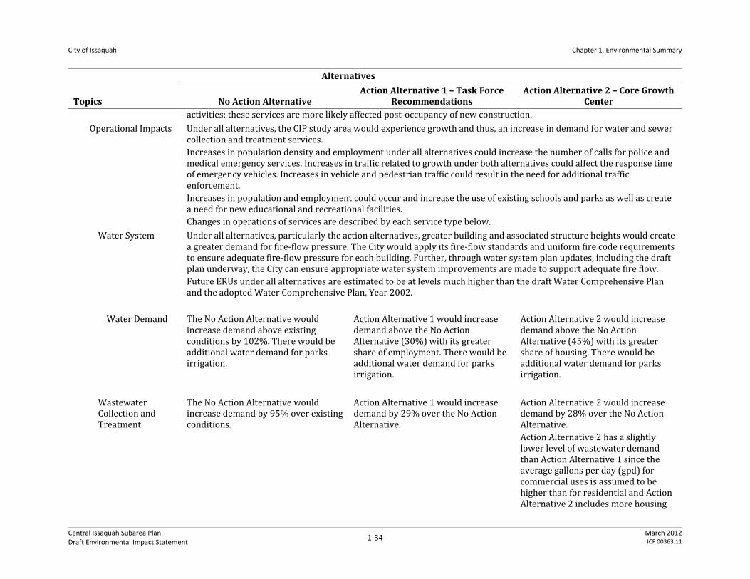
City of Issaquah Chapter 1. Environmental Summary
Central Issaquah Subarea Plan Draft Environmental Impact Statement
1‐34 March 2012ICF 00363.11
Topics
Alternatives
No Action Alternative Action Alternative 1 – Task Force
Recommendations Action Alternative 2 – Core Growth
Center activities; these services are more likely affected post‐occupancy of new construction.
Operational Impacts Under all alternatives, the CIP study area would experience growth and thus, an increase in demand for water and sewer collection and treatment services. Increases in population density and employment under all alternatives could increase the number of calls for police and medical emergency services. Increases in traffic related to growth under both alternatives could affect the response time of emergency vehicles. Increases in vehicle and pedestrian traffic could result in the need for additional traffic enforcement. Increases in population and employment could occur and increase the use of existing schools and parks as well as create a need for new educational and recreational facilities. Changes in operations of services are described by each service type below.
Water System Under all alternatives, particularly the action alternatives, greater building and associated structure heights would create a greater demand for fire‐flow pressure. The City would apply its fire‐flow standards and uniform fire code requirements to ensure adequate fire‐flow pressure for each building. Further, through water system plan updates, including the draft plan underway, the City can ensure appropriate water system improvements are made to support adequate fire flow. Future ERUs under all alternatives are estimated to be at levels much higher than the draft Water Comprehensive Plan and the adopted Water Comprehensive Plan, Year 2002.
Water Demand The No Action Alternative would increase demand above existing conditions by 102%. There would be additional water demand for parks irrigation.
Action Alternative 1 would increase demand above the No Action Alternative (30%) with its greater share of employment. There would be additional water demand for parks irrigation.
Action Alternative 2 would increase demand above the No Action Alternative (45%) with its greater share of housing. There would be additional water demand for parks irrigation.
Wastewater Collection and Treatment
The No Action Alternative would increase demand by 95% over existing conditions.
Action Alternative 1 would increase demand by 29% over the No Action Alternative.
Action Alternative 2 would increase demand by 28% over the No Action Alternative. Action Alternative 2 has a slightly lower level of wastewater demand than Action Alternative 1 since the average gallons per day (gpd) for commercial uses is assumed to be higher than for residential and Action Alternative 2 includes more housing
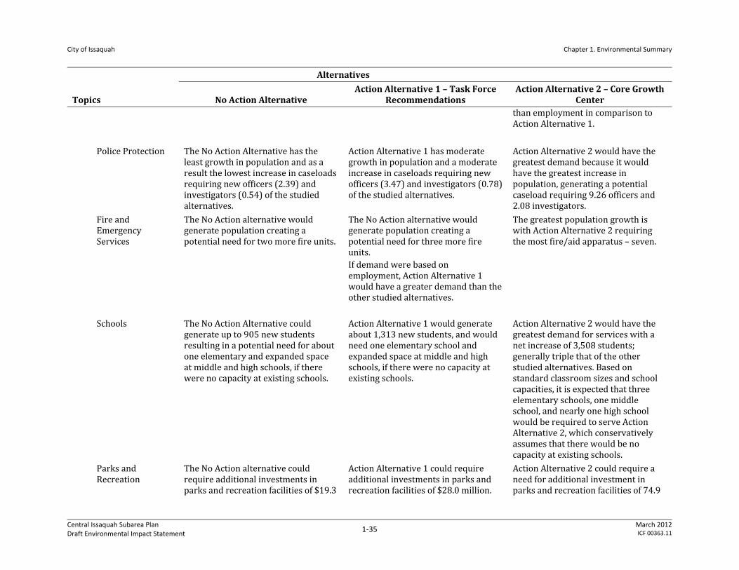
City of Issaquah Chapter 1. Environmental Summary
Central Issaquah Subarea Plan Draft Environmental Impact Statement
1‐35 March 2012ICF 00363.11
Topics
Alternatives
No Action Alternative Action Alternative 1 – Task Force
Recommendations Action Alternative 2 – Core Growth
Center than employment in comparison to Action Alternative 1.
Police Protection The No Action Alternative has the least growth in population and as a result the lowest increase in caseloads requiring new officers (2.39) and investigators (0.54) of the studied alternatives.
Action Alternative 1 has moderate growth in population and a moderate increase in caseloads requiring new officers (3.47) and investigators (0.78) of the studied alternatives.
Action Alternative 2 would have the greatest demand because it would have the greatest increase in population, generating a potential caseload requiring 9.26 officers and 2.08 investigators.
Fire and Emergency Services
The No Action alternative would generate population creating a potential need for two more fire units.
The No Action alternative would generate population creating a potential need for three more fire units. If demand were based on employment, Action Alternative 1 would have a greater demand than the other studied alternatives.
The greatest population growth is with Action Alternative 2 requiring the most fire/aid apparatus – seven.
Schools The No Action Alternative could generate up to 905 new students resulting in a potential need for about one elementary and expanded space at middle and high schools, if there were no capacity at existing schools.
Action Alternative 1 would generate about 1,313 new students, and would need one elementary school and expanded space at middle and high schools, if there were no capacity at existing schools.
Action Alternative 2 would have the greatest demand for services with a net increase of 3,508 students; generally triple that of the other studied alternatives. Based on standard classroom sizes and school capacities, it is expected that three elementary schools, one middle school, and nearly one high school would be required to serve Action Alternative 2, which conservatively assumes that there would be no capacity at existing schools.
Parks and Recreation
The No Action alternative could require additional investments in parks and recreation facilities of $19.3
Action Alternative 1 could require additional investments in parks and recreation facilities of $28.0 million.
Action Alternative 2 could require a need for additional investment in parks and recreation facilities of 74.9
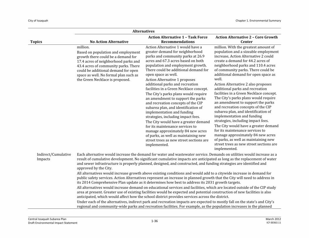
City of Issaquah Chapter 1. Environmental Summary
Central Issaquah Subarea Plan Draft Environmental Impact Statement
1‐36 March 2012ICF 00363.11
Topics
Alternatives
No Action Alternative Action Alternative 1 – Task Force
Recommendations Action Alternative 2 – Core Growth
Center million. Based on population and employment growth there could be a demand for 17.4 acres of neighborhood parks and 43.4 acres of community parks. There could be additional demand for open space as well. No formal plan such as the Green Necklace is proposed.
Action Alternative 1 would have a greater demand for neighborhood parks and community parks at 26.9 acres and 67.3 acres based on both population and employment growth. There could be additional demand for open space as well. Action Alternative 1 proposes additional parks and recreation facilities in a Green Necklace concept. The City’s parks plans would require an amendment to support the parks and recreation concepts of the CIP subarea plan, and identification of implementation and funding strategies, including impact fees. The City would have a greater demand for its maintenance services to manage approximately 84 new acres of parks, as well as maintaining new street trees as new street sections are implemented.
million. With the greatest amount of population and a sizeable employment increase, Action Alternative 2 could create a demand for 44.2 acres of neighborhood parks and 110.4 acres of community parks. There could be additional demand for open space as well. Action Alternative 2 also proposes additional parks and recreation facilities in a Green Necklace concept. The City’s parks plans would require an amendment to support the parks and recreation concepts of the CIP subarea plan, and identification of implementation and funding strategies, including impact fees. The City would have a greater demand for its maintenance services to manage approximately 84 new acres of parks, as well as maintaining new street trees as new street sections are implemented.
Indirect/Cumulative Impacts
Each alternative would increase the demand for water and wastewater service. Demands on utilities would increase as a result of cumulative development. No significant cumulative impacts are anticipated as long as the replacement of water and sewer infrastructure is properly planned, designed, and constructed, and funding strategies are identified and approved by the City. All alternatives would increase growth above existing conditions and would add to a citywide increase in demand for public safety services. Action Alternatives represent an increase in planned growth that the City will need to address in its 2014 Comprehensive Plan update as it determines how best to address its 2031 growth targets. All alternatives would increase demand on educational services and facilities, which are located outside of the CIP study area at present. Greater use of existing facilities would be expected and potential construction of new facilities is also anticipated, which would affect how the school district provides services across the district. Under each of the alternatives, indirect park and recreation impacts are expected to mostly fall on the state’s and City’s regional and community‐wide parks and recreation facilities. For example, as the population increases in the planned

City of Issaquah Chapter 1. Environmental Summary
Central Issaquah Subarea Plan Draft Environmental Impact Statement
1‐37 March 2012ICF 00363.11
Topics
Alternatives
No Action Alternative Action Alternative 1 – Task Force
Recommendations Action Alternative 2 – Core Growth
Center action areas, there would be a growing deficiency of Neighborhood and Community Parks. Because of proximity, these demands would likely be displaced to nearby regional facilities such as Lake Sammamish State Park. Implementation of either action alternative would result in higher property values and more intense competition for properties that could fulfill the CIP study area’s parks and recreation needs. Increased demands for park and recreation facilities and services generated by the forecast population growth under each of the alternatives would add to those created by general population growth throughout the Issaquah community. Expanded parks and recreation facilities within the CIP study area to serve forecast population would require increased funding for land acquisition and operations.
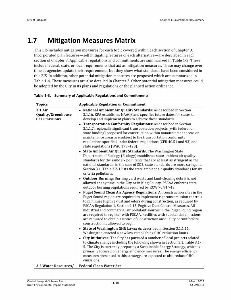
City of Issaquah Chapter 1. Environmental Summary
Central Issaquah Subarea Plan Draft Environmental Impact Statement
1‐38 March 2012ICF 00363.11
1.7 Mitigation Measures Matrix This EIS includes mitigation measures for each topic covered within each section of Chapter 3. Incorporated plan features—self mitigating features of each alternative—are described in each section of Chapter 3. Applicable regulations and commitments are summarized in Table 1‐3. These include federal, state, or local requirements that act as mitigation measures. These may change over time as agencies update their requirements, but they show what standards have been considered in this EIS. In addition, other potential mitigation measures are proposed which are summarized in Table 1‐4. These measures are also detailed in Chapter 3. Other potential mitigation measures could be adopted by the City in its plans and regulations or the planned action ordinance.
Table 1‐3. Summary of Applicable Regulations and Commitments
Topics Applicable Regulation or Commitment
3.1 Air Quality/Greenhouse Gas Emissions
National Ambient Air Quality Standards: As described in Section 3.1.16, EPA establishes NAAQS and specifies future dates for states to develop and implement plans to achieve these standards.
Transportation Conformity Regulations: As described in Section 3.1.1.7, regionally significant transportation projects (with federal or state funding) proposed for construction within nonattainment areas or maintenance areas are subject to the transportation conformity regulations specified under federal regulations (CFR 40.51 and 93) and state regulations (WAC 173–420).
State Ambient Air Quality Standards: The Washington State Department of Ecology (Ecology) establishes state ambient air quality standards for the same six pollutants that are at least as stringent as the national standards; in the case of SO2, state standards are more stringent. Section 3.1, Table 3.2‐1 lists the state ambient air quality standards for six criteria pollutants.
Outdoor Burning: Burning yard waste and land‐clearing debris is not allowed at any time in the City or in King County. PSCAA enforces state outdoor burning regulations required by RCW 70.94.743.
Puget Sound Clean Air Agency Regulations: All construction sites in the Puget Sound region are required to implement rigorous emission controls to minimize fugitive dust and odors during construction, as required by PSCAA Regulation 1, Section 9.15, Fugitive Dust Control Measures. All industrial and commercial air pollutant sources in the Puget Sound region are required to register with PSCAA. Facilities with substantial emissions are required to obtain a Notice of Construction air quality permit before construction is allowed to begin.
State of Washington GHG Laws: As described in Section 3.1.1.11, Washington enacted a new law establishing GHG reduction limits.
City Initiatives: The City has pursued a number of local projects related to climate change including the following shown in Section 3.1, Table 3.1‐5. The City is currently preparing a Sustainable Energy Strategy, which is primarily focused on energy efficiency measures. The energy efficiency measures presented in this strategy are expected to also reduce GHG emissions.
3.2 Water Resources/ Federal Clean Water Act
City of Issaquah Chapter 1. Environmental Summary
Central Issaquah Subarea Plan Draft Environmental Impact Statement
1‐39 March 2012ICF 00363.11
Topics Applicable Regulation or Commitment Stormwater The Clean Water Act governs the discharge of pollutants into the waters
of the United States and regulates water quality standards for surface water. The discharge of any pollutant from a point source into navigable waters without a proper permit is unlawful, under the act; therefore, the NPDES permit program controls these discharges. Ecology, under RCW 90.48 is the permitting agency for NPDES permits.
Additionally, under Section 401, any activity requiring a Section 404 permit (placement of fill or dredging within waters of the United States) or a Section 10 permit (placing a structure within the waters of the United States) which may result in any discharge into the navigable waters of the United States must obtain a certification from the state certifying that such discharge will comply with the applicable provisions of the Clean Water Act. Ecology, under chapter RCW 90.48, is the certifying agency for Section 401 permits.
Washington State Department of Ecology As mentioned, Ecology is responsible for implementing and enforcing surface water quality regulations in Washington State. The current water quality standards are established in state regulations (WAC 173‐201A). General requirements for stormwater management are contained in the NPDES Phase II Western Washington Municipal Stormwater Permit. Guidance on methods for achieving stormwater treatment standards is provided by Ecology in the Stormwater Management Manual for Western Washington (SMMWW) (Washington State Department of Ecology 2005) that are then implemented by local jurisdiction ordinances and stormwater management manuals.
Ecology’s SMMWW is not a regulation or set of regulations. This manual provides guidance on methods of achieving compliance with state and federal standards. It lists BMPs to minimize stormwater impacts on water quality and quantity. As part of compliance with the NPDES Phase II Western Washington Municipal Stormwater Permit, Ecology’s regulations require local agencies to adopt stormwater treatment regulations. Many local agencies, including the City, adopt regulations better tailored to their specific site conditions, but these specific regulations meet the intent of the guidelines and recommendations provided by Ecology.
City of Issaquah Municipal Code Local laws require stormwater discharges to meet water quality standards. Through Issaquah Municipal Code (IMC) 13.28, the City has adopted the King County Surface Water Design Manual (KCSWDM) to be consistent with the SWMWW (Washington State Department of Ecology 2005). The IMC does allow, and encourages, low impact development alternative standards per compliance with the KCSWDM. Unless specific exemptions are met, large projects are required to provide Sensitive Lake Water Quality treatment and Enhanced Basic Water Quality treatment that includes removal of specific amounts of phosphorous, total suspended solids, and heavy metals using zinc as an indicator metal. The City recently adopted amendments per Ordinance 2625 to the KCSWDM effective October 2011, to indicate that stormwater detention for redevelopment within specific drainage basins is allowed to restrict future peak runoff rates to be equal to existing peak runoff rates, instead of restricting future peak runoff rates to be equal to predevelopment forested condition runoff rates.
3.3 Natural Resources IMC 16.26 Building and Construction – Clearing and Grading
City of Issaquah Chapter 1. Environmental Summary
Central Issaquah Subarea Plan Draft Environmental Impact Statement
1‐40 March 2012ICF 00363.11
Topics Applicable Regulation or Commitment IMC 16.30 Buildings and Construction – Erosion and Sediment Control IMC 16.36 Buildings and Construction ‐ Areas of Special Flood Hazard IMC 18.10.010‐330 Environmental Protection – Environmental Policy (for non‐planned action and non‐exempt projects)
IMC 18.10.340‐515 Environmental Protection – Critical Areas IMC 18.10.940‐1050 Shoreline Regulations Stream and Riparian Areas Restoration Plan Washington Hydraulic Code Rules (WAC 220‐110) Water Pollution Control Act (Chapter 90.48 RCW) NPDES Construction Permit NPDES Municipal Stormwater Permit Water Quality Certification Federal Endangered Species Act (ESA) Federal Migratory Bird Treaty Act (MBTA) Federal Bald and Golden Eagle Protection Act
3.4 Land Use
IMC 18.07 – Required Development and Design Standards IMC 18.10 – Environmental Protection IMC 18.12 – Landscaping and Tree Protection
3.5 Aesthetics IMC Chapter 18.07 – Required Development and Design Standards IMC Chapter 18.10 – Environmental Protection IMC Chapter 18.12 – Landscaping and Tree Protection IMC Chapter 18.11 – Signs
3.6 Transportation The City of Issaquah is currently considering changes to its concurrency system (IMC 18.15) in terms of how impacts of new developments are evaluated. In addition to traditional traffic impact fees as described in IMC 3.71, non‐motorized and transit impact fees associated with new developments would also be encouraged. The City is also considering changes to its parking standards from suburban to urban standards.
3.7 Public Services and Utilities
The City has adopted and regularly updates its Capital Facilities Element of the Comprehensive Plan, as well as functional plans for water, wastewater, and parks. These plans are generally updated every six years or sooner to meet GMA and grant agency requirements.
The City has established water and sewer development standards and rates for development in IMC Title 13 Public Services.
Developers will construct all new buildings in compliance with the International Fire Code as adopted by the City in IMC Chapter 16.06, including provision of emergency egress routes and installation of fire‐extinguishing and smoke‐detection systems. All new buildings will comply with accessibility standards for people with disabilities, per the requirements of the Americans with Disabilities Act.
The City’s water service and fire service standards will require adequate fire flow of new development.
The City has adopted impact fees for fire services, parks in IMC Title 3. The City has adopted a means to address impacts on police facilities and other governmental services in IMC Chapter 3.74 Methods to Mitigate Development Impacts. The code indicates that methods of mitigating identified direct impacts required as a condition of any development approval may include, but are not limited to, dedication of land to any public body, off‐site improvement, on‐site improvements, and other
City of Issaquah Chapter 1. Environmental Summary
Central Issaquah Subarea Plan Draft Environmental Impact Statement
1‐41 March 2012ICF 00363.11
Topics Applicable Regulation or Commitment capital or noncapital methods that may effectively reduce direct impacts.
The Issaquah School District also regularly prepares a six‐year capital improvement program in order to plan for new facilities, and identify funding sources including bonds and impact fees. The City uses the district’s capital improvement program documentation to support the collection of impact fees in IMC Chapter 3.63, School Impact Fees. Currently, the City does not collect school impact fees for multifamily units in IMC 3.63.100 (A). This should be re‐evaluated as most of the dwelling units in the CIP study area would be multifamily.
The City should continue its cooperative agreement with Issaquah School District to allow school properties for recreation use. This agreement should be monitored and adapted over time if school facilities are added in or near the CIP study area.
Table 1‐4. Summary of Potential Mitigation Measures in addition to Incorporated Plan Features and Applicable Regulations and Commitments
Topics Mitigation Measures
3.1 Air Quality/Greenhouse Gas Emissions
The City should require all construction contractors to implement air quality control plans for construction activities in the CIP study area. The City should require all future developers to prepare a dust control plan that commits the construction crews to implement all reasonable control measures described in the Associated General Contractors of Washington’s Guide to Handling Fugitive Dust from Construction Projects. Copies of that guidance document are distributed by PSCAA. The air quality control plans should include best management practices (BMPs) to control fugitive dust and odors emitted by diesel construction equipment. BMPs are listed in Section 3.1.3.3 of this EIS.
The City is currently developing a Sustainable Energy Strategy to outline GHG emissions reduction measures, some of which would address the CIP study area, including efforts such as energy disclosure, district energy systems, electrified transportation, intelligent buildings, and renewable energy. As part of the City’s pending Sustainable Energy Strategy and planned action ordinance under consideration, the City could establish interim performance standards. To ensure TOD measures are incorporated into new development and to offer individual future developers opportunities to reduce emissions, the City should consider requiring development standards which incorporate TOD as modeled and could require or encourage future developers to implement additional trip‐reduction measures and energy conservation measures that could provide even greater GHG reductions. The City could require development applicants to consider the reduction measures shown in Table 3.1‐6 or Table 3.1‐7 in Section 3.1 of this EIS.
In addition to requiring applicants to consider the GHG measures in Table 3.1‐6, the City could also require on a case‐by‐case basis that proposed Planned Actions disclose their GHG emissions in order to determine consistency with City adopted GHG policies and strategies, such as the pending energy strategy plan.
City of Issaquah Chapter 1. Environmental Summary
Central Issaquah Subarea Plan Draft Environmental Impact Statement
1‐42 March 2012ICF 00363.11
Topics Mitigation Measures
3.2 Water Resources/ Stormwater
Encourage Low Impact Development (LID). Per IMC 13.28, redevelopment must be consistent with LID measures, such as use narrower streets and pervious pavements, in areas unless soils testing shows soils are unsuitable.
Encourage Stormwater Infiltration where Appropriate. As shown in Section 3.2, Water Resources/Stormwater, Figure 3.2‐3, areas where groundwater levels are farther below the ground surface and have the potential to be appropriate for stormwater infiltration. Use of infiltration in these areas should be encouraged during redevelopment.
Implement Regional Stormwater Treatment Facilities. Implement regional stormwater treatment facilities that may be used for open space purposes such as parks or other protected natural areas during the dry season.
3.3 Natural Resources There are existing uses and structures inside the standard buffers for critical areas (streams and wetlands). It is assumed that new development including substantial redevelopment would be subject to full compliance with standard buffers. Prior to new development or substantial redevelopment, some property owners may want to expand their uses or structures on an interim basis. To ensure impacts on critical areas are avoided, the City could add a policy and regulations that specify how minor building expansion could occur in already degraded areas. For example, building expansion could be allowed on existing impervious areas or by expanding upper floors to avoid increasing a building footprint. In addition, the City could require enhancement of the remaining buffer area and critical area such as by planting native vegetation or adding in‐stream habitat. The enhancement required could be proportional to the location and amount of the proposed building expansion.
3.4 Land Use
Other potential mitigation measures include the following: Revisit and revise as needed the Comprehensive Plan land use plan, growth assumptions, capital plans, and any other relevant goals and policies for the CIP study area.
Revise the City’s existing street classification system to incorporate proposed standards for the CIP study area.
Amend functional plans for utilities and public services to maintain consistency with growth assumptions and service needs associated with the action alternatives.
Monitor the jobs/housing ratio in the CIP study area. If housing is not being provided at the desired locations or rates, the City could re‐evaluate incentives or other features of the CIP, such as multifamily tax exemptions, removal of regulatory barriers, or other responses.
3.5 Aesthetics Establishment of Design Standards: Both action alternatives propose certain development standards and policies. Policies can be further clarified into design standards for dimensional or proportional specificity such as building setbacks, upper level step backs, building modulation, etc. Design standards could require a mix of evergreen and deciduous trees in landscaping for maintaining year‐round foliage. Additionally, standards could be developed for Mountains to Sound Greenway overlay to provide specific guidelines for landscaping, setbacks, signage and building design for developments abutting I‐90.
Preservation of View Corridors: Both action alternatives propose to
City of Issaquah Chapter 1. Environmental Summary
Central Issaquah Subarea Plan Draft Environmental Impact Statement
1‐43 March 2012ICF 00363.11
Topics Mitigation Measures preserve and integrate significant views. As part of the design standards, codes can be developed identifying specific view corridors of the Issaquah Alps, Mount Rainier and forested hillsides to be preserved.
Green Roofs and Roof Gardens: Green roofs and roof gardens could be encouraged on all development in the CIP study area through the use of incentives such as alternative stormwater requirements or flexible parking standards. Green roofs would reduce glare from rooftop pavement and improve visual character from upper levels of buildings.
3.6 Transportation No Action and Action Alternatives propose roadway network and non‐motorized improvements. See Figure 3.6‐4 in Section 3.6 Transportation of this EIS.
Specifically within the subarea, changes to level of service standards are being considered to encourage land uses and mixed use developments, like those included in the Action alternatives. Changes to operational level of service standards could result in fewer intersections that fail City concurrency thresholds in the Action alternatives compared to the No Action Alternative.
3.7 Public Services and Utilities
Water and Wastewater Services The City should update its water system plan and wastewater system plans to reflect the proposed CIP subarea plan land use, growth, and associated capital facility needs including phasing, funding, and similar strategies. This should occur prior to or at the time of the City’s Growth Management Act Comprehensive Plan Update, currently due for completion by December 2015.
As each development application is made, the City will ensure compliance with adopted plans and regulations that require adequate service at the time of development.
Police, Fire and Emergency Medical Services During construction, security measures will be implemented by developers to reduce potential criminal activity, including on‐site security surveillance, lighting, and fencing to prevent public access.
The City should design street layouts, open space, and recreation areas to promote visibility for residents and police. Street and sidewalk lighting would discourage theft and vandalism, and enhance security.
Revenues from increased retail activity and increased property values could help offset some of the City’s additional expenditures for providing additional officers and responses to incidents.
Revenues from increased retail activity and increased property values could help offset some of the Fire District’s additional expenditures for providing additional fire and emergency medical service staff to respond to incidents.
Schools Since the school district typically plans for a shorter‐term horizon than the 20 years envisioned for the Planned Action, the district will continue to monitor student generation rates into the future and adjust its facility planning accordingly. The district will continue to implement existing plans to expand permanent student capacity at area schools. In addition, the district may use portable classrooms or shift attendance boundaries to address student capacity issues that arise on a shorter‐term basis.
The City could work in partnership with the Issaquah School District to plan the potential need for schools as growth occurs in the CIP study area.
City of Issaquah Chapter 1. Environmental Summary
Central Issaquah Subarea Plan Draft Environmental Impact Statement
1‐44 March 2012ICF 00363.11
Topics Mitigation Measures For example, the City and School District could consider the location of potential surplus public properties or work in partnership with major land owners to consider where new educational facilities may be appropriate, or how to best use existing facilities when new growth occurs.
Parks and Recreation During construction, impacts adjacent to or in parks within the CIP study area, such as an increase in noise, dust, and access limitations, would be mitigated as per a construction mitigation plan.
The City should update its parks and recreation plans to incorporate the features of the Green Necklace concept.
The City could add parks and recreation facilities such as: o The City could convert current public properties no longer needed
for their current uses to parks and recreation uses. o The City could purchase private property for parks and recreation
use. An efficient means would be to consider properties in the vicinity of existing parks and recreation facilities or where additional population growth would be greatest.
o The City could determine if a parks impact fee should apply to employment uses.
1.8 Significant Unavoidable Adverse Impacts
1.8.1.1 Air Quality/Greenhouse Gas Emissions
No significant unavoidable adverse impacts on regional or local air quality are anticipated. Temporary, localized dust and odor impacts could occur during the construction activities. The regulations and mitigation measures described above are adequate to mitigate any adverse impacts anticipated to occur as a result of CIP study area growth increases.
1.8.1.2 Water Resources/Stormwater
If stormwater treatment facilities are properly designed per City ordinance requirements, there should be no unavoidable adverse impacts from stormwater runoff. Given the extensive development already in the study area and associated adverse impacts on water quality to surface waters from existing untreated or minimally treated runoff, it is expected that mitigation measures associated with redevelopment under the action alternatives and the No Action Alternative would lead to an overall improvement of stormwater runoff quality from the study area.
1.8.1.3 Natural Resources
All alternatives would result in additional impervious surface area and vehicle traffic in the CIP study area with the potential to increase pollutant loading to Tibbetts Creek, Issaquah Creek, and Lake Sammamish. However all alternatives would allow for critical area buffers to be established as redevelopment occurs. In addition, the action alternatives propose parks and streetscape improvements. All of these enhancements to buffers, parks, and tree canopy would offset some of the increased impervious surfaces.
City of Issaquah Chapter 1. Environmental Summary
Central Issaquah Subarea Plan Draft Environmental Impact Statement
1‐45 March 2012ICF 00363.11
Increased pollutant loading in turn has the potential to adversely impact aquatic species, especially salmonid fish species. However, assuming new construction will result in improvements to existing stormwater treatment, the overall effect could be an improvement in conditions for fish and other aquatic species.
Some loss of landscaping vegetation would occur during redevelopment. However, redevelopment would be in compliance with City building, land use, and critical areas ordinances. Therefore, no significant adverse impacts on critical areas are expected. In addition, replacement of low value vegetation such as English ivy (Hedera helix) with native vegetation that includes wildlife benefits could improve the habitat value for some species.
Last, while there would be an increase in urban development and human use of the subarea, the action alternatives support the Green Necklace concept of added parks, recreation, open space, and natural features, which could connect to the broader wildlife network of the Issaquah Alps.
1.8.1.4 Land Use
Land Use Patterns
Under both action alternatives, the CIP study area would transition from a primarily suburban auto‐oriented strip commercial, office, warehouse and industrial environment to a new pedestrian‐oriented compact mixed‐use community with urban density and distinct development character in each neighborhood. The area would irreversibly change to a larger‐scale, higher‐intensity center of the City.
Changes to land use would have the potential to create land use conflicts in some locations, but impacts can be mitigated as identified under mitigation measures above such as design standards.
Plans and Policies
The action alternatives propose an amendment of the Comprehensive Plan in terms of land use designations, transportation plans and street classifications. The Comprehensive Plan and development standards would require modification to implement the subarea plans. With application of mitigation measures and amendments, there are no significant unavoidable adverse impacts on plans and policies.
1.8.1.5 Aesthetics
The change in visual character from a suburban low‐rise commercial development pattern to an urban, mixed‐use intense development pattern is significant and unavoidable, and would occur with all studied alternatives, but most particularly under Action Alternative 1 and Action Alternative 2. The overall character and significance of visual impacts on the CIP study area would depend, in large part, on the quality of the architectural and urban design features incorporated into the development and the values of those viewing the changes. New development and redevelopment under all alternatives would result in a change to the current aesthetic conditions of the CIP study area. All alternatives would affect the ridgeline view within the vicinity of the CIP study area. However, views are based on placement of buildings and location of viewers. Overall, both action alternatives could mitigate the visual obstruction of the Issaquah Alps by appropriate placement of taller structures. However, this would remain relative as the appropriate placement would depend on viewers’ locations.
City of Issaquah Chapter 1. Environmental Summary
Central Issaquah Subarea Plan Draft Environmental Impact Statement
1‐46 March 2012ICF 00363.11
All alternatives could increase the amount of ambient light and glare produced in the CIP study area. The alternatives differ with regard to the scope, intensity, and location of these changes. With application of existing and proposed plans and regulations, and other identified mitigation measures, no significant unavoidable adverse impacts are anticipated.
1.8.1.6 Transportation
Although the effects of additional vehicles on traffic congestion could be mitigated to varying degrees through implementation of the transportation improvements identified in the Transportation Element and compliance with City codes and standards, the increases in traffic on certain roadways in the City may be considered a significant unavoidable adverse impact.
A significant unavoidable adverse impact could also result if one or more planned improvement projects identified to address expected impacts are not implemented. It is expected that all of the new roadway connections and intersection improvements included in the Action scenarios would be significantly funded through the City’s traffic impact fee program, and/or required as part of a development agreement. Between now and 2030, projects will need to be prioritized and built as development occurs and funding from the traffic fee program becomes available. There are other issues besides funding that could inhibit the construction of a transportation improvement. Although prioritization of future projects and interim year analysis is outside the scope of this study, it is required under the Growth Management Act that the City's Comprehensive Plan is updated regularly (roughly every 6‐8 years), at which time the various transportation projects can be reassessed together with approved development. Over periods between updates, transportation concurrency is intended to manage the transportation system and ensure that development cannot be approved without suitable associated mitigation.
1.8.1.7 Public Services and Utilities
Water and Wastewater Services
All studied alternatives are anticipated to increase demand for water and wastewater services. Increased growth in the CIP study area would exceed planned growth in adopted and draft capital plans. However, with application of mitigation measures including regular capital facility planning, no significant unavoidable adverse impacts are anticipated.
Police, Fire, and EMS Services
Under studied alternatives, the CIP study area is anticipated to experience significant growth during the planning period and increase the demand for police and fire protection. However, with application of mitigation measures including regular capital facility planning, no significant unavoidable adverse impacts are anticipated.
Schools
Studied alternatives would result localized demand for educational services. However, given the school district and the City have an opportunity to update plans and respond appropriately, and assuming the application of existing regulations such as impact fees, no significant unavoidable impacts are anticipated.
City of Issaquah Chapter 1. Environmental Summary
Central Issaquah Subarea Plan Draft Environmental Impact Statement
1‐47 March 2012ICF 00363.11
Parks and Recreation
Under studied alternatives, there would be an increased demand for parks and recreation facilities. With the application of mitigation measures, no significant unavoidable impacts are anticipated.


