Embed Size (px)
Citation preview
U.S. Department of Housing and Urban Development 451 Seventh Street, SW Washington, DC 20410 www.hud.govespanol.hud.gov
Environmental Assessment Determinations and Compliance Findings for HUD-assisted Projects
24 CFR Part 58
Project Information Project Name: Cartwright Family Apartments Responsible Entity: OC Housing & Community Development Grant Recipient (if different than Responsible Entity): State/Local Identifier: CA/059 Preparer: Jaclyn Canzone, OC Housing and Community
Development Certifying Officer Name and Title: Julia Bidwell, Director OC Housing & Community Development
Grant Recipient (if different than Responsible Entity): Consultant (if applicable): Jonathan Rigg, Dudek
1 SW Columbia Street, Suite 1500 Portland, Oregon 97258 503.956.1444
Direct Comments to: Jaclyn Canzone, [email protected]
1
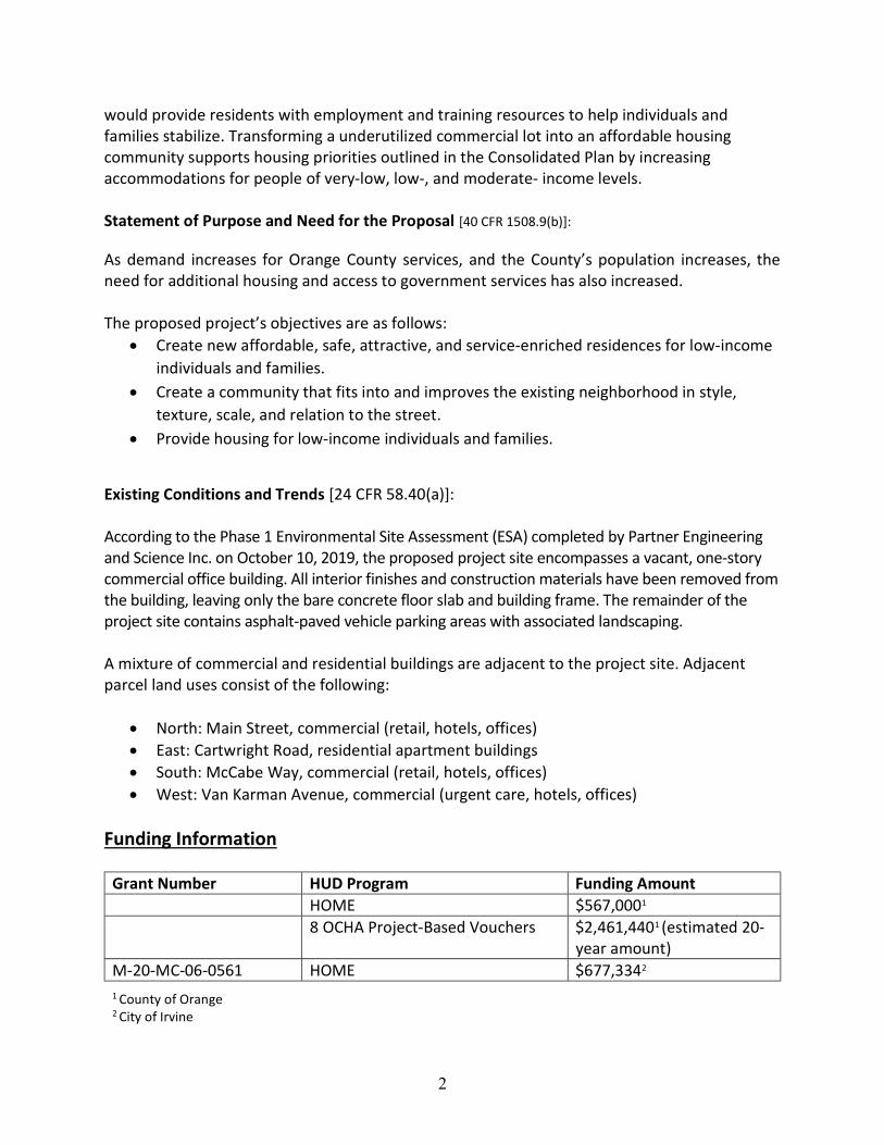
Project Location:
The Cartwright Family Apartments (referred to throughout this Environmental Assessment as the Multifamily Residential Project or proposed project) is located within Orange County, California (refer to Figure 1, Project Location). The proposed project is located at 17861 Cartwright Road in the City of Irvine, south of Main Street and west of Jamboree Road. The project site (refer to Attachment 1, Site Plan) is currently occupied by a vacant, one-story commercial office building that consists of only the bare concrete floor slab and building frame. Surrounding properties include commercial office buildings and residential apartment buildings. The project site is located on Assessor’s Parcel Number 435-142-39 and is a planned multifamily residential land use.
Description of the Proposed Project [24 CFR 50.12 & 58.32; 40 CFR 1508.25]:
The proposed project by C&C Development would involve replacing the currently vacant commercial office building with a 60-unit affordable housing community for families including 10 Permanent Supportive Housing (PSH) units designed to accommodate households who meet the Mental Health Services Act eligibility criteria whom are experiencing homelessness (in collaboration with the OC Health Care Agency) and eight Orange County Housing Authority (OCHA) Project-Based Vouchers will serve homeless individuals in OCHA’s jurisdiction with referrals via the Orange County Coordinated Entry System (CES). In addition, the project would reserve five units for developmentally disabled residents and six units with a veterans preference. The apartment complex would be a four-story tucker-under building with contemporary design and elevator access. Leadership in Energy and Environmental Design (LEED) Environmental Design Standards would influence the design and orientation of the development. Of the 60 rental units, there would be 15 one-bedroom units, 17 two-bedroom units, and 28 three-bedroom units to provide housing for diverse family sizes. In addition to the residential units, the approximately 1.62-acre project site would include a leasing office, community room, fitness room, computer room, tot lot, pool, bike room, dog park, and barbeque pavilion for residents.
The proposed project would comply with the surrounding mixed commercial and residential community, which is zoned as 5.1 IBC Multi-Use and allows for residential development at a minimum density of 30 units per acre. The height of the building and contemporary style architecture are meant to complement the surrounding community and are compliant with the City of Irvine Design Guidelines. The residential units to the east of the project site are market-rate apartment communities for rent, while the areas to the north, west, and south are composed of commercial offices and hotels. Many amenities are located within a 10-minute walk of the project site, such as numerous restaurants, a local bank, medical facilities, and public transportation. A new parking lot would accommodate 104 parking stalls for residents (1.73:1 parking ratio), with open green spaces planned on the outskirts of the lot. Pedestrian walkways would be strategically located throughout the site to increase connectivity between the buildings and the parking lot.
The affordable housing complex is optimally located next to community businesses and support centers. The PSH units included in the proposed project would provide social services to individuals and families experiencing homelessness or at-risk of homelessness. These resources
2
would provide residents with employment and training resources to help individuals and families stabilize. Transforming a underutilized commercial lot into an affordable housing community supports housing priorities outlined in the Consolidated Plan by increasing accommodations for people of very-low, low-, and moderate- income levels. Statement of Purpose and Need for the Proposal [40 CFR 1508.9(b)]: As demand increases for Orange County services, and the County’s population increases, the need for additional housing and access to government services has also increased. The proposed project’s objectives are as follows:
Create new affordable, safe, attractive, and service-enriched residences for low-income individuals and families.
Create a community that fits into and improves the existing neighborhood in style, texture, scale, and relation to the street.
Provide housing for low-income individuals and families.
Existing Conditions and Trends [24 CFR 58.40(a)]: According to the Phase 1 Environmental Site Assessment (ESA) completed by Partner Engineering and Science Inc. on October 10, 2019, the proposed project site encompasses a vacant, one-story commercial office building. All interior finishes and construction materials have been removed from the building, leaving only the bare concrete floor slab and building frame. The remainder of the project site contains asphalt-paved vehicle parking areas with associated landscaping. A mixture of commercial and residential buildings are adjacent to the project site. Adjacent parcel land uses consist of the following:
North: Main Street, commercial (retail, hotels, offices) East: Cartwright Road, residential apartment buildings South: McCabe Way, commercial (retail, hotels, offices) West: Van Karman Avenue, commercial (urgent care, hotels, offices)
Funding Information
Grant Number HUD Program Funding Amount HOME $567,0001 8 OCHA Project-Based Vouchers $2,461,4401 (estimated 20-
year amount) M-20-MC-06-0561 HOME $677,3342 1 County of Orange 2 City of Irvine

3
Estimated Total HUD Funded Amount: $3,705,774 Estimated Total Project Cost (HUD and non-HUD funds) [24 CFR 58.32(d)]: $32,127,656
4
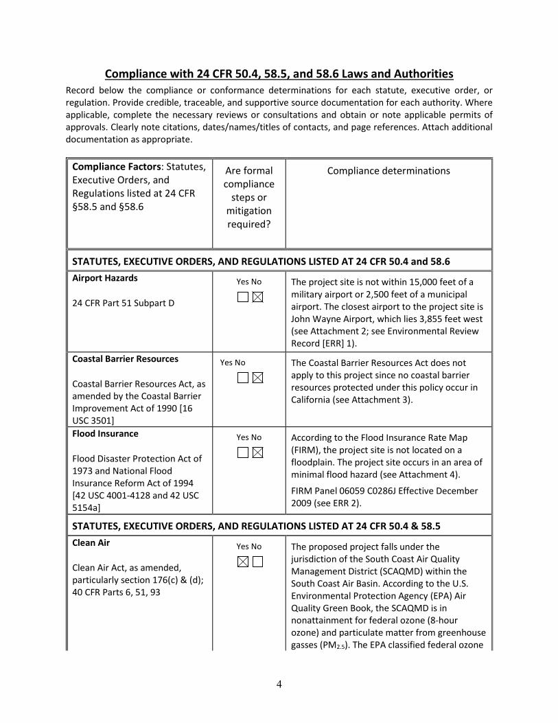
Compliance with 24 CFR 50.4, 58.5, and 58.6 Laws and Authorities Record below the compliance or conformance determinations for each statute, executive order, or regulation. Provide credible, traceable, and supportive source documentation for each authority. Where applicable, complete the necessary reviews or consultations and obtain or note applicable permits of approvals. Clearly note citations, dates/names/titles of contacts, and page references. Attach additional documentation as appropriate.
Compliance Factors: Statutes, Executive Orders, and Regulations listed at 24 CFR §58.5 and §58.6
Are formal compliance
steps or mitigation required?
Compliance determinations
STATUTES, EXECUTIVE ORDERS, AND REGULATIONS LISTED AT 24 CFR 50.4 and 58.6 Airport Hazards
24 CFR Part 51 Subpart D
Yes No
The project site is not within 15,000 feet of a military airport or 2,500 feet of a municipal airport. The closest airport to the project site is John Wayne Airport, which lies 3,855 feet west (see Attachment 2; see Environmental Review Record [ERR] 1).
Coastal Barrier Resources
Coastal Barrier Resources Act, as amended by the Coastal Barrier Improvement Act of 1990 [16 USC 3501]
Yes No
The Coastal Barrier Resources Act does not apply to this project since no coastal barrier resources protected under this policy occur in California (see Attachment 3).
Flood Insurance
Flood Disaster Protection Act of 1973 and National Flood Insurance Reform Act of 1994 [42 USC 4001-4128 and 42 USC 5154a]
Yes No
According to the Flood Insurance Rate Map (FIRM), the project site is not located on a floodplain. The project site occurs in an area of minimal flood hazard (see Attachment 4).
FIRM Panel 06059 C0286J Effective December 2009 (see ERR 2).
STATUTES, EXECUTIVE ORDERS, AND REGULATIONS LISTED AT 24 CFR 50.4 & 58.5 Clean Air
Clean Air Act, as amended, particularly section 176(c) & (d); 40 CFR Parts 6, 51, 93
Yes No
The proposed project falls under the jurisdiction of the South Coast Air Quality Management District (SCAQMD) within the South Coast Air Basin. According to the U.S. Environmental Protection Agency (EPA) Air Quality Green Book, the SCAQMD is in nonattainment for federal ozone (8-hour ozone) and particulate matter from greenhouse gasses (PM2.5). The EPA classified federal ozone
5
in Orange County as extreme and PM2.5 as moderate. Since the project site is in a nonattainment zone for these pollutants, it must conform to the State Implementation Plan (SIP) to meet HUD air quality guidelines. To be compliant with the SIP, a comprehensive plan that describes how an area will meet national and ambient air quality standards, the proposed project must ensure its criteria pollutant emissions remain below the local air district’s significance thresholds.
The project site’s location close to public transportation is consistent with regional efforts to improve transit availability and would reduce the amount of emissions (PM2.5) associated with motor vehicle travel. By developing affordable housing consistent with the growth anticipated by the General Plan and existing zoning and land use designations, the proposed project is in compliance with Regional Air Quality Strategy (RAQS), the SIP, and the Air Quality Management Plan for this locality.
Air quality at the project site could be negatively impacted by fugitive dust (PM10) and other particulate air pollutants (PM2.5) released during construction-related activities, such as land clearing or grading. Exhaust emissions (oxides of nitrogen [NOx] and carbon monoxide [CO]) released by heavy construction vehicles could also temporarily impact air quality. Adverse impacts to air quality during construction would be managed by implementing mitigation measures for fugitive dust control in compliance with SCQAMD Rule 403. This guideline identifies measures to reduce fugitive dust that are required to be implemented at all construction sites within the South Coast Air Basin (Mitigation Measure 1).
Daily emissions from the proposed project would not exceed the SCAQMD’s regional construction or operation emissions thresholds (see Attachment 5). Because the proposed development is consistent with existing zoning
6
and the General Plan, it is compliant with the SIP, RAQS, and the Clean Air Act (see ERR 3).
Coastal Zone Management
Coastal Zone Management Act, sections 307(c) & (d)
Yes No
The project site is 6.34 miles from the Pacific Ocean and is not located within the California Coastal Zone, as defined by the California Coastal Act (Public Resources Code, Division 20, Section 3000 et. seq.). Therefore, no adverse coastal impacts would occur as a result of this project (see Attachments 6 and 7; see ERR 4).
Contamination and Toxic Substances
24 CFR Part 50.3(i) & 58.5(i)(2)
Yes No
A Phase 1 ESA completed by Partner did not find any recognized environmental conditions (RECs), historical recognized environmental conditions (HRECs), or controlled recognized environmental conditions (CRECs) at the project site. The presence of asbestos-containing construction materials (ACCMs) and lead-based paints (LBPs) was tested by Barr& Clark (see Attachments 8 and 9). Results found no evidence of LBPs, but did show the presence of ACCMs in the mastic and roofing mastic of the building on the project site. Of these materials, only the damaged roofing mastic needs to be removed before construction activities begin (SCAQMD Rule 1403 Procedure 5; Mitigation Measure 2). ACCMs in good condition, such as the building mastic at the project site, presents minimal risk for asbestos exposure (see ERR 5).
A regulatory records review conducted as part of the Phase 1 ESA did not show any history of underground storage tanks (USTs) or environmental activity use limits (AULs) at the project site.
Historically, the project site was used for agricultural purposes. Agriculture-related chemicals, including pesticides, herbicides, and fertilizers may have been used and stored on site. Even if such chemicals were used, exposure would be minimal since the project site is paved over and covered by building structures. Previous development activities would have mixed or covered contaminated surface soils with fill material, further
7
minimizing potential exposure to any residual agricultural chemicals (if any).
Reference: Phase 1 ESA.
Endangered Species
Endangered Species Act of 1973, particularly section 7; 50 CFR Part 402
Yes No
No federally listed special-status plant or wildlife species are expected to be present within the project site due to the urban setting and the existing development of the site (concrete commercial building).
The range of seven threatened or endangered species of flowering plants, mammals, and birds overlap with the project site. However, according to the U.S. Fish and Wildlife Service’s IPaC database, the project site is situated outside of critical habitat areas for the endangered or threatened species that have these areas defined (see ERR 6 and Attachment 10).
Current commercial and residential development surrounding the project site similarly prevent wildlife activity. Therefore, the proposed project would not have any impacts on wildlife movement, migration, or nursery sites.
Explosive and Flammable Hazards
24 CFR Part 51 Subpart C
Yes No
Explosive and flammable hazards would not be present at the project site, which is designed for residential uses. The Phase 1 ESA did not identify the presence of explosive or flammable materials at the project site. Furthermore, the project site is not located near land uses capable of releasing explosive or flammable hazardous waste. As a result, the proposed project would not expose residents or the surrounding community to dangerous explosive or flammable hazards.
Reference: Phase 1 ESA
Farmlands Protection
Farmland Protection Policy Act of 1981, particularly sections
Yes No
The proposed project is not located on or adjacent to farmland. Areas surrounding the project site are committed to urban use. The project site is located within the Urban
8
1504(b) and 1541; 7 CFR Part 658
Neighborhood overlay of Planning area 36 (Irvine Business Complex) and is zoned as 5.1 IBC Multi-Use. According to the Farmland Mapping and Monitoring Program database, Orange County primarily consists of urban and built-up land (see Attachment 11).
The project site is situated on the Tustin Plain where soil is comprised of Quaternary alluvium. The alluvium consists of clay, silt, and sand.
The project will not affect protected farmlands. This project does not include any activities that could potentially convert agricultural land to a non-agricultural use. The project is in compliance with the Farmland Protection Policy Act.
Floodplain Management
Executive Order 11988, particularly section 2(a); 24 CFR Part 55
Yes No
Floodplain management would not be adversely impacted by the proposed project. The project site is not situated on a floodplain or floodway and is classified as an Area of Minimal Flood Hazard by FIRM panel 06059 C0286J, effective December 2009. The project is located outside of the 100-year and 500-year floodplains (see Attachment 4).
Historic Preservation
National Historic Preservation Act of 1966, particularly sections 106 and 110; 36 CFR Part 800
Yes No
In July 2020, the State Historic Preservation Office (SHPO) was consulted to determine the presence of historic properties and archaeological sites in the proposed project area. Pursuant to Section 800.4(d), the SHPO concludes that the Area of Potential Effect does not contain any historic resources that would be impacted by the proposed project (see Attachments 12 and 13. In the event that archaeological resources are discovered during implementation of the proposed project,
Mitigation Measure 3 is included.
Tribes that are traditionally and culturally affiliated with the proposed project site were consulted. The Kizh Nation requested that a Native American monitor be present during ground-disturbing activities, and this request is included as Mitigation Measure 4 (see ERR 7).
9
Noise Abatement and Control
Noise Control Act of 1972, as amended by the Quiet Communities Act of 1978; 24 CFR Part 51 Subpart B
Yes No
Construction noise. A temporary increase in noise levels would occur during the construction phase of the proposed project as a result of construction equipment and delivery of materials. Noise increases would be short-term and restricted to daytime hours. The increased noise during construction would not exceed applicable standards for construction noise.
Operational noise. Increases in neighborhood noise levels would still comply with Orange County noise limits. Sources of operational noises include project-generated traffic and recreational open space areas.
Noise level for the project site calculated using the HUD DNL Electronic Assessment Tool was lower than 65 decibels (dB), the acceptable HUD noise threshold. The combined noise level for the project site (from Main Street to the north, Von Karman Avenue to the west, and John Wayne Airport to the southwest) is 62 dBA (see Attachment 14). Therefore, this project would comply with the federal, state, and local standards for noise abatement and control (see ERR 8).
Sole Source Aquifers
Safe Drinking Water Act of 1974, as amended, particularly section 1424(e); 40 CFR Part 149
Yes No
The project site is not located on or adjacent to any sole-source aquifers. There are no sole-source aquifers in Orange County.
Environmental Policy Act Sole Source Aquifers Map (EPA 2018) (see Attachment 15).
Wetlands Protection
Executive Order 11990, particularly sections 2 and 5
Yes No
The proposed project would not affect wetland resources as there are no wetlands on or adjacent to the project site. The closest wetland is the San Joaquin Mars located approximately 0.75 miles south of the project site (see Attachment 16; see ERR 9).
National Wetlands Inventory. 2020. Surface Waters and Wetlands Map.
Wild and Scenic Rivers
Wild and Scenic Rivers Act of 1968, particularly section 7(b) and (c)
Yes No
The project site does not contain any rivers protected under the Wild and Scenic Rivers Act. The nearest Wild and Scenic waterway is South Fork Lytle Creek, which lies approximately 41 miles northeast of the proposed project (see Attachment 17; see ERR 10).
10
ENVIRONMENTAL JUSTICE Environmental Justice
Executive Order 12898
Yes No
The proposed project would provide a positive impact on low-income residents by building affordable housing in an urban setting near public transportation (bus stops located on Von Karmen Avenue and Main Street). There are no environmental hazards on or adjacent to the project site other than what has already been described. Existing environmental impacts would be reduced or mitigated through incorporation of design features, compliance with applicable regulations and policies, and implementation of mitigation measures. As a result, the proposed project would not negatively impact the surrounding community, least of all low-income or minority populations. Since the proposed project would not expose anyone to adverse environmental conditions, it would not violate Executive Order 12898 (see ERR 11).
Environmental Assessment Factors [24 CFR 58.40; Ref. 40 CFR 1508.8 &1508.27] Recorded below is the qualitative and quantitative significance of the effects of the proposal on the character, features and resources of the project area. Each factor has been evaluated and documented, as appropriate and in proportion to its relevance to the proposed action. Verifiable source documentation has been provided and described in support of each determination, as appropriate. Credible, traceable and supportive source documentation for each authority has been provided. Where applicable, the necessary reviews or consultations have been completed and applicable permits of approvals have been obtained or noted. Citations, dates/names/titles of contacts, and page references are clear. Additional documentation is attached, as appropriate. All conditions, attenuation or mitigation measures have been clearly identified. Impact Codes: Use an impact code from the following list to make the determination of impact for each factor. (1) Minor beneficial impact (2) No impact anticipated (3) Minor Adverse Impact – May require mitigation (4) Significant or potentially significant impact requiring avoidance or modification which may require an Environmental Impact Statement
Environmental Assessment Factor
Impact Code
Impact Evaluation
LAND DEVELOPMENT Conformance with Plans / Compatible
2 The project site encompasses 1.62 acres of land located within the Urban Neighborhood overlay of Planning Area 36 (Irvine
11
Land Use and Zoning / Scale and Urban Design
Business Complex). This area is zoned as 5.1 IBC Multi-Use, which supports the development of residential housing at a minimum density of 30 units per acre. The proposed project would build 60 units over 1.62 acres; therefore, it complies with the City of Irvine General Plan.
Soil Suitability/ Slope/ Erosion/ Drainage/ Storm Water Runoff
3
Soil Stability. Soil stability would not be adversely impacted by the proposed project as the project site is in an area with low potential for liquefaction, landslides, or seismically induced settlement. Successful prior building development on the project site and on adjacent parcels indicate that the soils on the site are suitable for the proposed project. Slopes and Drainage. Excessive slopes that would impact the proposed project were not found on the project site. Existing drainage systems would remain intact. The project does not propose any substantial alterations to drainage conditions. Erosion and Stormwater Runoff. No evidence of erosion was found at the project site. There is minimal chance of erosion at the project site due to the flat topography of the area. In addition, the proposed project would comply with erosion control measures during the construction phase to minimize erosion and stormwater pollution. Best management practices (BMPs) adopted from the Stormwater Quality Management Plan will be incorporated during and after the construction phase of the project (Mitigation Measure 5). Other low-impact drainage BMPs include maintaining existing drainage pathways and impervious areas, and retaining natural areas where possible. Runoff from the project site is not anticipated to exceed the capacity of stormwater drainage systems or contribute to stormwater pollution.
Hazards and Nuisances including Site Safety and Noise
3 Hazardous Materials. A Phase 1 ESA completed by Partner did not find any existing RECs, HRECs, or CRECs at the project site. Residual hazardous chemicals associated with agriculture, a historical land use for the project site, is not a significant environmental concern as the project site is paved and likely covered by engineered fill material. Barr & Clark tested for the presence of LBPs and ACCMs, with only low levels (2%–3%) of ACCMs detected. Removal of damaged roofing mastic containing asbestos would be required before construction begins (Mitigation Measure 2). A review of regulatory records within the Phase 1 ESA did not find any records regarding hazardous substance use, storage, or releases. In addition, no records indicating the presence of USTs or AULs were found. As a residential development, the proposed project would not require the presence or use of hazardous materials except for
12
common residential chemicals. The project would not require the ongoing use, storage, or routine transport of hazardous materials. Hazardous waste or emissions would not be released by the proposed project. Site Safety. The project would be constructed consistent with the current Orange County requirements for fencing, lighting, and other features related to site safety. No impacts related to hazards, nuisance, or site safety would occur. Noise. A temporary increase in noise would occur during the construction phase of the proposed project. Increased noise levels would adhere to limits set by Orange County for construction impacts on noise-sensitive land uses. Noise increases would occur during daylight hours, with no adverse impacts anticipated. Operational noise sources would include project-generated traffic and recreational spaces. However, based on the relatively small size of the proposed project, only minimal increases in noise should be expected. Operational noise would comply with Orange County Noise Control Ordinances.
Energy Consumption 2
To obtain building permits, this project would be required to meet energy consumption standards as outlined in the California Building Code, Title 24, 2001 Energy Efficiency Standards. This project would be designed to be LEED certified.
Environmental
Assessment Factor Impact Code
Impact Evaluation
SOCIOECONOMIC Employment and Income Patterns
1 The project has the potential to create temporary employment opportunities during the construction phase. Income patterns for the community would benefit from the construction of 60 affordable housing units in an area where low-income housing is in demand. In addition, the project would provide 10 housing units to accommodate the homeless, 5 units for the developmentally disabled, and 6 units with a veterans preference. In partnership with the Orange County Board of Supervisors, nearby businesses and the social services provided at the PSH units would support residents with comprehensive employment and training resources to help individuals and families stabilize.
Demographic Character Changes, Displacement
1 Considering that the project site would be built in an area surrounded by commercial and residential land uses, the proposed project would not adversely affect community
13
character. The architectural design of the project would complement the surrounding modern community. Since the project site would replace a currently vacant commercial building, the proposed project would not displace existing residents or businesses in the area. Increasing affordable housing units supports the housing priorities detailed in the Orange County Consolidated Plan by building accommodations for people with very low to moderate incomes. Existing utilities and adjacent roadways would not be affected by the proposed project, which would utilize current infrastructure, such as water and sewage. The proposed project would have a beneficial impact on the community by developing an affordable housing project that is consistent with the land use designation and zoning for the site.
Environmental
Assessment Factor Impact Code
Impact Evaluation
COMMUNITY FACILITIES AND SERVICES Educational and Cultural Facilities
2 As 45 (26 3-bedroom units and 19 2-bedroom units) of the 60 residential units contain multiple bedrooms that could accommodate families with children, enrollment at nearby schools could potentially increase. Increased enrollment at any school in the community would be negligible given the small size of the development. Furthermore, children residing at these apartments would be distributed among different schools based on age. The project site is located near multiple educational facilities, including:
University High School, approximately 3.6 miles from the project site
Lakeside Middle School, approximately 4 miles from the project site
Woodbridge High School, approximately 2.8 miles from the project site
Westpark Elementary School, approximately 1.4 miles from the project site
Saddleback High School, approximately 3.2 miles from the project site
Considering the relatively small size of this project and the availability of schools in the surrounding area, adverse impacts associated with exceeding the service population of local educational and cultural facilities are not anticipated.
Commercial Facilities
2 No adverse impacts to surrounding commercial facilities are anticipated. The project site is surrounded on three sides by
14
commercial/retail businesses ranging from restaurants and hotels to home appliance stores and an urgent care facility.
Health Care and Social Services
2 The proposed project would add 60 residential units to the community, possibly increasing demand for health care and social services in the area. The project site is situated near numerous health care facilities, including:
Concentra Urgent Care, approximately 0.5 miles from the project site at 2362 Morse Avenue, Irvine, California 92614
Irvine Urgent Care, approximately 4 miles from the project site at 2500 Alton Parkway #101, Irvine, California 92606
Irvine Woodbridge Walk-In Urgent Care, approximately 3.7 miles from the project site at 4950 Barranca Parkway #104, Irvine, California 92604
Family Care Centers Irvine, approximately 5.2 miles from the project site at 4950 Barranca Parkway #103, Irvine, California 92604
The Hoag Hospital Irvine, approximately 5.4 miles from the project site at 16200 Sand Canyon Avenue, Irvine, California 92618
Negative impacts on health care and social service facilities are not anticipated considering the relatively small size of the project and availability of service providers in the area surrounding the proposed project.
Solid Waste Disposal / Recycling
2 The proposed project involves replacing an existing single story structure with a four-story residential building. Demolition of the existing structure would generate construction debris that could be separated on site into material-specific containers, expediting the reuse, recycling and waste reclamation process. Waste could also be collected by a contracted waste hauler and separated at a handling facility. The City of Irvine is divided into two solid waste collection areas: Exclusive Village Commercial, which must be serviced by Waste Management of Orange County, and Nonexclusive Commercial, which can be serviced by a range of approved solid waste and recycling haulers (see Attachments 18 and 19). Waste collected would then be sorted and taken to one of three Orange County Landfills: Olinda Alpha Landfill, Frank R. Bowerman Landfill, and Prima Deshecha Landfill. The amount of solid waste generated by the proposed project following construction would be a fraction of the throughput taken to Orange County landfills daily.
15
As a result, adverse impacts from solid waste disposal associated with the proposed project are not anticipated.
Waste Water / Sanitary Sewers
2 Wastewater from the project site would be treated at the Baker Water Treatment Plant, which treats 28.1 million gallons of drinking water per day. Wastewater at the proposed project would be collected utilizing existing sewage infrastructure. The proposed project would be subject to sewer service fees. Negative impacts to waste water and sanitary sewers associated with the project site are not foreseen.
Water Supply
2 Water would be supplied to the subject property by the Irvine Ranch Water District (IRWD), which obtains water from the Orange County Groundwater Basin and Metropolitan Water District. Water supplied to the proposed project is in compliance with all state and federal regulations for drinking water standards, lead, and copper according to the 2018 Annual Water Quality Report and City of Irvine. Water would be supplied using existing infrastructure, which has sufficient capacity to provide water to the project. The proposed project would need to pay a service fee to IRWD. No adverse impacts associated with the proposed project are anticipated.
Public Safety - Police, Fire and Emergency Medical
2 The project site is in close proximity to public safety providers, including:
Irvine Police Department, located 1.6 miles from the project site at 1 Civic Center Plaza, Irvine, California 92606
Orange County Fire Authority (Station 28), located 0.6 miles away at 17862 Gillette Avenue, Irvine, California 92614
Orange County Fire Authority (Station 6), located 2 miles from the project site at 3180 Barranca Parkway, Irvine, California 92606
Hoag Hospital Irvine, approximately 5.4 miles from the project site at 16200 Sand Canyon Avenue, Irvine, California 92618
Given the relatively small size of the proposed project, only a slight increase in demand for public safety services are anticipated. Additionally, since the project is located in an area adequately served by existing services, negative impacts to public safety services are not expected.
Parks, Open Space and Recreation
2 The proposed project is not anticipated to substantially increase demand for public recreational resources. Therefore, adverse impacts to parks, open spaces, or recreational amenities is not foreseen. Recreational spaces in close proximity to the project site include:
16
William R. Mason Regional park, approximately 3.4 miles from the project site at 18712 University Drive, Irvine, California 92612
University Community Park located at 1 Beech Tree Lane, Irvine, California 92612, approximately 3.5 miles from the project site
San Marco Park is approximately 1.2 miles from the project site at 1 San Carlo, Irvine, California 92614
City of Costa Mesa Skate Park located at 900 Arlington Drive, Costa Mesa, California 92626, approximately 4.7 miles from the project site
Transportation and Accessibility
2 The proposed project is situated in close proximity to public transit stops along Von Karmen Avenue and Main Street. The nearest bus stop to the project site is about 300 feet north, at the corner of Cartwright Road and Main Street. This bus stop is serviced by lines 53, 86, and 213. The project site would incorporate the construction of a new parking lot consisting of 104 stalls accessible from Cartwright Road. Pre-existing urban development and readily available transit in the project’s vicinity would reduce transportation and accessibility issues, such as limited parking and traffic. Therefore, the 60 new units are not expected to adversely impact transportation or accessibility in the area.
Environmental Assessment Factor
Impact Code
Impact Evaluation
NATURAL FEATURES Unique Natural Features, Water Resources
3 The project site does not encompass any unique natural features. Federally protected natural resources, such as rivers, wetlands, coastal zones, and endangered species, are not present on the project site or adjacent properties. Therefore, the proposed project would not result in the alteration of water resources that could potentially result in substantial erosion or siltation on or off site, or result in downstream flooding. Since the proposed project would be built on an existing commercial lot, it would not interfere substantially with current groundwater recharge. Open green spaces included in the project site plan could increase groundwater recharge by replacing existing paved areas. According to the EPA Map of Sole Source Aquifer Locations, there are no sole source aquifers in the City of Irvine. Mitigation measures employing BMPs would be required during and post-construction to minimize potential adverse
17
contributions to stormwater pollution (Mitigation Measures 5 and 6).
Vegetation, Wildlife
2
Existing vegetation on the project site is associated with parking areas and would be cleared prior to construction. Landscaping after construction is complete would revegetate outdoor spaces on the project site (see Project Narrative). While the proposed project is located within the ranges of endangered or threatened species of mammals, flowering plants, and birds, none of these species are found on the project site as it is developed and in an urbanized area. According to the U.S. Fish and Wildlife Service’s IPaC database, the project site is situated outside of critical habitat areas for the endangered or threatened species that have these areas defined (see ERR 5).
Other Factors
Additional Studies Performed:
Phase 1 Environmental Assessment, Prepared by Partner Engineering and Science, Inc. October 2019.
Asbestos Inspection Report, Prepared by Barr & Clark Independent Environmental Testing. October 2019.
Lead-Based Paint Inspection Report, Prepared by Barr & Clark Independent Environmental Testing. October 2019.
Field Inspection (Date and completed by):
Phase 1 Environmental Assessment, Prepared by Partner Engineering and Science, Inc. October 2019.
List of Sources, Agencies and Persons Consulted [40 CFR 1508.9(b)]:
Barr & Clark Independent Environmental Testing. 2019. Asbestos Inspection Report. Barr & Clark Independent Environmental Testing. 2019. Lead-Based Paint Inspection Report. CARB (California Air Resources Board). 2014. “California Air Basin Map.” Last reviewed March
14, 2014. Accessed August 2020. https://ww3.arb.ca.gov/ei/maps/2017statemap/ abmap.htm.
CCC (California Coastal Commission). 2019. “Maps – Coastal Zone Boundary: Orange County.”
https://coastal.ca.gov/maps/czb/. DOC (California Department of Conservation). 2016. California Important Farmland Finder.
https://maps.conservation.ca.gov/DLRP/CIFF/.
18
City of Irvine. 2020. Find a Waste Hauler, City of Irvine Commercial Solid Waste Collection Areas. Accessed August 2020. https://www.cityofirvine.org/environmental-programs/find-waste-hauler.
EPA (U.S. Environmental Protection Agency). 2020. “Current Nonattainment Counties for all Criteria Pollutants.” July 31, 2020. Accessed August 2020. https://www3.epa.gov/ airquality/greenbook/ancl.html.
EPA. 2020. “Sole Source Aquifers for Drinking Water.” Last updated January 14, 2020. Accessed
August 2020. https://www.epa.gov/dwssa. FEMA (Federal Emergency Management Agency). 2012. “FEMA Flood Map Service Center:
Flood Insurance Rate Map for Irvine, California.” https://msc.fema.gov/ portal/search#searchresultsanchor.
Orange County Waste and Recycling. 2020. “Landfills.” https://www.oclandfills.com/landfills. Partner Engineering and Science, Inc. 2019. Phase 1 Environmental Site Assessment Report. SCAQMD (South Coast Air Quality Management District). 2005. “Rule 403: Fugitive Dust.” As
amended through June 3, 2005. https://www.aqmd.gov/docs/default-source/rule-book/rule-iv/rule-403.pdf?sfvrsn=4.
SCAQMD. 2019. “South Coast AQMD Air Quality Significance Thresholds.” April 2019. Accessed
August 2020. http://www.aqmd.gov/docs/default-source/ceqa/handbook/scaqmd-air-quality-significance-thresholds.pdf.
USFWS (U.S. Fish & Wildlife Service). 2019. “Coastal Barrier Resources System Mapper.”
Updated July 31, 2019. Accessed August 2020. https://www.fws.gov/cbra/ maps/Mapper.html.
USFWS. 2020. “Information for Planning and Consultation (IPaC).” Accessed August 2020.
https://ecos.fws.gov/ipac/location/JACZBM6PXJE25B3BXOS33AMDBE/resources#endangered-species.
USFWS. 2020. “National Wetlands Inventory, Surface Waters and Wetlands Map.” Accessed
August 2020. https://www.fws.gov/wetlands/data/mapper.html. U.S. National Park Service. 2019. “Interactive map of NPS Wild and Scenic Rivers.”
https://nps.maps.arcgis.com/apps/View/index.html?appid=ff42a57d0aae43c49a88daee0e353142.
19
List of Permits Obtained: Public Outreach [24 CFR 50.23 & 58.43]: The Draft Environmental Assessment will be made available for public review and comment beginning on November 13, 2020 and conclude on November 30, 2020 Cumulative Impact Analysis [24 CFR 58.32]: The proposed project is not expected to contribute to a significant cumulative impact under the National Environmental Policy Act because it would consist of an urban development project that would be consistent with the site’s General Plan land use and zoning designations and would be located near existing transit services. State and local planning guidelines encourage the development of urban multifamily housing in areas served by transit and near commercial and cultural amenities because this type of development contributes less to cumulative effects on the environment in comparison to development of previously undisturbed sites in more remote locations with fewer transit connections, many of which contain native vegetation and wildlife species. Alternatives [24 CFR 58.40(e); 40 CFR 1508.9] Site identification has proven to be a major obstacle in providing affordable housing units. Multifamily residential sites available at reasonable cost are extremely limited, and sites that do not meet cost and land use criteria are generally eliminated as alternatives. This project was chosen from several properties based on feasibility, location, and affordability. Physical and social constraints were also considered in identifying and rejecting alternatives. No other build alternatives are analyzed or included in this environmental document. No Action Alternative [24 CFR 58.40(e)]: The No Action Alternative would not build any additional housing at the project site. There are no benefits to the physical or human environment by not taking the federal action associated with this project. Physical impacts to the environment would occur in urban areas whether units are subsidized with federal funds or built at market rates. If an affordable project were not constructed on this site, the social benefits of providing new affordable housing opportunities on an urban infill parcel would not occur. Should the proposed project not advance, the site could potentially be used for market rate housing or office/retail.
The proposed project must acquire all required permits and approvals prior to construction; therefore, the proposed project would be consistent with all land use plans, policies, and regulations for the project site. Not building on this site could result in more housing constructed outside of the urban area in agricultural and undeveloped areas, contributing to urban sprawl, regional traffic congestion, and regional air quality issues.
Summary of Findings and Conclusions:
C&C Development is proposing the development of the Cartwright Family Apartments. The project consists of a 60-unit affordable housing community for families with 10 PSH units. The proposed project would contribute to the increased density and availability of mix-used development in an area that would encourage multi-modal activity. The proximity of existing
20
transit options to the project site would reduce long-term air emissions and energy use associated with motor vehicle travel.
The project is located within a developed urban area and would be adequately served by utilities and public services. The project would conform to all applicable federal, state, and regional regulations associated with land use compatibility, air emissions, water quality, geologic hazards, and related environmental resources addressed herein. Based on the analyses of environmental issues contained in this document, the proposed project is not expected to have significant environmental impacts.
Mitigation Measures and Conditions [40 CFR 1505.2(c)] Summarize below all mitigation measures adopted by the Responsible Entity to reduce, avoid, or eliminate adverse environmental impacts and to avoid non-compliance or non-conformance with the above-listed authorities and factors. These measures/conditions must be incorporated into project contracts, development agreements, and other relevant documents. The staff responsible for implementing and monitoring mitigation measures should be clearly identified in the mitigation plan. Air Quality – Fugitive Dust Mitigation Measure 1: The project shall implement the following from the list below, as applicable to the project:
Backfilling: Stabilize backfill material when not actively handling, stabilize backfill material during handling, and stabilize soil at completion of activity.
Clearing and Grubbing: Maintain stability of soil through pre-watering of site prior to clearing and grubbing, stabilize soil during clearing and grubbing activities, and stabilize soil immediately after clearing and grubbing activities.
Clearing Forms: Use water spray, sweeping and water spray, or a vacuum system to clear forms. Crushing: Stabilize surface soils prior to operation of support equipment and stabilize
material after crushing. Cut and Fill: Pre-water soils prior to cut and fill activities, and stabilize soil during and after
cut and fill activities. Demolition – Mechanical/Manual: Stabilize wind erodible surfaces to reduce dust, stabilize
surface soil where support equipment and vehicles will operate, stabilize loose soil and demolition debris, and comply with Air Quality Management District Rule 1403.
Disturbed Soil: Stabilize disturbed soil throughout the construction site, and stabilize disturbed soil between structures.
Earth-Moving Activities: Pre-apply water to depth of proposed cuts, re-apply water as necessary to maintain soil in a damp condition and to ensure that visible emissions do not exceed 100 feet in any direction, and stabilize soil once earth-moving activities are complete.
Importing/Exporting of Bulk Materials: Stabilize material while loading to reduce fugitive dust emissions, maintain at least 6 inches of freeboard on haul vehicles, stabilize material while transporting and unloading to reduce fugitive dust emissions, and comply with Vehicle Code Section 23114.
21
Landscaping: Stabilize soils, materials, slopes. Road Shoulder Maintenance: Apply water to unpaved shoulders prior to clearing, and apply
chemical dust suppressants and/or washed gravel to maintain a stabilized surface after completing road shoulder maintenance.
Screening: Pre-water material prior to screening, limit fugitive dust emissions to opacity and plume length standards, and stabilize material immediately after screening.
Staging Areas: Stabilize staging areas during use, and stabilize staging area soils at project completion.
Stockpiles/Bulk Material Handling: Stabilize stockpiled materials. Stockpiles within 100 yards of off-site occupied buildings must not be greater than 8 feet in height, or must have a road bladed to the top to allow water truck access, or must have an operational water irrigation system that is capable of complete stockpile coverage.
Traffic Areas for Construction Activities: Stabilize all off-road traffic and parking areas, stabilize all haul routes, and direct construction traffic over established haul routes.
Trenching: Stabilize surface soils where trencher or excavator and support equipment will operate, and stabilize soils at the completion of trenching activities.
Truck Loading: Pre-water material prior to loading and ensure that freeboard exceeds 6 inches (CVC 23114).
Turf Overseeding: Apply sufficient water immediately prior to conducting turf vacuuming activities to meet opacity and plume length standards, and cover haul vehicles prior to exiting the site.
Unpaved Roads/Parking Lots: Stabilize soils to meet the applicable performance standards and limit vehicular travel to established unpaved roads (haul routes) and parking lots.
Vacant Land: In instances where vacant lots are 0.10 acres or larger and have a cumulative area of 500 square feet or more that are driven over and/or used by motor vehicles and/or off-road vehicles, prevent motor vehicle and off-road-vehicle trespassing, parking, and access by installing barriers, curbs, fences, gates, posts, signs, shrubs, trees, or other effective control measures.
Hazards and Nuisances including Site Safety and Noise Mitigation Measure 2: Prior to the beginning of the construction phase, damaged and/or
significantly damaged asbestos-containing construction materials, which pose the greatest risk for asbestos exposure, shall be removed in compliance with South Coast Air Quality Management District Rule 1403 Procedure 5.
Historic Preservation (Cultural Resources) Mitigation Measure 3: In the event that previously unidentified cultural resources are
encountered during ground-disturbing activities associated with project construction, work in the immediate area must halt, and an archaeologist meeting the Secretary of the Interior’s Professional Qualifications Standards for archaeology shall be contacted immediately to evaluate the find. If the discovery proves to be
22
significant under the National Environmental Policy Act, additional work such as data recovery excavation may be warranted to mitigate potential adverse effects.
Mitigation Measure 4: The developer shall be required to retain the services of a qualified Native American monitor(s) during construction-related ground-disturbing activities. The tribal representative from the Gabrieleño Band of Mission Indians – Kizh Nation defines ground disturbance to include, but not limited to pavement removal, potholing, grubbing, weed abatement, boring, grading, excavation, or trenching within the project area. The monitor must be approved by the tribal representative and shall be present on-site during the construction phases that include ground-disturbing activities. The on-site monitoring shall end when the project site grading and excavation activities are completed, or when the monitor has indicated that the site has a low potential for archaeological resources. If archaeological or cultural resources are encountered, they shall be documented by the Native American monitor and collected for preservation.
Stormwater Runoff/Wastewater/Sanitary Sewer
Mitigation Measure 5: The proposed project shall include best management practices (BMPs) designed according to the guidance of the California Stormwater Quality Association Stormwater Best Management Practice Handbooks for Construction, for New Development/Redevelopment, and for Industrial and Commercial (or other similar source as approved by Orange County). Construction (temporary) BMPs for the proposed project shall include hydroseeding, straw mulch, velocity dissipation devices, silt fencing, fiber rolls, storm drain inlet protection, wind erosion control, and stabilized construction entrances.
Mitigation Measure 6: Prior to construction commencing, the applicant shall provide evidence to Orange County of a Waste Discharge Identification number generated from the State Regional Water Quality Control Board’s Stormwater Multiple Application & Reports Tracking System. This serves as the Regional Water Quality Control Board’s approval or permit under the National Pollutant Discharge Elimination System construction stormwater quality permit.

23
ENVIRONMENTAL REVIEW RECORDS (ERRs)

25
ERR #1. Clear Zones (CZ) and Accident Potential Zones (APZ)
OMB No. 2506-0177 (exp.9/30/2021)
U.S. DEPARTMENT OF HOUSING AND URBAN DEVELOPMENT WASHINGTON, DC 20410-1000
This Worksheet was designed to be used by those “Partners” (including Public Housing Authorities, consultants, contractors, and nonprofits) who assist Responsible Entities and HUD in preparing environmental reviews, but legally cannot take full responsibilities for these reviews themselves. Responsible Entities and HUD should use the RE/HUD version of the Worksheet.
Airport Hazards (CEST and EA) – PARTNER https://www.hudexchange.info/environmental-review/airport-hazards 1. To ensure compatible land use development, you must determine your site’s proximity to civil and
military airports. Is your project within 15,000 feet of a military airport or 2,500 feet of a civilian airport? ☒No If the RE/HUD agrees with this recommendation, the review is in compliance with this
section. Continue to the Worksheet Summary below. Provide a map showing that the site is not within the applicable distances to a military or civilian airport.
☐Yes Continue to Question 2.
2. Is your project located within a Runway Potential Zone/Clear Zone (RPZ/CZ) or Accident Potential
Zone (APZ)?
☐Yes, project is in an APZ Continue to Question 3.
☐Yes, project is an RPZ/CZ Project cannot proceed at this location.
☐No, project is not within an APZ or RPZ/CZ If the RE/HUD agrees with this recommendation, the review is in compliance with this section. Continue to the Worksheet Summary below. Provide a map showing that the site is not within either zone.
3. Is the project in conformance with DOD guidelines for APZ? ☐Yes, project is consistent with DOD guidelines without further action. If the RE/HUD agrees
with this recommendation, the review is in compliance with this section. Continue to the Worksheet Summary below. Provide any documentation supporting this determination.
☐No, the project cannot be brought into conformance with DOD guidelines and has not been approved. Project cannot proceed at this location.
If mitigation measures have been or will be taken, explain in detail the proposed measures that must be implemented to mitigate for the impact or effect, including the timeline for implementation.
Work with the RE/HUD to develop mitigation measures. Continue to the Worksheet Summary
below. Provide any documentation supporting this determination.
Worksheet Summary Provide a full description of your determination and a synopsis of the information that it was based on, such as:
The project is located over 3,800 feet from the nearest civilian airport (John Wayne Airport), see Attachment 2.
Include all documentation supporting your findings in your submission to HUD.

27
ERR #2. Floodplain Management
OMB No. 2506-0177 (exp. 9/30/2021)
U.S. DEPARTMENT OF HOUSING AND URBAN DEVELOPMENT WASHINGTON, DC 20410-1000
This Worksheet was designed to be used by those “Partners” (including Public Housing Authorities, consultants, contractors, and nonprofits) who assist Responsible Entities and HUD in preparing environmental reviews, but legally cannot take full responsibilities for these reviews themselves. Responsible Entities and HUD should use the RE/HUD version of the Worksheet.
Floodplain Management (CEST and EA) – PARTNER https://www.hudexchange.info/environmental-review/floodplain-management
1. Does 24 CFR 55.12(c) exempt this project from compliance with HUD’s floodplain management regulations in Part 55? ☐ Yes
Provide the applicable citation at 24 CFR 55.12(c) here. If project is exempt under 55.12(c)(6) or (8), provide supporting documentation. If the RE/HUD agrees with this recommendation, the review is in compliance with this
section. Continue to the Worksheet Summary below. Continue to the Worksheet Summary. ☒ No Continue to Question 2.
2. Provide a FEMA/FIRM map showing the site.
The Federal Emergency Management Agency (FEMA) designates floodplains. The FEMA Map Service Center provides this information in the form of FEMA Flood Insurance Rate Maps (FIRMs). Does your project occur in a floodplain? ☒ No Continue to the Worksheet Summary below.
☐ Yes Select the applicable floodplain using the FEMA map or the best available information:
☐ Floodway Continue to Question 3, Floodways
☐ Coastal High Hazard Area (V Zone) Continue to Question 4, Coastal High Hazard Areas
☐ 500-year floodplain (B Zone or shaded X Zone) Continue to Question 5, 500-year Floodplains
☐ 100-year floodplain (A Zone) The 8-Step Process is required. Continue to Question 6, 8-Step Process
3. Floodways
Is this a functionally dependent use? ☐ Yes
The 8-Step Process is required. Work with HUD or the RE to assist with the 8-Step Process. Continue to Worksheet Summary.
☐ No Federal assistance may not be used at this location unless an exception in 55.12(c)
applies. You must either choose an alternate site or cancel the project.
4. Coastal High Hazard Area Is this a critical action such as a hospital, nursing home, fire station, or police station? ☐ Yes Critical actions are prohibited in coastal high hazard areas unless an exception in 55.12(c)
applies. You must either choose an alternate site or cancel the project.
☐ No Does this action include new construction that is not a functionally dependent use, existing construction (including improvements), or reconstruction following destruction caused by a disaster? ☐ Yes, there is new construction of something that is not a functionally dependent use.
New construction must be designed to FEMA standards for V Zones at 44 CFR 60.3(e) (24 CFR 55.1(c)(3)(i)). Continue to Question 6, 8-Step Process
☐ No, this action concerns only existing construction.
Existing construction must have met FEMA elevation and construction standards for a coastal high hazard area or other standards applicable at the time of construction. Continue to Question 6, 8-Step Process
5. 500-year Floodplain
Is this a critical action? ☐ No If the RE/HUD agrees with this recommendation, the review is in compliance with this
section. Continue to the Worksheet Summary below.
☐Yes Continue to Question 6, 8-Step Process
6. 8-Step Process. Is this 8-Step Process required? Select one of the following options: ☐ 8-Step Process applies.
This project will require mitigation and may require elevating structure or structures. See the link to the HUD Exchange above for information on HUD’s elevation requirements. Work with the RE/HUD to assist with the 8-Step Process. Continue to Worksheet Summary.
☐ 5-Step Process is applicable per 55.12(a)(1-3). Provide the applicable citation at 24 CFR 55.12(a) here. Work with the RE/HUD to assist with the 5-Step Process. Continue to Worksheet Summary.
☐ 8-Step Process is inapplicable per 55.12(b)(1-4). Provide the applicable citation at 24 CFR 55.12(b) here. If the RE/HUD agrees with this recommendation, the review is in compliance with this
section. Continue to the Worksheet Summary below.
Worksheet Summary Provide a full description of your determination and a synopsis of the information that it was based on, such as:
The project is not within a floodplain according to FEMA Floodplain Map 06059C0286J (effective 12/3/2009), see Attachment 4.
Include all documentation supporting your findings in your submission to HUD.

29
ERR #3. Air Quality
OMB No. 2506-0177 (exp.9/30/2021)
U.S. DEPARTMENT OF HOUSING AND URBAN DEVELOPMENT WASHINGTON, DC 20410-1000
This Worksheet was designed to be used by those “Partners” (including Public Housing Authorities, consultants, contractors, and nonprofits) who assist Responsible Entities and HUD in preparing environmental reviews, but legally cannot take full responsibilities for these reviews themselves. Responsible Entities and HUD should use the RE/HUD version of the Worksheet.
Air Quality (CEST and EA) – PARTNER https://www.hudexchange.info/environmental-review/air-quality
1. Does your project include new construction or conversion of land use facilitating the development of public, commercial, or industrial facilities OR five or more dwelling units? ☒ Yes Continue to Question 2.
☐ No If the RE/HUD agrees with this recommendation, the review is in compliance with this section. Provide any documents used to make your determination.
2. Is your project’s air quality management district or county in non-attainment or maintenance
status for any criteria pollutants? Follow the link below to determine compliance status of project county or air quality management district: https://www.epa.gov/green-book ☐ No, project’s county or air quality management district is in attainment status for all criteria
pollutants If the RE/HUD agrees with this recommendation, the review is in compliance with this section. Continue to the Worksheet Summary below. Provide any documents used to make your determination.
☒ Yes, project’s management district or county is in non-attainment or maintenance status for
one or more criteria pollutants. Continue to Question 3.
3. Determine the estimated emissions levels of your project for each of those criteria pollutants that are in non-attainment or maintenance status on your project area. Will your project exceed any of the de minimis or threshold emissions levels of non-attainment and maintenance level pollutants or exceed the screening levels established by the state or air quality management district? ☒ No, the project will not exceed de minimis or threshold emissions levels or screening levels If the RE/HUD agrees with this recommendation, the review is in compliance with this section. Explain how you determined that the project would not exceed de minimis or threshold emissions.
☐ Yes, the project exceeds de minimis emissions levels or screening levels. Continue to Question 4. Explain how you determined that the project would not exceed de minimis or threshold emissions in the Worksheet Summary.
4. For the project to be brought into compliance with this section, all adverse impacts must be
mitigated. Explain in detail the exact measures that must be implemented to mitigate for the impact or effect, including the timeline for implementation.
Worksheet Summary Provide a full description of your determination and a synopsis of the information that it was based on, such as:
Potential impacts to air quality from emissions generated by the construction and operation of the proposed project were modeled using CalEEMod. Emissions from the proposed project would not exceed SCAQMD’s regional construction or operations emissions thresholds and would be compliant with the SIP, RAQS, and Clean Air Act air quality criteria. See Attachment 5.
Include all documentation supporting your findings in your submission to HUD.

31
ERR #4. Coastal Zone Management
OMB No. 2506-0177 (exp.9/30/2021)
U.S. DEPARTMENT OF HOUSING AND URBAN DEVELOPMENT WASHINGTON, DC 20410-1000
This Worksheet was designed to be used by those “Partners” (including Public Housing Authorities, consultants, contractors, and nonprofits) who assist Responsible Entities and HUD in preparing environmental reviews, but legally cannot take full responsibilities for these reviews themselves. Responsible Entities and HUD should use the RE/HUD version of the Worksheet.
Coastal Zone Management Act (CEST and EA) – PARTNER https://www.hudexchange.info/environmental-review/coastal-zone-managementh
Projects located in the following states must complete this form. Alabama Florida Louisiana Mississippi Ohio Texas Alaska Georgia Maine New Hampshire Oregon Virgin Islands American Samoa
Guam Maryland New Jersey Pennsylvania Virginia
California Hawaii Massachusetts New York Puerto Rico Washington Connecticut Illinois Michigan North Carolina Rhode Island Wisconsin Delaware Indiana Minnesota Northern
Mariana Islands South Carolina
1. Is the project located in, or does it affect, a Coastal Zone as defined in your state Coastal
Management Plan? ☐Yes Continue to Question 2. ☒No If the RE/HUD agrees with this recommendation, the review is in compliance with this section.
Continue to the Worksheet Summary below. Provide a map showing that the site is not within a Coastal Zone.
2. Does this project include activities that are subject to state review? ☐Yes Continue to Question 3. ☐No If the RE/HUD agrees with this recommendation, the review is in compliance with this section.
Continue to the Worksheet Summary below. Provide documentation used to make your determination.
3. Has this project been determined to be consistent with the State Coastal Management Program? ☐Yes, with mitigation. The RE/HUD must work with the State Coastal Management Program to develop mitigation measures to mitigate the impact or effect of the project. ☐Yes, without mitigation. If the RE/HUD agrees with this recommendation, the review is in compliance with this section. Continue to the Worksheet Summary below. Provide documentation used to make your determination.
☐No Project cannot proceed at this location.

Worksheet Summary Provide a full description of your determination and a synopsis of the information that it was based on, such as:
The project area is located over 6 miles from the Pacific Ocean and is not located within the California Coastal Zone, as defined by the California Coastal Act. See Attachments 6 and 7.
Include all documentation supporting your findings in your submission to HUD.

33
ERR #5. Toxic Chemicals and Radioactive Materials
OMB No. 2506-0177 (exp.9/30/2021)
U.S. DEPARTMENT OF HOUSING AND URBAN DEVELOPMENT WASHINGTON, DC 20410-1000
This Worksheet was designed to be used by those “Partners” (including Public Housing Authorities, consultants, contractors, and nonprofits) who assist Responsible Entities and HUD in preparing environmental reviews, but legally cannot take full responsibilities for these reviews themselves. Responsible Entities and HUD should use the RE/HUD version of the Worksheet.
Contamination and Toxic Substances (Multifamily and Non-Residential Properties) – PARTNER This Worksheet was designed to be used by those “Partners” (including Public Housing Authorities, consultants, contractors, and nonprofits) who assist Responsible Entities and HUD in preparing environmental reviews, but legally cannot take full responsibilities for these reviews themselves. Responsible Entities and HUD should use the RE/HUD version of the Worksheet.
General requirements Legislation Regulations
It is HUD policy that all properties that are being proposed for use in HUD programs be free of hazardous materials, contamination, toxic chemicals and gases, and radioactive substances, where a hazard could affect the health and safety of the occupants or conflict with the intended utilization of the property.
24 CFR 58.5(i)(2) 24 CFR 50.3(i)
Reference
https://www.hudexchange.info/programs/environmental-review/site-contamination
1. How was site contamination evaluated? 1 Select all that apply.
☒ ASTM Phase I ESA ☐ ASTM Phase II ESA ☐ Remediation or clean-up plan ☐ ASTM Vapor Encroachment Screening ☐ None of the above
Provide documentation and reports and include an explanation of how site contamination was evaluated in the Worksheet Summary. Continue to Question 2.
1 HUD regulations at 24 CFR § 58.5(i)(2)(ii) require that the environmental review for multifamily housing with
five or more dwelling units or non-residential property include the evaluation of previous uses of the site or other evidence of contamination on or near the site. For acquisition and new construction of multifamily and nonresidential properties HUD strongly advises the review include an ASTM Phase I Environmental Site Assessment (ESA) to meet real estate transaction standards of due diligence and to help ensure compliance with HUD’s toxic policy at 24 CFR §58.5(i) and 24 CFR §50.3(i). Also note that some HUD programs require an ASTM Phase I ESA.
2. Were any on-site or nearby toxic, hazardous, or radioactive substances found that could affect the health and safety of project occupants or conflict with the intended use of the property? (Were any recognized environmental conditions or RECs identified in a Phase I ESA and confirmed in a Phase II ESA?) ☒ No Explain: A Phase 1 ESA conducted by Partner Engineer and Science, Inc. did not find an RECs, HRECs (historical RECs), or CRECs (controlled RECs) at the project site. The ESA identified the presence of asbestos-containing material (ACM) and lead based paint (LBP) as possible environmental issues that do not qualify as RECs. Additional testing completed by Barr& Clark Independent Environmental Testing found no lead based paints at the project site. Low amounts of ACMs were found in the mastic and roofing mastic of the building. If the RE/HUD agrees with this recommendation, the review is in compliance with this section. Continue to the Worksheet Summary below. ☐ Yes. Describe the findings, including any recognized environmental conditions (RECs), in Worksheet Summary below. Continue to Question 3.
3. Mitigation
Work with the RE/HUD to identify the mitigation needed according to the requirements of the appropriate federal, state, tribal, or local oversight agency. If the adverse environmental effects cannot be mitigated, then HUD assistance may not be used for the project at this site.
Can adverse environmental impacts be mitigated? ☐ Adverse environmental impacts cannot feasibly be mitigated Project cannot proceed at this location.
☒ Yes, adverse environmental impacts can be eliminated through mitigation.
Prior to the beginning of the construction phase, damaged and/or significantly damaged asbestos-containing construction materials, which pose the greatest risk for asbestos exposure, shall be removed in compliance with South Coast Air Quality Management District Rule1403 Procedure 5.
Provide all mitigation requirements2 and documents. Continue to Question 4.
2 Mitigation requirements include all clean-up actions required by applicable federal, state, tribal, or local law.
Additionally, provide, as applicable, the long-term operations and maintenance plan, Remedial Action Work Plan, and other equivalent documents.
4. Describe how compliance was achieved. Include any of the following that apply: State Voluntary Clean-up Program, a No Further Action letter, use of engineering controls3, or use of institutional controls4.
If a remediation plan or clean-up program was necessary, which standard does it follow? ☒ Complete removal (See Mitigation Measure 2 in EA)
Continue to the Worksheet Summary. ☐ Risk-based corrective action (RBCA)
Continue to the Worksheet Summary.
Worksheet Summary Compliance Determination Provide a clear description of your determination and a synopsis of the information that it was based on, such as: A Phase 1 ESA completed by Partner Engineering and Science did not find any recognized environmental conditions (RECs), historical recognized environmental conditions (HRECs), or controlled recognized environmental conditions (CRECs) at the project site. The presence of asbestos-containing construction materials (ACCMs) and lead-based paints (LBPs) was tested by Barr & Clark (see Attachments 8 and 9). Results found no evidence of LBPs, but did show the presence of ACCMs in the mastic and roofing mastic of the building on the project site. Of these materials, only the damaged roofing mastic needs to be removed before construction activities begin (SCAQMD Rule 1403 Procedure5; Mitigation Measure 2). ACCMs in good condition, such as the building mastic at the project site, presents minimal risk for asbestos exposure. A regulatory records review conducted as part of the Phase 1 ESA did not show any history of underground storage tanks (USTs) or environmental activity use limits (AULs) at the project site. Are formal compliance steps or mitigation required?
☐ Yes ☐ No
3 Engineering controls are any physical mechanism used to contain or stabilize contamination or ensure the
effectiveness of a remedial action. Engineering controls may include, without limitation, caps, covers, dikes, trenches, leachate collection systems, signs, fences, physical access controls, ground water monitoring systems and ground water containment systems including, without limitation, slurry walls and ground water pumping systems.
4 Institutional controls are mechanisms used to limit human activities at or near a contaminated site, or to ensure the effectiveness of the remedial action over time, when contaminants remain at a site at levels above the applicable remediation standard which would allow for unrestricted use of the property. Institutional controls may include structure, land, and natural resource use restrictions, well restriction areas, classification exception areas, deed notices, and declarations of environmental restrictions.

35
ERR #6. Endangered Species Act (CEST and EA)
OMB No. 2506-0177 (exp.9/30/2021)
U.S. DEPARTMENT OF HOUSING AND URBAN DEVELOPMENT WASHINGTON, DC 20410-1000
This Worksheet was designed to be used by those “Partners” (including Public Housing Authorities, consultants, contractors, and nonprofits) who assist Responsible Entities and HUD in preparing environmental reviews, but legally cannot take full responsibilities for these reviews themselves. Responsible Entities and HUD should use the RE/HUD version of the Worksheet.
Endangered Species Act (CEST and EA) – PARTNER https://www.hudexchange.info/environmental-review/endangered-species
1. Does the project involve any activities that have the potential to affect species or habitats? ☐No, the project will have No Effect due to the nature of the activities involved in the project. If the RE/HUD agrees with this recommendation, the review is in compliance with this section. Continue
to the Worksheet Summary below. Provide any documents used to make your determination.
☐No, the project will have No Effect based on a letter of understanding, memorandum of agreement, programmatic agreement, or checklist provided by local HUD office.
Explain your determination:
If the RE/HUD agrees with this recommendation, the review is in compliance with this section. Continue to the Worksheet Summary below. Provide any documents used to make your determination.
☒Yes, the activities involved in the project have the potential to affect species and/or habitats. Continue to Question 2.
2. Are federally listed species or designated critical habitats present in the action area?
Obtain a list of protected species from the Services. This information is available on the FWS Website. ☐No, the project will have No Effect due to the absence of federally listed species and designated critical habitat. If the RE/HUD agrees with this recommendation, the review is in compliance with this section.
Continue to the Worksheet Summary below. Provide any documents used to make your determination. Documentation may include letters from the Services, species lists from the Services’ websites, surveys or other documents and analysis showing that there are no species in the action area.
☒Yes, there are federally listed species or designated critical habitats present in the action area. Continue to Question 3.
3. Recommend one of the following effects that the project will have on federally listed species or
designated critical habitat:
☒No Effect: Based on the specifics of both the project and any federally listed species in the action area, you have determined that the project will have absolutely no effect on listed species or critical habitat.
The project is currently developed within a fully urbanized area and no habitat for listed species is
present. If the RE/HUD agrees with this recommendation, the review is in compliance with this section.
Continue to the Worksheet Summary below. Provide any documents used to make your determination. Documentation should include a species list and explanation of your conclusion, and may require maps, photographs, and surveys as appropriate.
☐May Affect, Not Likely to Adversely Affect: Any effects that the project may have on federally listed
species or critical habitats would be beneficial, discountable, or insignificant. Partner entities should not contact the Services directly. If the RE/HUD agrees with this
recommendation, they will have to complete Informal Consultation. Provide the RE/HUD with a biological evaluation or equivalent document. They may request additional information, including surveys and professional analysis, to complete their consultation.
☐Likely to Adversely Affect: The project may have negative effects on one or more listed species or critical habitat. Partner entities should not contact the Services directly. If the RE/HUD agrees with this
recommendation, they will have to complete Formal Consultation. Provide the RE/HUD with a biological evaluation or equivalent document. They may request additional information, including surveys and professional analysis, to complete their consultation.
Worksheet Summary Provide a full description of your determination and a synopsis of the information that it was based on, such as: The range of seven threatened or endangered species of flowering plants, mammals, and birds overlap with the project site. However, according to the U.S. Fish and Wildlife Service’s IPaC database, the project site is located outside of critical habitat areas for the endangered or threatened species that have these areas defined. Furthermore, the project site is currently developed and within a fully urbanized area; therefore no species or critical habitat occur at the site and there would be no impacts to listed species or critical habitat (see Attachment10). Include all documentation supporting your findings in your submission to HUD.

37
ERR #7. Historic Preservation (CEST and EA)
OMB No. 2506-0177 (exp. 9/30/2021)
U.S. DEPARTMENT OF HOUSING AND URBAN DEVELOPMENT WASHINGTON, DC 20410-1000
This Worksheet was designed to be used by those “Partners” (including Public Housing Authorities, consultants, contractors, and nonprofits) who assist Responsible Entities and HUD in preparing environmental reviews, but legally cannot take full responsibilities for these reviews themselves. Responsible Entities and HUD should use the RE/HUD version of the Worksheet.
Historic Preservation (CEST and EA) – PARTNER https://www.hudexchange.info/environmental-review/historic-preservation
Threshold Is Section 106 review required for your project?
☐ No, because a Programmatic Agreement states that all activities included in this project are exempt. (See the PA Database to find applicable PAs.) Either provide the PA itself or a link to it here. Mark the applicable exemptions or include the text here:
Continue to the Worksheet Summary. ☐ No, because the project consists solely of activities included in a No Potential to Cause Effects
memo or other determination [36 CFR 800.3(a)(1)]. Either provide the memo itself or a link to it here. Explain and justify the other determination here: Continue to the Worksheet Summary.
☒Yes, because the project includes activities with potential to cause effects (direct or indirect).
Continue to Step 1.
The Section 106 Process After determining the need to do a Section 106 review, HUD or the RE will initiate consultation with regulatory and other interested parties, identify and evaluate historic properties, assess effects of the project on properties listed on or eligible for the National Register of Historic Places, and resolve any adverse effects through project design modifications or mitigation. Step 1: Initiate consultation Step 2: Identify and evaluate historic properties Step 3: Assess effects of the project on historic properties Step 4: Resolve any adverse effects
Only RE or HUD staff may initiate the Section 106 consultation process. Partner entities may gather information, including from SHPO records, identify and evaluate historic properties, and make initial assessments of effects of the project on properties listed in or eligible for the National Register of Historic Place. Partners should then provide their RE or HUD with all of their analysis and documentation so that they may initiate consultation.
Step 1 - Initiate Consultation The following parties are entitled to participate in Section 106 reviews: Advisory Council on Historic Preservation; State Historic Preservation Officers (SHPOs); federally recognized Indian tribes/Tribal Historic Preservation Officers (THPOs); Native Hawaiian Organizations (NHOs); local governments; and project grantees. The general public and individuals and organizations with a demonstrated interest in a project may participate as consulting parties at the discretion of the RE or HUD official. Participation varies with the nature and scope of a project. Refer to HUD’s website for guidance on consultation, including the required timeframes for response. Consultation should begin early to enable full consideration of preservation options. Use the When To Consult With Tribes checklist within Notice CPD-12-006: Process for Tribal Consultation to determine if the RE or HUD should invite tribes to consult on a particular project. Use the Tribal Directory Assessment Tool (TDAT) to identify tribes that may have an interest in the area where the project is located. Note that only HUD or the RE may initiate consultation with Tribes. Partner entities may prepare a draft letter for the RE or HUD to use to initiate consultation with tribes, but may not send the letter themselves. List all organizations and individuals that you believe may have an interest in the project here:
1) State Historic Preservation Office (complete, see Attachment 12) 2) Indian Tribes, including Tribal Historic Preservation Officers
a. Juaneño Band of Mission Indians, Acjachemen Nation b. Gabrieleno Band of Mission Indians, Kizh Nation
Continue to Step 2.
Step 2 - Identify and Evaluate Historic Properties Provide a preliminary definition of the Area of Potential Effect (APE), either by entering the address(es) or providing a map depicting the APE. Attach an additional page if necessary. 17861 Cartwright Road Irvine, CA 92614 See EA Figure 1.
Gather information about known historic properties in the APE. Historic buildings, districts and archeological sites may have been identified in local, state, and national surveys and registers, local historic districts, municipal plans, town and county histories, and local history websites. If not already listed on the National Register of Historic Places, identified properties are then evaluated to see if they are eligible for the National Register. Refer to HUD’s website for guidance on identifying and evaluating historic properties. In the space below, list historic properties identified and evaluated in the APE. Every historic property that may be affected by the project should be listed. For each historic property or district, include the National Register status, whether the SHPO has concurred with the finding, and whether information on the site is sensitive. Attach an additional page if necessary. No historic properties are present in the APE (SHPO concurrence, see Attachment 13).
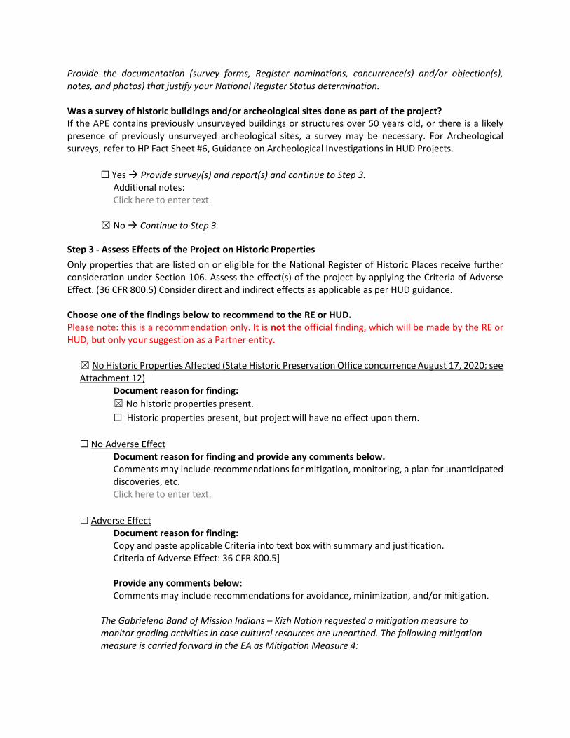
Provide the documentation (survey forms, Register nominations, concurrence(s) and/or objection(s), notes, and photos) that justify your National Register Status determination. Was a survey of historic buildings and/or archeological sites done as part of the project? If the APE contains previously unsurveyed buildings or structures over 50 years old, or there is a likely presence of previously unsurveyed archeological sites, a survey may be necessary. For Archeological surveys, refer to HP Fact Sheet #6, Guidance on Archeological Investigations in HUD Projects.
☐ Yes Provide survey(s) and report(s) and continue to Step 3. Additional notes: Click here to enter text.
☒ No Continue to Step 3.
Step 3 - Assess Effects of the Project on Historic Properties Only properties that are listed on or eligible for the National Register of Historic Places receive further consideration under Section 106. Assess the effect(s) of the project by applying the Criteria of Adverse Effect. (36 CFR 800.5) Consider direct and indirect effects as applicable as per HUD guidance. Choose one of the findings below to recommend to the RE or HUD. Please note: this is a recommendation only. It is not the official finding, which will be made by the RE or HUD, but only your suggestion as a Partner entity. ☒ No Historic Properties Affected (State Historic Preservation Office concurrence August 17, 2020; see Attachment 12)
Document reason for finding: ☒ No historic properties present. ☐ Historic properties present, but project will have no effect upon them.
☐ No Adverse Effect Document reason for finding and provide any comments below. Comments may include recommendations for mitigation, monitoring, a plan for unanticipated discoveries, etc. Click here to enter text.
☐ Adverse Effect
Document reason for finding: Copy and paste applicable Criteria into text box with summary and justification. Criteria of Adverse Effect: 36 CFR 800.5]
Provide any comments below: Comments may include recommendations for avoidance, minimization, and/or mitigation.
The Gabrieleno Band of Mission Indians – Kizh Nation requested a mitigation measure to monitor grading activities in case cultural resources are unearthed. The following mitigation measure is carried forward in the EA as Mitigation Measure 4:
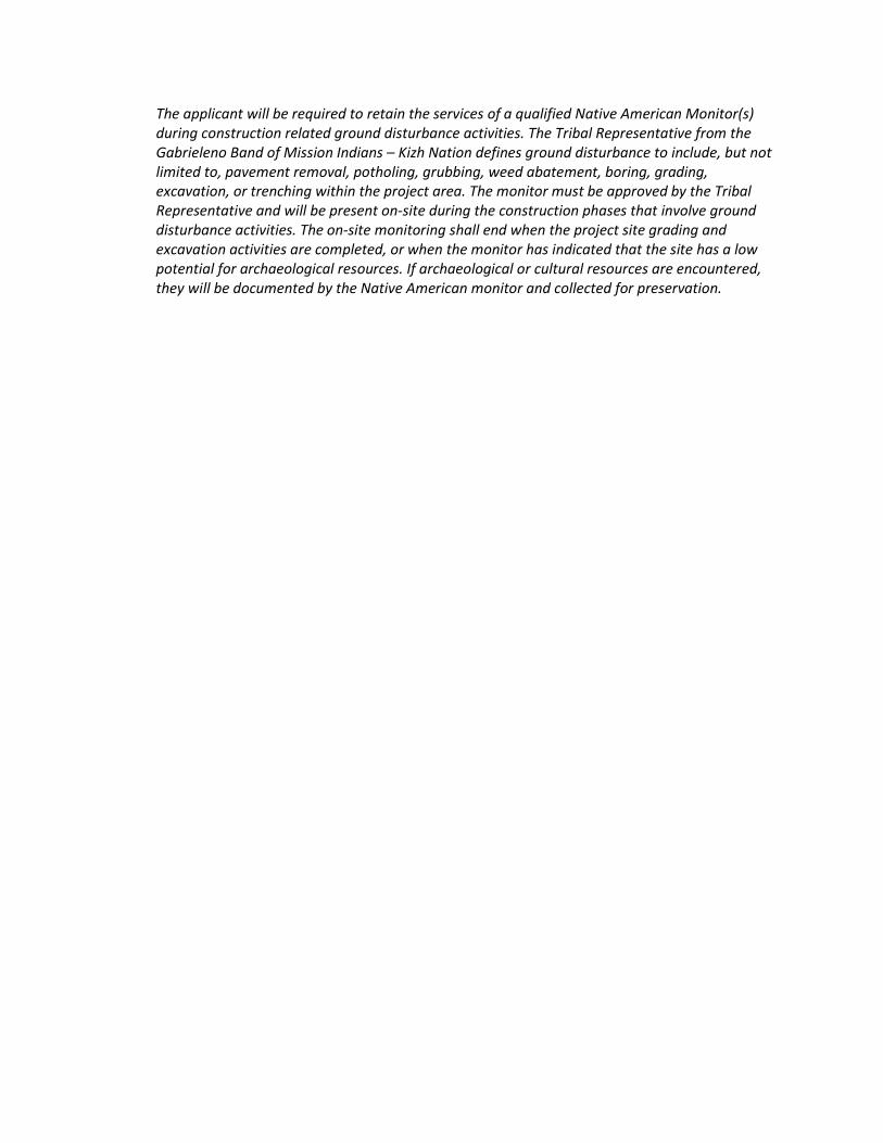
The applicant will be required to retain the services of a qualified Native American Monitor(s) during construction related ground disturbance activities. The Tribal Representative from the Gabrieleno Band of Mission Indians – Kizh Nation defines ground disturbance to include, but not limited to, pavement removal, potholing, grubbing, weed abatement, boring, grading, excavation, or trenching within the project area. The monitor must be approved by the Tribal Representative and will be present on-site during the construction phases that involve ground disturbance activities. The on-site monitoring shall end when the project site grading and excavation activities are completed, or when the monitor has indicated that the site has a low potential for archaeological resources. If archaeological or cultural resources are encountered, they will be documented by the Native American monitor and collected for preservation.

39
ERR #8. Noise Abatement and Control
OMB No. 2506-0177 (exp. 9/30/2021)
U.S. DEPARTMENT OF HOUSING AND URBAN DEVELOPMENT WASHINGTON, DC 20410-1000
This Worksheet was designed to be used by those “Partners” (including Public Housing Authorities, consultants, contractors, and nonprofits) who assist Responsible Entities and HUD in preparing environmental reviews, but legally cannot take full responsibilities for these reviews themselves. Responsible Entities and HUD should use the RE/HUD version of the Worksheet.
Noise (EA Level Reviews) – PARTNER https://www.hudexchange.info/programs/environmental-review/noise-abatement-and-control
1. What activities does your project involve? Check all that apply: ☒ New construction for residential use
NOTE: HUD assistance to new construction projects is generally prohibited if they are located in an Unacceptable zone, and HUD discourages assistance for new construction projects in Normally Unacceptable zones. See 24 CFR 51.101(a)(3) for further details. Continue to Question 2.
☐ Rehabilitation of an existing residential property
NOTE: For major or substantial rehabilitation in Normally Unacceptable zones, HUD encourages mitigation to reduce levels to acceptable compliance standards. For major rehabilitation in Unacceptable zones, HUD strongly encourages mitigation to reduce levels to acceptable compliance standards. See 24 CFR 51 Subpart B for further details. Continue to Question 2.
☐ None of the above If the RE/HUD agrees with this recommendation, the review is in compliance with this section. Continue to the Worksheet Summary below.
2. Complete the Preliminary Screening to identify potential noise generators in the vicinity
(1000’ from a major road, 3000’ from a railroad, or 15 miles from an airport). Indicate the findings of the Preliminary Screening below: ☐ There are no noise generators found within the threshold distances above. If the RE/HUD agrees with this recommendation, the review is in compliance with this section. Continue to the Worksheet Summary below. Provide a map showing the location of the project relative to any noise generators.
☒ Noise generators were found within the threshold distances. Continue to Question 3.
3. Complete the Noise Assessment Guidelines to quantify the noise exposure. Indicate the findings of the Noise Assessment below: ☒ Acceptable (65 decibels or less; the ceiling may be shifted to 70 decibels in circumstances described in §24 CFR 51.105(a))
Indicate noise level here: 62 dB If the RE/HUD agrees with this recommendation, the review is in compliance with this section. Continue to the Worksheet Summary below. Provide noise analysis, including noise level and data used to complete the analysis.
☐ Normally Unacceptable: (Above 65 decibels but not exceeding 75 decibels; the floor may be shifted to 70 decibels in circumstances described in 24 CFR 51.105(a))
Indicate noise level here:
If project is rehabilitation: Continue to Question 4. Provide noise analysis, including noise level and data used to complete the analysis. If project is new construction: Is the project in a largely undeveloped area1? ☐ No ☐ Yes The project requires completion of an Environmental Impact Statement (EIS) pursuant to 51.104(b)(1)(i).
Continue to Question 4. Provide noise analysis, including noise level and data used to complete the analysis.
☐ Unacceptable: (Above 75 decibels)
Indicate noise level here: If project is rehabilitation: HUD strongly encourages conversion of noise-exposed sites to land uses compatible with high noise levels. Consider converting this property to a non-residential use compatible with high noise levels. Continue to Question 4. Provide noise analysis, including noise level and data used to complete the analysis, and any other relevant information. If project is new construction: The project requires completion of an Environmental Impact Statement (EIS) pursuant to 51.104(b)(1)(i). Work with HUD or the RE to either complete an EIS or obtain a waiver signed by the appropriate authority. Continue to Question 4.
1 A largely undeveloped area means the area within 2 miles of the project site is less than 50 percent developed
with urban uses or does not have water and sewer capacity to serve the project.
4. HUD strongly encourages mitigation be used to eliminate adverse noise impacts. Work with the RE/HUD on the development of the mitigation measures that must be implemented to mitigate for the impact or effect, including the timeline for implementation. ☒ Mitigation as follows will be implemented: Provide drawings, specifications, and other materials as needed to describe the project’s noise mitigation measures.
Continue to the Worksheet Summary.
☐ No mitigation is necessary. Explain why mitigation will not be made here: Continue to the Worksheet Summary.
Worksheet Summary Provide a full description of your determination and a synopsis of the information that it was based on, such as:
Noise levels were calculated using HUD DNL Electronic Assessment Tool and are estimated to be 62 dBA, which is below the acceptable HUD noise threshold of 65 dBA (see Attachment 14).
Include all documentation supporting your findings in your submission to HUD.

41
ERR #9. Wetlands
OMB No. 2506-0177 (exp.9/30/2021)
U.S. DEPARTMENT OF HOUSING AND URBAN DEVELOPMENT WASHINGTON, DC 20410-1000
This Worksheet was designed to be used by those “Partners” (including Public Housing Authorities, consultants, contractors, and nonprofits) who assist Responsible Entities and HUD in preparing environmental reviews, but legally cannot take full responsibilities for these reviews themselves. Responsible Entities and HUD should use the RE/HUD version of the Worksheet.
Wetlands (CEST and EA) – Partner https://www.hudexchange.info/environmental-review/wetlands-protection
1. Does this project involve new construction as defined in Executive Order 11990, expansion of a building’s footprint, or ground disturbance? The term "new construction" includes draining, dredging, channelizing, filling, diking, impounding, and related activities and construction of any structures or facilities. ☐ No If the RE/HUD agrees with this recommendation, the review is in compliance with
this section. Continue to the Worksheet Summary below. ☒ Yes Continue to Question 2.
2. Will the new construction or other ground disturbance impact a wetland as defined in E.O. 11990? ☒ No If the RE/HUD agrees with this recommendation, the review is in compliance with
this section. Continue to the Worksheet Summary below. Provide a map or any other relevant documentation to explain your determination.
☐ Yes Work with HUD or the RE to assist with the 8-Step Process. Continue to Question 3.
3. Does Section 55.12 state that the 8-Step Process is not required?
☐ No, the 8-Step Process applies.
This project will require mitigation and may require elevating structure or structures. See the link to the HUD Exchange above for information on HUD’s elevation requirements. Work with the RE/HUD to assist with the 8-Step Process. Continue to Worksheet Summary.
☐ 5-Step Process is applicable per 55.12(a). Provide the applicable citation at 24 CFR 55.12(a) here. Work with the RE/HUD to assist with the 5-Step Process. This project may require mitigation or alternations. Continue to Worksheet Summary.
☐ 8-Step Process is inapplicable per 55.12(b). Provide the applicable citation at 24 CFR 55.12(b) here. If the RE/HUD agrees with this recommendation, the review is in compliance with this section. Continue to Worksheet Summary.
☐ 8-Step Process is inapplicable per 55.12(c). Provide the applicable citation at 24 CFR 55.12(c) here. If the RE/HUD agrees with this recommendation, the review is in compliance with this section. Continue to Worksheet Summary.
Worksheet Summary Provide a full description of your determination and a synopsis of the information that it was based on, such as:
No wetlands are located on or adjacent to the project area, (see Attachment 16). Include all documentation supporting your findings in your submission to HUD.

43
ERR #10. Wild and Scenic Rivers
OMB No. 2506-0177 (exp.9/30/2021)
U.S. DEPARTMENT OF HOUSING AND URBAN DEVELOPMENT WASHINGTON, DC 20410-1000
This Worksheet was designed to be used by those “Partners” (including Public Housing Authorities, consultants, contractors, and nonprofits) who assist Responsible Entities and HUD in preparing environmental reviews, but legally cannot take full responsibilities for these reviews themselves. Responsible Entities and HUD should use the RE/HUD version of the Worksheet.
Wild and Scenic Rivers (CEST and EA) – PARTNER This Worksheet was designed to be used by those “Partners” (including Public Housing Authorities, consultants, contractors, and nonprofits) who assist Responsible Entities and HUD in preparing environmental reviews, but legally cannot take full responsibilities for these reviews themselves. Responsible Entities and HUD should use the RE/HUD version of the Worksheet.
General requirements Legislation Regulation The Wild and Scenic Rivers Act provides federal protection for certain free-flowing, wild, scenic and recreational rivers designated as components or potential components of the National Wild and Scenic Rivers System (NWSRS) from the effects of construction or development.
The Wild and Scenic Rivers Act (16 U.S.C. 1271-1287), particularly section 7(b) and (c) (16 U.S.C. 1278(b) and (c))
36 CFR Part 297
References https://www.hudexchange.info/environmental-review/wild-and-scenic-rivers
1. Is your project within proximity of a NWSRS river as defined below?
Wild & Scenic Rivers: These rivers or river segments have been designated by Congress or by states (with the concurrence of the Secretary of the Interior) as wild, scenic, or recreational Study Rivers: These rivers or river segments are being studied as a potential component of the Wild & Scenic River system. Nationwide Rivers Inventory (NRI): The National Park Service has compiled and maintains the NRI, a register of river segments that potentially qualify as national wild, scenic, or recreational river areas
☒ No If the RE/HUD agrees with this recommendation, the review is in compliance with
this section. Provide documentation used to make your determination, such as a map identifying the project site and its surrounding area or a list of rivers in your region in the Screen Summary at the conclusion of this screen.
☐ Yes, the project is in proximity of a Nationwide Rivers Inventory (NRI) River.
Continue to Question 2.
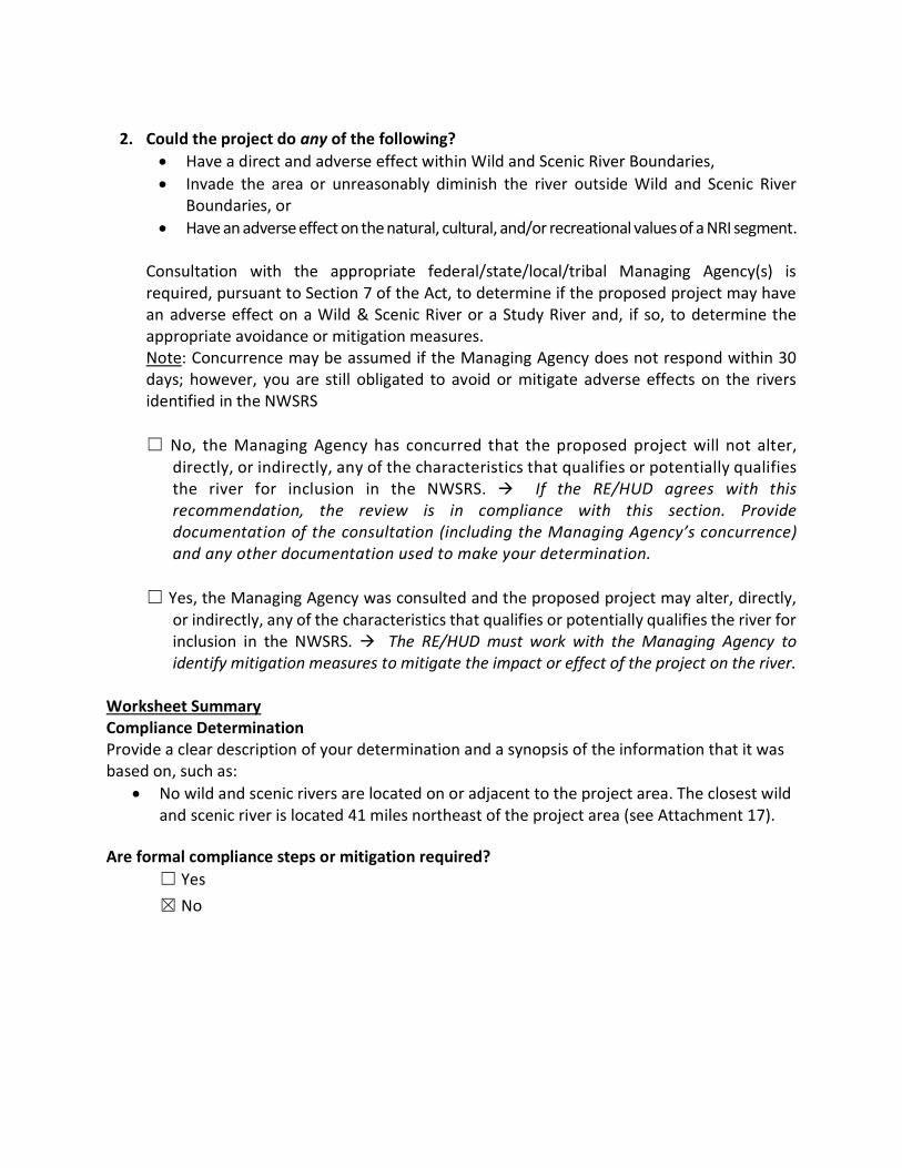
2. Could the project do any of the following?
Have a direct and adverse effect within Wild and Scenic River Boundaries, Invade the area or unreasonably diminish the river outside Wild and Scenic River
Boundaries, or Have an adverse effect on the natural, cultural, and/or recreational values of a NRI segment.
Consultation with the appropriate federal/state/local/tribal Managing Agency(s) is required, pursuant to Section 7 of the Act, to determine if the proposed project may have an adverse effect on a Wild & Scenic River or a Study River and, if so, to determine the appropriate avoidance or mitigation measures. Note: Concurrence may be assumed if the Managing Agency does not respond within 30 days; however, you are still obligated to avoid or mitigate adverse effects on the rivers identified in the NWSRS
☐ No, the Managing Agency has concurred that the proposed project will not alter,
directly, or indirectly, any of the characteristics that qualifies or potentially qualifies the river for inclusion in the NWSRS. If the RE/HUD agrees with this recommendation, the review is in compliance with this section. Provide documentation of the consultation (including the Managing Agency’s concurrence) and any other documentation used to make your determination.
☐ Yes, the Managing Agency was consulted and the proposed project may alter, directly, or indirectly, any of the characteristics that qualifies or potentially qualifies the river for inclusion in the NWSRS. The RE/HUD must work with the Managing Agency to identify mitigation measures to mitigate the impact or effect of the project on the river.
Worksheet Summary Compliance Determination Provide a clear description of your determination and a synopsis of the information that it was based on, such as:
No wild and scenic rivers are located on or adjacent to the project area. The closest wild and scenic river is located 41 miles northeast of the project area (see Attachment 17).
Are formal compliance steps or mitigation required?
☐ Yes ☒ No

45
ERR #11. Environmental Justice.
OMB No. 2506-0177 (exp.9/30/2021)
U.S. DEPARTMENT OF HOUSING AND URBAN DEVELOPMENT WASHINGTON, DC 20410-1000
This Worksheet was designed to be used by those “Partners” (including Public Housing Authorities, consultants, contractors, and nonprofits) who assist Responsible Entities and HUD in preparing environmental reviews, but legally cannot take full responsibilities for these reviews themselves. Responsible Entities and HUD should use the RE/HUD version of the Worksheet.
Environmental Justice (CEST and EA) – PARTNER https://www.hudexchange.info/environmental-review/environmental-justice
HUD strongly encourages starting the Environmental Justice analysis only after all other laws and authorities, including Environmental Assessment factors if necessary, have been completed. 1. Were any adverse environmental impacts identified in any other compliance review portion of this
project’s total environmental review? ☒Yes Continue to Question 2.
☐No If the RE/HUD agrees with this recommendation, the review is in compliance with this section.
Continue to the Worksheet Summary below. 2. Were these adverse environmental impacts disproportionately high for low-income and/or
minority communities? ☐Yes
Explain: The RE/HUD must work with the affected low-income or minority community to decide what mitigation actions, if any, will be taken. Provide any supporting documentation.
☒No Explain:
Air Quality: With the implementation of mitigation measures required for the control of fugitive dust at construction sites, no disproportionate impacts to low income and/or minority communities would occur as a result of impacts to air quality. Hazards Materials: With implementation of removing asbestos containing materials at the existing building during construction, no disproportionate impacts to low income and/or minority communities would occur as a result of hazardous materials. Erosion and Storm Water Runoff: With the implementation of stormwater mitigation measures outlined in a Stormwater Management Plan, no disproportionate impacts to low income and/or minority communities would occur as a result of erosion, drainage, and stormwater runoff. If the RE/HUD agrees with this recommendation, the review is in compliance with this section. Continue to the Worksheet Summary below.
Worksheet Summary Provide a full description of your determination and a synopsis of the information that it was based on, such as: Air Quality: Construction activities such as land clearing and grading may cause temporary adverse impacts to air quality from fugitive dust during construction of the residential community; however, with the implementation of air quality mitigation measures required for fugitive dust required by SCQAMD Rule 403 (see Mitigation Measure 1 in Environmental Assessment), impacts to air quality would be minimized or avoided. Therefore, no disproportionate impacts to low income and/or minority communities would occur as a result of fugitive dust. Hazardous Materials: Asbestos-containing materials are present in the existing building; however, with the removal of the asbestos-containing material during construction (see Mitigation Measure 2 in Environmental Assessment), no impacts to future residents would occur and no disproportionate impacts to low income and/or minority communities would occur as a result of asbestos-containing materials. Erosion/ Drainage/ Storm Water Runoff: Construction activities may temporarily increase impacts from erosion, drainage, and stormwater runoff. However, with the implementation of best management practices per the guidance of the California Stormwater Quality Association Stormwater Best Management Practice Handbooks for Construction, for New Development/Redevelopment, and for Industrial and Commercial (or other similar source as approved by Orange County) and the requirements of the National Pollutant Discharge Elimination System construction stormwater quality permit (see Mitigation Measures 5 and 6 in Environmental Assessment), the potential temporary impacts would be minimized and kept on-site to the greatest extent possible. Therefore, no disproportionate impacts to low income and/or minority communities would occur as a result of erosion, drainage, and stormwater runoff. Include all documentation supporting your findings in your submission to HUD.

47
Attachment 1. Site Plan and Design
2020 Supportive Housing NOFA OC Housing and Community Development
January 2020
Exhibit 4.02 - Project Narrative 36
EXHIBIT 4.02 Project Narrative
Project Name: Cartwright Family Apartments
Please attach a project narrative summary, no longer than one 8 ½ by 11 page, of the proposed project to this page.
NOTE: IF YOU PLAN TO RE-TYPE THIS EXHIBIT, PLEASE TYPE THE QUESTIONS IN BOLD PRINT, MAINTAIN SECTIONS IN THEIR ORIGINAL ORDER AND PUT THE DOCUMENT NAME IN THE HEADERS. YOU MAY ADD ADDITIONAL PAGES AS NEEDED.
In addition, provide information for the following:
1. General Information A. Provide a narrative of the purpose and the scope of your project.
The project is a new construction of a 60-unit family affordable community with 10 Permanent Supportive Housing (PSH) units, with a request for 8 project based vouchers. Please see attached for more details.
B. Identify the neighborhood you will serve. Attach a map and identify boundaries.
The project site is located within the Irvine Business Complex (IBC) area within the City of Irvine. Please see attached map.
C. Summarize the condition of the housing stock in the neighborhood.
The existing housing stock in the neighborhood to the East are market rate apartment communities for rent. To the North, West and South are mainly commercial offices and hotels.
D. Document neighborhood services (public transportation, schools, shopping, etc.)
Cartwright Family Apartments is conveniently located next to OC One-Stop Center that helps provide comprehensive employment and training resources in partnership with the Orange County Board of Supervisors. In addition, it’s within a 10-minute walking distance from a wide range of restaurants, a local bank, urgent care and public transportation.
A bus stop is conveniently located on the corner of Cartwright Road and Main Street (line 53, 86, 213), a 5-minute walk from the project site. Please refer to the attached map.
2020 Supportive Housing NOFA OC Housing and Community Development
January 2020
Exhibit 4.02 - Project Narrative 37
E. Discuss any other relevant issues regarding land use.
The project site was acquired by the Partnership in February 2020. The proposed project is compatible with both the Zoning Ordinance and General Plan of the City of Irvine. The project is located within the Urban Neighborhood overlay of Planning Area 36, the IBC, and is zoned 5.1 IBC Multi-Use, which allows for residential development (multifamily) at a minimum density of 30 units per acre. A density bonus or additive units will need to be processed to allow for additional parking. The design team is currently working on the initial entitlements package, with a May 2020 target submittal. Entitlement approvals are expected in the Fall of 2020.
2. Fair Housing
Explain how the project affirmatively promotes fair housing.
This project’s completion will facilitate the development of a vacant commercial building into an affordable apartment community. This would assist the County of Orange in its production efforts for new affordable housing.
Advanced Property Services Management, Inc. (APS), a wholly owned subsidiary of C&C Development, will be responsible for the ongoing management of the property. APS has been in business for over 30 years and actively involved in the management of affordable apartment communities throughout Southern California. They have thorough knowledge of Fair Housing Law and ensure that each property is in compliance with Fair Housing Law and provides a quality living environment foreach resident.
3. Targeting
Indicate the number of units targeted for the categories indicated in the table below.
Population Served
LargeFamilies (3
or more Bedrooms)
Elderly Homeless Single-room Occupancy Handicapped
No. of Units 26 10
NOTE: Total of units listed in categories above may exceed total units.
2020 Supportive Housing NOFA OC Housing and Community Development
January 2020
Exhibit 4.02 - Project Narrative 38
4. Neighborhood Revitalization
A. Describe the appropriateness of the design, unit mix and any special features that meet the occupants’ needs. Cartwright Family Apartments will feature a contemporary style architecture and the elevations will complement the architecturally modern community in the Irvine Business Complex area. The design is compliant with the City’s Design Guidelines. The height and scale of the buildings has been limited to four stories to help the buildings blend into the surrounding community. The project is designed with a mix of one-, two- and three-bedroom units to meet the needs of families who are expected to occupy the property.
Cartwright Family Apartments is conveniently located next to OC One-Stop Center that helps provide comprehensive employment and training resources in partnership with the Orange County Board of Supervisors. In addition, it’s within a 10-minute walking distance from a wide range of restaurants, a local bank, urgent care and public transportation.
A bus stop is conveniently located on the corner of Cartwright Road and Main Street (line 53, 86, 213), a 5-minute walk from the project site. Please refer to the attached map.
B. Describe how the project will address the identified housing priorities in the Consolidated Plan for the jurisdiction in which the project is located. The proposed project will address the housing priorities in the Consolidated Plan by increasing the number of affordable housing units through deed restrictions for people of very-low, low-, and moderate-income levels. In addition, developing a vacant commercial building to improve the quality of housing and add to the affordable housing stock within the Northern and Central sectors of Orange County.
C. Is the proposed project in an impacted census tract? How will the project positively impact the neighborhood? The proposed project is not within an impacted census tract as defined by HUD.
The project will positively impact the neighborhood through the development of a vacant commercial building into an affordable apartment community. The property will be owned and professionally managed by a to-be-formed Limited Partnership owned by Cartwright CCR LLC. The partners of this organization have years of experience in providing affordable housing for low income individuals. The property will be professionally managed with occupancy restrictions. Rules and regulations will be strictly enforced.
2020 Supportive Housing NOFA OC Housing and Community Development
January 2020
Exhibit 4.02 - Project Narrative 39
5. Collaboration
Describe the extent to which the project will involve community organizations, other than the project sponsor(s). Attach letters of endorsement, if available.
The project sponsor will be coordinating local community outreach efforts in conjunction with the City of Irvine. The 10 set-aside PSH units will be in collaboration with the OC Health Care Agency.
6. Innovation
Describe the extent to which the project involves a new or innovative approach (either physical, financial, or managerial) to meet the housing needs for very low and low-income persons.
The project involves an innovative approach to the new development of a family affordable housing community by being located right next to an OC One-Stop Center. The project will coordinate its efforts together its social service provider, Families Forward, together with OC One-Stop Center to help its residents, including the homeless or at-risk of homeless residents, with employment and training resources to help individuals and families stabilize and better lives.
7. Other
State anything else that you would like OC Housing and Community Development to know that is pertinent to this application. Please limit comments to one page. The project is a productive use of a vacant commercial building, that once completed, will result in the creation of new affordable housing units.
Certification The undersigned certifies under penalty of perjury that all statements made in this proposal are true and correct to the best of the undersigned’s knowledge.
Todd Cottle
Authorized Signature (Board Officer) Typed Name
Member March 19, 2020
Title Date Signed
�
ooo
ooooo
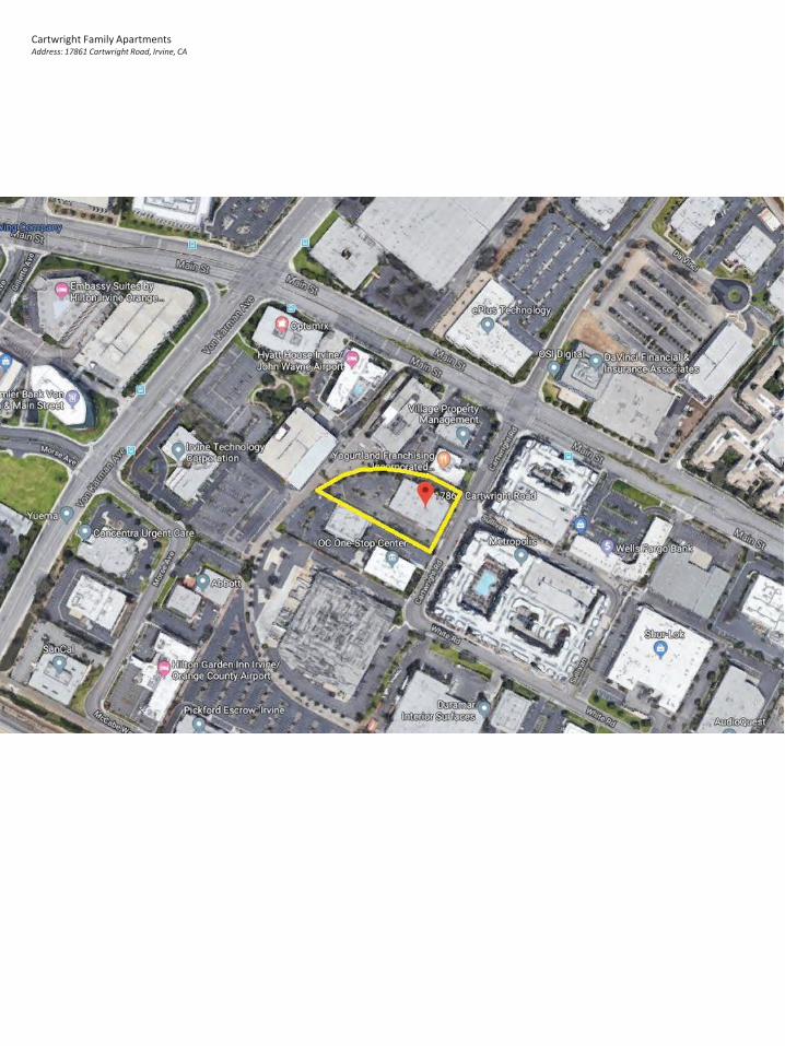
Cartwright Family ApartmentsAddress: 17861 Cartwright Road, Irvine, CA
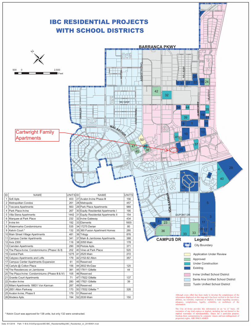
HAR
VARD
AV
E
MAIN STREET
HARVA
RDAV
E
HA
RV
A
BARRANCA PARKWAY
HA
RV
AR
DA
VE
ALTON PARKW AY
MUR IC A AISLE
VE
NE
TO
COR ON AD O
SAN LEON
SA
AMO
RE
SAN
C APOBELL
ES
TR
MER
IDA
SAN MARINO
PRESID IO
SAN CARLO
LILI
AN
O
LA F
LOR
A
DEL
ANT
EAEGEAN
P R IM AVERA
CA
RLS
ON
CA
RLS
ON
CAMPUS DR
CAMPUSDR
MICHE LSONDRIV
E
FAIRCHILD
CAMPUS DR
JAM
BO
RE
E
CAMPUS DR
CAMPUSDR
BARRANCA PARKWAY
FAIRCHILD
JAM
BO
RE
E
MACARTHUR
WARNER AVE
ALTON PARKWAY
JAM
BO
RE
E R
OA
D
ALTON PARKWAY
MAIN STREET
JAM
BO
RE
E R
OA
D
MA IN STREET
VO
NK
AR
MA
NA
VE
JAM
BO
RE
E
R
OA
D
VO
NK
AR
MA
NA
VE
VO
N K
AR
MA
N A
VE
MICHELSON DRIVE
MICHELSON DRIVE
MA
CA
RT
HU
R B
LVD
MA
CA
RT
HU
R B
LVD
MA IN STREET
MA
CA
RT
HU
RB
LVD
MACARTHUR BLVD
JAM
BO
RE
E R
OA
DJA
MB
OR
EE
RO
AD
VO
NK
AR
MA
NA
VE
MAC
ARTH
UR
BLV
D
CAMPUS DR CAMPUS DRCAMPUS DR
MAIN STREET
MAIN STRE ET
MAIN STREET
MACARTHUR BLVD
VO
N K
AR
MA
N A
VE
VO
N K
AR
MA
N A
VE
ALTON PARKWAY ALTON PARKWAY
MC GAW AVE MC GAW AVE
BARRANCA PARKWAY
MC GAW AVE
ALTON PARKWAY
VO
N K
AR
MA
N A
VE
MICHEL SON DRIVE
CA
RLS
ON
CA
RLS
ON
JAMBOREE ROAD
JAM
BO
RE
ER
OA
D
MC GAW AVE
JAM
BO
RE
E R
OA
D
MC GAW AVE
BARRANCA PARKWAY BARRANCA PARKWAY
MC GAW AVE
MICHE LSONDRIV
E
RED
HI L
LA
VE
RED
HILL
AVE
RE
DH
ILL
AV
ER
ED
HI L
L A
VE
RE
DH
I LL
AV
ER
ED
HI L
L A
VE
RE
DH
ILL
AV
E
SAN DIEGO FREEWAY (405)
CO
NST
RU
CT
ION
S
JAM
BO
RE
E R
OA
D
CO
NS T
RU
CT
ION
CIR
CLE
W
CO
NST
RU
CT
ION
CIR
CLE
E
CO
NST
RU
CT
ION
N
GATES GATES
BECKMAN AVE
NO
YE
SA
VE
RICH TER AVE
MU
RP
HY
AV
E
HA L
EA
VE
DU BRIDGE AVE
KELVIN AVE
DER
IAN
AV
E
MU
RP
HY
AV
E
CAR
TWR
IGH
T R
D
WHITE RDGI
LLET
TE A
VE
DEERE AVE DEERE AVE
ARM
STR
ON
GAR
MST
RO
NG
MC GAW AVE
PU
LLM
ANS
TPU
LLM
AN
ST
DURYEA AVE
REYNOLDS AVE
DUPONT
DR
DUPON T D R
MARTIN
DOUGLAS
MA
RT
IN
ASTO
N S
TA
STO
NS
T
STAN
LEY
BROWN ING
DAI
MLE
R S
TD
AIM
LER
ST
GIL
LETT
E A
VE
KETT ER ING ST
LANGLEY AVE
ARM
STR
ON
G
KAISER AVE
GIL
LETT
E A
VE
GIL
LETT
E A
VE
COWAN
CO
WAN
COWAN
COW AN
MITCHELL
MIT
CH
ELL
FIT
C H
FIT
CH
FIT
CH
FITC
H
REYNOLDS AVE
EAS
TMA
N A
VE
F ITCH
SK
YPA
RK
S
SKY PARK E
SKY P
ARK N
ARM
STR
ON
GARMSTRONG
GILLETTE AVE
BAR
DE
EN
AV
TELL
ER
AV
ETE
LLE
R
A
VE
BU
SIN
ES
SC
EN
TER
DR
DUPONT D
R
SKY
PA
RKBL
VD
SKY
PARK
BLVD
ASTO
N S
T
CO
RP
OR
AT E
PA
RK
CO
RP
OR
AT E
PAR
K
KELVIN AVE
CAR
TWR
IGH
T
DA VINCI
GIL
LETT
EAV
E
MIT C H ELL S.
MIL
LIK
AN
MCCABE WAY
MORSE
SAN DIEGO FREEWAY (405)
DUPON T D R
BARRANCA PARKWAY
SWE ET SH AD E
5
29
3
8
1
40
36 33
2
33
15
10
4232
4
11
2847
9
13
19
37
39
6
22
7
16 24
23
35
26
25
27
17
30
34 44
50
15
41
1820
14
45 3848
12
31
52
21
IBC RESIDENTIAL PROJECTS WITH SCHOOL DISTRICTS
Date: 8/1/2018 Path: Y:\B & S\GIS\projects\IBC\IBC_ResidentialMap\IBC_Residential_cn_20180801.mxd
500 2,5000Feet
Although every effort has been made to develop the completeness of the information displayed on this map and it has been verified to the best of our abilities, no warranty, expressed or implied, is made regarding accuracy, adequacy, completeness, legality, reliability, or usefulness of the information. The City of Irvine provides this information on an “as is” basis. All warranties of any kind express or implied, including but not limited to the implied warranties of merchantability, fitness for a particular purpose, freedom from contamination by computer viruses and non-infringement of proprietary rights, ARE DISCLAIMED.
ASTO
N
Mc GAW
AR
MST
RO
NG
MIL
LIKA
N
JAM
BO
REE
MU
RPH
Y
ARM
STR
ON
G
MAC ARTHUR
DUPONT DR
VON
KA
RM
AN
DAI
MLE
R
* Kelvin Court was approved for 138 units, but only 132 were constructed.
Legend
Tustin Unified School DistrictSanta Ana Unified School District
Irvine Unified School District
Existing
ApprovedUnder Construction
Application Under Review
BARRANCA PKWY
City Boundary
CAMPUS DR
Cartwright FamilyApartments
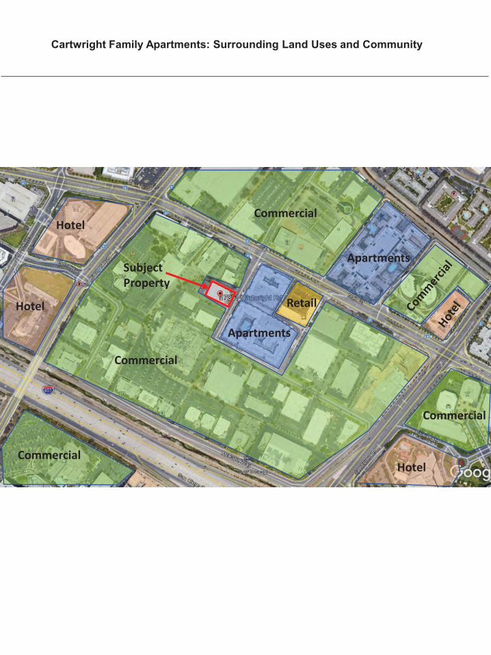
Cartwright Family Apartments: Surrounding Land Uses and Community
Commercial
Retail
Subject Property
Apartments
Hotel
Commercial
Apartments
Commercial
Hotel
Hotel
Commercial
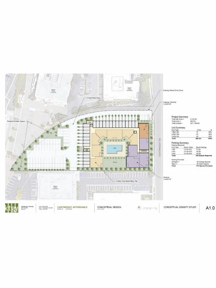
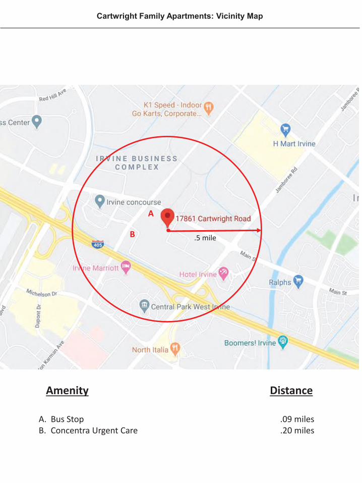
Cartwright Family Apartments: Vicinity Map
Amenity Distance
A. Bus Stop .09 milesB. Concentra Urgent Care .20 miles
.5 mile
A
B

48
Attachment 2. Airport Hazards Map
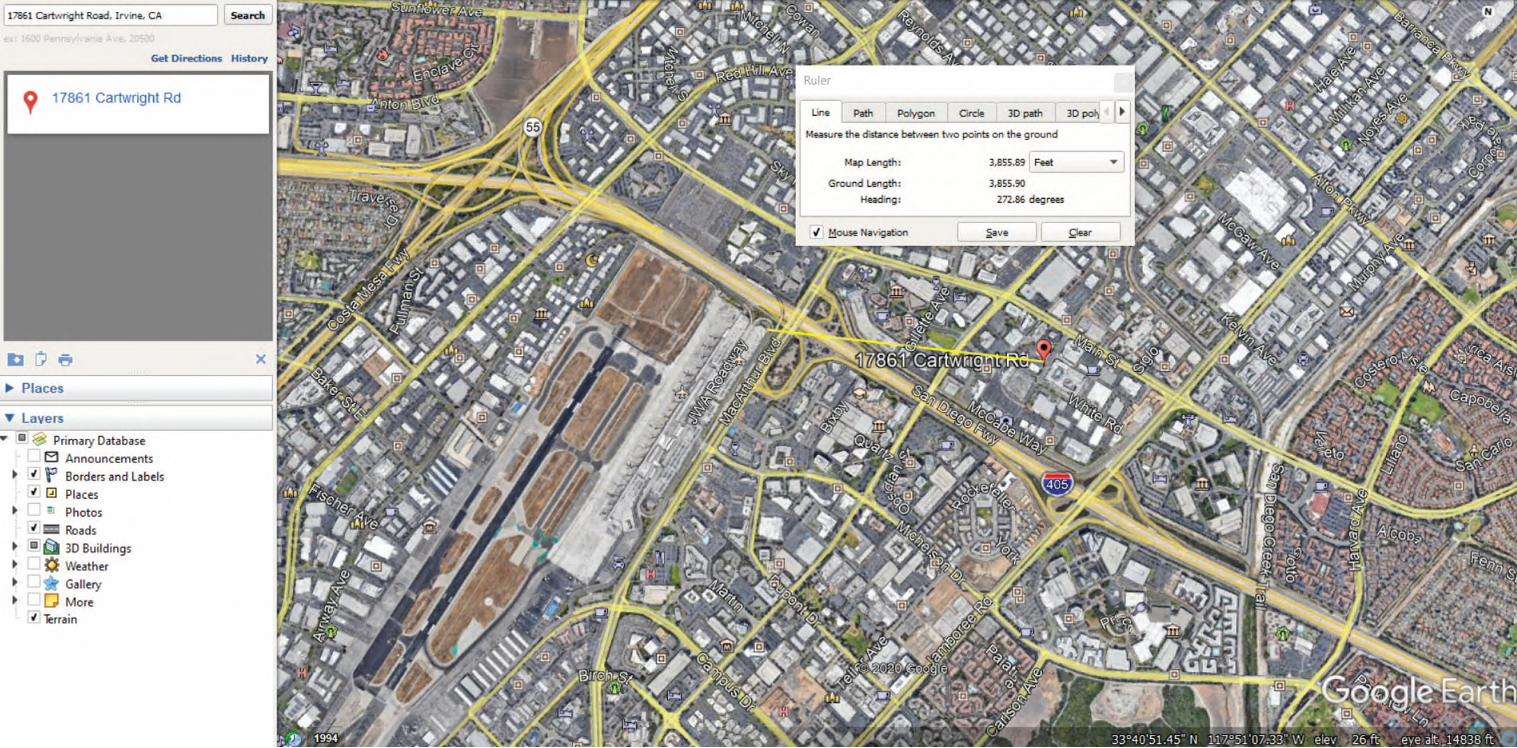

49
Attachment 3. Coastal Barrier Resources Map
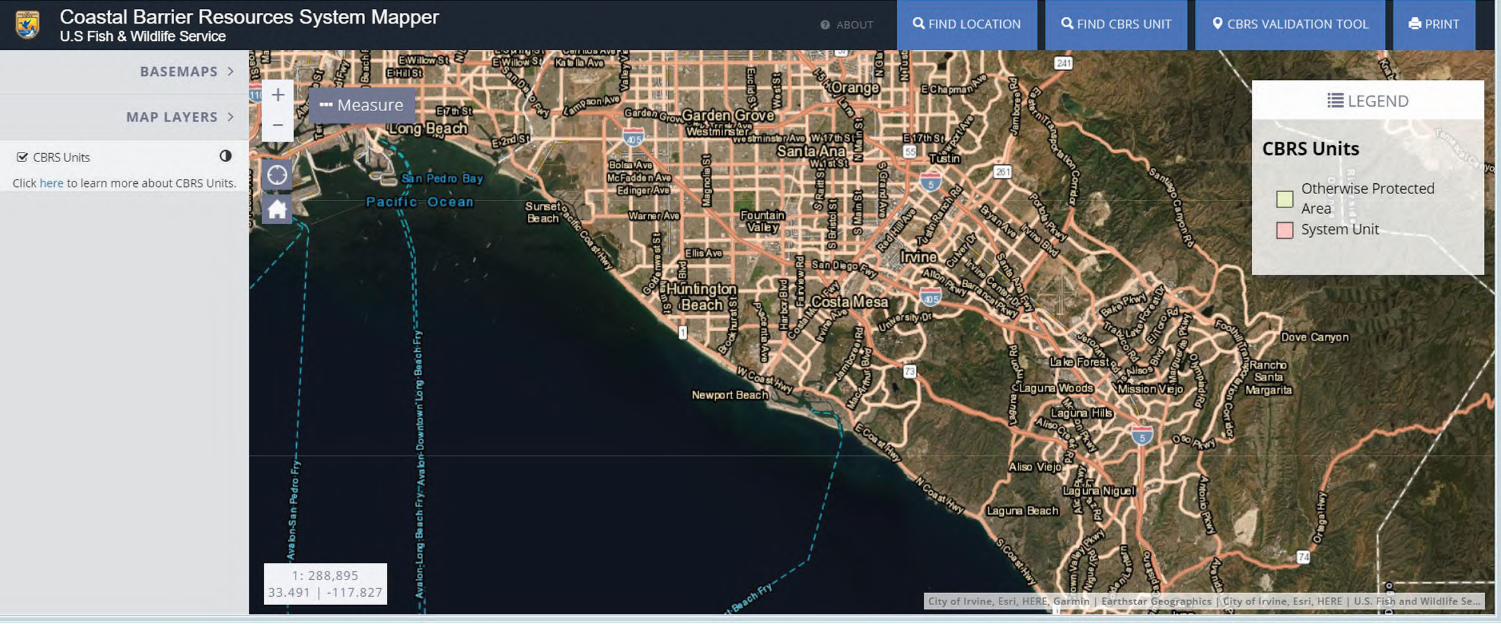

50
Attachment 4. Flood Insurance Map
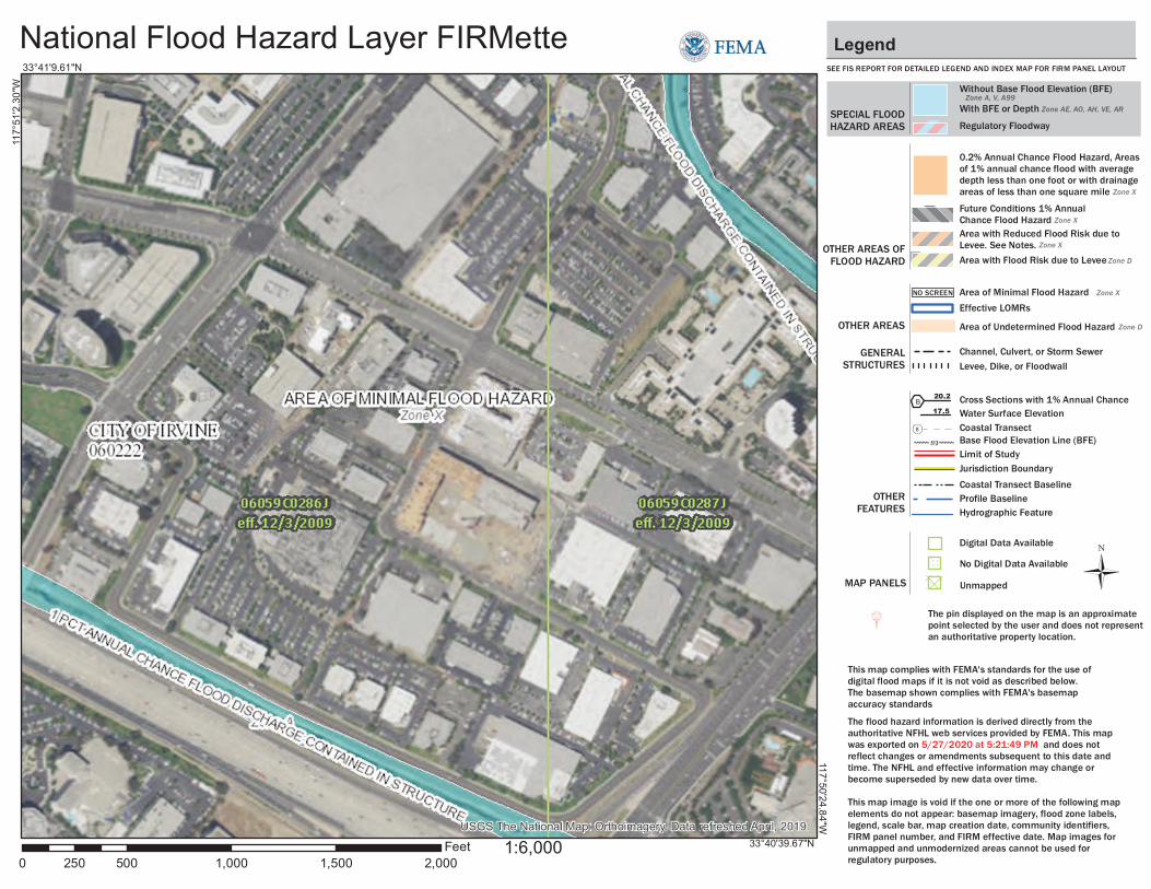
USGS The National Map: Orthoimagery. Data refreshed April, 2019.
National Flood Hazard Layer FIRMette
0 500 1,000 1,500 2,000250Feet
Ü
117°
51'2
.30"
W
33°41'9.61"N
117°50'24.84"W
33°40'39.67"N
SEE FIS REPORT FOR DETAILED LEGEND AND INDEX MAP FOR FIRM PANEL LAYOUT
SPECIAL FLOODHAZARD AREAS
Without Base Flood Elevation (BFE)Zone A, V, A99
With BFE or Depth Zone AE, AO, AH, VE, AR
Regulatory Floodway
0.2% Annual Chance Flood Hazard, Areasof 1% annual chance flood with averagedepth less than one foot or with drainageareas of less than one square mile Zone X
Future Conditions 1% AnnualChance Flood Hazard Zone X
Area with Reduced Flood Risk due toLevee. See Notes. Zone X
Area with Flood Risk due to Levee Zone D
NO SCREEN Area of Minimal Flood Hazard Zone X
Area of Undetermined Flood Hazard Zone D
Channel, Culvert, or Storm Sewer
Levee, Dike, or Floodwall
Cross Sections with 1% Annual Chance17.5 Water Surface Elevation
Coastal Transect
Coastal Transect BaselineProfile BaselineHydrographic Feature
Base Flood Elevation Line (BFE)
Effective LOMRs
Limit of StudyJurisdiction Boundary
Digital Data Available
No Digital Data Available
Unmapped
This map complies with FEMA's standards for the use of digital flood maps if it is not void as described below. The basemap shown complies with FEMA's basemap accuracy standards
The flood hazard information is derived directly from theauthoritative NFHL web services provided by FEMA. This mapwas exported on 5/27/2020 at 5:21:49 PM and does notreflect changes or amendments subsequent to this date andtime. The NFHL and effective information may change orbecome superseded by new data over time.
This map image is void if the one or more of the following mapelements do not appear: basemap imagery, flood zone labels,legend, scale bar, map creation date, community identifiers,FIRM panel number, and FIRM effective date. Map images forunmapped and unmodernized areas cannot be used forregulatory purposes.
Legend
OTHER AREAS OFFLOOD HAZARD
OTHER AREAS
GENERALSTRUCTURES
OTHERFEATURES
MAP PANELS
8
1:6,000
B20.2
The pin displayed on the map is an approximate point selected by the user and does not represent an authoritative property location.

51
Attachment 5. Air Quality CalEEMod Model
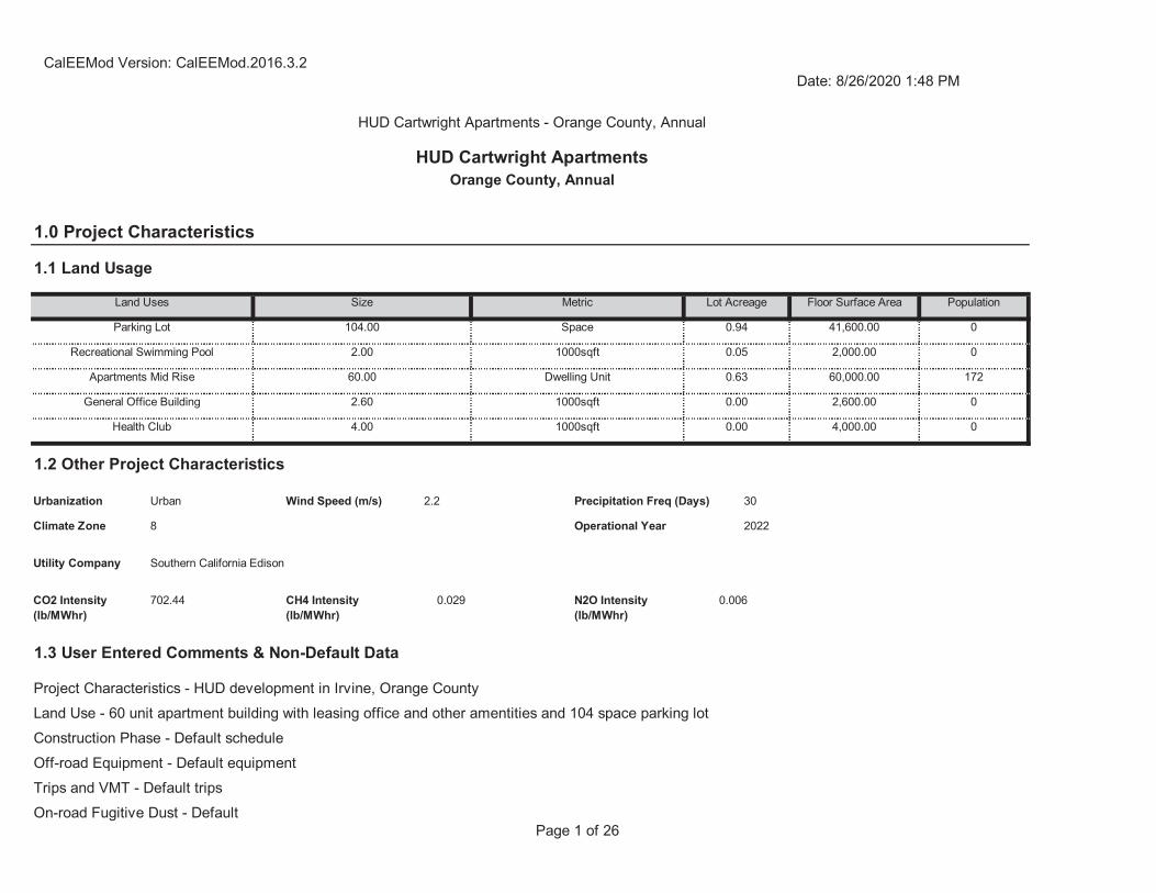
Page 1 of 26
1.3 User Entered Comments & Non-Default Data
Trips and VMT - Default tripsOn-road Fugitive Dust - Default
Project Characteristics - HUD development in Irvine, Orange CountyLand Use - 60 unit apartment building with leasing office and other amentities and 104 space parking lotConstruction Phase - Default scheduleOff-road Equipment - Default equipment
CO2 Intensity (lb/MWhr)
702.44 CH4 Intensity (lb/MWhr)
0.029 N2O Intensity (lb/MWhr)
0.006
30
Climate Zone 8 Operational Year 2022
Utility Company Southern California Edison
1.2 Other Project Characteristics
Urbanization Urban Wind Speed (m/s) 2.2 Precipitation Freq (Days)
Health Club 4.00 1000sqft 0.00 4,000.00 0
General Office Building 2.60 1000sqft 0.00 2,600.00 0
Apartments Mid Rise 60.00 Dwelling Unit 0.63 60,000.00 172
Recreational Swimming Pool 2.00 1000sqft 0.05 2,000.00 0
Floor Surface Area Population
Parking Lot 104.00 Space 0.94 41,600.00 0
1.0 Project Characteristics
1.1 Land Usage
Land Uses Size Metric Lot Acreage
CalEEMod Version: CalEEMod.2016.3.2Date: 8/26/2020 1:48 PM
HUD Cartwright Apartments - Orange County, Annual
HUD Cartwright ApartmentsOrange County, Annual
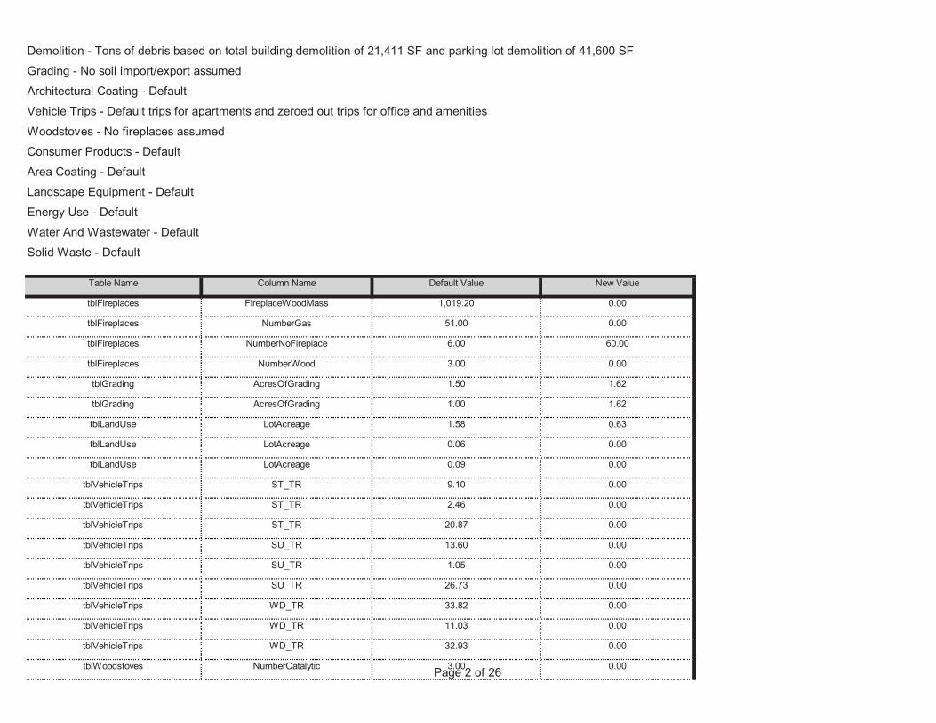
Page 2 of 26tblWoodstoves NumberCatalytic 3.00 0.00
tblVehicleTrips WD_TR 11.03 0.00
tblVehicleTrips WD_TR 32.93 0.00
tblVehicleTrips SU_TR 26.73 0.00
tblVehicleTrips WD_TR 33.82 0.00
tblVehicleTrips SU_TR 13.60 0.00
tblVehicleTrips SU_TR 1.05 0.00
tblVehicleTrips ST_TR 2.46 0.00
tblVehicleTrips ST_TR 20.87 0.00
tblLandUse LotAcreage 0.09 0.00
tblVehicleTrips ST_TR 9.10 0.00
tblLandUse LotAcreage 1.58 0.63
tblLandUse LotAcreage 0.06 0.00
tblGrading AcresOfGrading 1.50 1.62
tblGrading AcresOfGrading 1.00 1.62
tblFireplaces NumberNoFireplace 6.00 60.00
tblFireplaces NumberWood 3.00 0.00
tblFireplaces FireplaceWoodMass 1,019.20 0.00
tblFireplaces NumberGas 51.00 0.00
Area Coating - DefaultLandscape Equipment - DefaultEnergy Use - DefaultWater And Wastewater - DefaultSolid Waste - Default
Table Name Column Name Default Value New Value
Demolition - Tons of debris based on total building demolition of 21,411 SF and parking lot demolition of 41,600 SFGrading - No soil import/export assumedArchitectural Coating - DefaultVehicle Trips - Default trips for apartments and zeroed out trips for office and amenitiesWoodstoves - No fireplaces assumedConsumer Products - Default
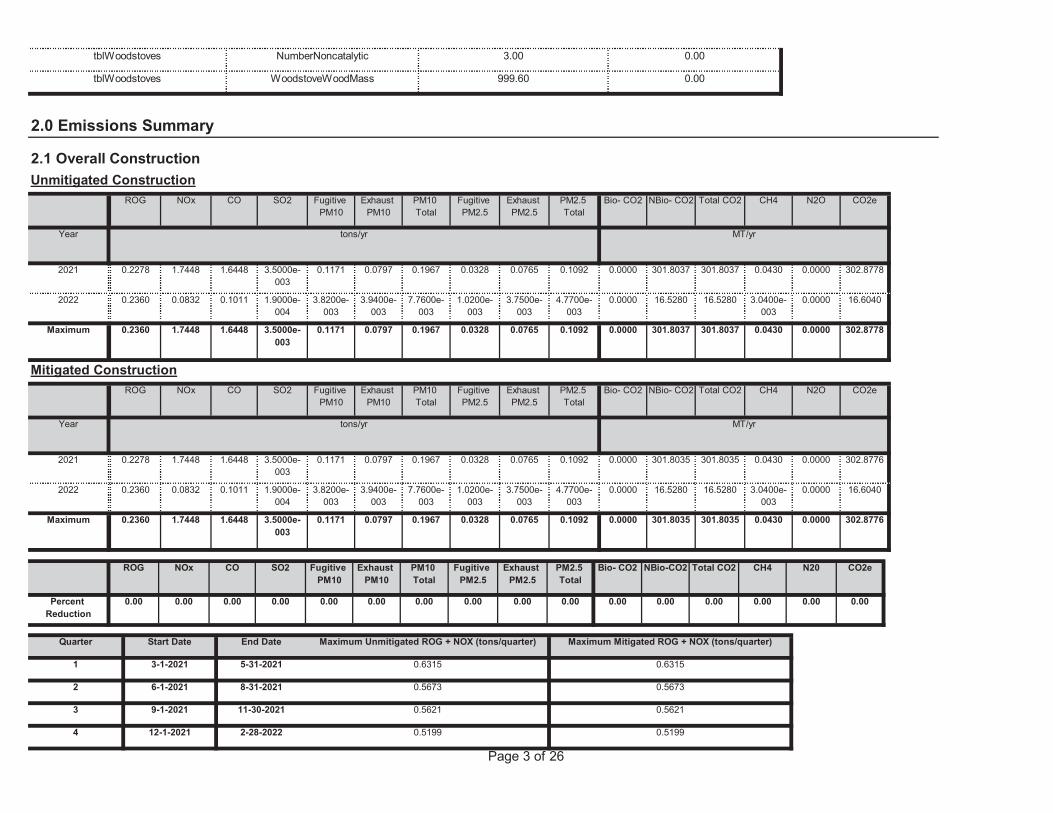
Page 3 of 26
4 12-1-2021 2-28-2022 0.5199 0.5199
2 6-1-2021 8-31-2021 0.5673 0.5673
3 9-1-2021 11-30-2021 0.5621 0.5621
Quarter Start Date End Date Maximum Unmitigated ROG + NOX (tons/quarter) Maximum Mitigated ROG + NOX (tons/quarter)
1 3-1-2021 5-31-2021 0.6315 0.6315
0.00 0.00 0.00 0.00 0.00 0.000.00 0.00 0.00 0.00 0.00 0.00
NBio-CO2 Total CO2 CH4 N20 CO2e
Percent Reduction
0.00 0.00 0.00 0.00
Exhaust PM10
PM10 Total
Fugitive PM2.5
Exhaust PM2.5
PM2.5 Total
Bio- CO2ROG NOx CO SO2 Fugitive PM10
0.0000 301.8035 301.8035 0.0430 0.0000 302.87760.1171 0.0797 0.1967 0.0328 0.0765 0.1092Maximum 0.2360 1.7448 1.6448 3.5000e-003
0.0000 16.5280 16.5280 3.0400e-003
0.0000 16.60403.8200e-003
3.9400e-003
7.7600e-003
1.0200e-003
3.7500e-003
4.7700e-003
2022 0.2360 0.0832 0.1011 1.9000e-004
0.0000 301.8035 301.8035 0.0430 0.0000 302.87760.1171 0.0797 0.1967 0.0328 0.0765 0.10922021 0.2278 1.7448 1.6448 3.5000e-003
Total CO2 CH4 N2O CO2e
Year tons/yr MT/yr
PM10 Total
Fugitive PM2.5
Exhaust PM2.5
PM2.5 Total
Bio- CO2 NBio- CO2
Mitigated ConstructionROG NOx CO SO2 Fugitive
PM10Exhaust
PM10
0.0000 301.8037 301.8037 0.0430 0.0000 302.87780.1171 0.0797 0.1967 0.0328 0.0765 0.1092Maximum 0.2360 1.7448 1.6448 3.5000e-003
0.0000 16.5280 16.5280 3.0400e-003
0.0000 16.60403.8200e-003
3.9400e-003
7.7600e-003
1.0200e-003
3.7500e-003
4.7700e-003
2022 0.2360 0.0832 0.1011 1.9000e-004
0.0000 301.8037 301.8037 0.0430 0.0000 302.87780.1171 0.0797 0.1967 0.0328 0.0765 0.10922021 0.2278 1.7448 1.6448 3.5000e-003
CH4 N2O CO2e
Year tons/yr MT/yr
Fugitive PM2.5
Exhaust PM2.5
PM2.5 Total
Bio- CO2 NBio- CO2 Total CO2
Unmitigated ConstructionROG NOx CO SO2 Fugitive
PM10Exhaust
PM10PM10 Total
tblWoodstoves WoodstoveWoodMass 999.60 0.00
2.0 Emissions Summary
2.1 Overall Construction
tblWoodstoves NumberNoncatalytic 3.00 0.00
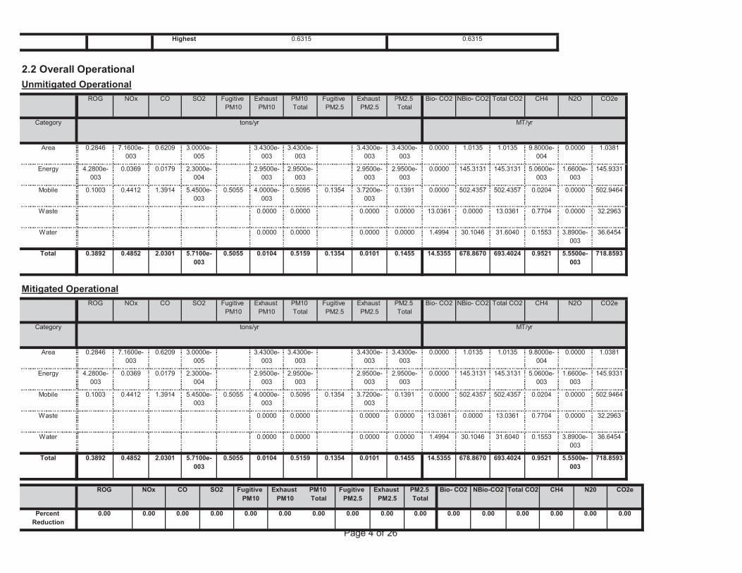
Page 4 of 26
0.00 0.00 0.00 0.00 0.00 0.000.00 0.00 0.00 0.00 0.00 0.00
NBio-CO2 Total CO2 CH4 N20 CO2e
Percent Reduction
0.00 0.00 0.00 0.00
Exhaust PM10
PM10 Total
Fugitive PM2.5
Exhaust PM2.5
PM2.5 Total
Bio- CO2ROG NOx CO SO2 Fugitive PM10
14.5355 678.8670 693.4024 0.9521 5.5500e-003
718.85930.5055 0.0104 0.5159 0.1354 0.0101 0.1455Total 0.3892 0.4852 2.0301 5.7100e-003
1.4994 30.1046 31.6040 0.1553 3.8900e-003
36.64540.0000 0.0000 0.0000 0.0000Water
13.0361 0.0000 13.0361 0.7704 0.0000 32.29630.0000 0.0000 0.0000 0.0000Waste
0.0000 502.4357 502.4357 0.0204 0.0000 502.94640.5055 4.0000e-003
0.5095 0.1354 3.7200e-003
0.1391Mobile 0.1003 0.4412 1.3914 5.4500e-003
0.0000 145.3131 145.3131 5.0600e-003
1.6600e-003
145.93312.9500e-003
2.9500e-003
2.9500e-003
2.9500e-003
Energy 4.2800e-003
0.0369 0.0179 2.3000e-004
0.0000 1.0135 1.0135 9.8000e-004
0.0000 1.03813.4300e-003
3.4300e-003
3.4300e-003
3.4300e-003
Area 0.2846 7.1600e-003
0.6209 3.0000e-005
Total CO2 CH4 N2O CO2e
Category tons/yr MT/yr
PM10 Total
Fugitive PM2.5
Exhaust PM2.5
PM2.5 Total
Bio- CO2 NBio- CO2
Mitigated OperationalROG NOx CO SO2 Fugitive
PM10Exhaust
PM10
14.5355 678.8670 693.4024 0.9521 5.5500e-003
718.85930.5055 0.0104 0.5159 0.1354 0.0101 0.1455Total 0.3892 0.4852 2.0301 5.7100e-003
1.4994 30.1046 31.6040 0.1553 3.8900e-003
36.64540.0000 0.0000 0.0000 0.0000Water
13.0361 0.0000 13.0361 0.7704 0.0000 32.29630.0000 0.0000 0.0000 0.0000Waste
0.0000 502.4357 502.4357 0.0204 0.0000 502.94640.5055 4.0000e-003
0.5095 0.1354 3.7200e-003
0.1391Mobile 0.1003 0.4412 1.3914 5.4500e-003
0.0000 145.3131 145.3131 5.0600e-003
1.6600e-003
145.93312.9500e-003
2.9500e-003
2.9500e-003
2.9500e-003
Energy 4.2800e-003
0.0369 0.0179 2.3000e-004
0.0000 1.0135 1.0135 9.8000e-004
0.0000 1.03813.4300e-003
3.4300e-003
3.4300e-003
3.4300e-003
Area 0.2846 7.1600e-003
0.6209 3.0000e-005
Total CO2 CH4 N2O CO2e
Category tons/yr MT/yr
PM10 Total
Fugitive PM2.5
Exhaust PM2.5
PM2.5 Total
Bio- CO2 NBio- CO2
2.2 Overall OperationalUnmitigated Operational
ROG NOx CO SO2 Fugitive PM10
Exhaust PM10
Highest 0.6315 0.6315
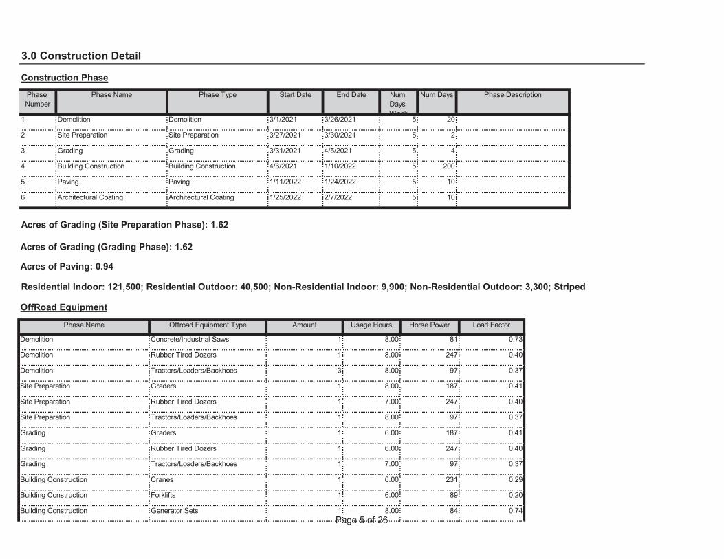
Page 5 of 26Building Construction Generator Sets 1 8.00 84 0.74
Building Construction Forklifts 1 6.00 89 0.20
Building Construction Cranes 1 6.00 231 0.29
Grading Tractors/Loaders/Backhoes 1 7.00 97 0.37
Grading Rubber Tired Dozers 1 6.00 247 0.40
Grading Graders 1 6.00 187 0.41
Site Preparation Tractors/Loaders/Backhoes 1 8.00 97 0.37
Site Preparation Rubber Tired Dozers 1 7.00 247 0.40
Site Preparation Graders 1 8.00 187 0.41
Demolition Tractors/Loaders/Backhoes 3 8.00 97 0.37
Demolition Rubber Tired Dozers 1 8.00 247 0.40
Load Factor
Demolition Concrete/Industrial Saws 1 8.00 81 0.73
Acres of Grading (Site Preparation Phase): 1.62
Acres of Grading (Grading Phase): 1.62
Acres of Paving: 0.94
Residential Indoor: 121,500; Residential Outdoor: 40,500; Non-Residential Indoor: 9,900; Non-Residential Outdoor: 3,300; Striped
OffRoad Equipment
Phase Name Offroad Equipment Type Amount Usage Hours Horse Power
10
6 Architectural Coating Architectural Coating 1/25/2022 2/7/2022 5 10
5 Paving Paving 1/11/2022 1/24/2022 5
4
4 Building Construction Building Construction 4/6/2021 1/10/2022 5 200
3 Grading Grading 3/31/2021 4/5/2021 5
20
2 Site Preparation Site Preparation 3/27/2021 3/30/2021 5 2
End Date Num Days Week
Num Days Phase Description
1 Demolition Demolition 3/1/2021 3/26/2021 5
3.0 Construction Detail
Construction PhasePhase Number
Phase Name Phase Type Start Date
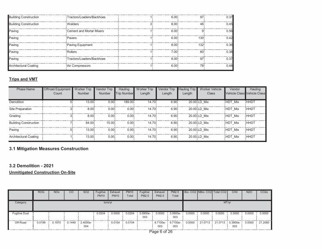
Page 6 of 26
0.0000 21.0713 21.0713 5.3900e-003
0.0000 21.20600.0104 0.0104 9.7100e-003
9.7100e-003
Off-Road 0.0199 0.1970 0.1449 2.4000e-004
0.0000 0.0000 0.0000 0.0000 0.0000 0.00000.0204 0.0000 0.0204 3.0900e-003
0.0000 3.0900e-003
Fugitive Dust
NBio- CO2 Total CO2 CH4 N2O CO2e
Category tons/yr MT/yr
Exhaust PM10
PM10 Total
Fugitive PM2.5
Exhaust PM2.5
PM2.5 Total
Bio- CO2
3.1 Mitigation Measures Construction
3.2 Demolition - 2021Unmitigated Construction On-Site
ROG NOx CO SO2 Fugitive PM10
14.70 6.90 20.00 LD_Mix HDT_Mix HHDT
6.90 20.00 LD_Mix HDT_Mix HHDT
Architectural Coating 1 13.00 0.00 0.00
Paving 5 13.00 0.00 0.00 14.70
14.70 6.90 20.00 LD_Mix HDT_Mix HHDT
6.90 20.00 LD_Mix HDT_Mix HHDT
Building Construction 7 64.00 15.00 0.00
Grading 3 8.00 0.00 0.00 14.70
14.70 6.90 20.00 LD_Mix HDT_Mix HHDT
6.90 20.00 LD_Mix HDT_Mix HHDT
Site Preparation 3 8.00 0.00 0.00
Demolition 5 13.00 0.00 189.00 14.70
Worker Trip Length
Vendor Trip Length
Hauling Trip Length
Worker Vehicle Class
Vendor Vehicle Class
Hauling Vehicle Class
Trips and VMT
Phase Name Offroad Equipment Count
Worker Trip Number
Vendor Trip Number
Hauling Trip Number
Architectural Coating Air Compressors 1 6.00 78 0.48
Paving Tractors/Loaders/Backhoes 1 8.00 97 0.37
Paving Rollers 1 7.00 80 0.38
Paving Paving Equipment 1 8.00 132 0.36
Paving Pavers 1 6.00 130 0.42
Paving Cement and Mortar Mixers 1 6.00 9 0.56
Building Construction Welders 3 8.00 46 0.45
Building Construction Tractors/Loaders/Backhoes 1 6.00 97 0.37
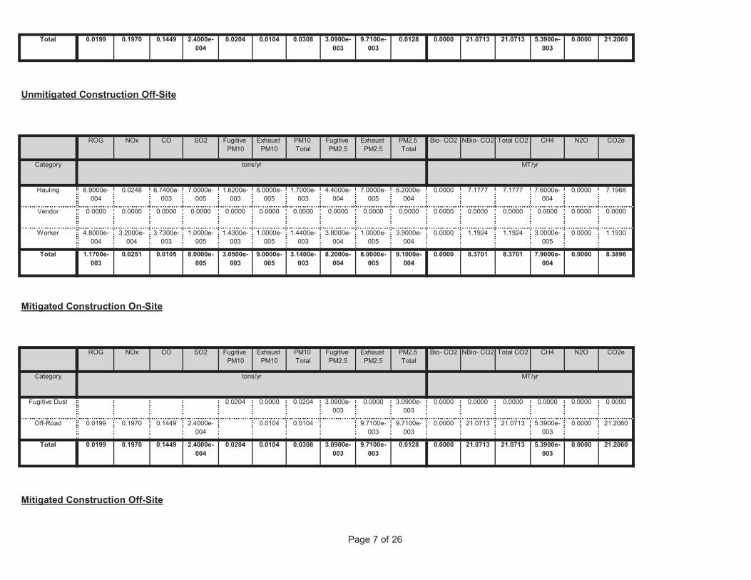
Page 7 of 26
Mitigated Construction Off-Site
0.0000 21.0713 21.0713 5.3900e-003
0.0000 21.20600.0204 0.0104 0.0308 3.0900e-003
9.7100e-003
0.0128Total 0.0199 0.1970 0.1449 2.4000e-004
0.0000 21.0713 21.0713 5.3900e-003
0.0000 21.20600.0104 0.0104 9.7100e-003
9.7100e-003
Off-Road 0.0199 0.1970 0.1449 2.4000e-004
0.0000 0.0000 0.0000 0.0000 0.0000 0.00000.0204 0.0000 0.0204 3.0900e-003
0.0000 3.0900e-003
Fugitive Dust
Total CO2 CH4 N2O CO2e
Category tons/yr MT/yr
PM10 Total
Fugitive PM2.5
Exhaust PM2.5
PM2.5 Total
Bio- CO2 NBio- CO2
Mitigated Construction On-Site
ROG NOx CO SO2 Fugitive PM10
Exhaust PM10
0.0000 8.3701 8.3701 7.9000e-004
0.0000 8.38963.0500e-003
9.0000e-005
3.1400e-003
8.2000e-004
8.0000e-005
9.1000e-004
Total 1.1700e-003
0.0251 0.0105 8.0000e-005
0.0000 1.1924 1.1924 3.0000e-005
0.0000 1.19301.4300e-003
1.0000e-005
1.4400e-003
3.8000e-004
1.0000e-005
3.9000e-004
Worker 4.8000e-004
3.2000e-004
3.7300e-003
1.0000e-005
0.0000 0.0000 0.0000 0.0000 0.0000 0.00000.0000 0.0000 0.0000 0.0000 0.0000 0.0000Vendor 0.0000 0.0000 0.0000 0.0000
0.0000 7.1777 7.1777 7.6000e-004
0.0000 7.19661.6200e-003
8.0000e-005
1.7000e-003
4.4000e-004
7.0000e-005
5.2000e-004
Hauling 6.9000e-004
0.0248 6.7400e-003
7.0000e-005
Total CO2 CH4 N2O CO2e
Category tons/yr MT/yr
PM10 Total
Fugitive PM2.5
Exhaust PM2.5
PM2.5 Total
Bio- CO2 NBio- CO2
Unmitigated Construction Off-Site
ROG NOx CO SO2 Fugitive PM10
Exhaust PM10
0.0000 21.0713 21.0713 5.3900e-003
0.0000 21.20600.0204 0.0104 0.0308 3.0900e-003
9.7100e-003
0.0128Total 0.0199 0.1970 0.1449 2.4000e-004
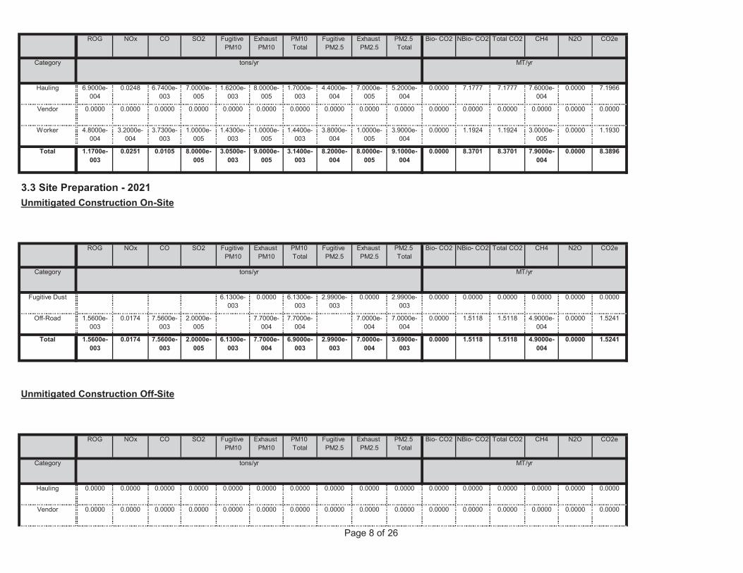
Page 8 of 26
0.0000 0.0000 0.0000 0.0000 0.0000 0.00000.0000 0.0000 0.0000 0.0000 0.0000 0.0000Vendor 0.0000 0.0000 0.0000 0.0000
0.0000 0.0000 0.0000 0.0000 0.0000 0.00000.0000 0.0000 0.0000 0.0000 0.0000 0.0000Hauling 0.0000 0.0000 0.0000 0.0000
Total CO2 CH4 N2O CO2e
Category tons/yr MT/yr
PM10 Total
Fugitive PM2.5
Exhaust PM2.5
PM2.5 Total
Bio- CO2 NBio- CO2
Unmitigated Construction Off-Site
ROG NOx CO SO2 Fugitive PM10
Exhaust PM10
0.0000 1.5118 1.5118 4.9000e-004
0.0000 1.52416.1300e-003
7.7000e-004
6.9000e-003
2.9900e-003
7.0000e-004
3.6900e-003
Total 1.5600e-003
0.0174 7.5600e-003
2.0000e-005
0.0000 1.5118 1.5118 4.9000e-004
0.0000 1.52417.7000e-004
7.7000e-004
7.0000e-004
7.0000e-004
Off-Road 1.5600e-003
0.0174 7.5600e-003
2.0000e-005
0.0000 0.0000 0.0000 0.0000 0.0000 0.00006.1300e-003
0.0000 6.1300e-003
2.9900e-003
0.0000 2.9900e-003
Fugitive Dust
Total CO2 CH4 N2O CO2e
Category tons/yr MT/yr
PM10 Total
Fugitive PM2.5
Exhaust PM2.5
PM2.5 Total
Bio- CO2 NBio- CO2
3.3 Site Preparation - 2021Unmitigated Construction On-Site
ROG NOx CO SO2 Fugitive PM10
Exhaust PM10
0.0000 8.3701 8.3701 7.9000e-004
0.0000 8.38963.0500e-003
9.0000e-005
3.1400e-003
8.2000e-004
8.0000e-005
9.1000e-004
Total 1.1700e-003
0.0251 0.0105 8.0000e-005
0.0000 1.1924 1.1924 3.0000e-005
0.0000 1.19301.4300e-003
1.0000e-005
1.4400e-003
3.8000e-004
1.0000e-005
3.9000e-004
Worker 4.8000e-004
3.2000e-004
3.7300e-003
1.0000e-005
0.0000 0.0000 0.0000 0.0000 0.0000 0.00000.0000 0.0000 0.0000 0.0000 0.0000 0.0000Vendor 0.0000 0.0000 0.0000 0.0000
0.0000 7.1777 7.1777 7.6000e-004
0.0000 7.19661.6200e-003
8.0000e-005
1.7000e-003
4.4000e-004
7.0000e-005
5.2000e-004
Hauling 6.9000e-004
0.0248 6.7400e-003
7.0000e-005
Total CO2 CH4 N2O CO2e
Category tons/yr MT/yr
PM10 Total
Fugitive PM2.5
Exhaust PM2.5
PM2.5 Total
Bio- CO2 NBio- CO2ROG NOx CO SO2 Fugitive PM10
Exhaust PM10
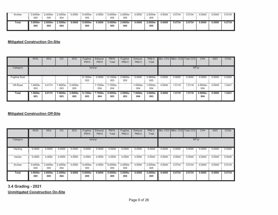
Page 9 of 26
3.4 Grading - 2021Unmitigated Construction On-Site
0.0000 0.0734 0.0734 0.0000 0.0000 0.07349.0000e-005
0.0000 9.0000e-005
2.0000e-005
0.0000 2.0000e-005
Total 3.0000e-005
2.0000e-005
2.3000e-004
0.0000
0.0000 0.0734 0.0734 0.0000 0.0000 0.07349.0000e-005
0.0000 9.0000e-005
2.0000e-005
0.0000 2.0000e-005
Worker 3.0000e-005
2.0000e-005
2.3000e-004
0.0000
0.0000 0.0000 0.0000 0.0000 0.0000 0.00000.0000 0.0000 0.0000 0.0000 0.0000 0.0000Vendor 0.0000 0.0000 0.0000 0.0000
0.0000 0.0000 0.0000 0.0000 0.0000 0.00000.0000 0.0000 0.0000 0.0000 0.0000 0.0000Hauling 0.0000 0.0000 0.0000 0.0000
Total CO2 CH4 N2O CO2e
Category tons/yr MT/yr
PM10 Total
Fugitive PM2.5
Exhaust PM2.5
PM2.5 Total
Bio- CO2 NBio- CO2
Mitigated Construction Off-Site
ROG NOx CO SO2 Fugitive PM10
Exhaust PM10
0.0000 1.5118 1.5118 4.9000e-004
0.0000 1.52416.1300e-003
7.7000e-004
6.9000e-003
2.9900e-003
7.0000e-004
3.6900e-003
Total 1.5600e-003
0.0174 7.5600e-003
2.0000e-005
0.0000 1.5118 1.5118 4.9000e-004
0.0000 1.52417.7000e-004
7.7000e-004
7.0000e-004
7.0000e-004
Off-Road 1.5600e-003
0.0174 7.5600e-003
2.0000e-005
0.0000 0.0000 0.0000 0.0000 0.0000 0.00006.1300e-003
0.0000 6.1300e-003
2.9900e-003
0.0000 2.9900e-003
Fugitive Dust
Total CO2 CH4 N2O CO2e
Category tons/yr MT/yr
PM10 Total
Fugitive PM2.5
Exhaust PM2.5
PM2.5 Total
Bio- CO2 NBio- CO2
Mitigated Construction On-Site
ROG NOx CO SO2 Fugitive PM10
Exhaust PM10
0.0000 0.0734 0.0734 0.0000 0.0000 0.07349.0000e-005
0.0000 9.0000e-005
2.0000e-005
0.0000 2.0000e-005
Total 3.0000e-005
2.0000e-005
2.3000e-004
0.0000
0.0000 0.0734 0.0734 0.0000 0.0000 0.07349.0000e-005
0.0000 9.0000e-005
2.0000e-005
0.0000 2.0000e-005
Worker 3.0000e-005
2.0000e-005
2.3000e-004
0.0000
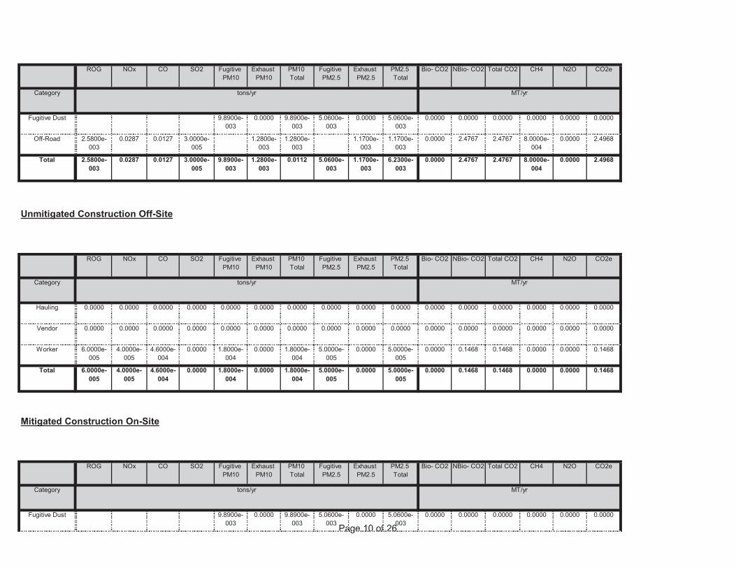
Page 10 of 260.0000 0.0000 0.0000 0.0000 0.0000 0.00009.8900e-
0030.0000 9.8900e-
0035.0600e-
0030.0000 5.0600e-
003Fugitive Dust
Total CO2 CH4 N2O CO2e
Category tons/yr MT/yr
PM10 Total
Fugitive PM2.5
Exhaust PM2.5
PM2.5 Total
Bio- CO2 NBio- CO2
Mitigated Construction On-Site
ROG NOx CO SO2 Fugitive PM10
Exhaust PM10
0.0000 0.1468 0.1468 0.0000 0.0000 0.14681.8000e-004
0.0000 1.8000e-004
5.0000e-005
0.0000 5.0000e-005
Total 6.0000e-005
4.0000e-005
4.6000e-004
0.0000
0.0000 0.1468 0.1468 0.0000 0.0000 0.14681.8000e-004
0.0000 1.8000e-004
5.0000e-005
0.0000 5.0000e-005
Worker 6.0000e-005
4.0000e-005
4.6000e-004
0.0000
0.0000 0.0000 0.0000 0.0000 0.0000 0.00000.0000 0.0000 0.0000 0.0000 0.0000 0.0000Vendor 0.0000 0.0000 0.0000 0.0000
0.0000 0.0000 0.0000 0.0000 0.0000 0.00000.0000 0.0000 0.0000 0.0000 0.0000 0.0000Hauling 0.0000 0.0000 0.0000 0.0000
Total CO2 CH4 N2O CO2e
Category tons/yr MT/yr
PM10 Total
Fugitive PM2.5
Exhaust PM2.5
PM2.5 Total
Bio- CO2 NBio- CO2
Unmitigated Construction Off-Site
ROG NOx CO SO2 Fugitive PM10
Exhaust PM10
0.0000 2.4767 2.4767 8.0000e-004
0.0000 2.49689.8900e-003
1.2800e-003
0.0112 5.0600e-003
1.1700e-003
6.2300e-003
Total 2.5800e-003
0.0287 0.0127 3.0000e-005
0.0000 2.4767 2.4767 8.0000e-004
0.0000 2.49681.2800e-003
1.2800e-003
1.1700e-003
1.1700e-003
Off-Road 2.5800e-003
0.0287 0.0127 3.0000e-005
0.0000 0.0000 0.0000 0.0000 0.0000 0.00009.8900e-003
0.0000 9.8900e-003
5.0600e-003
0.0000 5.0600e-003
Fugitive Dust
Total CO2 CH4 N2O CO2e
Category tons/yr MT/yr
PM10 Total
Fugitive PM2.5
Exhaust PM2.5
PM2.5 Total
Bio- CO2 NBio- CO2ROG NOx CO SO2 Fugitive PM10
Exhaust PM10
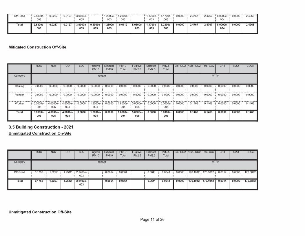
Page 11 of 26
Unmitigated Construction Off-Site
0.0000 176.1012 176.1012 0.0314 0.0000 176.88720.0664 0.0664 0.0641 0.0641Total 0.1758 1.3227 1.2512 2.1400e-003
0.0000 176.1012 176.1012 0.0314 0.0000 176.88720.0664 0.0664 0.0641 0.0641Off-Road 0.1758 1.3227 1.2512 2.1400e-003
Total CO2 CH4 N2O CO2e
Category tons/yr MT/yr
PM10 Total
Fugitive PM2.5
Exhaust PM2.5
PM2.5 Total
Bio- CO2 NBio- CO2
3.5 Building Construction - 2021Unmitigated Construction On-Site
ROG NOx CO SO2 Fugitive PM10
Exhaust PM10
0.0000 0.1468 0.1468 0.0000 0.0000 0.14681.8000e-004
0.0000 1.8000e-004
5.0000e-005
0.0000 5.0000e-005
Total 6.0000e-005
4.0000e-005
4.6000e-004
0.0000
0.0000 0.1468 0.1468 0.0000 0.0000 0.14681.8000e-004
0.0000 1.8000e-004
5.0000e-005
0.0000 5.0000e-005
Worker 6.0000e-005
4.0000e-005
4.6000e-004
0.0000
0.0000 0.0000 0.0000 0.0000 0.0000 0.00000.0000 0.0000 0.0000 0.0000 0.0000 0.0000Vendor 0.0000 0.0000 0.0000 0.0000
0.0000 0.0000 0.0000 0.0000 0.0000 0.00000.0000 0.0000 0.0000 0.0000 0.0000 0.0000Hauling 0.0000 0.0000 0.0000 0.0000
Total CO2 CH4 N2O CO2e
Category tons/yr MT/yr
PM10 Total
Fugitive PM2.5
Exhaust PM2.5
PM2.5 Total
Bio- CO2 NBio- CO2
Mitigated Construction Off-Site
ROG NOx CO SO2 Fugitive PM10
Exhaust PM10
0.0000 2.4767 2.4767 8.0000e-004
0.0000 2.49689.8900e-003
1.2800e-003
0.0112 5.0600e-003
1.1700e-003
6.2300e-003
Total 2.5800e-003
0.0287 0.0127 3.0000e-005
0.0000 2.4767 2.4767 8.0000e-004
0.0000 2.49681.2800e-003
1.2800e-003
1.1700e-003
1.1700e-003
Off-Road 2.5800e-003
0.0287 0.0127 3.0000e-005
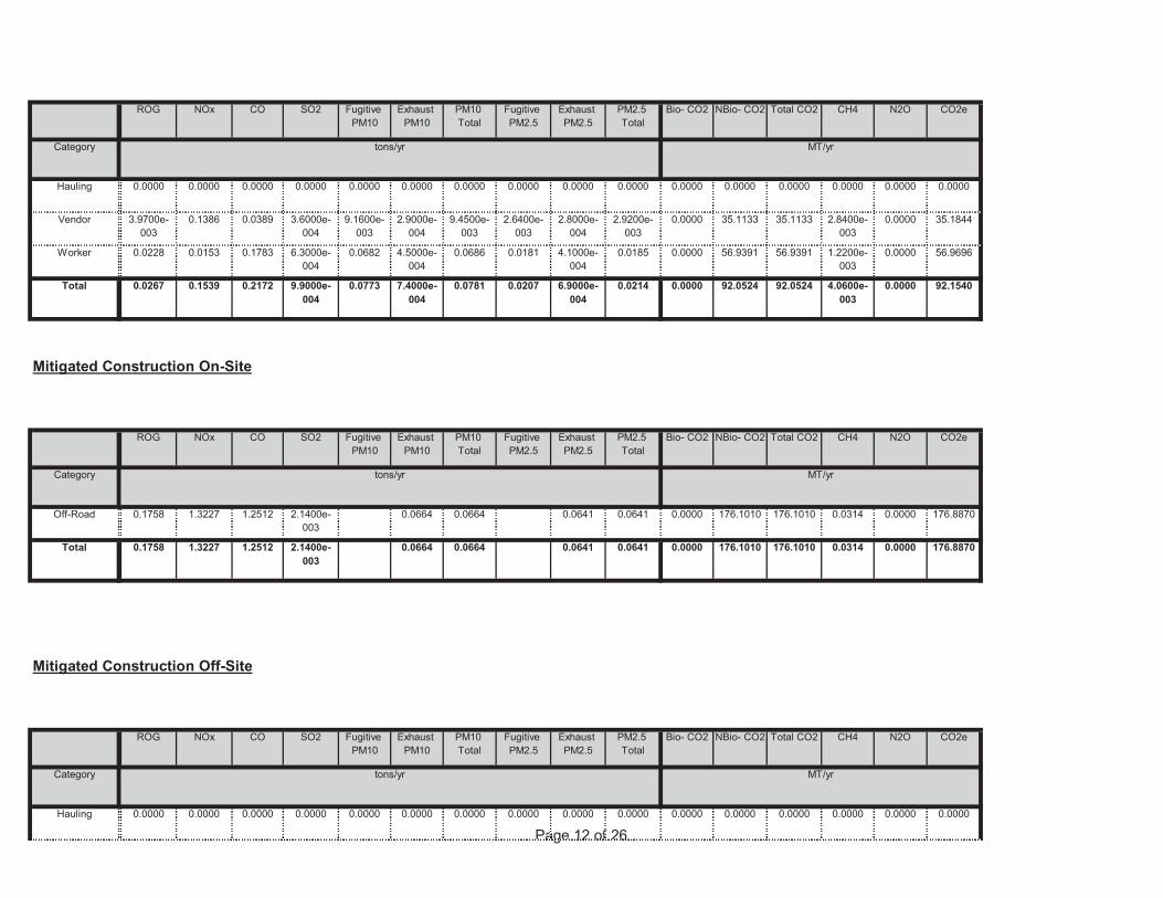
Page 12 of 260.0000 0.0000 0.0000 0.0000 0.0000 0.00000.0000 0.0000 0.0000 0.0000 0.0000 0.0000Hauling 0.0000 0.0000 0.0000 0.0000
Total CO2 CH4 N2O CO2e
Category tons/yr MT/yr
PM10 Total
Fugitive PM2.5
Exhaust PM2.5
PM2.5 Total
Bio- CO2 NBio- CO2
Mitigated Construction Off-Site
ROG NOx CO SO2 Fugitive PM10
Exhaust PM10
0.0000 176.1010 176.1010 0.0314 0.0000 176.88700.0664 0.0664 0.0641 0.0641Total 0.1758 1.3227 1.2512 2.1400e-003
0.0000 176.1010 176.1010 0.0314 0.0000 176.88700.0664 0.0664 0.0641 0.0641Off-Road 0.1758 1.3227 1.2512 2.1400e-003
Total CO2 CH4 N2O CO2e
Category tons/yr MT/yr
PM10 Total
Fugitive PM2.5
Exhaust PM2.5
PM2.5 Total
Bio- CO2 NBio- CO2
Mitigated Construction On-Site
ROG NOx CO SO2 Fugitive PM10
Exhaust PM10
0.0000 92.0524 92.0524 4.0600e-003
0.0000 92.15400.0773 7.4000e-004
0.0781 0.0207 6.9000e-004
0.0214Total 0.0267 0.1539 0.2172 9.9000e-004
0.0000 56.9391 56.9391 1.2200e-003
0.0000 56.96960.0682 4.5000e-004
0.0686 0.0181 4.1000e-004
0.0185Worker 0.0228 0.0153 0.1783 6.3000e-004
0.0000 35.1133 35.1133 2.8400e-003
0.0000 35.18449.1600e-003
2.9000e-004
9.4500e-003
2.6400e-003
2.8000e-004
2.9200e-003
Vendor 3.9700e-003
0.1386 0.0389 3.6000e-004
0.0000 0.0000 0.0000 0.0000 0.0000 0.00000.0000 0.0000 0.0000 0.0000 0.0000 0.0000Hauling 0.0000 0.0000 0.0000 0.0000
Total CO2 CH4 N2O CO2e
Category tons/yr MT/yr
PM10 Total
Fugitive PM2.5
Exhaust PM2.5
PM2.5 Total
Bio- CO2 NBio- CO2ROG NOx CO SO2 Fugitive PM10
Exhaust PM10
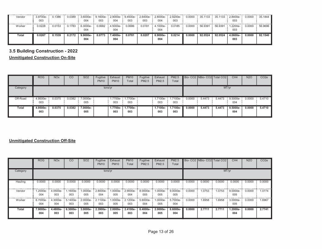
Page 13 of 26
0.0000 2.7711 2.7711 1.2000e-004
0.0000 2.77412.3900e-003
2.0000e-005
2.4100e-003
6.4000e-004
2.0000e-005
6.6000e-004
Total 7.9000e-004
4.4800e-003
6.3000e-003
3.0000e-005
0.0000 1.6958 1.6958 3.0000e-005
0.0000 1.69672.1100e-003
1.0000e-005
2.1200e-003
5.6000e-004
1.0000e-005
5.7000e-004
Worker 6.7000e-004
4.3000e-004
5.1400e-003
2.0000e-005
0.0000 1.0753 1.0753 9.0000e-005
0.0000 1.07742.8000e-004
1.0000e-005
2.9000e-004
8.0000e-005
1.0000e-005
9.0000e-005
Vendor 1.2000e-004
4.0500e-003
1.1600e-003
1.0000e-005
0.0000 0.0000 0.0000 0.0000 0.0000 0.00000.0000 0.0000 0.0000 0.0000 0.0000 0.0000Hauling 0.0000 0.0000 0.0000 0.0000
Total CO2 CH4 N2O CO2e
Category tons/yr MT/yr
PM10 Total
Fugitive PM2.5
Exhaust PM2.5
PM2.5 Total
Bio- CO2 NBio- CO2
Unmitigated Construction Off-Site
ROG NOx CO SO2 Fugitive PM10
Exhaust PM10
0.0000 5.4473 5.4473 9.5000e-004
0.0000 5.47101.7700e-003
1.7700e-003
1.7100e-003
1.7100e-003
Total 4.9500e-003
0.0375 0.0382 7.0000e-005
0.0000 5.4473 5.4473 9.5000e-004
0.0000 5.47101.7700e-003
1.7700e-003
1.7100e-003
1.7100e-003
Off-Road 4.9500e-003
0.0375 0.0382 7.0000e-005
Total CO2 CH4 N2O CO2e
Category tons/yr MT/yr
PM10 Total
Fugitive PM2.5
Exhaust PM2.5
PM2.5 Total
Bio- CO2 NBio- CO2
3.5 Building Construction - 2022Unmitigated Construction On-Site
ROG NOx CO SO2 Fugitive PM10
Exhaust PM10
0.0000 92.0524 92.0524 4.0600e-003
0.0000 92.15400.0773 7.4000e-004
0.0781 0.0207 6.9000e-004
0.0214Total 0.0267 0.1539 0.2172 9.9000e-004
0.0000 56.9391 56.9391 1.2200e-003
0.0000 56.96960.0682 4.5000e-004
0.0686 0.0181 4.1000e-004
0.0185Worker 0.0228 0.0153 0.1783 6.3000e-004
0.0000 35.1133 35.1133 2.8400e-003
0.0000 35.18449.1600e-003
2.9000e-004
9.4500e-003
2.6400e-003
2.8000e-004
2.9200e-003
Vendor 3.9700e-003
0.1386 0.0389 3.6000e-004
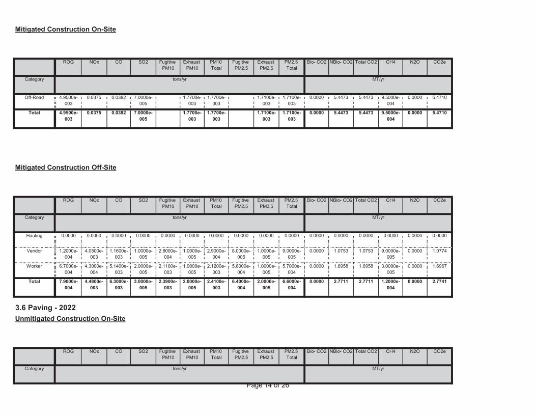
Page 14 of 26
Total CO2 CH4 N2O CO2e
Category tons/yr MT/yr
PM10 Total
Fugitive PM2.5
Exhaust PM2.5
PM2.5 Total
Bio- CO2 NBio- CO2
3.6 Paving - 2022Unmitigated Construction On-Site
ROG NOx CO SO2 Fugitive PM10
Exhaust PM10
0.0000 2.7711 2.7711 1.2000e-004
0.0000 2.77412.3900e-003
2.0000e-005
2.4100e-003
6.4000e-004
2.0000e-005
6.6000e-004
Total 7.9000e-004
4.4800e-003
6.3000e-003
3.0000e-005
0.0000 1.6958 1.6958 3.0000e-005
0.0000 1.69672.1100e-003
1.0000e-005
2.1200e-003
5.6000e-004
1.0000e-005
5.7000e-004
Worker 6.7000e-004
4.3000e-004
5.1400e-003
2.0000e-005
0.0000 1.0753 1.0753 9.0000e-005
0.0000 1.07742.8000e-004
1.0000e-005
2.9000e-004
8.0000e-005
1.0000e-005
9.0000e-005
Vendor 1.2000e-004
4.0500e-003
1.1600e-003
1.0000e-005
0.0000 0.0000 0.0000 0.0000 0.0000 0.00000.0000 0.0000 0.0000 0.0000 0.0000 0.0000Hauling 0.0000 0.0000 0.0000 0.0000
Total CO2 CH4 N2O CO2e
Category tons/yr MT/yr
PM10 Total
Fugitive PM2.5
Exhaust PM2.5
PM2.5 Total
Bio- CO2 NBio- CO2
Mitigated Construction Off-Site
ROG NOx CO SO2 Fugitive PM10
Exhaust PM10
0.0000 5.4473 5.4473 9.5000e-004
0.0000 5.47101.7700e-003
1.7700e-003
1.7100e-003
1.7100e-003
Total 4.9500e-003
0.0375 0.0382 7.0000e-005
0.0000 5.4473 5.4473 9.5000e-004
0.0000 5.47101.7700e-003
1.7700e-003
1.7100e-003
1.7100e-003
Off-Road 4.9500e-003
0.0375 0.0382 7.0000e-005
Total CO2 CH4 N2O CO2e
Category tons/yr MT/yr
PM10 Total
Fugitive PM2.5
Exhaust PM2.5
PM2.5 Total
Bio- CO2 NBio- CO2
Mitigated Construction On-Site
ROG NOx CO SO2 Fugitive PM10
Exhaust PM10
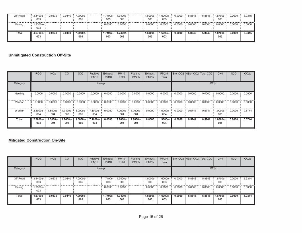
Page 15 of 26
0.0000 5.8848 5.8848 1.8700e-003
0.0000 5.93141.7400e-003
1.7400e-003
1.6000e-003
1.6000e-003
Total 4.6700e-003
0.0339 0.0440 7.0000e-005
0.0000 0.0000 0.0000 0.0000 0.0000 0.00000.0000 0.0000 0.0000 0.0000Paving 1.2300e-003
0.0000 5.8848 5.8848 1.8700e-003
0.0000 5.93141.7400e-003
1.7400e-003
1.6000e-003
1.6000e-003
Off-Road 3.4400e-003
0.0339 0.0440 7.0000e-005
Total CO2 CH4 N2O CO2e
Category tons/yr MT/yr
PM10 Total
Fugitive PM2.5
Exhaust PM2.5
PM2.5 Total
Bio- CO2 NBio- CO2
Mitigated Construction On-Site
ROG NOx CO SO2 Fugitive PM10
Exhaust PM10
0.0000 0.5741 0.5741 1.0000e-005
0.0000 0.57447.1000e-004
0.0000 7.2000e-004
1.9000e-004
0.0000 1.9000e-004
Total 2.3000e-004
1.5000e-004
1.7400e-003
1.0000e-005
0.0000 0.5741 0.5741 1.0000e-005
0.0000 0.57447.1000e-004
0.0000 7.2000e-004
1.9000e-004
0.0000 1.9000e-004
Worker 2.3000e-004
1.5000e-004
1.7400e-003
1.0000e-005
0.0000 0.0000 0.0000 0.0000 0.0000 0.00000.0000 0.0000 0.0000 0.0000 0.0000 0.0000Vendor 0.0000 0.0000 0.0000 0.0000
0.0000 0.0000 0.0000 0.0000 0.0000 0.00000.0000 0.0000 0.0000 0.0000 0.0000 0.0000Hauling 0.0000 0.0000 0.0000 0.0000
Total CO2 CH4 N2O CO2e
Category tons/yr MT/yr
PM10 Total
Fugitive PM2.5
Exhaust PM2.5
PM2.5 Total
Bio- CO2 NBio- CO2
Unmitigated Construction Off-Site
ROG NOx CO SO2 Fugitive PM10
Exhaust PM10
0.0000 5.8848 5.8848 1.8700e-003
0.0000 5.93151.7400e-003
1.7400e-003
1.6000e-003
1.6000e-003
Total 4.6700e-003
0.0339 0.0440 7.0000e-005
0.0000 0.0000 0.0000 0.0000 0.0000 0.00000.0000 0.0000 0.0000 0.0000Paving 1.2300e-003
0.0000 5.8848 5.8848 1.8700e-003
0.0000 5.93151.7400e-003
1.7400e-003
1.6000e-003
1.6000e-003
Off-Road 3.4400e-003
0.0339 0.0440 7.0000e-005
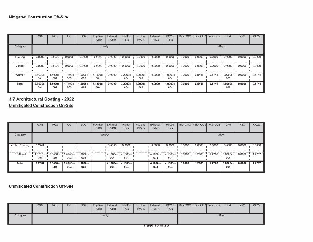
Page 16 of 26
Total CO2 CH4 N2O CO2e
Category tons/yr MT/yr
PM10 Total
Fugitive PM2.5
Exhaust PM2.5
PM2.5 Total
Bio- CO2 NBio- CO2
Unmitigated Construction Off-Site
ROG NOx CO SO2 Fugitive PM10
Exhaust PM10
0.0000 1.2766 1.2766 8.0000e-005
0.0000 1.27874.1000e-004
4.1000e-004
4.1000e-004
4.1000e-004
Total 0.2251 7.0400e-003
9.0700e-003
1.0000e-005
0.0000 1.2766 1.2766 8.0000e-005
0.0000 1.27874.1000e-004
4.1000e-004
4.1000e-004
4.1000e-004
Off-Road 1.0200e-003
7.0400e-003
9.0700e-003
1.0000e-005
0.0000 0.0000 0.0000 0.0000 0.0000 0.00000.0000 0.0000 0.0000 0.0000Archit. Coating 0.2241
Total CO2 CH4 N2O CO2e
Category tons/yr MT/yr
PM10 Total
Fugitive PM2.5
Exhaust PM2.5
PM2.5 Total
Bio- CO2 NBio- CO2
3.7 Architectural Coating - 2022Unmitigated Construction On-Site
ROG NOx CO SO2 Fugitive PM10
Exhaust PM10
0.0000 0.5741 0.5741 1.0000e-005
0.0000 0.57447.1000e-004
0.0000 7.2000e-004
1.9000e-004
0.0000 1.9000e-004
Total 2.3000e-004
1.5000e-004
1.7400e-003
1.0000e-005
0.0000 0.5741 0.5741 1.0000e-005
0.0000 0.57447.1000e-004
0.0000 7.2000e-004
1.9000e-004
0.0000 1.9000e-004
Worker 2.3000e-004
1.5000e-004
1.7400e-003
1.0000e-005
0.0000 0.0000 0.0000 0.0000 0.0000 0.00000.0000 0.0000 0.0000 0.0000 0.0000 0.0000Vendor 0.0000 0.0000 0.0000 0.0000
0.0000 0.0000 0.0000 0.0000 0.0000 0.00000.0000 0.0000 0.0000 0.0000 0.0000 0.0000Hauling 0.0000 0.0000 0.0000 0.0000
Total CO2 CH4 N2O CO2e
Category tons/yr MT/yr
PM10 Total
Fugitive PM2.5
Exhaust PM2.5
PM2.5 Total
Bio- CO2 NBio- CO2
Mitigated Construction Off-Site
ROG NOx CO SO2 Fugitive PM10
Exhaust PM10
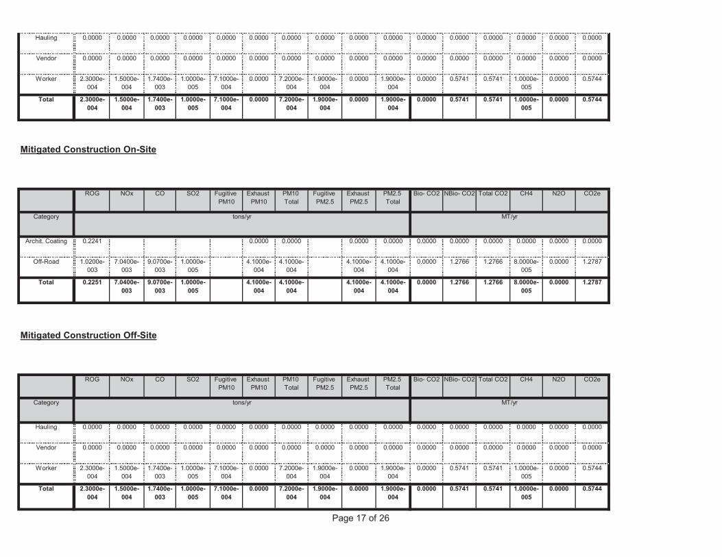
Page 17 of 26
0.0000 0.5741 0.5741 1.0000e-005
0.0000 0.57447.1000e-004
0.0000 7.2000e-004
1.9000e-004
0.0000 1.9000e-004
Total 2.3000e-004
1.5000e-004
1.7400e-003
1.0000e-005
0.0000 0.5741 0.5741 1.0000e-005
0.0000 0.57447.1000e-004
0.0000 7.2000e-004
1.9000e-004
0.0000 1.9000e-004
Worker 2.3000e-004
1.5000e-004
1.7400e-003
1.0000e-005
0.0000 0.0000 0.0000 0.0000 0.0000 0.00000.0000 0.0000 0.0000 0.0000 0.0000 0.0000Vendor 0.0000 0.0000 0.0000 0.0000
0.0000 0.0000 0.0000 0.0000 0.0000 0.00000.0000 0.0000 0.0000 0.0000 0.0000 0.0000Hauling 0.0000 0.0000 0.0000 0.0000
Total CO2 CH4 N2O CO2e
Category tons/yr MT/yr
PM10 Total
Fugitive PM2.5
Exhaust PM2.5
PM2.5 Total
Bio- CO2 NBio- CO2
Mitigated Construction Off-Site
ROG NOx CO SO2 Fugitive PM10
Exhaust PM10
0.0000 1.2766 1.2766 8.0000e-005
0.0000 1.27874.1000e-004
4.1000e-004
4.1000e-004
4.1000e-004
Total 0.2251 7.0400e-003
9.0700e-003
1.0000e-005
0.0000 1.2766 1.2766 8.0000e-005
0.0000 1.27874.1000e-004
4.1000e-004
4.1000e-004
4.1000e-004
Off-Road 1.0200e-003
7.0400e-003
9.0700e-003
1.0000e-005
0.0000 0.0000 0.0000 0.0000 0.0000 0.00000.0000 0.0000 0.0000 0.0000Archit. Coating 0.2241
Total CO2 CH4 N2O CO2e
Category tons/yr MT/yr
PM10 Total
Fugitive PM2.5
Exhaust PM2.5
PM2.5 Total
Bio- CO2 NBio- CO2
Mitigated Construction On-Site
ROG NOx CO SO2 Fugitive PM10
Exhaust PM10
0.0000 0.5741 0.5741 1.0000e-005
0.0000 0.57447.1000e-004
0.0000 7.2000e-004
1.9000e-004
0.0000 1.9000e-004
Total 2.3000e-004
1.5000e-004
1.7400e-003
1.0000e-005
0.0000 0.5741 0.5741 1.0000e-005
0.0000 0.57447.1000e-004
0.0000 7.2000e-004
1.9000e-004
0.0000 1.9000e-004
Worker 2.3000e-004
1.5000e-004
1.7400e-003
1.0000e-005
0.0000 0.0000 0.0000 0.0000 0.0000 0.00000.0000 0.0000 0.0000 0.0000 0.0000 0.0000Vendor 0.0000 0.0000 0.0000 0.0000
0.0000 0.0000 0.0000 0.0000 0.0000 0.00000.0000 0.0000 0.0000 0.0000 0.0000 0.0000Hauling 0.0000 0.0000 0.0000 0.0000
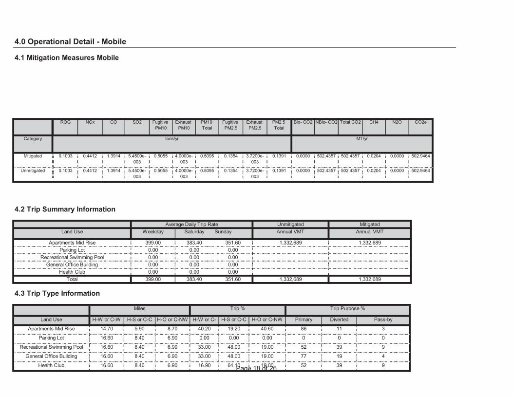
Page 18 of 2664.10 19.00 52 39 9
48.00 19.00 77 19 4
Health Club 16.60 8.40 6.90 16.90
48.00 19.00 52 39 9
General Office Building 16.60 8.40 6.90 33.00
0.00 0.00 0 0 0
Recreational Swimming Pool 16.60 8.40 6.90 33.00
19.20 40.60 86 11 3
Parking Lot 16.60 8.40 6.90 0.00
H-S or C-C H-O or C-NW Primary Diverted Pass-by
Apartments Mid Rise 14.70 5.90 8.70 40.20
4.3 Trip Type Information
Miles Trip % Trip Purpose %
Land Use H-W or C-W H-S or C-C H-O or C-NW H-W or C-W
Total 399.00 383.40 351.60 1,332,689 1,332,689Health Club 0.00 0.00 0.00
General Office Building 0.00 0.00 0.00Recreational Swimming Pool 0.00 0.00 0.00
Parking Lot 0.00 0.00 0.00
Annual VMT
Apartments Mid Rise 399.00 383.40 351.60 1,332,689 1,332,689
4.2 Trip Summary Information
Average Daily Trip Rate Unmitigated MitigatedLand Use Weekday Saturday Sunday Annual VMT
0.0000 502.4357 502.4357 0.0204 0.0000 502.94640.5055 4.0000e-003
0.5095 0.1354 3.7200e-003
0.1391Unmitigated 0.1003 0.4412 1.3914 5.4500e-003
0.0000 502.4357 502.4357 0.0204 0.0000 502.94640.5055 4.0000e-003
0.5095 0.1354 3.7200e-003
0.1391Mitigated 0.1003 0.4412 1.3914 5.4500e-003
NBio- CO2 Total CO2 CH4 N2O CO2e
Category tons/yr MT/yr
Exhaust PM10
PM10 Total
Fugitive PM2.5
Exhaust PM2.5
PM2.5 Total
Bio- CO2
4.0 Operational Detail - Mobile
4.1 Mitigation Measures Mobile
ROG NOx CO SO2 Fugitive PM10
Page 19 of 26NBio- CO2 Total CO2 CH4 N2O CO2eExhaust
PM10PM10 Total
Fugitive PM2.5
Exhaust PM2.5
PM2.5 Total
Bio- CO2
5.2 Energy by Land Use - NaturalGasUnmitigated
NaturalGas Use
ROG NOx CO SO2 Fugitive PM10
0.0000 42.3181 42.3181 8.1000e-004
7.8000e-004
42.56962.9500e-003
2.9500e-003
2.9500e-003
2.9500e-003
NaturalGas Unmitigated
4.2800e-003
0.0369 0.0179 2.3000e-004
0.0000 42.3181 42.3181 8.1000e-004
7.8000e-004
42.56962.9500e-003
2.9500e-003
2.9500e-003
2.9500e-003
NaturalGas Mitigated
4.2800e-003
0.0369 0.0179 2.3000e-004
0.0000 102.9950 102.9950 4.2500e-003
8.8000e-004
103.36350.0000 0.0000 0.0000 0.0000Electricity Unmitigated
0.0000 102.9950 102.9950 4.2500e-003
8.8000e-004
103.36350.0000 0.0000 0.0000 0.0000Electricity Mitigated
NBio- CO2 Total CO2 CH4 N2O CO2e
Category tons/yr MT/yr
Exhaust PM10
PM10 Total
Fugitive PM2.5
Exhaust PM2.5
PM2.5 Total
Bio- CO2
5.0 Energy Detail
Historical Energy Use: N
5.1 Mitigation Measures Energy
ROG NOx CO SO2 Fugitive PM10
0.017125 0.001747 0.001542 0.004926 0.000594 0.000934
0.000594 0.000934
Health Club 0.561378 0.043284 0.209473 0.111826 0.015545 0.005795 0.025829
0.005795 0.025829 0.017125 0.001747 0.001542 0.004926General Office Building 0.561378 0.043284 0.209473 0.111826 0.015545
0.017125 0.001747 0.001542 0.004926 0.000594 0.000934
0.000594 0.000934
Recreational Swimming Pool 0.561378 0.043284 0.209473 0.111826 0.015545 0.005795 0.025829
0.005795 0.025829 0.017125 0.001747 0.001542 0.004926Parking Lot 0.561378 0.043284 0.209473 0.111826 0.015545
0.017125 0.001747 0.001542 0.004926 0.000594 0.000934
SBUS MH
Apartments Mid Rise 0.561378 0.043284 0.209473 0.111826 0.015545 0.005795 0.025829
LHD2 MHD HHD OBUS UBUS MCYLand Use LDA LDT1 LDT2 MDV LHD1
4.4 Fleet Mix
Page 20 of 26
Unmitigated
Electricity Use
Total CO2 CH4 N2O CO2e
42.3181 42.3181 8.1000e-004
7.7000e-004
42.5696
5.3 Energy by Land Use - Electricity
2.9500e-003
2.9500e-003
2.9500e-003
2.9500e-003
0.0000
0.0000 0.0000
Total 4.2800e-003
0.0369 0.0179 2.3000e-004
0.0000 0.0000 0.0000 0.0000 0.0000 0.00000.0000 0.0000 0.0000 0.0000
0.0000 0.0000 0.0000 0.0000 0.0000
Recreational Swimming Pool
0 0.0000 0.0000
0.0000 0.0000 0.0000 0.0000 0.0000
8.0000e-005
4.4877
Parking Lot 0 0.0000 0.0000 0.0000 0.0000
3.1000e-004
3.1000e-004
0.0000 4.4612 4.4612 9.0000e-005
3.4400e-003
2.0000e-005
3.1000e-004
3.1000e-004
1.2681 1.2681 2.0000e-005
2.0000e-005
1.2757
Health Club 83600 4.5000e-004
4.1000e-003
9.0000e-005
9.0000e-005
9.0000e-005
9.0000e-005
0.0000
6.7000e-004
36.8062
General Office Building
23764 1.3000e-004
1.1600e-003
9.8000e-004
1.0000e-005
2.5500e-003
2.5500e-003
0.0000 36.5888 36.5888 7.0000e-004
0.0134 2.0000e-004
2.5500e-003
2.5500e-003
CO2e
Land Use kBTU/yr tons/yr MT/yr
Apartments Mid Rise
685648 3.7000e-003
0.0316
PM2.5 Total
Bio- CO2 NBio- CO2 Total CO2 CH4 N2OSO2 Fugitive PM10
Exhaust PM10
PM10 Total
Fugitive PM2.5
Exhaust PM2.5
NaturalGas Use
ROG NOx CO
42.3181 8.1000e-004
7.7000e-004
42.5696
Mitigated
2.9500e-003
2.9500e-003
2.9500e-003
0.0000 42.3181
0.0000
Total 4.2800e-003
0.0369 0.0179 2.3000e-004
2.9500e-003
0.0000 0.0000 0.0000 0.0000 0.0000 0.00000.0000 0.0000 0.0000 0.0000
0.0000 0.0000 0.0000 0.0000
Recreational Swimming Pool
0 0.0000 0.0000 0.0000
0.0000 0.0000 0.0000 0.0000 0.0000
4.4877
Parking Lot 0 0.0000 0.0000 0.0000 0.0000 0.0000
3.1000e-004
0.0000 4.4612 4.4612 9.0000e-005
8.0000e-005
2.0000e-005
3.1000e-004
3.1000e-004
3.1000e-004
1.2681 2.0000e-005
2.0000e-005
1.2757
Health Club 83600 4.5000e-004
4.1000e-003
3.4400e-003
9.0000e-005
9.0000e-005
9.0000e-005
0.0000 1.2681
36.8062
General Office Building
23764 1.3000e-004
1.1600e-003
9.8000e-004
1.0000e-005
9.0000e-005
2.5500e-003
0.0000 36.5888 36.5888 7.0000e-004
6.7000e-004
2.0000e-004
2.5500e-003
2.5500e-003
2.5500e-003
Apartments Mid Rise
685648 3.7000e-003
0.0316 0.0134
Land Use kBTU/yr tons/yr MT/yr
Page 21 of 26
6.0 Area Detail
6.1 Mitigation Measures Area
0.0000
Total 102.9950 4.2500e-003
8.8000e-004
103.3635
Recreational Swimming Pool
0 0.0000 0.0000 0.0000
10.8079
Parking Lot 14560 4.6391 1.9000e-004
4.0000e-005
4.6557
Health Club 33800 10.7694 4.4000e-004
9.0000e-005
76.2688
General Office Building
36374 11.5895 4.8000e-004
1.0000e-004
11.6310
Land Use kWh/yr ton
MT/yr
Apartments Mid Rise
238518 75.9969 3.1400e-003
6.5000e-004
Mitigated
Electricity Use
Total CO2 CH4 N2O CO2e
0.0000
Total 102.9950 4.2500e-003
8.8000e-004
103.3635
Recreational Swimming Pool
0 0.0000 0.0000 0.0000
10.8079
Parking Lot 14560 4.6391 1.9000e-004
4.0000e-005
4.6557
Health Club 33800 10.7694 4.4000e-004
9.0000e-005
76.2688
General Office Building
36374 11.5895 4.8000e-004
1.0000e-004
11.6310
Land Use kWh/yr ton
MT/yr
Apartments Mid Rise
238518 75.9969 3.1400e-003
6.5000e-004
Page 22 of 26Total CO2 CH4 N2O CO2ePM10
TotalFugitive PM2.5
Exhaust PM2.5
PM2.5 Total
Bio- CO2 NBio- CO2
Mitigated
ROG NOx CO SO2 Fugitive PM10
Exhaust PM10
0.0000 1.0135 1.0135 9.8000e-004
0.0000 1.03813.4300e-003
3.4300e-003
3.4300e-003
3.4300e-003
Total 0.2846 7.1600e-003
0.6209 3.0000e-005
0.0000 1.0135 1.0135 9.8000e-004
0.0000 1.03813.4300e-003
3.4300e-003
3.4300e-003
3.4300e-003
Landscaping 0.0188 7.1600e-003
0.6209 3.0000e-005
0.0000 0.0000 0.0000 0.0000 0.0000 0.00000.0000 0.0000 0.0000 0.0000Hearth 0.0000 0.0000 0.0000 0.0000
0.0000 0.0000 0.0000 0.0000 0.0000 0.00000.0000 0.0000 0.0000 0.0000Consumer Products
0.2434
0.0000 0.0000 0.0000 0.0000 0.0000 0.00000.0000 0.0000 0.0000 0.0000Architectural Coating
0.0224
Total CO2 CH4 N2O CO2e
SubCategory tons/yr MT/yr
PM10 Total
Fugitive PM2.5
Exhaust PM2.5
PM2.5 Total
Bio- CO2 NBio- CO2
6.2 Area by SubCategoryUnmitigated
ROG NOx CO SO2 Fugitive PM10
Exhaust PM10
0.0000 1.0135 1.0135 9.8000e-004
0.0000 1.03813.4300e-003
3.4300e-003
3.4300e-003
3.4300e-003
Unmitigated 0.2846 7.1600e-003
0.6209 3.0000e-005
0.0000 1.0135 1.0135 9.8000e-004
0.0000 1.03813.4300e-003
3.4300e-003
3.4300e-003
3.4300e-003
Mitigated 0.2846 7.1600e-003
0.6209 3.0000e-005
NBio- CO2 Total CO2 CH4 N2O CO2e
Category tons/yr MT/yr
Exhaust PM10
PM10 Total
Fugitive PM2.5
Exhaust PM2.5
PM2.5 Total
Bio- CO2ROG NOx CO SO2 Fugitive PM10
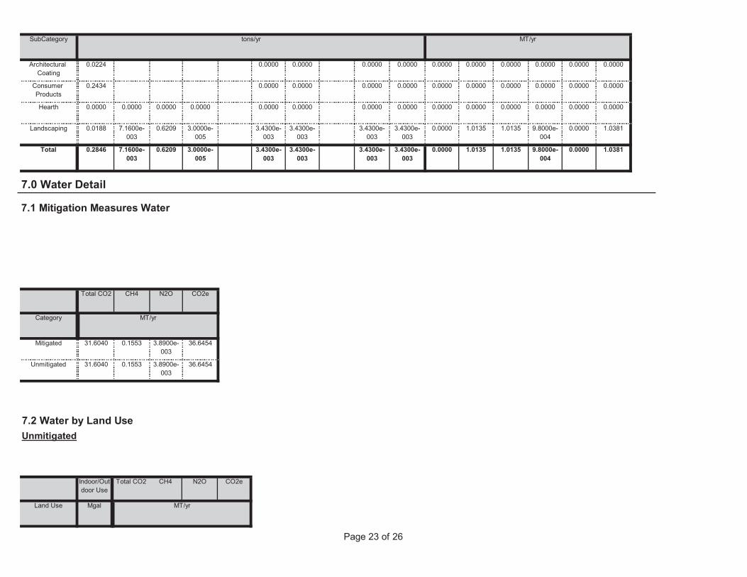
Page 23 of 26
Land Use Mgal ton
MT/yr
7.2 Water by Land UseUnmitigated
Indoor/Outdoor Use
Total CO2 CH4 N2O CO2e
Unmitigated 31.6040 0.1553 3.8900e-003
36.6454
Category ton
MT/yr
Mitigated 31.6040 0.1553 3.8900e-003
36.6454
7.0 Water Detail
7.1 Mitigation Measures Water
Total CO2 CH4 N2O CO2e
0.0000 1.0135 1.0135 9.8000e-004
0.0000 1.03813.4300e-003
3.4300e-003
3.4300e-003
3.4300e-003
Total 0.2846 7.1600e-003
0.6209 3.0000e-005
0.0000 1.0135 1.0135 9.8000e-004
0.0000 1.03813.4300e-003
3.4300e-003
3.4300e-003
3.4300e-003
Landscaping 0.0188 7.1600e-003
0.6209 3.0000e-005
0.0000 0.0000 0.0000 0.0000 0.0000 0.00000.0000 0.0000 0.0000 0.0000Hearth 0.0000 0.0000 0.0000 0.0000
0.0000 0.0000 0.0000 0.0000 0.0000 0.00000.0000 0.0000 0.0000 0.0000Consumer Products
0.2434
0.0000 0.0000 0.0000 0.0000 0.0000 0.00000.0000 0.0000 0.0000 0.0000Architectural Coating
0.0224
SubCategory tons/yr MT/yr
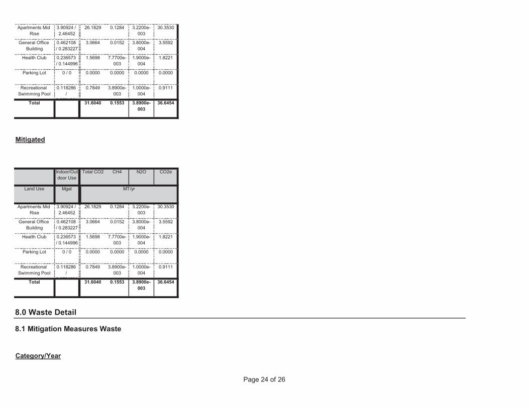
Page 24 of 26
8.0 Waste Detail
8.1 Mitigation Measures Waste
Category/Year
0.9111
Total 31.6040 0.1553 3.8900e-003
36.6454
Recreational Swimming Pool
0.118286 /
0 0724981
0.7849 3.8900e-003
1.0000e-004
1.8221
Parking Lot 0 / 0 0.0000 0.0000 0.0000 0.0000
Health Club 0.236573 / 0.144996
1.5698 7.7700e-003
1.9000e-004
30.3530
General Office Building
0.462108 / 0.283227
3.0664 0.0152 3.8000e-004
3.5592
Land Use Mgal ton
MT/yr
Apartments Mid Rise
3.90924 / 2.46452
26.1829 0.1284 3.2200e-003
Mitigated
Indoor/Outdoor Use
Total CO2 CH4 N2O CO2e
0.9111
Total 31.6040 0.1553 3.8900e-003
36.6454
Recreational Swimming Pool
0.118286 /
0 0724981
0.7849 3.8900e-003
1.0000e-004
1.8221
Parking Lot 0 / 0 0.0000 0.0000 0.0000 0.0000
Health Club 0.236573 / 0.144996
1.5698 7.7700e-003
1.9000e-004
30.3530
General Office Building
0.462108 / 0.283227
3.0664 0.0152 3.8000e-004
3.5592
Apartments Mid Rise
3.90924 / 2.46452
26.1829 0.1284 3.2200e-003
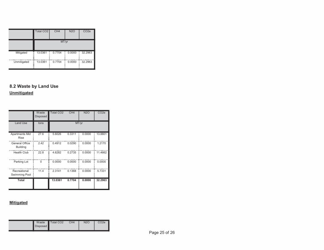
Page 25 of 26
Mitigated
Waste Disposed
Total CO2 CH4 N2O CO2e
5.7331
Total 13.0361 0.7704 0.0000 32.2963
Recreational Swimming Pool
11.4 2.3141 0.1368 0.0000
11.4662
Parking Lot 0 0.0000 0.0000 0.0000 0.0000
Health Club 22.8 4.6282 0.2735 0.0000
13.8801
General Office Building
2.42 0.4912 0.0290 0.0000 1.2170
Land Use tons ton
MT/yr
Apartments Mid Rise
27.6 5.6026 0.3311 0.0000
8.2 Waste by Land UseUnmitigated
Waste Disposed
Total CO2 CH4 N2O CO2e
Unmitigated 13.0361 0.7704 0.0000 32.2963
ton
MT/yr
Mitigated 13.0361 0.7704 0.0000 32.2963
Total CO2 CH4 N2O CO2e
Page 26 of 26
User Defined Equipment
Equipment Type Number
11.0 Vegetation
Fuel Type
Boilers
Equipment Type Number Heat Input/Day Heat Input/Year Boiler Rating Fuel Type
Load Factor Fuel Type
10.0 Stationary Equipment
Fire Pumps and Emergency Generators
Equipment Type Number Hours/Day Hours/Year Horse Power Load Factor
9.0 Operational Offroad
Equipment Type Number Hours/Day Days/Year Horse Power
5.7331
Total 13.0361 0.7704 0.0000 32.2963
Recreational Swimming Pool
11.4 2.3141 0.1368 0.0000
11.4662
Parking Lot 0 0.0000 0.0000 0.0000 0.0000
Health Club 22.8 4.6282 0.2735 0.0000
13.8801
General Office Building
2.42 0.4912 0.0290 0.0000 1.2170
Land Use tons ton
MT/yr
Apartments Mid Rise
27.6 5.6026 0.3311 0.0000

52
Attachment 6. CA Coastal Commission Coastal Zone Boundary Map
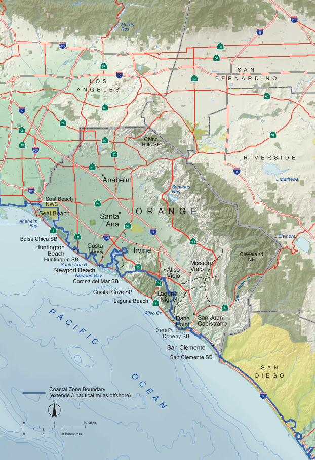
S A ND I E G O
O R A N G E
HuntingtonBeach Cleveland
NF
SantiagoRes
o0 5 10 Miles
0 5 10 Kilometers
!
Newport Bay
Bolsa Chica SB
Seal Beach!
R I V E R S I D E
Huntington SB
Corona del Mar SB
Crystal Cove SP
Doheny SB
San Clemente SB
Dana Pt.
L O SA N G E L E S
S A N
B E R N A R D I N O
AnaheimBay
Santa Ana R
Aliso CrDanaPoint
!
Laguna Beach!
Irvine!
Newport Beach!
CostaMesa
!
SantaAna
!
San Clemente !
PA
CI F
I C
OC
EA
N
Anaheim!
·}1
!"#$5
!"#$5
!"#$5
!"#$605
!"#$405
!"#$210
!"#$405
!"#$10
!"#$15
·}74
·}73
·}39
·}133
·}55
·}22
·}1
·}91
·}91
·}60
·}60
!"#$15
ChinoHills SP
MissionViejo!
AlisoViejo
!
LagunaNiguel
!
San JuanCapistrano
!
San
Ju
anCr
·}66
·}30
·}57
·}83
·}90
·}19
·}72
·}42
!"#$215
·}39
L Mathews
MorrisRes
L Elsinore
·}241
Seal BeachNWS
Coastal Zone Boundary(extends 3 nautical miles offshore)

53
Attachment 7. Project Site Distance to Coast
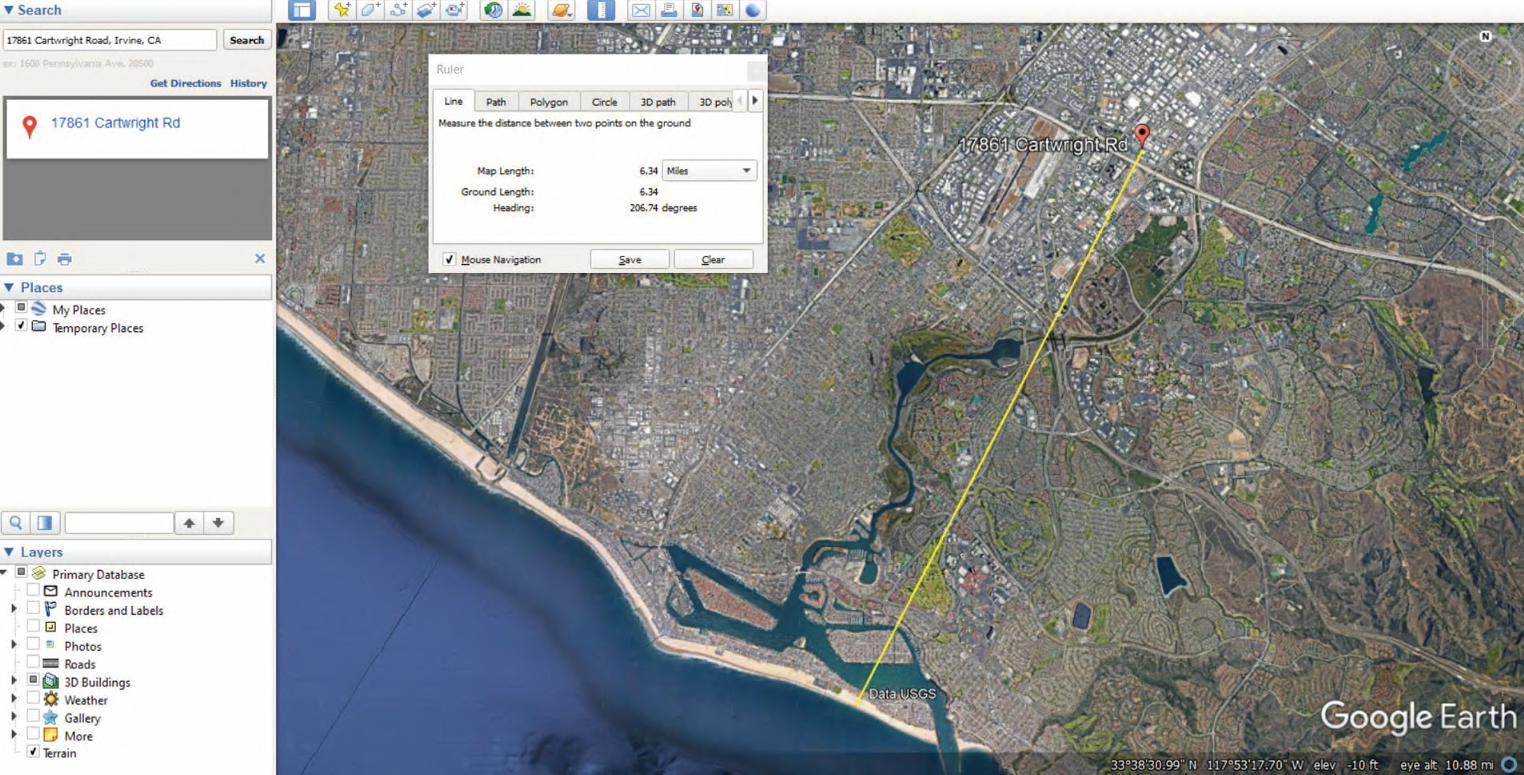

54
Attachment 8. Asbestos Test Results
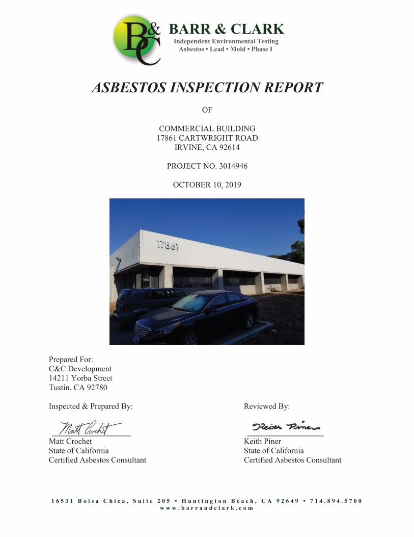
BARR & CLARK Independent Environmental Testing Asbestos • Lead • Mold • Phase I
1 6 5 3 1 B o l s a C h i c a , S u i t e 2 0 5 • H u n t i n g t o n B e a c h , C A 9 2 6 4 9 • 7 1 4 . 8 9 4 . 5 7 0 0 w w w . b a r r a n d c l a r k . c o m
ASBESTOS INSPECTION REPORT
OF
COMMERCIAL BUILDING 17861 CARTWRIGHT ROAD
IRVINE, CA 92614
PROJECT NO. 3014946
OCTOBER 10, 2019
Prepared For: C&C Development 14211 Yorba Street Tustin, CA 92780
Inspected & Prepared By: Reviewed By:
Matt Crochet Keith Piner State of California State of California Certified Asbestos Consultant Certified Asbestos Consultant
Asbestos Inspection Report Commercial Building 17861 Cartwright Road Project No. 3014946
Page 2
1 6 5 3 1 B o l s a C h i c a , S u i t e 2 0 5 • H u n t i n g t o n B e a c h , C A 9 2 6 4 9 • 7 1 4 . 8 9 4 . 5 7 0 0 w w w . b a r r a n d c l a r k . c o m
TABLE OF CONTENTS DESCRIPTION PAGE NO. 1.0 INTRODUCTION .......................................................................................................... 3
2.0 SCOPE OF WORK ......................................................................................................... 3
3.0 PROPERTY DESCRIPTION ......................................................................................... 3
4.0 INSPECTOR’S QUALIFICATIONS ............................................................................. 3
5.0 SAMPLING PROTOCOL / SAMPLE ANALYSIS ...................................................... 3
6.0 SUMMARY OF RESULTS ........................................................................................... 4
7.0 RECOMMENDATIONS ................................................................................................ 4
8.0 INSPECTION LIMITATIONS ...................................................................................... 5
APPENDICES
APPENDIX A LABORATORY RESULTS APPENDIX B INSPECTOR’S CERTIFICATE(S) APPENDIX C INSURANCE CERTIFICATE
Asbestos Inspection Report Commercial Building 17861 Cartwright Road Project No. 3014946
Page 3
1 6 5 3 1 B o l s a C h i c a , S u i t e 2 0 5 • H u n t i n g t o n B e a c h , C A 9 2 6 4 9 • 7 1 4 . 8 9 4 . 5 7 0 0 w w w . b a r r a n d c l a r k . c o m
ASBESTOS INSPECTION REPORT 1.0 INTRODUCTION
This report presents the results of Barr & Clark’s asbestos inspection of the Commercial Building located at 17861 Cartwright Road, Irvine, California (Subject Property). This document is prepared for the sole use of C&C Development, and any regulatory agencies that are directly involved in this project. No other party should rely on the information contained herein without prior written consent of C&C Development. The scope of services, inspection methodology, and results are presented below.
2.0 SCOPE OF WORK
The purpose of this inspection is to identify and assess certain accessible Asbestos Containing Construction Materials (ACCM) at the subject property. On October 07, 2019, Barr & Clark performed an inspection for asbestos at the subject property in Irvine, California. Physical bulk samples were collected of suspect materials from representative locations and submitted to an independent laboratory for analysis. If asbestos was detected at any concentration within a sample of a construction material, it was concluded that the material contains asbestos. Suspect materials were also visually inspected to assess their condition.
3.0 PROPERTY DESCRIPTION
The subject property is a commercial structure that was built circa 1975. It is a one story building that is constructed over a slab foundation. The exterior walls are covered with concrete.
4.0 INSPECTOR’S QUALIFICATIONS
Matt Crochet of Barr & Clark performed the inspection at the site. Personnel certificate(s) have been provided in Appendix B.
5.0 SAMPLING PROTOCOL / SAMPLE ANALYSIS
Sampling Protocol: Sampling was patterned after the Asbestos School Hazard Emergency Response Act (40 CFR 763 Subpart E) as mandated by Cal/OSHA (Title 8 Section 1529) and South Coast Air Quality Management District (Rule 1403). Sample Analysis: Physical bulk samples were collected from this property and analyzed for asbestos content by an independent environmental laboratory which is accredited by the National Voluntary Laboratory Accreditation Program (Lab Code 200358-0). The method of analysis was Polarized Light Microscopy (EPA 600/M4-82-020). Additional laboratory information can be found on the last page of the laboratory results (Appendix A).
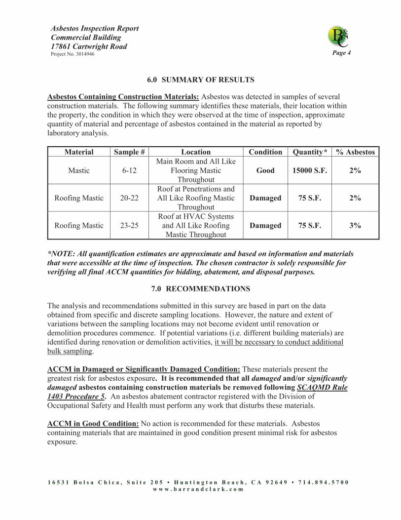
Asbestos Inspection Report Commercial Building 17861 Cartwright Road Project No. 3014946
Page 4
1 6 5 3 1 B o l s a C h i c a , S u i t e 2 0 5 • H u n t i n g t o n B e a c h , C A 9 2 6 4 9 • 7 1 4 . 8 9 4 . 5 7 0 0 w w w . b a r r a n d c l a r k . c o m
6.0 SUMMARY OF RESULTS
Asbestos Containing Construction Materials: Asbestos was detected in samples of several construction materials. The following summary identifies these materials, their location within the property, the condition in which they were observed at the time of inspection, approximate quantity of material and percentage of asbestos contained in the material as reported by laboratory analysis.
Material Sample # Location Condition Quantity* % Asbestos
Mastic 6-12 Main Room and All Like
Flooring Mastic Throughout
Good 15000 S.F. 2%
Roofing Mastic 20-22 Roof at Penetrations and All Like Roofing Mastic
Throughout Damaged 75 S.F. 2%
Roofing Mastic 23-25 Roof at HVAC Systems
and All Like Roofing Mastic Throughout
Damaged 75 S.F. 3%
*NOTE: All quantification estimates are approximate and based on information and materials that were accessible at the time of inspection. The chosen contractor is solely responsible for verifying all final ACCM quantities for bidding, abatement, and disposal purposes.
7.0 RECOMMENDATIONS
The analysis and recommendations submitted in this survey are based in part on the data obtained from specific and discrete sampling locations. However, the nature and extent of variations between the sampling locations may not become evident until renovation or demolition procedures commence. If potential variations (i.e. different building materials) are identified during renovation or demolition activities, it will be necessary to conduct additional bulk sampling. ACCM in Damaged or Significantly Damaged Condition: These materials present the greatest risk for asbestos exposure. It is recommended that all damaged and/or significantly damaged asbestos containing construction materials be removed following SCAQMD Rule 1403 Procedure 5. An asbestos abatement contractor registered with the Division of Occupational Safety and Health must perform any work that disturbs these materials. ACCM in Good Condition: No action is recommended for these materials. Asbestos containing materials that are maintained in good condition present minimal risk for asbestos exposure.
Asbestos Inspection Report Commercial Building 17861 Cartwright Road Project No. 3014946
Page 5
1 6 5 3 1 B o l s a C h i c a , S u i t e 2 0 5 • H u n t i n g t o n B e a c h , C A 9 2 6 4 9 • 7 1 4 . 8 9 4 . 5 7 0 0 w w w . b a r r a n d c l a r k . c o m
Note: If renovation or demolition activities are to affect these materials, an asbestos abatement contractor registered with the Division of Occupational Safety and Health should be contracted to perform all portions of the work affecting these materials.
8.0 INSPECTION LIMITATIONS
This inspection was planned, developed, and implemented based on Barr & Clark’s previous experience in performing asbestos inspections. Barr & Clark utilized state-of-the-art-practices and techniques in accordance with regulatory standards while performing this inspection. Barr & Clark’s evaluation of the relative risk of exposure to asbestos identified during this inspection is based on conditions observed at the time of the inspection. Barr & Clark cannot be responsible for changing conditions that may alter the relative exposure risk or for future changes in accepted methodology. This inspection did not evaluate hidden, buried or unseen building or other materials. When future renovation or demolition activities are undertaken, Barr & Clark should be contacted if such are encountered for further evaluation. Any materials that were not sampled during the inspection must be presumed to contain asbestos until proven otherwise. Access and inspection of attics or crawl spaces could be limited due to visibility, obstructions, health and safety hazards or structural issues. All undocumented materials should be presumed to contain asbestos until sampled and analyzed. Enclosed are the actual test results and all relevant certifications and licenses.

APPENDIX A
(LABORATORY RESULTS)
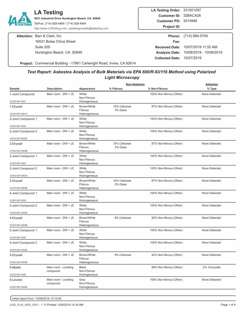
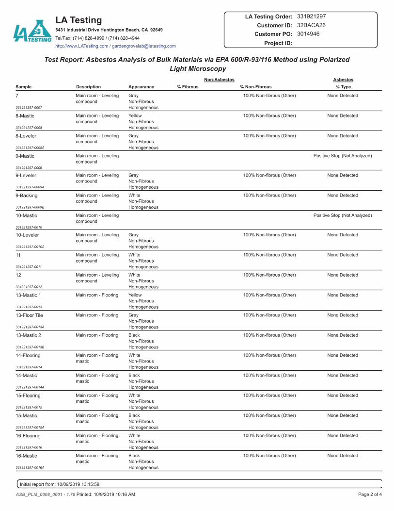
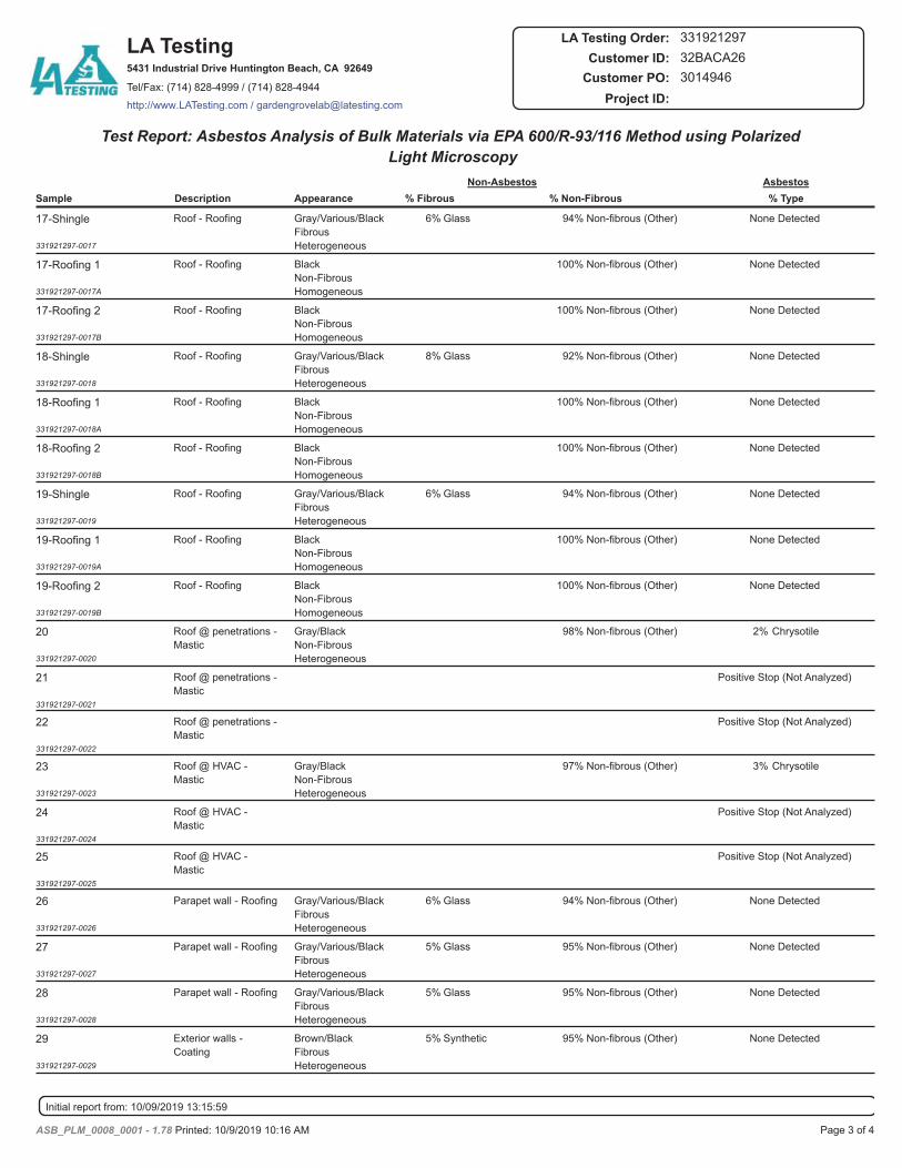
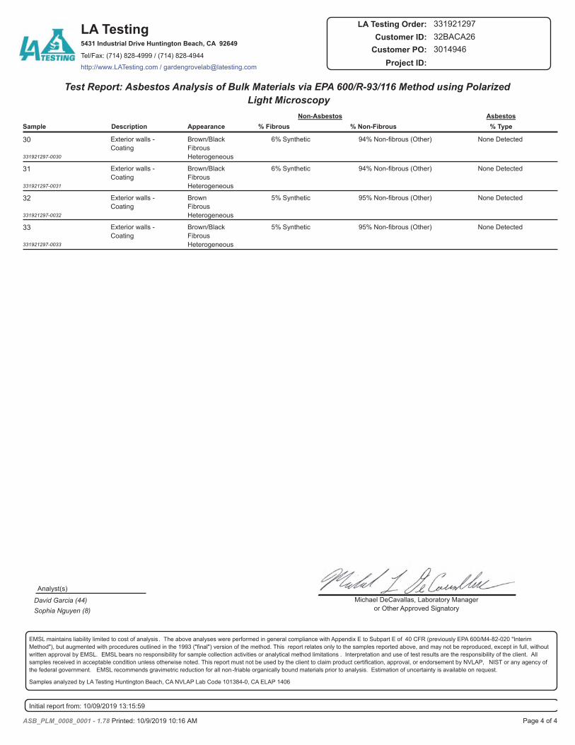
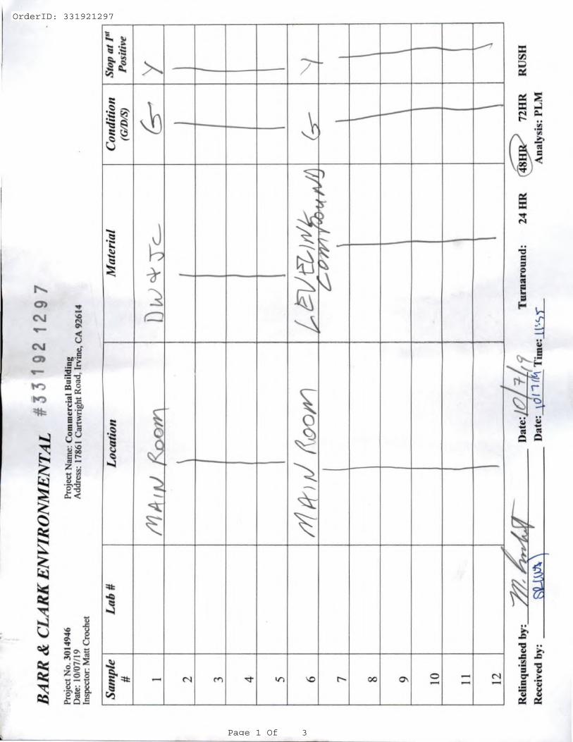
OrderID: 331921297
Page 1 Of 3
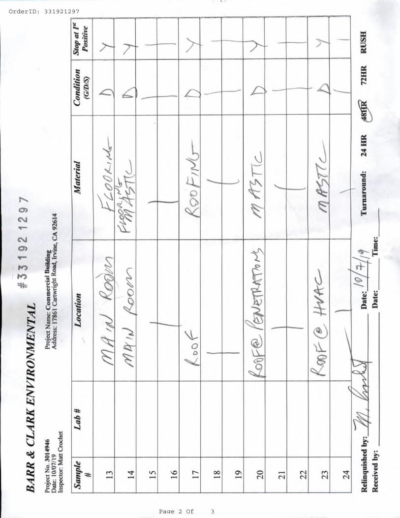
OrderID: 331921297
Page 2 Of 3
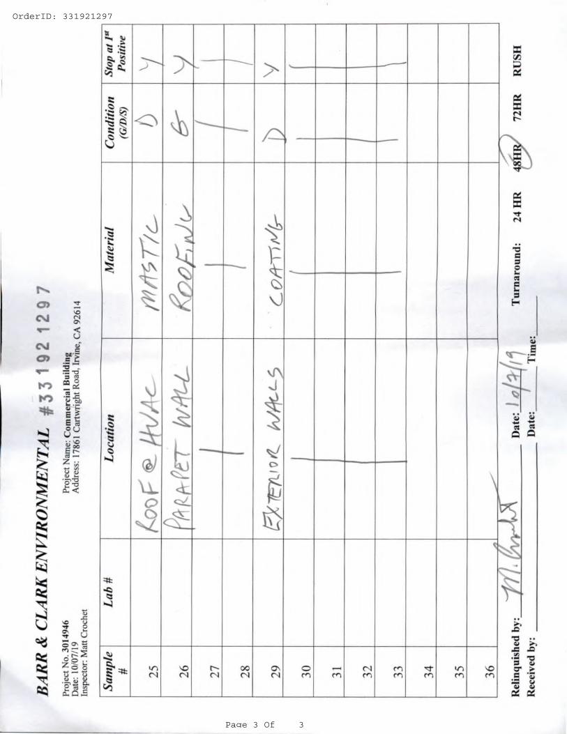
OrderID: 331921297
Page 3 Of 3

APPENDIX B
(INSPECTOR’S CERTIFICATES)
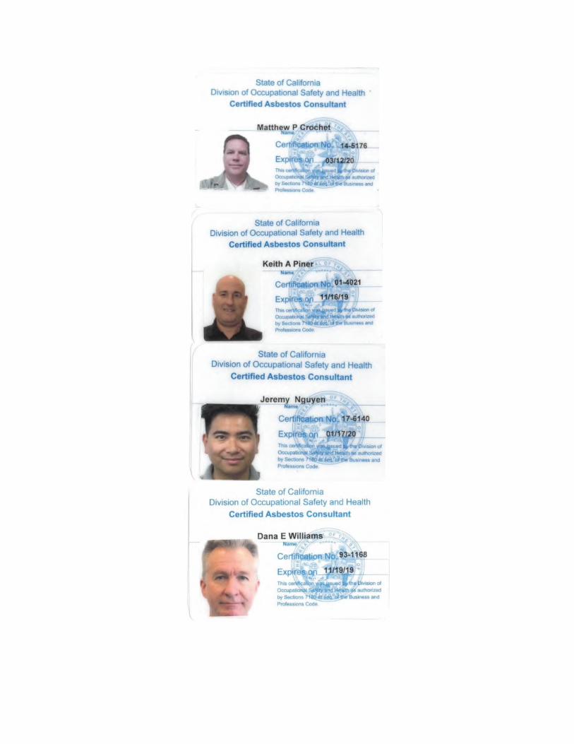
APPENDIX C
(INSURANCE CERTIFICATE)
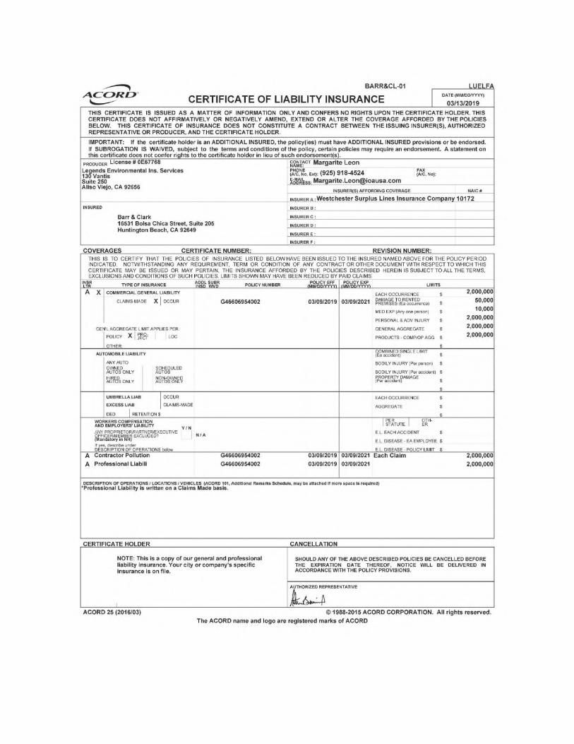

55
Attachment 9.Lead-Based Paint Test Results
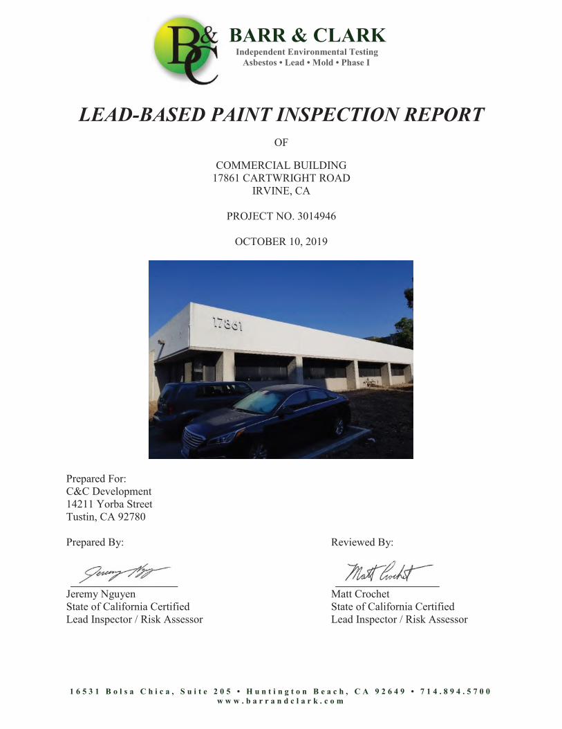
BARR & CLARK Independent Environmental Testing Asbestos • Lead • Mold • Phase I
1 6 5 3 1 B o l s a C h i c a , S u i t e 2 0 5 • H u n t i n g t o n B e a c h , C A 9 2 6 4 9 • 7 1 4 . 8 9 4 . 5 7 0 0 w w w . b a r r a n d c l a r k . c o m
LEAD-BASED PAINT INSPECTION REPORT
OF
COMMERCIAL BUILDING 17861 CARTWRIGHT ROAD
IRVINE, CA
PROJECT NO. 3014946
OCTOBER 10, 2019
Prepared For: C&C Development 14211 Yorba Street Tustin, CA 92780 Prepared By: Reviewed By:
Jeremy Nguyen Matt Crochet State of California Certified State of California Certified Lead Inspector / Risk Assessor Lead Inspector / Risk Assessor
Lead-Based Paint Inspection ReportCommercial Building17861 Cartwright RoadProject Number: 3014946 Page 2
1 6 5 3 1 B o l s a C h i c a , S u i t e 2 0 5 • H u n t i n g t o n B e a c h , C A 9 2 6 4 9 • 7 1 4 . 8 9 4 . 5 7 0 0w w w . b a r r a n d c l a r k . c o m
TABLE OF CONTENTS
DESCRIPTION PAGE NO.
1.0 INTRODUCTION .......................................................................................................... 3
2.0 SCOPE OF WORK......................................................................................................... 3
3.0 PROPERTY DESCRIPTION ......................................................................................... 3
4.0 INSPECTOR’S QUALIFICATIONS ............................................................................. 3
5.0 TESTING PROTOCOL.................................................................................................. 3
6.0 METHOD OF TESTING................................................................................................ 4
7.0 SUMMARY OF RESULTS ........................................................................................... 5
8.0 RECOMMENDATIONS................................................................................................ 5
9.0 TITLE X REQUIREMENTS.......................................................................................... 5
10.0 INSPECTION LIMITATIONS ...................................................................................... 5
APPENDICES
APPENDIX A
APPENDIX B
SUMMARIES LEAD CONTAINING COMPONENTS LIST XRF FIELD DATA CDPH 8552INSPECTOR’S CERTIFICATE(S)INSURANCE CERTIFICATE
Lead-Based Paint Inspection Report Commercial Building 17861 Cartwright Road Project Number: 3014946
Page 3
1 6 5 3 1 B o l s a C h i c a , S u i t e 2 0 5 • H u n t i n g t o n B e a c h , C A 9 2 6 4 9 • 7 1 4 . 8 9 4 . 5 7 0 0 w w w . b a r r a n d c l a r k . c o m
LEAD-BASED PAINT INSPECTION REPORT
1.0 INTRODUCTION
This report presents the results of Barr & Clark Environmental’s lead-based paint (LBP) inspection of the Commercial Building located at 17861 Cartwright Road, Irvine, California (Subject Property). This document is prepared for the sole use of the C&C Development, and any regulatory agencies that are directly involved in this project. No other party should rely on the information contained herein without prior written consent of the C&C Development. The scope of services, inspection methodology, and results are presented below.
2.0 SCOPE OF WORK
The purpose of this inspection is to identify and assess the Lead-Based Paint (LBP) present on painted components at the subject property. On October 07, 2019, Barr & Clark performed an inspection for lead-based paint at the subject property in Irvine, California. To comply with EPA and HUD guidelines, painted and varnished surfaces in every accessible “room equivalent” were sampled for the presence of LBP. The intent was to ascertain the presence of lead-based paint above the federal action level. If LBP was found, the inspection would identify individual architectural components and their respective concentrations of lead in such a manner that this report would be used to characterize the presence of LBP at this property.
3.0 PROPERTY DESCRIPTION
The subject property is a commercial structure that was built circa 1975. It is a one-story building that is constructed over a slab foundation. The exterior walls are covered with concrete and all of the windows are fixed types. At the time of this inspection, most of the painted surfaces were in fair condition.
4.0 INSPECTOR’S QUALIFICATIONS
Matt Crochet of Barr & Clark performed the inspection at the site using an RMD LPA-1 XRF spectrum analyzer instrument. He has attended the radiation safety course for handling the instrument, and completed an EPA approved curriculum in Lead in Construction Inspector / Risk Assessor Training. At the time of this report, the California Department of Health Services, Childhood Lead Poisoning Branch, has implemented a State Certification Model Accreditation Plan adopted from the EPA. Matt Crochet has received certification. Personnel certificate(s) have been provided in Appendix B.
5.0 TESTING PROTOCOL
XRF Testing: Testing of the painted surfaces was patterned after the inspection protocol in Chapter 7 of the HUD Guidelines for the Evaluation and Control of Lead-Based Paint Hazards in Housing1. In every “room equivalent” within the tested property, one representative surface of each “testing combination” was tested. Multiple readings were collected to resolve inconsistencies in the test results.
1 2012 Revision
Lead-Based Paint Inspection Report Commercial Building 17861 Cartwright Road Project Number: 3014946
Page 4
1 6 5 3 1 B o l s a C h i c a , S u i t e 2 0 5 • H u n t i n g t o n B e a c h , C A 9 2 6 4 9 • 7 1 4 . 8 9 4 . 5 7 0 0 w w w . b a r r a n d c l a r k . c o m
Regulatory Compliance: Several public (government) agencies have a published “regulatory action level” to classify LBP. To further complicate matters, some of the established “levels” are quantified in different units of measurement. Listed below are the current regulatory agencies that have defined LBP, along with the respective action level: Agency Ordinance # Action level (mg / cm2) Action level (ppm2) HUD / EPA 24 CFR 35.86 & 40 CFR 745.103 1.0 mg / cm2 5,000 ppm OSHA / CAL OSHA 29 CFR 1926.62 & Title 8, 1532.1 Not Specified 600 ppm3 HUD / EPA have recently issued the following guidance regarding units of measurement for paint samples: “Report lead paint amounts in mg/cm² because this unit of measurement does not depend on the number of layers of non-lead-based paint and can usually be obtained without damaging the painted surface. All measurements of lead in paint should be in mg/cm², unless the surface area cannot be measured or if all paint cannot be removed from the measured surface area. In such cases, concentrations may be reported in weight percent (%) or parts per million by weight (ppm).”4 Furthermore, EPA has previously issued guidance on lead content classification as follows: “… The rule, at 24 CFR 35.86 and 40 CFR 745.103 states that a lead-based paint free finding must demonstrate that the building is free of ‘paint or other surface coatings that contain lead in excess of 1.0 milligrams per square centimeter (1.0 mg / cm2) or 0.5 percent by weight (5000 ppm).’ The State standards are not applicable, whether more or less stringent, since a State cannot amend Federal requirements.”5 In recognition of the various action levels the testing results are classified as follows for this report:
Painted surfaces with readings at or above 1.0 mg / cm2 are considered - Positive Painted surfaces with readings at or below 0.9 mg / cm2 are considered - Negative
The individual readings have been provided on all field data sheets. Any future change in action levels by one of the regulating agencies may affect the classification of results.
6.0 METHOD OF TESTING
Paint Testing: The method employed was X-ray fluorescence (XRF) using a Radiation Monitoring Device Lead Paint Analyzer (RMD LPA-1). The instrument was operated in “Quick Mode,” where the duration for each test result is determined by a combination of: the actual reading relative to the designated action level; the age of the radioactive source; and the substrate on which the test was taken.
The instrument’s calibration was verified according to the manufacturer's specifications in compliance with the Performance Characteristic Sheet (PCS) developed for this instrument. The readings from this instrument produce a 95% confidence level that the “lead” reading accurately reflects the actual level of lead in the tested surfaces, relative to the federal action level. 2 Parts per million 3 Applies to construction related activities 4 Chapter 7 of the HUD Guidelines for the Evaluation and Control of Lead-Based Paint Hazards in Housing (2012 Revision). 5 Office of Pollution Prevention and Toxics, (August 20, 1996)
Lead-Based Paint Inspection Report Commercial Building 17861 Cartwright Road Project Number: 3014946
Page 5
1 6 5 3 1 B o l s a C h i c a , S u i t e 2 0 5 • H u n t i n g t o n B e a c h , C A 9 2 6 4 9 • 7 1 4 . 8 9 4 . 5 7 0 0 w w w . b a r r a n d c l a r k . c o m
7.0 SUMMARY OF RESULTS
Paint Sampling: Throughout the subject property, none of the tested painted surfaces indicated the presence of lead based paint (LBP) at or above the respective action level. Sampling for this inspection was representative. The field data and results for paint sampling may be found in Appendices A - B.
8.0 RECOMMENDATIONS
Since none of the tested painted surfaces indicated the presence of lead based paint (LBP) at or above the federal action level, no further testing is required at this time.
9.0 TITLE X REQUIREMENTS
The results of this inspection indicate that no lead in amounts greater than or equal to 1.0 mg/cm² in paint was found on any building components, using the inspection protocol in Chapter 7 of the HUD Guidelines for the Evaluation and Control of Lead-Based Paint Hazards in Housing (2012 Revision). Therefore, this dwelling qualifies for the exemption in 24 CFR part 35 and 40 CFR part 745 for target housing being leased that is free of lead-based paint, as defined in the rule. However, some painted surfaces may contain levels of lead below 1.0 mg/cm², which could create lead dust or lead-contaminated soil hazards if the paint is turned into dust by abrasion, scraping, or sanding. This report should be maintained as a permanent maintenance record for this property.
10.0 INSPECTION LIMITATIONS
This inspection was planned, developed, and implemented based on Barr & Clark’s previous experience in performing lead-based paint inspections. This inspection was patterned after Chapter 7 of the HUD Guidelines for the Evaluation and Control of Lead-Based Paint Hazards in Housing (2012 Revision). Barr & Clark utilized state-of-the-art-practices and techniques in accordance with regulatory standards while performing this inspection. Barr & Clark’s evaluation of the relative risk of exposure to lead identified during this inspection is based on conditions observed at the time of the inspection. Barr & Clark cannot be responsible for changing conditions that may alter the relative exposure risk or for future changes in accepted methodology. Enclosed are the diagram(s), actual test results, and all relevant certifications and licenses.

APPENDIX
A XRF FIELD DATA

Concrete Wall 44 0 100.00%
Gypsum Wall 44 0 100.00%
Metal Column 66 0 100.00%
Metal Door 33 0 100.00%
Metal Door Frame 33 0 100.00%
Metal Electric Utility Box 11 0 100.00%
Metal Pipe 11 0 100.00%
Metal Window Frame 44 0 100.00%
Metal Window Sill 44 0 100.00%
Wood Beam 44 0 100.00%
Wood Ceiling 11 0 100.00%
35 0 35Totals:
SUMMARY OF INTERIORCommercial BuildingProject Name:
Address:17861 Cartwright RoadIrvine CA, 92614
Project Number:3014946
ComponentNumberTested
NumberPositive Percent Positive
NumberNegative Percent Negative
1 10/8/2019 3:56:10 PMBarr & Clark Environmental (714) 894-5700
Testing done in compliance with current HUD guidelines for XRF.
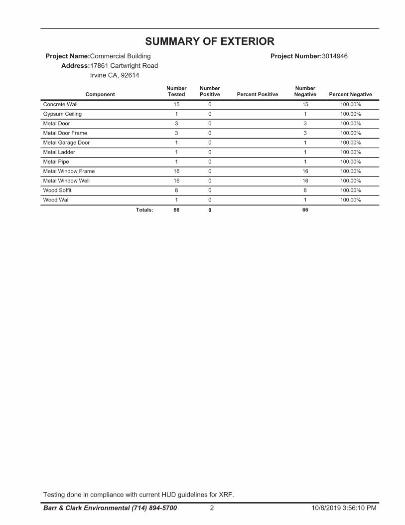
Concrete Wall 1515 0 100.00%
Gypsum Ceiling 11 0 100.00%
Metal Door 33 0 100.00%
Metal Door Frame 33 0 100.00%
Metal Garage Door 11 0 100.00%
Metal Ladder 11 0 100.00%
Metal Pipe 11 0 100.00%
Metal Window Frame 1616 0 100.00%
Metal Window Well 1616 0 100.00%
Wood Soffit 88 0 100.00%
Wood Wall 11 0 100.00%
66 0 66Totals:
SUMMARY OF EXTERIORCommercial BuildingProject Name:
Address:17861 Cartwright RoadIrvine CA, 92614
Project Number:3014946
ComponentNumberTested
NumberPositive Percent Positive
NumberNegative Percent Negative
2 10/8/2019 3:56:10 PMBarr & Clark Environmental (714) 894-5700
Testing done in compliance with current HUD guidelines for XRF.
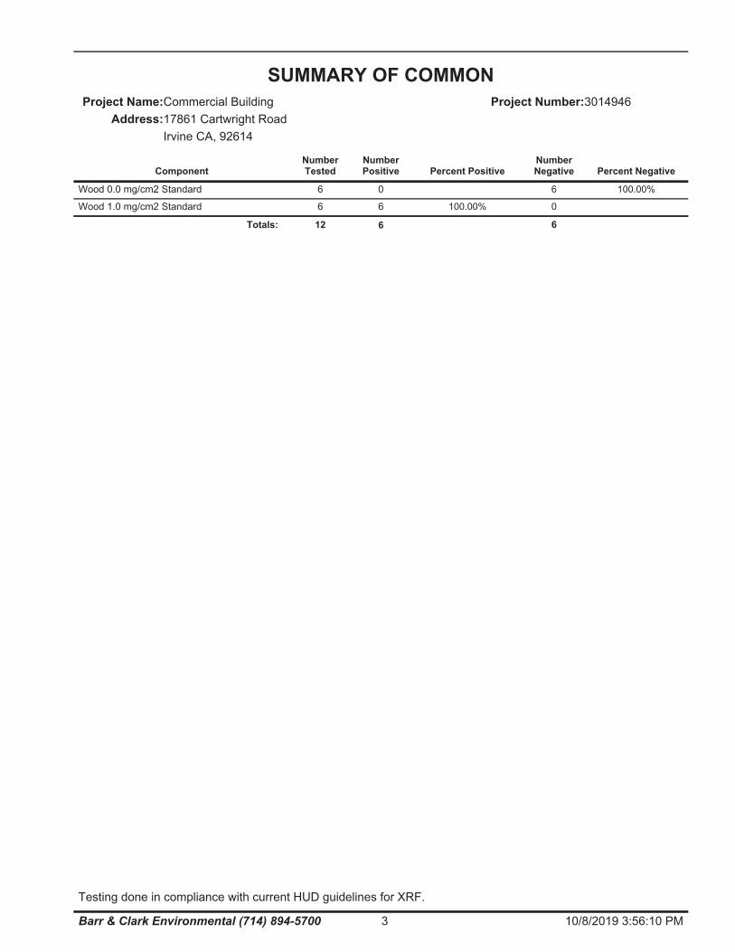
Wood 0.0 mg/cm2 Standard 66 0 100.00%
Wood 1.0 mg/cm2 Standard 06 6 100.00%
12 6 6Totals:
SUMMARY OF COMMONCommercial BuildingProject Name:
Address:17861 Cartwright RoadIrvine CA, 92614
Project Number:3014946
ComponentNumberTested
NumberPositive Percent Positive
NumberNegative Percent Negative
3 10/8/2019 3:56:10 PMBarr & Clark Environmental (714) 894-5700
Testing done in compliance with current HUD guidelines for XRF.
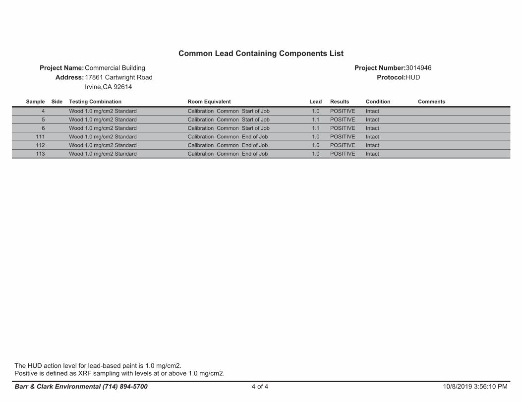
4 Calibration Common Start of Job Intact1.0Wood 1.0 mg/cm2 Standard POSITIVE5 Calibration Common Start of Job Intact1.1Wood 1.0 mg/cm2 Standard POSITIVE6 Calibration Common Start of Job Intact1.1Wood 1.0 mg/cm2 Standard POSITIVE
111 Calibration Common End of Job Intact1.0Wood 1.0 mg/cm2 Standard POSITIVE112 Calibration Common End of Job Intact1.0Wood 1.0 mg/cm2 Standard POSITIVE113 Calibration Common End of Job Intact1.0Wood 1.0 mg/cm2 Standard POSITIVE
Common Lead Containing Components ListCommercial BuildingProject Name:
Address:17861 Cartwright RoadIrvine,CA 92614
Project Number:3014946Protocol:HUD
Sample Room EquivalentSide Testing Combination ConditionLead Results Comments
4 of 4 10/8/2019 3:56:10 PMBarr & Clark Environmental (714) 894-5700
The HUD action level for lead-based paint is 1.0 mg/cm2.Positive is defined as XRF sampling with levels at or above 1.0 mg/cm2.

FIELD DATA
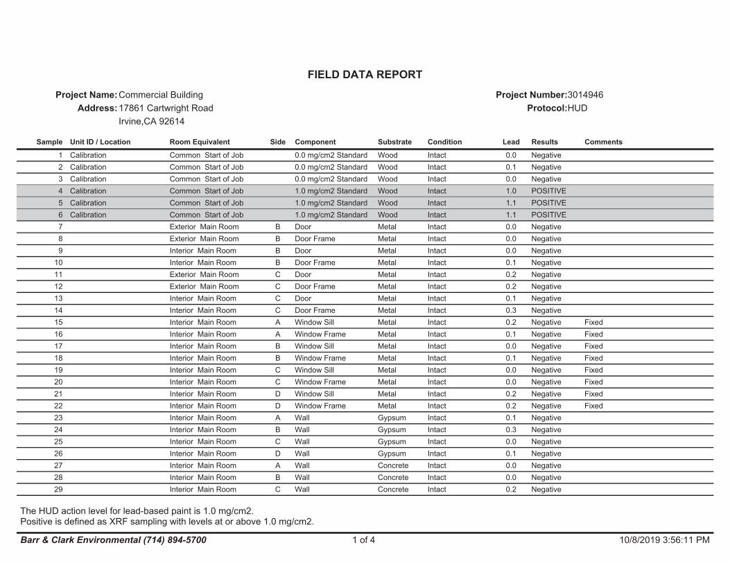
Calibration1 Common Start of Job 0.0 mg/cm2 Standard Wood Intact 0.0 NegativeCalibration2 Common Start of Job 0.0 mg/cm2 Standard Wood Intact 0.1 NegativeCalibration3 Common Start of Job 0.0 mg/cm2 Standard Wood Intact 0.0 NegativeCalibration4 Common Start of Job 1.0 mg/cm2 Standard Wood Intact 1.0 POSITIVECalibration5 Common Start of Job 1.0 mg/cm2 Standard Wood Intact 1.1 POSITIVECalibration6 Common Start of Job 1.0 mg/cm2 Standard Wood Intact 1.1 POSITIVE
7 Exterior Main Room B Door Metal Intact 0.0 Negative8 Exterior Main Room B Door Frame Metal Intact 0.0 Negative9 Interior Main Room B Door Metal Intact 0.0 Negative
10 Interior Main Room B Door Frame Metal Intact 0.1 Negative11 Exterior Main Room C Door Metal Intact 0.2 Negative12 Exterior Main Room C Door Frame Metal Intact 0.2 Negative13 Interior Main Room C Door Metal Intact 0.1 Negative14 Interior Main Room C Door Frame Metal Intact 0.3 Negative15 Interior Main Room A Window Sill Metal Intact 0.2 Negative Fixed16 Interior Main Room A Window Frame Metal Intact 0.1 Negative Fixed17 Interior Main Room B Window Sill Metal Intact 0.0 Negative Fixed18 Interior Main Room B Window Frame Metal Intact 0.1 Negative Fixed19 Interior Main Room C Window Sill Metal Intact 0.0 Negative Fixed20 Interior Main Room C Window Frame Metal Intact 0.0 Negative Fixed21 Interior Main Room D Window Sill Metal Intact 0.2 Negative Fixed22 Interior Main Room D Window Frame Metal Intact 0.2 Negative Fixed23 Interior Main Room A Wall Gypsum Intact 0.1 Negative24 Interior Main Room B Wall Gypsum Intact 0.3 Negative25 Interior Main Room C Wall Gypsum Intact 0.0 Negative26 Interior Main Room D Wall Gypsum Intact 0.1 Negative27 Interior Main Room A Wall Concrete Intact 0.0 Negative28 Interior Main Room B Wall Concrete Intact 0.0 Negative29 Interior Main Room C Wall Concrete Intact 0.2 Negative
FIELD DATA REPORTCommercial BuildingProject Name:
Address:17861 Cartwright RoadIrvine,CA 92614
Project Number:3014946Protocol:HUD
Sample Unit ID / Location Room Equivalent Side Component Substrate Condition Lead Results Comments
1 of 4 10/8/2019 3:56:11 PMBarr & Clark Environmental (714) 894-5700
The HUD action level for lead-based paint is 1.0 mg/cm2.Positive is defined as XRF sampling with levels at or above 1.0 mg/cm2.
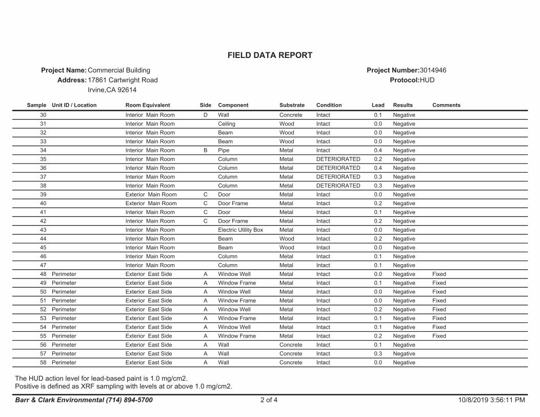
30 Interior Main Room D Wall Concrete Intact 0.1 Negative31 Interior Main Room Ceiling Wood Intact 0.0 Negative32 Interior Main Room Beam Wood Intact 0.0 Negative33 Interior Main Room Beam Wood Intact 0.0 Negative34 Interior Main Room B Pipe Metal Intact 0.4 Negative35 Interior Main Room Column Metal DETERIORATED 0.2 Negative36 Interior Main Room Column Metal DETERIORATED 0.4 Negative37 Interior Main Room Column Metal DETERIORATED 0.3 Negative38 Interior Main Room Column Metal DETERIORATED 0.3 Negative39 Exterior Main Room C Door Metal Intact 0.0 Negative40 Exterior Main Room C Door Frame Metal Intact 0.2 Negative41 Interior Main Room C Door Metal Intact 0.1 Negative42 Interior Main Room C Door Frame Metal Intact 0.2 Negative43 Interior Main Room Electric Utility Box Metal Intact 0.0 Negative44 Interior Main Room Beam Wood Intact 0.2 Negative45 Interior Main Room Beam Wood Intact 0.0 Negative46 Interior Main Room Column Metal Intact 0.1 Negative47 Interior Main Room Column Metal Intact 0.1 Negative
Perimeter48 Exterior East Side A Window Well Metal Intact 0.0 Negative FixedPerimeter49 Exterior East Side A Window Frame Metal Intact 0.1 Negative FixedPerimeter50 Exterior East Side A Window Well Metal Intact 0.0 Negative FixedPerimeter51 Exterior East Side A Window Frame Metal Intact 0.0 Negative FixedPerimeter52 Exterior East Side A Window Well Metal Intact 0.2 Negative FixedPerimeter53 Exterior East Side A Window Frame Metal Intact 0.1 Negative FixedPerimeter54 Exterior East Side A Window Well Metal Intact 0.1 Negative FixedPerimeter55 Exterior East Side A Window Frame Metal Intact 0.2 Negative FixedPerimeter56 Exterior East Side A Wall Concrete Intact 0.1 NegativePerimeter57 Exterior East Side A Wall Concrete Intact 0.3 NegativePerimeter58 Exterior East Side A Wall Concrete Intact 0.0 Negative
FIELD DATA REPORTCommercial BuildingProject Name:
Address:17861 Cartwright RoadIrvine,CA 92614
Project Number:3014946Protocol:HUD
Sample Unit ID / Location Room Equivalent Side Component Substrate Condition Lead Results Comments
2 of 4 10/8/2019 3:56:11 PMBarr & Clark Environmental (714) 894-5700
The HUD action level for lead-based paint is 1.0 mg/cm2.Positive is defined as XRF sampling with levels at or above 1.0 mg/cm2.
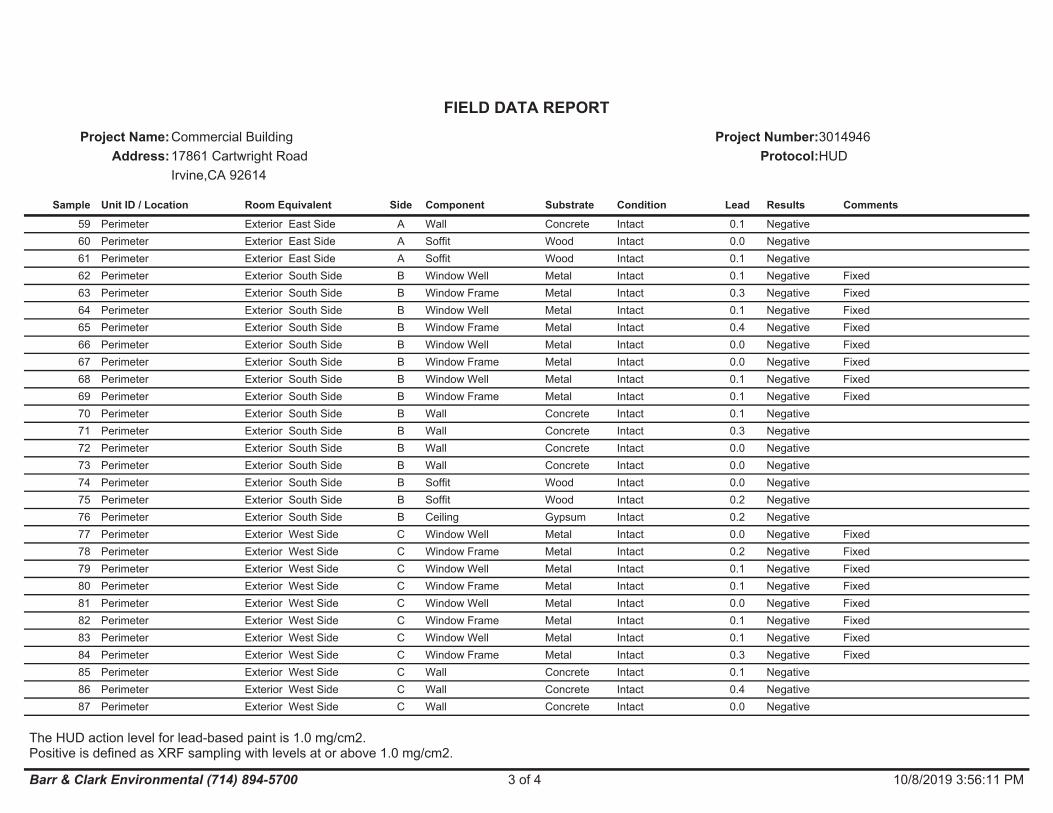
Perimeter59 Exterior East Side A Wall Concrete Intact 0.1 NegativePerimeter60 Exterior East Side A Soffit Wood Intact 0.0 NegativePerimeter61 Exterior East Side A Soffit Wood Intact 0.1 NegativePerimeter62 Exterior South Side B Window Well Metal Intact 0.1 Negative FixedPerimeter63 Exterior South Side B Window Frame Metal Intact 0.3 Negative FixedPerimeter64 Exterior South Side B Window Well Metal Intact 0.1 Negative FixedPerimeter65 Exterior South Side B Window Frame Metal Intact 0.4 Negative FixedPerimeter66 Exterior South Side B Window Well Metal Intact 0.0 Negative FixedPerimeter67 Exterior South Side B Window Frame Metal Intact 0.0 Negative FixedPerimeter68 Exterior South Side B Window Well Metal Intact 0.1 Negative FixedPerimeter69 Exterior South Side B Window Frame Metal Intact 0.1 Negative FixedPerimeter70 Exterior South Side B Wall Concrete Intact 0.1 NegativePerimeter71 Exterior South Side B Wall Concrete Intact 0.3 NegativePerimeter72 Exterior South Side B Wall Concrete Intact 0.0 NegativePerimeter73 Exterior South Side B Wall Concrete Intact 0.0 NegativePerimeter74 Exterior South Side B Soffit Wood Intact 0.0 NegativePerimeter75 Exterior South Side B Soffit Wood Intact 0.2 NegativePerimeter76 Exterior South Side B Ceiling Gypsum Intact 0.2 NegativePerimeter77 Exterior West Side C Window Well Metal Intact 0.0 Negative FixedPerimeter78 Exterior West Side C Window Frame Metal Intact 0.2 Negative FixedPerimeter79 Exterior West Side C Window Well Metal Intact 0.1 Negative FixedPerimeter80 Exterior West Side C Window Frame Metal Intact 0.1 Negative FixedPerimeter81 Exterior West Side C Window Well Metal Intact 0.0 Negative FixedPerimeter82 Exterior West Side C Window Frame Metal Intact 0.1 Negative FixedPerimeter83 Exterior West Side C Window Well Metal Intact 0.1 Negative FixedPerimeter84 Exterior West Side C Window Frame Metal Intact 0.3 Negative FixedPerimeter85 Exterior West Side C Wall Concrete Intact 0.1 NegativePerimeter86 Exterior West Side C Wall Concrete Intact 0.4 NegativePerimeter87 Exterior West Side C Wall Concrete Intact 0.0 Negative
FIELD DATA REPORTCommercial BuildingProject Name:
Address:17861 Cartwright RoadIrvine,CA 92614
Project Number:3014946Protocol:HUD
Sample Unit ID / Location Room Equivalent Side Component Substrate Condition Lead Results Comments
3 of 4 10/8/2019 3:56:11 PMBarr & Clark Environmental (714) 894-5700
The HUD action level for lead-based paint is 1.0 mg/cm2.Positive is defined as XRF sampling with levels at or above 1.0 mg/cm2.
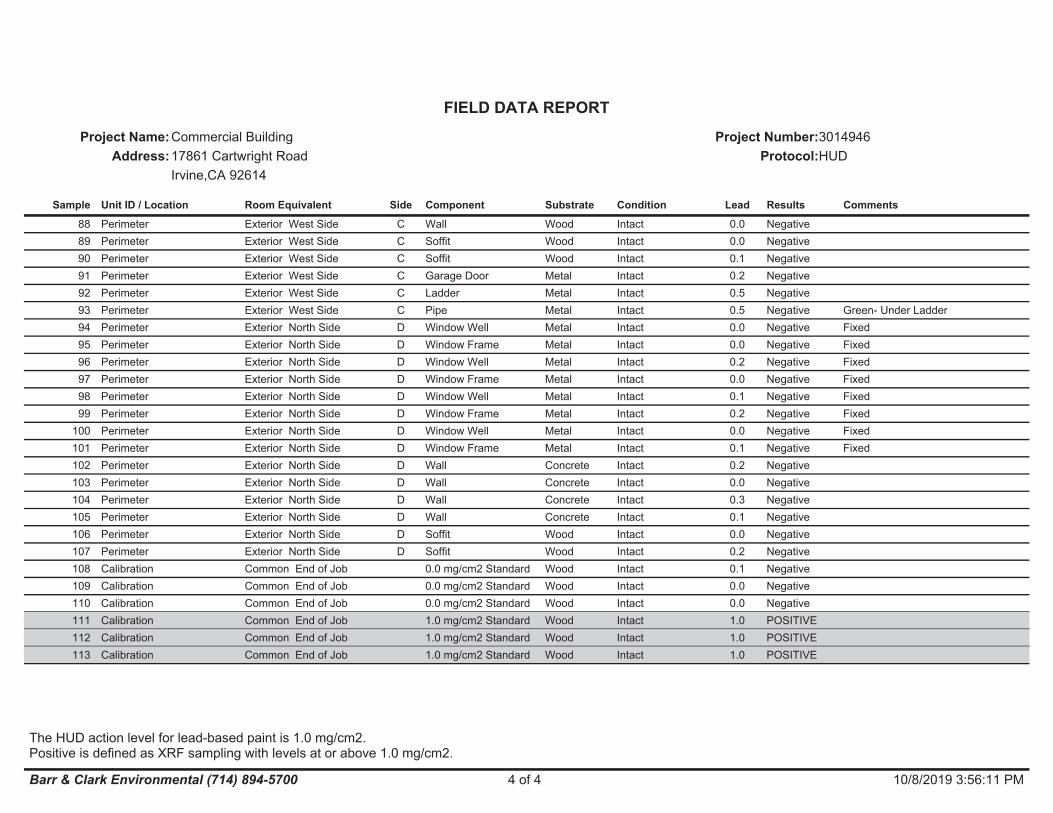
Perimeter88 Exterior West Side C Wall Wood Intact 0.0 NegativePerimeter89 Exterior West Side C Soffit Wood Intact 0.0 NegativePerimeter90 Exterior West Side C Soffit Wood Intact 0.1 NegativePerimeter91 Exterior West Side C Garage Door Metal Intact 0.2 NegativePerimeter92 Exterior West Side C Ladder Metal Intact 0.5 NegativePerimeter93 Exterior West Side C Pipe Metal Intact 0.5 Negative Green- Under LadderPerimeter94 Exterior North Side D Window Well Metal Intact 0.0 Negative FixedPerimeter95 Exterior North Side D Window Frame Metal Intact 0.0 Negative FixedPerimeter96 Exterior North Side D Window Well Metal Intact 0.2 Negative FixedPerimeter97 Exterior North Side D Window Frame Metal Intact 0.0 Negative FixedPerimeter98 Exterior North Side D Window Well Metal Intact 0.1 Negative FixedPerimeter99 Exterior North Side D Window Frame Metal Intact 0.2 Negative FixedPerimeter100 Exterior North Side D Window Well Metal Intact 0.0 Negative FixedPerimeter101 Exterior North Side D Window Frame Metal Intact 0.1 Negative FixedPerimeter102 Exterior North Side D Wall Concrete Intact 0.2 NegativePerimeter103 Exterior North Side D Wall Concrete Intact 0.0 NegativePerimeter104 Exterior North Side D Wall Concrete Intact 0.3 NegativePerimeter105 Exterior North Side D Wall Concrete Intact 0.1 NegativePerimeter106 Exterior North Side D Soffit Wood Intact 0.0 NegativePerimeter107 Exterior North Side D Soffit Wood Intact 0.2 NegativeCalibration108 Common End of Job 0.0 mg/cm2 Standard Wood Intact 0.1 NegativeCalibration109 Common End of Job 0.0 mg/cm2 Standard Wood Intact 0.0 NegativeCalibration110 Common End of Job 0.0 mg/cm2 Standard Wood Intact 0.0 NegativeCalibration111 Common End of Job 1.0 mg/cm2 Standard Wood Intact 1.0 POSITIVECalibration112 Common End of Job 1.0 mg/cm2 Standard Wood Intact 1.0 POSITIVECalibration113 Common End of Job 1.0 mg/cm2 Standard Wood Intact 1.0 POSITIVE
FIELD DATA REPORTCommercial BuildingProject Name:
Address:17861 Cartwright RoadIrvine,CA 92614
Project Number:3014946Protocol:HUD
Sample Unit ID / Location Room Equivalent Side Component Substrate Condition Lead Results Comments
4 of 4 10/8/2019 3:56:11 PMBarr & Clark Environmental (714) 894-5700
The HUD action level for lead-based paint is 1.0 mg/cm2.Positive is defined as XRF sampling with levels at or above 1.0 mg/cm2.
APPENDIX
B CDPH 8552
INSPECTOR’S CERTIFICATES INSURANCE CERTIFICATE
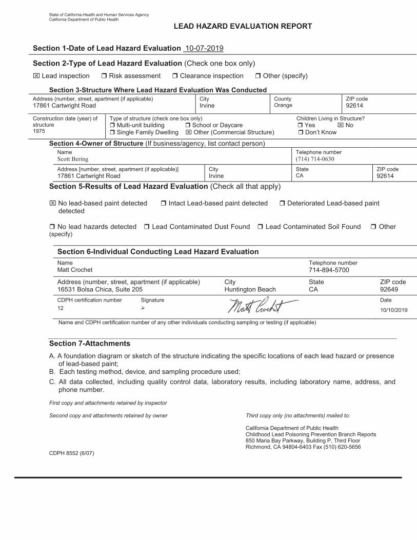
State of California-Health and Human Services Agency California Department of Public Health
LEAD HAZARD EVALUATION REPORT
Section 1-Date of Lead Hazard Evaluation 10-07-2019 Section 2-Type of Lead Hazard Evaluation (Check one box only)
Lead inspection Risk assessment Clearance inspection Other (specify)
Section 3-Structure Where Lead Hazard Evaluation Was Conducted Address (number, street, apartment (if applicable) 17861 Cartwright Road
City Irvine
County Orange
ZIP code 92614
Construction date (year) of structure 1975
Type of structure (check one box only) Children Living in Structure?
Multi-unit building School or Daycare Yes No Single Family Dwelling Other (Commercial Structure) Don’t Know
Section 4-Owner of Structure (If business/agency, list contact person)
Name Scott Bering
Telephone number (714) 714-0630
Address [number, street, apartment (if applicable)] 17861 Cartwright Road
City Irvine
State CA
ZIP code 92614
Section 5-Results of Lead Hazard Evaluation (Check all that apply)
No lead-based paint detected Intact Lead-based paint detected Deteriorated Lead-based paint detected
No lead hazards detected Lead Contaminated Dust Found Lead Contaminated Soil Found Other
(specify)
Section 6-Individual Conducting Lead Hazard Evaluation
Name Matt Crochet
Telephone number 714-894-5700
Address (number, street, apartment (if applicable) 16531 Bolsa Chica, Suite 205
City Huntington Beach
State CA
ZIP code 92649
CDPH certification number 12
Signature
Date
10/10/2019
Name and CDPH certification number of any other individuals conducting sampling or testing (if applicable)
Section 7-Attachments A. A foundation diagram or sketch of the structure indicating the specific locations of each lead hazard or presence of lead-based paint; B. Each testing method, device, and sampling procedure used; C. All data collected, including quality control data, laboratory results, including laboratory name, address, and phone number. First copy and attachments retained by inspector Second copy and attachments retained by owner Third copy only (no attachments) mailed to:
California Department of Public Health Childhood Lead Poisoning Prevention Branch Reports 850 Maria Bay Parkway, Building P, Third Floor Richmond, CA 94804-6403 Fax (510) 620-5656 CDPH 8552 (6/07)


56
Attachment 10. USFWS IPaC Species List
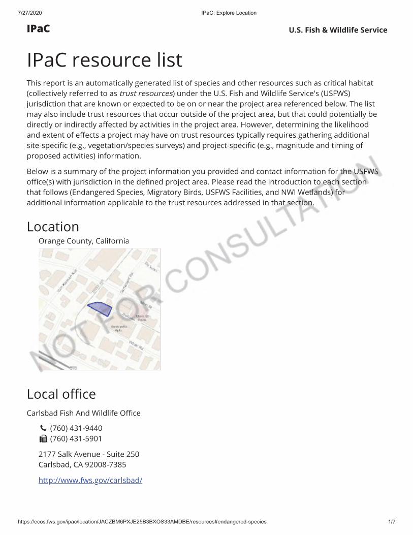
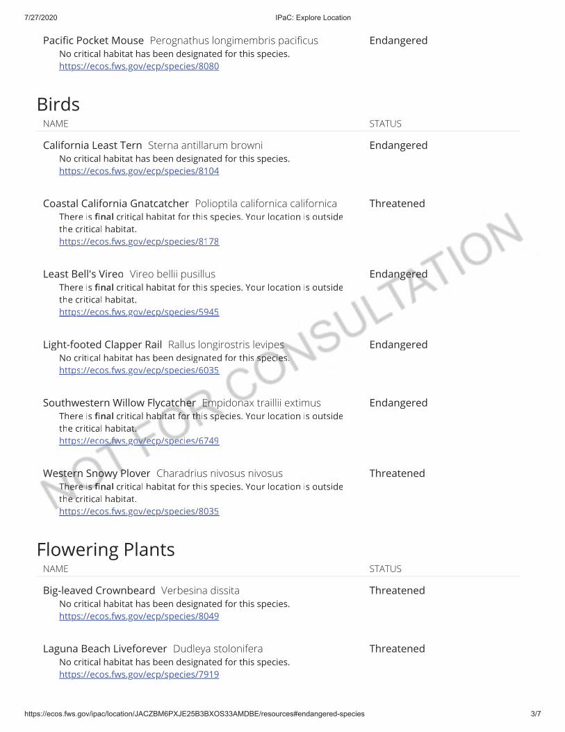

57
Attachment 11. California Important Farmland Finder
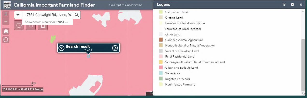

58
Attachment 12. SCCIC Historic Resources
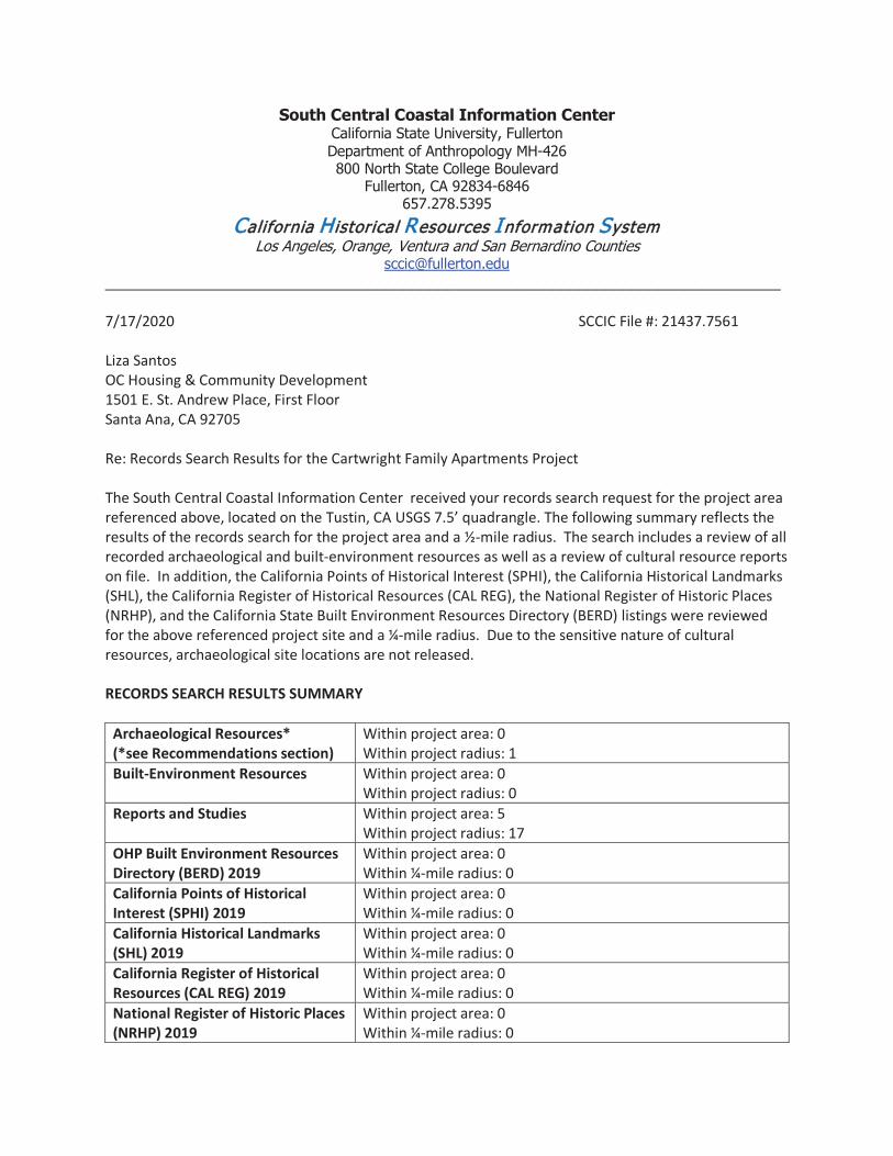
South Central Coastal Information Center California State University, Fullerton Department of Anthropology MH-426 800 North State College Boulevard
Fullerton, CA 92834-6846 657.278.5395
CCalifornia Historical Resources Information System Los Angeles, Orange, Ventura and San Bernardino Counties
[email protected] _____________________________________________________________________________ 7/17/2020 SCCIC File #: 21437.7561 Liza Santos OC Housing & Community Development 1501 E. St. Andrew Place, First Floor Santa Ana, CA 92705 Re: Records Search Results for the Cartwright Family Apartments Project The South Central Coastal Information Center received your records search request for the project area referenced above, located on the Tustin, CA USGS 7.5’ quadrangle. The following summary reflects the results of the records search for the project area and a ½-mile radius. The search includes a review of all recorded archaeological and built-environment resources as well as a review of cultural resource reports on file. In addition, the California Points of Historical Interest (SPHI), the California Historical Landmarks (SHL), the California Register of Historical Resources (CAL REG), the National Register of Historic Places (NRHP), and the California State Built Environment Resources Directory (BERD) listings were reviewed for the above referenced project site and a ¼-mile radius. Due to the sensitive nature of cultural resources, archaeological site locations are not released. RECORDS SEARCH RESULTS SUMMARY
Archaeological Resources* (*see Recommendations section)
Within project area: 0 Within project radius: 1
Built-Environment Resources Within project area: 0 Within project radius: 0
Reports and Studies Within project area: 5 Within project radius: 17
OHP Built Environment Resources Directory (BERD) 2019
Within project area: 0 Within ¼-mile radius: 0
California Points of Historical Interest (SPHI) 2019
Within project area: 0 Within ¼-mile radius: 0
California Historical Landmarks (SHL) 2019
Within project area: 0 Within ¼-mile radius: 0
California Register of Historical Resources (CAL REG) 2019
Within project area: 0 Within ¼-mile radius: 0
National Register of Historic Places (NRHP) 2019
Within project area: 0 Within ¼-mile radius: 0

Archaeological Determinations of Eligibility (ADOE): 2012
Within project area: 0 Within project radius: 0
HISTORIC MAP REVIEW - Santa Ana, CA (1896, 1901) 15' USGS Historic maps indicated that in 1896 there were two improved roads present as well as marshes to the Northwest. These features were still present in 1901. RECOMMENDATIONS
*When we report that no archaeological resources are recorded in your project area or within a specified radius around the project area; that does not necessarily mean that nothing is there. It may simply mean that the area has not been studied and/or that no information regarding the archaeological sensitivity of the property has been filed at this office. The reported records search result does not preclude the possibility that surface or buried artifacts might be found during a survey of the property or ground-disturbing activities.
While there are currently no recorded archaeological sites within the project area, buried resources could potentially be unearthed during project activities. Therefore, customary caution and a halt-work condition should be in place for all ground-disturbing activities. In the event that any evidence of cultural resources is discovered, all work within the vicinity of the find should stop until a qualified archaeological consultant can assess the find and make recommendations. Excavation of potential cultural resources should not be attempted by project personnel. It is also recommended that the Native American Heritage Commission be consulted to identify if any additional traditional cultural properties or other sacred sites are known to be in the area. The NAHC may also refer you to local tribes with particular knowledge of potential sensitivity. The NAHC and local tribes may offer additional recommendations to what is provided here and may request an archaeological monitor. Finally, if the built-environment resources on the property are 45 years or older, a qualified architectural historian should be retained to study the property and make recommendations regarding those structures.
For your convenience, you may find a professional consultant**at www.chrisinfo.org. Any
resulting reports by the qualified consultant should be submitted to the South Central Coastal Information Center as soon as possible. **The SCCIC does not endorse any particular consultant and makes no claims about the qualifications of any person listed. Each consultant on this list self-reports that they meet current professional standards.
If you have any questions regarding the results presented herein, please contact the office at
657.278.5395 Monday through Thursday 9:00 am to 3:30 pm. Should you require any additional information for the above referenced project, reference the SCCIC number listed above when making inquiries. Requests made after initial invoicing will result in the preparation of a separate invoice.
Thank you for using the California Historical Resources Information System, Michelle Galaz Assistant Coordinator
Stacy St. James
Digitally signed by Stacy St. James Date: 2020.07.17 17:53:04 -07'00'

Enclosures:
(X) Invoice # 21437.7561
Due to processing delays and other factors, not all of the historical resource reports and resource
records that have been submitted to the Office of Historic Preservation are available via this records search. Additional information may be available through the federal, state, and local agencies that produced or paid for historical resource management work in the search area. Additionally, Native American tribes have historical resource information not in the California Historical Resources Information System (CHRIS) Inventory, and you should contact the California Native American Heritage Commission for information on local/regional tribal contacts.
The California Office of Historic Preservation (OHP) contracts with the California Historical Resources Information System’s (CHRIS) regional Information Centers (ICs) to maintain information in the CHRIS inventory and make it available to local, state, and federal agencies, cultural resource professionals, Native American tribes, researchers, and the public. Recommendations made by IC coordinators or their staff regarding the interpretation and application of this information are advisory only. Such recommendations do not necessarily represent the evaluation or opinion of the State Historic Preservation Officer in carrying out the OHP’s regulatory authority under federal and state law.

59
Attachment 13. State Historic Preservation Office Letter
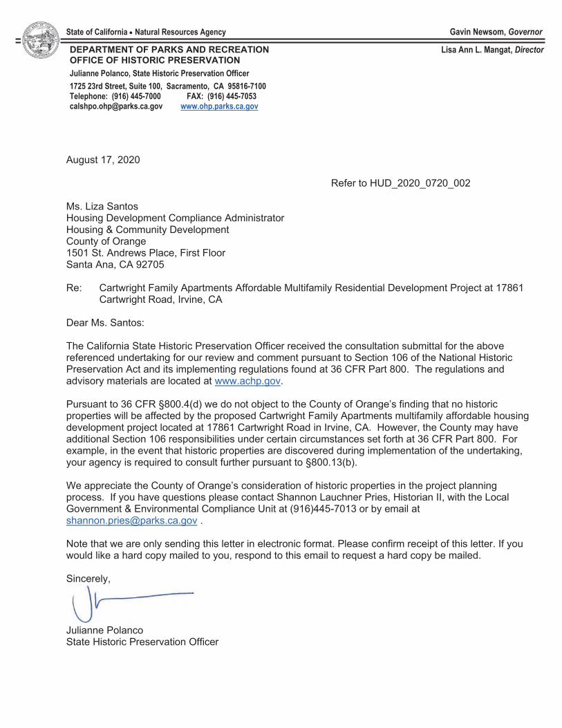
State of California Natural Resources Agency Gavin Newsom, Governor
DEPARTMENT OF PARKS AND RECREATION OFFICE OF HISTORIC PRESERVATION Julianne Polanco, State Historic Preservation Officer 1725 23rd Street, Suite 100, Sacramento, CA 95816-7100 Telephone: (916) 445-7000 FAX: (916) 445-7053 [email protected] www.ohp.parks.ca.gov
Lisa Ann L. Mangat, Director
August 17, 2020
Refer to HUD_2020_0720_002 Ms. Liza Santos Housing Development Compliance Administrator Housing & Community Development County of Orange 1501 St. Andrews Place, First Floor Santa Ana, CA 92705 Re: Cartwright Family Apartments Affordable Multifamily Residential Development Project at 17861
Cartwright Road, Irvine, CA Dear Ms. Santos: The California State Historic Preservation Officer received the consultation submittal for the above referenced undertaking for our review and comment pursuant to Section 106 of the National Historic Preservation Act and its implementing regulations found at 36 CFR Part 800. The regulations and advisory materials are located at www.achp.gov. Pursuant to 36 CFR §800.4(d) we do not object to the County of Orange’s finding that no historic properties will be affected by the proposed Cartwright Family Apartments multifamily affordable housing development project located at 17861 Cartwright Road in Irvine, CA. However, the County may have additional Section 106 responsibilities under certain circumstances set forth at 36 CFR Part 800. For example, in the event that historic properties are discovered during implementation of the undertaking, your agency is required to consult further pursuant to §800.13(b). We appreciate the County of Orange’s consideration of historic properties in the project planning process. If you have questions please contact Shannon Lauchner Pries, Historian II, with the Local Government & Environmental Compliance Unit at (916)445-7013 or by email at [email protected] . Note that we are only sending this letter in electronic format. Please confirm receipt of this letter. If you would like a hard copy mailed to you, respond to this email to request a hard copy be mailed. Sincerely,
Julianne Polanco State Historic Preservation Officer

60
Attachment 14. DNL Ambient Noise Calculator
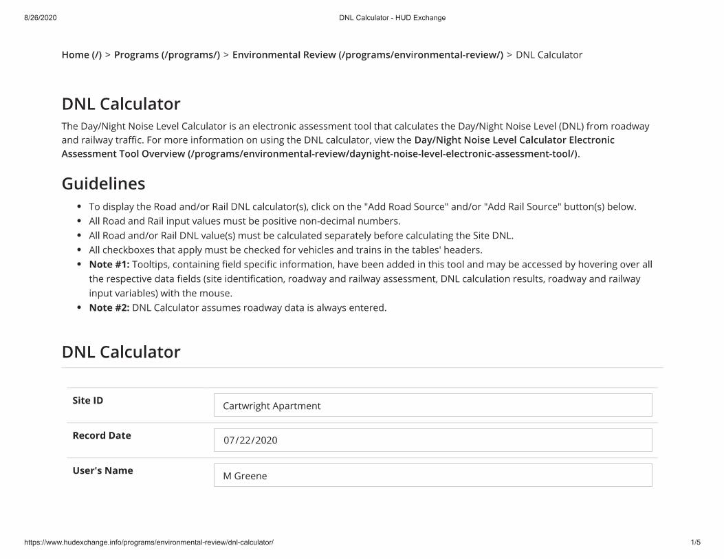
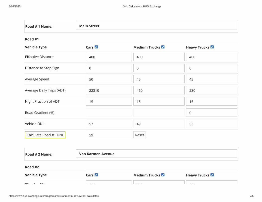
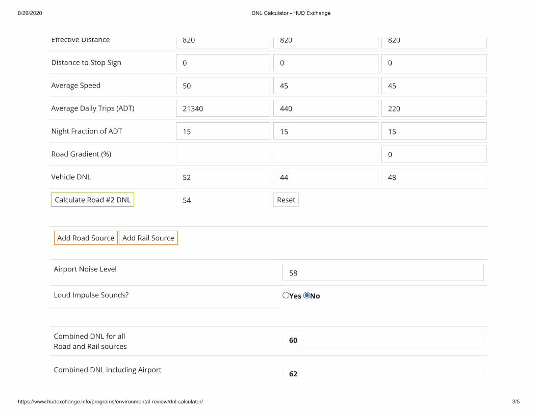
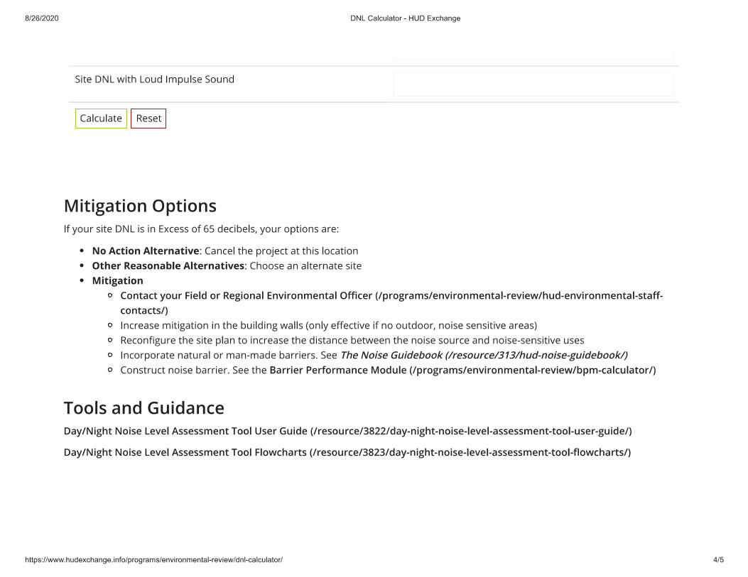


61
Attachment 15. Sole Source Aquifer Map
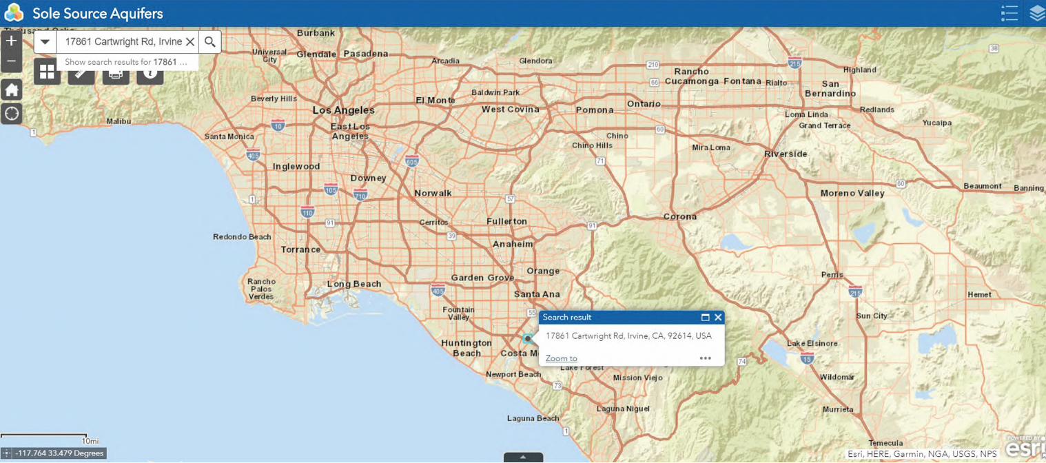

62
Attachment 16. NWI Surface Waters and Wetlands Map
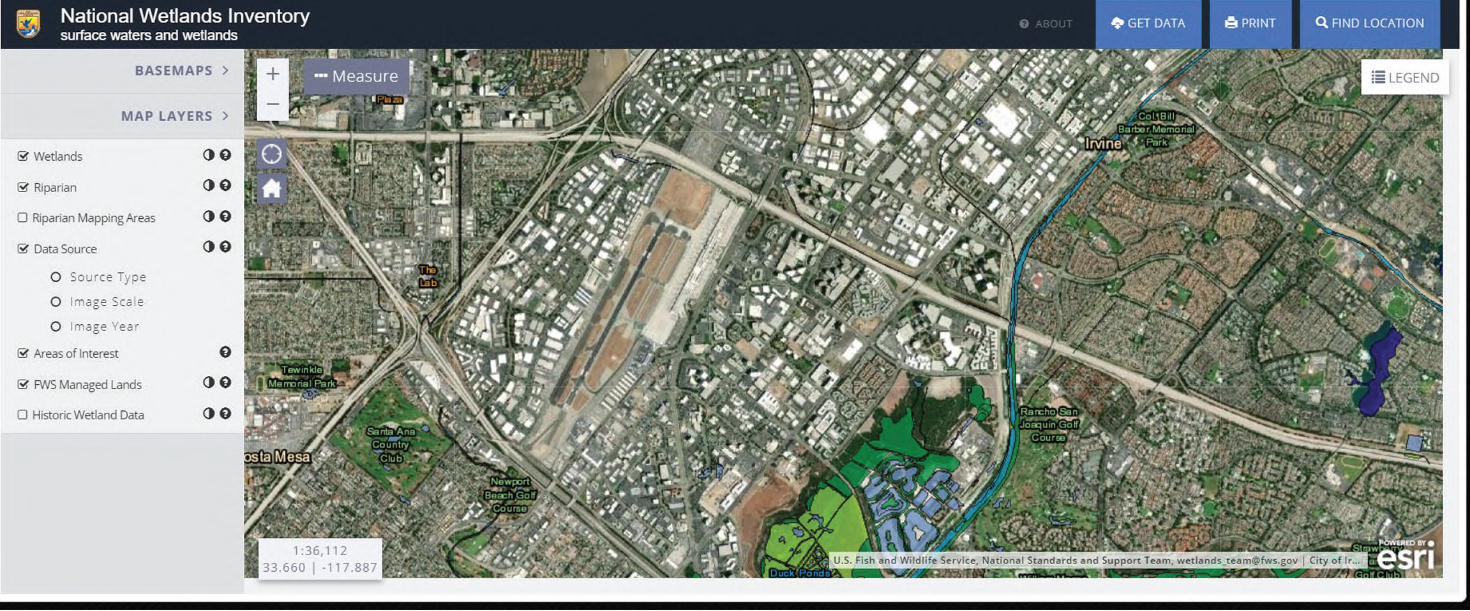

63
Attachment 17. NPS Nationwide Rivers Inventory Map Data
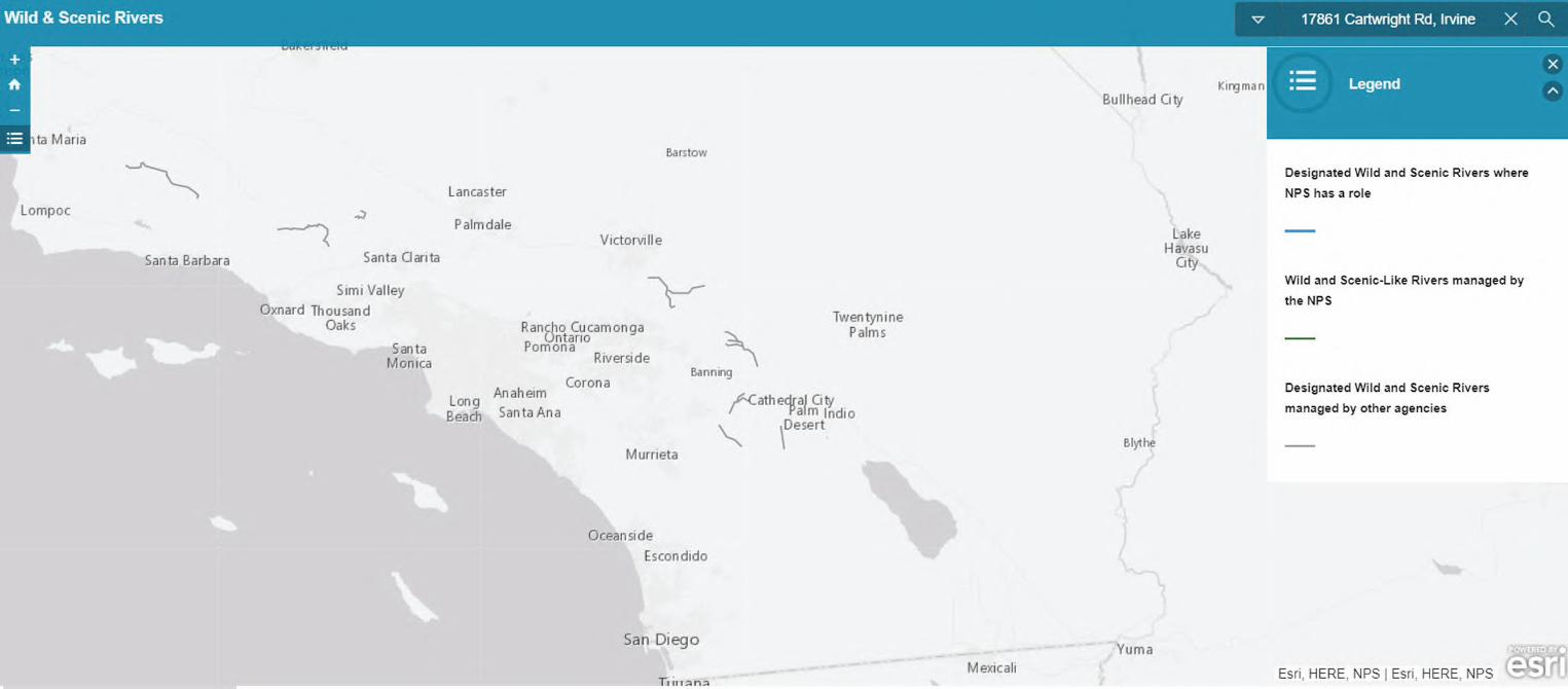

64
Attachment 18. City of Irvine Waste Haulers Map
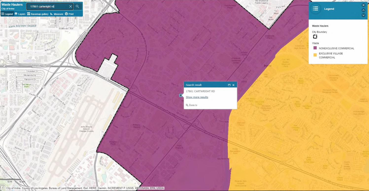

65
Attachment 19. City of Irvine Public Works Solid Waste & Recycling Haulers List
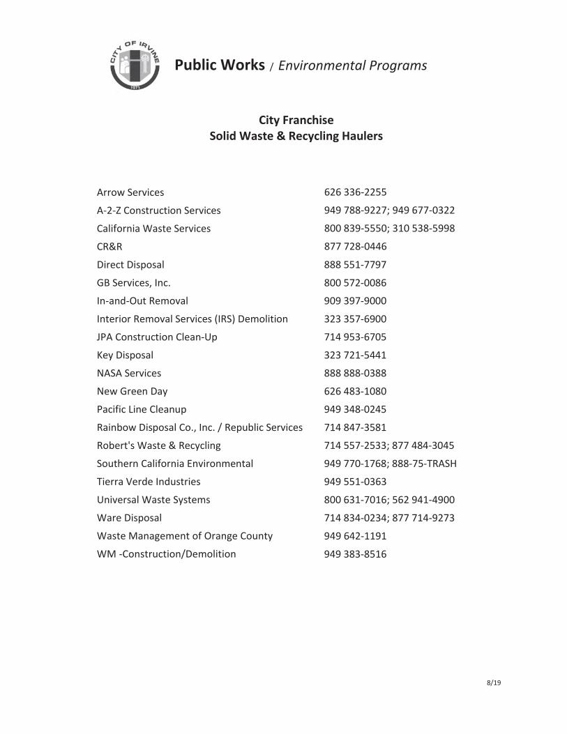
Public Works / Environmental Programs
City Franchise Solid Waste & Recycling Haulers
626 336-2255 949 788-9227 949 677-0322 800 839-5550 310 538-5998 877 728-0446 888 551-7797 800 572-0086909 397-9000 323 357-6900714 953-6705 323 721-5441888 888-0388 626 483-1080949 348-0245 714 847-3581
Arrow Services A-2-Z Construction ServicesCalifornia Waste ServicesCR&RDirect DisposalGB Services, Inc.In-and-Out RemovalInterior Removal Services (IRS) DemolitionJPA Construction Clean-UpKey DisposalNASA ServicesNew Green DayPacific Line CleanupRainbow Disposal Co., Inc. / Republic ServicesRobert's Waste & RecyclingSouthern California EnvironmentalTierra Verde IndustriesUniversal Waste SystemsWare DisposalWaste Management of Orange CountyWM -Construction/Demolition
714 557-2533; 877 484-3045 949 770-1768; 888-75-TRASH 949 551-0363 800 631-7016; 562 941-4900 714 834-0234; 877 714-9273
642-1191949 383-8516
8/19


