Embed Size (px)
Citation preview

1
ASX Announcement
6 April 2022
Encouraging Surface Sample Results
from Tambang Tinggi
Highlights:
• Anomalous gold and copper results returned from additional reconnaissance surface rock sampling over the Tambang Tinggi project area:
o 20 of 57 grab samples assayed >1 g/t Au, including five samples assaying from 13.1 to 36.6 g/t Au
o 19 of 57 grab samples assayed >0.2% Cu, including five samples assaying from 2.08 to 8.29% Cu in skarn type mineralisation
• New results from Tambang Tinggi continue to support potential for high-grade gold and copper targets on the South Block of the Contract of Work (CoW)
• Additional prospecting over other parts of the project area are in progress
Sihayo Gold Limited (ASX:SIH – “Sihayo” or the “Company”) is pleased to announce the latest results from reconnaissance rock sampling in progress at Tambang Tinggi located in the northeast corner of the South Block of the PT Sorikmas Mining CoW in North Sumatra, Indonesia.
Sihayo’s Executive Chairman, Colin Moorhead commented on the exploration results:
“Assay results from our surface sampling work on early-stage targets continue to demonstrate the exploration potential of the CoW. We continue to build a pipeline of exciting exploration base and precious metals targets across the CoW and will implement a structured approach to testing these targets.”
Latest Results
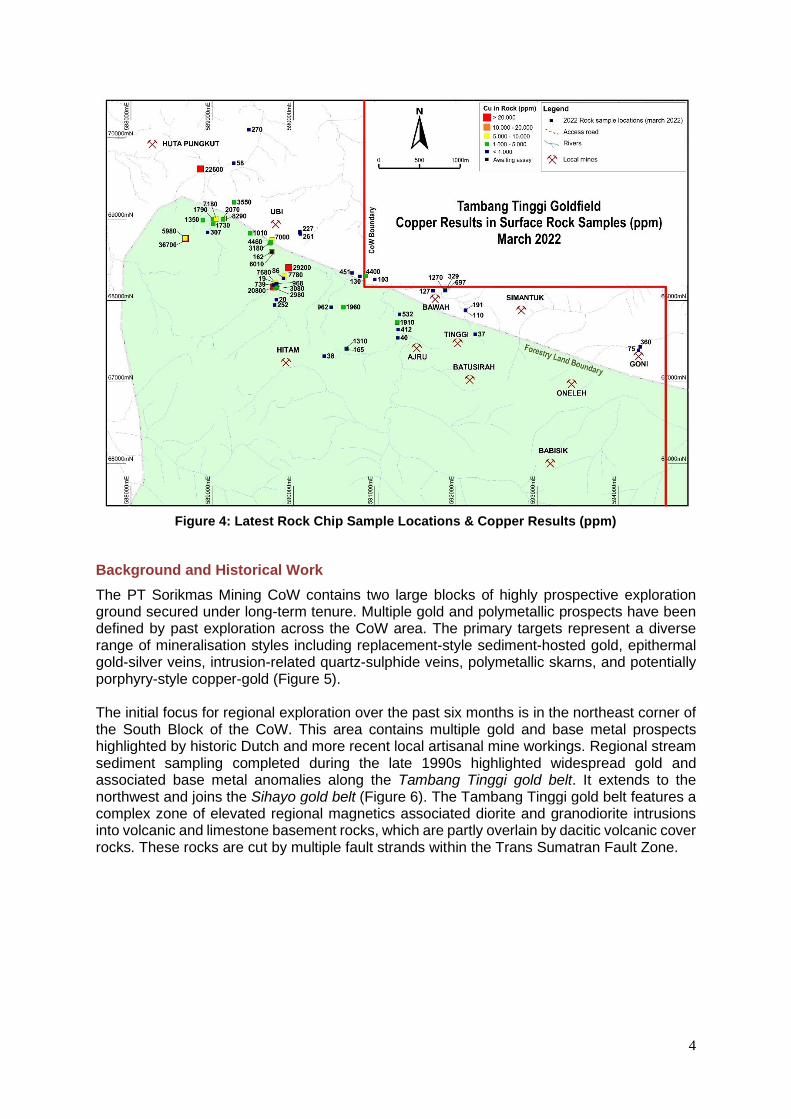
Results were received for 57 reconnaissance grab samples taken from local mining muck piles and outcrops located surrounding and between the Tambang Tinggi and Tambang Ubi prospects. The encouraging results are summarised below and continue to highlight strong gold and copper anomalies associated with quartz-sulphide veins and skarns located with a >4 km by 1 km area along the Tambang Tinggi project area (refer to Figures 1 – 4 and Appendix 1 for a full list of results).

2
Highlights from these results include:
▪ 5 samples returned gold results ranging from 13.1 to 36.6 g/t Au ▪ 8 samples returned gold results ranging from 5.8 to 8.9 g/t Au ▪ 7 samples returned gold results ranging from 1.12 to 4.51 g/t Au ▪ 19 samples returned copper results >0.2% Cu, including 5 samples assaying from 2.08
to 8.29% Cu
The concentration of higher copper and associated gold results on the western side of the Tambang Tinggi project area is sourced from garnet-pyroxene-wollastonite-sulphide-magnetite skarns in Permian limestones. Gold-bearing quartz-sulphide veining cutting diorite intrusions is concentrated at the centre and eastern side of the Tambang Tinggi project and is associated with stronger arsenic and tellurium anomalism.
There is currently insufficient sampling density and grade representativity to comment on the potential geometry and size of the prospects at this stage. However, the apparent large distribution of local artisanal workings and consistency of gold and copper anomalies detected in rock chips taken to-date are encouraging for the potential to discover significant gold-copper deposits in the Tambang Tinggi project area.
Figure 1: PT Sorikmas Mining CoW – Tambang Tinggi Location Plan

3
Figure 2: Tambang Tinggi Project Area – Simplified Geology & Prospects
Figure 3: Latest Rock Chip Sample Locations & Gold Results (ppm)
4
Figure 4: Latest Rock Chip Sample Locations & Copper Results (ppm)
Background and Historical Work
The PT Sorikmas Mining CoW contains two large blocks of highly prospective exploration ground secured under long-term tenure. Multiple gold and polymetallic prospects have been defined by past exploration across the CoW area. The primary targets represent a diverse range of mineralisation styles including replacement-style sediment-hosted gold, epithermal gold-silver veins, intrusion-related quartz-sulphide veins, polymetallic skarns, and potentially porphyry-style copper-gold (Figure 5). The initial focus for regional exploration over the past six months is in the northeast corner of the South Block of the CoW. This area contains multiple gold and base metal prospects highlighted by historic Dutch and more recent local artisanal mine workings. Regional stream sediment sampling completed during the late 1990s highlighted widespread gold and associated base metal anomalies along the Tambang Tinggi gold belt. It extends to the northwest and joins the Sihayo gold belt (Figure 6). The Tambang Tinggi gold belt features a complex zone of elevated regional magnetics associated diorite and granodiorite intrusions into volcanic and limestone basement rocks, which are partly overlain by dacitic volcanic cover rocks. These rocks are cut by multiple fault strands within the Trans Sumatran Fault Zone.

5
Figure 5: PT Sorikmas Mining CoW – General Geology
Figure 6: PT Sorikmas Mining CoW – Prospect Locations

6
Tambang Tinggi contains the historic Pagaran Siayu mine (or Tambang Ubi) located in the Muara Sipongi subdistrict. The Dutch mined a copper-gold-silver bearing skarn from a series of underground workings at Pagaran Siayu from 1936-39. The mine produced approximately 100,000 t of ore with reported grades averaging approximately 6.2 g/t Au, 2.7 g/t Ag and 0.24% Cu1.
Underground sampling of the mineralized skarn from accessible drives by Sihayo in 2006 produced encouraging results including 3 m at 19.85 g/t Au and 0.85% Cu, 3 m at 13.6 g/t Au and 1.29% Cu, and 3 m at 11.7 g/t Au and 0.78% Cu (Refer to ORP:ASX Announcement dated 19 September 2006). Sihayo completed 1,153 m of diamond drilling in 11 holes during 2006-07 and produced significant mineralised intercepts including 0.9 m at 6.27 g/t Au and 0.47% Cu from 35.7 m in TUDD001 and 4.0 m at 3.42 g/t Au and 0.48% Cu from 22.0 m in TUDD002 (Refer to ORP:ASX Quarterly Report 31 December 2006). Over the past few decades, local artisanal miners have intermittently worked mineralised pillars left in this historic mine.
The Company also conducted scout drilling at Tambang Hitam and Tambang Tinggi prospects during 2005-2011. Encouraging gold-copper drill intercepts were returned at Tambang Tinggi in quartz-sulphide stockworks within phyllic alteration (quartz-sericite-tourmaline-sulphide); including 27 m at 1.32 g/t Au and 0.11% Cu (TTDD001), 31 m at 3.42 g/t Au and 0.11% Cu (TTDD002) and 18 m at 5.86 g/t Au and 0.06% Cu (TTDD06). Additional details and results from this previous work are summarized under ‘Other substantive historic exploration data’ in the accompanying JORC Table.
Recent sampling and future work
The Company recommenced field work on the Tambang Tinggi gold belt in late 2021. This has included prospecting, mapping, and surface rock chip geochemical sampling (Refer to SIH:ASX announcement dated 25 October 2021). Encouraging gold, silver, and base metal results from initial sampling in the current phase of work was previously reported (Refer to SIH:ASX announcements dated 23 November 2021 and 25 January 2022) (Table 1 below; Figures 7 and 8).
Table 1: Tambang Tinggi – 2021 Program – Summary of Rock Chip Results (Previously reported)
No. of Samples Gold Results Range (g/t) Associated Silver, Copper & Zinc
5 29.6 102 Up to 163 g/t Ag, 0.75% Cu
8 10.2 19.6 Up to 51.4 g/t Ag, 1.89% Cu
11 5.00 8.84 Up to 725 g/t Ag, 2.31% Cu, 9.23% Zn
22 1.19 4.55 Up to 24.3 g/t Ag, 2.04% Cu
15 0.32 0.95 Up to 24.7 g/t Ag, 0.48% Cu
The Company has commenced the process of applying for an IPPKH Exploration forestry permit to conduct detailed surface exploration activities, such as trenching and drilling, inside forestry designated areas located on the eastern side of the CoW South Block. The initial application covers about 10,000 ha of forestry that includes a large part of the Tambang Tinggi gold belt. Processing and granting of an IPPKH is estimated to take approximately six months. The Company can freely operate with the permission of landowners in the non-forestry designated areas. Some samples reported in this announcement were taken outside of forestry and do not require a permit to undertake exploration trenching and drilling.
Additional prospecting and surface sampling are in progress along the southern edge of Tambang Tinggi where historic work has identified gold-bearing quartz vein swarms (e.g. Babisik prospect) hosted in younger dacitic volcanic rocks showing similarities with the
1 Beddoe-Stephens, B., Shepard, T.J., Bowles, J.F.W., and Brook, M., 1987. Gold mineralisation and skarn development near
Muara Sipongi, West Sumatra, Indonesia. Economic Geology 82: 1732-1749.

7
geology and mineralisation recorded at Hutabargot Julu. Initial sampling results from this area are expected to be received in April.
Figure 7: 2021 Rock Chip Sample Locations & Gold Results (ppm) Previously Reported
Figure 8: 2021 Rock Chip Sample Locations & Copper Results (ppm) Previously Reported

8
For further information, please contact: Colin Moorhead
Executive Chairman
Roderick Crowther
Chief Financial Officer

9
Appendix 1: Tambang Tinggi – Latest Rock Chip Results (March 2022)
Location Sample ID
Au ppm
Ag ppm
Cu ppm
Pb ppm
Zn ppm
As ppm
Bi ppm
Sb ppm
Te ppm
Tb. Tinggi 1032160 13.1 2.5 165 12 63 536 11.9 41.4 15
Tb. Tinggi 1032161 8.75 8.1 1310 31 53 480 4.06 26.5 8.3
Tb. Tinggi 1032162 5.99 24.6 40 49 157 2260 1.05 20.2 2.2
Tb. Tinggi 1032163 0.29 2.1 412 780 146 13 3.16 3.7 1.3
Tb. Tinggi 1032164 0.33 2.0 1910 0.9 0.8 74 0.76 0.07 10.2
Tb. Tinggi 1032165 0.32 5.6 532 11 79 2910 0.78 13.7 0.8
Tb. Tinggi 1032166 36.6 3.2 360 112 157 5.41% 0.62 241 3.4
Tb. Tinggi 1032167 0.08 0.2 75 10 66 125 0.06 12.7 0.05
Tb. Tinggi 1032168 0.15 0.5 127 10 65 4240 0.25 4.4 1.6
Tb. Tinggi 1032169 13.8 21.2 697 25 513 2.95% 2.67 63.2 130
Tb. Tinggi 1032170 8.31 39.1 1270 276 2130 1.78% 1.59 89.3 70.3
Tb. Tinggi 1032171 6.81 2.0 329 53 2220 3.48% 1.19 155 11.1
Tb. Ubi 1032173 0.04 0.1 162 9 66 140 0.17 13.1 0.2
Tb. Ubi 1032174 13.6 6.2 6010 4 60 26 13.9 5.4 2.5
Tb. Ubi 1032175 0.29 3.7 2.92% 3 337 13 0.47 2.6 0.1
Tb. Ubi 1032176 0.33 1.2 3080 3 184 23 0.81 2.6 0.1
Tb. Ubi 1032177 0.15 1.7 7680 3 137 75 0.55 0.8 0.2
Tb. Ubi 1032178 0.75 4 7780 10 497 42 0.95 5.5 0.4
Tb. Ubi 1032179 0.04 0.05 86 4 52 21 0.1 0.8 0.05
Tb. Ubi 1032180 0.17 9.9 252 13 1390 305 1.05 15 0.5
Tb. Ubi 1032181 0.01 0.3 20 27 62 24 0.42 2.6 0.05
Tb. Ubi 1032182 0.49 1.8 2980 3 90 61 0.68 0.8 0.5
Tb. Ubi 1032183 0.23 1.8 19 10 14 311 0.09 1.6 0.05
Tb. Ubi 1032184 0.07 0.3 968 7 48 66 0.91 1.2 0.8
Tb. Ubi 1032186 0.08 0.4 739 1 36 28 0.23 1 0.05
Tb. Ubi 1032187 0.25 2 2.08% 4 182 33 0.93 4.8 0.2
Tb. Ubi 1032189 1.12 7.3 1790 18 132 54 5.75 7.1 6.8
Tb. Ubi 1032190 0.2 1 1730 1 13 72 0.06 25.2 0.2
Tb. Ubi 1032191 0.46 5.6 5980 5 2890 793 2.81 34.9 1.3
Tb. Ubi 1032192 15.6 17 3.67% 4 387 31 31.2 7 3
Tb. Ubi 1032193 1.26 9.8 8.29% 7 240 15 1.23 0.9 1.1
Tb. Ubi 1032194 0.005 0.05 307 2 52 5 0.09 0.9 0.05
Tb. Ubi 1032195 0.27 2.2 1350 11 36 114 0.45 1.7 0.5
Tb. Ubi 1032196 0.07 0.05 58 11 39 11 0.42 1 0.2
Tb. Ubi 1032197 0.65 12.4 2.26% 1 58 7 0.62 0.5 1
Tb. Ubi 1032198 0.01 0.2 270 11 34 9 1.08 0.7 0.2
Tb. Ubi 1032199 0.02 0.1 103 7 86 9 0.22 1.4 0.05
Tb. Ubi 1032200 0.96 7.8 4400 102 6.50% 1390 1.79 21.8 0.6
Tb. Ubi 1032202 0.01 0.2 130 19 119 58 0.26 2.5 0.05
Tb. Ubi 1032203 4.51 6.8 451 589 2210 1.19% 2.43 46.7 2
Tb. Tinggi 1032204 0.99 3 37 24 59 145 0.36 4 0.3
Tb. Tinggi 1032205 3.94 9.3 191 148 79 440 0.77 5.2 0.05
Tb. Tinggi 1032206 0.08 0.7 110 4 64 15 0.99 6.4 0.6

10
Appendix 1: Tambang Tinggi – Latest Rock Chip Results (March 2022)
Location Sample ID
Au ppm
Ag ppm
Cu ppm
Pb ppm
Zn ppm
As ppm
Bi ppm
Sb ppm
Te ppm
Tb. Ubi 1032207 0.1 0.4 261 79 274 42 0.17 2.4 0.5
Tb. Ubi 1032208 0.08 0.2 227 73 201 26 0.15 1.9 0.3
Tb. Ubi 1032209 2.14 4.5 1960 17 152 47 7.2 9.3 9.2
Tb. Ubi 1032210 7.79 39.9 38 60 10 5 0.26 7.4 1.5
Tb. Ubi 1032211 1.92 7.2 962 31 38 20 5.24 15 4.6
Tb. Ubi 1032212 5.8 3.5 3550 47 88 50 1.9 12 2.2
Tb. Ubi 1032213 0.09 0.5 7180 7 1490 246 0.22 16.6 0.2
Tb. Ubi 1032215 0.66 2.4 2070 3 35 38 0.86 0.7 0.8
Tb. Ubi 1032216 8.51 8.1 8290 3 45 64 4.95 18.7 4.8
Tb. Ubi 1032217 0.59 1.2 880 2 45 13 0.89 4.6 0.9
Tb. Ubi 1032218 0.72 1.1 1010 2 38 92 1 9.6 0.4
Tb. Ubi 1032219 8.90 4.8 7000 2 28 79 3.79 68.8 0.9
Tb. Ubi 1032220 0.97 4.1 4460 7 225 38 1.52 3.1 0.6
Tb. Ubi 1032221 2.47 4.2 3180 3 60 38 5.03 7.4 1.8
Note: All assay results are reported in ppm unless otherwise stated in percent

11
Competent Person’s Statement
Exploration Results
The information in this report which relates to Exploration Results is based on, and fairly represents, information compiled by Mr Bradley Wake (BSc Hons. (Applied Geology)), who is a contract employee of the Company. Mr Wake does not hold any shares in the company, either directly or indirectly.
Mr Wake is a member of the Australian Institute of Geoscientists (AIG ID: 3339) and has sufficient experience that is relevant to the style of mineralisation and type of deposit under consideration and to the activity being undertaken to qualify as a Competent Person as defined in the 2012 Edition of the “Australasian Code for Reporting of Exploration Results, Mineral Resources and Ore Reserves”.
Mr Wake consents to the inclusion in the report of the matters based on this information in the form and
context in which it appears.
Disclaimer
This announcement may or may not contain certain “forward-looking statements”. All statements, other
than statements of historical fact, which address activities, events or developments that the Company
believes, expects or anticipates will or may occur in the future, are forward-looking statements. Forward-
looking statements are often, but not always, identified by the use of words such as “seek”, “anticipate”,
“believe”, “plan”, “estimate”, “targeting”, “expect”, and “intend” and statements that an event or result “may”,
“will”, “can”, “should”, “could”, or “might” occur or be achieved and other similar expressions. These
forward-looking statements, including those with respect to permitting and development timetables,
mineral grades, metallurgical recoveries, potential production reflect the current internal projections,
expectations or beliefs of the Company based on information currently available to the Company.
Statements in this document that are forward-looking and involve numerous risks and uncertainties that
could cause actual results to differ materially from expected results are based on the Company’s current
beliefs and assumptions regarding a large number of factors affecting its business. Actual results may
differ materially from expected results. There can be no assurance that (i) the Company has correctly
measured or identified all of the factors affecting its business or the extent of their likely impact, (ii) the
publicly available information with respect to these factors on which the Company’s analysis is based is
complete or accurate, (iii) the Company’s analysis is correct or (iv) the Company’s strategy, which is based
in part on this analysis, will be successful. The Company expressly disclaims any obligation to update or
revise any such forward-looking statements.
No Representation, Warranty or Liability
Whilst it is provided in good faith, no representation or warranty is made by the Company or any of its
advisers, agents or employees as to the accuracy, completeness, currency or reasonableness of the
information in this announcement or provided in connection with it, including the accuracy or attainability
of any Forward Looking Statements set out in this announcement. The Company does not accept any
responsibility to inform you of any matter arising or coming to the Company’s notice after the date of this
announcement which may affect any matter referred to in this announcement. Any liability of the
Company, its advisers, agents and employees to you or to any other person or entity arising out of this
announcement including pursuant to common law, the Corporations Act 2001 and the Trade Practices
Act 1974 or any other applicable law is, to the maximum extent permitted by law, expressly disclaimed
and excluded.
Distribution Restrictions
The distribution of this announcement may be restricted by law in certain jurisdictions. Recipients and
any other persons who come into possession of this announcement must inform themselves about and
observe any such restrictions.

12
JORC Code, 2012 Edition – Table 1 Report Section 1 Sampling Techniques and Data
Sampling Techniques
Surface rock samples: Tambang Tinggi
• Selective grab samples were taken from piles of broken vein cobbles (“muck heaps”) extracted by local miners to the surface from veins exposed in the sub-surface workings. It is therefore assumed that these samples are broadly representative of the sample location and not far-removed from their source(s) in the immediate underlying bedrock.
• Each sample was taken as a composite grab sample of rock chips broken from several selected pieces of vein cobble found on the muck piles. Samples were selected from vein material showing textural and mineralogical characteristics that might most-likely contain significant gold grades. The samples were broken by hammer-and-chisel and collected by hand. The assay results returned are only considered to be ‘indicative’. They do not necessarily accurately represent the gold and asociated metal grades of the vein source(s) in the underground working.
• Individual sample weights were maintained at betwen 1-2 kg each. Each sample was individually labelled with a unique sample number and sealed in a tied calico sample bag with sample ticket included. Groups of samples were loaded into larger polywoven sacks and individually sealed with numbered security tags for transport from site to PT Intertek Utama Services (“Intertek”) sample preparation facility in Medan and there pulps were prepared for air freight to their lab in Jakarta.
• Industry standard QAQC protocols are followed and include the insertion of OREAS Standards and sample blanks.
• Sample preparation is carried out by PT Intertek Utama Services at their sample preparation facility in Medan, North Sumatra, located about 10-hours by road from the project site. Sample preparation includes weighing, drying at 600C, then crushing of the entire core sample to 95% passing minus-2mm and then a 1.5kg split for pulverising to 95% passing minus-75 microns. The pulp samples are air-freighted to Jakarta for geochemical assaying.
• Gold is assayed by 50-g charge Fire Assay with AAS determination (FA51/AA) and 46 mutilements including silver are assayed using a four-acid digest with a combination of ICP-MS & OES determination (4A/OM10) at PT Intertek Utama Services laboratory in Jakarta.
• The number of samples relating to this announcement: Tambang Tinggi: 57 selective rock grab samples from local mining muck piles.
Drilling techniques
• Not applicable
Drill sample recovery
• Not applicable.
Logging Surface rock samples: Sihorbo South & Tambang Tinggi
• All rock samples were digitally photographed and geologically logged by the supervising geologist to record UTM location, lithology, weathering state, alteration, mineralisation, structure, etc. Representative rock chips and/or slabs of all samples are retained at Tor Sigompul and Kotanopan field camps for reference.
• Standard nomenclature is used for logging codes and abbreviations and the data are digitally recorded in Excel-generated

13
logging sheets and securely stored in the Company’s datashed. The geological logging details are qualitative with the exception of the sample location coordinates and assay results, which are measured.
• These samples provide geological and assay data that are indicative of exploration potential but are not suitable for resource modelling.
Sub-sampling techniques and sample preparation
Surface rock samples: Sihorbo South & Tambang Tinggi
• No sub-sampling was undertaken and the entire sample, with exception of reference chips and rock slab, were submitted for sample preparation and assaying.
• No sample duplicates were taken or prepared in the field sampling.
• Sample size is appropriate to the reconnaissance nature of these surveys and provides an indication of the presence and potential grade of the target metals sought; namely gold, silver, and base metals.
Quality of assay data and laboratory tests
• PT Intertek Utama Services (Jakarta/Medan) is the primary sample preparation and assaying laboratory and PT Geoservices (Bandung) periodically conducts independent umpire gold and multielement assaying checks. Both laboratories operate to international standards and procedures and participate in Geostatistical Round Robin interlaboratory test surveys.
• All samples are prepared at the Intertek sample preparation facilty in Medan, North Sumatra. Core samples are weighed and dried at 600C. The entire sample is crushed to P95 (95%) passing minus 2mm and 1.5kg is split off and pulverized to P95 (95%) passing minus 75 microns.
• Sample pulps prepared at the facility in Medan are air freighted to Intertek’s analytical laboratory in Jakarta. The samples are assayed for gold by 50g-charge Pb-collection Fire Assay with AAS finish (FA51/AAS) and 46 multielements by four-acid digest (HClO4, HCl, HNO3, HF) and a combination of determinations using Inductively Couple Plasma/Optical Emission Spectrometry (ICP/OES) (Al, Ca, Cr, Cu, Fe, K, Mg, Mn, Na, Ni, P, S, Sc, Ti, V, Zn) and Inductively Couple Plasma/Mass Spectrometry (ICP/MS) (Ag, As, Ba, Be, Bi, Cd, Co, Cs, Ga, Ge, Hf, In, Li, Mo, Nb, Pb, Rb, Sb, Se, Sn, Sr, Ta, Te, Th, Tl, U, W, Y, Zr) determinations (4A/OM10).
• Sample preparation procedures and analytical methods used are considered appropriate to test for the style(s) of mineralisation targeted in the prospect area (porphyry-related and epithermal-style gold-silver-base metal mineralisation).
• The Company routinely inserts OREAS Certified Reference Materials (CRMs) and blanks at a rate of 1 in every 10-12 core samples (~10%) and at a rate of 1 in every 20 surface rock samples of the sample sequence to evaluate the laboratory’s sample preparation procedures, analytical quality and/or biases. The results relating to this announcement fall well within acceptable tolerances of accuracy and precision.
• Intertek also applies its own QAQC procedures. Certified Reference Materials and/or in-house controls, blanks and replicates are analysed with each batch of samples (numbering at least 10% of the total samples submitted in the batch). These quality control results are reported along with the sample values in the final report.
Verification of sampling and assaying
• Assay results are received from the laboratory in digital format and hard-copy final certificates. Digital data are stored on a dedicated database server and back-up database server. Hard-copy certificates are stored in Jakarta Office.
• Results are received and validated by the Company’s Database Manager against QAQC protocols before loading into the assay database.
• Results and gold intersections are reported by the Company’s Competent Person and Database Manager; these are verified

14
by alternative senior company personnel.
• No adjustments or calibrations are applied to any of the assay results in this announcement.
Location of data points
• Sample locations are fixed in the field using using a hand-held Garmin GPSMAP 66s with accuracy of +3-5m.
• The coordinates presented for rock sample locations in this announcement are field GPS measurements.
• The Grid System used is WGS84/ UTM Zone 47 North.
Data spacing and distribution
• Sample-spacing of the surface muck pile sampling across the prospect is irregular. It was guided by the occurrence of workings and suitable muck piles for sampling.No sample compositing as applied to the samples.
• No sample compositing was applied to the surface rock samples.
Orientation of data in relation to geological structure
• Surface rock sample were collected from muck piles and lesser outcrops. The samples from muck piles are not in-situ and their exact relation to geological structures is not yet known.
Sample Security
• A detailed Chain-of-Custody protocol has been established to ensure the safe and secure transportation of all geochemical samples from the remote project site to PT Intertek Utama Services sample preparation laboratory in Medan, North Sumatra.
• Surface rock samples are packed into double-lined hessian (polyweave) sacks which are individually sealed with cable-ties and a unique numbered security tag. The hessian sacks are weighed and registered (hard copy and computer).
• The hessian sacks are weighed and registered at Kotanopan exploration camp, which is located close to a major road for loading and transportation. The samples are transported by company vehicle to the Bukit Malintang Office, where they are met by the Company’s logistics personnel, then directly loaded into the truck, which is then outer-locked and sealed with the Company’s assigned numbered security tag (photographed) for transport and delivery direct to PT Intertek Utama Services in Medan, North Sumatra, accompanied by Company security personnel. The PT Intertek sample preparation laboratory is located about 10-12 hours by road (430 km) from the project area.
• On delivery to PT Intertek Utama Services in Medan, the laboratory manager confirms that the truck and hessian sack security seals are intact (photographed), weighs the hessian sacks, and reports to the supervising geologist for verification and permission to proceed with the sample preparation.
• PT Intertek Utama Services ensures the safe and secure transportation of pulp samples prepared at its sample prep facility in Medan, which are dispatched under their custodianship to the assaying laboratory in Jakarta, via DHL air courier. The pulp samples are packaged and securely wrapped in standard-sized Intertek-signatured boxes that are sealed with Intertek-signatured packaging tape. The pulp samples are accompanied by Intertek dispatch/security forms to ensure the acknowledgement of receipt and integrity of the samples (i.e. sample registration is completed and confirmed at both ends).
Audits or reviews
• The exploration programs are supervised by the Exploration Manager and supervising senior geologists based on site. In the field. The results of this drilling program are periodically audited and reviewed by an independent geological consultant, Mr Rob Spiers, representing Spiers Geological Consultants (SGC, Pty. Ltd.).
• The database is internally checked by the Company’s Database Manager.

15
JORC Code, 2012 Edition – Table 1 Report Section 2 Reporting of Exploration Results
Criteria listed in the preceding section also apply to this section.
Criteria Commentary
Mineral tenement and land tenure status
The mineral tenement is a 7th Generation Contract of Work (CoW) granted in February 1998 to PT Sorikmas Mining, an Indonesian joint venture company owned by Aberfoyle Pungkut Investments Pte Ltd (75%) and PT Aneka Tambang Tbk (25%). Sihayo Gold Limited (formerly Oropa Limited) acquired all of the shares of Aberfoyle Pungkut Investments Pte Ltd in April 2004. The CoW is located in North Sumatra in the Republic of Indonesia and is approximately 80km south-east from the Martabe Gold Mine.
The joint venture remains as Sihayo Gold Limited (ASX:SIH) owning a 75% interest in PT Sorikmas Mining which in turn holds the Sihayo-Pungkut 7th Generation Contract of Work (“CoW”). PT Aneka Tambang Tbk is the Company’s joint venture partner in the CoW with a 25% interest.
The original CoW area covered 201,600 hectares. This was reduced to the current 66,200 hectares after two mandatory partial relinquishments; 1) to 151,000 ha in Feb 1999, and 2) to 66,200 ha in Nov 2000. As a consequence of these two partial relinquishments, the current CoW is subdivided into two separate blocks; North block and South block. The tenement is currently under the Operation/Production phase of the CoW. There is no future requirement for area relinquishment. Tenure on the CoW is until 2049 with an option to extend for two additional 10-year periods.
The PT Sorikmas Mining CoW area is located along on a fertile segment of the Sumatra magmatic arc in North Sumatra. The same arc segment includes the giant Martabe gold-silver deposit (located about 80km NW) and the high-grade Dairi lead-zinc deposit (located about 250km NW). The CoW and is considered highly prospective for gold, silver and base metal mineralisation. Multiple mineral prospects have been identified during previous exploration within the CoW area and various mineralisation target-styles are represented including replacement-style carbonate-hosted gold (Carlin-style), intermediate-sulphidation epithermal gold-silver veins, gold-base metal skarns and porphyry-related copper-gold.
The Sihayo Gold Project is the most advanced project within the CoW and a Definitive Feasibility Study for the project was completed in June 2020. The project has combined Mineral Resources of 24 Mt at 2.0 g/t for 1.5 Moz of contained gold and an Ore Reserve of 12.5 Mt at 2.1 g/t for 840 koz of contained gold in the Sihayo-1 and Sambung gold deposits. The bulk of this gold in the Sihayo-1 gold deposit. The Company has an active exploration program including extension drilling at the Sihayo Gold Project, drilling at the Hutabargot Julu Project located 6km south of the Sihayo Gold Project, and prospecting in the Tambang Tinggi project area of the South CoW block.
Tambang Tinggi gold-copper project is located in partly forested, rugged terrain in the South block of the CoW, within the Barisan Mountains of North Sumatra. It is located in Kotanopan sub-district at the southern end of Mandailing Natal regency, close to the provincial boundary with West Sumatra. The company rents a house as an exploration office/camp located on the western edge of Kotanopan township. Core from the historic drilling program on Tambang Tinggi is also stored at this office. Kotanopan is a moderate-sized town with a population of about 25,000 people.

16
Criteria Commentary
Access to Tambang Tinggi is via a major road and then walking track. Tambang Tinggi is located about 20-km west of Kotanopan along the Trans West Sumatra Highway, and then a few kilometres by an unsealed tracks off this highway. Travel time from Kotanopan office to Tambang Tinggi is about 2.5-hours. Kotanopan is located about 65-km SE from PT Sorikmas Mining administration office located at Bukit Malintang village. Travel time from Koyanopan to Bukit Malintang office is about 2 hours via the Trans West Sumatra Highway.
Bukit Malintang is located on the Trans West Sumatra Highway. Bukit Malintang is about 116 km (3.5-hour drive) southeast of Ferdinand Lumban Tobing airport, which services the nearby regional city and port of Sibolga. There are daily flights between Ferdinand Lumban Tobing airport and Jakarta. Alternative access is available from Silangi airport (Lake Toba) which is about 195 km (5.5 hours) and Minangkabau airport (Padang) which is about 315 km (8 hours) by road from Bukit Malintang. Both of these airports have daily flights to/from Jakarta.
Bukit Malintang office is located about 26 km (45-minute drive) northwest of the major regional town of Panyabungan, located off the eastern edge of the CoW North block. Panyabungan has a population of just under 100,000 people. Panyabungan and villages in the surrounding subdistricts provide most of the logistics and local labour in support of the project activities.
Much of the PT Sorikmas Mining CoW is covered by state-owned protected forest that is managed by the Ministry of Environment and Forestry. The Company requires an Ijin Pinjam-Pakai Kawasan Hutan (IPPKH), translated as a Borrow-Use forestry area permit, from the the Ministry of Environment and Forestry to access and use a forestry area for any purpose that is outside of forestry activities, including mineral exploration and mining activities. The PT Sorikmas Mining CoW contains caveats that allow the Company to conduct open-cut gold mining in protected forest. The Company holds a valid 485 ha IPPKH (Operasi) permit that contains the proposed Sihayo mine development area and, on the 4 September 2020, was granted a 13,800 ha IPPKH (Eksplorasi) permit that surrounds the operating permit. This allows the Company to conduct exploration activities including drilling on prospects located along the Sihayo Gold Belt in the North Block of the CoW, which includes Hutabargot Julu, Sihayo and near-by prospects. The 13,800 ha IPPKH (Eksplorasi) permit is valid for 2-years until 3 September 2022, and is extendible.
Tambang Tinggi lies partly within a protected forest designated area and partly within freehold land owned by local farmers. It contains a mixture of primary and secondary forest, rubber and cocoa plantation and areas of fruit and vegetable cultivation under formal and informal landholdings. Local artisanal gold mining is also active within the project area, but it is not permitted and therefore classified as an illegal activity or PETI (Pertambangan Tanpa Izin). Local miners are cooperative and compliant in recognizing the Company’s rights to explore in the project area. The Company will apply for an IPPKH (Eksplorasi) permit to allow it to explore the forestry designated areas and in the meantime can operate freely with the permission of landowners in the non-Forestry designated areas. Most of the samples reported in this announcement were taken outside Forestry land and do not require an IPPKH to undertake exploration programs, including drilling.

17
Criteria Commentary
Exploration done by other parties
Exploration commenced on the PT Sorikmas Mining CoW in 1995, originally under a domestic investment Kuasa Pertambangan (KP) title held by Antam with work managed by PT Aberfoyle Indonesia, a subsidiary of Aberfoyle Limited (Australia). Work continued under a pre-CoW permit (SIPP) from February 1997 to January 1998, and then under the joint venture company, PT Sorikmas Mining, when the CoW was signed in February 1998. Exploration carried out over this initial three year period included regional drainage geochemical sampling, prospecting, geological mapping, soil geochemical surveys and investigations on some of the historic Dutch mine workings in the district. Scout drilling was conducted by Aberfoyle on the Mandagang porphyry target in 1996 and produced some broad low grade Cu-Mo-Au intercepts. The regional work highlighted numerous gold and multielement anomalies across the CoW. Subsequent prospecting identified multiple targets, representing a broad spectrum of precious and base metal mineralisation styles, including:
• Carbonate-hosted jasperoid gold at Sihayo, Sambung, Link Zone, Sihayo-2, Sihayo-3, Sihayo-4, Mentari and Nabontar prospects (North CoW Block);
• Epithermal gold-silver veins and disseminated mineralisation at Hutabargot Julu (Dutch working), Sihayo-5 (North CoW Block), and Tambang Hitam, Tarutung, Babisik, Nalan Jae, Nalan Julu, and Rotap prospects (South CoW Block);
• Porphyry-style copper + gold-molybdenum mineralisation at Rura Balancing, Singalancar, Sihayo-2 Copper (North CoW Block), and Mandagang, Tambang Tinggi, Namilas and Siandop prospects (South CoW Block);
• Polymetallic skarn at Bandar Lasiak (North CoW Block), and Pagar Gunung, Huta Pungkut prospects and Tambang Ubi/Pagaran Siayu (Dutch mine) prospects.
Aberfoyle was taken over by Western Metals Ltd in late 1998. Western Metals farmed out part of their beneficial interest in the CoW to Pacmin Mining Corp in 1999. Pacmin funded and managed detailed prospect-scale work at Sihayo and on some neigbouring prospects during 1999 until early 2000. This work included grid-based soil geochemical surveys, ground IP-Resistivity surveys, detailed geological mapping, trenching on various prospects and the first scout drilling program on the Sihayo gold discovery. The CoW was placed into temporary suspension from November 2000 to February 2003 due to depressed gold prices, lack of funding and changes to the forestry regulations and status that restricted access to the CoW area. PacMin was taken over by Sons of Gwalia (SoG) (Australia) in late 2001. Oropa Limited entered into an agreement to purchase the 75% beneficial interest in the CoW held by SoG/Western Metals in late 2002. Oropa exercised its option to purchase the 75% beneficial interest in the CoW held by SoG/Western Metals in early 2004. Oropa changed its name to Sihayo Gold Limited in late 2009.

18
Criteria Commentary
Exploration resumed on the CoW in early 2003, fully funded by Oropa/Sihayo. This work included detailed prospect-scale exploration such as grid-based soil geochemical surveys, ground IP-Resistivity and magnetics surveys, detailed geological mapping, trenching and drilling campaigns in the North Block (Sihayo, Sihayo-2, Link Zone, Sambung & Hutabargot) and South Block (Tambang Tinggi, Tambang Ubi and Tambang Hitam) that steadily increased from 2003 to 2013. An airborne magnetic and radiometric survey was flown over the CoW in 2011.
A total of 86,499 m of diamond drilling in 824 holes was drilled on the CoW up to 2013. This included totals of:
- 3,996-m in 20 holes at Tambang Tinggi (2005, 2011),
- 856-m in 7 holes at Tambang Hitam (2005),
- 1153-m in 11 holes at Tambang Ubi (2006-07) in the South CoW Block.
Significant results reported from historic drilling at Tambang Tinggi are summarised under ‘Other substantive exploration data’.
Another hiatus in exploration activity occurred from 2013 to early-2019 due to lack of funding.
New investment was injected into Sihayo Gold Limited in 2018 and the Company recommenced ground work at Sihayo in 2019 with an infill drilling program in support of a new Mineral Resource estimate on Sihayo and Sambung gold deposits. A total of 7,338 m in 74 holes of infill drilling was completed at Sihayo in 2019 (See ASX:SIH Quarterly reports released in January 2020, April 2020, and ASX release by Sihayo (ASX:SIH) on 23 June 2020).
Another significant capital raising was achieved in August 2020, the proceeds of which are being used to fund exploration at Hutabargot Julu and elsewhere, early project works on the Sihayo Starter Project and working capital See ASX:SIH Quarterly reports released on 20 August 2020). A total of 4806-m/25 holes of reconnaissance drilling was completed over the greater Hutabargot project area in early 2020, 1740-m/8 holes completed on the Sihorbo North vein target and 2577-m/11 holes on the Penatapan stockwork target were completed in mid-late 2021 (See ASX releases by Sihayo ASX:SIH on 12 April 2021, 5 July 2021 and 17 November 2021).
Historic resource estimates have only been previously announced on the Sihayo gold deposit, located about 5-km NW of Hutabargot Julu (See ASX:SIH Quarterly reports released in January 2020, April 2020, and ASX release by Sihayo (ASX:SIH) on 23 June 2020).
The Mineral Resource estimate for the Sihayo and Sambung deposits has been updated to reflect consolidation of the results from the 2019 infill drilling program at Sihayo and a comprehensive revision of the geology and mineralisation models for both deposits. In particular, the geological model used in the 2020 DFS was updated to reflect metallurgical domains that are now in line with the mine and processing scheduling and inform the stockpiling and blending requirements for the operations.

19
Criteria Commentary
Furthermore, the cut-off grade for the Mineral Resource estimate was revised down from 0.6 g/t Au to 0.4 g/t Au in response to economic analysis used for the Ore Reserve estimate, which showed 0.4 g/t Au was a suitable cut-off for economic material in the deposits (See ASX release by Sihayo (ASX:SIH) on 17 February June 2022).
There have been no resource estimates relating to the Tambang Tinggi project area.
Geology Regional Setting The CoW is located at the western end of the 7,000 km long Sunda-Banda magmatic arc. Sumatra lies on the south-western margin of the Sundaland promontory at the edge of the Eurasian plate. The promontory basement is composed of accreted and fault-transposed continental plate and magmatic arc terranes that were derived from Gondwana during the Late Palaeozoic and Mesozoic. The CoW straddles a NW-SE trending collisional boundary separating two basement segments: namely the Late Palaeozoic West Sumatra terrane (eastern segment) and Mesozoic Woyla terrane (western segment). The West Sumatra segment is composed of intermediate-felsic volcano-sedimentary rocks and associated shallow marine carbonate rocks. The Woyla segment is an accretionary complex composed of deep to shallow marine sedimentary rocks and associated mafic volcanic rocks. The collisional contact between these two terranes, referred to as the Medial Sumatra Tectonic Line, is stitched by Mesozoic granitic intrusions. Extension on these basement rocks during the early Palaeogene produced local rift basins that were filled by fluvio-lacustrine, coal-bearing siliciclastic-volcano-sedimentary rocks. These rocks have been uplifted, structurally inverted and partly eroded by the development and formation of the Trans Sumatran Fault Zone (TSFZ), commencing in the Miocene. The evolution of the TSFZ was accompanied by Palaeogene magmatism (diorite/andesite – tonalite/dacite intrusions and volcanics) and associated hydrothermal activity and mineralisation within the CoW and surrounding region. Younger volcanic tephras erupted from nearby Quaternary volcanoes (eg Sorikmarapi, Toba) mantle the landscape in parts of the CoW. Tambang Tinggi Geology The South block of the PT Sorikmas Mining CoW is largely underlain by a “pop-up” basement between two large fault segments at the southern end of the of the Barumun-Angkola dextral transtensional jog in the NW-SE trending Trans Sumatran Fault Zone (TSFZ), at the southern end of a major dilatational pull apart basin (Panyabungan Graben: ~100km long, ~12km wide and ~1km deep) that is controlled by the Trans Sumatran Fault Zone (TSFZ). The TSFZ and associated deep seated dilatational structures that control the pull-apart basin are interpreted to be major structural controls on the alignment and evolution of Tertiary magmatism and mineralisation within the CoW. Tambang Tinggi project lies within one of three parallel/near-parallel prospect-aligned mineral belts recognised across both blocks of the CoW area. It is a +7.5 km long WNW-ESE trending corridor of Permian calcareous volcano-sedimentary rocks intruded by Late Jurassic intermediate intrusions of I-type affinity. These rocks are highly prospective for intrusion-related gold-silver-base metal veins, polymetallic skarn and possibly porphyry-related gold and copper mineralisation.

20
Criteria Commentary
Previous mapping over the greater Tambang Tinggi project area (2005, 2011) showed the area is underlain by Permian andesitic volcanic – limestone basement rocks intruded by Late Jurassic hornblende diorite and quartz diorite/tonalite, and younger dacitic volcaniclastic cover rocks. The intrusions and basement volcanic rocks are extensive and highlighted by an elevated magnetic response in recently reprocessed and imaged 2012 surveyed airborne magnetics.
Numerous artisanal gold workings occur across the greater project area. These defined a cluster of major prospects that include Huta Pungkut, Tambang Ubi/Pagaran Siayu (Dutch Mine), Tambang Hitam, Tambang Tinggi, Simantuk, Babisik and others. Most of the workings are developed on quartz-sulphide veins or skarn mineralization aligned along structures of varying length and continuity.
Drill hole Information
• Table 1 and Appendix 1 provide details on the surface rock samples and results from Tambang Tinggi.
• Surface rock sample location plans presenting gold and copper results are provided in this announcement.
Data aggregation methods
• Not applicable.
• No mineral equivalent values are used in the reporting of the gold and copper results.
Relationship between mineralisation widths and intercept lengths
• Not applicable.
Diagrams • Rock chip sample location plans are presented in this announcement.
Balanced reporting
• This announcement is believed to contain sufficient relevant information such as range of exploration results, geologic context, historic results, type and sampling methodology, maps/figures and spatial distribution of data points to represent balanced reporting.
21
Other substantive historic exploration data
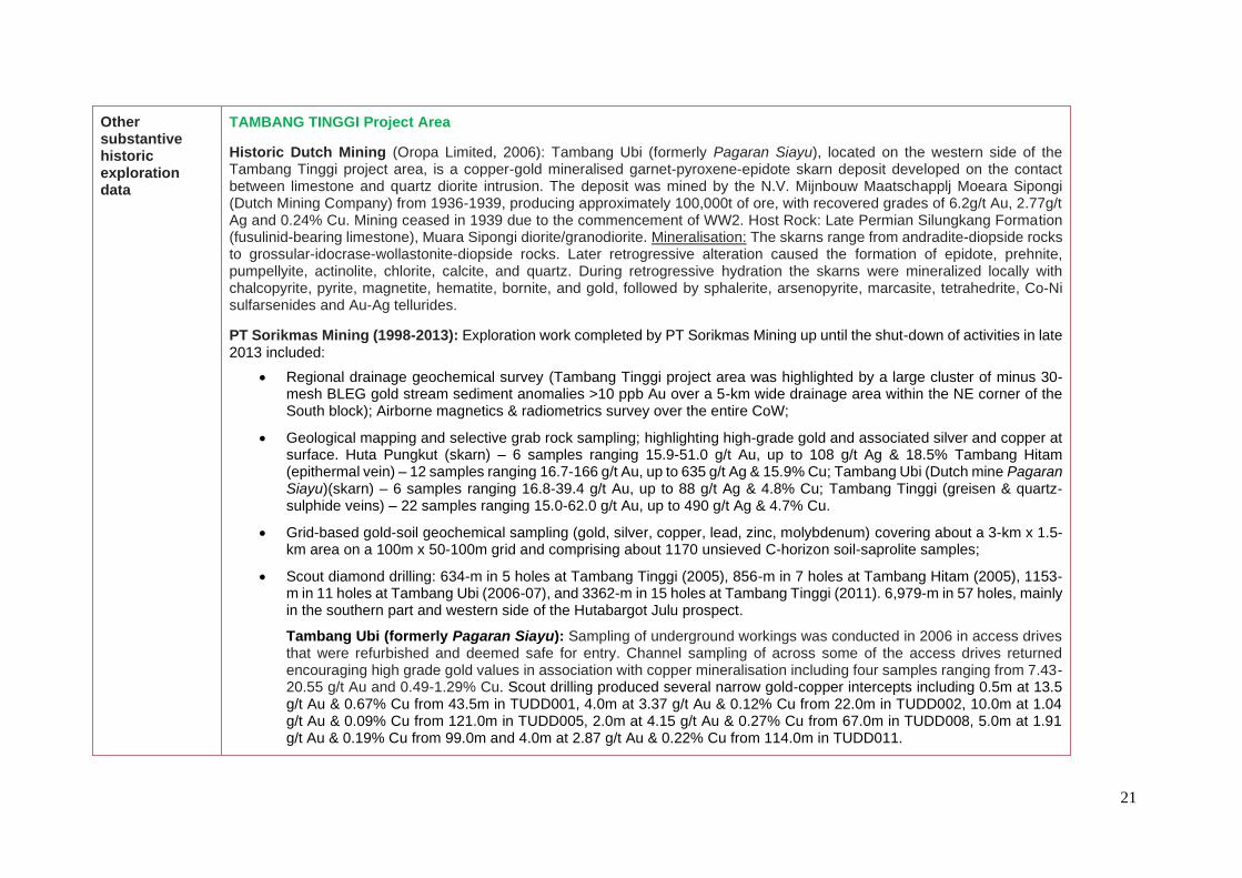
TAMBANG TINGGI Project Area
Historic Dutch Mining (Oropa Limited, 2006): Tambang Ubi (formerly Pagaran Siayu), located on the western side of the Tambang Tinggi project area, is a copper-gold mineralised garnet-pyroxene-epidote skarn deposit developed on the contact between limestone and quartz diorite intrusion. The deposit was mined by the N.V. Mijnbouw Maatschapplj Moeara Sipongi (Dutch Mining Company) from 1936-1939, producing approximately 100,000t of ore, with recovered grades of 6.2g/t Au, 2.77g/t Ag and 0.24% Cu. Mining ceased in 1939 due to the commencement of WW2. Host Rock: Late Permian Silungkang Formation (fusulinid-bearing limestone), Muara Sipongi diorite/granodiorite. Mineralisation: The skarns range from andradite-diopside rocks to grossular-idocrase-wollastonite-diopside rocks. Later retrogressive alteration caused the formation of epidote, prehnite, pumpellyite, actinolite, chlorite, calcite, and quartz. During retrogressive hydration the skarns were mineralized locally with chalcopyrite, pyrite, magnetite, hematite, bornite, and gold, followed by sphalerite, arsenopyrite, marcasite, tetrahedrite, Co-Ni sulfarsenides and Au-Ag tellurides.
PT Sorikmas Mining (1998-2013): Exploration work completed by PT Sorikmas Mining up until the shut-down of activities in late 2013 included:
• Regional drainage geochemical survey (Tambang Tinggi project area was highlighted by a large cluster of minus 30- mesh BLEG gold stream sediment anomalies >10 ppb Au over a 5-km wide drainage area within the NE corner of the South block); Airborne magnetics & radiometrics survey over the entire CoW;
• Geological mapping and selective grab rock sampling; highlighting high-grade gold and associated silver and copper at surface. Huta Pungkut (skarn) – 6 samples ranging 15.9-51.0 g/t Au, up to 108 g/t Ag & 18.5% Tambang Hitam (epithermal vein) – 12 samples ranging 16.7-166 g/t Au, up to 635 g/t Ag & 15.9% Cu; Tambang Ubi (Dutch mine Pagaran Siayu)(skarn) – 6 samples ranging 16.8-39.4 g/t Au, up to 88 g/t Ag & 4.8% Cu; Tambang Tinggi (greisen & quartz-sulphide veins) – 22 samples ranging 15.0-62.0 g/t Au, up to 490 g/t Ag & 4.7% Cu.
• Grid-based gold-soil geochemical sampling (gold, silver, copper, lead, zinc, molybdenum) covering about a 3-km x 1.5-km area on a 100m x 50-100m grid and comprising about 1170 unsieved C-horizon soil-saprolite samples;
• Scout diamond drilling: 634-m in 5 holes at Tambang Tinggi (2005), 856-m in 7 holes at Tambang Hitam (2005), 1153-m in 11 holes at Tambang Ubi (2006-07), and 3362-m in 15 holes at Tambang Tinggi (2011). 6,979-m in 57 holes, mainly in the southern part and western side of the Hutabargot Julu prospect.
Tambang Ubi (formerly Pagaran Siayu): Sampling of underground workings was conducted in 2006 in access drives that were refurbished and deemed safe for entry. Channel sampling of across some of the access drives returned encouraging high grade gold values in association with copper mineralisation including four samples ranging from 7.43-20.55 g/t Au and 0.49-1.29% Cu. Scout drilling produced several narrow gold-copper intercepts including 0.5m at 13.5 g/t Au & 0.67% Cu from 43.5m in TUDD001, 4.0m at 3.37 g/t Au & 0.12% Cu from 22.0m in TUDD002, 10.0m at 1.04 g/t Au & 0.09% Cu from 121.0m in TUDD005, 2.0m at 4.15 g/t Au & 0.27% Cu from 67.0m in TUDD008, 5.0m at 1.91 g/t Au & 0.19% Cu from 99.0m and 4.0m at 2.87 g/t Au & 0.22% Cu from 114.0m in TUDD011.

22
Figure (Above): Geology of the Tambang Ubi – Dutch mine area (Pagaran Siayu) (Beddoe-Stephens et al (1987)
Tambang Hitam: Comprises epithermal veins identified in surface mapping that persist over 400 strike metres. Initial trenching produced encouraging results including 20m @ 6.47g/t Au in trenching and up to 27g/t Au, 438g/t Ag in rock chips. Scout drilling returned a few narrow intercepts and a best result of 4.0m at 2.75 g/t Au, including 1.0m at 10.1 g/t Au from 76.0m and 7.0m at 0.79 g/t Au from 82m in THDD002.
Tambang Tinggi: Tambang Tinggi is underlain by intercalated andesitic volcanics and limestone intruded by hornblende diorite and later quartz diorite/tonalite. Significant gold mineralisation is related to quartz-pyrite±chalcopyrite stockwork veining within a broad quartz-sericite-tourmaline-pyrite±chalcopyrite alteration (phyllic alteration) zone centered on pencil-like quartz diorite/tonalite intrusions. Scout drilling returned significant gold and gold-copper intercepts including: 31m @ 3.42 g/t Au from 104m in TTDD002, 10m @ 39.2 g/t Au from 18m in TTDD010, 27m @ 0.39 g/t Au & 0.12% Cu from 232m in TTDD008, and 46m @ 0.35 g/t Au & 0.13% Cu from 116m in TTDD011.
HUTA PUNGKUT
TAMBANG UBI Pagaran Siayu

23
Significant gold intercepts reported from 2005 and 2011 Tambang Tinggi drilling programs:
mE mN mRL Dip/Az Depth (m) From (m) To (m) Length (m) Au (g/t)
TTDD001 592,025 67,522 1,040 -60/010 127.90 21.00 47.00 26.00 0.67
58.00 85.00 27.00 1.32
TTDD002 592,025 67,522 1,040 -60/130 152.00 25.00 56.00 31.00 3.42
79.00 103.00 24.00 0.96
110.00 112.60 2.60 5.14
TTDD003 592,025 67,523 1,040 -60/250 118.10 28.00 48.00 20.00 0.62
52.00 56.00 4.00 0.42
80.00 85.00 5.00 0.59
TTDD004 592,114 67,491 1,042 -60/010 135.50 55.00 67.00 12.00 0.57
TTDD005 592,004 67,576 1,020 -60/335 100.00 95.50 95.75 0.25 24.70
TTDD006 592,005 67,476 1,008 -60/020 174.75 24.00 30.00 6.00 0.87
36.00 52.00 16.00 1.46
72.00 78.00 6.00 0.55
92.00 118.00 26.00 0.67
104.00 134.00 30.00 3.90
TTDD007 591,961 67,496 994 -60/020 154.20 2.00 22.00 20.00 0.63
TTDD008 591,961 67,496 994 -75/020 259.35 2.00 16.00 14.00 0.92
20.00 36.00 16.00 0.53
182.00 202.00 20.00 2.33
208.00 234.00 26.00 0.66
TTDD009 591,961 67,496 994 -45/020 115.90 2.00 16.00 14.00 1.83
58.00 60.00 2.00 4.25
82.00 84.00 2.00 6.93
94.00 104.00 10.00 1.33
TTDD010 591,960 67,494 994 -60/200 91.00 18.00 28.00 10.00 39.24
TTDD011 592,005 67,476 1,008 -80/020 226.10 24.00 34.00 10.00 0.72
50.00 70.00 20.00 1.11
74.00 82.00 8.00 0.52
90.00 108.00 18.00 0.70
114.00 128.00 14.00 0.56
160.00 168.00 8.00 0.62
208.00 214.00 6.00 3.94
TTDD020 591,499 67,400 852 -50/220 174.20 27.00 39.00 12.00 0.66
45.00 48.00 3.00 2.02
Notes: 1) Reported at 0.3 g/t Au cut-off
2) Less than or equal to 2-m internal dilution allowed in reported intercepts
Tambang Tinggi PROJECT - HISTORIC DRILLING - TABLE OF GOLD INTERCEPTS
Mineralised InterceptsHole ID
Collar Coordinates: WGS84/UTM_z47N

24
Intercepts reported as length-weighted average gold intercepts at a 0.3 g/t gold cut-off with up to 2-m of consecutive internal dilution allowed; some of the longer reported intercepts may include several 2-m intervals of internal dilution but no single internal waste interval exceeds 2m. No high-cuts were applied.
Historic results previously released to the ASX in the following reports: - Sihayo Gold Limited – Quarterly Report for the 3 months ending 30 September 2011 - Sihayo Gold Limited – SIH:ASX Announcement dated 2 May 2011 - Oropa Limited – Annual Reports 2005 and 2006 - Oropa Limited – ORP:ASX Announcement dated 19 September 2006 - Oropa Limited – ORP:ASX Announcement dated 31 December 2006
Figure (Left): Tambang Tinggi Project
PT Sorikmas Mining CoW – South Block
Regional stream sediment sampling (1998) showing minus-30 mesh BLEG sample locations and gold results – Highlighting anomalous drainage basin of Tambang Tinggi project area


