Embed Size (px)
Citation preview
1
ASX Announcement
23 November 2021
Encouraging Exploration Results Continue at Sihayo
Highlights:
• Encouraging early results at Sihorbo South in the Hutabargot Julu area, including some exceptional high-grade gold and silver intercepts:
o HUTDD098: 1.0 m at 198 g/t Au and 23.7 g/t Ag from 89.0m, and 14.8 m at 0.91 g/t Au and 21.6 g/t Ag from 71.8m
o HUTDD099: 2.8 m at 1.04 g/t Au and 195.5 g/t Ag from 96.3m
o HUTDD101: 2.4 m at 6.37 g/t Au and 811 g/t Ag from 25.1m
• Results to date from Penatapan and Sihorbo South confirm Hutabargot Julu’s potential to host high grade vein and disseminated stockwork epithermal gold-silver deposits
• Further results from Penatapan and Sihorbo South expected in the coming weeks
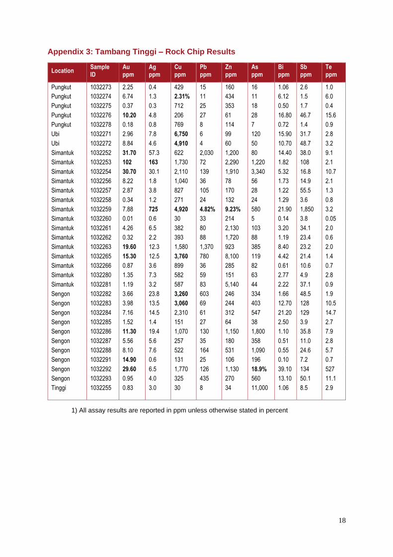
• Anomalous gold and copper results returned from reconnaissance surface rock sampling over the historic Tambang Tinggi project area:
o 25 of 33 grab samples assayed >1 g/t gold, including nine samples assaying from 10.2 to 102 g/t Au
o 14 of 33 grab samples assayed >0.1% copper, including eight samples assaying from 0.3 to 2.31% Cu.
• Early results from Tambang Tinggi confirm the potential for high-grade grade gold and associated base metal targets on the South CoW block; additional prospecting over other parts of the project area in progress
Sihayo Gold Limited (ASX:SIH – “Sihayo” or the “Company”) is pleased to announce this update on the latest results of exploration activities conducted on the PT Sorikmas Mining CoW located in North Sumatra, Indonesia. This includes the first results from scout drilling in progress on the Sihorbo South gold-silver target at Hutabargot Julu in the North CoW block, and the first results from reconnaissance rock sampling completed in the Tambang Tinggi mineral field located in the northeast corner of the South CoW block.

2
Sihayo’s Executive Chairman, Colin Moorhead commented on the exploration results:
“Assay results from Penatapan and Sihorbo South are beginning to flow with results for most holes expected in the coming weeks. One drill rig continues on follow up holes at Sihorbo South which is beginning to emerge as a possible higher grade silver rich epithermal vein structure, as compared with Penatapan which appears to be several zones of shallow mineralised stockwork. Both targets are located in the Hutabargot Julu area within trucking distance of the planned Sihayo processing plant, therefore having potential to add significant value. Further afield in the south block of our CoW, early stage greenfields exploration work is generating some exciting targets also.”
Sihorbo South Overview The Company recently reported drilling results from the Penatapan prospect at Hutabargot Julu (refer to SIH:ASX announcement date 25 October 2021) with historical results from Sihorbo South provided in Sihayo’s September 2021 Quarterly Activities Report. The latest results from Sihorbo South are part of a targeted drilling program on this vein target, which follows on from the Phase 1 reconnaissance drilling program at Hutabargot Julu completed in April 2021.
Sihorbo South, located about 1.5 – 2 km south of Penatapan, was originally discovered by the Dutch and explored along a series of short drifts and shallow shafts probably in the early 1900s. It is one of several large vein targets identified by Company geologists during detailed prospecting and mapping along the southern part of the greater Hutabargot Julu prospect during 2006 to 2007.
Figure 1: Hutabargot Julu project showing location of Sihorbo South target
The epithermal vein system at Sihorbo South was delineated by surface mapping and 1,416 m in 13 scout diamond holes during 2012-13 (Figures 1 and 2). The NNE-SSW oriented vein-alteration system is up to 50 m wide and extends over at least 400 m strike-length. It is a moderately west-dipping zone containing banded-brecciated epithermal quartz veins up to
3
5 m or more wide with hanging wall vein splays and surrounding stockwork. The vein system is hosted in a package altered volcanic breccias and hornblende diorite intrusions.
Previous scout drilling conducted in 2012-13 returned highly encouraging gold-silver intercepts1 summarised in Table 1. A complete table of the drill hole collar details is presented in Appendix 1a.
Local artisanal miners have been active at Sihorbo South over the past seven years, selectively mining parts of the top 50 m of oxidised vein outcrops from a series of shallow open cuts and narrow underground drives. Local mining is most active at the southern and northern ends of the vein system and appears to be sporadic along the strike of the vein system.
Table 1: Sihorbo South Prospect – Reported historic intercepts – 2011 Drilling Reported at 0.3 g/t Au cut-off and up to 4m internal dilution
Hole ID From (m) To (m) Interval (m) Au (g/t) Ag (g/t) Est True Width
(m)
HUTDD040 55.40 59.10 3.70 15.45 23 3.70
HUTDD041 98.60 100.60 2.00 0.84 40 1.80
HUTDD042 51.00 62.10 11.10 1.79 30 10.70
HUTDD043 80.05 83.35 3.30 1.36 37 3.20
HUTDD044 34.40 47.30 12.90 1.47 267 12.50
HUTDD045 46.95 63.75 16.80 1.43 237 11.90
HUTDD049 56.45 64.00 7.55 6.02 13 7.55
HUTDD050 2.60 20.20 17.60 1.38 27 7.55
HUTDD051 1.80 39.00 37.20 1.92 21 28.50
HUTDD052 24.20 53.00 28.80 1.51 86 22.10
HUTDD055 4.75 5.80 1.05 0.84 197 1.05
HUTDD056 80.00 85.00 5.00 2.91 357 4.70
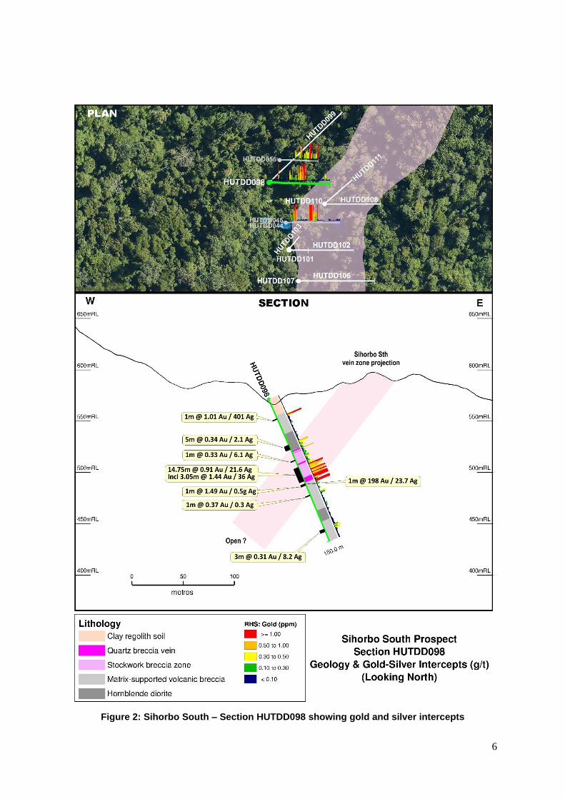
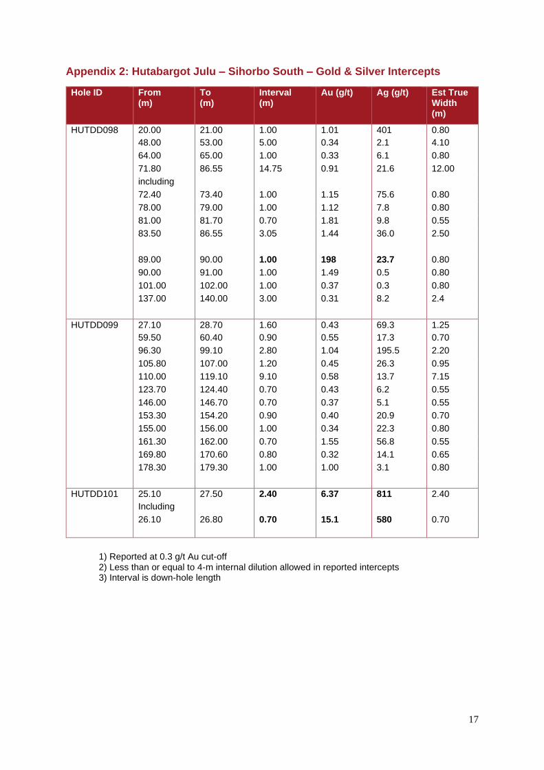
Sihorbo South Drilling Results Drilling is in progress at the northern end of this large vein target with a man-portable rig. A total of 1,337 m in twelve holes has been completed to date (Figures 1 and 2). Assay results have been received for the first three holes; HUTDD098, HUTDD099 and HUTDD101. Results for the other nine holes will be available over the next four to eight weeks and are expected to be announced by the end of the year.
Highly encouraging gold-silver intercepts within strongly veined quartz-chlorite-illite-adularia-pyrite altered volcanic breccias were returned in the first three holes, summarised in Table 2 below. A complete table of the drill hole collar details and intercepts is presented in Appendix 1b. A complete table of drill intercepts is presented in Appendix 2. Representative drill sections for holes HUTDD098, HUTDD099 and HUTDD101 are presented in Figures 3 to 5.
Further results are expected in the coming months and will be announced accordingly.
1 Results previously reported under ‘Other substantive historic exploration data’ in the JORC 2012
tables of several company announcements and quarterly reports in 2021. (See Appendix 1)
4
Table 2: Sihorbo South Prospect – 2021 Program – Summary of significant intercepts Reported at 0.3 g/t Au cut-off and up to 4m internal dilution
Hole ID From (m) To (m) Interval (m) Au (g/t) Ag (g/t) Est True Width
(m)
HUTDD098 including
20.00 21.00 1.00 1.01 401 0.80
71.80 86.55 14.75 0.91 21.6 12.00
Including 72.40 73.40 1.00 1.15 75.6 0.80
78.00 79.00 1.00 1.12 7.8 0.80
81.00 81.70 0.70 1.81 9.8 0.60
83.50 86.55 3.05 1.44 36.0 2.50
89.00 90.00 1.00 198 23.7 0.80
90.00 91.00 1.00 1.49 0.5 0.80
HUTDD099 96.30 99.10 2.80 1.04 195.5 2.20
110.00 119.10 9.10 0.58 13.7 7.15
161.30 162.00 0.70 1.55 56.8 0.55
178.30 179.30 1.00 1.00 3.1 0.80
HUTDD101 25.10 27.50 2.40 6.37 811 2.40
including 26.10 26.80 0.70 15.10 580 0.70
Hole HUTDD098 intersected the Sihorbo Vein structure at high angle (producing near true-width intercepts) between the previous holes HUTDD044, HUTDD045 and HUTDD056 (refer to Figure 2).
Hole HUTDD099 intersected a well-developed quartz-chalcedony-adularia-carbonate breccia-vein structure intersected between 71.80 and 86.55 m down-hole and produced consistent gold grades varying from 0.5 – 1 g/t Au and variable silver grades up to 75 g/t Ag (refer to Figure 3).
Hole HUTDD101 was drilled close to the portal of an historic Dutch adit. It intersected a solid vein from 25.10 m down-hole before being terminated in a local mine cavity from 27.50 to 27.90 m depth (refer to Figure 4).
Selective grab samples taken from local mine muck piles along the Sihorbo South vein target have also returned highly encouraging results (Error! Reference source not found.). Four of six grab samples previously reported from local muck piles sampled at the southern end of the vein system returned gold-silver grades ranging from 9 to 61 g/t Au and 16 to 46 g/t Ag (refer to SIH:ASX announcement dated 25 October 2021). Another 14 samples taken from the northern end of the vein have returned results in six of these samples ranging from 0.48 to 3.79 g/t Au and 102 to 3720 g/t Ag.
LEFT: Cut core slabs: A and B from HUTDD101 – Showing colloform-crustiform banded quartz-chalcedony-adularia-manganocarbonate-sulphide veins (15.1 g/t Au, 580 g/t Ag) C from HUTDD098 showing high-fineness electrum in quartz-carbonate stringer (198 g/t Au, 23.7 g/t Ag) Note: Coins are about 1-1.5 cm in diameter
A
B
C

5
Figure 2: Sihorbo South – Drill Hole Location Plan
. Figure 3: Sihorbo South – Surface grab samples & Au-Sg Results
6
Figure 2: Sihorbo South – Section HUTDD098 showing gold and silver intercepts
7
Figure 3: Sihorbo South – Section HUTDD099 showing gold and silver intercepts
8
Figure 4: Sihorbo South – Section HUTDD0101 showing gold and silver intercepts. Results for HUTDD102 and HUTDD104 are pending
9
Interpretation of Results and Follow Up
These initial results have demonstrated that the mineralised vein extends below the existing workings and that significant grades and potential volume remain in the subsurface.
Our geologists are mapping and surveying the distribution and depth of these local mine workings to better understand their extent and estimate the amount of material removed in the subsurface. Information obtained to-date indicates that the historical mining was highly selective and large amounts of the top of the vein remain. The workings are believed to be generally shallow (less than 30-m deep) and are more focused on extracting softer, stronger oxidised vein material.
The mineralised vein segment tested by these recent holes, HUTDD098, HUTDD099 and HUTDD101, and the historic holes HUTDD044, HUTDD045 and HUTDD056, represent about 100 m strike length. The vein structure has been tested down to about 100 m vertical depth (refer Figure and 8).
The Sihorbo South vein target is largely untested beneath and surrounding the active artisanal gold workings, and it appears open along strike potentially below cover rocks. In comparison with the Penatapan stockwork target located to the north, Sihorbo South appears to show stronger development of thicker mineralised veins within mineralised stockwork envelopes and demonstrates good potential for high grade ore shoots that appear to be silver-rich at the north end and gold-rich at the south end of the large vein structure.
Drilling is planned to progress from north to south along the vein target over the coming months. The Company anticipates releasing new drilling results over the next few weeks (Refer to Table 4).
Figure 5: Sihorbo South Long Section – Gold grade x true-width
10
Figure 8: Sihorbo South Long Section – Silver grade x true-width
Penatapan drilling update
The first phase of follow-up drilling was completed on the Penatapan gold-silver stockwork target. A total of 2,577 m in 11 holes was completed for this program and results have been reported for the first seven eight holes (Refer to SIH:ASX September 2021 Quarterly Activities Report dated 28 October 2021).
Assays were received for hole HUTDD097 collared off the northern edge of the Penatapan stockwork system. It intersected multiple zones of low-grade quartz stockwork projecting to the north of HUTDD095 (Refer to Table 3 and Figure 9).
The interval of 9.5 m at 0.36 g/t Au and 2.86 g/t Ag from 83.5 m returned in HUTDD097 may correlate with the interval of 9.2 m at 1.80 g/t Au and 10.49 g/t Ag from 88.0 m returned in HUTDD095. This highlights the variability of gold and silver grades within the stockwork. The mineralised stockwork is open to the north and may be displaced by WNW-ENE trending cross-cutting faults along the nearby Kaporas Creek.
Table 3: Penatapan Prospect – 2021 Program – Summary of significant intercepts Reported at 0.3 g/t Au cut-off and up to 4m internal dilution
Hole ID From (m) To (m) Interval (m) Au (g/t) Ag (g/t) Est True Width
(m)
HUTDD097 including
0.00 1.00 1.00 0.36 0.40 Not known
17.00 18.00 1.00 0.56 4.70
29.00 32.00 3.00 0.48 1.57
52.00 58.00 6.00 0.32 1.98
65.00 67.00 2.00 0.66 3.05
83.50 93.00 9.50 0.36 2.86
162.00 164.00 2.00 0.33 3.80
188.00 189.00 1.00 0.60 0.90
11
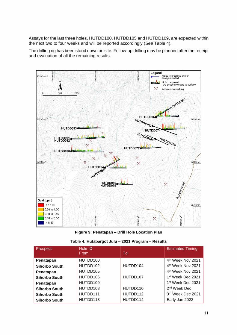
Assays for the last three holes, HUTDD100, HUTDD105 and HUTDD109, are expected within the next two to four weeks and will be reported accordingly (See Table 4).
The drilling rig has been stood down on site. Follow-up drilling may be planned after the receipt and evaluation of all the remaining results.
Figure 9: Penatapan – Drill Hole Location Plan
Table 4: Hutabargot Julu – 2021 Program – Results
Prospect Hole ID From
To
Estimated Timing
Penatapan Ig
HUTDD100 4th Week Nov 2021
Sihorbo South HUTDD102 HUTDD104 4th Week Nov 2021
Penatapan HUTDD105 4th Week Nov 2021
Sihorbo South HUTDD106 HUTDD107 1st Week Dec 2021
Penatapan HUTDD109 1st Week Dec 2021
Sihorbo South HUTDD108 HUTDD110 2nd Week Dec 2021 Sihorbo South HUTDD111 HUTDD112 3rd Week Dec 2021
Sihorbo South HUTDD113 HUTDD114 Early Jan 2022
12
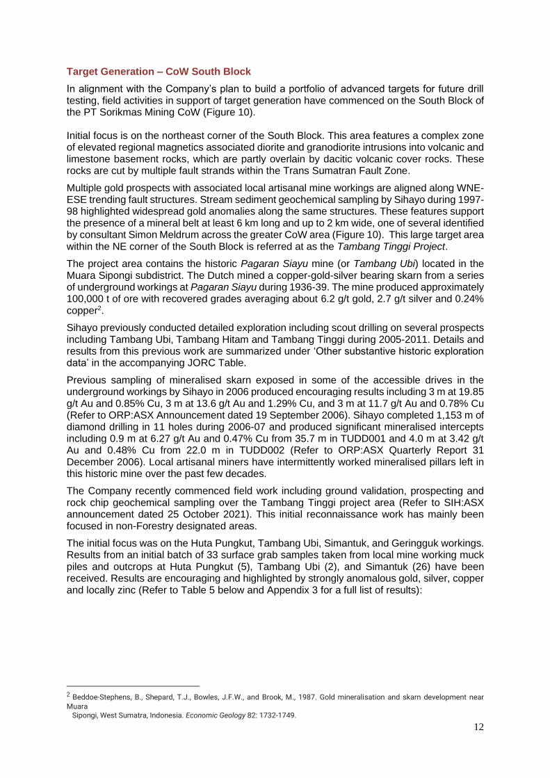
Target Generation – CoW South Block
In alignment with the Company’s plan to build a portfolio of advanced targets for future drill testing, field activities in support of target generation have commenced on the South Block of the PT Sorikmas Mining CoW (Figure 10). Initial focus is on the northeast corner of the South Block. This area features a complex zone of elevated regional magnetics associated diorite and granodiorite intrusions into volcanic and limestone basement rocks, which are partly overlain by dacitic volcanic cover rocks. These rocks are cut by multiple fault strands within the Trans Sumatran Fault Zone.
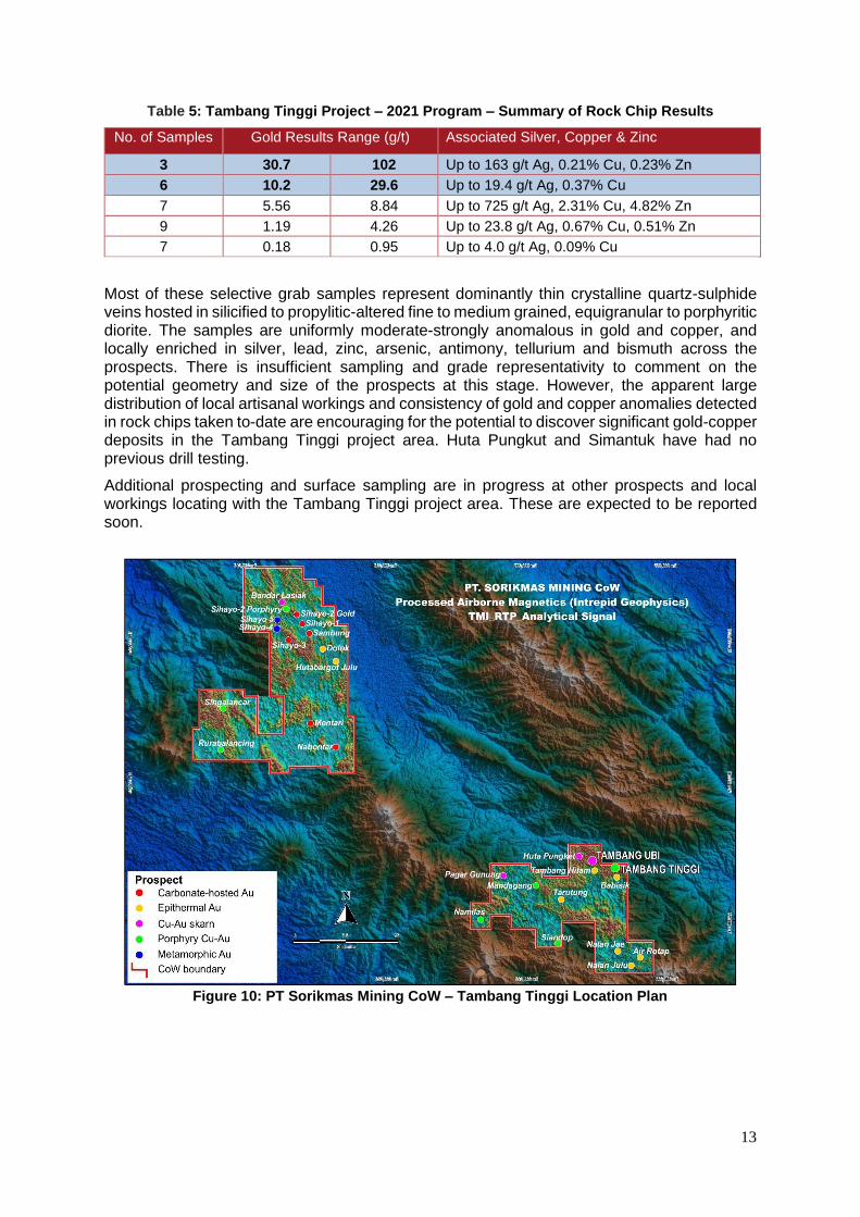
Multiple gold prospects with associated local artisanal mine workings are aligned along WNE-ESE trending fault structures. Stream sediment geochemical sampling by Sihayo during 1997-98 highlighted widespread gold anomalies along the same structures. These features support the presence of a mineral belt at least 6 km long and up to 2 km wide, one of several identified by consultant Simon Meldrum across the greater CoW area (Figure 10). This large target area within the NE corner of the South Block is referred at as the Tambang Tinggi Project.
The project area contains the historic Pagaran Siayu mine (or Tambang Ubi) located in the Muara Sipongi subdistrict. The Dutch mined a copper-gold-silver bearing skarn from a series of underground workings at Pagaran Siayu during 1936-39. The mine produced approximately 100,000 t of ore with recovered grades averaging about 6.2 g/t gold, 2.7 g/t silver and 0.24% copper2.
Sihayo previously conducted detailed exploration including scout drilling on several prospects including Tambang Ubi, Tambang Hitam and Tambang Tinggi during 2005-2011. Details and results from this previous work are summarized under ‘Other substantive historic exploration data’ in the accompanying JORC Table.
Previous sampling of mineralised skarn exposed in some of the accessible drives in the underground workings by Sihayo in 2006 produced encouraging results including 3 m at 19.85 g/t Au and 0.85% Cu, 3 m at 13.6 g/t Au and 1.29% Cu, and 3 m at 11.7 g/t Au and 0.78% Cu (Refer to ORP:ASX Announcement dated 19 September 2006). Sihayo completed 1,153 m of diamond drilling in 11 holes during 2006-07 and produced significant mineralised intercepts including 0.9 m at 6.27 g/t Au and 0.47% Cu from 35.7 m in TUDD001 and 4.0 m at 3.42 g/t Au and 0.48% Cu from 22.0 m in TUDD002 (Refer to ORP:ASX Quarterly Report 31 December 2006). Local artisanal miners have intermittently worked mineralised pillars left in this historic mine over the past few decades.
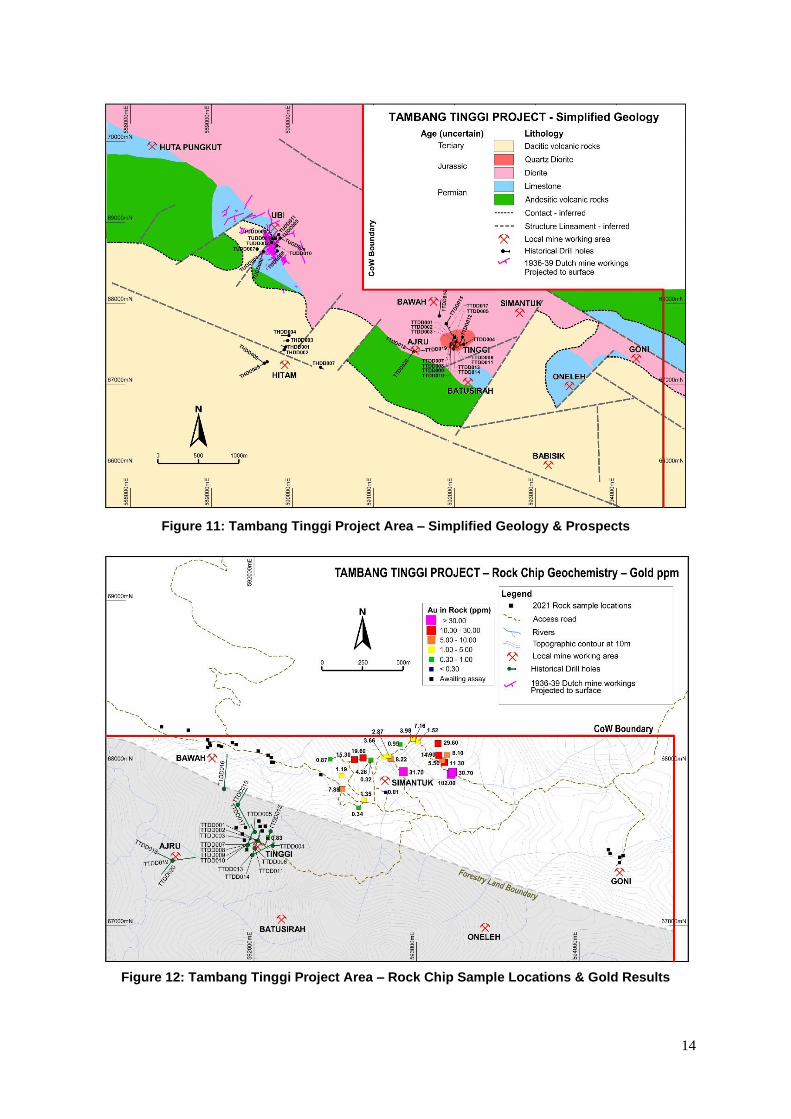
The Company recently commenced field work including ground validation, prospecting and rock chip geochemical sampling over the Tambang Tinggi project area (Refer to SIH:ASX announcement dated 25 October 2021). This initial reconnaissance work has mainly been focused in non-Forestry designated areas.
The initial focus was on the Huta Pungkut, Tambang Ubi, Simantuk, and Geringguk workings. Results from an initial batch of 33 surface grab samples taken from local mine working muck piles and outcrops at Huta Pungkut (5), Tambang Ubi (2), and Simantuk (26) have been received. Results are encouraging and highlighted by strongly anomalous gold, silver, copper and locally zinc (Refer to Table 5 below and Appendix 3 for a full list of results):
2 Beddoe-Stephens, B., Shepard, T.J., Bowles, J.F.W., and Brook, M., 1987. Gold mineralisation and skarn development near
Muara Sipongi, West Sumatra, Indonesia. Economic Geology 82: 1732-1749.
13
Table 5: Tambang Tinggi Project – 2021 Program – Summary of Rock Chip Results
No. of Samples Gold Results Range (g/t) Associated Silver, Copper & Zinc
3 30.7 102 Up to 163 g/t Ag, 0.21% Cu, 0.23% Zn
6 10.2 29.6 Up to 19.4 g/t Ag, 0.37% Cu
7 5.56 8.84 Up to 725 g/t Ag, 2.31% Cu, 4.82% Zn
9 1.19 4.26 Up to 23.8 g/t Ag, 0.67% Cu, 0.51% Zn
7 0.18 0.95 Up to 4.0 g/t Ag, 0.09% Cu
Most of these selective grab samples represent dominantly thin crystalline quartz-sulphide veins hosted in silicified to propylitic-altered fine to medium grained, equigranular to porphyritic diorite. The samples are uniformly moderate-strongly anomalous in gold and copper, and locally enriched in silver, lead, zinc, arsenic, antimony, tellurium and bismuth across the prospects. There is insufficient sampling and grade representativity to comment on the potential geometry and size of the prospects at this stage. However, the apparent large distribution of local artisanal workings and consistency of gold and copper anomalies detected in rock chips taken to-date are encouraging for the potential to discover significant gold-copper deposits in the Tambang Tinggi project area. Huta Pungkut and Simantuk have had no previous drill testing.
Additional prospecting and surface sampling are in progress at other prospects and local workings locating with the Tambang Tinggi project area. These are expected to be reported soon.
Figure 10: PT Sorikmas Mining CoW – Tambang Tinggi Location Plan
14
Figure 11: Tambang Tinggi Project Area – Simplified Geology & Prospects
Figure 12: Tambang Tinggi Project Area – Rock Chip Sample Locations & Gold Results

15
Figure 13: Tambang Tinggi Project Area – Rock Chip Sample Locations & Gold Results
For further information, please contact: Colin Moorhead
Executive Chairman
Roderick Crowther
Chief Financial Officer
16
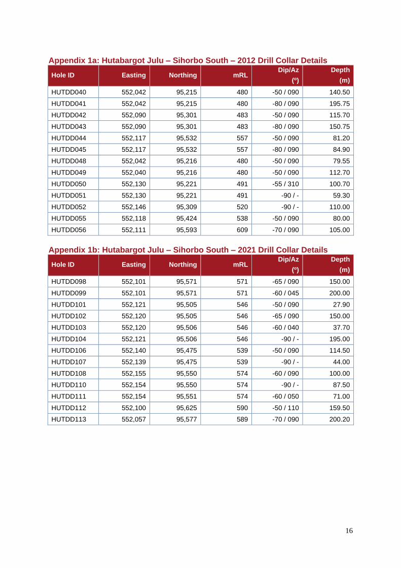
Appendix 1a: Hutabargot Julu – Sihorbo South – 2012 Drill Collar Details
Hole ID Easting Northing mRL Dip/Az
(o)
Depth
(m)
HUTDD040 552,042 95,215 480 -50 / 090 140.50
HUTDD041 552,042 95,215 480 -80 / 090 195.75
HUTDD042 552,090 95,301 483 -50 / 090 115.70
HUTDD043 552,090 95,301 483 -80 / 090 150.75
HUTDD044 552,117 95,532 557 -50 / 090 81.20
HUTDD045 552,117 95,532 557 -80 / 090 84.90
HUTDD048 552,042 95,216 480 -50 / 090 79.55
HUTDD049 552,040 95,216 480 -50 / 090 112.70
HUTDD050 552,130 95,221 491 -55 / 310 100.70
HUTDD051 552,130 95,221 491 -90 / - 59.30
HUTDD052 552,146 95,309 520 -90 / - 110.00
HUTDD055 552,118 95,424 538 -50 / 090 80.00
HUTDD056 552,111 95,593 609 -70 / 090 105.00
Appendix 1b: Hutabargot Julu – Sihorbo South – 2021 Drill Collar Details
Hole ID Easting Northing mRL Dip/Az
(o)
Depth
(m)
HUTDD098 552,101 95,571 571 -65 / 090 150.00
HUTDD099 552,101 95,571 571 -60 / 045 200.00
HUTDD101 552,121 95,505 546 -50 / 090 27.90
HUTDD102 552,120 95,505 546 -65 / 090 150.00
HUTDD103 552,120 95,506 546 -60 / 040 37.70
HUTDD104 552,121 95,506 546 -90 / - 195.00
HUTDD106 552,140 95,475 539 -50 / 090 114.50
HUTDD107 552,139 95,475 539 -90 / - 44.00
HUTDD108 552,155 95,550 574 -60 / 090 100.00
HUTDD110 552,154 95,550 574 -90 / - 87.50
HUTDD111 552,154 95,551 574 -60 / 050 71.00
HUTDD112 552,100 95,625 590 -50 / 110 159.50
HUTDD113 552,057 95,577 589 -70 / 090 200.20
17
Appendix 2: Hutabargot Julu – Sihorbo South – Gold & Silver Intercepts
Hole ID From (m)
To (m)
Interval (m)
Au (g/t) Ag (g/t) Est True Width (m)
HUTDD098 20.00 21.00 1.00 1.01 401 0.80
48.00 53.00 5.00 0.34 2.1 4.10
64.00 65.00 1.00 0.33 6.1 0.80
71.80 86.55 14.75 0.91 21.6 12.00
including
72.40 73.40 1.00 1.15 75.6 0.80
78.00 79.00 1.00 1.12 7.8 0.80
81.00 81.70 0.70 1.81 9.8 0.55
83.50 86.55 3.05 1.44 36.0 2.50
89.00 90.00 1.00 198 23.7 0.80
90.00 91.00 1.00 1.49 0.5 0.80
101.00 102.00 1.00 0.37 0.3 0.80
137.00 140.00 3.00 0.31 8.2
2.4
HUTDD099 27.10 28.70 1.60 0.43 69.3 1.25
59.50 60.40 0.90 0.55 17.3 0.70
96.30 99.10 2.80 1.04 195.5 2.20
105.80 107.00 1.20 0.45 26.3 0.95
110.00 119.10 9.10 0.58 13.7 7.15
123.70 124.40 0.70 0.43 6.2 0.55
146.00 146.70 0.70 0.37 5.1 0.55
153.30 154.20 0.90 0.40 20.9 0.70
155.00 156.00 1.00 0.34 22.3 0.80
161.30 162.00 0.70 1.55 56.8 0.55
169.80 170.60 0.80 0.32 14.1 0.65
178.30 179.30 1.00 1.00 3.1 0.80
HUTDD101 25.10 27.50 2.40 6.37 811 2.40
Including
26.10 26.80 0.70 15.1 580 0.70
1) Reported at 0.3 g/t Au cut-off 2) Less than or equal to 4-m internal dilution allowed in reported intercepts 3) Interval is down-hole length
18
Appendix 3: Tambang Tinggi – Rock Chip Results
Location Sample ID
Au ppm
Ag ppm
Cu ppm
Pb ppm
Zn ppm
As ppm
Bi ppm
Sb ppm
Te ppm
Pungkut 1032273 2.25 0.4 429 15 160 16 1.06 2.6 1.0
Pungkut 1032274 6.74 1.3 2.31% 11 434 11 6.12 1.5 6.0
Pungkut 1032275 0.37 0.3 712 25 353 18 0.50 1.7 0.4
Pungkut 1032276 10.20 4.8 206 27 61 28 16.80 46.7 15.6
Pungkut 1032278 0.18 0.8 769 8 114 7 0.72 1.4 0.9
Ubi 1032271 2.96 7.8 6,750 6 99 120 15.90 31.7 2.8
Ubi 1032272 8.84 4.6 4,910 4 60 50 10.70 48.7 3.2
Simantuk 1032252 31.70 57.3 622 2,030 1,200 80 14.40 38.0 9.1
Simantuk 1032253 102 163 1,730 72 2,290 1,220 1.82 108 2.1
Simantuk 1032254 30.70 30.1 2,110 139 1,910 3,340 5.32 16.8 10.7
Simantuk 1032256 8.22 1.8 1,040 36 78 56 1.73 14.9 2.1
Simantuk 1032257 2.87 3.8 827 105 170 28 1.22 55.5 1.3
Simantuk 1032258 0.34 1.2 271 24 132 24 1.29 3.6 0.8
Simantuk 1032259 7.88 725 4,920 4.82% 9.23% 580 21.90 1,850 3.2
Simantuk 1032260 0.01 0.6 30 33 214 5 0.14 3.8 0.05
Simantuk 1032261 4.26 6.5 382 80 2,130 103 3.20 34.1 2.0
Simantuk 1032262 0.32 2.2 393 88 1,720 88 1.19 23.4 0.6
Simantuk 1032263 19.60 12.3 1,580 1,370 923 385 8.40 23.2 2.0
Simantuk 1032265 15.30 12.5 3,760 780 8,100 119 4.42 21.4 1.4
Simantuk 1032266 0.87 3.6 899 36 285 82 0.61 10.6 0.7
Simantuk 1032280 1.35 7.3 582 59 151 63 2.77 4.9 2.8
Simantuk 1032281 1.19 3.2 587 83 5,140 44 2.22 37.1 0.9
Sengon 1032282 3.66 23.8 3,260 603 246 334 1.66 48.5 1.9
Sengon 1032283 3.98 13.5 3,060 69 244 403 12.70 128 10.5
Sengon 1032284 7.16 14.5 2,310 61 312 547 21.20 129 14.7
Sengon 1032285 1.52 1.4 151 27 64 38 2.50 3.9 2.7
Sengon 1032286 11.30 19.4 1,070 130 1,150 1,800 1.10 35.8 7.9
Sengon 1032287 5.56 5.6 257 35 180 358 0.51 11.0 2.8
Sengon 1032288 8.10 7.6 522 164 531 1,090 0.55 24.6 5.7
Sengon 1032291 14.90 0.6 131 25 106 196 0.10 7.2 0.7
Sengon 1032292 29.60 6.5 1,770 126 1,130 18.9% 39.10 134 527
Sengon 1032293 0.95 4.0 325 435 270 560 13.10 50.1 11.1
Tinggi 1032255 0.83 3.0 30 8 34 11,000 1.06 8.5 2.9
1) All assay results are reported in ppm unless otherwise stated in percent
19
Competent Person’s Statement
Exploration Results
The information in this report which relates to Exploration Results is based on, and fairly represents, information compiled by Mr Bradley Wake (BSc Hons. (Applied Geology)), who is a contract employee of the Company. Mr Wake does not hold any shares in the company, either directly or indirectly.
Mr Wake is a member of the Australian Institute of Geoscientists (AIG ID: 3339) and has sufficient experience that is relevant to the style of mineralisation and type of deposit under consideration and to the activity being undertaken to qualify as a Competent Person as defined in the 2012 Edition of the “Australasian Code for Reporting of Exploration Results, Mineral Resources and Ore Reserves”.
Mr Wake consents to the inclusion in the report of the matters based on this information in the form and
context in which it appears.
Disclaimer
This announcement may or may not contain certain “forward-looking statements”. All statements, other
than statements of historical fact, which address activities, events or developments that the Company
believes, expects or anticipates will or may occur in the future, are forward-looking statements. Forward-
looking statements are often, but not always, identified by the use of words such as “seek”, “anticipate”,
“believe”, “plan”, “estimate”, “targeting”, “expect”, and “intend” and statements that an event or result “may”,
“will”, “can”, “should”, “could”, or “might” occur or be achieved and other similar expressions. These
forward-looking statements, including those with respect to permitting and development timetables,
mineral grades, metallurgical recoveries, potential production reflect the current internal projections,
expectations or beliefs of the Company based on information currently available to the Company.
Statements in this document that are forward-looking and involve numerous risks and uncertainties that
could cause actual results to differ materially from expected results are based on the Company’s current
beliefs and assumptions regarding a large number of factors affecting its business. Actual results may
differ materially from expected results. There can be no assurance that (i) the Company has correctly
measured or identified all of the factors affecting its business or the extent of their likely impact, (ii) the
publicly available information with respect to these factors on which the Company’s analysis is based is
complete or accurate, (iii) the Company’s analysis is correct or (iv) the Company’s strategy, which is based
in part on this analysis, will be successful. The Company expressly disclaims any obligation to update or
revise any such forward-looking statements.
No Representation, Warranty or Liability
Whilst it is provided in good faith, no representation or warranty is made by the Company or any of its
advisers, agents or employees as to the accuracy, completeness, currency or reasonableness of the
information in this announcement or provided in connection with it, including the accuracy or attainability
of any Forward Looking Statements set out in this announcement. The Company does not accept any
responsibility to inform you of any matter arising or coming to the Company’s notice after the date of this
announcement which may affect any matter referred to in this announcement. Any liability of the
Company, its advisers, agents and employees to you or to any other person or entity arising out of this
announcement including pursuant to common law, the Corporations Act 2001 and the Trade Practices
Act 1974 or any other applicable law is, to the maximum extent permitted by law, expressly disclaimed
and excluded.
Distribution Restrictions
The distribution of this announcement may be restricted by law in certain jurisdictions. Recipients and
any other persons who come into possession of this announcement must inform themselves about and
observe any such restrictions.
20
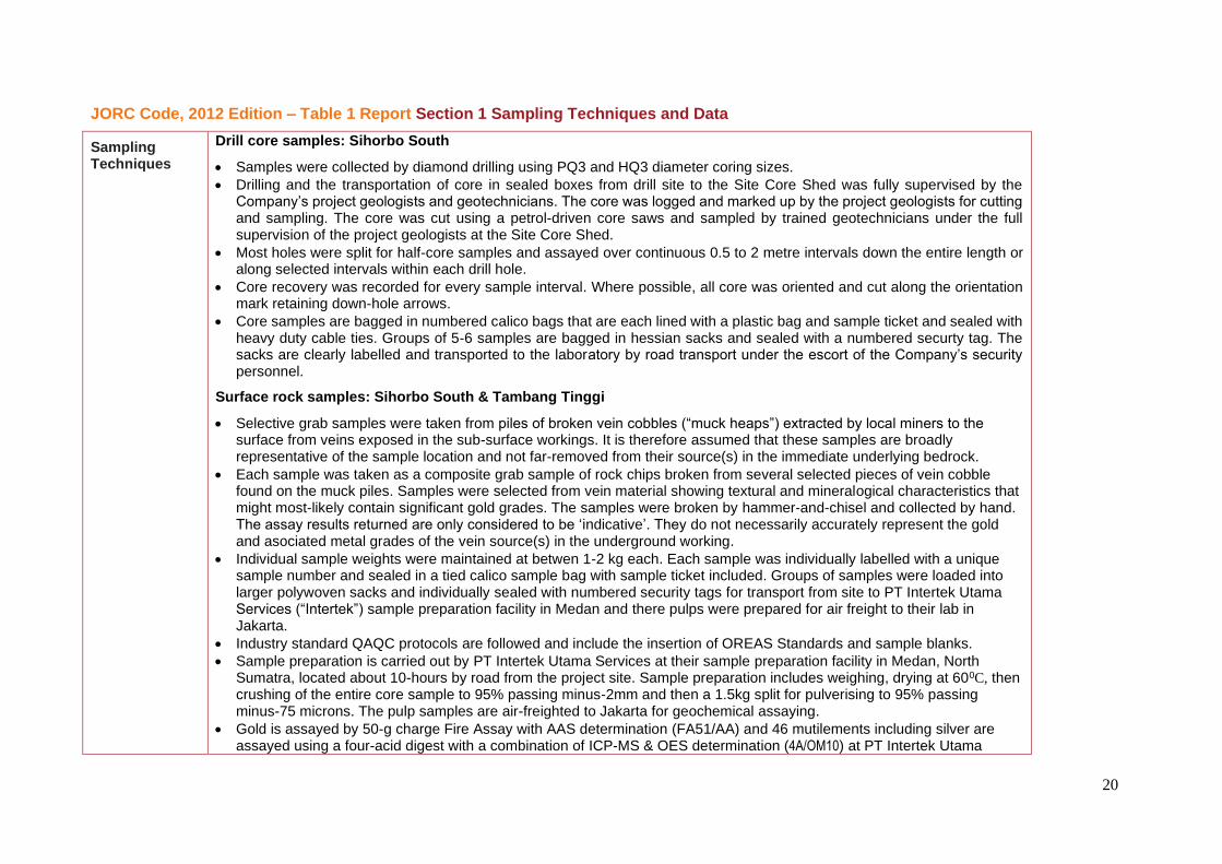
JORC Code, 2012 Edition – Table 1 Report Section 1 Sampling Techniques and Data
Sampling Techniques
Drill core samples: Sihorbo South
• Samples were collected by diamond drilling using PQ3 and HQ3 diameter coring sizes.
• Drilling and the transportation of core in sealed boxes from drill site to the Site Core Shed was fully supervised by the Company’s project geologists and geotechnicians. The core was logged and marked up by the project geologists for cutting and sampling. The core was cut using a petrol-driven core saws and sampled by trained geotechnicians under the full supervision of the project geologists at the Site Core Shed.
• Most holes were split for half-core samples and assayed over continuous 0.5 to 2 metre intervals down the entire length or along selected intervals within each drill hole.
• Core recovery was recorded for every sample interval. Where possible, all core was oriented and cut along the orientation mark retaining down-hole arrows.
• Core samples are bagged in numbered calico bags that are each lined with a plastic bag and sample ticket and sealed with heavy duty cable ties. Groups of 5-6 samples are bagged in hessian sacks and sealed with a numbered securty tag. The sacks are clearly labelled and transported to the laboratory by road transport under the escort of the Company’s security personnel.
Surface rock samples: Sihorbo South & Tambang Tinggi
• Selective grab samples were taken from piles of broken vein cobbles (“muck heaps”) extracted by local miners to the surface from veins exposed in the sub-surface workings. It is therefore assumed that these samples are broadly representative of the sample location and not far-removed from their source(s) in the immediate underlying bedrock.
• Each sample was taken as a composite grab sample of rock chips broken from several selected pieces of vein cobble found on the muck piles. Samples were selected from vein material showing textural and mineralogical characteristics that might most-likely contain significant gold grades. The samples were broken by hammer-and-chisel and collected by hand. The assay results returned are only considered to be ‘indicative’. They do not necessarily accurately represent the gold and asociated metal grades of the vein source(s) in the underground working.
• Individual sample weights were maintained at betwen 1-2 kg each. Each sample was individually labelled with a unique sample number and sealed in a tied calico sample bag with sample ticket included. Groups of samples were loaded into larger polywoven sacks and individually sealed with numbered security tags for transport from site to PT Intertek Utama Services (“Intertek”) sample preparation facility in Medan and there pulps were prepared for air freight to their lab in Jakarta.
• Industry standard QAQC protocols are followed and include the insertion of OREAS Standards and sample blanks.
• Sample preparation is carried out by PT Intertek Utama Services at their sample preparation facility in Medan, North Sumatra, located about 10-hours by road from the project site. Sample preparation includes weighing, drying at 600C, then crushing of the entire core sample to 95% passing minus-2mm and then a 1.5kg split for pulverising to 95% passing minus-75 microns. The pulp samples are air-freighted to Jakarta for geochemical assaying.
• Gold is assayed by 50-g charge Fire Assay with AAS determination (FA51/AA) and 46 mutilements including silver are assayed using a four-acid digest with a combination of ICP-MS & OES determination (4A/OM10) at PT Intertek Utama
21
Services laboratory in Jakarta.
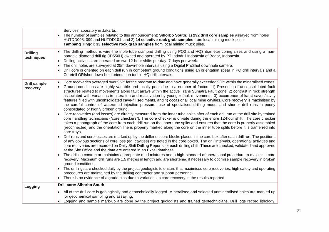
• The number of samples relating to this announcement: Sihorbo South: 1) 292 drill core samples assayed from holes HUTDD098, 099 and HUTDD101, and 2) 14 selective rock grab samples from local mining muck piles. Tambang Tinggi: 33 selective rock grab samples from local mining muck piles.
Drilling techniques
• The drilling method is wire-line triple-tube diamond drilling using PQ3 and HQ3 diameter coring sizes and using a man-portable diamond drill rig (ID550H) owned and operated by PT Indodrill Indonesia of Bogor, Indonesia.
• Drilling activities are operated on two 12-hour shifts per day, 7 days per week.
• The drill holes are surveyed at 25m down-hole intervals using a Digital ProShot downhole camera.
• Drill core is oriented on each drill run in competent ground conditions using an orientation spear in PQ drill intervals and a Coretell ORIshot down-hole orientation tool in HQ drill intervals.
Drill sample recovery
• Core recoveries averaged over 95% for the program to-date and have generally exceeded 90% within the mineralised zones.
• Ground conditions are highly variable and locally poor due to a number of factors: 1) Presence of unconsolidated fault structures related to movements along fault arrays within the active Trans Sumatra Fault Zone, 2) contrast in rock strength associated with variations in alteration and reactivation by younger fault movements, 3) occurrence of karst caves/cavity features filled with unconsolidated cave-fill sediments, and 4) occasional local mine cavities. Core recovery is maximised by the careful control of water/mud injection pressure, use of specialised drilling muds, and shorter drill runs in poorly consolidated or highly broken ground.
• Core recoveries (and losses) are directly measured from the inner tube splits after of each drill run at the drill site by trained core handling technicians (“core checkers”). The core checker is on-site during the entire 12-hour shift. The core checker takes a photograph of the core from each drill run on the inner tube splits and ensures that the core is properly assembled (reconnected) and the orientation line is properly marked along the core on the inner tube splits before it is tranferred into core trays.
• Drill runs and core losses are marked up by the driller on core blocks placed in the core box after each drill run. The positions of any obvious sections of core loss (eg. cavities) are noted in the core boxes. The drill intervals, operational activities and core recoveries are recorded on Daily Shift Drilling Reports for each drilling shift. These are checked, validated and approved at the Site Office and the data are entered in an Excel database.
• The drilling contractor maintains appropriate mud mixtures and a high-standard of operational procedure to maximise core recovery. Maximum drill runs are 1.5 metres in length and are shortened if necessary to optimise sample recovery in broken ground conditions.
• The drill rigs are checked daily by the project geologists to ensure that maximised core recoveries, high safety and operating procedures are maintained by the drilling contractor and support personnel.
• There is no evidence of a grade bias due to variations in core recovery in the results reported.
Logging Drill core: Sihorbo South
• All of the drill core is geologically and geotechnically logged. Mineralised and selected unmineralised holes are marked up for geochemical sampling and assaying.
• Logging and sample mark-up are done by the project geologists and trained geotechnicians. Drill logs record lithology,
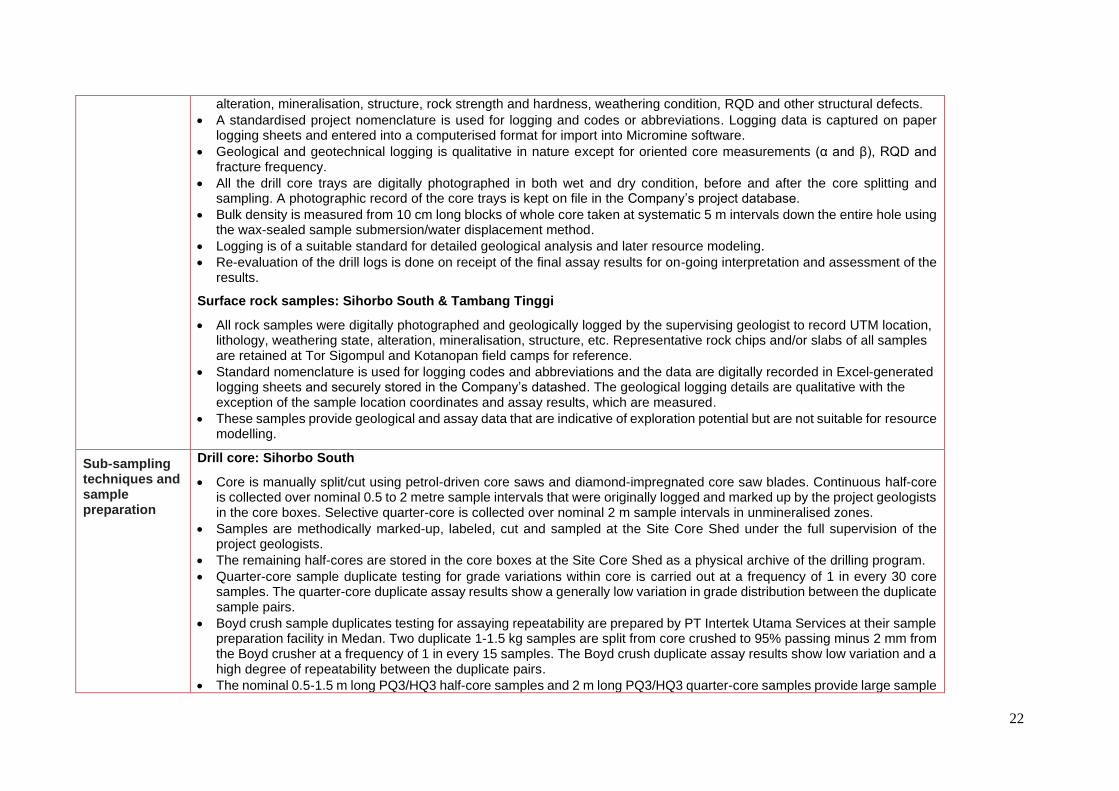
22
alteration, mineralisation, structure, rock strength and hardness, weathering condition, RQD and other structural defects.
• A standardised project nomenclature is used for logging and codes or abbreviations. Logging data is captured on paper logging sheets and entered into a computerised format for import into Micromine software.
• Geological and geotechnical logging is qualitative in nature except for oriented core measurements (α and β), RQD and fracture frequency.
• All the drill core trays are digitally photographed in both wet and dry condition, before and after the core splitting and sampling. A photographic record of the core trays is kept on file in the Company’s project database.
• Bulk density is measured from 10 cm long blocks of whole core taken at systematic 5 m intervals down the entire hole using the wax-sealed sample submersion/water displacement method.
• Logging is of a suitable standard for detailed geological analysis and later resource modeling.
• Re-evaluation of the drill logs is done on receipt of the final assay results for on-going interpretation and assessment of the results.
Surface rock samples: Sihorbo South & Tambang Tinggi
• All rock samples were digitally photographed and geologically logged by the supervising geologist to record UTM location, lithology, weathering state, alteration, mineralisation, structure, etc. Representative rock chips and/or slabs of all samples are retained at Tor Sigompul and Kotanopan field camps for reference.
• Standard nomenclature is used for logging codes and abbreviations and the data are digitally recorded in Excel-generated logging sheets and securely stored in the Company’s datashed. The geological logging details are qualitative with the exception of the sample location coordinates and assay results, which are measured.
• These samples provide geological and assay data that are indicative of exploration potential but are not suitable for resource modelling.
Sub-sampling techniques and sample preparation
Drill core: Sihorbo South
• Core is manually split/cut using petrol-driven core saws and diamond-impregnated core saw blades. Continuous half-core is collected over nominal 0.5 to 2 metre sample intervals that were originally logged and marked up by the project geologists in the core boxes. Selective quarter-core is collected over nominal 2 m sample intervals in unmineralised zones.
• Samples are methodically marked-up, labeled, cut and sampled at the Site Core Shed under the full supervision of the project geologists.
• The remaining half-cores are stored in the core boxes at the Site Core Shed as a physical archive of the drilling program.
• Quarter-core sample duplicate testing for grade variations within core is carried out at a frequency of 1 in every 30 core samples. The quarter-core duplicate assay results show a generally low variation in grade distribution between the duplicate sample pairs.
• Boyd crush sample duplicates testing for assaying repeatability are prepared by PT Intertek Utama Services at their sample preparation facility in Medan. Two duplicate 1-1.5 kg samples are split from core crushed to 95% passing minus 2 mm from the Boyd crusher at a frequency of 1 in every 15 samples. The Boyd crush duplicate assay results show low variation and a high degree of repeatability between the duplicate pairs.
• The nominal 0.5-1.5 m long PQ3/HQ3 half-core samples and 2 m long PQ3/HQ3 quarter-core samples provide large sample

23
weights varying between 4 kg and 6 kg. These relatively large sample weights and the partial sample preparation protocols are considered to be representative and appropriate for the style of gold being investigated.
• QA/QC procedures implemented by the Company and results reported by Intertek as part of their own internal QAQC procedures are considered sufficient to highlight any need for revision of the sample preparation procedures in the forward drilling program. Results to-date support that the sample-preparation technique is robust and appropriate to the determination of the metal grade of the rocks being investigated.
Surface rock samples: Sihorbo South & Tambang Tinggi
• No sub-sampling was undertaken and the entire sample, with exception of reference chips and rock slab, were submitted for sample preparation and assaying.
• No sample duplicates were taken or prepared in the field sampling.
• Sample size is appropriate to the reconnaissance nature of these surveys and provides an indication of the presence and potential grade of the target metals sought; namely gold, silver, and base metals.
Quality of assay data and laboratory tests
• PT Intertek Utama Services (Jakarta/Medan) is the primary sample preparation and assaying laboratory and PT Geoservices (Bandung) periodically conducts independent umpire gold and multielement assaying checks. Both laboratories operate to international standards and procedures and participate in Geostatistical Round Robin interlaboratory test surveys.
• All samples are prepared at the Intertek sample preparation facilty in Medan, North Sumatra. Core samples are weighed and dried at 600C. The entire sample is crushed to P95 (95%) passing minus 2mm and 1.5kg is split off and pulverized to P95 (95%) passing minus 75 microns.
• Sample pulps prepared at the facility in Medan are air freighted to Intertek’s analytical laboratory in Jakarta. The samples are assayed for gold by 50g-charge Pb-collection Fire Assay with AAS finish (FA51/AAS) and 46 multielements by four-acid digest (HClO4, HCl, HNO3, HF) and a combination of determinations using Inductively Couple Plasma/Optical Emission Spectrometry (ICP/OES) (Al, Ca, Cr, Cu, Fe, K, Mg, Mn, Na, Ni, P, S, Sc, Ti, V, Zn) and Inductively Couple Plasma/Mass Spectrometry (ICP/MS) (Ag, As, Ba, Be, Bi, Cd, Co, Cs, Ga, Ge, Hf, In, Li, Mo, Nb, Pb, Rb, Sb, Se, Sn, Sr, Ta, Te, Th, Tl, U, W, Y, Zr) determinations (4A/OM10).
• Sample preparation procedures and analytical methods used are considered appropriate to test for the style(s) of mineralisation targeted in the prospect area (porphyry-related and epithermal-style gold-silver-base metal mineralisation).
• The Company routinely inserts OREAS Certified Reference Materials (CRMs) and blanks at a rate of 1 in every 10-12 core samples (~10%) and at a rate of 1 in every 20 surface rock samples of the sample sequence to evaluate the laboratory’s sample preparation procedures, analytical quality and/or biases. The results relating to this announcement fall well within acceptable tolerances of accuracy and precision.
• Intertek also applies its own QAQC procedures. Certified Reference Materials and/or in-house controls, blanks and replicates are analysed with each batch of samples (numbering at least 10% of the total samples submitted in the batch). These quality control results are reported along with the sample values in the final report.
• The nature of the large core size (PQ3/HQ3), the total and partial preparation procedures (total crush to P95 -2mm, 1.5kg split pulverized to P95 -75 micron) are considered appropriate to the style of mineralisation being tested.
24
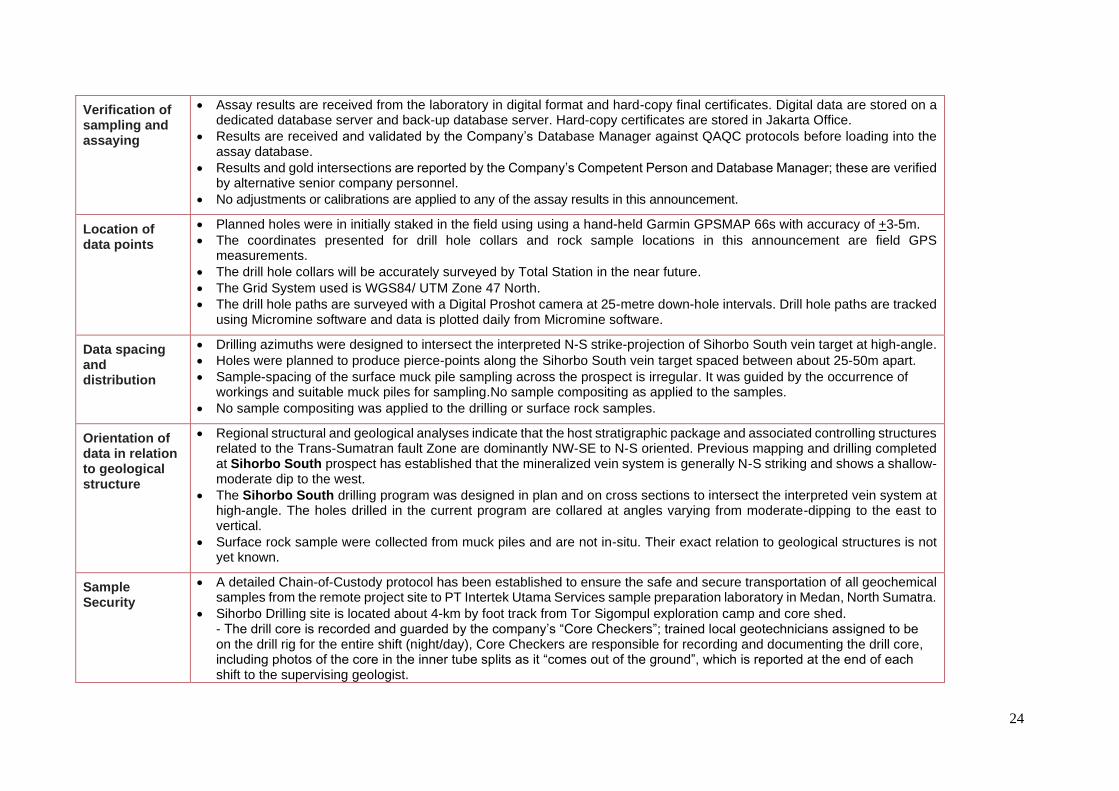
Verification of sampling and assaying
• Assay results are received from the laboratory in digital format and hard-copy final certificates. Digital data are stored on a dedicated database server and back-up database server. Hard-copy certificates are stored in Jakarta Office.
• Results are received and validated by the Company’s Database Manager against QAQC protocols before loading into the assay database.
• Results and gold intersections are reported by the Company’s Competent Person and Database Manager; these are verified by alternative senior company personnel.
• No adjustments or calibrations are applied to any of the assay results in this announcement.
Location of data points
• Planned holes were in initially staked in the field using using a hand-held Garmin GPSMAP 66s with accuracy of +3-5m.
• The coordinates presented for drill hole collars and rock sample locations in this announcement are field GPS measurements.
• The drill hole collars will be accurately surveyed by Total Station in the near future.
• The Grid System used is WGS84/ UTM Zone 47 North.
• The drill hole paths are surveyed with a Digital Proshot camera at 25-metre down-hole intervals. Drill hole paths are tracked using Micromine software and data is plotted daily from Micromine software.
Data spacing and distribution
• Drilling azimuths were designed to intersect the interpreted N-S strike-projection of Sihorbo South vein target at high-angle.
• Holes were planned to produce pierce-points along the Sihorbo South vein target spaced between about 25-50m apart.
• Sample-spacing of the surface muck pile sampling across the prospect is irregular. It was guided by the occurrence of workings and suitable muck piles for sampling.No sample compositing as applied to the samples.
• No sample compositing was applied to the drilling or surface rock samples.
Orientation of data in relation to geological structure
• Regional structural and geological analyses indicate that the host stratigraphic package and associated controlling structures related to the Trans-Sumatran fault Zone are dominantly NW-SE to N-S oriented. Previous mapping and drilling completed at Sihorbo South prospect has established that the mineralized vein system is generally N-S striking and shows a shallow-moderate dip to the west.
• The Sihorbo South drilling program was designed in plan and on cross sections to intersect the interpreted vein system at high-angle. The holes drilled in the current program are collared at angles varying from moderate-dipping to the east to vertical.
• Surface rock sample were collected from muck piles and are not in-situ. Their exact relation to geological structures is not yet known.
Sample Security
• A detailed Chain-of-Custody protocol has been established to ensure the safe and secure transportation of all geochemical samples from the remote project site to PT Intertek Utama Services sample preparation laboratory in Medan, North Sumatra.
• Sihorbo Drilling site is located about 4-km by foot track from Tor Sigompul exploration camp and core shed. - The drill core is recorded and guarded by the company’s “Core Checkers”; trained local geotechnicians assigned to be on the drill rig for the entire shift (night/day), Core Checkers are responsible for recording and documenting the drill core, including photos of the core in the inner tube splits as it “comes out of the ground”, which is reported at the end of each shift to the supervising geologist.

25
- The drill core is packed and sealed in core trays covered by a tray lid and locked with cable-tie strapping, immediately after each tray has been filled with core. - Core trays are man-portered from the drill site to the Tor Sigompul core shed daily by local laborers accompanied by the company’s local security team. - Supervising geologists check the drill site activity daily and are in charge of the security and handling of the drill core at Tor Sigompul core shed.
• After logging and splitting, the core samples are separately double-bagged; consisting of an inner plastic bag with an individual sample ID ticket stub (cable-tied) and an outer calico bag marked with the sample ID in permanent marker pen (cable tied).
• a) Drill core samples are packed into double-lined hessian (polyweave) sacks which are individually sealed with cable-ties and a unique numbered security tag. The hessian sacks are weighed and registered (hard copy and computer). b) Surface rock samples are packed into double-lined hessian (polyweave) sacks which are individually sealed with cable-ties and a unique numbered security tag. The hessian sacks are weighed and registered (hard copy and computer).
• The hessian sacks are man-portered from Tor Sigompul camp (Hutabargot – Sihorbo South) by local labour accompanied by the Company’s security personnel from the Site Core Shed to the Hutabargot road-side staging point (about 1.5-km distance), where they are met by the Company’s logistics personnel and a secure box-truck supplied by a domestic cargo carrier, PT Serasi Logistik Indonesia (SELOG).
• The hessian sacks are weighed and registered at Kotanopan exploration camp, which is located close to a major road for loading and transportation. The samples are transported by company vehicle to the Bukit Malintang Office, where they are met by the Company’s logistics personnel.
• The hessian sacks are checked, weighed (weights are verified by the supervising geologist) and then directly loaded into the truck, which is then outer-locked and sealed with the Company’s assigned numbered security tag (photographed) for transport and delivery direct to PT Intertek Utama Services in Medan, North Sumatra, accompanied by Company security personnel. The PT Intertek sample preparation laboratory is located about 10-12 hours by road (430 km) from the project area.
• On delivery to PT Intertek Utama Services in Medan, the laboratory manager confirms that the truck and hessian sack security seals are intact (photographed), weighs the hessian sacks, and reports to the supervising geologist for verification and permission to proceed with the sample preparation.
• PT Intertek Utama Services ensures the safe and secure transportation of pulp samples prepared at its sample prep facility in Medan, which are dispatched under their custodianship to the assaying laboratory in Jakarta, via DHL air courier. The pulp samples are packaged and securely wrapped in standard-sized Intertek-signatured boxes that are sealed with Intertek-signatured packaging tape. The pulp samples are accompanied by Intertek dispatch/security forms to ensure the acknowledgement of receipt and integrity of the samples (i.e. sample registration is completed and confirmed at both ends).
Audits or reviews
• The exploration programs are supervised by the Exploration Manager and supervising senior geologists based on site. In the field. The results of this drilling program are periodically audited and reviewed by an independent geological consultant, Mr Rob Spiers, representing Spiers Geological Consultants (SGC, Pty. Ltd.).
• The database is internally checked by the Company’s Database Manager.
26
JORC Code, 2012 Edition – Table 1 Report Section 2 Reporting of Exploration Results
Criteria listed in the preceding section also apply to this section.
Criteria Commentary
Mineral tenement and land tenure status
The mineral tenement is a 7th Generation Contract of Work (CoW) granted in February 1998 to PT Sorikmas Mining, an Indonesian joint venture company owned by Aberfoyle Pungkut Investments Pte Ltd (75%) and PT Aneka Tambang Tbk (25%). Sihayo Gold Limited (formerly Oropa Limited) acquired all of the shares of Aberfoyle Pungkut Investments Pte Ltd in April 2004. The CoW is located in North Sumatra in the Republic of Indonesia and is approximately 80km south-east from the Martabe Gold Mine.
The joint venture remains as Sihayo Gold Limited (ASX:SIH) owning a 75% interest in PT Sorikmas Mining which in turn holds the Sihayo-Pungkut 7th Generation Contract of Work (“CoW”). PT Aneka Tambang Tbk is the Company’s joint venture partner in the CoW with a 25% interest.
The original CoW area covered 201,600 hectares. This was reduced to the current 66,200 hectares after two mandatory partial relinquishments; 1) to 151,000 ha in Feb 1999, and 2) to 66,200 ha in Nov 2000. As a consequence of these two partial relinquishments, the current CoW is subdivided into two separate blocks; North block and South block. The tenement is currently under the Operation/Production phase of the CoW. There is no future requirement for area relinquishment. Tenure on the CoW is until 2049 with an option to extend for two additional 10-year periods.
The PT Sorikmas Mining CoW area is located along on a fertile segment of the Sumatra magmatic arc in North Sumatra. The same arc segment includes the giant Martabe gold-silver deposit (located about 80km NW) and the high-grade Dairi lead-zinc deposit (located about 250km NW). The CoW and is considered highly prospective for gold, silver and base metal mineralisation. Multiple mineral prospects have been identified during previous exploration within the CoW area and various mineralisation target-styles are represented including replacement-style carbonate-hosted gold (Carlin-style), intermediate-sulphidation epithermal gold-silver veins, gold-base metal skarns and porphyry-related copper-gold.
The Sihayo Gold Project is the most advanced project within the CoW and a Definitive Feasibility Study for the project was completed in June 2020. The project has combined Mineral Resources of 24 Mt at 2.0 g/t for 1.5 Moz of contained gold and an Ore Reserve of 12.5 Mt at 2.1 g/t for 840 koz of contained gold in the Sihayo-1 and Sambung gold deposits. The bulk of this gold in the Sihayo-1 gold deposit. The Company has an active exploration program including extension drilling at the Sihayo Gold Project, drilling at the Hutabargot Julu Project located 6km south of the Sihayo Gold Project, and prospecting in the Tambang Tinggi project area of the South CoW block.
The Hutabargot Julu gold-silver project is located in partly forested, rugged terrain of the Barisan Mountains in the North block of the CoW. The project is located in Hutabargot sub-district of the Mandailing Natal regency. An exploration camp and core shed facility has been constructed at Tor Sigompul located on the eastern side of the project area. A smaller drilling camp is servicing the drilling program at Sihorbo South located in the south-west corner of the project area. The nearest villages of Hutabargot sub-
27
Criteria Commentary
district are located within 2-km of both camps on the Batang Gadis river plain of the Panyabungan valley graben, immediately east of the northern block CoW boundary.
Access to Tor Sigompul Camp is via a walking track. The camp is located about 1.5-km walking distance from a vehicle drop-off point. The vehicle drop-off point is reached via an unsealed road from Hutabargot Julu village (about 1 km) and then about 9-km by sealed road to the PT Sorikmas Mining administration office located at Bukit Malintang village. Travel time from Bukit Malintang office to Tor Sigompul camp is about 1-2 hours. Access to the Sihorbo South prospect and current drilling target is by foot track and is located about 4 km west of from Tor Sigompul Camp.
Tambang Tinggi gold-copper project is located in partly forested, rugged terrain in the South block of the CoW, within the Barisan Mountains of North Sumatra. It is located in Kotanopan sub-district at the southern end of Mandailing Natal regency, close to the provincial boundary with West Sumatra. The company rents a house as an exploration office/camp located on the western edge of Kotanopan township. Core from the historic drilling program on Tambang Tinggi is also stored at this office. Kotanopan is a moderate-sized town with a population of about 25,000 people.
Access to Tambang Tinggi is via a major road and then walking track. Tambang Tinggi is located about 20-km west of Kotanopan along the Trans West Sumatra Highway, and then a few kilometres by an unsealed tracks off this highway. Travel time from Kotanopan office to Tambang Tinggi is about 2.5-hours. Kotanopan is located about 65-km SE from PT Sorikmas Mining administration office located at Bukit Malintang village. Travel time from Koyanopan to Bukit Malintang office is about 2 hours via the Trans West Sumatra Highway.
Bukit Malintang is located on the Trans West Sumatra Highway. Bukit Malintang is about 116 km (3.5-hour drive) southeast of Ferdinand Lumban Tobing airport, which services the nearby regional city and port of Sibolga. There are daily flights between Ferdinand Lumban Tobing airport and Jakarta. Alternative access is available from Silangi airport (Lake Toba) which is about 195 km (5.5 hours) and Minangkabau airport (Padang) which is about 315 km (8 hours) by road from Bukit Malintang. Both of these airports have daily flights to/from Jakarta.
Bukit Malintang office is located about 26 km (45-minute drive) northwest of the major regional town of Panyabungan, located off the eastern edge of the CoW North block. Panyabungan has a population of just under 100,000 people. Panyabungan and villages in the surrounding subdistricts provide most of the logistics and local labour in support of the project activities.
Much of the PT Sorikmas Mining CoW is covered by state-owned protected forest that is managed by the Ministry of Environment and Forestry. The Company requires an Ijin Pinjam-Pakai Kawasan Hutan (IPPKH), translated as a Borrow-Use forestry area permit, from the the Ministry of Environment and Forestry to access and use a forestry area for any purpose that is outside of forestry activities, including mineral exploration and mining activities. The PT Sorikmas Mining CoW contains caveats that allow the Company to conduct open-cut gold mining in protected forest. The Company holds a valid 485 ha IPPKH (Operasi) permit that contains the proposed Sihayo mine development area and, on the 4 September 2020, was granted a 13,800 ha IPPKH (Eksplorasi) permit that surrounds the operating permit. This allows the
28
Criteria Commentary
Company to conduct exploration activities including drilling on prospects located along the Sihayo Gold Belt in the North Block of the CoW, which includes Hutabargot Julu, Sihayo and near-by prospects. The 13,800 ha IPPKH (Eksplorasi) permit is valid for 2-years until 3 September 2022, and is extendible.
Hutabargot Julu (Sihorbo South) project contains a mixture of primary and secondary forest, rubber plantation and areas of fruit and vegetable cultivation held under informal landholdings. Local artisanal gold mining is active within the project area, but it is not permitted and therefore classified as an illegal activity or PETI (Pertambangan Tanpa Izin). Nonetheless, the presence of local mining carries strong social sensitivity, and the Company is working closely with local and central government to eventually reduce their activity within the CoW. Local miners are cooperative and compliant with the Company’s rights to operate in the project area.
Tambang Tinggi lies partly within a protected forest designated area and partly within freehold land owned by local farmers. It contains a mixture of primary and secondary forest, rubber and cocoa plantation and areas of fruit and vegetable cultivation under formal and informal landholdings. Local artisanal gold mining is also active within the project area, but it is not permitted and therefore classified as an illegal activity or PETI (Pertambangan Tanpa Izin). Local miners are cooperative and compliant in recognizing the Company’s rights to explore in the project area. The Company will apply for an IPPKH (Eksplorasi) permit to allow it to explore the forestry designated areas and in the meantime can operate freely with the permission of landowners in the non-Forestry designated areas. Most of the samples reported in this announcement were taken outside Forestry land and do not require an IPPKH to undertake exploration programs, including drilling.
Exploration done by other parties
Exploration commenced on the PT Sorikmas Mining CoW in 1995, originally under a domestic investment Kuasa Pertambangan (KP) title held by Antam with work managed by PT Aberfoyle Indonesia, a subsidiary of Aberfoyle Limited (Australia). Work continued under a pre-CoW permit (SIPP) from February 1997 to January 1998, and then under the joint venture company, PT Sorikmas Mining, when the CoW was signed in February 1998. Exploration carried out over this initial three year period included regional drainage geochemical sampling, prospecting, geological mapping, soil geochemical surveys and investigations on some of the historic Dutch mine workings in the district. Scout drilling was conducted by Aberfoyle on the Mandagang porphyry target in 1996 and produced some broad low grade Cu-Mo-Au intercepts. The regional work highlighted numerous gold and multielement anomalies across the CoW. Subsequent prospecting identified multiple targets, representing a broad spectrum of precious and base metal mineralisation styles, including:
• Carbonate-hosted jasperoid gold at Sihayo, Sambung, Link Zone, Sihayo-2, Sihayo-3, Sihayo-4, Mentari and Nabontar prospects (North CoW Block);
• Epithermal gold-silver veins and disseminated mineralisation at Hutabargot Julu (Dutch working), Sihayo-5 (North CoW Block), and Tambang Hitam, Tarutung, Babisik, Nalan Jae, Nalan Julu, and Rotap prospects (South CoW Block);
• Porphyry-style copper + gold-molybdenum mineralisation at Rura Balancing, Singalancar, Sihayo-2 Copper (North CoW Block), and Mandagang, Tambang Tinggi, Namilas and Siandop prospects (South CoW Block);

29
Criteria Commentary
• Polymetallic skarn at Bandar Lasiak (North CoW Block), and Pagar Gunung, Huta Pungkut prospects and Tambang Ubi/Pagaran Siayu (Dutch mine) prospects.
Aberfoyle was taken over by Western Metals Ltd in late 1998. Western Metals farmed out part of their beneficial interest in the CoW to Pacmin Mining Corp in 1999. Pacmin funded and managed detailed prospect-scale work at Sihayo and on some neigbouring prospects during 1999 until early 2000. This work included grid-based soil geochemical surveys, ground IP-Resistivity surveys, detailed geological mapping, trenching on various prospects and the first scout drilling program on the Sihayo gold discovery. The CoW was placed into temporary suspension from November 2000 to February 2003 due to depressed gold prices, lack of funding and changes to the forestry regulations and status that restricted access to the CoW area. PacMin was taken over by Sons of Gwalia (SoG) (Australia) in late 2001. Oropa Limited entered into an agreement to purchase the 75% beneficial interest in the CoW held by SoG/Western Metals in late 2002. Oropa exercised its option to purchase the 75% beneficial interest in the CoW held by SoG/Western Metals in early 2004. Oropa changed its name to Sihayo Gold Limited in late 2009. Exploration resumed on the CoW in early 2003, fully funded by Oropa/Sihayo. This work included detailed prospect-scale exploration such as grid-based soil geochemical surveys, ground IP-Resistivity and magnetics surveys, detailed geological mapping, trenching and drilling campaigns in the North Block (Sihayo, Sihayo-2, Link Zone, Sambung & Hutabargot) and South Block (Tambang Tinggi, Tambang Ubi and Tambang Hitam) that steadily increased from 2003 to 2013. An airborne magnetic and radiometric survey was flown over the CoW in 2011.
A total of 86,499 m of diamond drilling in 824 holes was drilled on the CoW up to 2013. This included totals of:
- 1,416 metres of diamond drilling in 13 holes at Sihorbo South (2012) in the North CoW Block; and
- 3,996-m in 20 holes at Tambang Tinggi (2005, 2011),
- 856-m in 7 holes at Tambang Hitam (2005),
- 1153-m in 11 holes at Tambang Ubi (2006-07) in the South CoW Block.
Significant results reported from historic drilling at Sihorbo South (Hutabargot Julu) and Tambang Tinggi are summarised under ‘Other substantive exploration data’.
Another hiatus in exploration activity occurred from 2013 to early-2019 due to lack of funding.
30
Criteria Commentary
New investment was injected into Sihayo Gold Limited in 2018 and the Company recommenced ground work at Sihayo in 2019 with an infill drilling program in support of a new Mineral Resource estimate on Sihayo and Sambung gold deposits. A total of 7,338 m in 74 holes of infill drilling was completed at Sihayo in 2019 (See ASX:SIH Quarterly reports released in January 2020, April 2020, and ASX release by Sihayo (ASX:SIH) on 23 June 2020).
Another significant capital raising was achieved in August 2020, the proceeds of which are being used to fund exploration at Hutabargot Julu and elsewhere, early project works on the Sihayo Starter Project and working capital See ASX:SIH Quarterly reports released on 20 August 2020). A total of 4806-m/25 holes of reconnaissance drilling was completed over the greater Hutabargot project area in early 2020, 1740-m/8 holes completed on the Sihorbo North vein target and 2577-m/11 holes on the Penatapan stockwork target were completed in mid-late 2021 (See ASX releases by Sihayo ASX:SIH on 12 April 2021, 5 July 2021 and 17 November 2021).
Historic resource estimates have only been previously announced on the Sihayo gold deposit, located about 5-km NW of Hutabargot Julu (See ASX:SIH Quarterly reports released in January 2020, April 2020, and ASX release by Sihayo (ASX:SIH) on 23 June 2020). There have been no resource estimates relating to the Tambang Tinggi project area.
Geology Regional Setting The CoW is located at the western end of the 7,000 km long Sunda-Banda magmatic arc. Sumatra lies on the south-western margin of the Sundaland promontory at the edge of the Eurasian plate. The promontory basement is composed of accreted and fault-transposed continental plate and magmatic arc terranes that were derived from Gondwana during the Late Palaeozoic and Mesozoic. The CoW straddles a NW-SE trending collisional boundary separating two basement segments: namely the Late Palaeozoic West Sumatra terrane (eastern segment) and Mesozoic Woyla terrane (western segment). The West Sumatra segment is composed of intermediate-felsic volcano-sedimentary rocks and associated shallow marine carbonate rocks. The Woyla segment is an accretionary complex composed of deep to shallow marine sedimentary rocks and associated mafic volcanic rocks. The collisional contact between these two terranes, referred to as the Medial Sumatra Tectonic Line, is stitched by Mesozoic granitic intrusions. Extension on these basement rocks during the early Palaeogene produced local rift basins that were filled by fluvio-lacustrine, coal-bearing siliciclastic-volcano-sedimentary rocks. These rocks have been uplifted, structurally inverted and partly eroded by the development and formation of the Trans Sumatran Fault Zone (TSFZ), commencing in the Miocene. The evolution of the TSFZ was accompanied by Palaeogene magmatism (diorite/andesite – tonalite/dacite intrusions and volcanics) and associated hydrothermal activity and mineralisation within the CoW and surrounding region. Younger volcanic tephras erupted from nearby Quaternary volcanoes (eg Sorikmarapi, Toba) mantle the landscape in parts of the CoW.
31
Criteria Commentary
Sihayo Gold Belt The Sihayo Gold Belt straddles the Angkola fault segment and associated fault strands (western margin) of the Barumun-Angkola dextral transtensional jog in the NW-SE trending TSFZ and is immediately adjacent to a major dilatational pull-apart basin (Panyabungan Graben: approximately 100 km long, 12 km wide and 1 km deep) that is controlled by the TSFZ. The TSFZ and associated deep seated dilatational structures that control the pull-apart basin are interpreted to be major structural controls on the alignment and evolution of Tertiary magmatism and mineralisation within the CoW. The Sihayo Gold Belt is one of three parallel/near-parallel prospect-aligned mineral belts recognised across the CoW area. It is a +15 km long NW-SW trending corridor of Permian calcareous volcano-sedimentary rocks, Tertiary siliciclastic-volcaniclastic rocks and associated intrusions. These rocks are highly prospective for replacement-style carbonate-hosted gold, epithermal gold-silver veins, polymetallic skarn and porphyry-related gold and copper mineralisation. It is host to the Sihayo-Sambung gold resources and near-mine prospects of Sihayo-2,-3, -4, -5, Bandar Lasiak, Sihayo-Sambung Link Zone, Hutabargot Julu and Dolok. Hutabargot Julu Geology
Hutabargot Julu prospect area (~9 km2) is situated at the southern end of the Sihayo Gold Belt and adjacent to Dolok. It comprises
the river catchments of Air Kaporas, Air Latong, Air Lambau (Air Kabau), and the middle section of Air Simalagi (A.Bargot) and
tributaries Air Sarahan and Air Cupak, Elevations in the area range from approximately 250 metres to 800 metres from east to
west across the prospect.The prospect area is situated immediately to the west of the Panyabungan graben floor and is underlain
by Tertiary age(?) andesitic to dacitic volcanic and volcaniclastic rocks intruded by several small porphyritic dacite plugs, quartz-
diorite stocks and associated phreatomagmatic breccias. These rocks fill a graben that has been uplifted (inverted) during the
evolution of the Trans Sumatran Fault Zone. Permian limestones and volcaniclastic rocks intruded by Mesozoic granitoids are
intrepreted to form the basement to this Tertiary graben; these basement rocks are exposed at higher elevations at nearby Dolok
prospect on the northern edge of Hutabargot Julu. Younger tephra deposits derived from nearby Sorik Marapi volcano cover parts
of the prospect.
Previous mapping over Hutabargot Julu (2010-2013) highlighted that the Tertiary volcanic and volcaniclastic rocks are extensively silica-clay-sulphide altered and host widespread veining within a 3-km by 3.5 km area. Numerous veins occur in arrays mapped in creeks and from local mine workings across the prospect. The veins show a generally NNW- to NNE- strike orientation and are reported to be moderate to steeply dipping. Strike-lengths appear to very from several 10’s m to several kms. The veins show pinch-and-swell geometries along strike and down-dip, most veins attaining maximum widths of 1-2m. The Sihorbo South epithermal gold-silver vein target, the subject of this announcement, is located on the south-western side of the large Hutabargot Julu project gold-soil anomaly. This target was previously highlighted by the historic Dutch adit that has no recorded gold production. Scout drilling of this target in 2012-13 returned significant gold-silver intercepts including 3.70 m at
32
Criteria Commentary
15.45 g/t Au & 23 g/t Ag from 55.40 m in HUTDD040 and 16.80 m at 1.43 g/t Au & 237 g/t Ag from 46.95 m in HUTDD045 (Refer to SIH:ASX announcement dated 16 March 2021 and 12 April 2021).
The epithermal vein system at Sihorbo South was delineated by surface mapping and 1,416 m in 13 scout diamond holes during 2012-13. The NNE-SSW oriented vein-alteration system is up to 50 m wide and extends over at least 400 m strike-length. It is a moderately west-dipping zone containing banded-brecciated epithermal quartz veins up to 5 m or more wide with hanging wall vein splays and surrounding stockwork. The vein system is hosted in a package altered phreatomagmatic volcanic breccias and associated hornblende diorite intrusions. The structural geology and detailed stratigraphy of the prospect is complex. The veins are characterized as intermediate-sulphidation epithermal-style and are represented by quartz-chalcedony-adularia(?)-manganocarbonate-sulphide fill featuring a variety of textures dominated by colloform-crustiform banding, locally developed lattice bladed and ghost sphere texture, and polyphasal brecciation and cementation. Disseminated sulphide mineralization is represented by pyrite, marcasite, silver sulphosalts (acanthite-argentite), rare chalcopyrite-sphalerite-galena and visible electrum. Alteration assemblages are represented by quartz-chlorite-epidote-calcite-hematite-pyrite as a more extensive “background” overprinted by stronger bleached zones of quartz-illite-smectite-adularia-leucoxene-pyrite-marcasite immediately surrounding the veins. Tectonic reactivation produces light-medium grey cataclasite zones containing milled vein and wallrock material along some vein contacts.
Tambang Tinggi Geology The South block of the PT Sorikmas Mining CoW is largely underlain by a “pop-up” basement between two large fault segments at the southern end of the of the Barumun-Angkola dextral transtensional jog in the NW-SE trending Trans Sumatran Fault Zone (TSFZ), at the southern end of a major dilatational pull apart basin (Panyabungan Graben: ~100km long, ~12km wide and ~1km deep) that is controlled by the Trans Sumatran Fault Zone (TSFZ). The TSFZ and associated deep seated dilatational structures that control the pull-apart basin are interpreted to be major structural controls on the alignment and evolution of Tertiary magmatism and mineralisation within the CoW. Tambang Tinggi project lies within one of three parallel/near-parallel prospect-aligned mineral belts recognised across both blocks of the CoW area. It is a +7.5 km long WNW-ESE trending corridor of Permian calcareous volcano-sedimentary rocks intruded by Late Jurassic intermediate intrusions of I-type affinity. These rocks are highly prospective for intrusion-related gold-silver-base metal veins, polymetallic skarn and possibly porphyry-related gold and copper mineralisation.
Previous mapping over the greater Tambang Tinggi project area (2005, 2011) showed the area is underlain by Permian andesitic volcanic – limestone basement rocks intruded by Late Jurassic hornblende diorite and quartz diorite/tonalite, and younger dacitic volcaniclastic cover rocks. The intrusions and basement volcanic rocks are extensive and highlighted by an elevated magnetic response in recently reprocessed and imaged 2012 surveyed airborne magnetics.
Numerous artisanal gold workings occur across the greater project area. These defined a cluster of major prospects that include Huta Pungkut, Tambang Ubi/Pagaran Siayu (Dutch Mine), Tambang Hitam, Tambang Tinggi, Simantuk, Babisik and others. Most of the workings are developed on quartz-sulphide veins or skarn mineralization aligned along structures of varying length and continuity.
33
Criteria Commentary
Drill hole Information
• Tables 1-2 and Appendices 1-2 of this announcement provide details of drill hole collar coordinates, hole dip and azimuth, final depths and intercepts for holes completed to-date in the Sihorbo South drilling program. Table 3 and Appendix 3 provides additional details on the surface rock samples and results from Tambang Tinggi.
• Drill hole and surface rock sample location plans and drill hole sections presenting gold and silver results are provided in this announcement.
Data aggregation methods
• Length-weighted average gold intercepts are reported at a 0.3 g/t Au cut-off with up to 4 m of consecutive internal dilution allowed. No high cuts were applied.
• No mineral equivalent values are used in the reporting of the gold and silver intercepts.
Relationship between mineralisation widths and intercept lengths
• The drilling results reported in this announcement provide preliminary data on the evaluation of Sihorbo South prospect. The results of these initial drilling programs will be further assessed to further establish the relationship between reported mineralised widths and intercept lengths.
• Structural data acquired from oriented core in the drilling program generally support the broad structural trends inferred from previous drilling and suface geological mapping. There is no significant sample bias believed to influence or exaggerate the results reported in this announcement. There is sufficient data to support or infer the true width of the mineralised down-hole intercepts reported.
• Data and interpretations derived from this latest drilling program will significantly refine the the geological model for future drill hole targeting.
Diagrams • Drill hole location plans and cross sections showing the positions of significantly mineralised intercepts and rock chip sample location plans are presented in this announcement.
Balanced reporting
• This announcement is believed to contain sufficient relevant information such as range of exploration results, geologic context, historic results, type and sampling methodology, maps/figures and spatial distribution of data points to represent balanced reporting.
Other substantive historic exploration data
SIHORBO SOUTH Vein Target
Historic Dutch Exploration (Jones, 2002): Dutch interests from 1910-1914 identified six mineralised vein systems in the southern and western areas of the Hutabargot Julu prospect. Two of these veins systems were investigated in some detail; surface and underground mapping over a length of 600m described extensive zones of silicification and brecciation 2m to 30m wide with a banded quartz-vein core of 0.2 metres – 3 metres width. Assays of the quartz core were reported as generally in the range 3-8 g/t Au and 5-100 g/t Ag with locally high values (maxima 34 g/t Au and 2,675 g/t Ag). The exact locations of the source of this data within the project area and how it relates to the historic Dutch adit identified at Sihorbo South is unknown.

34
Criteria Commentary
PT Anatam Barisan Mining (Jones, 2002): Parts of the PT Sorikmas Mining CoW area were previously held under an earlier CoW held by PT Antam Barisan Mining, a joint-venture between PT Aneka Tambang and CSR Billiton from the mid-1980’s until 1992. They did mapping, ridge-and-spur soil sampling, trenching and drilled two shallow diamond holes at Hutabargot Julu. The soil sampling outlined an 350 x 600m zone of gold-arsenic anomalism and continuous-chip sampling from trenching returned up to 12 metres @ 3.7 g/t Au and 14 metres @ 2.8 g/t Au. No data was available on the drilling results.
PT Sorikmas Mining (1998-2013): Exploration work completed by PT Sorikmas Mining over Hutabargot Julu up until the shut-down of activities in late 2013 included:
• Regional drainage geochemical survey (prospect highlighted by a 398 ppb Au BLEG anomaly);
• Airborne magnetics & radiometrics survey over the entire CoW;
• Geological mapping and rock sampling;
• Grid-based gold-multielement soil geochemical sampling (gold, silver, copper, lead, zinc, molybdenum, arsenic, antimony) on a 100m x 25m grid over the entire prospect;
• A ground dipole-dipole IP-Resistivty survey;
• Scout diamond drilling: 6,979-m in 57 holes, mainly in the southern part and western side of the Hutabargot Julu project area, which includes the Sihorbo South vein target.
35
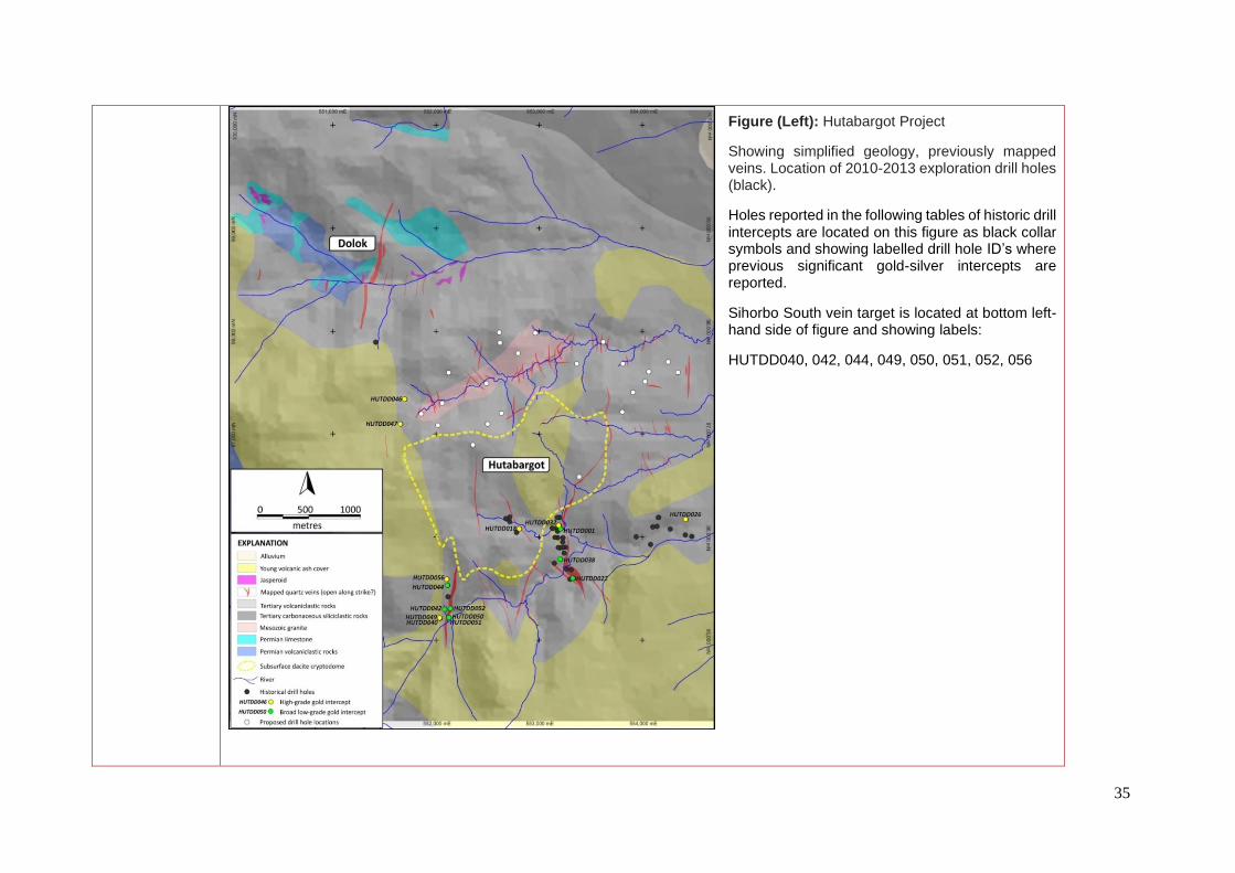
Figure (Left): Hutabargot Project
Showing simplified geology, previously mapped veins. Location of 2010-2013 exploration drill holes (black).
Holes reported in the following tables of historic drill intercepts are located on this figure as black collar symbols and showing labelled drill hole ID’s where previous significant gold-silver intercepts are reported.
Sihorbo South vein target is located at bottom left-hand side of figure and showing labels:
HUTDD040, 042, 044, 049, 050, 051, 052, 056
36
Significant higher grade gold-silver intercepts from 2010-2013 drilling programs:
Significant broad low-grade grade gold-silver intercepts from 2010-2013 drilling programs:
• Intercepts reported as length-weighted average gold intercepts at a 0.5 g/t gold cut-off with up to 2-m of consecutive internal dilution allowed; some of the longer reported intercepts may include several 2-m intervals of internal dilution but no single internal waste interval exceeds 2m. No high-cuts were applied.
Historic results previously released to the ASX in the following reports: - Sihayo Gold Limited – Quarterly Report for the 3 months ending 31st December 2011 - Sihayo Gold Limited – Quarterly Report for the 3 months ending 30th June 2012 - Sihayo Gold Limited – Quarterly Report for the 3 months ending 31st December 2012 - Sihayo Gold Limited – Quarterly Report for the 3 months ending 31st March 2013
Hole ID
mE mN mRL From (m) To (m) Length (m) Au (g/t) Ag (g/t)
HUTDD018 552814 96083 489 -60/90 68.4 47.00 52.00 5.00 35.67 198
HUTDD026 554427 96174 317 -50/90 265 54.30 60.20 5.90 4.12 6
HUTDD032 553194 96114 416 -70/90 100 42.40 48.90 6.50 4.64 4
HUTDD038 553209 95788 387 -70/90 136.2 43.00 44.00 1.00 7.15 10
HUTDD040 552042 95215 480 -50/90 140.5 55.40 59.10 3.70 15.45 23
HUTDD046 551700 97340 707 -50/90 96.2 56.20 61.50 5.30 17.06 19
HUTDD047 551660 97097 774 -50/90 93.5 83.40 84.55 1.15 204.00 55
HUTDD049 552042 95216 480 -50/90 112.7 56.45 64.00 7.55 6.02 13
HUTDD056 551418 97890 730 -50/55 105 80.00 85.00 5.00 2.91 357
Collar Coordinates WGS84/UTM_z47NDepth (m)
Mineralised InterceptsCollar Dip/Az
Hole ID
mE mN mRL From (m) To (m) Length (m) Au (g/t) Ag (g/t)
HUTDD001 553212 96082 400 -70/90 80.15 13.00 23.00 10.00 1.56 2
HUTDD022 553334 95603 413 -90/0 74 0.00 12.00 12.00 1.58 5
HUTDD038 553209 95788 387 -70/90 136.2 112.50 122.20 9.70 1.67 2
HUTDD042 552090 95301 483 -50/90 115.7 51.00 62.10 11.10 1.80 30
HUTDD044 552117 95532 557 -50/90 81.2 34.40 47.30 12.90 1.47 267
HUTDD045 552117 95532 557 -80/90 84.9 46.95 63.75 16.80 1.43 237
HUTDD050 552130 95221 491 -55/310 100.7 2.60 20.20 17.60 1.38 27
HUTDD051 552130 95221 491 -90/310 59.3 1.80 39.00 37.20 1.93 21
HUTDD052 552146 95309 520 -90/0 110 24.20 53.00 28.80 1.56 86
Collar Coordinates WGS84/UTM_z47NDepth (m)
Mineralised InterceptsDepth (m)

37
Figure (Left): Hutabargot Julu Project
Showing simplified geology, historic soil sample locations and gold results.
Sihorbo South vein target is located at bottom left-hand side of figure and soil sample coverage. It shows a relatively subdued and limited gold response compared to other parts of the larger project area.
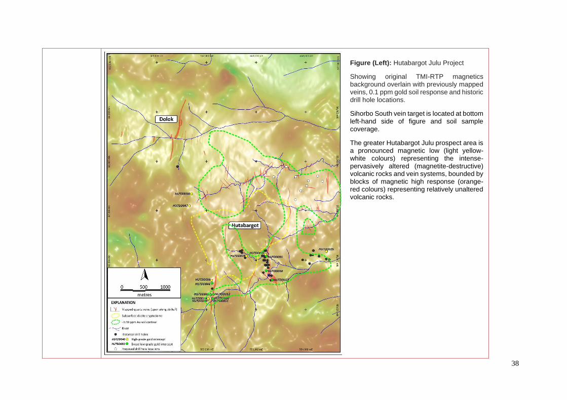
38
Figure (Left): Hutabargot Julu Project
Showing original TMI-RTP magnetics background overlain with previously mapped veins, 0.1 ppm gold soil response and historic drill hole locations.
Sihorbo South vein target is located at bottom left-hand side of figure and soil sample coverage.
The greater Hutabargot Julu prospect area is a pronounced magnetic low (light yellow-white colours) representing the intense-pervasively altered (magnetite-destructive) volcanic rocks and vein systems, bounded by blocks of magnetic high response (orange-red colours) representing relatively unaltered volcanic rocks.

39
TAMBANG TINGGI Project Area
Historic Dutch Mining (Oropa Limited, 2006): Tambang Ubi (formerly Pagaran Siayu), located on the western side of the Tambang Tinggi project area, is a copper-gold mineralised garnet-pyroxene-epidote skarn deposit developed on the contact between limestone and quartz diorite intrusion. The deposit was mined by the N.V. Mijnbouw Maatschapplj Moeara Sipongi (Dutch Mining Company) from 1936-1939, producing approximately 100,000t of ore, with recovered grades of 6.2g/t Au, 2.77g/t Ag and 0.24% Cu. Mining ceased in 1939 due to the commencement of WW2. Host Rock: Late Permian Silungkang Formation (fusulinid-bearing limestone), Muara Sipongi diorite/granodiorite. Mineralisation: The skarns range from andradite-diopside rocks to grossular-idocrase-wollastonite-diopside rocks. Later retrogressive alteration caused the formation of epidote, prehnite, pumpellyite, actinolite, chlorite, calcite, and quartz. During retrogressive hydration the skarns were mineralized locally with chalcopyrite, pyrite, magnetite, hematite, bornite, and gold, followed by sphalerite, arsenopyrite, marcasite, tetrahedrite, Co-Ni sulfarsenides and Au-Ag tellurides.
PT Sorikmas Mining (1998-2013): Exploration work completed by PT Sorikmas Mining up until the shut-down of activities in late 2013 included:
• Regional drainage geochemical survey (Tambang Tinggi project area was highlighted by a large cluster of minus 30- mesh BLEG gold stream sediment anomalies >10 ppb Au over a 5-km wide drainage area within the NE corner of the South block); Airborne magnetics & radiometrics survey over the entire CoW;
• Geological mapping and selective grab rock sampling; highlighting high-grade gold and associated silver and copper at surface. Huta Pungkut (skarn) – 6 samples ranging 15.9-51.0 g/t Au, up to 108 g/t Ag & 18.5% Tambang Hitam (epithermal vein) – 12 samples ranging 16.7-166 g/t Au, up to 635 g/t Ag & 15.9% Cu; Tambang Ubi (Dutch mine Pagaran Siayu)(skarn) – 6 samples ranging 16.8-39.4 g/t Au, up to 88 g/t Ag & 4.8% Cu; Tambang Tinggi (greisen & quartz-sulphide veins) – 22 samples ranging 15.0-62.0 g/t Au, up to 490 g/t Ag & 4.7% Cu.
• Grid-based gold-soil geochemical sampling (gold, silver, copper, lead, zinc, molybdenum) covering about a 3-km x 1.5-km area on a 100m x 50-100m grid and comprising about 1170 unsieved C-horizon soil-saprolite samples ;
• Scout diamond drilling: 634-m in 5 holes at Tambang Tinggi (2005), 856-m in 7 holes at Tambang Hitam (2005), 1153-m in 11 holes at Tambang Ubi (2006-07), and 3362-m in 15 holes at Tambang Tinggi (2011). 6,979-m in 57 holes, mainly in the southern part and western side of the Hutabargot Julu prospect.
Tambang Ubi (formerly Pagaran Siayu): Sampling of underground workings was conducted in 2006 in access drives that were refurbished and deemed safe for entry. Channel sampling of across some of the access drives returned encouraging high grade gold values in association with copper mineralisation including four samples ranging from 7.43-20.55 g/t Au and 0.49-1.29% Cu. Scout drilling produced several narrow gold-copper intercepts including 0.5m at 13.5 g/t Au & 0.67% Cu from 43.5m in TUDD001, 4.0m at 3.37 g/t Au & 0.12% Cu from 22.0m in TUDD002, 10.0m at 1.04 g/t Au & 0.09% Cu from 121.0m in TUDD005, 2.0m at 4.15 g/t Au & 0.27% Cu from 67.0m in TUDD008, 5.0m at 1.91 g/t Au & 0.19% Cu from 99.0m and 4.0m at 2.87 g/t Au & 0.22% Cu from 114.0m in TUDD011.
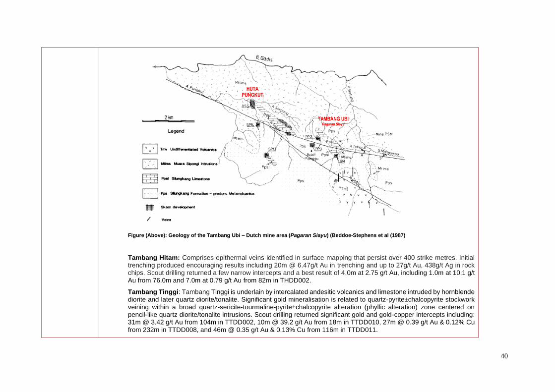
40
Figure (Above): Geology of the Tambang Ubi – Dutch mine area (Pagaran Siayu) (Beddoe-Stephens et al (1987)
Tambang Hitam: Comprises epithermal veins identified in surface mapping that persist over 400 strike metres. Initial trenching produced encouraging results including 20m @ 6.47g/t Au in trenching and up to 27g/t Au, 438g/t Ag in rock chips. Scout drilling returned a few narrow intercepts and a best result of 4.0m at 2.75 g/t Au, including 1.0m at 10.1 g/t Au from 76.0m and 7.0m at 0.79 g/t Au from 82m in THDD002.
Tambang Tinggi: Tambang Tinggi is underlain by intercalated andesitic volcanics and limestone intruded by hornblende diorite and later quartz diorite/tonalite. Significant gold mineralisation is related to quartz-pyrite±chalcopyrite stockwork veining within a broad quartz-sericite-tourmaline-pyrite±chalcopyrite alteration (phyllic alteration) zone centered on pencil-like quartz diorite/tonalite intrusions. Scout drilling returned significant gold and gold-copper intercepts including: 31m @ 3.42 g/t Au from 104m in TTDD002, 10m @ 39.2 g/t Au from 18m in TTDD010, 27m @ 0.39 g/t Au & 0.12% Cu from 232m in TTDD008, and 46m @ 0.35 g/t Au & 0.13% Cu from 116m in TTDD011.
HUTA PUNGKUT
TAMBANG UBI Pagaran Siayu

41
Significant gold intercepts reported from 2005 and 2011 Tambang Tinggi drilling programs:
mE mN mRL Dip/Az Depth (m) From (m) To (m) Length (m) Au (g/t)
TTDD001 592,025 67,522 1,040 -60/010 127.90 21.00 47.00 26.00 0.67
58.00 85.00 27.00 1.32
TTDD002 592,025 67,522 1,040 -60/130 152.00 25.00 56.00 31.00 3.42
79.00 103.00 24.00 0.96
110.00 112.60 2.60 5.14
TTDD003 592,025 67,523 1,040 -60/250 118.10 28.00 48.00 20.00 0.62
52.00 56.00 4.00 0.42
80.00 85.00 5.00 0.59
TTDD004 592,114 67,491 1,042 -60/010 135.50 55.00 67.00 12.00 0.57
TTDD005 592,004 67,576 1,020 -60/335 100.00 95.50 95.75 0.25 24.70
TTDD006 592,005 67,476 1,008 -60/020 174.75 24.00 30.00 6.00 0.87
36.00 52.00 16.00 1.46
72.00 78.00 6.00 0.55
92.00 118.00 26.00 0.67
104.00 134.00 30.00 3.90
TTDD007 591,961 67,496 994 -60/020 154.20 2.00 22.00 20.00 0.63
TTDD008 591,961 67,496 994 -75/020 259.35 2.00 16.00 14.00 0.92
20.00 36.00 16.00 0.53
182.00 202.00 20.00 2.33
208.00 234.00 26.00 0.66
TTDD009 591,961 67,496 994 -45/020 115.90 2.00 16.00 14.00 1.83
58.00 60.00 2.00 4.25
82.00 84.00 2.00 6.93
94.00 104.00 10.00 1.33
TTDD010 591,960 67,494 994 -60/200 91.00 18.00 28.00 10.00 39.24
TTDD011 592,005 67,476 1,008 -80/020 226.10 24.00 34.00 10.00 0.72
50.00 70.00 20.00 1.11
74.00 82.00 8.00 0.52
90.00 108.00 18.00 0.70
114.00 128.00 14.00 0.56
160.00 168.00 8.00 0.62
208.00 214.00 6.00 3.94
TTDD020 591,499 67,400 852 -50/220 174.20 27.00 39.00 12.00 0.66
45.00 48.00 3.00 2.02
Notes: 1) Reported at 0.3 g/t Au cut-off
2) Less than or equal to 2-m internal dilution allowed in reported intercepts
Tambang Tinggi PROJECT - HISTORIC DRILLING - TABLE OF GOLD INTERCEPTS
Mineralised InterceptsHole ID
Collar Coordinates: WGS84/UTM_z47N
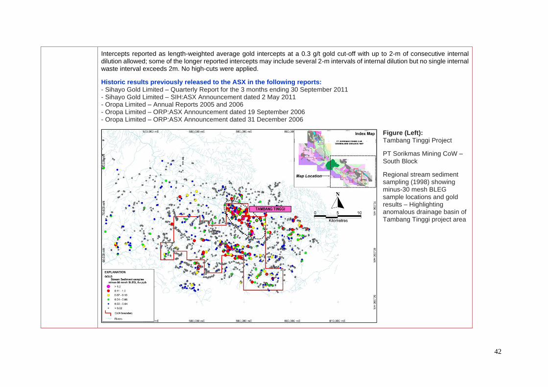
42
Intercepts reported as length-weighted average gold intercepts at a 0.3 g/t gold cut-off with up to 2-m of consecutive internal dilution allowed; some of the longer reported intercepts may include several 2-m intervals of internal dilution but no single internal waste interval exceeds 2m. No high-cuts were applied.
Historic results previously released to the ASX in the following reports: - Sihayo Gold Limited – Quarterly Report for the 3 months ending 30 September 2011 - Sihayo Gold Limited – SIH:ASX Announcement dated 2 May 2011 - Oropa Limited – Annual Reports 2005 and 2006 - Oropa Limited – ORP:ASX Announcement dated 19 September 2006 - Oropa Limited – ORP:ASX Announcement dated 31 December 2006
Figure (Left): Tambang Tinggi Project
PT Sorikmas Mining CoW – South Block
Regional stream sediment sampling (1998) showing minus-30 mesh BLEG sample locations and gold results – Highlighting anomalous drainage basin of Tambang Tinggi project area


