Embed Size (px)
Citation preview
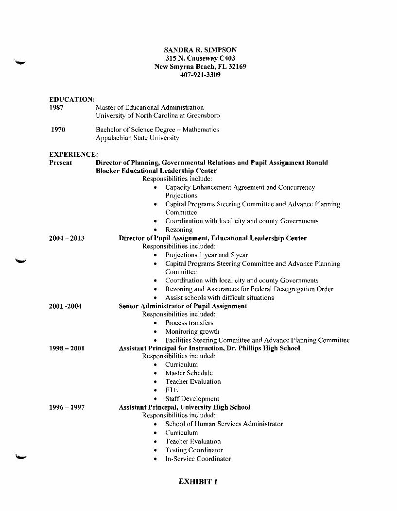
EDUCATION:
SANDRA R. SIMPSON 315 N. Causeway C403
New Smyrna Beach, FL 32169 407-921-3309
1987 Master of Educational Administration University of North Carolina at Greensboro
1970 Bachelor of Science Degree- Mathematics Appalachian State University
EXPERIENCE: Present Director of Planning, Governmental Relations and Pupil Assignment Ronald
Blocker Educational Leadership Center Responsibilities include:
• Capacity Enhancement Agreement and Concurrency Projections
• Capital Programs Steering Committee and Advance Planning Committee
• Coordination with local city and county Governments • Rezoning
2004-2013 Director of Pupil Assignment, Educational Leadership Center Responsibilities included:
• Projections 1 year and 5 year • Capital Programs Steering Committee and Advance Planning
Committee • Coordination with local city and county Governments • Rezoning and Assurances for Federal Desegregation Order • Assist schools with difficult situations
2001 -2004 Senior Administrator of Pupil Assignment Responsibilities included:
• Process transfers • Monitoring growth • Facilities Steering Committee and Advance Planning Committee
1998 - 2001 Assistant Principal for Instruction, Dr. Phillips High School
1996-1997
Responsibilities included: • Curriculum • Master Schedule • Teacher Evaluation • FTE • Staff Development
Assistant Principal, University High School Responsibilities included:
• School of Human Services Administrator • Curriculum • Teacher Evaluation • Testing Coordinator • In-Service Coordinator
EXHIBIT 1
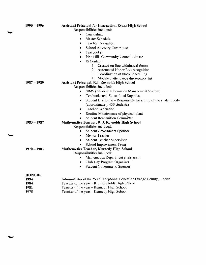
1990-1996
1987-1989
1983-1987
1970-1983
HONORS: 1994 1984 1981 1975
Assistant Principal for Instruction, Evans High School Responsibilities included:
• Curriculum • Master Schedule • Teacher Evaluation • School Advisory Committee • Textbooks • Pine Hills Community Council Liaison • IS Contact
1. Created on-line withdrawal forms 2. Automated Honor Roll recognition 3. Coordination of block scheduling 4. Modified attendance discrepancy list
Assistant Principal, R.J. Reynolds High School Responsibilities included:
• SIMS (Student Information Management System) • Textbooks and Educational Supplies • Student Discipline- Responsible for a third of the student body
(approximately 450 students) • Teacher Evaluation • Routine Maintenance of physical plant • Student Recognition Committee
Mathematics Teacher, R. J. Reynolds High School Responsibilities included:
• Student Government Sponsor • Mentor Teacher • Student Teacher Supervisor • School Improvement Team
Mathematics Teacher, Kennedy High School Responsibilities included:
• Mathematics Department chairperson • Club Day Program Organizer • Student Government, Sponsor
Administrator ofthe Year Exceptional Education Orange County, Florida Teacher of the year- R. J. Reynolds High School Teacher of the year- Kennedy High School Teacher of the year- Kennedy High School

Downtown South Neighborhood Improvement (DSNID) Plan, Orlando, FL VHB MillerSellen was engaged by the City of Orlando to prepare a master plan for the South
Downtown. The area is anchored by three economic drivers: the Orlando Health Campus, SODO
Mixed-use development, and the SunRail Commuter Rail station. The project required a master
plan for redevelopment of the area and its neighborhoods, and the formulation of a
neighborhood improvement district to fund infrastructure improvements to incentivize
redevelopment and investment by the private market place. VHB MillerSellen prepared a safe
neighborhood improvement plan under the provision of state statutes that will allow a
referendum to raise up to two mils of additional tax and/or an assessment of $500 per parcel.
Baldwin Park Naval Base Urban Redevelopment Plan When the Orlando Naval Training Center was closed in 1993 and sold to the city of Orlando, the
1,100-acre site represented huge opportunities for redevelopment. Orlando searched for
consultants to develop a master redevelopment plan to turn the city's vision for the urban infill
site into a reality. In a highly competitive contest, Mr. Sellen oversaw VHB MillerSellen's part on
the plan that reflected the concept of new urbanism, including a mix of residential and
commercial development, a focus on sustainability, and the use of Traditional Neighborhood
Design (TND) entitlements. It also considered the features and styles of the surrounding areas to
ensure the final redevelopment would fit seamlessly in the context of the larger community well
into the future .
Space Florida Master Plan, Cape Canaveral, FL Mr. Sellen was Principal-in-Charge when VHB MillerSellen was part of the team selected to
assist with the development of a Spaceport Master Plan to guide Space Florida in its efforts to
expand and modernize their facilities infrastructure at Cape Canaveral. VHB provided land use
planning and intermodal transportation systems planning assistance throughout the Master
Plan process. Transportation-related tasks included the identification of infrastructure needs
related to roadway, port, and space operations, and integration with the Florida Strategic
lntermodal System (SIS) .
Most Livable City Plan, City of Gulf Breeze, FL Principal in Charge for this project for master planning redevelopment and reinvestment along
the U.S. 98 corridor. This plan must create new economic development opportunities, while maintaining the high quality of life expected by the community and preserving their access to
environmental amenities. This plan will also consider the future impacts of an upcoming bridge
replacement project and the implications of future travel demand on the City and its business
community and citizens . The public involvement process includes stakeholder interviews, a four
day design charrette, and numerous Steering Committee meetings to reach consensus on a final
action plan for consideration by City Council.
Escambla County Sector Plan, Escambla County, FL As Principal-in-Charge, Mr. Sellen oversaw VHB MillerSellen's efforts to assist in the completion
of a state approved Optional Sector Plan for 16,000 acres located in central Escambia County.
Professional planning services provided include research, analysis and mapping of the Sector,
facilitation of stakeholder meetings and public visioning workshops, preparation of a Trends
Analysis, development of a Conceptual Build-out Overlay and Development of a model Specific
Area Plan ("SAP") .
James Sellen, MSP
lor <1 PI on n Pr .,,
dl ' pq C.tp
Mr. Sellen has been working
In both the public and
private sector throughout his
35+ year career ln Central
Florida as a community and
urban planner. As the Florida
Planning Practice Leader for
VHB MlllerSellen, his focus is
on the development and
Implementation of resource
based, long-term visions for
large property holdings
throughout the state of
Florida. His expertise
Involves developing a
consensus between
government and business to
support decision making
relative to the pattern and
scale growth should take in a
region or sub-region.
36 years of professional
experience
OMruerSel!en
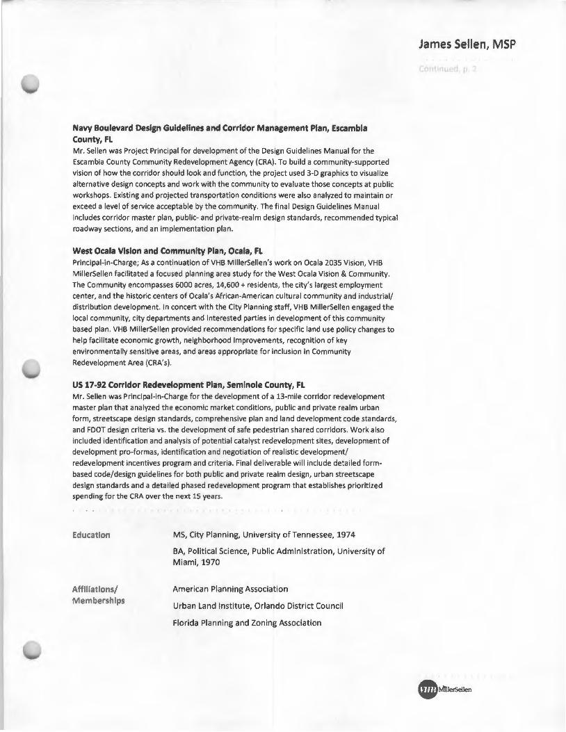
Navy Boulevard Design Guidelines and Corridor Management Plan, Escambla County, FL Mr. Sellen was Project Principal for development of the Design Guidelines Manual for the
Escambia County Community Redevelopment Agency {CRA). To build a community-supported
vision of how the corridor should look and function, the project used 3-D graphics to visualize
alternative design concepts and work with the community to evaluate those concepts at public
workshops . Existing and projected transportation conditions were also analyzed to maintain or
exceed a level of service acceptable by the community. The final Design Guidelines Manual
includes corridor master plan, public- and private-realm design standards, recommended typical
roadway sections, and an implementation plan.
West Ocala VIsion and Community Plan, Ocala, FL Principal-in-Charge; As a continuation of VHB MillerSellen's work on Oca la 2035 Vision, VHB
MillerSellen facilitated a focused planning area study for the West Ocala Vision & Community.
The Community encompasses 6000 acres, 14,600 +residents, the city's largest employment
center, and the historic centers of Ocala's African-American cultu ral community and industrial/
distribution development. In concert with the City Planning staff, VHB M illerSellen engaged the
local community, city departments and interested parties in development of this community
based plan. VHB MillerSellen provided recommendations for specific land use policy changes to
help facilitate economic growth, neighborhood improvements, recognition of key
environmentally sensitive areas, and areas appropriate for inclusion in Community
Redevelopment Area (CRA's).
US 17-92 Corridor Redevelopment Plan, Seminole County, FL Mr. Sellen was Principal-in-Charge for the development of a 13-mile corridor redevelopment
master plan that analyzed the economic market conditions, public and private realm urban
form, streetscape design standards, comprehensive plan and land development code standards,
and FOOT design criteria vs. the development of safe pedestrian shared corridors . Work also
included identification and analysis of potential catalyst redevelopment sites, development of
development pro-formas, identification and negotiation of realistic development/
redevelopment incentives program and criteria . Final deliverable will include detailed form
based code/design guidelines for both public and private realm design, urban streetscape
design standards and a detailed phased redevelopment program that establishes prioritized spending for the CRA over the next 15 years .
Education
Affiliations/ Memberships
MS, City Planning, University of Tennessee, 1974
BA, Political Science, Public Administration, University of Miami, 1970
American Planning Association
Urban Land Institute, Orlando District Council
Florida Planning and Zoning Association
James Sellen, MSP
tonttru rJ, tl
C MruerSellen
GMB ENGINEERS & PLANNERS, INC.
Synopsis
Dante A. Gabriel, P.E., PTOE Principal
M.S. Civil Engineering, University of Minnesota, 1982 B.S. Civil Engineering, University of the Philippines, 1979
Professional Engineer, Florida Registration No. 37271 Professional Traffic Operations Engineer ® (PTOE)
Institute of Transportation Engineers (ITE) Florida Section ITE
Dante A. Gabriel, P.E. is a founding partner and Principal of GMB Engineers and Planners, Inc. (GMB). He serves as
Project Manager, Principal-in-Charge, and technical advisor to traffic engineering design activities, traffic operations
studies, resort planning, traffic impact studies, and the administrative functions of the firm. Mr. Gabriel has 30
years of experience in all facets of traffic engineering and transportation planning activities. He is responsible for
all production work involving traffic operations studies, traffic signal systems and signal timing, pavement markings
and signing plans, maintenance of traffic plans, lighting plans, parking, Intelligent Transportation System (ITS)
Design and other design activities. He was also involved in the development of traffic elements for Developments
of Regional Impact (ORis), comprehensive plans, specific area plans, transportation modeling and design traffic
projects, roadway corridor preliminary engineering studies, and other studies involving assessment of traffic
impacts of site development projects. Mr. Gabriel has managed several continuing services contracts for FOOT,
counties, and local municipalities. These continuing services projects include traffic operations studies, signal
retiming, transportation modeling support, design traffic for Project Development and Environment (PD&E) Studies,
airport and resort traffic circulation master planning, and eminent domain support.
Relevant Experience
Traffic Operations Studies - Mr. Gabriel's relevant experience includes serving as Project Manager and Project
Engineer for several Districtwide Miscellaneous Traffic Operations Studies contracts with FOOT District 5. These
contracts involve signal warrant studies, intersection analysis to improve traffic operations efficiency and safety,
arterial studies to evaluate access management, safety, and traffic flow, data collection, pushbutton design and
signal timing optimization and retiming. He also completed for Orange County an assessment of pedestrian flows
on International Drive and Tangelo Park and developed recommendations to enhance the pedestrian walking
experience through this tourist corridor. Some representative projects include:
FDOT District 5 Traffic Operations Studies- seven contracts since 1987
FDOT District 5 Community Traffic Safety Program
Orange County Continuing Professional Engineering Studies
Traffic Signal Systems - Mr. Gabriel has managed numerous traffic signal system design and optimization and
retiming projects, the most recent of which involved the Orlando MPO Traffic Signal retiming Program administered
by FDOT District 5 in 2009. These projects involve development of design plans and technical specifications for traffic signal systems, data collection and development of time-of-day and day-of-week system timing plans,
implementation and fine-tuning. A few of the representative projects include:
FDOT District 5 Traffic Operations Studies
FOOT District 4 Traffic Signal Retiming for Palm Beach and Martin Counties
Orlando MPO Traffic Signal Retiming Program
Walt Disney World Traffic Control Management System
Traffic Operations Design - Mr. Gabriel has served as Project Manager and Project Engineer for numerous traffic
operations design projects involving the design of pavement markings, signing, lighting, traffic signal and system
communications. Representative projects include:
Signing & Pavement Marking and Signalization Plans for the 4-lane widening of SR 15 (Crystal Lake Drive)
Signing & Pavement Marking, Signalization and Traffic Control Plans for the 4-lane widening of CR 535
Segments A through E, Orange County, FL
Roadway Lighting Plans for SR 408 Segment 2530 in Orange County, FL
Signing & Pavement Marking, Lighting, ITS and Signalization Plans for the Interstate 95 Widening Project
from north of SR 50 to north of SR 46
Subarea/Corridor Planning - Mr. Gabriel served as Project Manager for several subarea/corridor planning
projects. Tasks associated with these projects typically include Build/No Build capacity improvement projects for Page 11
Dante A. Gabriel, P.E., PTOE Principal
arterials and interchanges, multi-modal travel demand modeling, capacity analysis and traffic flow simulation, and data collection. He also managed the SR 526 PD&E which involved alternatives evaluation of potential improvement options that will fit within the overpass bridge supports of 1-4. Representative projects include:
Design Traffic for PD&E Studies - FOOT District 5 SR 526 PD&E, FOOT District 5 Doctor's Drive Extension Alternative Alignment Study, Oviedo, FL I-4/Conroy Road Interchange Justification Report I-4/Republic Drive (Universal Boulevard) Interchange Modification Report
Policy and Systems Planning - Mr. Gabriel has served as Project Manager for numerous concurrency studies and sector plans for large-scale developments. These studies required the understanding and interpretation of transportation concurrency policies, application of acceptable procedures and methodologies to evaluate satisfying concurrency standards, and negotiations to mitigate development impacts to comply with concurrency. Mr. Gabriel has also served as Project Engineer in the development of traffic circulation elements for local government comprehensive plans. These elements evaluated the area-wide long-range relationships between roadway capacity needs and policy decisions relating to land uses, economic goals, and funding availability. A few examples of these projects include:
Innovation Way Sector Plan, Orange County Horizon West Town Center and Village F Sector Plans, Orange County Mall at Millenia DR!, Orlando
Land Planning/Engineering - Mr. Gabriel has completed numerous site impact analysis and applications for conformance and amendments to comprehensive plans. Tasks included concurrency evaluation for transportation; parking; access locations; rezoning; and master planning. He has also served as Project Engineer on eminent domain cases involving impacts of roadway expansion projects to parking, access and internal/external circulation. Some representative projects include:
Festival Bay Mall, Orlando Cape Canaveral Spaceport Universal Studios Florida
Resort and Airport Master Planning - Mr. Gabriel has also completed several comprehensive transportation planning functions for large-scale resort, theme park and airport projects. These projects involved developing the multi-modal transportation elements during the master planning phase. These elements include evaluation of external access, internal circulation for guests, employees, services, and parking facilities. Functional design and operation of the multi-modal transportation elements are important considerations to ensure the effective transition from the planning phase to engineering design.
• Universal Studios Florida Walt Disney World, Florida Orlando International Airport Cape Canaveral Spaceport Sauipe Resort, Bahia, Brazil
ITS Design - Mr. Gabriel has worked extensively with local and state municipalities in order to improve the safety of the motoring public while increasing the efficiency and capacity of roadway corridors. GMB has been involved in numerous ITS projects and is experienced in creating and implementing these types of plans. Representative ITS projects that GMB has been involved with include dynamic message signs, fiber optic interconnect plans, closed circuit television systems, AVI systems, emergency vehicle management systems utilizing Opticom and highway advisory radio plan design. Representative projects include:
University of Central Florida ITS Improvement Project, Orange County Interstate 95 ITS Relocation Plan, north of SR 50 to north of SR 46, Brevard County Fiber Optic Cable Interconnect Plans for various signalization design projects
Page I 2
Adrian Baus. PE. LEED AP, RCDD, QCxP
Director of Engineering mp Mechanical, Electrical, Fire Protection, & Technology Engineer
Mr. Baus has over 20 years experience in construction and engineering, encompassing
practical field experience as well as design expertise. His extensive knowledge and on the
job experience has led him to head MPE's Quality Control Division.
Adrian is a registered Electrical, Mechanical and Fire Protection Engineer and he is an
expert in renovation and new construction. Adrian is experienced in electrical, power,
lighting, communication systems, security systems, lightning and surge protection,
energy management, technology, cost estimating, and construction administration.
As the technical expert for the office, Adrian has been solving mechanical, electrical,
plumbing, fire protection and systems issues in the field for years. Adrian is the "go-to"
engineer for specialty projects such as photovoltaic systems, co-generation power
sources and complex problem solving projects. He is an expert in renovation as well as
new construction. His knowledge and understanding of all aspects of engineering is
remarkable, as is his attention to detail. He is also a Senior Member of the Institute of
Electrical and Electronics Engineers (IEEE), teaches electrical apprentice class for FEAT at
Seminole State College.
Project Experience (partial list)
K-12 Sports
• Seminole County Public Schools
o Lake Howell High School
• Softball Field Lighting
o Seminole High School
• Baseball Lighting
o Seminole High School
• Football Stadium Lighting
• Football Stadium Renovation
• Baseball/ Softball Lighting
o Lyman High School Additions
• Softball Field Lighting
• Volusia County Schools
o Spruce Creek High School
• Baseball I Softball Field Lighting
• Football/Track Lighting
o Pine Ridge High School
• Athletic Field Lighting
Mechanical • Electrical • Plumbing • Fire Protection • Technology • Energy • Commissioning Orlando I Fort Myers I Jacksonville I Tampa
www.matern.net
Adrian Baus, PE, LEED AP, RCDD, QCxP
Director of Engineering
Mechanical, Electrical, Fire Protection, & Technology Engineer
o Deltona High School
• Baseball/Softball Field Lighting
Community Sports
• Osceola USSSA Sports Building
• University of Central Florida Baseball Stadium
• Houston Astro's Spring Training Facility, Osceola County Baseball Stadium
• Harold & Ted Alfond Sports Center, Rollins College
• Rosemont Community Center, Orlando, FL
• College Park Community Center, Orlando, FL
• YMCA- South Orlando
• George Bailey Park, Winter Garden, FL
K-12 Education
• Orange County Public Schools
o McCoy Elementary School Replacement Prototype
o Lakeview Middle School Historical Renovation
o North Lake Park Relief Elementary School Prototype
o Sadler I Shingle Creek Relief Elementary School Prototype
o Meadowbrook Middle School Replacement Prototype
o Camelot Relief Elementary School
o Boone High School Renovations
o Chain of Lakes Middle School (Prototype MS#3)
o Meadow Woods Relief Middle School Prototype
o Hiawassee Elementary School - Replacement Prototype
o Citrus Elementary School
o Highpoint Elementary School
o Endeavor Elementary School
o Northlake Elementary School
o Camelot I Waterford Relief Elementary School Prototype
o Odyssey Middle School (Prototype #4)
Mechanical • Electrical • Plumbing • Fire Protection • Technology • Energy • Commissioning Orlando I Fort Myers I Jacksonville I Tampa
www.matern.net
mp ~

j. david torbert, aia partner
Education
Master of Science in Building Construction, 1993, University of Florida
Bachelor of Architecture, 1991, University of Florida
Registration
Registered Architect, TX #18221
Affiliations
American Institute of Architects
Awards I Recognition
Featured in the "Best Architects" Issue, Orlando Magazine, 2007
Professional Experience
19 years
SCHENKELSHULTZ DDD ARCHITECTURE DDD
Dave Torbert is a Partner with SchenkeiShultz Architecture. Joining the firm in 1994, Dave's
educational design experience began as a construction administrator on several elementary
and middle school projects in Orlando, Florida. His role has since evolved in to leading our
team on more than 22 million SF of K-12 education projects, including managing the firm's
work with Orange County Public Schools, the 10th largest school district in the US (as cited
by American School & University. 2012). For this work, Dave is responsible for overseeing the
design and planning efforts, as well as managing resource allocation on each K-12 project to
ensure that the client's vision and expectations are met.
In 2011, Dave was an integral member of the firm's successful contract with the U.S. Army
Corps of Engineers (USACE) Norfolk District and the Department of Defense Education
Activity (DoDEA) to support their mission of rebuilding their educational infrastructure by
creating 21st century, high performance educational environments. To date, this work has
included more than 1.5 million SF of 21st century school designs totaling more than $537
million in construction costs. Serving as the Project Director and primary contact with USACE
and DoDEA, Dave's responsibilities include coordinating all assigned task orders, as well as
responsible for fee negotiations, overseeing contract and task compliance, scheduling and
allocating resources and manpower.
In addition, Dave and his team were recognized in 2012 with the Charles F. Trainor Award
for their work on the Randall David Shughart Elementary and Middle School project at Fort
Bragg, North Carolina. This is a prestigious award given by the U.S. Army Corps of Engineers,
Savannah District to one team annually that recognizes a team that was significantly involved
in executing programs, projects, or improving processes.
Recent Design Experience:
Orange County Public Schools - Orlando, FL
Oak Ridge High School Comprehensive Addition I Renovation
Evans High School Replacement
Sun Ridge Elementary and Middle School
Sun Blaze Elementary School
• Arbor Ridge K-8 School Comprehensive Addition I Renovation
Wekiva High School
Bridgewater Middle School
• Ocoee Middle School
Catalina Elementary School
• Whispering Oak II I Sunset Park Elementary School Relief
US Army Corps of Engineers- Norfolk, VA
Ramstein High School
Spangdahlem Elementary School Addition I Renovation
Spangdahlem Middle School I High School
Kaiserslautern High School Replacement
Alachua County Schools - Gainesville, FL
Meadowbrook Elementary School
Jason Vargas, PE Project Manager
Years of Experience 15 Total 13 With Firm
Professional Registration Professional Engineer No. 62434, Florida
Education Bachelor of Science, Civil Engineering, University of Central Florida, 1998
Professional Affiliations American Society of Civil Engineers
PROFESSIONAL EXPERIENCE
Mr. Vargas has 15 years of experience in the civil engineering discipline. He has been involved in a varied range of educational and municipal projects. In his capacity as a project engineer, Jason has successfully completed a wide variety of projects to include park design, permitting, utility design, educational facility design and roadway projects. The scope of engineering services he has provided range from feasibility studies to design services through construction documents and construction administration.
• Apopka High School - $56,000,000. A comprehensive high school replacement for the existing campus. Worked to complete the high project within multiple phases to maintain the existing active campus. Completed 2006.
• Ocoee High School - Provided complete site civil, landscape and irrigation services including grading, drainage, water, sanitary and geometry. Completed 2005.
• Winter Park High School - $7,500,000. Provided design and construction administration services for additions to an existing school . Completed 2003.
• Jones High School Renovation - $41,000,000. Provided update to incorporate a new bid package into an existing package, which included full high school design of sanitary, stormwater, water and site layout. The projected include developing a temporary portable campus to house the displaced students while construction was being performed on the existing buildings. Completed 2005.
• East River High School- 92.7-acre site. $20,000,000. Project Manager responsible for design of potable water mains, fire mains, sanitary sewer systems, and permitting. Completed 2009.
• Freedom High School -$40,000,000. Provided complete site civil, landscape and irrigation services including grading, drainage, water, sanitary and geometry. Completed 2003.
• Lake Nona High School - 20.5-acre site. $15,000,000. Project Manager responsible for design of potable water mains, fire mains, sanitary sewer systems, coordination with owner and owner's consultants, architectural, landscape and MEP plans to ensure proper connection to civil services and permitting.
• University High School - 98.6 acre site. $35,000,000. Provided update to incorporate a new bid package into an existing package, which included full high school design of sanitary, stormwater, water and site layout. The projected include developing a temporary portable campus to house the displaced students while construction was being performed on the existing buildings. 10% Construction Complete.
• Evans Replacement High School - 40.56-acre site. $20,000,000. Project Manager responsible for design of potable water mains, fire mains, sanitary sewer systems, coordination with owner and owner's consultants, architectural, landscape and MEP plans to ensure proper connection to civil services and permitting. Design Complete.
• Oak Ridge High School -36.57-acre site. $52,000,000. Provided update to incorporate a new bid package into an existing package, which included full high school design of sanitary, stormwater, water and site layout. The projected include developing a temporary portable campus to house the displaced students while construction was being performed on the existing buildings. Design Complete.

Education
B.S. Agriculture 1988,
University of Florida
Registrations/Certifications
USACE Certified Wetland
Delineator
USFWS Habitat Evaluation
Procedures
Project Development and
Environmental Studies
(FOOT)
Leadership in Energy and
Environmental Design (LEED® AP - Building Design
and Construction)
Skills
Ecological Consulting
LEED®
Land Use Assessments
Wetland Delineation
NEPA
Environmental Impact
Statements and Assessments
Relevant Training/Courses
Unified Wetland Delineation
gai consultants
Karl G. Lotspeich, LEED® AP
Sr. Director, Environmental Services
Professional Summary
Mr. Lotspeich has been providing ecological consulting since 1988. He has been
the project manager for land use assessments, wetland delineations, and listed
species evaluations for more than 700 sites throughout Florida. Mr. Lotspeich has
conducted all levels of ecological impact assessments including pre-purchase due
diligence evaluations, final design studies and permit evaluations, National
Environmental Policy Act (NEPA) documentation including Environmental Impact
Statement (EIS), Environmental Assessment (EA) and Project Development and
Environmental (PD&E) studies for the Florida Department of Transportation
(FDOT). He has supported Comprehensive Plan Amendments and participated in
the design/submittal/approval of over 20 Developments of Regional Impact
(DRI). He has developed mitigation/ compensation programs for over 50 projects
throughout Florida, including wetland restoration/creation efforts, the use of
mitigation banks, and the preservation of thousands of acres of native habitat
throughout Florida. He is knowledgeable of a great array of plant and wildlife
species and have developed specific population survey and management plans for
such species as bald eagle, red-cockaded woodpecker, Florida indigo snake, sand
skink, and gopher tortoise to name a few.
He is knowledgeable in the application of ecological evaluation techniques
including: Wetland Rapid Assessment Procedures (SFWMD), Habitat Evaluation
Procedures (USFWS), and the Unified Wetland Mitigation Assessment
Methodology (UMAM). He is knowledgeable in green building practices requ ired
for successful implementation of LEED® (Leadership in Energy and Environmental
Design), and has been recognized as a qualified expert witness in wetland
ecology, plant communities, and threatened and endangered species habitat
requirements. He has successfully negotiated countless Federal, State and local
permits through a wide diversity of regulatory agencies and works closely with all
project team members to ensure that permit compliance efforts conform to the conditions of issuance.
As a Principal and Owner of his own consulting firm, Mr. Lotspeich has a broad range of experience with project and staff resource management, and the development and implementation of Quality Assurance/Quality Control Plans and
Project Safety Plans. He is skilled in marketing and client coordination including
proposal development, fee and rate negotiation, contract review, insurance
verification and other compliance verification efforts. He is an excellent public
speaker and has presented at numerous professional conferences.
Professional Experience
+ Orange Lake Resort and Country Club, Orange County, Florida. Conducted
inventory and analyzed all wetland and upland communities contained within
this 1,031 acre Development of Regional Impact. Both naturally occurring
and man-altered communities were identified. During the project planning
www.gaiconsultants.com
Affiliations
National Association of
Environmental Professionals
Florida Association of Environmental Professionals
Association of Eminent Domain Professionals
Florida Planning and Zoning Association
Orange County Bar Association - Environmental
Land Use Section
Volusia County Association
for Responsible Development
Home Builders Association of Mid-Florida
Professional Employment
Lotspeich and Associates, Inc., 1988-2012
gai consultants
+
+
Karl G. Lotspeich, LEED AP I 2
phase, he designed and implemented the quantitative population surveys for
a number of state and federally listed animal species over a three year period
using a wide array of sampling protocols including: drift fences, bucket traps,
live traps, intersect transects and others. A detailed Conservation
Management Plan was developed to protect, manage, and restore a variety of the on-site habitats thereby maximizing the availability of life requisite elements within the preservation areas.
Ft. Drum Marsh Conservation Area Listed Species Assessment, Indian River County, Florida. Coordinated with the St. Johns River Water Management
District and local land management staff to design a sampling protocol to
evaluate the recreational and water storage capability of the 23,000-acre site. Managed qualitative and quantitative sampling for listed species of
animals and plants along with full floristic inventory by vegetative community
type. Scheduled and coordinated with field teams; and provided final data on the presence, location, and abundance of rare plants, herpetiles, birds,
mammals, and exotic/nuisance species. Sampling included established and random pedestrian sampling transects, drift fences with bucket traps, various
live traps, minnow traps/nets, audio recording devices, and burrow cams.
World Gateway, Orange County, Florida. As part of the permit for the World Gateway 840 acre Development of Regional Impact, a 120-acre wetland
restoration/creation site was developed in East Orange County, Florida. The
restoration plan involved the re-hydration of an abandoned sod farm and
recreating a diverse freshwater marsh, wet prairie, forested wetland system complimenting the existing extensive Lake Hart wetland system. In addition
to a wide diversity of both wetland and upland plant schemes, a detailed
exotic species eradication program was implemented addressing primarily dog fennel and tropical soda apple . A five year monitoring program was
implemented to track and record the transitions and ultimate success of this wetland restoration project. Also coordinated a Section 10 consultation with the U.S. Fish and Wildlife Service for the removal of red-cockaded
woodpeckers' cavity trees, and an Incidental Take Permit for gopher tortoise through the Florida Fish and Wildlife Conservation Commission.
+ Kissimmee River Restoration Evaluation Program, Land Use Mapping. As
Project Supervisor, coordinated the collection of data and field verification reviews, oversaw review and delineation of aerial plots, and oversaw detailed quality control review program for mapping of a 70-square-mile section of the Kissimmee River restoration area. Developed a specific QA/QC protocol for mapping attributes and managed a team of 6 photo-interpreters for the review of more than 21,000 individual mapping polygons. Updated and republished Photo Interpretation Guide Book for delineation and classification of gee-referenced land use maps (comparable to FLUCCS level 4).
Transportation Major Highway
+ I 95, Segment 5 (Fiske to S.R. 528) Final Design & Design Build
+ S.R. 530/U .S. Highway 192/Airport Boulevard, Osceola County
+ S.R. 50 Widening Final Design, S.R. 429 to Good Homes Rd, FDOT 5
www.gaiconsultants.com
gai consultants
Karl G. Lotspeich, LEED AP I 3
+ S.R. SA/Nova®® Road (from U.S. Highway 1 to Herbert Street)
+ S.R. SO (Cortez Boulevard-U.S. 19 to Mariner Boulevard), Hernando
+ I-9S Widening, Sections 3 and S, Brevard County
+ S.R. 245 over Olustee Creek Bridge, Columbia & Union County
+ U.S. 301/Balm Riverview Appraisals, Parcels 100/100A, Hillsborough
+ S.R. 400 (I-4) and S.R. 46 Interchange Design Build, Seminole County
+ Wekiva Parkway, Segment 3b, S.R. 46/441 to Vista View
Interchanges
+ I-95/I-4/U.S. 192 Interchange PD&E Study, FDOT 5, Volusia
+ C.R. 210/U.S. 1 Interchange, FDOT 2, St. Johns
+ I-4/Conroy Road Interchange, Orange County
+ I-4/C.R. 46A Interchange and Access Road, Seminole County
+ I-95/I-4/U.S. Highway 192 Interchange, Volusia County
+ Matanzas Woods Parkway Interchange PD&E and Final Design, Flagler
+ I-75/S.R. 441 Interchange Improvements, Alachua County
Design Build
+ CR314 Sharpes Ferry Bridge over Oklawaha River Design Build
+ S.R. 50 Widening, Avalon Road to S.R. 429 Design Build
+ S.R. 1-9S Widening Final Design, S.R. 50 to S.R. 46, FDOT 5
+ S.R. 1-95 Widening Design Build, S.R. 528 to S.R. 50, FDOT 5
+ S.R. 1-95 Widening Design Build, Malabar to Palm Bay, FDOT 5
+ C.R. 245 Bridge over Olustee Creek Design/Build, FDOT 2
+ S.R. 50 Widening Design/Build, Avalon Rd to S.R. 429, FDOT 5
County Roadways
+ S.R. 436 PD&E and Final Design, Orange County
+ East Lake Mary Boulevard, Seminole County
+ Wekiva Springs Road, Seminole County
+ Chapman Road Widening, Seminole County
+ Longwood-Lake Mary Road, Roadway and Drainage, Seminole County
+ S.R. 419/434, Jetta Point to Mitchell Hammond Road, Seminole County
Miscellaneous Design
+ Orange County Continuing Engineering Services Stormwater Y8 900C
+ Orange County Continuing Services - Stormwater Y1 902-C
+ Seminole County Minor Roadway Continuing Services
+ East Orlando Transportation Needs Study
www.galconsultants.com

gai consultants
Karl G. Lotspeich, LEED AP I 4
Community Development I Municipal + City of Lake Mary, Fire Station/Municipal Services Building
+ Sanford/Lake Mary/Seminole County Consumptive Use Permit
+ Silver Star Community Park, Orange County Capital Projects
+ Orange County Evaluation and Appraisal Report for COMP Plan
+ City of Edgewater Evaluation and Appraisal Report for COMP Plan
+ Southeast Orlando Sector Plan, City of Orlando
Natural Resources I Stormwater + SFWMD, KICCO Management Area, Floristic Inventory, Osceola
+ Ft. Drum Marsh Conservation Area, 23,000 acres, Indian River County
+ SJRWMD's Seminole Ranch Listed Plant Assessments, Orange/Brevard
+ Suwannee River Water Management District Land Use/Mapping
+ Orange County Planning, Environmental Lands Stewardship Program,
including Residential/Industrial Capacity Analysis and Innovation Way Small
Area Study)
+ SFWMD, Kissimmee River Restoration Evaluation Program, Vegetation
Mapping and Photo-Interpretation Guide Book
+ Big Wekiva Drainage Basin, Stormwater Management Master Plan
Parks I Trails + Cross Seminole Trail North, Recreational Trail, Seminole County
+ City of Orlando Vision Plan for Parks
+ Clermont to Minneola Bike Path, Lake County
+ Ward Park/Mead Gardens Bike Path, Orange County
+ Kelly Park Trail Refurbishment, Orange County
+ Little Econ Greenway, Phase II, West End, Orange County
+ Dr. Phillips Community Park, Orange County
Expert Witness + S.R. 50 Appraisals and Expert Witness Testimony, Orange County
+ S.R. 45 Appraisals and Expert Witness, Pasco County
+ S.R. 44 Appraisals (S.R. 45 to C.R. 470), Citrus County
+ Seminole County CDBG, Engineering Services
+ FDOT 2 Litigation Support
+ Commuter Rail Depots (Orange & Seminole County), Expert Witness
+ S.R. 313 Appraisals, 5 Parcels, FDOT 2, St. Johns
+ Plant City/Interstate 4 Appraisals, Hillsborough County
www.galconsultants.com
ORANGE TV Nww.orangetv.us 3RIGHTHOUSE CABLE :hannel199 :OMCAST CABLE :hannel9
"ISION TV Nww.orangetv.us 3RIGHTHOUSE CABLE :hannel198
=otvKAST CABLE :haonel98
I P 407.685.9000 - ' .685.902'1
I STREET ADDRESS
9860 Universal Blvd., Orlando, Fl32819
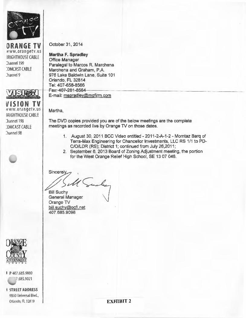
October 31, 2014
Martha F. Spradley Office Manager Paralegal to Marcos R. Marchena Marchena and Graham, P.A. 976 Lake Baldwin Lane, Suite 101 Orlando, FL 32814 Tel: 407-658-8566
Martha,
The DVD copies provided you are of the below meetings are the complete meetings as recorded live by Orange TV on those dates.
1. August 30, 2011 BCC Video entitled- 2011-2-A-1-2- Momtaz Barq of Terra-Max Engineering for Chancellor Investments, LLC RS 1/1 to PDC/0/LDR (RS); District 1; continued from July 26,2011;
2. September 6, 2013 Board of Zoning Adjustment meeting, the portion for the West Orange Relief High School, SE 13 07 046.
7~~ BiiiSuchy ~ General Manager \) Orange TV [email protected] 407.685.9098
EXHIBIT 2

Board of Zoning Adjustment West Orange County Relief High School
September 6, 2013

1 1
M
,...., 0 N
-- \D
-- 0'> "'' c .r: u
N Q)
"C
u; ~
u
r '
c ro ·-L..
0 Q
) ·-+-
' +
-'
·-ro
L..
c ()
~ ·-"'0
c L
..
0 L
.. 0
0 +
-'
·-C
ll 0
+-'
c. ·-
()
"'0 I
Q)
c Q
) c
Q)
(.)
>< Q
) +
-'
0 0
·-w
z
C/)
·-·-+-'
en ·-
-C
) -
Cll
-ro
en 0
0 c
·-·-
~
0 :::J
0 (.)
·-Cll
..c c-
..c Q
) (.)
0 (.)
(.) (.)
c. en
-C
/) f C
/) C
/) ()
·-0 •
• •
•

(/)
-c Q
) Q
)
z 0 0 ..c (..)
en

LEGEND
HIGH SCHOOL SITES
Ji CURRENT
~ FIVE YEAR CIP
Q PROPOSED
HIGH SCHOOL STUDENTS
2003.04 HISTORICAL
2007.08 HISTORICAL
0 2012·13 CURRENT
• 2017-18 PROJECTED
ROADS & BOUNDARIES
-- MAJOR STREETS
~· , ATTENDANCE ZONES
.. ...
LEGEND
·~e .. ?!i,&'M~· EII u.<J HIGH SCHOOL SITES
CURRENT
FIVE YEAR CIP
_ PROPOSED
HIGH SCHOOL STUDENTS
0 2003..04 HISTORICAL
2007..08 HISTORICAL
0 2012-13 CURRENT
e 2017-18 PROJECTED
ROADS & BOUNDARIES
-- MAJOR STREETS
D ATTENDANCE ZONES
LAKES
.. -- ..

LEGEND
iti~W.-~~L~HIGH SCHOOL SITES
~~~~~~~!!!IlL~~~~~~~ ~ CURRENT ~~~ ~ FIVE YEAR CIP
mi~W~~-~ Q PROPOSED
---i~-l~;.;~~ HIGH SCHOOL STUDENTS 0 2003..04 HISTORICAL
0 2007..08 HISTORICAL
0 2012-13 CURRENT
• 2017-18 PROJECTED
ROADS & BOUNDARIES
-- MAJOR STREETS
LAKES
..
LEGEND
·~oo ........ &tM:ift\RJ LHJ HIGH SCHOOL SITES
CURRENT
FIVE YEAR CIP
_ PROPOSED
HIGH SCHOOL STUDENTS
2003..04 HISTORICAL
2007..08 HISTORICAL
0 2012-13 CURRENT
• 2017-18 PROJECTED
ROADS & BOUNDARIES
-- MAJOR STREETS
~· , ATTENDANCE ZONES
~
. ..

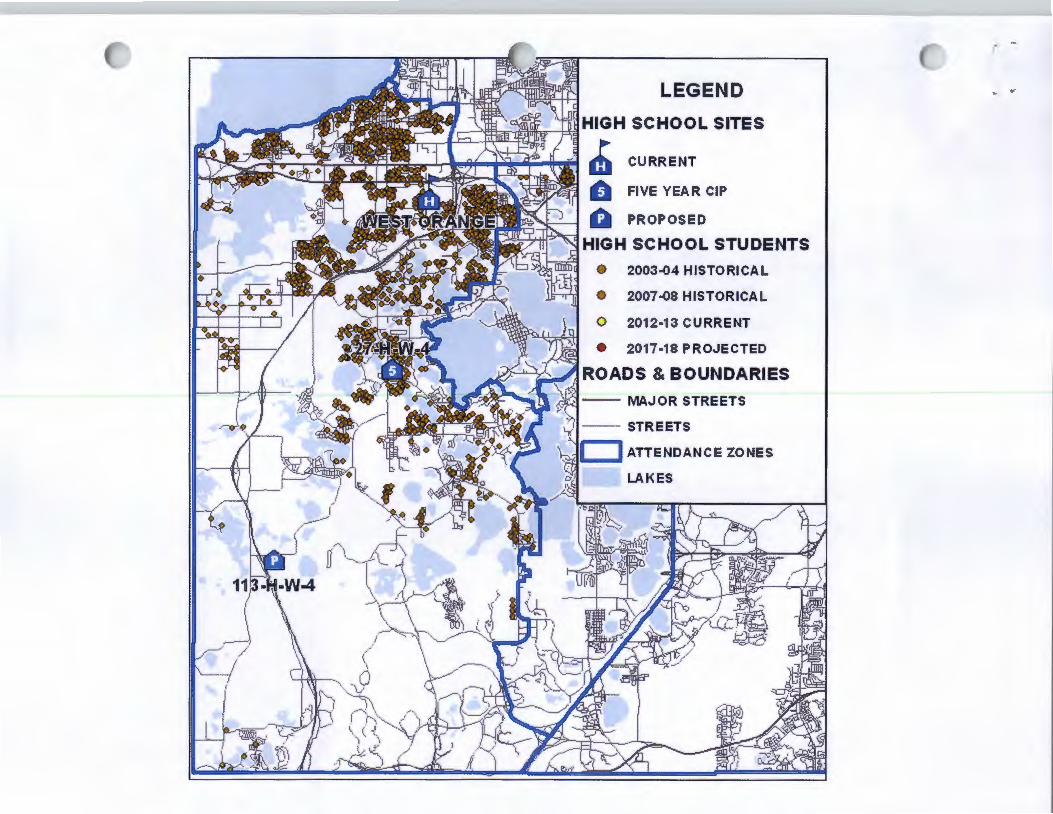
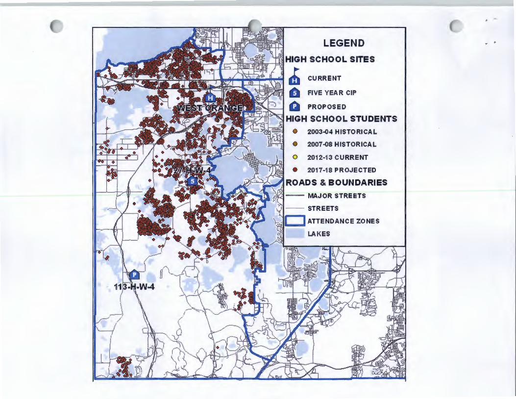
Projected HS Students at Buildout with ~~:-:-.f~;~~~c~_,~. ·. , ~;y :i'i<-:;r Ui r'7'G:J All Approved Development and CEAs
I I High School Zone
• Existing HS Student
Proposed HS Student at Buildout
...
..

' ..
I~
10 ..... ltn ·-J: \C: 0 ·-~
·-·-i::S tT
(.) <
(

Acquisition History
• Real estate market conditions 2003- 2006
• Property held by two Family Trusts One agreed to sell and negotiated a contract The other did not agree to sell - property was acquired via eminent domain
• 12/1/08 -- 2.67 acres Conveyed to Orange County
(Right-of-way for Winter Garden Vineland Widening Project)

Acquisition History
Acquisition by Eminent Domain
• Unable to obtain Special Exception until acquisition complete
• Conducted discussions with Orange County confirming consistency with the Future Land Use Map and requested consistency letter
• Relied on School Siting Ordinance allowing high school in rural settlement by Special Exception

' .
rc .... 0 \0 0

School Board and County Coordination
Florida's Community Planning Act and Education Code require counties to coordinate comprehensive. pla-ns with the School· Board.
Fla. Stat. section 1 013.33(3)(2013) A board and the local governing body must share and coordinate information related to existing and planned school facilities.
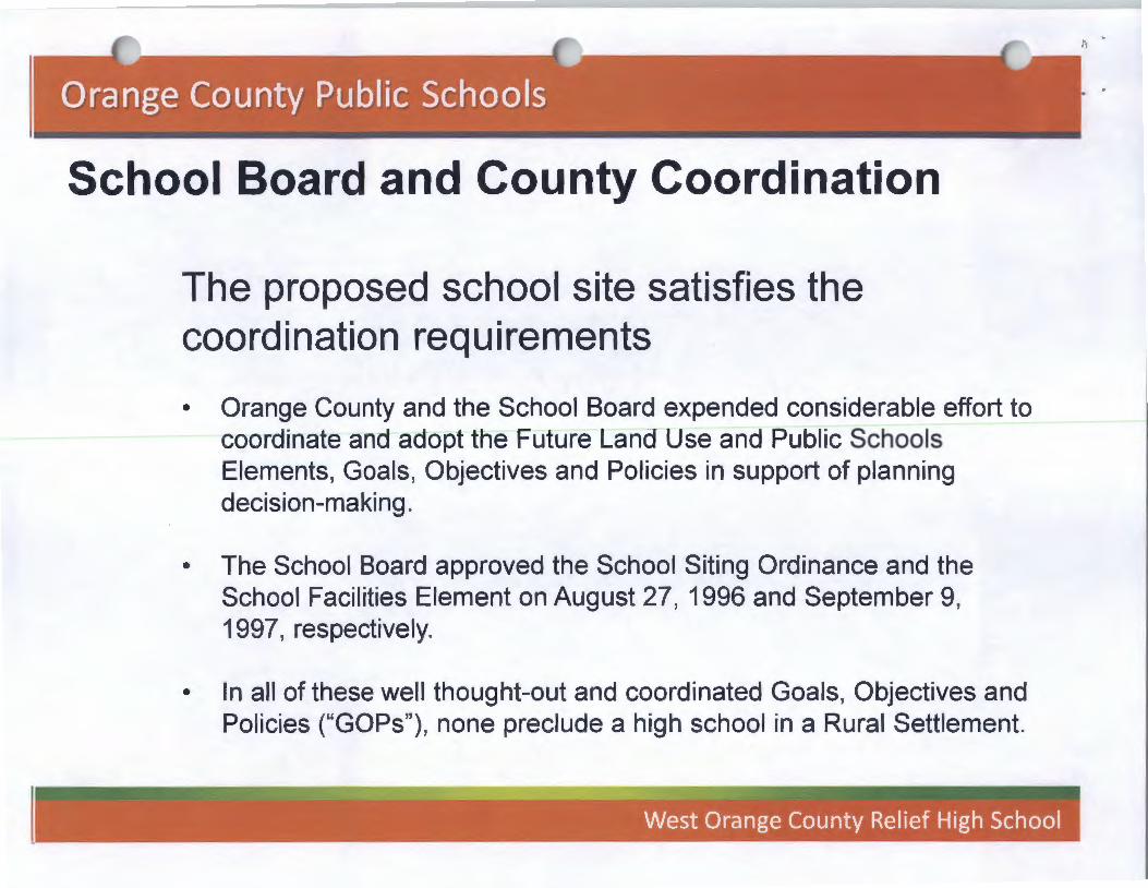
School Board and County Coordination
The proposed school site satisfies the coordination requirements
• Orange County and the School Board expended considerable effort to coordinate and adopt the Future Land Use and Public Schools Elements, Goals, Objectives and Policies in support of planning decision-making.
• The School Board approved the School Siting Ordinance and the School Facilities Element on August 27, 1996 and September 9, 1997, respectively.
• In all of these well thought-out and coordinated Goals, Objectives and Policies ("GOPs"), none preclude a high school in a Rural Settlement.
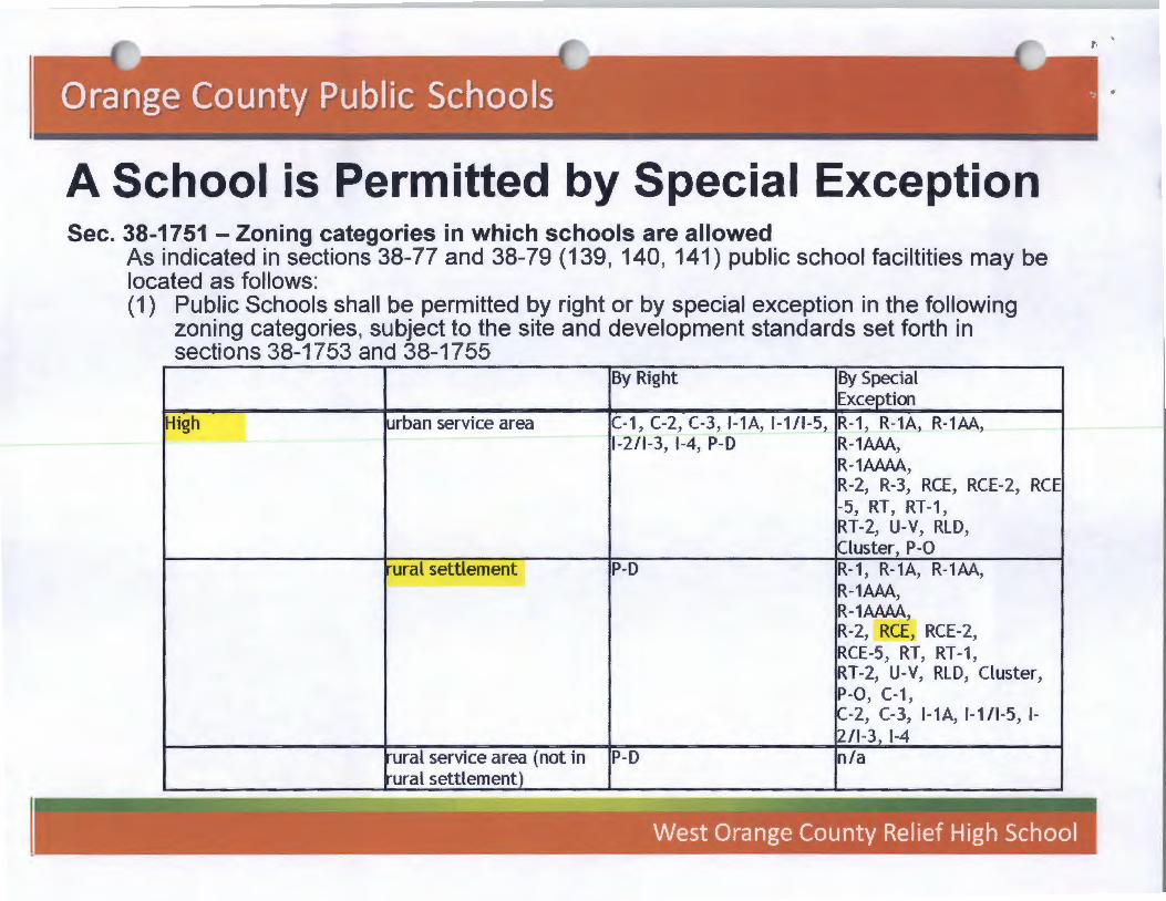
A School is Permitted by Special Exception Sec. 38-1751 -Zoning categories in which schools are allowed
As indicated in sections 38-77 and 38-79 (139, 140, 141) public school faciltities may be located as follows: (1) Public Schools shall be permitted by right or by special exception in the following
zoning categories, subject to the site and development standards set forth in sections 38-1753 and 38-1755
By Right By Special Exception
High _j urban service area C-1, C-2, C-3, I-1A, 1-111-5, R-1"' R-1A, R-1AA, 1-2/1-3 1-4 P-D R-1AAA,
' ' R-1AAAA, R-2, R-3, RCE, RCE-2, RCE -5, RT, RT-1, RT-2, U-V, RLD, Cluster, P-0
ural settlement P-D R-1, R-1A, R-1AA, R-1AAA, R-1AAAA _, R-2, RCE, RCE-2, RCE-5, RT, RT-1, RT-2, U-V, RLD, Cluster, P-0, C-1, C-2 C-3 I-1A 1-1/1-5 1-' ' ' ' 2/1-3, 1-4
ural service area (not in P-D n/a ural settlement)
. ..
I ns ·-1.. Cl) ,..., ·-'S.. 0 Is:: 0 ·-~
c. I~ >< w
I
-ca ·-(.) Cl) c. tn
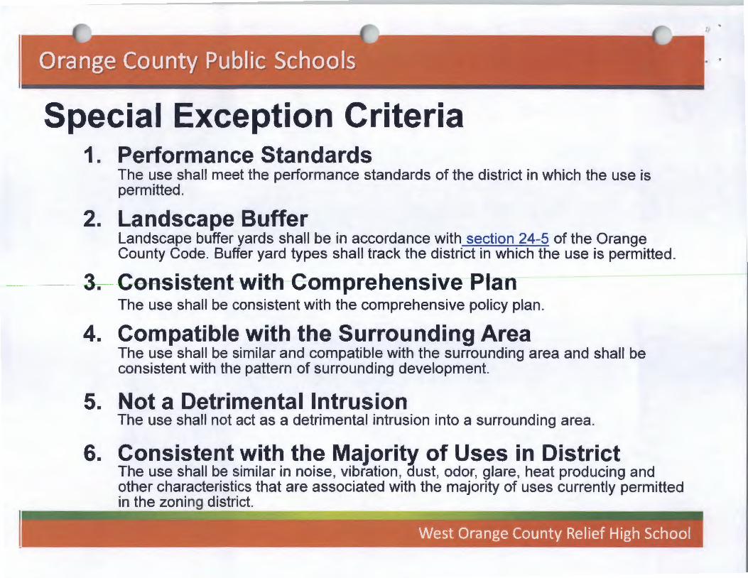
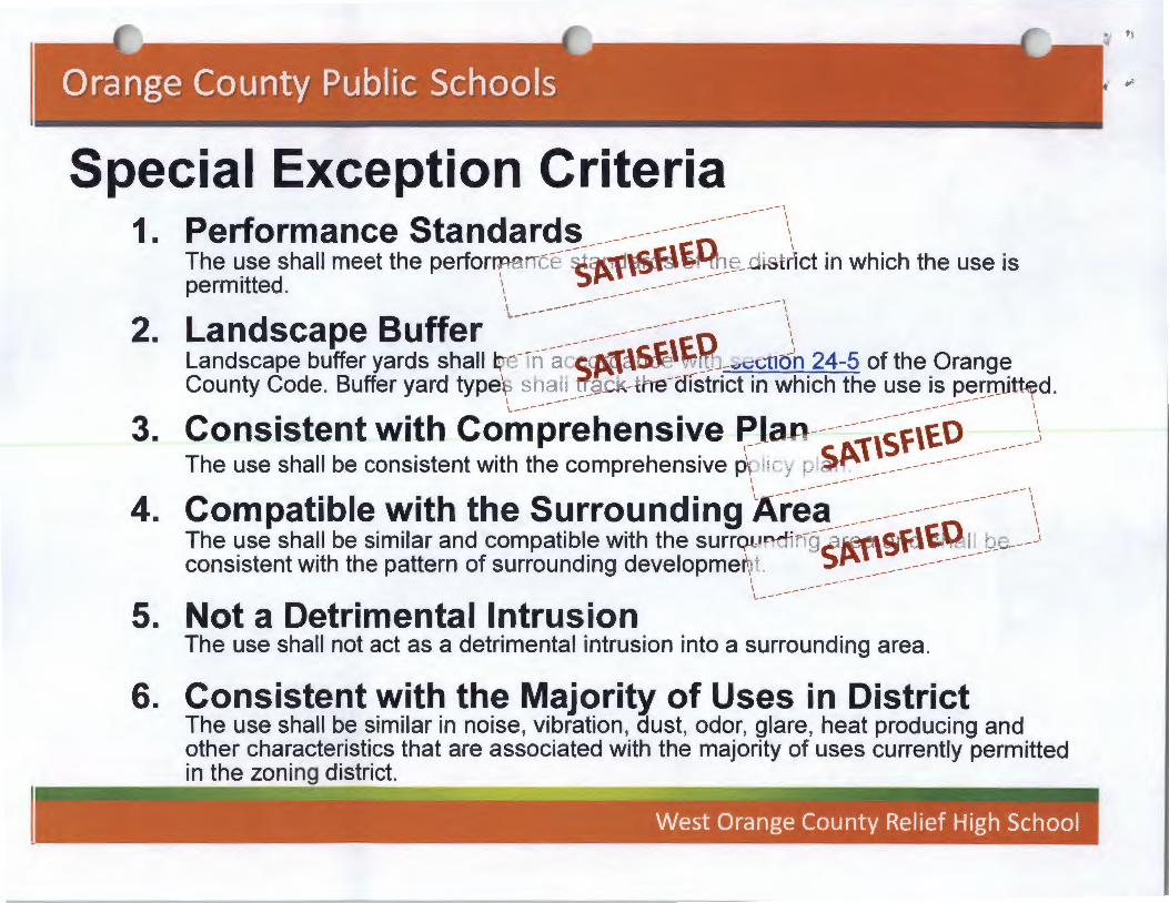
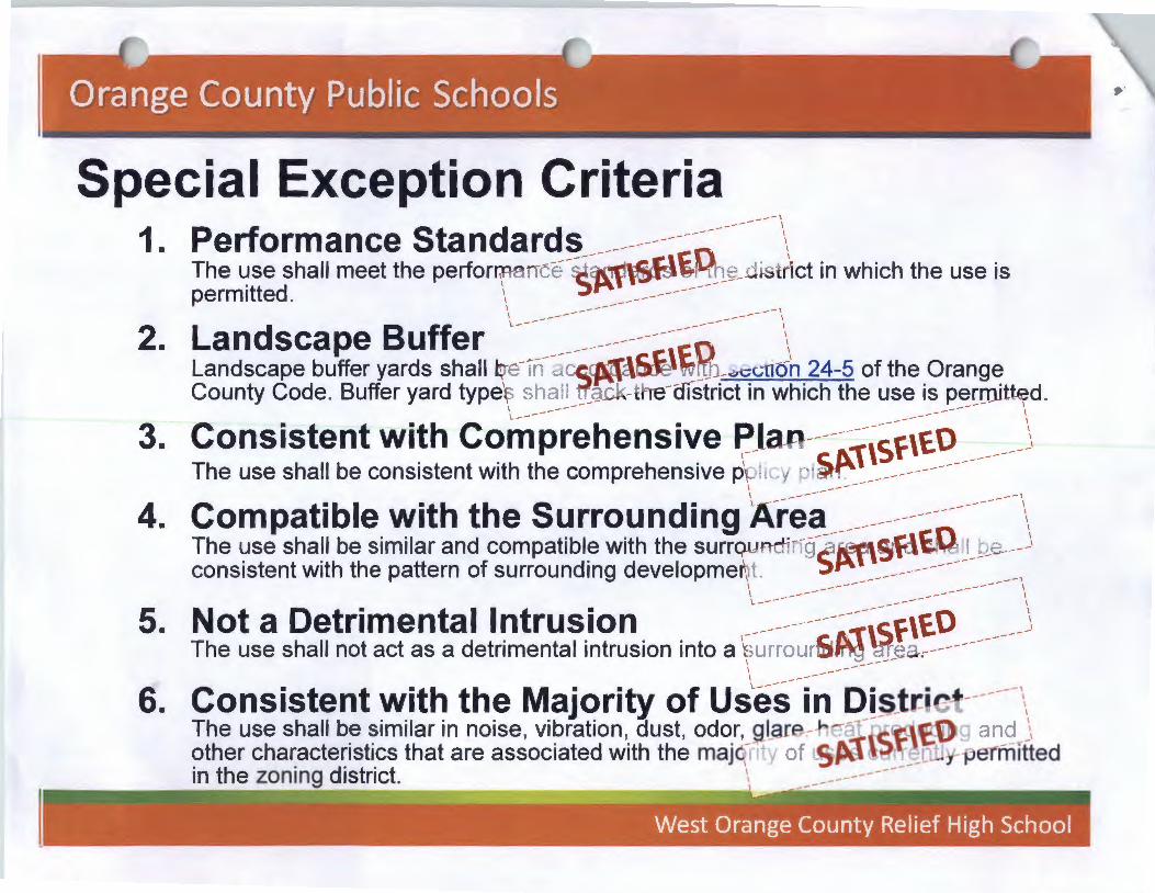
Special Exception Criteria 1. Performance Standards
The use shall meet the performance standards of the district in which the use is permitted.
2. Landscape Buffer Landscape buffer yards shall be in accordance with section 24-5 of the Orange County Code. Buffer yard types shall track the district in which the use is permitted.
3. Consistent with-Comprehensive Plan The use shall be consistent with the comprehensive policy plan.
4. Compatible with the Surrounding Area The use shall be similar and compatible with the surrounding area and shall be consistent with the pattern of surrounding development.
5. Not a Detrimental Intrusion The use shall not act as a detrimental intrusion into a surrounding area.
6. Consistent with the Majority of Uses in District The use shall be similar in noise, vibration, dust, odor, glare, heat producing and other characteristics that are associated with the majority of uses currently permitted in the zoning district.

Special Exception Criteria
1. Performance Standards
---------
2.
---------
County Staff Agrees that the School Site Submitted Meets:
• The Performance Standards of the District.
• The School Siting Ordinance Requirements
• The Landscape Buffering Requirements.

Special Exception Criteria
3. Consistent with Comprehensive Plan The use shall be consistent with the comprehensive policy plan.
4. Compatible with the Surrounding Area The use shall be similar and compatible with the surrounding area and shall be consistent with the pattern of surrounding development.

Special Exception Criteria 3. Consistent with Comprehensive Plan
The use shall be consistent with the comprehensive policy plan. ...-, ...... \ ...... \ ... \ __ ...... ..1.. \
............... ~~ \ County Staff Supports a Finding of County Staff's Reli<;~pe"~~ ~'-e~- /~ing Consistency with Comprehensive to Support a R~c-F.t~ ;d~~-.ff-Pian Based on the Following: lnconsist~9.C'-1 ... ~(J~IsolX\~ ... ___... .........
/ ·~ -~ .. v / Public Schools Element ... fi"_....._..... ~0 ~ "'• (j~ ... _,...rne~t
Goal PS1, PS2, PS3 ............... ~'(\0 ~·n~~r ... -arid Policies FLU 6.2, FLU Objective and Policies PS2.4, PS2.2.8, \ ' .. .i~~V:-rLU6.2.12, FLU 8.2, FLU 8.2.1, PS3.1.1, PS3.1. 7, PS5.2, PS5.2.2, PS \ ~~t:~tJ8.2.11 5.2.4, PS5.2. 7, PS5.3.6, PS6.1.9 \ _..... ......
\ ......
Future Land Use Element Objective and Policies FLU8.7.6, FLU8.7.8, FLU1.2.5
Capital Improvement Element Policies and Objectives 1.13.14
\ ... v-'
•

Consistent with the Comprehensive Plan
Future Land Use Objective 6.2: Rural Settlements provide for a rural residential lifestyle. In some instances, Rural Settlements allow a transition of rural areas adjacent to the Urban Service Area while avoiding development in active agricultural areas. Rural Settlements were intended to recognize and preserve existing development patterns at the time the CP was adopted in 1991. The creation of Rural Settlements recognized the need to mat""t~ain agricultural areas and rural uses in the Rural Se~ic,.-0/--~a \'<,hile providing for rural
"t" / ... ,, ~\ \ commum 1es. /,/\<:, ~ ~'\.~~~/'
/</ ~~e$ i'~'!-/,//-~~,s o~ ~~/ \\\ ~~~~//
\ /
\ ----\ ----\ ---\-'
Consistent with the Comprehensive Plan .... ,
........ '
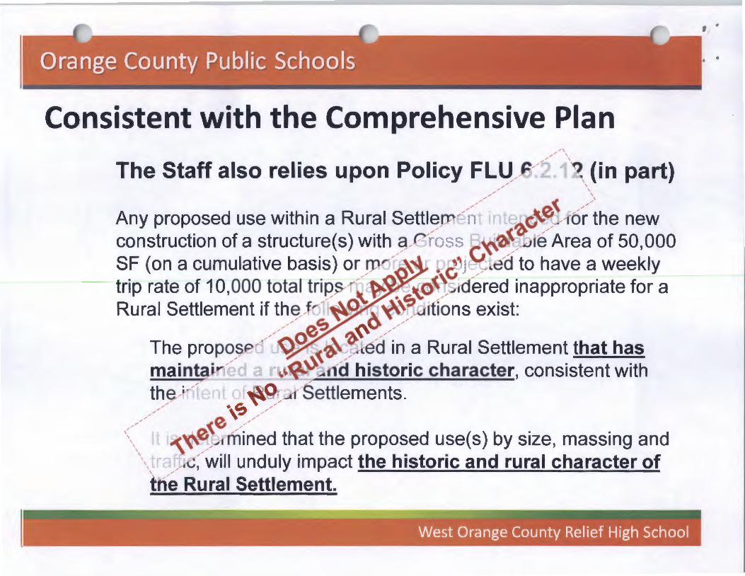
The Staff also relies upon Policy FL~ .... ~ .... ~~ '1, (in part) ........ '
.... ' ........ '
Any proposed use within a Rural Settlern,.,-/-,nte-b.'(;~1-r6;-~he new construction of a structure(s) with _9-e ./ J::; ~~0:~.JJt~ Area of 50,000 SF (on a cumulative basis) or}J1" .... ·~~ • 8'~ .... ;---led to have a weekly trip rate of 10,000 total trips-~'<.~~ ~~...-!dered inappropriate for a Rural Settlement if th~ .... Jr" · : ~~ ~!uJrtions exist:
........................ ~~ ~~ ....................
The propo_? ,.,- <::>~0-~~ ~d in a Rural Settlement that has maintai-~........ . a \.~~~..Jild historic character, consistent with th~ .... ~-- ........ , 1t - ~~ .... ~ .... Settlements.
................ ·~~ ............ .... e ~ .... ,<- 1t i~~~Anli~ed that the proposed use(s) by size, massing and
\\ _.......--rG: .... will unduly impact the historic and rural character of trfe Rural Settlement.
•
Consistent with the Comprehensive Plan
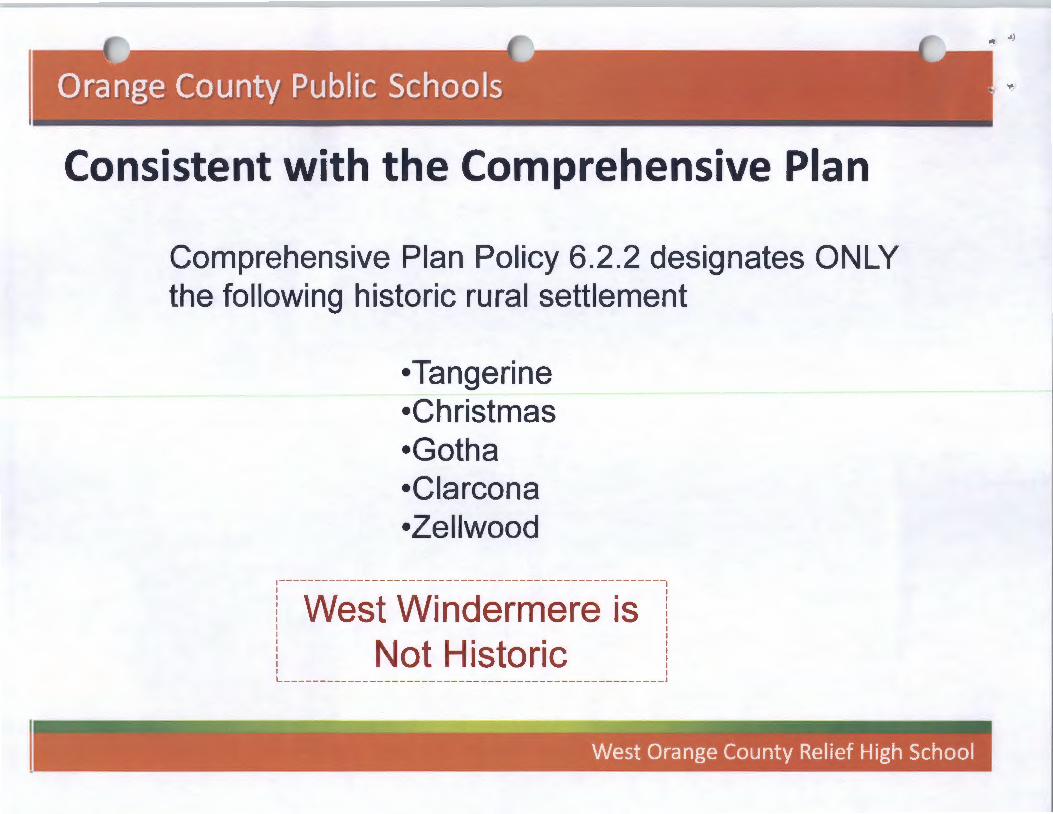
Comprehensive Plan Policy 6.2.2 designates ONLY the following historic rural settlement
•Tangerine •Christmas •Gotha •Clarcona •Zellwood
~-----------------------------------------------------1
! West Windermere is I I
! Not Historic I
L----------------------------------------------------'
f'

Consistent with the Comprehensive Plan
The Surrounding Area The Surrounding Area Character is NOT: Character is IS:
• Rural or Agricultural • Modern Upscale Suburban Development
• Historic
~-----------------------------------------------------------------~
i The Proposed School Is l Consistent with the I I
i Comprehensive Plan ~-----------------------------------------------------------------
•I


• West Windermere is not rural or historic.
• The scale and intensity of the proposed high school is consistent
l. with public high
schools.
• !';
>.
ro 3:
..c C
> n
::..c
()
Q)
-c
o m
Q
) ~
""C
::J '(i) .E ""C
m
c
c ro
o ..c I
Q)
.s=~
«>en c
0 0
0 +-'CJ)
..c u
Q)C
f)
~""C c
Q)
0 C
J) N
0
·c c..
0 0
I~
..
I
/
Consistent with the Comprehensive Plan
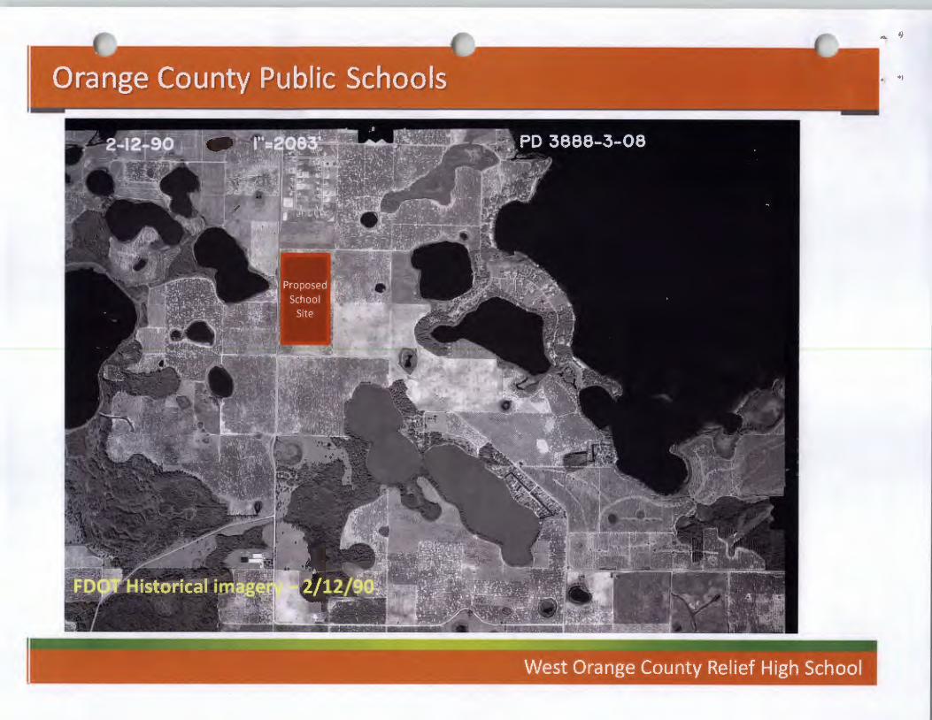
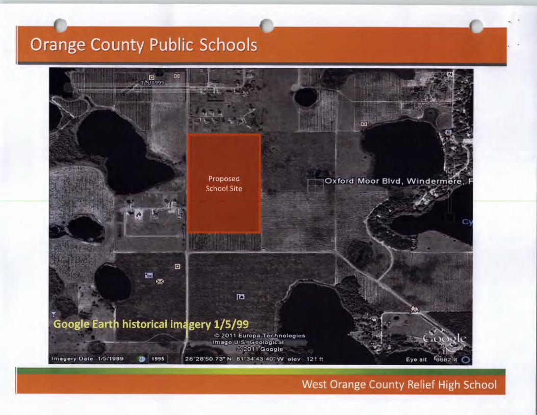
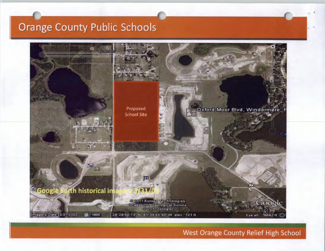
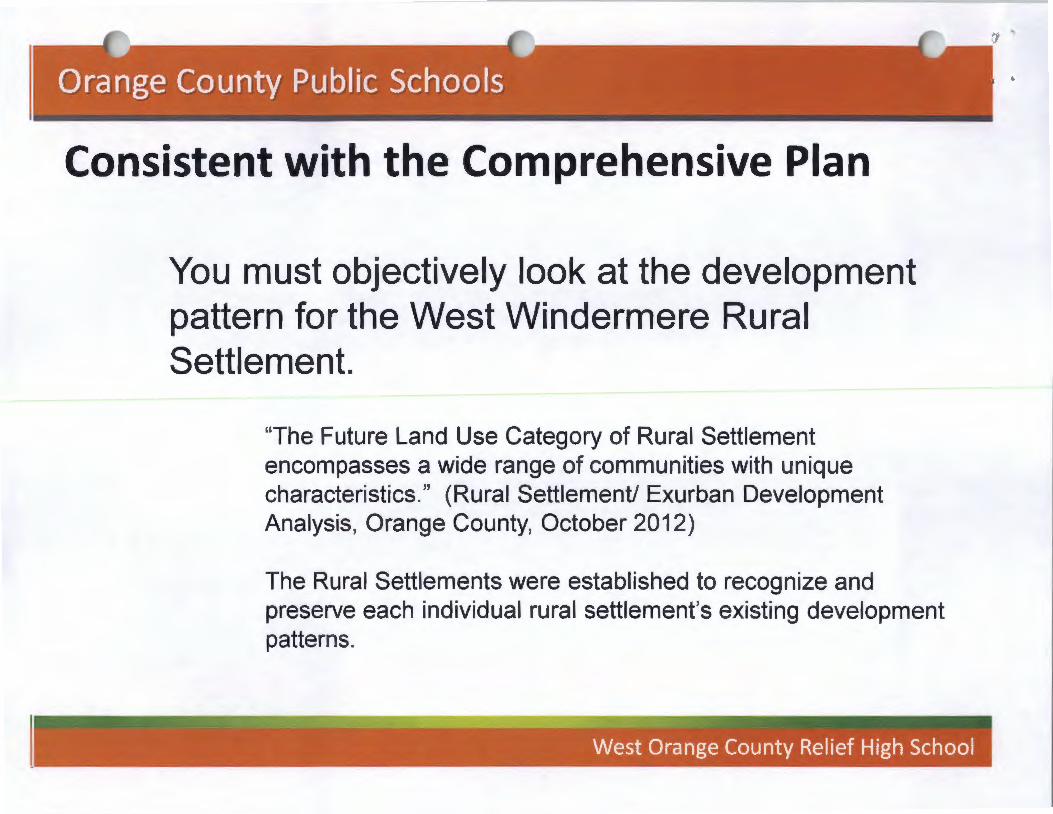
You must objectively look at the development pattern for the West Windermere Rural Settlement.
"The Future Land Use Category of Rural Settlement encompasses a wide range of communities with unique characteristics." (Rural Settlement/ Exurban Development Analysis, Orange County, October 2012)
The Rural Settlements were established to recognize and preserve each individual rural settlement's existing development patterns.
Consistent with the Comprehensive Plan
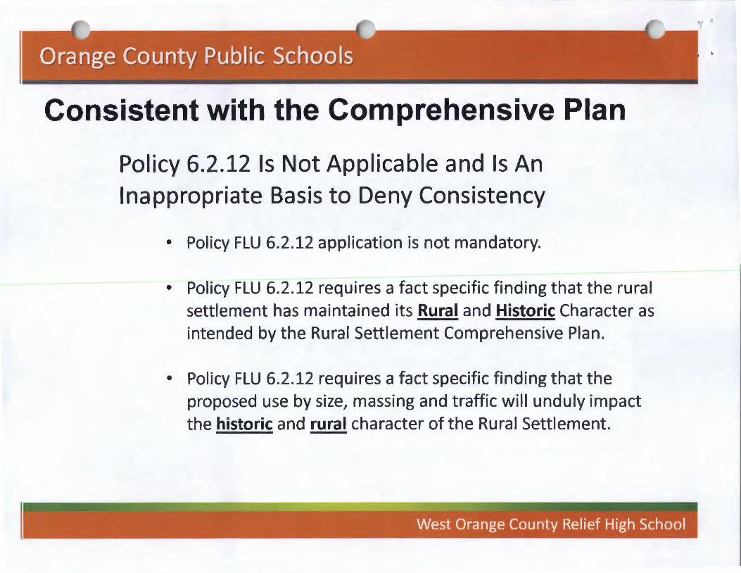
Policy 6.2.12 Is Not Applicable and Is An Inappropriate Basis to Deny Consistency
• Policy FLU 6.2.12 application is not mandatory.
• Policy FLU 6.2.12 requires a fact specific finding that the rural settlement has maintained its Rural and Historic Character as intended by the Rural Settlement Comprehensive Plan.
• Policy FLU 6.2.12 requires a fact specific finding that the proposed use by size, massing and traffic will unduly impact the historic and rural character of the Rural Settlement.
•

Consistent with the Comprehensive Plan • The West Windermere Rural Settlement, has not preserved
the development vacant/agricultural patterns that existed in 1991.
• The area is not providing a "rural residential lifestyle"
• The area never had an historic character
• The area did not maintain an agricultural character
• The proposed school site is consistent with the Rural Settlement Objective 6.2, Policies and Objectives 6.2.5, Public Schools Policy 3.1.1 in addition to the previously listed policies
• Policy 6.2.12 is inapplicable.

Consistent with the Comprehensive Plan
The school site is compatible with the suburban residential development and is consistent with FLU 8.2 and Policy 8.2. t.
Consistent with the Comprehensive Plan
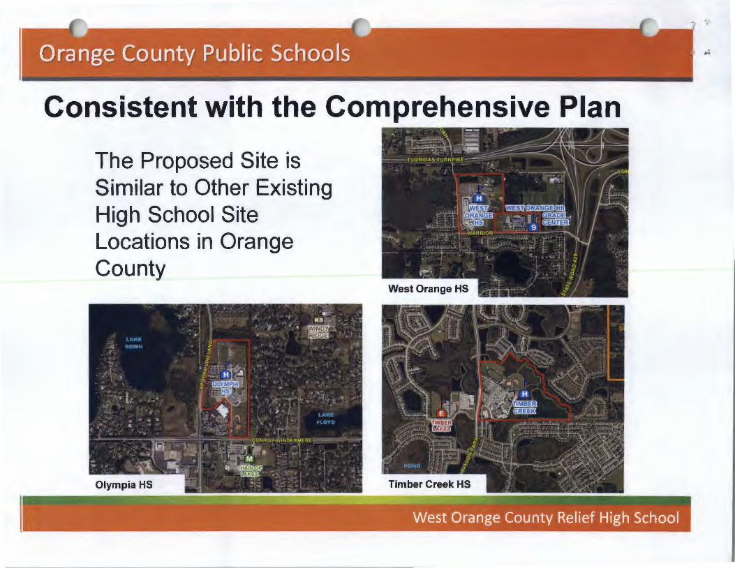
The Proposed Site is Similar to Other Existing High School Site Locations in Orange County
Consistent with the Comprehensive Plan
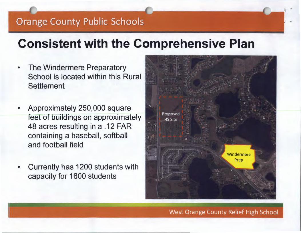
• The Windermere Preparatory School is located within this Rural Settlement
• Approximately 250,000 square feet of buildings on approximately 48 acres resulting in a .12 FAR containing a baseball, softball and football field
• Currently has 1200 students with capacity for 1600 students
Special Exception Criteria 1. Performance Standards _______________________ \
The use shall meet the perforrr-~rrc-~ -Si~~i&~-.chstrict in which the use is permttted. \ ~ ____________ _
2. Land sea pe Buffer '---:::~-:: ________________________ \ Landscape buffer yards shall ~in ac:q:pR.'<l&i~~l(1l.-~<-ll0n . 2 4-5 of the. Orangl'7 County Code. Buffer yard type$ shal, t'(a-k-the-atstnct tn whtch the use ts perrrutted.
3. I --- --- I I. ----- ----- I
Consistent with Corllprehensive ~Jan--------\Sf\EO _____ J The use shall be consistent with the comprehensive pp llcy pl~~-------------
4. Compatible with the Surrounding )s;re~~~--~--------------------\ The ~se sha~l be similar and compatibl~ with the surrq.u~rfq~~\Sf:l i~~I_ Q_. ____ j conststent wtth the pattern of surroundtng developmer~ ~'"'~-----------
\ --------1.----5. Not a Detrimental Intrusion
The use shall not act as a detrimental intrusion into a surrounding area.
6. Consistent with the Majority of Uses in District The use shall be similar in noise, vibration, oust, odor, glare, heat producing and other characteristics that are associated with the majority of uses currently permitted in the zoning district.
as ea: .:u,
.,

Special Exception Criteria
5. Not a Detrimental Intrusion The use shall not act as a detrimental intrusion into a surrounding area.
6. Consistent with the Uses in the District The use shall be similar in noise, vibration, dust, odor, glare, heat producing and other characteristics that are associated with the majority of uses currently permitted in the zoning district.
¥
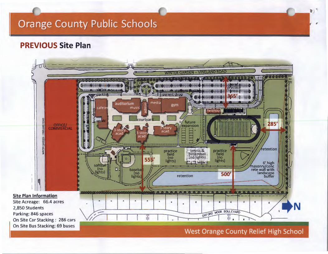
PREVIOUS Site Plan
q I I
Site Plan Information Site Acreage: 66.4 acres 2,850 Students Parking: 846 spaces
'-....../
On Site Car Stacking : 286 cars On Site Bus Stacking: 69 buses
retention

CURRENT Site Plan
0
~ 0 z :3 w z 5 I
z w 0 a: <( \!) a: w !z 3:
Site Plan Information S1te Acreage: 66.4 acres 2,850 Students Parking: 870 spaces On Site Car Stacking : 331 cars On Site Bus Stacking: 69 buses
~ •• I «ur 1'-<J·--·~··· ... ··········•·
<4
N

Not a Detrimental Intrusion
• A High School is a necessity to serve residents in the Community
• All access (traffic and pedestrian) from C.R. 535
• No access through neighborhoods
• Location on high capacity, high volume road as required by County Guidelines
• No basis for argument that it is an intrusion simply because it serves both the Rural Settlement and west Orange County
.......

Not a Detrimental Intrusion Significant buffers from abutting property 3 Story Academic Building
.
6' Person \ \
6' Wall , \
Tree Buffer '· ·-.,, '\
~( Setback 505 Feet )
East Side Setback/Buffer
2 Story Residence
, Tree and Shrub Buffer
~( 230 Feet )~( Setback- 180 Feet )~ West Side Setback/Buffer
2 Story Residence
Gymnasium
....

s::: 0 ·-tn ::s ~
... Q
)
s::: (.) c
-ro
-ns Q
) c
...... 0
·-s:::
c Q
) en
"'C
Q)
ro (.)
L..
L..
E
c c
~
0 ·-
ro "'C
c
::J C
>
·-L
.. ca
c ~
0 ·-"'C
·-
... --
+-'
Q)
L..
en ·-
C>
0
~
C/)
c c
(.)
ns +
-' Q
) ro
0
..c en
..c 0
C>
·-
+-'
..c ...
0 ·-
Q)
(.)
0 _
J
z C
/) C
/)
z

Consistent with the Uses in the District
Olympia H.S.
Developed Residential Areas Surround the Site
Adjacent to Same Rural Settlement
Access to Site from High Capacity High volume Road

u ·-' I ' I ro ~
I-
~
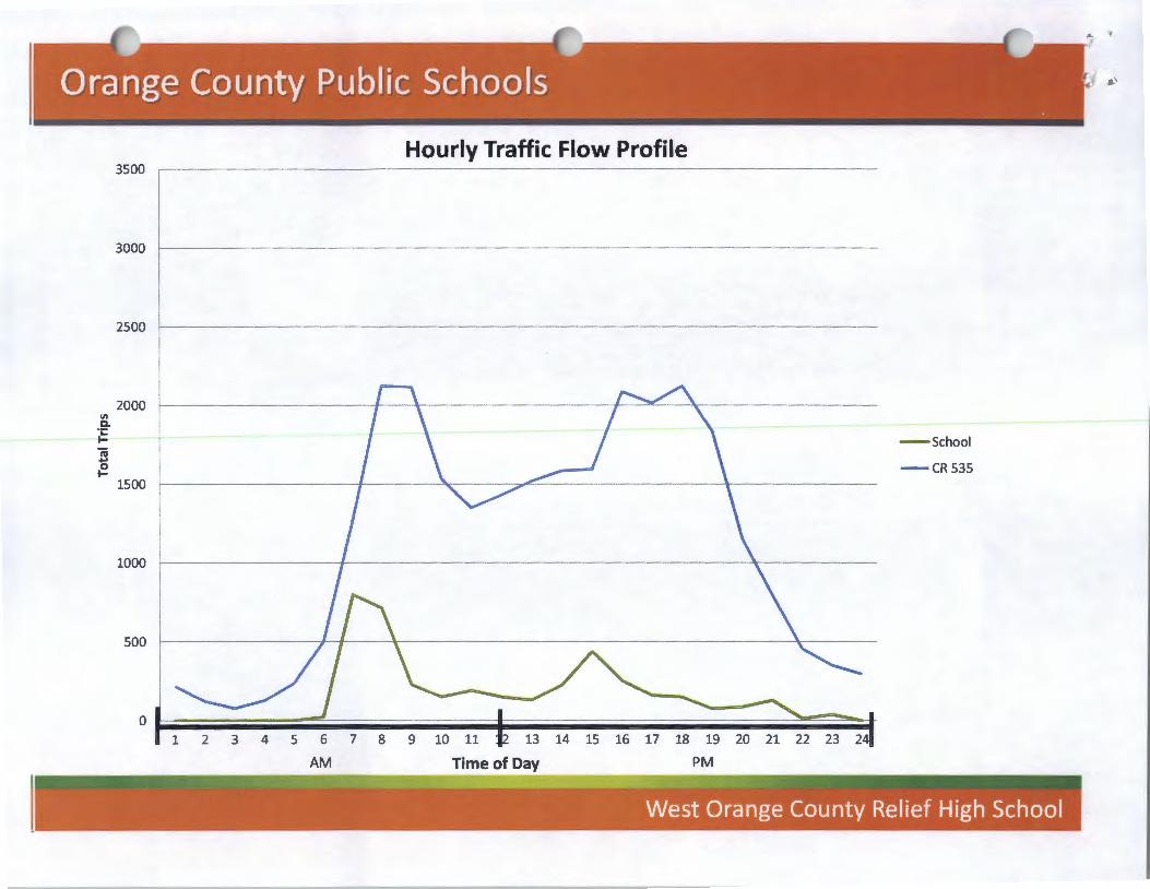
Hourly Traffic Flow Profile 3500
3000
2500
2000 "' Q. ·;: ... t I \ I \ - School 'iii ...
I I \ ~ \ 0 - CR535 ... 1500
1000
500
0~~~~-=~----------~------------------~~~~ 2 3 4 5 7 8 9 10 11 12 13 14 15 16 17 18 19
Time~DQ PM

Special Exception Criteria ------\ 1. Performance Standards _________________ \
The l!se shall meet the perforrrmcet~~~~~§_.distrlct in which the use is permrtted. 1 ______ _
2. Landscape Buffer "--~~::_~:---~---------------------\ Landscape buffer yards shall 9~fin a~<l~~R.-""':"LIOn . 24-5 of the Orange County Code. Buffer yard type~ shall t(g~h-the-arstnct rn whrch the users perro.ttted.
I --- --- I L------ ------ I
3. Consistent with Comprehensive ~Jan--------\Sf\EO ______ J The use shall be consistent with the comprehensive ppl1cy pl~~------------
4. Compatible with the Surrounding A-rea_~:: _____________________ \ The use shall be similar and compatible with the surrQ-lHl:di --rg:_ar.£¥\SfiiQ II_ P-P---~1
consistent with the pattern of surrounding developmer\1i !>~~-·------------ ___ , \ ---------- --------- \ L--- ----- I
5. Not a Detrimental Intrusion ----------------~~f\~0 ____ J The use shall not act as a detrimental intrusion into a '~ urrouri~_W_e~---------
1 --1 ------
6. Consistent with the Majority of Usles in 0~~-trie-t-------\ The use shall be similar in noise, vibration, dust, odor, gLare- -h~~tiE!f!t~g andJ other characteristics that are associated with the major ty ot ~Pd l~~~[tJv--oermitted in the zonina district. \ --

PROJECT NAME
ORANGE COUNTY DEVELOPMENT REVIEW COMMITTEE
APPROVED MEETING MINUTES JUNE 25, 2008
CONSENT AGENDA ITEMS
PROJECTS PREVIOUSLY REVIEWED
APPEAL DISCUSSIONS
THE VILLAGES AT LAKE LA WNE LAND USE PLAN
BONNET CREEK PD/LOT 5/WYNDHAM VACATION OWNERSHIP DP
SOUTHCHASE PDffRACT 32- PRIVATE WATER SKI SCHOOL DP
FRYE CENTER PDIFRYE CENTER PSP
SUMMERCHASE PD/HARVEST BIBLE CHAPEL OF ORLANDO DP
ISLESWORTH FOUR CORNERS PD/SOUTH\VEST CORNER DP
EXHIBIT3
PAGE
i- xvii
xvii
1 -14
15-24
25-34
35-52
53-64
65-71

ORANGE COUNTY DEVELOPMENT REVIEW COMMITTEE
APPROVED MEETING MINUTES JUNE 25, 2008
The Development Review Committee met on Wednesday, June 11, 2008, in the first floor conference room, Public Works Building, 4200 S. John Young Parkway. David Heath called the meeting to order at 8:00a.m. with appropriate staff present. The DRC Minutes of June 11, 2008, were reviewed and approved with a MOTION by John Smogor, seconded by Joe Kunkel TO APPROVE THE DRC MEETING MINUTES OF JUNE II, 2008. MOTION CARRIED.
CONSENT AGENDA ITEMS- DEVELOPMENT PLAN APPROVALS
CAMINO REAL AKA VISTA CENTER PD!VENTURELLA HOTEL & SPA (RECREATION AND ENTRANCE ADDITIONS) DEVELOPMENT PLAN Plan dated Received June 3, 2008 DISTRICT I
LAKE BURDEN NEIGHBORHOOD PD/PARCEL 2 WALGREENS & RETAIL AT LAKE BURDEN DEVELOPMENT PLAN Plan dated Received June 12, 2008 DISTRICT 1
MOTION by John Smogor seconded by Joe Kunkel TO APPROVE THE CONSENT AGENDA ITEMS AND RECOGNIZE THAT THE 15-DAY APPEAL PERJOD FOR THESE APPROVALS SHALL BEGIN JULY 9, 2008. MOTION CARRIED.
PROJECTS PREVIOUSLY REVIEWED
1. SUNTERR.\ RESORTS PD DISTRICT 1
Present for discussion were Randi Fitzgerald and Sc:m Sebaali. Approval is requested of the Agreement Regarding Transfer and Use of Vested Trips for the Sunterra Resorts PD. A prior owner of the Vista Park PD privately assigned a total of U36 vested trips to a prior ov.ner of the Sunterra Resorts PD in conjunction with a sale of property in 1998. The Sunterra Resorts PD Land Use Plan as it was approved in 1999 included the land conveyed out of the Vista Park PD but referenced a transfer of 1,983 vested trips as part of the total 7,000 tnps approved for that PD. The actual assignment document transferring the trips between the two PD' s only assigned 1,136 trips to the Sun terra Resorts PD. Non-substantial changes to both the Vista Park PD and the Sunterra Resorts PD have recently been approved by the Development Review Committee to correct the trip figures previously stated on each of the PD Land Use Plans so that the correct number of trips is now indicated for both of these PD's. The total number of trips in the Sunterra Resorts PD has been reduced by 847, and the trips now referenced on the Amended PD Land Use Plan is 6,153 i\DT rather than 7,000 ADT. The Amended Vista Park PD Land Use Plan reflects a corresponding increase of 84 7 vested trips. The Agreement Regarding Transfer and Use of Vested Trips for the Sunterra Resorts PD is for the purpose of confirming that only 1,136 vested trips have transferred from the Vista Park PD to the Sun terra Resorts PD and confirming that these vested trips may be used on any of the development parcels within the Sun terra Resorts PD. A chronology of the relevant documents pertaining to the transfer of the vested trips is set forth below.
APPROVED MEETING MINUTES JUNE 25, 2008
• September 24, I 996 - The Activity Center Turkey Lake Road Network Agreement was executed with James R. Boyce ("Boyce") as a party. Boyce dedicated right-of-way for the Turkey Lake Road Extension (n/k/a Palm Parkway) and contributed to the construction of the road in exchange for vested development rights.
• September 30, 1997- Boyce's property was approved as the Buena Vista Park PD.
• July 17, 1998 - Boyce sold property to Signature Resorts, Inc. ("Signature"), a portion of which was in the Buena Vista Park PD.
• July 17, 1998 - Boyce and Signature entered into an unrecorded agreement that assigned 1,136 ADT's (the "Vested Trips") to the ortion of the ro e was ongma y part o the Buena Vista Park PD. They also agreed to process a lot split so that Signature could develop the property separately from the Buena Vista Park PD.
• July 20, 1998 - Signature Resorts changed its name to Sunterra Corporation ("Sunterra").
• December 1, 1999 - Signature's property (which included the property purchased from Boyce together with additional land) was approved as the Sunterra Resorts Planned Development (the "Sunterra Resorts PD").
• May 21, 2000 - Sunterra filed for Chapter 11 bankruptcy and entered into a reorganization plan. The plan provided for the reorganization, but not the discharge, of Sunterra's debts.
• Present- Diamond Resorts Cypress Pointe ill Development, LLC is the successor in interest to Sun terra and wants to spread the 1, 13 6 Vested Trips received across the entire Sun terra Resorts PD.
MOTION by John Smogor, seconded by Joe Kunkel TO APPROVE A NON-SUBSTA/VTIAL CHA..lvGE TO THE PRE~TOUSLYAPPROVED PD LAND USE PLAN TO CORRECT THE TRIP FIGURES PRE~OUSLY STATED AND REDUCE BY 847; THE TRIPS NOW REFERENCED ON THE AMENDED PD LA.lVD USE PLAN IS 6,153 ADT RATHER THAN 7,000 ADT.
ADDITIONALLY, ST.4FF RECOMMENDS APPROVAL OF THE AGREEMENT REGARDING TRANSFER AND USE OF VESTED TRIPS FOR THE SUNTERRA RESORTS PD subject to approval of a revised plan to reflect the correct trip figures prior to placing this request on the Growth Management's Consent Agenda. MOTION CARRIED.
2. \VEST ORANGE RELIEF HIGH SCHOOL LAND USE PLA...l\1 DISTRICT I
Present for discussion Alex Busto, Chris Wilson and Drew Decandis. This request was previously reviewed and continued during the DRC meeting held on July 11, 2007, for a neighborhood meeting and resolution of right-of-way Issues. During today' s review, staff acknowledged that Section 3 8-1751 (a) of the Orange County Code identifies that high schools are permitted within in the rural settlement. In terms of the Right-of-Way Agreement, the County and Orange County Public Schools (OCPS) have agreed that OCPS will bifurcate the Right-of-Way Agreement from the rezoning process. The parties have found it necessary to deal with this issue outside of the DRC, as the County requires the property immediately to proceed with this road-widening project. The applicant will work with the Real Estate Management and Public Works Department as well as the County Attorneys Office to finalize the Real Estate Purchase Agreement and proceed v.ith the
ii

APPROVED MEETING MINUTES JUNE 25, 2008
transfer of title. During review, EPD staff requested copies of the Water Management District permits.
MOTION by Bob Windom, seconded by Joe Kunkel TO RECOMMEND APPROVAL OF THE PD LAND USE PLAN subject to Conditions of Approval and subject to approval of the revised plan dated June 20, 2008, submitted as backup for today's meeting prior to scheduling a public hearing with the P &ZC.
1. Development shall conform to the West Orange Relief High School PD Land Use Plan dated "Received June 20, 2007", and shall comply with all applicable federal, state and county laws, ordinances and regulations, except to the extent that any applicable county laws, ordinances or regulations are expressly waived or modified by an o these con t wns. ccor zng y, t e may be developed in accordance with the uses, densities and intensities described in such Land Use Plan, subject to those uses, densities and intensities conforming with the restrictions and requirements found in the conditions of approval and complying with all applicable federal, state and county laws, ordinance and regulations, except to the extent that any applicable county laws, ordinances or regulations are expressly waived or modified by any of these conditions. If the development is unable to achieve or obtain desired uses, densities or intensities, the County is not under any obligation to grant any waivers or modifications to enable the developer to achieve or obtain those desired uses, densities or intensities. In the event of a conflict or inconsistency between a condition of approval of this zoning and the land use plan dated "Received June 20, 2007" the condition of approval shall control to the extent of such conflict or inconsistency.
2. This project shall comply with, adhere to, and not deviate from or otherwise conflict with any verbal or written promise or representation made by the applicant (or authorized agent) to the Board of County Commissioners at the public hearing where this development was approved, where such promise or representation, whether oral or written, was relied upon by the Board in approving the development, could have reasonably been expected to have been relied upon by the Board in approving the development, or could have reasonably induced or othem•ise influenced the Board to approve the development. For purposes of this condition, a 'promise' or 'representation' shall be deemed to have been made to the Board by the applicant (or authorized agent) if it was expressly made to the Board at a public hearing where the development was considered or approved.
3. The Developer shall obtain water, wastewater and reclaimed water senice from Orange County Utilities.
4. Outdoor storage and display shall be prohibited.
5. Billboards and pole signs shall be prohibited. Ground and fascia signs shall comply with Chapter 31.5.
6. Sports lighting of the stadium shall be prohibited.
7. A 6-foot masonry wall shall be required along the east and north property lines except along the consen>ation area.
MOTION CARRIED.
iii
APPROVED MEETING MINUTES JUNE 25, 2008
3.
4.
EMERGI CARE MEDICAL CENTER LAND USE PLAN DISTRICT 1
Present for discussion were Mark Maciel and Shaman Foradi. This request was previously reviewed and continued during the DRC meeting held on May 14, 2008, for a neighborhood meeting on June 16, 2008. Consistent with Section 38-1372(c)(l)(b), if redeveloped, this parcel shall be redeveloped only for office use at the greater of0.14 floor area ration (FAR) or the intensity existing on October 29, 1996, based upon trip generation and to appear and function only as a single, unified and integrated development with the other nonresidential development in the southwest quadrant. The developer proposes to construct a 14,000 square foot medical office and requests a waiver from Section 38-1372(c) (1) b of the Orange County Code is granted to increase the FAR from .14 to .28. Following a brief discussion, it was the consensus of the DRC to continue review for a traffic study and for the applicant to proceed through the concurrency review process. The County Attorneys Office will review the request regarding the possible waiver from County code or a change in the Ordinance. Staff will further review the request upon resolution of threshold issues. No action taken.
STATE FARM BUILDING LAND USE PLAN DISTRICT 5
Present for discussion were Don Bieger and Rocco English. This request was previously re-viewed and continued during the DRC meeting held on August 22, 2007, for resolution of traffic concurrency issues. Since that time, the applicant bas obtained a Capacity Encumbrance Letter #07-197, which will expire on October 27, 2008. This request proposes to rezone property (R-2 and RIA) to Planned Development for office uses. The applicant acknowledged that the development has been modified slightly, reduced by 10,000 square feet for a total of 30,000 square feet.
MOTION by John Smogor, seconded by Andres Salcedo TO RECOMMEND APPROVAL OF THE PD LAND USE PLAN subject to Conditions of Approval and subject to approval of the revised plan dated June 20, 2008, prior to requesting a public hearing with the P & ZC
I. Development shall conform to the State Farm PD Land Use Plan dated "Received," and shall comply with all applicable federal, state and county taws, ordinances and regulations, except to the extent that any applicable county laws, ordinances or regulations are expressly waived or modified by any of these conditions. Accordingly, the PD may be developed in accordance with the uses, densities and intensities described in such Land Use Plan, subject to those uses, densities and intensities conforming with the restrictions and requirements found in the conditions of approval and complying with all applicablefederal, state and county laws, ordinance and regulations, except to the extent that any applicable county laws, ordinances or regulations are expressly waived or modified by any of these conditions. If the development is unable to achieve or obtain desired uses, densities or intensities, the County is not under any obligation to grant any waivers or modifications to enable the developer to achieve or obtain those desired uses, densities or intensities. In the event of a conflict or inconsistency between a condition of approval of this zoning and the land use plan dated "Received *, " the condition of approval shall control to the extent of such conflict or inconsistency.
*DATE OF APPROVED PLAN TO BE DETERMDVED
iv


Interoffice Memorandum
DATE:
TO:
FROM:
THROUGH:
SUBJECT:
October 3, 2012
Mayor Teresa Jacobs -AND-Board of County Commissioners (BCC)
Susan E. Caswell, AICP, Manag~ Planning Division
J V W . P E D' ~ ~' on . etss, .. , 1rector :'. . Community, Environmental a~jd Development Services Department
Rural Settlement/Exurban Development Analysis
When Orange County adopted the Comprehensive Policy Plan in 1991, Rural Settlements were formally designated as a way to recognize existing rural communities. This Future Land Use category includes a broad range of communities with unique characteristics. The Rural Settlement policies have been amended a number of times to address issues that have arisen over the years concerning Rural Settlements and adjacent properties.
As part of the 2010-2030 Comprehensive Plan update, Policy FLU6.2.1 was amended to restrict the creation or expansion of Rural Settlements. The rationale for continuing to allow the creation or expansion of Rural Settlements no longer appeared justified. This was determined based on the amount of existing vacant land within Rural Settlements, commitments to Horizon West and Innovation Way, and the County's policy direction toward infil! ~nd redevelopment. However, this policy also directed staff to complete a study that evaluated the viability and impacts of expanding Rural Settlements and to provide additional information and recommendations.
The study includes an analysis of the following factors:
• Development capacity and trends in the County's 22 Rural Settlements to address the demand or "need" side of the expansion question;
• The impact of expansion on the character of existing Rural Settlements;
• The sustainability of expansion relative to the cost of providing public services; and
• The advisability of further Rural Settlement expansions, given the increasing frequency of conflicts between urban and rural land uses.
\.
Mayor Teresa Jacobs and Board of County Commissioners Re: Rural Settlement/Exurban Development Analysis October 3, 2012 Page 2
The attached study concludes that there is adequate land in existing Rural Settlements to provide for a rural lifestyle; recent Rural Settlement creation/expansions have not generally maintained the character of historic Rural Settlements; providing services to very-low density development - particularly in locations far from the urban core - has not been shown to be cost-efficient; and because of the urban nature of the County and the expansion of its cities, conflicts between Rural Settlements and development proposals on nearby land are increasing.
Because there appears to be little benefit to allowing continued expansion of these areas, staff recommends that the language in Policy FLU6.2.1 prohibiting Rural Settlement creation or expansion should be retained. As required by the policy, this issue will be reevaluated as part of the next Evaluation and Appraisal Report, scheduled for 2016.
Staff will share the results of this study with the Rural Settlement Alliance, a group of Rural Settlement residents who meet regularly to discuss Rural Settlement-related issues. The group's next meeting is scheduled for October 10, 2012.
If you have any questions or comments, please contact me at 407-836-5884 or by email at [email protected].
SEC/bdd
c: Christopher R. Testerman, AICP, Assistant County Administrator Joel Prinsell, Deputy County Attorney Vivien Monaco, Assistant County Attorney Read file
Attachment
Acknowledgments
Authors
Brandy Driggers, Principal Planner, Planning Division Wayne Bennett, Chief Planner, Planning Division
Editor
Susan Caswell, AICP, Manager, Planning Division
October 3, 2012
'

Rural Settlement/Exurban Development Analysis
Purpose
In 2009, Orange County updated the Comprehensive Plan based upon the 2006 Evaluation and
Appraisal Report. As part of the 2010-2030 Comprehensive Plan update, Policy FLU6.2.1 -
which addresses Rural Settlements - was amended to prohibit new Rural Settlements or
expansions to existing Rural Settlements, stating that this strategy would be evaluated as part of
the next Evaluation and Appraisal Report.
The basis for this policy change was:
• Rural Settlements were recognized in the 1991 Plan to identify communities already in
existence at that time;
• Over the years Rural Settlement boundaries have expanded, while simultaneously the
County was becoming increasingly urban. These two factors have caused increasing conflict
between urban development and Rural Settlements; and
• The overarching strategy of the 2009 Comprehensive Plan update was to focus
development within the County's Urban Service Area (USA).
During the Plan update adoption public hearing, language was added to Policy FLU6.2.1
directing staff to complete a study to determine the appropriateness of allowing expansions of
existing Rural Settlements. In completing this analysis, staff addressed a number of factors:
1. Development capacity and development trends in the County's twenty-two rural
settlements to address the demand or "need" side of the expansion question;
2. The sustainability of expansion relative to the cost of providing public services;
3. The impact of expansion on the viability and contextual elements (historic, cultural, rural
character) of existing Rural Settlements; and
4. The advisability of further Rural Settlement expansions in a progressively more urban
county, given the increasing frequency of conflicts at the urban/rural interface.
Staff Recommendation
This analysis led to several findings, which are summarized in the following sections of this
report. These findings support the following staff recommendation:
A need to expand existing Rural Settlements or to accommodate urban-type development
within the Rural Service Area is not justified by the findings. The Comprehensive Plan requires
that Policy FLU6.2.1 be reevaluated as part of the next Evaluation and Appraisal Report (EAR)
in 2016. (While the policy states that the next EAR is due in 2014, the EAR schedule was
extended for all local governments in 2011, so the County's next EAR is due in 2016.}
Planning Division I Orange County

Rural Settlement/Exurban Development Analysis
Background
Rural Settlements were formally addressed in the Comprehensive Plan to recognize existing
rural communities. The Future Land Use category of Rural Settlement encompasses a wide
range of communities with unique characteristics. Since 1991, Rural Settlement planning
policies have been adopted and amended in the Future Land Use Element to provide a
framework and to address Rural Settlement issues that have arisen over time.
Twenty years later, the rationale for continuing to allow creation of new Rural Settlements or
expansion of existing Rural Settlements no longer appears justified, based on the existing vacant
land within Rural Settlements, the County's Committed Land Use Inventory, commitments to
Horizon West and Innovation Way, and the County's policy direction toward infill development
and redevelopment. As part of the 2010-2030 Comprehensive Plan update, a formal restriction
on Rural Settlement creation and expansion was adopted in Policy FLU6.2.1; however, the
policy language was amended by the Board of County Commissioners at adoption to include a
directive to staff to evaluate the viability and impacts of Rural Settlement expansions and return
to the BCC with additional information and recommendations.
Logond
CJc.)t•rJtr..:u.rJboy
CJ UftHn :.er.k'.t" M~:~ !IJ~l,i
History of Rural Settlements
Orange County has recognized existing historic and rural communities since its 1980 Growth
Management Policy {the precursor to the Comprehensive Plan). The 1980 Comprehensive Plan
Planning Division I Orange County
Rural Settlement/Exurban Development Analysis
was adopted to meet the requirements of the 1975 Local Government Comprehensive Planning
Act, which required that all local governments adopt comprehensive plans and that
development conform to those plans. This 1980 Growth Management Policy (GMP) defined
Rural Settlements as existing communities within the Rural Service Area that had become a
focal point of rural activity. This included Tangerine, Plymouth, Zellwood, Gotha, and Christmas,
and the Plan also referenced (but did not specifically name), "other unincorporated places listed
in the 1970 decennial census."
The Future Land Use Element addressed Rural Settlements in a section called "Location and
Compatibility." Policy 3.1.6 stated, "For areas defined as Rural Settlements in the Development
Framework Element of the GMP low and low-medium density residential uses may be
permitted where these Rural Settlements coincide with Community Development Target Areas.
Furthermore, these permitted low and low-medium density residential areas should provide for
the needs of low and moderate income families dependent on a rural economy, and should
have adequate services, and be compatible with surrounding land uses." The policy addressed
densities in Rural Settlements only where they coincided with target areas (areas with high
concentrations of low income households), and then it specified that such areas should provide
for families "dependent on a rural economy." It also specified that adequate services should be
available.
In the 1985 GMP, the policy language from the 1980 GMP was largely carried forward. Rural
Settlements were described as " ... urban-like settlements" that existed prior to the Growth
Management Policy in 1980. Bithlo was added to the list of Rural Settlements. (The table on the
following page shows the designation of Rural Settlements over time, starting with the 1980
GMP.)
Florida's 1985 Growth Management Act strengthened the planning requirements of the 1975
Act, adding a requirement that the state would determine compliance of local plans. Detailed
plan requirements, which were outlined in administrative rules, included policy language
intended to curb urban sprawl.
In 1991, the County adopted its Comprehensive Policy Plan (CPP), consistent with the 1985
Growth Management Act. Issues being addressed in the County at the time included strong
development pressure in the Rural Service Area, particularly in areas adjacent to municipalities.
In the background analysis of the 1991 CPP, the County recognized that " ... to make the Urban
Service Area an effective mechanism for controlling growth and optimizing governmental
expenditures, the type and intensity of development in the Rural Service Area must be
restricted. "The CPP stated that ideally, urban-scale development would occur within the USA,
but recognized that the ideal model did not exist in Orange County. The CPP stated that parts of
the Rural Service Area were characterized by "areas of one-acre lots and urban uses in Rural
Settlements and Growth Centers."
Planning Division I Orange County
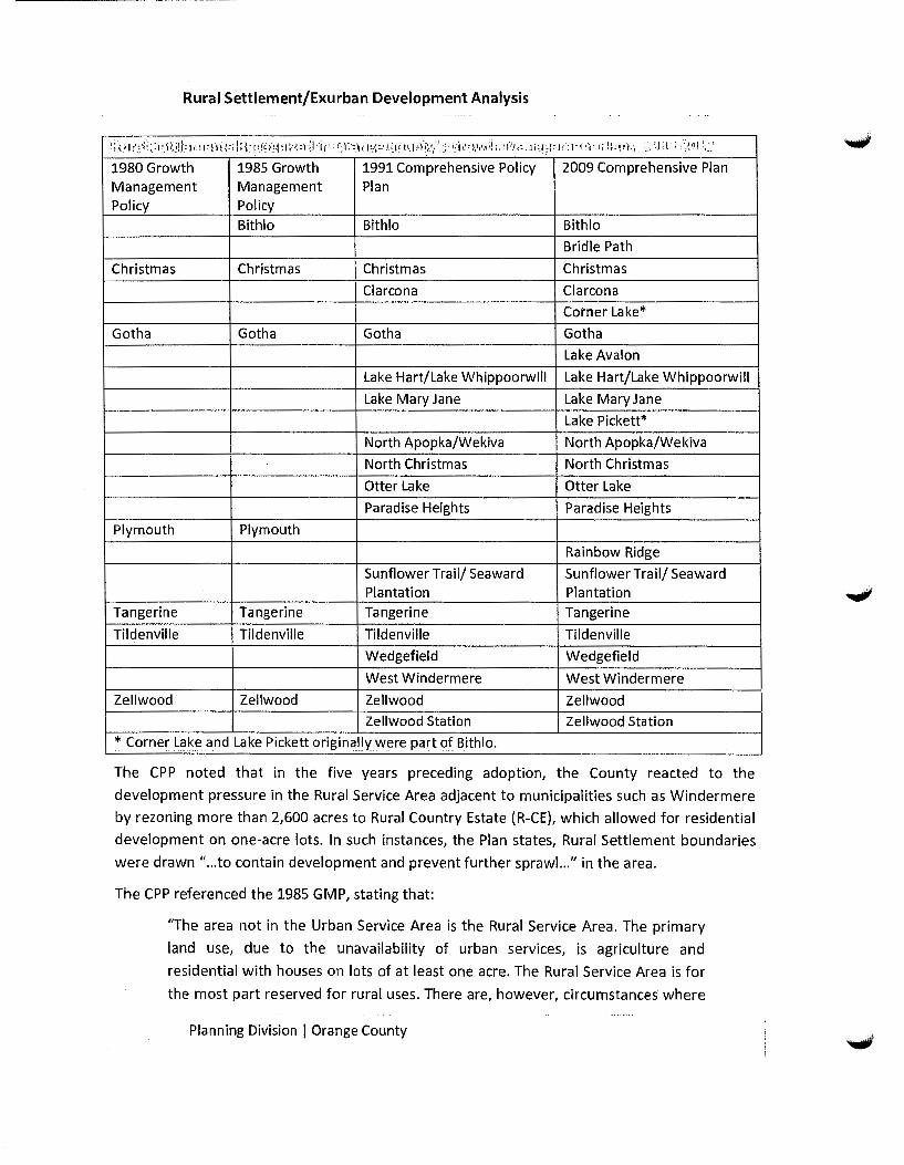
Rural Settlement/Exurban Development Analysis
I~) ~.I ri _:. ~ I .. :- '1 ~: i ;~ !! _1_:. 1 ·r ~ 1 :.}·n i ;: .. ; \ I : { ~ ·r q ~ f~1-~ 1 I· ~ ~ 1 ~ i f i fl 1 : ~~: .l >:_ \ .: 1 ~-~ i., J. c·\ c· J t~ l·.l )-!:~ •/ ~- ·.i '-.~-j t! r P ~' .~ ij 1 . ~ 1 ':'.1 I; ~ .1 i :_I_ ; f :. J r -~ 1 - f 'I 1 ;· i : : ! r.1: ·• _ : __ :; ~ J; {: l : -~ ~ ~ }; I,-~\
1980 Growth 1985 Growth 1991 Comprehensive Policy 2009 Comprehensive Plan Management Management Plan Policy Policy
Bithlo Bithlo Bithlo
Bridle Path
Christmas Christmas Christmas Christmas
Clarcona Clarcona
Corner Lake*
Gotha Gotha Gotha Gotha
Lake Avalon
Lake Hart/Lake Whippoorwill Lake Hart/Lake Whippoorwill
Lake Mary Jane Lake Mary Jane
Lake Pickett*
North Apopka/Wekiva North Apopka/Wekiva
North Christmas North Christmas
Otter Lake Otter Lake
Paradise Heights Paradise Heights
Plymouth Plymouth
Rainbow Ridge
Sunflower Trail/ Seaward Sunflower Trail/ Seaward Plantation Plantation
Tangerine Tangerine Tangerine Tangerine
Til denville Tildenville Til denville Tildenville
Wedgefield Wedgefield
West Windermere West Windermere
Zellwood Zellwood Zellwood Zellwood Zellwood Station Zellwood Station
* Corner Lake and Lake Pickett originallywere part ()f Bithlo.
The CPP noted that in the five years preceding adoption, the County reacted to the
development pressure in the Rural Service Area adjacent to municipalities such as Windermere
by rezoning more than 2,600 acres to Rural Country Estate (R-CE), which allowed for residential
development on one-acre lots. In such instances, the Plan states, Rural Settlement boundaries
were drawn " ... to contain development and prevent further sprawl. .. " in the area.
The CPP referenced the 1985 GMP, stating that:
11The area not in the Urban Service Area is the Rural Service Area. The primary
land use, due to the unavailability of urban services, is agriculture and
residential with houses on lots of at least one acre. The Rural Service Area is for
the most part reserved for rural uses. There are, however, circumstances where
Planning Division I Orange County

Rural Settlement/Exurban Development Analysis
urban type uses exist in the Rural Service Area. Currently the [1985] Growth
Management Policy identifies three circumstances: Rural Settlements, Growth
Centers, and uses which by their nature require isolation and a high degree of
security for national defense purposes."
The CPP goes on to state that: 'The Rural Settlements identified in the 1985 comprehensive
plan are Tangerine, Plymouth, Zellwood, Gotha, Christmas, Bithlo, Paradise Heights, and
Wedgefield. These urban-like settlements, some of historic significance, existed prior to the
establishment of the Growth Management Policy in 1980. The 1985 Growth Management Policy
would not allow such uses in these locations." (Note: Wedgefield was not identified in the 1985
Plan when it originally was adopted, but it was added between 1985 and 1991.)
In the transmittal version of Orange County's 1991 CPP, 17 communities were listed. The
transmitted Plan stated that expansion of these settlements should not be supported unless
they are found to be in the public interest, such as sites for affordable housing. The transmittal
version of the Plan also introduced a new concept called Rural Villages.
This version of the 1991 CPP was transmitted to the Florida Department of Community Affairs
(DCA). DCA objected to the County's proposed Rural Village concept, based on concerns about
urban sprawl. Specifically, DCA's objection stated that the language "does not discourage urban
sprawl or ensure the separation of rural and urban land" because the policy allowed an urban
density of one dwelling unit per acre in the Rural Service Area (RSA). DCA also objected that the
policy was vague and self-amending, due to language that outlined the process of platting and
developing property. The definition of urban sprawl in Rule 9J-5, Florida Administrative Code
included, among other factors: low-intensity, low-density, and/or single-use development;
premature or poorly planned conversion of rural land to other uses; a development pattern that
fails to adequately protect adjacent agricultural areas; development that fails to maximize use
of existing public facilities and services and causes inefficient use of facilities and service
investments; or development that discourages or inhibits infill development or redevelopment.
Orange County proposed a number of new policies to address DCA's objections, including
requiring:
1. Small area studies;
2. Rural Village zoning;
3. Proposals over 100 acres be processed as Planned Developments;
4. Expansions to be contiguous;
5. New villages shall not create enclaves; and
6. Rural settlements not be expanded except for affordable housing.
Eventually, the County took their response a step further, blending the Rural Settlement
concept and criteria with the former Rural Village concept, even though the various approaches
Planning Division I Orange County
Rural Settlement/Exurban Development Analysis
were intended to address unique situations in the RSA (Rural Settlements being existing rural
communities and Rural Villages being areas of R-CE zoning). The new "blended" Rural
Settlement concept established a minimum size of 20 acres for new Rural Settlements. The
concept further required that availability of water and wastewater services would not be used
as a basis for expansion. The policies allowed limited office and commercial uses, and policies
were specific as to the criteria under which Rural Settlement expansion could occur. This
approach was the one adopted by the County and accepted by DCA.
It is notable that the original Rural Settlement policies in the 1991 CPP were located under Goal
2, which stated, "The County shall institute effective planning controls to preserve (active)
agricultural land in the Rural Service Area." In other words, in addition to recognizing existing
historic rural communities, Rural Settlement policies served the purpose of containing urban
sprawl to limit its encroachment into the rural area. Objective 2.1 states, in part, that, "Rural
Settlements shall be implemented to allow residential uses in the Rural Service Area while
precluding development in active agricultural areas. The creation of Rural Settlements
recognizes the goal of preserving agricultural and rural uses in Orange County's Rural Service
Area. Due to the urban uses created by numerous municipal annexations in the Rural Service
Area, Orange County is constrained to preserve these rural areas by creating Rural
Settlements ... " (Emphasis added.)
In 1991, when the CPP was amended to meet the requirements of the 1985 Growth
Management Act, language was added to Future Land Use Policy 2.1.1 as follows: "Orange
County shall designate the following Rural Settlements on the Future Land Use Map to meet the
demand for a rural lifestyle."
Over the next 15 years, five new Rural Settlements were added to the original list of 17:
Rainbow Ridge, Bridle Path, Lake Avalon, Corner Lake, and Lake Pickett. Rainbow Ridge and
Bridle Path are greenfield Rural Settlements, each owned by a single property owner. (Bridle
Path and a portion of Rainbow Ridge are located within the area covered by the Wekiva
Interchange Land Use Plan.) Corner Lake and Lake Pickett are grandfathered subdivisions,
served by central water and wastewater, in rural east Orange County. Both Rural Settlements,
originally part of the Bithlo Rural Settlement, were split off from Bithlo in 2005. Lake Avalon,
designated in 2004, originally was part of the Horizon West Planning Area but opted to become
a Rural Settlement instead.
In summary, Rural Settlements in Orange County comprise a wide mix of community types.
There are a number of historic communities, including some built around agricultural
operations (Tangerine, Tildenville, and Zellwood) as well as other historic settlements (Bithlo,
Christmas, Clarcona, and Gotha). The majority of the County's Rural Settlements are
developments of various types- large lot subdivisions, mobile home/golf course communities,
and affordable housing - in existence at the time of 1991 Plan adoption (Lake Hart/Lake
Planning Division I Orange County

Rural Settlement/Exurban Development Analysis
Whippoorwill, lake Mary Jane, North Apopka/Wekiva, North Christmas, Otter lake, Paradise
Heights, Sunflower Trail, Wedgefield, West Windermere, Zellwood Station). New Rural
Settlements since 1991 were created by splitting off from existing Rural Settlements, in the case
of Corner lake and lake Pickett (which split off from Bithlo); or splitting off from Horizon West,
in the case of lake Avalon. Additionally, two Rural Settlements- Rainbow Ridge and Bridle Path
- were created in response to annexation pressure from Apopka. These two Rural Settlements
illustrate the use of the Rural Settlement designation as a mechanism to increase development
entitlements in the Rural Service Area. The designation has been used this way much more
extensively in the multitude of Rural Settlement expansions that have occurred since 1991.
County growth management plans have addressed Rural Settlements in various ways over the
past 30 years. Reasons for designating Rural Settlements have included protecting existing
communities (especially historic communities), containing development to prevent further
urban sprawl, and preserving agricultural land. In 1991, language was added in the CPP stating
that Rural Settlements provide for a rural lifestyle. This language, which was added largely to
address concerns about urban sprawl, was removed from the Comprehensive Plan in 2009.
Findings
As mentioned previously, a number of issues have been addressed in this analysis relative to
Rural Settlements, including land supply and development trends in the Rural Settlements (to
assess the need for Rural Settlement expansions); the impact of expansion on the character of
existing Rural Settlements; the sustainability of expansion relative to the cost of providing public
services; and the advisability of further Rural Settlement expansions in an progressively more
urban county.
1. Need for Rural Settlement expansion
The issue of market "need" for Rural Settlement expansion has two components. The first is
the availability of vacant land in Rural Settlements, while the second relates to the reason
for the need. A market need for e>(pansion has not been demonstrated for Rural
Settlements, as measured by the supply of available land for either residential or non
residential development or by the pace of development (expressed as reduction in supply of
available vacant land). Nearly 4,500 acres of vacant land are available for development in
Rural Settlements, enough to satisfy at least an additional 20 years of market demand based
on the apparent demand during the 2000-2010 period. During the 2000-2010 period, 3,069
acres were added to Rural Settlements or designated new Rural Settlements. The number of
vacant acres increased by 1,516, and the vacancy rate in Rural Settlements increased from
11% to 15%. Overall, development in Rural Settlements that occurred between 2000 and
2010 (1,554 acres) could have been accommodated in the existing Rural Settlements (which
had 2,979 vacant acres in 2000), with no expansion necessary.
Planning Division I Orange County

Rural Settlement/Exurban Development Analysis
!L.,l n 1' [l;.\:•:~1 i I;) ~illli:,'l •j ,.II:·\!· 1·': i! .. ·,~.:i:t;!i_Jrn.t l:l·,;:-r '.{O!GI~, •: • · ·~ c l' i )
land (acres) 2000 2010 Change
Total Land 26,060 29,129 3,069
Developed Land 23,081 24,635 1,554
Vacant Land 2,979 4A95 1,516
Vacancy Rate 11% 15%
Source: Property Appraiser Parcel data, property use codes, 2000 and 2010.
The second issue relates to the reason for the 11need." The way Rural Settlements have been
addressed in County growth management plans has changed over the years, as described in
the History section of this document. In 1980 and 1985, the GMP stated that Rural
Settlements should provide for, "the needs of low and moderate income families dependent
on a rural economy." A number of the County's Rural Settlements- such as Tangerine and
Zellwood- were built for just this purpose, but most Rural Settlements were not, and even I
Tangerine and Zellwood no longer serve this purpose.
The language added to the 1991 CPP that referred to meeting "the demand for a rural
lifestyle" was added largely to address concerns about urban sprawl. This language
addressed the majority of the County's Rural Settlements, which were existing
developments or expanses of large-lot rezonings that were approved in reaction to
annexation pressure. The CPP stated that these Rural Settlements were designated " ... to
contain development and prevent further sprawl ... " in the area. The language referring to
demand for a rural lifestyle was removed in 2009 as part of the County's focus on infill
development and redevelopment. The question of whether the County should provide
additional opportunities for a "rural lifestyle" should be based on the impact of this
development pattern on the County. This is addressed further in the findings below.
2. Impact of expansion on the character of existing Rural Settlements
Newly created tract housing developments, when introduced into small rural communities,
can change an area from a rural and/or village character to more suburban, semi-rural or
exurban. Development in and around Rural Settlements, both before and after adoption of
the 1991 CPP, illustrates this change in character. The map below shows the Tangerine Rural
Settlement, which traces its roots back to 1875. The older part of the community (outlined
in red) is located near the post office in a section of the Rural Settlement with a gridded,
well-connected street pattern, while newer parts of the Rural Settlement (outlined in blue)
- many of which have been developed after the year 2000 - are in subdivisions that are
disconnected from the rest of the Rural Settlement. These subdivisions often have one road
in and out, with the subdivision entrances oriented not to the Rural Settlement itself, but to
major roads bordering the Rural Settlement. Thus, they are cut off from the older parts of
the Rural Settlement. While this type of development does not necessarily have a negative
Planning Division I Orange County
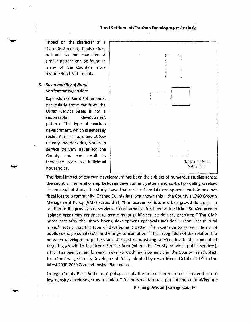
Rural Settlement/Exurban Development Analysis
impact on the character of a
Rural Settlement, it also does
not add to that character. A
similar pattern can be found in
many of the County's more
historic Rural Settlements.
3. Sustainability of Rural Settlement expansions
Expansion of Rural Settlements,
particularly those far from the
Urban Service Area, is not a
sustainable development
pattern. This type of exurban
development, which is generally
residential in nature and at low
or very low densities, results in
service delivery issues for the
County and can result in
increased costs for individual
households.
.D
T<Jngcrinc Rural Sctllcmcnl
The fiscal impact of exurban development has been the subject of numerous studies across
the country. The relationship between development pattern and cost of providing services
is complex, but study after study shows that rural residential development tends to be a net
fiscal loss to a community. Orange County has long known this- the County's 1980 Growth
Management Policy (GMP) states that, "the location of future urban growth is crucial in
relation to the provision of services. Future urbanization beyond the Urban Service Area in
isolated areas may continue to create major public service delivery problems." The GMP
noted that after the Disney boom, development approvals included "urban uses in rural
areas," noting that this type of development pattern "is expensive to serve in terms of
public costs, personal costs, and energy consumption." This recognition of the relationship
between development pattern and the cost of providing services led to the concept of
targeting growth to the Urban Service Area (where the County provides public services),
which has been carried forward in every growth management plan the County has adopted,
from the Orange County Development Policy adopted by resolution in October 1972 to the
latest 2010-2030 Comprehensive Plan update.
Orange County Rural Settlement policy accepts the net-cost premise of a limited form of
low-density development as a trade-off for preservation of a part of the cultural/historic
Planning Division I Orange County
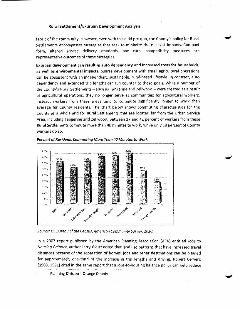
Rural Settlement/Exurban Development Analysis
fabric of the community. However, even with this quid pro quo, the County's policy for Rural
Settlements encompasses strategies that seek to minimize the net-cost impacts. Compact
form, altered service delivery standards, and rural compatibility measures are
representative outcomes of these strategies.
Exurban development can result in auto dependency and increased costs for households,
as well as environmental impacts. Sparse development with small agricultural operations
can be consistent with an independent, sustainable, rural-based lifestyle. In contrast, auto
dependency and extended trip lengths can run counter to these goals. While a number of
the County's Rural Settlements- such as Tangerine and Zellwood- were created as a result
of agricultural operations, they no longer serve as communities for agricultural workers.
Instead, workers from these areas tend to commute significantly longer to work than
average for County residents. The chart below shows commuting characteristics for the
County as a whole and for Rural Settlements that are located far from the Urban Service
Area, including Tangerine and Zellwood. Between 27 and 42 percent of workers from these
Rural Settlements commute more than 40 minutes to work, while only 18 percent of County
workers do so.
Percent of Residents Commuting More Than 40 Minutes to Work
/---------------------40'!{. - .-
35t;{. - /
30%-
25% -
20')(. -
1s~x. -,
10%
5'" I 0: J
42%
Source: US Bureau of the Census, American-Community Survey, 2010.
In a 2007 report published by the American Planning Association {APA) entitled Jobs to
Housing Balance, author Jerry Weitz noted that land use patterns that have increased travel
distances because of the separation of homes, jobs and other destinations can be blamed
for approximately one-third of the increase in trip lengths and driving. Robert Cervero
{1989, 1991) cited in the same report that a jobs-to-housing balance policy can help reduce
Planning Division I Orange County

Rural Settlement/Exurban Development Analysis
sprawl and lower energy consumption as well as reduce vehicular miles traveled (VMTs) and
other traffic impacts. In the article Impact of Urban Form on US Residential Energy Use (Reid
Ewing, 2008L the author notes that changes in energy consumption can be achieved
through development patterns, so a goal of reducing greenhouse gases would be a basis to
encourage compact development. Mobility and jobs-housing balance strategies have been
incorporated into the County's 2030 Comprehensive Plan update to address these issues.
Providing infrastructure and services to exurban/rural areas is not cost-effective. The Penn
Design Central Florida: Our Region Report found the infrastructure costs of the Trend
Growth Model for roads, utilities and other services on newly developed land to be $90,000
per acre, as opposed to $20,000 per acre in existing urban areas. In the report Economic and
Fiscal Impacts of Alternative Land Use Patterns, Robert Burchell of Rutgers University found
that roads cost 25% less, utilities 15% less, and schools 5% less when developed under
compact land use patterns as opposed to being extended in newly developed land.
Urban areas create resource efficiencies that are not possible with single-use residential
areas; conversely, exurban development preempts urban development and the critical mass
needed to efficiently use existing infrastructure. There are long-term fiscal costs for
conversion of land into low-density, single-family use only. Although residential
development may appear as a revenue generator, over the long term, the costs of serving
residential development make it a net expense for local government. The true differential
becomes evident once the full cost of government services and schools are factored into the
equation. It is only when a non-residential component is incorporated into a residential
component that costs balance out. The exurban development nature of Rural Settlement
expansion cannot, by definition, achieve the characteristics of a balanced development
program.
The fiscal impact of growth recently has become a more pressing issue. Similar to cities and
counties across the country, the County has had to delay infrastructure maintenance and
improvements, due in part to declining revenue.
With respect to services, exurban development often introduces urban expectations into
locations not fully equipped to deal with them. The County's service providers have
responded to these competing demands with a number of innovative and adaptive
strategies. The following is a brief overview of how key services respond to this issue.
Water and Wastewater. The Urban Service Area (USA) is the County's 20-year water and
wastewater planning area. Water service provision comprises two components; availability
of the water supply itself, and facilities needed to pipe and treat water and wastewater.
With respect to water supply, Water Management Districts allocate supply to jurisdictions
through the Consumptive Use Permit (CUP)/ Water Use Permit (WUP) allocation processes.
Planning Division I Orange County

Rural Settlement/Exurban Development Analysis
The County has planned for future water supply in its Comprehensive Plan. The availability
of service is determined at the time of development and is coordinated with adjoining
providers or agreements as needed.
Orange County coordinates with other local governments, regulatory agencies, and utility
providers to achieve local and regional objectives regarding cost-effective and reliable
service provision. For example, the water supply for part of Horizon West is provided by the
Tohopekaliga Water Authority until sufficient demand exists for the County to construct its
own facilities to serve that area of the County.
In instances when water demand is unplanned, however, there are more limiting factors.
Although the public may be satisfied with reduced services in the beginning (i.e. wells and
septic tanks), over time, as municipalities offer service in areas near the Rural Settlements,
the demand for services from residents can increase.
Virtually all of the County's rural area, including the Rural Settlements, is not on central
water and wastewater systems, but instead is served by other jurisdictions or by wells and
septic tanks. Performance issues exist with respect to wells and septic systems in a number
of areas in the County. Many of the issues associated with water quality relate to the
proliferation of wells that go into the shell bed of the superficial aquifer, which contains
high levels of calcium, or deep into the aquifer where there are heavy deposits of iron and
sulfur from the surrounding limestone.
In southeast Orange County, water quality and quantity issues have been reported by area
Rural Settlement residents, many of whom have experienced problems with their wells. In
most of east Orange County, septic systems pose a challenge because of the high water
table, while in northwest Orange County, recent regulations governing the Wekiva area
include restrictions on septic systems.
Fire and EMS. The County's Comprehensive Plan Fire Rescue Element notes: "As Central
Florida's population has grown, Orange County has continued to work hard to ensure
infrastructure needs are adequate to meet demand for services. The population of the
unincorporated area has generally grown at a faster pace than that of local municipalities or
other areas of the State. Changes have occurred in the concentration of growth, as
development has spread throughout the County to areas once sparsely populated. Growth
has prompted a renewed focus on the issue of urban sprawl, efforts to contain it, and
actions needed to respond to it." The Fire Rescue Element goes on to state that the Orange
County Fire Rescue Department (OCFRD) has been affected by this growth pattern - as
residents have moved into areas previously considered remote, OCFRD faces challenges in
providing service.
Planning Division I Orange County
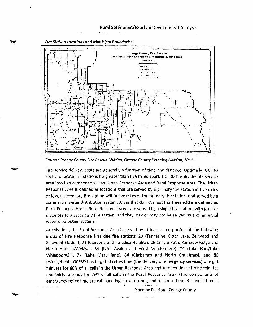
Rural Settlement/Exurban Development Analysis
Fire Station Locations and Municipal Boundaries
Orange County Fire Rescue All Fire Station Locations & Municipal Boundaries
October2011
lcgond
F1ro St.·Uiona.
Source: Orange County Fire Rescue Division, Orange County Planning Division, 2011.
Fire service delivery costs are generally a function of time and distance. Optimally, OCFRD
seeks to locate fire stations no greater than five miles apart. OCFRD has divided its service
area into two components- an Urban Response Area and Rural Response Area. The Urban
Response Area is defined as locations that are served by a primary fire station in five miles
or less, a secondary fire station within five miles of the primary fire station, and served by a
commercial water distribution system. Areas that do not meet this threshold are defined as
Rural Response Areas. Rural Response Areas are served by a single fire station, with greater
distances to a secondary fire station, and they may or may not be served by a commercial
water distribution system.
At this time, the Rural Response Area is served by at least some portion of the following
group of Fire Response first due fire stations: 20 (Tangerine, Otter Lake, Zellwood and
Zellwood Station), 28 (Clarcona and Paradise Heights), 29 (Bridle Path, Rainbow Ridge and
North Apopka/Wekiva), 34 (Lake Avalon and West Windermere), 76 (Lake Hart/Lake
Whippoorwill), 77 (Lake Mary Jane), 84 (Christmas and North Christmas), and 86
(Wedgefield). OCFRD has targeted reflex time (the delivery of emergency services) of eight
minutes for 80% of all calls in the Urban Response Area and a reflex time of nine minutes
and thirty seconds for 75% of all calls in the Rural Response Area. (The components of
emergency reflex time are call handling, crew turnout, and response time. Response time is
Planning Division I Orange County
Rural Settlement/Exurban Development Analysis
defined as the amount of time that elapses from the activation of a 911 call to when an
emergency service unit arrives at the scene. Response time does not reflect the time taken
to detect an emergency and activate the 911 system.)
Water supply also is an essential element in emergency response to fire incidents. The
location of fire hydrants depends on the availability of adequate water pressure and
distribution services in the area. In rural areas, where this type of water distribution is not
available, there may be a limited number of fire hydrants. This limitation can be just as
important as proximity of a fire station. If utilities are not present in rural locations, water
pressure may be hard to maintain. Rural Settlement residents' expectations in this regard
were evidenced by a question asked at a recent community meeting about when fire
hydrants would be installed in the Rural Settlement. Generally, fire hydrants are not
provided in Rural Settlements, but residents may be unaware of this County policy.
In the late 1990s, a series of wildfires threatened or burned the Wedgefield, Bithlo, Lake
Mary Jane, and Christmas rural settlements. Shortly after that, Governor Lawton Chiles's
Wildfire Response and Mitigation Review Committee expressed concerns about what they
call the "urban interface," where wooded rural areas abut communities, providing the
opportunity for wildfires to destroy homes and harm people. The committee's report
recommended that local governments, " ... promote compact urban growth through the
comprehensive planning process to prevent and mitigate the potential adverse impacts of
wildfires upon urbanizing areas" {Emergency Response Planning & Management 1999). The
County has supported a Firewise program to address this need, but the overall concern
remains nonetheless.
While fire stations and EMS facilities can be built with impact fees from new development,
the County must fund their staffing, operation, and maintenance costs. While a developer
may provide land for a fire station, this does not take into account other operating and
capital costs necessary to provide the fire rescue services, which can sometimes result in a
time lag between when new development occurs and when the station is fully operational.
When a fire station cannot be constructed and operated, the County must endeavor to
provide that service in a different manner. To date, the County has kept pace with these
issues, even locating a fire station in a retail center near the Four Corners area (the area in
southwest Orange County where Lake, Polk, Osceola, and Orange counties meet) to address
suburban growth. Although the County has adapted to provide fire and rescue service in
areas where existing fire stations are not located or are located at further distances than
preferred standards, issues remain with respect to this trend.
Law Enforcement. The Orange County Sheriff's Office {OCSO) divides its service area into six
sectors: Sector 1 (north Orange County), Sector 2 {east Orange County), Sector 3 (west
Planning Division I Orange County
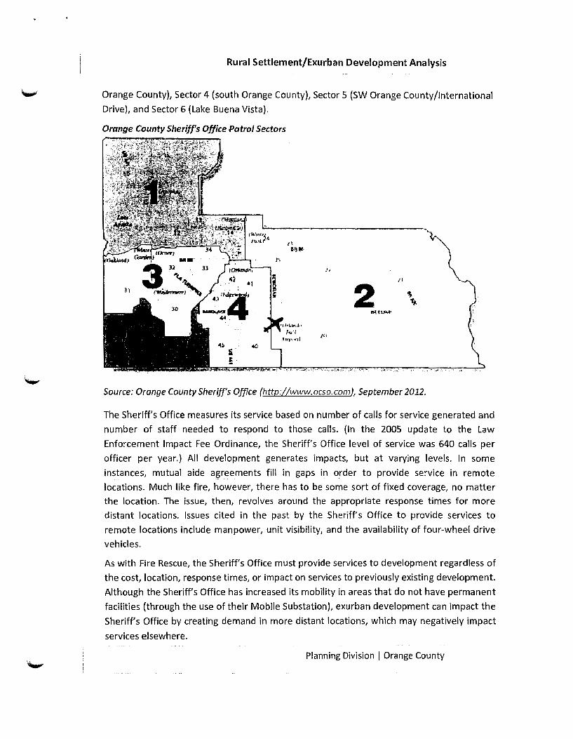
Rural Settlement/Exurban Development Analysis
Orange County), Sector 4 (south Orange County), Sector 5 (SW Orange County/International
Drive), and Sector 6 (lake Buena Vista).
Orange County Sheriff's Office Patrol Sectors
_., ll
2
Source: Orange County Sheriff's Office (http://www.ocso.com), September 2012.
The Sheriff's Office measures its service based on number of calls for service generated and
number of staff needed to respond to those calls. (In the 2005 update to the law
Enforcement Impact Fee Ordinance, the Sheriff's Office level of service was 640 calls per
officer per year.} All development generates impacts, but at varying levels. In some
instances, mutual aide agreements fill in gaps in order to provide service in remote
locations. Much like fire, however, there has to be some sort of fixed coverage, no matter
the location. The issue, then, revolves around the appropriate response times for more
distant locations. Issues cited in the past by the Sheriff's Office to provide services to
remote locations include manpower, unit visibility, and the availability of four-wheel drive
vehicles.
As with Fire Rescue, the Sheriff's Office must provide services to development regardless of
the cost, location, response times, or impact on services to previously existing development.
Although the Sheriff's Office has increased its mobility in areas that do not have permanent
facilities (through the use of their Mobile Substation), exurban development can impact the
Sheriff's Office by creating demand in more distant locations, which may negatively impact
services elsewhere.
Planning Division I Orange County

Rural Settlement/Exurban Development Analysis
Due to the character of the rural area, the Sheriff's Office serves rural locations in ways
other than the typical patrol method. In order to provide services to the Rural Settlements
consistent with the more urban areas of the County, the Sheriff's Office has units that
specialize in the areas of aviation, agriculture, forestry, and nautical patrol.
Solid Waste. The County's Solid Waste Division is responsible for providing solid waste
management services in unincorporated Orange County. The Division is responsible for
managing the residential garbage, yard waste, and recycling collection program for single
family homes in unincorporated Orange County. It administers residential garbage and
recycling collection for approximately 200,000 homes. The County Solid Waste
Management System consists of three facilities -the 5,000-acre Solid Waste Management
Facility located at the end of Young Pine Road in east Orange County, and two centrally
located transfer stations; the Porter Transfer Station, at 8750 White Road (at the corner of
Good Homes Road and White Road, about one-half mile north of Colonial Drive), and the
Mcleod Transfer Station, at 5000 LB. Mcleod Road (about one-third mile east of Kirkman
Road).
Currently, solid waste disposal is managed as an enterprise fund, paying 100% of the
system's operational costs. Tipping fees -a cost by weight of load - are used to recoup the
operational costs of the system. Residential garbage collection is paid by homeowners
through a charge on annual tax bills. Because this service is funded primarily through user
fees, the additional costs- including transportation, transfer, and hauling- that result from
low-density development located away from the urban core are borne not by the County,
but by County residents who pay for the service. The charge to County residents is $235 per
dwelling unit, no matter the home's location or the development pattern, although in more
compact areas, collection costs are lower.
Parks. The Parks and Recreation Division's adopted level of service (LOS) is 1.5 acres of
publicly owned activity-based parkland and trails, and 6.0 acres of publicly owned resource
based parkland, per 1,000 residents of unincorporated Orange County. The goal of the
County's Recreation Element is to have an activity-based park accessible to all residents of
the unincorporated County.
The County classifies parks based on size, service area and available facilities. (See the table
below for a description of park types.) While the LOS for parks is based on acreage per 1,000
population, accessibility to parks is measured based on "reasonable distance" to parks. In
the urbanized part of the County, where densities typically range from 4 units per acre (low
density) up to 20 units per acre (medium density), parks would be accessible to many more
residents than similar facilities located in a Rural Settlement location, where the densities
are lower (typically 1 unit per acre for newly designated Rural Settlement land).
Planning Division I Orange County
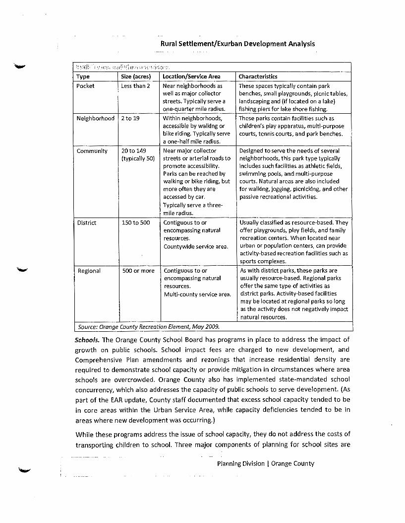
Rural Settlement/Exurban Development Analysis
\ ( t:. S. il :-; '·!. j .'',;1 ;' I : ~: r ·; r, 1( 1:-~ ': I ~ j '1 ,_-, 11 f > I • '; 1l . l1fi-~~ :: I ·:~·,
Type Size {acres) Location/Service Area Characteristics
Pocket Less than 2 Near neighborhoods as These spaces typically contain park well as major collector benches, small playgrounds, picnic tables, streets. Typically serve a landscaping and (if located on a lake) one-quarter mile radius. fishing piers for lake shore fishing.
Neighborhood 2 to 19 Within neighborhoods, These parks contain facilities such as accessible by wall<ing or children's play apparatus, multi-purpose bike riding. Typically serve courts, tennis courts, and park benches. a one-half mile radius.
Community 20 to 149 Near major collector Designed to serve the needs of several (typically 50) streets or arterial roads to neighborhoods, this park type typically
promote accessibility. includes such facilities as athletic fields, Parks can be reached by swimming pools, and multi-purpose walking or bike riding, but courts. Natural areas are also included more often they are for walking, jogging, picnicking, and other accessed by car. passive recreational activities.
Typically serve a three-mile radius.
District 150to 500 Contiguous to or Usually classified as resource-based. They encompassing natural offer playgrounds, play fields, and family resources. recreation centers. When located near
Countywide service area. urban or population centers, can provide activity-based recreation facilities such as sports complexes.
Regional 500 or more Contiguous to or As with district parks, these parks are encompassing natural usually resource-based. Regional parks resources. offer the same type of activities as
Multi-county service area. district parks. Activity-based facilities may be located at regional parks so long as the activity does not negatively impact natural resources.
Source: Orange County Recreation Element, May 2009.
Schools. The Orange County School Board has programs in place to address the impact of
growth on public schools. School impact fees are charged to new development, and
Comprehensive Plan amendments and rezonings that increase residential density are
required to demonstrate school capacity or provide mitigation in circumstances where area
schools are overcrowded. Orange County also has implemented state-mandated school
concurrency, which also addresses the capacity of public schools to serve development. (As
part of the EAR update, County staff documented that excess school capacity tended to be
in core areas within the Urban Service Area, while capacity deficiencies tended to be in
areas where new development was occurring.)
While these programs address the issue of school capacity, they do not address the costs of
transporting children to school. Three major components of planning for school sites are
Planning Division I Orange County

Rural Settlement/Exurban Development Analysis
location, transportation, and flexibility to meet changing needs. This focus includes a
balancing of strategies based on where people are moving, distance from existing schools,
demographics, and justifiable expenses. School siting balances capital and transportation
costs with need and opportunity. OCPS has responded to growth in the Rural Service Area,
but it generally can be said that this tends to intensify the competition for investment,
operation, and maintenance dollars. A recent example of current investment to forestall
future transportation costs includes the two Future Land Use Map amendments adopted in
2010 that will accommodate future school sites in the Wedgefield Rural Settlement.
Code Enforcement. Code Enforcement Officers are responsible for enforcement of the
County's Code of Ordinances, which includes zoning, sign, nuisance, and property
maintenance codes. Orange County's code enforcement staff is distributed throughout the
County in 37 geographically designated areas, which include areas outside of the urban
core.
Code enforcement issues inevitably vary between rural and urban areas and result in
differing expectations. Code enforcement expectations also can vary depending on
respective lot sizes, visibility, and location. Development away from the urban core requires
staff be spread out county-wide. Additionally, there can be greater discord when new
residents are introduced to existing rural areas in terms of disparate expectations of what
are acceptable activities.
Transportation Facility Construction and Maintenance. Low-density, single-use
development patterns require more road per capita, create auto-dependent environments,
and result in traffic congestion. A case study on the City of Toronto, published in the March
2006 edition Journal of Urban Planning and Development, found that on a per capita basis,
low-density suburban development is more energy and greenhouse gas (GHG)-intensive (by
a factor of 2.0-2.5) than high-density urban core development. The study analyzed the
following three components of urban density: construction materials for infrastructure
(including residential dwellings, utilities, and roads), building operations, and transportation
(private automobiles and public transit).
Low Density Development High Density Development GHG Emissions Energy Use GHG Emissions Energy Usc
/_.,M•r•r;"~ Tr.on1port _.. lrarupor.F 31•A / 61% I :
v" · Building , ~ · ·. OpOJollcns ( '
'· ' 32%
Fig. 6. R\.~l.uiv(' f\llllrihulit'll:O. ,,f m;Hcrial pl,ldudimL building op~'r.:uion..,, mh.t trom,pnll;llion to annual grc\.~nhnus~. ... p-a1:-. cn1b.sion' ;HHic..'naty 'hi.' for h.1w- nnd hiph·tkn'ii!y dc•,·clnplllt'lll
Source: Journal of Urban Planning and Development, March 2006
Planning Division I Orange County

I i
Rural Settlement/Exurban Development Analysis
New development on the fringe of the Urban Service Area requires new facilities and
upgrades of existing facilities, the costs of which potentially are borne only in part by the
developer. House Bill 7207, signed into law in 2011, limited local government's ability to
assign the cost of roadway improvements to new development.
The County adopted an Alternative Mobility Area (AMA) as part of its Comprehensive Plan
update. The AMA, located in the urban core adjacent to the City of Orlando, was selected
based on area density, infrastructure capacity, and opportunities for transit. In this area,
road network connectivity and transit availability represent existing infrastructure
investments that can be used more efficiently through infiff development and
redevelopment. The AMA recognizes that development closer to the more compact central
core of Orange County has the potential to reduce vehicle miles traveled (VMT), thereby
placing less demand on the transportation system, allowing for alternative means of
transportation, reducing auto dependency, and lowering per capita costs as compared to
low-density, single use development.
Other Countywide Services. Orange County provides other services on a Countywide basis,
including mosquito control and animal control. For mosquito control, the issue in more rural
areas is related to disparate expectations of what are acceptable levels of service. Operating
expenses can be impacted by increasing calfs for service in newly developed areas.
Orange County's Animal Control function serves the entire County, including municipalities,
with 27 field officers who work shifts to provide 24/7 coverage. Although its charge is
related to domestic animals, the County is, in effect, the first responder for calfs for wildlife
as well. Response to calfs in the rural service area results in increased travel requirements.
Increased travel costs can result in greater costs, including for fuel as well as for staff time.
In summary, a variety of issues- including cost to provide services and expectations about
level of service- arise with respect to development in exurban areas.
4. Advisability of further Rural Settlement expansions in a progressively more urban county.
The County designated Rural Settlements in the Comprehensive Plan. This designation was
intended to recognize existing rural communities at the time of Plan adoption, as well as to
preserve both agricultural and rural uses in the Rural Service Area by containing low-density
suburban residential development on the fringes.
The Rural Settlement objective (FLU6.2) and associated policies in the Comprehensive Plan
offer protective treatment for Rural Settlements. Development in Rural Settlements must
preserve the Rural Settlement's "existing character" or the "intended rural character," as
well as "contribute to the community's sense of place." Development criteria include items
such as road design, building design and layout, landscaping, and buffering. Restrictions also
Planning Division I Orange County
Rural Settlement/Exurban Development Analysis
are placed on development adjacent to a Rural Settlement to ensure that it does not
negatively impact the character of the Rural Settlement. This policy language clearly offers
protection to Rural Settlements, and this protection is recognized by Rural Settlement
residents. One community markets itself with this language:
This gives the neighborhood the unique privilege of being considered what they call a
"Rural Settlement." It gives us special rights and privileges not seen in your average
cookie cutter neighborhood. It gives area a Country like setting while giving us access
to all the amenities of the city ... What is so nice is we'll be isolated from the growth
yet able to take advantage of it. (source: http://lakemaryjanehome.com/aboutthearea.htm)
In the 20 years since the Comprehensive Plan was adopted, County population has
increased by 65 percent, cities have annexed extensively, and the County has become more
urban. These changes affect some Rural Settlements more than others, but all are affected
to some degree.
As the urbanized area (both incorporated and unincorporated} has increased, some rural
locations are so close to urban centers that higher density development would be viable
from a market perspective, while other Rural Settlements have urban development literally
right across the street. Lake Hart/Lake Whippoorwill Rural Settlement is one example of the
conflict that happens when a city boundary meets a Rural Settlement -the development
pressure across the street, the six-laning of Narcoossee Road, and the lower cost of land in
the Rural Settlement have created a situation that is difficult to address.
Given that Rural Settlement policies offer protection to these areas, and given that conflicts
at the urban/rural interface inevitably will continue to increase over time, the County will
find it more and more challenging to protect the existing Rural Settlements. Designating
more land as Rural Settlement would serve only to exacerbate this situation.
Conclusion
Based upon these findings, staff concludes that allowing the continued expansion of Rural
Settlements does not appear to be justified. There is adequate land in existing Rural
Settlements to provide for a rural lifestyle, and it could be argued that an urban County such as
Orange no longer has the need to provide additional opportunities for a rural lifestyle beyond
what already exist. Additionally, many of the Rural Settlement expansions over the past 20
years have not, beyond their density restrictions, maintained the character of historic Rural
Settlements.
Very-low density development - particularly in locations far from the urban core - presents a
number of difficulties for the County. Providing services is not cost-efficient. Conflicts between
Rural Settlements and development proposals on nearby land are increasing. Protection of
Planning Division I Orange County

I
'·· Rural Settlement/Exurban Development Analysis
existing Rural Settlements is becoming more challenging -expansion of Rural Settlements will
serve only to aggravate this situation.
Summary: Because there appears to be little benefit to allowing continued expansion of these areas~ staff recommends that the language in Policy FLU6.2.1 prohibiting Rural Settlement creation or expansion be retained. The policy requires that this issue be re-addressed during the next Evaluation and Appraisal Report, which is scheduled for 2016. Boundary studies of the existing Rural Settlements during the EAR process would help determine whether adjustment of Rural Settlement boundaries would be recommended. Criteria used in such studies could include the existence of enclaves {parcels entirely surrounded by a Rural Settlement and/or undevelopable land), the parcel's location relative to the Urban Service Area, the feasibility of future urban use for a parcel, and the potential for an increase in urban/rural conflicts, among others.
Based on the above recommendation, there will be fewer options for developing land in the
County's Rural Service Area (RSA) between now and 2016. Other mechanisms for developing
rural land do exist, however, including:
• Leaving land in the RSA, in which case residential development is allowed at a density of one
unit per ten acres;
• Adding land into the Urban Service Area (USA) through a Comprehensive Plan amendment,
which involves changing the land use designation to increase the density and/or allowable
uses;
• Adopting a Sector Plan; or
• Annexing into a city.
Maintaining this policy restriction on Rural Settlement creation and expansion removes one
mechanism for increasing density on property currently located in the Rural Service Area.
Potential consequences of this policy decision differ, depending on where in the County land is
located. In some areas, increased annexation potentially could result, while in other areas,
enough acreage exists for sector planning. For this reason, this policy will be re-evaluated
periodically. Additionally, staff will analyze areas with concentrations of Rural Settlements -
such as northeast and northwest Orange County - to identify issues and strategies for
development in these areas.
In northeast Orange County, a group of Rural Settlements (Lake Pickett, Corner Lake, Bithlo, and
Sunflower Trail) are located along the State Road 50 corridor just outside the Urban Service
Area. Uses in these Rural Settlements - particularly in Bithlo - are more intense, including
commercial and industrial. Some of these businesses are vested, nonconforming uses operating
inconsistent with the future land use and zoning designations applied to their property;
however, they give the area the appearance of being more urban that the Future Land Use
designations indicate. Consequently, the land use pattern, location along a major arterial, and
proximity to the Urban Service Area combine to result in relatively intense development
Planning Division I Orange County
Rural Settlement/Exurban Development Analysis
pressure in this area. There are no municipalities in this area, but there is enough acreage in
east Orange County to make a Sector Plan an option.
Northwest Orange County is changing in a number of ways. This is the only part of the County in
which areas designated Rural and Rural Settlement also are designated by the federal
government as areas where job creation should be encouraged. There are both Enterprise
Zones and Historically Underutilized ~usiness {HUB) Zones in NW Orange, and nearly half of the
County's Rural Settlements are located in this area. Three cities - Apopka, Ocoee and Winter
Garden - have annexed land in northwest Orange over the past two decades since Rural
Settlements were designated. In addition to this municipal growth, the Wekiva Parkway, SR 429
and other limited access roadways have changed the character of the area.
Analyzing the issues specific to these areas would result in planning and development strategies
appropriate for the issues each area faces. Such strategies would, in the long term, serve these
areas better than continued use of the Rural Settlement Future Land Use designation as a
mechanism for development.
In addition to the analysis described above, staff is in the initial stages of preparing
amendments to Objective FLU6.2 and associated policies, which pertain to Rural Settlements.
These amendments, which are being drafted to address issues and questions brought up as a
result of recent Rural Settlement development proposals, are intended to clarify requirements
for development in Rural Settlements. The amendments will be brought to the Board of County
Commissioners for their consideration in 2013.
Planning Division I Orange County
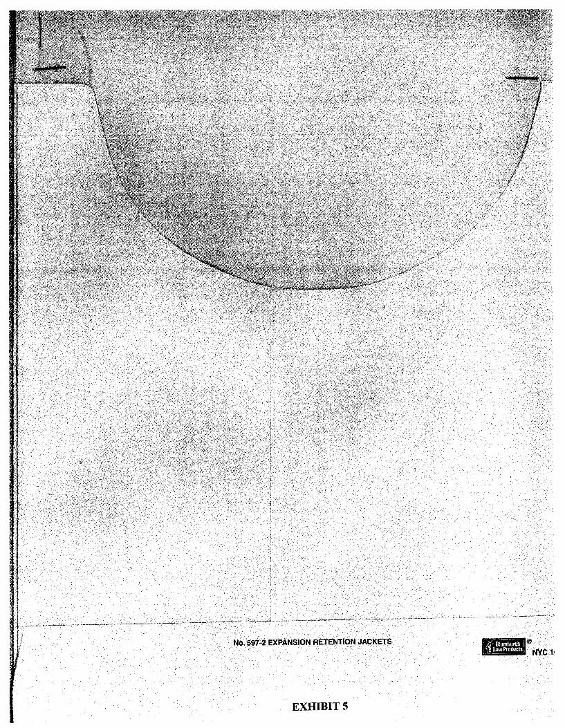
No .. 597-2 EXPANSION RETENTION JACKETS
EXHIBIT 5

• mag c report ng
ORANGE COUNTY BOARD OF ZONING ADJUSTMENT
PUBLIC HEARING
WEST ORANGE RELEIF HIGH SCHOOL
EXCERPTS VISHAAL GUPTA
September 6, 2013
ORIGINAL
P.O. Box 2007 Orlando, Florida 32802( t:407.251.7121 • f: 407.251.7122 depos@mag creport ng.com

WEST ORANGE RELIEF HIGH SCHOOL 9/6/2013
407-251-7121
Page 1
ORIGINAL
ORANGE COUNTY BOARD OF ZONING ADJUSTMENT
PUBLIC HEARING
WEST ORANGE RELIEF HIGH SCHOOL
HELD ON SEPTEMBER 6, 2013
EXCERPTS
COMMENTS OF BOARD MEMBER VISHAAL GUPTA
AFTER CONCLUSION OF PUBLIC COMMENTS
Magic Reporting, Inc. 407-251-7122
~
~·
~·
WEST ORANGE RELIEF HIGH SCHOOL 9/6/2013
1
2
3
4
5
6
7
8
9
10
11
12
13
14
15
16
17
18
19
20
21
22
23
24
25
407-251-7121
Page 2
* * * *
MR. GUPTA: I have one question. One
point that has been brought up several times
this afternoon was the Windermere Prep School;
and one thing about that school that was
brought up was the vernacular, you know, rural
nature of its architecture and planning.
Has the School Board explored that
well, two questions. Has Orange County ever
done a high school with that type of
architecture or different architecture than
what we've seen at Oak Ridge, for example, and,
two, has the School Board explored that as an
option for this site to appease, you know,
these other residents?
* * * *
MR. GUPTA: Any other questions? All
right. Thank you, sir. I appreciate it.
* * * *
MR. GUPTA: Let me go ahead and close the
public hearing.
* * * *
MR. GUPTA: What I would like to do is -
and I know some of you don't like to do this
I would like to take 15 minutes, 10 to 15
Magic Reporting, Inc. 407-251-7122
'-"'
~
·~
WEST ORANGE RELIEF HIGH SCHOOL 9/6/2013
1
2
3
4
5
6
7
8
9
10
11
12
13
14
15
16
17
18
19
20
21
22
23
24
25
407-251-7121
Page 3
minutes, and I need to consult with Orange
County Staff on a couple things that were
mentioned this afternoon.
So if I could get 10 minutes, 10 minutes
with Orange County Staff, I would appreciate
that.
* * * *
MR. GUPTA: No, sorry. I'm allowed to do
that, Rocco, in a side room?
* * * *
MR. GUPTA: I would like to do that with
Orange County Staff. Where would you like; in
this room here? Okay, great. 10 minutes and
we'll reconvene, if that's okay.
* * * *
MR. GUPTA: I would like to ask a couple
questions so I can get it on the record to
Staff.
The first one I had was we've noted that,
according to FLU 8.7.6, high schools are an
exception in Rural Settlement areas.
correct?
* * * *
Is that
MR. GUPTA: Yeah, special exception. I
wanted to know when this was -- when the Rural
Magic Reporting, Inc. 407-251-7122

~
"'-"'
~·
WEST ORANGE RELIEF HIGH SCHOOL 9/6/2013
1
2
3
4
5
6
7
8
9
10
11
12
13
14
15
16
17
18
19
20
21
22
23
24
25
407-251-7121
Settlement was created 1n '91 -- is that
correct?
* * * *
Page 4
MR. GUPTA: Okay. What -- was the intent
of the B.C.C. and/or Orange County at that time
to specifically allow public high schools as a
permitted -- as a special exception because --
* * * *
MR. GUPTA: In your opinion, what
characteristics -- I guess what we're -- what
has been said is that there's no public high
schools in -- it's been denied previously
having public high schools in Rural
Settlements, right? But, at the same time,
we're saying that it is a special exception to
go through this process.
In your opinion, what would be allowed
what characteristics would that public high
school have to have to support D.R.C. to
approve that high school, if you understand
what I'm saying?
* * * *
MR. GUPTA: That high school, was that a
Rural Settlement?
* * * *
Magic Reporting, Inc. 407-251-7122

WEST ORANGE RELIEF HIGH SCHOOL 9/6/2013
1
2
3
4
5
6
7
8
9
10
11
12
13
14
15
16
17
18
19
20
21
22
23
24
25
407-251-7121
Page 5
MR. GUPTA: Okay, gotcha. The other
question that I had was I just want to confirm
that when Osceola -- I'm sorry Orange County
had the opportunity to rebut, was everything
that he said pretty accurate or accurate to
what we -- you know, what we know?
* * * *
MR. GUPTA: Any other questions for Orange
County Staff from the Board?
* * * *
MR. GUPTA: Anything else?
* * * *
MR. GUPTA: All right. I'm going to open
up the discussion on my board; but before I do
that, I just wanted to first thank everyone for
being part of the process.
Just echoing Chairman Betterman's words
that -- I know a lot of you -- in fact, all of
you have spent an enormous amount of time,
energy and money to some extent to be part of
the process.
And whichever way this goes, I hope that,
that we can move forward and respect the
decision and know that it will go on to the
B.C.C. for the next -- whenever -- I'm not sure
Magic Reporting, Inc. 407-251-7122
WEST ORANGE RELIEF HIGH SCHOOL 9/6/2013
1
2
3
4
5
6
7
8
9
10
11
12
13
14
15
16
17
18
19
20
21
22
23
24
25
407-251-7121
Page 6
what date that is, but we really do appreciate
you being here.
I'm going to open up to my colleagues,
start over on that end. Any thoughts or --
* * * *
MR. GUPTA: All right. Thank you. The
way I look at it is I'm going to certainly look
at it from the special exception criteria, you
know, as far as the -- is concerned, my heart
goes out to them, but I think that's the
responsibility of Orange County Public Schools
to figure out and not ours.
I think we're here today to really see
whether this, this application fits within the
special exception criteria and whether -- and,
most notably, whether it's compatible with the
surrounding area.
You know, I read this -- the zoning
division gave us a supplemental staff report,
and I probably read it 10 or 15 times. I think
what calls out to me the most is when, when
Staff noted compatibility is a fundamental
consideration in all land use decisions, and I
do believe in that.
When we're doing -- and I have not been ln
Magic Reporting, Inc. 407-251-7122
"-".
WEST ORANGE RELIEF HIGH SCHOOL 9/6/2013
1
2
3
4
5
6
7
8
9
10
11
12
13
14
15
16
17
18
19
20
21
22
23
24
25
407-251-7121
Page 7
a B.Z.A. meeting where we've done high school
before, but some of you mentioned that O.C.P.S.
lS trying to fit a square peg in a round hole.
While that may be true, I think that
O.C.P.S. probably feels the same way when they
put any high school on the ground because no
resident -- I shouldn't say "no resident", but
I would expect few residents really want a high
school in their backyard, whether they're in a
Rural Settlement or they're not.
And I've heard stories -- actually John
mentioned about Olympia High School where that
school those residents did not want that
school and it wasn't even a Rural Settlement.
So I think it's just the nature of the,
the industry, of the public school industry
where you got to put a school somewhere, and
it's got to go somewhere. A landfill,
obviously a different circumstance.
So to that -- you know, I was reading
specifically -- two things, I think, that
affect my perspective is, number one, according
to FLU 8.7.6, as I discussed earlier with John
Smogor, that there's a special exception
allowed for high schools in, you know, in Rural
Magic Reporting, Inc. 407-251-7122

.'-'
..........
WEST ORANGE RELIEF HIGH SCHOOL 9/6/2013
1
2
3
4
5
6
7
8
9
10
11
12
13
14
15
16
17
18
19
20
21
22
23
24
25
407-251-7121
Page 8
Settlement areas.
And, you know, we don't know why they put
that in there; but obviously they put it in as
a special exception to go through this process
because there could be a case in which that
high school, a high school, a public high
school, deserves to be in a Rural Settlement
area.
The B.C.C. and Orange County at that time
could have made a decision that says under no
circumstances is a public high school allowed
in a Rural Settlement area; and if that was the
case, we wouldn't be here today. So we are
following the process that was designed years
and years ago.
The other thing that I was noting with
FLU 8.2.11 was about compatibility. And
while -- and Staff had noted that compatibility
has more to do -- has more than just -- it's
more than just about the massing of the
building, right?
You have to take into consideration a
variety of things, and I want to read to you
what they wrote. Here it is. It's FLU 8.2.11.
Compatibility may not necessarily be
Magic Reporting, Inc. 407-251-7122

'-"'.
"-"'
WEST ORANGE RELIEF HIGH SCHOOL 9/6/2013
1
2
3
4
5
6
7
8
9
10
11
12
13
14
15
16
17
18
19
20
21
22
23
24
25
407-251-7121
Page 9
determined to be a land use that•s identical to
those that surround it. Other factors may be
considered such as the design attributes of the
project, its urban form, the physical
integration of a project and its function in
the broader community, as well as its
contribution towards the goals and objectives
in the Comprehensive Plan. The Comprehensive
Plan shall specifically allow for such a
balance of consideration to occur.
And I think that that paragraph alone
speaks out that we have to think more than just
the mass of the 350,000 square feet that•s
there; it•s more than just the square footage,
and it•s more than the three stories. I think
we are responsible to take a look at it from a
holistic approach.
Yesterday Commissioner Boyd and I spent
the afternoon touring a lot of schools; and one
of the schools we visited was Oak Ridge High
School.
And we -- on a three-story portion of the
school, we stood at the corner and we paced 500
feet in any direction, didn•t matter which
direction, and turned around and looked at the
Magic Reporting, Inc. 407-251-7122

'-"
WEST ORANGE RELIEF HIGH SCHOOL 9/6/2013
1
2
3
4
5
6
7
8
9
10
11
12
13
14
15
16
17
18
19
20
21
22
23
24
25
407-251-7121
Page 10
size and at the massing.
And, in my opinion, there was a one-story
building right in front of it; and, to be very
honest, I could bearly see the top of the
three-story building with the one-story
building in front of it.
We did the same thing with the HVAC, the
concern that came out, and we went -- we didn't
measure that, but we went to the end of the
high school property and we couldn't hear it
with the windows open in our vehicle; so I
think some of those concerns are hearsay and,
you know, it's --you'll never really know
until you actually walk it.
So that said, you know, it's a very, very
tough decision, but I, I feel I -- I feel the
high school, the West Orange Relief High School
is consistent with the Comprehensive Policy
Plan, and I think it meets all six items on the
special exception.
I feel that it's similar and compatible to
the surrounding area and it's consistent with
the pattern of surrounding development.
I can't name another --you know, if it's
a permitted -- if it's a special exception,
Magic Reporting, Inc. 407-251-7122

'-"
'-"
'-"'.
WEST ORANGE RELIEF HIGH SCHOOL 9/6/2013
1
2
3
4
5
6
7
8
9
10
11
12
13
14
15
16
17
18
19
20
21
22
23
24
25
407-251-7121
Page 11
what better place to have it on a Rural
Settlement, on a corner of the settlement
across from urban service area on a two-lane
on a four-lane road.
I just don't know if I could name a better
place personally where would be a special
exception for, so I'm just quoting specifically
Section 38.5-78 (ph.), I believe that it meets
all the criteria, so I will make a motion to
approve the application.
I know we have -- I know we have some -
D.R.C. has recommended some conditions -- by
the way, me saying that, did anybody want to
chime in or
* * * * MR. GUPTA: There are 13 conditions of
approval. Has Orange County seen these 13
conditions?
* * * * MR. GUPTA: Okay, and I actually have a
note here -- I probably should have mentioned
before you came up, but I believe that
Number 12 should be removed as a condition,
given the fact that they are putting the
technology that they are, as well -- Page 14 ln
Magic Reporting, Inc. 407-251-7122
'-'"•
'-"
WEST ORANGE RELIEF HIGH SCHOOL 9/6/2013
1
2
3
4
5
6
7
8
9
10
11
12
13
14
15
16
17
18
19
20
21
22
23
24
25
407-251-7121
your staff booklets -- in your staff
supplement, 14 and 15.
Page 12
And the fact that the lights are -- I
can't remember exact number, but I think there
were -- how far were the lights away from the
nearest property, adjacent property?
* * * *
MR. GUPTA: It's 1,000 something.
* * * *
MR. GUPTA: All right. So given that, I
believe that I would like to remove Number 12
from the condition, so we have a total of 12
conditions, and I make a motion -- well, go
ahead.
* * * *
MR. GUPTA: So we will insert 9-6-13, and
I make a motion to approve -- sorry.
* * * *
MR. GUPTA: Yeah, if I could get the
language. What would the language be for that
specific light fixture that we could put into
the -- or would it be dark sky-compliant?
* * * *
MR. GUPTA: So maybe add that in there,
that O.C.P.S. is required to have dark sky-
Magic Reporting, Inc. 407-251-7122
'-"'
WEST ORANGE RELIEF HIGH SCHOOL 9/6/2013
1
2
3
4
5
6
7
8
9
10
11
12
13
14
15
16
17
18
19
20
21
22
23
24
25
407-251-7121
Page 13
compliant lighting throughout your property,
because the parking lights are also dark sky
compliant lighting; is that correct?
* * * *
MR. GUPTA: Maybe we can do this --
* * * *
MR. GUPTA: Could I just say full cut-off
fixtures?
* * * *
MR. GUPTA: So full cut-off fixtures for
the lighting, per Orange County lighting
ordinance.
* * * *
MR. GUPTA: Would that be okay with you
guys?
Yeah, that's fine.
* * * *
MR. GUPTA: What are the hours of
operation of the school? We typically don't do
that, right?
* * * *
MR. GUPTA: I think we can leave that out.
It is what it is.
* * * *
MR. GUPTA: Amended Condition 12 will say
Magic Reporting, Inc. 407-251-7122
~
WEST ORANGE RELIEF HIGH SCHOOL 9/6/2013
1
2
3
4
5
6
7
8
9
10
11
12
13
14
15
16
17
18
19
20
21
22
23
24
25
407-251-7121
Page 14
that -- something to the effect that the sports
lighting of the stadium shall be dark sky
compliant and that parking lights will be full
cut-off fixtures, according to Orange County
ordinance.
* * * *
MR. GUPTA: We don't need to go into that
detail.
* * * *
MR. GUPTA: Correct, that's correct, yeah.
* * * *
MR. GUPTA: It does.
* * * *
(End of excerpt)
Magic Reporting, Inc. 407-251-7122
1
2
3
4
5
6
7
8
9
10
11
12
~ 13
14
15
16
17
18
19
20
21
22
23
24
25
TRANSCRIPT CERTIFICATE
STATE OF FLORIDA COUNTY OF ORANGE
Page 15
I, CHRISTINE E. LE RETTE, Court Reporter,
certify that I was authorized to and did
stenographically report the foregoing excerpt of
proceedings and that the transcript is a true and
complete record of my stenographic notes.
DATED this 24th day of October 2013.
WEST ORANGE RELIEF HIGH SCHOOL 9/6/2013
Page 16
A 5:17 CONCLUSION development 14:4 accurate 5:5,5 board 1:6,16 2:8 1:17 10:23 FLORIDA 15:3 add 12:24 2:13 5:9,14 condition 11:23 different 2: 11 FLU 3:20 7:23 adjacent 12:6 booklets 12:1 12:12 13:25 7:19 8:17,24 ADJUSTMENT Boyd 9:18 conditions 11: 12 direction 9:24 following 8:14
1:6 broader 9:6 11:16,18 12:13 9:25 footage 9:14 affect 7:22 brought 2:3,6 confirm 5:2 discussed 7:23 foregoing 15:9 afternoon 2:4 building 8:21 consideration discussion 5: 14 form 9:4
3:3 9:19 10:3,5,6 6:23 8:22 9:10 division 6:19 forward 5:23 ago8:15 considered 9:3 doing6:25 four-lane 11:4
ahead 2:20 c consistent 10:18 front 10:3,6
12:14 calls 6:21 10:22 E full13:7,10 14:3 allow 4:6 9:9 case8:5,13 consult 3:1 E 15:7,20 function 9:5 allowed 3:8 4:17 certainly 6:7 contribution 9:7 earlier 7:23 fundamental
7:258:11 CERTIFICA ... corner 9:23 11:2 echoing 5:17 6:22
Amended 13:25 15:1 correct 3:22 4:2 effect 14:1
amount5:19 certify 15: 8 13:3 14:10,10 energy 5:20 -~~--
and/or 4:5 Chairman 5: 1 7 County 1:6 2:9 enormous 5: 19 given 11:24
anybody 11: 13 characteristics 3:2,5,12 4:5 exact 12:4 12:10
appease 2: 14 4:10,18 5:3,9 6:11 8:9 example 2: 12 go2:20 4:16
application 6:14 chime11:14 11:1713:11 exception 3:21 5:24 7:18 8:4
11:10 CHRISTINE 14:4 15:3 3:24 4:7,15 6:8 12:13 14:7
appreciate 2:18 15:7,20 couple 3:2,16 6:15 7:24 8:4 goals 9:7
3:5 6:1 circumstance Court 15:7 10:20,25 11:7 goes 5:22 6:10
approach 9:17 7:19 created 4:1 excerpt 14: 14 going 5:13 6:3,7
approval11: 17 circumstances criteria 6:8,15 15:9 gotcha 5:1
approve 4:20 8:11 11:9 EXCERPTS great 3:13
11:1012:17 close 2:20 cut-off 13:7,10 1:13 ground 7:6
architecture 2:7 colleagues 6:3 14:4 expect 7:8 guess 4:10
2:11,11 COMMENTS ~------- ~
explored2:8,13 GUPTA 1:16
area6:17 8:8,12 1:16,17 D extent 5:20 2:2,17,20,23
10:22 11:3 Commissioner D.R.C4:19 3:8,11,16,24
areas3:21 8:1 9:18 11:12 F 4:4,9,23 5:1,8
attributes 9:3 community 9:6 dark 12:22,25 fact 5:18 11:24 5:11,13 6:6
authorized 15:8 compatibility 13:2 14:2 12:3 11:16,2012:8 6:22 8:17,18 date 6:1 factors 9:2 12:10,16,19,24
B 8:25 DATED 15:13 far 6:9 12:5 13:5,7.10,14
B.C.C 4:5 5:25 compatible 6: 16 day 15:13 feel1 0:16,16,21 13:18,22,25
8:9 10:21 decision 5:24 feels 7:5 14:7,10,12
B.Z.A 7:1 complete 15: 11 8:10 10:16 feet9:13,24 guys 13:15
backyard 7:9 compliant 13: 1 decisions 6:23 figure 6:12
balance 9:10 13:3 14:3 denied4:12 fine 13:16 H --~----~
bearly 10:4 Comprehensive deserves 8:7 first 3: 19 5: 15 hear 10:10
believe 6:24 9:8,8 10:18 design 9:3 fit 7:3 heard 7:11
11:8,2212:11 concern 10:8 designed 8:14 fits 6:14 hearing 1:7 2:21
better 11: 1,5 concerned 6:9 detail14:8 fixture 12:21 hearsay 10:12
Betterman's concerns 10: 12 determined 9: 1 fixtures 13: 8, 1 0 heart 6:9
407-251-7121 Magic Reporting, Inc. 407-251-7122
WEST ORANGE RELIEF HIGH SCHOOL 9/6/2013
Page 17
HELD 1:9 lot 5:18 9:19 5:1 11:20 proceedings RETTE 15:7,20 high 1 : 8 2: 1 0 13:14 15:10 Ridge 2:12 9:20
3:20 4:6,11,13 M Olympia 7:12 process 4:16 right2:18 4:14 4:18,20,23 7:1 mass 9:13 one-story 10:2,5 5:16,21 8:4,14 5:13 6:6 8:21 7:6,8,12,25 8:6 massing 8:20 open 5:13 6:3 project 9:4,5 10:3 12:10 8:6,6,11 9:20 10:1 10:11 property 10: 1 0 13:20 10:10,17,17 matter9:24 operation 13:19 12:6,6 13:1 road 11:4
hole 7:3 measure 10:9 opinion 4:9,17 public 1:7,17 Rocco 3:9 holistic 9: 17 meeting 7:1 10:2 2:21 4:6,11,13 room 3:9,13 honest 10:4 meets 10:19 opportunity 5:4 4:186:117:16 round 7:3 hope 5:22 11:8 option 2:14 8:6,11 rural2:6 3:21 hours 13:18 MEMBER1:16 Orange 1:6,8 put 7:6,17 8:2,3 3:25 4:13,24 HVAC 10:7 mentioned 3:3 2:9 3:1,5,12 12:21 7:10,14,25 8:7
7:2,12 11:21 4:5 5:3,8 6:11 putting 11:24 8:1211:1 I minutes 2:25 3:1 8:910:17
identica19: 1 3:4,4,13 11:1713:11 0 s industry 7:16,16 money5:20 14:4 15:3 question 2:2 5:2 saying 4:15,21 insert 12: 16 motion 11:9 ordinance 13: 12 questions 2:9,17 11:13 integration 9:5 12:13,17 14:5 3:175:8 says8:10 intent 4:4 move 5:23 Osceola 5:3 quoting 11:7 school1:8 2:4,5 items 10:19 2:8,10,13 4:19
N p R 4:20,23 7:1,6,9 J name 10:24 11:5 paced 9:23 read 6: 18,20 7:12,13,14,16
John 7:11,23 nature2:7 7:15 Page 11:25 8:23 7:17 8:6,6,7,11 nearest 12:6 paragraph 9: 11 reading 7:20 9:21,23 10:10
K necessarily 8:25 parking 13:2 really6:1,13 7:8 10:17,17 13:19 know 2:6,14,24 need 3:1 14:7 14:3 10:13 schools 3:20 4:6
3:25 5:6,6,18 never 10:13 part 5: 16,20 rebut 5:4 4:12,13 6:11 5:24 6:9,18 notably 6:16 pattern 10:23 recommended 7:25 9:19,20 7:20,25 8:2,2 note 11:21 peg 7:3 11:12 Section 11:8 10:13,13,15,24 noted 3:19 6:22 permitted 4:7 reconvene 3: 14 see6:13 10:4 11:5,11,11 8:18 10:25 record 3:17 seen2:1211:17
notes 15:11 personally 11:6 15:11 SEPTEMBER L noting 8:16 perspective 7:22 Relief1:8 10:17 1:9 land 6:23 9:1 number7:22 ph 11:8 remember 12:4 service 11 :3 landfill 7: 18 11:2312:4,11 physical9:4 remove 12:11 settlement 3:21 language 12:20 place 11:1,6 removed 11 :23 4:1,24 7:10,14 12:20 0 Plan 9:8,9 10:19 report 6:19 15:9 · 8:1,7,12 11:2,2 LE 15:7,20 O.C.P.S 7:2,5 planning 2:7 Reporter 15:7 Settlements leave 13:22 12:25 point 2:3 required 12:25 4:14 light 12:21 Oak 2:12 9:20 Policy 10:18 resident 7:7,7 side 3:9 lighting 13:1,3 objectives 9:7 portion 9:22 residents 2:15 similar 10:21 13:11,1114:2 obviously 7:19 Prep2:4 7:8,13 sir 2:18 lights 12:3,5 8:3 pretty 5:5 respect 5:23 site2:14
13:2 14:3 occur 9:10 previously 4:12 responsibility six 10:19 look6:7,7 9:16 October 15:13 probably 6:20 6:11 size 10:1 looked 9:25 okay 3:13,14 4:4 7:5 11:21 responsible 9:16 sky 12:25 13:2
407-251-7121 Magic Reporting, Inc. 407-251-7122

-----~-~--~------~-~~------~-------------------------
WEST ORANGE RELIEF HIGH SCHOOL 9/6/2013
Page 18
~ 14:2 thing2:5 8:16 wanted 3:25 3 sky-compliant 10:7 5:15 350,000 9: 13
12:22 things 3:2 7:21 wasn't7:14 38.5-78 11:8 Smogor 7:24 8:23 way 5:22 6:7 7:5 sorry 3:8 5:3 think 6:10,13,20 11:13 4
12:17 7:4,15,21 9:11 we'll3:14 speaks 9:12 9:12,15 10:12 we're 4:10,15 5 special3:24 4:7 10:1912:4 6:13,25 500 9:23
4:15 6:8,15 13:22 we've 2:12 3:19 7:24 8:4 I 0:20 thoughts 6:4 7:1 6
10:2511:6 three 9:15 went 10:8,9 61:9
specific 12:21 three-story 9:22 West 1:8 10:17 7
specifically 4:6 10:5 whichever 5:22 7:21 9:911:7 time 4:5,14 5:19 Windermere 8
spent5:19 9:18 8:9 2:4 8.2.11 8:17,24 sports 14:1 times 2:3 6:20 windows 10:11 8.7.6 3:20 7:23 square 7:3 9:13 today 6:13 8:13 words 5:17
9:14 top 10:4 wouldn't 8:13 9 stadium 14:2 total12:12 wrote 8:24 9-6-13 12: 16 staff 3 :2,5, 12,18 tough 10:16
X 914:1 5:9 6:19,22 touring 9: 19 8:18 12:1,1 transcript 15: 1 y
start 6:4 15:10 ~ STATE 15:3 true 7:4 15:10 yeah 3:24 12:19
stenographic trying 7:3 13:16 14:10
15:11 turned 9:25 years 8:14,15
stenographica ... two 2:9,13 7:21 Yesterday 9: 18
15:9 two-lane 11:3 z stood 9:23 type 2:10
zoning 1:6 6:18 stories 7:11 9:15 typically 13: 19 supplement 0 u 12:2 supplemental understand 4:20 1
6:19 urban 9:4 11:3 1,000 12:8 support 4:19 use 6:23 9:1 10 2:25 3:4,4,13 sure 5:25 v 6:20 surround 9:2 12 11 :23 12: 11 surrounding variety 8:23
12:12 13:25 6:17 10:22,23 vehicle 10:11
13 11:16,17 vernacular 2:6
T VISHAAL 1:16 14 11:25 12:2
take 2:25 8:22 visited 9:20 15 2:25,25 6:20
12:2 9:16 w technology 2 11:25 walk10:14
20131:9 15:13 thank 2:18 5:15 want 5:2 7:8,13
24th 15:13 6:6 8:2311:13
"-' 407-251-7121 Magic Reporting, Inc. 407-251-7122

West Orange County Relief High School
OCPS Position Statement Submitted for DRC Meeting
August 28, 2013
Consistency with the Comprehensive Plan
Florida's Community Planning Act, (Fla. Stat. Sections 163.2511 et seq {2012)), requires counties
to create comprehensive plans, and include therein an element providing for coordination with the
school board relating to school siting:
A comprehensive plan shall include ... [a]n intergovernmental coordination element
showing relationships and stating principles and guidelines to be used in coordinating
the adopted comprehensive plan with the plans of school boards ....
Fla. Stat. Section 163.3177{6)(h)1 {2013) (emphasis added)
... [T)he intergovernmental coordination element must describe joint processes for
collaborative planning and decision-making on ... public school siting ...
Fla. Stat. section 163.3177(6)(h)(2)(2013) (emphasis added)
The future land use element must clearly identify the land use categories in which
public schools are an allowable use. When delineating the land use categories in which
public schools are an allowable use, a local government shall include in the categories
sufficient land proximate to residential development to meet the projected needs for
schools in coordination with public school boards and may establish differing criteria
for schools of different type or size ...
Fla. Stat. section 163.3177(6)(a)(7) (2013)(emphasis added)
As does the Education Code (Fla. Stat. Title XLVIII (2012):
A board and the local governing body must share and coordinate information related to
existing and planned school facilities ...
Fla. Stat. section 1013.33{3)(2013) (emphasis added)
As required by the above referenced statutes, Orange County expended considerable time and effort to
coordinate with the School Board and adopt the following Elements, Goals, Objectives and Policies in
support of planning decision-making on public school siting within Orange County. See attached School
Board Agenda Items and presentations from August 27, 1996 and September 9, 1997 wherein the
School Board approved the School Siting Ordinance and the School Facilities Element. In all of these
1
EXHIBIT 6

well thought out and coordinated Goals, Objectives and Policies ("GOP's") which specifically deal with
siting of schools, ncne preclude a high school in a Rural Settlement.
The following GOP's support a finding of consistency with the comprehensive plan as to the proposed
high school site (the "School Site").
Public Schools Element, the Future Land Use Element and the Capital Improvement Element
GOAL PSl Provide a community for the positive development and growth of all children.
(emphasis added)
There is no exception contained herein for children within a Rural Settlement.
GOAL PS2 Make schools the cornerstones of community planning and design.
OCPS coordinated with the County at the time of purchase and requested a letter of consistency
(See attached letter dated April 7, 2004). A timely verbal response was received indicating consistency
prior to purchase and a draft letter confirming same was provided by the County subsequent to
purchase. (see attached draft letter dated May 3, 2004).
OBJ PS2.4 Coordinate with the School Board to identify the locations for new high schools on the
periphery of residential neighborhoods, where access to major roads is available.
(emphasis added)
The comprehensive plan specifically recognizes that high schools will be within or on the
periphery of residential neighborhoods to allow access to major roads. The School Site is located on the
periphery of residential neighborhoods, similar to most other Orange County Public High Schools, and is
located on a major road.
PS2.2.8 In an effort to enhance local communities and neighborhoods, Orange County will
participate with OCPS in the school siting, design, and development process so that
the school serves as a focal point for the community and is compatible with the Future
Land Use Map and with land uses surrounding proposed school sites.
OCPS has followed the School Siting Ordinance as to siting the School Site and the OCPS 10-year
Capital Outlay Plan was adopted and incorporated by reference into this Comprehensive Plan which
included the School Site. (See CIE 1.3.14 below). As set forth above, the County has participated in the
school siting process for this site dating back to 2004.
GOAL PS3 Provide safe and secure schools in healthy, well designed neighborhoods.
The subject site is surrounded by well designed upscale suburban neighborhoods. Many of
which are gated communities within the Rural Settlement boundary.
2
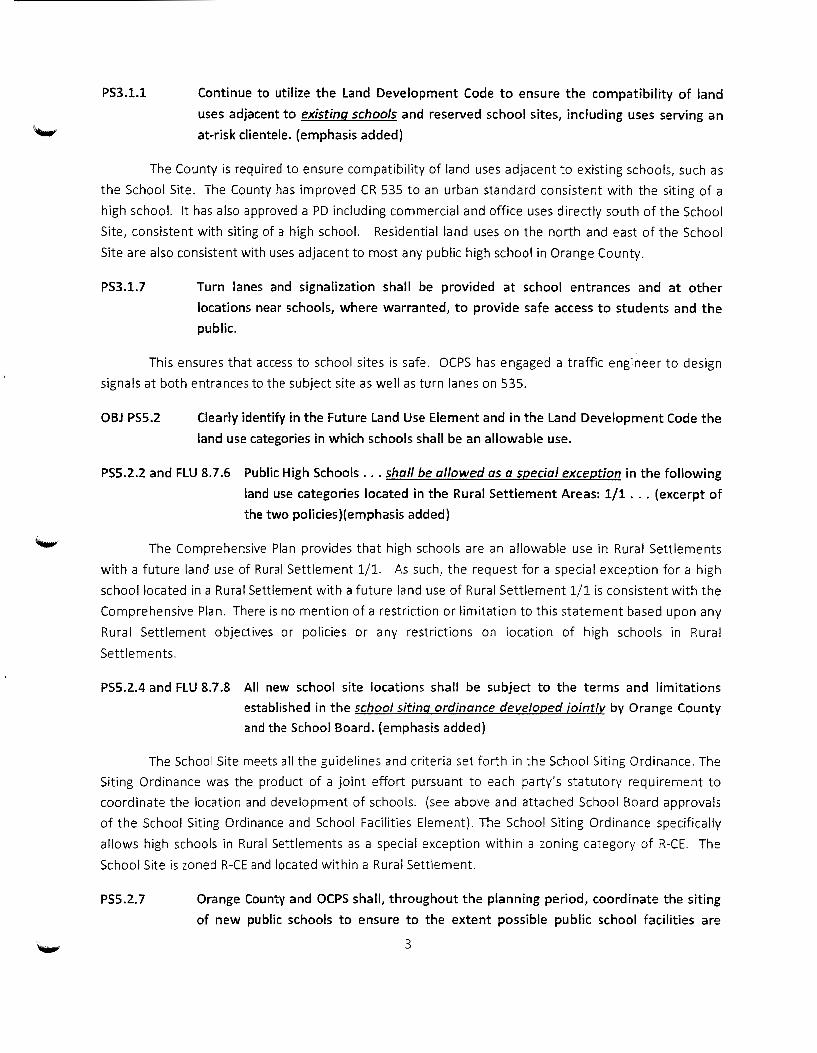
PS3.1.1 Continue to utilize the Land Development Code to ensure the compatibility of land
uses adjacent to existing schools and reserved school sites, including uses serving an
at-risk clientele. {emphasis added)
The County is required to ensure compatibility of land uses adjacent to existing schools, such as
the School Site. The County has improved CR 535 to an urban standard consistent with the siting of a
high school. It has also approved a PD including commercial and office uses directly south of the School
Site, consistent with siting of a high school. Residential land uses on the north and east of the School
Site are also consistent with uses adjacent to most any public high school in Orange County.
PS3.1.7 Turn lanes and signalization shall be provided at school entrances and at other
locations near schools, where warranted, to provide safe access to students and the
public.
This ensures that access to school sites is safe. OCPS has engaged a traffic engineer to design
signals at both entrances to the subject site as well as turn lanes on 535.
OBJ PS5.2 Clearly identify in the Future Land Use Element and in the Land Development Code the
land use categories in which schools shall be an allowable use.
PS5.2.2 and FLU 8.7.6 Public High Schools ... shall be allowed as a special exception in the following
land use categories located in the Rural Settlement Areas: 1/1 ... {excerpt of
the two policies){emphasis added)
The Comprehensive Plan provides that high schools are an allowable use in Rural Settlements
with a future land use of Rural Settlement 1/1. As such, the request for a special exception for a high
school located in a Rural Settlement with a future land use of Rural Settlement 1/1 is consistent with the
Comprehensive Plan. There is no mention of a restriction or limitation to this statement based upon any
Rural Settlement objectives or policies or any restrictions on location of high schools in Rural
Settlements.
PS5.2..4 and FLU 8.7 .8 All new school site locations shall be subject to the terms and limitations
established in the school siting ordinance developed iointlv by Orange County
and the School Board. {emphasis added}
The School Site meets all the guidelines and criteria set forth in the School Siting Ordinance. The
Siting Ordinance was the product of a joint effort pursuant to each party's statutory requirement to
coordinate the location and development of schools. (see above and attached School Board approvals
of the School Siting Ordinance and School Facilities Element). The School Siting Ordinance specifically
allows high schools in Rural Settlements as a special exception within a zoning category of R-CE. The
School Site is zoned R-CE and located within a Rural Settlement.
PS5.2.7 Orange County and OCPS shall, throughout the planning period, coordinate the siting
of new public schools to ensure to the extent possible public school facilities are
3
located to address the needs of future residential development, are coordinated with
necessary services and infrastructure development, provide safe learning
environment, are consistent with the County's adopted Future Land Use Map and with
other provisions of the Comprehensive Plan. (emphasis added)
The School Site is located to address the needs of future residential development in West
Orange County. The School Site has the necessary services and is located adjacent to a major road as
required by the comprehensive plan and School Siting Ordinance. OCPS is designing traffic signals and
turn lanes to ensure a safe environment for ingress and egress from the School Site. The County's
Future Land Use Map allows high schools in Rural Settlement 1/1.
The final catch all of "other provisions with the comprehensive Plan" does not provide what is to
occur when there is a direct conflict between the Public Schools and Future Land Use Elements related
to schools with "other provisions of the Comprehensive Plan" as is the case here. As the coordination
required between OCPS and the County is mandatory pursuant to Florida statutes and changes to the
School Siting Ordinance and Comprehensive Plan relating to schools has historically been coordinated
with the School Board, including formal approval at a public School Board meeting, any other
comprehensive plan policy that conflicts with or changes the allowed land uses in which a school may be
sited is subject to coordination with the School Board and is conflict with the statutory scheme for siting
public schools.
PS5.3.6 Applications for ... special exceptions ... for schools shall be given priority status.
(emphasis added)
This recognizes the special status of schools as a public facility providing a service to the a II
citizens of Orange County.
PS 6.1.9 The County shall support OCPS' efforts to meet the adopted LOS standards through
the adoption of a ten (10) year, financially feasible DCOP. Where the LOS cannot be
achieved through the construction of new school capacity as provided in the five (5)
year DCOP, the County shall cooperate with OCPS' efforts to adopt a long range ten
(10) year DCOP as part of the School District's annual capital planning process.
The School Site has been included in the OCPS ten (10) year DCOP and was incorporated within
the Comprehensive Plan to provide capacity for current approved and future residential development in
west Orange County each fiscal year since 2008. It is consistent with the Comprehensive Plan to meet
the demand for high school capacity in west Orange County.
CIE 1.3.14 The County hereby incorporates by reference the OCPS 10-year Capital Outlay Plan
2010-2011 adopted by the Orange County School Board on September 14, 2010, which
includes sufficient school capacity to meet anticipate[sic] demands projected by OCPS.
4

Budgets for years 2008-2013 indicate the School Site {27-H-W-4) has been included in the ten
{10) year DCOP and incorporated into the County's Comprehensive Plan.
The Subject Site is Consistent with the Rural Settlement GOP's of the Comprehensive Plan
The Planning Staff relies on Objective FlU6.2 for a finding of inconsistency which provides:
Rural Settlements provide for a rural residential lifestyle. In some instances,
Rural Settlements allow a transition of rural areas adjacent to the Urban
Service Area while avoiding development in active agricultural areas. Rural
Settlements were intended to recognize and preserve existing development
patterns at the time the CP was adopted in 1991. The creation of Rural
Settlements recognized the need to maintain agricultural areas and rural uses
in the Rural Service Area, while providing for rural communities.
The Plannin~ Staff must consider more than just the first sentence relating to
the rural residential lifestyle.
1. The Public Schools and Future Land Use Element specifically allow high
schools within the rural settlement. The Planning Staff's position that high
schools are not consistent with the rural residential lifestyle directly
conflicts with multiple GOP's within the Public Schools and Future Land Use
elements of the Comprehensive Plan which allow high schools in Rural
Settlements. The Planning staff also is overlooking the varied character of
Rural Settlements within Orange County, and specifically the lack of rural or
historical character in the West Windermere Rural Settlement. In the West
Windermere Rural Settlement, the County has not recognized and
preserved the existing development patterns as the area changed from
vacant/agricultural development to upscale suburban residential.
2. The Planning Staff's position also conflicts with the second sentence of this
particular Objective that recognizes that Rural Settlements allow a transition
of rural areas adjacent to the Urban Service Area. Although Horizon West is
not the Urban Service Area, it is a Growth Center which contains mixed uses
of urban design similar to or more dense and intense than found in the
Urban Service Area. Assuming the remainder of the West Windermere
Rural Settlement was actually rural, the School Site is located on the edge of
the Rural Settlement adjacent to Horizon West (which contains mixed uses),
suburban residential development and commercial and office development,
none of which are rural in character. The School Site's low .12 FAR and
roughly fifty percent open space provides a buffer to the Rural Settlement
residents from Horizon West's more urban nature. It is important to note
that the FAR at .12 is the same as that of the Chancellor commercial and
5

office development directly to the south of the School Site which the County
found consistent with the Rural Settlement GOP's.
3. The Planning Staff's position also conflicts with the existing development
pattern of the West Windermere Rural Settlement which has been and
continues to be upscale suburban residential communities, many of which
are gated and may include golf courses. This Rural Settlement, unlike others
in the County, has not maintained its rural and historical character.
The County also relies upon Policy FLU 6.2.12 (in part)
Any proposed use within a Rural Settlement intended for the new
construction of a structure(s) with a Gross Buildable Area of 50,000 SF (on a
cumulative basis) or more or projected to have a weekly trip rate of 10,000
total trips may be considered inappropriate for a Rural Settlement if the
following conditions exist:
The use, as determined by a market study, is primarily intended for those
whose daily life activities do not occur within the Rural Settlement.
The Planning Staff's position directly conflicts with the statutorily mandated
Public Schools and Future Land Use Elements dealing with school siting. The elements
listed above specifically allow high schools in Rural Settlements and provide no
restriction on which citizens of Orange County are to utilize a high school, or any other
public school for that matter. By definition a public school is to provide education to the
citizens of Orange County and there are no boundaries recognized for a limitation of use
by certain municipalities or Rural Settlements. As an example citizens of Orange County
that live in Rural Settlements, in the City of Windermere and the City of Ocoee may all
attend the same school. The School Board is the duly elected body charged with the
task of establishing the zones schools in Orange County. The application of the above
Policy to schools is an improper attempt by Orange County to usurp that duty by
establishing de facto zones for schools by restricting schools from Rural Settlements.
This interpretation of the Policy restricts any public school from being approved
in a Rural Settlement as an elementary school is typically 90,000 SF, a middle school is
typically 150,000 SF and high schools are typically 350,000 SF. If the purpose of the
adoption of this policy is to preclude the siting of schools in Rural Settlements, it directly
conflicts with other elements of the Comprehensive Plan relating to school siting and
the School Siting Ordinance. The Public Schools Element and the Future Land Use
Element GOP's are to be coordinated with the School Board. Prior to adoption, the
County was required to coordinate with the School Board on its intent to limit all public
schools from the Rural Settlements.
6

FLU 6.2.12 was initiated subsequent to the adoption of a change to the Zoning
Ordinance relating to religious institutions within residential or agricultural properties as
'-' evidenced by Condition 32 of Section 38-79. This supports OCPS' position that it is
inapplicable to public high schools providing a service to Orange County.
The County also relies on FLU 8.2 and Policy 8.2.1 regarding Compatibility.
Objective FLU 8.2 Compatibility will continue to be the fundamental consideration in
all land use and zoning decisions. For purposes of this objective, the following policies
shall guide regulatory decisions that involve differing land uses.
Policy 8.2.1 Land Use changes shall be required to be compatible with the existing
development and development trend in the area. Performance restrictions and/or
conditions may be placed on property through the appropriate development order to
ensure compatibility. No restrictions or conditions shall be placed on a Future land
Use Map change.
Compatibility goes beyond the immediate adjacency and looks to the
development pattern in the entire area. The School Site is at a low .12 FAR (the same as
the Chancellor Development to the south) and provides approximately 50% open space.
The majority of the open space is on the eastern and northern side of the School Site
adjacent to the upscale suburban residential development. The nearest building to the
residential development to the east is approximately 505 feet and to the north is
approximately 620 feet, which is equal to or greater than the lot depth required for R-CE
and is many times the setback and landscape buffer requirements. To the west, there is
approximately 160 feet to CR 535 beyond that the Bridegewater Village Center, an
urban development. To the south there is the recently approved commercial and office
PD known as the Chancellor development.
As an example of a similar use within the West Windermere Rural Settlement,
the Windermere Preparatory School is located within this Rural Settlement and has
approximately 250,000 square feet of buildings on approximately 48 acres resulting in a
.12 FAR containing a baseball, softball and football field.
The standard of review for compatibility is the School Siting Ordinance. The site
plan submitted meets or exceeds the guidelines and criteria set forth therein. Even
considering the West Windermere Rural Settlement development trends the School Site
is compatible. The development trend in the area is upscale suburban residential sprawl
with no rural or historical character. Moreover, there is ample precedent for locating
high schools in proximity to residential neighborhoods (e.g. Winter Park, Dr. Phillips,
Boone and West Orange).
7

Based on the above analysis, the School Board's position is that the School Site
is consistent with the Comprehensive Plan.
The Special Exception Criteria Have Been Met
The site plan submitted for review by the Special Exception meets the requirements set
forth in 38-78 (1}-(5}. Which are as follows:
1. The use shall be consistent with the Comprehensive Policy Plan;
2. The use shall be similar and compatible with the surrounding area and shall be
consistent with the pattern of surrounding development;
3. The use shall not act as a detrimental intrusion into a surrounding area;
4. The use shall meet the performance standards of the zoning district; and
5. The use shall be similar in noise, vibration, dust, odor, glare, heat producing and
other characteristics that are associated with the majority of uses currently
permitted in the zoning district.
The Zoning Staff improperly concluded that items (1}-(3} and (5} were not met as a
result of the Planning and Zoning Commission's finding of inconsistency with the site
plan and recommendation of denial of the 2008 Planned Development submittal. The
surrounding area has changed since the submittal of the Planned Development request
in 2008 and OCPS has submitted a different site plan for consideration.
The appropriate objective standards by which the site plan and use submitted for a
special exception is the School Siting Ordinance, the Noise Pollution Control Ordinance
of Orange County, Florida ("Noise Ordinance"} and the Lighting Ordinance.
1. As set forth above in detail, the School Site is consistent with the
Comprehensive Plan, satisfying 38-78(1).
2. The site is consistent with the surrounding development and the development
trend in the area. Directly south of the school site is a commercial and office
development. West of the school site is a major roadway with adequate
capacity to carry student and parent traffic and is suitable for high volume
traffic during evening and special events and Horizon West, an urban mixed use
planned development. North and east of the school site is upscale suburban
neighborhoods. A review of the aerial photographs reveals that the
development trend in the area is upscale suburban sprawl, not a rural
residential lifestyle. As stated above, high schools are located adjacent to
residential throughout Orange County and are consistent with same. The site
meets or exceeds 38-78(2).
8
3. The site will not be a detrimental intrusion into the surrounding area. The site is
consistent with the Orange County Lighting Ordinance wherein light spillage at
the property line of adjacent residential will not exceed .5 footcandles and will
not exceed 1 footcandle at the south and west property lines. The site will
adhere to the Noise Ordinance. Pursuant to the traffic study and analysis by
Orange County, there is sufficient capacity on CR 535 for the project. The
signals requested by the OCPS will be linked to the signal at the CR
535/Fiquette-Hancock Road intersection to insure proper traffic flows on CR
535. The site plan provides for a low .12 FAR, similar to the Chancellor
Development to the south and the West Windermere Preparatory School, and
provides for approximately 50% open space. The open space is located on the
east and north of the School Site and provides a buffer to the upscale residential
neighborhoods to the east and north of the School Site. The site meets or
exceeds 38-78(3).
4. The County staff concurs that the site meets or exceeds the performance
standards ofthe district, therefore satisfying 38-78(4).
5. The Zoning Use Table, note 139 provides that high schools are a permitted use
within rural settlements by special exception so long as the development is in
accordance with the School Siting Ordinance. The site plan submitted meets or
exceeds all guidelines and criteria in the Siting Ordinance and will meet or
exceed the lighting ordinance and Noise Ordinance. As an example of a similar
use within the West Windermere Rural Settlement, the Windermere
Preparatory School is located within this Rural Settlement and has
approximately 250,000 square feet of buildings on approximately 48 acres
resulting in a .12 FAR containing a baseball, softball and football field. The
School Sitie satisfies 38-8(5).
This document may be amended, updated and/or supplemented at any time
subsequent to this submittal.
9

MEMORANDUM
TO:
ATTENTION:
FROM:
SUBJECT:
Background
DR. DON SHAW Superintendent
FRANK KEBELMAN Associate Superintendent Facilities Services
DAVID LOWERY Senior Director Facilities Services
JON MARTIN Administrator, Facilities Strategic Planning
1-' .I ~ -;
.~
'., \/
. i·
Approval of Resolution of Support for Orange CoLRnty Ordinance Adopting School Siting/site Standards
-.·:. .
Although the independence of local school boards from loc:al government control is defined in Florida Statutes, local governments have often sought to impose restrictions on school construction and siting. In 1995, the Florida Legislature clarifted its intent that IDeal governments may not use restrictions on land use and zoning as a means to usurp school board responsibilities or to demand that school board funds be used for upgrades to other pubiic faciiities (water, sewer, parks).
As part of its clarification, the legislature required that 'The future land use element must clearly identify the land use categories in which public schools are an allowable use. When delineating the land use categories in which public schools are an allowable use, a local government shall include in the categories sufficient land proximate to residential development to meet the projected needs for schools in coordination with pubfic school boards and may establish differing criteria for schools of different type or stze. Each local government shall include lands contiguous to existing school sites, to the maximum extent possible, within the land use categories in which pub[;c schools are an allowable use." and that ~All comprehensive plans must comply with this paragraph no later than October 1, 1996. "
The Florida Department of Community Affairs made clear the legislature's intent by advising local governments that this requirement could not be met by identifying schools as permitted special ex:ceptions (thereby requiring schools to be subject to local government review and control).
At the same time, the legislature recognized that local government and school board should coordinate their planning efforts. Ch. 23.5 FS makes clear that 'This section does not prohibit a local governing body and district school board from agreeing and establishing an alternative process for re\'iewing a proposed educational facility and site plan, and off-site impacts."
G:\realproperty\ORA.NGECO\SfTING\SITE.A.GND.DDC
Coordination cf Planning
This section implements state requirements for coordination of planning and sharing of information.
Review of Public School Sites
For those sites not requiring formal review coordination will be expedited. After the school board has conducted a neighborhood meeting and prepared plans it will request a determination of consistency. The consistency review shall be limited to the criteria and standards but will be processed through County development review (DRC) staff to assist the school board in its site planning.
Neighborhood Meeting
ln response to concerns rais9d by planning board members, County staff has asked that school board agree to conduct neighborhood meetings after preliminary site plans are prepared but before plans are submitted to County staff. County staff assures us that the purpose of such meetings and minutes of the meetings is solely to assure that adjacent homeowners are informed, have an opportunity to communicate with school board staff and have an opportunity to provide information relative to criteria and standards.
Resolution
WHEREAS, Orange County, Florida, and the Orange County School Board have been working together to provic!e for implementation of the 1995 Florida Legislative Session amendments to Chapt9rs 163 and 235, Florida Statutes, pertaining to public schools and the need tor coordination with local governments; and
WHEREAS, Section 163.3177(6)(a), Florida Statutes, speciftcalty requires that by October 1, 1996, the Orange County Comprehensive Policy Plan Future Land Use Element shall contain standards for public school siting and fist those land uses where public schools are permitted; and
WHEREAS" Orange County has transmitted such Comprehensive Plan policies pertaining to school siting and anticipates such policies will be adopted in September, i 996; and
WHEREAS, Proposed Future Land Use Element Policies 3.2.21, 3.2.21.1, 3.2.21.2, 3.2.21.3 and 3.2..21.4 pertaining to school siting have been jaintly reviewed by the staffs of Orange County and the Orange County School Board; and
WHEREAS, Proposed Future Land Use Element Policy 3.2.21.3 cal!s for the adoption of a school siting ordinance by Orange County with such ordinance being developed jointly by Orange County and the Orange County School Board; and
WHEREAS, the staffs of Orange County and the Orange County School Board have jointly developed a Public School Siting and Development Standards Ordinance cor1sistent with the Proposed Future Land Use Element Policies; and
WHEREAS, upon review of the Proposed Future Land Use Element Policies pertaining to school siting and the Public School Siting and Development Standards Ordinance, the Orange
G:\reaiproperty\DRANGECD\SrT!NG\SfTEAGND.DOC
"Attachment A"
Proposed Orange County Future Land Use Element Policies
'-" 3.2.21 Public elementary schools shall be allowed as permitted uses in the following land use categories located in the Urban Service Area: Low Density Residential, Low-Medium Density Residential, Medium Density Residential, High Density Residential, Institutional, and Activity Center Residential. Public middle schools and free-standing ninth-grade centers ·shall be allowed as permitted uses in the following land use categories located in the Urban Service Area: Medium Density Residential, High Density Residential, Institutional, and Activity Center ResidentiaL Public middle schools and free-standing ninth-grade centers shall be alloWed as speclal exceptions in the following land use categories located in the Urban Service Area: Low Density Residential and Low-Medium Density ResidentiaL Public elementary schools, middle schools, and free-standing ninth grade centers shall be allowed as special exceptions in the following land use categories located in the Rural Settlement Areas,: 1/1, 1/2, 115, Low Density Residential, Low-Medium Density Residential, and Institutional. In addition to the locations identified above, public elementary schools, middle schools, and free-standing ninth-grand centers shall be allowed as a permitted use in all future land use categories if identified in a Planned Development Land Use Plan approved by the Board of County Commissioners.
3.2.21.1 Public high schools and ninth-grade centers developed in conjunction with high schools shall be allowed as permitted uses in the following land use categories located in the Urban Service Area: Commercial, Industrial, Institutional, and Actrvity Center Mixed Use. Public high schools and ninth-grade centers developed in conjunction with high schools shall be allowed as special exceptions in the following land use categories located in the Urt:lan Service Area: Low Density Residential, Low-Medium Density Residential, Medium Density Residential, High Density Residential, Offtce, and Activity Center Residential. Public high schools and ninthgrade centers developed in conjunction with high schools shall be allowed as a special exception in the following land use categories located in the Rural Settlement Areas: 1/1, 1/2, 115, Low Density Residential, Low-Medium Density Residential, Office, Commercial, Industrial, and Institutional. In addition to the locations identified above, public high schools and ninth-grand centers developed in conjunction with high schools shall be allowed as a permitted use in all tuture land use categories if identified in a Planned Development Land Use Plan approved by the Board of County Commissioners.
3.2..21.2 tn the event that the School Board determines a public school facility is required in an area designated Rural/Agricultural on the Future Land Use Map, an amendment to the Future Land Use Map shall be required. The School Board may request an ame:1dment to the Future Land Use Map at no cost.
3.2.21.3 All new school locations shall be subject to the terms and limitations established in the school siting ordinance deve~oped jointly by Orange County and the School Board.
3.2.21.4 Orange County shall amend the Land Development Regulations to allow schools as permitted uses and special exceptions in appropriate categories, consistent with Future Land Use Policies 3.2.21, 3.2.2 1. 1, and 3.2.21.2.
G:\realprope:rty\DP..ANGECD\SfTING\SfTEAGND.DOC

Orange County Public Schools MEMO September 9, 1997
TO: Dennis M. Smith, Superintendent
FROM: Mike Mekdeci, Associate Superintendent
SUBJECT: AGENDA fTEM: Approve Transmittal of Draft School Facilities Element- Orange County Comprehensive Plan
BACKGROUND:
Changes in Florida Statutes adopted in 1995 establish a framework for coordination of planning between the school board and local governments.
Working with school board staff, Orange County has prepared the enclosed draft School Facilities Element for inclusion in the Orange County Comprehensive Plan. This plan turns away from confrontation and reliance on rules, regulations and laws toward both formal and informal intergovernmental cooperation. This draft reflects the adopted mission of the Orange County Public Schools and describes the related role the County plays in land use, parks, traffic safety and other cooperative programs (e.g. after school programs and community improvement projects).
The draft's unifying design vision ls that schools will be cornerstones for both new development and for neighborhood planning. The underlying theme of the element and the Goals, Objectives and Policies (GOPs) is that the entire community must share a vision and responsibility to enable children to succeed.
Finally, the plan recognizes the shortfall in school capital revenues and outlines a strategy for reviewing options and seeking creatrve solutions tor managing growth. Vvhile no single approach can address all school facility needs, the School Facilities Element sets the stage for examining important options and managing processes efficiently.
Comprehensive Plan Element Requirements
A "Comprehensive Plan" (as defined in Florida Department of Community Affairs, Rule 9J-5; F.A.C.) is an official public document adopted by a local government as a policy guide to decisions about the future physical development of the community.
Dennis M. Smith September 9, 1997 Page 3
Adoption of a school element does not change the adopted Land Use Plan, which ·~ specifies the land uses and the residential densities throughout the county, but may
have an impact on the timing and regulation of development. A school facilities element may or may not include concurrency provisions. The draft does not adopt concurrency but does set the stage for considering concurrency along with other mechanisms to address the impact of growth on the school system.
As a condition of adopting a concurrency standard, a local government must adopt a realistic and adequate level of service (LOS) standard. The school board capital imp~ovements element must set forth a financially feasible plan which demonstrates that the local government (in this case, the school board) can achieve and maintain the adopted level of service standards. If the school board cannot demonstrate that it can achieve its proposed level of service standards with revenues available to it, then rt must amend or lower the level of service standard.
The Goals, Objectives and Policies
• address statutory requirements for coordination of planning. • establish policies to make schools "focal points for community design and
improvement" • set the stage for amendments to Orange County's development regulations
relative to schools • describe the substantial intergovernmental programs which are in place. • establish a process and format for sharing of critical information about
development plans and projections. " commit the County and school board to consider concurrency and other
options to assist in meeting challenges created by growth.
The draft includes "non-binding" school siting maps which icientrry in broad terms ths areas of the County which may need new schools over the 'le>~t twenty years. The maps are consistent with the Heery I 0 Year Plan. County staff developed these maps to link long term planning for school sites with the County's adopted Parks and Recreation Plan and to identify opportunities for joint school and park use.
The Adoption Process
If the School Board approves the Public Schools Facilities Element, Orange County \Viii conduct hearings for adoption and transmittal to DCA. If either the Local Planning Board (LPA) or the County make changes to the draft after approval by the School Board, these changes wil\ be brought back to the school board for approval pr'1or to adoption. The County will conduct a two public hearings, one before the LPA on

''' ••• ~'I ••- ;> ':-11 • .... ~ .. ; ~"ff. ··:)'',1:. :·~~~.~~~~1? !' I I I • 1• - .+~. ,, 1.,\:~'fi. ·'· 1 , ', 11 • 1,n• .' , I, ;,.:;~J
11 I I _,• L'l'\~ ,·i 1owlt'\Y
·,,_ ,•· ;{ :-~ :, 1'/\f-:r-..::-:- :~\~ 11';.~·-~H .. ~ .. ~.if ~~-·nr·~-~~,.Y
Public School Facilities Element
PrepaYed by tl1e Ora11ge Co1A.11-fy
PlaTilting Departrn_errt i11 COJ1j1A-nctioJ1 Tui tl1
Orange CoLll'lty PL1blic Scl'lools
~.~,:.,.,,! '"'j•, 1 ' 1 , '.- 1 ) ,,:(~ 11 - -"1 1 '•' ' 11 /<, _":./l\"''f,'•j'' , 1 ,IJf,";.-,,,l'', ' 1
1 '·.' 11•,f'•t•'•'•l,,•:·t'•j',,," ,'I>
1 I ,•' I
1 1 I,,.;)', I '
-·- ------- --~------------------·----------~-----------------~-----~-----~----·--·--
) ) )
.i'

' ; ';':" : ' : : ;;,. ~~'~{il Public School Facilities Elernent Background
"
o OIJtiOilal element
• Developed by Orange CoLlit_ty & Scltool Board
e Establislres CoLIItty policy to adclre.ss scl1ooliLeeds
e 1'ra11smitted by botl'l tl~e LP A a11_d tl1e BCC d_lJ_ri:rlg tl._e 97-1 cycle
• Received no objections frorlt DCA
• Scltool Board adopted a ResolLrlioit of Su]:)port for tl._e Ele1nent
• Curre11tly bei11_g brouglt_t before tlte 1_jp f\ for adoiJtiOit
lllll ______________________ ,.. ________________ ._ll!llloaw"'o"'· .. , ":er!li:t-.. '*'¥M'Kai~·MM,.+' ' - d'"'~.....a:lllrr6lalii?NM il 5
....,.,.... a· ·-·
) )
.I
)
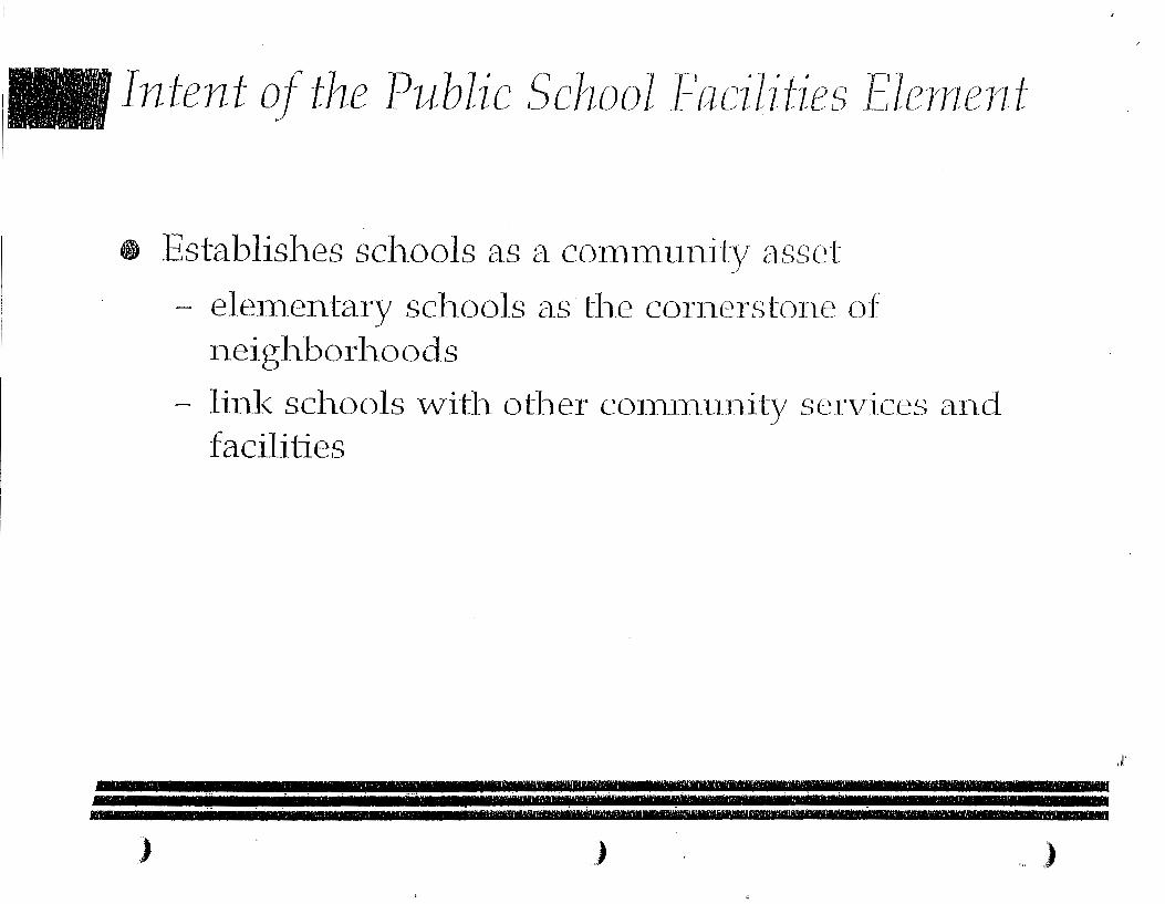
· · ~ , ·, ,:·t.' • '>'1 t fr. ~ -:, '~ ' ,' 'I l l'l ~ I ~ !'"f 1t<f
, I ', I l• q.l J.:l.J
;;::.·,i,:~~··. _:~{;,: .. :.:;·iii( Intent of the Public School facilit-ies Elenrent
e Establisl1es scl1ools as a con11111111ity asset
- elementary scl'lools a_s tl'le corilerstoile of Ileigltborltoods
- liitl< schools witl'l otlter COITilTI.liitity services a11_d faciliiies
f.·,····· ·~·l ··;1-~:j_l:··,: ... · ,11. r· .. ;·J;,-;r_._;:•r\·,;·,··-1 ·--:.;.~·li!'•.'f''• 1.iH·-(;· '··:.:~-~·;• '(.,H_-·.:-:.-,:;· -·:, .. 1 .~ ..... ;.:,-·-;·:· ·,'.'·•t- 1--'l·t ·,.: .. ;_'!,:·:-. ·,···~· .:·;
... _., •: r',r.',·J,-:1 1'1 ,·Jl ·; -.. ,, __ ,.·~-· ·:•-.· .• -,r:-:-,· ·,, ·.·r_, ____ .__,_, nn -~ ---.-_--.-- ,,, rr ________ ------riiiifuug~....WerwweM""PUM=-,.z•···, •v4M MIM'M 11........,
" )
'· )
):

. • • , , .. ~ ... ·. ·-~ .... i ~:r
' ' ' I ' I •"t ' • '~~~;
l' :, <.~ .. ,.·.·.~:: ·.~~;,·)~! Intent of the Public School F'acilihes Elenzent, COJ1t.
49 EI1COtirages intergover11111e11tal coo]peratiOJl
- develops a Scl1ool Conce1:)t Pla11
- establisltes Itew scltool si-Li~tg criteria
- eitcourages representatives to ser\Te 011 respective plaiutiitg boards
- requires ii1forinatiOit sltaring betvveert CoLliYty a11d Scl1.ool Board
.."• ·-,!~.-~ •·-··· ·:,::,_::•,.:_;:, 1,~~-·- : 1 :~. ---\.· ··,-, 1 : ·:. ·.;:., ·;_.~~·;:~:•.:- ... •-.. • ·~;;_:;::·r. 1 .,,_- .7 •• '• -~-·.:- •. .- 1,.
lr~·-<_·.,1·1;·.·:- ., ""1' ,._ ~-.l. _,_,.. _~.--·.: .. '-r!.·.-·,~ ... ::'.'.:--:_.1·;,•/r=f!l ._ .. ,-_"' .•. , ... _ .... ':1 ···---·;• ,--•. ·_: .. !··~ .. !")"·1'-::::·~-.- ·~;, .. ~·.J .• •· ·.• .1~
,) ,) )
.I

t'; I !,'1 ·~.:·:' • • •~}.;•,€)
'' ·.::.: .• -.. ; i ~ ...... ~.::'/;/ Intent of the Public School Facilities Elen1ent1 cant,
e Establisl1es s11pport to e11S11re scl1ool ca1Jacity is a_vailable for tl1.e de1na1l.d
- S'Llpports efficient 11se of existi.rtg ft1I1di11g SO'Llrces
- s11pports consideratio11. of alterrtative f-tiJ1.di11.g S011rces
; 1 ', .; I I 1 1 ' • , 1 1, •'' ; •J {;I J\ , 1 1 • I ' • , ,1 I 1 "f. • \•
1 jl)j~ J I ,' I 'I I ' p ' I
01 ,I I o ·, • 11 1 11 ~',
1 1\lj, 'lj ,I I I'- ' • ' •: ) I I , I ' • ' ,. • 1 ' 1 , •\ 1 •• ; •I 'II \ 1 t< ,I II':, { ,•. 1 I I , 1 It l",l
. ~· . ·-· -. --.--,--~---·---- .:...:. . ...:_!_ -- --~- ________ ::.._ ... __ ___.:___. ___ ~_ -·- ·----. --~·-·- ....... : . ··-- , _________ __;_____ -·---- - -~--------- --·-·---- ---·-'-·---·-·--·-'"--
• ' I 1 , 1 1 ' 1 • I 1 ~ 1" 1 '> , ~ , 1 \ - 1 / I
1 I 1 I I • ' J 11 • 1 1 1 ~ • / • ' 1 • I ' 1 I 1 • ,
-... ~----~--~~~------------ ---. . ··-- ...:____ .. --·-·· ~,~~· I __ , ! 1 1 _ ~ 1 I' ~ '~-' _ I · 1 • 1;.l.\, I ,~ "', l,_l.' I' 1 ! I , ~<r\ r!'t' ~r ti\11"• •'11 : ~ •'•'I • • '. -;· , ~··1, j ,)•• 1', l' '', •I•• ('' t ·.',, L~' 1 ,
) ) )
i· I ~.'

'.::·:· .. :·::·~. :·_: ... i ::):~1 • ' ' • I • ' 1 ~ ,j '..,\
. :r-. ',~It :•.•.,~: I, 't•f : ' ; ;: ,:•:;
Six Chapters Con1prise the Pl/ll;Jic Scirool Facilities Ele111e11t
e CHAPTER 1:
e CHAPTER2:
o CI-IAPTER 3:
• CI-IAPTER 4: • CHAPTER 5:
• CI-IAPTER 6:
PURPOSE & OVERVIEvV
EXISTING COIVIIVJU-NITY CONDITIONS
SCI-IOOL F ACI1~ITIES i-\.N-D LAND USE
ACTION PLJ\N VISION ST A Tl~JvlEN'f
MONI1'0RING & J3Vi\T~UATION PROGRAM
Jl ,-,1,_1-.····~ !:-:·,--'1 "~ • -:\·]_.,• ·,-·r ··-.·. ·~· ·~·.~· :-1 "· . ·- ·"' '• "' . -~. • • I 1 •
r---/. -: :· . ! . :-~.-~- . --. ~·. . :~ ·;··. ~:- , .-. , .. · .--~
,) ) )
.i
: ·,~ . ·, .;~ ·.-: '/: :~ ':I~·~_; ;'f:~· . ·'.' ' ' . f . ·IJ~·
• ; ~~ ' "r, J '!r; [!
'~I •;'\'t(,·~;·,,;:~•:::~/.\.f.:~:~ CI-IAPTER 4: ACTIO_N JJLAN
GOALS/ OBJECTIVES/ AND POLICIES
• How do we coordiilate services a11d capital i1nproveme11.ts to e11.able cl1.ildre11. to Sticceed?
o How ca11. -vve e11.S1.1re tl1at p11blic scl1ool sites a11.d facilities are focal poi11.ts for 1Jrogra1ns a11.d
i1nproveme11.ts to enl'1a11.ce · neiglt.borlioods a11.d commti11.ities?
• How do we erlSllre tltat cl1.ildrerl live Jlt sa_fe an.d secure ertvironments/ 11.0t oruy at scltool btlt iil tl1.eir comm"Lll1.ities?
.• • r,··'j!'.-, r·:l ,c:-, .~.-· ...... ·::·· ··.·,·'··, ~··.'-1' 1.'1, !'. •;:1'~ .,... :,-, .. , ~~, ' ....... , ·· .. '!.\·. ·,: .--,' \ \ -:-1
• ' ~ I ; 'I.., < ' • • f I ' I ' ' ,, (l,' I ,,. I I • ~ -, - ' - I I ' . I ' ~ ' I I ' ' . . . ... ' ' ' ' . ' I' I ' ' . ·- . ' I ' ~ I ,' lj • I ' • I ,· ' ''"~ I ' • ' '• I • ,. j '; •' '. I ' ; '. I ~- ' ' ;,. J j ' ' ~ t ' I l I. I f 1 I ' J )I -- ~ .. - - -
) ) . )
,):
CHAPTER 4: AC110_N PLANGOALS/ OBJECTIVES/ AN-D _POL_IL~_TES
e How cait we ltelp tlte Ora11_ge CotiiYty Scl1ool Board provide S"Lifficient scl1.ool capacity to 1T1eet tlte Iteeds of tlte existing aitd f"L1h1re scltool pO])Lilatioit?
• How cai'l we support tlte Scl1ool Board's efforts to enSLire adequate ft111ding to COits-h'"Lict ar1d operate required_ scl1ool facilities?
• How ca11_ we foster effective u:LtergoverilJneittal cooperation to meet corrunuitity 11.eeds a11.d S"Lipport tl1.e public scl~_ool syste1n lit a J~l_lilti-jLirisdiction_al
en vir 01tme11t?
.. _,.,_ .- •. · .• __ ,- -:~ ., .• ·. .,:"":.-;.·· --~-- :·.· .. =:-,-, .. -~·---I·i .• -_,;''."! ·, ........ '.r .. :-:·· .. ~-·.:..: ~-,:.-.. ,~.: •.. :~·.: .. :.}.•_:: ~ -~- ._. ... --._._ .. _:.,~·:..=·,-.. ·;-t-·.'1:·~-~(l•l,.;: .-~._.,-,_.:: __ ... ,_/;,.·.~
• MEL u mr · ··"naov·tt rreJtf'XWMitMZER ·or , nrw ...... • ~{:·~·-•·,:··.;:• ·.·.\~.·"):••,- -~•·'':",,,:·,i: -~: ~'.1' ,·,•:. ~-::.-.~:;.'., .Jr ~; •.::~~j~.~--:"•,"; '• 0•:1•:,;:-'._•, -~· .~·····1• !:'•~',~•l,,,~•,,,,'j·~.--.:,•,',"•o .:. ;,., ,,,;',, .......... ,;~~~--:,! .. ~:· .. {.- .. ~.·'1··-;'''•·~·.,..~ •• ··,• J;'r-.',;.1.
,) ) ,)
_,

• I I ' .J, '•, • 0
I
0
' 0 ~ f
' • ' I'
' ' \ ._ ·;
. '. ,' . ,,' .. ,:;_':.;:-~'!' Goals, ObjectiDes, and Policies
of the Public School Facilities Elen1ent
GOAL 1:
• Provide a coinn'llli'lity of Slll)])Ort for tl'le positive develop1nent a11_d growtlt_ of all c]1_ildrerL
OBJECTIVE 1:
• SiTen_gtl1en family ancl cl1ilclre11 services.
~~'J' • ~ •, ': •Ji • I' ' ·.-;1 •• lj I • :, • I ' ~- I l'lj I :t I, ·~ .,' :'i, ,,~\:~;,~,I ' r. l,it/;,:JI ~ '· ~. ., ' . ~ I. ... \'·H,Ij· ~~ I :t· t tl':,t ~··. f'~tl .,'n, I'd' :J ,. ' ;j J ',r ~r '/ry .r-4-v~/ ~: P·~\v: .. ; 1,) llfll"-•I.Jr llit'r~o JJJ ·,'I I•. lj. l ~·,;~r .'•1,' }.·~·l ,••J;:.rlif'-t.l,.lt' ~~~ • ,•\,,'llJ t.~J.~"I.-1i\· j',• ~.~~~r-;'1 fJ• ... ·/1! ,41'1\d•'
~·,w .. ·. ; -.·. ···'1 /,'• ":'. ' .. r ,t :· :·.,·h. ' .. :1. ~ ·.;1 ", .< .'1 I !; ; .•; f .. : .. 1 ',·; :.!'. · .l~i.·:.l,~;~;.;.-; ·. l ,. ·,::;·· .. ·, •.·.~ · ' :c· •::~1~ l:'";·JI,',:.-,,,\. f f~~:•f-11~·~,":;' ~-7>'1 ~/-\,l. · .• :t".•.i .; <...; ·:1.:'~ r 1:. ·• •:· 1 .. '/!·h ·;;•Ji';·, ,•,~ f•;\.li·-~ 1L/:;:.~ :~;...' .. ;~~~T_'I_~~ ~ i·1 :·; l'· ,·,· 1. ~ ·~;: ., ·:·.,•., :.._· _. lf.i't.:.1: <".; l1; I 1 ,., .. :•~.:.• ·:;)) ~··~ ~·,·~··i .,..·,, .\·tt: ~· •• ~~.; ~ .•. ·, · ~; ;, •\·;·'i
.):
IMiidlllil m E'Mifml't T e"'tiiJf"'ijsp .. ·~~Nwprmwo:.y••!DJliii"!••Mee!!r!MmfWIMM"'IMIWIIIDIIHli!IIIJ
,) ) . ,)

. '•'
·:'.' ·'
· .. · ,'.) ··'- ,l .. ,li]
Goals/ Objeci·ives/ and Policies of t-he Public School Facilities Elernent
GOAL?:
1> Mal<e sclt_ools tlt_e coiTterstOI1es of cOI1111l_llltity plaiUtiilg a11d desigr1.
OBJEC1'IVE 1:
e Enl1ance community jneigl1borl1oocl design tl1rot1gh tl1e joi11t use of ed-ucational faciJjties.
··!.. •'o :'.j ,!'4•'.•.;<.-;t, .''.,,·q, ;'!'I:,· •· •. ,1,·,.,·· , .. ~·:,,,." ".',,' ••·, ... ,· ·,,·•··c,.-,_.'··:·;o,,:",~~.',::',•~'·'':l·-,_-:,.,. :·,,;;_;., ......
••,., 1;;',•,-~ .1 ,f. ,... ·,·~'ti• ~:••,' •;o•·-•. -,·-; ,·: ,.:,---;"•·:-, ··-~·: ·~ '••·.,,.: •,•', ';:-• c·:-~·'-':• ;,• '•.'•'• ',,',·,.',, roo• ··-·~
) ) )

.··,·. ·. · .. · ·._: ".: .. ):,:
· .. ; ; ::.:··; ;.·.· :"~~:\:·::.;: Goals/ Objectives/ and Policies of the Public School Facilities Elernent
GOAL 2 ( corrlirttied.):
OBJECTIVE 2:
• Eili1an.ce community jn.eigl1borl1ood design tl1rot1gl1 effective scl1ool facility desigrl an_d siting sta11dards.
.d '·•"-II ·-~-- i ~~~·\_ ..... _,Jr:,· ·,:,t ... r -~.--:·:d'·-:,1..-1\!,h·_.; ~-·.-i~··.. ..~-i.·,"1:-''~·l~""··".".' ··L';·"!··-·,~,~ .. -q'·'· .. ,-.'';r-·; -~-!-, ., .. ,.,.,,-~~- :,,;1r .;_~·-,
' ' - • • •• • 1 11 , •· ' ' j , • ~ I I : ' I '~ 1 • • ' ' 1
t 1 ' •
;:r·;:,;. •.:· .··· _ci"'::·--~---·~·--.·i,-·::•1 ";,.<'). • .... :-'11· o; .-.,'·.: •'·!; .'.i:·.;.,,·.-=·-.:,:r.. ·-··-. _;_::·.·.:;._;_.-r·,-~. -~/::.,,":·~ •·r ,._ff!l
) ) )
I' . ~~·

' . ' _~. ·::, · .. -:: ·:' ~·~·:r
' I ' ' ~ • j' •:
: '4 ,· ' •••• ':·
Goals/ Objectives/ and Policies of the Public School Facilities Ele1neni
GOAL~ 3:
e Provide safe and sec"Lire scltools i11 l1ealtlly1 vvelldesigned lteighborll.C)ocls.
OBJECTIVE 1:
• Ens-ure security a11d safety of ch.ildre11.
~~ .... ~ .................. ~ .... -. .. K8~ .......................... ~ .... -.uMM~n~·erBm•wn•=-~rrw~~ .. _.a..wzwa .. .-~~.a~-~---~~- a w ~
) ,) ,)

~ • ~ • .- ... 1 I, '.,'r ••1
. ' ' ' 11 ' ' ' ' ' ' ' ~:.'
' ' ''1',' . ' · .. ·..: ,:,1: fi ' '
Goals/ Objectives/ and Policies of the Public School Facilities Elernent
GOAL 3 (co11tiil11ed):
OBJECTIV-E 2:
• Coord:inate Juvenile jllstice services -vvitl1 edtlcatio11al 11eeds.
•". 1 1 , , 1 1 , 1 I 1 , 1 'jl 1 1 ,;• '-~,1 '·ill .... ,,,'j - 1 "-;:~j,' ), }~~•'\ll"'l1<,;!f,11t'1 1;:,,-.1\:o"i :'j<,r 1,• I 1 1 1~,'1,' 1 ';'1~,"-~1~' .. 1o• 1 ,,1,)-.:.. 11 °• 1 >il~',• lj,,' ,,
, 0 ,1' I 1 j •\ 1 ~,,~" ij] ol,, 'l'j• 1 l '<< I.H,l),,-,,1 1, ,.j.[_J >'I ' < ' f • II '• <1
•I Ill J < l ~ r • i . ... . . ... . - . '~ .
,) ) )
,, ,j,

Goals/ Objectives/ and Policies of the Public School Facilities Elenzent
GOAl~ 4:
Stlpport Scltool Board efforts to erlSLlre tltat adeqliate capital facilities a11_d teclut_ology resot1rces are
available to SLlpport tlte ediicatiorlalJnissiorl of pL1blic scltools .
..... :.::.~ ..... -, .. ~,:·:~·.1''1~.-l. ,, 1_\ ~-.:----.· .• • .... :·.~:'" .:;';;-,, l. , .. , ·, ___ .,...., ,:-.-.-~·- __ -:·-···· :\ .. ;'.' ·-·--~-·-·d,·-·.- 1'.'
;~'\f',.- 1 -l::.-.:·.-:·i::~:.·~-·{ ........ · 1 •• •.:..·:;-~--·.,-•••• • • ._ •• ·.::~-~--•· 1 -· •••• •• ,· :-.~:.~·;1~-x-~:~ ·-!::.,-.. ".::·,-·I·--; !i -~·'"-\~-:-"',tf·:!;,-r ...... -~.--r .. ;·,;.• •. ·.•·-·:•.-:_~;~i~l_!: . .;-_; .. ,~:,·_\.;: ... _.'"·~· .. -1;·_~,~<:;~r.-,·., .... ·i·'~ .... 1_j'; .. , 1 ,;·~~---;~;_\':
) ) j

•, ' '• ; I i ':._ ~ ·:,\)
- ' ' • 't ~I ' ·'·:
_l'l ,. j:, ':")
I t ' t I
Goals, Objectives, and Policies of the Public School Facilities Ele1nent
GOAL 4 (corttinLied-):
OBJECTIVE 1~
• S-upport Scl1ool Board progran.1s to effectively a11cl efficiently n:lan_age existing capital ftlltds a11_d resou.rces.
OBJECTIVE 2:
• Stlpport Stlpple111ental and alternative sot1rces for scl1ool capital fun_ding.
----- -~-----~
·~' _ .,_,, ___ __:, 1 , , ' ', ~1' t·' {t 1 M I Itt•·.: •I : 1 •, :. ''•, .1' 1 ·f~ · 1 .. 1
, •• ~, J,,..(i •t ,, '•,, r 11 1 1 ,• 1/l•.f
) ) ,)
J:
' . --;.,'.' · .. I 1.'/
i I ,,:•! '' ', ::,1
Goals/ Objectives/ and Policies of the Public School Facilities Elen1ent
GOAL 4 ( corrtirYLled):
OBJECTIVE 3:
• Man~age tl1e iin1iltg of Itew developn~lcnt to coordil1ate with adeq·uate school capacity .
. •... ~... .,, ., .:. -·. ~ :···, .... ·:: !'·~.\:···•' •-:.(_-·-.. - ... :.·- ,.,._ ..• -: ·-.::-.·-;~i ,;': i;.' , ····'-.::·1 •• 1 :" ··- ·~-· :·. ~.-;·!·'·· ..• \.-~
.~:':':.1 ',,• •~'.•,',,_1 I'' '· ,.;.. ~··~ r.., :.: .... ~-:.·;..'•· ,: ': ;• .;• •' ,:rt ,..;·, .. -··_. • ~ • .,.\ ::,' 0 ," ·, '• - -;·_•- "I~ I. 'f : •. '- ~.' •'• ·- ,_,. I,·:
) , )
• ' 'I
) ·'· , I'
't:.:
' . , . ,: ··:.'t Goals/ Objectives/ and Policies
of the Public School Facilities Elenzent
GOAL 5:
• Promote ar1d optiiltize i1ttergoverr11nerrtal cooperation for effective OIJeratio11_ of tlte p11blic
scl:1ool system in a miilii-jlirisdictioital ertvirortnt_eilt.
OBJECTIVE 1:
e Maxin'lize opporitiniiies to share irJorrTtatior'l.
1\.~~ .. ,· ~,L • ;. - J ;/, ~ t II i •• \ ',.' I .. • ·~· ~ \ • ~ ~ I . j .1 '• ~ :'n r~. :J I ' ' ...... ·~-..., : ' ' ,, .'c.: L. I I • '' •"I· \ ' t,'l'. \ ~ .. 11 j I. '• ~ ... •• ..\~- I ! 1 ~ I II ,, p ~,>( i:~ ' j .• • ·: ,: ,f II: ~ ... h~ ... ~"t' q 1., .... l' •,,:·J t~•·tl1.:,11'r~ ~I'- I, ,~. ~\'1 1
: • j', ~I ':\ ·~ ... I ,_I, ~I ~~ 1\ I ,• f;:: ·~ t:, l·u ('; ll .\ H't' oil\' I, ,•' r .,,-,.,, I.,
(ll·~~,' ~:i'...,'-1. j (.".J ,,' .1·. j .,1.:, : ; ',::: ~ ; ; , '·. 1 , ; :, L 1 .' <' •• ·,, Y.~ '· .. · ';' ~-•;' ;'l,; .} ,}··~! / -~~ "":;! J .! : •• ·~~ .'1 ; ··' ,', \ '. 1 ·' ·; 1.1 i1 ·. I~ ·,:•: 1l'. ;. ::1\ 1:~· -:,~::; 1 :,11/} .!",, i·,., 'f\ ... i·, i~T: ·; 1 '1' ·; ::1 ';··.; 'j'-l~.' 1111)',';,~;.;: t: ;;, '.~' 1. 1•1 -~'.-1 •') ', .: .,,rl ,; 'tl .• :,i 'I,;',•' "':; ·."j·,, I \ ; /'! I' ,•:' ,''' .• {~ ~ -': '"• · ·' fi :·. 1 ~-;-;: ,:, ~ 'l (.( ,'d . '.j'.t."~'..) I 1."; , ·, · 1 -.1 ·I o' .' 1; ~- 1 'nj ,', ·I ,·.: '·',•.
) ) )
•· ,;,·
Goals/ Object-ives/ and Policies of the Public School Facilities Elen1ent
GOAT_J 5 ( COittirllied_):
OBJECTIVE'):
e· Clearly identify in. th.e F·uu1re Land Use Elen1er1t artd il"1 tb_e
Land Development Code tl1e land use categories in_ vvl1icl1 sch.ools sh.all be an allowable tlse.
OBJECTIVE 3:
e Establish_ expeditecl Scl1ool SibJ1g lJrocesses.
r'.~J~i·,.-~ . .-·:.-J_:.·.··•.; 1 ·"· ... ~--' ,'.'·\.'!- --; .-..... ~:-~-~---··,- •. : .-~-- :3·1·.;i,t•-.::.· .. :i:-~·-:.•·i _:,•:··· ·.·.·-,~-:-···:~~ ;·-·:•.- :·,:·1-;,l. 1'•' .:-,.1. .. ·.···:.·-~·r..,:,::p·:.·,.·'-.• ,-;!1, ;, .•• .-;:,-·;...:- ...
M** 0 tiW!i'WMJ"i"l'la'M F7WZLMM-S@M''N Z!lCII1&d -·gnrnzzs,t SM .._
~;{~-~c.·:o'.·.:.:.c:,·.\<~'·_ ... ~.~:.:.:: -:-.: ... ·• ; .... ~:.-. -.:\~:~~-·--~~·,· .•...•• _ ~._:·1, .-.-~;. _.;. ··,;_··,:,7;",\.(.";i·.·.~::;.~-.:~·::-..:"":~·:.~r- ,-;;."!·c::· .;~t-~~ .. ·~:-!. .-.·,;_. •'. .. :-.:--,.~:-;.. 1 ·<·~_._,_,r-l-_.:·.,.;1 ~~.:·:,-.'.'· · •.• ;.·· ·,: ', .... -.
,) , )
: 1 . '0 I : ,:·.I ~I ' .•,',1
' ' /1
. . n' •' 1 • ' .. ' ,' :~;
Goals, ObjeciiDes, and Policies of the Public School Facilities Elen1ent
GOAL 5 (corrlinL1ed):
OBJECTIVE Ll:
e E11S11re effective processes for reservn1g scl1ool sites.
}
1~ , f j -< I , 1 ~ I , • ' 1 , ,I , I ,! ~ r 1 ' , • r ,, • f•. 1 i , • '-'n 1
'• I r ( I ' 1 ' ! 0
, ~ 1 I~ ' 1, , ----~----?!·---1 .... ___ ,~-.... ~ ··------·-.... _ ~----jwja•m:jw"'M'i ................... _ so • 727% . '\' ' I .. '
f 1'< ;J • ~, 1 ' • ' I ' ' , , • • ; 1 • • '• t ... • • ,"' • ' • - ... ' ''q r' •' ")' ;-·~
,,..;' I • I f'• I 1 r ' ' • , ( ,' 11 1
, 11
, I 1 "l 11'\
) ,) )·

I Jill
I I
CHAPTER 4:
t
IHTBODUCTION The Action Plan section of the Public School Facilities Element is divided into two sections. The Strategic Issues section identifies the general issues, in the form of questions, that should be addressed when considering the future of public schools and Orange County's role in shaping their future. The second section, the Goals, Objectives and Policies, define the specific steps, or actions, to be taken to address the strategic issues.
ST'R.ATECIC ISSUES Strateg1c Issues represent a summation of the issues identified relative to public schools in Orange County. The strategic issues are phrased as questions and guide the development of the Goals, Objectives and Policies (GOP) ill tbe Public School Facilities Element. The foDowing strategic issues are addressed in tbe Action Plan oftbe Publ1c School Facilities Element:
Ho\"' do we coordinate serv'ices and capital improvements to enable children to sucu-..,ed?
Ho-v,' CB.D we ensure thai. public schoo1 sites and facilities are focal points for programs and improvements to enhance neighbor
hoods and communities?
DRP..FT September 9, 1997
ACTION PLAN
"The mediDcre teacher tells. The good teacher explains. The superior teacher demonstrates. The great teacher inspires."
William Arthur Ward
How do we eDSille that children live in safe and secure environments not only at school but in ilieir communities?
How can we help tbe Orange County Schoo} Board pro\~de sufficient school capacity to meet the needs of the ey.isting and future .school population?
How can we support the School Board's efforts to ensure adequate funding to construct 2..t'1d operate required school facilities?
How can we foster effective intergovernmental cooperation to meet community needs and support tbe public school system
in a multi-jurisclicn onru environment?
The stl de~c issues fu-e ~rl.r1-ressed v,ri_th a.D 11..!.!.
dersta.Ddingthat children can sucr-..,er-...d where tbe community m.akes their success a priority. Cap.able and c.CJmm..itted educators cannot overcome all of tbe challenges facing children if, as parents, family, neighbors, churches, healtb care providers, se>ciaJ service agencies, juvenile and criminal justice agencies, community leaders and busin::ss leaders, we abandon our personz.J and civic responsibilities. The needs of our public schools can be most effectively addressed in a comprehensive m8.IIDer as outlined by the fo1-)o~"'ring Goals, Objectives and Policies.

GDAL 2: Make schools the eornen;tones of community planning amd design.
Objectives
,. Enhance community/neighborhood design through the joint use of educational facilities.
DRAFT September 9, 1997
Policies
• Encourage the location of parks, recreation and community facilities in new and existing communities in conjunction with school sites.
Enter into agreement for joint-use of School Board and Orange County facilities, to include but not be limited to, schools, community centers, libraries and parks.
Upon notice from the School Board that it is considering contracting for a school site, promptly notify the School Board ofthe County's interest; if any, in joint acquisition for other public facilities.
Coordinate with the School Board to jointly fund and design new school facilities for joint-use such as community rn eeting sites and comrn unity-based recreation a! activities.
Encourage the business community zmd other private organizations to ce>ordinate with the County and the School Board to jointly fund and design community-based services and facilities (-i.e. recreational facilities) in conjunction with existing and proposed school sites.
Link schools, parks, libraries and other public facilities with bikeways, trails, and sidewalks
Support and encourage community-based programs for children's athletics, performing arts and after-school enrichment in conjunction with school facilities.
GDA.L 3: Provide n.ie and s.ecure schools in healthy, weB-designed neighborhoods.
0 bjectives
• Ensure security and safety of children.
DRAFT September 9, 1997
Policies
o By January 1998, include language in the Land Develop-ment Code to ensure the compatibility of land uses adjacent to existing schools and reserved school sites, including serving an at-risk clientele.
• Coordinate with the School Board to ensure that both existing educational facilities and prop-osed school sites are. accessible from, and integrated into, a planned system of sidewalks, trails, and bikeways.
Provide an annual program of improvements to ensure safe pedestrian/bicycle access to schools through the Student Pedestrian Safety Committee.
Provide interconnected pedestrian access between neighborhoods to allow direct access to school sites and bus dropoff locations.
Provide assistance in developing traffic circulation plans to serve schools and the surrounding neighborhood.
In cooperation witb tbe School Board, develop and adopt · design standards for school bus stops and turnarounds in new developments.
Provide off-site signalization, signage, access improvements a.l1d side~>i't·alh to serve. all schools, ·.;.·here needed.
Target community development improvements in older or distressed neighborhoods near schools.
GOALS~ DBJ'ECTt'irES Miil P~t.u::rc:s.
GDA.L 4: Support School Board efforts to euure that adeqilate capital facilities and technology resources
a.re available to Bupport the edncations..I mission of public schools.
Objectives
• Support School Board programs to effectively .and efficiently manage erlsting capital funds and resources.
.. Snpport supplemental and altern~tive sources for school capital funding.
DRAFT September 9, 1997
Policies
Support School Board efforts to ensure sufficient capacity for current and future school enrollment by identifying capital needs for each c:ampus, identifying available funding sottrceS for school capital requirements and establishing a financially feasible capital improvements program for schools.
Support 1he School Board in encou..~o-ing the State to allow flexibility in state, local and private sector participation in capital funding of public school facilities..
Consider development in::entives (i.e. density bonus, exp"'"....dited development reView, etc.) for residential properties fhat are l<Y'..a:ted v.ithin Y: mile of an existing elemen1my school fturt has a school enrollment below 1 OD% of the permanent core capacity, excluding portables., and the residential pro~.is located in the subject school attendance zone. No development i.ncentiVes shall be. granted fua1 'WOUld result in 'the school enrollment over 1 ~h of the permanent rore capacity.
By Dec..."""nber 1997, review and up:ia:te scho-Dl impact fees to ensure tha1 fees reflect the most recently available school cost, credits B.Ild revenues
data.
With fue School Board, re\~ew and rec-ommend fu.uendments, as necessary, to the school impact fee ordinance, consistent v,rifu current applicable law.
Research and support alternative funding for se-hool caph:a:l n~_s., including, but not limited to, ob'---...ilil..ing additiorcl revenue frum commercial and industrial develoinnerrt that creat..'"S employment and attracts residenti.SJ growth. .
Encourage fue private se::!or to identify and implemem creative solutions in de-veloping adequate scllo:Jl f.a.cilities m residential developmert~..::>.
Give priority in scheduling County programs and capital improvements which are consistent 'With and -Y~Tiich meet the capital needs identifie:d in the School Board campus plaiL.'1ing program( s ).

I
I i I
DDA.L 4: Support School Board effor~S to ensure that a.dequ&.te capital facilities and technology resources
a.re &.va.Uable to gupport the ednea.tion:al mission of public ~c:hcols (cont.)
Objectives
• Manage the timing of new development to coordinate with adequate school ca
pacity (cont.).
DR.A.Ff September 9, 1997
Policies
ments that would authorize the adoption of a county-wide school concurrency system.
Prior to the implementation of li school concurrency management requirement, the following criteria shall be met:
a. establish li community task force to conduct a .study, consistent with Ch.163.3180 F.S., to detennine how a school concurrency requirement would be met and shared by all affected parties;
b. provide n.n informational bzu;is upon which to consider imposing a school concurrency requirement; the County shall prepare an economic study and cost-benefit analysis addressing the short-term li!ld long-term impact on the local economy and the school system of both options to either implement or not implement a school concurrency requirement;
c. implement the fmdings of the above study from paragraph "a" through an interlocal agreement with the School Board;
d. coordinate with the School Board to establish level-of-service standards and mutually acceptable planning efforts for public schools within Orange County;
e. amend tbe Cs.pitallmprovernents Element to incorporate LOS standards and the School Board's frnancially feasible plan which demonstrates that the adopted LOS standards for public schools wi.ll be achieved and maintained;
f. develop a staging plan implementing tbe concurrency requirement to c'orrespon d with availab 1 e fun ding;
g. process the school concurrency requirement as a comprehensive plan amendment;
h. prepare., in conjunction ·,vitb t1e School Board, a local ordi....'1ance to implement the school concurrency requirement; s.nd
1. implement, in coordination with the School Board, a school concurrency requirement if the criteria in the above policy ere met.
GOAL 5: Promote and optimize intergovernmental cooperation for effective operation of the public school
~stem in a multi-jnrudictiona.I environment.
Objectives
• M:a:dmize opportunities to share in.formation.
DRAFT September 9, 1997
Policies
With the support of the School Board, encourage county-wide consistency oflocal school elements and, as requested, assist municipalities in developing a lD""...al school element.
Cooperate 'With the School Board and other local jurisdictions and agencies to address and resolve multi-jurisdictional public school issues.
• The Board of County Commissioners shall meet with the Orange County School Board annually and publicly to review and discuss the Public School Facilities Element and ofuer issues of mlJtl.lal coocem.
Invite 2. School Board representative to s...-rve as an ex-officio member on fue Orange County Development Review Committet.
Assign a County representative to serve a.s an ex-officio member on the School Board Facilities Review Committee.
:F.or purposes of coordinating planning efforts, Orange County shall initiate the compilation and provision. to the school board of the data and reports -identified below. After the initial reports have been developed., Orange County shall continue to provide updated reports to the School Board by October 1st of each year.
a. A smnmary and maps of projected buildout populations for all approved development in Oi2Ilge Collil.ty in a format suitable for ~si.sting in development of school population projections and development of long-range capital programs for schools and anci1-lary facilities.
b. A listing and maps showing all major capital improvements programmed for parr..s., recreation, pedestrian and bike trails, Libruies, children's services and related improvements impacting schools or suitable for joint pla.t"11ling and design of improvements.
c. A bikev."Sy/r...-destrian plan for student access for each sch::.ol in the County showing all improvements needed to serve students ·within two m.lles of all existing and proposed school
Ell

I I
I I
[I ~
I I I I r
GOAL 5: Promote and optimize intergovernmental cooperation for effective operation of the public school
sy8tem in a multi-jurisdictional environment (cont.)
Objectives
·• Clearly identify in the FutureL:e.nd Use Element and in the Land Development Code the land use categories in which schools shaU be an allowable use.
DRAFT September 9, 1997
Policies
• Public elementary schools shall be allowed as permitted uses in the foUo'Wing land use categories loc:a.ted in the Urban Service Area: Low Density Residential, Low-Medium Density Residential, Medium Density Residential, High Density Residential, Institutional, Bnd Activity Center Residential. Public middle schools and free-standing ninthgrade centers shall be allowed as permitted uses in the following land use ciategories located in the Urban Senrice Area: Medium Density Residential, High Density Residential, Institutional, and Activity Center Residential. Public middle schools md free-standing ninth-grade centers shBI.l be allowed as special exceptions in the following land use categories located in the Urban Service Area: Low Density Residential ~md Low-Medium Density Residential. Public elementary schools, middle schools, md free-standing ninth-grade centers shall be allowed as Sp-"'...cial exceptions in the following land use categories located in the Rural Settlement Areas: 111, 1/2., 1/5, Low Density Residential, Low-Medium Density Residential, and Institutional. In addition to the locations identified above, public elementary schools, middle .schools, and free-standing ninth-grade centers shall be allowed as a permitted use in all future land use categories if identified in a P l8.Ilt")ed Development Lsnd Use Plan approved by.tbe Board of County Commissioners.
Public high schools and ninth-grade centers developed in conjunction -..vith high schools shall be allowed as permitted uses in the follo·wing land use categories lor-...ated in the Urban Service Area: Commercial, bd~..al, Institutional and Activity Center Mixed Use. Public high ,..,...h,..,_-ls --~ -:~•l-- ~..t,.. -b~--e- o'e··-1 o~~r~ ;~ ~~~: .. ~.......:o~ ~"~+"'- h1·,.,..., ..,..._ ....,-,J ~I,.L u..J..U.u.!-5JO.U..,.. v-aLL;; 't\,..;l. p-....,.,.,; L.L..1. \.rJUJ~;,...iJ L.l YtLUJ. "'-".. &'
schools shall be allowed as sv-..-eia.J exceptions L.1 the follo·~,ing lEU'1d use categories located in the Urban Service Area: Low Density Residential.. Low-Medium Density Residential, Medium Density Residential, High Density Residential, Office, and Activity Center Residential. Public high schools and ninth-grade cente~ developed in conjunction ·with high schools shall be allowed as a Sp-"-CiaJ exception in the folloViing land use categories lor-....a.ted in the Rural Settlement Areas: 1/1, 1/2, 1/5, Low Density Residential, Low-Medium Density Residential, Office, Commercial, Industrial, and lnstitu.t:ional. In addition to the locations identified above, public high schools and ninth-grade centers develop~d in conjunction \Vith high
schools shall be allowed as a permitted use in all future land use
GOALS: Promote and optimize intergovernmental cooperation to effectively operate the public school
system in a multi-jurisdictional environment (cont.)
Objectives
& Ensure Effective Processes for Reserving School Sites.
DRAFT September 9, 1997
Policies
Review and update reservation requirements to insure that school sites are identified prior to changes in urban senrice lines~ land use, zoning or approval of projects generating new students.
Coordinate with the School Board to establish procedures and standards for school siting as part of area 'Wide planning studies.
Consider entering into a developers~ agreement whereby a portion of property dedicated to the County may be donated or leased to the School Board to dev_elop public schools facili-ties. -
Consider providing incentives (such as but not limited to~ density credits, priority 'With capital improvement projects and development approval preferences) to developments that donate land or cash in lieu of land~ for new public school ·sites.
Review standards for school sites appraisal and acquisition to ensure that school site appraisals are determined on pre-development prices and that costs are not i..:."111ated by the reservation process or by values arising from approvals based on the presumed availability of schools.
e Before disposing of surplus public property, offer fLrst right ofrefusal for surplus county property to the School Board..
Support School Board efforts to identify long-range school site needs and select sites based on the criteria es"-I.B.blished in this element and in the School Siting Ordlnance. For illustrative pur· poses, the most current application of these principles is represented by the School Concept Plans identi£ed as M.aps 3, 4, and
. 5 in the appendix of the Public School Facilities Element.

May 3, 2004
F. Jon Martin . Orange County Pubic Schools
Real Properties Department 6501 Magic Way Orlando, Florida 32809
Subject: Beck Grove Care High School Site
Dear J\1r. Marti.n:
A-vL ( )r.r Ct~cr '-' 1' +--
This office has received your letter concerning the proposed high school site in west Orange County on Winter Garden-Vineland Road.. The property is zoned RCE. Under the School Siting Ordinance, a Special Exception is required for a high school site. Although the County does not object to this site at this time, we anticipate significant local oppositionto this request. Per your letter, there ~rill be no requests for any waivers from the Ordinance. A copy of your letter will be forwarded to the Parks Division for an evaluation of a co-located park with Orange County.
If you have any questions concerning this matter, please contact John Snogor, of my staff at ( 407) 836-5616.
Sincerely,
Chris Testerman, AJCP, Manager Planning DiVisimi
c: David C. Heath, ACIP, Deputy County Administrator James E. Harrison, Esq., A1CP, Inter!ID Director, Grollirtb Management Department Bill Potter, Manager, Par:ks Division 1vfitch Gordon, Manager, Zoning Division

ORANGE COUNTY PUBLIC SCHOOLS
April7, 2004
Chris Testerman Orange County Plannil)g Planning Division Manager 201 S. Rosalind Orlando, Florida 32801
Dear Mr. Testerman,
Real Property Department 6501 :Magic "\Vay, Orlando, Florida 32809 401<~11·3:95-~ FAX: 407-317-3792
Pursuant to the School Siting Ordinance approved by the Orange County School Board and the Board of County Commissioners in 1996 and the lnterlocal Agreement for Public School FacHity Planning executed in October of 2003, this is to notify you that the School Board will consider entering into a contract for the purchase of a 77.29 acre parcel and to use approximately 60-65 acres of the site of land shown in the attached exhibits as a land bank site for construction of a high school site to serve portions of the Windermere and Horizon West areas of West Orange County.
Please provide a determination of consistency with Orange County's Comprehensive Plan which also confirms that the property is zoned R-CE and that a high school is a permitted special exception, subject to compliance with the standards provided for in the School Siting Ordinance. Orange County Public Schools (OCPS) does not intend to seek any waivers from the standard contained in the Siting Ordinance.
Construction of this school is not on the current frve year capital improvement program. \'lie also understand that the requirements for public hearings and review must be completed prior to design and construction of the school.
Section 38-1756 (b) of the School Siting Ordinance provides that OCPS shall use its best efforts to reserve or obtain options to additional land for use by Orange County for related uses and that Orange County shall evaluate alternatives for acquiring additional, property adjacent to the school and that the County shall formally consider recommendations for acquisition or joint development of related facilities.
OCPS has complied with the requirement to reserve or obtain options. The 77.29 acre site to be placed under contract by DCPS contains adequate acreage for construction of a prototype school and, subject to further planning, contains approximately 15-20 acres \Nhich may be made available for purchase and joint development of related faciltties by the County

Chris Testerman Page 2
Attachments- aerial Property Appraiser information
C: Ron Blocker, Superintendent Pat Herron, Chief Facilities Officer Dan Buckman, Governmental Relations Sandy Simpson, Pupil Assignment Dennis Follz, Planning David Heath, Orange County John Smogor, Orange County

Chris Testerman Page2
Attachments - aerial Property Appraiser information
C: Ron Blocker, Superintendent Pat Herron, Chief Facilities Officer Dan Buckman, Governmental Re~ations Sandy Simpson, Pupil Assignment Dennis Foltz, P~anning David Heath, Orange County J::>hn Smogor, Orange County
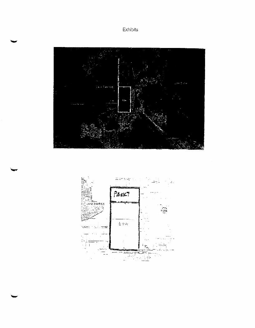
Exhibits
::
.. ~::-.,. =:_r;!!.m
~: .. ;::.:::::_:

OCPA Parcel Id Searcb Page 1 of 2
IRecords found for parcel search [14-23-27-0000-00-013] Records 1 -1 oflj
Parcel Id Address Owner
14-23-27-0000-00-013 5505 WlliTER GARDEN VINELAND RD BECK GROVE CARE D\IC
/(1~-~~~~ BILL DONEGAN, CFA ~~\. ;., , } i'_ ~-Orange Co~nty Property Appraiser ~ ·· Property Line Inquiry Systein
Assessed values shown are NOT certified values and therefore are subject to change before being finalized for ad valorem tax purposes
Parcel Data for 14-23-27-0000-00-013
Shctr~~~
~·~ap
14-23-27-0000-00-P,l!;:red ld,
013
TRI\1 l'Jio!joes
f \ View Property Tares I
115505 W1NTER GARDEN ,l VINELAND RD ·~
Property Use Code
City 0 R G - Ur::in:e Org Ce~e C:n.ty
,i\i.llta~e Cbd~
j .~;:, - eJ ects cv: ,ates !··:.':!.~ R ·7 I' R
Value Summary
I Value Method
~ Number of Bldgs.
Depreciated Bldg. Value
Depreciated XFOB Value
L:tiiHi y :i!ID§:!~~t (J\~.1H"ke1)
' Land Value AG
' • i Just (Market) Value
j Assessed Value (SOH)
It Exempt Value
~J Taxable Value
~'f' Estimate Taxes J. (U this property were to sell)
Market
"'~I 'l..•
-· ··············-··
[ rol .:!>\,!
q:n
$] _2:63.450
L ~ 1111 n·.; ) 1 .,fi ,. 1 ,. ___ 1 .. :.
·,
"1 ,.,_.-., .1 ··n ~ :t .,;~05, · ... "'!' ~ • ~ ..... ~ i :\:101 ~.--.!
u. - _ _::_-.,~~t
"'{} f: .Jh, li
r!
2003 Tax Savi.ng:s Due to SOH*
2003 Taxes without SOH
1003 Taxes with SOH
Owner Infonnation
O'l,'lj."JriJei"(S) II BECK GROVE CAKE D\IC 'II
I -~ddrt~:!l Jr] -=:c.tw nv~R·:'--Tr'FFT H.D i!1
~;~,~;a~~;~.i~,;,;l'z~l ~~. ._. ~ · .... }
Legal Description
j
18~;~-~ •·.1···• •• •
--·- . :;
;

OCPA Parcel Id Search
~ 2003 Total Tax Savings
For details see S·ave Our Homes (SOH). I : "'Excludes Non-Ad Valorem Assessments. 1 ~ ~
"-"'~
.brues Information
I r OR fioo..kt'Pag~ f&.r~~n~~~ Jfs~l~,~~~;~~-Er.t ·fo~d rr;]r\;~~,:[m~.;c;~ ., Q~aDi£:C$tJOll [_E~~8/~-~ __ _jj02iiCfl/J984 j S35il'l/H(~l) MS ~ V~ca~t. -~--"-· llr_vqulJJfiJ.~~u
Display Similar Sales in Subdivision
_Building Information
Jliltodel l TYp•l- ~--1.1 .. ~ -~~--- --"f __ ,_-·F--h ]!-·_··· Y e-JA,r ' ~ ~ti5; · Llia'WS I, n;; t • Code CtJJ3e ··· · ··· ·· w. ··· · ·· 11 ·· · f Bttrlt
oouuu ~ou Fu L
l Gi-nss Hce:at:ed hH Ext
SF SF \Vail '"~ll Cvd>e ~i Cod:e
. .1~ .. >,
Show Building Sub Areas
Land Information
Page 2 cf 2
[ Q/U ~~~s~m ij f . I
Bldg II Est.
Value (:;p~t
:II N'f'W
Item II Land Use Code II Zoning* Frontage Depth Land Units ., Unit Price II Land Value
I l
'")-
f.•6] 3 n. .. cE 3•6J)9 . .:!.._CRE(S) i $35,{)1{)1}_1)1) 11 $i.c263.l.SO 'i
Sl OtJJ)Ci j 9f,CI(i rR-CE
*Please contact your local Zoning Department for the latest zoning information.
Extra Feature Infom1ation
[Home) [About OCPA] [General Info] [Meet Bill Dom~r:-anJ [Record Searches] [Map Searches! [Contact OCPAl [Denartments] [Other Sites] [Products]
. -· - -. - . - .. . .
[Whats Hot] [!moortanl Notices]
Copyright © 1996 Orange County Property .A.ppraiser. All rights reserved.. Tnis page last modified on: 02/25/00
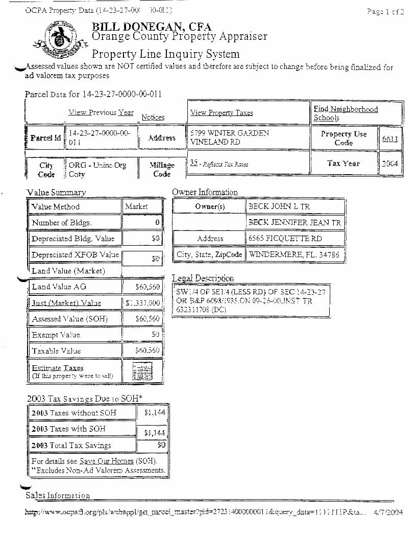
OCPA Property Data (14-23-27-001 )0-011) Pagelof2
BILL DONEGAN, CFA Orange County Property Appraiser
Property Line Inquiry Systen1 ._,Assessed values shown are NOT certified values and therefore are subject to change before being finalized for
ad valorem tax purposes
Parcel Data for 14-23-27-0000-00-011
Value Summarv
Value Method Market
Number ofBldgs. {li
Depreciated Bldg. Value •·n t J:t.
Depreciated XFOB Value I so 1 Land Value (J\1arket)
""' •· - $60,560 ji ! Land Value AG ,I
Jj.Ius.t (Market) Va]:ue Jl $1,337,ooo 1
]I Assessed Val~e (SOH) ~·
II $6o,s661
Exempt Value II -~~~ ---=1 .
Taxable Value .e·r:-1 ~"~- ~ .,!!.!<.J, •. -'<K~'
] Estimate Taxe5 , ___ ,;, 1
jl !, ""'L-".>:~ ~;&:. • .;...t.:..~··
. (If this property were to sell) t,., !;r-· ~~F··· :::~~~~.~ ~:
;>~
2003 Tax Savin as Due to SOH* b
2003 Taxes without SOH ~1,1?4
2003 Taxes with SOH $l,J4':.
2003 Total Tax Savings $0
For details see Save Our Homes (SOH). "Excludes Non-Ad Valorem Assessments.
'-"" Sales Information
Owner Information
Owner(s) BECK JOI:m L TR
RECK JE1\TNIFER JEAN TR
Address /6565 FICQUETTE RD
City, State, ZipCode I WJJ\TDER11ERE, FL. 34786
'; S~t~n /4C)P SE1/4(LESS RD) -OF SEC 1+13-·27 ! OK B&P M'r93'i9~5.0r·~ 09-2f~'IJtO.n-:sT TR 632311708 (DC)
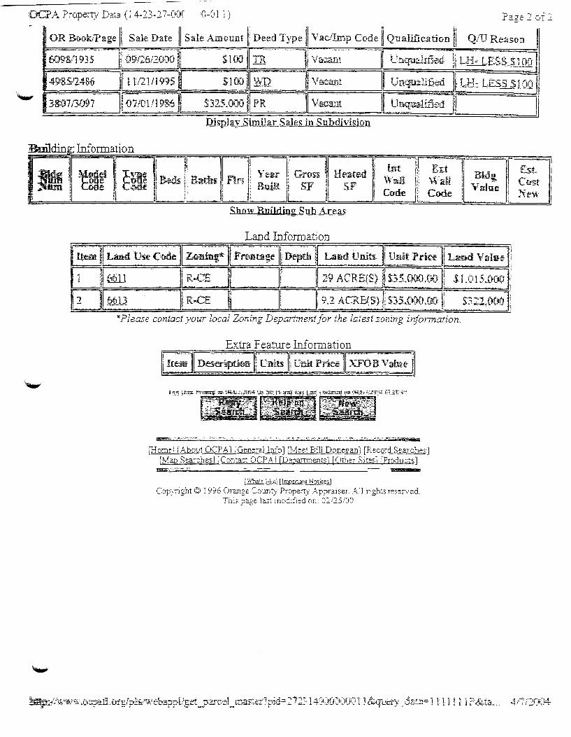
:DC:PA Property Data (14-23-27-00C ·0-011) Page .2 of .2
. OR Book/Page Ill Sale Date II Sale Amount II Deed Type ll Vac/Imp Code II Qualification II Q/U Reason
6098/1935 ]j o'9,;26/2DOO: SlW IR tl Vf3c:a;~·" r Urtquilifled ll L.1i~·-1ES.S .. $JJJ·;~
-....,.. 49-&.S.·24S,6 __]! 1 !l2T-.ilrt95 swv ~TI Va;ta.11t I Un!!iiua1.it1ttd t,H: u::s~JDQ 3&l:n.:.:-~o97 ·-1f~7jo-I n~8? ......... ~n:5._o~' PR ___ ... v~c~3_Jt__ J .. ~1~~u-a1i£~~;
Display Similar Sales in Subdivision
:Bnildin ; Information
Show Building Sub Areas
Land Information
*Please contact your local Zoning Department for the latest zoning information.
Extra Feature Infom1ation
[Home I [About OCPA l 1.0-ener-allnfo] [Meet Bill Doneto:an] [Record Searches] [Mao Searches II Contact OCP.LIJ [Departments] [Other Sites) [Products] ~., .. ,....._ . ..,,_
[Whats ]-lot] [lmoorlant Notices)
Copy:-igbt © 1996 Orange County Property Appraiser. All rights resen1ed. T11is page last modified on: 02/25/00

VIA HAND DELIVERY
Rocco Relvini Orange County Zoning 201 S. Rosalind A venue Orlando, Florida 32802
445 West Amt'ii,; Srreet Orlando. FL 32801-1 I 29 Phone 407.317.3200 www.ocps.net
April 26, 2013
Re: The School Board of Orange County, Florida/Special Exception for High Schooi/Pan:el # 14-23·27-0000-00-013
Dear Mr. Relvini:
Please find enclosed the Spc~:ial Exception Application from Marchena and Graham, P.A. filed on behalf of the School Board of Orangt..· County, Florida.
Should you have any questions or concerns, please do not hesitate to contact Marcos R. Marchena, Esq. at (407) 65X-R566.
cc: Diego Rodriguez, Esq., General Counsel, OCPS (via email) Eileen D. Fernandez, Esquire, Associate General Counsel, OCPS (via email) John T. Morris, Chief Facilities Officer. OCPS (via email) Fazlur Ali, Senior Director Planning & Design. OCPS (via email) Harold Jenkins. Director of Real Estate Management, OCPS (via email) Marcos R. Marchena, Esq .. Special Counsel (via email)
EXHIBIT7
"The Orange Count) School Board is an equal opportunity agency ...

MARCOS R. MARCHENA KEITH A. GRAHAM YOVANNIE R. STORMS CHRISTOPHERJ.~LSON
SHANNON M. WIGGINS
VIA HAND DELIVERY Rocco Relvini Orange County Zoning 20 I S. Rosalind A venue Orlando, Florida 32802
MARCHENA AND GRAHAM, PA
April 29. 2013
976 LAKE BALDWIN LANE, SUrTI! 101 ORLANDO, FLORIDA 32814
TELEPHONE (407) 658-8566 TELECOPIER (407) 281·8564
WRITER'S E·MAil:[email protected]
RE: The School Board of Orange County, Florida/Special Exception for High School/Parcel# 14-23-27-0000-00-013
Dear Mr. Relvini:
Please find enclosed a Special Exception Application for the above-referenced property. The Special Exception Application includes the following:
1. 2. 3.
4. 5. 6. 7. 8. 9. 10.
A property appraiser map outlining the subject property; A legal description of the subject property: Two copies of site plans drawn by Schenkel Shultz Architects and WBQ Design and Engineering compliant with the information on Page 12 of 15 of the Orange County Board of Zoning Adjustment ("BZA'') Application for Special Exception (the ''Application"): An 8 W' x 11" reduction of the site plan referenced above: Orange County Specific Project Expenditure Report: The Relationship Disclosure Form; Section Ill of the Application; Sections A and B of the Application; Sections D and E of the Application; and Agent Authorization Form.
The purpose of the Special Exception Application is to obtain a special exception from Orange County, Florida to construct a public high school on the 66.4 acre subject property. A portion of the subject property was acquired by the School Board in 2004 and the remainder was acquired by eminent domain in 2006 for the specific purpose of utilizing it as a relief high school site to accommodate the growth forecast to occur and that wall already approved at the time throughout west Orange County.
The actual growth has exceeded the forecast and the current forcca"t predicts the area will continue to grow requiring this relief high school site to provide a public service to the citizens of Orange County. The site is currently vacant with a portion being operated on an interim basis as a citrus grove by a licensee.
The Future Land Use of the subject property is Rural Settlement 1/1 and the Zoning is R-CE. Pursuant to the Public School Siting Ordinance Section 38-1751 ( 1) a public high school is an allowable use as a special exception in a rural settlement in the R-CE zoning district. Future Land Use policy 8.7.6 states that ''[p]ublic high schools ... shall be allowed as a special exception in the following land usc categories located in the Rural Settlement Areas: 1/1 .. .'" Pursuant to Conditions for Permitted Uses and Special Exceptions contained in Section 3 8-79( 139) Orange County Code. development of a high school site in R-CE zoning district must be in accordance with the Public School Siting Ordinance (38-1751-38-1759. Orange County

Rocco Relvini Orange County Zoning April 29,2013
~ Page2
Code). The site plan submitted herein for the subject property complies with the Public School Siting Ordinance.
In 2008. in response to Development Review Committee comments regarding a request for right-ofway to accommodate the future high school. the School Board cooperated with the County in a negotiated sale of right-of-way in fee and necessary easements to allow for the widening ofCR 535.
The high school site plan is typical of high schools constructed around Orange County by the School Board over the last decade. It will include a core campus including administration, media classroom buildings, a gym. an auditorium and a cafeteria around a central courtyard. It will also include athletic facilities including a field house, baseball field. softball field and lighted football field and track. The campus will be comprised of approximately 350,000 square feet of space. The tallest buildings are the classroom buildings, which arc three (3) stories and at a height of approximately 55 feet. There will be 846 parking spaces provided. Floor plans cannot be provided as they are exempt for security purposes pursuant to §119.071(3)(b), Fla. Stat.
The high school site is designed for a capacity of 2.776 students. The public school site would employ five (5) administrative staff. forty-one ( 41) classified employees. one hundred fifty-one (151) teachers and fifteen ( 15) cafeteria staff. The high school's operational hours are also typical of public high schools in Orange County. It will operate from approximately 7:00AM to 3:00PM Monday-Friday for instruction and will operate from 3:OOPM to I O:OOPM Monday-Friday for extracurricular activities including clubs and athletics. The campus will also operate for extracurricular and athletics on Saturday and Sunday between 7:00AM and 1 O:OOPM.
The public high school will host typical outdoor events and activities for an Orange County public high schooL The events and activities wlll include, but are not limited to. football, bao;eball. softball and lacrosse practice and games, track and field practice and meets, marching band practice. cheerleading practice and competition, pep rallies and other school events.
The School Board looks forward to working with staff through the special exception process and looks forward to providing a high school site that the surrounding community will be proud to call their own.
If you should have questions or comments please do not hesitate to contact my office.
CW/mlm Enclosures Cc: Barbara M. Jenkins, Superintendent. OCPS (via email)
Diego Rodriguez, Esq., General Counsel. OCPS (via email) Eileen D. Fernandez, Esquire, Associate General Counsel, OCPS (via email) John T. Morris, Chief Facilities Officer. OCPS (via email) Fazlur Ali, Senior Director Planning & Design, OCPS (via email) Harold Jenkins. Director of Real Estate Management. OCPS (via email)
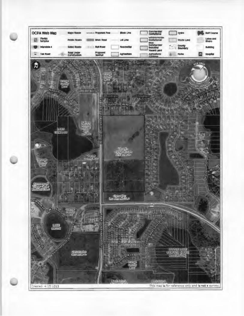
----------------------
OCPAWebMip 8 I'!Oiiae ---·• I>!Opotl!l 0 !tiVOli 1.11!!1 CCII'Ill'llt!IO!ill IIIIIMf'.lll
u ' £>~ dl llrf• !\'all ~ohlne ~ ..... nd ftllllft
Ro 114111Rold L IU'IIdodJ.il count)' ~OI!IIII.lr)
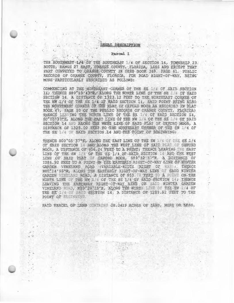
. ..
.. ~ ·. .-'. l~ '· ~ "-· '·
.• ~. t,.
: ... . · ....... . ~
. -- ~· . . .. '• ~~~· .... . ·,;
TEE . SO!JTHli'E:S? :1;/ <1 . ~· TEE SQ:n:'h!:liST 1/4 OF S!:.>b::o.~ 14, T tii!"Sfi-_ 23 sooTH, p_:;l'me '27 ~~T I O.K.~NG.=. CG>UN'JY., FLORIDA; L.t;ss AND ?jXC.E.PT ·?~T p: ...... ~r coN"~J TO .ORANGE :otrn'!Y :3: i:Eo .aoor. 369, .PJ!..GE s ..... , POEL.:rc RECO.N:>S OF O?..ANGE comqlfly., rwRlDA, FoR ~Ol'.D .RlGE':!:-OF-WAY, BEING ' MO?.:: · :J>.?.Tiw.:;.,.:i..,:' :i DESCR.I~ED AS Fv.W.OviS:
SA1D ?!>..?.CEL :.ESS .
. t
-~ .
· .
• ·! ·. .· ; ...

CONTINUE PARCEL 1
AL D ON r E " 1/4 14, 12
o-s ~ ...,:, :: . ~NG~
OUNT't , FLC EO AS 0 L.C ·~:
se: _r_ o i l t. JF
Jn .. SG i 'l-!; f l .T ~ape_: I , PLAT BOOK 47, ?AaE 3
C'OLJNT , f l U::: :OA AHO Ti .E P I N!
!-'::t~C LeA F i!.fE S~ i / 4 .:; - AIO E': ,.! ON ~ 4. SC 'OS ' :! i "C., 1/ 4 OF .,.I£ 51: . / 4 s:.ro ~~c- :ON ~4 N..C !NE Of 5.1}0 PL.i.T :• OXFORO HOOP C: : - J, ,... Oi" 1 ~25. 0"' -we
NW l/~ -;:: - !-':; '"": ::.~:ST
L t NE "': -:...:; '·J 1/4 OF fl-. !; s;: 1/4 :;: 5 : : ~-; £ f~ 14 t.NC TH:;: L- ... OF S.t. I D PL.AT OF Jr- RJ H:kG Si!fS .25'1 5 " . ~ diE 5 '..'TH L!'E OF - HE NW 1 /~ ::F r - :;;: 1, 4 :JF S.A.!D se: :: -i:ON ; .;, OF j3-:s.:;~ __ - : 111:: .s:rurr; :sa :t. =t= Jt: "r 4E ~w : ; 4 ~t= -..;e li " .r SA : s :::;;-I >I 14: T"i2'1C:. LeAviNa ... H 3·-Ui'H LINE j / .Q OF ii-:E s=: 1/4- :A!J sec7! N 1.!, D"lJ ' : 5 ·w. t.. ~~"~- T .E L :~~ SE 1/ A ~ 5A:D s; ~ r i~N !4. A D: ~~ ~N ~ OF ~ ~22 . 4 3 ~-~T
Tv "'1E s;;: j I ~ OF ::A: J 3::- : JH ! 4: Tr -~
LEA 'IN'J 71-[E WES Ll ·• Or THE c : ,' .:. OF S.A:- J SE.:-:J ~ 4 . N89.19 ' 43 ''~ .ALONG 'THE 10f-IT-! LIE OF T"'E x 1/ .; 0~ S:.I:: :; _: lO ~A . 4 OI:- :.r,c: - 1.323 . 12 FE::T TC TY=: ?O.NT :; ~'~!:~ ! 'tN!~- .
SA ID F~~E -~ LAND ~TINS 40. l5i3 ACRES OF~ ·
' IS SIJ6JECT TO A AOAQ F THE t
. MC =' OR :..: :s. 15 FE NO H:O
W s~ 30 FE~T T 'E cOF P€~ K g ~1. PAGE 4! =. ~~ I N - ~ .( ·r, ;='LOFL A.
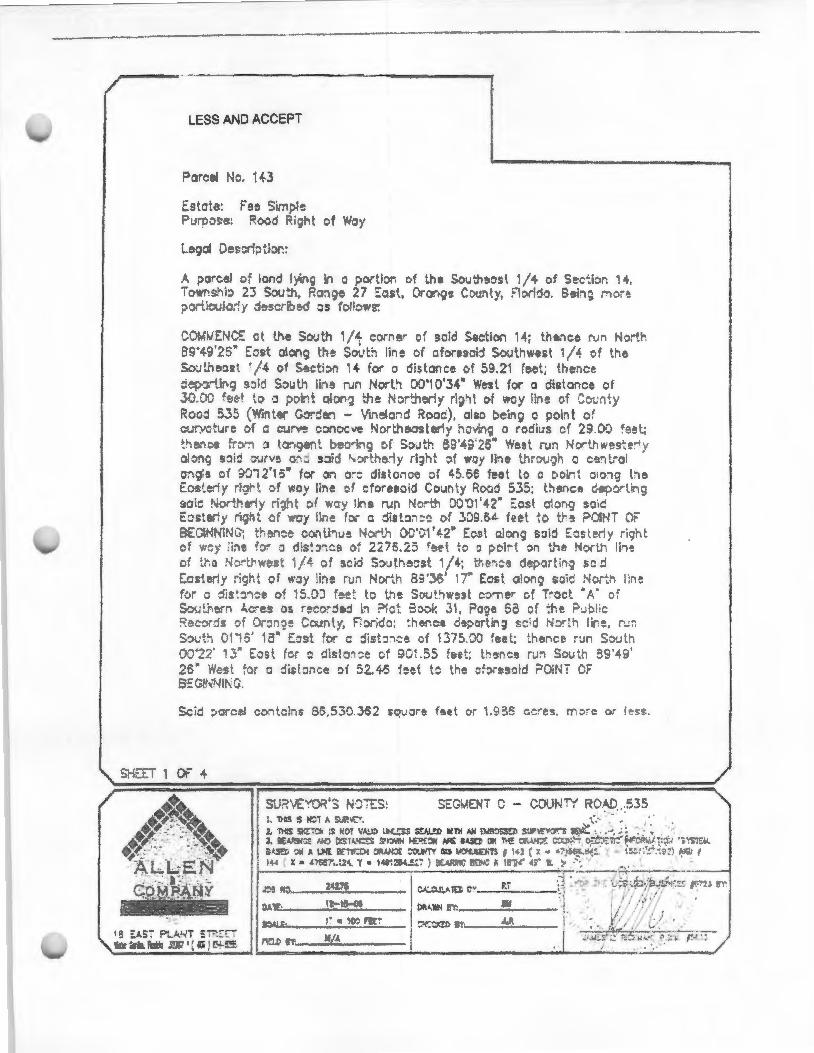
~------ ---------------------------------~
LESS AND ACCEPT
Parcel t o. 11t.3
Es te: Fee Si, I! Purpc:::: ?.o:.~d Ri of Woy
Legal e~~ ·;; .ior:
A ;>J"cel o~ lond If. ~ in a porti - of , e So• th~ost 1/4 of Sectbr. 4, Tow .... b 23 -~':'\, ~~:tge 27 ::·;:}Sf., 0-o:-.q~ ounty, ::lor! . Behg n " p '"".l:::ula;-: y "'! >:~l!:: os fo!: o•g:
COMWE:NC£ ~t lf-.e So\.! 1/4 c rf'le'" o: >aid S~ction 14; th~. ce run Nort 89 '49'.2~~ ::est o!ong ~ e Sovth lin~ of .ft:>res ij So• i wes t /4 of t e So·JU e::!t t · /4 of S!lc':bn q .. for o distance e: • 59.21 fee:; the. o ~? -ur.g s::lu South n-~ run Nort~ DCl'i 0'34" w~st for a dis lance of 30.0.) zeef ~ o ·J p .. kt ol -,] :h!t ' - ':herly rig ' ~ of wcy line o· ·" ;. ~:y Rood 53:. (W'i~ :er .. -: en - 'i el , d !{ooc), also b hg o poii"1t o~ cury.:;:ure c.f o cur •e .. ~:"lccve I or ,;oosterly · o l.r~~ o ro:ii::s a· 29 .0D ~eet.;
: e.. :::e fr "" !l • -, e"'t e -i:'·g of So tr 89'43 26" West -un ..fc:r.-thw<Js~ -~ y along sJi:: ::urvs : :d:! • ::~:- : e'iy ri3h: ::f way line r r u·_ h a C9. 1..rol c;;a'e c · 9 2'15" or OJ a-: di5tonce ::>f '-5.65 feet to o • o "' , o:o1o he £oste.-Jy ri . t ::,i woy line _f cforesold Co~nt rRood 535; thenee '"' .;tp -~ ing sa·~ No•L ~-! y ri.r cf ·:yH.~ run '· r• or ~ 1'4?" ::osl a'on-;1 so•c' E;:.ster!)' ri~, t <~ w:sy lir.e f01 c ::ii st::~ . ::c of 3D~U.L fee t t~s ? II 'T Or SEOiNtJINC?; t~en::e co, li :.1~ t4 ;"' o~··::1'L2p t:os\ along s~ij E:;: r1y riq" •.
f •J·:; • :b, :::>_ o d:s cs t 22i5.25 r_et io o pc,i·' :>n t."''e Nor' .. h lh~ oi :nr: !·b'l:;.·~s. •;L of s~id S:>uthe=st '/4; tr .... ~e de;'ortin9 sed Eos erl. righ t of 'tr''J)' lii"'re ru0 North 8:l'~6' ·- Eosi o! on~ so i~ Nc,:-:1 1:. e fvr o dL ·=-~~e of ·.s.OJ f::.e: to tn e S\>ut1w~~t c:>-nE!r cf T~oct &,;' of 5·::w...J[!I~~~ t.c•es o:. r~:;: . ·oej I ?let S.:>o .. 31 , rO?e 6~ of ';he: t=':Jb !ic D _c :ls d ·: ?~ Coo ty, F :Jr; d::~: :' ~r.ce o~~·Or' j g :::'d N:? ., lin, r_.r. S~u'.;., 0 • 5' 13" E~ ~t :o:" 02 dist:n:e cf 1375) f~et; :h~~~ce r·.:n S:Ju~h o:r22' 3'' E::;.sl fer o disl a~ ~e e:f 90 .55 7~et; t e .ce ru. 5 ;:>-;:n ~9'49' 25" W~s . . -:.r c .;;s ::;, c o{ 52..45 feet t~ he ofore :~id ?Oit T 0F S::Gi~ 'I-JH G.
s:.;:r~ 1 or- +
SE:S:iv!ENT C - COUII/TY R .':-£ .. 535
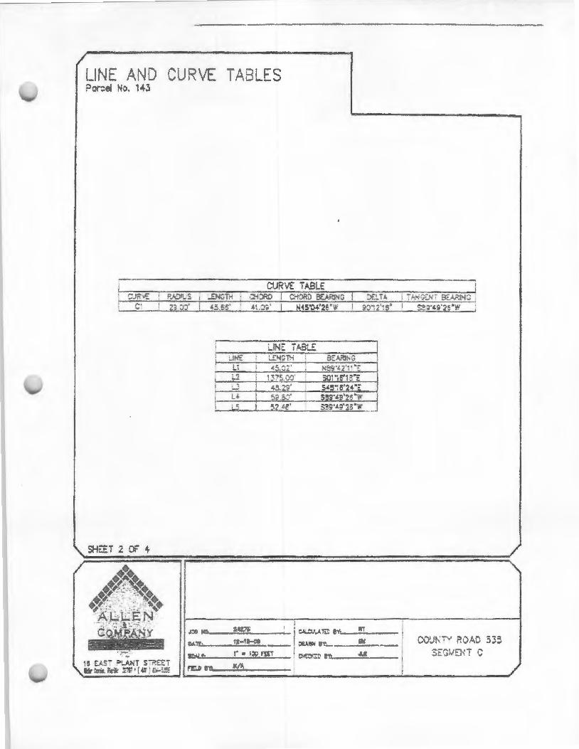
LIN~ AND v 'P\ E ~A LES P ~ No. 43
I LINE TA8LE l -1~£ L!:loiCTM I SEA.~
Ll I c5.~2' I N!;!?'tZ'··•;: I ~ 2 I i37~ . o:r so· ·;s-1e·E r ....; l ~:?9' S45':o'2<-·~
I LL I r~· S9S'4&'26"W I '-~ S::!S'L:!'~i>"YI' 5Z tf
c~.J ~ ~'!': _ _ ?._., __ ~
0 r:::....· __ ..;l:.;.Z-..;.1!----:;..;;.;t'$_ _ 01'.1. !!!~'------~>~_ C{)\.Jt'-" R ~ 0 535. St: ;>liE! T G

SKE Po ~I
I
I
li J;.
0':' lti
'""RIPTON
PA?.CEL NO. IH s;:E: :> :£iS S, 7, Of I"
R/W M, S, C.R. 53$ l.!At>S :;~G ~~T C
IJ,o<;: CAW) .D ESlA':'C:, A f.'~.t, ?.S 35, .. ~ !I S
--=.·:...n-sti~ ~--~::-:~-+---51 \ • 0!.\
e 275.25'
901.55' PA.r<C::L 0. i 44
r..:. 1:: TS 6, 7, I.HO 9 OF 14 P./Yf M.A?S, C.R. 5:!.5 lJ. t.?>S s~GiJ.::N T C
SECTION 14 - i 'M'~SH!P 23 SOU"'"'-!
LEGEND: 6 09/:> , ~TJ.. ;; C! ;;.u;r p~~'i ~ ::N::>'I!:S Bi ' T< OC-'1:'-i:.l: T..,_'i'"! ' i W. ; 1"-V\ t>:;H TJ,N:;~1
ll:l 2<27!>
12- 13--!15
I ' • 100
11./J,
l ~-= !.£NGTJ'i (Pi lr.PI:'iD I"I.Al
:A!..:J .1;0 ~·
"' ··
F·"' ,. JJ!
C')' ·- . RO J 535 s::Gt·.n iT ...

00000~ !I I j l i II I I f
ORANGE COUJ\ FOR zorc-·c v
. B ARD OF ZO ~ 'G ADJl-~T rr ... (flZA) APPLICA Tl ON RIANC..- , SP CIAL EXCEPTION, AND Al' )EAL F ZO~T~G
~ANAG R'S DE'fl:R fNA TON
fnstr ·ons to Appli ant
RE Rw;:PORT (PAG ·' ~ & 6) 7 &; 8}
f:'liCO :····· A . PPUC.o\NT B\' MAIL.
2. Do not w?i; 7 .: ; the filin~ dead fin:: , .: :o submit the appli ~- : . n be;au~ if j, f."r~~:"n i rrJ~~ i::g the cirad] l t ":: v.-m not D~ "' .. ~.,~a; a re-;ult tile ~"'ing w II be schedul<td forthc next h~ -i<:f d;;~ . D=:l l in~ ,•~ · ·q are Hs1ed on F'?ge II.
.l. Tb.: ~:--'ir·· · · iY nan· ' 10 nlao:-~ om: or more poS!"r~ on . ~ ;::rr'l:>::~·. The 7.o · _ r: .. :.i<m ' ''i'l ~ -,., .. ,... the pc.>~t~r. and pr ··'1g : ~~-.:;;th: ·s ,.,l!l l.:: ~·vi~~" t t"~ ill'"' i:-,. . The., -lic?.nt ust be pr .• cnt at th· ;,n~-,,;.1> ,.._,.,,.
-~. This :: - ~:tcoJi;:m !s for WI'· ... - usc arr~:- al only. Additi:'ll' I ny··wal~ mil.)' b~ -~ =- .irc:d (i.e., buildin~ p:·:mit.s. buii:li ;; r.'fil'l:' ~ - n::-hr.•. r::::mati nal li :~ "l;'les. septic 1ru1!· well <.~n~~\-al. i ~ ~ ;:;: of •'CC"~~~ ... : ·• e0 . ·~-.·ati n r·~~ de: r ... ·r ·, Jllion, c:c; 'l'r ~~ -':' '·;,.. 1 up va!s often• I":" ~ 1'1~ ··!tin aduitk-: 1 c · ·to the a~l!lli ·e~t
,6,?prov;~ls r-"·~.d hy ~he B7..4\ ... . no: final until the Boa.rO of County \ommi .:"_,-~ (B('C') co C-:7o : tbc rt:C "':"'~~~:iations ;>f·' . ll~A ani ilO ar:-" IS :: " fi d d~hir: 1" ea'~·"d::r r1 ... or ~~~ SZA. '!. d(';'i :.,., _
11. r~~: Ftog~ (jl o be ,,.n ·,·d. The ~eon·ice l'h t for rrfun lng Zoning Dh'f~'''n ":-""· is SJO c:r l/3 r• t of ,; h' in , r i~ ""'7z·:.-r. ~r;! .-.. the f.- w11s co'" u in c ··-.r by !Jle County. r.hkr check pc•·ablc to OnJ Z c' E • h4 ·'~n.
$620.00
S1Ji6.00
S1 ;;U F--::::ptin· .. f:-r m·,:. i!•: I" ~ during .: ~t~·~:~ .. inglt: family h". ·~ . ,cc!rl::':ight w tch .: · :-c:l~· oF.'--:~::-;=~ :~::--i ~~ si!.:~ sales :ndlcr. f't'!'~t house:. Sti20.00
$(>~3.00
~oi76 00
$1,5 1HKl
$2.9::9.00
~and un - ··-: 4 Se .' ~·1 a.nd 11 ; '"'-' ~-
· n ii~~ 's s:_:;.:. m (r uircd): . D,.,. -7'/~,,J.

Application fo B ard of Zoning Adjustmc t 0 •e Co • Zo · Di · ion
201 . salind A ue P ~ 0 1c• Box 2687 I do, Florid? 32802·2687
407.836~.311 J
c ion A- To be completed yap li nt (pJease print cl rJ ·· type or usc ink pen on ly)
D April 29, 2013 Marcos R. Marchena, Esq.
A icant's. · e. The School Board of Orange County, Florid~aili !: ddr ss 978 L9ke Baldwin Lane -------Suite 101
Mai ing Addres _ 445 West Amelia Street Orlando, Florida 32814
Orlando, Florida 32802 Cell Phone Nu.ro er # N/A
Home nc (__J. __ N_i_A _______ _ P perty Owner's "' The School Board of Orange County, Florida
Work phone ( 407 ) 658-8566 - ----- EMAil.. [email protected] _____ _
S e ion B- To be completed by applicant (please p 'nt clearly; type or u 'nk pen only)
Request is her • m:lde for. (c e k appi'Q ·ate :e
Vari c
Ill' you pr propo IX! dis nee he igh sil.e and the cqui f . -:e, height or si:> ·
-------Public High School -----
Propc Legl!l Description (A c of the tax bill is Acce a le) SEEATIACHED
Property Address: 5505 Winter Garden Vineland Road Tr.u:t s· or Dim s·ons 66.4 Acres ~~...::...::.----
Tax ld ific i , -':" (REQl .D)( IS digit# located o tax bill): 14 - 23 27- 0000 • 00 • 013
Exis i Structures/Uses on Site: Agricultural Citrus Operation - - --- --- -- ·-------
se only
Zooiog C'lassi 1 • : --------~--- Tr;,ct iz.c: - ----- Coord" te ----
FLUM Dcsignati n: _ - ------ Sec__ rp_ Rge __
#; - - - -- - ·------
Location: ---- ------ -
Receipt o .. _ ______ PcnnitA a 'St: _________ __ He rin Date; ___ ~-----
REV. S.10. i2 p .. 2o115

REMlNDER: Incomplete applications will not be pr applicant by 1ail.
d a d ~ 'ill be r u ned to t c
ection D- To be compJ cd by applicant (plea e prini de.<tt'ly: type or usc ink pen oo l_-
I. What is p sed? Public High School
------------------2. What is he size of the po , d ru u ? 350,000 square feet
----------------~~~~~~~--~-----72 ' from Nortll; 535' from East; 201' from South; a,d 3. Dis ce (in fee ) of 1e rom the affected pro line?~~es_t ____ _
4. Do you I ave a f<..'11ce/wall on rty lines? W
5. What is e ·is ina on the property? VacanUAgricultural Citrus Operation ------~--------~---------------------------
6. Wha is height in ee of e pro d structure? 55' at classroom bldg, 48' for Auditorium
7. I he proposed cturc 1- ory? ~ If m th 1-st • how many sto - s? 3 stories --- -8. Do you have I r of no objection from your neighbors? _ _ N_o _______ -~~----~
9. Do you reside in :m a at has a hom No
I 0. If yes to #K do you have a I r of no objection from the homeowner associ ion? __ N_IA ___ _
ll.ls e lrl ial cxc p io No
1cer contact you r garding this matter? _ N_o _ ___ _
ofofiicer. N/A
Section E- To be compl ed by applicant (print cl rly; u e ink I" n only)
On th line· provided below, please list names and add esses (includin zi c.odes) of ;:. . ons as ·ociated wi your pr t who you wish to receive a public hearing notice about this q .. t:
1._
CO . CTS REGARDING T IS APPLICA TJON:
Rocco.Rch · [email protected] net Je rt- ·[email protected] Kirnherly.Cat tt ocfl.oet
REV. 9·10..2 t g~3of15
AG 1 NT AUTH()JliZATI ON FORM
FOR ' ROJECT . LOC':Ht:D IN Olt<\i'JG~~ <: ll tTY, t'LORIDA Barbara M. Jenkins
. . \ THE OW I:R(S) OF 1/Vv"l.l , (? 1. 1 PROPI:Il.TY O\ 'ER KAME) The Sc~ol B_oa_rd o~range County, Florida
THE REAL PROPERTY DESC'RJBE O AS FOLLOWS Parce_lld_# 14·_23·27·0000·00s013 ---- _ ,1)0
IIHH EBY L' 'IIORJZ!: TO AC'T AS MY/OUR A · E. T (PRINT AGE '1" 1\AME>.
Marcos R. Marchena & ~~rchena an~_Graham __ :. .. 1>.:, TO E EC TE ANY PETJ1'JONS OR OTHER DOC'U~ lr TS NEC'ESS RY TO
AFFECT Ti lE Af>PLICATI . APP ROVA L Rf:Q 'E, 11m ;\ND MORE SPI ~ IrrCALLY DJ:St'fi.!O f-D AS FOLI.OWS,
VARfANC'E, SPF.('jA . EXChJ> l'JO '· APPEAL OF ZONING_ ~ANAGER, AND TO APPEAR ON M'l /OliR UEII LF
BEFORE ANY ADMJNISTRAT VE OR LEGJSLA TIVE BODY IN THE COUNT 'CO. 'SIDERING . "IllS APPI.I<' TIO~
:\ND TO ACT 1:-.1 ALL RESP GE MATTRRS PERT AI lNG TO THE PPLICA TION.
DAlE: rfJ\5(1? Barbara M. Jenkins, Superintendent
ER PRINT NA.1E PROPERT OW 'FR
0.-\TE: - . ---'!GNATURE OF PROPER1"Y OW. 'ER PRJ 'T , '/\~1R PROPFRTY OW 'FR
DATE:_ ·-·M-00- -----SIGNATURE OF PROPERTY 0\VNER PRJ. T NA. 1 : PROrFRTY OW r :R
STATE OF FLORIDA : C'OU TV OF Orange
' cERTIFY THAT ol\ '-1 ).5- 13 , BEFORE ME J oser:h M\Jv a...... . AN o rFrrrR o LY AlJTIIORIZED 13Y THE hATE OF FLORJDA A, D I 11LE CdU; TY ·IF. 10 1EP ABOVE, TO TAKE AC KNOWLEDGE. 1E · ·. , PERSONALLY APPl:ARI~DBarbara M. Jenkins 1 1 TO BE TilE f>~RSO ' DE 'CRIB ED 1:-.1 Tl fl INSTRUMENT OR TO HAVE PROD 'CEO itft-_ . EVIDE 'C .. A ID WHO HAS ACKNOWLEDGED BEFORE ME THAT fE OR SH£~ EXEC TED THE I ' TRU E. 1T AND 10 I Dll> NOT T KE ,\N OATIL
'"'C' .. "' W II 'ESS MY II ND AND OFFICIAL SEAL IN THE COUNTY A. D 1 ATE STATED ABOVE 0 1 THE ~- D Y OF Apr• L .. INTHE YEAR ;;2..013 .
~~ JOSEPH .._MORGAN BLIC--~e; ,MX~\Ml0f4 1 Ee17211t "0 '1 RY PtJSLJC FOR Tl [ TATE OF FLORIDA
''~s·;'•~o7,20t7 21 a - o- C"OMMI. SION EXPIRES:_ 9
_ 7 ( 17 LEGAL DESCRIPTIO OR PARCEL JOE '!!FICA TIO 1 NUMBER(S} ARE REQUIRED:
Parcel ld# 14-23-27 ·0000·00·013 PARCEL ID# OR LEGAL DESCRIPTION: - - ----
ReV. 9-·10·2012 Page 4 of15

For Staff Use Only: Spxific ProJect E~ itur~ Report (Revi!>Cd No 1b!!f S, 2010) Initially SU mitted On
·~---Fo~=zsofM1U'Cb 1, 2011 Updated On --~~~-
Project Name (as fiJed) --:-::------Case or Bid 1o. -----
ORANGE COUNTY SPECIFIC PROJECf EXPE!\"'DITURE REPORT
This lobbying ex.pendjtltre form shaJJ be com.pleted in full and filed with all applieafon submittals. This fonJl shall rem.aio cumulative and shall be filed l''ith tbe department processioo your appli~tio • Forms si!rned by a prlneipal's authorized ageDt shall include an fl:ecuted Agent APt ori7Jat1on Po
This is tbe i ··at Fonn:_x_
Part I Tbjs is a Sub eque t F ·-
Please eomplete aU of the follol'•ing:
Name and Address of Principal (legal name of e ' ty or owner per Orange County tax rolls): The School Board of Orange County, Florida; 445 West Amelia Street, Orlando, Fl 32801
Name and Addr s of Pr'ncipars Authorized Agent, if applicable: Marcos R, Marcheoa, !::sq.
Marchena and Graham P A , 976 Lake 6aldwi Lane, Suite 101 , Orlando, Florida 32814
List tbe name and .address of ell iobbrists., r:oostdtants, contractors, subcontract rs, indhi Pals or busioc en tit' who 'l-ill .assist with obtai ing !lp r ·al for this P,roject. (Additional fi rms may be used IU nece ry.)
Mar hana. and Graham, P .A. 1. Name and address of individual or business entity: 976 Lake Baldwin Lane, Ste. 101 , Orlando, FL 32814
/\.re they registe Lo yist? Yes ~ or No __
2. Name and address of indiYidual or business entitY!·--------~-------Ar tbey · gistered Lobb) · ? Yes_ or No_
3. Name and address of individual or business entity:. ________________ _ Are they registered Lobbyist? Yes_ or No_
4. Name and address of individual or business entlty!~------~-----~--Are the egistered Loblrjist? Yes_ or No~.
5. Name and addres$ of individual or business en · . : _ _______________ _ Are the:y registered Lobbyist? Yes_ or No_
6, Name and address of individual or business entity:. __________ ______ _ Are th y regis Lobbyist? Yes _ or No_
7. Name and ad s of individual or business en i. =-----------------Are they reg's ered Lobbyist? Yes_ or No_
6. Name and address of individual or business entity:. _ ___ ~------------Are ' registered Lo yist? Yes_ or No
NOTE: lf you have questions about THIS PAGE please contact Dana Crosby~Collier of the Orange County Legal Depart ent at 407..S36-7320.
REV. 9-10..2012 Page 5 of 15

For Staff se Only: pcl;if~.~: l r:<:tE pcnthlurc:R~purt (Rcno::<! N ·r r' , ;!OIO) {ni 'aJly SUbmit On ·----
For ll.tc liS 11fMarclJ 1 lJ Updated On ------
Part I Expenditures:
Pro'ec Na (as filed) ~:----
'ase Bid No.~----
nsation by
The follow' g is a complete list of all lobbying ex iture and ac ivi ie (including those of lo consul ts etc.) inc • ed b · the · ci I or his/her authorized and e · ended in c: 1 e ·ion re ced project or issue. You need not i cluc!P de mlnimus ens s (under $ · 0 for producinu graphic , aermJ pboto pbs h t co · , urvcys studies or otbt>r d~ men r~la c to t is
l D of N· me ofP rty
I Description of A h•ity I Amou t
Erpeoditu Incur 'ng p id Expenditure I
I l I ~
N/A
! I I i I !
I I
I r I I
TOTAL EXPENDED THI ro $
l I I
I J I
NOTE: ff you hav questi s about THIS PAGE please con ac Dana Crosby~C IIi of the 0 ge Cou ty l al Department at 407~836- 320.
EV. 9-10.2 2 Page 6 of 15

• ' fl~ Projc Ffl'p<mdi un: R.
For u.se A$ of March I , 2011
P rtnt
For Staff Use On(v: ~ . :o OJ Initially itted
Upda cd On _ ----Project N (as filed)------
Cas~ Bid 1o. -----
ORJGINAL SIGNATURE AND NOTA I01. REQUIRED
. Of FLORTDA OF ORANGE
S1aff stgnature and dale ol recei:>t of form
Star! r Ylcws u to fonn and doet> not a
me this 1 '2a. f l{o/t / . 20_:1~ by produced ~--------~ as
Information pro'lide e In
NOTE: If you have que io.ns about THIS PAG lea e contact Dana Crosby-C IIi r th Orange County Legal Depa men at 407~836-7320 .
REV.S..1 2: ' 2 Pa 7

For StafflJsc Only: OC C:S FORM 2P Initially su itted on-----
Updated on---------Project Name (as filed)--~--Case Number
FOR DEVELOI'MEI\'T·R.ELAT.F.D ITEMS (NovemberS, ] 01 0)
for~ aftu- M#I'P I, lOll
-------------------RELATIONSHIP DISCLOSURE FORM
FOR USE WITH DEVELOPMENT RELATED ITEMS. EX EPT THOSE WHERE THE COUNTY IS THE PRINCIPAL OR PRIMARY APPLICMT
This relationship disclosure form rnt:JSt be submitted to the Orange County departrot7nl or di ision processing your application at the time of filing. In the event any informafon provided on this fo should change, the Owner, Contract Purchaser or Au oriz.ed Agent(s) must fik ded fi rm on or before the date the· e is considered by the appropriate board or body.
-
Part I
INFORMA TJON 'OWNER OF RECORD J>ER ORANGE COUNT\' TAX ROLLS:
Name: The School Board of Orange County, Florida
Business Address (Str et.IP.O. Box, City and Zip Code): - - --------445 West Amelia Stree~ Orlando, Florida 32801
Business Phone ( 407 )~_31_7.....;.·34~11~-----
Facsimile ( 407 ) _ _ 31_7_·3_3_48 _______ _
INFORMATION ON COI\'TRACf PURCHASER. IF APPLICA~LE: Name: ________ N~M _____________________ _________________ __
Business Address (Street!P.O. Box, Chy and Zip Code): _ _ N_IA _____ _ _
Business Phone ( ), ____ N_IA ____ __ _
Facsimile ( ). ________ NI_A _ _____ _
INFORMATION ON A ITBORIZED AG ;T, IF APPLICABLE: (Ag nt Au ori.ation Form also required to be attached)
Name: Marcos R. Marchena, Esq. Marchena and Graharn, P.A.
Business Address (Str-eet!P.O. Sox, City and Zip Code):~-~--------976 Lake Baldwin Lane, Suite 101 , Orlando, Floricle 32814
Business J>hone ( 407 ). __ s_s8--8~5_s_e - ----
Facsimile ( 407)._..:::;2.:...81_-8_5_64 __ ~-----~
NOTE: If you have questions about THIS PAGE please contact ana Crosby-Collier of the Orange County Legal Department at 407-836-7320.
REV, 9-10..2012 Page 8 of 1?

For Staff Use Only: OCCEFORM 20
FOR DEV PMr.NT·REl-Aicl> ITEMS (November 5, 2010) Initially submitted on -----~ Updated on --=-~:::--:------Project Name (as filed)----~ Case Number
For Rllt Jfter Mlrtb I, 2011
-----------------Part II
IS THE OWNER, CONTRACT PURCHASER, OR .AUTHORIZED AGENT A RELA TIY.E OF TilE M..-\ YOR OR ANY ME~!BER OF THE BCC?
YES _:_No
IS TH MAYOR OR ANY MEMBER OF THE BCC AN EMPLO r E OF THE OWNER, CONTRACT PURCB S O.R AUTHORIZED .-\GENT1
YES 2_NO
IS ANY P£RSON WITH A DIRECT BEI\'EFJCIAL INTEREST IN THE OUTCOME OF THIS MATTER A BUSINESS ASSOClA. T£ OF THE MA. YOR OR A ... ~Y M&M.BER OF BCC! (When respP~tdiDg to this question please conside all couSllltaots, = torueys, contraeto~ ubc:o1:1tractor and an other persons wbo rna ~· have beeo retained by tbe Owner, Contract Purchaser, or Autborized .-\gen( t:o assist with obtaining app ·aJ of this i em.)
Y 2_NO
If you responded "'YES to any of the above que tions, please state with whom and explain the relationship:
N/A
(Use additional sh of pap r if necessary)
NOTE: If you have questions about THIS PAGE please contact Dana C sby-Collier of the Orange County Legal Department at 407-836-7320.
Rt:V. ~10..2012 P• 9 of 15
ForSt ' Use Only: OCC£PORM2D Initially submined on ______ _ FOR l>E\ I'MENT-RELA TE.D ITEMS (N~>vember 5, :2010)
F r llR a r Mardll, 2011 Updated on-~------Project Name (as filed)~~---Case Number---------
Part JU ORIGINAL SIGNAT -RE~~D NOTAlUZA110N REQUlRED
l hereby certify thai information r vided in this relationship disclosr.rre form is true a d correct based on my knowledge aod belief. If any of this information changes, I furt nr acknowledge and agree to amend this relationship disclfrsure form prior to any meeting at which the above-refe ced project is scheduled robe heard. In accordance with s. 837.06 Florida Statutes, I understand and acknowledge that whoev knowingly malres a false statement in writing with the intent to mislead a public servant in the performance of his or her official duty shall be guilry of a misdemeanor in the second degree punishable: as pro ided in s. 77~083. Florida tatutes.
Sign
Print N and Title of Person completing this form: Marcos R. M;,~rchena. Esq.
STATE OF FLORIDA COU 'TY OF ORANGE
I"\ I rtify that the foregoing instrument was acknowledged bcfi . me this _It day of
20~ by M. areas R. Marchena . He/she is ~rsonally lrnmvo rome or -----~---as identification and did/did not tal;e an oath.
my hand and official seal in the county and state stated above on the ? I )II.. · the 2 13 '- ,
ClfUSTOPHER J. WILSON i MYOOMM1SSIOfU00~154&4 o . otary Public
1\·~~~~1~ P ic for the State of Florida
S taff si9nature and date of receip! o~ form
Staff reviews; ulo lorm end ooos no1 aliaS to the accuracy or vemclly o inf0flt121iol'l piOWkld er lin.
NOTE: If you have questions about THIS PAGE please contact Dana Cr by~Collier of e Orange County legal Department at 407-836--7320.
REV. 9-1Cl- 2 Page 10 of 15

OFFICE OF THE
September 20, 2013 CHIEF ADMINISTRATIVE OFFICER
Honorable Scott Boyd County Commissioner, District 1 Orange County Government 201 South Rosalind Avenue Orlando, Florida 32801
Subject: Use ofCONSERV 11 Recreational Site
Dear Commissioner Boyd:
This letter is in response to your inquiry regarding use of a parcel of land in the City-County joint CONSERV II land holdings in west Orange County that is subject to the City of Orlando (City) and Orange County (County) Lease Agreement related to Water CONSERV II Property for Sportsplex Park approved in August 2007. Specifically, you asked if the City would support the use of a portion of land the City and County previously agreed to reserve for recreational purposes for another public purpose, a public school. The City does not object to the County and Orange County Public Schools (OCPS) pursuing a possible sale of the necessary amount of acreage in the property previously identified and designated as a future recreation site for a school site since public schools provide a public purpose.
Please keep us abreast of the discussions and any negotiations. We presume any land transaction would be governed by the CONSERV II agreement between the City and County, the aforementioned Lease Agreement as well as any other applicable regulations, and would be subject to appropriate legal review and City Council action. The City will be cooperative in reviewing and processing any action required of us in an expeditious manner if the County and OCPS agree to pursue a land transaction.
Please contact me at ( 407) 246-3091 if you have any questions or desire any additional information.
Sincerely
'!'f!.~ks, NCP Chief Administrative Officer RECEIVED
BWB/jo SEP 2 3 '~lli3
Cc: Ajit Lalchandani , P.E., County Administrator Orange County BCC, DISTRICT 1 Mayarme Downs, City Attorney, City of Orlando JeffNewton, County Attorney, Orange County Kevin Edmonds, Deputy Chief Administrative Officer Richard Howard, P.E., Director Public Works Department, City of Orlando Ray Hanson, P .E., Director, Utilities Department, Orange County EXHIBIT
8
ORLANDO CITY HALL • 400 SOUTH ORANGE AVENUE • P.O. BOX 4990 • ORLANDO, t-L -'L.o u .. -.,., __
PHONE 407.246.3091 • FAX 407.246.3342 • CITYOFORLANDO.NET

Coversheet http:/ /orlandopubl ic.novusagenda.com/CoverSheet.aspx?IterniD=3 57 ...
1 of 1
Items Types: Other District: ALL Contract ID: Exhibits: Yes Grant Received by City?: No
Subject:
CITY OF ORLANDO
COUNCIL AGENDA ITEM
For Meeting of: October 21 , 2013 From: Document Number: On File (City Clerk) : Yes
Resolution - Related to the City's sale of CONSERV II Property to Orange County Government
Summary:
Draft Only: No
Orange County desires to purchase the City share of approximately 65 acres of! and located in the CONSERV II property that is jointly owned by the City and County. The County would use this site for public purpose(s). The sale price would be based on an appraisal to determine fair market value and would include cost associated with the impact on any existing RIBs on the property, executed in a purchase and sale agreement. The County will have the oportunity to purchase this site for one year from the date of adoption of this Resolution.
Fiscal & Efficiency Data: No fiscal impact at th is time
Recommended Action: Approval of the Resolution related to the City's sale of certain real property to Orange County, Florida.
Agenda Item attachment(s) on file in the City Clerks Office.
Note: All agenda items must be in the City Clerk's office by Noon Friday, six(6) business days prior to the regular Monday City Council meeting.
Contact: Byron Brooks, Wes Powell , Rick Howard Approved By:
Department Budget Outside Routing Approval City Clerk
ATTACHMENTS :
Date and Time I0/21 /201312:34PM 10/21/2013 !2:34PM
Name: Description : [)
Resolution Resolution Re Sale of Conserv II Prooerty to County.Finall2l.doc
[) Resolution Re Sale of Conserv 11 Property to County Exh A Map.odf tv\ap
Type:
Backup Material
Backup Material
"Enhance the quality of life in the City by delivering public services in a knowledgeable, responsive and financially responsible manner."
11 /4/2013 10:24 PM

A RESOLUTION OF THE CITY COUNCIL OF THE CITY OF ORLANDO, FLORIDA, (CITY) RELATED TO THE CITY'S SALE OF CERTAIN REAL PROPERTY TO ORANGE COUNTY, FLORIDA; PROVIDING FOR SEVERABILITY AND AN EFFECTIVE DATE.
WHEREAS, Orange County (County) desires to purchase the City' s share of approximately sixty-five (65) acres of land located in the City/County Conserve II Wastewater Effluent Disposal System, as more particularly described on the map attached hereto and incorporated herein, by reference, as Exhibit A (Property); and
WHEREAS, the City is willing to sell the City's share of the Property to the County at fair market value pursuant to a Purchase and Sale Agreement executed by the City and County.
NOW, THEREFORE, BE IT RESOLVED BY THE CITY COUNCIL OF THE CITY OF ORLANDO, FLORIDA, AS FOLLOWS:
Section 1. The City hereby indicates its willingness to sell its share of the Property to the County at fair market value pursuant to a mutually agreeable Purchase and Sale Agreement executed within one (1) year of the date of adoption of this Resolution.
Section 2. The purchase price shall be the fair market value of the Property as determined by a method mutually agreeable to the City and County, and shall include the cost associated with relocating the existing Rapid Infiltration Basins (RIBS) located on the Property.
Section 3. The terms of the Purchase and Sale Agreement shall be negotiated by City and County staff and presented to City Council and the Board of County Commissioners for approval.
Section 4. If any section or portion of a section of this Resolution proves to be invalid, unlawful , or unconstitutional, it shall not be held to invalidate or impair the validity, force , or effect of any other section or part of this Resolution .
Section 5. This Resolution shall become effective immediately upon its adoption. If the Agreement is not executed within the time period set forth in Section 1 above, then this Resolution shall be void and of no effect.
This Resolution is adopted this_ day of _______ , 2013.
ATTEST:
By: ----------City Clerk
CITY OF ORLANDO, FLORIDA
By: ------------Mayor
APPROVED AS TO FORM AND LEGALITY for use and reliance ofthe City of Orlando only.
-----------' 2013 .
City Attorney

EXHIBIT A (SEE ATTACHED MAP)
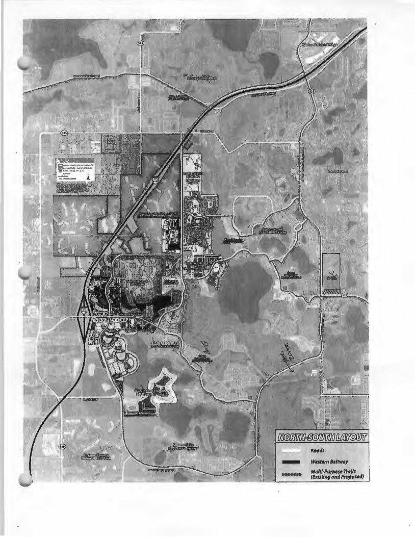
Wwsttrn B•ltway
Multi·Purpost Trolls (Exlsrinl and Proposed)

~~ QOYER!VMENT
o H J J) .\
Chiif P Ianners
Carol Hossfield Permitting
Rocco Relvini BZA Coordination
ZONING DIVIS. .-J MITCH GORDON, Manager 201 South Rosalind A venue, 1 '' Floor Reply To: Post Office Box 2687 Orlando, Florida 32802-2687 407-836-3111 Fax 407-836-5507, www.orangecountyfl.net
ORANGE COUNTY BOARD OF ZONING ADJUSTMENT POST OFFICE BOX 2687
ORLANDO, FL 32802-2687 **AMENDED CORRECTION LETTER**
September 19, 2013
Marcos R. Marchena
Orlando, FL 32814
PUBLIC HEARING #SE-13-07 -046, 09/06/2013, WEST ORANGE RELIEF HIGH SCHOOL
Action taken by the Board of Zoning Adjustment (BZA) on the above application was as follows:
REQUEST: Special Exception in R-CE zone to construct a public high school
ADDRESS: 5505 Winter Garden Vineland Rd.
DECISION: A motion was made by Vishaal S. Gupta, seconded by Tony Rey, Gabriela Ortigoni, Pinkie P. Freeman voting AYE by voice vote, Ka'Juel J. Washington, Peter Betterman voting No by voice vote, (Zachary Seybold was absent), and carried to approve the Special Exception request in that the Board finds it met the requirements governing Special Exceptions as spelled out in Orange County Code, Section 38-78, and that the granting of the Special Exception does not adversely affect general public interest; further, said approval is subject to the following conditions (4 in favor, 2 opposed):
1. Development shall conform to the West Orange Relief High School Special Exception Site Plan dated "Received September 6, 2013", and to the following conditions of approval. Development based upon this approval shall comply with all applicable federal, state and county laws, ordinances and regulations, which are incorporated herein by reference, except to the extent any applicable county laws, ordinances and regulations are expressly waived or modified by these conditions, or by action approved by the BCC, or by action of the BCC. In the event of a conflict or inconsistency between a condition of approval of this site plan and the actual site plan dated "Received * ", the condition of approval shall control to the extent of such conflict or inconsistency.
EXHIBIT 9
2. This project shall comply with, adhere to, and not deviate from or otherwise conflict with any verbal or written promise or representation made by the applicant (or authorized agent) to the Board of County Commissioners at the public hearing where this development was approved, where such promise or representation, whether oral or written, was relied upon by the Board in approving the development, could have reasonably been expected to have been relied upon by the Board in approving the development, or could have reasonably induced or otherwise influenced the Board to approve the development. For purposes of this condition, a "promise" or "representation" shall be deemed to have been made to the Board by the applicant (or authorized agent) if it was expressly made to the Board at a public hearing where the development was considered or approved.
3. Pursuant to Section 125.022, Florida Statutes, issuance of this development permit by the County does not in any way create any rights on the part of the applicant to obtain a permit from a state or federal agency and does not create any liability on the pa1t of the County for issuance of the permit if the applicant fails to obtain requisite approvals or fulfill the obligations imposed by a state or federal agency or undertakes actions that result in a violation of state or federal law. Pursuant to Section 125.022, the applicant shall obtain all other applicable state or federal permits before commencement of development.
4. Prior to construction plan approval, hydraulic calculations shall be submitted to Orange County Utilities demonstrating that proposed water, wastewater, and reclaimed water systems have been designed to support the school site.
5. Prior to earthwork or construction, the developer shall provide a copy of the completed National Pollutant Discharge Elimination System (NPDES) Notice of Intent (NOI) form for stormwater discharge from construction activities to the Orange County Environmental Protection Division, NPDES Administrator. The original NOI form shall be sent to the Florida Department of Environmental Protection.
6. All acreages regarding conservation areas, wetland buffers and conservation encroachment are considered approximate until finalized by a state application and permit to be provided to Orange County. Approval of this plan does not authorize any direct or indirect conservation area impacts.
7. The Orange County Public Schools recognizes the prior use of this property as a citrus grove.
8. Neither installation nor operation of potable or irrigation water supply wells using local groundwater will be allowed on site.
9. The Developer shall obtain water, wastewater, and reclaimed water service from Orange County Utilities.
10. Billboards and pole signs shall be prohibited. Ground and fascia signs shall comply with Ch. 31.5.
11. A six-foot masonry wall shall be required along the east and north property lines, except along the conservation area.
12. Per Orange County code public schools are exempt from transportation concurrency. However an approved traffic operational analysis addressing intersecti01 1 ope1 ati01 IS, Pedesll ian crossings and traffic circulation within the impact area will be required prior to construction plan approval.
13. Sports field stadium lighting shall comply with the cutoff requirements of the Orange County lighting ordinance and shall comply with the exhibit submitted by the applicant. Parking lot lighting shall comply with the cutoff requirements in the Orange County lighting ordinance.
THIS DECISION IS NOT FINAL UNTIL BOTH OF THE FOLLOWING HAVE OCCURRED:
A) NO APPEAL IS FILED WITHIN 15 DAYS OF THE DATE THE BZA RENDERED ITS DECISION; AND
B) THE BCC CONFIRMS THE BZA DECISION ON September 24, 2013.
NOTE: IF THE BCC CONFIRMS THE BZA DECISION AS NOTED ON 'B' ABOVE, YOU WILL NEED TO SUBMIT THIS LETTER TO OBTAIN PERMITS.
Please contact The Zoning Division after the BCC confirmation date above at [email protected] for information regarding the BCC confirmation or any appeals that may have been filed.
Sincerely,
Mitch Gordon, Manager Zoning Division
Traffic Study for the
West Orange Relief High School
Prepared for:
ORANGE COUNTY PUBLIC SCHOOLS 6501 Magic Way
Orlando, FL 32809
Prepared by:
GMB ENGINEERS & PLANNERS, Inc. Orlando, Florida
July 2013
EXHIBIT 10
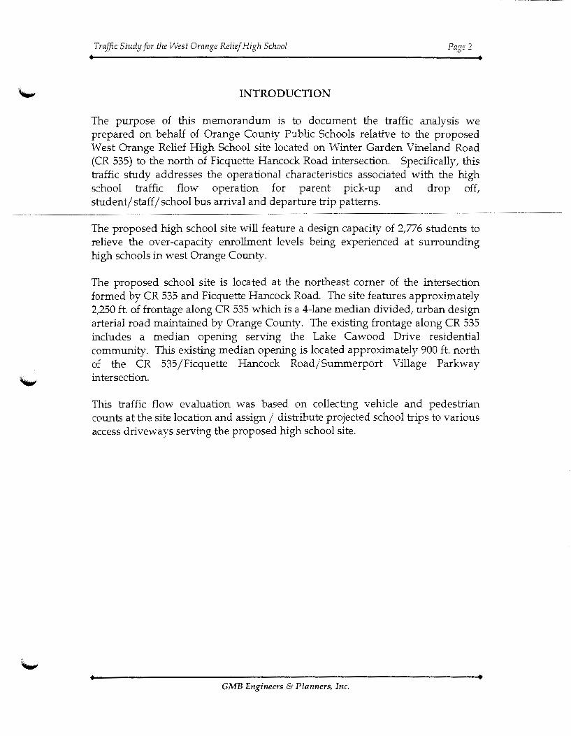
Traffic Study for the West Orange Relief High School Page 2
INTRODUCTION
The purpose of this memorandum is to document the traffic analysis we prepared on behalf of Orange County Public Schools relative to the proposed West Orange Relief High School site located on Winter Garden Vineland Road (CR 535) to the north of Ficquette Hancock Road intersection. Specifically, this traffic study addresses the operational characteristics associated with the high school traffic flow operation for parent pick-up and drop off, student/ staff/ school bus arrival and departure trip patterns.
The proposed high school site will feature a design capacity of 2,776 students to relieve the over-capacity enrollment levels being experienced at surrounding high schools in west Orange County.
The proposed school site is located at the northeast corner of the intersection formed by CR 535 and Ficquette Hancock Road. The site features approximately 2,250 ft. of frontage along CR 535 which is a 4-lane median divided, urban design arterial road maintained by Orange County. The existing frontage along CR 535 includes a median opening serving the Lake Cawood Drive residential community. This existing median opening is located approximately 900ft. north of the CR 535/Ficquette Hancock Road/Summerport Village Parkway intersection.
This traffic flow evaluation was based on collecting vehicle and pedestrian counts at the site location and assign / distribute projected school trips to various access driveways serving the proposed high school site.
GMB Engineers & Planners, Inc.

Tinlter Rd.
La!;e
11\1 Lake Butler Rd.
1- Proiect Location
Traffic Study for the West Orange Reli~f High School Page 4
ANALYSIS OF EXISTING TRAFFIC
This section of the report deals with an operational evaluation of existing traffic flow conditions. Turning movement counts were collected for the CR 535 and Ficquette Hancock Road intersection during a weekday between 6:00-8:00 a.m. and 1:00-3:00 p.m. coinciding with the high school's arrival and dismissal periods. 24-Hour approach counts were also collected along CR 535 to the north and east of Ficquette Hancock Road. Existing traffic counts are summarized in the Appendix. The peak hour vehicle turni11g movement counts collected at the intersection are shown in Figure 2.
An analysis of the operating characteristics of the study intersections using applicable tools developed from the traffic analysis software, SYNCHRO, was prepared using these traffic counts.
Table 1 provides a summary of the existing intersection operating characteristics. Existing traffic counts indicate that the study intersection operates at level of service C coinciding with the school's 6:30-7:30 a.m. arrival and 2:00-3:00 p.m. departure periods. Delays are moderate and adequate capacity is available at the intersection as evidenced by v j c (volume-to-capacity) ratios less than 1.00.
It should be noted that the peak periods used in the analysis coincide with the school's opening and dismissal periods. ·vvhile there is a slight overlap in the school's a.m. opening and the normal peak hour commute period, school traffic significantly drops after tl1e 7:15 a.m. opening bell. In tl1e p.m., there is a distinct separation betvveen the school's dismissal time of 2:15 p.m. and tl1e regular 5:00 p.m. work to home commute period. As such, the operating conditions obtained in tl1is analysis reflect conditions different from those typically obsen·ed or attained during v>ork commute periods.
GMB Engineers & Planners, Inc.
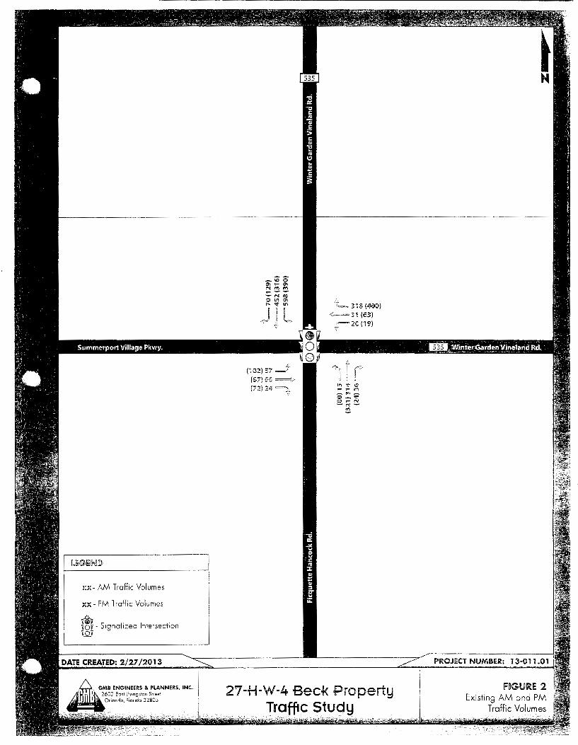
xx- AM Traffic Volumes
xx- Plv1 Traffic Volumes
m _ Signalized Intersection
(57) 55 ==i•
(72)24~,
<z~ 318 (~-010) <=3:1 (53) ,~..=20(19)
l"'l ~ 10 - -:- rf} _,.,-0-'<!" =-N -~-~
27-H-W-4 Beck Property Traffic Study

Intersection CR 535@
r1cquette HancocK Koaa
Table 1 Traffic Operations Analysis - Existing
West Orange Relief High School
Overall Intersection MOE's
Type of 6:30-7:30 A.M. Arrival 2:00-3:00 P.M. Departure
Control v;c Delay v;c Delay Ratio (sec/veh) LOS Ratio (secjveh) LOS
~lgnai U.ISl .jj_1:) L U./.:l .jLLL L
Traffic Study for the West Orange Relief High School Page 7
TRIP GENERATION
This section describes the trip generation characteristics associated with the project. We utilized the Dr. Philips High School trip characteristics as a typical representation of the traffic characteristics for the proposed high school. DPHS is one of the schools where a high proportion of its students drive or are droppedoff and picked up by their parents resulting in higher vehicular traffic generation. Dr. Philips High School reported an emollment figure of 3,264 students during the school year 2010-11. The design capacity of the proposed school is 2,776 students which is based on the prototype high school adopted by OCPS.
Table 2 summarizes the trip generation characteristics of the proposed school using data obtained from DPHS. As shown in Table 2, the project is expected to generate 1,483 vehicle trips during the a.m. arrival period (976 inbound trips and 507 outbound trips) and 1,049 trips in the p.m. dismissal period (434 inbound trips and 615 outbound trips). The trip counts during the afternoon dismissal period are lower because of post-school activities such as after school programs, sports, tutorials, etc. Daily trip generation is estimated at 3,953 trips.
GMB Engineets & Planners, Inc.

High School
Student/Visitor /Parent Pick-up/Drop-Off
Statl Buses
TOTAL
Source:
Table 2 High School Trip Generation
West Orange Relief High School
High School Trip Generation Daily 6:30-7:30 a.m.
IN OUT Total IN
794 454 1,248 378
13Y 10 149 15 43 43 86 41
3,953 976 507 1,483 434
Dr. Philips High School Traffic Counts adjusted for 2,776 students, Janumy 2011
2:00-3:00 p.m. OUT Total
478 856
96 111 41 82
615 1,049
Traffic Study for the West Orange Relief High School Page 9
ANALYSIS AT DESIGN DAY TRAFFIC CONDITIONS
This section of the report deals with an evaluation of future year 2018 traffic flow characteristics and operational conditions expected to occur when the school reaches its design capacity of 2,776 students. We applied a growth rate of rate of 2.0% per year to the background traffic to simulate the traffic growth expected to occur with a year 2018 school opening. This growth rate was developed using traffic forecasts obtained from the Horizon West Town Center/Village F /Village H planning studies which relied on the Orlando Urban Area Transportation Studies travel forecasting models. As such, the 2018 traffic projections for background traffiC represent antiCipated growth patterns assoCiated w1th the surrounding planned developments.
The high school trips were assigned to the surrounding intersections assuming a distribution pattern of 40% oriented to/from the north, 20% to/from the south, and 40% oriented to/from the east. This distribution pattern reflects the location of the proposed school site relative to the school zone.
\1\Te conducted traffic operational analysis for the proposed high school using the no build condition and the proposed school operational site plan.
Access Locations
School driveways will be located to achieve optimum separation for access management conn·ol and adapt to existing median access constraints made to serve surrounding developments. Recognizing the access constraints along CR 535, it is logical for the school property to share an existing full median opening across Lake Cawood Drive which is approximately 900ft. north of the Ficquette Hancock Road intersection. For practical design purposes, it will be assumed that one of the school's dri\·e,,..·ays will lirte up across the Lake Cav;ood Drive median opening. This driveway will be referred to as Driveway #2. The next available full median opening along CR 535 serves the Southern Way intersection which is approximately 2,000 ft. to the north of Lake Ca.vood Drive and 300ft. beyond the northern boundary of the school property. Based on these physical constraints, it is proposed that another median opening serving the school's second driveway will be placed approximately 1,200 ft. (i.e., :!::_100 ft. for design flexibility) north of Lake Cawood Drive. This driveway will be referred to as Driveway #1. Notwithstanding whether it meets traffic signal warrants or not, Driveway #1 is optimally spaced at ±_2,100 ft. for traffic signal control relative to the existing signal at Ficquette Hancock Road. Driveway #2 across Lake Cawood Drive, located 900' north of Ficquette Hancock Road and 1,200 ft. south of Driveway #1, may also be signalized if warranted but would require it to be synchronized due to its close proximity to adjacent signals.
Gl\1B Engineet·s & Planners, Inc.

Traffic Study for the West Orange Relief High School Page 10
In order to provide safe and adequate access to the school, we propose dual southbound left-turn lanes and one northbound right-turn lane at Driveway #1. Driveway #2 across Lake Cawood Drive will require one southbound left-turn lane and one northbound right-turn lane.
Operating Performance Measures
For analysis purposes, operating conditions for signalized intersections are assessed using Level of Service (LOS) and volume/ capacity (v j c) ratio as measures of performance indicators. LOS is associated wiUt overall delay while the v / c ratio compares traffic volumes against capacity. LOS A thru E are considered acceptable, while LOS F is not acceptable. LOS A represents the best acceptable standard while LOS E represents the lowest acceptable standard. A v / c ratio at or lower than 1.00 is also considered acceptable while a ratio greater than 1.00 is treated as over-capacity and therefore, represents congested conditions.
For unsignalized intersections (i.e., under stop sign control), level of service and v / c ratios are also used as measuring standards. However, because of the nature of its operation, long delays are typical of stop controlled operation which can be mitigated when the intersection meets criteria for signalization.
Alternative Scenarios
No Build Scenario: This scenario presents an analysis of the future traffic operating conditions at the intersection of CR 535 /Ficquette Hancock Road based on year 2018 traffic flow characteristics Vv'ith no developments assumed on the school property. Existing signal timings obtained from Orange County '"'ere used in the analysis including a demand-actuated all-red pedestrian crossing phase. The projected traffic movements under this scenario are illustrated m Figure 3 for the a.m. arrival and p.m. dismissal periods respectively.
The analysis indicates that the CR 535/Ficquette Hancock Road intersection will operate at LOS D in both a.m. and p.m. peak hours. The a.m. arrival v / c ratio is measured at 0.82 while the p.m. dismissal v / c ratio is at 0.78.
Build Scenario: This scenario includes two school driveway connections to CR 535 to the north of Ficquette Hancock Road as previously discussed. Driveway #1 is a signalized driveway designated for students, visitors and parent pickup/drop-off. Driveway #2 across Lake Cawood Drive will serve school buses and staff parking. Both driveways were analyzed as signalized intersections (verified as meeting traffic signal warrants at a later section of this report). The
GA1B Engineers & Planners, Inc.
Traffic Study for the West Orange Relief High School Page 11
projected traffic movements under this scenario are illustrated in Figures 4 and 5 for a.m. arrival and p.m. dismissal periods respectively.
In this scenario, Driveway #1 (signalized for students, parents and visitors) will operate at LOS C with vIc ratios lower than 1.00 during the a.m. arrival and p.m. dismissal periods. Driveway #2 (for school buses and staff) was analyzed under both signalized and unsignalized conditions. As expected, under stop controlled conditions, Driveway #2 will experience LOS F condition with very long delays which may lead to unsafe operations as vehicles will be forced to enter the mainstream traffic with less than acceptable and unsafe gaps. School buses will be adversely impacted as they will need rrro1 e than tire minim am acceptable gap to enter or cross CR 535. Under signalized operation, Driveway #2 will operate at LOS B with acceptable vIc ratios.
The analysis also indicates that the CR 535IFicquette Hancock Road intersection will operate at LOS F with a vIc ratio of 1.12 in the a.m. arrival period; and LOS E with a 0.94 vIc ratio with the p.m. dismissal period. As previously noted, the adverse capacity condition during the a.m. period applies during a brief 15-20 minute period coinciding with peak school arrival. After the 7:20 a.m. school bell, traffic flow along CR 535 will consist primarily of commuter travelers.
Table 3 presents the future traffic operating conditions of the proposed school driveways including the CR 535 IFicquette Hancock Road intersection. It should be noted that the results achieved from the analysis were based on assumptions that the school driveways will be signalized as they meet the criteria for signalization. An analysis to determine if the school driveways satisfy signal warrant engineering criteria is provided in the next section of this report.
It should be noted that under the build scenario, the CR 535/Ficquette Hancock Road intersection vdll operate at over-capacity (v / c ratio of 1.12) conditions in the a.m. peak hour. In the p.m. dismissal period, the intersection will operate at LOSE with a \'/c ratio lower than 1.00. One of the contributing factors that lead to over-capacity operating conditions is the presence of pedesh·ian traffic crossing this intersection V\·hich must be accounted for in the traffic signal operating plan. In order to provide a safe pedestrian crossing even today, Orange County implemented an all-red pedestrian phase at this intersection; the consequence of which is it sacrifices the operating capacity of the intersection. In addition, this adverse operating capacity condition is expected to occur for a brief 15-20 minute period coinciding with the school's peak arrival period. AJter the 7:20 a.m. opening bell, traffic volumes traveling on CR 535 ,,vill drop off and will consist primarily of commuter trips.
Gi\iB Engineers & Planners, Inc.
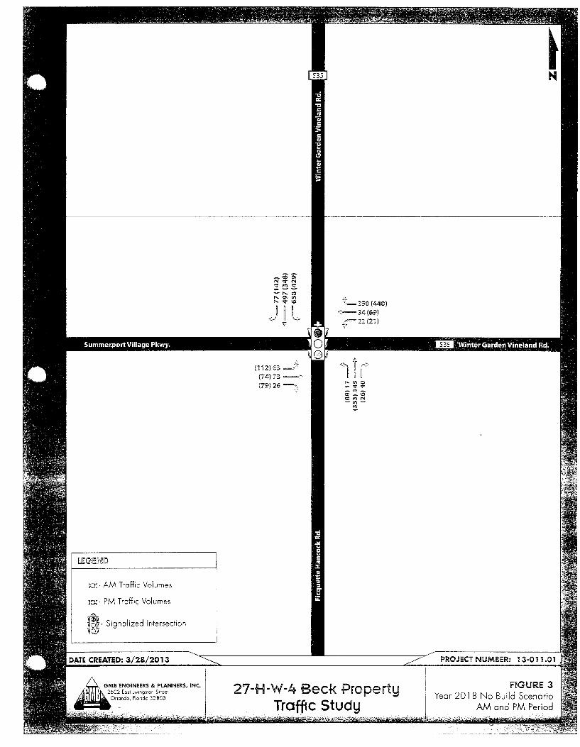
::K- AM Traffic Volumes
XX. PM Tr·::Jffic Volumes
®.Signalized Intersection
(112)63 ~" (74)73 =-:(79)26 =~,
!L._ 350 (440)
<",'==- 34 (69')
-;t=2.2(21)
27-H-W-4 Beck .Property Traffic Study

X>::+ =>::>::-Total Tr'1ps
L L_ School Trips
Background Traffic
J
tS~
IS~
0\0 0\1.:> L'l c:> II II
+ + ""c:!
~"'- ~ L"'t ~ ..... ~ ~
r
Jl
+ --
.. ~350+-
<=:>4 )~:2
~ ~.~, 0 ~<r<::;
"' +
II 0 <:!' L~
= 740
27-H-W-4 Beck Property Traffic Study

XX+ ~Y.K) =XX- Total Trips
L L_ School Trips
Background Traffic
112 74 ----> 79
-<=6?
J:== 21

..........
Table 3 Year 2018 Design Capacity- Traffic Operations Analysis
West Omnge Relief High School
Overall Intersection MOE's
Type of A.M. Peak Hour P.M. Peak Hour
Control VIC Delay VIC Delay Intersection Ratio (seclveh) LOS Ratio (seclveh)
No Build Scenario
CR 535@
Ficquette Hancock Road Signal 1.17 81.0 F 0.85 49.2
Build Scenario
CR 535@
Driveway #1: Student/Parent Entrance Signal 0.79 26.0 c 0.74 23.0
Driveway #2: Staff I Bus Entrance Stop 1.48 323.8 F 2.22 440.2
Ficquette Hancock Road Signal 1.12 85.2 F 0.94 58.2
Build Scenario W Two Signalized intersections
CR 535@
Driveway #1: Student/Parent Entrance Signal 0.79 22.9 c 0.76 21.9
Driveway #2: Staff I Bus Entrance Signal 0.65 13.2 B 0.74 15.9
Ficquette Hancock Road Signal 1.12 85.2 F 0 94 58.2
Notes: LOSE or Fare typical conditions for stop controlled intersections.
LOS
D
c
F
E
c
B
E

Traffic Study for the West Orange Relief High School Page 16
Signal Warrant Analysis
This section presents the results of a traffic signal warrant analysis for Driveways #1 and #2 for the opening year 2018. The proposed intersection geometry for the two driveway cmmections is presented in Figure 6. Based on the daily trip generation for the proposed high school of 3,953 trips and the 24-hour traffic flow profile, Driveway #1 is expected to satisfy the required MUTCD warrants (#1 Eight-Hour Vehicular Volume), (#2 Four-Hour Vehicular Volume) and (#3 Peak Hour) for installation of a traffic signal, Dnveway #2 IS expected to satisfY the required MUTCD warrant #3 Peak Hour for installation of a traffic signal. It also exceeded the traffic volumes for three of the required four hours to satisfy '!\Tarrant #2. Table 4 below presents the summary of the signal warrant analysis conducted for the Driveways #1 and #2. The traffic signal warrant worksheets are included in the Appendix.
Table 4 Signal Warrant Analysis Summary
MUTCD Signal Warrant Driveway #1 Driveway #2 Criteria
#1: Eight-Hour Vehicular Satisfied Not Satisfied
Volume #2: Four-Hour Vehicular
Satisfied Considered Satisfied for three of
Volume the four required hours #3:PeakHour Satisfied Satisfied #4: Pedestrian Volume NA NA #5: School Crossing NA NA #6: Coordinated Signal
NA NA System #7: Crash Experience NA NA #8: Roadway Netv,;ork NA I NA
Notes: NA- Warrants are not applicable.
GMB Engineers & PLanners, Inc.

~,-Lane Geometry
@ -Signalized Intersection
• - Stop Controlled Intersection
27-H-W-4 Beck Property Traff1c Study

Traffic Study for the West Orange Relief High School Page 18
CR535
This section provides an operations analysis of CR 535 as a corridor to determine the operating conditions with the proposed traffic signals at Driveways #1 and #2 and evaluate these proposed traffic signals' influence on the CR 535/Ficquette Hancock Road intersection operation during the school arrival and dismissal periods.
We developed a time-space diagram for CR 535 to determine a coordinated timing solution to move traffic flow progressively through the three closely spaced signalized intersections. We utilized SYNCHRO to optimize the cycle lengths and signal timings, and Tru-Traffic to optimize the bandwidth. The results of the signal timing optimization analysis reveal that a bandwidth of 70 seconds can be achieved in the critical southbound direction during the a.m. peak hour. During the p.m. dismissal period, a 70 second bandwidth can also be achieved in the southbound direction with a 35 second bandwidth going northbound. Another 25 seconds of northbound bandwidth is available to accommodate the westbound right-turn overlap movement at the Ficquette Hancock Road intersection. This analysis proves that adequate signal coordination can be achieved for moving traffic flow through the three closely spaced signalized intersections with minimal stops and delays. The time-space diagrams for the arrival and departure periods are presented below.
Pedestrian Access
Traffic signals at Driveways #1 and #2 serving the high school will be designed to provide a protected signalized crossv,,alk environment for the students crossing CR 535. A signalized access at Driveway #2 improves pedestrian safety by providing pedestrian access for the students arriving from the south to occur in front of the school drive,,vay which minimizes, if not eliminate, activating the capacity-consuming all-red pedestrian phase at the critical CR 535/Ficquette Hancock Road intersection which experiences heavy turning traffic volumes. Pedestrians arriving from the north can access Driveway #1 with a similar signalized crosswalk environment.
Queue Length Analysis
The projected Year 2018 peak hour volumes were used to generate a queue length analysis and the recommended turn lane storage lengths at the school driveways. Table 5 presents the results of this analysis. The turn lane storage lengths for the signalized intersections were evaluated using the SYNCRHO 95th
GA1B Engineers & Planners, Inc.

.c I-
-o 0
·;::
~l (!)
0.. ,: ro " > li ·c: I! I.... 1:
<C E OJ~ cr ·-I Cl ,__ I Ol
2:! I.!) I (") I
I.!) I 0:::1 ()
() (!) (/)
0 1.!) .,....
1' "' N <') "' N co J
1' "' N
I! I: I! I! I: I"
u :t " " t • t t t I
' ' ' ' :1 !I
" :r Er :1 !I !I :I :I
-------··~'"'~-~~·~·M==~~-~~~~
:: I! I: I: I: I! I!
" " " 1:
" " I! c ' ' I I ' ' • , " " " " " " "
!'
1' "' N <') "' N co J
<')~~============~-+--------~
.r:: c. E 0
1
t .r:: c. E
' ' ' " " " " : . " !I :I :I :I :I :I
I
' ' • , " " " " " " " !I !I :I :I :I :I :I
f I
0
v~~==========~~~
Cl>-- () :::J (!) co (/)
:;:::, 0 c "<t (!) .,.... ,__ ro 0..
>-$:
...>::: 0.. OJ
> t 0 Q.
(!) () c ro ,__ c w ()
(!) tl:: (/)
ro .,.... -(f) "<t :;:::, .,.... c (!) -o .2 (f)
,_ () (!) (!) Q. (/)
E o :::J 0 (f)-.,....
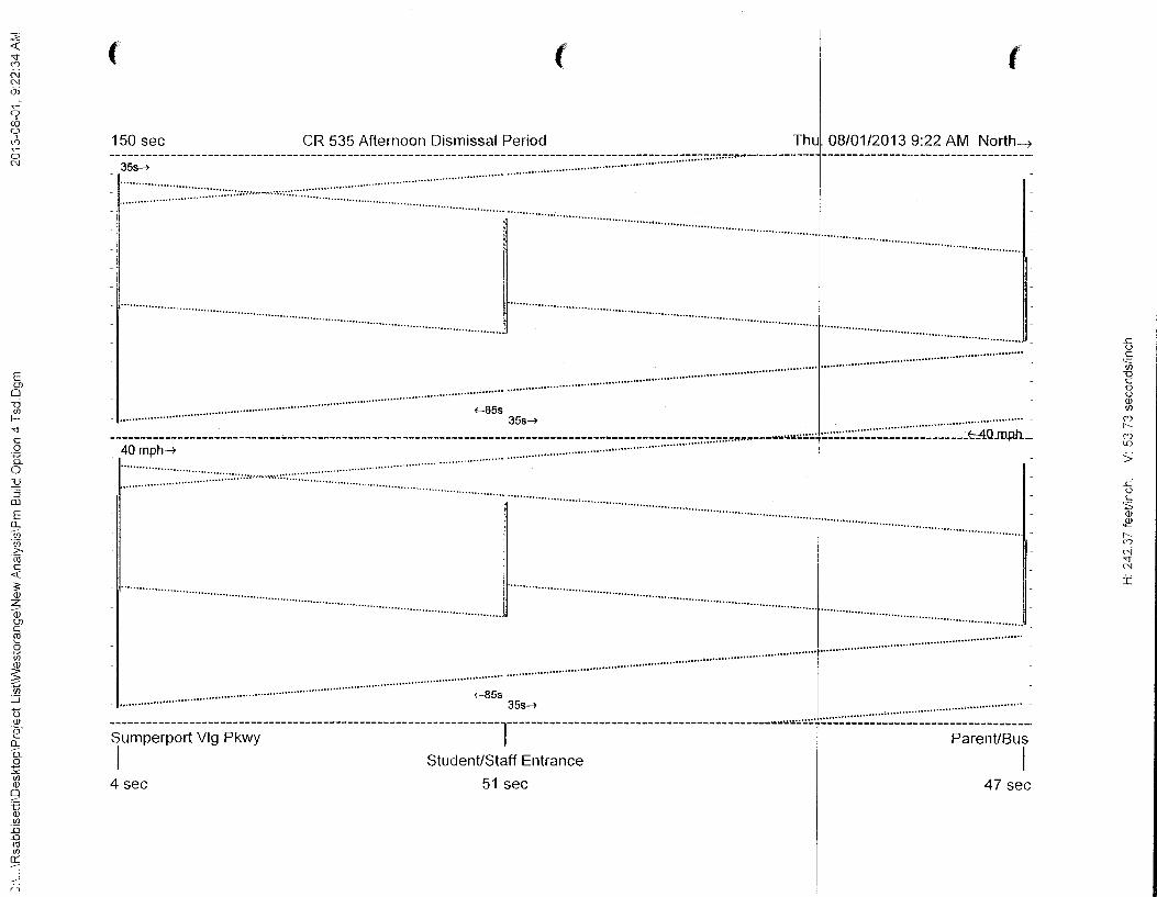
~ 'T (Y)
N N a; ~
9 co 0
I (Y) ~
0 N
E OJ 0 "0 (/)
f'T c 0
:g_ 0 :Q :::J
[]J
E 0.. v, ·v; >-m c <(
:;: (j)
z -aJ OJ c <1l
2 (/)
~ (/)
:_:]
u (j) ·e
0.. a. 2 -"' (/) (j)
9 B (j) (/)
:.0 _Q <1l (/)
~
()
(' ( (
150 sec CR 535 Afternoon Dismissal Period Thul. 08/01/2013 9:22AM North~
'·······································································································································································
•··· ... . . .. . ... . .. .. .. . . .... . . .. .. .. . . . . . ··;:;;;: ········· ... ················ ········· ··········· .... ··········•······· ··················· ..... ·········· ········
35s~ --------------------------------------------------------------------------------------------------- ........ J .................................................................. -40 mph~ ........... :-:::nn,.,.~---Y"'---- ------------------------~QJD.Ph. .............................................................................. -
·:::::: ::: :::: . ., ... _,, ·:: : : : .... ,.......... ... . .. ······· .... ······· ....
....................................................................................................................................................
Sumperport Vlg Pkwy ParenUBus
I StudenUStaff Entrance I 4 sec 51 sec 47 sec
..c u c
'=:: (/)
""0 c 0 u (j) (/)
(Y) 1""-(Y) lD
> ..c u c ';; (j)
2 1""-(Y)
r--i 'T N
:i

Traffic Study for the West Orange Relief High School Page 21
percentile queue length. Actual design and implementation of queue lengths will be a function of design and physical practicality of their construction.
As shown in Table 5, Driveway #1 requires a maximum storage length of 380ft. for the southbound left-turn movement and 380ft. for the northbound right-turn movement. The maximum queue length for the exiting movement in Driveway #1 is estimated at 355 ft. Driveway #2 requires a maximum storage length of 305 ft. for the southbound left-turn movement and 180ft. for the northbound rightturn movement. The maximum queue length for the exiting movement in Driveway #2 is estimated at 280ft.
The CR 535 and Ficquette Hancock Road intersection is projected to experience manageable queuing on the southbound left-turn lane with a projected queue length of 780 ft. during the a.m. period. Using traffic simulation techniques, the southbound left-turn queues are not projected to extend into the Lake Cawood intersection. Queuing in the p.m. dismissal period is less pronounced since it does not coincide with the peak commuter period.
GA1B Engineers & Planners, Inc.

-----------~~---~--------------------------------
Table 5 Queue Length Analysis
West Orange Relief High School
Number of Queue
Traffic Control Turn Movement Lanes Lengths AM
Driveway #1
Build Scenario Signal SB Left 2 211
NBRight 1 222
WB Left 2 158
WBRight 1 0
Driveway #2
Build Scenario Signal SB Left 1 136
NB Right 1 10
WB Left 1 44
WBRight 1 0
CR 535 at Ficquette Hancock Road
All Scenarios Signal SB Left 2 610
Notes:
Queue Lengths
PM
117
80
187
16
48
10
116
0
451
The Recommended Storage Length includes decel and taper distance as per FDOT Index 301
Recommended Storage Length
380
380
355
180
305
180
280
155
780
Traffic Study for the West Orange Relief High School Page 23
CONCLUSIONS
This traffic analysis report prepared for the West Orange Relief High School project evaluated the traffic flow operation at the proposed access driveways to adequately serve traffic generated by a proposed high school at this location. The results of this analysis indicate that acceptable traffic operating conditions are expected to be maintained along the sd1ool's driveways operating under traffic signal control during the a.m. arrival and p.m. dismissal periods. Due to the limited availability of gaps in the traffic stream on CR 535 especially during the a.m. arrival period, a stop controlled school driveway will operate meffiCiently causmg very long delays and potentially unsafe conditions as drivers will be forced to take abrupt maneuvers. A signal warrant analysis presented in this report supports the justification for installing traffic signals at both driveways to the school. A traffic signal coordination and optimization analysis was also performed to prove that vehicles can progressively move through the three closely spaced signalized intersections with minimal stops, delay and queuing. A schematic diagram showing the driveway arrangement, traffic use assignment, number of lanes needed to support the expected traffic volumes, and traffic control type are illustrated in Figure 6.
GMB Engineers & Planners, Inc.
Traffic Study for the West Orange Relief High School Page 24
Appendix
GMB Engineers & Planners, Inc.
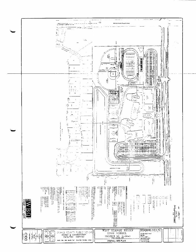
..... :, ·- -~~~- - - ~ ··-
::;.~·.L,!·~I~E C·~.il,,!!\:-y PJ:t('~ :~~~ ii:J.:)! WEST ORANGE RELIEF
HIGH SCHOOL ?ROJECT NO. S-0041
! SCHENKELS:-JUL TZ i < "" '" ... ''.'". " ' '
1 ~((•~ ~illw··~~~e-DI:SlGK i< CONSTP.lJCT!ON
F AC:lll~'!l:S ~I::P.VJr.ES f---------'•ori. loeALiGIL lliO~ 1 ~~~~ .. 3~lll;"
___ I VDo",': .ll:l~-S7'i-:;:;:~~ '::-.r4J7-51L-3.::JT..
OVERALL SITE PLAN

Roadway Count Summary CMB Engineers & Planners, Inc.
County Orange City Windermere
Intersection CR 535 & Ficquette Hancock Rd
Date February 12, 2013 All Vehicles
Time Period 6:00 to 8:00
----·--
Northbound Southbound Time Period Left Through Right Left Through Right
6:00 6:15 2 37 99 80 10
6:15 6:30 1 39 11 111 105 6
6:30 6:45 0 53 3 125 123 19
6:45 7:00 2 87 9 110 101 18
7:00 7:15 7 79 9 155 109 14
7:15 7:30 6 85 15 208 119 19 7:30 7:45 7 102 24 241 105 14
7:45 8:00 16 96 7 178 109 18
41 588 81 1.227 851 118
Eastbound Westbound
'-' Time Period Left Through Right Left Through Right
6:00 6:15 11 5 4 2 18
6:15 6:30 7 10 5 29
6:30 6:45 11 10 6 6 79
6:45 7:00 9 13 0 4 7 77
7:00 7:15 11 16 6 9 11 58
7:15 7:30 26 27 12 6 7 104
7:30 7:45 25 21 8 19 11 134
7:45 8:00 28 16 10 16 9 145
128 118 51 58 53 644
65 442 782 t 441 North I South
CR 535 J 1 L 38
East I West ! 50 Ficquette Hancock Rd
Peak Hour t 7:00 8:00 90 l t r Peak Hour Factor 80 0.87
36 l 36 362 55
,_., Total Pk Hr Voume
2.477

-----------~~----------------
'-" Roadway Count Summary CMB Engineers & Planners, Inc.
County Orange City Windermere
Intersection CR 535 & Ficquette Hancock Rd
Date February 12, 2013
Time Period 6:00 to 8:00 Trucks
GMB Project #: 13-011.01
Northbound Southbound Time Period Left Through Right Left Through Right
6:00 6:15 0 0 0 4 3 0 6:15 6:30 0 3 1 4 3 0 6:30 6:45 0 1 0 4 7 6 6:45 7:00 0 2 0 5 7 5 7:00 7:15 0 5 0 6 10 4 7:15 7:30 0 1 0 3 5 1 7:30 7:45 0 7 0 6 4 2 7:45 8:00 0 5 0 3 5 1
Eastbound Westbound Time Period Left Through Right Left Through Right
6:00 6:15 0 0 1 0 0 1 6:15 6:30 0 1 1 0 0 2 6:30 6:45 2 0 0 0 0 9 6:45 7:00 0 0 0 0 0 2 7:00 7:15 3 0 0 0 3 2 7:15 7:30 4 0 0 0 1 1 7:30 7:45 2 1 2 0 0 1 7:45 8:00 3 2 0 0 0
North I South 12.3% 5.4% 2.3% t 0.9% CR 535
J 1 L 10.5% East I West
Ficquette Hancock Rd i 0.0%
Peak Hour 7:00 8:00 t 13.3% l l r 3.8%
~
8.3% l 0.0% 5.0% 0.0%

Roadway Count Summary GMB Engineers & Planners, Inc.
County Orange City Windermere
Intersection CR 535 & Ficquette Hancock Rd
Date February 12, 2013
Time Period 6:00 to 8:00 U-Turn & RTOR
GMB Project #: 13-011.01
Northbound Southbound Time Period Left Through Right Left Through Right
6:00 6:15 0 0 1 0 0 2 6:15 6:30 0 0 5 0 0 3 6:30 6:45 0 0 0 0 0 3 6:45 7:00 0 0 3 0 0 3 7:00 7:15 0 0 3 0 0 4 7:15 7:30 0 0 3 0 0 5 7:30 7:45 0 0 5 0 0 5 7:45 8:00 0 0 2 0 0 6
"-" Eastbound Westbound Time Period Left Through Right Left Through Right
6:00 6:15 0 0 0 0 0 12 6:15 6:30 0 0 3 0 0 20 6:30 6:45 0 0 6 0 0 41 6:45 7:00 0 0 0 0 0 40 7:00 7:15 0 0 3 0 0 17 7:15 7:30 0 0 6 0 0 28 7:30 7:45 0 0 4 1 0 22 7:45 8:00 0 0 5 0 0 26
4 4 4 ~· ~ ~
North I South 20 0 0 L_ 93 CR 535
J l L 0 East I West
Ficquette Hancock Rd
Peak Hour 7:00 8:00 _j 0 l t r 0
18 0 0 13

Roadway Count Summary GMB Engineers & Planners, Inc.
County Orange City Windermere
Intersection CR 535 & Ficquette Hancock Rd
Date February 12, 2013 All Vehicles
Time Period 13:00 to 15:00
GMB Pro"ect #: 13-011.01
Northbound Southbound Time Period Left Through Right Left Through Right
13:00 13:15 20 68 11 98 65 25 13:15 13:30 10 68 6 87 61 30 13:30 13:45 20 70 8 81 71 29 13:45 14:00 13 64 5 81 64 21 14:00 14:15 6 74 7 86 71 30 14:15 14:30 18 85 2 89 71 30 14:30 14:45 25 78 4 98 82 37 14:45 15:00 31 84 11 117 92 32
143 591 54 737 577 234
Eastbound Westbound ~ Time Period Left Through Right Left Through Right
13:00 13:15 36 19 25 6 23 85 13:15 13:30 27 15 20 6 20 93 13:30 13:45 22 15 20 7 15 89 13:45 14:00 31 19 22 9 23 77 14:00 14:15 35 20 25 4 15 74 14:15 14:30 18 17 9 7 13 115 14:30 14:45 24 12 9 3 14 117 14:45 15:00 25 18 29 5 21 94
218 135 159 47 144 744
129 316 390 t 400 North I South
CR 535 J 1 L 63
East I West l 19 Ficquette Hancock Rd
Peak Hour t 14:00 15:00 102 l 1 r Peak Hour Factor 67 0.89
72 l 80 321 24
'-"' Total Pk Hr Voume
1,983
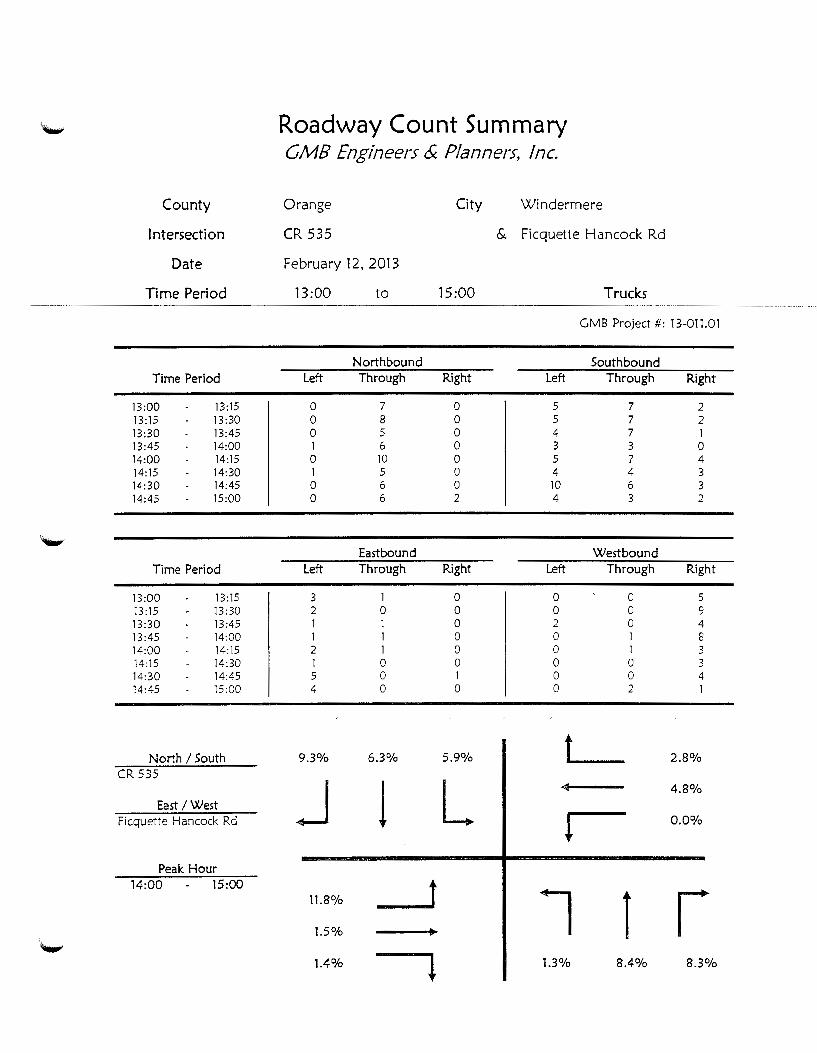
'~ Roadway Count Summary CMB Engineers & Planners, Inc.
County Orange City Windermere
Intersection CR 535 & Ficquette Hancock Rd
Date February 12. 2013
Time Period 13:00 to 15:00 Trucks
GMB Project#: 13-011.01
Northbound Southbound Time Period Left Through Right Left Through Right
13:00 13:15 0 7 0 5 7 2 13:15 13:30 0 8 0 5 7 2 13:30 13:45 0 5 0 4 7 1 13:45 14:00 1 6 0 3 3 0 14:00 14:15 0 10 0 5 7 4 14:15 14:30 1 5 0 4 4 3 14:30 14:45 0 6 0 10 6 3 14:45 15:00 0 6 2 4 3 2
'-". Eastbound Westbound
Time Period Left Through Right Left Through Right
13:00 13:15 3 1 0 0 0 5 13:15 13:30 2 0 0 0 0 9 13:30 13:45 1 1 0 2 0 4 13:45 14:00 1 1 0 0 1 8 14:00 14:15 2 1 0 0 1 3 14:15 14:30 1 0 0 0 0 3 14:30 14:45 5 0 1 0 0 4 14:45 15:00 4 0 0 0 2 1
North I South 9.3% 6.3% 5.9% t 2.8% CR 535
J 1 L 4.8% East I West
Ficquette Hancock Rd 0.0%
Peak Hour 14:00 15:00 t l 11.8% l r 1.5%
1.4% l 1.3% 8.4% 8.3%
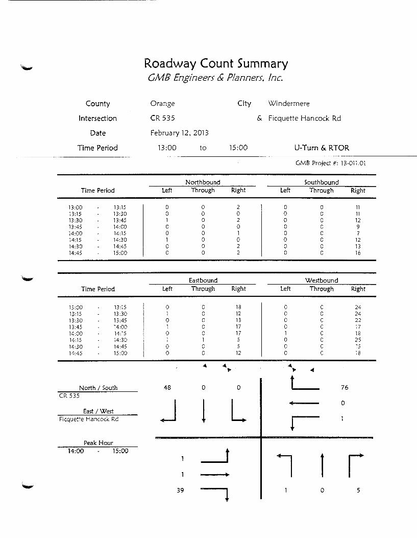
Roadway Count Summary CMB Engineers & Planners, Inc.
County Orange City Windermere
Intersection CR 535 & Ficquette Hancock Rd
Date February 12, 2013
Time Period 13:00 to 15:00 U-Turn & RTOR
GMB Project#: 13-011.01
Northbound Southbound Time Period Left Through Right Left Through Right
13:00 13:15 0 0 2 0 0 11 13:15 13:30 0 0 0 0 0 11 13:30 13:45 1 0 2 0 0 12 13:45 14:00 0 0 0 0 0 9 14:00 14:15 0 0 1 0 0 7 14:15 14:30 1 0 0 0 0 12 14:30 14:45 0 0 2 0 0 13 14:45 15:00 0 0 2 0 0 16
~ Eastbound Westbound Time Period Left Through Right Left Through Right
13:00 13:15 0 0 18 0 0 24 13:15 13:30 1 0 12 0 0 24 13:30 13:45 0 0 13 0 0 22 13:45 14:00 1 0 17 0 0 17 14:00 14:15 0 0 17 1 0 18 14:15 14:30 1 1 5 0 0 25 14:30 14:45 0 0 5 0 0 15 14:45 15:00 0 0 12 0 0 18
4. 4. . ·~ ~ ...
North I South 48 0 0 L 76 CR 535
J 1 L 0 East I West
Ficquette Hancock Rd
Peak Hour 14:00 15:00
1 l r ~
39 0 5

,.._, Roadway Count Summary CMB Engineers & Planners, Inc.
County Orange City Windermere
Intersection CR 535 & Overstreet Rd
Date February 14, 2013 All Vehicles
Time Period 8:00 to 10:00
GMB Project#: 13-11.01
Northbound Southbound Time Period Left Through Right Left Through Right
8:00 8:15 23 122 24 24 218 4 8:15 8:30 24 102 11 40 215 3 8:30 8:45 13 109 6 28 196 0 8:45 9:00 17 132 24 211 3 9:00 9:15 12 88 4 21 209 8 9:15 9:30 0 0 0 5 135 8 9:30 9:45 0 0 0 13 139 7 9:45 10:00 0 0 0 10 131 4
89 553 46 165 1,454 37
Eastbound Westbound
"'-"' Time Period Left Through Right Left Through Right
8:00 8:15 31 49 63 61 26 31 8:15 8:30 9 66 43 16 4 12 8:30 8:45 5 34 27 16 5 10 8:45 9:00 24 17 71 19 4 15 9:00 9:15 16 8 45 13 3 15 9:15 9:30 17 5 49 0 0 0 9:30 9:45 10 9 21 0 0 0 9:45 10:00 10 4 21 0 0 0
122 192 340 125 42 83
10 840 116 t 68 North I South
CR 535 J J L 39
East I West l 112
Overstreet Rd
Peak Hour t 8:00 9:00 69 l t r Peak Hour Factor 166
0.82 204 1 77 465 42
Total Pk Hr Voume
2.208
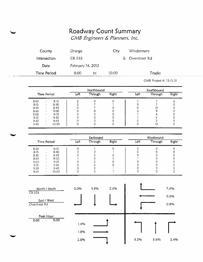
-----------·~----------------
Roadway Count Summary CMB Engineers & Planners, Inc.
County Orange City Windermere
Intersection CR 535 & Overstreet Rd
Date February 14, 2013
Time Period 8:00 to 10:00 Trucks
GMB Project #: 13-11.01
Northbound Southbound Time Period Left Through Right Left Through Right
8:00 8:15 2 4 0 1 7 0 8:15 8:30 2 7 1 0 7 0 8:30 8:45 0 7 0 0 10 0 8:45 9:00 0 8 0 2 9 0 9:00 9:15 0 5 0 1 4 0 9:15 9:30 0 0 0 1 3 0 9:30 9:45 0 0 0 0 3 0 9:45 10:00 0 0 0 0 13 0
'-' Eastbound Westbound Time Period Left Through Right Left Through Right
8:00 8:15 0 1 0 0 0 0 8:15 8:30 0 2 1 0 0 0 8:30 8:45 0 0 0 0 0 0 8:45 9:00 1 0 3 1 0 5 9:00 9:15 0 0 0 0 0 0 9:15 9:30 0 0 0 0 0 0 9:30 9:45 0 0 1 0 0 0 9:45 10:00 0 0 1 0 0 0
North I South 0.0% 3.9% 2.6% t 7.4% CR 535
J 1 L 0.0% East /West
Overstreet Rd ! 0.9%
Peak Hour 8:00 9:00 t l 1.4% l r 1.8%
.......... 2.0% l 5.2% 5.6% 2.4%
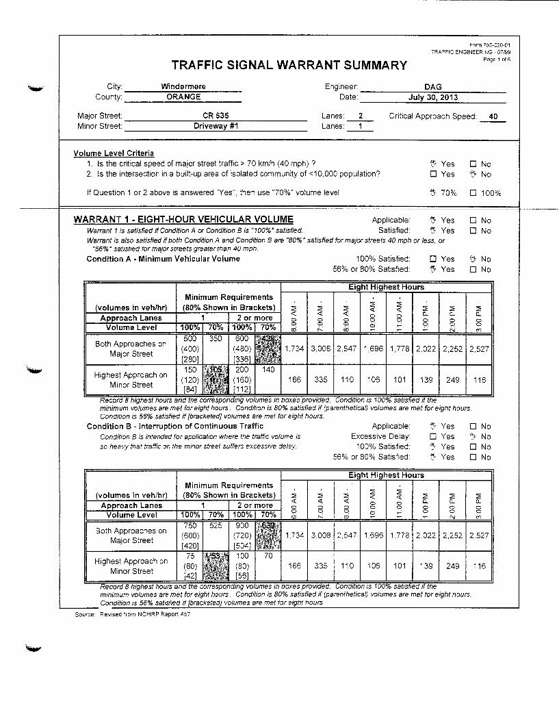
~ ~ -~--~---------------------------------------------
TRAFFIC SIGNAL WARRANT SUMMARY
Form 750-020-01 TRAFFIC ENGINEERING- 07/99
Page 1 of6
City: Windermere Engineer: DAG County: ORANGE Date: July 30, 2013
Major Street: CR535 Lanes: 2 Critical Approach Speed: Minor Street Driveway #1 Lanes:
Volume Level Criteria 1. Is the critical speed of major street traffic> 70 km/h (40 mph) ? 2. Is the intersection in a built-up area of isolated community of <1 0,000 population?
If Question 1 or 2 above is answered "Yes", then use "70%" volume level
WARRANT 1 - EIGHT -HOUR VEHICULAR VOLUME Warrant 1 is satisfied if Condition A or Condition 8 is "100%" satisfied.
Applicable: Satisfied:
~er Yes 0 Yes
~ 70%
•e;, Yes
" Yes Warrant is also satisfied if both Condition A and Condition 8 are "80%" satisfied for major streets 40 mph or less, or
"55%· satisfied for maJor streets greater than 40 mph.
0
"" 0
0 0
40
No No
100%
No No
Condition A- Minimum Vehicular Volume 100% Satisfied: 0 Yes 56% or 80% Satisfied: ~Yes
~ No 0 No
minimum volumes are met for eight hours. Condition is 80% satisfied if (parenthetical) volumes are met for eight hours. Condition is 56% satisfied if [bracketed] volumes are met for eight hours.
Condition B -Interruption of Continuous Traffic Applicable: ".'1 Yes 0 No Condition B is intended for application where the traffic volume is so heavy that traffic on the minor street suffers excessive delay.
Excessive Delay: 100% Satisfied:
56% or 80% Satisfied:
D \N:~
~~
Yes If}
Yes D Yes D
No No No
2,252 2.527
249 116
minimum volumes are met for eight hours. Condition is 80% satisfied if (parenthetical) volumes are met for eight hours . ....._ ___ Condition is 56% satisfted if {bracketed] volumes are met tor eight hours.
Source: Revised from NCHRP Report 457
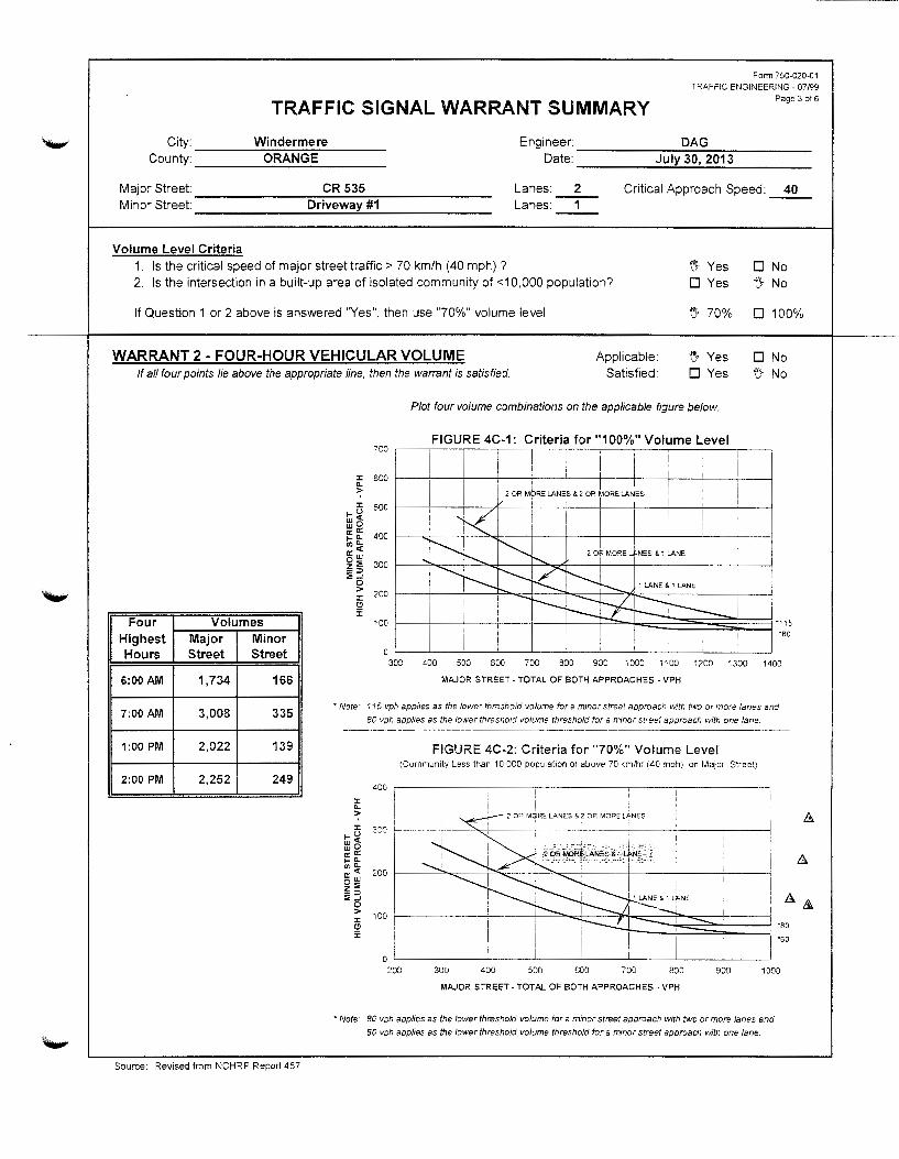
Form 750-020-01 TRAFFIC ENGINEERING- 07/99
TRAFFIC SIGNAL WARRANT SUMMARY Page 3 of 6
City: Windermere Engineer: DAG County: ORANGE Date: July 30, 2013
Major Street: CR 535 Lanes: 2 Critical Approach Speed: 40 Minor Street: Driveway #1 Lanes:
Volume Level Criteria 1. Is the critical speed of major street traffic> 70 km/h (40 mph) ? 15- Yes 0 No 2. Is the intersection in a built-up area of isolated community of <1 0,000 population? D Yes '::J- No
If Question 1 or 2 above is answered "Yes", then use "70%" volume level ~1 70% 0 100%
WARRANT 2 -FOUR-HOUR VEHICULAR VOLUME Applicable \'.'} Yes 0 No If all four points lie above the appropriate line, then the warrant is satisfied. Satisfied 0 Yes t} No
Four Volumes Highest Major Minor Hours Street Street
6:00AM 1,734 166
7:00AM 3,008 335
1:00PM 2,022 139
2:00PM 2,252 249
Source: Revised from NCHRP Report 457
:t: "-::;-:t:
Iii~ wO o::O:: f-"-II)"-0::<( ow z:O -:0 :O..J
0 > :t: (!)
5:
700
600
500
400
300
200
100
0 308
Plot four volume combinations on the applicable figure below.
FIGURE 4C-1: Criteria for "100%" Volume Level
400 500 600 700 BOO 900 1000 1100 1200 1300 1400
MAJOR STREET- TOTAL OF BOTH APPROACHES - VPH
• Note· 115 vph applies as the lower threshold volume for a minor street approach with two or more lanes and
80 vph applies as the lower threshold volume threshold for a minor street approach with one lane.
:t: "-::;-:t:
f-u w<Z: wO a:: a: f-"-en"-a:<( ow z:O -::> :;;..J
0 > :t: (!) :;:
400
300
FIGURE 4C-2: Criteria for "70%" Volume Level (Community Less than 10.000 population or above 70 kmlhr (40 mph) on Major Street)
2 OR MQRE LANES & 2 OR MORE LANES
' c2 oR M~J lJii.iES.& 0: j,NE:-~ 200
:~,:._:y:'! -··l 1_..1..._._-7------i
100
0 200 300 400 500 600
I 1 LANE&. 1 LP.NE ---700 BOO
MAJOR STREET- TOTAL OF BOTH APPROACHES • VPH
900 1000
*Note: 80 vph applies as the lower threshold volume for a minor street approach with two or more lanes and
60 vph applies as the lower threshold volume threshold for a minor street approach with one lane

....... TRAFFIC SIGNAL WARRANT SUMMARY
Form 750-020-01 TRAFFIC ENGINEERING- 07/99
Page 4 of 6
City: Windermere Engineer: DAG County: ORANGE Date: July 30, 2013
Major Street CR535 Lanes: 2 Critical Approach Speed: 40 Minor Street Driveway#1 Lanes:
Volume Level Criteria 1. Is the critical speed of major street traffic> 70 km/h (40 mph)? 2. Is the intersection in a built-up area of isolated community of <1 0,000 population?
~Yes 0 Yes
0 No ~ No
If Question 1 or 2 above is answered "Yes", then use "70%" volume level ~ 70% 0 100%
WARRANT 3 -PEAK HOUR If all three criteria are fu/Jfilled or the plotted point lies above the appropriate line,
then the warrant is satisfed.
Applicable Satisfied
{'J, Yes {'J, Yes
0 No 0 No
Unusual condition justifying
use of warrant:
High School Entrance
Record hour when criteria are fulfilled
and the corresponding delay or volume
in boxes provided.
Criteria 1. Delay on Minor Approach
*(vehicle-hours)
Approach Lanes 1 2
Delay Criteria* 4.0 5.0
Delay*
Fulfilled?: 0 Yes ~~~ No
2. Volume on Minor Approach *(vehicles per hour)
Approach Lanes 1 2
Volume Criteria* 100 150 Volume* 335
Fulfilled?: {'J, Yes 0 No
3. Total Entering Volume
*(vehicles per hour)
No. of Approaches 3 4
Volume Criteria* 650 800 Volume• 3,343
Fulfilled?: ~Yes 0 No
Source: Revised from NCHRP Report 457
!I
i '
600
:t: 500 ll. :>; :t:
tij~ wD a:"' ,_c.. "'"-a:<t ow z:E _::;;, :l:.J
0 > :t: (!) :;:
100
Plot volume combination on the applicable figure below.
FIGURE 4C-3: Criteria for "100%" Volume Level
"100
500 600 700 800 900 1000 1100 1200 1300 1400 1500 1600 1700 1800
MAJOR STREET- TOTAL OF BOTH APPROACHES- VPH
• Note: 150 vph applies as the lower threshold volume for a minor street approach with two or more lanes ancl
100 vph applies as the lower threshold volume threshold for a minor street approach with one lane
J: a. > J:
,_u lli~ a: a: ,_a. CJ)O.
cc:~ D:;; z_ i::
0 > J:
~
500
FIGURE 4C-4: Criteria for "70%" Volume Level (Community Less than 10.000 population or above 70 km/hr (40 mph) on Major Street)
. . i
400
2 OR MORE LANEs! & 2 OP MoRE LANEs !
~------'--'"'-__:. __ ..._,..---;;.-L:....L--+----+----'---;.__-----~
300
200
100
0 300 400
2 DRI MORE LANEs & 1 LANE ' '
500 600 700 800 900 1000 1100 ~200 1308
MAJOR STREET- TOTAL OF BOTH APPROACHES- VPH
• Note: 100 vph applies as the lower threshold volume for a minor street approach with two or more lanes and
75 vph applies as the lower threshold volume threshold for a minor street approach with one lane

TRAFFIC SIGNAL WARRANT SUMMARY
City: Windermere Engineer:
Form 750-020-01 TRAFFIC ENGINEERING- 07/99
Page 1 of 6
DAG County: ORANGE Date: July 30, 2013
Major Street: CR 535 Lanes: 2 Critical Approach Speed: 40 Minor Street: DRIVEWAY#2 Lanes: -1-
Volume Level Criteria 1. Is the critical speed of major street traffic> 70 km/h (40 mph)? 2. Is the intersection in a built-up area of isolated community of <1 0,000 population?
If Question 1 or 2 above is answered "Yes", then use "70%" volume level
WARRANT 1- EIGHT-HOUR VEHICULAR VOLUME Warrant 1 is satisfied if Condition A or Condition 8 is "1 00%" satisfied.
Applicable: Satisfied:
~~ Yes 0 Yes
'[} 70%
t). Yes t).' Yes
Warrant is also satisfied if both Condition A and Condition 8 are "80%" satisfied for major streets 40 mph or less. or "56%" satisfied tor major streets greater than 40 mph.
Condition A -Minimum Vehicular Volume 1 00% Satisfied: 56% or 80% Satisfied:
0 Yes 0 Yes
0 No
~ No
0 100%
0 No
0 No
~ No ~ No
minimum volumes are met for eight hours. Condition is 80% satisfied if (parentheticalj volumes are met for eight hours. Condition is 56% satisfied if {bracketed] volumes are met for eight hours.
Condition 8 - Interruption of Continuous Traffic Condition 8 is intended for application where the traffic volume is
so heavy that traffic on the minor street suffers excessive delay
Applicable: Excessive Delay:
100% Satisfied 56% or 80% Satisfied
"::Yes 0 Yes 0 Yes 0 Yes
0 No No l:l'flrjr.
J
,w" v ~[y
J
No No
minimum volumes are met for eight hours. Condition is 80% satisfied if (parentheticalj volumes are met for eight hours . ...._ ___ condition 1s 56% satisfied if [bracketed} volumes are met tor e1ght hours.
Source: Revised from NCHRP Report 457

Form 7 50-020-01 TRAFFIC ENGINEERING - 07199
TRAFFIC SIGNAL WARRANT SUMMARY Page 3 of 6
City: Windermere Engineer: DAG County: ORANGE Date: July 30, 2013
Major Street: CR535 Lanes: 2 Critical Approach Speed: 40 Minor Street: DRIVEWAY#2 Lanes: -1-
Volume Level Criteria 1. Is the critical speed of major street traffic> 70 km/h (40 mph) ? '"' U' Yes 0 No 2. Is the intersection in a built-up area of isolated community of <10,000 population? 0 Yes ~ No
If Question 1 or 2 above is answered "Yes", then use "70%" volume level ':} 70% 0 100%
WARRANT 2 - FOUR-HOUR VEHICULAR VOLUME Applicable: ~~Yes 0 No ':} No If all four points lie above the appropriate line, then the warrant is satisfied. Satisfied: 0 Yes
Four Volumes Highest Major Minor Hours Street Street
6:00AM 1,715 55
7:00AM 2,971 112
1:00PM 2,006 46
2:00PM 2,224 83
Source: Revised from NCHRP Report 457
Plot four volume combinations on the applicable figure below.
FIGURE 4C-1: Criteria for "100%" Volume Level 700 ,-~,1~~,-~-,~~y-~-,-~-,-~,-~-,-~,-~-,~-,
~ 600 r-~-r~-4~~+-~~~~~~,....~~~~+-~-+--~+-~~
>
0 300 400 SOD 600 700 900 1080 1100 1200 1300 1400
MAJOR STREET- TOTAL OF BOTH APPROACHES · VPH
• Note: 115 vph appl1es as the lower threshold volume for a minor street approach with two or more lanes and
80 vph appfies as the lower threshold volume threshold for a minor street approach with one lane.
:c 0..
::: :c
tu~ wO o:"' ,_c.. (J)O..
o:<t ow z::: -=> :;:_,
0 > :c (!l :;;
FIGURE 4C-2: Criteria for "70%" Volume Level (Community Less than 10.000 population or above 70 km/hr (40 mph) on Major Street)
4~0
• I 2 OR MGlRE LANES & 2 OR MORE lANES
30G
20C L~
I I
100 I
I 0 I
200 300 400 500 600 700 800 900
MAJOR STREET- TOTAL OF BOTH APPROACHES - VPH
1000
• Note: 80 vph applies as the lower threshold volume for a minor street approach with two or more lanes and
60 vph applies as the lower threshold volume threshold for a minor street approach with one lane.

._.,
Form 750-020-01 TqAFFIC ENGINEERING- 07199
TRAFFIC SIGNAL WARRANT SUMMARY Page 4 of 5
City Windermere Engineer: DAG County: ORANGE Date: July 30, 2013
Major Street: CR 535 Lanes: 2 Critical Approach Speed: 40 Minor Street: DRIVEWAY#2 Lanes:
Volume Level Criteria 1. Is the critical speed of major street traffic> 70 km/h (40 mph) ?
2. Is the intersection in a built-up area of isolated community of <10,000 population? ~Yes
DYes D No ~ No
If Question 1 or 2 above is answered "Yes", then use "70%" volume level "" 70% D 100%
WARRANT 3- PEAK HOUR Applicable: If all three criteria are fullfilled or the plotted point lies above the appropriate line,
then the warrant is satisfed.
Satisfied ~Yes
~Yes D No D No
Unusual condition justifying
use of warrant:
High School Entrance
Record hour when criteria are fulfilled
and the corresponding delay or volume
in boxes provided.
Peak Hour 7:00AM 2,971 112
Criteria 1. Delay on Minor Approach
*(vehicle-hours)
Approach Lanes 1 2
Delay Criteria* 4.0 5.0
Delay• Fulfilled?: DYes ~~ No
2. Volume on Minor Approach *(vehicles per hour)
Approach Lanes 1 2
Volume Criteria* 100 150
Volume* 112
Fulfilled?: f.} Yes D No
3. Total Entering Volume *(vehicles per hour)
No. of Approaches 3 4
Volume Criteria* 650 800 Volume• 3,113
Fulfilled?: ~ Yes D No
Source: Revised from NCH RP Report 457
~ 500 > :t
tii ~ 400 ::!~
Plot volume combination on the applicable figure below.
~t ~i 300 r---r---r---~~+---~~t---t-~t---+---+---4---4---~--~ -::> :;;...J
0 > 200 r---~--r---+---+---+-~~~+---~~±7L-~~~--4---4---~
5 :;:
"100
D 400 500 600 700 BOD 900 1000 11 DO 1200 1300 1400 1500 1600 1700 1 BOO
MAJOR STREET- TOTAL OF BOTH APPROACHES- VPH
• Note: 150 vph applies as the lower threshold volume for a minor street approach with two or more lanes and
100 vph applies as the lower threshold volume threshold for a minor street approach with one lane
FIGURE 4C-4: Criteria for "70%" Volume Level (Community Less than 10.000 population or above 70 kmlhr (LO mph) on MaJOr Street)
I
:r. 2 OR M~RE LA.NES: & 2 OR MORE LANES ! ~ 400 ~--~~~~-----+~~~----~-----'-----t-----~----L---~ :t
tu ~ 2 ORiMORE LANES & 1 LANE w o I e: g: 300 r-~~----"""<:"'--------f~---+T----+------'-----+------+-----T---------1 ooo..
~~ ~ ~ 200 c-------1------+~=----'-----"'~:-----+-"""-;;:---b''-------'------+------+-----____j ~ t5 :;:
D ~--____j----~-------'-----~----~-----'------'-----~----+-----~ 300 400 500 600 700 BOO 90C 1 000 110J 1200 1300
MAJOR STREET -TOTAL OF BOTH APPROACHES - VPH
• Note: 100 vph applies as the lower threshold volume for a minor street approach with two or more lanes and
75 vph applies as the lower threshold volume threshold for a minor street approach with one lane.
"100
"75
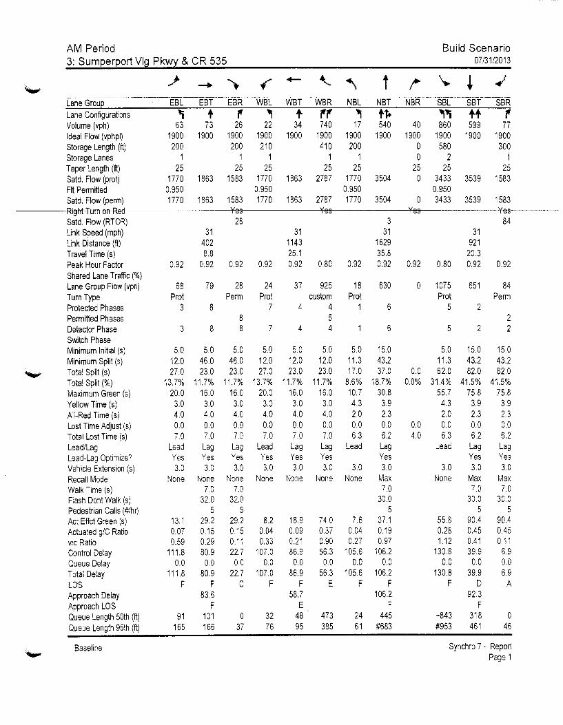
AM Period 3: Sumperport Vlg Pkwy & CR 535
Build Scenario 07/31/2013
Lane Configurations Volume (vph} Ideal Flow (vphpl) Storage Length (It} Storage Lanes Taper Length (ft) Satd. Flow (prot) Fit Permitted Satd. Flow (perm) Right Tum on Red Satd. Flow (RTOR) Link Speed (mph) Link Distance (ft) Travel Time (s) Peak Hour Factor Shared Lane Traffic(%) Lane Group Flow (vph) Tum Type Protected Phases Permitted Phases Detector Phase Switch Phase Minimum Initial (s) Minimum Split (s) Total Split (s) Total Split(%) Maximum Green (s) Yellow Time (s) All-Red Time ( s) Lost Time Adjust (s) Total Lost Time (s) Lead/Lag Lead-Lag Optimize? Vehicle Extension (s) Recall Mode Walk Time (s) Flash Don! Walk (s) Pedestrian Calls (#/hr) Act Effct Green (s) Actuated g/C Ratio vic Ratio Control Delay Queue Delay Total Delay LOS Approach Delay Approach LOS Queue Length 50th (ft) Queue Length 95th (ft)
Baseline
., t , ~ t ,, ., tt+ .,., tt 63 73 26 22 34 740 17 540 40 860 599
1900 1900 1900 1900 1900 1900 1900 1900 1900 1900 1900 200 200 210 410 200 0 580
1 1 1 1 1 0 2 25 25 25 25 25 25 25
1770 1863 1583 1770 1863 2787 1770 3504 0 3433 3539 0.950 0.950 0.950 0.950 1770 1863 1583 1770 1863 2787 1770 3504 0 3433 3539
0.92
68 Prot
3
3
5.0 12.0 27.0
13.7% 20.0
3.0 4.0 0.0 7.0
Lead Yes 3.0
None
13.1 0.07 0.59
111.8 0.0
111.8 F
91 165
31 402 8.8
0.92
79
8
8
5.0 46.0 23.0
11.7% 16.0 3.0 4.0 0.0 7.0 Lag Yes 3.0
None 7.0
32.0 5
29.2 0.15 0.29 80.9 0.0
80.9 F
83.6 F
101 166
Yes 28
0.92
28 Perm
8 8
5.0 46.0 23.0
11.7% 16.0
3.0 4.0 0.0 7.0
Lag Yes 3.0
None 7.0
32.0 5
29.2 0.15 0.11 22.7
0.0 22.7
c
0 37
31 1143 25.1
0.92 0.92
24 37 Prot
7 4
7 4
5.0 5.0 12.0 12.0 27.0 23.0
13.7% 11.7% 20.0 16.0
3.0 3.0 4.0 4.0 0.0 0.0 7.0 7.0
Lead Lag Yes Yes 3.0 3.0
None None
8.2 18.9 0.04 0.09 0.33 0.21
107.0 86.9 0.0 0.0
107.0 86.9 F F
58.7 E
32 48 76 95
Yes Yes 3
31 31 1629 921 35.8 20.3
0.80 0.92 0.92 0.92 0.80 0.92
925 18 630 0 1075 651 custom Prot
4 1 5 4
5.0 12.0 23.0
11.7% 16.0 3.0 4.0 0.0 7.0
5.0 11.3 17.0
8.6% 10.7 4.3 2.0 0.0 6.3
6
6
15.0 43.2 37.0
18.7% 30.8 3.9 2.3 0.0 6.2
Lag Lead Lag Yes Yes 3.0 3.0 3.0
None None Max 7.0
30.0 5
74.0 7.6 37.1 0.37 0.04 0.19 0.90 0.27 0.97 56.3 105.6 106.2 0.0 0.0 0.0
56.3 105.6 106.2 E F F
106.2 F
473 24 445 385 61 #683
0.0 0.0%
0.0 4.0
Prot 5
5
5.0 11.3 62.0
31.4% 55.7 4.3 2.0 0.0 6.3
2
2
15.0 43.2 82.0
41.5% 75.8
3.9 2.3 0.0 6.2
Lead Lag Yes
3.0 3.0 None Max
7.0 30.0
5 55.8 90.4 0.28 0.45 1.12 0.41
130.8 39.9 0.0 0.0
130.8 39.9 F D
92.3 F
-843 318 #953 461
SBR , 77
1900 300
1 25
1583
1583 Yes
84
0.92
84 Perm
2 2
15.0 43.2 82.0
41.5% 75.8
3.9 2.3 0.0 6.2
Lag Yes 3.0
Max 7.0
30.0 5
90.4 0.45 0.11
6.9 0.0 6.9
A
0 46
Synchro 7 - Report Page 1

._..,
'-"
AM Period 3: Sumperport Vlg Pkwy & CR 535
--- -----------~-----------·------------ --··--·-·-··---
Lane Grou 09 Lanejtonfigurations Volume (vph) Ideal Flow (vphpl) Storage Length (ft) Storage Lanes Taper Length (ft) Satd. Flow (prot) Fit Permitted Satd. Flow erm Right Turn on Red Satd. Flow (RTOR) Link Speed (mph) Link Distance (ft) Travel Time (s) Peak Hour Factor Shared Lane Traffic(%) Lane Group Flow (vph) Turn Type Protected Phases 9 Permitted Phases Detector Phase Switch Phase Minimum Initial (s) 1.0 Minimum Split (s) 48.4 Total Split (s) 48.4 Total Split(%) 25% Maximum Green (s) 42.0 Yellow Time (s) 3.9 All-Red Time (s) 2.5 Lost Time Adjust (s) Total Lost Time (s) Lead/Lag Lead-Lag Optimize? Vehicle Extension (s) 3.0 Recall Mode Ped Walk Time (s) 7.0 Flash Don! Walk (s) 35.0 Pedestrian Calls (#/hr) 5 Act Effct Green (s) Actuated g/C Ratio vic Ratio Control Delay Queue Delay Total Delay LOS Approach Delay Approach LOS Queue Length 50th (ft) Queue Length 95th (ft)
Baseline
Build Scenario 07/31/2013
Synchro 7 - Report Page 2
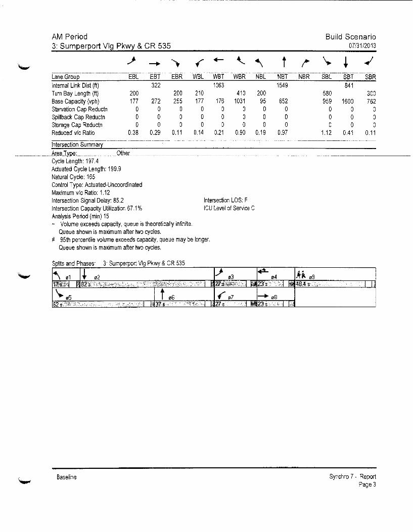
AM Period 3: Sumperport Vlg Pkwy & CR 535
t
Build Scenario 07/31/2013
Lan6Groue~- --~------------EsC-- Esf ____ E:rur-~WsL-wsr--·wsR:~-Hsr~~---Nsf~---~~sR~-- ssc--·-s-sf ssR Internal Link Dis! (ft) 322 1063 1549 841 Tum Bay Length (ft) 200 200 210 410 200 580 300 Base Capacity (vph) 177 272 255 177 176 1031 95 652 959 1600 762 Starvation Cap Reductn 0 0 0 0 0 0 0 0 0 0 0 Spillback Cap Reductn 0 0 0 0 0 0 0 0 0 0 0 Storage Cap Reductn 0 0 0 0 0 0 0 0 0 0 0 Reduced v/c Ratio 0.38 0.29 0.11 0.14 0.21 0.90 0.19 0.97 1.12 0.41 0.11
Cycle Length: 197.4 Actuated Cycle Length: 199.9 Natural Cycle: 165 Control Type: Actuated-Uncoordinated Maximum v/c Ratio: 1.12 Intersection Signal Delay: 85.2 Intersection LOS: F Intersection Capacity Utilization 67.1% ICU Level of Service C Analysis Period (min) 15 - Volume exceeds capacity, queue is theoretically infinite.
Queue shown is maximum after two cycles. # 95th percentile volume exceeds capacity, queue may be longer.
Queue shown is maximum after two cycles.
Splits and Phases: 3 Sumperport Vlg Pkwy & CR 535
Baseline
- I I.
Synchro 7 - Report Page 3

AM Period 3: Sumperport Vlg Pkwy & CR 535
Lane Grou I'IJ9 Internal Link Dis! (ft) Turn Bay Length (ft) Base Capacity (vph) Starvation Cap Reductn Spillback Cap Reductn Storage Cap Reductn Reduced v/c Ratio
Intersection Summary
Baseline
Build Scenario 07/31/2013
Synchro 7- Report Page 4
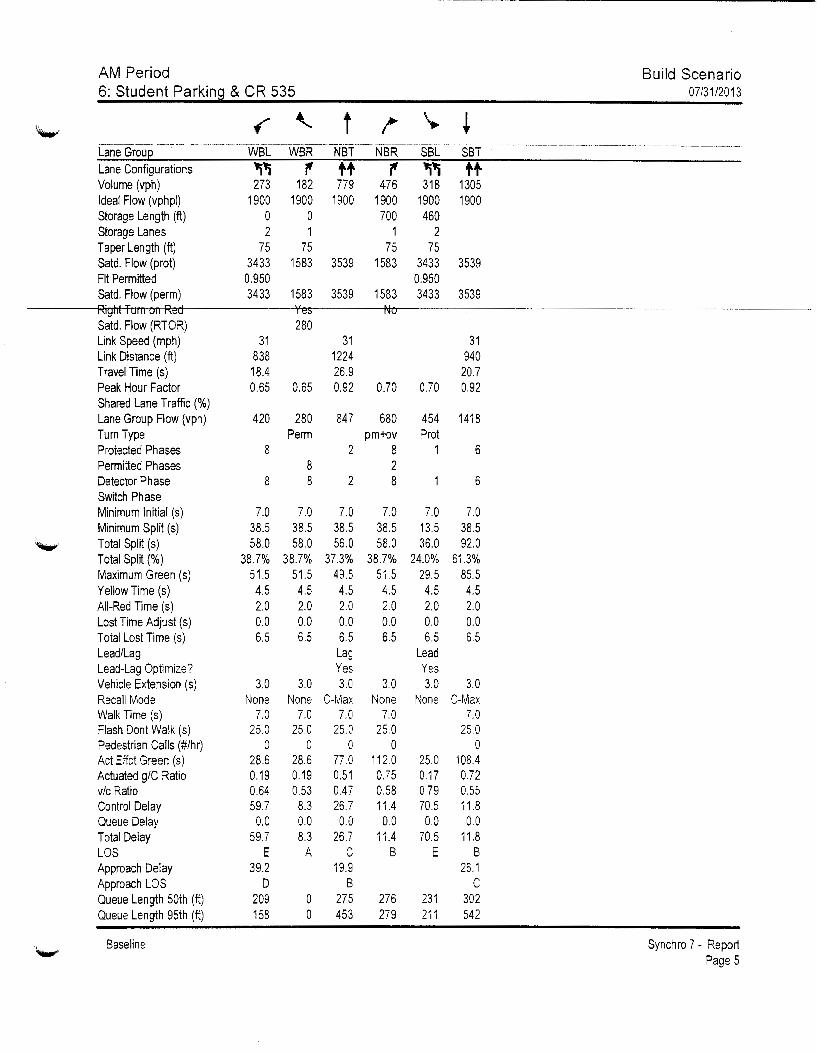
AM Period 6: Student Parking & CR 535
Lane Group Lane Configurations Volume (vph) Ideal Flow (vphpl) Storage Length (ft) Storage Lanes Taper Length (ft) Satd. Flow (prot) Fit Permitted Satd. Flow (perm) Right Turn 011 Red Satd. Flow (RTOR) Link Speed (mph) Link Distance (ft) Travel Time (s) Peak Hour Factor Shared Lane Traffic(%) Lane Group Flow (vph) Turn Type Protected Phases Permitted Phases Detector Phase Switch Phase Minimum Initial (s) Minimum Split (s) Total SpliT (s) Total Split(%) Maximum Green (s) Yellow Time (s) All-Red Time (s) Lost Time Adjust (s) Total Lost Time (s) Lead/Lag Lead-Lag Optimize? Vehicle Extension (s) Recall Mode Walk Time (s) Flash Dont Walk (s) Pedestrian Calls (#/hr) Act Effct Green (s) Actuated g/C Ratio v/c Ratio Control Delay Queue Delay Total Delay LOS Approach Delay Approach LOS Queue Length 50th (ft) Queue Length 95th (ft)
Baseline
t
~' r tt ~ ~' tt 273 182 779 476 318 1305
1900 1900 1900 1900 1900 1900 0 0 700 460 2 1 1 2
75 75 75 75 3433 1583 3539 1583 3433 3539 0.950 0.950 3433 1583 3539 1583 3433 3539
31 838 18.4
Yes 280
0.65 0.65
420 280 Perm
8 8
8 8
7.0 38.5 58.0
38.7% 51.5 4.5 2.0 0.0 6.5
3.0 None
7.0 25.0
0 28.6 0.19 0.64 59.7
0.0 59.7
E 39.2
D 209 158
7.0 38.5 58.0
38.7% 51.5 4.5 2.0 0.0 6.5
3.0 None
7.0 25.0
0 28.6 0.19 0.53 8.3 0.0 8.3
A
0 0
31 1224 26.9
No
0.92 0.70
847 680 pm+ov
2 8 2
2 8
7.0 38.5 56.0
37.3% 49.5 4.5 2.0 0.0 6.5 Lag Yes 3.0
C-Max 7.0
25.0 0
77.0 0.51 0.47 26.7
0.0 26.7
c 19.9
B 275 453
7.0 38.5 58.0
38.7% 51.5 4.5 2.0 0.0 6.5
3.0 None
7.0 25.0
0 112.0 0.75 0.58 11.4
0.0 11.4
B
276 279
31 940
20.7 0.70 0.92
454 1418 Prot
1 6
7.0 13.5 36.0
24.0% 29.5 4.5 2.0 0.0 6.5
Lead Yes 3.0
None
25.0 0.17 0.79 70.5 0.0
70.5 E
231 211
6
7.0 38.5 92.0
61.3% 85.5 4.5 2.0 0.0 6.5
3.0 C-Max
7.0 25.0
0 108.4 0.72 0.55 11.8
0.0 11.8
B 26.1
c 302 542
Build Scenario 07/31/2013
Synchro 7 - Report Page 5
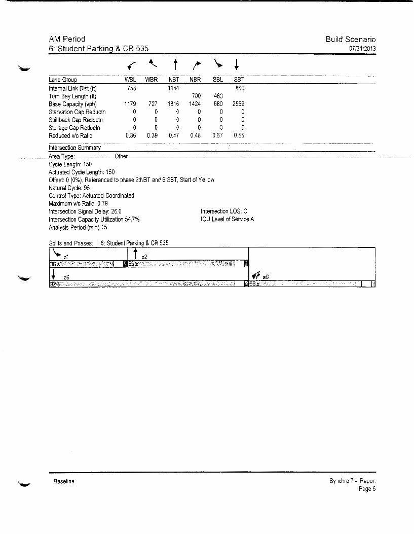
AM Period 6: Student Parking & CR 535
t -~------·-----·-··----------------- ----------------···------------------------------ ---------------- -----·- ------------------Lane Groue WBL WBR NBT NBR SBL SST Internal Link Dis! (ft) 758 1144 860 Turn Bay Length (ft) 700 460 Base Capacity (vph) 1179 727 1816 1424 680 2559 Starvation Cap Reductn 0 0 0 0 0 0 Spillback Cap Reductn 0 0 0 0 0 0 Storage Cap Reductn 0 0 0 0 0 0 Reduced v/c Ratio 0.36 0.39 0.47 0.48 0.67 0.55
-------------
Build Scenario 07/31/2013
------- ·-···--------------·----- .... --------- ---
--------------------------------·-- ------·---------------------------------··-· ---------- ---------···------ --------
Cycle Length: 150 Actuated Cycle Length: 150 Offset: 0 (0%), Referenced to phase 2:NBT and 6:SBT, Start of Yellow Natural Cycle: 95 Control Type: Actuated-Coordinated Maximum v/c Ratio: 0.79 Intersection Signal Delay: 26.0 Intersection LOS: C Intersection Capacity Utilization 54.7% ICU Level of Service A Analysis Period (min) 15
Splits and Phases: 6: Student Parking & CR 535
Baseline Synchro 7 - Report Page 6
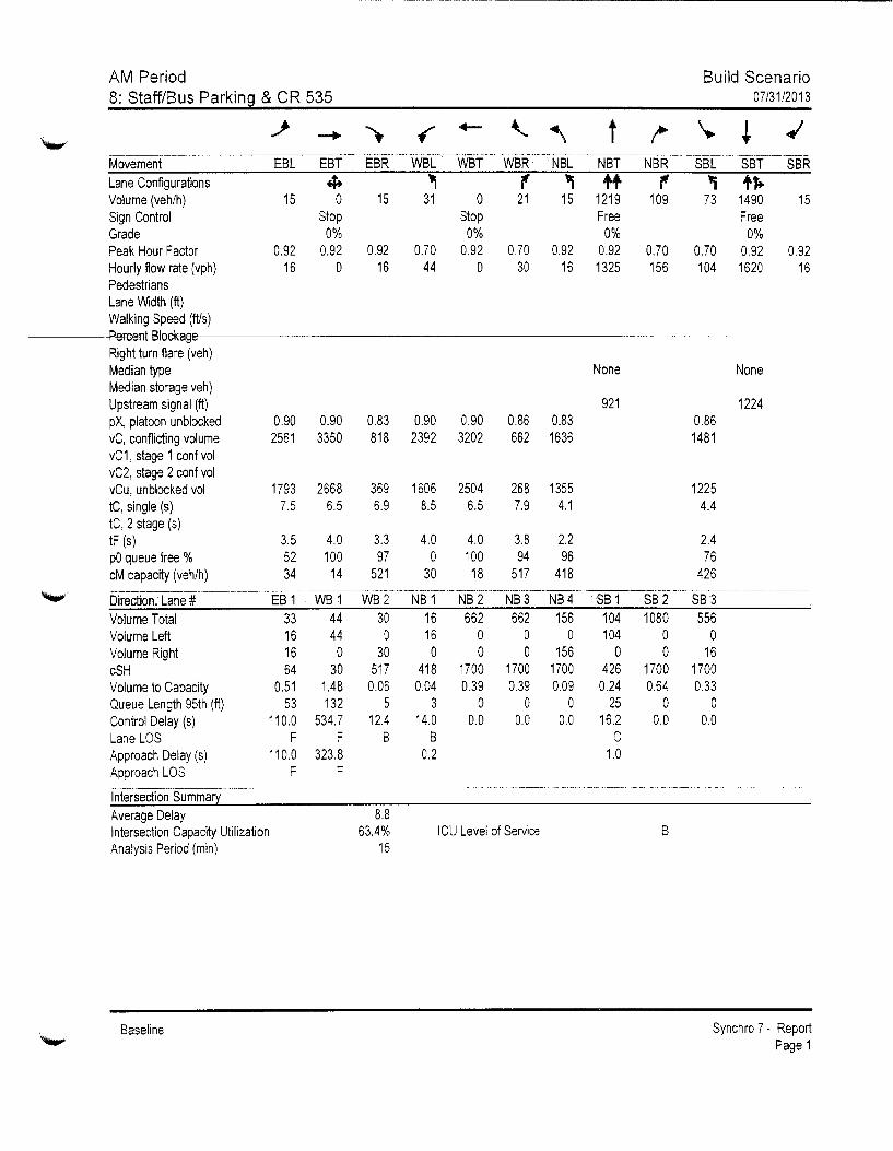
·~·
AM Period 8: Staff/Bus Parking & CR 535
Build Scenario 07/31/2013
Lane Configurations 4+ "l '{' "l ++ 'f' "i fft. Volume (veh/h) 15 0 15 31 0 21 15 1219 109 73 1490 15 Sign Control Grade
Stop 0%
Stop 0%
Peak Hour Factor 0.92 0.92 0.92 0.70 0.92 Hourly flow rate (vph) 16 0 16 44 0 Pedestrians Lane Width (ft) Walking Speed (fils)
Right turn flare (veh) Median type Median storage veh) Upstream signal (ft) pX, platoon unblocked vC, conflicting volume vC1, stage 1 conf vol vC2, stage 2 conf vol vCu, unblocked vol tC, single (s) tC, 2 stage (s) tF (s) pO queue free % eM capacity (veh/h)
Direction, Lane# Volume Total Volume Left Volume Right cSH Volume to Capacity Queue Length 95th (ft) Control Delay (s) Lane LOS Approach Delay (s) Approach LOS
Intersection Summary Average Delay
0.90 0.90 0.83 0.90 0.90 2561 3350 818 2392 3202
1793 2668 369 1606 2504 7.5 6.5 6.9 8.5 6.5
3.5 4.0 3.3 4.0 4.0 52 100 97 0 100 34 14 521 30 18
EB 1 WB 1 WB 2 NB 1 NB 2 33 44 30 16 662 16 44 D 16 0 16 0 30 0 0 64 30 517 418 1700
0.51 1.48 0.06 0.04 0.39 53 132 5 3 0
110.0 534.7 12.4 14.0 0.0 F F B B
110.0 323.8 0.2 F F
Free Free 0% 0%
0.70 0.92 0.92 0.70 156
0.70 0.92 30 16 1325 104 1620
0.86 0.83 662 1636
268 1355 7.9 4.1
3.8 2.2 94 96
517 418
NB 3 NB 4 662 156
0 0 0 156
1700 1700 0.39 0.09
0 0 0.0 0.0
None
921 0.86 1481
1225 4.4
2.4 76
426
SB 1 SB 2 SB 3 104 1080 556 104 0 0
0 0 16 426 1700 1700 0.24 0.64 0.33
25 0 0 16.2 0.0 0.0
c 1.0
None
1224
0.92 16
Intersection Capacity Utilization Analysis Period (min)
8.8 63.4%
15 ICU Level of Service B
Baseline Synchro 7 - Report Page 1
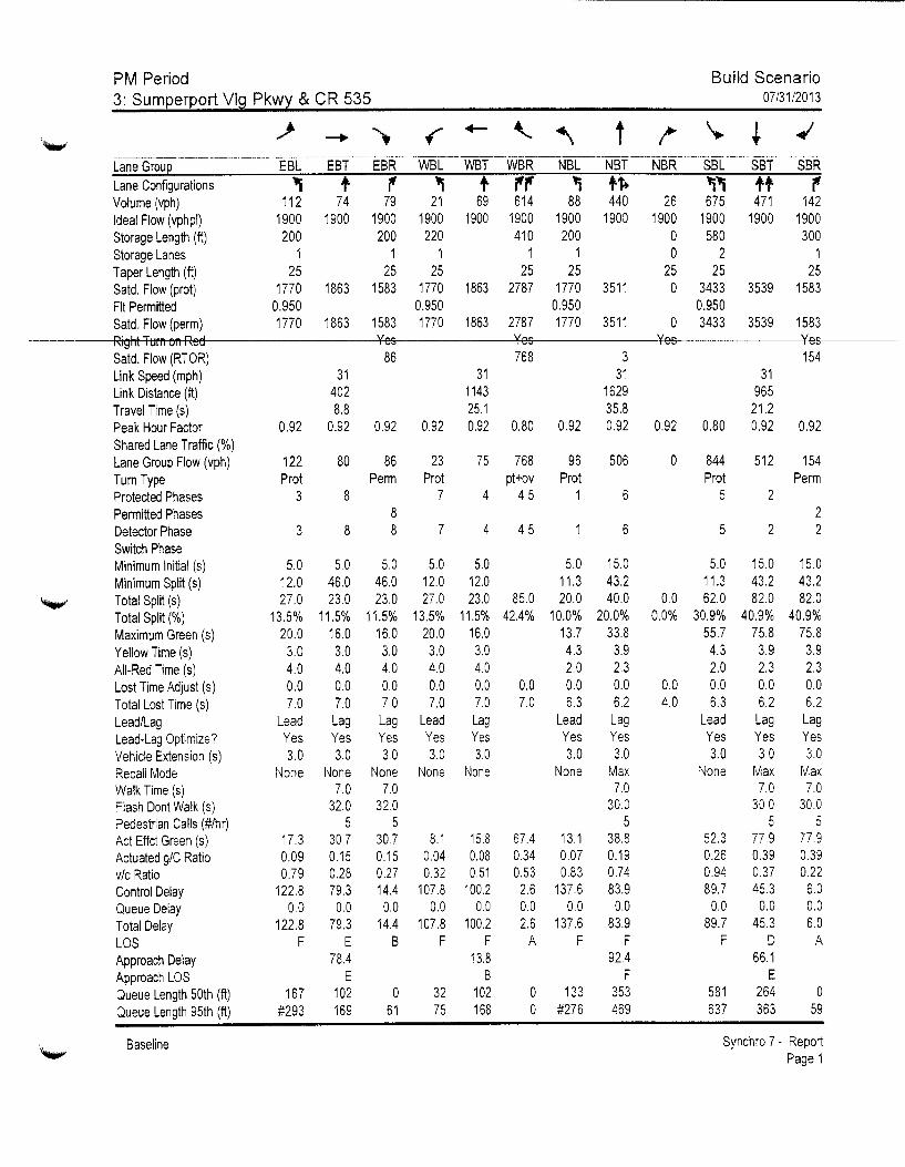
PM Period Build Scenario 3: Sumeerport VI~ Pkwl & CR 535 07/31/2013
/ --+ ., f +- ' "\ t /"' \.. ! ..; ---------··------~------ ---- -----------------~------····------- ----·----------···----------------~--- -· ---~--------- ----- s8R Lane Grou~ EBL EBT EBR WBL WBT WBR NBL NBT NBR SBL SBT
Lane Configurations '1 t 7' ~ t 7'7' "1 t~ "1'1 tt 7' Volume (vph) 112 74 79 21 69 614 88 440 26 675 471 142 Ideal Flow (vphpl) 1900 1900 1900 1900 1900 1900 1900 1900 1900 1900 1900 1900 Storage Length (ft) 200 200 220 410 200 0 580 300 Storage Lanes 1 1 1 1 1 0 2 1 Taper Length (ft) 25 25 25 25 25 25 25 25 Said. Flow (prot) 1770 1863 1583 1770 1863 2787 1770 3511 0 3433 3539 1583 Fit Permitted 0.950 0.950 0.950 0.950 Satd. Flow (perm) 1770 1863 1583 1770 1863 2787 1770 3511 0 3433 3539 1583 Right Tum on Red Yes Yes Yes Yes Satd. Flow (RTOR) 86 768 3 154 Link Speed (mph) 31 31 31 31 Link Distance (ft) 402 1143 1629 965 Travel Time (s) 8.8 25.1 35.8 21.2 Peak Hour Factor 0.92 0.92 0.92 0.92 0.92 0.80 0.92 0.92 0.92 0.80 0.92 0.92 Shared Lane Traffic(%) Lane Group Flow (vph) 122 80 86 23 75 768 96 506 0 844 512 154 Tum Type Prot Perm Prot pt+ov Prot Prot Perm Protected Phases 3 8 7 4 4 5 1 6 5 2 Permitted Phases 8 2 Detector Phase 3 8 8 7 4 45 6 5 2 2 Switch Phase Minimum Initial (s) 5.0 5.0 5.0 5.0 5.0 5.0 15.0 5.0 15.0 15.0 Minimum Split (s) 12.0 46.0 46.0 12.0 12.0 11.3 43.2 11.3 43.2 43.2 Total Split (s) 27.0 23.0 23.0 27.0 23.0 85.0 20.0 40.0 0.0 62.0 82.0 82.0 Total Split (%) 13.5% 11.5% 11.5% 13.5% 11.5% 42.4% 10.0% 20.0% 0.0% 30.9% 40.9% 40.9% Maximum Green (s) 20.0 16.0 16.0 20.0 16.0 13.7 33.8 55.7 75.8 75.8 Yellow Time (s) 3.0 3.0 3.0 3.0 3.0 4.3 3.9 4.3 3.9 3.9 All-Red Time ( s) 4.0 4.0 4.0 4.0 4.0 2.0 2.3 2.0 2.3 2.3 Lost Time Adjust (s) 0.0 0.0 0.0 0.0 0.0 0.0 0.0 0.0 0.0 0.0 0.0 0.0 Total Lost Time ( s) 7.0 7.0 7.0 7.0 7.0 7.0 6.3 6.2 4.0 6.3 6.2 6.2 Lead/Lag Lead Lag Lag Lead Lag Lead Lag Lead Lag Lag Lead-Lag Optimize? Yes Yes Yes Yes Yes Yes Yes Yes Yes Yes Vehicle Extension (s) 3.0 3.0 3.0 3.0 3.0 3.0 3.0 3.0 3.0 3.0 Recall Mode None None None None None None Max None Max Max Walk Time (s) 7.0 7.0 7.0 7.0 7.0 Flash Dont Walk (s) 32.0 32.0 30.0 30.0 30.0 Pedestrian Calls (#/hr) 5 5 5 5 5 Act Effct Green (s) 17.3 30.7 30.7 8.1 15.8 67.4 13.1 38.8 52.3 77.9 77.9 Actuated g/C Ratio 0.09 0.15 0.15 0.04 0.08 0.34 0.07 0.19 0.26 0.39 0.39 v/c Ratio 0.79 0.28 0.27 0.32 0.51 0.53 0.83 0.74 0.94 0.37 0.22 Control Delay 122.8 79.3 14.4 107.8 100.2 2.6 137.6 83.9 89.7 45.3 6.0 Queue Delay 0.0 0.0 0.0 0.0 0.0 0.0 0.0 0.0 0.0 0.0 0.0
Total Delay 122.8 79.3 14.4 107.8 100.2 2.6 137.6 83.9 89.7 45.3 6.0
LOS F E B F F A F F F D A Approach Delay 78.4 13.8 92.4 66.1 Approach LOS E B F E Queue Length 50th (ft) 167 102 0 32 102 0 133 353 581 264 0
Queue Length 95th (ft) #293 169 61 75 168 0 #276 469 637 363 59
~ Baseline Synchro 7 - Report
Page 1
'-"
~
PM Period 3: Sumperport Vlg Pkwy & CR 535
---------------------·--··------ ------------Lane Grou 09 Lanejtonfigurations Volume (vph) Ideal Flow (vphpl) Storage Length (ft) Storage Lanes Taper Length (ft) Satd. Flow (prot) Fit Permitted Satd. Flow (perm)
Satd. Flow (RTOR) Link Speed (mph) Link Distance (ft) Travel Time (s) Peak Hour Factor Shared Lane Traffic(%) Lane Group Flow (vph) Turn Type Protected Phases 9 Penmitted Phases Detector Phase Switch Phase Minimum Initial (s) 1.0 Minimum Split (s) 48.4 Total Split (s) 48.4 Total Split(%) 24% Maximum Green (s) 42.0 Yellow Time (s) 3.9 All-Red Time (s) 2.5 Lost Time Adjust (s) Total Lost Time (s) Lead/Lag Lead-Lag Optimize? Vehicle Extension (s) 3.0 Recall Mode Ped Walk Time (s) 7.0 Flash Dont Walk (s) 35.0 Pedestrian Calls (#/hr) 0 Act Effct Green (s) Actuated g/C Ratio vic Ratio Control Delay Queue Delay Total Delay LOS Approach Delay Approach LOS Queue Length 50th (ft) Queue Length 95th (ft)
Baseline
Build Scenario 07/31/2013
Synchro 7- Report Page 2

PM Period 3: Sumperport Vlg Pkwy & CR 535
t
Build Scenario 07/31/2013
-·-"---------·-·-------------------------------------------· ---·-··------------. ·-----·--·-·····-···- ----------·-··-· -. ------------ ·------------ - ·------------- ----------Lane Group EBL EBT EBR WBL WBT WBR NBL Internal Link Dist (ft) 322 1063 Turn Bay Length (ft) 200 200 220 410 200 Base Capacity (vph) 178 286 316 178 175 1516 122 Starvation Cap Reductn 0 0 0 0 0 0 0 Spillback Cap Reductn 0 0 0 0 0 0 0 Storage Cap Reductn 0 0 0 0 0 0 0 Reduced v/c Ratio 0.69 0.28 0.27 0.13 0.43 0.51 0.79 ------------------ ···----- ------------- ---------------------------------.. ------Intersection Summary Area T e: Other Cycle Length: 200.4 Actuated Cycle Length: 199.4 Natural Cycle: 165 Control Type: Actuated-Uncoordinated Maximum v/c Ratio: 0.94 Intersection Signal Delay: 58.2 Intersection LOS: E Intersection Capacity Utilization 61.3% ICU Level of Service B Analysis Period (min) 15 # 95th percentile volume exceeds capacity, queue may be longer.
Queue shown is maximum after two cycles.
Splits and Phases: 3: Sumperport Vlg Pkwy & CR 535
Baseline
NBT NBR 1549
685 0 0 0
0.74 - ---------------·-
SBL SBT 885
580 963 1383
0 0 0 0 0 0
0.88 0.37 ·----------------
SBR
300 713
0 0 0
0.22
I li
Synchro 7 - Report Page 3

PM Period 3: Sumperport Vlg Pkwy & CR 535
lane Grou 09 Internal link Dist (ft) Turn Bay Length (ft) Base Capacity (vph) Starvation Cap Reductn Spillback Cap Reductn Storage Cap Reductn Reduced v/c Ratio
Build Scenario 07/31/2013
-----------·-·------------------· --- ----------··------------··-------------------------------------------- ·------------------- ------------- ------------------------- ---Intersection Summary
Baseline Synchro 7 - Report Page 4
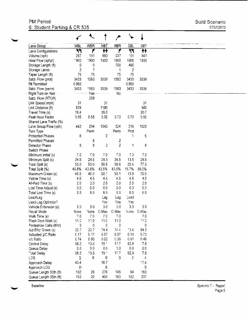
~-~---~--~----~-------------------------------------
PM Period Build Scenario 6: Student Parkin~ & CR 535 0713112013
~ .f '- 1 ~ \. + -·------···-·---·-·-···-- -- -·-----------·---·-- -·-····--··--------···---------------------------------------------------------·-· --···-·-···----- ---··- -------~---------- -----····-
Lane GrouE WBL WBR NBT NBR SBL SBT Lane Configurations 'l"i ., tt ., "i"i tt Volume (vph) 287 191 960 227 151 941 Ideal Flow (vphpl) 1900 1900 1900 1900 1900 1900 Storage Length (ft) 0 0 700 460 Storage Lanes 2 1 1 2 Taper Length (ft) 75 75 75 75 Satd. Flow (prot) 3433 1583 3539 1583 3433 3539 Fit Permitted 0.950 0.950 Satd. Flow (perm) 3433 1583 3539 1583 3433 3539 Right Turn on Red Yes No Satd. Flow (RTOR) 259 Link Speed (mph) 31 31 31 Link Distance (ft) 838 1180 940 Travel Time (s) 18.4 26.0 20.7 Peak Hour Factor 0.65 0.65 0.92 0.70 0.70 0.92 Shared Lane Traffic(%) Lane Group Flow (vph) 442 294 1043 324 216 1023 Turn Type Perm Perm Prot Protected Phases 8 2 1 6 Permitted Phases 8 2 Detector Phase 8 8 2 2 6 Switch Phase Minimum Initial (s) 7.0 7.0 7.0 7.0 7.0 7.0 Minimum Split (s) 24.5 24.5 24.5 24.5 13.5 24.5
'-"' Total Split (s) 53.0 53.0 56.6 56.6 20.4 77.0 Total Split (%) 40.8% 40.8% 43.5% 43.5% 15.7% 59.2% Maximum Green (s) 46.5 46.5 50.1 50.1 13.9 70.5 Yellow Time (s) 4.5 4.5 4.5 4.5 4.5 4.5 All-Red Time (s) 2.0 2.0 2.0 2.0 2.0 2.0 Lost Time Adjust (s) 0.0 0.0 0.0 0.0 0.0 0.0 Total Lost Time (s) 6.5 6.5 6.5 6.5 6.5 6.5 Lead/Lag Lag Lag Lead Lead-Lag Optimize? Yes Yes Yes Vehicle Extension (s) 3.0 3.0 3.0 3.0 3.0 3.0 Recall Mode None None C-Max C-Max None C-Max Walk Time (s) 7.0 7.0 7.0 7.0 7.0 Flash Dont Walk (s) 11.0 11.0 11.0 11.0 11.0 Pedestrian Calls (#/hr) 0 0 0 0 0 Act Effct Green (s) 22.7 22.7 74.4 74.4 13.4 94.3 Actuated g/C Ratio 0.17 0.17 0.57 0.57 0.10 0.73 v/c Ratio 0.74 0.60 0.52 0.36 0.61 0.40 Control Delay 58.3 13.5 19.1 17.7 62.9 7.8 Queue Delay 0.0 0.0 0.0 0.0 0.0 0.0 Total Delay 58.3 13.5 19.1 17.7 62.9 7.8 LOS E B B B E A Approach Delay 40.4 18.7 17.4 Approach LOS D B B Queue Length 50th (ft) 192 26 276 145 94 160 Queue Length 95th (ft) 163 20 404 183 102 237
'-"' Baseline Synchro 7- Report
Page 5

,._.,
PM Period Build Scenario 6: Student Parkin~ & CR 535 07/31/2013
f '- t !' \. ~ ---~----~------- --~-------------------------------------------------------- -·------------------------ ·---------·--·- --- ----------------------------- -------·· Lane Grou~ WBL WBR NBT NBR SBL SBT Internal Link Dist (ft) 758 1100 860 Turn Bay Length (ft) 700 460 Base Capacity (vph) 1228 733 2025 906 390 2568 Starvation Cap Reductn 0 0 0 0 0 0 Spillback Cap Reductn 0 0 0 0 0 0 Storage Cap Reductn 0 0 0 0 0 0 Reduced v/c Ratio 0.36 0.40 0.52 0.36 0.55 0.40 fnterSectioriSumnlary ----~--------------------~--------------------~--- -------------------------- ---------- ------ ··-
Area T e: Other Cycle Length: 130 Actuated Cycle Length: 130 Offset: 70.5 (54%), Referenced to phase 2:NBT and 6:SBT, Start of Yellow Natural Cycle: 65 Control Type: Actuated-Coordinated Maximum vic Ratio: 0.74 Intersection Signal Delay: 23.0 Intersection Capacity Utilization 56.8% Analysis Period (min) 15
Splits and Phases: 6: Student Parking & CR 535
n-s·· · -- ··
Baseline
Intersection LOS: C ICU Level of Service B
-I II
Synchro 7- Report Page 6

'-"
PM Period Build Scenario 8: Staff/Bus Parkin~ & CR 535 0713112013
..}- "'). f .,._ '- "\ t I'" \. ~ .,; -+
"---------~ -- -- ·---·. ------- ··---·--------·-··· ·--·--····--·---------------- ----------·--·-- - -··--·---·- -------·-------------------Movement EBL EBT EBR WBL WBT WBR NBL Lane Configurations 4+ "i ., "'i Volume (veh/h) 15 0 15 82 0 55 15 Sign Control Stop Stop Grade 0% 0% Peak Hour Factor 0.92 0.92 0.92 0.70 0.92 0.70 0.92 Hourly flow rate (vph) 16 0 16 117 0 79 16 Pedestrians Lane Width (ft) Walking Speed (ft/s)
Right turn flare (veh) Median type Median storage veh) Upstream signal (ft) pX, platoon unblocked 0.92 0.92 0.93 0.92 0.92 0.89 0.93 vC, conflicting volume 2084 2661 655 1973 2620 607 1311 vC1, stage 1 conf vol vC2, stage 2 conf vol vCu, unblocked vol 1674 2298 482 1554 2254 311 1186 tC, single (s) 7.5 6.5 6.9 7.9 6.5 7.3 4.1 tC, 2 stage (s) IF (s) 3.5 4.0 3.3 3.7 4.0 3.5 2.2 pO queue free % 64 100 97 0 100 86 97 eM capacity (veh/h) 46 32 494 53 34 564 544 ~-------------------------------------------------------------·-···--
Direction, Lane # EB 1 WB1 WB2 NB 1 NB 2 NB 3 NB4 Volume Total 33 117 79 16 607 607 49 Volume Left 16 117 0 16 D 0 0 Volume Right 16 0 79 0 0 0 49 cSH 83 53 564 544 1700 1700 1700 Volume to Capacity 0.39 2.22 0.14 0.03 0.36 0.36 0.03 Queue Length 95th (ft) 40 306 13 2 0 0 0 Control Delay (s) 73.6 727.1 12.4 11.8 0.0 0.0 0.0 Lane LOS F F B B Approach Delay (s) 73.6 440.2 0.2 Approach LOS F F -------·--· ------··--·-- ----------------- . ·- -- -----·- -- ------- ------ - - - ----------- ------ --
Intersection Summa~ Average Delay 31.3 Intersection Capacity Utilization 48.5% ICU Level of Service Analysis Period (min) 15
Baseline
NBT NBR SBL SBT SBR
++ 'f' ... +1+ 1117 34 22 1191 15 Free Free
0% 0% 0.92 0.70 0.70 0.92 0.92 1214 49 31 1295 16
None None
965 1180 0.89 1263
1048 5.1
2.7 92
388 --· --------~------------ --------------- --- ---
SB 1 SB 2 31 863 31 0 0 0
388 1700 0.08 0.51
7 0 15.1 0.0
c 0.4
A
SB 3 448
0 16
1700 0.26
0 0.0
Synchro 7 - Report Page 1

AM Period 3: Sumperport Vlg Pkwy & CR 535
Build Scenario W Two Traffic Signals 07/31/2013
Lane Conftgurations Volume (vph) Ideal Flow (vphpl) Storage Length (ft) Storage Lanes Taper Length (ft) Satd. Flow (prot) Fit Permitted Said. Flow (perm) Right Tu11 1 011 Red Satd. Flow (RTOR) Link Speed (mph) Link Distance (ft) Travel Time (s) Peak Hour Factor Shared Lane Traffic(%) Lane Group Flow (vph) Tum Type Protected Phases Permitted Phases Detector Phase Switch Phase Minimum Initial (s) Minimum Split (s) Total Split (s) Total Split(%) Maximum Green (s) Yellow Time (s) All-Red Time (s) Lost Time Adjust (s) Total Lost Time (s) Lead/Lag Lead-Lag Optimize? Vehicle Extension (s) Recall Mode Walk Time (s) Flash Don! Walk (s) Pedestrian Calls (#/hr) Act Effct Green (s) Actuated g/C Ratio v/c Ratio Control Delay Queue Delay Total Delay LOS Approach Delay Approach LOS Queue Length 50th (ft) Queue Length 95th (ft)
Baseline
t "i t r' "i t r''f' "i t-r.
63 73 26 22 34 740 17 540 1900 1900 1900 1900 1900 1900 1900 1900 200 200 210 410 200
1 1 1 1 1 ~ ~ ~ ~ ~
1770 1863 1583 1770 1863 2787 1770 3504 0.950 0.950 0.950 1770 1863 1583 1770 1863 2787 1770 3504
0.92
68 Prot
3
3
31 402 8.8
0.92
79
8
8
5.0 5.0 12.0 46.0 27.0 23.0
13.7% 11.7% 20.0 16.0 3.0 3.0 4.0 4.0 0.0 0.0 7.0 7. 0
Lead Lag Yes Yes 3.0 3.0
None None 7.0
32.0 5
13.1 29.2 0.07 0.15 0.59 0.29
111.8 80.9 0.0 0.0
111.8 80.9 F F
83.6 F
91 101 165 166
Yes 28
0.92
28 Perm
8 8
5.0 46.0 23.0
11.7% 16.0 3.0 4.0 0.0 7.0
Lag Yes 3.0
None 7.0
32.0 5
29.2 0.15 0.11 22.7
0.0 22.7
c
0 37
0.92
24 Prot
7
7
5.0 12.0 27.0
13.7% 20.0 3.0 4.0 0.0 7.0
Lead Yes 3.0
None
8.2 0.04 0.33
107.0 0.0
107.0 F
32 76
31 1143 25.1 0.92
37
4
4
5.0 12.0 23.0
11.7% 16.0 3.0 4.0 0.0 7.0 l_ag Yes 3.0
None
18.9 0.09 0.21 86.9 0.0
86.9 F
58.7 E
48 95
Yes
0.80
925 custom
4 5 4
5.0 12.0 23.0
11.7% 16.0 3.0 4.0 0.0 7.0
Lag Yes 3.0
None
74.0 0.37 0.90 56.3
0.0 56.3
E
473 385
0.92
18 Prot
1
5.0 11.3 17.0
8.6% 10.7 4.3 2.0 0.0 6.3
Lead
3.0 None
7.6 0.04 0.27
105.6 0.0
105.6 F
24 61
3 31
1629 35.8 0.92
630
6
6
15.0 43.2 37.0
18.7% 30.8
3.9 2.3 0.0 6.2
Lag Yes 3.0
Max 7.0
30.0 5
37.1 0.19 0.97
106.2 0.0
106.2 F
106.2 F
445 #683
NBR SBL .,., 40 860
1900 1900 0 580 0 2
25 25 0 3433
0.950 0 3433
Yes
0.92 0.80
0 1075
0.0 0.0%
0.0 4.0
Prot 5
5
5.0 11.3 62.0
31.4% 55.7 4.3 2.0 0.0 6.3
Lead
3.0 None
55.8 0.28 1.12
130.8 0.0
130.8 F
-843 #953
SBT SBR
tt r' 599 77
1900 1900 300
1 25
3539 1583
3539 1583
31 921
20.3
Yes 84
0.92 0.92
651 84 Perm
2 2
2 2
15.0 43.2 82.0
41.5% 75.8
3.9 2.3 0.0 6.2 Lag Yes 3.0
Max 7.0
30.0 5
90.4 0.45 0.41 39.9
0.0 39.9
D 92.3
F 318 461
15.0 43.2 82.0
41.5% 75.8
3.9 2.3 0.0 6.2
Lag Yes 3.0
Max 7.0
30.0 5
90.4 0.45 0.11 6.9 0.0 6.9
A
0 46
Synchro 7 - Report Page 1
AM Period 3: Sumperport Vlg Pkwy & CR 535
Lane Grou 09 Lanejtonfigurations Volume (vph) Ideal Flow (vphpl) Storage Length (ft) Storage Lanes Taper Length (ft) Satd. Flow (prot) Fit Permitted Satd. Flow (perm)
Satd. Flow (RTOR) Link Speed (mph) Link Distance (ft) Travel Time (s) Peak Hour Factor Shared Lane Traffic(%) Lane Group Flow (vph) Turn Type Protected Phases 9 Permitted Phases Detector Phase Switch Phase Minimum Initial (s) 1.0 Minimum Split (s) 48.4 Total Split (s) 48.4 Total Split(%) 25% Maximum Green (s) 42.0 Yellow Time (s) 3.9 All-Red Time (s) 2.5 Lost Time Adjust (s) Total Lost Time (s) Lead/Lag Lead-Lag Optimize? Vehicle Extension (s) 3.0 Recall Mode Ped Walk Time (s) 7.0 Flash Don! Walk (s) 35.0 Pedestrian Calls (#/hr) 5 Act Effct Green (s) Actuated g/C Ratio vic Ratio Control Delay Queue Delay Total Delay LOS Approach Delay Approach LOS Queue Length 50th (ft) Queue Length 95th (ft)
Baseline
Build Scenario W Two Traffic Signals 07/31/2013
Synchro 7 - Repori Page 2
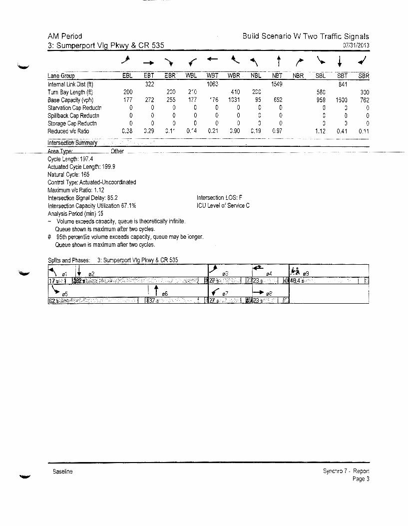
AM Period 3: Sumperport Vlg Pkwy & CR 535
Build Scenario W Two Traffic Signals 07/31/2013
Internal Link Dist (ft) 322 1063 1549 841 Turn Bay Length (ft) 200 200 210 410 200 580 300 Base Capacity (vph) 177 272 255 177 176 1031 95 652 959 1600 762 Starvation Cap Reductn 0 0 0 0 0 0 0 0 0 0 0 Spillback Cap Reductn 0 0 0 0 0 0 0 0 0 0 0 Storage Cap Reductn 0 0 0 0 0 0 0 0 0 0 0 Reducedv/cRatio 0.38 0.29 0.11 0.14 0.21 0.90 0.19 0.97 1.12 0.41 0.11
Intersection Summary
Cycle Length: 197.4 Actuated Cycle Length: 199.9 Natural Cycle: 165 Control Type: Actuated-Uncoordinated Maximum v/c Ratio: 1.12 Intersection Signal Delay: 85.2 Intersection LOS: F Intersection Capacity Utilization 67.1% ICU Level of Service C Analysis Period (min) 15 - Volume exceeds capacity, queue is theoretically infinite.
Queue shown is maximum after two cycles. # 95th percentile volume exceeds capacity, queue may be longer.
Queue shown is maximum after two cycles.
Splits and Phases: 3: Sumperport Vlg Pkwy & CR 535
Baseline
I li
Synchro 7 - Report Page 3
AM Period 3: Sumperport Vlg Pkwy & CR 535
Lane Grou 1?.19 Internal Link Dist (ft) Turn Bay Length (ft) Base Capacity (vph) Starvation Cap Reductn Spillback Cap Reductn Storage Cap Reductn Reduced v/c Ratio
Intersection Summary
Baseline
Build Scenario W Two Traffic Signals 07/31/2013
Synchro 7 - Report Page 4

AM Period 6: Student Parking & CR 535
Lane Configurations Volume (vph) Ideal Flow (vphpl) Storage Length (ft) Storage Lanes Taper Length (ft) Satd. Flow (prot) Fit Permitted Said. Flow (perm) Right Tum on Red Said. Flow (RTOR) Link Speed (mph) Link Distance (ft) Travel Time (s) Peak Hour Factor Shared Lane Traffic(%) Lane Group Flow (vph) Turn Type Protected Phases Permitted Phases Detector Phase Switch Phase Minimum Initial (s) Minimum Split (s) Total Split (s) Total Split (%) Maximum Green (s) Yellow Time (s) All-Red Time (s) Lost Time Adjust (s) Total Lost Time (s) Lead/Lag Lead-Lag Optimize? Vehicle Extension (s) Recall Mode Walk Time (s) Flash Doni Walk (s) Pedestrian Calls (#/hr) Act Effct Green (s) Actuated g/C Ratio vic Ratio Control Delay Queue Delay Total Delay LOS Approach Delay Approach LOS Queue Length 50th (ft) Queue Length 95th (ft)
Baseline
~' ~ +t ~ ~' t+ 273 182 779 476 318 1305
1900 1900 1900 1900 1900 1900 0 0 700 460 2 1 1 2
75 75 75 75 3433 1583 3539 1583 3433 3539 0.950 0.950 3433 1583 3539 1583 3433 3539
31 838 18.4
Yes 280
0.65 0.65
420 280 Perm
8 8
8 8
7.0 38.5 58.0
38.7% 51.5 4.5 2.0 0.0 6.5
3.0 None
7.0 25.0
0 28.6 0.19 0.64 59.7
0.0 59.7
E 39.2
D 209 158
7.0 38.5 58.0
38.7% 51.5 4.5 2.0 0.0 6.5
3.0 None
7.0 25.0
0 28.6 0.19 0.53 8.3 0.0 8.3
A
0 0
31 1224 26.9
No
0.92 0.70
847 680 pm+ov
2 8 2
2 8
7.0 38.5 56.0
37.3% 49.5
4.5 2.0 0.0 6.5
Lag Yes 3.0
C-Max 7.0
25.0 0
77.0 0.51 0.47 16.2 0.0
16.2 B
11.5 B
107 351
7.0 38.5 58.0
38.7% 51.5 4.5 2.0 0.0 6.5
3.0 None
7.0 25.0
0 112.0 0.75 0.58 5.7 0.0 5.7
A
25 222
31 940
20.7 0.70 0.92
454 1418 Prot
1 6
7.0 13.5 36.0
24.0% 29.5 4.5 2.0 0.0 6.5
Lead Yes 3.0
None
25.0 0.17 0.79 70.5
0.0 70.5
E
231 211
6
7.0 38.5 92.0
61.3% 85.5 4.5 2.0 0.0 6.5
3.0 C-Max
7.0 25.0
0 108.4 0.72 0.55 11.8 0.0
11.8 B
26.1 c
302 542
Build Scenario W Two Traffic Signals 07/31/2013
Synchro 7 - Report Page 3

......
AM Period Build Scenario W Two Traffic Signals 6: Student Parkin~ & CR 535
.f "- t !" \.. + ·-··--------· ---··· - ----·-·----·- ---·--······-----~-------- ------------ ------·-··------- --·-------
Lane Groue WBL WBR NBT NBR SBL SBT Internal Link Dist (ft) 758 1144 860 Turn Bay Length (ft) 700 460 Base Capacity (vph) 1179 727 1816 1424 680 2559 Starvation Cap Reductn 0 0 0 0 0 0 Spillback Cap Reductn 0 0 0 0 0 0 Storage Cap Reductn 0 0 0 0 0 0 Reduced v/c Ratio 0.36 0.39 0.47 0.48 0.67 0.55
Cycle Length: 150 Actuated Cycle Length: 150 Offset: 0 (0%), Referenced to phase 2:NBT and 6:SBT, Start of Yellow Natural Cycle: 95 Control Type: Actuated-Coordinated Maximum v/c Ratio: 0.79 Intersection Signal Delay: 22.9 Intersection Capacity Utilization 54.7% Analysis Period (min) 15
Splits and Phases: 6: Student Parking & CR 535
Baseline
Intersection LOS: C ICU Level of Service A
. ---·- ·- ·- --- --- --~- --
07/31/2013
Synchro 7- Report Page 4

AM Period 8: Staff/Bus Parking & CR 535
Build Scenario W Two Traffic Signals 07/31/2013
Lane Configurations Volume (vph) Ideal Flow (vphpl) Storage Length (ft) Storage Lanes Taper Length (ft) Satd. Flow (prot) Fit Permitted Satd. Flow (perm) Rtght Turn on Red Satd. Flow (RTOR) Link Speed (mph) Link Distance (ft) Travel Time ( s) Peak Hour Factor Heavy Vehicles(%) Shared Lane Traffic(%) Lane Group Flow (vph) Turn Type Protected Phases Permitted Phases Detector Phase Switch Phase Minimum Initial (s) Minimum Split (s) Total Split (s) Total Split(%) Maximum Green (s) Yellow Time (s) All-Red Time (s) Lost Time Adjust (s) Total Lost Time (s) Lead/Lag Lead-Lag Optimize? Vehicle Extension (s) Recall Mode Walk Time (s) Flash Don! Walk (s) Pedestrian Calls (#/hr) Act Effct Green (s) Actuated g/C Ratio vic Ratio Control Delay Queue Delay Total Delay LOS Approach Delay Approach LOS Queue Length 50th (ft)
Baseline
4+ "i ., "i tt ., "i tt. 15 0 15 31 0 21 15 1219 109 73 1490 15
1900 1900 1900 1900 1900 1900 1900 1900 1900 1900 1900 1900 0 0 0 0 150 450 620 0 0 0 1 1 1 1 1 0
75 75 75 75 75 75 75 75 0 1694 0 1203 0 1077 1770 3539 1404 1570 3536 0
0.976 0.736 0.950 0.950 0 1694 0 932 0 1077 1770 3539 1404 1570 3536 0
16 31
665 14.6
0.92 0.92 2% 2%
0 32 Perm
4 4
7.0 45.0 45.0
30.0% 38.5 4.5 2.0 0.0 6.5
3.0 None
7.0 11.0
0
4
4
7.0 45.0 45.0
30.0% 38.5 4.5 2.0 0.0 6.5
3.0 None
7.0 11.0
0 12.7 0.08 0.20 39.8 0.0
39.8 D
39.8 D
15
Yes
0.92 0.70 2% 50%
0 44
0.0 0.0%
0.0 4.0
custom
8 8
7.0 45.0 45.0
30.0% 38.5 4.5 2.0 0.0 6.5
3.0 None
7.0 11.0
0 12.7 0.08 0.56 90.2
0.0 90.2
F
44
31 915
20.1
Yes 30
0.92 0.70 2% 50%
0 30
31 921
20.3 0.92 0.92
2% 2%
16 1325 custom Prot
Yes 156
0.70 15%
156
1 31
1224 26.9
0.70 0.92 15% 2%
104 1636 Perm Prot
Yes
0.92 2%
0
5 2 1 6
0.0 0.0%
0.0 4.0
8 8
7.0 45.0 45.0
30.0% 38.5 4.5 2.0 0.0 6.5
3.0 None
7.0 11.0
0 12.7 0.08 0.25 23.6 0.0
23.6 c
0
5
7.0 13.5 13.5
9.0% 7.0 4.5 2.0 0.0 6.5
Lead Yes 3.0
None
7.5 0.05 0.18 72.7
0.0 72.7
E
16
2
7.0 24.5 80.0
53.3% 73.5 4.5 2.0 0.0 6.5
Lag Yes 3.0
C-Max 7.0
11.0 0
105.3 0.70 0.53 13.5 0.3
13.8 B
13.2 B
331
2 2
7.0 24.5 80.0
53.3% 73.5 4.5 2.0 0.0 6.5 Lag Yes 3.0
C-lvlax 7.0
11.0 0
105.3 0.70 0.15
2.0 0.0 2.0
A
0
7.0 13.5 25.0
16.7% 18.5 4.5 2.0 0.0 6.5
Lead Yes 3.0
None
15.2 0.10 0.65 85.1 0.0
85.1 F
110
6
7.0 24.5 91.5
61.0% 85.0 4.5 2.0 0.0 6.5 Lag Yes 3.0
C-Max 7.0
11.0 0
122.4 0.82 0.57 5.9 0.0 5.9
A 10.6
B 126
0.0 0.0%
0.0 4.0
Synchro 7 - Report Page 5

'-"
AM Period Build Scenario W Two Traffic Signals 8: Staff/Bus Parkin~ & CR 535 07/31/2013
~ ...... .., f .,._ ...... '\ t /"" \. + ..;
-·-------- -··-· --·---·---------·------------------·--·-··--···--- -- ·····--- ---------------·---· ---------· ---·-. ----·-·-- ------------ --·
Lane Grou~ EBL EBT EBR WBL WBT WBR NBL NBT NBR SBL SBT SBR Queue Length 95th {ft) 50 66 20 43 506 10 136 136 Internal Link Dis! (ft) 585 835 841 1144 Turn Bay Length (ft) 150 450 620 Base Capacity (vph) 447 239 299 89 2484 1032 199 2885 Starvation Cap Reductn 0 0 0 0 481 0 0 0 Spillback Cap Reductn 0 0 0 0 0 0 0 0 Storage Cap Reductn 0 0 0 0 0 0 0 0 Reduced vic Ratio 0.07 0.18 0.10 0.18 0.66 0.15 0.52 0.57 Intersection Summary ------------- ------------------------·-------·-- ·- -- ----·----------·----··------------·------ ··---------------
Area Type: Other Cycle Length: 150 Actuated Cycle Length: 150 Offset: 0 (0%), Referenced to phase 2:NBT and 6:SBT, Start of Yellow Natural Cycle: 115 Control Type: Actuated-Coordinated Maximum vic Ratio: 0.65 Intersection Signal Delay: 13.2 Intersection LOS: B Intersection Capacity Utilization 72.2% ICU Level of Service C Analysis Period (min) 15
Splits and Phases: 8: Staff/Bus Parking & CR 535
.···-- / >._·.•· .. ,·
Baseline
... ·•
I I'
Synchro 7 - Report Page 6
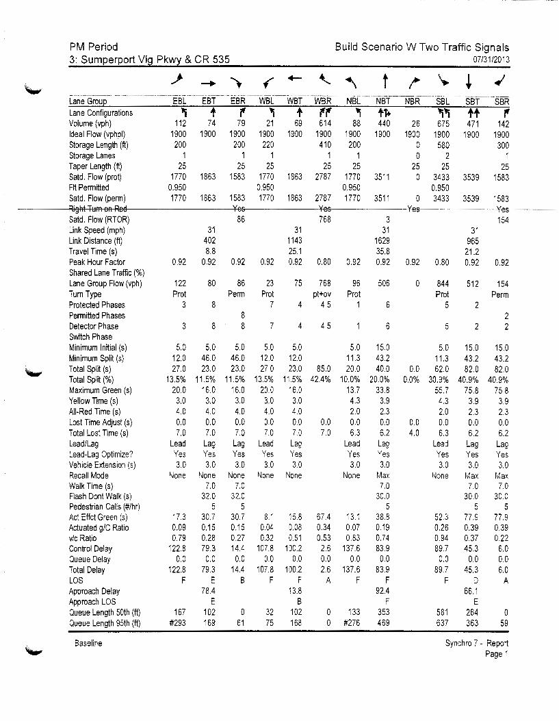
PM Period 3: Sumperport Vlg Pkwy & CR 535
Build Scenario W Two Traffic Signals 07/31/2013
Lane Configurations Volume (vph) Ideal Flow (vphpl) Storage Length (tt) Storage Lanes Taper Length (tt) Satd. Flow (prot) Fit Permitted Satd. Flow (perm) Right Tum on Red Satd. Flow (RTOR) Link Speed (mph) Link Distance (tt) Travel Time (s) Peak Hour Factor Shared Lane Traffic(%) Lane Group Flow (vph) Tum Type Protected Phases Permitted Phases Detector Phase Switch Phase Minimum Initial (s) Minimum Split (s) Total Split (s) Total Split(%) Maximum Green (s) Yellow Time (s) All-Red Time (s) Lost Time Adjust (s) Total Lost Time (s) Lead/Lag Lead-Lag Optimize? Vehicle Extension (s) Recall Mode Walk Time (s) Flash Doni Walk (s) Pedestrian Calls (#/hr) Act Effct Green (s) Actuated g/C Ratio v/c Ratio Control Delay Queue Delay Total Delay LOS Approach Delay Approach LOS Queue Length 50th (tt) Queue Length 95th (tt)
Baseline
t "i + r' "i + r'r' "i +1+ "l"i ++ r'
112 74 79 21 69 614 88 440 26 675 471 142 1900 1900 1900 1900 1900 1900 1900 1900 1900 1900 1900 1900 200 200 220 41 0 200 0 580 300
1 1 1 1 1 0 2 1 ~ ~ ~ ~ ~ ~ ~ ~
1770 1863 1583 1770 1863 2787 1770 3511 0 3433 3539 1583 0.950 0.950 0.950 0.950 1770 1863 1583 1770 1863 2787 1770 3511 0 3433 3539 1583
31 402 8.8
0.92 0.92
122 80 Prot
3 8
3 8
5.0 12.0 27.0
13.5% 20.0
3.0 4.0 0.0 7.0
Lead Yes 3.0
None
17.3 0.09 0.79
122.8 0.0
122.8 F
167 #293
5.0 46.0 23.0
11.5% 16.0
3.0 4.0 0.0 7.0
Lag Yes 3.0
None 7.0
32.0 5
30.7 0.15 0.28 79.3
0.0 79.3
E 78.4
E 102 169
Yes 86
0.92
86
31 1143 25.1
Yes 768
0.92 0.92 0.80
23 75 768
3 31
1629 35.8
0.92 0.92
96 506 Perm Prot pt+ov Prot
8 8
5.0 46.0 23.0
11.5% 16.0
3.0 4.0 0.0 7.0
Lag Yes 3.0
None 7.0
32.0 5
30.7 0.15 0.27 14.4 0.0
14.4 B
0 61
7
7
5.0 12.0 27.0
13.5% 20.0
3.0 4.0 0.0 7.0
Lead Yes 3.0
None
8.1 0.04 0.32
107.8 0.0
107.8 F
32 75
4 4 5 1
4
5.0 12.0
45
23.0 85.0 11.5% 42.4%
16.0 3.0 4.0 0.0 0.0 7.0 7.0
Lag Yes 3.0
None
15.8 67.4 0.08 0.34 0.51 0.53
100.2 2.6 0.0 0.0
100.2 2.6 F A
13.8 B
102 0 168 0
5.0 11.3 20.0
10.0% 13.7 4.3 2.0 0.0 6.3
Lead Yes 3.0
None
13.1 0.07 0.83
137.6 0.0
137.6 F
133 #276
6
6
15.0 43.2 40.0
20.0% 33.8
3.9 2.3 0.0 6.2 Lag Yes 3.0
Max 7.0
30.0 5
38.8 0.19 0.74 83.9
0.0 83.9
F 92.4
F 353 469
Yes
0.92
0
0.0 0.0%
0.0 4.0
31 965
21.2
Yes 154
0.80 0.92 0.92
844 512 154 Prot Perm
5 2 2
5 2 2
5.0 11.3 62.0
30.9% 55.7 4.3 2.0 0.0 6.3
Lead Yes 3.0
None
52.3 0.26 0.94 89.7
0.0 89.7
F
581 637
15.0 43.2 82.0
40.9% 75.8
3.9 2.3 0.0 6.2
Lag Yes 3.0
Max 7.0
30.0 5
77.9 0.39 0.37 45.3
0.0 45.3
D 66.1
E 264 363
15.0 43.2 82.0
40.9% 75.8
3.9 2.3 0.0 6.2
Lag Yes 3.0
Max 7.0
30.0 5
77.9 0.39 0.22 6.0 0.0 6.0
A
0 59
Synchro 7 - Report Page 1

.....,
'-"'
~·
PM Period 3: Sumperport Vlg Pkwy & CR 535
--·---~-~----·-·-·--·-··--·--
Lane Grou Laneitonfigurations Volume (vph) Ideal Flow (vphpl) Storage Length (ft) Storage Lanes Taper Length (ft) Satd. Flow (prot) Fit Permitted Satd. Flow (perm)
Satd. Flow (RTOR) Link Speed (mph) Link Distance (ft) Travel Time (s) Peak Hour Factor Shared Lane Traffic(%) Lane Group Flow (vph) Turn Type Protected Phases Permitted Phases Detector Phase Switch Phase Minimum Initial (s) Minimum Split (s) Total Split (s) Total Split(%) Maximum Green (s) Yellow Time (s) All-Red Time (s) Lost Time Adjust (s) Total Lost Time (s) Lead/Lag Lead-Lag Optimize? Vehicle Extension (s) Recall Mode Walk Time (s) Flash Dont Walk (s) Pedestrian Calls (#/hr) Act Effct Green (s) Actuated g/C Ratio v/c Ratio Control Delay Queue Delay Total Delay LOS Approach Delay Approach LOS Queue Length 50th (ft) Queue Length 95th (ft)
Baseline
9
1.0 48.4 48.4 24% 42.0
3.9 2.5
3.0 Ped 7.0
35.0 0
Build Scenario W Two Traffic Signals 07/31/2013
Synchro 7 - Report Page 2

~·
PM Period Build Scenario W Two Traffic Signals 3: Sumperport Vlg Pkw~ & CR 535
...i' ........ ..,. f ....... -\..
"" -·-------~---·--------· ------·---·-- -- . ·--. -· ·- . ----·- ·--- ---· ---- --- -·---·- --·--·------·---------·-----------· --·- ---------····--·-···--····----
Lane Grou2 EBL Internal Link Dist (ft) Turn Bay Length (ft) 200 Base Capacity (vph) 178 Starvation Cap Reductn 0 Spillback Cap Reductn 0 Storage Cap Reductn 0 Reduced v/c Ratio 0.69
Intersection Summary Area Type: Other
yce eng : Actuated Cycle Length: 199.4 Natural Cycle: 165 Control Type: Actuated-Uncoordinated Maximum v/c Ratio: 0.94
EBT 322
286 0 0 0
0.28
EBR WBL WBT WBR 1063
200 220 410 316 178 175 1516
0 0 0 0 0 0 0 0 0 0 0 0
0.27 0.13 0.43 0.51
Intersection Signal Delay: 58.2 Intersection LOS: E Intersection Capacity Utilization 61.3% ICU Level of Service B Analysis Period (min) 15 # 95th percentile volume exceeds capacity, queue may be longer.
Queue shown is maximum after two cycles.
Splits and Phases: 3: Sumperport Vlg Pkwy & CR 535
Baseline
NBL
200 122
0 0 0
0.79
t j'-' -----·---·-·- -·--- ---····-··--· --NBT NBR 1549
685 0 0 0
0.74
07/31/2013
'. + ..; -- --·------~---·--·
SBL SBT SBR 885
580 300 963 1383 713
0 0 0 0 0 0 0 0 0
0.88 0.37 0.22
I h
Synchro 7 - Report Page 3
PM Period 3: Sumperport Vlg Pkwy & CR 535
Lane Grou 09 Internal Link Dist (ft) Turn Bay Length (ft) Base Capacity (vph) Starvation Cap Reductn Spillback Cap Reductn Storage Cap Reductn Reduced v/c Ratio
Intersection Summary
Baseline
Build Scenario W Two Traffic Signals 07/31/2013
Synchro 7 - Report Page 4

PM Period 6: Student Parking & CR 535
Lane Configurations Volume (vph) Ideal Flow (vphpl) Storage Length (ft) Storage Lanes Taper Length (ft) Satd. Flow (prot) Ftt Permitted Satd. Flow (perm) Right Tum on Red Satd. Flow (RTOR) Link Speed (mph) Link Distance (ft) Travel Time (s) Peak Hour Factor Shared Lane Traffic(%) Lane Group Flow (vph) Turn Type Protected Phases Permitted Phases Detector Phase Switch Phase Minimum Initial (s) Minimum Split (s) Total Split (s) Total Split (%) Maximum Green (s) Yellow Time (s) All-Red Time (s) Lost Time Adjust (s) Total Lost Time (s) Lead/Lag Lead-Lag Optimize? Vehicle Extension (s) Recall Mode Walk Time (s) Flash Dont Walk (s) Pedestrian Calls (#/hr) Act Effct Green (s) Actuated g/C Ratio v/c Ratio Control Delay Queue Delay Total Delay LOS Approach Delay Approach LOS Queue Length 50th (tt) Queue Length 95th (ft)
Baseline
~~ r tt r ~~ tt 287 191 960 227 151 941
1900 1900 1900 1900 1900 1900 D 0 700 460 2 1 1 2
75 75 75 75 3433 1583 3539 1583 3433 3539 0.950 0.950 3433 1583 3539 1583 3433 3539
31 838 18.4 0.65
442
8
8
7.0 24.5 61.0
40.7% 54.5 4.5 2.0 0.0 6.5
3.0 None
7.0 11.0
0 25.4 0.17 0.76 68.1
0.0 68.1
E 46.7
D 224 187
Yes 261
0.65
294 Perm
8 8
7.0 24.5 61.0
40.7% 54.5 4.5 2.0 0.0 6.5
3.0
31 1180 26.0 0.92
1043
2
2
7.0 24.5 66.0
44.0% 59.5 4.5 2.0 0.0 6.5 Lag Yes 3.0
No
0.70
324 Perm
2 2
7.0 24.5 66.0
44.0% 59.5 4.5 2.0 0.0 6.5
Lag Yes 3.0
None C-Max C-fvlax 7.0 7.0 7.0
11.0 11.0 11.0 0 0 0
25.4 90.4 90.4 0.17 0.60 0.60 0.61 0.49 0.34 14.5 11.1 10.8 0.0 0.0 0.0
14.5 11.1 10.8 B B B
11.0 B
29 121 71 16 151 80
0.70
216 Prot
1
31 940
20.7 0.92
1023
6
6
7.0 7.0 13.5 24.5 23.0 89.0
15.3% 59.3% 16.5 82.5 4.5 4.5 2.0 2.0 0.0 0.0 6.5 6.5
Lead Yes 3.0 3.0
None C-Max 7.0
11.0 0
14.7 111.6 0.10 0.74 0.64 0.39 73.8 7.8
0.0 0.0 73.8 7.8
E A 19.3
B 110 175 117 252
Build Scenario W Two Signals 07/31/2013
Synchro 7 - Report Page 3
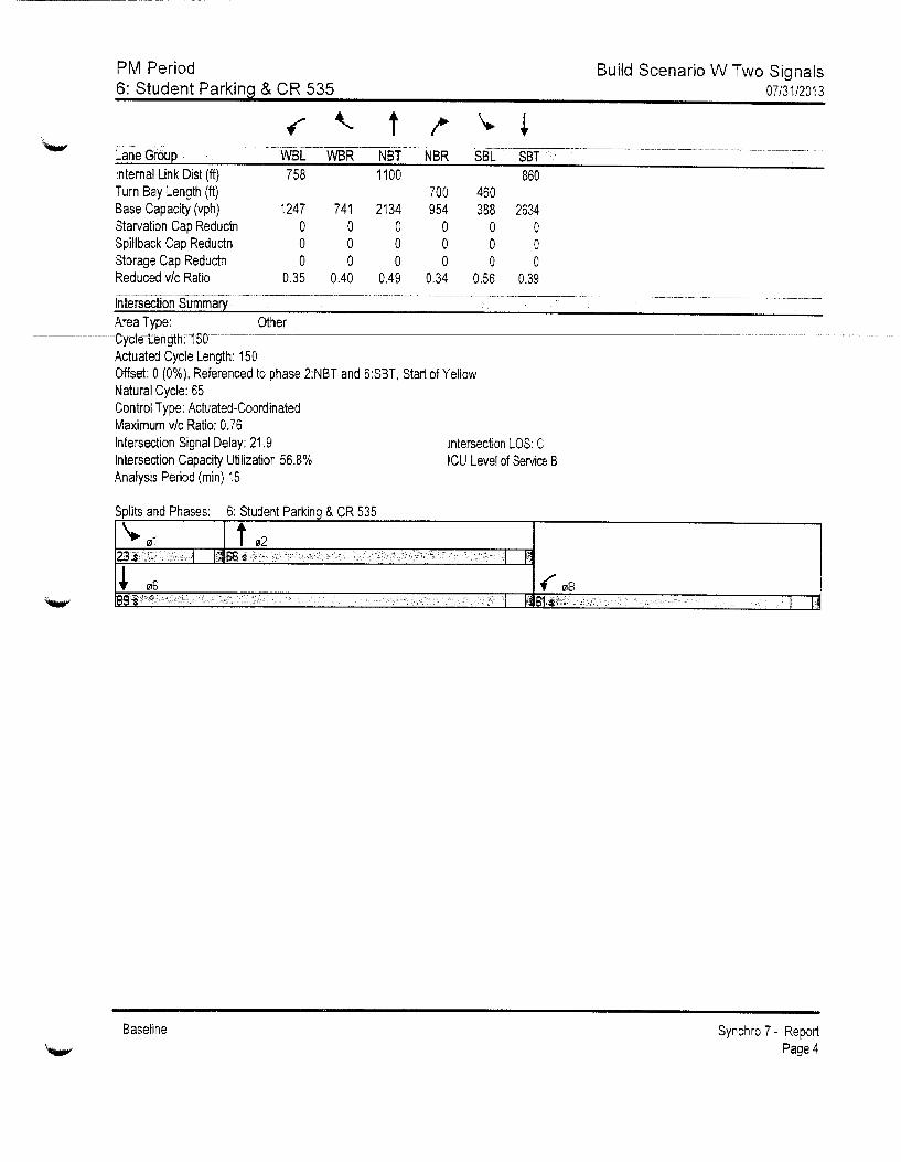
PM Period 6: Student Parking & CR 535
t
Build Scenario W Two Signals 07/31/2013
Can_e_G-ro-up ____ - --- -- ------wsc --- wsR--N8Y ___ NBR ___ ssc--s8T __________________________________ -------------
Internal Link Dis! (ft) Turn Bay Length (ft) Base Capacity (vph) Starvation Cap Reductn Spillback Cap Reductn Storage Cap Reductn Reduced v/c Ratio
Intersection Summary
758
1247 0 0 0
0.35
Area Type: Other yce eng :
Actuated Cycle Length: 150
1100
741 2134 0 0 0 0 0 0
0.40 0.49
860 700 460 954 388 2634
0 0 0 0 0 0 0 0 0
0.34 0.56 0.39
Offset: 0 (0%), Referenced to phase 2:NBT and 6:SBT, Start of Yellow Natural Cycle: 65 Control Type: Actuated-Coordinated Maximum v/c Ratio: 0.76 Intersection Signal Delay: 21.9 Intersection Capacity Utilization 56.8% Analysis Period (min) 15
Splits and Phases: 6: Student Parking & CR 535
_ -,·---:~>:1:·:c_:: .:.~
Baseline
Intersection LOS: C ICU Level of Service B
,,. --· --- --~- 'I ffl 81$?' .. - >- -__ 1 T
Synchro 7- Report Page 4
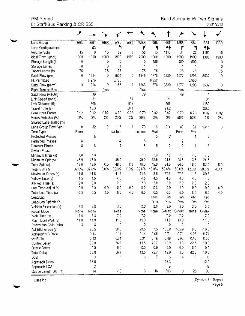
PM Period 8: Staff/Bus Parking & CR 535
Build Scenario W Two Signals 07/31/2013
Lane Group Lane Configurations Volume (vph) Ideal Flow (vphpl) Storage Length (ft} Storage Lanes Taper Length {ft) Satd. Flow (prot) Fit Permitted Said. Flow (perm) Right Tum on Red Satd. Flow (RTOR) Link Speed (mph) Link Distance (ft) Travel Time (s) Peak Hour Factor Heavy Vehicles(%) Shared Lane Traffic(%} Lane Group Flow (vph) Turn Type Protected Phases Permitted Phases Detector Phase Switch Phase Minimum Initial (s) Minimum Split (s) Total Split (s) Total Split(%) Maximum Green (s) Yellow Time (s) All-Red Time (s) Lost Time Adjust (s) Total Lost Time (s) Lead/Lag Lead-Lag Optimize? Vehicle Extension (s) Recall Mode Walk Time (s) Flash Dont Walk (s) Pedestrian Calls (#/hr) Act Effct Green (s} Actuated g/C Ratio vic Ratio Control Delay Queue Delay Total Delay LOS Approach Delay Approach LOS Queue Length 50th (ft)
Baseline
15 1900
0 0
75 0
0
0.92 2%
0 Perm
8 8
7.0 45.0 48.0
32.0% 41.5
4.5 2.0 0.0 6.5
3.0 None
7.0 11.0
0
4+ "i ., "i ++ , ., +f+ 0 15 82 0 55 15 1117 34 22 1191 15
1900 1900 1900 1900 1900 1900 1900 1900 1900 1900 1900 0 0 0 150 450 500 0 0 1 1 1 1 1 0
75 75 75 75 75 75 75 1694 0 1504 0 1346 1770 3539 1077 1203 3532 0
0.976 0.736 0.950 0.950 1694 0 1165 0 1346 1770 3539 1077 1203 3532 0
16 31
606 13.3 0.92 2%
32
8
8
7.0 45.0 48.0
32.0% 41.5
4.5 2.0 0.0 6.5
3.0 None
7.0 11.0
0 20.5 0.14 0.13 33.0
0.0 33.0
c 33.0
c 14
Yes
0.92 2%
0
0.0 0.0%
0.0 4.0
31 915
20.1 0.70 0.92 20% 2%
117 0 custom
4 4
7.0 45.0 48.0
32.0% 41.5 4.5 2.0 0.0 6.5
3.0 None
7.0 11.0
0 20.5 0.14 0.74 86.7 0.0
86.7 F
116
0.0 0.0%
0.0 4.0
Yes 79
31 965
21.2 0.70 0.92 0.92 20% 2% 2%
79 16 1214 custom Prot
Yes 49
0.70 50%
49
1 31
1180 26.0
0.70 0.92 50% 2%
31 1311 Perm Prot
0.92 2%
0
5 2 1 6 8 8
7.0 45.0 48.0
32.0% 41.5
4.5 2.0 0.0 6.5
3.0 None
7.0 11.0
0 20.5 0.14 0.31 13.5 0.0
13.5 B
0
5
7.0 13.5 15.0
10.0% 8.5 4.5 2.0 0.0 6.5
Lead Yes 3.0
None
7.5 0.05 0.18 72.7 0.0
72.7 E
16
2
7.0 24.5 84.0
56.0% 77.5 4.5 2.0 0.0 6.5 Lag Yes 3.0
C-Max 7.0
11.0 0
105.9 0.71 0.49 12.9
0.0 12.9
B 13.3
B 303
2 2
7.0 24.5 84.0
56.0% 77.5
4.5 2.0 0.0 6.5 Lag Yes 3.0
C-Max 7.0
11.0 0
105.9 0.71 0.06
3.3 0.0 3.3 A
0
7.0 13.5 18.0
12.0% 11.5 4.5 2.0 0.0 6.5
Lead Yes 3.0
None
9.6 0.06 0.40 82.5
0.0 82.5
F
28
6
7.0 24.5 87.0
58.0% 80.5 4.5 2.0 0.0 6.5 Lag Yes 3.0
C-Max 7.0
11.0 0
110.6 0.74 0.50 10.3 0.0
10.3 B
12.0 B
90
0.0 0.0%
0.0 4.0
Synchro 7 - Report Page 5
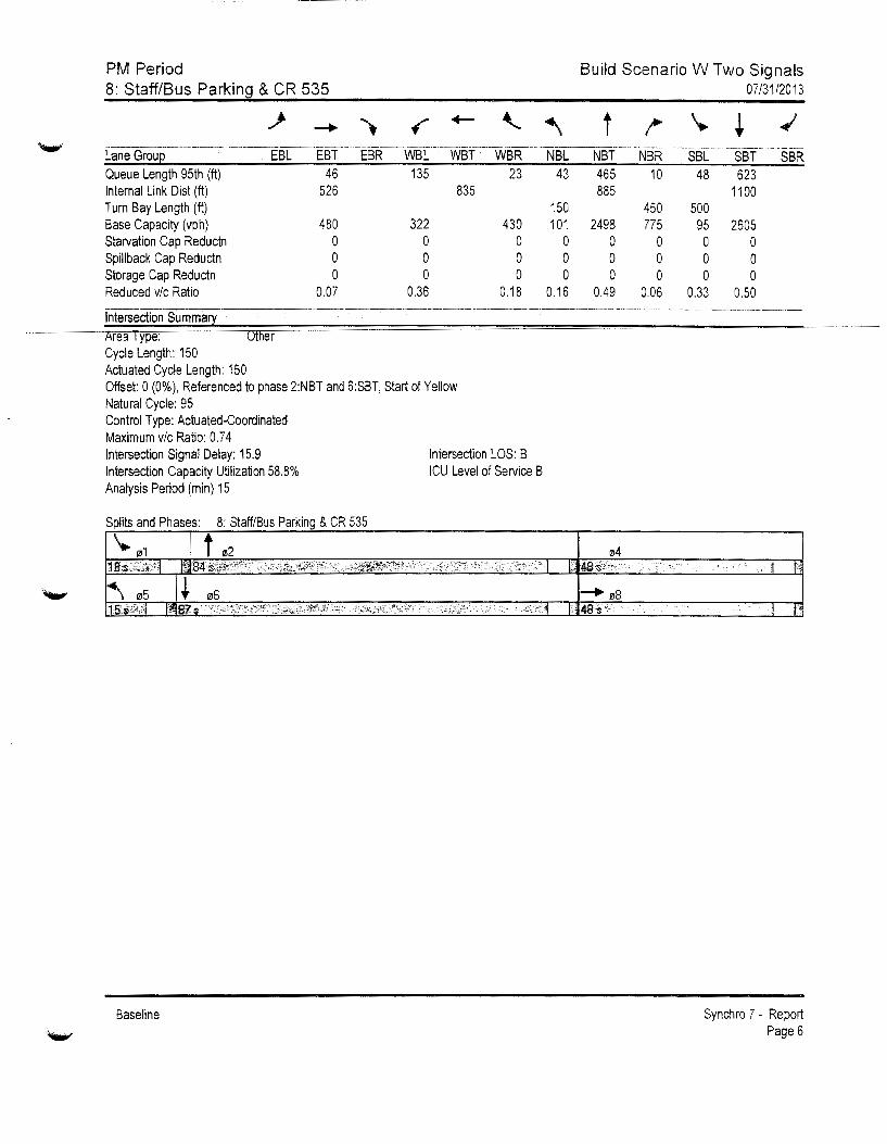
PM Period Build Scenario W Two Signals 8: Staff/Bus Parkin~ & CR 535 07/31/2013
..)- ....... "') f +- -\.. ' t !' \.
* ...;
------------ ---------------- ------------------------------------------------~---------------------- ---------· ----------------Lane Grou~ EBL EBT EBR WBL WBT WBR NBL NBT NBR SBL SBT SBR Queue Length 95th (ft) 46 135 23 43 465 10 48 623 Internal Link Dist (ft) 526 835 885 1100 Turn Bay Length (ft) 150 450 500 Base Capacity (vph) 480 322 430 101 2498 775 95 2605 Starvation Cap Reductn 0 0 0 0 0 0 0 0 Spillback Cap Reductn 0 0 0 0 0 0 0 0 Storage Cap Reductn 0 0 0 0 0 0 0 0 Reduced v/c Ratio 0.07 0.36 0.18 0.16 0.49 0.06 0.33 0.50
fntersectiOriSumma~ -- --~-------------------- -------------------------------------------------- --------------- ------- ~------
rea ype: er Cycle Length: 150 Actuated Cycle Length: 150 Offset: 0 (0%), Referenced to phase 2:NBT and 6:SBT, Start of Yellow Natural Cycle: 95 Control Type: Actuated-Coordinated Maximum v/c Ratio: 0.74 Intersection Signal Delay: 15.9 Intersection LOS: B Intersection Capacity Utilization 58.8% ICU Level of Service B Analysis Period (min) 15
Splits and Phases: 8: Staff/Bus Parking & CR 535
Baseline
• .. ·1 I'
Synchro 7 - Report Page 6
MARCOS R. MARCHENA KEITH A. GRAHAM YOVANNIE R. STORMS CHRISTOPHERJ.~LSON
SHANNON M. WIGGINS
Rocco Relvini Orange County Zoning 201 S. Rosalind Avenue Orlando, Florida 32&02
MARCHENA AND GRAHAM, PA
June 20, 2013
976 LAKE BALDWIN LANE, SUITE 101 ORLANDO, FLORIDA 32814
TELEPHONE { 407) 658-8565 TELfCOP'IER (407) 281~8564
WRITER'S E-MAIL:CWILSON @MGFIRM.COM
RE: The School Board of Ora::rge County, Florida/Special Exception for High Schoo11Parcel # 14-23-2 7-0000-00-0 13
Dear !vir. Relvini:
Enclosed herein please fmd an updated Orange County Specific Project Expenditure Report form executed by Marcos R. Marchena oftoday's date.
Should have questions or comments please do not hesitate to contact my office.
~-:--~-Christopher \Vilson
CW/mim Enclosure
EXHIBIT 11

::~:::: :.::~:: ~- :uf : .. 1u;·;::L l :!~.~: ~ L: pdated On ----"~oje2~ r-.::~e (as filed)
Cf!Se Oi Bid 1\o.
This k•bbying c;:ft~ndit:::-e r(::-m ~hall be {"p;mpl::t~d in fr;Il and med wrth ail appfic2t>on subrn ir~;;:!s. Thi~ form sh.:1.:l rem~diD C'r::nr;.lr~:f:·e 2nd shaH be fiie-1 't,lidth the de-;1s~ment Frtrms si~rH·d by::. ~'rimcir!'1 's zuth:-:-:z.L-:i a~ent s!'t2H hadude .an ~~~:.,er:ttd Fo:-c.
This fs the !~ftisJ F ~ :--::: : This is a S!!!hH;qt•ert Fc=~~X
Part 1 p]<,;;se cmr<piete :dl r{ the foil:,,,·:r:g-:
i'\:11-ne and .~ .. dCres:!' of P-~;;:-j;;:J {leg:J narne of e:J:ity or :-~·-lEr ;-1::-r- 0:--!.;ge Co·u:1:) t=J.: roHs_r: Board of Orange Cou;1ty, Fiori::ta; -"45 West Amelia Stree:, :J~ia"lcio. F'.. 32301
The S:::hoo
--------~-~--- ~----------"-· ·------·-----------
Marchena and Graham, PA, 976 Lake Baldwh Lane. Suite 101, Orlando, Florida 32814 -~~. -~.... - '"---
r-.-rst the narne 2-nd z~.~~~~:~s of 21llot~bTis,t: ... con~nitat:t~ C"O!:t7"7.:"1:"0~-- sa~h("'CJ-n~~~to:--s. In:::.-:.~dtu:ls c"':-- bns;in::·~·s
e:-: :-t:i£~s "'hn n-:~; >::s~:~t w':-?-: obt~!nirrg.. ap:;;:-c>val for thrs Ptj~i,~g~n(af'ad1;i~~2~;:;~:;:;~~ ::::.:y l>c used "s :::,::-C"<:<:z :-:-·.)
1. '\::::-.: .w.:: :it:::i~::: : :Jf irdf,iduc;.; o: b::::i::1ess e::;:-':-;-·:..::?.? .. ~~ke ~aldw!~ L:_~:=· Ste. ~C1. ~ria~::b, FL 3281 4 __ .k..r~: :~:--~· - Lob'byis(7 ~1:-::-: ~ or ~c1__ Boyte Consulting. LLC
2. ~<arne.:~.-:--.:. a::-:-~-~ of Ir.:~·,·ldu::: oz- 1.-.:_::;i:::?~~."? ::::~1ty: '1 011 rrencreek .A.v:nue N .. Orian::io. =L 32803
.D:...re ~~;:::' ... ·:·--~~: LJ~:,yist? ~:'es 2 or ~~o __
·------------------·------- .. ··-----.--· ·---
or :~o __
NO-:=: 1f you have ouestions abcr_;t THiS ;::·,t:J.J:C: C'isase contact Dana ~e Ors'loe County Legal Deoart:ent at 407-836-7320.
O·T
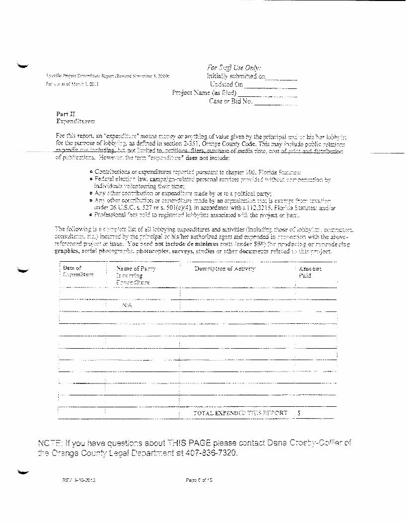
Fi.:;r Sr:g_p __ :o.e On{v: fnitia!Jy f:ubmitted o:-~ _____ _
Up:5?.:cd On Project !\arne (as fied) ___ _
Case or Bid No. ----
Fur :·~:s rey~1:-t an tie;:pe:~:l~:~:~-~·,1 rnc:.::n.s r:::-<.~)ey or an:(:t.!ng of'"'l.'a}ue given by the princ.i.pa! 2::.: :·~ his'~<~r ioJh;-~5-: for tJe ptr0-:-se of lobby:.::;.~ as d~-f.:1e:d in section 2 .. 351~ Or~:::g·e County C~ode. This rrli!y in:~iu:l~ p:!blic ~e.lz..ti~~: f""YpPn,-1Tr n·:...~ ;_:,....!n:-i;n~: ~--~- ':"Ffi !':-:--::,~tP.,..; t') :--~~Tio~,;;: f]i~rs, ~ .. ,,_ .... ,rs~ ofmc:·F~ rim....,~ ..... OSt ·Of~":_:_,.. ~n-1 f1:-:·'""-... :~.,.r-i~;~
e Contj~:tuz:ions or e;.:p~nditures ~::;;::!i:::C: purss:rn: to chapte;- ·1 06 .. F::1:-:ds S:z~::~:~.::;; • Fe:L::-ai el~::-:i--~~ ia, .. r_ camp::Tgn-;efat(>:j pe:-sona! s:;;~~:-eE ?~7\"fj:.: -;-,-~~~-:·:.:: ~-::-'·7"'"""'~:"::-:?::~~n~ by
individu:tb: ". ';):u!';:ee:ine. t~rt'~:: time~ e .h. •. ny .:--.:7Ie: c:.n:-r7jbu-~·~.:::: -O·r exp-endi:u:"~ made by or 10 a ~}:;U:i~::..i p.art:·t; c A: .. r:y o77-·.e; c..'Jr;::-i:):.;-jJn or :.::::::t::::!i:.u;;· :-:::-:de by an o:-;;~ni::::!:;;-:1 :h.::: Is ex:·::-::f: ~~~::'":"" :2:ar:::7"
under 26 V.S.C. s. 5].7 or s. 501(c)(4). in accordance ·"'iths.1 i2.3215. FJo:-:.:a S.:a-c;..;:e:s: :mdor e Professio:1aJ ::-:::::-~ ;:::1: to xg!st~r~~ Je~~:--y:s:5 assoc~ated v.~1:}: the project or j:e:r ..
The fo1lov,'"ing is £ r:--:-:::r:~c:: Est -of a.il fob:,yfng expen:iit:rres a'rld activ1tie~ (inc:iu:::;& :hos:: of J,a~~y~~~s~. ~c::::--:1Gt:?:--: .. :o:Isu!tz:::s. ~::.) ~ncL:~~: by :::1e ?:::;cipa: 0:-- h'.s.'her au:ho:-ized c.;!:::: and e':?~:-Ide:i in :-:-·::-lw·le~.:·1or: \viti !he .Jhovc-;-~,.f~-~:-;~~d p:-~~:~.:: o:- is.su::-. \:--au r:e:r.-:= not ineh1Ge d-e. rrrh!imus cc.t~t~ ltH:de:- S5~~: f:->~ r;:-od~c:.:~ o:- ;-,:,.~,r·:-~drcf7::f;
grnphics, 2rri:rl prw:,..~:--~r .. rho~occpk'-". sur.-eys, st;:;dies or :>tbrr docmnerr:<: r~·!:c.; cd ': ·.J~ ::
i>.J•A
---------- '"""""--·-------------
----- -~------------ -----
-------------·------------
-----------" _______ .. ____ _ ------ --------------------
TOTAL EX:Pt:.T\DL:; T;r:s ~ .. FORT '_v..-·.-.--i "-"·'~'~" ------------------------------
NCT:=: if you have qus2ti:.:,::s about THIS PAGE please comacr Dana C;os:-,-CcJi:e'" of ~~-s C"::nge CoL L:::oaf C'e:::art;;-ent at 407-836-7320.

p.,:-t HI
For St::tT c~e fl;:z':: b.itial1y s:hm;-::-d .. ··-""---
Lipd.::c:j ():1 __
?:-8.;:-c:t N::me (as filed) -------------------Case or Bid No.
ORJGINAL S:J G~A TL'RE A '\D NOT ARIZA TI 0 ~ RE-Ql'LR£D
l hc:~c-:Jy c ... e:--:::f::~: :hat ~n:-::.~.::7j.::>r; 7J:-:t..,,.ided in th~s specific p;--c:_1ect expendit:1re re;:-·:·:--: is true 211.J c~·,~~:! ba;-:~d. on :::;· kn-:r·~vl:..dge ani beTic:~ ! aekr~ev. J: i?Z· and f:g!7C.e le eomrt~· 1\ !:!: !h:, ::--:.z:u:_ ... =:;.:,_ d '.}f 5e' ....... :io_~ :-.J .::4~ of::.~: e' L ·EL
C~:J.nry ~C)de~ to amend this ~~e-:-:S.c ;;:-·~t-eet e;:pertdi::::-e :-e.?Jrt for any ad:.:::c:~c:} t):?e~ii:!!re,:.~) }nct::-:·!;·d relating tc w~:s p-roject ;::-~:-,r to tbe ::;::::~~uJeC. BGa.rd -of Count:y· Co:-:-~::issio1e:- :r~ee::::g. I fur:.her ackn-:r\~·ie·:1gc and 2[:~-r~~., :h:it fa11:r:--~ t.c c.0:7:?1Y ·~--1:·:--. :~:~;e ~e::r..:::--e:-:1~-:s lo file the s~ecific ex~:1diture :-e;-~art a-.d ali c.ss~=--~c:-e{! arnendme:~:~ ~zy
;--esuJt in the d~t:y of ::.;:-~~-::0\:al ::y the Bc3J".: of County ComrnissioTl:_~ f~"" ~:·· ?:""~:;(~c: or ite:n:' ~:.:~: osoc.iated. cc~st.s fo7 ·.),·~cich l sh.sl1 be he-ld ~c::qonsible. in acc::;:-::Tice with s.. 837.05, Flo:-ida S:a!u!es. l :::-dc:-s:"?.nd a1d acl::::c~' )edge that-;·.·~~;;:·.·.::- knc,"·i:igly mai:es a faise stz:+c::!f:?::! in ;;-:-::ing with L1e intem Lo mislead a ::mbhc ;:-~\·am in :he perfc::::::.:1::e of his or ~e~ ::/'5::1a1 du:-y shaH ~e gullty of a m~sd:':-:1e2.:10r in the second Ce~:-e~. pur:::::--:abie as ~Jroviied ins. 775.0S:2
~-?T'i:J::ip.a.I~s ;.,.:.::~::-rr:7::j J-~geD1
FRI?\T appra1"::"t-3t::tr: b:.:z:..~) _
TiTLE:: Lf;ec:::'s o.z. Marchena, :::sq.
ST.!.;. ___ ? t)? FLOE.-~A.
C'O~;;-.;;y OF ORANGE
'< .?'~;.3~!:1-~J. WlLS;?N ···': , __ ..,,~;,fell' t 00 915484 : :· <''"~Fs. October 11 . .2013 , ... "'" No!a1' f'ubOc u~
----··------
·ro-~ ,, t.. •• · .. -u~so~ 8r- • r\t · t t:: t1 you t J8\'e que:s:~or1s aooul ~ t 11 r ,.::-, -r:. p~ease
Orange Count:' Legal Deps~r;ent a~ 407-836-7320.

MARCOS R. MARCHENA KEITH A. GRAHAM YOVANNIE R. STORMS CHRISTOPHER J. WILSON
SHANNON M. WIGGINS
VIA HAND DELIVERY Rocco Relvini Orange County Zoning 201 S. Rosalind Avenue Orlando, Florida 32802
MARCHENA AND GRAHAM, PA
July 10, 2013
976 LAKE BALDWIN LANE, SUITE 101 ORLANDO, FLORIDA 32814
TELEPHONE (407) 658-8566 TELECOPIER(407)281~
WRITER'S E·MAIL:[email protected]
RE: West Orange County Relief High School Special Exception Application
Dear Mr. Relvini:
Please find enclosed eighteen ( 18) fuJI size and eighteen ( 18) half size site plans. The site plan was revised subsequent to the June 191
h Community Meeting to address comments received and provide better buffering to adjacent residential property. Please replace the prior site plan in the aJ;'plication with the enclosed site plans for all future meetings and reviews of same including the July 24 Development Review Committee and the September 5th Board of Zoning Adjustment meeting. Enclosed also please find a revised page 3 of the application reflecting changes based on the revised site plan.
Should you have questions or comments please do not hesitate to contact my office.
CW/mlm Enclosures cc: Barbara M. Jenkins, Superintendent, OCPS (via email)
Diego Rodriguez, Esq., General Counsel, OCPS (via email) Eileen D. Fernandez, Esquire, Associate General Counsel, OCPS (via email) John T. Morris, Chief Facilities Officer, OCPS (via email) Fazlur Ali, Senior Director Planning & Design, OCPS (via email) Harold Jenkins, Director of Real Estate Management, OCPS (via email) J. Dave Torbert, Schenkel, Shultz (via email) Jason Vargas, WBQ Design and Engineering (via email)
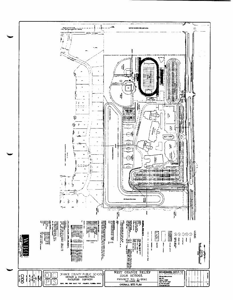
-.
I' I ~~ I; . .... ik~ , .. It!. t a.::.
r?\l(OC' ORANGf COUNTY PUBLIC: SOIOOL WEST ORANGE RELIEF SCHENKELSHULTZ ~ DESIGN k CONSTRUCT10N HIGH SCHOOL ~..:=~'hU g ~ r.
fD)rc:J FACIUTIES SERVICES PROJECT NO. S-0041 "'"'"' u::..Jl.2J IILDC... too. 0501 MAC-It' 'WAT OIILAMIIO. nDIUDl ~ t-----=•ori:::_l::-=...::•-=----____j ::-~=.3321
'----~o...:....~.-'--I.J '------------_; OVERALl. SITE PLAN ~
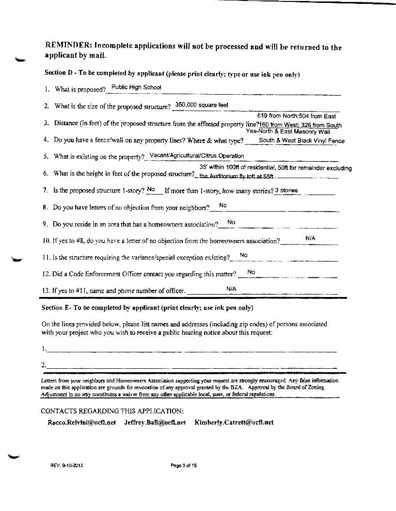
REMINDER: Incomplete applications wil1 not be processed and will be returned to the applicant by mail.
Section D- To be completed by applicant (please print clearly; type or use ink pen only)
1. What is proposed?_~u~~.~~~~-~~~~,1-_____________ , __ _
2. What is the size ofthe proposed structure? 350,000 square feet _, ______ _ 619 from North;504 from East
3. Distance (in feet) ofthe proposed structure from the affected property line?160 from We~~; 326 from South Yes-North & East Masonry Wall
4. Do you have a fence/wall on any property lines? Where & what type? South & West Black Vinyl Fence
5. \Vbat is existing on the property? Vacant/Agricultural/Citrus Operation
35' within 1OOft of residential, 50ft for remainder excluding 6. What is the height in feet of the proposed structure?_ the Auditori• u:c fly loft at 55ft , ___ _
7. Is the proposed structure 1-story? ~If more than 1-story, how many stories? 3 stories
8. Do you have letters of no objection from your neighbors? ~0---------------
9. Do you reside in an area that has a homeov.ners association? __ N_~-----
l 0. If yes to #8, do you have a letter of no objection from the homeowners association? ____ N_I_A __
ll. Is the structure requiring the variance/special exception existing? __ ~_0 ______ _
12. Did a Code Enforcement Officer contact you regarding this matter? __ N_o __
13. If yes to # 11, name and phone number of officer. N/A
Section E- To be completed by applicant (print dearly; use ink pen only)
On the lines provided below, please list names and addresses (including zip codes) of persons associated with your project \Vho you wish to receive a public hearing notic--e about this request:
1. ---------------------·,------~
2. ________________ _
Letters from your neighbors and Homeowners Association supporting your request are strongly encouraged. Any fulse information made on this application are grounds for revocation of any approval granted by the BZA. Approval by the Board of Zoning Adjustment in no way constitutes a waiver from any other applicable local, state, or federal re~lations.
CONTACTS REGARDING THIS APPLICA TJON:
[email protected] Jeffrey [email protected] Kimberly [email protected]
REV. 9-10-2012 Page 3 of 15
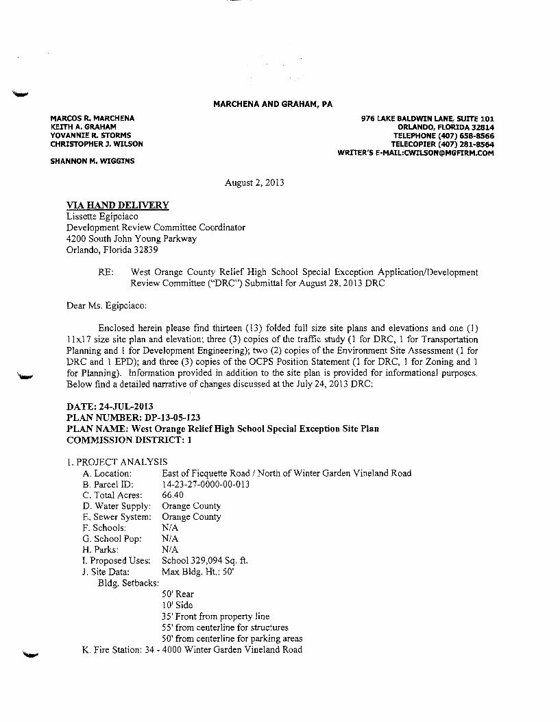
MARCOS R. MARCHENA KEITH A. GRAHAM YOVANNIE R. STORMS CHRISTOPHER J. WILSON
SHANNON M. WIGGINS
VIA HAND DELIVERY Lissette Egipciaco
MARCHENA AND GRAHAM, PA
August 2, 2013
Development Review Committee Coordinator 4200 South John Young Parkway Orlando, Florida 32839
976 LAKE BALDWIN LANE, SUITE 101 ORLANDO, FLORIDA 32814
TELEPHONE (407) 658·8566 TELECOPIER (407) 281·8564
WRITER'S E·MAIL:[email protected]
RE: West Orange County Relief High School Special Exception Application/Development Review Committee ("DRC") Submittal for August 28, 20I3 DRC
Dear Ms. Egipciaco:
Enclosed herein please find thirteen (13) folded full size site plans and elevations and one ( 1) II xi 7 size site plan and elevation; three (3) copies of the traffic study (I for DRC, I for Transportation Planning and 1 for Development Engineering); two (2) copies of the Environment Site Assessment (1 for DRC and 1 EPD); and three (3) copies of the OCPS Position Statement (1 for DRC, 1 for Zoning and I
'-" for Planning). Information provided in addition to the site plan is provided for informational purposes. Below find a detailed narrative of changes discussed at the July 24,2013 DRC:
DATE: 24-JUL-2013 PLAN NUMBER: DP-13-05-123 PLAN NAME: West Orange Relief High School Special Exception Site Plan COMMISSION DISTRICT: 1
1. PROJECT ANALYSIS A. Location: East of Ficquette Road I North of Winter Garden Vineland Road B. Parcel ID: 14-23-27-0000-00-013 C. Total Acres: 66.40 D. Water Supply: Orange County E. Sewer System: Orange County F. Schools: N/A G. School Pop: N/A H. Parks: N/A I. Proposed Uses: School 329,094 Sq. ft. J. Site Data: Max Bldg. Ht.: 50'
Bldg. Setbacks: 50' Rear IO' Side 3 5' Front from property line 55' from centerline for structures 50' from centerline for parking areas
K. Fire Station: 34 - 4000 Winter Garden Vineland Road

Lissette Egipciaco August 2, 2013 Page 2
Comment Response: Building was revised to 350,000 sq. ft. on the revised plan. Revised maximum building height to include, 35 ft. within 100 ft. of residential and 50 ft. otherwise EXCLUDING AUDITORIUM STAGE FLY LOFTS PER SEC. 38-1755(2)C.
2. COMPREHENSIVE PLAN
The property's Future Land Use Map (FLUM) designation is Rural Settlement Ill (RS 1/1). The plan is inconsistent with the Comprehensive Plan, specifically objective FLU6.2, policy FLU6.2.5, policy 6.2.12 (in part), objective FLU8.2 and policy FLU8.2.1,
Comment Response: Per instruction from the DRC Chairman OCPS bas prepared a Position Statement setting forth its support for a finding of consistency with the Comprehensive Plan.
3.ZON1NG:
R-CE; The CP Future Land Use is Rural Settlement l/1. Per Section 3 8-1751 (1 ), a high school requires a Special Exception. The Special Exception is scheduled for the September 6, 2013 BZA. Therefore, the applicant is on notice that the plan must meet final approval by the date of notice (August 13, 2013 ). Per Section 38-78, "The zoning manager shall have the authority and discretion to require an application for a special exception or a variance to be reviewed by the development review committee prior to review by the BZA to properly assess and address its impacts and to make a recommendation and recommend conditions (if any). In making such a determination, the zoning manager shall consider relevant factors, including the size of the project, land use intensity, land use density, traffic impacts, and school impacts". On September 18, 2008, the Planning and Zoning Commission (P&ZC) made a finding of inconsistency with the Comprehensive Policy Plan (CPP), and that the zoning is incompatible with the surrounding area citing 2008 CP FLU policies 2.1.8 and 3 .2.25, "P&ZC stated that the proposed school is neither consistent with the Comprehensive Policy Plan nor compatible with the development pattern of the surrounding area. They further noted that it is an institutional use that would serve a student population beyond the boundaries of the West Windermere Rural Settlement and would likely serve as the catalyst for additional residential and commercial development, thus negatively affecting the Rural Settlement". On November 11, 2008 and January 27, 2009, the BCC, upon the OCSB request, continued this item until January 27, 2009 and March 24, 2009. The Orange County School Board withdrew the rezoning request on February 24,2009.
Comment Response: The above analysis is to be revised to include DRC's recommendation of approval in 2008.
4. COMMENTS: 1. Revised Plan The required setback for RCE are as follows: Front (Winter Garden Road (major
collector)) = 35' from property line or 55' from centerline for structures and 50' from centerline for parking areas, Side = 1 0', and rear= 50'. Note these setbacks on the plan (both required and proposed). Additionally, depict the centerline setback and demonstrate that the buildings/parking is meeting the centerline setbacks.(Z)
Comment Response: Revised Plan to add the set back requirements and added additional dimensions to indicated set backs are met.
Lissette Egipciaco August 2, 2013 Page 3
2. Revised Plan Provide a photometric plan, landscape plan and architectural elevations.(P)
Comment Response: Revised plans are provided.
3. Revised Plan Conservation Area Pennits - Wetlands are present on site. Provide Elizabeth Johnson, Environmental Programs Administrator of the Orange County Environmental Protection Division (EPD), a copy of the documents being submitted to either the Water Management District or Florida Department of Environmental Protection as part of the Environmental Resource Pennitting
Comment Response: Wetland information was provided on the revised plans Sheet C103.
4. Revised Plan Vicinity Map - add a vicinity map to indicator local water bodies and other natural features. Chapter 38 Zoning, Article VIII P-D Planned Development District, Division 1 Generally, Section 38-1206 Development Plan.(EPD)
Comment Response: Vicinity map was added to the Cover Sheet COOO.
5. Revised Plan Vegetation - The plan shall clearly indicate the generalized vegetation based upon the Florida Land Use, Cover and Fonns Classification System (FLUCFCS) or the Natural Community Types as developed by the Florida Natural Areas Inventory. Reference Orange County Code 38-1205(2) for LUP or 38-1206(6)m for DP.(EPD)
Comment Response: Revised plan to added the vegetation Sheet C104.
6. Revised Plan Contact Mark Dreibelbis of the Orange County Zoning Division at (407) 836-2803 with any questions pertaining to Ch. 24 Landscape requirements or Ch. 15 Tree Survey/Mitigation Plan requirements.
Landscape Review: Revised plan: Per Sec 38-1755: A continuous 30" in height hedge shall be planted in the 7' wide landscape buffer between interior vehicular use areas and the R-0-W.
Comment Response: Landscape Sheet LlOO provided to address the landscape.
Tree Survey: Information - No tree survey is required: the existing orange grove(Z)
Comment Response: Information noted
7. Revised Plan Topography - The plan shall clearly indicate the existing topography at one-foot contours based upon the county datum. Reference Orange County Code 3 8-1205(2) for LUP or 38-1206(6)a for DP.(EPD)
Comment Response: Information regarding existing contours were added to Sheet C103.
Lissette Egipciaco August 2, 2013 Page4
8. Revised Plan Soils Onsite - The plan shall clearly indicate on-site soil types and soil contours based upon the USDA Soil Conservation Service classification system. Reference Orange County Code 38-1205(2) for LUP or 38-1206(6) I for DP. (EPD)
Comment Response: Information regarding existing soils were added to Sheet C104.
9. Revised Plan Soils Report - This property may be the location of petroleum spills, agricultural related contamination, and fertilizer, pesticide or herbicide spillage. If an Environmental Site Assessment (ESA) has been conducted on this site, then provide a copy to the Orange County Environmental Protection Division, Attention: John Geiger. If the site is determined to have soil or groundwater contamination, then the applicant must provide documentation to assure compliance with the Florida Department of Environmental Protection (FDEP) regulation 62-777 Contaminant Cleanup Target Levels.(EPD)
Comment Response: Phase I and II report provided as a separate report. (Enclosed hereto). OCPS is aware of the condition contained in the report and is in contact with the appropriate agency to take the appropriate steps to address the issue.
1 0. Revised Plan A traffic operational analysis is required for the circulation and stacking at the drop-off/pick-up location.(TP)
Comment Response: Sheet ClOl and Sheet C102 added to provide the proposed conceptual on-site circulation.
1 1. Revised Plan A summary of all changes shall be provided on a comment response letter with the revised plans.(P)
Comment Response: Comment response will be provided.
12. Disc/Revised Plan The maximum building height per Section 38-1755 (2) (c) "Thirty-five (35) feet for high school buildings within one hundred (1 00) feet of residential zoned property, and fifty (50) feet for all other buildings in high schools excluding auditorium stage fly lofts". Buildings 4-6 are exceeding the maximum allowed building height. If 56' is proposed a variance will need to be advertised.(Z)
Discussion: Prior Plan reflected correct building heights.
13. Discussion Request discussion regarding projected traffic counts on C.R. 535 and any traffic counts conducted to date. Discuss the need for a traffic signai.(DE)
Comment Response: Discussion noted. Traffic study is attached.
14. Discussion Request discussion regarding on-site traffic movements and on-site traffic storage.(DE)
Lissette Egipciaco August 2, 2013 Page 5
Comment Response: Traffic patterns on-site shown on Sheet ClOt and C102.
15. Discussion Zoning's position is that submitting a Special Exception Application instead of going through the rezoning process doesn't make this site any more consistent with the CP FLU or compatible with the surrounding area. Subject to Section 3 8-43 and Section 30-43 of this code, in reviewing any request for a special exception, the following criteria have not been met as required by Section 38-78 (1 )-(3) and (5) (based upon P &ZC denial on September 18, 2008):
1. ( 1 )-The use shall be consistent with the comprehensive policy plan; 2. (2)-The use shall be similar and compatible with the surrounding area and shall be consistent with the pattern of surrounding development; 3. (3)-The use shall not act as a detrimental intrusion into a surrounding area; 4. (5)- The use shall be similar in noise, vibration, dust, odor, glare, heat producing and other characteristics that are associated with the majority of uses currently permitted in the zoning district.(Z)
Comment Response: Per instruction from the DRC Chairman OCPS has prepared a Position Statement setting forth its support for a finding of satisfying the Special Exception Criteria.
16. Information This application proposes a 329,094 square foot high school for 2,776 students (plus future expansion area), and outdoor areas that consist of: softball field, baseball field, practice field, basketball courts, tennis courts, track and field, and band practice area. The hours of operation are proposed to be Monday-Sunday 7 a.m. till I 0 p.m.(Z)
Comment Response: Information change to reflect 350,000 sq. ft. high school for 2,850 students to include football field and to adjust the hours of operation to Monday through Saturday 6:00 a.m. to midnight.
17. Information The plan is inconsistent with the Comprehensive Plan, specifically objective FLU6.2, policy FLU6.2.5, policy 6.2.12 (in part), objective FLU8.2 and policy FLU8.2.1.
Objective FLU6.2 - RURAL SETTLEMENTS. Rural Settlements provide for rural residential lifestyle. In some instances, Rural Settlements allow a transition of rural areas adjacent to the Urban Service Area while avoiding development in active agricultural areas. Rural Settlements were intended to recognize and preserve existing development patterns at the time the CP was adopted in 1991. The creation of Rural Settlements recognized the need to maintain agricultural areas and rural uses in the Rural Service Area, while providing for rural communities.
The subject property is located within the West Windermere Rural Settlement and has a Future Land Use Map (FLUM) designation of Rural Settlement Ill (RIS Ill). Per Objective FLU6.2, Rural Settlements are intended to provide for a rural residential lifestyle. The externalities associated with a high school, including but
-----------------------------------~---------------------------
Lissette Egipciaco August 2, 2013 Page 6
not limited to noise, light and traffic are inconsistent with a rural residential lifestyle.
Policy FLU6.2.5 - The permitted densities and intensities of land use within the Rural Settlements shall maintain their rural character. Factors to be considered shall include lot size, open space and views, tree canopy, building location and orientation, and compatibility with existing land uses. Density and Floor Area Ratio (FAR) calculations shall be defined as the language specified in Future Land Use Element Policy FLU1.1.2(C).
Although the character surrounding the West Windermere Rural Settlement is more urban in nature, the intensity of the proposed high school use is inconsistent with large-lot residential character within the exiting Rural Settlement boundary.
Policy FLU6.2.12 (in part) - Any proposed use within a Rural Settlement intended for the new construction of a structure(s) with a Gross Buildable Area of 50,000 SF (on a cumulative basis) or more or projected to have a weekly trip rate of 10,000 total trips may be considered inappropriate for a Rural Settlement if the following conditions exist:
- The proposed use is located in a Rural Settlement that has maintained a rural and historic character, consistent with the intent of Rural Settlements. - It is determined that the proposed use(s) by size, massing and traffic, will unduly impact the historic and rural character of the Rural Settlement; - The use. as determined by a market study. is primarily intended for those whose daily life activities do not occur within the Rural Settlement. - It is not demonstrated that other potential sites were evaluated as being suitable.
The proposed (348, 066 square foot) high school will exceed 50,000 square feet of gross buildable area. The high school will most likely serve residential areas well beyond the boundaries of the existing West Windermere Rural Settlement. (P)
Comment Response: See Position Statement.
18. Information CP Information Comment Continued:
Objective FLU8.2 COMP ATffiiLITY. Compatibility will continue to be the fundamental consideration in all land use and zoning decisions. For purposes of this objective, the following policies shall guide regulatory decisions that involve differing land uses.
The proposed high school is directly adjacent to large single family lots to the east. Per Objective FLU8.2, compatibility is the fundamental consideration in all land use and zoning decisions. The proposed use would be incompatible with adjacent large-lot single family residential properties to the east and west (Lake Cawood Estates).

Lissette Egipciaco August 2, 20 13 Page 7
Policy FLU8.2.1 - Land use changes shall be required to be compatible with the existing development and development trend in the area. Performance restrictions and/or conditions may be placed on property through the appropriate development order to ensure compatibility. No restrictions or conditions shall be placed on a Future Land Use Map change.
The proposed high school is incompatible with the adjacent large-lot singlefamily residential properties to the east and west (Lake Cawood Estates). (P)
Comment Response: See Position Statement.
19. Information The property's Future Land Use Map (FLUM) designation is Rural Settlement 111 (RS 111) and the property's zoning designation is R-CE (Country Estate District). The property is located within the West Windermere Rural Settlement.(P)
Comment Response: Information noted.
20. Information The project is located within District # 1. The applicant is proposing a special exception to permit a 329,094 square foot relief high school and associated infrastructure on 66.4 gross acres. (P)
Comment Response: Building square footage revised to 350,000 sq. ft. and indicated on the revised plan Sheet CIOO.
21. Information Irrigation Wells - Two irrigation wells are present on site. Any existing wells shall be properly abandoned prior to earthwork or construction. Permits shall be applied for and issued by the appropriate agencies. Contact the Department of Health (DOH) and the appropriate Water Management District. (EPD)
Comment Response: Wells will be abandoned per FDEP/SFWMD criteria. Information noted.
22. Information Erosion Control - Use caution to prevent erosion during construction along the boundary of the property, into wetlands and buffers, and into all drainage facilities and ditches. Construction will require Best Management Practices (BMPs) for erosion control. Minimize the extent of area exposed at one time, apply perimeter controls where necessary, and perform maintenance checks every seven (7) days and after every 1/2 inch rain. The construction entry area shall be designed to prevent trucks from tracking soil onto local roads and the affected storm drainage system shall be protected as indicated in 34-250(g). This may require periodic street sweeping. (EPD)
Comment Response: Information noted.
Lissette Egipciaco August2, 2013 Page 8
23. Information Wildlife - If any species listed by State or Federal wildlife agencies as Threatened, Endangered, or of Special Concern are present on the property, then submit copies of all applicable permits and/or correspondence from the appropriate agencies to the Orange County EPD.(EPD)
Comment Response: Information noted.
24. Information The one parcel ID number, 14-23-27-0000-00-013, listed on Sheet ClOO is correct.(DE)
Comment Response: Information noted.
25. Information Left turn lanes into the project will be required at both access driveways.(DE)
Comment Response: Information noted.
26. Information The developer shall obtain water, wastewater, and reclaimed water service from Orange County Utilities.(UD)
Comment Response: Information noted.
27. Information There are no wastewater mains located directly adjacent to this site. Approximately one-half mile of wastewater main extension will be required.(UD)
Comment Response: Information noted.
28. Information This PD is within the recommended response distance of 2.5 miles in the Fire Rescue Element of the Orange County Comprehensive Plan as it is located 1.30 miles to Station 34- 4000 Winter Garden Vineland Road. (FR)
Comment Response: Information noted.
29. Information The plans submitted and reviewed by the Office of the Fire Marshal does not provide enough information for a complete review regarding fire department requirements.(FR)
Comment Response: Information noted.
30. Information During construction, when combustibles are brought on to the site, access roads and a suitable temporary or permanent supply of water acceptable to the fire department shall be provided and maintained Chapter 16, NFP A 1 2009 Edition (FFPC 20 I 0 Edition).(FR)
Comment Response: Information noted.
3 l. Information Plan dated received June 28, 2013 is approved.(PK)
Lissette Egipciaco August 2, 2013 Page 9
Comment Response: Information noted.
32. Information No right-of-way is required for Winter Garden Vineland Road from this project.(PWE)
Comment Response: Information noted.
33. Information Due to the dual left turns at northernmost access signal plans shall be required for parent drop-off loop access at construction phase(TE)
Comment Response: Information noted.
34. Information There are no failing roadways within the project influence area.(TP)
Comment Response: Information noted.
35. Information/Cond In 2008 the DRC had processed a proposed Land Use Plan to rezone this property (68.39 acres) to PD for a High School use with the following Conditions of Approval; 1. Sports lighting of the stadium shall be prohibited; 2. A six-foot masonry wall shall be required along the east and north property lines, except along the conservation area. (Z)
Comment Response: The Applicant does not concur with Condition #1 and has revised the plan to allow a masonry or pre-cast concrete wall.
Please do not hesitate to call if you should have any questions regarding this submittal.
CW/mlm Enclosures cc: John Smogor, DRC Chainnan (w/o encls.) (via email)
Rocco Relvini, Zoning (w/o encls.) (via email) Barbara M. Jenkins, Superintendent, OCPS (w/o encls.) (via email) Diego Rodriguez, Esq., General Counsel, OCPS (w/o encls.) (via email) Eileen D. Fernandez, Esquire, Associate General Counsel, OCPS (w/o encls.) (via email) John T. Morris, Chief Facilities Officer, OCPS (w/o encls.) (via email) Fazlur Ali, Senior Director Planning & Design, OCPS (w/o encls.) (via email) Harold Jenkins, Director of Real Estate Management, OCPS (w/o encls.) (via email) J. Dave Torbert, Schenkel, Shultz (w/o encls.) (via email) Jason Vargas, WBQ Design and Engineering (w/o encls.) (via email)
u \cjw\ocsb\bec:k grove .027'e:<eeption application\ltr to liiSdtc cocl mise silt plans 8.1. ll doc:

-----------------------------
Property Posting Instructions ln accordance with Section 30·44(6), Chapter 38, Zoning, Orange County Code, a poster must be placed on the property involved in a public hearing at least 10 days prior to the hearing.
It is very important that you properly prepare your poster for mounting and that it be mounted in the proper location on your property. To assist you, please follow the specific posting instructions on the reverse side of this document.
NOTICE TO APPLICANTS Fill in all the blank spaces below. Sign your name and r~ave your signature notarized. Prior to your public hearing, please mail this document to: Board Secretary in the Zoning Department, P.O. Box 2687, Orlando, FL 32802-2687.
AFFIDAVIT OF COMPLIANCE
I, the undersigned property owner or authorized agent, do hereby affirm that the public
hearing poster(s) for Public Hearing Case# S>E- IS -07--046 in the name of \1')'\Vrd·,cf\C., o-~ 6 ,._~..,..,.?fo. o,...~IF*
lh.c. ).;.~ ~;:::-:.~a'r.r'Gtv-rip 8oo ,Jc, was placed on the property on the date of
,4~ ~t- 2 ..:>, Z..o I 3 in accordance with the instructions specified [Da~ esters placea or: property)
on the front and reverse side of this document.
Note: Failure to place the poster on your prope~y will result in the need to reschedule your public hearing at your expense.
STATE OF FLORiDA COUNTY OF ORANGE
::\-\"! The foregoing instrument was acknowledged before me this .,3:)==----
NOTARY------~~-
-i3-20 [7/05)
day of

Chris Wilson
From: Sent:
Surguine, James M. [email protected]] Friday, August 23. 2013 3:23PM
To: Chris Wilson Cc: Subject:
Fernandez, Eileen D.; Melissa Moreno; Salvo, Julie C.; Morris, John T. ; Greene, Toni RE: OCPS/Rezoning for Beck Property/Site 27-H-W-6
Chris, FYI - the signs have been posted
Jim Surguine Senior Facil it ies Director Facilities Maintenance 6501 Magic Way, Bldg. 600 Orlando, Fl. 32809 Ph. 407-317-3700 ext. 5017
-----Original Message-----From: Chris Wilson [mailto:[email protected]] Sent: Thursday, August 15, 2013 10:27 AM To: Surguine, James M . Cc: Fernandez, Ei leen D.; Melissa Moreno Subject: OCPS/Rezoning for Beck Property/Site 27-H-W-6
Jim,
1

MARCOS R. MARCHENA. KE.!.""TH A. GRAHAM YOVA.NN!IE R. STORMS CHR!STOPHERJ.~LSON
SHANNON M. W!GGZNS
Lissette Egipciaco
MARCHENA MilD GRAHAM, PA
September 5, 2013
976 U\.KE BALDWIN U\.NE, SUITE 101 ORLANDO, FLORIDA 32814
TELE?HOriE (407) 658-8566 TELECOP!ER ( 407) 281-8564
W!LTTER'S E-MAIL:CW!!..SON@MGF!RM.CQl11!
Development Review Committee Coordinator 4200 Soc:th John Yot:ng Parkway Orlando. Florida 32839
RE: V\cst Orange Coun:y Relief fiig:1 School Special Exception Applic<nionDe·velopment ReYJC\\ Commitee t·DRC") Revised Pian from August 28.2013 DRC Comments
Dear \1s. Egipciacc:
Enclosed herein please find thirteen (13) folded full size site plans and revised photometric pLans. one (1) llx17 size site plan and the email transmitting the FDE? Discharge Reporting Form to John Geiger. 1nformation provided in addition to the :;itc p~an is provided for infonnational purpose:s. Belmv finci a detailed n.2rrative of the revised plan items discussed at the August 28, 2013 DRC:
l 7. Re\ ised ?!an
18. RcYised ?l2.n
19. Revised Plan
Extend left m:-n lane at bus bo:J to 400'(TE)
Pedestria:c C:-ossing Stall be Required at Signat:zcd Location (TE):
~otificatio:-1 to FDEP - ~-\s docun1entcd in the Environmental Site ~A..ssessme~t •J:Je own?r- N opcc-M(Y of+he S:.:bjcct Propem· is required to noti:fv tho;; FDSP of the identified con::amination. Send copy of this notification to EPD. Artn: DRC Rcviev,•er:
Please do not hesitate to call if you should have ai1y questior.s rcg;::rding ttis submit:a!.
Ch:is:::Jp11er \\"ilson CW!mlm ~-··'/ Enclosures
Lissette Egipciaco September :5, 2013 Page 2
cc: John Smogor, DRC Chairma21 (wto ends.) (•ia email) Rocco Relvini, Zoning (w/o encls.) (via email) Barbara M. Jenkins, Supe:-intcndent. OCPS (vv!o encls.) (via email) Diego Rodriguez, Esq., General CounseL OCPS (w/o ends.) (via email) Eileen D. Fernandez, Esquire, Associate General Counsel, OCPS (vr/o ends.) (via email) John T. Morris, Chief Facilities Officer, OCPS (\\'.'o encls.) (via email) Fazlur Aii, Senior Director Planning & Design, OCPS (v,·/o encls.) (via email) I-iarold Jenkins. Director of Real Estate Management, OCPS (-,,/o encls.) (via email) J. Dave Torjcn. SchenkeL Shultz (w/o encls.) (via email) .iason Varg:::s. \VBQ Design and £ngineeri:1g (vv.:o cncls.) (via cn:ail)
Chris Wilson
From: ~nt:
'-r'o: Cc: Subject: Attachments:
John,
Chris Wilson Monday, August 26, 2013 5:20 PM '[email protected]' '[email protected]'; 'Fernandez, Eileen D.'; Fowler, Jennifer B.; [email protected] West Orange County Relief High School DRF- Horizons West Relief HS 8-2-2013.pdf
Please find attached the Discharge Reporting Form for the West Orange County Relief Site. The contractor hired by
OCPS is diligently working on the delineation in ol-der to obtain an approved mitigation plan.
Regards,
Christopher J. Wilson, Esq. Marchena & Graham, P.A. 976 Lake Baldwin Lane, Suite '1 01 Orlando, Florida 32814 (T) 407 658.8566 (F) 407.281.8564
CONFIDENTIALITY NOTE: the information contained in this transmission is attorney pnvileged and confidential. It is intended only for the use of the individual or entity named above. If the reader of this message is not the intended recipient, you are hereby notified that any dissemination, distribution, or copy of this message is strictly prohibited. If you have received this communication in error, please notify us immediately by telephone and return the original message to us at the address listed above via the United States Postal Service. Thank you.
) CIRCULAR 230 DISCLOSURE: Under regulations issued by the U.S. Treasury, to the extent that tax advice is contained in this communication (or any ~achment or enclosure hereto), you are advised that such tax advice is not intended or written to be used, and cannot be used by you, or any other party to
whom this correspondence is shown, for the punpose of: (i) avoiding penalties under the Internal Revenue Code, or (ii) promoting, marketing or recommending the tax advice addressed herein to any other party.
1
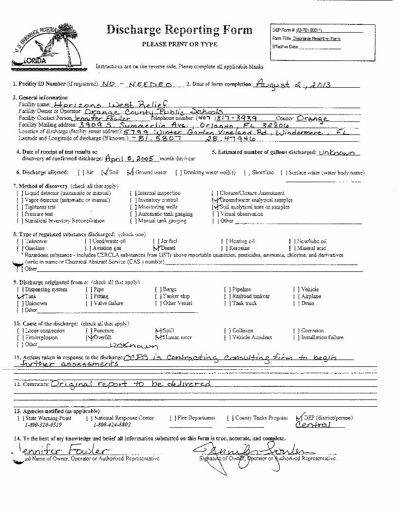
nischarge Reporting Form DEPFarm# 62-761 S00!1l
PLEASE PRINT OR TYPE Form Title Dis:harae Reoortin::; Form
Effective Date-------
Insti11ctions are on the reverse side. Please complete all applicable blanks
1. Facility ID Number (iiregistered): f-JD - (\{ E F D c 0 2. Date afform completion: fh..>ou ~± Q2 i d 1>13 .)
3. General information Facilityname: ld-oct:zoo 0 luest, Belie£ Facility Owner or Operator: Qra h. :v- C a,, n+•t :F't . ..l b /,'c. :Sc.hc:o/.5 ~ac~~Con~~ctPersoQ Jearu.fe.r- Fowle.relephonenumber: (t.lo, )3/'l- 3'f39 County: Oro...JI\%€... l:'acullty Mailing address: 3 9 0 q .S . Su rn 01 e. r I in Ave.. J 0 rIa n do F L ;£.22. 2$ O(o Location of dischcrge (faciiity street address): 5" "J 9 '1 ( 1 ) t n±e..r Ga rd e o Vt n.t:..lOJI. d 'Ed 1 L•.) in d e..rrne re. , 1- L Latitude and Longitude of discharge (Ifknovm.) - 8/ 5 '3 01 c2 S . 'f"J 9 I{ lo
4. Date of receipt of test results or discovcr:r of confirmed discharge: Apr; l 8 1 2,oo5' month/day/year
5. Estimated number of gallons discharged: Uo 16oo!JJO
6. Discharge affected: [ ].Air [.).Soil M Grou.Tld waler [ ] Drinking waler well(s) l J Shoreline [ ] Strrface waler (waler body name)
7. Method of discovery (check all that apply) i j Liquid detector (automatic or manual) [ ] Vapor detector (automatic or manual) [ ] Tightness test [ 1 Pressure test [ 1 Slalislical Inventory Reconciliation
j l.nternal inspection ] Inventory control ] Monitoring wells 1 Automatic tank gauging
[ J Manual lank gaut,ring
8. Type ofreg-ulatc:d substilllce discillirged: (check. one:)
l 1 Closure/C]oswe Assesswent ["i1Jroundwater analytical samples [ vf'Soil anruytical tests or samples [ 1 Visual observation [ ] Other ________________ _
[ ] Unl11mvn [ ] Used/waste oil [ · ] Jet fuel [ ] Heating oil [ ] Ncwflubc oil [ J Gasoline [. ] Aviation gas tyJ'Diesel I J Kerosine [ ] Mineral acid · , Hazardous substance- includes CERCLA substances from USTs above reportable quantities, pesticides, ammonia, chlorine. and derivatives ~ (wrilc in narnc or Chemical Abstracl Service (CAS ) number) _____________________________ _
[ ] Other ___________________________________________ _
[ ] Dispensing system [ ] Pipe [ ] Barge
Vf'Tank l I Fitting l j T arucer ship I ] Unknown [ ] Valve failure [ ] Other Vessel [ 1 Other ______________________ _
Hi. Cause oftbe discharge: (check all that apply) [ ] Loose connection [ J Puncture !_1-[Spill [ 1 Fire/explosion ['}'Overfill [Y"Human error [ 1 Othcr ___________ ... L?""'-'-n~K..,..n. 0L.l.>Y)
.. 0 .. { '1"1 •. ,. -,..-+ ... .L-. "t...,.'U'.m.u: ...... .ut..J. r ' % c n.o.....
13. Agencies notified (as applicable): l J State Warning Point [ J National Response Center l J Fire Department.
1-800-320-0519 1-800-424-8802
[ ] Pipeline l 1 Railroad tankcar [ ] Tank truck
) Collision ] Vehicle Accident
[ ] Vehicle l j Airplane []Drum
] Corrosion [ ] Installation failme
l J County Tanks Program MDEP (district/person) (1en+raJ
14. Tn the best af my lmowiedge and belief all information submitted on this form is true, accurate, .and Cllm lete.
- \.eVLo;fu- F;w(.e_r ~ "-"'.cd Name of Owner, Opcraior or Authorized Rcprcscnlalivc

Oil spills to navigable waters of the United States and releases of a reportable quantities o.fCERCLA hazardous substances must be reported immediately to tile National Response Center. Reports to tile National Response Center of oil spills to navigable waters need not be repeated to any other .federal, state, or local agency. Conditions at the site that do not involve spills to navigable waters of the United States, or CERCLA hazardous
~;bstances, that pose an immediate threat to human heaith or the environment must be reported to the State --warning Point ar t!:e Local Fire Departme::t 1\fever=t!:e=less~ t!zisjorm must be su.bl::itt.ed_for all discl!arges_fro1n facilities with storage tank systems, and sites in accordance with Chapters 62-761 and 770, F.A.C
State Warning Point 1-800-320-0519
National Response Center 1-800-424-8802
Local Fire Department (obtain local number)
1 ~~i~ form .m~st be used ~o r:po_rt any con~rmed (ii~c~a~ge, or of any one of the following, unless the mscnarge IS trom a prevwusty-K.Down ana reportea mscnarge:
L Results of analytical or field tests of surface water, groundwater, or soils indicating the presence of contamination by: a. A hazardous substance from a UST; b. A regulated substance, other than petroleum products; or c. Petroleum products' chemicals of concern specified in Chapter 62-770, F.AC.;
2. A spill or overfill event of a regulated substance to soil equal to or exceeding 25 gallons. tmless the regulated substance has a more stringent reporting requirement specified in CFR Title 40, I-' art 302;
3 _ Free product or t;hccn of a rcs..rl~tcd S'".lbt;t;mc::: present in surface or ground";'.:-atcr: soils: basements, sc-r . .:rlcrs~ and utility lines at titc facility or in the surrounding area
4. Soils stained by regulated substances observed during a closure assessment performed in accordance with Rule 62-761.800, FA C.
I A ronv· of thi111 fm;·m m·u111t- hP &!·PlivP"rPrl nr f~YPrl to thP ronntv w·rthin ?d. honr~;: of thP ~~ -~rJ ~~ ----~ -~- ~ ~-~- ~- ~---· ---- ~- ~---~ -~ -~- ~~-~-.J .. -----~-. --~-- .... ~~ ----
discovery of a discharge, or before the close of the next business day. It is recommended that the original copy be sent in the maiL If the discharge occurs at a
'-'I county-owned facility, a copy of the form must be faxed or delivered to the locai DEP j.uistrict office.
Northwest District 160 Governmental Center, Suite 308 Pensacola, FL 32501-5794 Phone: 850-595-8360 FAX: 850-595-8417
Soulhwcsl District 13051 North Telecom Parh:way Temple Terrace, FL 33637-0926 Phnnc: R13-632-7600 F.L0C: 813-632-7665
DEP District Office Addresses:
Northeast District 7825 Baymeadows Way, Suite B 200 Jacksonville, FL. 32256-7590 Phone: 904-807-3300 FAX: 904-448-43GG
South District 2295 Victoria Ave. Suite 364 Ft. Myers FL 33901-2549 Phone: 239-332-6975 FA. X: 239-332-6969
Central District 3319 Maguire Blvd., Suite 232 Orlando, FL 32803-3767 Phone: 407-894-7555 FXJC: 407-897-6499
Soulhcasl District 400 N. Congress Ave. West Palm Beach_ FI 33416-~475 Phone: 561 -6R 1-6600 FAX: 561-681-6790

Proeerty Posting Instructions In accordance with Section 30-44(6), Chapter 38, Zoning, Orange County Code, a poster must be placed on the property involved in a public hearing at Jeast 10 days prior to tbe hearing.
It is very important that you properly prepare your poster for mounting and that it be mounted in the proper location on your property. To assist you, please follow the specific posting instructions on the reverse side of this document.
NOTICE TO APPLICANTS Fill in all the blank spaces below. Sign your name and have your signature notarized. Prior to your public hearing, please mail this document to: Board Secretary in the Zoning Department, P.O. Box 2687, Orlando, FL 32802-2687.
AFFIDAVIT OF COMPLIANCE
I, the undersigned property owner or authorized agent, do hereby affirm that the public
hearing poster(s) for Public Hearing Case #S (-I) ~01-0-lb_ in the name of M-Art..ite"'""'v.~ ~~f,ll.-1 "n t.:1+ ,
I ~rda (~f~laced on the property on the date of (App!icar.ts Name)
__ ....!,1~0~I:....;Z=--4.~....~...//L...o!3~--,---- in accordance with the instructions specified {Date posters placed on property)
on the front and reverse side of this document.
Print Name: V"...), rJ,/J?, ~ ~ Uc~ f.l.f_ ·· -----~~~~~~~~-----~-+~
State s2e1y
ZiP
Note: Failure to place the poster on your property will result in the need to reschedule your public hearing at your expense.
STATE OF FLORIDA COUNTY OF ORANGE
The foregoing instrument was acknowledged before me this _ 2 S' fh- day of
£2cl.f:lk . zoH by <.nLJ1~~Vl6{/:!.__w!£X!.L:Is~?rl!J.___~------- -=:::::::::
G,bo ifi..Rersonally know~ or has produced-~------------~(kU::-: NOTARY _________________ _ Notary Seal:
43-20 (7/05)
2
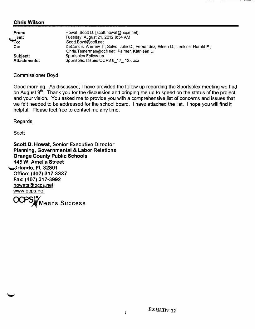
Chris Wilson
J:rom: "'-ant: 10:
Howat, Scott D. [[email protected]] Tuesday, August 21, 2012 9:54AM 'Scott. Boyd@ocfl. net'
Cc: DeCandis, Andrew T.; Salvo, Julie C.; Fernandez, Eileen D.; Jenkins, Harold E.; '[email protected]'; Palmer, Kathleen L.
Subject: Sportsplex Follow-up Attachments: Sportsplex Issues OCPS 8_17 _ 12.docx
Commissioner Boyd,
Good morning. As discussed, I have provided the follow up regarding the Sportsplex meeting we had on August gth. Thank you for the discussion and bringing me up to speed on the status of the project and your vision. You asked me to provide you with a comprehensive list of concerns and issues that we felt needed to be addressed for the school board. I have attached the list. I hope you will find it helpful. Please feel free to contact me any time.
Regards,
Scott
Scott D. Howat, Senior Executive Director Planning, Governmental & Labor Relations Orange County Public Schools 145 W. Amelia Street
~rlando, FL 32801 Office: (407) 317-3337 Fax: (407) 317-3992 howats@ocps. net www.ocps.net
OCPS~eans Success
1 EXHIBIT 12

._.,
-----~--------------------
Sportsplex Issues
Issues needing to be addressed before a School Board workshop on
Sportsplex property.
Access Road Issues
• Who will build the access roadway into the site?
• Who will construct the northern access road across the wetlands? Who will be responsible for
mitigation of the wetlands impacted?
• What will be the cost of the roadway construction to the School Board?
• Will the access road be completed by the summer of 2015 when construction of the school is
scheduled to begin or will temporary access be to the site be available and construction of the
road completed by summer of 2017? Road must be designed by 2013 so the school can be
planning and design and construction completed by 2017.
• Will a connection to Tiny Road be available?
Site Size and Cost
• •
•
•
•
•
How much land will be made available for the high school site?
If additional land is needed to address environmental issues will it be available? (i.e. if 10 acres
of wetlands are identified on site, will10 acres of upland be added to the school site)
Will additional land be made available for the school site if sink holes and wetland depressions
cannot be mitigated because of excess cost? Will the site cost OCPS $1 per year?
Who will be responsible for the necessary land use changes (comp. plan and zoning) and what
will be the time frame for completing any needed zoning actions?
This site has topographical challenges. Who will be financially responsible for the costs of
grading and filling and other earth work necessary to ready site for construction?
What funding source has been identified by the County for the Sportsplex?
Access to Utilities
• Will sufficient water and sewer be available to the High School site?
• How far will the School district need to construct utility lines?
Environmental Issues
• Who will pay for the needed environmental assessments and testing on the school site
property? The environmental assessment should include, but are not limited to, the
following:

o Phase I (proposed site was previously used as a Conserv II spray field), Phase II,
~ and mitigation, if needed.
o Wetlands determination, delineation and mitigation, if necessary.
o Endangered species report, including removal, mitigation and permitting, if
necessary.
o Geotechnical studies including borings and geophysical testing for sinkholes
(possible use of ground penetrating radar).
• The cost of mitigation of sand skinks at school site is estimate at $70,000 an acre or $4.8 million
for the school site Who will cover the cost of the mitigation?
• What is the extent of the gopher tortoise population of the school site? What is the estimated
cost?
Sewer Plant
• How close to the school sites will the sewer plant be constructed? The School Siting Ordinance
dictates the minimum distance a school can be constructed to a sewer treatment facility.
• How will the plant address the any odor issues that may come from the plant?
Construction of the Sportsplex
• Who will build the Sportsplex?
~ • Will the School District bear any responsibility for the construction of pubic sports fields or their
maintenance?
• When will the Sportsplex be added to the County's capital plan?
Joint Use of School Facilities
• Historically, high schools are not good joint use partners because of the intense use of the
facilities by high school athletics and extracurricular clubs.
• Which facilities at the school will the county request to use and how often will the County
expect to use it?
8:30
8:40
DEVELOPMENT REVIEW COMMITTEE MEETING AGENDA Public Works Building
4200 S. John Young Parkway Wednesday, August 28,2013
REVIEW OF MEETING MINUTES - AUGUST 22, 2013
REVIEW OF PUBLIC HEARING REPORTS/STAFF DISCUSSIONS
CONSENT AGENDA- DEVELOPMENT PLAN APPROVALS
FLORIDA MALL PD I FLORIDA MALL TOWN CENTER ADDITION I MODIFICATION- AMERICAN GIRL & ZARA ADDITION DP Plan Date Stamped "Received August 5, 2013" DISTRICT 4
NEW PROJECTS
DP-13-05-123- DISTRICT 1
WEST ORANGE RELIEF HIGH SCHOOL SPECIAL EXCEPTION SITE PLAN
Developer:
Applicant:
Acres:
Usage:
Water:
Sewer:
Parcel ID#:
Location:
1
School Board of Orange County Florida
Marchena and Graham, P.A.
66.40
School 350,000 Sq. ft.
Orange County
Orange County
14-23-27-0000-00-013
East of Ficquette Road I North of Winter Garden Vineland Road
EXHIBIT 13
9:40
9:55
DEVELOPMENT REVIEW COMMITTEE MEETING AGENDA Public Works Building
4200 S. John Young Parkway Wednesday, August 28,2013
PSP-13-08-197- DISTRICT 2
SHEELER A VENUE TOWNHOMES PO/SHEELER AVENUE TOWNHOMES PSP/DP
Developer:
Applicant:
Acres:
Usage:
Water:
Sewer:
Parcel ID#:
Location:
DP-13-08-198- DISTRICT 1
Keewin Real Property Co., LLC.
Evans Engineering, Inc.
21.4
Townhomes (Single Family)
City of Apopka
City of Apoka
14-21-28-0000-00-085, 14-21-28-0000-00-006, 14-21-28-0000-00-117' 14-21-28-0000-00-009
East of Sheeler Avenue I South of S. Orange Blossom Trail
GRAND CYPRESS RESORT/GRAND CYPRESS MASS GRADING DP
Developer:
Applicant:
Acres:
Usage:
Water:
Sewer:
Parcel ID#:
Location:
2
Grand Cypress Orlando, LLC.
Evans Engineering, Inc.
60.51
Mass Grading
Orange County
Orange County
17-24-28-5844-00-390, 17-24-28-5844-00-590, 08-24-28-5844-00-000, 17-24-28-5844-00-000
East & North of Winter GardenVineland Road I North of Lake Buena Vista

10:10
10:25
DEVELOPMENT REVIEW COMMITTEE MEETING AGENDA Public Works Building
4200 S. John Young Parkway Wednesday, August 28,2013
DP-13-07-191- DISTRICT 3
WATERFORD OAKS PD I WATERFORD OAKS PHASE 1 DP
Developer:
Applicant:
Acres:
Usage:
Water:
Sewer:
Parcel ID#:
Location:
DP-13-06-150- DISTRICT 5
Waterford Oaks, LLC.
Mitch Collins P.E., Inc
3.958
Commercial13,771 Sq. ft.
Orange County
Orange County
22-22-31-8469-00-190, 22-22-31-8469-00-020, 22-22-31-8469-00-180, 22-22-31-8469-00-010
South of East Colonial Drive I West ofNorth Alafaya Trail
TOWN PARK PD I TOWN PARK MULTI-FAMILY DP
Developer:
Applicant:
Acres:
Usage:
Water:
Sewer:
Parcel ID#:
Location:
3
Tri Bridge Residential
Kimley-Horn and Associates, Inc.
12.745
290 Multi-Family Units
Orange County
Orange County
22-22-31-0000-00-005
North of S.R. 50 I East of Alafaya Trail

10:40
"-'.
DEVELOPMENT REVIEW COMMITTEE MEETING AGENDA Public Works Building
4200 S. John Young Parkway Wednesday, August 28,2013
CDR-13-06-163- DISTRICT 1
VILLAGE F MASTER PD- SUBSTANTIAL CHANGE
Developer: Magnolia Estates, LLC
Applicant: Dewberry I Bowyer-Singleton
Acres: 1708.95
Usage: Mixed Use
Water: Orange County
Sewer: Orange County
04-24-2 7-0000-00-006' 04-24-27-0000-00-001' 04-24-27-0000-00-007' 04-24-27-0000-00-017' 04-24-27-0000-00-016, 04-24-27-0000-00-019' 04-24-27-0000-00-002, 04-24-27-0000-00-005' 33-23-27-0000-00-003, 3 3-23-2 7-0000-00-006' 33-23-27-0000-00-007,
Parcel ID#: 34-23-27-0000-00-004, 03-24-27-0000-00-003, 05-24-27-0000-00-00 I, 05-24-27-0000-00-005, 08-24-27-0000-00-026, 08-24-27-0000-00-011' 08-24-27-0000-00-008, 08-24-27-0000-00-013, 34-23-27-0000-00-002, 04-24-27-0000-00-015, 34-23-27-0000-00-011, 33-23-27-0000-00-017, 33-23-27-0000-00-018
Location: South of Seidel Road I East of Avalon Road
4

10:55
11:10
DEVELOPMENT REVIEW COMMITTEE MEETING AGENDA Public Works Building
4200 S. John Young Parkway Wednesday, August 28,2013
DP-13-06-149- DISTRICT 4
WEBER LAKES PD (AKA YOUNG PINE ROAD PD) I COMMERCIAL RET AIL STORE DP
Developer:
Applicant:
Acres:
Usage:
Water:
Sewer:
Parcel ID#:
Location:
Concept Development, LLC.
Causseaux, Hewett, & Walpole
1
Commercial 9,100 Square Feet
Orange County
Orange County
08-23-31-3749-00-030
South of Curry Ford Road I West of Hidden River Drive
PROJECTS PREVIOUSLY REVIEWED
PSP-13-06-139- DISTRICT 4
MOSS PARK PD I PARCEL E PHASE 3 PSP
Applicant:
Parcel ID#:
Sponsoring Division:
Request:
Poulos & Bennett, LLC.
10-24-31-0000-00-005
DRC Chairman
Request to discuss modification to COA #11
5

1:00
DEVELOPMENT REVIEW COMMITTEE MEETING AGENDA Public Works Building
4200 S. John Young Parkway Wednesday, August 28,2013
CDR-13-07-192- DISTRICT 4
High Point PD
Applicant:
Parcel ID#:
Sponsoring Division:
Request:
Florida Engineering Group, Inc.
28-22-31-3520-00-017' 28-22-31-3520-00-010
Zoning
Request to add commercial uses allowed in the C-1 Zoning District to Tract B in order to have a veterinary use in the existing building located on the parcels owned by New Pediatric Dental Care of Greater Orlando, Inc.
CDR-13-07-194- DISTRICT 4 Yates PD I Yates Parcell PSP I DP
Applicant:
Parcel ID#:
Sponsoring Division:
Request:
KB Homes Orlando, LLC.
19-24-30-0000-00-001
Planning
Request phasing for Parcel 1
CDR-13-07-195- DISTRICT 1
SPRINGHILL LAND USE PLAN
Applicant:
Parcel ID#:
Sponsoring Division:
Request:
Poulos & Bennett, LLC
18-24-2 7-0000-00-004' 17-24-27-0000-00-008, 08-24-27-0000-00-005
Planning Division
Request per District Base to adjust the density and request a waiver to reduce the front porch setback to 7' in lieu of 1 0'
6
DEVELOPMENT REVIEW COMMITTEE MEETING AGENDA Public Works Building
4200 S. John Young Parkway Wednesday, August 28, 2013
CDR-13-08-201- DISTRICT 4
Colonial Self Storage PD
Applicant:
Parcel ID#:
Sponsoring Division:
Request:
Lowndes, Drosdick, Doster, Kantor & Reed, P.A.
22-22-31-0000-00-019
Planning
Request text change to list of permitted uses within PO to add Truck Rental I leasing associated with self storage I mini warehouse uses.
LUP-13-06-144- DISTRICT 5
Coranado Land Use Plan
Applicant:
Parcel ID#:
Sponsoring Division:
Request:
New Earth Properties, LLC
11-22-30-0000-00-048
DRC
This item was continued from the DRC meeting of July 10, 2013 for a community meeting; which was held on August 14, 2013.
CDR-13-08-207- DISTRICT 1
Shadow Wood PD I Master Infrastructure- Aguatica DP
Applicant:
Parcel ID#:
Sponsoring Division:
Request:
Mr. Greg Bales
07-24-29-7959-00-011' 07-24-29-7959-00-010
Zoning
Request to develop an area within the existing development for a new attraction.
7

DEVELOPMENT REVIEW COMMITTEE MEETING AGENDA Public Works Building
4200 S. John Young Parkway Wednesday, August 28,2013
LUP-13-02-036- DISTRICT 4
BOGGY CREEK CROSSINGS LAND USE PLAN
Applicant:
Parcel ID#:
Sponsoring Division:
Request:
Highland Engineering, Inc.
33-24-30-0000-00-015
DRC
Continued from 2-13-13- & 2-27-13
PSP-13-04-090- DISTRICT 1
ROYAL ESTATES PD I ROYAL ESTATES PARCEL 1 - SPECIAL EXCEPTION FOR TOWNHOMES SITE PLAN
Applicant:
Parcel ID#:
Sponsoring Division:
Request:
TERRA-MAX ENGINEERING, INC.
01-24-27-0000-00-006
DRC
Continued from the DRC meeting of May 22, 2013 for a community meeting; which was held on July 23, 2013.
PSP-13-03-051- DISTRICT 1
VILLAGE F MASTER PO/HORIZON WEST VILLAGE F PARCELS N32,N33,N34,N36,N37,N38 S-3, S-4 &S-5 PSP
Applicant:
Parcel ID#:
Sponsoring Division:
Request:
Poulos & Bennett, LLC.
04-24-27-0000-00-001' 04-24-27-0000-00-007' 04-24-27-0000-00-030, 04-24-27-0000-00-029
EPD
Continued from April 10, 2013 for a CAD and a road agreement.
8

2:00
DEVELOPMENT REVIEW COMMITTEE MEETING AGENDA Public Works Building
4200 S. John Young Parkway Wednesday, August 28,2013
CDR-13-08-211- DISTRICT 1
Hunter's Creek PD I Tract 184 - Lot 1 I Ladybird Academy DP
Applicant:
Parcel ID#:
Sponsoring Division:
Request:
Fragomeni Engineering, Inc.
33-24-29-3729-00-010
Development Engineering
Request to change use from Urgent Care Facility to Daycare Facility for 150 children. Also requesting to remove 1 0 parking spaces and sidewalk to add playground area on west and east side of the building.
CDR-13-08-213- DISTRICT 4
Orlando Airport Park PD I Orlando Airport Park I Lots A-2, A-3, a portion of B-1, B-2 & C-1- C-3 DP
Applicant:
Parcel ID#:
Sponsoring Division:
Request:
Kimley Hom & Associates
20-24-3 0-0000-00-009' 20-24-3 0-0000-00-010
Zoning
Request to increase the square footage of Building #200 from 158,074 sq. ft. to 225,000 sq. ft. The total building square footage of the overall park will remain under the allowed amount per the LUP, which is 1,240,000 sq. ft.
9

DEVELOPMENT REVIEW COMMITTEE MEETING AGENDA Public Works Building
4200 S. John Young Parkway Wednesday, August 28,2013
Note: Additions, deletions and time changes may occur prior to the meeting.
Appeals ofDRC Decisions: Pursuant to Section 34-29, any person aggrieved by a decision ofDRC relative to Chapter 34 of the Orange County Code ("Subdivision Regulations") may appeal such decision to the Board of County Commissioners by submitting a letter to the chairman ofDRC within 30 days after DRC's approval of the minutes memorializing such decision.
Pursuant to Section 38-1203 (3)d., any person aggrieved by the decision of the DRC to approve or deny a development plan for a Planned Development (PD) may appeal such decision by filing a notice of appeal with (submitting a letter to) the chairman of the DRC within 15 days after DRC's approval of the minutes memorializing the approval of the Development Plan on the DRC Consent Agenda.
Notice to the Public: Please note that DRC meetings are not public hearings. However, DRC is a "Sunshine" committee, and, as such, DRC meetings are open to the public, and minutes are taken and kept as part of the public record.
In accordance with the Americans with Disabilities Act (ADA), if any person with a disability as defined by the ADA needs special accommodation to participate in this proceeding, then not later than 2 business days prior to the proceeding, he or she should contact the Orange County Communications Division at ( 407) 836-5500.
10

DEVELOPMENT REVIEW COMMITTEE MEETING AGENDA Public Works Building
4200 S. John Young Parkway Wednesday, August 28,2013
DATE: 28-AUG-2013
PLAN NUMBER: DP-13-05-123
PLAN NAME: West Orange Relief High School Special Exception Site Plan
COMMISSION DISTRICT:
1. PROJECT ANALYSIS
A. Location: B. Parcel ID: C. Total Acres: D. Water Supply: E. Sewer System: F. Schools: G. School Pop: H. Parks: I. Proposed Uses: J. Site Data:
K. Fire Station:
East of Ficquette Road I North of Winter Garden Vineland Road 14-23-27-0000-00-013 66.40 Orange County Orange County N/A N/A N/A School 350,000 Sq. ft. Max Bldg. Ht.: 3 5' within 1 00' of residential 60' fly loft 50' remaining Bldg. Setbacks: 50' rear 10' side 35' front from property line 55' from centerline for structures 50' from centerline for parking areas
34 - 4000 Winter Garden Vineland Road
2. COMPREHENSIVE PLAN
The subject property is located within the West Windermere Rural Settlement and has an underlying Future Land Use Map (FLUM) designation of Rural Settlement 111 (RS 1/1). The request is inconsistent with the intent of the Comprehensive Plan.
3. ZONING:
R-CE
4. COMMENTS:
11
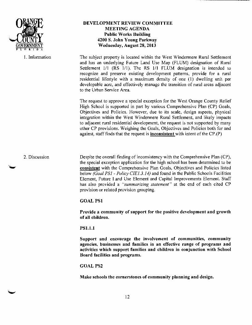
1. Information
2. Discussion
~---~- ------------------------------
DEVELOPMENT REVIEW COMMITTEE MEETING AGENDA Public Works Building
4200 S. John Young Parkway Wednesday, August 28,2013
The subject property is located within the West Windermere Rural Settlement and has an underlying Future Land Use Map (PLUM) designation of Rural Settlement 111 (RS 111). The RS 111 PLUM designation is intended to recognize and preserve existing development patterns, provide for a rural residential lifestyle with a maximum density of one (1) dwelling unit per developable acre, and effectively manage the transition of rural areas adjacent to the Urban Service Area.
The request to approve a special exception for the West Orange County Relief High School is supported in part by various Comprehensive Plan (CP) Goals, Objectives and Policies. However, due to its scale, design aspects, physical integration within the West Windermere Rural Settlement, and likely impacts to adjacent rural residential development, the request is not supported by many other CP provisions. Weighing the Goals, Objectives and Policies both for and against, staff finds that the request is inconsistent with intent of the CP .(P)
Despite the overall finding of inconsistency with the Comprehensive Plan (CP), the special exception application for the high school has been determined to be consistent with the Comprehensive Plan Goals, Objectives and Policies listed below (Goal PSI- Policy CIE1.3.14) and found in the Public Schools Facilities Element, Future Land Use Element and Capital Improvements Element. Staff has also provided a "summarizing statement" at the end of each cited CP provision or related provision grouping.
GOALPSl
Provide a community of support for the positive development and growth of all children.
PSl.l.l
Support and encourage the involvement of communities, community agencies, businesses and families in an effective range of programs and activities which support families and children in conjunction with School Board facilities and programs.
GOAL PS2
Make schools the cornerstones of community planning and design.
12

DEVELOPMENT REVIEW COMMITTEE MEETING AGENDA Public Works Building
4200 S. John Young Parkway Wednesday, August 28,2013
Consistent with Goal PSI and Policy PSJ.J.l, public high schools support the positive development and growth of children, and represent the type of facilities that effectively provide a range of programs and activities. Also, consistent with Goal PS2, Orange County continues to recognize schools as the cornerstone of community planning and design.
OBJPS2.4
Coordinate with the School Board to identify the locations for new high schools on the periphery of residential neighborhoods, where access to major roads is available.
FLU8.7.2
Orange County shall coordinate with the School Board to identify the locations for new high schools on the periphery of residential neighborhoods, where access to major roads is available.
Consistent with OBJ PS2.4 and FLU8. 7.2, there has been extensive coordination between Orange County and Orange County Public Schools (OCPS) on various school-related issues and activities, including the preparation and approval of a School Siting Ordinance in 1996 and the adoption of the Public School Facilities Element of the Comprehensive Plan in 1997. As it pertains to the proposed high school, OCPS appropriately notified the County on April 7, 2004, that the School Board was considering a contract to purchase the subject property for the purpose of constructing a high school to serve portions of the Windermere and Horizon West areas of west Orange County.
Staff acknowledges that the subject property is located on the periphery of a residential neighborhood where access to a major road is available.
PS2.2.8
In an effort to enhance local communities and neighborhoods, Orange County will participate with OCPS in the school siting, design and development process so that the school serves as a focal point for the community and is compatible with the Future Land Use Map and with land uses surrounding proposed school sites.
13

3. Discussion
DEVELOPMENT REVIEW COMMITTEE MEETING AGENDA Public Works Building
4200 S. John Young Parkway Wednesday, August 28,2013
Consistent with CP Policies PS5.2.2 and FLUB. 76, public high schools in Rural Settlements are allowed by the special exception public hearing process, with such approval contingent upon meeting the special exception criteria outlined in Section 38-78 of the Orange County Code and the compatibility provisions in the Comprehensive Plan. Consistent with Policy PS2.2.8, Orange County has participated with OCPS in the school siting, design and development process for the subject request by reviewing the application and attending I facilitating numerous application-related community meetings. The purpose of the meetings was to assess community sentiment regarding whether the proposed high school was compatible with surrounding uses. In addition, Orange County staff has met with OCPS staff and their consultants to discuss the request and applicable Code and Comprehensive Plan provisions.(P)
Discussion Item Continued:
PS3.1.7
Turn lanes and signalization shall be provided at school entrances and at other locations near schools, where warranted, to provide safe access to students and the public. Responsibility for construction of school-related signalization and road construction at school entrances shall be the responsibility of OCPS.
In their submitted Position Statement, OCPS has committed to designing the necessary turn lanes and traffic signals to ensure safe access to students and the public.
OBJPS5.2
Clearly identify in the Future Land Use Element and in the Land Development Code the land use categories in which schools shall be an allowable use.
14

4. Discussion
DEVELOPMENT REVIEW COMMITTEE MEETING AGENDA Public Works Building
4200 S. John Young Parkway Wednesday, August 28,2013
PS5.2.2 and FLU8.7.6
Public high schools and ninth-grade centers developed in conjunction with high schools shall be allowed as a special exception in the following land use categories located in the Rural Settlement Areas: l/1, 112, 115, Low Density Residential, Low-Medium Density Residential, Office, Commercial, Industrial, and Institutional. (policy excerpt)
The underlying Future Land Use Map (FLUM) designation of the subject property is Rural Settlement 111 (RS Ill), which allows public high schools through the special exception public hearing process. Therefore, consistent with OBJ PS5.2, PS5.2.2 and FLU8. 7.6, the applicant is appropriately seeking approval of a high school use as the Code and Comprehensive plan allow. However, the request remains contingent upon meeting the criteria outlined under Section 38-78 of the Orange County Code and other applicable Comprehensive Plan provisions. (P)
PS5.2.4 and FLU8.7.8
All new school locations shall be subject to the terms and limitations established in the school siting ordinance developed jointly by Orange County and the School Board.
FLU8.7.10
Orange County shall implement the School Siting Criteria contained in the Land Development Code.
The submitted West Orange Relief High School site plan, dated received "August 02, 2013 ", meets the school site guidelines, criteria and standards found in Orange County Code Sections 38-1752 through 38-1755 ("Public School Siting Regulations"); therefore the request is consistent with Policies PS5.2.4, FLU8. 7.8 and FLU8. 7.10.
15
DEVELOPMENT REVIEW COMMITTEE MEETING AGENDA
PS5.2.7
Public Works Building 4200 S. John Young Parkway Wednesday, August 28,2013
Orange County and OCPS shall, throughout the planning period, coordinate the siting of new public schools to ensure to the extent possible public school facilities are located to address the needs offuture residential development, are coordinated with necessary services and infrastructure development, provide for safe learning environments, are consistent with the County's adopted Future Land Use Map and with other provisions of the Comprehensive Plan.
Consistent with Policy PS5.2. 7, Orange County and OCPS have historically coordinated the siting of new public schools. In this case, the County acknowledges that the proposed high school site would address the needs of existing and future residential development and that the site would provide for a safe learning environment. Should the request be approved, Orange County would continue to work with OCPS to address any necessary services and infrastructure.
PS5.3.6
Applications for Future Land Use Map amendments, rezonings, conditional use/special exceptions and site plans for schools shall be given priority status. OCPS shall not be required to pay application fees or impact fees for the development of public school facilities, provided, however, OCPS shall not be exempt from payment of capital connection fees for water and wastewater.
Consistent with Policy PS5.3.6, Orange County has recognized the priority status of the subject special exception application by not requiring payment of any associated fees.
PS6.1.9
The County shall support OCPS' efforts to meet adopted LOS standards through the adoption of a ten (10) year, financially feasible DCOP ("District Capital Outlay Plan"). Where the LOS cannot be achieved through the construction of new school capacity as provided in the five (5) year DCOP, the County shall cooperate with OCPS' efforts to adopt a long range ten (10) year DCOP as part of the School District's annual capital planning process.
16
5. Discussion
------ --------------------------
DEVELOPMENT REVIEW COMMITTEE MEETING AGENDA Public Works Building
4200 S. John Young Parkway Wednesday, August 28,2013
As required by Chapter 2004-290, Laws of Florida (Senate Bill 360) and the Orange County I Orange County Public Schools Interlocal Agreement for School Concurrency, the OCPS-adopted I 0-year DCOP has been incorporated into the Orange County Comprehensive Plan by reference in Capital Improvements Element Policy CIE1.3.14. The proposed high school site was identified in the adopted DCOP by OCPS.
Capital Improvements Element:
CIE1.3.14
The County hereby incorporates by reference the OCPS 10-Year Capital Outlay Plan for 2012-2013 adopted by the Orange School Board on September 11, 2012, which includes school capacity sufficient to meet anticipated student demands projected by OCPS.
As required by Chapter 2004-290, Laws of Florida (Senate Bill 360) and the Orange County I Orange County Public Schools Interlocal Agreement for School Concurrency, the OCPS-adopted 10-Year Capital Outlay Plan has been incorporated into the Orange County Comprehensive Plan by reference in Policy CJEJ.3.14.(P)
Determinations of consistency with the Comprehensive Plan (CP) are not made in isolation by focusing only on one (1) or more Goals, Objectives or Policies. Instead, they are made by reviewing and weighing all applicable CP provisions and then determining the overriding intent. Considering the balance of applicable CP provisions, the subject special exception application for a high school has been determined to be inconsistent with the CP. This determination has been based on the competing Objectives and Policies listed below (OBJ FLU8.2 - Policy PS3.1.1) and found in the Public Schools Facilities and the Future Land Use Elements:
OBJ FLU8.2 COMPATIBILITY.
Compatibility will continue to be the fundamental consideration in all land use and zoning decisions. For purposes of this objective, the following policies shall guide regulatory decisions that involve differing land uses.
17

~- ~~-~- ---~~------------------
DEVELOPMENT REVIEW COMMITTEE MEETING AGENDA Public Works Building
4200 S. John Young Parkway Wednesday, August 28,2013
Pursuant to OBI FLU8.2, compatibility is the fundamental consideration in all land use and zoning decisions. The proposed high school is located immediately adjacent to three existing, large lot, rural residential subdivisions (Southern Acres, Cawood Estates and Oxford Moor) -two of which are located within the West Windermere Settlement. Given the proximity of the adjacent residential uses, in conjunction with the impacts associated with proposed high school-related activities, staff finds the request to be inconsistent with OBJ FLU8.2.
FLU8.2.l
Land use changes shall be required to be compatible with the existing development and development trend in the area. Performance restrictions and/or conditions may be placed on property through the appropriate development order to ensure compatibility. No restrictions or conditions shall be placed on a Future Land Use Map change.
As stated previously, the uses and facilities associated with the proposed high school would adversely impact the rural character found in the immediately adjacent residential neighborhoods.
In support of the request, the applicant has compared the proposed West Orange County Relief High School to the existing K-12 Windermere Preparatory School located approximately one-mile from the proposed site along CR. 535. Although located within the West Windermere Rural Settlement boundary, there are noteworthy differences between the Windermere Preparatory School and the proposed West Orange County Relief High School.
Aside from having a significantly smaller enrollment of -725 students and -250,000 square feet of buildings, the Windermere Preparatory School does not use lighted football, baseball or softball facilities. It was also reviewed and approved as a special exception in 1998, prior to the approval of the adjacent Waterstone Planned Development (residential subdivision) in 2006 and the platting of the subdivision in 20 I 0. Lastly, the architecture and design of the Windermere Preparatory School was established to complement the rural residential character of the West Windermere Rural Settlement. (P)
18

6. Discussion
DEVELOPMENT REVIEW COMMITTEE MEETING AGENDA Public Works Building
4200 S. John Young Parkway Wednesday, August 28,2013
FLU8.2.11
Compatibility may not necessarily be determined to be a land use that is identical to those uses that surround it. Other factors may be considered, such as the design attributes of the project, its urban form, the physical integration of a project and its function in the broader community, as well as its contribution toward the Goals and Objectives in the CP. The CP shall specifically allow for such a balance of considerations to occur.
While the proposed high school would support the broader community, as addressed by FLU8.2.11, its overall scale and design, and more specifically the adverse impacts on the immediately adjacent and existing residential neighborhoods make the proposal incompatible.
OBJ FLU6.2 RURAL SETTLEMENTS.
Rural Settlements provide for a rural residential lifestyle. In some instances, Rural Settlements allow a transition of rural areas adjacent to the Urban Service Area while avoiding development in active agricultural areas. Rural Settlements were intended to recognize and preserve existing development patterns at the time the CP was adopted in 1991. The creation of Rural Settlements recognized the need to maintain agricultural areas and rural uses in the Rural Service Area, while providing for rural communities.
Objective FLU6.2 states that in some instances a transitional/and use may be provided in Rural Settlement areas adjacent to the Urban Service Area. The subject property is located immediately east of Horizon West and the Village of Bridgewater Specific Area Plan (SAP). Although Horizon West is not geographically located in the Urban Service Area, according to Policy FLU1.2.5, it is recognized as a designated urban area.
In the case of the subject property, staff acknowledges that a transitional land use between the urbanized area to the west and the adjacent rural residential densities within the West Windermere Rural Settlement may be appropriate.
19
DEVELOPMENT REVIEW COMMITTEE MEETING AGENDA Public Works Building
4200 S. John Young Parkway Wednesday, August 28,2013
In its Position Statement for the August 28, 2013 Development Review Committee (DRC) meeting, the applicant states that a high school (designed to accommodate 2,850 students, 350,000 square feet of buildings and multiple lighted outdoor sports stadiums and recreational fields) qualifies as an appropriate transitional use. In support of this position, the applicant compares the high school and its proposed 0.12 Floor Area Ratio (FAR) with the approved development in the adjacent Chancellor at Windermere PD which also has a 0.12 FAR.
The applicant, however, fails to identifY that the adjacent Chancellor at Windermere PD is located at a major street intersection; is approved for only 49,900 square feet of neighborhood-serving commercial and office uses; and has extensive design and architectural standards to ensure that development will be compatible with the West Windermere Rural Settlement. These standards include, but are not limited to:
• Development shall be in Florida vernacular style as found in historical buildings in Gotha, Winter Garden and West Windermere;
• At least 4 building sections shall have metal roofs to give the appearance of smaller buildings;
• Development shall incorporate hip and gable roofs, with a majority having rafter tails;
• Development shall reflect clapboard sheathing appearance (predominately white, with varying grey);
• A majority of buildings must have 2nd story shell space that appears as habitable;
• A majority of buildings must have porches (min. 8' depth);
• Internal streets shall be paved with brick pavers with contrasting crosswalks;
• Parking lots behind buildings may be paved with asphalt or brick pavers; and
• Buildings shall be oriented with front facades facing internal streets. (P)
20

7. Discussion
8. Discussion
DEVELOPMENT REVIEW COMMITTEE MEETING AGENDA Public Works Building
4200 S. John Young Parkway Wednesday, August 28,2013
Discussion Item Continued:
When addressing Objective FLU6.2 and specifically the Rural Settlement statements related to rural residential lifestyle; existing development patterns; and the need to maintain agricultural and rural areas in the Rural Service Area; the applicant contends that the West Windermere Rural Settlement lacks any of these criteria. Rather, the applicant characterizes the West Windermere Rural Settlement as "upscale suburban residential" and the area's development trend as "upscale suburban residential sprawl".
Residential styles within the West Windermere Rural Settlement may differ from those found in other Rural Settlements; but, the determination that the West Windermere Rural Settlement is in fact "rural" and therefore worthy of the same protections provided to other Rural Settlements, was made by the Board of County Commissioners in 1991 during the adoption of the Comprehensive Plan.
Staff contends that rural character and lifestyle should not be based solely on appearance, but also on development densities and intensities. In this case, the average residential density in the West Windermere Rural Settlement is one (1) dwelling unit per developable acre, which is defined in the Comprehensive Plan as "rural". The scale of the proposed West Orange Relief High School is incompatible with the adjacent and existing rural residential development pattern and would not represent an appropriate transitional land use to the adjacent urbanized area. (P)
FLU6.2.5
The permitted densities and intensities of land use within the Rural Settlements shall maintain their rural character. Factors to be considered shall include lot size, open space and views, tree canopy, building location and orientation, and compatibility with existing land uses. Density and Floor Area Ratio (FAR) calculations shall be defined as the language specified in Future Land Use Element Policy FLU1.1.2(C).
Relying on Policies PS5.2.2 and FLUB. 7.6, the applicant is seeking approval of a high school in the West Windermere Rural Settlement through the special exception process. These provisions, however, do not obviate the requirement to meet other applicable provisions, including Policy FLU6.2.6 addressing compatibility.
21
DEVELOPMENT REVIEW COMMITTEE MEETING AGENDA Public Works Building
4200 S. John Young Parkway Wednesday, August 28,2013
The more urbanized character of areas beyond the West Windermere Rural Settlement boundary is acknowledged by staff, but the uses and facilities associated with the proposed high school would adversely impact the rural character found in some of the existing and adjacent residential neighborhoods.
FLU6.2.12
Any proposed use within a Rural Settlement intended for the new construction of a structure(s) with a Gross Buildable Area of 50,000 SF (on a cumulative basis) or more or projected to have a weekly trip rate of 10,000 total trips may be considered inappropriate for a Rural Settlement if the following conditions exist:
Note: Policy FLU6.2.12 does not preclude approval of uses in Rural Settlements with greater than 50,000 square feet of gross buildable area. For example, certain civic and institutional uses including churches and public or private schools have been approved in Rural Settlements since the adoption of the Comprehensive Plan in 1991. In this case, staff finds the proposed high school to be inconsistent with the following two (2) underlying provisions of this Policy.
• The proposed use is located in a Rural Settlement that has maintained a rural and historic character, consistent with the intent of Rural Settlements.
• It is determined that the proposed use(s) by size, massing and traffic, will unduly impact the historic and rural character of the Rural Settlement.
Since the adoption of the 1991 Comprehensive Plan, the County has successfully maintained the rural character within the West Windermere Rural Settlement.
PS3.1.1
Continue to utilize the Land Development Code to ensure compatibility of land uses adjacent to existing schools and reserved schools sites, including uses serving an at-risk clientele.
22

DEVELOPMENT REVIEW COMMITTEE MEETING AGENDA Public Works Building
4200 S. John Young Parkway Wednesday, August 28,2013
In its submitted Position Statement, the applicant cites Policy PS3.1.1 in support of the proposed high school. However, Orange County staff does not find the Policy to be applicable given that the proposed site was not reserved pursuant to Section 34-155(b)(J)(c) ofthe Orange County Code.
Regarding the issue of compatibility, Orange County consistently seeks to appropriately address the relationship between two or more adjacent land uses. When one land use is more intense than another, various techniques may be used to address compatibility. For example, the County encourages masterplanned projects where the locations of certain intense uses are sited long before surrounding development takes place. In other situations where more intense uses are proposed after development on adjacent properties has commenced, it may be possible to apply performance restrictions or conditions to mitigate for any adverse impacts.
In this case, the proposed West Orange County Relief High School site may be centrally located in the appropriate school zone, but was identified after the approval of adjacent subdivisions. Although there is no requirement that high schools be approved as part of a master-planned community, it should be noted that the subject site was purchased by OCPS on July 2, 2004, after the adoption of the 1991 Orange County Comprehensive Plan and after the platting of the four (4) adjacent residential subdivisions. (P)
23
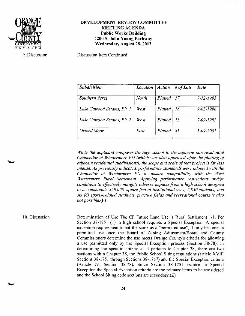
9. Discussion
10. Discussion
DEVELOPMENT REVIEW COMMITTEE MEETING AGENDA Public Works Building
4200 S. John Young Parkway Wednesday, August 28,2013
Discussion Item Continued:
Subdivision Location
Southern Acres North
Lake Cawood Estates, Ph. 1 West
Lake Cawood Estates, Ph. 2 West
Oxford Moor East
Action
Platted
Platted
Platted
Platted
#of Lots Date
17 7-12-1993
16 9-03-1996
15 7-09-1997
85 5-09-2001
While the applicant compares the high school to the adjacent non-residential Chancellor at Windermere PD (which was also approved after the platting of adjacent residential subdivisions), the scope and scale of that project is far less intense. As previously indicated, performance standards were adopted with the Chancellor at Windermere PD to ensure compatibility with the West Windermere Rural Settlement. Applying performance restrictions and/or conditions to effectively mitigate adverse impacts from a high school designed to accommodate 350,000 square feet of institutional uses; 2,850 students; and six (6) sports-related stadiums, practice fields and recreational courts is also not possible. (P)
Determination of Use The CP Future Land Use is Rural Settlement Ill. Per Section 38-1751 (1 ), a high school requires a Special Exception. A special exception requirement is not the same as a "permitted use", it only becomes a permitted use once the Board of Zoning Adjustment/Board and County Commissioners determine the use meets Orange County's criteria for allowing a use permitted only by the Special Exception process (Section 38-78). In determining the specific criteria as it pertains to Chapter 38, there are two sections within Chapter 38, the Public School Siting regulations (article XVIII Sections 38-1751 through Sections 38-1757) and the Special Exception criteria (Article IV, Section 38-78). Since Section 38-1751 requires a Special Exception the Special Exception criteria are the primary items to be considered and the School Siting code sections are secondary.(Z)
24

II. Discussion
12. Discussion
DEVELOPMENT REVIEW COMMITTEE MEETING AGENDA Public Works Building
4200 S. John Young Parkway Wednesday, August 28,2013
Past Action On July II, 2007 the DRC had processed a proposed PO Land Use Plan to rezone this property (68.39) to PO for a High School use. The DRC made a recommendation of approval on June 25, 2008 based upon the Comp Plan finding in the DRC Report of July II, 2007 "This project has a Future Land Use designation of Rural 1/I (1 d.u. per acre), and is therefore consistent with the CPP". Specific policies regarding consistency with Rural Settlement Policies or School Policies were not included within the DRC report/findings. On September I8, 2008, the Planning and Zoning Commission (P&ZC) made a finding if inconsistency with the Comprehensive Policy Plan (CPP), and that the zoning is incompatible with the surrounding area citing 2008 CP FLU policies 2.1.8 and 3.2.25, P&ZC stated that the proposed school is neither consistent with the Comprehensive Policy Plan nor compatible with the development pattern of the surrounding area.
They further noted that it is "an institutional use that would serve a student population beyond the boundaries of the West Windermere Rural settlement and would likely serve as the catalyst for additional residential and commercial development, thus negatively affecting the Rural Settlement". On November II, 2008 and January 27, 2009, the BCC, upon the OCSB request, continued this item until January 27, 2009 and March 24, 2009. The Orange County School Board withdrew the rezoning request on February 24, 2009.(2)
Sec 38-78 Special Exception Criteria Subject to section 38-43 and section 30-43 of this Code, in reviewing any request for a special exception, the following criteria shall be met:
(1) The use shall be consistent with the comprehensive policy plan.
(2) The use shall be similar and compatible with the surrounding area and shall be consistent with the pattern of surrounding development.
(3) The use shall not act as a detrimental intrusion into a surrounding area.
(4) The use shall meet the performance standards of the district in which the use is permitted.
(5) The use shall be similar in noise, vibration, dust, odor, glare, heat producing and other characteristics that are associated with the majority of uses currently permitted in the zoning district.
25
13. Discussion
DEVELOPMENT REVIEW COMMITTEE MEETING AGENDA Public Works Building
4200 S. John Young Parkway Wednesday, August 28, 2013
(6) Landscape buffer yards shall be in accordance with section 24-5 of the Orange County Code. Buffer yard types shall track the district in which the use is pennitted. Zoning's position is that submitting a Special Exception Application instead of going through the rezoning process doesn't make this site any more consistent with the CP FLU or compatible with the surrounding area. Subject to Section 38-43 and Section 30-43 of this code, in reviewing any request for a special exception, the following criteria have not been met as required by section 38-78 (1)-(3) and (5) based upon the following:(Z)
Consistency I.
(I)- The use shall be consistent with the comprehensive policy plan.
a. Although the DRC finding regarding consistency with the comp plan on July II, 2007 which resulted in the recommendation of approval of the proposed rezoning it was not until specific policies (Rural Settlement) were brought out in the P & ZC recommendation of denial on September 18, 2008 and July 24, 2013 DRC's review of the Special Exception Application finding that this application is inconsistent with the comprehensive plan.
b. I. The P &ZC cited 2008 policies 2.1.8 and 3 .2.25 which correspond to today' s policies 6.2.5 and 8.2.1.
c. The applicant stated FLU policies FLU 8.7.2, 8.7.6 and, 8.7.8 are relevant to this application at the DRC meeting of July 24, 2013. FLU8.7.2 Orange County shall coordinate with the School Board to identify the locations for new high schools on the periphery of residential neighborhoods, where access to major roads is available. FLU8.7.6 .... Public high schools and ninth-grade centers, developed in conjunction with high schools, shall be allowed as a special exception in the following land use categories located in the Rural Settlement Areas: Ill, 112, 115, Low Density Residential, Low-Medium Density Residential, Office, Commercial, Industrial, and Institutional. FLU8.7.8 All new school locations shall be subject to the tenns and limitations established in the school siting ordinance developed jointly by Orange County and the School Board. Nowhere within these policies or any of the policies found under the OBJ 8.7 policies does this exempt the requirements to comply with the Rural Settlement policies, nor does it give the school board absolute right to be a pennitted use within a rural settlement.(Z)
26
14. Discussion
DEVELOPMENT REVIEW COMMITTEE MEETING AGENDA Public Works Building
4200 S. John Young Parkway Wednesday, August 28,2013
Compatibility 2.
(2) - The use shall be similar and compatible with the surrounding area and shall be consistent with the pattern of surrounding development.
a. The existing uses in the immediate surrounding area within the West Windermere Rural Settlement is large lot residential development as required for the Zoning Districts that are compatible with Rural Settlement (R-CE, and R-CE Cluster, R-CE-2, R-CE Cluster, R-CE-5, R-CE Cluster and A-R ).
b. A 350,000 square foot high school with a minimum school population of 2,850 students and operating times of Monday through Sunday 6 a.m. to midnight is not compatible with the surrounding large lot single-family development.
3. (3)- The use shall not act as a detrimental intrusion into a surrounding area.
a. The proposed high school is 350,000 square feet with a minimum proposed student population of 2,850. Per OCPS Position Statement dated "Received August 06, 2013", "the School Site is located to address the needs of future residential development in West Orange County". Since the school is for "West Orange County" and not just for the West Windermere Rural Settlement it is an intrusion into this Rural Settlement.
b. If this site were developed at residential, the maximum number of lots allowed under the designation of 111 would be sixty-six lots (632 calculated daily trips). A high school with the projected enrolment of 2,850 students will have a calculated daily trip of 4,822. This equates to more than 7 times the amount of traffic if developed as single-family lots. *number calculations are based off the State of Florida's DOT 8th Edition ITE Generation Report.
c. FLU Policy 6.2.12 refers to new uses within a rural settlement of 50,000 square feet (cumulative) and 10,000 weekly trips could be considered inappropriate. This proposed school will exceed both square footage and weekly trips (based upon State of Florida's DOT 8th Edition ITE Generation Report).
4. (5) - The use shall be similar in noise, vibration, dust, odor, glare, heat producing and other characteristics associated with the majority of uses currently permitted in the zoning district.
27

15. Discussion
DEVELOPMENT REVIEW COMMITTEE MEETING AGENDA Public Works Building
4200 S. John Young Parkway Wednesday, August 28,2013
a. The permitted uses within Section 38-77 (permitted use table) for those zoning districts compatible with RS 111 are predominantly customary residential uses.
b. The noise associated with high school games etc. is not similar to noise associated with those zoning districts compatible with RS 111.
c. The light (glare) associated with stadiums is not similar to light (glare) associated with those zoning districts compatible with RS 111.(Z)
Development Standards The Development Standards found within Section 38-1751-1755 pertaining to a high school are as follows:
I. Section 38-1751 requires a special exception to allow for a high school use within a site that has a designation ofR-CE.
2. Section 38-1752 (a) "The following are presumed to meet all requirements for consistency with the comprehensive plan, and with site guidelines, criteria and standards". Section 38-1752 (a)(l),"School sites owned, under option or reserved in approved plans prior to October 14, 1996".
a. Per Orange County Property Appraiser records, Parcel I.D. # 14-23-27-0000-00-013 was purchased by Orange County School Board from Beck Grove Care Inc. on 07/02/2004. Since this site was purchased in 2004 and not before the October 14, 1996 it cannot be "presumed to meet all requirements for consistency with the comprehensive plan, criteria and standards".
b. The School Siting Regulations that exist within the code today were adopted December 2, 2003.
3. Section 38-1753(a), "Schools should be located to minimize average hometo-school travel distances based on both current and projected student enrollments".
a. Based upon the information available to Zoning, the school appears to predominantly support the Horizon West area in the future; not only the rural settlement (per the statements made in 2008 by the P&Z and statement found within OCPS Position Statement dated "Received August 06, 2013", "the School Site is located to address the needs of future residential development in West Orange County". The DRC meeting of 2007/2008 did not have any available information relating to this.
28

16. Information
DEVELOPMENT REVIEW COMMITTEE MEETING AGENDA Public Works Building
4200 S. John Young Parkway Wednesday, August 28, 2013
4. Section 38-1753 (f), "High schools should be located on roadways with adequate capacity to carry student and parent traffic and suitable for high volume traffic during evening and special events".
a. The proposed site is located on Winter Garden Road which is classified as major collector roadway. Thus, it is consistent with the guideline found within Section 38-1753 (f) but, may in appropriate under Policy FLU 6.2.12 (dealing with traffic introduced into a rural settlement).
5. Section 38-1754 pertains to school placements locations that could be deemed hazardous. This section is not applicable to this application:
a. The site has already been purchased;
b. Does not appear to be a hazardous site under (I) through (7) of this section.
6. Section 38-1755 (1), "minimum net lot area shall exclude water bodies and conservation areas, but may include off site areas used for retention/detention of site runoff. Minimum net lot area shall be reduced ten (I 0) percent for planned multi-story schools". Minimum net lot areas shall be as follows: (Section 38-1752 (a)(d)), "Sixty-five (65) acres for high school sites".
a. Based upon the plan dated "Received August 2, 2013", the proposed high school site is 69.40 acres. The plan appears to propose multi-story buildings (based upon the heights shown on the plan for buildings 4-6) allowing the minimum site size to be reduced to 62.46 acres. If there are no conservation areas on this site then this proposed site meets this requirement.
b. Section 38-1755 (2) (c), the maximum building height for high schools is thirty-five (35) when located within one hundred (1 00) feet of residential zoned property, and fifty (50) feet for all other buildings in high schools excluding auditorium stage fly lofts. The locations and height restrictions comply with code.(Z)
7. Section 38-1755 (3), "Building setbacks from property line: All buildings on public school sites shall adhere to the minimum building setback requirements established for the zoning district and as established for major street setbacks." R-CE Minimum Setback Requirements Setbacks Provided Front = 35= for height 35' or less; 100' for 35 + 160.34' Side= 10' for height 35' or less; 100' for 35 + North=619 .83', South=326.56' Rear = 50' for height 35' or less; I 00' for 35 + 504.49' Winter Garden Road (Major Collector): 55' from c/1 for buildings 90' (+/-) (guard house) 50' from C/L for parking/pavement 85.85'
29
17. Revised Plan
18. Revised Plan
19. Revised Plan
20. Disc/Revised Plan
DEVELOPMENT REVIEW COMMITTEE MEETING AGENDA Public Works Building
4200 S. John Young Parkway Wednesday, August 28, 2013
Setbacks comply with code.
8. Section 38-1755 ( 4 ), "Driveways and parking areas: All driveways and parking areas on public school sites shall adhere to the minimum setback requirements established for the zoning district and as identified in the landscaping, buffering and open space requirements found in section 24-4, general design and development standards" Chapter 24 requires 7' landscape buffer adjacent to r-o-w. Plan meets code.
9. Section 38-1755 (5)(b), "Primary access to ninth grade centers located adjacent to high schools and to all high schools shall be provided from a collector or arterial roadway ... " Winter Garden Road is a major collector.
10. Section 38-1755 (5)(c), Five-foot sidewalks shall be provided along that portion of the school site which is adjacent to public roadways. (Aerial photography indicates an existing side walk).
II . Section 3 8-17 55 ( 6) and (7) speaks to required landscaping buffers. Plan meets code.(Z)
Extend left turn lane at bus loop to 400'(TE)
Pedestrian crossings shall be required at signalized location(TE)
Notification to FDEP - As documented in the Environmental Site Assessment the owner or operator of the Subject Property is required to notify the FDEP of the identified contamination. Send copy of this notification to EPD, ATTN: DRC Reviewer.(EPD)
The proposed High School may meet the technical requirements outlined in both the adopted School Site Siting Ordinance and the Orange County Lighting Ordinance; however, the submitted photometric plan is incomplete. The photometric plan should be revised to address the following requirements:
• Pursuant to the requirements of Orange County Code Section 9-649(a)(J), the photometric plan should identify the illumination levels within the overall site.
30
DEVELOPMENT REVIEW COMMITTEE MEETING AGENDA Public Works Building
4200 S. John Young Parkway Wednesday, August 28,2013
• Pursuant to the requirements of Orange County Code Section 9-649(a)(5), illumination levels at the property line of the building or project shall not be greater than 0. 5 foot candles at any point where the building or project is located adjacent to any residential use, and shall not be more than 1.0 footcandles when located next to any other use. The submitted plan indicates 0. 0 footcandles adjacent to the residential property to the east. It does not appear that lighting from the football stadium, baseball field, softball field, tennis courts, basketball courts or practice fields have been included in these calculations.
• The intent and purpose of the County's exterior lighting ordinance is to ensure that exterior (outdoor) lighting positively enhances the visual impact of a building or project on surrounding properties and uses. To that end, exterior lighting should be installed in a consistent and coordinated fashion to provide safe, convenient and efficient lighting for customers, pedestrians and vehicles, while avoiding the creation of hot spots, obtrusive light, light pollution, light trespass, and visual nuisance. The football stadium appears to be oriented in a manner which directs the proposed lighting (90' high poles) toward the residential property to the east.
• Although stadium lighting may need to exceed the maximum 30(. pole height allowed by Code, pursuant to Orange County Code Section 9-649(a)(4), all light fixtures, including security lighting, shall be full cutoff fixtures, and shall be incorporated as an integral design element that complements the design of the building or project through style, material or color. Luminaries shall not be tilted. A cutoff fixture shall not have more than one percent (I%) of lamp lumens above horizontal. Lighting at a building or project shall not be comprised in whole or part of any floodlights, except floodlights may be permitted with a noncommercial industrial use, provided the floodlights are shielded to meet cut-off standards. Provide cut sheets for the proposed stadium fixtures, and justify how they meet the purpose and intent of the County's lighting ordinance. (P)
31
DEVELOPMENT REVIEW COMMITTEE MEETING AGENDA Public Works Building
4200 S. John Young Parkway Wednesday, August 28,2013
2I. Discussion ltem/Cond Environmental Site Assessment (ESA) - A soil and groundwater report "Phase I/11 Environmental Site Assessment Proposed Horizons West Relief High School Site, Windermere, Orange County, Florida" dated April 8, 2005 by Nodarse & Associates was submitted for review with this project. Two areas of soil and groundwater contamination were documented in that report in the vicinity of two citrus pump houses and the related fuel storage tanks. Prior to site disturbance the applicant shall provide an updated ESA Phase I and II that covers the current site property to the Florida Department of Environmental Protection (FDEP). The site shall comply with the FDEP regulations regarding soil and groundwater contamination. The area of contamination concern was not delineated in the study reviewed but only denoted by the sampling wells used in the study. FDEP will require full delineation of the contaminated areas and a proposed remediation plan.(EPD)
22. Information The project is located within District #1. The applicant is proposing a special exception with the R-CE (Country Estate District) to allow for the consideration of a 350,000 square foot public high school. The project is proposed to be completed in one (I) phase.(P)
23. Information
24. Information
25. Information
26. Information
27. Information
The property's Future Land Use Map (FLUM) designation is Rural Settlement III (RS 1/I) and the property is located within the West Windermere Rural Settlement. The property's zoning designation is R-CE (Country Estate District).(P)
Section 38-78 states that criteria (I) through (6) shall be met. Based upon all of the Zoning information provided within the report, items (4) and (6) have been met if built as shown on Plan dated "Received August 2, 2013".(Z)
This PD is within the recommended response distance of 2.5 miles in the Fire Rescue Element ofthe Orange County Comprehensive Plan as it is located 1.30 miles to Station 34 - 4000 Winter Garden Vineland Road. (FR)
The plans submitted and reviewed by the Office of the Fire Marshal does not provide enough information for a complete review regarding fire department requirements.(FR)
During construction, when combustibles are brought on to the site, access roads and a suitable temporary or permanent supply of water acceptable to the fire department shall be provided and maintained Chapter I6, NFP A I 2009 Edition (FFPC 20 I 0 Edition).(FR)
32

28. Infonnation
29. Infonnation
30. Infonnation
31. lnfonnation
32. Infonnation
33. Infonnation
34. Infonnation
35. Infonnation
DEVELOPMENT REVIEW COMMITTEE MEETING AGENDA Public Works Building
4200 S. John Young Parkway Wednesday, August 28,2013
No right-of-way IS required for Winter Garden Vineland Road from this project.(PWE)
Must obtain a school pennit from FDOH. 407-52l-2630.(HD)
Wildlife - Development of the subject property shall comply with all state and federal regulations regarding endangered, threatened, or species of special concern. (EPD)
Erosion Control - Use caution to prevent erosion during construction along the boundary of the property, into wetlands, and into all drainage facilities and ditches. Construction will require Best Management Practices (BMPs) for erosion control. Minimize the extent of area exposed at one time, apply perimeter controls where necessary, and perfonn maintenance checks every seven (7) days and after every 112 inch rain. The construction entry area shall be designed to prevent trucks from tracking soil onto local roads and the affected stonn drainage system shall be protected as indicated in 34-250(g). This may require periodic street sweeping.(EPD)
Irrigation Wells - Two irrigation wells are present on site. Any existing wells shall be properly abandoned prior to earthwork or construction. Pennits shall be applied for and issued by the appropriate agencies. Contact the Department of Health (DOH) and the appropriate Water Management District.(EPD)
Conservation Area Pennits - Wetlands are present on site. Provide Elizabeth Johnson, Environmental Programs Administrator of the Orange County Environmental Protection Division (EPD), a copy of the documents being submitted to either the Water Management District or Florida Department of Environmental Protection as part of the Environmental Resource Pennitting process.(EPD)
The one parcel ID number, 14-23-27-0000-00-013, listed on the coversheet is correct.(DE)
At the time of construction plan review, left turn lanes into the project at both driveways will be analyzed for proper length and geometry.(DE)
33
36. Information
37. Information
38. Information
DEVELOPMENT REVIEW COMMITTEE MEETING AGENDA Public Works Building
4200 S. John Young Parkway Wednesday, August 28,2013
Traffic Engineering supports the installation of a signal at the parent/student parking and further recommends a NB left U-tum at that location.(TE)
There are no roadway agreements relating to this project/parcei.(TP)
There are no failing roadways within the project influence area.(TP)
39. Keep/Outstanding Issue A traffic operational analysis is currently in review for this project.(TP)
RECOMMENDATION:
The recommendation shall be determined. In the event the DRC recommends approval of this project, the following Conditions of Approval shall apply:
1. Development shall conform to the West Orange Relief High School Special Exception Site Plan dated "Received * ",and to the following conditions of approval. Development based upon this approval shall comply with all applicable federal, state and county laws, ordinances and regulations, which are incorporated herein by reference, except to the extent any applicable county laws, ordinances and regulations are expressly waived or modified by these conditions, or by action approved by the BCC, or by action of the BCC. In the event of a conflict or inconsistency between a condition of approval of this site plan and the actual site plan dated "Received * ", the condition of approval shall control to the extent of such conflict or inconsistency.
* DATE OF APPROVED PLAN TO BE DETERMINED UPON APPROVAL OF A REVISED PLAN
2. This project shall comply with, adhere to, and not deviate from or otherwise conflict with any verbal or written promise or representation made by the applicant (or authorized agent) to the Board of County Commissioners at the public hearing where this development was approved, where such promise or representation, whether oral or written, was relied upon by the Board in approving the development, could have reasonably been expected to have been relied upon by the Board in approving the development, or could have reasonably induced or otherwise influenced the Board to approve the development. For purposes of this condition, a "promise" or "representation" shall be deemed to have been made to the Board by the applicant (or authorized agent) if it was expressly made to the Board at a public hearing where the development was considered or approved.
34

DEVELOPMENT REVIEW COMMITTEE MEETING AGENDA Public Works Building
4200 S. John Young Parkway Wednesday, August 28,2013
3. Pursuant to Section 125.022, Florida Statutes, issuance of this development permit by the County does not in any way create any rights on the part of the applicant to obtain a permit from a state or federal agency and does not create any liability on the part of the County for issuance of the permit if the applicant fails to obtain requisite approvals or fulfill the obligations imposed by a state or federal agency or undertakes actions that result in a violation of state or federal law. Pursuant to Section 125.022, the applicant shall obtain all other applicable state or federal permits before commencement of development.
4. Prior to construction plan approval, hydraulic calculations shall be submitted to Orange County Utilities demonstrating that proposed water, wastewater, and reclaimed water systems have been designed to support the PD.
5. Prior to earthwork or construction, the developer shall provide a copy of the completed National Pollutant Discharge Elimination System (NPDES) Notice of Intent (NOI) form for stormwater discharge from construction activities to the Orange County Environmental Protection Division, NPDES Administrator. The original NOI form shall be sent to the Florida Department of Environmental Protection.
6. All acreages regarding conservation areas, wetland buffers and conservation encroachment are '-"' considered approximate until finalized by the issuance of a permit from the applicable Water
Management District, and only after a copy of which has been provided to the permitting program of the Orange County Environmental Protection Division. Approval of this plan does not authorize any direct or indirect conservation area impacts.
7. No activity will be permitted on the site that may disturb, influence or interfere with: areas of soil or groundwater contamination, any remediation activities, or within the hydrological zone of influence of the contaminated area, unless prior approval has been obtained through FDEP. An owner/operator who exacerbates the existing contamination or does not properly dispose of any excavated contaminated media may become liable for some portion of the contamination pursuant to the provisions in section 376.308, F.S.
8. The Orange County Public Schools recognizes the prior use of this property as a citrus grove.
9. Neither installation or operation of potable or irrigation water supply wells using local groundwater will be allowed on site.
I 0. The Developer shall obtain water, wastewater, and reclaimed water service from Orange County Utilities.
35
DEVELOPMENT REVIEW COMMITTEE MEETING AGENDA Public Works Building
4200 S. John Young Parkway Wednesday, August 28,2013
11. Prior to construction plan approval, hydraulic calculations shall be submitted to Orange County Utilities demonstrating that proposed water, wastewater, and reclaimed water systems have been designed to support the PD.
12. Billboards and pole signs shall be prohibited. Ground and fascia signs shall comply with Ch. 31.5.
13. A six-foot masonry wall shall be required along the east and north property lines, except along the conservation area.
14. Sports lighting of the stadium and ball fields shall be prohibited.
CONCLUSION:
After review/discussion of the above listed findings, the following action was taken:
36

MARCOS R.. MARCHENA KEITH A. GRAHAM YOVAWNl!E R.. STORMS CHR!STOPH:RJ.~~LSO~
SHANNON iii. W!GGl:NS
VIA. HA .. .:~D DELIVERY Ussette Egipciaco
1>11ARCHENA. AND GRAHAM, ?A
September 5,.2013
Development Reviev,· Committee Coordinator 4200 South John Young Parkway Orlando. florida 32839
S'75 LAIKE BALDW!N LANE, SUITE 101 ORLANDO, FLORIDA 32814
TELE?HOr'I'E ( 407) 658-8566 TELECOP!ER (407) 281~8564
WRITER'S E-!>f,AIL:C"[email protected]
RE: West Orange County Relief FI:g:1 School Special Exception Application/Development ReYic\v Committee ('"DRC'.) Revised Plan from _A.ugust 28, 20 J 3 DRC Comments
Dear Vts. Egipciaco:
Enclosed herein please fmd thi;-teen ( 13) folded full size site ?lans and reYised tJhotometric plans. GilC en 1 hl! siz.e si:c p:an and :he emd traDScnitting the FDE? Discharge Reponing Fon to Joh:: Geiger. information p:-ovided in addition to ;he site p~a;r is provided for infonnational purposes. Bela·,, f1nd a detailed :12rrative of the rcYis;:.d plan i:ems discussed at the ~~ugust 28, 2013 D~\_C:
17. ReYised ?Jan
CW/mlm Enclosures
:he c.n~-~-Je:- cr opc:-z:c·:- cf:}:e S:...:bjccl PrC~per:y :s req~iircd to :1otl~y t:~c FDEt? of !he i6~nti:Je.d C()n~ar:linc~:i~)n. S,:::rd c.c~py e_rf :.his 71ot!~lcatio:1 :o E::?J) _ .·\ 7t7L DR(~ :\eviewer:
Sinccreh. '
-,...__/.
EXHIBIT 14

!.-issctt:: Eg:?ciac~) September :3,2013 Page 2
cc: John S:mogor, DRC Chair:na.:1 (v.io cncls.) (Yia email) Rocco Relvini. Zoning (w/o encls.) (via email) Barbara 1VL Jenkins, Supe:-intcndent. OCPS (w!o encls.) (via e::mail) Diego Rodriguez, Esq., Gcner2.l CounseL OCPS (wio encls.) (\·ia email) Eileen D. Fernandez.. Esquire, As.o;ociate General CounseL OCPS ("w/o ends.) (via email) John T. Morris, Chief Facilities Officer, OCPS (w/o encls.) (via email) Fzzlur Ali, Senior Director Pianning & Desi~:;n, OCPS <\v/o encls.) (via email) Ihrold Jenkins. Di7ector of Real Estate Management, OCPS ('c;.,·/o encls.) (via email) J. Dave Torbert. SchenkeL Shultz (w/o encls.) (via email) .iason Varg~s, \V3Q Design and Engineering (vv 1o cncls.) (Yia email)

Chris Wilson
From: '"'ent:
Yc~ Subject: Attachments:
Chris Wilson Monday, August 26, 2013 5:20PM 'John. Geiger@ocfl. net' '[email protected]'; 'Fernandez, Eileen D.'; Fowler, Jennifer B.; [email protected] West Orange County Relief High School DRF- Horizons West Relief HS 8-2-2013.pdf
Please find attached the Discharge Reporting Form for the West Orange County Relief Site. The contr-actor hired by OCPS is diligently working on the delineation in order to obtain an approved mitigation plan.
Christopher J. Wilson, Esq Marchena & Graham, P.A. 9.76 Lake Baldwin Lane, Suite 101 Orlando, Florida 32814 (T) 407.658.8566 (F) 407.281.8564
CONFIDENTIALITY NOTE: the information contained in this transmission is attorney privileged and confidential. It is intended only for the use of the individual or entity named above. If the reader of this message is not the intended recipient, you are hereby notified that any dissemination, distribution, or copy of this message is strictly prohibited. If you have received this communication in error, please notify us immediately by telephone and return the original message to us at the address listed above via the United States Postal Service. Thank you.
Ti=zS ORCULAR 230 DISCLOSURE: Under regulations issued by the U.S. Treasury, to the extent that tax advice is contained in this communication (or any 3chment or enclosure hereto), you are adv1sed that such tax advice is not intended or written to be used, and cannot be used by you, or any other party to
'-'tlom this correspondence is shown, for the purpose of: (i) avoiding penalties under the Internal Revenue Code, or (ii) promoting, marketing or recommending the tax advice addressed herein to any other party.
1
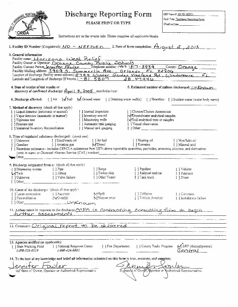
Discharge Reporting Form DEPForm# 62-7G1.9J0!1)
Form Title Dis::haroe Reoortirc Form PLEASE PRINT OR TYPE Effe:::tive Date ______ _
Instructions are on the reverse side. Please complete all applicable blanks
1. Facility ID Number (ifregistered):_!V~O=· '----1-N'"'-'~"'--'-E..2...D~c~a....__ 2. Date af form completion: f1..?~u 5f c2 J d Q/3
3. General information Facilityname: f.±orczons West, Belie£ facility Owl1er or Operator: Q ra n '2o.f C or., n+'f :Pu b I' 'c. :Sch o0 /.5 ~ac~!YCon~~ctPerson..Je.nru-le.r fowle...-el~honenumber: ('-lo, )311- 3'139' County: Ora..JII%€.. ta~::ulity Mailing address: 3 9 0 g .S . Sum tb e r 1111 Ave... J 0 r /and a J F L 3'¢ ~ Ol.D I..ocation of discharge (faciiity street address): 5" "1 9 =t ( d m+e..r: Go n-1 e o Vt n.e. la..n. d Rd 1 L&.-1 j nd £-rmere.. , I- L_ Latitude and Longitude of discharge (If known) - 8 I 5 '3 0 I c2 8 . '+"1 '3 I{ to
4. Date of receipt of test results or discovcr_y of confinncd discharge: Apr; I 6 1 .2co5 month/day/year
5. Estimated number of gallons discharged: 1 )O l.::::nou . .>o
6. Discb.arge affected: [ ] Air r..J Soil M C-.rol!!ld water [ l Drinking water well(s) l J Shoreline [ l Surface waler (water body name)
7. Method of discovery (check all that apply) t l Liquid detectoj (automatic Oi manual) [ ) Vapor detector (automatic or manual) [ ] Tightness test I 1 Pressure test I ] Slalislicallnvenlory Reconciliation
t j lntern.al inspection [ ) Inventory control [ ] Monitoring wells I 1 Automatic tank gauging I ] Manual tank gauging
g. Type uf reg-ulated substooce discharged: ( chocJ .. o.oc=)
l 1 Closure/Closure Assessment [Y}"tlroundwater analytical samples [\-]"Soil analytical tests or Sfllll ples I 1 Visual observation [ J Ol11er ________________ _
[ 1 Un\.:-nown [ ] Used/waste oil [ 1 Jet fuel [ ] Heating oil ! ] New!iube oil [ J Gasoline [. ) Aviation gas [vfDiesel [ ] Kerosine [ ] Mineral acid [ ] Hazardous substance- includes CERCLA substances from USTs above reportable quantities, pesticides, ammonia, chlorine, and derivatives
(write in name or Chemical Abstract Service (CAS ) number) _____________________________ _ "'-rOther ___________________________________________ _
[ J Dispensing system [ J Pipe [ ] Barge
VfTank [ ] Fitting l ] T anlcer ship
[ ] Unknown I ] Valve failure [ ] Other V esse! [ l Other _____________________ _
1 {L Cuuse nf the ilisch;rrge: (check all that apply) [ } Loose connection [ ] Puncture ['.-fSpill [ J Firetexplosion [~verfill [V]Huruan error 1 1 Othcr ___________ _,_L?""'-'-n-PK..n.ol.J.>I")
13. Agencies notified (as applicable): L j State Warning Point [ ] National Response Center l J Fire Department
1-800-320-0519 1-800-424-8802
[ ] Pipeline l ] Railroad tank~::ar [ ] Tank truck
] Collision ] Vehic.le Accident
[ J Vehicle l ] Airplane []Drum
] Corrosion j !mtaliatio11 failure.
l J County Tanks Program MDEP (district/person) Qeo+m.l
14. Tn the best of my knowledge and belief all information submitted on this form is true, accurate, and com
~.e ... 'l.o ;-tu- FDwL.e...r ted Name or Owner, Operator or Authorized Rcprcscnlalivc
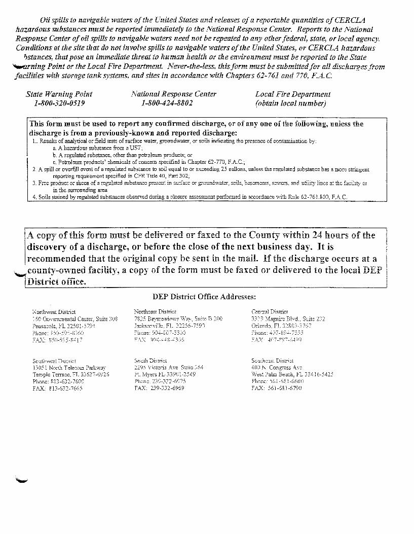
Oil spills to navigable waters of the U!!ited States and releases of a reportable quantities of CERCLA iz.azanlous substances must be reported immediately to the National Response Center. Reports to tlte National Response Center of oil spills to navigable waters need not be repeated to any other .federal, state, or local agency. Conditions at the site that do not involve spills to navigable waters of the United States, or CERCLA hazardous
1Jstances, that pose an immediate threat to human health or the environment must be reported to the State ~rninf! Point or tile Local Fire Deoa.rtme;:t .. Nel'er=t!:e=lessf! tl!is form must be suhl:zitt.ed for all disc!:ar~es froln -- ~ -.., - --· facilities r.Jith storage tank systems, and sites in accordance with Chapters 62-761 and 770, F.A.C.
State Warning Point 1-800-320-0519
National Response Center 1-800-424-8802
Local Fire Department (obtain local number)
1 ~~i~ form .m~st he used ~o r:po_rt any con!irmed di~c~a~ge, or of any one of the following, uniess the mscnarge Is rrom a prevwusiy-Known ana reportea mscnarge:
L Results of analytical or field tests of surface water, groundwater, or soils indicating the presence of contamination by: a. A hazardous substance from a UST; b. A regulated substance, other than petroleum products; or c. Petroleum products' chemicals of concern specified in Chapter 62-770, F.A. C.;
2. A spill or overfill event of a regulated substance to soil equal to or exceeding 25 gallons, unless the regulated substance has a more stringent reporting requirement specified in CFR Title 40, Part 302;
3. Free product or sheen of a regulated S"J.b~tancc present in surface or g:raund~;atcr~ soils, basements, sc;.Ycrs, c.nd utility lines at the facility or in the surrounding area
4. Soils stained by regulated substances observed during a closure assessment performed in accordance with Rnle 62-761.800, F.A C.
I A l'rmv of thi!OI fnrm m-niO:t hP i!Plhu:•rPrl or f~yprl to thP ronn-tv within 1 . .1 honr.:o: of thP ~ ~ -~r.r ~~ ~~~~~ ~~- ~ ~-~- ~- ~--·· -- -~ ~~ ~-~-~ ~~ ~~- ~~ -~--.; • • -~--~~- - . ~-~ -· ~ ~~ -u-diSCOVery of a discharge, or before the close of the next business day. It is recommended that the original copy be sent in the maiL If the discharge occurs at a
._,.county-owned facility, a copy of the form must be faxed or delivered to the local .uEP j..uistrict office.
Northwest District 160 Governmental Center, Suite 3 08 Pensacola, FL 32501-5794 ?hone: 850-SYS-~360 f-~~· 8:10-59)-g-417
Southwest District 13051 North Telecom Parkway Temple Terrace, FL 33637-0926 Ph nne: R 13-63 2-7600 FAX..: 813-632-7665
DEP District Office Addresses:
Northeast District 7825 Baymeadows Way, Suite B 200 .la::ksonYille, FL. 322.56-7590 ?hone: YO.:.i--S0/-3300 F_;_x· 904-4.:;~.~-43G(l
South District 2295 Victoria Ave Suite 364 Ft. Myers FL 33901-2549 Phuiic: 230-332-6975 F.A.X. 239-332-6969
Cen rral District 3319 Maguire Blvd, Suite 232 Orlando, FL 32803-3 767 ?hone: .:.i-07-89.:+-7555 F!;_x: .:+o7-g97-c~.:+9:j
Southeast District 400 N. Congress Ave. West Palm Beach, FL 334 J 6-5425
FA.X 561-681-6790

~§~ ~
r~
-~~
~l :::j
l'i ~
m
~~~
"1J r
~~~
> z '
li~
c
:~ G>
::1
: -i
~~ z G>
'!te
l "1
J ~;
ll
::1:
~~
0 -i 0
!: ~
m
-i
::0
0 (/) DE
SIG
N
&
CO
NST
RU
CTI
ON
H
IGH
SC
HO
OL
••
• "'"
'"""" •
• •
I [Q
)[~~~) O
RANG
E CO
UNTY
PUB
LIC S
CHOO
LS
WES
T O
RA
NG
E R
EL
IEF
SC
HE
NK
ELS
HU
L1Z
illii
iJJ ['P
)f§l
FAC
IUT
iES
SER
VIC
ES
PR
OJE
CT
· 20
0
""'"
"""'-
'---
-'--
'--'
--'-
..I.
..J "--
-~---B
LOO-._•_ ..
_._ ... _._
.... _'c_•_•
_y_·_o
RUND
O _
_ ._n
.o_..,._._
..... _·J
t-.. -_-_-_-_-_-_
-_-_-SflE_-..;.·~·PCA
H~--~~~~·l.JCl>n'HCl!!'_·
~·~--~~-~O_~--·..!f'HOT'O
IETFIC8_,
~~_~..;.-~0~
0~4~~1~~~~
~~~W.t_~· .. ~7·2l~~~
~~~=~. __
__ J·.
:
i
i i~
I
i ! i ~
~ t• f
·~ -- •
f'H
' r:-~
n ·~
~----~
H
~.: ·-]
'I

c~
' I
:!
I 1 -
r-!l
---
1::
~~----:-
-: ~fi
t-:~-!
f~j I
!":e-
· !
' I
f~ '
' '
I '
WES
T O
RA
NG
E R
EL
IEF
SC
HE
NK
EL
SH
UL
TZ
•
HIG
H
SCH
OO
L
;_;.:.
,;,.:,
:;~"'"
' 0 0
0
~ P
RO
JEC
T
NO
. S
-0
04
1 ,. .
. ,..
· "
J-----..::•
o:.:._•k =l
o~=Uo
n:..!l=o
oa----1 ~
0~:::
3322
· SI
TE P
LAN
-L
IClH
TJI
Q-
CIJ
TSIE
E18
iu
<07
-372
-:ml
~
-com
·-:!"
' f

im·'i.ll
.· i.
ft
1 ~,
!idf w·! ~rr I
. .t
lni[:C:
cl OR
ANGE
CO
UNTY
PUB
UC S
CHOO
LS
WES
T O
RA
NG
E R
EL
IEF
SC
HE
NK
EL
SH
UL
TZ
rrm
m ~ .
D
ESI
GN
&
C
ON
STR
UC
TIO
N
HIG
H
SCH
OO
L ;.;
:.:::.
::.~""
" 0
0
• ~
'--...I....I..
..J...J~ ...J
..J
..... · [_
P_. _H~_
S_J_BUlG
_. _ ... _~~-c:
u_MA:_::_:
.,_:_:_:_~
E-~RroA-...
_ .. .J
'-t-
-____
____
PR=o=JE~£:
T:,~:·.?.~
~ ·:~;~o=o
=4t===
~..w=-~· ~
:~!:::!2~~·-=:..
.._ _ _
J
• SI
TE P
UN
-l.J
C»
iTT
IK)-
cimH
:Ers
laK
.o7
.an.
.JJ0
3 -'<
!
selte
nkels
hull2
.com
'f r ~
I §
ln'l(~( j
ORAN
GE C
OUN
TY P
UBLIC
SCH
OO
O
WES
T O
RA
NG
E R
EL
IEF
~. ~!i
~mWh
~~V~
~ •
~ ~
; §,
I
I ~J
DE
SIG
N
&
CO
NST
RU
CT
ION
H
IGH
SC
HO
OL
200
~ ~
j' ~.~'
'! 1 •
riill
§l
FA
CII
JTIE
S
SE
RV
ICE
S
PRO
JEC
T
NO
. S
-004
.1
.... ':
,"""
""'"'
"' ,..
-
l..[
_J~
Bl.D
C.
200
, 16
01
IUC
JC
YA
Y
OR
UH
DO
, n.o
~ma 321
10i
j-----
......:"
"='k.
=IDc
•=ti•
oc.!::
lOO:
:_S ----1
::"4o
~~.mz
'---
-0-.
I...
.J..
..I.
..J.
..J '---------_
__
J
filE
I'U
N-
UC
»ff
ljQ
-CII
I1H
%1
8
:..~
~ '

i I
1~1 1"
:m;'.
~i r.
~ 1
...
'..J
lni(:C
CJ O
RANG
E CO
UNTY
PUB
LIC S
CHOO
LS
HIG
H
SCH
OO
L
;.,;
~c=~
~"""
. . .
;
~
DE
SIG
N
&
CO
NST
RU
CT
ION
I
S l-
------=•
"'•:...::
•-=u""=
'=..,.-----1
,..•,..,07
41l!.,-t
,~f!!2
WES
T O
RA
NG
E R
EL
IEF
SC
HE
NK
EL
SH
UL
TZ
~
CSJ
FAC
!IJT
!ES
S
ER
VIC
ES
PR
OJE
CT
N
O.
S-
0041
:;::,
32801
. B
LDG
. 2
00
, 86
01
IUG
JC W
AY
OR
LAH
DO
, rL
OR
JDA
S
280V
El
iTE
l"l.
AN
-L
.JC
»fl1
«)-
CU1'
&EE
'TB
..,,
-.-...
.
'---
-L-.
....
_I.
....
I...
J '------------'-----------~..=""
"'=-=---
I
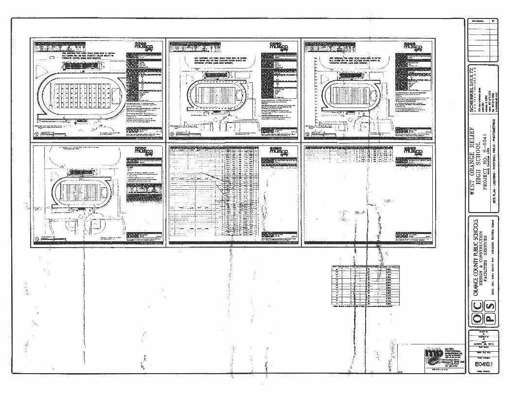
(Q)[ C
) OR
ANGE
COU
NTY
PUBL
IC S
CHOO
LS
WES~I~
HRASNC
GHEOOR
LELIEF
~~~
~.~~~h~
!Wl:~ ·m±rrrn~
. D
ES
IGN
&
C
ON
STR
UC
TIO
N
,.,.
,..-
..,,
.,.
P f§
l.. F
AC
IUT
IES
S
ER
VIC
ES
. P
RO
JEC
T
NO
. S
-00
41
-
300
~
BlD
G.
200,
G
601
IUG
JC Y
.AY
OR
UN
DO
, PL
OIU
DA
~~
t----
-~-~
rl<~
loc~at
.l~-~~~O
O~S _
__
_ __
j ~.;~~
~--~~~~~----------------------------~
~---~-
~----~
------~
--~---
~----~
--~~
~~~~~~
~~72~-~~-
---__j
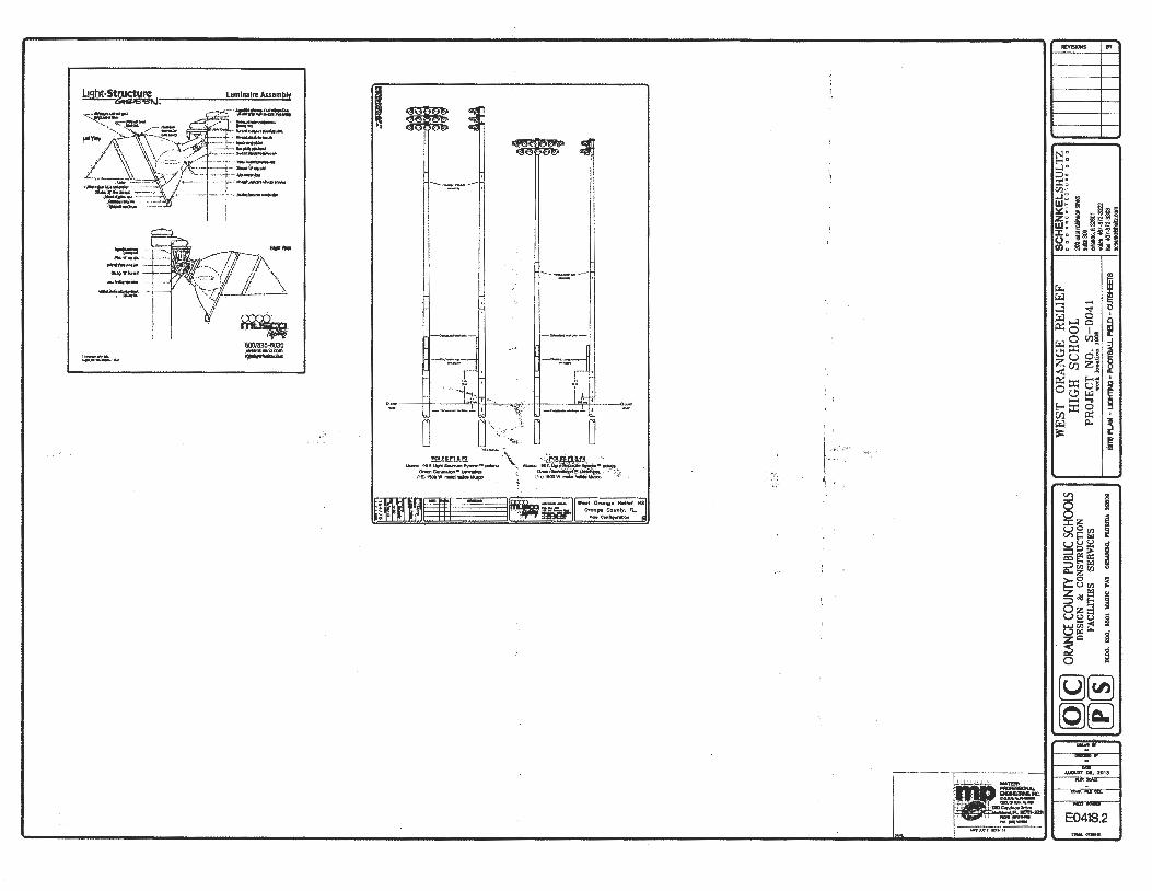
,_-,.,
_____
__
_;:
--~ ~
-~
~ i
il
[Q][
~] O
RANG
E CO
UNTY
PUB
UC S
CHO
OlS
W
EST
ORA
NG
E R
ELIE
F S
CH
EN
KE
L S
HU
LT
Z ITII
II1E
.... --_.~~~"
"'[-~~-)
[_}[}[_J
____ D_E
S-IG
_N __
&_
C_ON
_S_rn
_u_c
T-IO
_N _
_ _
J._
__
__
__
_ H_IG
_H __
S_C_H
_O_O
_L __
__
__
~~~~~~;~
"~~·~-"_"_"'_'
_""_J" -~~-
FACI
IJTI
ES
SERV
ICES
P
RO
JEC
T
NO
S
00
...
,300
! r-~~--~
~=·~~~
~tio~·~~-~
---4_1
__ ~~~~k
BLD
G.
20
0,
8S
01
K£G
IC
WA
Y O
JtL.
Um
Q,
FLO
RID
A
S28
00
S
fE P
LA
N -
l.J
CJ
il"N
) _
F001
'BA
I..L
FE
I.D
_ C
U'TS
t-EET
S fil
l 41
)]-8
T2·3
303
sehe
nklb
hulz.
com

-~~~-~-------
WEST ORANGE RELIEF HIGH SCHOOL_ ORANGE COUNTY, FLORIDA
.. ·~~. .
PROJECT TEAM
OWNP.RIAPPUCANT:
Orange Cou!1()' Public Schools 650 I Magic Way BuUdin@;200
~~2~~--~~Tcl: (407)317-3700
OWNERATTORNF.Y: Man:htna & (JJ'llham. P .A. 976 Lake Bald"''in Lane, Suite 101 Orlando, Florida 32814 Tol: (4()7) 658--8566
ARCHJTECT: SbenkCi Shuhz Arthitec\ure 200 Eat Robinson Street Suite 300 Orlando., Florida 32801 Tel:(4()7)872-3303
CIVIL ENGINI!£R: WBQ Design & Eu.git~ lnc. 201 N. Magnolia Avenue Sui1c200 Orlando, Florida 32801 Tel: (407) 839-4300
MeP CONSULTANT: Matem·Professional Engineering. P.A. 130 Candace Drive Maltlomd. florida 32751 · Tel: (407) 74<>-lOW
LANDSCAPE ARCHITECT: Boonctl Design Group, Ll£ 131 Cittlc Drive Maitland, FL 327S 1 Tel : (407) 622-1588
SURVEYOR: Leading Edge Land Services, lnc. 67SO Forum Drive Orlando, florida 32821 Tel: (41l'l)l51-6730
PROJECT NO. S-0039 PARCEL ID # 14-23-27-0000-00-013
SUBMITTED: JULY 31, 2013 2nd SUBMITTED: SEPTEMBER 5, 2013
-~
H:- V" fl' N •Vt tiT~I .. IIJil Olt;. ~ aum:n-... ____ ,,_,..,~
~AfW_oM<UT_.tii'HI ....... c:t._ ~ lf1 JfO/fZ_,..,.,._/N(If(J/fff#I.JIII:fiiN(S"r,.NrT - ~ N, AllnMG:tll'l.a\llllrTIV N --.uT
=::.:.:;:.~:;;gogy.=;~ CII.W1'!(1UMI.I_N_Itlf'..._.....
Hid' W-K-JNUJC:aFN.I/fti_Jir:_ ll,
::s-:l-..u::::~~;~,J!~,~~~ .KlCIIt AlllftlloiCI"tl,_llflllTIUHDIMUI'OIINII'fT 1M' ,_ ,...t1H"JI' 1,4G'-~I'I' IHDIQ'WI-NU.ST = :.-:.e"",.'f;:r::v:~=-~,.;_-_~-:: ~,:,..·n:::t.:::::s~,-=--sv.~. 1;. (Jf'MCitlr-l<t HICt:WI*'IM'MN1H~QTH 11'11 /~ G'JC'.I,.AifT$.60~1 ... -,.~AUMMWST ii'IIG'N'.v-flF-~M.AI8MIICift/TI.IrUJJ'UT lU H-lt«SJ'CDMIIIaTMS" /~G'SOoCI~It:Hllfl7 W- H 101 Ult: IT N• ,_.. G' Mil .liD;'D 14. -41"L _.. _ _._W.-trHWVttrs...~ lf:~ Ho~OII'*ltiTIJ;U.UfffllUH_,fT_
-NoCCI.t/T~OIWT-ClOU.-sG'lMCI.-Oirlftl.
~~~~~=--=-.:.::.w:t:.:::::.::": Hl'l&e~QT--CICUfJ'C,......._
LEGAL DESCRIPTION:
H _. ~ tl N!" •Vttl~r"n.- ~ _. ~ ,.._., cnr-DitD'f-TIW/7~ liP IRAIIIIOlf _,...,_- •n«n.-oiiRDII:II tiCIIIWIIIZ' a:un-c ~ lat __ ,-4'--.. , -&nil' 1M'-•-Aa~D; ---·~r~.unu
a::MiiJIICM .nN-IC<iJl"QIIIllreOFHXVI>t/T- sr..
~ :.-::·r:n=~=~~= ~ '!r.~:.sr :"~N:,::,:&~~·: ~N.A~::'~ ::;r .u ._.,ltAAt--l1,..,.._,.tTH-~ G'ccum;~ ..UW-N:IIII:JtiW~tiN:J£ lfi OF -.-- ........ Jl"':~M'£Mf~CII""" ""l/ltl 1M: • ,.....rr.,...tn:JIQrrr•MCJM.r.K.:sr w t1 sw lUI IJ/F--~At#tii/IIC£ti,.._.Rl'TIIOH'~
:-... :.:!o:'~(lf'N'li'Vfti- ..... U -1M 1IOt« ,.._3n.AUJIIIIJHWrt•' fTitC'I/IIV'(II"IN' .~ rT $1oG£-IlMCJAU:Wli£11DTIJHftr ... f'V,T a: (WaD ..oat ~tii.TINCC/1F~trrr JU~-t IM1G:LU.... EAJfiMftiHI'rlll'f tT NSC/~01' -«nc:wl<l-
::: t~u:',.C:,J::~'~-:'v~=-.:, IJHf (If _,11)1 OMCICN~-r-«1'-W .n (IT • ., II!D#fZ-·""'---~,--_.,,~., -----oi!QIIQA-tl'flll1¥f!FrJID A
~Oil .. ~~=::~~~,~:.::: -~INlNGIICMII,-'Jf"CIItJIIC¥M:JtiWI.Wtl
:..:~IU·M':::t':'.:..S't- 1. A 1Cf1AIIIt/E tT
~
·"l-. . ,.;·
:<j.i ·~
-~a: ·~
"t:'
~ I'~
'f>, ~ :=c:::~ '::~~.:;::' 'T~tJTJHCs•..,.-tT,..~
~~ N:-lMrfJ'N'K Vfo 0"
_.m:_No_:JT'I:"'..IICHwtUW•...-••I'I't~
:!,:;~-=~~-==~=,:«H:~s.:. -l ~ ~"'..IICKCAS111116.0"HIJIV'ft1H tiE J •1'1'., _ _.._,_..__._,_,_N.Ar"' ~'- (Wa:l-. ,.. QI!JrAifll'tJTJ.an m:1 JU ~ ~ 011 ..: . __ ,_,_._~ruw.tr ____ _
~,t:.·~~~':.rks.o"::t~_.:Kw~':r~ '-'!-1 -N.Aftlt»lliiiCC~~/ItDIIflrHt-!JGr~Utr· ~ 0"-•r lAIC "" _ _._._ __ .._,..IJIJ'fltMZ: IT -=~~r ~~ '1:::=:-~-~~
.~; ::'~"':"' .... '::~~:.:::::..7(JT-:.~ ... -r :-'AIIIt/E~:~r~:;':.~:~, lM' tlT- ... CMDDI'.........., ... N'Mlt IIJUOof,...
~-. =-... ~":'":.::.-:-~IJHfmrlU~== • w- N' ~"-UJ~Mrfi0(1-.(IT-Mru.tr ~ ..,. ...._. ~- -- 11'001, _,.,rt. ~-fiT,___, 1JV " 1M
,;J~: :',:n~II(WWrfSN-ACIDr7i.MIIIL-IIIUD.
:~{ ,,
t r.
-· ~i
.,
coooo C!OO CIO I Cl02 CJ03 C I04 LIOO E041N E041C.I E041C.2 E041C.3 E041C.4 E041C.5
N " E-< " ....:! • ;:::,. ::r: ~ (/) '
..J u " w ~ f: ~a e Z~ ~ § ~ ~2~
• (0') . ...... W e ~ 2 .;:::~;! ::t: , ~1<~ ~ ~i o , ,.!l 3 Sa~ U) ;J ~ ... i5
""' ~ ...... ...... """ ...:l 0 ~...:lo ~0 l:g
0 Cf.l~ ~~ .. C.!lu o~ z Cf'J Z! < E-<~ ~~ u~ OC.!l ~ .......... E-<~0 Cf) ~ ~ p.. a:
~ ~
8 , ;~ csz -~ V'>§~~ u;:J~ !. ::Ill:> cQE-< ll: 2~~ 0
~8~ ::>.Ide:: Oz~ Ut!l-_u t$~~ z~
: ~ i §
g - ~
(g)~ (QJ~
.........

uuum ~m!!m 1 ~mu~n
IIIII/III/
lit:tt:t:tt:tt .
uu
uu
a a
8092£ Y
amO
'll: 'O
G..N
YlaO
:.l.Y.I.
JI9YJI
Jogg •ooo
"MI8
S~::l1Alf3S S
3I.LITI::lV
.!I N
OIJ.::lfilLLS
NO
::l 'I?
N!HS~a
SlOO
H)S )nO
()d AlN
nO) 39~0
O't'O
lJ ONV13NIAN30~~1M
~-.
If?----···-··--··············--------.
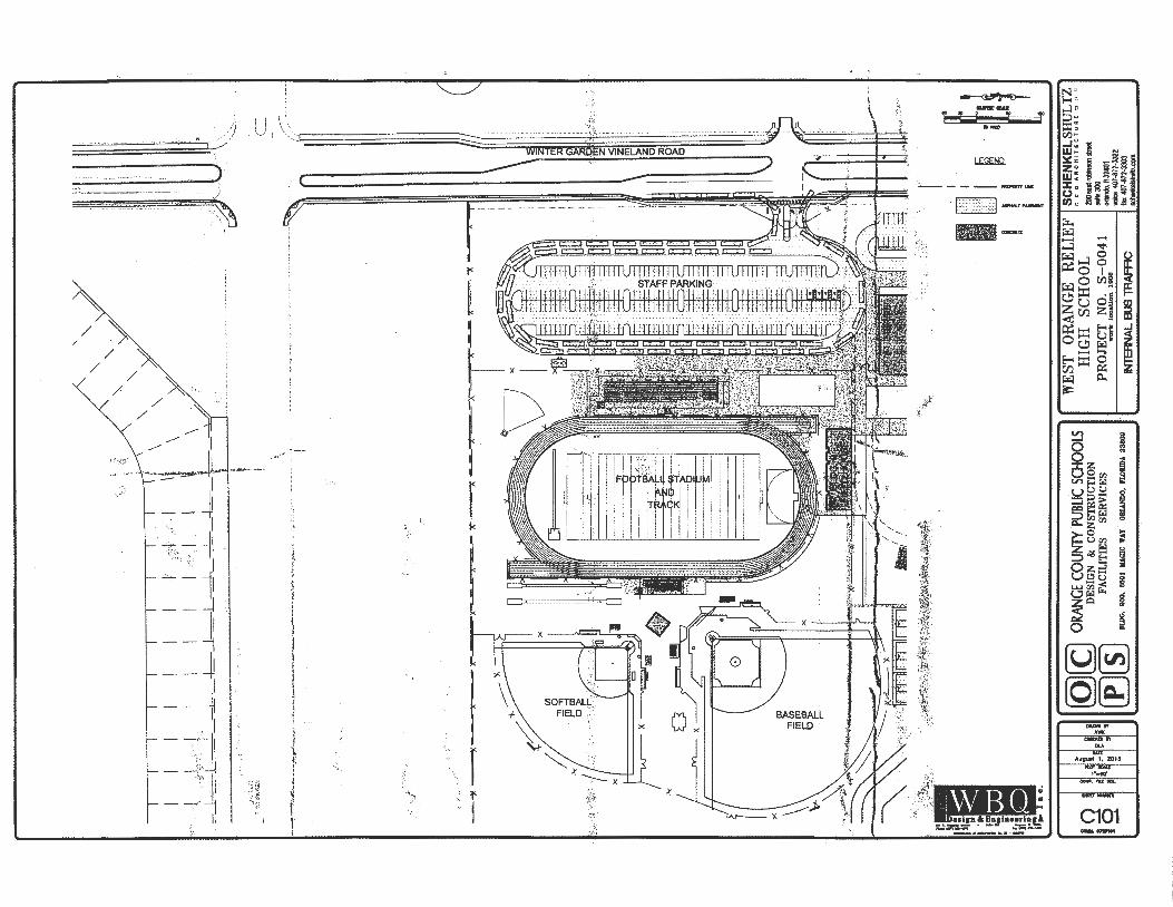
0,'
! '
' \;_
; l
·~ \..
.
. '
--.,
-... , -
.-, -
--.,-
... , -.-
, ---
.,-.... , -
.-, --.
-.,-----
-r l \ ""
I I
I I
I I
I ·'F
~;;~
/:·
I \
\ · .I,
..• ts-:
~:~:-
rL,
I I
I I
I I .
·I
\ //
/
p
'• 1 =-_L~Ld=_-±
-_-b
-_L-
=-~~
--:.
=---
b--r
--:
. .
. t
··~---
---
----
-·-
----
---
---·--
···-------
--·--··-·
-;.,,_,
\
.£en
,1r;
?, tz
6?.
6SN
),..
•.;•
·"-t
''\<J.
i',~
·., ...
. -;~·-'f'
· . .-.
, . .
,,-.
,.
\ ·-
· ... -
--·-~
·---
~-p4
;r~~-··-
.....
--""
""'"""
'''"*'·
·-,..·=
--·~
--,.
.~·.-.
..-... ~.
-.. ,..
"",....
,----
.---
--r -
--···-
·---------~-.-x-~-··-.----------· --·
·---
-:,·
!-:~.-
:. •.
. ~"·~
:.--
,..,. ~/
.,.'
(~-¥
;,_
/ ..,.!
! .~ ,-
ltlh-;
t~""''
·'~"~;
,, -:-·
~r~-... ,
1 ;....
'
~
.-
......
~ .. -
-~
9·F
e ~~
~1:,
~~
1-. g
.
~.,.
. \,I'
~~--
----·
(_
r I .
I~:)
/ I
::::::, I
~ ::::,
:. ~
I ~
I I
i
ill:! f
[Q)(
g ~(ID OR
ANGE
CO
UNTY
PUB
UC S
CHOO
LS
DE
SIG
N
&
CO
NST
RU
CT
ION
FA
CIL
ITIE
S SE
RV
ICE
S
WES
T O
RA
NG
E R
EL
IEF
SC
HE
NK
EL
Sii
llL
TZ
BlD
G.
200,
55
01
KA.G
IC
YA
Y
OR
LlH
DO
, n.
oJID
A.
3280
8
HIG
H
SCH
OO
L ~,:_::.:,::,;'
""'"
"a
PR
OJE
CT
N
O.
S-0
04
1
=3
28
01
w
ork
loea
Uon
18
08
'll:ice
-40 7
..a72
-33t
2
INTE
RN
AL
BUS
TRA
FFIC
fa
x <4
07-B
72-3
303
scllo
nk!ls
iUiz
.com
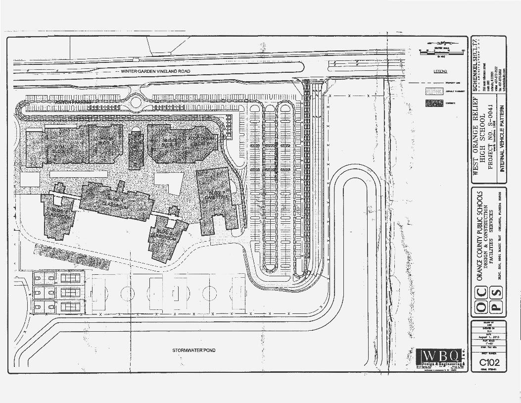
(Jl
,~r~ ;::
!!!:
~ m ~· z D
' .,,·,~·~.t>;W;1;>·
... . ~-.;/'f
~;: ~
·'~'""
" .
. ·~•~
,'illf
.C'f.~
t!i£'!
! . :
.
·'· '' · ~)
liJ!.
"~.\~'
i'~~-'
J.\'Fi
~~]~v"
i"i'''
""'"""
"Y.
pr-t'
~. £ '
-...,.
..;:.·
.y~,r.~
.·::
t·t:· ..
\,
I )( I
.• ,,..
.:·-.:0
.,..•_
:~~
. I I
! 1
\ \'~
i ~ I m z :5
z m ~ D
;n ~
I',, ~
11 ~
I ~
I I
i
•\:.'
·-~~ -
rn-1[ C
) OR
ANGE
CO
UNTY
PUB
UC S
CHOO
LS
WES
T O
RA
NG
E R
EL
IEF
~~!i
f.~!
.Wh~
!Wl:
l.:~
~
DE
SIG
N
&
CO
NS
TR
UC
TIO
N
HIG
H
SCH
OO
L
200o
astrO
Oim
onSI
IOO
I
[f]~
FA
CIL
ITIE
S
SE
RV
ICE
S
PR
OJE
CT
NO
. S
-00
41
"*
300
wor
k·l
ooat
loo
1808
O
fland
o.113
2801
BLD
G.
200,
811
01
IIA
CIC
YA
Y
OII
WID
O
PLOil
lllA a
28
oo
"*"
407-
812·
3322
l
1 1
1 1
1 1
· •
INTE
RN
AL V
EHIC
LE P
AlT
EA
N
""•o
l-87
2-33
03
--

. -·-·--
l c -
--
~ ~
"f•
~ct....,_l!U ... ~?.
.:.-
--------+
-·~
__
__ .... -. .,....u
. (j
1'0
1/
Qlt
(f1
3!\
U.i
-,\
.'!l
ll:O
!J
.tJ.:l
J..'
la
-,_
----
-----
.......
.. ---
------
------
----·
H!f.
a:l
fl
~
.LJt'
l/.1
·---
-----
--·-
-
Y}
' -~
~'
~
'
•':" ,,.,:!
~i' 1/
f ~~=
----
~-=-
--'~
. ..
. ~-
, '
,,'t,jf
;,.,,
·--------
..
. '\
:.:
::
_~;,.,.,
,,._:;iJ
<Ji:"'
·"~-----
{f..
, ---v~ '
\
~1-~
~-
-~
c :....
.:- \ .;
-"
·-)
~!(
···"
•!
~~--
::M.
~
,~-
,..:·
~ ~
.. , ,. "
'{""
j
~
~
lll'
lt'"
lt;r
..'U
.P:l
' -;;.;.~~:·-·;·--.oo~.
i::.:J~ :1 f
ln1[
C) O
RANG
E C
OU
NlY
PUB
UC S
CHOO
LS
WES
T O
RA
NG
E R
EL
IEF
SC
HE
NK
EL
SH
UL
TZ
~
. D
ESI
GN
•·
C
HIG
H
SCH
OO
L
• •" •
•c•
OT
«T
UR
E •"
• "'
O
NST
RU
CTI
ON
20
0out
robi
nsoo
,_
~00
FAC
ILIT
IES
SER
VIC
ES
. P
RO
JEC
T N
O.
S-0
04
1
mao
o w
ork
loca
Uon
lf
l08
orW
MXI,
ft 32
801
l I
I I
I BL
DG
. 20
0,
1160
1 K
AG
IC W
AY
OR
UN
DO
, rL
ORI
DA
. 32
1108
•
• vo
ice 4
07-8
72-3
322
\,. -
-..1
.
. ..J
..
. ...I.
L....J.
. ...J
.I .J
I EX
ISTN
l CO
NTO
URS
AK:
J W
ETl
AN
JS
fax
407-
872-
3303
sc
11er
ice!
s11U
tcom
•J.,~i
i ~~~;~
le~i~
;;;
l t \ ~

EXISTING SOILS - USDA SOIL MAP
CUttotll Soil Rnoun:e Reporl Sol Mop
II~ ~ IIR ~ ~ A. ~ ... ~-:.:..'lt;la.. __ llll_:~
SOILS MAP LEG~ND
4 CANDLER FINE SAND 44 SMYRNA FINE SAND 46 TAVARES FINE SAND
~'
1
EXISTING LAND COVER MAP,
.. ~":-
i ' ..
"
N " f-< "
~ ~ <I)•
..J " i w= ~ ~a~ !lei 6 f;i:<:::J :~ z u l! ~l;p N o w: !5! -: [i~:! :J: o Nto;~ •"'f ~ : iHh01
~ ... ~8 ...... -.j< ..,.::! 0 i'z;:l..,.::~ 0 0 P::o 1!11 ~
0 u:l!! :J c.!:lu o, l'z;:l ::X:: ·~ ~ Z rn Z§ < -p:; ::X:: t;t . ~ 0(.!;! w Cll
.......... ('l E-t:::X::O 2:
rn p;:; ~ l'z;:l j;l.,
~
~ .. §z ; ~§gs ~ uuu . ::I~~ ~ 0:0.... ~ ::l {/l r.l 0 0:. z {/l
~0 ::. urn •
r.l u ::;;>.1/lE=: t; Oz~ 01 Ut!lti ;; LU rij < ~ L:1 r.l""' • ZQ 2 ~ . 0 ~
(g)0 (QJ@;) _ .. ...
ov. 1lf
~1. 2013 .......... AS NOl!D
C104
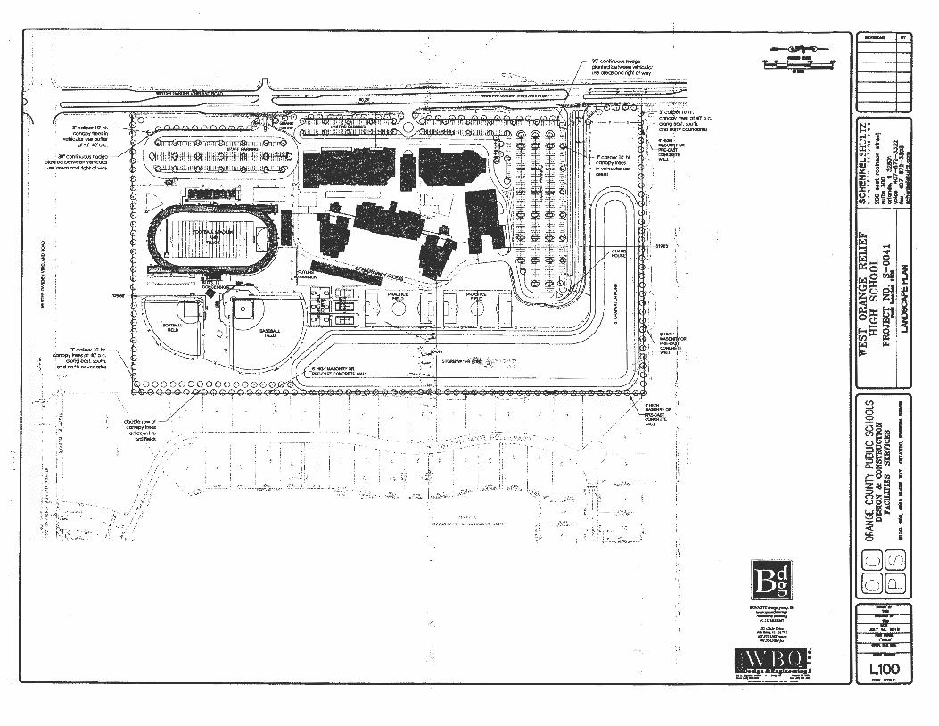
WIN
TER
GA
AO
EN V
INEL
AN
D R
OA
D
c
. ~
,
.....
: .. ...
.:: .·:
·:..: -,
;:::
;·-:-~
-··
··--
.. ·
·-:
.--
:.--..
.-:-
-=.:
:·~
--·
-'.
,--;-
..........
...... _
_,.;-
··--::--.
'-i_C_.t....~.-'-.
&....L.J'-i-Q~-
~~s_:?~_!_OR-A-N
DG-~-1 GC-£ll-~TY-c-o~-~-
B~-C-CI'I-.S~-~-O-
OL-SJ '---WE-S..:J~
IG:.:OH:.:RAN:::S::.
C.:~.:..:~::O:.:.RL_
E_LI_E_F _
_,L=:!~~:..~!=!!!!:~
~~~~~~'~i:~_·_·T·_J~ ~m~
j 8
-FA
CIL
J.TI
ES
S
ER
VIC
ES
PR
OJE
,£'t ~ ,1-
0041
ou
lto
300
·
....
. -
....
-n
T -· ,_
-t---
---'
--=~=~~
----..
......
J ~7=
~~33
22
I..A
f«)8
CN
'E P
LAN
=-
"""~
;~~~


