Embed Size (px)
Citation preview
II 1 II 1 II 1 1111101101,1, 110 1)0110 110111111411,11111Document Control Sheet
Sheet Title:Box ID:Control Sheet ID:Record Series Name:Record Series:Primary ID:Secondary ID:Doc Type:Security:Date:Title:Tertiary ID
1IIIMSW SUB T - OLS176520000-0000-0049-4135WST / Municipal Solid Waste Sub TMSW SUB T67022
ApplicationsPublic9/23/2020 12:00AMApplications
I I0 II

NOTICE
OF
DOCUMENTQUALITY
TEXAS COMMISSION ONENVIRONMENTAL QUALITY
THE QUALITY OF THE FOLLOWING ORIGINAL PAPERDOCUMENT(S) WAS SUCH THAT ALL OR PORTIONS OF THE
SCANNED IMAGE
MAY BE DIFFICULT TO READ OR ILLEGIBLE.
Some reasons for poor quality:
There are multiple densities per page, different types of ink, faded document, and some documents are different colors. Many of the photographs, charts, graphs, maps are of poor
quality.
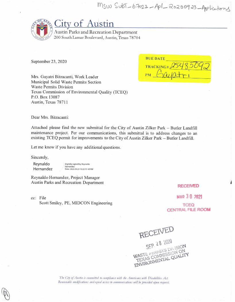
Insw obl, blval — Apt— Roa 09 023 —Arplic,,Arr
City of Austin Austin Parks and Recreation Department200 South Lamar Boulevard, Austin, Texas 78704
September 23, 2020
Mrs. Gayatri Bitracanti, Work LeaderMunicipal Solid Waste Permits SectionWaste Permits DivisionTexas Commission of Environmental Quality (TCEQ)P.O. Box 13087Austin, Texas 78711
Dear Mrs. Bitracanti:
DUE DATE
TRACKING # a5-e 3 56q02 PM (1)Ckijia-+I--
Attached please find the new submittal for the City of Austin Zilker Park — Butler Landfillmaintenance project. Per our communications, this submittal is to address changes to anexisting TCEQ permit for improvements to the City of Austin Zilker Park — Butler Landfill.
Let me know if you have any additional questions.
Sincerely,
ReynaldoHernandez
Digitally signed by ReynaldoHernandezDate: 2020.09.23 1122:15 05'00'
Reynaldo Hernandez, Project ManagerAustin Parks and Recreation Department
RECEIVED
cc: FileScott Smiley, PE, MEDCON Engineering
MAR 30 7021TCEQ
CENTRAL FILE ROOM
Rta 5.)
SE?• I.% la
Watt. CS I)
0,15.014
COI*SSIOINI OIL
EIV11101°aW."M, QUAIA
The Go of Austin is committed to compliance with the Americans with Disabilities ActReasonable modifications and equal access to communications will be pivnided upon request.
11Mili -.OMEN
F
TCEQ
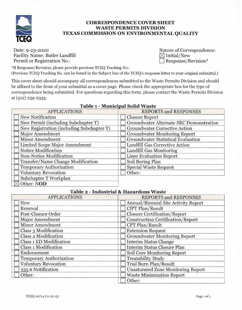
CORRESPONDENCE COVER SHEETWASTE PERMITS DIVISION
TEXAS COMMISSION ON ENVIRONMENTAL QUALITY
Date: 9-23-2020 Nature of Correspondence:Facility Name: Butler Landfill [Z] Initial/NewPermit or Registration No.: EIResponse/Revision*
*If Response/Revision, please provide previous TCEQ Tracking No.:(Previous TCEQ Tracking No. can be found in the Subject line of the TCEQ's response letter to your original submittal.)
This cover sheet should accompany all correspondences submitted to the Waste Permits Division and shouldbe affixed to the front of your submittal as a cover page. Please check the appropriate box for the type ofcorrespondence being submitted. For questions regarding this form, please contact the Waste Permits Divisionat (512) 239-2335.
Table 1- Municipal Solid WasteAPPLICATIONS REPORTS and RESPONSES
LI New Notification LI Closure ReportLI New Permit (including Subchapter T) LI Groundwater Alternate SRC DemonstrationLI New Registration (including Subchapter T) LI Groundwater Corrective ActionLI Major Amendment LI Groundwater Monitoring ReportLI Minor Amendment LI Groundwater Statistical EvaluationLI Limited Scope Major Amendment LI Landfill Gas Corrective ActionLI Notice Modification LI Landfill Gas MonitoringLI Non-Notice Modification LI Liner Evaluation ReportLI Transfer/Name Change Modification LI Soil Boring PlanLI Temporary Authorization LI Special Waste RequestLI Voluntary Revocation LI Other:LI Subchapter T Workplan
Other: NOD
Table 2 - Industrial & Hazardous WasteAPPLICATIONS REPORTS and RESPONSES
LI New LI Annual/Biennial Site Activity ReportLI Renewal LI CfPT Plan/ResultLI Post-Closure Order LI Closure Certification/ReportLI Major Amendment LI Construction Certification/ReportLI Minor Amendment LI CPT Plan/ResultLI Class 3 Modification LI Extension RequestLI Class 2 Modification LI Groundwater Monitoring ReportLI Class 1 ED Modification LI Interim Status ChangeLI Class 1 Modification LI Interim Status Closure PlanLI Endorsement LI Soil Core Monitoring ReportLI Temporary Authorization LI Treatability StudyLI Voluntary Revocation LI Trial Burn Plan/ResultLI 335.6 Notification LI Unsaturated Zone Monitoring ReportLI Other: LI Waste Minimization Report
LI Other:
TCEQ-20714 (11-23-15) Page 1 of 1
• k •
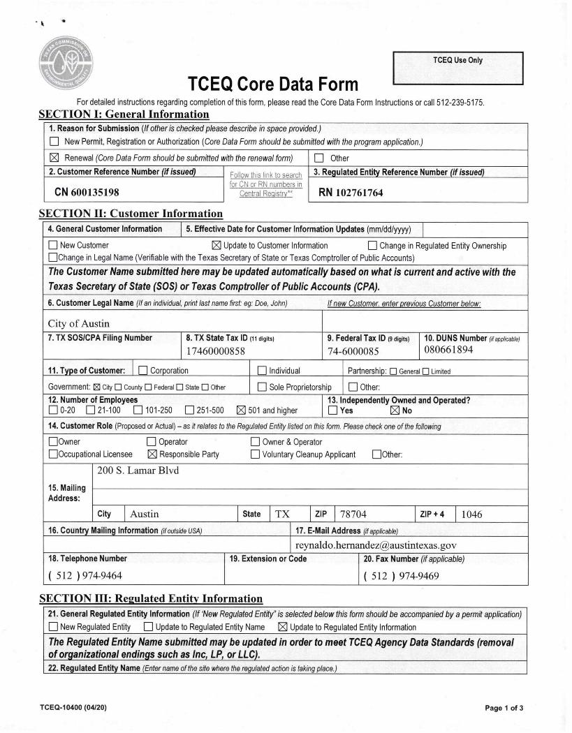
TCEQ Core Data Form
TCEQ Use Only
For detailed instructions regarding completion of this form, please read the Core Data Form Instructions or call 512-239-5175.
SECTION I: General Information 1. Reason for Submission (If other is checked please describe in space provided.)
0 New Permit, Registration or Authorization (Core Data Form should be submitted with the program application.)
1E Renewal (Core Data Form should be submitted with the renewal form) 0 Other
2. Customer Reference Number (if issued)
CN 600135198
Follow this link to search for ON or RN numbers in
Central Registry**
3. Regulated Entity Reference Number (if issued)
RN 102761764
SECTION II: Customer Information
4. General Customer Information 5. Effective Date for Customer Information Updates (mm/dd/yyyy)
fl New CustomerChange in Legal Name (Verifiable with the Texas
'Update to Customer Information Change in Regulated Entity Ownership
Secretary of State or Texas Comptroller of Public Accounts)
The Customer Name submitted here may be updated automatically based on what is current and active with theTexas Secretary of State (SOS) or Texas Comptroller of Public Accounts (CPA).
6. Customer Legal Name (If an individual, print last name first: eg: Doe, John) If new Customer, enter previous Customer below:
City of Austin
7. TX SOS/CPA Filing Number 8. TX State Tax !Dot digits)
17460000858
9. Federal Tax ID (9 digits)
74-6000085
10. DUNS Number (if applicable)080661894
11. Type of Customer: fl Corporation U Individual Partnership: 0 Genera 0 Limited
Government: (2) City El County 0 Federal Cl State 0 Other 0 Sole Proprietorship 0 Other:
12. Number of Employees0-20 21-100 101-250 0 251-500 ii 501 and higher
13. Independently0 Yes
Owned'
and Operated?No
14. Customer Role (Proposed or Actual) — as it relates to the Regulated Entity listed on this form. Please check one of the following
fl OwnerOccupational Licensee'
Operator 0 Owner & Operator
Responsible Party Voluntary Cleanup Applicant Other:
15. MailingAddress:
200 S. Lamar Blvd
City Austin State TX ZIP 78704 ZIP +4 1046
16. Country Mailing Information (if outside usa) 17. E-Mail Address (if applicable)
reynaldo.hernandezgaustintexas.gov
18. Telephone Number
( 512 ) 974-9464
19. Extension or Code 20. Fax Number (if applicable)
( 512 ) 974-9469
SECTION III: Regulated Entity Information
21. General Regulated Entity Information (If 'New Regulated Entity" is selected below this form should be accompanied by a permit application)
0 New Regulated Entity 0 Update to Regulated Entity Name Z Update to Regulated Entity Information
The Regulated Entity Name submitted may be updated in order to meet TCEQ Agency Data Standards (removalof organizational endings such as Inc, LP, or LLC). 22. Regulated Entity Name (Enter name of the site where the regulated action is taking place.)
TCEQ-10400 (04/20) Page 1 of 3
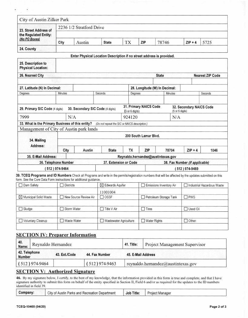
City of Austin Zilker Park
23. Street Address ofthe Regulated Entity:(No PO Boxes)
2236 1/2 Stratford Drive
City Austin State TX ZIP 78746 ZIP + 4 5725
24. County
Enter Physical Location Description if no street address is provided.
25. Description toPhysical Location:
26. Nearest City State Nearest ZIP Code
27. Latitude (N) In Decimal: 28. Longitude (W) In Decimal:Degrees Minutes Seconds Degrees Minutes Seconds
29. Primary SIC Code (4 digits) 30. Secondary SIC Code (4 digits) 31. Primary NAICS Code 32. Secondary NAICS Code(5 or 6 digits) (5 or 6 digits)
7999 N/A 924120 N/A
33. What is the Primary Business of this entity? (Do not repeat the SIC or NAICS description.)
Management of City of Austin park lands
34. Mailing
Address:
200 South Lamar Blvd.
City Austin State TX ZIP 78704 ZIP + 4 1046
35. E-Mail Address: [email protected]
36. Telephone Number 37. Extension or Code 38. Fax Number (if applicable)
( 512 ) 974-9464 ( 512 ) 974-9469
39. TCEQ Programs and ID Numbers Check all Programs and write in the permits/registration numbers that will be affected by the updates submitted on thisform. See the Core Data Form instructions for additional guidance.
• Dam Safety •Districts Edwards Aquifer •Emissions Inventory Air •Industrial Hazardous Waste
11001004
Municipal Solid Waste •New Source Review Air •OSSF •Petroleum Storage Tank U PWS
M Sludge MI Storm Water M Title V Air •Tires IN Used Oil
M Voluntary Cleanup •Waste Water •Wastewater Agriculture •Water Rights •Other:
SECTION IV: Preparer Information
40.Name: Reynaldo Hernandez 41. Title: Project Management Supervisor
42. TelephoneNumber
43. ExtJCode 44. Fax Number 45. E-Mail Address
( 512 ) 974-9464 ( 512)974-9463 [email protected]
SECTION V: Authorized Signature 46. By my signature below, I certify, to the best of my knowledge, that the information provided in this form is true and complete, and that I havesignature authority to submit this form on behalf of the entity specified in Section II, Field 6 and/or as required for the updates to the ID numbersidentified in field 39.
Company: City of Austin Parks and Recreation Department Job Title: Project Manager
TCEQ-10400 (04/20) Page 2 of 3

Name (In Print): Reynaldo Hernandez Phone: ( 512 ) 974- 9464
Signature:Digitally signed by Reynaldo
Reynaldo Hernandez H.n.nd.Date. 2020.09/313.2/25 -0500 Date:
TCEQ-10400 (04/20) Page 3 of 3
10
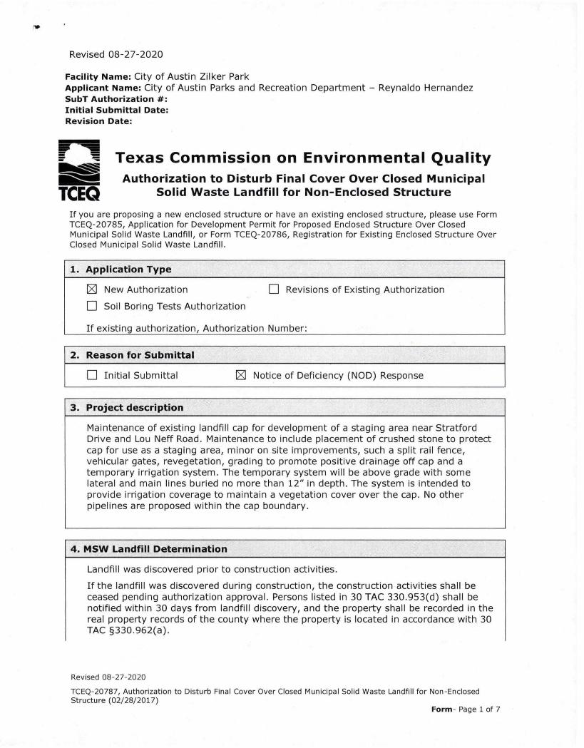
Revised 08-27-2020
Facility Name: City of Austin Zilker ParkApplicant Name: City of Austin Parks and Recreation Department — Reynaldo HernandezSubT Authorization #:Initial Submittal Date:Revision Date:
irmwimo . Texas Commission on Environmental Quality---,...., Authorization to Disturb Final Cover Over Closed Municipal
TCEO Solid Waste Landfill for Non-Enclosed Structure
If you are proposing a new enclosed structure or have an existing enclosed structure, please use FormTCEQ-20785, Application for Development Permit for Proposed Enclosed Structure Over ClosedMunicipal Solid Waste Landfill, or Form TCEQ-20786, Registration for Existing Enclosed Structure OverClosed Municipal Solid Waste Landfill.
1. Application Type
El New Authorization1=1 Soil Boring Tests Authorization
0 Revisions of Existing Authorization
If existing authorization, Authorization Number:
2. Reason for Submittal
1=1 Initial Submittal N Notice of Deficiency (NOD) Response
3. Project description
Maintenance of existing landfill cap for development of a staging area near StratfordDrive and Lou Neff Road. Maintenance to include placement of crushed stone to protectcap for use as a staging area, minor on site improvements, such a split rail fence,vehicular gates, revegetation, grading to promote positive drainage off cap and atemporary irrigation system. The temporary system will be above grade with somelateral and main lines buried no more than 12" in depth. The system is intended toprovide irrigation coverage to maintain a vegetation cover over the cap. No otherpipelines are proposed within the cap boundary.
4. MSW Landfill Determination
Landfill was discovered prior to construction activities.
If the landfill was discovered during construction, the construction activities shall beceased pending authorization approval. Persons listed in 30 TAC 330.953(d) shall benotified within 30 days from landfill discovery, and the property shall be recorded in thereal property records of the county where the property is located in accordance with 30TAC §330.962(a).
Revised 08-27-2020
TCEQ-20787, Authorization to Disturb Final Cover Over Closed Municipal Solid Waste Landfill for Non-EnclosedStructure (02/28/2017)
Form- Page 1 of 7
ir
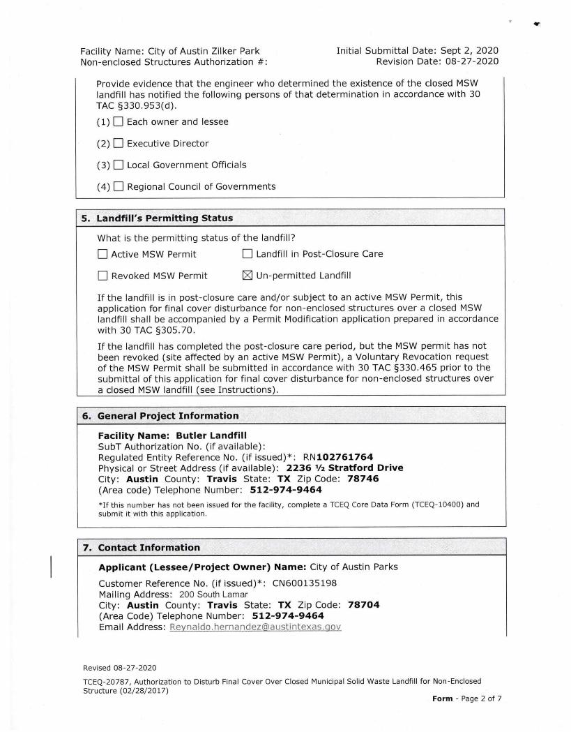
Facility Name: City of Austin Zilker Park Initial Submittal Date: Sept 2, 2020Non-enclosed Structures Authorization #: Revision Date: 08-27-2020
Provide evidence that the engineer who determined the existence of the closed MSWlandfill has notified the following persons of that determination in accordance with 30TAC §330.953(d).
(1) Each owner and lessee
(2) 1=1 Executive Director
(3) 1=1 Local Government Officials
(4) El Regional Council of Governments
5. Landfill's Permitting Status
What is the permitting status of the landfill?
I=1 Active MSW Permit Landfill in Post-Closure Care
Revoked MSW Permit Un-permitted Landfill
If the landfill is in post-closure care and/or subject to an active MSW Permit, thisapplication for final cover disturbance for non-enclosed structures over a closed MSWlandfill shall be accompanied by a Permit Modification application prepared in accordancewith 30 TAC §305.70.
If the landfill has completed the post-closure care period, but the MSW permit has notbeen revoked (site affected by an active MSW Permit), a Voluntary Revocation requestof the MSW Permit shall be submitted in accordance with 30 TAC §330.465 prior to thesubmittal of this application for final cover disturbance for non-enclosed structures overa closed MSW landfill (see Instructions).
6. General Project Information
Facility Name: Butler LandfillSubT Authorization No. (if available):Regulated Entity Reference No. (if issued)*: RN102761764Physical or Street Address (if available): 2236 1/2 Stratford DriveCity: Austin County: Travis State: TX Zip Code: 78746(Area code) Telephone Number: 512-974-9464
*If this number has not been issued for the facility, complete a TCEQ Core Data Form (TCEQ-10400) andsubmit it with this application.
7. Contact Information
Applicant (Lessee/Project Owner) Name: City of Austin Parks
Customer Reference No. (if issued)*: CN600135198Mailing Address: 200 South LamarCity: Austin County: Travis State: TX Zip Code: 78704(Area Code) Telephone Number: 512-974-9464Email Address: Reynaldo.hernandez©austintexas.qov
Revised 08-27-2020
TCEQ-20787, Authorization to Disturb Final Cover Over Closed Municipal Solid Waste Landfill for Non-Enclosed
Structure (02/28/2017)Form - Page 2 of 7
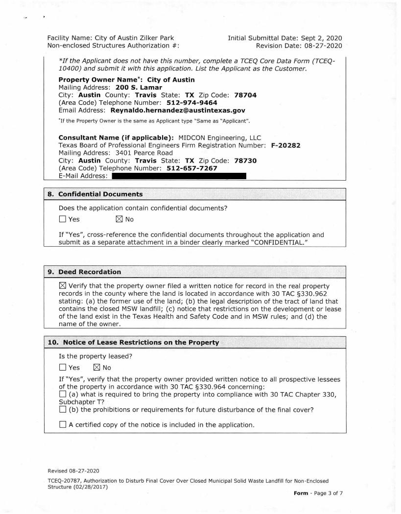
Facility Name: City of Austin Zilker Park Initial Submittal Date: Sept 2, 2020Non-enclosed Structures Authorization #: Revision Date: 08-27-2020
*If the Applicant does not have this number, complete a TCEQ Core Data Form (TCEQ-10400) and submit it with this application. List the Applicant as the Customer.
Property Owner Name*: City of AustinMailing Address: 200 S. LamarCity: Austin County: Travis State: TX Zip Code: 78704(Area Code) Telephone Number: 512-974-9464Email Address: [email protected]
*If the Property Owner is the same as Applicant type "Same as "Applicant".
Consultant Name (if applicable): MIDCON Engineering, LLCTexas Board of Professional Engineers Firm Registration Number: F-20282Mailing Address: 3401 Pearce RoadCity: Austin County: Travis State: TX Zip Code: 78730(Area Code) Telephone Number: 512-657-7267E-Mail Address:
8. Confidential Documents
Does the application contain confidential documents?
El Yes El No
If "Yes", cross-reference the confidential documents throughout the application andsubmit as a separate attachment in a binder clearly marked "CONFIDENTIAL."
9. Deed Recordation
E] Verify that the property owner filed a written notice for record in the real propertyrecords in the county where the land is located in accordance with 30 TAC §330.962stating: (a) the former use of the land; (b) the legal description of the tract of land thatcontains the closed MSW landfill; (c) notice that restrictions on the development or leaseof the land exist in the Texas Health and Safety Code and in MSW rules; and (d) thename of the owner.
10. Notice of Lease Restrictions on the Property
Is the property leased?
O Yes N NoIf "Yes", verify that the property owner provided written notice to all prospective lesseesof the property in accordance with 30 TAC §330.964 concerning:O (a) what is required to bring the property into compliance with 30 TAC Chapter 330,Subchapter T?O (b) the prohibitions or requirements for future disturbance of the final cover?
O A certified copy of the notice is included in the application.
Revised 08-27-2020
TCEQ-20787, Authorization to Disturb Final Cover Over Closed Municipal Solid Waste Landfill for Non-EnclosedStructure (02/28/2017)
Form - Page 3 of 7
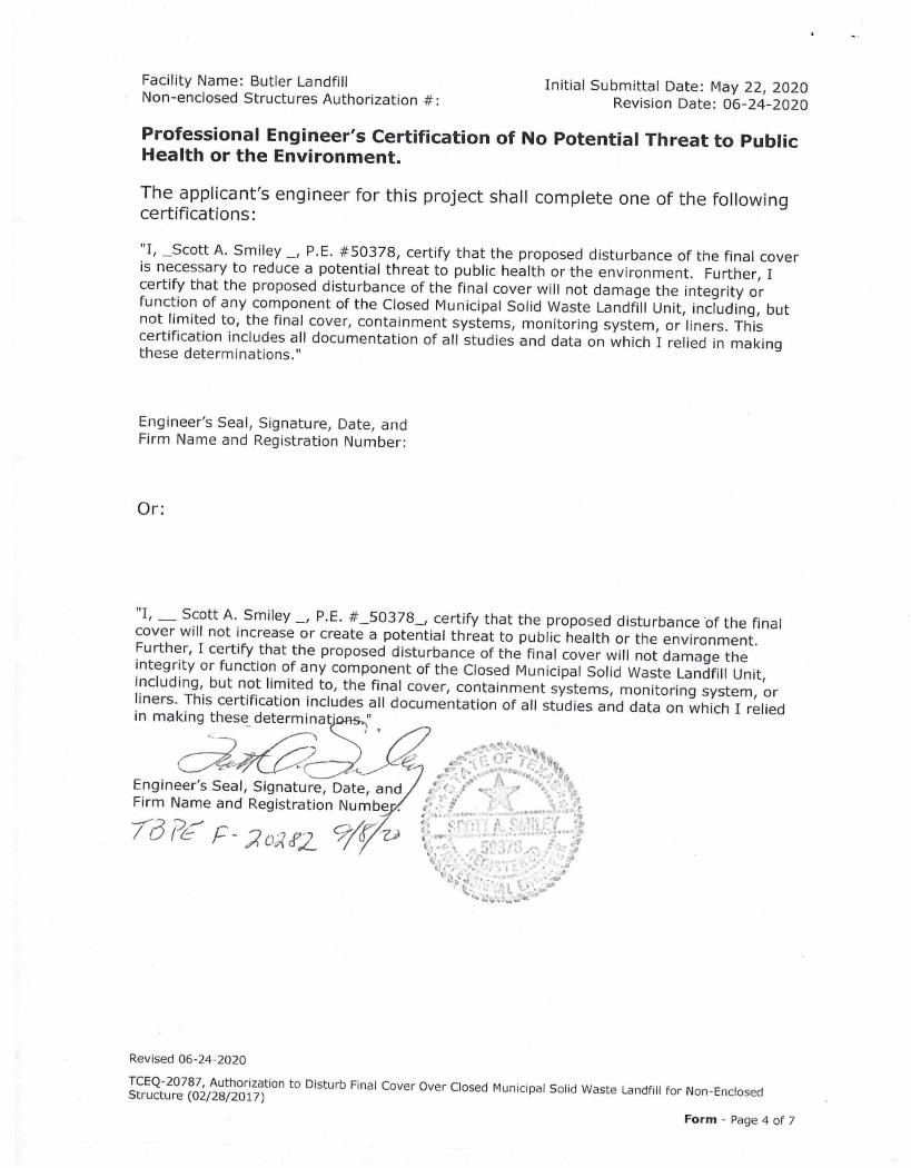
Facility Name: Butler Landfill Initial Submittal Date: May 22, 2020Non-enclosed Structures Authorization #: Revision Date: 06-24-2020
Professional Engineer's Certification of No Potential Threat to PublicHealth or the Environment.
The applicant's engineer for this project shall complete one of the followingcertifications:
"I, _Scott A. Smiley _, P.E. #50378, certify that the proposed disturbance of the final coveris necessary to reduce a potential threat to public health or the environment. Further, Icertify that the proposed disturbance of the final cover will not damage the integrity orfunction of any component of the Closed Municipal Solid Waste Landfill Unit, including, butnot limited to, the final cover, containment systems, monitoring system, or liners. Thiscertification includes all documentation of all studies and data on which I relied in makingthese determinations."
Engineer's Seal, Signature, Date, andFirm Name and Registration Number:
Or:
"I, Scott A. Smiley _, P.E. #_50378_, certify that the proposed disturbance of the finalcover will not increase or create a potential threat to public health or the environment.Further, I certify that the proposed disturbance of the final cover will not damage theintegrity or function of any component of the Closed Municipal Solid Waste Landfill Unit,including, but not limited to, the final cover, containment systems, monitoring system, orliners. This certification includes all documentation of all studies and data on which I reliedin making these determinats.,
Engineer's Seal, Seal, Signature, Date, andFirm Name and Registration Numbe
Revised 06-24-2020
TCEQ-20787, Authorization to Disturb Final Cover Over Closed Municipal Solid Waste Landfill for Non-EnclosedStructure (02/28/2017)
Form - Page 4 of 7

Facility Name: City of Austin Zilker Park Initial Submittal Date: Sept 2, 2020Non-enclosed Structures Authorization #: Revision Date: 08-27-2020
Signature Page
I, _Reynaldo Hernandez, Project Manager(Applicant/Property Owner or Project Owner) (Title)
certify under penalty of law that this document and all attachments were prepared undermy direction or supervision in accordance with a system designed to assure that qualifiedpersonnel properly gather and evaluate the information submitted. Based on my inquiry ofthe person or persons who manage the system, or those persons directly responsible forgathering the information, the information submitted is, to the best of my knowledge andbelief, true, accurate, and complete. I am aware there are significant penalties forsubmitting false inform tion, inc ding the possibility of fine and imprisonment for knowingviolations.
Signature: Date: 7 - Z • zotc,
SUBSCRIBED AND SWORN to before me by the said
(9\t‘t On this day of5r4e0f, 2:52L5
My onnmission pires on the (V\- day of JUir , 702_1+
of-Otary Public in and for
"Fro/ County, Texas(Note: Application Must Bear Signature & Seal of Notary Public)
TANIA KINTYSEON% ,t.Notary Public, State of
Comm. Expires 08-18-2024
8.1.
TO% Neter If) 132527835no%
Revised 08-27-2020
TCEQ-20787, Authorization to Disturb Final Cover Over Closed Municipal Solid Waste Landfill for Non-EnclosedStructure (02/28/2017)
Form - Page 5 of 7
Facility Name: City of Austin Zilker Park Initial Submittal Date: Sept 2, 2020Non-enclosed Structures Authorization #: Revision Date: 08-27-2020
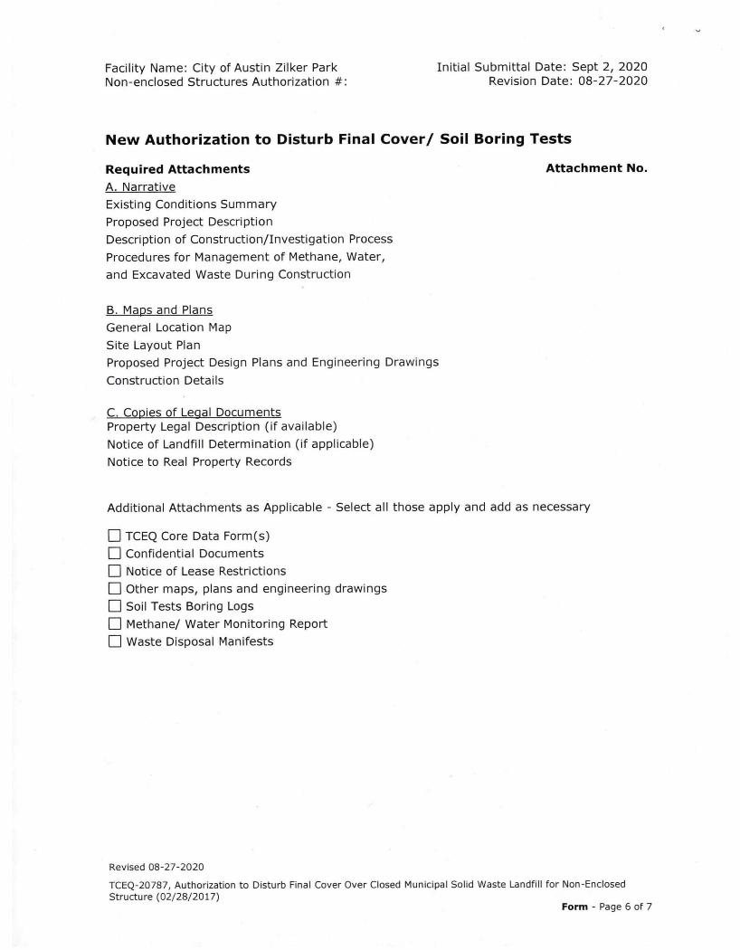
New Authorization to Disturb Final Cover/ Soil Boring Tests
Required Attachments
A. Narrative
Existing Conditions Summary
Proposed Project Description
Description of Construction/Investigation Process
Procedures for Management of Methane, Water,
and Excavated Waste During Construction
B. Maps and Plans
General Location Map
Site Layout Plan
Proposed Project Design Plans and Engineering Drawings
Construction Details
C. Copies of Legal Documents Property Legal Description (if available)
Notice of Landfill Determination (if applicable)
Notice to Real Property Records
Attachment No.
Additional Attachments as Applicable - Select all those apply and add as necessary
• TCEQ Core Data Form(s)
• Confidential Documents
• Notice of Lease Restrictions
El Other maps, plans and engineering drawings
Soil Tests Boring Logs
El Methane/ Water Monitoring ReportLI Waste Disposal Manifests
Revised 08-27-2020
TCEQ-20787, Authorization to Disturb Final Cover Over Closed Municipal Solid Waste Landfill for Non-Enclosed
Structure (02/28/2017)Form - Page 6 of 7
Facility Name: City of Austin Zilker Park Initial Submittal Date: Sept 2, 2020Non-enclosed Structures Authorization #: Revision Date: 08-27-2020
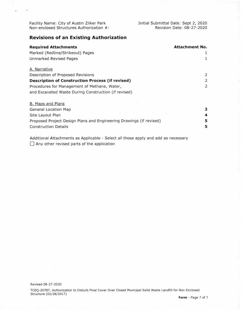
Revisions of an Existing Authorization
Required Attachments Attachment No.
Marked (Redline/Strikeout) Pages 1
Unmarked Revised Pages 1
A. Narrative
Description of Proposed Revisions 2
Description of Construction Process (if revised) 2
Procedures for Management of Methane, Water, 2
and Excavated Waste During Construction (if revised)
B. Maps and Plans
General Location Map 3
Site Layout Plan 4
Proposed Project Design Plans and Engineering Drawings (if revised) 5
Construction Details 5
Additional Attachments as Applicable - Select all those apply and add as necessary
E] Any other revised parts of the application
Revised 08-27-2020
TCEQ-20787, Authorization to Disturb Final Cover Over Closed Municipal Solid Waste Landfill for Non-EnclosedStructure (02/28/2017)
Form - Page 7 of 7
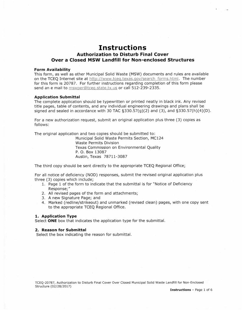
InstructionsAuthorization to Disturb Final Cover
Over a Closed MSW Landfill for Non-enclosed Structures
Form AvailabilityThis form, as well as other Municipal Solid Waste (MSW) documents and rules are availableon the TCEQ Internet site at http://www.tceo.texas.gov/search forms.html. The numberfor this form is 20787. For further instructions regarding completion of this form pleasesend an e mail to mswperPtcecbstate.tx.us or call 512-239-2335.
Application SubmittalThe complete application should be typewritten or printed neatly in black ink. Any revisedtitle pages, table of contents, and any individual engineering drawings and plans shall besigned and sealed in accordance with 30 TAC §330.57(g)(2) and (3), and §330.57(h)(4)(D).
For a new authorization request, submit an original application plus three (3) copies asfollows:
The original application and two copies should be submitted to:Municipal Solid Waste Permits Section, MC124Waste Permits DivisionTexas Commission on Environmental QualityP. 0. Box 13087Austin, Texas 78711-3087
The third copy should be sent directly to the appropriate TCEQ Regional Office;
For all notice of deficiency (NOD) responses, submit the revised original application plusthree (3) copies which include;
1. Page 1 of the form to indicate that the submittal is for "Notice of DeficiencyResponse;"
2. All revised pages of the form and attachments;3. A new Signature Page; and4. Marked (redline/strikeout) and unmarked (revised clean) pages, with one copy sent
to the appropriate TCEQ Regional Office.
1. Application TypeSelect ONE box that indicates the application type for the submittal.
2. Reason for SubmittalSelect the box indicating the reason for submittal.
TCEQ-20787, Authorization to Disturb Final Cover Over Closed Municipal Solid Waste Landfill for Non-EnclosedStructure (02/28/2017)
Instructions — Page 1 of 6
1111f,111 III
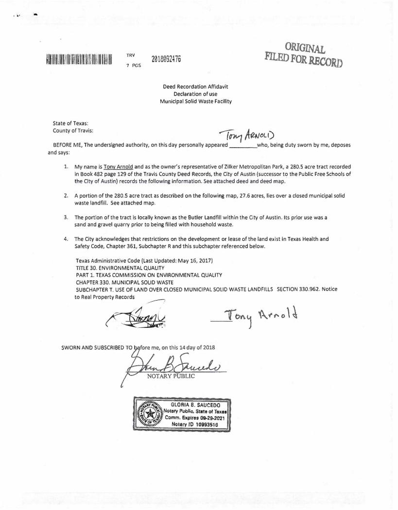
State of Texas:
County of Travis:
TRV2018092476
7 PGS
Deed Recordation Affidavit
Declaration of use
Municipal Solid Waste Facility
ORIGNALFILED FOR WOW)
CL ()
BEFORE ME, The undersigned authority, on this day personally appeared who, being duty sworn by me, deposes
and says:
1. My name is Tony Arnold and as the owner's representative of Zilker Metropolitan Park, a 280.5 acre tract recorded
In Book 482 page 129 of the Travis County Deed Records, the City of Austin (successor to the Public Free Schools of
the City of Austin) records the following information. See attached deed and deed map.
2. A portion of the 280.5 acre tract as described on the following map, 27.6 acres, lies over a closed municipal solid
waste landfill. See attached map.
3. The portion of the tract is locally known as the Butler Landfill within the City of Austin. Its prior use was a
sand and gravel quarry prior to being filled with household waste.
4. The City acknowledges that restrictions on the development or lease of the land exist in Texas Health and
Safety Code, Chapter 361, Subchapter R and this subchapter referenced below.
Texas Administrative Code (Last Updated: May 16, 2017)
TITLE 30. ENVIRONMENTAL QUALITY
PART 1. TEXAS COMMISSION ON ENVIRONMENTAL QUALITY
CHAPTER 330. MUNICIPAL SOLID WASTE
SUBCHAPTER T. USE OF LAND OVER CLOSED MUNICIPAL SOLID WASTE LANDFILLS SECTION 330.962. Notice
to Real Property Records
SWORN AND SUBSCRIBED TO
A AlAin".6.44.4arNOTARY PUBLIC
fore me, on this 14 day of 2018
Tort I 'I\ o
4.rp0.,,, GLORIA B. SAUCEDO0:4ASNotary Public. State of Texas
Comm. Expires 09-294021Wary ID 10993516
. . • .•
•
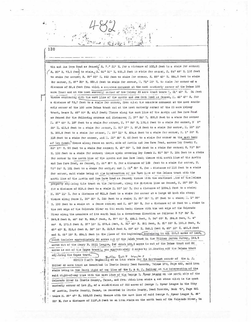
130
1".:t-
..• •
,%7 •.
r ;
; 41.4
tin and ice cave Road as fenoed 3. Z. for a uihtonoe of 333.5 feet to a stake :or acrncr;
(3. 83' 2. 73.5 fee) to stahe.; 3. 66• 7. 930.3 feet .o etuhe for corner, 3. 24' 48' 7. 135 feet
to stake for corner; S. 89' 05' .f. 960 feet to stake :or corns:. 3. 85' 40' 7. 294.5 feet to stoke
21r corner, 15. 87 30' 7. 550.6 feet to stake for corner, .7. 71' :4' TI. to h.oke :or corner .o.0 a
distance of 89.4 feet fron ohich a othlra.• noruwnt at the nost ruuthorV corner of the Bohne 100
eare. Treat and at the =oat eastar'_•,• co.:--nr of the I:olony 25 acre tract boars 40, 7. 34 :eat_. -.-thence oontinuln.; clth the eeat :Liza of the Isuhtin and dee Cava :1oad as fenced, I:. 46' 47' 7. for
a 'lista-Doe of 72.7 feet to a sake for corner, fret/ n_ieh t..a ocnorote nom:cant at the lost aouth-
only corner of the 100 acre 7o treat on:. et the host oanterly acctor of the 25 acre 1:o1ony
tract, bears 3. 65' 30, 3. 42.3 feat; :1-ence alunc tue oast line of the oat1 LflO 3ee Zaire Zoe
as fenced for the follo4in5 ootrasa end /Ill/Lances; 17. 37' 24' 7. 228.5 Net to a stake for corner
::. 45' V. 187 feet to a stake for col-ner, 17. 7' 24" 7, 122.3 feet to a ateke for corner, 77 0'
«. 413.6 feet to stake foz zomor. 17. 21' 17, a. 37.8 feet to a stake for corner, 74 33' 11'
7. 305.8 feet to a stake :or oOmer. 20' 11' TI. 5.34.4 feet to C stake for corner, N. 1' 32, E.
113 feat to a stake for carter. and ::. 28' 27. 62 feet to a etahe for corner en the islet bank
of :-./ry Creek;‘thence alma; fence on razts: aide of ..uetin nod .A00 Cave :load, across 7.r7' Creek; 1.7.
63' 17/ 77. 95 feet to a stake for co=tr; S. 4.9' 00' 7. 549 feet to a otako for corner; S. 73' 55'
U. 132 feet to a stake for corner; %;har_ne azein crossing M•y Creek if. 83' 56' 7. 104 feet to a :take
for corner in the north line of the ;.:.stit and 3es Cave ..oed; thence uith north line of Lk.: Austin
an1 Bee Cave /Wed, as fenced, tr. 66' V• 7. for a distance of 14 feet to a stake for cot-ter, IT.
73' 04' 77. 131 feet to a stake for corr-r; end 77. :Li° 50' 0. for - distonoe of 112 feet to a stake
for corner, said stake being at 1h:4C/soot/on 0: the East line of the :alone tract -4th the
north line of the .1.Jetin and Bea cave load tos fenoed; thence •./ith the southeast -ins of toe ::elana- _
property adj...Inlne Lis tract cra tte1-orthnust, c1on3 the division line es fenced, 11. 35' 35/ !.:.
for a distance of 919.6 feet to a steLls Z. 33' 14' 3. for a eliatonoe of 1004.1 teat to e stake;
11. 35' 11' 3. for a aistance of 911.9 feet to a stake :or °a:nor at a large 48 inch elm sturnp;
thence alanz fence 17. 35' 30' :7. 32) Net to a stake; 77. n' co, -.T. 27 feet to c stake; .. 1° 00'
U. 100 Net to a stake at a fence co; and. i1. 46' 50' E. for a &inter/De o: 4.5 feet to /.. stake in
the oat edga of the Colorado on it; south hank; thence tith the net adGe of the Colorado
3ivar along the neanaere of its 50112: ban:- in a dormatreen direction as follons: 3 7e 24' Z.
395.5 feet 8. 46' 54' E. 555.7 :eat, 2. 57' 01' 3. 298.1 feet, 5. 34• 05' E. 294.8 feat, S. 4'
oo" 77. 173.5 feet S. 57' 10' 3. 570.4 Net, S. 31' 40" E. 231 feet, S. 51' 02' E. 105.2 feet, 5.
40' 45' E. 312.6 foot S. 38' 1.8 1 E. 4.5.8 Net S. 2.2" 42' Z. 546.1 feet S. 65' 10' Z. 400.5 feet
and 3. GO • 15' E. 284.1 Met to 12-..e ;leen of t14 bosinning in all 583.5 sores of land,
6/71-1oh inoluCes appro=ately BO aorea 0.1 of the .41sh treat in toe 77_11.1_1aa2orton 3urvey,_
cores out of the Z.enry P. Hill Laczoe, (of zhich 106.5 acres is out of the Bohm@ treat and 86 .
_ , __ . -- .--_-_ _ .- - •
.- .Baran is out of t..e :oyes treat, ena epproater; 3 acres by li _
itation off the Delano treat
• • - _ ___.-- - -___ --- --- - _ __
adj An ing the Copes trast7)
- ------ . - ---' 13‘,41e. 7,A-E
Z..•=:B 3,.a3L.: Beginhinc-, at cin ir-m staho for 04 dorthoeurt co:11dr of the 1._ C.r
; IZilker 40 acre tract as 6esorib4.1 in lravis County Deed Roaords, 7olune
172, Itoze 463, said iron
_4 'Stake being in the :oath -icht of T: line Of tfee I. & G. i'.. 3ail3ex at t..3 interecotion of the
said right-of-Day line oith ;..16 eclat 1ine of the lagros 7. Speer Leegua 00 .he north si,e of the
--Colorado Sly= in :reran County, Tema, and fro.: ohtaj iron stake
sat stone %let is too roost
! • -__-- __-
! easterly aorta: of Lot gl, of a au-Idirlaion of 252 aorea of 5eor5e :. Spear League in the City
of Austin, l'revis County, Tams, t'A resorded in :rovis County, Deed P000rtla, 3ook "S", Pac,-er 501
• bears IT. 24.• 47' 3. 9E15.03 feat; thanze with the cast line of said 3sorze 7. Spear Leave S. 39•
•
30' N. for a distance or 1137.5 root ho an iron stska on the north bank of the Colorado River. in
r, •
I
.•. •I ,
.4" .7 4:4 ;•1". •
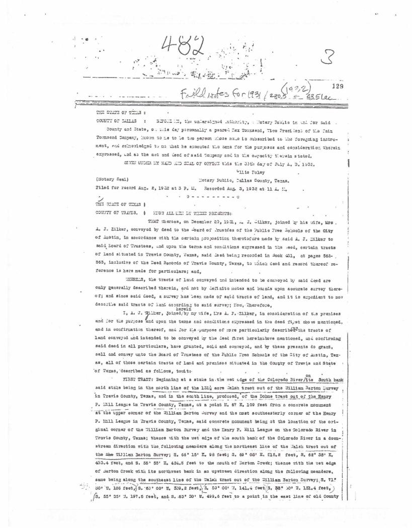
129
r tc13Y. ,
:
COL117: OfruA7.1.7.3 Vac un:srulznad "otary %auto in :or aid .
:ounty and :tete, o . is Lk. por=nadly a poem... nex l'okr.sead, 1.co:Teri len': of V..4 rain
Townsend Crthpany, kr.own to Le to *ue to person na_s to wuCacriced to,ite, romgoinc in.stru-
meat, ero: ecktowledced tu rao that he ekocute d t:.cs r..=.0 for the pur.lasos and conaidereti or. therein
enprassad, •-nd ar. the act and ,deed of said .to:upany and in Z:.e odpacity s toted.
ETAL OF Orr-ad: this t:.e 3)th day of It.ly A. 3„. 1032.
la rolay
Watery Seal) ::otery Public, :alias County, Teras.
Tiled for record koc. 2, 19Z at 3 P. U. Reoorded !dug. 3, 19 32 at 11 1.
:•""THE 72.177. OF TZCAS I
COI= Of '78::/1.3., 0 i:701 I-LL L7:.:LrTZT.37: PRE-ZITS:
TEAT -11eraae„ on Deeec'aer 23, 3.53.. J. -ilkar, Joined .z" his wifa, lira
A. F. Zilker, oonvoyad by dead to the ;card of -'rustdes of the ?uhlicr Tree 30110013 of the city
of lastin, in accordance with t'.us oerzain ropoeit1on therotof are undo try. Laid A. F. T.ilkar to
acid. Board o: Trustees, L.nd upon no terms. and conditIone a...Tressed in ue ,aed, certain traota
of land situated in Traria Comaty, .26=3. said :sed bran; recorded in Sook at paces 562-
555, inalusive of the ;sad B000rds of Travis :ounty, Taxes, to .."aloia (dead and record tacreof re-
forenc• is here made for par.doulars; and.
, the tracts of ladd conveyed tna intended to he ccmvoyad 'ay raid deed are
only Generally described therein, ard not by :..efinito liates and bounds upon aoourate aurvey there-
of; and since said deed, a survey has 1,een. cade of said tracts of land, and it to akpadient to nos
desoul'ue said tracts of /and or:lording to said survey; row, Therefore,herein
A. F. 7Jer, oined, by my :rife, I:.rs A. 7.•Zilker, in consideration of t..a premises
and _or t4e pu.*„.ose and. upon the terms and conditions expressed in the deed fi,.-et above moot/goad,
and in cronfircati-n thereof, and :or i.e •yurpose of ;ore particularly describa7tha treats of
land conveyed t.n4 intended to be conveyed 1.7 the Ueed first hereindbove mentioned, sal,. confirming
eaid deed in all particulars, have Granted, aold and oonveyad, and by these presets do grant,
sell and convey unto the Board of Tvustees of tile Public :too Schools or the City of .h.,stin, Tex-
as, all of those oartain treats of land and. presiaos situated in the County of Travis cad State
'of Toxne, 'described as foldons, toy/it:-On
FIRST. TRACT: Be3innin3 at a stake in the pet c.d.ge of the Colorado River/ite South bank
said stake beans In the north line of the 131ii acre ;elfin treat out of the lilliam 3arton
in Travis County, Texan, and in the aooth line, prOduoad, of the Whose treat out of the Aleni7 _ — . _
P. :all League in •Travis County, Texas, at a point U. 67 E. 109 feet from a concrete conument
at-the—upPer—oorner of the liLliesa Barton ...uryey and the cost southeasterly corner of the Henry
P. 11111 League in Zravis County, ia=tra, said concrete manument tains at the location of the ori-
ginal corner of the -alLiam Barton purvey and the Eenry P. hill League on the Colorado /liver In
Travis' County, Texas; thence ,11-32 the net edge of the earth bank of the Colorado River in a down.;
strews direction pith tau following meanders along .tta northeast line of the :ash tract out of..
the Ur* Millara Barton Survey; S. 66' 15' E. 98 feet; 5. 69' oat E. ris.2 feet. S. 62' 36. z.403.4 feat, and S. 55" 55. E. 424.5 feet to the mouth of Torton :reek; tnence Tri t h the ;:et edge
of ...Carton Creek with its northwest bank in an upstream direction alonz, the foliar/1ns maruaders,
same being along the southeast line of the Calsli tract out of th0 74.1liam Barton Purvey; S. 71'—. . • —__________ , ••• .00" 17. 106 feet(S. '63 00* V. 339.2 feet.`; 3. 53' 00' 11. 141.4 felt S. izii• )01 01. 151.4 fest, ,
I'S. 55' 35, .1. 197.6 feet, and S. 63° 30' B. 499.6 roe% to a point in the east line of old county I

.., ._: • . ..A 1
•... • ''..... s' 41 .1 di!: p- ,': 1-, I .•,'4.1 ". •
131
e711ence, ?seeing an iron stare for t.:.42 narth.7ant corlur o: the Sand :etch 7.a..erve ct 02 :cot
itlionee with .7est line or =1.0 .hiserre to ao.rer; ta-..ace with tile .et alga 0: ta:3Iorado
:.iver clung its nort'h ber.h, same being t_e app.or.,!.-ba south lir.o or zi.e leorget 3pe4r League
running an upstream Ci:eation z.-ith the tailoring noarh.ere; ".•:. 54' 17. 0, 357.2 feet, ::. 52' 1'
•••O. 510 feet .....45' 0. 333 root I:. 53' OS. 1.03.5 feet to en. iron s'Are for the soutanest
corner of the Zilker 43 core treat, Laid corner being in the di Svieion line botween Lot Do.
end Lot 1:0. 13, out of a suZivision of 2:)2 soros out of 7.1'e loorge :7. Spear Lasalle prouuned to
tho Zoloredo 1iiver; :Leone with this uo.st One or said a. :. 1/Meer 43 core tract 23'
1530 feet to an iron stake for the north«est.comer of Balt: tract and :rri,,71.1.ela syhtlie ti_e center-
line of the earinaoting spur betceen. the «uetin 31c, and Suburban Tailwey and the mein line of the
Pacific as evidenoed by ti.e citing rails, boors 17. Et 30. Z. 108 feet and fr.*/
which northwest corner a concrete conunant set in :est 8th 1treet bears 29* ;13, 3. 336.92 rest
and fromrhiob nort7est corner the aouthi7est corner of Lot 65 nor 'aid 252 acre suhdivielon as
desoribed nhove beers ir. 29' 5.1, 3. 317.79 feat; thence 10 feet distance from and parallel to
the center or the spur line tract 3. 40• 00. D. 2.8 feet to an iron stare in the south 100 foot
right-of-way line of the 1. 4 C. Rallney; Comae* i7ith the south ri6ht-or--.7ay line of tho I. &
G. 17. Reilvey and 100 feet southerly and parallel to the centerline or said railroad line for the
following courses and distances for the north line cold A. J. Zilker 43 care tract; S. az'
20, Z. 569.4 feet S. 24• 25. Z. 222.8 feet 3. 30° 00, Z. 280 feet. 3 33" 20. 3. 178 feet 2. 39"
DO, 80.1 feet 3 44' 51, Z. 147.D. feet S. 46' 50, Z. 145 feat, and S. 63' 65. Z. 250 rest to an
iron stake at the place of beginning nr.ciontaining 43.51 acres of 1lart_71-..
The yttrpoee and latestt of this .nstrument to to convey all of the premises i:itinn the
boundaries of the too treats above eat out, which wecre acquired end owned by the said A. J. 311-
ker through tha verioue conveyances to hici of thane portions or the .;altra Dotone 1opes and Sunter
treats on the South or -best side of the Colorado River and the ahlter lease treat oht of the Geo.
3. Spear League on the North or Zest side or the Colorado hiver, referredto in said original deed
frtiva A. J. =faker and rife to the Grantee of Cate Decersoor zg, lga, to which reference is here
made; together 7.1.th such other treats or p_roels or lend Vlach may have been acquired by the said
A. I. Zilker by listitetion or othervice, and-cinch are also included in said boundaries.
TO MO/3X:0 PI MID unto sa.d.Soard of Trustees of the Public 17ree Schools or the
City of Austin, Texas, ',hair successors and cssigns, t..e siid above too described treats or land
and premises, in trust for the purposes herelnbefe.-0 referred to.
And 70 40 hec..by bind ourselves, our. heirs, exeoutors and adainistratore to .ZL:12.A1:1'
A:ID 1,02rial 0Z3 all and singular the veld land and prrniaos unto the said 3oard of Trhstees
of tic Public :Free Schools of ti s '11.ty of Austin, Ticias, their .suceeneors. and assictc, against
every person wilonsoever laufully oleic...lag or to claim the &time, or any part thereof.
7,:-.zr2ss OUR agiros, at Austin, Texas, tile ti,e inst day of July A. D„ 1932.
A. J. 7-taker
1.1re A. J. Miser
'Z11i STATE 03 Tr.r.A.3 )
cou:rrY or 7.7.....7a3. ) sort: LI, 1/0yes D. biith, a ..:otary Public in and for Travis County,
Terse, on this day personally appeared A. J. Dilksr inia.r4 to no to be the parse@ ulese ;raze to
subecribed to tae foregoing instrunent, and ho coiniaaledged to me that he executed the sane for
the pur,ussus and oonsideration tharoin expressed.. ,Lad also on this day. personally appeared before
no A. Zillcer, vire of said A. J. Zillcar, also hnacn to no to be the person %Those name is
subscribed to the foregoing instrumont, and bta-ins been axe-aimed by no privIly and apart from her
husband and having the sane fully explained to her by no, she, the seia L.rs A. J. alker, aormov-
ledged ouch /astronaut to be bar cot and deed, and declared that she had willingly eigned the secs

Approximate Locations ofDeed Tracts making up theZilker Park area
Zilker Park Deeds
City of Austin Parks
2015 Aerial Imagery, City of X
Cy ofAusti&
Rfat Estate Servicti
0 500 1,000 2,000 71rts c5
This product is for informational purposesand may not have been prepared for orbe suitable for legal, engineering, or surveyingpurposes. it does not represent anon-the-ground survey and represents only theapproximate relative location of properly boundaries.
This product has been produced by theOffice of Real Estate Services for thesole purpose of geographic reference.No warranty is made by the City &Austinregarding specific accuracy or completenes.
Produced by CBoas, 4/14/2017

#7. Butler
Landfill Fealwes
Estimated Landfill
Boundary
Landfill
LandfillBuffer
City of AustinJuriadIctkin - Lot Lines
FULL I Roads
LJ LTD I Water features
1-1 2 MILELII-1 5 MILE
0 250 500 1,000 Feet
watersnee rrotecnon
Develmit aimIle•Iarahml PrS.1.1040 & haeehneeeel RAM.. 1:t•Pe,leweet
ma CM, ei peedueed hee map ter the ttoet hoopoe. el
hoe sr wore reeetteut nod as ea vet:meted barundar, e/
Wenn. 6 mowed MYR- The C try el enelle hese ft.
vonevelet Me ease Ler leiereutlem rehandle, it.eeetareay
ihteepitoteenot.
Reentelthollete le eel pmetetted *the. pereasueen 07010 1.11.
City a/ Adeetle-teafeesheel Pleteertlee & rleveleewel Reehee
Chtearistmee.
Ogle: 09_20 2006
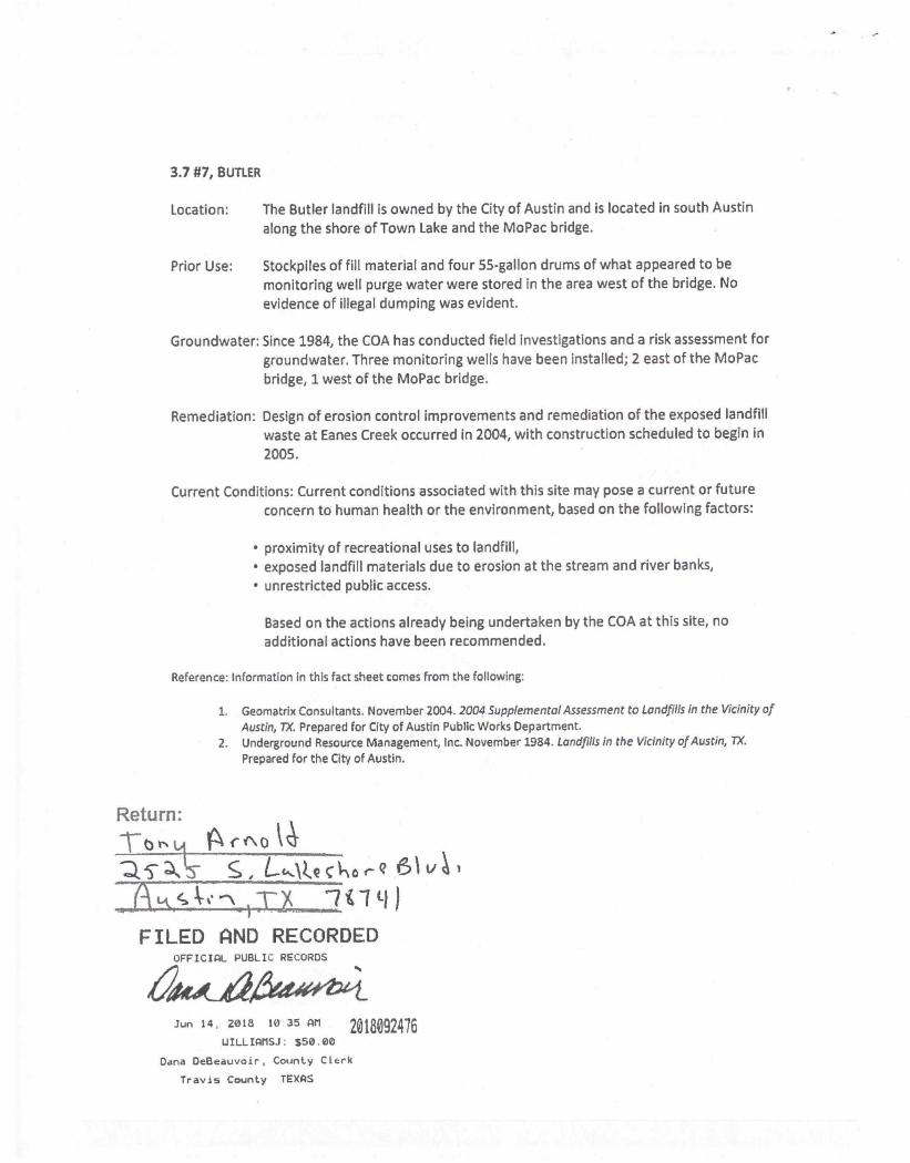
3.7 #7, BUTLER
Location: The Butler landfill is owned by the City of Austin and is located in south Austin
along the shore of Town Lake and the MoPac bridge.
Prior Use: Stockpiles of fill material and four 55-gallon drums of what appeared to be
monitoring well purge water were stored in the area west of the bridge. No
evidence of illegal dumping was evident.
Groundwater: Since 1984, the COA has conducted field investigations and a risk assessment for
groundwater. Three monitoring wells have been installed; 2 east of the MoPac
bridge, 1 west of the MoPac bridge.
Remediation: Design of erosion control improvements and remediation of the exposed landfill
waste at Eanes Creek occurred in 2004, with construction scheduled to begin in
2005.
Current Conditions: Current conditions associated with this site may pose a current or future
concern to human health or the environment, based on the following factors:
• proximity of recreational uses to landfill,
• exposed landfill materials due to erosion at the stream and river banks,
• unrestricted public access.
Based on the actions already being undertaken by the COA at this site, no
additional actions have been recommended.
Reference: Information in this fact sheet comes from the following:
1. Geomatrix Consultants, November 2004. 2004 Supplemental Assessment to Landfills in the Vicinity of
Austin, 7X. Prepared for City of Austin Public Works Department.
2. Underground Resource Management, Inc. November 1984. Landfills in the Vicinity of Austin, 7X.
Prepared for the City of Austin.
Return:
1t j A.r"o ksz\-
151Tix )
FILED AND RECORDEDOFFICIAL PUBLIC RECORDS
Jun 14 2018 10 35 AM 2018092476UILLIAMSJ. $50.00
Dana DeBeauvoir, County Clerk
Travis County TEXAS
s/C3 Operations Dropboy/Work Perry/C3 Operations/SITE/ACL/ZILKER PROJECT/CAD/Zilker Park AutoCAD fi
les 3.20.20/53691-05-5ITE.dwo
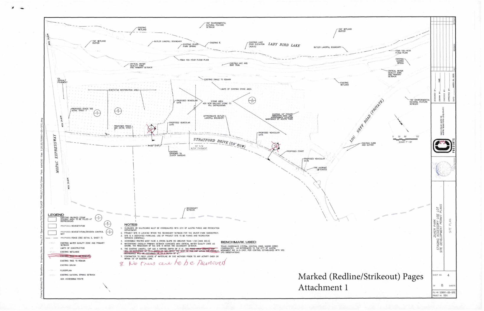
ELASPHALTPAVEMENT
7150 WETLANDBUFFER
PROPOSED FENCE SEEDETAIL SHEET 7
LEGEND EXTSTING CRUSHED STONESTAGING AREA TO BE FILLED AT DEPRESSIONSPROPOSED REVEGETATIONPROPOSED REVEGETATION/EROSION CONTROLMATPROPOSED FENCE (SEE DETAIL E. SHEET 7)
COSTINGWETLAND
,...-CRITICAL WATERQUALITY ZONEAND PRIMARY SETBACK
VFGETABVE RESTORATION AREA
PROPOSED FENCE \FE DETAIL SHEET
COSTING WATER QUALITY ZONE AND PRIMARYSETBACKUNITS OF CONSTRUCTIONEXISTING WETLANDS
EXISTING TREE TO REMAINEXISTING BRUSHFLOODPLAINEXISTING NATURAL SPRING SETBACKADA ACCESSIBLE ROUTE
/-150' ENVIRONMENTALNATURAL FEATURESETBACK
BUTLER LANDFILL BOUNDARY /-EXISTING7
-EXISTINGPARK SPRING
NOTES1. CLOSURES OR SHUTDOWNS MUST BE COORDINATED WITH CITY OF AUSTIN PARKS AND RECREATIONDEPARTMENT.2. PROJECT SITE IS LOCATED WITHIN THE SECONDARY SETBACK FOR THE ZILKER PARK SUBDISTRICT.3. SITE IS A DEDICATED PARKLAND. USE OF PROJECT SITE TO BE PARKS AND RECREATIONSERVICES (GENERAL).4. ACCESSIBLE ROUTES MUST HAVE A CROSS SLOPE NO GREATER THAN 1:50 [ANSI 403.3]WARJoKONT OVERLAY PRIMARY SETBACK COINCIDES WITH CRITICAL WATER QUALITY ZONE ASSHOWN. THE REMAINDER OF THE SITE IS WITHIN THE SECONDARY SETBACK.
- Rm25-11YR-.)
N_FETIA 100-YEAR FLOOD PLAIN
PROPOSED VEHICULAR[GATE
EXISTINGDRIVEWAY TOZILKER GARDENS
EXISTING LZIEON LADY BIRD LAKE/(429.0)
HIKE ANDBIKE TRAI
EXIS77NG SWALE TO REMAIN
'N\\\_UNITS OF EXISTING STONE AREA
STONE AREAADD NEW BALLAST STONE TOFILL DEPRESSIONS
APPROXIMATE BUTLERLANDFILL BOUNDARYEXISTING T6 PRIVATE--"----IRRIGATION MAIN UNCAPPROXIMATE LOCATIONMAINTAINED BY AUSTIN PART)
_L.' - [PROPOSED VEHICULARGATE
STRATFORD DRITT (6050' R/w 6)0 Fr)vi/24* PAVEMENT
iSECONDARYSETBACK
BENCHMARK USED
TEXAS COORDINATE SYS1DA CENTRAL ZONE NA063 (GRID)6. THE EXISTING LANDFILL CAP HAS A VARYING DEPTH OF 3-5'. TME-Pe141~ellreilBRIIVellg— COORDINATES AS REFERENCED TO THE CITY OF AUSTIN=;gS70:5:=DIE=C1P-NIVIR411=HEEFIrSa.. MONUMENT NO, N-2-2401. PER CONTROL ESTABUSHED WITH YRSGPS OBSERVATIONS.
7. CONTRACTOR TO FELD LOCATE Er WATERLINE EW SUE METHODS PRIOR TO ANY ACTIVITY OVER ORWITHIN 10' OF COSTING LINE.Aih e- /2QA44oved
PROPOSED FENCE
/150' WETLANDBUFFER
BUTLER LANDFILL BOUNDARY -\\
PROPOSED VEHICULARGATE
----FME--- (1153533)
-\\-EXISTINGWETLAND
'N) EXISTING CURBAND GUTTER
FEMA 100-YEARFLOOD PLAINEXISTING-\\GAZEBOSpRING
CRITICAL WATERQUALITY ZONEAND PRIMARYSETBACK
\-150' ENVIRONMENTALNATURAL FEATURESETBACK
0 30 ED 120'
SCALE 1* = 60'
Marked (Redline/Strikeout) PagesAttachment 1
,,ErT NO
OF 8
4
5-;
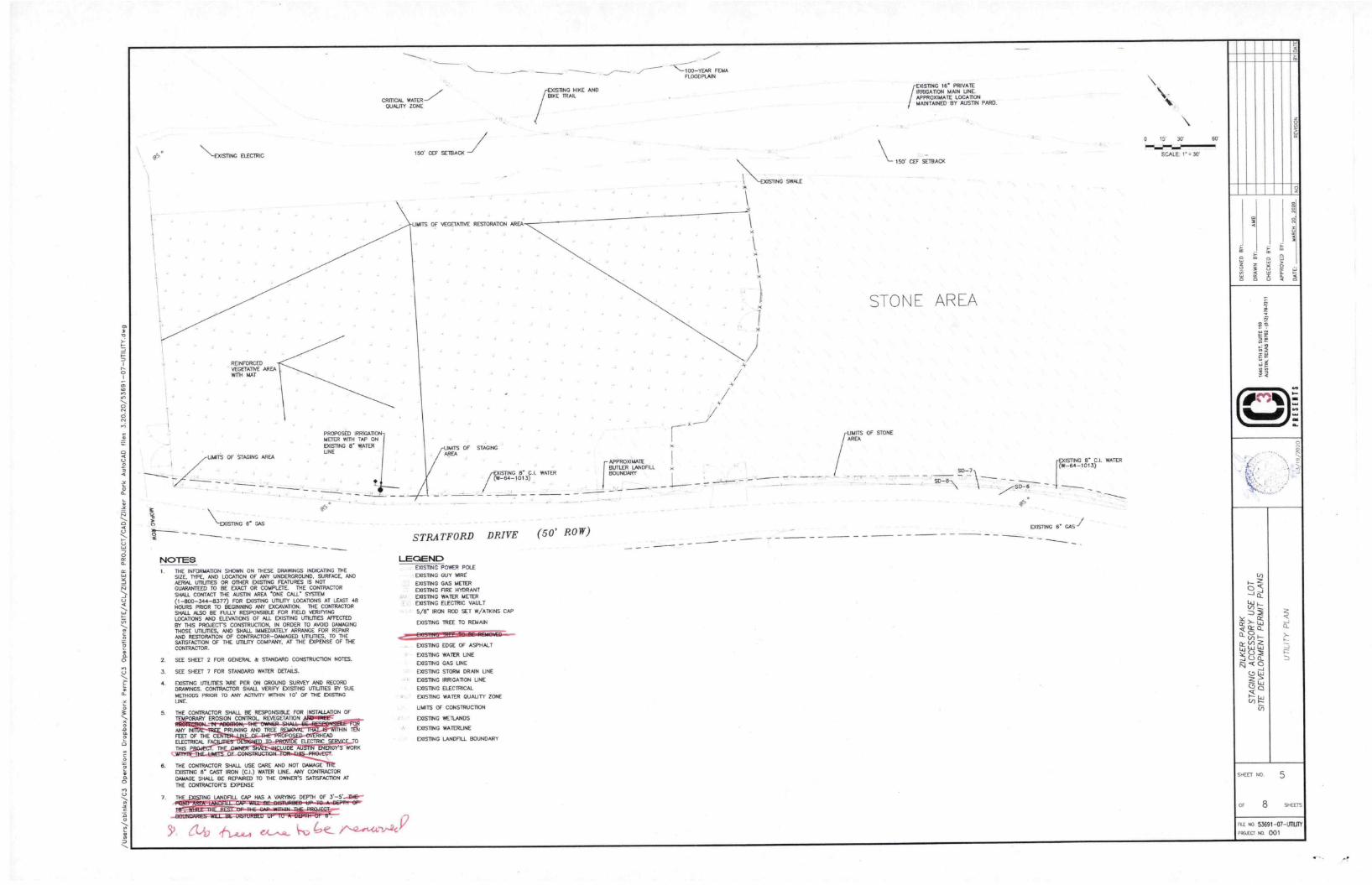
"-EXISTING ELECTRIC
REINFORCEDVEGETATIVE AREAWITH MAT
PROPOSED IRRIGAT1METER WITH TAP ONEXISTING 8' WATERUNE
/
UNITS OF STAGING AREA
\ EXISTING r GAS
NOTES C. THE INFORMATION SHOWN ON THESE DRAWINGS INDICATING THE
SIZE. TYPE. AND LOCATION OF ANY UNDERGROUND. SURFACE. ANDAERLN. UTILITIES OR OTHER COSTING FEATUFtES IS NOTGUARANTEED TO BE EXACT OR COMPLETE THE CONTRACTOR
SHALL CONTACT THE AUSTIN AREA ONE CALL Sys11.14
(1-800-344-8377) FOR EXISTING UTILITY LOCATIONS AT LEAST 48HOURS PRIOR TO BEGINNING ANY EXCAVATION. THE CONTRACTORSHALL ALSO BE FULLY RESPONSIBLE FOR FIELD VERIFYINGLOCATIONS AND ELEVATIONS OF ALL EXISTING UTILITIES AFFECTEDBY THIS PROJECT'S CONSTRUCTION. IN ORDER TO AVOID DAMAGINGTHOSE unt.rnEs, AND SHALL IMMEDIATELY ARRANGE FOR REPAJRAND RESTORATION OF CONTRACTOR-DAMAGED UTILITIES. TO THESATISFACTION OF THE UTILITY COMPANY. AT THE EXPENSE OF THECONTRACTOR.
2
3
4
SEE SHEET 2 FOR GENERAL & STANDARD CONSTRUCTION NOTES.
SEE SHEET 7 FOR STANDARD WATER DETAILS.
EXISTING UTILITIES ARE PER ON GROUND SURVEY AND RECORDDRAWINGS. CONTRACTOR SHALL VERIFY EXISTING LTILMES BY SUEMETHODS PRIOR TO ANY ACTNTTY WIThIN I C OF THE COSTINGUNE
5. THE CONTRACTOR SHALL BE RESPONSIBLE FOR INSTALLATION OFTEMPORARY EROSION CONTROL REVEGETATION
ANY INFEET OF THEELECTRICAL FTHIS P
PRUNING MAD TREE IN
" St3- E gt.EmaccTR Ejo. • - • RHEAD
• 4- •-.1̀ . • LUDE AU ENERGY'S WORKOF CONSTRUCTION- PROJECT.
6. THE CONTRACTOR SHALL USE CARE AND NOT DAMAGEEXISTING 8" CAST IRON (CI.) WATER UNE ANY CONTRACTORDAMAGE SHALL BE REPNRED TO THE OWNER'S SATISFACTION AT
THE CONTRACTOR'S EXPENSE
CRMCAL WATER -7QUALITY ZONE
150' CEF SETBACK
UNITS OF VEGETATIVE RESTORATION AREA
UNITS OF STAGINGAREA
TSING HIKE AND
BIKE TRAIL
ISIING 6 CI. RAlLY-64-1013)
STRATFORD DRIVE (50' ROW)
LEGEND EXISTING POWER POLE
EXISTING GUY WIRE
EXISTING GAS METEREXISTING FIRE HYDRANTDOSING WATER METERCOSTING ELECTRIC VAULT
5/8 IRON ROD SET W/ATKINS CAP
7. THE NO LANDFILL CAP HAS A VARYING DEPTH OF 3.-5'....13E--M.C-J3E=BIBIWOBEB-OP-40.A.DGPMI-BP•
afff- Of IU-BEILINDARIES WILL BE DISTU+4C-113111 1430t.—
5) (LAI) ,f- 4 P
EXISTING TREE TO REMAIN
EXISTING EDGE OF ASPHALT
EXISTING WATER UNE
EXISTING GAS LINE
DOSING STORM DRAIN UNE
COSTING IRRIGATION UNE
EXISTING ELECTRICAL
EXISTING WATER QUALITY ZONE
UNITS OF CONSTRUCTION
EXISTING WETLANDS
EXISTING WATERUNE
EXISTING LANDFILL BOUNDARY
APPROXIMATE
1-BUTLER LANDFILLBOUNDARY
"-TOO-YEAR FDAFLOODPLAIN
\\\ \ -EXISTING SWALE*
iEMSTING le PRIVATEIRRIGATION MAIN UNEAPPROXIMATE LOCATIONMAINTAINED BY AUSTIN PARD.
150' GEE SETBACK
STONE AREA
UNITS OF STONE/AREA
• -SO-7\
-EXISTING r CI.WATER(W-64-1013)
EXISTING 6' GAS
15' 30
SCALE 1' 30'
g
5S
soEET NO 5
ce,
Co—
OF 8 SHEETS
53691-07-our(
..oJECt to. 001
COVERAS NERCO 04 OCRSEC T ION 3 3 ANDITEN SIR. SEC 11044
SIO
PK( 00 PIPEwm 3D
WA .71
- RACY. OR 000
0101 00 •300t• 12-1 /AI14
PPE 00 .60Ct•2•-• SAAB
NA TURAL GP OLKO
cTref);EEng",, 216
BEDDING ENvELOPEoT EN 510, SEC TON 510 31(4
CENTER OWE TREK.
Y.-- -.CRS • UREKO EAR111
REFERENCES
1401*00 CRITERIA MANUAL SECTION 34 3 TIN.. DESIGN
2 STANDARD SPEOFKATON .10011201. t.1.4 510.
SECTOR 510 2161, "SELECT RACKFLL OR BORROW .
SECTION 510 3,61, TRENCH XPTH ANO DEPTH OF COVER
SECTOR 510 3114 1, 'PPE 6E00045 ENvELOPE-
CITY OF AUSTIN TYPICAL TRENCH DETAIL
De of A. s WITH UNFINISHED SURFACEPAR 14 sT Kos
/' t 4"="crtiO,UVP,,, 51 5
100 fe- pr,c4,c) 5 /-
ADOP ED
/ ceiet 14
ROW ORESAAT LONE
WATER SERVICE TAP PLAN VIEW
Ac00En00.1
• " ) •J I I Ij io 2_
V IV
pm. 000MPRED1
—4.04•41.1
- 1.. kaTER • • •- WATER SERVICE TAP PROFILE VIEW
ruETER•11.
.A1 ERMAN
CITY Of AUSTIN
MOSTW WATER
WATER SERVICE & METER INSTALLATION
1.8 SMALLER METERS
JEFF 3 ArLE 661422,9
ADOPTED
•wE ARCN,TECT.ENDNEER ASSUATES
RE SPEWS/Mt rt. 1O3 ARPROPRU1E
LEE OF DM ST AWARD
STANDARD m0
520-A W -01B
EXISTING El.
WATER UNEMETER AND BOX
SINGLE WATER -
SEE DETAIL
S20-AW-018
PLAN VIEW
IRRIGA TION WATER TAP DETAIL 0N. ES
iOWNER'S CUTOFF
IRRIGATION QUICK
CONNECT IN METER BOX
SPL WW- 45A
MATERIALS LIST
• r SERV-CE CLARA sr, v.. .44
B r CORACRA101 ST, SP1 MN.
L •TOPE m•-ER Stmt. 14BAK
O y6.1 MtvE SA, MT ael
I SANCAE SERVCD EMIl ',OWEN tt ARE ANT., KW AM Be OR
OMAR& SERwC1 r TAP ,• CO.TER ,LARE ME SIN
t" SWAM. NVT COwPRESSiON KNO M
c ROPE wAYER SER.( RAINS 510000.0.
t• ANGLE METER STOP SPL VAT/M
WIER ROD ARO LIO SP. MN TA..
OUAL t•RET1RS USE INT•t0 5.44.,44 4,41441.0.44
MATERIALS TO BE INSTALLED BY ?LUMBER.
4-10060 To doiortc I *102116W To. v.", METER
▪ w•T DR NETER P.m...op TM. AvSTW MA1SP
I BRASS WATER WIER 0011P5ING.41 ATT KVA: CO.,144 NUT
i• METERS KV LONG • 1.01A
A PROPERTY OWNERS 0.11 011 VALVE SIN AWN,211,
N PROPERTY OWNERS OLD OK VALW 110x .0 OR
• TERPORARy ME TER SPACER AREOuREO TO ASSURE METER mu. AlT MTPROPRIATE L 1,
tY woODEN otTrEt 59.66 ...DOWSE 06 oreirt vswc WATERPROCR 0010E31
NOTES
CL.A SMALL Ry WRAPPED COMP-STEL WM. 5 MG POLYE T./ILENE ,LT, 501 *0 710
7 MARC. CONNECTI.S Arer• Fit MOLE keETER STOPS 1A431 BE WSTALLE0 PRIOR 10 NYY METER
NIT AL, TONTop, WE W A BOXES SmOULO BE .• MUNE 0R01.040
• 01010 ANO MEMO IN STREET MONT 01 WAY SMALL BE SE 00E0 N ...KEMAL, AS
0D020K0 sEcno.. 5(0 3111 Of IRE CITY CP AuSIK STAMDARO srEonc000Ns &KKR/
A60110 616.4.1,1111600t. IS RECUWEET IT SEC,. STAT 251
METER BOR Mat BE BEM. CURB 10/11 TO INKPERTY LINE OR EASEMENT MO OUT Or vETKuLAIII
TOPSAIL AREA AND SIOEveALA
F BALL 21141 V SAKI NOT 5E 1003150 .110ER SWEWALA COM OR PAvEMENT .0 NOT OE
LOCATED WM TN. 36. SE Low pou. GAAVE
T METER SUES TORE SmOwN 0a PLANS
IS MITER BOX Cur OuT SMALL NOT EACE5 0 DAtO TATES THE PIPE CtUMEIER
• DASTALL wETALuc TAAL/. TAPE Spt ven.sio Kw.... I ARovE TWBIND 1004 BE51111 CLAAAA
IUSALL viuveID WK. STOLL SE 0_30E0 IN • STRACRT °WENT .0 AK OWED TO RELAX 0.10 'SHAKE'
LOOSELY At NE TREMOR TWA. IIENARD CURB AND WTI 11 SNAIL Et 6I10ALLE0 A ...um
7 OE, N 0, OTWR
11 r TuKNO MIEN GENT STVNL nAvE • RAUL. NO SMALLER IN. 1. F TUBING WREN BENT SMALL
NAVE A R•ORLS NO SMALLER R.AN 5 BRASS iTTP/GS STIALL NOT BE CCNNEC TED TO A BEN/
SECWOR YLTIMO12 DOLIO ILINAAR SIEK 1011000 511000610 ETK YORE RAMO S•1•11 RE 4*E0
AT ALL
COMPREKICN 'WU... INSERT SurrETERS ViALLL BE EROV TT* SAME TAANUFACTURER AS TI'S
COMPEKSSTON 1wIR•G USER
I FOR RECLAAR 0 WATER SERVICES .0 LETE10 4,. RECLARAO IVA.5G511141 BE WAVE ACTURED
50110 PURPLE SAL wyTeaSA AU App.mo.uces 5.000 00 VATALTDACLIREDI PURPLE A AvAILABLE
Au Atm.) r.r Ant TA01 AvARAIALE MOM /NE uNvuSACTuRER PA PURPLE SRA, BE PAINTED
AustPLE PER SPI ANA&C ALL ME TER KM LC, ST.,: BE KM, tAME ltreC4Pall WATER.
CAST WO SPL VAN 1.14A
CITY OF AuSON
.K0 WATER
WATER SERVICE a METER INSTALLATION.
VA SMALLER METERS
AP • 10:E- 06,6201,
ADOPTED
THE ARCNYTECTENGwEE it ASSL AMS
RESPONSWA lIT *00000011,1510114
v. OE UAW STANDARD
513003301*0
520-AW-0182002
ottN E.1r.s:a.e'll,°°- 5•.,,e9 lin‘. I I V- 1.----' Ili ill' rp_de v• t - ,‘s =It * 7era erea.,??Aew•Ta:B•••,:‘0 4: :
r coliT '4,;•;-,.3 F.7,,,,,......,k zi....,,...-.T..-A‘-
ci,.iet,.tl32-ra4r.. ....z,:si., i%.1_ „-4.sis,„is0,i 0,
4 v.,
2
WA PCH 20. 2020
m
“AYi
:53
SHEET NO 8
OF 8 SHEETS
FILE NO 53691 -13-DET1
PROJECT NO, 001
19,
ORIGINALSUBMITTAL DATE: 03/20/2020
ZILKER PARKBUTLER LANDFILL CAP MAINTENANCE
CITY OF AUSTIN, TRAVIS COUNTY, TEXAS
"I CERTIFY THAT THESE ENGINEERING DOCUMENTS ARE COMPLETE, ACCURATEAND ADEQUATE FOR THE INTENDED PURPOSES, INCLUDING CONSTRUCTION, BUT
ARE NOT AUTHORIZED FOR CONSTRUCTION PRIOR TO FORMAL CITY APPROVAL?
SCOTT A. SMILEY, P.E.
REVIEWED BY:
FOR DIRECTOR, PARKS AND RECREATION DEPARTMENT
DATE
DATE
LOCATION MAPN.T.S
PROJECT ADDRESS2236 1/2 STRAT-cRO DRIVE
AUSTIN, TO 78746
OWNER/DEVELOPER CITY OF AUSTIN PARKS AND RECREATION DEPARTMENT
200 S. LAMAR BOULEVARDAUSTIN, TX 78704
PHONE: (512) 974-6700
DESIGN ENGINEER
ALIDCON ENGINEERING, LLC3401 PEARCE RDAUSTIN, TX 78730
PHONE (512) 657-7287TBPE REGISTRATION NO. F-20282
LEGAL DESCRIPTION 81.18 ACRES, BARTON HILLS, ABSTRACT NO. 14 LOT ID 19278
RELATED CASE NUMBERS 4;P-01-00980S
SITE PLAN
47C-2008-04850SITE PLAN
C14-B7-11, ZONING
DESCRIPTIONTOT./ S
$14910 88PLO& SET
NET5191866WV. COVERISO FT I
TOMJ. SITE IMPOMER
rSO ITS
CRT OFP95111APPROVAL• DATE
DATE IMAGED
9-EET UST
Shoal Number Mel Mb
1 COVER SHEET
2 GENERAL NOTES
3 EXISTING CONOI TONS AND DEM OU TION PLItN&BROWN AND SEDIMENT CONTROL PLAN
4 SITE PLAN
5 UTIU TY PLAN
B EROSION AND SEDIMENTATION CONTROL DETAILS
7 SITE DETAILS
a IRRIGATION DETAILS
NOTES 1. RELEASE OF T1.95 APPUCATION DOES NOT CONSTITUTE A VERIFICATION OF ALL DATA, INFORMATION AND CALCULATONS
SUPPLIED BY THE APPLICANT. THE ENGINEER OF RECORD IS SOLELY RESPONSIBLE FOR THE COMPLETENESS, ACCURACY ANDADEQUACY OF HIS/HER SUBMITTAL, WHETHER OR NOT THE APPUCATION IS REVIEWED FOR CODE COMPLIANCE BY CRYENGINEERS.
2. WATERSHED STATUS: THIS PROJECT IS LOCATED IN THE LADY BIRD LAKE/TOWN LAKE WATERSHED AND IS CLASSIFIED ASWATER SUPPLY SUBURBAN. THE PROJECT IS LOCATED OVER THE EDWARDS AQUIFER RECHARGE ZONE ACCORDING TO THETEXAS COMMISSION ON ENVIRONMENTAL QUALITY (TEED) AND THE CITY OF AUSTIN MAPS.
3. THIS PROJECT IS LOCATED WITHIN THE FULL PURPOSE JURISDICTION OF THE CITY OF AUSTIN AND IS ENTIRELY WITHIN TRAVISCOUNTY. TEXAS.
4. ACCORDING TO FEAM PANEL MAP NO. 46453C0445J, TRAVIS COUNTY, DATED JANUARY 6, 2016, THE SUBJECT PROPERTYLIES IN AREAS DETERMINED TO BE INSIDE THE 500-YR FLOODPLAIN. A PORTION OF THE TRACT IS WITHIN THE an OFAUSTIN FULLY-DEVELOPED 100 YEAR FLOOD PLAIN.
S. ALL CONSTRUCTION OPERATIONS SHALL BE ACCOMPLISHED IN ACCORDANCE WITH APPLICABLE REGULATIONS OF U.S.OCCUPATIONAL SAFETY AND HEALTH ADMINISTRATION (OSHA). OSHA STANDARDS MAY BE PURCHASED FROM GOVERNMENTPRINTING OFFICE; INFORMATION AND RELATED REFERENCE MATERIALS MAY BE PURCHASED FROM OSHA, 611 EAST 6THMUT. AUSTIN TEXAS.
B. THE LOCATION OF DUSTING ura.mes HAS BEEN BASED ON RECORD INFORMATION ONLY. THE CONTRACTOR SHALL CONTACT'DIG-TESS- AT I (800 DIG-TESS, OR THE OWNER OF EACH INDIVIDUAL UTILITY, FOR ASSISTANCE IN DETERMINING THEENACT LOCATIONS AND DEPTHS OF ALL EXISTING URLMES PRIOR TO BEGINNING ANY CONSTRUCTION.
7. THE ENVIRONMENTAL INSPECTOR HAS THE AUTHORITY TO CHANGE OR MODIFY EROSION/SEDIMENTATION CONTROLS, PERSECTION 25-8-183 OF THE CRY OF AUSTIN'S LAND DEVELOPMENT CODE.
B. STRUCTURAL WATER QUALITY CONTROLS FOR THIS PROJECT ARE NOT REQUIRED.
9. THERE ARE NO SLOPES IN EXCESS OF FIFTEEN PERCENT (154), IN THE UNITS OF CONSTRUCTION.
10. ALL RESPONSIBILITY FOR THE ADEQUACY OF THESE PLANS REMAINS WITH THE ENGINEER WHO PREPARED THEM. INACCEPTING THESE PLANS, THE CRY OF AUSTIN MUST RELY UPON THE ADEQUACY OF THE DESIGN ENGINEER.
11. FOR THOSE DEVELOPMENTS WHICH ARE IMMEDIATELY ADJACENT AND DISCHARGE DIRECTLY IN TO LAKE TRAVIS, LAKE AUSTIN.LADY SRD LAKE, AND THE COLORADO RIVER, ON-SITE DETENTION IS NOT REQUIRED. [DCM 1.2.2 (F)]
12. THE SITE S LOCATED IN THE WATERFRONT OVERLAY, ZIU(ER PARK DISTRICT.
13. THIS PROJECT IS SUBJECT TO SUBCHAPTER E OF THE LAND DEVELOPMENT CODE (COMMERCIAL DESIGN STANDARDS)
14. SITE IS A DEDICATED PARKLAND. USE OF PROJECT SITE TO BE PARKS AND RECREATION SERVICES (GENERAL) WITH ANACCESSORY USE OF STAGING LOT.
15. STRATFORD DRIVE IS A DEDICATED PUBLIC STREET. LOU NEFF ROAD IS A PARK ROAD AND IS CONSIDERED TO BE PRIVATE_
16. NO BUILDINGS ARE LOCATED ON THIS SITE.
Unmarked Attachment 1
As
2
SHEET NO.
OF 8 5,4E115
115 40 53691-01-ML
191511: NO 001

150' Tl.APC
WQZ
"
EXISTINGMERANO
7-150' ENVIRONMENTALNATURAL FEATURESETBACK
BUTTER LANDFILL BOUNDARYDOSING Zs-11AR EMISIING
7PARK SPRINGLEIF
LOU
FPCRITICAL WATERQUALM' ZONEAND PR
FEMA 100-TEAR F1000 PLAIN
T.tool
EOC mT ac14'-'nEE .E DN LADY BIRD LAKE(429.0)
EXISTNG NIKE p
BIKE 111 F
\\-\
- . .
7:\ \\\ TOREM\ MN \
,
.......................................... : \\\\\\\
I
............................ : ... : : : : : .
4 4GE.TAreRERTORORENAREA.,....4. \\""\\ \ \ \
\RA TE\\ \\\ \\ \ \\ \.72,ELFN:76E:t• . • • • • - • ........ ' .....
........... . ' ' ' : .. : .. ' . ' . ' . ' ....... . ... : . : . : 4 ' ' \ F' (17 \\ •
\
• .......
\ \ \ • \ \
0
. A
A
....
\
\
\ VEHICULOk
..
.......... .. . " .
. . .. . . • • • • ....... • • .... , ...
\ \ \ \
0.. A .. .. .
.......
. . : .. : PRDFC'SEDF::07,FE"CS.I.:LOF
.......
LEGEND EASING CRUSHED STDNE
STAGING AREA TO BE FILLF_D ATDEPRESSIONS.
- -
-CWOZ-
LOC
PROPOSED REVEGETATION
• •PROPOSED REVEGETATIONAROSION CONTROLMATPROPOSED FENCE (SEE DETA/L E. SHEET 7)
EXISTING WATER QUALITY ZONE AND PRIMARYSETBACKLIMITS OF CONSTRUCTIONCOSTING WETLANDS
COSTING TREE TO REMAIN
DOSING BRUSH
-FP- FLOODPLAIN
-SPRG- DOSING NATURAL SPRING SETBACK
ADA ACCESSIBLE ROUTE
MINNA& /IMMO 01511.,
isnicDRIVEWAY IvZILXER GARDENS
150 WETLAND//-BUFFER
BUTLER LANDFILL BOUNDARY-\\,
0T -
\\ 1• • • • • • • • • • • • • • • • • \ • •
• • • • • • • • • • • • • \ • • • • • •\ \ \ \ \ \ \ \ \ \ \ \ \ \ \ \ \I• • • • • • • • • • • • • • • • • •
• • • • • • • • • • • • • • • • • • • • •\\\ \\\• • • • • • • • • • • • • • ),.1s...c \
• • • • • •
• • • • • • •itAN • • • • • • • • •
• • • • • • • • • •' \\ • • • • • • • • wobTAINP• • • • • • • • • • • • •• • • • • • • • • • •
,\AppRoxoue44• • • • • • • • • • • • • • • • • • • • • • • • • • • • • • • •
• • • • • • • •• • • • • • • • • • • • • • • • • • •
• • • • • • • • • • • • • • • • • • • • • • • • • • • • • • •
• • • • • • • • • • • • • • • • • • • • • • • koposED liEsoc4LAR • • • • • • • • • •
• • • • • • • • • • • • • • • • • • • • • • vAit• • • • • • • • • • • • • • • • •
• • • • • • • • • • • • • • • • • •s\.1,
TFó- -
\\.4.\\ .\\ .\\ .\\ .\\ \\\
N • • • • • • • • • • • • • • • • • • • •
• • •
.1? 49
• • • • • • 'tD(CC
• • • • • • • • • • • • • • • • • • • •/24 PAVEMENT
• • •
•
• • • • • • 1/1,
• • • • • • •
Up
• • • • • • • • • \• • • • • • • • • • • • • •hs\\\\Ao\\ \ • '\STONEtAbLA,Diencw's \ MEAL" •\
/SECONDARYSETBACK
4101ftWo
NOTESI. CLOSURES OR SHUTDOWNS MUST BE COORDINATED VATH CITY OF AUSTIN PARKS AND RECREATION
DEPARTMENT.2. PROJECT SITE IS LOCATED WITHIN THE SECONDARY SETBACK FOR THE ZILXER PARK SUBDISTRICT.3. SITE IS A DEDICATED PARKLAND. USE OF PROJECT SITE TO BE PARKS AND RECREATION
SERVICES (GENERAL).4. ACCESSIBLE ROUTES MUST HAVE A CROSS SLOPE NO GREATER THAN 1:50 [ANSI 403.3]5. WATERFRONT OVERLAY PRIMARY SETBACK COINCIDES WM CRITICAL WATER QUAUTY ZONE AS
SHOWN THE REMAINDER OF THE SITE IS VATHIN THE SECONDARY SETBACK.B. THE EXISTING LANDFILL CAP HAS A VARYING DEPTH OF 3-51.7. CONTRACTOR TO FIELD LOCATE le WATERLINE BY SUE ML: PRIOR 10 ANY ACTIVITY OVER DR
WITHIN 10' OF EXISTING UNE.B. No tree. to be rernoved.
BENCHMARK USED TEXAS COORDINATE SYSTEM, CENTRAL ZONE NAITO (GRID)COORDINATES , AS REFERENCED TO THE CITY OF AUSTINMONUMENT NO. N-2-2401, PER CONTROL ESTABLISHED NITH SRSGPS OBSERVATIONS.
•
VP
cVvo7cvlo7
•
WETLAND
CI
OFLOU
ammo CURBAND GUTTER
DOGAZEBOSTINC-\NCSIP\ --
C R-2'
WATERQUAUTY ZONEAND PRIMARYSETBACK
boom
06
vow."
6
ONMEN TAO.FEATURE
1'0
o•oe
2
SHEET NO. 4
OF 8 SHEETS
FILE No. 53691-05-SITEmum so. 001 -
\\-0(1511NG ELECTRIC
A _A
-V A y
„
„
40,
CRITICAL WATERQUALITY ZONE
A A
5 „
A
4 3
„
A 9 „ y
„
'=IDNAREAWITH WI
A A s
A „ „ A
A 4
ids OFiTACINO AREA
\onsnr4c te cps—
• ,
• ,
nno' nosto IF:OG.4sMETER WITH TAP ONpasnna r WATERUNE
A A A A
NOTES 1. THE INFORMATION SHOWN ON THESE DRAWINGS INDICATING THE
SIZE, TIRE AND LOCATION OF AM' UNDERGROUND, SURFACE, ANDAERIAL UTILMES OR OTHER EXISTING FEATURES IS NOTGUARANTEED TO BE EXACT OR COMPLETE. THE CONTRACTORSHALL CONTACT THE AUSTN AREA 'ONE CALL' SYSTEM(1-800-344-8377) FOR EXISTING L/TLITY LOCATIONS AT LEAST 48HOURS PRIOR TO BEGINNING ANY ENCAVATON. THE CONTRACTORSIOJJ_ ALSO BE FULLY RESPONSIBLE FOR FELD VERIFYINGLOCATIONS AND ELEVATIONS OF ALL EXISMNG UTILITIES AFFECTEDBY THIS PROJECT'S CONSTRUCTOR, IN ORDER TO AVOID DAMAGINGTHOSE UTILMES, AND SHALL IMMEDLATELY ARRANGE FOR REPAIRAND RESTORATION OF CONTRACTOR-DAMAGED UTILMES, TO THESATISFACTION OF THE UTUTY COMPANY, AT THE EXPENSE OF THECONTRACTOR.
2. SEE SHEET 2 FOR GENERAL A STANDARD CONSTRUCTION NOTES.
3. SEE SHEET 7 FOR STANDARD WATER DETAILS.
4. EXISTING LMUTIES ARE PER ON GROUND SURVEY AND RECORDDRAWINGS. CONTRACTOR SHALL VERIFY EXISTING UTILMES BY SUEMETHODS PRIOR TO ANY ACTMTY WITHIN 10' OF THE EXISTINGUNE
5. THE CONTRACTOR SHALL BE RESPONSIBLE FOR INSTALLATION OFTEMPORARY EROSION CONTROL REVEGETATTON.
T. THE CONTRACTOR SHALL USE CARE AND NOT DAMAGE THEEXISTING r CAST WON (C.I.) WATER LINE_ ANY CONTRACTORDAMAGE SHALL BE REPAIRED TO THE OWNER'S SATISFACTTON ATTHE CONTRACTOR'S EXPENSE
7. THE COSTING LANDFILL CAP HAS A VARYING DEPTH OF 3.-5'.8. NO TREES ARE TO BE REMOVED.
„
150* CEF SETBACK
STING NIKE ANDBIKE TRML
„.,
A 4 A A A4 A A A A A A A 4\ \ \ \ \ \
\ \ \ \ \ \
A A A y , ,
ns cy VETATNE, RESTORATION AREA
A\ \ \ \ \ \
, A , 4 A A A A \ \ \ \ \
A A A 4 .4 4
., , \ \ \ \ \ \A A A 9\ \ \ \ \ N
3 , A A A
\ \ \ \ \ \
\ \ \ \ \ \
A „ , ,
A A \ N \ \ \ \
A A A A A .1 A A A
A
\ \ N \ \
A A \ N \ \ \ \
A A A A A A
\
A 9 A A A A A
4
„ A
\ \ \ \ \ \ \A A ,A A A
A 4 \ N \ \ \ \ \, J A
9 A A A A \ \ \ \ \ N \ \
,
A A A A A
A „
4,P47
\ \ \ \ \ \ \ \\ \ \ \ \ \ \ \A A
A A A A A\ I\ \ Ilk\ \__\
sr....\,,,
:izig1 \ir CJ. WATER
lin
_ ED
TOO-YEAR FDA.,FLOODPIAM
AOZ —
EIVIC 16' PRIVATEMAIN UNE.
RonaNmcm oAPPROXIMATE LOCATION -
Y AuxMl
\- 150' CEF SETBACK
A
UNITS OFAEA
STRATFORD
A A
ST'MANG-'
DRIVE
LEGEND ppo EXISTING POWER POLE
COSTING OUT WIRE
E COSTING GAS METERCI EXISTING FIRE HYDRANT
WM 0 EXISTING WATER METER
=1 COSTING ELECTRIC VAULT
1550 sys- IRON ROD SET A/ATKINS CAPCOSTING TREE TO REMAIN
_IA_ COSTING EDGE OF ASPHALT
- W - COSTING WATER USE
- C - COSTING GAS UNE
-SD- EASING STORM DRAIN UNE
-IRS- EXISTING IRRIGATION UNE
- E - COMM ELECTRICAL
-CW02- EXISTING WATER QUALITY ZONE
LOC UNITS OF CONSTRUCTION
-WILD- DOSING WETLANDS
- EXISTING WATERLINE
- LDF - EXISTING U1NDF1U_ BOUNDARY
LOP
-(50' ROW)
\ \ \\ \ \ \ \ \
Roz
CAIOZ
TWOS
\ ,k \--- \ ..\-- -C.,, \-- -,,,, \\ \ \ \ \ \ \ \ \ \\ \ \ \ \ \ \ \\ \ \ \ \ \ \ \ \ \ \ \ \ \ \ \ \ \\ \ \ \ \ \ \ \ \ \ \ \ \ \ \ \ \ \\ \ \ \ \ \ \ \ \ \ \ \ \ \ \ \ \ \\ \ \ \ \ \ \ \ \ \ \ \ X \ \ \ \ \\ \ \ \ \\\ \ \ \ \ \ \ \ \ \ \ \ \ \ \ \ \ \\ --V \ \ \ \ \ \ \ \ \ \ \ \ \ \ \ \\ \ \ \ \ \ \ \ \ \ \ \ \ \ \ \ \ \\ \ \ \ \ \ \ \ \ \ \ \ \ \ \ \ \ \\ \ \ \ \ \ \ \ \ \ \ \ \ \ \ \ \ \\ \ \ \ \ \ \ \ \ \ \ \ \ \ \ \ \ \\ \ \ \ \ \ \ \ \ \ \ \ \ \ \ \ \ \\ \ \ \ \ \ \ \ \ \ \ \ \ \ \ \ \\ \ \ \ \nv,,zr s\DNE \ \ N \ \ \ \ \ \ \ \ \ \ . \ ,,,,,ER \\ \ \ \ \ \ \ \ \ \ \ \ \ \ itis L \ \\ \ \ \ \ \ \
\
--AUL
Dm-MG 5* GAS.
15 37 60'
SCALE 1' = 312
SHEET NO. 5
OF 8 SHEETS
TIE NO. 53891-07-UTINY
PRELIM NM 001
MINOAN COVERAS MEWED W UCNSECTION 34 3 ANCITEM 510. SEEN°.
51021E1
r.
ofUsCH OR SOO
PIPE 0.0 .300 rm.1-12, MN.
PIPE 05 -600 mrn1•24..1 NAV
AILIRAL GROUND
ITEM SRI, DECREDA 510.216,
BED3WIC ENVELOPEITEM 510 SECTION 51C VIII
CENTER PIPE IN TRENCH
uNDISTUREE0 EARTH
REFERENCES
u...0,1.1 CRITERIA IAINIJIL SECTION 34 3. ',NAL DEVON"2 SYMP., SPECIFICATION SIANLIAL ITEM 510
SECTION 5102161. 'SELECT BNCIVILL OR BORROW,SECTION 5103160. "TRENCH DEPTH AND DEPTH OF COVER.
SECTION 510 31141, ..PIPE BEDDING ENVELOPE.:
CITY OF AUSTIN TYPICAL TRENCH DETAILWARW. a TINT WITH UNFINISHED SURFACE
Y4,* E'F"8r11:441; 55
NOTES:PROPOSED WATERLINE
STUB IS NOT ABOVE LANDFILL MATERIAL
EXIS1DNC 8.WATER USE
SINGLE WATER
METER ANC/ BOX
SEE DETAIL
520-AW-018
PLAN VIEW IRRIGATION WATER TAP DETAIL MT.S.
OWNERS CUTOFF
IRRIGATION QUICK
CONNECT IN METER BOX
SPL WR-145A
PVT,. EADAPTER
FLO w Off ESNT uNE
WATER SERVICE TAP PLAN VIE
EMIT LAE
6' PREFERRED
WATER SERVICE TRW PROFILE VIEW
CITY OF AUSTIN
AUsTIN viATER
WATER SERVICE & METER INSTALLATION -
IT & SMALLER METERS
JEF1- A oCYLE 3,8.16,019
ADOPTED
ARCHRECLIENGINEER ASSUMESRESPDASI. ITT FOR APPRO./PATE
1.15( OF 71. St ARAM..
sTANDAHO NO
520-AW-0113
MATERIALS LIST A 7 BERVIGE CLAMP SR WAWAa 7 CORPORATOR STOP SR WW.C HOPE WATER SERV., TUBA. SP....D 2WALL V.W.SPL WSW
SI.WE SERVICE r MIP X Y COPPER FLARE PIING. SPL WASS .DOUBLE SEAV. P MEP ITCORPER FLARE WYE SAL WW.(19
F r. SWIVEL NUT, H COMPRESSION. BEND, SPL NW.a HOPE WATER SERVICE GA.: SIN W..N. L. AARE METER SIDE SR AV.1 METER BOX AND LID EFL WW.19313
FOR DIAI Y AFTERS Twn sivrf F NETER P0,05
MATERIALS ROBE INSTALLED BY PLUMBER RRWS MEYER WARNE, SC1 AS NEEDED TO CONNECT ANGIE LIFTER STOP TO METERWATER WIER FTAGAAED EMMAUS. VAT.
L BRASS WATER METER COUPLING MAW 11. • SWIVEL COUPLING N.P.
%TARO , METERS 3VLONG DAP MEM.
FA PROPER. DWNENG SPLN PROPER. %WEI. FM Of YALYE /MUDO TEMPORARY AMP ,AEOMMD TO ASSoRr MEAN.. FIT APPITOPRATEIP WOOD. DOwEl rWPAVADOWSS ON Down. HS*. WATERPROOF MARNE.
NOTES
I SERV. CLAMP SHALL BE WRAPPED COMPLETE. WITH S POLYETHYLENE FM.. V.2702 BRANCH C.NEC110. AND All MCLE METER STOPS WS, BE INSTPLLED PRIOR 10 ANS
ASTAL.11.3 TOPS* METER OA. SHOULD BE 4.movs aiMANT.1 PIPING Two Nem Pi sNTEET RicHT.NrAs. sNALL at 360060 0INALAR SWEPT,: As
REowfku NT 3.0110N Suo ON our of AusTw sTANDARD SPE...DORS, RAM..WOVE DRAWL. IIEDDING AS NETAIRED MI SELMA 11(1051
S METER RA MAT BE BEHIND CURB NEXT TO PROPERTY LINE OR EASEmENT OU/ Of
II
IRAFFeC AREA WEI SANWA.F .1.1 VAL vr IR SNAIL 1101 UNDER SIDEWAW ELM OR PM... PM NOT RE
LOUT!. MORE IRAN 3. EIELANFRASL GRADE
e MEYER REES TOSE SHOWN ON PLA.LATERBOX CUT MISER.. NCT E WEED TAT. T. FP. DIAMETER
9 PAULL METALL. TPACER TAPE sq. ww-sr MNPAP4 mOvE TAR. PRON SERNCE CLAW N•
A Tu.. BE PlArWO IN A sTwoofff AT...MENT AND .LOWED TO REL. AND SNAKELOOSEGY Fr WE TRENCH TWINS SERINO CURB AND GUTTEA WALL BE PIGTAILED wITH A MIMI.▪ DEPTH. COVER.
IT Y 113....EN BENT WALL HAVE A RAD.S NO SEINE. T.N 3 2' TUE....1.1 BENT WALLIAVC A FMG. NO ...CR IIIAN V ORE. AAA.: SI., MEP CHNNECTED IL A FENT.CTION OF TUBINGsar.10, ursv. TVWDIG NAt BE USED vv.,.
COMPRESS. RAMOS INSERT STIFFENEAS EA FROM THE SAVA IMEWEACT.R.ER AS THECAMPRESEION FITTING USED
IS FOR REPAIRED WATER SERVICES AND METERS ALL REPPAIED WANG SHALL BE AVILIFACTUREDSOWS PURPLE SPL ALL APAATENWLES SHALL SE MANur ACT u.13 PURPLE If AvAILABLE.L TITTINGS WAT .F 1.1 AVAILAITLE FROM THE MAN.., A. IN PURPLE WALL SE T. ANTED• FER rw.r. ALL METER DOR LIDS W.l MARL AND .VE ItEcLwalso wATArCAST WM THEM SR WWI..
CITY OF AUSTIN
AuSTN WATER
WATER SERVICES METER INSTALLATION.
1- & SMALLER METERS
IETT XT. G.4.2019
ADOPTED
THE FACRITECTENOINEER ASS IMEsRFSFONSEILITY FOR APPROPRIATE
tr. of THIS ...ND
STANDARD NO
520-AW.01132 OF
2
8
53591 - 13 -DETL
September 2, 2020
Attachment #2
Description of Proposed RevisionsDescription of Construction Process
Procedures for Management of Methane, Water, and Excavated Waste During ConstructionDisturbance of Final cover over Closed Municipal Landfill
Butler Landfill
2236% Stratford Drive
City of Austin
Existing Conditions Summary
The cap over the bulk of the landfill area to be disturbed by this project is intact and measures 3to 5' of thickness based upon approved borings on a portion of the site. Little grass vegetationexists on most of the site as the area has been used for parking and a large portion of the site
has been covered with open graded crushed stone. Grass vegetation exist on the western mostpart of the site. The eastern end of the site has a depression in the cap up to 10' deep creatingessentially a pond. This area has grass vegetation on top of several feet of cap material exceptfor the area covered by trees. There is a culvert to discharge runoff from this area and its
contributing area but there has been significant blockage over time that has allowed a wetland
to be created in the bottom of the depression. A culvert on this swale has created a small areaof wetland community prior to flowing into the wetland on the bottom of the depression. Thisswale and the hike and bike trail are between the proposed work area and Lady Bird Lake.There is a steep wooded slope from the top of the land fill cap to the lake edge. Currently,uphill runoff flows across the cap to the north side swale and into the depression.
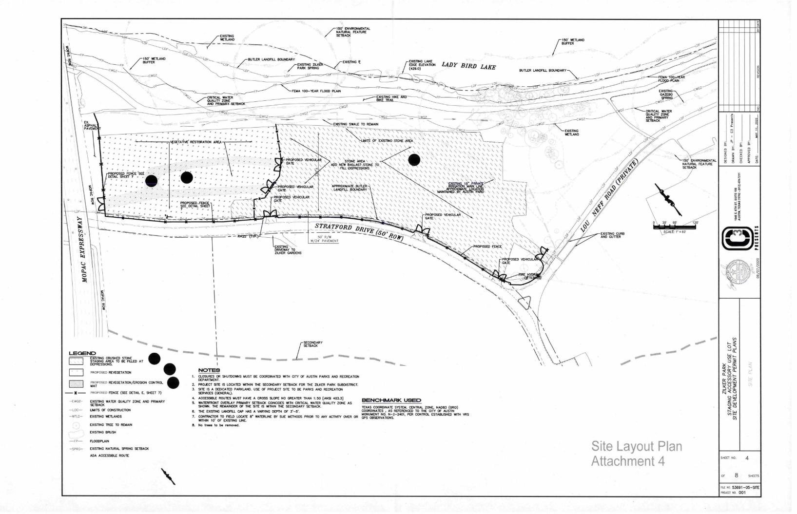
Proposed Project Description
The project proposes to provide maintenance improvements to maintain cap conditions. Theproposed improvements include the addition of vehicular gates to control vehicular access onto
the cap, addition of topsoil and revegetation of the western portion of the site, a temporaryirrigation system to support the revegetation and the installation of a split rail fence along
Stratford Drive and between the gravel area and the revegetation area.
Description of Construction/Investigation ProcessThe project site has been investigated through site observations for existing environmental
conditions. Existing conditions topographic surveys, owner interviews, utility route investigationand through soil borings on the cap. Utility and topographic information is shown on the plans.
Procedures for Management of Methane, Water and Excavated Waste During ConstructionThe soil borings were preformed while monitoring for methane. None was detected. Waterwas not encountered in any boring. All activities have been designed to minimize/avoid anydisturbance of the existing cap materials. None of the maintenance improvements proposedshall disturb or penetrate the cap into the trash below. Groundwater is not expected to beencountered during any excavation process, but if it is and requires removal, then it will becontainerized, characterized, and disposed at an authorized facility. Any encountered trashmaterials, utility or storm trenching or pond construction, will be separated from the capmaterial and hauled to an approved landfill. Cap materials will be used for backfill or trenchesor replacement of the cap liner.
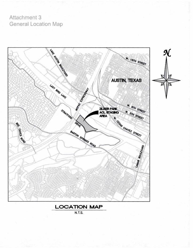
Attachment 3General Location Map
LOCATION MAPN.T.S.
FP
150' WETLANDBUFFER
EXISTINGWETLAND
_
FPCRITICAL WATERQUALITY ZONEAND PRI
7150' ENVIRONMENTALNATURAL FEATURESETBACK
BUTLER LANDFILL BOUNDARY EXISTING IE
7EXISTING ZILK'OR---„,...fPARX SPRING
FP FP
FEMA 100-YEAR FLOOD PLAIN
v407.
OF
EXISTING LAKE EDGE ELEVATION LADY BIRD LAKE(429.0)
/150' WETLANDBUFFER
BUTLER LANDFILL BOUNDARY-\\
Fp
........ A
I
—
I
.,W.y.A
.
—... ..
....
.......
...
......\
.
..,...\
.
...\.,\.4
.
.'.1.\\„....4A
.
r
.
.
,
.
\\
...
V
V
3
..\...A
.
.\..._W
.A.
..,1\
-
I KV
\
e
\
\
W\
\
\\
\
C\
\
V
\
a
.\
.\.
As
s
,
\
\
E..,
\,_.\
I
\
.3\_\
„\
.
\
_.
e\\
.\.W,_\
\
\
\_•
‘
„_.
\\=.\
_1
\
,.\„0\
_
q\
.\
_\
\
C.
,
,0.,
,\
,
._\,\
,.\”\,5
..
.
\)
\3
\
\ ,.s
\.
\\
c w
\
o Z\\\\\\
\\\\\\\\\\\\\\\\\\\\\\\\\
\\\\\\\\\\\\\
\\\\
\;-
\\
•9
z\\
\
\
\
\\
\
\\
\\-
\ \ \
C•k\
\
\
\,\
C
\l\\
\
\\\'k
\\\\\\\\'s\\\\\\\\\
k\\\\\\\\\\\\\\\\\\\\\
.
.\\\\\,
,,,
\\\\\:\
\\\\\\\\\\\\\\\\\\RerocuceARE
\\\\\\
\\\\\\\\\\\\\\
\\°ErAl
\\\\\\\\\\\N \\
\\\\\\\\LL
\\\\\\
\\\\\\\\\\\
\\\\\\\\\\\\\ \\\\\\\\X
\\\\\\\\
\\\\4\\\
\wt.\
\\
\
\\\\\\\\\\\\\\\\HCA\\\
\\\\\\\\\\\\\\\\\\\\\OENCES
.
\\
*
\\\\\\\\\\\
C\
‘•
\
I\
.
\
i
G
\
1i
\
L
\
A
-\
\\
"\•\\
.
\\-
\
\
\
\
\ \
\AT
\i
\\\\\\\\\\\\\\\\\\\\\\\\\\\\\\\
\\\\\\\RA\
\\\\\\\\
\ \\\\\\F.PF
-EE.
\0
\
••••••••••••••••••••
\
•
7
•STRATFORD DRI450,
• • • • • • • • • • • • •
•_ .
• • • \
•— 5' R
„
\\\\\\\\_—L
W/24' PAVEMENT -
--:, ,.\
RA
ENS
1. \
\
CI
I
I
\
o
I
so,m
I
\
I
LEGEND EXISTING CRUSHED STONE
STAGING AREA TO BE FILLED AT DEPRESSIONS.
— X —
PROPOSED REVEGETATTON
•PROPOSED REVEGETATION/EROSION CONTROLMAT
PROPOSED FENCE (SEE DETAIL E. 9-IEET
•-Cw0Z- EXISTING WATER QUALITY ZONE AND PRIMARY
SETBACK
LOC UMITS OF CONSTRUCTION
- WT 1- EXISTING WETLANDS
EXISTING TREE TO REMAIN
EXISTING BRUSH
FLOODPLAIN
EXISTING NATURAL SPRING SETBACK
ADA ACCESSIBLE ROUTE
0.01.1. tams. /SECONDARYSETBACK
NOTES1. CLOSURES OR SHUTDOWNS MUST BE COORDINATED WITH CITY OF AUSTIN PARKS AND RECREATION
DEPARTMENT.
2. PRO,ECT SITE IS LOCATED WITHIN THE SECONDARY SETBACK FOR THE ZILKER PARK SUBDISTRICT.
3. SITE IS A DEDICATED PARKLAND. USE OF PROJECT SITE TO BE PARKS AND RECREATIONSERVICES (GENERAL).
4. ACCESSIBLE ROUTES MUST HAVE A CROSS SLOPE NO GREATER THAN 1:50 (ANSI 403.3]BENCHMARK USED
5. WATERFRONT OVERLAY PRIMARY SETBACK COINCIDES WITH CRITICAL WATER QUALITY ZONE ASSHOWN. THE REMAINDER OF THE SITE IS WITHIN THE SECONDARY SETBACK. TEXAS COORDINATE SYSTEM, CENTRAL ZONE, NAD83 (GRID)
6. THE EXISTING LANDFILL CAP HAS A VARYING DEPTH OF 3.-5'. COORDINATES , AS REFERENCED TO THE CITY OF AUSTINMONUMENT NO. N-2-2401, PER CONTROL ESTABUSHED WITH VRS
7. CONTRACTOR TO FIELD LOCATE 8 WATERUNE BY SUE METHODS PRIOR TO ANY ACTNITY OVER OR GPS OBSERVATIONS.WITHIN IC OF EXISTING UNE.
8. No trees to be removed.
ol
NSTI GWETLAND
LOF
OF
EXISTP4G CURBAND GUTTER
OC
1-OF
EXISTINGGAIMMOSPRIN
CW°7
----- c-rRrncAL WATERQUAUTY ZONEAND PRIMARYSETBACK
V
0
Site Layout PlanAttachment 4
Cl
¶50 \kNV1RONIAENTALNATUFK FEATURESETBACK
S.
1.1
M.
SHEET NO
OF 8
4
SHEETS
RE NO 53691-05-SITE
PROJECT NO 001
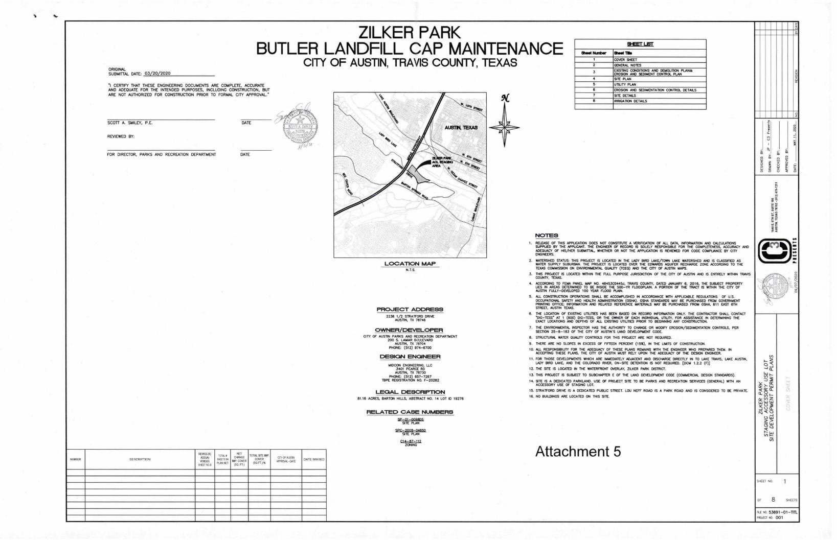
ORIGINALSUBMITTAL DATE: 03/20/2020
ZILKER PARKBUTLER LANDFILL CAP MAINTENANCE
CITY OF AUSTIN, TRAVIS COUNTY, TEXAS
"I CERTIFY THAT THESE ENGINEERING DOCUMENTS ARE COMPLETE, ACCURATEAND ADEQUATE FOR THE INTENDED PURPOSES, INCLUDING CONSTRUCTION, BUTARE NOT AUTHORIZED FOR CONSTRUCTION PRIOR TO FORMAL CITY APPROVAL."
SCOTT A. SMILEY, P.E.
REVIEWED BY:
FOR DIRECTOR, PARKS AND RECREATION DEPARTMENT
DATE
DATE
p/u
LOCATION MAPN.T.S.
PROJECT ADDRESS
2236 1/2 STRATFORD DRIVEAUSTIN, TX 713746
OWNER/DEVELOPER CITY OF AUSTIN PARKS AND RECREATION DEPARTMENT
200 S. LAMAR BO'JLEVARDAUSTIN, 1N 78704
PHONE: (512) 974-6700
DESIGN ENGINEER
/MIXON ENGINEERING, LLC3401 PEARCE RDAUSTIN, TX 78730
PHONE: (512) 657-7267IBPE REGISTRATION NO. F-20282
LEGAL DESCRIPTION
81.16 ACRES, BARTON HILLS, ABSTRACT NO. 14 LOT ID 19276
RELATED CASE NUMBERS
5P-01-0098M SITE PLAN
5PC-2003-04850 SHE PLAN
C14-87-112,ZONING
DESCRIPTION
REVISERADMVOICXV)
SHEET Nas
TOTALSMEETS INPLAN SET
NETCHANGE
ISF. COVERpa. r.)
TOTAL SITE IMPCOVER
(SOFT."
CITY OF AUSTINAPPROVAL -DATE
DATE IMAGED
NOTES
SI-IEET UST
BMW NuTiaor 8118•1 Me
1 COVER SHEET
2 GENERAL NOTES
3 EXISTING CONDITIONS AND DEMOLITION PLAN&EROSION AND SEDIMENT CONTROL PLAN
4 SITE PLAN
5 UTIU TY PLAN
6 EROSION AND SEDIMENTATION CONTROL DETAILS
7 SITE DETAILS
8 IRRIGATION DETAILS
1. RFI FALSE OF THIS APPUCATTON DOES NOT CONSTITUTE A VERIFICATION OF ALL DATA, INFORMATION AND CALCULATIONSSUPPUED BY THE APPUCANT. THE ENGINEER OF RECORD IS SOLELY RESPONSIBLE FOR THE COMPLETENESS, ACCURACY ANDADEQUACY OF HIS/HER SUBMITTAL WHETHER OR NOT THE APPL/CATION IS REVIEWED FOR CODE COMPLANCE BY CITYENGINEERS.
2. WATERSHED STATUS: THIS PROJECT IS LOCATED IN THE LADY BIRD LAKE/TOWN LAKE WATERSHED AND IS CLASSIFIED ASWATER SUPPLY SUBURBAN. THE PROJECT IS LOCATED OVER THE EDWARDS AQUIFER RECHARGE ZONE ACCORDING TO THETEXAS COMMISSION ON ENVIRONMENTAL QUALITY (ICED) AND THE CITY OF AUSTIN MAPS.
3. THIS PROJECT IS LOCATED WITHIN THE FULL PURPOSE JURISDICTION OF THE CITY OF AUSTIN AND IS ENTIRELY WITHIN TRAVISCOUNTY, TFXAs.
4. ACCORDING TO FE1AA PANEL MAP NO. 48453C0445J. TRAVIS COUNTY, DATED JANUARY 6, 2016, THE SUBJECT PROPERTYUES IN AREAS DETERMINED TO BE INSIDE THE 500-YR FLOODPLAIN. A PORTION OF THE TRACT IS WITHIN THE CITY OFAUSTIN FULLY-DEVELOPED 100 YEAR FLOOD PLAIN.
5. ALL CONSTRUCTION OPERATIONS SHALL BE ACCOIAPUSHED IN ACCORDANCE WITH APPLICABLE REGULATIONS OF U.S.OCCUPATIONAL SAFETY AND HEALTH ADMINISTRATION (OSHA). OSHA STANDARDS MAY BE PURCHASED FROM GOVERNMENTPRIMING OFFICE; INFORMATION AND RELATED REFERENCE MATERIALS MAY BE PURCHASED FROM OSHA, 611 EAST 6THSTREET, AUSTIN TEXAS.
6. THE LOCATION OF DIEING UTILITIES HAS BEEN BASED ON RECORD INFORMATION ONLY. THE CONTRACTOR SHALL CONTACT*DIG-TESS" AT 1 (800) DIG-TESS, OR THE OWNER OF EACH INDIVIDUAL UTILITY, FOR ASSISTANCE IN DETERMINING THEEXACT LOCATIONS AND DEPTHS OF ALL EXISTING UTIUTIES PRIOR TO BEGINNING ANY CONSTRUCTION.
7. THE ENVIRONMENTAL INSPECTOR HAS THE AUTHORITY TO CHANGE OR MODIFY EROSION/SEDIMENTATION CONTROLS, PERSECTION 25-8-183 OF THE CITY OF AUSTIN'S LAND DEVELOPMENT CODE.
8. STRUCTURAL WATER QUALITY CONTROLS FOR THIS PROJECT ARE NOT REQUIRED.
9. THERE ARE NO SLOPES IN EXCESS OF FIFTEEN PERCENT (I 530, IN THE UMITS OF CONSTRUCTION.
TO. ALL RESPONSIBIUTY FOR THE ADEQUACY OF THESE PLANS REMAINS WITH THE ENGINEER WHO PREPARED THEM. INACCEPTING THESE PLANS, THE CITY OF AUSTIN MUST RELY UPON THE ADEQUACY OF THE DESIGN ENGINEER.
11. FOR THOSE DEVELOPMENTS WHICH ARE IMMEDIATELY ADJACENT AND DISCHARGE DIRECTLY IN TO LAKE TRAVIS, LAKE AUSTIN,LADY BIRD LAKE, AND THE COLORADO RIVER, ON-SITE DETENTION IS NOT REQUIRED. [DCIA 1.2.2 (F))
12. THE SITE IS LOCATED IN THE WATERFRONT OVERLAY, ZILKER PARK DISTRICT.
13. THIS PROJECT IS SUBJECT TO SUBCHAPTER E OF THE LAND DEVELOPMENT CODE (COMMERCIAL DESIGN STANDARDS).
14. SITE IS A DEDICATED PARKLAND. USE OF PROJECT SITE TO BE PARKS AND RECREATION SERVICES (GENERAL) WITH ANACCESSORY USE OF STAGING LOT.
15. STRATFORD DRIVE IS A DEDICATED PUBLIC STREET. LOU NEFF ROAD IS A PARK ROAD AND IS CONSIDERED TO BE PRIVATE.
16. NO BUILDINGS ARE LOCATED ON THIS SITE.
Attachment 5
5
2
:73
414
MA
SHEET NO.
OF 8 SHEETS
FILE NO. 53691 -01 -TITLPROJECT NO. 001
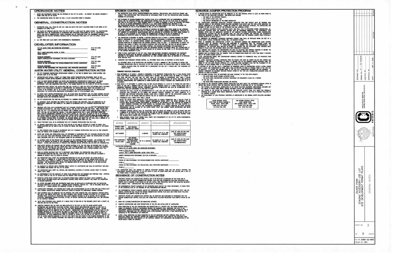
;111411 P NMI 9 Pi!
ili r r ° 1M0 iR
1 pp W ME; r
2-g
v 12 I
IA0 8F
IT' ia
11
ligA.E1 1 :IT ii 41 y ,,
,, A4
A: gpi.! b.! poli
ih 11
>6
g
AOA
23 1
,N 2'4
!Mt
i gi2
4w g
p IR
1 ,-,
A g 1 p
A hA E ., 7
2
111Y :N-g 9§ 4Rd 11 igg 9 P
gl Ae54 N! ag
A ;4 1 1 :m X
Pi
.1:14gAig
140 g LW P Mq 0 '10 .
11A mm:0 5
iw m9
1.7,1
rAy
AI= g Ap 1g
j A
51 Ai
d A A1 rg An 4
gAht Ne
1
o id
mi 'i
d -d -;
1 RP 'm
iN
qqg4
A AV I JO. gm ;
-
A 4F
Mi 4
0 q '45 ;Aw U 4! g 8
°
R40 ig AL 4
/PI
-P:h 1 g
14 '
e9
L;111
b 1: 1 1
E
A2g
*
i -$ Ag
QK 015 1'4 =
41A N R
IA r
g
gi !
p g ii i ! :304 05
aa d ta
'I;
A.5114iA5 g
"g01
A 1
g. :4
A A
8
§00
B gg
g A!
! 0 !
g1 :s
. RA
0 1
1 0
201;1
;. nos
s04
r
1AA
A '4
9 M
AO
n g
.
1W MI 1 11
/" " 911
TiP5 1
1 §4 h
Oh TV
11 M
Ogi
gi
e I
xag
a i!
NA A
g gm A
mm pe
g g 4
N21
*11
gXN
g E§ qA 9! q
v§
-9IC
am
;N1
!Mg
4A h r AA
cA! eq
ti
Ag gig, 1
g:
hg
T2 R A
a 0 IA
id P
22
6
2,
La R
i;
`14
*A
g A
1 p
2g
A
P
56
!
1 1 ;MIT li: li! q° T r I
A
INYWQ! 211
p i
°01
IP r 10
:At ' P
11:4! h
: :r
ill
Ili 4
' li
T 2 t4 in
R ;
6p 2 X -
gag
1 oi
l q
x 1
.",,
P 1 ';A
0141
7! :i i 9 IT FP 1; i
" A .0.1 4
41 11 Mt i
° gi
AAIW
1.t
IR 2 g "gi i
i
0 1 MhiltA ii 1 4 iAl
IP
44!! 1 AAA4jA
LP 1 I
X 2,te 41 !I
1 i 114q! 4 d il; i
!! q
h. a AR
mR MTAg : , ix
8 4 1 IA
4;1
ip 4
;$AT
AO
1 11 W i-
.7 I 8
R 0 g
l :1 lip A
i1§ g e
x
ttl g .a il
MIAMI WI
>1 05 11
MATERIAL
A95
Pt°1
Pr
IN 01
r
DESCRIPTION
% 8 - & g
- N
§ 1
li 1 8 3 g
li P R g
TYPICAL APPLICATIONS
AAM8
Iii
i0
A
AA3148
Ili
gPA
APPUCATION RATES
0
c 1
10,1
orl'
;:li
g1::
:1::
A0 :41:1
11"- mln
-g rg0 t
gig I
YkA itill TIN 1 hilOh i kiNi
ii
i;:;
g2FO
li
POP
gr'MAillid ql!il
IRa. 01115
A X 49g1 511N ill PI
4 I R
a g4ta
e,_,11
S'
P11;
iii
1!4;1;ilii
!!
i
111104 >XX"
srAc 0 /
0
a
54 4 1
.: 41i
1 AN
120
1;4 "
In
Elq5
Wig
"4.E9
0 0
a
!
!
! ! !
11 I ;1!
I ! ! !
fwgdg*1 A*4 )41
1 10
4kl 4
0, g Ali%
!I
i 4q i 4; NPli Neigir! i
IN g
:p
r4 r 0%4 kV el
i ii: /400 Op vA
ri:
m24
i- gil
yl Al
i 8 1
1::: !:
g: 0
1'1
1 ::i
Ig i i:
!!
44! iL:il
1 :
1
q; m
FA2 CORA= OP
4 r;
q g : l i g
d
021041
nAviR-
e 4
8 10 : A 614
Lli
PI g
84 j
A,
9I
p ° 'AX
XS2I'M9911Wg J°86AP
A"
1 wAr n :g i ; i 4 V rciRON 11 IV qt Or
A;
1/
r:°:!m::!:;:
:;::i:::!:::
::2:1901jr"P
l:::11::;2:;i::;:::::
115:52151:::;:
5341.2 1 g
pOg pi
A8 sWv.R
gi'R
LI1 1014: iii i i:)!i; 441 A ,i1ggiI1
61;14h
Gin;lA
Ihi:i?4 N
T
i! 1!;;:iiiil 15
i IN"
15
8 Nire !!
i WO !I h*164 r't:TA aRpAq
48
0 14
11e; iillIPI:
8 FlOOR : 3
A A
cn t I
Pt EN
4
.1go
x ime
1 x i I
tA
2 t il
e Oi
!il H/
lag IAN 0
!
49
T iP- ge! 41
: mg
i,
.
ela
410
g t! * 1
"A
15 '.'
' :II:g!c
,§ igll 13
g -E
z°
1e
gi i
s
1 h
?. !
R-H
PXR
i a
X siA
0 >
mf.q,
AA:
a
co
Ni
ZILKER PARK
STAGING ACCESSORY USE LOT
SHE DEVELOPMENT PERMIT PLANS
GENERAL NOTES
09/07/2020
PIES/NTS
1646 E. 6TH ST.
SUITE 150
AUST
IN, TEX
AS 787
02-0
12)4
78-7
211
DESIGNED BY
.
DRAWN BY
: JP - C3 P
resents
CHECKED BY
:
APPROVED BY
:
DATE
:
MAY
It. 2020
NO.
REVI
SION
BYDATE
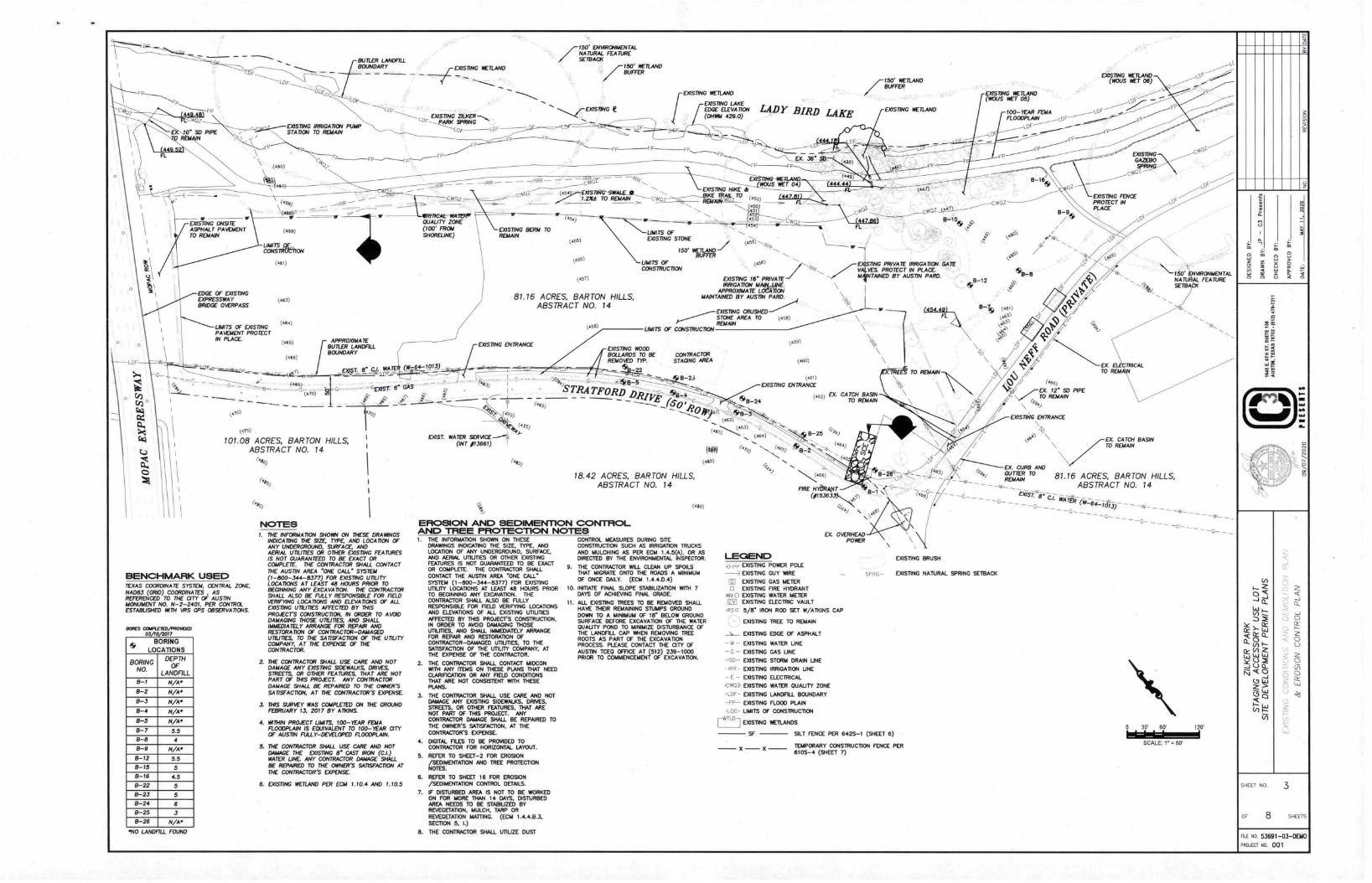
1
1
LDF
CO!
BUTLER LANDFILLBOUNDARY
- -
4MV04871-___EXISTING IRRIGATION PUMP
0' SD PIPE STATION TO REMAIN
-
EXISTING ONSITEASPHALT PAVEMENTTO REMAIN
EDGE OF EXISTINGEXPRESSWAYBRIDGE OVERPASS
(450)
(45.)
01, -
(451)
LIMITS pc,CONSTRUCTION
LIMITS OF EXISTINGPAVEMENT PROTECTIN PLACE.
(4-1 )
I'? 51
(461)
(463)
(444)
(445)
(466)
1
(464.1
(470)
APPROXIMATEBUTLER LANDFILLBOUNDARY
F. 8' ch WA
-Gvasr. er -
s?4‘
101.08 ACRES, BARTON HILLS,ABSTRACT NO. 14
(.4o,
BENCHMARK USED TEXAS COORDINATE SYSTEM, CENTRAL ZONE,NA083 (GRID) COORDINATES. ASREFERENCED TO THE CITY OF AUSTINMONUMENT NO. N-2-2401, PER CONTROLESTABUSHED 147TH VRS GPS OBSERVATIONS.
BORES COMPLETED/PROWOCD03/10/2017
BORING
LOCATIONS
BORING
NO.
DEPTHOF
LANDF7LL
N/A'
8-2 N/A'
8-3 N/A.
8-4 N/A.
8-5 N/A.
B-7 55
B-8 4
8-9 N/A'
B-12 5.59-15 5
8-16 4.5
8-22 5
B-23 5
B-24 6
8-25 3
B-26 N/A •
'NO LANDFILL FOUND
_ r°°5° WETLAND
EXISTING
t_DF
- -IRR -
CWrIz
DUALITY ZONE(100' FROMSHORELINE)
(91-64-101;)_
NOTESI. THE INFORMATION SHORN ON THESE DRAIWNGS
INDICATING THE SIZE, TYPE, AND LOCATION OFANY UNDERGROUND, SURFACE ANDAERIAL UTILITIES OR OTHER EXISTING FEATURESIS NOT GUARANTEED TO BE EXACT ORCOMPLETE. THE CONTRACTOR SHALL CONTACTTHE AUSTIN AREA 'ONE CALL SYSTEM(I-800-344-8377) FOR EXISTING UTILITYLOCATIONS AT LEAST 48 HOURS PRIOR TOBEGINNING ANY EXCAVATION. THE CONTRACTORSHALL ALSO BE FULLY RESPONSIBLE FOR FIELDVERIFYING LOCATIONS AND ELEVATIONS OF ALLEXISTING UTILITIES AFFECTED BY THISPROJECTS CONSTRUCTION, IN ORDER TO AVOIDDAMAGING THOSE UTILITIES, AND SHALLIMMEDIATELY ARRANGE FOR REPAIR ANDRESTORATION OF CONTRACTOR-DAMAGED1117UTIES, TO THE SATISFACTION OF THE UTILITYCOMPANY, AT THE EXPENSE OF THECONTRACTOR.
2. THE CONTRACTOR SHALL USE CARE AND NOTDAMAGE ANY EXISTING SIDEWALKS DRIVESSTREETS, OR OTHER FEATURES THAT ARE NOTPART OF THIS PROJECT. ANY CONTRACTORDAMAGE SHALL BE REPAIRED TO THE OMER'SSATISFACTION, AT THE CONTRACTOR'S EXPENSE.
3. THIS SURVEY WAS COMPLETED ON THE GROUNDFEBRUARY 13, 2017 BY ATKINS.
4. WITHIN PROJECT WAITS, 100-TAR FE6.1.4FLOODPLAIN IS EQUIVALENT TO 100-YEAR CITYOF AUSTIN FULLY-DEVELOPED FLOODPLAIN.
5. THE CONTRACTOR SHALL USE CARE AND NOTDAMAGE THE EXISTING 8" CAST IRON (CI.)WATER LINE ANY CONTRACTOR DAMAGE SHALLBE REPAIRED TO THE OWNER'S SATISFACTION ATTHE CONTRACTOR'S EXPENSE.
6. EXISTING WETLAND PER ECM 1.10.4 AND 1.10.5
DRAWINGS INDICATING THE SIZE, TYPE, ANDLOCATION OF ANY UNDERGROUND. SURFACE.AND AERIAL ununEs OR OTHER COSTINGFEATURES IS NOT GUARANTEED TO BE EXACTOR COMPLETE. THE CONTRACTOR SHALLCONTACT THE AUSTIN AREA "ONE CALL"SYSTEM (1-800-344-8377) FOR EXISTINGUTILITY LOCATIONS AT LEAST 48 HOURS PRIORTO BEGINNING ANY EXCAVATION. THECONTRACTOR SHALL ALSO BE FULLYRESPONSIBLE FOR FIELD VERIFYING LOCATIONSAND ELEVATIONS OF ALL EXISTING LMUTIESAFFECTED BY THIS PROJECT'S CONSTRUCTION,IN ORDER TO AVOID DAMAGING THOSEUTILITIES, AND SHALL IMMEDIATELY ARRANGEFOR REPAIR AND RESTORATION OFCONTRACTOR-DAMAGED UTIUTIES, TO THESATISFACTION OF THE UTILITY COMPANY, ATTHE EXPENSE OF THE CONTRACTOR.
2. THE CONTRACTOR SHALL CONTACT MIDCONWITH ANY ITEMS ON THESE PLANS THAT NEEDCLARIFICATION OR ANY FIELD CONDMONSTHAT ARE NOT CONSISTENT WITH THESEPLANS.
3. THE CONTRACTOR SHALL USE CARE AND NOTDAMAGE ANY EXISTING SIDEWALKS, DRIVES,STREETS, OR OTHER FEATURES, THAT ARENOT PART OF THIS PROJECT. ANYCONTRACTOR DAMAGE SHALL BE REPAIRED TOTHE OWNER'S SATISFACTION, AT THECONTRACTOR'S EXPENSE.
4. DIGITAL FILES TO BE PROVIDED TOCONTRACTOR FOR HORIZONTAL LAYOUT.5. REFER TO SHEET-2 FOR EROSION/SEDIMENTATION AND TREE PROTECTION
NOTES.
6. REFER TO SHEET 16 FOR EROSION/SEDIMENTATION CONTROL DETAILS.7. IF DISTURBED AREA IS NOT TO BE WORKEDON FOR MORE THAN 14 DAYS. DISTURBED
AREA NEEDS TO BE STABIUZED BYREVEGETATION, MULCH, TARP ORREVEGETATION MATTING. (ECM 1.4.4.6.3,SECTION 5, I.)
8. THE CONTRACTOR SHALL UTIUZE DUST
-
EXISTING BERM TOREMAIN
7150' ENVIRONMENTALNATURAL FEATURESETBACK
7150' WETLANDBUFFER
C i- EXISTING IIERAND
EXISTING LAKEEDGE El-EVA noN(0711134 429.0)
FP
FP
1.2%.* TO REMAIN Cw▪ oz . (45o)
450---,I451
-,.
-.-'.
UNITS OFSTONE(455) EXISTING
-.-_
150. 0 ..// (A▪ -5'5) -,.../i,
-' .„!7
LADY BIRD LAKE
(456)
(45,1
81.76 ACRES, BARTON HILLS,ABSTRACT NO. 14
EXISTING ENTRANCE
4!)b•PA. (.60)
(445)
EXIST. WATER SERVICET /1366/) I
r•to,)
(44s)
(4551
BUFFERUMITS OF (456)CONSTRUCTION
1.0
NET 04)
//-150' WETLAND
BUFFER
woz----A-- (447.88313 FL
w
EXISTING 16' PRIVATEIRRIGATION MAI&LINE.
APPROXIMATE LOCATIONMAINTAINED BY AUSTIN PARD.
EXISTING CRUSHED---STONE AREA TO /561REMAIN
UNITS OF CONSTRUCTION
EXISTING WOODBOLLARDS TO BE CONTRACTORREMOVED TIP. STAGING AREA
- -22.44_5
STRA TFORD.----••••••••• 45.0 '.,e? •Oft5l)
"*".• (462)
(.;;.........z63) 06:1.
)
18.42 ACRES, BARTON HILLS,ABSTRACT NO. 14
EROSION AND SEDIMENT1ON CONTROLAND TREE PROTECTION NOTES THE INFORMATION SHOWN ON THESE CONTROL MEASURES DURING SITECONSTRUCTION SUCH AS IRRIGATION TRUCKS
AND MULCHING AS PER ECM 1.4.5(4), OR ASDIRECTED BY THE ENVIRONMENTAL INSPECTOR.9. THE CONTRACTOR WILL CLEAN UP SPOILSTHAT MIGRATE ONTO THE ROADS A MINIMUMOF ONCE DAILY. (ECM 1.4.4.0.4)10. INITIATE FINAL SLOPE STABIUZATION WITH 7DAYS OF ACHIEVING FINAL GRADE.11. ALL EXISTING TREES TO BE REMOVED SHALL
HAVE THEIR REMAINING STUMPS GROUNDDOWN TO A MINIMUM OF 18" BELOW GROUNDSURFACE BEFORE EXCAVATION OF THE WATERQUALITY POND TO MINIMIZE DISTURBANCE OFTHE LANDFILL CAP WHEN REMOVING TREEROOTS AS PART OF THE EXCAVATIONPROCESS. PLEASE CONTACT THE a TY OFAUSTIN TCE0 OFFICE AT (512) 239-1000PRIOR TO COMMENCEMENT OF EXCAVATION.
.B-24
(W) (̀,0,(45)
(4to)
LECIEND
(459)
(460)
(461)
EXISTING ENTRANCE
(02) EX CATCH BASINTO REMAIN
EXISTING WETLAND
0411
CWOZ
TING PRIVATE IRRIGATION GATEVBS. PROTECT IN PLACEMINED BY AUSTIN PARD.
FIRE HYbRANT(#15J633
EX OVERHEADPOWER
pp EXISTING POWER POLEEXISTING GUY WIRE
El EXISTING GAS METER0 EXISTING FIRE HYDRANT8510 EXISTING WATER METERI= EXISTING ELECTRIC VAULT
IPSO 5/8' IRON ROD SET W/A. DONS CAPEXISTING TREE TO REMAIN
EXISTING EDGE OF ASPHALT
- W - EXISTING
- C - EXISTING
-SO- EXISTING
-IRA- EXISTING
- E - EXISTING
-CWCZ- EXISTING
-OR EXISTING
-FP- EXISTING
WATER LINE
CAS LINE
STORM DRAIN LINE
IRRIGATION LINE
ELECTRICAL
WATER QUALITY ZONE
LANDFILL BOUNDARY
FLOOD PLAIN
TO REMAIN
EXISTING BRUSH
EXISTING WETLAND(INDUS NET 05)
.B-12
FEMAFLOODPLAIN100-YEAR oF
B-1
wOZ
EXISTING NATURAL SPRING SETBACK
LOG LIMITS OF CONSTRUCTION[-WILD-1
EXISTING WETLANDS
SF SILT FENCE PER 642S-1 (SHEET 6)
X XTEMPORARY CONSTRUCTION FENCE PER- -610S-4 (SHEET 7)
EX. 12' SD PIPETO REMAIN
EXISTING WETLAND(WOUS NET 06)
u0c
EXISTINGGAZEBOSPFNN
EXISTING FENCEPITOTECT WIPLACE
c33.5
0
obb
cosnko\71RAN\CE
\ EX. CATCH BASINTO REMAIN
EX.
CUouGUTTERTo 81.16 ACRES,mBARTON
E:AND
REMAINABSTRACT NO. 14
0 30 60'
0
120
SCALE 7'' 60'
-4,,
re
DESIGNED BY
:
6 3-;
SHEET NO
OF 8
3
FILE NO. 53691-03-DEMOPROJECT 710 001

•)?
1
IT 150' WETLANDBUFFER
PROPOSED FENCE SEEDETAIL SHEET 7
EXISTINGWETLAND
CRITICAL WATERQUALITY ZONEAND PRI
VrGET. ATVE' RitsrounoN AREA ,, .4 . .
r150' ENVIRONMENTALNATURAL FEATURESETBACK
\
BUTLER LANDFILL BOUNDARYDOSING t
CMIZ—
,g g g
.............. g
. . .-
.....
.PROPOSED. FENCE
EEDETAJLs"..,uLT. va
yy.wa vs ys it at at .g.g
...... L
LEGEND EXISTING CRUSHED STONE
STAGING AREA TO BE FILLED ATDEPRESSIONS.
- X -
PROPOSED REVEGETATION
•PROPOSED REVEGETATION/EROSION CONTROLMAT
PROPOSED FENCE (SEE DETAIL E. SHEET 7)
— - -
',Nebo
•EXISTING WATER GNAUTY ZONE AND PRIMARYSETBACK
UMITS OF CONSTRUCTION
EXISTING WETLANDS
EXISTING TREE TO RDAAIN
EXISTING BRUSH
FLOODPLAIN
EXISTING NATURAL SPRING SETBACK
ADA ACCESSIBLE ROUTE
7 EXISTINGPARK SPRING
LO
MIA 100-YEAR FLOOD PLAIN
vtiot
EXISTING HIKETRAI
WOZ
EXISTING LAKED
LADY BIRD LAKE(429.0)
\ \ \ \ \ \ 1\ \ \ \ \ \ \ \ \ \ \ \ \ \ \ \ \\ \
\ \ \ \ \ \ \ \ \ \ \ \ \ \ \ \ \ \ \ \ \\ \\ \ \ \ \ \ \ \ \ \ \ \ \ \ \ \
, , \ \ \
\ \ \ \ \\ \ \ \ \ \ \ \ \ \ \ \ \ \ \ \ ‘
\ \ \ \ \ \ \ \ \ \ \ \ \ \ \ \ \ \ \ \ \ \ \ \
IAA,TAINIM
\ \ VORROXIM
\ \ \ \ \ \ \ \ \ \ \ \ \ \ \ \ \ \ \ \ \ \ \ \ \ \ \ \ \ \ \ \ \ \
\ \ \ \ \ \ \ \ \ \ \ \ \ \ \ \ \ \ \ \ \ \ \ \
\ \ \ \ \ \ \ \ \ \ \ \ \ \ \ \ \ \ \ \ \ \ \ \ \ \ \ \ \ \ \ \ \ \ \ \ \ \ \ \ \ \ \
\ \ \ \ \ \ \ \ \ \ \ \ \ \ \
\ \ \ \ \ \ \ \ \ \
\ \ \ \ \ \ \ \ \ \ \ \ \ \ \ \ \ \ \ \ \ \ \ \ \ \ \ \ \ \ \ \ \ \ \ \ \ \ \
\ \ \ \ \ \ \ \ \ \ \ \-_...4_
\ \ \ \ \ \ \ \ \ \Iht 0 \\
W/24 PAVEMENT50' R/W .....,............_
150' WETLANDBUFFER
BUTLER LANDFILL BOUNDARY
\ \ \ \ \ \
\\\\ \\ \ \ \
\ \ \ \ \ \ \ \ \ \ \ \ \ \ \ \ \ \ \ \ \ \ \ \ \\ \ \ \ \ \
\ \ \ \ \ \ \ \
\\7\\\\\
\\\\\\EA:\\\1\\7\\:\
\sw\\\\
\\\\
\TO
\\
:\iRoA
\\
\\
\0FA:
\\
\:
\\\ \\ \ \ \ \ \ \
\ \ \ 7 \ \ \ \ \ \ \ \ \ \ \\ \ \ \ \ \\ \
\ VEHICULAR \
>REA \ \\ \ \
.44\
\ \\\\\\\
\ \\ \
\ \ \ \ \ \
Ja4c4JLAR
DRIVEWAY ssie'ZXKER GARDENS
SECONDARYSETBACK
meesie MOWN
NOTES1. CLOSURES OR SHUTDOWNS MUST BE COORDINATED WITH CITY OF AUSTIN PARKS
DEPARTMENT.
2. PROJECT SITE IS LOCATED WITHIN THE SECONDARY SETBACK FOR THE ZILKER PARK SUBDISTRICT.
3. SITE IS A DEDICATED PARKLAND. USE OF PROJECT SITE TO BE PARKS AND RECREATIONSERVICES (GENERAL).
4. ACCESSIBLE ROUTES MUST HAVE A CROSS SLOPE NO GREATER THAN 1:50 [ANSI 403.3]
5. WATERFRONT OVERLAY PRIMARY SETBACK COINCIDES WITH CRITICAL WATER (DUALITY ZONE ASSHOWN. THE REMAINDER OF THE SITE IS WITHIN THE SECONDARY SETBACK.
6. THE EXISTING LANDFILL CAP HAS A VARYING DEPTH OF 3.-5'.
7. CONTRACTOR TO FIELD LOCATE 13" WATERUNE BY SUE METHODS PRIOR TO ANY AMITY OVER ORWITHIN 10' OF COSTING UNE.
B. No trees to be removed.
AND RECREATION
\ \ \ \ \ \ \ \\ \ \ \ \ \ \ \ \ \ \ \ \ \ \
\ \ \ \ \ \ \ \ \ \ \ \ \ \ \ \ \ \ \ \\ \ \ \ \ \ \ \ \ \ \ \ \ \ \ \ \ \ \ \\ \ \ \ \ \ \ \ \ \ \ \ \ \ \ \ \ \ \ \ \ \
\ \ \ \ \ \ \ \ \ \ \ \ \ \ \ \ \\ \ \ \ \ \ ,••••). \\ \ \ \ \ \ \ \ \
BENCHMARK USED TEXAS COORDINATE SYSTEM, CENTRAL ZONE, NA1383 (GRID)COORDINATES AS REFERENCED TO THE CITY OF AUSTINMONUMENT NO. N-2-2401, PER CONTROL ESTABUSHED WITH VRSGPS OBSERVATIONS.
1.2
\ \ \
\ P OSED VEHICU\ \ \ \ \ rCATE
\ \ \
\ \
OF
400
EP
CWOZ
WETLAND
LDS
ER
EXISTINGThGAZEBOSp1117C4
2. CRITICAL WATEROUAUTY ZONEAND PRIMARYSETBACK
EXISTING CURBAND GUTTER
>51
-150' \ENVIRONMENTALNATURAL FEATURESETBACK
DRAWN BY: JP — C3 Pr"ent.
6.1
IS
O.
SHEET NO.
OF 8
4
SHEE1S
FILE No 53691-05-SITE
PROJECT ND 001
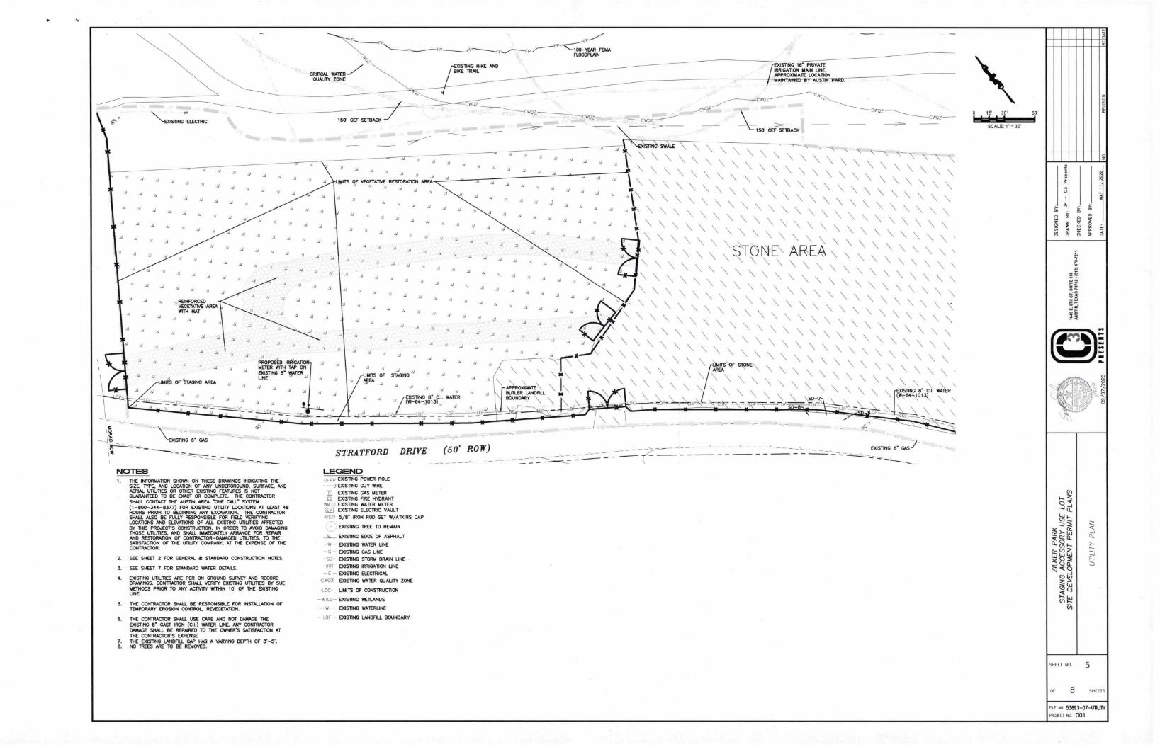
\ -EXISTING ELECTRIC
REINFORCEDVEGETATIVE _AREAWITH MAT
y ,PROPOSED IRRIGATIONMETER WITH TAP ONEXISTING 8 WATERLINE
\EXISTING r GAS
NOTES 1 THE INFORMATION SHOWN ON THESE DRAWINGS INDICATING THE
SIZE, TYPE, AND LOCATION OF ANY UNDERGROUND, SURFACE, ANDAERIAL UTIUTIES OR OTHER EXISTING FEATURES IS NOTGUARANTEED TO BE EXACT OR COMPLETE. THE CONTRACTORSHALL CONTACT THE AUSTIN AREA ONE C.ALL' STPIEM(1-800-344-8377) FOR EXISTING UTILITY LOCATIONS AT LEAST 48HOURS PRIOR TO BEGINNING ANY EXCAVATION. THE CONTRACTORSHALL ALSO BE FULLY RESPONSIBLE FOR FIELD VERIF1INGLOCATIONS AND ELEVATIONS OF ALL EXISTING UTIUTIES AFFECTEDBY THIS PROJECT'S CONSTRUCTION, IN ORDER TO AVOID DAMAGINGTHOSE UTILITIES, AND SHALL IMMEDIATELY ARRANGE FOR REPAJRAND RESTORATION OF CONTRACTOR-DAMAGED UTIUTIES, TO THESATISFACTION OF THE LITIUTY COMPANY, AT THE EXPENSE OF THECONTRACTOR.
2.
3.
4.
SEE SHEET 2 FOR GENERAL & STANDARD CONSTRUCTION NOTES.
SEE SHEET 7 FOR STANDARD WATER DETAILS.
EXISTING UTILITIES ARE PER ON GROUND SURVEY AND RECORDDRAWINGS. CONTRACTOR SHALL VERIFY EXISTING UTILITIES BY SUEMETHODS PRIOR TO ANY ACTIVITY WITHIN 10' OF THE EXISTINGUNE.
5. THE CONTRACTOR SHALL BE RESPONSIBLE FOR INSTALLATION OFTEMPORARY EROSION CONTROL REVEGETATION.
6. THE CONTRACTOR SHALL USE CARE AND NOT DAMAGE THEEXISTING 8' CAST IRON (CI.) WATER LINE. ANY CONTRACTORDAMAGE SHALL BE REPNRED TO THE OWNER'S SATISFACTION ATTHE CONTRACTOR'S EXPENSE
7. THE EXISTING LANDFILL CAP HAS A VARYING DEPTH OF 3.-5'.8. NO TREES ARE TO BE REMOVED.
FP,s,
CRITICAL WATERQUALITY ZONE
150' CEF SETBACK
,
ITS Of VEGETATIVE RESTORATION AFtEA
y
FP
EXISTING HIKE ANDBIKE TRAIL
FEMAFLOODPLMN
snNG le PRIVATErMAIRRIGATION MAIN UNE,APPROXIMATE LOCATION INTAJNED BY "WAN YARD.
- 150' CEF SETBACK
CW0,
\ \ \ \ \ \ \ \ \ \ \ \ \ \ \ \ \ \ \ \ N
NQ \
\N-A N \ \ \ \ \ \ \ \ \ \ \ \ N \ \ \ \ \ \ \ \ \ \
A A A A
A A A A
\ \ \ \ \ \ \ \ \ \ N \ \ \ \ \ \ \ \ \ \ \ \ \
A A A A A \ \ \ N \ \ \ \ \ \ \ \ \ \ \ \ \ \ \ \ \ \ \ \
_A A A • A A A ,i A A
A A A A A \ \ \ \ N \ \ \ \ \ \ \ \ \ \ \ \ \ \ N \ \ \ \
A A A
A A A A A AA A A A
A V A A A
\ \ \ \ \ \ \ \ \ \ \ N N \ \ \ \ \ \ \ \ \ \ \
\ \ \ \ \ \ \ \ \ \ \ \ \ \ \ \ \ \ \ \ \ \ \ sA A' A
A A
5 5 .5 .5 , 5 ., , 5 5 5 5 5 \ \ \ \ \ \ \ \ \ \ \ \ \ \ \ \ \ \ \ \ \ \ \ \A A
A
\ \ \ \ \ \ \ \ \ \ \ \ \ \ \ \ \ \ \ \ \ \ \ \
.5.5 A A A A A
\ \ \ \ \ \ \ \ \ \ \ \ \ \ \ \ \ \ \ \ \ \ \ \
A A A A A A A A A A
A
MYlAtiE
n
A
0AA
A
F
_• A
A
A AA
▪ A A
A
AAP
\\
\\V
\
\\ \
\-\\-
\
\
\\\\
\
\
\
\\\
\
\
\\\,\\
\
\\
t\-
\
i)
\\\\
\\\I T
S
\ \\\C\C
S\\T\\
\\
\\
\
\\
\A AA
\\..\.\s
\
I
• \k
„„\
i
\\
m
m
\ 6
\
A A„A
„
A \ \ \
\\ \ \
SNG ▪
AA
AOTE\\e\ \ \ N N
\\\\\\ \ \
\ \ \ \
z
\
o4:13 =RoF.L
\ \ (
V
A 3t 717o
L
N
\
•
.\ N'
.0
\ \
WOZ
-- • ---STRATFORD DRIVE
LEGENDF EXISTING POWER POLE
EXISTING GUY WIRE
El EXISTING GAS METER0 EXISTING FIRE HYDRANTAUGEXISTING WATER METERI=1 EXISTING ELECTRIC VAULT
IRS 0 5/r IRON ROD SET W/AIXINS CAP
EXISTING TREE TO REMAJN
DUSTING EDGE OF ASPHALT
-W- EXISTING WATER UNE
-G- EXISTING GAS UNE
-SD- EXISTING STORM DRAIN UNE
-IRR - EXISTING IRRIGATION UNE
- E - EXISTING ELECTRICAL
-CW03 EXISTING WATER QUALITY ZONE
LOC UNITS OF CONSTRUCTION
-WILD- EXISTING WETLANDS
W EXISTING WATERUNE
- LEIF - EXISTING LANDFILL BOUNDARY
(50' ROW) EXISTING e CAS
0 15' 30' 60'
SCALE: 1” = 30'
03 Pre
sent
s
t
4•▪ 11
11▪ .
SHEET NO. 5
OF. 8 SHEETS
RI NO. 53691-07-M1YPROJECT NO 001
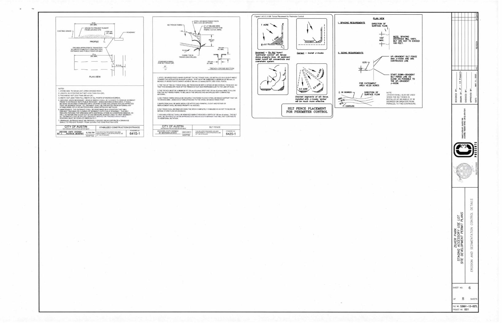
15 m
EXISTING GRADE 1
(57) MIN.
GRADE TO PREVENT RUNOFFFROM LEAVING SITE n=8") MIN
.., - - • --. - , . _, ,
,/-- ROADWAY
IPROFILE
PROVIDE APPROPRIATE 1RANSMON'BETWEEN STABILIZED CONSTRUCTIONENTRANCE AND PUBLIC RIGHT-OF-WAY
15 m
111 (57) MIN.
R.O.W.
—
PLAN VIEW
NOTES
1. STONE SIZE: 75-125 mm 0-71 OPEN GRADED ROCK
2. LENGTH. AS EFFECTIVE BUT NOT LESS THAN 15 m MI.
3. THICKNESS: NOT LESS THAN 200 mm (r).
4. WIDTH NOT LESS THAN FULL WIDTH OF AU. POINTS OF INGRESS/EGRESS.
5. WASHING WHEN NECESSARY. VEHICLE WHEELS SHALL BE CLEANED TO REMOVE SEDIMENTPRIOR TO ENTRANCE ONTO PUBLIC ROADWAY. WI/EN WASHING IS REQUIRED, IT SHALLBE DONE ON AN AREA STABILIZED WITH CRUSHED STONE AND DRAINS INTO AN APPROVEDTRAP OR SEDIMENT BASIN, ALL SEDIMENT SHALL BE PREVENTED FROM ENTERING ANYSTORM DRAIN. DITCH OR WATERCOURSE USING APPROVED METHODS.
B. MAINTENANCE THE ENTRANCE SHALL BE MAINTAINED IN A CONDITION THAT WILLPREVENT TRACKING OR FLOWING OF SEDIMENT ONTO PUBLIC ROADWAY. THIS MAYREQUIRE PERIODIC TOP DRESSING VVITH ADDITIONAL STONE AS CONDITIONS DEMAND ASWELL AS REPAIR AND CLEAN OUT OF ANY MEASURE DEVICES USED TO TRAP SEDIMENT.ALL SEDIMENTS THAT IS SPILLED, DROPPED. WASHED OR TRACKED ONTO PUBLICROADWAY MUST BE REMOVED IMMEDIATELY.
7. DRAINAGE ENTRANCE MUST BE PROPERLY GRADED OR INCORPORATE A DRAINAGESWALE TO PREVENT RUNOFF FROM LEAVING THE CONSTRUCTION SITE.
CITY OF AUSTINARTERSNFIT PROTECTION CEPARTNENT
STABILIZED CONSTRUCTION ENTRANCE
RECORD COPY SIGNED , , ,,,,,nr,BY J. PATRICK MURPHY
r PCHITECTENGWEER ASSUMESXONSMIL, FOR APPROPRIATE UNE
S'T"'"'"'"'°-
STANONRO NC
641S-1ADOPTED
STEEL OR WOOD FENCE POSTSMAX. 2.4 m 033 SPACING
SILT FENCE FABRICIT x 4. WELDED WIREBACKING SUPPORT FOR
- FABRIC (12.5 GA. IMRE)
-1.'411No1
FLOW
FABRIC TOE-INTRENCH (BACKFILLED)
t
(247
150 nyn(6") MIN.
STANDARD SYMBOL 150 rpmFOR SILT FENCE (SF) ISTi MIN.
SF_TRENCH CROSS SECTION
I. STEEL OR WOOD POSTS WHICH SUPPORT THE SILT FENCE SHALL BE INSTALLED ON A SLIGHT ANGLETOWARD THE ANTICIPATED RUNOFF SOURCE. POST MUST BE EMBEDDED A MINIMUM OF 300 non (t2INCHES). IF WOOD POSTS CANNOT ACHIEVE 300 mm (12 inches) DEPTH, USE STEEL POSTS.
2, THE TOE OF THE SILT FENCE SHALL BE TRENCHED IN WITH A SPADE OR MECHANICAL TRENCHER, SOTHAT THE DOWNSLOPE FACE OF THE TRENCH IS FLAT AND PERPENDICULAR TO THE LINE OF FLOW.
J. THE TRENCH MUST BE A MINIMUM OF 150 mm (6 Inches) DEEP AND 150 nen (6 Inches) WIDE TO ALLOWFOR THE SILT FENCE FABRIC TORE LAID IN THE GROUND AND BACKFILLED WITH COMPACTEDMATERIAL
4. SILT FENCE FABRIC SHOULD BE SECURELY FASTENED TO EACH STEEL OR WOOD SUPPORT POST ORTO WOVEN WIRE . WHICH IS/STERN ATTACHED TO THE STEEL OR WOOD FENCE POST.
5. INSPECTION SHALL BE MADE WEEKLY OR AFTER EACH RAINFALL EVENT AND REPAIR ORREPLACEMENT SHALL BE MADE PROMPTY AS NEEDED.
B. SILT FENCE SHAu. BE REMOVED WI/EN THE SITE IS COMPLETELY STABILIZED SO AS NOV TO BLOCK ORIMPEDE STORM FLOW OR DRAINAGE.
7. ACCUMULATED SILT SHALL BE REMOVED WHEN IT REACHES A DEPTH OF 150 rnm (6 inches). THE SILTSHALL BE DISPOSED OF ON AN APPROVED SITE AND IN SUCH A MANNER THAT WILL NOT CONTRIBUTETO ADDMONAL SILTATION.
CITY OF AUSTINwATERSHEO PRolECTIoN DEPARTMENT
SILT FENCERECORD COPY SIGNED „n„,BY MORGAN BYARS ....92071
TOE ARCHREcToCTIcINEER AsNumESRESRONSEOL/Tv FOR APPRoaRmis u.OF /145 sTANDERO
st ovuOulD I/O
642S-1ADOPTED
Fig re 1.4.5.0 3511/ Fence Placement for Perimeter Control
62,22cold - gg_tiatkuout'perimeter control' sit fencesalong property lines. AN sedimentladen runoff wel concentrate andoverwhelm s)stem.
C.m»._011
Correct — mdcli J—hooks
Discreet segments of silt fence,installed with J—hooks 'smiles'wN be much more effective.
SILT FENCE PLACEMENTFOR PERIMETER CONTROL
I, SPACING REOUIREMENTZ
U. SIZING RfOUIREMENTS
eLetLIIEW.
DIRECTION OFSURFACE FLOW,
FOR CATCHMENTAREA 40.25 AS
NOEL SPACINGDISTANCES 1/MU. VARY,BUT ARE NOT TO EXCEED100 FEET.
UP-GRADIENT SILT FENCEAND J-HOOK ARE ONECONTINUOUS UNE
START DO -GRADIENTSILT FENCE UNE ASCLOSE AS POSSIBLE TOTHE UP-GRADIENTJ-HOOK
a 30 MOMS DIRECTION OF NOTE/ SURFACE FLOW .I-HOOKS SHALL ALSO REUSED
WHEN THE SILT FENCE IS
INSTALLED AT AN ANGLE OF 30J.-875 DEGREES OR GREATER FROM416-/ PARALLEL TO THE CONTROURS.
CONTOURS
0—•
tirM
SHEET NO 6
OF 8 SHEETS
FIRIECT N0 0NO 536901-113-001.P
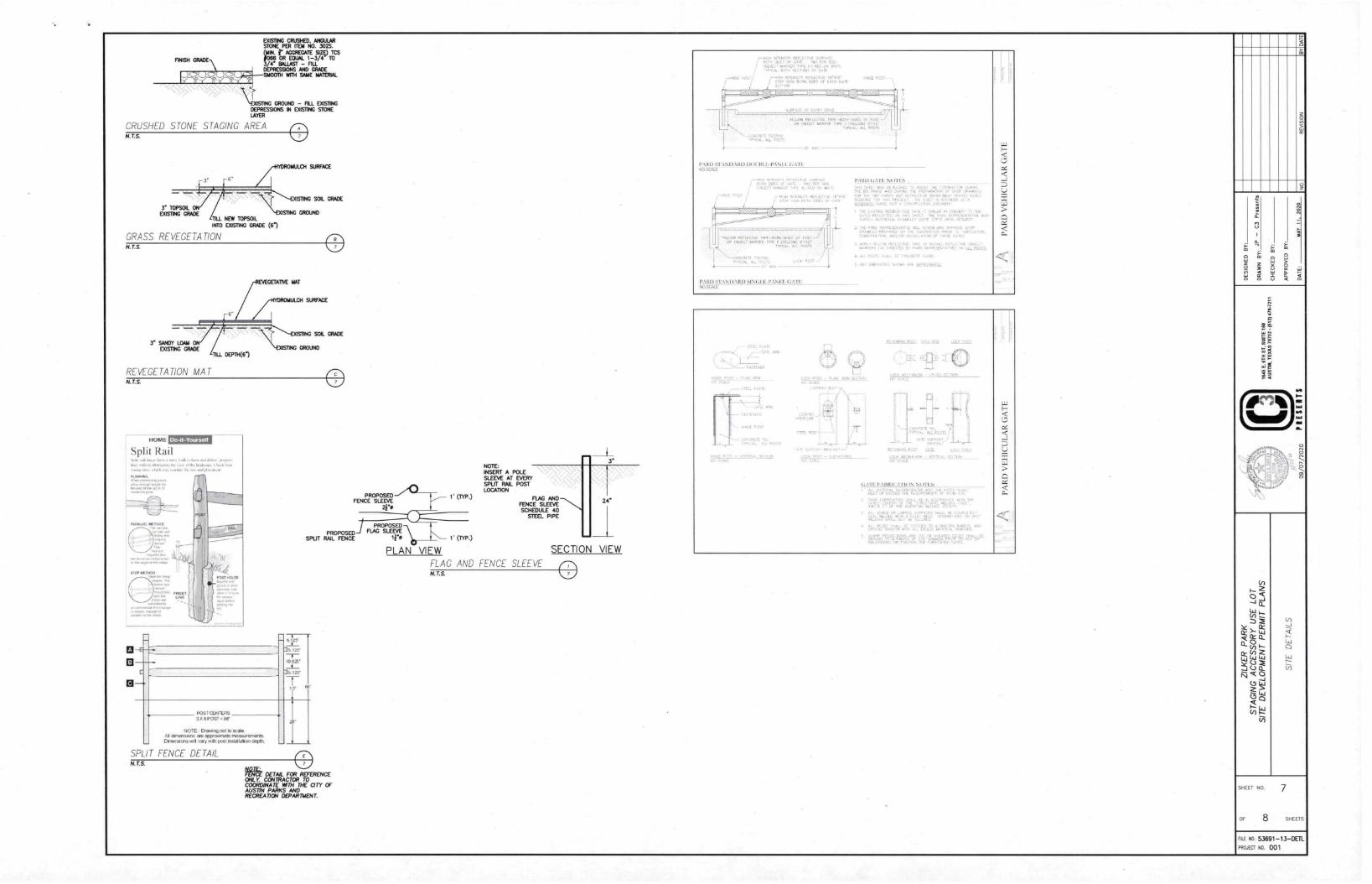
OUSTING CRUSHED, ANGULARSTONE PER HEM NO. 302$.
r AGGREGME SIZO Tcs• OR EQUAL 1-3/4 TO
ga Ess4;BALleST LLNs - FI AND GRADE
SMOOTH ICH SAME MAMMAL
\ COMING GROUND - FILL EXISTINGDEPRESSIONS IN EXISTING STONELAYER
CRUSHED STONE STAGING AREAN. T.S.
3' TOPSOILDOSING GRADE
LCH SURFACE
vasw4G SRNG SOIL GRADE
GROUNDTILL NEW TOPSOILINFO MING GRADE (6)
GRASS REVEGETATION N. T.S.
REVEGETATION MATN.T.S
HOME
Split Railplyup.dttm O.,. A dic Sauk, P., A
• •Iskil Pastla, 113. pP
PLANNING
• ore.r.64.
PAP. LEL WINO°
rak.11
13
PROPOSED 1 (TVP.)FENCE SLEEVE
PROPOSEDSPLIT RAIL FENCE
III
1
I
1. 6.1.25---1--• S.125'
—I10.6Z"
• 5.125'
1r
-
eg.
II
I
KIST CEN,ERS32 6POST PVT
NOTE ' Owen net 55 scaleAl larnensans are approddrate measurementsOrmensens 4111 :dry with post Installat on depth
SPLIT FENCE DETAILN.T.S.
/av'et DETAIL FOR REFERENCE
OVL Y. CONTRACTOR TOCOORDINATE WTH THE CITY OFAUSTIN PARKS ANDRECREATION DEPARTMENT.
PROPOSEDFLAG SLEEVE
1. (w.)
PLAN VIEW SECTION VIEW
FLAG AND FENCE SLEEVE 0
NOTE:INSERT A POLESLEEVE AT EVERYSPLIT RAIL POSTLOCATION
3'
FLAG ANDFENCE SLEEVESCHEDULE 40
STEEL PIPE
24'
1,NOE
or, 000.0
YELLOW itEiLECINE tAn -00TH 5015 OF052001 IL.WER TYPE MLLE:MO 6112
.91CAL. ALL POSTS
1,:;11:13 STANDARD DOEDLE-PANEL GATE
4
-e
REi LEV
WOW RE, 1E10.C.IN SlOtS OF 4051OR ^fr. II 11040041)
.L
I'ARDSI\\I)IRDSJ\lII
PART) GATE NO*ITS
.1, SOLE, 111, DE VELL4-, S,11,0 510 0(0110 MC 54,154 114 ',OF
PP, T :L;CLVIJI.
NE RE.. 1.7, .` •LONCEP, THE ,sh MA
sltn,-Lsrat E. M.111, 7, ON. hi 10,,
. PFLOEPEI 1•41 • 2,1",:014,00,1,.. ANS 0,7, L
VAR, 1,740 1.01111111 Cl I'LPO PC..5014500 iN ELL POTTS
PARD VEHICULAR GATE
•
1i ,ItI, , It, TT T ,
C,
JP — C3 Presents
09 /0 7/7020
SHEET NO 7
Flo 8 SHEETS
FILE NO 53691-13 —DETL
PROJECT NO 001
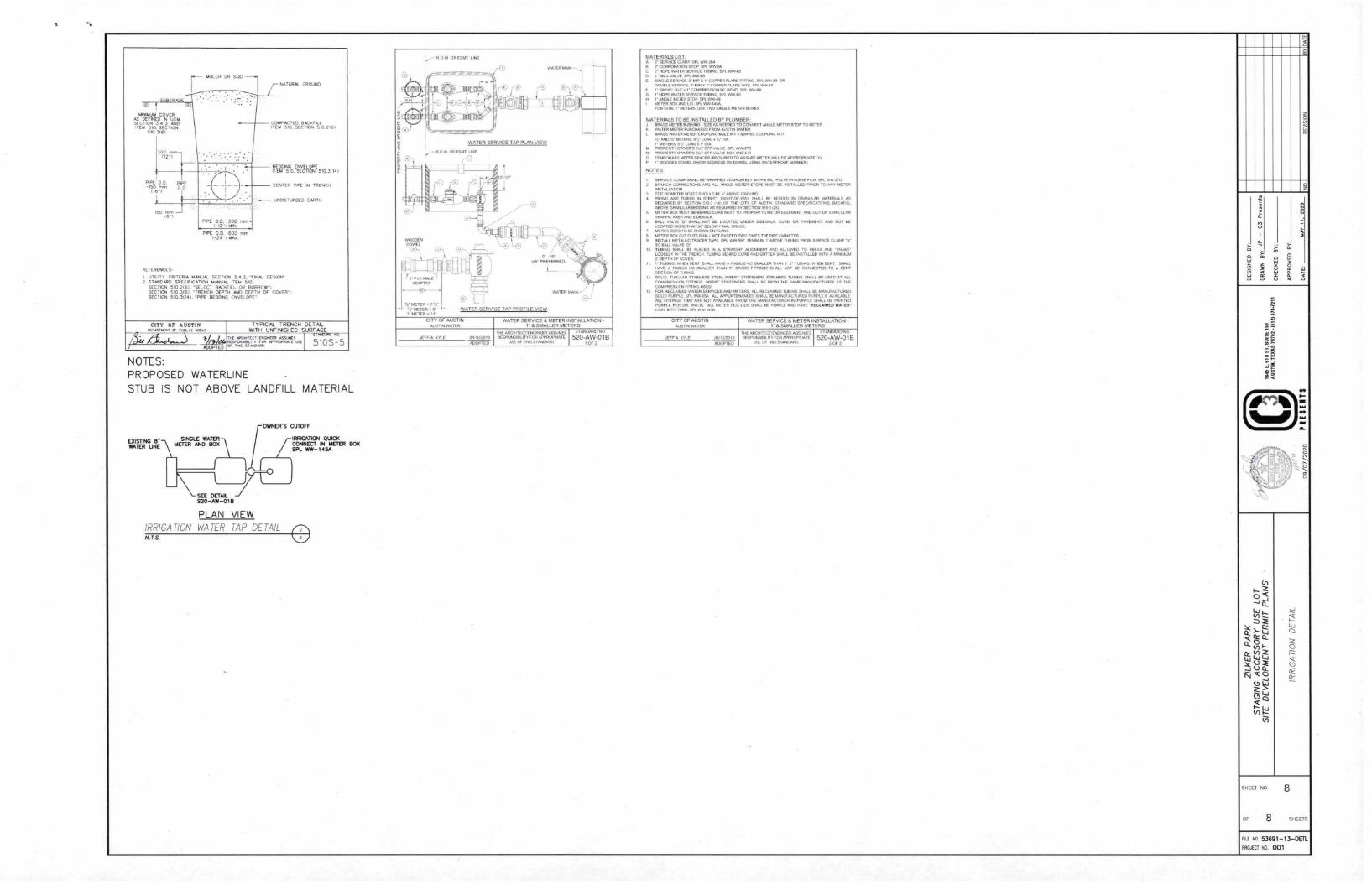
MINIMUM COVERAS DEFINED IN UCMSECTION 3.4.3 ANDITEM 510. SECTION
510.305/
PPE 00. PIPE.150 nvn SD
1.6'1
MULCH OR SOO
PIPE 0.0. •300 mon1.12.1 ANN.
rnm
NATURAL GROUND
COMPACTED BACKE,ITO. 510. SECTION 510 2161
BEDDING ENVELOPEITEM SIG, SECTION 010.3114
CENTER PIPE N TRENCH
UNDISTURBED EARTH
REFERENCES.
1, UTILITY CRITERIA MANUAL SECTION 3.4.3. "FINAL DESIGN"2 STANDARD SPECIFICATION MANUAL ITEM 5,0.
SECTION 510.2161, "SELECT BACKFILL OR BORROW',SECTION 510.3I61. "TRENCH DEPTH AND DEPTH OF COVER".
SECTION 510 31141. "PIPE BEDDING ENVELOPE'
CITY OF AUSTINOERARTNEAT BF PLS. C BORAS
//It 2/_24t4OP ED
TYPICAL TRENCH DE T AIL
WITH UNFINISHED SURF ACE
ARCIPTECTANOINEER ISSUESRESPONSOLITV FOR APPRCPMATE USEOF INS Si NPARD
STANDARD NO
510S - 5
NOTES:PROPOSED WATERLINE
STUB IS NOT ABOVE LANDFILL MATERIAL
EXISTING 8'WATER UNE
SINGLE WATER
METER AND BOX
SEE DETAIL
S20-AW-01B
PLAN VIEW IRRIGATION WATER TAP DETAIL 0
OWNER'S CUTOFF
IRRIGATION QUICK
CONNECT IN METER BOX
SPL VAV- 1 4SA
AF METER' 7(6'
37 METER 7 -I--1. METER Air'
WATER SERVICE TAP PLAN VIEW
WATER SERVICE TAP PROFILE VIEW
CITY OF AUSTIN
AUSTIN WATER
WATER SERVICE & METER INSTALLATION -V' & SMALLER METERS
JEFF A KYLE 08/18/2019
ADOPTED
THE AFICHITECT/ENDINEER ASSUMESRESPONSIBILITY FOR APPROPRIATE
USE OF THIS STANDARD
STANDARD NO
520-AW-01BOF 2
MATERIALS LIST.A. SERVICE CLAMP. SPL VVNA.8 2 CORPORATOR sive SP. Am.!C THREE WATER SERVICE TUBING SPL WW-85O 7 BALL VALVE SPL VAN.E. SINGLE SERVICE 7 /AP X V COPPER FLARE FITTING SPL MR. OR
DOUBLE SERvICE NIP x V COPPER runc WYE SPL WWG5F SWIVEL NUT , COMPRESSION 90' BEND SPL VANA311G 1.HDPs PATER SERVICE TURING SPA WW-ssH 1- ANGLE METER STOP SM. VARM3I METER BOX AND LID SM. WWIMA.
FOR DUAL I 5H5 USE TWO smr..,LE METER ROSES
MATERIALS TO BE INSTALLED BY PLUMBER:J BRASS METER BUSHING. SIZE As NEEDED TO coNNEcT ANGLE METER STOP TO METERK WATER METER PURCHASED FROM AUSTIN WATERL BRASS WATER METER COUPLING MALE swivel. COUPLING NUT
37 AND 37 METERS B'.LONCI.EISV METERS 817 LONG a V 01A
LI PROPERTY OWNER'S CUT OFF VALVE. SPL WW7P3N. PROPERTY OWNER'S CUT OFF VALVE BOX AND LIDO TEMPORARY METER SPACER IREQUIRED TO ASSURE METER WILL FR APPROPRIATELY)P i• WOODEN DOWEL (SHOW ADDRESS ON DOWEL USING WATERPROOF MARKER)
NOTES
I. SERVICE CLAMP SHALL SE WRAPPED COMPLETELY WITH 5 MIL POLYETHYLENE FILM. SPL WW-2701 BRANCH CONNECTIONS AND ALL ANGLE METER STOPS MUST BE INSTALLED PRIOR TO ANY METER
INSTALLATION3. TOP OF METER BOXES SHOULD 86 4' ABOVE GROUND4. PIPING AND TUBING IN STREET RIGHT-OF-WAY SHALL BE BEDDED IN GRA/40,R MATERIALS AS
REOUIRED BY SECTION 510 3 1141 OF THE CM, OF AUSTIN STANDARD SPECIFICATIONS. BACKFILLABOVE GRANULAR BEDDING AS REQUIRED BY SECTION 510 3 (25)
5. METER BOY MUST BE BEHIND CURB NEXT TO PROPERTY LINE DR EASEMENT AND OUT OF VEHICULARTRAFFIC AREA AND SIDEWALK
5. BALL VALVE SHALL NOT RE LOCATED UNDER SIDEWALK. CURB, OR PAVEMENT AND NOT BELOCATED MORE THAN 36- BELOVV FINAL GRADE.METER SUES SANE SHOWN ON MANS
8. METER BOX CUT OUTS RANI NOT EXCEED TWO TIMES THE PIPE DIAMETER9 INSTALL METALLIC TRACER TAPE. OK WW 6/37 MINIMUM F ABOVE TUBING FROM SERVICE CLAMP Me
TO BALL VALVE "LT10 TUBING SHALL BE PLACED IN A STRAIGHT ALIGNMENT AND ALLOWED TO RELAX AND /SNAKE-
LOOSELY IN THE TRENCH TUBING BEHIND CURB AND GUTTER SHALL BE INSTALLED WITH A MINIMUMDEPTH OF COVER_
11 1/ TUBING WHEN BENT SHALL HAVE A RADIUS NO SMALLER THAN 3 2/ TUOING. WHEN BENT. SHALLHAVE A RADIUS NO SMALLER THAN 5/ BRASS ElI INNS SHALL NOT BE CONNECTED TO A BENTSECDON OF TUBING
12_ SOLID, TUBULAR STAINLESS STEEL INSERT STIFFENERS FOR HOPE TUBING SHALL BE USED AT ALLCOMPRESSION FITTINGS INSERT STIFFENERS SHALL BE FROM THE SAME MANUFACTURER AS THECOMPRESSION FETTNG USED
13. FOR RECLAIMED WATER SERVICES AND M TERS. ALL RECLAIMED TUBING SHALL BE MANUFACTUREDSOLID PURPLE SPL WW4SA ALL APPURTENANCES SHALL BE MANUFACTURED PURPLE IF AVAILABLEALL FITTINGS THAT ARE NOT AVAILABLE FROM THE IAAMIFACTURER IN PURPLE SHALL BE PAINTEDPURPLE PER SPL WPRIC ALL METER BOX LIDS SHALL SE PURPLE AND HAVE "RECLAIMED WATER-CAST INTO THEM. SPL WW-145A
CITY OF AUSTIN
AUSTIN WATER
WATER SERVICE & METER INSTALLATION1" & SMALLER METERS
JEFF A KYLE 011,18/2019
ADOPTED
THE ARCHTTECTENDINEER ASSUMESRESPONSIBILM FOR APPROPRIATE
USE OF THIS STANDARD
STANDARD NO
520-AW-01B2 OF 2
IA
AN
I,
MN
IAA
MS
SHEET NO. 8
OF 8 SHEETS
FILE NO 53891 -13 -DEMPROJECT NO. 001
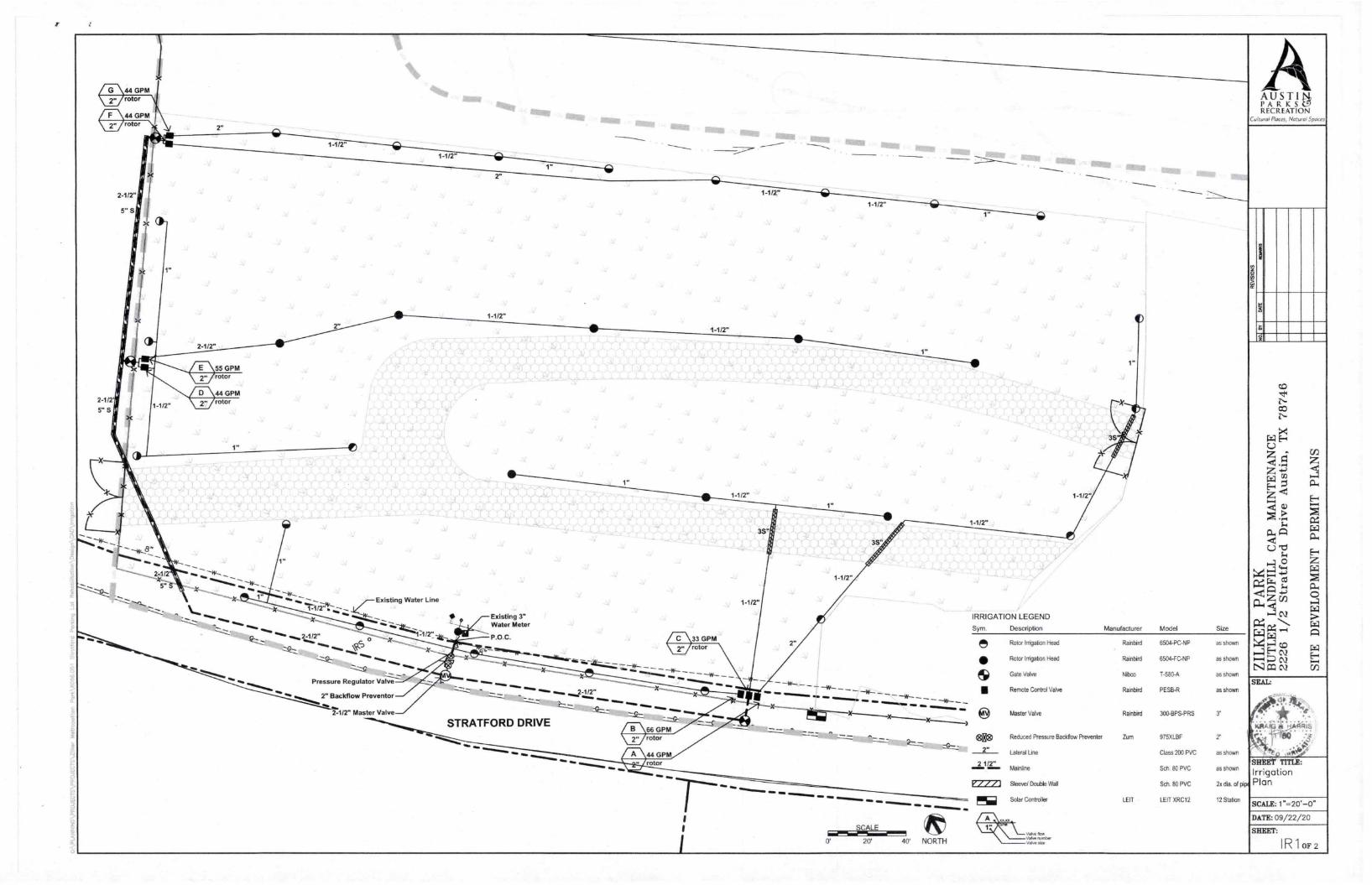
Existing Water Line
..mos-jkiz4/2
50
Pressure Regulator ValCe"---
2" Backfiow Preventor
%to
2-1/2" Master Valve
Existing 3"Water Meter
P.O.C.
STRATFORD DRIVE66 GPMrotor
44 GPMrotor
MID gr.
33 GPM
1-1/2"
1-1/2"
IMO IMO
3S
1-1/2"
)()
eiani •••
•••
••• •••
MD WM,
SCALE
0 20' 40' NORTH
NO
1-1/2"
1-1/2"
IRRIGATION LEGEND
Sym. Description
1"
Manufacturer Model Size
Rotor Irrigation Head
• Rotor Inigabon Head
Gate Valve
• Remote Control Valve
2"
21/2'
Master Valve
Reduced Pressure Back/low Preventer
Lateral Use
Mainline
Sleeve/ Double Wall
Solar Controller
v Pow
V mmber
V
Rainbird
Rainbird
Nibco
Rainbird
Rainbird
Zum
LEIT
6504-PC-NP
6504-FC-NP
1-580-A
PESB-R
as shown
as shown
as shown
as shown
AAUSTIPARKSC9RECREATION
Cultural Places, Natural Spaces
c0
E-4
Z
Z
Z'-•<-4 12)
•
c=1
0
r24';7:-zc=z
r'4:4>.44441,4 cr)
•-4NI= cv S
ITE DEVELOPMENT PERMIT PLANS
300-BPS-PRS 3'
975XLBF 2"
Class 200 PVC as shown
SCh. 80 PVC as shown
Sch. BO PVC 2x dia. of pip
LEIT XRC12 12 Station
SEAL:
SHEET TITLE:
IrrigationPlan
SCALE: 1"--20'-0-
DATE: 09/22/20
SHEET:
IR1 OF 2
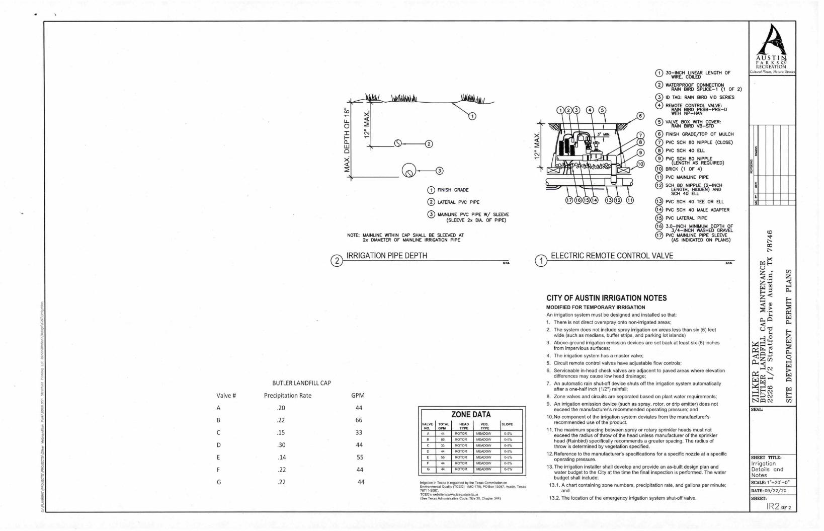
Valve #
A
MAX. DEPTH OF 18"
0 FINISH GRADE
0 LATERAL PVC PIPE
0 MAINLINE PVC PIPE W/ SLEEVE(SLEEVE 2x DIA. OF PIPE)
NOTE: MAINLINE WITHIN CAP SHALL BE SLEEVED AT2x DIAMETER OF MAINLINE IRRIGATION PIPE
0 IRRIGATION PIPE DEPTH
BUTLER LANDFILL CAP
Precipitation Rate
.20
.22
.15
.30
.14
.22
.22
GPM
44
66
33
44
55
44
44
mts.
VALVENO.
TOTALGPM
ZONEHEADTYPE
DATAVEG.TYPE
SLOPE
0 44 ROTOR MEADOW 0-5%
F 66 ROTOR MEADOW 0-5%
C 33 ROTOR MEADOW 0-5%
0 44 ROTOR MEADOW 0-5%
55 ROTOR MEADOW 0-5%
F 44 ROTOR MEADOW 0-5%
G 44 ROTOR MEADOW 0-5%
Irrigation in Texas is regulated by the Texas Commission onEnvironmental Quality (TCECI) (MC-178). PO Box 13087, Austin, Texas78711-3087.TCECI's website is:www.teee.state.tx.us(See Texas Administrative Code. Title 30, Chapter 344)
00000
0
00
80
30—INCH LINEAR LENGTH OFWIRE, COILED
WATERPROOF CONNECTIONRAIN BIRD SPLICE-1 (1 OF 2)
ID TAG: RAIN BIRD VID SERIES
REMOTE CONTROL VALVE:RAIN BIRD PES8—PRS—DWITH NP—HAN
VALVE BOX WITH COVER:RAIN BIRD VB—STD
FINISH GRADE/TOP OF MULCH
PVC SCH 80 NIPPLE (CLOSE)
PVC SCH 40 ELL
PVC SCH 80 NIPPLE(LENGTH AS REQUIRED)
BRICK (1 OF 4)
PVC MAINLINE PIPE
SCH 80 NIPPLE (2—INCHLENGTH, HIDDEN) ANDSCH 40 ELL
PVC SCH 40 TEE OR ELL
PVC SCH 40 MALE ADAPTER
PVC LATERAL PIPE
3.0—INCH MINIMUM DEPTH OF3/4—INCH WASHED GRAVEL
PVC MAINLINE PIPE SLEEVE(AS INDICATED ON PLANS)
ELECTRIC REMOTE CONTROL VALVE
CITY OF AUSTIN IRRIGATION NOTESMODIFIED FOR TEMPORARY IRRIGATION
An irrigation system must be designed and installed so that:
1. There is not direct overspray onto non-irrigated areas;
2. The system does not include spray irrigation on areas less than six (6) feetwide (such as medians, buffer strips, and parking lot islands)
3. Above-ground irrigation emission devices are set back at least six (6) inchesfrom impervious surfaces;
4. The irrigation system has a master valve;
5. Circuit remote control valves have adjustable flow controls;
6. Serviceable in-head check valves are adjacent to paved areas where elevationdifferences may cause low head drainage;
7. An automatic rain shut-off device shuts off the irrigation system automaticallyafter a one-half inch (1/2") rainfall;
8. Zone valves and circuits are separated based on plant water requirements;
9. An irrigation emission device (such as spray, rotor, or drip emitter) does notexceed the manufacturer's recommended operating pressure: and
10.No component of the irrigation system deviates from the manufacturer'srecommended use of the product.
11. The maximum spacing between spray or rotary sprinkler heads must notexceed the radius of throw of the head unless manufacturer of the sprinklerhead (Rainbird) specifically recommends a greater spacing. The radius ofthrow is determined by vegetation specified.
12.Reference to the manufacturer's specifications for a specific nozzle at a specificoperating pressure.
13. The irrigation installer shall develop and provide an as-built design plan andwater budget to the City at the time the final inspection is performed. The waterbudget shall include:
13.1. A chart containing zone numbers, precipitation rate, and gallons per minute;and
13.2. The location of the emergency irrigation system shut-off valve.
AAUSTINI„PARKSC.9RECREATION
Cultural Places, Natural Spaces
SITE DEVELOPMENT PERMIT PLANS
SEAL:
SHEET TITLE:
IrrigationDetails andNotesSCALE: 1=20.-0"
DATE: 09/22/20
SHEET:
I R 2 OF 2