Embed Size (px)
Citation preview
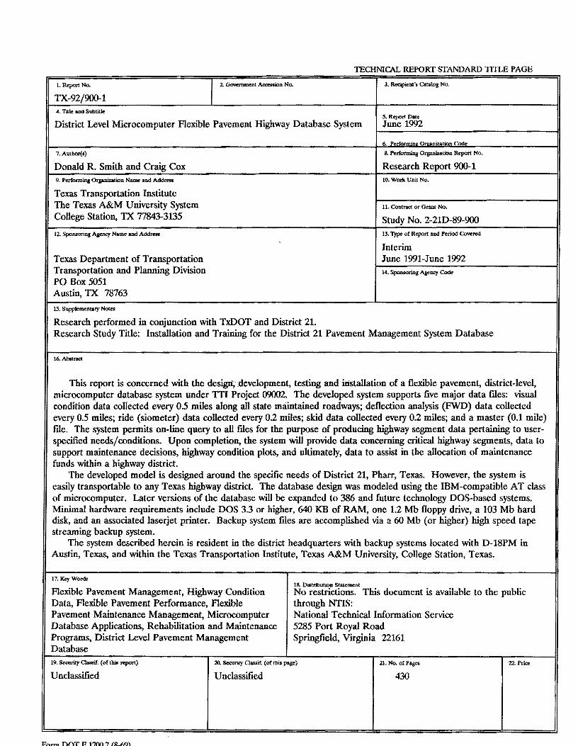
TECHNICAL REPORT STANDARD 1TILE PAGE
1. Report No. 2. G<M!mment Accession No.
TX-92/900-1 4. Title and Subtitle
District Level Microcomputer Flexible Pavement Highway Database System
7. Autbor(s)
Donald R. Smith and Craig Cox 9. Performing Organization Name and Address
Texas Transportation Institute The Texas A&M University System College Station, TX 77843-3135
12. Sponsoring Agency Name and Address
Texas Department of Transportation Transportation and Planning Division PO Box 5051 Austin, TX 78763
15. Supplementary Notes
Research performed in conjunction with TxDOT and District 21.
3. Recipient's Catalog No.
S. Report Date June 1992
8. Performing Organization Report No.
Research Report 900-1 10. Work Unit No.
11. Contract or Grant No.
Study No. 2-21D-89-900 13. Type of Report and Period Covered
Interim June 1991-June 1992 14. Sponsoring Agency Code
Research Study Title: Installation and Training for the District 21 Pavement Management System Database
16. Abstract
This report is concerned with the design;'.development, testing and installation of a flexible pavement, district-level, microcomputer database system under TTI Project 09002. The developed system supports five major data files: visual condition data collected every 0.5 miles along all state maintained roadways; deflection analysis (FWD) data collected every 0.5 miles; ride (siometer) data collected every 0.2 miles; skid data collected every 0.2 miles; and a master (0.1 mile) file. The system permits on-line query to all files for the purpose of producing highway segment data pertaining to userspecified needs/conditions. Upon completion, the system will provide data concerning critical highway segments, data to support maintenance decisions, highway condition plots, and ultimately, data to assist in the allocation of maintenance funds within a highway district.
The developed model is designed around the specific needs of District 21, Pharr, Texas. However, the system is easily transportable to any Texas highway district. The database design was modeled using the IBM-compatible AT class of microcomputer. Later versions of the database will be expanded to 386 and future technology DOS-based systems. Minimal hardware requirements include DOS 3.3 or higher, 640 KB of RAM, one 1.2 Mb floppy drive, a 103 Mb hard disk, and an associated laserjet printer. Backup system files are accomplished via a 60 Mb (or higher) high speed tape streaming backup system.
The system described herein is resident in the district headquarters with backup systems located with D-18PM in Austin, Texas, and within the Texas Transportation Institute, Texas A&M University, College Station, Texas.
17. Kl:yWonls 18. Distribution Statement
Flexible Pavement Management, Highway Condition Data, Flexible Pavement Performance, Flexible Pavement Maintenance Management, Microcomputer Database Applications, Rehabilitation and Maintenance Programs, District Level Pavement Management Database
No restrictions. This document is available to the public
19. Security Classif. (of this "'!"'rt)
Unclassified
Fhrm noT JI 17M 7 fst.J;Q\
through NTIS: National Technical Information Service 5285 Port Royal Road Springfield, Virginia 22161
20. Security Classif. (of tllis page)
Unclassified
21. No. of Pages
430
22. Price

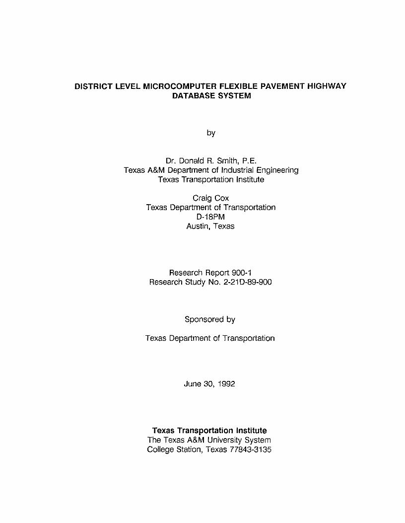
DISTRICT LEVEL MICROCOMPUTER FLEXIBLE PAVEMENT HIGHWAY DATABASE SYSTEM
by
Dr. Donald R. Smith, P. E. Texas A&M Department of Industrial Engineering
Texas Transportation Institute
Craig Cox Texas Department of Transportation
D-18PM Austin, Texas
Research Report 900-1 Research Study No. 2-21 D-89-900
Sponsored by
Texas Department of Transportation
June 30, 1992
Texas Transportation Institute The Texas A&M University System College Station, Texas 77843-3135


METRIC (SI*) CONVERSION FACTORS
APPROXIMATE CONVERSIONS TO SI UNITS
Symbol When You Know Multlply By To Find Symbol
In ft yd ml
oz lb T
fl 0%
gal ft 3
yd'
Inches feet
yards mlles
square Inches square feet
square yards square miles
acres
ounces pounds
short tons (2000 lb)
fluid ounces gallons
cubic feet cubic yards
LENGTH
2.54 0.3048 0.914 1.61
AREA
8.452 0.0929 0.838 2.59 0.395
MASS (weight)
28.35 0.454 0.907
VOLUME
29.57 3.785
0.0328 0.765
centimeters meters meters
kilometers
centimeters squared meters squared meters squared
kllometers squared hectares
grams kllograms
megagrams
mllllmeters llters
meters cubed meters cubed
Note: Volumes greater than 1000 L shall be ahown In m *.
Of Fahrenheit temperature
TEMPERATURE (exact)
5/9 (after subtracting 32)
Celsius temperature
These factors conform to the requirement of FHWA Order 5190.1 A
•SI Is the symbol for the lnternatlonal System of Measurements
cm m m km
t cm m2 mt
km2
ha
g kg Mg
ml L m3
m'
Symbol
mm m yd km
g kg Mg
ml L ms ma
oc
APPROXIMATE CONVERSIONS TO SI UNITS
When You Know
mllllmeters meters meters
kllometers
mllllmeters squared meters squared
kilometers squared hectares (10,000 m 2
)
Multlply By
LENGTH
0.039 3.28 1.09 0.621
AREA
0.0016 10.764
0.39 2.53
MASS (weight)
grams kilograms
megagrams (1 ooo kg)
mllllmeters liters
meters cubed meters cubed
0.0353 2.205 1.103
VOLUME
0.034 0.264 35.315 1.308
To Find
Inches feet
yards miles
square Inches square feet
square miles acres
ounces pounds
short tons
fluld ounces gallons
cubic feet cubic yards
TEMPERATURE (exact)
Celsius temperature
9/5 (then add 32)
Fahrenheit temperature
32 98.6 212° F ·40° F 0 I 40 80 120 160 200 I
I I I I I I I 1l 1 I I I I I I I I I I I I I I I 11 I I I I I I I I I I I I I I I
-4o 0 c -20 o 20 40 ao 80 1oo•c 37
Symbol
In ft yd ml
oz lb T
fl 0%
gal ft a yd3
OF


TABLE OF CONTENTS
SECTION TOPIC PAGE NUMBER
Abstract ..................................................................................... . Acknowledgements . . . . . . . . . . . . . . . . . . . . . . . . . . . . . . . . . . . . . . . . . . . . . .. . . . . . . . . . . . . . . . . . . . .. . . . . . . ii District 21 Official Map ................................................................... iii
SECTION 1 - OVERVIEW OF THE RESEARCH
1.0 Introduction .. . ....... ...... .. ..... ................ ...... ........ ...... ....... ....... ...... 1 1. 1 Background of The Problem . . . . .. .. . . .. .. . . .. . . . . . . . . . . . . . . . . . . . . .. . . . ... ......... .. . . . 1 1.2 Objectives of the Research ................................................................ 5
SECTION 2 ·THE DATABASE DESIGN
2.0 Database Design - An Overview ...................................................... 6 2. 1 Database Terminology . .. .. . . . .. . . .. .. . . . . .. . . .. . .. .. . . .. .. .. . . .. .. . .. .. .. . . . . . . .. .. .. . .. . 1 O 2.2 Relational Database File Structure - Overview . .. . ... . .. .. . . . . .. . .. ... . .. . .. ... 12 2.3 District-level Database Management ................................................ 14
SECTION 3- SYSTEM DESIGN
3.0 District-level, Flexible Pavement Database Overview ...................... 16 3.1 Database System Design . .. ... . . .. .... . .. . .... . .. . . . .. . .. .. . . . . .. . .. . . . . . . . .. . .. . . .. .. .. 17 3.2 County-level Highway Inventory File .............. ................ ..... ... .. ... . .. .. 21
3.2.1 Direction of Increasing Milepost Numbers .... .... ......... .......... ....... ..... 23 3.2.2 Location of Milepost "zero" .......... ...... ..... .......... ..... ... ... .. . ......... ........ 24 3.2.3 Locating Highway Segments in the Field . ....... ......... ........... .. .... ... .. 26 3.2.4 Mileposts on Concurrent Highways ................................................ 27 3.2.5 Details of the County Highway Inventory File ....... ......... ........ ......... 28 3.2.5.1 lntrepretation of the County-level
Highway File Records .. . .. . . . .. .. .. . .. . .. .. . . .. . .. .. .. . . . .. . . . . .. . . . . .. . . . . . . .. . 38 3.2.6 Generating the County-level Reports ... .. . . .. .. . ........ ... . . . .. ........ .. . .. .. 40 3.3 Generation of 0.5, 0.2, and 0.1 Data Files ....................................... 45 3.3.1 Definition and Structure of the 0.5 Visual Data File ... . ..... ..... ........ 48 3.3.2 Calculation of the Visual Pavement and Shoulder Scores ........ ... 57 3.4 Organization and Structure of the 0.5 Falling Weight
Deflectometer File . . .. . . . .. . .. . . . . .. . . . .. . .. . . . . .. . . . . . .. . . .. .. .. .. . . .. ... ... .. .. . . ... .. .. . . . . 58 3.5 0.2 Mile Skid Data File ........................................................................ 61 3.6 0.2 Mile Ride/Siometer Data File ...................................................... 62 3. 7 0.1 Mile Master File ..... ...... . ............... .... . .. ..... ........ .............. ....... ..... 66 3.8 Miscellaneous Files .. ... . . . ..... ... .. ...... ..... ........ ....... ......... ....... ..... .... ... ... 68

SECTION TOPIC PAGE NUMBER
4.0 4.1 4.1.1 4.1.2 4.1.3 4.1.4 4.1.5 4.1.6 4.2
SECTION 4 - REPORT GENERATION
Report Generation Capabilities ....................................................... . Standard Reports .......................................................................... . Critical PAS/ ADT Report ................................................................ . Critical Ride/ ADT Report ................................................................ . Critical Surface Curvature (SCI) Report .......................................... . Critical Skid/ ADT Report ................................................................ . Critical Date of Last Surface Report .............................................. .. Critical Reports from the Visual and Ride Data Files ..................... . Summary for Report Generation ..................................................... .
SECTION 5 ·RIDE DATA COLLECTION
69 70 71 72 72 74 75 76 80
5.0 Ride Data Collection - Siometer Method ........................................... 81 5.1 Siometer Ride Data Conversion......................................................... 81 5.2 Siometer Data Import ............................. ........ .................... ............ .. 85 5.3 Siometer Error Correction Procedures ............................................ 87 5.4 Completeness of Siometer Data ...................................................... 101 5.5 Generation of Siometer Related Reports ......................................... 102 5.6 Siometer Data: Final Transfer to the 0.1 Master File ....................... 105
SECTION 6 - SKID DATA COLLECTION
6.0 Skid Data Collection - Hansen Method ............................................. 110 6.1 Skid Data Collection Equipment . .. .... ............... .... ... . . .. .. .. .. .. .. .. .. . .. . ... 11 O 6.2 Skid Data Insertion While Testing ..................................................... 110 6.3 Skid "A" Data Item . . . . . . . . . . . . . . .. . .. .. . . . . . . . . . . .. . . . . . . . ... . . . . . .. .. . . . . . . . . .. . . . . . .. . . . .. . . 11 O 6.4 Skid "81" Data Item ........................................................................... 111 6.5 Skid "C" Whole Reference Point" Data Item ..................................... 113 6.6 Skid "82" Data Item ......................................................................... 114 6.7 Skid "C" Data Item ........................................................................... 114 6.8 Skid Cassette Tape Handling ........................................................... 116 6.9 Skid Data Conversion . .. . . . .. . . . . .. . . .. . .. .. ... .. . ... . .... . . . ... .. . ... . .. .. . .. . .. ... . . . . . . . 117 6. 1 O Skid Data Import .. .. .. . .. .. . . ... . . . . . . .. . . . . .... .. . . . .. . . . ... ...................... ... .. . ... . . 130 6.11 Skid Data Completeness . ... . . .. . .. .. . . . . .. .. .... .. . . . .... . . . .. . . .. . . .. .. . ... . . . . . .. . . . .. . 148 6.12 Skid Data Final Transfer .. .. . . .. . . . .. .. . .... ... . .. .. . .. . .. . . .. . . . .. . . . . . . .. .. .. .. . .. . .. .. .. . 152

SECTION TOPIC PAGE NUMBER
SECTION 7 - DEFLECTION DATA COLLECTION PROCEDURES
7.0 Deflection Data Collection - FWD Method ............................................. 157 7.1 FWD Data Conversion ........................................................................ 157 7.1.1 Converting Raw FWD Data ................................................................. 159 7.1.2 Importing Converted FWD Data into the P.M.S. Database. .................... 161 7 .1.3 Handling Non-matching FWD Records .................................................. 162 7 .1.4 Editing Non-matching FWD Records ..................................................... 164 7.1.5 Correcting FWD Errors in the Import File ............................................... 171 7.2 Completness of FWD Data .................................................................. 175 7.3 FWD Data Final Transfer ..................................................................... 180
SECTION 8 - VISUAL DATA ENTRY
8.0 Visual Oat Entry ................................................................................. 184 8.1 D21-PMS Data Set Categories ............................................................. 184 8.2 Description of Visual Data Collection .................................................... 185 8.3 Entering the Database: Begin Visual Data Entry ................................... 187 8.3.1 Beginning Visual Data Entry ................................................................. 188 8.3.2 The Database Sign-On Menu ............................................................... 190 8.4 Entering Visual Data ........................................................................... 194 8.4.1 Quitting a Session .............................................................................. 197 8.4.2 Re-Entering the Database ................................................................... 198 8.5 Producing Visual Data Collection Forms ................................................ 199

List of Appendices
Appendix Topic Page
A D21 PMS Microcomputer Hardware Requirements ..................... 202
8 PMS Database Detailed File Structure ......................................... 203
c PMS Query Procedures .............................................................. 267
D Listing of PMS Database Files ................................................... 359
E PMS Database Form Relationships ............................................. 363
F PMS Database Import File Names .............................................. 365
G PMS Menu Definition Specifications: 1988-89 Version ................. 366
H Detailed Specifications for all Import Procedures. ........................ 388
PMS Database Laserprinter Definition Specifications ................... 390
J Compiled Microsoft QuickBasic Programs to Support PMS Data Import-Export Activities ...................................................... 391
Ridec.Bas ............................................................................... 392 Rideform.bas ............................................................................ 396 Riderr.bas ............................................................................... 398 Skidcornp.bas ........................................................................... 399 Skidedit.bas ............................................................................. 408 Skiderr.bas ............................................................................... 411 FWDconv.bas .......................................................................... 413 FWDerr.bas ............................................................................. 417
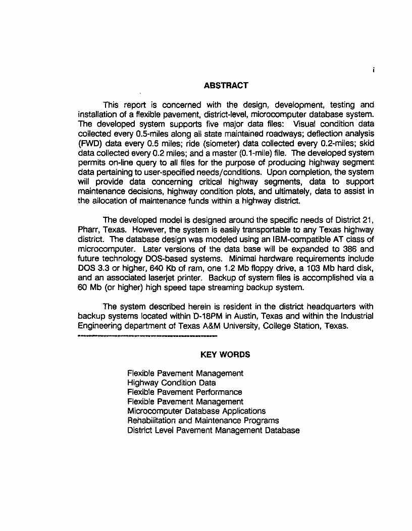
ABSTRACT
This report is concerned with the design, development, testing and installation of a flexible pavement. district-level, microcomputer database system. The developed system supports five major data files: Visual condition · data collected every 0.5-miles along all state maintained roadways; deflection analysis (FWD) data every 0.5 miles; ride (siometer) data collected every 0.2-miles; skid data collected every 0.2 miles; and a master (0.1-mile) file. The developed system permits on-line query to all files for the purpose of producing highway segment data pertaining to user-specified needs/conditions. Upon completion, the system will provide data concerning critical highway segments, data to support maintenance decisions, highway condition plots, and ultimately, data to assist in the allocation of maintenance funds within a highway district.
The developed model is designed around the specific needs of District 21, Pharr, Texas. However, the system is easily transportable to any Texas highway district. The database design was modeled using an IBM-compatible AT class of microcomputer. Later versions of the data base will be expanded to 386 and future technology DOS-based systems. Minimal hardware requirements include DOS 3.3 or higher, 640 Kb of ram, one 1.2 Mb floppy drive, a 103 Mb hard disk, and an associated laserjet printer. Backup of system files is accomplished via a 60 Mb (or higher) high speed tape streaming backup system.
The system described herein is resident in the district headquarters with backup systems located within D-1 SPM in Austin, Texas and within the Industrial Engineering department of Texas A&M University, College Station, Texas.
-··I ···---· • ··--------KEYWORDS
Flexible Pavement Management Highway Condition Data Flexible Pavement Performance Flexible Pavement Management Microcomputer Database Applications Rehabilitation and Maintenance Programs District Level Pavement Management Database


ii
ACKNOWLEDGEMENTS
The original motivation behind this research is credited to Samuel G. Cox, Maintenance Engineer (retired), District 21, Pharr, Texas. Mr. Cox was instrumental in conceiving the original ideas that motivated this research effort. It was through his vision and dynamic leadership that this effort was undertaken. Mr. Cox has gained state-wide and national attention for his leadership and knowledge relating to the maintenance and rehabilitation of pavement systems. Through his efforts, and the cooperative spirit of his associates, District 21 has gained the reputation of successfully managing and maintaining one of the best highway systems in the state of Texas.
Grateful appreciation is extended to Mr. Bob Guinn, D-18PM, Austin for his support, and leadership. Through Mr. Guinn's interaction with Highway Department officials, this effort greatly benefited.
Finally, Dr. A.G. Lytton, Professor of Civil Engineering and Director of the Pavement Research Division of TTI deserves special credit for his vision, leadership, and support.
Donald R. Smith, P. E. Department of Industrial Engineering Texas A&M University College Station, Texas 77842-3131
Craig Cox D-18PM Texas Department of Transportation Austin, Texas
DISCLAIMER
The contents of this report reflect the views of the authors who are responsible for the accuracy of the data and the facts presented herein. the contents do not necessarily reflect the official view or policies of the Texas Department of Transportation. This report does not constitute a standard, specification, or regulation. this report is not intended for construction, bidding, or permit purposes.

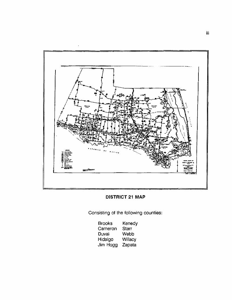
DISTRICT 21 MAP
Consisting of the following counties:
Brooks Cameron Duval Hidalgo Jim Hogg
Kenedy Starr Webb Willacy Zapata
iii


1.0 INTRODUCTION
The State of T~xas currently maintains over 180,000 lane miles of federal, state, and park roads with a public investment involving billions of dollars. Twenty four state highway districts supervise and manage approximately six to seven thousand lane miles per district. Due to the vast geographical expanse of Texas, with its severe climatic conditions, highway maintenance and rehabilitation activities represent a challenging set of problems to highway engineers.
Central to the success of any rehabilitation and maintenance (R&M) program is the need for accurate and timely data relating to the highway network under study. This research project, originally undertaken in September or 1984, sought to establish a District level, microcomputer database system accessible at the local level to supply the information needs of highway engineers.
The original concept of a de-centralized, microcomputer based system is attributed to Mr. Samuel G. Cox, Maintenance Engineer (retired) District 21, Pharr, Texas. Mr. Cox was instrumental in conceiving the notion of a District level database powerful enough to handle the complex needs of the District combined with simplicity to allow a variety of District level personnel to utilize the system on a day-to-day basis.
1.1 BACKGROUND OF THE PROBLEM
District 21 has been involved with pavement evaluation since the early 1970's. Under Cooperative Research Study No. 151, Mr. Sam Cox worked with TTI researcher Dr. Jon Epps to develop a prototype Maintenance Management System (MMS). The results of these efforts are documented in several research reports, specifically:
1. n-1 Report 151-4: "The Development of Maintenance Management Tools". 2. n-1 Report 151-2: "Roadway Maintenance Evaluation User's Manual". 3. SDHPT SS18.0: "An Approach to Maintenance Management".
The major achievements of this research were:
a. The development of a flexible and rigid pavement rating procedure with sufficient detail to be used for maintenance purposes.
b. The development of a pavement scoring procedure which matched maintenance engineers' perceive condition ratings.
c. The implementation of pavement condition plots similar to the one shown in Figure 1.
This system was fully operational by the late 1970s. The condition plots were introduced at the maintenance foreman level and several foremen began to use the plots and condition reports to select candidate maintenance and rehabilitation

2
projects for the upcoming year. For several reasons, the condition rating system was discontinued in 1978 and not reinstated until Project 409 was started in 1985.
DISTRICT NO. 21 WILLACY COUNTY US 77 RIGHT LANE 5.o ...;:;..;.;;..;..;.;.;.;:;..;....;.;.;;;;.;..;;..;..._...;;.;;......;.... _______________ ,._z.s • 10 --- --··--
I I
4.0· I
I I
- 3.0· -;; ..
·2.0- " " .. " .. •
1.0·
o.o I
0.0 1.0
CROSS ROADS
AVERAGE DAILY TRAFFIC
11 KIP EQUIV. AXLES CONTROL-SECTION
SURFACE TYPE DATE OF LAST SURFACE
DOLLAR COST /MILE
COST/BENEFIT RATIO FOREMAN NO.
PAVEMENT RATING SHOULDER RATING ROADSIDE RATING DRAINAGE RATING
TRAFFIC SERV. RATING
I I I I I I I I I I I I I I I I
I I I I I I
• " .. .. " " " .. • . .. " " " ..... .. .. . " •• " • • • " •
I I I I I I
2.0 3.0 4.0 5.0 e.o 7.0 . DISTANCE FROM MILEPOST 0.0 : . . . . . . . . . .•.
"" ... Ct •: ... o..: ... "": 2 . IL.
3390 2810
2.459 2.14 327-10
AC 8/74 1187
3781 51.94 55.102
8 87 11 77 19 70 55 80 13 80 72
FIGURE 1 Specimen Condition Rating Plot Part of the Initial Project 409 Effort
I I I I I I
--2.0 I +50
.. -1.s - •40 -CJ z
" - -•• " 0 z " " ·-1.0 Cl) +30 fl)
" • .. -.s +20
I .o +10 8.0 9.0
Cl • ... ::c fl)
3180
3.31
53.253-
81-
70--
70-80-74-

3
In the initial pnase of Project 409, an analysis was made of additional user requirements from the new system. The results of that analysis are summarized below:
A. Pavement Performance Inputs
Visual Condition Surveys:
To be conducted at 0.5-mile intervals using an inspection procedure from rn Report 151-2.
Ride Data:
To be collected using the May's Ride Meter (MAM) equipment or a SIOMETER (e.g. Walker Roughness Device) based on 0.2-mile intervals.
Deflection Analysis:
To be collected using a Falling Weight Deflectometer (FWD) based on 0.5-mile intervals.
Testing Frequency:
Visual and Ride data to be collected annually (normally beginning in September of a given year.) Skid data collected annually on high volume roads and at 3-year intervals on low volume highways. The Falling Weight Deflectometer data is collected on 3-year intervals.
B. Inventory Requirements
The following data items need to be collected and procedures developed to facilitate updating:
* Pavement width. * Surface type and Date of Last Surface ( DLS ). * Average Daily Traffic ( ADT ). * Projected 18 Kl P single-axle equivalent loadings ( 18KI P ) . * Location of cross-roads.
c. Historical Data
Provisions must be made to store Visual, Ride, Skid, and FWD data in a file structure suitable for fast access, data analysis, and report summarizations.

4
D. Output Requirements
In addition to highway segment condition plots (see Figure 1), the following outputs were required:
Degradation Curves
The system would provide condition trends as a function of time for defined highway segments.
On-line Query
The system would provide the ability to permit real-time access to the data and to respond to ad hoc requests such as "list all highways with ADT greater than 1000 which have not been worked on in the last five years" or, "list highways with skid values less than 35."
Maintenance Estimates
To permit users to supply decision criteria which will be used to generate maintenance estimates. For example, "apply crack seal treatments to all highways which have moderate or severe longitudinal or transverse cracking" or, "apply levelups to all highways carrying between 1000 and 3000 vehicles per day with PSI less than 2.5."
Funds Allocation
To produce statistics on overall network condition to aid in the funds allocation process and to provide an user-friendly interface between the highway segment database and the RAMS-00-1 series of FORTRAN-based optimization routines.
Details of each of these activities will be given in later sections of this report.
The purpose of this report is to produce a detailed design document describing the development of the District 21 microcomputer database system that stores highway segment data based upon 0.1, 0.2, and 0.5-mile highway segment data for all state-maintained highways within District 21. While the system described herein is specific to the needs of District 21, the system is capable of being installed within any state-wide district. Further, due to the flexible nature of the database, it is possible to modify the D21 system to suit the specific needs of other Districts.

5
1.2 Objectives of the Research
The primary objectives of this research effort are as follows:
1. Design and develop a 16 /32-bit microcomputer database system capable of storing, retrieving, and summarizing, highway segment data at the 0.1, 0.2, and 0.5-mile interval level.
2. Design the system such that District-level personnel could effectively manage and operate the system at the District level.
3. Have the system in place and fully operational by the end of 1987.
4. Design the system to be comprehensive with the flexibility to be customized for other Districts desiring to implement it either as is or in some modified form.
Work was begun in January of 1987 to design a microcomputerized database system consistent with the data collection philosophy adhered to by District 21. Mr. Cox directed that 100% of the District 21 highway network be inspected with data collected under the following categories:
1. Visual Inspection every 0.5 miles. 2. Ride data collected every 0.2 miles. 3. Skid data collected every 0.2 miles. 4. Falling Weight Deflectometer measuments taken every 0.5 miles.
Additionally, physical attribute data was collected from the Rl-1 files to build the District level highway inventory file, crossroads file, and the 0.1 mile master file.
The primary file for the system described herein is the 0. 1 mile master file. This data file contains over 90 separate data elements that store the physical and condition data of each 0.1 mile segment of state maintained highway within District 21. This file is built from a county-level highway inventory file. To augment the 0.1 file, several 0.2 and 0.5 files are maintained to hold visual data, falling weight, skid, and ride data. The database described herein permits data from one file to be incorporated into other files as required.
The mechanism by which collected highway segment data is entered, stored, sorted, evaluated, and accessed, is a popular microcomputer relational database software program by SoftEase Corporation termed DATAEASE. Early in the project development phase of this research, consideration was given to all of the then-current microcomputer database systems. DBASE Ill and ABASE 5 were evaluated. DATAEASE was selected based upon its simplicity, ease of learning,

6
programming features, and end-user friendliness. While DBASE Ill was (and remains) the industry de facto standard, the time to learn the system was far greater than that of DATAEASE. Since the research team was under time constraints to have a system in place and operational, and the research staff had little or no experience with DBASE Ill, the decision to implement DATAEASE was affirmed.
Development of this version of the flexible pavement district-level database system was instituted in January of 1987. The original plan called for on-site installation in May of 1987. However, due to developmental problems coupled with data collection delays, the phase I version (reported herein) was not installed until the fall of 1987.
The remainder of this report will describe the database and illustrate the elements currently designed into the system. It is perceived that this version will undergo modifications and enhancements as time progresses. In actuality, no computer-based system is, nor should be, considered "in final form." As conditions and time evolve, this version will be modified to reflect the needs of the end user, i.e., the district level engineers. This system is designed to be a decision support tool to aid and assist highway engineers in the day-to-day tasks associated with maintaining public roadways in the highest possible condition at a reasonable and affordable cost.
The next section presents an overview of computerized database logic. This section is intended to brief the reader on the basic principles of relational database design and is included merely to promote a greater understanding of the detail associated with the flexible pavement database.
2.0 DATABASE DESIGN -AN OVERVIEW
During the 1960s, the concept of database processing was one of the developing computer-based technologies. The concept of database processing (limited primarily to mainframe computer users) was strongly promoted to corporate industry as a better way to provide information to decision makers. With the implementation of centralized data processing centers, database applications were actively promoted by DPC managers as a tool to improve overall managerial efficiency.
During the 1970s, numerous database systems were designed and promoted extensively within business and government. Some systems were successful; others failed to various degrees. Where failures were experienced, managers grew wary of database technology. Others, who experienced success with their systems, swore by them. With the introduction of the 8 bit IBM-PC microcomputer in the early 80s, the concept of desktop database power grew in rapid proportions.

7
Further enhancements to the IBM-PC, (PC/XT, AT and the 386 machine) combined with more sophisticated "operating" systems, merely accelerated the scope of the PC-based database software.
Today, with the power of the 32 bit 386 system architecture, database systems are more powerful than the IBM 360 /370 mainframe equivalent database systems of the 60s and 70s are in place. With the increasing need for timely information, decision makers have grown to readily accept these decision support tools and rely heavily on them.
Properly designed, database processing allows an organization's data to be processed as an integrated whole. This approach allows data to be maintained in separate files, but the design of the database system permits the user to access data as if there was one, integrated file. The integrated database concept presents data to the decision maker in a more natural manner.
Microcomputer database systems permit the following functions:
1. Data entry with data checking ability. 2. Data storage (usually on a hard disk). 3. Data retrieval for viewing/editing. 4. File creation from other separate files (merging). 5. Data sorting/manipulation. 6. Report generation from a single file or from other related files. 7. The ability to "export" data out to other programs and "import" data
into the database from other programs. 8. Communication to and from mainframe and mini computer systems. 9. System administration (security, password protection, file management,
etc.
The database structure permits a common and consistent file structure that permits fast accessing of a selected item or, the merging of two or more files to create a merged file. Specifically, to qualify as a database, such a system must possess the following attributes:
1. The ability to integrate more than one logical record. 2. Represent more than one key (common element) per record. 3. Represent a variety of relationships among the records. 4. Permit program/data independence.
If a promoted system does not perform or provide these features, it is not technically a database. Rather, such a design would be referred to as a "data base" or a "file management system." Simply stated, a database is a computerized record-keeping system or, an electronic filing cabinet capable of performing a

8
variety of operations on the stored data. The primary objective of a computerized database is to provide access to information and data manipulations within a small time frame.
Using today's technology, database systems range from large, multi-user mainframe systems to small (but powerful) microcomputer-based systems. Depending upon the computer's operating system, the micro-based database (DB) systems may be single-user or multi-user. Generally, a microcomputer database system involves four major components:
1. Hardware, 2. Software, 3. Data, 4. Users.
The system described herein is a microcomputer-based single-user system designed for installation and operation at the district level. The system minimally requires an IBM-XT/AT microcomputer (or compatible) 640Kb of main memory, with at least one 33Mb hard disk, one or more floppy drives, and an appropriate wide carriage dot matrix printer.
The prototype version was developed using the DATAEASE software system running under control of PC-DOS 3.2. The system will run on any IBM-PC compatible XT,AT, or 386-based machine under MS-DOS 3.1 or higher. More specific information regarding hardware requirements will be presented in Section 7.
Operationally, a microcomputer database system possesses five software-related elements (see Figure 2.} They are:
1. An interactive user/ applications program, 2. A Data Communications Processor, 3. Batch User Applications Program, 4. The Database Processing System, 5. The computer's Disk Operating System - DOS.
The interactive/user applications program permits the designer and the user to create input files and associated data entry -screens. A data record may be physically built using this routine. The designer-user does not have to be proficient in computer programming to accomplish this task. By using the "point and shoot"
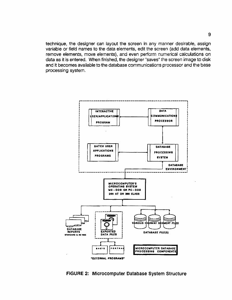
9
technique, the designer can layout the screen in any manner desirable, assign variable or field names to the data elements, edit the screen (add data elements, remove elements, move elements), and even perform numerical calculations on data as it is entered. When finished, the designer "saves" the screen image to disk and it becomes available to the database communications processor and the base processing system.
r----------------------------------------------------~-i I I I I 1
DATA 1 I INTERACTIVE I I I 1 SER/APPLICATIO OMMUNICATION 1 I I
: PROGRAM PROCESSOR : I I I I I I I I I I
l I I I I I I I I I I I I BATCH USER DATABASE I ! APPLICATIONS PROCESSING ! '1 PROGRAMS I SYSTEM I I I I I I I DATABASE : I ENVIRONMENT:
------------------------ -------------------------------~
DATABASE REPORTS
ITANOARD & NJ ttDC
MICROCOMPUTER'S OPERATING SYSTEM MS-DOI OR PC-DOS 218 AT OR Me CLASS
r--~---~---: I I I ._.. I
I 0 I I I I I : I I EXPORTED l ! DATA FILES l ,______ _ _____ _,,
DATABASE FIL!(S)
MICROCOMPUTER DATABASE PROCESSING COMPONENTS
•EXTERNAL PROGRAMr
FIGURE 2: Microcomputer Database System Structure

10
The Communications Processor is a set of software programs that link the user applications (files, screens, etc.) to the Database Processing System. The processing system controls the actual sorting, retrieval, and calculation functions that will ultimately be requested. The Batch User Application Program permits the user to write programs in a special language called the query language. The term "query language" has grown to be a common term; however, it is a misnomer since the term "query" implies "retrieval only." In database applications, the query language permits other activities such as updating, inserting, merging, sorting, etc. By using the query language, the user can write any number of applications routines that will sort the database, extract specified information, produce detailed reports, import/export data to other files, and perform complex mathematical calculations on the data within a given record.
The final element, the disk operating system of the micro, is required to manage all of the file inputjoutput activities that transpire. DOS is, in effect, the "shell" that surrounds the database and permits use of the microcomputer's resources to function properly.
The end-result of the integration of these five elements is the resultant database files, reports, special files, (files suitable for transfer to other programs outside of the database), and the ability to receive imported files from outside programs. As will be shown, the developed system relies on file import and export activities to occur. For example, some of the activities require the use of PC-SAS to manipulate data and import that data back into the database. Additional applications require the database to prepare sorted data from specified files, export the sorted data to disk for use in FORTRAN and/or BASIC programs. The file import/ export feature greatly expands the utility of the database to other existing software packages that permit plotting, optimizations, cost estimations, etc.
2.1 DATABASE TERMINOLOGY
To assist in understanding the architecture of the developed system, the following terminology is defined:
BIT The smallest discrete element of storage in a digital computer. A computer bit = O or 1.
BYTE A byte (normally = to 8 bits) represents one character. Thus, a pattern of 8 bits equals one byte or one character.
FIELD - A collection of bytes or characters that can represent a number, words, phrases, etc.

11
RECORD - A collection of fields that represent a unique, complete dataset.
FILE
KEY •
A collection of records.
A special identifying field within a record. When the file is accessed, the key assists in specifying the identity of the record to be processed. Most keys are one or more fields within a record. These are referred to as imbedded keys.
Additional important termonology:
DATABASE RECORD
A grouping of fields or, a logical record format.
DATABASE FILE
A collection of database records.
DATABASE
A collection of database files.
PRIMARY KEY
A field or collection of fields that is/are unique i.e. no other record possesses the same field value. The key is used to access matching records in a small amount of time.
SECONDARY KEY(S)
Additional field(s) which may or may not be unique. Secondary keys assist in sorting and/or retrieving specified records that match the keyed value(s).
For the purpose of this report, a database record will generally represent a unique highway-lane segment. In the 0.1 master file, each record represents a unique tenth-mile lane segment for a particular highway number in a given county. The fields within that record contain the fields (data) that represent the condition of that particular stretch of highway-lane. Thus, if a particular county has 300 miles of two lane highway, then the 0.1 file will contain 6000 records (3000 records for the "R" lane and 3000 records for the "L" lane.) For multi-lane roads, i.e. interstate

12
roads, more lane designations are required thus increasing the number of records required. The 0.1, 0.2, and 0.5 files discussed herein are all organized in this manner.
2.2 RELATIONAL DATABASE FILE STRUCTURE - AN OVERVIEW.
Most of recently-developed computerized databases are relational in nature. These newer systems are based upon the concept of relational ideas. While the theoretical concepts underlying relational mathematics is beyond the scope of this report, the reader may require an overview of the concept. Simply stated, a relational database system is one that:
1. The user perceives the data as being represented by tables and nothing but tables.
2. The operations at the user's disposal for data retrieval are operators that generate new tables from older, existing tables.
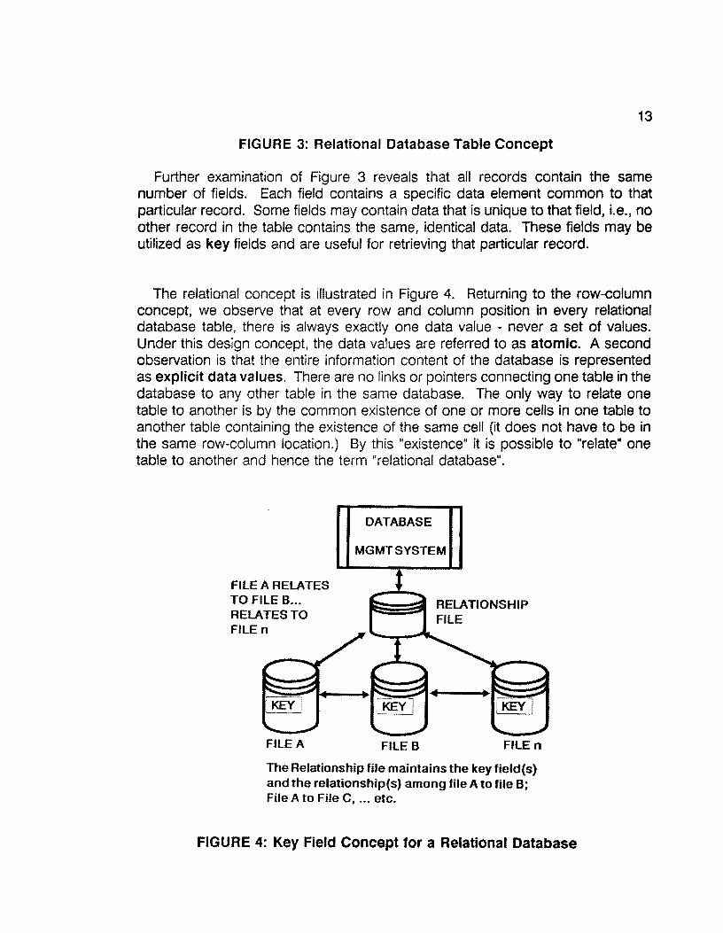
Figure 3 illustrates the table concept. As shown, the table is comprised of rows and columns. Each row in the table is referred to as record; each column within a row is a field. The collection of rows with their associated fields comprises a database file.
r---~----------------------------~---------, I I I I
I ~~1~2m~a m~' f I I
1 :::::: : I I I I I i : llEC:OAD 3 . . . . I : . : I • I
! . : : lllCOAD II I I i:?!'.iif I l : i L..-------------1--~~~~~~~~':-~~-~~~~~~--------J
r----:;;:.-:.;~::-;;~:~:;-,::;------1 I I
I ij ii I I B J:.::::· I D CIAT'A f'l .. 11
I * , I I SI I I :::r:=J I : i ! ' l "c:Hl~D" OA llEUITED Fii.i! I t________________ .
m:lm •&•OYI• A •••MO• aA1'A •flLI
FIGURE 3: Relational Database Table Concept
13
FIGURE 3: Relational Database Table Concept
Further examination of Figure 3 reveals that all records contain the same number of fields. Each field contains a specific data element common to that particular record. Some fields may contain data that is unique to that field, i.e., no other record in the table contains the same, identical data. These fields may be utilized as key fields and are useful for retrieving that particular record.
The relational concept is illustrated in Figure 4. Returning to the row-column concept, we observe that at every row and column position in every relational database table, there is always exactly one data value - never a set of values. Under this design concept, tl1e data values are referred to as atomic. A second observation is that the entire information content of the database is represented as explicit data values. There are no links or pointers connecting one table in the database to any other table in the same database. The only way to relate one table to another is by the common existence of one or more cells in one table to another table containing the existence of the same cell (it does not have to be in the same row-column location.) By this "existence" it is possible to "relate" one table to another and hence the term "relational database".
FILE A RELATES TO FILE B ... RELATES TO FILEn
. KEY• ~-~_J
FILEA
DATABASE
MGMT SYSTEM
FILE B FILE n
The Relationship file maintains the key field(s) and the relationship(s) among file A to file B; File A to File C, ... etc.
FIGURE 4: Key Field Concept for a Relational Database

14
Non-relational database design incorporates pointers or "links" that direct the system to other datasets. Many of the older DB systems utilized linked lists and imbedded pointers to direct control from one data set to another. Modern DB design has appeared to abandon these concepts in favor of the relational concept
In summary, the relational design is a useful means to represent highway data. It is important to emphasize that the database may not actually store the data in a matrix or tabular format. It is not important that we understand exactly how the data is stored. What is important is that we perceive that it is stored in a tabular manner. By understanding this perception, we can better comprehend the design of the system.
2.3 DISTRICT-LEVEL DATABASE MANAGEMENT
Historically, computerized database systems have been an integral part of centralized data processing systems. This is true because historically, database systems were originally designed for large, mainframe systems. With the advent of remote terminal access, users located away from the centralized facility could access data through a terminal system. With the proliferation of single user microcomputers, database systems were designed exclusively for these systems. Today, the single-user micro-based database system is common.
The system reported herein is designed to be a single user, district-based system. With some modification, the system could be expanded to run under a network configuration (assuming the requisite hardware and networking software is purchased.)
The advantages of single-user microcomputer database systems for district-level use are as follows:
1. Flexibility in design. 2. Integrity of data. 3. Increased response time. 4. Ease of use.
Use of microcomputer-based database software permits custom design of the system to suit the individual needs of each district. Due to the flexible nature of these systems, it is possible to design a "base system" and incorporate custom applications to fit the district's special needs. The base or "generic" system can easily be modified to generate a variety of different file structures from a base file. Additionally, an unlimited number of reports can be generated without employing

15
programmers or seeking assistance from a centralized mainframe environment. Data can be transported to various sites for additional processing. In essence, the data and the applications programs reside in the district and can be manipulated in a variety of ways.
The very essence of a database design creates an environment whereby data values are secure and stored in a format that permits flexible manipulation. Password protection can be implemented to restrict access to some or all of the data. Data may, if required, be accessed on a "need to know" basis via the password security systems. Only "authorized" users can view all or part of the data and/or run specified reports.
With the database residing at the district level, engineers can access highway data within a short time and have reports, plots, etc. in their hands often within minutes. Increased time response often pays valuable dividends over centralized database operations, especially when customized or "one-time" reports are required.
The selected system, DATAEASE, has proven to be relatively easy to learn. Within one or two weeks, engineers will possess the ability to generate custom reports with little difficulty. With the menu-based features of the system, a variety of staff members can use the system within a short time. With proper training, the district staff could completely manage, program, alter, and create extensions to the system as future needs arise. It is estimated that staff members, depending upon their level of education, could master the system with less than 40 hours of training combined with 2-3 months of day-to-day use.
The next section will begin the detailed description of the highway database system by focusing upon the required files that ''drive" the system. In this section, the logic and the sequence of events will be described, illustrated by system-level flow charts for each file.

16
3.0 DISTRICT-LEVEL, FLEXIBLE PAVEMENT DATABASE· OVERVIEW
The district-level, flexible pavement database is designed for the analysis of highway segment pavement data at the district level. The entire system is devised to reside on an IBM compatible XT, AT, or a 386-based microcomputer. The system defined herein maintains highway segment data by county. If, for example, a district is comprised of 12 counties, then 12 separate database directories are required. Each DOS directory contains the entire datasets for a given county. In the design stage of this project, a variety of segmentation schemes were evaluated. The most logical breakdown appeared to be by county. It is possible to combine counties in an attempt to create a multi-county base. However, under the DOS 3.XX restrictions, a 33 Mb. limit on the hard disk is imposed. With future releases of DOS, notably IBM's newly announced OS/2 operating system (scheduled for release in early 1988), this limit may disappear, and the maintenance of a entire district level file could be possible.
The selected DB system, DATAEASE, allows for a variety of operations to be performed with minimal computer expertise of the user. However, users will be required to undergo a series of training session before becoming operational on the system. A separate user's manual will be prepared at a later date, and maintained as changes evolve, to assist in the training process.
This report discusses Version 1.0 of the flexible pavement database. The first installation is scheduled to take place in the fall of 1987 in District 21, Pharr, Texas. A backup of the system will be maintained in D-18PM, Austin, and within the Texas Transportation Institute at Texas A&M University, College Station, Texas. All data collected by the host district will be stored in the three locations plus the appropriate number of tape backups. This level of redundancy will serve to minimize problems associated with loss of data. Additionally, any problems encountered at the district level could be emulated at the backup sites in order to provide user assistance when required.
The succeeding sections describe the details of the database and the various operational features designed into the system. Each file will be described along with the information required to collect the requisite data and the associated data entry.

17
3.1 DATABASE SYSTEM DESIGN
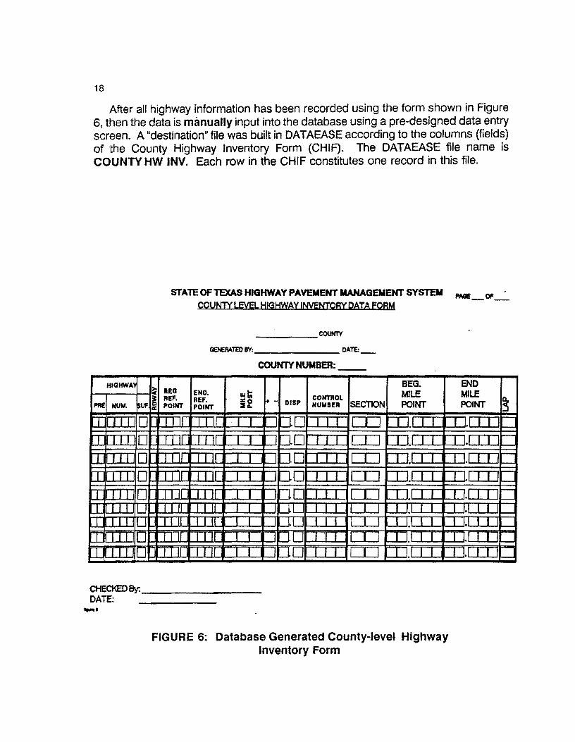
The overview of the flexible pavement, district-level database system is shown in Figure 5. The primary data source from which all succeding files are built are gathered from the Rl-1 district file. Information such as county highway inventory data, cross-road data, traffic, road widths, date of last surfacing, etc. are required to initiate the system. Parts of the data requirements exist on various computerized datasets in Austin while other elements are not computerized and must be generated manually by researching this information source. Twelve items of information for each highway within a given county must be extracted from the Rl-1 file. Figure 6 illustrates a county-level data form that is helpful in tabulating this information for input into the database. The information consists of the highway number, roadway, beginning and ending reference points by job control section, milepost information, and control section number and location. The details concerning each data item will be discussed in the next section.
-DISTRICT I.Mt HA8DWAU REOMTI
lllM-AT - 8GB,1.2J.tlb 2-30t.t> HO, 4Mb M91n ~ 8-d &lwNi IOt.t> T1p41 helcup int
Mdl Co- Processor Cl..p Wide c.r. Lile l'l1nter ( IBM Gnptics Coql.) DOS 3.1 or 3.2 SOFTWARE 8EOMll! DATAEASE (f.490.00) GIWTAU< MS-FORTRAN TURBO- BASIC
,,,,. • .,,,.-·""·'·.,.,.·#....._ _______ __,
FORT & BASIC PGMS
DISTRICT - LEVEL REPORTS, Pl.OT$, ETC.
FIGURE 5: Flexible Pavement District-level Database Overview
18
After all highway information has been recorded using the form shown in Figure 6, then the data is manually input into the database using a pre-designed data entry screen. A "destination" file was built in DATAEASE according to the columns (fields) of the County Highway Inventory Form (CHIF). The DATAEASE file name is COUNTY HW INV. Each row in the CHIF constitutes one record in this file.
HIGHWA'I
PR! NUM. SUF
I I I I D I I I I D I I I I D I I I I D I I I I D I I I I LJ I I I I u I I I I LJ I I I I D
STATE OF TEXAS HIGHWAY PAVEMENT MANAGEMENT SYSTEM COUNTY LEVEi. HIGHWAY INVENTORY DATA FOAM
____ COUNTY
GEIEMlED BV: ______ DATE:_
COUNTY NUMBER:
~ BEG BEG.
END. :1t MILE ~ REF, REF. f+ - CONTROL cc POINT POINT =i2 DISP NUMBER SECTION POINT
I I 11 T I Ir I I 1=i.D I I I CIJ =rJ_f T I
I I II f I II I I -i.D I I I [I] [IJ_f I I
I l 11 r r 11 I I ID I I I [I] [IJJ T T
I I II I J II I I I :J.D I I I [I] =:IJ.1 I I
I I II I I II I I 1=i.o I I I CIJ [IJ,I I I I I fl f I TT I I ILJI I I I I I I _LJ.J I I I r II 1 I II I I LI I I I I I I LU.I I l
I I II I I II I I JD I ·1 I I I I [TI,I I I
I I II I I II I I JD I I I [I] ITJ.1 I I
CHECKED By: _______ _
DATE: ......
FIGURE 6: Database Generated County-level Highway Inventory Form
PNIE_Of_
ENO MILE s POINT
I I.I I I I.I i= I IJ I I l I I I l.I I I I U I I -l 1,1 I I
I 11 I I I -11,1111
19
After all highway information has been entered into DATAEASE, the DAT AEASE file COUNTY HW INV contains (hopefully) all of the highway inventory information. Several reports can then be run to produce a listing of this file, sorted in any manner desired. It must be remembered that the row order of this file is unimportant. A relational database has the ability to sort this file and write another file based upon a large number of sorting options. This file is ordered (record by record) with respect to the order of the manual data entry. The user should not be concerned with row order since it can be altered as required. ·
The hardcopy reports written for this file should be audited by the engineering staff to insure accuracy. Two critical points must be kept in mind concerning the creation of the COUNTY HW INV file. First, the creation of this file is normally a one-time effort. Once the file is built, it remains fairly constant from year-to-year. The audit report needs to be reviewed annualy to see if any new pavements have been constructed or, old pavments have been taken out. Since both of these options are rare events, this file will remain fairly stable. This file will be used in the future to generate new 0.1 sections only if new pavement has been added or existing pavement has been taken out. Second, the data in this file must be totally accurate. Before building this file for a new district, great care should be taken to insure its accuracy. In effect, this file is the "driver file" for the database.
Further examination of Figure 5 reveals that given the County Highway Inventory File, as it resides in the database, all other data files are built from it. By use of the DATAEASE Query Language (QL), routines have been written to read the COUNTY HW INV file and generate the Ride, Skid, FWD, and the 0.1 Mile Segment files. Once generated, these files contain no data per se. However, each record in each file is established with the appropriate milage increments. For example, if a given highway segment contains 10.00 miles of highway, then the file creation process will generate 20 0.5-mile records for visual and FWD data; 50 0.2-mile records for ride and skid data; and 200 0.1-mile records for the master highway segment file. However, at this stage, the files do not contain the actual data. The processing time to prepare these files is minimal, i.e., one or two working days. Once prepared, these files become a "perminent" file structure that can be re-used in succeding years. If pavements are added or taken out of service, it is a simple task to update the COUNTY HW INV file and generate the new records and add them to the existing set.
Roadway segments entered into this file (where one record equals one unigue roadway segment) are defined as follows:
One record in the County-level Highway Inventory File equates to one Roadway-Control Section number. In other words, each roadway segment (record) possesses a unique roadway code and a unique control section number.

20
Thus, when one first builds the COUNTY HW INV file, the District Traffic Engineer must identify all roadway segments within the county by their unique roadway-control section values. It is this criteria that determines "uniqueness" of roadway segments.
The next phase is the in-field data collection activities. Field data collection will take months to complete. As data comes in, it can be entered manually into the appropriate file or if automated data collection is used, merged into the appropriate file. The 0.1, 0.2, and 0.5 files must be totally complete before any meaningful analysis can be run accross the files. Once completed, the database is available for virtually any type of analysis required.
The analysis aspect of the database is primarially driven from the 0.1 MASTER file. This file contains over 90 fields of information for each 0.1-mile segment of highway within a given county. The database possesses the ability through the query language to generate a wide variety of reports, sorts, exporting of selected data in a variety of formats, and graphics generation for segment plots.
The last overview feature concerns the end-of-year functions required to prepare the files for new data. First, the entire database will be backed up to tape. By using the query language, selected data in each file will be moved into "history fields" reserved for storing cumulative historical data.. After the history fields have been updated, the actual data wHI be erased and the file(s) will be ready to receive current data. This process will be repeated toward the end of each year (normally in November.)
The next sections review in more detail, the specific files needed by the database. These are:
1. The County Highway Inventory File, 2. The 0.5 Visual File, 3. The 0.5 FWD File, 4. The 0.2 Ride File, 5. The 0.2 Skid File, 6. The 0.1 Master File, 7. The Miscellaneous Files.

21
3.2 COUNTY-LEVEL HIGHWAY INVENTORY FILE
Analysis of Figure 5 reveals that the prime source of information for beginning the database is the Rl-1 file and other information maintained within the district. The system is driven from knowledge of the total highway system within a given county. District engineers must first inventory each county for 13 data elements for each highway. These are:
1. Highway Prefix
IH,US,SH,FM,PR.
2. Highway Number
The (up to) 4 digit designation.
3. Highway Suffix
For PR roads: { 'blank', A,B, ... ,z }. For FM,US,IH, and SH: { 'blank', A,S,E,W, and N }
4. Roadway code
The lane direction code: { R,L,A, and X }. {Rand A} designate increasing milepost directional values.The {Land X } set designates decreasing milepost directional values.
5. Beginning Reference Point
The mile point defining the beginning of the defined highway segment where the segment first enters a given county or, where the segment is initiated within the given county for the first control section. If the roadway is comprised of multiple control sections, in general, the beginning reference point (BRP) equals the ending reference point of the previous control section segment.
6. Ending Reference Point
The length of the control section (in tenths of miles) added to the BRP of that control section. In effect, this is the length of the control section rounded to the nearest tenth of a mile.

22
7. Mile Post (Replaced by the new Reference Marker System in 1990)
A physical marker set in the field to act as a reference point to assist in location. Mile posts are generally set every two miles (unless physical constraints prevent) and measure the distance from the point of origin of the highway within the county.
8. Mile Post Sign
A "+ 11 or 11-" displacement direction. 11 +" indicates an increasing mile post
direction: 11-" indicates a decreasing mile post direction.
9. Mile Post Displacement
Tenths of miles associated with the mile post sign "+ 11 or 11-" from the mile
post sign and begins from the mile post sign.
10. Control Number
A four digit identification number associated with the given segment. This number is assigned at the time the highway segment was originally constructed.
11. Section Number
A two-digit code i.e., 01,02, ... , attached to the end of the control number.
12. Beginning Mile Point
The beginning mile point associated with the origination of the control section associated with the given segment. This may not be connsistent with the beginning/ ending reference point mile system. This numbering scheme is measured in thousandths of a mile and permits location within +- 5.28 feet. Note: no physical marker is placed in the field for this scheme.
13. Ending Mile Point
The length of a given control section measured to the nearest thousandth of a mile and measures the length of the control section.

23
14. Lap Code
A "Y" or a "N". A "Y" designates the fact that the current segment has a control section break at the beginning of the segment. An "N" signifies the current segment is a continuation of existing control section number.
This information is required to generate the 0.1 Master File and the associated 0.2 and 0.5 mile files.
An important feature of the database files is the location scheme applied by the State of Texas in locating highway segments. Under the Texas scheme, mileposts are set on 2-mile intervals (except on interstate roads which are set on 1-mile intervals). In some locations, i.e. urban areas, it may be physically impossible to set a milepost exactly at the proper point. In some instances, mileposts may be offset, or even missing. All highway segments in the 0.1, 0.2, and 0.5 mile files are referenced to these mileposts or some offset ( + or -) from the milepost.
The next section discusses the identification/location rules as defined by the Texas State Highway Department. This information is important in that the rules for identifying and locating a given highway segment are presented. This is critical because each database record in the 0.1 Master file, 0.2, and 0.5 files all contain segment location information. Thus, it is important to understand the terminology and rules used by the Texas Department of Transportation (fxDOT).
3.2.1 DIRECTION OF INCREASING MILEPOST NUMBERS
For east-west highways, the mileposts values increase from west to east for all highway types (IH,US,SH,FM and PR). For north-south highways, milepost values generally increase from north to south except for interstate highways. For interstate roadways, the mileposts increase from south to north. To view increasing milepost numbers the following rules apply:
INCREASING MILEPOST VALUES APPLY FOR ....
1. INTERSTATE HIGHWAYS TRAVELING EAST OR NORTH 2. US HIGHWAYS TRAVELING EAST OR SOUTH 3. STATE HIGHWAYS TRAVELING EAST OR SOUTH 4. FARM-TO-MARKET HIGHWAYS TRAVELING EAST OR SOUTH
These rules may vary on certain highways, especially if the highway "angles" across the state. A specific example is US 59 from Laredo to Texarkana. This highway
24
These rules may vary on certain highways, especially if the highway "angles" across the state. A specific· example is US 59 from Laredo to Texarkana. This highway travels more east·west than north-south. For milepost direction purposes, US 59 is considered to be a north-south road system. Thus, traveling east on this system is considered as traveling north! Thus, the milepost values decrease in value from Laredo to Texarkana.
Milepost locations and values are maintained on D-10 files. However, it is the responsibility of the District Pavement Manager to ensure that all mileposts within the district are accurately placed.
3.2.2 LOCATION OF MILEPOST ZERO
Milepost 'O' indicates the beginning of a highway. The location of this milepost follows these rules:
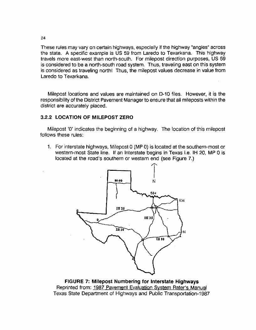
1. For interstate highways, Milepost O (MP 0) is located at the southern-most or western-most State line. If an Interstate begins in Texas i.e. IH 20, MP O is located at the road's southern or western end (see Figure 7.)
T N
FIGURE 7: Milepost Numbering for Interstate Highways Reprinted from: 1987 Pavement Evaluation System Rater's Manual
Texas State Department of Highways and Public Transportation-1987
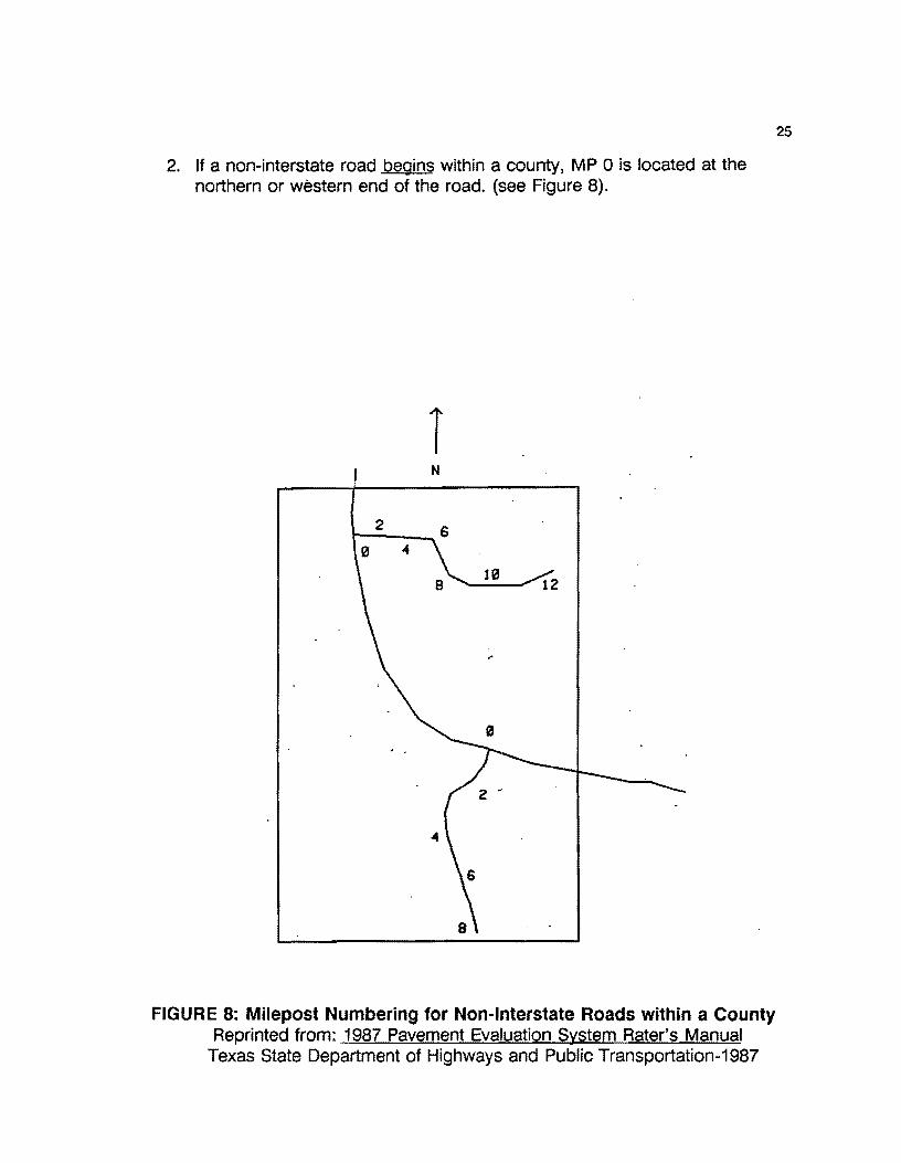
2. If a non-interstate road begins within a county, MP O is located at the northern or western end of the road. (see Figure 8).
T N
2
FIGURE 8: Milepost Numbering for Non-Interstate Roads within a County Reprinted from: 1987 Pavement Evaluation System Rater's Manual
Texas State Department of Highways and Public Transportation-1987
25
26
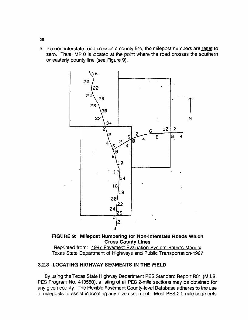
3. If a non-interstate road crosses a county line, the milepost numbers are reset to zero. Thus, MP dis located at the point where the road crosses the southern or easterly county line (see Figure 9).
N
s 10 2
8 121 4
. ·12
14
:
0 2
FIGURE 9: Milepost Numbering for Non-Interstate Roads Which Cross County Lines
Reprinted from: 1987 Pavement Evaluation System Rater's Manual Texas State Department of Highways and Public Transportation-1987
3.2.3 LOCATING HIGHWAY SEGMENTS IN THE FIELD
By using the Texas State Highway Department PES Standard Report R01 (M.l.S. PES Program No. 413560), a listing of all PES 2-mile sections may be obtained for any given county. The Flexible Pavement County-level Database adheres to the use of mileposts to assist in locating any given segment. Most PES 2.0 mile segments
27
begin and end exactly at a milepost. However, some sections may not follow this convention. Thus, an "offset scheme" has been devised to locate segments between mileposts. This scheme employs a milepost number "+" or "-" some displacement or offset. For example, assume a segment of highway begins at milepost "34 + 00" and runs to milepost "34 + 16". This means that the segment begins exactly at milepost 34 and ends at mile post 34 + 1.6 miles. The ending milepost "34 + 16" indicates that the defined segment ends 1.6 miles past milepost 34.
Milepost designations are comprised of two values. The first value is the milepost (34 in this example) and a displacement value ( + 16) which stands for "1.6 miles past the previous milepost. Displacements may also be "-". If the segment end point was "34-16", this would state that the segment ended 1.6 mile before milepost 34. It is to be emphasized that these designations assume one is traveling in the direction of increasing mileposts.
3.2.4 MILEPOSTS ON CONCURRENT HIGHWAYS
In many instances, two or more highways may be "concurrent" (i.e., they travel along the same route). As such, the milepost designations should follow the major highway according to the following rules:
1. If the roads have different prefixes (IH,US, SH, or FM), the major highway is identified by the highest level prefix. Prefix ordering follows:
Ranking No. Prefix
1 IH 2 us 3 SH 4 FM
2. If the concurrent roadways have the same prefix, identify the major highway as that highway having the lowest highway number. Example: If a streach of highway involved both US 82 and US 62, the milepost designations would adhere to the lowest number highway, i.e., US 62.
As stated in the PES manual:
"There is no consistent method used for setting mileposts on concurrent routes. Mileposts on the major highway should continue uninterrupted. However, mileposts on the minor highway(s) may be interrupted at the end of the concurrent route."

28
Additionally, while every road must begin with MP 0, there is no guarantee that MP o will be located exactly where it should be. If the road begins at an intersection, it may be physically impossible to locate the milepost marker at its exact spot (in this case, the centerline of the intersection.) Thus, the milepost may be slightly removed from its exact location. In this case, MP O may be referenced as MP 0+01 to signify that this milepost is 0.1 miles ahead of its exact location.
The detailed milepost rules are documented in the current version of the Pavement Evaluation System Rater•s Manual available from the Texas Department of Transportation (0-18PM) in Austin, Texas. This manual (updated annually) contains detailed information concerning the location schemes and rating rules. Use of the database assumes the user is familiar with the existing State of Texas Pavement Evaluation System (PES) methodology. However, it must be emphasized that the file structure of the district-level, flexible pavement database contains different information than the State's PES file structure, nor does this database follow the data structure of the PES file system. This system is separate and distinct from the PES system.
3.2.5 DETAILS OF THE COUNTY HIGHWAY INVENTORY FILE
The County Highway Inventory File (CHIF) contains highway segment data as entered under the format shown in Figure 6. Tables 1, 2, and 3 illustrate the entire CHIF sorted three different.ways. These reports were generated by DATAEASE for Cameron County {County Number 31). These 11reports" was defined within the DATAEASE structure as a report function selected from the DATAEASE Main Menu -Option 3 (see Figure 10). Details regarding using the database will be presented in Section 5.
DATAEASE - MAIN MENU
1. Form Definition and Changes 2. Record Entry and Quick Reports 3. Full Reports 4. Data Base Maintenance 5. Data Base Utilities 6. Menus and Relationships 7. System Administration
FIGURE 10: DATAEASE Main Menu Screen

TABLE 1 Listing of Cameron County Highway Inventory File
Sorted by Record Number
SORTED BY RECORD NUMBER ONLY
CCXJNTY LEVEL NIGHllAY INVENTORY REPORT DISTRICT 21, PHARR, TEXAS
CAMERON COUNTY
29
PAGE NO.
Record COUNTY HIGHWAY HIGHWAY HIGHWAY ROADWAY BEG. END. MILEPOST MILEPOST MILEPOST CONTROL SECTION BEG. END. LAP MILEPOINT MILEPOINT NU!tler NUMBER PREFIX NUMBER SUFFIX
000001 000002 000003 000004 000005 000006 000007 000008 000009 000010 000011 000012 000013 000014 000015 000016 000017 000018 000019 000020 000021 000022 000023 000024 OOOOZ5 000026 000027 000028 000029 000030 000031 000032 000033 000034 000035 000036 000037 000038 000039 000040 000041 000042 000043 000044 000045
31 us 31 FM 31 FM 31 FM 31 FM 31 FM 31 FM 31 FM 31 FM 31 FM 31 FM 31 FM 31 FM 31 FM 31 FM 31 FM 31 FM
31 FM 31 FM 31 FM 31 FM 31 FM 31 FM 31 FM 31 FM
31 FM 31 FM 31 FM 31 FM 31 FM 31 FM 31 FM 31 FM 31 FM 31 FM
31 FM 31 FM 31 FM 31 FM 31 FM 31 FM 31 FM 31 FM 31 FM
31 FM
0071 0106 0106 0106 0106 0106 0313 0506 0506 0506 0507 0507 0508 0509 0510 0510 0511 0511 0675 0732 0733 0800 0800 0801 0802
0802 0802 0803 0803 1419 1420 1421 1479 1479 1575
1561 1577 1595 1595 1599 1732 1846 1847 1847 1847
A
R
R
R
R
R
R
R
R R
R
R R
R
R
R
R
R
R R
R R
R
R
R
R
R R
R
R
R R
l
R
R
R
R
R
R
R R
R
R
R
R
REF. REF. POINT POINT
1. 7 4.3 o.o 6.3 6.3 9.2 9.2 11.4
11.4 13.1 13.1 15.8 0.0 1.7 0.0 2.8 2.8 5.9 6.5 18.5 o.o 4.9 5.4 9.1 o.o 9.1 0.0 5.5 0.0 17.1
17.1 22.5 o.o 12.2
12.2 16.2 o.o 4.2 0.0 6.0 0.0 3.2 0.0 5.4 5.4 16.9 o.o 3.6 o.o 2.2 2.2 7.2 7.2 8.6 o.o 10.3
10.3 13.6 0.0 12.3 0.0 4.5 o.o 6.6 o.o 1.1 0.0 9.2 o.o 4.0 0.0 4.3 o.o 5.3 0.0 1.8 1.8 4.0 o.o 2.2 0.0 5.1 o.o 7.5 0.0 7.4 7.4 13.5
13.5 27.8
0 2 6 8
10 12 0
0 2 4
2 4
0 2
0 16 2
12 2 2 2 2 4 2 0 2
6 2
10 2
2 4
2
2 2 0
2
0 0
2
2 2
2 6
12
DISP.
SIGN
+
+
+
+
+
+
+ +
+
+
+
+ +
+
+
+ +
+
+
+
+
+
+ +
VALUE
1.7 2.0 0.3 1.2 1.4 1.1 0.0 o.o 0.8 2.5 2.0 1.4 o.o 2.0 o.o 1.1 2.0 0.2 2.0 2.0 2.0 2.0 1.4 1.0 o.o 0.2 1.2 1.9 0.3 1.7 2.0 4.0 2.0 2.0 2.0 o.o 2.0 0.0 1.8 2.0 2.0 2.0 2.0 1.4 1.5
0327 1425 0630 0630 1138 2243 1806 0872 0872 0872 0873 0813 0342 1065 1057 0775 0684 0684 1057 1057 0872 1136 1136 1137 1140 1140 1140 1138 1138 1426 1425 0331 1425 1425 1505 3045 1506 2369 0630 1518
0684 1065 1801 1801 1801
08 03 02 03 01 01 01 02 02 04 02 01 04 01 03 01 01 02 01 02 03 01 02 01 01 02 03 01 02 01 02 03 04 04 01 01 01 01 02 01 03 02 02 02 01
2.650 0.000 6.350
19.241 o.ooo 0.000 0.000 0.000
10.000 0.000 0.000 0.000 0.409 0.000 0.000 o.ooo 0.212
12.488 0.000 0.000 0.000 0.000 5.352 1.026 5.000 7.121 1.000 1.732 o.ooo 0.345 0.000 0.022 0.000 0.000 1.000 o.ooo 0.000 o.ooo 1.770 0.000 o.ooo o.ooo o.ooo
20.000 0.000
5.325 no 6.345 no 9.241 yes
21.460 yes 1. 732 yes 2.667 yes 1.736 no 2.831 no
13.110 yes 11.972 no 4.938 no 3.745 no 9.517 no 5.512 no
17.077 no 5.366 yes
12.425 no 16.462 yes
4.158 no 5.980 no 3.222 no 5.352 no
16.891 yes 4.578 no 7.221 no
12.111 yes 2.424 yes
12.045 no 3.255 yes
12.639 no 4.497 no 6.635 no 1.117 no 9.195 no 4.999 no 4.270 no 5.266 no 1. 770 no 3.988 yes 2.220 no
5.057 no 7.468 no 7.381 no
26.055 yes 14.328 yes

30
TABLE 1 - Continued Listing of Cameron County Highway Inventory File
Sorted by Record Number
C()JNTY LEVEL HIGHWAY INVENTORY REPORT DISTRICT 21, PHARR, TEXAS
CAMERON CCXJNTY
SORTED BY RECORD NUMBER OHLY PAGE NO. 2
Record C()JNTY HIGHWAY HIGHWAY HIGHWAY ROADWAY BEG. END. MILEPOST MILEPOST MILEPOST CONTROL SECTION BEG. ENO. LAP
Nunber NUMBER PREFIX NUMBER SUFFIX REF. REF, DISP. VALUE MILEPOINT MILEPOINT
000046 000047 000048 000049 000050 000051 000052 000053 000054 000055 000056 000057 000058 000059 000060 000061 000062 000063 000064 000065 000066 000067 000068 000069 000070 000011 000072 000073 000074 000075
000076 oooon 000078 000079 000080 000081 000082 000083 000084
000085 000086 000087 000088 000089 000090
31 FM 31 FM 31 FM 31 FM 31 FM 31 FM 31 FM 31 FM 31 FM 31 FM 31 FM 31 FM 31 FM 31 FM 31 FM 31 FM 31 PR
31 PR
31 PR
31 PR
31 PR
31 PR 31 SH 31 SH 31 SH 31 SH 31 SH 31 SH 31 SH 31 SH 31 SH 31 SH 31 SH 31 SH 31 SH 31 SH 31 SH 31 SH
31 Sit
31 SH 31 SH 31 SH
31 SH
31 SH 31 SH
2480 2519 2520 2556 2556 2556 2629 2893 2925 2925 2994 3067 3068 3069 3195 3248 0100 0100 0100 0100 0100 0100 0004 0004
0004 0004 0048
0048 0048 0100 0100 0100 0100 0107 0107 0206 0206 0345 0345 0374 0374 0415 0415 0448 0448
s s
s s s s s s
R
R
R
R
R
R R R R
R R
R
R R
R
R
A
l
R
R x x l
R
R L
R
R
L
L R R R
R L
R
L
R
L
R
l R
l L
POIO POIO SI~
o.o 6.8 o.o 1.8 0.0 7.0 o.o 2.3 2.3 11.8
12.4 17.6 o.o 0.4 o.o 2.9 o.o 3.1 3.1 14.8 0.0 4.1 0.0 2.5 o.o 1.5 0.0 3.0 0.0 1.7 o.o 5.3
11.5 13.9 10.9 13.9 0.0 7.0 7.0 13.9
10.9 11.3 11.5 13.9 0.0 0.1 1.5 1.6 o.o 1.4 1.4 23.5 6.3 6.8 o.o 6.8 6.8 22.3
22.8 23.5 24.2 24.6 0.0 12.7
12.7 24.6 0.0 8.5 8.5 8.9 0.0 2.4 0.0 2.4 7.3 8.1 0.0 8.8 8.5 9.3 0.0 9.3 3.d 3.9 0.0 3.9
11.9 12.5 13.2 17.1
2 0 2 2 2
10 0
2 10 12 0 0 0 0 0 4
22 22 12 18 22 22 2 2 2 2 6
2 6
22 26 2
12 0
8 0 0 6
2
8 0
2 0
8 8
+
+
+
+
+
+
+
+
+
+
+
+ +
+
+
+
+
+
+
+ +
+
+
+ +
+
+
+ +
+
+
+
2.0 0.0 2.0 2.0 0.3 2.4 o.o 2.0 0.0 1.1 0.0 o.o 0.0 o.o 0.0 4.0 1.1 0.5 0.4 0.6 0.5 1.1 1.1 0.4 1.1 0.3 0.3 2.0 0.8 0.8 0.2 2.0 0.7 0.0 0.5 0.1 0.1 1.3 2.0 0.5 0.0 1.0 o.o 0.3 1.6
2366 0487 2356 2529 2529 2529 2621 2965 0630 0630 3044 3094 0684 3093 3304 2717 0331 0331 0331 0331 0331 0331 1504 0039 1504 0039 0220 0220 0220 0331 0331 0331 0331 0342 0342 1425 1425 0630 0630
0039 0039 0039 0039 0327 0327
01 01 01 01 01 02 02 01 04 03 01 03 04 01 01 01 04 04
05 04
04 04 01 10 01 10 05 05 07 02 02 01 02 03 04 03 03 01 01 06 06
10 10 08
08
0.000 0.000 0.000 0.000
10.002 10.000 0.000 0.000 0.222 3.328 0.000 0.000 0.000 0.000 5.000 1.000
26.548 25.876 15.000 22.000 25.876 26.548 0.973
11.476 0.973
11.365 6.319 0.000 1.000
22.746 24.142 0.000
12.690 o.ooo 0.000
10.000 10.000 7.289 0.035 8.512 0.000 3.518 0.546 8.981
10.281
6.801 no 1.799 no 7.007 no 2.266 no
19.501 yes 15.175 no 0.366 no 2.945 no 3.328 no
14.998 yes 4.079 no 2.453 no 1.502 no
3.020 no
6.705 no
6.344 no 28.918 no 28.918 no 22.000 no 28.918 yes
26.231 no
28.918 no 1.087 no
11.618 no 2.365 no
33.458 yes
6.830 no
6.830 no 16.498 yes 23.469 no
24.610 no 12.690 no 24.610 yes
8.544 no
0.409 yes
12.398 no 12.398 no 8.043 no 8.805 no 9.326 no 9.326 no 4.435 no 4.435 no
9.533 no 14.150 no

TABLE 1 - Continued Listing of Cameron County Highway Inventory File
Sorted by Record Number
COUNTY LEVEL HIGll\IAY INVENTORY REPORT DISTRICT 21, PHARR, TEXAS
CAMERON COUllTY
SORTED BY RECORD NUMBER ONLY
Record COUNTY HIGH\IAY HIGHWAY fflGHllAY ROADWAY BEG. END. MILEPOST MILEPOST MILEPOST CONTROL SECTION Nl.lltler NUMBER PREFIX NUMBER SUFFIX REF. REF. DISP. VALUE
000091 000092 000093 000094 000095 000096 000097 000098 000099 000100 000101 000102 000103 000104 000105 000106 000107 000108 000109 000110 000111 000112 000113 000114 000115 000116 000117 000118 000119 000120 000121 000122 000123 000124 000125 000126 000127 000128 000129 000130 000131 000132
31 SH 31 SH 31 SH 31 SH 31 SH 31 SH 31 SH 31 SH 31 SH 31 SH 31 us 31 us 31 us 31 us 31 us 31 us 31 us 31 us 31 us 31 us 31 us 31 us 31 us 31 us 31 us 31 us 31 us 31 us 31 us 31 us 31 us 31 us 31 us 31 us 31 us 31 us 31 us 31 us 31 us 31 us 31 us 31 us
000133 31 us 000134 31 us 000135 31 us
0448 0448 0448 0448 0448 0448
0486 0499 0499 0054 0077 0077 0077 0077 0077 0077 0077 0077 0077 0077 0077 0077 0077 0077 0077 0077 oon oon oon oon oon oon 0077 0077 oon oon oon 0083
0083 0083
0083
0281 0281 0281 0281
s s s s s s s s s s
L
L L
R R R
R
R
R
R
A
A
A
A
A
A
l
l
L l
L l
R
R R R
R R
R
x x x x x x x x A
L
R
x R R
R
R
POINT POINT
17.1 17.6 20.2 22.1 23.3 23.8 0.0 1.2 8.9 17.1
17.1 23.9 0.0 1.0 0.0 6.8 6.8 7.8 0.0 1.1 o.o 1.1 4.3 20.2
20.6 23.3 27.3 30.6 30.6 32.9 32.9 36.8 0.0 4.3 4.3 20.5
20.5 30.6 30.6 32.9 32.9 36.9 36.8 36.9 0.0 4.3 4.3 20.5
20.5 30.6 30.6 32.9 32.9 36.9 36.8 37.7 37.7 37.8 0.0 4.3 4.3 20.2
20.5 23.4 24.5 24.7 27.3 27.7 28.1 30.6 30.6 32.9 32.9 36.8 0.0 8.6 0.0 9.8 o.o 9.8 0.0 8.5 0.0 12.4
12.4 18. 7 18.7 26.1 26.1 26.6
10 16 18 o 6
10 0 0 6 0 o 4
zo 26 30 32 0 4
20 30 32 36
0
4
20 30 32 36 36 o 4
20 24 26 26 30 32 2 2
z 2 2
12 18 26
SIGN
+
+
+
+
+
+ .. +
+
+
+
+
+
+
+
+
+ +
+ +
+ +
+
+
+
+
+ +
+ +
+
+ +
+
+
+
+
+
+
3.5 0.6 1.7 o.o 0.7 3.5 0.0 o.o 0.8 o.o 0.0 0.3 0.6 1.3 0.6 0.9 o.o 0.3 0.5 0.6 0.9 0.8 0.0 0.3 0.5 0.6 0.9 0.8 1.7 0.0 0.3 0.5 0.5 1.3 2.1 0.6 0.9 2.0 2.0 2.0 2.0 2.0
0039 0039 0039 0327 0327 0039 1065 1137 1137 0039 0327 0039 0039 0039 0039 0039 0327 0039 0039 0039 0039 1504 0327 0039 0039 0039 0039 1504 0039 0327 0039 0039 0039 0039 0039 0039 0039 0039 0039 0039 0039 0220
12 12 12 11 08 12 02 02 01 zo 08 07 08
08 09 16 08 07 08 09 16 01 08 07 08 09 16 01 11
08 07 08 08 08
08 09 16 19 19 19 19 03
0.4 0220 04 0.7 0220 04 0.1 0220 OS
31
PAGE NO. 3
BEG. ENO. LAP MILEPOINT MlLEPOINT
14. 150 17.241 20.393 1.000 6.000
14. 150 7.468 1.064 o.ooo 0.000
• 1.000 5.325
21.677 28.322 31.629 33.879
1.000 5.325
21.543 31.629 33.879
5.021 1.000 5.325
21.543 31.629 33.879 5.021 o.ooo 1.000 5.325
21.543 25.495 28.322 29.184 31.629 33.879 o.ooo 0.000 o.ooo 0.000 0.000
12.361 28.606 8.000
14.669 yes 19.122 no 20.923 no
2.226 no 14.150 no
20.923 yes 8.471 no 7.886 no 1.026 yes
1.134 no
2.140 no 21.183 yes
24.393 no
31.629 no 33.879 yes 37.770 yes 5.325 no
21.543 yes 31.629 yes 33.879 yes 37.876 yes
5.113 yes 5.325 no
21.543 yes 31.629 yes
33.879 yes
37.876 yes
5.925 yes 0.060 yes
5.325 no 21.183 yes
24.407 no 25.741 no 28.720 no 31.629 no 33.879 yes 37.770 yes 8.616 no 9.838 no 9.838 no 8.507 no
12.361 no 18.652 yes
35.956 yes 8.542 yes
32
TABLE 2 Listing of Cameron County Highway Inventory File
Multiple Sort Criteria Sorted by: County Number, Highway Prefix, Highway Number, Roadway, and
Beginning Reference Point
MULTIPLE SORT CRITERIA
COUNTY LEVEL HIGHWAY INVENTORY REPORT DISTRICT 21, PHARR, TEXAS
CAMERON COONTY PAGE HO.
Record COUNTY HIGHllAY HIGHllAY HIGHllAY ROADWAY BEG. END. MILEPOST MILEPOST MILEPOST CONTROL SECTION BEG. END. LAP N\.lltler NUMBER PREFIX NUMBER SUFFIX REF. REF. DISP. VALUE MILEPOIHT MILEPOIHT
000064 31 PR
000065 31 PR
000066 31 PR
000063 31 PR
000062 31 PR 000067 31 PR
000002 31 FM 000003 31 FM 000004 31 FM 000005 31 FM 000006 31 FM 000007 31 FM 000008 31 FM 000009 31 FM 000010 31 FM 000011 31 FM 000012 31 FM 000013 31 FM 000014 31 FM 000015 31 FM 000016 31 FM 000017 31 FM 000018 31 FM 000019 31 FM 000020 31 FM 000021 31 FM 000022 31 FM 000023 31 FM 000024 31 FM 000025 31 FM 000026 31 FM 000027 31 FM 000028 31 FM 000029 31 FM 000030 31 FM 000031 31 FM 000032 31 FM 000034 31 FM 000033 31 FM 000036 31 FM 000035 31 FM 000037 31 FM 000038 31 FM 000039 31 FM 000040 31 FM
0100 0100 0100 0100 0100 0100 0106 0106 0106 0106 0106 0313 0506
0506
0506 0507 0507
0508
0509 0510 0510 0511 0511 0675 0732
. 0733 0800
0800 0801 0802
0802 0802 0803 0803 1419 1420 1421 1479 1479
1561 1575 1577
1595 1595
1599
R
R x L
A
x R
R R
R
R • R R
R
R R
R
R
R
R R
R
R R
R
R
R
R
R
R
R
R
R R
R
R
R
R
L
R
R R
R
R R
POINT POINT
0.0 7.0 7.0 13.9
10.9 11.3 10.9 13.9 11.5 13.9 11.5 13.9 0.0 6.3 6.3 9.2 9.2 11.4
11.4 13.1 13.1 15.8 0.0 1.7 0.0 2.8 2.8 5.9 6.5 18.5 o.o 4.9 5.4 9.1 0.0 9.1 o.o 5.5 0.0 17.1
17.1 22.5 0.0 12.2
12.2 16.2 0.0 4.2 0.0 6.0 0.0 3.2 o.o 5.4 5.4 16.9 0.0 3.6 o.o 2.2 2.2 7.2 7.2 8.6 0.0 10.3
10.3 13.6 0.0 12.3 0.0 4.5 0.0 6.6 0.0 9.2 0.0 1. 1
o.o 4.3 0.0 4.0 o.o 5.3 0.0 1.8 1.8 4.0 o.o 2.2
12 18 22 22 22 22
2
6 8
10 12 0 0 2 4
2 4
0
2
0
16 2
12 2
2
2 2 4
2 0 2 6
2 10 2
2 4
2 2 0
2
2
0
0
2
SIGH
+
+ +
+ +
+
+
+
+
+
+
+ +
+
+
+
+
+
+
+
+
+
+
+
+
+
0.4 0331 05 0.6 0331 04
0.5 0331 04
0.5 0331 04 1.1 0331 04 1. 1 0331 04 2.0 1425 03 0.3 0630 02 1.2 0630 03 1.4 1138 01 1.1 2243 01 o.o 1806 01 o.o 0872 02 0.8 0872 02 2.5 0872 04
2.0 0873 02 1.4 0873 01 0.0 0342 04
2.0 1065 01 o.o 1057 03 1.1 0775 01 2.0 0684 Ot 0.2 0684 02 2.0 1057 01 2.0 1057 02 2.0 0872 03 2.0 1136 01 1.4 1136 02 1.0 1137 01 0.0 1140 01 0.2 1140 02 1.2 1140 03 1.9 1138 01 0.3 1138 02 1.7 1426 01
2.0 1425 02 4.0 0331 03 2.0 1425 04
2.0 1425 04 0.0 3045 01 2.0 1505 01 2.0 1506 01
o.o 2369 01
1.8 0630 02
2.0 1518 01
15.000 22.000 no 22.000 28.918 ye$
25.876 26.231 no 25.876 28.918 no 26.548 28.918 no 26.548 28.918 no 0.000 6.345 no 6.350 9.241 yes
19.241 21.460 yes o.ooo 1.732 yes 0.000 2.667 yes o.ooo 1.736 no 0.000 2.831 no
10.000 13.110 yes 0.000 11.972 no 0.000 4.938 no 0.000 3.745 no 0.409 9.517 no 0.000 5.512 no 0.000 17 .077 no 0.000 5.366 yes
0.272 12.425 no 12.488 16.462 yes 0.000 4.158 no o.ooo 5.980 no 0.000 3.222 no 0.000 5.352 no 5.352 16.891 yes 1.026 4.578 no 5.000 7.221 no 7.121 12.111 yes 1.000 2.424 yes 1.732 12.045 no 0.000 3.255 yes 0.345 12.639 no 0.000 4.497 no 0.022 6.635 no 0.000 9.195 no 0.000 1.117 no 0.000 4.270 no 1.000 0.000 o.ooo 1.770 0.000
4.999 no 5.266 no 1.770 no 3.988 yes
2.220 no
MULTIPLE SORT CRITERIA
TABLE 2 • Continued Listing of Cameron County Highway Inventory File
Multiple Sort Criteria
COJllTY LEVEL HIGHWAY tllVENTOllY REPORT DISTRICT 21, PHARR, TEXAS
CAMERON caJNTY
33
PAGE NO. 2
Record COUNTY HIGHWAY HIGHWAY HIGHWAY ROAO\.IAY BEG. ENO. MILEPOST MILEPOST MILEPOST CONTROL SECTION BEG. END. LAP
MILEPOINT MILEPOINT Nunber NUMBER PREFIX NUMBER SUFFIX
000041 000042 000043 000044 000045 000046 000047 000048 000049 000050 000051 000052 000053 000054 000055 000056 000057 000058 000059 000060 000061 000068 000070 000071 000069 000073 000072 000074 000100 000077 000078 000075 000076 000079 000080 000081 000082 000084 000083 000086 000085 000088 000087 000094 000095
31 FM 31 FM 31 FM 31 FM 31 FM 31 FM 31 FM 31 FM 31 FM 31 FM 31 FM 31 FM 31 FM 31 FM 31 FM 31 FM 31 FM 31 FM 31 FM 31 FM 31 FM 31 SH 31 SH 31 SH 31 SH
31 SH 31 SH 31 SH 31 SH 31 SH 31 SH 31 SH 31 SH 31 SH 31 SH 31 SH 31 SH 31 SH 31 SH 31 SH
31 SH 31 SH
31 SH 31 SH 31 SH
1732 1846 1847 1847 1847 2480 2519 2520 2556 2556 2556 2629 2893 2925 2925 2994 3067 3068 3069 3195 3248 0004 0004 0004 0004 0048 0048 0048 0054 0100 0100 0100 0100 0107 0107
0206 0206 0345 0345 0374 0374 0415
0415 0448 0448
s
s s
$
s s s s s
R
R
R R
R
R
R
R
R
R
R
R
R
R
R
R
R
R
R
R
R
L
R
R
L
R
L
R
R
R
R
L
l
R
R
L
R
R
L
R
R
L
R
R
REF. REF. POINT POINT
0.0 5.1 o.o 7.5 o.o 7.4 7.4 13.5
13.5 27.8 o.o 6.8 o.o 1.8 0.0 7.0 o.o 2.3
2.3 11.8 12.4 17.6 o.o 0.4 o.o 2.9 o.o 3.1 3.1 14.8 0.0 4.1 o.o 2.5 0.0 1.5 0.0 3.0 0.0 1. 7 o.o 5.3 o.o 0.1 0.0 1.4 1.4 23.5 1.5 1.6 o.o 6.8 6.3 6.8 6.8 22.3 0.0 1.1 0.0 12.7
1Z.7 24.6 22.8 23.5 24.2 24.6 0.0 8.5 8.5 8.9 0.0 2.4 0.0 2.4 0.0 8.8 7.3 8.1 0.0 9.3 8.5 9.3 0.0 3.9 3.0 3.9 o.o 1.2 8.9 17.1
2
2 2 6
12 2 0 2 2 2
10 0 2
10 12 0 0 0
0 0
4
2 2 2 2 2 6 6 0 2
12 22 26 0
8
0 0
2 6 0
8 0
2 0
6
DtSP. SIGN
+
+
+
+ +
+
+
+
+ +
+
+
+
+
+
+
+
+
+
+
+
+
+
+
+ +
+
+
+
VALUE
2.0 2.0 2.0 1.4 1.5 2.0 0.0 2.0 2.0 0.3 2.4 0.0 2.0 0.0 1.1 o.o 0.0 0.0 0.0 o.o 4.0 1. 1
1.1 0.3 0.4 2.0 0.3 0.8 0.0 2.0 0.7 0.8 0.2 o.o 0.5 0.1 0.1 2.0 1.3
o.o 0.5 o.o 1.0 0.0 0.7
0684 1065 1801
1801 1801
2366 0487 2356 2529 2529 2529 2621 2965 0630 0630 3044 3094 0684
3093 3304 2717 1504 1504 0039 0039 0220 0220 0220 0039 0331 0331 0331 0331 0342 0342 1425 1425 0630 0630 0039 0039 0039 0039 0327 0327
03 02 02 02 01 01 01 01 01 01 02 02 01 04 03 01 03 04
01 01 01 01 01 10 10 05 05 07 20 01 02 02 02 03 04 03 03 01
01 06 06 10 10 11 08
0.000 0.000 0.000
20.000 0.000 0.000 0.000 o.ooo 0.000
10.002 10.000 0.000 0.000 0.222 3.328 o.ooo 0.000 0.000 0.000 5.000 1.000 0.973 0.973
11.365 11.476 0.000 6.319 1.000 o.ooo 0.000
12.690 22.746 24.142 0.000 0.000
10.000 10.000
0.035 7.289 o.ooo 8.512 0.546 3.518 1.000 6.000
5.057 no
7.468 no 7.381 no
26.055 yes 14.328 yes
6.801 no 1.799 no 7.007 no 2.266 no
19.501 yes
15.175 no
0.366 no
2.945 no 3.328 no
14.998 yes
4.079 no 2.453 no 1.502 no 3.020 no 6.705 no 6.344 no 1.087 no 2.365 no
33.458 yes 11.618 no 6.830 no 6.830 no
16.498 yes
1.134 no 12.690 no 24.610 yes 23.469 no 24.610 no 8.544 no 0.409 yes
12.398 no
12.398 no 8.805 no 8.043 no 9.326 no 9.326 no
4.435 no 4.435 no 2.226 no
14. 150 no

34
MULTIPLE SORT CRITERIA
TABLE 2 - Continued Listing of Cameron County Highway Inventory File
Multiple Sort Criteria
COJllTY LEVEL HIGH\IAY INVENTORY REPORT DISTRICT 21, PHARR, TEXAS
CNICRON COUNTY PAGE NO. 3
Record COUNTY HIGHllAY HIGHWAY HIGHWAY ROADllAY BEG. ENO. MILEPOST MILEPOST MILEPOST CONTROL SECTION BEG. ENO. LAP Nunber NUMBER PREFIX NUMBER SUFFIX REF. REF. DISP. VALUE MILEPOINT MllEPOINT
000089 000090 000096 000091 000092 000093 000097 000098 000099
000107 000113 000101 000120 000001 000102 000121 000108 000114 000109 000115 000122 000103 000123 000104 000124 000125 000110 000116 000126 000105 000117 000111 000106 000127 000118 000112 000119 000131 000129 000130 000128 000132 000133 000134 000135
31 SH
31 SH
31 SH
31 SH
31 SH
31 Sii
31 SH
31 SH
31 SH
31 us 31 us 31 us 31 us 31 us 31 us 31 us 31 us 31 us 31 us 31 us 31 us 31 us 31 us 31 us 31 us 31 us 31 us 31 us 31 us 31 us 31 us 31 us 31 us 31 us 31 us 31 us 31 us 31 us 31 us 31 us 31 us 31 us 31 us 31 us 31 us
0448 0448 0448 0448 0448 0448 0486 0499 0499 0077 0077 0077 0077 0077 0077 0077 0077 0077 0077 0077 0077 0077 0077 0077 0077 0077 0077 0077 0077 0077 0077 0077 0077 0077 0077 0077 0077 0083 0083 0083 0083 0281 0281 0281 0281
s s s s s s s s s
l
L
R
L
l
l
R
R
R
L
R A )(
A
A )(
L
R
L
R x A
x A
x x L
R
x A
R
L
A
x R
L
R
x L
R
A R R R
R
POINT POINT
11.9 12.5 13.2 17.1 17.1 23.9 17.1 17 .6 20.2 22.1 23.3 23.8 0.0 1.0 o.o 6.8 6.8 7.8 0.0 4.3 0.0 4.3 0.0 1.1 o.o 4.3 1.7 4.3 4.3 20.2 4.3 20.2 4.3 20.5 4.3 20.5
20.5 30.6 20.5 30.6 20.5 23.4 20.6 23.3 24.5 24.7 27.3 30.6 27.3 27.7 28.1 30.6 30.6 32.9 30.6 32.9 30.6 32.9 30.6 32.9 32.9 36.9 32.9 36.9 32.9 36.8 32.9 36.8 36.8 37.7 36.8 36.9 37.7 37.8 0.0 8.5 0.0 9.8 0.0 9.8 0.0 8.6 o.o 12.4
12.4 18.7 18.7 26.1 26.1 26.6
8 8
10 10 16 18 0 0 6
0 0 0
0
0
4 4
4
4 20 20 20 20 24 26 26 26 30 30 30 30 32 32 32 32 36 36 36 2 2 2
2 2
12 18 26
SIGN
+
+
+ +
+ +
+
+
+
+ +
+ +
+
.+ +
+ +
+ +
+
+ +
+
+
+ +
+
+
+
+ +
+
+
+
+
+
:
+
+
+
0.3 0327 08
1.6 0327 08 3.5 0039 12 3.5 0039 12 0.6 0039 12 1.7 0039 12 0.0 1065 02 o.o 1137 02 0.8 1137 01 o.o 0327 08 0.0 0327 08 o.o 0327 08
0.0 0327 08 1.7 0327 08 0.3 0039 07 0.3 0039 07
0.3 0039 07 0.3 0039 07 0.5 0039 08 0.5 0039 08
0.5 0039 08 0.6 0039 08 0.5 0039 08 1.3 0039 08 1.3 0039 08 2. 1 0039 08
0.6 0039 09 0.6 0039 09 0.6 0039 09 0.6 0039 09 0.9 0039 16 0.9 0039 16 0.9 0039 16 0.9 0039 16 0.8 1504 01 0.8 1504 01 1.7 0039 11 2.0 0039 19 2.0 0039 19 2.0 0039 19 2.0 0039 19 2.0 0220 03 0.4 0220 04 o. 7 0220 04 0.1 0220 05
8.981 10.281 14.150 14.150 17.241 20.393
7.468
1.064 0.000 1.000 1.000 1.000 1.000 2.650 5.325 5.325 5.325 5.325
21.543 21.543 21.543 21.677 25.495 28.322 28.322 29.184 31.629 31.629 31.629 31.629 33.879 33.879 33.879 33.879 5.021 5.021 0.000 0.000 0.000 0.000 0.000 o.ooo
12.361 28.606 8.000
9.533 no 14.150 no 20.923 yes 14.669 yes 19.122 no 20.923 no 8.471 no 7.886 no 1.026 yes 5.325 no 5.325 no 2.140 no 5.325 no 5.325 no
21.183 yes 21.183 yes 21.543 yes 21.543 yes 31.629 yes 31.629 yes 24.407 no 24.393 no 25.741 no 31.629 no 28.720 no 31.629 no 33.879 yes 33.879 yes 33.879 yes 33.879 yes 37.876 yes 37.876 yes 37.770 yes 37.770 yes 5.925 yes
5.113 yes 0.060 yes 8.507 no 9.838 no 9.838 no 8.616 no
12.361 no 18.652 yes 35.956 yes 8.542 yes
TABLE 3 listing of Cameron County Highway Inventory File
Sorted by Control Section Number
SORTED BY CONTROL SECTION NUMBER
COUNTY LEVEL HIGHWAY INVENTORY REPORT DISTRICT 21, PHARR, TEXAS
CAMERON COUNTY PAGE NO.
35
BEG. END. LAP Record COUNTY HIGHWAY HIGHWAY HIGHWAY ROADllA'f BEG. END. MILEPOST MILEPOST MILEPOST CONTROL SECTION Number NUMBER PREFIX NUMBER SUFFIX REF. REF. DISP. VALUE MILEPOINT MILEPOINT
000085 000086 000114 000108 000121 000102 000103 000109 000125 000124 000104 000122 000115 000123 000116 000126 000105 000110 000071 000088 000087 000069 000119 000096 000092 000093 000091 000117 000127 000111 000106 000129 000130 000128 000131 000100 000132 000134 000133 000072 000135 000073 000074 000001 000120
31 SH 31 SH 31 us 31 us 31 us 31 us 31 us 31 us 31 us 31 - us 31 us 31 us 31 us 31 us 31 us 31 us 31 us 31 us 31 SH
31 SH
31 SH
31 SH 31 us 31 SH
31 SH
31 SH
31 SH 31 us 31 us 31 us 31 us 31 us 31 us 31 us 31 us 31 SH
31 us 31 us 31 us 31 SH
11 us 31 SH
31 SH 31 us 31 us
0374 0374 0077 0077 0077 0077 0077 0077 0077 0077 0077 0077 0071
0077 0077 0071 0077 0077 0004 0415 0415 0004 0077 0448
0448 0448 0448 0077 0077 0077 0077 0063
0063 0063
0063
0054 0281 0281 0281 0048 0281 0048 0043
0077 0077
s s
s s
s s s s
s
L
R
R
L x A
A
L
x x A x R K
R
K
A
l R
R L
L
R
R
l L
L
R
K
L
A
L
R
A
x R
R
R
R
l
R
R
R
A )(
POINT POINT
8.5 9.3 o.o 9.3 4.3 20.5 4.3 20.5 4.3 20.2 4.3 20.2
20.6 23.3 20.5 30.6 28.1 30.6 27.3 27.7 27.3 30.6 20.5 23.4 20.5 30.6 24.5 24.7 30.6 32.9 30.6 32.9 30.6 32.9 30.6 32.9
1.4 23.5 o.o 3.9 3.0 3.9 1.5 1.6
37.7 37.8 17.1 23.9 20.2 22. 1 23.3 23.8 17.1 17.6 32.9 36.9 32.9 36.8 32.9 36.9 32.9 36.8 0.0 9.8 0.0 9.8 0.0 8.6 0.0 8.5 0.0 1.1 o.o 12.4
18.7 26.1 12.4 18.7 6.3 6.8
26.1 26.6 . o.o 6.8 6.8 22.3 1.7 4.3 0.0 4.3
8 0 4
4
4
4 20 20 26 26 26 20 20 24 30 30 30 30 2 0 2 2
36 10 16 18 10 32 32 32 32
2
2 2 2 0 2
18 12 6
26 2
6
0
0
SIGN
+
+
+ + +
+ +
+
+
+
+
+
+ +
+
+
+ +
+
+
+
+
+
+
+ + +
+ +
+
+
+
+
+
+ +
+ +
+
0.5 o.o 0.3 0.3 0.3 0.3 0.6 o.s 2.1 1.3 1.3 o.s 0.5 0.5 0.6 0.6 0.6 0.6 0.3 0.0 1.0 0.4 1.7 3.S 0.6 1.7 3.5 0.9 0.9 0.9 0.9 2.0 2.0 2.D 2.0 o.o 2.0 0.7 0.4 0.3 0.1 2.0 0.8 1.7 0.0
0039 06
0039 06 0039 07 0039 07 0039 07 0039 07 0039 08 0039 08 0039 08 0039 08 0039 06 0039 08 0039 08 0039 . 08
0039 09 0039 09 0039 09 0039 09 0039 10 0039 10 0039 10 0039 10 0039 11 0039 12 0039 12 0039 12 0039 12 0039 16 0039 16 0039 16 0039 16 0039 19 0039 19 0039 19 0039 19 0039 20 0220 03 0220 04 0220 04 0220 05 0220 05 0220 05 0220 07 0327 08 0327 08
8.512 0.000 5.325 5.325 5.325 5.325
21.677 21.543 29.184 28.322 28.322 21.543 21.543 25.495 31.629 31.629 31.629 31.629 11.365 0.546 3.518
11.476 0.000
14.150 17.241 20.393 14. 150 33.879 33.879 33.879 33.879 0.000 0.000 o.ooo 0.000 0.000 0.000
28.606 12.361 6.319 8.000 0.000 1.000 2.650 1.000
9.326 no 9.326 no
21.543 yes 21.543 yes 21.183 yes 21.183 yes 24.393 no 31.629 yes 31.629 no 28.720 no 31.629 r.l 24.407 no 31.629 yes
25.741 no 33.879 yes 33.879 yes 33.879 yes 33.879 yes 33.458 yes 4.435 no 4.435 no
11.618 no 0.060 yes
20.923 yes 19.122 no 20.923 no 14.669 yes 37.876 yes 37.770 yes 37.876 yes 37.710 yes 9.838 no 9.838 no 8.616 no 8.507 no 1.134 no
12.361 no 35.956 yes 18.652 yes 6.830 no 8.542 yes 6.830 no
16.498 yes 5.325 no 5.325 no

36
TABLE 3 - Continued Listing of Cameron County Highway Inventory File
Sorted by Control Section Number
SORTED BY CONTROL SECTION NUMBER
CQJllTY LEVEL HI GllllAY INVENTORY REPORT DISTRICT 21, PHARR, TEXAS
CAMERON COONTY PAGE ND. 2
Record COUNTY HIGH\IAY HIGHWAY HIGHWAY ROADIJAY BEG. END. MILEPOST MILEPOST MILEPOST CONTROL SECTION Nl.llt>er NUMBER PREFIX NUMBER SUFFIX REF. REF. OISP. VALUE
000090 000107 000089 000095 000101 000113 000094 000077 000075 000078 000076 000032 000063 000065 000062 000067 000066 000064 000079 000013 000080 000047 000083 000084 000039 000003 000055 000004 000054 000017 000018 000041 000058 000016 000009 000008 000021 000010 000012 000011 000019 000020
31 SH 31 us 31 SH 31 SH 31 us 31 us 31 SH
31 SH 31 SH 31 31 31 31 31 31 31 31 31 31
31 31 31 31 31 31 31 31 31 31 31 31
31 31 31 31 31 31 31 31 31 31 31
SH SH FM
PR PR PR PR PR
PR SH FM
SH FM
SH SH FM FM
FM FM
FM
FM
FM FM
FM
FM
FM
FM
FM
FM
FM
FM
FM FM
000015 31 FM
000014 31 FM 000097 31 SH
0448 0077 0448 0448
0077 0077 0448 0100 0100 0100 0100 1421 0100 0100 0100 0100 0100 0100 0107 0508 0107 2519 0345 0345 1595 0106 2925 0106 2925 0511 0511 1732 3068 0510 0506 0506 0733 0506 0507 0507 0675 0732 0510 0509
s
s s
s
0486 s
L L
L
R A
R
R
R
l
R
L R
L
R
A
x x R
R
R
R
R
l R
R R
R
R
R
R
R
R
R
R R
R R
R
R
R
R
R R R
R
POINT POINT
13.2 17.1 0.0 4.3
11.9 12.5 8.9 17.1 o.o 1.1 0.0 4.3 0.0 1.2 0.0 12.7
22.8 23.S 12.7 24.6 24.2 24.6 o.o 6.6
10.9 13.9 7.0 13.9
11.5 13.9 11.5 13.9 10.9 11.3 o.o 7.0 o.o 8.5 0.0 9.1 8.5 8.9 o.o 1.8
7.3 8.1 o.o 8.8 1.8 4.0 6.3 9.2 3.1 14.8 9.2 11.4 0.0 3.1 o.o 12.2
12.2 16.2 0.0 5.1 0.0 1.5
17.1 22.5 2.8 5.9 0.0 2.8 o.o 3.2 6.5 18.5 5.4 9.1 0.0 4.9 0.0 4.2 o.o 6.0 0.0 17.1 o.o 5.5 o.o 1.0
8 0 8 6 0 0 0
2 22 12 ~
4 22 18 22 22 22 12 0 0 8 0 6 2 0
6
12 8
10 2
12 2 0
16 2 0
2 4 4
2 2 2 0
2 0
SIGN
+
+ +
+
+
+
+ +
+
+
+
+ +
+
+
+
+ +
+
+
+
+ +
+
+
+
+
+
+
+
+
+
+
1.6 o.o 0.3 0.7 o.o o.o o.o 2.0 0.8 0.7 0.2 4.0 0.5 0.6 1.1 1. 1 0.5 0.4 o.o o.o 0.5 0.0 1.3 2.0 1.8 0.3 1.1 1.2 0.0 2.0 0.2 2.0 0.0 1. 1
0.8 0.0 2.0 2.5 1.4 2.0 2.0 2.0 o.o 2.0 o.o
0327 0327 0327 0327 0327 0327 0327 0331 0331 0331 0331 0331 0331 0331 0331 0331 0331 0331 0342 0342 0342 0487 0630 0630 0630 0630 0630 0630 0630 0684 0684
0684
0684
0775
0872 0872 0872 0872 0873 0873 1057 1057
08
08 08 08 08 08 11 01 02 02 02 03 04
04
04
04
04
OS 03 04 04 01 01 01 02 02 03 03 04
01 02 03 04
01 02 02 03 04
01 02 01 02
1057 03 1065 01 1065 02
BEG. END. LAP
MILEPOINT MILEPOINT
10.281 1.000 8.981 6.000 1.000 1.000 1.000 o.ooo
22.746 12.690 24. 142 0.022
25.876 22.000 26.548 26.548 25.876 15.000 0.000 0.409 0.000 o.ooo 7.289 0.035 1.770 6.350 3.328
19.241 0.222 0.272
12.488 0.000 0.000 0.000
10.000 o.ooo 0.000 o.ooo 0.000 o.ooo 0.000 0.000 0.000 0.000 7.468
14. 150 no 5.325 no 9.533 no
14.150 no 2.140 no 5.325 no 2.226 no
12.690 no
23.469 no 24.610 24.610 6.635
28.918 28.918 28.918 28.918 26.231 22.000 8.544 9.517 0.409 1.799
8.043 8.805 3.988 9.241
14.998 21.460 3.328
12.425 16.462 5.057 1.502 5.366
13.110 2.831 3.222
11.972 3.745 4.938 4.158 5.980
yes
no no no yes
no
no no
no no no yes
no no no yes
yes
yes
yes
no
no yes
no no yes
yes ~
no no
no no no
no
no 11.on no 5.512 no
8.471 no

TABLE 3 • Continued Listing of Cameron County Highway Inventory File
Sorted by Control Section Number
SORTED BY CONTROi. SECTION NUMBER
COUNTY LEVEL HIGHWAY INVENTORY REPORT DISTRICT 21, PHARR, TEXAS
CAMERON COONTY PAGE NO. 3
37
Record COUNTY HIGHWAY HIGHWAY HIGHWAY ROADWAY BEG. END. MILEPOST MILEPOST MILEPOST CONTROL SECTION BEG. END. LAP Nuii:ler NUMBER PREFIX NUMBER SUFFIX REF. REF. DISP. VALUE MILEPOINT MILEPOINT
000042 000022 000023 000099 000024 000098 000028 000005 000029
"000025 000026 000027 000031 000082 000002 000081 000034 000033 000030 000070 000068 000118 000112 000035 000037 000040 000045 000044 000043 000007 000006 000048 000046
000038 000049 000050 000051 000052 000061 000053 000056 000036 OOOOS9 000057 000060
31 FM 31 FM 31 FM 31 SH 31 FM 31 SH 31 FM 31 FM 31 FM 31 FM 31 FM 31 FM 31 FM 31 SH 31 FM 31 SH 31 FM 31 FM 31 FM 31 SH 31 SH 31 us 31 us 31 FM 31 FM
31 FM
31 FM
31 FM 31 FM 31 FM 31 FM 31 FM
31 FM
31 FM
31 FM
31 FM 31 FM
31 FM
31 FM 31 FM
31 FM 31 FM 31 FM 31 FM 31 FM
1846 0800 0800 0499 0801 0499 0803 0106 0803 0802 0802 0802 1420 0206 0106 0206 1479 1479 1419 0004 0004 0077 0077 1575 1577 1599 1847 1847 1647 0313
0106 2520 2480 1595 2556 2556 2556 2629 3248 2893 2994 1561 3069 3067 3195
s
s
s
s
R
R
R R
R R
R
R
R R
R R
R R
R L
R
L
R
R
L
R L
R
R
R R
R
R
R
R
R R R
R R R
R R
R
R R
R R
R
POINT POINT
0.0 7.5 0.0 5.4 5.4 16.9 6.8 7.8 o.o 3.6 0.0 6.8 0.0 10.3
11.4 13.1 10.3 13.6 o.o 2.2 2.2 7.2 7.2 8.6 0.0 4.5 0.0 2.4 0.0 6.3 o.o 2.4 0.0 9.2 0.0 1.1 0.0 12.3 0.0 1.4 o.o 0.1
36.8 37.7 36.8 36.9 0.0 4.0 0.0 5.3 o.o 2.2
13.5 27.8 7.4 13.5 0.0 7.4 o.o 1.7
13. 1 15.8 0.0 7.0 o.o 6.8 0.0 1.8 0.0 2.3 2.3 11.8
12.4 17.6 o.o 0.4 0.0 5.3 0.0 2.9 0.0 4.1 0.0 4.3 o.o 3.0 0.0 2.5 0.0 1.7
2 2 4 6 2 0 2
10 10 0 2 6 2 0 2 0 2 2 2 2 2
36 36
2 2 2
12 6 2 0
12 2 2
0
2 2
10 0
4
2 0 0
0 0 0
SIGN
+ +
+
+ +
+
+
+
+ +
+
+
+
+
+
+ +
+
+ +
+ +
+
2.0 2.0 1.4 0.8 1.0 0.0 1.9 1.4 0.3 0.0 0.2 1.2 2.0 0.1 2.0 0.1 2.0 2.0 1.7 1.1 1.1
0.8 0.8 2.0 2.0 2.0 1.5 1.4 2.0 o.o 1.1 2.0 2.0 o.o 2.0 0.3 2.4 0.0
4.0 z.o 0.0 0.0 0.0 0.0 0.0
1065 1136 1136 1137 1137 1137 1138 1138 1138 1140 1140 1140 1425 1425 1425 1425 1425 1425 1426 1504 1504 1504 1504 1505 1506 1518 1801 1801 1801 1806
2243 2356 2366
2369 2529 2529 2529
2621 2717
2965 3044 3045 3093 3094 3304
02 01 02 01 01 02 01 01 02 01 02 03 02 03 03 03 04
04
01 01 01 01 01 01 01 01 01 02 02 01 01 01 01 01 01 01 02 02 01 01 01 01 01 03 01
0.000 0.000 5.352 0.000 1.026 1.064 1.732 0.000 0.000 5.000 7.121 1.000 0.000
10.000 0.000
10.000 0.000 o.ooo 0.345 0.973 0.973 5.021 5.021 1.000 0.000 0.000 0.000
20.000 0.000 0.000 0.000 0.000 o.ooo 0.000 0.000
10.002 10.000 0.000 1.000 0.000 0.000 0.000 0.000 0.000 5.000
7.468 no
5.352 no 16.891 yes
1.026 yes
4.578 no
7.886 no 12.045 no 1. 732 yes
3.255 yes
7.221 no
12.111 yes
2.424 yes
4.497 no
12.398 no 6.345 no
12.398 no 9.195 no 1.117 no
12.639 no 2.365 no 1.087 no
5.925 yes
5. 113 yes
4.999 no 5.266 no 2.220 no
14.328 yes
26.055 yes
7.381 no 1.736 no
2.667 yes
7.007 no
6.801 no
1.770 no 2.266 no
19.501 yes
15.175 no 0.366 no 6.344 no 2.945 no 4.079 no 4.270 no 3.020 no 2.453 no 6. 705 no

38
3.2.5.1 INTERPRETATION OF THE COUNTY-LEVEL HIGHWAY FILE RECORDS
As shown in Tables 1, 2, and 3, the CHIF records may be sorted in any manner desired from within the query language. It has also been stated that each record within this file constitutes one unique control section-roadway highway segment. In this section, a series of control section roadways will be selected from the CHIF for illustration purposes.
To illustrate, examine the first six records shown in Table 2. These records deal with Park Road 100 [PR100], Cameron County. PR100 is the main highway located on South Padre Island. This section is illustrated in Figure 11.
Analysis of the PR100 records shown in Table 2 coordinated with Figure 11 reveal that record limits in the CHIF are defined by lane, for each control section. When a lane is added, a new record will be created and added to the CHIF. Basically, a completed record in the CHIF ends when (a) the lane ends (see record 000066), (b) a control section ends, or (c) the road ends (see record no. 000063).
Figure 11 also reveals the difficulties that may be expected during construction of the CHIF records from Rl-1 data. Although the Cameron County CHIF (fables 1,2,or 3) list six records for PR100, Figure 11 shows only four records (000063, 000064, 000065, and 000066). Two frontage road records ( 000062 and 000067) from MP 26.548 to MP 28.918 were inadvertently included in the Cameron CHIF because the Rl-1 drawings of this area looked more like parallel frontage roads rather than a long bridge (which it really is). However, this is not a critical error since no field data would be collected on the two "extra" sections. The absence of field data should alert District users to problem sections. In this example, the erroneous records should be deleted from the CHIF to avoid future problems.
To insure that all field data has been collected, a "Missing Data" batch run is made across the 0.2 and 0.5 files to determine those segments with no data. Missing segment reports are then generated and field crews are directed back into the District to collect the data from the missing segments.

PORT
/SABEi. 1X
PR 100 IEGINS
MP 211.641
p R
'f 0 0
3:'1-05 MP 'fS.000
RECORD NO. OOOOM
END CS 331-0S 0 MP 22.000
IEGIN CS 331 -04
+---------S. PADRE ISLAND
,---CMP 25.171
RECORD NO.
ooooee
MP 28.231
RECORD NO.
ooooa
FIGURE 11: PR100 EXAMPLE - CAMERON COUNTY Illustrating County-level CHIF Record Construction
39

40
3.2.6 GENERATING THE COUNTY-LEVEL REPORTS
The database provides a straight-forward mechanism by which users can output information from the various database files. Data requirements for any DATAEASE report are defined using the DATAEASE QUERY LANGUAGE (DQL). This language is a flexible and relatively comprehensive language. Within a short time, users can generate a variety of reports and/or build output files to be read by "external" programs. While it is beyond the scope of this report to go into extensive detail regarding the DQL, it is useful to illustrate its capabilities at this point. The details of the DQL are contained in the DAT AEASE Version 2.5 Reference Manual, Section 8, pp 8-1 - 8-109.
The DQL is similar to PASCAL in that it provides a logic base by which the user writes a program to generate reports. The DOL utilizes structured programming concepts and supports a variety of macro statements to perform mathematical and sorting operations. Further, the DQL supports an output formating feature that allows the user to design, on the screen, exactly how a given report will look. Within a matter of several days, the "persistent" user can master many of the features of the DQL. However, based upon the experience of the research team, the above mentioned reference manual lacked clarity on certain points, and trial-and-error was resorted to in order to accomplish some tasks. The authors of DATAEASE (Software Solutions, Inc., Trumbull, CT.} are in the process of updating this manual and have scheduled a December, 1987 release.
The DQL for the report shown in Table 1 is reproduced in Table 4. Examination of Table 4 gives the reader an idea of the structured logic and specific statements required to reproduce this report.

TABLE 4 DATAEASE Query Language Statements to Generate
the County-level Highway Inventory Sorted by Record Number
for COUNTY HW INV
LIST RECORDS RECORD NUMBER IN ORDER COUNTY NUMBER ; HIGHWAY PREFIX ; HIGHWAY NUMBER ; HIGHWAY SUFFIX; ROADWAY; BEG. REF. POINT ; END.REF.POINT MILEPOST; MILEPOST DISP.SIGN; MILEPOST VALUE; CONTROL; SECTION; BEG.MILEPOINT; END.MILEPOINT; LAP.
41
The query language statements shown in Table 4 were used to generate the report shown in Table 1. Note, the various records are shown in "record number order". This means that the individual control section-roadway segments are printed out in the identical order of original data entry. From Table 1, the first record entered was US 77, roadway A, from milepost 1.7 to 4.3 - control Section 0327-08. The next record entered was FM 106 from milepost 0.0 to 6.3 (R lane) for control section 1425-03, etc.
The database does not care about the order of entry for each control sectionroadway segment. The order of data entry is immaterial. With the query language, the user can always generate new files or formatted output ("reports") based upon any sorting criteria required.
The 'for' command requests the name of the datafile to be used to generate the report. The target file COUNTY HW INV is the designated file. The LIST RECORDS command initiates output of the file according to the variable names of the selected fields and the sorting criteria that follow. Note, the first value listed is RECORD NUMBER. RECORD NUMBER is one of the field variables previously defined when

42
the file was first constructed. The next field variable, COUNTY NUMBER is requested to be listed IN ORDER. The IN ORDER syntax designates that all records in the file COUNTY HW INV are to be sorted in ascending order. The remaining field variables are shown in the listing. When the IN ORDER command follows a variable, the appropriate sorting scheme is applied. When the IN ORDER command does not follow a field variable, no sorting is applied to that field. Further note that the DQL requires the';' and'.' symbols to end each line. The'.' symbol following LAP signifies the end of the query language for this report.
Table 2 illustrates the same file sorted multiply according to the following:
County Number Highway Prefix
Highway Number Roadway
Beginning Reference Point.
The "staggered" notation indicates that the first sort is by county number. Then, given the county number, the next sort is by Highway Prefix. Given county number and Highway Prefix, the next sort is by Roadway, etc. This illustrates the power of the database in that virtually any combination of sorting can be accomplished by the database.
Further examination of Table 2 reveals that the first column of the report - Record Number - is not in sequential order. When this file is first constructed by entering the data from the County-level Highway Inventory Form (Figure 6), the order of entry is unimportant. The Record Number represents the order of original data entry (as demonstrated in Table 1). When the sorting criteria are applied to the finished file, the record numbers will most likely be in non-sequential order. The Record Number field is maintained in order for the user to call up the j-th record with one key stroke. This facilitates data editing of any given segment within a matter of seconds. Thus, the Record Number field is merely for convenience.

43
The query language statements that produce the multiple-sorted report for the county-level inventory file are shown in Table 4.
TABLE 4 DATAEASE Query Language Syntax to Generate the Multiple-Sorted
County-level Highway Inventory Report
for COUNTY HW INV
LIST RECORDS RECORD NUMBER ; COUNTY NUMBER IN ORDER ; HIGHWAY PREFIX IN ORDER ; HIGHWAY NUMBER IN ORDER HIGHWAY SUFFIX; ROADWAY IN ORDER ; BEG. REF. POINT IN ORDER END.REF.POINT MILEPOST; MILEPOST DISP.SIGN; MILEPOST VALUE; CONTROL; SECTION; BEG. MILEPOINT; END.MILEPOINT; LAP.
Note the placement of the "IN ORDER " commands throughout this syntax. The "IN ORDER" commands establish the order of sorting reading from top to bottom of the statements.
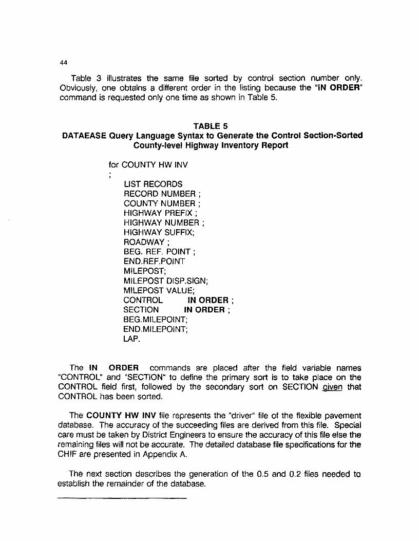
44
Table 3 illustrates the same file sorted by control section number only. Obviously, one obtains a different order in the listing because the "IN ORDER" command is requested only one time as shown in Table 5.
TABLE 5 DATAEASE Query Language Syntax to Generate the Control Section-Sorted
County-level Highway Inventory Report
for COUNTY HW INV
LIST RECORDS RECORD NUMBER ; COUNTY NUMBER ; HIGHWAY PREFIX ; HIGHWAY NUMBER ; HIGHWAY SUFFIX; ROADWAY; BEG. REF. POINT ; END.REF.POINT MILEPOST; MILEPOST DISP.SIGN; MILEPOST VALUE; CONTROL IN ORDER ; SECTION IN ORDER ; BEG.MILEPOINT; END.MILEPOINT; LAP.
The IN ORDER commands are placed after the field variable names "CONTROL" and "SECTION" to define the primary sort is to take place on the CONTROL field first, followed by the secondary sort on SECTION given that CONTROL has been sorted.
The COUNTY HW INV file represents the "driver" file of the flexible pavement database. The accuracy of the succeeding files are derived from this file. Special care must be taken by District Engineers to ensure the accuracy of this file else the remaining files will not be accurate. The detailed database file specifications for the CHIF are presented in Appendix A.
The next section describes the generation of the 0.5 and 0.2 files needed to establish the remainder of the database.
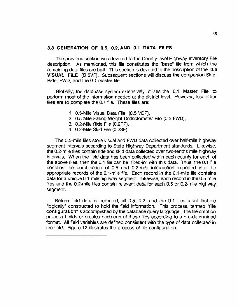
45
3.3 GENERATION OF 0.5, 0.2, AND 0.1 DATA FILES
The previous section was devoted to the County-level Highway Inventory File description. As mentioned, this file constitutes the "base" file from which the remaining data files are built. This section is devoted to the description of the 0.5 VISUAL FILE (0.5VF). Subsequent sections will discuss the companion Skid, Ride, FWD, and the 0.1 master file.
Globally, the database system extensively utilizes the 0.1 Master File to perform most of the information needed at the district level. However, four other files are to complete the 0.1 file. These files are:
1. 0.5-Mile Visual Data File (0.5 VDF), 2. 0.5-Mile Falling Weight Deflectometer File (0.5 FWD), 3. 0.2-Mile Ride File (0.2RF), 4. 0.2-Mile Skid File (0.2SF).
The 0.5-mile files store visual and FWD data collected over half-mile highway segment intervals according to State Highway Department standards. Likewise, the 0.2-mile files contain ride and skid data collected over two-tenths mile highway intervals. When the field data has been collected within each county for each of the above files, then the 0.1 file can be "filled-in" with this data. Thus, the 0.1 file contains the combination of 0.5 and 0.2-mile information imported into the appropriate records of the 0.1-mile file. Each record in the 0.1-mile file contains data for a unique 0.1-mile highway segment. Likewise, each record in the 0.5-mile files and the 0.2-mile files contain relevant data for each 0.5 or 0.2-mile highway segment.
Before field data is collected, all 0.5, 0.2, and the 0.1 files must first be 0 logically" constructed to hold the field information. This process, termed "file configuration" is accomplished by the database query language. The file creation process builds or creates each one of these files according to a pre-determined format. All field variables are defined consistent with the type of data collected in the field. Figure 12 illustrates the process of file configuration.
46
STMr
....
ti::::::=:::4 COUNTY MASl'ER FU QIO'AEASI ~ COUN1Y
MASTER .... _..
1 ..,____. __ AUNA PRE-DEFINED
l ... ....
0.1 BASE ... F1LE _..
I
IATCH PROGRAM TO GENERATETliE 0.1 IAS!FU.!.
MANUAL VAUOATION TN<!2-I DAYS PER MATCH REF. COUNTY. ONE-TIM!
1 ....
O.SVlS O.SFWD
POINTS TO PROCESS Pl!R PESOATAFll.E COUNTY
J_ CONF.""
~==::4 CONFIGURED BASE FILE O.iVAi.. ~~l H.W. SEGMENTS.
BASEl'ILE .... _..
1 OOAEASE GEN.O.S& ll.2 BASE F1LE
l l
0.2RIDE
....
j_
0.2 SKID ....
NOTE: Altlis stage, .. ~ ... do not conlllin dlda. ~ .... 6tflMd ..... a'lld .ild .... mil9 fnc:l•llliil:I -1n p!Ke.
DATAllASE LOGIC TO lua.D TH£ D.1, 11.2, 0.1 llASI FllJES
•
FIGURE 12: DATABASE LOGIC TO BUILD THE 0.5, 0.2, AND 0.1 DATA FILES
From Figure 12, the CHIF is used to generate a 0.1-mile "base" file. A series of DATAEASE batch programs have been written to accomplish this task. Given the "base" file, a manual validation process must be instituted to match reference points to the PES file. This process can take from two to five days per county. However, this is a one-time task per county. Once completed, the 0.1 "base" file

47
remains intact for future use. The only time modifications are made to this file are when:
1. New pavements are added within a county 2. Existing pavements are removed from a county.
Since these constitute rare events, this file can be reviewed annually, and the appropriate updates made with the assistance of D-18PM in Austin. Normally, the 0.1 "base" file will remain unchanged over time.
Given the 0.1 Base file, batch runs are made with the DATAEASE Query Language to generate the remaining 0.2 and 0.5 files. It is to be emphasized that at this point, all files (0.1, 0.2, and 0.5 files) are essentially empty except for highway segment location and identification fields. The location/identification fields common to all highway segment files are summarized in Table 7.
TABLE 7 Location/Identification Field Variables Common
to all Highway Segment Files
1. County Number 2. District Number 3. Highway Prefix 4. Highway Number 5. Highway Suffix 6. Roadway 7. Milepost 8. Milepost Displacement Sign 9. Milepost Value 10. From 11. Reference Point (To) 12. Lane
The parameters shown in Table 7 serve to accurately identify and locate a given highway segment. Most of the county-level reports concerning the summarization of the segment data (see Section 5 of this report) contain most, if not all of these ID/Location values in each highway segment database record. While these fields occupy approximately 45 bytes per record, this information is valuable in sorting based upon location of the desired segments. In a sense, one may think of these fields as "valuable overhead" that do not contribute directly to the condition data, but are required for location and identification purposes.
The next section presents information concerning the exact file structure of the 0.5 Visual Data File.

48
3.3.1 DEFINITION AND STRUCTURE OF THE 0.5 VISUAL DATA FILE
The 0.5 Visual Data File contains visual data collected over half-mile flexible (ACP) highway segments by qualified raters. Raters record the occurrence of specified surface distress types and shoulder characteristics. According to State guidelines, raters travel along the side of the road (with the traffic flow) in a vehicle traveling no more than 15 mph. Raters are instructed to rate the most severely distressed lane, stopping at least once every 0.5 miles. The first stop is made at the beginning milepost. At each stop, raters are instructed to walk approximately 100 feet in each direction from the vehicle. They are to critically observe all visible distress types in this interval. Ratings are conducted on the following surface distress types:
1. Rutting 2. Raveling 3. Flushing 4. Corrugations 5. Alligator Cracking 6. Longitudinal Cracking 7. Transverse Cracking 8. Cracks and Patching 9. Failures 10. Shoulder Conditions.
The results are recorded on a customized form designed for this purpose (see Figure 16). Obviously, visual rating is a complex combination of objective and subjective evaluation of the pavement's surface distress features. Raters are trained in the proper rating procedures and through experience, become reasonably accurate and consistent. The documented visual rating procedures are outlined in the current version of the Pavement Rating System Rater's Manual, TxDOT, D-18PM, in Austin, Texas.
The rating process continues over each 0.5-mile section (or fraction thereof) until the entire highway is completed. This process is repeated over all state maintained roadways within a given district. In most state-wide districts, visual rating begins in September. Depending upon the availability of qualified raters and the work demands within the District, visual rating may take from 2 to 4 months to complete. In most instances, visual rating should be completed by the end of the current calendar year.
The record structure of the 0.5 Visual File is graphically shown in Figure 13. Appendix B contains the detailed record structure for this file. From Figure 13, the first 13 fields contain "identification/location" fields (see Table 7). The remaining fields contain the visual rating values obtained from the field for each 0.5 mile

49
segment in the given county. Each record represents one 0.5-mile segment (or fraction thereof}. Thus, if a county has 600 miles of highway, then that county's 0.5 VDF would contain 1,200 half-mile records.
RECORD COUNTY DISTRICT HIGHWAY HIGHWAY HIGHWAY NUMBER NUMBER NUMBER PREFIX NUMBER SUFFIX
ROADWAY MILEPOST
MILEPOST MILEPOST I
DISP. FROM REF. POINT LAME RUTTING RUTTING RUTTING I VALUE t
SIGN (lo) SLIGHT MODERATE SEVERE ~
I
RAVELINE I
l RAVELING RAVELING FLUSH. FLUSH. FLUSH. CORREG. CORREG. CORREG. t SUGHT MODERATE SEVERE SLIGHT MODERATE SEVERE SLIGHT MODERATE SEVERE I
j ALG. CRACK ALG. CRACK ALG. CRACK LONG. CKS LONG. CKS LONG. CKS TRANS CKS TRANS CKS t MODERATE SEVERE SLIGHT MODl!RATE SEVERE SLIGHT MODERATE SLIGHT
j
11TRANS CKS CRACKS PATCH I SEVERE SEALED SLIGHT
I
PAVED PAVED PAYED CRACKS RAVEL VEG
NOTES:
PATCH PATCH TOTAL PAVED MOO. SEVERE FAILURES RIDE
UNPAVEC UN-PAVED EDGE RUT-CORR-L ROCK
PAYED PAYED PAVE-SHLD 1
CONTRAST EDGE EDGE
f N
OP
"'c RECORD STRUCTURE FOR
THE 0.5 VISUAL HIGHWAY
DATABASE FILE
FIGURE 13: Record Structure for the 0.5 Visual Data File
Figure 13 illustrates the record structure by which the 0.5 VDF. Building this file involves the creation of data collection forms that can be used in the field to record surface distress values. One of the valuable features of the database is the ability to read the 0.5 Configured Visual file and produce properly-sequenced data collection forms on a laser printer. Since the forms are sequenced for a given county, raters can take the forms to the starting milepost and begin the rating from that point. Each line of the produced form constitutes one 0.5-mile segment. By producing the forms from the configured 0.5-mile file, the possibility of missing segments is reduced. Figure 14 illustrates the logic involved in forms creation and data entry.
50
Figures 14 and 15 illustrate the procedures for building a 0.5 VDF at the county level. Once the in-field visual rating is completed, the rating forms are brought into the district for manual data entry. Staff personnel can begin the visual data entry as soon as the filled-in forms are available. The 0.5 VIS file is called up in the Data Entry mode, and the data is entered from the forms. The order of data entry is immaterial. The database can sort the entered records into any order required. The file can be first constructed in the order of completion of the segments. At any time, the staff can run a "Missing Data Report" that lists the 0.5-mile segments containing no data. This report can be used to direct raters to missing segments to obtain data.
c:Jll OAfACO~C--
. MAY Rt0Y.N: , Htf~ , 10 fttl .... UJ • tu CCIUft;l • fft Vl~UU UAIA. AJlflJ/(Ut , Mt$£U.U OAfA ,
FIELD DATA] 1----... COLLECTION
"'OSTlO VIS""4. UAIA ONLY WtfHOUf ~. "M$1$11S SCOAU
IL... CO"'"'•U!D -..__..- ·-·· "'"o- CM.U!D
o .. no...... CALPR::.exe SUMMAaY
fl'llllStSllS
MCt'ORf
,ll.! C0NfAIMlfllt8 VISUAL 0A1'A lli\.US ..-s MllO SlllS CM..CU4..Aff0 VAU.lf.S '°" fACH ..,_....,.. Sl!GM«Nf
11""0 lllV AICM Ptt..IWmt~ OATA H"AltATl:O av A·~··
..,.,,...,,.,...,.,l',OltTN'l'All.U ..._ _r--···- VALumt
FIGURE 14: Overview Logic for Building the 0.5-Mile Visual File
Figure 14 shows the overall logic required to construct the 0.5 Visual File. This

51
process begins with the configured 0.5 visual file. The term configured means that the file format has been built by the database and is ready to receive data. The first step in building this file is to generate the requisite data collection forms that can be taken to the field. A DATAEASE report procedure has been written to automatically generate these forms. This illustrates one of the powerful features of the database in that the system has the ability to read the configured 0.5 file and produce logically organized visual data collection forms. Figure 15 shows the detailed logic associated with producing the visual data collection forms.
CHIF
DATAEAIE DB
RUN IATCH REPORT TO 8ENERATE THE FIELD FORMS
HP IOO+ OR HP LASERJET
SERIES II 3000PI ,RINTER
I PAelltMt• OUTPUT P•OPl•LY llQUl•OIO
MA•U•U.LY
DATAEASE 01
O.S VISUAL
DATA ENTRY
0.1-MILE VISUAL DATA COLLECTION FORMS
ITU•• TO l'llLO TO COLLICT
O.S VOF
FIGURE 15: Logic to Produce the 0.5-mile Visual Data Collection Forms
The 0.5-mile visual data collection forms are produced by a pre-designed report program that reads the 0.5-mile configured file (which contains 0.5-mile records built from the County Highway Inventory File) and produces the forms on an HP 500+ or HP LaserJet Series II 300 dpi laser printer. Due to the output capability of laser printers (8 pages/minute on the average), this process of producing data collection forms is best handled on these types of printers. If one

52
were to attempt to produce these forms on a dot matrix printer, the production time would be extremely slow. Thus, it is highly recommended that a laser printer be used for this specific function.
Once the forms have been produced, they are released to the visual inspectors to conduct the actual visual distress ratings in the field. When the visual data has been collected, the inspectors return them to the District Headquarters where a trained staff member manually enters the data into the database. This process may cover from 4 to 6 weeks depending upon the availability of qualified visual inspectors. However, visual data can be entered as soon as the inspectors are finished rating. Care must be taken to insure that data is entered in the proper order. However, the database provides a mechanism whereby it is virtually impossible to enter visual data incorrectly. Figure 16 illustrates a specimen visual data collection data form for County 31, PR 100 in the R roadway beginning at Milepost 12+0.4.
The remainder of this page is intentionally left blank
53
CIUIT'f: S1 11-T: l'I010ll _, I a"11111C1 lll~t 12·0.4
U.tUS: ,.. __ ITIClll -n
1111'1111 MWIM ~ - A.CUCI{ L.CllAIX T.CIUQ c , .. ,,_ YI• I - .....
OAT11 " c • II II D 0 f f I: u
I I I I I I I • T \'lllT -
T - • 1·2 T 1 T I .. - I ·- L - •
ll "''' 1111n
ll "'" ll "'" lllll'Tll UI n •• • SUM 1·• u .... ... " • • 10il" 1Qll " L u \'lllT- " ·- • , T , 1 1 1 , ' , • ' • I
1•10 MO MO MO HO ,. .. Ht - 1•10 I 0 2 2 l l l l l l z I , I , .
11·SO ll·SO 11·SO 1MO U·!JO , ...... 1MO lt·SO A I •• J J J J J J J • J • • 0 y i. .,. .,. .. >ta .,. ·- .,. 0 .. , I 11 V I ,_ • L I II 0
II • • • • • • - • C I t I I I o 0 0 0 0 0 0 • J • 0 I I • r •• • • I 0 • • • • I 0 • • • I I t I ••• I t I I • ' • c y T ' ( I U L I I L I I l I I l I I L I I L I I L I I' l ' I t •
Cll , L I . " I I y I I y I I y I I y I I y I I YA . . , u I I I I A L f I I 0. • A • • I I A I I A f I A I Cl A I . " . . " .. 0 .. 0 I I A 0 0 c I I • 0 I I 0 ' • • T • • T I • ' I I T I I T I a T I I T IT 0 l 0 I • • • • ' . 0 • c ~I • D I T I I T I I T I I T I • ' • I T I I t I I D I I • I T I I • •• . '
II II I I I I I I I I I II I II 1_,I o.s1 u1 I I I I I I II II I I I I I I I I I I II
I II I I I I I I I I I I I I I I I I I I I I I I I I I II I I II
1-1 2.01 1·'1 I I I I I II II II I I I I I I II II I I I 1 I I I I I I I I I I I I II I II I I 11 I I II I I I I I I I I II I II I II I II II I I I I I I I
I I I I I I I I II II I I I I I I II I II I I I I II I I I I I I I I II II I I I I I II I I I I I I II II I
II II II I 11 I I I 100067111 ••• , Uf I I I II II I I I II II I
II II I I I I! II I
FIGURE 16: Specimen Data Collection Form for 0.5 Visual Data Collection
As can be seen from Figure 16, the database automatically reads the configured 0.5-mile file and creates the appropriate "From·To" sequence on the form. One line on the data collection form corresponds to one 0.5-mile segment of roadway. The rater then knows exactly where to begin the visual inspection. Visual inspection is conducted on each half-mile section as noted on the collection form(s). When a highway number is completed, the forms for that highway are turned into the District Headquarters for manual data entry. Due to the batch processing nature of the forms generation program, all of the required data collection forms are generated at one time for a given county.

54
After the visual data has been collected, the forms returned and the data entered, two batah programs are then run across the 0.5 file. The first procedure examines the 0.5-mile visual file (with entered data) to determine if any 0.5-mile segments contain missing data. If any half-mile records are found to contain missing data. the From-To IDs are printed in a Missing Visual Data Report. By running this procedure, one can determine any missing segments. When missing segments are found, the Maintenance Engineer will direct the inspectors (with the appropriate forms) back into the field to collect the information. The Missing Data Report is run across the visual file to determine if any more missing segments exist. This procedure is repeated until no missing segments exist.
Once it is confirmed that no missing data exists, the second validation report procedure can be nJn. This batch run is referred to as VALIDAT PAVE RECORDS and resides in the DATAEASE Report Menu. This report scans each 0.5-mile record for "infeasible" entries. "Infeasible entries" are defined to be any sequence of pavement distress ratings for the distress categories (Rutting, Raveling, Flushing, Corrugations, Alligator Cracking. Longitudinal Cracking, and Transverse Cracking) whose data entry sequence totals greater than six. For example, assume that three scores exist for the Rutting category, i.e.,
SLIGHT 3
MODERATE 3
SEVERE 2
This sequence is infeasible since a "3" represents "greater than 50% area" for the associated distress. The above sequence would represent greater than 50% rutting for slight, greater than 50% for moderate and 11 to 50% for severe. This signifies a greater than 100% evaluation which is infeasible. Thus, the validation run simply checks for pavement condition ratings whose entries in each category sums to 6 or greater. Presently, this is the only check that is made on each sequence. To further support the accuracy of the visual file, users are permitted to enter only a valid range of values at the time of data entry. In other words, these fields are restricted to accept only "valid data", i.e., a, 1, 2, or 3. No other values are permitted.
The visual data validation run produces a printed report similar to the one shown in Table 9. In this example, a data input error was intentionally made in a record to illustrate the procedure. For the flushing and corrugation entries, three 3s were entered for each category. The validation run detected these errors and flagged the appropriate columns. The remaining fields validated with no apparent error. When errors are detected, the staff should refer back to the original data
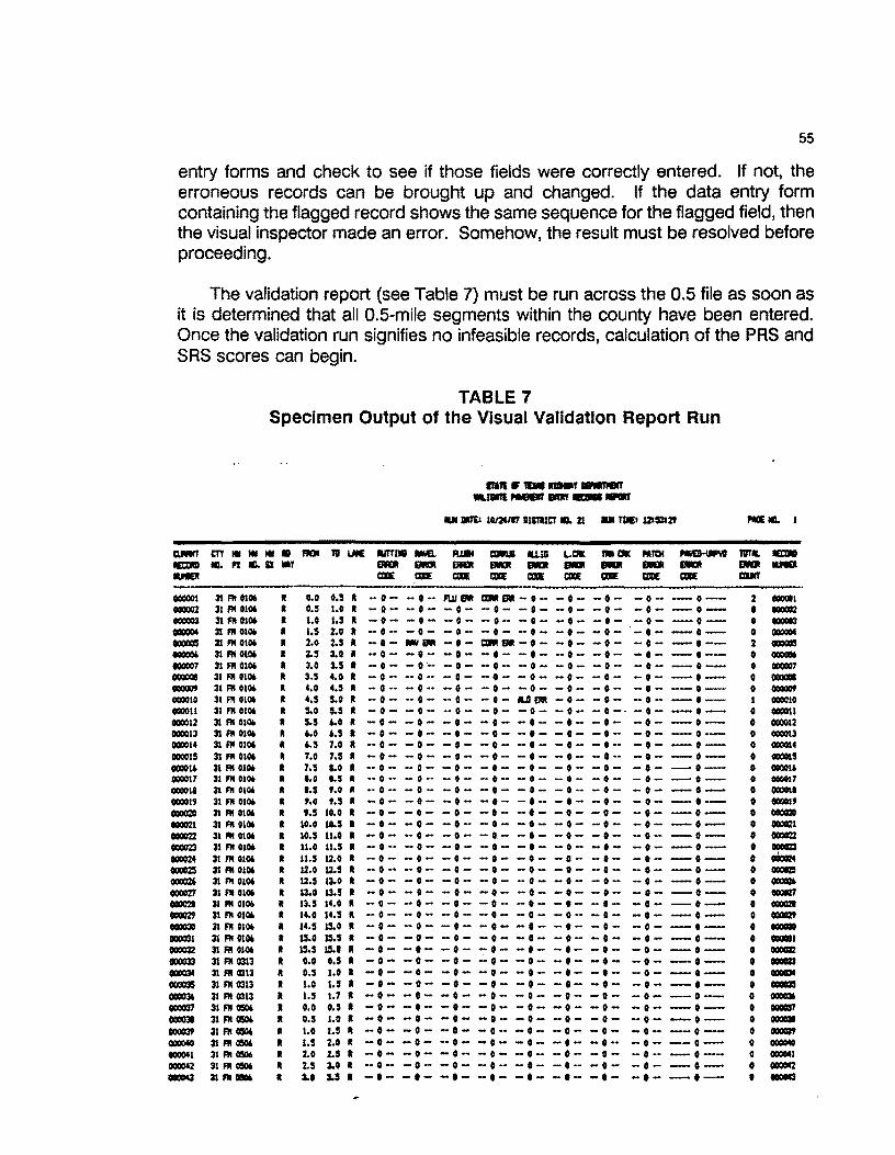
55
entry forms and check to see if those fields were correctly entered. If not, the erroneous records can be brought up and changed. If the data entry form containing the flagged record shows the same sequence for the flagged field, then the visual inspector made an error. Somehow, the result must be resolved before proceeding.
The validation report (see Table 7) must be run across the 0.5 file as soon as it is determined that all 0.5-mile segments within the county have been entered. Once the validation run signifies no infeasible records, calculation of the PAS and SAS scores can begin.
TABLE 7 Specimen Output of the Visual Validation Report Run
11111 •-.... , --WIJlllll,.... - --....
1111 llllro ttm/17 DISllICT Ill. 21 U TICI 121$112' PG IL l
D.Mn' m .. Ill Ill • FllDI 111 UllE Mfllll -. R.181 CIJlllll llJJG &..IX JmlCllC Mn:H ............, 'lllT .. ll:l:ml MaJllD .. Pl II). SI ., 111111 ---811111 11111111 - DIGI - OD .... IUEI IDE IDE IDE IDE CllE IDE IDE mDE mlE aurr
000001 21 F!I 0106 0.0 o.s • .. ·- -o- l'IJJEM a11111111-o- -o- -o- - 0 ·- -o-- 2 OOOGll 000002 31 Fl'I 0106 o.s 1.0 • -o- •• 0 - -·- -o- -o- -o- -o- -o- -o- 0 oococ OOOG03 31 F!I 0106 t.O 1.s • -·- -·- -o- - 0 •• -·- -o- -·- -·- -·- 0 -000004 3l Fii 0106 1.s 2.0 -·- -·- -o- -·- -·- -·- -o- -·- -·- 0 000004 000005 31 Fii 0106 2.0 2.S -·- -· -·- t11111at-o- -o- -·- -o- -·-- 2 mm 000006 21 Fii 0106 2.S 3.0 -o- _,_ -o- -o- -·- -·- -·- -·- -o-- • OOOQOt fQ0007 31 Fii 0106 u 3.S -·- - 0 •• -·- -o- -·- -o- -o- - 0 ·- --·-- 0 QCIOCI01 000008 31 Fii 0106 3.S 4.0 - 0 •• -·- -·- -·- -o- -·- -o- -o- -·- 0 OQOQlll
OOOOOf 31 Fii 0106 4.0 4.S -o- - 0 •• - 0 •• -o- -o- -o- - 0 •• -o- --o- 0 -000010 31 Fii 0106 4.S s.o -o- -o- -·- -·- UERR -o- -o- -o- -·- I 000010 oooou 31 fll 0106 5.0 s.s -o- -o- -o- -o- -o- -o- -0-· -o- --o- 0 000011 000012 31 Fii 010/o s.s 4.0 -o- -o- -·- -o- -·- -·- -o- -·- -··-- 0 000012 000013 31 F!I 010. ... .. , -o- -·- -o- -o- -·- -o- -o- -o- -o- 0 GQOOl3 000014 31 Fii 0106 • .. s 7.0 -o- -·- -o- -o- -·- -·- - 0 •• -·- -·- 0 G00014 000015 31 Fii 0106 7.0 7.S -o- -o- -o- -o- -o- -o- - 0 •• -·- -o- 0 «IOOIS 00001' 31 Fii 0106 7.$ a.o •• 0 - -o- -o- -o- -·- -·- -·- -·- -·- • 000016 000017 31 Fii 0106 0.0 .. , -o- - o- -o - -o- -·- -o- -o- -o- -·- 0 0000!7 000018 :n Fii 0106 t.s f.O .. o- - 0 - -o- -·- -·- - 0 •• -o- -o- -o- 0 OOCOlt 000019 31 Fii 0106 f.O M -o- -·- -o- -·- -o- -·- -·- -o- -·- 0 GOOOlf 000020 :n Fii 0106 t.5 10.0 -·- -·- -·- -·- -·- -·- -·- -o- -·- 0 OOOCl20 000021 31 Fii 0106 10.0 ... , -o- -·- -·- -·- -·- -·- -o- -·- -o- 0 OOCCI 000022 31 Fii 0106 10.s u.o -·- -o- -o- -o- -·- -·- -o- -o- -o- 0 ooom 000023 31 Fl'I 0106 u.o u.s - 0 •• - 0 •• -·- -·- -·- -o- -·- -·- -·- • ocom 000024 31 "' 0106 u.s 12.0 -·- -o- -·- -o- -·- -·- -·- -o- -·- 0 oOoai:z4 OOOOZI 31 Fii 0106 12.0 u.s -o- -o- -o- -·- -o- -·- -·- -·- -·- 0 OXCJ 00002' 31 Fii 0106 u.s l:l..0 -·- -o- -·- -·- -·- -·- -·- -·- -o- 0 -toOC27 31 Fii OU» 13.0 13.S -o- -·- -·- -·- -o- -·- -·- -·- -·- 0 OGQID 0000'2I 31 Fii 010/o 13.S 14.0 •• 0 - -o- -·- -·- -·- -·- -·- -·- -·- 0 -000029 31 Fii 0106 It 14.0 14.S • -o- -o- -·- -·- -·- -o- -o- -·- -·- 0 OOQl29
000030 31 Fii OU>lt II 14.S 15.0 II -·- -o- -·- -·- -·- -·- -·- -·- -·- • OOOOIO 000031 31 Fii 0106 • IS.O 15.S II -·- -·- -o- -·- -·- -o- -·- -·- -o-- 0 OOOlll 000032 3l Fii 0106 II 15.S IS.I II -·- -·- -·- -·- -·- -·- -·- -o- -o- 0 ooom eocl033 31 Fii 0313 • o.o o.s II -o- -·- -o- -o- -o- -·- -o- -·- -o- 0 -OCllC34 31 Fii «313 II o.s 1.0 • -·- -o- -·- -o- -·- -·- -·- -o- -·- 0 _,. oooaJ5 31 Fii 0313 • 1.0 '·' • -·- -·- -·- -o- -·- -·- -·- -·- -o- 0 -000036 31 Fii 0313 • t.5 1.1 I •• 0 - -o- -·- -·- -o- -·- -·- -o- -o-- 0 GOOD OOOCl37 31 F!I G50(o II o.o o.s • -o- -·- -·- - 0 •• -·- -·- -o- -·- -·- 0 OOOGll7 00003ll 31 Fil 0506 • o.s 1.0 • -·- -·- -·- -·- -o- -o- -o- •• 0 - -o- 0 ooca 000039 31 Fii 0506 II 1.0 1.s II -o- -·- -o- - 0 •• -o- •• 0 - -·- -o- -o-- 0 _, OOOOfO 31 Fil 0506 • t.S 2.0 II -·- -·- -o- -·- -o- -·- -·- -o- --o- 0 0000!0 to0041 31 I'll 0506 II 2.0 z.s • -o- -·- -o- -o- -o- -·- -o- - 0 •• -·-- 0 000041 000042 31 Fii 0506 II 2.5 3.0 • -o- -·- -o- -o- -·- -·- -o- -·- -·- 0 000042 ..,.,, 311'11 .. • :LO J.S • -·- -·- -·- -·- -·- -·- -·- -·- -·- • ...,

56
Examination of Table 8 illustrates detected errors in records 1, 5, and 10. The sum of the three visual evaluations are greater than 6 (hence, infeasible) in these specific records. The user should bring up these records in the Visual file and examine the data values and coordinate the entries with the data collection form. If a data entry error has been made, it is a simple task to edit the appropriate visual ratings or modify each record. If it turns out that the values were entered correctly, then a visual inspection error has occurred. The Maintenance Engineer will need to correct the errors and/or return to the field to re-evaluate the specific sections. In either case, the detected error(s) must be rectified. It must be noted that the validation run detects only "gross infeasible" errors. There is no way to detect errors in judgement or recording errors. In other words, some of the visual evaluation values may still be incorrect but not "infeasible".
Remainder of this page intentionally left blank.

57
3.3.2 CALCULATION OF THE VISUAL PAVEMENT AND SHOULDER SCORES
Upon confirming that the 0.5-mile file is complete and contains feasible data, the next step in building this file is to calculate the Pavement Rating Scores (PRS) and the Shoulder Rating Scores (SRS). This procedure is not conducted from within the database. Rather, the procedure is to export the entire visual file out as an ASCII file with commas separating the visual data items. This process is shown
In Figure 17. (-=- ~ --°" llAf!IM_'l'O_
OATAIASC ..,. ASCII ---11'.lO'OllT VII ACCllS "-I _...._.
........... _ POll_UT_A_
...__,...._.., ~llO•llAll
FILE NAME: EXPORT.OAT
IMPORT PRS ... ...__
FILE wrTH 1COR!S AND PRSISAS 0.1 VIS VAWES CALCULATED ANO POSTED
COMPLETED 0.1-.i WIUAl nJ!
FIGURE 17: Logic Detailing Calculation of PRS/SRS Scores for o.s Visual File
58
Given the 0.5-mile file with visual data, a batch program called EXPORT PAVE DATA is run from the Reports Menu. This procedure reads each 0.5-mile record and places a "," between each data item in the record and writes the record to a file called EXPORT.DAT. This file is written to a floppy diskette in the A: drive.
After the EXPORT.DAT temporary file has been created, the user exits the DATAEASE program. From the DOS prompt, run the CALPRS. EXE program and respond to the prompts. Within seconds, all PAS and SAS scores have been calculated and written to an output file that is user-specified within CALPRS.EXE. Returning to DATAEASE, the user selects the IMPORT option and imports the file into the 0.5 Visual data file.
At this point, the 0.5 Visual file is complete! This file remains intact throughout the year and requires no additional manipulations until the end-of-year postings are made. It is possible to run a variety of queries on this file as required by the District. Specific queries relating to this file will be discussed in Section 5 of this report.
3.4 ORGANIZATION AND STRUCTURE OF THE 0.5 FALLING WEIGHT DEFLECTOMETER FILE
Similar to the 0.5 Visual File, the FWD file represents a half-mile highway segment file. The process begins with a configured 0.5 FWD file that contains the appropriate 0.5-mile records as built from the county inventory file. However, this file initially does not contain FWD data. While the Visual File requires manual data entry, building the FWD is an automated process requiring no manual data entry. The logic detailing the construction of this file is shown in Figure 18.
Given a configured 0.5-mile FWD file, the database generates a "missing data" report similar to the one shown in Table 10. At first, all of the configured records have missing data. Thus, all records will show up missing - by design. The missing data report can be used as an aid for the collection of field data since it reports the missing 0.5-mile segments.
With the missing data report as an aid, trained FWD technicians drive the FWD van/trailer over the various highways within the county which automatically records FWD readings. These readings are collected inside the van by a portable microcomputer. The readings are recorded on a 5.25 inch floppy disk. When the task of collecting the FWD readings is complete, the disks are returned to the District Office.

CONFIGUA VISUAL OATAFIU! CNOOATA)
O.IVIS
RUN MITOMATED l'WD . FWOVAH/ DATAca...t..!CTION TIW.OR lN-FE..D PROCISS
PROctDURE
ccu..ecrED !'ED DATA ON FLOPPY CISK
--IMPORT INTO THE DATABASE
FIGURE 18: Falling Weight Deflectometer File Logic
59
When all highways within a county have been recorded, the collected disks are read by a compiled BASIC program to produce an ASCII file suitable to be imported into the 0.5-mile FWD database file. By running a pre-written database query report, the ASCII file is imported into the 0.5-mile FWD file. This missing data procedure is ran across the FWD database file to determine if any missing records exits. If so, the missing data report is used to direct the data collection team back into the field to collect the data. If no missing records are found, the 0.5-mile FWD file is complete!
Appendix B contains the detailed database file design for the 0.5-mile FWD file and the source code listing of the BASIC program used to convert the collected

60
field data into an ASCII file. Essentially, five values are recorded into the 0.5-mile FWD file. The five data values are:
W1 & W2:
These two data values represent readings from geophones 1 and 2. These readings measure the strength in the upper part of the pavement.
W6 & W7:
The next two data values represent the readings from geophones 6 and 7. These readings measure the strength in the pavement's sub grade.
DATE:
The date the readings were recorded.
The basic procedure for recording FWD readings is to drive each half-mile section of pavement. At the selected point, the deflectometer is positioned on or just above the pavement and various readings are recorded. Currently, the FWD unit contains seven geophones. However, recordings are currently made from phones 1, 2, 6, and 7.
The Surface Curvature Index (SCI) is calculated by the following relationship:
The size for the 0.5-mile file requires 55 bytes of storage per half-mile highway segment. After all half-mile records have been constructed, selected field variables are merged into the 0.1-mile master file. At the end of the year, the field variables W1, W2, W6, W7, and Date are "blanked" from the file to make room for the new data. However, the segment location data (fields 1 - 11 as defined in Appendix B) remain intact. The FWD field data is recorded on magnetic media for subsequent processing in Austin. The post-data collection processing produces a FWD file on 3.5 inch microdisks. The microdisks can be read by a compiled BASIC data reduction program for direct import into the 0.5 FWD input 'file.

61
3.5 0.2 MILE SKID DATA FILE
The third data file necessary to support the database is the 0.2-mile skid data file. Skid data is collected over 0.2 mile highway segments using a "skid truck". The logic detailing the procedure is illustrated in Figure 19.
Figure 19: Logic to Create the 0.2-mile Skid File
The steps required to generate this file are:
1. Given the 0.2-mile configured file (configured with location data and space for the skid values), generate a "missing data report". Obviously, this missing data report will, at this stage, show all records having missing skid data. However, as with the FWD file, this report is used as an aid in the field to assist in location.
2. Given the missing data report, technicians run the skid truck in the field to collect the skid data over 0.2-mile segments.
3. The skid data is initially collected on cassette tape within the skid truck. Upon returning from the field, the cassettes are collected and delivered to D-18PM in Austin. D-18PM runs a conversion program across the cassette to convert the data to 5.25/3.50 disks.

62
to convert the data to 5.25/3.50 disks.
4. Given the 5.25 disk format, 018-P "up-loads" the 5.25 format to the mainframe computer to run against the current PES file. This procedure produces an ASCII file suitable for merging into the database's 0.2-mile skid file.
5. By using PC SAS, the ASCII file produced in Step 4 is read and tested against the 0.2-mile database file. If any non-matching segments are discovered, the missing half-mile segments must be collected. The PC SAS routine generates another ASCII file that is in the proper format for the final merging process into the database.
6. All matching records are imported into the database by running a predefined import procedure stored within the database. Since the PC SAS procedure executed in Step 5 assures matching segments, the imported records will match the configured 0.2 skid file. However, missing data may still exist!
7. Run the missing data query report across the 0.2 Skid file. This query is resident within the database. If the report indicates missing 0.2-mile segments, then return to Step 2 and follow Steps 2 - 7. If no missing records are discovered, the 0.2-mile skid file is complete!
3.6 0.2-MILE RIDE DATA FILE
The 0.2-mile Ride Data file stores 0.2-mile segment location data and the SI value calculated from the observed MRM rating of the segments. The file structure for this file is shown in detail in Appendix E. Currently, ride data may be collected in the field using one of two procedures. The first procedure involves using a Mayes Ride Meter towed behind a vehicle. As the vehicle covers each 0.2-mile segment, MRM values are displayed inside the vehicle. At the end of each 0.2-mile interval, the observer manually records the MRM value on a data form. The second procedure utilizes a Siometer and involves automated data collection. Either procedure can be used to collect ride data. Figure 20 illustrates the logic for the MRM manual procedure. Figure 21 shows the Siometric automated procedure.
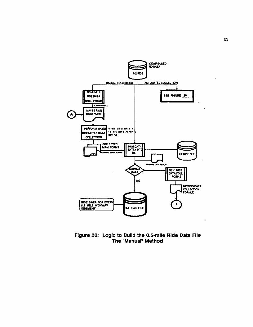
WITH 11111111 lollUT I
TO Tll nno Al.~"" _,...
RIDI! DATA l'Ofl IEYE 0.2 MU HIGHWAY IEGMl!NT
-QO.TA-NO
0.2 RICE FILE
GEN. MISS. OATACOU.
FORMS
MISSING DATA COLLECTION FORM(S)
Figure 20: Logic to Build the O.S·mile Ride Data File The "Manual" Method
63
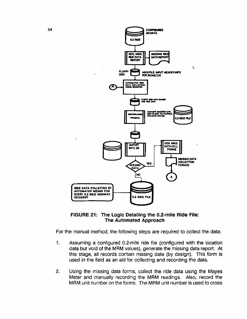
64
_ __,,_ ...
IMPORT INTODI
=---::-..:.::. ~ --MODIL o.2 lllDI PU
GEN.MISS. DATA COLL
FORMS
t.ISSINQ DATA CQU.ECTION FOAM(SJ
FIGURE 21: The Logic Detailing the 0.2-mile Ride File: The Automated Approach
For the manual method, the following steps are required to collect the data:
1. Assuming a configured 0.2~mile ride file (configured with the location data but void of the MRM values), generate the missing data report. At this stage, all records contain missing data {by design). This form is used in the field as an aid for collecting and recording the data.
2. Using the missing data forms, collect the ride data using the Mayes Meter and manually recording the MRM readings. Also, record the MRM unit number on the forms. The MRM unit number is used to cross

65
2. Using the missing data forms, collect the ride data using the Mayes Meter and manually recording the MAM readings. Also, record the MAM unit number on the forms. The MAM unit number is used to cross reference the calibration constant for the particular MAM unit. This calibration value is required in the Surface Index calculation.
3. Return the collected MAM forms to the District Headquarters to begin the manual data entry process. The MAM values are input to the configured 0.2 Ride file by using the data entry mode of the data base.
4. After all forms have been entered, run the Missing Data Report to determine if any missing records exist. If any missing 0.2-mile segments are discovered, go to Step 2, above. If no missing records are discovered, the 0.2-mile Ride file is complete.
The associated SI value for each 0.2-mile record is calculated as soon as the MAM value is entered in the file. This is shown explicitly in Field 16 of the Ride Input detailed field definition shown in Appendix E. Thus, no additional batch runs or external (external to the database} programs are needed to compute the SI value. The equation defined in Field 16 requires the "Alpha" and "Beta" value of the particular Mayes Ride Meter unit. A small related database file called MACHINE # VAR stores the associated "Alpha" and "Beta" values (associated machine calibration constants) for each MAM unit used. The Alpha and Beta values are constants associated with the annual calibration of each Mayes Ride Meter. The calibration process is conducted in Austin, and the calibration constants are specific to each MAM unit. Thus, it is possible to call in a number of MAM units to assist in collecting ride data. The associated Alpha and Beta values are stored in the related file which are accessible to the database by the LOOKUP function.
After all 0.2-mile Ride records have been recorded, the file is ready for any predefined or ad hoc query reports that the District may desire. (Query reports are discussed in Section 5 of this report.} Additionally, the SI values for each 0.2-mile record will subsequently be merged into the 0.1-mile Master File that will be presented in the next section.

66
3.7 THE 0.1-MILE MASTER FILE
The o. 1-mile Master File represents the primary file utilized by this database. This file contains the following data:
1. Location data fields for each 0.1-mile segment 2. Date of Last Surface and Average Daily Traffic · 3. Rl-1 data including:
* No. of lanes * Shoulder Data * Lane widths
4. PES Data * Section number and break points * Design type * Highway class
5. Merged Visual Data and PRS/SRS values (every fifth record) 6. FWD summary data (every fifth record) 7. SI values (every second record) 8. Skid value and date (every second record) 9. Field space (allocated) for cost data (to be entered later) 10. Fields to hold historical data for:
* PES for the last five years * SI data for the last five years * Skid values for the last two years * SCI values for the last two years.
The detailed file format for the 0.1-mile Master File is provided in Appendix B. This file contains 95 fields and requires 216 bytes per 0.1-mile record. Each county will require, on the average, from 6,000 to 7,000 records. The detailed logic required to build this file is illustrated in Figure 22.
The remainder of this page is intentionally left blank

DATE ITElll ~
DUI NTr N-1 DATA
#I.Nm• SHOIA.Da DATA WIOTH9, ... PU DATA: ..... ........ ......... , .. 1'1111 ... ~ ...... .. _ ....... , ...
"f'OIUllATTED" RI.I: L .. , ......... ····~ __ ... Della
OATAl!AR RUN DATAU8E REPORT .... TO...._,.
MOTE:
Al••· ..... .. .. , ....... .. ..... llATCH/MllfllllaiO
-....-i~..-.FILI
..... FWD, .- ..
MO
¥1 .... .,... ........ ......... c .......... .,.
.---. t.1 FIU W'fTH,... .._.._ __ :.MTA
1.1 AUE
Figure 22: Logic to Build the 0.1-mile Master File
67
NOTE: As of the date this report was written, the designers were working on improvements to this file based upon the results of field testing in 021. When the field evaluation is completed, revised documentation relating to this file will be added to this report. Therefore, details concerning this file remain intentionally brief. It is anticipated that the current
68
milepost/reference marking system will be replaced with a new "reference marker" system sometime in 1991. This version of the database does not include the anticipated changes/additions.
3.8 MISCELLANEOUS FILES
Three miscellaneous files, while small, are nevertheless required to support the system. The three files are:
1. The County file (file name COUNTIES), 2. The Cross roads file (file name CROSS ROADS), 3. The Alpha and Beta file (file name MACHINE #VAR).
* The COUNTIES file contains three fields, i.e.,
County Number County Name District Number
This file is used to support the initial building of the configured 0.2 and 0.5 files. Appendix G contains the details of this file.
The CROSS ROADS file (Appendix H) contains 12 fields and provides the location data needed to reference all cross roads (intersections) within a given county. The fields in this file are used to support generation of the condition rating plots (Figure 1) that will be generated from the database.
The last supporting file is the MACHINE #VAR file previously referenced in Section 3.7. This file contains the MRM unit number and the alpha and beta calibration values required by the Ride file. The detailed file structure is documented in Appendix B.
Appendix B and D of this report contain details relative to all files required by this system.
69
4.0 REPORT GENERATION CAPABILITIES
The previous sections of this report have dealt primarily with the overall database design and the file structure of the various support file. This section concentrates on the report generation capabilities of the database. Report generation, and the ability to produce queries to the various files, constitutes an important feature of this design. The ability to produce reports within the scope of a user-specified format represents one of the powerful features of DATAEASE. During the pre-design phase of this project, one of the criteria for the specific database to be used was the ability to allow the user to design customized queries with a minimum of effort. Of the three then-popular databases, (DATAEASE, RBASE-5000, and DBASE 111), DATAEASE ranked superior at the time of selection.
The term "report generation" in database nomenclature, means the following:
or,
1. A mechanism by which the user produces screen, disk, or printed output based upon a logical inquiry to one or more of the database files.
2. The construction of a sequence of commands to access one or more existing files in order to:
a. Create one or more new file(s). b. Modify and/or delete one or more file(s). c. Sort and/or merge file(s) from one or more existing file(s). d. Perform mathematical, statistical, and financial calculations on
fields residing in existing files.
A "report" constitutes a batch program executed under control of the database system monitor. A batch program is made up of a sequence of commands that are executed sequentially until some predefined condition is fulfilled. Once begun, a batch program runs with little or no user intervention. Most of the reports designed for this system are batch programs.
A DATAEASE report is constructed by the user using the DATAEASE Query Language (DQL). The DQL is a PASCAL-like language that follows a somewhat rigid structure. In order to be proficient with the DQL, the user must undertake a daily involvement in writing and executing various reports. While the DQL appears straight-forward, potential users must spend a moderate amount of time practicing with the language. With this in mind, the designers of the database have prewritten many of the critical reports (batch programs) that build and maintain the critical files. Additionally, a small subset of these reports are devoted to simple

70
queries to the files to produce printed reports that summarize the highway segment data.
The system supports two types of output reports: standard and ad hoc. A standard report is one that remains fixed over an operating year and represents information that District engineers expect to see as a matter of routine. Ad hoc reports represent those type of reports that may be one-time queries or, special purpose. Due to the relative simplicity of DATAEASE, it is not difficult for District personnel (once trained) to create their own reports within an hour or so.
The remainder of this section will present a sample of the standard-type reports available with the database. Since it is not possible to anticipate the various queries that District personnel will expect, the number of initial standard reports will be small. After the database is installed, and district-level personnel become accustomed to its features, additional reports will be added based upon demand. As part of the installation procedures, selected district personnel will be trained in the details of report generation. Thus, as time progresses, selected district personnel will be able to create their own library of reports to cover specific needs. In the interim, D-1 SPM and TTI staff members will assist in creating reports as requested.
4.1 STANDARD REPORTS
To illustrate the standard report capability of the database, five pre-defined reports are included in the database. The five reports are:
1. A listing of all highway segments with a Pavement Rating Score equal to or less than 50 and ADT greater than 5000.
2. A listing of all highway segments with a Serviceability Index (SI) less than 2.8 and ADT greater than 5000.
3. A listing of all highway segments with a Surface Curvature Index {SCI) greater than 1.
4. A listing of all highway segments with a Skid Value less than 30 and ADT greater than 5000.
5. A listing of all highway segments with a Date of Last Surface year equal to or less than 82, i.e., highway segments with a date of last surface 5 years or older and ADT greater than or equal to 5000 .

71
In the above listings, the numerical values (shown in bold type) for each category represent perceived critical values. These values may be user-specified prior to running the specific report. Thus, the user is not locked into fixed critical values. Prior to running each report, a data entry screen is provided to allow acceptance of the default setting(s) or, to allow the user to specify another critical value. The next section will address each of these reports in more detail and provide sample output for Brooks County with 1986 data.
Note: All of the sample reports referred to in the next section are taken from the 0.1-mile master file. However, reports may be generated from the component files, i.e., the 0.5 Visual and FWD files and the 0.2-mile Ride and Skid files.
4.1.1 CRITICAL PRS/ADTREPORT
The CRITICAL PAS/ ADTREPORT scans the 0.1-mile master file to locate all highway segments within the given county with average daily traffic equal to or greater than 5000 vehicles per day and PAS scores equal to or less than SO. Table 8 illustrates the output from this batch run for District 21, Brooks County. Appendix J contains the DATAEASE Report Definition for this report. Table 4 (beginning on the next page) shows the output for Brooks County using 1990 data.
TABLE 4 CRITICAL PAS AND ADT SUMMARY REPORT
Critical PRS and ADT Sumiary Report BROOKS COUNTY (024)
Critical PRS Score: 50 Critical AOT Value Specified: 5,000 Page No.
============================================================================================================ ITEM COUNTY HIGHY HIGHY HIGHW ROAD MILE MILE MILEP REFER LANE PRS AOT MAI NT. NO. PFX NO. SFX WAY POST DISP VALUE POINT SCORE VALUES SECTION
24 us 0281 R 4 + 0.0 2.5 R 30 12,200 3 2 24 us 0281 R 4 + 0.5 3.0 R 8 12,200 3 3 24 us 0281 R 4 + 1.0 3.5 R 41 12,200 3
Date Last Surface
01/86 01/86 04/86
-----·------··-------------------------------------------·--·-··--W••··--M----------------------·-·---------mean 26.33 12,200.00
===============================================================================:=====================-======

72
4.1.2 CRITICAL RIDE/ ADTREPORT
The report CRITICALRIDE/ADTprovides the user with all highway segments with a ride score less than 2.8 (or, any ride value the user may choose) and ADT greater than 1500 vehicles per day. Table 5 shows the highway segments meeting the stated requirement.
TABLE 5 CRITICAL RIDE AND ADT SUMMARY
Critical Ride and ADT Sllllllllry Report BROOKS COUNTY (024)
Critical RIDE Score: 2.8 Critical ADT Value Specified: 1,500 Page No.
======================================================================================================================== ITEM COUNTY HIGHW HIGHW HIGHW ROAD MILE MILE MILEP REFER LANE RIDE ADT MAINTENANCE Date of Last
NO. PFX NO. SFX WAY POST DISP VALUE POINT SCORE VALUES SECTION Surface
1 24 FM 2191 R 0 + 0. 1 0.2 2.0 1,850 3 08/87 2 24 FM 2191 R 0 + 0.7 0.8 1.3 1,850 3 08/87 3 24 FM 2191 R 0 + 0.9 1.0 R 2.7 1,850 3 01/85 4 24 SH 0285 R 24 + 0.2 24.2 1.2 4,800 3 04/88
---------------------------------------~·---~---·----------·---·--·-·-----------------·--------------------~-----·~~----mean 1.8 2,587.50 ========================================================================================================================
Note, four segments within Brooks county meet the specified conditions of ride scores less than 2.8 combined with an ADT rating in excess of 1500 vehicles per day.
4.1.3 CRITICAL SURFACE CURVATURE INDEX (SCI) REPORT
The CRITICAL SCI report generates all highway segments possessing SCI values greater than the critical SCI value requested when the report is run. Appendix L contains the detailed DATAEASE Report Definition form detailing this query. Table 6 illustrates the output for Brooks County.

TABLE 6 CRITICAL SCI AND ADT REPORT
Critical SCI and AOT Sl.llll18ry Report BROOKS CClJNTY (024)
Critical SCI Score: 1.00 Critical ADT Value Specified: 1,500
73
Page No.
============================================================================================================ ITEM NO.
2 3
CClJNTY HIGHW HIGHW HIGHW ROAD MILE MILE MILEP REFER LANE SCI PFX NO. SFX WAY POST OISP VALUE POINT SCORE
24 FM 2191 R 0 + 0.4 0.5 R 1.27 24 SH 0285 R 28 + o.o 28.0 R 1.06 24 us 0281 R 4 + 0.5 3.0 R 1.11
ADT MAINTEN D.L.S. VALUES SECTION
1,850 3 08/87 2, 100 3 01/78
12,200 3 01/86 ••-••-•••--•-•-••-~••••••-•••-•••-••--••-•••-••-•-••-•--•••-•••-••--••-•••-•-•••--·-·-----•w------------·--•
mean 1.15 5,383.33
============================================================================================================
For Brooks County, three segments were located possessing SCI scores of 1.00 or greater combined with an ADT of 1500 vehicles per day or more.
The remainder of this page intentionally left blank.

74
4.1.4 CRITICALSKID/ADTREPORT
The CRITICAL SKID report locates all highway segments with critical skid values/ADT ratings. Table 11 describes the output of this run for Brooks County with user-specified skid of 30 or less and ADT ratings of 5000 vehicles per day or more.
TABLE 11 CRITICAL SKID AND ADT REPORT
DISTRICT 21 CRITICAL SKID & ADT SUMMARY BROOKS COUNTY (024)
FOR A CRITICAL SKID VALUE OF 30 WITH AOT VALUE GREATER THAN OR = TO 8,000 VPD
Page No.
======================================================================================================= Item COUNTY HIGHWAY HIGHWAY H.WAY ROAD MILE M.P. M.POST REF. LANE SKID ADT MAINT. No. No. PREFIX NO. SFX WAY POST DISP VALUE POINT VALUE SEC.
24 us 0281 R 0 + 0.4 0.4 30 11,100 3 2 24 us 0281 R 0 + 0.5 0.5 R 18 11,100 3
3 24 us 0281 R 0 + 1.0 1.0 R 30 11,100 3 4 24 us 0281 R 0 + 1.2 1.2 30 11, 100 3 5 24 us 0281 R 0 + 1.6 1.6 28 11, 100 3 6 24 us 0281 R 0 + 1. 7 1. 7 30 11,100 3 7 24 us 0281 R 0 + 1.8 1.8 28 11,100 3
8 24 us 0281 R 2 + 0.0 2.0 R 26 11,100 3
9 24 us 0281 R 2 + 0.2 2.2 29 12,200 3 10 24 us 0281 R 2 + 0.4 2.4 27 12, 200 3
11 24 us 0281 R 4 + 0.7 3.2 28 12,200 3 12 24 us 0281 R 4 + 0.9 3.4 25 12,200 3 13 24 us 0281 R 4 + 1.1 3.6 29 12,200 3 14 24 us 0281 R 4 + 1.6 5.6 16 11, 100 3 15 24 us 0281 R 4 + 1.8 5.8 14 11, 100 3 16 24 us 0281 R 6 + o.o 6.0 R 15 11,100 3 17 24 us 0281 R 30 + 3.7 33.7 29 11, 100 3
----··--------------·-------·-·------·------·-·-----------------------~---·----------------------------
mean 25.41 11,423.53
==================================:====================================================================
Seventeen sections were located possessing skid values of 30 or less with an ADT of 5000 vehicles per day or more.
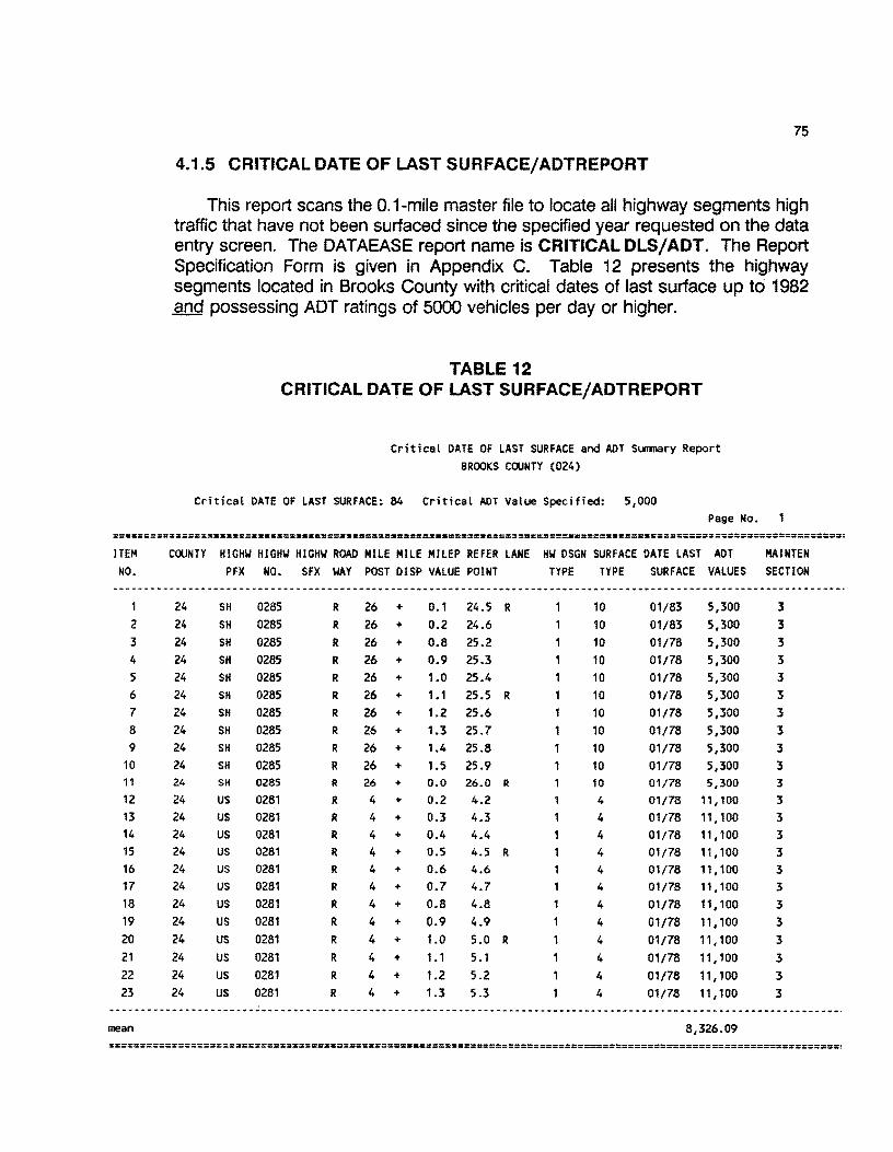
75
4.1.5 CRITICAL DATE OF LAST SURFACE/ADTREPORT
This report scans the 0.1-mile master file to locate all highway segments high traffic that have not been surfaced since the specified year requested on the data entry screen. The DATAEASE report name is CRITICAL DLS/ADT. The Report Specification Form is given in Appendix C. Table 12 presents the highway segments located in Brooks County with critical dates of last surface up to 1982 and possessing ADT ratings of 5000 vehicles per day or higher.
TABLE 12 CRITICAL DATE OF LAST SURFACE/ ADTREPORT
Critical DATE OF LAST SURFACE and AOT Surmary Report BROOKS COUNTY (024)
Critical DATE OF LAST SURFACE: 84 Critical AOT Value Specified: 5,000 Page No.
=====================================:============================================================================== ITEM COUNTY HIGHW HIGHW HIGHW ROAD HILE HILE HILEP REFER LANE HW OSGN SURFACE DATE LAST AOT HAINTEN NO. PFX NO. SFX WAY POST OISP VALUE POINT TYPE TYPE SURFACE VALUES SECTION
~·----··-------------------·---------------------------------···----·-----------------------------------~----------~
24 SH 0285 R 26 + 0.1 24.5 R 10 01/83 5,300 3 2 24 SH 0285 R 26 + 0.2 24.6 10 01/83 5,300 3 3 24 SH 0285 R 26 + 0.8 25.2 10 01/78 5,300 3 4 24 SH 0285 R 26 + 0.9 25.3 10 01/78 5,300 3 5 24 SH 0285 R 26 + 1.0 25.4 10 01/78 5,300 3 6 24 SH 0285 R 26 + 1.1 25.5 R 10 01/78 5,300 3 7 24 SH 0285 R 26 + 1.2 25.6 10 01/78 5,300 3 8 24 SH 0285 R 26 + 1.3 25.7 10 01/78 5,300 3 9 24 SH 0285 R 26 + 1.4 25.8 10 01/78 5,300 3
10 24 SH 0285 R 26 + 1.5 25.9 10 01/78 5,300 3 11 24 SH 0285 R 26 + 0.0 26.0 R 10 01/78 5,300 3 12 24 us 0281 R 4 + 0.2 4.2 4 01/78 11,100 3 13 24 us 0281 R 4 + 0.3 4.3 4 01/78 11, 100 3 14 24 us 0281 R 4 + 0.4 4.4 4 01/78 11,100 3 15 24 us 0281 R 4 + 0.5 4.5 R 4 01/78 11, 100 3 16 24 us 0281 R 4 + 0.6 4.6 4 01/78 11,100 3 17 24 us 0281 R 4 + 0.7 4.7 4 01/78 11,100 3 18 24 us 0281 R 4 + 0.8 4.8 4 01/78 11,100 3 19 24 us 0281 R 4 + 0.9 4.9 4 01/78 11,100 3 20 24 us 0281 R 4 + 1.0 5.0 R 4 01/78 11,100 3 21 24 us 0281 R 4 + 1.1 5.1 4 01/78 11,100 3 22 24 us 0281 R 4 + 1.2 5.2 4 01/78 11,100 3 23 24 us 0281 R 4 + 1.3 5.3 4 01/78 11,100 3
·--~-·------·--------·------···----··-----·------·----------····--·-------·----~--------------~--------------------·
mean 8,326.09
====================================================================================================================

76
4.1.6 CRITICAL REPORTS FROM THE VISUAL AND RIDE DATA FILES
In addition to the five standard reports, four additional reports will be presented. These are:
1. Critical Ride/FWD/ADT, 2. Critical Raveling/Rutting/Patching (from the visual data file), 3. Critical Raveling/Rutting/Patching/Ride, 4. Critical Crack Location.
Critical Ride/FWD /ADT Report
This report locates those road segments possessing inferior ride and FWD scores in conjunction with a designated ADT value. These segments indicate worse case segments that are in need of major maintenance work. Table 13 illustrates critical segments taken from Brooks County.
TABLE 13 CRl"rlCAL RIDE/FWD/ADT REPORT
Critical RIDE/FWD/ADT Slllll'lary Report Specified for BROOKS COUNTY (024)
Critical RIDE Score: 2.8 and Critical FWD Score >= 1.00 and a Critical ADT Value >= 500 vpd Page No.
======================================================================================================================== ITEM COUNTY HIGHW HIGHW HIGHW ROAD MILE MILE MILEP REFER LANE RIDE FWD NO.
2
3
mean
24 24 24
PFX NO. SFX WAY POST DISP VALUE POINT
FM 0430 FM 2191 SH 0285
R
R
R
0 + 1.0 1.0 R 12 + 0.0 12.0 R 12 + 0.2 12.0 R
SCORE SCORE
2.4 2.8 2.5
2.6
1.31 1.41 1.29
1.34
ADT VALUES
910 540
640
696.67
MAINTENANCE D.L.S. SECTION
:s 3
:s
06/88 03/87
06/85
========================================================================================================================

77
Critical Raveling /Rutting /Patching Report
Table 14 presents those highway segments located in Brooks County possessing low visual ratings regarding raveling, rutting, or patching. These segments indicate segments in need of sealing/ overlay work.
TABLE 14 CRITICAL RAVELING/RUTTING/PATCHINmEPORT
DISTRICT 21 CRITICAL RAVELING-RUTTING-PATCHING VS. RIDE LOCATION REPORT BROOKS COUNTY (024)
Page No.1
================================================================================================= item Cty H.W. H.W. H.W. Road M.P. M.P. M.P. Lane no. No. PFX NO. Sfx Way Dsp. Val.
1 24 us 0281 2 24 us 0281 3 24 us 0281 4 24 us 0281 5 24 us 0281 6 24 us 0281 7 24 us 0281 8 24 us 0281 9 24 us 0281
10 24 us 0281 11 24 SH 0285 12 24 SH 0285 13 24 SH 0285 14 24 SH 0285 15 24 SH 0285 16 24 SH 0285 17 24 SH 0285 18 24 SH 0285 19 24 SH 0285 20 24 SH 0285 21 24 SH 0285 22 24 SH 0285 23 24 SH 0285 24 24 SH 0285 25 24 SH 0285 26 24 SH 0285 27 24 SH 0285 28 24 SH 0285 29 24 SH 0285 30 24 SH 0285 31 24 SH 0285 32 24 SH 0285 33 24 FM 0430 34 24 FM 0430 35 24 FM 0430 36 24 FM 0430
R
R
R
R
R
R
R
R
R
R
R
R
R
R
R
R
R
R
R
R
R
R
R
R
R
R
R
R
R
R
R
R
R
R
R
R
0 +
2 +
4 +
4 +
4 +
4 +
4 +
4 +
18 +
20 +
0 +
0 +
4 +
4 +
6 +
6 +
8 +
8 +
8 +
10 +
10 +
10 +
12 +
12 +
12 +
14 +
16 +
18 +
18 +
18 +
18 +
20 +
0 +
0 +
2 +
0.5 R 0.0 R 0.0 R 0.5 R 1.0 R
0.0 R 0.5 R 1.0 R 1.0 R
0.0 R 0.5 R 1.5 R
0.7 R
1.2 R
0.7 R
1.7 R
0.2 R 0.7 R 1.7 R 0.2 R
0.7 R 1.2 R 0.7 R 1.2 R 1.7 R
1.7 R 0.0 R 0.0 R 0.5 R 1.0 R
1.5 R
0.5 R 0.5 R 1.0 R
0.0 R 2 + 1.0 R
Ref. Rav Rav Rut Rut Pat Pat Ride Maint. Point Mo Sv Mo Sv Mo Sv Val. Sec
0.5 0 2.0 0 2.5 0 3.0 0 3.5 0 4.0 0 4.5 0 5.0 0
19.0 0
20.0 0 0.5 0
1.5 0 4.5 0
5.0 0 6.5 0 7.5 0 8.0 0 8.5 0 9.5 0
10.0 0 10.5 0 11.0 0
12.5 0 13.0 0 13.5 0 15.5 0 16.0 0 18.0 0 18.5 0 19.0 0 19.5 0 20.5 0 0.5 0
1.0 0
2.0 0
0 2 0 1 0 1 0 2 0 2 0 2 0 1 0 0 0
0
0 2 0 0 0
0 1 0 2 0 2 0 0 ,
0 0
0
0 0 0 1 0 1
0 0 0 0 0 0
0 0 0 0 0 0 0 0 0
0 0 0 0 0 0
0 0 0 0
0 0 0 0 0 0
0
0
0
0 0
0
0
0
0 0
0
0
0 0
0
0 0
0
0
0 0
0 0
0 0
3.0 0 0 0 0
0
0 0
0 0 0 0 0
0
0 0 0 0 0 0 0 0 0
0
0
0
0
2
1
0 0 0
0 0 2
0
1 4.7
3.0 1
0 4.8 1
3.8 0 3.3 0 3.0 0
0
0 0 4.4 0
0
0 4.1 0
3 3.4
2 0 4.1
0 2 3.6 0 0 0 3.3
1 3.4
1
0 0
3.6
0 2.4 0 3.6 0 3.3
3
3
3
3 3 3 3 3 3
3
3 3 3
3
3
3 3
3
3
3 3 3
3 3
3
3
3
3
3 3
3 3 3
3
3
3

78
Critical Raveling/Rutting/Patching/Ride Report
Table 15 presents located highway segments possessing critical visual-type distresses (rutting, raveling, patching, etc) along with the associated ride score. In this manner, the maintenance engineer can judge if the ride value of the segment has been adversely affected by the visual distresses.
TABLE 15 CRITICAL RAVELING/RUTTING/PATCHING/RIDE REPORT
DISTRICT 21 CRITICAL RAVELING-RUTTING-PATCHING VS. RIDE LOCATION REPORT BROOKS COUNTY (024)
Page No.2
================================================================================================= item Cty H.W. H.W. H.W. Road M.P. M.P. M.P. Lane Ref. Rav Rav Rut Rut Pat Pat Ride Maint. no. No. PFX NO. Sfx way
52 24 FM 0755 53 24 FM 0755 54 24 FM 0755 55 24 FM 0755 56 24 FM 0755 57 24 FM 0755 58 24 FM 0755 59 24 FM 0755 60 24 FM 1418 61 24 FM 1418 62 24 FM 1418 63 24 FM 1418 64 24 FM 2191 65 24 FM 2191 66 24 FM 2191 67 24 FM 2191 68 24 FM 2191 69 24 FM 2191 70 24 FM 2191 71 24 FM 2191 72 24 FM 2191 73 24 FM 2191 74 24 FM 2191 75 24 FM 2191 76 24 FM 2191 77 24 FM 2191 78 24 FM 2191 79 24 FM 2191 80 24 FM 2191 81 24 FM 2191
R
R
R
R
R
R
R
R
R
R
R
R
R
R
R R
R
R
R
R
R
R
R
R
R
R
R
R
R
R
Osp. Val.
14 + 1.0 R
16 + 0.0 R 16 + 0.5 R 16 + 1.0 R 16 + 1.5 R
18 + 0.5 R
20 + 0.0 R 22 + 0.4 R 0 + 0.5 R 0 + 1.0 R
0 + 1.5 R
2 + 0.0 R 0 + 0.4 R
0 + 0.9 R
0 + 1.4 R
2 + 0.0 R 2 + 0.5 R 2 + 1.0 R 2 + 1.5 R 4 + 0.0 R 4 + 0.5 R
4 + 1.0 R
4 + 1.5 R
6 + 0.0 R 6 + 0.5 R 6 + 1.0 R
10 + 1.0 R
10 + 1.5 R 12 + 0.0 R 12 + 0.3 R
Point Mo Sv Mo sv Mo Sv Val. Sec
15.0 0 16.0 0 16.5 0 17.0 0 17.5 0 18.5 0 20.0 0 22.4 0 0.5 0 1.0 0 1.5 0 2.0 0 0.5 0 1.0 0
1.5 0 2.0 0 2.5 0
3.0 0 3.5 0 4.0 0 4.5 0 5.0 0 5.5 0 6.0 0 6.5 0 7.0 0
11.0 0 11.5 0
12.0 0 12.3 0
0 0 • 0 0 0 0 0 0 0 0 0 0 0 1
0 0 0 0 0 1 0 0
0 1 0 0 0 0 0 1
0 0 0 1 0 0 0 0 0 0 0 2 0 0 2 0 0 0 0 1 0 0
0 0 0 0 0 1 0 0 0 0 0 0 0 0 0 0 0 0 0 0 1 0 0
0 0 0 1
0 0 0 0 0 0 0 0
0 0 0 .1 0 0
0 0 0 1
0 0 0 0 0 1 0 1
0 0 0 0
0 0 0
1 3.6 0 3.7 0 0 4.0
0 1
4.5
2 1.9 0
0 4.1
2.7 2 1 3. 1
3.5
0 3.3 1
1 3.6
0 2.8 2 0 4.5 1 3.3
2.8
3 3 3 3 3
3 3
3 3 3 3 3 3 3 3
3 3
3 3 3
3 3 3 3 3 3
3 3 3 3
==============================================================================~==•==============:

79
Critical Crack Location Report
Table 16 locates those highway segments possessing moderate to severe crack distresses. This report serves to inform the maintenance engineer of the location and severity of the various moderate to severe cracking distresses.
TABLE 16 CRITICAL CRACK LOCATION REPORT
DISTRICT 21 MODERATE-SEVERE CRACK LOCATION REPORT CRACK CONDITION CODES: 1=ARE 2=NOT 3=PARTLY ••. SEALED
BROOKS COUNTY (024) Page No:
================================================================================================================================ ITEM COUNTY HIGH HIGH HIGH ROAD HILE HILE HILE POST LANE REFERENCE ALG-MO ALG-SV LONG·HO LONG·SY TRANS·MO TRANS-SY CR NO. NO. PREFX NO. SFX ~AY POST OISP VALUE POINT COND
1
2 3 4
5 6 7
8
9
10
11 12 13 14 15 16 17
18
19
20 21
22 23 24 25 26 27
28 29 30 31
24 24 24 24 24 24 24 24 24 24 24 24 24 24 24 24 24 24
24 24 24
24 24 24 24
24 24 24 24 24 24
us 0281 us 0281 us 0281 us 0281 us 0281 us 0281 us 0281 us 0281 us 0281 us 0281 us 0281 us 0281 us 0281 us 0281 us 0281 us 0281 us 0281 us 0281 us 0281 us 0281 us 0281 us 0281 us 0281 us 0281 us 0281 us 0281 us 0281 FM 2191 FM 2191
FM 2191
FM 2191
R
R
R
R
R
R
R
R
R
R
R
R
R
R
R
R
R
R
R
R
R
R
R
R
R
R
R
R
R
R
R
0 +
2 +
4 + 4 +
4 +
4 +
6 + 6 +
6 +
6 +
8 +
8 +
8 +
8 + 10 +
10 +
10 +
10 +
12 + 12 +
12 +
12 + 14 +
14 +
14 +
14 +
16 +
2 4 +
6 +
10 +
0.5 0.0 o.o 0.5 1.0 1.5 0.0 0.5 1.0
1.5 0.0 0.5 1.0 1.5 0.0 0.5 1.0 1.5 0.0 0.5 1.0
1.5 0.0 0.5 1.0
1.5
0.5 2.0 1.5 0.0 1.0
R 1.0 R 2.5 R 4.5 R 5.0 R 5.5 R 6.0 R 6.5
R 7.0 R 7.5
R 8.0 R 8.5 R 9.0 R 9.5 R 10.0 R 10.5 R 11.0
R 11.5 R 12.0 R 12.5 R 13.0 R 13.5
R 14.0 R 14.5 R 15.0 R 15.5 R 16.0 R 17.0
R 0.5 R 6.0 R 6.5
R 11.5
0
0
0
0 0
0 0
0
0
0
0
0
0 0
0 0
0 0
0
0
0
0
0
0
0
0
0
2
1
2 2
0
0 0 0
0
0
0
0
0
0
0
0
0
0
0
0
0 0
0
0
0 0
0
0 0
0
0 0
0
0
0
2
3 3
3 3 3 3
3 3
3 3 3
2 2
2
3 3 3
3 3 3 3 3
2
0
3
0
0
1
0
0
0 0
0
0
0
0
0 0
0
0 0
0
0 0
0
0 0 0
0
0
0 0
0
0
0
0
0
0
0
0
0 2
3 3 3 3 3 3
3 3 3 3 3 3
3 3
3 3 3
3 3 3 3
3 3
2
3 0
0
1 0
0
0
0 0
0
0
0 0
0
0 0
0
0
0
0
0
0 0
0
0
0
0
0
0
0
0
0 0
0
0
0
3
3 3 1
3 3
3 3 3
3 3
3
1 3
3
3
2
2 2
0
===========================================-====================================================================================

80
4.2 SUMMARY FOR REPORT GENERATION
This section presented information concerning the generation of standardized sample reports that the research team felt would be important to District Engineers. As more experience is gained with the system, it is highly likely that numerous other reports will be added. Thus, as with any system of this nature, it will continue to expand and develop as future needs arise.
When the final installation of this system is completed in D21, the authors will revise this report to reflect the changes brought about by day-to-day use. OL1r intent for now is to present the development of the prototype system and the reporting capabilities designed herein.
As district personnel become familiar with the system, they will develop the skill necessary to write their own standard reports and any ad hoc reports that may be required. The ad hoc report represents a special propose or one-time report that satisfies a special inquiry into the database. An ad hoc report can be executed one time or saved to a report file for continued use.
The report generation language once learned, is straight-forward. With the appropriate training, resident engineers can produce their own reports specific to their needs. The developed system permits building libraries of reports and incorporating them into a menu scheme.
The purpose of this section is to illustrate the basic reports available on the developed system. No attempt has been made to cover the details of the report generation language. Training District personnel in the report generation capabilities of the database will be part of specialized training sessions to be conducted at the request of the district. Documentation of these activities will be part of the maintenance/extension of this system and will be published under separate documentation as performed.
The next sections deal with details relating to collection and importing of ride, skid, FWD, and visual data into the respective holding files.

81
5.0 RIDE DATA COLLECTION- SIOMETER METHOD
(This section was written by D-1 SPM personnel under the direction of Mr. Craig Cox.)
When Slometer ride data is collected for a given county, its final form is in a format readable only by the Pavement Evaluation System (PES). In order to use this ride data in this Pavement Management System (PMS), the collected data must be converted into a readable format. After the data is converted, it is then imported into the proper data form through an iterative process. When the collection of the ride data is complete, the results will be used in reporting and decision making operations.
The following example details the steps involved in processing the Slometer Ride Data.
5.1 SIOMETER RIDE DATA CONVERSION
To begin the Slometer ride data conversion, select the county in which the Siometer ride data was collected. This can be accomplished by using the "Pavement Management System" main menu (Figure 23). In this example, we will use Willacy county. To do this, use the arrow keys on the keyboard to point to the item "1 - Willacy County (245)" (only in this example) and press the "Enter" key, or press the "1" key.
Pavement Management System
MENU 2 OF 2 -> 1 - Willacy County (245)
2 - Zapata County (253)
3 - Process Raw Skid Data
4 Tape Backup
5 - Optimize Hard Disk
6 - Disk Operating System
December 4 1989 8:37:23 am NUM 640 K
FIGURE 23: PMS MAIN MENU

82
As soon as you select a county, the menu program automatically accesses the database for that county and prompts you for your name and your security password (Figure 24). Your sign-on name and password are assigned to you by your PMS administrator.
In the following example, the sign on name is "DATA" and the security password is "ENTRY". The database first prompts you for your name. In this example, type "DATA" and press the "Enter" key. The database then prompts you for your security password. Type "ENTRY" and press the "Enter" key. Notice that the password that you typed does not appear on the screen.
D A T A E A S E - S I G N 0 N
Directory: D:\DEASE\WILLACY
What is the database name?: WILLACY
What is your name : DATA
What is your security password : __
F4 CMDHELP ESC EXIT D:\DEASE\WILLACY WILLACY 12/04/89 8:40 am
FIGURE 24: PMS SIGN-ON MENU
If everything was typed in correctly, the "PAVEMENT MANAGEMENT SYSTEM /WILLACY COUNTY" menu should appear on your screen with seven different categories to choose from (Figure 25). Select "2. Data Entry -- District Field Data" by pressing the "2" key or use the arrow keys to highlight the selection and press the "Enter" key.
PAVEMENT MANAGEMENT SYSTEM I WILLACY COUNTY
1. Setup
2. Data Entry -- District Field Data
3. Data Entry -- Import PES Data
4. Data Handling -- District Field Data
5. Data Handling -- Imported PES Data
6. Reports
7. Year End
l to 7 - UP - DOWN - RETURN - END __J
F4 CMDHELP ESC EXIT D:\DEASE\WILLACY WILLACY 12/04/89 8:40 am
FIGURE 25: PMS DATA ENTRY MENU
The next menu that appears on your screen is the "DATA ENTRY -- DISTRICT FIELD DATA/ WILLACY COUNTY" menu. Since we want to process ride data,

83
select "2. Ride Data" by pressing the "2" key, or use the arrow keys to highlight the selection and press the "Enter" key (Figure 26).
DATA ENTRY -- DISTRICT FIELD DATA I WILLACY COUNTY
1. Input or Modify Visual Data
2. Ride Data
3. FWD Data
4. Skid Data I I
5. Create or Modify Date of Last Surface I I
6. Create or Modify Crossroads I I
7. Create or Modify District Counties Data I I
a. Create or Modify Roadway Characteristics I I
L.__ l to 8 - UP DOWN - RETURN - END ___J
F4 CMDHELP ESC EXIT D: \DEASE\WILLACY WILLACY 12/04/89 8:40 am
FIGURE 26: FIELD DATA MENU
The next menu, "RIDE DATA / WILLACY COUNTY", will initiate ride data processing (Figure 27).
The first operation to perform is to convert the raw Slometer data. This is done by selecting "2. Convert Raw Slometer Data". Press the "2" key or use the arrow keys to highlight the selection and press the "Enter" key.
RIDE DATA I WILLACY COUNTY
1. Input or Modify Mays Ride Data
2. Convert Raw Siometer Data
3. Import Siometer Data
4. Validate Siometer Errors in Imported Data
5. Correct Errors in Siometer Data File
1 to 5 - UP -DOWN - RETURN END -~
F4 CMDHELP ESC EXIT D:\DEASE\WILLACY WILLACY lZ/04/89 8:40 am
FIGURE 27: CONVERT RAW SIOMETER DATA
You are then prompted with the following message.
PLACE RIDE FIELD DATA IN DRIVE A:
Strike a key when ready . . .
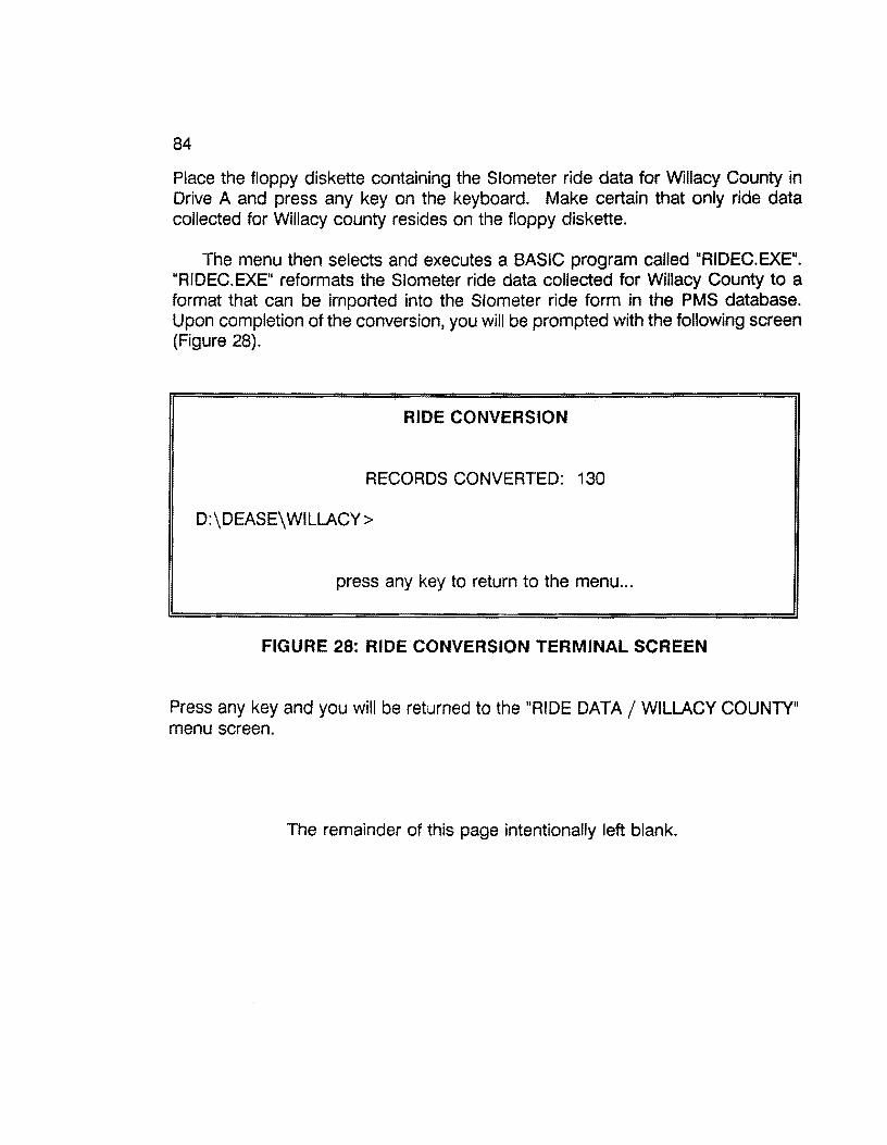
84
Place the floppy diskette containing the Slometer ride data for Willacy County in Drive A and press any key on the keyboard. Make certain that only ride data collected for Willacy county resides on the floppy diskette.
The menu then selects and executes a BASIC program called "RIDEC.EXE". "RIDEC.EXE" reformats the Slometer ride data collected for Willacy County to a format that can be imported into the Slometer ride form in the PMS database. Upon completion of the conversion, you will be prompted with the following screen (Figure 28).
RIDE CONVERSION
RECORDS CONVERTED: 130
D:\DEASE\WILLACY>
press any key to return to the menu ...
FIGURE 28: RIDE CONVERSION TERMINAL SCREEN
Press any key and you will be returned to the "RIDE DATA/ WILLACY COUNTY" menu screen.
The remainder of this page intentionally left blank.
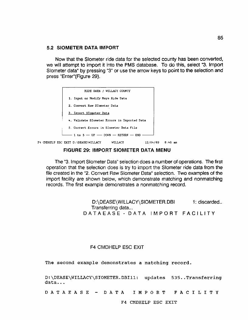
85
5.2 SIOMETER DATA IMPORT
Now that the Slometer ride data for the selected county has been converted, we will attempt to import it into the PMS database. To do this, select "3. Import Slometer data" by pressing "3" or use the arrow keys to point to the selection and press "Enter"(Figure 29).
RIDE DATA I WILLACY COUNTY
1. Input or Modify Mays Ride Data
2. Convert Raw Siometer Data
3. Import Siometer Data
4. Validate Siometer Errors in Imported Data
5. Correct Errors in Siometer Data File
1 to 5 - UP - DOWN - RETURN - END
F4 CMDHELP ESC EXIT D:\DEASE\WILLACY WILLACY 12/04/89 8:40 am
FIGURE 29: IMPORT SIOMETER DATA MENU
The "3. Import Slometer Data" selection does a number of operations. The first operation that the selection does is try to import the Slometer ride data from the file created in the "2. Convert Raw Slometer Data" selection. Two examples of the import facility are shown below, which demonstrate matching and nonmatching records. The first example demonstrates a nonmatching record.
D:\DEASE\WILLACY\SIOMETER.DBI 1: discarded .. Transferring data ...
DATAEASE - DATA IMPORT FACILITY
F4 CMDHELP ESC EXIT
The second example demonstrates a matching record.
D:\DEASE\WILLACY\SIOMETER.OBill: updates 535 .• Transferrinq data ...
D A T A E A S E DAT A I M P 0 R T F A C I L I T Y
F4 CMDHELP ESC EXIT

86
Invariably you will have records that will not match the records in the database for some reason or another. These records are listed in a separate file as errors from the import function. On the other hand, if no errors occur, the import process of the Slometer ride data is complete, and you can disregard the next set of operations.
The error file, that the import function creates, contains only the line number from the import data set where the errors occurred. The next process that the import selection does is to match the line number errors in the error file to the actual line containing the data, and to list the data with errors. This process is done by a program named "RIDERR.EXE". "RIDERR.EXE" then creates a new import file with the Slometer ride data that contained errors.
An example listing, to the printer, of the errors incurred by the import process and generated by "RIDERR.EXE" follows (Table 17).
RIDE ERRORS
CNTY HIGHWAY MILEPOST RWY SI CMT YEAR
discarded.. 245;FM;0490; ;ooo;+;o.o;R;1.6; ;88 discarded.. 245;FM;0490; ;000;+;0.2;R;2.7; ;88 discarded.. 245;FM;0490; ;000;+;0.4;R;3.6; ;88 discarded.. 245;FM;0490; ;000;+;0.6;R;2.6; ;88 discarded.. 24S;FM;0490; ;000;+;0.8;R;2.8; ;88 discarded.. 24S;FM;0088; ;OOO;+;O.O;R;3.6; ;88 discarded .• 245;FM;0088; ;ooo;+;0.2;R;3.1; ;88 discarded.. 245;FM;0088; ;000;+;0.4;R;2.7; ;88 discarded.. 245;FM;0088; ;ooo;+;0.6;R;3.4; ;ss discarded.. 24S;FM;0088; ;ooo;+;0.8;R;3.0; ;88 discarded.. 24S;FM;0606; ;ooo;+;O.O;L;3.3; ;88 discarded.. 245;FM;0606; ;000;+;0.2;L;2.7; ;88 discarded.. 245;FM;0606; ;000;+;0.4;L;3.0; ;88 discarded.. 24S;FM;0606; ;000;+;0.6;L;3.0; ;88 discarded.. 245;FM;0606; ;000;+;0.8;L;2.1; ;88
TABLE 17 DISGARDED RIDE RECORDS
These errors must be corrected and reimported again until no more errors exist.
The first operation in correcting the errors is to separate the break points in the error listing by manually underlining them on the output. This will make the error validation process much easier. Table 18 demonstrates the break points in the error listing of the Slometer ride data.
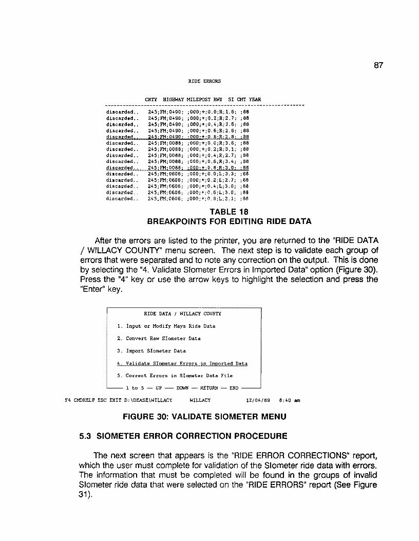
discarded .. discarded .. discarded .. discarded .. discarded .. discarded .. discarded .. discarded .. discarded .. discarded .. discarded ..
RIDE ERRORS
CNTY HIGHWAY MILEPOST RWY SI CMT YEAR
245;FM;0490; ;000;+;0.0;R;l.6; ;88 245;FM;0490; ;000;+;0.2;R;2.7; ;88 245;FM;0490; ;000;+;0.4;R;3.6; ;88 245;FM;0490; ;000;+;0.6;R;2.6; ;88 245;FM;0490; ;000:+:0.8;R;2.8; ;88 245;FM;0088; ;OOO;+;O.O;R;3.6; ;88 245;FM;0088; ;000;+;0.2;R;3.l; ;88 245;FM; 0088; ; 000;+; 0. 4 ;R;2. 7; ; 88 245;FM;0088; ;000;+;0.6;R;3.4; ;88 245;FM;0088; ;000;+;0.8:R:3.0; ;88 245;FM;0606; ;OOO;+;O.O;L;3.3; ;88
discarded.. 245;FM;0606; ;000;+;0.2;L;2.7; ;88 discarded.. 245;FM;0606; ;000;+;0.4;L;3.0; ;88 discarded.. 245;FM;0606; ;000;+;0.6;L;3.0; ;88 discarded.. 245;FM;0606; ;000;+;0.8;L;2.l; ;88
TABLE 18 BREAKPOINTS FOR EDITING RIDE DATA
87
After the errors are listed to the printer, you are returned to the "RIDE DATA / WILLACY COUNTY" menu screen. The next step is to validate each group of errors that were separated and to note any correction on the output. This is done by selecting the "4. Validate Slometer Errors in Imported Data" option (Figure 30). Press the "4" key or use the arrow keys to highlight the selection and press the "Enter" key.
RIDE DATA I WILLACY COUNTY
1. Input or Modify Mays Ride Data
2. Convert Raw Siometer Data
3. Import Siometer Data
4. Validate Siometer Errors in Imported Data
5. Correct Errors in Siometer Data File
1 to 5 - UP - DOWN - RETURN - END
F4 CMDHELP ESC EXIT D:\DEASE\WILLACY WILLACY 12/04/89 8;40 am
FIGURE 30: VALIDATE SIOMETER MENU
5.3 SIOMETER ERROR CORRECTION PROCEDURE
The next screen that appears is the "RIDE ERROR CORRECTIONS11 report, which the user must complete for validation of the Slometer ride data with errors. The information that must be completed will be found in the groups of invalid Slometer ride data that were selected on the "RIDE ERRORS" report (See Figure 31).

88
discarded .. discarded .. discarded., discarded .. discarded,, discarded .. discarded .. discarded .. discarded .. discarded .. discarded .. discarded .. discarded .. discarded .. discarded ..
RIDE ERRORS
CNTY HIGHWAY MILEPOST RWY SI CMT YEAR
245;FM; 0088; ; ooo; +; o. o ;R;3. 6; ; 88 245·FM·0088· ;000;+;0.2;R;3.l; ;88 245:FM:oo88: ;ooo;+;0.4;R;2.7; ;88 245'.FM'.0088: ;ooo;+;0.6;R;3.4; ;88 245 ;FMi 0088; ; ooo :+; o. s;R; 3. o; ; 88
FIGURE 31: DISGARDED RIDE ERRORS
To validate the errors in the first group of Slometer ride errors (Figure 31 ), the "RIDE ERROR CORRECTIONS" report screen must be completed as shown in Figure 32.
EDE ERROR CORRECTIONS 1:
Complete the entries below, then press "F2"
HIGHWAY PREFIX: ft!
HIGHWAY NUMBER: 0490
HIGHWAY SUFFIX:
ROADWAY: B
F4CMDHELP ESCEXIT F2SAVE F5FORM CLEAR F6FIELD CLR
FIGURE 32: RIDE ERROR CORRECTIONS
After the information is completed (FM; 0490; SPACE; R), press the "F2" key to start the validation report process. Scroll through the output by pressing the space bar until the output matches, as near as possible, that of the first group on the Slometer ride data error listing (Table 19).

89
the Slometer ride data error listing (Table 19).
RIDE VIEW Running report RIDE VIEW SPACEorPgDn: Continue report EXIT: Abort report PgUp: Scroll
SICX1ETER ERROR CORRECTIONS
RECORD COUNTY HIGHWAY ROADWAY REFERENCE MILEPOST NUMBER NUMBER POINT
000016 245 FM0490 R 0.2 2-1.8 000017 245 FM0490 R 0.4 2-1.6 000018 245 FM0490 R 0.6 2-1.4 000019 245 FM0490 R 0.8 2-1.2 000020 245 FM0490 R 1.0 2-1.0 000021 245 FM0490 R 1.2 2-0.8 000022 245 FM0490 R 1. 4 2-0.6 000023 245 FM0490 R 1.6 2-0.4 000024 245 FM0490 R 1. 8 2-0.2 000025 245 FM0490 R 2.0 2+0.0 000026 245 FM0490 R 2.2 2+0.2 000027 245 FM0490 R 2.4 2+0.4 000028 245 FM0490 R 2.6 2+0.6 000029 245 FM0490 R 2.8 2+0.8 000030 245 FM0490 R 3.0 2+1.0 000031 245 FM0490 R 3.2 2+1.2
F4 CMDHELP ESC EXIT D:\DEASE\WILLACY WILLACY 12/12/89 10:40 am
TABLE 19 SIOMETER ERROR SUMMARY
Note on the Slometer ride data error output the corrections that need to be made to match the records to the ones above. In our example, the only difference between the Slometer ride error output and the screen above is the "MILEPOST'' structure inequality. To correct the structure inequality, modify the milepost variable to appear as the "MILEPOST' above.

90
Also, the first record in the "RIDE ERRORS" report does not appear in the "SIOMETER ERROR CORRECTIONS" report, so it must be deleted as demonstrated below.
RIDE ERRORS
CNTY HIGHWAY MILEPOST RWY SI CMT YEAR
discarded •. 245; FM; 0490; ;000;+;0.0;R;l.6; ;88 - DELETE RECORD discarded .. 245;FM;0490; ;000;+;0 2;R;2.7; ;88 - ;002;-; 1. 8 discarded •. 245;FM;0490; ;000;+;0.4;R;3.6; ;88 - ;002; ;l.6 } filLEro8T INEQUALITY discarded .. 245;FM;0490; ;000;+;0.6;R;2.6; ;88 - ;002;-;l.4 CHANGE discarded., 245;FMj0490; ;000;+;0.8;R;2.8; ;88 - ;002;-; 1.2 discarded .. 245;FM;0088; ;OOO;+;O.O;R;3.6; ;88 discarded .. 245;FM;0088; ;000;+;0.2;R;3.l; ;88 discarded .. 245;FM;0088; ;000;+;0.4;R;2.7; ;88 discarded .. 245;FM;0088; ;000;+;0.6;R;3.4; ;88 discarded .. 245jFMj0088; ;000;+;0.8;R;3.0; ;88 discarded .. 245;FM;0606; ;OOO;+;O.O;L;3.3; ;88 discarded •. 245;FM;0606; ;000;+;0.2;L;2.7; ;88 discarded .. 245;FM;0606; ;000;+;0.4;L;3.0; ;88 discarded .. 245;FM;0606; ;000;+;0.6;L;3.0; ;88 discarded .. 245;FM;0606; ;000;+;0.8;L;2.1; ;88
Press the "Esc" key to return to the "RIDE ERROR CORRECTIONS" report input screen. Now, we need to validate the second group of errors in the Slometer ride data (Table 20).
RIDE ERRORS
CNTY HIGHWAY MILEPOST RWY SI CMT YEAR
discarded .. 245;FM;0490; ;000;+;0.0;R;l.6; ;88 - DELETE RECORD discarded •. 245;FM;0490; ;000;+;0.2;R;2.7; ;88 - ; 002; - : 1. 8; discarded .. 245;FM;0490; ;000;+;0.4;R;3.6; ;88 - ; 002; - ; l. 6; } MILEPOST INEQUALITY discarded .. 245;FM;0490; ;000;+;0.6;R;2.6; ;88 - ;002; ; l.4; CHANGE discarded, 1 245;FM;0490; ;000;+;0.8;R;2.8; ;88 - ;002;-;1.2 discarded .• 245;FM;0088; ;OOO;+;O.O;R;3.6; '"} discarded .. 245;FM;0088; ;000;+;0.2;R;3.1; ·88 discarded .. 245;FM;0088; ;000;+;0.4;R;2.7; ;88 SECOND GROUP discarded .. 245;FM;0088; ;000;+;0.6;R;3.4; ;88 discarded, . 245jFM;0088; ;000;+;0.8;R;3.0; j88 discarded .. 245;FM;0606; ;OOO;+;O.O;L;3.3; ;88 discarded .. 245;FM;0606; ;000;+;0.2;L;2.7; ;88 discarded .. 245;FM;0606; ;000;+;0.4;L;3.0; ;88 discarded .. 245;FM;0606; ;000;+;0.6;L;3.0; ;88 discarded .. 245;FM;0606; ;000;+;0.8;L;2.1; ;88
TABLE 20 RIDE ERROR CORRECTIONS
Type in the pertinent information (FM; 0088; SPACE; R) of the second group of data for the. error validation report, and press the "F2" key.
RIDE ERROR CORRECTIONS Complete the entries below, then p;i;ess "F2"
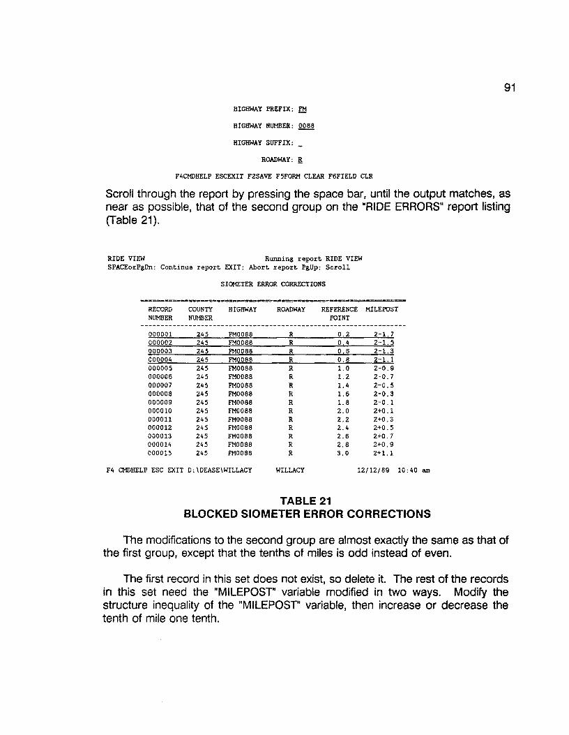
91
HIGHWAY PREFIX: f.tl
HIGHWAY NUMBER: 0086
HIGHWAY SUFFIX:
ROADWAY: !!
F4CMDHELP ESCEXIT F2SAVE F5FORM CLEAR F6FIELD CLR
Scroll through the report by pressing the space bar, until the output matches, as near as possible, that of the second group on the "RIDE ERRORS" report listing (Table 21).
RIDE VIEW Running report RIDE VIEW SPACEorPgDn: Continue report EXIT: Abort report PgUp: Scroll
SIOMETER ERROR CORRECTIONS
======·=====•========~-- ...... ••===:=.=:= rm •========-= RECORD COUNTY HIGHWAY ROADWAY REFERENCE MILEPOST NUMBER NUMBER POINT
------------------------------------------------------------------000001 245 FM0088 R 0.2 2-1.7 000002 245 FM0088 R 0.4 2-1.5 000003 245 FM0088 R 0.6 2-1.3 000004 245 FM0088 R 0.8 2-1.l 000005 245 FM0088 R 1.0 2-0.9 000006 245 FM0088 R 1. 2 2-0.7 000007 245 FM0088 R 1.4 2-0.5 000008 245 FM0068 R 1.6 2-0.3 000009 245 FM0088 R 1. 8 2-0.1 000010 245 FM0088 R 2.0 2+0.1 000011 245 FM0088 R 2.2 2+0.3 000012 245 FM0088 R 2.4 2+0.5 000013 245 FM0088 R 2.6 2+0.7 000014 245 FM0088 R 2.8 2+0.9 000015 245 FM0068 R 3.0 2+1. l
F4 CMDHELP ESC EXIT D:\DEASE\WILLACY WILLACY 12/12/89 10:40 am
TABLE 21 BLOCKED SIOMETER ERROR CORREC"rlONS
The modifications to the second group are almost exactly the same as that of the first group, except that the tenths of miles is odd instead of even.
The first record in this set does not exist, so delete it. The rest of the records in this set need the "MILEPOST" variable modified in two ways. Modify the structure inequality of the "MILEPOST' variable, then increase or decrease the tenth of mile one tenth.

92
The rounding of the tenths of mile will now allow the data to match the records in the database. The modification notes for the second data set appear in Table 22.
RIDE ERRORS
CNTY HIGHWAY MILEPOST RWY SI CMT YEAR
discarded •• 245;FM;0490; ;000;+;0.0;R;l.6; ;88 - DELETE RECORD discarded .. 245;FM;0490; ;000;+;0.2;R;2.7; ;88 ; 002; -; 1. 8; discarded .• 245;FM;0490; ;000;+;0.4;R;3.6; ;88 ; 002; -; 1. 6; } ffiL-T INEQUALITY discarded •• 245;FM;0490; ;000;+;0.6;R;2.6; ;88 - ; 002; - ; 1. 4; CHANGE discarded .. 245jFMj0490i ;000;+;0.8jR;2.8; j88 - ;002;-; l.2 discarded .. 245;FM;0088; ;OOO;+;O.O;R;3.6; ;88 - DELETE RECORD discarded .. 245;FM;0088; ;000;+;0.2;R;3.l; ;88 - ;002; ; 1. 7 discarded .. 245;FM;0088; ;000;+;0.4;R;2.7; ;88 - ;002;-;l.5 } MILEPOST INEQUALITY discarded .. 245;FM;0088; ;000;+;0.6;R;3.4; ;88 - ;002;-;l.3 AND ROUNDING CHANGE discarded., 245;FM;0088; ;000;+;0.8;R;3.0; ;88 ; 002; - ; 1.1 discarded .. 245;FM;0606; ;OOO;+;O.O;L;3.3; ;88 discarded .. 245;FM;0606; ;000;+;0.2;L;2.7; ;88 discarded. , 245;FM;0606; ;000;+;0.4;L;3.0; ;88 discarded .. 245;FM;0606; ;000;+;0.6;L;3.0; ;88 discarded .. 245;FM;0606; ;000;+;0.8;L;2.l; ;88
TABLE 22 DELETED SIOMETER RECORDS
Press the "Esc" key to return to the "RIDE ERROR CORRECTIONS" report input screen. This leaves the third and final group to validate (Table 23).
RIDE ERRORS
CNTY HIGHWAY MILEPOST RWY SI CMT YEAR
discarded .. 24S;FM;0490; ;000;+;0.0;R;l.6; ;88 - DELETE RECORD discarded .. 245;FM;0490; ;000;+;0.2;R;2.7; ;88 ;002;-;l.8; discarded .. 24S;FM;0490; ;000;+;0.4;R;3.6; ;88 ;002;-;1.6; } MILEPOST INEQUALITY discarded .. 245;FM;0490; ;000;+;0.6;R;2.6; ;88 ;002;-;l.4; CHANGE discarded .. 245;FMj0490j ;OOOj+;0.8jRj2.8; j88 ;002; ;1.2 discarded .. 245;FM;0088; ;OOO;+;O.O;R;3.6; ;88 - DELETE RECORD discarded .. 245;FM;0088; ;000;+;0.2;R;3.l; ;88 - ;002;-; 1. 7 discarded .. 245;FM;0088; ;000;+;0.4;R;2.7; ;88 - ;002; ;1.5 } MILEPOST INEQUALITY discarded .. 245 ;FM; 0088: ;000;+;0.6;R;3.4; ;88 - ;002; ; 1.3 AND ROUNDING CHANGE discarded .. 245;FM;0088; ;000;+;0.8jR;3.0j ;88 ; 002; - ; 1.1 discarded .. 245;FM;0606; ;OOO;+;O.O;L;3.3;
"} discarded .. 245;FM;0606; ;000;+;0.2;L;2.7; ·88 discarded .. 245;FM;0606; ;000;+;0.4;L;3.0; ;88 THIRD GROUP discarded .. 245;FM;0606; ;000;+;0.6;L;3.0; ;88 discarded .. 245;FM;0606; ;000;+;0.8;L;2.1; ;88
TABLE 23 MODIFIED RIDE CORRECTIONS
Type in the pertinent information (FM; 0606; SPACE; L) of the third group of data for the error validation report, and press the "F2" key.

l!.IDE ERRCit CORRECTIONS
Complete the entries below, then press "F2"
HIGHWAY PREFIX: .£11
HIGHWAY NUMBER: Q.§,Q§
HIGHWAY SUFFIX:
ROADWAY: 1
F4CMDHELP ESCEXIT F2SAVE F5FORM CLEAR F6FIELD CLR
Upon examination, this road does not exist according to the database.
RIDE VIEW Running report RIDE VIEW SPACEorPgDn: Continue report EXIT; Abort report PgUp: Scroll
SIOMETER ERROR CORRECTIONS
RECORD COUNTY HIGHWAY ROADWAY REFERENCE MILEPOST NUMBER NUMBER POINT
F4 CMDHELP ESC EXIT 0:\DEASE\WILLACY WILLACY 12/12/89 10:40 am
93
There must be something wrong with our input to the data selection of the report. If we change our "ROADWAY" input from "L" to "A", we can find the records for the selected highway in the database.
l!.IDE ERRCit CORRECTIONS
Complete the entries below, then press "F2"
HIGHWAY PREFIX: FM
HIGHWAY NUMBER: 0606
HIGHWAY SUFFIX:
ROADWAY: !!
F4CMDHELP ESCEXIT F2SAVE F5FORM CLEAR F6FIELD CLR
Scroll through the report, by pressing the space bar, until the output matches, as near as possible, that of the third group on the Slometer ride data error listing (Table 24).

94
RIDE VIEW Running report RIDE VIEW SPACEorPgDn: Continue report EXIT: Abort report PgUp: Scroll
SIOMETER ERROR CORRECTIONS
RECORD NUMBER
COUNTY NUMBER
HIGHWAY ROADWAY REFERENCE MILEPOST POINT
000057 245 FM0088 R 0.2 2-l. 7 000058 245 FM0088 R 0.4 2-1.5 000059 245 FM0088 R 0 6 2-1.3 000050 245 FM0088 R 0.8 2-1.1 000005 245 FM0088 R 1.0 2-0.9 000006 245 FM0088 R 1.2 2-0.7 000007 245 FM0088 R 1.4 2-0.5 000008 245 FM0088 R 1.6 2-0.3 000009 245 FM0088 R 1.8 2-0.1 000010 245 FM0088 R 2.0 2+0.1 000011 245 FM0088 R 2.2 2+0.3 000012 245 FM0088 R 2.4 2+0.5 000013 245 FM0088 R 2.6 2+0.7 000014 245 FM0088 R 2.8 2+0.9 000015 245 FM0088 R 3.0 2+1.1
F4 CMDHELP ESC EXIT D:\DEASE\WILLACY WILLACY 12/12/89 10:40 am
TABLE 24 MODIFIED SIOMETER ERROR CORRECTIONS
There are only two changes that need to be made. The first record of the third group does not exist according to the database, so it needs to be deleted. The other change is that of the "ROADWAY" variable. Change it from "L" to "R" (see Table 25).
MILEPOST INEQUALITY
CHANGE
MILEPOST INEQUALITY
AND ROUNDING CHANGE
THIRD GROUP
RIDE ERRORS
CNTY HIGHWAY MILEPOST RWY SI CMT YEAR
discarded.. 245;FM;0490; ;000;+;0.0;R;l.6; ;88 - DELETE RECORD discarded.. 245;FM;0490; ;000;+;0.2;R;2.7; ;88 - ;002;-;1.8; discarded.. 245;FM;0490; ;000;+;0.4;R;3.6; ;88 - ;002; ;1.6;
discarded .. 245;FM; 0490; ; 000; +; 0 .6;R;2. 6; ; 88 - ; 002; - ; 1. 4;
discarded.. 245;FM;0490; :000;+;0.8:R:2.8; ;88 - ;002;-;1.2 discarded.. 245;FM;0088; ;OOO;+;O.O;R;3.6; ;88 - DELETE RECORD discarded.. 245;FM;0088; ;000;+;0.2;R;3.l; ;88 - ;002;-;1.7 discarded.. 245;FM;0088; ;000;+;0.4;R;2.7; ;88 - ;002; ;1.5
discarded.. 245;FM;0088; ;000;+;0.6;R;3.4; ;88 - ;002;-;l.3
discarded.. 245;FM;0088; ;000;+;0.8;R;3.0; ;88 ~ ;002;-;l.l discarded.. 245;FM;0606; ;000;+;0.0;L;3.3; ;88 - DELETE RECORD discarded.. 245;FM;0606; ;000;+;0.2;L;2.7; ;88 - ;R; discarded.. 24S;FM;0606; ;000;+;0.4;L;3.0; ;88 ~ ;R;
discarded.. 245;FM;0606; ;000;+;0.6;L;3.0; ;88 ~ ;R; discarded.. 245;FM;0606; ;000;+;0.8;L;2.1; ;88 - ;R;
TABLE 25 REVISED SIOMETER DATA

95
Now that the noting of the changes to the Slometer ride data is complete, we want to attempt to modify the Slometer ride file to the changes that we noted. The first thing we need to do is to exit from the "RIDE ERROR CORRECTIONS" report menu and return to the "AIDE DATA/ WILLACY COUNTY" menu.
Complete the entries below, then press "F2"
HIGHWAY PREFIX:
HIGHWAY NUMBER:
HIGHWAY SUFFIX:
ROADWAY:
F4CMOHELP ESCEXIT F2SAVE FSFORM CLEAR F6FIELD CLR
To accomplish this, press the "Esc" key, and the "RIDE DATA / WILLACY COUNTY" screen should appear (Figure 33). Select "5. Correct Errors in Slometer Data File" by pressing the "5" key or using the arrow keys to highlight the selection and press the "Enter" key.
RIDE DATA f WILLACY COUNTY
1. Input or Modify Mays Ride Data
2. Convert Raw Siometer Data
3. Import Slometer Data
4. Validate Siometer Errors in Imported Data
5. Correct Errors in Siometer Data File
l to 5 - UP - DOWN - RETURN - END
F4 CMDHELP ESC EXIT D:\DEASE\WILLACY WILLACY 12/04/89 8:40 am
FIGURE 33: CORRECT SIOMETER DATA MENU
The menu option labeled "5. Correct Errors in Slometer Data File" selection loads a text editor, "ESB.EXE", with the Slometer ride data file that contained the errors. Now, we can use the notes made earlier to modify the Slometer ride data (Table 26).

96
D:RIDE.DAT Line:OO Col:OZ Free: 1681 Mode: EDIT Com key: [Fl] > COUNTY NUMBER;BIGHWAY l?REFIX;HIGHWAY NUMBER;HIGHWAY SUFFIX;MILEPOST;MILEPOST DISP. SIGN;MILEPOST
VALUE;ROADWAY;SI VALUE;Cor+IENT;YEAR > 245 ;FM;0490; ; 000; +; 0. 0 ;R; 1. 6; ; 88 > 245;FM;0490; ;000;+;0.2;R;2.7; ;88 > 245;FM;0490; ;000;+;0.4;R;3.6; ;88 > 245;FM;0490; ;000;+;0.6;R;2.6; ;88 > 245;FM;0490; ;000;+;0.8;R;2.8; ;88 > 245;FM;0088; ;OOO;+;O.O;R;3.6; ;88 > 245;FM;0088; ;000;+;0.2;R;3.l; ;88 > 245;FM;0088; ;000;+;0.4;R;2.7; ;88 > 245;FM;0088; ;000;+;0.6;R;3.4; ;88 > 245;FM;0088; ;000;+;0.8;R;3.0; ;88 > 245;FM;0606; ;OOO;+;O.O;L;3.3; ;8B > 245;FM;0606; ;000;+;0.2;L;2.7; ;88 > 245;FM;0606; ;000;+;0.4;L;3.0; ;BB > 245;FM;0606; ;000;+;0.6;L;3.0; ;88 > 245; FM; 0606; ; 000 ;+; 0. 8 ;L; 2.1; ; 88 F F F F F F
TABLE 26 SAMPLE RIDE DATA
The first task is to separate the break points of each group by inserting a line between them (to facilitate editing each group). Before the file is saved, the "inserted lines" must be deleted.
In the example shown below, the inserted blank lines assist in delineating the various highway segments.
O:RIDE.DAT Line:OO Col:OZ Free:l681 Mode: EDIT Com key:[Fll > COUNTY NUMBER;HIGHWAY PREFIX;HIGHWAY NUMBER;HIGHWAY SUFFIX;MILEPOST;MILEPOST DI
SP. SIGN;MILEPOST VALUE;ROADWAY;SI VALUE;Cot-t-IENT;YEAR > 245;FM;0490; ;000;+;0.0;R;l.6; ;88 > 245;FM;0490; ;000;+;0.2;R;2. 7; ;88 > 245;FM;0490; ;000;+;0.4;R;3.6; ;88 > 245;FM;0490; ;000;+;0.6;R;2.6; ;88 > 245;FM;0490; ;000;+;0.8;R;2.8; ;88
> 245;FM;0088; ;OOO;+;O.O;R;3.6; ;88 > 245;FM;0088; ;000;+;0.2;R;3.l; ;88 > 245;FM;0088; ;000;+;0.4;R;2. 7; ;88 > 245;FM;0088; ;000;+;0.6;R;3.4; ;88 > 245;FM;0088; ;000;+;0.8;R;3.0; ;88 >
> 245;FM;0606; ;OOO;+;O.O;L;3.3; ;88 > 245;FM;0606; ;000;+;0.2;L;2.7; ;88 > 245;FM;0606; ;000;+;0.4;L;3.0; ;88 > 245;FM;0606; ;000;+;0.6;L;3.0; ;88 > 245; FM; 0606; ; 000;+; 0. 8 ;L; 2.1; ; 88 F F F F F F
Using the notes taken during the validation process, modify the first group of

97
Slometer ride data by first deleting the first data line then modifying the mileposts (Table 27).
D:RIDE.DAT Line:OO Col:02 Free:l681 Mode: EDIT Com key:[Fl] > COUNTY NUMBER;HIGHWAY PREFIX;HIGHWAY NUMBER;HIGHWAY SUFFIX;MILEPOST;MILEPOST DISP. SIGN;MILEPOST VALUE;ROADWAY;SI VALUE;C(.ffo!ENT;YEAR
> 245;FM;0490; ;002;-;l.8;R;2.7; ;88 > 245;FM;0490; ;002j-jl.6;R;3.6; ;88 MJDIFY MILEPOSTS > 245;FM;0490; ;002;-;1.4;R;2.6; ;88 INEQUALITY > 245;FM;0490; ;002:-jl.2;R;2.8; ;88 > > 245;FM; 0088; ; 000; +; 0. 0 ;R; 3. 6; ; 88 > 245;FM;0088; ;000;+;0.2;R;3.1; ;88 > 245;FM;0088; ;000;+;0.4;R;2.7; ;88 > 245;FM;0088; ;000;+;0.6;R;3.4; ;88 > 245;FM;0088; ;000;+;0.8;R;3 O; ;88 >
> 245;FM;0606; ;OOO;+;O.O;L;3.3; ;88 > 245;FM;0606; ;000;+;0.2;L;2.7; ;88 > 245;FM;0606; ;000;+;0.4;L;3.0; ;88 > 245;FM;0606; ;000;+;0.6;L;3.0; ;88 > 245;FM;0606; ;OOO;-t;0.8;L;Z.l; ;88 F F F F F F
TABLE 27 SAMPLE RIDE DATA WITH BREAK POINTS
Modify the second group of Slometer ride data in the same manner as the first, including a rounding change. Delete the first record of the second group, then modify the mileposts by changing the inequality and rounding them as illustrated in Table 28.
D:RIDE.DAT Line:OO Col:02 Free:1681 Mode: EDIT Com key:[Fl} > COUNTY NUMBER;HIGHWAY PREFIX;HIGHWAY NUMBER;HIGHWAY SUFFIX;MILEPOST;MILEPOST DISP. SIGN;MILEPOST
VALUE;ROADWAY;SI VALUE;CCM1ENT;YEAR > 245;FM;0490; ;002;-;l.8;R;2.7; ;88 > 245;FM;0490; ;002;-;l.6;R;3.6; ;88 > 245;FM;0490; ;002;-;l.4;R;2.6; ;88 > 245;FM;0490; ;002;-;l.2;R;2.8; ;88
> 245;FM;0088; ;002:-;l.7;R;3.1; ;88 J > 245;FM;0088; ;002;-;l.5;R;2.7; ;88 MODIFY MILEPOSTS > 24S;FM;0088; ;002;-:1.3;R;3.4; ;88 INEQUALITY & ROUND > 245;FM;0088; ;002;-:l.l;R;3.0; ;88 >
> 245;FM;0606; ;000;+;0.0;L;3.3; ;88 > 245;FM;0606; ;000;+;0.2;L;2. 7; ;88 > 245;FM;0606; ;000;+;0.4;L;3.0; ;88 > 245; FM; 0606; ; 000; +;O. 6; L; 3. 0; ;88 > 245;FM;0606; ;000;+;0.8;L;2.1; ;88 F F F F
TABLE 28 EDITING/ROUNDING SIOMETER DATA

98
Modify the third group by deleting the first record of the group and changing the "ROADWAY" variable from "L" to "R" (fable 29).
D:RIDE.DAT Line:OO Col:02 Free:l681 Mode: EDIT Com key:[Fll :>COUNTY NUMBER; HIGHWAY PREFIX; HIGHWAY NUMBER; HIGHWAY SUFFIX; MILEPOST ; MILEPOST DISP. SIGN; MILEPOST
VALUE;ROADWAY;SI VALUE;CCM1ENT;YEAR > 245;FM;0490; ;002;-;l.8;R;2.7; ;88 > 245;FM;0490; ;002;-;l.6;R;3.6; ;88 > 245;FM;0490; ;002; ;l.4;R;2.6; ;88 > 245;FM;0490; ;002;-;l.2;R;2.8; ;88 > > 245;FM;0088; ;002;-;l.7;R;3.l; ;88 > 245;FM; 0088; ; 002; -; l. 5 ;R;2. 7; ; 88 > 245;FM;0088; ;002;-;l.3;R;3.4; ;88 > 245;FM;0088; ;002;-;1.l;R;3.0; ;88 > > 245;FM;0606; ;000;+;0.2;B;2.7; ;88 J > 245;FM;0606; ;000;+;0.4;fi;3.0; ;88 CHANGE ROADWAY FRai > 245;FM;0606; ;000;+;0.6;B;3.0; ;88 L TO R > 245;FM;0606; ;000;+;0.8;!!;2.1; ;88 F F F F F F
TABLE 29 ADDITIONAL EDITS TO RIDE DATA
Now, delete all of the blank lines and save the data set by pressing the "F1" key and selecting the "(A.) END "the edit option and save this file" option by pressing the "A" key {Figure 34).
D:RIDE.DAT Line:OO Col:02 Free:l681 Mode: EDIT Com key:[Fl] > COUNTY NUMBER;HIGHWAY PREFIX;HIGHWAY NUMBER;HIGHWAY SUFFIX;MILEPOST;MILEPOST DISP. SIGN;MILEPOST
VALUE;ROADWAY;SI VALUE;CCM1ENT;YEAR > 245;FM;0490; ;002;-;l.8;R;2.7; ;88 > 245;FM;0490; ;002;-;l.6;R;3.6; ;88 MASTER Ca.t1AND MENU > 245;FM;0490; ;002;-;l.4;R;2.6; ;88 > 245;FM;0490; ;002;-;l.2;R;2.8; ;88 > 245 ;FM; 0088; ; 002;-; 1. 7 ;R; 3.1; ;88 > 245;FM;0088; ;002;-;l.5;R;2.7; ;88 > 245;FM;0088; ;002;-;l.3;R;3.4; ;88 > 245;FM;0088; ;002;-;l.l;R;3.0; ;88 > 245;FM;0606; ;000;+;0.2;R;2.7; ;88 > 245;FM; 0606; ; 000; +; 0. 4 ;R; 3 .0; ; 88 > 245;FM;0606; ;000;+;0.6;R;3.0; ;88 > 245;FM; 0606; ; 000 ;+;O. 8;R; 2. l; ; 88 F F F F F F
Select option or press Esc to return
(A.) END the edit and save this file CB.) BACKUP (create filename.bak) (C.) CHANGE filename (for saving) (D.) HELP CE.) EDIT another file (with options) (F.) SEARCH and [replace} string {G.) SETUP (set default parameters) CH.) QUIT* RETURN TO DOS* NO SAVE
FIGURE 34: FINAL EDITS TO SIOMETER DATA

99
After saving the changes to the Slometer ride data file, you are then returned back to the "RIDE DATA/ WILLACY COUNTY" menu.
Select the "3. Import Slometer Data" option to import the Slometer ride data that has been altered by pressing the "3" key or using the arrow keys to highlight the option and press the "Enter" key (Figure 35).
RIDE DATA I WILLACY COUNTY
l. Input or Modify Mays Ride Data
2. Convert Raw Siometer Data
3. Import Siometer Data
4. Validate Siometer Errors in Imported Data
5. Correct Errors in Siometer Data File
L_ l to 5 - UP - DOWN - RETURN - END
F4 CMDHELP ESC EXIT D:\DEASE\WILLACY WILLACY 12/04/89 8:40 am
FIGURE 35: IMPORT SIOMETER DATA MENU
After the import has completed and there are no errors sent to the printer, you will be returned to the "RIDE DATA/ WILLACY COUNTY" menu with the "O added, 14 updated, O discarded" message at the top of the screen.
o added, 12 updated, o discarded

100
The system will return to the main siometer menu as shown below (Figure 36).
RIDE DATA I WILLACY COUNTY
1. Input or Modify Mays Ride Data
2. Convert Raw Slometer Data
3. Import Siometer Data
4. Validate Siometer Errors in Imported Data
5. Correct Errors in Siometer Data File
-' - l to 5 - UP - DOWN - RETURN - END ---' F4 CMDHELP ESC EXIT D:\DEASE\WILLACY WILLACY 12/04/89 8:40 am
FIGURE 36: SIOMETER MAIN MENU
If errors were detected, you must go through the previous processes of validation and correction until there are no errors detected.
Now that the Slometer ride data entry process is complete for this data set, press the "Esc" key to retrace our steps out of the database until the "Pavement Management System" menu appears (Figure 37). If additional Slometer ride data is collected for the same county at a later date, follow the same procedures of the Slometer ride data entry process discussed above.
Pavement Management System
MENU 2 OF 2 -> 1 - Willacy County (245)
2 - Zapata County (253)
3 - Process Raw Skid Data
4 - Tape Backup
5 - Optimize Hard Disk
6 - Disk Operating System
December 4, 1989 8:37:23 am NUM Memory: 640 K
FIGURE 37: PMS MAIN MENU

101
5.4 COMPLETENESS OF SIOMETER DATA
After it is assumed that all of the Slometer ride data for a particular county has been collected, converted, and imported, it is a good practice to ensure that you are satisfied with the completeness of the data. This is done by running a missing ride data report for the particular county of interest.
Select the particular county that is assumed to be complete. In this example, we will again use Willacy county. To do this, use the arrow keys on the keyboard to point to the item "1 - Willacy County (245)" (only in this example) and press the "Enter" key, or press the "1" key (Figure 38).
Pavement Management System
MENU 2 OF 2 -> 1 - WillacI Counti {245)
2 - Zapata County (253)
3 - Process Raw Skid Data
4 - Tape Backup
5 - Optimize Hard Disk
6 - Disk Operating System
December 4, 1989 8:37:23 am NUM Memory: 640 K
FIGURE 38: PMS MAIN MENU
Again you are prompted for your name and security password. In the following example, the sign on name is "DATA" and the security password is "ENTRY".

102
The main sign-on menu is shown below (Figure 39).
DATAEASE - SIGN ON
Directory: D:\DEASE\WILLACY
What is the database name?: WILLACY
What is your name : DATA
What is your security password : ~~
F4 CMDHELP ESC EXIT D:\DEASE\WILLACY WILLACY 12/04/89 8:40 am
FIGURE 39: PMS MAIN SIGN-ON MENU
5.5 GENERATION OF SIOMETER RELATED REPORTS
The "PAVEMENT MANAGEMENT SYSTEM /WILLACY COUNTY" menu should appear on your screen (Figure 40). Select "6. Reports" by pressing the "611 key, or use the arrow keys to highlight the selection and press the "Enter11 key.
PAVEMENT MANAGEMENT SYSTEM I WILLACY COUNTY
1. Setup
2. Data Entry -- District Field Data
3. Data Entry -- Import PES Data
4. Data Handling District Field Data
5 Data Handling -- Imported PES Data
6. Reports
7. Year End
1 to 7 - UP - DOWN - RETURN - END
F4 CMDHELP ESC EXIT D:\DEASE\WILLACY WILLACY 12/04/89 8:40 am
FIGURE 40: PMS MAIN MENU - REPORTS
The next menu (flGURE 41) that appears on your screen is 11REPORTS / WILLACY COUNTY" menu. We want a report on missing ride data so select the "1. Missing Data Reports" by pressing the "1" key, or use the arrow keys to highlight the selection and press the "Enter" key.

,-----··----~------------. I REPORTS I WILLACY COUNTY I
I I I I I I I I I I I I I
I I 1. Missing Data Reports I I 2. Generate Rating Forms I I 3. Critical Value Reports I I 4. Data Listing Reports I I 5. PMS-PES Conversion I I 6. Ad Hoc Reports
1 to 6 -UP -DOWN RETURN - END -----'
F4 CMDHELP ESC EXIT D:\DEASE\WILLACY WILLACY 12/04/89 8:40 am
FIGURE 41: MISSING DATA REPORT MENU
103
Make certain the printer is powered up, loaded with paper, and on line, then select the "2. Missing Ride Data" option by pressing the "2" key, or use the arrow keys to highlight the selection and press the "Enter" key {Figure 42).
MISSING DATA REPORTS I WILLACY COUNTY
I l. Missing Visual Data I I 2. Missing Ride Data I I 3. Missing FWD Data I I 4. Missing Skid Data I I 5. Missing Date of Last Surface & Surface Data I L.__ 1 to 5 UP DOWN - RETURN END -~
F4 CMDHELP ESC EXIT D:\DEASE\WILLACY WILLACY 12/04/89 8:40 am
FIGURE 42: PMS MISSING DATA MENU CHOICE
A listing of missing ride data should start printing on the printer. If there was no missing ride data, a blank page will be printed.An example of a missing ride data report for Willacy county is shown in Table 30.
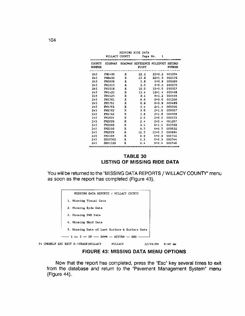
104
MISSING RIDE DATA WILLACY COUNTY Page No. l
-==·--=- -- = -== COUNTY HIGHWAY ROADWAY REFERENCE MILEPOST RECORD NUMBER POINT NUMBER
------------------------------------------~---------245 FM0490 R 22.2 22+0.2 001204 245 FM0490 R 23.9 22+1.9 000135 245 FM0606 R 0.8 0+0.0 000260 245 FM1015 R 2.0 2+0.0 000270 245 FM1018 R 10.0 10+0.0 000327 245 FM1420 R 13.4 12+1. 4 000408 245 FM1425 R 9.1 8+1.2 000454 245 FM1761 R 6.6 6+0.6 001206 245 FM1761 R 6.9 6+0.9 000489 245 FM1762 R 3.4 2+1.4 000506 245 FM1762 R 3.6 2+1.6 000507 245 FM1762 R 3.8 2+1.8 000508 245 FM1834 R 2.0 2+0.0 000533 245 FM2099 R 2.4 2+0.4 001207 245 FM2099 R 9.4 8+1. 4 000599 245 FM2209 R 6.5 6+0.5 000632 245 FM2629 R 12.5 12+0.5 000684 245 FM3168 R 0.9 0+0.9 000742 245 SH0056S R 0.3 0+0.3 000744 245 SH0112S R 0.4 0+0.4 000746
~~--====--:==~--------~==--==--====
TABLE 30 LIS1"1NG OF MISSING RIDE DATA
You will be returned to the "MISSING DATA REPORTS/ WILLACY COUNTY" menu as soon as the report has completed (Figure 43).
MISSING DATA REPORTS I WILLACY COUNTY
l. Missing Visual Data
2. Missing Ride Data
3. Missing FWD Data
4. Missing Skid Data
5. Missing Date of Last Surface & Surface Data
l to 5 - UP - DOWN RETURN - END
F4 CMDHELP ESC EXIT D:\DEASE\WILLACY WILLACY 12/04/89 8:40 am
FIGURE 43: MISSING DATA MENU OPTIONS
Now that the report has completed, press the "Esc" key several times to exit from the database and return to the "Pavement Management System" menu (Figure 44) ..

105
Pavement Management System
MENU 2 OF 2 -> 1 - Willacy County (245)
2 Zapata County (253)
3 - Process Raw Skid Data
4 - Tape Backup
5 - Optimize Hard Disk
6 - Disk Operating System
: December 4, 1989 8:37:23 am NUM Memory: 640 K
FIGURE 44: PMS MAIN MENU OPTIONS
If you are not satisfied with the results of the missing ride data report, use the report as a guide in collecting the missing sections. Then, you must go through the conversion and import processes discussed earlier to finalize the completeness of the ride data. If you are completely satisfied with the completeness of the ride data, proceed with the next section.
5.6 SIOMETER DATA: FINAL TRANSFER TO THE 0.1 MASTER FILE
When it is verified that all of the ride data has been completely collected for the given year in a particular county, the data must be transferred from the Ride data form to the Master data form for reporting purposes. This process is accomplished by first selecting the particular county. In this example we will use Willacy county. To do this, use the arrow keys on the keyboard to point to the item "1 - Willacy County (245)" (only in this example) and press the "Enter" key, or press the "1" key. This option for "Willacy County (245)" is selected as shown in Figure 45.

106
Pavement Management System
MENU 2 OF 2 -> l - Willac1 Count1 ~2452
2 - Zapata County (253)
3 Process Raw Skid Data
4 - Tape Backup
5 - Optimize Hard Disk
6 - Disk Operating System
December 4, 1989 8:37:23 am NUM Memory: 640 K
FIGURE 45: PMS SELECT COUNTY MENU
You are then prompted for your name and security password. In the following example, (Figure 46), the sign-on name is "DATA", and the security password is "ENTRY".
D A T A E A S E - S I G N 0 N
Directory: O:\DEASEIWILLACY
What is the database name?: WILLACY
What is your name
What is your security password : __
F4 CMDHELP ESC EXIT D:\DEASE\WILLACY WILLACY 12/04/89 8:40 am
FIGURE 46: PMS SIGN-ON MENU
The "PAVEMENT MANAGEMENT SYSTEM/ WILLACY COUNTY" menu should appear on your screen. Select "4. Data Handling -- District Field Data" by pressing the "4" key, or use the arrow keys to highlight the selection and press the "Enter" key (Figure 47).

107
PAVEMENT MANAGEMENT SYSTEM I WILLACY COUNTY
1. Setup
2. Data Entry -- District Field Data
3. Data Entry -- Import PES Data
4. Data Handling -- District Field Data
5. Data Handling -- Imported PES Data
6. Reports
7. Year End
l to 7 - UP - DOWN - RETURN - END
F4 CMDHELP ESC EXIT D:\DEASE\WILLACY WILLACY 12/04/89 8:40 am
FIGURE 47: DATA HANDLING MENU
The next menu (Figure 48) is the "DATA HANDLING -- DISTRICT FIELD DATA /WILLACY COUNTY" menu. Select option "2. Ride Data" by pressing the "2" key, or use the arrow keys to highlight the selection and press the "Enter" key.
DATA HANDLING DISTRICT FIELD DATA I WILLACY COUNTY
1. Visual Data
2. Ride Data
3. FWD Data
4. Skid data
5. Date of Last Surface
6. Roadway Characteristics
~-- 1 to 6 - UP - DOWN - RETURN - END --~
F4 CMDHELP ESC EXIT D:\DEASE\WILLACY WILLACY 12/04/89 8:40 am
FIGURE 48: DATA HANDLING - RIDE DATA MENU OP1"10N
The next screen {Figure 49) that appears is "RIDE DATA HANDLING/ WILLACY COUNTY" with two selections. Make certain that the printer is on and select "1. Verify Validity of Ride Data" by pressing the "1" key, or use the arrow keys to highlight the selection and press the "Enter" key. This process checks for valid dates and ride values. When errors are encountered, they are listed to the printer.

108
RIDE DATA HANDLING I WILLACY COUNTY
1. Verify Validity of Ride Data
L' 2. Transfer Ride Data to Master Data Form
1 to 2 - UP - DOWN - RETURN - END
F4 CMDHELP ESC EXIT D:\DEASE\WILLACY WILLACY 12/04/89 8:40 am
FIGURE 49: RIDE DATA HANDLING - VERIFY RIDE DATA
If any errors were encountered, they must be corrected before proceeding to the next step. The type of errors that can occur are that of missing date of collection or ride values less than 0.1.
If no errors were encountered, select the "2. Transfer Ride Data to Master Data Form" option (Figure 50) by pressing the "2" key, or use the arrow keys to highlight the selection and press the "Enter key.
RIDE DATA HANDLING I WILLACY COUNTY
1. Verify Validity of Ride Data
2. Transfer Ride Data to Master Data Form
1 to 2 - UP DOWN - RETURN - END
F4 CMDHELP ESC EXIT D:\DEASE\WILLACY WILLACY 12/04/89 8:40 am
FIGURE 50: TRANSFER RIDE DATA TO MASTER FILE MENU OP1"10N
This process transfers all of the ride data from the Ride data form (0.2 mile records) to the equivalent Master data form (0.1 mile records). This procedure "matches" the existing 0.2 mile siometer records in the SIOMETER DATA FILE to an equivalent record in the MASTER file.
As soon as the update procedure has completed, you will be returned to the "RIDE DATA HANDLING /WILLACY COUNTY" menu (Figure 51).
RIDE DATA HANDLING f WILLACY COUNTY
1. Verify Validity of Ride Data
2. Transfer Ride Data to Master Data Form
1 to 2 UP ~ DOWN - RETURN END
F4 CMDHELP ESC EXIT D:\DEASE\WILLACY WILLACY 12/04/89 8:40 am
FIGURE 51: RIDE DATA HANDLING MENU

109
Press the "Esc" key several times to return to the "Pavement Management System" menu as illistrated in Figure 52.
Pavement Management System
MENU 2 OF 2 -> l - Willacy County (245)
2 - Zapata County (253)
3 - Process Raw Skid Data
4 - Tape Backup
5 - Optimize Hard Disk
6 - Disk Operating System
December 4 1989 8;37:23 am NUM Memory: 640 K
FIGURE 52: PMS MAIN MENU
This concludes the Slometer data input process.

110
6.0 SKID DATA COLLECTION- HANSEN METHOD
(This section was written under the direction of Mr. Craig Cox, D-18PM, Austin.)
Data collection using the Hansen method will use integer or whole reference points as a basis for location, which will be cross-referenced with mileposts or reference markers that are located along the highways. The existing skid test equipment along with the automated method of data collection, which was established under the SKIDR system, will be used.
6.1 SKID DATA COLLECTION EQUIPMENT
The skid resistance data collection equipment is basically a two-wheeled skid test trailer conforming to ASTM E274. The instrumentation includes a skid number calculator, coupler scanner, distance measuring instrument, velocity measuring instrument and a data recorder which is a teletype or Tl-733 data terminal.
6.2 SKID DATA INSERTION WHILE TESTING
The data to be collected by the skid test unit have been subdivided into five categories as follows:
Category 1 - Termed "A" Data Item.
Category 2 - Termed "81" Data Item.
Category 3 - Termed "C Whole Reference Point" Data Item.
Category 4 - Termed "82" Data Item.
Category 5 - Termed "C Skid" Data Item.
6.3 SKID "A" DATA ITEM
Figure 53 shows the format and an example of an "A" data item. The "A" data item will be manually typed in on the teletype or Tl-733 keyboard. In a given district, the "A" data should not change except on different days--or more particularly as the temperature changes. All numbers should be right justified and contain zeros where blank spaces normally occur.

Card column DATA
1234567 A214010
1 1 1 1 1 8901 23 4 118809 5
Card Identifier District Number
Truck Number Month Day Year Temperature
- col. 1 - col. 2-3 - col. 4-5 - col. 6-7 - col. 8-9 - col. 10-11 - col. 12-14
FIGURE 53: SKID 11A11 DATA ITEM RECORD FORMAT
6.4 SKID "81 11 DATA ITEM (Highway Location)
111
The "B 1" data item format shown in Figure 54 includes the highway system and number, the county number and a frontage road designator. Table 31 shows the numbers used to denote the highway system used to denote the counties. When testing on frontage roads of highways, code a "1" in the frontage road designator, and when testing on the main lanes of highways, code a "O" in the frontage road designator.
The "81" data item is input by the observer using the thumb wheel on the observer console. When the desired digits are dialed on the thumb wheels, the data is inserted (or recorded) by depressing the "B" data buttons on the observer console. Note the activation of the "B" data buttons clears and resets the distance counters. Therefore, activation of the "B" data item should be accomplished only at a desired roadway location.
The "B 1" data item indicates begin testing but not necessarily at a whole reference point. A "C, comm. 7" and "82" data types must follow (in order) at some point in the data stream to identify a whole reference point.
112
1 1 1 1 1 Card Columns: 1 2 3 4 5 6 7 8 9 0 1 2 3 4 Data: B 1 1 4 0 1 0 1 1 8 8 7 5
Card Identifier - col. 1 (8) Format Identifier - col. 2 (1) Highway System - col. 3-4 (14) Highway Number - col. 5-8 (01) County Number - col. 9-11 (188) Frontage Road Designator - col. 12 (7) Not Used - col. 14 (blank)
FIGURE 54: SKID 11B11 DATA ITEM FORMAT
01 U.S. Highway10 U.S. Highway Spur 02 State Highway11 Recreational Road 03 State Loop or Spur12 Recreational Road Spur 04 Park Road 05 Farm or Ranch to Market 06 U.S. Alternate 07 State Alternate or Temporary Route 08 Interstate Highway 09 Farm or Ranch to Market Spur
TABLE 31 SKID HIGHWAY SYSTEM DESIGNATION CODES
The business routes are designated as State loops or spurs, even though they may be signed as U.S. business routes. Therefore, all business routes are coded with a 03. There are also some unusual special codes for a few "unusual" highway names, but none of these are in District 21 (see Table 32).
SHOOSR - will be coded 020999 SHNASA - will be coded 029999 I H0035E - will be coded 080353 IH0035W - will be coded 080354
TABLE 32 SPECIAL SKID HIGHWAY CODES
113
6.5 SKID "C WHOLE REFERENCE POINT1 DATA ITEM (Skid Data)
"C Whole Reference Point" data item has a format that is shown in Figure 55. The "C Whole Reference Point" data item always has a "7" in the comment column. The "C Whole Reference Poinr data item is always inserted (recorded) by depressing the "C" data button on the observer console. The reason for inserting a "C Whole Reference Point" data item, with a "7" in the comments, is to set a flag or check in order for the software program to expect a "82" data item, which will immediately follow the "C Whole Reference Point" data item. Normally "C Whole Reference Point" data items will contain a zero skid number and a zero velocity. However, the distance and lane items may contain varying data, depending on conditions. All possible lane designations and codes are identified below.
Record Columns: 1 2 3 4 5 6 7 8 9 0 1 2 3 4 Data Value: c 0 0 0 0 0 0 3 0 7
Gard Identifier - col. 1 (C) Skid Number - col. 2-3 (00) Blank - col. 4 (blank) Velocity - col. 5-6 (00-usually near 40) Blank - col. 7 (blank) Distance (in tenths) - col. 8-10 (00.3) Blank - col. 11 (blank) Lane - col. 12 (O=L or X) Comment - col. 13 (7=32 card next)
FIGURE 55: SKID "C" DATA ITEM FORMAT
The associated skid lane designation codes are shown in Table 33.
Frontage Main Main Road Lanes Lanes
Frontage Road
Designation X-Y-Z L-M-N-0-P V-U-T-S-R C-B-A
CODE 0-1-2 0-1-2-3-4 5-6-7-8-9 7-8-9
Direction of Increasing Mileposts:
TABLE 33 SKID LANE DESIGNATIONS AND CODES

114
6.6 SKID "82" DATA ITEM (Milepost Location)
"82" data item immediately follows the insertion of "C Whole Reference Point" data item. The format for the "82" data item is identified below. The "82" data item is inserted through the use of the same thumb wheels used to record the "81" data item. In fact, the Highway System and Highway Number used on the "81" data item should be left in place for use on the "82" data item. A "2" is dialed on the thumb wheel to the far left and, the whole reference point number replaces the county number previously used in the "81" data item. If desired, the frontage road designator number used in the "81" data may be left in place. The "82" data item is recorded by depressing the "8" data item button on the observer console (Figure 56).
1 1 1 1 1 1 2 3 4 5 6 7 8 9 0 1 2 3 4
B 2 0 1 0 0 7 7 0 0 1 0 x x
Card Identifier - col. 1 Format Identifier - col. 2 Highway System - col. 3-4 Highway Number - col. 5-8 Whole Reference Point - col. 9-11 Frontage Road Designator - col. 12 Not Used - col. 13-14
(B) (2) (Ol=US) (0077) (002) (0 = No) (blank)
FIGURE 56: 82 DATA ITEM RECORDING FORMAT
6.7 SKID "C Skid" DATA ITEM
The format of the "C Skid" data item is shown below and is the same as that used in the SKIDR system. The observer has little control over the recording of the "C Skid" data, since this data is automatically recorded after each skid. The observer does have control over the lane designation number and comments. The lane numbers and designation are listed above. The lane numbers also give direction of travel. The lane numbers O thru 4 are opposite the direction of increasing mileposts, and the numbers 5 thru 9 are with the direction of increasing mileposts.
115
The comment codes are shown in Figure 57. Note comment "7" is termed "Reference Point Designator". The remaining comments are similar to that used in the SKIDR system. Note that a comment "9" will cause the last "C Skid" data item to be deleted, and two successive comment "9"s will cause an entire series of data to be deleted, back to and including the previous "81" data item.
Top Row = Record Column: Bottom Row = Data Value(s)
1
c 2 3 4
3 7
Card Identifier Skid Number Blank Velocity Blank
5
3
Distance (in tenths) Blank Lane Comment Not Used
6 7 8
2 0
- col. 1 - col. 2-3 - col. 4 - col. 5-6 - col. 7 - col. 8-10 - col. 11 - col. 12 - col. 13 - col. 14
9
0
(C) (37) (blank) (32 mph) (blank) (00.0) (blank) (0= L)"' (0) (blank)
10 11
0
12 13 14
0 0
Note:~ "O" is Lane 'L" here since previous 82 card indicates that testing is on main lanes (Frontage Road Designator, Col. 12, is "O" =No)
Skid Comment Codes
O - No Comment 1 - Flushed Surface 2 - Patched Surface 3 - Intersection 4 - Structure 5 - Railroad Crossing 6 - Curve 7 - Reference Point Designator 8 - District Selected {User defined) 9 - Disregard Last Skid
FIGURE 57: SKID DATA "C" FORMAT AND CODES
116
6.8 SKID CASSETTE TAPE HANDLING
1. The beginning of each day's data should contain an identification number, which is input on the keyboard. This identification number will consist of the following items and format(Figure 58):
Record Column 1 2 3 4 5 6 2 1 1 0 8 8
District Month Year
- col. 1-2 (21) - col. 3-4 (10) - col. 5-6 (88)
FIGURE 58: SKID TAPE RECORD FORMAT
The identification number is right justified with leading zeros.
2. The characters EOT and the End of Tape Symbol should be put on the cassette at the end of each day's data or at the end of the data recording on each side of a cassette.
3. The cassettes should be duplicated before mailing the original to the Division of Maintenance and Operations , Pavement Management Section (D-18PM) for processing. The duplicated cassette will be held in the District until the District is assured of having correct data. The duplicate ensures a backup.
4. Cassettes should have external labels on each side in the following manner:
(a) Labeled side A or side 8.
(b) All identification numbers recorded on side A should be listed on the external label on side A. A similar procedure should be used for side 8.
(c) Number of EOTs on each side.

(An example follows)
Example: Side A 210988
1 EOT
Side B 210988 211088
2 EOTs
5. Do not put data from more than one District on a cassette.
Figure 59 illustrates a typical beginning-of-day tape format.
Example Skid Data
211088 A2140101188075 810100770660 C52 39 000 00 C51 38 002 00 coo 00 003 07 820100770020 C44 41 000 00 C39 41 002 00 C28 41 004 00 C32 39 006 08
-- identification Number -- "A" Data Item -- "81" Data Item -- "C" Skid Data Item
-- "C Whole Reference Point Data Item -- "82" Data Item
-- "C" Skid Data Item with User Defined Comment
FIGURE 59: EXAMPLE SKID DATA TAPE FORMAT
6.9 SKID DATA CONVERSION
117
The skid data processing, done by D-18PM, transfers the skid data, in its original format, to a floppy diskette. After the skid data has been transferred, D-18PM sends the District the skid data on the floppy diskette. The collected skid data must now be validated and converted into a format that the Pavement Management System (PMS) database can input.
The validation and conversion of the skid data is done through an iterative process selected from the "Pavement Management System" main menu (Figure 60), labeled
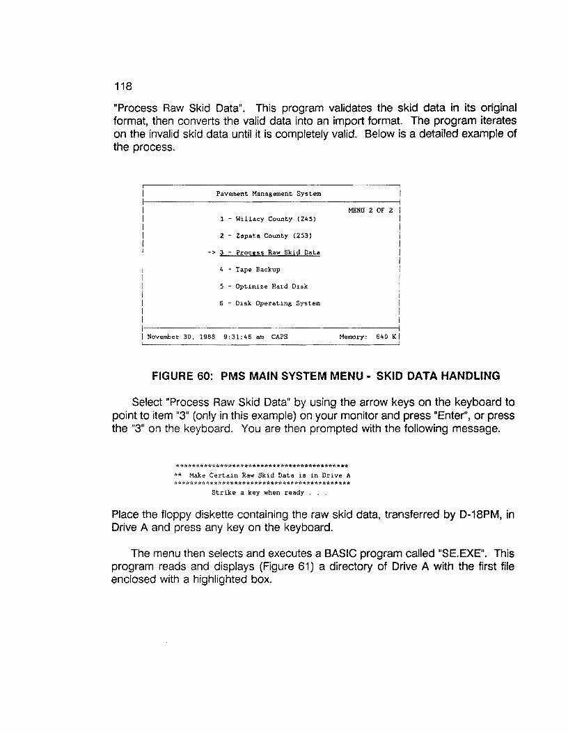
118
"Process Raw Skid Data". This program validates the skid data in its original format, then converts the valid data into an import format. The program iterates on the invalid skid data until it is completely valid. Below is a detailed example of the process.
MENU 2 OF 2 1 - Willacy County (245)
2 - Zapata County (253)
-> 3 - Process Raw Skid Data
4 - Tape Backup
5 - Optimize Hard Disk
6 - Disk Operating System
November 30, 1988 9:31:46 am CAPS Memory: 640 KI
FIGURE 60: PMS MAIN SYSTEM MENU· SKID DATA HANDLING
Select "Process Raw Skid Data" by using the arrow keys on the keyboard to point to item "3" (only in this example) on your monitor and press "Enter", or press the "3" on the keyboard. You are then prompted with the following message.
******************************************* ** Make Certain Raw Skid Data is in Drive A ********************************************
Strike a key when ready . . .
Place the floppy diskette containing the raw skid data, transferred by D-18PM. in Drive A and press any key on the keyboard.
The menu then selects and executes a BASIC program called "SE.EXE". This program reads and displays (Figure 61) a directory of Drive A with the first file enclosed with a highlighted box.
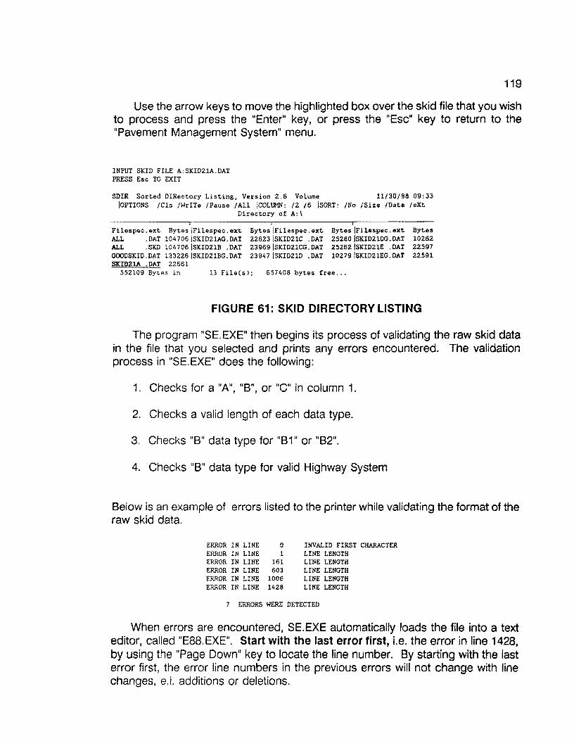
119
Use the arrow keys to move the highlighted box over the skid file that you wish to process and press the "Enter" key, or press the "Esc" key to return to the "Pavement Management System" menu.
INPUT SKID FILE A:SKID21A.DAT PRESS Esc TO EXIT
SDIR Sorted D!Rectory Listing, Version 2.6 Volume 11/30/88 09:33 !OPTIONS /Cls /WrITe /Pause /All !COLUMN: /2 /6 ISORT: /No /Size /Date /eXt
Directory of A:\
Filespec.ext Bytes IFilespec.ext Bytes IFilespec.ext Bytes IFilespec.ext Bytes ALL .DAT 104706ISKID21AG.DAT 22623 ISKID21C .DAT 25280ISKID21DG.DAT 10262 ALL .SKD 104706 ISKID21B .DAT 23969ISKID21CG.DAT 25262ISKID21E .DAT 22597 GOODSKID.DAT 133226JSKID21BG.DAT 23947 ISKID21D .DAT 10279ISKID21EG.DAT 22591 SKID21A .DAT 22661
552109 Bytes in 13 File(s); 657408 bytes free ...
FIGURE 61: SKID DIRECTORY LISTING
The program "SE.EXE" then begins its process of validating the raw skid data in the file that you selected and prints any errors encountered. The validation process in "SE.EXE" does the following:
1. Checks for a "A", "B", or "C" in column 1.
2. Checks a valid length of each data type.
3. Checks "B" data type for "81" or "82".
4. Checks "8" data type for valid Highway System
Below is an example of errors listed to the printer while validating the format of the raw skid data.
ERROR IN LINE 0 INVALID FIRST CHARACTER ERROR IN LINE l LINE LENGTH ERROR IN LINE 161 LINE LENGTH ERROR IN LINE 603 LINE LENGTH ERROR IN LINE 1006 LINE LENGTH ERROR IN LINE 1428 LINE LENGTH
7 ERRORS WERE DETECTED
When errors are encountered, SE.EXE automatically loads the file into a text editor, called "E88. EXE". Start with the last error first, i.e. the error in line 1428, by using the "Page Down" key to locate the line number. By starting with the last error first, the error line numbers in the previous errors will not change with line changes, e.i. additions or deletions.
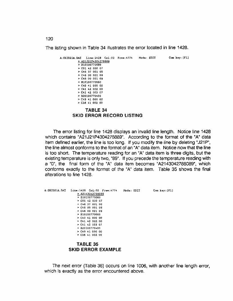
120
The listing shown in Table 34 illustrates the error located in line 1428.
A:SKID21A.DAT Line:l428 Col:02 Free:4774 Mode: EDIT Com key: [Fl] > A21J21P4304278669 > Bl0100770660 > COl 42 000 07 > C46 37 001 00 > C46 00 001 09 > C46 00 001 09 > Bl0100770660 > C40 41 000 00 > C41 42 002 00 > C41 42 003 07 > B20100770400 > C49 41 000 00 > C36 41 002 00
TABLE 34 SKID ERROR RECORD LISTING
The error listing for line 1428 displays an invalid line length. Notice line 1428 which contains "A21J21 P4304278889". According to the format of the "A" data item defined earlier, the line is too long. If you modify the line by deleting "J21 P", the line almost conforms to the format of an "A" data item. Notice now that the line is too short. The temperature reading for an "A" data item is three digits, but the existing temperature is only two, "89". If you precede the temperature reading with a "O", the final form of the "A" data item becomes "A2143042788089", which conforms exactly to the format of the "A" data item. Table 35 shows the final alterations to line 1428.
A:SKID21A.DAT Line:l426 Col:02 Free:4774 Mode: EDIT Com key: [Fl] > A2143042788089 > Bl0100770660 > C01 42 000 07 > C46 37 001 00 > C46 00 001 09 > C46 00 001 09 > B10100770660 > C40 41 000 00 > C41 42 002 00 > C41 42 003 07 > B20100770400 > C49 41 000 00 > C38 41 002 00
TABLE 35 SKID ERROR EXAMPLE
The next error (Table 36) occurs on line 1006, with another line length error, which is exactly as the error encountered above.
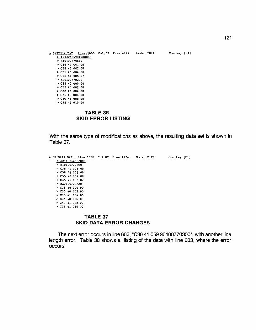
121
A:SKID21A.DAT Line:l006 Col:02 Free:4774 Mode: EDIT Com key: [Fl] > A21J21P4304208886 > Bl0100770660 > C36 41 001 00 > C38 41 002 00 > C35 40 004 00 > C35 41 005 07 > B20100770220 > C38 40 000 00 > C35 40 002 00 > C38 41 004 00 > C35 40 006 00 > C49 41 008 00 > C38 41 010 00
TABLE 36 SKID ERROR LISTING
With the same type of modifications as above, the resulting data set is shown in Table 37.
A:SKID21A.DAT Line:l006 Col:02 Free:4774 > A2143042088086 > B10100770660 > C36 41 001 00 > C38 41 002 00 > C35 40 004 00 > C35 41 005 07 > B20100770220 > C38 40 000 00 > C35 40 002 00 > C38 41 004 00 > C35 40 006 00 > C49 41 008 00 > C38 41 010 00
TABLE 37
Mode: EDIT
SKID DATA ERROR CHANGES
Com key: [Fl]
The next error occurs in line 603, "C36 41 059 90100770300", with another line length error. Table 38 shows a listing of the data with line 603, where the error occurs.

122
A:SKID21A.DAI Line:603 Col:02 Free:4774 Mode: EDIT Com key: [Fl] > C36 41 059 90100770300 > C36 41 000 97 > B20100770300 > C38 40 000 90 > C32 40 004 96 > C27 40 006 96 > C28 41 008 96 > C30 40 010 90 > C32 40 012 90 > C35 40 014 90 > C33 40 016 90 > CJO 41 018 90 > C28 40 020 90
TABLE 38 SKID DATA ERROR CORRECTION
Line 603 appears to be two lines in one, with "C36 41 059 90" being one line and "0100770300" being the other. However, there is no data type identification for the concatenation of the additional line. With further investigation, the additional part of line 603, "0100770300", appears to have a format of a "B" data item. Now, another problem arises. Is the "B" data item a "81" or a "82"? If you look further down the data set, you will see that there is a "82" data item, "820100770300", preceded by a "C" data item, "C36 4100097", with a comment "7", and line 603's "C" data item, "C36 41 059 90", does not have a comment "7". Therefore the additional part of line 603, "0100770300", must be a "81" data item.
After you break line 603 into two lines and make the alterations, the modified data set should look like the one below (Table 39).
A:SKID21A.DAT Line:603 Col:02 Free:4773 Mode: EDIT Com key: [Fll > C36 41 059 90 > Bl0100770300 > C36 41 000 97 > 1320100770300 > C38 40 000 90 > C32 40 004 96 > C27 40 006 96 > C28 41 008 96 > C30 40 010 90 > C32 40 012 90 > C35 40 014 90 > CJJ 40 016 90 > C30 41 018 90
TABLE 39 MODIFIED SKID ERRORS
Another error occurs in line 161, "C44 40 096 OC50 40 098 00", which is similar to the last error. Again, the error is another line length problem. The error is shown in Table 42. Note: Tables 40 and 41 have been omitted from this report for technical reasons. Also, the succeding page (page 123) does not apply to this report.

123
TABLE 40 SKID ERROR CORRECTION
line 161, "G44 40 096 OG50 40 098 00", appears to be t\vo "G" data types in one, with the first "G" data type being "G44 40 096 O" and the second "G50 40 098 00". The only item missing is tho eommont eode in tho first "G" data type, "G44 40 096 O". If vt'e assume that there was no comment, "O", we can correct this error by adding a "O" after the first part of line 161.
If you encounter an error that appears to be t\•10 lines of data concatenated together and one or both of the lines are missing identifying traits or data, delete the line or lines in question. When you divide line 161 and mal<e the modifications, the data set should appear as shown in Table 41.
TABLE 41 MODIFIED SKID DATA
The lasttwo errors appear in lines 0, "210288", and 1, "A21J21P4:304188882". The data set, with these errors, is shov1·n in Table 42.
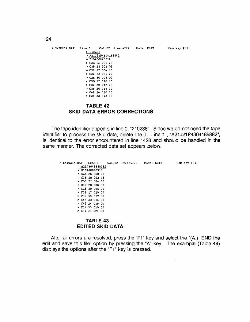
124
A:SKIDZlA.DAT Line:O Col:OZ Free:4772 Mode: EDIT > 210288 > A21J21P4304188882 > B10200040310 > C36 26 000 00 > C36 28 002 03 > C30 27 004 00 > C30 28 006 00 > C26 30 008 00 > C38 17 010 00 > C32 30 012 00 > C36 29 014 00 > C42 24 016 00 > C34 33 018 00
TABLE 42 SKID DATA ERROR CORRECTIONS
Com key: [Fl]
The tape identifier appears in line O, "210288". Since we do not need the tape identifier to process the skid data, delete line 0. Line 1 , "A21 J21 P4304188882", is identical to the error encountered in line 1428 and should be handled in the same manner. The corrected data set appears below.
A:SKID21A.DAT Line:O Col:02 Free:4773 Mode: EDIT > A2143041888082 > B10200040310 > C36 26 000 00 > C36 28 002 03 > C30 27 004 00 > C30 28 006 00 > C26 30 008 00 > C38 17 010 00 > C32 30 012 00 > C46 29 014 00 > C42 24 016 00 > C34 33 018 00 > C34 33 020 00
TABLE 43 EDITED SKID DATA
Com key: [Fl J
After all errors are resolved, press the "F1" key and select the "(A.) END the edit and save this file" option by pressing the "A" key. The example [fable 44) displays the options after the "F1" key is pressed.
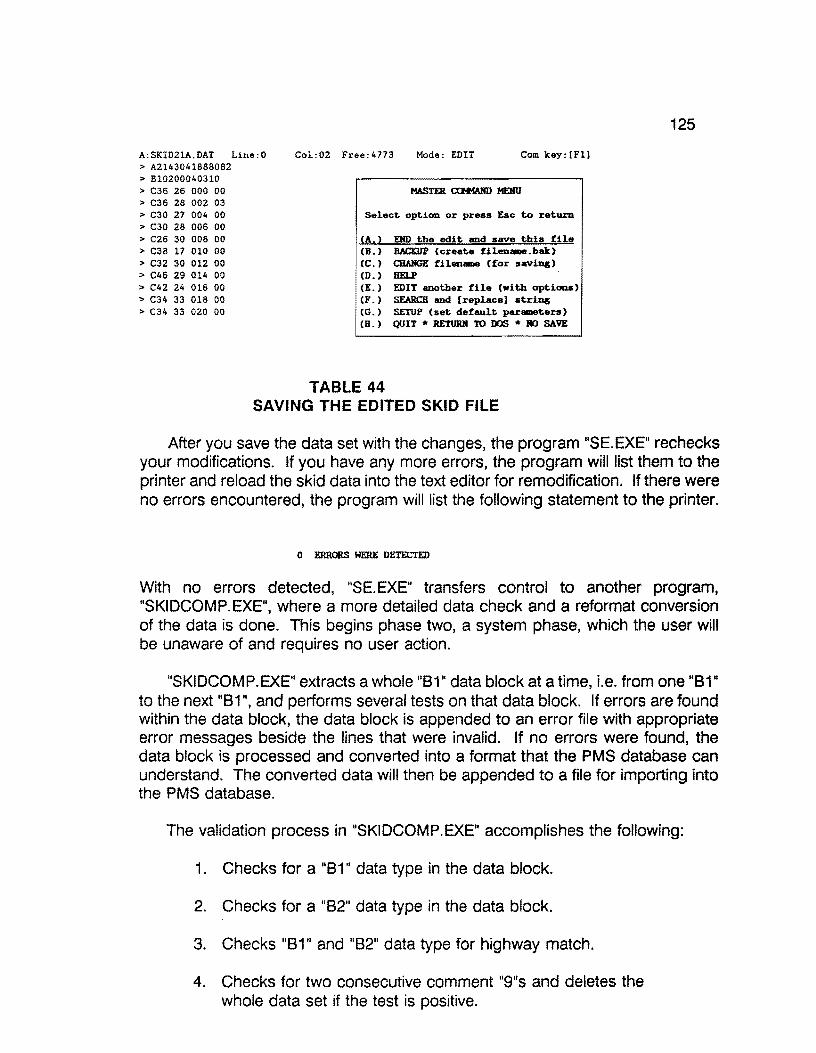
A:SKID21A.DAT Line:O > A2143041888082 > B10200040310 > C36 26 000 00 > C36 28 002 03 > C30 27 004 00 > C30 28 006 00 > C26 30 008 00 > C38 17 010 00 > C32 30 012 00 > C46 29 014 00 > C42 24 016 00 > C34 33 018 00 > C34 33 020 00
Col:02 Free:4773 Mode: EDIT Com key: (Fll
Select option or press Eac to return
CA.> END the edit and save this file (B.) BACKUP (create filen-.bak) (C.) CBAllGE filen- {for saving) CD.) HELP (E.) EDIT another file (with optiona) CF.) SEARCH and {replace] string (G.) SETUP (set default parameters) CB. ) QUIT * RETURJI to DOS * BO SAVE
TABLE 44 SAVING THE EDITED SKID FILE
125
After you save the data set with the changes, the program "SE.EXE" rechecks your modifications. If you have any more errors, the program will list them to the printer and reload the skid data into the text editor for remodification. If there were no errors encountered, the program will list the following statement to the printer.
0 ERRORS WERE DETECTED
With no errors detected, "SE.EXE" transfers control to another program, "SKIDCOMP.EXE", where a more detailed data check and a reformat conversion of the data is done. This begins phase two, a system phase, which the user will be unaware of and requires no user action.
"SKIDCOMP.EXE" extracts a whole "B1" data block at a time, i.e. from one "B1" to the next "B1", and performs several tests on that data block. If errors are found within the data block, the data block is appended to an error file with appropriate error messages beside the lines that were invalid. If no errors were found, the data block is processed and converted into a format that the PMS database can understand. The converted data will then be appended to a file for importing into the PMS database.
The validation process in "SKIDCOMP.EXE" accomplishes the following:
1. Checks for a "B 1" data type in the data block.
2. Checks for a "B2" data type in the data block.
3. Checks "B1" and "82" data type for highway match.
4. Checks for two consecutive comment "9"s and deletes the whole data set if the test is positive.
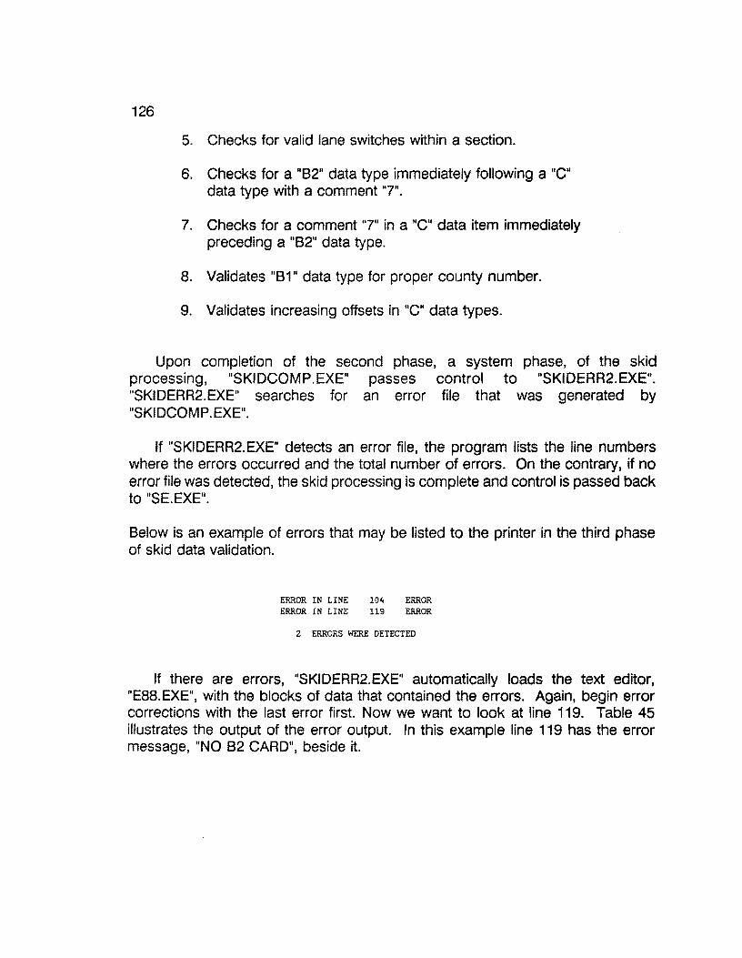
126
5. Checks for valid lane switches within a section.
6. Checks for a "82" data type immediately following a "C" data type with a comment "7".
7. Checks for a comment "7" in a "C" data item immediately preceding a "82" data type.
8. Validates "81" data type for proper county number.
9. Validates increasing offsets in "C" data types.
Upon completion of the second phase, a system phase, of the skid processing, "SKIDCOMP.EXE" passes control to "SKIDERR2.EXE". "SKIDERR2.EXE" searches for an error file that was generated by "SKIDCOMP.EXE".
If "SKIDERR2.EXE" detects an error file, the program lists the line numbers where the errors occurred and the total number of errors. On the contrary, if no error file was detected, the skid processing is complete and control is passed back to "SE.EXE".
Below is an example of errors that may be listed to the printer in the third phase of skid data validation.
ERROR IN LINE 104 ERROR ERROR IN LINE 119 ERROR
2 ERRORS WERE DETECTED
If there are errors, "SKIDERR2.EXE" automatically loads the text editor, "E88.EXE", with the blocks of data that contained the errors. Again, begin error corrections with the last error first. Now we want to look at line 119. Table 45 illustrates the output of the error output. In this example line 119 has the error message, "NO 82 CARD", beside it.
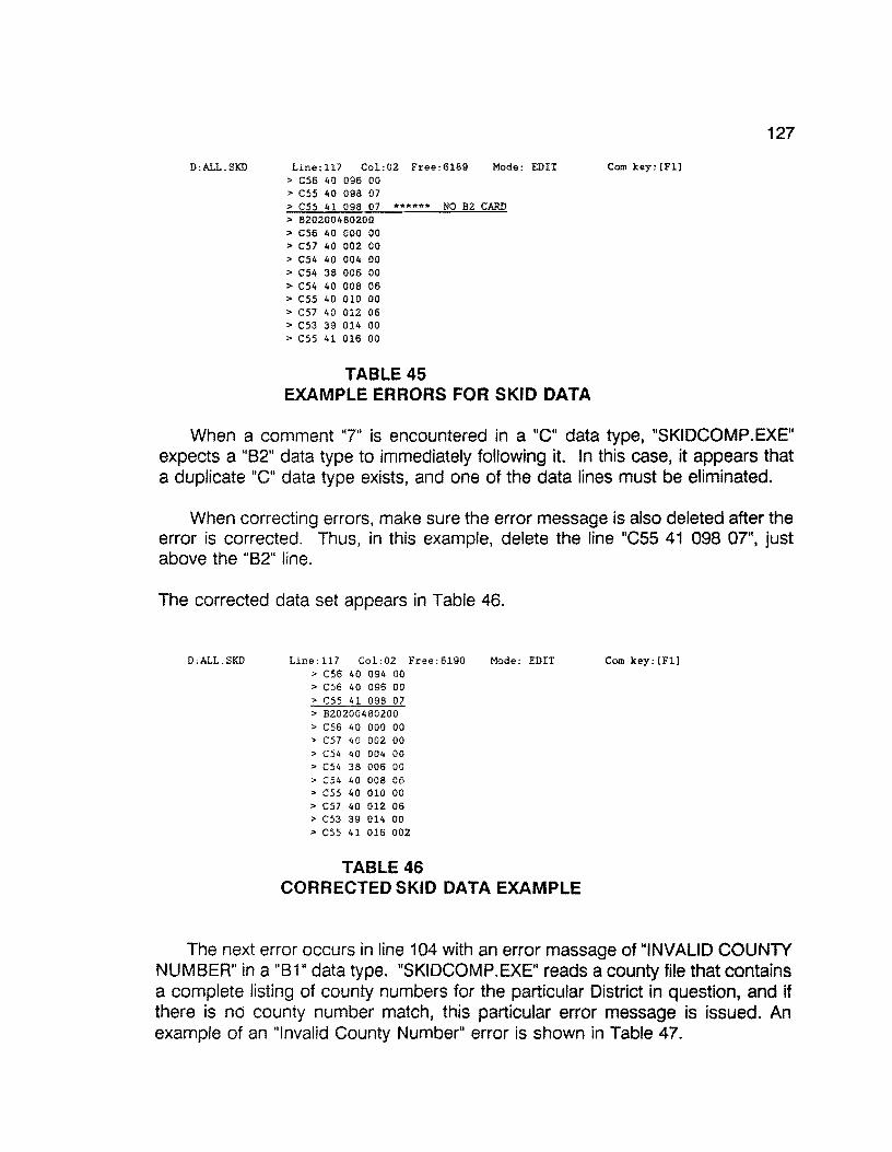
D:ALL.SKD Line:l17 Col:OZ Free:6189 Mode: EDIT > C56 40 096 00 > C55 40 096 07 > C55 41 098 07 ****** NO BZ CARD > 820200480200 > C56 40 000 00 > C57 40 002 00 > C54 40 004 00 > C54 36 006 00 > C54 40 008 06 > C55 40 010 00 > C57 40 012 06 > C53 39 014 00 > css 41 016 00
TABLE 45 EXAMPLE ERRORS FOR SKID DATA
127
Com key: [Fl]
When a comment "7" is encountered in a "C" data type, "SKIDCOMP.EXE" expects a "82" data type to immediately following it. In this case, it appears that a duplicate "C" data type exists, and one of the data lines must be eliminated.
When correcting errors, make sure the error message is also deleted after the error is corrected. Thus, in this example, delete the line "C55 41 098 07", just above the "82" line.
The corrected data set appears in Table 46.
D:ALL.SKD Line:ll7 Col:OZ Free:6190 Mode: EDIT Com key: [Fl] > C56 40 094 00 > C56 40 096 00 > C55 41 098 07 > B20200480200 > C56 40 000 00 > C57 40 002 00 > C54 40 004 00 > C54 38 006 00 > C54 t.O 008 06 > C55 40 010 00 > C57 40 012 06 > C53 39 014 00 > css 41 016 002
TABLE 46 CORRECTED SKID DATA EXAMPLE
The next error occurs in line 104 with an error massage of "INVALID COUNTY NUMBER" in a "B1" data type. "SKIDCOMP.EXE" reads a county file that contains a complete listing of county numbers for the particular District in question, and if there is no county number match, this particular error message is issued. An example of an "Invalid County Number" error is shown in Table 47.
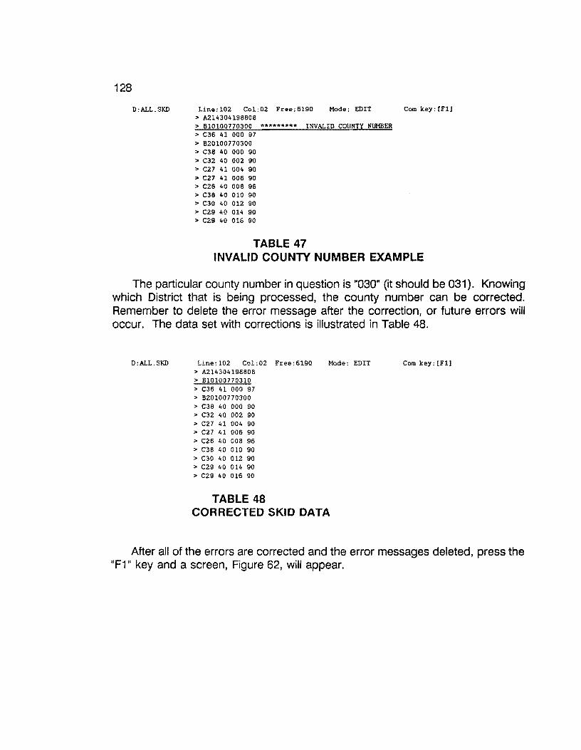
128
D:ALL.SKD Line:l02 Col:02 Free:6190 Mode: EDIT > A214304198808 > B10100770300 ********* INVALID COUNTY NUMBER > C36 41 000 97 > B20100770300 > C38 40 000 90 > C32 40 002 90 > C27 41 004 90 > C27 41 006 90 > C26 40 008 96 > C38 40 010 90 > C30 40 012 90 > C29 40 014 90 > C29 40 016 90
TABLE 47
Com key: [Fl]
INVALID COUNTY NUMBER EXAMPLE
The particular county number in question is "030" (it should be 031 ). Knowing which District that is being processed, the county number can be corrected. Remember to delete the error message after the correction, or future errors will occur. The data set with corrections is illustrated in Table 48.
D:ALL.SKD Line:l02 Col:02 Free:6190 Mode: EDIT > A214304198808 > Bl0100770310 > C36 41 000 97 > B20100770300 > C38 40 000 90 > C32 40 002 90 > C27 41 004 90 > C27 41 006 90 > C26 40 008 96 > C38 40 010 90 > C30 40 012 90 > C29 40 014 90 > C29 40 016 90
TABLE 48 CORRECTED SKID DATA
Com key: [Fl]
After all of the errors are corrected and the error messages deleted, press the "F1" key and a screen, Figure 62, will appear.
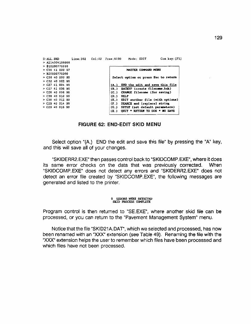
D:ALL.SKD > A214304198808 > B10100770310 > C36 41 000 97 > B20100770300 > C38 40 000 90 > C32 40 002 90 > C27 41 004 90 > C27 41 006 90 > C26 40 008 96 > C38 40 010 90 > C30 40 012 90 > C29 40 014 90 > C29 40 016 90
Line:l02 Col:02 Free:6190 Mode: EDIT Com key: [Fl]
Select option or press Esc to return
CA.) END the edit and save this file (B.) B.llCKUP (create filenane.bak) (C.) CHANGE filename (for saving) (D.) HELP (E.) EDIT another file (with options) (F.) SEARCH and [replace] string CG.) SETUP (set default paraneters) CU. ) QUIT * RETUR.K TO DOS * !IO SAVE
FIGURE 62: END-EDIT SKID MENU
129
Select option "{A.) END the edit and save this file" by pressing the "A" key, and this will save all of your changes.
"SKIDERR2.EXE" then passes control back to "SKIDCOMP.EXE", where it does its same error checks on the data that was previously corrected. When "SKIDCOMP.EXE" does not detect any errors and "SKIDERR2.EXE" does not detect an error file created by "SKIDCOMP.EXE", the following messages are generated and listed to the printer.
O ERRORS WERE DETECTED SKID PROCESS CGtPLETE
Program control is then returned to "SE. EXE", where another skid file can be processed, or you can return to the "Pavement Management System" menu.
Notice thatthe file "SKID21A.DAT", which we selected and processed, has now been renamed with an "XXX'' extension (see Table 49). Renaming the file with the "XXX" extension helps the user to remember which files have been processed and which files have not been processed.
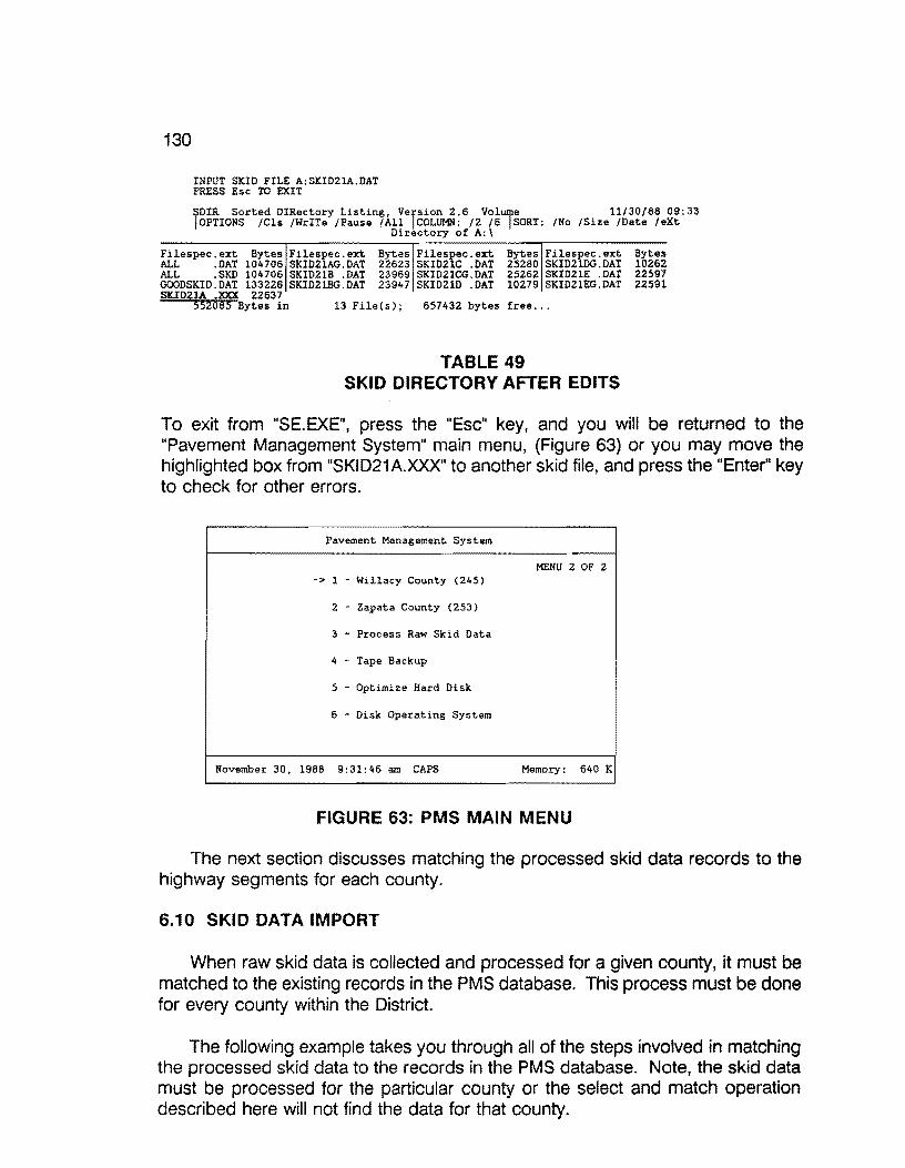
130
INPUT SKID FILE A:SKID21A.DAT PRESS Esc TO EXIT
~DIR Sorted DIRectory Listing, Vefsion 2.6 Volje 11/30/88 09:33 !OPTIONS /Cls /WrITe /Pause /All COLUMN: /2 /6 SORT: /No /Size /Date /eXt
Directory of A:\
Filespec.ext Bytes Filespec.ext Bytes Filespec.ext Bytes Filespec.ext Bytes ALL .DAT 104706 SKID21AG.DAT 22623 SKID21C .OAT 25280 SKID21DG.DAT 10262 ALL .SKD 104706 SKID21B .DAT 23969 SKID21CG.DAT 25262 SKID21E .DAT 22597 GCXJDSKID.DAT 133226 SKI021BG.DAT 23947 SKID210 .OAT 10279 SKID21EG.DAT 22591 SKID21A .XXX 22637
552085 Bytes in 13 File(s); 657432 bytes free ...
TABLE 49 SKID DIRECTORY AFTER EDITS
To exit from "SE.EXE", press the "Esc" key, and you will be returned to the "Pavement Management System" main menu, (Figure 63) or you may move the highlighted box from "SKID21A.XXX" to another skid file, and press the "Enter" key to check for other errors.
Pavement Management System
MENU 2 OF 2 -> 1 Willacy County (245)
2 Zapata County (253)
3 - Process Raw Skid Data
4 - Tape Backup
5 Optimize Hard Disk
6 - Disk Operating System
November 30, 1988 9:31:46 am CAPS Memory: 640 K
FIGURE 63: PMS MAIN MENU
The next section discusses matching the processed skid data records to the highway segments for each county.
6.10 SKID DATA IMPORT
When raw skid data is collected and processed for a given county, it must be matched to the existing records in the PMS database. This process must be done for every county within the District.
The following example takes you through all of the steps involved in matching the processed skid data to the records in the PMS database. Note, the skid data must be processed for the particular county or the select and match operation described here will not find the data for that county.
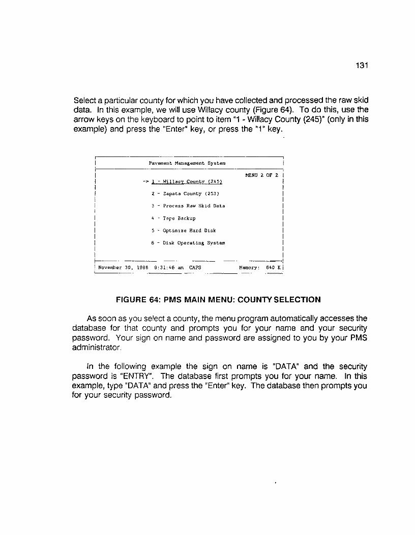
131
Select a particular county for which you have collected and processed the raw skid data. In this example, we will use Willacy county (Figure 64). To do this, use the arrow keys on the keyboard to point to item "1 - Willacy County (245)" (only in this example) and press the "Enter" key, or press the "1" key.
Pavement Management
MENU 2 OF 2 -> l - Willacy County (245)
Z - Zapata County (253)
3 - Process Raw Skid Data
4 - Tape Backup
5 - Optimize Hard Disk
6 Disk Operating System
November 1988 9:31:46 am CAPS 640 IC
FIGURE 64: PMS MAIN MENU: COUNTY SELECTION
As soon as you select a county, the menu program automatically accesses the database for that county and prompts you for your name and your security password. Your sign on name and password are assigned to you by your PMS administrator.
In the following example the sign on name is "DATA" and the security password is "ENTRY". The database first prompts you for your name. In this example, type "DATA" and press the "Enter" key. The database then prompts you for your security password.

132
Type "ENTRY" and press the "Enter" key. Notice the password you typed in does not appear on the screen (Figure 65).
D A T A E A S E - S I G N 0 N
Directory: D:\DEASE\WILLACY\
What is the database name?: Willacy
What is your name :~
What is your security password : __
F4 CMDHELP ESC EXIT D:\DEASEIWILLACY WILLACY 11/30/88 10:37 am
FIGURE 65: PMS SIGN-ON MENU
If everything was typed in correctly, the "PAVEMENT MANAGEMENT SYSTEM /WILLACY COUNTY" menu should appear on your screen with seven different categories to choose (Figure 66). Select "2. Data Entry -- District Field Data" by pressing the "2" key, or use the arrow keys to highlight the selection, and press the "Enter" key.
PAVEMENT MANAGEMENT SYSTEM I WILLACY COUNTY
1. Setup
2. Data Entry -- District Field Data
3. Data Entry -- Import PES Data
4. Data Handling -- District Field Data
5. Data Handling -- Imported PES Data
6. Reports
7. Year End
l to 7 UP - DOWN - RETURN - END ---'
F4 CMDHELP ESC EXIT D:\DEASE\WILLACY WILLACY 11/30/88 10:37 am
FIGURE 66: PMS DATA ENTRY· DISTRICT FIELD DATA MENU
The next menu (Figure 67) that appears on your screen is the "DATA ENTRY -- DISTRICT FIELD DATA/ WILLACY COUNTY". Since we want to enter skid data, select "4. Skid Data" by pressing the "4" key, or use the arrow keys to highlight the selection, and press the "Enter11 key.

2
133
DATA ENTRY -- DISTRICT FIELD DATA I WILLACY COUNTY
1. Input or Modify Visual Data
2. Input or Modify Ride Data
3. FWD Data
4, Skid Data
5. Create or Modify Date of Last Surface
6. Create or Modify Crossroads
7. Create or Modify District Counties Data
Create or Modify Roadway Characteristics I
1 to 8 - UP - DOWN - RETURN - END __J
F4 CMDHELP ESC EXIT D:\DEASE\WILLACY WILLACY 11/30/88 10:37 am
FIGURE 67: SKID DATA MENU SELECTION
The next menu (Figure 68), "SKID DATA ENTRY/ WILLACY COUNTY", will be where we process all of the skid data.
The first operation to perform is to separate and transfer the skid data for the county that we selected from all of the processed skid data. This is done by selecting "1. Transfer Skid Field Data". Press the "1" key or use the arrow keys to highlight the selection and press the "Enter" key.
SKID DATA ENTRY I WILLACY COUNTY
1. Transfer Skid Field Data
2. Import Transferred Skid Field Data
3. Validate Errors in Imported Skid Data File
4. Correct Errors in Imported Data File
-' - l to 4 - UP - DOWN - RETURN - END ---
F4 CMDHELP ESC EXIT D:\DEASE\WILLACY WILLACY 11/30/88 10:37 am
FIGURE 68: TRANSFER SKID FIELD DATA
The "1. Transfer Skid Field Data" selection calls a program named "SKIDSEG.EXE". "SKIDSEG.EXE" separates the skid data, for the county selected, from the entire District skid data file. A skid data file is created for the separated

134
data, and the remainder skid data is returned to the District file. After completion of the process, you are returned to the "SKID DATA ENTRY" menu selection.
Now that the skid data for the selected county has been separated from the District skid data, we will attempt to import it into the PMS database. To do this, select "2. Import Transferred Skid Field Data" by pressing "2" or use the arrow keys to point to the selection and press "Enter" (Figure 69).
SKID DATA ENTRY I WILLACY COUNTY I I 1. Transfer Skid Field Data I I 2. Import Transferred Skid Field Data I ! 3. Validate Errors in Imported Skid Data File i I 4. Correct Errors in Imported Data File I L_. 1 to 4 - UP - DOWN RETURN - END --~
F4 CMDHELP ESC EXIT O:\DEASE\WILLACY WILLACY 11/30/88 10:37 am
FIGURE 69: IMPORT SKID DATA MENU
The "2. Import Transferred Skid Field Data" selection does a number of operations. The first operation that the selection does is try to import the skid data from the file created in the "1. Transfer Skid Field Data" selection. Two examples of the import facility are shown below, which demonstrates matching and nonmatching records.
The first example demonstrates a nonmatching record.
0:\DEASE\WILLACY\SKIDIMP.DBI Transferring data, .. 1: discarded ••
D A T A E A S E - 0 A T A I M P 0 R T F A C I L I T Y
F4 CMOHELP ESC EXIT D:\DEASE\WILLACY WILLACY 11/30/88 10:37 am
The second example demonstrates a matching record.
D:\DEASE\WILLACY\SKIDIMP.DBI Transferring data ... 31: updates 1044 ••
D A T A E A S E - 0 A T A I M P 0 R T F A C I L I T Y
F4 CMOHELP ESC EXIT D:\DEASE\WILLACY WILLACY 11/30/88 10:37 am

135
Invariably you will have records that will not match the records in the database for some reason or another. These records are listed in a separate file as errors from the import function. On the other hand, if no errors occur, the import process of the skid data is complete, and you can disregard the next set of operations.
The error file, that the import function creates, contains only the line numbers from the import data set, where the errors occurred. The next process that the import selection does is to match the line number errors in the error file to the actual line containing the data, and to list the data with errors. This process is done by a program named "SKIDERR.EXE". "SKIDERR.EXT" then creates a new import file with the skid data that contained errors.
An example listing, to the printer, of the errors incurred by the import process and generated by "SKIDERR.EXE" follows( Table 50).
SKID ERRORS
CNTY HIGHWAY RWY' REF. SKD DATE
discarded .. 245;US;0077; ;L;006.0;40;88 discarded .. 245;US;0077; ;L;OOS.8;42;88 discarded .. 24S;US;0077; ;L;OOS.6;41;88 discarded .. 24S;SH;0186; ;L;Ol9.7;54;88 discarded .. 24S;SH;Ol86; ;L;Ol9.5;60;88 discarded .. 245;SH;Ol86; ;L;Ol9.3;57;88 discarded .. 245;SH;0186; ;L;030.0;31;88 discarded .. 245;SH;Ol86; ;L;029.7;30;88 discarded .. 245;SH;Ol86; ;L;029.6;32;88
TABLE 50 LISTING OF SKID ERRORS
These errors must be corrected and reimported again until no more errors exist, similar to a manual iterative process on the raw skid data with errors. The first operation in correcting the errors is to separate the break points in the error listing, by manually underlining them on the output. This will make the error validation process much easier. Table 51 illustrates the break points in the error listing of the skid data shown in Table so.

136
SKID ERRORS
CNTY HIGHWAY RWY REF. SKD DATE
discarded.. 245;US;0077; ;L;006.0;40;88 discarded.. 245;US;0077; ;L;005.8;42;88 discarded.. 245;US;0077; ;L;OOS.6;41;88 discarded.. 245;SH;Ol86; ;L;Ol9.7;54;88 discarded.. 245;SH;0186; ;L;Ol9.5;60;88 discarded.. 245;SH;0186; ;L;Ol9.3;57;88 discarded.. 245;SH;0186; ;L;030.0;31;88 discarded.. 245;SH;0186; ;L;029.7;30;88 discarded.. 245;SH;Ol86; ;L;029.6;32;88
TABLE 51 SKID ERRORS WITH ASSOCIATED BREAK POINTS
After the errors are listed to the printer, you are returned to the "SKID DATA ENTRY/ WILLACY COUNTY" (FIGURE 70) process of the PMS database. The next step is to validate each group of errors that was separated and to note any correction on the output. This is done by pressing "3" or using the arrow keys to highlight "3. Validate Errors in Imported Skid Data File" and pressing the "Enter" key.
SKID DATA ENTRY f WILLACY COUNTY
1. Transfer Skid Field Data
2. Import Transferred Skid Field Data
3. Validate Errors in Imported Skid Data File
4. Correct Errors in Imported Data File
L___ 1 to 4 UP DOWN - RETURN - END ---'
F4 CMDHELP ESC EXIT D:\DEASE\WILLACY WILLACY 11/30/88 10:37 am
FIGURE 70: SKID DATA ENTRY MENU
The next screen that appears is the "SKID ERROR CORRECTIONS" report, in which the user must complete for validation of the skid data with errors. The information that must be completed will be found in the groups of invalid skid data that were selected on the "SKID ERRORS" report (see Table 52).
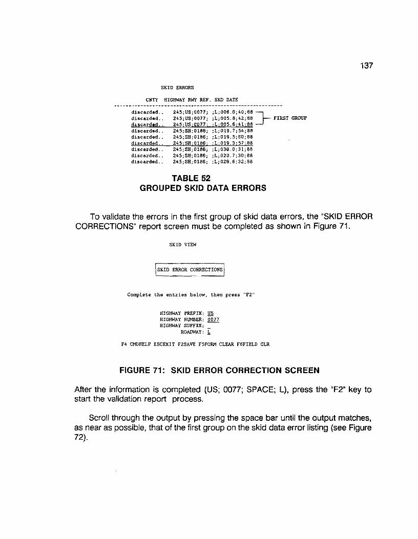
SKID ERRORS
CNTY HIGHWAY RWY REF. SKD DATE
discarded .. discarded •. discarded .. discarded .. discarded .. discarded .. discarded .. discarded .. discarded ..
245;US;0077; ;L;006.0;40;88 J-245;US;0077; ;L;005.8;42;88 FIRST GROUP 245;USj0017; ;L;005.6;41;88 245;SH;Ol86; ;L;Ol9.7;54;88 245;SH;Ol86; ;L;019.5;60;88 245;SH;0186; ;L;019.3;57;88 245;SH;0186; ;L;030.0;31;88 245;SB;0186; ;L;029.7;30;88 245;SH;0186; ;L;029.6;32;88
TABLE 52 GROUPED SKID DATA ERRORS
137
To validate the errors in the first group of skid data errors, the "SKID ERROR CORRECTIONS" report screen must be completed as shown in Figure 71.
SKID VIEW
lsKID ERROR CORRECTIONS'
Complete the entries below, then press "F2"'
HIGHWAY PREFIX: ~ HIGHWAY NUMBER: 0017 HIGHWAY SUFFIX:
ROADWAY: 1
F4 CMDHELP ESCEXIT F2SAVE F5FORM CLEAR F6FIELD CLR
FIGURE 71: SKID ERROR CORRECTION SCREEN
After the information is completed (US; 0077; SPACE; L), press the "F2" key to start the validation report process.
Scroll through the output by pressing the space bar until the output matches, as near as possible, that of the first group on the skid data error listing {see Figure 72).

138
SKID VIEW Running report SKID VIEW SPACE: Continue Report EXIT; Abort Report
SKID ERROR CORRECTIONS
mrm::ot&m-m--==m-===-==-=·~===='°'
RECORD COUNTY HIGHWAY ROADWAY REFERENCE MILEPOST NUMBER NUMBER POINT
001060 245 US0077 L 3.1 2+1.l 001061 245 US0077 L 3.3 2+1.3 001062 245 US0077 L 3.5 2+1.5 001063 245 US0077 L 3.7 2+1.7 001064 245 US0077 L 3.9 2+1.9 001065 245 US0077 L 4.1 4+0.l 001066 245 US0077 L 4.3 4+0.3 001067 245 US0077 L 4.5 4+0.5 001068 245 US0077 L 4.7 4+0.7 001069 245 US0077 L 4.9 4+0.9 001070 245 US0077 L 5.1 4+1.1 001071 245 US0077 L 5.3 4+1.3 001072 245 US0077 L 5.5 4+1.5 001073 245 US0077 L 5.7 4+1. 7 001074 245 US0077 L 5.9 4-tl. 9 001075 245 US0077 L 6.1 6+0.1
F4 CMDHELP ESC EXIT D:\DEASE\WILLACY WILLACY 11/30/88 10:37 am
FIGURE 72: BLOCKED SKID ERRORS
Note on the skid data error output, the corrections that need to be made to match the records to the ones above. In our example, the only difference between the skid error output and the screen above is the "REFERENCE POINT" mismatch. To correct the mismatch error, round the "REFERENCE POINT" up or down by one tenth. This correction will then allow the data to match the records in the database (Figure 73).
SKID ERRORS
CNTY HIGHWAY RWY REF. SKD DATE
discarded .. discarded .. discarded .. discarded .. discarded .. discarded .. discarded .. discarded .. discarded ..
245;US;0077; ;L;006.0;40;88 J-245;US;0077; ;L;005.8;42;88 ROUND REFERENCE POINT UP 245;US;0077; :L:005.6;41;88 ONE TENTH 245;SH;Ol86; ;L;Ol9.7;54;88 245;SH;Ol86; ;L;Ol9.5;60;88 245;SH;Ol86; jL:Ol9.3;57;88 245;SH;Ol86; ;L;030.0;31;88 245;SH;Ol86; ;L;029.7;30;88 245;SH;Ol86; ;L;029.6;32;88
FIGURE 73: CORRECTED SKID VALUES
Press the "Esc" key to return to the "SKID ERROR CORRECTION" report input screen. Now, we need to validate the second group of errors in the skid data.

139
SKID ERRORS
CNTY HIGHWAY RWY REF. SKD DATE
discarded.. 245;US;0077; ;L;006.0;40;88 ]-discarded.. 245;US;0077; ;L;005.8;42;88 ROUND REFERENCE POINT UP ,..d1._,· s:.:::c,..ar..,d:.:::e.._d,_. .. ....___,2""4"""5.._,; U""'S.._; 0'"-'0:..:.7..:..7.._; _.;"""L""'; 0:..::0:.::.5.:...:. 6::...;..;:.4.:..1 ;"""8""8 ONE TENTH discarded.. 245;SH;0186; ;L;Ol9.7;54;88 discarded.. 245;SH;0186; ;L;Ol9.5;60;88 SECOND GROUP discarded.. 245;SH;Ol86; ;L;Ol9.3;57;88 discarded.. 245;SH;Ol86; ;L;030.0;31;88 discarded.. 245;S8;0186; ;L;029.7;30;88 discarded.. 245;S8;0186; ;L;029.6;32;88
FIGURE 74: ROUNDING SKID RECORDS TO CORRECT IMPORT ERRORS
Type in the pertinent information (SH; 0186; SPACE; L) of the second group of data for the error validation report, and press the "F2" key (Figure 75).
SKID VIEW
lsKID ERROR CORRECTIONS!
Complete the entries below, then press "F2"
HIGHWAY PREFIX: SH
HIGHWAY NUMBER: 0186
HIGHWAY SUFFIX:
ROADWAY: .!::
F4 CMDHELP ESCEXIT F2SAVE F5FORM CLEAR F6FIELD CLR
FIGURE 75: SKID ERROR CORRECTIONS
The response of the system for this example is shown in Table 53.
SKID VIEW Running report SKID VIEW END OF REPORT. SPACE: Return to Menu
RECORD NUMBER
COUNTY NUMBER
SKID ERROR CORRECTIONS
HIGHWAY ROADWAY
TABLE 53
REFERENCE MILEPOST POINT
SKID ERROR SCREEN REPORT
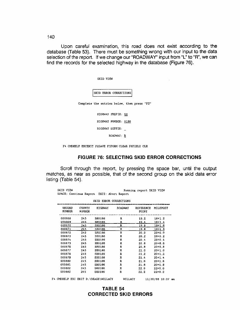
140
Upon careful examination, thls road does not exist according to the database (Table 53). There must be something wrong with our input to the data selection of the report. If we change our "ROADWAY" input from "L" to "R", we can find the records for the selected highway in the database (Figure 76).
SKID VIEW
lsKID ERROR CORRECTIONS!
Complete the entries below, then press "F2"
HIGHWAY PREFIX: SH
HIGHWAY NUMBER: 0186
HIGHWAY SUFFIX:
ROADWAY: li
F4 CMDHELP ESCEXIT F2SAVE F5FORM CLEAR F6FIELD CLR
FIGURE 76: SELECTING SKID ERROR CORRECTIONS
Scroll through the report, by pressing the space bar, until the output matches, as near as possible, that of the second group on the skid data error listing (Table 54).
SKID VIEW Running report SKID VIEW SPACE: Continue Report EXIT: Abort Report
SKID ERROR CORRECTIONS
RECORD COUNTY HIGHWAY ROADWAY REFERENCE MILEPOST NUMBER NUMBER POINT
000858 245 SH0186 R 19.2 18+1.2 000869 245 SH0186 R 19.4 18+1. 4 000870 245 SH0186 R 19.6 18+1. 6 000871 245 SH0186 R 19.8 18+1. 8 000872 245 SH0186 R 20.0 20+0.0 000873 245 SH0186 R 20.2 20+0.2 000874 245 SH0186 R 20.4 20+0.4 000875 245 SH0185 R 20.6 20+0.6 000876 245 SH0186 R 20.8 20+0.8 000877 245 SH0186 R 21.0 20+1.0 000878 245 SH0186 R 21.2 20+1. 2 000879 245 SH0186 R 21.4 20+1.4 000880 245 SH0186 R 21.6 20+1.6 000881 245 SH0185 R 21.8 20+1. 8 000882 245 SH0186 R 22.0 22+0.0 000883 245 SH0186 R 22.2 22+0.2
F4 CMDHELP ESC EXIT D:\DEASE\WILLACY WILLACY 11/30/88 10:37 am
TABLE 54 CORRECTED SKID ERRORS
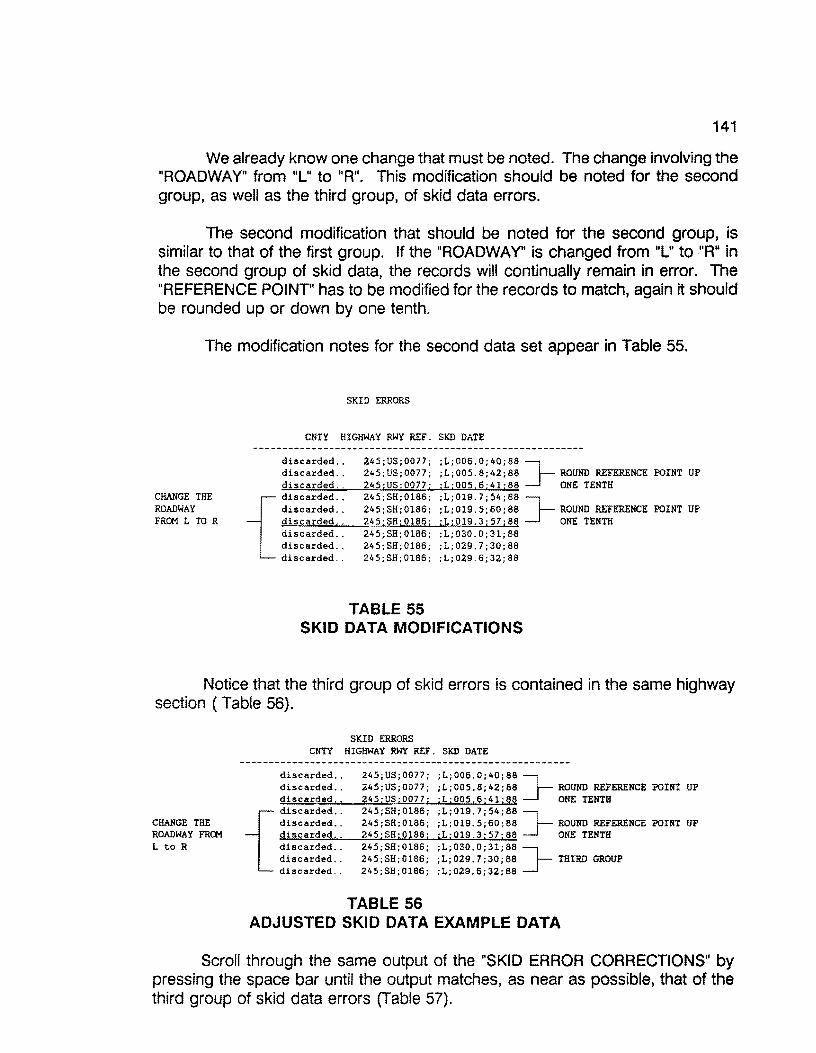
141
We already know one change that must be noted. The change involving the "ROADWAY" from "L" to "R". This modification should be noted for the second group, as well as the third group, of skid data errors.
The second modification that should be noted for the second group, is similar to that of the first group. If the "ROADWAY" is changed from "L" to "R" in the second group of skid data, the records will continually remain in error. The "REFERENCE POINT' has to be modified for the records to match, again it should be rounded up or down by one tenth.
The modification notes for the second data set appear in Table 55.
CHANGE THE ROADWAY FROM L TO R
SKID ERRORS
CNTY HIGHWAY RWY REF. SKD DATE
discarded .. discarded .. discarded ..
{
discarded .. discarded .. discarded .. discarded .. discarded .. discarded ..
245;US;0077; ;L;006.0;40;88 ]-245;US;0077; ;L;OOS.8;42;88 ROUND REFERENCE POINT UP 245;US;0077; ;L;OOS.6;41;88 ONE TENTH 245;SH;0186; ;L;019.7;54;88 J-245;SH;0186; ;L;019.5;60;88 ROUND REFERENCE POINT UP 24S;SH;0186; ;L;Ol9.3;57;88 ONE TENTH 24S;SH;Ol86; ;L;OJ0.0;31;88 24S;SH;0186; ;L;029.7;30;88 245;SH;0186; ;L;029.6;32;88
TABLE 55 SKID DATA MODIFICATIONS
Notice that the third group of skid errors is contained in the same highway section (Table 56).
CHANGE THE ROADWAY FRG! L to R
SKID ERRORS CNTY HIGHWAY RWY REF. SKD DATE
discarded.. 245;US;0077; ;L;006.0;40;86 ]-discarded.. 245;US;0077; ;L;OOS.6;42;88 ROUND REFERENCE POINT UP ~di~s_,_ca=r~de~d~. ~· ___...2~45~;~US~;~00~7~7-; ~iL~;~OO=S_,_. 6""'";"""'41 .... ;.-...86 ONE TENTH
{
discarded.. 245;SH;Ol86; ;L;Ol9.7;54;66 ]-discarded.. 245;SH;Ol86; ;L;019.5;60;68 ROUND REFERENCE POINT UP =di=s=ca=r=de=do:... ,_. --"2'-'-'45=....;=SH"-';.;..01=8=6.._; ....,;L._.;.::..01=9_,_,. 3:....;~57'-"';.=68 ONE TENTH discarded.. 245;SH;Ol86; ;L;030.0;31;86 ]-discarded.. 245;SH;Ol86; ;L;029.7;30;88 THIRD GROUP discarded.. 245;SH;Ol86; ;L;029.6;32;88
TABLE 56 ADJUSTED SKID DATA EXAMPLE DATA
Scroll through the same output of the "SKID ERROR CORRECTIONS" by pressing the space bar until the output matches, as near as possible, that of the third group of skid data errors (Table 57).

142
SKID VIEW Running report SKID VIEW SPACE: Continue Report EXIT: Abort Report
SKID ERROR CORRECTIONS
RECORD COUNTY HIGHWAY ROADWAY NUMBER NUMBER
000916 245 SH0186 R 000917 245 SH0186 R 000918 245 SH0186 R 000919 245 SHOl86 R 000920 245 SH0186 R 000921 245 SH0186 R 000922 245 SH0186 R 000923 245 SH0186 R 000924 245 SH0186 R 000925 245 SH0186 R 000926 245 SH0186 R 000927 2.45 SH0186 R 000928 245 SH0186 R 000929 245 SH0186 R 000930 245 SH0186 R 000931 245 SH0186 R
REFERENCE MILEPOST POINT
28.8 28+0.8 29.0 28+1.0 29.2 28+1.2 29.4 28+1.4 29.6 28+1.6 29.8 28+1.8 30.0 30+0.0 30.2 30+0.2 30.4 30+0.4 30.6 30+0.6 30.8 30+0.8 31.0 30+1.0 31.2 30+1.2 31. 4 30+1.4 31.6 30+1. 6 31.8 30+1.8
F4 CMDHELP ESC EXIT D:\DEASE\WILLACY WILLACY 11/30/88 10:37 am
TABLE 57 CORRECTED SKID ERRORS
Notice that after the notes of the "ROADWAY" changes from "L" to "R", that the first and third records in the third group of the skid data do not require any additional notes. However, the second record in the third group of skid data does require, again, a "REFERENCE POINT" modification note (Table 58).
CHANGE THE ROADWAY FROM L to R
SKID ERRORS
CNTY HIGHWAY RWY REF. SKD DATE
discarded .. discarded .. discarded ..
{
discarded .. discarded .. discarded .. discarded .. discarded .. discarded ..
245;US;0077; ;L;006.0;40;88 ]-245;US;0077; ;L;005.8;42;88 ROUND REFERENCE POINT UP 245;US;0077; ;L;OOS.6;41;88 ONE TENTH 2.45;SH;Ol86; ;L;Ol9.7;54;88 J-245;SH;0186; ;L;Ol9.5;60;88 ROUND REFERENCE POINT UP 245;SH;Ol86; ;L;Ol9.3;57;88 ONE TENTH 245;SH;Ol86; ;L;030.0;31;88 245;SH;Ol86; ;L;029.7;30;88 ~~ROUND REFERENCE POINT UP 245;SH;0186; ;L;029.6;32;88 ONE TENTH
TABLE 58 MODIFIED SKID DATA
Now that the noting of tl1e changes to the skid data is complete, we want to attempt to modify the skid file with the changes that we noted. The first thing we

143
need to do is to exit from the "SKID ERROR CORRECTIONS" report menu and return to the "SKID DATA ENTRY" menu (Figure 77).
SKID VIEW
'SKID ERROR CORRECTIONS'
Complete the entries below, then press "F2"
HIGHWAY PREFIX:
HIGHWAY NUMBER:
HIGHWAY SUFFIX:
ROADWAY:
F4 CMDHELP ESCEXIT F2SAVE FSFORM CLEAR F6FIELD CLR
FIGURE 77: SKID ERROR CORRECTION MENU
To do this, press the "Esc" key, and the "SKID DATA ENTRY/ WILLACY COUNTY" screen should appear (Figure 78). Select "4. Correct Errors in Imported Data File" by pressing the "4" key, or using the arrow keys to highlight the selection, press the 11Enter" key.
SKID DATA ENTRY I WILLACY COUNTY
l. Transfer Skid Field Data
Z. Import Transferred Skid Field Data
3. Validate Errors in Imported Skid Data File
4. Correct Errors in Imported Data File
1 to 4 UP - DOWN - RETURN END --~
F4 CMDHELP ESC EXIT D:\DEASE\WILLACY WILLACY 11/30/88 10:37 am
FIGURE 78: CORRECT ERRORS IN IMPORTED SKID DATA
The "4. Correct Errors in Imported Data File" selection loads a text editor, "ESB.EXE", with the skid data file that contained the errors. Now, we can use the notes made earlier to modify the skid data (Table 59).
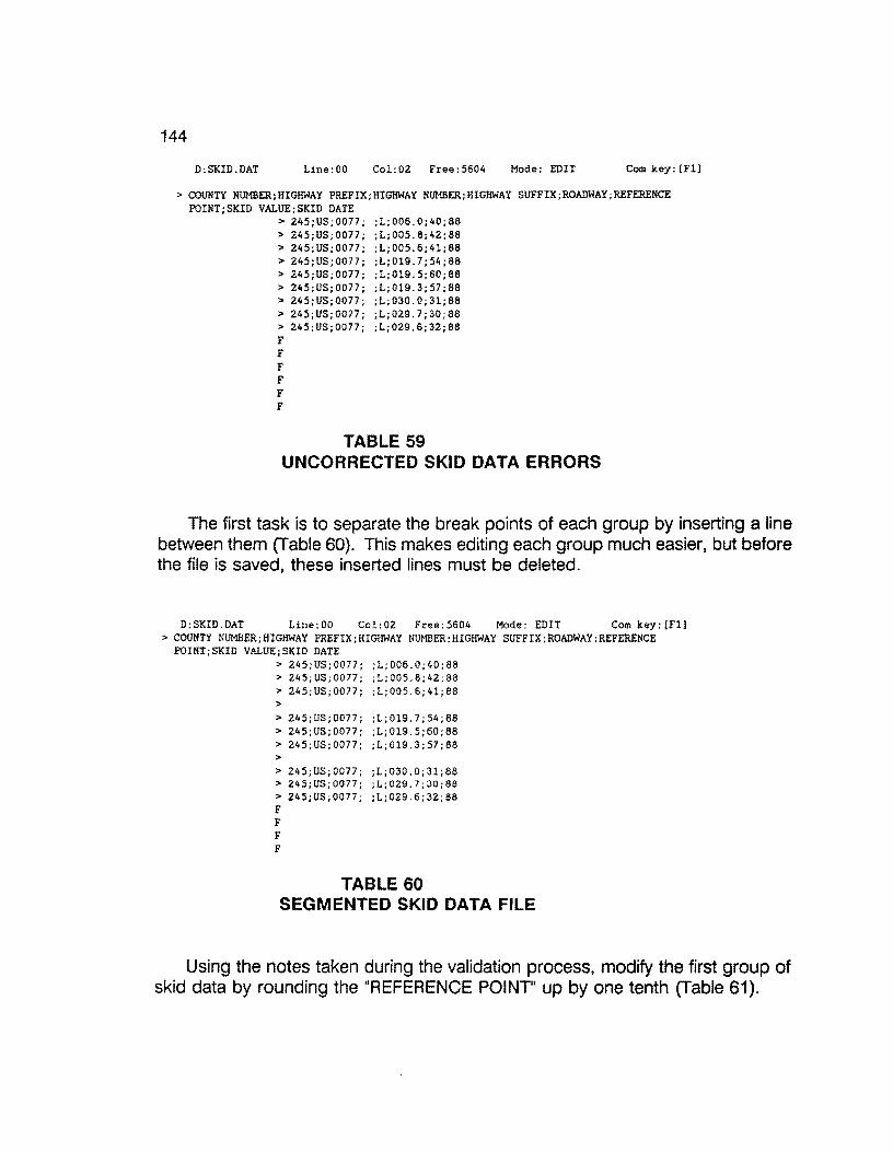
144
D:SKID.DAT Line:OO Col:02 Free:5604 Mode: EDIT Com key: [Fll
> COUNTY NUMBER;HIGHWAY PREFIX;HIGHWAY NUMBER;HIGHWAY SUFFIX;ROADWAY;REFERENCE POINT;SKID VALUE;SKID DATE
> 245;US;0077; ;L;006.0;40;88 > 245;US;0077; ;L;OOS.8;42;88 > 245;US;0077; ;L;OOS.6;41;88 > 245;US;0077; ;L;Ol9.7;54;88 > 245; US; 0077; ;L;Ol9. 5; 60; 88 > 245;US;0077; ;L;Ol9.3;57;88 > 245;US;0077; ;L;030.0;31;88 > 245;US;0077; ;L;029.7;30;88 > 245;US;0077; ;L;029.6;32;88 F F F F F F
TABLE 59 UNCORRECTED SKID DATA ERRORS
The first task is to separate the break points of each group by inserting a line between them (Table 60). This makes editing each group much easier, but before the file is saved, these inserted lines must be deleted.
D:SKID.DAT Line:OO Col:02 Free:5604 Mode: EDIT Com key:{Fll > COUNTY NUMBER;HIGHWAY PREFIX;HIGHWAY NUMBER;HIGHWAY SUFFIX;ROADWAY;REFER.ENCE
POINT;SKID VALUE;SKID DATE > 245;US;0077; ;L;006.0;40;88 > 245;US;0077; ;L;OOS.8;42;88 > 245;US;0077; ;L;OOS.6;41;88 >
> 245;US;0077; ;L;Ol9.7;54;88 > 245;US;0077; ;L;Ol9.5;60;88 > 245;US;0077; ;L;Ol9.3;57;88 > > 245;US;0077; ;L;030.0;31;88 > 245;US;0077; ;L;029.7;30;8a > 245;US;0077; ;L;OZ9.6;32;8a F F F F
TABLE 60 SEGMENTED SKID DATA FILE
Using the notes taken during the validation process, modify the first group of skid data by rounding the "REFERENCE POINT" up by one tenth (Table 61).
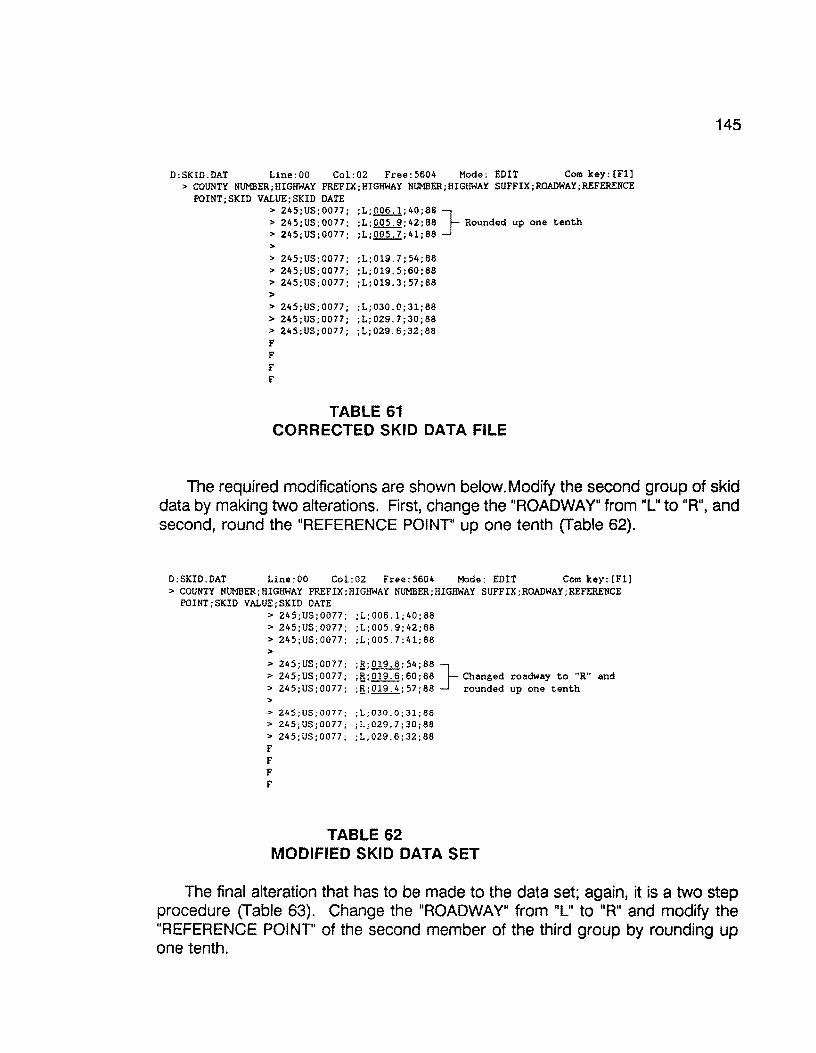
D:SKID.DAT Line:OO Col:02 Free:5604 Mode: EDIT Com key:[Fl] > COUNTY NUMBER;HIGHWAY PREFIX;HIGHWAY NUMBER;HIGHWAY SUFFIX;ROADWAY;REFERENCE
POINT;SKID VALUE;SKID DATE > 245;US;0077; ;L;Q.Q.2.,_!;40;88} > 245;US;0077; ;L;Q.Q2.J!.;42;88 Rounded up one tenth > 245;US;0077; ;L;.Q.Q.:i..,2;41;88 > > 245;US;0077; ;L;Ol9.7;54;88 > 245;US;0077; ;L;Ol9.5;60;88 > 245;US;0077; ;L;019.3;57;88 > > 245;US;0077; ;L;030.0;31;88 > 245;US;0077; ;L;029.7;30;88 > 245;US;0077; ;L;029.6;32;88 F F F F
TABLE 61 CORRECTED SKID DATA FILE
145
The required modifications are shown below.Modify the second group of skid data by making two alterations. First, change the "ROADWAY" from "L" to "R", and second, round the "REFERENCE POINT" up one tenth (Table 62).
D:SKID.DAT Line:OO Col:02 Free:S604 Mode: EDIT Com key:[Fl] > COUNTY NUMBER;HIGHWAY PREFIX;HIGHWAY NUMBER;HIGHWAY SUFFIX;ROADWAY;REFERENCE
POINT;SKID VALUE;SKID DATE > 245;US;0077; ;L;006.1;40;88 > 245;US;0077; ;L;OOS.9;42;88 > 245;US;0077; ;L;OOS 7;41;88 > > 245;US;0077; :B;Ol9.8;54;88 } > 245;US;0077; :B:019.6;60;88 Changed roadway to "R" and > 245;US;0077; ;fl;Ol9.4;57;88 rounded up one tenth >
> 24S;US;0077; ;L;030.0;31;88 > 24S;US;0077; ;L;029.7;30;88 > 245;US;0077; ;L;029.6;32;88 F F F F
TABLE 62 MODIFIED SKID DATA SET
The final alteration that has to be made to the data set; again, it is a two step procedure (Table 63). Change the "ROADWAY" from "L" to "R" and modify the "REFERENCE POINT" of the second member of the third group by rounding up one tenth.

146
O:SKID.DAT Line:OO Col:02 Free:S604 Mode: EDIT Com key:[Fll > COUNTY NUMBER;HIGHWAY PREFIX;HIGHWAY NUMBER;HIGHWAY SUFFIX;ROADWAY;REFERENCE
POINT;SKID VALUE;SKIO DATE > 245;US;0077; ;L;006.l;40;88 > 24S;US;0077; ;L;OOS.9;42;88 > 24S;US;0077; ;L;OOS.7;41;88 >
> 245;US;0077; ;R;019.8;54;88 > 245;US;0077; ;R;Ol9.6;60;88 > 245;US;0077; ;R;Ol9.4;57;88 > > 245;US;0077; ;g;030.0;31;88} > 24S;US;0077; ;g;029.8;30;88 Changed roadway to "R" and > 245;US;0077; ;g;029.6;32;88 rounded up one tenth F F F F
TABLE 63 MODIFIED SKID DATA
Now, delete all of the blank lines and save the data set by pressing the "F1" key and selecting the "(A.) END the edit and save this file" option by pressing the "A" key (Figure 79).
D:SKID.OAT Line:OO Col:OZ Free:5604 Mode: EDIT Com key:[Fl] > COUNTY NUMBER;HIGHWAY PREFIX;HIGHWAY NUMBER;HIGHWAY SUFFIX;ROAOWAY;REFERENCE P
OINT;SKID VALUE;SKIO DATE > 245;US;0077; ;L;006.1;40;88 > 24S;US;0077; ;L;OOS.9;42;88 > 245;US;0077; ;L;OOS.7;41;88 > 245;US;0077; ;R;019.8;54;88 > 245;US;0077; ;R;Ol9.6;60;88 > 245;US;0077; ;R;019.4;57;88 > 24S;US;0077; ;R;030.0;31;88 > 24S;US;0077; ;R;029.8;30;88 > 245;US;0077; ;R;029.6;32;88 F F F F F F
MASTER Cot-t1AND MENU
Select option or press Esc to return
(A. l CB.) (C.)
(0.)
(E.) (F.)
(G.)
<H.)
END the edit and save this file BACKUP (create filename.bak) CHANGE filename (for saving) HELP EDIT another file (with options) SEARCH and [replace] string SETUP (set default parameters) QUIT * RETURN TO DOS * NO SAVE
FIGURE 79: FINAL EDITS· SKID DATA
After saving the changes to the skid file, you are then returned back to the "SKID DATA ENTRY/ WILLACY COUNTY" menu.
Select the "2. Import Transferred Skid Field Data" option to import the skid data that has been altered by pressing the "2" key or using the arrow keys to highlight the option and press the "Enter" key (Figure 80).

147
SKID DATA ENTRY I WILLACY COUNTY
1. Transfer Skid Field Data
2. Import Transferred Skid Field Data
3. Validate Errors in Imported Skid Data File
4. Correct Errors in Imported Data File
1 to 4 - UP - DOWN - RETURN - END ----'
F4 CMDHELP ESC EXIT D:\DEASE\WILLACY WILLACY 11/30/88 10:37 am
FIGURE 80: IMPORT TRANSFERRED SKID FIELD DATA
After the import has completed and there are no errors sent to the the printer, you will be returned to the "SKID DATA ENTRY/ WILLACY COUNTY" menu with the "O added, 9 updated, O discarded" message at the top of the screen. The sub-menu is shown in Figure 80.
0 added, 9 updated, 0 discarded
SKID DATA ENTRY I WILLACY COUNTY
1. Transfer Skid Field Data
2. Import Transferred Skid Field Data
3. Validate Errors in Imported Skid Data File
4. Correct Errors in Imported Data File
1 to 4 - UP - DOWN - RETURN - END --~
F4 CMDHELP ESC EXIT D:\DEASE\WILLACY WILLACY 11/30/88 10:37 am
FIGURE 80: SKID DATA MAIN MENU
If errors were detected, you must go through the previous processes of validation and correction until there are no errors detected.
Now that the skid data entry process is complete for this data set, press the "Esc" key to retrace your steps out of the database until the "Pavement Management System" menu appears (Figure 81 ). If additional skid data is collected for the same county at a later date, follow the same procedures of the skid data entry process discussed above.

148
Pavement Management System
MENU 2 OF 2 -> 1 - Willacy County (245)
2 - Zapata County (253)
3 - Process Raw Skid Data
4 - Tape Backup
5 - Optimize Hard Disk
6 - Disk Operating System
November 30, 1988 9:31:46 am CAPS Memory: 640 K
FIGURE 81: PMS MAIN SYSTEM MENU
6.11 SKID DATA COMPLETENESS
After it is assumed that all of the skid data for a particular county has been collected, converted, and imported, it is a good practice to ensure that you are satisfied with the completeness of the data. This is done by running a missing skid data report for the particular county of interest.
Select the particular county that is assumed to be complete. In this example, we will again use Willacy county. To do this, use the arrow keys on the keyboard to point to the item "1 - Willacy County (245)" (only in this example) and press the "Enter" key, or press the "1" key (Figure 82).
Pavement Management System
MENU 2 OF 2 -> 1 - WillacI CountI ~245l
2 - Zapata County (253)
3 - Process Raw Skid Data
4 - Tape Backup
5 - Optimize Hard Disk
6 - Disk Operating System
November 30, 1988 9:31:46 am CAPS Memory: 640 K
FIGURE 82: PMS MAIN MENU
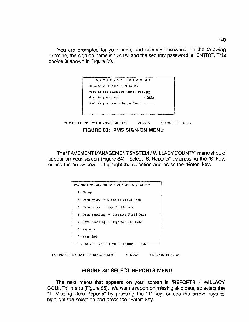
149
You are prompted for your name and security password. In the following example, the sign on name is "DATA" and the security password is "ENTRY". This choice is shown in Figure 83.
D A T A E A S E - S I G N 0 N
Directory: D:\DEASE\WILLACY\
What is the database name?: Willacy
What is your name : DATA
What is your security password : __
F4 CMDHELP ESC EXIT D:\DEASE\WILLACY WILLACY 11/30/88 10:37 am
FIGURE 83: PMS SIGN·ON MENU
The "PAVEMENT MANAGEMENT SYSTEM/ WILLACY COUNTY" menu should appear on your screen (Figure 84). Select "6. Reports" by pressing the "6" key, or use the arrow keys to highlight the selection and press the "Enter" key.
PAVEMENT MANAGEMENT SYSTEM I WILLACY COUNTY
1. Setup
2. Data Entry -- District Field Data
3. Data Entry Import PES Data
4. Data Handling District Field Data
5. Data Handling -- Imported PES Data
6. Reports
I 7. Year End
l__ 1 to 7 - UP - DOWN - RETURN - END ---'
F4 CMDHELP ESC EXIT D:\OEASE\WILLACY WILLACY 11/30/88 10:37 am
FIGURE 84: SELECT REPORTS MENU
The next menu that appears on your screen is "REPORTS / WILLACY COUNTY" menu (Figure 85). We want a report on missing skid data, so select the "1. Missing Data Reports" by pressing the "1" key, or use the arrow keys to highlight the selection and press the "Enter" key.

150
REPORTS I WILLACY COUNTY
l. Missing Data Reports
2. Generate Rating Forms
3. Critical Value Reports
4. Data Listing Reports
5. PMS-PES Conversion
6. Ad Hoc Reports
END_J ~- 1 to 6 - UP - DOWN - RETURN
F4 CMDHELP ESC EXIT D:\DEASE\WILLACY WILLACY 11/30/88 10:37 am
FIGURE 85: PMS MISSING DATA REPORT MENU
Make certain that your printer is powered up and on line, then select the "4. Missing Skid Data" by pressing the "4" key, or use the arrow keys to highlight the selection and press the "Enter" key (see Figure 86).
MISSING DATA REPORTS I WILLACY COUNTY
1. Missing Visual Data
2. Missing Ride Data
3. Missing FWD Data
4. Missing Skid Data
5. Missing Date of Last Surface & Surface Data
1 to 5 - UP - DOWN - RETURN - END ---'
F4 CMDHELP ESC EXIT D:\DEASE\WILLACY WILLACY 11/30/88 10:37 am
FIGURE 86: MISSING SKID DATA MENU
A listing of missing skid data should start printing on the printer. If there was no missing skid data, a blank page will be printed. Table 64 illustrates a missing skid data report for Willacy County.

151
MISSING SKID DATA Willacy County Page No. l
==-=--====--=-==--==e==:-~ =-===·--=-=~ -COUNTY HIGHWAY ROADWAY REFERENCE MILEPOST ADT 18-KIP RECORD
NUMBER POINT NUMBER --------------------------------------------------------------------
245 FM0088 R 0.0 2-1.9 1,250 480 000001 245 FM0088 R 0.2 2-l. 7 1,250 480 000002 245 FM0088 R 0.4 2-1.5 l,250 480 000003 245 FM0088 R 0.6 2-l.3 1,250 480 000004 245 FM0088 R 0.8 2-l.1 1,250 480 000005 245 FM0088 R o.o 2-0.9 1,250 480 000006 245 FM0088 R 0.2 2-0.7 1,250 480 000007 245 FM0088 R 0.4 2-0.5 1,250 480 000008 245 FM0088 R 0.6 2-0.3 1,250 480 000009 245 FM0088 R 0.8 2-0.1 1,250 480 000010 245 FM0088 R 0.0 2+0.1 1,250 480 000011 245 FM0088 R 0.2 2+0.3 1,250 480 000012 245 FM0088 R 0.4 2+0.5 1,250 480 000013 245 FM0088 R 0.6 2+0.7 1,250 480 000014 245 FM0088 R 0.8 2+0.9 1,250 480 000015 245 FM0088 R 0.0 2+1.1 1,250 480 000016 245 FM0490 R 0.0 2-2.0 280 133 000017
--------------------------------------------------------------------
TABLE 64 MISSING SKID DATA REPORT· EXAMPLE
You will be returned to the "MISSING DATA RECORDS/ WILLACY COUNTY" menu as soon as the report has completed {Figure 86).
MISSING DATA REPORTS I WILLACY COUNTY
1. Missing Visual Data
2. Missing Ride Data
3. Missing FWD Data
4. Missing Skid Data
5. Missing Date of Last Surface & Surface Data
1 to 5 UP DOWN - RETURN - END ---'
F4 CMOHELP ESC EXIT D:\OEASE\WILLACY WILLACY 11/30/88 10:37 am
FIGURE 86: MISSING DATA REPORT MAIN MENU
Now that the report has completed, press the "Esc" key several times to exit from the database and return to the "Pavement Management System" menu (Figure 87).
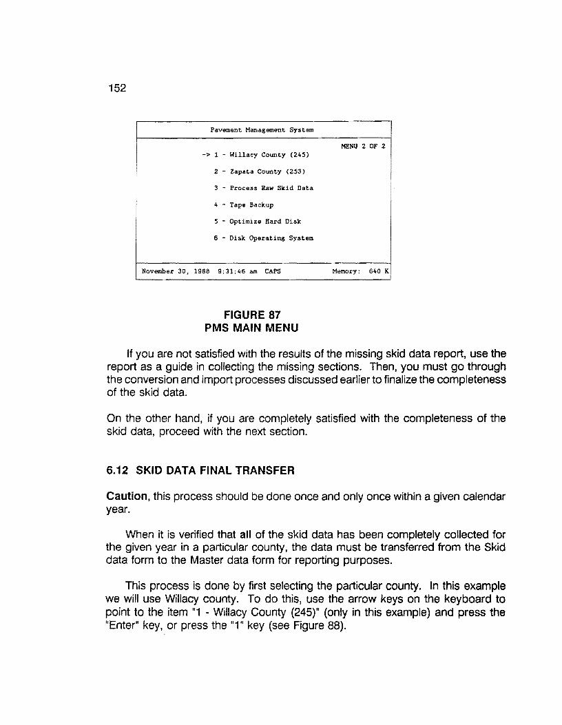
152
Pavement Management System
-> l - Willacy County (245)
2 - Zapata County (253)
3 - Process Raw Skid Data
4 - Tape Backup
5 - Optimize Hard Disk
6 - Disk Operating System
November 30, 1988 9:31:46 am CAPS
FIGURE 87 PMS MAIN MENU
MENU 2 OF 2
Memory: 640 K
If you are not satisfied with the results of the missing skid data report, use the report as a guide in collecting the missing sections. Then, you must go through the conversion and import processes discussed earlier to finalize the completeness of the skid data.
On the other hand, if you are completely satisfied with the completeness of the skid data, proceed with the next section.
6.12 SKID DATA FINAL TRANSFER
Caution, this process should be done once and only once within a given calendar year.
When it is verified that all of the skid data has been completely collected for the given year in a particular county, the data must be transferred from the Skid data form to the Master data form for reporting purposes.
This process is done by first selecting the particular county. In this example we will use Willacy county. To do this, use the arrow keys on the keyboard to point to the item "1 - Willacy County (245)" (only in this example) and press the "Enter" key, or press the "1" key (see Figure 88).

153
Pavement Management System
MENU 2 OF 2 -> 1 - Willac~ Count~ '245)
2 - Zapata County (253)
3 - Process Raw Skid Data
4 Tape Backup
5 - Optimize Hard Disk
6 - Disk Operating System
November 30, 1988 9:31:46 am CAPS Memory: 640 K
FIGURE 88: PMS MAIN MENU
You are then prompted for your name and security password. In the following example, (Figure 89) the sign on name is "DATA" and the security password is "ENTRY".
D A T A E A S E - S I G N 0 N
Directory: D:\DEASE\WILLACY\
What is the database name?: Willacy
What is your name : DATA
What is your security password : __
F4 CMIJHELP ESC EXIT D:\DEASE\WILLACY WILLACY 11/30/88 10:37 am
FIGURE 89: PMS SIGN-ON MENU
The "PAVEMENT MANAGEMENT SYSTEM/ WILLACY COUNTY" menu should appear on your screen (Figure 90). Select "4. Data Handling -- District Field Data" by pressing the "4" key, or use the arrow keys to highlight the selection and press the "Enter" key.

154
PAVEMENT MANAGEMENT SYSTEM I WILLACY COUNTY
1. Setup
2. Data Entry -- District Field Data
3. Data Entry Import PES Data
4. Data Handling -- District Field Data
5. Data Handling -- Imported PES Data
6. Reports
7. Year End
1 to 7 - UP - DOWN - RETURN END --
F4 CMDHELP ESC EXIT D:\DEASE\WILLACY WILLACY 11/30/88 10:37 am
FIGURE 90: PMS DATA HANDLING MENU
The next menu that should appear on your screen is entitled "DATA HANDLING -- DISTRICT FIELD DATA/ WILLACY COUNTY" (Figure 91). Select "4. Skid data" by pressing the "4" key, or use the arrow keys to highlight the selection and press the "Enter" key.
DATA HANDLING -- DISTRICT FIELD DATA I WILLACY COUNTY
1. Visual Data
2. Ride Data
3. FWD Data
4. Skid Data
5. Date of Last Surface
6. Roadway Characteristics
~-- l to 6 UP DOWN - RETURN - END --~
F4 CMDHELP ESC EXIT D:\DEASE\WILLACY WILLACY 11/30/88 10:37 am
FIGUREE 91: MOVE SKID DATA TO HISTORY FILE MENU
The next screen (Figure 92) that appears is "SKID DATA HANDLING / WILLACY COUNTY", with only one selection. Select "1. Transfer Skid Data to Master Data Form" by pressing the "1 " key, or use the arrow keys to highlight the selection and press the "Enter" key. This process transfers all of the skid data from the Skid data form (0.2 mile records) to the Master data form (0.1 mile records).
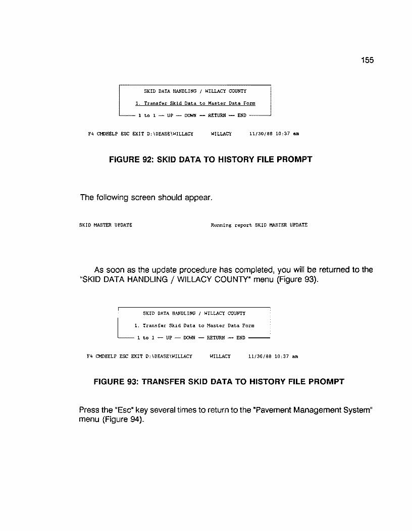
155
SKID DATA HANDLING I WILLACY COUNTY
1. Transfer Skid Data to Master Data Form
1 to 1 - UP - DOWN - RETURN - END --~
F4 CMDHELP ESC EXIT D:\DEASE\WILLACY WILLACY 11/30/88 10:37 am
FIGURE 92: SKID DATA TO HISTORY FILE PROMPT
The following screen should appear.
SKID MASTER UPDATE Running report SKID MASTER UPDATE
As soon as the update procedure has completed, you will be returned to the "SKID DATA HANDLING / WILLACY COUNTY" menu (Figure 93).
SKID DATA HANDLING I WILLACY COUNTY
1. Transfer Skid Data to Master Data Form
1 to 1 - UP DOWN - RETURN - END --~
F4 CMDHELP ESC EXIT D:\DEASE\WILLACY WILLACY 11/30/88 10:37 am
FIGURE 93: TRANSFER SKID DATA TO HISTORY FILE PROMPT
Press the "Esc" key several times to return to the "Pavement Management System" menu (Figure 94).
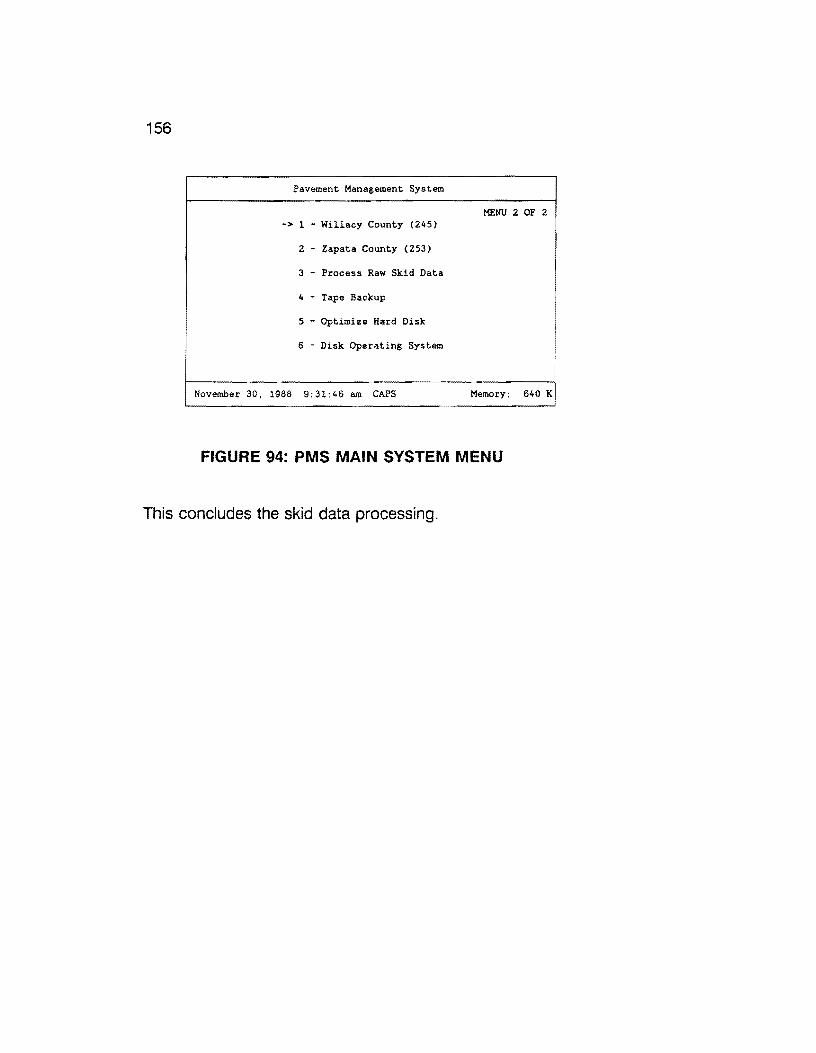
156
Pavement Management System
MENU 2 OF 2 -> 1 - Willacy County (245)
2 - Zapata County (253)
3 - Process Raw Skid Data
4 - Tape Backup
5 - Optimize Hard Disk i
6 - Disk Operating System
November 30, 1988 9:31:46 am CAPS Memory: 640 K
FIGURE 94: PMS MAIN SYSTEM MENU
This concludes the skid data processing.

7.0 DEFLECTION DATA COLLECTION DEFLECTOMETER METHOD
157
FALLING WEIGHT
This section was written under the direction of Mr. Craig Cox, D-1 BPM, Austin, Texas.
Data collected by the Falling Weight Deflectometer (FWD) must be converted to a format readable by the Pavement Management System (PMS) database. After the data is converted, it is then imported into the proper data form through an iterative process for a particular county. After all of the FWD data has been collected and imported to the proper form, it will be used in reporting and decision making operations.
Within District 21, FWD data is collected over 0.5-mile intervals. Additionally, the District attempts to collect FWD data over approximately one third of the state maintained highways within D21 in a given year. Thus, over a three year period, all highways have FWD readings collected over 0.5-mile intervals.
The following procedures and examples isntructs the user in processing and storing the collected FWD data in the PMS database.
7.1 FWD DATA CONVERSION
To begin the FWD data conversion, select the county in which the FWD data was collected. This can be accomplished by using the "Pavement Management System" main menu (Figure 95). In this example, we will use Willacy county. To do this, use the arrow keys on the keyboard to point to "1 - Willacy County (245)" (only in this example) and press the "Enter" key, or press the "1" key.
Pavement Management System
MENU Z OF 2 -> 1 - Willacy County (245)
Z - Zapata County (253)
3 - Process Raw Skid Data
4 Tape Backup
5 Optimize Hard Disk
6 - Disk Operating System
December 4 1989 8:37:23 am NUM Memory: 640 K
FIGURE 95: PMS MAIN SYSTEM MENU

158
As soon as you select a county, the menu program automatically accesses the database for that county and prompts you for your name and your security password. Your sign on name and password are assigned to you by your PMS administrator.
In the following example, the sign on name is "DATA" and the security password is "ENTRY". The database first prompts you for your name (Figure 96). In this example, type "DATA" and press the "Enter" key. The database then prompts you for your security password. Type "ENTRY" and press the "Enter" key. Notice that the password that you typed does not appear on the screen.
D A T A E A S E - S I G N ON
Directory: D:\DEASE\WILLACY
What is the database name?: WILLACY
What is your name
What is your security password : __
F4 CMDHELP ESC EXIT D:\DEASE\WILLACY WILLACY 12/04/89 8:40 am
FIGURE 96: SIGN-ON MENU
If everything was typed in correctly, the "PAVEMENT MANAGEMENT SYSTEM /WILLACY COUNTY" menu should appear on your screen with seven different categories to choose from. Select "2. Data Entry -- District Field Data" by pressing the "2" key, or use the arrow keys to highlight the selection and press the "Enter" key (Figure 97).
PAVEMENT MANAGEMENT SYSTEM I WILLACY COUNTY
1. Setup
2. Data Entry -- District Field Data
3. Data Entry -- Import PES Data
4. Data Handling -- District Field Data
5. Data Handling -- Imported PES Data
6. Reports
7, Year End
l to 7 - UP - DOWN - RETURN - END
F4 CMDHELP ESC EXIT D:\DEASE\WILLACY WILLACY 12/04/89 8:40 am
FIGURE 97: PMS DATA ENTRY MENU

159
The next menu that appears on your screen is the "DAT A ENTRY -- DISTRICT FIELD DATA/ WILLACY COUNTY" menu (Figure 98). Since we want to process FWD data, select "3. FWD Data" by pressing the "3" key, or use the arrow keys to highlight the selection and press the "Enter" key.
DATA ENTRY -- DISTRICT FIELD DATA I WILLACY COUNTY
1. Input or Modify Visual Data
2. Ride Data
3. FWD Data
4. Skid Data
5. Create or Modify Date of Last Surface
6. Create or Modify Crossroads
7. Create or Modify District Counties Data
8. Create or Modify Roadway Characteristics
1 to 8 - UP - DOWN - RETURN - END
F4 CMDHELP ESC EXIT D:\DEASE\WILLACY WILLACY 12/04/89 8:40 am
FIGURE 98: SELECT FWD DATA OPTION
The next menu (Figure 99), "FWD DATA/ WILLACY COUNTY", will present all options relative to FWD data handling.
7.1.1 CONVERTING RAW FWD DATA
The first operation we must perform is to convert the raw FWD data. This is done by selecting "1. Convert FWD Field Data". Press the "1" key, or use the arrow keys to highlight the selection and press the "Enter" key.
FWD DATA ENTRY I WILLACY COUNTY
1. Convert FWD Field Data
2. Import Converted FWD Field Data
3. Validate Errors in Imported FWD Data File
4. Correct Errors in Imported Data File
l to 4 - UP - DOWN - RETURN - END
F4 CMDHELP ESC EXIT D:\DEASE\WILLACY WILLACY 12/04/89 8:40 am
FIGURE 99: CONVERT FWD FIELD DATA MENU OPTION

160
The user is prompted with the following message.
PLACE FWD FIELD DATA Ill DRIVE A: Strite a key when ready • • •
Place the floppy diskette containing the FWD field data for Willacy county in Drive A and press any key on the keyboard. Make certain that only FWD data collected for Willacy county resides on the floppy diskette.
The menu then selects and executes a BASIC program called "CONVRT.EXE", which reformats the FWD field data collected for Willacy county into a format suitable for direct import into the FWD file in the PMS database. The following logo appears on the screen when "CONVRT.EXE" is executed.
FALLIBG WEIGHT DEFI.ECTCMETER. DATA COHVERSIOH 1'ROGRAH
This program converts raw FWD data files into a form which can be used by Dataease, a spreadsheet, or database management programs.
DISTRICT 21 VERSION
Upon completion of the conversion, the following screen will appear.
FILE COHVERSIOH IS CXMPLETE
You will then be returned to the "FWD DATA ENTRY/ WILLACY COUNTY" menu screen.
161
7.1.2 IMPORTING CONVERTED FWD DATA INTO THE PMS DATABASE
Now that the FWD field data for the selected county has been converted, we will attempt to import it into the PMS database. To do this, select "2. Import Converted FWD Field Data" by pressing "2", or use the arrow keys to point to the selection and press the "Enter" key (Figure 100).
FWD DATA ENTRY I WILLACY COUNTY
l. Convert FWD Field Data
2. Import Converted FWD Field Data
3. Validate Errors in Imported FWD Data File
I, 4. Correct Errors in Imported Data File
-- l to 4 - UP - DOWN - RETURN END
F4 CMDHELP ESC EXIT D:\DEASE\WILLACY WILLACY 12/04/89 8:40 am
FIGURE 100: IMPORT FWD DATA
The "2. Import Converted FWD Field Data" selection does a number of operations. Initially, the selection tries to import the FWD field data from the file created in the "1. Convert FWD Field Data" selection. Two examples of the import facility are shown below, which demonstrate matching and nonmatching records.
The first example (Figure 101) demonstrates a nonmatching record as evidenced by the "discarded .. " message. "Discarded" means that the current record being read did not totally match the input record in the FWD file. Thus, the imported record is skipped in an attempt to match the next import record.
D:\WILLACY\FWDIMP.DBI Transferring data ...
D A T A E A S E - D A I A I M P 0 R I F A C I L I T Y
F4 CMDHELP ESC EXIT
l: disca:rded .•
FIGURE 101: NON-MATCHING FWD RECORD
A non-matching record is one whose location parameters did not match the 0.5-mile FWD file. The FWD import is conducted under a update matching import protocol. In order for a given FWD record to be accepted into the 0.5-mile FWD file, all of the predesignated matching fields in the input record must match a resident record in the 0.5-mile FWD file. If no match exists, the record is rejected, i.e., it becomes a non-matching record.
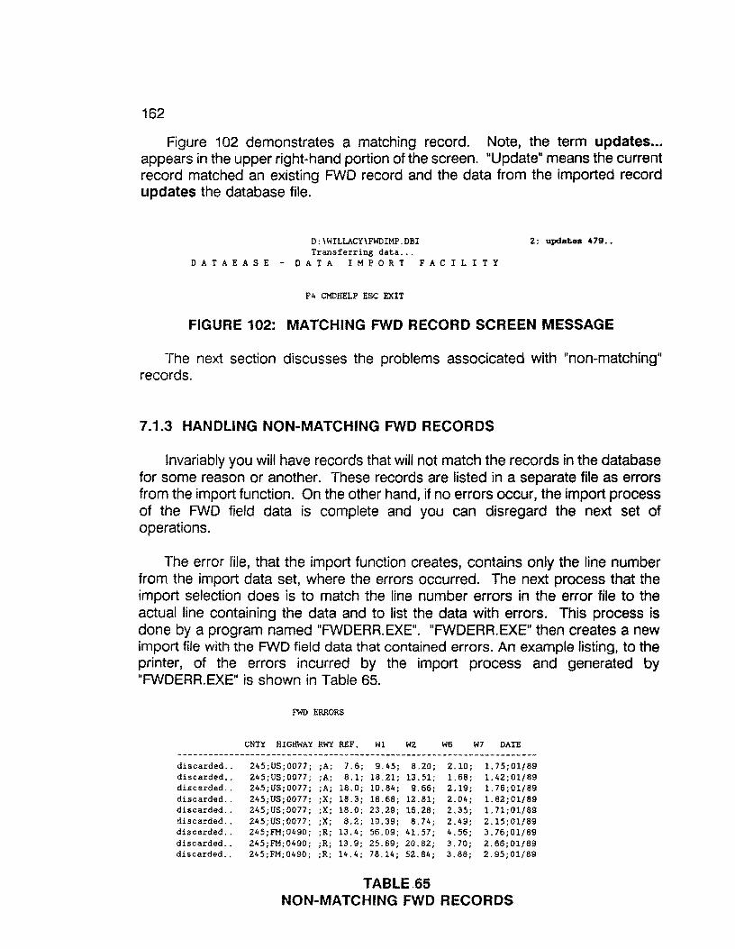
162
Figure 102 demonstrates a matching record. Note, the term updates ... appears in the upper right-hand portion of the screen. "Update" means the current record matched an existing FWD record and the data from the imported record updates the database file.
D:\WILLACY\FWDIMP.DBI 2: updates 479 .. Transferring data ...
0 A T A E A S E - D A T A I M P 0 R T F A C I L I T Y
F4 CMDHELP ESC EXIT
FIGURE 102: MATCHING FWD RECORD SCREEN MESSAGE
The next section discusses the problems associcated with "non-matching" records.
7.1.3 HANDLING NON-MATCHING FWD RECORDS
Invariably you will have records that will not match the records in the database for some reason or another. These records are listed in a separate file as errors from the import function. On the other hand, if no errors occur, the import process of the FWD field data is complete and you can disregard the next set of operations.
The error file, that the import function creates, contains only the line number from the import data set, where the errors occurred. The next process that the import selection does is to match the line number errors in the error file to the actual line containing the data and to list the data with errors. This process is done by a program named "FWDERR.EXE". "FWDERR.EXE" then creates a new import file with the FWD field data that contained errors. An example listing, to the printer, of the errors incurred by the import process and generated by "FWDERR.EXE" is shown in Table 65.
FWD ERRORS
CNTY HIGHWAY RWY REF. Wl W2 W6 W7 DATE
discarded.. 245;US;0077; ;A; 7.6; 9.45; 8.20; 2.10; 1.75;01/89 discarded.. 245;US;0077; ;A; 8.1; 18.21; 13.51; 1.68; l.42;01/89 discarded.. 245;US;0077; ;A; 18.0; 10.84; 9.66; 2.19; l.76;01/89 discarded.. 245;US;0077; ;X; 18.3; 18.68; 12.81; 2.04; l.82;01/89 discarded.. 245;US;0077; ;X; 18.0; 23.29; 16.28; 2.35; l.71;01/89 discarded.. 245;US;0077; ;X; 8.2; 10.39; 8.74; 2.49; 2.15;01/89 discarded. . 245 ;FM; 0490; ;R; 13. 4; 56. 09; 41. 57; 4. 56; 3. 76; 01/89 discarded.. 245;FM;0490; ;R; 13.9; 25.69; 20.82; 3.70; 2.66;01/89 discarded.. 245;FM;0490; ;R; 14.4; 78.14; 52.84; 3.88; 2.95;01/89
TABLE 65 NON-MATCHING FWD RECORDS

163
These errors must be corrected and reimported again until no more errors exist.
The first operation in correcting the errors is to separate the break points in the error listing, by manually underlining them on the output. This will make the error validation process much easier. Table 66 illustrates the break points in the error listing of a specimen sample of FWD field data that did not match on the first import run.
FWD ERRORS
CNTY HIGHWAY RWY REF. Wl W2 W6 W7 DATE
discarded .. 245;US;0077; ;A; 7.6; 9.45; 8.20; 2.10; 1. 75;01/89 discarded .. 245;US;0077; ;A; 8. l; 18.21; 13.51; 1.68; 1. 42; 01/89 discarded .. 24S;US;0077; ;A; 18.0; 10.84j 9.66j 2.19; l.76;01£89 discarded .. 24S;US;0077; ;X; 18.3; 18.68; 12.81; 2.04; 1. 82; 01/ 89 discarded .. Z4S;US;0077; ;X; 18.0; 23.29; 16.28; 2.35; 1. 71;01/89 discarded .. 24S;US;0077; ;X; 8.2; 10.39; 8.74; 2.49; 2.15;01£89 discarded .. 24S;FM;0490; ;R; 13. 4; 56.09; 41. 57; 4.56; 3.76;01/89 discarded .. 245;FM;0490; ;R; 13.9; 25.69; 20.82; 3.70; 2.66;01/89 discarded .. 245;FM;0490; ;R; 14.4; 78.14; 52.84; 3.88; Z.95;01/89
TABLE 66 BLOCKED FWD RECORDS -NON-MATCHING
After the errors are listed to the printer, you are returned to the "FWD DATA ENTRY/ WILLACY COUNTY" menu screen. The next step is to validate each group of errors that were separated, and to note any correction on the output. This is done by selecting the "3. Validate Errors in Imported FWD Data File" option. Press the "3" key, or use the arrow keys to highlight the selection and press the "Enter" key (See Figure 103).
FWD DATA ENTRY I WILLACY COUNTY
1. Convert FWD Field Data
2. Import Converted FWD Field Data i I 3. Validate Errors in Imported FWD Data File I I 4. Correct Errors in Imported Data File I
I I I I I I I I I
L___ 1 to 4 ~up DOWN RETURN - ENO __J
F4 CMDHELP ESC EXIT D:\DEASE\WILLACY WILLACY 12/04/89 8:40 am
FIGURE 103: VALIDATE FWD ERROR OPTION
At this point, the user initiates a DOS text editor to make appropriate changes in the non-matching records in order to re-import.

164
7.1.4 EDITING NON-MATCHING FWD RECORDS
The next screen that appears is the "FWD ERROR CORRECTIONS" report, wf"1ich the user must complete for validation of the FWD field data with errors. The information that must be completed will be found in the groups of invalid FWD field data that were selected on the "FWD ERRORS" report. Table 67 illustrates specimen data requiring editorial changes.
FWD ERRORS
CNTY HIGHWAY RWY REF. Wl W2 W6 W7 DATE
discarded .. 245;US;0077; ;A; 7.6; 9.45; 8.20; 2.10; l. 75;01/89 ]-discarded .. 245;US;0077; ;A; 8.1; 18.21; 13.51; 1.68; l.42;01/89 FIRST GROUP discarded .. 245;US;0077; :A: 18.0; 10.84; 9.66; 2.19; 1. 76;01/89 discarded .. 245;US;0077; ;X; 18.3; 18.68; 12.81; 2.04; 1. 82; 01/89 discarded .. 245;US;0077; ;X; 18.0; 23.29; 16.28; 2.35; 1. 71;01/89 discarded .. 245;US;0077; ;X; 8.2; 10.39; 6.74; 2.49; 2.15;01/89 discarded .. 245;FM;0490; ;R; 13.4; 56.09; 41.57; 4.56; 3.76;01/89 discarded .. 245;FM;0490; ;R; 13.9; 25.69; 20.82; 3.70; 2.66;01/89 discarded .. 245;FM;0490; ;R; 14.4; 78.14; 52.84; 3.88; 2.95;01/89
TABLE 67 FWD RECORDS REQUIRING EDITS
To validate the errors in the first group of FWD field data errors, the "FWD ERROR CORRECTIONS" report screen must be completed as shown in Figure 104.
/FWD ERROR CORRECTIONS!
Complete the entries below, then press "F2"
HIGHWAY PREFIX: US
HIGHWAY NUMBER: Qfil
HIGHWAY SUFFIX:
ROADWAY: t,.
F4 CMDHELP ESC EXIT D:\DEASE\WILLACY WILLACY 12/04/89 8:40 lllll
FIGURE 104: CORRECT FWD ERRORS
After the information is completed (US; 0077; SPACE; R), press the "F2" key to start the validation report process. Scroll through the output by pressing the space bar, until the output matches, as near as possible, that of the first group on the FWD field data error listing (Table 68).
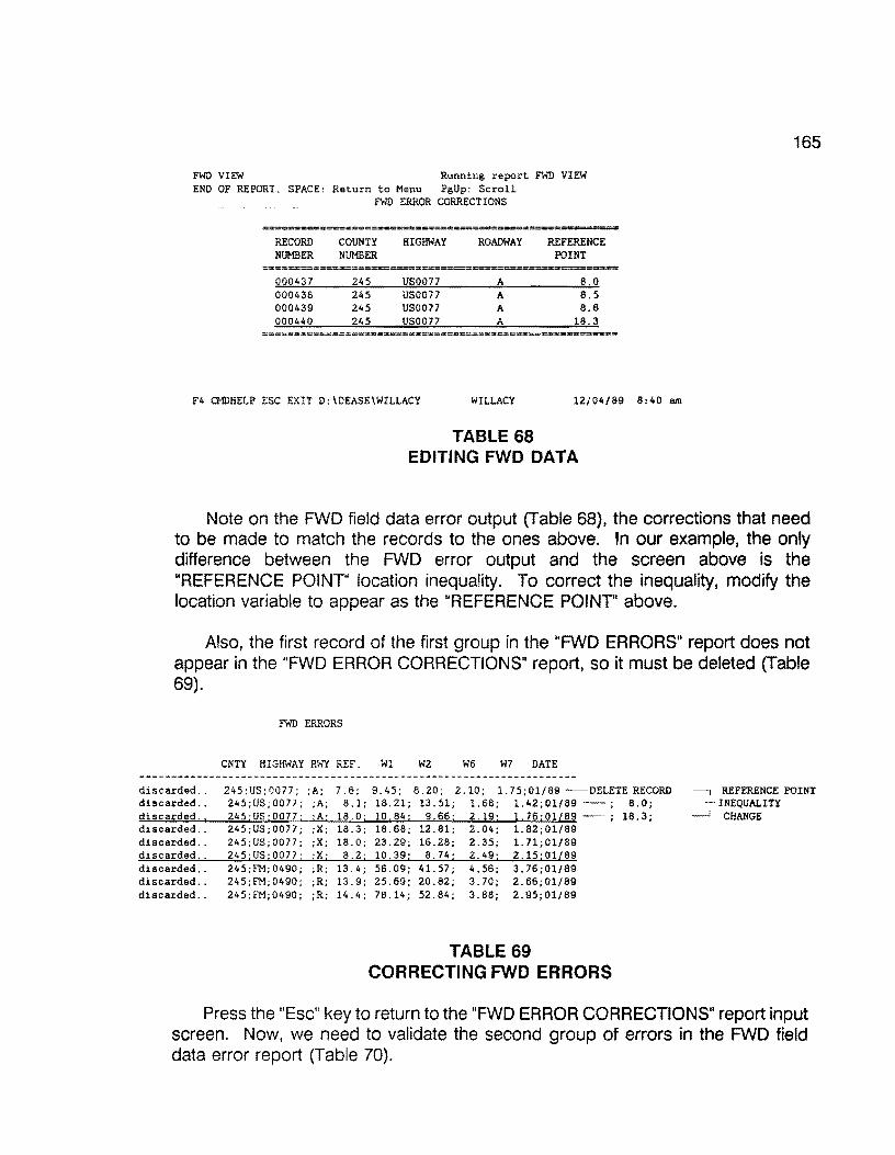
FWD VIEW Running report FWD VIEW END OF REPORT. SPACE: Return to Menu PgUp: Scroll
FWD ERROR CORRECTIONS
RECORD COUNTY HIGHWAY ROADWAY REFERENCE NUMBER NUMBER POINT
000437 245 US0077 A 8.0 000438 245 US0077 A 8.5 000439 245 US0077 A 8.6 000440 245 US0077 A 18.3
====e••=••••====•••==••:LCS=•••=•===••••=••=--==-----~=
F4 CMDHELP ESC EXIT D:\DEASE\WILLACY WILLACY 12/04/89 8:40 am
TABLE 68 EDITING FWD DATA
165
Note on the FWD field data error output (Table 68), the corrections that need to be made to match the records to the ones above. In our example, the only difference between the FWD error output and the screen above is the "REFERENCE POINT" location inequality. To correct the inequality, modify the location variable to appear as the "REFERENCE POINT" above.
Also, the first record of the first group in the "FWD ERRORS" report does not appear in the "FWD ERROR CORRECTIONS" report, so it must be deleted (Table 69).
discarded .. discarded .. discarded ..
FWD ERRORS
CNTY HIGHWAY RWY REF. Wl W2 W6 W7 DATE
245;US;0077; ;A; 8.1; 245;US;0077; ;A; 18.0; 245;US;0077; ;X; 18.3; 245;US;0077; ;X; 18.0; 245;US;0077; :X; 8.2; 245;FM;0490; ;R; 13.4; 245;FM;0490; ;R; 13.9; 245;FM;0490; ;R; 14.4;
18.21; 13.51; 1.68; 1.42;01/89 . 10.84; 9.66: 2.19; 1.76;01{89 -; 18.68; 12.81; 2.04; l. 82: 01/89 23.29; 16.28; 2.35; 1. 71;01/89 10.39; 8,74; 2.49; 2.15;01/89 56.09; 41. 57; 4.56; 3.76;01/89 25.69; 20.82; 3.70; 2.66;01/89 78.14; 52.84; 3.88; 2.95;01/89
TABLE 69 CORRECTING FWD ERRORS
8.0; 18.3;
Press the "Esc" key to return to the "FWD ERROR CORRECTIONS" report input screen. Now, we need to validate the second group of errors in the FWD field data error report (Table 70).
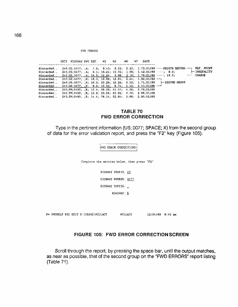
166
FWD ERRORS
CNTY HIGHWAY RWY REF. Wl W2 W6 W7 DATE
discarded .. 245;US;0077; ;A; 7 .6; 9.45; 8.20; 2.10; 1. 75;01/89 -DELETE RECORD REF. POINT discarded .. 245;US;0077; ;A; 8.1; 18.21; 13.51; 1.68; 1.42;01/89 - ; 8.0; INEQUALITY discarded .. 245 ;US i 0077; ;A; 18.0; 10.84; 9.66; 2.19; 1. 76; Oll89 ; 18.3; CHANGE discarded .. 245;US;0077; ;X: 18.3; 18.68; 12.81; 2.04; l.82;01/89 -, discarded .. 245;US; 0077; ;X; 18.0; 23.29; 16.28; 2.35; 1. 71;01/89 f- SECOND GROUP discarded .. 245;US;0077; ;X; 8.2; 10.39; 8.74; 2.49; 2.15;01l89 __J
discarded .. 245;FM;0490; ;R; 13.4; 56.09; 41. 57; 4.56; 3.76;01/89 discarded .. 245;FM;0490; ;R; 13.9; 25.69; 20.82; 3.70; 2.66;01/89 discarded .. 245;FM;0490; ;R; 14.4; 78.14; 52.84; 3.88; 2.95;01/89
TABLE 70 FWD ERROR CORRECTION
Type in the pertinent information (US; 0077; SPACE; X) from the second group of data for the error validation report, and press the "F2" key (Figure 105).
ERROR CORRECTIONS
Complete the entries below, then press "F2"'
HIGHWAY PREFIX; US
HIGHWAY NUMBER: 0077
HIGHWAY SUFFIX:
ROADWAY: ~
F4 CMDHELP ESC EXIT D:IDEASE\WILLACY WILLACY 12/04/89 8:40 am
FIGURE 105: FWD ERROR CORRECTION SCREEN
Scroll through the report, by pressing the space bar, until the output matches, as near as possible, that of the second group on the "FWD ERRORS" report listing (Table 71).

FWD VIEW Running report. FWD VIEW END OF REPORT. SPACE: Ret.urn t.o Menu PgUp: Scroll
FWD ERROR CORRECTIONS
RECORD COUNTY HIGHWAY ROADWAY REFERENCE NUMBER NUMBER POINT
·---==-======~~~
000517 245 US0077 x z.o 000518 245 US0077 x 2.1 000519 245 US0077 x 8.0 000520 245 US0077 x 8.4
F4 CMDHELP ESC EXIT D:\DEASE\WILLACY WILLACY
TABLE 71 CORRECTIONS TO FWD DATA
12/04/89 8:40 am
167
The modifications to the second group is almost exactly the same as that of the first group.
The first two records in this set do not exist, so delete them. The third record requires a "REFERENCE POINT" modification to match the records above. Although the location of this record falls exactly between the two records above, the location point can be rounded up or down two tenths. Use your own discretion when rounding the location points, choosing the least distance in rounding. The modification notes for the second data set appear in Table 72.
FWD ERRORS
CNTY HIGHWAY RWY REF. Wl W2 W6 W7 DATE
discarded .. 245;US;0077; ;A; 7.6; 9. 45; 8.20; 2.10; 1.75;01/89 - DELETE RECORD]- REFERENCE POINT discarded .. 245;US;0077; ;A; 8.1; 18.21; 13.51; 1.68; l.42;01/89 - ; 8.0; INEQUALITY discarded .. discarded .. discarded .. discarded .. discarded .. discarded .. discarded ..
245;US;0077; ;A; 18.0; 10.84; 245;US;0077; ;X; 18.3; 18.68; 245;US;0077; ;X; 18.0; 23.29; 245;US;0077; ;X; 8.2; 10.39; 245;FM;0490; ;R; 13.4; 56.09; 245;FM;0490; ;R; 13.9; 25.69; 245;FM;0490; ;R; 14.4; 78.14;
9.66; 2.19; l.76;01/89 - ; 18.3; CHANGE 12.81; 2.04; l.82;01/89 - DELETE RECORD]- REFERENCE POINT 16.28; 2.35; 1.71;01/89 - DELETE RECORD INEQUALITY 8.74; 2.49; 2.15;01/89 - ; 8.0; CHANGE
41. 57; 4,56; 3.76;01/89 20.82; 3.70; 2.66;01/89 52.84; 3.88; 2.95;01/89
TABLE 72 EDITED FWD DATA
Press the "Esc" key to return to the "FWD ERROR CORRECTIONS" report input screen. Now, validate the third group and final group of errors in the FWD field data (Figure 73).
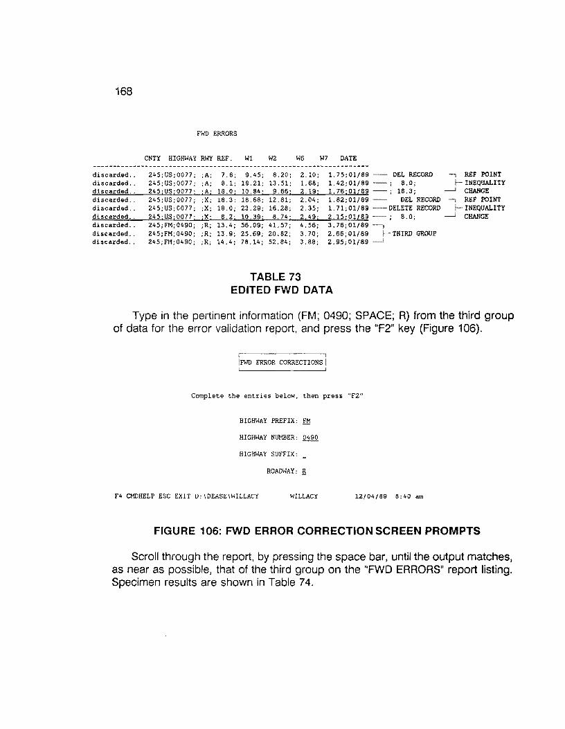
168
discarded .. discarded .. discarded .. discarded .. discarded .. discarded .. discarded .. discarded .. discarded ..
FWD ERRORS
CNTY HIGHWAY RWY REF. Wl W2 W6 W7 DATE
245;US;0077; ;A; 7.6; 9.45; 8.20; 2.10; 1. 75;01{89 DEL RECORD 245;US;0077; ;A; 8.1; 18 .21; 13.51; 1.68; l. 42; 01/89 ; 8.0; 245;US;0077: ;A; 18.0; 10.84; 9.66; 2.19; 1. 76;01l89 - ; 18.3; 245;US;0077; ; x; 245;US;0077; ; x; 245;US;0077; ;X; 245;FM;0490; ;R; 245;FM;0490; ;R; 245;FM;0490; ;R;
18.3; 18.68; 12.81; 2.04; 1.82;01/89 -18.0; 23.29; 16.28; 2.35; 1. 71;01/89 8.2; 10.39; 8.74; 2.49; 2.15;0ll89
13.4; 56.09; 41 57; 4.56; 3.76;01/89 ...... 13.9; 25.69; 20.82; 3.70; 2.66;01/89 14.4; 78.14; 52.84; 3.88; 2.95;01/89
TABLE 73 EDITED FWD DATA
DEL RECORD DELETE RECORD ; 8.0;
THIRD GROUP
-, REF POINT INEQUALITY CHANGE REF POINT INEQUALITY
-· CHANGE
Type in the pertinent information (FM; 0490; SPACE; R) from the third group of data for the error validation report, and press the "F2" key (Figure 106).
ERROR CORRECTIONS
Complete the entries below, then press "F2"
HIGHWAY PREFIX: FM
HIGHWAY NUMBER: 0490
HIGHWAY SUFFIX:
ROADWAY: Ji
F4 CMDHELP ESC EXIT D:\DEASE\WILLACY WILLACY 12/04/89 8:40 am
FIGURE 106: FWD ERROR CORRECTION SCREEN PROMPTS
Scroll through the report, by pressing the space bar, until the output matches, as near as possible, that of the third group on the "FWD ERRORS" report listing. Specimen results are shown in Table 74.
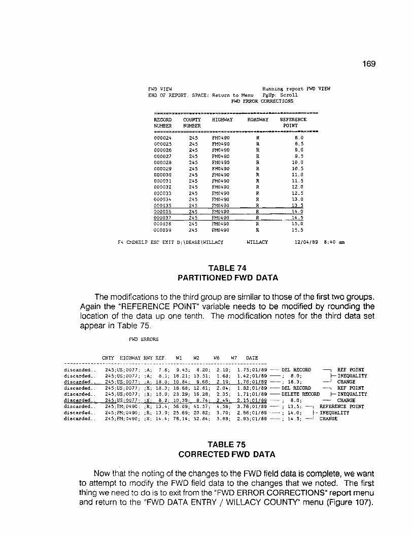
169
FWD VIEW Running report FWD VIEW END OF REPORT. SPACE: Return to Menu PgUp: Scroll
FWD ERROR CORRECTIONS
RECORD COUNTY HIGHWAY ROADWAY REFERENCE NUMBER NUMBER POINT
000024 245 FM0490 R 8.0 000025 245 FM0490 R 8.5 000026 245 FM0490 R 9.0 000027 245 FM0490 R 9.5 000028 245 FM0490 R 10.0 000029 245 FM0490 R 10.5 000030 245 FM0490 R 11.0 000031 245 FM0490 R 11. s 000032 245 FM0490 R 12.0 000033 245 FM0490 R 12.5 000034 245 FM0490 R 13.0 000035 245 FM0490 R 13.5 000036 245 FM0490 R 14.0 000037 245 FM0490 R 14. 5 000038 245 FM0490 R 15.0 000039 245 FM0490 R 15.5
F4 CMDHELP ESC EXIT D:\DEASE\WILLACY WILLACY 12/04/89 8:40 am
TABLE 74 PARTITIONED FWD DATA
The modifications to the third group are similar to those of the first two groups. Again the "REFERENCE POINT" variable needs to be modified by rounding the location of the data up one tenth. The modification notes for the third data set appear in Table 75.
discarded .. discarded .. discarded .. discarded .. discarded .. discarded .. discarded .. discarded .. discarded ..
FWD ERRORS
CNTY HIGHWAY RWY REF Wl W2 W6 W7 DATE
245;US;0077; ;A; 7.6; 9.45; 8.20; 2.10; l. 75;01/89 -DEL RECORD --, REF POINT 24S;US;0077; ;A; 8.1; 18.21; 13.51; 1.68; l.42;01/89 - ; 8.0; INEQUALITY 245;US;0077; ;A; 18.0; 10.84; 9.66; 2.19; 1. 76;01£89 - ; 18.3; CHANGE 245; US; 0077; ;X; 18.3; 18.68; 12.81; 2.04; l.82;01/89 DEL RECORD REF POINT 245;US;0077; ;X; 18.0; 23.29; 16.28; 2.35; l. 71;01/89 DELETE RECORD INEQUALITY 245jUS; 0077; ;Xi 8.2; 245;FM;0490; ;R; 13.4; 245;FM;0490; ;R; 13.9; 245;FM;0490; ;R; 14.4;
10.39; 8.74; 2.49; 2.15;01l89 - ; 56.09; 41. 57; 4.56; 3.76;01/89 25.69; 20.82; 3.70; 2.66;01/89 78.14; 52.84; 3.88; 2.95;01/89
TABLE 75 CORRECTED FWD DATA
8.0; CHANGE 13.5; --, REFERENCE POINT 14.0; INEQUALITY 14. 5; CHANGE
Now that the noting of the changes to the FWD field data is complete, we want to attempt to modify the FWD field data to the changes that we noted. The first thing we need to do is to exit from the "FWD ERROR CORRECTIONS" report menu and return to the "FWD DATA ENTRY/ WILLACY COUNTY" menu (Figure 107).

170
IFWD ERROR CORRECTIONS'
Complete the entries below, then press "F2"
HIGHWAY PREFIX:
HIGHWAY NUMBER:
HIGHWAY SUFFIX:
ROADWAY:
F4 CMDHELP ESC EXIT D: \DEASE\WILLACY WILLACY 12/04/89 8:40 am
FIGURE 107: FWD CORRECTION SCREEN
To do this, press the "Esc" key, and the "FWD DATA ENTRY/ WILLACY COUNTY" screen should appear (Figure 108). Select "4". Correct Errors in Imported Data File" by pressing the "4" key, or using the arrow keys to highlight the selection and press the "Enter" key.
FWD DATA ENTRY I WILLACY COUNTY
1. Convert FWD Field Data
2. Import Converted FWD Field Data
3. Validate Errors in Imported FWD Data File
4. Correct Errors in Imported Data File
-- l to 4 - UP - DOWN - RETURN - END
F4 CMDHELP ESC EXIT D:\DEASE\WILLACY WILLACY 12/04/89 8:40 am
FIGURE 108: PMS CORRECT FWD ERROR MAIN MENU
The next section discusses editing the FWD input data file to correct errors.
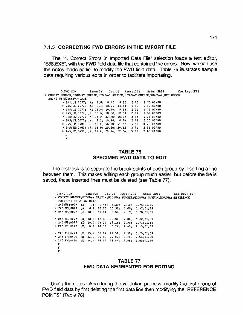
171
7.1.5 CORRECTING FWD ERRORS IN THE IMPORT FILE
The "4. Correct Errors in Imported Data File" selection loads a text editori "E88. EXE", with the FWD field data file that contained the errors. Now, we can use the notes made earlier to modify the FWD field data. Table 76 illustrates sample data requiring various edits in order to facilitate importating.
D:FWD.CON Line:08 Col:02 Free:l39l Mode: EDIT Com key:[Fll > COUNTY NUMBER;B!GHWAY PREFIX;HIGHWAY NUMBER;BIGHWAY SUFFIX;ROADWAY;REFERENCE
POINT;Wl;W2;W6;W7;DATE > 245;US;0077; ;A; 7.6; 9.45; 8.20; 2.10;
1.68; 2.19; 2.04; 2.35; 2.49; 4.56; 3.70; 3.88;
1.75;01/89 1.42;01/89 1. 76; 01/89 1.82;01/89 l.71;01/89 2.15;01/89 3.76;01/89 2.66;01/89 2.95;01/89
> 245;US;0077; > 245;US;0077; > 245;US;0077; > 245;US;0077; > 245;US;0077; > 245;FM;0490; > 24S;FM;0490; > 245;FM;0490;
F F
;A; 8.1; 18.21; 13.51; ;A; 18.0; 10.84; 9.66; ;X; 18.3; 18.68; 12.81; ;X; 18.0; 23.29; 16.28; ;X; 8.2; 10.39; 8. 74; ;R; 13.4; 56.09; 41.57; ;R; 13.9; 25.69; 20.82; ; R; 14. 4 ; 7 8. 14; 52. 84;
TABLE 76 SPECIMEN FWD DATA TO EDIT
The first task is to separate the break points of each group by inserting a line between them. This makes editing each group much easier, but before the file is saved, these inserted lines must be deleted (see Table 77).
D:FWD.CON Line:08 Col:02 Free:l391 Mode: EDIT Com key;[Fll > COUNTY NUMBER;HIGHWAY PREFIX;HIGHWAY NUMBER;HIGHWAY SUFFIX;ROADWAY;REFERENCE
POINT;Wl;W2;W6;W7;DATE > 245;US;0077; ;A; 7.6; 9.45; 8.20; 2.10; l.75;01/89 > 245;US;0077; ;A; 8.1; 18.21; 13.51; 1.68; l.42;01/89 > 245;US;0077; ;A; 18.0; 10.84; 9.66; 2.19; l.76;01/89
> 245;US;0077; ;X; 18.3; 18.68; lZ.81; 2.04; l.82;01/89 > 245 ;US; 0077; ;X; 18.0; 23.29; 16.28; 2.35; 1. 71;01/89 > 245;US;0077; ;X; 8.2; 10.39; 8.74; 2.49; 2.15;01/89
> 245;FM;0490; ;R; 13.4; 56.09; 41. 57; 4.56; 3.76;01/89 > 245;FM;0490; ;R; 13.9; 25.69; 20.82; 3.70; 2.66;01/89 > 245;FM;0490; ;R; 14.4; 78.14; 52.84; 3.88; 2.95;01/89
F F F
TABLE 77 FWD DATA SEGMENTED FOR EDITING
Using the notes taken during the validation process, modify the first group of FWD field data by first deleting the first data line then modifying the "REFERENCE POINTS" (Table 78).
172
D:FWD.CON Line:08 Col:02 Free:l391 Mode: EDIT Com key:[Fll >COUNTY NUMBER HIGHWAY PREFIX;ll!GHWAY NUMBER HIGHWAY SUFFIX;ROADWAY;REFERENCE POINT;Wl;W2;W6;W7;DATE > 245;US;0077; A;---'L..Q.; 18.21; 13.51; 1.68 1.42;01/89 MODIFY REFERENCE POINT > 245;US;0077; A;~; 10.84; 9.66; 2.19 1.76;01/89 INEQUALITIES
> 245 US;0077 x 18.3; 18.68; > 245 US;0077 x 18.0; 23.29; > 245 US;0077 x 8.2; 10.39:
> 245 FM 0490 R 13.4; 56.09; > 245 FM 0490 R 13.9; 25.69; > 245 FM 0490 R 14.4; 78.14;
F F F F F F F F
12.81 2.04; l.82;01/89 16.28 2.35; l.71;01/89 8.74 2.49; 2.15;01/89
41.57 4.56; 3.76;01/89 20.82 3.70; 2.66;01/89 52.84 3.88; 2.95;01/89
TABLE 78 MODIFIED FWD DATA
Modify the second group of FWD field data in the same manner as the first. Delete the first two records, then modify the "REFERENCE POINT' inequality by rounding (Table 79).
D:FWD.CON Line:08 Col:02 Free:1391 Mode: EDIT Com key:[Fll >COUNTY NUMBER;HIGHWAY PREFIX;HIGHWAY NUMBER;HIGHWAY SUFFIX;ROADWAY;REFERENCE POINT;Wl;W2;W6;W7;DATE
> 245;US;0077; ;A; 8.0; 18.21; 13.51; 1.68; l.42;01/89 > 245;US;0077; ;A; 18.3; 10.84; 9.66; 2.19; l.76;01/89
> 245;US;0077; ;X;---'L..Q.; 10.39; 8.74; 2.49; 2.15;01/89 ~MODIFY REFERENCE POINT INEQUALITY
> 245 FM 0490; ;R; 13.4; 56.09; 41.57; 4.56; 3.76;01/89 > 245 FM 0490; ;R; 13.9; 25.69; 20.82; 3.70; 2.66;01/89 > 245 FM 0490; ;R; 14.4; 78.14; 52.84; 3.88; 2.95;01/89 F F F F F F F F
TABLE 79 MODIFIED FWD DATA REFERENCE POINTS - PASS 2
Modify the third group by rounding the "REFERENCE POINTS" (Table 80).
D:FWD.CON Line:08 Col:02 Free:l391 Mode: EDIT Com key:[Fll > COUNTY NUMBER;HIGHWAY PREFIX;HIGHWAY NUMBER;HIGHWAY SUFFIX;ROADWAY;REFERENCE POINT;Wl;W2;W6;W7;DATE
> 245;US;0077; ;A; 8.0; 18.21; 13.51; 1.68; 1.42;01/89 > 245;US;0077; ;A; 18.3; 10.84; 9.66; 2.19; l.76;01/89
> 245;US;0077; ;X; 8.0; 10.39; 8.74; 2.49; 2.15;01/89
> 245;FM 0490; ;R 13.5; 56.09 41.57 > 245;FM 0490: :R -1.iJJ.; 25.69 20.82 > 245;FM 0490; ;R ...!.i,2; 78.14 52.84 F F F F F F F F
4.56 3.70 3.88
3.76 01/89 J-2.66 01/89 l'K>DIFY REFERENCE POINT 2.95 01/89 INEQUALITIES
TABLE 80 ROUNDING REFERENCE POINTS IN FWD DATA
173
Now, delete all of the blank lines and save the data set by pressing the "F1" key and selecting the "(A.) END the edit and save this file" option by pressing the "A" key (Figure 109).
D:FWD.CON Line:08 Col:02 Free:l391 Mode: EDIT Com key:[Fl] > COUNTY NUMBER;HIGHWAY PREFIX:HIGHWAY NUMBER;HIGHWAY SUFFIX;ROADWAY;REFERENCE POINT;Wl;W2;W6;W7;DATE
> 245;US;0077 ;A; 8.0; 18.21; 13.51; l.68; l.42;01/89 > 24S;US;0077 ;A: 18.3; 10.84; 9.66; 2.19; 1.76;01/89 > 245;US;0077 ;X; 8.0; 10.39; 8.74; 2.49; 2.15;01/89 > 245 FM 0490 ;R; 13.S; 56.09; 41.57; 4.56; 3.76;01/89 > 245 FM 0490 ;R; 14.0; 25.69; 20.82; 3.70; 2.66;01/89 > 245 FM 0490 ;R; 14.5; 78.14; 52.84; 3.88; 2.95;01/89 F F F F F F F F
MASTER CCMIAND MENU
Select option or press Esc to return
(A. J CB. J (C. J (D.)
(E.)
(F.)
CG.) (H.)
END the edit and save this file BACKUP (create filename.bak) CHANGE filename (for saving) HELF EDIT another file (with options) SEARCH and [replace] string SETUP (set default parameters) QUIT * RETURN TO DOS * NO SAVE
FIGURE 109: SAVING EDITED FWD DATA MENU
After saving the changes to the FWD field data file, you are then returned back to the "FWD DATA ENTRY/ WILLACY COUNTY" menu.
Select the "2. Import Converted FWD Field Data" option to import the FWD filed data that has been altered, by pressing the "2" key, or using the arrow keys to highlight the option and press the "Enter" key (Figure 110).
174
FWD DATA ENTRY I WILLACY COUNTY
1. Convert FWD Field Data
2. Import Converted FWD Field Data
3. Validate Errors in Imported FWD Data File
4. Correct Errors in Imported Data File
l to 4 - UP - DOWN - RETURN - END
F4 CMDHELP ESC EXIT D:\DEASE\WILLACY WILLACY 12/04/89 8:40 am
FIGURE 110: IMPORT FWD DATA MENU
After the import has completed and there were no errors sent to the printer, you will be returned to the "FWD DATA ENTRY/ WILLACY COUNTY" menu with the "O added, 6 updated, o discarded" message at the top of the screen (Figure 111 ).
0 added, 6 updated, 0 discarded
FWD DATA ENTRY I WILLACY COUNTY
1. Convert FWD Field Data
2. Import Converted FWD Field Data
3. Validate Errors in Imported FWD Data File
4. Correct Errors in Imported Data File
L__ l to 4 - UP - DOWN - RETURN - END
F4 CMDHELP ESC EXIT D:\DEASE\WILLACY WILLACY 12/04/89 8:40 am
FIGURE 111: FWD DATA ENTRY SYSTEM MENU
If errors were detected, you must go through the previous processes of validation and correction until there are no errors detected.
Now that the FWD field data entry process is complete for this data set, press the "Esc" key to retrace our steps out of the database until the "Pavement Management System" menu appears (Figure 112). If additional FWD field data is collected for the same county at a later date, follow the same procedures of the FWD field data entry process discussed above.
175
Pavement Management System
MENU 2 OF 2 -> 1 - Willacy County {245)
2 - Zapata County (253)
3 - Process Raw Skid Data
4 - Tape Backup
5 - Optimize Hard Disk
6 - Disk Operating System
December 4, 1989 8:37:23 am NUM Memory: 640 K
FIGURE 112: PMS MAIN SYSTEM MENU
The next section discusses auditing the FWD file to insure that no missing data exists.
7.2 COMPLETENESS OF FWD DATA
After it is assumed that all of the FWD data for a particular county has been collected, converted, and imported, it is a good practice to ensure that you are satisfied with the completeness of the data. This is done by running a missing FWD data report for the particular county of interest.
Select the particular county that is assumed to be complete. In this example, we will again use Willacy county. To do this, use the arrow keys on the keyboard to point to the item "1 - Willacy County (245)" (only in this example) and press the "Enter" key, or press the "1" key (Figure 113}.
176
Pavement Management System
MENU 2 OF 2 -> l - Willacz Countz !2452
2 - Zapata County (253)
3 - Process Raw Skid Data
4 Tape Backup
5 - Optimize Hard Disk
6 Disk Operating System
December 4, 1989 8:37:23 am NUM Memory: 640 K
FIGURE 113: PMS MAIN SYSTEM MENU
Again you are prompted for your name and security password. In the following example, the sign on name is "DATA" and the security password is "ENTRY" (Figure 114).
D A T A E A S E S I G N ON
Directory: D:\DEASE\WILLACY
What is the database name?: WILLACY
What is your name :~
What is your security password : ~~
F4 CMDHELP ESC EXIT D:\DEASE\WILLACY WILLACY 12/04/89 8:40 am
FIGURE 114: PMS SIGN-ON MENU SCREEN
The "PAVEMENT MANAGEMENT SYSTEM/ WILLACY COUNTY" menu should appear on your screen (Figure 115). Select "6. Reports" by pressing the "6" key, or use the arrow keys to highlight the selection and press the "Enter" key.
177
PAVEMENT MANAGEMENT SYSTEM I WILLACY COUNTY
1. Setup
2. Data Entry -- District Field Data
3. Data Entry -- Import PES Data
4. Data Handling -- District Field Data
5. Data Handling -- Imported PES Data
6. Reports
7. Year End
1 to 7 - UP - DOWN RETURN - END
F4 CMDHELP ESC EXIT D:\DEASE\WILLACY WILLACY 12/04/89 8:40 am
FIGURE 115: PMS REPORTS MENU
The next menu that appears on your screen is "REPORTS / WILLACY COUNTY" menu (Figure 116). We want a report on missing FWD data, so select the "1. Missing Data Reports" by pressing the "1" key, or use the arrow keys to highlight the selection and press the "Enter" key.
REPORTS I WILLACY COUNTY
1. Missing Data Reports
2. Generate Rating Forms
3. Critical Value Reports
4. Data Listing Reports
5. PMS-PES Conversion
6. Ad Hoc Reports
1 to 6 - UP - DOWN - RETURN END
F4 CMDHELP ESC EXIT D:IDEASEIWILLACY WILLACY 12/04/89 8:40 am
FIGURE 116: PMS MISSING DATA REPORT MENU
Make certain that your printer is powered up and on line, then select the "3. Missing FWD Data" option by pressing the "3" key or use the arrow keys to highlight the selection and press the "Enter" key (Figure 117). At this point, make certain the laser printer is loaded with paper and on-line.

178
MISSING DATA REPORTS I WILLACY COUNTY
1. Missing Visual Data
2. Missing Ride Data
3. Missing FWD Data
4. Missing Skid Data
5. Missing Date of Last Surface Data
1 to 5 - UP -- DOWN - RETURN - END
F4 CMDHELP ESC EXIT D: \DEASE\WILLACY WILLACY 12/04/89 8:40 am
FIGURE 117: MISSING DATA REPORT MENU
A listing of missing FWD data should start printing on the printer. If there was no missing FWD data, a blank page will be printed. Tabe 81 provides an example of a missing FWD data report for Willacy County.
MISSING FWD DATA Willacy County Page No. 1
=n===---·--==--:===----==na==-----~-----=··-- -= ---=--==--====== COUNTY HIGHWAY ROADWAY REFERENCE MILEPOST ADT KIP RECORD NUMBER POINT NUMBER
-------------------------------------------------------------------245 FM049S R 11.8 10+1. 8 170 265 000092 245 FM1761 R 4.0 4+0.0 240 302 000205 245 FM2099 R 0.0 2-2.0 160 120 000242 245 FM2099 R 1. 0 2-1.0 160 120 000244 245 FM2099 R 1. 5 2-0.5 160 120 000245 245 FM2099 R 2.0 2+0.0 160 120 000246 245 FM2099 R 2.5 2+0.5 160 120 000247 245 FM2099 R 3.0 2+1.0 160 120 000248 245 FM2099 R 3.5 2+1.5 160 120 000249 245 FM2099 R 4.0 4+0.0 160 120 000250 245 FMZ099 R 4.5 4+0.5 130 107 000251 245 FM2099 R 5.0 4+1. 0 130 107 000252 245 FM2099 R 5.5 4+1. 5 130 107 000253 245 FM2099 R 5.6 4+1.6 130 107 000254 245 FM2099 R 6.5 8-1. 5 130 107 000255 245 FM2099 R 7.0 8-1. 0 130 107 000256 245 FM2099 R 7.5 S-0.5 130 107 000257 245 FM2099 R 8.0 8+0.0 130 107 000258 245 FM2099 R 8.5 8+0.5 130 107 000259 245 FM2099 R 9.0 8+1.0 130 107 000260 245 FM2099 R 9.4 8+1.4 130 372 000261 245 FM2209 R 5.5 4+1.5 710 372 000273 245 FM2209 R 6.0 6+0.0 7,800 7,621 000274 245 US0077 A 8.6 8+0.6 000439 245 US0077 x 2.0 2+0.0 000517 245 US0077 x 2.1 2+0.1 000518
===#•=====:==:=====:=====:=~===m:=:=z~;;;;:=====-======~==-=::::==========
TABLE 81 SPECIMEN OUTPUT FOR MISSING FWD DATA

179
You will be returned to the "MISSING DATA REPORTS/ WILLACY COUNTY" menu (Figure 118) as soon as the report has completed.
MISSING DATA REPORTS I WILLACY COUNTY
l. Missing Visual Data
2. Missing Ride Data
3. Missing FWD Data
4. Missing Skid Data
5. Missing Date of Last Surface Data
l to 5 - UP - DOWN - RETURN - END
F4 CHDHELP ESC EXIT D:\DEASE\WILLACY WILLACY 12/04/89 8:40 am
FIGURE 118: MISSING DATA MENU
Now that the report has completed, press the "Esc" key several times to exit from the database and return to the "Pavement Management System" menu (Figure 119).
Pavement Management System
MENU 2 OF 2 -> l - Willacy County (245)
2 - Zapata County (253)
3 - Process Raw Skid Data
4 - Tape Backup
5 - Optimize Hard Disk
6 - Disk Operating System
December 4, 1989 8:37:23 am NUM Memory: 640 K
FIGURE 119: PMS MAIN SYSTEM MENU
If not satisfied with the results of the missing FWD data report, use the report as a guide in collecting the missing sections. Then, one must go through the
180
conversion and import processes discussed earlier to finalize the completeness of the FWD data. On the other hand, if one is satisfied with the completeness of the FWD data, proceed with undertaking movement of the FWD data to the 0.1-mile history file (with caution as noted in the next section).
7.3 FWD DATA FINAL TRANSFER
Caution, this process should be undertaken only one time within a given data collection year. This procedure moves the 0.5-mile FWD data to the 0.1-mile Master file. Normally, final data transfer takes place as soon as all district field data (Visual, Skid, Siometer, and FWD) have been collected and either entered or imported.
When it is verified that all of the FWD data has been completely collected for the given year in a particular county, the data must be transferred from the FWD data form to the 0.1 - mile Master data form. Once trasferred, the various critical and ad hoc reports can be generated from the 0.1 - mile Master.
This process is done by first selecting the particular county. In this example we will use Willacy county. To do this, use the arrow keys on the keyboard to point to the item "1 - Willacy County (245)" (only in this example) and press the "Enter" key, or press the "1" key (Figure 120).
Pavement Management System
MENU 2 OF 2 -> l - Willacy County ~2452
2 - Zapata County (253)
3 - Process Raw Skid Data
4 - Tape Backup
5 - Optimi~e Hard Disk
6 - Disk Operating System
December 4, 1989 8:37:23 am NUM Memory: 640 K
FIGURE 120: PMS MAIN SYSTEM MENU
You are then prompted for your name and security password. In the following example, the sign on name is "DATA" and the security password is "ENTRY" as shown in Figure 121.
181
D A T A E A S E - S I G N ON
Directory: D:\DEASE\WILLACY
What is the database name?: WILLACY
What is your name
What is your security password : ~~
F4 CMDHELP ESC EXIT D:\DEASE\WILLACY WILLACY 12/04/89 8:40 am
FIGURE 121: PMS SIGN-ON MENU
The"PAVEMENTMANAGEMENTSYSTEM/WILLACYCOUNTY"menushould appear on your screen (Figure 122). Select "4. Data handling -- District Field Data" by pressing the "4" key, or use the arrow keys to highlight the selection and press the "Enter" key.
PAVEMENT MANAGEMENT SYSTEM f WILLACY COUNTY
1. Setup
2. Data Entry -- District Field Data
3. Data Entry Import PES Data
4. Data Handling -- District Field Data
5. Data Handling -- Imported PES Data
6. Reports
7. Year End
1 to 7 - UP DOWN - RETURN - END
F4 CMDHELP ESC EXIT D:\DEASE\WILLACY WILLACY 12/04/89 8:40 am
FIGURE 122: PMS DATA HANDLING MENU
The next menu that should appear on your screen is entitled "DATA HANDLING -- DISTRICT FIELD DATA/ WILLACY COUNTY" (Figure 122). Select "3. FWD Data" by pressing the "3" key, or use the arrow keys to highlight the selection and press the "Enter" key.

182
DATA liANDLING -- DISTRICT FIELD DATA I WILLACY COUNTY
1. Visual Data
2. Ride Data
3. FWD Data
4. Skid Data
5. Date of Last Surface
6. Roadway Characteristics
l to 6 - UP - DOWN - RETURN - END
F4 CMDHELP ESC EXIT D:\DEASE\WILLACY WILLACY 12/04/89 8:40 am
FIGURE 123: PMS FWD DATA SELECTION MENU
The next screen that appears is "FWD DATA HANDLING / WILLACY COUNTY", with only one selection (Figure 124). Select "1. Transfer FWD Data to Master Data Form" by pressing the "1" key, or use the arrow keys to highlight the selection and press the "Enter" key. This process transfers all of the FWD data from the FWD data form (0.5 mile records) to the Master data form (0.1 mile records).
FWD DATA HANDLING I WILLACY COUNTY
1. Transfer FWD Data to Master Data Form
l to 1 UP - DOWN RETURN - END
F4 CMDHELP ESC EXIT D:\DEASE\WILLACY WILLACY 12/04/89 8:40 am
FIGURE 124: FWD TRANSFER TO HISTORY FILE
The following screen (Figure 125) will appear.
FWD MASTER UPDATE ••••• UPDATE
RUNNING REPORT FWD MASTER
FIGURE 125: FWD MASTER FILE UPDATE
This procedure transfers the 0.5-mile FWD data for each 0.5-mile highway

183
segment to the appropriate 0.1-mile Master File. As soon as the update procedure has completed, you will be returned to the "FWD DATA HANDLING/ WILLACY COUNTY" menu as shown in Figure 126.
FWD DATA HANDLING I WILLACY COUNTY
1. Transfer FWD Data to Master Data Form
1 to 1 - UP - DOWN - RETURN ENO
F4 CMDBELP ESC EXIT D:\DEASE\WILLACY WILLACY lZ/04/89 8:40 am
FIGURE 126: TRANSFER FWD DATA TO 0.1-MILE FILE
When the transfer process is complete, press the "Esc" key several times to return to the "Pavement Management System" menu as shown in Figure 127.
Pavement Management System
MENU 2 OF 2 -> 1 - Willaci Counti '245l
2 - Zapata County (253)
3 - Process Raw Skid Data
4 - Tape Backup
5 - Optimize Hard Disk
6 - Disk Operating System
December 4, 1989 8:37:23 am NUM Memory: 640 K
FIGURE 127: PMS MAIN SYSTEM MENU
This concludes the FWD data processing.

184
8.0 VISUAL DATA ENTRY
This section describes the data entry steps necessary to enter current Visual data into the database. Visual data is one of several data types required by the database. It is important to point out that this is the only data collection process that requires manual data entry. Since the gathering of visual data (on 0.5-mile intervals) is largely a human-intensive effort, and no means as yet been discovered to fully automate visual data, this task remains labor intensive. First, the actual collection of visual data is highly subjective. Trained raters must drive the entire district and record their evaluations of the pavement sections on computergenerated rating sheets. Second, the rating sheets are returned to the district headquarters where trained staff personnel manually enter the scored segments directly into the 0.5 VIS file, record by record. This report segment describes, in detail, the steps required to enter visual data into the PMS database.
Visual data is stored within a data file containing half-mile highway segment records. Trained rating personnel begin the manual process of rating pavement segments in September of any given year. Rating forms are produced from the 0.5-mile visual file and given to the raters to assist in the rating process. The rating forms contain sorted 0.5-mile segments associated with each highway within a given conty. Using the forms as a guide, raters drive the various highway segments and subjectively rate each visual category associated with pavement distresses.
This protion of the report deals with the manual data entry of the subjectively gathered distress values and the subsequent transfer of the data to the 0.1-mile master file. Based upon the visual distress scores observed, the system generates pavement rating scores (PRS values) and shoulder rating scores (SRS values). The respective PAS and SRS values are calculated and stored within the 0.5-mile and 0.1-mile files for later analysis.
Details relating to visual data collection and the associated training requirements may be found in the 1989 District PRS Rater's Manual, published by the Texas Department of Transportation, August, 1989.
8.1 D21-PMS Data Set Categories
The D21 system currently supports four (4) types of data sets, specifically:

185
1. Visual Data, 2. Ride Data, 3. Falling Weight Data, 4. Skid Data.
Under the 1988-89 version, Visual Data must be manually input by a trained data entry operator. The remaining data sets (Ride, Skid, and FWD data are automated data transfer procedures that require more intimate knowledge of the internal operation of the database. This section will emphasize the data entry procedures pertaining only to the manual entry of Visual Data. Later sections will focus on the procedures for Ride, FWD, and Skid data entry.
8.2 DESCRIPTION OF VISUAL DATA COLLECTION
Data collection activities for District 21 normally begin in September of a given year. Trained field crews drive the entire grid of state maintained roads within the district and collect visual pavement condition data. This activity involves from three (3) to five (5) 2-person crews who are assigned to work a given county. For large counties, two 2-person crews divide the visual data collection. The goal is to 100% visually rate 0.5-mile segments within each county. Normally, the visual data collection activities are finished by the end of November of a given year. Visual data collection involves a skilled rater who subjectively evaluates the following attributes:
1. Rutting, 2. Raveling, 3. Flushing, 4. Corrugations, 5. Alligator Cracking, 6. Longitudinal Cracking, 7. Transverse Cracking, 8. Sealed cracks, 9. Patching, 10. Shoulder evaluation (paved or unpaved).
In order to record the visual scores, the 021 Database maintains an up-to-date highway inventory file listing the County Number, Highway Prefix, suffix, number, roadway, and reference milepost. From the highway inventory within a given county, the database system has the ability to generate visual data collection forms sorted in a specific order. The visual data collection forms are generated on a laser printer and are provided to the raters. The forms are taken to the field where the rating crews drive the required segments and manually record their subjective scores (37 individual entries per half-mile segment) for each of the 10 categories. The computer generated rating forms contain all information necessary to
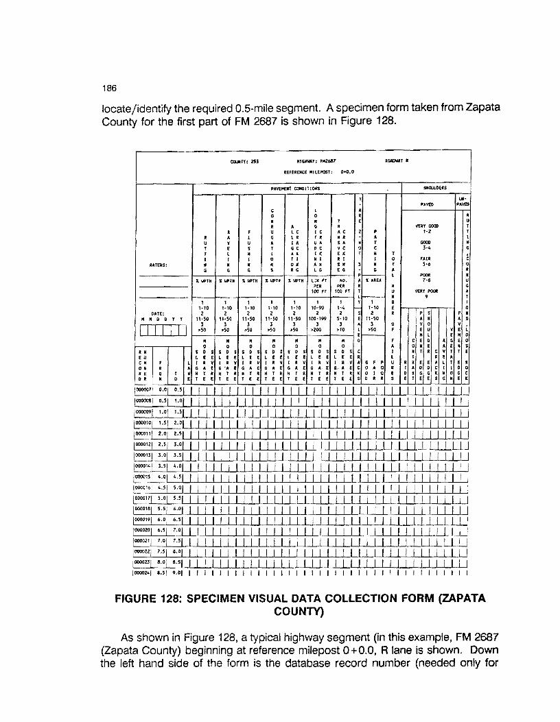
186
locate/identify the required 0.5-mile segment. A specimen form taken from Zapata County for the first part of FM 2687 is shown in Figure 128.
COUNTY: 253 HIGllllAY: FM26117 R<Wl\IAYl
REFERENCE MILEPOST: O+O.O
PAVEMENT CONOITIOllS SllCIJU!US
1 Ull· PAV£0 PAV£0
c l • 0 D R R R • T E u
• • G R VERY Goal T l F u LC IC • c 2 p 1-2 r
I • L G L R T R N R A I u v u • I A u. s• N T GOal • T E s T G C 0 c v c 0 c 3·4 G T l H I A K I K E K T H T
i: I I I 0 T I N I R I I 0 FAIR RATERS: • • • • 0 • •• $. 3 • T 5·6 0
G G G s R G LG E G G • I .~ L POOi! I
11. llPTH 11. llPTll il llPTH X llPTH X WPTH L.IM FT HO. • 11. AREA 7-$ u PER PER • • G
100 FT 100 FT T u VERY POOi! • l------ • 9 T
1 1 1 1 1 1 1 y 1 8 I 1·10 1-10 1•10 1•10 1·10 10·90 1·4 '- 1·10 E 0
DATE: 2 2 2 2 2 2 2 s 2 R p s p • M M D D T y 11·50 11·50 11·50 i IMO 11-50 100·199 5·10 e 11·50 • H A s
I I I I I I I 3 3 3 3 3 3 3 ... 3 0 v 0 v
L >50 >SO >50 >SO >50 >200 >10 l >50 F e u v e E- M l e • 0
• • • II M • • 0 F c E 0 R G E 0 0 0 0 0 D 0 0 I • 0 • e A E • s
•• s 0 s s 0 s s 0 $ s D s s D s s 0 s s 0 s c I • r R c v T T E e u L E e L E E l E E l E E l E E l E E L E E R L T l E • CM F L I • v I l v I R v I R y I • v I l v I R v • G F p u • R E E • l T e l 0 8 • • G • E G .,_ E G • E G A E G A E G A. E a .. A E c 0 A 0 R I • D D c I I D 0 i E Q T N • T • H T • K T R K T R H T R H T R H T R ~ Q I 0 E D $ G G c M 0 G c D R M 0 E T E e T E E T E E T E E r E E T E E T E E s D R R s E T E E s G E l ~·
10000011 °·0
/ o.sl I I I I I I I I I I I I I I I I I I I I I I I I I I I I I /0000081 °·51 ,_01 I I I I I I I I I I I I I I I I I I I I I I I I I I I I I
/0000091 1-
0/ u1 I I I I I I I I I I I I I I I I I I I I I I I I I I I I
/000010
/ ,_ 51 2-01 I I I I I I I I I I I I I I I I I I I I I I I I I I I I
i000011! 2-0 /
2•51 I I I I I I I I I I I I I I I I I I I I I I I I I I I
10000121 2•5
/ 3
•01 I I I I I I I I I I I I I I I I I I I I I I I I I I
E 31 3•01 351 I I I I I I I I I I I I I I I I I I I I I I I I I I
I 000014 I 3 • 5 I 4
• 0 ..... 1 ...__,_! ....cl_._.._! _._I _,_I ....._I -'-! _._l'---'-1 _._._I -1..I _._ I I I I I I I I I I II I I II
/000015 ! 4.0/ '·51 I I I I I I I I I I I I I I I I I I l I I l I I I I I I ~~1 0 1 5·
01 I I I I I I l I I I I I I I I I I I I I I I I I I I I I ~00011 1 5
•01 5 •
51 I I I I I I I I I I I I I I I I I I I I I I I I I I 1 I I 1000018
/ 5
·51 6•
01 I I I I I I I I I I I I I I I I I I I I I I I I I I I I 1000019
/ 6
•0
; 6
•51 I I I I I I I I I I I I I I I I I I I I I I I I I I I I
/000020
/ 6
•51 1•
0W I I I I I I I I I I I I I I I I I I I I I I I I I I 1000021
/ 1
•0
1 1
·51 I I I I I I I I I I I I I I I I I I I I I I I I I U.U
._I
0000_
2._...,2 /_
7_·
5_._I _
8·_._0 I __.I_._./ _,_/ _.__._I _.I I I I I I I I I I I I I I I I I I I I I I I I I I I
1000023/ s.o: 8
•51 I I I I I I I I I I I I I I I I I I I I I I I I I I I I I I I
10000241 a.s1 9.01 I I I I I I I I I I I I I I I I I I I I I I I I I I I I I I I
FIGURE 128: SPECIMEN VISUAL DATA COLLECTION FORM (ZAPATA COUNTY}
As shown in Figure 128, a typical highway segment (in this example, FM 2687 (Zapata County) beginning at reference milepost 0+0.0, R lane is shown. Down the left hand side of the form is the database record number (needed only for

187
internal auditing) along with the From-To limits. Raters will drive FM 2687 beginning at reference milepost O+O.O (which denotes R.P. 0.0). The first row of the form corresponds to the first 0.5-mile segment (RP 0.0 - 0.5). Upon driving this segment, the raters will manually record their impressions of the scores for each category (categories are shown across the top of the form). An integer score that varies for each column (normally O, 1,2,3) is entered on the row and within the required column. Each row in this form represents a particular 0.5-mile segment or fraction thereof.
The next section describes the steps required to enter the database in order to begin visual data entry.
8.3 Entering the Database to Begin Visual Data Entry
The current version of the D21 Database is maintained at the District 21 Headquarters in Pharr, Texas. The system resides on a Hewlett Packard Vectra R/S20 20 Mhz 386-based microcomputer. This system is configured as follows:
1. 640 Kb of "standard" or base RAM, 2. 2 Mb of total memory, 3. One 5.25" 1.2Mb floppy (A:Drive), 4. One 3.5" drive (B: Drive), 5. One 103 Mb Hard Drive partitioned as a C: Drive (32 Mb) and a 0:
Drive (70 Mb), 6. One HP LaserJet Series II or Ill parallel printer (LPT1), 7. One Computerland 60Mb high speed tape backup unit.
The D21 database was designed using an existing software package called DATAEASE Version 4.0. User menus have been developed to facilitate data entry and report generation by various users of the system. DAT A EASE requires that all users have a password in order to gain access to the system. The software supports various levels of users and each user's level is defined in advance. A "high" level user is one who can access all levels of the system from data entry to creating data calculations and report generation. Lower level users are restricted to such activities as data entry only and cannot gain access to the intimate details of the system. Visual data entry is established at a rather low level and all one can do is simply enter data.
The next section describes the process of entering the recorded visual distress scores.

188
8.3.1 Booting the System
To begin visual data entry perform the following steps:
1. Power on the system and turn the color monitor on.
The power-on switch is on the upper left-hand side of the Vectra. Depress the switch then push in the power switch on the lower right hand side of the monitor.
After completing the above steps, it takes approximately 20 seconds or so for the system to perform internal checking procedures. Upon passing the internal checks, the software built into the system comes up with the Pavement Management System main menu as shown in Figure 9.2.
Pavement Management System
1 - Brooks County (024)
2- Cameron County (031)
3 - Duval County (067)
4 - Hidalgo County (109)
5 - Jim Hogg County (066)
6 - Kenedy County (066)
7- Starr county (214)
8 - Webb county (240)
July 22, 1989 7:51:23 pm
menu 1 of 2
NUM SHIFT Memory 640 k
FIGURE 129: Pavement Management System Main Menu2
Figure 129 shows the first menu that the user sees. A small arrow (pointer)
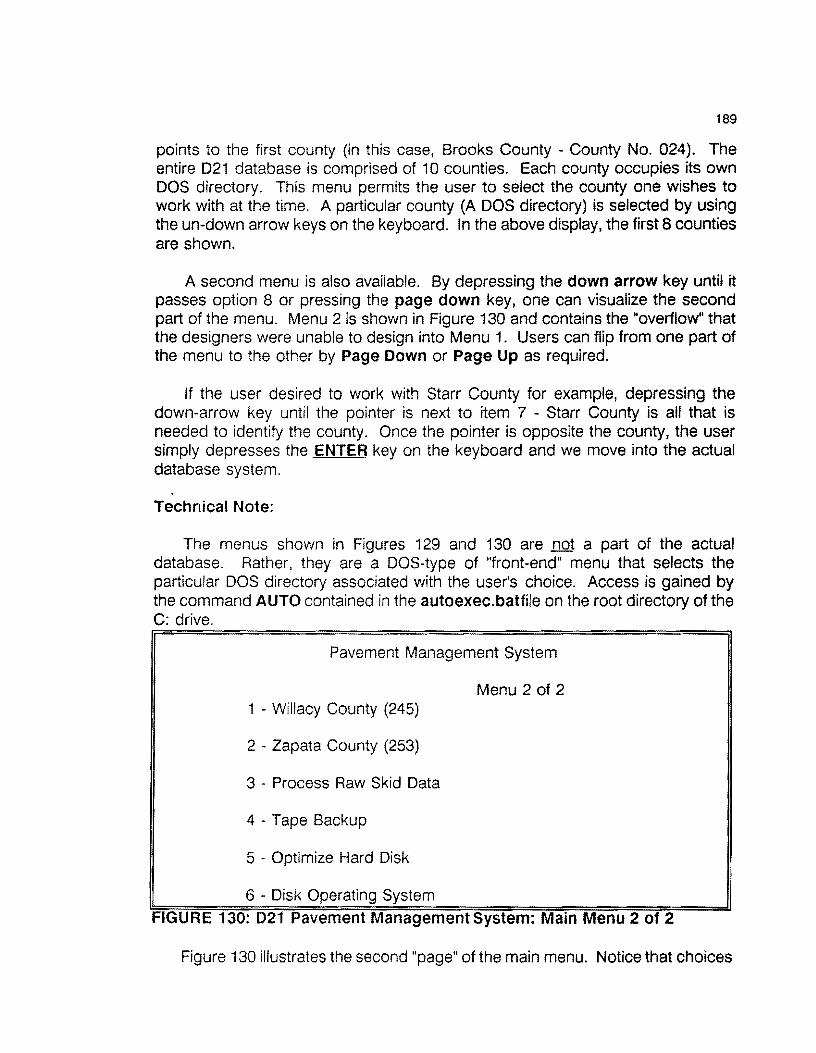
189
points to the first county (in this case, Brooks County - County No. 024). The entire D21 database is comprised of 10 counties. Each county occupies its own DOS directory. This menu permits the user to select the county one wishes to work with at the time. A particular county (A DOS directory) is selected by using the un-down arrow keys on the keyboard. In the above display, the first 8 counties are shown.
A second menu is also available. By depressing the down arrow key until it passes option 8 or pressing the page down key, one can visualize the second part of the menu. Menu 2 is shown in Figure 130 and contains the "overflow" that the designers were unable to design into Menu 1. Users can flip from one part of the menu to the other by Page Down or Page Up as required.
If the user desired to work with Starr County for example, depressing the down-arrow key until the pointer is next to item 7 - Starr County is all that is needed to identify the county. Once the pointer is opposite the county, the user simply depresses the ENTER key on the keyboard and we move into the actual database system.
Technical Note:
The menus shown in Figures 129 and 130 are not a part of the actual database. Rather, they are a DOS-type of "front-end" menu that selects the particular DOS directory associated with the user's choice. Access is gained by the command AUTO contained in the autoexec.batfile on the root directory of the C: drive.
Pavement Management System
1 - Willacy County (245)
2 - Zapata County (253)
3 - Process Raw Skid Data
4 - Tape Backup
5 - Optimize Hard Disk
6 - Disk Operating System
Menu 2 of 2
FIGURE 130: 021 Pavement Management System: Main Menu 2 of 2
Figure 130 illustrates the second "page" of the main menu. Notice that choices

190
1 and 2 on this menu represent the last two counties in the database. The first 8 counties are menu choices on the first page of the main menu.
Choices 3-6 on the second menu (Figure 130) are not to be selected when one is entering visual data. These choices are for the more experienced user and are simply not required for visual data entry. Option 6 merely transports the user out of the Main Menu and into DOS. One can return to this menu from DOS by typing AUTO followed by depressing the ENTER key.
8.3.2 THE DATABASE SIGN-ON MENU
Given the user has selected the appropriate county, the DATAEASE sign-on menu is displayed as shown in Figure 131.
DATAEASE 4.2 16M COPYRIGHT DATAEASE INTERNATIONS INC., USA. 1989 SERIAL NUMBER 269-0022560
DATAEASE - SIGN ON
DIRECTORY: D:\DEASE\BROOKS\
WHAT IS THE DATABASE NAME? BROOKS
WHAT IS YOUR NAME : ENTRY
WHAT IS YOUR SECURITY PASSWORD : COX
FIGURE 131: THE DATABASE SIGN-ON SCREEN
Figure 131 illustrates the database's sign-on screen. This screen is a functional part of the database and is required by the user in order to gain access to the data entry files for a particular county. For this example, we will assume the user has selected BROOKS county from the Main Menu (See Figure 129). When this screen appears, the name of the county has been pre-set by the designers (in this example it is displaying BROOKS. The first prompt is asking:
What is your name
Do not respond with your actual name! Rather, a pre-set name has been selected as DATA ..
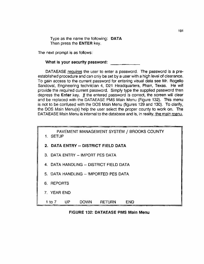
Type as the name the following: DATA Then press the ENTER key.
The next prompt is as follows:
What is your security password:
191
DATAEASE requires the user to enter a password. The password is a preestablished procedure and can only be set by a user with a high level of clearance. To gain access to the current password for entering visual data see Mr. Rogelio Sandoval, Engineering technician 4, D21 Headquarters, Pharr, Texas. He will provide the required current password. Simply type the supplied password then depress the Enter key . .If the entered password is correct, the screen will clear and be replaced with the DATAEASE PMS Main Menu (Figure 132). This menu is not to be confused with the DOS Main Menu {figures 129 and 130). To clarify, the DOS Main Menu(s) help the user select the proper county to work on. The DATAEASE Main Menu is internal to the database and is, in reality, the main menu.
PAVEMENT MANAGEMENT SYSTEM/ BROOKS COUNTY 1. SETUP
2. DATA ENTRY -- DIS"rRICT FIELD DATA
3. DATA ENTRY -- IMPORT PES DATA
4. DATA HANDLING -- DISTRICT FIELD DATA
5. DATA HANDLING -- IMPORTED PES DATA
6. REPORTS
7. YEAR END
1 to 7 UP DOWN RETURN END
FIGURE 132: DATAEASE PMS Main Menu

192
For entering visual data we are only concerned with Option 2 - District Field Data. The remaining options (1,3,4,5,6, and 7) do not concern us at this time! Therefore:
Select option 2
by using the up-down arrow keys to highlight the choice or ... typing the number associated with the choice. For visual data entry either use the up-down arrow keys or type
2
after which you ....
Press the ENTER key
for the next lower level menu (shown in Figure 133
DATA ENTRY --DISTRICT FIELD DATA /BROOKS COUNTY
1. INPUT OR MODIFY VISUAL DATA
2. RIDE (SIOMETER) DATA
3. FWD DATA
4. SKID DATA
5. CREATE/MODIFY DATE OF LAST SURFACE
6. CREATE OR MODIFY CROSSROADS
7. CREATE OR MODIFY DISTRICK COUNTIES DATA
8. CREATE OR MODIFY ROADWAY CHARACTERISTICS
1 TO 8 UP DOWN RETURN END
FIGURE 133: P.M.S. FIELD DATA MENU
Figure 1331ustrates the second-level menu relating to all field-level data entry options. For our purposes, we are only concerned with option 1 - Input or modify Visual Data. The other options relate to ride, FWD, skid, and
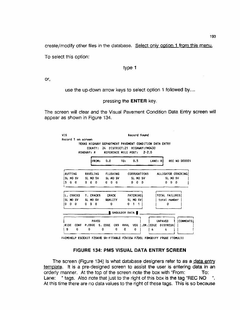
193
create/modify other files in the database. Select only option 1 from this menu.
To select this option:
type 1
or,
use the up-down arrow keys to select option 1 followed by ....
pressing the ENTER key.
The screen will clear and the Visual Pavement Condition Data Entry screen will appear as shown in Figure 134.
VIS Record found Record 1 on screen
TEXAS HIGHWAY DEPARTMENT PAVEMENT CONDITION DATA ENTRY COUNTY: 24 DISTRICT:21 HIGHWAY:FM0430
ROADWAY: R REFERENCE MILE POST: 2-2.0
IFROH: o.o
!RUTTING RAVELING FLUSHING ISL MO sv SL MO sv SL MO sv 13 0 0 0 0 0 0 0 0
IL. CRACKS T. CRACKS CRACK ISL MO sv SL MO SV QUALITY 10 0 0 0 0 0 0
TO: 0.5
CORRUGATIONS SL MO SV 0 0 0
PATCHING I SL MO SVI o 1 1 I
LANE: RI REC NO 000001
ALLIGATOR CRACKINGj SL MO sv I o o o I
!TOTAL FAILURES! I total nl..llber I I o I
--------- SHOULDER OATA I-------
I PAVED UNPAVED I I COMMENTS I !RIDE CONT P.EOGE s. EDGE cKs RAVL VEG 1.oR.jEDGE DISTREssj I I 10 o o o o o 01 14 4 11 I
F4CMDHELP ESCEXIT F2SAVE Sh·F1TABLE F3VIEW F7DEL F8MODIFY f9QBE F10MULTI
FIGURE 134: PMS VISUAL DATA ENTRY SCREEN
The screen (Figure 134) is what database designers refer to as a data entry template. It is a pre-designed screen to assist the user is entering data in an orderly manner. At the top of the screen note the box with "From: To: Lane: " tags. Also note that just to the right of this box is the tag "REC NO " At this time there are no data values to the right of these tags. This is so because

194
we have not yet "pulled up" an active record of information. This screen is just a template with no data yet displayed.
To display data on this template, we must use the F3 key. Before depressing the F3 key, examine the bottom of the screen. The database displays nine function keys that when depressed, initiate some sort of action. These keys are:
F4: Provides on-the-spot help to the user
Esc: Pressing the Esc key "escapes" or quits and returns the user to the next higher level of action.
F2: The SAVE option. Never press this key!. An explanation will soon follow.
Sh-F1: Ignore this key for the present and do not use it during visual data entry.
F3: View the next record action. Pressing the F3 key permits the user to bring up the next record to view and/or modify. We will make extensive use of this key.
F?: The Delete action. Pressing the F? key will delete/erase a record from the visual file. Never use this key! If this key is depressed and the subsequent confirm-delete command answered with a "YES", then we have lost a 0.5-mile segment of visual data. Therefore, do not use the F7 key!
F8: The Modify key. This key is most important to visual data entry and its use will be explained shortly.
The remaining two function keys (F9 and F10) are not needed at all for visual data entry. Ignore them! The next section address the manual data entry of collected visual data.
8.4 ENTERING VISUAL DATA
At this point we have the Visual Data Entry template on the screen (Figure 134). However, in its present form it is not showing use any data. To bring up the first data file (remember, these files have been pre-built according to the From-To mile point locations) we press the F3 key. The F3 key allows one to view the next available record and display its contents on the template. One could continually press the F3 key and scroll through the records in the file. Pressing the F3 key does no harm in any way to the data .... it simply permits one to view the next

195
record.
An alternative use of the F3 key is to find a given record in the visual file. The designers of the Visual file have stored a "record number" in each 0.5-mile record. The record number appears to the left of the visual data entry recording sheets that the raters have filled out in the field. If you wanted to find record 203 for example we type"
Ctrl-F3
followed by the record number we wish to view. In this example we would enter 203 followed by pressing the Enter key. 1f that record exists, the database system will immediately find and display it on the screen. If the record does not exist, the system will communicate it to you. So remember, use of Ctrl-F3 finds a specified record: F3 used by itself, finds the next record.
Assuming we are in Brooks County, depress the F3 key and we will see the first record (shown below in Figure 135).
VIS Record found Record 1 on screen
TEXAS HIGHWAY DEPARTMENT PAVEMENT CONDITION DATA ENTRY COUNTY: 24 OISTRICT:21 HIGHWAY:FMD430
ROADWAY: R REFERENCE MILE POST: 2-2.0
!FROM: 0.0
RAVELING FLUSHING SL MO SV SL MO SV 0 0 0 0 0 0
jL. CRACKS T. CRACKS SL HO SV SL MO SV 0 0 0 0 0 0
CRACK QUALITY
0
TO: 0.5
CORRUGATIONS SL HO SV 0 0 0
PATCHING! SL MO SV! o 1 1 I
LANE: RI REC NO 000001
ALLIGATOR CRACKING SL MO sv I o o o I
!TOTAL FAILURESj I total nuiber I I o I
---------· SHOULDER DATA • -------
I PAVED I I UNPAVED I I CC»IMENTS I !RIDE CONT P.EDGE s. EDGE CKS RAVL VEG j.OR.jEDGE DISTRESS! I I 10 o o o o o o I 14 4 11 I
F4CHOHELP ESCEXIT F2SAVE Sh-F1TABLE F3VIEW F71>EL FBHCX>IFY F9QBE F10MULTI
FIGURE 135: SPECIMEN VISUAL RECORD TAKEN FROM BROOKS COUNTY

196
By pressing the F3 key we have successfully brought up the first record. Note that in the "From - To" block we see the fist mile post increments displayed, in this case we see:
From: o.o TO: 0.5.
Also, we see the current record number displayed to the right as:
REC NO 000001.
Thus, we have the first record for FM0430 (displayed at the top of the screen) from mile point 0.0 to mile point 0.5. Always check the From-To values on the data collection forms against the From-to values shown on the screen. They must match! Also, cross check the highway number (at the top of the field data form against the highway number at the top of the data entry screen. Likewise, these must match. If not, your collection forms are out of order. If you find that elements do not match, contact Mr. Sandoval in 021 for the appropriate action to recover. If you detect mis-matches, cease entering data until an audit has been performed.
If no apparent mis-matches exist, we are now ready to enter the data from the visual data field forms.
The first value required is the Lane designation and the cursor is positioned on the Lane cell. For most visual evaluations. this will be the R lane. So we would enter a "R" in the lane designation cell. Note, other lane designations are possible such as (A,B,C,V,U,T,S,R,L,M,N,O,P,X,Y,Z). Regardless of the lane designation, the appropriate letter should always be shown on the field data collection form. Simply enter that lane code in this cell.
As soon as you have entered the lane designation letter, the cursor will move to the next field (Rutting in this example). For the remaining entries, most of them will be "O's". To post a "O" in the field, keep pressing the Enter key and the cursor will keep moving across the template posting a "O" in the appropriate cell. If a nonzero value is required, simple type the appropriate number as call for from the field data form. Remember,
You must keep pressing the "Enter" key or the appropriate number until the entire template is filled out.
If you make a mistake it is a simple matter to correct it. Use the arrow keys to locate the cell with the mistake then:
Hit the F6 key (this deletes the value)

197
Then enter the corrected value. Remember, the F6 key deletes the current field. You are then free to enter the corrected value. (Do not use the F7 key - which would attempt to delete the entire record!)
When you are finished with the current record it is time to post your entries to the database. While you were entering values on the template, you were not saving the values in the database. In order to post your entered values you must use the FS key (Modify) key. The FS key modifies the current record to the values you have just entered. Remember we stated that all of the visual records have been pre-built for you. These records already exist. You are simply modifying their current values.
Recall, we said not to use the F2 key. If you enter all of the data for a given 0.5-mile stretch and then use the F2 key you would be creating a new record and we don't want that! Since these records already exist, we only want to modify the existing records. So, do not use the F2 key to "save" the current record. If you examine the F2 key code at the bottom of the screen it specifies ...
F2SAVE
and SAVE means to "save" the record. What is really means is to "create" a new (additional) record and this can be misleading to the user. If we remember not to use the F2 key but rather the F8 key, we stay out of trouble!
After pressing the FS key, we have modified the record. Now, hit the F3 key and the next record is displayed. Check you record number and From-To limits on the field form against the screen values. They should match! If not, cease data entry and report the problem to Mr. Sandoval. If these fields match. continue posting the appropriate values until the entire line on the field data form is posted to the template on the screen. Then visually check the line on the form against the screen template. If all fields match hit the FS key followed by the F3 key and this will post the changes to the file and bring up the next record.
If you detect an error, use the arrow keys to move to the cell with the error, hit the F6 key to delete the error, re-enter the corrected value, re-check, then hit the FS followed by the F3 key.
8.4.1 Quitting a Session
When finished (or you wish to quit) finish the current record, record where you are in the field data (Highway No, record number) then hit the Esc key to escape out of the data entry. You may continue hitting the Esc key and responding to any prompts until you are out of the database.

198
8.4.2 To Re-enter the Database
Follow the procedures outlined in Section 8.3.2 of this section and come up into the PMS Visual Data Entry Screen (Figure 134}. If you have recorded the record number of the last record you entered, you can enter ...
Ctrl-F3
and respond with that record number. The data base will display that record number for you to check. Then hit F3 to display the next record and you can begin entering data from the spot that you last left.
Remember to always check the highway number, record number and the From-To values on the field data form against the screen values to ensure that you are coordinated. The values on the field data forms must match with the location values on the screen for a given record. It might help to remember that one line on the field data form corresponds to one screen on the data entry form.
In summary, the process is:
1. Use the F3 key to bring up the next record.
2. Use the Enter or the arrow keys to move around on the screen template.
3. Check the location parameters on the field data forms against the same fields on the displayed screen.
4. Enter the correct values on the screen template as per the values on the field data forms.
5. When finished with one line on the field data forms, visually confirm, then hit the FS key to modify the current record.
6. Press the F3 key to move to the next record (or the Ctrl·F3 key combination to move to the specified record).
7. To quit a session, finish the current line on the field data forms and record the associated record number. Then hit the Esc key as many times as required to back out of the data base.

199
8.5 Producing Visual Data Collection Forms
Visual data collection activities within District 21 commence in September of any given year. Prior to collecting visual data, district personnel attend visual rating classes in Austin and at district headquarters. Trained raters are then routed to the various counties to commence the visual data collection activities.
In order to organize their work, the PMS Database has the ability to generate sorted visual data collection forms for each county within the district. The automated procedure for accomplishing this follows.
NOTE: Before beginning this procedure, perform the following tasks.
1. Load the Laser Jet printer tray with a full supply of paper.
2. Take the printer off-line and set the font number to font no. 9 or 10. To obtain a listing of the possible number of fonts supported by the HP LaserJet, take the printer off-line, and press ALT-Print Fonts keys on the printer. This action will produce a listing of all possible fonts supported by the printer.
3. Bring the printer back to On-line status.
4. Log into the database in the normal fashion. The following PMS main menu appears (Figure 136):
Remainder of this page intentionally left blank.
200
PAVEMENT MANAGEMENT SYSTEM / BROOKS COUNTY
1. SETUP
2. DATA ENTRY -- DISTRICT FIELD DATA
3. DATA ENTRY -- IMPORT PES DATA
4. DATA HANDLING -- DISTRICT FIELD DATA
5. DATA HANDLING -- IMPORTED PES DATA
6. REPORTS
7. YEAR END
1 to 7 UP DOWN RETURN END
Figure 136: P.M.S. REPORTS MENU
Select option 6, REPORTS.
The next menu appearing (Figure 137):
REPORTS / BROOKS COUNTY
1. MISSING DATA REPORTS
2. GENERATE RATING FORMS
3. CRITICAL VALUE REPORTS
4. DATA LISTING REPORTS
5. PMS-PES CONVERSION
6. AD HOC REPORTS
1 TO 6 UP DOWN RETURN END
FIGURE 137: P.M.S. GENERATING RATING FORMS MENU OPTION
201
Select option 2. GENERATE RATING FORMS. This option produces the next menu, (Figure 138).
GENERATE RATING FORMS REPORTS/ BROOKS COUNTY
1. GENERATE VISUAL RATING FORMS (HP LASERJET)
2. GENERATE RIDE RATING FORMS (HP LASERJET)
1 TO 2 UP DOWN RETURN END
FIGURE 138: P.M.S. GENERATE VISUAL RATING FORMS MENU
Select option 1 GENERATE VISUAL RATING FORMS (HP LASERJET). The remaing process is under control of a Database procedure termed visual rating forms. This routine scans the 0.5-mile visual form, sorts the records into an appropriate order, and prints the forms for the entire county.
Upon completion of the batch process, press the ESC key three times to exit the PMS database. This concludes generation of the visual rating forms.

202
APPENDIX A
021 P.M.S. MICROCOMPUTER HARDWARE REQUIREMENTS
To install and maintain the Micro-PMS system, the following minimum hardware requirements apply:
1. 386-based (or higher) microcomputer operating under DOS 4.01 or higher.
Specific hardware requirements are:
a. Minimum of 4 Mb of RAM. b. Math co-processor. c. Minimum 120 Mb hard disk. d. Color EGA or VGA adaptor and monitor. e. 1.44 Mb A: Drive f. 1.44 Mb 3.5" B: Drive for microdisks.
2. Sysdyne high speed tape backup unit (internal or external) capable of backing up at least 60Mb of data per tape.
3. HP LaserJet Series Ill or 11-P with 2.5 Mb of data storage and 300 d.p.i. resolution.
4. Software:
a. DataEase Version 4.2 from Software Solutions, Inc. b. The EDIX DOS Text editor from Emergine Technology, Boulder,
Colorado.
203
APPENDIX B P.M.S. DATABASE DETAILED FILE STRUCTURE
This appendix summarizes the individual files required to support the PMS database. Details involving the screen displays, fields, and field definitions are provided for each file. Brooks County (024) has been selected to illustrate the file definitions. The remaining 9 counties within 021 have exactly the same file structure.
Form Name: COUNTIES
SCREEN DESCRIPTION
1 10 20 30 40 so 60 70 80 +----+----+----+----+----+----+----+----+----+----+----+----+----+----+----+---+
COUNTY DISTRICT RElATIONSHIPS
COUNTY NUMBER: 1
FIELD DESCRIPTIONS
No. Name Type
1 COUNTY NUMBER Number Number Type : Integer Lower Limit: 001 Upper Limit: 2S4
2 COUNTY NAME Text
3 DISTRICT NUMBER Number Number Type : Integer Lower Limit: 01 Upper Limit: 25
DISTRICT NUMBER: ---+----+----+----+--
so 60 70 80
Long Record Req In- Uni- Der- Rng Pre-Size offset uir dex que ived Chk vent
3 2
20 20
2 1
3
5
2S
* *
*
Record Size: 26 Memory: Text = 116 Fields - 193 Total = 309
204
Form Name: MACHINE # VAR.
SCREEN DESCRIPTION
1 10 20 30 40 50 60 70 80 +----+----+----+----+----+----+----+----+----+----+----+----+----+----+----+---+
MRM MACHINE ALPHA AND BETA VALUES
+-------------------------------------------------------------------+ I I I MACHINE #: I I I I I I ALPHA VALUE : BETA VALUE : 3 I I I +-------------------------------------------------------------------+
+----+----+----+----+----+----+----+----+----+----+----+----+----+----+----+---+ 1 10 20 30 40 50 60 70 80
FIELD DESCRIPTIONS
No. Name Type Long Record Req In- Uni- Der- Rng Pre-Size offset uir dex que ived Chk vent
1 MACHINE # Text 7 7 3 * * Display Attribute: Highlight 1
2 ALPHA VALUE Number 9 4 10 * Number Type : Integer Display Attribute: Highlight 1
3 BETA VALUE Number 9 4 14 * Number Type : Integer Display Attribute: Highlight 1
Record Size: 18 Memory: Text - 647 Fields - 98 Total ~ 745

205
Form Name: TEMP
SCREEN DESCRIPTION
1 10 20 30 40 50 60 70 80 +----+----+----+----+----+----+----+----+----+----+----+----+----+----+----+---+
MAINTENANCE MANAGEMENT MASTER FILE
RI-1 FILE DATA ENTRY
COUNTY NUMBER ....... : 1 HIGHWAY PREFIX ...... : HIGHWAY NUMBER ...... :~ HIGHWAY SUFFIX ...... :-~ REFERENCE POINT ..... :-5 MILEPOST ............ :-6-MILEPOST DISP. SIGN.:- -MILEPOST DISP ....... :-8 ROADWAY ............. :- -
MASTER ID CODE 10 +----+----+----+------+---_-_-_-+--------+----+----+----+----+----+----+----+----+----+---+ 1 10 20 30 40 50 60 70 BO
FIELD DESCRIPTIONS
No. Name Type Long Record Req In- Uni- Der- Rng Pre-
1 COUNTY NUMBER Number Number Type : Integer Help:
2 HIGHWAY PREFIX Text
3 HIGHWAY NUMBER Nurn. String
4 HIGHWAY SUFFIX Text
5 REFERENCE POINT Number Number Type Fixed Point
6 MILEPOST Number Number Type Integer
7 MILEPOST DISP. SIGN Text
8 MILEPOST VALUE Number Number Type : Fixed Point
9 ROADWAY
10 MASTERID
Text
Text
3
2
4
1
5
3
1
3
1
16
Size off set uir dex que ived Chk vent
2 4 *
2 6 * 4 8 * 1 12 * 4 13 *
2 17
1 19
4 20
1 24
16 25 * * * Formula: JOINTEXT(COUNTY NUMBER,JOINTEXT(HIGHWAY PREFIX,JOINTEXT(HIGHWAY
NUMBER,JOINTEXT(HIGHWAY SUFFIX,JOINTEXT(ROADWAY,REFERENCE POINT)))))
Record Size: 41 Memory: Text = 794 Fields = 552 Total = 1346
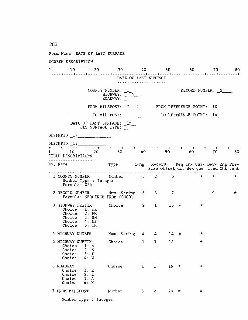
206
Form Name: DATE OF LAST SURFACE
SCREEN DESCRIPTION
1 10 20 30 40 50 60 70 80 +----+----+----+----+----+----+----+----+----+----+----+----+----+----+----+---+
DATE OF LAST SURFACE
DLSFMPID
DLSTMPID
COUNTY NUMBER: 1 HIGHWAY: - -4 --ROADWAY:
FROM MILEPOST: 7 9
TO MILEPOST:
DATE OF LAST SURFACE: 15 PES SURFACE TYPE:
RECORD NUMBER: 2
FROM REFERENCE POINT: 10
TO REFERENCE POINT: 14
+----+----+---- ---+----+----+----+----+----+----+----+----+----+----+---+ 1 10 20 30 40 50 60 70 80 FIELD DESCRIPTIONS
No. Name Type Long Record Req In- Uni- Der- Rng Pre-
1 COUNTY NUMBER Number Number Type : Integer Formula: 024
2 RECORD NUMBER Num. String Formula: SEQUENCE FROM 000001
3 HIGHWAY PREFIX Choice Choice 1: PR Choice 2: FM Choice 3: SH Choice 4: us Choice 5: IH
4 HIGHWAY NUMBER Num. String
5 HIGHWAY SUFFIX Choice Choice 1: A Choice 2: s Choice 3: E Choice 4: w
6 ROADWAY Choice Choice 1: R Choice 2: L Choice 3: A Choice 4: x
7 FROM MILEPOST Number
Number Type Integer
Size offset uir dex que ived Chk vent
3 2 5 * * *
6 6 7 * *
2 1 13 * *
4 4 14 * * 1 1 18 *
1 1 19 * *
3 2 20 * *

207
Form Name: DATE OF LAST SURFACE Continued ... FIELD DESCRIPTIONS
No. Name Type
8 FROM MILEPOST SIGN Choice Choice 1: + Choice 2: -
9 FRM MILEPOST DISP Number Number Type Fixed Point
10 FROM Number Number Type Fixed Point
11 TO MILEPOST Number Number Type Integer
12 TO MILEPOST SIGN Choice Choice 1: + Choice 2: -
13 TO MILEPOST DISP Number Number Type Fixed Point
14 TO Number Number Type Fixed Point
15 DATE Num. String Formated as Other Format
16 SURFACE TYPE Number Number Type Integer Lower Limit: 1 Upper Limit: 10
Long Record Req In- Uni- Der- Rng Pre-Size offset uir dex que ived Chk vent
1 1 22 * *
3 4 23 * *
5 4 27
3 2 31 *
1 1 33 *
3 4 34 *
5 4 38
5 4 42 * 00/00 2 1 46 * *
17 DLSFMPID Text 17 17 47 * * * Formula: JOINTEXT(GOUNTY NUMBER,JOINTEXT(HIGHWAY PREFIX,JOINTEXT(HIGHWAY
NUMBER,JOINTEXT(HIGHWAY SUFFIX,JOINTEXT(ROADWAY,JOINTEXT(FROM

208
Form Name: DATE OF LAST SURFACE Continued ...
FIELD DESCRIPTIONS
No. Name Type Long Record Req In- Uni- Der- Rng Pre-Size offset uir dex que ived Chk vent
MILEPOST,JOINTEXT(FROMMILEPOST SIGN,FRM MILEPOST DISP*lO)))))))
18 DLSTMPID Text 17 17 64 * * * Formula: JOINTEXT(COUNTY NUMBER,JOINTEXT(HIGHWAY PREFIX,JOINTEXT(HIGHWAY
NUMBER,JOINTEXT(HIGHWAY SUFFIX,JOINTEXT(ROADWAY,JOINTEXT(TO MILEPOST,JOINTEXT{TO MILEPOST SIGN,TO MILEPOST DISP*lO)))))))
Record Size: 81 Memory: Text = 539 Fields = 1354 Total = 1893

209
Form Name: ROADWAY CHARACTERS
SCREEN DESCRIPTION
1 10 20 30 40 50 60 70 80 +----+----+----+----+----+----+----+----+----+----+----+----+----+----+----+---+
ROADWAY CHARACTERISTICS
COUNTY NUMBER: 2 HIGHWAY: - -4 --ROADWAY:
FROM REFERENCE:
TO REFERENCE: 8
NUMBER OF LANES: SURFACE WIDTH: -ro
LEFT SHOULDER WIDTH: -11~ LEFT SHOULDER TYPE:
RIGHT SHOULDER WIDTH: --"I3 RIGHT SHOULDER TYPE:
RIGHT OF WAY WIDTH: -rs ROADBED WIDTH: -16--
BASE TYPE:
FROMCHARID 18 _____ _
TOCHARID 19
RECORD NUMBER: 1
+----+---~+-------+..,.--_-__ -_-+~-------+----+----+----+----+----+----+----+----+----+----+---+ l 10 20 30 40 50 60 70 80
FIELD DESCRIPTIONS
No. Name Type Long Record Req In- Uni- Der- Rng Pre-Size offset uir dex que ived Chk vent
-----·-------------- ---------- - .... -- ---- ------ --- --- ... - --l RECORD NUMBER Num. String 6 6 5 * * Formula: SEQUENCE FROM 000001
2 COUNTY NUMBER Nwnber 3 2 11 * * * Number Type Integer Formula: 024
3 HIGHWAY PREFIX Choice 2 1 13 * * Choice 1: PR Choice 2: FM Choice 3: SH Choice 4: us Choice 5: IH
4 HIGHWAY NUMBER Num. String 4 4 14 * * Formated as Other Format 0000
5 HIGHWAY SUFFIX Choice 1 1 18 * Choice 1: A Choice 2: s Choice 3: E Choice 4: w
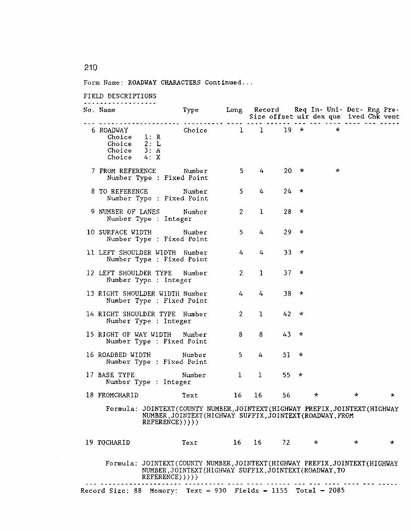
210
Form Name: ROADWAY CHARACTERS Continued ...
FIELD DESCRIPTIONS _ ... _____________ .,. __
No. Name Type Long Record Req In- Uni- Der- Rng Pre-Size offset uir dex que ived Chk vent
-------------------- ... .,. __ .,. ___ .,._ ---- ------ --- --... - --- - ... ---6 ROADWAY Choice l l 19 * * Choice 1: R
Choice 2: L Choice 3: A Choice 4: x
7 FROM REFERENCE Number 5 4 20 * * Number Type Fixed Point
8 TO REFERENCE Number 5 4 24 * Number Type Fixed Point
9 NUMBER OF lANES Number 2 l 28 * Number Type Integer
10 SURFACE WIDTH Number 5 4 29 * Number Type Fixed Point
11 LEFT SHOULDER WIDTH Number 4 4 33 * Number Type Fixed Point
12 LEFT SHOULDER TYPE Number 2 l 37 * Number Type Integer
13 RIGHT SHOULDER WIDTH Number 4 4 38 *
14
15
16
17
18
Number Type Fixed Point
RIGHT SHOULDER TYPE Number 2 l 42 * Number Type Integer
RIGHT OF WAY WIDTH Number 8 8 43 * Number Type Fixed Point
ROADBED WIDTH Number s 4 51 * Number Type Fixed Point
BASE TYPE Number 1 1 55 * Number Type Integer
FROM CHAR ID Text 16 16 56 * * * Formula: JOINTEXT(COUNTY NUMBER,JOINTEXT(HIGHWAY PREFIX,JOINTEXT(HIGHWAY
NUMBER,JOINTEXT(HIGHWAY SUFFIX,JOINTEXT(ROADWAY,FROM REFERENCE)))))
19 TOCHARID Text 16 16 72 * * *
Formula: JOINTEXT(COUNTY NUMBER,JOINTEXT(HIGHWAY PREFIX,JOINTEXT(HIGHWAY NUMBER,JOINTEXT(HIGHWAY SUFFIX,JOINTEXT(ROADWAY,TO REFERENCE)))))
Record Size: 88 Memory: Text ~ 930 Fields = 1155 Total - 2085
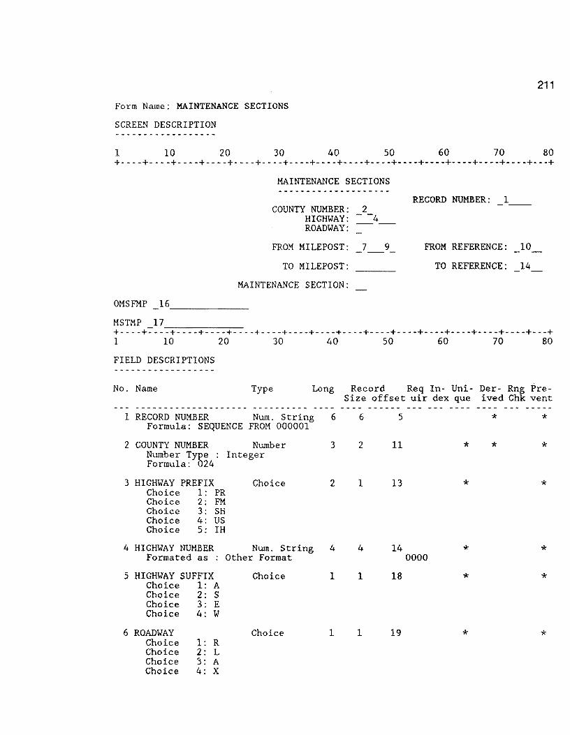
211
Form Name: MAINTENANCE SECTIONS
SCREEN DESCRIPTION
1 10 20 30 40 50 60 70 80 +----+----+----+----+----+----+----+----+----+----+----+----+----+----+----+---+
OMSFMP
MSTMP 17
MAINTENANCE SECTIONS
COUNTY NUMBER: 2 HIGHWAY: - -4 ROADWAY:
FROM MILEPOST: 7
TO MILEPOST:
MAINTENANCE SECTION:
9
RECORD NUMBER: 1
FROM REFERENCE: 10
TO REFERENCE: 14
+----+7 __ -_-+--------+---_-_-_-+------+----+----+----+----+----+----+----+----+----+----+---+ 1 10 20 30 40 50 60 70 80
FIELD DESCRIPTIONS
No. Name Type Long
1 RECORD NUMBER Num. String 6 Formula: SEQUENCE FROM 000001
2 COUNTY NUMBER Number Number Type : Integer Formula: 024
3 HIGHWAY PREFIX Choice 1: PR Choice 2: FM Choice 3: SH Choice 4: US Choice 5: IH
Choice
3
2
4 HIGHWAY NUMBER Num. String 4 Formated as : Other Format
5 HIGHWAY SUFFIX Choice 1: A Choice 2: S Choice 3: E Choice 4: W
6 ROADWAY Choice Choice Choice Choice
1: R 2: L 3: A 4: x
Choice
Choice
1
1
Record Req In- Uni- Der- Rng Pre-Size offset uir dex que ived Chk vent
6
2
1
4
1
1
5
11
13
14 0000
18
19
* *
* * *
* *
* *
* *
* *

212
Form Name: MAINTENANCE SECTIONS Continued ...
FIELD DESCRIPTIONS ____ ,.. __ ..._ __________
No. Name Type Long Record Req In- Uni- Der- Rng Pre-Size offset uir dex que ived Chk vent ____ .,. ______________ ..
-·-------- -- .. - ------ --- - --- --- -----7 FROM MILEPOST Number 3 2 20 *
Number Type Integer
8 FROM MILEPOST SIGN Choice 1 1 22 * Choice 1: + Choice 2: -
9 FRM MILEPOST DISP Number 3 4 23 * Number Type Fixed Point
10 FROM REFERENCE Number 5 4 27 * Number Type Fixed Point
11 TO MILEPOST Number 3 2 31 Number Type Integer
12 TO MILEPOST SIGN Choice 1 1 33 Choice 1: + Choice 2: -
13 TO MILEPOST DISP Number 3 4 34 Number Type Fixed Point
14 TO REFERENCE Number 5 4 38 * Number Type Fixed Point
15 MAINT SEC Number 2 1 42 *
16
Number Type Integer
MSFMP Text 17 17 43 * * *
Formula: JOINTEXT(COUNTY NUMBER,JOINTEXT(HIGHWAY PREFIX,JOINTEXT(HIGHWAY NUMBER,JOINTEXT(HIGHWAY SUFFIX,JOINTEXT(ROADWAY,JOINTEXT(FROM MILEPOST,JOINTEXT(FROMMILEPOST SIGN,FRM MILEPOST DISP*lO)))))))
17 MSTMP Text 17 17 60 * * * Formula: JOINTEXT(COUNTY NUMBER,JOINTEXT(HIGHWAY PREFIX,JOINTEXT(HIGHWAY
NUMBER,JOINTEXT(HIGHWAY SUFFIX,JOINTEX.T(ROADWAY,JOINTEXT(TO MILEPOST,JOINTEXT(TO MILEPOST SIGN, TO MILEPOST DISP*lO)))))))
Record Size: 77 Memory: Text = 611 Fields = 1302 Total - 1913

213
Form Name: ADT VALUES
SCREEN DESCRIPTION
1 10 20 30 40 50 60 70 80 +----+----+----+----+----+----+-- -+----+----+----+----+----+----+----+----+---+
ADFMP 16 -------ADTMP 17
ADT
COUNTY NUMBER: 2 HIGHWAY: - -4 --ROADWAY:
FROM MILEPOST: 7 9
TO MILEPOST:
ADT VALUE: 15
RECORD NUMBER:
FROM REFERENCE: 10
TO REFERENCE: 14
------+----+----+----+----+----+----+----+----+----+----+----+----+----+----+----+---+ 1 10 20 30 40 50 60 70 80
FIELD DESCRIPTIONS
No. Name Type Long Record Req In- Uni- Der- Rng Pre-
1 RECORD NUMBER Num. String 6 Formula: SEQUENCE FROM 000001
2 COUNTY NUMBER Number Number Type : Integer Formula: 024
3 HIGHWAY PREFIX Choice 1: PR Choice 2: FM Choice 3: SH Choice 4: US Choice 5: IH
Choice
3
2
4 HIGHWAY NUMBER Num. String 4 Formated as : Other Format
5 HIGHWAY SUFFIX Choice 1: A Choice 2: S Choice 3: E Choice 4: W
6 ROADWAY Choice Choice Choice Choice
1: R 2: L 3: A 4: x
Choice
Choice
1
1
Size offset uir dex que ived Chk vent
6
2
1
4
1
1
5
11
13
14 0000
18
19
* *
* * *
* *
* *
* *
* *
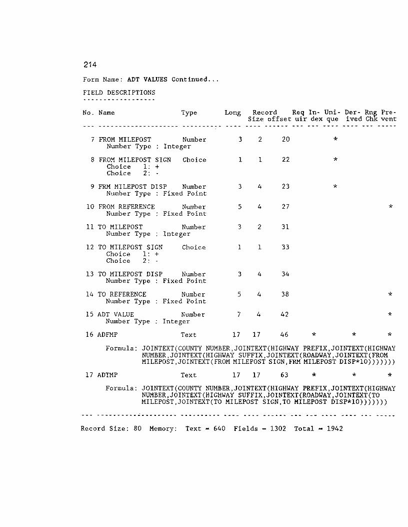
214
Form Name: ADT VALUES Continued ...
FIELD DESCRIPTIONS ------------------No. Name Type Long Record Req In- Uni- Der- Rn~ Pre-
Size offset uir dex que ived Ch vent -------------------- ---------- ---- ------ --- ---- --- - - -- ...
7 FROM MILEPOST Number 3 2 20 * Number Type Integer
8 FROM MILEPOST SIGN Choice 1 1 22 * Choice 1: + Choice 2: -
9 FRM MILEPOST DISP Number 3 4 23 * Number Type Fixed Point
10 FROM REFERENCE Number 5 4 27 * Number Type Fixed Point
11 TO MILEPOST Number 3 2 31 Number Type Integer
12 TO MILEPOST SIGN Choice 1 1 33 Choice 1: + Choice 2: -
13 TO MILEPOST DISP Number 3 4 34 Number Type Fixed Point
14 TO REFERENCE Number 5 4 38 * Number Type Fixed Point
15 ADT VALUE Number 7 4 42 * Number Type Integer
16 ADFMP Text 17 17 46 * * * Formula: JOINTEXT(COUNTY NUMBER,JOINTEXT(HIGHWAY PREFIX,JOINTEXT(HIGHWAY
NUMBER,JOINTEXT(HIGHWAY SUFFIX,JOINTEXT(ROADWAY,JOINTEXT(FROM MILEPOST,JOINTEXT(FROM MILEPOST SIGN,FRMMILEPOST DISP*lO)))))))
17 ADTMP Text 17 17 63 * * * Formula: JOINTEXT(COUNTY NUMBER,JOINTEXT(HIGHWAY PREFIX,JOINTEXT(HIGHWAY
NUMBER,JOINTEXT(HIGHWAY SUFFIX,JOINTEXT(ROADWAY,JOINTEXT(TO MILEPOST,JOINTEXT(TO MILEPOST SIGN,TO MILEPOST DISP*lO))))}))
Record Size: 80 Memory: Text = 640 Fields = 1302 Total = 1942

215
Form Name: FUNCT CLASS
SCREEN DESCRIPTION
1 10 20 30 40 50 60 70 80 +----+----+----+----+----+----+----+----+----+----+----+----+----+----+----+---+
FCFMP
FCTMP 17
FUNCTIONAL CLASSIFICATION
COUNTY NUMBER: 2 HIGHWAY: - -4 --ROADWAY:
FROM MILEPOST: 9
TO MILEPOST:
FUNCTIONAL CLASSIFICATION:
RECORD NUMBER:
FROM REFERENCE: 10
TO REFERENCE: 14
+----+------+--------+---_-_-_-+------+----+----+----+----+----+----+----+----+----+----+---+ 1 10 20 30 40 50 60 70 80
FIELD DESCRIPTIONS
No. Name Type Long Record Req In- Uni- Der- Rng Pre-
1 RECORD NUMBER Num. String 6 Formula: SEQUENCE FROM 000001
2 COUNTY NUMBER Number Number Type : Integer Formula: 024
3 HIGHWAY PREFIX Choice 1: PR Choice 2: FM Choice 3: SH Choice 4: US Choice 5: IH
4 HIGHWAY NUMBER
Choice
Num. String Formated as Other Format
5 HIGHWAY SUFFIX Choice Choice 1: A Choice 2: s Choice 3: E Choice 4: w
6 ROADWAY Choice Choice 1: R Choice 2: L Choice 3: A Choice 4: x
3
2
4
1
1
Size offset uir dex que ived Chk vent
6 5 * *
2 11 * * *
1 13 * *
4 14 * * 0000
1 18 * *
1 19 * *

216
Form Name: FUNCT CLASS Continued ...
FIELD DESCRIPTIONS
No. Name Type Long Record Req In- Uni- Der- Rng Pre-Size offset uir dex que ived Chk vent __ .. _____ ,....,. __________ ---------- - --- ---- ........ -- ... --- ---- --- -----
7 FROM MILEPOST Number 3 2 20 * Number Type Integer
8 FROM MILEPOST SIGN Choice 1 1 22 * Choice 1: + Choice 2: -
9 FRM MILEPOST DISP Number 3 4 23 * Number Type Fixed Point
10 FROM REFERENCE Number 5 4 27 * Number Type Fixed Point
11 TO MILEPOST Number 3 2 31 Number Type Integer
12 TO MILEPOST SIGN Choice 1 1 33 Choice 1: + Choice 2: -
13 TO MILEPOST DISP Number 3 4 34 Number Type Fixed Point
14 TO REFERENCE Number 5 4 38 * Number Type Fixed Point
15 FC VALUE Number 1 1 42 * Number Type Integer
16 FGFMP Text 17 17 43 * * * Formula: JOINTEXT(COUNTY NUMBER,JOINTEXT(HIGHWAY PREFIX,JOINTEXT(HIGHWAY
NUMBER,JOINTEXT(HIGHWAY SUFFIX,JOINTEXT(ROADWAY,JOINTEXT(FROM MILEPOST,JOINTEXT(FROMMILEPOST SIGN,FRMMILEPOST DISP*lO)))))))
17 FCTMP Text 17 17 60 * * * Formula: JOINTEXT(COUNTY NUMBER,JOINTEXT(HIGHWAY PREFIX,JOINTEXT(HIGHWAY
NUMBER,JOINTEXT(HIGHWAY SUFFIX,JOINTEXT(ROADWAY,JOINTEXT(TO MILEPOST,JOINTEXT(TO MILEPOST SIGN,TO MILEPOST DISP*lO)))))))
Record Size: 77 Memory: Text - 658 Fields = 1301 Total - 1959

217
Form Name: 18-KIP VALUES
SCREEN DESCRIPTION
l 10 20 30 40 50 60 70 80
18-KIP ____ ,.._
RECORD NUMBER: COUNTY NUMBER: 2
HIGHWAY: 4 --ROADWAY:
FROM MILEPOST: 7 9 FROM REFERENCE: 10
TO MILEPOST: TO REFERENCE: 14
18-KIP VALUE: 15 - -
KPFMP 16 -------DPTMP 17 ------+----+--- ---- ----+----+----+----+----+----+----+----+----+----+----+---+ 1 10 20 30 40 50 60 70 80
FIELD DESCRIPTIONS _____________ .,. ___ .,..
No. Name Type Long Record Req In- Uni- Der- Rng Pre-Size offset uir dex que ived Chk vent
------------- ... ------ -----·---- -- - .. ------ - - - --- - ... - -1 RECORD NUMBER Num. String 6 6 5 * * Formula: SEQUENCE FROM 000001
2 COUNTY NUMBER Number 3 2 11 * * * Number Type Integer Formula: 024
3 HIGHWAY PREFIX Choice 2 1 13 * * Choice 1: PR Choice 2: FM Choice 3: SH Choice 4: us Choice 5: IH
4 HIGHWAY NUMBER Num. String 4 4 14 * * Formated as . Other Format 0000
5 HIGHWAY SUFFIX Choice 1 1 18 * * Choice 1: A Choice 2: s Choice 3: E Choice 4: w
6 ROADWAY Choice 1 1 19 * * Choice 1: R Choice 2: L Choice 3: A Choice 4: x
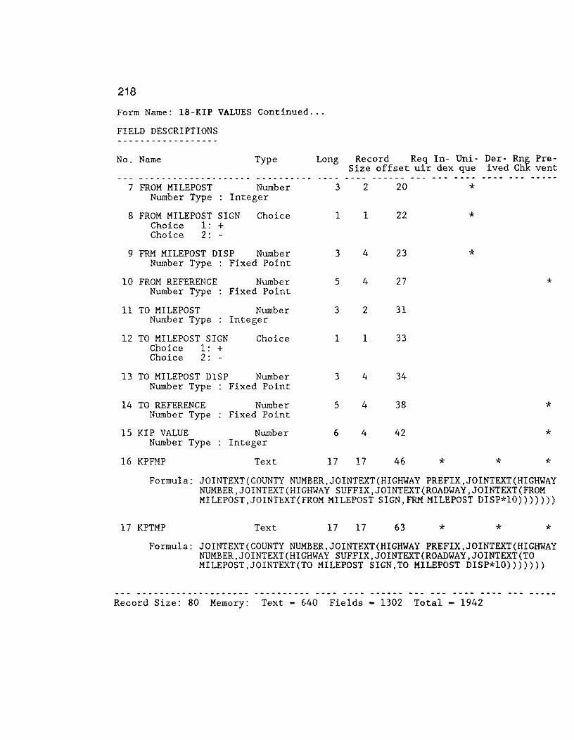
218
Form Name: 18-KIP VALUES Continued ...
FIELD DESCRIPTIONS
No. Name Type Long Record Req In- Uni- Der- Rn~ Pre-Size offset uir dex que ived Ch vent __ .,. __ .., ______________ ---------- ---- --·- ------ --- __ .,._ --- -----
7 FROM MILEPOST Number 3 2 20 * Number Type Integer
8 FROM MILEPOST SIGN Choice 1 1 22 * Choice 1: + Choice 2: -
9 FRM MILEPOST DISP Number 3 4 23 * Number Type Fixed Point
10 FROM REFERENCE Number 5 4 27 * Number Type Fixed Point
11 TO MILEPOST Number 3 2 31 Number Type Integer
12 TO MILEPOST SIGN Choice 1 l 33
13
14
15
16
Choice 1: + Choice 2: -
TO MILEPOST DISP Number 3 4 34 Number Type Fixed Point
TO REFERENCE Number 5 4 38 * Number Type Fixed Point
KIP VALUE Number 6 4 42 * Number Type Integer
KPFMP Text 17 17 46 * * * Formula: JOINTEXT(COUNTY NUMBER,JOINTEXT(HIGHWAY PREFIX,JOINTEXT(HIGHWAY
NUMBER,JOINTEXT(HIGHWAY SUFFIX,JOINTEXT(ROADWAY,JOINTEXT(FROM MILEPOST,JOINTEXT(FROMMILEPOST SIGN,FRMMILEPOST DISP*lO)))))))
17 KPTMP Text 17 17 63 * * * Formula: JOINTEXT(COUNTY NUMBER,JOINTEXT(HIGHWAY PREFIX,JOINTEXT(HIGHWAY
NUMBER,JOINTEXT(HIGHWAY SUFFIX,JOINTEXT(ROADWAY,JOINTEXT(TO MILEPOST,JOINTEXT(TO MILEPOST SIGN, TO MILEPOST DISP*lO)))))))
Record Size: 80 Memory: Text = 640 Fields = 1302 Total - 1942

219
Form Name: HIGHVAY DESIGN
SCREEN DESCRIPTION
1 10 20 30 40 50 60 70 80 +----+----+----+----+----+----+----+----+----+----+----+----+----+----+----+---+
HDFMP
HDTMP 17
HIGHWAY DESIGN
COUNTY NUMBER: HIGHWAY: ROADWAY:
FROM MILEPOST: 7
TO MILEPOST:
HIGHWAY DESIGN:
9
RECORD NUMBER: 1
FROM REFERENCE: 10
TO REFERENCE: 14
------+----+----+----+----+----+----+----+----+----+----+----+----+----+----+----+---+ 1 10 20 30 40 50 60 70 80
FIELD DESCRIPTIONS
No. Name Type Long Record Req In- Uni- Der- Rng Pre-
1 RECORD NUMBER Num. String 6 Formula: SEQUENCE FROM 000001
2 COUNTY NUMBER Number Number Type : Integer Formula: 024
3 HIGHWAY PREFIX Choice 1: PR Choice 2: FM Choice 3: SH Choice 4: US Choice 5: IH
4 HIGHWAY NUMBER Formated as
5 HIGHWAY SUFFIX Choice 1: A Choice 2: s Choice 3: E Choice 4: w
6 ROADWAY Choice 1: R Choice 2: L Choice 3: A Choice 4: x
Choice
Num. String Other Format
Choice
Choice
3
2
4
1
1
Size offset uir dex que ived Chk vent
6 5 * *
2 11 * * *
1 13 * *
4 14 * * 0000
l 18 * *
1 19 * *

220
Form Name: HIGHWAY DESIGN Continued ...
FIELD DESCRIPTIONS
No. Name Type
7 FROM MILEPOST Number Number Type : Integer
8 FROM MILEPOST SIGN Choice Choice 1: + Choice 2: -
9 FRM MILEPOST DISP Number Number Type Fixed Point
10 FROM REFERENCE Number Number Type Fixed Point
11 TO MILEPOST Number Number Type Integer
12 TO MILEPOST SIGN Choice Choice 1: + Choice 2: -
13 TO MILEPOST DISP Number Number Type Fixed Point
14 TO REFERENCE Number Number Type Fixed Point
15 HIGHWAY DESIGN Number Number Type : Integer
16 HDFMP Text
Long Record Req In- Uni- Der- Rng Pre-Size offset uir dex que ived Chk vent
3 2 20 *
1 1 22 *
3 4 23 *
5 4 27 *
3 2 31
1 1 33
3 4 34
5 4 38 * 1 1 42 *
17 17 43 * * * Formula: JOINTEXT(COUNTY NUMBER,JOINTEXT(HIGHWAY PREFIX,JOINTEXT(HIGHWAY
NUMBER,JOINTEXT(HIGHWAY SUFFIX,JOINTEXT(ROADWAY,JOINTEXT(FROM MILEPOST,JOINTEXT(FROMMILEPOST SIGN,FRMMILEPOST DISP*lO)))))))
17 HDTMP Text 17 17 60 * * * Formula: JOINTEXT(COUNTY NUMBER,JOINTEXT(HIGHWAY PREFIX,JOINTEXT(HIGHWAY
NUMBER,JOINTEXT(HIGHWAY SUFFIX,JOINTEXT(ROADWAY,JOINTEXT(TO MILEPOST,JOINTEXT(TO MILEPOST SIGN,TO MILEPOST DISP*lO)))))))
Record Size: 77 Memory: Text = 606 Fields = 1307 Total = 1913

Form Name: GRAPH FILE HW ID
F 0 R M P R 0 P E R T I E S
Minimum Security Levels: to VIEW Records: to MODIFY Records: to ENTER Records: to DELETE Records:
Encrypt Data Records: yes
When Entering Records: Default View of This Form:
Low3 Medium3 Medium3 Medium3
Clear Form After Entering Record: Suppress Automatic TAB When a Field Fills: Preserve Old CURRENT DATE, etc. on Modify:
Form Name: GRAPH FILE HW ID
SCREEN DESCRIPTION
1 10 20 30 40
Form View yes yes yes
so
221
60 70 80 +----+----+----+----+----+----+----+----+----+----+----+----+----+----+----+---+
TEMPORARY FILE TO HOLD THE TARGETED HW PREFIX AND NO
HIGHWAY PREFIX HIGHWAY NUMBER 2 +----+----+----+----+----+----+----.:j:":"""---+----+----+----+--~-+----+----+----+---+ 1 10 20 30 40 so 60 70 80
FIELD DESCRIPTIONS
No. Name
1 HIGHWAY PREFIX
2 HIGHWAY NUMBER
Type Long Record Req In- Uni- Der- Rng Pre-
Text 2
Num. String 4
Size offset uir dex que ived Chk vent
2
4
3
s *
*
Record Size: 9 Memory: Text - 13S Fields - 83 Total ~ 218

222
Form Name: CROSS ROADS
F 0 R M P R 0 P E R T I E S
Minimum Security Levels: to VIEW Records: to MODIFY Records: to ENTER Records: to DELETE Records:
Encrypt Data Records: yes When Entering Records:
Default View of This Form:
Low3 Medium3 Medium3 Medium3
Clear Form After Entering Record: Suppress Automatic TAB When a Field Fills: Preserve Old CURRENT DATE, etc. on Modify:
Form Name: CROSS ROADS SCREEN DESCRIPTION
1 10 20 30 40
Form View yes yes yes
50 60 70 80 +----+----+----+----+----+----+----+----+----+----+----+----+----+----+----+---+ MASTER ID GODE 1 CRMPID
CROSS ROADS
RM: 3 6
COUNTY ......... : HIGHWAY ........ :
REF.POINT: 11 RM VALUE ....... : MILEPOST ....... : ROADWAY ........ : XROAD .......... : 18
-----+----+----+----+----+----+----+----+----+----+----+----+----+----+----+---+ 1 10 20 30 40 50 60 70 80
FIELD DESCRIPTIONS
No. Name Type Long Record Req In- Uni- Der- Rng Pre-Size offset uir dex que ived Chk vent
1 MASTERID Text 16 16 5 * * * * Formula: JOINTEXT(COUNTY NUMBER,JOINTEXT(HIGHWAY PREFIX,JOINTEXT(HIGHWAY
NUMBER,JOINTEXT(HIGHWAY SUFFIX,JOINTEXT(ROADWAY,REFERENCE POINT)))))
2 CRMPID Text 17 17 21 * * *
3 RM
Formula: JOINTEXT(COUNTY NUMBER,JOINTEXT(HIGHWAY PREFIX,JOINTEXT(HIGHWAY NUMBER,JOINTEXT(HIGHWAY SUFFIX,JOINTEXT(ROADWAY ,JOINTEXT(MILEPOST,JOINTEXT(MILEPOST DISP. SIGN,MILEPOST DISP. *10)))))))
Number Type Number
Integer 3 2 38
4 RM SUFFIX Text 1
1
1
1
40
41 5 RM DISP. SIGN Text

223
Form Name: CROSS ROADS Continued ...
FIELD DESCRIPTIONS ------------------
No. Name Type Long Record Req In- Uni- Der- Rn~ Pre-Size offset uir dex que ived Ch vent
-------------------- ---------- ---- ...... --- --- --....... ---- --- ---... -6 RM DISP. Number 4 4 42
Number Type Fixed Point
7 COUNTY NUMBER Number 3 2 46 * * Number Type Integer Lower Limit: 001 Upper Limit: 245
8 HIGHWAY PREFIX Choice 2 1 48 * Choice 1: PR Choice 2: FM Choice 3: SH Choice 4: us Choice 5: IH
9 HIGHWAY NUMBER Num. String 4 4 49 * * * Lower Limit: 0001 Upper Limit: 9999
10 HIGHWAY SUFFIX Choice 1 1 53 * Choice 1: R Choice 2: L Choice 3: A Choice 4: x
11 REFERENCE POINT Number 5 4 54 Number Type Fixed Point
12 RM VALUE Number 5 4 58 Number Type Fixed Point
13 MILEPOST Number 3 2 62 * Number Type Integer
14 MILEPOST DISP. SIGN Choice 1 1 64 * * Choice 1: + Choice 2: -
15 MILEPOST DISP. Number 3 4 65 * * Number Type Fixed Point
16 ROADWAY Choice 1 1 69 * Choice 1: R Choice 2: L Choice 3: A
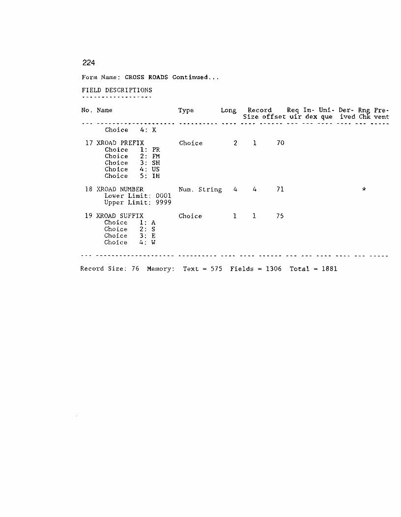
224
Form Name: CROSS ROADS Continued ...
FIELD DESCRIPTIONS
No. Name
Choice 4: X
17 XROAD PREFIX Choice 1: PR Choice 2: FM Choice 3: SH Choice 4: US Choice 5: IH
Type
Choice
Long Record Req In- Uni- Der- Rng Pre-Size offset uir dex que ived Chk vent
2 1 70
18 XROAD NUMBER Num. String 4 4 71 * Lower Limit: 0001 Upper Limit: 9999
19 XROAD SUFFIX Choice 1: A Choice 2: S Choice 3: E Choice 4: W
Choice 1 1 75
Record Size: 76 Memory: Text = 575 Fields = 1306 Total = 1881
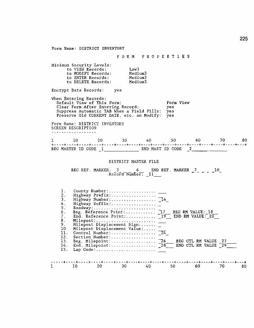
Form Name: DISTRICT INVENTORY
F 0 R M P R 0 P E R T I E S
Minimum Security Levels: to VIEW Records: to MODIFY Records: to ENTER Records: to DELETE Records:
Encrypt Data Records:
When Entering Records:
yes
Default View of This Form:
Low3 Medium3 Medium3 Medium3
Clear Form After Entering Record: Suppress Automatic TAB When a Field Fills: Preserve Old CURRENT DATE, etc. on Modify:
Form Name: DISTRICT INVENTORY SCREEN DESCRIPTION
1 10 20 30 40
Form View yes yes yes
50
225
60 70 80 +----+----+----+----+----+----+----+----+----+----+----+----+----+----+----+---+ BEG MASTER ID CODE 1 END MAST ID CODE 2
1. 2. 3. 4. 5. 6. 7. 8. 9. 10. 11. 12. 13. 14. 15.
-------
DISTRICT MASTER FILE
BEG REF. MARKER: 3 6 END REF. MARKER 10 Record-Ntimoer: 11
County Number: .................. . Highway Prefix: ................. . Highway Number: ................. . Highway Suffix: ................. . Roadway: ........................ . Beg. Reference Point: ........... . End. Reference Point: ........... . Milepost: ....................... . Milepost Displacement Sign: ..... . Milepost Displacement Value: .... . Control Number: ................. . Section Number: ................. . Beg. Milepoint: ................. . End. Milepoint: ................. . Lap Code: ....................... .
-17 BEG RM VALUE: 18 -19- END RM VALUE:-20
26 BEG CTL RM VALUE 27 -28- END CTL RM VALUE -29--- - - --
-----+----+----+----+----+----+----+----+----+----+----+----+----+----+----+---+ 1 10 20 30 40 50 60 70 80

226
FIELD DESCRIPTIONS ... District Inventory ... continued
No. Name Type Long Record Req In- Uni- Der- Rng Pre-Size offset uir dex que ived Chk vent
1 BEG MASTERID Text 16 16 6 * * * * Formula: JOINTEXT(COUNTY NUMBER,JOINTEXT(HIGHWAY PREFIX,JOINTEXT(HIGHWAY
NUMBER,JOINTEXT(HIGHWAY SUFFIX,JOINTEXT(ROADWAY,BEG. REF. POINT)))))
2 END MASTERID Text 16 16 22 * * * *
3
4
5
6
7
8
9
10
11
12
13
Formula: JOINTEXT(COUNTY NUMBER,JOINTEXT(HIGHWAY PREFIX,JOINTEXT(HIGHWAY NUMBER,JOINTEXT(HIGHWAY SUFFIX,JOINTEXT(ROADWAY,END. REF. POINT)))))
BEG RM Number 3 2 38 Number Type Integer
BEG RM SUFFIX Text l 1 40
BEG RM DISP. SIGN Text 1 1 41
BEG RM DISP. Number 4 4 42 Number Type Fixed Point
END RM Number 3 2 46 Number Type Integer
END RM SUFFIX Text 1 1 48
END RM DISP. SIGN Text 1 1 49
END RM DISP. Number 4 4 50 Number Type Fixed Point
Record Number Num. String 6 6 54 * * Formula: SEQUENCE FROM 000001
COUNTY NUMBER Number 3 2 60 * * Number Type Integer Lower Limit: 1 Upper Limit: 254 View Security Required: High Write Security Required: High Display Attribute: Highlight 1
HIGHWAY PREFIX Choice 2 1 62 * Choice .1: PR Choice 2: FM Choice 3: SH Choice 4: us Choice 5: IH
View Security Required: High Write Security Required: High
Display Attribute: Highlight 1

227
Form Name: DISTRICT INVENTORY Continued ...
FIELD DESCRIPTIONS
No. Name Type Long Record Req In- Uni- Der- Rng Pre-Size offset uir dex que ived Chk vent
14 HIGHWAY NUMBER Nurn. String Lower Limit: 0000 Upper Limit: 9999 View Security Required: High Display Attribute: Highlight 1
15 HIGHWAY SUFFIX Choice 1: A Choice 2: S Choice 3: E Choice 4: W
Choice
4 4 63 *
Write Security Required: High
1 1 67
View Security Required: High Write Security Required: High Display Attribute: Highlight 1
16 ROADWAY Choice Choice Choice Choice
1: R 2: L 3: A 4: x
Choice 1 1 68 *
View Security Required: High Write Security Required: High Display Attribute: Highlight 1
17 BEG. REF. POINT Number
Number Type · Fixed Point Lower Limit: 000.00 Upper Limit: 999.99
5 4 69 *
View Security Required: High Write Security Required: High Display Attribute: Highlight 1
18 BEG RM VALUE
Number Type
19 END. REF. POINT
Number
Fixed Point
Number
Number Type Fixed Point Lower Limit: 000.00 Upper Limit: 999.99
5 4 73
5 4 77 *
View Security Required: High Write Security Required: High Display Attribute: Highlight 1
20 END RM VALUE Number
Number Type Fixed Point
21 MILEPOST Number Number Type : Integer Lower Limit: 0 Upper Limit: 999 View Security Required: High Display Attribute: Highlight 1
5 4 81
3 2 85 *
Write Security Required: High
*
*
*
*

228
Form Name: DISTRICT INVENTORY Continued ...
FIELD DESCRIPTIONS
No. Name Type Long Record Req In- Uni- Der- Rng Pre-Size offset uir dex que ived Chk vent
--- -·------------·- ---- ______ ... ___ ------ --- ...... - ... ----22 MILEPOST DISP. SIGN Choice l 1 87 * Choice 1: +
Choice 2: -View Security Required: High Write Security Required: High Display Attribute: Highlight 1
23 MILEPOST VALUE Number 3 4 88 * Number Type Fixed Point Lower Limit: 0.0 Upper Limit: 9.9 View Security Required: High Write Security Required: High Display Attribute: Highlight 1
24 CONTROL Num. String 4 4 92 * View Security Required: High Write Security Required: High Display Attribute: Highlight 1
25 SECTION Num. String 2 2 96 * View Security Required: Hi~h Write Security Required: High Display Attribute: Highlig t 1
26 BEG. MILEPOINT Number 6 4 98 * Number Type Fixed Point View Security Required: High Write Security Required: High Display Attribute: Highlight 1
27 BEG CTL RM VALUE Number 7 8 102
Number Type Fixed Point
28 END. MILEPOINT Number 6 4 110 * Number Type : Fixed Point View Security Required: High Write Security Required: High Display Attribute: Highlight 1
29 END CTL RM VALUE Number
Number Type Fixed Point
30 LAP Choice Choice
1: no 2: yes
Choice
7 8 114
3 1 122 *
Record Size: 123 Memory: Text - 1717 Fields = 1702 Total - 3419
--- --- ... -
*

Form Name: FWD INPUT
F 0 RM P R 0 P E R T I E S
Minimum Security Levels: to VIEW Records: to MODIFY Records: to ENTER Records: to DELETE Records:
Encrypt Data Records:
When Entering Records:
yes
Default View of This Form:
Lowl High High High
Clear Form After Entering Record: Suppress Automatic TAB When a Field Fills: Preserve Old CURRENT DATE, etc. on Modify: Form Name: FWD INPUT
SCREEN DESCRIPTION
1 10 20 30 40
Form View yes yes yes
50
229
60 70 80 +----+----+----+----+----+----+----+----+----+----+----+----+----+----+----+---+ FWD ID CODE 1
~~-s~t_a_t_e~o~f~T.exas Highway Department REC # 2
FWD DATA Input Screen +- - - - - - - - - - - - - - - - - - - - - - - - - - - - - - - - - - - - - - - - - - - - - - - - - - - - - - - - - - - - - - - - - - -+ I Record Parameters I I I I County No. :_3_ HIGHWAY: ROADWAY: MILEPOST: _8__ I
REF POINT: 11 I I REF. MARKER: SUFFIX DISP.-SIGN _ RM DISP VALUE _15_ I +- - - - - - - - - - - - - - - - - - - - - - - - - - - - - - - - - - - - - - - - - - - - - - - - - - - - - - - - - - - - - - - - - - -+
RM VALUE 16 +- - - - - - - - - - - - - - - - - - - - - - - - - - - - --=- - --::--::- - - - - - - - - - - - - - - - - - - - - - - - - - - - - - - - - - - -+ I INPUT VALUES I I I I Wl: 17 W2: 18 I I - - - - I I DATE: 19 W6: _20_ Vl7: _21_ I I I I SCI: _22_ I +- - - - - - - - - - - - - - - - - - - - - - - - - - - - - - - - - - - - - - - - - - - - - - - - - - - - - - - - - - - - - - - - - - - - -+
+----+----+----+----+----+----+----+----+----+----+----+----+----+----+----+---+ 1 10 20 30 40 50 60 70 80

230
FIELD DESCRIPTIONS ... FWD Input ... continued
No. Name Type Long Record Req In- Uni- Der- Rng Pre-Size offset uir dex que ived Chk vent
1 FWDID Text 16 16 5 * * * * Formula: JOINTEXT(COUNTY NUMBER,JOINTEXT(HIGHWAY PREFIX,JOINTEXT(HIGHWAY
NUMBER,JOINTEXT(HIGHWAY SUFFIX,JOINTEXT(ROADWAY,REFERENCE POINT)))))
2 RECORD NUMBER Num. String 6 6 21 * * Formula: SEQUENCE FROM 00001
3 COUNTY NUMBER Number 3 2 27 Number Type Integer View Security Required: High Write Security Required: Lowl
4 HIGHWAY PREFIX Text 2 2 29
View Security Required: High Write Security Required: Lowl
5 HIGHWAY NUMBER Nurn. String 4 4 31
View Security Required: High Write Security Required: Lowl
6 HIGHWAY SUFFIX Text 1 1 35
View Security Required: High Write Security Required: Lowl
7 ROADWAY Text 1 1 36
View Security Required: High Write Security Required: Lowl
8 MILEPOST Number
Number Type : Integer
9 MILEPOST DISP. SIGN Choice Choice 1: + Choice 2: -
10 MILEPOST VALUE Number Number Type : Fixed Point
11 REFERENCE POINT Number Number Type Fixed Point
12 RM Number Number Type Integer
13 RM SUFFIX Text
14 RM DISP. SIGN Text
15 RM DISP. Number Number Type Fixed Point
16 RM VALUE Number Number Type Fixed Point
17 Wl Number Number Type Fixed Point
3
1
3
5
3
1
1
4
5
6
2
1
4
4
2
1
1
4
4
4
37
39
40
44
48
50
51
52
56
60
*
*
*
*
*
*
*
*
*
*

231
Form Name: FYD INPUT Continued ...
FIELD DESCRIPTIONS
No. Name Type Long Record Req In- Uni- Der- Rng Pre-Size offset uir dex que ived Chk vent
18 W2 Number 6 4 64 Number Type Fixed Point
19 DATE Num. String 5 4 68 Formated as Other Format 00/00
20 W6 Number 6 4 72 Number Type Fixed Point
21 W7 Number 6 4 76 Number Type Fixed Point
22 SCI Number 6 4 80 * * Number Type Fixed Point Formula: (((Wl-W2)*0.02678)+0.1871)
Record Size: 84 Memory: Text - 1431 Fields - 945 Total - 2376
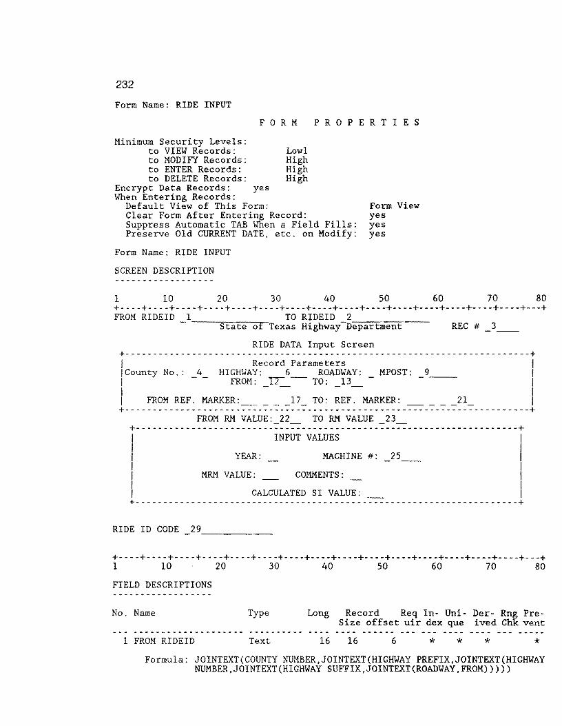
232
Form Name: RIDE INPUT
F 0 R M P R 0 P E R T I E S
Minimum Security Levels: to VIEW Records: to MODIFY Records: to ENTER Records: to DELETE Records:
Encrypt Data Records: When Entering Records:
yes
Default View of This Form:
Lowl High High High
Clear Form After Entering Record: Suppress Automatic TAB When a Field Fills: Preserve Old CURRENT DATE, etc. on Modify:
Form Name: RIDE INPUT
SCREEN DESCRIPTION
1 10 20 30 40
Form View yes yes yes
50 60 70 80 +----+----+----+----+----+----+----+----+----+----+----+----+----+----+----+---+ FROM RIDEID 1 TO RIDEID 2
State of Texas Highway_D_e_p-ar-t~m-e-n~t~~- REC # 3
RIDE DATA Input Screen +-------------------------------------------------------------------------+ I Record Parameters I !County No.: _4_ HIGHWAY: 6_ ROADWAY: _ MPOST: _9__ I I FROM: ~ TO: 13 I I - - - - I I FROM REF. MARKER: ____ l TO: REF. MARKER: ____ 21_ I +-------------------------------------------------------------------------+
FROM RM VALUE: TO RM VALUE 23 +- - - - - - - - - - - - - - - - - - - - - - - - - - - - - - - - - - - - - - - - - - - - -=- - - -=--=- - - - - - - - - - - - - - - - - - - - -+ I INPUT VALUES I I I I YEAR: MACHINE #: _25__ I I I I MRM VALUE: COMMENTS: I I I I CALCULATED SI VALUE: I +---------------------------------------------------------------------+
RIDE ID CODE
+----+----+----+----+----+----+----+----+----+----+----+----+----+----+----+---+ 1 10 20 30 40 so 60 70 80
FIELD DESCRIPTIONS
No. Name Type Long Record Req In- Uni- Der- Rng Pre-Size offset uir dex que ived Chk vent
1 FROM RIDEID Text 16 16 6 * * * * Formula: JOINTEXT(COUNTY NUMBER,JOINTEXT(HIGHWAY PREFIX,JOINTEXT(HIGHWAY
NUMBER,JOINTEXT(HIGHWAY SUFFIX,JOINTEXT(ROADWAY,FROM)))))

233
FIELD DESGRIPTIONS ... RIDE INPUT ... continued
No. Name Type Long Record Req In- Uni- Der- Rng Pre-Size offset uir dex que ived Chk vent
2 TO RIDEID Text 16 16 22 * * * * Formula: JOINTEXT(COUNTY NUMBER,JOINTEXT(HIGHWAY PREFIX,JOINTEXT(HIGHWAY
NUMBER,JOINTEXT(HIGHWAY SUFFIX,JOINTEXT(ROADWAY,REFERENCE POINT)))))
3 RECORD NUMBER Num. String 6 6 38 Formula: SEQUENCE FROM 00001
4 COUNTY NUMBER Number 3 2 44 * Number Type Integer View Security Required: High Write Security Required: Lowl
5 HIGHWAY PREFIX Text 2 2 46 * View Security Required: High Write Security Required: Lowl
6 HIGHWAY NUMBER Num. String 4 4 48 * View Security Required: High Write Security Required: Lowl
7 HIGHWAY SUFFIX Text l 1 52 * View Security Required: High Write Security Required: Lowl
8 ROADWAY Text 1 1 53 * View Security Required: High Write Security Required: Lowl
9 MILEPOST Number Number Type : Integer
10 MILEPOST DISP. SIGN Choice Choice 1: + Choice 2: -
11 MILEPOST VALUE Number Number Type Fixed Point
12 FROM Number Number Type Fixed Point
13 REFERENCE POINT Number Number Type Fixed Point
14 FROM RM Number Type
15 FROM RM SUFFIX
Number Integer
Text
16 FROM RM DISP. SIGN Text
17 FROM RM DISP. Number Type
18 TO RM Number Type
Number Fixed Point
Number Integer
3
1
3
5
5
3
1
1
4
3
2
1
4
4
4
2
1
1
4
2
54
56
57
61
65
69
71
72
73
77
*
* *
*
*
*
*
*
*
*
*
*
*
234
Form Name: RIDE INPUT Continued ...
FIELD DESCRIPTIONS
No. Name Type Long Record Req In- Uni- Der- Rng Pre-Size offset uir dex que ived Chk vent
19 TO RM SUFFIX Text 1 1 79
80
81
20 TO RM DISP. SIGN Text 1 1
21 TO RM DISP. Number 4 4 Number Type Fixed Point
22 FROM RM VALUE Number 5 4 85 * * Number Type : Fixed Point Formula: IF(FROM RM DISP. SIGN= "+",FROM RM+ FROM RM DISP., FROM RM -
FROM RM DISP.)
23 TO RM VALUE Number 5 4 89 * * Number Type Fixed Point
Formula: IF(TO RM DISP. SIGN="+", TO RM + TO RM DISP., TO RM - TO RM DISP.)
24 YEAR Number 2 1 93 * * Number Type Integer Lower Limit: 86 Upper Limit: 99 Display Attribute: Highlight 1
25 MACHINE # Choice 7 1 94 Choice 1: 079873A Choice 2: 219917C Choice 3: 299867A Display Attribute: Highlight 1
26 MRM VALUE Number 3 2 95 Number Type : Integer Display Attribute: Highlight 1
27 COMMENTS Number 2 1 97 Number Type Integer Display Attribute: Highlight 1
28 SI VALUE Number 3 4 98 * * Number Type : Fixed Point Formula: FLOOR( ((5/EXP(POWER((LOG(32*MRM VALUE} }/(LOOKUP "MACHINE #VAR."
29 RIDEID
"BETA VALUE"/100000},LOOKUP "MACHINE# VAR." "ALPHA VALUEn /100000)))*10)+0.5)/10
Text 16 16 102 * * Formula: JOINTEXT(COUNTY NUMBER,JOINTEXT(HIGHWAY PREFIX,JOINTEXT(HIGHWAY
NUMBER,JOINTEXT(HIGHWAY SUFFIX,JOINTEXT(ROADWAY,REFERENCE POINT)))))
Record Size: 118 Memory: Text = 1488 Fields = 2261 Total = 3749

235
Form Name: ORIGINAL RIDE INPUT
F 0 R M P R 0 P E R T I E S Minimum Security Levels:
to VIEW Records: Lowl to MODIFY Records: High to ENTER Records: High to DELETE Records: High
Encrypt Data Records: yes
When Entering Records: Default View of This Form: Form View Clear Form After Entering Record: yes Suppress Automatic TAB When a Field Fills: yes Preserve Old CURRENT DATE, etc. on Modify: yes
Form Name: ORIGINAL RIDE INPUT
SCREEN DESCRIPTION
1 10 20 30 40 50 60 70 80 +----+----+----+----+----+----+----+----+----+----+----+----+----+----+----+---+
FROM RIDEID 1 TO RIDEID 2 State of Texas Highway Depar-tm_e_n_t~~~~-REC # _3~-
ORIGINAL RIDE DATA Input Screen +-------------------------------------------------------------------------+ I Record Parameters I I County No.: 4 HIGHWAY: 6 ROADWAY: MPOST: 9 I I - - FROM: _u-_- TO: _13_ - - I I I I FROM REF. MARKER: __ 17_ TO: REF. MARKER: ____ 21_ I +-------------------------------------------------------------------------+
FROM RM VALUE: 22 TO RM VALUE 23 +- - - - - - - - - - - - - - - - - - - - - - - - -:: - -:::: - - - - - - - - - - - - - -:: - -:::: - - - - - - - - - - - - - - - - - - - -+
INPUT VALUES I
YEAR: MACHINE #: 25
MRM VALUE: COMMENTS:
I I I I I
CALCULATED SI VALUE: I +- - - - - - - - - - - - - - - - - - - - - - - - - - - - - - - - - - - - - - - - - - - - - - - - - - - - - - - - - - - - - - - - - - -+
RIDE ID CODE
!----+----+----+----+----+----+----+----+----+----+----+----+----+----+----+---+ 1 10 20 30 40 50 60 70 80
236
FIELD DESCRIPTIONS ORIGINAL RIDE INPUT ... continued
No. Name Type Long Record Req In- Uni- Der- Rng Pre-Size offset uir dex que ived Chk vent
1 FROM RIDEID Text 16 16 6 * * * * Formula: JOINTEXT(COUNTY NUMBER,JOINTEXT(HIGHWAY PREFIX,JOINTEXT(HIGHWAY
NUMBER,JOINTEXT(HIGHWAY SUFFIX,JOINTEXT(ROADWAY,FROM)))))
2 TO RIDEID Text 16 16 22 * * * * Formula: JOINTEXT(COUNTY NUMBER,JOINTEXT(HIGHWAY PREFIX,JOINTEXT(HIGHYAY
NUMBER,JOINTEXT(HIGHWAY SUFFIX,JOINTEXT(ROADWAY,REFERENCE POINT)))))
3 RECORD NUMBER Num. String 6 6 38 * * Formula: SEQUENCE FROM 00001
4 COUNTY NUMBER Number 3 2 44 * * Number Type Integer View Security Required: High Write Security Required: Lowl
5 HIGHWAY PREFIX Text 2 2 46 * * View Security Required: High Write Security Required: Lowl
6 HIGHWAY NUMBER Num. String 4 4 48 * * View Security Required: High Write Security Required: Lowl
7 HIGHWAY SUFFIX Text 1 1 52 * * View Security Required: High Write Security Required: Lowl
8 ROADWAY Text 1 1 53 * * View Security Required: High Write Security Required: Lowl
9 MILEPOST Number 3 2 54 * Number Type Integer
10 MILEPOST DISP. SIGN Choice 1 1 56 * Choice 1: + Choice 2: -
11 MILEPOST VALUE Number 3 4 57 * Number Type Fixed Point
12 FROM Number 5 4 61 * Number Type Fixed Point
13 REFERENCE POINT Number 5 4 65 * * Number Type Fixed Point
14 FROM RM Number 3 2 69 Number Type Integer
15 FROM RM SUFFIX Text 1 1 71
16 FROM RM DISP. SIGN Text 1 1 72
17 FROM RM DISP. Number 4 4 73 Number Type Fixed Point
18 TO RM Number 3 2 77 Number Type Integer
237
Form Name: ORIGINAL RIDE INPUT Continued ...
FIELD DESCRIPTIONS
No. Name Type Long Record Req In- Uni- Der- Rng Pre-Size offset uir dex que ived Chk vent
19 TO RM SUFFIX Text 1 1 79
20 TO RM DISP. SIGN Text 1 1 80
21 TO RM DISP. Number 4 4 81 Number Type Fixed Point
22 FROM RM VALUE Number 5 4 85 * * Number Type Fixed Point Formula: IF(FROM RM DISP. SIGN ="+",FROM RM+ FROM RM DISP. , FROM RM -
FROM RM DISP.)
23 TO RM VALUE Number 5 Number Type : Fixed Point Formula: IF(TO RM DISP. SIGN-"+",
DISP.)
24 YEAR Number
Number Type : Integer Lower Limit: 86 Upper Limit: 99 Display Attribute: Highlight 1
2
25 MACHINE # Choice 7 Choice 1: 079873A Choice 2: 219917C Choice 3: 299867A Display Attribute: Highlight 1
26 MRM VALUE Number 3 Number Type : Integer Display Attribute: Highlight 1
27 COMMENTS Number 2 Number Type : Integer Display Attribute: Highlight 1
4 89 * * TO RM+ TO RM DISP., TO RM - TO RM
1 93 * *
1 94
2 95
1 97
28 SI VALUE Number 3 4 98 * * Number Type : Fixed Point Formula: FLOOR( ( (5/EXP(POWER( (LOG(32*MRM VALUE) )/(LOOKUP "MACHINE# VAR."
29 RIDEID
"BETA VALUE"/100000),LOOKUP "MACHINE# VAR." "ALPHA VALUE" /100000)))*10)+0.5)/10
Text 16 16 102 * * Formula: JOINTEXT(COUNTY NUMBER,JOINTEXT(HIGHWAY PREFIX,JOINTEXT(HIGHWAY
NUMBER,JOINTEXT(HIGHWAY SUFFIX,JOINTEXT(ROADWAY,REFERENCE POINT)))))
Record Size: 118 Memory: Text ~ 1494 Fields = 2261 Total - 3755

238
Form Name: 0.1 SIOMETER FILE
F 0 R M P R 0 P E R T I E S
Minimum Security Levels: to VIEW Records: to MODIFY Records: to ENTER Records: to DELETE Records:
Encrypt Data Records: yes
When Entering Records: Default View of This Form:
Low3 Medium3 Medium3 Medium3
Clear Form After Entering Record: Suppress Automatic TAB When a Field Fills: Preserve Old CURRENT DATE, etc. on Modify:
Form Name: 0.1 SIOMETER FILE
SCREEN DESCRIPTION
1 10 20 30 40
Form View yes yes yes
50 60 70 80 +----+----+----+----+----+----+----+----+----+----+----+----+----+----+----+---+
RIDEID: 1 BROOKS COUNTY (024) REC # 2 0.1 - MILE SIOMETER INPUT FILE (RIDE) MODIFIED: APRIL, 199i---
COUNTY NUMBER ....... : 3 HIGHWAY PREFIX ...... :- -HIGHWAY NUMBER ...... :-S HIGHWAY SUFFIX ...... : REFERENCE POINT ..... :-7 MILEPOST ............ :-8-MILEPOST DISP. SIGN.:- -MILEPOST DISP ....... : ROADWAY ............. :
FROM REF. MARKER: SUFFIX
FROM RM VALUE: 16
DISP. SIGN
TO RM VALUE
RM DISP VALUE 15
17 +- - - - - - - - - - - - - - - - - - - - - - - - - - - - - - - - - - - - - - - - - - - - -+ I INPUT VALUES I I I I YEAR: ~ SIOMETER VALUE: COMMENTS: ~ I +- - - - - - - - - - - - - - - - - - - - - - - - - - - - - - - - - - - - - - - - - - - - -+
+----+----+----+----+----+----+----+----+----+----+----+----+----+----+----+---+ 1 10 20 30 40 50 60 70 80
FIELD DESCRIPTIONS
No. Name Type Long Record Req In- Uni- Der- Rng Pre-Size offset uir dex que ived Chk vent
1 IMPORT SIOM KEY Text 16 16 5 * * * Formula: JOINTEXT(COUNTY NUMBER,JOINTEXT(HIGHWAY PREFIX,
JOINTEXT(HIGHWAY NUMBER,JOINTEXT(HIGHWAY SUFFIX, JOINTEXT(ROADWAY,TO RM VALUE)))))
2 RECORD NUMBER Num. String 6 Formula: SEQUENCE FROM 00001
6 21
* *
* *
239
Form Name: 0.1 SIOMETER FILE Continued ...
FIELD DESCRIPTIONS ------------------No. Name Type Long Record Req In- Uni- Der- Rnt Pre-
Size offset uir dex que ived Ch vent _ .., _______ .,. _____ ..,. __ .,._ __ .., _______ - ...... - ---.... ------ --- --- ---- -- --3 COUNTY NUMBER Number 3 2 27. * * Number Type Integer
Lower Limit: 1 Upper Limit: 254
4 HIGHWAY PREFIX Choice 2 1 29 * * Choice 1: PR Choice 2: FM Choice 3: SH Choice 4: us Choice 5: IH
5 HIGHWAY NUMBER Num. String 4 4 30 * * * Lower Limit: 0001 Upper Limit: 9999
6 HIGHWAY SUFFIX Choice 1 1 34 * Choice 1: A Choice 2: s Choice 3: E Choice 4: w
7 REFERENCE POINT Number 5 4 35 * Number Type Fixed Point
8 MILEPOST Number 3 2 39 * * * Number Type Integer Lower Limit: 0 Upper Limit: 999
9 MILEPOST DISP. SIGN Choice 1 1 41 * * Choice 1: + Choice 2: -
10 MILEPOST VALUE Number 3 4 42 * * * Number Type Fixed Point Lower Limit: 0.0 Upper Limit: 9.9
11 ROADWAY Choice 1 1 46 * * Choice 1: R Choice 2: L Choice 3: A Choice 4: x
12 RM Number 3 2 47 * Number Type Integer
13 RM SUFFIX Text 1 1 49 * 14 RM DISP. SIGN Text 1 1 50 * 15 RM DISP. Number 4 4 51 * Number Type Fixed Point

240
Form Name: 0.1 SIOMETER FILE Continued ...
FIELD DESCRIPTIONS
No. Name Type Long Record Req In- Uni- Der- Rng Pre-
16 FROM RM VALUE Number 5 Number Type : Fixed Point Formula: IF (RM DISP. SIGN - "+" ,
17 TO RM VALUE Number Type
Number Fixed Point
5
18 YEAR Number 2 Number Type : Integer Display Attribute: Highlight 1
19 SI VALUE Number Type
20 COMMENTS Number Type
Number Fixed Point
Number Integer
3
2
Size offset uir dex que ived Chk vent
4 55 * * RM+ RM DISP. , RM - RM DISP.)
4 59 *
1 63 *
4 64 *
1 68 *
Record Size: 69 Memory: Text - 1292 Fields = 1189 Total = 2481

Form Name: SKID INPUT
F 0 R M P R 0 P E R T I E S
Minimwn Security Levels: to VIEW Records: Lowl to MODIFY Records: High to ENTER Records: High to DELETE Records: High
Encrypt Data Records: yes When Entering Records:
Default View of This Form: Form View Clear Form After Entering Record: yes Suppress Automatic TAB When a Field Fills: yes Preserve Old CURRENT DATE, etc. on Modify: yes
Form Name: SKID INPUT
SCREEN DESCRIPTION
1 10 20 30 40 50
241
60 70 80 +----+----+----+----+----+----+----+----+----+----+----+----+----+----+----+---+
State of Texas Highway Department BROOKS COUNTY (024)
SKID DATA Input Screen +------ - - - - - - - - - - - - - - - - - - - - - - - - - - - - - - - - - - - - - - - - - - - - - - - - - - - - - - - - - - - - - - -+
' Record Parameters
I I County No.: _2_ HIGHWAY: 4 ROADWAY:
I REFERENCE POINT: 10
MILEPOST: 7 9
I I I
I REF. MARKER: _ SUFFIX DISP. SIGN_ RM DISP VALUE _14_ I +- - - - - - - - - - - - - - - - - - - - - - - - - - - - - - - - - - - - - - - - - - - - - - - - - - - - - - - - - - - - - - - - - - - - - -+
RM VALUE 15 +- - - - - - - - - - - - - - - - - - - - - - - - - - - - - - - -:-- -:--:-- - - - - - - - - - - - - - - - - - - - - - - - - - - - - - - -+ I INPUT VALUES I I I I SKID VALUE: SKID DATE: I I I +---------------- ----------------------------------------------------+
OLD SKID ID CODE 18 ------+----+----+----+----+----+----+----+----+----+----+----+----+----+----+----+---+ 1 10 20 30 40 50 60 70 80
FIELD DESCRIPTIONS
No. Name Type Long Record Req In- Uni- Der- Rng Pre-Size offset uir dex que ived Chk vent _____ .,...,..., ____________ __ .., _____ ...... - - - - - - - .. ------ - - - - -- - - - -
1 RECORD NUMBER Num. String 6 6 5 * * Formula: SEQUENCE FROM 00001
2 COUNTY NUMBER Number 3 2 11 * Number Type Integer View Security Required: High Write Security Required: Lowl
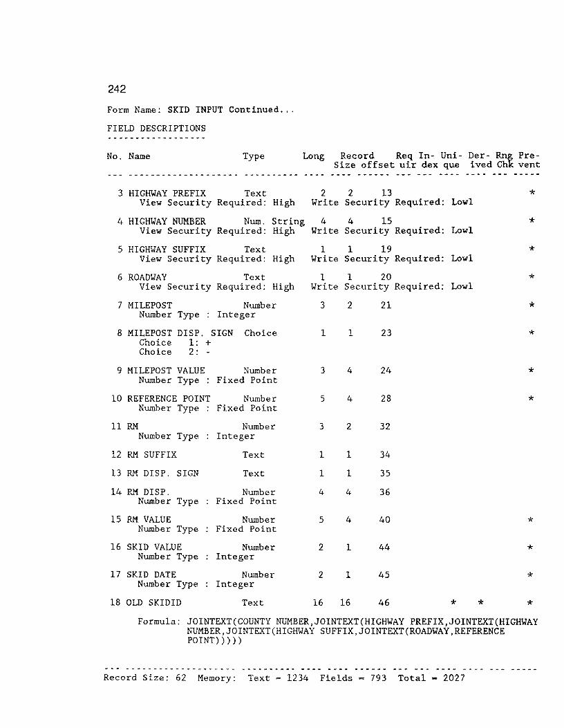
242
Form Name: SKID INPUT Continued ...
FIELD DESCRIPTIONS
No. Name Type Long Record Req In- Uni- Der- Rng Pre-Size offset uir dex que ived Ghk vent
3 HIGHWAY PREFIX Text 2 2 13 View Security Required: High Write Security Required: Lowl
4 HIGHWAY NUMBER Num. String 4 4 15 View Security Required: High Write Security Required: Lowl
5 HIGHWAY SUFFIX Text View Security Required: High
6 ROADWAY Text View Security Required: High
7 MILEPOST Number Type
Number Integer
8 MILEPOST DISP. SIGN Choice Choice 1: + Choice 2: -
9 MILEPOST VALUE Number Number Type Fixed Point
10 REFERENCE POINT Number Number Type Fixed Point
11 RM Number Type
12 RM SUFFIX
13 RM DISP. SIGN
14 RM DISP. Number Type
15 RM VALUE Number Type
16 SKID VALUE Number Type
17 SKID DATE Number Type
18 OLD SKIDID
Number Integer
Text
Text
Number Fixed Point
Number Fixed Point
Number Integer
Number Integer
Text
1 1 19 Write Security Required: Lowl
1 1 20 Write Security Required: Lowl
3
1
3
5
3
1
l
4
5
2
2
16
2
1
4
4
2
1
1
4
4
1
1
16
21
23
24
28
32
34
35
36
40
44
45
46 *
*
*
*
*
*
*
*
*
*
*
*
* * Formula: JOINTEXT(COUNTY NUMBER,JOINTEXT(HIGHWAY PREFIX,JOINTEXT(HIGHWAY
NUMBER,JOINTEXT(HIGHWAY SUFFIX,JOINTEXT(ROADWAY,REFERENCE POINT)))))
Record Size: 62 Memory: Text = 1234 Fields ~ 793 Total = 2027

Form Name: PES: ADT & l8KIP IN
F 0 R M P R 0 P E R T I E S
Minimum Security Levels:
to VIEW Records: to MODIFY Records: to ENTER Records: to DELETE Records:
Encrypt Data Records:
When Entering Records:
yes
Default View of This Form:
Low3 Mediwn3 Mediwn3 Medium3
Clear Form After Entering Record: Suppress Automatic TAB When a Field Fills: Preserve Old CURRENT DATE, etc. on Modify:
Form Name: PES: ADT & 18KIP IN
SCREEN DESCRIPTION
1 10 20 30 40
Form View yes yes yes
50
243
60 70 80 +----+----+----+----+----+----+----+----+----+----+----+----+----+----+----+---+ PESKEY 1 DISTRICT 21 PES DATA FILE: ADT & l8KIP REC. NO: 2 GRAPHKEY - --- --
COUNTY NUMBER: 4 HIGHWAY: ROADWAY:
FROM REF. MARKER: 9 TO REF. MARKER 10
ADT VALUE: 11 18-KIP VALUE: 12 DATE:
HIGHWAY DESIGN TYPE FUNCTIONAL CLASS
+----+----+----+----+----+----+----+----+----+----+----+----+----+----+----+---+ 1 10 20 30 40 so 60 70 80
FIELD DESCRIPTIONS
No. Name Type Long Record Req In- Uni- Der- Rng Pre-Size offset uir dex que ived Chk vent
1 PESKEY Text 15 15 4 * * * Formula: JOINTEXT(COUNTY NUMBER,JOINTEXT(HIGHWAY PREFIX, JOINTEXT(HIGHWAY
NUMBER,JOINTEXT(HIGHWAY SUFFIX,TO REF. MARKER))))
2 RECORD NUMBER Num. String 6 6 19 * * Formula: SEQUENCE FROM 000001
3 GRAPHKEY Text 6 6 25 * * Formula: JOINTEXT(HIGHWAY PREFIX,HIGHWAY NUMBER)

244
FIELD DESCRIPTIONS PES: ADT & 18KIP IN
No. Name Type Long Record Req In- Uni- Der- Rng Pre-Size off set uir dex que ived Chk vent
4 COUNTY NUMBER Number 3 2 31 * Number Type Integer
5 HIGHWAY PREFIX Choice 2 1 33 * Choice 1: PR Choice 2: FM Choice 3: SH Choice 4: us Choice 5: IH
6 HIGHWAY NUMBER Num. String 4 4 34 * Formated as Other Format 0000
7 HIGHWAY SUFFIX Choice 1 1 38 * Choice 1: A Choice 2: s Choice 3: E Choice 4: w
8 ROADWAY Choice 1 1 39 * Choice 1: R Choice 2: L Choice 3: A Choice 4: x
9 FROM REF. MARKER Number 5 4 40 * Number Type Fixed Point
10 TO REF. MARKER Number s 4 44 * Number Type Fixed Point
11 ADT VALUE Number 7 4 48 * Number Type Integer
12 KIP VALUE Number 6 4 52 * Number Type Integer
13 YEAR Number 2 1 56 * Number Type Integer
14 HIGHWAY DESIGN TYPE Number 1 1 57 * Number Type Integer
15 FUNCTIONAL CLASS Number 1 1 58 * Number Type Integer ___ ,.. __ ,. _____________ ---------- --- ... - ...... -
__ ,.. ___ - -- -- - - -- - ---- --- --- ... -
Record Size: 59 Memory: Text = 439 Fields = 802 Total = 1241

245
Form Name: SIOMETER RIDE VALUES
SCREEN DESCRIPTION
1 10 20 30 40 50 60 70 80 +----+----+----+----+----+----+----+----+----+----+----+----+----+----+----+---+ RIDE ID: l GRAPH KEY 2...---=
- State of Texas Highway Department BROOKS COUNTY (024)
REC # 3
RIDE DATA Input Screen +- - - - - - - - - - - - - - - - - - - - - - - - - - - - - - - - - - - - - - - - - - - - - - - - - - - - - - - - - - - - - - -+ I I I Record Parameters: Location Data I I I I County No.: HIGHWAY: 6 ROADWAY: I I I I FROM REF. MARKER: 9 12 TO: REF. MARKER: __ 16_ I I I I MILEPOST: FROM: 20 TO: 2 I
+- - - - - - - - - - - - - - - - - - - - - - - - - - - - - - - - - - - - - - - - - - - - - - - - - - - - - - - - - - - - - - -+ FROM RM VALUE: 22 TO RM VALUE 23
+------------------~-----------------~----=--=-----+ I INPUT VALUES I I I I YEAR: _ SIOMETER VALUE:_ COMMENTS: _ I +- - - - - - - - - - - - - - - - - - - - - - - - - - - - - - - - - - - - - - - - - - - - -+
FROM RM INDEX 27 TO RM INDEX: 28 FROM RIDEID 2"9° --- TO RIDEID -3"""'0~-
+- ---+- ---+- - -+----+----+----+----+---~+-----_-+--------+---------+----+----+----+----+---+ 1 10 20 30 40 so 60 70 80
FIELD DESCRIPTIONS
No. Name Type Long Record Req In- Uni- Der- Rng Pre-Size offset uir dex que ived Chk vent
l IMPORT SIOM KEY Text 16 16 6 * * * * * Formula: JOINTEXT(COUNTY NUMBER,JOINTEXT(HIGHWAY PREFIX,
JOINTEXT(HIGHWAY NUMBER,JOINTEXT(HIGHWAY SUFFIX, JOINTEXT(ROADWAY,TO RM VALUE)))))
2 GRAPH KEY Text 8 8 22 * * *
3
Formula: JOINTEXT (HIGHWAY PREFIX, JOINTEXT(HIGHWAY NUMBER, JOINTEXT(HIGHWAY SUFFIX, ROADWAY)))
RECORD NUMBER Num. String 6 6 30 Formula: SEQUENCE FROM 00001
4 COUNTY NUMBER Number 3 2 36 Number Type Integer View Security Required: High Write Security Required: Lowl
5 HIGHWAY PREFIX Text 2 2 38 View Security Required: High Write Security Required: Lowl
6 HIGHwAY NUMBER Num. String 4 4 40 View Security Required: High Write Security Required: Lowl
* *
*
*
*
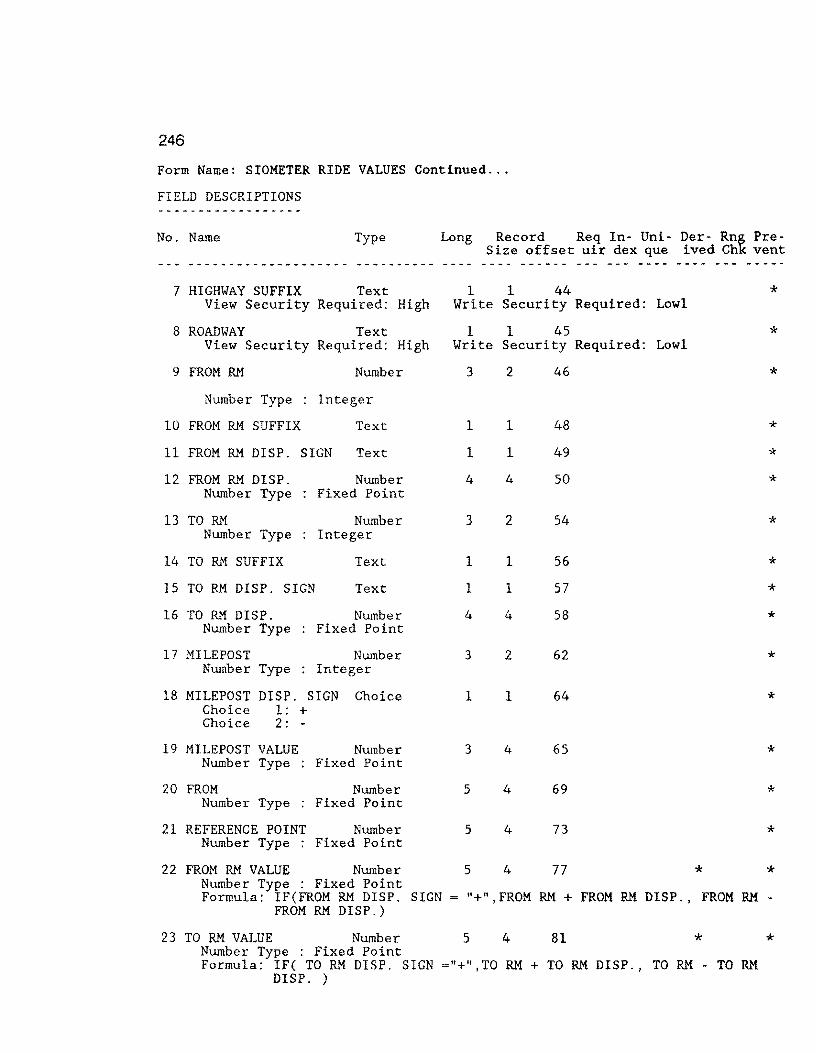
246
Form Name: SIOMETER RIDE VALUES Continued ...
FIELD DESCRIPTIONS
No. Name Type Long Record Req In- Uni- Der- Rng Pre-Size offset uir dex que ived Chk vent
7 HIGHWAY SUFFIX Text 1 1 44 * View Security Required: High Write Security Required: Lowl
8 ROADWAY Text 1 1 45 * View Security Required: High Write Security Required: Lowl
9 FROM RM Number 3 2 46 * Number Type Integer
10 FROM RM SUFFIX Text 1 1 48 * 11 FROM RM DISP. SIGN Text 1 1 49 * 12 FROM RM DISP. Number 4 4 so * Number Type Fixed Point
13 TO RM Number 3 2 54 * Number Type Integer
14 TO RM SUFFIX Text 1 1 56 * 15 TO RM DISP. SIGN Text 1 1 57 * 16 TO RM DISP. Number 4 4 58 * Number Type Fixed Point
17 MILEPOST Number 3 2 62 * Number Type Integer
18 MILEPOST DISP. SIGN Choice 1 1 64 * Choice 1: + Choice 2: -
19 MILEPOST VALUE Number 3 4 65 * Number Type Fixed Point
20 FROM Number 5 4 69 * Number Type Fixed Point
21 REFERENCE POINT Number s 4 73 * Number Type Fixed Point
22 FROM RM VALUE Number s 4 77 * * Number Type : Fixed Point Formula: IF(FROM RM DISP. SIGN= "+",FROM RM + FROM RM DISP. , FROM RM -
FROM RM DISP.)
23 TO RM VALUE Number 5 4 81 * * Number Type Fixed Point Formula: IF( TO RM DISP. SIGN ="+ 11 ,TO RM+ TO RM DISP., TO RM - TO RM
DISP. )
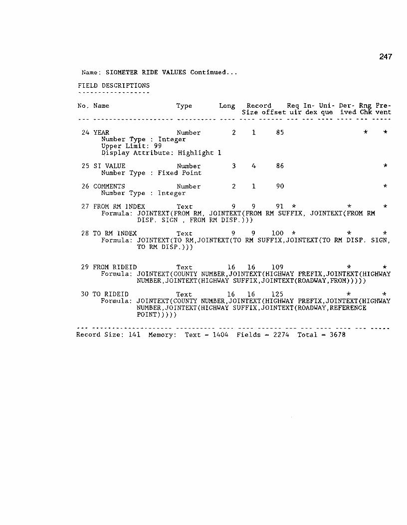
247
Name: SIOMETER RIDE VALUES Continued ...
FIELD DESCRIPTIONS
No. Name Type Long Record Req In- Uni- Der- Rng Pre-Size offset uir dex que ived Chk vent
24 YEAR Number 2 1 85 * * Number Type Integer Upper Limit: 99 Display Attribute: Highlight 1
25 SI VALUE Number 3 4 86 * Number Type Fixed Point
26 COMMENTS Number 2 1 90 * Number Type Integer
27 FROM RM INDEX Text 9 9 91 * * * Formula: JOINTEXT(FROM RM, JOINTEXT(FROM RM SUFFIX, JOINTEXT(FROM RM DISP. SIGN , FROM RM DISP.)))
28 TO RM INDEX Text 9 9 100 * * * Formula: JOINTEXT(TO RM,JOINTEXT(TO RM SUFFIX,JOINTEXT(TO RM DISP. SIGN,
TO RM DISP.)))
29 FROM RIDEID Text 16 16 109 * * Formula: JOINTEXT(COUNTY NUMBER,JOINTEXT(HIGHWAY PREFIX,JOINTEXT(HIGHWAY
NUMBER,JOINTEXT(HIGHWAY SUFFIX,JOINTEXT(ROADWAY,FROM)))))
30 TO RIDEID Text 16 16 125 * * Formula: JOINTEXT(COUNTY NUMBER,JOINTEXT(HIGHWAY PREFIX,JOINTEXT(HIGHWAY
NUMBER,JOINTEXT(HIGHWAY SUFFIX,JOINTEXT(ROADWAY,REFERENCE POINT)))))
Record Size: 141 Memory: Text= 1404 Fields = 2274 Total= 3678

248
Form Name: PRS-SRS INPUT FILE
F 0 R M P R 0 P E R T I E S
Minimum Security Levels:
to VIEW Records: to MODIFY Records: to ENTER Records: to DELETE Records:
Encrypt Data Records:
When Entering Records:
yes
Low3 Medium3 Medium3 Medium3
Default View of This Form: Form View Clear Form After Entering Record: yes Suppress Automatic TAB When a Field Fills: yes Preserve Old CURRENT DATE, etc. on Modify: yes
Form Name: PRS-SRS INPUT FILE
SCREEN DESCRIPTION
1 10 20 30 40 so 60 70 80 +----+----+----+----+----+----+----+----+----+----+----+----+----+----+----+---+
PAVEMENT RATING & SHOULDER RATING HOLDING FILE ( Not to be used for Data Entry ]
RECORD NUMBER PAVEMENT RATING SCORE SHOULDER RATING SCORE
1 2 3 +----+----+----+----+----+----+-~--+----+----+----+----+----+~---+----+----+---+ 1 10 20 30 40 50 60 70 80
FIELD DESCRIPTIONS
No. Name Type Long Record Req In- Uni- Der- Rng Pre-Size offset uir dex que ived Chk vent
-------------------- ---------- ---- ---- ------ --- --- .. ---1 RECORD NUMBER Num. String 6 6 3 * * * Display Attribute: Highlight 1
2 PAVEMENT RATING Number 6 4 9 * Number Type Fixed Point Display Attribute: Highlight 1
3 SHOULDER RATING Number 6 4 13 * Number Type Fixed Point Display Attribute: Highlight 1
Record Size: 17 Memory: Text = 258 Fields - 115 Total = 373

Form Name: VIS F 0 R M P R 0 P E R T I E S
Minimum Security Levels: to VIE'\J Records: to MODIFY Records: to ENTER Records: to DELETE Records:
Encrypt Data Records: When Entering Records:
yes
Default View of This Form:
Low3 Medium3 Medium3 Medium3
Clear Form After Entering Record: Suppress Automatic TAB When a Field Fills: Preserve Old CURRENT DATE, etc. on Modify:
Form Name: VIS
SCREEN DESCRIPTION
1 10 20 30 40
Form View yes yes yes
50
249
60 70 80 +----+----+----+----+----+----+----+----+----+----+----+----+----+----+----+---+
LOCATION KEY 1 GRAPH KEY 2 BROOKS COUNTY (024) VISUAL DATA FILE ENTRY SCREEN REC NO FROM: 4 7 TO: 8 11 FROM RM-VALUE- I2" TO RM VALUE -13-
COUNTY: - DISTRICT: HIGHWAY: 17- lmAD'\JAY: REFERENCE MILE POST: YEAR---;-23- lANE:
+------------------------------------------------------------------------+ !RUTTING RAVELING FLUSHING CORRUGATIONS ALLIGATOR CRACKING! ISL MO SV SL MO SV SL MO SV SL MO SV SL MO SV I I_ _ _ _ _ _ _ _ _ _ _ _ I +- - - - - - - - - - - - - - - - - - - - - - - - - - - - - - - - - - - - - - - - - - - - - - - - - - - - - - - - - - - - - - - - - - - - - - - -+ +- --------------------------------------------++- -------------+ IL. CRACKS T. CRACKS CRACK PATCHING I !TOTAL FAILURESIPRS: ISL MO SV SL MO SV QUALITY SL MO SVI I total number ISRs:::=z;r~ I_ _ _ _ _ 11 I +- - - - - - - - - - - - - - - - - - - - - - - - - - - - - - - - - - - - - - - - - - - - -++- - - - - - - - - - - - - -+
. SHOULDER DATA . -+---__ -_-_-_-_-_-_-_-_-_-_-_-_ -_ -__ -_-_-_-_-_-_-_-_ ------------------+ +- -------------+ +- -------+ I PAVED I I UNPAVED I ICOMMENTSI !RIDE CONT P.EDGE S. EDGE CKS RAVL VEG I .OR. IEDGE DISTRESS I I I I _ _ I I _ I I _62_ I +--------------------------------------------+ +--------------+ +--------+ RESERVED 1 RESERVED 2 0'4 RESERVED 3 -65 __ _
VISID CODE (FROM): 66 ------FROM: 67 TO;
FROM RM INDEX 69 __ _ TO RM INDEX 70
VISIDCODE(TO) _71 ____ _
68
---
+----+----+----+----+----+----+----+----+----+----+----+----+----+----+----+---+ 1 10 20 30 40 so 60 70 80
continued on the succeding page

250
FIELD DESCRIPTIONS VIS (VISUAL DATA FILE .... REQUIRES MANUAL INPUT AT THE DISTRICT)
No. Name Type Long Record Req In- Uni- Der- Rng Pre-Size offset uir dex que ived Chk vent
FIELD DESCRIPTIONS
No. Name Type Long Record Req In- Uni- Der- Rng Pre-Size offset uir dex que ived Chk vent
1 LOCATION KEY Text 16 16 11 * * 2 GRAPH KEY Text 7 7 27 *
Formula: JOINTEXT(HIGHWAY PREFIX,JOINTEXT(HIGHWAY NUMBER, JOINTEXT(HIGHWAY SUFFIX,ROADWAY)))
3 RECORD NUMBER Num. String 6 Formula: SEQUENCE FROM 000001 Display Attribute: Highlight 2
4 FROM RM Number Type
5 FROM RM SUFFIX
Number Integer
Text
6 FROM RM DISP. SIGN Text
7 FROM RM DISP. Number Type
8 TO RM Number Type
9 TO RM SUFFIX
10 TO RM DISP. SIGN
11 TO RM DISP. Number Type
12 FROM RM VALUE Number Type
13 TO RM VALUE Number Type
Number Fixed Point
Number Integer
Text
Text
Number Fixed Point
Number Fixed Point
Number Fixed Point
3
1
1
4
3
1
1
4
5
5
14 COUNTY NUMBER Nurn. String 3 Lower Limit: 000 Upper Limit: 254 Formula: 000 Display Attribute: Highlight 1
6
2
1
1
4
2
1
1
4
4
4
3
34 * *
40
42
43
44
48
50
51
52
56
60
64
15 DISTRICT Num. String 2 2 67 Formula: LOOKUP COUNTIES "DISTRICT NUMBER"
*
* * *
* *
*
* * *
*
* * *
*
*
* * *
* *

251
Form Name: VIS Continued ... FIELD DESCRIPTIONS ------------------No. Name Type Long Record Req In- Uni- Der- Rng Pre-
Size offset uir dex que ived Chk vent -- -
__ .,. _________________ ---------- - .... -- --·--- -- - --- ---- ---- --- -- ---
Display Attribute: Highlight 1
16 HIGHWAY PREFIX Choice 2 1 69 * Choice 1: PR Choice 2: FM Choice 3: SH Choice 4: us Choice 5: IH Display Attribute: Highlight 1
17 HIGHWAY NUMBER Num. String 4 4 70 * Formated as : Other Format 0000 Display Attribute: Highlight 1
18 HIGHWAY SUFFIX Choice 1 1 74 * Choice 1: A Choice 2: s Choice 3: E Choice 4: w Display Attribute: Highlight 1
19 ROADWAY Choice 1 1 75 * Choice 1: R Choice 2: L Choice 3: A Choice 4: x Display Attribute: Highlight 1
20 MILEPOST Number 3 2 76 * Number Type Integer
21 MILEPOST DISP. SIGN Choice 1 l 78 * Choice 1: + Choice 2: -
22 MILEPOST VALUE Number 3 4 79 * Number Type Fixed Point
23 YEAR Text 5 5 83 * 24 LANE Text 1 1 88
Display Attribute: Highlight 1
25 RUT-SL Number 1 1 89 * * Number Type : Integer Lower Limit: 0 Upper Limit: 3 Formula: 0 Display Attribute: Highlight 1
26 RUT-MO Number 1 1 90 * * Number Type Integer Lower Limit: 0 Upper Limit: 3 Formula: 0 Display Attribute: Highlight 1
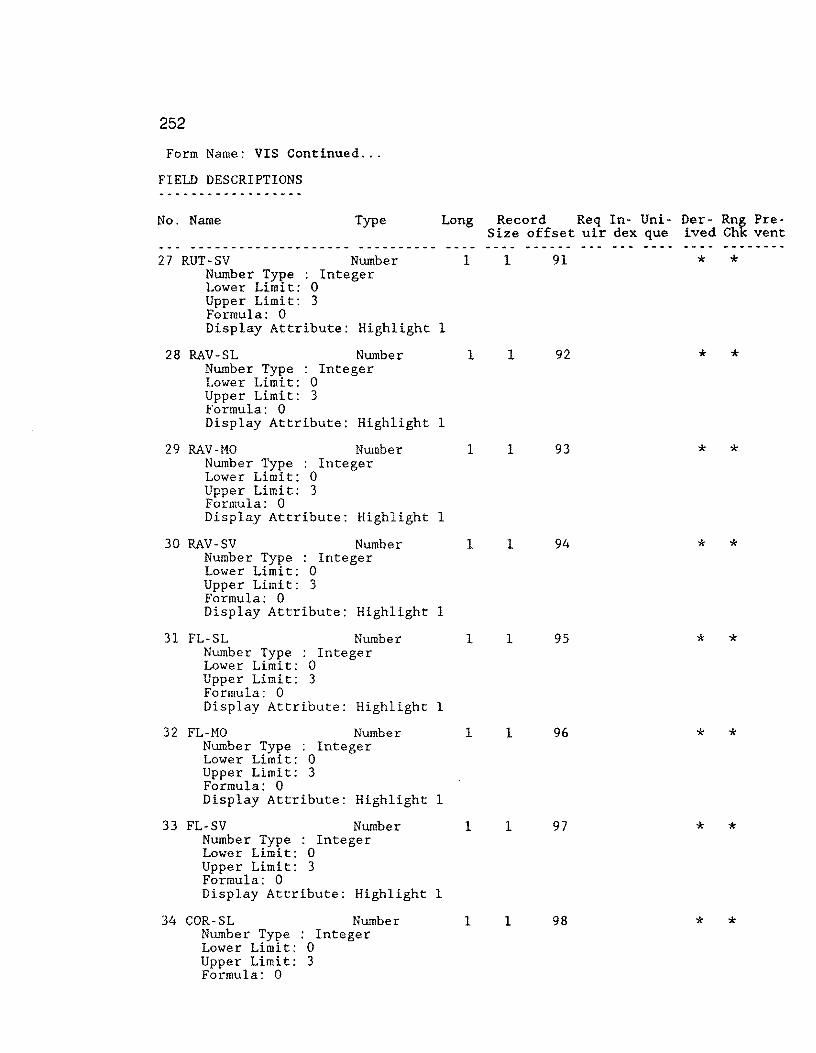
252
Form Name: VIS Continued ...
FIELD DESCRIPTIONS .., _____ ,.. _______ ,.. ___
No. Name Type Long Record Req In- Uni- Der- Rn~ Pre-Size offset uir dex que ived Ch vent
--- _____ .., _______ ,.. ____ ,.._ ----------___ ... __ --- --- ---- --------
27 RUT-SV Number 1 1 91 * * Number Type : Integer Lower Limit: 0 Upper Limit: 3 Formula: 0 Display Attribute: Highlight 1
28 RAV-SL Number 1 1 92 * * Number Type Integer Lower Limit: 0 Upper Limit: 3 Formula: 0 Display Attribute: Highlight 1
29 RAV-MO Number 1 1 93 * * Number Type Integer Lower Limit: 0 Upper Limit: 3 Formula: 0 Display Attribute: Highlight 1
30 RAV-SV Number 1 1 94 * * Number Type Integer Lower Limit: 0 Upper Limit: 3 Formula: 0 Display Attribute: Highlight 1
31 FL-SL Number 1 1 95 * * Number Type : Integer Lower Limit: 0 Upper Limit: 3 Formula: 0 Display Attribute: Highlight 1
32 FL-MO Number 1 1 96 * * Number Type Integer Lower Limit: 0 Upper Limit: 3 Formula: 0 Display Attribute: Highlight 1
33 FL-SV Number 1 1 97 * * Number Type Integer Lower Limit: 0 Upper Limit: 3 Formula: 0 Display Attribute: Highlight 1
34 COR-SL Number 1 1 98 * * Number Type Integer Lower Limit: 0 Upper Limit: 3 Formula: 0
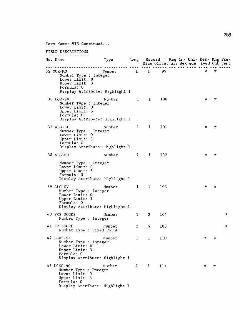
253
Form Name: VIS Continued ...
FIELD DESCRIPTIONS - -
_____________ ..., ...
No. Name Type Long Record Req In- Uni- Der- Rng Pre-Size off set uir dex que ived Chk vent
--- -------------------- __ .,. ___ .. ___ ------ --- -- - - ---35 COR-MO Number 1 1 99 * *
Number Type Integer Lower Limit: 0 Upper Limit: 3 Formula: 0 Display Attribute: Highlight 1
36 COR-SV Number 1 1 100 * * Number Type . Integer . Lower Limit: 0 Upper Limit: 3 Formula: 0 Display Attribute: Highlight 1
37 ALG-SL Number 1 1 101 * * Number Type Integer Lower Limit: 0 Upper Limit: 3 Formula: 0 Display Attribute: Highlight 1
38 ALG-MO Number 1 1 102 * * Number Type Integer Lower Limit: 0 Upper Limit: 3 Formula: 0 Display Attribute: Highlight 1
39 ALG-SV Number 1 1 103 * * Number Type : Integer Lower Limit: 0 Upper Limit: 3 Formula: 0 Display Attribute: Highlight 1
40 PRS SCORE Number 3 2 104 * Number Type Integer
41 SR SCORE Number 5 4 106 * Number Type Fixed Point
42 LCKS-SL Number 1 1 110 * * Number Type Integer Lower Limit: 0 Upper Limit: 3 Formula: 0 Display Attribute: Highlight 1
43 LCKS-MO Number 1 1 111 * * Number Type : Integer Lower Limit: 0 Upper Limit: 3 Formula: 0 Display Attribute: Highlight 1

254
Form Name: VIS Continued ...
FIELD DESCRIPTIONS ___ ., ___ .., __ .,.. ______ ..
No. Name Type Long Record Req In- Uni- Der- Rn~ Pre-Size offset uir dex que ived Ch vent
--- -------------------- ---------- ------ --- --- ---- ----·--· 44 LCKS-SV Number l l 112 * * Number Type : Integer
Lower Limit: 0 Upper Limit: 3 Formula: 0 Display Attribute: Highlight l
45 TCKS-SL Number l l 113 * * Number Type Integer Lower Limit: 0 Upper Limit: 3 Formula: 0 Display Attribute: Highlight 1
46 TCKS-MO Number 1 l 114 * * Number Type Integer Lower Limit: 0 Upper Limit: 3 Formula: 0 Display Attribute: Highlight 1
47 TCKS-SV Number 1 1 115 * * Number Type Integer Lower Limit: 0 Upper Limit: 3 Formula: 0 Display Attribute: Highlight 1
48 CRACKS-SEALED ETC Number 1 1 116 * * Number Type : Integer Lower Limit: 0 Upper Limit: 3 Formula: 0 Display Attribute: Highlight 1
49 PAT-SL Number 1 1 117 * * Number Type Integer Lower Limit: 0 Upper Limit: 3 Formula: 0 Display Attribute: Highlight 1
50 PAT-MO Number 1 l 118 * * Number Type Integer Lower Limit: 0 Upper Limit: 3 Formula: 0 Display Attribute: Highlight 1
51 PAT-SV Nurnber 1 1 119 * * Number Type Integer Lower Limit: 0 Upper Limit: 3 Formula: 0
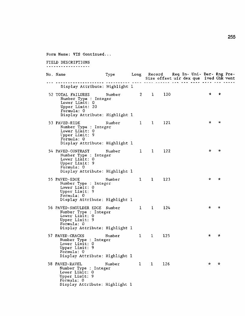
255
Form Name: VIS Continued ...
FIELD DESCRIPTIONS ------------------No. Name Type Long Record Req In- Uni- Der- Rng Pre-
Size offset uir dex que i ved Chk vent ------------ ...... ______ ______ .,. ___ ---- ---·-- --- --- ---- ----Display Attribute: Highlight 1
52 TOTAL FAILURES Number 2 1 120 * * Number Type : Integer Lower Limit: 0 Upper Limit: 20 Formula: 0 Display Attribute: Highlight 1
53 PAVED-RIDE Number 1 1 121 * * Number Type Integer Lower Limit: 0 Upper Limit: 9 Formula: 0 Display Attribute: Highlight 1
54 PAVED-CONTRAST Number 1 1 122 * * Number Type Integer Lower Limit: 0 Upper Limit: 9 Formula: 0 Display Attribute: Highlight 1
55 PAVED-EDGE Number 1 1 123 * * Number Type : Integer Lower Limit: 0 Upper Limit: 9 Formula: 0 Display Attribute: Highlight 1
56 PAVED-SHOULDER EDGE Number 1 1 124 * * Number Type : Integer Lower Limit; 0 Upper Limit: 9 Formula: 0 Display Attribute: Highlight 1
57 PAVED-CRACKS Number 1 1 125 * * Number Type : Integer Lower Limit: 0 Upper Limit: 9 Formula: 0 Display Attribute: Highlight 1
58 PAVED-RAVEL Number 1 1 126 * * Number Type : Integer Lower Limit: 0 Upper Limit: 9 Formula: 0 Display Attribute: Highlight 1

256
Form Name: VIS Continued ...
FIELD DESCRIPTIONS
No. Name Type Long Record Req In- Uni- Der- Rng Pre-Size offset uir dex que ived Chk vent
59 PAVED-VEG Number
60
Number Type : Integer Lower Limit: 0 Upper Limit: 9 Formula: 0
Display Attribute: Highlight
UNPAVED-EDGE Number Number Type Integer Lower Limit: 0 Upper Limit: 9 Formula: 0 Display Attribute: Highlight
61 UNPAVED-RUT-CR-ROCK Number Number Type Integer Lower Limit: 0 Upper Limit: 9 Formula: 0 Display Attribute: Highlight
62 COMMENTS Text Display Attribute: Highlight
63 RESERVED 1 Number Number Type Integer View Security Required: Low3
64 RESERVED 2 Number Number Type Fixed Point View Security Required: Low3
65 RESERVED 3 Number Number Type Fixed Point
66 VISUALID FROM Text
1 1 127 * *
1
1 1 128 * *
1
1 1 129 * *
1
5 5 130 1
3 2 135 * Write Security Required: Low3
10 8 137 * Write Security Required: Low3
10 8 145 *
16 16 153 * * Formula: JOINTEXT(COUNTY NUMBER,JOINTEXT(HIGHWAY PREFIX,JOINTEXT(HIGHWAY NUMBER,JOINTEXT(HIGHWAY SUFFIX,JOINTEXT(ROADWAY,FROM)))))
6 7 FROM Number 5 4 169 * * Number Type : Fixed Point Lower Limit: 0.00 Display Attribute: Highlight 1
68 REFERENCE POINT Number 5 4 173 * * Number Type : Fixed Point Lower Limit: 0.00 Display Attribute: Highlight 1

257
Form Name: VIS Continued ...
FIELD DESCRIPTIONS
No. Name Type Long Record Req In- Uni- Der- Rng Pre-Size offset uir dex que ived Chk vent
69 FROM RM INDEX Text 9 9 177. * * * Formula: JOINTEXT(FROM RM, JOINTEXT(FROM RM SUFFIX, JOINTEXT(FROM RM
DISP. SIGN, FROM RM DISP.)))
70 TO RM INDEX Text 9 9 186 * * * Formula: JOINTEXT(FROM RM, JOINTEXT(FROM RM SUFFIX, JOINTEXT(FROM RM
DISP. SIGN, TO RM DISP.)))
71 VISUALID2 Text 16 16 195 * * Formula: JOINTEXT(GOUNTY NUMBER,JOINTEXT(HIGHWAY PREFIX,JOINTEXT(HIGHWAY
NUMBER,JOINTEXT(HIGHWAY SUFFIX,JOINTEXT(ROADWAY,REFERENCE POINT)))))
Record Size: 211 Memory: Text = 1841 Fields = 5039 Total = 6880

258
Form Name: MASTER (0.1 Master File)
F 0 R M P R 0 P E R T I E S
Minimum Security Levels:
to VIEW Records: to MODIFY Records: to ENTER Records: to DELETE Records:
Encrypt Data Records: yes When Entering Records:
Default View of This Form:
Low3 Medium3 Medium3 Medium3
Clear Form After Entering Record: Suppress Automatic TAB When a Field Fills: Preserve Old CURRENT DATE, etc. on Modify:
Form Name: MASTER
SCREEN DESCRIPTION Multiple Screen File
1 10 20 30 40
Form View yes yes yes
50 60 70 80 +----+----+----+----+----+----+----+----+----+----+----+----+----+----+----+---+
SORTED MAINTENANCE MANAGEMENT MASTER FILE LOCATION KEY: l GRAPHKEY 2 RM VALUE: 3 ------- --
RI-1 FILE DATA ENTRY
COUNTY NUMBER ....... : 4 HIGHWAY PREFIX ...... : HIGHWAY NUMBER ...... :~ HIGHWAY SUFFIX ...... : MASTER ID CODE 8 REFERENCE POINT ..... :-9 -------MILEPOST ............ : MILEPOST DISP. SIGN.: MILEPOST DISP ....... : ROADWAY ............. :
REFERENCE MAR.KER DATA FIELDS POSTED 12-18-90 +-------------------------------------------------------------------+ I I I REF. MARKER: SUFFIX DISP. SIGN RM DISP VALUE 17 I I I +- - - - - - - - - - - - - - - - - - - - - - - - - - - - - - - - - - - - - - - - - - - - - - - - - - - - - - - - - - - - - - - - - - -+

Master 0.1 File -- continued
MAINTENANCE MANAGEMENT MASTER FILE
RI-1 FILE ADDITIONAL DATA ENTRY
NUMBER OF LANES ..... : SURFACE WIDTH ....... :-"I9 LEFT SHOULDER WIDTH.:-20-LEFT SHOULDER TYPE .. : RIGHT SHOULDER WIDTH:--Z2 RIGHT SHOULDER TYPE.:- -RIGHT OF WAY WIDTH .. :--Z4 ROADBED WIDTH ....... :-25--BASE TYPE ........... :- --
screen no. 2
259
+----+----+----+----+----+----+----+----+----+----+----+----+----+----+----+---+ 1 10 20 30 40 50 60 70 80
1 10 20 30 40 50 60 70 80 +----+----+----+----+----+----+----+----+----+----+----+----+----+----+----+---+
MAINTENANCE MANAGEMENT MASTER FILE
PES MERGE DATA
MAINTENANCE SECTION: HIGHWAY DESIGN TYPE: FUNCTIONAL CLASS ... : CONTROL-SECTION 1 .. :-30 CONTROL-SECTION 2 .. :-31-- PES DATE ADT ................ :-33--18-KIP ............. :-34--
===============--============= screen no . 3 ==::i:::==::=~=-:o::===-== =======-= ==--=
FWD FILE
MAINTENANCE MANAGEMENT MASTER FILE
ADDITIONAL FILE MERGE DATA
VISUAL FILE 1-----------------------------------------1 LANE: SHOULDER PAVEMENT CONDITIONS PAVED RUTTING ........ : PS RIDE ...... : RAVELING ....... : PS CONTRAST .. : FLUSHING ....... : PS PAV. EDGE. : CORRUGATIONS ... : PS SHLD. EDGE: ALLIG. CRACKING: PS CRACKS .... : LONG. CRACKING.: PS RAVELING .. : TRANS. CRACKING: PS VEGETATION: CRACKS SEALED .. : PATCHING ....... : UNPAVED FAILURES ....... : US PVMT. EDGE:
Wl: 77 W2: 78 W6: 79 W7:=81= SCIT 82 FWDATE: 83
- --Screen no~ 4--
US CONDITION. : -COMMENTS: 84 PRS: -
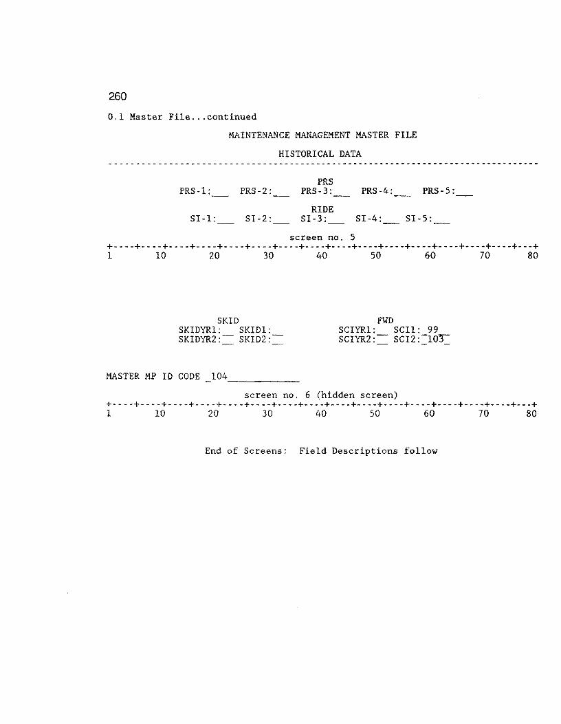
260
0.1 Master File ... continued
PRS-1:
SI-1:
MAINTENANCE MANAGEMENT MASTER FILE
HISTORICAL DATA
PRS-2:
SI-2:
PRS PRS-3:
RIDE SI-3:
screen no. 5
PRS-4: PRS-5:
SI-4: SI-5:
+----+----+----+----+----+----+----+----+----+----+----+----+----+----+----+---+ 1 10 20 30 40 so 60 70 80
SKID SKIDYRl: SKIDl: SKIDYR2: SKID2:
MASTER MP ID CODE 104 ------
FWD SCIYRl: SCil: 99 SGIYR2: SCIZ:-10-r-
screen no. 6 (hidden screen) +----+----+----+----+----+----+----+----+----+----+----+----+----+----+----+---+ 1 10 20 30 40 50 60 70 80
End of Screens: Field Descriptions follow
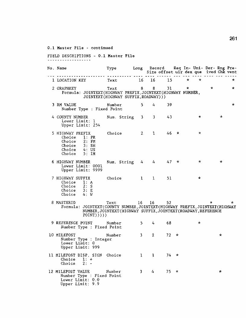
261
0.1 Master File - continued
FIELD DESCRIPTIONS - 0.1 Master File
No. Name Type Long Record Req In- Uni- Der- Rng Pre-Size offset uir dex que ived Chk vent
1 LOCATION KEY Text 16 16 15 * * 2 GRAPHKEY Text 8 8 31 *
3
4
5
6
7
Formula: JOINTEXT(HIGHWAY PREFIX,JOINTEXT(HIGHWAY NUMBER, JOINTEXT(HIGHWAY SUFFIX,ROADWAY)))
RM VALUE Number 5 4 39 Number Type : Fixed Point
COUNTY NUMBER Num. String 3 3 43 * Lower Limit: 1 Upper Limit: 254
HIGHWAY PREFIX Choice 2 1 46 * * Choice 1: PR Choice 2: FM Choice 3: SH Choice 4: us Choice 5: IH
HIGHWAY NUMBER Num. String 4 4 47 * * Lower Limit: 0001 Upper Limit: 9999
HIGHWAY SUFFIX Choice 1 1 51 * Choice 1: A Choice 2: s Choice 3: E Choice 4: w
* * *
*
*
*
8 MASTERID Text 16 16 52 * * Formula: JOINTEXT(COUNTY NUMBER,JOINTEXT(HIGHWAY PREFIX,JOINTEXT(HIGHWAY
NUMBER,JOINTEXT(HIGHWAY SUFFIX,JOINTEXT(ROADWAY,REFERENCE POINT)))))
9 REFERENCE POINT Number Number Type Fixed Point
10 MILEPOST Number Number Type Integer Lower Limit: 0 Upper Limit: 999
11 MILEPOST DISP. SIGN Choice Choice 1: + Choice 2: -
12 MILEPOST VALUE Number Number Type : Fixed Point Lower Limit: 0.0 Upper Limit: 9.9
5
3
1
3
4 68 *
2 72 * *
1 74 *
4 75 * *
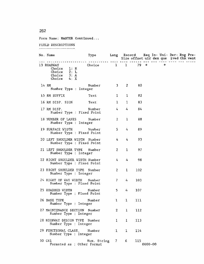
262
Form Name: MASTER Continued ...
FIELD DESCRIPTIONS
No. Name Type Long Record Req In- Uni- Der- Rng Pre-Size offset uir dex que ived Chk vent
13 ROADWAY Choice Choice Choice Choice
14 RM
1: R 2: L 3: A 4: x
Number Type
15 RM SUFFIX
16 RM DISP. SIGN
17 RM DISP. Number Type
18 NUMBER OF LANES Number Type
19 SURFACE WIDTH Number Type
Choice
Number Integer
Text
Text
Number Fixed Point
Number Integer
Number Fixed Point
20 LEFT SHOULDER WIDTH Number Number Type Fixed Point
21 LEFT SHOULDER TYPE Number Number Type Integer
22 RIGHT SHOULDER WIDTH Number Number Type Fixed Point
23 RIGHT SHOULDER TYPE Number Number Type Integer
24 RIGHT OF wAY WIDTH Number Number Type Fixed Point
25 ROADBED wIDTH Number Type
26 BASE TYPE Number Type
Number Fixed Point
Number Integer
27 MAINTENANCE SECTION Number Number Type Integer
28 HIGHWAY DESIGN TYPE Number Number Type Integer
29 FUNCTIONAL CLASS. Number Number Type Integer
1
3
1
1
4
2
5
4
2
4
2
7
5
1
2
1
l
30 GSl Formated as
Num. String 7 Other Format
1
2
l
1
4
l
4
4
1
4
1
4
4
1
1
1
1
6
79 *
80
82
83
84
88
89
93
97
98
102
103
107
111
112
113
114
115 0000-00
*
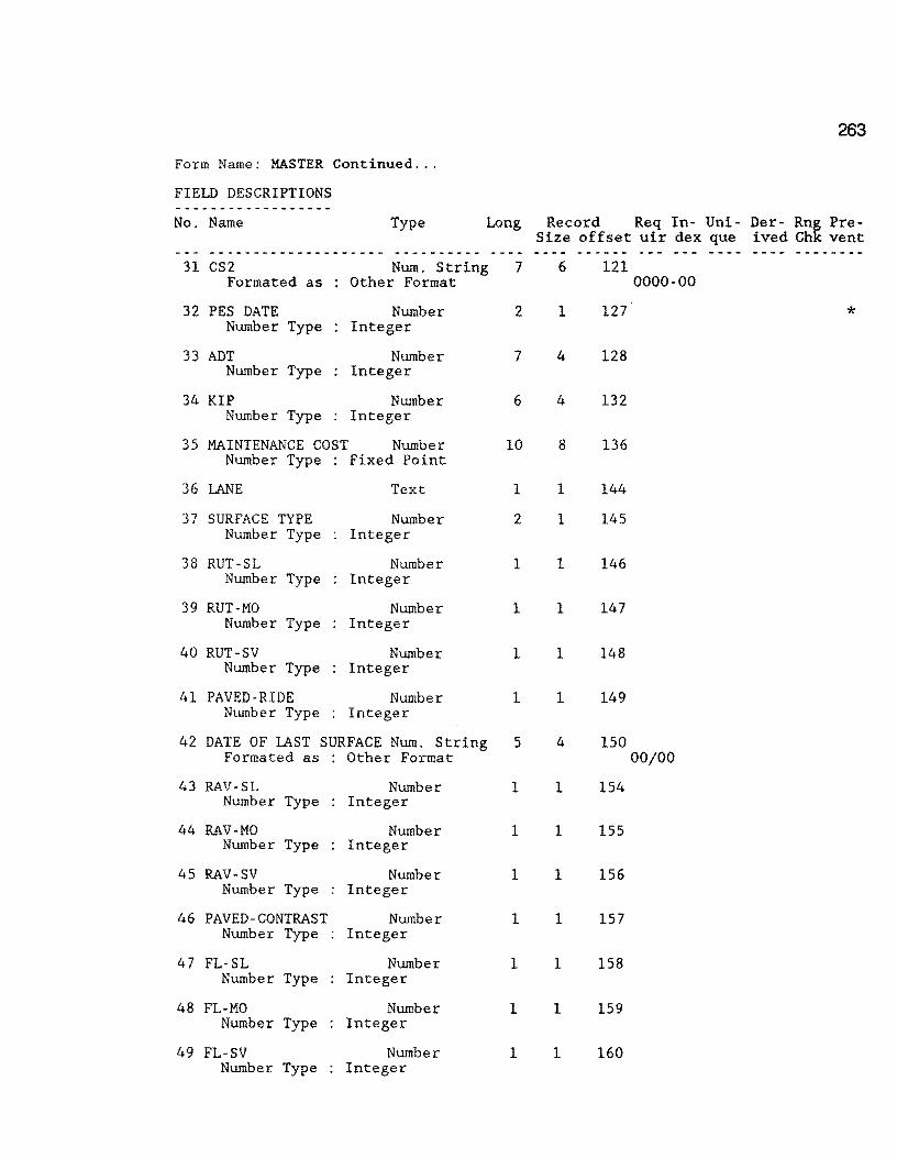
263
Form Name: MASTER Continued ...
FIELD DESCRIPTIONS ------------------No. Name Type Long Record Req In- Uni- Der- Rn~ Pre-
Size offset uir dex que ived Ch vent ---·---------------- ·--------- -- -.... ....... ---- --- --- ---- _.., ___ .., __
31 CS2 Num. String 7 6 121 Formated as Other Format 0000-00
32 PES DATE Number 2 1 127 * Number Type Integer
33 ADT Number 7 4 128 Number Type Integer
34 KIP Number 6 4 132 Number Type Integer
35 MAINTENANCE COST Number 10 8 136 Number Type Fixed Point
36 LANE Text 1 1 144
37 SURFACE TYPE Number 2 1 145 Number Type Integer
38 RUT-SL Number 1 1 146 Number Type Integer
39 RUT-MO Number 1 1 147 Number Type Integer
40 RUT-SV Number 1 1 148 Number Type Integer
41 PAVED-RIDE Number 1 1 149 Number Type Integer
42 DATE OF I.AST SURFACE Num. String 5 4 150 Formated as Other Format 00/00
43 RAV-SL Number 1 1 154 Number Type Integer
44 RAV-MO Number 1 1 155 Number Type Integer
45 RAV-SV Number 1 1 156 Number Type Integer
46 PAVED-CONTRAST Number 1 1 157 Number Type Integer
47 FL-SL Number 1 1 158 Number Type Integer
48 FL-MO Number 1 1 159 Number Type Integer
49 FL-SV Number 1 1 160 Number Type Integer

264
Form Name: MASTER Continued ...
FIELD DESCRIPTIONS ---·--·--------·--No. Name Type Long Record Req In- Uni- Der- Rng Pre-
Size offset uir dex que ived Chk vent ------------------·- ---------- ---- ------ --- --- ---- ---- ......... -----
SO PAVED-EDGE Number 1 1 161 Number Type Integer
51 COR-SL Number 1 1 162 Number Type Integer
52 COR-MO Number 1 1 163 * Number Type Integer Upper Limit: 3
53 COR-SV Number 1 1 164 Number Type Integer
54 PAVED-SHOULDER EDGE Number 1 1 165 Number Type Integer
55 SKID VALUE Number 2 1 166 Number Type Integer
56 SKID DATE Number 2 1 167 Number Type ,, Integer
57 ALG-SL Number 1 1 168 Number Type Integer
58 ALG-MO Number 1 1 169 Number Type Integer
59 ALG-SV Number 1 1 170 Number Type Integer
60 PAVED-CRACKS Number 1 1 171 Number Type Integer
61 LCKS-SL Number 1 1 172 Number Type Integer
62 LCKS-MO Number 1 1 173 Number Type Integer
63 LCKS-SV Number l 1 174 Number Type Integer
64 PAVED-RAVEL Number 1 1 175 Number Type Integer
65 TCKS-SL Number 1 1 176 Number Type Integer
66 TCKS·MO Number 1 1 177 Number Type Integer
67 TCKS-SV Number 1 1 178 Number Type Integer

Form Name: MASTER Continued ...
FIELD DESCRIPTIONS
No. Name
68 PAVED-VEG Number Type
69 RIDE VALUE Number Type
70 RIDE DATE Number Type
Type
Number Integer
Number Fixed Point
Number Integer
71 CRACKS-SEALED ETC Number Number Type Integer
72 PAT-SL Number Type
73 PAT-MO Number Type
74 PAT-SV Number Type
75 TOTAL FAILURES Number Type
76 UNPAVED-EDGE Number Type
77 Wl Number Type
78 W2 Number Type
79 W6 Number Type
Number Integer
Number Integer
Number Integer
Number Integer
Number Integer
Number Fixed Point
Number Fixed Point
Number Fixed Point
80 UNPAVED-RUT-CR-ROCK Number Number Type Integer
81 W7 Number Type
82 SCI Number Type
Number Fixed Point
Number Fixed Point
83 DATE Num. String Formated as Other Format View Security Required: Low3
84 COMMENTS Text
85 PRS Number Type
86 PRS-1 Number Type
Number Integer
Number Integer
265
Long Record Req In- Uni- Der- Rng Pre-Size offset uir dex que ived Chk vent
1 1 179
3 4 180
2 1 184
1 1 185
1 1 186
1 1 187
l 1 188
2 1 189
1 1 190
5 4 191
5 4 195
5 4 199
1 l 203
5 4 204
6 4 208
5 4 212 00/00
Write Security Required: 5 5 216
3 2 221
3 2 223
Low3

266
FIELD DESCRIPTIONS Master - continued
No. Name
87 PRS-2 Number Type
88 PRS-3 Number Type
89 PRS-4 Number Type
90 PRS-5 Number Type
91 SI-1 Number Type
92 SI-2 Number Type
93 SI-3 Number Type
94 SI-4 Number Type
95 SI-5 Number Type
96 SKIDYRl Number Type
97 SKIDl Number Type
98 SCIYRl Number Type
99 sen Number Type
100 SKIDYR2 Number Type
101 SKID2 Number Type
102 SCIYR2 Number Type
Type
Number Integer
Number Integer
Number Integer
Number Integer
Number Fixed Point
Number Fixed Point
Number Fixed Point
Number Fixed Point
Number Fixed Point
Number Integer
Number Integer
Number Integer
Number Fixed Point
Number Integer
Number Integer
Number Integer
Long Record Req In- Uni- Der- Rng Pre-Size offset uir dex que ived Chk vent
3 2 225
3 2 227
3 2 229
3 2 231
3 4 233
3 4 237
3 4 241
3 4 245
3 4 249
2 1 253
2 1 254
2 1 255
5 4 256
2 1 260
2 1 261
2 1 262
103 SCI2 Number 5 4 263 Number Type Fixed Point
104 MASTERMPID Text 17 17 267 * * * Formula: JOINTEXT(COUNTY NUMBER,JOINTEXT{HIGHWAY PREFIX,JOINTEXT(HIGHWAY
NUMBER,JOINTEXT(HIGHWAY SUFFIX,JOINTEXT(ROADWAY ,JOINTEXT(MILEPOST,JOINTEXT(MILEPOST DISP. SIGN,MILEPOST VALUE *10)))))))
Record Size: 284 Memory: Text = 4271 Fields = 3641 Total = 7912

267
Appendix C PMS Query Procedures
The PMS Query Procedures represent a collection of programs that interrogate one or more of the PMS files for the purpose of producing a report, calculation of summary values, or producing variable length export files for use by external programs. All of the commercially available database languages utilize some form of a "query language". The language (command structure) used herein is the DataEase Query Language (DQL). DOL, while not exactly similar to IBM's SOL, is a rich and powerful language with SOL-like capabilities.
This appendix presents the DQL procedures utilized by the PMS Database as of January 1, 1989.
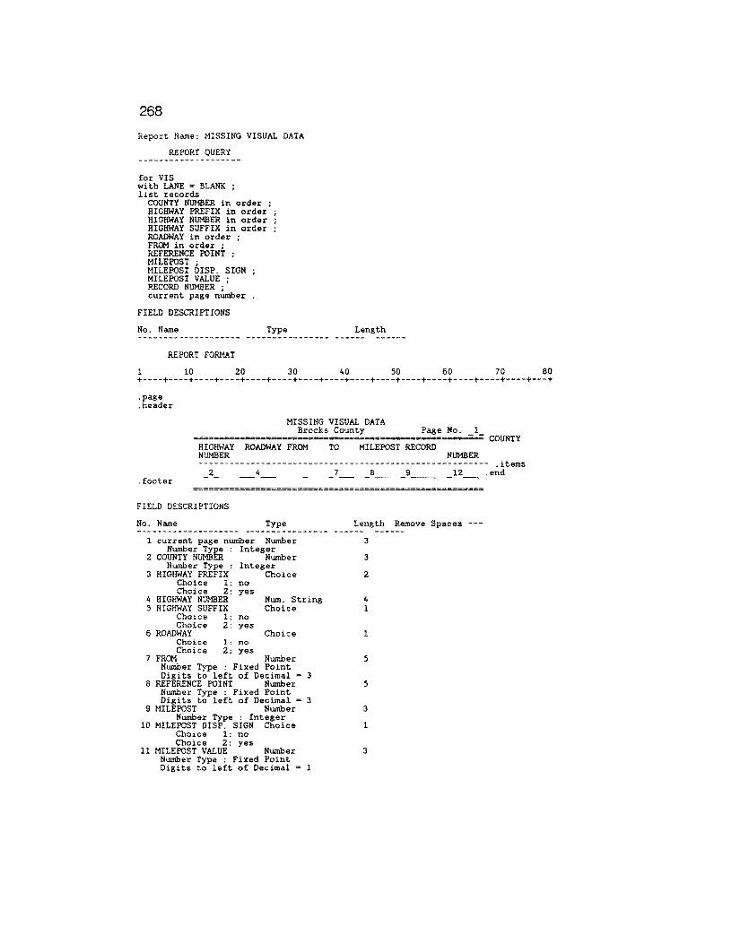
268
Report Name: MISSING VISUAL DATA
REPORT QUERY
for VIS with LANE ~ BLANK ; list records
COUNTY NUMBER in order ; HIGHWAY PREFIX in order HIGHWAY NUMBER in order HIGHWAY SUFFIX in order ROADWAY in order ; FROM in order ; REFERENCE POINT ; MILEPOST ; MILEPOST DISP. SIGN MILEPOST VALUE ; RECORD NUMBER ; current page number
FIELD DESCRIPTIONS
No. Name
REPORT FORMAT
Type Length
1 10 20 30 40 50 60 70 80 +----+----+----+----+----+----+----+----+----+----+----+----+----+----+----+---+
.page
.header
MISSING VISUAL DATA Brooks County Page No. l
======•===-===•==============•========~=======-===-~ COUNTY HIGHWAY ROADWAY FROM TO MILEPOST RECORD NUMBER NUMBER -------------------------------------------------------- .items
footer _2_ _4_ _ __ a __ 9 ___ 12_ .end
FIELD DESCRIPTIONS
No. Name Type Length Remove Spaces ---
1 current page number Number 3 Number Type : Integer
2 COUNTY NUMBER Number 3 Number Type : Integer
3 HIGHWAY PREFIX Choice 2 Choice l: no Choice Z: yes
4 HIGHWAY NUMBER Num. String 4 5 HIGHWAY SUFFIX Choice 1
Choice 1: no Choice 2: yes
6 ROADWAY Choice 1 Choice 1: no Choice 2: yes
7 FROM Number 5 Number Type : Fixed Point Digits to left of Decimal ~ 3
8 REFERENCE POINT Number 5 Number Type : Fixed Point Digits to left of Decimal = 3
9 MILEPOST Number 3 Number Type : Integer
10 MILEPOST DISP. SIGN Choice 1 Choice 1: no Choice 2: yes
11 MILEPOST VALUE Number 3 Number Type : Fixed Point Digits to left of Decimal l
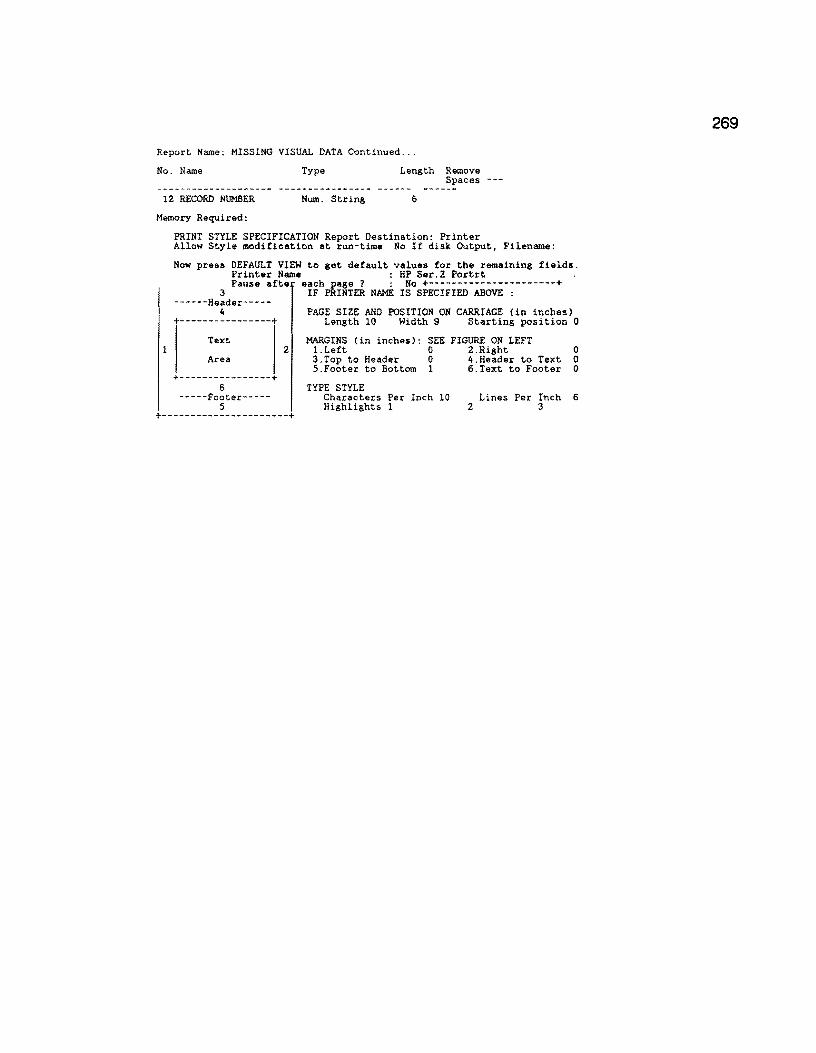
Report Name: MISSING VISUAL DATA Continued ...
No. Name
12 RECORD NUMBER
Memory Required:
Type
Num. String
Length Remove Spaces
6
PRINT STYLE SPECIFICATION Report Destination: Printer Allow Style modification at run-time No If disk Output, Filename:
Now press DEFAULT VIEW to get default values for the remaining fields. Printer Name HP Ser.2 Portrt Pause afte each page ? : No +----------------------+
3 IF PRINTER NAME IS SPECIFIED ABOVE : ------Header-----
4 +----------------+
Text
PAGE SIZE AND POSITION ON CARRIAGE (in inches) Length 10 Width 9 Starting position 0
MARGINS (in inches): SEE FIGURE ON LEFT 2 I.Left 0 2.Right 0
Area
+----------------+ 6
-----Footer-----5
+----------------------+
3.Top to Header 0 4.Header to Text 0 S.Footer to Bottom 1 6.Text to Footer 0
TYPE STYLE Characters Per Inch 10 Highlights l
Lines Per Inch 6 2 3
269

270
Report Name: TRANSFER PRS TO PED
REPORT DEFINITION
DATA-ENTRY FORM Data-Entry Form Name: TRANSFER PRS TO PED SCREEN DESCRIPTION
1 10 20 30 40 50 60 70 80 +----+----+----+----+----+----+----+----+----+----+----+----+----+----+----+---+
PROCEDURE: To copy the PRS and SRS data imported from the compiled BASIC program into the PAVEMENT DATA
ENTRY FILE.
Press the FZ Key to begin +----+----+----+----+----+----+----+----+----+----+----+----+----+----+----+---+ 1 10 20 30 40 50 60 70 80
FIELD DESCRIPTIONS
No. Name Type Long Record Req In- Uni- Der- Rng Pre-Size offset uir dex que ived Chk vent
Record Size: 32000 Memory: Text = 250 Fields = 17 Total= 267 REPORT QUERY
for PRS-SRS INPUT FILE
modify records in VIS with ( RECORD NUMBER PRS-SRS INPUT FILE RECORD NUMBER
RESERVED 1 := PRS-SRS INPUT FILE PAVEMENT RATING ; RESERVED 2 := PRS-SRS INPUT FILE SHOULDER RATING . end .
UFIELD DESCRIPTIONS¢
No. Name Type Length
REPORT FORMAT
1 10 20 30 40 50 60 70 80 +----+----+----+----+----+----+----+----+----+----+----+----+----+----+----+---+ .page
PRS-SRS RECORDS HAVE BEEN TRANSFERRED
PRINT STYLE SPECIFICATION Report Destination: Screen Allow Style modification at run-time No If disk Output, Filename: Now press DEFAULT VIEW to get default values for the remaining fields.
1
Printer Name : Pause afte each page ? : Yes +----------------------+
3 ------Header-----
4 +----------------+
Text
Area
+----------------+ 6
-----Footer-----5
IF PRINTER NAME IS SPECIFIED ABOVE :
PAGE SIZE AND POSITION ON CARRIAGE (in inches) Length 0 Width 0 Starting position 0
MARGINS (in inches): SEE FIGURE ON LEFT 2 1.Left 0 2.Right 0
3.Top to Header 0 4.Header to Text o 5.Footer to Bottom 0 6.Text to Footer 0
TYPE STYLE Characters Per Inch 0 Highlights 1 Special 7
Lines Per Inch 0 2 Special 8 3
+----------------------+

Report Name: PRINT PRS-SRS INFILE
REPORT DEFINITION
DATA-ENTRY FORM Data-Entry Form Name: PRINT PRS-SRS INFILE
SCREEN DESCRIPTION
1 10 zo 30 40 50 60 70 80 +----+----+----+----+----+----+----+----+----+----+----+----+----+----+----+---+
+-----------------------+ I MICRO-RAMS DATA BASE I +-----------------------+
+-------------------------------------+ TEXAS STATE HIGHWAY DEPARTMENT
& THE TEXAS TRANSPORTATION INSTITUTE
TEXAS A&M UNIVERSITY +-------------------------------------+ LIST PAVEMENT DATA RECORDS REPORT
RUN DATE: _l~~- (Press RETURN to automatically generate)
******* PRESS THE FZ KEY TO BEGIN ******* +----+----+----+----+----+----+----+----+----+----+----+----+----+----+----+---+ l 10 20 30 40 50 60 70 80
FIELD DESCRIPTIONS
No. Name Size offset uir dex que
Type Long ived Chk vent ---
Record Req In- Uni- Der- Rng Pre-
l RUN DATE Date 8 6 3 *
Formula: ??/??/??
Record Size: 9 Memory: Text • 768 Fields = 70 Total = 838
REPORT QUERY
for VIS with LANE not blank list records
current page number data-entry RUN DATE DISTRICT ; RECORD NUMBER in order COUNTY NUMBER ; HIGHWAY PREFIX HIGHWAY NUMBER ; HIGHWAY SUFFIX ; ROADWAY ; MILEPOST ; MILEPOST DISP. SIGN MILEPOST VALUE ; FR~ · REFERENCE POINT ; LANE · RUT-SL RUT-00 RUT-SV rav-sl RAV-MO RAV-SV FL-SL ; FL-MO · FL-SV ; COR-SL COR-MO COR-SV ALG-SL
271

272
Report Name: PRINT PRS-SRS INFILE Contin~ed ...
REPORT QUERY
ALG-M::l ; ALG-SV ; LCKS-SL LCKS-M::l LCKS-SV TCKS-SL TCKS-M::l TCKS-SV ; CRACKS-SEALED ETC PAT-SL • PAT-00 ; PAT-SV ; TOTAL FAILURES PAVED-RIDE ; PAVED-CONTRAST PAVED-EDGE ; PAVED-SHOULDER EDGE PAVED-CRACKS ; PAVED-RAVEL ; PAVED-VEG ; UNPAVED-EDGE ; UNPAVED-RUT-CR-ROCK ; RESERVED 1 item mean max min ; RESERVED 2 item mean max min
CCM1ENTS .

Report Name: PLOT DATA
REPORT DEFINITION
REPORT QUERY
DEFINE "NSI" NUMBER. DEFINE "NSN" NUMBER. for MASTER with SKID VALUE not • BLANK or
RIDE VALUE not = BLANK or SCI not s BLANK or PRS not = BLANK •
if SKID VALUE NOT ~ BLANK then assign temp NSN :• SKID VALUE.
eND IF RIDE VALUE NOT = BLANK THEN
ASSIGN TEMP NSI :• RIDE VALUE * 10 . end list records
COUNTY NUMBER in order ; HIGHWAY PREFIX in order ; HIGHWAY NUMBER in order ; HIGHWAY SUFFIX in order ; ROADWAY IN ORDER ; REFERENCE POINT in order ; SKID VALUE RIDE VALUE SCI nsN NSI PRS
REPORT FORMAT
l 10 20 30 40 50 60 70 80 +----+----+----+----+----+----+----+----+----+----+----+----+----+----+----+---+ .page . items l 3 - _6 _ -:-end- - -
__ 9_
UFIELD DESCRIPTIONS¢
No. Name Type Length
1 COUNTY NUMBER Number 3 Number Type : Integer
2 HIGHWAY PREFIX Choice 2 3 HIGHWAY NUMBER Num. String 4 4 HIGHWAY SUFFIX Choice l 5 ROADWAY Choice 1 6 REFERENCE POINT Number 5
Number Type : Fixed Point Digits to left of Decimal = 3
7 nsN Number 2 Number Type Integer
8 NSI Number 2 Number Type Integer
9 SCI Number 5 Number Type : Fixed Point Digits to left of Decimal = 3
10 PRS Number 3
l
Number Type : Integer
PRINT STYLE SPECIFICATION Report Destination: Disk Allow Style modification at run-time Yes If disk Output, Filename:
A: PLOT.DAT Now press DEFAULT VIEW to get default values for the remaining fields.
Printer Name : 3 Pause afte er~hPkI~T~ NAME I~sS;E~iFIEO-~O_;n;-~-------+
------Header-----4
+----------------+ Text
Area
+----------------+ 6
-----Footer-----5
PAGE SIZE AND POSITION ON CARRIAGE (in inches) Length 0 Width 0 Starting position 0
MARGINS (in inches): SEE FIGURE ON LEFT 2 l.Left 0 2.Right 0
3.Top to Header 0 4.Header to Text 0 5.Footer to Bottom 0 6.Text to Footer 0
TYPE STYLE Characters Per Inch 0 Lines Per Inch 0 Highlights 1 2 3
+----------------------+
273

274
Report Name: MISSING RIDE DATA REPORT DEFINITION
REPORT QUERY
for RIDE INPUT ; for SIOMETER RIDE VALUES with ( RIDEID =RIDE INPUT RIDEID and SI VALUE< 0.1
and RIDE INPUT MRM VALUE < l
list records current page number ;
COUNTY NUMBER in order ; HIGHWAY PREFIX in order ; HIGHWAY NUMBER in order ; HIGHWAY SUFFIX in order ; ROADWAY in order ; REFERENCE POINT in order MILEPOST ; MILEPOST DISP. SIGN MILEPOST VALUE ; RECORD NUMBER
END END
REPORT FORMAT
l 10 20 30 40 50 60 70 80 +----+----+----+----+----+----+----+----+----+----+----+----+----+----+----+---+
.page
.header
MISSING RIDE DATA Brooks County Page No. 1
======•===============s=======================•========= ~OUNTY HIGHWAY ROADWAY REFERENCE MILEPOST RECORD NUMBER POINT NUMBER
---------------------------------------------------- .items
. footer _z_ 4 _7 __ 8 ___ 11_
.page
FIELD DESCRIPTIONS
No. Name Type Length Remove Spaces ---
current page number Number 3 Number Type : Integer
2 COUNTY NUMBER Number 3 Number Type : Integer
3 HIGHWAY PREFIX Text 2 4 HIGHWAY NUMBER Num. String 4 5 HIGHWAY SUFFIX Text 1 6 ROADWAY Text l 7 REFERENCE POINT Number 5
Number Type : Fixed Point Digits to left of Decimal = 3
8 MILEPOST Number 3 Number Type : Integer
9 MILEPOST DISP. SIGN Choice l Choice 1: no Choice 2: yes
10 MILEPOST VALUE Number 3 Number Type : Fixed Point Digits to left of Decimal m 1
11 RECORD NUMBER Num. String 6
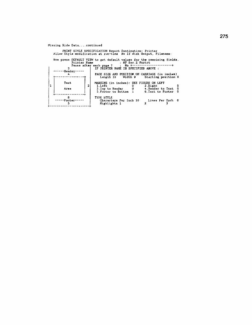
Missing Ride Data .... continued
1
PRINT STYLE SPECIFICATION Report Destination: Printer Allow Style modification at run-time No If disk Output, Filename:
Now press DEFAULT VIEW to get default values for the remaining fields. Printer Name HP Ser.2 Portrt Pause after each page ? : No +----------------------+
3 ------Header-----
4 +----------------+
Text
Area
+----------------+ 6
-----Footer-----5
IF PRINTER NAME IS SPECIFIED ABOVE :
PAGE SIZE AND POSITION ON CARRIAGE (in inches) Length 10 Width 9 Starting position 0
MARGINS (in inches): SEE FIGURE ON LEFT 2 1.Left 0 2.Right 0
3.Top to Header 0 4.Header to Text 0 5.Footer to Bottom 1 6.Text to Footer 0
TYPE STYLE Characters Per Inch 10 Highlights l
Lines Per Inch 6 2 3
+----------------------+
275

276
Report Name: MISSING SKID DATA
REPORT DEFINITION
REPORT QUERY
for SKID INPUT with SKID VALUE < 1 ; for MASTER with ( MASTERID SKID INPUT SKIDID and SKID DATE <• year ( current date ) - 3 )
list records current page number ;
COUNTY NUMBER in order ; HIGHWAY PREFIX in order ; HIGHWAY NUMBER in order ; HIGHWAY SUFFIX in order ; ROADWAY in order ; REFERENCE POINT in order MILEPOST ; MILEPOST DISP. SIGN MILEPOST VALUE ; ADT : KIP · SKID, INPUT RECORD NUMBER
END END .
REPORT FORMAT
1 10 20 30 40 50 60 70 80 +----+----+----+----+----+----+----+----+----+----+----+----+----+----+----+---+
.page
.header
MISSING SKID DATA: RECORDED FROM THE 0.1-MILE MASTER FILE Brooks County Page No. 1
=·-==•===a===•==-·===·======·===============•z--==·======-==-====;-=== COUNTY HIGHWAY ROADWAY REFERENCE MILEPOST ADT NUMBER POINT
18-KIP RECORD NUMBER
-------------------------------------------------------------------- .items 2
.footer- -4
FIELD DESCRIPTIONS
No. Name
1 _a ___ 11 ___ 12 __ 13_
Type Length
1 current page number Number 3 Number Type : Integer
2 COUNTY NUMBER Number 3 Number Type : Integer
3 HIGHWAY PREFIX Choice 2 4 HIGHWAY NUMBER Nurn. String 4 5 HIGHWAY SUFFIX Choice 1 6 ROADWAY Choice 1 7 REFERENCE POINT Number 5
Number Type : Fixed Point Digits to left of Decimal = 3
8 MILEPOST Number 3 Number Type : Integer
9 MILEPOST DISP. SIGN Choice 1 10 MILEPOST VALUE Number 3
Number Type : Fixed Point Digits to left of Decimal = 1
11 ADT Number 7 Number Type : Integer
12 KIP Number 6 Number Type : Integer
13 SKID INPUT RECORD NU Nurn. String 6
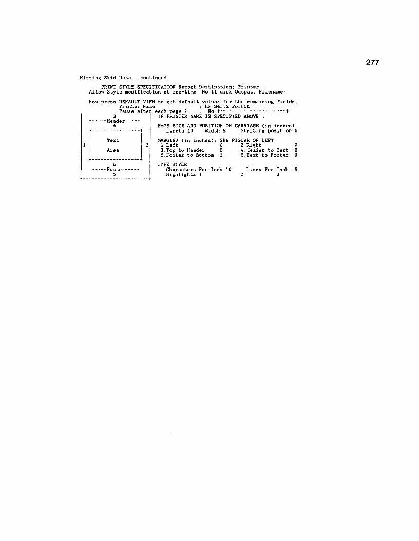
Missing Skid Data ... continued
1
PRINT STYLE SPECIFICATION Report Destination: Printer Allow Style modification at run-time No If disk Output, Filename:
Now press DEFAULT VIEW to get default values for the remaining fields. Printer Name ; HP Ser.2 Portrt Pause after each page ? : No +----------------------+
3 ------Header-----
4 +----------------+
Text
Area
+----------------+ 6
-----Footer-----5
IF PRINTER NAME IS SPECIFIED ABOVE :
PAGE SIZE AND POSITION ON CARRIAGE (in inches) Length 10 Width 9 Starting position 0
MARGINS (in inches): SEE FIGURE ON LEFT 2 l.Left 0 2.Right 0
3.Top to Header 0 4.Header to Text 0 5.Footer to Bottom 1 6.Text to Footer 0
TYPE STYLE Characters Per Inch 10 Highlights 1
Lines Per Inch 6 2 3
+----------------------+
277
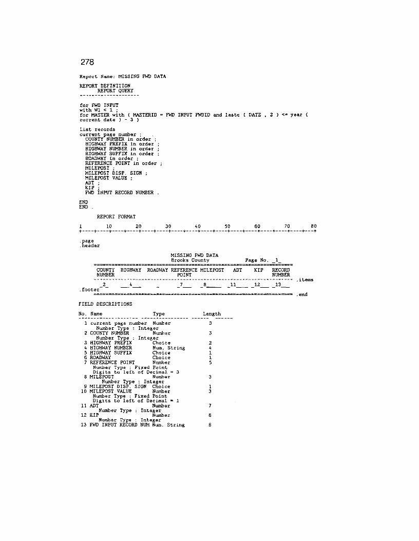
278
Report Name: MISSING FWD DATA
REPORT DEFINITION REPORT QUERY
for FWD INPUT with Wl < 1 ; for MASTER with ( MASTERID = FWD INPUT FWDID and lastc ( DATE , 2 ) <• year ( current date ) 3 )
list records current page number ;
COUNTY NUMBER in order ; HIGHWAY PREFIX in order ; HIGHWAY NUMBER in order ; HIGHWAY SUFFIX in order ; ROADWAY in order ; REFERENCE POINT in order MILEPOST ; MILEPOST DISP. SIGN MILEPOST VALUE ; ADT KIP FWD INPUT RECORD NUMBER
END END .
REPORT FORMAT
1 10 20 30 40 50 60 70 80 +----+----+----+----+----+----+----+----+----+----+----+----+----+----+----+---+
.page
.header
MISSING FWD DATA Brooks County
COUNTY HIGHWAY ROADWAY REFERENCE MILEPOST ADT NUMBER POINT
Page No.
KIP RECORD NUMBER
------------------------------------------------------------------- .items 2
.footer- -4 _7_ _a__ _u ___ 12 __ 13_
FIELD DESCRIPTIONS
No. Name Type Length
1 current page number Number 3 Number Type ; Integer
2 COUNTY NUMBER Number 3 Number Type : Integer
3 HIGHWAY PREFIX Choice 2 4 HIGHWAY NUMBER Num. String 4 5 HIGHWAY SUFFIX Choice l 6 ROADWAY Choice 1 7 REFERENCE POINT Number 5
Number Type : Fixed Point Digits to left of Decimal = 3
8 MILEPOST Number 3 Number Type : Integer
9 MILEPOST DISP. SIGN Choice l 10 MILEPOST VALUE Number 3
Number Type : Fixed Point Digits to left of Decimal = 1
11 ADT Number 7 Number Type : Integer
12 KIP Number 6 Number Type : Integer
13 FWD INPUT RECORD NUM Num. String 6

Missing FWD Data ... continued
1
PRINT STYLE SPECIFICATION Report Destination: Printer Allow Style modification at run-time No If disk Output, Filename:
Now press DEFAULT VIEW to get default values for the remaining fields. Printer Name HP Ser.2 Portrt Pause afte each page ? : No +----------------------+
3 IF PRINTER NAME IS SPECIFIED ABOVE : ------Header-----
4 +----------------+
Text
Area
+----------------+ 6
-----Footer-----5
PAGE SIZE AND POSITION ON CARRIAGE (in inches) Length 10 Width 9 Starting position 0
MARGINS (in inches): SEE FIGURE ON LEFT 2 1.Left 0 2.Right 0
3.Top to Header 0 4.Header to Text 0 5.Footer to Bottom l 6.Text to Footer 0
TYPE STYLE Characters Per Inch 10 Highlights 1
Lines Per Inch 6 2 3
+----------------------+
279

280
Report Name: ALL DATA
Data-Entry Form Name: ALL DATA
SCREEN DESCRIPTION
l 10 20 30 40 50 60 70 80 +----+----+----+----+----+----+----+----+----+----+----+----+----+----+----+---+
+--------------------+ I MASTER DATA BASE I +--------------------+
+------------------------------------+
I TEXAS STATE DEPARTMENT OF HIGHWAYS I AND PUBLIC TRANSPORTATION
+------------------------------------+ LIST DATA RECORDS REPORT
RUN DATE: _1~~- (Press RETURN to automatically generate)
******* PRESS THE F2 KEY TO BEGIN ******* +----+----+----+----+----+----+----+----+----+----+----+----+----+----+----+---+ l 10 20 30 40 50 60 70 80
FIELD DESCRIPTIONS
No. Name Type Length
1 RUN DATE Date 8 Formula: ??/??/??
Record Size: 9 Memory: Text = 730 Fields = 70 Total = 800
REPORT QUERY
for MASTER with MAINTENANCE SECTION not = BLANK or HIGHWAY DESIGN TYPE not BLANK or FUNCTIONAL CLASS. not = BLANK or CSl not = BLANK or ADT not = BLANK or KIP not = BLANK or LANE not = BLANK or SKID VALUE not = BLANK or RIDE VALUE not • BLANK or Wl not • BLANK ;
list records
COUNTY NUMBER IN ORDER ; HIGHWAY PREFIX IN ORDER HIGHWAY NUMBER IN ORDER HIGHWAY SUFFIX IN ORDER ROADWAY IN ORDER ; current page number data-entry RUN DATE MAINTENANCE SECTION
REFERENCE POINT IN ORDER CSl ; SURFACE TYPE LANE ;
RUT-SL RUT-MO RUT-SV
rav-sl RAV-MO RAV-SV

Report Name: ALL DATA Continued ...
REPORT QUERY
FL-SL FL-t-0 FL-SV
COR-SL COR-M:.l COR-SV
ALG-SL ALG-MJ ALG-SV
LCKS-SL LCKS-MJ LCKS-SV
TCKS-SL TCKS-MO TCKS-SV
CRACKS-SEALED ETC
PAT-SL ; PAT-MO ; PAT-SV ;
TOTAL FAILURES
PAVED-RIDE ; PAVED-CONTRAST PAVED-EDGE ; PAVED-SHOULDER EDGE PAVED-CRACKS ; PAVED-RAVEL ; PAVED-VEG ;
UNPAVED-EDGE ; UNPAVED-RUT-CR-ROCK
RIDE VALUE SKID VALUE SCI ; ADT · KIP '. HIGHWAY DESIGN TYPE FUNCTIONAL CLASS. PRS .
281
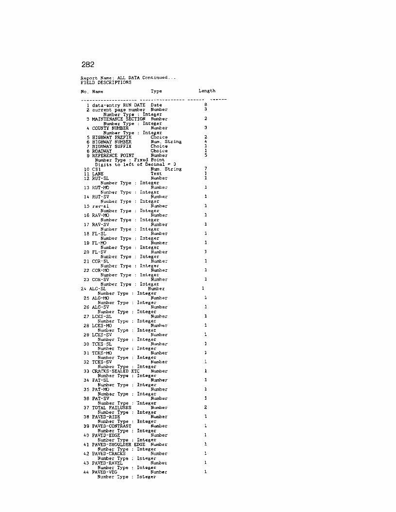
282
Report Name: ALL DATA Continued ... FIELD DESCRIPTIONS
No. Name Type
1 data-entry RUN DATE Date 2 current page number Number
Number Type : Integer 3 MAINTENANCE SECTION Number
Number Type Integer 4 COUNTY NUMBER Number
Number Type Integer 5 HIGHWAY PREFIX Choice 6 HIGHWAY NUMBER Num. String 7 HIGHWAY SUFFIX Choice 8 ROADWAY Choice 9 REFERENCE POINT Number
Number Type : Fixed Point Digits to left of Decimal = 3
10 CSl Num. String 11 LANE Text 12 RUT-SL Number
Number Type Integer 13 RUT-MO Number
Number Type Integer 14 RUT-SV Number
Number Type Integer 15 rav-sl Number
Number Type Integer 16 RAV-MO Number
Number Type Integer 17 RAV-SV Number
Number Type Integer 18 FL-SL Number
Number Type Integer 19 FL-MO Number
Number Type Integer 20 FL-SV Number
Number Type Integer 21 COR-SL Number
Number Type Integer 22 COR-M'.> Number
Number Type Integer 23 COR-SV Number
Number Type Integer 24 ALG-SL Number
Number Type Integer 25 ALG-M'.> Number
Number Type Integer 26 ALG-SV Number
Number Type Integer 27 LCKS-SL Number
Number Type Integer 28 LCKS-MO Number
Number Type Integer 29 LCKS-SV Number
Number Type Integer 30 TCKS-SL Number
Number Type Integer 31 TCKS-M:> Number
Length
8 3
2
3
2 4 1 1 5
7 1 1
1
1
1
1
1
1
1
1
1
1
1
1
1
1
1
1
Number Type Integer 32 TCKS-SV Number 1
Number Type : Integer 33 CRACKS-SEALED ETC Number l
Number Type Integer 34 PAT-SL Number
Number Type Integer 35 PAT-MO Number 1
Number Type Integer 36 PAT-SV Number 1
Number Type ·Integer 37 TOTAL FAILURES Number 2
Number Type : Integer 38 PAVED-RIDE Number
Number Type : Integer 39 PAVED-CONTRAST Number 1
Number Type : Integer 40 PAVED-EDGE Number l
Number Type : Integer 41 PAVED-SHOULDER EDGE Number 1
Number Type Integer 42 PAVED-CRACKS Number 1
Number Type Integer 43 PAVED-RAVEL Number 1
Number Type Integer 44 PAVED-VEG Number 1
Number Type Integer
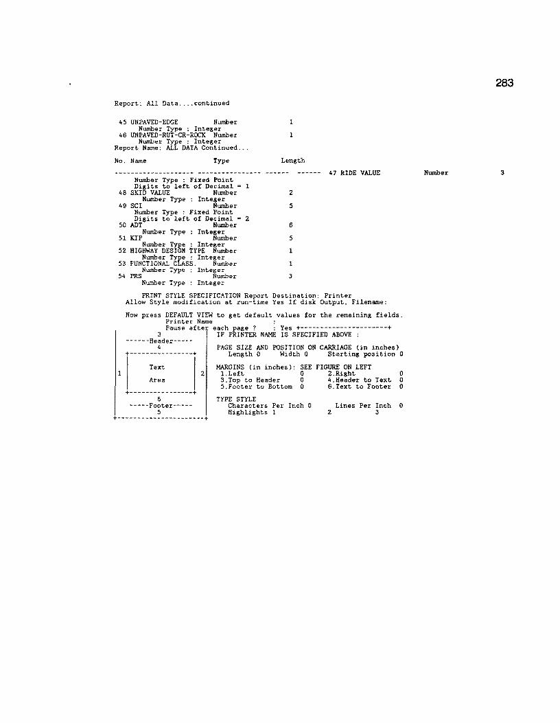
Report: All Data .... continued
45 UNPAVED-EDGE Number Number Type : Integer
46 UNPAVED-RUT-CR-ROCK Number Number Type : Integer
Report Name: ALL DATA Continued ...
No. Name Type
Number Type : Fixed Point Digits to left of Decimal = 1
48 SKID VALUE Number Number Type : Integer
49 SCI Number Number Type : Fixed Point Digits to left of Decimal = 2
50 ADT Number Number Type : Integer
51 KIP Number Number Type : Integer
52 HIGHWAY DESIGN TYPE Number Number Type : Integer
53 FUNCTIONAL CLASS. Number Number Type Integer
54 PRS Number Number Type : Integer
1
l
Length
2
5
6
5
1
1
3
47 RIDE VALUE
PRINT STYLE SPECIFICATION Report Destination: Printer
1
Allow Style modification at run-time Yes If disk Output, Filename:
Now press DEFAULT VIEW to get default values for the remaining fields. Printer Name : Pause after each page ? : Yes +----------------------+
3 ------Header-----
4 +----------------+
Text
Area
+----------------+ 6
-----Footer-----5
IF PRINTER NAME IS SPECIFIED ABOVE :
PAGE SIZE AND POSITION ON CARRIAGE (in inches) Length 0 Width 0 Starting position 0
MARGINS (in inches): SEE FIGURE ON LEFT 2 l.Left 0 2.Right 0
3.Top to Header 0 4.Header to Text 0 5.Footer to Bottom 0 6.Text to Footer 0
TYPE STYLE Characters Per Inch 0 Highlights 1
Lines Per Inch 0 2 3
+----------------------+
283
Number 3

284
Report Name: VISUAL RATING FORM
REPORT QUERY
for VIS ; list records
COUNTY NUMBER in GROUPS ; HIGHWAY PREFIX in GROUPS HIGHWAY NUMBER in GROUPS HIGHWAY SUFFIX in GROUPS ROADWAY in groups FROM in order ; REFERENCE POINT ; MILEPOST ; MILEPOST DISP. SIGN MILEPOST VALUE ; RECORD NUMBER .
No. Name Type Length
1 COUNTY NUMBER Number 3 Number Type : Integer
2 HIGHWAY PREFIX Choice 2 Choice 1: no Choice 2: yes
3 HIGHWAY NUMBER Num. String 4 4 HIGHWAY SUFFIX Choice 1
Choice l: no Choice 2: yes
5 ROADWAY Choice 1 Choice 1: no Choice 2: yes
6 MILEPOST Number 3 Number Type Integer
7 MILEPOST DISP. SIGN Choice 1 Choice 1: no Choice 2: yes
8 MILEPOST VALUE Number 3 Number Type Fixed Point Digits to left of Decimal = 1
9 RECORD NUMBER Num. String 6 10 FROM Number 5
Number Type Fixed Point Digits to left of Decimal = 3
11 REFERENCE POINT Number 5 Number Type . Fixed Point Digits to left of Decimal ~ 3
PRINT STYLE SPECIFICATION Report Destination: Disk Allow Style modification at run-time No If disk Output, Filename: FORM.PRN
Now press DEFAULT VIEW to get default values for the remaining fields.
1
Printer Name HP SER.2 PORTRT Pause after each page ? : No +----------------------+
3 ------Header-----
4 +----------------+
Text
Area
+----------------+ 6
-----Footer-----5
IF PRINTER NAME IS SPECIFIED ABOVE :
PAGE SIZE AND POSITION ON CARRIAGE (in inches) Length 10 Width 14 Starting position 0
MARGINS (in inches): SEE FIGURE ON LEFT 2 1.Left 0 2.Right 0
I I 3.Top to Header 0 4.Header to Text 0 5.Footer to Bottom 0 6.Text to Footer 0
TYPE STYLE Characters Per Inch 17 Highlights 1
Lines Per Inch 8 2 3
+----------------------+
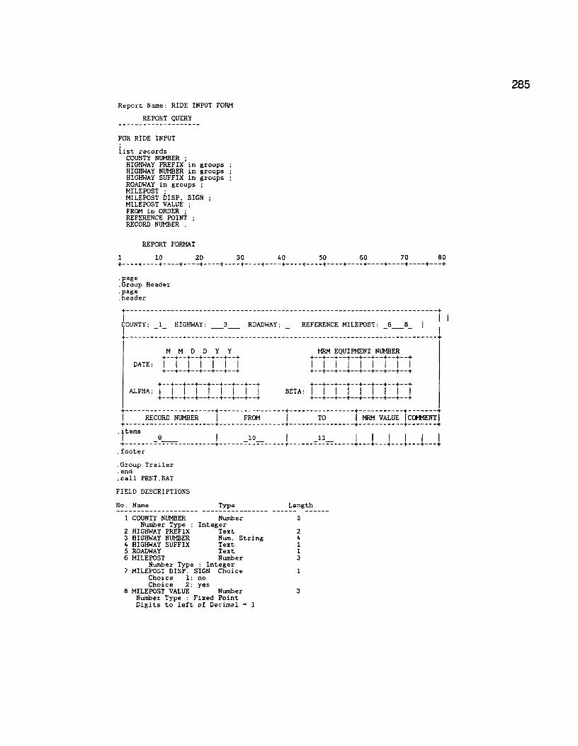
Report Name: RIDE INPUT FORM
REPORT QUERY
FOR RIDE INPUT
iist records COUNTY NUMBER ; HIGHWAY PREFIX in groups HIGHWAY NUMBER in groups HIGHWAY SUFFIX in groups ROADWAY in groups ; MILEPOST ; MILEPOST DISP. SIGN MILEPOST VALUE ; FROM in ORDER ; REFERENCE POINT RECORD NUMBER .
REPORT FORMAT
1 10 20 30 40 50 60 70 80 +----+----+----+----+----+----+----+----+----+----+----+----+----+----+----+---+ .page .Group Header .page .header
+----------------------------------------------------------------------------+ I I I TOUNTY: _l_ HIGHWAY: _3_ ROADWAY: REFERENCE MILEPOST: _6_8_ I +----------------------------------------------------------------------------+
M M D D Y Y +--+--+--+--+--+--+ DATE: I I I I I I I +--+--+--+--+--+--+
+--+--+--+--+--+--+--+--+
MRM EQUIPMENT NUMBER +--+--+--+--+--+--+--+--+ I I I I I I I I I +--+--+--+--+--+--+--+--+ +--+--+--+--+--+--+--+--+
ALPHA: I I I I I I I I I BETA: I I I I I I I I I +--+--+--+--+--+--+--+--+ +--+--+--+--+--+--+--+--+ +----------------------+----------------+----------------+-----------+-------+ I RECORD NUMBER I FROM I TO I MRM VALUE I Ccx+mNT I +----------------------+----------------+----------------+-----------+-------+
·t'tems _9__ I _10_ I _11_ I I I I I I +----------------------+----------------+----------------+---+---+---+---+---+
. footer
.Group Trailer
.end
. call PRNT. BAT
FIELD DESCRIPTIONS
No. Name Type Length
1 COUNTY NUMBER Number 3 Number Type : Integer
2 HIGHWAY PREFIX Text 2 3 HIGHWAY NUMBER Num. String 4 4 HIGHWAY SUFFIX Text 1 5 ROADWAY Text 1 6 MILEPOST Number 3
Number Type : Integer 7 MILEPOST DISP. SIGN Choice 1
Choice 1: no Choice 2: yes
8 MILEPOST VALUE Number 3 Number Type : Fixed Point Digits to left of Decimal l
285
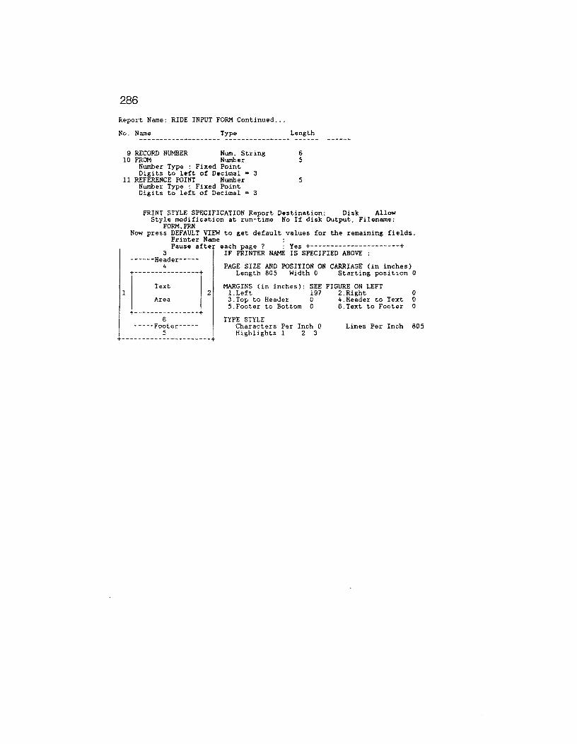
286
Report Name: RIDE INPUT FORM Continued ...
No. Name Type Length
9 RECORD NUMBER Num. String 6 10 FROM Number 5
Number Type : Fixed Point Digits to left of Decimal • 3
11 REFERENCE POINT Number 5
1
Number Type : Fixed Point Digits to left of Decimal • 3
PRINT STYLE SPECIFICATION Report Destination: Disk Allow Style modification at run-time No If disk Output, Filename:
FORM.PRN Now press DEFAULT VIEW to get default values for the remaining fields.
Printer Name : Pause after each page ? : Yes +----------------------+
3 ------Header-----
4 +----------------+
Text
Area
+----------------+ 6
-----Footer-----5
IF PRINTER NAME IS SPECIFIED ABOVE :
PAGE SIZE AND POSITION ON CARRIAGE (in inches) Length 805 Width 0 Starting position 0
MARGINS (in inches): SEE FIGURE ON LEFT 2 l.Left 197 2.Right 0
3.Top to Header 0 4.Header to Text 0 5.Footer to Bottom 0 6.Text to Footer 0
TYPE STYLE Characters Per Inch 0 Lines Per Inch 805 Highlights 1 2 3
+----------------------+
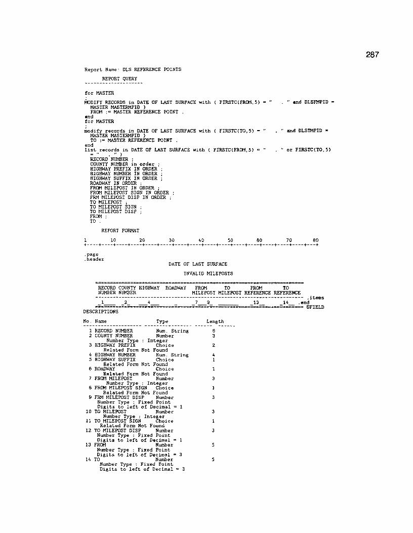
Report Name: DLS REFERENCE POINTS
REPORT QUERY
for MASTER
~DIFY RECORDS in DATE OF LAST SURFACE with ( FIRSTC(FROM,5) • " MASTER MASTERMPID ) FROM := MASTER REFERENCE POINT .
end for MASTER
~odify records in DATE OF LAST SURFACE with ( FIRSTCCT0,5) MASTER MASTERMPID ) TO :• MASTER REFER.ENCE POINT
end list records in DATE OF LAST SURFACE with ( FIRSTCCFROM,5) •"
;;::! .. • •• )
RECORD NUMBER ; COUNTY NUMBER in order ; HIGHWAY PREFIX IN ORDER ; HIGHWAY NUMBER IN ORDER ; HIGHWAY SUFFIX IN ORDER ; ROADWAY IN ORDER ; FROM MILEPOST IN ORDER ; FROM MILEPOST SIGN IN ORDER FRM MILEPOST DISP IN ORDER TO MILEPOST ; TO MILEPOST SIGN TO MILEPOST DISP FROM · TO '
REPORT FORMAT
. " and OLSFMPID -
• " and DLSTMPID •
. " or FIRSTC(T0,5)
1 10 20 30 40 50 60 70 80 +----+----+----+----+----+----+----+----+----+----+----+----+----+----+----+---+
.page
.header DATE OF LAST SURFACE
INVALID MILEPOSTS
RECORD COUNTY HIGHWAY ROADWAY FROM TO FRC*l TO NUMBER NUMBER MILEPOST MILEPOST REFERENCE REFERENCE
----------------------------------------------------------------------- .items l 2 4 7 9 13 14 . end
••=~========~====-==::=~=====;x~;;==~====~·==--===--= O'FIELD DESCRIPTIONS
No. Name Type Length
1 RECORD NUMBER Num. String 6 2 COUNTY NUMBER Number 3
Number Type : Integer 3 HIGHWAY PREFIX Choice 2
Related Form Not Found 4 HIGHWAY NUMBER Num. String 4 5 HIGHWAY SUFFIX Choice 1
Related Form Not Found 6 ROADWAY Choice 1
Related Form Not Found 7 FROM MILEPOST Number 3
Number Type : Integer 8 FROM MILEPOST SIGN Choice l
Related Form Not Found 9 FRM MILEPOST DlSP Number 3
Number Type : Fixed Point Digits to left of Decimal = l
10 TO MILEPOST Number 3 Number Type : Integer
11 TO MILEPOST SIGN Choice 1 Related Form Not Found
12 TO MILEPOST D!SP Number 3 Number Type : Fixed Point Digits to left of Decimal = 1
13 FRC*l Number 5 Number Type : Fixed Point Digits to left of Decimal = 3
14 TO Number 5 Number Type : Fixed Point Digits to left of Decimal = 3
287

288
Report Name: DLS REFERENCE POINTS Continued ...
1
PRINT STYLE SPECIFICATION Report Destination: Printer Allow Style modification at run-time Yes If disk Output, Filename:
Now press DEFAULT VIEW to get default values for the remaining fields. Printer Name : Pause after each page ? : Yes +----------------------+
3 ------Header-----
4 +----------------+
Text
Area
+----------------+ 6
-----Footer-----5
IF PRINTER NAME IS SPECIFIED ABOVE :
PAGE SIZE AND POSITION ON CARRIAGE (in inches) Length 0 Width 0 Starting position 0
MARGINS (in inches); SEE FIGURE ON LEFT 2 1.Left 0 2.Right 0
3.Top to Header 0 4.Header to Text 0 5.Footer to Bottom 0 6.Text to Footer 0
TYPE STYLE Characters Per Inch 0 Lines Per Inch 0 Highlights 1 2 3
+----------------------+

Report Name: DLS VALIDATION
REPORT QUERY
for DATE OF LAST SURFACE with HIGHWAY PREFIX not • BLANK list records
RECORD NUMBER ; COUNTY NUMBER in order ; HIGHWAY PREFIX in order HIGHWAY NUMBER in order HIGHWAY SUFFIX in order ROADWAY in order FROM in order ; TO
REPORT FORMAT
1 10 20 30 40 50 60 70 80 +----+----+----+----+----+----+----+----+----+----+----+----+----+----+----+---+ .page .items 1 2 4 7 8 -:-enc- -- --- -- -
UFIELD DESCRIPTIONS¢
No. Name Type -------------------- ----------------
1 RECORD NUMBER Num. String 2 COUNTY NUMBER Number
Number Type Integer 3 HIGHWAY PREFIX Choice
Choice l: no Choice 2: yes
4 HIGHWAY NUMBER Num. String 5 HIGHWAY SUFFIX Choice
Choice 1: no Choice 2: yes
6 ROADWAY Choice Choice l: no Choice 2: yes
7 FROM Number Number Type Fixed Point Digits to left of Decimal = 3
8 TO Number Number Type : Fixed Point Digits to left of Decimal = 3
Length
6 3
2
4 1
1
5
5
PRINT STYLE SPECIFICATION Report Destination: Disk Allow Style modification at run-time No If disk Output, Filename: DLS.DAT
Now press DEFAULT VIEW to get default values for the remaining fields.
l
Printer Name : Pause after each page 7 : Yes +----------------------+
3 ------Header-----
4 +----------------+
Text
Area
+----------------+ 6
-----Footer-----5
2
IF PRINTER NAME IS SPECIFIED ABOVE :
PAGE SIZE AND POSITION ON CARRIAGE (in inches) Length 0 Width 0 Starting position 0
MARGINS (in inches): SEE FIGURE ON LEFT l.Left 0 2.Right 193 3.Top to Header 0 4.Header to Text 0 5.Footer to Bottom 0 6.Text to Footer 0
TYPE STYLE Characters Per Inch 0 Lines Per Inch 0 Highlights 1 2 3
+----------------------+
289

290
Report Name: DLS MERGE TO MASTER
REPORT QUERY
MODIFY RECORDS in MASTER with ( SURFACE TYPE > 0 l SURFACE TYPE := BLANK DATE OF LAST SURFACE := BLANK
for DATE OF LAST SURFACE
~odify records in MASTER with ( COUNTY NUMBER = DATE OF LAST SURFACE COUNTY NUMBER and
HIGHWAY PREFIX = DATE OF LAST SURFACE HIGHWAY PREFIX and HIGHWAY NUMBER • DATE OF LAST SURFACE HIGHWAY NUMBER and HIGHWAY SUFFIX = DATE OF LAST SURFACE HIGHWAY SUFFIX and ROADWAY • DATE OF LAST SURFACE ROADWAY and REFERENCE POINT >= DATE OF LAST SURFACE FROM and REFERENCE POINT <• DATE OF LAST SURFACE IO ) SURFACE TYPE := DATE OF LAST SURFACE SURFACE TYPE ; DATE OF LAST SURFACE := DATE OF LAST SURFACE DATE .
REPORT FORMAT
1 10 20 30 40 50 60 70 80 +----+----+----+----+----+----+----+----+----+----+----+----+----+----+----+---+ .page
MASTER FILE HAS BEEN UPDATED WITH DATE OF LAST SURFACE DATA
PRINT STYLE SPECIFICATION Report Destination: Screen Allow Style modification at run-time No If disk Output, Filename:
Now press DEFAULT VIEW to get default values for the remaining fields. Printer Name : Pause afte each page ? : Yes +----------------------+
3 ------Header-----
4 +----------------+
Text
IF PRINTER NAME IS SPECIFIED ABOVE :
PAGE SIZE AND POSITION ON CARRIAGE (in inches) Length 0 Width 0 Starting position 0
MARGINS (in inches): SEE FIGURE ON LEFT 2 1.Left 0 2.Right 0
Area
+----------------+ 6
-----Footer-----5
+----------------------+
3.Top to Header 0 4.Header to Text 0 S.Footer to Bottom 0 6.Text to Footer 0
TYPE STYLE Characters Per Inch 0 Highlights l
Lines Per Inch 0 2 3

Report Name: MAINT SEC REF POINTS
REPORT QUERY
for MASTER
i:.odify records in MAINTENANCE SECTIONS with ( FIRSTC(FROM REFERENCE,5) = " MSFMP = MASTER MASTERMPID ) FROM REFERENCE := MASTER REFERENCE POINT .
end for MASTER
.:iodify records in MAINTENANCE SECTIONS with ( FIRSTC(TO REFERENCE,5) = " MSTMP = MASTER MASTERMPID ) TO REFERENCE := MASTER REFERENCE POINT .
end list records in MAINTENANCE SECTIONS with FIRSTCCFROM REFERENCE,5) • "
FIRSTC(TO REFERENCE,5) = " . " ) RECORD NUMBER ; COUNTY NUMBER in order ; HIGHWAY PREFIX IN ORDER ; HIGHWAY NUMBER IN ORDER ; HIGHWAY SUFFIX IN ORDER ; ROADWAY IN ORDER ; FROM MILEPOST IN ORDER ; FROM MILEPOST SIGN IN ORDER FRM MILEPOST DISP IN ORDER TO MILEPOST ; TO MILEPOST SIGN TO MILEPOST OISP FROM REFERENCE ; TO REFERENCE .
REPORT FORMAT
• H and
. " and
. " o r
1 10 20 30 40 50 60 70 80 +----+----+----+----+----+----+----+----+----+----+----+----+----+----+----+---+
.page
.header MAINTENANCE SECTION
INVALID MILEPOSTS
RECORD COUNTY HIGHWAY ROADWAY FROM TO FROM TO NUMBER NUMBER MILEPOST MILEPOST REFERENCE REFERENCE
----------------------------------------------------------------------- .items ===:.=:;=~=~;;==,=&;;;;;..;;;~===,==='====•=•,=a:~;; ••. ;;;:;=:.;;;;~ •.• =;;;~,a=.=~,;;,.;;=.~·~engFIELD
DESCRIPTIONS¢
No. Name Type Length
l RECORD NUMBER Num. String 6 2 COUNTY NUMBER Number 3
Number Type : Integer 3 HIGHWAY PREFIX Choice 2
Related Form Not Found 4 HIGHWAY NUMBER Num. String 4 5 HIGHWAY SUFFIX Choice 1
Related Form Not Found 6 ROADWAY Choice 1
Related Form Not Found 7 FRCM MILEPOST Number 3
Number Type : Integer 8 FRCM MILEPOST SIGN Choice l
Related Form Not Found 9 FRM MILEPOST DISP Number 3
Number Type : Fixed Point Digits to left of Decimal = l
10 TO MILEPOST Number 3 Number Type : Integer
11 TO MILEPOST SIGN Choice l Related Form Not Found
12 TO MILEPOST DISP Number 3 Number Type : Fixed Point Digits to left of Decimal • l
13 FRCM REFERENCE Number 5 Number Type : Fixed Point Digits to left of Decimal = 3
14 TO REFERENCE Number 5 Number Type : Fixed Point
Continued on the next page ...
291
292
Report Name: MAINT SEC REF POINTS Continued ...
PRINT STYLE SPECIFICATION Report Destination: Printer Allow
1
Style modification at run-time Yes If disk Output, Filename:
Now press DEFAULT VIEW to get default values for the remaining fields. Printer Name : Pause after each page ? : Yes +----------------------+
3 ------Header-----
4 +----------------+
Text
Area
+----------------+ 6
-----Footer-----5
IF PRINTER NAME IS SPECIFIED ABOVE :
PAGE SIZE AND POSITION ON CARRIAGE (in inches) Length 0 Width 0 Starting position 0
MARGINS (in inches): SEE FIGURE ON LEFT 2 l.Left 0 2.Right 0
3.Top to Header 0 4.Header to Text 0 5.Footer to Bottom 0 6.Text to Footer 0
TYPE STYLE Characters Per Inch 0 Lines Per Inch 816 Highlights 1 2 3
+----------------------+

Report Name: HWY DESN REFER POINT
REPORT QUERY
for MASTER
i:iodify records in HIGHWAY DESIGN with ( FIRSTCCFROM REFERENCE,5) • " = MASTER MASTERMPID ) FRCl1 REFERENCE :•MASTER REFERENCE POINT .
end for MASTER
i:iodify records in HIGHWAY DESIGN with ( FIRSTCCTO REFERENCE,5) MASTER MASTERMPID ) TO REFERENCE := MASTER REFERENCE POINT .
end list records in HIGHWAY DESIGN with ( FIRSTC(FROM REFERENCE,5) = "
REFERENCE, 5 l = " . " ) RECORD NUMBER ; COUNTY NUMBER in order ; HIGHWAY PREFIX IN ORDER ; HIGHWAY NUMBER lN ORDER ; HIGHWAY SUFFIX IN ORDER ; ROADWAY IN ORDER ; FROM MILEPOST IN ORDER ; FROM MILEPOST SIGN IN ORDER FRM MILEPOST DISP IN ORDER TO MILEPOST ; TO MILEPOST SIGN TO MILEPOST DISP FROM REFERENCE ; TO REFERENCE .
REPORT FORMAT
. " and HDFMP
. " and HDTMP •
. " or FIRSTC(TO
1 10 20 30 40 50 60 70 80 +----+----+----+----+----+----+----+----+----+----+----+----+----+----+----+---+
.page
.header HIGHWAY DESIGN
INVALID MILEPOSTS
RECORD COUNTY HIGHWAY ROADWAY FROM TO FROM TO NUMBER NUMBER MILEPOST MILEPOST REFERENCE REFERENCE
----------------------------------------------------------------------- .items .end
.:,~:=-==:, •• :~:,, •• ;;;:;;;.::==,==•===;==•====;;;;;;;.~:=,==;;;;;;;~; •• #=;~~.=:;. ... ~;;.;;n;.,,,;.,;, UFIELD
FIELD DESCRIPTIONS
No. Name Type Length
1 RECORD NUMBER Num. String 6 2 COUNTY NUMBER Number 3
Number Type : Integer 3 HIGHWAY PREFIX Choice 2
Related Form Not Found 4 HIGHWAY NUMBER Num. String 4 5 HIGHWAY SUFFIX Choice l
Related Form Not Found 6 ROADWAY Choice l
Related Form Not Found 7 FROM MILEPOST Number 3
Number Type : Integer 8 FROM MILEPOST SIGN Choice l
Related Form Not Found 9 FRM MILEPOST DISP Number 3
Number Type : Fixed Point Digits to left of Decimal = 1
10 TO MILEPOST Number 3 Number Type : Integer
11 TO MILEPOST SIGN Choice 1 Related Form Not Found
12 TO MILEPOST DISP Number 3 Number Type : Fixed Point Digits to left of Decimal ~ 1
13 FRCl1 REFERENCE Number 5 Number Type : Fixed Point Digits to left of Decimal = 3
14 TO REFERENCE Number 5 Number Type : Fixed Point
293
294
Report Name: HWY DESN REFER POINT Continued ...
PRINT STYLE SPECIFICATION Report Destination: Printer Allow
1
Style modification at run-time Yes If disk Output, Filename:
Now press DEFAULT VIEW to get default values for the remaining fields. Printer Name : Pause after each page ? : Yes +----------------------+
3 ------Header-----
4 +----------------+
Text
Area
+----------------+ 6
-----Footer-----5
IF PRINTER NAME IS SPECIFIED ABOVE :
PAGE SIZE AND POSITION ON CARRIAGE (in inches) Length 0 Width 0 Starting position 0
MARGINS (in inches): SEE FIGURE ON LEFT 2 1.Left 0 2.Right 0
3.Top to Header 0 4.Beader to Text 0 5.Footer to Bottom 0 6.Text to Footer 0
TYPE STYLE Characters Per Inch 0 Highlights l
Lines Per Inch 2 3 Underline
0
+----------------------+

Report Name: HWY DSN MRG TO MASTR
REPORT QUERY
modify records in MASTER with { HIGHWAY DESIGN TYPE > 0 ) HIGHWAY DESIGN TYPE ·• BLANK .
for HIGHWAY DESIGN
modify records in MASTER with { COUNTY NUMBER • HIGHWAY DESIGN COUNTY NUMBER and HIGHWAY PREFIX = HIGHWAY DESIGN HIGHWAY PREFIX and HIGHWAY NUMBER = HIGHWAY DESIGN HIGHWAY NUMBER and HIGHWAY SUFFIX = HIGHWAY DESIGN HIGHWAY SUFFIX and ROADWAY = HIGHWAY DESIGN ROADWAY and REFERENCE POINT >= HIGHWAY DESIGN FR<:.t1 REFERENCE and REFERENCE POINT <= HIGHWAY DESIGN TO REFERENCE ) HIGHWAY DESIGN TYPE := HIGHWAY DESIGN HIGHWAY DESIGN .
END .
REPORT FORMAT
l 10 20 30 40 50 60 70 80 +----+----+----+----+----+----+----+----+----+----+----+----+----+----+----+---+ .page
l
MASTER FILE HAS BEEN UPDATED WITH HIGHWAY DESIGN DATA
PRINT STYLE SPECIFICATION Report Destination: Screen Allow Style modification at run-time No If disk Output, Filename:
Now press DEFAULT VIEW to get default values for the remaining fields. Printer Name : Pause afte each page ? : Yes +----------------------+
3 ------Header-----
4 +----------------+
Text
Area
+----------------+ 6
IF PRINTER NAME IS SPECIFIED ABOVE :
PAGE SIZE AND POSITION ON CARRIAGE (in inches) Length O Width O Starting position 0
MARGINS (in inches): SEE FIGURE ON LEFT 2 1.Left 0 2.Right 0
3.Iop to Header 0 4.Header to Text 0 5.Footer to Bottom 0 6.Text to Footer 0
TYPE STYLE Characters Per Inch 0 Lines Per Inch 0 Highlights l Special 4 2 3
+----------------------+
295

296
Report Name: 18-KIP REFER POINT
REPORT QUERY
for MASTER
~odify records in 18-KIP VALUES with ( FIRSTC(FROM REFERENCE,~)) = " MASTER MASTERMPID ) FROM REFERENCE :c MASTER REFERENCE POINT .
end for MASTER
~odify records in 18-KIP VALUES with ( FIRSTC(TO REFERENCE,5J MASTER MASTERMPID ) TO REFERENCE :• MASTER REFERENCE POINT .
end list records in 18-KIP VALUES with ( FIRSTCCFROM REFERENCE,5) = "
REFERENCE, 5) = " . " ) RECORD NUMBER ; COUNTY NUMBER in order ; HIGHWAY PREFIX IN ORDER ; HIGHWAY NUMBER IN ORDER ; HIGHWAY SUFFIX IN ORDER ; ROADWAY IN ORDER ; FROM MILEPOST IN ORDER ; FROM MILEPOST SIGN IN ORDER FRM MILEPOST DISP IN ORDER TO MILEPOST ; TO MILEPOST SIGN TO MILEPOST DISP FROM REFERENCE TO REFERENCE .
REPORT FORMAT
. " and KPFMP =
. " and KPTMP •
. " or FIRSTC<TO
10 20 30 40 50 60 70 80 +----+----+----+----+----+----+----+----+----+----+----+----+----+----+----+---+
.page
.header 18-KIP
INVALID MILEPOSTS
RECORD COUNTY HIGHWAY ROADWAY FROM TO FROM TO NUMBER NUMBER MILEPOST MILEPOST REFERENCE REFERENCE
----------------------------------------------------------------------- .items .. ~;=~===;;==·===~~:;;;;;,===•======•===•~=;;;;-;;;~,=~~;;;;;;;;;;;==•=-==~;,;;;;;;=====~;~===,;;;;,·e.nd =' UFIELD
DESCRIPTIONS¢
No. Name Type Length Remove Spaces ---
1 RECORD NUMBER Num. String 6 2 COUNTY NUMBER Number 3
Number Type : Integer 3 HIGHWAY PREFIX Choice 2
Related Form Not Found 4 HIGHWAY NUMBER Num. String 4 S HIGHWAY SUFFIX Choice 1
Related Form Not Found 6 ROADWAY Choice l
Related Form Not Found 7 EROH MILEPOST Number 3
Number Type : Integer 8 FROM MILEPOST SIGN Choice
Related Form Not Found 9 FRM MILEPOST DISP Number 3
Number Type : Fixed Point Digits to left of Decimal = 1
10 TO MILEPOST Number 3 Number Type : Integer
11 TO MILEPOST SIGN Choice 1 Related Form Not Found
12 TO MILEPOST DISP Number 3 Number Type : Fixed Point Digits to left of Decimal = 1
13 FROM REFERENCE Number 5 Number Type : Fixed Point Digits to left of Decimal % 3
14 TO REFERENCE Number 5 Number Type : Fixed Point
Report Name: 18-KIP REFER POINT Continued ...
l
PRINT STYLE SPECIFICATION Report Destination: Printer Allow Style modification at run-time Yes If disk Output, Filename:
Now press DEFAULT VIEW to get default values for the remaining fields. Printer Name : Pause after each page ? : Yes +----------------------+
3 ------Header----
q +----------------+
Text
Area
+----------------+ 6
-----Footer-----5
IF PRINTER NAME IS SPECIFIED ABOVE :
PAGE SIZE AND POSITION ON CARRIAGE (in inches) Length 0 Width 0 Starting position 0
MARGINS (in inches): SEE FIGURE ON LEFT 2 l.Left O 2.Right 0
3.Top to Header 0 4.Header to Text 0 5.Footer to Bottom 0 6.Text to Footer 0
TYPE STYLE Characters Per Inch 0 Lines Per Inch 0 Highlights 1 2 Underline 3 Italicise
+----------------------+
297

298
Report Name: 18-KIP MRG TO MASTR
REPORT QUERY
modify records in MASTER with ( KIP > 0 ) KIP := BLANK .
for 18-KIP VALUES ;
modify records in MASTER with ( COUNTY NUMBER • 18-KIP VALUES COUNTY NUMBER and HIGHWAY PREFIX 18-KIP VALUES HIGHWAY PREFIX and HIGHWAY NUMBER • 18-KIP VALUES HIGHWAY NUMBER and HIGHWAY SUFFIX = 18-KIP VALUES HIGHWAY SUFFIX and ROADWAY = 18-KIP VALUES ROADWAY and REFERENCE POINT >- 18-KIP VALUES FROM REFERENCE and REFERENCE POINT <= 18-KIP VALUES TO REFERENCE ) KIP := 18-KIP VALUES KIP VALUE .
END .
REPORT FORMAT
1 10 20 30 40 50 60 70 80 +----+----+----+----+----+----+----+----+----+----+----+----+----+----+----+---+ .page
1
MASTER FILE HAS BEEN UPDATED WITH 18-KIP DATA
PRINT STYLE SPECIFICATION Report Destination: Screen Allow Style modification at run-time No If disk Output, Filename:
Now press DEFAULT VIEW to get default values for the remaining fields. Printer Name : Pause after each page ? : Yes +----------------------+
3 ------Header-----
4 +----------------+
Text
Area
+----------------+ 6
-----Footer-----5
IF PRINTER NAME IS SPECIFIED ABOVE :
PAGE SIZE AND POSITION ON CARRIAGE (in inches) Length 0 Width 0 Starting position 0
MARGINS {in inches): SEE FIGURE ON LEFT 2 l.Left 0 2.Right 0
3.Top to Header 0 4.Header to Text 0 5.Footer to Bottom 0 6.Text to Footer 0
TYPE STYLE Characters Per Inch O Highlights l Special
Lines Per Inch O 2 3
+----------------------+

Report Name: ADT REFER POINT
REPORT QUERY
for MASTER
~odify records in ADT VALUES with ( FIRSTC(FROM REFERENCE,5) "' " MASTER MASTERMPID ) FROM REFERENCE :• MASTER REFERENCE POINT .
end for MASTER
i:iodify records in ADT VALUES with ( FIRSTC(TO REFERENCE,5) = " MASTER MASTERMPID ) TO REFERENCE :• MASTER REFERENCE POINT .
end list records in ADT VALUES with ( FIRSTC<FROM REFERENCE,5)
REFERENCE, 5) = " . " ) RECORD NUMBER ; COUNTY NUMBER in order ; HIGHWAY PREFIX IN ORDER ; HIGHWAY NUMBER IN ORDER ; HIGHWAY SUFFIX IN ORDER ; ROADWAY IN ORDER ; FROM MILEPOST IN ORDER ; FROO MILEPOST SIGN IN ORDER FRM MILEPOST DISP IN ORDER TO MILEPOST ; TO MILEPOST SIGN TO MILEPOST DISP FROM REFERENCE ; TO REFERENCE .
REPORT FORMAT
. " and ADFMP =
. " and ADTMP =
. " or FIRSIC(TO
1 10 20 30 40 50 60 70 80 +----+----+----+----+----+----+----+----+----+----+----+----+----+----+----+---+
.page
.header ADT
INVALID MILEPOSTS
RECORD COUNTY HIGHWAY ROADWAY FROO TO FROM TO NUMBER NUMBER MILEPOST MILEPOST REFERENCE REFERENCE
----------------------------------------------------------------------- .items =~!~ •. ;!~=zs~--====-=K•cs:2;;;;:;=~~!k...... -14
--_;!nifr.IELD DESCRIPTIONS¢
No. Name Type Length
1 RECORD NUMBER Num. String 6 2 COUNTY NUMBER Number 3
Number Type : Integer 3 HIGHWAY PREFIX Choice 2
Related Form Not Found 4 HIGHWAY NUMBER Nwn. String 4 5 HIGHWAY SUFFIX Choice 1
Related Form Not Found 6 ROADWAY Choice 1
Related Form Not Found 7 FROM MILEPOST Number 3
Number Type : Integer 8 FROM MILEPOST SIGN Choice l
Related Form Not Found 9 FRM MILEPOST DISP Number 3
Number Type : Fixed Point Digits to left of Decimal = 1
10 TO MILEPOST Number 3 Number Type : Integer
11 TO MILEPOST SIGN Choice l Related Form Not Found
12 TO MILEPOST DISP Number 3 Number Type : Fixed Point Digits to left of Decimal = 1
13 FROM REFERENCE Number 5 Number Type : Fixed Point Digits to left of Decimal = 3
14 TO REFERENCE Number 5 Number Type : Fixed Point
299
300
ADR REFER POINT ... continued
PRINT STYLE SPECIFICATION Report Destination: Printer Allow Style modification at run-time Yes If disk Output, Filename:
Now press DEFAULT VIEW to get default values for the remaining fields. Printer Name :
3 Pause afte e~~hPk~3±E; NAME i~sS;ECIFIED-ABOVE-~-------+ ------Header-----
4 +----------------+
Text
Area
+----------------+ 6
-----Footer-----5
2
+----------------------+
PAGE SIZE AND POSITION ON CARRIAGE (in inches) Length 0 Width 0 Starting position 0
MARGINS (in inches): SEE FIGURE ON LEFT l.Left 0 2.Right 0 3.Top to Header 0 4.Header to Text 0 5.Footer to Bottom 0 6.Text to Footer 0
TYPE STYLE Characters Per Inch O Highlights 1 Italicise
Lines Per Inch 0 2 Underline 3 Special 2

Report Name; ADT MRG TO MASTR
REPORT QUERY
modify records in MASTER with ADT > 0 ) ADT := BLANK . for ADT VALUES
~odify records in MASTER with ( COUNTY NUMBER • ADT VALUES COUNTY NUMBER and HIGHWAY PREFIX = ADT VALUES HIGHWAY PREFIX and HIGHWAY NUMBER = ADT VALUES HIGHWAY NUMBER and HIGHWAY SUFFIX = ADT VALUES HIGHWAY SUFFIX and ROADWAY • ADT VALUES ROADWAY and REFERENCE POINT >= ADT VALUES FROM REFERENCE and REFERENCE POINT <= ADT VALUES TO REFERENCE ) ADT :• ADT VALUES ADT VALUE
REPORT FORMAT
1 10 20 30 40 50 60 70 80 +----+----+----+----+----+----+----+----+----+----+----+----+----+----+----+---+ .page
MASTER FILE HAS BEEN UPDATED WITH ADT DATA
PRINT STYLE SPECIFICATION Report Destination: Screen Allow Style modification at run-time No If disk Output, Filename:
Now press DEFAULT VIEW to get default values for the remaining fields, Printer Name
Pause after each page ? : Yes +----------------------+ 3
------Header-----4
+----------------+ Text
IF PRINTER NAME IS SPECIFIED ABOVE :
PAGE SIZE AND POSITION ON CARRIAGE (in inches) Length 0 Width 0 Starting position 0
MARGINS (in inches): SEE FIGURE ON LEFT 2 1.Left 0 2.Right 0
Area
+----------------+ 6
-----Footer-----5 +----------------------+
3.Top to Header 0 4.Header to Text 0 5.Footer to Bottom 0 6.Text to Footer 0
TYPE STYLE Characters Per Inch 0 Lines Per Inch 0 Highlights 1 2 3
301

302
Report Name: VIS UPDATE MASTER
UREPORT DEFINITION¢
REPORT QUERY
for VIS with LANE not = BLANK ; modify records in MASTER with ( MASTERID = VIS VISUALID ) LANE := VIS LANE
RUT-SL :• VIS RUT-SL RUT-MO := VIS RUT-MO RUT-SV := VIS RUT-SV
RAV-SL := VIS RAV-SL RAV-MO := VIS RAV-HJ RAV-SV := VIS RAV-SV
FL-SL := VIS FL-SL ; FL-HJ := VIS FL-HJ ; FL-SV := VIS FL-SV ;
COR-SL := VIS COR-SL CQR-MJ := VIS COR-MO COR-SV := VIS COR-SV ALG-SL := VIS ALG-SL ALG-MO := VIS ALG-MO ALG-SV := VIS ALG-SV
LCKS-SL ·= VIS LCKS-SL · LCKS-MO. := VIS LCKS-MO•; LCKS-SV := VIS LCKS-SV ;
TCKS-SL := VIS TCKS-SL ; TCKS-MO ·= VIS TCKS-MO · TCKS-SV ;. VIS TCKS-SV ;
CRACKS-SEALED ETC := VIS CRACKS-SEALED ETC
PAT-SL := VIS PAT-SL ; PAT-MO ·= VIS PAT-MO ·
PAT-SV := VIS PAT-SV
TOTAL FAILURES := VIS TOTAL FAILURES PAVED-RIDE := VIS PAVED-RIDE ; PAVED-CONTRAST :=VIS PAVED-CONTRAST ; PAVED-EDGE := VIS PAVED-EDGE ; PAVED-SHOULDER EDGE := VIS PAVED-SHOULDER EDGE PAVED-CRACKS := VIS PAVED-CRACKS PAVED-RAVEL := VIS PAVED-RAVEL PAVED-VEG := VIS PAVED-VEG ;
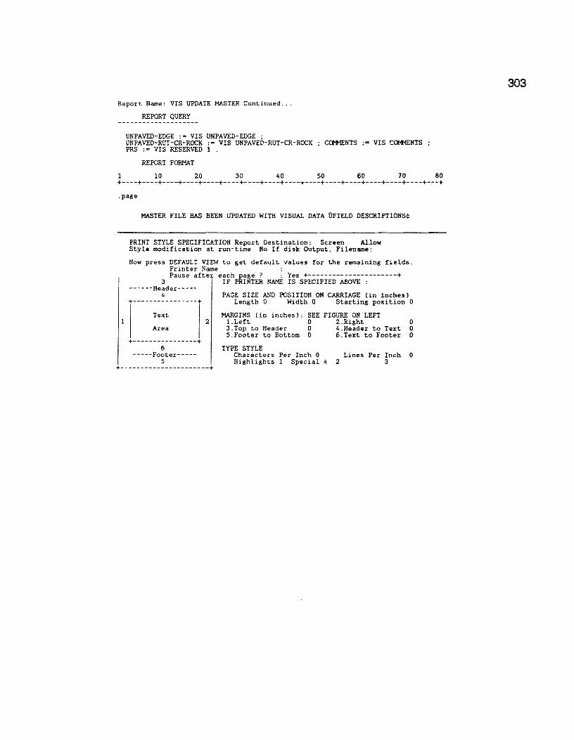
Report Name: VIS UPDATE MASTER Continued ...
REPORT QUERY
UNPAVED-EDGE :• VIS UNPAVED-EDGE ; UNPAVED-RUT-CR-ROCK := VIS UNPAVED-RUT-CR-RCX:K Cctt1ENTS :• VIS ~TS PRS := VIS RESERVED l .
REPORT FORMAT
l 10 20 30 40 50 60 70 80 +----+----+----+----+----+----+----+----+----+----+----+----+----+----+----+---+ .page
MASTER FILE HAS BEEN UPDATED WITH VISUAL DATA UFIELD DESCRIPTIONS¢
PRINT STYLE SPECIFICATION Report Destination: Screen Allow Style modification at run-time No If disk Output, Filename:
Now press DEFAULT VIEW to get default values for the remaining fields. Printer Name : Pause after each page ? : Yes +----------------------+
3 IF PRINTER NAME IS SPECIFIED ABOVE : ------Header-----
4 +----------------+
Text
PAGE SIZE AND POSITION ON CARRIAGE (in inches) Length 0 Width 0 Starting position 0
MARGINS (in inches): SEE FIGURE ON LEFT 2 l.Left 0 2.Right 0
Area
+----------------+ 6
-----Footer-----5
+----------------------+
3.Top to Header 0 4.Header to Text 0 5.Footer to Bottom 0 6.Text to Footer 0
TYPE STYLE Characters Per Inch 0 Lines Per Inch 0 Highlights 1 Special 4 2 3
303

304
Report Name: RIDE MASTER UPDATE
REPORT QUERY
for RIDE INPUT with MRM VALUE > 0 ; modify records in MASTER with ( MASTERID = RIDE INPUT RIDEID ) RIDE VALUE :• RIDE
INPUT SI VALUE ; RIDE DATE := RIDE INPUT YEAR
end for SIOMETER RIDE VALUES with SI VALUE > 0 ; modify records in MASTER with ( MASTERID Sict1ETER RIDE VALUES RIDEID ) RIDE VALUE
·= SIOMETER RIDE VALUES SI VALUE ; RIDE DATE := SIOMETER RIDE VALUES YEAR . end
REPORT FORMAT
1 10 20 30 40 50 60 70 80 +----+----+----+----+----+----+----+----+----+----+----+----+----+----+----+---+ .page
1
PRINT STYLE SPECIFICATION Report Destination: Screen Allow Style modification at run-time No If disk Output, Filename:
Now press DEFAULT VIEW to get default values for the remaining fields. Printer Name : Pause after each page ? : Yes +----------------------+
3 IF PRINTER NAME IS SPECIFIED ABOVE : ------Header-----
4 PAGE SIZE AND POSITION ON CARRIAGE (in inches) +----------------+ Length 0 Width 0 Starting position 0
Text
Area
+----------------+ 6
-----Footer-----5
MARGINS (in inches): SEE FIGURE ON LEFT 2 1.Left 0 2.Right 0
3.Top to Header 0 4.Header to Text 0 5.Footer to Bottom 0 6.Text to Footer 0
TYPE STYLE Characters Per Inch 0 Lines Per Inch 0 Highlights l Special 4 2 3
+----------------------+
Report Name: FWD MASTER UPDATE
REPORT QUERY
for FWD INPUT with Wl > 0 ; modify records in MASTER with ( MASTERID = FWD INPUT FWDID ) SCI2 := SCil
SCil ·= SCI · Wl :"'.FWD INPUT Wl ; W2 :• FWD INPUT W2 ; W6 := FWD INPUT W6 ; W7 := FWD INPUT W7 ; SCI := FWD INPUT SCI SCIYRZ := SCIYRl ; SCIYRl := LASTCCDATE,2) DATE := FWD INPUT DATE
REPORT FORMAT
1 10 20 30 40 50 60 70 80 +----+----+----+----+----+----+----+----+----+----+----+----+----+----+----+---+
.page
305

306
Report Name: SKID MASTER UPDATE
REPORT QUERY
for SKID INPUT with SKID VALUE > 0 ; modify records in MASTER with ( MASTERID = SKID INPUT SKIDID ) SKID2 := SKIDl
SKIDl :• SKID VALUE ; SKID VALUE := SKID INPUT SKID VALUE SKIDYR2 :- SKIDYRl ; SKIDYRl := SKID DATE ; SKID DATE := SKID INPUT SKID DATE .
Report Name: FC REFER POINT
REPORT QUERY
for MASTER
tiiodify records in FUNCT CLASS with ( FIRSTC(FROO REFERENCE,5) • " MASTER MASTERMPID ) FROM REFERENCE : • MASTER REFERENCE POINT .
end for MASTER
ciiodify records in FUNCT CLASS with ( FIRSTCCTO REFERENCE,5) • " MASTER MASTERMPID ) TO REFERENCE :• MASTER REFERENCE POINT .
end list records in FUNCT CLASS with ( FIRSTCCFROM REFERENCE,5)
REFERENCE, 5) • " . " ) RECORD NUMBER ; COUNTY NUMBER in order ; HIGHWAY PREFIX IN ORDER ; HIGHWAY NUMBER IN ORDER ; HIGHWAY SUFFIX IN ORDER ; ROADWAY IN ORDER ; FROO MILEPOST IN ORDER ; FROM MILEPOST SIGN IN ORDER FRM MILEPOST DISP IN ORDER TO MILEPOST ; TO MILEPOST SIGN TO MILEPOST DISP FROM REFERENCE ; TO REFERENCE .
REPORT FORMAT
. " and FCFMP •
... and FCTMP •
. " or FIRSTC(IO
1 10 20 30 40 50 60 70 80 +----+----+----+----+----+----+----+----+----+----+----+----+----+----+----+---+
.page
.header FUNCTIONAL CLASS
INVALID MILEPOSTS
RECORD COUNTY HIGHWAY ROADWAY FROM TO FROM IO NUMBER NUMBER MILEPOST MILEPOST REFERENCE REFERENCE
----------------------------------------------------------------------- .items _1 ___ 2_ _4_ _ _7_9_ ___ _13_ _14_ .eng ==============--========-==~=======:=========--=====-===-=--=====•-======- UFIELD
DESCRIPTIONS
No. Name Type Length
1 RECORD NUMBER Num. String 6 2 COUNTY NUMBER Number 3
Number Type : Integer 3 HIGHWAY PREFIX Choice 2
Related Form Not Found 4 HIGHWAY NUMBER Num. String 4 5 HIGHWAY SUFFIX Choice 1
Related Form Not Found 6 ROADWAY Choice l
Related Form Not Found 7 FROM MILEPOST Number 3
Number Type : Integer 8 FROM MILEPOST SIGN Choice 1
Related Form Not Found 9 FRM MILEPOST DISP Number 3
Number Type : Fixed Point Digits to left of Decimal = 1
10 TO MILEPOST Number 3 Number Type : Integer
11 TO MILEPOST SIGN Choice 1 Related Form Not Found
12 TO MILEPOST DISP Number 3 Number Type : Fixed Point Digits to left of Decimal = 1
13 FROM REFERENCE Number 5 Number Type : Fixed Point Digits to left of Decimal = 3
14 TO REFERENCE Number 5 Number Type : Fixed Point
307
308
FC REFER POINT ... continued
1
PRINT STYLE SPECIFICATION Report Destination: Printer Allow Style modification at run-time Yes If disk Output, Filename:
Now press DEFAULT VIEW to get default values for the remaining fields. Printer Name : Pause after each page ? : Yes +----------------------+
3 ------Header-----
4 +----------------+
Text
Area
+----------------+ 6
-----Footer-----5
IF PRINTER NAME IS SPECIFIED ABOVE :
PAGE SIZE AND POSITION ON CARRIAGE (in inches) Length 0 Width 0 Starting position 0
MARGINS (in inches): SEE FIGURE ON LEFT 2 l.Left 0 2.Right 0
3.Top to Header 0 4.Header to Text 0 5.Footer to Bottom O 6.Text to Footer 0
TYPE STYLE Characters Per Inch 0 Highlights 1
Lines Per Inch 0 2 Italicise 3 Italicise
+----------------------+

Report Name: FC MR.G TO MASTR
iiR.EPORT DEFINITION¢
REPORT QUERY
modify records in MASTER with FUNCTIONAL CLASS. > 0 l FUNCTIONAL CLASS. := BLANK for FUNCT CLASS
~edify records in MASTER with ( COUNTY NUMBER = FUNCT CLASS COUNTY NUMBER and HIGHWAY PREFIX • FUNCT CLASS HIGHWAY PREFIX and HIGHWAY NUMBER c FUNCT CLASS HIGHWAY NUMBER and HIGHWAY SUFFIX FUNCT CLASS HIGHWAY SUFFIX and ROADWAY = FUNCT CLASS ROADWAY and REFERENCE POINT >= FUNCT CLASS FROM REFERENCE and REFERENCE POINT <- FUNCT CLASS TO REFERENCE ) FUNCTIONAL CLASS. ·= FUNCT CLASS FC VALUE .
REPORT FORMAT
l 10 20 30 40 50 60 70 80 +----+----+----+----+----+----+----+----+----+----+----+----+----+----+----+---+ .page
1
MASTER FILE HAS BEEN UPDATED WITH FUNCTIONAL CLASSIFICATION DATA
PRINT STYLE SPECIFICATION Report Destination: Screen Allow Style modification at run-time No If disk Output, Filename:
Now press DEFAULT VIEW to get default values for the remaining fields. Printer Name : Pause afte each page ? : Yes +----------------------+
3 ------Header-----
4 +----------------+
Text
Area
+----------------+ 6
-----Footer-----5
IF PRINTER NAME IS SPECIFIED ABOVE :
PAGE SIZE AND POSITION ON CARRIAGE (in inches) Length 0 Width 0 Starting position 0
MARGINS (in inches): SEE FIGURE ON LEFT 2 1.Left 0 2.Right 0
3.Top to Header 0 4.Header to Text 0 5.Footer to Bottom 0 6.Text to Footer 0
TYPE STYLE Characters Per Inch 0 Highlights 1 Special 4
Lines Per Inch 0 2 3
+----------------------+
309
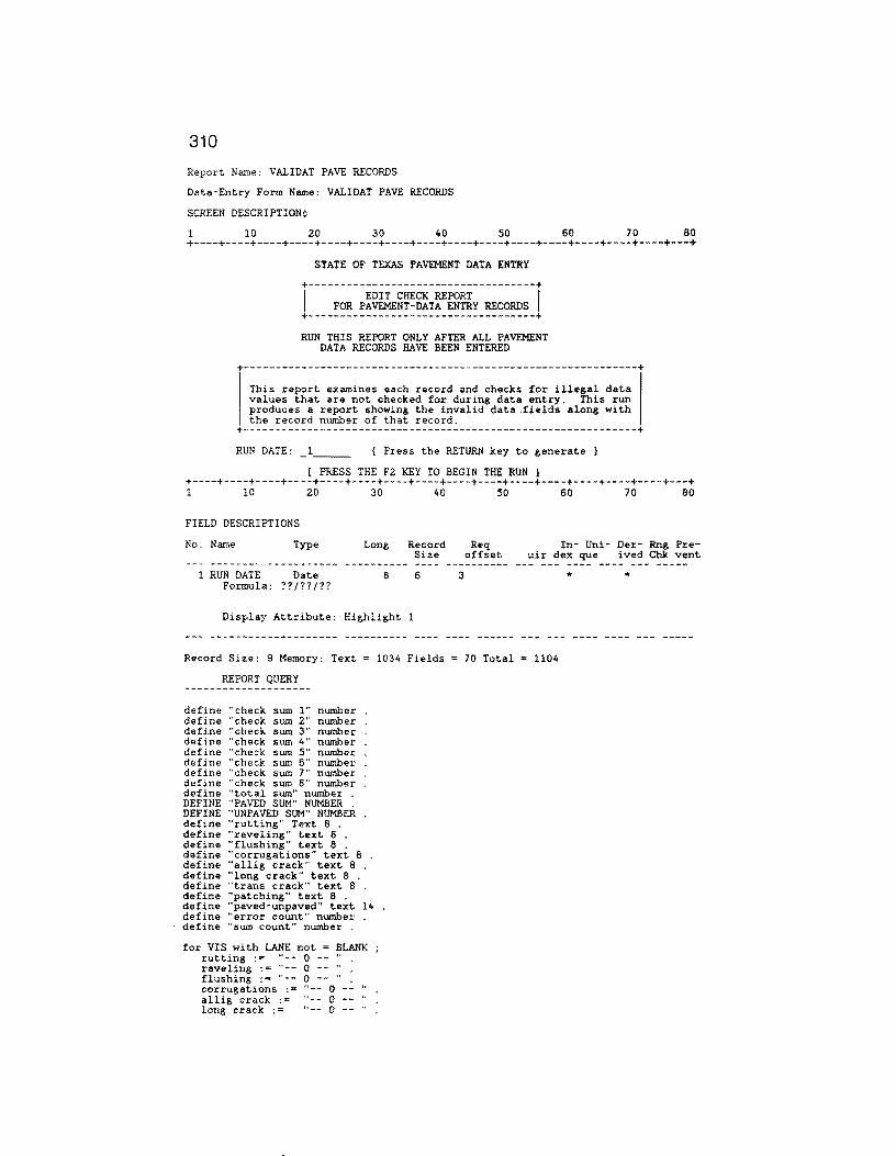
3i0
Report Name: VALIDAT PAVE RECORDS
Data-Entry Form Name: VALIDAT PAVE RECORDS
SCREEN DESCRIPTION¢
1 10 20 30 40 50 60 70 80 +----+----+----+----+----+----+----+----+----+----+----+----+----+----+----+---+
STATE OF TEXAS PAVEMENT DATA ENTRY
+------------------------------------+ I EDIT CHECK REPORT I
FOR PAVEMENT-DATA ENTRY RECORDS +------------------------------------+ RUN THIS REPORT ONLY AFTER ALL PAVEMENT
DATA RECORDS HAVE BEEN ENTERED
+--------------------------------------------------------------+ This report examines each record and checks for illegal data values that are not checked for during data entry. This run produces a report showing the invalid data .fields along with the record number of that record.
+--------------------------------------------------------------+ RUN DATE: 1 ---- { Press the RETURN key to generate }
[ PRESS THE F2 KEY TO BEGIN THE RUN I +----+----+----+----+----+----+----+----+----+----+----+----+----+----+----+---+ 1 10 20 30 40 50 60 70 80
FIELD DESCRIPTIONS
No. Name Type
1 RUN DATE Date Formula: ??/??/??
Long
8
Record Size
6
Display Attribute: Highlight l
3
Req offset
In- Uni- Der- Rng Preuir dex que ived Chk vent
*
Record Size: 9 Memory: Text 1034 Fields = 70 Total = 1104
REPORT QUERY
define "check sum l" number define "check sum 2" number define "check sum 3" number define "check sum 4" number define "check sum 5" number define "check sum 6" number define "check sum 7" number define "check sum 8" number define "total sum" number DEFINE "PAVED SUM" NUMBER DEFINE "UNPAVED SUM" NUMBER define "rutting" Text 8 define "raveling" text. 8 define "flushing" text a define "corrugations" text a define "allig crack" text 8 define "long crack" text 8 define "trans crack" text B define "patching" text 8 define "paved-unpaved" text 14 define "error count" number define "sum count" number
for VIS with LANE not = BLANK rutting . ., raveling · = "-flushing ·= "-corrugations ·• allig crack ·= long crack ·=
0 0 -- .. 0 -- ..
0 0 .. __ 0

Report Name: VALIDAT PAVE RECORDS Continued ...
REPORT QUERY
trans crack :• patching := paved-unpaved
.. __ 0 -- ... 0 -- " . .• ,, _____ 0 ----- ..
SUM COUNT := 0 . ERROR COUNT :"' 0
check sum 1 := rut-sl + rut-mo + rut-sv + rav-sl + rav-mo + rav-sv . check sum 2 := fl-sl + fl-mo + fl-sv +cor-sl + cor-mo + cor-sv . check sum 3 := alg-sv + alg-mo + alg-sl + lcks-sl + lcks-mo + lcks-sv . check sum 4 := tcks-sl + tcks-mo + tcks-sv + cracks-sealed etc . check sum 5 := pat-sl + pat-mo + pat-sv + total failures + paved-ride . check sum 6 := paved-contrast + paved-edge + paved-shoulder edge . check sum 7 := paved-cracks + paved-ravel + paved-veg + unpaved-edge . check sum 8 := unpaved-rut-er-rock . total sum := check sum 1 + check sum 2 + check sum 3 + check sum 4 + check su m 5
+ check sum 6 + check sum 7 + check sum 8 .
IF TOTAL SUM > 0 THEN
sum count := rut-sl + rut-mo + rut-sv . if sum count > 7 then rutting := "RUT ERR " . error count := error count + 1 .
else end sum count := 0 . sum count := RAV-SL + RAV-MJ + RAV-SV . if sum count > 7 then raveling := "RAV ERR "
error count := error count + l . else end
sum count := O • sum count := fl-sl + fl-mo + fl-sv . if sum count > 7 then
flushing := "FLU ERR " error count := error count + 1 . else
end sum count := 0 . sum count := cor-sl + car-mo + cor-sv .
if sum count > 7 then error count :• error count + 1 .
corrugations ·= "CORR ERR" else end
sum count :• 0 . sum count := alg-sl + alg-mo + alg-mo If sum count > 7 then
error count := error count + 1 . allig crack : = "ALG ERR " .
else end
sum count 0 . sum count lcks-sl + lcks-mo + lcks-sv
if sum count > 9 then long crack := "LGT ERR "
error count := error count + 1 . else end
sum count := 0 . sum count := tcks-sl + tcks-mo + tcks-sv
if sum count > 9 then
end
trans crack "TRCK ERR" . error count ·= error count + 1 .
else
sum count := 0 . sum count := PAT-SL + PAT-MJ + PAT-SV .
if sum count > 7 then patching :- "PAT ERR " .
error count :• error count + l . else
PAVED SUM :• PAVED-RIDE + PAVED-CONTRAST + PAVED-EDGE + PAVED-SBOULDER EDGE + PAVED-CRACKS + PAVED-RAVEL + PAVED-VEG .
UNPAVED SUM := UNPAVED-EDGE + UNPAVED-RUT-CR-ROCK . IF PAVED SUM > 0 AND UNPAVED SUM > 0 THEN
END ELSE END
ERROR COUNT :s ERROR COUNT + 1 . PAVED-UNPAVED := "MUT. EXC ERROR" . ELSE
if temp error count > 0 then
311

312
Report Name: VALIDAT PAVE RECORDS Continued ... COUNTY NUMBER
LIST RECORDS current date current time current page number DISTRICT ; RECORD NUMBER ; HIGHWAY PREFIX HIGHWAY NUMBER ; HIGHWAY SUFFIX ; ROADWAY ; FROM ; REFERENCE POINT LANE temp ~utting ; temp raveling ; temp flushing ; temp corrugations temp allig crack ; temp long crack ; temp trans crack ; temp patching ; temp paved-unpaved temp error count temp tot.al sum ; RECORD NUMBER
end end. END .
FIELD DESCRIPTIONS
No. Name Type Length
1 current date Date 8 2 DISTRICT Number 3
Number Type : Integer 3 current time Time 8 4 current page number Number 3
Number Type Integer 5 RECORD NUMBER Num. String 6 6 COUNTY NUMBER Number 3 7 HIGHWAY PREFIX Choice 2
Choice l: no Choice 2: yes
8 HIGHWAY NUMBER Num. String 4 9 HIGHWAY SUFFIX Choice l
Choice 1: no Choice 2: yes
10 ROADWAY Choice 1 Choice 1: no Choice 2: yes
11 FROM Number 5 Number Type : Fixed Point Digits to left of Decimal = 3
12 REFERENCE POINT Number 5 Number Type : Fixed Point Digits to left of Decimal 3
13 LANE Text l 14 temp rutting Text 8 15 temp raveling Text 8 16 temp flushing Text 8 17 temp corrugations Text 8 18 temp allig crack Text 8 19 temp long crack Text 8 20 temp trans crack Text 8 21 temp patching Text 8 22 temp paved-unpaved Text 14 23 temp error count Number 5
Number Type Integer 24 RECORD NUMBER Num. String 6

Validate Pavement Records ... continued
1
PRINT STYLE SPECIFICATION Report Destination: Printer Allow Style modification at run-time Yes If disk Output, Filename:
Now press DEFAULT VIEW to get default values for the remaining fields. Printer Name HP Ser.2 Landsp Pause after each page ? : No +----------------------+
3 ------Header-----
4 +----------------+
Text
Area
+----------------+
IF PRINTER NAME IS SPECIFIED ABOVE :
PAGE SIZE AND POSITION ON CARRIAGE (in inches) Length 8 Width 11 Starting position 0
MARGINS (in inches): SEE FIGURE ON LEFT 2 l.Left 0 2.Right 0
3.Top to Header 0 4.Header to Text 0 5.Footer to Bottom 1 6.Text to Footer 0
6 TYPE STYLE -----Footer----- Characters Per Inch 17 Lines Per Inch 6
5 Highlights 1 2 3 +----------------------+
313

314
Report Name: FWD VIEW
Data-Entry Form Name: FWD VIEW
SCREEN DESCRIPTION
1 10 20 30 i.o 50 60 10 80 +----+----+----+----+----+----+----+----+----+----+----+----+----+----+----+---+
+---------------------+ IFWD ERROR CORRECTIONS! +---------------------+
Complete the entries below, then press "F2"
BIGHWAY PREFIX:
BIGHWAY NUMBER: _2_
HIGHWAY SUFFIX:
ROADWAY: +----+----+----+----+----+----+----+----+--~-+----+----+----+----+----+----+---+ 1 10 20 30 40 50 60 70 80
FIELD DESCRIPTIONS¢
No. Name Type Long Record Req In- Uni- Der- Rng Pre- Size offset uir dex que ived Chk vent
l HP 2 HN
Formated 3 HS 4 RD
Text Num. String
as : Other Format Text Text
2 4
1 1
2 3 " 4 5 " 0000 1 9 1 10 " --- ---- ---- --- -----
Record Size: 11 Memory: Text = 412 Fields = 98 Total = 510
REPORT QUERY
!or FWD INPUT with HIGHWAY PREFIX = data-entry HP and
HIGHWAY NUMBER = data-entry HN and HIGHWAY SUFFIX = data-entry HS and ROADWAY = data-entry RD ;
list records RECORD NUMBER in order ; COUNTY NUMBER ; HIGHWAY PREFIX HIGHWAY NUMBER HIGHWAY SUFFIX ROADWAY ; MILEPOST ; MILEPOST DISP. SIGN MILEPOST VALUE ; REFERENCE POINT .
REPORT FORMAT
10 20 30 40 50 60 70 80 +----+----+----+----+----+----+----+----+----+----+----+----+----+----+----+---+ .page .header
.end
COUNTY NUMBER
HIGHWAY NUMBER
FWD ERROR CORRECTIONS
ROADWAY REFERENCE MILEPOST POINT
------------------------------------------------------------------ .items _ 1 __ _ 2 _ _4_ 7 _8 __

FWD VIEW .... continued: FIELD DESCRIPTIONS
No. Name TYPe Length
l RECORD NUMBER Num. String 6
2 COUNTY NUMBER Number 3 Number Type Integer
3 HIGHWAY PREFIX Text 2 4 HIGHWAY NUMBER Num. String 4 5 HIGHWAY SUFFIX Text 1 6 ROADWAY Text 1 7 REFERENCE POINT Number 5
Number Type : Fixed Point Digits to left of Decimal • 3
8 MILEPOST Number 3 Number Type : Integer
9 MILEPOST DISP. SIGN Choice 1 Related Form Not Found
10 MILEPOST VALUE Number 3
1
Number Type : Fixed Point Digits to left of Decimal = l
PRINT STYLE SPECIFICATION Report Destination: Screen Allow Style modification at run-time No If disk Output, Filename:
Now press DEFAULT VIEW to get default values for the remaining fields. Printer Name : Pause after each page ? : Yes +----------------------+
3 ------Header-----
4 +----------------+
Text
Area
+----------------+ 6
IF PRINTER NAME IS SPECIFIED ABOVE :
PAGE SIZE AND POSITION ON CARRIAGE (in inches) Length 0 Width 0 Starting position 0
MARGINS (in inches): SEE FIGURE ON LEFT 2 l.Left O 2.Right 0
3.Top to Header 0 4.Header to Text 0 5.Footer to Bottom 0 6.Text to Footer 0
TYPE STYLE Characters Per Inch 0 Highlights l
Lines Per Inch 0 2 3
+----------------------+
315

316
Report Name: EXPORT PAVE RECORDS
Data-Entry Form Name: EXPORT PAVE RECORDS
SCREEN DESCRIPTION
l 10 20 30 40 50 60 70 80 +----+----+----+----+----+----+----+----+----+----+----+----+----+----+----+---+
+-----------------------+ I MICRO-RAMS DATA BASE I +-----------------------+
+-------------------------------------+
I TEXAS STATE HIGHWAY DEPARTMENT I
THE TEXAS TRANS~RTATION INSTITUTE TEXAS A&M UNIVERSITY
+-------------------------------------+ EXPORT PAVEMENT RECORD DATA TO DISK FILE
RUN DATE: _l~~- (Press RETURN to automatically generate)
******* PRESS THE FZ KEY TO BEGIN ******* +----+----+----+----+----+----+----+----+----+----+----+----+----+----+----+---+ l 10 20 30 40 so 60 70 80
FIELD DESCRIPTIONS
No. Name Type
l RUN DATE Date Formula: ??/??/??
Long Record off set
8 6 3
Req In- Uni- Der- Rng Pre- Size uir dex que ived Chk vent
*
Record Size: 9 Memory: Text = 772 Fields = 70 Total = 842
REPORT QUERY
delete records in PRS-SRS INPUT FILE for VIS with lane not = BLANK list records
RECORD NUMBER in order ; COUNTY NUMBER ; HIGHWAY PREFIX ; HIGHWAY NUMBER ; FROM · REFERENCE POINT ; LANE · RUT-SL RUT-MO RUT-SV rav-sl RAV-MO RAV-SV FL-SL · FL-MO '. FL-SV ; COR-SL COR-MO COR-SV ALG-SL ALG-MO ALG-SV LCKS-SL LCKS-MO LCKS-SV TCKS-SL TCKS-MO TCKS-SV · CRACKS-SEALED ETC PAT-SL · PAT-MO '. PAT-SV : TOTAL FAILURES PAVED-RIDE ; PAVED-CONTRAST PAVED-EDGE ; PAVED-SHOULDER EDGE PAVED-CRACKS ; PAVED-RAVEL · PAVED-VEG · • UNPAVED-EDGE ; UNPAVED-RUT-CR-ROCK
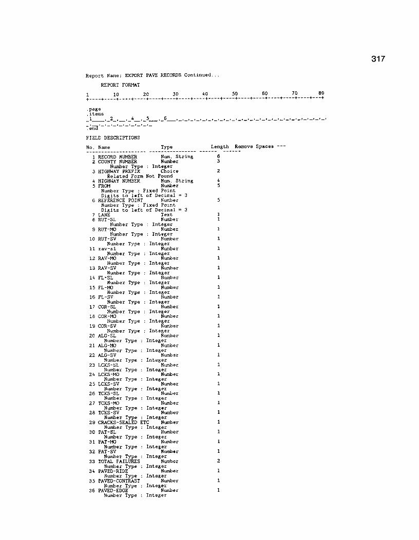
Report Name: EXPORT PAVE RECORDS Continued ...
REPORT FORMAT
1 10 20 30 40 50 60 70 80 +----+----+----+----+----+----+----+----+----+----+----+----+----+----+----+---+
.page
.items _1 __ ,_2_,_._4_,_s_._s_,_,_,_,_,_,_,_._,_,_,_,_,_,_,_,_,_,_t_t_,_,_,_,_,_, ~~na·_,_._,_,_,_,_,_,_
FIELD DESCRIPTIONS
No. Name Type Length Remove Spaces ---
1 RECORD NUMBER Num. String 6 2 COUNTY NUMBER Number 3
Number Type : Integer 3 HIGHWAY PREFIX Choice 2
Related Form Not Found 4 HIGHWAY NUMBER Num. String 4 5 FROM Number 5
Number Type : Fixed Point Digits to left of Decimal 3
6 REFERENCE POINT Number 5 Number Type : Fixed Point Digits to left of Decimal 3
7 LANE Text l 8 RUT-SL Number l
Number Type Integer 9 RUT-MO Number 1
Number Type Integer 10 RUT-SV Number 1
Number Type Integer 11 rav-sl Number 1
Number Type Integer 12 RAV-MO Number 1
Number Type Integer 13 RAV-SV Number 1
Number Type Integer 14 FL-SL Number 1
Number Type Integer 15 FL-MO Number 1
Number Type Integer 16 FL-SV Number 1
Number Type Integer 17 COR-SL Number 1
Number Type Integer 18 COR-MO Number 1
Number Type Integer 19 COR-SV Number 1
Number Type Integer 20 ALG-SL Number 1
Number Type Integer 21 ALG-MO Number l
Number Type Integer 22 ALG-SV Number l
Number Type Integer 23 LCKS-SL Number 1
Number Type Integer 24 LCKS-MO Number l
Number Type Integer 25 LCKS-SV Number l
Number Type Integer 26 TCKS-SL Number 1
Number Type Integer 27 TCKS-MO Number 1
Number Type Integer 28 TCKS-SV Number 1
Number Type : Integer 29 CRACKS-SEALED ETC Number 1
Number Type Integer 30 PAT-SL Number 1
Number Type Integer 31 PAT-MO Number 1
Number Type Integer 32 PAT-SV Number 1
Number Type Integer 33 TOTAL FAILURES Number 2
Number Type : Integer 34 PAVED-RIDE Number 1
Number Type : Integer 35 PAVED-CONTRAST Number l
Number Type Integer 36 PAVED-EDGE Number l
Number Type : Integer
317
318
Report Name: EXPORT PAVE RECORDS Continued ... No. Name Type Length Spaces
37 PAVED-SHOULDER EDGE Number 1 Number Type Integer
38 PAVED-CRACKS Number l Number Type Integer
39 PAVED-RAVEL Number l Number Type Integer
40 PAVED-VEG Number 1 Number Type Integer
41 UNPAVED-EDGE Number 1 Number Type : Integer
42 UNPAVED-RUT-CR-ROCK Number l Number Type : Integer
PRINT STYLE SPECIFICATION Report Destination: Disk Allow Style modification at run-time No If disk Output, Filename:
EXPORT.VIS Now press DEFAULT VIEW to get default values for the remaining fields.
Printer Name : Pause after each page ? : Yes +----------------------+
3 ------Header-----
4 +----------------+
Text
IF PRINTER NAME IS SPECIFIED ABOVE :
PAGE SIZE AND POSITION ON CARRIAGE (in inches) Length 0 Width 0 Starting position 0
MARGINS (in inches): SEE FIGURE ON LEFT 2 l.Left 0 2.Right 0
Area
+----------------+ 6
-----Footer-----5
+----------------------+
3.Top to Header 0 4.Header to Text 0 5.Footer to Bottom 0 6.Text to Footer 0
TYPE STYLE Characters Per Inch 0 Highlights 1
Lines Per Inch 0 2 3
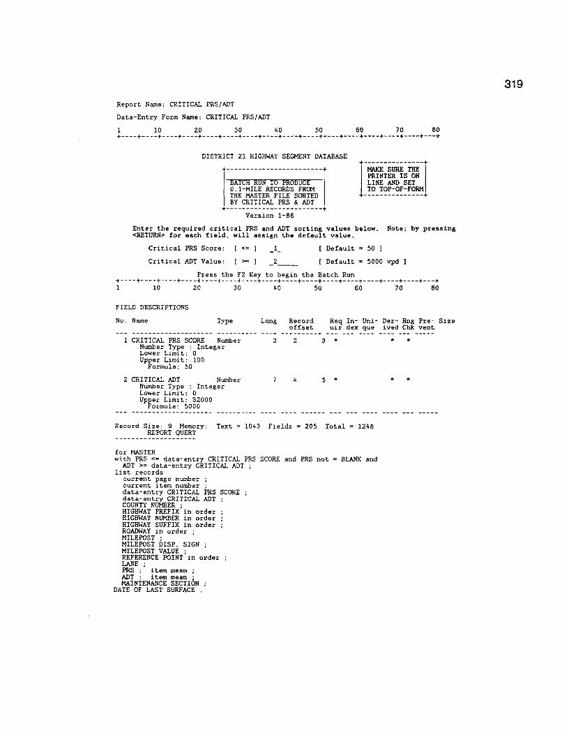
Report Name: CRITICAL PRS/ADT
Data-Entry Form Name: CRITICAL PRS/ADT
1 10 20 30 40 50 60 70 80 +----+----+----+----+----+----+----+----+----+----+----+----+----+----+----+---+
DISTRICT 21 HIGHWAY SEGMENT DATABASE
+------------------------+ BATCH RUN TO PRODUCE 0.1-MILE RECORDS FROM THE MASTER FILE SORTED BY CRITICAL PRS & ADT
+------------------------+ Version 1-88
Enter the required critical PRS and ADT sorting values below. Note: by pressing <RETURN> for each field, will assign the default value.
Critical PRS Score: <= _1_ Default • 50 l
Critical ADT Value: >= _2 __ Default 5000 vpd l
Press the F2 Key to begin the Batch Run +----+----+----+----+----+----+----+----+----+----+----+----+----+----+----+---+ 1 10 20 30 40 50 60 70 80
FIELD DESCRIPTIONS
No. Name Type Long Record offset
Req In- Uni- Der- Rng Pre- Size uir dex que ived Chk vent
l CRITICAL PRS SCORE Number Number Type : Integer Lower Limit: O Upper Limit: 100
Formula: 50
2 CRITICAL ADT Number Number Type : Integer Lower Limit: 0 Upper Limit: 32000
Formula: 5000
3 2 3 *
7 4 5 *
Record Size: 9 Memory: Text = 1043 Fields = 205 Total = 1248 REPORT QUERY
for MASTER with PRS <= data-entry CRITICAL PRS SCORE and PRS not • BLANK and
ADT >= data-entry CRITICAL ADT list records
current page number ; current item number ; data-entry CRITICAL PRS SCORE data-entry CRITICAL ADT COUNTY NUMBER ; HIGHWAY PREFIX in order HIGHWAY NUMBER in order HIGHWAY SUFFIX in order ROADWAY in order ; MILEPOST ; MILEPOST DISP. SIGN ; MILEPOST VALUE ; REFERENCE POINT in order LANE · PRS : ' item mean ; ADT : item mean ; MAINTENANCE SECTION
DATE OF LAST SURFACE .
* "
* *
319
320
Report Name: CRITICAL RIDE/ADT
Data-Entry Form Name: CRITICAL RIDE/ADT
SCREEN DESCRIPTION
1 10 20 30 40 50 60 70 80 +----+----+----+----+----+----+----+----+----+----+----+----+----+----+----+---+
DISTRICT 21 HIGHWAY SEGMENT DATABASE
+------------------------+ BATCH RON To PRODUCE 0.1-MILE RECORDS FROH THE MASTER FILE SORTED BY CRITICAL RIDE & ADT
+------------------------+ Version 1-88
Enter the required critical RIDE and ADT sorting values below. Note: by pressing <RETURN> for each field, will assign the default value.
Critical RIDE Score: <= _1_ Default = 2.8
Critical ADT Value: >= _2 __ Default 5000 vpd
Press the F2 Key to begin the Batch Run +----+----+----+----+----+----+----+----+----+----+----+----+----+----+----+---+ 1 10 20 30 40 50 60 70 80
FIELD DESCRIPTIONS¢
No Name Type Long Record Req In- Uni- Der- Rng Pre-offset uir dex que ived Chk vent
-------------------- ---------- ---------- --- ----l CRITICAL RIDE SCORE Number 4 4 3 .. * *
Number Type : Fixed Point Lower Limit: 0 Upper Limit: 5 Formula: 2.8 Display Attribute: Highlight 1
2 CRITICAL ADT Number 7 4 7 * * * Number Type : Integer Lower Limit: 0 Upper Limit: 32000 Formula: 5000
Record Size: 11 Memory: Text = 1046 Fields 205 Total = 1251
REPORT QUERY
for MASTER with RIDE VALUE <= data-entry CRITICAL RIDE SCORE and RIDE VALUE not = BLANK and
ADT >= data-entry CRITICAL ADT list records
current page number ; current item number ; data-entry CRITICAL RIDE SCORE data-entry CRITICAL ADT COUNTY NUMBER ; HIGHWAY PREFIX in order HIGHWAY NUMBER in order HIGHWAY SUFFIX in order ROADWAY in order ; MILEPOST ; MILEPOST DISP. SIGN ; MILEPOST VALUE ; REFERENCE POINT in order LANE ; RIDE VALUE : item mean ADT : item mean ; MAINTENANCE SECTION ; DATE OF LAST SURFACE .
Size
Report Name: CRITICAL RIDE/ADI Continued ...
REPORT QUERY
REPORT FORMAT
1 10 20 30 40 50 60 70 80 +----+----+----+----+----+----+----+----+----+----+----+----+----+----+----+---+
.page
.header Critical Ride and ADT Sun:mary Report
BROOKS COUNTY (024)
Critical RIDE Score: _1~ Critical ADT Value Specified: _2~~
Page No. 3
321
322
Report Name: CRITICAL SCI/ADT
Data-Entry Form Name: CRITICAL SCI/ADT
SCREEN DESCRIPTION
1 10 20 30 40 50 60 70 80 +----+----+----+----+----+----+----+----+----+----+----+----+----+----+----+---+
DISTRICT 21 HIGHWAY SEGMENT DATABASE
+------------------------+ BATCH RON TO PROOOC£ 0.1-MILE RECORDS FR~ THE MASTER FILE SORTED BY CRITICAL SCI & ADT
+,-~-;~-THE-+! PRINTER IS ON LINE AND SET TO TOP-OF-FORM
+---------------+ +------------------------+
Version 1-88
Enter the required critical SCI and ADT sorting values below. Note: by pressing <RETURN> for each field, will assign the default value.
Critical SCI Score: >=
Critical ADT Value: >=
_l __
_2 __
Default = 1. 00 J
Default = 5000 vpd
Press the F2 Key to begin the Batch Run +----+----+----+----+----+----+----+----+----+----+----+----+----+----+----+---+ l 10 20 30 40 50 60 70 80
FIELD DESCRIPTIONS
No. Name Type
1 CRITICAL SCI Number Number Type : Fixed Point Lower Limit: 0 Upper Limit: 999.99 Formula: 1.00 Display Attribute: Highlight
2 CRITICAL ADT Number Number Type : Integer Lower Limit: 0 Upper Limit: 32000 Formula: 5000
Long Record offset
6 4
7
Req In- Uni- Der- Rng Pre- Size uir dex que ived Ch): vent
3 " *
7 * * *
Record Size: 11 Memory: Text = 1044 Fields = 204 Total 1248
REPORT QUERY
for MASTER with SCI >= data-entry CRITICAL SCI and
SCI not = BLANK and ADT >= data-entry CRITICAL ADT ;
list records current page number ; current item number ; data-entry CRITICAL SCI data-entry CRITICAL ADT COUNTY NUMBER ; HIGHWAY PREFIX in order HIGHWAY NUMBER in order HIGHWAY SUFFIX in order ROADWAY in order ; MILEPOST ; MILEPOST DISP. SIGN ; MILEPOST VALUE ; REFERENCE POINT in order LANE · SCI : ' item mean ; ADT : item mean ; MAINTENANCE SECTION
DATE OF LAST SURFACE .

Report Name: CRITICAL SC!/ADT Continued ...
REPORT FORMAT
1 10 20 30 40 50 60 70 80 +----+----+----+----+----+----+----+----+----+----+----+----+----+----+----+---+ .page
@c4 @["&.180]
.header
1
Critical SCI and ADT SUI!lllary Re port BROOKS COUNTY (024)
Critical SCI Score: _1__ Critical ADT Value Specified: _2 __
PRINT STYLE SPECIFICATION Report Destination: Printer Allow Style modification at run-time Yes If disk Output, Filename:
Now press DEFAULT VIEW to get default values for the remaining fields. Printer Name HP Ser.2 Portrt Pause afte each page ? : No +----------------------+
3 ------Header-----
4 +----------------+
Text
Area
+----------------+ 6
-----Footer-----5
IF PRINTER NAME IS SPECIFIED ABOVE :
PAGE SIZE AND POSITION ON CARRIAGE {in inches) Length 10 Width 9 Starting position 0
MARGINS (in inches): SEE FIGURE ON LEFT 2 l.Left 0 2.Right 0
3.Top to Header 0 4.Header to Text 0 5.Footer to Bottom 0 6.Text to Footer 0
TYPE STYLE Characters Per Inch 17 Highlights 1
Lines Per Inch 6 2 3 +----------------------+
323

324
Report Name: CRITICAL SKID/ADI
Data-Entry Form Name: CRITICAL SKID/ADI
SCREEN DESCRIPTION
l 10 20 30 40 50 60 70 80 +----+----+----+----+----+----+----+----+----+----+----+----+----+----+----+---+
DISTRICT 21 HIGHWAY SEGMENT DATABASE
+------------------------+ BATCH RUN To PRODUCE 0.1-MILE RECORDS FROM THE MASTER FILE SORTED BY CRITICAL SKID & ADT
+------------------------+ Version 1-88
+
1-~-sURE:-!liE-+
1 PRINTER IS ON LINE AND SET TO TOP-OF-FORM
+---------------+
Enter the required critical SKID and ADT sorting values below. Note: by pressing <RETURN> for each field, will assign the default value.
Critical SKID Score: <= Default = 30.00 J
Critical ADI Value: >= _2 __ [ Default 5000 vpd
Press the F2 Key to begin the Batch Run +----+----+----+----+----+----+----+----+----+----+----+----+----+----+----+---+ 1 10 20 30 40 50 60 70 80
FIELD DESCRIPTIONS
No. Name Type Long Record Req In- Uni- Der- Rng Pre- Size offset uir dex que ived Chk vent
CRITICAL SKID VALUE Number Number Type : Integer Lower Limit: 0 Upper Limit: 99 Formula: 30
2 1 3 *
Display Attribute: Highlight 1
2 CRITICAL ADI Number Number Type : Integer Lower Limit: 0 Upper Limit: 32000 Formula: 5000
Record Size: 8 Memory: Text
REPORT QUERY
for MASTER
7 4 4 *
1049 Fields = 205 Total • 1254
with SKID VALUE <= data-entry CRITICAL SKID VALUE and SKID VALUE not ADT >= data-entry CRITICAL ADT ;
list records current page number ; current item number ; data-entry CRITICAL SKID VALUE data-entry CRITICAL ADT COUNTY NUMBER ; HIGHWAY PREFIX in order HIGHWAY NUMBER in order HIGHWAY SUFFIX in order ROADWAY in order ; MILEPOST ; MILEPOST DISP. SIGN MILEPOST VALUE ; REFERENCE POINT fo order LANE · SKID VALUE : item mean ADT : item mean ; MAINTENANCE SECTION .
* *
* *
BLANK and
Report Name: CRITICAL DLS/ADT Data-Entry Form Name: CRITICAL DLS/ADT
l 10 20 30 40 50 60 70 80 +----+----+----+----+----+----+----+----+----+----+----+----+----+----+----+---+
DISTRICT 21 HIGHWAY SEGMENT DATABASE
+------------------------+
SATCA RUN To PRODUCE 0.1-MILE RECORDS FROM THE MASTER FILE SORTED BY CRITICAL DLS & ADT
+------------------------+
+
1
-MAX:E-sliRE-!iiE-+I PRINTER IS ON LINE AND SET TO TOP-OF-FORM
+---------------+ DATE OF LAST SURFACE Version 1-88
Enter the required critical DLS and ADT sorting values below. Note: by pressing <RETURN> for each field, will assign the default value.
Critical Date of Last Surface (last 2 Digits of the Year)
Critical ADI Value: [ >= l 2 [ Default = 5000 vpd
Press the F2 Key to begin the Batch Run +----+----+----+----+----+----+----+----+----+----+----+----+----+----+----+---+ l 10 20 30 40 50 60 70 80
FIELD DESCRIPTIONS
No. Name Type Long Record Req In- Uni- Der- Rng Pre- Size offset uir dex que ived Chk vent
1 CRITICAL YEAR Number 2 1 3 * Number Type : Integer Lower Limit: 00 Upper Limit: 99
Display Attribute: Highlight 1
2 CRITICAL ADI Number Number Type : Integer Lower Limit: 0 Upper Limit: 32000
Formula: 5000
Record Size: 8 Memory:
REPORT QUERY
for MASTER
7 4 ... * *
Fields = 182 Total = 1246
with LASTC(DATE OF LAST SURFACE,2) <=data-entry CRITICAL YEAR and DATE OF LAST SURFACE NOT = BLANK and ADT >= data-entry CRITICAL ADI ;
list records current page number ; current item number ; data-entry CRITICAL YEAR data-entry CRITICAL ADT COUNTY NUMBER ; HIGHWAY PREFIX in order HIGHWAY NUMBER in order HIGHWAY SUFFIX in order ROADWAY in order ; MILEPOST ; MILEPOST DISP. SIGN ; MILEPOST VALUE ; REFERENCE POINT in order LANE ; HIGHWAY DESIGN TYPE ; SURFACE TYPE ; DATE OF LAST SURFACE ; ADI : item mean ; MAINTENANCE SECTION in order .
325

326
Report Name: PRINT DIST. INVENTRY
Data-Entry Form Name: PRINT DIST. INVENTRY
SCREEN DESCRIPTION
l 10 20 30 40 50 60 70 80 +----+----+----+----+----+----+----+----+----+----+----+----+----+----+----+---+
PRINT THE COUNTY-LEVEL HIGHWAY INVENTORY
PRESS THE F2 KEY TO BEGIN THE RUN +----+----+----+----+----+----+----+----+----+----+----+----+----+----+----+---+ 1 10 20 30 40 50 60 70 80
FIELD DESCRIPTIONS
No. Name Type Long Record Req In- Uni- Der- Rng Pre-Size offset uir dex que ived Chk vent
Record Size: 32000 Memory: Text= 125 Fields = 17 Total= 142
REPORT QUERY
for DISTRICT INVENTORY
list records Record Number ; COUNTY NUMBER ; HIGHWAY PREFIX in order HIGHWAY NUMBER in order HIGHWAY SUFFIX ; ROADWAY ; BEG. REF. POINT in order END. REF. POINT ; MILEPOST in order ; MILEPOST DISP. SIGN MILEPOST VALUE ; CONTROL in order SECTION ; BEG. MILEPOINT ; END. MILEPOINT ;
LAP .

Report Name: SETUP YEAR-ENO BLANK
DATA-ENTRY FORM
Data-Entry Form Name: SETUP YEAR-END BLANK
USCREEN DESCRIPTION¢
1 10 20 30 40 50 60 70 80 +----+----+----+----+----+----+----+----+----+----+----+----+----+----+----+---+
DISTRICT 21 HIGHWAY DATABASE
WARNING!!!!:
USE OF THIS BATCH PROGRAM WILL RESULT IN BLANKING ALL RELEVENT DATA FIELDS IN THE MASTER 0.1 FILE, THE VISUAL 0.5 FILE, THE FWD, RIDE AND SKID FILES.
THIS REPORT SHOULD ONLY BE RUN WHEN THE USER IS READY TO BLANK THE CURRENT YEAR'S DATABASE AND SETUP FOR NEW DATA ENTRY.
MAKE SURE YOU HAVE PROVIDED FOR ADEQUATE BACKUP OF THE FILES BEFORE RUNNING.
ARE YOUR PREPARED TO RUN THIS ROUTINE? IF SO, PRESS THE F2 KEY TO BEGIN ..... IF NOT, PRESS THE F4 KEY TO EXIT AND ABORT THIS RUN
+----+----+----+----+----+----+----+----+----+----+----+----+----+----+----+---+ l 10 20 30 40 50 60 70 80
REPORT QUERY
for MASTER
modify records lane := blank PRS-5 := PRS-lt PRS-4 := PRS-3 PRS-3 := PRS-2 PRS-2 := PRS-1 PRS-1 := PRS ; PRS : = BLANK ; RUT-SL ·= BLANK · RUT-MO ;. BLANK ; RUT-SV ·= BLANK · PAVED-RIDE := BLANK RAV-SL := BLANK ; RAV-MO := BLANK ; RAV-SV := BLANK ; PAVED-CONTRAST := BLANK FL-SL ·= BLANK · FL-MO ;= BLANK ; FL-SV := BLANK ; PAVED-EDGE := BLANK COR-SL := BLANK ; COR-MO ·= BLANK · COR-SV :. BLANK '. PAVED-SHOULDER EDGE := BLANK ALG-SL := BLANK ; ALG-MO := BLANK ; ALG-SV ·= BLANK · PAVED-cRACKS := BLANK LCKS-SL := BLANK ; LCKS-MO := BLANK ; LCKS-SV ·= BLANK · PAVED-RAVEL := BLANK TCKS-SL := BLANK ; TCKS-MO ·= BLANK · TCKS-SV ;= BLANK ; PAVED-VEG := BLANK SI-5 ·= SI-It · SI-4 ;= SI-3 ; SI-3 ·= SI-2 · SI-2 ; .. SI-1 ; Sl-1 := RIDE VALUE ; RIDE VALUE := BLANK ; RIDE DATE := BLANK ; CRACKS-SEALED ETC := BLANK PAT-SL := BLANK ; PAT-MO := BLANK ; PAT-SV := BLANK ; TOTAL FAILURES := BLANK UNPAVED-EDGE := BLANK ; UNPAVED-RUT-CR-ROCK := BLANK Ca-t1ENTS := BLANK . end .
327

328
Report Name: SETUP YEAR-END BLANK Continued ...
REPORT QUERY
modify records in VIS LANE ·=blank · RUT-SL := blank RUT-00 := blank RUT-SV := blank RAV-SL := blank RAV-MO :• blank RAV-SV := blank FL-SL ·= blank · FL-00 ;= blank ; FL-SV :"' blank ; COR-SL := blank COR-M:l :"' blank COR-SV := blank ALG-SL := blank ALG-MO := blank ALG-SV := blank ; LCKS-SL := blank LCKS-M:l : = blank LCKS-SV := blank TCKS-SL := blank TCKS-M:l := blank TCKS-SV := blank CRACKS-SEALED ETC := blank PAT-SL ·= blank · PAT-MO ; .. blank ; PAT-SV := blank ; TOTAL FAILURES :s blank PAVED-RIDE := blank ; PAVED-CONTRAST := blank PAVED-EDGE := blank ; PAVED-SHOULDER EDGE := blank PAVED-CRACKS ·= blank · PAVED-RAVEL .,;. blank ·' PAVED-VEG :=.blank ; ' UNPAVED-EDGE ·= blank · UNPAVED-RUT-CR-ROCK ·='blank COl-t1ENTS := blank ; RESERVED 1 · = blank · RESERVED 2 ; .. blank '.
modify records in RIDE INPUT YEAR := lastc ( current date , 2 ) MACHINE # := blank ; MRM VALUE := blank ; CO!'t1ENTS := blank ; SI VALUE := blank .
modify records in FWD INPUT Wl ·= blank · W2 := blank '. DATE := blank W6 ·= blank · W7 := blank : SCI.:= blank'.
modify records in SKID INPUT SKID VALUE := blank ; SKID DATE := blank .
delete records in HIGHWAY DESIGN . delete records in MAINTENANCE SECTIONS delete records in 18-KIP VALUES delete records in ADT VALUES . DELETE RECORDS in FUNCT CLASS .

Setup Year-end Blank .... continued
REPORT FORMAT
1 10 20 30 40 50 60 70 80 +----+----+----+----+----+----+----+----+----+----+----+----+----+----+----+---+ .page
1
master file has been reset for new data
PRINT STYLE SPECIFICATION Report Destination: Screen Allow Style modification at run-time Yes If disk Output, Filename:
Now press DEFAULT VIEW to get default values for the remaining fields. Printer Name : Pause after each page ? : Yes +----------------------+
3 ------Header-----
4 +----------------+
Text
Area
+----------------+ 6
-----Footer-----5
IF PRINTER NAME IS SPECIFIED ABOVE :
PAGE SIZE AND POSITION ON CARRIAGE (in inches) Length 0 Width 0 Starting position 0
MARGINS (in inches): SEE FIGURE ON LEFT 2 1.Left 0 2.Right 0
3.Top to Header 0 4.Header to Text 0 5.Footer to Bottom 0 6.Text to Footer 0
TYPE STYLE Characters Per Inch 0 Lines Per Inch 0 Highlights 1 2 Special 8 3
+----------------------+
329

330
Report Name: CRIT RIDE/FWD/ADT
Data-Entry Form Name: CRIT RIDE/FWD/ADI
USCREEN DESCRIPTION¢
1 10 20 30 40 50 60 70 80 +----+----+----+----+----+----+----+----+----+----+----+----+----+----+----+---+
DISTRICT 21 HIGHWAY SEGMENT DATABASE
+------------------------+ BATCH RON TO PRODUCE 0.1-MILE RECORDS FROM THE MASTER FILE SORTED BY CRIT. RIDE/FWD/ADI
+------------------------+ Version 6-88
+1-~-;UR.E-iai-+I PRINTER IS ON LINE AND SET TO TOP-OF-FORM
+---------------+
Enter the required critical RIDE and ADT sorting values below. Note: by pressing <RETURN> for each field, will assign the default value.
Critical RIDE Score: [ <= Critical FWD Score : [ >= Critical ADT Value: ! >=
[ Default = 2.8 ] [ Default = 1.00 J [ Default 5000 vpd
Press the F2 Key to begin the Batch Run +----+----+----+----+----+----+----+----+----+----+----+----+----+----+----+---+ 1 10 20 30 40 50 60 70 80
FIELD DESCRIPTIONS
No. Name Type Long Record Req In- Uni- Der- Rng Pre- Size offset uir dex que ived Chk vent
1 CRITICAL RIDE SCORE Number 4 4 3 "' "' * Number Type : Fixed Lower Limit: 0
Point
Upper Limit: 5 Formula: 2.8
Display Attribute: Highlight 1
2 CRITICAL SCI SCORE Number 6 4 7 .,. " * Number Type : Fixed
Lower Limit: 0.2 Point
Upper Limit: 3.0 Formula: 1. 00
3 CRITICAL ADI Number 7 4 11 * " * Number Type : Integer Lower Limit: 0 Upper Limit: 32000
Formula: 5000 -------------------- ---------- ---- ---- ---- --- -----
Record Size: 15 Memory: Text = 1111 Fields 304 Total • 1415

Report Name: CRIT RIDE/FWD/ADT Continued ...
REPORT QUERY
!or MASTER with RIDE VALUE <= data-entry CRITICAL RIDE SCORE and RIDE VALUE not • BLANK and
SCI >= data-entry CRITICAL SCI SCORE and ADT >= data-entry CRITICAL ADI ; list records
current page number ; current item number ; data-entry CRITICAL RIDE SCORE data-entry CRITICAL SCI SCORE data-entry CRITICAL ADT COUNTY NUMBER ; HIGHWAY PREFIX in order HIGHWAY NUMBER in order HIGHWAY SUFFIX in order ROADWAY in order ; MILEPOST ; MILEPOST DISP. SIGN ; MILEPOST VALUE ; REFERENCE POINT in order LANE · RIDE VALUE : item mean SCI : item mean ; ADT : item mean ; MAINTENANCE SECTION ;
DATE OF LAST SURFACE .
331

332
Report Name: CRIT SKID/DLS/ADT
Data-Entry Form Name: CRIT SKID/DLS/ADT
USCREEN DESCRIPTION¢
1 10 20 30 40 50 60 70 80 +----+----+----+----+----+----+----+----+----+----+----+----+----+----+----+---+
DISTRICT 21 HIGHWAY SEGMENT DATABASE
+------------------------+ BATCH RUN To PRCoucE 0.1-MILE RECORDS FRCt1 THE MASTER FILE SORTED BY CRIT. SKID/DLS/ADT
+------------------------+ Version 6-88
+1-MAKF:-sii:RE-!Bi-+I PRINTER IS ON LINE AND SET TO TOP-OF-FORM
+---------------+
Enter the required critical SKID, DLS, and ADT values below. Note: by pressing <RETURN> for each field, will assign the default value.
Critical SKID Score: [ <= Critical DLS YEAR [ <= Critical ADT Value: [ >=
[ Default • 30 J Last 2 digits i.e. 82 [ Default = 5000 vpd I
Press the F2 Key to begin the Batch Run +----+----+----+----+----+----+----+----+----+----+----+----+----+----+----+---+ 1 10 20 30 40 50 60 70 80
FIELD DESCRIPTIONS
No. Name Type
1 CRITICAL SKID Number Number Type : Integer
Formula: 30
2 CRITICAL DLS DATE Number Number Type Integer
3 CRITICAL AOT Number Number Type : Integer Lower Limit: 0 Upper Limit: 32000
Formula: 5000
Long
2
2
7
Record Req In- Uni-offset uir dex que --------- --- ----
1 3 *
l 4 *
4 5 *
Record Size: 9 Memory: Text = 1117 Fields = 198 Total = 1315
REPCRT QUERY
for MASTER
Der- Rng Pre-ived Chk vent --- -----
*
* *
Size
with SKID VALUE <= data-entry CRITICAL SKID and SKID VALUE not = BLANK and lastc(DATE OF LAST SURFACE,2) <= data-entry CRITICAL DLS DATE and ADT >= data-entry CRITICAL ADT ;
list records current page number current item number data-entry CRITICAL SKID ; data-entry CRITICAL DLS DATE data-entry CRITICAL ADT COUNTY NUMBER ; HIGHWAY PREFIX in order HIGHWAY NUMBER in order HIGHWAY SUFFIX in order ROADWAY in order ; MILEPOST ; MILEPCST DISP. SIGN ; MILEPOST VALUE ; REFERENCE POINT in order LANE · SKID VALUE : item mean DATE OF LAST SURFACE ; ADT : item mean ; MAINTENANCE SECTION .

Report Name: GRIT CRACK LOCATION
Data-Entry Form Name: CRIT CRACK LOCATION
SCREEN DESCRIPTION
1 10 20 30 40 50 60 70 80 +----+----+----+----+----+----+----+----+----+----+----+----+----+----+----+---+
DISTRICT 21 CRITICAL CRACKING LOCATION REPORT
This batch run scans the VISusal data file in order to locate all 0.5-mile highway segments possessing alligator, long. and transverse moderate to severe cracking, i.e., those segments with scores> 0 in each of the categories defined as moderate or severe.
Press the F2 Key to begin the Run +----+----+----+----+----+----+----+----+----+----+----+----+----+----+----+---+ 1 10 20 30 40 50 60 70 80
REPORT QUERY
for VIS with ALG-MO > 0 or
ALG-SV > 0 or
LCKS-MO > 0 or
LCKS-SV > 0 or
TCKS-MO > 0 or
TCKS-SV > 0
hst records current item number current page number COUNTY NUMBER ;
HIGHWAY NUMBER in order ; HIGHWAY PREFIX in order HIGHWAY SUFFIX ROADWAY ; MILEPOST ; MILEPOST DISP. SIGN MILEPOST VALUE ; LANE · REFERENCE POINT in order ALG-MO · ALG-SV '. LCKS-MO'; LCKS-SV · TCKS-MO ; TCKS-SV ·
CRACKS-SEALED ETC
333
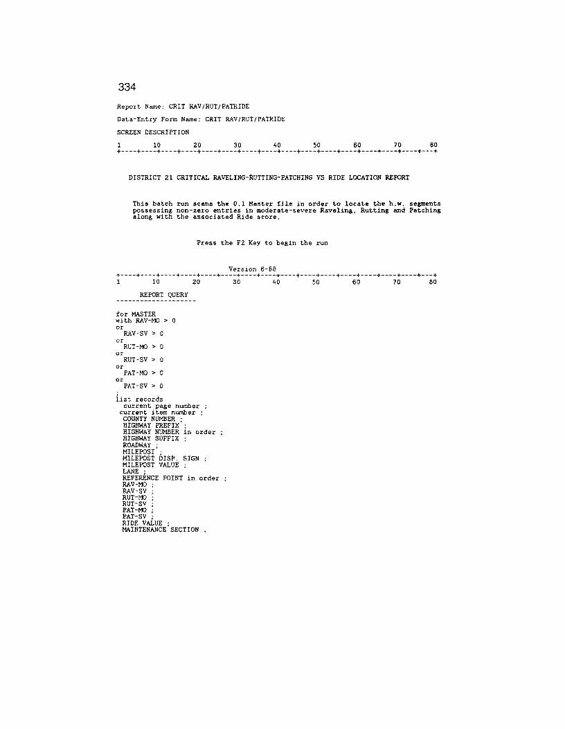
334
Report Name: CRIT RAV/RUT/PATRIDE
Data-Entry Form Name: CRIT RAV/RUT/PATRIDE
SCREEN DESCRIPTION
1 10 20 30 40 50 60 70 80 +----+----+----+----+----+----+----+----+----+----+----+----+----+----+----+---+
DISTRICT 21 CRITICAL RAVELING-RUTTING-PATCHING VS RIDE LOCATION REPORT
This batch run scans the O.l Master file in order to locate the h.w. segments possessing non-2ero entries in moderate-severe Raveling, Rutting and Patching along with the associated Ride score.
Press the F2 Key to begin the run
Version 6-88 +----+----+----+----+----+----+----+----+----+----+----+----+----+----+----+---+ 1 10 20 30 40 50 60 70 80
REPORT QUERY
for MASTER with RAV-MO > 0 or
RAV-SV > 0 or
RUT-MO > 0 or
RUT-SV > 0 or
PAT-MO > 0 or
PAT-SV > 0
list records current page number ;
current item number ; COUNTY NUMBER ; HIGHWAY PREFIX HIGHWAY NUMBER in order HIGHWAY SUFFIX ROADWAY ; MILEPOST ; MILEPOST DISP. SIGN MILEPOST VALUE ; LANE ; REFER.ENCE POINT in order RAV-MO RAV-SV RUT-MO RUT-SV PAT-00 PAT-SV · RIDE vAiuE ; MAINTENANCE SECTION
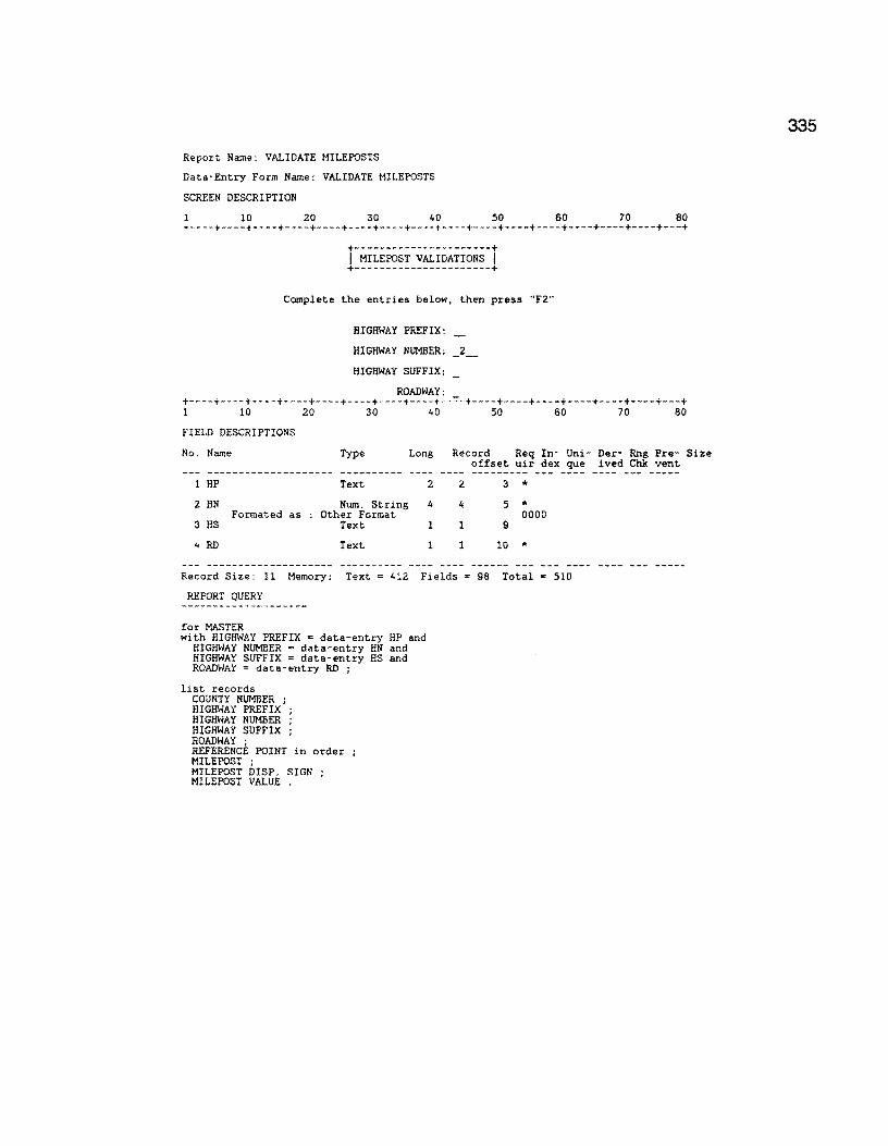
Report Name: VALIDATE MILEPOSTS
Data-Entry Form Name: VALIDATE MILEPOSTS
SCREEN DESCRIPTION
1 10 20 30 40 50 60 70 80 +----+----+----+----+----+----+----+----+----+----+----+----+----+----+----+---+
+----------------------+ I MILEPOST VALIDATIONS I +----------------------+
Complete the entries below, then press "F2"
HIGHWAY PREFIX:
HIGHWAY NUMBER: _2_
HIGHWAY SUFFIX:
ROADWAY: +----+----+----+----+----+----+----+----+--~-+----+----+----+----+----+----+---+ 1 10 20 30 40 50 60 70 80
FIELD DESCRIPTIONS
No. Name Type Long Record Req In- Uni- Der- Rng Pre- Size offset uir dex que ived Chk vent
-------------------- ----------1 HP Text 2 2 3 * 2 HN Num. String 4 4 5 *
Formated as Other Format 0000 3 HS Text l 1 9
4 RD Text l 1 10 *
Record Size: 11 Memory: Text = 412 Fields • 98 Total • 510
REPORT QUERY
for MASTER with HIGHWAY PREFIX = data-entry HP and
HIGHWAY NUMBER = data-entry HN and HIGHWAY SUFFIX = data-entry HS and ROADWAY ~ data-entry RD ;
list records COUNTY NUMBER ; HIGHWAY PREFIX ; HIGHWAY NUMBER ; HIGHWAY SUFFIX ; ROADWAY ; REFERENCE POINT in order MILEPOST ; MILEPOST DISP. SIGN MILEPOST VALUE .
335
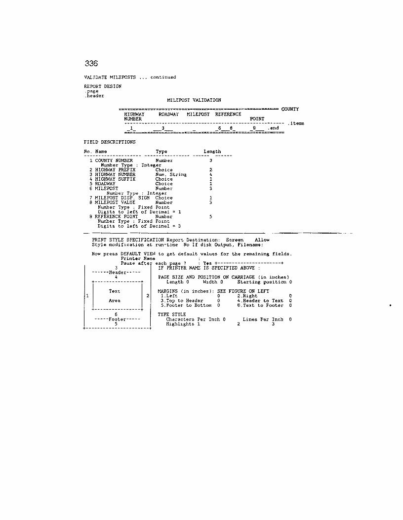
336
VALIDATE MILEPOSTS ... continued
REPORT DESIGN .page .header
MILEPOST VALIDATION
====;;:·----=============================·~-=--==--===-- COUNTY HIGHWAY ROADWAY MILEPOST REFERENCE NUMBER POINT -------------------------------------------------------- .items
.end
FIELD DESCRIPTIONS
No. Name Type Length
l COUNTY NUMBER Number 3 Number Type : Integer
2 HIGHWAY PREFIX Choice 2 3 HIGHWAY NUMBER Num. String 4 4 HIGHWAY SUFFIX Choice l 5 ROADWAY Choice 1 6 MILEPOST Number 3
Number Type : Integer 7 MILEPOST DISP. SIGN Choice 1 8 MILEPOST VALUE Number 3
Number Type : Fixed Point Digits to left of Decimal = 1
9 REFERENCE POINT Number 5 Number Type : Fixed Point Digits to left of Decimal 3
PRINT STYLE SPECIFICATION Report Destination: Screen Allow Style modification at run-time No If disk Output, Filename:
Now press DEFAULT VIEW to get default values for the remaining fields. Printer Name : Pause afte each page ? : Yes +----------------------+
3 ------Header-----
4 +----------------+
Text
IF PRINTER NAME IS SPECIFIED ABOVE :
PAGE SIZE AND POSITION ON CARRIAGE (in inches) Length 0 Width 0 Starting position 0
MARGINS (in inches): SEE FIGURE ON LEFT 2 l.Left 0 2.Right 0
Area
+----------------+ 6
-----Footer-----5
+----------------------+
3.Top to Header 0 4.Header to Text 0 5.Footer to Bottom 0 6.Text to Footer 0
TYPE STYLE Characters Per Inch 0 Highlights 1
Lines Per Inch 0 2 3
•

Report Name: MNT SEC MRG TO MASTR
REPORT QUERY
r-KJDIFY records in MASTER with ( MAINTENANCE SECTION > 0 ) MAINTENANCE SECTION := BLANK
for MAINTENANCE SECTIONS ; OODIFY RECORDS IN MASTER with
( COUNTY NUMBER = MAINTENANCE SECTIONS COUNTY NUMBER and HIGHWAY PREFIX = MAINTENANCE SECTIONS HIGHWAY PREFIX and HIGHWAY NUMBER = MAINTENANCE SECTIONS HIGHWAY NUMBER and HIGHWAY SUFFIX = MAINTENANCE SECTIONS HIGHWAY SUFFIX and ROADWAY = MAINTENANCE SECTIONS ROADWAY and REFERENCE POINT >= MAINTENANCE SECTIONS FRC»i REFERENCE and REFERENCE POINT <= MAINTENANCE SECTIONS TO REFERENCE )
MAINTENANCE SECTION :• MAINTENANCE SECTIONS MAINT SEC .
END REPORT FORMAT
l 10 20 30 40 50 60 70 80 +----+----+----+----+----+----+----+----+----+----+----+----+----+----+----+---+ .page
1
MASTER FILE HAS BEEN UPDATED WITH MAINTENANCE SECTION DATA
PRINT STYLE SPECIFICATION Report Destination: Screen Allow Style modification at run-time No If disk Output, Filename:
Now press DEFAULT VIEW to get default values for the remaining fields. Printer Name : Pause after each page ? : Yes +----------------------+
3 IF PRINTER NAME IS SPECIFIED ABOVE : ------Header-----
4 PAGE SIZE AND POSITION ON CARRIAGE (in inches) +----------------+ Length 0 Width 0 Starting position 0
Text
Area
+----------------+ 6
-----Footer-----5
MARGINS (in inches): SEE FIGURE ON LEFT 2 l.Left 0 2.Right 0
3.Top to Header 0 4.Header to Text O 5.Footer to Bottom 0 6.Text to Footer 0
TYPE STYLE Characters Per Inch 0 Lines Per Inch 0 Highlights l Special 4 2 3
+----------------------+
337
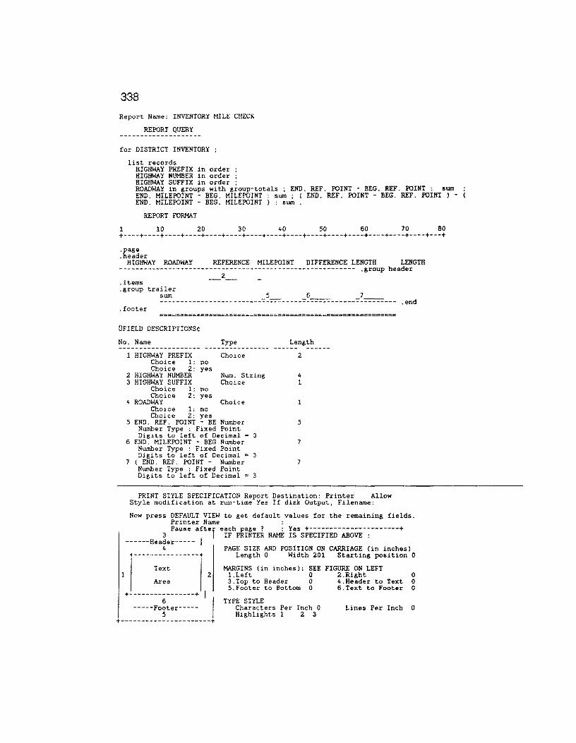
338
Report Name: INVENTORY MILE CHECK
REPORT QUERY
for DISTRICT INVENTORY
list records HIGHWAY PREFIX in order HIGHWAY NUMBER in order HIGHWAY SUFFIX in order ; ROADWAY in groups with group-totals ; END. REF. POINT - BEG. REF. POINT : sum END. MILEPOINT - BEG. MILEPOINT : sum ; ( END. REF. POINT BEG. REF. POINT ) -END. MILEPOINT - BEG. MILEPOINT ) : sum .
REPORT FORMAT
l 10 20 30 40 50 60 70 80 +----+----+----+----+----+----+----+----+----+----+----+----+----+----+----+---+
.page
.header HIGHWAY ROADWAY REFERENCE MILEPOINT DIFFERENCE LENGTH LENGTH
---------------------------------------------------------- .group header _2_
.end . footer
UFIELD DESCRIPTIONS¢
No. Name Type Length -------------------- ----------------
1
1
2 3
4
HIGHWAY PREFIX Choice 1: no Choice 2: yes
HIGHWAY NUMBER HIGHWAY SUFFIX
Choice 1: no Choice 2: yes
ROADWAY Choice 1: no Choice 2: yes
Choice
Num. String Choice
Choice
5 END. REF. POINT - BE Number Number Type : Fixed Point Digits to left of Decimal = 3
6 END. MILEPOINT - BEG Number Number Type : Fixed Point Digits to left of Decimal = 3
7 { END. REF. POINT - Number Number Type : Fixed Point Digits to left of Decimal = 3
2
4 1
1
5
7
7
PRINT STYLE SPECIFICATION Report Destination: Printer Allow Style modification at run-time Yes If disk Output, Filename:
Now press DEFAULT VIEW to get default values for the remaining fields. Printer Name :
3 Pause aftef eIFh~I~T~ NAME j;sS;E~IFIED-ABOVE-~-------+ ------Header----- I
4 PAGE SIZE AND POSITION ON CARRIAGE (in inches) +----------------+ Length 0 Width 201 Starting position 0
Text MARGINS (in inches): SEE FIGURE ON LEFT 2 l.Left 0 2.Right 0
Area
+--------55-------+ I I -----Footer-----
3.Top to Header 0 4.Header to Text 0 5.Footer to Bottom 0 6.Text to Footer 0
TYPE STYLE Characters Per Inch 0 Highlights l 2 3
Lines Per Inch 0
+----------------------+
Report Name: SORT INVENTORY FILE
REPORT QUERY
for DISTRICT INVENTORY
list records COUNTY NUMBER ; HIGHWAY PREFIX in order HIGHWAY NUMBER in order HIGHWAY SUFFIX in order ROADWAY in order ; BEG. REF. POINT in order END. REF. POINT ; MILEPOST ; MILEPOST DISP. SIGN MILEPOST VALUE CONTROL ; SECTION ; BEG. MILEPOINT END. MILEPOINT LAP .
end delete records in DISTRICT INVENTORY .
REPORT FORMAT
1 10 20 30 40 50 60 70 80 +----+----+----+----+----+----+----+----+----+----+----+----+----+----+----+---+
.page COUNTY NUMBER;HIGHWAY PREFIX;HIGHWAY NUMBER;HIGHWAY SUFFIX;ROADWAY;BEG. REF. POI NT;END. REF. POINT;MILEPOST;MILEPOST DISP. SIGN;MILEPOST VALUE;CONTROL;SECTION;B EG. MILEPOINT;END. MILEPOINT;LAP . items _1_;_;_3_;_;_;_6_;_7_;_8_;_;_;_11_;_;_13_;_14_;_ .end
FIELD DESCRIPTIONS
No. Name Type
l COUNTY NUMBER Number Type :
Number Integer
Choice 2 HIGHWAY PREFIX Choice 1: no Choice 2: yes
3 HIGHWAY NUMBER 4 HIGHWAY SUFFIX
Choice l: no Choice 2: yes
5 ROADWAY Choice 1: no Choice 2: yes
Num. String Choice
Choice
6 BEG. REF. POINT Number Number Type Fixed Point Digits to left of Decimal = 3
7 END. REF. POINT Number Number Type Fixed Point Digits to left of Decimal 3
8 MILEPOST Number Number Type Integer
9 MILEPOST DISP. SIGN Choice Choice 1: no Choice 2: yes
10 MILEPOST VALUE Number Number Type Fixed Point Digits to left of Decimal = 1
11 CONTROL Num. String 12 SECTION Num. String 13 BEG. MILEPOINT Number
Number Type Fixed Point Digits to left of Decimal = 2
14 END. MILEPOINT Number Number Type Fixed Point Digits to left of Decimal = 2
15 LAP Choice Choice 1: no
Length
3
2
4 l
1
5
5
3
1
3
4 2 6
6
3
*
* *
*
*
*
* *
* ... * *
...
339

340
Sort Inventory File ... continued
1
PRINT STYLE SPECIFICATION Report Destination: Disk Allow Style modification at run-time No If disk Output, Filename: INV.DAT
Now press DEFAULT VIEW to get default values for the remaining fields. Printer Name : Pause afte each page ? : Yes +----------------------+
3 ------Header-----
4 +----------------+
Text
Area
+----------------+ 6
-----Footer-----5
IF PRINTER NAME IS SPECIFIED ABOVE :
PAGE SIZE AND POSITION ON CARRIAGE (in inches) Length O Width 201 Starting position O
MARGINS (in inches): SEE FIGURE ON LEFT 2 l.Left 0 2.Right 0
3.Top to Header 0 4.Header to Text 0 5.Footer to Bottom 0 6.Text to Footer 0
TYPE STYLE Characters Per Inch 0 Lines Per Inch 0 Highlights 1 2 3
+----------------------+
•

Report Name: CREATE MASTER FILE
Data-Entry Form Name: CREATE MASTER FILE
SCREEN DESCRIPTION
1 10 20 30 40 50 60 70 80 +----+----+----+----+----+----+----+----+----+----+----+----+----+----+----+---+
+----------------------------------------------------+ I ADD, M:>DIFY, OR CREATE MASTER ( O. 1 mi. ) FILE RECORDS I +----------------------------------------------------+
ENTER HIGHWAY: _2_
NOTE: FOR ALL ROADS ENTER "XXOOOOX"
+----------------------+ !PRESS "F2" TO CONTINUE! +----------------------+ +----+----+----+----+----+----+----+----+----+----+----+----+----+----+----+---+
1 10 20 30 40 50 60 70 80
FIELD DESCRIPTIONS
No. Name Type Long Record Req In- Uni- Der- Rng Pre- Size
1 PREFIX
2 NUMBER
3 SUFFIX
Text
Num. String
Text
2
4
1
2
4
1
offset uir dex que ived Chk vent
3
5
9
Record Size: 10 Memory: Text= 455 Fields = 86 Total = 541
REPORT QUERY
define "tc" Number . define "CSl" Text 7 . define "CS2" Text 7 . define "MP" Number . define "MPS" Text l . define "MPD" Number . define "CC" Number . define "test" Number . define "LPl" Text, 2 . define "LP2" Text 2 . define "LNl" Numeric String 4 define "LN2" Numeric String 4 define "LSl" Text l . define "LSZ" Text l . if data-entry PREFIX "' "XX" then
assign temp LPl ·= "PR" assign temp LP2 ·= "IH" . assign temp LNl ·= 0000 . assign t,emp LNZ ·= 9999 . assign temp LSl ·= "•" assign temp LS2 "*"
else assign assign assign assign assign assign
end
temp LPl temp LP2 temp LNl temp LN2 temp LSl temp LS2
·= data-entry ·• data-entry ·• data-entry ·= data-entry ·= data-entry
data-entry
for DISTRICT INVENTORY wit,h
PREFIX PREFIX NUMBER NUMBER SUFFIX SUFFIX
HIGHWAY PREFIX between temp LPl to temp LP2 and HIGHWAY NUMBER between temp LNl to temp LN2 and
HIGHWAY SUFFIX between temp LSl to temp LS2 ; assign temp MP := MILEPOST . assign temp MPS :•MILEPOST DISP. SIGN . assign temp MPD :=MILEPOST VALUE * 10 assign temp tc :=BEG. REF. POINT" 10 . assign temp CC := 0 . if LAP = yes then
assign temp CC :• 1 . end while ceil ( END. REF. POINT• 10 ) >= ceil ( temp tc ) do if LAP= yes and temp CC not• 1 then assign temp CSl :• JOINTEXT (CONTROL, JOINTEXT ( "-",SECTION) ) .
end if LAP • yes and temp CC = 1 then
assign temp CS2 :; JOINTEXT {CONTROL , JOINTEXT C "-",SECTION) ) . end if LAP = yes and temp CC not • l then assign temp CS2 := BLANK . end
341

342
Create Master File ... continued
if LAP = no then
end assign temp CS2 := BLANK .
Report Name: CREATE MASTER FILE Continued ...
REPORT QUERY
if LAP = no then assign temp CSl ·= JOINTEXT (CONTROL , JOINTEXT ( "-",SECTION ) ) .
end list records
COUNTY NUMBER ; HIGHWAY PREFIX HIGHWAY NUMBER HIGHWAY SUFFIX ROADWAY ; temp tc I 10 ; temp MP ; temp MPS ; temp MPD I 10 ; temp CSl ; temp CS2 .
assign temp tc := temp tc + 1 . if temp MPS "+" then
assign temp MPD ·= temp MPD + l end if temp MPS = ,._., then
end assign temp MPD ·= temp MPD - l
if temp MPS = •• _ .. and floor ( temp MPD ) = 0 then assign temp MPS := "+" . assign temp MPD := 0 .
end if temp MPS = "+" and mod ( temp MPD , 20 ) < 1 then if mod ( temp MP , 2 ) not < l then
end
temp MPD := temp MPD - 10 temp MP := temp MP + 1 .
end
if temp MPS = "+" and mod ( temp MPD , 20 ) < 1 then if temp MPD not • 0 then temp MPD := 0 . temp MP := temp MP + 2 . end
end assign temp cc := 2 .
end
REPORT FORMAT
10 20 30 40 50 60 70 80 +----+----+----+----+----+----+----+----+----+----+----+----+----+----+----+---+
.page COUNTY NUMBER;HIGHWAY PREFIX;HIGHWAY NUMBER;HIGHWAY SUFFIX;ROADWAY;REFERENCE POI NT;MILEPOST;MILEPOST DISP. SIGN;MILEPOST VALUE;CSl;CS2 .items _1_;_;_3_;_;_;_6_;_7_;_;_9_;_10 __ ;_11 __ .end
FIELD DESCRIPTIONS
No. Name Type
1 COUNTY NUMBER Number Number Type : Integer
2 HIGHWAY PREFIX Choice Choice 1: no Choice 2: yes
3 HIGHWAY NUMBER Num. String 4 HIGHWAY SUFFIX Text 5 ROADWAY Choice
Choice 1: no Choice 2: yes
6 temp tc I 10 Number Number Type : Fixed Point Digits to left of Decimal = 3
7 temp MP Number Number Type : Integer
8 temp MPS Text 9 temp MPD I 10 Number
Number Type : Fixed Point Digits to left of Decimal 1
10 temp CSl Text 11 temp CSZ Text
Length
3 * 2
4 l 1
5 *
3 * 1 3 *
7 7

CREATE MASTER FILE ---continued
1
PRINT STYLE SPECIFICATION Report Destination: Disk Allow Style modification at run-time No If disk Output, Filename: MASTR.EXP
Now press DEFAULT VIEW to get default values for the remaining fields. Printer Name : Pause after each page ? : Yes +----------------------+
3 ------Header-----
4
IF PRINTER NAME IS SPECIFIED ABOVE :
PAGE SIZE AND POSITION ON CARRIAGE (in inches) +----------------+ Length O Width O Starting position 0
Text
Area
+----------------+ 6
-----Footer-----5
2
I I
MARGINS (in inches): SEE FIGURE ON LEFT l.Left 0 2.Right 3.Top to Header 0 4.Header to Text 5.Footer to Bottom 0 6.Text to Footer
TYPE STYLE Characters Per Inch 0 Highlights l
Lines Per Inch 2 3
0 0 0
0
+----------------------+
343
344
Report Name: ORDERED MASTER FILE
REPORT QUERY
delete records in TEMP for MASTER
list records COUNTY NUMBER ; HIGHWAY PREFIX in order HIGHWAY NUMBER in order HIGHWAY SUFFIX in order ROADWAY in order ; REFERENCE POINT in order MILEPOST ; MILEPOST DISP. SIGN MILEPOST VALUE .
REPORT FORMAT
1 10 20 30 40 50 60 70 80 +----+----+----+----+----+----+----+----+----+----+----+----+----+----+----+---+ .page COUNTY NUMBER;HIGHWAY PREFIX;HIGHWAY NUMBER;HIGHWAY SUFFIX;ROADWAY;REFERENCE POI NT;MILEPOST;MILEPOST DISP. SIGN;MILEPOST VALUE .items l· ·3 ···6 ·7··9 -:end-'- _._._,_ -'- _._,_ -
8iit~6;6i~~~ibi±g~~~ 9 ; 999 : 9 ; 9 · 9
No. Name Type Length Remove Spaces ---
l COUNTY NUMBER Nwnber 3 * Nwnber Type : Integer 2 HIGHWAY PREFIX Choice 2 *
Related Form Not Found 3 HIGHWAY NUMBER Num. String 4 * 4 HIGHWAY SUFFIX Choice l .,.
Related Form Not Found 5 ROADWAY Choice *
Related Form Not Found 6 REFERENCE POINT Number 5 * Number Type : Fixed Point
Digits to left of Decimal = 3 7 MILEPOST Number 3 *
Number Type Integer 8 MILEPOST DISP. SIGN Choice * Related Form Not Found 9 MILEPOST VALUE Number 3 * Number Type : Fixed Point
Digits to left of Decimal = l
PRINT STYLE SPECIFICATION Report Destination: Disk Allow Style modification at run-time No If disk Output, Filename: SORT.DAT
Now press DEFAULT VIEW to get default values for the remaining fields. Printer Name : Pause after each page ? : Yes +----------------------+
3 ------Header-----
4
IF PRINTER NAME IS SPECIFIED ABOVE :
PAGE SIZE AND POSITION ON CARRIAGE (in inches) +----------------+ Length 0 Width 0 Starting position 0
1 Text
Area
+----------------+ 6
-----Footer-----5
2
I I +----------------------+
MARGINS (in inches): SEE FIGURE ON LEFT 1.Left 0 2.Right 3.Top to Header O 4.Header to Text 5.Footer to Bottom 0 6.Text to Footer
TYPE STYLE Characters Per Inch 0 Lines Per Inch Highlights 1 2 3
0 0 0
0

Report Name:' GENERATE FWD FILE
REPORT QUERY
delete records in FWD INPUT define "HWYl" Text 15 define "HWY2" Text 15 define "HWY" Text 15 . define "MPl" Text 9 . define ••MP2" Text 9 . define "MP" Text 9 . define "CNT" Number . define "FRST" Number . define "SC" Number . define "Rl" Text 31 . temp FRST := 0 temp SC := 0 . for TEMP ;
if temp FRST 0 then temp HWYl := jointext ( COUNTY NUMBER , jointext ( ";" , jointext ( HIGHWAY PREFIX
, jointext ( ";" , jointext ( HIGHWAY NUMBER , jointext ( ";" jointext ( HIGHWAY SUFFIX , jointext ( .. ; .. • ROADWAY ) ) ) ) ) ) ) ) .
temp HWY2 := temp HWYl . temp MPl := jointext ( MILEPOST , jointext ( ";" , jointext ( MILEPOST DISP. SIGN , jointext ( ";" , MILEPOST VALUE ) l ) l . temp MP2 :=temp MPl .
temp SC := REFERENCE POINT * 10 end temp HWYl := jointext ( COUNTY NUMBER , jointext ( ";" , jointext ( HIGHWAY PREFIX ,
jointext ( "; ·· , jointext ( HIGHWAY NUMBER , jointext "·" , jointext ( HIGHWAY SUFFIX , jointext ( ";" , ROADWAY ) ) ) l ) ) ) ) .
temp CNT : REFERENCE POINT * 10 . temp MP2 := temp MPl . temp MPl := jointext ( MILEPOST , jointext. ( "·" , joint.ext. ( MILEPOST DISP. SIGN ,
joint.ext ( ";" , MILEPOST VALUE ) ) ) ) . if temp FRST > 0 then
temp SC := temp SC + 1 . end if temp HWYl not = HWY2 or firstc ( temp SC , length ( temp SC )) not = firstc (
temp CNT , length ( CNT )) then temp HWY := temp HWY2 . temp MP := temp MP2 . temp SC := ( temp SC - 1 ) I 10 . temp Rl := joint.ext ( temp HWY , joint.ext ( ";" , joint.ext ( temp SC , jointext (
" ; " , temp MP ) l ) ) . temp SC := temp SC * 10 . if mod ( temp SC , 5 ) >= l and mod ( temp SC , 5 ) <= 4 then
list records temp Rl .
end temp HWY2 := temp HWYl temp SC := temp CNT .
end end
define "HWY" Text 15 define "MP" Text 9 . define "SC" Number . define "CNT" Number . define "FRST" Number define "R" Text 31 temp FRST := 0 for TEMP ;
if temp FRST = 0 then temp SC := REFERENCE POINT * 10 .
end temp HWY := jointext ( COUNTY NUMBER , jointext ( ";" , jointext C HIGHWAY PREFIX ,
jointext ( ";" , joint.ext (HIGHWAY NUMBER , joint.ext ( ";" , jointext (HIGHWAY SUFFIX , jointext ( ··;" , ROADWAY ) ) ) ) ) ) l ) .
temp MP :=joint.ext C MILEPOST , jointext ( ";" , jointext ( MILEPOST DISP. SIGN , jointext C ";" , MILEPOST VALUE ) ) l ) .
temp CNT := REFERENCE POINT * 10 . if temp FRST not ~ O then
temp SC := temp SC + 1 . end temp FRST := l . if mod ( temp CNT , 5 ) < 0.9 or mod ( temp CNT , 5 ) > 4 or firstc ( temp SC ,
length ( temp SC )) not= firstc ( temp CNT , length ( CNT )) then temp CNT := temp CNT I 10 . temp R :=joint.ext ( temp HWY , joint.ext ( ";" , jointext ( temp CNT , joint.ext "; " , temp MP ) ) ) ) . if COUNTY NUMBER not = 999 then list records
temp R . end temp CNT := REFERENCE PCINT * 10 . temp SC := temp CNT .
end end.
345

346
Report Name: GENERATE FWD FILE Continued ...
REPORT QUERY
temp FRST := 1 .
REPORT FORMAT
1 10 20 30 40 50 60 70 80 +----+----+----+----+----+----+----+----+----+----+----+----+----+----+----+---+ .page COUNTY NUMBER;HIGHWAY PREFIX;HIGHWAY NUMBER;HIGHWAY SUFFIX;ROADWAY;REFERENCE POI NT;MILEPOST;MILEPOST DISP. SIGN;MILEPOST VALUE .items _l 2 .end
UFIELD DESCRIPTIONS¢
No. Name Type Length Remove Spaces ---
l
1 temp Rl 2 temp R
Text Text
31 31
* *
PRINT STYLE SPECIFICATION Report Destination: Disk Allow
Now Style modification at run-time No If disk Output, Filename: FWD.EXP
press DEFAULT VIEW to get default values for the remaining fields. Printer Name : Pause afte each page ? : Yes +----------------------+
3 ------Header-----
4 +----------------+
Text
Area
+----------------+ 6
-----Footer-----5
IF PRINTER NAME IS SPECIFIED ABOVE :
PAGE SIZE AND POSITION ON CARRIAGE (in inches) Length 0 Width 0 Starting position 0
MARGINS (in inches): SEE FIGURE ON LEFT 2 l.Left 0 2.Right 0
3.Top to Header 0 4.Header to Text 0 5.Footer to Bottom 0 6.Text to Footer 0
TYPE STYLE Characters Per Inch 0 Lines Per Inch 0 Highlights 1 Special 4 2 3
+----------------------+

Report Name: FWD SORTED
REPORT QUERY
for FWD INPUT ;
list records COUNTY NUMBER in order ; HIGHWAY PREFIX in order HIGHWAY NUMBER in order HIGHWAY SUFFIX in order ROADWAY in order ; REFERENCE POINT in order MILEPOST ; MILEPOST DISP. SIGN MILEPOST VALUE .
end . delete records in FWD INPUT
REPORT FORMAT
1 10 20 30 40 50 60 70 80 +----+----+----+----+----+----+----+----+----+----+----+----+----+----+----+---+ .page
COUNTY NUMBER;HIGHWAY PREFIX;HIGHWAY NUMBER;HIGHWAY SUFFIX;ROADWAY;REFERENCE POI NT;MILEPOST;MILEPOST DISP. SIGN;MILEPOST VALUE .items 1· ·3 ···6 ·7··9 ~end-'- _,_._._ -·- _,_,_ -FIELD DESCRIPTIONS
No. Name Type Length
l
1 COUNTY NUMBER Number Number Type : Integer
2 HIGHWAY PREFIX Text 3 HIGHWAY NUMBER Num. String 4 HIGHWAY SUFFIX Text 5 ROADWAY Text 6 REFERENCE POINT Number
Number Type Fixed Point Digits to left of Decimal = 3
7 MILEPOST Number Number Type : Integer
8 MILEPOST DISP. SIGN Choice Related Form Not Found
9 MILEPOST VALUE Number Number Type Fixed Point Digits to left of Decimal = l
3
2 4 1 1 5
3
1
3
* * * * * *
* *
*
PRINT STYLE SPECIF'ICATioN Report Destination: Disk Allow Style modification at run-time No lf disk Output, Filename:FWD.EXP
Now press DEFAULT VIEW to get default values for the remaining fields. Printer Name : Pause after each page ? : Yes +----------------------+
3 ------Header-----
4 +----------------+
Text
Area
+----------------+ 6
-----Footer-----5
IF PRINTER NAME IS SPECIFIED ABOVE :
PAGE SIZE AND POSITION ON CARRIAGE (in inches) Length 861 Width 0 Starting position 0
MARGINS (in inches): SEE FIGURE ON LEFT 2 l.Left 0 2.Right 0
3.Top to Header 0 4.Beader to Text 0 5.Footer to Bottom 0 6.!ext to Footer 0
TYPE STYLE Characters Per Inch 0 Lines Per Inch 0 Highlights l 2 3
+----------------------+
347
348
Report Name: ORDERED R MASTER
REPORT QUERY
delete records in TEMP
for MASTER with ROADWAY • R or ROADWAY = A list records
COUNTY NUMBER in order ; HIGHWAY PREFIX in order ; HIGHWAY NUMBER in order ; HIGHWAY SUFFIX in order ; ROADWAY in order ; REFERENCE POINT in order MILEPOST ; MILEPOST DISP. SIGN MILEPOST VALUE .
end
REPORT FORMAT
i io 20 30 4o 50 60 10 ao +----+----+----+----+----+----+----+----+----+----+----+----+----+----+----+---+ .page COUNTY NUMBER;HIGHWAY PREFIX;HIGHWAY NUMBER;HIGHWAY SUFFIX;ROADWAY;REFERENCE POI NT;MILEPOST;MILEPOST DISP. SIGN;MILEPOST VALUE .items ~;n~~;_3~;_;_;_6~;_7_;_;_9_
FIELD DESCRIPTIONS
No. Name Type Length
1
l COUNTY NUMBER Number Number Type : Integer
Z HIGHWAY PREFIX Choice Related Form Not Found
3 HIGHWAY NUMBER Num. String 4 HIGHWAY SUFFIX Choice
Related Form Not Found 5 ROADWAY Choice
Related Form Not Found 6 REFERENCE POINT Number
Number Type : Fixed Point Digits to left of Decimal = 3
7 MILEPOST Number Number Type : Integer
8 MILEPOST DISP. SIGN Choice Related Form Not Found
9 MILEPOST VALUE Number Number Type : Fixed Point Digits to left of Decimal =
3 * 2 * 4 * 1 *
* 5 *
3 * 1 * 3 *
PRINT STYLE SPECIFICATION Report Destination: Disk Allow Style modification at run-time No If disk Output, Filename: hulll.SRT
Now press DEFAULT VIEW to get default values for the remaining fields. Printer Name : Pause afte each page ? : Yes +----------------------+
3 ------Header-----
4 +----------------+
Text
Area
+----------------+ 6
-----Footer-----5
IF PRINTER NAME IS SPECIFIED ABOVE :
PAGE SIZE AND POSITION ON CARRIAGE Cin inches) Length 0 Width 0 Starting position O
MARGINS (in inches): SEE FIGURE ON LEFT 2 l.Left O 2.Right O
3.Top to Header 0 4.Beader to Text 0 5.Footer to Bottom O 6.Text to Footer 0
TYPE STYLE Characters Per Inch 0 Highlights l 2
Lines Per Inch 0 3
+----------------------+

Report Name: ORDERED L MASTER
REPORT DEFINITION
REPORT QUERY
for MASTER with ROADWAY = L or ROADWAY = X list records
COUNTY NUMBER ; HIGHWAY PREFIX in order HIGHWAY NUMBER in order HIGHWAY SUFFIX in order ROADWAY in order ; REFERENCE POINT in reverse MILEPOST ; MILEPOST DISP. SIGN MILEPOST VALUE .
REPORT FORMAT
l 10 20 30 40 50 60 70 80 +----+----+----+----+----+----+----+----+----+----+----+----+----+----+----+---+ .page .items
. 3 ... 6 . 7 .. 9 , __ ._,_,_ -·- _,_,_ -999;99;9999;9;9;999.9;999;9;9.9 .call COPY BULL1.SRT+BULL2.SRT SORT.OAT
FIELD DESCRIPTIONS
No. Name Type Length
1
l COUNTY NUMBER Number Number Type : Integer
2 HIGHWAY PREFIX Choice 3 HIGHWAY NUMBER Nurn. String 4 HIGHWAY SUFFIX Choice 5 ROADWAY Choice 6 REFERENCE POINT Number
Number Type : Fixed Point Digits to left of Decimal = 3
7 MILEPOST Number Number Type : Integer
8 MILEPOST DISP. SIGN Choice 9 MILEPOST VALUE Number
Number Type : Fixed Point Digits to left of Decimal =
3 * 2 * 4 * l * 1 " 5 "
3 " l " 3 "
PRINT STYLE SPECIFICATION Report Destination: Disk Allow
Now Style modification at run-time No If disk Output, Filename: C:BULL2.SRT
press DEFAULT VIEW to get default values for the remaining fields. Printer Name : Pause after each page ? : Yes +----------------------+
3 ------Header-----
4 +----------------+
Text
Area
+----------------+ 6
-----Footer-----5
IF PRINTER NAME IS SPECIFIED ABOVE :
PAGE SIZE AND POSITION ON CARRIAGE (in inches) Length 0 Width 0 Starting position 0
MARGINS (in inches): SEE FIGURE ON LEFT 2 l.Left 0 2.Right 0
3.Top to Header 0 4.Header to Text 0 5.Footer to Bottom 0 6.Text to Footer 0
TYPE STYLE Characters Per Inch 0 Lines Per Inch 0 Highlights 1 2 3
+----------------------+
349

350
Report Name: GENERATE RIDE FILE
REPORT QUERY
delete records in RIDE INPUT .
define "SC" Number . define "FRM" Number . define "HWYl" Text 15 define "HWY2" Text 15 define "FRST" Number . define "CNT" Number . define "TO" Number . define "LMP" Text 9 . define "RD" Text 1 .
assign temp FRST ·= 0
for TEMP ;
if temp FRST = 0 then assign temp SC := REFERENCE POINT * 10 assign temp RD := ROADWAY . if ROADWAY = "L" or ROADWAY "X" then
assign temp TO := temp FRM - 2 . end if ROADWAY "R" or ROADWAY = "A" then
assign temp TO := temp FRM + 2 . end
assign temp FRM :• REFERENCE POINT * 10 .
assign temp LMP := jointext (MILEPOST , jointext ( ";", jointext (MILEPOST DI SP. SIGN , JOintext ( ";". MILEPOST VALUE ) J J J .
assign temp HWYl := jointext ( COUNTY NUMBER , jointext ( ";" PREFIX , JOINTEXT ( .. ; " , jointext ( HIGHWAY NUMBER , JOINTEXT HIGHWAY SUFFIX , jointext ( ";" , ROADWAY ) ) ) ) ) ) ) ) .
JOINTEXT C HIGH WAY ";" , joint ext (
assign temp HWY2 jointext ( COUNTY NUMBER , jointext ( ";" , JOINTEXT ( HIGH WAY PREFIX , JOINTEXT ( ";" , jointext ( HIGHWAY NUMBER , JOINTEXT ( ";" , joint ext ( HIGHWAY SUFFIX , joint.ext ( ";" . ROADWAY ) ) ) ) ) ) J J . end assign temp HWY2 := jointext ( COUNTY NUMBER , jointext ( ";" , JOINTEXT C HIGHWAY PREFIX , JOINTEXT ( ";" , jointext ( HIGHWAY NUMBER , JOINTEXT { ";" , jointe xt ( HIGHWAY SUFFIX , jointext ( ";" , ROADWAY l l ) ) ) ) ) ) .
assign temp CNT := REFERENCE POINT * 10 . if temp FRST not = 0 then if ROADWAY = "L" or ROADWAY = "X" then
end assign temp SC := temp SC 1 .
if ROADWAY = "R" or ROADWAY "A" then assign temp SC ·= temp SC + l .
end end assign temp FRST := 1 if temp HWYl not= temp HWY2 or firstc ( temp CNT , length ( temp CNT )) not = f irstc ( temp SC , length ( temp SC )) or
firstc ( temp SC , length ( temp SC )) = firstc ( temp TO , length ( temp T 0 )) then
if temp HWYl not= temp HWY2 or firstc ( temp CNT , length ( temp CNT )) not= firstc ( temp SC , length ( temp SC )) then if ( temp RD= "R" or temp RD"' "A" ) and COUNTY NUMBER not • 999 then temp SC := temp SC - l .
end if ( temp RD = "L" or temp RD "X" ) and COUNTY NUMBER not = 999 then temp SC := temp SC + 1 .
end end if ( temp FRM + 1 <= temp SC and ( temp RD = "R" or temp RD = "A" ) ) or ( temp FRM -
1 >= temp SC and ( temp RD = "L" or temp RD = "X" )) then list records
temp HWYl ; temp FRM I 10 ; temp SC I 10 ; temp LMP .
end assign temp FRM := REFERENCE POINT * 10 . assign temp SC := REFERENCE POINT * 10 . assign temp HWYl := temp HWY2 . assign temp LMP := jointext (MILEPOST, jointext ( ";", jointext (MILEPOST DISP.
SIGN , jointext ( ";", MILEPOST VALUE ) ) ) ) .
end
assign temp RD := ROADWAY . if ROADWAY = "L" or ROADWAY end
"X" then assign temp TO ·= temp FRM 2
if ROADWAY = "R" or ROADWAY = "A" then assign temp TO ·= temp FRM + 2 end

Report Name: GENERATE RIDE FILE Continued ...
REPORT QUERY
REPORT FORMAT
1 10 20 30 40 50 60 70 80 +----+----+----+----+----+----+----+----+----+----+----+----+----+----+----+---+ .page COUNTY NUMBER;HIGHWAY PREFIX;HIGHWAY NUMBER;HIGHWAY SUFFIX;ROADWAY;FROM;REFER.ENC E POINT;MILEPOST;MILEPOST DISP. SIGN;MILEPOST VALUE .items
1-..... _____ ;_2_;_3_;_ 4 __ _ -:-end
FIELD DESCRIPTIONS
No. Name Type Length
15
1
1 temp HWYl Text 2 temp FRM I 10 Number
Number Type : Fixed Point Digits to left of Decimal = 3
3 temp SC f 10 Number Number Type : Fixed Point Digits to left of Decimal = 3
4 temp LMP Text
5
5
9
* *
*
*
PRINT STYLE SPECIFICATION Report Destination: Disk Allow Style modification at run-time No If disk Output, Filename: RIDE.EXP Now press DEFAULT VIEW to get default values for the remaining fields.
Printer Name : Pause afte each page ? : Yes +----------------------+
3 ------Header-----
4 +----------------+
Text
Area
+----------------+ 6
-----Footer-----5
IF PRINTER NAME IS SPECIFIED ABOVE :
PAGE SIZE AND POSITION ON CARRIAGE (in inches) Length O Width O Starting position 0
MARGINS (in inches): SEE FIGURE ON LEFT 2 I.Left 0 2.Right 0
I I 3.Top to Header 0 4.Header to Text 0 5.Footer to Bottom 0 6.Text to Footer 0
TYPE STYLE Characters Per Inch 0 Highlights 1 Special 4
Lines Per Inch 0 2 3
+----------------------+
351

352
Report Name: RIDE SORTED
REPORT QUERY
for RIDE INPUT ;
list records COUNTY NUMBER in order ; HIGHWAY PREFIX in order HIGHWAY NUMBER in order HIGHWAY SUFFIX in order ROADWAY in order ; REFERENCE POINT in order MILEPOST ; MILEPOST DISP. SIGN ; MILEPOST VALUE .
end . delete records in RIDE INPUT
REPORT FORMAT
1 10 20 30 40 50 60 70 80 +----+----+----+----+----+----+----+----+----+----+----+----+----+----+----+---+ .page COUNTY NUMBER;HIGHWAY PREFIX;HIGHWAY NUMBER;HIGHWAY SUFFIX;ROADWAY;REFERENCE POI NT;MILEPOST;MILEPOST DISP. SIGN;MILEPOST VALUE .items l· ·3 ···6 ·7··9 :-end_. __ ,_,_,_ -·- -· ·- -
FIELD DESCRIPTIONS
No. Name Type Length -------------------- ----------------
1
1 COUNTY NUMBER Number 3 * Number Type : Integer
2 HIGHWAY PREFIX Text 2 * 3 HIGHWAY NUMBER Num. String 4 * 4 HIGHWAY SUFFIX Text 1 * 5 ROADWAY Text 1 * 6 REFERENCE POINT Number 5 ..
Number Type : Fixed Point Digits to left of Decimal 3
7 MILEPOST Number 3 * Number Type Integer
8 MILEPOST DISP. SIGN Choice l .. Choice l: no Choice 2: yes
9 MILEPOST VALUE Number 3 * Number Type Fixed Point Digits to left of Decimal ~ 1
PRINT STYLE SPECIFICATION Report Destination: Disk Allow Style modification at run-time No If disk Output, Filename: RIDE.EXP
Now press DEFAULT VIEW to get default values for the remaining fields. Printer Name : Pause after each page ? : Yes +----------------------+
3 IF PRINTER NAME IS SPECIFIED ABOVE : ------Header-----
4 +----------------+
Text
Area
+----------------+ 6
-----Footer-----5
PAGE SIZE AND POSITION ON CARRIAGE (in inches) Length 805 Width 0 Starting position 0
MARGINS (in inches): SEE FIGURE ON LEFT 2 I.Left 0 2.Right 0
3.Top to Header O 4.Header to Text 0 5.Footer to Bottom 0 6.Text to Footer 0
I I TYPE STYLE Characters Per Inch 0 Highlights 1 2 3
Lines Per Inch 805
+----------------------+
Report Name: GENERATE SKID FILE
REPORT QUERY
delete records in SKID define "HWYl" text 16 define "HWY2" text 16 define "MP" text 9 . define "RD" text 1 . define "FRST'' Number . define "CNT" Number . define "SC" Number . define "STRT" Number . define "ALL" text 31 . define "ALL2" text 31 define "TST" Number temp FRST := 0 temp STRT := 0 for TEMP ;
0 then
INPUT
if temp FRST = temp HWYl := jointext ( COUNTY NUMBER , jointext ( ";" , jointext ( HIGHWAY PREFIX ,
jointext ( ";" , jointext (HIGHWAY NUMBER , jointext ( ";" , jointext ( HIGHWAY SUFFIX , jointext ( ";" , jointext ( ROADWAY , ";" ) ) ) ) ) ) ) J ) • temp HWY2 ·= temp HWYl .
temp RD := ROADWAY . temp CNT := REFERENCE POINT * 10 temp SC := temp CNT . if temp RD = "R" or temp RD = "A" then
temp SC ·= temp SC + 2 else
temp SC temp SC - 2 end
end temp FRST ·= 1 .
temp CNT := REFERENCE POINT * 10 . temp HWYl := jointext C COUNTY NUMBER , jointext ( ";" , jointext ( HIGHWAY PREFIX ,
joint.ext ( ";" , joint.ext ( HIGHWAY NUMBER , jointext ( ";" , jointext (HIGHWAY SUFFIX , jointext ( ";" , jointext (ROADWAY , ";" l l ) ) ) ) ) ) ) . temp MP := joint.ext ( MILEPOST , jointext ( ";" ,
joint.ext ( MILEPOST DISP. SIGN , jointext ( ";" , MILEPOST VALUE ) l ) l
if temp HWYl not = temp HWY2 or firstc(temp CNT,length(temp CNT)) = firstc(temp SC,length(temp temp SC or temp STRT = 0 then
temp CNT := temp CNT I 10 . temp ALL := jointext ( HWYl , joint.ext ( temp CNT , joint.ext (
if COUNTY NUMBER not = 999 then list records
end temp ALL .
temp STRT := 1 . temp CNT := temp CNT * 10 . temp HWY2 := temp HWYl . if temp RD = "R" or temp RD
temp SC ·= temp CNT + 2 else
temp SC temp CNT 2 end
"A" then
SC)) or temp CNT >
ft~ H . , temp MP ) ) )
temp MP ·= jointext MILEPOST , joint.ext ( ";" , joint.ext ( MILEPOST DISP. SIGN , jointext "·" , MILEPOST VALUE ) ) ) ) ..
end end . temp FRST ·= 0 for TEMP ; if temp FRST =
temp HWYl := 0 then jointext C COUNTY NUMBER , joint.ext ( ":" , jointext ( HIGHWAY PREFIX , jointext. ( ";" , joint.ext ( HIGHWAY NUMBER , jointext. ( ";" , jointext ( HIGHWAY SUFFIX , jointext ( ";" , joint.ext ( ROADWAY , ";" ) ) ) ) ) ) ) ) .
temp HWY2 := temp HWYl . temp MP := jointext ( MILEPOST , jointext ( ";" , jointext ( MILEPOST DISP. SIGN ,
joint.ext ( ";" , MILEPOST VALUE ) ) ) ) . temp SC := REFERENCE POINT * 10 . temp RD := ROADWAY .
end temp FRST temp HWYl :=
l . joint.ext C COUNTY NUMBER , jointext ( ";" , jointext ( HIGHWAY PREFIX , joint.ext ( ";" , jointext (HIGHWAY NUMBER , jointext ( ";" , jointext ( HIGHWAY SUFFIX , jointext ( ";" , jointext ( ROADWAY , "·" ) ) ) ) ) ) ) ) ) .
temp CNT := REFERENCE POINT * 10 . if temp RD = "R" or temp RD = "A" then
temp TST := temp SC + 1.5 else
temp TST :• temp SC - 0.5 . end
353
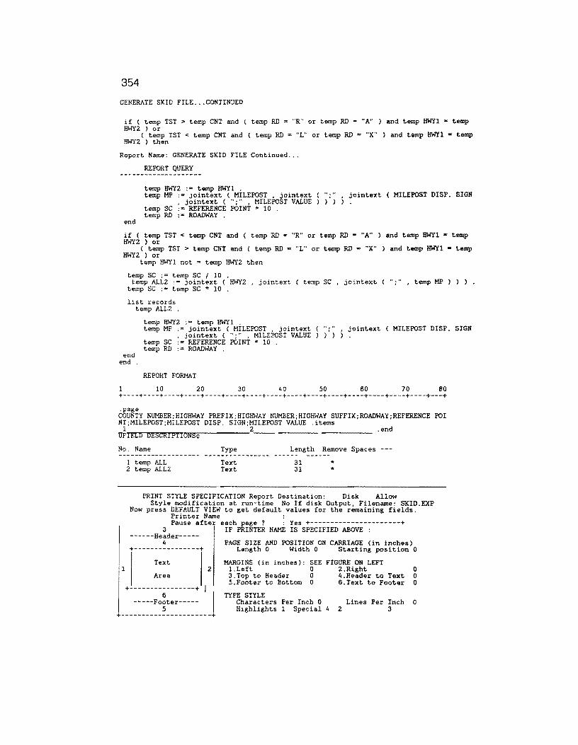
354
GENERATE SKID FILE ... CONTINUED
if ( temp TST > temp CNT and ( temp RD = "R" or temp RD = "A" ) and temp HWYl "' temp HWY2 } or
( temp TST < temp CNT and ( temp RD "L" or temp RD = "X" ) and temp HWYl • temp HWY2 ) then
Report Name: GENERATE SKID FILE Continued ...
REPORT QUERY
temp HWY2 := temp HWYl . temp MP := jointext ( MILEPOST , jointext
, jointext ( ";" , MILEPOST VALUE temp SC := REFERENCE POINT * 10 . temp RD ·• ROADWAY .
t>,n jointext ( MILEPOST DISP. SIGN
end
if ( temp TST < temp CNT and ( temp RD = "R" or temp RD = "A" ) and temp HWYl • temp HWY2 ) or
( temp TST > temp CNT and ( temp RD = "L" or temp RD = "X" ) and temp HWYl = temp HWY2 ) or
temp HWYl not = temp HWY2 then
temp SC := temp SC I 10 . temp ALL2 := jointext ( HWY2 , jointext ( temp SC , jointext (
temp SC := temp SC * 10 .
list records temp ALL2 .
"·" . , temp MP ) ) ) .
temp HWY2 := temp HWYl . temp MP := jointext ( MILEPOST , jointext
, jointext ( ";" , MILEPOST VALUE temp SC ·= REFERENCE POINT * 10 .
..... . jointext ( MILEPOST DISP. SIGN ) )
temp RD ·= ROADWAY . end
end .
REPORT FORMAT
1 10 20 30 40 50 60 70 80 +----+----+----+----+----+----+----+----+----+----+----+----+----+----+----+---+ .page COUNTY NUMBER;HIGHWAY PREFIX;HIGHWAY NUMBER;HIGHWAY SUFFIX;ROADWAY;REFERENCE POI NT;MILEPOST;MILEPOST DISP. SIGN;MILEPOST VALUE .items
1 2 .end UF!ELD DESCRIPTIONS¢
No. Name Type Length Remove Spaces ---
l
1 temp ALL 2 temp ALL2
Text Text
31 31
... *
PRINT STYLE SPECIFICATION Report Destination: Disk Allow
Now Style modification at run-time No If disk Output, Filename: SKID.EXP
press DEFAULT VIEW to get default values for the remaining fields. Printer Name : Pause after each page ? : Yes +----------------------+
3 ------Header-----
4 ~----------------+
Text
Area
+----------------+ 6
-----Footer-----5
2
I I
IF PRINTER NAME IS SPECIFIED ABOVE :
PAGE SIZE AND POSITION ON CARRIAGE (in inches) Length 0 Width 0 Starting position 0
MARGINS (in inches}: SEE FIGURE ON LEFT l.Left 0 2.Right 0 3.Top to Header 0 4.Header to !ext 0 5.Footer to Bottom 0 6.Text to Footer 0
TYPE STYLE Characters Per Inch 0 Lines Per Inch 0 Highlights l Special 4 2 3
+----------------------+
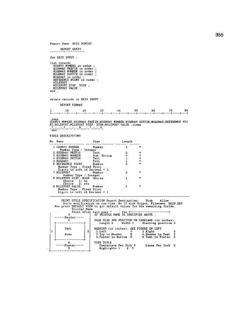
Report Name: SKID SORTED
REPORT QUERY
for SKID INPUT ;
list records COUNTY NUMBER in order ; HIGHWAY PREFIX in order ; HIGHWAY NUMBER in order ; HIGHWAY SUFFIX in order ; ROADWAY in order ; REFERENCE POINT in order MILEPOST ; MILEPOST DISP. SIGN MILEPOST VALUE
end .
delete records in SKID INPUT .
REPORT FORMAT
1 10 20 30 40 50 60 70 80 +----+----+----+----+----+----+----+----+----+----+----+----+----+----+----+---+ .page COUNTY NUMBER;HIGHWAY PREFIX;HIGHWAY NUMBER;HIGHWAY SUFFIX;ROADWAY;REFERENCE POI NT;MILEPOST;MILEPOST DISP. SIGN;MILEPOST VALUE .items l· ·3 ···6 ·7··9
~end~'- ~'-'-'- ~t- _,_,_ -
FIELD DESCRIPTIONS
No. Name Type Length ----------------l COUNTY NUMBER Number 3 * Number Type Integer
2 HIGHWAY PREFIX Text 2 * 3 HIGHWAY NUMBER Num. String 4 * 4 HIGHWAY SUFFIX Text l * 5 ROADWAY Text 1 * 6 REFERENCE POINT Number 5 * Number Type : Fixed Point
Digits to left of Decimal = 3 7 MILEPOST Number 3 *
Number Type Integer 8 MILEPOST DISP. SIGN Choice l * Choice l: no
Choice 2: yes 9 MILEPOST VALUE Number 3 * Number Type : Fixed Point
Digits to left of Decimal =
PRINT STYLE SPECIFICATION Report Destination: Disk Allow Style modification at run-time No If disk Output, Filename: SKID.EXP
Now press DEFAULT VIEW to get default values for the remaining fields. Printer Name : Pause afte eIFhPkI~TE~ NAME is5S;ECIFIED-~OVE-~-------+
4 PAGE SIZE AND POSITION ON CARRIAGE (in inches) Length 0 Width 0 Starting position 0
Text MARGINS (in inches): SEE FIGURE ON LEFT l 2 1.Left 0 2.Right 0
Area 3.Top to Header 0 4.Header to Text 0 5.Footer to Bottom 0 6.Text to Footer 0
6 TYPE STYLE Characters Per Inch 0 Lines Per Inch 0 Highlights 1 2 3
+----------------------+
355

356
Report Name: GENERATE VIS FILE
REPORT QUERY
delete records in VIS
define "SC" Number . define "FRM" Number . define "HWYl" Text 15 define "HWY2"' Text 15 define "FRST" Number . define "CNT" Number . define "LMP" Text 9 . assign temp FRST :e 0 . for TEMP ; if temp FRST = 0 then assign temp SC := REFERENCE POINT * 10 . assign temp FRM := REFERENCE POINT * 10 . assign temp LMP := jointext (MILEPOST, jointext ( ";", jointext (MILEPOST DI SP.
SIGN , jointext ( "; ", MILEPOST VALUE ) ) ) ) . assign temp HWYl :"' jointext ( COUNTY NUMBER , jointext ( ";"
PREFIX , jointext ( ";" , jointext { HIGHWAY NUMBER , jointext HIGHWAY SUFFIX . jointext { ";" , ROADWAY ) l ) ) ) ) ) ) .
jointext ( HIGH WAY "; " , joint ext (
assign temp HWY2 := jointext (COUNTY NUMBER , jointext ( ";" , jointext ( HIGH WAY PREFIX , join text ( ";" , join text ( HIGHWAY NUMBER , join text ( ··;" , joint ext ( HIGHWAY SUFFIX . jointext ( .. ; ·· , ROADWAY ) l ) ) ) ) ) ) . end assign temp HWY2 : jointext ( COUNTY NUMBER , jointext { ";" , JOINTEXT ( BIGHW AY PREFIX, JOINTEXT ( ";" , jointext ( HIGHWAY NUMBER , JOINTEXT ( ";" , jointe xt ( HIGHWAY SUFFIX . jointext ( '';" , ROADWAY ) l ) ) ) ) ) ) . assign temp CNT := REFERENCE POINT * 10 . if temp FRST not = 0 then
assign temp SC := temp SC + 1 end assign temp FRST := 1 . if temp HWYl not = temp HWY2 or firstc ( temp SC , length ( temp SC )) or mod then
temp CNT , length ( temp CNT )) not= f irstc temp SC , 5 ) < 1 or mod ( temp S C , 5 ) > 4
if temp HWYl not = temp HWY2 or firstc { temp SC , length { temp SC )) not ( temp CNT , length ( temp CNT )l then temp SC :=temp SC - 1
end if ( temp FRM + l ) <= temp SC then
list records temp HWYl ; temp FRM I 10 temp SC I 10 ; temp LMP .
end
f irstc
assign temp FRM := REFERENCE POINT * 10 assign temp SC := REFERENCE POINT * 10 . assign temp HWYl := temp HWY2 . assign temp LMP := jointext (MILEPOST , jointext ( ";", jointext (MILEPOST DISP.
SIGN , jointext ( ";", MILEPOST VALUE l ) ) ) . end
REPORT FORMAT
1 10 20 30 40 50 60 70 60 +----+----+----+----+----+----+----+----+----+----+----+----+----+----+----+---+
.page COUNTY NUMBER;HIGHWAY PREFIX:HIGHWAY NUMBER;HIGHWAY SUFFIX;ROADWAY;FROM;REFERENC E POINT;MILEPOST;MILEPOST DISP. SIGN;MILEPOST VALUE .items
1 . 2 . 3 . 4 :-end ·- -·- _,_ ---
FIELD DESCRIPTIONS
No. Name Type
1 temp HWYl Text 2 temp FRM I 10 Number
Number Type : Fixed Point Digits to left of Decimal = 3
3 temp SC I 10 Number Number Type : Fixed Point Digits to left of Decimal = 3
4 temp LMP Text
Length
16 5
5
9
* *
*
*

GENERATE VIS FILE ... continued
1
Now
PRINT STYLE SPECIFICATION Report Destination: Disk Allow Style modification at run-time No If disk Output, Filename: VISUAL.EXP
press DEFAULT VIEW to get default values for the remaining fields. Printer Name : Pause after each page ? : Yes +----------------------+
3 ------Header-----
4
IF PRINTER NAME IS SPECIFIED ABOVE :
PAGE SIZE AND POSITION ON CARRIAGE (in inches) +----------------+ Length 0 Width 0 Starting position 0
Text 2
Area
+--------55-------+ I I -----Footer-----
MARGINS (in inches): SEE FIGURE ON LEFT l.Left 0 2.Right 3.Top to Header 0 4.Header to Text 5.Footer to Bottom 0 6.Text to Footer
TYPE STYLE Characters Per Inch 0 Lines Per Inch Highlights l Special 4 2 3
0 0 0
0
+----------------------+
357

358
Report Name: MISSING SURFACE DATA
REPORT QUERY
for MASTER with SURFACE TYPE < 1
list records COUNTY NUMBER in order ; HIGHWAY PREFIX in order ; HIGHWAY NUMBER in order ; HIGHWAY SUFFIX in order ; ROADWAY in order ; REFERENCE POINT in order .
REPORT FORMAT
1 10 20 30 40 50 so 70 80 +----+----+----+----+----+----+----+----+----+----+----+----+----+----+----+---+
.page
.header MISSING DATE OF LAST SURFACE
AND SURFACE DATA
COUNTY HIGHWAY ROADWAY REFERENCE NUMBER POINT
_ l_ _3_
FIELD DESCRIPTIONS
No. Name Type
1 COUNTY NUMBER Number Number Type : Integer
2 HIGHWAY PREFIX Choice Choice Field Type Name: 1
l: 2: 3: 4: no 5: yes S: 7: 8: PR 9: FM 10: SH 11: us 12: IH 13: 14: A 15: s 16: E 17: w 18: 19: + 20: -21: 22: R 23: L 24: A 25: x 26: 0000-00 27: 0000-00 28: 00/00 29: 00/00
Length
3
2
_s _
Choice Choice Choice Choice Choice Choice Choice Choice Choice Choice Choice Choice Choice Choice Choice Choice Choice Choice Choice Choice Choice Choice Choice Choice Choice Choice Choice Choice Choice Choice 30: JOINTEXT (COUNTY NUMBER, JOINTEXT (HIGHWAY PREFIX, JOINTEXTCHIGHWAY
Choice Choice Choice
31: J 32: 33:
NUMBER,JOINTEXTCHIGHWAY SUFFIX,JOINTEXT(ROADWAY,REFERENCE POINT)))))

359
APPENDIX D LISTING OF P.M.S. DATABASE FILES
The following file list describes all files required to support the PMS Database system. For the micro-PMS system, each county within D21 resides within its own DOD directory. Each county-level directory maintains the same file structure as shown below. The microPMS D21 system consists of 29 user-defined files and 6 system files for a total of 35 files per county. The forms list contained in this appendix have been extracted from the BROOKS COUNTY (024) sud-directory of the PMS. The remaining 9 counties have exactly the same file structure. The Brooks County structures was selected for illustrative purposes.

360
P.M.S. Data Forms List (1989)
Number of Forms: User Defined: 29 System Defined: 6 Total: 35 ------·---------------·---------------------------------------------------------No. Form Name No. of Records Disk File Name File Size Bytes
Existing Deleted -------------------- -------- ------- --------------- ---------------
1 users 6 0 USERBAAA.DBM 378 2 configuration 1 0 CONFBAAA.DBM 186 3 printers 231 0 PRINTERS.DAT 237,930 4 screen sthles 3 0 SCREBAAA.DBM 201 5 relations ips 8 3 RELABAAA.DBM 1,792 6 menus 58 0 MENUBAAA.DBM 38,976
7 COUNTIES 10 0 COUNBAAA.DBM 260 Form Definition file COUNBAAA.DBA 346
8 MACHINE # VAR. 3 0 MACHBAAA.DBM 54 Form Definition file MACHBAAA.DBA 782
9 TEMP 0 0 TEMPBAAA.DBM 0 Index File TEMPBAAA. IOA 512 Form Definition file TEMPBAAA.DBA 1,383
10 DATE OF I.AST SURFACE 26 0 DATEBAAA.DBM 2,106 Index File DATEBAAA.111 2,048 Index File DATEBAAA.112 2,560 Form Definition file DATEBAAA.DBA 1,930
11 ROADWAY CHARACTERS 33 0 ROADBAAA.DBM 2,904 Index File ROADBAAA.112 2,560 Index File ROADBAAA.113 2,560 Form Definition file ROADBAAA.DBA 2,122
12 MAINTENANCE SECTIONS 0 0 MAINBAAA.DBM 0 Index File MAINBAAA.110 512 Index File MAINBAAA. Ill 512 Form Definition file MAINBAAA.DBA 1,950
13 ADT VALUES 0 0 ADTVBAAA.DBM 0 Index File ADTVBAAA.IlO 512 Index File ADTVBAAA.Ill 512 Form Definition file ADTVBAAA.DBA 1,979
14 FUNCT Cl.ASS 0 0 FUNCBAAA.DBM 0 Index File FUNCBAAA.110 512 Index File FUNCBAAA.111 512 Form Definition file FUNCBAAA.DBA 1,996
15 18-KIP VALUES 0 0 KIPVBAAA.DBM 0 Index File KIPVBAAA.IlO 512 Index File KIPVBAAA.111 512 Form Definition file KIPVBAAA.DBA 1,979
361
LISTING OF P.M.S. DATABASE FILES - continued
Form List Continued ... --------------------------------------------------------------------------------No. Form Name No. of Records Disk File Name File Size Bytes
Existing Deleted -·--------------·--- __ .,. ____ .,. ------- -·------------- ---------------
16 HIGHWAY DESIGN 0 0 HIGHBAAA. DBM 0 Index File HIGHBAAA.IlO 512 Index File HIGHBAAA.Ill 512 Form Definition file HIGHBAAA.DBA 1,950
17 UNSORTED 0.5 FWD FIL 0 0 UNSOBAAA.DBM 0 Index File UNSOBAAA.!10 512 Form Definition file UNSOBAAA.DBA 2,183
18 SORTED 0.5 FWD FIL 0 0 SORTBAAA.DBM 0 Index File SORTBAAA.IlO 512 Form Definition file SORTBAAA.DBA 2,181
19 GRAPH FILE HW ID 0 0 GRAPBAAB.DBM 0 Form Definition file GRAPBAAB.DBA 305
20 DUMMY RM FILE 1175 0 DUMMBAAB.DBM 173,900 Index File DUMMBAAB.IOl 59,392 Index File DUMMBAAB.102 8,192 Index File DUMMBAAB.Il6 59,392 Form Definition file DUMMBAAB.DBA 3, 961
21 CROSS ROADS 21 0 CROSBAAB.DBM 1,596 Index File CROSBAAB.IOl 2,048 Index File CROSBAAB. I02 2,048 Form Definition file CROSBAAB.DBA 1,968
22 DISTRICT INVENTORY 15 0 DISTBAAB.DBM 1,845 Index File DISTBAAB. IOl 1,024 Index File DISTBAAB.!02 1,024 Form Definition file DISTBAAB.DBA 3,506
23 FWD INPUT 246 0 FWDIBAAB.DBM 20,664 Index File FWDIBAAB.101 11, 776 Form Definition file FWDIBAAB.DBA 2,463
24 RIDE INPUT 587 0 RIDEBAAA.DBM 69,266 Index File RIDEBAAA.IOl 29,184 Index File RIDEBAAA. !02 29,184 Form Definition file RIDEBAAA.DBA 3,836
25 ORIGINAL RIDE INPUT 587 0 ORIGBAAA.DBM 69,266 Index File ORIGBAAA.!01 29,184 Index File ORIGBAAA. I02 29,184 Form Definition file ORIGBAAA.DBA 3,842
26 0.1 SIOMETER FILE 1175 0 SIOMBAAD.DBM 81,075 Index File SIOMBAAD. 101 59,904 Form Definition file SIOMBAAD.DBA 2,568
362
LISTING OF P.M.S. DATABASE FILES - continued
Form List Continued ...
No. Form Name No. of Records Disk File Name File Size Bytes Existing Deleted
27 SKID INPUT 596 0 SKIDBAAB.DBM SKIDBAAB.DBA Form Definition file
28 PES: ADT & 18KIP IN 1175 0 PESABAAA.DBM PESABAAA.101 PESABAAA.103 PESABAAA.DBA
Index File Index File Form Definition file
29 DUMMY VIS INPUT 0 0 DUMMBAAA.DBM DUMMBAAA. 101 DUMMBAAA.DBA
Index File Form Definition file
30 UNMATCH SIOM HOLD FL 74 0 UNMABAAB.DBM UNMABAAB.101 UNMABAAB.DBA
Index File Form Definition file
31 SIOMETER RIDE VALUES 587 0 SIOMBAAA.DBM SIOMBAAA.IOl SIOMBAAA.102 S IOMBAAA. DBA
Index File Index File Form Definition file
32 PRS-SRS INPUT FILE 236 0 PRSSBAAB.DBM PRSSBAAB.IOl PRSSBAAB.DBA
Index File Form Definition file
33 VIS Index File Index File Index File Form Definition file
34 1990 PES ADT KIP FC Form Definition file
35 MASTER Index File Index File Form Definition file
237
41
1175
0 VISABAAB.DBM VlSABAAB.IOl VISABAAB.102 VlSABAAB.103 VISABAAB.DBA
0 PESABAAB.DBM PESABAAB.DBA
0 MASTBAAA.DBM MASTBAAA.IOl MASTBAAA.102 MASTBAAA.DBA
36,952 2,114
69,325 59,904 8,192 1,328
0 512
4,377
2,590 4,608
627
82,767 30,208 8, 192 3,765
4,012 7,680
460
50,007 12,288
3 ,072 7,680 6,967
2,296 1,218
333,700 66,560
8,192 7,999

363
APPENDIX E PMS DATABASE FORM RELATIONSHIPS
This appendix defines the PMS data file relationship structure. Various forms within the PMS structure share common data fields. This sharing of common fields supports forms lookups and cross referencing activites.
The forms that have explicit relationships are defined on the succeding page.

364
List of Form Relationships for the PMS Database
COUNTIES · VISUAL
+----------·-----------+ I COUNTIES I +--+-------------------+
I I +·----·+···--------------------------------------------+ I I VIS I I I ----------------------------------------- I
COUNTY NUMBER = COUNTY NUMBER I !-----------------------------------------------! +------+-----------------------·-----------------------+ 1 VISUAL I
I --------··------------------------------- I ! COUNTY NUMBER = COUNTY NUMBER ! +-----------------------------------------------+
List of Form Relationships
MACHINE # VAR. (MAYES RIDE) - RIDE INPUT
+----------------------+ I MACHINE # VAR. I +--+-------------------+
I I
+------+-----------------------------------------------+
Form 1
Form 2 I I
Form 1
Form 2
I ~~~~-~~~~:............................... I Form 1
! MACHINE # = MACHINE # ! Form 2 +----------------------------·········----------+
List of Form Relationships
VISUAL - COUNTIES (COUNTY NO.)
+··--------------------+ I VIS I +--+-------------------+
I I +------+------------------------- ---------------------+
Restrict
Restrict
Restrict
Restrict
Restrict
Restrict
I COUNTIES I Form 1 Restrict I ------------------------------·---------- I ! COUNTY NUMBER = COUNTY NUMBER ! Form 2 Restrict +~~- -----·--------·-~---·-----·----·----- --·--+
List of Form Relationships
RIDE INPUT (MAYES) • MACHINE # VAR
+··--------------------+ I RIDE INPUT I +··+··--------------·-·+
I I
+····-·+------------------·---------------------------·· I MACHINE # VAR. I Form 1 Restrict
I ----------~;~~;~~·;·:-~;~~;~~-;··-··-·-·- I Form 2 Restrict I I
·---------------------·----------------·········+

365
Appendix F PMS Database Import File Names
The import programs shown below constitute the requisite import procedures required to import all variable length data files into their respective data files.
Import List
No. Import Name Disk File Name File Size Bytes __ .., ___ ... _______ ... ____ --------------- ---------------
1. ADTIMP ADTIMP.DBI 92 2. FCIMP FCIMP.DBI 92 3. FWD FWD.DBI 92 4. FWD IMP FWDIMP.DBI 92 5. HD IMP HDIMP.DBI 92 6. IMPPRS IMPPRS.DBI 92 7. INVENTRY INVENTRY.DBI 92 8. KI PIMP KIPIMP.DBI 92 9. MASTER MASTER.DBI 92
10. MS IMP MSIMP.DBI 92 11. REF IMP REFIMP.DBI 190 12. RIDE RIDE.DBI 92 13. SIOMETER SIOMETER.DBI 190 14. SKID SKID.DBI 92 15. SKID IMP SKIDIMP.DBI 190 16. SORTA SORTA.DBI 92 17. VISUAL VISUAL.DBI 92

366
Appendix G PMS Menu Definition Specifications: 1988-89 Version
The following define the user-menu designs for the PMS database as of December, 1989. These menus permit district personnel unfamiliar with the programming details of the PMS to interact with the pre-defined routines designed into the system. Each menu shown below constitutes a menu data record. The menu records are stored within a database system file. The menus appear when the user logs into the PMS with the appropriate password.
All menus as of December, 1989 are shown on the following pages of this appendix.

Menu Name: 18-KIP DATA HANDLING Security Level: High
18-KIP Data Handling / BROOKS COUNTY
+----------------------------------------------+ TYPE 11.Match Mileposts with Reference Points !Run Proc. 12.Validate 18-KIP Mileposts !Run Proc. 13.Modify 18-KIP Data !Rec Entry 14.Transfer 18-KIP Data to Master Form !Run Proc. 1 s. I 16. I 17. I 18. I 19. I +----------------------------------------------+
Menu Name: ADT DATA HANDLING Security Level: High
ADT Data Handling / BROOKS COUNTY
+- ------ --- ------ --------- ---- ---- --- ----------+ TYPE 11.Match Mileposts with Reference Points !Run Proc. 12.Validate ADT Mileposts !Run Proc. 13.Modify ADT Data !Rec Entry 14.Transfer ADT Data to Master Form IRun Proc. Is. I 16. I 17. I 18. I 19. I +----------------------------------------------+
Menu Name: ADT IMPORT Security Level: High
CHAIN
+- - - - - - - - - - - - - - - - - - - - - - - - - - - - - - - - - - - - - - - - - - - - - -+ TYPE 11.Transfer ADT Data to PC IProg Call 12.Import ADT Data !Import 13 · I 14. I 1 s. 1' 16. 17. 1' 18. 19. I +- - - - - - - - - - - - - - - - - - - - - - - - - - - - - - - - - - - - - - - - - - - - - -+
367
NAME 18-KIP REFER POINT VALIDATE MILEPOSTS 18-KIP VALUES 18-KIP MRG TO MASTR
NAME ADT REFER POINT VALIDATE MILEPOSTS ADT VALUES ADT MRG TO MASTR
NAME PES.BAT ADTIMP

368
Menu Name: CREATE MASTER Security Level: High
CHAIN
+----------------------------------------------+ TYPE fl.Generate Master Data Records IRun Proc. 12.Import Records into Master Data Form !Import 13.Delete Master Data Record File IProg Call 14. I 1 s. I 16. I 17. I 1 s. I 19. I +----------------------------------------------+ Menu Name: CRITICAL REPORTS Security Level: Low3
CHAIN
+ - - - - - - - - - - - - - - - - - - - - - - - - - - - - - - - - - - - - - - - - - - - - - -+ TYPE 11.Critical PRS/ADT !Run Proc. 12.Critical Ride/ADT !Run Proc. 13.Critical SCI/ADT !Run Proc. 14.Critical Skid/ADT jRun Proc. IS.Critical DLS/ADT !Run Proc. 16.Critical Ride/FWD/ADT !Run Proc. 17.Critical Skid/DLS/ADT !Run Proc. IS.Critical Crack Location !Run Proc. 19.Critical RAV/RUT/PAT/Ride jRun Proc. +- - - - - - - - - - - - - - - - - - - - - - - - - - - - - - - - - - - - - - - - - - - - - -+
Menu Name: DATA ENTRY I Security Level: Lowl
NAME CREATE MASTER FILE MASTER DEL MASTR.EXP
NAME CRITICAL PRS/ADT CRITICAL RIDE/ADT CRITICAL SCI/ADT CRITICAL SKID/ADT CRITICAL DLS/ADT CRIT RIDE/FWD/ADT CRIT SKID/DLS/DAT CRIT CRACK LOCATION
CRIT RAV/RUT/PATRIDE
DATA ENTRY -- DISTRICT FIELD DATA/ BROOKS COUNTY
+- - - - - - - - - - - - - - - - - - - - - - - - - - - - - - - - - - - - - - - - - - - - - -+ TYPE 11.Input or Modify Visual Data IRec Entry 12.Ride Data !User Menu 13.FWD Data !User Menu 14.Skid Data !User Menu IS.Create or Modify Date of Last Surface !Rec Entry 16.Create or Modify Crossroads !Rec Entry 17.Create or Modify District Counties Data fRec Entry 18.Create of Modify Roadway Characteristics !Rec Entry 19. I +----------------------------------------------+
NAME VIS RIDE INPUT FWD DATA INPUT SKID DATA INPUT
DATE OF LAST SURFACE CROSS ROADS COUNTIES ROADWAY CHARACTERS

Menu Name: DATA ENTRY II Security Level: High
369
DATA ENTRY -- IMPORTED PES DATA/ BROOKS COUNTY
+----------------------------------------------+ TYPE NAME 11.Import Maintenance Section Data !User Menu MAINTENANCE SECT IMP 12.Import ADT Data IUser Menu ADT IMPORT 13.Import Functional Classification Data !User Menu FUNCT CI.ASS IMP 14.Import 18-KIP Data !User Menu KIP IMPORT IS.Import Highway Design Data IUser Menu HIGHWAY DESN IMP 16. I 17. I 18. I 19. I +- - - - - - - - - - - - - - - - - - - - - - - - - - - - - - - - - - - - - - - - - - - - - -+
Menu Name: DATA LISTING Security Level: Low3
DATA LISTING REPORTS / BROOKS COUNTY
+----------------------------------------------+ TYPE 11.List District Inventory Data !Run Proc. 12.List Visual Ratings !Run Proc. j3.List Date of Last Surface & Surface Data !Run Proc. 14.List Cross Roads IRun Proc. IS.List Counties Information Data !Run Proc. 16.List All Data IRun Proc. 17.Create File for Plotting Data IRun Proc. 18.PRINT PRS-SRS DATA SUMMARY IRun Proc. 19. I +- - - - - - - - - - - - - - - - - - - - - - - - - - - - - - - - - - - - - - - - - - - - - -+
Menu Name: DLS DATA HANDLING Security Level: Mediuml
NAME PRINT DIST. INVENTRY PRINT PRS-SRS INFILE
DLS DATA CROSSROADS COUNTY DATA ALL DATA PLOT DATA PRINT PRS-SRS SUMRY
DATE OF I.AST SURFACE DATA HANDLING / BROOKS COUNTY
+----------------------------------------------+ TYPE 11.Match Mileposts with Reference Points !Run Proc. 12.Validate Date of Last Surface Mileposts !Run Proc. 13.Check Date of Last Surface for Overlaps IUser Menu 14.Modify Date of Last Surface Data !Rec Entry IS.Transfer Date of Last Surface Data to MasterjRun Proc. 16. I 17. I
NAME DLS REFERENCE POINTS VALIDATE MILEPOSTS DLS VALIDATE
DATE OF I.AST SURFACE DLS MERGE TO MASTER

370
1 s. I 19. I +----------------------------------------------+
Menu Name: DLS VALIDATE Security Level: Mediuml
CHAIN
+----------------------------------------------+ TYPE 11.Export Date of Last Surface Data !Run Proc. 12.Validate Date of Last Surface Data IProg Call 13.Delete Data File IProg Call 14. I 1 s. I 16. I 17. I 1 s. I 19. I +----------------------------------------------+
Menu Name: FC DATA HANDLING Security Level: High
NAME DLS VALIDATION DLSVAL.EXE DEL DLS.DAT
Functional Classification Data Handling / BROOKS COUNTY
+----------------------------------------------+ TYPE 11.Match Mileposts with Reference Points IRun Proc. 12.Validate Functional Classification MilepostslRun Proc. 13.Modify Functional Classification Data IRec Entry 14.Transfer Funct. Class. Data to Master Form IRun Proc. 1 s. I 16. I 17. I 1 a. I 19. I +----------------------------------------------+
Menu Name: FUNCT CLASS IMP Security Level: High
CHAIN
+----------------------------------------------+ TYPE 11.Transfer Functional Class. Data to PC jProg Call 12.Import Functional Classification Data !Import 13. I 14. II Is.
NAME FC REFER POINT VALIDATE MILEPOSTS FUNCT CLASS FC MRG TO MASTR
NAME PES.BAT FCIMP

16. II 17. 18. I 19. I +----------------------------------------------+
Menu Name: FWD CONVERT Security Level: Medium!
CHAIN
+----------------------------------------------+ TYPE 11.Make certain data is in drive A: IProg Call 12.Copy FWD Field Data into One File IProg Call 13.EDIT EOF'S FROM ALL.FWD IProg Call 14.RUN THE CONVERT PROGRAM IProg Call IS.DELETE THE COMBINED FILE IProg Call 16. I 17. I 18. I 19. I +- ---------------------------------------------+
Menu Name: FWD CREATE Security Level: High
CHAIN
NAME FWD.BAT
371
COPY A:*.FWD ALL.FWD EDIX ALL.FWD FWDCONV.EXE DEL ALL.FWD
+----------------------------------------------+ TYPE NAME 11.Sort Master Data in Ascending Order IRun Proc. ORDERED MASTER FILE 12.Irnport Sorted Master Data into Temp Form !Import SORTA 13.Delete Sorted Data File IProg Call DEL SORT.DAT 14.Generate FWD Records !Run Proc. GENERATE FWD FILE IS.Reorganize FWD Data File IForm Reorg FWD INPUT 16.Import FWD Records into FWD FoFm !Import FWD 17.Delete FWD Data File IProg Call DEL FWD.EXP 18.Sort FWD Records !Run Proc. FWD SORTED 19.Go to Part Two of this Menu !User Menu FWD CREATE II +- - - - - - - - - - - - - - - - - - - - - - - - - - - - - - - - - - - - - - - - - - - - -+
Menu Name: FWD CREATE II Security Level: High
CHAIN
+----------------------------------------------+ TYPE NAME 11.Reorganize FWD Data File !Form Reorg FWD INPUT 12.Import FWD Records into FWD Form IImport FWD 13.Delete FWD Data File IProg Call DEL FWD.EXP 14. I 1 s. I 16. I 17. I 1 s. I

372
19. _.,. _________ ,.. +------
I -----------+

Menu Name: FWD DATA Security Level: High
FWD DATA SETUP / BROOKS COUNTY
+----------------------------------------------+ TYPE NAME jl.Create FWD Data Records jUser Menu FWD CREATE 12. 1
1 13. 14. I Is.
11
16. 17. I 1 s. I 19. I +----------------------------------------------+
Menu Name: FWD DATA HANDLING Security Level: Mediuml
FWD DATA HANDLING / BROOKS COUNTY
+----------------------------------------------+ TYPE NAME jl.Verify Validity of FWD Data I
373
12.Transfer FWD Data to Master Data Form jRun Proc. FWD MASTER UPDATE 13. I 14. I 1 s. I 16. I 17. I 1 s. I 19. I +- - - - - - - - - - - - - - - - - - - - - - - - - - - - - - - - - - - - - - - - - - - - - -+
Menu Name: FWD DATA INPUT Security Level: Mediuml
FWD DATA ENTRY / BROOKS COUNTY
+----------------------------------------------+ TYPE jl.Convert FWD Field Data jUser Menu j2.Import Converted FWD Field Data jUser Menu j3.Validate Errors in Imported FWD Data File !Run Proc. j4.Correct Errors in Imported Data File IProg Call 1 s. I 16. I 17 · I 1 s. I 19. I +- - - - - - - - - - - - - - - - - - - - - - - - - - - - - - - - - - - - - - - - - - - - - -+
NAME FWD CONVERT FWD IMPORT FWD VIEW EDIX FWD.CON

374
Menu Name: FWD ERRORS Security Level: Mediuml
CHAIN
+----------------------------------------------+ TYPE NAME 11.List the Roadway Section Where Errors Occur I 12.Edit the Errors I
Run Proc. FWD VIEW Prog Call E88 FWD.CON
13. I 14. I 1 s. I 16. I 17. I 18. I 19. I +-------------------------------------- -------+
Menu Name: FWD IMPORT Security Level: Mediuml
CHAIN
+----------------------------------------------+ TYPE 11.Import Converted FWD Field Data !Import 12.Copy Errors into File IProg Gall 13.List Errors to Printer IProg Call 14.Delete Error Files IProg Call IS.DELETE FWD*.E?? FILE IProg Call 16. I 17. I 1 s. I 19. I +----------------------------------------------+
Menu Name: GRAPH-1 Security Level: Medium2
021 PMS HIGHWAY SEGMENT PLOTTING MENU
+- - - - - - - - - - - - - - - - - - - - - - - - - - - - - - - - - - - - - - - - - - - - - -+ TYPE 11.PRINT BROOKS COUNTY HIGHWAY INVENTORY IRun Proc. 12.PRODUCE RID~/SKID/FWD/PRS PLOTS IRun Proc. j 3. I 14. I 1 s. I 16. I 17. I 18. I 19. I +- - - - - - - - - - - - - - - - - - - - - - - - - - - - - - - - - - - - - - - - - - - - - -+
NAME FWD IMP
COPY FWD*.EOO ER.ERR FWDERR.EXE DEL *.ERR DEL FWD*.EO?
NAME PRINT DIST. INVENTRY
BUILD GRAPH PROC
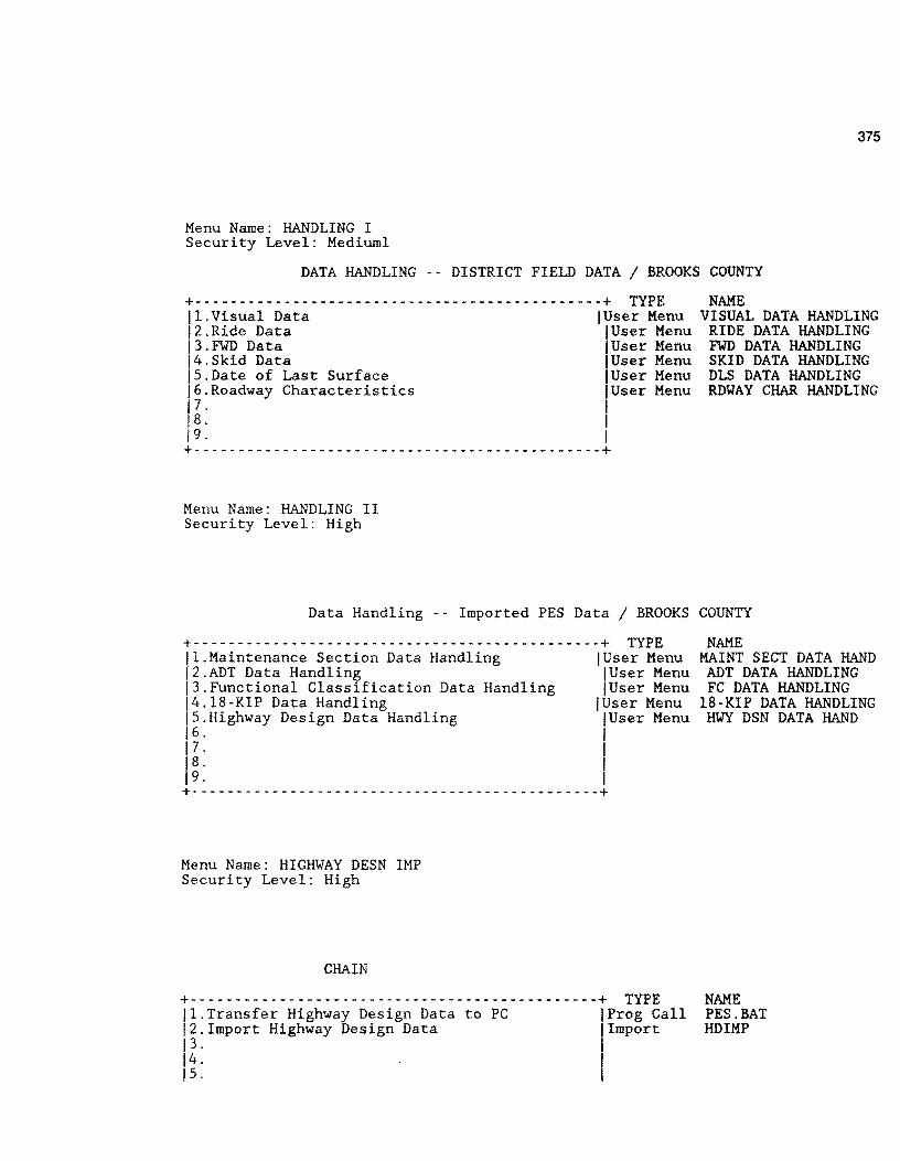
Menu Name: HANDLING I Security Level: Mediuml
375
DATA HANDLING -- DISTRICT FIELD DATA/ BROOKS COUNTY
+----------------------------------------------+ TYPE NAME 11.Visual Data !User Menu VISUAL DATA HANDLING 12.Ride Data !User Menu RIDE DATA HANDLING 13.FWD Data IUser Menu FWD DATA HANDLING 14.Skid Data !User Menu SKID DATA HANDLING IS.Date of Last Surface !User Menu DLS DATA HANDLING 16.Roadway Characteristics !User Menu RDYAY CHAR HANDLING 17. ,1 18. 19. I +- - - - - - - - - - - - - - - - - - - - - - - - - - - - - - - - - - - - - - - - - - - - -+
Menu Name: HANDLING II Security Level: High
Data Handling -- Imported PES Data /BROOKS COUNTY
+- - - - - - - - - - - - - - - - - - - - - - - - - - - - - - - - - - - - - - - - - - - - - -+ TYPE 11.Maintenance Section Data Handling !User Menu 12.ADT Data Handling !User Menu 13.Functional Classification Data Handling !User Menu 14.18-KIP Data Handling !User Menu IS.Highway Design Data Handling !User Menu 16. I 17 · I 18. I 19. I +- - - - - - - - - - - - - - - - - - - - - - - - - - - - - - - - - - - - - - - - - - - - - -+
Menu Name: HIGHWAY DESN IMP Security Level: High
CHAIN
+----------------------------------------------+ TYPE 11.Transfer Highway Design Data to PC IProg Call 12.Import Highway Design Data I Import 13 · I 14. I 1 s. I
NAME MAINT SECT DATA HAND
ADT DATA HANDLING FC DATA HANDLING
18-KIP DATA HANDLING HWY DSN DATA HAND
NAME PES.BAT HD IMP

376
16. I 17. I 1 s. I 19. I +----------------------------------------------+
Menu Name: HWY DSN DATA HAND Security Level: High
Highway Design Data / BROOKS COUNTY
+----------------------------------------------+ TYPE 11.Match Mileposts with Reference Points !Run Proc. 12.Validate Highway Design Mileposts !Run Proc. 13.Modify Highway Design Data IRec Entry 14.Transfer Highway Design Data to Master Form !Run Proc. 15. I 16. I 17. I 18. I 19. I +- - - - - - - - - - - - - - - - - - - - - - - - - - - - - - - - - - - - - - - - - - - - -+
Menu Name: INVENTORY Security Level: High
COUNTY INVENTORY SETUP / BROOKS COUNTY
+----------------------------------------------+ TYPE 11.Create or Modify County Inventory Data !Rec Entry 12.Roadway Length Check !Run Proc. 13.Reorganize County Inventory Data jUser Menu 14. I 15. I 16. I 17. I 1 s. I 19. I +----------------------------------------------+
Menu Name: KIP IMPORT Security Level: High
CHAIN
+- - - - - - - - - - - - - - - - - - - - - - - - - - - - - - - - - - - - - - - - - - - - - -+ TYPE 11.Transfer 18-KIP Data to PG IProg Call 12.Import 18-KIP Data !Import 13. I
NAME HWY DESN REFER POINT VALIDATE MILEPOSTS HIGHWAY DESIGN
HWY DSN MRG TO MASTR
NAME DISTRICT INVENTORY
INVENTORY MILE CHECK REORGANIZE INVENTORY
NAME PES.BAT. KI PIMP
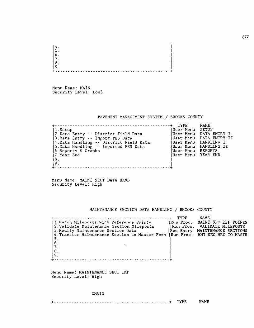
14. I 15. I 16. I 17. I 18. I 19. I +----------------------------------------------+
Menu Name: MAIN Security Level: Low3
377
PAVEMENT MANAGEMENT SYSTEM / BROOKS COUNTY
+- -------------------------------------------- -+ TYPE 11.Setup IUser Menu 12.Data Entry -- District Field Data IUser Menu 13.Data Entry -- Import PES Data IUser Menu 14.Data Handling -- District Field Data IUser Menu 15.Data Handling -- Imported PES Data !User Menu 16.Reports & Graphs IUser Menu 17.Year End IUser Menu 18. I 19. I +- - - - - - - - - - - - - - - - - - - - - - - - - - - - - - - - - - - - - - - - - - - - - -+
Menu Name: MAINT SECT DATA HAND Security Level: High
NAME SETUP DATA ENTRY I DATA ENTRY II HANDLING I HANDLING II REPORTS YEAR END
MAINTENANCE SECTION DATA HANDLING / BROOKS COUNTY
+----------------------------------------------+ TYPE jl.Match Mileposts with Reference Points jRun Proc. 12.Validate Maintenance Section Mileposts !Run Proc. 13.Modify Maintenance Section Data !Rec Entry 14.Transfer Maintenance Section to Master Form !Run Proc. 15. I 16. I 17. I 18. I 19. I +- - - - - - - - - - - - - - - - - - - - - - - - - - - - - - - - - - - - - - - - - - - - - -+
Menu Name: MAINTENANCE SECT IMP Security Level: High
CHAIN
NAME MAINT SEC REF POINTS VALIDATE MILEPOSTS
MAINTENANCE SECTIONS MNT SEC MRG TO MASTR
+----------------------------------------------+ TYPE NAME

378
11.Transfer Maintenance Section Data to PC IProg Call PES.BAT 12.Import Maintenance Section Data !Import MSIMP 13. I 14. I Is. II 16. 17. I 18. I 19. I +- ------ -- ---- ---- -------------- -------- -- -----+
Menu Name: MASTER DATA Security Level: High
MASTER DATA SETUP / BROOKS COUNTY
+- ---------------------------------------------+ TYPE 11.Create Master Data Records !User Menu 12.Modify Master Data Records IRec Entry 13 · I 14. I Is. I J 6. I 17. I 1 s. I J 9. I +----------------------------------------------+
Menu Name: MISSING DATA Security Level: Low3
MISSING DATA REPORTS / BROOKS COUNTY
+----------------------------------------------+ TYPE JI.Missing Visual Data jRun Proc. 12.Missing Ride Data IRun Proc. j3.Missing FWD Data !Run Proc. 14.Missing Skid Data I-Run Proc. JS.Missing Date of Last Surface & Surface Data !Run Proc. 16. I J 7. I 18. I 19. I +- - - - - - - - - - - - - - - - - - - - - - - - - - - - - - - - - - - - - - - - - - - - - -+
Menu Name: MRM EQUIPMENT Security Level: High
NAME CREATE MASTER MASTER
NAME MISSING VISUAL DATA MISSING RIDE DATA MISSING FWD DATA MISSING SKID DATA
MISSING SURFACE DATA

379
MRM Equipment Coefficients SETUP / BROOKS COUNTY
+----------------------------------------------+ TYPE NAME II.Add, Delete,or Update Current Coefficients !Rec Entry MACHINE # VAR. 12.Modify Ride Form with New MRM Equip. NumberslMain Menu 13. I 14. I Is. I 16. I 17. 18. I 19. I +- - - - - - - - - - - - - - - - - - - - - - - - - - - - - - - - - - - - - - - - - - - - - -+
Menu Name: PMS-PES Security Level: Low3
CHAIN
+ ----------------------------------------------+ TYPE 11.List Visual Data jRun Proc. 12.List Maintenance Sections & Surface Type IRun Proc. 13.List Ride Data !Run Proc. 14. I 1 s. I 16. I 17. I 18. I 19. I +- - - - - - - - - - - - - - - - - - - - - - - - - - - - - - - - - - - - - - - - - - - - - -+
Menu Name: RATING FORMS Security Level: Low3
NAME PMS-PES VISUAL PMS-PES MS & ST PMS-PES RIDE
GENERATE RATING FORMS REPORTS / BROOKS COUNTY
+----------------------------------------------+ TYPE 11.Generate Visual Rating Forms (HP Laser Jet) !Run Proc. 12.Generate Ride Rating Forms (HP Laser Jet) IRun Proc. 13. I 14. I 1 s. I 16. I 17 · I 1 s. I 19. I +- - - - - - - - - - - - - - - - - - - - - - - - - - - - - - - - - - - - - - - - - - - - - -+
Menu Name: RDWAY CHAR HANDLING Security Level: Mediuml
NAME VISUAL RATING FORM
RIDE INPUT FORM
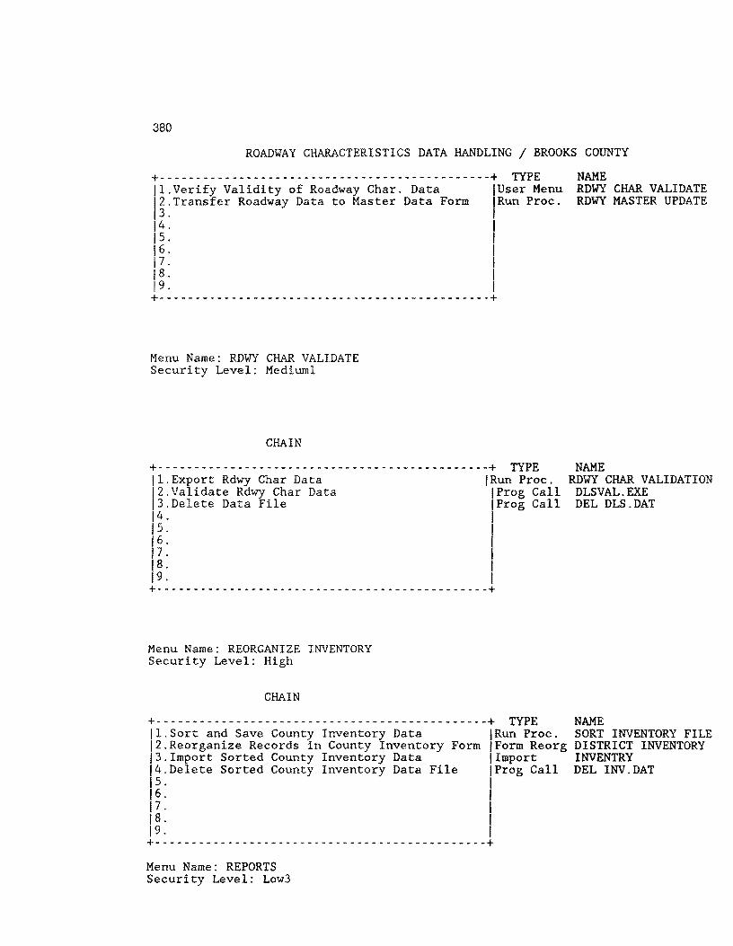
380
ROADWAY CHARACTERISTICS DATA HANDLING / BROOKS COUNTY
+----------------------------------------------+ TYPE 11.Verify Validity of Roadway Char. Data IUser Menu 12.Transfer Roadway Data to Master Data Form fRun Proc. 13. I 14. I 15. I 16. I 17. I 1 s. I 19. I +- - - - - - - - - - - - - - - - - - - - - - - - - - - - - - - - - - - - - - - - - - - - - -+
Menu Name: RDWY CHAR VALIDATE Security Level: Mediuml
CHAIN
+----------------------------------------------+ TYPE 11.Export Rdwy Char Data !Run Proc. 12.Validate Rdwy Char Data IProg Call 13.Delete Data File IProg Call 14. I 15. I 16. 1' 17. 1 s. I 19. I +----------------------------------------------+
Menu Name: REORGANIZE INVENTORY Security Level: High
CHAIN
+----------------------------------------------+ TYPE 11.Sort and Save County Inventory Data !Run Proc. 12.Reorganize Records in County Inventory Form jForm Reorg 13.Import Sorted County Inventory Data !Import 14.Delete Sorted County Inventory Data File IProg Call 15. I 16. I 17. I 1 s. I 19. I +----------------------------------------------+ Menu Name: REPORTS Security Level: Low3
NAME RDWY CHAR VALIDATE RDWY MASTER UPDATE
NAME RDWY CHAR VALIDATION
DLSVAL.EXE DEL DLS.DAT
NAME SORT INVENTORY FILE DISTRICT INVENTORY INVENTRY DEL INV.DAT

REPORTS / BROOKS COUNTY
+----------------------------------------------+ TYPE 11.Missing Data Reports jUser Menu 12.Generate Rating Forms !User Menu 13.Critical Value Reports 1user Menu 14.Data Listing Reports User Menu 15.PMS-PES Conversion !User Menu 16.Ad Hoc Reports IRun Proc. 17.Highway Segment Graphs (Ride/Skid/PRS/FWD) !User Menu 18. I 19. I +----------------------------------------------+
Menu Name: RIDE CREATE Security Level: High
CHAIN
NAME MISSING DATA RATING FORMS CRITICAL REPORTS DATA LISTING PMS-PES
GRAPH-1
+ - - - - - - - - - - - - - - - - - - - - - - - - - - - - - - - - - - - - - - - - - - - - - -+ TYPE NAME II.Sort Master Data in R Roadway Order !Run Proc. ORDERED R MASTER 12.Sort Master Data in L Roadway Order !Run Proc. ORDERED L MASTER 13.Delete Temporary Sorted Files !Frog Call DEL *.SRT 14.Import Sorted Data Files !Import SORTA IS.Delete Sort File IProg Call DEL SORT.DAT
381
16.Generate Ride File !Run Proc. GENERATE RIDE FILE 17.Reorganize Ride Data File !Form Reorg RIDE INPUT 18.Import Ride Data into Ride Form !Import RIDE 19.Continue !User Menu RIDE CREATE II +----------------------------------------------+ Menu Name: RIDE CREATE II Security Level: High
CHAIN
+----------------------------------------------+ TYPE NAME 11.Delete Ride Data File IProg Call DEL RIDE.EXP 12.Sort Ride Form !Run Proc. RIDE SORTED 13.Reorganize Ride Form !Form Reorg RIDE INPUT 14.Import Sorted Ride File !Import RIDE IS.Delete Sorted Ride File IProg Call DEL RIDE.EXP 16. I 17. I 1 s. I 19. I +- - - - - - - - - - - - - - - - - - - - - - - - - - - - - - - - - - - - - - - - - - - - - -+
Menu Name: RIDE DATA

382
Security Level: High
RIDE DATA SETUP / BROOKS COUNTY
+----------------------------------------------+ TYPE NAME 11.Create Ride Data Records IUser Menu RIDE CREATE 12. I 13. I 14. I 15. I 16. I 17. I 18. l 19. I +- - - - - - - - - - - - - - - - - - - - - - - - - - - - - - - - - - - - - - - - - - - - -+
Menu Name: RIDE DATA HANDLING Security Level: Mediuml
RIDE DATA HANDLING / BROOKS COUNTY
+- --------------------------------------------+ TYPE 11.Verify Validity of Ride Data !Run Proc. j2.Transfer Ride Data to Master Data Form IRun Proc. 13. I 14. I 15. I 16. I 17. I 1 s. I 19. I +- - - - - - - - - - - - - - - - - - - - - - - - - - - - - - - - - - - - - - - - - - - - - -+
Menu Name: RIDE INPUT Security Level: Lowl
RIDE DATA / BROOKS COUNTY
+----------------------------------------------+ TYPE 11.Input or modify Mays Ride Data !Rec Entry 12.Convert Raw Siometer Data IProg Call 13.Irnport Siometer Data !User Menu 14.Validate Slometer Errors in Imported Data !Run Proc. IS.Correct Errors in Slometer Data File IProg Call 16. I 17 · I 18. I 19. I +- - - - - - - - - - - - - - - - - - - - - - - - - - - - - - - - - - - - - - - - - - - - - -+
NAME VALIDATE RIDE DATA RIDE MASTER UPDATE
NAME RIDE INPUT RIDEC.EXE SIOMETER RIDE VIEW E88 RIDE.DAT
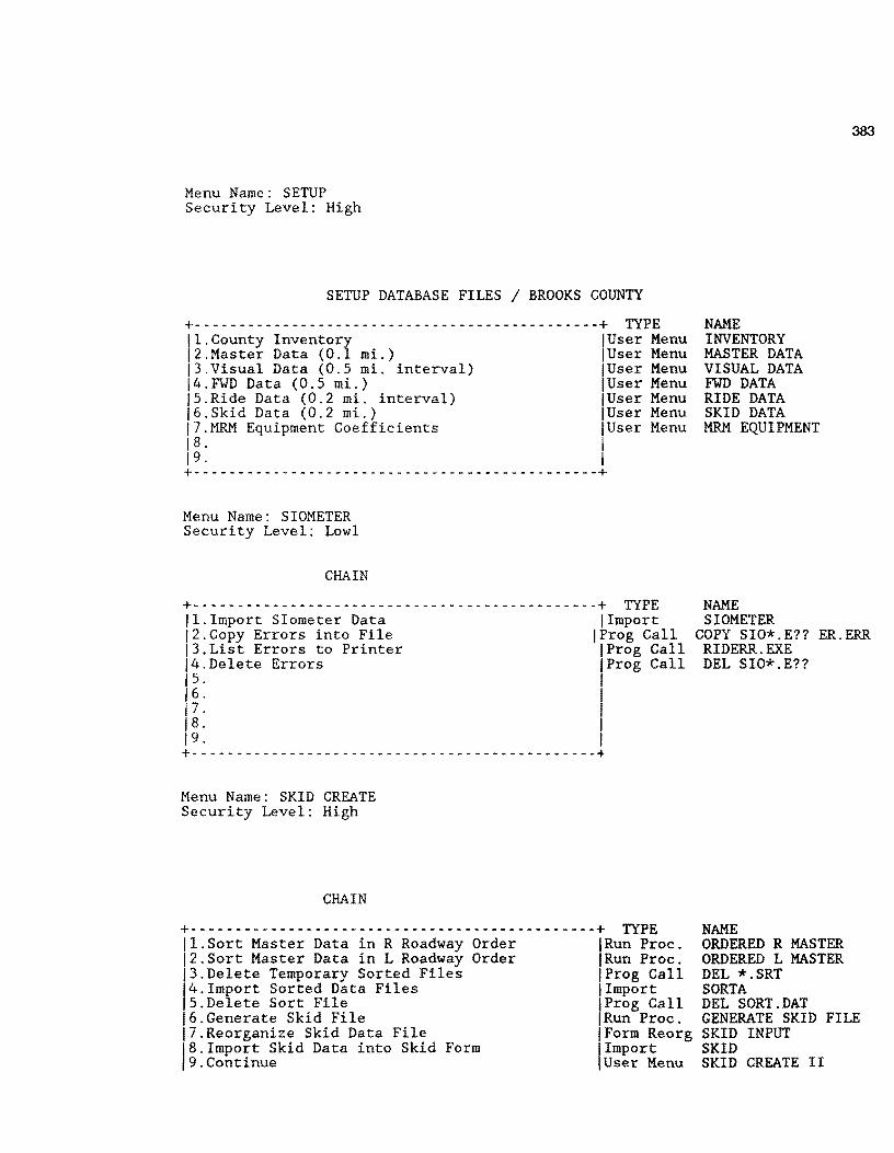
Menu Name: SETUP Security Level: High
SETUP DATABASE FILES / BROOKS COUNTY
+----------------------------------------------+ TYPE 11.County Inventory !User Menu 12.Master Data (0.1 mi.) !User Menu 13.Visual Data (0.5 mi. interval) !User Menu 14.FWD Data (0.5 mi.) !User Menu IS.Ride Data (0.2 mi. interval) !User Menu 16.Skid Data (0.2 mi.) !User Menu 17.MRM Equipment Coefficients jUser Menu 1 s. I 19. I +- ---------------------------------------------+
Menu Name: SIOMETER Security Level: Lowl
CHAIN
+ _________ - - - - - - - - - - - - - - - - - - - - - - - - - - - - - - - - - - - - -+ TYPE 11.Import Siometer Data !Import 12.Copy Errors into File IProg Call j3.List Errors to Printer IProg Call j4.Delete Errors jProg Call 1 s. I
j 6. 1' 17. 18. I 19. I +- - - - - - - - - - - - - - - - - - - - - - - - - - - - - - - - - - - - - - - - - - - - - -+
Menu Name: SKID CREATE Security Level: High
CHAIN
+----------------------------------------------+ TYPE jl.Sort Master Data in R Roadway Order IRun Proc. 12.Sort Master Data in L Roadway Order IRun Proc. 13.Delete Temporary Sorted Files IProg Call 14.Irnport Sorted Data Files !Import IS.Delete Sort File jProg Call 16.Generate Skid File !Run Proc. 17.Reorganize Skid Data File !Form Reorg 18.Irnport Skid Data into Skid Form !Import j9.Continue !User Menu
NAME INVENTORY MASTER DATA VISUAL DATA FWD DATA RIDE DATA SKID DATA MRM EQUIPMENT
NAME SIOMETER
383
COPY SIO*.E?? ER.ERR RIDERR.EXE DEL SIO*.E??
NAME ORDERED R MASTER ORDERED L MASTER DEL *.SRT SORTA DEL SORT.DAT GENERATE SKID FILE SKID INPUT SKID SKID CREATE II
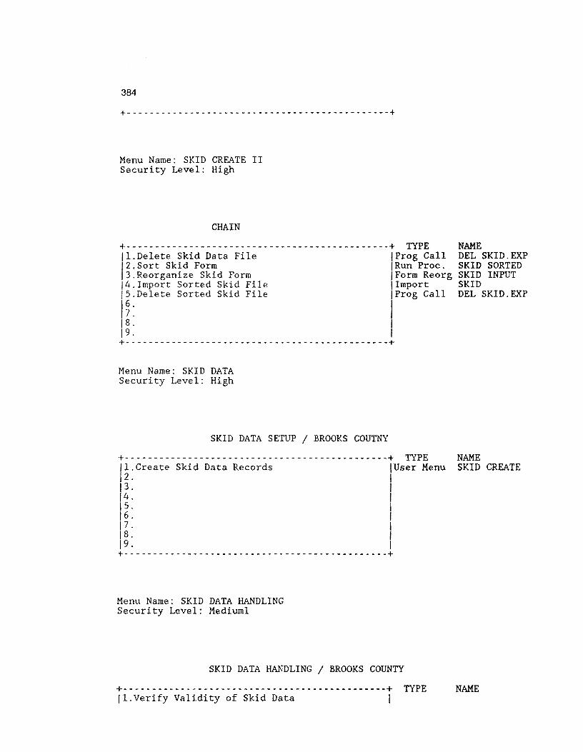
384
+- ---------- -- -------------- ----- ----- --------+
Menu Name: SKID CREATE II Security Level: High
CHAIN
+----------------------------------------------+ TYPE NAME 11.Delete Skid Data File !Prag Call DEL SKID.EXP 12.Sort Skid Form 'Run Proc. SKID SORTED 13.Reorganize Skid Form Form Reorg SKID INPUT j4.Import Sorted Skid File !Import SKID j5.Delete Sorted Skid File IProg Call DEL SKID.EXP 16. I 17. I 18. I 19. I +----------------------------------------------+
Menu Name: SKID DATA Security Level: High
SKID DATA SETUP / BROOKS COUTNY
+----------------------------------------------+ TYPE NAME jl.Create Skid Data Records jUser Menu SKID CREATE 12. I i 3. I 14. I 1 s. I 16. I 17 · I i 8. I 19. I +- - - - - - - - - - - - - - - - - - - - - - - - - - - - - - - - - - - - - - - - - - - - -+
Menu Name: SKID DATA HANDLING Security Level: Mediuml
SKID DATA HANDLING / BROOKS COUNTY
+----------------------------------------------+ TYPE NAME 11.Verify Validity of Skid Data I

12.Transfer 13. 14. 1 s. 16. 17. 18.
Skid Data to Master Data Form I Run I I I
I I
19. I +----------------------------------------------+
Menu Name: SKID DATA INPUT Security Level: Mediurnl
SKID DATA ENTRY / BROOKS COUNTY
Proc.
+ ----------------------------------------------+ TYPE 11.Transfer Skid Field Data IProg Call 12.Import Transferred Skid Field Data fUser Menu 13.Validate Errors in Imported Skid Data File jRun Proc. 14.Correct Errors in Imported Data File !Prog Call IS.Perform a Quick Edit on Skid.dat IProg Call 16. I 17. I 1 s. I 19. I +- --------------------------------------------+ Menu Name: SKID ERRORS Security Level: Mediuml
CHAIN
+ - - - - - - - - - - - - - - - - - - - - - - - - - - - - - - - - - - - - - - - - - - - - - -+ TYPE 11.List the Roadway Section Where Errors Occur !Run Proc. 12.Edit the Errors IProg Call 13. I 14.
1
1
15. 16. I 17 · I 18. I 19. I +- - - - - - - - - - - - - - - - - - - - - - - - - - - - - - - - - - - - - - - - - - - - - -+
Menu Name: SKID IMPORT Security Level: Mediurnl
CHAIN
+- - - - - - - - - - - - - - - - - - - - - - - - - - - - - - - - - - - - - - - - - - - - - -+ TYPE 11.Import Transferred SKID Field Data !Import j2.Copy Errors into File IProg Call 13.List Errors to Printer IProg Gall !4.Delete Error Files IProg Call 1 s. I
385
SKID MASTER UPDATE
NAME SKIDSEG SKID IMPORT SKID VIEW EDIX SKID.DAT skidedit.exe
NAME SKID VIEW EDIX SKID.DAT
NAME SKID IMP
COPY SKI*.E?? ER.ERR SKIDERR.EXE DEL *.E??

386
j 6. 1' 17. 18. I 19. I +----------------------------------------------+
Menu Name: VISUAL CREATE Security Level: High
CHAIN
+------------------------- --------------------+ TYPE NAME 11.Sort Master Data in Ascending Order !Run Proc. ORDERED MASTER FILE 12.Import Sorted Master Data into Temp Form I Import SORTA 13.Delete Sorted Data File IProg Call DEL SORT.DAT 14.Generate Visual Records !Run Proc. GENERATE VIS FILE IS.Reorganize Visual Data File !Form Reorg VIS j6.Import Visual Records into Visual Form !Import VISUAL 17.Delete Visual Data File jProg Call DEL VISUAL.EXP 18. I 19. I +- - - - - - - - - - - - - - - - - - - - - - - - - - - - - - - - - - - - - - - - - - - - - -+
Menu Name: VISUAL DATA Security Level: High
VISUAL DATA SETUP / BROOKS COUNTY
+----------------------------------------------+ TYPE NAME 11.Create Visual Data Records !User Menu VISUAL CREATE 12. I 13 · I 14. I 1 s. I 16. I 17 · I 18. I 19. I +- - - - - - - - - - - - - ,. - - - - - - - - - - - - - - - - - - - - - - - - - - - - - - - -+
Menu Name: VISUAL DATA HANDLING Security Level: Mediuml
VISUAL DATA HANDLING / BROOKS COUNTY
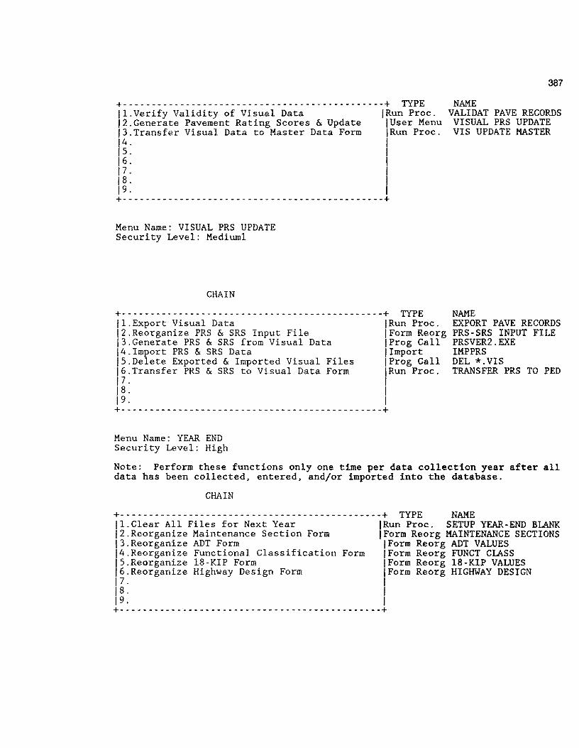
+- ------ ------- ----- --- ---- - ------ -- ---- -------+ TYPE 11.Verify Validity of Visual Data jRun Proc. 12.Generate Pavement Rating Scores & Update jUser Menu 13.Transfer Visual Data to Master Data Form IRun Proc. 14. I 1s. 16. I 17. 1'
18. 19. I +----------------------------------------------+
Menu Name: VISUAL PRS UPDATE Security Level: Mediuml
CHAIN
+- - - - - - - - - - - - - - - - - - - - - - - - - - - - - - - - - - - - - - - - - - - - - -+ TYPE 11.Export Visual Data IRun Proc. 12.Reorganize PRS & SRS Input File !Form Reorg j3.Generate PRS & SRS from Visual Data IProg Call 14.Irnport PRS & SRS Data !Import IS.Delete Exported & Imported Visual Files jProg Call 16.Transfer PRS & SRS to Visual Data Form IRun Proc. 17. ' 18. I 19. I +- - - - - - - - - - - - - - - - - - - - - - - - - - - - - - - - - - - - - - - - - - - - - -+
Menu Name: YEAR END Security Level: High
387
NAME VALIDAT PAVE RECORDS
VISUAL PRS UPDATE VIS UPDATE MASTER
NAME EXPORT PAVE RECORDS PRS-SRS INPUT FILE PRSVER2.EXE IMPPRS DEL *.VIS TRANSFER PRS TO PED
Note: Perform these functions only one time per data collection year after all data has been collected, entered, and/or imported into the database.
CHAIN
+--------------- ------------------------------+ TYPE NAME 11.Clear All Files for Next Year IRun Proc. SETUP YEAR-END BLANK 12.Reorganize Maintenance Section Form IForm Reorg MAINTENANCE SECTIONS 13.Reorganize ADT Form !Form Reorg ADT VALUES 14.Reorganize Functional Classification Form !Form Reorg FUNCT CLASS IS.Reorganize 18-KIP Form IForm Reorg 18-KIP VALUES 16.Reorganize Highway Design Form !Form Reorg HIGHWAY DESIGN 17. I 1 s. I 19. I +-----------~----------------------------------+

388
Appendix H Detailed Specification for all Import Procedures
The following import procedures are required to import data into various files within the database. Details regarding the type of import, matching rules, source data drive, and target data drive are provided.
These specifications coordinate with the import files shown in Appendix F of this report. The details that follow define the import procedure, the source file, the targed file, and the import protocol.
lll'pOrt Definitions
Import Destination Form
ADTIMP ADT VALUES Destination Form: A:ADT.DAT Auto Decimal: No Special 7
FCIMP FUNCT CLASS Destination Form: A:FC.DAT Auto Decimal: No Special 7 Record Sep:
Format
VAR.LENGTH
Record Sep:
VAR.LENGTH
F\JO FWD INPUT VAR.LENGTH Destination Form: d:F\JO.EXP
Auto Decimal: No Special 7 Record Sep: ;
FIJOIMP F\JO INPUT VAR.LENGTH Destination Form: d:F\JO.CON
Auto Decimal: No Special 7 Record Sep: ;
HDIMP HIGHIJAY DESIGN VAR.LENGTH Destination Form: A:HD.DAT Auto Decimal: No Special 7 Record Sep: ;
IMPPRS PRS·SRS INPUT FILE VAR.LENGTH Destination Form: d:IMPORT.VIS Auto Decimal: No Special 7 Record Sep: ,
INVENTRY DISTRICT INVENTORY VAR.LENGTH Destination Form: d:INV.DAT Auto Decimal: No Special 7 Record Sep: ;
KIPIMP 18-KIP VALUES VAR.LENGTH Destination Form: A:KIP.DAT Auto Decimal: No Special 7 Record Sep: ;
MASTER MASTER VAR.LENGTH Destination Form: d:MASTR.EXP Auto Decimal: No Special 7 Record Sep: ;
MSIMP MAINTENANCE SECTIONS VAR.LENGTH Destination Form: A:MS.DAT Auto Decimal: No Special 7 Record Sep: ;
Add or Update ---·- .. ··-----Update Match
Update Match
Update Match
Update Match
Update Match
Add Non-Match
Update Match
Update Match
Update Match
Update Match
REFIMP MASTER VAR.LENGTH Update Hatch Destination Form: D:\DEASE\BROOKS\IMP.024 Auto Decimal: Yes Special 7 Record Sep:
RIDE RIDE INPUT VAR.LENGTH Update Match
Organized ______ ........
Auto Dec
Auto Dec
Auto Dec
Destinat
Auto Dec
Auto Dec
Auto Dec
Auto Dec
Source F
Auto Dec
Destinat
Auto Dec
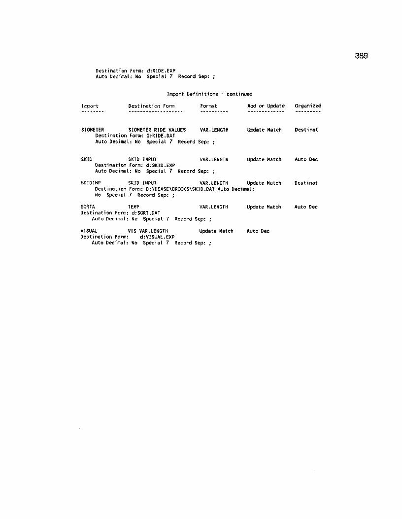
389
Destination Form: d:RIDE.EXP Auto Decimal: No Special 7 Record Sep:
Import Definitions · continued
Import Destination Form format Add or Update Organized
SIOMETER SIOMETER RIDE VALUES VAR.LENGTH Update Match Destinat Destination Form: G:RIDE.DAT Auto Decimal: No Special 7 Record Sep: ;
SKID SKID INPUT VAR.LENGTH Update Match Auto Dec Destination Form: d:SKID.EXP Auto Decimal: No Special 7 Record Sep: ;
SKIDIMP SKID INPUT VAR.LENGTH Update Match Destinat Destination Form: D:\OEASE\BROOKS\SKIO.DAT Auto Decimal: No Special 7 Record Sep:
SORTA TEMP VAR. LENGTH Update Match Auto Dec Destination Form: d:SORT.DAT
Auto Decimal: No Special 7 Record Sep: ;
VISUAL VIS VAR.LENGTH Update Match Auto Dec Destination Form: d:VISUAL.EXP
Auto Decimal: No Special 7 Record Sep: ;
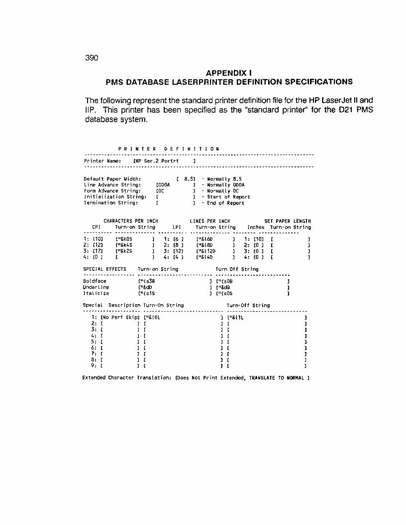
390
APPENDIX I PMS DATABASE LASERPRINTER DEFINITION SPECIFICATIONS
The following represent the standard printer definition file for the HP LaserJet II and llP. This printer has been specified as the "standard printer" for the 021 PMS database system.
P R I N T E R D E F I N I T I 0 N
Printer Name: [HP Ser.2 Portrt
Default Paper Yidth: Line Advance String: Form Advance String: Initialization String: Termination String:
CODOA roe [
[
CHARACTERS PER INCH CPI
1 : (1 OJ 2: [12] 3: [17] 4: co ]
Turn-on String
[11&kOS
["&k4S ["&k2S [
LPI
1: [6 ] 2: [8 J 3: [12} 4: [4 ]
SPEC I AL EFFECTS Turn-on String
Boldface Underline Italicize
["(s3B ["&c:ID ["(s1S
Special Description Turn-On String
1: [No Perf Skip] [11&LOL 2: [ ] [ 3: [ ] [ 4: r 1 c 5: [ ] [ 6: ( ] [ 7: [ ] [ 8: [ l [ 9: [ l [
8.5) - Normally 8.5 l - Normally ODOA ] - Normal l y OC l - Start of Report 1 - End of Report
LINES PER INCH SET PAPER LENGTH Turn-on String Inches Turn-on String
["&160 C"&l8D C"&l 120 ["&l4D
1: C1 OJ C 2: co ] [ 3: [0 l [ 4: [0 J [
Turn Off String
[''(sOB ["&dQl [ 11 (s0S
Turn-Off String
l [11&l1L ] [
] c ] [ ] [ ] [ ] [
l [ J [
]
l l ]
l l ] ] ]
Extended Character Translation: [Does Not Print Extended, TRANSLATE TO NORMAL J

391
APPENDIX J COMPILED MICROSOFT QUICKBASIC PROGRAMS TO SUPPORT PMS DATA
IMPORT-EXPORT ACTIVll"IES
The following programs, written in Microsoft Quick-Basic (Version 4.0 and 4.5) support selected ASCII data import-export activites. These routines were authored by Mr. Craig Cox, 018-PM and Dr. Don Smith, TAMU-TTl-INEN. A brief description of each program preceeds the source code listing.
Each of the programs listed within this appendix have been compiled into .EXE code and copied into the root directory of the PMS Database. Thus, each of the 1 O county sub-directories under the PMS main directory can access each .EXE program as required.
392
RI DEC.BAS
Converts raw Siometer Data as supplied by D21 field data collection activities into a format suitable for ilJllOrting into the Siometer Holding File.
DECLARE SUB TOFILE (A$, PRIORA$) DECLARE SUB PAUSE () 1 1991 SIOMETER FORMAT RIDE.DAT IMPORT PREPARATION PROGRAM 1 MODIFIED BYD. R. SMITH: 3·28-91 • TAMU-INEN·TTl·D21: TT! PROJECT 900-1 'BASED UPON THE FOLLOWING MMSS1 HEADER FORMAT
COLUMNS INFORMATION 1·5 MMSS1 HEADER ID (HEADER TAG) 6-7 DISTRICT NUMBER C21> 8 LANE CODE (A·Z)
9-14 DATE DATA COLLECTED (EX: 110890) 15·21 SIOMETER UNIT NUMBER 22-24 3 DIGIT COUNTY NUMBER e.g 024 C= Brooks County) 25·26 HW PREFIX e.g. FM, US, IH, SH, •• 27·30 HW NUMBER 31 HW SUFFIX (MOST = BLANK, SOME = S ) 32-35 REF MARKER VALUE (4 DIGITS e.g. 0656 =656 36 REF MARKER SUFFIX 37 REF MARKER DISP SIGN ( + OR • )
38-39 REF MARKER DISP. VALUE (VALUE X 10)
'************** FORMAT FOR THE MMSS2 SIOMETER RECORD ************************ COLS
1 • 5 6 - 8
9-10
DATA DEFINITION HEADER ID = ( MMSS2 ) = A SIOMETER VALUE RECORD SEQUENCE NUMBER i.e., 001, 002, ••• ,010 exist in blocks of 10 or less C 2 mile segments) FIRST SIOMETER VALUE· 2 DIGITS I.E., 29
14 . 15 19 - 20
I 24 " 25 29 - 30
SECOND SIOMETER VALUE .•. THIRD VALUE FOURTH VALUE... {MAX OF 5 VALUES/RECORD) FIFTH VALUE •.•
'** MMSS2 PERMISSIBLE RECORDS LENGTHS FOR THE MMSS2 RECORD: 1 5 VALUES: L = 30: 4 VALUES: L=25: 3 VALUES: L=20: 2 VALUES: L=15: I 1 VALUE L = 10 1 COLUMNS 1-8 = MMSS2XXX WHERE XXX = SEQUENCE NUMBER BEG AT 001 • 010 1 ***************** END OF FORMAT DEFINITIONS *****************************
' DATABASE IMPORT KEY DEFINITION 1 DATABASE KEY FIELD NAME IN THE FILE SIOMETER RIDE VALUES
I RIDEID ' TEXT, MAXIMUM OF 16 ALPHA-NUM CHARACTERS BASED UPON: 1 COUNTY NUMBER + HIGHWAY PREFIX + HIGHWAY NUMBER + HIGHWAY SUFFIX + ROADYAY I + TO RM VALUE
WIDTH LPRINT 131 LPRJNT CHR$(27}; 11&k2S111 print code for the HPLJ SERIES II COMPRESSED CLEAR LNO% = 0 1 SET LINEPRINT RECORD COUNTER TO 0 CLS LOCATE 2, 15: PRINT "D21 Siometer (Ride) Data Conversion Program" LOCATE 3, 23.: PRINT "Version 2.0: March, 1991 11
BEEP: LOCATE 4, 5: INPUT "County Name for this run "; cnameS tagO: LOCATE 5, 5: INPUT "Designate the Data Drive (A,B)"; ORV$
tag1:
LOCATE 7, 5: PRINT II II
IF ORV$ = 11 8 11 THEN ORV$ = "A:": GOTO tag1 IF ORV$ = "A" THEN ORV$ = 11A: 11 : GOTO tag1 IF ORV$ = 11b11 THEN ORV$ = "B:": GOTO tag1 IF ORV$= 11811 THEN ORV$ = 11 B: 11 : GOTO tag1 BEEP: LOCATE 7, 5: PRINT "Invalid Drive: Must be A or B: Re-enter" GOTO tagO
LOCATE 7, 5: PRINT "Designated Drive is the"; ORV$; II drive" LOCATE 8, 5: PRINT "Make certain the correct data disk is in the 11 ; ORV$; 11 drive"
RIDEC.BAS ••• continued
FIN$ = ORV$ + "VAL RIDE .DAT" FOUT$ = ORV$ + "RIDE.DAT" PR INT 11 INPUT FI LE IS • • • "; FIN$ PRINT "WTPUT FILE JS ••• "; FOOT$ INPUT "Do you want a hard copy of the output file?(Y/N) "; YNS YN$ = UCASESCYNS) OPEN FOUTS FOR OUTPUT AS #2 'OUTPUT FILE TO IMPORT INTO DE OPEN FINS FOR INPUT AS #1 'VALIDATED FILE TO CONVERT CALL PAUSE CLS
'PRINT THE FIELD NAMES AT THE TOP OF THE OOTPUT FILE PER DATAEASE IMPORT 'REQUIREMENTS. THESE FIELD NAMES HATCH THE SIOMETER RIDE VALUES DATABASE 'FIELD NAMES
IF YNS = "Y" THEN LPRINT "County Name: 11; cnameS
PRINT "PRINTING THE DATABASE HEADERS AT TOP OF OUTPUT FILE" PRINT #2, "IMPORT SIOM KEY"; ";"; "SI VALUE"; ";"; "COMMENTS"; 11 ; 11 ; "YEAR" IF YN$ = "Y" THEN
LPRINT "REC NO"; "RIDEID"; 11;
11; "SI VALUE"; ";"; "COMMENTS"; 11
;11
; "YEAR" END IF
'OPEN THE VAL RIDE.OAT INPUT FILE AND READ EACH RECORD UNTIL EOF CONDITION I Is ENCOUNTERED
MMSS1% = 0 WHILE NOT EOF(1)
LINE INPUT #1, AS MMSS1% = MMSS1% + 1 'INCREMENT THE MMSS1 COUNTER HOLDS = AS
' CHECK FOR A MMSS1 HEADER RECORD IN THE INPUT FILE ' AND BUILD THE DATABASE IMPORT SORTING KEY STRING
T$ = MIDSCAS, 1, 5)
AAA:
PRINT T$
IF M!DSCAS, 1, 5) = "MMSS1" THEN
IF MMSS1% = 1 THEN PRINT #2, MIDS(AS, 1, 50) GOTO AAA
END IF IF YNS = "Y" THEN
LPR!NT SHORTS = MIDS(AS, LPRINT SHORTS;
1, 45)'SHORTEN AS TO FIT ON ONE LINE
IF PRIORAS =A$ THEN LPRINT " CONFLICT WITH ELSE LPRINT II *** OK ***"
END IF
IF YN$ = 11Y11 THEN LPRINT END IF
CALL TOFILECAS, PRIORAS)
TEMPAS = A$
'LPRINT CURRENT MMSS2 RECORD 'CHECK LAST MMSS1 TO CURRENT MMSSS1 LAST MMSS1 REC."
CNTY$ = MIDS(AS, 22, 3) 'OBTAIN THE COUNTY NO CVALUE = VAL(CNTY$) IF CVALUE <= 99 THEN CNTY$ = RIGHTS(CNTYS, 2)
PRES = MIDSCAS, 25, 2) NUMS = MIDS(AS, 27, 4) SFXS = MIDS(AS, 31, 1) LANS = MID${A$, 8, 1) If LAN$ > 11Q11 AND LAN$ < 11W11 THEN RDWY$ = "R" IF LAN$ > "IC" ANO LAN$ < 11Q11 THEN RDWYS : "L" IF LAN$ < 11011 THEN RDWY$ = "A" IF LAN$ > "W" THEN RDWY$ ::: "X" YEARS = MID${A$, 13, 2)
1 BUILD THE STARTING REF MARKER VALUE FROM THE MMSS1 RECORD
393
394
RIDEC.BAS ••• conti~
RMVALUE$ = MID$(A$, 32, 4) RMV = VALCRMVALUE$) ' CONVERT TO A REAL NUMBER
' check to see of the RMV is an even 10 mile record i.e. 520.0 • this particular ref marker must be written as 520 not 520.0 in order to • match the import key in the dataease 0.10·mile siometer file
RMSIGNS = MID$(A$, 37, 1) RMDISPV$ = MID$(A$, 38, 2) RMD = VALCRMDISPVS) RMD = RMD I 10! IF RMSIGNS = 11+11 THEN
START = RMV + RMD ELSE
START = RMV - RMD END IF
' DEFINE THE FIRST PART OF THE RIDE KEY:
PRIORA$ = A$ 'STORE THE CURRENT MMSS1 REC TO COMPARE WITH NXT END IF
' CASE: MMSS2 RECORD IF MIDSCAS I 1' 5) ::: "MMSS2" THEN
CMS = " " L = LENCAS) 'DETERMINE THE LENGTH OF CURR MMSS2 REC.
IF L > 9 THEN SIS = MIDSCAS, 9, 1) + 11 • 11 + MIOSCA$, 10, 1) IF L > 11 THEN CM$ = MI0$(A$, 12, 1) IF SIS <> II • II THEN GOSUB 100 IF L > 14 THEN SJ$ = MIDS(A$, 14, 1) + 11 • 11 + MIOS{AS, 15, 1) IF L > 16 THEN CMS = MID$(A$, 17, 1) IF SIS <> 11
• " THEN GOSUB 100 IF L > 19 THEN SI$ = MIDS(AS, 19, 1) + "·" + MIDSCAS, 20, 1) IF L > 21 THEN CMS = MIDSCAS, 22, 1) IF SJ$ <> II • II THEN GOSUB 100 IF L > 24 THEN SI$ = MIDS(A$, 24, 1) + 11 • 11 + MIOS(AS, 25, 1) IF L > 26 THEN CMS= MIDSCAS, 27, 1) IF SIS <> II • II THEN GOSUB 100 IF L > 29 THEN SI$= MIO$(AS, 29, 1) + 11 • 11 + MIOS(AS, 30, 1) IF l > 31 THEN CMS = MID$(A$, 32, 1) IF SIS <> 11 • " THEN GOSUB 100 END IF
WEND
CLOSE #1, #2 CLS : BEEP: LOCATE 10, 10: PRINT "RIDE CONVERSION FINISHED •••. " CALL PAUSE
1 SEND A FORMS FEED TO THE PRINTER TO FLUSH THE LAST PAGE IF YSS = 11Y11 THEN LPRINT CHRS(12) END
'GOSUB TO PRINT EACH RECORD TO THE OUTPUT (IMPORT) FILE ON UNIT #2
100 :
1 START = THE RM VALUE AT THE BEGINNING OF THE HW SEGMENT ' RMSIGNS = + OR - DEPENDING UPON THE LANE
IF RDWY$ = "R" OR RDWY$ = "A" THEN START = START + .2
ELSE IF RDWY$ = 11L 11 OR RDWY$ = "X" THEN START = START - .2
END IF
1 CONVERT TO TO 10-TH MILE VALUE ' START= A NUMERIC VALUE FOR THE REF MARKER ••• MUST CONVERT TO A STRING ' DUE TO THE MANNER IN WHICH QBASIC COMPUTES, NUM REPRESENTATION MAY BE TO ' MORE THAN ONE PLACE. IF SO, THE VALUE MUST BE CONVERTED TO THE NEAREST
RIDEC.BAS •.. contil"K.led
1 10·TH OF A MILE I.E. 524.2 NOT 525.20001 •••••• THE NEXT CODE SEGMENT 1 CONVERTS TO A STRING VALUE WITH ONE PLACE TO THE RIGHT OF THE DECIMAL
TEMP$ = STR$(START) 'CONVERT START TO A STRING LL% = LENCTEMPS) IF LEFT$CTEMP$, 1) = II II THEN TEMP$= RlGHT$(TEMP$, LL% • 1} LL%= LENCTEMP$) • CAL THE TOTAL LENGTH OF THE STRING EQUIVALENT IF LL%= 3 THEN TEMP$ = TEMPS + 11 .011 'IF L=3 WE NEED A FORCED DEC pt. E% = 1 1 SET A COUNTER = TO 1
XXX: COMPARES= MIOS(TEMPS, E%, 1) IF COMPARE$ <> 11 • 11 THEN
1 PHARSE THROUGH TO FIND THE . 1 DECIMAL FOUND?
E% = EX+ 1 1 NOT FOUND ADD ONE TO COUNTER GOTO XXX 1 GO BACK ANO SEARCH CHECK NEXT PLACE
ELSE DECPLACE% = E% PLEFT% = E% - 1
END IF
BS = LEFT$(TEMP$, PLEFT%) C$ = MlDS(TEMPS, E% + 1, 1) TEMP$ = BS + 11 • 11 + C$
' CONVERT TO A STRING PLACES TO LEFT 1 NEAREST 10·MILE DISP VALUE HELD 1 PUT THE RM VALUE BACK TOGETHER
1 BUILD THE IMPORT KEY FOR THE DATABASE AV% = ASC(SFX$) PRINT "***ASCII VALUE OF SFXS="; AV%; 11 ********" CALL pause
IF ASC(SFX$) = 0 OR ASC(SFX$) = 32 THEN part1$ = CNTY$ + PRE$ + NUM$ + ROWY$
ELSE part1$ = CNTY$ + PRES + NUM$ + SFX$ + RDWYS
ENO IF '******************** END OF BLOCK TO CHECK ON SFX$ *********************** ' CHECK TO SEE IF RM VALUE =AN EVEN 10-TH MILE VALUE J.E., 520.0 ' THIS PARTICULAR RM VALUE MUST BE WRITTEN AS 520 NOT 520.0 IN ORDER TO 'MATCH THE DATAEASE 0.1-MILE SORT KEY IN THE SJOMETER FILE
TAILS= RIGHTSCTEMPS, 1) IF TAILS = 11011 THEN TEMPS = LEFTSCTEMP$, 3)
KEYS = part1$ + TEMP$ RMV$ = TEMP$ PRINT #2, KEYS; ";"; SIS; 11 ;
11; CMS; 11
;11
; YEAR$ 'PRINT LNO%; 11 11 ; KEY$; 11 ; 11 ; SIS; 11 ; 11 ; CM$; ";"; YEARS IF YS$ = "Y" THEN
LNO% = LNO% + 1 LPRINT LNO%; 11 ";
LPRINT TAB(8); KEYS; 11;
11; SI$; 11
;11
; CMS; ";"; YEARS; END IF SI$ = " II
CM$ :: II II
RETURN
SUB PAUSE STATIC LOCATE 25, 50 PRINT "Press any key to Continue" DO WHILE INKEY$ = "" LOOP END SUB SUB TOFlLE (AS, PRIORAS) STATIC
SHORTS= MID$(A$, 1, 45)'SHORTEN AS TO FIT ON ONE LINE
II• H • I I
PRINT #2, SHORTS; 'LPRINT CURRENT MMSS2 RECORD IF PRIORA$ = AS THEN 'CHECK LAST MMSS1 TO CURRENT MMSSS1
PRINT #2, 11 CONFLICT WITH LAST MMSS1 REC." ELSE
PRINT #2, II *** OK ***" END IF END SUB
RMV$
395

396
RIDEFORM.BAS
RI DEFORM.BAS opens a datafile on the A: drive (raw siometer data) and reformats the data into an ouput file suitable of importation in the ride data holding file.
DIM C1$(40,3),C2$(10,3) C=O OPEN "A:RIDE.EXP" FOR INPUT AS #1 \.IHILE NOT EOf (1)
LINE INPUT #1, A$ IF C>O THEN 5
TSTS=MIDS(AS,7,11) RO\.IYS=MID$(A$, 17,1) IF RD\.IY$="R" OR RD\.IY$="A11 THEN 2
TP$=Ml0$(A$,23,5) GOTO 3
2 TP$=MI0$(A$,18,5) 3 TP=VALCTP$)-0.2
TP=INT(TP*10) CNTYS=MID$(A$,7,3) HWYS=MID$(A$,10,7)
5 HDRS=MIDSCAS,7,11) IF TST$=HDR$ THEN 7 GOTO 30
7 IF ROWY$=11 R" OR RD\.IYS="A" THEN TP=TP+2 ELSE TP=TP·2 TP=INT(TP) IF RDWY$="R" OR RD\.IYS="A" THEN 8
SEQ$=MID$(AS,23,5) GOTO 9
8 SEQ$=MIOS(A$, 18,5) 9 SEQ=VAL(SEQ$)
SEO=INT(SEC*10) IF SEQ=TP THEN 10 GOTO 30
10 C=C+1 IF C<51 THEN 12
C=C·1 GOTO 30
12 IF C<41 THEN 15 C2$(C·40,1)=MID$(A$,1,6) C2$(C·40,2)=MIDS(A$, 18,5) C2$(C-40,3)=MIO$(A$,23,5) GOTO 50
15 C1$(C,1)=MIDS(A$,1,6) C1$(C,2)=M!0$(A$, 18,5) C1SCC,3)=Ml0$(AS,23,5) GOTO 50
30 FOR 1=1 TO 6
35
LPRINT NEXT I LPRINT SPACE$(20);"COUNTY: ";CNTYS; LPRINT SPACE$(13);"HIGH\.IAY: ";HWY$ LPR!NT LPRINT LPRINT SPACE$(33);"ROAD\.IAY: ";RO\.IY$ FOR 1=1 TO 10
LPRINT NEXT I IF C>40 THEN 35
FOR 1=1 TO C
GOTO 40 C2=C·40
NEXT I
LPRINT SPACE$(9);C1$(!,1);SPACE$(4); LPRINT C1S(I,2);SPACESC5);C1$(1,3)

RIDEFORM.BAS ••• continued
FOR 1=1 TO C2
NEXT I
LPRlNT SPACE$(9);C1$(1,1);SPACE$(4); LPRINT C1$(1,2);SPACE$(5);C1$(1,3);
LPRINT SPACE$(13);C2$(1,1);SPACE$(4); LPRINT C2$(1,2>;SPACE$(5);C2$(1,3)
FOR l=C2+1 TO C-C2
NEXT I
LPRINT SPACE$(9);C1$(1, 1);SPACE$(4); LPRINT C1$(1,2);SPACE$(5);C1$(1,3)
40 C=1 C1$(1,1)=MI0$(AS,1,6) C1$(1,2)=Ml0$(A$,18,5) C1SC1,3)=MIDS(AS,23,5) TSTS=MIDS(AS,7,11) RDllY$=MID$(A$,17,1) IF RDllY$= 11 R11 OR RDllYS= 11A11 THEN 41
TPS=MID$(A$,23,5) GOTO 42
41 TPS=MID$(A$,18,5) 42 TP=VAL(TPS)
50 llENO
135
240 CLOSE #1 ENO
TP=INT(TP*10) CNTYS=MIDS(AS,7,3) HllY$=Ml0$(A$,10,7) LPRINT CHR$(12); GOTO 50
FOR 1=1 TO 6 LPRINT
NEXT I LPRINT SPACESC20); 11COUNTY: ";CNTYS; LPRINT SPACE$(13); 11 HIGHllAY: ";HWY$ LPRINT LPRINT LPRINT SPACESC33); 11ROADllAY: ";RDllY$ FOR 1=1 TO 10
LPRINT NEXT I IF C>40 THEN 135
FOR 1=1 TO C LPRINT SPACE$(9);C1S(l,1);SPACE$(4); LPRINT C1$(!,2);SPACE$(5);C1$(I,3)
NEXT I GOTO 240
C2=C-40 FOR 1=1 TO C2
NEXT I
LPRINT SPACE$(9);C1S(!,1);SPACE$(4); LPRINT C1$(1,2);SPACE$(5);C1$(J,3); LPRINT SPACE$(13);C2$(l, 1);SPACE$(4); LPRlNT C2$(1,2);SPACESC5);C2$(1,3)
FOR I=C2+1 TO C·C2
NEXT
LPRINT SPACESC9);C1SCl,1);SPACESC4); LPRINT C1$(1,2);SPACE$(5);C1$(l,3)
397
398
RIDERR.BAS
The RIDERR.bas program reads the DataEase exception file following an import pass and selects those records from the original import file that did not match the import run. The program retains the format of the import file which allows the user to enter a text editor and edit the records in preparation for another import pass.
' BASIC PROGRAM TO READ THE ER.ERR FILE FROM THE DATABASE AND PRINT THE 'MIS-MATCHED RECORDS TO THE LINE PRINTER VERSION APRIL, 1991
PRINT "PROGRAM TO LIST UN-MATCHED RIDE RECORDS TO THE PRINTER" BEEP INPUT "MAKE READY THE PRINTER ••• LOAD WITH PAPER ANO ON·LINE"; OUM$ INPUT "MAKE CERTAIN THE SIOMETER DISK IS IN THE B: DRIVE"; OUM$ ON ERROR GOTO 999 OPEN "B: \ER. ERR" FOR INPUT AS #1 OPEN "B:\RIDE.DAT" FOR INPUT AS #2 OPEN "B: \RIDE. TMP" FOR OUTPUT AS #3 LINE INPUT #2, A$ PRINT #3, A$ FC = 0 LPRINT LPRINT LPRINT II
LPRINT LPRINT ""
RIDE ERRORS"
LPRINT II CNTY REF. MARKER KEY RWY SI CMT YEAR" LPRINT 11
·-·-·····--·--·····--------------···----·--------·----·--···--···---11
10 LINE INPUT #1, A$ L = LEN(A$) LN = 0 FOR I = 1 TO L
TS= MIDS(A$, I, 1) IF T$ = 11 : 11 THEN LN = I · 1
NEXT I IF LN = 0 THEN 999 LN$ = MID$(A$, 1, LN) LN :: VAL(LN$) IF FC > LN THEN
END IF
CLOSE #2 OPEN "B:\RIDE.DAT" FOR INPUT AS #2 LINE INPUT #2, DUMMY$ FC = 0
WHILE NOT EOFC2) ANO FC <> LN LINE INPUT #2, 8$ FC = FC + 1
WEND PRINT #3, B$ LPR!NT "discarded.. "; 8$ GOTO 10
999 CLOSE #3, #2, #1 SHELL "DEL B:\RIDE.DAT" SHELL "RENAME 8:\RIDE. TMP RIDE.DAT" ENO

399
SKIDCOMP.BAS
SKIDCOMP.BAS prepares raw skid data as supplied from the District in order to import the data into the Skid holding file.
PROGRAM NAme: SKIDCOMP.BAS DIM N$(50, 4)
***************
DIM D$(500) DIM G$(500) DIM conty(50)
•************************************************************************* '************** •************** '**************
OPEN DATA FILE AND SETUP COUNTERS *********** *********** ***********
'*************************************************************************
CLS : COLOR 2, 0 PRINT 11 Processing in Skidcomp.bas"
20 NAME$ = "ALL.SKD" CLS PRINT "Opening COUNTY .DAT file to obtain val id county m.rrbers" OPEN "COUNTY.DAT" FOR INPUT AS #1 cnties = 0 WHILE NOT EOF(1)
cnties = cnties + 1 INPUT #1, conty(cnties)
WEND CLOSE #1 FOR jjjj = , TO cnties
PRINT jjjj; 11 11 ; conty(jjjj) NEXT jjjj INPUT "press return to continue"; dun$
OPEN NAME$ FOR INPUT AS #1 CNT = 0 NC = 0 LC$ = "''
1 CARD COUNTER 1 COMMENT 11911 COUNTER 1 LAST DATA CARD ENCOUNTERED
•************************************************************************* •*************** •*************** '***************
READ JN DATA AND TEST ***************** ***************** *****************
•*************************************************************************
WHILE NOT EOF(1) LINE INPUT #1, A$
'************************************** '*** IF "A" DATA TYPE VALIDATE **** '**************************************
30 IF MID$(AS, 1, 1) = "A" THEN
'*********************************************** •*** CHECK IF LAST CARD IS A COMMENT 11911 *** '***********************************************
IF NC = 1 AND CNT <> 0 THEN D$(CNT • 1> = DS(CNT) CNT :: CNT - 1 NC = 0
END IF

400
SKIDCQIU>.BAS •• contirx.ied
'************************************** '*** PROCESS LAST 1181 11 DATA SET *** '************************************** IF CNT <> 0 THEN GOSUB 100 '*************************************** •*** SET VARIABLES FROM "A" CARD *** •***************************************
YEAR$ = MI0$(A$, 10, 2) AC$ = A$ CNT = 0 LC$ = "A" GOTO 999
END IF
'********************************* '*** lF 1181 11 TYPE VALIDATE *** '*********************************
IF MID$(A$, 1, 2) = "Bl" THEN
'*********************************************** •*** CHECK IF LAST CARD IS A COMMENT 119 11 *** •***********************************************
IF NC = 1 THEN 0$(CNT · 1) = 0$(CNT) CNT = CNT · 1 NC = 0
END IF
•************************************** '*** SET VARIABLES TO 11B1 11 CARD *** '**************************************
CNT = CNT + 1 0$(CNT} = A$ LC$ = 1181 11
GOTO 999
END IF
•************************************** '*** IF 118211 TYPE THEN VALIDATE *** •**************************************
IF Ml0$(A$, 1, 2) = 118211 THEN
•*********************************************** '*** CHECK IF LAST CARD IS A COMMENT 11911 *** '***********************************************
IF NC = 1 THEN 0$(CNT • 1) = 0$(CNT) CNT = CNT · 1 NC = 0
END IF '************************************** '*** SET VARIABLES TO 118211 CARD *** •**************************************
CNT = CNT + 1 0$(CNT) = A$ LC$ = 118211
GOTO 999 END IF
SKIDCCJV>.BAS ••• contir..ied
•************************************* •*** IF "C" TYPE THEN VALIDATE *** •*************************************
IF Ml0$(A$, 1, 1) = "C" THEN
'************************************************* '*** CHECK FOR Ca-tMENT 119" ANO SET COUNTER *** •*************************************************
IF MID$(A$, 13, 1) = "9" THEN NC = NC + 1
'***************************************************** '*** '***
If 2 CONSECUTIVE Ca-tMENT 119"S THEN DELETE ENTIRE DATA SET
*** ***
'*****************************************************
IF NC = 2 THEN CNT = 0 NC : 0
END IF
'************************************* '*** SET VARIABLES TO "C" CARO *** '*************************************
LC$ = "C" GOTO 999
END IF
'****************************************** '*** CHECK IF LAST CARD COMMENT 11911 *** '******************************************
IF NC= 1 THEN DSCCNT • 1) = 0$(CNT) CNT = CNT · 1 NC = 0
END IF
•*********************************************** •*** IF LAST CARO 1161" THEN PROCESS DATA *** '***********************************************
IF LC$ = "81" THEN GOSUB 100 0$( 1) = DSC CNT) CNT =
ENO IF
************************************** '*** SET VARIABLES TO 11C" CARO *** '*************************************
CNT = CNT + 1 0$(CNT) = AS LC$ = "C"
END IF
999 \.IENO
401

402
SKIDCCJCP.BAS •• continued
•******************************************* '*** ENO OF DATA, PROCESS LAST BLOCK *** '******************************************* GOSUB 100 CLOSE #1 •**************************************************** •*** •***
DELETE LAST WORK FILE ANO CREATE NEW ONE FROM ERRORS GENERATED ON LAST SET IF ANY
*** ***
'**************************************************** SHELL "DEL ALL SKD 11
SHELL "COPY SKID.BAD All.SKD" SHELL "DEL SKID.BAO"
'*********************************************** '*** CALL PROGRAM TO LIST ERRORS, IF ANY *** '***********************************************
CHAIN 11SKIOERR2.EXE 11
ENO
•******************************************************************** SUBROUTINE TO CHECK FOR ERRORS IN A COMPLETE DATA BLOCK *** ANO WRITE THE ERRORS TO AN ERROR FILE OR CONVERT DATA *** TO OATAEASE FORMAT ANO IJRITE CONVERTED DATA TO DATA FILE ***
'********************************************************************
'*************************************************************** '*** '***
SET UP COUNTERS ANO DETERMINE NUMBER OF ELEMENTS IN DATA ARRAY
*** ***
'***************************************************************
100 IF LC$= "B1 11 THEN N = CNT · BC = 0 GC = 0 FCC = 0
1 ELSE N = CNT 'LOCATION OF 11B2" CARD 'GOOD "C" CARD FLAG 'FIRST 11C11 CARO FLAG
'************************************* '*** PROCESS ENTIRE DATA BLOCK *** •*************************************
FOR I = 1 TO N
'************************************ •*** CHECK FOR FIRST "C11 CARD *** •************************************
IF FCC = 0 THEN
'************************************************* '*** •***
If FIRST "C" CARO THEN GET LANE VALUE ANO RESET FIRST "C" CARO FLAG
*** ***
'*************************************************
IF Ml0$(0$(1), 1, 1) = 11C" THEN LN = VALCMl0$(0$(1), 12, 1)) FCC = 1
END IF
ENO IF
'******************************************* '*** CHECK ANO PROCESS "C" DATA CARO *** •*******************************************
IF MID$(0$(1), 1, 1) = 11C11 THEN

SKIDC04P.BAS ••• contirw.Jed
•********************************* •*** CHECK LANE CONTINUITY *** •*********************************
TLN = VAL(Ml0$(D$(1), 12, 1)) IF (TLN < 5 ANO LN > 4) OR (TLN > 4 AND LN < 5) THEN
GC = ·1 D$(I) = D$( I) + " *!NV. LANE Sl.JITCH: Curr C rec does not match 1st C rec"
END IF '*********************************************************** '*** •***
CHECK FOR COMMENT "711 AND "82" CARD IMMEDIATELY FOLLOWING THE "C" CARO
"'** •••
•********************************************•**************
IF Ml0$(0$(1), 13, 1) :: 11 711 ANO MID$(0$(1 + 1), 1, 2) <> 1182" THEN GC = 1 0$(1 + 1) = DSC I + 1) + " * NO 82 Rec here: 82 must follow a C7 rec"
ENO IF ENO IF
IF BC <> 0 THEN 110
•**************************************************** '*** LOCATE FIRST 1182" CARD AND KEEP LOCATION *** •****************************************************
IF MID$(D$(l), 1, 2) = 118211 THEN BC = I
110 NEXT I
'************************************* '*** CHECK IF 1182" CARO EXISTS *** •*************************************
IF BC = 0 THEN RETURN
'"'***"'***********"'"'********"'********"'"'"'****• •*** IF ERRORS l.JRITE THEM ANO RETURN *"'* '*******************************************
IF GC < 0 THEN GOSU8 200: RETURN IF GC > 0 THEN GOSUB 200: RETURN GC = 0
•******************************************************** '*** CHECK FIRST CARO IN DATA BLOCK FOR 1181 11 CARO **"' '********************************************************
IF MID$(0$(1), 1, 2) <> 1181" THEN D$(1) = 0$(1) + 11 *******MISSING 81 CARD ·• LAST COUNTY= 11
0$(1) = D$(1) + COUNTY$ GOSU8 200 RETURN
END IF
•*********************************************** •••• CONVERT HJGHl.JAY COOE FROM 1181 11 CARD *** •***********************************************
Hl.JY$ = II II
HSC = VALCMJD$(0$(1), 3, 2)) IF HSC = 1 OR HSC = 6 OR HSC = 10 THEN MIO$(Hl.JY$, 1, 2) = 11US11
IF HSC = 2 OR HSC = 3 OR HSC = 7 THEN Ml0$(Hl.JYS, 1, 2) :: "SH" IF HSC = 4 OR HSC : 11 OR HSC = 12 THEN Ml0$(Hl.JYS, 1, 2) = 11PR 11
IF HSC = 5 OR HSC = 9 THEN MIOS(Hl.JYS, 1, 2) = "FM"
403
404
SKIDCCl4P.BAS ••• continued
IF HSC = 8 THEN MID$(Hl./Y$, 1, 2) = 11 1H 11
HN = VAL{MID$(D$(1), 5, 4)) IF HN = 999 AND HSC = 2 THEN MID$(Hl./Y$, 3, 4) = 1100SR 11
IF HN = 9999 AND HSC = 2 THEN Ml0$(Hl./Y$, 3, 4) = "NASA" lF MI0${Hl./YS, 3, 4) = II II THEN MIOS(Hl./Y$, 3, 4) = MIOS(0${1), 5, 4) IF HN = 353 AND HSC = 8 THEN Ml0$(Hl./Y$, 7, 1) = "E" IF HN = 354 AND HSC = 8 THEN MIDS( Hl./YS, 7, 1) = "W" IF HSC = 3 OR HSC = 9 OR HSC = 10 OR HSC = 12 THEN MIDS(Hl./YS, 7, 1) = "S" IF HSC = 6 OR HSC = 7 THEN MIDS(HWYS, 7, 1) :. 11A11
•************************************************ 1*** CHECK FOR VALID COUNTIES IN DISTRICT *** •************************************************
COUNTY$ = Ml0$(0$(1), 9, 3) CNTY = VAL(COUNTYS) LPRINT "COUNTY CODES = "; COUNTY$; 11 NUM VAL = "; CNTY I = 1
CNTF = 0 WHILE I <= cnties AND CNTF = 0
WEND
IF conty(I) = CNTY THEN CNTF = I = I + 1
IF CNTF = 0 THEN D$(1) = 0$(1) + 11 *INV. CTY NO. Does not exist in this District" GOSU8 200 RETURN
END IF
'************************************************************* '*** IF 1182" CARD, CHECK LAST 11C11 CARD FOR COMMENT "711 *** '*************************************************************
IF Mi0$(D$(BC - 1), 13, 1) <> 11711 THEN OSCBC - 1) = D$(8C - 1) + " *NO c 7 rec. C7 ~st come before 82 rec" GOSUB 200 RETURN
END IF
•******************************************************** '*** CHECK 1181" ANO "82" FOR HIGHWAY SYSTEM MATCH *** •********************************************************
IF Ml0$(D$(1), 3, 6) <> Ml0$(0$(8C), 3, 6) THEN OS(BC) = D$(8C) + " *82 & last 81 do not match on HW fields cols 3-611
GOSUB 200 RETURN
END IF
PST : INT(VAL(MI0$(0$(BC), 9, 3)) * 10) RD = VALCMI0$(D$(1), 12, 1))
IF BC > 2 THEN
FF = INT(VALCMl0$(0$(8C - 1), 8, 3))) TBC = BC IF T8C - 2 < 2! THEN TBC = 4
IF LN < 5 THEN 120 FOR I = 2 TO TBC • 2
L = INT{VAL(MID$(0$(I), 8, 3)))
'STARTING REFERENCE POINT 'ROADWAY
'LAST OFFSET BEFORE "B2"
'L OR X DIRECTION

SKIDCCMP .BAS ••• contiooed
'*************************** '*** VALIDATE OFFSET *** '***************************
If L > ff THEN D$(BC · 1) = 0$(BC - 1) + " *INV OFFSET OR MISSING 82 CARD ABOVE"
GOSUB 200 RETURN
END IF
RP = INT(PST - (FF · L)} IF RD = 1 THEN RDlolY$ = "A" SKD$ = MID$(D$(1), 2, 2) GOSUB 180
NEXT I
GOTO 130
'COMPUTE REFERENCE POINT ELSE RDIJY$ = "R" 'SET ROADIJAY
1GET SKID NUMBER 'BUILD DATAEASE RECORD
'******************************************************** '*** COMPUTE REFERENCE POINT FOR L OR X DIRECTION *** •********************************************************
120 FOR I = 2 TO TBC - 2 L = INTCVAL(MJD$(0$(1), 8, 3)))
'*************************** '*** VALIDATE OFFSET *** •***************************
IF L > FF THEN D$(BC • 1) = D$(BC - 1) + " ***** INVALID OFFSET OR MISSING B2 CARD
GOSUB 200 RETURN
END IF
'COMPUTE REFERENCE POINT ELSE ROWY$ = "L" 'SET ROADIJAY
RP = INT(PST + (ff • L)) IF RD = 1 THEN RDWY$ = "X" SKD$ = MID$(0$(I), 2, 2) GOSUB 180
'GET SKID NUMBER 'BUILD DATAEASE RECORD
NEXT
130 END IF
•**************************************************** '*** PROCESS EVERYTH 1 NG AFTER FIRST 118211 CARD *** '****************************************************
PTR = BC + 1
WHILE PTR <= N CT$ = MlD$(D$(PTR), 1, 1)
'***************************************** '*** CHECK AND PROCESS IF 11811 CARD *** '*****************************************
IF CTS = 118" THEN
•******************************************************** '*** CHECK 1181 11 AND 118211 FOR HIGHIJAY SYSTEM MATCH *** '********************************************************
405
ABOVE"
406
SK IOCOIP. BAS •••• continued
140
<> MIOS(D$(1), 3, 6) THEN IF Ml0$(0$(PTR), 3, 6) 0$(PTR) = D$(PTR) + II
GOSUB 200 * NON MATCH. HW. SYS. BETWEEN 82 ANO LAST 81 REC"
RETURN END IF
PST = INTCVAL(MIOS(D$(PTR), 9, 3)) * 10) PTR = PTR + 1
END IF
'***************************************** 1 *** CHECK AND PROCESS IF "C" CARD *** '*****************************************
IF CT$ = 11C" THEN
IF MIO$(D$(PTR), 13, 1) = "711 THEN 140
L = INT(VALCMID$(0$(PTR), 8, 3))) 'GET OFFSET
'**************************************** '*** CHECK FOR INCREASING OFFSETS *** '****************************************
'GET NEW REFERENCE POINT
IF MI0$(0$(PTR - 1), 1, DS(PTR) = D$(PTR) + II
GOSUB 200
1) = "C" ANO INT(VAL(MIOS(DS(PTR • 1), 8, 3))) > L THEN ***** INVALID OFFSET OR B2 CARD MISSING ABOVE"
RETURN ENO IF •********************************************************** '*** COMPUTE REFERENCE POINT FROM ROADWAY DIRECTION *** '**********************************************************
IF LN < 5 THEN RP = INT(PST • SKDS = MIDS(DS(PTR), 2, 2) GOSUB 180 PTR = PTR + 1
END IF
WEND
L) ELSE RP = INT(PST + L) 'GET SKID NUMBER 'BUILD DATAEASE RECORD
'*************************************************** '*** WRITE GOOD SKIO DATA IN DATAEASE FORMAT *** '***************************************************
OPEN 11GOOOSKID.DAT" FOR APPEND AS #2 FOR I = 1 TO GC
PRINT GS(!) PRINT #2, G$(l)
NEXT I CLOSE #2 RETURN
'*****************************************************•********** '*** SUBROUTINE TO BUILD SKID RECORD INTO DATAEASE FORMAT *** '****************************************************************
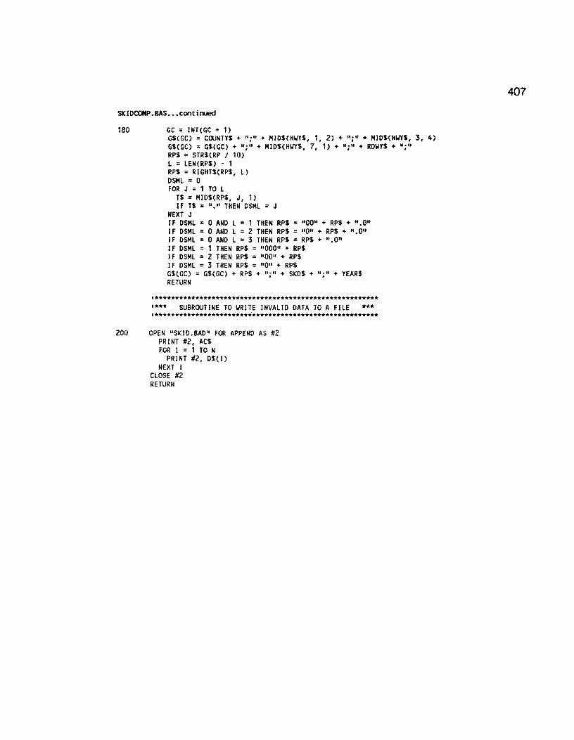
SKIDCCl4P.BAS ••• continued
180 GC = JNTCGC + 1) G$CGC) = COUNTY$+ ";" + MIDSCHWY$, 1, 2) + ";" + MIDS(HWYS, 3, 4) GSCGC} = GS(GC) + ";" + MJOS(HIJYS, 7, 1) + ";" + RDIJYS + ";" RP$ = STRS(RP I 10) L = LEN(RPS) - 1 RPS = RIGHTS(RPS, L)
OSML = 0 FOR J = 1 TO L
TS = MIOS(RPS, J, 1) if TS = 11 • 11 THEN OSML = J
NEXT J IF DSML = 0 ANO L = 1 THEN RPS = 110011 + RPS + 11 .0" IF OSML = 0 ANO L = 2 THEN RPS = 110" + RPS + ".011
IF DSML = 0 ANO L = 3 THEN RPS = RPS+ 11 .011
IF OSML = 1 THEN RPS = 11 00011 + RPS IF OSML = 2 THEN RPS = "0011 + RPS IF OSML = 3 THEN RPS = 11011 + RPS GSCGC) = GSCGC) + RPS + ";" + SKOS + 11 ; 11 + YEARS RETURN
'******************************************************* '*** SUBROUTINE TO WRITE INVALID DATA TO A FILE *** '*******************************************************
200 OPEN "SKID .BAD" FOR APPEND AS #2 PRINT #2, ACS FOR I = 1 TO N
PRINT #2, DS(l) NEXT I
CLOSE #2 RETURN
407

408
SKIDEDIT.BAS
The SKIDEDIT.BAS program permits the user to add/subtract 0.1 mile to the previously rejected records from an import attempt. The rejected records are usually 0.1 mile off from the existing database records. In order to facilitate correcting data import errors, this routine allows the addition/subtraction of a thenth of a mile to a defined sequence of skid records within a few seconds. This relieves the user from having to manually adjust the sequence of records • which often can take several hours.
'program to edit and add/sub 0.1 mile to the skid.dat file
REM $DYNAMIC DIM x$(1, 2) WIDTH LPRINT 131 LPRINT CHR$(27J; "E" xflag = 0 NAME$ = "sldd.dat" REC% = 0 OPEN NAME$ FOR INPUT AS #1 WHILE NOT EOF(1)
LINE INPUT #1, A$ REC% = REC% + 1
WEND CLOSE #1 PRINT "NO. OF RECORDS READ = "; REC% maxrec% = REC% - 1 ERASE x$ DIM xSCmaxrec%, 2) OPEN NAME$ FOR INPUT AS #1 RECORD% = 0 WHILE NOT EOF(1)
LINE INPUT #1, A$ IF MID$(A$, 1, 6) = "COUNTY" THEN GOTO 100 RECORD% = RECORD% + 1 x$(RECORD%, 1) = STR$(RECORD%) x$(RECORD%, 2) = AS PRINT RECORD% GOTO 110
100 t~ = A$ 110 WEND PRINT "SKID.DAT FILE TRANSFERRED INTO THE ARRAY XS" ' PRINT TO THE PRINTER 74 : CLS : BEEP LOCATE 5, 5 INPUT "Print to the line printer? CY/N) •••. "; dunS IF dun$ = "Y" OR dum$ = "Y" OR dum$ = "N" OR dun$ = "n" THEN GOTO 77 GOTO 74 77 : IF dum$ = "Y" OR dum$ = "Y" THEN GOTO 78 GOTO 500 78 : LPR INT "REC NO" CK$ = MID$Cx$(1, 2), 5, 12) FOR i% = 1 TO maxrec% b$ = MID$(x$(i%, 2), 1, 16) CS = MI0$(x$(i%, 2J, 17, 5) d$ = RIGHT$(x$(i%, 2), 6) CUR$= MI0${x$(i%, 2), 5, 12) IF CURS = CK$ THEN GOTO 115
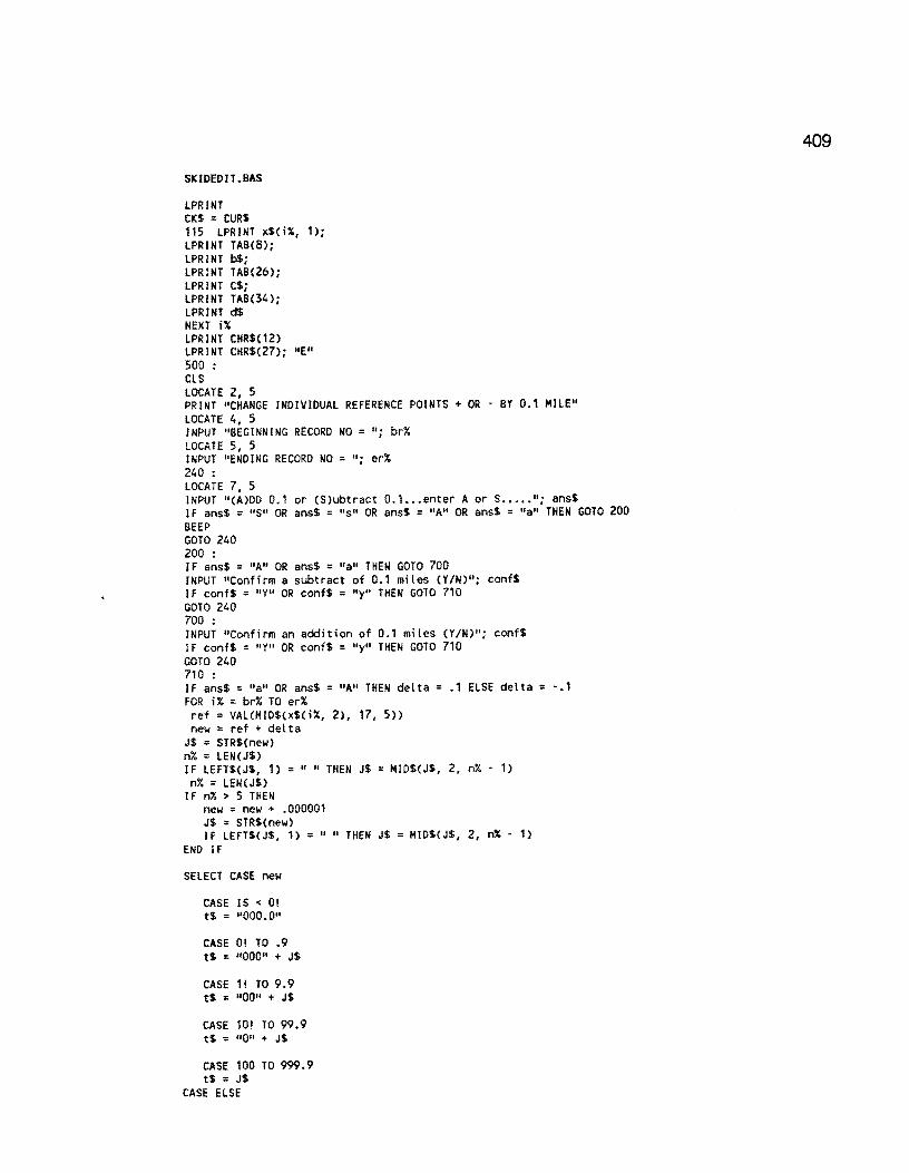
SKIDEDIT .BAS
LPRINT CKS = CURS 115 LPRINT xSCi%, 1); LPRINT TAB(8); LPRINT b$; LPRINT TABC26); LPRINT CS; LPRINT TABC34); LPRINT d$ NEXT i% LPRINT CHRSC12) LPRINT CHR$(27); "E" 500 : CLS LOCATE 2, 5 PRINT "CHANGE INDIVIDUAL REFERENCE POINTS + OR · BY 0.1 MILE" LOCATE 4, 5 INPUT "BEGINNING RECORD NO= 11
; br% LOCATE 5, 5 INPUT "ENDING RECORD NO = "; er% 240 : LOCATE 7, 5 INPUT "CA)DD 0.1 or (S)ubtract 0.1. •• enter A or s ..... "; ans$ IF ansS = 11S11 OR ansS = 11s 11 OR ansS = "A" OR ans$ = "a" THEN GOTO 200 BEEP GOTO 240 200 : IF ans$ = "A" OR ans$ = 11a11 THEN GOTO 700 INPUT "Confirm a subtract of 0.1 miles (Y/N)"; confS IF confS = 11 Y11 OR conf$ = "Y" THEN GOTO 710 GOTO 240 700 : INPUT "Confirm an addition of 0.1 miles (Y/N)"; conf$ IF conf$ = "Y" OR conf$ = "y" THEN GOTO 710 GOTO 240 710 : IF ans$= 11a11 OR ans$= "A" THEN delta= .1 ELSE delta= -.1 FOR i% = br% TO er% ref = VALCMIDS(x$(i%, 2), 17, 5)) new= ref+ delta
JS = STRS(new) n% = LEN(J$) IF LEFTS(JS, 1) =" 11 THEN JS= MIDS(JS, 2, n% - 1)
n% = LEN(J$) IF n% > 5 THEN
new = new + .000001 JS = STRS(new) IF LEFTS(JS, 1) = 11 11 THEN JS = MIDSCJS, 2, n% - 1)
END IF
SELECT CASE new
CASE JS < O! t$ = 11000.011
CASE O! TO .9 tS = 1100011 + JS
CASE 1! TO 9.9 t$ = 11 0011 + JS
CASE 10! TO 99.9 tS = 11011 + JS
CASE 100 TO 999.9 tS = JS
CASE ELSE
409

410
SKIDEOIT .BAS
PRINT "*****case else no match found •.• abort run" PRINT "REC NO = "; RECORD% PRINT "VALUE OF JS = 11
; J$ xflag = 1 END SELECT IF xflag = 1 THEN GOTO 1000 1 check for whole nl.lllbers and convert x = VAL(J$) t% = INT(x) tt = t% dif = x • tt IF dif = 0 THEN t$ = t$ + 11 .011
IF x = 0 THEN t$ = 11000.011
n% = LEN(t$) IF n% > 5 THEN
t$ = LEFT$(t$, 5) END IF b$ = MID$(x$(i%, 2), 1, 16) d$ = RIGHT$(x$(i%, 2), 6) PRINT i%, ref, new, t$, n% • ••••••••• write changes to the array ••••••••••• new$ = b$ + t$ + d$ x$(i%, 2) = news NEXT i% GOTO 2000 1000 : BEEP: PRINT "********** No match found in the reference point adjustment" 2000 : PRINT INPUT "Perform another interation ••• (Y/N) "; dl.lllS IF dum$ = "Y" OR dl.lllS = 11Y11 OR dl.lllS = "n" OR dl.lllS = 11N" THEN GOTO 2010 GOTO 2000 2010 : IF dum$ = 11y11 OR dl.lllS = "Y" THEN GOTO 500 IF xflag = 1 THEN
CLS PRINT " aborting run xflag == 1 no match error found" GOTO 6000
ELSE 6000 :
CLS PRINT 11 re·writing the file and closing out ••••• " OPEN "tskid.dat" FOR OUTPUT AS #2 PRINT #2, temp$ FOR i% = 1 TO maxrec% PRINT #2, x$(i%, 2) PRINT i% NEXT i%
ENO IF PRINT : PRINT
2600 :
LOCATE , 5 INPUT 11 type TSKIO.DAT file to the line printer??? (Y/N)"; dl.lllS IF dum$ = "Y" OR dl.lllS = "Y" OR dum$ = "n" OR dl.lllS = "H" THEN GOTO 3000 GOTO 2600
3000 :
IF dum$ = "y" OR dl.lllS = 11 Y" THEN SHELL "type tskid.dat ;> lpt1"
END IF SHELL "erase oldskid.dat" SHELL "rename skid.dat oldskid.dat" SHELL "rename tsldd.dat skid.dat"

SHELL "erase tskld.dat" END
SKI DERR.BAS
411
SKIDERR.BAS examines the DataEase exception file following an import attempt of a sequence of skid data records. The exception file lists the record number(s) of all rejected skid records, i.e., those records that did not match the database records. SKIDERR.BAS produces the rejected records from the original SKID.DAT file in a form the can be edited and submitted for re-import.
'skiderr.bas ••••• COX and SMITH 7·88 ON ERROR GOTO 999 OPEN "ER.ERR" FOR INPUT AS #1 '**** FILE CONTAINING ERRORS OPEN "SKID.DAT" FOR INPUT AS #2 '**** FILE CONTAINING SKID DATA OPEN "SKIO.TMP" FOR OUTPUT AS #3 '**** FILE CONTAINING SKID ERR DATA
'********************************************** •**** INPUT VARIABLE IDENTIFIER LINE **** •**********************************************
LINE INPUT #2, A$
'************************************************************ '**** YRITE VARIABLE IDENTIFIER LINE TO ERROR FILE **** •************************************************************
PRINT #3, A$
FC = 0 '*** LINE POINTER IN SKID DATA FILE
•************************************************** '**** PRINT HEADER TO PRINTER FOR ERRORS **** •**************************************************
LPRINT LPRINT LPRINT II LPRINT LPRINT
SKID ERRORS"
LPRINT 11 CNTY HIGHYAY RWY REF. SKD DATE" LPRINT "···--···········-······-······-··-·--·················"
'********************************************************** •**** INPUT NEXT LINE ERROR OR ENO OF ERROR FILE **** '**********************************************************
10 LINE INPUT #1, A$
L = LENCA$) '*** LENGTH OF ERROR MESSAGE LN = 0 '*** POINTER FOR ENO OF LINE NUMBER WHERE ERROR IS
'******************************************************** '**** CHECK FOR LINE NUMBER YHERE ERROR OCCURS **** ~********************************************************
FOR I = 1 TO L T$ = MID$(A$, I, 1) IF T$ = .. : II THEN LN l • 1 I*** LI NE NUMBER FOUND
NEXT I
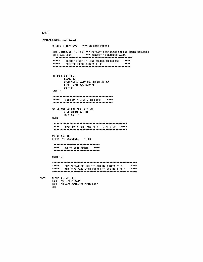
412
SKIDERR.BAS ••• continued
IF LN = 0 THEN 999 1*** NO MORE ERRORS
lN$ = MID$(A$, 1, LN) '***EXTRACT LINE NUMBER WHERE ERROR OCCURRED LN = VAL(LN$) 1*** CONVERT TO NUMERIC VALUE
'***************************************************** '**** CHECK TO SEE IF LINE NUMBER lS BEFORE **** '**** POINTER IN SKID DATA FILE **** '*****************************************************
IF FC > LN THEN CLOSE #2 OPEN "SKID.DAT" FOR INPUT AS #2 LINE INPUT #2, DUMMY$ FC = 0
END IF
•***************************************** '**** FIND DATA LINE WITH ERROR **** •*****************************************
WHILE NOT EOF(2) AND FC < LN LINE INPUT #2, B$ FC = FC + 1
WEND
'*************************************************** '**** SAVE DATA LINE AND PRINT TO PRINTER **** '***************************************************
PRINT #3, Bt LPRINT "discarded •• "; 8$
•******************************** '**** GO TO NEXT ERROR **** '********************************
GOTO 10
'********************************************************** •**** '****
END OPERATION, DELETE OLD SKID DATA FILE AND COPY DATA WITH ERRORS TO NEU SKID FILE
**** ****
•**********************************************************
999 CLOSE #3, #2, #1 SHELL "DEL SKID.DAT" SHELL "RENAME SKID. TMP SKID .DAT" END

413
FWDCONV.BAS This program reads the raw FWD data file as produced from District FWD data collection and re-formats the data (record by record) into a form suitable for importing into the FWD data file.
'************************************************************************* '************************************************************************* '**************** '**************** PROGRAM NAME: CONVRT.BAS '****************Ver.2 July 23,1990: Modified by Craig Cox '**************** for the revised FWD format
************ ************ ************ ************
'************************************************************************* CLS LOCATE 4, 15: PRINT "====================================:================" LOCATE 5, 15: PRINT "FALLING-WEIGHT OEFLECTOMETER DATA CONVERSION PROGRAM" LOCATE 6, 15: PRINT "====================================================" LOCATE 15, 17: PRINT "This program converts raw FWD data files into a" LOCATE 16, 17: PRINT "form which can be used by Dataease, a" LOCATE 17, 17: PRINT "spreadsheet, or database management programs." LOCATE 19, 27: PRINT "DISTRICT 21 VERSION": PRINT : PRINT ON ERROR GOTO 40
100 SHELL "PAUSE"
'******************************************************* '************** '************** '**************
GET RA\J FWD FILE **************** ****'!'*********** ****************
'*******************************************************
30 CLS 8$ = "ALL.FWD" OPEN 8$ FOR INPUT AS #1 GOTO 50
40 NUM = ERR IF NUM = 53 THEN
CLOSE #1 CLS LOCATE 15, 20: PRINT "FILE NOT FOUND ·- TRY AGAIN" LOCATE 17, 20: PRINT "HIT ANY KEY TO CONTINUE"
60 FS = INICEY$: IF F$ = '"' THEN 60 RESUME 30
ENO IF
•************************************************************* '**************** '**************** •****************
SETUP FWD CONVERTED FILE ************* ************* *************
•*************************************************************
50 CS = "FWD.CON" OPEN CS FOR OUTPUT AS #2 ON ERROR GOTO 0 PRINT #2, "COUNTY NUMBER;HIGHWAY PREFIX;HIGHWAY NUMBER;HIGHWAY SUFFIX;ROADWAY;REFERENCE
POI NT ;W1 ;W2;W6;W7;0ATE"
'************************************************************* '**************** •**************** '****************
CONVERT RA\J FIJD FILE ***************** ***************** *****************
•*************************************************************
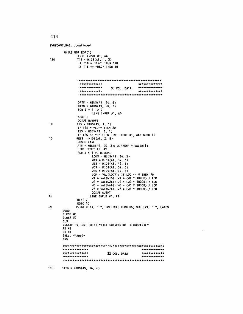
414
FWCONVT .BAS ••• cont in.Jed
WHILE NOT EOF(1) LINE INPUT #1, AS
150 T1$ = MID$(A$, 1, 3)
10
15
16
20
IF T1$ = "R3211 THEN 110 IF T1$ <> 11 R8011 THEN 10
'************************************************ •************* •************* **************
80 COL. DATA ************** ************** **************
'************************************************
DAT$ = MI0$(A$, 14, 6) CTY$ = MID$(A$, 20, 3) FOR I = 1 TO 4
LINE INPUT #1, A$ NEXT I GOSUB HWYDPS
T1$ = MID$(A$, 1, 3) IF T1$ = "EOF" THEN 20 T2$ = MI0$(A$, 1, 1) IF T2$ <> 11S11 THEN LINE INPUT #1, A$: GOTO 10
REF$ = Ml0$(A$, 2, 8) GOSUB LANE ATS = MID$(A$, 40, 3): AIRTEMP = VAL(AT$} LINE INPUT #1, AS FOR J = 1 TO NDROPS
LOOS = MI0$(A$, 34, 5) W1$ MID$(A$, 39, 6) W2$ = Ml0$(A$, 45, 6) W6$ = MI0$(A$, 69, 6) W7$ MIDS(A$, 75, 6) LOO = VAL(L00$): IF LOO <= 0 THEN 16 W1 = VAL(W1$): W1 = (W1 * 10000) I LOO W2 = VAL(W2$}: W2 CW2 * 10000) I LOO W6 VAL(W6$): W6 (W6 * 10000) I LOO W7 = VAL(W7$): W7 = (W7 * 10000) I LOO GOSUB OUTPT .
LINE INPUT #1, AS NEXT J GOTO 10
PRINT CTY$; n u. I PREFIX$; NUMBER$; SUFFIX$; 11 ";
WEND CLOSE #1 CLOSE #2 CLS LOCATE 15, 20: PRINT "FILE CONVERSION IS COMPLETE" PRINT PRINT SHELL "PAUSE" ENO
LANE$
'********************************************************** '************** '************** •**************
32 COL. DATA ************* ************* *************
'**********************************************************
110 DAT$ = Ml0$(A$, 14, 6)
FY>CONV.BAS ••• contirA.led
FOR I = 1 TO 4 LINE INPUT #1, A$
NEXT I CTYS = MIDS(A$, 3, 3) GOSUB HIJYDPS
130 T1S = MID$(A$, 1, 3) IF T1S = "EOF" THEN 20 T2$ = MID$(AS, 1, 1) IF T2$ <> "S" THEN LINE INPUT #1, AS: GOTO 130
120 REF$ = M!DSCA$, 2, 8) GOSUB LANE ATS = Ml0$(AS, 24, 2): AIRTEMP = VAL(AT$) LINE INPUT #1, AS FOR J = 1 TO NDROPS
LOO$= MID$(A$, 1, 4) W1$ = MI0$(A$, 5, 4) IJ2$ = Ml0$(A$, 9, 4)
IJ6$ = MID$(A$, 25, 4) IJ7$ = Ml0$(A$, 29, 4) LOO= VAL(L00$): LOO= 1000 *LOO* .10197 * .00142234# * 3.1415 * (5.91 A 2) IF LOO <= 0 THEN 121 W1 = VAL(W1$): W1 = cwt I 25.4 * 10000) I LOO IJ2 = VAL(W2S): W2 = CW2 I 25.4 * 10000) I LOO W6 = VALCW6$): W6 = (W6 I 25.4 * 10000) I LOO W7 = VALCW7$): W7 = (W7 I 25.4 * 10000) I LOO GOSUB OUTPT
121 LINE INPUT #1, A$ NEXT J GOTO 130
HWYDPS: PREFIX1$ = MID$(A$, 7, 1) TEMP$ = PREFIX1$ GOSUB CAPS PREFIX1$ = TEMP$ PREFIX2$ = MID$(A$, 8, 1) TEMP$ = PREFIX2$ GOSUS CAPS PREFIX2$ = TEMP$ PREFIX$ = PREFIX1$ + PREFIX2$ SUFFIX$= M!D$(A$, 13, 1) TEMP$ = SUFFIX$ GOSUB CAPS SUFFIX$ = TEMP$ NUMBER$ = MID$(A$, 9, 4) FOR I = 1 TO 25
LINE INPUT #1, A$ NEXT I NDROPS = 0 FOR I = 1 TO 3
LINE INPUT #1, 6$ NEXT I FOR K = 1 TO 80
IF Ml0$(A$, K, 1) <> "·" AND MID$(B$, K, 1) <> "·" THEN NDROPS = NDROPS + 1 NEXT K FOR I = 1 TO 4
NEXT I RETURN
LINE INPUT #1, A$
LANE: REF = ABS(VALCREF$)) LANE$= MID$(A$, 10, 1) TEMP$ = LANE$
415
416
flil>CONV. BAS. - • continued
GOSUB CAPS LANES = TEMPS RETURN
OUTPT: IF (J = 2 OR NDROPS = 1) AND W1 > W2 AND W2 > W6 AND W6 > W7 THEN YR$ = LEFT$(DATS, 2)
CAPS:
END IF RETURN
MOS = MIDSCDATS, 3, 2) PRINT #2, CTYS; ";"; PREFIX$; ";"; NUMBERS; ";"; PRINT #2, SUFFIX$; ";"; LANES; 11
; 11 ;
PRINT #2, USING 11###.#11 ; REF; PRINT #2, 11 ; 11 ;
PRINT #2, USING 11###.##11 ; W1; PRINT #2, 11 ; 0 ;
PRINT #2, USING "###.##"; W2; PRINT #2, ";"; PRINT #2, USING "###.##"; W6; PRINT #2, ";"; PRINT #2, USING 11###.##11 ; W7; PRINT #2, 11 ; 11 ; MOS; 11 / 11 ; YRS
TN = ASC(TEMP$) IF TN > 96 AND TN < 123 THEN
END IF RETURN
TN = TN - 32 TEMPS = CHRS(TN)

417
FWDERR.BAS
FWDERR. BAS examines the DataEase exception file following an import attempt of a sequence of skid data records. The exception file lists the record number(s) of all rejected 0.5~MILE FWD records, i.e., those records that did not match the database records. FWD ERR. BAS produces the rejected records from the original SKID.DAT file in a form the can be edited and submitted for re-import.
ON ERROR GOTO 999 OPEN "ER.ERR" FOR INPUT AS #1 OPEN "FWD.CON" FOR INPUT AS #2 OPEN "FWD.TMP" FOR OUTPUT AS #3 LINE INPUT #2,A$ PRINT #3,A$ FC=O LPRINT LPRINT LPRINT " FWD ERRORS" LPRINT LPRINT " LPRINT 11 CNTY HIGHWAY RWY REF. Wl W2
W6 W7 DATE" L P R I N T
"--------------------------------------------------------------------" 10 LINE INPUT #1,A$
L=LEN(A$) LN=O FOR I=l TO L
T$=MID$(A$,I,l) IF T$=":" THEN LN=I-1
NEXT I IF LN=O THEN 999 LN$=MID$(A$,l,LN) LN=VAL(LN$) IF FC > LN THEN
CLOSE #2 OPEN "FWD.CON" FOR INPUT AS #2 LINE INPUT #2,DUMMY$ FC=O
END IF WHILE NOT EOF(2) AND FC <> LN
LINE INPUT #2,B$ FC=FC+l
WEND

418
FWDERR.BAS
PRINT #3,B$ LPRINT "discarded.. ";B$ GOTO 10
999 CLOSE #3,#2,#1 SHELL "DEL FWD.CON" SHELL "RENAME FWD.TMP FWD.CON" END

Appendix K Detailed Specification for all Import Procedures
The following iq:>0rt procedures are required to iq:>0rt data into various files within the database. Details regarding the type of import, matching rules, source data drive, and target data drive are provided.
Iq:>0rt Definitions
lq:>0rt Destination Form
ADTIMP ADT VALUES Destination Form: A:ADT.DAT
Format ... -... -... -... "' .....
VAR.LENGTH
Auto Decimal: No Special 7 Record Sep:
FCIMP FUNCT CLASS VAR.LENGTH Destination Form: A:FC.DAT Auto Decimal: No Special 7 Record Sep:
FllD F\.ID INPUT VAR.LENGTH Destination Form: d:F\.ID.EXP
Auto Decimal: No Special 7 Record Sep: ;
FWD IMP F\.ID INPUT VAR.LENGTH Destination Form: d:FWD.CON
Auto Decimal: No Special 7 Record Sep: ;
HD IMP HIGHWAY DESIGN VAR.LENGTH Destination form: A:HD.DAT Auto Decimal: No Special 7 Record Sep: ;
IMPPRS PRS·SRS INPUT FILE VAR.LENGTH Destination form: d:IMPORT.VIS Auto Decimal: No Special 7 Record Sep: ,
INVENTRY DISTRICT INVENTORY VAR.LENGTH Destination Form: d:INV.DAT Auto Decimal: No Special 7 Record Sep: ;
KIPIMP 18·KIP VALUES VAR.LENGTH Destination Form: A:KIP.DAT Auto Decimal: No Special 7 Record Sep: ;
MASTER MASTER VAR. LENGTH Destination Form: d:MASTR.EXP Auto Decimal: No Special 7 Record Sep: ;
MSIMP MAINTENANCE SECTIONS VAR.LENGTH Destination Form: A:MS.OAT Auto Decimal: No Special 7 Record Sep: ;
Add or Update Organized ----- .. ------- ---·---...- ..
Update Match Auto Dec
Update Match Auto Dec
Update Match Auto Dec
Update Match Destinat
Update Match Auto Dec
Add Non-Match Auto Dec
Update Hatch Auto Dec
Update Match Auto Dec
Update Hatch Source F
Update Match Auto Dec
REF IMP MASTER VAR. LENGTH Update Match Destinat Destination Form: O:\DEASE\BROOKS\IMP.024 Auto Decimal: Yes Special 7 Record Sep: ;
RIDE RIDE INPUT VAR.LENGTH Update Hatch Auto Dec Destination Form: d:RIDE.EXP Auto Decimal: No Special 7 Record Sep: ;
SIOMETER SIOMETER RIDE VALUES VAR.LENGTH Update Match Destinat Destination Form: G:RIDE.DAT Auto Decimal: No Special 7 Record Sep: ;
Import Definitions - continued
Import Destination Form Format Add or Update Organized
SKID SKID INPUT VAR.LENGTH Update Match Auto Dec Destination Form: d:SKID.EXP Auto Decimal: No Special 7 Record Sep: ;
SKIDIMP SKID INPUT VAR.LENGTH Update Match Oestinat Destination Form: D:\DEASE\BROOKS\SKIO.DAT Auto Decimal: No Special 7 Record Sep:
SORTA TEMP VAR.LENGTH Update Match Auto Dec Destination Form: d:SORT.DAT
Auto Decimal: No Special 7 Record Sep: ;
VISUAL VIS VAR. LENGTH Update Match Auto Dec Destination Form: d:VISUAL.EXP
Auto Decimal: No Special 7 Record Sep: ;


