Embed Size (px)
Citation preview
The Anthropocene Review 1 –26
© The Author(s) 2015Reprints and permissions:
sagepub.co.uk/journalsPermissions.navDOI: 10.1177/2053019614565394
anr.sagepub.com
Research article
Diachronous beginnings of the Anthropocene: The lower bounding surface of anthropogenic deposits
Matt Edgeworth,1 Dan deB Richter,2 Colin Waters,3 Peter Haff,2 Cath Neal4 and Simon James Price3
AbstractAcross a large proportion of Earth’s ice-free land surfaces, a solid-phase stratigraphic boundary marks the division between humanly modified ground and natural geological deposits. At its clearest, the division takes the form of an abrupt surface at the base of deposits variously called ‘artificial ground’, ‘anthropogenic ground’ or ‘archaeological stratigraphy’ – which together comprise a distinctive part of the geosphere called the ‘archaeosphere’. In other cases the bounding surface is more diffuse, gradational or mixed, due to action of non-human agencies and anthropedogenic forcings. It is alternately conformable and unconformable. Layers above typically contain artificial features, structures, artifacts and other material traces of human activity, in contrast to their relative absence in layers below. A fundamental characteristic of the boundary is that it is diachronous, still being formed and renewed today. In examining the boundary, this paper asks – does it reflect the diachronous onset and development of the Anthropocene itself?
Keywordsanthropedology, Anthropocene, archaeosphere, artificial ground, Critical Zone, diachroneity, soil polygenesis, stratigraphy, technofossils, technosphere
Introduction
The Anthropocene has been proposed as a new geological epoch marked by global-scale human impact on Earth systems, but there is no general agreement as to when it began, or what stratigraphic indicators mark its start. The range of arguments is broad, and so is the range of supporting material evidence (Waters et al., 2014). Some of the main positions are listed below in order of proposed date of onset:
1University of Leicester, UK2Duke University, USA3British Geological Survey, UK4University of Hull, UK
Corresponding author:Matt Edgeworth, School of Archaeology and Ancient History, University of Leicester, Leicester LE1 7RH, UK. Email: [email protected]
565394 ANR0010.1177/2053019614565394The Anthropocene ReviewEdgeworth et al.research-article2014
by guest on January 14, 2015anr.sagepub.comDownloaded from
2 The Anthropocene Review
(1) 13,800 BP. Extinction of megafauna as the result of human predation, leading to a rapid forest growth and regional climate change (Doughty et al., 2010).
(2) 11,700 BP. Domestication of plants and animals and development of first agricultural econ-omies and landscapes – the onset of the Anthropocene being considered to coincide with the start of the already ratified Holocene epoch (Smith and Zeder, 2013).
(3) 8000–5000 BP. Agricultural practices and associated deforestation, giving rise to increases in atmospheric levels of methane and carbon dioxide, as measured in ice cores. Such evi-dence supports calls for an ‘early anthropogenic era’ (Ruddiman, 2003, 2013).
(4) 2000 BP. Widespread creation of anthropogenic soils, significantly transforming large parts of the terrestrial surfaces of the planet (Certini and Scalenghe, 2011).
(5) 1750–1800. Start of the Industrial Revolution in the late 18th century (Crutzen and Stoermer, 2000), with multiple indicators of transformation of Earth systems on a global scale. A related argument is that the period of more gradual human-induced change which preceded it should be characterized as the ‘Palaeoanthropocene’ (Foley et al., 2013).
(6) 1945–1950. Atom bomb tests and global spread of A-bomb-derived radionuclides, taking the date of the first nuclear bomb explosion at Alamogordo, New Mexico in 1945 as marker of the onset of the Anthropocene (Zalasiewicz et al., in press). The period from 1945 on ties in well with the so-called ‘Great Acceleration’ or rapid rise in multiple indicators of anthro-pogenically induced change in global systems (Steffen et al., 2011).
A common assumption behind many of these arguments is that the onset of the Anthropocene should be marked by a single date or time plane, preferably of global extent. Zalasiewicz et al. (in press) state that it should be ‘a single time surface, a precisely synchronous level that can be traced all around the Earth’. This makes sense with regard to the task of building chronostratigraphic timeframes, and establishing the date of transition between the Holocene and the Anthropocene. But it contrasts with the diachronous character of much archaeological and geological evidence in the Earth’s sedimentary record. Many processes identified by others as constitutive parts of the Anthropocene – from the dif-fusion of agriculture to the spread of industrialization to the acceleration of anthropogenically induced soil erosion and river sedimentation – are diachronous in character.
According to Zalasiewicz et al. (in press), an effective geochronological and chronostratigraphic boundary should reflect, on a global scale, a ‘substantial change in the Earth system, so that the physical and chemical nature of the deposits, and their fossil contents, are recognizably different above and below the boundary’. Whether or not those requirements are fulfilled in the case of the A-bomb-derived radioactive signal and accompanying markers, they are definitely met by Boundary A, the lower boundary of anthropogenic deposits that is the subject of this paper. The substantial global change in this instance is to the Earth’s surface itself – its soils, landscapes, criti-cal zones and ecologies – brought about not instantaneously but rather through the cumulative effects of many local events and processes taking place in different ways at different times. There is no single date for when these developments started to have global impact. As Periman (2006) succinctly puts it, ‘The Anthropocene begins to emerge when we consider human-environmental activity at a local level, compounded by thousands of years, affecting vast areas of interlocking landscapes’.
This paper examines the stratigraphic evidence for the diachroneity of human impact on the surface of the Earth. It draws from geological literature on artificial ground (Ford et al., 2010, 2014; Harris, 1989, 2014; McMillan and Powell, 1993; Nirei et al., 2012; Price et al., 2004, 2011; Rosenbaum et al., 2003) together with work on archaeological stratigraphy (Barker, 1977; Carver, 1987, 2009; Roskams, 2001; Schiffer, 1987) as well as recent articles on the technosphere and
by guest on January 14, 2015anr.sagepub.comDownloaded from
Edgeworth et al. 3
technofossils (Barnosky, 2014; Haff, 2014; Zalasiewicz et al., 2014b) and ecological perspectives on human transformations of soils (Richter, 2007; Richter and Mobley, 2009) and the terrestrial biosphere (Ellis, 2011). An earlier paper set out to combine aspects of archaeological and geologi-cal methodologies and perspectives in its account of anthropogenically modified deposits that now cover large parts of the terrestrial surfaces of the Earth (Edgeworth, 2014), and in so doing laid some of the groundwork for the argument presented here. For convenience, anthropogenically modified deposits forming the upper part of the geosphere will be referred to as the archaeosphere (a term first coined by Capelotti, 2010) and its lower boundary as Boundary A, following nomen-clature in the previous paper.
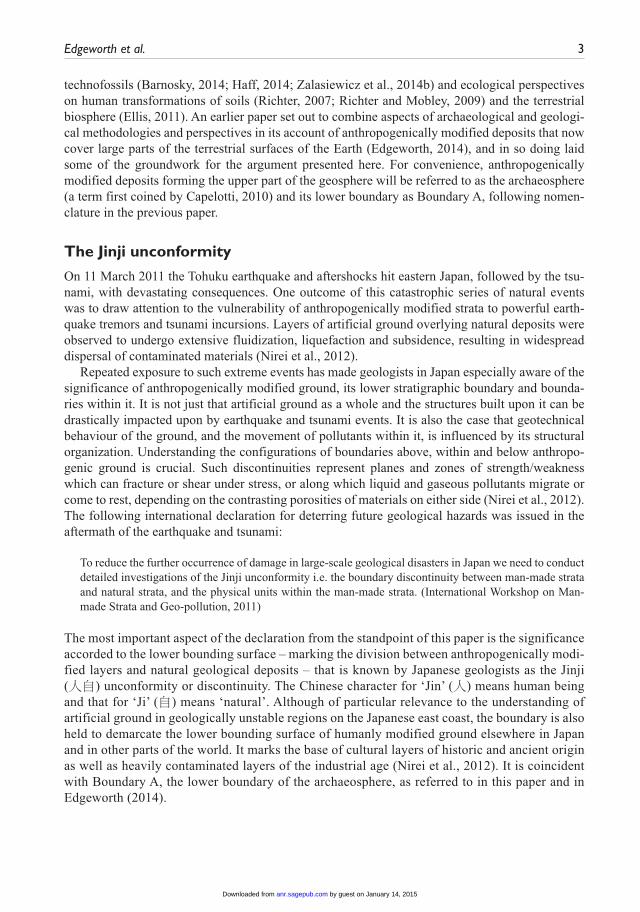
The Jinji unconformity
On 11 March 2011 the Tohuku earthquake and aftershocks hit eastern Japan, followed by the tsu-nami, with devastating consequences. One outcome of this catastrophic series of natural events was to draw attention to the vulnerability of anthropogenically modified strata to powerful earth-quake tremors and tsunami incursions. Layers of artificial ground overlying natural deposits were observed to undergo extensive fluidization, liquefaction and subsidence, resulting in widespread dispersal of contaminated materials (Nirei et al., 2012).
Repeated exposure to such extreme events has made geologists in Japan especially aware of the significance of anthropogenically modified ground, its lower stratigraphic boundary and bounda-ries within it. It is not just that artificial ground as a whole and the structures built upon it can be drastically impacted upon by earthquake and tsunami events. It is also the case that geotechnical behaviour of the ground, and the movement of pollutants within it, is influenced by its structural organization. Understanding the configurations of boundaries above, within and below anthropo-genic ground is crucial. Such discontinuities represent planes and zones of strength/weakness which can fracture or shear under stress, or along which liquid and gaseous pollutants migrate or come to rest, depending on the contrasting porosities of materials on either side (Nirei et al., 2012). The following international declaration for deterring future geological hazards was issued in the aftermath of the earthquake and tsunami:
To reduce the further occurrence of damage in large-scale geological disasters in Japan we need to conduct detailed investigations of the Jinji unconformity i.e. the boundary discontinuity between man-made strata and natural strata, and the physical units within the man-made strata. (International Workshop on Man-made Strata and Geo-pollution, 2011)
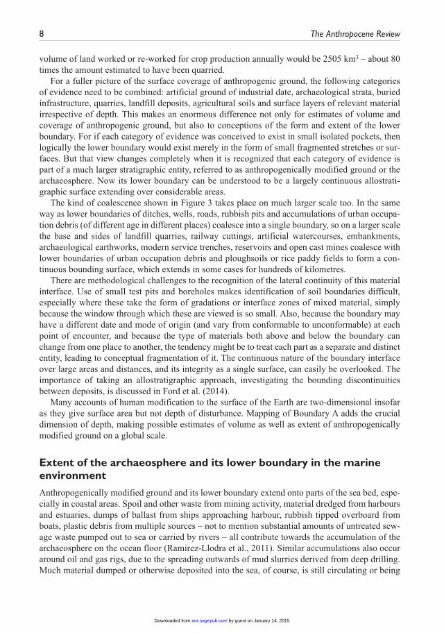
The most important aspect of the declaration from the standpoint of this paper is the significance accorded to the lower bounding surface – marking the division between anthropogenically modi-fied layers and natural geological deposits – that is known by Japanese geologists as the Jinji (人自) unconformity or discontinuity. The Chinese character for ‘Jin’ (人) means human being and that for ‘Ji’ (自) means ‘natural’. Although of particular relevance to the understanding of artificial ground in geologically unstable regions on the Japanese east coast, the boundary is also held to demarcate the lower bounding surface of humanly modified ground elsewhere in Japan and in other parts of the world. It marks the base of cultural layers of historic and ancient origin as well as heavily contaminated layers of the industrial age (Nirei et al., 2012). It is coincident with Boundary A, the lower boundary of the archaeosphere, as referred to in this paper and in Edgeworth (2014).
by guest on January 14, 2015anr.sagepub.comDownloaded from
4 The Anthropocene Review
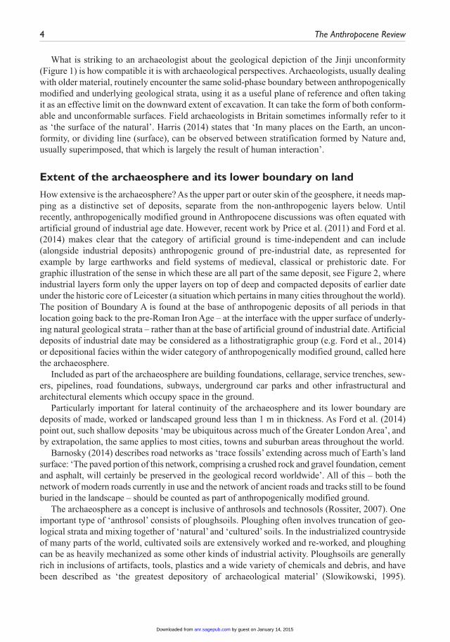
What is striking to an archaeologist about the geological depiction of the Jinji unconformity (Figure 1) is how compatible it is with archaeological perspectives. Archaeologists, usually dealing with older material, routinely encounter the same solid-phase boundary between anthropogenically modified and underlying geological strata, using it as a useful plane of reference and often taking it as an effective limit on the downward extent of excavation. It can take the form of both conform-able and unconformable surfaces. Field archaeologists in Britain sometimes informally refer to it as ‘the surface of the natural’. Harris (2014) states that ‘In many places on the Earth, an uncon-formity, or dividing line (surface), can be observed between stratification formed by Nature and, usually superimposed, that which is largely the result of human interaction’.
Extent of the archaeosphere and its lower boundary on land
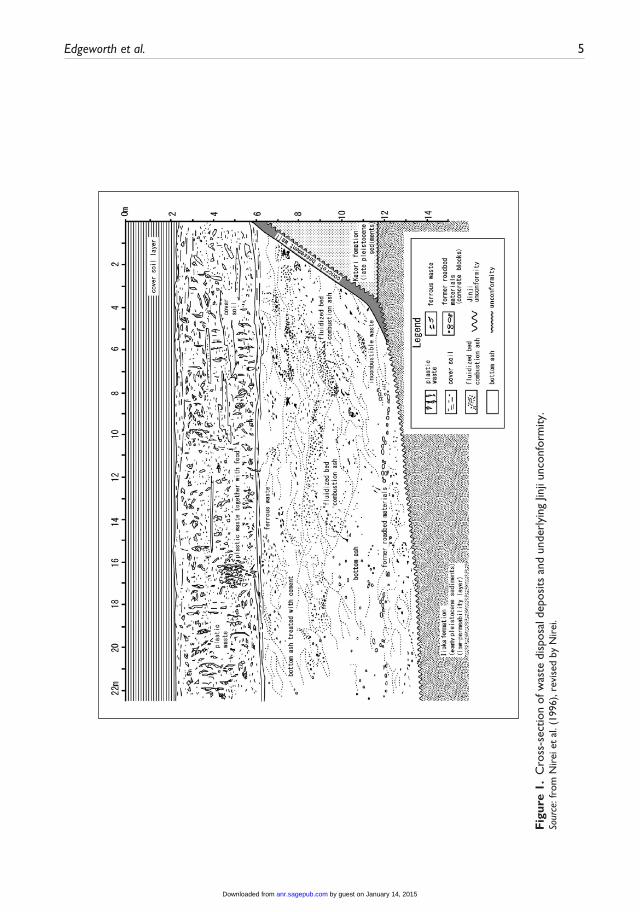
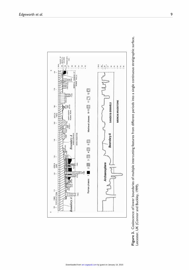
How extensive is the archaeosphere? As the upper part or outer skin of the geosphere, it needs map-ping as a distinctive set of deposits, separate from the non-anthropogenic layers below. Until recently, anthropogenically modified ground in Anthropocene discussions was often equated with artificial ground of industrial age date. However, recent work by Price et al. (2011) and Ford et al. (2014) makes clear that the category of artificial ground is time-independent and can include (alongside industrial deposits) anthropogenic ground of pre-industrial date, as represented for example by large earthworks and field systems of medieval, classical or prehistoric date. For graphic illustration of the sense in which these are all part of the same deposit, see Figure 2, where industrial layers form only the upper layers on top of deep and compacted deposits of earlier date under the historic core of Leicester (a situation which pertains in many cities throughout the world). The position of Boundary A is found at the base of anthropogenic deposits of all periods in that location going back to the pre-Roman Iron Age – at the interface with the upper surface of underly-ing natural geological strata – rather than at the base of artificial ground of industrial date. Artificial deposits of industrial date may be considered as a lithostratigraphic group (e.g. Ford et al., 2014) or depositional facies within the wider category of anthropogenically modified ground, called here the archaeosphere.
Included as part of the archaeosphere are building foundations, cellarage, service trenches, sew-ers, pipelines, road foundations, subways, underground car parks and other infrastructural and architectural elements which occupy space in the ground.
Particularly important for lateral continuity of the archaeosphere and its lower boundary are deposits of made, worked or landscaped ground less than 1 m in thickness. As Ford et al. (2014) point out, such shallow deposits ‘may be ubiquitous across much of the Greater London Area’, and by extrapolation, the same applies to most cities, towns and suburban areas throughout the world.
Barnosky (2014) describes road networks as ‘trace fossils’ extending across much of Earth’s land surface: ‘The paved portion of this network, comprising a crushed rock and gravel foundation, cement and asphalt, will certainly be preserved in the geological record worldwide’. All of this – both the network of modern roads currently in use and the network of ancient roads and tracks still to be found buried in the landscape – should be counted as part of anthropogenically modified ground.
The archaeosphere as a concept is inclusive of anthrosols and technosols (Rossiter, 2007). One important type of ‘anthrosol’ consists of ploughsoils. Ploughing often involves truncation of geo-logical strata and mixing together of ‘natural’ and ‘cultured’ soils. In the industrialized countryside of many parts of the world, cultivated soils are extensively worked and re-worked, and ploughing can be as heavily mechanized as some other kinds of industrial activity. Ploughsoils are generally rich in inclusions of artifacts, tools, plastics and a wide variety of chemicals and debris, and have been described as ‘the greatest depository of archaeological material’ (Slowikowski, 1995).
by guest on January 14, 2015anr.sagepub.comDownloaded from
Edgeworth et al. 5
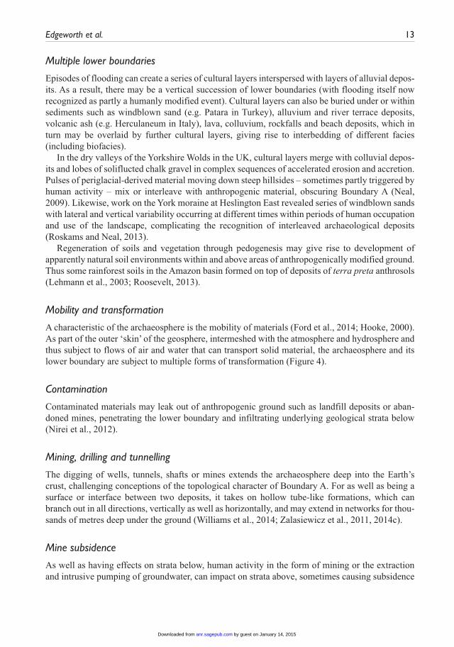
Fig
ure
1. C
ross
-sec
tion
of w
aste
dis
posa
l dep
osits
and
und
erly
ing
Jinji
unco
nfor
mity
.So
urce
: fro
m N
irei
et
al. (
1996
), re
vise
d by
Nir
ei.
by guest on January 14, 2015anr.sagepub.comDownloaded from
6 The Anthropocene Review
Fig
ure
2. P
rofil
es t
hrou
gh t
he u
rban
arc
haeo
sphe
re in
Lei
cest
er, U
K: (
a) a
sec
tion
draw
n du
ring
exc
avat
ion
at C
ause
way
Lan
e (C
onno
r an
d Bu
ckle
y,
1999
) an
d (b
) a
com
posi
te s
ectio
n re
cons
truc
ted
from
num
erou
s ex
cava
tion
tren
ches
and
bor
ehol
es t
o cr
eate
a d
epos
it m
odel
(Lu
cas,
198
1). B
ound
ary
A is
sho
wn
as d
otte
d lin
e in
bot
h in
stan
ces.
The
upp
er s
ectio
n is
app
roxi
mat
ely
100
times
sm
alle
r in
leng
th t
han
the
low
er s
ectio
n, il
lust
ratin
g th
e fr
acta
l qu
ality
of m
uch
arch
aeos
pher
e st
ratig
raph
y.
by guest on January 14, 2015anr.sagepub.comDownloaded from
Edgeworth et al. 7
Technosols contain especially high concentrations of materials of technological origin. Examples are landfills and strata composed of building rubble, such as comprise the Teufelsberg deposit in Berlin (Cocroft and Schofield, 2012).
All this fits with a larger picture of human transformation of Earth’s soils (Arnold et al., 1990). ‘About half of the approximately 13 billion hectares of Earth’s soil are now converted to human use … The age of pedogenesis has given way to the age of anthropedogenesis’ (Richter, 2007; see also Richter and Yaalon, 2012). Soils that were until recently treated as though they were part of natural ecological systems have for the most part been fully incorporated into the technosphere (Haff, 2014) and the archaeosphere – the ecological implications of which have yet to be fully real-ized. As Ellis (2011) puts it, ‘Human populations and their use of land have transformed most of the terrestrial biosphere into anthropogenic biomes (anthromes), causing a variety of novel eco-logical patterns and processes to emerge’.
With regard to Certini and Scalenghe’s (2011) suggestion that certain soil horizons could be used as a GSSP or ‘golden spike’ for the proposed new geological epoch, critics have rightly pointed out that the suggested date of 2000 BP for the proposed expansion of anthropogenic soils is too arbitrary (Gale and Hoare, 2012), and avoids the problem that the spread of agricultural techniques, and associated creation of cultivated soils, is a diachronous process. There is no single date for when terrestrial surfaces, the global atmosphere and the hydrosphere were significantly altered by arable farming.
It has also been argued that lower boundaries of cultivated soils are not ideal as markers of the onset of the Anthropocene because they are often diffuse and hard to identify with precision (Zalasiewicz et al., 2014a). Anthropedologists, archaeologists and geologists recognize interfacial zones of mixed material between cultivation soils and natural strata (Fenwick, 1968; Holliday, 2004). But such soils should still be included in the broad category of anthropogenically modified ground. The task of lower boundary definition needs further work – through combining the perspec-tives and correlating respective categories deployed by soil science, archaeology and geology.
How fast is the archaeosphere growing today? It is estimated (Jennings, 2011) that 50 giga-tonnes of material – sands, gravel, clay, metal ores, coal, etc., including spoil and waste – are quar-ried or mined annually (Douglas and Lawson, 2001, give the higher estimate of 57 gigatonnes). At an assumed density of crushed rock/soil of 1.5 tonnes/1 m3 (Brady and Weil, 2007) this corre-sponds to a volume of about 30 km3. Not only does most of this material eventually add to the archaeosphere in an upwards direction: holes dug extend the lower boundary of the archaeosphere downwards. There are of course many other processes through which material gets brought into the archaeosphere, such as groundworks for infrastructure projects, ploughing, etc.
What is the re-use rate of archaeosphere materials? Some parts of the archaeosphere have not been disturbed since initial formation. But there is ample stratigraphic evidence of cutting and intercutting of different phases of anthropogenic ground – testifying to extensive churning over, extraction, transportation, re-use and re-deposition of archaeosphere material. No part of the archaeosphere and its lower boundary is immune from anthropogenic disturbance or reworking in the future. In the broader technosphere, as ore deposits become exhausted, metal recycling and re-use will be increasingly necessary (Haff, 2014), and even waste in landfill deposits may be mined for heavy metals and other valuable materials.
Ploughing may involve truncation of underlying layers (addition of new material, re-cutting of Boundary A) together with turning over of already cultivated land (re-use of existing archaeo-sphere soils) as well as mixing in of other materials such as compost or fertilizer. If the surface area of land ploughed or otherwise cultivated globally every year is 16.7 million km2 (Hooke and Martín-Duque, 2012), and if average depth of cultivation is estimated at just 0.15 m, then total
by guest on January 14, 2015anr.sagepub.comDownloaded from
8 The Anthropocene Review
volume of land worked or re-worked for crop production annually would be 2505 km3 – about 80 times the amount estimated to have been quarried.
For a fuller picture of the surface coverage of anthropogenic ground, the following categories of evidence need to be combined: artificial ground of industrial date, archaeological strata, buried infrastructure, quarries, landfill deposits, agricultural soils and surface layers of relevant material irrespective of depth. This makes an enormous difference not only for estimates of volume and coverage of anthropogenic ground, but also to conceptions of the form and extent of the lower boundary. For if each category of evidence was conceived to exist in small isolated pockets, then logically the lower boundary would exist merely in the form of small fragmented stretches or sur-faces. But that view changes completely when it is recognized that each category of evidence is part of a much larger stratigraphic entity, referred to as anthropogenically modified ground or the archaeosphere. Now its lower boundary can be understood to be a largely continuous allostrati-graphic surface extending over considerable areas.
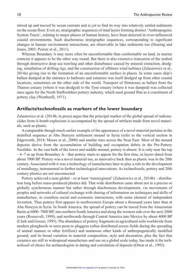
The kind of coalescence shown in Figure 3 takes place on much larger scale too. In the same way as lower boundaries of ditches, wells, roads, rubbish pits and accumulations of urban occupa-tion debris (of different age in different places) coalesce into a single boundary, so on a larger scale the base and sides of landfill quarries, railway cuttings, artificial watercourses, embankments, archaeological earthworks, modern service trenches, reservoirs and open cast mines coalesce with lower boundaries of urban occupation debris and ploughsoils or rice paddy fields to form a con-tinuous bounding surface, which extends in some cases for hundreds of kilometres.
There are methodological challenges to the recognition of the lateral continuity of this material interface. Use of small test pits and boreholes makes identification of soil boundaries difficult, especially where these take the form of gradations or interface zones of mixed material, simply because the window through which these are viewed is so small. Also, because the boundary may have a different date and mode of origin (and vary from conformable to unconformable) at each point of encounter, and because the type of materials both above and below the boundary can change from one place to another, the tendency might be to treat each part as a separate and distinct entity, leading to conceptual fragmentation of it. The continuous nature of the boundary interface over large areas and distances, and its integrity as a single surface, can easily be overlooked. The importance of taking an allostratigraphic approach, investigating the bounding discontinuities between deposits, is discussed in Ford et al. (2014).
Many accounts of human modification to the surface of the Earth are two-dimensional insofar as they give surface area but not depth of disturbance. Mapping of Boundary A adds the crucial dimension of depth, making possible estimates of volume as well as extent of anthropogenically modified ground on a global scale.
Extent of the archaeosphere and its lower boundary in the marine environment
Anthropogenically modified ground and its lower boundary extend onto parts of the sea bed, espe-cially in coastal areas. Spoil and other waste from mining activity, material dredged from harbours and estuaries, dumps of ballast from ships approaching harbour, rubbish tipped overboard from boats, plastic debris from multiple sources – not to mention substantial amounts of untreated sew-age waste pumped out to sea or carried by rivers – all contribute towards the accumulation of the archaeosphere on the ocean floor (Ramirez-Llodra et al., 2011). Similar accumulations also occur around oil and gas rigs, due to the spreading outwards of mud slurries derived from deep drilling. Much material dumped or otherwise deposited into the sea, of course, is still circulating or being
by guest on January 14, 2015anr.sagepub.comDownloaded from
Edgeworth et al. 9
Fig
ure
3. C
oale
scen
ce o
f low
er b
ound
arie
s of
mul
tiple
inte
rcut
ting
feat
ures
from
diff
eren
t pe
riod
s in
to a
sin
gle
cont
inuo
us s
trat
igra
phic
sur
face
, Le
ices
ter,
UK
(C
onno
r an
d Bu
ckle
y, 1
999)
.
by guest on January 14, 2015anr.sagepub.comDownloaded from
10 The Anthropocene Review
stirred up and moved by ocean currents and is yet to find its way into relatively settled sediments on the ocean floor. Even so, stratigraphic sequences of mud layers forming distinct ‘Anthropogenic System Tracts’, relating to major phases of human history, have been detected in river-influenced coastal environments. Such diachronous stratigraphic sequences, corresponding to significant changes in human–environment interactions, are observable in lake sediments too (Dearing and Jones, 2003; Poirier et al., 2011).
Whereas Boundary A may more often be unconformable than conformable on land, in marine contexts it appears to be the other way round. But there is also extensive truncation of the seabed through destructive deep sea trawling and other disturbance caused by mineral extraction, dredg-ing, installation of drilling rigs, and the construction of offshore wind turbines (Zalasiewicz et al., 2014a) giving rise to the formation of an unconformable surface in places. In some cases ship’s ballast dumped at the entrance to harbours and estuaries was itself dredged up from other coastal locations, sometimes on the other side of the world. Transport of flintstones as ballast from the Thames estuary (where it was dredged) to the Tyne estuary (where it was dumped) was collected once again for the North Staffordshire pottery industry, which used ground flint as a constituent of pottery clay (Weatherill, 1971).
Artifacts/technofossils as markers of the lower boundary
Zalasiewicz et al. (2014b, in press) argue that the principal marker of the global spread of radionu-clides from A-bomb explosions is accompanied by the spread of artifacts made from novel materi-als, such as plastic.
A comparable though much earlier example of the appearance of a novel material pertains in the stratified sequence at Abu Hureyra settlement mound in Syria (refer to the vertical section in Edgeworth, 2014; Moore et al., 2000) and similar sites across the Near East. Most of the mound deposits derive from the accumulation of building and occupation debris in the Pre-Pottery Neolithic. In the vast bulk of the lower and middle mound, pottery is absent. It is only near the top – 6–7 m up from Boundary A – that pottery starts to appear for the first time, in layers dated from about 7000 BP. Pottery was a novel material too, as innovative back then as plastic was in the 20th century. Associated with it was a technology of manufacture later to play a role in the development of metallurgy, instrumental in further technological innovations. As technofossils, pottery and 20th century plastics are not unconnected.
Pottery achieved a near-global – or at least ‘transregional’ (Zalasiewicz et al., 2014b) – distribu-tion long before mass-produced plastics did. That wide distribution came about not in a precise or globally synchronous manner but rather through diachronous developments, via movements of peoples and networks of cultural exchange with sharing of information on techniques and skills of manufacture, in countless social and economic interactions, with some element of independent invention. Thus pottery first appears in northwestern Europe about a thousand years later than at Abu Hureyra in Syria. In South America, the spread of pottery can be traced from the Amazonian Basin at 6000–7000 BP, into northern South America and along the western side over the next 2000 years (Roosevelt, 1999), and northwards through Central America into Mexico by about 4000 BP (Clark and Gosser, 1995). The abundance of pottery fragments in agricultural soils worldwide from modern ploughsoils to terra preta to plaggens (often distributed across fields during the spreading of animal manure or other fertilizer) and numerous other kinds of anthropogenically modified ground, and its broad variation in material composition, style and decoration, plus the fact that ceramics are still in widespread manufacture and use on a global scale today, has made it the tech-nofossil of choice for archaeologists in dating and correlation of deposits (Orton et al., 1993).
by guest on January 14, 2015anr.sagepub.comDownloaded from
Edgeworth et al. 11
Both ceramics and plastics are inclusions within the archaeosphere and thus part of its overall material signature. Compared with ceramics, plastics are proving to be especially mobile as aeo-lian, fluvial and marine debris, breaking down into smaller particles and polymers which are able to spread rapidly even to places otherwise untouched or unvisited by human beings (Corcoran et al., 2014). Ford et al. (2014) identify alkaline batteries, compact discs and aluminium cans as useful indicators of the date of layers in which they are found, since specific types can have dates assigned to their first, last and main operational phases of use.
As well as examining first and last appearances of specific types of artifacts associated with boundaries within the archaeosphere, it makes sense to look to the lower boundary of the archaeo-sphere itself. For this is where the really substantial change occurs – the presence of human artifacts as a general category above Boundary A relative to their absence below (exceptional cases to be explored later). It is a palaeontological signal of huge significance, which even on its own would stand as a marker of a major change in Earth systems. For though we may characterize them as technofossils, and though they may be associated with a lifecycle of human selection that can be understood to mimic natural selection, artifacts are nevertheless fundamentally different from fos-sils of biological organisms. As Harris puts it, ‘archaeological artifacts are inanimate; they are cre-ated, preserved or destroyed largely by human agencies. These objects, therefore, are not normally subject to a [biological] lifecycle, or the process of evolution by natural selection’ (Harris, 1989).
In those instances where Boundary A manifests as an unconformable surface, the change in the biostratigraphic record can be quite striking. Take for example quarries in the English Midlands where clay was extracted for the brick industry, the resulting holes used for landfill dumping. The basal cut of the quarries themselves consists of the upper (truncated) surface of sedimentary depos-its laid down in shallow seas during the Jurassic period. Below the boundary are the fossil remains of plesiosaurs, ichthyosaurs, marine crocodiles and common fossils such as belemnites and Gryphaea shells. Above the boundary (in places artificially lined with stiff clay) are radio sets, nappies, glass bottles, tin cans, books, clothes, cinema tickets, electrical components, food packag-ing, plastic bags and biros, with the most common bones being those of domesticated animals such as factory-reared chickens.
Similar examples, juxtaposing human material culture and technofossil evidence with fossil remains from many other geological periods either side of Boundary A, can be drawn from quarries used as landfill dumps throughout the world. In certain types of agricultural soils, on the other hand, considerable mixing of artifacts and fossils tends to occur, because of reworking of geologi-cal material into Anthropocene soils through truncation of underlying deposits. Thus Gryphaea fossils are often found alongside plastic items and pottery sherds in ploughed fields overlying Jurassic sedimentary deposits.
Important though the biostratigraphic marker is, Boundary A is still primarily a material interface between layers. Thus when the side of a medieval gravel quarry was discovered during excavation at Wallingford, Oxfordshire (Janssen et al., 2014), there were no artifacts at all in the fill, which consisted mainly of redeposited grey clay marl quarried from elsewhere. But the cut of the quarry (Boundary A) was still recognized in the form of the interface between orange gravel sides (in situ geological deposits) relative to the grey marl infill (redeposited natural) – the field interpretation confirmed by subsequent microfossil analysis. That study provides an important example of the benefits of archaeologists and geologists collaborating in investigation of the lower boundary of the archaeosphere. Soil scientists are part of the equation too. With its archaeological, pedological and geological aspects, the lower boundary presents challenges which can be tackled through a combi-nation of all these sets of disciplinary knowledge, and discussions around the Anthropocene concept have significantly contributed to such collaborations.
by guest on January 14, 2015anr.sagepub.comDownloaded from

12 The Anthropocene Review
According to Barnosky (2014), the Anthropocene epoch should be characterized by distinctive organic remains if it is to be equivalent in rank to the other geological epochs. In this regard, the material traces of substantial changes in the morphology of domesticated species achieved through human selection, and recently by means of bioengineering and applied genetics, must surely qual-ify as ‘distinctive organic remains’.
The sheer number of domesticated animals relative to humans is important to the archaeo-sphere’s overall fossil signature. Recent statistics show that there are roughly 1.4 billion cattle, 1 billion sheep and pigs, and 19 billion chickens alongside about 7 billion humans (Food and Agriculture Organization, 2014: statistics for 2011), and these figures are rising. Biomass of living domesticated animals is more than twice that of human beings. Their impact on landscapes is cor-respondingly large.
There is one palaeontological signature of archaeosphere deposits that deserves to be noted with reference to organic remains (which will become more marked as human population size increases exponentially). That is, skeletal and cremated remains of human bodies are often configured in large clusters arranged in regular geometric layouts, sometimes placed in and around monuments. Patterns include rows of bodies aligned in grids, radial rows oriented towards a central point, satel-lite burials around a central mound or marker, or bodies stacked vertically in graves over time to save space – to give just some of many hundreds of possible arrangements – with specific burial customs varying culturally in time and space. This intentional and sometimes heavily symbolic ordering of human remains will leave a substantial and distinctive imprint in the fossil record alongside non-organic technofossil evidence – see Zalasiewicz (2008) on ‘fossil cemeteries’. In many cases grave cuts are deep enough to extend down into previously undisturbed geological strata, replacing and renewing Boundary A in those locations, imprinting the distinctive patterns and layouts onto the form of the bounding surface itself.
Human skeletal fossils will be very different in character from other animal fossils, since often accompanied by (or wearing) artifacts. Marks of technology or traces of synthetic materials – from trepanning of skulls in the Neolithic to modern-day hip replacements and prosthetic implants – may be found on, in, or attached to the human bone itself. Tooth fillings alone may contain copper, mer-cury, gold, tin, aluminium, glass, ceramics and plastics. Some of these materials are toxic and can leach out into surrounding soils. Such hybrid entities/assemblages are true technofossils in the sense that they blur conceptual divisions between biological life-forms and technological artifacts.
Problematic evidence
Wherever anthropogenically modified ground exists, the lower boundary can be found and recog-nized through application of archaeological, geological and pedological techniques, ideally in combination. This is not to claim that the boundary is always clear or that the task is necessarily easy, for many challenges are presented by the stratigraphic evidence. Some of these are outlined below.
Interfacial layers
Often there are interfacial layers, or zones of mixed materials, between anthropogenically modi-fied deposits and geological strata. Earthworm action and other forms of bioturbation, erosion, mixing of material through ploughing, leaching, etc., can render the lower boundary diffuse or gradational. As already noted, this may often apply to the base of cultivated soils (Gale and Hoare, 2012; Zalasiewicz et al., 2014a).
by guest on January 14, 2015anr.sagepub.comDownloaded from
Edgeworth et al. 13
Multiple lower boundaries
Episodes of flooding can create a series of cultural layers interspersed with layers of alluvial depos-its. As a result, there may be a vertical succession of lower boundaries (with flooding itself now recognized as partly a humanly modified event). Cultural layers can also be buried under or within sediments such as windblown sand (e.g. Patara in Turkey), alluvium and river terrace deposits, volcanic ash (e.g. Herculaneum in Italy), lava, colluvium, rockfalls and beach deposits, which in turn may be overlaid by further cultural layers, giving rise to interbedding of different facies (including biofacies).
In the dry valleys of the Yorkshire Wolds in the UK, cultural layers merge with colluvial depos-its and lobes of soliflucted chalk gravel in complex sequences of accelerated erosion and accretion. Pulses of periglacial-derived material moving down steep hillsides – sometimes partly triggered by human activity – mix or interleave with anthropogenic material, obscuring Boundary A (Neal, 2009). Likewise, work on the York moraine at Heslington East revealed series of windblown sands with lateral and vertical variability occurring at different times within periods of human occupation and use of the landscape, complicating the recognition of interleaved archaeological deposits (Roskams and Neal, 2013).
Regeneration of soils and vegetation through pedogenesis may give rise to development of apparently natural soil environments within and above areas of anthropogenically modified ground. Thus some rainforest soils in the Amazon basin formed on top of deposits of terra preta anthrosols (Lehmann et al., 2003; Roosevelt, 2013).
Mobility and transformation
A characteristic of the archaeosphere is the mobility of materials (Ford et al., 2014; Hooke, 2000). As part of the outer ‘skin’ of the geosphere, intermeshed with the atmosphere and hydrosphere and thus subject to flows of air and water that can transport solid material, the archaeosphere and its lower boundary are subject to multiple forms of transformation (Figure 4).
Contamination
Contaminated materials may leak out of anthropogenic ground such as landfill deposits or aban-doned mines, penetrating the lower boundary and infiltrating underlying geological strata below (Nirei et al., 2012).
Mining, drilling and tunnelling
The digging of wells, tunnels, shafts or mines extends the archaeosphere deep into the Earth’s crust, challenging conceptions of the topological character of Boundary A. For as well as being a surface or interface between two deposits, it takes on hollow tube-like formations, which can branch out in all directions, vertically as well as horizontally, and may extend in networks for thou-sands of metres deep under the ground (Williams et al., 2014; Zalasiewicz et al., 2011, 2014c).
Mine subsidence
As well as having effects on strata below, human activity in the form of mining or the extraction and intrusive pumping of groundwater, can impact on strata above, sometimes causing subsidence
by guest on January 14, 2015anr.sagepub.comDownloaded from
14 The Anthropocene Review
Figure 4. Photographs taken in 1948 and 2006 of the agriculturally eroded landscape of the Calhoun Critical Zone Observatory, South Carolina, USA. From the late 18th to early 20th century, Boundary A consisted of the base of cultivated soils of cotton fields. Continued crop production led to ever more severe soil erosion. By the early 20th century, farm fields were commonly cut by gullies and even ravines, with sediments transported by gully and stream channel networks, to be deposited downstream in river floodplains, behind dams, on deltas and estuaries. By the late 20th century, second-growth forests had established themselves on much of the eroded landscape. The archaeosphere and its lower boundary have been and continue to be transformed by these developments.Source: Photos by USDA Forest Service and James et al. (2006).
in the form of ‘crown holes’ when voids collapse, disrupting the stratigraphy of anthropogenically modified ground.
Peatland shrinkage
Numerous peatlands have subsided due to drainage followed by shrinkage and accelerated decom-position of organic matter in the newly oxidizing environment (Stephens et al., 1984).
Seismic events
As Nirei et al. (2012) have shown, earthquakes and tsunamis can have drastic impacts on strati-graphic formations of anthropogenic ground. But this impact works to some extent in both direc-tions. The sheer weight of the archaeosphere may have effects on underlying geological strata in
by guest on January 14, 2015anr.sagepub.comDownloaded from
Edgeworth et al. 15
places, including enhanced subsidence of coastal and deltaic deposits through loading and com-pounded by water abstraction. Earthquake activity may be partially caused by the weight of water in reservoirs behind large dams.
Hydraulic fracturing
The hydraulic fracturing of shale rock or other deposits through injection of water, proppants and chemical additives at high pressure involves the modification of deposits far beyond the limits of anthropogenically modified ground on the surface, and is remarkable for precisely that reason. Hydraulic fracturing represents an extensive expansion of human influence via alteration of the Earth’s crust along geologic joints, faults, bedding planes and stress contrasts.
Earlier evidence
Human artifacts and features are not entirely absent from geological layers below Boundary A. Many early human activities throughout the world have left material traces in the ground that have then been sealed by geological strata: examples include layers of charcoal from deliberate burning of vegetation (Glikson, 2013), or Palaeolithic cave deposits and working surfaces strewn with stone tools. While clearly constituting ground which has been anthropogenically modified, directly or indirectly, the stratigraphically isolated position of such layers presents seemingly anomalous evidence because of their physical dislocation.
Wherever early evidence of human activity is found, the following criterion can be applied and investigated stratigraphically: does the lower boundary of the deposit coalesce with other lower boundaries of anthropogenically modified ground to form a continuous and extensive surface that is more than just a local trace of human activity? If yes, then the lower boundary of the deposit can be taken to be part of Boundary A. If on the other hand the deposit is isolated and sealed within non-anthropogenic geological strata, it can be considered to be below Boundary A.
This is not to exclude such deposits from the archaeosphere. They still belong to the totality of anthropogenic ground, and are potentially of great interest in the study of past human–environment interaction. Their physical separation from the greater bulk of the archaeosphere points to the fact that, to use a geographical metaphor, the lower boundary viewed in section sometimes takes the form of a ‘coast’ with outlying ‘islands’ (refer to North American stratigraphic code NACSN, 1983: Article 23, Figure 2D).
The stratigraphic ‘islands in time’ – precursors to the main archaeosphere formation – reveal something important about the impact of human beings on the surface geology of the planet. Initially human impact was local rather than regional or global. Over time, as extent and intensity of human activity increased, the small ‘islands’ of anthropogenic ground coalesced – both verti-cally and horizontally – into larger units. The process of coalescence is still taking place. It is the coalescence of local traces (leaving some uncoalesced units in its wake) that leads to formation of the archaeosphere proper – now of regional and near-global extent.
There is no single date for when this process of stratigraphic coalescence started taking place, for even the uncoalesced ‘islands’ below the main archaeosphere deposit are often themselves coales-cences of multiple traces of human activity. Nor is there an end date, for the process is ongoing.
The hybridization of human, biological and geological forces
A difficulty in writing this paper has been that the very language available, in the form of common descriptive phrases, tends to reify conceptual divisions between human and non-human agencies. Thus the terms ‘artificial ground’ and ‘man-made strata’ appear to exclude participation of
by guest on January 14, 2015anr.sagepub.comDownloaded from
16 The Anthropocene Review
non-human agencies in the formation of those deposits, just as the archaeological term ‘natural’ appears to exclude participation of humans. Here the phrase ‘archaeosphere’ or ‘anthropogenically modified ground’ has been preferred to the former, though this has hardly solved the problem of language. At any rate these phrases should not be taken to imply wholly artificial or unnatural ground, and it is important to stress roles of earthworms, burrowing mammals, nematodes, proto-zoa, insects, plants, fungi and the countless billions of microbial organisms present in soils – along-side humans and machines and domesticated animals – in the creation of parts of the archaeosphere and its boundaries. Forces of erosion and deposition are still at work, though stratigraphic evidence in the Anthropocene can no longer be explained entirely in terms of those processes (see Harris, 1989, for geological methods adapted to deal with the unique aspects and the unprecedented com-plexities of anthropogenically modified ground). Climatic and hydrological processes have a role in formation processes, but these are now widely understood to be not wholly ‘natural’ in any case.
In the midst of the archaeosphere, pedogenesis takes hold. Over decades or centuries, as plants regrow, soil organic matter accumulates, weathering reactions are ongoing, microbial iron redox cycling occurs, and new soils with pedological properties form, within and on top of archaeosphere horizons and profiles. Soil polygenesis is a fundamental concept here. There is an ebb and flow of soil systems through time, with soil forming processes themselves transformed – climatically, biotically, geomorphically, as well as anthropogenically. It follows that the archaeosphere (and its lower boundary) – since it consists mainly of soil (and soil boundaries) – is polygenetic too. The implication is that Boundary A, even when it takes the form of a clear boundary in the ground, does not actually represent such a clear-cut distinction between artificial and natural as terminology used might suggest.
The archaeosphere occupies an important part of Earth’s ‘Critical Zone’ – the surface or near-surface environment where the geosphere, pedosphere, hydrosphere, biosphere, atmosphere, human beings and the energy from the Sun all interact – identified as the most heterogeneous por-tion of the Earth (Richter and Mobley, 2009). Consideration of the archaeosphere – sometimes occupying the upper part of the below-ground Critical Zone, sometimes cutting down through it to encompass and transform it to its full depth – can greatly enrich many Critical Zone discussions.
Although described here as solid-phase, Boundary A has gas- and liquid-phases too. The move-ment of liquid contaminants along the boundary, and leakage through into layers below (Nirei et al., 2012) hints at wider implications for the movement of groundwater. Production of methane gas within landfill deposits, and containment within reinforced quarry sides, is an obvious example of the effects that Boundary A must have on the movements of gases. Ploughing is an activity which – in the very process of formation and re-use of archaeosphere deposits – oxidizes soil car-bon and releases carbon dioxide into the atmosphere, influencing global climate (Reicosky, 2005).
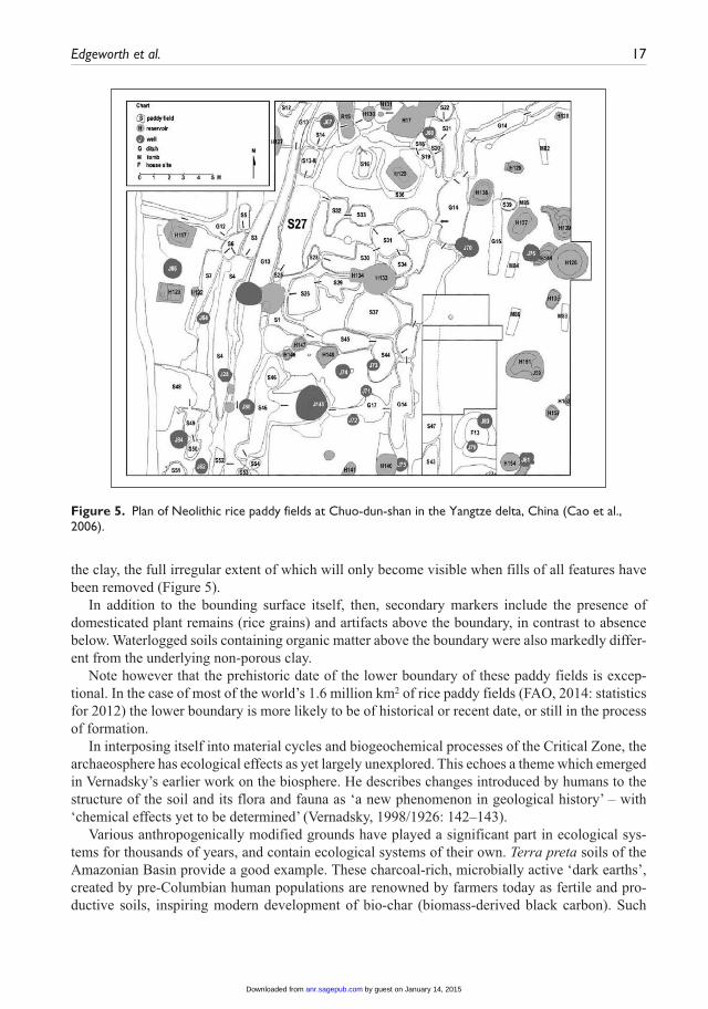
Millions of tonnes of atmospheric methane, a ‘greenhouse’ gas, are produced annually by rice paddy agriculture in southern and eastern Asia today. The warm waterlogged soils of seasonally flooded paddy fields make ideal anaerobic conditions for methane-producing micro-organisms. Increases in global methane levels from about 3000 bc recorded in ice cores have been linked with early rice production (Ruddiman et al., 2008). Early rice-production sites in China, such as Ciaoxieshan and Chuo-dun-shan in the Yangtze river delta, have been investigated archaeologi-cally (Cao et al., 2006; Fuller and Qin, 2009), providing some stratigraphic basis for claims about early human impact on global atmospheric change (Fuller and Weisskopf, 2011).
At Chuo-dun-shan, 46 small rice fields connected by channels were excavated. Each ‘field’ consists of a roundish or rectangular feature, 1.4–16.0 m2 in size, cut into the natural clay). Carbonized rice grains from the organic soils of the paddy field complex were radio-carbon dated to 4000–3000 bc (Cao et al., 2006). Boundary A on this site takes the form of the upper surface of
by guest on January 14, 2015anr.sagepub.comDownloaded from
Edgeworth et al. 17
the clay, the full irregular extent of which will only become visible when fills of all features have been removed (Figure 5).
In addition to the bounding surface itself, then, secondary markers include the presence of domesticated plant remains (rice grains) and artifacts above the boundary, in contrast to absence below. Waterlogged soils containing organic matter above the boundary were also markedly differ-ent from the underlying non-porous clay.
Note however that the prehistoric date of the lower boundary of these paddy fields is excep-tional. In the case of most of the world’s 1.6 million km2 of rice paddy fields (FAO, 2014: statistics for 2012) the lower boundary is more likely to be of historical or recent date, or still in the process of formation.
In interposing itself into material cycles and biogeochemical processes of the Critical Zone, the archaeosphere has ecological effects as yet largely unexplored. This echoes a theme which emerged in Vernadsky’s earlier work on the biosphere. He describes changes introduced by humans to the structure of the soil and its flora and fauna as ‘a new phenomenon in geological history’ – with ‘chemical effects yet to be determined’ (Vernadsky, 1998/1926: 142–143).
Various anthropogenically modified grounds have played a significant part in ecological sys-tems for thousands of years, and contain ecological systems of their own. Terra preta soils of the Amazonian Basin provide a good example. These charcoal-rich, microbially active ‘dark earths’, created by pre-Columbian human populations are renowned by farmers today as fertile and pro-ductive soils, inspiring modern development of bio-char (biomass-derived black carbon). Such
Figure 5. Plan of Neolithic rice paddy fields at Chuo-dun-shan in the Yangtze delta, China (Cao et al., 2006).
by guest on January 14, 2015anr.sagepub.comDownloaded from
18 The Anthropocene Review
anthropogenic soils provide a material basis for a model of sustainable agriculture in the humid tropics, and form a stable and long-lasting carbon sink (Lehmann et al., 2003). Respiration of CO2 from the soil to the atmosphere as the result of activities of soil microbes is greater than the annual CO2 emissions from burning of fossil fuels, so even small changes in the soil carbon cycle can have large impacts on atmospheric CO2 concentrations (Gougoulias et al., 2014).
The contribution of non-human forces to formation of anthropogenically modified ground can be demonstrated through comparison of artifact deposition on the surface of the Earth and the sur-face of the Moon. Scatter some artifacts on the Earth’s soil, and if undisturbed by humans or flows of air or water, these quickly get covered by vegetation or animal dung, or buried by worm cast-ings, eventually to sink into the ground (or rather enveloped by it), with any organic content decomposed by insects and soil microbes. Within a short time the artifacts will have moved, van-ished or been transformed (Canti, 2003; Darwin, 1881). By way of contrast, artifacts deposited on the surface of the Moon (Gorman, 2005, 2014) will remain in their positions for much greater periods of time, although over millions of years they are subject to burial and translocation through meteorite impacts (Arnold, 1975).
In the upper section of Figure 2, the uniform deposit of ‘garden soil’ of medieval and early post-medieval date, over 1 m in depth, has been homogenized by a mixture of human digging and activ-ity of earthworms and plants, removing all trace of what would otherwise have been complex stratigraphic sequences of layers, cuts and fills. Such processes can erase stretches of the lower boundary of the archaeosphere in much the same way as the boundaries within it. For this reason, Boundary A is often found to be more diffuse than abrupt, more mixed than precisely delineated, more porous than solid.
Awareness of the role of animals, plants, fungi and microbes in the formation, accumulation and transformation of archaeosphere soils should be balanced by acknowledgement of their role in the reduction and moderation of it. Every time a plant or animal dies and falls to the ground – or a human body is buried – soil-dwelling insects, fungi and microbial organisms are called into action to break it down, recycling the carbon and nitrogen contained in the complex organic molecules. Soil as a ‘decomposition system’ is much utilized by people yet largely taken for granted. Deep deposits of anthropogenically modified ground which have accumulated in anaerobic conditions – the 8 m deep waterlogged early medieval deposits in Coppergate, York (Hall, 1984; Holden et al., 2009) for instance – show by default the extent of microbial action that takes place in normal aero-bic conditions, and the great impact this has in moderating effects of human action on the surface of the Earth.
Mixing of human and non-human forces is just as relevant to understanding of the formation of the lower boundary as it is to that of the anthropogenic deposits within and above it. It might be assumed, for example, that the cut of a quarry is wholly the product of human agency, the cultural or technological imposition of form – the outline of the quarry – upon natural strata. However, the sides and base of a quarry (unless backfilled immediately) are subject to processes of erosion and deposition and growth of vegetation which substantially modify them in interaction with human forces, sometimes leading to the same kind of interface layer discussed in relation to cultivation soils. The result is a stratigraphic configuration that is at once anthropogenic, biological and geo-logical in origin.
This is one area where the Jinji boundary is especially important to the current discussion. Processes of liquefaction and fluidization that were observed in soils above the boundary (Nirei et al., 2012) were not wholly cultural or technological any more than they were wholly natural in origin. Seismic waves of the earthquake and incursion of the resulting tsunami combined with the partially artificial structure of reclaimed land to produce the observed effects. The significance of
by guest on January 14, 2015anr.sagepub.comDownloaded from
Edgeworth et al. 19
the Jinji boundary – equivalent to Boundary A as the lower bounding surface of archaeosphere deposits – emerges from the mixture, rather than division, of geological and human.
Discussion
On diachroneity
This paper presents a very different perspective to that put forward by the argument for the mid-20th century start for the Anthropocene, marked by nuclear fallout from atomic bomb tests (Zalasiewicz et al., in press). It does so, crucially, not by proposing an alternative date; rather it challenges the rationale of imposing a precise and globally synchronous date onto processes that stratigraphic evidence indicates were – and still are – manifestly diachronous in onset and development.
Boundary A is diachronous through and through. This diachroneity pertains not just to the past, but to the present and future. The archaeosphere is growing both laterally and vertically, down-wards as well as up. The lower boundary (like the upper boundary) is still forming in places or being renewed in others. Even the material traces of geological and archaeological investigations – the cuts of excavation trenches, boreholes and test pits – renew and reshape the boundary. Former versions of Boundary A are being truncated and replaced by more recent versions, which in turn are liable to further truncation in the future. The archaeosphere, it would appear – and arguably the Anthropocene too – is in ongoing boundary formation mode.
Indeed, as scientific observers, we are observing boundary formation processes from the ‘inside’ – during the boundary formation event – instead of looking back on closed events and on strata that are fixed in place. This raises methodological challenges for stratigraphic studies, but it also pro-vides a unique opportunity to observe Earth systems in transformation in real time.
There are correspondences between the archaeosphere and the recently proposed ‘Palaeoanthropocene’ period (Foley et al., 2013), which recognizes the diachroneity of anthropogenic environmental change and thus also has time-transgressive beginnings. But the correspondence is not absolute. The Palaeoanthropocene is conceived as a past period which, by definition, has already finished. The archae-osphere, on the other hand, is a stratigraphic deposit still in the process of formation, likely to continue forming and being transformed. Its time-transgression, in other words, is not confined to the past, but extends to the present and on into the future. Instead of being equated with the whole of the archaeo-sphere, then, the Palaeoanthropocene can be equated with and grounded in lower/earlier parts of strati-graphic sequences observable within the archaeosphere.
The archaeosphere and its lower boundary have been forming for thousands of years, and are still forming today. It would be misleading to impose a precise and globally synchronous date onto such diachronous processes, whether to mark a beginning or an end. As Edward Harris argues, ‘a date is irrelevant or changeable in the first instance, when considering what should be the funda-mental evidence of change, namely the change in the nature of the stratification of the Earth’ (Harris, 2014).
On the distinctive character of Boundary A
Boundary A is unlike any other geological boundary. It is a palimpsest of traces of a mixture of human and natural forces. It bears the marks – amongst other things – of human intentions and designs. Indeed it has been partly formed through (an accumulation of the effects of) intentional actions, along with their unintended effects, in combination with other forces. This
by guest on January 14, 2015anr.sagepub.comDownloaded from
20 The Anthropocene Review
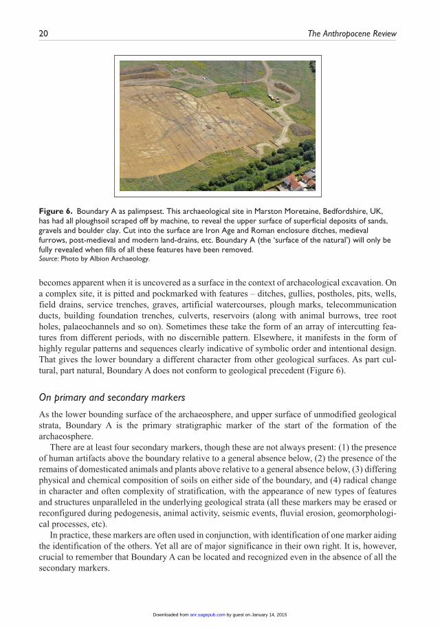
becomes apparent when it is uncovered as a surface in the context of archaeological excavation. On a complex site, it is pitted and pockmarked with features – ditches, gullies, postholes, pits, wells, field drains, service trenches, graves, artificial watercourses, plough marks, telecommunication ducts, building foundation trenches, culverts, reservoirs (along with animal burrows, tree root holes, palaeochannels and so on). Sometimes these take the form of an array of intercutting fea-tures from different periods, with no discernible pattern. Elsewhere, it manifests in the form of highly regular patterns and sequences clearly indicative of symbolic order and intentional design. That gives the lower boundary a different character from other geological surfaces. As part cul-tural, part natural, Boundary A does not conform to geological precedent (Figure 6).
On primary and secondary markers
As the lower bounding surface of the archaeosphere, and upper surface of unmodified geological strata, Boundary A is the primary stratigraphic marker of the start of the formation of the archaeosphere.
There are at least four secondary markers, though these are not always present: (1) the presence of human artifacts above the boundary relative to a general absence below, (2) the presence of the remains of domesticated animals and plants above relative to a general absence below, (3) differing physical and chemical composition of soils on either side of the boundary, and (4) radical change in character and often complexity of stratification, with the appearance of new types of features and structures unparalleled in the underlying geological strata (all these markers may be erased or reconfigured during pedogenesis, animal activity, seismic events, fluvial erosion, geomorphologi-cal processes, etc).
In practice, these markers are often used in conjunction, with identification of one marker aiding the identification of the others. Yet all are of major significance in their own right. It is, however, crucial to remember that Boundary A can be located and recognized even in the absence of all the secondary markers.
Figure 6. Boundary A as palimpsest. This archaeological site in Marston Moretaine, Bedfordshire, UK, has had all ploughsoil scraped off by machine, to reveal the upper surface of superficial deposits of sands, gravels and boulder clay. Cut into the surface are Iron Age and Roman enclosure ditches, medieval furrows, post-medieval and modern land-drains, etc. Boundary A (the ‘surface of the natural’) will only be fully revealed when fills of all these features have been removed.Source: Photo by Albion Archaeology.
by guest on January 14, 2015anr.sagepub.comDownloaded from
Edgeworth et al. 21
In addition to the lower bounding surface Boundary A, within the archaeosphere itself there are multiple bounding surfaces, first and last appearances of certain types of artifact or synthetic mate-rial, a wealth of environmental evidence in the form of animal and plant remains, buried paleosols, and distinct physical-chemical signals which can be used to aid understanding and dating of spe-cific phases of human–environment interaction.
Conclusion
Two distinct possibilities emerge out of the preceding discussion.The first is the coincidence of the archaeosphere with the Anthropocene, with the lower bound-
ing surface (Boundary A) serving as the primary stratigraphic indicator to mark its start. Boundary A has proven to be of great practical use both in the archaeological investigation of human activity in the past and, as the Jinji boundary, in the geological investigation of the movement of soils and contaminants. It could be just as useful as the lower boundary of the stratigraphy of the Anthropocene, for it marks amongst other things a radical change in stratification processes, the first appearance of technofossils (with certain exceptions), and in most cases the earliest substan-tial surviving trace of human activity at any given location. Having such a visible and tangible lower boundary gives the Anthropocene a firm stratigraphic basis. The fundamentally diachro-nous character of the boundary can be taken to accurately reflect the diachronous onset and devel-opment of the Anthropocene itself.
It should be recognized, however, that what appears as diachronous on a human timescale could be taken as synchronous on a geological timescale. Viewed from the perspective of 100 million years in the future, for example, whatever remains of Boundary A might well be regarded as a high-precision synchronous boundary.
If such an option were taken, then stratigraphic boundaries within archaeosphere deposits – marking the start of processes such as the spread of agriculture, diffusion of pottery or metal tech-nologies, phases of industrialization, introduction of novel materials such as plastics and the advent of nuclear technology – would all be understood to indicate developments taking place within the Anthropocene.
Under established stratigraphic procedures and rules, however, it is likely that an Anthropocene thus defined and bounded would not be formally ratified as a new geological epoch, because of the importance of synchronous boundaries to definitions of chronostrati-graphic units. However, it might be considered and used as an informal non-chronostratigraphic (time-transgressive) unit.
A second possibility is that the totality of anthropogenically modified ground that makes up the archaeosphere, with Boundary A as its diachronous lower boundary, could be equated (instead of with a geological epoch) with some time-transgressive geological category such as a biozone (MacLeod, 2005) – in effect an ‘anthrozone’. It would be defined mainly by the refashioning of surface sediments into the distinctive archaeosphere layer, with associated biostratigraphic mark-ers, as well as by fossil skeletal remains. Boundary A would thus signify the lower boundary of the anthrozone rather than the start of the Anthropocene, which would be located somewhere within it, perhaps using some of the artifacts, novel materials, anthropaleosols and chemical signatures con-tained therein as indicators.
In contrast to the Anthropocene epoch, the anthrozone can be defined independently of a glob-ally synchronous marker, and could thus include cumulative events and processes on local and regional scales as well as the measurable global effects of human impact. Despite the ‘anthro’ in its suggested name, it need not necessarily be defined in terms of Homo sapiens alone. It could be
by guest on January 14, 2015anr.sagepub.comDownloaded from
22 The Anthropocene Review
characterized as an ‘assemblage biozone’ or ‘ecozone’, which recognizes ‘a set of dependent eco-logical relations among species and between organisms and their environment’ (MacLeod, 2005). While acknowledging the role of humans as a driving force, it would also acknowledge the inter-connected participation of other actants (such as domesticated animals and plants, and microbial organisms in soils) in formation of the archaeosphere. Physical remains and other material traces of related species, and the presence of polygenetic soils resulting from human–biological–geolog-ical interactions, could be used alongside artifacts in identification of the anthrozone in strati-graphic deposits.
No matter what type of geological time-unit it is equated with, the archaeosphere should be recognized as a single lithostratigraphic unit (made up of multiple smaller units). Mapping of its extent and accelerating growth as a composite entity – a distinctive part of the larger geosphere – is of key importance, as is the investigation of its changing internal structure. Implications extend beyond archaeology, geology and soil science into many other subject areas. The archaeosphere has become an embedded, active part of biogeochemical processes and material cycles, such as the hydrological cycle and global carbon cycle – the changes of which are fundamental to any defini-tion of the Anthropocene. Blanket covering and truncation of so much of terrestrial surfaces of the Earth, and intermeshing of the archaeosphere with parts of the Critical Zone, is having substantial impact on global systems. In many respects the archaeosphere is emerging as a force and vast pres-ence in its own right, impinging on every aspect of human life and encroaching on the environ-ments of most other species. In addition to being an effect and imprint of human action, it produces effects and imprints of its own. It is a mover as well as a marker of global system change.
It follows that the lower bounding surface of the archaeosphere, Boundary A, should be given greater recognition and study as a stratigraphic boundary with major bearing on Anthropocene issues. It was formed, and is still forming, not by a single great event but through the coalescence of traces of countless relatively small events, accruing over time into a substantial material inter-face that now extends over large parts of the terrestrial surfaces of the Earth. It is an actual material surface (alternately conformable and unconformable) with a visible, solid-phase and tangible pres-ence, as opposed to a conceptual boundary allocated to a stratigraphic location on the basis of other evidence. Its diachroneity reflects the changing and accelerating character of human impact on the surface of the Earth. As the interface between anthropogenic layers and underlying geological strata, it can be recognized and described by archaeologists, geologists, soil scientists, landscape ecologists, environmental historians and other scholars, and thus is fertile ground for future inter-disciplinary investigation.
Acknowledgements
Thanks to Hisashi Nirei, Zhihong Cao, L Allan James, University of Leicester Archaeological Services, Transactions of the Leicestershire Archaeological and Historical Society, and Albion Archaeology for per-mission to reproduce images. Much useful feedback was provided by Jan Zalasiewicz and other members of the Anthropocene Working Group. Abby Porter and Alice Gorman provided detailed comments on early drafts. Jane Evans and Jon Ford made valuable suggestions on later versions. Colin Waters and Simon Price publish with the permission of the Executive Director, British Geological Survey, Natural Environment Research Council.
Funding
Colin Waters and Simon Price were funded with the support of the British Geological Survey’s Engineering Geology science programme. Dan Richter was supported by a grant from the US National Science Foundation (EAR-1331846 ).
by guest on January 14, 2015anr.sagepub.comDownloaded from
Edgeworth et al. 23
References
Arnold JR (1975) Monte Carlo simulation of turnover processes in the lunar regolith. Lunar and Planetary Science Conference Proceedings 6: 2375–2395.
Arnold RW, Szabolcs I and Targulian VO (1990) Global Soil Change. Report of an IIASA-ISSS-UNEP task force on the role of soil in global change. Laxenburg: International Institute for Applied Systems Analysis.
Barker P (1977) The Techniques of Archaeological Excavation. London: Batsford.Barnosky AD (2014) Palaeontological evidence for defining the Anthropocene. In: Waters CN, Zalasiewicz
J, Williams M et al. (eds) A Stratigraphical Basis for the Anthropocene. Geological Society, London, Special Publications 395, pp. 149–165.
Brady NC and Weil RR (2007) The Nature and Properties of Soils. New York: Prentice Hall.Canti MG (2003) Earthworm activity and archaeological stratigraphy: A review of products and processes.
Journal of Archaeological Science 30: 135–148.Cao ZH, Ding JL, Hu ZH et al. (2006) Ancient paddy soils from the Neolithic Age in China’s Yangtze River
Delta. Naturwissenschaften 93(5): 232–236.Capelotti PJ (2010) The Human Archaeology of Space: Lunar, Planetary and Interstellar Relics of Exploration.
Jefferson, NC: Mcfarland & Co.Carver M (1987) Underneath English Towns. Interpreting Urban Archaeology. London: Batsford.Carver M (2009) Archaeological Investigation. Abingdon: Routledge.Certini G and Scalenghe R (2011) Anthropogenic soils are the golden spikes for the Anthropocene. The
Holocene 21: 1269–1274.Clark JE and Gosser D (1995) Reinventing Mesoamerica’s first pottery. In: Barnett WK and Hoopes JW
(eds) The Emergence of Pottery: Technology and Innovation in Ancient Societies. Washington, DC: Smithsonian Institution Press, pp. 209–219.
Cocroft W and Schofield J (2012) The secret hill: Cold War archaeology of the Teufelsberg. British Archaeology 126: 38–43.
Connor A and Buckley R (1999) Roman and Medieval Occupation in Causeway Lane, Leicester. Leicester Archaeology Monographs No. 5. Leicester: University of Leicester Press.
Corcoran PL, Moore CJ and Jarvac K (2014) An anthropogenic marker in the future rock record. GSA Today 24(6): 4–8.
Crutzen PJ and Stoermer EF (2000) The ‘Anthropocene’. Global Change Newsletter 41: 17–18.Darwin C (1881) The Formation of Vegetable Mould, Through the Action of Worms, with Observations on
their Habits. London: John Murray.Dearing JA and Jones RT (2003) Coupling temporal and spatial dimensions of global sediment flux through
lake and marine sediment records. Global and Planetary Change 39: 147–168.Doughty CE, Wolf A and Field CB (2010) Biophysical feedbacks between the Pleistocene megafauna extinc-
tion and climate: The first human-induced global warming? Geophysical Research Letters 37: L15703.Douglas I and Lawson N (2001) The human dimensions of geomorphological work in Britain. Journal of
Industrial Ecology 4: 9–33.Edgeworth M (2014) The relationship between archaeological stratigraphy and artificial ground and its sig-
nificance to the Anthropocene. In: Waters CN, Zalasiewicz J, Williams M et al. (eds) A Stratigraphical Basis for the Anthropocene. Geological Society, London, Special Publications 395, pp. 91–108.
Ellis EC (2011) Anthropogenic transformation of the terrestrial biosphere. Philosophical Transactions of the Royal Society A369: 1010–1035.
Fenwick IM (1968) Pedology as tool in archaeological investigations. Ontario Archaeology: Ontario Archaeological Society Publication 11: 27–38.
Foley SF, Gronenborn D, Andreae MO et al. (2013) The Palaeoanthropocene – The beginnings of anthropo-genic environmental change. Anthropocene 3: 83–88.
Food and Agriculture Organization of the United Nations (FAO) (2014) Statistical database. http://faostat.fao.org/site/573/default.aspx#ancor (accessed 28 June 2014).
by guest on January 14, 2015anr.sagepub.comDownloaded from
24 The Anthropocene Review
Ford JR, Kessler H, Cooper AH et al. (2010) An Enhanced Classification of Artificial Ground. British Geological Survey, Open Report, OR/10/036.
Ford JR, Price SJ, Cooper AH et al. (2014) An assessment of lithostratigraphy for anthropogenic deposits. In: Waters CN, Zalasiewicz J, Williams M et al. (eds) A Stratigraphical Basis for the Anthropocene. Geological Society, London, Special Publications 395, pp. 55–89.
Fuller DQ and Qin L (2009) Water management and labour in the origins and dispersal of Asian rice. World Archaeology 41(1): 88–111.
Fuller DQ and Weisskopf AR (2011) The early rice project: From domestication to global warming. Archaeology International 13/14: 44–51.
Gale SJ and Hoare PG (2012) The stratigraphic status of the Anthropocene. The Holocene 22: 1478–1481.Glikson A (2013) Fire and human evolution: The deep-time blueprints of the Anthropocene. Anthropocene
3: 89–92.Gorman AC (2005) The cultural landscape of interplanetary space. Journal of Social Archaeology 5: 85–107.Gorman AC (2014) The Anthropocene in the solar system. Journal of Contemporary Archaeology 1(1):
87–91.Gougoulias C, Clark JM and Shaw LJ (2014) The role of soil microbes in the global carbon cycle: Tracking
the below-ground microbial processing of plant-derived carbon for manipulating carbon dynamics in agricultural systems. Journal of the Science of Food and Agriculture 94(12): 2362–2371.
Haff PK (2014) Technology as a geological phenomenon: Implications for human well-being. In: Waters CN, Zalasiewicz J, Williams M et al. (eds) A Stratigraphical Basis for the Anthropocene. Geological Society, London, Special Publications 395, pp. 301–330.
Hall R (1984) The Viking Dig. London: Bodley Head.Harris EC (1989) Principles of Archaeological Stratigraphy. London: Academic Press.Harris EC (2014) Archaeological stratigraphy as a paradigm for the Anthropocene. Journal of Contemporary
Archaeology 1(1): 105–109.Holden J, Howard A, West L et al. (2009) A critical review of hydrological data collection for assessing
preservation risk for urban waterlogged archaeology: A case study from the City of York, UK. Journal of Environmental Management 90: 3197–3204.
Holliday VT (2004) Soils in Archeological Research. Oxford: Oxford University Press.Hooke RL (2000) On the history of humans as geomorphic agents. Geology 28(9): 843–846.Hooke RL and Martín-Duque JF (2012) Land transformation by humans: A review. GSA Today 22(12):
4–10.International Workshop on Man-made Strata and Geo-pollution (2011) Katori-Narita-Itako International
Declaration. 18 June 2011. Available (in Japanese and English) at: http://homepage3.nifty.com/jagh/soumu/news/201107/IUGS-GEM_Kokusai-Sengen.pdf (accessed 8 December 2014).
James LA, Watson DG and Hansen WF (2006) Using LIDAR data to map gullies and headwater streams under forest canopy: South Carolina, USA. Catena 71: 132–144.
Janssen DM, Wilkinson IP, Williams M et al. (2014) Medieval land remediation of a quarry site at Wallingford, Oxfordshire, revealed by microfossil analysis. Environmental Archaeology 19(2): 124–130.
Jennings NS (2011) Mining and quarrying. In: Armstrong JR and Menon R (eds) Encyclopedia of Occupational Health and Safety. Geneva: International Labor Organization, Chapter 74.
Lehmann J, Kern DC, Glaser B et al. (eds) (2003) Amazonian Dark Earths: Origin, Properties, Management. Dordrecht: Kluwer.
Lucas JN (1981) The debris of history: An archaeological survey of Leicester. Transactions of the Leicestershire Archaeological and Historical Society 56: 1–9.
MacLeod N (2005) Biozones. In: Selley RC, Cocks LRM and Plimer IR (eds) Encyclopedia of Geology. London: Academic Press, pp. 294–306.
McMillan AA and Powell JH (1993) BGS Rock Classification Scheme: The Classification of Artificial (Man-made) Ground and Natural Superficial Deposits. Version 2. British Geological Survey, Technical Report, WG/93/46/R.
by guest on January 14, 2015anr.sagepub.comDownloaded from
Edgeworth et al. 25
Moore AMT, Hillman GC and Legge AJ (2000) Village on the Euphrates: From Foraging to Farming at Abu Hureyra. Oxford: Oxford University Press.
Neal C (2009) People and the environment: a geoarchaeological approach to the Yorkshire Wolds landscape. Unpublished doctoral thesis, University of York. DOI: 10.5284/1000391.
Nirei H, Furuno K, Osamu K et al. (2012) Classification of man-made strata for assessment of geopollution. Episodes 35: 333–336.
Nirei H, Minato H, Zheng Z et al. (1996) Stratigraphy of waste landfills and zoning of artificial miner-als. Proceedings of the 6th Symposium on Geo-Environmental and Geo-Technics 6. Committee of Environmental Geology, Geological Society of Japan, pp. 367–370 (in Japanese).
North American Commission on Stratigraphic Nomenclature (NACSN) (1983) North American stratigraphic code. Bulletin of the American Association of Petroleum Geologists 67: 841–875.
Orton C, Tyers P and Vince A (1993) Pottery in Archaeology. Cambridge: Cambridge University Press.Periman RD (2006) Visualizing the Anthropocene: Human land use history and environmental manage-
ment. In: Aguirre-Bravo C, Pellicane PJ, Burns DP et al. (eds) Monitoring Science and Technology Symposium: Unifying Knowledge for Sustainability in the Western Hemisphere. Fort Collins, CO: US Department of Agriculture, pp. 558–564.
Poirier C, Chaumillon E and Arnaud F (2011) Siltation of river-influenced coastal environments: Respective impact of late Holocene land use and high-frequency climate changes. Marine Geology 290: 51–62.
Price SJ, Ford JR, Cooper AH et al. (2011) Humans as major geological and geomorphological agents in the Anthropocene: The significance of artificial ground in Great Britain. In: Zalasiewicz JA, Williams M, Haywood A et al. (eds) The Anthropocene: A New Epoch of Geological Time. Philosophical Transactions of the Royal Society (Series A) 369: 1056–1084.
Price SJ, Ford JR, Kessler H et al. (2004) Mapping our impact on the surface of the Earth. Earthwise 20: 30–31.
Ramirez-Llodra E, Tyler PA et al. (2011) Man and the last great wilderness: Human impact on the deep sea. Plos One 6(8). Available at: http://dx.doi.org/10.1371/journal.pone.0022588.
Reicosky DC (2005) Tillage and gas exchange. In: Lal R (ed.) Encyclopaedia of Soil Science, Vol. 2, 2nd Edition. Boca Raton, FL: CRC Press, pp. 1773–1775.
Richter D deB (2007) Humanity’s transformation of Earth’s soil: Pedology’s new frontier. Soil Science 172: 957–967.
Richter D deB and Mobley ML (2009) Monitoring Earth’s Critical Zone. Science 326(5956): 1067–1068.Richter D deB and Yaalon DH (2012) The changing model of soil revisited. Soil Science Society of America
Journal 76: 766–778.Roosevelt AC (1999) The maritime, highland, forest dynamic and the origins of complex culture. In:
Salomon F and Schwartz SB (eds) Native Peoples of America Volume III: South America, 1. Cambridge: Cambridge University Press, pp. 264–349.
Roosevelt AC (2013) The Amazon and the Anthropocene: 13,000 years of human influence in a tropical rainforest. Anthropocene 4: 69–87.
Rosenbaum MS, McMillan AA, Powell JH et al. (2003) Classification of artificial (man-made) ground. Engineering Geology 69: 399–409.
Roskams S (2001). Excavation. Cambridge: Cambridge University Press.Roskams S and Neal C (2013) Heslington East Area A3 (Fields 8 and 9), Assessment Report Volume 1.
Department of Archaeology, University of York (YORYM2011.1129).Rossiter DG (2007) Classification of urban and industrial soils in the world reference base for soil resources.
Journal of Soils and Sediments 7: 96–100.Ruddiman WF (2003) The Anthropogenic greenhouse era began thousands of years ago. Climatic Change
61: 261–293.Ruddiman WF (2013) Anthropocene. Annual Review of Earth and Planetary Sciences 41(4): 1–24.Ruddiman WF, Guo Z, Zhou X et al. (2008) Early rice farming and anomalous methane trends. Quaternary
Science Reviews 27: 1291–1295.
by guest on January 14, 2015anr.sagepub.comDownloaded from
26 The Anthropocene Review
Schiffer MB (1987) Formation Processes of the Archaeological Record. Albuquerque, NM: University of New Mexico Press.
Slowikowski A (1995) ‘The greatest depository of archaeological material’: The role of pottery in ploughzone archaeology. In: Shepherd E (ed.) Interpreting Stratigraphy. Hunstanton: Witley Press 5, pp. 15–20.
Smith BD and Zeder MA (2013) The onset of the Anthropocene. Anthropocene 4: 8–13.Steffen W, Grinevald J and Crutzen P et al. (2011) The Anthropocene: Conceptual and historical perspectives.
Philosophical Transactions of the Royal Society A 369: 842–867.Stephens JC, Allen LH and Chen E (1984) Organic soil subsidence. Reviews in Engineering Geology 6:
107–122.Vernadsky VI (1998/1926) The Biosphere. (Complete annotated edition) New York: Copernicus.Waters CN, Zalasiewicz J, Williams M et al. (eds) (2014) A Stratigraphical Basis for the Anthropocene.
Geological Society, London, Special Publications 395.Weatherill L (1971) The Pottery Trade and North Staffordshire, 1660–1760. Manchester: Manchester
University Press.Williams M, Zalasiewicz J, Waters CN et al. (2014) Is the fossil record of complex animal behaviour a
stratigraphical analogue for the Anthropocene? In: Waters CN, Zalasiewicz J, Williams M et al. (eds) A Stratigraphical Basis for the Anthropocene. Geological Society Special Publications 395. London: Geological Society, pp. 143–148.
Zalasiewicz J (2008) The Earth After Us. Oxford: Oxford University Press.Zalasiewicz J, Waters CN and Williams M (2014c) Human bioturbation, and the subterranean landscape of
the Anthropocene. Anthropocene DOI: 10.1016/j.ancene.2014.07.002 (available online 24 July 2014).Zalasiewicz J, Waters CN, Williams M et al. (in press) When did the Anthropocene begin? A mid-twentieth
century boundary level is stratigraphically optimal. Quaternary International.Zalasiewicz J, Williams M et al. (2011) Stratigraphy of the Anthropocene. In: Zalasiewicz JA, Williams M,
Haywood A et al. (eds) The Anthropocene: A New Epoch of Geological Time. Philosophical Transactions of the Royal Society (Series A) 369, pp. 1036–1055.
Zalasiewicz J, Williams M and Waters CN (2014a) Can an Anthropocene Series be defined and recognised? In: Waters CN, Zalasiewicz J, Williams M et al. (eds) A Stratigraphical Basis for the Anthropocene. Geological Society, London, Special Publications 395, pp. 39–53.
Zalasiewicz J, Williams M, Waters CN et al. (2014b) The technofossil record of humans. Anthropocene Review 1: 1–10.
by guest on January 14, 2015anr.sagepub.comDownloaded from