Embed Size (px)
Citation preview

VEGETATION MANAGEMENT PLANCLARENCE CATCHMENT
*** DRAFT ***ISSUES PAPER
Prepared by
Greg SteenbeekeDepartment of Land and Water Conservation, Grafton.
Utilising funding sourced from the National LandcareProgram/Natural Heritage Trust
by Clarence Catchment Management Committee.

DRAFT ISSUES PAPER - CLARENCE VEGETATION MANAGEMENT
List of Contents.LIST OF TABLES.......................................................
1. INTRODUCTION TO PROJECT..........................................1.1. THE CLARENCE CATCHMENT.............................................
1.1.1. Land Description including Geology..................................................................................1.1.2. Climate..................................................................................................................................1.1.3. Land Use................................................................................................................................
1.2. PROJECT METHODOLOGY................................................1.3. SUPPORTING DOCUMENTATION............................................1.4. LEGISLATIVE REQUIREMENTS............................................1.5. KEY PRINCIPLES AND OBJECTIVES:.......................................2. KEY ISSUES.......................................................2.1. VEGETATION AND BIODIVERSITY.....................................
2.1.1. Biodiversity Principles...........................................................................................................2.1.2. Rare, Threatened or Endangered Species...........................................................................2.1.3. Vegetation Types with Restricted Distributions..................................................................2.1.4. ‘High Conservation Value’ Vegetation Types.......................................................................2.1.5. Riparian Vegetation..............................................................................................................2.1.6. Wetlands................................................................................................................................2.1.7. Coastal Lands........................................................................................................................2.1.8. Rainforests.............................................................................................................................
2.1.8.a. Littoral Rainforests..........................................2.1.8.b. Subtropical Rainforests.......................................2.1.8.c. Warm-temperate Rainforests....................................2.1.8.d. Cool-temperate Rainforests....................................2.1.8.e. Dry Rainforests...............................................
2.1.9. Genetic Integrity....................................................................................................................2.1.10. Dry Forests..........................................................................................................................
2.2. MANAGEMENT AND COMMUNITY ACTIONS................................2.2.1. Commuity Awareness...........................................................................................................2.2.2. Maintaining and Conserving Biodiversity...........................................................................2.2.3. Management of Fire in Grazing Situations.........................................................................2.2.4. Management of Hazard Reduction and Wildfire..............................................................2.2.5. Management of Roadside Vegetation.................................................................................2.2.6. Protected Lands.....................................................................................................................2.2.7. Wildlife Corridors..................................................................................................................2.2.8. Greenbelt Areas.....................................................................................................................2.2.9. Weed Management...............................................................................................................2.2.10. Marine, Maritime and Estuarine Communities................................................................2.2.11. Pasture Management.........................................................................................................2.2.12. Appropriate Revegetation..................................................................................................
2.3. FINANCIAL BENEFITS OF VEGETATION................................2.3.1. Seed Supply............................................................................................................................2.3.2. Seedling Supply.....................................................................................................................2.3.3. Harvesting of Natural Forests..............................................................................................2.3.4. Harvesting of Natural Plant Products.................................................................................2.3.5. Ecotourism.............................................................................................................................
Produced by Greg SteenbeekePage 15/10/2022
DRAFT ISSUES PAPER - CLARENCE VEGETATION MANAGEMENT
2.3.6. Agroforestry...........................................................................................................................2.3.7. Plantation Establishment and Management......................................................................2.3.8. Bush Tucker............................................................................................................................2.3.9. Apiaries.................................................................................................................................
3. CONCLUDING REMARKS................................................3.1. IDENTIFIED ONGOING PROJECTS.........................................3.2. IDENTIFIED PRIORITY PROJECTS.......................................3.3. PROJECTS THAT SHOULD BE FUNDED......................................3.4. EDUCATION........................................................APPENDIX A...........................................................A.1. AUGMENTING DOCUMENTATION AND MATERIALS..........................
A.1.1. Active Geographic Information Systems for maintaining accurate details of vegetation.........................................................................................................................................
A.1.1.1. Multiple GIS Layers...........................................A.1.1.1.a. Protected Lands.................................................A.1.1.1.b. Significant Vegetation Types........................................A.1.1.1.c. Rare Species (TSC and ROTAP).......................................A.1.1.1.d. Noxious Species..................................................A.1.1.1.e. Reserves and Conservation Areas....................................A.1.1.1.f. Prescribed and Significant Streams...................................A.1.1.1.g. Greenbelt Zones..................................................A.1.1.1.h. SEPP Zones......................................................A.1.1.1.i. Acid Sulfate Soils.................................................A.1.1.1.j. Fire Management and Prescribed Burning..............................A.1.1.1.k. Clearing Rates...................................................
A.1.2. Data Availability and Custodians........................................................................................
APPENDIX B...........................................................B.1. LIST OF REPORTS ON VEGETATION OF THE CLARENCE CATCHMENT.................B.2. BRIEF LIST OF REPORTS AND LOCAL STUDIES CONSIDERED RELEVANT TO VEGETATION MANAGEMENT PLANNING.....................................................B.3. PAPERS AND STUDIES USED AS REFERENCES FOR THIS STUDY BUT NOT CITED IN THE TEXT..................................................................APPENDIX C...........................................................C.1. PRINCIPLES DERIVED FROM OTHER SOURCES:................................
C.1.1. Clearing..................................................................................................................................C.1.2. Wetland Management..........................................................................................................C.1.3. Rivers and Estuaries..............................................................................................................C.1.4. Ecological Goals / Objectives from RTA Roadside Environment Strategic Plan:.............C.1.5. Strategy Plan for Key Natural Resource Issues in the Clarence Catchment:..................
APPENDIX D...........................................................D.1. RARE, ENDANGERED AND THREATENED PLANT SPECIES LIKELY TO OCCUR IN THE CLARENCE CATCHMENT......................................................APPENDIX E...........................................................E.1. LAND AND ACTIVITIES EXEMPTED FROM THE RVMP PROCESS..............
E.1.1. Lands Exempted....................................................................................................................E.1.2. Clearing Activities Excluded..................................................................................................
Produced by Greg SteenbeekePage 15/10/2022

DRAFT ISSUES PAPER - CLARENCE VEGETATION MANAGEMENT
LIST OF TABLES.
Produced by Greg SteenbeekePage 15/10/2022

DRAFT ISSUES PAPERCLARENCE VEGETATION MANAGEMENT
Produced by Greg SteenbeekePage 0 15/10/2022
DRAFT ISSUES PAPERCLARENCE VEGETATION MANAGEMENT
1. Introduction to Project.The project was originally conceived by The Clarence CatchmentManagement Committee, which had become aware of the need for astrategic planning instrument for the Clarence Catchment in anumber of workshops and public meetings. Acknowledgement thatthe position would require a coordinated effort, and theemployment of an officer to undertake that, the soughtfunding from the National Landcare Program in the 1995/6round. This project failed to obtain funding in that year, butin a resubmitted form managed to do so in the 1996/7 round.The title of the position was noted as ‘Local GovernmentLiaison Officer’, with the obvious relationships between thelead agency (DLWC) and the 11 councils of the catchmentbecoming obvious in the title.The preferred outcomes of the project were:· A vegetation management plan for the Clarence Catchment;· The development of coordinated and community accepted
policies for the management of vegetation within thecatchment;
· Identifications to councils and community groups of theprocesses involved with vegetation management planning;
· Identification of high priority vegetation managementprojects within the catchment for support and funding; and
· Assisting councils to access sources for data andinformation on vegetation and biodiversity.
During the early part of the timeframe there were problemswith a clear direction for the project. This resulted from theconfused state of vegetation management in DLWC while theNative Vegetation Conservation Act (NVC Act) was beingcomposed. However, once the NVC Act had been passed (1 January1998), there were few impediments to the direction, with onlythe lack of ministerial response on boundaries causing ongoingconcern.
1.1. The Clarence Catchment.
The Clarence River Catchment occupies an area of approximately22 700 km2 in North Eastern New South Wales. The physicallimits of the catchment are the Richmond Range on the North-eastern boundary, the McPherson Range (including AcaciaPlateau) on the Northern boundary (which is also the State
Produced by Greg SteenbeekePage 1 15/10/2022
DRAFT ISSUES PAPERCLARENCE VEGETATION MANAGEMENT
Border with Queensland), the New England Range (Great DividingRange) along the western side southwards to Ben Lomond, theDoughboy Range along the South-western side and the DorrigoPlateau on the South-eastern side, and the Coast Range alongthe eastern Boundary. For planning and sociological purposes,the catchments of the Wooli Wooli and Sandon rivers east ofthe Coast Range are also included in the ‘Clarence Catchment’.
1.1.1. Land Description including Geology.The Clarence shows a great diversity of landforms throughoutit’s extent. The mainly basin-shaped eastern section isdominated by rolling lowland hills surrounding an extensiveflooplain. However, the erosion of the sandstone-dominatedCoast Range has resulted in sharply rising hills, dissectedinto narrow ridges. The higher altitude lands on the westernand south-western parts predominately show rolling topography.The escarpment area dividing these two parts is steep andmountainous country dissected by deep gorges and ravines, withrapid changes in slope and elevation over short distances.Small areas of riparian terrace occur along the majorwatercourses, and form disjunct areas of flatter topography.Altitudes throughout the catchment range from sea-level alongthe coast (and to some distance inland along the Clarence) toa maximum of 1584 metres at Round Mountain west of Ebor.The geology of the area reflects the presence of two majorgeological units. The southern end of the Clarence-Mortonsedimentary basin forms the eastern half and extendsnorthwards along the Richmond Range (where there are frequentoutcrops of Tertiary basalt capping). The rocks of this basinare mainly coarser-grained sediments (sandstones, arenites),although strata of shale and coal occur within the basin also.The western plateau forms largely from the weathering of anumber of granite and granitoid plutons, the rollingtopography showing their presence. The escarpment areas also consist of two separate bodies. Thesouthern end is dominated by metamorphosed materials derivedfrom sediments, with shales, slates argillites and quartzitesas the majority of materials present. The northern end of theescarpment is dominated by acid volcanics, such as rhyoliteand tuff. Serpentinite forms a belt roughly seperating the twoareas, with main outcrops in the Baryulgil area.
Produced by Greg SteenbeekePage 2 15/10/2022

DRAFT ISSUES PAPERCLARENCE VEGETATION MANAGEMENT
The Dorrigo Plateau and areas of the New England Plateau nearGuyra have extensive areas of Tertiary volcanics (basalt andtrachyte mainly). This has given these areas rich soils andhas resulted in extensive agricultural development to thedetriment of the natural vegetation.
1.1.2. Climate.The climate of the Clarence is largely sub-tropical maritime,with a distinct summer maximum rainfall and generally a warm -hot Summer and cool - mild Winter. Snow and frosts are notuncommon during Winter on higher lands in the western parts ofthe catchment, while the coastal lowlands can reach quite hightemperatures during the Summer.Wettest parts of the catchment lie in the South (DorrigoPlateau), and along the coast, with an area of higher rainfallalso occurring on the eastern edge of the north-southescarpment (mainly in the Gibraltar Range area), the DorrigoPlateau and escarpment areas near Coffs Harbour, and thenorthern end of the Richmond Range.
1.1.3. Land Use.Use by Aboriginal people of the vegetation was limited to toolmaking, and harvesting foods and madicines. Extensive changesto the vegetation was limited to the use of fire which wasmainly used in open areas to attract game. Little evidenceexists of past fire practices in the Clarence.After Europeans arrived the vegetation suffered extensive andrapid change. The first clearing was conducted by timbercutters (‘Cedar Getters’), harvesting the rainforest species(mainly Red Cedar) along the rivers. Later, the arrival ofgraziers saw an extensive pastoral industry arise. Many of thelands used for grazing (both coastal and on the tablelands)were probably occupied by 1870, with the industry continuingto be important throughout the catchment. Beef and dairyproduction mainly occur along the coastal zone, while thewestern plaeux support a sheep and beef industry.The development of a cropping industry in northern NSWcommmenced with sugar cane planted on the floodplain of theClarence in 1864. Other crops reaching prominence in the areainclude that based on a native teatree (Melaleuca alternifolia),
Produced by Greg SteenbeekePage 3 15/10/2022

DRAFT ISSUES PAPERCLARENCE VEGETATION MANAGEMENT
which is harvested mainly for oil. Cropping is not a largeindustry in the Clarence, and this situation is likely tocontinue due to poor soils and lower rainfall away from thecoast.Mining has been carried out in various locations since theearly 1800’s. Gold and tin have been mined in the upperClarence since the 1850’s, and significant quantities ofsilver, copper, manganese and antimony have also beenextracted. The serpentinite belt near Baryulgil yieldedasbestos, while the mineral sands along the coast have beenmined for rutile.
1.2. Background information.
A range of information has been collected of the vegetation resources of the Clarence. However, the bulk of this relates to the Crown Lands, gained through projects such as the North-East Forests Biodiversity Study (NEFBS) and the Natural Resources Audit Council (NRAC) audit of Upper North-East New South Wales.
Local governmentname
Area within theClarenceCatchment
Area (& %) of NationalPark, State Forest andother excluded lands.
Bellinger 51653 14192 (27.48%)Coffs Harbour 64503Copmanhurst 315797 83114 + 1125 (26.68%)Dumaresq 5250 153 (2.91%)Grafton 8217 24 (0.29%)Guyra 492675 151270 (30.70%)Kyogle 154936 42478 (27.42%)Maclean 104838 25537 + 8687 (32.64%)Nymboida 513600 246529 (48.00%)Richmond River 25256 + 7245 (Tenterfield 439674 119822 (27.25%)Ulmarra 168688 59958 + 4183 (38.02%)
Produced by Greg SteenbeekePage 4 15/10/2022

DRAFT ISSUES PAPERCLARENCE VEGETATION MANAGEMENT
1.3. Project Methodology.The coordinator, once appointed, met with staff of eachcouncil on an individual basis, usually meeting with theDirector of Planning or Environmental Services. A number offormal addresses to Councils were also made once the formatfor planning under the NVC Act became evident.Data on vegetation in conservation areas was obtained from theNSW National Parks and Wildlife Service, through both the headoffice (Hurstville) and the Northern Zone Office (CoffsHarbour). For forestry areas, a separate set of data wasobtained from State Forests (NSW) at Pennant Hills.Approaches were made to a number of local consultants andenvironmental groups, and information obtained from themincluded the location of particular rare species, or areaswith higher conservation priorities.Information gained from the Vegetation Management unit atGrafton DLWC was also used to determine priorities within theregion for areas with higher conservation values, and toillustrate areas where the vegetation is either in low, mediumor high risk of clearing pressures. There was also involvement in the development of the regionalGreenbelt network, a project of the Department of UrbanAffairs and Planning. Much of the information gained from thatproject is also included here.
1.4. Supporting Documentation.The NSW North East Plants Database was developed as part of this project. It allows the determination of likely identity lists for plants, as well as a capability of creating lists ofspecies which suit particular criteria (habitat, altitude, growth rates or occurrence in a catchment). It satisfies in part the desire to make biodiversity information available to the councils of the Clarence Catchment.Other documentation relevant to the project is contained in the Appendices.
Produced by Greg SteenbeekePage 5 15/10/2022
DRAFT ISSUES PAPERCLARENCE VEGETATION MANAGEMENT
1.5. Legislative Requirements.The main legislative requirements imposed upon the preparationof Vegetation Management Plans come from the Native VegetationConservation Act, 1997 (the NVC Act). This governs themanagement of vegetation upon both private and Crown lands,with the exception including urban lands, lands covered understate planning policies 14 and 26, and Crown Lands managed fortheir vegetation (State Forests, National Parks and NatureReserves). Some clearing activities are also exempted from theoperations of the Act, and they include minimal clearing foron farm purposes, damage resulting from noxious plantscontrol, clearing approved in a designated development andminimal disturbance from road maintenance and construction. Afull coverage of the exempted lands and exempted activities isgiven in Appendix E.A plan, once produced, operates as a Regional EnvironmentalPlan under Part 3 of the Environmental Planning and AssessmentAct, 1989. This places it in a superior position to the LocalEnvironment Plans which must be prepared by Local Governments.
1.6. Key principles and objectives:
{ Maintaining viable populations of all species, with emphasisplaced on monitoring populations of rare and endangered species.{ Reducing threats to existing vegetation through sensible useof fire, control of clearing, and reducing the extent and severity of weed and feral animal infestations.{ Promoting the use of locally harvested and grown propagationmaterials for regeneration works.{ Retention of vegetation where the inherent values of the vegetation are not severely compromised and to maintain and enhance areas with low area to boundary ratios, and connectingcorridors.Values would include: w Suitability as fauna habitat (diversity of ages/species/structure, rare species);w Flora conservation (diversity of species, reproducing/potentially reproductive populations, rare species refuge);
Produced by Greg SteenbeekePage 6 15/10/2022
DRAFT ISSUES PAPERCLARENCE VEGETATION MANAGEMENT
w Stabilisation of surface and landform structure (reductionof soil erosion), and prevention of other forms of land degradation - especially salinisation and acid soils; w Protection of water quality; w Suitability as sustainable fodder source; w Suitability as stock and wildlife refuge (from drought, heat, cold, wind, etc); w Potential income source (bush foods, ecotourism, wildflower production); w Extent of the type as represented throughout the catchment.
Other principles relating to specific issues areas are givenin the relevant section, and are marked with this symbol (v).
Produced by Greg SteenbeekePage 7 15/10/2022
DRAFT ISSUES PAPERCLARENCE VEGETATION MANAGEMENT
2. KEY ISSUES.
2.1. VEGETATION AND BIODIVERSITY.
2.1.1. Biodiversity Principles.v Conserve the diversity of each site at an optimum level forthe available area and resources within the remnant vegetation.v Establishing vegetation around a remnant to reduce the drain on available resources within that vegetation.
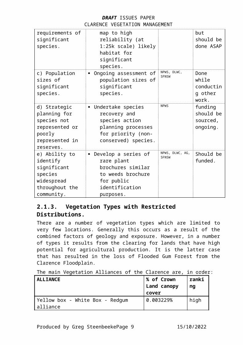
2.1.2. Rare, Threatened or Endangered Species.A diverse array of nationally significant species occur in theClarence Catchment - some 226 taxa in total. Their habitatsand distributions are equally varied. However, few are knownto be entirely conserved, and very few would have a majorityof the extant populations in reserves (see below). Seventy-oneare not apparently represented in reserves at all in eitherthe North Coast or Northern Tablelands botanical regions. 11 species are endemic to the Clarence, with centres ofpopulation around Gibraltar Range (Acacia cangaiensis, A. floydii,Dodonaea serratifolia, Persoonia rufa, Telopea aspera, Zieria sp L (Z. floydiims)) and the Baryulgil area (Eucalyptus ophitica, Acacia ruppii). Ofthe 11 species, 4 are noted as not being represented inconservation reserves - National Parks, Nature Reserves andFlora Reserves (they being Acacia ruppii, Eucalyptus ophitica, Melichrushirsutus and Tylophora woollsii), while only one (Zieria floydii ms.) isfound entirely within conservation areas (Mann River NatureReserve).For the complete list of species noted in the ROTAP orlegislative schedules, please refer to Appendix D.ISSUES:ISSUE ACTIONS RESPONSIBILITY TIMEFRAME
a) Location of significant species.
· Identify, locate and store to GIS all locations of significant species.
NPWS Ongoing
b) Habitat · Model habitat, and NPWS, SFNSW Ongoing,
Produced by Greg SteenbeekePage 8 15/10/2022
DRAFT ISSUES PAPERCLARENCE VEGETATION MANAGEMENT
requirements ofsignificant species.
map to high reliability (at 1:25k scale) likelyhabitat for significant species.
but should bedone ASAP
c) Population sizes of significant species.
· Ongoing assessment ofpopulation sizes ofsignificant species.
NPWS, DLWC, SFNSW
Done while conducting other work.
d) Strategic planning for species not represented or poorly represented in reserves.
· Undertake species recovery and species action planning processes for priority (non-conserved) species.
NPWS funding should besourced, ongoing.
e) Ability to identify significant species widespread throughout the community.
· Develop a series of rare plant brochures similar to weeds brochure for public identification purposes.
NPWS, DLWC, AG,SFNSW
Should befunded.
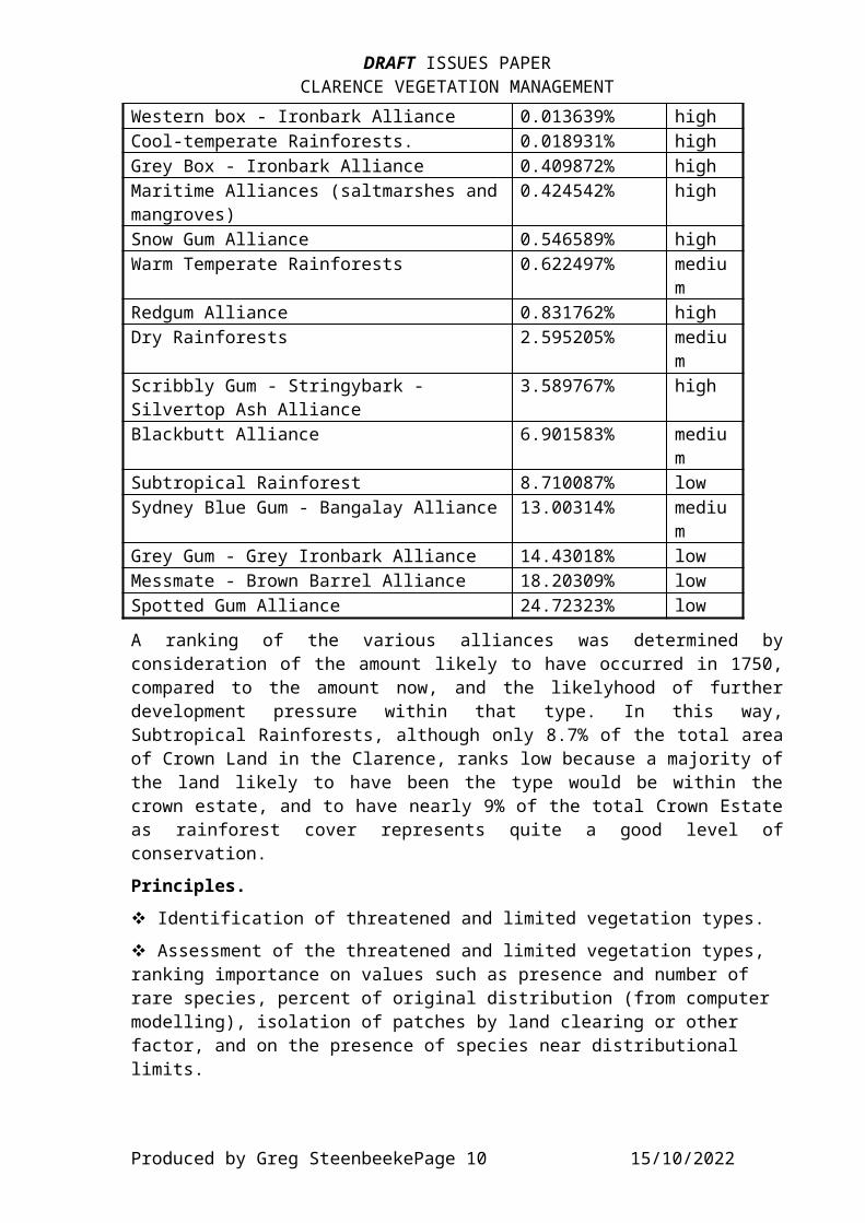
2.1.3. Vegetation Types with Restricted Distributions.There are a number of vegetation types which are limited tovery few locations. Generally this occurs as a result of thecombined factors of geology and exposure. However, in a numberof types it results from the clearing for lands that have highpotential for agricultural production. It is the latter casethat has resulted in the loss of Flooded Gum Forest from theClarence Floodplain.The main Vegetation Alliances of the Clarence are, in order:ALLIANCE % of Crown
Land canopy cover
ranking
Yellow box - White Box - Redgum alliance
0.003229% high
Produced by Greg SteenbeekePage 9 15/10/2022
DRAFT ISSUES PAPERCLARENCE VEGETATION MANAGEMENT
Western box - Ironbark Alliance 0.013639% highCool-temperate Rainforests. 0.018931% highGrey Box - Ironbark Alliance 0.409872% highMaritime Alliances (saltmarshes andmangroves)
0.424542% high
Snow Gum Alliance 0.546589% highWarm Temperate Rainforests 0.622497% mediu
mRedgum Alliance 0.831762% highDry Rainforests 2.595205% mediu
mScribbly Gum - Stringybark - Silvertop Ash Alliance
3.589767% high
Blackbutt Alliance 6.901583% medium
Subtropical Rainforest 8.710087% lowSydney Blue Gum - Bangalay Alliance 13.00314% mediu
mGrey Gum - Grey Ironbark Alliance 14.43018% lowMessmate - Brown Barrel Alliance 18.20309% lowSpotted Gum Alliance 24.72323% lowA ranking of the various alliances was determined byconsideration of the amount likely to have occurred in 1750,compared to the amount now, and the likelyhood of furtherdevelopment pressure within that type. In this way,Subtropical Rainforests, although only 8.7% of the total areaof Crown Land in the Clarence, ranks low because a majority ofthe land likely to have been the type would be within thecrown estate, and to have nearly 9% of the total Crown Estateas rainforest cover represents quite a good level ofconservation.Principles.v Identification of threatened and limited vegetation types.v Assessment of the threatened and limited vegetation types, ranking importance on values such as presence and number of rare species, percent of original distribution (from computer modelling), isolation of patches by land clearing or other factor, and on the presence of species near distributional limits.
Produced by Greg SteenbeekePage 10 15/10/2022
DRAFT ISSUES PAPERCLARENCE VEGETATION MANAGEMENT
v Denoting zones of high endemism and ensuring greater protection criteria are applied to these zones.ISSUES:ISSUE ACTIONS RESPONSIBILITY TIMEFRAME
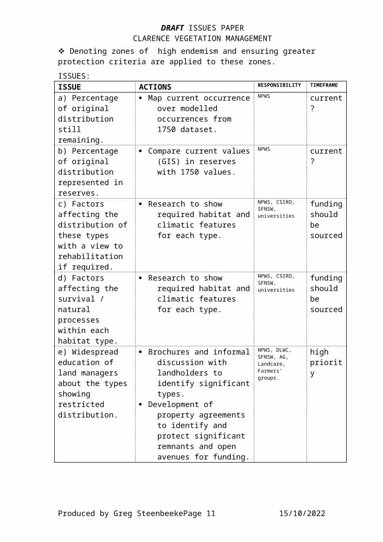
a) Percentage of original distribution still remaining.
· Map current occurrenceover modelled occurrences from 1750 dataset.
NPWS current?
b) Percentage of original distribution represented in reserves.
· Compare current values(GIS) in reserves with 1750 values.
NPWS current?
c) Factors affecting the distribution ofthese types with a view to rehabilitation if required.
· Research to show required habitat andclimatic features for each type.
NPWS, CSIRO, SFNSW, universities
fundingshould be sourced
d) Factors affecting the survival / natural processes within each habitat type.
· Research to show required habitat andclimatic features for each type.
NPWS, CSIRO, SFNSW, universities
fundingshould be sourced
e) Widespread education of land managers about the typesshowing restricted distribution.
· Brochures and informaldiscussion with landholders to identify significanttypes.
· Development of property agreements to identify and protect significant remnants and open avenues for funding.
NPWS, DLWC, SFNSW, AG, Landcare, Farmers’ groups.
high priority
Produced by Greg SteenbeekePage 11 15/10/2022

DRAFT ISSUES PAPERCLARENCE VEGETATION MANAGEMENT
2.1.4. ‘High Conservation Value’ Vegetation Types.High Conservation value relates not only to the values of thebiotic environment (such as species complexity -‘biodiversity’, suitability as habitat for all forms of life,and source for propagules), but to various physical featuressuch as the ability of the vegetation to maintain soilstability, present a pleasing panorama or provide linksbetween other types of vegetation.Although consideration will be made of vegetation typesshowing some physical inflence in the environment (such asriparian zones etc.), in the context of this report, the termwill be taken to encompass those types where the vegetationshows at least one of the following characteristics:· greater diversity; · has old growth form;· wilderness characteristics;· is poorly (or is not) reserved;· is threatened by ongoing land management practices;· has populations of rare or threatened species; and · may have value as habitat for localised, endemic or rare orthreatened fauna.
The other physical benefits of vegetation are addressed underseparate headings.ISSUES:ISSUE ACTIONS RESPONSIBILITY TIMEFRAME
a) Definition of high conservation value as a function of thespecies richness, habitat suitability andgeneral rarity of the type.
· Definition suitable tomost situations available for implementation by any department or vegetation worker.
NPWS done?
b) Education ofthe inherent values of HCV vegetation to both the
· Production of information bulletins, guides and brochures givinginformation on the
DLWC, Landcare high priority
Produced by Greg SteenbeekePage 12 15/10/2022
DRAFT ISSUES PAPERCLARENCE VEGETATION MANAGEMENT
landholder and community at large.
values in laymans terms with express relationships to farm productivity.
c) Identification of areas of HCVvegetation throughout the catchment.
· Mapping of HCVV to GISfor all land tenures. Distribution to all land management agencies.
NPWS, DLWC, Ag, SFNSW
high priority
2.1.5. Riparian Vegetation.Riparian vegetation is important for a number of reasons. It’sprotection is generally restricted to the protection ofvegetation to a distance of 20 metres from the bed or bank ofprescribed streams on a state-wide basis, or in the NativeVegetation Conservation Act, 1997, of any stream identified ina regional vegetation plan. However, the distance to whichriparian vegetation can extend outwards from the stream islargely dependent upon the combined factors of floodplainmorphology and how perennial the flow is in the stream. The structure of vegetation in the riparian zone is largelydependent upon two factors. The frequency with which a streamexperiences fast or over-bank (flood) flows, and thesurrounding vegetation communities. Other influencing factorsinclude the local topography (steeper gullies are more likelyto have wetter forests extending to some distance upslope onmore protected aspects), and of course the disturbance historyof the site.The vegetation has the ability to utilise nutrient ladenrunoff, or to slow passage of nutrient laden water, causingdeposition of the suspended materials, therefore acting as anutrient buffer. Principles.v Retention and enhancement of riparian vegetation.v Catchment headwater needs protection to ensure water quality and amenity.v Protection and maintenance of areas with higher conservation values (vegetation type of limited distribution; populations of rare species).
Produced by Greg SteenbeekePage 13 15/10/2022
DRAFT ISSUES PAPERCLARENCE VEGETATION MANAGEMENT
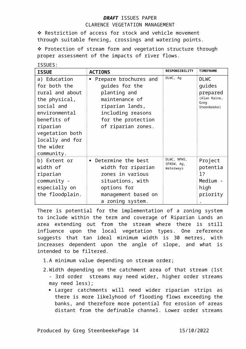
v Restriction of access for stock and vehicle movement through suitable fencing, crossings and watering points.v Protection of stream form and vegetation structure through proper assessment of the impacts of river flows.ISSUES:ISSUE ACTIONS RESPONSIBILITY TIMEFRAME
a) Education for both the rural and aboutthe physical, social and environmental benefits of riparian vegetation bothlocally and forthe wider community.
· Prepare brochures and guides for the planting and maintenance of riparian lands, including reasons for the protection of riparian zones.
DLWC, Ag DLWC guides prepared(Alan Raine, Greg Steenbeeke)
b) Extent or width of riparian community - especially on the floodplain.
· Determine the best width for riparian zones in various situations, with options for management based on a zoning system.
DLWC, NPWS, SFNSW, Ag, Waterways
Project potential? Medium -high priority.
There is potential for the implementation of a zoning systemto include within the term and coverage of Riparian Lands anarea extending out from the stream where there is stillinfluence upon the local vegetation types. One referencesuggests that tan ideal minimum width is 30 metres, withincreases dependent upon the angle of slope, and what isintended to be filtered. 1.A minimum value depending on stream order; 2.Width depending on the catchment area of that stream (1st- 3rd order streams may need wider, higher order streamsmay need less);· Larger catchments will need wider riparian strips asthere is more likelyhood of flooding flows exceeding thebanks, and therefore more potential for erosion of areasdistant from the definable channel. Lower order streams
Produced by Greg SteenbeekePage 14 15/10/2022
DRAFT ISSUES PAPERCLARENCE VEGETATION MANAGEMENT
will have a high percentage of inflow derived from theslopes above the banks, so the riparian strip is mainlyacting as a filter. Once a stream reaches about 4thorder, there is a majority of flow being sourced fromupstream, rather than across the banks. The riparianstrip is then acting more as structure andstabilisation, so the main activity of the riparianstrip is the protection of the immediate (and proximal)bank from slumping and movement, rather than as a filterfor overbank flows.
1.Additional consideration for flow and bank structure:· Consideration of the actual over-bank inflow that
section of stream is likely to experience.· Consideration of the flow ‘behaviour’ (hydrology) of thestream.
1.Consideration of the purpose for which the buffer zoneexists.
Wider ‘core’ riparian zones are probably of less relevancewhere the stream is ‘mature’, such as on the floodplain, asthe amount of overbank inflow is quite negligible, and themain benefit of the vegetation is in stabilising the bankstructure. When this scenario is considered, a peak width of30 metres should be applied where there is still inflow fromthe edges of the stream, and where there is the potential oflarge (possibly extreme) changes in the water level as aresult of storm or other discharge event.
2.1.6. Wetlands.The definition of ‘wetland’ has always been somewhat confused.In various references, the term applies to any vegetationwhich at some point in the lifecycle relies upon water beingpresent at or near the base of the plant, while in others, thedefinition relates to those plants which grow in areaspermanently or ephemerally covered with moving or standingwater. The definition which has been accepted for use in theNVC Act is similar to the latter, and states:
“..Any shallow body of water (such as a marsh, billabong, swamp or sedgeland) that is:
(a) inundated cyclically, intermittently or permanently with water, and
(b) vegetated with wetland plant communities.”
Produced by Greg SteenbeekePage 15 15/10/2022

DRAFT ISSUES PAPERCLARENCE VEGETATION MANAGEMENT
Therefore, any area which shows typical wetland plants (thoseliving in water or on wet land), and which is at some stagecovered with water, is able to be considered as a wetland.Within the Clarence there are categories of freshwater wetlands, as well as a number of categories of estuarine and tidal wetlands. These are shown in the table below.
FRESHWATER ESTUARINEPerched and Window Lakes andSwamps
Mangroves
Hanging Swamps (phreatic) SaltmarshesIn-stream Wetlands (pluvial) Seagrass BedsFloodplain Wetlands (of various types)
Tidally-influenced, CoastalWetlands
Ponds, Dams and Ditches Estuarine Swamp ForestsSwamp ForestsEach generally occupies a particular location in thelandscape. Sometimes the wetland is quite restricted in it’sposition (such as window and dunal swamps, and hangingswamps).The diversity within a wetland is usually a function of theseason, the water temperature and clarity, the altitude andthe disturbance history. Many ephemeral wetlands show a peakdiversity soon after flooding, with invertebrate faunadiversity increasing significantly when conditions becomefavourable. Flora diversity peaks soon after flooding-inducedgermination, although a percentage of the germinants (mainlythe non-wetland species) are soon drowned. In perennialwetlands, the diversity is often a response to the disturbancehistory and the season. Warmer and wetter seasons induce agreater response from the annual and ephemeral wetlandspecies.Identification and location of wetland areas is not a majorissue in the Clarence catchment following a recent projectwhich identified and mapped the location of wetlands(including the types of wetlands) throughout the Clarencecatchment.Principles.v Adequate protection for wetlands through limiting stock useand maintaining natural flows of water.
Produced by Greg SteenbeekePage 16 15/10/2022

DRAFT ISSUES PAPERCLARENCE VEGETATION MANAGEMENT
v Rehabilitating natural wetlands through suitable and sustainable land use and management practices. ISSUES:ISSUE ACTIONS RESPONSIBILITY TIMEFRAME
a) Flooding regimes / hydrology in wetlands under tidal influence.
· Determine hydrologicalregimes allowing highest productivityof tidally influenced wetlands.
DLWC, NPWS, Ag, Fisheries,Landcare, landholders,
priority project- gain funds
b) Loss of biodiversity inwetlands due towater management practices.
· Prepare / source information that presents data showing how hydrology influencesproductivity and whyproductivity should be viewed for the whole catchment system rather than solely on-farm.
DLWC, Universities, Fisheries, Ag,Landcare, landholders, CRCC
part ofabove project. Also consider as studentproject.
c) Education ofthe community on biological aspects of wetlands, especially wider communitybenefits such as breeding areas of predatory birds.
· Prepare brochures and guides presenting information on the breeding habits of animals using the wetlands as feeding and rookery areas.
· Promote the use of wetlands as an attraction to the property and potential source of income (eco-tourism,birdwatching)
DLWC, universities, Landcare, CRCC, landholders groups, tourism operators, NPWS, Ag, Aboriginal Land Councils,NSW Fisheries
source info - consider as studentproject. Medium priority
d) Research andinformation needs.
Functions of and resource turnover in wetland environments, tolerance to disturbanceand the effects of grazing.
NPWS, DLWC, AG, Universities, TAFE
Studentprojects - medium priority.
e) Determining · Knowledge of the Universities, Medium
Produced by Greg SteenbeekePage 17 15/10/2022
DRAFT ISSUES PAPERCLARENCE VEGETATION MANAGEMENT
management requirements.
requirements that wetland species have for their survival - fire; hydrology; use of buffering zones; managing grazing intensity, timing and locations; upland management of sediment and chemical movement into the wetland; groundwater management practices (salinity, volumes).
NPWS, DlWC, RBG Sydney
priority - projects by students - possibly seek external funding.
f) Management of water and requirements: - Hydrology - Drainage
· Determination of a hydrological regime(frequency, timing and depth of flooding) that accounts for a variance in water level as needed by most species.
· Monitoring the effectsof drainage of a wetland - both biotic (species density, composition) and abiotic (oxidation of ASS and peaty soils; loss of trapping sediments and pollutants in water moving through the wetland). This problem is related
DLWC, ClarenceRiver County Council, Universities, Landholders, NPWS
Medium priority - currently in consider-ation?
Produced by Greg SteenbeekePage 18 15/10/2022
DRAFT ISSUES PAPERCLARENCE VEGETATION MANAGEMENT
to the constructionof channels and canals, which also have the effect of hastening water movement through the wetland.
- Water Quality - Policies
· Water quality is generally affected by the volume and frequency with which the wetland is flooded., the quality of the inflow and the speed with which the water moves through the wetland.
· Policies have been developed for the management of wetland areas. Morelocality-specific policy development is now needed.
DLWC, Universities, Landcare
Medium priority - currently in consider-ation?
- Channels and levees - Floodgates - Weirs - Penstocks & Dropboards - Causeways
· Effects on the hydrological regimeof levees, banks and floodgates - reducing the frequency, depth and duration of flooding, restrict tidal movement and may lead to stagnation of trapped waters (mosquitoes favour stagnant water).
· Weirs, causeways and pipes restrict the
Clarence RiverCounty Council, DLWC,Ag, NPWS, Local Govenrnment Health Staff, Fisheries
Medium priority - currently in consider-ation?
Produced by Greg SteenbeekePage 19 15/10/2022
DRAFT ISSUES PAPERCLARENCE VEGETATION MANAGEMENT
movement of animals(mainly fish) into and through wetlandareas; permanently pond water on the upstream side; and possibly raise thewatertable on the upstream side - potentially hazardous if the groundwater is saline. They can also reduce the water circulation, leading to eutrophication.
· Drainage and lowering watertable resulting in ASS leaching.
- Water extraction
· Water extraction can reduce the flow of water into wetlands, reducing the extent and frequency of inundation. In tidal areas the reduction of inflowand fresh water flowing through thewetland can result in the migration / transgression of saline waters into the wetland.
DLWC Medium priority. currently in consider-ation?
g) Harvesting wetland species.
· Fishing, forestry (Melaleuca commercially and fenceposts and firewood for on
Fisheries, State Forests,NPWS, Landcare
Medium priority. Potential
Produced by Greg SteenbeekePage 20 15/10/2022
DRAFT ISSUES PAPERCLARENCE VEGETATION MANAGEMENT
farm use), and grazing are the main harvesting of wetland species which need to be considered.
studentproject?
h) Recreationaluse.
· Hunting, fishing, birdwatching, artistry, boating, walking.
· Ecotourism
Landholders, NPWS, fisheries, Waterways Authority, RAOU, Aboriginal community
discussion needed.Medium priority
i) Aboriginal significance.
· Sites of aboriginal significance need to be recognised.
Aboriginal Community, Landholders, NPWS
discussion needed - medium - high priority.
j) Other land uses.
· Cropping (teatree, sugar cane).
· Extractive industry - peat, mineral sandsand construction materials (sands and gravels)
Ag, Industry groups, DLWC, Dept of Mines
medium - high priority
k) Introduced species.
· Exotic waterplants.· Exotic fauna - fish,
amphibians, mammals.
· Noxious plant control.
landholders, Local Govt Authorities (including Clarence RiverCounty Council), NPWS, Ag.
medium priority
l) Fire. · Many wetland species are capable of withstanding fire only during the periods when there is water on the surface, or the soils is fully saturated. Fires during dry periods
Landcare, FireAuthorities, NPWS, Ag
use existing research to apply locally- studentproject
Produced by Greg SteenbeekePage 21 15/10/2022
DRAFT ISSUES PAPERCLARENCE VEGETATION MANAGEMENT
will cause death ofsubsoil rhizomes and growths, and may ignite peaty soils.
?
m) Land use controls.
· SEPP 14, LEP controls,DA controls.
DUAP, Local Govt
medium - high priority
n) International, National and Interstate issues.
· RAMSAR, JAMBA, CAMBA, NPWS, RAOU establish status
2.1.7. Coastal Lands.The coastal lands are one area in which vegetation managementshould be considered of high importance on the grounds thatthe vegetation is acting as a barrier between the active coastand the urbanised areas nearby.
Principles.v Ensuring the stability of dune systems within natural guidelines.v Ensuring vegetation cover on dune fronts and crests is retained.v Protecting the water quality for water-reliant ecosystems, especially in the margins of lakes and intake/recharge areas for aquifers, through the maintenance of vegetation cover and reduced incidence of fire.v Reducing the occurrence and spread of weeds and potential weed species through education, awareness and action.v Allowing for a succession of vegetation types through time and space.
Produced by Greg SteenbeekePage 22 15/10/2022

DRAFT ISSUES PAPERCLARENCE VEGETATION MANAGEMENT
ISSUES:ISSUE ACTIONS RESPONSIBILITY TIMEFRAME
a) Development pressures and unauthorised vegetation removal.
· Foster understanding by the community of the protective effects (wind, waves) of vegetation.
· As a final resort impose penalties forclearing.
· Planning for urbanisation should account for a barrier of coastal vegetation.
DUAP, Local govt, DLWC, Dunecare
Medium - high priority
b) Poorly managed plantings.
· Present information togroups / individualscontemplating planting on the suitable indigenous species, sources of materials and ongoing care, including explanations of succession.
DLWC, Dunecare, Local govt
high priority.
c) Weed invasion - spreading & dumped.
· Brochures / guides presenting information on potentially weedy species (features also, not just names) and proper disposal of garden waste.
Dunecare, local govt.
source funding.
d) stabilisation of mobile alluvium / aeolium.
· Prioritise activities along shorter sections of coastline (maximum 20km) to allow localgroups to address
Dunecare, DLWC, NPWS, Local govt.
high priority
Produced by Greg SteenbeekePage 23 15/10/2022

DRAFT ISSUES PAPERCLARENCE VEGETATION MANAGEMENT
these areas sooner. · Identify potential
blowouts early in their development with a view to stabilising by planting or works.
e) Fire management.
· Identify zones where management is based on frequency of fires suiting the proximity to property and the biological needs of the species in the vegetation.
DLWC, Local govt fire control officers, local community, NPWS, Dunecare
medium - high priority
f) vermin harbour.
· Remove introduced and noxious plants near habitation (where possible) and any dumped waste that may act as a harbour.
Dunecare, local govt
medium priority
g) Incorrect / poor mapping ofSEPP 26.
· Address mapping of SEPP 26 (Littoral rainforests) to ensure accuracy of boundaries and completeness of coverage.
DUAP, DLWC, NPWS
Medium priority - many ‘at risk’ okay
h) Education orawareness of vegetation condition and the necessity of vegetation as a part of the frontal protection of land and as a biologically diverse
· Prepare / present information (brochures, noticeboards) on theprotecting effects of frontal vegetation, and the value to the community of the species present in the vegetation (wildlife,
DLWC, Dunecare, NPWS,
medium priority. Source fundingby sponsor-ship
Produced by Greg SteenbeekePage 24 15/10/2022
DRAFT ISSUES PAPERCLARENCE VEGETATION MANAGEMENT
community. wildflowers, sand stabilisation)
2.1.8. Rainforests.Generally in areas where there are more humid conditions and better or damper soils, although the seral progression in muchg of the Clarence will see the development of a rainforestsuite in areas where disturbance (including fire and grazing) is light or lacking for an extended period.. Nutrient status of the soil is generally irrelevant.Principles.v Adequate representation of all rainforest types and associations.v Protection of rainforests through the use of buffer zones of vegetation afforded as high a conservation value as that ofthe rainforest it is protecting.v Protection of rainforests from fire through the use of fuel-reduction techniques which are specifically targetted to protect the rainforest and it’s vegetation buffer.
2.1.8.a. Littoral Rainforests.Littoral rainforests is a term used for several broad-leafcommunities generally restricted to sandy soils of moderatenutrient status or on richer soils derived from basalt andslate within a short distance of the coast, where they maysuffer from severe wind shear and salt spray. Their presenceis probably related to a low occurrence of disturbance andshallow watertables in the case of sand. Many suffer fromencroachment of urban development and invasion by exoticspecies (mainly Bitou Bush). The implementation of a protection order (State EnvironmentalPlanning Policy no. 26) was largely to ensure that these areaswere considered during the planning and development process.They are important for coastal biodiversity, and a number ofspecies are restricted in habitat preference to littoralrainforests.ISSUES:ISSUE ACTIONS RESPONSIBILITY TIMEFRAME
a) Areas of littoral
· Identify, map and formally recognise
DUAP, NPWS, DLWC
medium priority
Produced by Greg SteenbeekePage 25 15/10/2022
DRAFT ISSUES PAPERCLARENCE VEGETATION MANAGEMENT
rainforests notcovered by SEPP26 or NPWS protection.
areas as being SEPP 26 lands.
- see ‘coastallands’ entry.
b) Impacts of urban pressure and urban runoff / nutrients.
· Formulate planning guidelines to protect areas of littoral rainforest,including the identification and protection of a buffer zone.
DUAP, local govt.
high priority
c) Weeds. · Identify weed species likely to impact on littoral rainforestsand maintain controlby best methods.
Dunecare, NPWS, DLWC, local govt weed inspectors.
high priority
2.1.8.b. Subtropical Rainforests.Although representing the majority of rainforests within theClarence Catchment, the widespread nature of the various formswithin the description ‘Sub-tropical rainforest’ results in asituation where it is probable that there is adequatereservation of the type within the Clarence Catchment (seesection 2.1.3). However, more consideration of the variousalliances is needed to ensure that there is adequaterepresenation of some of the lowland forms, which by theirlocation and composition were often among the first vegetationtypes cleared in the early European settlement of the ClarenceValley.ISSUES:ISSUE ACTIONS RESPONSIBILITY TIMEFRAME
a) Clearing / development andgrazing pressures.
· Education for land holders on managing these areas as part of a property, and allowing for the regeneration and protection of rainforest areas.
· Identification of areas into formal
DUAP, DLWC, Landcare, CMC
medium priority
Produced by Greg SteenbeekePage 26 15/10/2022
DRAFT ISSUES PAPERCLARENCE VEGETATION MANAGEMENT
instruments for protection.
b) Weed invasion / lackof regeneration.
· Identify main weed species, and advise on effective controland suppression techniques.
· Promote regeneration in rainforests through the use of timed stock exclusion and exclusion of fire.
NPWS, DLWC, Landcare, local govt weed inspectors.
medium priority
2.1.8.c. Warm-temperate Rainforests.Restricted to a reasonably narrow altitude band, this type hassuffered extensive modification by timber cutters. Only 0.62%of the Crown lands in the Clarence support this type, whichis probably close to it’s northern limit in the north-westernparts of the Catchment (Gibraltar Range - Washpool and intothe Timbarra Catchment).ISSUES:ISSUE ACTIONS RESPONSIBILITY TIMEFRAME
a) Clearing / development andgrazing pressures.
· Education for land holders on managing these areas as part of a property, and allowing for the regeneration and protection of rainforest areas.
· Identification of areas into formal instruments for protection.
DUAP, DLWC, Landcare, CMC
high priority
b) Weed invasion / lackof regeneration.
· Identify main weed species, and advise on effective controland suppression techniques.
· Promote regeneration in rainforests
NPWS, DLWC, Landcare, local govt weed inspectors.
high priority, seekfundingfor rehab. project
Produced by Greg SteenbeekePage 27 15/10/2022
DRAFT ISSUES PAPERCLARENCE VEGETATION MANAGEMENT
through the use of timed stock exclusion and exclusion of fire.
s
2.1.8.d. Cool-temperate Rainforests.Restricted to higher altitudes, where it is usually dominatedby Antarctic Beech (Nothofagus cunninghamii). This form has beensubjected to enormous clearing and development pressures inthe past (mainly while Dorrigo Plateau was being developed).Many of the northernmost occurrences of the form (MtNothofagus within the Catchment and on the eastern side of theRichmond catchment along the Tweed Range) are protected ineither flora reserves or national parks. Some developmentpressure still applies to isolated patches on the DorrigoPlateau.
ISSUES:ISSUE ACTIONS RESPONSIBILITY TIMEFRAME
a) Clearing / development andgrazing pressures.
· Education for land holders on managing these areas as part of a property, and allowing for the regeneration and protection of rainforest areas.
· Identification of areas into formal instruments for protection.
DUAP, DLWC, Landcare, CMC
medium - high
b) Weed invasion / lackof regeneration.
· Identify main weed species, and advise on effective controland suppression techniques.
· Promote regeneration in rainforests through the use of timed stock exclusion and exclusion of fire.
NPWS, DLWC, Landcare, local govt weed inspectors.
high
Produced by Greg SteenbeekePage 28 15/10/2022
DRAFT ISSUES PAPERCLARENCE VEGETATION MANAGEMENT
c) Disjunct occurrences.
· Identification of suitable habitat forrainforest regeneration to forma less disjunct corridor of the typefrom north (Mt Nothofagus) to south(Dorrigo)
NPWS, Landcare, GA, SFNSW
high
2.1.8.e. Dry Rainforests.Frequently maligned by landholders, the dry rainforests areone of the more common types within the Clarence, but theirstructure and biotic features being less ‘desirable’, therehas been less pressure to ensure their formal protection. Anumber of species are restricted in NSW to dry rainforestswithin the Clarence, with continuation of their distributionnorthwards into Queensland (Erythroxylum australe), or solelywithin the Clarence (Zieria floydii ms, Macrozamia moorei). Theposition and Climate of the Clarence promotes the developmentof this type in preference to wetter rainforest forms,especially in the middle-catchment areas between OBX Crossingand Legume.Taken in their broadest sense in the current context. the termused here also refers to both wattle and vine thickets. Vinethickets are a specialised community favouring dry, rockyhillsides, and contain representatives from a number ofrainforest genera, and in some cases will also containepiphytes. Wattle thickets form even aged stands in drierconditions, often similar to that supporting dry rainforests.The canopy is often nearly closed, resulting in a very limitedand sparse understorey. Rainforest genera do not often inhabitthis environment.ISSUES:ISSUE ACTIONS RESPONSIBILITY TIMEFRAME
a) Clearing / development andgrazing pressures.
· Education for land holders on managing these areas as part of a property, and allowing for the regeneration and
DUAP, DLWC, Landcare, CMC
medium - high
Produced by Greg SteenbeekePage 29 15/10/2022
DRAFT ISSUES PAPERCLARENCE VEGETATION MANAGEMENT
protection of rainforest areas.
· Identification of areas into formal instruments for protection.
b) Weed invasion / lackof regeneration.
· Identify main weed species, and advise on effective controland suppression techniques.
· Promote regeneration in rainforests through the use of timed stock exclusion and exclusion of fire.
NPWS, DLWC, Landcare, local govt weed inspectors.
high
c) Poor community understanding of the biological importance of dry rainforest areas.
· Education using brochures explainingthe habitat, shelterand amenity values of dry rainforest.
NPWS, GA, Landcare
high
2.1.9. Genetic Integrity.The issue of genetic integrity within the region is one whichhas received a great deal of concern from some members of thecommunity. The potential for introduction of non-local genestock into plantation timber established in the area is high.The issues involve the use of bulk seed source for seedlings(generally from non-local provinence), and the production ofplants in large numbers for planting into essentiallymonoculture stands for timber production.It is stressed that this issue is largely concerned with theextensive timber plantation schemes, such as those promoted byState Forests. Many of the LandCare/DuneCare groups throughoutthe region produce their own plants, or obtain them fromgrowers who are producing plants from within the region orclose by. A number of groups (eg. Green Point, Yuraygir,Clarence Rainforest Rescue and Kangaroo Creek) have expressed
Produced by Greg SteenbeekePage 30 15/10/2022

DRAFT ISSUES PAPERCLARENCE VEGETATION MANAGEMENT
their use of locally sourced material in any regenerationworks undertaken.ISSUES:ISSUE ACTIONS RESPONSIBILITY TIMEFRAME
a) Seed / genome sourcingand provenance.
· Establishment of a networked resource linking seed collectors, collections and plant suppliers to ensure accuracy of sourcing is known.
Landcare, Clarence Valley Seed Netbank, GA, agencies (mainly SFNSW and NPWS)
Establish ASAP, maintain with funding.
b) Potential for non-indigenous genetic material to be introduced intothe regional environment.
· Brochures, leaflets and education materials explainingclearly the reasons for using locally sourced materials.
· Identifying and publicising species which have the potential to breed with indigenous species, and developing brochuresrecommending alternative indigenous species with the same attributes.
Landcare, GA, local govt, nurseries, Ag., SFNSW,
medium - many alreadyunder- stand and some material is available.
2.1.10. Dry Forests.The management of grazing and other land-uses within naturaldry forests is one issue that it was considered needed to beaddressed. With the bulk of farming activities (especiallygrazing activities) occurring in these widespread forests ofthe catchment, there was need for the options undertaken, andhow the land is managed. Options requiring considerationinclude the clearing and removal of forests, control ofregrowth, rates of stocking and the use of fertilisers. Manyof these will have some impact on the everyday management offarming activities.
Produced by Greg SteenbeekePage 31 15/10/2022

DRAFT ISSUES PAPERCLARENCE VEGETATION MANAGEMENT
ISSUES:ISSUE ACTIONS RESPONSIBILITY TIMEFRAME
a) Sustainability of activities undertaken in dry forests andwodlands.
· Determining sustainability values for grazing and harvesting consistent with the productivity of the vegetation type.
DLWC, Ag, Universities, industry
Medium - high - identify gaps for funding
b) Ensure management allowing multiple land-use.
· Develop guidelines forclearing activities,fertilising, and fire use consistent with wildlife needs.
DLWC, Ag, NPWS, landholders
Medium - high.
c) undertaking management within the confines of an established code of practice.
· Implementation and useof the hardwood forests code, and development of othercodes to cover regeneration control, grazing practices and fertiliser application / pasture ‘improvement’.
DLWC, SF NSW, Ag, universities.
High.
2.2. MANAGEMENT AND COMMUNITY ACTIONS.
2.2.1. Commuity Awareness.The development of community awareness, and accuracy in theirinterpretation of the policy, actions and planning processesis necessary to ensure their eventual accepatnce of theoutcomes from this project. Media outlets, field days andcommunity workshops are all seen as vital parts of theproject. The development of a regular column, newsletter orflyer is a recommendation that should be considered strongly.The involvement of community in the planning process, and thepromotion of the process by members of the local community totheir peers and associates is an activity that should beundertaken.
Produced by Greg SteenbeekePage 32 15/10/2022
DRAFT ISSUES PAPERCLARENCE VEGETATION MANAGEMENT
ISSUES:ISSUE ACTIONS RESPONSIBILITY TIMEFRAME
a) General understanding of the implications ofvegetation management - species and habitat preservation, shelter areas for stock and source areas ofpredators and beneficial insects.
· Brochures and other material explaining in clear terms the various benefits of vegetation retention, enhancement and management, including the avenues for funding and likely on-farm returns implied fromvegetation management.
DLWC, NPWS, Ag, SFNSW, Landcare, farmers’ groups
high - some material alreadybecoming available throughSydney DLWC.
b) Targetted school / TAFE /Tertiary activities involving vegetation management in rural and agricultural situations.
· School and education groups involved in establishing, maintaining and monitoring of regenerated areas.
· Involvement of vegetation workers and farmers in classroom / lab activities explaining their role in the vegetation management process.
TAFE, DSE, DLWC, NPWS, Landcare, local Government, universities
high
c) Publicising areas where native vegetation is aproductive partof farming, while retainingstructural and biological diversity.
· Brochures and media coverage of ‘successstories’ showing on-farm integration of natural and regenerated areas. Clear explanation ofthe financial benefits incurred inall aspects.
DLWC, Ag., Landcare, media outlets
high
Produced by Greg SteenbeekePage 33 15/10/2022

DRAFT ISSUES PAPERCLARENCE VEGETATION MANAGEMENT
d) Better community understanding of the NVC and related legislation (TSC etc.)
· Brochures that are accepted by the community, free seminars and workshops about the Acts (not debating them though)
DLWC, NPWS, landcare, Industry groups (NSWFA etc)
high - need for local forums
2.2.2. Maintaining and Conserving Biodiversity.Although biodiversity receives a lot of attention, thecommunity in general has a limited understanding of whatconstitutes biodiversity. The ability to manage thebiodiversity as part of the whole farm system is one areaneeding attention.ISSUES:ISSUE ACTIONS RESPONSIBILITY TIMEFRAME
a) Maintaining source materials for regeneration works - production of planting stock from locally sourced materials.
· Establishment of a networked resource linking seed collectors, collections and plant suppliers to ensure accuracy of sourcing is known.
Landcare, Clarence Valley Seed Netbank, GA, agencies (mainly SFNSW and NPWS)
Establish ASAP, maintain with funding.
b) Reducing theimpact from non-indigenous species capableof breeding with indigenousspecies.
· Identifying and publicising species which have the potential to breed with indigenous species, and developing brochuresrecommending alternative indigenous species with the same attributes.
GA, Landcare, DLWC, Nurseries, NPWS
medium - high
c) Ensuring genetic diversity in regeneration
· Production of plants for regeneration projects from seeds,and collection of
Landcare, Nurseries, GA
high innon-commer-cial
Produced by Greg SteenbeekePage 34 15/10/2022
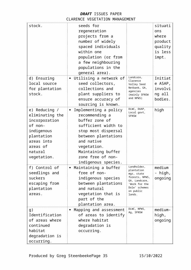
DRAFT ISSUES PAPERCLARENCE VEGETATION MANAGEMENT
stock. seeds for regeneration projects from a number of widely spaced individuals within one population (or from a few neighbouring populations in the general area).
situations where productqualityis lessimpt.
d) Ensuring local source for plantation stock.
· Utilising a network ofseed collectors, collections and plant suppliers to ensure accuracy of sourcing is known.
Landcare, Clarence Valley Seed Netbank, GA, agencies (mainly SFNSW and NPWS)
Initiate ASAP,involving all bodies.
e) Reducing / eliminating theincorporation of non-indigenous plantation areas into areas of natural vegetation.
· Implementing a policy recommending a buffer zone of sufficient width to stop most dispersal between plantations and native vegetation. Maintaining buffer zone free of non-indigenous species.
DLWC, DUAP, Local govt, SFNSW
high
f) Control of seedlings and suckers escaping from plantation areas.
· Maintaining a buffer free of non-indigenous species between plantations and natural vegetation that is part of the plantation area.
Landholder, plantation mgr, state forests, NPWS,GA, Landcare, ‘Work for the Dole’ schemes on public lands.
medium - high,ongoing
g) Identification of areas where continued habitat degradation is occurring.
· Mapping and assessmentof areas to identifywhere habitat degradation is occurring.
DLWC, NPWS, Ag, SFNSW
medium-high, ongoing
Produced by Greg SteenbeekePage 35 15/10/2022
DRAFT ISSUES PAPERCLARENCE VEGETATION MANAGEMENT
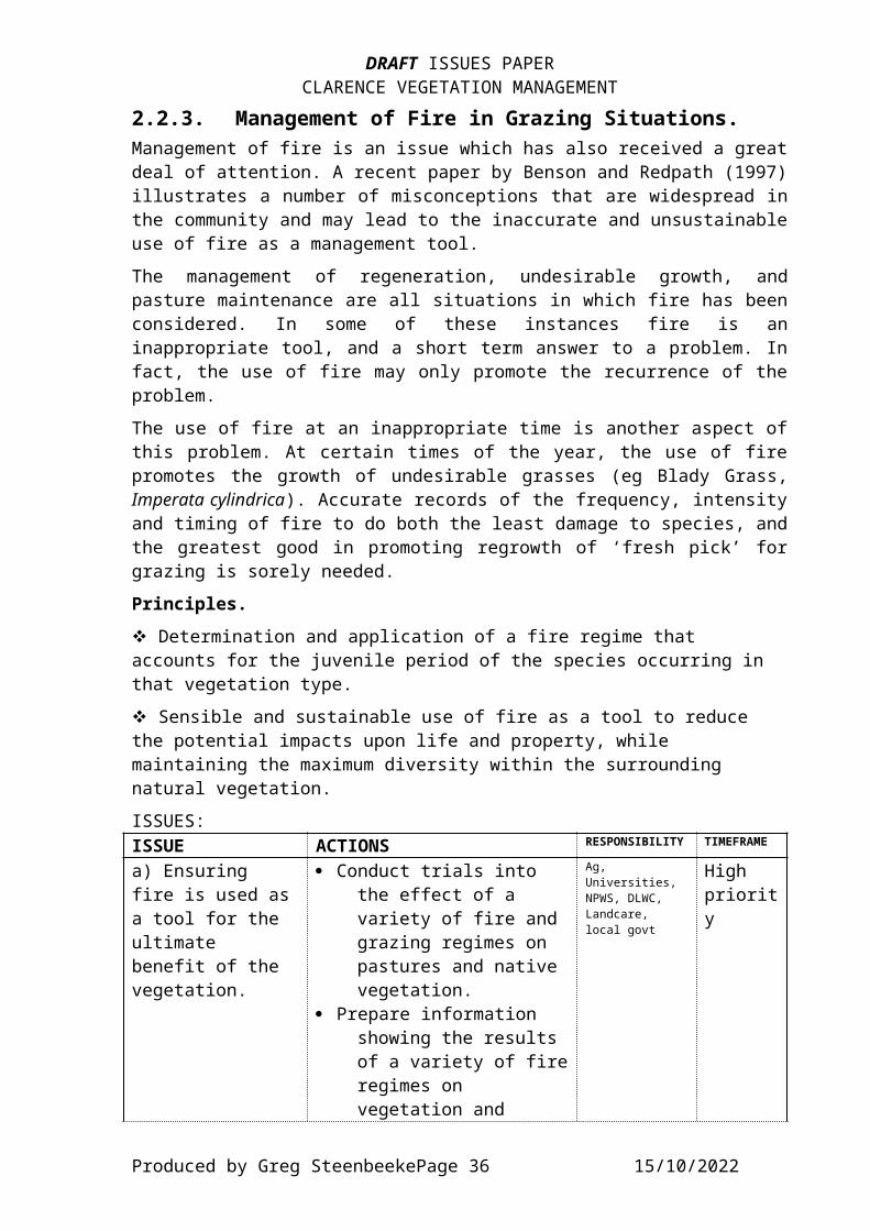
2.2.3. Management of Fire in Grazing Situations.Management of fire is an issue which has also received a greatdeal of attention. A recent paper by Benson and Redpath (1997)illustrates a number of misconceptions that are widespread inthe community and may lead to the inaccurate and unsustainableuse of fire as a management tool.The management of regeneration, undesirable growth, andpasture maintenance are all situations in which fire has beenconsidered. In some of these instances fire is aninappropriate tool, and a short term answer to a problem. Infact, the use of fire may only promote the recurrence of theproblem.The use of fire at an inappropriate time is another aspect ofthis problem. At certain times of the year, the use of firepromotes the growth of undesirable grasses (eg Blady Grass,Imperata cylindrica). Accurate records of the frequency, intensityand timing of fire to do both the least damage to species, andthe greatest good in promoting regrowth of ‘fresh pick’ forgrazing is sorely needed.Principles.v Determination and application of a fire regime that accounts for the juvenile period of the species occurring in that vegetation type.v Sensible and sustainable use of fire as a tool to reduce the potential impacts upon life and property, while maintaining the maximum diversity within the surrounding natural vegetation.ISSUES:ISSUE ACTIONS RESPONSIBILITY TIMEFRAME
a) Ensuring fire is used asa tool for the ultimate benefit of the vegetation.
· Conduct trials into the effect of a variety of fire and grazing regimes on pastures and native vegetation.
· Prepare information showing the results of a variety of fireregimes on vegetation and
Ag, Universities, NPWS, DLWC, Landcare, local govt
High priority
Produced by Greg SteenbeekePage 36 15/10/2022

DRAFT ISSUES PAPERCLARENCE VEGETATION MANAGEMENT
pasture composition for a wide variety of situations.
b) Implementinga fire regime (frequency and intensity) thatdoes not promote the growth of undesirable or commercially poor species.
· Education materials showing the more desirable species and the fire regimesthat suit them, including time, intensity and frequency of burning, and the time required to build sufficient quantity into the sward.
Ag, universities, DLWC, local govt
High priority
c) Tailoring fire use in natural vegetation (including grasslands) to suit the growthand reproduction patterns of native species,especially those beneficial to rural production.
· Identify desirable species likely to disadvantaged in current fire regime,and tailor regime tosuit these species while giving them competitive advantage over undesirable species.Use database and other sources for identifying suitablespecies, and identification materials to allow landholders to identify their presence and the portion of the swardthey make.
Ag, DLWC, local govt, NPWS, Landcare, farmers’ groups
High priority
d) Limiting annual use of fire to areas where pasture diversity and
· Formally identify areas where annual burning is necessaryto protect property and life.
DUAP, local govt, Ag,
Medium priority
Produced by Greg SteenbeekePage 37 15/10/2022

DRAFT ISSUES PAPERCLARENCE VEGETATION MANAGEMENT
vegetation structure are poor.
· Prepare materials for landholders to illustrate alternative methods of producing suitable stock fodder, or of agronomic practices necessary to reduce the growth of undesirable species (eg blady grass) that are favoured byfrequent or poorly timed firing.
e) Developing aseries of ‘firemanagement zones’ with differing regimes.
· Identify areas of natural vegetation with higher susceptibility to frequent fire and develop a managementplan that utilises this information. Maintain frequent burning regimes on those areas where property protection is the aim.
Local govt, NPWS, DUAP
Medium,priority
f) Suitable fire regime.
· Identify a fire regimethat maintains existing vegetation types, including seral and successional processes.
NPWS, SF NSW, DLWC, NSW RFS,Universities, researchers
Medium - high,priority
g) Long-term impact of various fire regimes
· Assessment of the effects of the fire regime on each species and on the vegetation as a whole.
NPWS, SF NSW, DLWC, NSW RFS,Universities, researchers
Medium - high,priority.
Produced by Greg SteenbeekePage 38 15/10/2022

DRAFT ISSUES PAPERCLARENCE VEGETATION MANAGEMENT
2.2.4. Management of Hazard Reduction and Wildfire.The implementation of a Fire Management Plan as required underthe Rural Fires Act calls for the development of managementoptions that account for issues such as the location of rarespecies; life and property; use of retardants and otherchemicals; the timing and extent of control. Many of theseissues are discussed below.ISSUES:a) Location of threatened species that are fire sensitive.
· Accurate knowledge of the location and extent of threatenedspecies.
· Knowledge of the sensitivity species have to fire.
NSW Rural FireService, NPWS,SF NSW, DLWC, RBG, landholders
Medium - High,priority. Source funding.
b) Resolution of pre-fire actions needed to manage species.
· Undertaking planning and implementation of actions to protect populations of threatened species.
NPWS, SF NSW, NSW RFS
Medium - high,priority.
c) Determining species sensitivity to chemicals used in fire-fighting.
· Knowledge of the sensitivity species have to the various chemical employed.
NPWS, RBG, Medium,priority.
d) Regime of controlled burning.
· Determine suitable regime for the vegetation composition.
NPWS, NSW RFS,DLWC, Landholders
Medium,priority.
e) Suitable fire regime.
· Identify a fire regimethat maintains existing vegetation types, including seral and successional processes.
NPWS, SF NSW, DLWC, NSW RFS,Universities, researchers
Medium - high,priority
f) Long-term impact of various fire
· Assessment of the effects of the fire regime on each
NPWS, SF NSW, DLWC, NSW RFS,Universities, researchers
Medium - high,priorit
Produced by Greg SteenbeekePage 39 15/10/2022

DRAFT ISSUES PAPERCLARENCE VEGETATION MANAGEMENT
regimes species and on the vegetation as a whole.
y.
2.2.5. Management of Roadside Vegetation.The roadside is one area where vegetation management is ahighly visible, and very public issue. There are a number ofcouncils undertaking roadside planning in the Catchment(Severn, Kyogle, Nymboida, Bellingen and Ulmarra councils),generally with funding sourced from either NHT or NLP. Othercouncils (Grafton mainly) are considering applying for NHTfunds for conducting similar planning.Roadsides have a main purpose in the movement of motortraffic. As a corridor for wildlife movement, theirsuitability is dependent upon a number of factors, including:· the width of the corridor;· the diversity and structure of the vegetation within the
corridor;· linkages to larger patches of natural vegetation.Where a corridor is narrow, has little diversity in eitherstructure or composition, and is isolated, there is littlevalue. Wildlife present in the corridor may be forced onto thecarriageway, there is often a source of dust to coatvegetation, or erosion may be active in the table drain andbattering of edges. Narrower corridors are also highly proneto weed invasion, as not only can vehicles act as a weedsource, but the surrounding lands offer little protectionfrom, and a great source of, weed propagules. Should fireescape from burning in nearby grazing or agricultural landsthere is little refuge available for wildlife.Conversely, the involvement of a wider corridor function (aswould happen in the case of a Travelling Stock Route orsimilar) enhances the ability for it to operate as a wildlifecorridor. With a greater area for structural diversity, alower boundary:area ratio, and more habitat for wildlife torefuge from vehicles and fire, the wider corridors are muchmore desirable for environmental reasons. However, they alsoprovide a greater source area for vermin (mainly rabbits) andhave higher potential to act as a fire conduit.The NSW Roadside Environment Committee has developed a packageof information that sovers the various stages of development
Produced by Greg SteenbeekePage 40 15/10/2022

DRAFT ISSUES PAPERCLARENCE VEGETATION MANAGEMENT
of a roadside plan and the subsequent implementation (NSW REC1997). This package is broken into a number of documentsdetailing assessment, planning and implementation phases.According to the assessment sheet, high value roadsides have acombination of features such as· Width (wider is better, divisions at 0, 5 and 21 to separate
categories)· Vegetation Condition (degraded, modified, near natural)· Introduced Species (dominant, scattered, isolated clumps or
few / none)· Regeneration (presence of young native trees, and how
extensively they occur)· Potential Fauna Habitat (whether there are the followingpresent: trees, trees with hollows, shrubs, native herbs andgrasses, fallen logs/litter, rocks/crevices, wet/marshyareas/creeks.
In the planning phase, a number of issues arise when thevarious uses are considered. These include the use by grazingand travelling stock, the control and management of fire andfuel, the control of weeds, road maintenance and construction,heritage sites and areas known to harbour rare species. Eachof these issues should preferably be individually addressed ina roadside management plan.Principles.v Retention and enhancement of roadside vegetation.v Burning of roadside vegetation is to be on a rotation permitting germination, growth and establishment of local vegetation types.v Soil disturbance in roadside reserves should be minimised.ISSUES:ISSUE ACTIONS RESPONSIBILITY TIMEFRAME
a) Use of the corridor as a grazing area bylocal stock while not in a declared drought.
· Identify areas where the vegetation is susceptible to frequent grazing, orwhere the continued survival of species may be jeopardised by unsuitable stock management.
Ag, RLPB, NPWS, local govt
high, ongoing
Produced by Greg SteenbeekePage 41 15/10/2022
DRAFT ISSUES PAPERCLARENCE VEGETATION MANAGEMENT
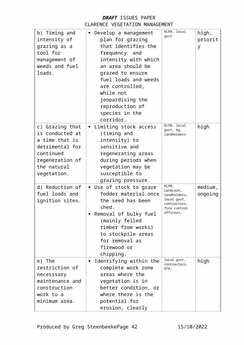
b) Timing and intensity of grazing as a tool for management of weeds and fuel loads.
· Develop a management plan for grazing that identifies the frequency and intensity with whichan area should be grazed to ensure fuel loads and weedsare controlled, while not jeopardising the reproduction of species in the corridor.
RLPB, local govt
high, priority
c) Grazing thatis conducted ata time that is detrimental forcontinued regeneration ofthe natural vegetation.
· Limiting stock access (timing and intensity) to sensitive and regenerating areas during periods when vegetation may be susceptible to grazing pressure.
RLPB, local govt, Ag, landholders
high
d) Reduction offuel loads and ignition sites.
· Use of stock to graze fodder material oncethe seed has been shed.
· Removal of bulky fuel (mainly felled timber from works) to stockpile areas for removal as firewood or chipping.
RLPB, Landcare, landholders, local govt, contractors, fire control officers,
medium,ongoing
e) The restriction of necesssary maintenance andconstruction work to a minimum area.
· Identifying within thecomplete work zone areas where the vegetation is in better condition, orwhere there is the potential for erosion, clearly
local govt, contractors, RTA,
high
Produced by Greg SteenbeekePage 42 15/10/2022
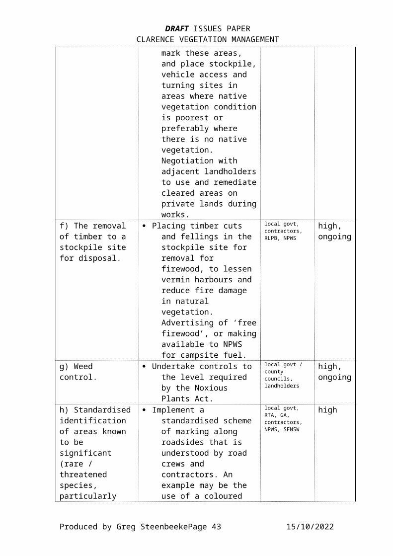
DRAFT ISSUES PAPERCLARENCE VEGETATION MANAGEMENT
mark these areas, and place stockpile,vehicle access and turning sites in areas where native vegetation conditionis poorest or preferably where there is no native vegetation. Negotiation with adjacent landholdersto use and remediatecleared areas on private lands duringworks.
f) The removal of timber to a stockpile site for disposal.
· Placing timber cuts and fellings in the stockpile site for removal for firewood, to lessen vermin harbours and reduce fire damage in natural vegetation. Advertising of ‘freefirewood’, or makingavailable to NPWS for campsite fuel.
local govt, contractors, RLPB, NPWS
high, ongoing
g) Weed control.
· Undertake controls to the level required by the Noxious Plants Act.
local govt / county councils, landholders
high, ongoing
h) Standardisedidentification of areas known to be significant (rare / threatened species, particularly
· Implement a standardised scheme of marking along roadsides that is understood by road crews and contractors. An example may be the use of a coloured
local govt, RTA, GA, contractors, NPWS, SFNSW
high
Produced by Greg SteenbeekePage 43 15/10/2022
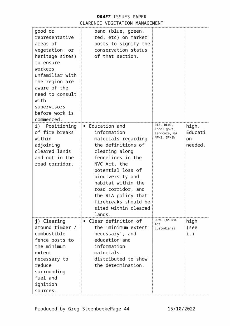
DRAFT ISSUES PAPERCLARENCE VEGETATION MANAGEMENT
good or representative areas of vegetation, or heritage sites)to ensure workers unfamiliar withthe region are aware of the need to consultwith supervisors before work is commenced.
band (blue, green, red, etc) on marker posts to signify theconservation status of that section.
i) Positioningof fire breaks within adjoining cleared lands and not in the road corridor.
· Education and information materials regarding the definitions of clearing along fencelines in the NVC Act, the potential loss of biodiversity and habitat within the road corridor, and the RTA policy that firebreaks should besited within clearedlands.
RTA, DLWC, local govt, Landcare, GA, NPWS, SFNSW
high. Education needed.
j) Clearing around timber /combustible fence posts to the minimum extent necessary to reduce surrounding fuel and ignition sources.
· Clear definition of the ‘minimum extent necessary’, and education and information materials distributed to show the determination.
DLWC (as NVC Act custodians)
high (see i.)
Produced by Greg SteenbeekePage 44 15/10/2022

DRAFT ISSUES PAPERCLARENCE VEGETATION MANAGEMENT
k) Reduce erosion and weed invasion.
· Mowing and wick-weeding of verge andtable-drain to reduce loss of protective vegetation cover andbinding properties of roots.
· Limited grading near road edge (within 1mof tar edge) on roads where growth is causing excessivedamage or impeding drainage.
local govt, RTA, contractors
high, ongoing
l) Siting of rest areas and services.
· Placing extensive restareas in lower valueareas, with small stopping areas in places where there is higher value vegetation for reasons such as views or heritage places.
local govt, RTA, NPWS.
high
m) Identification of areas where the corridor may become a multi-purpose corridor without affecting the natural environment, and the converse (will have an effect).
· Mapping of areas that are suitable for thepurpose of multiple functionality.
local govt, NPWS, DLWC, RTA, water authorities, NorthPower, Telstra
high
n) Maintaining natural
· Leaving scattered fallen timber, and
local govt, contractors
high
Produced by Greg SteenbeekePage 45 15/10/2022
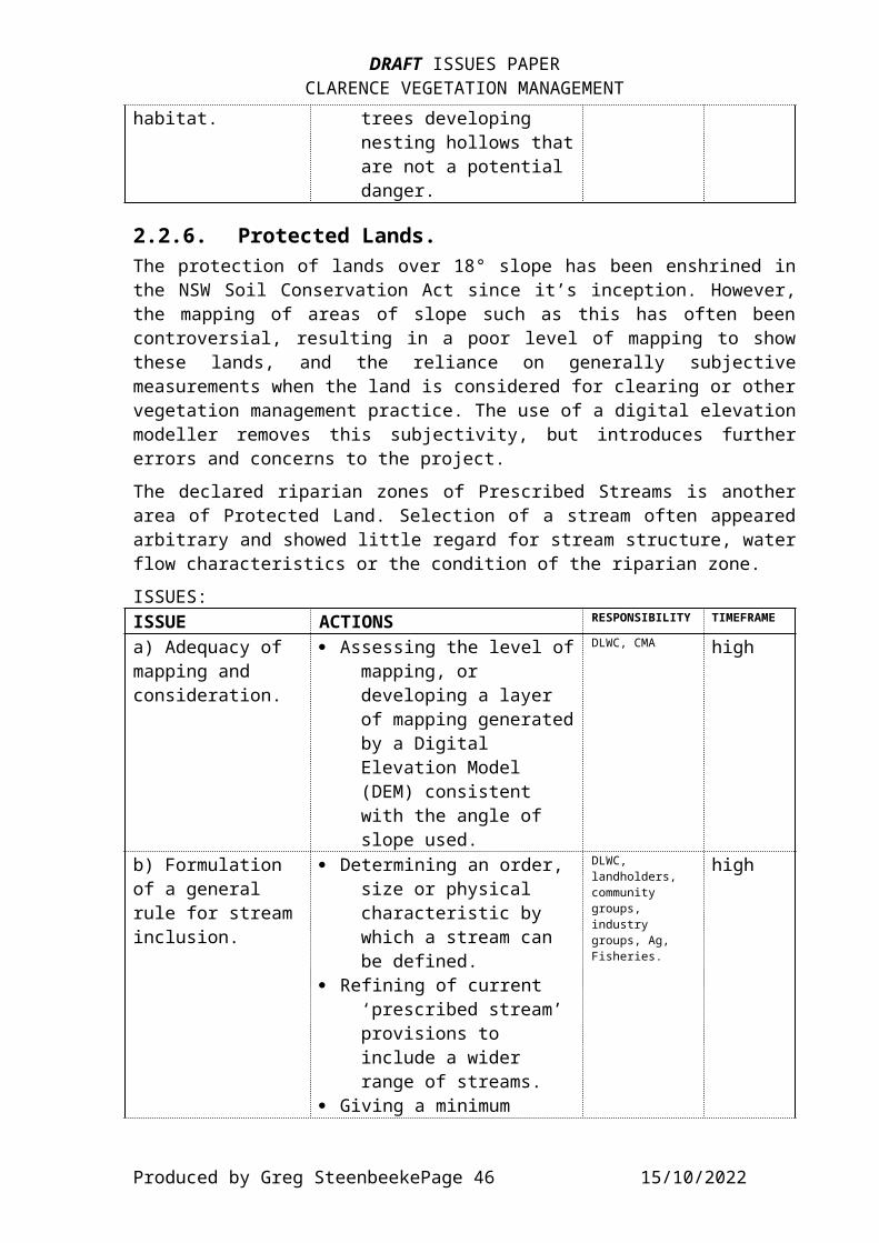
DRAFT ISSUES PAPERCLARENCE VEGETATION MANAGEMENT
habitat. trees developing nesting hollows thatare not a potential danger.
2.2.6. Protected Lands.The protection of lands over 18° slope has been enshrined inthe NSW Soil Conservation Act since it’s inception. However,the mapping of areas of slope such as this has often beencontroversial, resulting in a poor level of mapping to showthese lands, and the reliance on generally subjectivemeasurements when the land is considered for clearing or othervegetation management practice. The use of a digital elevationmodeller removes this subjectivity, but introduces furthererrors and concerns to the project.The declared riparian zones of Prescribed Streams is anotherarea of Protected Land. Selection of a stream often appearedarbitrary and showed little regard for stream structure, waterflow characteristics or the condition of the riparian zone.ISSUES:ISSUE ACTIONS RESPONSIBILITY TIMEFRAME
a) Adequacy of mapping and consideration.
· Assessing the level ofmapping, or developing a layer of mapping generatedby a Digital Elevation Model (DEM) consistent with the angle of slope used.
DLWC, CMA high
b) Formulation of a general rule for streaminclusion.
· Determining an order, size or physical characteristic by which a stream can be defined.
· Refining of current ‘prescribed stream’ provisions to include a wider range of streams.
· Giving a minimum
DLWC, landholders, community groups, industry groups, Ag, Fisheries.
high
Produced by Greg SteenbeekePage 46 15/10/2022

DRAFT ISSUES PAPERCLARENCE VEGETATION MANAGEMENT
protection level to a stream, and developing this consistent with stream size, structure, conservation status,and both the patternof flow and the volume of water it carries.
c) Determination of other protected lands.
· Developing a set of guidelines that can be applied to any parcel or area of land to determine ifit is, or should be considered for, Protected Land status.
Landcare, DLWC, NPWS, GA,
high
2.2.7. Wildlife Corridors.Wildlife corridors can exist in a number of situations, andmay be inherently used as an identified migration route or maybe used because it is the last remnants of habitat linking twopopulations. In many cases, the true corridor results fromeither the legal protection of vegetation along certainwaterways (under the Soil Conservation Act, 1938), theforesight of a landholder to retain or plant vegetation inshelterbelts, or the retention of natural vegetation in areastoo steep to allow clearing or alternative land use. Newopportunities have arisen with the Native VegetationEnhancement Fund being available for use in projects wherepermanent protection of the vegetation is envisioned.
Produced by Greg SteenbeekePage 47 15/10/2022

DRAFT ISSUES PAPERCLARENCE VEGETATION MANAGEMENT
ISSUES:ISSUE ACTIONS RESPONSIBILITY TIMEFRAME
a) Appropriate width of corridor to allow for positive biological values while not impeding farm productionor other corridor uses (see roadside management.)
· Research to determine appropriate corridorwidth in various situations.
· Regeneration of land adjacent to existingcorridors to enhancethe functionality.
· Education materials explaining the valueof corridors to wildlife and to a variety of farming needs (shelter, etc)and alternative income sources (native foods, wildflowers)
universities, DLWC, Landcare, NPWS,Ag, aboriginalcommunity, SFNSW,
medium - high,ongoing
b) Appropriate floristic composition of corridor for the wildlife utilising the corridor.
· Identify major local food source species.
· Incorporate as many aspossible.
· Aim to have food source available over the longest possible period withpeaks during known migration times.
Ag, Landcare, NPWS, RAOU, Corridors for Wildlife
high, ongoing
c) Maintenance of diversity incomposition andstructure within the corridor.
· Ensure a diverse rangeof species are planted into corridors, with the acknowlegdement of ongoing (if irregular) maintenance as individuals die.
Landcare, Corridors for Wildlife, landholders,
high
d) Corridor design allowingfor species
· Utilise, where possible, species with longer life
Landcare, Corridors for Wildlife, landholders,
high
Produced by Greg SteenbeekePage 48 15/10/2022
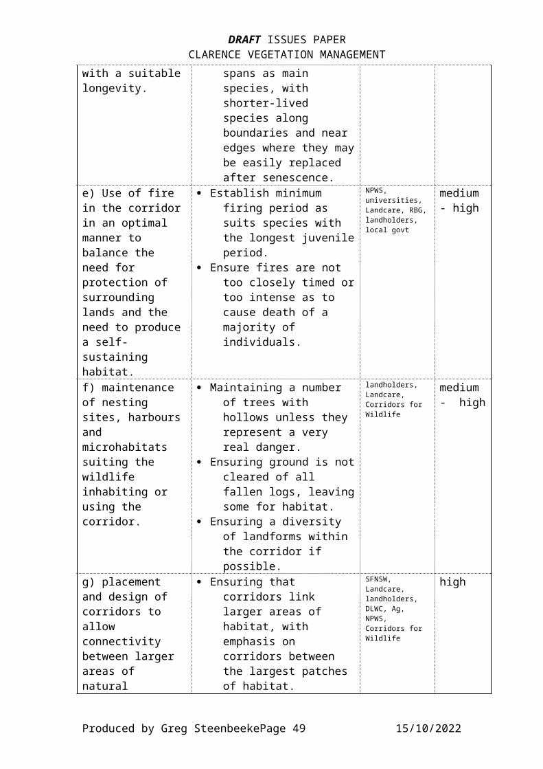
DRAFT ISSUES PAPERCLARENCE VEGETATION MANAGEMENT
with a suitablelongevity.
spans as main species, with shorter-lived species along boundaries and near edges where they maybe easily replaced after senescence.
e) Use of fire in the corridorin an optimal manner to balance the need for protection of surrounding lands and the need to producea self-sustaining habitat.
· Establish minimum firing period as suits species with the longest juvenileperiod.
· Ensure fires are not too closely timed ortoo intense as to cause death of a majority of individuals.
NPWS, universities, Landcare, RBG,landholders, local govt
medium - high
f) maintenance of nesting sites, harboursand microhabitats suiting the wildlife inhabiting or using the corridor.
· Maintaining a number of trees with hollows unless they represent a very real danger.
· Ensuring ground is notcleared of all fallen logs, leavingsome for habitat.
· Ensuring a diversity of landforms within the corridor if possible.
landholders, Landcare, Corridors for Wildlife
medium - high
g) placement and design of corridors to allow connectivity between larger areas of natural
· Ensuring that corridors link larger areas of habitat, with emphasis on corridors between the largest patches of habitat.
SFNSW, Landcare, landholders, DLWC, Ag, NPWS, Corridors for Wildlife
high
Produced by Greg SteenbeekePage 49 15/10/2022
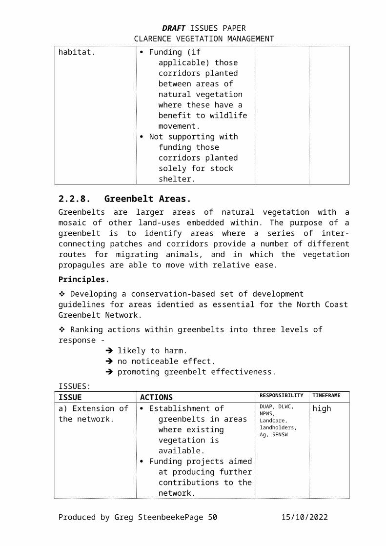
DRAFT ISSUES PAPERCLARENCE VEGETATION MANAGEMENT
habitat. · Funding (if applicable) those corridors planted between areas of natural vegetation where these have a benefit to wildlife movement.
· Not supporting with funding those corridors planted solely for stock shelter.
2.2.8. Greenbelt Areas.Greenbelts are larger areas of natural vegetation with amosaic of other land-uses embedded within. The purpose of agreenbelt is to identify areas where a series of inter-connecting patches and corridors provide a number of differentroutes for migrating animals, and in which the vegetationpropagules are able to move with relative ease.Principles.v Developing a conservation-based set of development guidelines for areas identied as essential for the North CoastGreenbelt Network.v Ranking actions within greenbelts into three levels of response -
è likely to harm.è no noticeable effect.è promoting greenbelt effectiveness.
ISSUES:ISSUE ACTIONS RESPONSIBILITY TIMEFRAME
a) Extension ofthe network.
· Establishment of greenbelts in areas where existing vegetation is available.
· Funding projects aimedat producing furthercontributions to thenetwork.
DUAP, DLWC, NPWS, Landcare, landholders, Ag, SFNSW
high
Produced by Greg SteenbeekePage 50 15/10/2022

DRAFT ISSUES PAPERCLARENCE VEGETATION MANAGEMENT
· Identifying areas where potential exists for new greenbelts.
b) Location of greenbelts intoareas where there is natural or potential wildlife movement patterns in existence.
· Identification of current and potential migration routes.
· Prioritising planting projects occurring in these areas.
· Involving landholders in the benefits of natural vegetation through education and extension.
NPWS, SFNSW, DUAP, Landcare, landholders, RAOU, AKF, WWF,
high - priority.
2.2.9. Weed Management.Weed management strategies used throughout the catchment vary not only from one shire to another, but also between the various weeds. Other problems arise when there is a weed that has been considered in one part of the catchment, but not in others (eg. Camphor Laurel), still allowing a source or propagation materials, or when a weed is a major environmentalweed but has not been recognised in official weed management strategies (eg. Privet).Principles.v Reducing the extent and diversity of weeds in areas of vegetation identified as being of conservation importance.v Reducing the extent of weeds in areas already threatened byother processes (esp. by clearing, fragmentation and urbanisation).v Identifying plant species as potential weed species, and endeavouring to control their spread and/or introduction to the area through information and education.v Identifying weeds as being of environmental importance, notjust economic and social importance. Developing strategies forthe control of environmental weeds.
Produced by Greg SteenbeekePage 51 15/10/2022
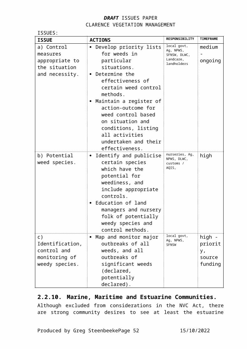
DRAFT ISSUES PAPERCLARENCE VEGETATION MANAGEMENT
ISSUES:ISSUE ACTIONS RESPONSIBILITY TIMEFRAME
a) Control measures appropriate to the situation and necessity.
· Develop priority listsfor weeds in particular situations.
· Determine the effectiveness of certain weed controlmethods.
· Maintain a register ofaction-outcome for weed control based on situation and conditions, listing all activities undertaken and theireffectiveness.
local govt, Ag, NPWS, SFNSW, DLWC, Landcare, landholders
medium - ongoing
b) Potential weed species.
· Identify and publicisecertain species which have the potential for weediness, and include appropriate controls.
· Education of land managers and nurseryfolk of potentially weedy species and control methods.
nurseries, Ag,NPWS, DLWC, customs / AQIS,
high
c) Identification,control and monitoring of weedy species.
· Map and monitor major outbreaks of all weeds, and all outbreaks of significant weeds (declared, potentially declared).
local govt, Ag, NPWS, SFNSW
high - priority, source funding
2.2.10. Marine, Maritime and Estuarine Communities.Although excluded from considerations in the NVC Act, thereare strong community desires to see at least the estuarine
Produced by Greg SteenbeekePage 52 15/10/2022
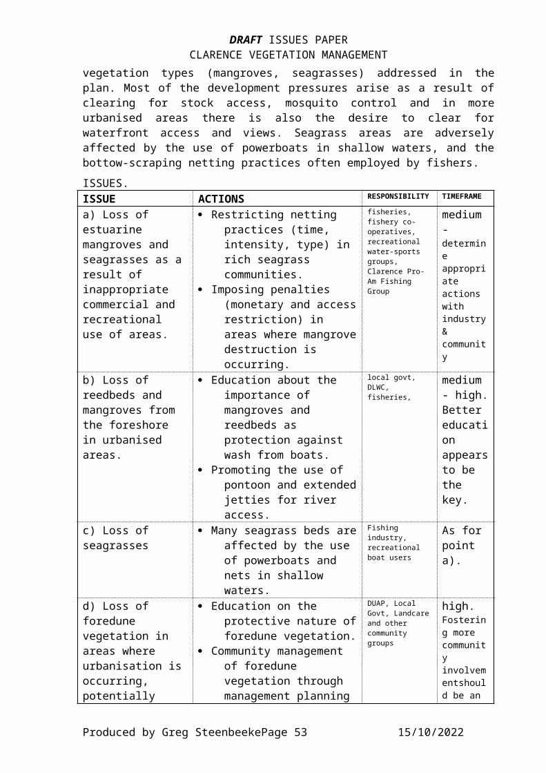
DRAFT ISSUES PAPERCLARENCE VEGETATION MANAGEMENT
vegetation types (mangroves, seagrasses) addressed in theplan. Most of the development pressures arise as a result ofclearing for stock access, mosquito control and in moreurbanised areas there is also the desire to clear forwaterfront access and views. Seagrass areas are adverselyaffected by the use of powerboats in shallow waters, and thebottow-scraping netting practices often employed by fishers.ISSUES.ISSUE ACTIONS RESPONSIBILITY TIMEFRAME
a) Loss of estuarine mangroves and seagrasses as aresult of inappropriate commercial and recreational use of areas.
· Restricting netting practices (time, intensity, type) in rich seagrass communities.
· Imposing penalties (monetary and accessrestriction) in areas where mangrovedestruction is occurring.
fisheries, fishery co-operatives, recreational water-sports groups, Clarence Pro-Am Fishing Group
medium - determine appropriate actions with industry& community
b) Loss of reedbeds and mangroves from the foreshore in urbanised areas.
· Education about the importance of mangroves and reedbeds as protection against wash from boats.
· Promoting the use of pontoon and extendedjetties for river access.
local govt, DLWC, fisheries,
medium - high.Better education appearsto be the key.
c) Loss of seagrasses
· Many seagrass beds areaffected by the use of powerboats and nets in shallow waters.
Fishing industry, recreational boat users
As for point a).
d) Loss of foredune vegetation in areas where urbanisation isoccurring, potentially
· Education on the protective nature offoredune vegetation.
· Community management of foredune vegetation through management planning
DUAP, Local Govt, Landcareand other community groups
high. Fostering more community involvementshould be an
Produced by Greg SteenbeekePage 53 15/10/2022
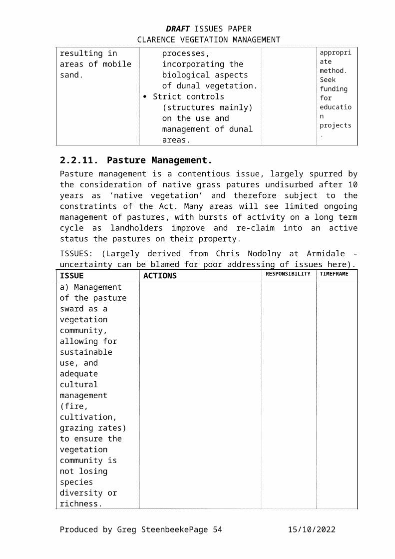
DRAFT ISSUES PAPERCLARENCE VEGETATION MANAGEMENT
resulting in areas of mobilesand.
processes, incorporating the biological aspects of dunal vegetation.
· Strict controls (structures mainly) on the use and management of dunal areas.
appropriate method. Seek funding for education projects.
2.2.11. Pasture Management.Pasture management is a contentious issue, largely spurred bythe consideration of native grass patures undisurbed after 10years as ‘native vegetation’ and therefore subject to theconstratints of the Act. Many areas will see limited ongoingmanagement of pastures, with bursts of activity on a long termcycle as landholders improve and re-claim into an activestatus the pastures on their property.ISSUES: (Largely derived from Chris Nodolny at Armidale -uncertainty can be blamed for poor addressing of issues here).ISSUE ACTIONS RESPONSIBILITY TIMEFRAME
a) Management of the pasture sward as a vegetation community, allowing for sustainable use, and adequate cultural management (fire, cultivation, grazing rates) to ensure the vegetation community is not losing species diversity or richness.
Produced by Greg SteenbeekePage 54 15/10/2022

DRAFT ISSUES PAPERCLARENCE VEGETATION MANAGEMENT
b) Measurement of coverc) Seasonality of composition.d) Definitions of regrowth.e) Species and communities most threatened, including species of uncertain status.f) Role and importance of native grasslands in the context of remnant vegetation management in the region.g) Native grasslands codeof practice.
2.2.12. Appropriate Revegetation.In this case, the term appropriate applies to a number offeatures that can be shown by the vegetation. These includeseral stage, species composition, source of propagationmaterials, and vegetation type. Other factors needing to beconsidered include the location and timing of planting, andthe eventual purpose of the planting (erosion control, shadeand shelter belt, wildlife corridor).
Produced by Greg SteenbeekePage 55 15/10/2022
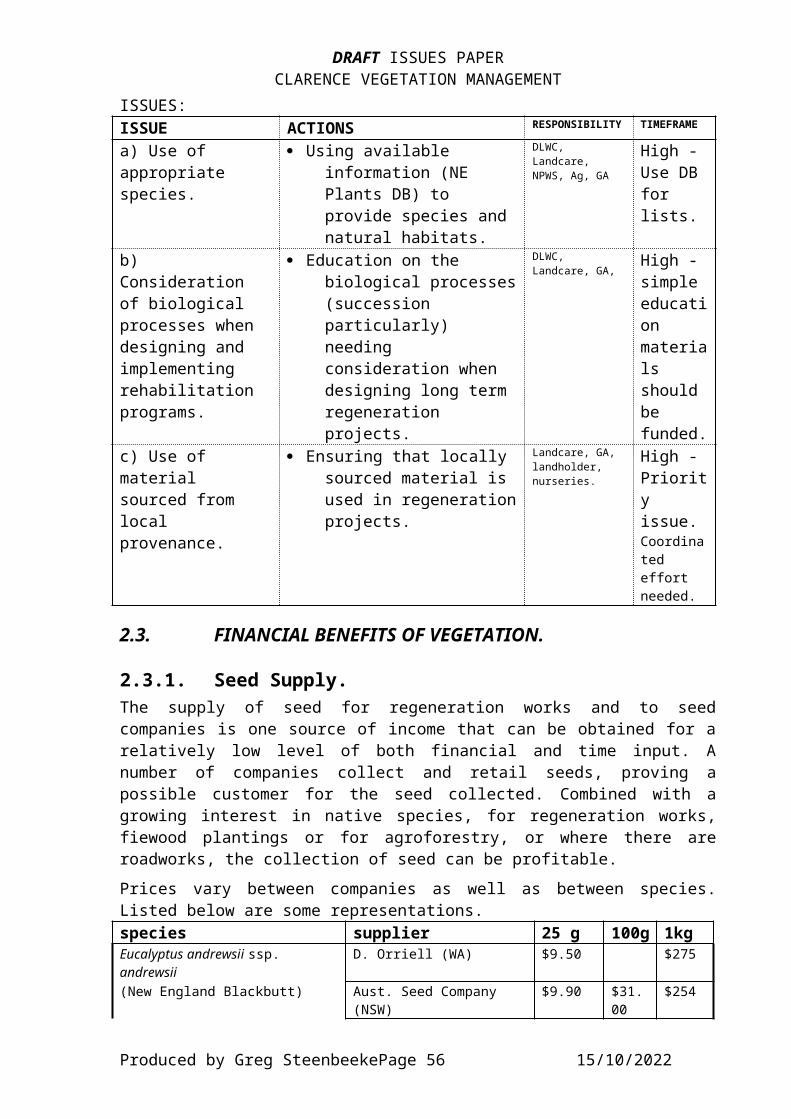
DRAFT ISSUES PAPERCLARENCE VEGETATION MANAGEMENT
ISSUES:ISSUE ACTIONS RESPONSIBILITY TIMEFRAME
a) Use of appropriate species.
· Using available information (NE Plants DB) to provide species and natural habitats.
DLWC, Landcare, NPWS, Ag, GA
High - Use DB for lists.
b) Consideration of biological processes when designing and implementing rehabilitation programs.
· Education on the biological processes(succession particularly) needing consideration when designing long term regeneration projects.
DLWC, Landcare, GA,
High - simple education materials should be funded.
c) Use of material sourced from local provenance.
· Ensuring that locally sourced material is used in regenerationprojects.
Landcare, GA, landholder, nurseries.
High - Priority issue. Coordinated effort needed.
2.3. FINANCIAL BENEFITS OF VEGETATION.
2.3.1. Seed Supply.The supply of seed for regeneration works and to seedcompanies is one source of income that can be obtained for arelatively low level of both financial and time input. Anumber of companies collect and retail seeds, proving apossible customer for the seed collected. Combined with agrowing interest in native species, for regeneration works,fiewood plantings or for agroforestry, or where there areroadworks, the collection of seed can be profitable.Prices vary between companies as well as between species.Listed below are some representations.species supplier 25 g 100g 1kgEucalyptus andrewsii ssp. andrewsii
D. Orriell (WA) $9.50 $275
(New England Blackbutt) Aust. Seed Company (NSW)
$9.90 $31.00
$254
Produced by Greg SteenbeekePage 56 15/10/2022
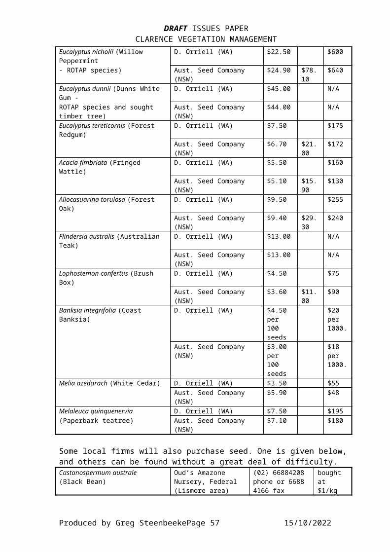
DRAFT ISSUES PAPERCLARENCE VEGETATION MANAGEMENT
Eucalyptus nicholii (Willow Peppermint
D. Orriell (WA) $22.50 $600
- ROTAP species) Aust. Seed Company (NSW)
$24.90 $78.10
$640
Eucalyptus dunnii (Dunns White Gum -
D. Orriell (WA) $45.00 N/A
ROTAP species and sought timber tree)
Aust. Seed Company (NSW)
$44.00 N/A
Eucalyptus tereticornis (Forest Redgum)
D. Orriell (WA) $7.50 $175
Aust. Seed Company (NSW)
$6.70 $21.00
$172
Acacia fimbriata (Fringed Wattle)
D. Orriell (WA) $5.50 $160
Aust. Seed Company (NSW)
$5.10 $15.90
$130
Allocasuarina torulosa (Forest Oak)
D. Orriell (WA) $9.50 $255
Aust. Seed Company (NSW)
$9.40 $29.30
$240
Flindersia australis (Australian Teak)
D. Orriell (WA) $13.00 N/A
Aust. Seed Company (NSW)
$13.00 N/A
Lophostemon confertus (Brush Box)
D. Orriell (WA) $4.50 $75
Aust. Seed Company (NSW)
$3.60 $11.00
$90
Banksia integrifolia (Coast Banksia)
D. Orriell (WA) $4.50 per 100 seeds
$20 per 1000.
Aust. Seed Company (NSW)
$3.00 per 100 seeds
$18 per 1000.
Melia azedarach (White Cedar) D. Orriell (WA) $3.50 $55Aust. Seed Company (NSW)
$5.90 $48
Melaleuca quinquenervia D. Orriell (WA) $7.50 $195(Paperbark teatree) Aust. Seed Company
(NSW)$7.10 $180
Some local firms will also purchase seed. One is given below, and others can be found without a great deal of difficulty.Castanospermum australe(Black Bean)
Oud’s Amazone Nursery, Federal (Lismore area)
(02) 66884208 phone or 6688 4166 fax
bought at $1/kg
Produced by Greg SteenbeekePage 57 15/10/2022
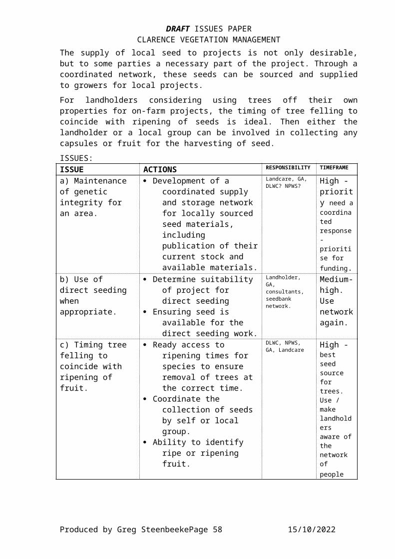
DRAFT ISSUES PAPERCLARENCE VEGETATION MANAGEMENT
The supply of local seed to projects is not only desirable,but to some parties a necessary part of the project. Through acoordinated network, these seeds can be sourced and suppliedto growers for local projects.For landholders considering using trees off their ownproperties for on-farm projects, the timing of tree felling tocoincide with ripening of seeds is ideal. Then either thelandholder or a local group can be involved in collecting anycapsules or fruit for the harvesting of seed.ISSUES:ISSUE ACTIONS RESPONSIBILITY TIMEFRAME
a) Maintenance of genetic integrity for an area.
· Development of a coordinated supply and storage network for locally sourced seed materials, including publication of theircurrent stock and available materials.
Landcare, GA, DLWC? NPWS?
High - priority need acoordinated response- prioritise for funding.
b) Use of direct seeding when appropriate.
· Determine suitability of project for direct seeding
· Ensuring seed is available for the direct seeding work.
Landholder, GA, consultants, seedbank network.
Medium-high. Use networkagain.
c) Timing tree felling to coincide with ripening of fruit.
· Ready access to ripening times for species to ensure removal of trees at the correct time.
· Coordinate the collection of seeds by self or local group.
· Ability to identify ripe or ripening fruit.
DLWC, NPWS, GA, Landcare
High - best seed source for trees. Use / make landholders aware ofthe network of people
Produced by Greg SteenbeekePage 58 15/10/2022
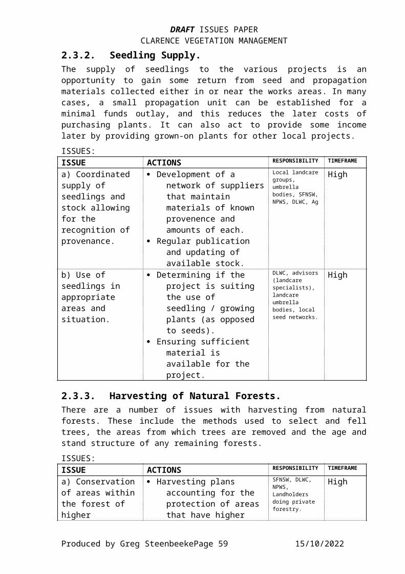
DRAFT ISSUES PAPERCLARENCE VEGETATION MANAGEMENT
2.3.2. Seedling Supply.The supply of seedlings to the various projects is anopportunity to gain some return from seed and propagationmaterials collected either in or near the works areas. In manycases, a small propagation unit can be established for aminimal funds outlay, and this reduces the later costs ofpurchasing plants. It can also act to provide some incomelater by providing grown-on plants for other local projects.ISSUES:ISSUE ACTIONS RESPONSIBILITY TIMEFRAME
a) Coordinated supply of seedlings and stock allowing for the recognition of provenance.
· Development of a network of suppliersthat maintain materials of known provenence and amounts of each.
· Regular publication and updating of available stock.
Local landcaregroups, umbrella bodies, SFNSW,NPWS, DLWC, Ag
High
b) Use of seedlings in appropriate areas and situation.
· Determining if the project is suiting the use of seedling / growing plants (as opposed to seeds).
· Ensuring sufficient material is available for the project.
DLWC, advisors(landcare specialists), landcare umbrella bodies, local seed networks.
High
2.3.3. Harvesting of Natural Forests.There are a number of issues with harvesting from naturalforests. These include the methods used to select and felltrees, the areas from which trees are removed and the age andstand structure of any remaining forests.ISSUES:ISSUE ACTIONS RESPONSIBILITY TIMEFRAME
a) Conservationof areas withinthe forest of higher
· Harvesting plans accounting for the protection of areas that have higher
SFNSW, DLWC, NPWS, Landholders doing private forestry.
High
Produced by Greg SteenbeekePage 59 15/10/2022

DRAFT ISSUES PAPERCLARENCE VEGETATION MANAGEMENT
conservation values.
biological value.· Understanding of the
factors that led to the higher conservation status to determine if these factors are also occurring in other areas within the forests, (thereby possibly allowing sustainablelogging activities within these areas).
b) Determination of sustainable logging rates for particular situations.
· Establishing maximum harvest values basedon the factors of species, soil, nutrient, rainfall, altitude, stand density, and exposure.
· Developing a sustainable logging plan for areas of private land that are in considerationbased upon growth rates and research.
universities, DLWC, Ag, SFNSW, NPWS
High - Priority issuefor gfunding wherethe info isnot alreadyknown.
c) Strict adherence to the Code of Practice once developed for each of the forest types.
· Development of the codes of practice for each forest type.
· Education and dissemination of thecode(s).
· Random audit of the code implementation.
DLWC, SFNSW, landcare, landholders
High - priority.
d) Timing harvesting to permit the maximum return
· Felling trees when theseed is ripe enough to be collected/harvested
High - priority - work
Produced by Greg SteenbeekePage 60 15/10/2022
DRAFT ISSUES PAPERCLARENCE VEGETATION MANAGEMENT
from each species (in both timber andother products).
for use in local regeneration works.
with seed harvesters network.
2.3.4. Harvesting of Natural Plant Products.A number of natural plant products may be harvested fromnatural forests. These include fruits, seeds, flowers, oilsand foliage. The ability to harvest these in a sustainablemanner largely depends on regulating numbers or amounts toallow sufficient for both wildlife needs and a commercialreturn. It is also important to have assessed the likelymarket for the products, and whether viable returns on theproduct are possible.ISSUES:ISSUE ACTIONS RESPONSIBILITY TIMEFRAME
a) Collection of seeds, flowers and foliage needingtight regulation to ensure resources for wildlife are not depleted.
· Determining the level of wildlife use of the resource.
· Licensing (at absoluteminimum charge) for harvesting from natural stands to ensure wildlife minimum resource not depleted.
aboriginal community, NPWS, Landcare, DLWC, Ag, Fisheries
medium - high.
2.3.5. Ecotourism.This is one area where there is enormous potential for theClarence Valley. The main advantages it has are in it relyingupon the maintenance of natural vegetation, and in producing areasonable income for very small landholder input. Ifstockhand and shearers accomodation is available to beconverted to reasonably comfortable amenities, the costs areless than the development of purpose-built accommodation.The upper valley is quite close to the growing population ofSouth East Queensland, and there is a potential desire shownby some members of that community for farm stay and similar
Produced by Greg SteenbeekePage 61 15/10/2022
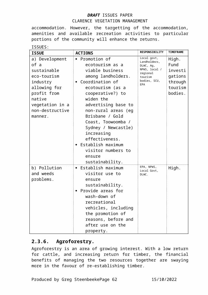
DRAFT ISSUES PAPERCLARENCE VEGETATION MANAGEMENT
accommodation. However, the targetting of the accommodation,amenities and available recreation activities to particularportions of the community will enhance the returns.ISSUES:ISSUE ACTIONS RESPONSIBILITY TIMEFRAME
a) Development of a sustainable eco-tourism industry allowing for profit from native vegetation in anon-destructivemanner.
· Promotion of ecotourism as a viable business among landholders.
· Coordination of ecotourism (as a cooperative?) to widen the advertising base to non-rural areas (eg Brisbane / Gold Coast, Toowoomba / Sydney / Newcastle) increasing effectiveness.
· Establish maximum visitor numbers to ensure sustainability.
Local govt, Landholders, DLWC, Ag, NPWS, local / regional tourism bodies, SCU, EPA
High. Fund investigationsthroughtourismbodies.
b) Pollution and weeds problems.
· Establish maximum visitor use to ensure sustainability.
· Provide areas for wash-down of recreational vehicles, including the promotion of reasons, before and after use on the property.
EPA, NPWS, Local Govt, DLWC.
High.
2.3.6. Agroforestry.Agroforestry is an area of growing interest. With a low returnfor cattle, and increasing return for timber, the financialbenefits of managing the two resources together are swayingmore in the favour of re-establishing timber.
Produced by Greg SteenbeekePage 62 15/10/2022
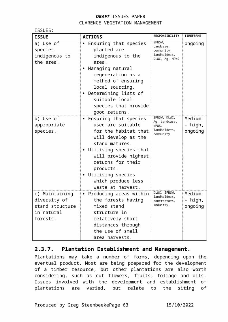
DRAFT ISSUES PAPERCLARENCE VEGETATION MANAGEMENT
ISSUES:ISSUE ACTIONS RESPONSIBILITY TIMEFRAME
a) Use of species indigenous to the area.
· Ensuring that species planted are indigenous to the area.
· Managing natural regeneration as a method of ensuring local sourcing.
· Determining lists of suitable local species that providegood returns.
SFNSW, Landcare, community, landholders, DLWC, Ag, NPWS
ongoing
b) Use of appropriate species.
· Ensuring that species used are suitable for the habitat thatwill develop as the stand matures.
· Utilising species thatwill provide highestreturns for their products.
· Utilising species which produce less waste at harvest.
SFNSW, DLWC, Ag, Landcare, NPWS, landholders, community
Medium - high,ongoing
c) Maintaining diversity of stand structurein natural forests.
· Producing areas withinthe forests having mixed stand structure in relatively short distances through the use of small area harvests.
DLWC, SFNSW, landholders, contractors, industry,
Medium - high,ongoing
2.3.7. Plantation Establishment and Management.Plantations may take a number of forms, depending upon theeventual product. Most are being prepared for the developmentof a timber resource, but other plantations are also worthconsidering, such as cut flowers, fruits, foliage and oils.Issues involved with the development and establishment ofplantations are varied, but relate to the siting of
Produced by Greg SteenbeekePage 63 15/10/2022
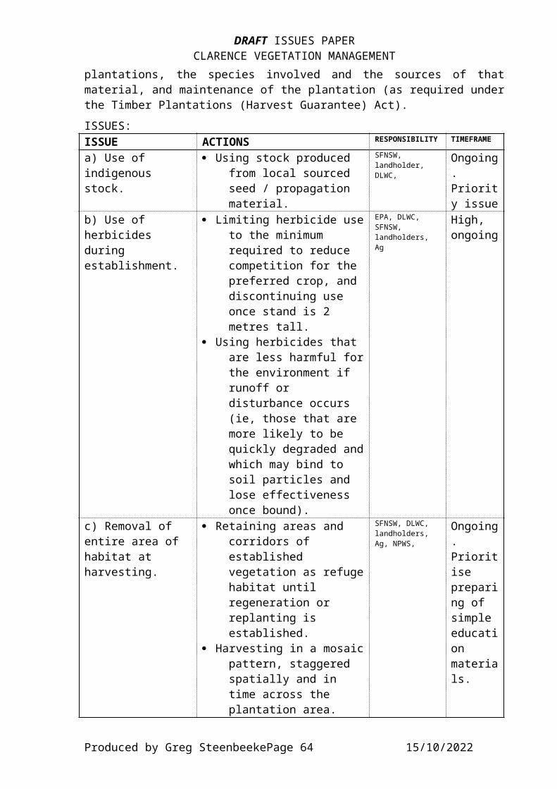
DRAFT ISSUES PAPERCLARENCE VEGETATION MANAGEMENT
plantations, the species involved and the sources of thatmaterial, and maintenance of the plantation (as required underthe Timber Plantations (Harvest Guarantee) Act).ISSUES:ISSUE ACTIONS RESPONSIBILITY TIMEFRAME
a) Use of indigenous stock.
· Using stock produced from local sourced seed / propagation material.
SFNSW, landholder, DLWC,
Ongoing. Priority issue
b) Use of herbicides during establishment.
· Limiting herbicide useto the minimum required to reduce competition for the preferred crop, and discontinuing use once stand is 2 metres tall.
· Using herbicides that are less harmful forthe environment if runoff or disturbance occurs (ie, those that are more likely to be quickly degraded andwhich may bind to soil particles and lose effectiveness once bound).
EPA, DLWC, SFNSW, landholders, Ag
High, ongoing
c) Removal of entire area of habitat at harvesting.
· Retaining areas and corridors of established vegetation as refugehabitat until regeneration or replanting is established.
· Harvesting in a mosaicpattern, staggered spatially and in time across the plantation area.
SFNSW, DLWC, landholders, Ag, NPWS,
Ongoing. Prioritise preparing of simple education materials.
Produced by Greg SteenbeekePage 64 15/10/2022
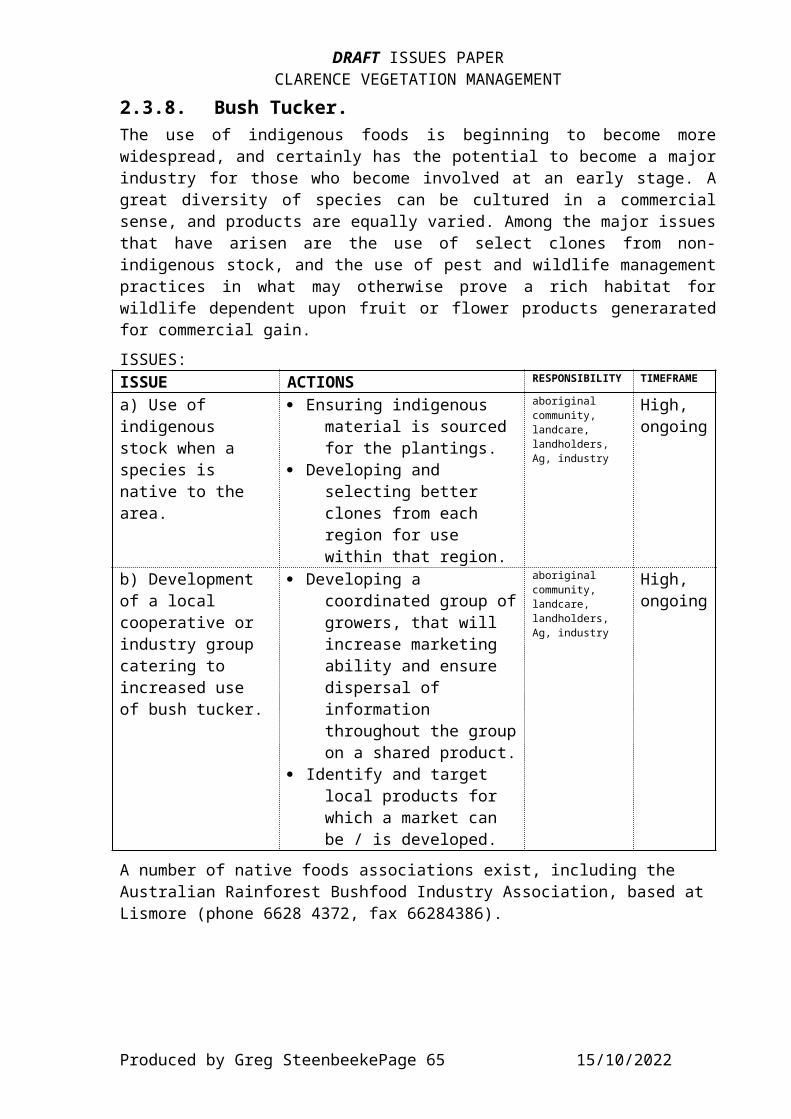
DRAFT ISSUES PAPERCLARENCE VEGETATION MANAGEMENT
2.3.8. Bush Tucker.The use of indigenous foods is beginning to become morewidespread, and certainly has the potential to become a majorindustry for those who become involved at an early stage. Agreat diversity of species can be cultured in a commercialsense, and products are equally varied. Among the major issuesthat have arisen are the use of select clones from non-indigenous stock, and the use of pest and wildlife managementpractices in what may otherwise prove a rich habitat forwildlife dependent upon fruit or flower products generaratedfor commercial gain. ISSUES:ISSUE ACTIONS RESPONSIBILITY TIMEFRAME
a) Use of indigenous stock when a species is native to the area.
· Ensuring indigenous material is sourced for the plantings.
· Developing and selecting better clones from each region for use within that region.
aboriginal community, landcare, landholders, Ag, industry
High, ongoing
b) Development of a local cooperative or industry group catering to increased use of bush tucker.
· Developing a coordinated group ofgrowers, that will increase marketing ability and ensure dispersal of information throughout the groupon a shared product.
· Identify and target local products for which a market can be / is developed.
aboriginal community, landcare, landholders, Ag, industry
High,ongoing
A number of native foods associations exist, including the Australian Rainforest Bushfood Industry Association, based at Lismore (phone 6628 4372, fax 66284386).
Produced by Greg SteenbeekePage 65 15/10/2022

DRAFT ISSUES PAPERCLARENCE VEGETATION MANAGEMENT
2.3.9. Apiaries.The use of both natural and exotic vegetation as a bee-sitehas been a long standing tradition. In some areas, bees arevital to ensure adequate pollination occurs, particularly instone and pome fruit orchards. However, bees have a number ofnegative effects on the vegetation such as reduced pollinationof native plants (mainly pea-flowers) through by-passing ofthe physical pathway the pollinator must take to accessnectar. An apiary may also act as a nursery for diseases thatcan be distributed around the native vegetation.
ISSUES:ISSUE ACTIONS RESPONSIBILITY TIMEFRAME
a) Competition between native and exotic bees
· Ensuring that bees arenot causing undue competition in areaswhere native bees are vital for pollination.
NPWS, RLPB, Ag Ongoing.
Produced by Greg SteenbeekePage 66 15/10/2022

DRAFT ISSUES PAPERCLARENCE VEGETATION MANAGEMENT
3. CONCLUDING REMARKS.The following is a brief summary of the various projects and issues raised, targetting areas where there is a need for funding and financial assistance, and where efforts should be directed within the near future.
3.1. Identified Ongoing Projects.A number of projects could be identified as requiring continuing activity. These included:· Location details for significant species, and the
maintenance of a reliable, up to date register of their approximate locations for the use of council and govt staff.
· Determination of population sizes for significant species.· Strategic planning for species poorly conserved.· Establish a plant propagation material resource network
which will coordinate, maintain and disseminate information relating to the provenance and amounts of collected and stored seed, and the growing plants producedby various people / groups throughout the catchment for regeneration works.
· Rehabilitation projects to establish vegetation in areas where little remains, such as throughout the floodplain and on the tablelands.
· Regeneration and development of widlife corridor networks across a number of properties as part of the Greenbelt Planning / Implementation process.
· Ongoing weed control, including the development of a regional registry of weed outbreaks, methods used for controlling and success.
· Wetland studies.· Riparian studies.· Education materials for the general implications of
vegetation management legislation.· Control of plants and materials ‘escaping’ from plantations
into natural vegetation.· Idenitification of areas where habitat degradation is
occurring at an accelerated rate.· Long-term examination of the effects of grazing stock on
Travelling Stock Routes, Reserves and Camps.· Use of stock to reduce fuel loads and weeds in TSR’s.
Produced by Greg SteenbeekePage 67 15/10/2022

DRAFT ISSUES PAPERCLARENCE VEGETATION MANAGEMENT
· Removal of timber from roadworks to a stockpile site for useby public or NPWS. Make note of free availability with simple signage carrying conditions.
· Development of corridors having a width and species composition suitable for wildlife movement and establishment.
· Use of locally-sourced materials of indigenous, appropriate species in regeneration, agroforestry and plantations.
· Develop closer links with local bush tucker organisations toallow the formation of a cooperative marketing and production body.
· Studies into the relationships between introduced honeybees and native bees, with particular reference to both competition and pollination effects (cross-pollination between species and reduced pollination of some species).
3.2. Identified Priority Projects.The following projects arose from consideration of actions foreach issue. Many of them should be considered as being of highpriority.· Habitat requirements of significant species - especially
those without a conserved population.· Widepread community ability to identify priority species · Factors affecting the rehabilitation of vegetation types
with restricted distributions.· Research into the factors affecting the distribution of rare
vegetation types.· Baseline assessment of rare vegetation types, especially
those restricted to particular geologies (eg. serpentinite), or certain landscape positions.
· Determination of satisfactory riparian zone widths for all stream types within the catchment.
· Identification of all areas of High Conservation Value Vegetation throughout the catchment.
· Education materials about the inherent values of high conservation value vegetation.
· Re-establishing a tidal regime of flooding on those areas where tidal flooding would have occurred (low altitude wetlands), with one of the benefits being a study of the effects on wildlife and biodiversity.
· Riparian commmunity studies to determine optimum widths for protected lands status.
Produced by Greg SteenbeekePage 68 15/10/2022

DRAFT ISSUES PAPERCLARENCE VEGETATION MANAGEMENT
· Stabilisation of mobile dunes.· Addressing poor or inadequate coverage by SEPP14 and SEPP 26
of lands meeting those criteria.· Sponsoring and developing a network of Property agreements
across the Catchment to allow greater local input to vegetation projects and management.
· Determining species sensitivity to fire and disturbance, to suggest the best time, frequency and intenity of activity (fire, cultivation) to manage the species.
· Development of roadside environment plans for the local govtareas not yet done or undertaking the process (Maclean, Copmanhurst, Tenterfield, Guyra).
· Simple online / CD-ROM identification guide utilising the NENSW Plants database as base.
·
3.3. Projects that should be funded.The following list is projects that have been idenified at various ratings for funding. Sources would include NHT, TCM Enhancement and sponsorship, with the size and estimated cost of the project being the main criteria for pursuing a particular funding source.· Development of more ‘information centres’ for the public at
beach-access points explaining the importance of coastal vegetation and the values of the species present.
· Establishment of a networking organisation between all of the seed collectors, seed storers and propagators throughout the region to allow greater exchange of information and materials to those needing plants for regeneration.
· Extension / broadening of the Greenbelt and Corridor networks to allow better linkages through a number of different avenues rather than a select few, especially where wildlife (including flora) movement has been idetified as a major feature of the locality.
· Factors affecting the distribution of significant vegetationtypes with a view to rehabilitation if required.
· Factors affecting the natural processes within each type.· Flooding regimes and hydrology in wetlands under tidal
influence.
Produced by Greg SteenbeekePage 69 15/10/2022
DRAFT ISSUES PAPERCLARENCE VEGETATION MANAGEMENT
· Guides to allow identification of significant species to become a widespreadability within the community.
· Identification, control and monitoring of weedy species.· Information on potentially weedy species and proper disposal
of garden waste (attach to council rates information?)· Location of fire sensitive significant species populations.· Loss of biodiversity in `wetlands due to water management
practices.· Management requirements of wetland species.· Native food market development.· Rehabilitation projects to combat environmental weeds in
rainforests.· Required widths of the riparian community (in progress?)· Sensitivity of local species to the effects of fire under
varying regimes.· Simple education materials about harvesting and native
vegetation management processes that the landholder can undertake to ensure greater viability and environmentally sensible use of native vegetation lands.
· Simple education materials about succession and seral processes.
· Strategic plannig for species poorly or inadequately (or not) conserved in reserves.
· Studies into visitor interest in farm-stay accomodation and likely markets.
· Sustainability levels for activities undertaken in dry forests and woodlands.
3.4. Education.Many of the more successfully implemented activities willresult from the provision of adequate, clear educationmaterials. The following list provides a summation of theeducation materials which are considered necessary for theimplementation of many actions listed in the plan.· Identification guides for
rare and significant species;coastal species identification - especially at young
juvenile stage;riparian species and those suitable for use in
riparian rehabilitation projects (following on from Alan Raine’s Riparian
Guide);
Produced by Greg SteenbeekePage 70 15/10/2022

DRAFT ISSUES PAPERCLARENCE VEGETATION MANAGEMENT
· A simple glossary and guide fo use by landcare groups andthose working with vegetation to allow them to understandthe terminology.
· A guide to show the successional stages in vegetation types,and why it is that succession needs to be considered inrevegetation works.
· Development of a ‘process manual’ for landholders wishing todiversify into the farmstay / ecotourism field.
· The importance of mixed stand structure and composition forthe continued health and productivity of a vegetationtype.
· Mosaic and strip harvesting methods.· Diversification using indigenous plants - bush food,wildflowers, plant products (foliage, fruit, etc.).
Produced by Greg SteenbeekePage 71 15/10/2022

APPENDIX A TO DRAFT ISSUES PAPERCLARENCE VEGETATION MANAGEMENT
Produced by Greg SteenbeekePage A0 15/10/2022
APPENDIX A TO DRAFT ISSUES PAPERCLARENCE VEGETATION MANAGEMENT
APPENDIX A.
A.1. AUGMENTING DOCUMENTATION AND MATERIALS.
A.1.1. Active Geographic Information Systems formaintaining accurate details of vegetation.
A.1.1.1. Multiple GIS Layers.
A.1.1.1.a. Protected LandsA layer to illustrate the areas declared as protected in the plan. This may include the 18° slope characters, protected streams and other sensitive lands. Allows for rapid assessment of the areas of protected land within any landholding.
A.1.1.1.b. Significant Vegetation Types.A layer illustrating the extent of significant vegetationtypes as determined in the plan.
A.1.1.1.c. Rare Species (TSC and ROTAP).Locations (to within a 10,000 sq metre grid? (hectare size)). Resolve in committee the area and location detailing needed to give workable answers.
A.1.1.1.d. Noxious Species.Locatins of larger noxious weed outreaks, and possibly a layer modelling the likely occurrence given characteristics of the species.
A.1.1.1.e. Reserves and Conservation Areas.Areas reserved for the benefit of the environment.
A.1.1.1.f. Prescribed and Significant Streams.Prescribed streams as already listed, and significant streams layer to show all those waterways considered to be significant for vegetation management.
A.1.1.1.g. Greenbelt Zones.As determined from the DUAP study.
Produced by Greg SteenbeekePage A1 15/10/2022
APPENDIX A TO DRAFT ISSUES PAPERCLARENCE VEGETATION MANAGEMENT
A.1.1.1.h. SEPP Zones.As determined from DUAP records. May also include areas which are recommended for inclusion and reasons.
A.1.1.1.i. Acid Sulfate Soils.Utilising the mapping held by DLWC.
A.1.1.1.j. Fire Management and Prescribed Burning.Optimal and preferred regimes best suiting the vegetationand habitats present in any particular polygon.
A.1.1.1.k. Clearing Rates.Rates of clearing within each polygon, based upon mappingalready conducted. May expand or broaden at a later stageto show a cumulative algorithm using known data (as a basis) and the amounts of each area / polygon considered and approved for clearing under the permitting system.
ISSUES:ISSUE ACTIONS RESPONSIBILITY TIMEFRAME
Ensuring data is available toall govt requests at maximum of costof transfer
· Distribution throughout the various agencies of lists of data held, maintained and created that is relevant to the region.
· Regular updating of the lists of available materials / layers.
Ag, NPWS, SFNSW, DLWC, universities, DUAP, local govts, CSIRO
A.1.2. Data Availability and Custodians.Layer custodian data format data
typecoverage scale currency
Coastal wetlands (SEPP 14)
Dept of Planning
Genamap hard copy GIS, HC Tweed Hds - Camden Haven
1:25 000 current
Llittoral rainforests (SEPP26)
Dept of Planning
Genamap hard copy GIS, HC Tweed Hds - Camden Haven
1:25 000 current
Sensitive coastallands
Dept of Planning
Genamap hard copy GIS, HC Tweed Hds - Camden Haven
1:25 000 current
Produced by Greg SteenbeekePage A2 15/10/2022
APPENDIX A TO DRAFT ISSUES PAPERCLARENCE VEGETATION MANAGEMENT
Vegetation systems (Roberts)
NPWS E-RMS GIS NC + parts New Eng & Hunter Regions
1:100 000
Jun-92
Protected lands DLWC (CaLM) Genamap GIS North Coast 1:25 000Protected lands DLWC (CaLM) Genamap GIS North Coast 1:50 000Protected lands DLWC (CaLM) Genamap GIS North Coast 1:26 720Soil Landscapes DLWC (CaLM) Genamap GIS parts of North
Coast1:100 000
Soil Landscapes DLWC (CaLM) Genamap GIS parts of North Coast
1:250 000
Landsat imagery DLWC (CaLM) Landsat TM NSWNorth East forests biodiversity d'base
NPWS E-RMS GIS North Coast
Vegetation systems
NPWS E-RMS GIS North Coast
ROTAP D'Base NPWS E-RMS GIS North CoastForest Cover NPWS E-RMS GIS NC + parts New
Eng & Hunter Regions
1:100 000
Jun-92
Atlas of Australian wildlife
NPWS DBMS NSW
Census of Aust'n vertebrate species
NPWS DBMS NSW
Census of Aust'n plant species
NPWS DBMS NSW
Fire history NPWS E-RMS GIS parts of NSW - some NPWS estates
Rainforest mapping
NPWS E-RMS GIS parts of NE NSW
Old growth forests
NPWS E-RMS GIS parts of NE NSW
Fauna surveys NPWS E-RMS GIS parts of NSW - some NPWS estates
Vegetation surveys
NPWS E-RMS GIS parts of NSW - some NPWS estates
Herpet. records -CSIRO catalogue
NPWS DBMS NSW
Australian Museumcatalogue
NPWS DBMS NSW
RAOU catalogue NPWS DBMS NSWvegetation NPWS hard copy Border Ranges 1:25 000vegetation (Griffith)
NPWS hard copy Broadwater 1:25 000 1984
Vegetation map & rainforest inventory
NPWS hard copy Dorrigo NP 1:25 000
Rainforest inventory (Williams, Roberts)
NPWS hard copy Gibraltar RangeNP
1:25 000
Vegetation NPWS hard copy Nymboida NP 1:25 000Vegetation NPWS hard copy Washpool NP 1:25 000Vegetation NPWS hard copy Yuraygir NP 1:25 000 1985
Produced by Greg SteenbeekePage A3 15/10/2022
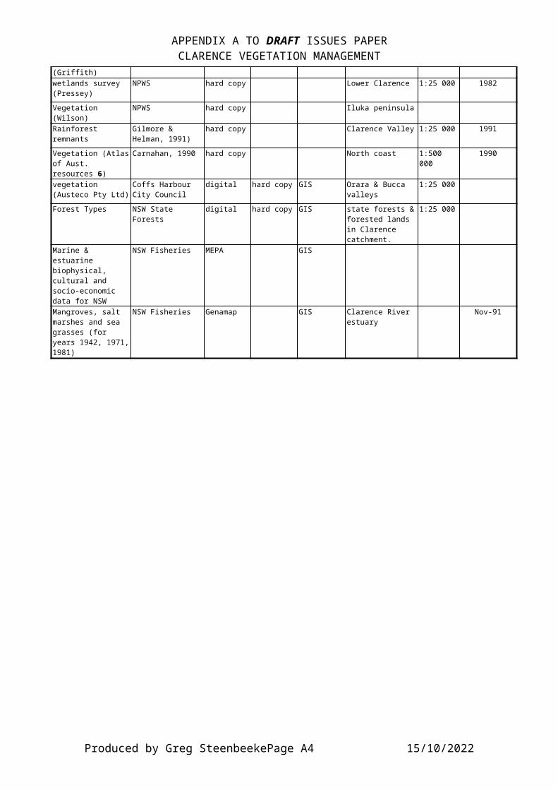
APPENDIX A TO DRAFT ISSUES PAPERCLARENCE VEGETATION MANAGEMENT
(Griffith)wetlands survey (Pressey)
NPWS hard copy Lower Clarence 1:25 000 1982
Vegetation (Wilson)
NPWS hard copy Iluka peninsula
Rainforest remnants
Gilmore & Helman, 1991)
hard copy Clarence Valley 1:25 000 1991
Vegetation (Atlasof Aust. resources 6)
Carnahan, 1990 hard copy North coast 1:500 000
1990
vegetation (Austeco Pty Ltd)
Coffs Harbour City Council
digital hard copy GIS Orara & Bucca valleys
1:25 000
Forest Types NSW State Forests
digital hard copy GIS state forests &forested lands in Clarence catchment.
1:25 000
Marine & estuarine biophysical, cultural and socio-economic data for NSW
NSW Fisheries MEPA GIS
Mangroves, salt marshes and sea grasses (for years 1942, 1971,1981)
NSW Fisheries Genamap GIS Clarence River estuary
Nov-91
Produced by Greg SteenbeekePage A4 15/10/2022

APPENDIX B TO DRAFT ISSUES PAPERCLARENCE VEGETATION MANAGEMENT
APPENDIX B.
B.1. List of Reports on Vegetation of the Clarence Catchment.AUTHOR YEAR TITLE PUBLISHER / CUSTODIAN
BENSON, John and ASHBY, Elizabeth
1996 Vegetation of the Guyra1:100 000 Map Sheet.
Royal Botanic Gardens,Sydney.
BINNS, Doug 1992 Flora Survey, Glen Innes management area, northern region.
NSW Forestry Commission.
CARR, David 1996 A field guide to the Trees and Tall Shrubs of the North-West Slopes.
Greening Australia, Armidale.
CENTRE FOR COASTAL MANAGEMENT
1990 Vegetation Survey, Elcom Transmission Line, Grafton to Coffs Harbour
Southern Cross University report for the NSW Electricity Commission.
CLAYTON, K.N. 1992 The rare and threatenedflora of Gibraltar Range National Park andmanagement strategies for conservation.
University of New England, Armidale. Minor thesis
DODKINS, M. and BENSON, J.
1984 Plant Species List for Mt Neville Area.
NSW National Parks andWildlife Service internal report, Mt Neville Natural Area investigation.
FLOYD, Alex 1980 Vegetation of the CoffsHarbour Area, in The Natural History of the Coffs Harbour District.
Department of Continuing Education, Southern Cross University, Coffs Harbour.
FLOYD, Alex G. 1976 Flora of Sherwood Nature Reserve.
Forestry Commission ofNSW
FORESTRY COMMISSION OF NSW
1992 Proposed Forestry Operations, Dorrigo Management Area: Environmental Impact Statement
Forestry Commission ofNSW
GRIFFITH, S. 1992 Thesium australe. Species Recovery Plan
NSW National Parks andWildlife Service, Hurstville.
Produced by Greg SteenbeekePage B0 15/10/2022

APPENDIX B TO DRAFT ISSUES PAPERCLARENCE VEGETATION MANAGEMENT
GRIFFITH, S.J. 1983 A survey of the vegetation of Bundjalung National Park
University of New England, Honours Thesis.
GRIFFITH, S.J. 1984 A survey of the vegetation of Yuraygir National Park
NSW National Parks andWildlife Service, Northern Region Report
HARDEN, Gwen J.
1991 - 1993
Flora of New South Wales, Volumes 1 - 4.
Royal Botanic Gardens,Sydney, University of NSW Press.
HARDEN, Gwen J. and WILLIAMS, JohnB.
1979 A guide to the common trees and shrubs found in rainforests in Dorrigo National Park.
University of New England.
HARDEN, Gwen J. and WILLIAMS, JohnB.
undated
A guide to some common and unusual fruits found in rainforests.
University of New England.
HOLLINGER, E. 1990 The role of vegetation in streambank stabilisation - a case study on the Orara River.
SCU Lismore IntegratedProject
JOHNSTON, Anthony
1987 Northern section of theYuraygir National Park Management Plan
SCU Lismore IntegratedProject
KAHN, Lewis and HEARD, Belinda
1997 Pasture Plants of the Slopes and Tablelands of NSW
NSW Department of Landand Water Conservation, Armidale
LOCKWOOD, Jocelyn
1991 Plan of Management - Bald Rock National Park.
SCU Lismore IntegratedProject
McPHERSON, David
1992 A Draft Plan of Management for the Tidal Wetlands of the Lower Clarence Estuary,North-East New South Wales
SCU Lismore IntegratedProject
MORGAN G. and TERREY, J.
1990 Land conservation for the New England Tableland: A regional plan.
World Wide Fund for Nature, Sydney.
Produced by Greg SteenbeekePage B1 15/10/2022
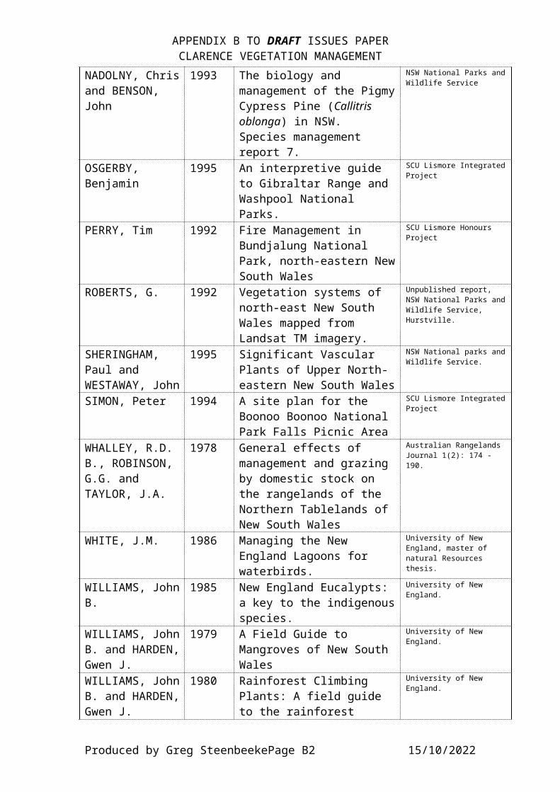
APPENDIX B TO DRAFT ISSUES PAPERCLARENCE VEGETATION MANAGEMENT
NADOLNY, Chrisand BENSON, John
1993 The biology and management of the PigmyCypress Pine (Callitris oblonga) in NSW. Species management report 7.
NSW National Parks andWildlife Service
OSGERBY, Benjamin
1995 An interpretive guide to Gibraltar Range and Washpool National Parks.
SCU Lismore IntegratedProject
PERRY, Tim 1992 Fire Management in Bundjalung National Park, north-eastern NewSouth Wales
SCU Lismore Honours Project
ROBERTS, G. 1992 Vegetation systems of north-east New South Wales mapped from Landsat TM imagery.
Unpublished report, NSW National Parks andWildlife Service, Hurstville.
SHERINGHAM, Paul and WESTAWAY, John
1995 Significant Vascular Plants of Upper North-eastern New South Wales
NSW National parks andWildlife Service.
SIMON, Peter 1994 A site plan for the Boonoo Boonoo National Park Falls Picnic Area
SCU Lismore IntegratedProject
WHALLEY, R.D. B., ROBINSON, G.G. and TAYLOR, J.A.
1978 General effects of management and grazing by domestic stock on the rangelands of the Northern Tablelands of New South Wales
Australian Rangelands Journal 1(2): 174 - 190.
WHITE, J.M. 1986 Managing the New England Lagoons for waterbirds.
University of New England, master of natural Resources thesis.
WILLIAMS, JohnB.
1985 New England Eucalypts: a key to the indigenousspecies.
University of New England.
WILLIAMS, JohnB. and HARDEN,Gwen J.
1979 A Field Guide to Mangroves of New South Wales
University of New England.
WILLIAMS, JohnB. and HARDEN,Gwen J.
1980 Rainforest Climbing Plants: A field guide to the rainforest
University of New England.
Produced by Greg SteenbeekePage B2 15/10/2022
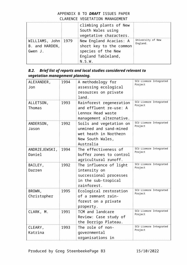
APPENDIX B TO DRAFT ISSUES PAPERCLARENCE VEGETATION MANAGEMENT
climbing plants of New South Wales using vegetative characters.
WILLIAMS, JohnB. and HARDEN,Gwen J.
1979 New England Acacias: A short key to the commonspecies of the New England Tableland, N.S.W.
University of New England.
B.2. Brief list of reports and local studies considered relevant to vegetation management planning.ALEXANDER, Jon
1994 A methodology for assessing ecological resources on private land.
SCU Lismore IntegratedProject
ALLETSON, Thomas
1993 Rainforest regenerationand effluent re-use: A Lennox Head waste management alternative.
SCU Lismore IntegratedProject
ANDERSON, Jason
1992 Soils and vegetation onunmined and sand-mined wet heath in Northern New South Wales, Australia
SCU Lismore IntegratedProject
ANDRZEJEWSKI,Daniel
1994 The effectiveness of buffer zones to controlagricultural runoff.
SCU Lismore IntegratedProject
BAILEY, Darren
1992 The influence of light intensity on successional processes in the sub-tropical rainforest.
SCU Lismore IntegratedProject
BROWN, Christopher
1995 Ecological restoration of a remnant rain-forest on a private property.
SCU Lismore IntegratedProject
CLARK, M. 1991 TCM and landcare Review: Case study of the Dorrigo Plateau.
SCU Lismore IntegratedProject
CLEARY, Katrina
1993 The role of non-governmental organisations in
SCU Lismore IntegratedProject
Produced by Greg SteenbeekePage B3 15/10/2022

APPENDIX B TO DRAFT ISSUES PAPERCLARENCE VEGETATION MANAGEMENT
environmental policy making and management.
CLYDESDALE, Joshua
1993 The potential for ecotourism in the Northern Rivers Region of New South Wales.
SCU Lismore IntegratedProject
CRAVEN, John 1994 Community mapping: an environmental management and planningtool.
SCU Lismore Honours Project
CURTIS, David 1989 Vegetation changes on the Northern tablelandsof New South Wales.
University of New England PhD thesis.
DEEGAN, John 1993 Camphor Laurel (Cinnamomum camphora (L.) Nees and Eberm) within the Richmond-Tweed region of northern New South Wales - A review of current literature and suggestions for future management.
SCU Lismore IntegratedProject
EARLY, Owen 1995 Conservation agreements: background information and case studies including management plan.
SCU Lismore IntegratedProject
EAST, Margaret
1992 Revegetation prioritiesfor the preservation ofnative vegetation remnants.
SCU Lismore IntegratedProject
EMTAGE, Nick 1995 Landholders perceptionsof the planting and management of trees.
SCU Lismore Honours Project
FAHY, Leanne 1994 Options for action in achieving the conservation of naturalresources.
SCU Lismore IntegratedProject
FERGUSON, Sophie
1995 Invasion by Senna in north eastern New SouthWales, ecology and
SCU Lismore IntegratedProject
Produced by Greg SteenbeekePage B4 15/10/2022

APPENDIX B TO DRAFT ISSUES PAPERCLARENCE VEGETATION MANAGEMENT
management implications.
FRANCIS, Kerri
1994 Nature conservation on pivate land, governmentand community roles: Clark’s Scrub, a case study.
SCU Lismore IntegratedProject
GILL, Annette 1996 Effects of aerial spraying of Bitou Bush on invertebrate fauna.
SCU Lismore IntegratedProject
GIMELLARO, Vanessa
1996 Riparian Zone conservation and regeneration in Australia.
SCU Lismore IntegratedProject
GRIFFITH, S.J.
1992 Species recovery plan, Zieria prostrata ms.
Australian National Parks and Wildlife Service, Canberra, Endangered species program.
GRIFFITH, S.J.
1992 Species recovery plan, Thesium australe.
Australian National Parks and Wildlife Service, Canberra, Endangered species program.
GRIFFITHS, J. 1991 An investigation of Australian Native Plantspecies which may be useful in soil erosion control.
SCU Lismore IntegratedProject
GROSSE, Suellen
1995 Agroforestry. The role of legumes in the viability of trees on farms.
SCU Lismore IntegratedProject
HAGER, T.C. and BENSON, J.S.
1994 Review of the conservation status of vegetation communities in NSW, part 3, Assessment of the conservation status of forest plant communities in North-eastern NSW.
Australian Heritage Commission, Canberra; Royal Botanic Gardens,Sydney.
HALL, Karen 1995 A field guide booklet for the identification of cabinet timber
SCU Lismore IntegratedProject
Produced by Greg SteenbeekePage B5 15/10/2022
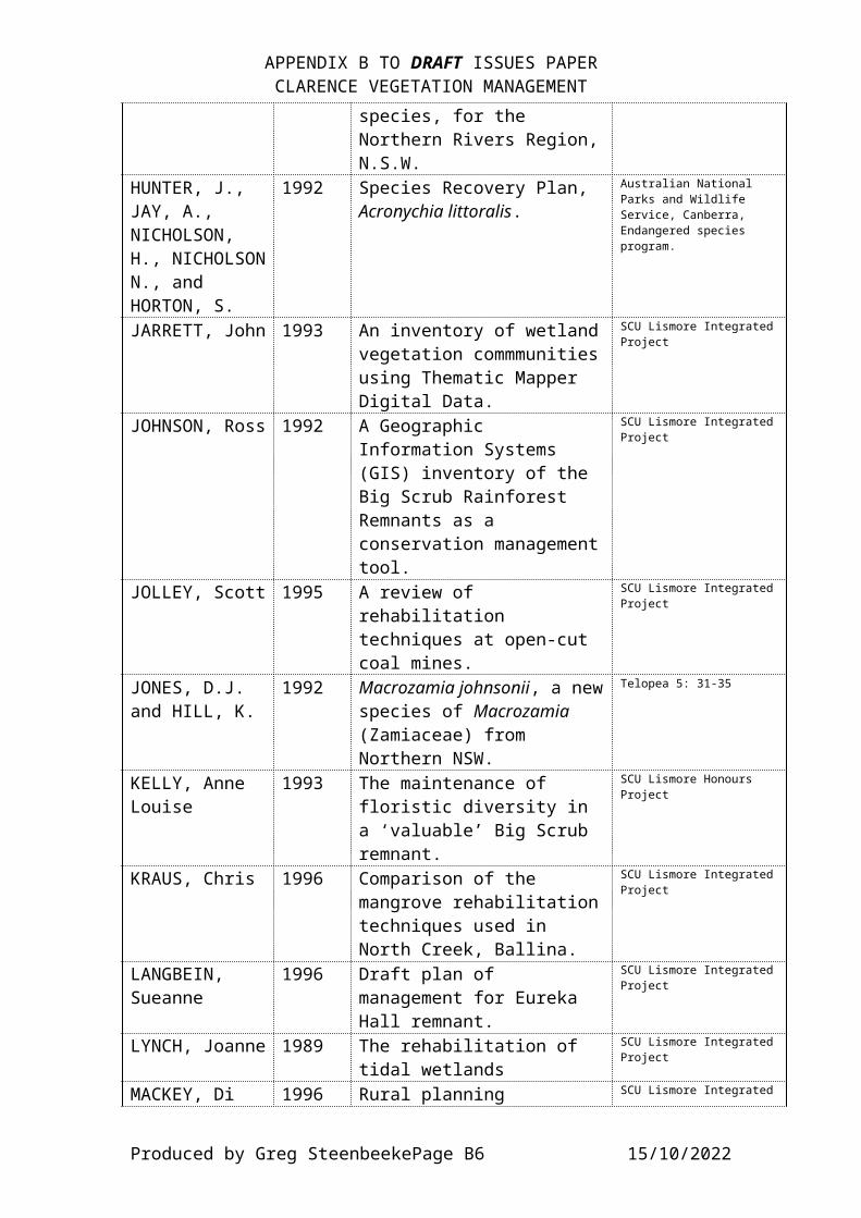
APPENDIX B TO DRAFT ISSUES PAPERCLARENCE VEGETATION MANAGEMENT
species, for the Northern Rivers Region,N.S.W.
HUNTER, J., JAY, A., NICHOLSON, H., NICHOLSONN., and HORTON, S.
1992 Species Recovery Plan, Acronychia littoralis.
Australian National Parks and Wildlife Service, Canberra, Endangered species program.
JARRETT, John 1993 An inventory of wetlandvegetation commmunitiesusing Thematic Mapper Digital Data.
SCU Lismore IntegratedProject
JOHNSON, Ross 1992 A Geographic Information Systems (GIS) inventory of the Big Scrub Rainforest Remnants as a conservation managementtool.
SCU Lismore IntegratedProject
JOLLEY, Scott 1995 A review of rehabilitation techniques at open-cut coal mines.
SCU Lismore IntegratedProject
JONES, D.J. and HILL, K.
1992 Macrozamia johnsonii, a newspecies of Macrozamia (Zamiaceae) from Northern NSW.
Telopea 5: 31-35
KELLY, Anne Louise
1993 The maintenance of floristic diversity in a ‘valuable’ Big Scrub remnant.
SCU Lismore Honours Project
KRAUS, Chris 1996 Comparison of the mangrove rehabilitationtechniques used in North Creek, Ballina.
SCU Lismore IntegratedProject
LANGBEIN, Sueanne
1996 Draft plan of management for Eureka Hall remnant.
SCU Lismore IntegratedProject
LYNCH, Joanne 1989 The rehabilitation of tidal wetlands
SCU Lismore IntegratedProject
MACKEY, Di 1996 Rural planning SCU Lismore Integrated
Produced by Greg SteenbeekePage B6 15/10/2022
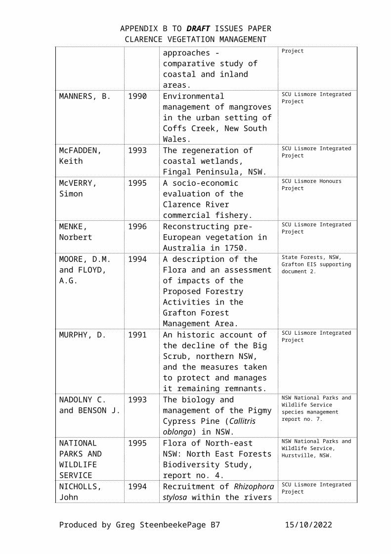
APPENDIX B TO DRAFT ISSUES PAPERCLARENCE VEGETATION MANAGEMENT
approaches - comparative study of coastal and inland areas.
Project
MANNERS, B. 1990 Environmental management of mangrovesin the urban setting ofCoffs Creek, New South Wales.
SCU Lismore IntegratedProject
McFADDEN, Keith
1993 The regeneration of coastal wetlands, Fingal Peninsula, NSW.
SCU Lismore IntegratedProject
McVERRY, Simon
1995 A socio-economic evaluation of the Clarence River commercial fishery.
SCU Lismore Honours Project
MENKE, Norbert
1996 Reconstructing pre-European vegetation in Australia in 1750.
SCU Lismore IntegratedProject
MOORE, D.M. and FLOYD, A.G.
1994 A description of the Flora and an assessmentof impacts of the Proposed Forestry Activities in the Grafton Forest Management Area.
State Forests, NSW, Grafton EIS supportingdocument 2.
MURPHY, D. 1991 An historic account of the decline of the Big Scrub, northern NSW, and the measures taken to protect and manages it remaining remnants.
SCU Lismore IntegratedProject
NADOLNY C. and BENSON J.
1993 The biology and management of the PigmyCypress Pine (Callitris oblonga) in NSW.
NSW National Parks andWildlife Service species management report no. 7.
NATIONAL PARKS AND WILDLIFE SERVICE
1995 Flora of North-east NSW: North East ForestsBiodiversity Study, report no. 4.
NSW National Parks andWildlife Service, Hurstville, NSW.
NICHOLLS, John
1994 Recruitment of Rhizophorastylosa within the rivers
SCU Lismore IntegratedProject
Produced by Greg SteenbeekePage B7 15/10/2022
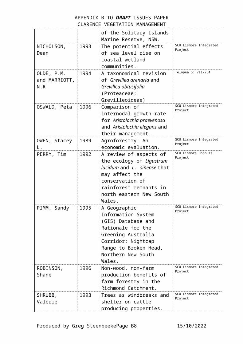
APPENDIX B TO DRAFT ISSUES PAPERCLARENCE VEGETATION MANAGEMENT
of the Solitary IslandsMarine Reserve, NSW.
NICHOLSON, Dean
1993 The potential effects of sea level rise on coastal wetland communities.
SCU Lismore IntegratedProject
OLDE, P.M. and MARRIOTT,N.R.
1994 A taxonomical revision of Grevillea arenaria and Grevillea obtusifolia (Proteaceae: Grevilleoideae)
Telopea 5: 711-734
OSWALD, Peta 1996 Comparison of internodal growth rate for Aristolochia praevenosa and Aristolochia elegans and their management.
SCU Lismore IntegratedProject
OWEN, Stacey L.
1989 Agroforestry: An economic evaluation.
SCU Lismore IntegratedProject
PERRY, Tim 1992 A review of aspects of the ecology of Ligustrum lucidum and L. sinense thatmay affect the conservation of rainforest remnants in north eastern New SouthWales.
SCU Lismore Honours Project
PIMM, Sandy 1995 A Geographic Information System (GIS) Database and Rationale for the Greening Australia Corridor: Nightcap Range to Broken Head, Northern New South Wales.
SCU Lismore IntegratedProject
ROBINSON, Shane
1996 Non-wood, non-farm production benefits of farm forestry in the Richmond Catchment.
SCU Lismore IntegratedProject
SHRUBB, Valerie
1993 Trees as windbreaks andshelter on cattle producing properties.
SCU Lismore IntegratedProject
Produced by Greg SteenbeekePage B8 15/10/2022
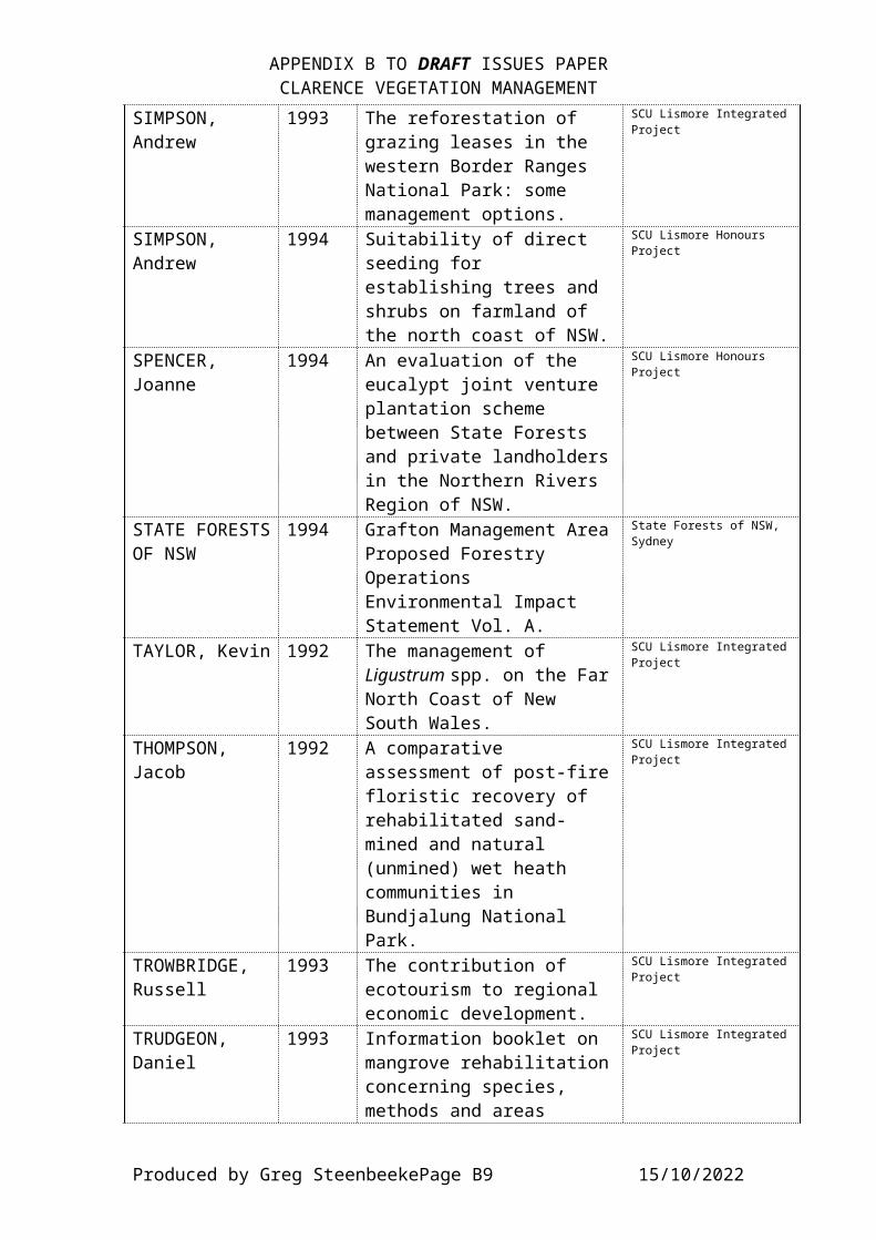
APPENDIX B TO DRAFT ISSUES PAPERCLARENCE VEGETATION MANAGEMENT
SIMPSON, Andrew
1993 The reforestation of grazing leases in the western Border Ranges National Park: some management options.
SCU Lismore IntegratedProject
SIMPSON, Andrew
1994 Suitability of direct seeding for establishing trees and shrubs on farmland of the north coast of NSW.
SCU Lismore Honours Project
SPENCER, Joanne
1994 An evaluation of the eucalypt joint venture plantation scheme between State Forests and private landholdersin the Northern Rivers Region of NSW.
SCU Lismore Honours Project
STATE FORESTSOF NSW
1994 Grafton Management AreaProposed Forestry Operations Environmental Impact Statement Vol. A.
State Forests of NSW, Sydney
TAYLOR, Kevin 1992 The management of Ligustrum spp. on the FarNorth Coast of New South Wales.
SCU Lismore IntegratedProject
THOMPSON, Jacob
1992 A comparative assessment of post-firefloristic recovery of rehabilitated sand-mined and natural (unmined) wet heath communities in Bundjalung National Park.
SCU Lismore IntegratedProject
TROWBRIDGE, Russell
1993 The contribution of ecotourism to regional economic development.
SCU Lismore IntegratedProject
TRUDGEON, Daniel
1993 Information booklet on mangrove rehabilitationconcerning species, methods and areas
SCU Lismore IntegratedProject
Produced by Greg SteenbeekePage B9 15/10/2022
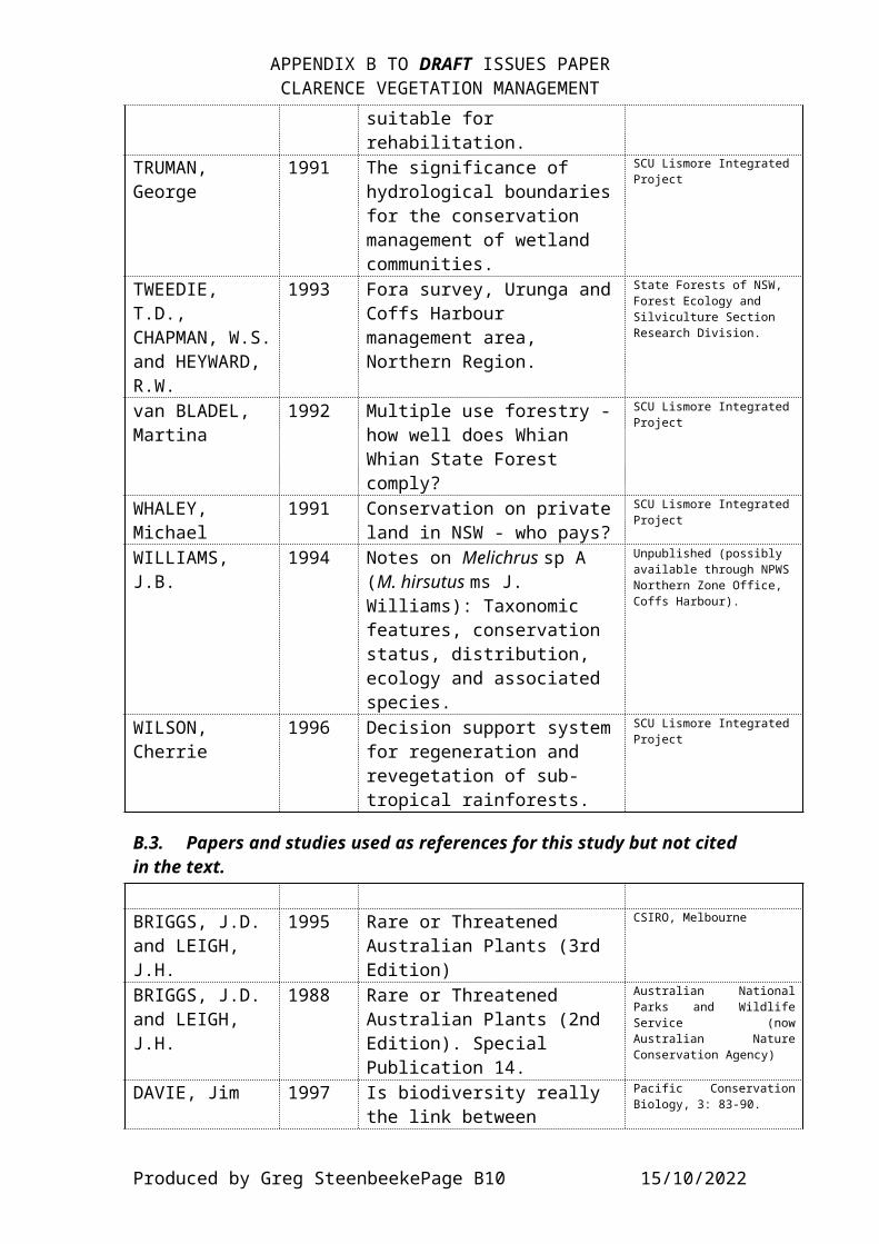
APPENDIX B TO DRAFT ISSUES PAPERCLARENCE VEGETATION MANAGEMENT
suitable for rehabilitation.
TRUMAN, George
1991 The significance of hydrological boundariesfor the conservation management of wetland communities.
SCU Lismore IntegratedProject
TWEEDIE, T.D., CHAPMAN, W.S.and HEYWARD, R.W.
1993 Fora survey, Urunga andCoffs Harbour management area, Northern Region.
State Forests of NSW, Forest Ecology and Silviculture Section Research Division.
van BLADEL, Martina
1992 Multiple use forestry -how well does Whian Whian State Forest comply?
SCU Lismore IntegratedProject
WHALEY, Michael
1991 Conservation on privateland in NSW - who pays?
SCU Lismore IntegratedProject
WILLIAMS, J.B.
1994 Notes on Melichrus sp A (M. hirsutus ms J. Williams): Taxonomic features, conservation status, distribution, ecology and associated species.
Unpublished (possibly available through NPWSNorthern Zone Office, Coffs Harbour).
WILSON, Cherrie
1996 Decision support systemfor regeneration and revegetation of sub-tropical rainforests.
SCU Lismore IntegratedProject
B.3. Papers and studies used as references for this study but not cited in the text.
BRIGGS, J.D. and LEIGH, J.H.
1995 Rare or Threatened Australian Plants (3rd Edition)
CSIRO, Melbourne
BRIGGS, J.D. and LEIGH, J.H.
1988 Rare or Threatened Australian Plants (2nd Edition). Special Publication 14.
Australian NationalParks and WildlifeService (nowAustralian NatureConservation Agency)
DAVIE, Jim 1997 Is biodiversity really the link between
Pacific ConservationBiology, 3: 83-90.
Produced by Greg SteenbeekePage B10 15/10/2022

APPENDIX B TO DRAFT ISSUES PAPERCLARENCE VEGETATION MANAGEMENT
conservation and ecologically sustainable management?A reflection on paradigm and practice.
EMTAGE, Nick and SPECHT, Alison
1996 Revegetation programs: a case for niche marketing.
‘Conservation OutsideNature Reserves’conference, centre forConservation Biology,University ofQueensland.
McPHEE, M.J.,AYRES, J.F. and CURLL, M.L.
1997 Growth periodicity of introduced pastures on the northern tablelandsof New South Wales.
Australian Journal ofAgricultural Research,48: 831-841
Produced by Greg SteenbeekePage B11 15/10/2022
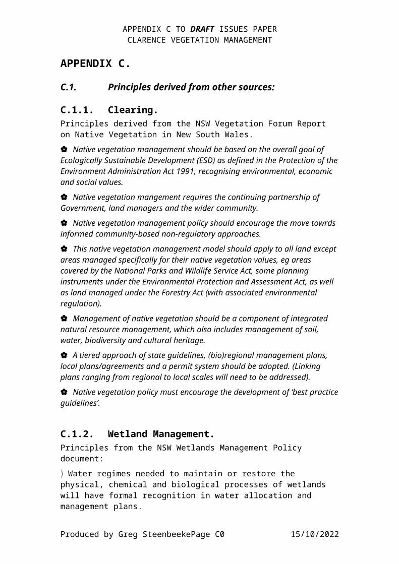
APPENDIX C TO DRAFT ISSUES PAPERCLARENCE VEGETATION MANAGEMENT
APPENDIX C.
C.1. Principles derived from other sources:
C.1.1. Clearing.Principles derived from the NSW Vegetation Forum Report on Native Vegetation in New South Wales.{ Native vegetation management should be based on the overall goal of Ecologically Sustainable Development (ESD) as defined in the Protection of theEnvironment Administration Act 1991, recognising environmental, economic and social values.
{ Native vegetation mangement requires the continuing partnership of Government, land managers and the wider community.
{ Native vegetation management policy should encourage the move towrds informed community-based non-regulatory approaches.
{ This native vegetation management model should apply to all land except areas managed specifically for their native vegetation values, eg areas covered by the National Parks and Wildlife Service Act, some planning instruments under the Environmental Protection and Assessment Act, as well as land managed under the Forestry Act (with associated environmental regulation).
{ Management of native vegetation should be a component of integrated natural resource management, which also includes management of soil, water, biodiversity and cultural heritage.
{ A tiered approach of state guidelines, (bio)regional management plans, local plans/agreements and a permit system should be adopted. (Linking plans ranging from regional to local scales will need to be addressed).
{ Native vegetation policy must encourage the development of ‘best practiceguidelines’.
C.1.2. Wetland Management.Principles from the NSW Wetlands Management Policy document:) Water regimes needed to maintain or restore the physical, chemical and biological processes of wetlands will have formal recognition in water allocation and management plans.
Produced by Greg SteenbeekePage C0 15/10/2022

APPENDIX C TO DRAFT ISSUES PAPERCLARENCE VEGETATION MANAGEMENT
) Land use and management practices taht maintain or rehabilitate wetland habitats and processes will be encouraged.) New developments will require allowance for suitable water distribution to and from wetlands.) Water entering natural wetlands will be of sufficient quality so as not to degrade the wetlands.) The construction of purpose-built wetlands on the site of viable natural ones will be discouraged.) Natural wetlands should not be destroyed, but when social or economic imperatives require it, the rehabilitation or construction of a wetland should be required.) Degraded wetlands and their habitats and processes will be actively rehabilitated as far as is practical.) Wetlands of regional or national significance will be conserved.) The adoption of a stewardship ethos and co-operative action between land and water owners and managers, governmnent authorities, non-government agencies, and thegeneral community is necessary for effective wetland management.
C.1.3. Rivers and Estuaries.From the Riparian Zone Policy Discussion Paper.š Those uses of rivers and estuaries which are non-degrading should be encouraged.š Non-sustainable resource uses which are not essential should be progressively phased out.š Environmentally degrading processes and practices shouldbe replaced with more efficient and less degrading alternatives.š Environmentally degraded areas should be rehabilitated and their biophysical functions restored.š Remnant areas of significant environmental values shouldbe accorded special protection.
Produced by Greg SteenbeekePage C1 15/10/2022

APPENDIX C TO DRAFT ISSUES PAPERCLARENCE VEGETATION MANAGEMENT
š An ethos for the sustainable management of river and estuarine resources should be encouraged in all agencies and individuals who own, manage or use these resources, and its practical application enabled.
C.1.4. Ecological Goals / Objectives from RTA Roadside Environment Strategic Plan:> Identify and manage roadside corridors and adjoining lands to maximise ecological values, considering social and economic functions of the transport link.
> To maintain and establish indigenous vegetation to conserve ecological values and optimise opportunities for linkage of natural areas of vegetation / habitat.
> To control the number of weeds in road corridors in order to maintain and enhance ecological values of roadside and adjoining vegetation.
> To control pest species within roadside corridors, consistent with maintaining native flora and fauna values.
> To maintain and increase habitat for wildlife in roadside corridors while identifying and minimising conflict between animal movement and traffic.
> To minimise soil erosion in the road corridor and sedimentation of the downstream environment through the implementation of appropriate soil conservation strategies.
> To protect watercourses and their associated habitats through strategies designed to minimise the adverse effects of the construction and use of road corridors on river environments and their catchments.
> To identify the effects of bush fires and bush fire control and management strategies on the ecology of corridors and to promote ecologically sound bush fire control practices while not compromising the protection of lives andproperty.
> To site stockpiles where visual amenity and vegetation are not affected.
> To provide for the placement of public utility services in roadside corridors, whilst not compromising the ecological and social functions.
C.1.5. Strategy Plan for Key Natural Resource Issues in the Clarence Catchment:
Vegetation management and Biodiversity section.
Produced by Greg SteenbeekePage C2 15/10/2022

APPENDIX C TO DRAFT ISSUES PAPERCLARENCE VEGETATION MANAGEMENT
Goals:
ª To re-establish vegetative cover on over-cleared slopes, degraded land, and in riparian corridors.ª To maintain or enhance biodiversity in the catchment.ª To encourage vegetation mangement which is ecologicallyand economically sustainable.Strategies:
ª Encourage revegetation and regeneration of sensitive orunstable areas, with native species.ª Promote farm management that maintains/regenerates vegetation on sensitive or unstable areas, and enhances biodiversity.ª Encourage better management of existing vegetation.ª Promote the economic and ecological importance of vegetation to the community.
Produced by Greg SteenbeekePage C3 15/10/2022

APPENDIX D.
D.1. Rare, Endangered and Threatened Plant Species likely to occur in the Clarence Catchment.
The following presents in tabular form information for each of the nominated species from the NSW North East Plants database (developed as part of this project).
Table D1. ROTAP (Rare or Threatened Australian Plants) coding for each species (the standard applied by Briggs and Leigh, 1988, 1995).1 Total range limited to one population.2 Total range of populations is less than 100 kilometres.3 Total range of populations is greater than 100 kilometres.K Species rarity status poorly known.R Species considered rare.E Species considered endangered.X (x) Species considered extinct. Large X refers to species
considered extinct over full range, small x refers to those species considered extinct within that region.
C Species occurs within formal conservation areas (National Parks, Nature Reserves and Flora Reserves).
i Populations conserved are considered inadequate for the ongoing maintenance of the species.
a Populations conserved are considered adequate for the ongoingmaintenance of the species.
t Populations of the species is found entirely within conservation areas.
- The adequacy of conservation status is not known.+ The species occurs naturally outside Australia.
Other coding is applied to each species in the following ways:· Italics are used to denote species which are adequately
conserved within the conservation areas (a species). Although the species is important (and may have legalimportance if listed in the Threatened Species Conservation Act or the Endangered Species ProtectionAct), the need to formally recognise populations intoconservation agreements has less urgency. However, recognition of populations distant, isolated or out-of-typical-habitat should be made.
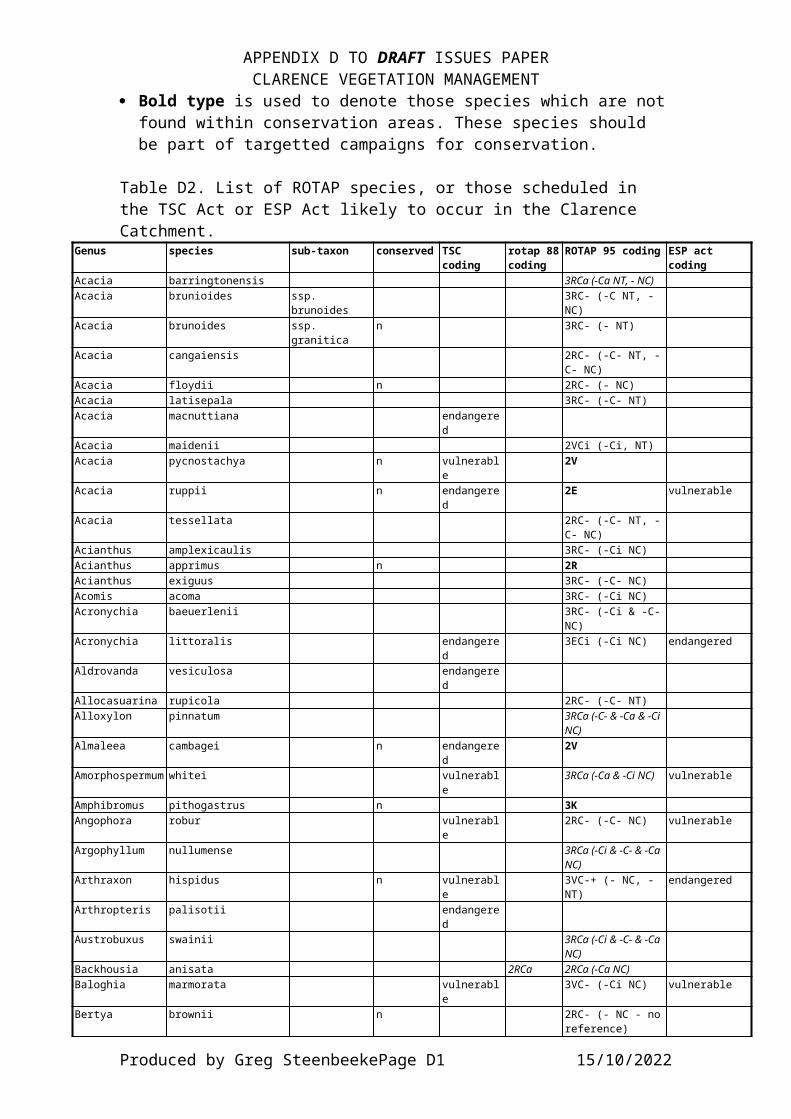
APPENDIX D TO DRAFT ISSUES PAPERCLARENCE VEGETATION MANAGEMENT
· Bold type is used to denote those species which are notfound within conservation areas. These species should be part of targetted campaigns for conservation.
Table D2. List of ROTAP species, or those scheduled in the TSC Act or ESP Act likely to occur in the Clarence Catchment.
Genus species sub-taxon conserved TSC coding
rotap 88coding
ROTAP 95 coding ESP act coding
Acacia barringtonensis 3RCa (-Ca NT, - NC)Acacia brunioides ssp.
brunoides3RC- (-C NT, - NC)
Acacia brunoides ssp. granitica
n 3RC- (- NT)
Acacia cangaiensis 2RC- (-C- NT, -C- NC)
Acacia floydii n 2RC- (- NC)Acacia latisepala 3RC- (-C- NT)Acacia macnuttiana endangere
dAcacia maidenii 2VCi (-Ci, NT)Acacia pycnostachya n vulnerabl
e2V
Acacia ruppii n endangered
2E vulnerable
Acacia tessellata 2RC- (-C- NT, -C- NC)
Acianthus amplexicaulis 3RC- (-Ci NC)Acianthus apprimus n 2RAcianthus exiguus 3RC- (-C- NC)Acomis acoma 3RC- (-Ci NC)Acronychia baeuerlenii 3RC- (-Ci & -C-
NC)Acronychia littoralis endangere
d3ECi (-Ci NC) endangered
Aldrovanda vesiculosa endangered
Allocasuarina rupicola 2RC- (-C- NT)Alloxylon pinnatum 3RCa (-C- & -Ca & -Ci
NC)Almaleea cambagei n endangere
d2V
Amorphospermum whitei vulnerable
3RCa (-Ca & -Ci NC) vulnerable
Amphibromus pithogastrus n 3KAngophora robur vulnerabl
e2RC- (-C- NC) vulnerable
Argophyllum nullumense 3RCa (-Ci & -C- & -Ca NC)
Arthraxon hispidus n vulnerable
3VC-+ (- NC, - NT)
endangered
Arthropteris palisotii endangered
Austrobuxus swainii 3RCa (-Ci & -C- & -Ca NC)
Backhousia anisata 2RCa 2RCa (-Ca NC)Baloghia marmorata vulnerabl
e3VC- (-Ci NC) vulnerable
Bertya brownii n 2RC- (- NC - noreference)
Produced by Greg SteenbeekePage D1 15/10/2022
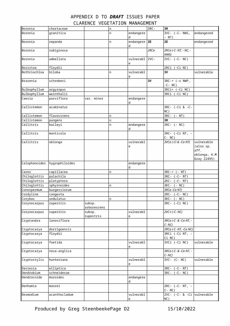
APPENDIX D TO DRAFT ISSUES PAPERCLARENCE VEGETATION MANAGEMENT
Boronia chartaceae n 3RC- 3RBoronia granitica n endangere
d3VC- (-C- NWS, - NT)
endangered
Boronia repanda n endangered
2E 2E endangered
Boronia rubiginosa 2RCa 2RCa (-C- NT, - NC, - NWS)
Boronia umbellata vulnerable
2VC- 2VC- (-C- NC)
Bosistoa floydii 2RCi (-Ci NC)Bothriochloa biloba n vulnerabl
e3V vulnerable
Brasenia schreberi 3V 3RC-+ (-x NWP, -C- NC)
Bulbophyllum argyropus 3RCi+ (-Ci NC)Bulbophyllum weinthalii 3RCi (-Ci NC)Caesia parviflora var. minor endangere
dCallistemon acuminatus 3RC- (-Ci & -C-
NC)Callistemon flavovirens n 3RC- (- NT)Callistemon pungens n 3RCallitris baileyi n endangere
d3RC- (- NC)
Callitris monticola 3RC- (-Ci NT, -C- NC)
Callitris oblonga vulnerable
3VCa (-Ci & -Ca NT) vulnerable (also sp. aff. oblonga, A.MGray 22495)
Calophanoides hygrophiloides endangered
Carex capillacea n 3RC-+ (- NT)Chiloglottis palachila 3RC- (-C- NT)Chiloglottis platyptera 2KC- (-C- NT)Chiloglottis sphyrnoides n 3KC- (- NC)Conospermum burgessiorum 3RCa -Ca NT)Cordyline congesta 2RC- (-C- NC)Corybas undulatus n 3KC- (- NC)Corynocarpus rupestris subsp.
arborescens3RC- (-Ci NC)
Corynocarpus rupestris subsp. rupestris
vulnerable
2VC-t (-C- NC)
Cryptandra lanosiflora 3RCa (-C- & -Ca NT, -C- NC)
Cryptocarya dorrigoensis 2RCa (-C- NT, -Ca NC)Cryptocarya floydii 3RCi (-Ci NT, -
Ci NC)Cryptocarya foetida vulnerabl
e3VCi (-Ci NC) vulnerable
Cryptocarya nova-anglica 3RCa (-C- & -Ca NT, -C- NC)
Cryptostylis hunteriana vulnerable
3VC- (C- NC) vulnerable
Daviesia elliptica 3RC- (-C- NT)Dendrobium schneiderae 3RC- (-C- NC)Dendrocnide moroides endangere
dDenhamia moorei 2RC- (-C- NT, -
C- NC)Desmodium acanthocladum vulnerabl
e2VC- (-C- & -CiNC)
vulnerable
Produced by Greg SteenbeekePage D2 15/10/2022
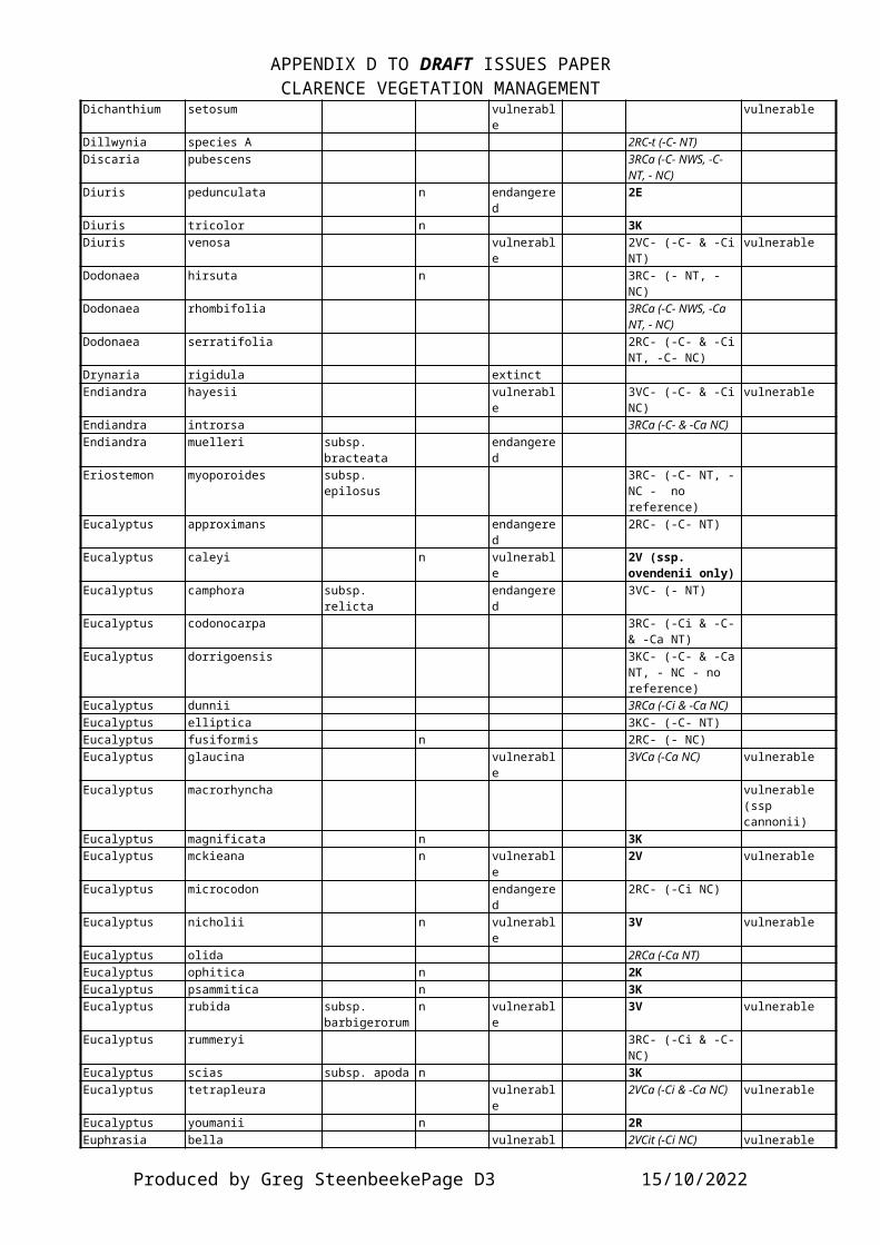
APPENDIX D TO DRAFT ISSUES PAPERCLARENCE VEGETATION MANAGEMENT
Dichanthium setosum vulnerable
vulnerable
Dillwynia species A 2RC-t (-C- NT)Discaria pubescens 3RCa (-C- NWS, -C-
NT, - NC)Diuris pedunculata n endangere
d2E
Diuris tricolor n 3KDiuris venosa vulnerabl
e2VC- (-C- & -CiNT)
vulnerable
Dodonaea hirsuta n 3RC- (- NT, - NC)
Dodonaea rhombifolia 3RCa (-C- NWS, -Ca NT, - NC)
Dodonaea serratifolia 2RC- (-C- & -CiNT, -C- NC)
Drynaria rigidula extinctEndiandra hayesii vulnerabl
e3VC- (-C- & -CiNC)
vulnerable
Endiandra introrsa 3RCa (-C- & -Ca NC)Endiandra muelleri subsp.
bracteataendangered
Eriostemon myoporoides subsp. epilosus
3RC- (-C- NT, -NC - no reference)
Eucalyptus approximans endangered
2RC- (-C- NT)
Eucalyptus caleyi n vulnerable
2V (ssp. ovendenii only)
Eucalyptus camphora subsp. relicta
endangered
3VC- (- NT)
Eucalyptus codonocarpa 3RC- (-Ci & -C-& -Ca NT)
Eucalyptus dorrigoensis 3KC- (-C- & -CaNT, - NC - no reference)
Eucalyptus dunnii 3RCa (-Ci & -Ca NC)Eucalyptus elliptica 3KC- (-C- NT)Eucalyptus fusiformis n 2RC- (- NC)Eucalyptus glaucina vulnerabl
e3VCa (-Ca NC) vulnerable
Eucalyptus macrorhyncha vulnerable (ssp cannonii)
Eucalyptus magnificata n 3KEucalyptus mckieana n vulnerabl
e2V vulnerable
Eucalyptus microcodon endangered
2RC- (-Ci NC)
Eucalyptus nicholii n vulnerable
3V vulnerable
Eucalyptus olida 2RCa (-Ca NT)Eucalyptus ophitica n 2KEucalyptus psammitica n 3KEucalyptus rubida subsp.
barbigerorumn vulnerabl
e3V vulnerable
Eucalyptus rummeryi 3RC- (-Ci & -C-NC)
Eucalyptus scias subsp. apoda n 3KEucalyptus tetrapleura vulnerabl
e2VCa (-Ci & -Ca NC) vulnerable
Eucalyptus youmanii n 2REuphrasia bella vulnerabl 2VCit (-Ci NC) vulnerable
Produced by Greg SteenbeekePage D3 15/10/2022
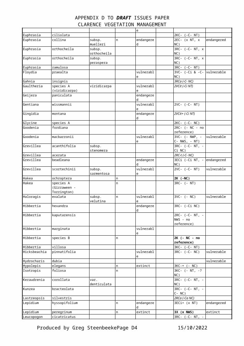
APPENDIX D TO DRAFT ISSUES PAPERCLARENCE VEGETATION MANAGEMENT
eEuphrasia ciliolata 2KC- (-C- NT)Euphrasia collina subsp.
muellerin endangere
d2EC- (x NT, x NC)
endangered
Euphrasia orthocheila subsp. orthocheila
3RC- (-C- NT, xNC)
Euphrasia orthocheila subsp. peraspera
3RC- (-C- NT, xNC)
Euphrasia ramulosa 3RC- (-C- NT)Floydia praealta vulnerabl
e3VC- (-Ci & -C-NC)
vulnerable
Gahnia insignis 3RCa (-C- NC)Gaultheria species A
(viridicarpa)viridicarpa vulnerabl
e2VCit (-Ci NT)
Geijera paniculata endangered
Gentiana wissmannii vulnerable
2VC- (-C- NT)
Gingidia montana endangered
2VCit+ (-Ci NT)
Glycine species A 2KC- (-C- NC)Goodenia fordiana 2RC- (- NC - no
reference)Goodenia macbarronii vulnerabl
e3VC- (- NWP, -C- NWS, - NT)
vulnerable
Grevillea acanthifolia subsp. stenomera
3RC- (-C- NT, -Ci NC)
Grevillea acerata 2RC-t (-C- NC)Grevillea beadleana endangere
d3ECi (-Ci NT, -NC)
endangered
Grevillea scortechinii subsp. sarmentosa
vulnerable
2VC- (-C- NT) vulnerable
Hakea ochroptera n 2K (-NC)Hakea species A
(Girraween - Torrington)
n 3RC- (- NT)
Haloragis exalata subsp. velutina
n vulnerable
3VC- (- NC) vulnerable
Hibbertia hexandra endangered
3RC- (-Ci NC)
Hibbertia kaputarensis 2RC- (-C- NT, -NWS - no reference)
Hibbertia marginata vulnerable
Hibbertia species B n 2K (- NC - no reference)
Hibbertia villosa 3KC- (-C- NT)Hicksbeachia pinnatifolia vulnerabl
e3RC- (-C- NC) vulnerable
Hydrocharis dubia vulnerableHypolepis elegans n extinct 3KC-+ (- NC)Isotropis foliosa n 3KC- (- NT, -?
NC)Keraudrenia corollata var.
denticulata3RC- (-C- NT, -NC)
Kunzea bracteolata 3RC- (-C- NT, -C- NC)
Lastreopsis silvestris 2RCa (-Ca NC)Lepidium hyssopifolium n endangere
d3ECi+ (x NT) endangered
Lepidium peregrinum n extinct 3X (x NWS) extinctLeucopogon cicatricatus 3RC- (-C- NT, -
Produced by Greg SteenbeekePage D4 15/10/2022

APPENDIX D TO DRAFT ISSUES PAPERCLARENCE VEGETATION MANAGEMENT
NC)Leucopogon recurvisepalus 3RC- 3KC- (-C- NC)Lindsaea incisa endangere
dMacadamia tetraphylla vulnerabl
e2VC- (-Ci & -C-NC)
vulnerable
Macrozamia moorei endangered
2RC- (-C- NC)
Macrozamia pauli-guilielmi subsp. flexuosa
n 2K
Marsdenia liisae 3RC- (-C- NC)Marsdenia longiloba n endangere
d3RC- (- NC) endangered
Melaleuca groveana vulnerable
3RC- (- NT, -CiNC)
vulnerable
Melaleuca tortifolia 2RC-t (-C- NT)Melichrus sp A (hirsutus) endangere
dMillettia australis 3VC- 3RC-+ (-C- & -
Ci NC)Muehlenbeckia costata n 3KC- (- NT)Muellerina myrtifolia n endangere
d3RC- (- NC)
Myriophyllum implicatum n extinct 3V vulnerableNeoastelia spectabilis vulnerabl
e2VCit (-Ci NT)
Olax angulata vulnerable
2VCi (-Ci NC)
Olearia flocktoniae 2ECi (-Ci NC) endangeredOlearia gravis n 3KC- (- NWS, -
NT)Olearia stilwelliae 3RCa (-Ca NC)Ozothamnus adnatus n 3KC- (- NT)Ozothamnus vagans 2RCa (-Ci & -Ca NC)Ozothamnus whitei 3RC- (-C- NT, -
C- NC)Parsonsia dorrigoensis vulnerabl
e2VCi (-Ci NC)
Parsonsia tenuis 2RC-t (-Ci NC)Persicaria elatior n vulnerabl
e3V vulnerable
Persoonia daphnoides 3RC- (-C- NT)Persoonia procumbens 2RC- (-C- NT)Persoonia rufa 2RCa (-Ca NT)Persoonia terminalis subsp.
terminalisn 2R
Persoonia volcanica 2RC- (-C- NC)Phaius australis vulnerabl
e3VCa (-Ci & -Ca NC) vulnerable
Phaius tankervilleae n endangered
3VC-+ (- NC) vulnerable
Phebalium ambiens 3RC- (-C- NT)Phebalium elatius subsp.
elatiusn 3K
Phebalium glandulosum subsp. eglandulosum
n endangered
2VCi (- NT)
Phebalium rotundifolium 3RC- (- NWS, -C- NT)
Pimelea umbratica 2RC- (-C- NC)Pimelea venosa n 2V vulnerablePittosporum oreillyanum 2RCat (-Ci NC)Plectranthus alloplectus n endangere
d2RC- (- NC)
Produced by Greg SteenbeekePage D5 15/10/2022

APPENDIX D TO DRAFT ISSUES PAPERCLARENCE VEGETATION MANAGEMENT
Plectranthus cremnus n 3KPlectranthus suaveolens 3KC- (-C- NT, -
NC)Podolepis monticola 2RCa (-C- & -Ca NC)Podolobium aestivum 3RC- (-C- & -Ci
NC)Pomaderris notata 2RC-t (-Ci NC)Pomaderris queenslandica endangere
dPrasophyllum dossenum n 3RProstanthera species B 2RC- (-Ci NT)Prostanthera species F vulnerabl
e2VCit (-Ci NC)
Prostanthera staurophylla n vulnerable
2R
Psilotum complanatum endangered
Pterostylis nigricans n vulnerable
3V
Pterostylis woollsii n 3RC- (- NWS, - NT, - NC)
Pultenaea campbellii n vulnerable
3K vulnerable
Pultenaea pycnocephala 3RCa (x NT, -C- & -Ca NC)
Pultenaea species B 2RC-t (-C- NT, - NWS -no reference)
Pultenaea stuartiana n vulnerable
3VC- (- NT) vulnerable
Quassia species A 3RC- (-Ci & -C-NC)
Quassia species B n endangered
2E endangered
Ricinocarpos speciosus 3RCi (-Ci NT, -Ci NC)
Rutidosis heterogama vulnerable
vulnerable
Sarcochilus aequalis 3RC- (-C- NC)Sarcochilus fitzgeraldii vulnerabl
e3VC- (-C- & -CiNC)
vulnerable
Sarcochilus hartmannii vulnerable
3VC- 3VC- (-C- NC) vulnerable
Sarcochilus weinthalii n vulnerable
3VC- (- NC) vulnerable
Sauropus albiflorus subsp. microcladus
endangered
Schistotylus purpuratus 3RCi (-Ci NT, -Ci NC)
Senecio macranthus n 3RC- (-C- NWS, - NT)
Senna acclinis n endangered
3RC- (- NC)
Sophora fraseri n vulnerable
3VC- (- NC) vulnerable
Tasmannia glaucifolia vulnerable
3VCi (-Ci NT) vulnerable
Telopea aspera 2RCa (-Ca NT)Thelionema grande 3RC- (-C- NT)Thesium australe vulnerabl
e3VCi+ (- NT, -Ci NC)
vulnerable
Thismia rodwayi 3RC-+ (-C- NC)Tinospora tinosporoides vulnerabl
e3RC- (-Ci & -C-NC)
vulnerable
Produced by Greg SteenbeekePage D6 15/10/2022

APPENDIX D TO DRAFT ISSUES PAPERCLARENCE VEGETATION MANAGEMENT
Trichosanthes subvelutina 3RC- (-Ci NC)Tylophora woollsii n endangere
d2E endangered
Wahlenbergia glabra n 2RC- (- NC)Wahlenbergia scopulicola endangere
d2RC- (-C- NC)
Westringia glabra var. glabra 2RC- (-C- NT)Westringia sericea 3RC- (-C- NC)Zannichellia palustris n 3R+Zieria species L
(floydii)endangered
2RC-t (-C- NC)
Zieria species Q (prostrata)
n endangered
2E endangered
Counts 227 71 94 9 208 55taxa in total not
represented in reserves in the Catchment(36 not conservedanywhere)
considered under the Threatened SpeciesConserv’nAct
mentioned in the1988 ROTAP list
mentioned in the 1995 ROTAP list
considered in the national Endangered Species Protection Act.
Produced by Greg SteenbeekePage D7 15/10/2022


APPENDIX E TO DRAFT ISSUES PAPERCLARENCE VEGETATION MANAGEMENT
APPENDIX E.
E.1. LAND AND ACTIVITIES EXEMPTED FROM THE RVMP PROCESS.
E.1.1. Lands Exempted.· Land zoned ‘residential’ (but not ‘rural residential’ areas)
‘urban’, ‘village’, ‘township’, ‘industrial’ or ‘business’;· Land covered by SEPP 14 (Coastal Wetlands) or SEPP 26
(Littoral rainforests)· Land that is a state forest, national forest, flora reserve
or timber reserve under Forestry Act 1916, and land acquired for the purposes of a state forest (but not a plantation forest);
· Land dedicated or reserved under the National Parks and Wildlife Act 1974 (NPW Act);
· Land acquired under s. 145 of the NPW Act for preserving, protecting and preventing damage to relics or aboriginal places;
· Land subject to a conservation agreement entered into under Part 4, D.7 of the NPW Act;
· Land subject to an interim protection order made under part 6A of the NPW Act;
· Land subject to a conservation instrument within the meaning of the Heritage Act 1977;
· Land that is Critical Habitat (presumably as defined in the Threatened Species Conservation Act 1995); and
· Lord Howe Island.· It applies only to the State Protected Land within a number of cities and shires as listed in Schedule one of the NVC, which are all wholly or mostly urbanised lands within the Sydney area.
E.1.2. Clearing Activities Excluded.Clearing activities excluded from the NVC Act operations include:
· Any clearing authorised in the Rural Fires Act 1997 or the State Emergency and Rescue Management Act 1989 when carriedout in relation to an emergency within the meaning of the latter Act;
Produced by Greg SteenbeekePage E1 15/10/2022
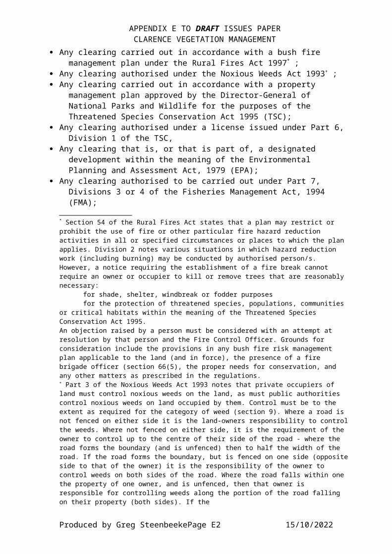
APPENDIX E TO DRAFT ISSUES PAPERCLARENCE VEGETATION MANAGEMENT
· Any clearing carried out in accordance with a bush fire management plan under the Rural Fires Act 1997* ;
· Any clearing authorised under the Noxious Weeds Act 1993+ ;· Any clearing carried out in accordance with a property
management plan approved by the Director-General of National Parks and Wildlife for the purposes of the Threatened Species Conservation Act 1995 (TSC);
· Any clearing authorised under a license issued under Part 6, Division 1 of the TSC,
· Any clearing that is, or that is part of, a designated development within the meaning of the Environmental Planning and Assessment Act, 1979 (EPA);
· Any clearing authorised to be carried out under Part 7, Divisions 3 or 4 of the Fisheries Management Act, 1994 (FMA);
* Section 54 of the Rural Fires Act states that a plan may restrict or prohibit the use of fire or other particular fire hazard reduction activities in all or specified circumstances or places to which the plan applies. Division 2 notes various situations in which hazard reduction work (including burning) may be conducted by authorised person/s. However, a notice requiring the establishment of a fire break cannot require an owner or occupier to kill or remove trees that are reasonably necessary:
for shade, shelter, windbreak or fodder purposesfor the protection of threatened species, populations, communities
or critical habitats within the meaning of the Threatened Species Conservation Act 1995.An objection raised by a person must be considered with an attempt at resolution by that person and the Fire Control Officer. Grounds for consideration include the provisions in any bush fire risk management plan applicable to the land (and in force), the presence of a fire brigade officer (section 66(5), the proper needs for conservation, and any other matters as prescribed in the regulations.+ Part 3 of the Noxious Weeds Act 1993 notes that private occupiers of land must control noxious weeds on the land, as must public authorities control noxious weeds on land occupied by them. Control must be to the extent as required for the category of weed (section 9). Where a road is not fenced on either side it is the land-owners responsibility to controlthe weeds. Where not fenced on either side, it is the requirement of the owner to control up to the centre of their side of the road - where the road forms the boundary (and is unfenced) then to half the width of the road. If the road forms the boundary, but is fenced on one side (oppositeside to that of the owner) it is the responsibility of the owner to control weeds on both sides of the road. Where the road falls within one the property of one owner, and is unfenced, then that owner is responsible for controlling weeds along the portion of the road falling on their property (both sides). If the
Produced by Greg SteenbeekePage E2 15/10/2022
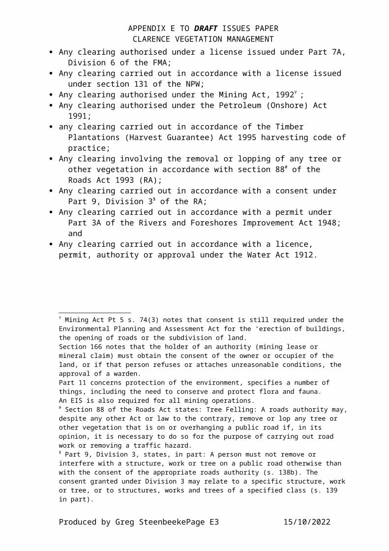
APPENDIX E TO DRAFT ISSUES PAPERCLARENCE VEGETATION MANAGEMENT
· Any clearing authorised under a license issued under Part 7A,Division 6 of the FMA;
· Any clearing carried out in accordance with a license issued under section 131 of the NPW;
· Any clearing authorised under the Mining Act, 1992Y ;· Any clearing authorised under the Petroleum (Onshore) Act
1991;· any clearing carried out in accordance of the Timber
Plantations (Harvest Guarantee) Act 1995 harvesting code ofpractice;
· Any clearing involving the removal or lopping of any tree or other vegetation in accordance with section 88# of the Roads Act 1993 (RA);
· Any clearing carried out in accordance with a consent under Part 9, Division 3$ of the RA;
· Any clearing carried out in accordance with a permit under Part 3A of the Rivers and Foreshores Improvement Act 1948; and
· Any clearing carried out in accordance with a licence, permit, authority or approval under the Water Act 1912.
Y Mining Act Pt 5 s. 74(3) notes that consent is still required under the Environmental Planning and Assessment Act for the ‘erection of buildings,the opening of roads or the subdivision of land.Section 166 notes that the holder of an authority (mining lease or mineral claim) must obtain the consent of the owner or occupier of the land, or if that person refuses or attaches unreasonable conditions, the approval of a warden.Part 11 concerns protection of the environment, specifies a number of things, including the need to conserve and protect flora and fauna. An EIS is also required for all mining operations.# Section 88 of the Roads Act states: Tree Felling: A roads authority may,despite any other Act or law to the contrary, remove or lop any tree or other vegetation that is on or overhanging a public road if, in its opinion, it is necessary to do so for the purpose of carrying out road work or removing a traffic hazard.$ Part 9, Division 3, states, in part: A person must not remove or interfere with a structure, work or tree on a public road otherwise than with the consent of the appropriate roads authority (s. 138b). The consent granted under Division 3 may relate to a specific structure, workor tree, or to structures, works and trees of a specified class (s. 139 in part).
Produced by Greg SteenbeekePage E3 15/10/2022


