Embed Size (px)
Citation preview

Charack: tool for real-time generation of pseudo-infinite virtual worlds for
3D games
Fernando Bevilacqua
Cesar Tadeu Pozzer
Marcos Cordeiro d Ornellas
UFSM, Programa de Pos-graduacao em Informatica, Brazil
Figure 1: Coastlines and islands procedurally generated by Charack
Abstract
In MMO games the player’s experience is mainly influenced by thesize and details of the virtual world. Technically the bigger theworld is, the bigger is the time the player takes to explore all theplaces. This work presents a tool (named Charack) able to gener-ate pseudo-infinite virtual worlds with different types of terrains.Using a combination of algorithms and content management meth-ods, Charack is able to create beaches, islands, bays and coastlinesthat imitates real world landscapes. The tool clearly distinguish thegeneration of each type of content. The contribution of the tool isthe ability to generate arbitrarily large pieces of land (or landscape)focusing on detailed coastline generation, by means of using proce-dural algorithms.
Keywords:: MMO, virtual worlds, terrain generation, 3D games,noise, procedural generation, multifractal
Author’s Contact:
{fernando,pozzer,ornellas}@inf.ufsm.br
1 Introduction
The computer games market has been evolving considerably overthe years. Since the first console, the hardware performance hasincreased and new graphic technologies were developed, resultingin a wide range of themes and game styles. In the multiplayergames, players interact with other human beings and also withNPCs, which are represented by virtual characters. That kind ofgame is popular and the social interaction between players is a mat-ter of research [Griffiths et al. 2003; Ducheneaut et al. 2006]. In thecategory of multiplayer games there are the massively multiplayeron-line (MMO) ones, which are on-line games featuring large num-ber of players interacting with each other in a huge virtual world.
An MMO can feature millions of players, such as EverQuest [SonyEntertainment 2007] and World of Warcraft [Blizzard Entertain-ment 2007], the latter with more than 6 million subscribers [Clark2006]. A persistent virtual world is an important topic to keep thegame fun and attractive to the player. The bigger is the world to beexplored, technically the bigger is the time the player has to spendin order to explore all the places. As a result of such huge virtualworlds, their creation and subsequent upgrade are a complex task.EverQuest and World of Warcraft present a virtual world with awide diversity of geographical features such as mountains, valleys,forests, fields, caves, etc, and most of them have specific names andare related to the game story. The manual creation of those vir-tual worlds requires a team able to design heightmaps, adorn land-
scapes, ensure usability of the map (avoid unreachable places, forinstance), create interesting places for players, etc. To help on thattask, the development of a tool able to generate complex virtualworlds is useful to speed up the development of 3D games such asMMOs.
The solution proposed in this work is the development of a tool,called Charack1, able to generate complex virtual worlds in real-time using noise-based techniques for terrain generation. Charackwas designed to allow developers to use its features in order to gen-erate 3D terrains for games, particularly MMOs, with minimal hu-man intervention in the generation process. The content genera-tion is made on demand. As the user moves along the world, theelements inside the user’s view are processed and stored into thememory and the ones away from the user’s view are removed. Eventhough the generation of all elements is based on random numbers,if the player visits an specific point A, then walks for miles generat-ing a completely different set of landscapes, and returns to point A,the same previously seen landscape will be shown again. Charackhandles separately the content generation of continents, topographyand coastlines, so each of those elements can be independently ad-justed in order to produce highly customized results.
This paper is organized as follows. Section 2 describes relatedwork concerning the generation of finite or infinite virtual worlds.Section 3 presents the tool structure and the techniques used inthe content generation process. Section 5 describes and illustratesthe results that Charack produced. Finally section 6 presents aconclusion and ideas for future work.
2 Related works
There are several related works concerning the generation of finiteor infinite virtual worlds. One of them creates an infinite city that ispresented to the user on demand as it walks on the ground [Greuteret al. 2005]. The world were divided into a grid composed of severalsquares, called cells. The location of each cell is used with a globalseed as an input for a hash function [Wang 2000]. The result of thisfunction is used as a seed for a pseudo random number generatorand it defines all the characteristics of the buildings within a cell.As a consequence of that approach the contents of a cell is alwaysthe same, no matter if the user moves and that cell is removed fromthe memory. That work was the ground zero for Charack develop-ment, however the original idea was changed in order to make thetool suitable to generate more types of terrains (mountains, plains,continents, etc.), not only streets and buildings. The approach ofcontent generation made on demand was maintained, but the cellsorganization was removed.
1Charack is available at http://code.google.com/p/charack
VIII Brazilian Symposium on Games and Digital Entertainment Rio de Janeiro, RJ – Brazil, October, 8th-10th 2009
81

Figure 2: Results of the planet map creator used by Charack
The use of a procedurally generated world approach [Linda 2007]is very close to the concept of content generation aimed forCharack. In that work, a spherical planet is created as a result ofa recursive division of a geometric shape, then noise functions areapplied to the mesh to generate the heightmap. There is no distinc-tion between the content generation approach for continents and thecontent generation for the terrain within the continents. As a resultthe continents are created by flooding the heightmap with a wa-ter plane, which will produce the coastlines based on the sea levelheight and the amount of ripples in the topography. The contentitself is not generated on demand. Charack was created from anevolution of that idea, but with limitations. The world created byCharack handles differently the content generation of continents,coastlines and the heightmap and it also generates the content ondemand, however it does not use a spherical approach.
Another related work was a tool used to build the SkyCastle mul-tiplayer game engine [Haggstrom 2006; Haggstrom 2009]. For theheightmap generation, parameterized procedures and fractal basedsystems are combined in a layered approach: starting with a basemap, the application merges a new map with the base one in eachiteration. The new maps are pre-calculated and generated using Per-lin noise [Perlin 1985]. To texturize the landscape and to adorn itwith plants, several techniques are used [Cohen et al. 2003; Prze-myslaw and Lindenmayer 1990; Lintermann and Deussen 1998;Weber and Penn 1995]. Charack uses a similar noise approach inorder to create the terrain height, however it was not initially de-signed to generate extra content such as trees and plants.
The generation of a virtual world as a result of recursive subdivi-sions of a quadtree [Dollins 2002] is very similar to the Charackproposal. In that work, a world with huge proportions is createdand its content is generated on demand as the user moves. Theheightmap is created in a parameterized and multi-resolution way,so the closer the user is of place, the greater is the amount of detailthere. There is also no distinction in the content generation processof continents, coastlines and land. The proposed heightmap gen-eration is used by Charack, however continents and the coastlinesgeneration process are completely different.
Another approach uses fractals affected by erosion for real-time,procedural generation of terrains [Olsen 2004]. For the erosionsimulation, thermal [Musgrave et al. 1989] and hydraulic methodsare used. Charack has no feature connected with the weather in-fluence, even though it produces some sort of very basic erosionsimulation when all sharp edges of the heightmap are removed bya smoothing algorithm.
The planet map creator based on the generation of a spheric worldusing a recursive subdivision of a tetrahedron is another approachconcerning procedural content generation [Mogensen 2009]. Allthe generated information is part of a complete virtual world featur-ing highly customizable continents and oceans created as a result ofa projection of pixels onto a sphere, a method similar to ray trac-ing [Whitted 1980]. That planet map creator is used by Charackas a starting point on the continent generation process. Figure 2illustrates the planet map creator results.
Figure 3: Charack’s basic structure
3 Tool organization
3.1 Basic structure
Analyzing the related works, virtual worlds are generated throughseveral approaches, but none of them handles differently the con-tent generation for continents, coastlines and topography. Althoughthere are variations in how the heightmap is created, the generationof continents is a result of a water flooding plane. This method al-lows the developers to focus on the content generation for the land,however it has a simple approach concerning continents and coast-lines. The main idea and contribution of Charack is the contentgeneration handled differently for each world element (continent,coastline, etc.), with an aggressive and specific approach for eachone. This is a new approach for the content generation process,which is different from the the related works that focuses on con-tent generation as a unified process. The term pseudo infinite usedin the paper title is necessary due to physical limitations in comput-ers hardware: an unsigned integer, for instance, can store a certainamount of data; if there were no physical limitations, the tool wouldbe able to generate, in fact, an infinite world.
In order to create a virtual world that reaches the presented pro-posal, a top-down plan is used for the content generation. TheCharack data flow begins in a macro view of the world, which arethe continents, evolving to a micro view of the planet, which are thecontent generation for each vertex that will be drawn in the screen.Figure 3 shows Charack basic structure.
3.1.1 Maps generator
At the top of the chain is the map generator, which creates the con-tinents that exist throughout the virtual world. This module is anencapsulation of the solution created by [Mogensen 2009]. Whenthe tool is initiated, it uses a user defined seed to generate all thecontinents. Once the continents are generated, all the informationrelated to terrain types (land, water and coast) are stored in a matrixcalled macro-matrix (MM), which is used by all the other algo-rithms.
3.1.2 Slice manager
Below the MM and the map generator is the slice manager (SM). Itextracts a portion of the virtual world (the user’s view described asa regular mesh) and provide the rendering engine with informationabout the heightmap. In order to obtain the required information tocreate the heightmap, the slice manager uses the coastline generator(CG), which uses the height generator (HG) and the data stored inthe MM.
VIII Brazilian Symposium on Games and Digital Entertainment Rio de Janeiro, RJ – Brazil, October, 8th-10th 2009
82
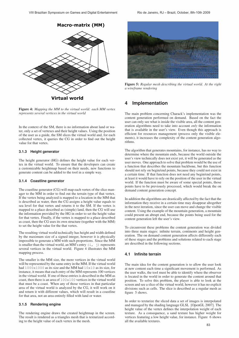
Figure 4: Mapping the MM to the virtual world: each MM vertexrepresents several vertices in the virtual world
In the context of the SM, there is no information about land or wa-ter, only a set of vertexes and their height values. Using the positionof the user as a guide, the SM slices the virtual world and, for eachcollected vertex, it queries the CG in order to find out the heightvalue for that vertex.
3.1.3 Height generator
The height generator (HG) defines the height value for each ver-tex in the virtual world. To ensure that the developers can createa customizable heightmap based on their needs, new functions togenerate content can be added to the tool in a simple way.
3.1.4 Coastline generator
The coastline generator (CG) will map each vertex of the slice man-ager to the MM in order to find out the terrain type of that vertex.If the vertex being analyzed is mapped to a location in the MM thatis described as water, then the CG assigns a height value equals tosea level for that vertex and returns it to the SM. If the vertex ismapped to a place described as (simple) land, then the CG will usethe information provided by the HG in order to set the height valuefor that vertex. Finally, if the vertex is mapped to a place describedas coast, then the CG uses its own structure (together with the MM)to set the height value for the that vertex.
The resulting virtual world technically has height and width definedby the maximum size of a signed integer, however it is physicallyimpossible to generate a MM with such proportions. Since the MMis smaller than the virtual world, an MM’s entry (i, j) representsseveral vertices in the virtual world. Figure 4 illustrates the MMmapping process.
The smaller is the MM size, the more vertices in the virtual worldwill be represented by the same entry in the MM. If the virtual worldhad 1000x1000 as its size and the MM had 10x10 as its size, forinstance, it means that each entry of the MM represents 100 verticesin the virtual world. If one of these entries is described in the MM ascoast, then there is an area of 100x100 vertices in the virtual worldthat must be a coast. When any of those vertices in that particulararea of the virtual world is analyzed by the CG, it will work on itand return it with different values, which will result in a coastlinefor that area, not an area entirely filled with land or water.
3.1.5 Rendering engine
The rendering engine draws the created heightmap in the screen.The result is rendered as a triangles mesh that is texturized accord-ing to the height value of each vertex in the mesh.
Figure 5: Regular mesh describing the virtual world. At the righta wireframe rendering
4 Implementation
The main problem concerning Charack’s implementation was thecontent generation performed on demand. Based on the fact theuser can only see what is inside the visible area, all the content gen-eration algorithms need to take into account only the informationthat is available in the user’s view. Even though this approach isefficient for resources management (process only the visible ele-ments), it increases the complexity of the content generation algo-rithms.
The algorithm that generates mountains, for instance, has no way todetermine where the mountain ends, because the world outside theuser’s view technically does not exist yet, it will be generated as theuser moves. One approach to solve that problem would be the use ofa function that describes the mountain backbone, but this functionshould not rely on begin/end points, because they could not exist ina certain time. If that function does not need any begin/end points,at least it would have to rely on the position of the user in the virtualworld. If the function must be aware of some special points, thosepoints have to be previously processed, which would break the ondemand content generation concept.
In addition the algorithms are drastically affected by the fact that theinformation they receive in a certain time may disappear altogetherin the next iteration, since the user can move and change the visiblecontent. Using the example of the mountain generation, a mountaincould present an abrupt end, because the points being used for thecontent generation left the user’s view.
To circumvent these problems the content generation was dividedinto three main stages: infinite terrain, continents and height gen-eration. The on demand content generation affects differently eachof these stages and the problems and solutions related to each stageare described in the following sections.
4.1 Infinite terrain
The main idea for the content generation is to allow the user lookat new content each time a significant movement is performed. Asthe user walks, the tool must be able to identify where the observeris located in the world in order to generate the content around thatposition. To solve this problem, the player is able to look at thescreen and see a slice of the virtual world, however it has no explicitdivisions such as cells. The slice is described as a regular mesh asfigure 5 shows.
In order to texturize the sliced data a set of images is interpolatedand managed by the shading language GLSL [OpenGL 2007]. Theheight value of the vertex defines the interpolation weight of eachtexture. As a consequence, a sand texture has higher weight forvertices featuring a low height value, for instance. Figure 6 showsall the available textures.
VIII Brazilian Symposium on Games and Digital Entertainment Rio de Janeiro, RJ – Brazil, October, 8th-10th 2009
83
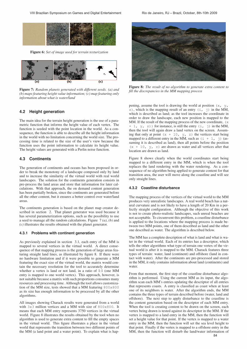
Figure 6: Set of image used for terrain texturization
Figure 7: Random planets generated with different seeds. (a) and(b) maps featuring height value information; (c) map featuring onlyinformation about what is water/land
4.2 Height generation
The main idea for the terrain height generation is the use of a para-metric function that informs the height value of each vertex. Thefunction is seeded with the point location in the world. As a con-sequence, the function is able to describe all the height informationin the world with no limitation concerning the world size. The pro-cessing time is related to the size of the user’s view because thefunction uses the point information to calculate its height value.The height values are generated with a Perlin noise function.
4.3 Continents
The generation of continents and oceans has been proposed in or-der to break the monotony of a landscape composed only by landand to increase the similarity of the virtual world with real worldlandscapes. The solution for the continents generation consists inpre-process the land areas and store that information for later cal-culations. With that approach, the on demand content generationhas been partially broken, since the continents are generated beforeall the other content, but it ensures a better control over water/landareas.
The continents generation is based on the planet map creator de-scribed in section 2. That planet generator was used because ithas several parameterization options, such as the possibility to usea seed to manage all the random calculations. Figure 7 (a), (b) and(c) illustrates the results obtained with the planet generator.
4.3.1 Problems with continent generation
As previously explained in section 3.1, each entry of the MM ismapped to several vertices in the virtual world. A direct conse-quence of that mapping process is the generation of large areas fea-turing straight land lines, as illustrated by figure 8. If there wereno hardware limitation and if it were possible to generate a MMfeaturing the exact size of the virtual world, the matrix would con-tain the necessary resolution for the tool to accurately determinewhether a vertex is land or not land, in a ratio of 1:1 (one MMentry is mapped to one world vertex). This approach, however, isnot suitable because a matrix with such proportions consumes manyresources and processing time. Although the tool allows customiza-tion of the MM size, tests showed that a MM featuring 800x800as its size has enough information to be processed by all the otheralgorithms.
All images showing Charack results were generated from a worldwith 3x3 million vertices and a MM with size of 800x800. Itmeans that each MM entry represents 3750 vertices in the virtualworld. Figure 8 illustrates the results obtained by the tool when noalgorithm is used to generate extra content to fill the empty spacesin the virtual world. This figure illustrates a place in the virtualworld that represents the transition between two different points ofthe MM (a land point and a water point). To explain what is hap-
Figure 8: The result of no algorithm to generate extra content tofill the discrepancies in the MM mapping process
pening, assume the tool is drawing the world at position (x, y,
z), which is the mapping result of an entry (i, j) in the MM,which is described as land; as the tool increases the coordinate inorder to draw the landscape, each new position is mapped to theMM. If the result of the mapping process of the new coordinate, (x+ 1, y, z)) for instance, is still the entry (i, j) in the MM,then the tool will again draw a land vertex on the screen. Assum-ing that only at point (x + 10, y, z) the vertices start beingmapped to a different entry in the MM, such as (i + 1, j) (as-suming it is described as land), then all points before the position(x + 10, y, z) are drawn as water and all vertices after thatlocation are drawn as land.
Figure 8 shows clearly when the world coordinates start beingmapped to a different entry in the MM, which is when the toolreplaces the land rendering with the water rendering. As a con-sequence of no algorithm being applied to generate content for thattransition area, the user will move along the coastline and will seeonly straight lines.
4.3.2 Coastline disturbance
The mapping process of the vertices of the virtual world to the MMproduces very unrealistic landscapes. A real world beach has a nat-ural curvature and is not likely to have a length of 20 Km in a per-fectly straight configuration. Although the objective of this workis not to create photo-realistic landscapes, such unreal beaches arenot acceptable. To circumvent this problem, a coastline disturbanceis applied to the locations where the mapping process is made be-tween two MM points, one of them described as land and the otherone described as water. The algorithm is described below.
The MM has a complete description of what is land and what is wa-ter in the virtual world. Each of its entries has a descriptor, whichtells the other algorithms what type of terrain one vertex of the vir-tual world is after it is mapped to the MM. Charack features threetypes of terrain: water, land (continent) and offshore (land in con-tact with water). After the continents are pre-processed and storedin the MM, it only contains information about land (continents) andwater.
From that moment, the first step of the coastline disturbance algo-rithm is performed. Using the current MM as its input, the algo-rithm scan each MM’s entries updating the descriptor of all entriesthat represents coasts. A entry is classified as coast when at leastone of its neighbors is water. After the algorithm ends, the MMcontains the three types of terrain described before (water, land andoffshore). The next step to apply disturbance to the coastline isthe content generation based on the descriptor of each MM entry.When the tool is creating content to be drawn on the screen, eachvertex being drawn is tested against its descriptor in the MM. If thevertex is mapped to a land entry in the MM, then the function willset a height value for that point. If the vertex is mapped to a waterentry in the MM, then the function will set the sea level height tothat point. Finally if the vertex is mapped to a offshore entry in theMM, then the function will disturb the land/water information of
VIII Brazilian Symposium on Games and Digital Entertainment Rio de Janeiro, RJ – Brazil, October, 8th-10th 2009
84

Figure 9: Coastline disturbance algorithm
Figure 10: Small heightmap generated by the coastline disturbancealgorithm
that vertex, which will result on a non-straight coastline. Figure 9illustrates the algorithm.
The MM entries A and B have a descriptor indicating that they areclassified as a coast. Plan M describes the MM and plan V describesthe result of the mapping process between them. It is not describedin the figure, but each block of plan V is composed of several ver-tices, while each block of plan M represents only one MM entry. TheMM entry C is mapped to a massive block of land in the plan V, asits descriptor tells the tool that it is a entry described as land. Theentry A would also be mapped to a massive block of land, but withthe intervention of the coastline disturbance algorithm it is mappedto a different configuration. During the content generation for thevertices that are inside the block RA, the coastline disturbance al-gorithm alters the land/water information for each vertex, so thatthe block will not be composed of land or water vertices only, but acombination of them instead.
The implementation of that process is based on a noise functionand random numbers with a parametric function deciding what island and what is water for all vertices described as a coast in theMM. Using the vertex position in the block RA, the function mapsthat information into a spectrum of values created by a Perlin noisefunction. What the parametric function does is check if the hash ofthe vertex being analyzed is inside or outside of the spectrum. Theprocess can be illustrated as a height test of a value against a smallheightmap (which is created as a result of the noise spectrum): if thereturn of the noise function for that vertex is greater than a certainvalue (which is the granularity of the block being analyzed), then itis classified as land, otherwise it is classified as water. The higher isthe granularity of the block, the greater is the amount of land on thatlocation. Figure 10 illustrates the small heightmap generated by thecoastline disturbance algorithm when block RA is being processed.
4.3.3 Beaches
The coastline disturbance algorithm minimizes the problem of un-realistic coastlines, but the outcome is not quite good enough.When Charack is rendering a slice of the world, for each vertexdescribed as land a height value is set it; the same applies to thevertices that are described as water, but in that case the height value
Figure 11: Beach generation algorithm
is always the same (the sea level). As a direct result of that ap-proach if the tool is rendering a set of vertices which belongs to amountain and the next vertices are described as water at the MM,the landscape will features a ”step”. It happens because the moun-tain backbone was generated very close to the water, which meansthat its rendering is abruptly interrupted when Charack finds ver-tices described as water. Although there are cliffs in the real world,they are not present in all coasts. To solve this problem, a specialalgorithm is applied in order to create beaches in certain locationsof the world, which makes the generated landscape looks more re-alistic.
The beach generation algorithm is performed right before the con-tent is rendered on the screen. After Charack maps the vertices tothe MM and after the coastline disturbance algorithm is performed,the result is a heightmap ready to be rendered. The heightmap istreated by the beach creator algorithm before being drawn on thescreen, as figure 11. The procedure scans all the vertices in themap and for each one its distance to a near water vertex is checked.The vertices around the target are mapped directly to the MM, sothe only information that is used from the heightmap is the vertexlocation in the world (which is necessary to map it to the MM). Thechecking process is performed in four directions (right, left, up anddown) and it ends when a water vertex is found or when N verticeswere analyzed. After that, the four distances are added and used tocalculate the height of the beach. The possible results are:
• If the vertex has 4N as its distance (Figure 11, point B), itmeans the tool has iterated through the four possible direc-tions and found no water. In this case, the height value for thevertex remains the same. It happens to all the vertices that arewithin the continent or on the coast but away from the water:they do not belong to the beach area and their height value isdefined by the height generator;
• If the vertex has a value smaller than 4N as its distance (Fig-ure 11, point A), then its height value will be recalculated,because the vertex is located at the beach. The greater is thedistance from that vertex to the water vertex, the greater is theheight value that will be applied. The height variation is cal-culated within a range of [T,B], where T is the maximumheight and B is a minimum height value of all vertices in thebeach. The result of that approach is a beach featuring higherheight values near the continent and lower height values nearthe water.
Figure 12 shows the results of the beach generator algorithm.
4.3.4 Island generator and beach disturber
The coastline disturbance and the beach generation algorithmsmake Charack able to generate more realistic landscapes. The finalresult, however, presents a well defined pattern, which is unusual tohappen in the real world, where the lines and landscapes are morelikely to follow a random patterns. If the player walks in the virtualworld only through the coast, he would see beaches with the sameconfiguration and no islands along the path. To avoid that problem,
VIII Brazilian Symposium on Games and Digital Entertainment Rio de Janeiro, RJ – Brazil, October, 8th-10th 2009
85

Figure 12: Results of the beach generator algorithm
Figure 13: Results of the beach disturber algorithm
two new algorithms are applied to the coastline vertices: beach dis-turber and island generator.
The beach disturber disturbs the distance used to calculate the wa-ter vertices neighboring a certain vertex. Instead of using N as valueto calculate the distance from the vertex to the water, the beach dis-turber uses the vertex position as a seed and generates a new valuethat will be used as the distance. Using this technique, the beachdisturber is able to change the size and shape of the beaches, sothat certain regions may have a greater amount of sand than others.Figure 13 shows the beach disturber results.
The island generator creates land portions in some MM entries.After the MM is created and all the descriptors are configured,the generator iterates through all entries described as coast and forsome of them it sets a flag describing that region as a place thatfeatures islands. Each vertex mapped to that special regions of theMM has its position used as a hash that is tested against a spectrumcreated by a noise function. According to the test result, the vertexis classified as land, so a group of vertices classified as land willproduce an island. The noise spectrum used for that are differentfrom that one used in the coastline disturbance algorithm, since theexpected outcome are small portions of land (islands). Figure 14shows the island generator results.
5 Results
This section aims to evaluate each of the techniques used in thecontent generation process, explaining the obtained results for eachapproach. It is important to highlight that Charack’s purpose is notthe generation of real or photo-realistic content, but elements thatcan be used to create a 3D game scene. A result is classified asgraphically acceptable if it can be integrated into a game and notsurprise the player in a negative way, such as a pyramidal mountaininstead of a smooth mountain.
Figure 14: Island generated by the island generator (beach areahas been influenced by the beach disturber)
Figure 15: Continents and oceans generated by Charack
5.1 Continents evaluation
The time spent for the continent generation is directly proportionalto the size of the specified MM. The reduction of the MM sizeto 800x800 yielded significant performance improvements. Asa consequence, the smaller is the MM size, the more linear andsquare are the coastlines of each continent. To avoid that problem,it is possible to adjust the coastline disturbance algorithm in order tomake it produce more aggressive changes in the coastlines. Figure15 shows the continents and oceans generated by the Charack.
5.2 Terrain height evaluation
The terrain height generated by Charack is fully customizable. Thetool has a built-in terrain height generator based on Perlin noise,however it was designed for testing purposes only. The main focusof the present work are the continents and the coastline generation,so any activity related to terrain height generation was very super-ficial and presents no contribution. Figure 16 shows the terrainheight created by the built-in generator.
5.3 Coastline evaluation
The coastline generation is composed of two main elements, aglobal and a local one. The global one only uses data availablein the MM in order to create the coastlines, as described in section4.3.1. The final result for that approach is a unreal straight coast-line. Figure 17 shows two completely straight coastlines which hasno content generation algorithm applied to them.
After the coastline disturbance algorithm was introduced, Charackstarted producing more acceptable landscapes. Figures 18 and21 show small bays in some places of the coast. It happened be-cause at those locations the coastline disturbance algorithm createdpieces of land towards the ocean and at the same time the beach dis-turber reduced the amount of sand on the newly created land pieces.Charack is also able to create gulfs, which are large bays, but it isnot possible to predict the exact location where those bays will hap-
VIII Brazilian Symposium on Games and Digital Entertainment Rio de Janeiro, RJ – Brazil, October, 8th-10th 2009
86
Figure 16: Terrain heightmap created by Charack’s built-in gener-ator
Figure 17: The interception of two coastlines with no extra contentbeing applied to them
pen because it depends on a set of specific values (location, beachsize, etc).
Figures 19 and 20 show the final result obtained with the combi-nation of all the previously described algorithms: coastline distur-bance, beach disturber and island generator.
5.4 Performance evaluation
All tests were performed running Charack on Windows Vista on aIntel(R) Core(TM)2 Duo 1.66Gz, with 2Gb RAM and a graphicscard NVidia 8600 GT, using Microsoft Visual C++ 2008 ExpressEdition to compile the source code. Figure 22 shows the time thatCharack takes to process each step on the virtual world generation:height calculation for each vertex, coastline generation, beach gen-eration and the rendering process. The X axis shows the world slicesize in vertexes, e.g. 200 means a regular mesh of 200x200 ver-texes. The Y axis shows the time in miliseconds that Charack takesto generate the respective world slice.
Figure 18: Small bay featuring rocks
Figure 19: Coastline featuring almost no beach area
Figure 20: Coastline featuring beaches with different sizes
Figure 21: Result of the coastline disturbance algorithm
Figure 22: Time that Charack takes to process each step on thevirtual world generation
VIII Brazilian Symposium on Games and Digital Entertainment Rio de Janeiro, RJ – Brazil, October, 8th-10th 2009
87

If the world slice visible to the user has a size of 100x100 pixels,then Charack takes about 200 ms to generate a complete land-scape (the sum of times for all steps). This process is not executedfor each rendered frame, it is only performed when the user movestoo far from his initial position, what makes Charack remove theold content from the memory and replace it with new data. If aslice with size 300x300 pixels is used, then Charack takes about1000 ms to generate the landscape. Most of the time is spent onthe beach creation because Charack has to analyze each vertex onthe screen and its four neighbours to decide if it is a beach point ornot.
The coastline generation is not significantly affected by the slicesize because the algorithm does not analyze an arbitrary amountof vertexes to generate the content. It uses a combination of noisefunctions and MM meta data in order to generate the required in-formation.
According to the chart the slowest step performed by Charack is thebeach generation. The second slowest step is the coastline genera-tion, closely followed by the height generation for each vertex.
6 Conclusion and future work
The automated creation of virtual worlds is one of the availablemethods that can help developers to create games featuring detailedenvironments in less time and using fewer resources. Unlike thepurely non-automated approaches where a game designer has todesign the entirely world, an automated approach is able to generatea complete world with almost no human interference. There areseveral researches on that subject using different approaches andfocusing on a wide range of results.
This paper presented a tool able to generate pseudo-virtual worldsfeaturing different continents, coastlines and landscapes. Using acombination of algorithms and methods for content management,the tool is able to create beaches, islands, bays and coastlines simi-lar to the ones found in the real world.
One of the Charack’s contributions is the ability to generate arbi-trarily large pieces of land focusing on coastline generation. Thedevelopment of the present work aimed to handle separately thecontent generation for all elements in the world (continents, ter-rains, etc.). The main point in the work is the coastline generation,not the content inside the continents. The final virtual world canbe huge: a player with a 100 vertices per second speed in a virtualworld generated with the maximum value allowed by a integer willtake about 1 year and 3 months to across the whole world.
One suggestion of future work is the enhancement of the heightgenerator, which currently produces a very simple result. Anothersuggestion is the addition of new types to the MM’s descriptors,such as deserts, forests and cities. All the new content can be cre-ated tweaking Charack’s content generator algorithm in order toproduce variations in the current results, such as lowering the heightvalues of all vertices in an area described as a desert, or increasingthem in a volcanic area. Another suggestion is to port all the contentgeneration algorithms to the CUBA platform [nVidia 2009]. Thegeneration of each world vertex can be calculated separately, so theCUBA parallelism capabilities can be fully used. It will drasticallyimprove Charack’s performance and it will allow the generation ofa bigger world slice to be displayed in the screen. Another sugges-tion is the addition of rivers, which can be done with a new MMdescriptor and some changes in the content generation algorithm.
References
BLIZZARD ENTERTAINMENT, 2007. World of warcraft. Availableat: http://www.blizzard.com.
CLARK, N. L. 2006. Addiction and the Structural Characteristicsof Massively Multiplayer Online Games. Master’s thesis, Uni-versity of Hawai, Hawai.
COHEN, M., SHADE, J., HILLER, S., AND DEUSSEN, O. 2003.Wang tiles for image and texture generation. In Siggraph 03Conference proceedings.
DOLLINS, S. C. 2002. Modeling for the Plausible Emulation ofLarge Worlds. PhD thesis, Brown University, United States ofAmerica.
DUCHENEAUT, N., YEE, N., NICKELL, E., AND MOORE, R. J.2006. Alone together exploring the social dynamics of massivelymultiplayer online games. In CHI 2006 Proceedings.
GREUTER, S., PARKER, J., STEWART, N., AND LEACH, G., 2005.Realtime procedural generation of ’pseudo infinite’ cities.
GRIFFITHS, M. D., DAVIES, M. N., AND CHAPPELL, D., 2003.Breaking the stereotype the case of online gaming.
HAGGSTROM, H. 2006. Real-time generation and rendering ofrealistic landscapes. Master’s thesis, University of Helsinki,Finlandia.
HAGGSTROM, H., 2009. Skycastle - free multiplayer game enginefocusing on player creativity and world simulation. Available at:http://www.skycastle.org/.
LINDA, O. 2007. Generation of planetary models by means offractal algorithms. Tech. rep., Czech Technical University.
LINTERMANN, B., AND DEUSSEN, O., 1998. A modelling methodand user interface for creating plants. Computer Graphics Fo-rum.
MOGENSEN, T. ., 2009. Instant planet generator. Available at:http://www.eldritch.org/erskin/roleplaying/planet.php.
MUSGRAVE, F. K., KOLB, C. E., AND MACE, R. S., 1989. Thesynthesis and rendering of eroded fractal terrains. ComputerGraphics, Volume 23, Number 3, July 1989, pages 41 to 50.
NVIDIA, 2009. Cuda. Available at: http://www.nvidia.com/cuda.
OLSEN, J., 2004. Realtime synthesis of eroded fractal terrain foruse in computer games.
OPENGL, 2007. Opengl shading language. Available at:http://www.opengl.org/documentation/glsl/.
PERLIN, K. 1985. An image synthesizer. In SIGGRAPH, 287–296.
PRZEMYSLAW, P., AND LINDENMAYER, A., 1990. The algorith-mic beauty of plants. Springer-Verlag.
SONY ENTERTAINMENT, 2007. Everquest. Available at:http://everquest2.station.sony.com/.
WANG, T., 2000. Integer hash function. Available at:http://www.concentric.net/ Ttwang/tech/inthash.htm.
WEBER, J., AND PENN, J., 1995. Creation and rendering of real-istic trees.
WHITTED, T. 1980. An improved illumination model for shadeddisplay. Communications of the ACM 23, 6 (June), 343–349.
VIII Brazilian Symposium on Games and Digital Entertainment Rio de Janeiro, RJ – Brazil, October, 8th-10th 2009
88