Embed Size (px)
Citation preview

CAVENDISH UNIVERSITY ZAMBIA
Faculty of Information and Communications
Technology (ICT)
PROJECT TITLE:
THE AUTOMATED LOCAL GOVERNMENT
LAND ACQUISITION SYSTEM
“Dissertation”
Names: Danny Kamwengo
STUDENT NUMBER 002-990
2020

i
DECLARATION
I Danny Kamwengo hereby declare and certify that the material contained in this dissertation
is my own work, and does not contain significant portions of unreferenced or unacknowledged
material. Other people’s work used have been acknowledged and fully referenced.
Furthermore, I certify that all statements and information contained herein, and in all my
application materials submitted by me, are true, accurate, and accurate to the best of my
knowledge and belief. I further certify that the writing was solely done by me and it is my
original work. The preparation of this project was supervised by Mr. Alex Ng’uni.
AUTHOR SIGNATURE ………………………………. DATE………………………….
(Danny Kamwengo)
SUPERVISOR SIGNATURE…………………………… DATE…………………………
(Mr. Alex Ng’uni)

ii
ACKNOWLEDGEMENTS
First and foremost, I would love to thank Jehovah Almighty for being the greatest part of my
Life. The wisdom, knowledge and strength I have exhibited in this whole journey could only
be his grace. Secondly, I would love to thank my supervisor, Mr. Alex Ng’uni, who has been
helpful in each and every way he could, and most importantly seeing to it that my research
becomes a success. I would also love to extend my gratitude to Mr. Madichi and Mr. Mark
Matete with the helpful information they provided me during the research.
Not forgetting my friends; Rothmar Kajinga, Felix Nyirongo, Jents Chishimba, Azizi Phiri,
Musonda Kasapo, Felix Musonda, Steven Lukunde, Stefano Chibia, James Ngumba, Julius
Mwansa and a few others, for the love and support they have always shown me. Lastly, I want
to say thanks to all Cavendish staff and lecturers for the shared information experiences.

iii
DEDICATION
I dedicate this project to my family, most especially my dad, Mr. Stanley Kamwengo and my
mum Ms. Mercy Katongo Chapoloko for each and every sacrifice they have made towards my
education, and for always encouraging and supporting me that I become the best I could be. I
would also love to extend my dedication to my sisters; Memory Kamwengo, Faith Kamwengo,
and Joy Kamwengo, and my brothers; Mike Kamwengo, Samuel Kamwengo, Joe Kamwengo,
Winston Chapoloko, and Mathews Chapoloko, who have always encouraged me to reach
greater heights, and through their support, I am who I am today.

iv
ABSTRACT
Land is an important source of production that produces great benefits and provides a basis for
the event of the state. There can be no meaningful development in a country if land is not
properly managed, and also if strict policies are not enforced to prosecute the perpetrators of
the law. It is for this reason that Government has connected great importance as being at the
center stage of all economic development activity. so as to boost national Development, land
ought to be created out there for various economic ventures, which include Agriculture,
Industry, industrial Activities, Human Settlement and alternative uses. In this regard, all
economic activities ought to be supported by and efficient Land Administration System, that
ensures equity, within the acquisition and property utilization of land.

v
CONTENTS
CAVENDISH UNIVERSITY ZAMBIA ............................................................................................. 1
DECLARATION.................................................................................................................................... i
ACKNOWLEDGEMENTS ................................................................................................................. ii
DEDICATION...................................................................................................................................... iii
ABSTRACT .......................................................................................................................................... iv
CONTENTS........................................................................................................................................... v
TABLE OF FIGURES ........................................................................................................................ vii
LIST OF TABLES ............................................................................................................................. viii
CHAPTER ONE ................................................................................................................................... 1
1.0 Introduction ........................................................................................................................... 1
1.1 Background ........................................................................................................................... 1
1.2 Problem Analysis Statement. ............................................................................................... 2
1.3 Purpose of The Study/Objective (S). ................................................................................... 2
1.4 Proposed System. .................................................................................................................. 3
1.5 Definition of Unfamiliar Terms. .......................................................................................... 4
1.6 Scope of Study. ...................................................................................................................... 4
1.7 Significance of Research/Project. ........................................................................................ 5
CHAPTER TWO: LITERATURE REVIEW AND THEORETICAL FRAMEWORK. .............. 6
2.0 Overview ................................................................................................................................ 6
2.1 Literature Review ................................................................................................................. 6
2.1.0 Development of the Land Management System in Dingzhuang Town. ................... 6
2.2.0 “One Map”-based Land Information System. ........................................................... 9
CHAPTER THREE: METHODOLOGY AND RESEARCH DESIGN. ....................................... 12
3.0 METHODOLOGY ............................................................................................................. 12
3.1.0 Methodological Approach ................................................................................................. 12
3.1.1 Data Collection Methods ................................................................................................... 12
3.1.2 Research Findings. ............................................................................................................. 13
3.2 RESEARCH DESIGN. ............................................................................................................. 16
3.2.0 Software Development Model ........................................................................................... 16
3.2.0 Hardware and Software Requirements ........................................................................... 21
3.2.1 Development Requirements .............................................................................................. 21
CHAPTER FOUR: TESTING (TEST DATA, TEST PLAN, and TEST REPORT) ................... 21
4.0 Overview ........................................................................................................................................ 21
4.1 Test Plan .................................................................................................................................... 21
4.1.0 Path Testing. (White Box Testing). .................................................................................... 21
4.1.1 Security Testing .................................................................................................................. 21
4.1.2 Black Box Testing............................................................................................................... 22

vi
4.2 Test Objectives .......................................................................................................................... 22
4.3 Test Principles. .......................................................................................................................... 22
4.4 Scope and Levels of Testing. .................................................................................................... 23
4.5 Features to be Tested. ............................................................................................................... 23
4.6 Test Report ................................................................................................................................ 23
4.6.0 Path Testing ........................................................................................................................ 23
4.6.1 Test Data for Security Testing .......................................................................................... 23
4.6.2 Black Box Testing............................................................................................................... 26
CHAPTER FIVE: IMPLEMENTATION. ....................................................................................... 28
5.0 Overview ........................................................................................................................................ 28
5.1 Implementation Method ............................................................................................................... 28
5.2 System Installation ........................................................................................................................ 28
5.3 Implementation Support. ............................................................................................................. 28
5.3.0 Hardware. ........................................................................................................................... 28
5.3.1 Software .............................................................................................................................. 28
5.4 Training. ........................................................................................................................................ 29
5.5 Maintenance. ................................................................................................................................. 29
CHAPTER SIX: CONCLUSIONS, IMPLICATIONS AND RECOMMENDATIONS. ............. 30
6.1 CONCLUSIONS. ...................................................................................................................... 30
6.2 IMPLICATIONS ...................................................................................................................... 30
6.2.0 Positive ................................................................................................................................ 30
6.2.1 Negative. .............................................................................................................................. 30
6.3 RECOMMENDATIONS .......................................................................................................... 31
BIBLIOGRAPHY ............................................................................................................................... 32
APPENDICES ..................................................................................................................................... 33
Appendix A: INSTALLATION AND USER MANUAL ............................................................. 33
Appendix B: SYSTEM FUNCTIONALITIES ............................................................................. 34
a) Client Module ...................................................................................................................... 34
b) Admin Module ..................................................................................................................... 39
Appendix C: TECHNICAL REPORT .......................................................................................... 41
I. Client Login ......................................................................................................................... 41
II. Client registration ............................................................................................................... 41
III. Land Application............................................................................................................. 42
IV. View Applications ........................................................................................................... 43

vii
TABLE OF FIGURES
Figure 1: Waterfall model, picture source: (tutorialspoint, 2020) ........................................... 17
Figure 2: Client Module Flow Chart ........................................................................................ 18
Figure 3: Admin Module Flow Chart ...................................................................................... 19
Figure 4: System Data Flow Diagram ..................................................................................... 20
Figure 5: Confidentiality Testing ............................................................................................. 24
Figure 6: Authentication Testing. ............................................................................................ 24
Figure 7: Integrity Testing 1 .................................................................................................... 25
Figure 8: Integrity Testing 2 .................................................................................................... 25
Figure 9: Testing for No data ................................................................................................... 26
Figure 10: Testing for Valid Data ............................................................................................ 26
Figure 11: Testing for Invalid Data ......................................................................................... 27
Figure 12: Starting ‘Apache’ and ‘MySQL’ ............................................................................ 33
Figure 13: Accessing phpMyAdmin area ................................................................................ 33
Figure 14: Creating a Database ................................................................................................ 33
Figure 15: Running the System................................................................................................ 34
Figure 16:Running the admin area of the system .................................................................... 34
Figure 17: Client Login ............................................................................................................ 35
Figure 18: Client Registration .................................................................................................. 35
Figure 19: Client Dashboard .................................................................................................... 36
Figure 20: Viewing Land Adverts ........................................................................................... 36
Figure 21:Viewing applications instructions ........................................................................... 37
Figure 22: Viewing Map .......................................................................................................... 37
Figure 23: Applying for Land .................................................................................................. 38
Figure 24: Making a Query ...................................................................................................... 38
Figure 25: Admin Login .......................................................................................................... 39
Figure 26: Viewing Applications ............................................................................................. 39
Figure 27: Viewing Queries ..................................................................................................... 39
Figure 28: Accessing the Client Module ................................................................................. 40
Figure 29: Creating a new Admin ............................................................................................ 40
Figure 30: Client Login Source Code ...................................................................................... 41
Figure 31: Registering a Client Source Code .......................................................................... 41
Figure 32: Applying for Land Source Code 1 ......................................................................... 42
Figure 33: Applying for Land Source Code 2 ......................................................................... 42
Figure 34: Viewing Applications 1 .......................................................................................... 43
Figure 35: Viewing Applications 2 .......................................................................................... 43

viii
LIST OF TABLES
Table 1: Applicant’s Research findings ................................................................................... 14
Table 2: Lusaka City Council’s findings. ................................................................................ 16
Table 3: features to be tested. .................................................................................................. 23
Table 4: Test Report Summary ................................................................................................ 27

1
CHAPTER ONE
1.0 Introduction
Land is an important resource which is desired by many across the globe. With its great
significance and power, land attracts a lot of demand from all stakeholders. Legally, Land is
acquired on a ‘first come first save’ basis. Meaning, anyone has the right to acquire land at any
time, provided they meet all stipulated requirements, and the pursued land is solemnly
available. But over the years, this has not been the case. Land acquisition in Zambia has been
characterized with a lot of corrupt activities. The ‘first come first save’ basis is merely word
and is rarely practiced. Land acquisition has also been learnt to be complex and bureaucratic
therefore making it inefficient and inconvenient.
1.1 Background
According to an interview conducted at Lusaka City Council’s City planning department, the
Local Government is contracted by the Ministry of Lands to advertise and sell state land on its
behalf. To start the process of, the Ministry of Lands and natural resources firstly opens up a
new area to sell, and engages the Local Government as its agent. The Local Government
therefore advertises the pieces of Land, clearly categorized, sub-divided, and priced.
After advertising, land application forms are open for purchase to the public, and interested
parties are free to buy from the Local Government offices. During application, Applicants are
required to attach documents like their most recent pay-slips, Bank statements, and NRC. This
is done to check their financial capabilities, and also prove their identity.
When application closes, successful applicants are later called for interviews, and are further
questioned on their financial capabilities. If the applicants pass the interviews and are deemed
fit to purchase the land without fail, they are asked to pay the amount within a specified period
of time.
When the pursued piece of land has successfully been paid for, an offer letter is granted as
rights of ownership to the deserved individual. The offer letter can later be taken to Ministry
of Lands and Natural resources for publication of title deed.

2
1.2 Problem Analysis Statement.
The first problem to be identified is that people are not properly educated or sensitized on the
steps to undertake when buying state land. A number of people may have financial power to
purchase it, but may not know the proper channels to follow in order to acquire it. Hence in
their ignorance, they usually end up buying illegal land or land belonging to other parties.
Secondly, in the current system, land acquisition is inconveniencing and quite inefficient. It
has been discovered that people line up in great numbers, unorderly queueing up for land
application. This leads to slow processing and hence the land acquisition process may take
longer than usual.
Another issue affecting the current system is the various corrupt activities that are associated
with land acquisition. It has been discovered that some applicants are asked to pay extra fees
as bribe, so that their application is processed quicker. Others also use powerful connections
and titles to acquire land, thereby abusing their authority. This compromises the integrity of
the system and hence it cannot be relied on.
Furthermore, the current system has had issues where one piece of land has been sold to more
than one party, illegally. Such issues have brought about social conflicts and fatal disputes
amongst parties. With a proper system in place, all this can be avoided.
1.3 Purpose of The Study/Objective (S).
The main objective of this project is to cut out the commonly corrupt practices performed
during the land acquisition process. Further objectives include;
• Sensitizing citizens on steps to take when acquiring land. This will be done through
publication of step by step guidelines on the web.
• Improve convenience and efficiency in the whole land acquisition process. By applying
for land online, people may not need to queue up in unordered numbers just to have
their papers processed, but they will do it anywhere, anytime, and at their own
convenience.

3
• To promote transparency by Preventing unscrupulous local government employees
from taking bribe from applicants. The online system will ensure that there is clearly
no interference during application, and that that the Land acquisition process is fair to
all.
• To ensure proper back up of sensitive data on the central server for easy access and
retrieval at any given time.
• To hold clear evidence of whom owns the land.
• To ensure proper land management. The system will make sure that no piece of land is
being illegally managed by un-authorized personnel such as political cadres.
• To highlight citizens or applicants on the precise location of land being sold. Through
the help of Map box GPS mapping services, the system will allow users to navigate to
the specific location of land.
• To ensure confidentiality, integrity, and availability in the entire land acquisition
process. The system must meet the main security principles of computer network’s
security.
1.4 Proposed System.
The ALGLAS is a system proposed to automate all manual processes that are encountered
during the entire land acquisition process from the Local Government. The proposed system
aims at simplifying the tedious, complex, and bureaucratic land acquisition procedures taken
in the current system. This will be achieved by enabling clients to apply for land online at their
own convenience, through the help of simple step by step guidelines provided by the system.
The ALGLAS also aims at promoting ultimate transparency during the entire land acquisition
process, by ensuring that land acquisition is strictly on ‘first come first serve’ basis, provided
all requirements are met, and also ensuring that there is no middle-man involved during
application. Hence, leaving no room for any sort of bribes.
In addition, the system also aims at achieving greater efficiency, because once implemented,
applicants will not have to make unorganized long queues just to apply for land, but instead
will do it at their own comfort and convenience. This will save them time and costs.
Furthermore, the system will be supported by live Map-Box mapping services that will show
the precise location of the piece of land on sale. Therefore, stakeholders may not have to

4
physically travel to the area for regular surveys and demarcations. Lastly, the system is to be
built with a friendly interface that users will easily interact with.
1.5 Definition of Unfamiliar Terms.
• ALGLAS – Automated Local Government Land Acquisition System.
• Database - A database is an organized collection of structured information, or data,
typically stored electronically in a computer system.
• Authentication - In the context of computer systems, authentication is a process that
ensures and confirms a user’s identity.
• Confidentiality - Confidentiality, in the context of computer systems, allows authorized
users to access sensitive and protected data.
• Unscrupulous - not honest or fair: doing things that are wrong, dishonest, or illegal.
• PDA- Portable Digital Assistant.
• GPS- Global Positioning System
1.6 Scope of Study.
The system will be entirely based on automating the Land acquisition process. However, the
system will have the following limitations;
• The system will only cater for state land acquisition and not customary land acquisition.
• The system will only still be purely based on newly land acquisition and will not in
include things like transferring land from one party to the other.
• The system will only focus on applicant’s engagement with the local government and
will not include the processes done at Ministry of Lands and natural resources
concerning land.

5
1.7 Significance of Research/Project.
The most important element about this research is that though it’s main focus is on automating
land acquisition, it also tries to bring out ways and alternatives in which the whole land
acquisition process can be fair, transparent, and simplified. For example, because of the
complexity and bureaucratic process of land acquisition, some people don’t get response in due
time. Hence, this causes delay and their chance of acquiring the desired piece of land slims
down.
Secondly, the project exposes the corrupt activities that take place during land acquisition, and
puts in measures to stop such unscrupulous behavior. In an anonymous interview carried out
during the research, it was found that two out of three individuals, had agreed to have paid
some bribe to acquire their pieces of land.
The research also tries to educate people on the steps to follow in order to acquire Local
government land. This will be achieved through referenced publications from the Land
Acquisition Act, and also from the Local Government. Another major importance of the
research is the improvement in efficiency and convenience. The system will allow users to
query land related information and also apply for land online at their own convenience. This
will enable users save time and cost.
Furthermore, the ALGLAS puts into consideration the main network security concepts,
which are; Confidentiality, Authentication, and Integrity of data. The system ensures a true
secure backup of sensitive data, to be accessed and retrieved at any time, and only by
authorized personnel.

6
CHAPTER TWO: LITERATURE REVIEW AND THEORETICAL FRAMEWORK.
2.0 Overview
Effective and transparent land management and secure and equitable land rights are crucial to
achieve the UN Sustainable Development Goals (SDGs) since land is at the heart of poverty
eradication, food security, gender equality, water management, decent work, sustainable cities,
ending climate change and protecting biodiversity. Transparency is key to prevent corruption
and to hold authorities and institutions to account. It should be present in the formulation of
land policy to help minimize ambiguities and misinterpretations. Land policy should articulate
clear goals, identify institutional responsibilities, assess the resources needed for effective
implementation and define ways to measure progress (Zúñiga, 2018).
2.1 Literature Review
The use of technology can improve the effectiveness of land administrative procedures, making
processes simpler, cheaper, faster and more transparent. Technology can also standardize
processes, removing opportunities for human discretion and, thus, decreasing corruption risks.
Besides e-governance measures like the digitization of land records, there are other helpful
technologies for the land sector. Global positioning systems (GPS), for example, can be useful
to automate land surveys and demarcation, and geographical information systems (GIS) can be
used for cadastral and land use mapping (Zúñiga, 2018).
Transparency is achieved by full public disclosure of documents around investment deals (final
contract, bids at land auctions, changes in land usage plans) and land title certificates. It should
be promoted by allowing public access to land administration documents, such as maps, land
and urban plans, and to the findings of accountability institutions. Information on how
decisions are made in land allocation deals and the price paid should also be available to the
public (Zúñiga, 2018).
Registration systems would reduce the danger of concentrating land in the hands of powerful
elites by including ways to inform potential claimants about the processes and criteria used to
decide between competing rights. A state land inventory, to inform every citizen which land
belongs to the state and the institution that controls its use, is a way to ensure that public land
is used for the benefit of society (Zúñiga, 2018).
2.1.0 Development of the Land Management System in Dingzhuang Town.

7
Taking as example the natural resources management in Dingzhuang town, Guangrao county,
Shandong province, China, this thesis makes sufficient investigation and demand analysis in
accordance with the options of land resources management in villages and cities. It studied in
details the most content of natural resources management in villages and cities. On this basis,
the thesis first makes a general style of the natural resources management system in
Dingzhuang town, Associate in Nursing an in-depth investigation of the functions of each
module within the information system of natural resources management in villages and cities,
together with the mandatory principles for the look of system interface.
Within the following steps, it establishes through analysis the abstraction information and
attribute information, along with the platform of the geographic data system of Dingzhuang
city on the premise of the abstraction knowledge and attribute knowledge of this city. On this
platform, it uses the relevant knowledge of Dingzhuang city natural resources and software
second development technology to analyse and develop the data system of land resources
management in villages and cities. the fundamental functions of this method include land use
designing, basic farmland management, the management of land for construction use, land
survey, land registration then on. Besides, it realizes the basic land management of every patch
within the village and city level, as well as property search map and map search perform.
2.1.1 System Design
The land management system in villages and cities chiefly caters to land administrations in
villages and cities, whose style philosophy is straightforward operation and convenient use and
management. Moreover, for timely renewal of the management and the system, the users of
the system area unit divided into common users and system administrator. Common users will
search and transfer relative info, and search the attribute info of the maps, so on.
The computer user will maintain the system by getting into administrator name and code.
Supported field investigation and analysis, the land management system in villages and cities
include six parts: land use and management, farmland protection and management, land
register management, land coming up with management, enforcement, and direction of land,
together with system maintenance.
Land-use module contains two (2) sub modules: the management of land for foundation of
houses; the management of construction land for town enterprises, common facilities and
public welfare endeavor. Its functions embody application procedures for relative laws and
8
regulations; map search management for land of foundation houses; attribute search; activity
of space, length so on.
Farmland protection management contains five (5) sub modules: basic laws and regulations;
elementary introduction; basic farmland; development and organization; farmland conversion
and arrogation. It introduces relative laws and regulations; basic scenario of farmland;
practicableness report for development and organization; relative laws for the procedures of
land conversion and arrogation applications. Additionally, this module provides a sort of the
world of basic farmland reserves and basic farmland figures for relative inquiry Land Registry
management module contains seven sub modules: relative laws and regulations; this state of
affairs of land use; land conversion investigation; farmland classification; land registration;
land statistics and land registry info inquiry.
This module provides the figures of gift state of affairs of land use, figures for soil
classification, land registry management figures and then on. It realizes functions like attribute
inquiry and statistics similarly because the activity of space and length. Land designing
management contains 3 sub modules: relative laws and regulations; overall designing and
special-purpose designing. It introduces relative laws and the overall designing aims of normal
villages and cities, providing info for land designing administrations.
The module of enforcement and oversight of land contains many sub modules: relative laws
and regulations; case analysis; unlawful case report and then on. It introduces details of the
unlawful cases and punishments, providing cases for the legal land use of land users. System
maintenance module contains four modules: account management; note management; news
management and also the management of web site content, serving to the administrator provide
timely renewal and maintenance.
2.1.2 Functions of the System
The information system of land resources management in villages and towns caters to the land
administrations’ need for the automation inside an office of land management, and helps to
improve professionals’ efficiency so as to manage large amounts of land use data effectively.
This system provides scientific basis for the planning of land use in villages and towns, basic
farmland protection and the decision-making people. The main functions include three aspects:
(Yusheng, Wenbin, Haiting, & Ying, 2011)
9
I. Independent research and development of database management system of
Dingzhuang town, which realizes unified management of multi-source data and
establishes service-oriented integrated module for heterogeneous data.
II. Independent research and development of land management system of Dingzhuang
town, which realizes basic farmland management of each patch, three generations of
land conversion and dynamic management of land contract management right.
III. Integrated and internet management of attribute data and spatial data in villages and
towns, which realizes property search map and map search function and so on.
2.1.3 Development Tools
This system is Windows Form application program designed by C# which enables the
computer users to use all kinds of Windows software without specific training through graphic
interfaces. Besides, it is the standard that the program designers have to follow while designing
Windows program interface, which reduces the burden of program designers and help
concentrate their attention on solving and realizing the problems. C#.Net, a kind of visual
programming language, further simplifies the design work of the program interface. Only with
few codes can we have the standard application program interface. (Yusheng, Wenbin, Haiting,
& Ying, 2011)
2.2.0 “One Map”-based Land Information System.
“One map” project is an innovative action launched by the Ministry of Land and Resources of
China. Literally, “one map” is the aggregation of multi-source data, such as remote sensing
images, land use map, basic farmland map, and productions of updating land use investigation,
fundamental geographical information and so forth. In the construction of this project, “one
map” is overlaid with the data of land planning, supervision, supply, complementarities,
exploitation, and execution of land laws in other land administration systems so as to establish
an integrated framework of land monitoring and management. Based on the framework, the
aim of dynamically monitoring and managing land and resources can be realized as “see from
the sky, manage through the network, and check on the ground”. (Zhao, 2010).

10
2.2.1 Design and Development
In fact, “one map” represents the transition of land management manner of China. it's a
synthetical live adopted by land administration thus on notice the standardization of land
management towards E-government. Therefore, “one map” is thought-about as three main
contents. Firstly, a group of land base data info ought to be established, that embrace land use
map, registry information, and these observational thematic data associated with land use
planning, agriculture land protection, land use assessment, and supervision of land laws. this is
often a key step for E-government of land management. Secondly, supported the land base
information info, forms of thematic land data systems ought to be established, like land use
management system, registry data system, land use coming up with information system,
agricultural land protection system, land laws superintendence system, and so on. These
thematic systems should notice share and transfer of knowledge thus on avoid the confusion
and conflict in land management owing to the disaccord of land information and to boost the
authority and veracity of land data in land data system.
Thirdly, “one map” aims at establishing uniform information standards and technical criterion
for base geographic information and land data. this is often the precondition of share and
transfer of land data in systems across totally different levels. Finally, “one map” needs the
seamless network across four levels of nation, province, prefecture, and county thus as land
information will smoothly run though these four levels. Therefore, computer network system,
information organization and update system and data maintenance mechanisms must be
established.
2.2.2 System Functions
E-government for land management intuitively is a computer system which drives all kinds of
operations related to land management through transferring and interpreting base data and
operation rule in land information database based on computer network and land data center.
The key point of such system is that it can provide necessary land information and convenient
operations to society. The main function of E-government for land management can be
summarized as follows: (Zhao, 2010).
• Promulgation of the process and results of administration approvals of declaration and
application related to land management on the network.

11
• Report and gathering of synthetic and thematic data on the network. x Online operation
of public impeachment, remote sensing monitoring, and check on the ground of
supervise of land laws.
• Automatically integration and analysis of land information for spatial make-decision
support on the network.
• Network office automation of synthetic affairs related to land management.
2.2.3 Software Architecture
“One map”-based land information system is an integrated unit of land data management and
land management operations. Huge graphic data should be dealt with in the system. Therefore,
software architecture of the system adopts a mixed mode of C/S and B/S. Functions of complex
graphic data handling, spatial analysis, and data transfer, projection transformation, data
statistics, and map export is carried out in C/S mode, and operations and data promulgation is
implemented in B/S mode through GIS and Java or .Net techniques. (Zhao, 2010)

12
CHAPTER THREE: METHODOLOGY AND RESEARCH DESIGN.
3.0 METHODOLOGY
3.1.0 Methodological Approach
In this research, a qualitative type of approach was used to gather data from participants. The
research was aimed at finding how effective the current land acquisition system is, and also the
problems that are encountered during the entire land acquisition process. The participants were
divided into two groups; the first group being the applicants (former), and the other group being
the Local Government (Lusaka City Council). The research was characterized by direct
interviews with both parties, but at separate intervals. This was so as to get a balanced hands-
on view on exactly how the current land acquisition system works and performs.
3.1.1 Data Collection Methods
On the applicants’ side, three anonymous individuals termed as X, Y, and Z, who own plots in
Kabanana site and service were randomly picked for a semi structured interview. During
interviews, a series of questions ranging from how they heard about the plots, to how they
acquired them, and more, were asked to obtain required the information. Interviews were
conducted on them at their homes, and approximately lasted for 20 minutes each. All answers
provided by the participants were recorded by note-taking.
On the Local government’s side, An Interview was conducted with an employee of Lusaka
City Council, from the Lusaka City Council’s City Planning Department. The interview was
done in his office at the fifth floor of the Civic Center building. The questions asked ranged
from how the Local government initiates the selling of Land, to how they get to issue out land.
The interview had approximately lasted for 40 minutes and all answers provided were recorded
by note-taking.
Secondary data was also collected through reviews from published articles on the internet,
journals, and some periodical reports.

13
3.1.2 Research Findings.
3.1.2.0 Applicant’s Findings.
The following table shows the questions and answers that were obtained from the randomly
selected persons who had acquired land from the local government.
Applicant Questions Answers
X How did you learn about
Property (land) Selling by the
Local Government?
Through an employee of the
Local government.
How did you apply for Land? Filled in, and submitted an
application form from the
Lusaka City Council Civic
Center.
Did any employee from the
Local Government push for
the acquisition of land you
own?
Yes
Did you pay any fees apart
from the application fee? If
yes, then what for?
Yes. The fee was to help in the
acquisition process.
How would you rate the
convenience and efficiency of
the system; poor, very poor,
good, very good, Excellent.
Poor
Y How did you learn about
Property (land) Selling by the
Local Government?
Through a friend
How did you apply for Land? Filled in, and submitted an
application form from the
Lusaka City Council Civic
Center.
Did any employee from the
Local Government push for
Yes

14
the acquisition of land you
own?
Did you pay any fees apart
from the application fee? If
yes, then what for?
No
How would you rate the
convenience and efficiency of
the system; poor, very poor,
good, very good, Excellent.
Very Poor
Z How did you learn about
Property (land) Selling by the
Local Government?
Advertisement from the Local
government offices
How did you apply for Land?
Did any employee from the
Local Government push for
the acquisition of land you
own?
Yes
Did you pay any fees apart
from the application fee? If
yes, then what for?
Yes
How would you rate the
convenience and efficiency of
the system; poor, very poor,
good, very good, Excellent.
Poor
Table 1: Applicant’s Research findings
3.1.2.1 Lusaka City Council’s Findings
The following table shows the questions and answers that were obtained from an employee of
the Lusaka city Council.
Lusaka City Council Question Answer
Employee How do you initiate the
selling of land?
The Ministry of Lands and
Natural Resources engages
the Local government as the

15
official client to sell Land on
their behalf.
How do you inform people
about the new land for sale?
Advertisement is done at the
local government offices.
How do people get to apply
for land?
Interested parties are advised
to buy land application forms
from the Local Government
offices, then later submit the
application form once filled
in.
What is required for
someone to successfully
apply for land?
An applicant should possess
an NRC, most recent pay
slips, and a bank statement to
show their financial
capability.
How do you get to shortlist
applicants to suit the number
of plots available for sale?
After a thorough analysis of
all applications, first
shortlisted applicants will be
called for face to face
interviews concerning the
subject at hand to clarify
more on their financial
capability.
How do you finally issue out
land?
When successful applicant’s
have proven to be financially
stable, an offer later will be
given as grant to the desired
plot.
Has there been any issues of
corruption during
acquisition?
Yes, corruption cases have
been heard of in the
acquisition of land.

16
Has there been an instance or
instances whereby one plot
has been sold to more than
one individual?
Yes sir, there are quite a
number of cases of that
nature.
Has there been issues
concerning land
mismanagement?
Of course, there have been
cases where land people use
powerful titles and
connections to acquire land.
Table 2: Lusaka City Council’s findings.
3.2 RESEARCH DESIGN.
The ALGLAS is set to be web-based, comprising of two Modules; the Client Module, and the
Admin Module. The Client Module will be accessed by clients/users of the system, while the
Admin Module will be accessed by Administrators of the system.
3.2.0 Software Development Model
The Automated Local Government Land Acquisition System will be developed using the
waterfall model of the SDLC. This model was preferred because it is simple to follow,
requirements are very well understood, and all stages are clearly defined. The system will
undergo the following stages;
1. Requirement Gathering and analysis: All possible requirements of the ALGLAS will
be developed are captured in this phase.
2. System Design: This phase studies the requirement specifications from the first phase
and helps designing the system. System Design will help in specifying hardware and
software requirements and also helps in define the overall system architecture.
3. Implementation: With inputs from system design, the system is first developed in small
programs called units, which are integrated in the next phase. Each unit is developed
and tested for its functionality which is referred to as Unit Testing.
4. Integration and Testing: All the units developed in the implementation phase are
integrated into a system after testing of each unit. Post integration the entire system is
tested for any faults and failures.
5. Deployment of system: Once the functional and nonfunctional testing is done, the
product is deployed in the customer environment or released into the market.

17
6. Maintenance: There are some issues which come up in the client environment. To fix
those issues patches are released. Also, to enhance the product some better versions are
released.
7. Maintenance: is done to deliver these changes in the customer environment.
Figure 1: Waterfall model, picture source: (tutorialspoint, 2020)
The Client Module of the ALGLAS has been designed to comprise of the following features;
• Username and Password Authentication. A client will be required to log in with their
correct Username and Password to access the system.
• User/Client Sign Up. If a new user tries to access the system, they will be required to
sign up.
• View Land Adverts. This will be an advertising platform where users/clients will check
for available land.
• Application Instructions. This feature displays step by step guidelines on how to apply
a client can acquire land.
• View Map. This feature shows live GPS Mappings of the precise location of land for
sale.

18
• Apply Now. This is the main feature of the ALGLAS. Here, users get to fill in their
details in a form, upload necessary document’s, and when done, they submit to
complete the application process.
• Make a Query. This feature provides a query platform where clients can query for any
land related issues.
In the Client Module, the user will be requested to enter their correct username and password
to access the system. If authentication is true, the user will proceed to the main dashboard of
the Module that will show a list of categorical features to choose from. The flow chart below
shows the design structure and information flow in the Client Module.
Figure 2: Client Module Flow Chart
On the other end, the Admin Module will comprise of the following features;
• Username and Password Authentication. An Admin will be required to log in with their
correct Username and Password to access the system.

19
• View Applications. This feature will enable admins to view, and review client’s
applications.
• View Queries. This feature will enable an admin to view client’s queries.
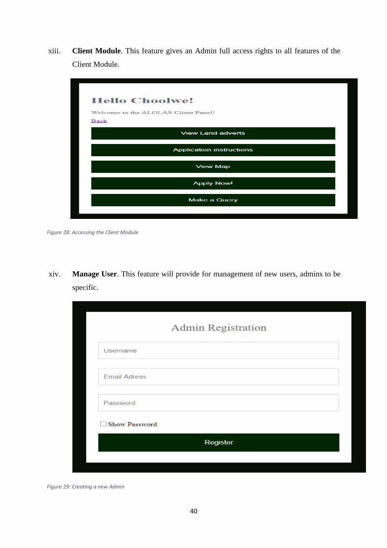
• Client Module. This feature gives an Admin full access rights to all features of the
Client Module.
• Add Admin. This feature will provide for registration of new admins.
In the Admin Module, the admin will be requested to enter their correct username and password
to access the system. If authentication is true, the user will proceed to the main dashboard of
the Module that will show a list of other features to choose from. The flow chart below shows
the design structure and information flow in the Admin Module.
Figure 3: Admin Module Flow Chart

20
The Level one 1 DFD below shows how the two modules (Client module and Admin module)
and how they are incorporated to form one system.
Figure 4: System Data Flow Diagram

21
3.2.0 Hardware and Software Requirements
• Computer or any PDA device such as a Phone, Tablet, etc.
• Recommended Browser, such as Chrome, Firefox, etc.
3.2.1 Development Requirements
• Front End Tools : Brackets (code editor)
• Language : PHP and JavaScript
• Back End Tools : Xampp and Brackets
• Language : PHP, MySQL, and JavaScript
CHAPTER FOUR: TESTING (TEST DATA, TEST PLAN, and TEST REPORT)
4.0 Overview
According to (Sommerville, 2011), testing is intended to show that a program does what it is
intended to do and to discover program defects before it is put into use. When you test software,
you execute a program using artificial data. You check the results of the test run for errors,
anomalies, or information about the program’s non-functional attributes.
4.1 Test Plan
This test plan describes the testing approach and overall framework that will drive the testing
of the ALGLAS. The system will be subjected to numerous tests ranging from its source code,
to its execution and functionality. The system is set to be tested again and again to ensure that
all errors are fixed (debugging), and that it’s functioning according to its stipulated objectives.
The ALGLAS will be subjected to the following testing methods;
4.1.0 Path Testing. (White Box Testing).
In path testing, we will clearly examine all the paths in the program source code, ensuring that
they do not contain any errors that may interfere with the smooth execution of the system.
4.1.1 Security Testing
In security testing, we will test how the system will protect data from any malicious intent. To
achieve this, we will ensure that security testing is based on the following key objectives of
computer systems security;

22
• Confidentiality: This will ensure that all information provided by clients is held in
the strictest confidence and is not shared with any outside parties.
• Integrity: This will determine that the information provided by the system is
accurate and consistent, and is not altered by any unauthorized persons.
• Availability: This objective ensures that data, network resources/services are
available every time they are needed.
• Authentication: Represents the process of establishing the identity of a user.
• Authorization: This will define the rights of the users, i.e. the Client and the Admin.
4.1.2 Black Box Testing
In Black Box Testing, the system functionalities are tested with ignorant knowledge of the
internal code structure, implementation details and internal paths. Black Box Testing is entirely
based on software requirements and specifications, and mainly focuses on input and output of
system applications data. Below show the tests done in Black Box testing;
• No data: The system will check if no data is submitted and give a specific response.
• Valid data: The system will check if Valid test data is submitted then give a specific
response.
• Invalid data: The system will check if Invalid data is submitted then give a specific
response.
4.2 Test Objectives
• To verify that the Automated Local Government Land Acquisition System works ac-
cording to its stated specifications and objectives.
• To identify errors in code and fix them so the system can run smoothly without any
interference.
• To ensure security of sensitive data and that it is not accessed by unauthorized persons.
4.3 Test Principles.
• Testing of the system will focus on meeting the cost efficiency, and convenience.
• Testing activities will build upon previous stages to avoid redundancy or duplication of
effort.
• Testing will be a repeatable, quantifiable, and measurable activity.
• Testing will be divided into distinct phases, each with clearly defined objectives and
goals.

23
• Testing processes will be well defined, yet flexible, with the ability to change as needed.
4.4 Scope and Levels of Testing.
• Unit testing. Each individual class and unit program, or small program that has will be
tested in isolation from the more complete system.
• Component testing. Each program package will be tested in isolation from the more
complete system.
• Integration testing. The combined execution of classes, packages, components, will be
carried out.
• Regression testing. The repetition of previously executed test cases for the purpose of
finding defects in software that previously passed the same set of tests.
• System testing. This will involve the execution of the software in its final configura-
tion, including integration with other software and hardware systems. It will test for
security, performance, resource loss, timing problems, and other issues that can’t be
tested at lower levels of integration.
4.5 Features to be Tested.
Item to Test Test Description Test Tool (s)
Path testing Paths in the program source code Brackets Text Editor
Security Testing Confidentiality, Authorization,
Authentication, Integrity.
PHP, MySQL
Validation Validation of Data PHP, MySQL
Verification Verification of Data PHP, MySQL
Table 3: features to be tested.
4.6 Test Report
4.6.0 Path Testing
All paths in source code have been thoroughly tested ensuring that they are returning no errors.
4.6.1 Test Data for Security Testing
4.6.1.0 Confidentiality.
The admin is the only entrusted personnel to manage system data and must have correct cre-
dentials (username and password) to do so. Therefore, the Admin module of the ALGLAS is
secured with username and password authentication that prohibits unauthorized access so sen-
sitive data and resources. Details can be seen from the picture below.

24
Figure 5: Confidentiality Testing
4.6.1.1 Authentication.
This describes the process of establishing the identity of a user. On authentication testing, the
system uses a combination of usernames and passwords to login and its purpose is to check
that only authorized persons are able to access the system. If the correct username and password
is entered, the user will be through to the main dashboard of the system. Else if an incorrect
username or password is entered, the system will display “Incorrect username/password,” as
shown below;
Figure 6: Authentication Testing.
4.6.1.2 Authorization.
This defines the specific rights of a particular user. Our test data contains two different combi-
nations of users (clients and admins), and only users with sufficient privileges will be able to
perform a particular operation. In the ALGLAS, the client cannot perform admin functions
such as; viewing applications, viewing queries, and admin management. On the contrary, the

25
admin has full access rights to all features of the system including those of the of the client
module.
4.6.1.3 Integrity
Data Integrity ensures that the information provided by the system is accurate and consistent,
and that it has not been altered in any way. Data has to be the same as it was initially submitted
in the system. For data integrity testing, our test data was submission of a client’s registration
data, which was later verified if the same was in the database as shown below;
Figure 7: Integrity Testing 1
The submitted data above matched as that of the database. Therefore, the system has passed an
integrity test as shown below;
Figure 8: Integrity Testing 2

26
4.6.2 Black Box Testing
4.6.2.0 No data.
Upon submission of the form, the system will check if data has been entered in the required
fields. If specific required fields have not been entered but yet submitted, the system will return
“Please fill out this field,” as shown below;
Figure 9: Testing for No data
4.6.2.1 Valid data
The system checks the validity of data when it is submitted and outputs a response. An example
of valid data validation in the system is seen in the picture below where registration of a client
is successful.
Figure 10: Testing for Valid Data

27
4.6.2.2 Invalid data
The system checks if Invalid data is submitted and outputs a response. An example of an Invalid
data check in the system is seen in the picture below where a wrong email format has been used
and yet submitted.
Figure 11: Testing for Invalid Data
4.6.3 Test Report (Summary).
Item to Test Test Description Expected Result Actual Result
Path testing Paths in the program
source code
Pass Pass
Security Testing Confidentiality Pass Pass
Authorization Pass Pass
Authentication Pass Pass
Integrity Pass Pass
Validation Validation of Data Pass Pass
Verification Verification of Data Pass Pass
Table 4: Test Report Summary

28
CHAPTER FIVE: IMPLEMENTATION.
5.0 Overview
This subsection of the documentation explains the implementation of the Automated Local
Government Land Acquisition System. It clearly describes what implementation method is to
be used to implement the system, system installation, Implementation support, Training, and
maintenance.
5.1 Implementation Method
When choosing the implementation method to best suit the system, all key implementation
methods were considered and a thorough analysis was made to arrive at the decision. The
methods considered included; Direct approach, Parallel run, Pilot run, and Phased approach.
After evaluating all the implementation methods, a Parallel approach was chosen as the best
implementation method to best suit the ALGLAS. This means, both the old system, and the
new system will be running alongside each other for a specific amount of time. All of the data
that is input into the old system, is also input into the new one. Eventually, when the new
system is proven to work as intended and meets its core objectives, the old system will be
discarded.
5.2 System Installation
The Automated Local Government Land Acquisition System has been designed and
programmed to be a web-based system, which is to be hosted on either the local Server or the
Cloud Server. The system has been integrated with a MySQL database which stores and
organizes user data. To access the system, the user is required to enter their correct login
credentials i.e. username and password.
5.3 Implementation Support.
5.3.0 Hardware.
The following hardware equipment is needed to implement the system.
• Web server.
• Computer
• Scanner
• Network
5.3.1 Software
• Windows Operating System (Preferably Windows 10)

29
• XAMPP Server
• Web browser (Preferably Google Chrome or Brave)
• Text Editor (Preferably Brackets)
5.4 Training.
A simple training can be done to educate employees on how the system operates and what they
can do in case they run into a problem, and more. The employees should be run through all the
features of the system to ensure that they are fully acquainted with it before it is finally
deployed. Training may not require so much time and resources because the system is so clear
and self-explanatory.
5.5 Maintenance.
Maintenance of the system will be done from time to time through relevant data updates. Data
updates will be mandatory on especially two features of the system i.e. the adverts page and
the maps page. For example, when all pieces of land have been issued out, an update on the
adverts page has to be made to explicitly show that. Or rather, when there is new land available,
details like the name of the location, land sizes, etc. will have to be updated on the page.
The same applies to the maps page, when all pieces of land have been issued out, the map
should either show the specific pieces of land have been sold out or rather completely removing
the coordinates and descriptions. If new land is available for sale the old coordinates will be
updated with new coordinates of the new land.
A back up of the data will have to be manually performed from time to time, to provide for
data loss or corruption. Maintenance of the system must be done by an IT professional as it
may be too complex for a regular professional.

30
CHAPTER SIX: CONCLUSIONS, IMPLICATIONS AND RECOMMENDATIONS.
6.1 CONCLUSIONS.
The Automated Local Government Land Acquisition System will bring about a lot of
developmental changes in the way Land is acquired in Zambia. The system will allow
applicants to conveniently apply for land at their own comfort, without making unnecessary
movements that may be a drain on their income. Furthermore, the system will hinder most
corrupt practices that are initiated during land acquisition, such as; paying of bribes, using
powerful titles and connections, and many more, because there will be no middle man to
interfere with the land acquisition process, and thus, interaction will be done directly with the
system. The system is also set to bring about a modern way of handling data, where data is
stored on a central server, for efficient and convenient, access and retrieval. The use of live
maps also helps the client to easily navigate to the area without physically going there. This
creates a huge milestone in the utilization of technology in solving the current subsequent land
acquisition problems. The system also provides a platform on which clients can make their land
related queries. This will enhance customer service at its best, as clients are happier to be
served.
6.2 IMPLICATIONS
6.2.0 Positive
Once the system is implemented, there will be a reduction in the rate of bribes and other corrupt
activities that are practiced when acquiring land, because the system will provide a direct
interaction with the applicant. Hence, there will be no middle man to interfere with the
application process. Furthermore, the system will enhance efficiency in processing of data by
allowing applicants to conveniently apply for land at their own convenience, and also allowing
a quick retrieval of data whenever it is needed, and wherever it is needed. In addition, the
system being implemented with authentication protocols, it will provide security to who gets
to access specific data. Thereby ensuring that data is only accessed by authorized users.
6.2.1 Negative.
The proposed system does not currently provide password recovery methods that may assist a
user in a case they forget their password. This means that the user may have to query from the
local governments physical offices and an IT professional from the department can assist in
recovering the password. This may be inconveniencing on both the clients’ side, and the local
governments’ side. Another limitation of the proposed system is that it does not currently
generate pdf reports of stored data.

31
6.3 RECOMMENDATIONS
The Automated Local Government Land Acquisition System stands out as one of the solutions
to promoting efficiency and transparency in land acquisition. Though the system is intended
for the Local government, it has also proven to be ideal for companies dealing in Real Estate.
Furthermore, the system is also recommended as it helps people avoid unnecessary movements
which may be costly, and also encourages people to stay and work from home to avoid
contraction of deadly diseases such as the COVID-19.
Therefore, implementation of the Automated Local Government Land Acquisition System is
highly recommended as it will produce numerous benefits that may bring about development
of the country, in both the utilization of technology, and solving problems that hinder
development growth.

32
BIBLIOGRAPHY
1. A, O. (2007). Land inequality, government ideology and agricultural protection. Food Policy vol. 32, 67-83.
2. B, A., & S, F. (2009). E-Government institutionalizing practices of a land registration mapping system. Government Information Quarterly, 5-14.
3. Jean-Brice, T., & Neil, S. (2019). Land Corruption in Africa in Three Topics. Netherlands: Land Portal Foundation.
4. Liu, H. (2005). Web-based Research and Development of House Property Management Information System. Xi’an University of Technology.
5. Sommerville, I. (2011). Software Engineering (9th Edition ed.). Boston: Addison-Wesley.
6. Sun, J. (1986). Land resources information systems to the research and establish. Beijing: Energy press.
7. tutorialspoint. (2020, September 25). tutorialspoint. Retrieved from www.tutorialspoint.com: https://www.tutorialspoint.com/sdlc/sdlc_waterfall_model.htm
8. Yusheng, L., Wenbin, S., Haiting, D., & Ying, L. (2011). The Design and Development of the Land Management System in Dingzhuang Town Based on Spatial Data. Beijing: Springer, Berlin, Heidelberg.
9. Zhao, Y. (2010). “"One Map"”-Based Land Information System: Towards E-government for Land Management. Proceedings of the International Conference on E-Business and E-Government (p. 3). Guangzhou: ICEE.
10. Zheng, X., & Han, R. (2008). Land Management Geographic Information System. Wuhan: Wuhan University Press.
11. Zúñiga, N. (2018). Counteracting Land Corruption. Land Corruption Topic Guide, 11-19.

33
APPENDICES
Appendix A: INSTALLATION AND USER MANUAL 1. Download and install freeware XAMPP from https://www.apachefriends.org.
2. After successful installation, open the XAMPP control module and start ‘Apache,’
and ‘MySQL’ services as shown in the picture below;
Figure 12: Starting ‘Apache’ and ‘MySQL’
3. Open a web browser and type ‘localhost/phpmyadmin’ then press ‘Enter’.
Figure 13: Accessing phpMyAdmin area
4. Press ‘New’ to create a database with name ‘alglas’, and lastly click on ‘create’.
Figure 14: Creating a Database

34
5. Import the database by clicking ‘Import’, then click ‘Choose file’ to select the sql file
named ‘alglas’ and lastly scroll down and click ‘Go’.
6. Extract the system folder ‘alglas’ in C:\xampp\htdocs.
7. Open a new tab in browser, type ‘localhost/alglas’ then press ‘Enter’ to run the sys-
tem.
Figure 15: Running the System
8. To run as system as administrator, type ‘localhost/alglas/admin’ in the web browser
and press ‘Enter’ as shown below. Default Admin Username is ‘admin’, and password
is ‘1234’
Figure 16:Running the admin area of the system
Appendix B: SYSTEM FUNCTIONALITIES
a) Client Module
i. Client login. When the ALGLAS system is run, it will prompt the user to login with
their correct username and password to access the system. A new user should click
on ‘Register Now’ to create an account as seen in the picture below.

35
Figure 17: Client Login
ii. Client Registration.
To create an account, the new user will have to fill in the form as shown in the pic-
ture below.
Figure 18: Client Registration
iii. Client Dashboard.
When the user attempts to login using their created credentials, and login is successful,
a dashboard showing a Welcome message with their username and a list of features
will be displayed as shown below.

36
Figure 19: Client Dashboard
iv. View Land adverts. This will be an advertising platform where users/clients will
check for available land.
Figure 20: Viewing Land Adverts
v. Application Instructions. This feature displays step by step guidelines on how to
apply a client can acquire land.

37
vi.
Figure 21:Viewing applications instructions
vii. View Map. This feature shows live GPS Mappings of the precise location of land for
sale. The map contains five styles; streets, light, dark, outdoors, and satellite.
Figure 22: Viewing Map

38
viii. Apply Now. This is the main feature of the ALGLAS. Here, users get to fill in their
details in a form, upload necessary document’s, and when done, they ‘finish’ to
complete the application process.
Figure 23: Applying for Land
ix. Make a Query. This feature provides a query platform where clients can query for any
land related issues.
Figure 24: Making a Query

39
b) Admin Module
x. Username and Password Authentication. An Admin will be required to log in with
their correct Username and Password to access the system.
Figure 25: Admin Login
xi. View Applications. This feature will enable admins to view client’s applications, and
also downloading their uploaded documents.
Figure 26: Viewing Applications
xii. View Queries. This feature will enable an admin to view client’s queries.
Figure 27: Viewing Queries
40
xiii. Client Module. This feature gives an Admin full access rights to all features of the
Client Module.
Figure 28: Accessing the Client Module
xiv. Manage User. This feature will provide for management of new users, admins to be
specific.
Figure 29: Creating a new Admin

41
Appendix C: TECHNICAL REPORT
I. Client Login
Figure 30: Client Login Source Code
II. Client registration
Figure 31: Registering a Client Source Code

42
III. Land Application
Figure 32: Applying for Land Source Code 1
Figure 33: Applying for Land Source Code 2

43
IV. View Applications
Figure 34: Viewing Applications 1
Figure 35: Viewing Applications 2


