Embed Size (px)
Citation preview
Computer Engineering and Intelligent Systems www.iiste.org
ISSN 2222-1719 (Paper) ISSN 2222-2863 (Online)
Vol 2, No.4, 2011
82
Automatic Road Extractions from High Resolution Satellite
Imagery Using Road Intersection Model in Urban Areas
Boshir Ahmed
Department of Computer Science & Engineering
Rajshahi University of Engineering & Technology, Rajshahi-6204, Bangladesh.
Tel: +8801713228547 E-mail: [email protected]
Md. Fayzur Rahman
Department of Electrical & Electronic Engineering
Rajshahi University of Engineering & Technology, Rajshahi-6204, Bangladesh.
E-mail: [email protected]
Abstract
This paper proposes intersection model and strategy for road extraction from high resolution satellite
images. Satellite images are rich in information. For Geographic Information System (GIS), many
features require fast and reliable extraction of roads and intersections. They are also complex to
analyze. Satellite image provides useful data that is extracted from satellite image of the urban area.
Automatic extraction of the road intersections from the urban areas has been a challenging topic
because the high resolution satellite images contain multiple layers that represent roads, buildings, and
other high density objects. Our goals is to automatically separate the road layer from the other layers
then extract the road intersections. Usually traditional image processing methods don’t achieve
satisfied performance in case of satellite images. This paper proposes a modified and a cost effective
method for road extraction from high resolution satellites images. In order to find the precise road
intersection of urban areas we have divided whole process into two sequential modules: first, extraction
of road line using different Morphological direction filtering to automatically eliminate the other layers
from road layer and finally, extraction of road intersections to determine the road orientation and
interconnectivity. We applied this method to a set of randomly selected high resolution satellite image
from urban and semi urban areas and the correctness of road network extraction reaches 95.71%,
significantly higher than those of other existing road extraction methods.
Keywords: Automatic road extraction, High resolution satellite image, Intersection detection, imagery,
Remote sensing, Geographic Information System (GIS), Urban area, Morphology.
1. Introduction
Geographic Information System (GIS) aggressively being popular day by day due to attractiveness of
internet as well as satellite image. Google, Yahoo, Virtual Earth and other maps are examples of
exhibit of those high resolution satellite images (Ahmed et al 2010). Information of the urban and rural
road areas for resource management, security monitoring, urban development and GIS is changing with
the growing world. With the availability of high resolution satellite data and its processing
technologies, integration of digital image analyzing systems with advance GIS systems permit
compositing data sources as well as promoting a partnership between man and machine (Erick 2009).
Satellite images provide opportunity in many areas like security monitoring, communication industry,
rural microclimate and transportation navigation, landscape planning and visualization etc. Road
extraction from remotely sensed images has been the purpose of many works in the image processing
field and because of its complexity is still a challenging topic (Renaud et al 2009).
brought to you by COREView metadata, citation and similar papers at core.ac.uk
provided by International Institute for Science, Technology and Education (IISTE): E-Journals
Computer Engineering and Intelligent Systems www.iiste.org
ISSN 2222-1719 (Paper) ISSN 2222-2863 (Online)
Vol 2, No.4, 2011
83
An early road extraction approach is focused in low-resolution aerial images. The road detector
considering local and global criteria is proposed (Fischler et al 1980). Road tracing step exploits local
criteria calculated by low level processing. The method of line extraction based on a differential
geometry is presented (Steger 1996). For each pixel in the image convoluted with the Gaussian kernel,
the image profile along the principal direction is examined. Line points i. e. the first and second
derivations of the profile have respectively a vanishing and minimum are detected and connected
(Koutaki et al ).
Above works have concentrated on open urban and rural areas. Multi-resolution approach mainly
depends on the result of line detection in low-resolution. Most roads are distinct from background
objects (mostly field and vegetation) and have road sides clearly presented. Therefore, because the line
detector or ribbon snakes extract a lot of salient roads very successfully, the construction step of road
network works well even if some gaps derived from shadows or tree exists (Koutaki et al ). However,
road sides in suburban areas are absent because of house, shadow or bush. Additionally, some house
roofs that have parallel edges will be extracted as road sides and they will cause false connection for
the road network generation.
Automation has been considering the most effective way to remove the obstacles of labour intensive
manual processes and reduce the cost and shorten the turnaround time of spatial database updating
[Xiangyun et al 2003). Road layers are usually presented in single line or double line format depending
on image sources (Yao-Yi et al 2009). In our scheme, we considered a road as a group of “similar”
pixels (Yan et al 2009). The traditional road extraction methods have some disadvantages such as the
long computational time, the existence of some residual objects in the image which are not classified as
roads and the inability to detect roads in all directions (Talal et al). Our proposed methods try to avoid
these disadvantages by performing the automatic segmentation and various morphological operations
in first steps and detect various intersections aligned with non regular intervals in second steps to detect
road intersections.
2. Previous Work
The existing approaches for road extraction cover a wide variety of strategies, using different resolution
aerial or satellite images. A quite extensive overview of such approaches is given in (Mena 2003,
Auclair-Fortier et al 1999). Overall, schemes can be divided into two groups: semi-automatic and
automatic. Semi-automatic schemes require human interaction to provide some prior knowledge during
the process of extraction, such as identifying the areas of roads. Based on the information provided by
users, roads are then extracted by methods such as profile matching (Vosselman et al 1995),
cooperative algorithms (Mckeown et al 1988), and dynamic programming (Gruen et al 1997).
Automatic methods usually try to extract some hypotheses for road segments through edge and line
detection and then establish connections between road segments to form road networks. Data from
multiple sources may be combined (Hinz et al 2001) to improve the reliability. Depending on the type
of images, in some schemes, contextual information is used to guide the extraction of roads (Ohlhof et
al 2000). For images that are not cluttered, reducing the resolution may help identify roads as lines
(Baumgartner et al 1996). However, most of the proposed methods share the common assumptions of
relatively simplistic road models and require roads to be easily identified in images, such as constant
intensity or straight and smooth road edges. As a result, they are very sensitive to interferences such as
cars, shadows or occlusions and do not always provide consistent and reliable results (Yan et al 2009).
3. The Proposed Approach
In order to find the precise road intersection of urban areas we have divided the whole process into two
sequential modules: first, extraction of road line using different Morphological direction filtering to
automatically eliminate the other layers from road layer and finally, extraction of road intersections to
determine the road orientation and interconnectivity.
Computer Engineering and Intelligent Systems www.iiste.org
ISSN 2222-1719 (Paper) ISSN 2222-2863 (Online)
Vol 2, No.4, 2011
84
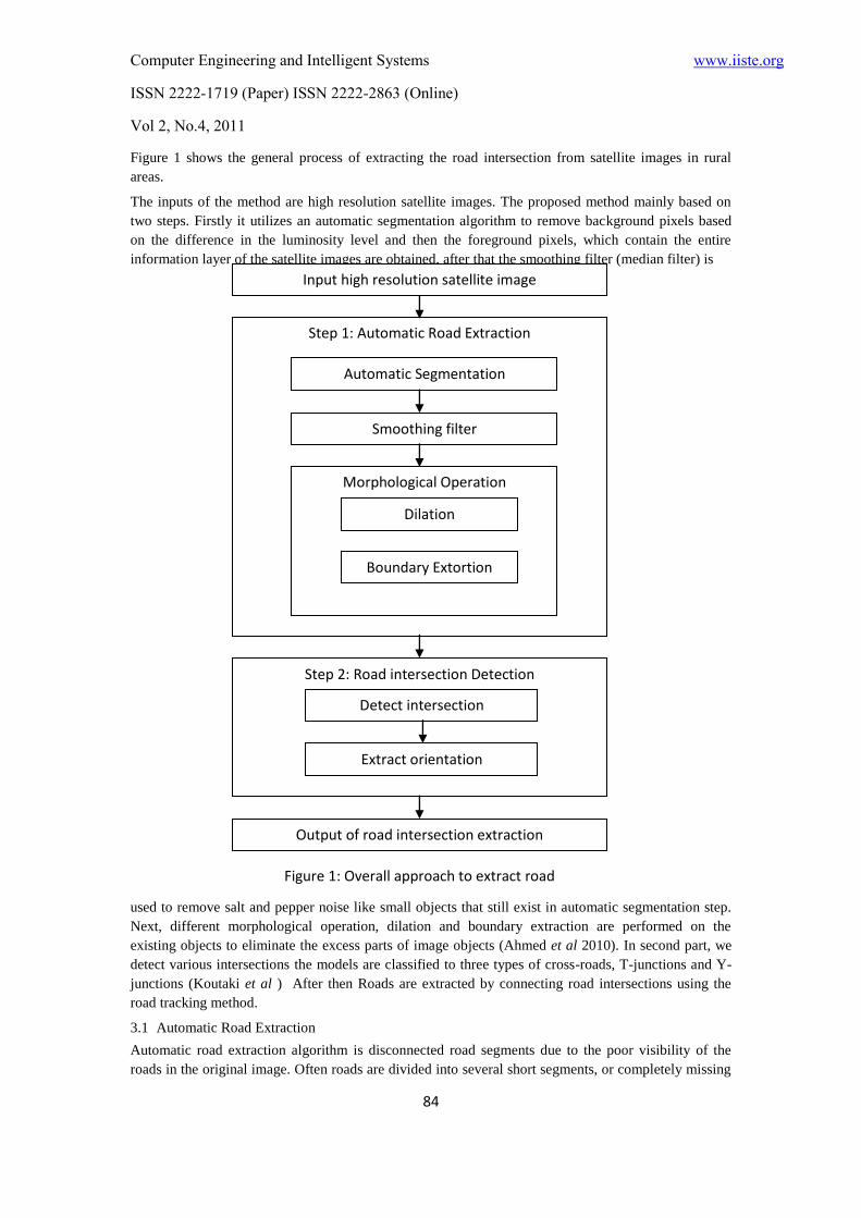
Figure 1 shows the general process of extracting the road intersection from satellite images in rural
areas.
The inputs of the method are high resolution satellite images. The proposed method mainly based on
two steps. Firstly it utilizes an automatic segmentation algorithm to remove background pixels based
on the difference in the luminosity level and then the foreground pixels, which contain the entire
information layer of the satellite images are obtained, after that the smoothing filter (median filter) is
used to remove salt and pepper noise like small objects that still exist in automatic segmentation step.
Next, different morphological operation, dilation and boundary extraction are performed on the
existing objects to eliminate the excess parts of image objects (Ahmed et al 2010). In second part, we
detect various intersections the models are classified to three types of cross-roads, T-junctions and Y-
junctions (Koutaki et al ) After then Roads are extracted by connecting road intersections using the
road tracking method.
3.1 Automatic Road Extraction
Automatic road extraction algorithm is disconnected road segments due to the poor visibility of the
roads in the original image. Often roads are divided into several short segments, or completely missing
Input high resolution satellite image
Step 1: Automatic Road Extraction
Automatic Segmentation
Smoothing filter
Morphological Operation
Dilation
Boundary Extortion
Step 2: Road intersection Detection
Detect intersection
Extract orientation
Output of road intersection extraction
Figure 1: Overall approach to extract road
intersections
Computer Engineering and Intelligent Systems www.iiste.org
ISSN 2222-1719 (Paper) ISSN 2222-2863 (Online)
Vol 2, No.4, 2011
85
from the image. To solve this problem, we fit Gaussian models to image points, which represent the
likelihood of being road points. These models are evaluated recursively to determine the correlation
between the neighboring points. The iterative process consists of finding the connected road points,
fusing them with the previous image, passing them through the directional line filter set and computing
new magnitudes and orientations. The road segments are updated, and the process continues until there
are no further changes in the roads extracted. We have combined the following general steps for
automatically road extraction processes.
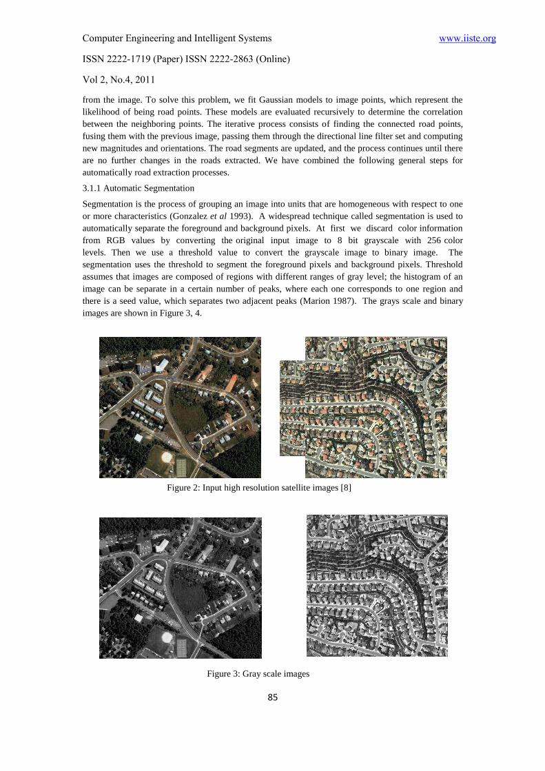
3.1.1 Automatic Segmentation
Segmentation is the process of grouping an image into units that are homogeneous with respect to one
or more characteristics (Gonzalez et al 1993). A widespread technique called segmentation is used to
automatically separate the foreground and background pixels. At first we discard color information
from RGB values by converting the original input image to 8 bit grayscale with 256 color
levels. Then we use a threshold value to convert the grayscale image to binary image. The
segmentation uses the threshold to segment the foreground pixels and background pixels. Threshold
assumes that images are composed of regions with different ranges of gray level; the histogram of an
image can be separate in a certain number of peaks, where each one corresponds to one region and
there is a seed value, which separates two adjacent peaks (Marion 1987). The grays scale and binary
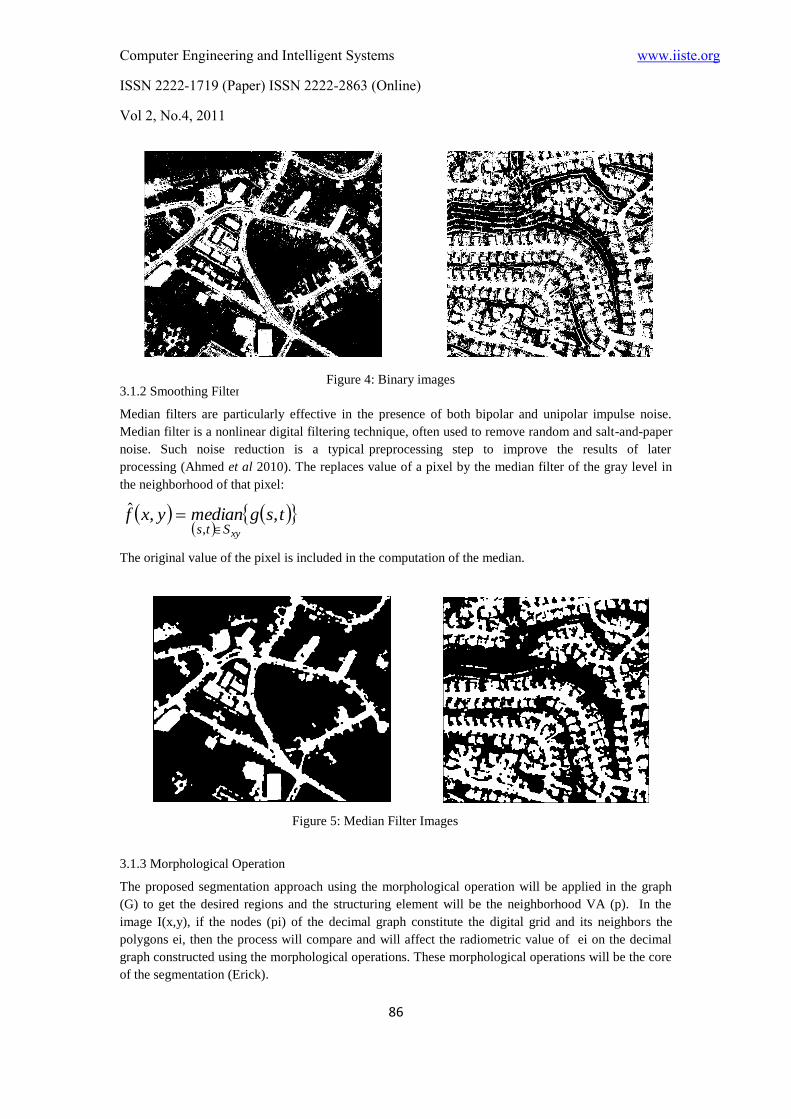
images are shown in Figure 3, 4.
Figure 2: Input high resolution satellite images [8]
Figure 3: Gray scale images
Computer Engineering and Intelligent Systems www.iiste.org
ISSN 2222-1719 (Paper) ISSN 2222-2863 (Online)
Vol 2, No.4, 2011
86
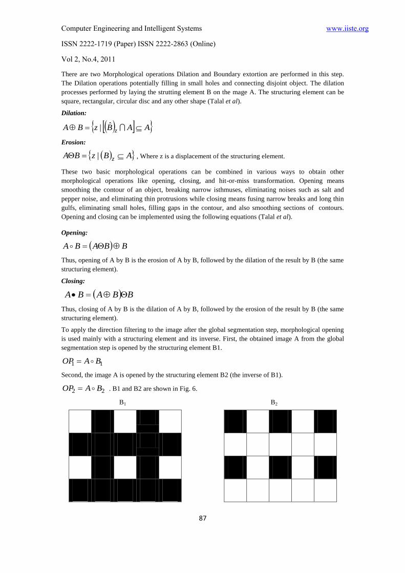
3.1.2 Smoothing Filter
Median filters are particularly effective in the presence of both bipolar and unipolar impulse noise.
Median filter is a nonlinear digital filtering technique, often used to remove random and salt-and-paper
noise. Such noise reduction is a typical preprocessing step to improve the results of later
processing (Ahmed et al 2010). The replaces value of a pixel by the median filter of the gray level in
the neighborhood of that pixel:
tsgmedianyxfxySts
,,ˆ,
The original value of the pixel is included in the computation of the median.
3.1.3 Morphological Operation
The proposed segmentation approach using the morphological operation will be applied in the graph
(G) to get the desired regions and the structuring element will be the neighborhood VA (p). In the
image I(x,y), if the nodes (pi) of the decimal graph constitute the digital grid and its neighbors the
polygons ei, then the process will compare and will affect the radiometric value of ei on the decimal
graph constructed using the morphological operations. These morphological operations will be the core
of the segmentation (Erick).
Figure 4: Binary images
Figure 5: Median Filter Images
Computer Engineering and Intelligent Systems www.iiste.org
ISSN 2222-1719 (Paper) ISSN 2222-2863 (Online)
Vol 2, No.4, 2011
87
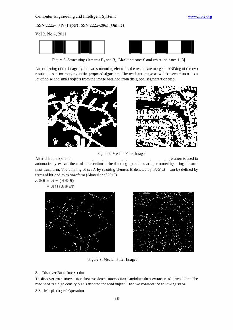
There are two Morphological operations Dilation and Boundary extortion are performed in this step.
The Dilation operations potentially filling in small holes and connecting disjoint object. The dilation
processes performed by laying the strutting element B on the mage A. The structuring element can be
square, rectangular, circular disc and any other shape (Talal et al).
Dilation:
AABzBA z ˆ|
Erosion:
ABzBA z | , Where z is a displacement of the structuring element.
These two basic morphological operations can be combined in various ways to obtain other
morphological operations like opening, closing, and hit-or-miss transformation. Opening means
smoothing the contour of an object, breaking narrow isthmuses, eliminating noises such as salt and
pepper noise, and eliminating thin protrusions while closing means fusing narrow breaks and long thin
gulfs, eliminating small holes, filling gaps in the contour, and also smoothing sections of contours.
Opening and closing can be implemented using the following equations (Talal et al).
Opening:
BBABA
Thus, opening of A by B is the erosion of A by B, followed by the dilation of the result by B (the same
structuring element).
Closing:
BBABA
Thus, closing of A by B is the dilation of A by B, followed by the erosion of the result by B (the same
structuring element).
To apply the direction filtering to the image after the global segmentation step, morphological opening
is used mainly with a structuring element and its inverse. First, the obtained image A from the global
segmentation step is opened by the structuring element B1.
11 BAOP
Second, the image A is opened by the structuring element B2 (the inverse of B1).
22 BAOP . B1 and B2 are shown in Fig. 6.
B1 B2
Computer Engineering and Intelligent Systems www.iiste.org
ISSN 2222-1719 (Paper) ISSN 2222-2863 (Online)
Vol 2, No.4, 2011
88
After opening of the image by the two structuring elements, the results are merged. ANDing of the two
results is used for merging in the proposed algorithm. The resultant image as will be seen eliminates a
lot of noise and small objects from the image obtained from the global segmentation step.
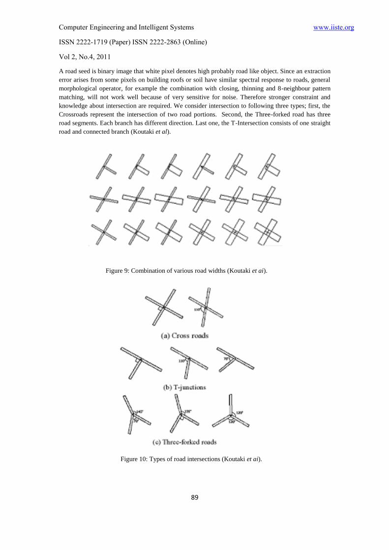
After dilation operation we use Morphological thinning operation. Binary thinning operation is used to
automatically extract the road intersections. The thinning operations are performed by using hit-and-
miss transform. The thinning of set A by strutting element B denoted by BA can be defined by
terms of hit-and-miss transform (Ahmed et al 2010).
3.1 Discover Road Intersection
To discover road intersection first we detect intersection candidate then extract road orientation. The
road seed is a high density pixels denoted the road object. Then we consider the following steps.
3.2.1 Morphological Operation
Figure 6: Structuring elements B1 and B2. Black indicates 0 and white indicates 1 [3]
Figure 7: Median Filter Images
Figure 8: Median Filter Images
Computer Engineering and Intelligent Systems www.iiste.org
ISSN 2222-1719 (Paper) ISSN 2222-2863 (Online)
Vol 2, No.4, 2011
89
A road seed is binary image that white pixel denotes high probably road like object. Since an extraction
error arises from some pixels on building roofs or soil have similar spectral response to roads, general
morphological operator, for example the combination with closing, thinning and 8-neighbour pattern
matching, will not work well because of very sensitive for noise. Therefore stronger constraint and
knowledge about intersection are required. We consider intersection to following three types; first, the
Crossroads represent the intersection of two road portions. Second, the Three-forked road has three
road segments. Each branch has different direction. Last one, the T-Intersection consists of one straight
road and connected branch (Koutaki et al).
Figure 9: Combination of various road widths (Koutaki et ai).
Figure 10: Types of road intersections (Koutaki et ai).
Computer Engineering and Intelligent Systems www.iiste.org
ISSN 2222-1719 (Paper) ISSN 2222-2863 (Online)
Vol 2, No.4, 2011
90
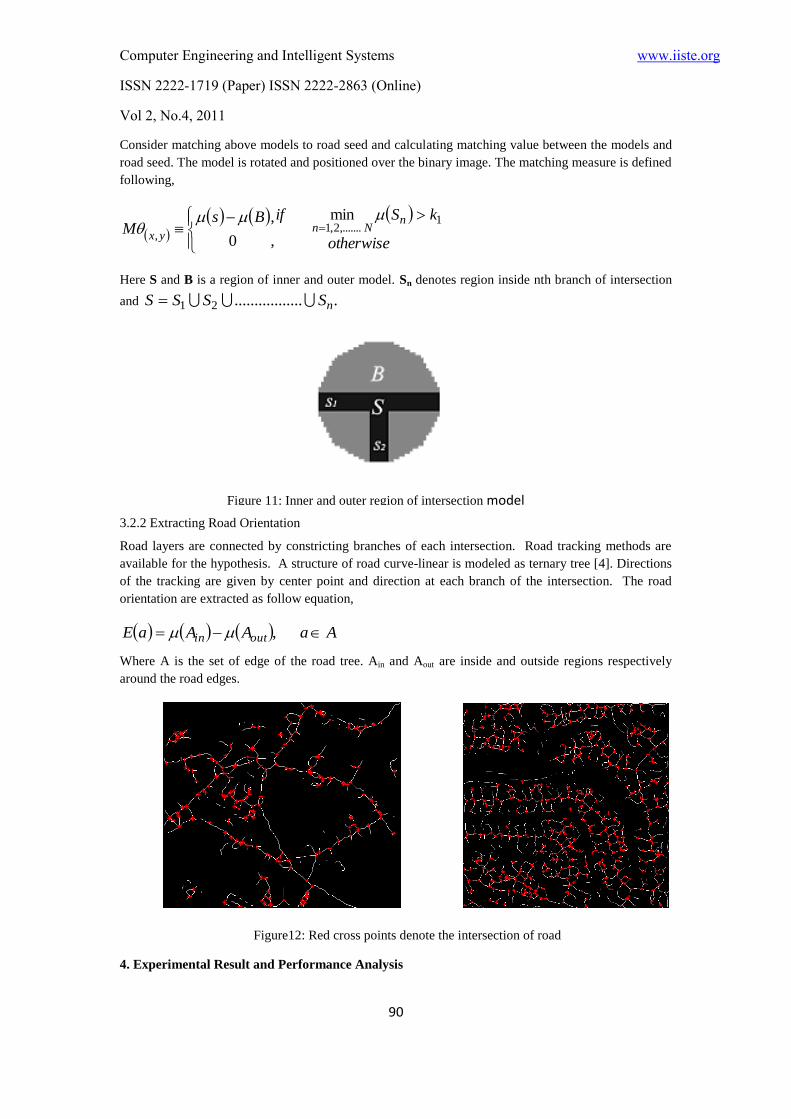
Consider matching above models to road seed and calculating matching value between the models and
road seed. The model is rotated and positioned over the binary image. The matching measure is defined
following,
otherwise
kSifBsM
nNn
yx
1,.......2,1
,
min
,
,
0
Here S and B is a region of inner and outer model. Sn denotes region inside nth branch of intersection
and ..................21 nSSSS
3.2.2 Extracting Road Orientation
Road layers are connected by constricting branches of each intersection. Road tracking methods are
available for the hypothesis. A structure of road curve-linear is modeled as ternary tree [4]. Directions
of the tracking are given by center point and direction at each branch of the intersection. The road
orientation are extracted as follow equation,
AaAAaE outin ,
Where A is the set of edge of the road tree. Ain and Aout are inside and outside regions respectively
around the road edges.
4. Experimental Result and Performance Analysis
Figure 11: Inner and outer region of intersection model
[4].
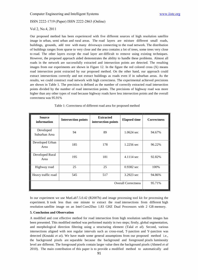
Figure12: Red cross points denote the intersection of road
Computer Engineering and Intelligent Systems www.iiste.org
ISSN 2222-1719 (Paper) ISSN 2222-2863 (Online)
Vol 2, No.4, 2011
91
Our proposed method has been experienced with five different sources of high resolution satellite
image in urban, semi urban and rural areas. The road layers are mixture different small roads,
buildings, grounds, add tree with many driveways connecting to the road network. The distribution
of buildings ranges from sparse to very close and the area contains a lot of trees, some trees very close
to road. The other layers except the road layer are difficult to remove using existing techniques.
However, the proposed approach aided demonstrates the ability to handle these problems. Almost all
roads in the network are successfully extracted and intersection points are detected. The resulting
images from our experiments are shown in Figure 12. In the figure the red colored cross (X) means
road intersection point extracted by our proposed method. On the other hand, our approach could
extract intersections correctly and not extract buildings as roads even if in suburban areas. As the
results, we could construct road network with high correctness. The experimental achieved precisions
are shown in Table 1. The precision is defined as the number of correctly extracted road intersection
points divided by the number of road intersection points. The precisions of highway road was more
higher than any other types of road because highway roads have less intersection points and the overall
correctness was 95.91%
Source
information Intersection points
Extracted
intersection points Elapsed time Correctness
Developed
Suburban Area 94 89 1.0624 sec 94.67%
Developed Urban
Area 185 178 1.2256 sec 96.22%
Developed Rural
Area 195 181 4.1114 sec 92.82%
Highway road 25 25 0.9382 sec 100%
Heavy traffic road 545 517 3.2923 sec 94.86%
Overall Correctness 95.71%
In our experiment we use MatLab7.5.0.42 (R2007b) and image processing tool kit for processing the
experiment. It took less than one minute to extract the road intersections from different high
resolution satellite image on an Intel Core2Duo 1.83 GHZ Dual Processors with 2 GB memory.
5. Conclusion and Observation
A modified and cost effective method for road intersection from high resolution satellite images has
been presented. This modified method was performed mainly in two steps; firstly, global segmentation,
and morphological direction filtering using a structuring element (Talal et al). Second, various
intersections aligned with non regular intervals such as cross-road, T-junction and Y-junction was
detected (Koutaki et ai). We have made some general assumptions from our proposed method i.e.,
the background pixels are separable because the background and foreground pixels luminosity
level are different. The foreground pixels contain larger value then the background pixels (Ahmed et al
2010). The main contribution of this paper is to provide a modified method to automatically and
Table 1: Correctness of different road area for proposed method
Computer Engineering and Intelligent Systems www.iiste.org
ISSN 2222-1719 (Paper) ISSN 2222-2863 (Online)
Vol 2, No.4, 2011
92
efficiently extract road intersections from high resolution satellite images. We applied our
proposed approach on five different satellite images on urban, semi-urban and rural area taken from
internet (Google Map) and successfully extracted the road intersection points to identify the
geographical information. We achieved 95.71% correctness accurate to automatically extracting road
intersection points. This proposed method has been successfully applied in the detection of single,
multiple, intersected and branched roads, efficiently.
References
Yao-Yi Chiang, Craig A. Knoblock & Ching-Chien Chen, (2009) “Automatic Extraction of Road
Intersections from Raster Maps”, Geoinformatica archive 13, pp. 121-157.
Renaud P´eteri, Julien Celle & Thierry Ranchin “Detection And Extraction Of Road Networks
From High Resolution Satellite Images” Remote Sensing & Modeling Group, Ecole des Mines de Paris
B.P. 207-06904 Sophia Antipolis cedex, France.
T. M. Talal1 , M. I. Dessouky
2 , A. El-Sayed
2 , M. Hebaishy
1 & F. E. Abd El-Samie
2 “Road
Extraction from High Resolution Satellite Images by Morphological Direction Filtering and
Length Filtering”, 1National Authority of Remote Sensing and Space Science, Cairo (Egypt).
2Faculty of Electronic Engineering, Menoufia University, Menouf, Egypt.
Go Koutakia , Keiichi Uchimura
a , Zhencheng Hu
b “Road Updating From High Resolution
Aerial Imagery Using Road Intersection Model”, aGraduate School of Science and Technology,
bFaculty of Engineering, Kumamoto University, 2-39-1 Kurokami, Kumamoto, 860-8555 Japan.
Xiangyun Hu C. Vincent Tao (2003) “Automatic Extraction Of Main-Road Centerlines From High
Resolution Satellite Imagery Based On Perceptual Grouping” York University Annual Conference
Proceedings, Anchorage, Alaska.
Yan Li & Ronald Briggs (2009) “Automatic Extraction of Roads from High Resolution Aerial and
Satellite Images with Heavy Noise”, World Academy of Science, Engineering and Technology 54. pp.
416-422.
Erick López-Ornelas (2009) “High Resolution Images: Segmenting, Extracting Information and GIS
Integration” World Academy of Science, Engineering and Technology 54 . pp. 172-177.
Yun Zhang & Ruisheng Wang “Multi-resolution and multi-spectral image fusion for urban object
extraction” Department of Geodesy and Geomatics Engineering University of New Brunswick .
XXTH
ISPRS Congress.
Ahmed Boshir, Md. Ali Hossain & Md. Ariful Islam (2010) “Automatic extractions of road
intersections from satellite imagery in urban areas” 6th
International Conference on Electrical and
Computer Engineering (ICECE), Dhaka, Bangladesh, pp: 686-689.
Yan Li & Ronald Briggs (2009) “Automatic Extraction of Roads from High Resolution Aerial and
Satellite Images with Heavy Noise” World Academy Science, Engineering and Technology 54
J.B. Mena (2003). State of the Art on Automatic Road Extraction for GIS Update: a Novel
Classification. Pattern Recognition Letters, 24(16), pp 3037-3058.
M.-F. Auclair-Fortier, D. Ziou, C. Armenakis, & S. Wang (1999) “Survey of Work on Road Extraction
in Aerial and Satellite Images”. Technical Report 241, Département de mathématiques et
d’informatique, Université de Sherbrooke.
G. Vosselman, J.D. Knecht (1995) “Road Tracking by Profile Matching and Kalman Filtering”.
Workshop on Automatic Extraction of Man-Made Objects from Aerial and Space Images, pp 265-274.
D.M. Mckeown, J.L. Denlinger.(1988) “Cooperative Methods for Road Tracking in Aerial Imagery.”
Workshop Computer Vision Pattern Recognition, pp 662-672.
A. Gruen, H. Li (1997) “Semi-automatic Linear Feature Extraction by Dynamic Programming and
LSB-Snakes.” Photogrammet Eng. Remote Sensing 63, pp 985-995.
Computer Engineering and Intelligent Systems www.iiste.org
ISSN 2222-1719 (Paper) ISSN 2222-2863 (Online)
Vol 2, No.4, 2011
93
S.B. Hinz, A. Ebner (2001) “Modeling Contextual Knowledge for Controlling Road Extraction in
Urban Areas.” IEEE/ISPRS Joint Workshop Remote Sensing Data Fusion over Urban Areas.
T. Ohlhof, T. Emge, W. Reinhardt, K. Leukert, C. Heipke, K. Pakzad (2000) “Generation and Update
of VMAP data using satellite and airbone imagery.” Remote Sensing, 33, pp 763-768.
A. Baumgartner, C.T. Steger, C. Wiedemann, H. Mayer, W. Eckstein, & H. Ebner (1996) “Update of
Roads in GIS from Aerial Imagery: Verification and Multi-Resolution Extraction.” Proceedings of
International Archives of Photogrammetry and Remote Sensing, XXXI B3/III, pp 53–58.
Erick López-Ornelas, ‘High Resolution Images: Segmenting, Extracting Information and GIS
Integration
R. Gonzalez, and R. Woods (1993) Digital Image Processing, Addison-Wesley.
A. Marion (1987), ‘‘Introduction aux techniques de traitement d’images’’, Ed. Eyrolles.

This academic article was published by The International Institute for Science,
Technology and Education (IISTE). The IISTE is a pioneer in the Open Access
Publishing service based in the U.S. and Europe. The aim of the institute is
Accelerating Global Knowledge Sharing.
More information about the publisher can be found in the IISTE’s homepage:
http://www.iiste.org
The IISTE is currently hosting more than 30 peer-reviewed academic journals and
collaborating with academic institutions around the world. Prospective authors of
IISTE journals can find the submission instruction on the following page:
http://www.iiste.org/Journals/
The IISTE editorial team promises to the review and publish all the qualified
submissions in a fast manner. All the journals articles are available online to the
readers all over the world without financial, legal, or technical barriers other than
those inseparable from gaining access to the internet itself. Printed version of the
journals is also available upon request of readers and authors.
IISTE Knowledge Sharing Partners
EBSCO, Index Copernicus, Ulrich's Periodicals Directory, JournalTOCS, PKP Open
Archives Harvester, Bielefeld Academic Search Engine, Elektronische
Zeitschriftenbibliothek EZB, Open J-Gate, OCLC WorldCat, Universe Digtial
Library , NewJour, Google Scholar