Embed Size (px)
Citation preview
International Journal of Scientific & Engineering Research Volume 9, Issue 6, June-2018 764 ISSN 2229-5518
IJSER © 2018 http://www.ijser.org
Assessment of Petrol Stations Locations in Port Harcourt, Rivers State, Nigeria Using
Geospatial Techniques
1Prof. Sika Orupabo and 2York, F. Newton
1Department of Surveying and Geomatics, Rivers State University.
2Rivers State Boundary Commission, Office of the Deputy Governor, Government House, Port Harcourt.
Abstract
This study was conducted in Port Harcourt City Local Government Area of Rivers State. The aim of the study is to analyze the location of filling stations in Port Harcourt Metropolis against the physical planning standards set by Department of Petroleum Resource (DPR). The research used geographic information system (GIS) based analysis. Global positioning System GPS Garmin 76CSX was used to capture the location of the filling stations and names of the filling stations were obtained from DPR Port Harcourt Office. The aerial photo of Port Harcourt City and the Local Government shape file were obtained from the Office of the Surveyor General of Rivers State. The filling stations field data were processed in excel spread sheet and imported to ESRI ArcGIS 10.1 where all the analyses were performed. The study conducted shows a total number of 53 petrol filling stations located on major and minor roads in Port Harcourt City. It also shows that 25(47%) out of 53 petrol stations complied and 28(53%) petrol stations do not comply with DPR guidelines. Finally, the study recommends regular monitoring by the regulating bodies to ensuring total compliance at all level of the guidelines for the safety of the general public.
Key Words: Filling stations, spatial distribution, location, geodatabase, conformity, Port Harcourt.
I. INTRODUCTION
Petrol filling stations are facilities established to serve the public with sales of petroleum products. Therefore, petrol stations should be located not only where they are accessible but where they can be easily located by strangers. Specifically, petrol stations should be placed where they will not cause danger and congestion as, much as possible (KASUPDA, 2009). According to Abdullahi (2012) filling stations could be distributed rationally according to the size, spacing or distance and population to be served. However, in Nigeria, there is a guideline for location and operation of petrol stations. The issuance of license to all petrol stations is vested with the Department of Petroleum Resources (DPR). It is the responsibility of DPR to determine whether or not an application is suitable for “Approval to Construct” (ATC) a petrol station. In urban cities where there is no proper coordination of development, petrol stations are one of the contributing factors of traffic, explosion and fire (Samuel, 2011). For example, in Port Harcourt, some of the filling stations are too close to one another and no adequate set back from roads. GIS techniques can be employed to enhance the location of infrastructures and assessment for proper distribution within a city (Oloko-oba et’ al 2016, Abdullahi 2012). Therefore, there is need for a study on the spatial analysis of the distribution and location of filling stations in Port Harcourt.
Statement of the Problem
In locating petrol stations, it is important to take some precautionary measures like locating them at a required distance from buildings; places of public assembly such as markets, hospitals and schools and areas of high traffic congestions and residential buildings (Odeh, 2017). This should be in accordance with the guidelines provided by the Department of Petroleum Resources that the distance between two nearest petrol stations should be 400m and 15m set back from road to shun possible hazards (DPR, 2007).
IJSER
International Journal of Scientific & Engineering Research Volume 9, Issue 6, June-2018 765 ISSN 2229-5518
IJSER © 2018 http://www.ijser.org
Despite this however, it is common to see petrol stations located in the midst of residential houses or sharing walls with people houses in Port Harcourt City. It is therefore against this background that the study examined the conformity of those petrol station sites in relation to DPR standard.
Aim of the study
The study aimed at assessing the spatial distribution and conformity of petrol filling stations with DPR regulations in Port Harcourt City Local Government Area.
II. STUDY AREA
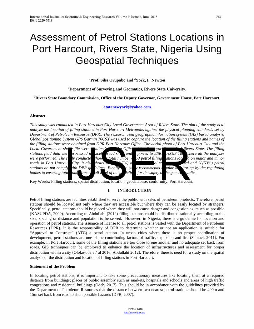
The Study area (Port Harcourt City) is one of the 23 local governments and capital of Rivers state, found in the south southern part of Nigeria, otherwise called the Niger Delta Region of Nigeria as shown in figure 1. It has an area of 360sqkm (140sqmi), with a population of 1,382,592 (2006 Census). It is located between latitude 40 39’ 45” and 40 50’ 00” and longitude 60 56’ 15”.6 and 70 7’ 32”.
Figure 1. Study Area (Port Harcourt City).
III. METHODOLOGY
Dataset
Dataset for this study were obtained through field measurement. The hand held Global Positioning System (GPS) receiver was used to determine the coordinates of the petrol stations across the entire routes in the study area (Table 1).
IJSER
International Journal of Scientific & Engineering Research Volume 9, Issue 6, June-2018 766 ISSN 2229-5518
IJSER © 2018 http://www.ijser.org
Records from DPR Port Harcourt office and Office of the Surveyor General of Rivers State were equally sourced. Excel spread sheet was used to enter the names of the filling stations, the streets address and their coordinates. The data were processed, converted and plotted as points in ArcGIS environment (Figure 2). Personal Geodatabase Area Personal Geodatabase is one of the data management tools used to store, organize and distribute data. Stated as one of the conditions to be met for approval of petrol station is that the size of site should be up to two plots of land about 1000m2. With the creation of Personal Geodatabase, sizes of the filling stations identified in Port Harcourt City were digitized using polygon which made possible their respective areas in square meters to be generated and obtained in the attributes table (Figure 4 and 5). Buffer Analysis Buffer is a region created around an object. It could be in linear, polygon or point. DPR stipulates that the distance between two filling stations on the same road should not be less than 400m apart. Therefore, the same 400m distance was used to carry out buffer analysis (Figure 3) to check if there is conformity with the guidelines. The methodology was subdivided into various steps such as: Planning stage, Data acquisition, Digitization/Data conversion and coordinate plotting, GIS database design and creation, GIS analysis and results presentation as shown in the flowchart. Data Analysis The petroleum filling station amendment decree no. 37 of 1977 safety rules and regulations stipulate site inspection by DPR of proposed filling station, so as to among other things, issue report on the following basic requirements: -
i. Size of the proposed site (not less than 2 plots of land). ii. Whether site lie within pipeline or electricity high tension cable Right Of Way (ROW).
iii. Distance from the edge of the road to the nearest pump (not less than 15 meters). iv. The number of petrol stations within 2km stretch of the site on both sides of the road will not be more
than four, including the one under consideration. v. The distance between an existing station and the proposed one will not be less than 400 (four hundred)
meters. vi. The drainage from the site will not go into a stream or river.
vii. In some instances where site is along Federal Highway, a letter of consent from the Federal Highway is required.
viii. DPR guided/supervised EIA study of the site by DPR accredited consultant .
This study is concerned with regulation number i & v which state that: a) The size of the propose site should not be less than two (2) plots of land. b) The distance between an existing station and the proposed one will not be less than 400m.
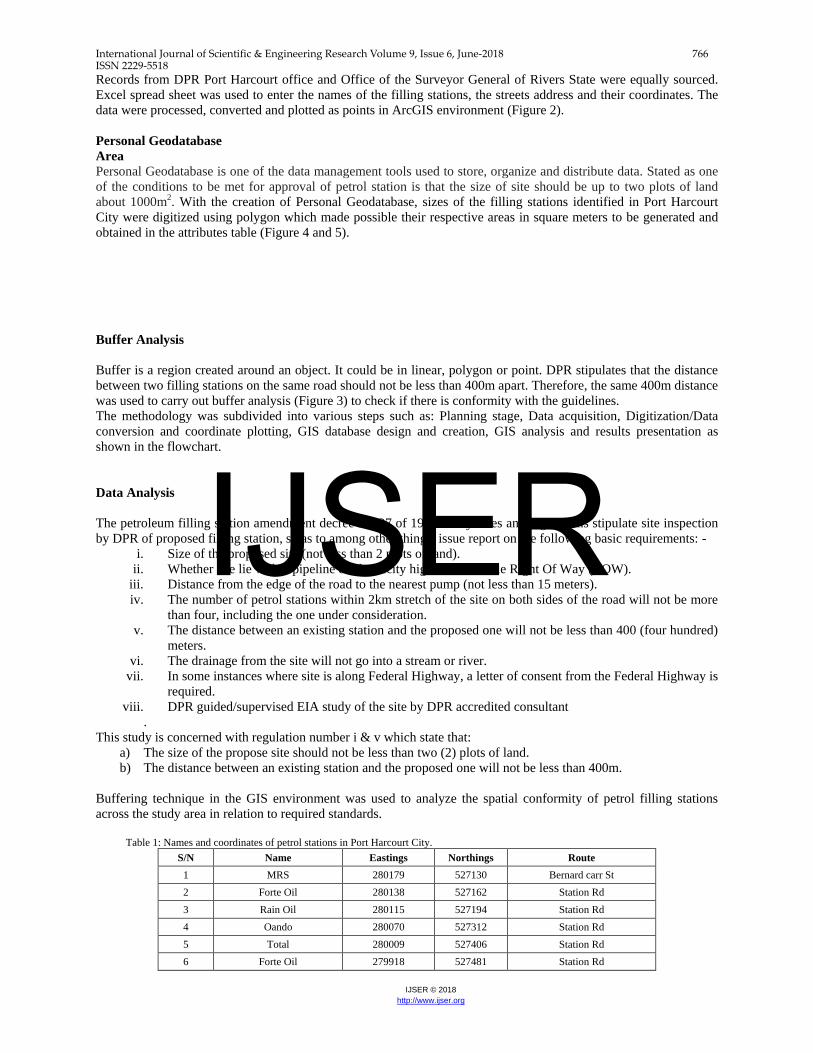
Buffering technique in the GIS environment was used to analyze the spatial conformity of petrol filling stations across the study area in relation to required standards. Table 1: Names and coordinates of petrol stations in Port Harcourt City.
S/N Name Eastings Northings Route 1 MRS 280179 527130 Bernard carr St 2 Forte Oil 280138 527162 Station Rd 3 Rain Oil 280115 527194 Station Rd 4 Oando 280070 527312 Station Rd 5 Total 280009 527406 Station Rd 6 Forte Oil 279918 527481 Station Rd
IJSER
International Journal of Scientific & Engineering Research Volume 9, Issue 6, June-2018 767 ISSN 2229-5518
IJSER © 2018 http://www.ijser.org
7 Eterna 278384 529850 Aba Rd 8 Con Oil 278324 530014 Aba Rd 9 MRS 278536 530276 Aba Rd 10 Total 279091 531274 Aba Rd 11 Mobil 279233 531561 Aba Rd 12 Total 278990 533236 Aba Rd 13 Mobil 279205 532706 Aba Rd 14 Oando 278431 530241 Aba Rd 15 Forte Oil 279707 530494 Eastern by pass 16 Forte Oil 279518 530657 Eastern by pass 17 Oando 280939 531644 Trans Amadi Rd 18 Con Oil 281182 530572 Amadi Round About 19 Forte Oil 282444 530386 Odili Road 20 Resto Park 282893 530557 Odili Road
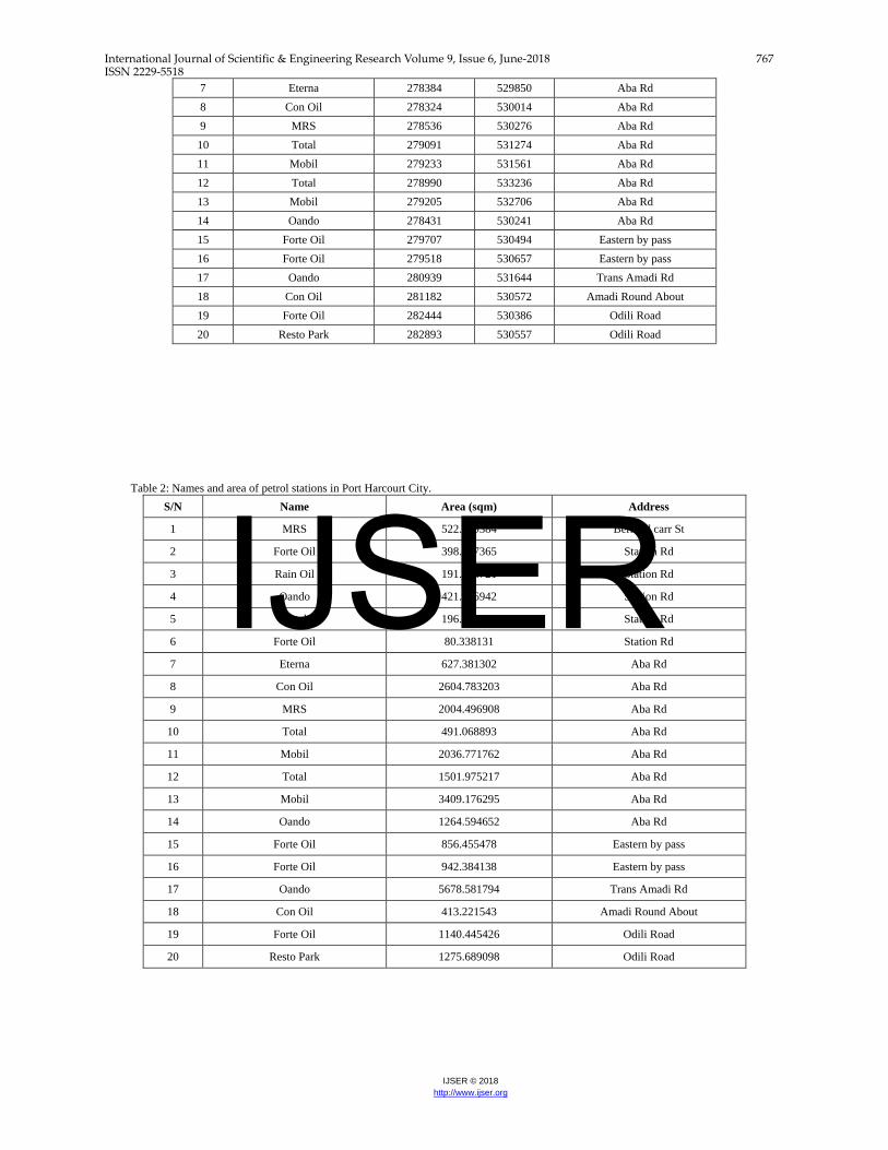
Table 2: Names and area of petrol stations in Port Harcourt City.
S/N Name Area (sqm) Address
1 MRS 522.509384 Bernard carr St
2 Forte Oil 398.037365 Station Rd
3 Rain Oil 191.138721 Station Rd
4 Oando 421.806942 Station Rd
5 Total 196.825406 Station Rd
6 Forte Oil 80.338131 Station Rd
7 Eterna 627.381302 Aba Rd
8 Con Oil 2604.783203 Aba Rd
9 MRS 2004.496908 Aba Rd
10 Total 491.068893 Aba Rd
11 Mobil 2036.771762 Aba Rd
12 Total 1501.975217 Aba Rd
13 Mobil 3409.176295 Aba Rd
14 Oando 1264.594652 Aba Rd
15 Forte Oil 856.455478 Eastern by pass
16 Forte Oil 942.384138 Eastern by pass
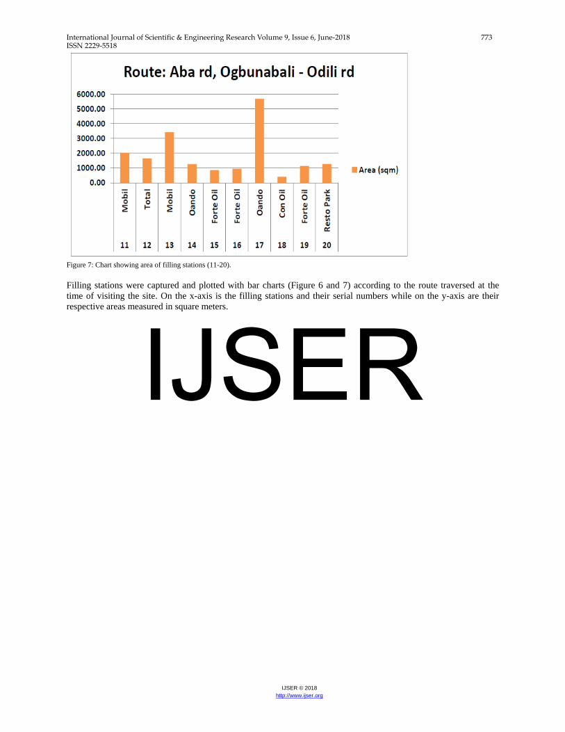
17 Oando 5678.581794 Trans Amadi Rd
18 Con Oil 413.221543 Amadi Round About
19 Forte Oil 1140.445426 Odili Road
20 Resto Park 1275.689098 Odili Road
IJSER
International Journal of Scientific & Engineering Research Volume 9, Issue 6, June-2018 768 ISSN 2229-5518
IJSER © 2018 http://www.ijser.org
IV. RESULTS AND DISCUSSION
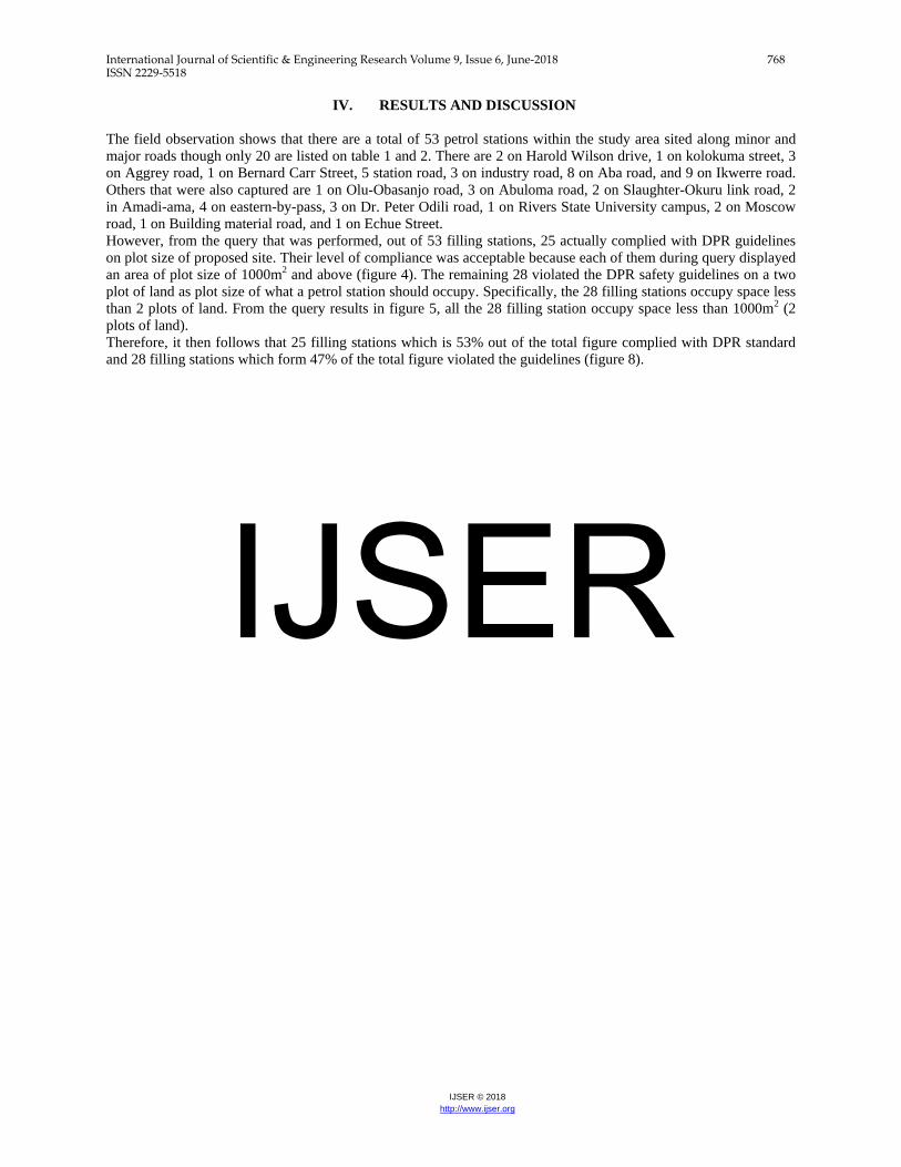
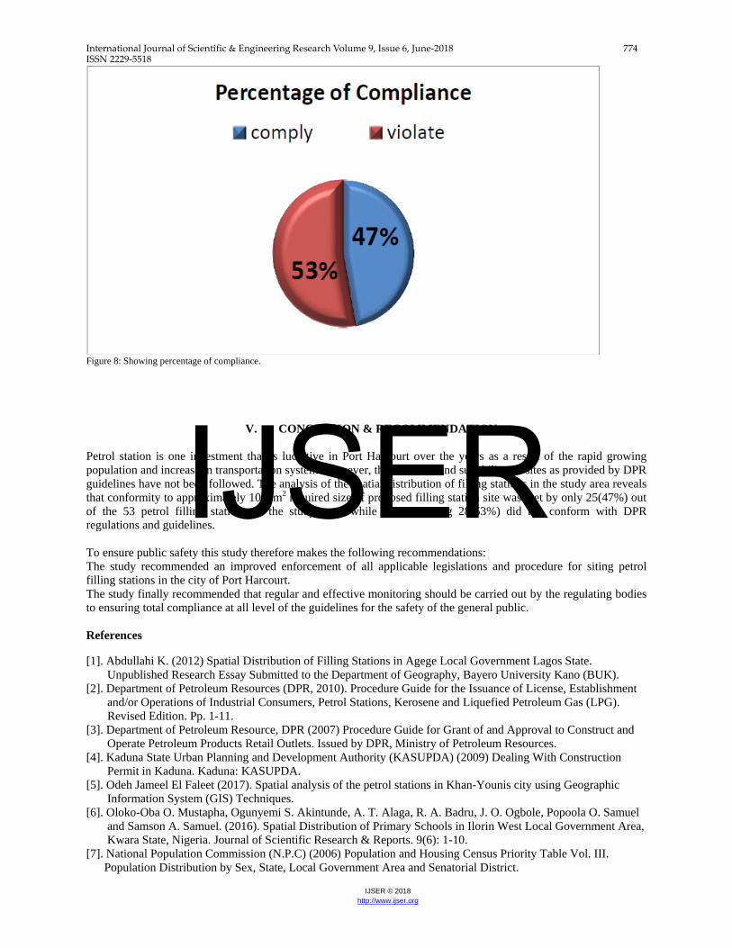
The field observation shows that there are a total of 53 petrol stations within the study area sited along minor and major roads though only 20 are listed on table 1 and 2. There are 2 on Harold Wilson drive, 1 on kolokuma street, 3 on Aggrey road, 1 on Bernard Carr Street, 5 station road, 3 on industry road, 8 on Aba road, and 9 on Ikwerre road. Others that were also captured are 1 on Olu-Obasanjo road, 3 on Abuloma road, 2 on Slaughter-Okuru link road, 2 in Amadi-ama, 4 on eastern-by-pass, 3 on Dr. Peter Odili road, 1 on Rivers State University campus, 2 on Moscow road, 1 on Building material road, and 1 on Echue Street. However, from the query that was performed, out of 53 filling stations, 25 actually complied with DPR guidelines on plot size of proposed site. Their level of compliance was acceptable because each of them during query displayed an area of plot size of 1000m2 and above (figure 4). The remaining 28 violated the DPR safety guidelines on a two plot of land as plot size of what a petrol station should occupy. Specifically, the 28 filling stations occupy space less than 2 plots of land. From the query results in figure 5, all the 28 filling station occupy space less than 1000m2 (2 plots of land). Therefore, it then follows that 25 filling stations which is 53% out of the total figure complied with DPR standard and 28 filling stations which form 47% of the total figure violated the guidelines (figure 8).
IJSER
International Journal of Scientific & Engineering Research Volume 9, Issue 6, June-2018 769 ISSN 2229-5518
IJSER © 2018 http://www.ijser.org
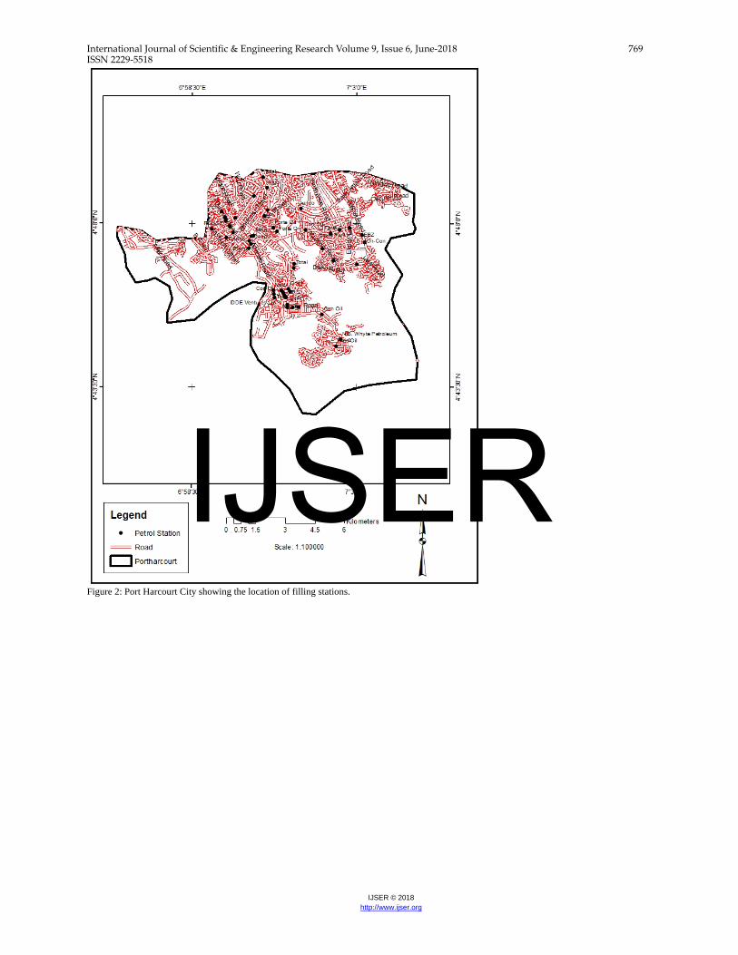
Figure 2: Port Harcourt City showing the location of filling stations.
IJSER
International Journal of Scientific & Engineering Research Volume 9, Issue 6, June-2018 770 ISSN 2229-5518
IJSER © 2018 http://www.ijser.org
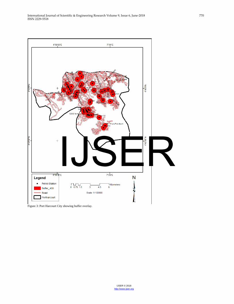
Figure 3: Port Harcourt City showing buffer overlay.
IJSER

International Journal of Scientific & Engineering Research Volume 9, Issue 6, June-2018 771 ISSN 2229-5518
IJSER © 2018 http://www.ijser.org
Figure 4: Query result showing filling stations with plot size above 1000m2.
IJSER
International Journal of Scientific & Engineering Research Volume 9, Issue 6, June-2018 772 ISSN 2229-5518
IJSER © 2018 http://www.ijser.org
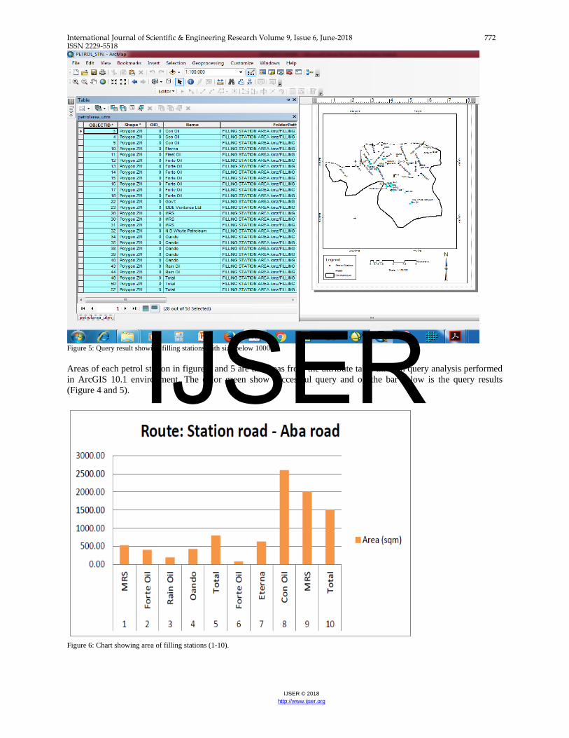
Figure 5: Query result showing filling stations with size below 1000m2. Areas of each petrol station in figure 4 and 5 are the areas from the attribute table through query analysis performed in ArcGIS 10.1 environment. The color green show successful query and on the bar below is the query results (Figure 4 and 5).
Figure 6: Chart showing area of filling stations (1-10).
IJSER
International Journal of Scientific & Engineering Research Volume 9, Issue 6, June-2018 773 ISSN 2229-5518
IJSER © 2018 http://www.ijser.org
Figure 7: Chart showing area of filling stations (11-20). Filling stations were captured and plotted with bar charts (Figure 6 and 7) according to the route traversed at the time of visiting the site. On the x-axis is the filling stations and their serial numbers while on the y-axis are their respective areas measured in square meters.
IJSER
International Journal of Scientific & Engineering Research Volume 9, Issue 6, June-2018 774 ISSN 2229-5518
IJSER © 2018 http://www.ijser.org
Figure 8: Showing percentage of compliance.
V. CONCLUSION & RECOMMENDATION
Petrol station is one investment that is lucrative in Port Harcourt over the years as a result of the rapid growing population and increase in transportation system. However, their number and suitability on sites as provided by DPR guidelines have not been followed. The analysis of the spatial distribution of filling stations in the study area reveals that conformity to approximately 1000m2 required size of proposed filling station site was met by only 25(47%) out of the 53 petrol filling stations in the study area, while the remaining 28(53%) did not conform with DPR regulations and guidelines. To ensure public safety this study therefore makes the following recommendations: The study recommended an improved enforcement of all applicable legislations and procedure for siting petrol filling stations in the city of Port Harcourt. The study finally recommended that regular and effective monitoring should be carried out by the regulating bodies to ensuring total compliance at all level of the guidelines for the safety of the general public. References
[1]. Abdullahi K. (2012) Spatial Distribution of Filling Stations in Agege Local Government Lagos State. Unpublished Research Essay Submitted to the Department of Geography, Bayero University Kano (BUK). [2]. Department of Petroleum Resources (DPR, 2010). Procedure Guide for the Issuance of License, Establishment and/or Operations of Industrial Consumers, Petrol Stations, Kerosene and Liquefied Petroleum Gas (LPG). Revised Edition. Pp. 1-11. [3]. Department of Petroleum Resource, DPR (2007) Procedure Guide for Grant of and Approval to Construct and Operate Petroleum Products Retail Outlets. Issued by DPR, Ministry of Petroleum Resources. [4]. Kaduna State Urban Planning and Development Authority (KASUPDA) (2009) Dealing With Construction Permit in Kaduna. Kaduna: KASUPDA. [5]. Odeh Jameel El Faleet (2017). Spatial analysis of the petrol stations in Khan-Younis city using Geographic Information System (GIS) Techniques. [6]. Oloko-Oba O. Mustapha, Ogunyemi S. Akintunde, A. T. Alaga, R. A. Badru, J. O. Ogbole, Popoola O. Samuel and Samson A. Samuel. (2016). Spatial Distribution of Primary Schools in Ilorin West Local Government Area, Kwara State, Nigeria. Journal of Scientific Research & Reports. 9(6): 1-10. [7]. National Population Commission (N.P.C) (2006) Population and Housing Census Priority Table Vol. III. Population Distribution by Sex, State, Local Government Area and Senatorial District.
IJSER
International Journal of Scientific & Engineering Research Volume 9, Issue 6, June-2018 775 ISSN 2229-5518
IJSER © 2018 http://www.ijser.org
[8]. Samuel, J. A. (2011). Spatial Location of Filling stations in Kaduna. Kaduna: Retrieved on 5th August, 2017 from www.srib.com/samuel_ayodele1.
IJSER


