Embed Size (px)
Citation preview
An RM-ODP Enterprise View for Spatial Data
Infrastructures
Ruben Bejara, Miguel A. Latre, Javier Nogueras-Iso, Pedro R.Muro-Medrano, F. Javier Zarazaga-Soria
Computer Science and Systems Engineering Department, Universidad de Zaragoza,c/Marıa de Luna 1, 50018, Zaragoza, Spain
Abstract
Spatial Data Infrastructures (SDIs) are large, open, distributed andstandards-based information systems which intend to facilitate and pro-mote the use of spatial data and spatial services on the Internet. Spatialdata describe information tied with locations on Earth, while spatial servicesallow to manipulate spatial data following a Service Oriented Architecture.This paper proposes to model SDIs as federations of autonomous communi-ties following the enterprise language of the ITU-T and ISO/IEC ‘ReferenceModel of Open Distributed Processing’ (RM-ODP), and the recently ap-proved ‘Use of UML for ODP Systems Specifications’ (UML4ODP). Theenterprise language of the RM-ODP provides a conceptual foundation toaddress several aspects of SDIs not previously considered from a systemsarchitecture point of view. The use of UML4ODP provides a modellinglanguage to facilitate the exchange of knowledge about SDI, and it is anopportunity to try this recent standard for a class of large and complexsystems.
Keywords: RM-ODP, Enterprise Architecture, Service OrientedArchitecture, Spatial Data Infrastructure, UML, Distributed System
1. Introduction
The importance of spatial data to support decision-making and manage-ment has been cited as critical in important United Nations (UN) events suchas the 1992 Rio Summit, the special session of the UN General Assembly to
Preprint submitted to Computer Standards & Interfaces October 10, 2011
This is the author's version of the work. The definitive version is published in Computer Standards & Interfaces, 2012, vol. 34, p. 263-272
appraise the implementation of the Agenda 21 in 1997, or the World Summiton Sustainable Development in Johannesburg in 2003 [1]. Spatial, or geo-graphic, data describe information tied to some locations on Earth’s surfaceor to zones adjacent to it.
In the last decade of the 20th century, the use of spatial data was limiteddue to its high prices and the use of closed and monolithic systems. To im-prove that situation, the development of Spatial Data Infrastructures (SDIs)was proposed as a means to facilitate the discovery, access and use of spa-tial information. According to the ‘SDI cookbook’, ‘the term ‘Spatial DataInfrastructure’ (SDI) is often used to denote the relevant base collection oftechnologies, policies and institutional arrangements that facilitate the avail-ability of and access to spatial data’ [1, p. 8]. Other relevant definitions forthe term SDI are cited in [2], but in general these definitions share commonobjectives and similar components, which have been similarly categorized bydifferent authors: from the people, policies and agreements, standards andtechnologies proposed in [3] to the framework composed of data, people, in-stitutional frameworks, technology and standards in [4, p. 22-23]. SDIs arecomplex systems, and under this point of view have been considered Systemsof Systems [5] and Complex Adaptive Systems [6]. Nowadays, SDIs are beingdeveloped in many countries and are accepted as an essential infrastructurein modern societies [7, p. xiii].
Another important characteristic that has been considered for SDIs, isthat they may be components of other SDIs. Rajabifard et al. [8] propose ahierarchy of SDIs, from the corporate to the global level, and point out somerelationships among these levels. Masser [9] suggests that this hierarchicalcomposition is one of the research challenges provided by SDIs. The alreadyapproved Infrastructure for Spatial Information in the European Community(INSPIRE) directive aims to build a European SDI based on the SDIs of theMember States [10].
Some aspects of the software architecture of SDIs have already beenanalyzed: ANZLIC [11] describes a technical architecture, services, serviceproviders and data storage facilities, for the Internet Framework of the Aus-tralian SDI Distribution Network. Bernard et al. [12] present an architecturalview of the European SDI geoportal and associated services. GeoConnec-tions [13] describes the Canadian Geospatial Data Infrastructure Architec-ture following the ISO RM-ODP information, engineering and computationalviewpoints. Bejar et al. [14] have proposed an architectural style, roughlycorrespondent to the ISO RM-ODP engineering viewpoint, for the software
2
This is the author's version of the work. The definitive version is published in Computer Standards & Interfaces, 2012, vol. 34, p. 263-272
components of an SDI.Although SDIs include many different components, software architecture
techniques have been mainly used to model their technical aspects. Neverthe-less, some software architecture methods allow to address the non-technicalcomponents of systems too: RM-ODP provides the concepts and tools toaddress non-technical components of complex distributed systems, like SDIs,under the so-called enterprise viewpoint. The RM-ODP is being consideredfor the United Nations SDI technical governance framework, although thisproject is still in the design phase, and there are not many details yet [15].It is also being used for the architecture implementation pilot of the Groupon Earth Observations System of Systems (GEOSS), which objectives arerelated to those of an SDI [16].
Hjelmager et al. [17] have proposed an initial model for SDIs under theRM-ODP enterprise viewpoint (and also under the information viewpoint).Besides other differences, our paper improves their enterprise model in severalaspects:
• We take into consideration the relationships among different SDIs andamong the organizations participating in them.
• We relate policies with the interactions affected by them, consider ex-plicitly enterprise object types and artefact role types and describeprocesses in UML.
• We use the recently approved ISO/IEC International Standard thatestablishes the use of UML to express the RM-ODP concepts [18].
In this paper, an approach to model some of the technical and non-technical components of an SDI using an architectural viewpoint is proposed.This approach allows to model SDIs as federations of autonomous organi-zations, where technical and non-technical components interact, under theguidelines and constraints of several policies, to achieve certain objectives.The RM-ODP enterprise language provides a set of well-defined conceptsused to create an enterprise view on a system. This viewpoint addressesits purpose, expected behaviour and policies. There is also a standardizedway to express these concepts as diagrams in the Unified Modeling Language(UML), and several proposals to formalize them if needed [19, 20].
The rest of the paper is structured as follows: section 2 presents a briefintroduction to the ISO RM-ODP and its enterprise language. This is fol-lowed by the main part of the paper, section 3, where the elements of an
3
This is the author's version of the work. The definitive version is published in Computer Standards & Interfaces, 2012, vol. 34, p. 263-272
architecture to model SDIs following the enterprise language of the ISO RM-ODP are described. Finally, in section 4, some conclusions and further workare described.
2. The Enterprise Language of the RM-ODP
The ISO Open Distributed Processing Reference Model (RM-ODP) pro-vides an architectural framework to model complex environments where het-erogenous information resources are distributed among different intercon-nected organizational domains [21, 22, 23, 24].
The RM-ODP allows to specify an Open Distributed Processing (ODP)system in terms of different, but interrelated, viewpoint specifications. Aviewpoint on a system is an abstraction of that system addressing a particu-lar set of concerns. Viewpoints simplify reasoning about a system, allowingits designers to focus on different concerns as needed. For the different view-points on a system, a viewpoint language is provided.
The RM-ODP provides five viewpoints: the enterprise viewpoint, con-cerned with the purpose, scope and policies of a system, the informationviewpoint, concerned with the information handled by the system, the compu-tational viewpoint, concerned with the decomposition of the system in objectsand interfaces, the engineering viewpoint, concerned with the infrastructurerequired to support distribution, and the technology viewpoint, concernedwith the chosen technologies used to support distribution. A complete spec-ification of a given system would consist of several, related and mutuallyconsistent, viewpoints. This paper is focused on the enterprise viewpoint.
The Enterprise Language of the RM-ODP defines the concepts and rulesused to specify the enterprise viewpoint on a system [25]. The fundamentalstructuring concept for an enterprise viewpoint is that of community. A com-munity is a configuration of enterprise objects describing a set of entities suchas human beings, information resources or information processing systems,which is formed to meet an objective. An enterprise view must include atleast one community, but it can be structured in terms of several interactingcommunities.
The scope (of a system) is ‘the behaviour that a system is expected toexhibit’ [25, p. 4], and it ‘is defined in terms of its intended behaviour; in theenterprise language this is expressed in terms of roles or processes or both,policies, and the relationships of these’ [25, p. 6, emphasis added]. These
4
This is the author's version of the work. The definitive version is published in Computer Standards & Interfaces, 2012, vol. 34, p. 263-272

concepts are defined later in this paper, when they are used (sections 3.3, 3.5and 3.6).
Roles, processes, and policies allow to model the behaviour of an ODPsystem. The enterprise objects of a community will typically fulfil differentroles at different times: the same person, an enterprise object, can be a userand a data producer, both of them roles, though not simultaneously. Whenthis person is fulfilling the role user, she can be involved in downloadingcertain data set, that would be a process, but only if she is allowed to, forinstance by a certain policy.
To end this section, a formal issue must be highlighted: the RM-ODPstandard does not recommend any notation to specify ODP systems. Never-theless, there is an ISO/IEC International Standard to establish how to usethe UML for this task [18] (UML4ODP). In this paper that InternationalStandard has been followed.
3. SDIs in the Enterprise Language of the RM-ODP
As described in section 2, the RM-ODP provides the necessary conceptsand rules to specify distributed information systems under five different view-points. In the next subsections we develop an approach to facilitate themodelling of SDIs from the enterprise viewpoint of the RM-ODP.
3.1. Communities
In the RM-ODP enterprise viewpoint, systems are first specified as com-munities and then refined as needed. As highlighted in [8, 9], SDIs are usu-ally composed of other SDIs, with some kind of hierarchical organization.Nevertheless, other community types are also involved: for example, two en-vironment departments of neighbour states may agree to form a new SDI,but they are not SDIs themselves. We will say that any community that ispart of an SDI is a member of that SDI.
We may be more precise if we take into consideration a common com-munity type in the RM-ODP: a federation is a type of community formedby other communities that cooperate to achieve a common objective [25].These communities, the federation members, are bound by the contract ofthe federation but they keep their autonomy. As SDIs are formed by severalcommunities to achieve a common objective, we may model an SDI as a typeof RM-ODP federation.
5
This is the author's version of the work. The definitive version is published in Computer Standards & Interfaces, 2012, vol. 34, p. 263-272

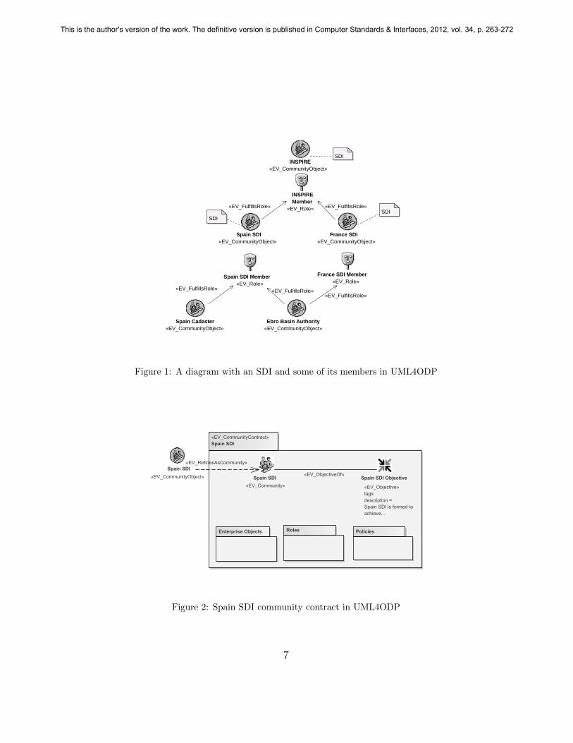
The relationships between SDIs and their members will typically be im-plemented by making some objects in the members to fulfill roles defined bythe SDIs to which they belong. For instance, an SDI may require its mem-bers to have a contact point, so this SDI specifies the role ‘contact point’and each member designates an object, e.g. a person or organization, tofulfill it. Nevertheless it may be useful to have a UML4ODP diagram whichshows the relationships among the communities in an SDI without that levelof detail. Figure 1 shows a very simple example with our proposal1. Thatdiagram includes three different SDIs (INSPIRE, Spain SDI and France SDI)and two communities which are not SDIs (Spain cadaster and the Ebro basinAuthority). All communities are modelled as «EV CommunityObjects»,UML classes, which are used in RM-ODP to model communities as a whole.All SDIs must define a role which extends the corresponding ‘SDI members’(see section 3.3.1). To show that a community is member of an SDI, it mustfulfill that SDI member role. For instance, as shown in the figure, the ‘Spaincadaster’ community object is shown to fulfill the role ‘Spain SDI member’ bymeans of a «EV FulfillsRole» UML association. To show which communitiesare SDIs, simple notes are used.
3.2. Objectives
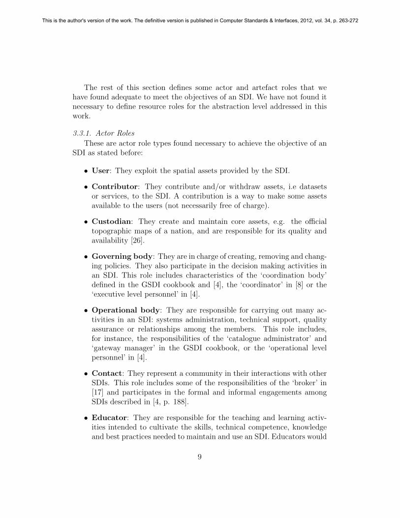
An RM-ODP community is built to meet an objective. This objectivemay be decomposed into sub-objectives if needed. Communities are speci-fied in contracts. An example of a community contract which includes itsobjective, in UML4ODP, is shown in figure 2. In that figure, the SpainSDI is modelled as an «EV Community», a UML component, linked toits objective, a UML class, by a «EV ObjectiveOf» UML association. TheSpain SDI «EV CommunityObject» is also shown to illustrate the use of the«EV RefinesAsCommunity» UML dependency with the component whichexpresses this community.
Based on the several definitions for the term ‘Spatial Data Infrastructure’analyzed in [2, 3], we propose that the objective of an SDI is to facilitate andpromote the use of electronic spatial information resources, on a stable andsupporting environment, in a geographical region where different autonomousrelevant organizations2 coexist, and where it is desirable, or necessary, to
1UML4ODP does not address federations, so there is neither a recommended approachnor any hints on how to model them in UML.
2We are using organization in a broad sense, not necessarily to refer to formal or legal
6
This is the author's version of the work. The definitive version is published in Computer Standards & Interfaces, 2012, vol. 34, p. 263-272
INSPIRE«EV_CommunityObject»
INSPIRE Member
«EV_Role»
SDI
SDI
Spain Cadaster«EV_CommunityObject»
Ebro Basin Authority«EV_CommunityObject»
Spain SDI «EV_CommunityObject»
France SDI «EV_CommunityObject»
Spain SDI Member«EV_Role»
France SDI Member«EV_Role»
SDI
«EV_FulfillsRole»
«EV_FulfillsRole»«EV_FulfillsRole»
«EV_FulfillsRole»«EV_FulfillsRole»
Figure 1: A diagram with an SDI and some of its members in UML4ODP
«EV_CommunityContract»Spain SDI
Spain SDI Objective
«EV_Objective»tagsdescription =Spain SDI is formed toachieve...
Enterprise Objects
Spain SDI«EV_Community»
Roles Policies
Spain SDI«EV_CommunityObject»
«EV_RefinesAsCommunity»
«EV_ObjectiveOf»
Figure 2: Spain SDI community contract in UML4ODP
7
This is the author's version of the work. The definitive version is published in Computer Standards & Interfaces, 2012, vol. 34, p. 263-272

keep some of that autonomy. This objective is decomposed in these threesub-objectives:
• Facilitating the creation, discovery, evaluation, exploitation, reuse, in-tegration, and commerce of electronic spatial data and services.
• Creating a sustainable, reliable and supporting environment, by secur-ing the necessary funds, establishing and adopting norms and policiesand providing certain fundamental assets.
• Facilitating the cooperation and coordination among relevant, au-tonomous organizations, with different responsibilities in differentareas, scales and domains.
These sub-objectives are generic and they must be considered as a startingpoint for concrete SDIs to specify their own.
3.3. Roles
The behaviour of a community is specified to meet its objective. It con-sists of the actions where this community objects participate. These objectsparticipate fulfilling the roles defined for the community. For instance, aperson can fulfill the role of user in a certain interaction, and the role ofcontributor in another one. Roles in RM-ODP are identifiers for behaviours(i.e. a role is a named collection of actions, with some constraints on thoseactions). A given object can participate in an action, as an actor role, or bementioned in an action, fulfilling an artefact role, or can be essential for anaction, requiring allocation and possibly becoming unavailable, as a resourcerole.
Roles facilitate modelling complex and scalable environments. For in-stance, the system administrators in two different communities in an SDImay have very different profiles and responsibilities, but when they fulfill theSDI role of operational body, their behaviour is well-known. This way theinteractions and processes in the SDI can be defined without the need toknow which objects will be participating, as long as these objects participatefulfilling the well-known roles specified for that SDI.
organizations. We use the term ‘relevant’ to refer to organizations with an interest inspatial data and services, either as producers, value-added providers or users.
8
This is the author's version of the work. The definitive version is published in Computer Standards & Interfaces, 2012, vol. 34, p. 263-272
The rest of this section defines some actor and artefact roles that wehave found adequate to meet the objectives of an SDI. We have not found itnecessary to define resource roles for the abstraction level addressed in thiswork.
3.3.1. Actor Roles
These are actor role types found necessary to achieve the objective of anSDI as stated before:
• User: They exploit the spatial assets provided by the SDI.
• Contributor: They contribute and/or withdraw assets, i.e datasetsor services, to the SDI. A contribution is a way to make some assetsavailable to the users (not necessarily free of charge).
• Custodian: They create and maintain core assets, e.g. the officialtopographic maps of a nation, and are responsible for its quality andavailability [26].
• Governing body: They are in charge of creating, removing and chang-ing policies. They also participate in the decision making activities inan SDI. This role includes characteristics of the ‘coordination body’defined in the GSDI cookbook and [4], the ‘coordinator’ in [8] or the‘executive level personnel’ in [4].
• Operational body: They are responsible for carrying out many ac-tivities in an SDI: systems administration, technical support, qualityassurance or relationships among the members. This role includes,for instance, the responsibilities of the ‘catalogue administrator’ and‘gateway manager’ in the GSDI cookbook, or the ‘operational levelpersonnel’ in [4].
• Contact: They represent a community in their interactions with otherSDIs. This role includes some of the responsibilities of the ‘broker’ in[17] and participates in the formal and informal engagements amongSDIs described in [4, p. 188].
• Educator: They are responsible for the teaching and learning activ-ities intended to cultivate the skills, technical competence, knowledgeand best practices needed to maintain and use an SDI. Educators would
9
This is the author's version of the work. The definitive version is published in Computer Standards & Interfaces, 2012, vol. 34, p. 263-272

hold responsibilities on information and training for the capacity build-ing described in [27].
• Promoter: They are responsible for publicizing an SDI, its compo-nents, objectives and benefits, and for keeping the different actors in-formed of news and changes. The promotion of the SDI is an activitymentioned in the GSDI cookbook.
• Funder: They provide the funds needed to keep the SDI. The GSDIcookbook highlights the importance of funding, gives some examples fordifferent SDIs, and makes some suggestions in order to ensure fundingand persuade funders (p. 110-112).
• Member: This role models the behaviour of a community which be-longs to an SDI, as a whole. It is mainly used to show the structure ofan SDI (see section 3.1).
• Communication channel: The means used by other actors of an SDIto exchange information and to access the spatial assets. It is explicitlyconsidered to emphasize the importance of well-defined communicationmechanisms in an SDI.
• SDI catalog: The mechanism provided by an SDI to obtain metadataabout its spatial assets. Nothing is implied about this mechanism: itcan be a single service, a gateway to a network of services or a simpledirectory.
3.3.2. Artefact Roles
These are the descriptions for the artefact role types mentioned in theprocesses and interactions in this paper:
• Spatial asset: Any useful or valuable spatial information resource thatcan be made accessible to the users of an SDI. It is a generalization ofvery different spatial information resources (such as spatial datasets,geoportals, OGC web services or promotional stuff).
• Core asset: An element which is essential to achieve the objectivesof an SDI. The GSDI cookbook describes ‘consistent reusable themesof base cartographic content (framework, fundamental, foundation orcore data)’ (p. 10). The core asset would include these themes, butalso core web services, support applications, and data models.
10
This is the author's version of the work. The definitive version is published in Computer Standards & Interfaces, 2012, vol. 34, p. 263-272

• Spatial asset metadata: A structured description about a spatialasset.
These artefact role types are sufficient for the processes and interactionsdescribed in this paper. Nevertheless, it is expected that modelling moredetailed behaviour in an SDI will requiere refinements of them, like differenttypes of spatial assets.
3.4. Enterprise Objects
Enterprise objects model entities which are needed in the specification ofa system from the enterprise viewpoint. These entities can be, for instance,human beings, legal entities, software components or data resources. Theyparticipate in actions fulfilling actor, artefact or resource roles. The sameenterprise object may fulfill different roles at different moments.
These are the enterprise object types required to fulfill the role typespresented in sections 3.3.1 and 3.3.2:
• Person: An individual human being. They can fulfill the roles ofuser, contributor, governing body, operational body, funder, contact,educator and promoter.
• Team: A group of people, usually small, with a common objective.They can fulfill the roles of user, contributor, governing body, opera-tional body, funder, contact, educator and promoter.
• Organization: A stable entity formed by people with a certain pur-pose, and guided by a set of, typically formal, rules. It can fulfill theroles of member, user, contributor, governing body, operational body,funder, contact, educator, promoter and custodian. This is the onlyobject type that we have found appropriate for custodianship, as thisactivity would require long term commitment and, possibly, a formalinstitution.
• Spatial dataset: A collection of data related to geographic locations.They can fulfill the roles of spatial asset and core asset.
• Spatial application: A software system that allows users to performa set of tasks, mainly related with spatial data and metadata, possiblyaccessing to some spatial services. They can fulfill the roles of spatialasset, spatial application, core asset and SDI catalog.
11
This is the author's version of the work. The definitive version is published in Computer Standards & Interfaces, 2012, vol. 34, p. 263-272
• Spatial service: A software system, with an interface for other soft-ware systems, that provides operations to access to, or work with, spa-tial data and metadata. They can fulfill the roles of spatial asset, spatialservice, core asset and SDI catalog.
• Geoportal: A web site mainly focused on spatial content, spatial ser-vices, and the tools to discover them. They can fulfill the roles ofspatial asset, core asset, SDI catalog (i.e. if implemented as databaseaccessible through the geoportal), and communication channel.
3.5. Policies
Policies in RM-ODP are sets of rules related to particular purposes. Forexample, the specification of an SDI may require that a ‘standards policy’regulates the process of loading a piece of metadata in the SDI catalog. Thispolicy would state which standards are accepted for the metadata to beloaded.
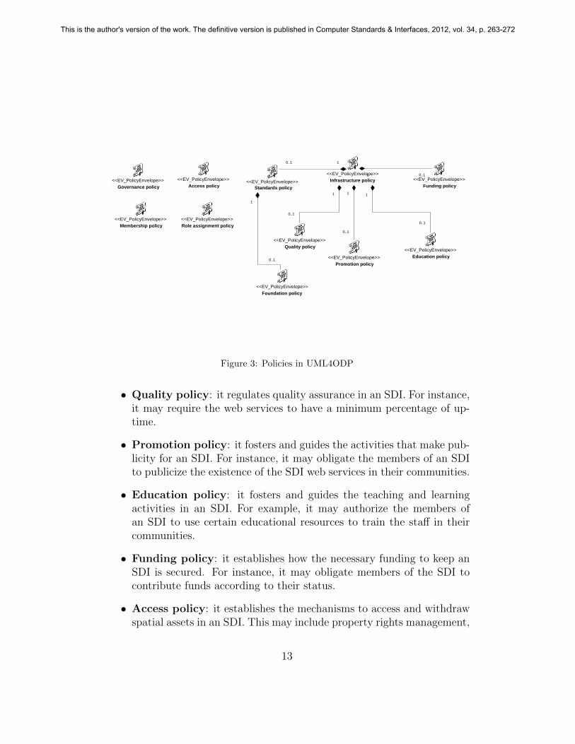
In this work, we propose a set of policies we have found relevant to anSDI. These policies will differ among different SDIs, but any SDI followingthe architectural proposal in this paper will implement most, if not all, ofthem. They are expressed in UML4ODP, as «EV PolicyEnvelope» UMLclasses, in figure 3:
• Governance policy: it regulates the decision making and policy mak-ing activities in an SDI. Its specific rules are very dependant on the typeof SDI: its size, its scope or if its legally mandated or not.
• Role assignment policy: it establishes the enterprise objects thatmay fulfill the different roles, and under which circumstances. Somesimple rules are given in section 3.4, with the different types of enter-prise objects described there.
• Infrastructure policy: it helps to enforce that an SDI and its compo-nents possess certain properties that contribute to make them a stable,reliable and supporting environment. It is composed of several policies,as shown in figure 3.
• Standards policy: it facilitates the exchange of information and ser-vices by the specification or adoption of certain norms.
• Foundation policy: this policy establishes the core assets of an SDI.
12
This is the author's version of the work. The definitive version is published in Computer Standards & Interfaces, 2012, vol. 34, p. 263-272
<<EV_PolicyEnvelope>>Standards policy
<<EV_PolicyEnvelope>>Quality policy
<<EV_PolicyEnvelope>>Access policy
<<EV_PolicyEnvelope>>Foundation policy
<<EV_PolicyEnvelope>>Governance policy
<<EV_PolicyEnvelope>>Role assignment policy
<<EV_PolicyEnvelope>>Infrastructure policy <<EV_PolicyEnvelope>>
Funding policy
<<EV_PolicyEnvelope>>Promotion policy
1
0..1
1 0..1
1
0..1
1
0..1
<<EV_PolicyEnvelope>>Membership policy
<<EV_PolicyEnvelope>>Education policy
1
0..1
10..1
Figure 3: Policies in UML4ODP
• Quality policy: it regulates quality assurance in an SDI. For instance,it may require the web services to have a minimum percentage of up-time.
• Promotion policy: it fosters and guides the activities that make pub-licity for an SDI. For instance, it may obligate the members of an SDIto publicize the existence of the SDI web services in their communities.
• Education policy: it fosters and guides the teaching and learningactivities in an SDI. For example, it may authorize the members ofan SDI to use certain educational resources to train the staff in theircommunities.
• Funding policy: it establishes how the necessary funding to keep anSDI is secured. For instance, it may obligate members of the SDI tocontribute funds according to their status.
• Access policy: it establishes the mechanisms to access and withdrawspatial assets in an SDI. This may include property rights management,
13
This is the author's version of the work. The definitive version is published in Computer Standards & Interfaces, 2012, vol. 34, p. 263-272
licensing, price policies and the rights that members keep over the spa-tial assets they contribute (i.e. whether after a contribution they keepthe right to withdraw it).
• Membership policy: it regulates generic aspects of the relationshipamong an SDI and its members, as rights and obligations or entry andexit procedures.
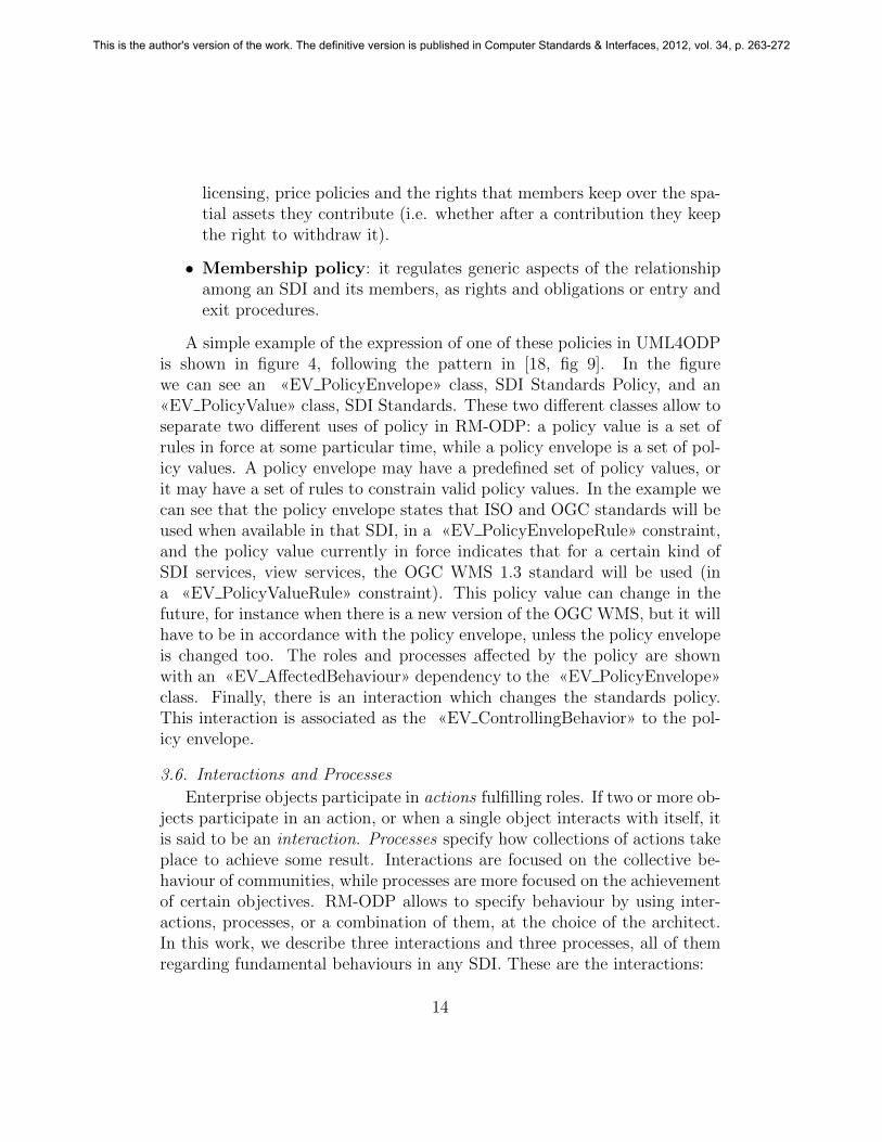
A simple example of the expression of one of these policies in UML4ODPis shown in figure 4, following the pattern in [18, fig 9]. In the figurewe can see an «EV PolicyEnvelope» class, SDI Standards Policy, and an«EV PolicyValue» class, SDI Standards. These two different classes allow toseparate two different uses of policy in RM-ODP: a policy value is a set ofrules in force at some particular time, while a policy envelope is a set of pol-icy values. A policy envelope may have a predefined set of policy values, orit may have a set of rules to constrain valid policy values. In the example wecan see that the policy envelope states that ISO and OGC standards will beused when available in that SDI, in a «EV PolicyEnvelopeRule» constraint,and the policy value currently in force indicates that for a certain kind ofSDI services, view services, the OGC WMS 1.3 standard will be used (ina «EV PolicyValueRule» constraint). This policy value can change in thefuture, for instance when there is a new version of the OGC WMS, but it willhave to be in accordance with the policy envelope, unless the policy envelopeis changed too. The roles and processes affected by the policy are shownwith an «EV AffectedBehaviour» dependency to the «EV PolicyEnvelope»class. Finally, there is an interaction which changes the standards policy.This interaction is associated as the «EV ControllingBehavior» to the pol-icy envelope.
3.6. Interactions and Processes
Enterprise objects participate in actions fulfilling roles. If two or more ob-jects participate in an action, or when a single object interacts with itself, itis said to be an interaction. Processes specify how collections of actions takeplace to achieve some result. Interactions are focused on the collective be-haviour of communities, while processes are more focused on the achievementof certain objectives. RM-ODP allows to specify behaviour by using inter-actions, processes, or a combination of them, at the choice of the architect.In this work, we describe three interactions and three processes, all of themregarding fundamental behaviours in any SDI. These are the interactions:
14
This is the author's version of the work. The definitive version is published in Computer Standards & Interfaces, 2012, vol. 34, p. 263-272
SDI Standards Policy
«EV_PolicyEnvelope»
SDI Standards«EV_PolicyValue»
«EV_PolicyEnvelopeRule»{Obligation: when available for a certain use, ISO TC 211 and OGCstandards will be followed}
«EV_PolicyValueRule»{Obligation: OGC WMS 1.3 will be used for view services}
OperationalBody
«EV_Role»
Contributor«EV_Role»
ContributeSpatialDataSet
«EV_Process»
SetStandards
Policy
«EV_Interaction»
The standards policy in SDI is in line withinternational standards and the applicablelaws. It promotes the use of standards whenever possible in order to maximize theusefulness of its spatial assets.
0..1
1
+current value
«EV_AffectedBehavior»
«EV_AffectedBehavior»
«EV_AffectedBehavior»
«EV_ControllingBehavior»
Figure 4: A standards policy expression in UML4ODP
15
This is the author's version of the work. The definitive version is published in Computer Standards & Interfaces, 2012, vol. 34, p. 263-272
• Join SDI: A community, represented by a contact, joins an SDI,represented also by a contact. The interaction is regulated by thegovernance, the membership and the infrastructure policies, andapproved by an operational body of the SDI that is incorporatingthe new member. The membership policy establishes the requirementsto the joining member to be admitted, and the governance policy theprocedures to follow. The infrastructure policy may include certainindirect requirements: for instance, if certain quality parameter is ex-pected to be achieved by all members, the new member must comply.
• Leave SDI: A community, represented by a contact, wants to leavean SDI, represented also by a contact. The interaction is regulated bythe governance, the membership and the infrastructure policies,and approved by an operational body of the SDI which includes theleaving member. The membership policy determines the requirementsthat a member must fulfill to withdraw from an SDI, and if that ispermitted.
• Obtain access to spatial asset: Any user with an interest in a spa-tial asset uses the SDI catalog to obtain the spatial asset meta-data, in order to find out the requirements to access it. These re-quirements may involve contacting an operational body, e.g. to gettechnical support, or the contributor responsible for that asset, e.g.to obtain a permission. This contact would happen through an SDIcommunication channel. This interaction intends to capture the,potentially complex, actions needed for users to obtain access to spa-tial assets (e.g. discovering them, negotiating licenses and terms ofservices or establishing payment agreements), and not to model thediscovery, download or use of a spatial asset. Once obtained access toa spatial asset, users will probably use it many times, but how thishappens depends on the type of spatial asset.
The access policy essentially exists to regulate this interaction: whocan obtain access to what and how. The infrastructure policy mayregulate some quality aspects in the access to certain assets, or somerules regarding the access to core assets.
As an example of their representation in UML4ODP, the join SDIinteraction is shown in figure 5. This figure shows an «EV Interaction»
16
This is the author's version of the work. The definitive version is published in Computer Standards & Interfaces, 2012, vol. 34, p. 263-272

class, join SDI, associated with three «EV Role» classes. This meansthat enterprise objects fulfilling these roles will be interacting. There is an«EV InteractionInitiator», contact, representing the community joiningthe SDI, and two «EV InteractionResponder», a contact, which repre-sents the SDI, and an operational body that will take the necessarysteps to incorporate the new community. The interaction is regulated,«EV AffectedBehavior», by three policies: membership, infrastructureand governance.
Other common behaviours can be modelled as processes. Most SDIs willhave many processes, but they may be very different among different SDIs.These are some common examples:
• Contribute spatial asset: Any contributor with a spatial as-set contacts an operational body through an SDI communicationchannel. The contributor must provide the spatial asset metadata.The operational body checks if the contribution fulfills the appropri-ate policies before making it available. This process is affected by theinfrastructure and membership policies, that may indicate certainrequirements a spatial asset must fulfill in order to be accepted, andalso certain requirements for the contributor. The access policy allowsthe operational body to check if the contribution will be accessible asrequired by the SDI.
• Withdraw spatial asset: Any contributor with certain rights overa spatial asset contacts an operational body through an SDI com-munication channel. The contributor must provide the spatial as-set metadata, in order to identify the spatial asset to be withdrawn.The operational body will remove the metadata from the SDI cata-log. This process is affected by the infrastructure and membershippolicies, that may indicate that certain assets from certain memberscannot be withdrawn, or can be only withdrawn after certain require-ments are fulfilled. The access policy may indicate if the contributorhas the right to withdraw the spatial asset.
• Establish/change policy: It specifies how a governing body canchange a policy, or create a new one. It is controlled by the governancepolicy. Refinements of this process could include the adoption of newstandards (i.e. changing the standards policy) or changes in the laws
17
This is the author's version of the work. The definitive version is published in Computer Standards & Interfaces, 2012, vol. 34, p. 263-272

JoinSDI
<<EV_Interaction>>
<<EV_Role>>Contact
<<EV_Role>>Contact
<<EV_Role>>Operational body
«EV_InteractionInitiator»
«EV_InteractionResponder»
«EV_InteractionResponder»
«EV_AffectedBehaviour»
«EV_AffectedBehaviour»
«EV_AffectedBehaviour»
<<EV_PolicyEnvelope>>Membership policy
<<EV_PolicyEnvelope>>Infrastructure policy
<<EV_PolicyEnvelope>>Governance policy
Figure 5: Join SDI interaction in UML4ODP
affecting the SDI (i.e. changing the governance or the membershippolicies).
As an example of their representation in UML4ODP, the activity dia-gram of the contribute spatial asset process is shown in figure 6. In thatdiagram, the actor roles contributor, communication channel and op-erational body are expressed by «EV Role» activityPartitions. The stepsof the process, e.g. ‘validate contribution’, are expressed by «EV Step» call-BehaviorActions. The artefacts referenced in the process, e.g. spatial asset,are expressed by «EV Artefact» objectNodes. The process is started by acontributor, who request a spatial asset contribution to the communicationchannel. The channel delivers the spatial asset, and its metadata, to an oper-ational body. The operational body validates the contribution. If it is valid,the operational body makes it available in the SDI. If not, the operationalbody informs of the rejection reasons so the contributor can make the appro-priate changes. A real world specification would refine several of the stepsof this process, for instance to specify in detail the validation. This wouldbe done associating each refined callBehaviorAction with an «EV Process»activity that expresses the refinement.
18
This is the author's version of the work. The definitive version is published in Computer Standards & Interfaces, 2012, vol. 34, p. 263-272

Spatial Asset
Spatial AssetMetadata
RejectionReasons
«EV_Role» Communication Channel
Spatial Asset
Spatial AssetMetadata
RejectionReasons
«EV_Role» Operational Body
Spatial Asset
Spatial AssetMetadata
RejectionReasons
«EV_Role» Contributor
Spatial Asset
Spatial AssetMetadata
RejectionReasons
«EV_Step»
Request Spatial Asset Contribution
ActivityInitial
«EV_Step»
ValidateContribution
«EV_Step»Add Spatial Asset Metadata to SDI
Catalog
«EV_Step»
Make Spatial Asset Available
«EV_Step»Reject
Contribution
ActivityFinal
«EV_Step»
Accept Rejection
«EV_Step»
Accept Successful Contributioin
«EV_Step»
Deliver Spatial Asset Contribution
«EV_Step»
ReceiveContribution
«EV_Step»
Deliver Rejection
«EV_Step»
Deliver Acceptance
[Not OK]
[OK]
Figure 6: Contribute Spatial Asset process in UML4ODP
19
This is the author's version of the work. The definitive version is published in Computer Standards & Interfaces, 2012, vol. 34, p. 263-272

4. Conclusions
This paper has presented an architectural view for SDIs, which allowsto describe them as federations of communities in terms of the enterpriselanguage of the ISO RM-ODP. The language chosen to express this viewhas been UML4ODP. This approach provides a systematic, graphical andformalizable technique to model SDIs, and a way to facilitate the exchangeof knowledge about them among different stakeholders. Designers and re-searchers may apply this view to produce an enterprise specification to guidethe set up of a new SDI, to plan future changes to a given one, or to documentits current state, for instance as a first step towards an assessment study. Asthey are based on common and well-established architectural concepts, theseviews make it possible to compare different SDIs, from a systems perspective.
This work has also made it possible to provide conceptualizations formany terms used to describe SDIs in current research. The most significantexample is the term ‘SDI’ itself, that we can now define on well-known con-cepts of the RM-ODP: an SDI is a federation of communities, which may beSDIs themselves, which objective is to facilitate and promote the use of elec-tronic spatial information resources, on a stable and supporting environment,in a geographical region where different autonomous relevant organizationscoexist, and where it is desirable, or necessary, to keep some of that auton-omy. Although this definition looks simple, we consider that it fits well thesystems currently described as SDIs, and that it is more specific and clearthan the existing definitions for SDI. This paper has also advanced in theconceptualization, on RM-ODP concepts, of many other SDI terms whichexisted but were not typically related to any formal substrate, e.g. user; ithas also proposed new terms for some abstract concepts that were necessaryin order to model generic interactions, e.g. spatial asset, and has made itexplicit several concepts which have been usually considered implicit, or notconsidered at all, like promotion policy.
SDIs are complex systems in constant change, with many different compo-nents, and where many actors, with different interests, necessities and degreesof autonomy are constantly interacting. Previous research has recognized thiscomplexity by considering them under the point of view of Systems of Sys-tems and Complex Adaptive Systems. We thus expect that the proposal inthis work can be useful to model SDIs to a certain extent (e.g. fundamen-tal roles, policies, and interactions), that is enough to set up an ‘SDI gameboard’ where the evolving interactions among its elements can be followed,
20
This is the author's version of the work. The definitive version is published in Computer Standards & Interfaces, 2012, vol. 34, p. 263-272
although further research is needed to validate this point.Regarding the use of RM-ODP, this ISO standard has provided the nec-
essary concepts to model SDIs from an enterprise viewpoint. Taking intoconsideration the complexity of SDIs, we have shown that the enterprise lan-guage of the RM-ODP can be a powerful and flexible tool to address themodelling of complex and distributed systems. The use of UML4ODP hasprovided us with an standardized way to express the concepts in the enter-prise language of the RM-ODP. Nevertheless we have found some issues withUML4ODP which deserve some attention:
• The UML4ODP standard does not address federations at all. Thiswould have been very helpful in a situation where the distinction be-tween federations, SDIs, and communities which are not federations,which are not SDIs, is crucial.
• It seems there is an ‘impedance mismatch’ between UML and the RM-ODP. Although the UML4ODP standard has managed to successfullyovercome this, it has been done at the price of a certain complexity. Forinstance, an actor role type is expressed as a stereotyped UML Class oras an stereotyped UML ActivityPartition, while an artefact role type isexpressed as a stereotyped UML Signal or as an stereotyped UML Ob-jectNode depending on the situation. The use of an appropriate UMLmodelling tool makes things easier, but we think that the UML4ODPstandard complexity must be taken into consideration when evaluatingits suitability for a project.
As immediate future work, we will apply the results presented in thispaper to model a real-world SDI, in order both to confirm its applicabilityand to extend the concepts described in this paper if necessary to address newaspects of that SDI. In the longer term, we plan to address other RM-ODPviewpoints for SDIs too.
5. Acknowledgments
This work has been partially funded by the Spanish government throughthe projects ‘Espana Virtual’ (ref. CENIT 2008-1030) and TIN2009-10971,the Government of Aragon through the project PI075/08, the Spain NationalGeographic Institute (IGN) and GeoSpatiumLab S.L. The authors have alsoto acknowledge Akira Tanaka and Antonio Vallecillo who, by blog, e-mail
21
This is the author's version of the work. The definitive version is published in Computer Standards & Interfaces, 2012, vol. 34, p. 263-272
and telephone, helped us to understand some points in the RM-ODP andUML4ODP standards (of course, any mistake in this paper regarding thesestandards is entirely our own fault).
References
[1] GSDI Technical Working Group and contributors, Developing SpatialData Infrastructures: The SDI Cookbook, Global Spatial Data Infras-tructure (http://www.gsdi.org), 2.0 edition, 2004.
[2] A. Rajabifard, I. P. Williamson, Spatial data infrastructures: Con-cept, SDI hierarchy and future directions, in: Geomatics 80 Conference,Tehran, Iran.
[3] D. J. Coleman, J. McLaughlin, Defining Global Geospatial Data In-frastructure (GGDI): Components, Stakeholders and Interfaces, in: 2ndGlobal Spatial Data Infrastructure Conference, Chapel Hill, USA.
[4] M. Warnest, A Collaboration Model for National Spatial Data Infras-tructure in Federated Countries, Ph.D. thesis, Department of Geomatics,The University of Melbourne, 2005. Retrieved December 15, 2006 fromhttp://eprints.infodiv.unimelb.edu.au/archive/00001361/.
[5] R. Bejar, M. A. Latre, J. Nogueras-Iso, P. R. Muro-Medrano,J. Zarazaga-Soria, Systems of systems as a conceptual framework forspatial data infrastructures, International Journal of SDI Research (IJS-DIR) 4 (2009) 201–217.
[6] L. Grus, J. C. and A. K. Bregt, Spatial data infrastructures as complexadaptive systems, International Journal of Geographical InformationScience 24 (2010) 439–463.
[7] J. Crompvoets, A. Rajabifard, B. van Loenen, T. Delgado Fernan-dez (Eds.), A Multi-View Framework to Assess SDIs, Space for Geo-Information (RGI), Wageningen University and Centre for SDIs andLand Administration, Department of Geomatics, The University of Mel-bourne, 2008.
[8] A. Rajabifard, I. P. Williamson, P. Holland, G. Johnstone, From localto global SDI initiatives: a pyramid building blocks, in: 4th GSDIConference, Cape Town, South Africa.
22
This is the author's version of the work. The definitive version is published in Computer Standards & Interfaces, 2012, vol. 34, p. 263-272
[9] I. Masser, What’s special about SDI related research?, InternationalJournal of Spatial Data Infrastructures Research 1 (2006) 14–23.
[10] The European Parliament and the Council of the European Union, Di-rective 2007/2/EC of the European Parliament and of the Council of14 March 2007 establishing an Infrastructure for Spatial Information inthe European Community (INSPIRE), Official Journal of the EuropeanUnion, volume 50, L 108.1/14, 2007.
[11] ANZLIC, ASDI Distribution Network: The Internet Framework Techni-cal Architecture (v2.6), Final draft, 2003. Retrieved September 2, 2008from http://www.anzlic.org.au/get/2375015862.pdf.
[12] L. Bernard, I. Kanellopoulos, A. Annoni, P. Smits, The European geo-portal - one step towards the establishment of a European spatial datainfrastructure, Computers, Environment and Urban Systems 29 (2005)15–31.
[13] GeoConnections, The Canadian Geospatial Data Infrastructure Archi-tecture Description Version 2.0, Technical Report, 2005.
[14] R. Bejar, M. A. Latre, J. Nogueras-Iso, P. R. Muro-Medrano,J. Zarazaga-Soria, An architectural style for spatial data infrastructures,International Journal of Geographical Information Science (IJGIS) 23(2009) 271–294.
[15] R. Atkinson, P. Box, United Nations Spatial Data Infras-tructure (UNSDI) Proposed Technical Governance Frame-work, Preliminary report 1.1, United Nations Geographic In-formation Working Group, 2008. Retrieved July 15, 2010from http://www.ungiwg.org/docs/unsdi/TechnicalGov/ProposedUNSDI Tech Gov Framework v1.1.doc.
[16] GEO Architecture and Data Committee, GEOSS Architec-ture Implementation Pilot (AIP), Core Task AR-09-01b,Group on Earth Observations, 2010. Retrieved July 15,2010 from http://www.earthobservations.org/documents/cfp/20100129 cfp aip3 architecture.pdf.
[17] J. Hjelmager, H. Moellering, A. Cooper, T. Delgado, A. Rajabifard,P. Rapant, D. Danko, M. Huet, D. Laurent, H. Aalders, A. Iwaniak,
23
This is the author's version of the work. The definitive version is published in Computer Standards & Interfaces, 2012, vol. 34, p. 263-272
P. Abad, U. Duren, A. Martynenko, An initial formal model for spatialdata infrastructures, International Journal of Geographic InformationScience 22 (2008) 1295–1309.
[18] ISO/IEC, Information technology — Open distributed processing —Use of UML for ODP system specifications, International Standard;ISO/IEC 19793:2008, International Organization for Standardization /International Electrotechnical Commission, Montreal, Quebec, Canada,2008.
[19] M. W. A. Steen, J. Derrick, ODP enterprise viewpoint specification,Computer Standards & Interfaces 22 (2000) 165–189.
[20] F. Duran, A. Vallecillo, Formalizing ODP enterprise specifications inMaude, Computer Standards & Interfaces 25 (2003) 83–102.
[21] ISO/IEC, Information technology - Open Distributed Processing - Ref-erence Model: Architecture, International standard; ISO/IEC 10746-3, International Organization for Standardization / International Elec-trotechnical Commission, Geneva, Switzerland, first edition edition,1996.
[22] ISO/IEC, Information technology - Open Distributed Processing - Ref-erence Model: Foundations, International standard; ISO/IEC 10746-2, International Organization for Standardization / International Elec-trotechnical Commission, Geneva, Switzerland, first edition edition,1996.
[23] ISO/IEC, Information technology - Open Distributed Processing - Refer-ence Model: Architectural Semantics, International standard; ISO/IEC10746-4, International Organization for Standardization / InternationalElectrotechnical Commission, Geneva, Switzerland, 1 edition, 1998.
[24] ISO/IEC, Information technology - Open Distributed Processing - Refer-ence Model: Overview, International standard; ISO/IEC 10746-1, Inter-national Organization for Standardization / International Electrotech-nical Commission, Geneva, Switzerland, first edition edition, 1998.
[25] ISO / IEC, Information technology - Open distributed processing - Ref-erence model - Enterprise language, International standard; ISO/IEC
24
This is the author's version of the work. The definitive version is published in Computer Standards & Interfaces, 2012, vol. 34, p. 263-272

15414:2006, International Organization for Standardization / Interna-tional Electrotechnical Commission, Geneva, Switzerland, second edi-tion edition, 2006.
[26] B. Thompson, M. Warnest, C. Chipchase, Developing Spatial Data In-frastructures: From Concept to Reality, Taylor and Francis, London,New York, pp. 147–164.
[27] A. Rajabifard, A. Binns, I. Masser, I. Williamson, The role of sub-national government and the private sector in future spatial data infras-tructures, International Journal of Geographical Information Science 20(2006) 727–741.
25
This is the author's version of the work. The definitive version is published in Computer Standards & Interfaces, 2012, vol. 34, p. 263-272


