Embed Size (px)
Citation preview
AMDTeAIPContactPost:
AERONAUTICALINFORMATION SERVICESCivil Aviation Authority ofSingapore,Singapore Changi Airport,P. O. Box 1Singapore 918141
Tel: (65) 64227036Fax: (65) 64410221Email: [email protected]
05/2021Effective date07 OCT 2021
Publication date07 OCT 2021
wp-AMDT-2021-05
1. Significant information and changes
1.1 Singapore FIR
a. Updates to AIP Section ENR 1.9 – Bay of Bengal Cooperative ATFM (BOBCAT)
b. Addition of flight planning requirements for ATS Route G334
c. Updated SINJON DVOR/DME (SJ) coordinates to relevant AIP pages and Aeronautical Charts.
2. This amendment incorporates information contained in the listed NOTAMs which are hereby superseded:
NOTAMsA4656/21 dated 18/08/2021A5487/21 dated 23/09/2021A5488/21 dated 23/09/2021
Amended Pages
GEN 0.1-1/2: : replace.GEN 0.2-1/2: : replace.GEN 0.3-1/2: : replace.GEN 0.3-3/4: : replace.GEN 0.3-5/6: : replace.GEN 0.4-1/2: : replace.GEN 0.4-3: : replace.GEN 2.1-1/2: : replace.GEN 3.1-3/4: : replace.GEN 3.2-3/4: : replace.GEN 3.6-3/4: : replace.ENR 0.6-5/6: : replace.ENR 1.9-1/2: : replace.ENR 1.9-3/4: : replace.ENR 1.9-5: : replace.ENR 3.1-3/4: : replace.ENR 3.1-5/6: : replace.ENR 3.1-7/8: : replace.ENR 3.1-9/10: : replace.ENR 3.1-11/12: : replace.ENR 3.6-1/2: : replace.ENR-3.6-3: : replace.ENR-3.6-7: : replace.ENR-3.6-9: : replace.ENR 4.1-1/2: : replace.
AIP AMDT 05/2021© 2021 Civil Aviation Authority Singapore
AMDT 05/2021-1AIP Singapore
ERC-6-1 En-Route Chart: : replace.AD 2.WSSS-3/4: : replace.AD 2.WSSS-13/14: : replace.AD 2.WSSS-25/26: : replace.AD 2.WSSS-41/42: : replace.AD-2-WSSS-ADC-2: : replace.AD-2-WSSS-STAR-14 to 14.1: : replace.AD-2-WSSS-STAR-15 to 15.1: : replace.AD-2-WSSS-IAC-1: : replace.AD-2-WSSS-IAC-2: : replace.AD-2-WSSS-IAC-5: : replace.AD-2-WSSS-IAC-6: : replace.AD-2-WSSS-IAC-7: : replace.AD 2.WSAP-9/10: : replace.AD 2.WSAP-11: : replace.AD-2-WSAP-IAC-2: : replace.AD-2-WSAP-IAC-3: : replace.AD-2-WSAP-IAC-4: : replace.AD-2-WSAP-IAC-6: : replace.AD 2.WSAT-5/6: : replace.
© 2021 Civil Aviation Authority SingaporeAIP AMDT 05/2021
AIP SingaporeAMDT 05/2021-2
Part 1 — General (GEN)
GEN 0
GEN 0.1 PREFACE
1 Name of the publishing authority1.1 The Singapore Aeronautical Information Products are published by authority of the Civil Aviation Authority of
Singapore.
2 Applicable ICAO documents
• ICAO Annex 15 - Aeronautical Information Service;• ICAO Annex 4 - Aeronautical Charts;• ICAO Doc 8126 - AIS Manual;• ICAO Doc 8697 - Aeronautical Chart Manual.• ICAO Doc 10066 - Procedures for Air Navigation Services - Aeronautical Information Management
(PANS-AIM)
2.1 Differences to ICAO Standards, Recommended Practices and Procedures are listed under subsection GEN1.7.
3 Publication Media3.1 TheSingaporeAeronautical InformationProducts comprisingAIPSingapore, AIPAmendments, AIPSupplements,
Aeronautical Information Circulars and NOTAM Lists, including NOTAMs and Pre-Flight Information Bulletinsare available for retrieval from AIM-SG URL https://aim-sg.caas.gov.sg
4 The AIP structure and established regular amendment interval
4.1 The AIP structureThe AIP forms part of the Aeronautical Information Products, details of which are given in subsection GEN 3.1.The principal AIP structure is shown in graphic form on page GEN 0.1-3.
The AIP is made up of three Parts, General (GEN), En-route (ENR) and Aerodromes (AD), each divided intosections and subsections as applicable, containing various types of information.
4.1.1 PART 1 — GENERAL (GEN)Part 1 consists of five sections containing information briefly described hereafter.
Preface; Record of AIP Amendments; Record of current AIP Supplements; Checklist of AIP pages;List of hand amendments to the AIP; and Table of Contents to Part 1.
GEN 0 -
National regulations and requirements - Designated authorities; Entry, transit and departure ofaircraft; Entry, transit and departure of passengers and crew; Entry, transit and departure of cargo;Aircraft instruments, equipment and flight documents; Summary of national regulations andinternational agreements/conventions; and Differences from ICAO Standards, RecommendedPractices and Procedures.
GEN 1 -
Tables and codes - Measuring system, aircraft markings, holidays; Abbreviations used in AISpublications; Chart symbols; Location indicators; List of radio navigation aids; Conversion tables;and Sunrise/Sunset tables.
GEN 2 -
Services - Aeronautical Information Services; Aeronautical Charts; Air Traffic Services;Communication Services; Meteorological Services; and Search and Rescue.
GEN 3 -
Charges for aerodromes and air navigation services - Aerodrome charges and Air navigationservices charges.
GEN 4 -
4.1.2 PART 2 — EN-ROUTE (ENR)Part 2 consists of seven sections containing information briefly described hereafter.
AIP AMDT 02/2020© 2020 Civil Aviation Authority Singapore
GEN 0.1-126 MAR 2020
AIP Singapore
Table of Contents to Part 2.ENR 0 -General rules and procedures - General rules; Visual flight rules; Instrument flight rules; ATS airspaceclassification; Holding, approach and departure procedures; Radar services and procedures;Altimeter setting procedures; Regional supplementary procedures; Air traffic flow management;Flight planning; Addressing of flight planmessages; Interception of civil aircraft; Unlawful interference;and Air traffic incidents.
ENR 1 -
Air traffic services airspace - Detailed description of Flight Information Region (FIR); TerminalControl Areas (TMA); and other regulated airspace.
ENR 2 -
ATS routes - Detailed description of ATS routes; Area Navigation Routes; Helicopter Routes; otherroutes; and en-route holding.
Note - Other types of routes which are specified in connection with procedures for traffic to andfrom aerodromes are described in the relevant sections and subsections of Part 3 - Aerodromes.
ENR 3 -
Radio navigation aids/systems - Radio navigation aids - en-route; special navigation systems;name-code designators for significant points; and aeronautical ground lights - en-route.
ENR 4 -
Navigation warnings - Prohibited, restricted and danger areas; military exercise and training areas;other activities of a dangerous nature; air navigation obstacles - en-route; aerial sporting andrecreational activities; and bird migration and areas with sensitive fauna.
ENR 5 -
En-route charts - En-route Chart - ICAO.ENR 6 -
4.1.3 PART 3 - AERODROMES (AD)Part 3 consists of three sections containing information briefly described hereafter.
Table of Contents to Part 3.AD 0 -Aerodromes - Introduction - Aerodromes availability; Rescue and fire fighting services; Index toaerodromes; and Grouping of aerodromes.
AD 1 -
Aerodromes - Detailed information about aerodromes listed under 24 sub-sections.AD 2 -This section has been omitted as there are no heliports in Singapore.AD 3 -
4.2 Regular Amendment IntervalRegular amendments to AIP Singapore will be issued once every two months. The publication dates will be onalternate AIRAC effective dates as follows:
Publication DateAmendment Number02 December 202106/2021←27 January 202201/2022←24 March 202202/2022←19 May 202203/2022←14 July 202204/2022←08 September 202205/2022←03 November 202206/202229 December 202207/2022
5 Service to contact in case of detected AIP errors or omissionsIn the compilation of the AIP, care has been taken to ensure that the information contained therein is accurateand complete. Any errors and omissions which may nevertheless be detected, as well as any enquiries orsuggestions concerning the Aeronautical Information Products, should be referred to:
Post:AERONAUTICAL INFORMATION SERVICESCivil Aviation Authority of Singapore,Singapore Changi Airport,P. O. Box 1Singapore 918141
Tel: (65) 64227036Fax: (65) 64410221Email: [email protected]
© 2021 Civil Aviation Authority SingaporeAIP AMDT 05/2021
AIP SingaporeGEN 0.1-207 OCT 2021~~~eaip-amdt~~~ver-date-2021-09-09T07-08-00-035
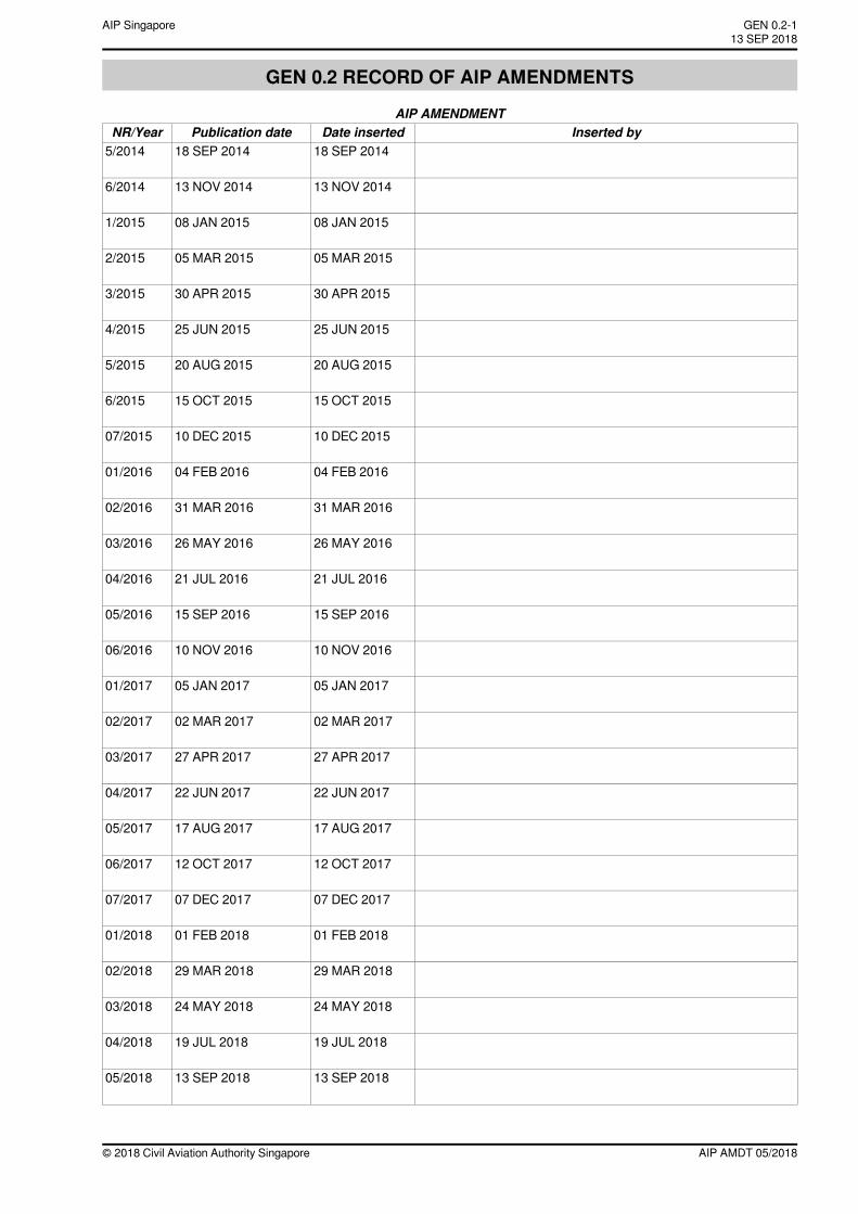
GEN 0.2 RECORD OF AIP AMENDMENTS
AIP AMENDMENTInserted byDate insertedPublication dateNR/Year
18 SEP 201418 SEP 20145/2014
13 NOV 201413 NOV 20146/2014
08 JAN 201508 JAN 20151/2015
05 MAR 201505 MAR 20152/2015
30 APR 201530 APR 20153/2015
25 JUN 201525 JUN 20154/2015
20 AUG 201520 AUG 20155/2015
15 OCT 201515 OCT 20156/2015
10 DEC 201510 DEC 201507/2015
04 FEB 201604 FEB 201601/2016
31 MAR 201631 MAR 201602/2016
26 MAY 201626 MAY 201603/2016
21 JUL 201621 JUL 201604/2016
15 SEP 201615 SEP 201605/2016
10 NOV 201610 NOV 201606/2016
05 JAN 201705 JAN 201701/2017
02 MAR 201702 MAR 201702/2017
27 APR 201727 APR 201703/2017
22 JUN 201722 JUN 201704/2017
17 AUG 201717 AUG 201705/2017
12 OCT 201712 OCT 201706/2017
07 DEC 201707 DEC 201707/2017
01 FEB 201801 FEB 201801/2018
29 MAR 201829 MAR 201802/2018
24 MAY 201824 MAY 201803/2018
19 JUL 201819 JUL 201804/2018
13 SEP 201813 SEP 201805/2018
AIP AMDT 05/2018© 2018 Civil Aviation Authority Singapore
GEN 0.2-113 SEP 2018
AIP Singapore
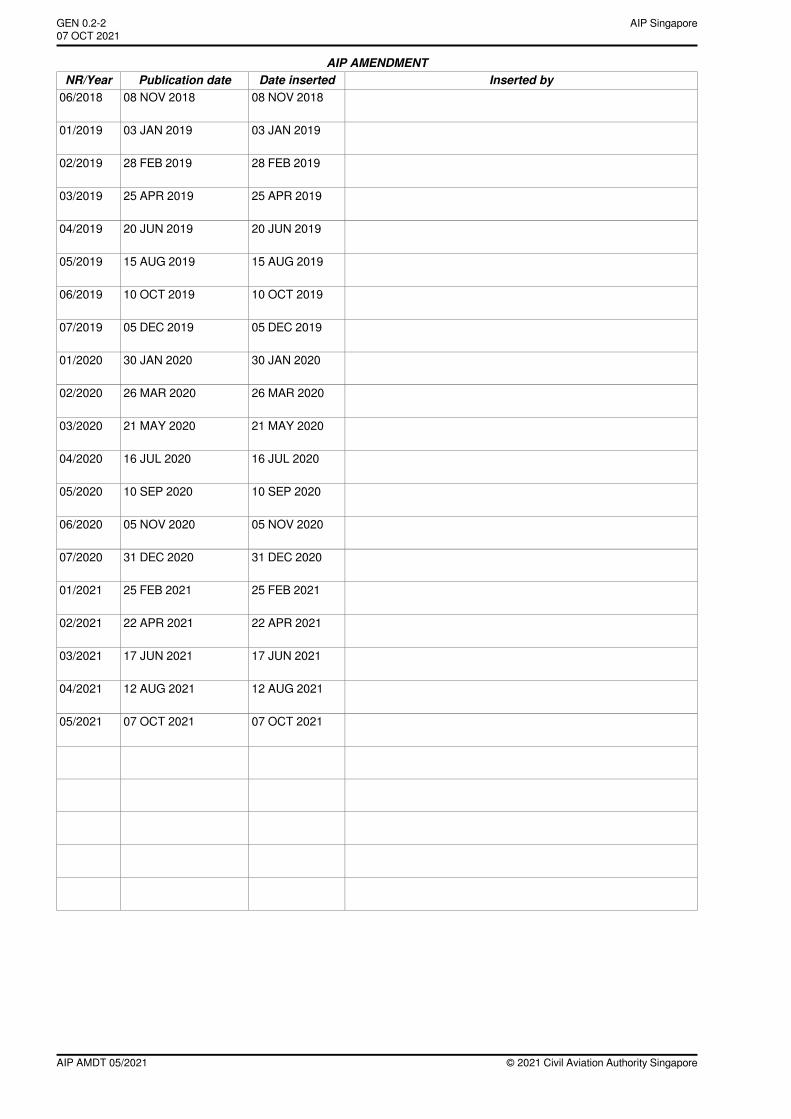
AIP AMENDMENTInserted byDate insertedPublication dateNR/Year
08 NOV 201808 NOV 201806/2018
03 JAN 201903 JAN 201901/2019
28 FEB 201928 FEB 201902/2019
25 APR 201925 APR 201903/2019
20 JUN 201920 JUN 201904/2019
15 AUG 201915 AUG 201905/2019
10 OCT 201910 OCT 201906/2019
05 DEC 201905 DEC 201907/2019
30 JAN 202030 JAN 202001/2020
26 MAR 202026 MAR 202002/2020
21 MAY 202021 MAY 202003/2020
16 JUL 202016 JUL 202004/2020
10 SEP 202010 SEP 202005/2020
05 NOV 202005 NOV 202006/2020
31 DEC 202031 DEC 202007/2020
25 FEB 202125 FEB 202101/2021
22 APR 202122 APR 202102/2021
17 JUN 202117 JUN 202103/2021
12 AUG 202112 AUG 202104/2021
07 OCT 202107 OCT 202105/2021
© 2021 Civil Aviation Authority SingaporeAIP AMDT 05/2021
AIP SingaporeGEN 0.2-207 OCT 2021~~~eaip-amdt~~~ver-date-2021-09-09T07-08-00-035
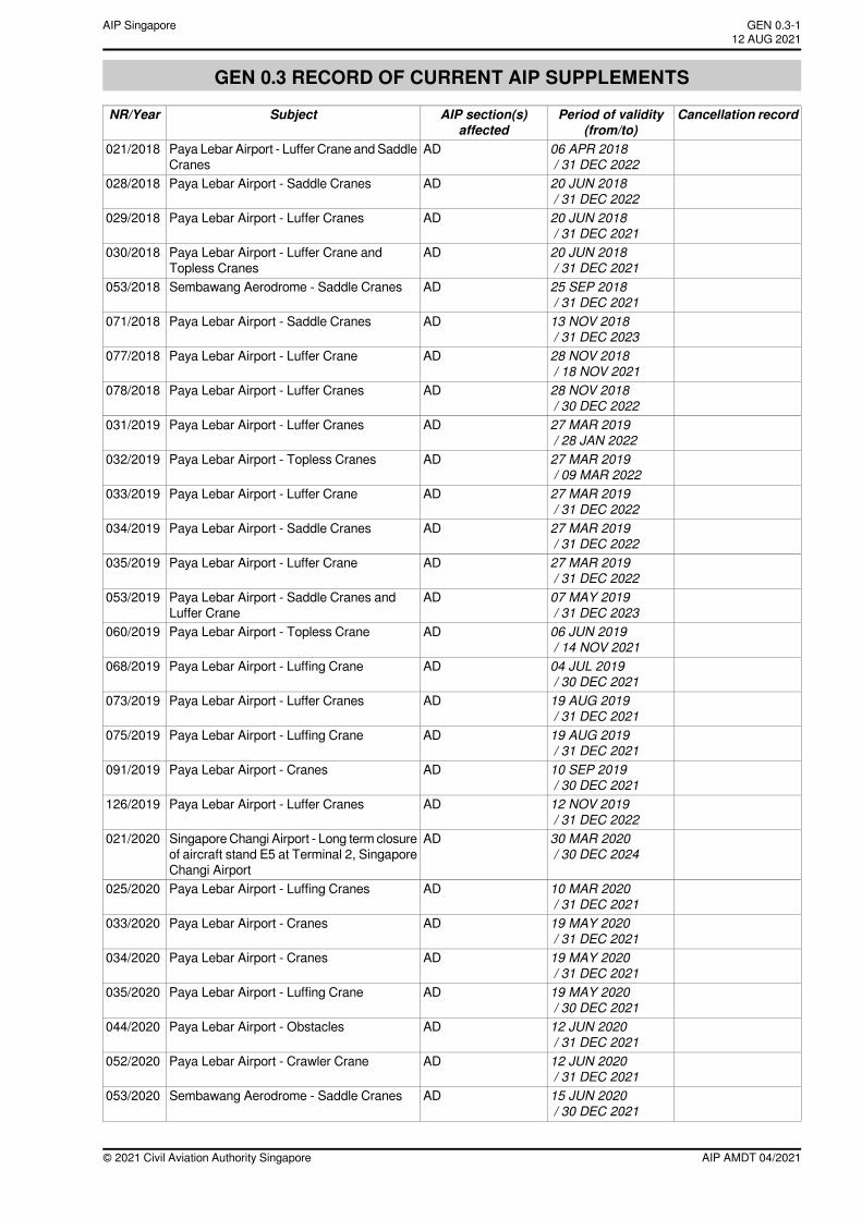
GEN 0.3 RECORD OF CURRENT AIP SUPPLEMENTS
Cancellation recordPeriod of validity(from/to)
AIP section(s)affected
SubjectNR/Year
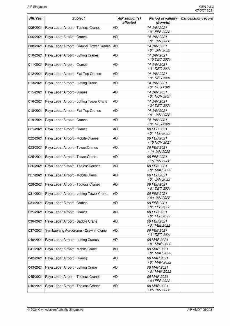
06 APR 2018/ 31 DEC 2022
ADPaya Lebar Airport - Luffer Crane and SaddleCranes
021/2018
20 JUN 2018/ 31 DEC 2022
ADPaya Lebar Airport - Saddle Cranes028/2018
20 JUN 2018/ 31 DEC 2021
ADPaya Lebar Airport - Luffer Cranes029/2018
20 JUN 2018/ 31 DEC 2021
ADPaya Lebar Airport - Luffer Crane andTopless Cranes
030/2018
25 SEP 2018/ 31 DEC 2021
ADSembawang Aerodrome - Saddle Cranes053/2018
13 NOV 2018/ 31 DEC 2023
ADPaya Lebar Airport - Saddle Cranes071/2018
28 NOV 2018/ 18 NOV 2021
ADPaya Lebar Airport - Luffer Crane077/2018
28 NOV 2018/ 30 DEC 2022
ADPaya Lebar Airport - Luffer Cranes078/2018
27 MAR 2019/ 28 JAN 2022
ADPaya Lebar Airport - Luffer Cranes031/2019
27 MAR 2019/ 09 MAR 2022
ADPaya Lebar Airport - Topless Cranes032/2019
27 MAR 2019/ 31 DEC 2022
ADPaya Lebar Airport - Luffer Crane033/2019
27 MAR 2019/ 31 DEC 2022
ADPaya Lebar Airport - Saddle Cranes034/2019
27 MAR 2019/ 31 DEC 2022
ADPaya Lebar Airport - Luffer Crane035/2019
07 MAY 2019/ 31 DEC 2023
ADPaya Lebar Airport - Saddle Cranes andLuffer Crane
053/2019
06 JUN 2019/ 14 NOV 2021
ADPaya Lebar Airport - Topless Crane060/2019
04 JUL 2019/ 30 DEC 2021
ADPaya Lebar Airport - Luffing Crane068/2019
19 AUG 2019/ 31 DEC 2021
ADPaya Lebar Airport - Luffer Cranes073/2019
19 AUG 2019/ 31 DEC 2021
ADPaya Lebar Airport - Luffing Crane075/2019
10 SEP 2019/ 30 DEC 2021
ADPaya Lebar Airport - Cranes091/2019
12 NOV 2019/ 31 DEC 2022
ADPaya Lebar Airport - Luffer Cranes126/2019
30 MAR 2020/ 30 DEC 2024
ADSingapore Changi Airport - Long term closureof aircraft stand E5 at Terminal 2, SingaporeChangi Airport
021/2020
10 MAR 2020/ 31 DEC 2021
ADPaya Lebar Airport - Luffing Cranes025/2020
19 MAY 2020/ 31 DEC 2021
ADPaya Lebar Airport - Cranes033/2020
19 MAY 2020/ 31 DEC 2021
ADPaya Lebar Airport - Cranes034/2020
19 MAY 2020/ 30 DEC 2021
ADPaya Lebar Airport - Luffing Crane035/2020
12 JUN 2020/ 31 DEC 2021
ADPaya Lebar Airport - Obstacles044/2020
12 JUN 2020/ 31 DEC 2021
ADPaya Lebar Airport - Crawler Crane052/2020
15 JUN 2020/ 30 DEC 2021
ADSembawang Aerodrome - Saddle Cranes053/2020
AIP AMDT 04/2021© 2021 Civil Aviation Authority Singapore
GEN 0.3-112 AUG 2021
AIP Singapore
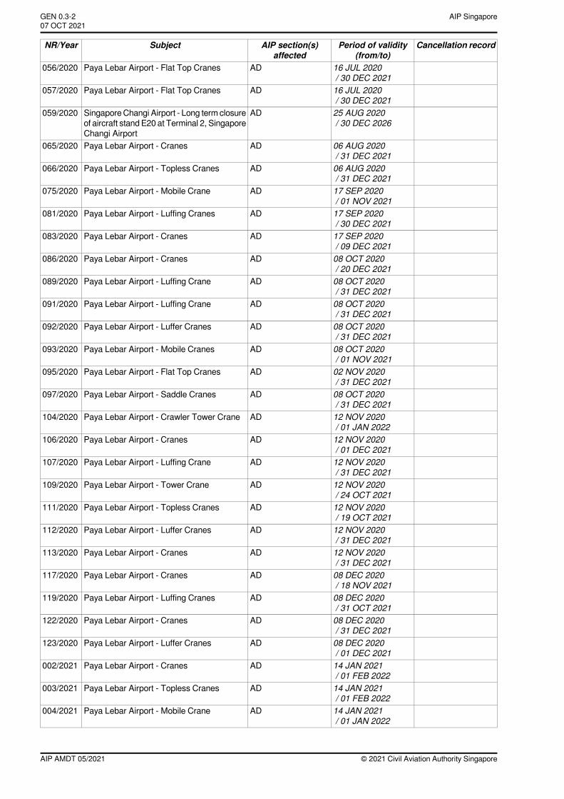
Cancellation recordPeriod of validity(from/to)
AIP section(s)affected
SubjectNR/Year
16 JUL 2020/ 30 DEC 2021
ADPaya Lebar Airport - Flat Top Cranes056/2020
16 JUL 2020/ 30 DEC 2021
ADPaya Lebar Airport - Flat Top Cranes057/2020
25 AUG 2020/ 30 DEC 2026
ADSingapore Changi Airport - Long term closureof aircraft stand E20 at Terminal 2, SingaporeChangi Airport
059/2020
06 AUG 2020/ 31 DEC 2021
ADPaya Lebar Airport - Cranes065/2020
06 AUG 2020/ 31 DEC 2021
ADPaya Lebar Airport - Topless Cranes066/2020
17 SEP 2020/ 01 NOV 2021
ADPaya Lebar Airport - Mobile Crane075/2020
17 SEP 2020/ 30 DEC 2021
ADPaya Lebar Airport - Luffing Cranes081/2020
17 SEP 2020/ 09 DEC 2021
ADPaya Lebar Airport - Cranes083/2020
08 OCT 2020/ 20 DEC 2021
ADPaya Lebar Airport - Cranes086/2020
08 OCT 2020/ 31 DEC 2021
ADPaya Lebar Airport - Luffing Crane089/2020
08 OCT 2020/ 31 DEC 2021
ADPaya Lebar Airport - Luffing Crane091/2020
08 OCT 2020/ 31 DEC 2021
ADPaya Lebar Airport - Luffer Cranes092/2020
08 OCT 2020/ 01 NOV 2021
ADPaya Lebar Airport - Mobile Cranes093/2020
02 NOV 2020/ 31 DEC 2021
ADPaya Lebar Airport - Flat Top Cranes095/2020
08 OCT 2020/ 31 DEC 2021
ADPaya Lebar Airport - Saddle Cranes097/2020
12 NOV 2020/ 01 JAN 2022
ADPaya Lebar Airport - Crawler Tower Crane104/2020
12 NOV 2020/ 01 DEC 2021
ADPaya Lebar Airport - Cranes106/2020
12 NOV 2020/ 31 DEC 2021
ADPaya Lebar Airport - Luffing Crane107/2020
12 NOV 2020/ 24 OCT 2021
ADPaya Lebar Airport - Tower Crane109/2020
12 NOV 2020/ 19 OCT 2021
ADPaya Lebar Airport - Topless Cranes111/2020
12 NOV 2020/ 31 DEC 2021
ADPaya Lebar Airport - Luffer Cranes112/2020
12 NOV 2020/ 31 DEC 2021
ADPaya Lebar Airport - Cranes113/2020
08 DEC 2020/ 18 NOV 2021
ADPaya Lebar Airport - Cranes117/2020
08 DEC 2020/ 31 OCT 2021
ADPaya Lebar Airport - Luffing Cranes119/2020
08 DEC 2020/ 31 DEC 2021
ADPaya Lebar Airport - Cranes122/2020
08 DEC 2020/ 01 DEC 2021
ADPaya Lebar Airport - Luffer Cranes123/2020
14 JAN 2021/ 01 FEB 2022
ADPaya Lebar Airport - Cranes002/2021
14 JAN 2021/ 01 FEB 2022
ADPaya Lebar Airport - Topless Cranes003/2021
14 JAN 2021/ 01 JAN 2022
ADPaya Lebar Airport - Mobile Crane004/2021
© 2021 Civil Aviation Authority SingaporeAIP AMDT 05/2021
AIP SingaporeGEN 0.3-207 OCT 2021~~~eaip-amdt~~~ver-date-2021-09-09T07-08-00-035
Cancellation recordPeriod of validity(from/to)
AIP section(s)affected
SubjectNR/Year
14 JAN 2021/ 01 FEB 2022
ADPaya Lebar Airport - Topless Cranes005/2021
14 JAN 2021/ 01 JAN 2022
ADPaya Lebar Airport - Cranes006/2021
14 JAN 2021/ 01 JAN 2022
ADPaya Lebar Airport - Crawler Tower Cranes008/2021
14 JAN 2021/ 15 DEC 2021
ADPaya Lebar Airport - Luffing Cranes010/2021
14 JAN 2021/ 31 DEC 2021
ADPaya Lebar Airport - Cranes011/2021
14 JAN 2021/ 31 DEC 2021
ADPaya Lebar Airport - Flat Top Cranes012/2021
14 JAN 2021/ 31 DEC 2021
ADPaya Lebar Airport - Luffing Crane013/2021
14 JAN 2021/ 01 NOV 2021
ADPaya Lebar Airport - Cranes015/2021
14 JAN 2021/ 24 DEC 2021
ADPaya Lebar Airport - Luffing Tower Crane016/2021
14 JAN 2021/ 01 JAN 2022
ADPaya Lebar Airport - Flat Top Cranes018/2021
14 JAN 2021/ 31 DEC 2021
ADPaya Lebar Airport - Cranes019/2021
08 FEB 2021/ 01 FEB 2022
ADPaya Lebar Airport - Cranes021/2021
08 FEB 2021/ 15 NOV 2021
ADPaya Lebar Airport - Mobile Cranes022/2021
08 FEB 2021/ 19 JAN 2022
ADPaya Lebar Airport - Tower Cranes023/2021
08 FEB 2021/ 15 JAN 2022
ADPaya Lebar Airport - Tower Crane025/2021
08 FEB 2021/ 01 MAR 2022
ADPaya Lebar Airport - Topless Cranes026/2021
08 FEB 2021/ 01 JAN 2022
ADPaya Lebar Airport - Mobile Crane027/2021
08 FEB 2021/ 01 DEC 2021
ADPaya Lebar Airport - Topless Cranes028/2021
08 FEB 2021/ 09 JAN 2022
ADPaya Lebar Airport - Luffing Tower Crane031/2021
08 FEB 2021/ 01 FEB 2022
ADPaya Lebar Airport - Cranes034/2021
08 FEB 2021/ 01 FEB 2022
ADPaya Lebar Airport - Cranes035/2021
08 FEB 2021/ 01 FEB 2022
ADPaya Lebar Airport - Saddle Crane036/2021
08 FEB 2021/ 31 DEC 2021
ADSembawang Aerodrome - Crawler Crane037/2021
08 MAR 2021/ 01 MAR 2022
ADPaya Lebar Airport - Luffing Cranes040/2021
08 MAR 2021/ 01 MAR 2022
ADPaya Lebar Airport - Mobile Crane041/2021
08 MAR 2021/ 01 MAR 2022
ADPaya Lebar Airport - Cranes042/2021
08 MAR 2021/ 01 MAR 2022
ADPaya Lebar Airport - Luffing Crane043/2021
08 MAR 2021/ 03 FEB 2022
ADPaya Lebar Airport - Topless Cranes045/2021
08 MAR 2021/ 25 JAN 2022
ADPaya Lebar Airport - Topless Cranes046/2021
AIP AMDT 05/2021© 2021 Civil Aviation Authority Singapore
GEN 0.3-3AIP Singapore~~~eaip-amdt~~~ver-date-2021-09-09T07-08-00-03507 OCT 2021
Cancellation recordPeriod of validity(from/to)
AIP section(s)affected
SubjectNR/Year
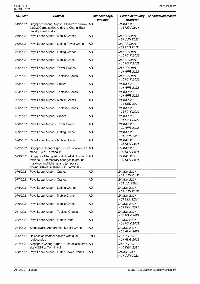
20 MAY 2021/ 03 NOV 2021
ADSingapore Changi Airport -Closure of runway02C/20C and taxiways due to Changi Eastdevelopment works
049/2021
08 APR 2021/ 21 JUN 2022
ADPaya Lebar Airport - Mobile Cranes050/2021
08 APR 2021/ 01 FEB 2022
ADPaya Lebar Airport - Luffing Tower Crane052/2021
08 APR 2021/ 15 MAR 2022
ADPaya Lebar Airport - Luffing Cranes054/2021
08 APR 2021/ 15 MAR 2022
ADPaya Lebar Airport - Mobile Crane055/2021
08 APR 2021/ 01 APR 2022
ADPaya Lebar Airport - Tower Cranes056/2021
08 APR 2021/ 10 MAR 2022
ADPaya Lebar Airport - Topless Cranes057/2021
19 MAY 2021/ 01 APR 2022
ADPaya Lebar Airport - Cranes063/2021
19 MAY 2021/ 01 APR 2022
ADPaya Lebar Airport - Topless Cranes064/2021
19 MAY 2021/ 18 DEC 2021
ADPaya Lebar Airport - Mobile Cranes065/2021
19 MAY 2021/ 25 MAY 2022
ADPaya Lebar Airport - Topless Cranes066/2021
19 MAY 2021/ 01 MAY 2022
ADPaya Lebar Airport - Cranes067/2021
19 MAY 2021/ 12 APR 2022
ADPaya Lebar Airport - Tower Crane068/2021
19 MAY 2021/ 01 JAN 2022
ADPaya Lebar Airport - Luffing Crane069/2021
19 MAY 2021/ 15 NOV 2021
ADPaya Lebar Airport - Mobile Crane070/2021
25 MAY 2021/ 29 NOV 2021
ADSingapore Changi Airport - Closure of aircraftstand F34 at Terminal 2
072/2021
25 MAY 2021/ 29 NOV 2021
ADSingapore Changi Airport - Partial closure oftaxilane R3, temporary changes to groundmarkings and lighting, and temporarydowngrade of taxilane R2 at Terminal 2
073/2021
24 JUN 2021/ 11 JUN 2022
ADPaya Lebar Airport - Cranes076/2021
24 JUN 2021/ 01 JUL 2022
ADPaya Lebar Airport - Cranes077/2021
24 JUN 2021/ 01 JUN 2022
ADPaya Lebar Airport - Luffing Cranes078/2021
24 JUN 2021/ 01 DEC 2021
ADPaya Lebar Airport - Mobile Crane079/2021
24 JUN 2021/ 01 DEC 2021
ADPaya Lebar Airport - Mobile Crane080/2021
24 JUN 2021/ 15 MAY 2022
ADPaya Lebar Airport - Topless Cranes081/2021
24 JUN 2021/ 04 MAY 2022
ADPaya Lebar Airport - Luffer Crane082/2021
24 JUN 2021/ 08 AUG 2022
ADSembawang Aerodrome - Mobile Crane084/2021
01 AUG 2021/ 01 AUG 2022
ENRRelease of weather balloon with dualradiosondes
086/2021
02 AUG 2021/ 10 DEC 2021
ADSingapore Changi Airport - Closure of aircraftstand E28 at Terminal 2
087/2021
08 JUL 2021/ 11 JUN 2022
ADPaya Lebar Airport - Luffer Tower Cranes088/2021
© 2021 Civil Aviation Authority SingaporeAIP AMDT 05/2021
AIP SingaporeGEN 0.3-407 OCT 2021~~~eaip-amdt~~~ver-date-2021-09-09T07-08-00-035
Cancellation recordPeriod of validity(from/to)
AIP section(s)affected
SubjectNR/Year
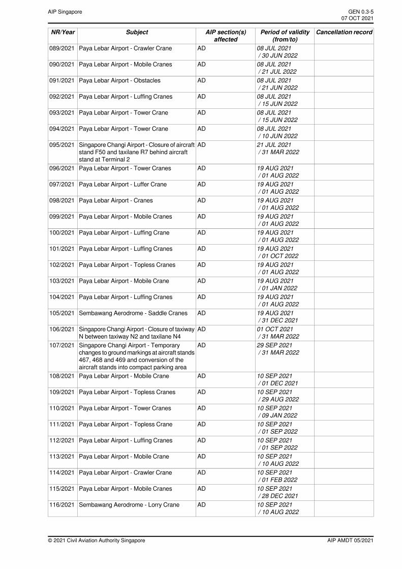
08 JUL 2021/ 30 JUN 2022
ADPaya Lebar Airport - Crawler Crane089/2021
08 JUL 2021/ 21 JUL 2022
ADPaya Lebar Airport - Mobile Cranes090/2021
08 JUL 2021/ 21 JUN 2022
ADPaya Lebar Airport - Obstacles091/2021
08 JUL 2021/ 15 JUN 2022
ADPaya Lebar Airport - Luffing Cranes092/2021
08 JUL 2021/ 15 JUN 2022
ADPaya Lebar Airport - Tower Crane093/2021
08 JUL 2021/ 10 JUN 2022
ADPaya Lebar Airport - Tower Crane094/2021
21 JUL 2021/ 31 MAR 2022
ADSingapore Changi Airport - Closure of aircraftstand F50 and taxilane R7 behind aircraftstand at Terminal 2
095/2021
19 AUG 2021/ 01 AUG 2022
ADPaya Lebar Airport - Tower Cranes096/2021
19 AUG 2021/ 01 AUG 2022
ADPaya Lebar Airport - Luffer Crane097/2021
19 AUG 2021/ 01 AUG 2022
ADPaya Lebar Airport - Cranes098/2021
19 AUG 2021/ 01 AUG 2022
ADPaya Lebar Airport - Mobile Cranes099/2021
19 AUG 2021/ 01 AUG 2022
ADPaya Lebar Airport - Luffing Crane100/2021
19 AUG 2021/ 01 OCT 2022
ADPaya Lebar Airport - Luffing Cranes101/2021
19 AUG 2021/ 01 AUG 2022
ADPaya Lebar Airport - Topless Cranes102/2021
19 AUG 2021/ 01 JAN 2022
ADPaya Lebar Airport - Mobile Crane103/2021
19 AUG 2021/ 01 AUG 2022
ADPaya Lebar Airport - Luffing Cranes104/2021
19 AUG 2021/ 31 DEC 2021
ADSembawang Aerodrome - Saddle Cranes105/2021
01 OCT 2021/ 31 MAR 2022
ADSingaporeChangi Airport - Closure of taxiwayN between taxiway N2 and taxilane N4
106/2021
29 SEP 2021/ 31 MAR 2022
ADSingapore Changi Airport - Temporarychanges to groundmarkings at aircraft stands467, 468 and 469 and conversion of theaircraft stands into compact parking area
107/2021
10 SEP 2021/ 01 DEC 2021
ADPaya Lebar Airport - Mobile Crane108/2021
10 SEP 2021/ 29 AUG 2022
ADPaya Lebar Airport - Topless Cranes109/2021
10 SEP 2021/ 09 JAN 2022
ADPaya Lebar Airport - Tower Cranes110/2021
10 SEP 2021/ 01 SEP 2022
ADPaya Lebar Airport - Topless Crane111/2021
10 SEP 2021/ 01 SEP 2022
ADPaya Lebar Airport - Luffing Cranes112/2021
10 SEP 2021/ 10 AUG 2022
ADPaya Lebar Airport - Mobile Crane113/2021
10 SEP 2021/ 01 FEB 2022
ADPaya Lebar Airport - Crawler Crane114/2021
10 SEP 2021/ 28 DEC 2021
ADPaya Lebar Airport - Mobile Cranes115/2021
10 SEP 2021/ 10 AUG 2022
ADSembawang Aerodrome - Lorry Crane116/2021
AIP AMDT 05/2021© 2021 Civil Aviation Authority Singapore
GEN 0.3-5AIP Singapore~~~eaip-amdt~~~ver-date-2021-09-09T07-08-00-03507 OCT 2021
Cancellation recordPeriod of validity(from/to)
AIP section(s)affected
SubjectNR/Year
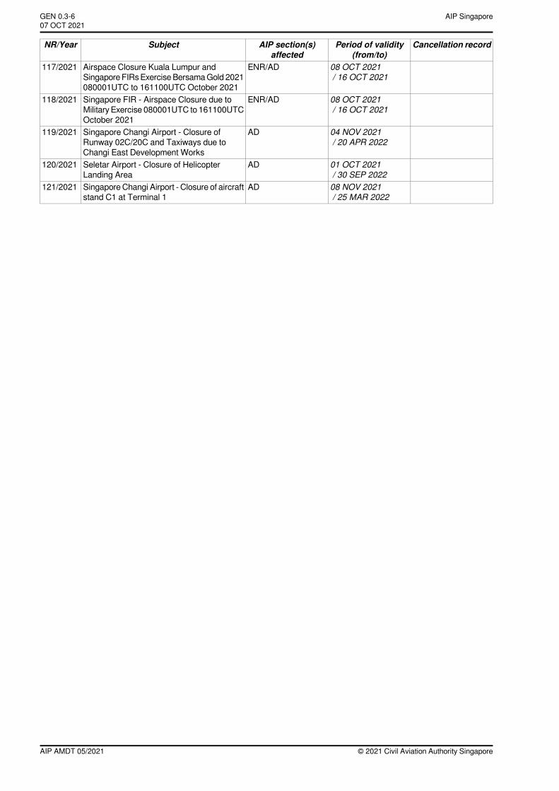
08 OCT 2021/ 16 OCT 2021
ENR/ADAirspace Closure Kuala Lumpur andSingapore FIRsExerciseBersamaGold 2021080001UTC to 161100UTC October 2021
117/2021
08 OCT 2021/ 16 OCT 2021
ENR/ADSingapore FIR - Airspace Closure due toMilitary Exercise 080001UTC to 161100UTCOctober 2021
118/2021
04 NOV 2021/ 20 APR 2022
ADSingapore Changi Airport - Closure ofRunway 02C/20C and Taxiways due toChangi East Development Works
119/2021
01 OCT 2021/ 30 SEP 2022
ADSeletar Airport - Closure of HelicopterLanding Area
120/2021
08 NOV 2021/ 25 MAR 2022
ADSingapore Changi Airport - Closure of aircraftstand C1 at Terminal 1
121/2021
© 2021 Civil Aviation Authority SingaporeAIP AMDT 05/2021
AIP SingaporeGEN 0.3-607 OCT 2021~~~eaip-amdt~~~ver-date-2021-09-09T07-08-00-035
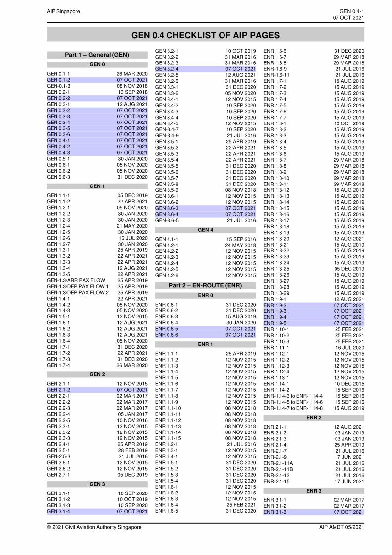
GEN 0.4 CHECKLIST OF AIP PAGES
Part 1 – General (GEN)GEN 0
GEN 0.1-1 26 MAR 2020GEN 0.1-2 07 OCT 2021GEN-0.1-3 08 NOV 2018GEN 0.2-1 13 SEP 2018GEN 0.2-2 07 OCT 2021GEN 0.3-1 12 AUG 2021GEN 0.3-2 07 OCT 2021GEN 0.3-3 07 OCT 2021GEN 0.3-4 07 OCT 2021GEN 0.3-5 07 OCT 2021GEN 0.3-6 07 OCT 2021GEN 0.4-1 07 OCT 2021GEN 0.4-2 07 OCT 2021GEN 0.4-3 07 OCT 2021GEN 0.5-1 30 JAN 2020GEN 0.6-1 05 NOV 2020GEN 0.6-2 05 NOV 2020GEN 0.6-3 31 DEC 2020
GEN 1
GEN 1.1-1 05 DEC 2019GEN 1.1-2 22 APR 2021GEN 1.2-1 05 NOV 2020GEN 1.2-2 30 JAN 2020GEN 1.2-3 30 JAN 2020GEN 1.2-4 21 MAY 2020GEN 1.2-5 30 JAN 2020GEN 1.2-6 16 JUL 2020GEN 1.2-7 30 JAN 2020GEN 1.3-1 25 APR 2019GEN 1.3-2 22 APR 2021GEN 1.3-3 22 APR 2021GEN 1.3-4 12 AUG 2021GEN 1.3-5 22 APR 2021GEN-1.3/ARR PAX FLOW 25 APR 2019GEN-1.3/DEP PAX FLOW 1 25 APR 2019GEN-1.3/DEP PAX FLOW 2 25 APR 2019GEN 1.4-1 22 APR 2021GEN 1.4-2 05 NOV 2020GEN 1.4-3 05 NOV 2020GEN 1.5-1 12 NOV 2015GEN 1.6-1 12 AUG 2021GEN 1.6-2 12 AUG 2021GEN 1.6-3 12 AUG 2021GEN 1.6-4 05 NOV 2020GEN 1.7-1 31 DEC 2020GEN 1.7-2 22 APR 2021GEN 1.7-3 31 DEC 2020GEN 1.7-4 26 MAR 2020
GEN 2
GEN 2.1-1 12 NOV 2015GEN 2.1-2 07 OCT 2021GEN 2.2-1 02 MAR 2017GEN 2.2-2 02 MAR 2017GEN 2.2-3 02 MAR 2017GEN 2.2-4 05 JAN 2017GEN 2.2-5 10 NOV 2016GEN 2.3-1 12 NOV 2015GEN 2.3-2 12 NOV 2015GEN 2.3-3 12 NOV 2015GEN 2.4-1 25 APR 2019GEN 2.5-1 28 FEB 2019GEN-2.5-3 21 JUL 2016GEN 2.6-1 12 NOV 2015GEN 2.6-2 12 NOV 2015GEN 2.7-1 05 DEC 2019
GEN 3
GEN 3.1-1 10 SEP 2020GEN 3.1-2 10 OCT 2019GEN 3.1-3 10 SEP 2020GEN 3.1-4 07 OCT 2021
GEN 3.2-1 10 OCT 2019GEN 3.2-2 31 MAR 2016GEN 3.2-3 31 MAR 2016GEN 3.2-4 07 OCT 2021GEN 3.2-5 12 AUG 2021GEN 3.2-6 31 MAR 2016GEN 3.3-1 31 DEC 2020GEN 3.3-2 05 NOV 2020GEN 3.4-1 12 NOV 2015GEN 3.4-2 10 SEP 2020GEN 3.4-3 10 SEP 2020GEN 3.4-4 10 SEP 2020GEN 3.4-5 12 NOV 2015GEN-3.4-7 10 SEP 2020GEN-3.4-9 21 JUL 2016GEN 3.5-1 25 APR 2019GEN 3.5-2 22 APR 2021GEN 3.5-3 22 APR 2021GEN 3.5-4 22 APR 2021GEN 3.5-5 31 DEC 2020GEN 3.5-6 31 DEC 2020GEN 3.5-7 31 DEC 2020GEN 3.5-8 31 DEC 2020GEN 3.5-9 08 NOV 2018GEN 3.6-1 12 NOV 2015GEN 3.6-2 12 NOV 2015GEN 3.6-3 07 OCT 2021GEN 3.6-4 07 OCT 2021GEN-3.6-5 21 JUL 2016
GEN 4
GEN 4.1-1 15 SEP 2016GEN 4.2-1 24 MAY 2018GEN 4.2-2 12 NOV 2015GEN 4.2-3 12 NOV 2015GEN 4.2-4 12 NOV 2015GEN 4.2-5 12 NOV 2015GEN 4.2-6 12 NOV 2015
Part 2 – EN-ROUTE (ENR)ENR 0
ENR 0.6-1 31 DEC 2020ENR 0.6-2 31 DEC 2020ENR 0.6-3 15 AUG 2019ENR 0.6-4 30 JAN 2020ENR 0.6-5 07 OCT 2021ENR 0.6-6 07 OCT 2021
ENR 1
ENR 1.1-1 25 APR 2019ENR 1.1-2 12 NOV 2015ENR 1.1-3 12 NOV 2015ENR 1.1-4 12 NOV 2015ENR 1.1-5 12 NOV 2015ENR 1.1-6 12 NOV 2015ENR 1.1-7 12 NOV 2015ENR 1.1-8 12 NOV 2015ENR 1.1-9 12 NOV 2015ENR 1.1-10 08 NOV 2018ENR 1.1-11 08 NOV 2018ENR 1.1-12 08 NOV 2018ENR 1.1-13 08 NOV 2018ENR 1.1-14 08 NOV 2018ENR 1.1-15 08 NOV 2018ENR 1.2-1 21 JUL 2016ENR 1.3-1 12 NOV 2015ENR 1.4-1 12 NOV 2015ENR 1.5-1 31 DEC 2020ENR 1.5-2 31 DEC 2020ENR 1.5-3 31 DEC 2020ENR 1.5-4 31 DEC 2020ENR 1.6-1 12 NOV 2015ENR 1.6-2 12 NOV 2015ENR 1.6-3 12 NOV 2015ENR 1.6-4 25 FEB 2021ENR 1.6-5 31 DEC 2020
ENR 1.6-6 31 DEC 2020ENR 1.6-7 29 MAR 2018ENR 1.6-8 29 MAR 2018ENR-1.6-9 21 JUL 2016ENR-1.6-11 21 JUL 2016ENR 1.7-1 15 AUG 2019ENR 1.7-2 15 AUG 2019ENR 1.7-3 15 AUG 2019ENR 1.7-4 15 AUG 2019ENR 1.7-5 15 AUG 2019ENR 1.7-6 15 AUG 2019ENR 1.7-7 15 AUG 2019ENR 1.8-1 10 OCT 2019ENR 1.8-2 15 AUG 2019ENR 1.8-3 15 AUG 2019ENR 1.8-4 15 AUG 2019ENR 1.8-5 15 AUG 2019ENR 1.8-6 15 AUG 2019ENR 1.8-7 29 MAR 2018ENR 1.8-8 29 MAR 2018ENR 1.8-9 29 MAR 2018ENR 1.8-10 29 MAR 2018ENR 1.8-11 29 MAR 2018ENR 1.8-12 15 AUG 2019ENR 1.8-13 15 AUG 2019ENR 1.8-14 15 AUG 2019ENR 1.8-15 15 AUG 2019ENR 1.8-16 15 AUG 2019ENR 1.8-17 15 AUG 2019ENR 1.8-18 15 AUG 2019ENR 1.8-19 15 AUG 2019ENR 1.8-20 12 AUG 2021ENR 1.8-21 15 AUG 2019ENR 1.8-22 15 AUG 2019ENR 1.8-23 15 AUG 2019ENR 1.8-24 15 AUG 2019ENR 1.8-25 05 DEC 2019ENR 1.8-26 15 AUG 2019ENR 1.8-27 15 AUG 2019ENR 1.8-28 15 AUG 2019ENR 1.8-29 15 AUG 2019ENR 1.9-1 12 AUG 2021ENR 1.9-2 07 OCT 2021ENR 1.9-3 07 OCT 2021ENR 1.9-4 07 OCT 2021ENR 1.9-5 07 OCT 2021ENR 1.10-1 25 FEB 2021ENR 1.10-2 25 FEB 2021ENR 1.10-3 25 FEB 2021ENR 1.11-1 16 JUL 2020ENR 1.12-1 12 NOV 2015ENR 1.12-2 12 NOV 2015ENR 1.12-3 12 NOV 2015ENR 1.12-4 12 NOV 2015ENR 1.13-1 12 NOV 2015ENR 1.14-1 10 DEC 2015ENR 1.14-2 15 SEP 2016ENR-1.14-3 to ENR-1.14-4 15 SEP 2016ENR-1.14-5 to ENR-1.14-6 15 SEP 2016ENR-1.14-7 to ENR-1.14-8 15 AUG 2019
ENR 2
ENR 2.1-1 12 AUG 2021ENR 2.1-2 03 JAN 2019ENR 2.1-3 03 JAN 2019ENR 2.1-4 25 APR 2019ENR-2.1-7 21 JUL 2016ENR-2.1-9 17 JUN 2021ENR-2.1-11A 21 JUL 2016ENR-2.1-11B 21 JUL 2016ENR-2.1-13 21 JUL 2016ENR-2.1-15 17 JUN 2021
ENR 3
ENR 3.1-1 02 MAR 2017ENR 3.1-2 02 MAR 2017ENR 3.1-3 07 OCT 2021
AIP AMDT 05/2021© 2021 Civil Aviation Authority Singapore
GEN 0.4-1AIP Singapore~~~eaip-amdt~~~ver-date-2021-09-09T07-08-00-03507 OCT 2021
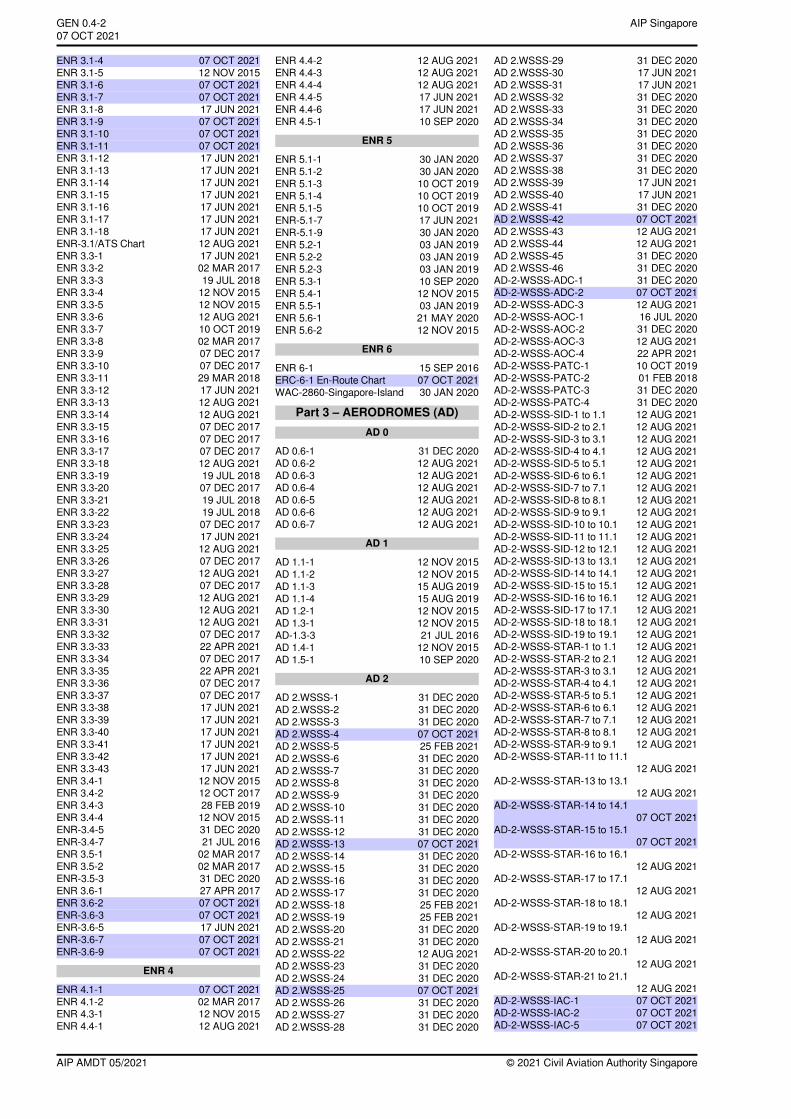
ENR 3.1-4 07 OCT 2021ENR 3.1-5 12 NOV 2015ENR 3.1-6 07 OCT 2021ENR 3.1-7 07 OCT 2021ENR 3.1-8 17 JUN 2021ENR 3.1-9 07 OCT 2021ENR 3.1-10 07 OCT 2021ENR 3.1-11 07 OCT 2021ENR 3.1-12 17 JUN 2021ENR 3.1-13 17 JUN 2021ENR 3.1-14 17 JUN 2021ENR 3.1-15 17 JUN 2021ENR 3.1-16 17 JUN 2021ENR 3.1-17 17 JUN 2021ENR 3.1-18 17 JUN 2021ENR-3.1/ATS Chart 12 AUG 2021ENR 3.3-1 17 JUN 2021ENR 3.3-2 02 MAR 2017ENR 3.3-3 19 JUL 2018ENR 3.3-4 12 NOV 2015ENR 3.3-5 12 NOV 2015ENR 3.3-6 12 AUG 2021ENR 3.3-7 10 OCT 2019ENR 3.3-8 02 MAR 2017ENR 3.3-9 07 DEC 2017ENR 3.3-10 07 DEC 2017ENR 3.3-11 29 MAR 2018ENR 3.3-12 17 JUN 2021ENR 3.3-13 12 AUG 2021ENR 3.3-14 12 AUG 2021ENR 3.3-15 07 DEC 2017ENR 3.3-16 07 DEC 2017ENR 3.3-17 07 DEC 2017ENR 3.3-18 12 AUG 2021ENR 3.3-19 19 JUL 2018ENR 3.3-20 07 DEC 2017ENR 3.3-21 19 JUL 2018ENR 3.3-22 19 JUL 2018ENR 3.3-23 07 DEC 2017ENR 3.3-24 17 JUN 2021ENR 3.3-25 12 AUG 2021ENR 3.3-26 07 DEC 2017ENR 3.3-27 12 AUG 2021ENR 3.3-28 07 DEC 2017ENR 3.3-29 12 AUG 2021ENR 3.3-30 12 AUG 2021ENR 3.3-31 12 AUG 2021ENR 3.3-32 07 DEC 2017ENR 3.3-33 22 APR 2021ENR 3.3-34 07 DEC 2017ENR 3.3-35 22 APR 2021ENR 3.3-36 07 DEC 2017ENR 3.3-37 07 DEC 2017ENR 3.3-38 17 JUN 2021ENR 3.3-39 17 JUN 2021ENR 3.3-40 17 JUN 2021ENR 3.3-41 17 JUN 2021ENR 3.3-42 17 JUN 2021ENR 3.3-43 17 JUN 2021ENR 3.4-1 12 NOV 2015ENR 3.4-2 12 OCT 2017ENR 3.4-3 28 FEB 2019ENR 3.4-4 12 NOV 2015ENR-3.4-5 31 DEC 2020ENR-3.4-7 21 JUL 2016ENR 3.5-1 02 MAR 2017ENR 3.5-2 02 MAR 2017ENR-3.5-3 31 DEC 2020ENR 3.6-1 27 APR 2017ENR 3.6-2 07 OCT 2021ENR-3.6-3 07 OCT 2021ENR-3.6-5 17 JUN 2021ENR-3.6-7 07 OCT 2021ENR-3.6-9 07 OCT 2021
ENR 4
ENR 4.1-1 07 OCT 2021ENR 4.1-2 02 MAR 2017ENR 4.3-1 12 NOV 2015ENR 4.4-1 12 AUG 2021
ENR 4.4-2 12 AUG 2021ENR 4.4-3 12 AUG 2021ENR 4.4-4 12 AUG 2021ENR 4.4-5 17 JUN 2021ENR 4.4-6 17 JUN 2021ENR 4.5-1 10 SEP 2020
ENR 5
ENR 5.1-1 30 JAN 2020ENR 5.1-2 30 JAN 2020ENR 5.1-3 10 OCT 2019ENR 5.1-4 10 OCT 2019ENR 5.1-5 10 OCT 2019ENR-5.1-7 17 JUN 2021ENR-5.1-9 30 JAN 2020ENR 5.2-1 03 JAN 2019ENR 5.2-2 03 JAN 2019ENR 5.2-3 03 JAN 2019ENR 5.3-1 10 SEP 2020ENR 5.4-1 12 NOV 2015ENR 5.5-1 03 JAN 2019ENR 5.6-1 21 MAY 2020ENR 5.6-2 12 NOV 2015
ENR 6
ENR 6-1 15 SEP 2016ERC-6-1 En-Route Chart 07 OCT 2021WAC-2860-Singapore-Island 30 JAN 2020
Part 3 – AERODROMES (AD)AD 0
AD 0.6-1 31 DEC 2020AD 0.6-2 12 AUG 2021AD 0.6-3 12 AUG 2021AD 0.6-4 12 AUG 2021AD 0.6-5 12 AUG 2021AD 0.6-6 12 AUG 2021AD 0.6-7 12 AUG 2021
AD 1
AD 1.1-1 12 NOV 2015AD 1.1-2 12 NOV 2015AD 1.1-3 15 AUG 2019AD 1.1-4 15 AUG 2019AD 1.2-1 12 NOV 2015AD 1.3-1 12 NOV 2015AD-1.3-3 21 JUL 2016AD 1.4-1 12 NOV 2015AD 1.5-1 10 SEP 2020
AD 2
AD 2.WSSS-1 31 DEC 2020AD 2.WSSS-2 31 DEC 2020AD 2.WSSS-3 31 DEC 2020AD 2.WSSS-4 07 OCT 2021AD 2.WSSS-5 25 FEB 2021AD 2.WSSS-6 31 DEC 2020AD 2.WSSS-7 31 DEC 2020AD 2.WSSS-8 31 DEC 2020AD 2.WSSS-9 31 DEC 2020AD 2.WSSS-10 31 DEC 2020AD 2.WSSS-11 31 DEC 2020AD 2.WSSS-12 31 DEC 2020AD 2.WSSS-13 07 OCT 2021AD 2.WSSS-14 31 DEC 2020AD 2.WSSS-15 31 DEC 2020AD 2.WSSS-16 31 DEC 2020AD 2.WSSS-17 31 DEC 2020AD 2.WSSS-18 25 FEB 2021AD 2.WSSS-19 25 FEB 2021AD 2.WSSS-20 31 DEC 2020AD 2.WSSS-21 31 DEC 2020AD 2.WSSS-22 12 AUG 2021AD 2.WSSS-23 31 DEC 2020AD 2.WSSS-24 31 DEC 2020AD 2.WSSS-25 07 OCT 2021AD 2.WSSS-26 31 DEC 2020AD 2.WSSS-27 31 DEC 2020AD 2.WSSS-28 31 DEC 2020
AD 2.WSSS-29 31 DEC 2020AD 2.WSSS-30 17 JUN 2021AD 2.WSSS-31 17 JUN 2021AD 2.WSSS-32 31 DEC 2020AD 2.WSSS-33 31 DEC 2020AD 2.WSSS-34 31 DEC 2020AD 2.WSSS-35 31 DEC 2020AD 2.WSSS-36 31 DEC 2020AD 2.WSSS-37 31 DEC 2020AD 2.WSSS-38 31 DEC 2020AD 2.WSSS-39 17 JUN 2021AD 2.WSSS-40 17 JUN 2021AD 2.WSSS-41 31 DEC 2020AD 2.WSSS-42 07 OCT 2021AD 2.WSSS-43 12 AUG 2021AD 2.WSSS-44 12 AUG 2021AD 2.WSSS-45 31 DEC 2020AD 2.WSSS-46 31 DEC 2020AD-2-WSSS-ADC-1 31 DEC 2020AD-2-WSSS-ADC-2 07 OCT 2021AD-2-WSSS-ADC-3 12 AUG 2021AD-2-WSSS-AOC-1 16 JUL 2020AD-2-WSSS-AOC-2 31 DEC 2020AD-2-WSSS-AOC-3 12 AUG 2021AD-2-WSSS-AOC-4 22 APR 2021AD-2-WSSS-PATC-1 10 OCT 2019AD-2-WSSS-PATC-2 01 FEB 2018AD-2-WSSS-PATC-3 31 DEC 2020AD-2-WSSS-PATC-4 31 DEC 2020AD-2-WSSS-SID-1 to 1.1 12 AUG 2021AD-2-WSSS-SID-2 to 2.1 12 AUG 2021AD-2-WSSS-SID-3 to 3.1 12 AUG 2021AD-2-WSSS-SID-4 to 4.1 12 AUG 2021AD-2-WSSS-SID-5 to 5.1 12 AUG 2021AD-2-WSSS-SID-6 to 6.1 12 AUG 2021AD-2-WSSS-SID-7 to 7.1 12 AUG 2021AD-2-WSSS-SID-8 to 8.1 12 AUG 2021AD-2-WSSS-SID-9 to 9.1 12 AUG 2021AD-2-WSSS-SID-10 to 10.1 12 AUG 2021AD-2-WSSS-SID-11 to 11.1 12 AUG 2021AD-2-WSSS-SID-12 to 12.1 12 AUG 2021AD-2-WSSS-SID-13 to 13.1 12 AUG 2021AD-2-WSSS-SID-14 to 14.1 12 AUG 2021AD-2-WSSS-SID-15 to 15.1 12 AUG 2021AD-2-WSSS-SID-16 to 16.1 12 AUG 2021AD-2-WSSS-SID-17 to 17.1 12 AUG 2021AD-2-WSSS-SID-18 to 18.1 12 AUG 2021AD-2-WSSS-SID-19 to 19.1 12 AUG 2021AD-2-WSSS-STAR-1 to 1.1 12 AUG 2021AD-2-WSSS-STAR-2 to 2.1 12 AUG 2021AD-2-WSSS-STAR-3 to 3.1 12 AUG 2021AD-2-WSSS-STAR-4 to 4.1 12 AUG 2021AD-2-WSSS-STAR-5 to 5.1 12 AUG 2021AD-2-WSSS-STAR-6 to 6.1 12 AUG 2021AD-2-WSSS-STAR-7 to 7.1 12 AUG 2021AD-2-WSSS-STAR-8 to 8.1 12 AUG 2021AD-2-WSSS-STAR-9 to 9.1 12 AUG 2021AD-2-WSSS-STAR-11 to 11.1
12 AUG 2021AD-2-WSSS-STAR-13 to 13.1
12 AUG 2021AD-2-WSSS-STAR-14 to 14.1
07 OCT 2021AD-2-WSSS-STAR-15 to 15.1
07 OCT 2021AD-2-WSSS-STAR-16 to 16.1
12 AUG 2021AD-2-WSSS-STAR-17 to 17.1
12 AUG 2021AD-2-WSSS-STAR-18 to 18.1
12 AUG 2021AD-2-WSSS-STAR-19 to 19.1
12 AUG 2021AD-2-WSSS-STAR-20 to 20.1
12 AUG 2021AD-2-WSSS-STAR-21 to 21.1
12 AUG 2021AD-2-WSSS-IAC-1 07 OCT 2021AD-2-WSSS-IAC-2 07 OCT 2021AD-2-WSSS-IAC-5 07 OCT 2021
© 2021 Civil Aviation Authority SingaporeAIP AMDT 05/2021
AIP SingaporeGEN 0.4-207 OCT 2021~~~eaip-amdt~~~ver-date-2021-09-09T07-08-00-035
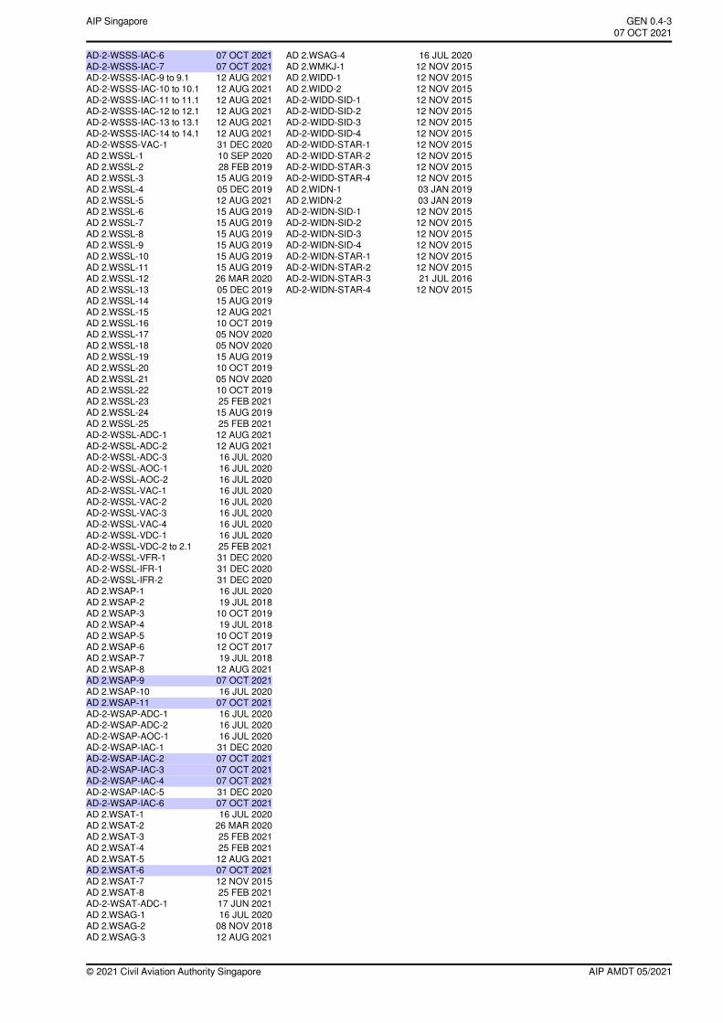
AD-2-WSSS-IAC-6 07 OCT 2021AD-2-WSSS-IAC-7 07 OCT 2021AD-2-WSSS-IAC-9 to 9.1 12 AUG 2021AD-2-WSSS-IAC-10 to 10.1 12 AUG 2021AD-2-WSSS-IAC-11 to 11.1 12 AUG 2021AD-2-WSSS-IAC-12 to 12.1 12 AUG 2021AD-2-WSSS-IAC-13 to 13.1 12 AUG 2021AD-2-WSSS-IAC-14 to 14.1 12 AUG 2021AD-2-WSSS-VAC-1 31 DEC 2020AD 2.WSSL-1 10 SEP 2020AD 2.WSSL-2 28 FEB 2019AD 2.WSSL-3 15 AUG 2019AD 2.WSSL-4 05 DEC 2019AD 2.WSSL-5 12 AUG 2021AD 2.WSSL-6 15 AUG 2019AD 2.WSSL-7 15 AUG 2019AD 2.WSSL-8 15 AUG 2019AD 2.WSSL-9 15 AUG 2019AD 2.WSSL-10 15 AUG 2019AD 2.WSSL-11 15 AUG 2019AD 2.WSSL-12 26 MAR 2020AD 2.WSSL-13 05 DEC 2019AD 2.WSSL-14 15 AUG 2019AD 2.WSSL-15 12 AUG 2021AD 2.WSSL-16 10 OCT 2019AD 2.WSSL-17 05 NOV 2020AD 2.WSSL-18 05 NOV 2020AD 2.WSSL-19 15 AUG 2019AD 2.WSSL-20 10 OCT 2019AD 2.WSSL-21 05 NOV 2020AD 2.WSSL-22 10 OCT 2019AD 2.WSSL-23 25 FEB 2021AD 2.WSSL-24 15 AUG 2019AD 2.WSSL-25 25 FEB 2021AD-2-WSSL-ADC-1 12 AUG 2021AD-2-WSSL-ADC-2 12 AUG 2021AD-2-WSSL-ADC-3 16 JUL 2020AD-2-WSSL-AOC-1 16 JUL 2020AD-2-WSSL-AOC-2 16 JUL 2020AD-2-WSSL-VAC-1 16 JUL 2020AD-2-WSSL-VAC-2 16 JUL 2020AD-2-WSSL-VAC-3 16 JUL 2020AD-2-WSSL-VAC-4 16 JUL 2020AD-2-WSSL-VDC-1 16 JUL 2020AD-2-WSSL-VDC-2 to 2.1 25 FEB 2021AD-2-WSSL-VFR-1 31 DEC 2020AD-2-WSSL-IFR-1 31 DEC 2020AD-2-WSSL-IFR-2 31 DEC 2020AD 2.WSAP-1 16 JUL 2020AD 2.WSAP-2 19 JUL 2018AD 2.WSAP-3 10 OCT 2019AD 2.WSAP-4 19 JUL 2018AD 2.WSAP-5 10 OCT 2019AD 2.WSAP-6 12 OCT 2017AD 2.WSAP-7 19 JUL 2018AD 2.WSAP-8 12 AUG 2021AD 2.WSAP-9 07 OCT 2021AD 2.WSAP-10 16 JUL 2020AD 2.WSAP-11 07 OCT 2021AD-2-WSAP-ADC-1 16 JUL 2020AD-2-WSAP-ADC-2 16 JUL 2020AD-2-WSAP-AOC-1 16 JUL 2020AD-2-WSAP-IAC-1 31 DEC 2020AD-2-WSAP-IAC-2 07 OCT 2021AD-2-WSAP-IAC-3 07 OCT 2021AD-2-WSAP-IAC-4 07 OCT 2021AD-2-WSAP-IAC-5 31 DEC 2020AD-2-WSAP-IAC-6 07 OCT 2021AD 2.WSAT-1 16 JUL 2020AD 2.WSAT-2 26 MAR 2020AD 2.WSAT-3 25 FEB 2021AD 2.WSAT-4 25 FEB 2021AD 2.WSAT-5 12 AUG 2021AD 2.WSAT-6 07 OCT 2021AD 2.WSAT-7 12 NOV 2015AD 2.WSAT-8 25 FEB 2021AD-2-WSAT-ADC-1 17 JUN 2021AD 2.WSAG-1 16 JUL 2020AD 2.WSAG-2 08 NOV 2018AD 2.WSAG-3 12 AUG 2021
AD 2.WSAG-4 16 JUL 2020AD 2.WMKJ-1 12 NOV 2015AD 2.WIDD-1 12 NOV 2015AD 2.WIDD-2 12 NOV 2015AD-2-WIDD-SID-1 12 NOV 2015AD-2-WIDD-SID-2 12 NOV 2015AD-2-WIDD-SID-3 12 NOV 2015AD-2-WIDD-SID-4 12 NOV 2015AD-2-WIDD-STAR-1 12 NOV 2015AD-2-WIDD-STAR-2 12 NOV 2015AD-2-WIDD-STAR-3 12 NOV 2015AD-2-WIDD-STAR-4 12 NOV 2015AD 2.WIDN-1 03 JAN 2019AD 2.WIDN-2 03 JAN 2019AD-2-WIDN-SID-1 12 NOV 2015AD-2-WIDN-SID-2 12 NOV 2015AD-2-WIDN-SID-3 12 NOV 2015AD-2-WIDN-SID-4 12 NOV 2015AD-2-WIDN-STAR-1 12 NOV 2015AD-2-WIDN-STAR-2 12 NOV 2015AD-2-WIDN-STAR-3 21 JUL 2016AD-2-WIDN-STAR-4 12 NOV 2015
AIP AMDT 05/2021© 2021 Civil Aviation Authority Singapore
GEN 0.4-3AIP Singapore~~~eaip-amdt~~~ver-date-2021-09-09T07-08-00-03507 OCT 2021

PAGE INTENTIONALLY LEFT BLANK
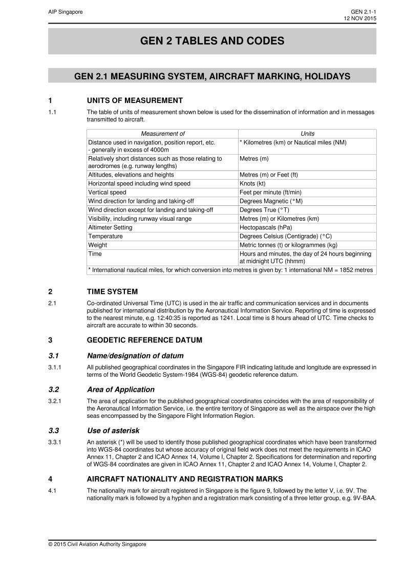
GEN 2 TABLES AND CODES
GEN 2.1 MEASURING SYSTEM, AIRCRAFT MARKING, HOLIDAYS
1 UNITS OF MEASUREMENT1.1 The table of units of measurement shown below is used for the dissemination of information and in messages
transmitted to aircraft.
UnitsMeasurement of* Kilometres (km) or Nautical miles (NM)Distance used in navigation, position report, etc.
- generally in excess of 4000mMetres (m)Relatively short distances such as those relating to
aerodromes (e.g. runway lengths)Metres (m) or Feet (ft)Altitudes, elevations and heightsKnots (kt)Horizontal speed including wind speedFeet per minute (ft/min)Vertical speedDegrees Magnetic (°M)Wind direction for landing and taking-offDegrees True (°T)Wind direction except for landing and taking-offMetres (m) or Kilometres (km)Visibility, including runway visual rangeHectopascals (hPa)Altimeter SettingDegrees Celsius (Centigrade) (°C)TemperatureMetric tonnes (t) or kilogrammes (kg)WeightHours and minutes, the day of 24 hours beginningat midnight UTC (hhmm)
Time
* International nautical miles, for which conversion into metres is given by: 1 international NM = 1852 metres
2 TIME SYSTEM2.1 Co-ordinated Universal Time (UTC) is used in the air traffic and communication services and in documents
published for international distribution by the Aeronautical Information Service. Reporting of time is expressedto the nearest minute, e.g. 12:40:35 is reported as 1241. Local time is 8 hours ahead of UTC. Time checks toaircraft are accurate to within 30 seconds.
3 GEODETIC REFERENCE DATUM
3.1 Name/designation of datum3.1.1 All published geographical coordinates in the Singapore FIR indicating latitude and longitude are expressed in
terms of the World Geodetic System-1984 (WGS-84) geodetic reference datum.
3.2 Area of Application3.2.1 The area of application for the published geographical coordinates coincides with the area of responsibility of
the Aeronautical Information Service, i.e. the entire territory of Singapore as well as the airspace over the highseas encompassed by the Singapore Flight Information Region.
3.3 Use of asterisk3.3.1 An asterisk (*) will be used to identify those published geographical coordinates which have been transformed
into WGS-84 coordinates but whose accuracy of original field work does not meet the requirements in ICAOAnnex 11, Chapter 2 and ICAO Annex 14, Volume I, Chapter 2. Specifications for determination and reportingof WGS-84 coordinates are given in ICAO Annex 11, Chapter 2 and ICAO Annex 14, Volume I, Chapter 2.
4 AIRCRAFT NATIONALITY AND REGISTRATION MARKS4.1 The nationality mark for aircraft registered in Singapore is the figure 9, followed by the letter V, i.e. 9V. The
nationality mark is followed by a hyphen and a registration mark consisting of a three letter group, e.g. 9V-BAA.
© 2015 Civil Aviation Authority Singapore
GEN 2.1-112 NOV 2015
AIP Singapore
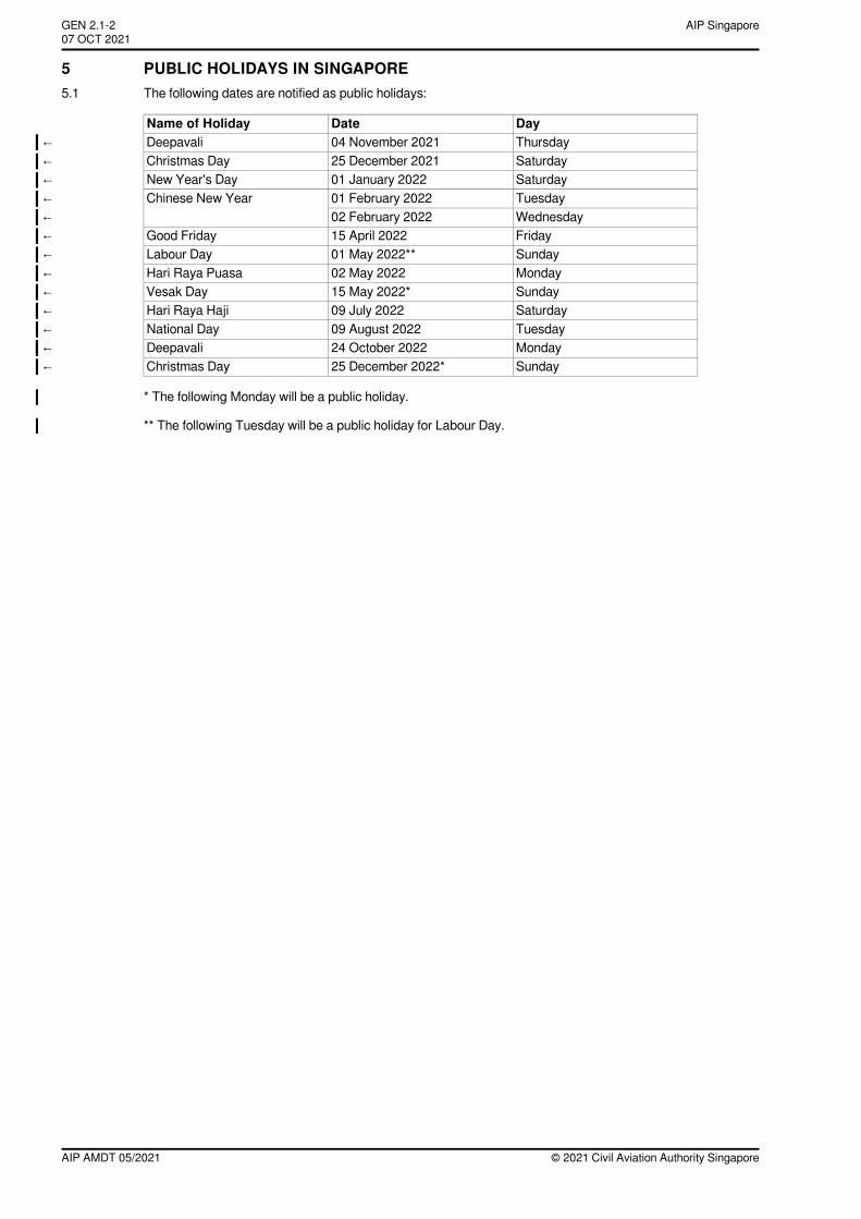
5 PUBLIC HOLIDAYS IN SINGAPORE5.1 The following dates are notified as public holidays:
DayDateName of HolidayThursday04 November 2021Deepavali←Saturday25 December 2021Christmas Day←Saturday01 January 2022New Year's Day←Tuesday01 February 2022Chinese New Year←Wednesday02 February 2022←Friday15 April 2022Good Friday←Sunday01 May 2022**Labour Day←Monday02 May 2022Hari Raya Puasa←Sunday15 May 2022*Vesak Day←Saturday09 July 2022Hari Raya Haji←Tuesday09 August 2022National Day←Monday24 October 2022Deepavali←Sunday25 December 2022*Christmas Day←
* The following Monday will be a public holiday.
** The following Tuesday will be a public holiday for Labour Day.
© 2021 Civil Aviation Authority SingaporeAIP AMDT 05/2021
AIP SingaporeGEN 2.1-207 OCT 2021~~~eaip-amdt~~~ver-date-2021-09-09T07-08-00-035
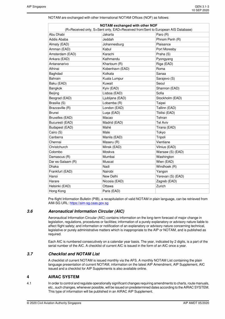
NOTAM are exchanged with other International NOTAM Offices (NOF) as follows:
NOTAM exchanged with other NOF(R=Received only, S=Sent only, EAD=Received from/Sent to European AIS Database)
Paro (R)JakartaAbu DhabiPhnom Penh (R)JeddahAddis AbabaPlaisanceJohannesburgAlmaty (EAD)Port MoresbyKabulAmman (EAD)Praha (S)KarachiAmsterdam (EAD)PyongyangKathmanduAnkara (EAD)Riga (EAD)Khartoum (R)AntananarivoRomaKobenhavn (EAD)AthinaiSanaaKolkataBaghdadSarajevo (S)Kuala LumpurBahrainSeoulKuwaitBaku (EAD)Shannon (EAD)Kyiv (EAD)BangkokSofiaLisboa (EAD)BeijingStockholm (EAD)Ljubljana (EAD)Beograd (EAD)TaipeiLobamba (R)Brasilia (S)Tallinn (EAD)London (EAD)Brazzaville (R)Tbilisi (EAD)Luqa (EAD)BruneiTehranMacaoBruxelles (EAD)Tel AvivMadrid (EAD)Bucuresti (EAD)Tirana (EAD)MahéBudapest (EAD)TokyoMaleCairo (S)TripoliManila (EAD)CanberraVientianeMaseru (R)ChennaiVilnius (EAD)Minsk (EAD)ChristchurchWarsaw (S) (EAD)MoskvaColomboWashingtonMumbaiDamascus (R)Wien (EAD)MuscatDar es-Salaam (R)Windhoek (R)NadiDhakaYangonNairobiFrankfurt (EAD)Yerevan (S) (EAD)New DelhiHanoiZagreb (EAD)Nicosia (EAD)HarareZurichOttawaHelsinki (EAD)
Paris (EAD)Hong Kong
Pre-flight Information Bulletin (PIB), a recapitulation of valid NOTAM in plain language, can be retrieved fromAIM-SG URL: https://aim-sg.caas.gov.sg
3.6 Aeronautical Information Circular (AIC)Aeronautical Information Circular (AIC) contains information on the long-term forecast of major change inlegislation, regulations, procedures or facilities; information of a purely explanatory or advisory nature liable toaffect flight safety; and information or notification of an explanatory or advisory nature concerning technical,legislative or purely administrative matters which is inappropriate to the AIP or NOTAM, and is published asrequired.
Each AIC is numbered consecutively on a calendar year basis. The year, indicated by 2 digits, is a part of theserial number of the AIC. A checklist of current AIC is issued in the form of an AIC once a year.
3.7 Checklist and NOTAM ListA checklist of current NOTAM is issued monthly via the AFS. A monthly NOTAM List containing the plainlanguage presentation of current NOTAM, information on the latest AIP Amendment, AIP Supplement, AICissued and a checklist for AIP Supplements is also available online.
4 AIRAC SYSTEM4.1 In order to control and regulate operationally significant changes requiring amendments to charts, routemanuals,
etc., such changes, whenever possible, will be issued on predetermined dates according to the AIRACSYSTEM.This type of information will be published in an AIRAC AIP Supplement.
AIP AMDT 05/2020© 2020 Civil Aviation Authority Singapore
GEN 3.1-310 SEP 2020
AIP Singapore
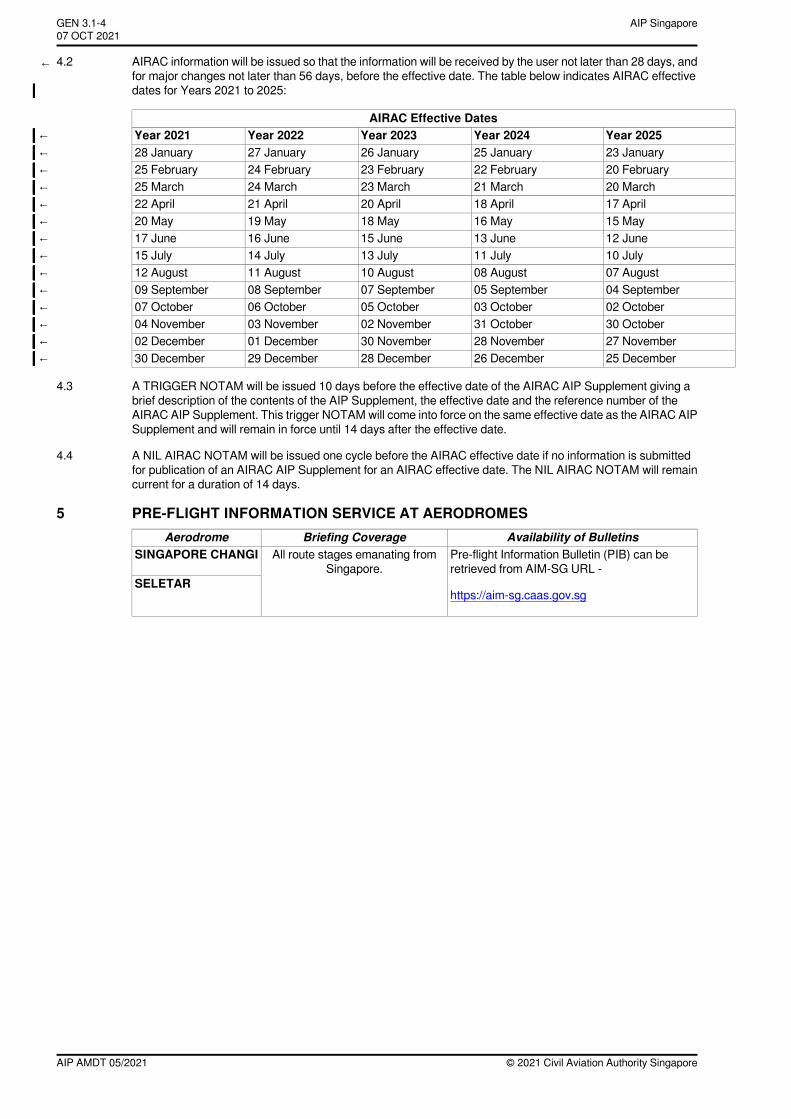
← 4.2 AIRAC information will be issued so that the information will be received by the user not later than 28 days, andfor major changes not later than 56 days, before the effective date. The table below indicates AIRAC effectivedates for Years 2021 to 2025:
AIRAC Effective DatesYear 2025Year 2024Year 2023Year 2022Year 2021←23 January25 January26 January27 January28 January←20 February22 February23 February24 February25 February←20 March21 March23 March24 March25 March←17 April18 April20 April21 April22 April←15 May16 May18 May19 May20 May←12 June13 June15 June16 June17 June←10 July11 July13 July14 July15 July←07 August08 August10 August11 August12 August←04 September05 September07 September08 September09 September←02 October03 October05 October06 October07 October←30 October31 October02 November03 November04 November←27 November28 November30 November01 December02 December←25 December26 December28 December29 December30 December←
4.3 A TRIGGER NOTAM will be issued 10 days before the effective date of the AIRAC AIP Supplement giving abrief description of the contents of the AIP Supplement, the effective date and the reference number of theAIRAC AIP Supplement. This trigger NOTAMwill come into force on the same effective date as the AIRAC AIPSupplement and will remain in force until 14 days after the effective date.
4.4 A NIL AIRAC NOTAM will be issued one cycle before the AIRAC effective date if no information is submittedfor publication of an AIRAC AIP Supplement for an AIRAC effective date. The NIL AIRAC NOTAM will remaincurrent for a duration of 14 days.
5 PRE-FLIGHT INFORMATION SERVICE AT AERODROMESAvailability of BulletinsBriefing CoverageAerodrome
Pre-flight Information Bulletin (PIB) can beretrieved from AIM-SG URL -
https://aim-sg.caas.gov.sg
All route stages emanating fromSingapore.
SINGAPORE CHANGI
SELETAR
© 2021 Civil Aviation Authority SingaporeAIP AMDT 05/2021
AIP SingaporeGEN 3.1-407 OCT 2021~~~eaip-amdt~~~ver-date-2021-09-09T07-08-00-035
k. Visual Approach Chart - ICAO
This chart is produced for aerodromes used by civil aviation where:
∗ only limited navigation facilities are available; or∗ radio communication facilities are not available; or∗ no adequate aeronautical charts of the aerodrome and its surroundings at 1:500 000 or greater
scale are available; or∗ visual approach procedures have been established
The aeronautical data shown include information on aerodromes obstacles, designated airspace, visualapproach information, radio navigation aids and communication facilities, as appropriate.
AIP AMDT 02/2016© 2016 Civil Aviation Authority Singapore
GEN 3.2-331 MAR 2016
AIP Singapore
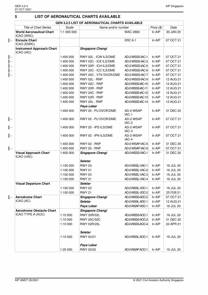
5 LIST OF AERONAUTICAL CHARTS AVAILABLEGEN 3.2.5 LIST OF AERONAUTICAL CHARTS AVAILABLE
DatePrice ($)Name and/or numberScaleTitle of Chart Series30 JAN 20In AIPWAC 28601:1 000 000World Aeronautical Chart
ICAO (WAC)07 OCT 21In AIPERC 6-1Enroute Chart←
ICAO (ENRC)Singapore ChangiInstrument Approach Chart
ICAO (IAC)07 OCT 21In AIPAD-2-WSSS-IAC-1RWY 02L - ICW ILS/DME1:400 000←07 OCT 21In AIPAD-2-WSSS-IAC-2RWY 02C - ICE ILS/DME1:400 000←07 OCT 21In AIPAD-2-WSSS-IAC-5RWY 20R - ICH ILS/DME1:400 000←07 OCT 21In AIPAD-2-WSSS-IAC-6RWY 20C - ICC ILS/DME1:400 000←07 OCT 21In AIPAD-2-WSSS-IAC-7RWY 20C - VTK DVOR/DME1:400 000←12 AUG 21In AIPAD-2-WSSS-IAC-9RWY 02L - RNP1:400 00012 AUG 21In AIPAD-2-WSSS-IAC-10RWY 02C - RNP1:400 00012 AUG 21In AIPAD-2-WSSS-IAC-11RWY 20R - RNP1:400 00012 AUG 21In AIPAD-2-WSSS-IAC-12RWY 20C - RNP1:400 00012 AUG 21In AIPAD-2-WSSS-IAC-13RWY 02R - RNP1:400 00012 AUG 21In AIPAD-2-WSSS-IAC-14RWY 20L - RNP1:400 000
Paya Lebar31 DEC 20In AIPAD-2-WSAP
IAC-1RWY 20 - PU DVOR/DME1:400 000
07 OCT 21In AIPAD-2-WSAPIAC-2
RWY 02 - PU DVOR/DME1:400 000←
07 OCT 21In AIPAD-2-WSAPIAC-3
RWY 20 - IPS ILS/DME1:400 000←
07 OCT 21In AIPAD-2-WSAPIAC-4
RWY 02 - IPN ILS/DME1:400 000←
31 DEC 20In AIPAD-2-WSAP-IAC-5RWY 02 - RNP1:400 00007 OCT 21In AIPAD-2-WSAP-IAC-6RWY 20 - RNP1:400 000←31 DEC 20In AIPAD-2-WSSS-VAC-1Singapore Changi1:400 000Visual Approach Chart
ICAO (VAC)Seletar
16 JUL 20In AIPAD-2-WSSL-VAC-1RWY 031:100 00016 JUL 20In AIPAD-2-WSSL-VAC-2RWY 211:100 00016 JUL 20In AIPAD-2-WSSL-VAC-3RWY 031:100 00016 JUL 20In AIPAD-2-WSSL-VAC-4RWY 211:100 000
SeletarVisual Departure Chart16 JUL 20In AIPAD-2-WSSL-VDC-1RWY 031:100 00025 FEB 21In AIPAD-2-WSSL-VDC-2RWY 211:100 00007 OCT 21In AIPAD-2-WSSS-ADC-2Singapore ChangiAerodrome Chart←
ICAO (AC) 12 AUG 21In AIPAD-2-WSSL-ADC-1Seletar16 JUL 20In AIPAD-2-WSAP-ADC-1Paya Lebar
Singapore ChangiAerodrome Obstacle ChartICAO TYPE A (AOC) 16 JUL 20In AIPAD-2-WSSS-AOC-1RWY 20R/02L1:10 000
31 DEC 20In AIPAD-2-WSSS-AOC-2RWY 20C/02C1:10 00022 APR 21In AIPAD-2-WSSS-AOC-4RWY 02R/20L1:10 000
Seletar16 JUL 20In AIPAD-2-WSSL-AOC-1RWY 03/211:10 000
Paya Lebar16 JUL 20In AIPAD-2-WSAP-AOC-1RWY 20/021:20 000
© 2021 Civil Aviation Authority SingaporeAIP AMDT 05/2021
AIP SingaporeGEN 3.2-407 OCT 2021~~~eaip-amdt~~~ver-date-2021-09-09T07-08-00-035
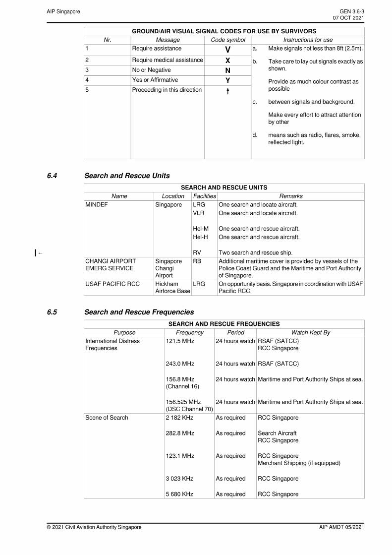
GROUND/AIR VISUAL SIGNAL CODES FOR USE BY SURVIVORSInstructions for useCode symbolMessageNr.
VRequire assistance1 a. Make signals not less than 8ft (2.5m).
XRequire medical assistance2 b. Take care to lay out signals exactly asshown.
Provide as much colour contrast aspossible
NNo or Negative3
YYes or Affirmative4
↑Proceeding in this direction5
c. between signals and background.
Make every effort to attract attentionby other
d. means such as radio, flares, smoke,reflected light.
6.4 Search and Rescue UnitsSEARCH AND RESCUE UNITS
RemarksFacilitiesLocationNameOne search and locate aircraft.LRGSingaporeMINDEFOne search and locate aircraft.VLR
One search and rescue aircraft.Hel-MOne search and rescue aircraft.Hel-H
Two search and rescue ship.RV←Additional maritime cover is provided by vessels of thePolice Coast Guard and the Maritime and Port Authorityof Singapore.
RBSingaporeChangiAirport
CHANGI AIRPORTEMERG SERVICE
Onopportunity basis. Singapore in coordinationwithUSAFPacific RCC.
LRGHickhamAirforce Base
USAF PACIFIC RCC
6.5 Search and Rescue FrequenciesSEARCH AND RESCUE FREQUENCIES
Watch Kept ByPeriodFrequencyPurposeRSAF (SATCC)RCC Singapore
24 hours watch121.5 MHzInternational DistressFrequencies
RSAF (SATCC)24 hours watch243.0 MHz
Maritime and Port Authority Ships at sea.24 hours watch156.8 MHz(Channel 16)
Maritime and Port Authority Ships at sea.24 hours watch156.525 MHz(DSC Channel 70)
RCC SingaporeAs required2 182 KHzScene of Search
Search AircraftRCC Singapore
As required282.8 MHz
RCC SingaporeMerchant Shipping (if equipped)
As required123.1 MHz
RCC SingaporeAs required3 023 KHz
RCC SingaporeAs required5 680 KHz
AIP AMDT 05/2021© 2021 Civil Aviation Authority Singapore
GEN 3.6-3AIP Singapore~~~eaip-amdt~~~ver-date-2021-09-09T07-08-00-03507 OCT 2021
Note:
← Speech circuits exist between all ATS Units in Peninsular Malaysia and Singapore. Speech circuits also existbetween Singapore ATS Unit and Kota Kinabalu ATS Unit in Sabah. Direct speech communications betweenKuching and Singapore ATS Unit is also available. Direct speech communications circuits exist betweenSingapore ATS Unit and Jakarta, Manila and Ho Chi Minh ATS Units and are available for relay of messagesbetween Singapore RCC and the respective RCCs but may be subject to delays.
© 2021 Civil Aviation Authority SingaporeAIP AMDT 05/2021
AIP SingaporeGEN 3.6-407 OCT 2021~~~eaip-amdt~~~ver-date-2021-09-09T07-08-00-035
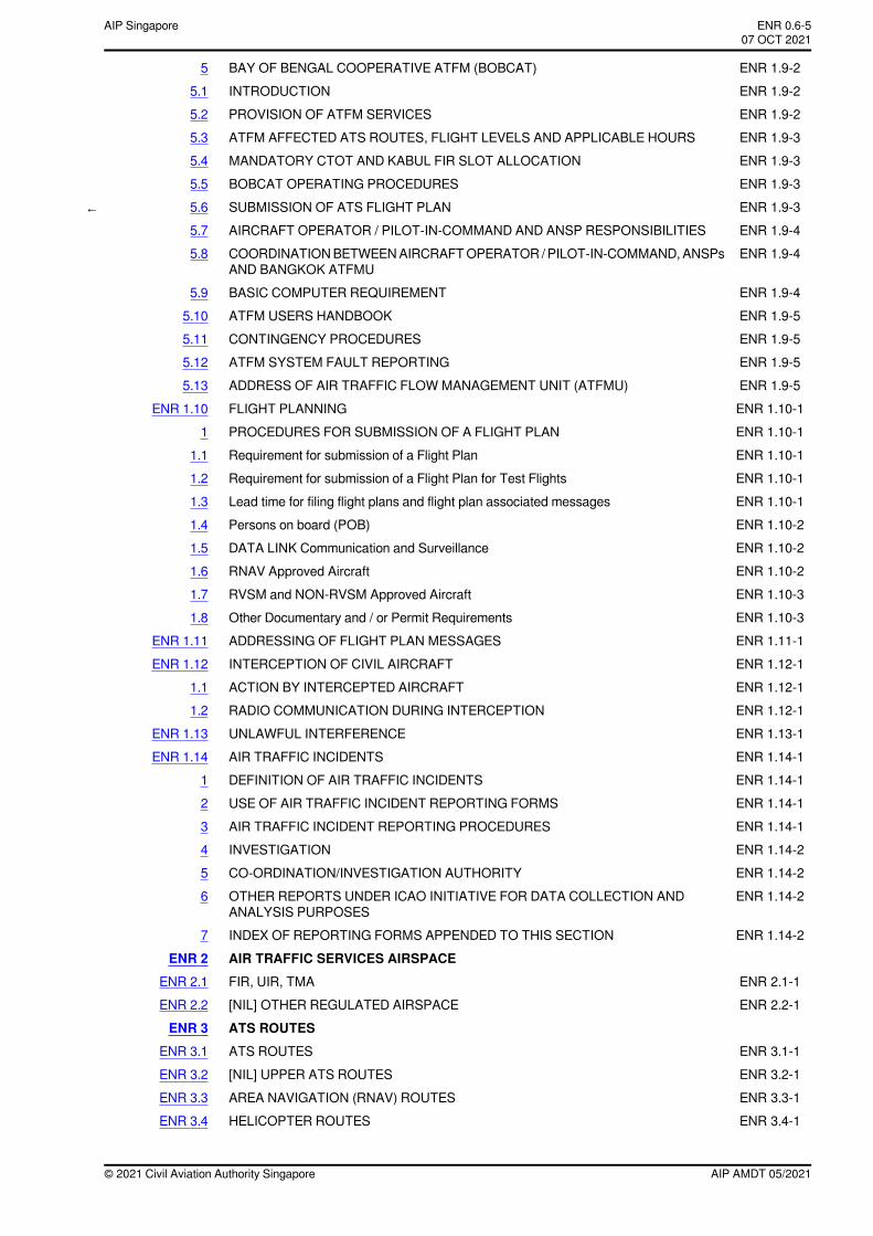
ENR 1.9-2BAY OF BENGAL COOPERATIVE ATFM (BOBCAT)5ENR 1.9-2INTRODUCTION5.1ENR 1.9-2PROVISION OF ATFM SERVICES5.2ENR 1.9-3ATFM AFFECTED ATS ROUTES, FLIGHT LEVELS AND APPLICABLE HOURS5.3ENR 1.9-3MANDATORY CTOT AND KABUL FIR SLOT ALLOCATION5.4ENR 1.9-3BOBCAT OPERATING PROCEDURES5.5
← ENR 1.9-3SUBMISSION OF ATS FLIGHT PLAN5.6ENR 1.9-4AIRCRAFT OPERATOR / PILOT-IN-COMMAND AND ANSP RESPONSIBILITIES5.7ENR 1.9-4COORDINATIONBETWEENAIRCRAFTOPERATOR /PILOT-IN-COMMAND,ANSPs
AND BANGKOK ATFMU5.8
ENR 1.9-4BASIC COMPUTER REQUIREMENT5.9ENR 1.9-5ATFM USERS HANDBOOK5.10ENR 1.9-5CONTINGENCY PROCEDURES5.11ENR 1.9-5ATFM SYSTEM FAULT REPORTING5.12ENR 1.9-5ADDRESS OF AIR TRAFFIC FLOW MANAGEMENT UNIT (ATFMU)5.13ENR 1.10-1FLIGHT PLANNINGENR 1.10ENR 1.10-1PROCEDURES FOR SUBMISSION OF A FLIGHT PLAN1ENR 1.10-1Requirement for submission of a Flight Plan1.1ENR 1.10-1Requirement for submission of a Flight Plan for Test Flights1.2ENR 1.10-1Lead time for filing flight plans and flight plan associated messages1.3ENR 1.10-2Persons on board (POB)1.4ENR 1.10-2DATA LINK Communication and Surveillance1.5ENR 1.10-2RNAV Approved Aircraft1.6ENR 1.10-3RVSM and NON-RVSM Approved Aircraft1.7ENR 1.10-3Other Documentary and / or Permit Requirements1.8ENR 1.11-1ADDRESSING OF FLIGHT PLAN MESSAGESENR 1.11ENR 1.12-1INTERCEPTION OF CIVIL AIRCRAFTENR 1.12ENR 1.12-1ACTION BY INTERCEPTED AIRCRAFT1.1ENR 1.12-1RADIO COMMUNICATION DURING INTERCEPTION1.2ENR 1.13-1UNLAWFUL INTERFERENCEENR 1.13ENR 1.14-1AIR TRAFFIC INCIDENTSENR 1.14ENR 1.14-1DEFINITION OF AIR TRAFFIC INCIDENTS1ENR 1.14-1USE OF AIR TRAFFIC INCIDENT REPORTING FORMS2ENR 1.14-1AIR TRAFFIC INCIDENT REPORTING PROCEDURES3ENR 1.14-2INVESTIGATION4ENR 1.14-2CO-ORDINATION/INVESTIGATION AUTHORITY5ENR 1.14-2OTHER REPORTS UNDER ICAO INITIATIVE FOR DATA COLLECTION AND
ANALYSIS PURPOSES6
ENR 1.14-2INDEX OF REPORTING FORMS APPENDED TO THIS SECTION7AIR TRAFFIC SERVICES AIRSPACEENR 2
ENR 2.1-1FIR, UIR, TMAENR 2.1ENR 2.2-1[NIL] OTHER REGULATED AIRSPACEENR 2.2
ATS ROUTESENR 3ENR 3.1-1ATS ROUTESENR 3.1ENR 3.2-1[NIL] UPPER ATS ROUTESENR 3.2ENR 3.3-1AREA NAVIGATION (RNAV) ROUTESENR 3.3ENR 3.4-1HELICOPTER ROUTESENR 3.4
AIP AMDT 05/2021© 2021 Civil Aviation Authority Singapore
ENR 0.6-5AIP Singapore~~~eaip-amdt~~~ver-date-2021-09-09T07-08-00-03507 OCT 2021
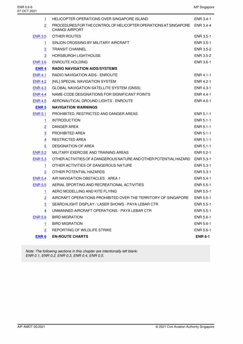
ENR 3.4-1HELICOPTER OPERATIONS OVER SINGAPORE ISLAND1ENR 3.4-4PROCEDURESFORTHECONTROLOFHELICOPTEROPERATIONSATSINGAPORE
CHANGI AIRPORT2
ENR 3.5-1OTHER ROUTESENR 3.5ENR 3.5-1SINJON CROSSING BY MILITARY AIRCRAFT1ENR 3.5-2TRANSIT CHANNEL2ENR 3.5-2HORSBURGH LIGHTHOUSE3ENR 3.6-1ENROUTE HOLDINGENR 3.6
RADIO NAVIGATION AIDS/SYSTEMSENR 4ENR 4.1-1RADIO NAVIGATION AIDS - ENROUTEENR 4.1ENR 4.2-1[NIL] SPECIAL NAVIGATION SYSTEMENR 4.2ENR 4.3-1GLOBAL NAVIGATION SATELLITE SYSTEM (GNSS)ENR 4.3ENR 4.4-1NAME-CODE DESIGNATIONS FOR SIGNIFICANT POINTSENR 4.4ENR 4.5-1AERONAUTICAL GROUND LIGHTS - ENROUTEENR 4.5
NAVIGATION WARNINGSENR 5ENR 5.1-1PROHIBITED, RESTRICTED AND DANGER AREASENR 5.1ENR 5.1-1INTRODUCTION1ENR 5.1-1DANGER AREA2ENR 5.1-1PROHIBITED AREA3ENR 5.1-1RESTRICTED AREA4ENR 5.1-1DESIGNATION OF AREA5ENR 5.2-1MILITARY EXERCISE AND TRAINING AREASENR 5.2ENR 5.3-1OTHERACTIVITIESOFADANGEROUSNATUREANDOTHERPOTENTIALHAZARDENR 5.3ENR 5.3-1OTHER ACTIVITIES OF DANGEROUS NATURE1ENR 5.3-1OTHER POTENTIAL HAZARDS2ENR 5.4-1AIR NAVIGATION OBSTACLES - AREA 1ENR 5.4ENR 5.5-1AERIAL SPORTING AND RECREATIONAL ACTIVITIESENR 5.5ENR 5.5-1AERO MODELLING AND KITE FLYING1ENR 5.5-1AIRCRAFT OPERATIONS PROHIBITED OVER THE TERRITORY OF SINGAPORE2ENR 5.5-1SEARCHLIGHT DISPLAY / LASER SHOWS - PAYA LEBAR CTR3ENR 5.5-1UNMANNED AIRCRAFT OPERATIONS - PAYA LEBAR CTR4ENR 5.6-1BIRD MIGRATIONENR 5.6ENR 5.6-1BIRD MIGRATION1ENR 5.6-1REPORTING OF WILDLIFE STRIKE2ENR 6-1EN-ROUTE CHARTSENR 6
Note: The following sections in this chapter are intentionally left blank:ENR 0.1, ENR 0.2, ENR 0.3, ENR 0.4, ENR 0.5.
© 2021 Civil Aviation Authority SingaporeAIP AMDT 05/2021
AIP SingaporeENR 0.6-607 OCT 2021~~~eaip-amdt~~~ver-date-2021-09-09T07-08-00-035
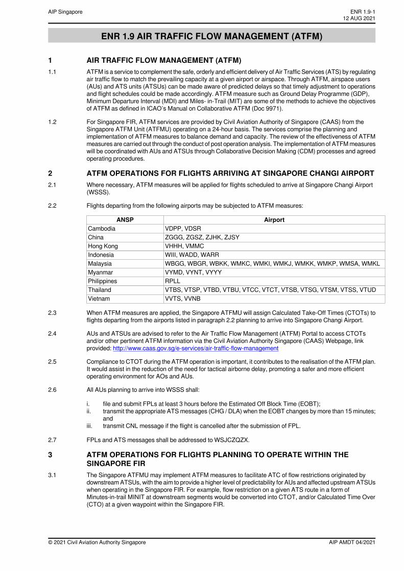
ENR 1.9 AIR TRAFFIC FLOW MANAGEMENT (ATFM)
1 AIR TRAFFIC FLOW MANAGEMENT (ATFM)1.1 ATFM is a service to complement the safe, orderly and efficient delivery of Air Traffic Services (ATS) by regulating
air traffic flow to match the prevailing capacity at a given airport or airspace. Through ATFM, airspace users(AUs) and ATS units (ATSUs) can be made aware of predicted delays so that timely adjustment to operationsand flight schedules could be made accordingly. ATFM measure such as Ground Delay Programme (GDP),Minimum Departure Interval (MDI) and Miles- in-Trail (MIT) are some of the methods to achieve the objectivesof ATFM as defined in ICAO’s Manual on Collaborative ATFM (Doc 9971).
1.2 For Singapore FIR, ATFM services are provided by Civil Aviation Authority of Singapore (CAAS) from theSingapore ATFM Unit (ATFMU) operating on a 24-hour basis. The services comprise the planning andimplementation of ATFM measures to balance demand and capacity. The review of the effectiveness of ATFMmeasures are carried out through the conduct of post operation analysis. The implementation of ATFMmeasureswill be coordinated with AUs and ATSUs through Collaborative Decision Making (CDM) processes and agreedoperating procedures.
2 ATFM OPERATIONS FOR FLIGHTS ARRIVING AT SINGAPORE CHANGI AIRPORT2.1 Where necessary, ATFM measures will be applied for flights scheduled to arrive at Singapore Changi Airport
(WSSS).
2.2 Flights departing from the following airports may be subjected to ATFM measures:
AirportANSPVDPP, VDSRCambodiaZGGG, ZGSZ, ZJHK, ZJSYChinaVHHH, VMMCHong KongWIII, WADD, WARRIndonesiaWBGG, WBGR, WBKK, WMKC, WMKI, WMKJ, WMKK, WMKP, WMSA, WMKLMalaysiaVYMD, VYNT, VYYYMyanmarRPLLPhilippinesVTBS, VTSP, VTBD, VTBU, VTCC, VTCT, VTSB, VTSG, VTSM, VTSS, VTUDThailandVVTS, VVNBVietnam
2.3 When ATFM measures are applied, the Singapore ATFMU will assign Calculated Take-Off Times (CTOTs) toflights departing from the airports listed in paragraph 2.2 planning to arrive into Singapore Changi Airport.
2.4 AUs and ATSUs are advised to refer to the Air Traffic Flow Management (ATFM) Portal to access CTOTsand/or other pertinent ATFM information via the Civil Aviation Authority Singapore (CAAS) Webpage, linkprovided: http://www.caas.gov.sg/e-services/air-traffic-flow-management
2.5 Compliance to CTOT during the ATFM operation is important, it contributes to the realisation of the ATFM plan.It would assist in the reduction of the need for tactical airborne delay, promoting a safer and more efficientoperating environment for AOs and AUs.
2.6 All AUs planning to arrive into WSSS shall:
i. file and submit FPLs at least 3 hours before the Estimated Off Block Time (EOBT);ii. transmit the appropriate ATSmessages (CHG / DLA) when the EOBT changes by more than 15minutes;
andiii. transmit CNL message if the flight is cancelled after the submission of FPL.
2.7 FPLs and ATS messages shall be addressed to WSJCZQZX.
3 ATFM OPERATIONS FOR FLIGHTS PLANNING TO OPERATE WITHIN THESINGAPORE FIR
3.1 The Singapore ATFMU may implement ATFM measures to facilitate ATC of flow restrictions originated bydownstreamATSUs, with the aim to provide a higher level of predictability for AUs and affected upstreamATSUswhen operating in the Singapore FIR. For example, flow restriction on a given ATS route in a form ofMinutes-in-trail MINIT at downstream segments would be converted into CTOT, and/or Calculated Time Over(CTO) at a given waypoint within the Singapore FIR.
AIP AMDT 04/2021© 2021 Civil Aviation Authority Singapore
ENR 1.9-112 AUG 2021
AIP Singapore
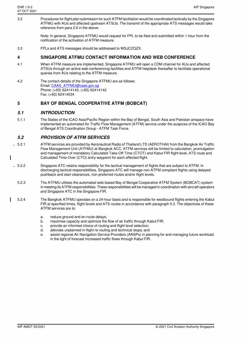
3.2 Procedures for flight plan submission for such ATFM facilitation would be coordinated tactically by the SingaporeATFMU with AUs and affected upstream ATSUs. The transmit of the appropriate ATS messages would takereference from para 2.6 in the above.
Note: In general, Singapore ATFMU would request for FPL to be filed and submitted within 1 hour from thenotification of the activation of ATFM measure.
3.3 FPLs and ATS messages should be addressed to WSJCZQZX.
4 SINGAPORE ATFMU CONTACT INFORMATION AND WEB CONFERENCE4.1 When ATFM measure are implemented, Singapore ATFMU will open a CDM channel for AUs and affected
ATSUs through an active web conferencing facilities and ATFM helpdesk thereafter to facilitate operationalqueries from AUs relating to the ATFM measure.
4.2 The contact details of the Singapore ATFMU are as follows:Email: [email protected]: (+65) 62414143, (+65) 62414142Fax: (+65) 62414034
5 BAY OF BENGAL COOPERATIVE ATFM (BOBCAT)
5.1 INTRODUCTION5.1.1 The States of the ICAO Asia/Pacific Region within the Bay of Bengal, South Asia and Pakistan airspace have
implemented an automated Air Traffic Flow Management (ATFM) service under the auspices of the ICAO Bayof Bengal ATS Coordination Group - ATFM Task Force.
5.2 PROVISION OF ATFM SERVICES← 5.2.1 ATFM services are provided by Aeronautical Radio of Thailand LTD (AEROTHAI) from the Bangkok Air Traffic
Flow Management Unit (ATFMU) at Bangkok ACC. ATFM services will be limited to calculation, promulgationand management of mandatory Calculated Take-Off Time (CTOT) and Kabul FIR flight level, ATS route andCalculated Time-Over (CTO) entry waypoint for each affected flight.
← 5.2.2 Singapore ATC retains responsibility for the tactical management of flights that are subject to ATFM. Indischarging tactical responsibilities, Singapore ATC will manage non-ATFM compliant flights using delayedpushback and start clearances, non-preferred routes and/or flight levels.
5.2.3 The ATFMU utilises the automated web based Bay of Bengal Cooperative ATFM System (BOBCAT) systeminmeeting its ATFM responsibilities. These responsibilities will bemanaged in coordination with aircraft operatorsand Singapore ATC in the Singapore FIR.
5.2.4 The Bangkok ATFMU operates on a 24-hour basis and is responsible for westbound flights entering the KabulFIR at specified times, flight levels and ATS routes in accordance with paragraph 5.3. The objectives of theseATFM services are to:
a. reduce ground and en-route delays;b. maximise capacity and optimize the flow of air traffic through Kabul FIR;c. provide an informed choice of routing and flight level selection;d. alleviate unplanned in-flight re-routing and technical stops; ande. assist regional Air Navigation Service Providers (ANSPs) in planning for and managing future workload
in the light of forecast increased traffic flows through Kabul FIR.
© 2021 Civil Aviation Authority SingaporeAIP AMDT 05/2021
AIP SingaporeENR 1.9-207 OCT 2021~~~eaip-amdt~~~ver-date-2021-09-09T07-08-00-035
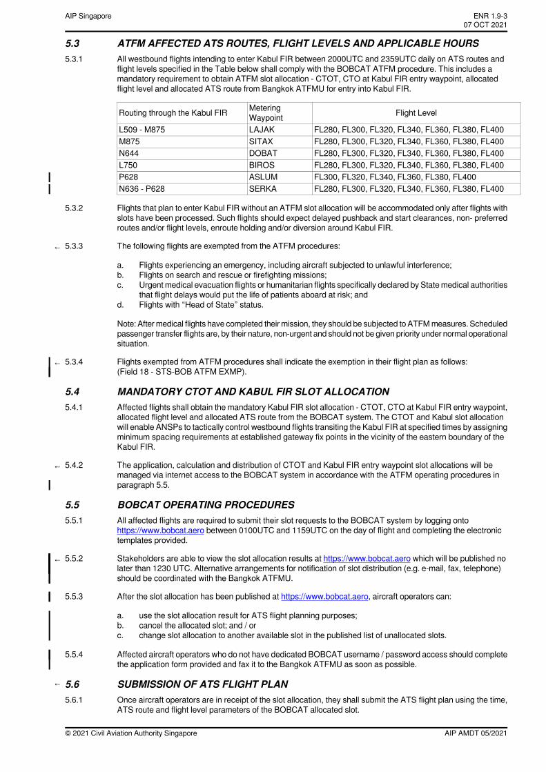
5.3 ATFM AFFECTED ATS ROUTES, FLIGHT LEVELS AND APPLICABLE HOURS5.3.1 All westbound flights intending to enter Kabul FIR between 2000UTC and 2359UTC daily on ATS routes and
flight levels specified in the Table below shall comply with the BOBCAT ATFM procedure. This includes amandatory requirement to obtain ATFM slot allocation - CTOT, CTO at Kabul FIR entry waypoint, allocatedflight level and allocated ATS route from Bangkok ATFMU for entry into Kabul FIR.
Flight LevelMeteringWaypointRouting through the Kabul FIR
FL280, FL300, FL320, FL340, FL360, FL380, FL400LAJAKL509 - M875FL280, FL300, FL320, FL340, FL360, FL380, FL400SITAXM875FL280, FL300, FL320, FL340, FL360, FL380, FL400DOBATN644FL280, FL300, FL320, FL340, FL360, FL380, FL400BIROSL750FL300, FL320, FL340, FL360, FL380, FL400ASLUMP628FL280, FL300, FL320, FL340, FL360, FL380, FL400SERKAN636 - P628
5.3.2 Flights that plan to enter Kabul FIR without an ATFM slot allocation will be accommodated only after flights withslots have been processed. Such flights should expect delayed pushback and start clearances, non- preferredroutes and/or flight levels, enroute holding and/or diversion around Kabul FIR.
← 5.3.3 The following flights are exempted from the ATFM procedures:
a. Flights experiencing an emergency, including aircraft subjected to unlawful interference;b. Flights on search and rescue or firefighting missions;c. Urgent medical evacuation flights or humanitarian flights specifically declared by State medical authorities
that flight delays would put the life of patients aboard at risk; andd. Flights with “Head of State” status.
Note: Aftermedical flights have completed their mission, they should be subjected to ATFMmeasures. Scheduledpassenger transfer flights are, by their nature, non-urgent and should not be given priority under normal operationalsituation.
← 5.3.4 Flights exempted from ATFM procedures shall indicate the exemption in their flight plan as follows:(Field 18 - STS-BOB ATFM EXMP).
5.4 MANDATORY CTOT AND KABUL FIR SLOT ALLOCATION5.4.1 Affected flights shall obtain the mandatory Kabul FIR slot allocation - CTOT, CTO at Kabul FIR entry waypoint,
allocated flight level and allocated ATS route from the BOBCAT system. The CTOT and Kabul slot allocationwill enable ANSPs to tactically control westbound flights transiting the Kabul FIR at specified times by assigningminimum spacing requirements at established gateway fix points in the vicinity of the eastern boundary of theKabul FIR.
← 5.4.2 The application, calculation and distribution of CTOT and Kabul FIR entry waypoint slot allocations will bemanaged via internet access to the BOBCAT system in accordance with the ATFM operating procedures inparagraph 5.5.
5.5 BOBCAT OPERATING PROCEDURES5.5.1 All affected flights are required to submit their slot requests to the BOBCAT system by logging onto
https://www.bobcat.aero between 0100UTC and 1159UTC on the day of flight and completing the electronictemplates provided.
← 5.5.2 Stakeholders are able to view the slot allocation results at https://www.bobcat.aero which will be published nolater than 1230 UTC. Alternative arrangements for notification of slot distribution (e.g. e-mail, fax, telephone)should be coordinated with the Bangkok ATFMU.
5.5.3 After the slot allocation has been published at https://www.bobcat.aero, aircraft operators can:
a. use the slot allocation result for ATS flight planning purposes;b. cancel the allocated slot; and / orc. change slot allocation to another available slot in the published list of unallocated slots.
5.5.4 Affected aircraft operators who do not have dedicated BOBCAT username / password access should completethe application form provided and fax it to the Bangkok ATFMU as soon as possible.
← 5.6 SUBMISSION OF ATS FLIGHT PLAN5.6.1 Once aircraft operators are in receipt of the slot allocation, they shall submit the ATS flight plan using the time,
ATS route and flight level parameters of the BOBCAT allocated slot.
AIP AMDT 05/2021© 2021 Civil Aviation Authority Singapore
ENR 1.9-3AIP Singapore~~~eaip-amdt~~~ver-date-2021-09-09T07-08-00-03507 OCT 2021
5.6.2 In addition to the normal addressees, Singapore AIS will also address the flight plan (FPL) and related ATSmessages (e.g. DLA, CNL, CHG) to the Bangkok ATFMU via AFTN address VTBBZDZX for all flights that havesubmitted a slot request.
5.7 AIRCRAFT OPERATOR / PILOT-IN-COMMAND AND ANSP RESPONSIBILITIES
Aircraft Operator / Pilot-in-Command
5.7.1 In accordance with ICAO PANS-ATM provisions, it is the responsibility of the Pilot-in-Command (PIC) and theaircraft operator to ensure that the aircraft is ready to taxi in time to meet any required departure time. PIC shallbe kept informed by their aircraft operators of the CTOT, CTO at Kabul FIR entry waypoint and flight parameters(route / level) allocated by BOBCAT.
5.7.2 The PIC, in collaboration with ATC, shall arrange take-off as close as possible to the CTOT in order to meet theallocated CTO at Kabul FIR entry waypoint.
ANSPs
5.7.3 In accordance with ICAO PANS-ATM provisions, flights with an ATFM slot allocation should be given priorityfor take-off to facilitate compliance with the CTOT.
← 5.7.4 CTOT shall be included as part of the initial ATC clearance. In collaboration with PIC, Singapore ATC shallensure that every opportunity and assistance is granted to a flight tomeet the allocated CTOT andCTOat KabulFIR entry waypoint.
5.8 COORDINATION BETWEEN AIRCRAFT OPERATOR / PILOT-IN-COMMAND, ANSPsAND BANGKOK ATFMU
5.8.1 The PIC shall include the CTOT in the initial ATC clearance request.
5.8.2 PIC shall adjust cruise flight to complywith slot parameters at the Kabul FIR entry waypoint, requesting appropriateATC clearances including speed variations in accordance with the published AIP requirements.
5.8.3 Prior to departure, in circumstances where it becomes obvious that the allocated Kabul FIR entry waypoint slotparameters will not be met, a new slot allocation should be obtained as soon as possible and via the mostexpeditiousmeans (e.g. via coordination between flight dispatcher, PIC, Singapore ATCandBangkokATFMU).Early advice that the Kabul FIR slot parameters will be missed also enables the slots so vacated to be efficientlyreassigned to other flights.
5.8.4 Prior to departure and after the aircraft has left the gate, in the event that the aircraft is unable to meet the KabulFIR entry waypoint slot parameters, when requested by the PIC, Singapore ATC shall assist the PIC to coordinatewith the Bangkok ATFMU for a revised slot allocation.
5.8.5 The Bangkok ATFMU (VTBBZDZX) shall be included in the list of AFTN addressees for NOTAMs regardingany planned activities that may affect slot availability (e.g. reservation of airspace / closure of airspace, non-availability of routes, etc.).
5.8.6 The Bangkok ATFMU (VTBBZDZX) shall be included in the list of AFTN addressees for ATS messages (e.g.FPL, DEP, DLA, CHG, CNL) relating to flights subject to ATFM procedures.
5.8.7 A missed slot results in dramatically increased coordination workload for ATC and PIC and should be avoided.To minimise coordination workload in obtaining a revised slot allocation, the following procedures arerecommended:
a. If the flight is still at the gate, coordination should take place via aircraft operators / flight dispatchers toBangkok ATFMU;
b. If the flight has left the gate, coordination to Bangkok ATFMU may also take place via the ATS unitpresently communicating with the flight.
5.9 BASIC COMPUTER REQUIREMENT
5.9.1 Aircraft operators and Singapore ATC are required to have computer equipment capable of connecting to theBOBCAT website https://www.bobcat.aero via the internet and satisfying the following minimum technicalrequirements:
a. A personal computer of any operating system with the following characteristics:
i. Processor: minimum CPU clock speed of 150MHz;
© 2021 Civil Aviation Authority SingaporeAIP AMDT 05/2021
AIP SingaporeENR 1.9-407 OCT 2021~~~eaip-amdt~~~ver-date-2021-09-09T07-08-00-035
ii. Operating System: any that operates one of the following web browsers (i.e. Windows 2000 / XP,Linux, Unix, or Mac OS);
iii. Web Browser: Internet Explorer 5.5 or newer, Mozilla 1.0 or newer, Mozilla Firefox 1.0 or newer,Netscape 7 or newer;
iv. RAM: 64MB or larger (depending on operating system);
v. Hard Disk Space: minimum of 500MB or larger (depending on operating system);
vi. Monitor Display Resolution: minimum of 800 x 600 pixels; and
vii. Internet Connection: 56Kbps modem or faster.
5.10 ATFM USERS HANDBOOK← 5.10.1 Supporting documentation, including detailed information in respect of the ATFM operations described above
and other pertinent information has been included in the Bay of Bengal and South Asia ATFM Handbook (the“ATFM Users Handbook”), available at https://www.bobcat.aero
5.10.2 ANSPs and aircraft operators shall ensure that they are conversant with and able to apply the relevant proceduresdescribed in the ATFM Users Handbook.
5.11 CONTINGENCY PROCEDURES← 5.11.1 In the event that an aircraft operator or Singapore ATC is unable to access the Bangkok ATFMU website, the
Bangkok ATFMU shall be contacted via the alternative means (telephone, fax, AFTN) described in paragraph5.13.
5.11.2 Contingency procedures for submission of slot request, including activation of Contingency Slot RequestTemplates (CSRT), are included in the ATFM Users Handbook.
5.11.3 In the event of system failure of BOBCAT, Bangkok ATFMU shall notify all parties concerned and advise thatATFM slot allocation procedures are suspended. In this event, all parties concerned will revert to the existingATM procedures as applicable outside the daily period of ATFM metering.
5.12 ATFM SYSTEM FAULT REPORTING5.12.1 An ATFM system fault is defined as a significant occurrence affecting an ATS unit, an aircraft operator or
Bangkok ATFMU resulting from the application of ATFM procedures.
5.12.2 Aircraft operators and Singapore ATC experiencing an ATFM system fault should complete an ATFM SystemFault Report Form from the ATFM Users Handbook and forward it to the Bangkok ATFMU at the addressindicated on the form. The Bangkok ATFMU will analyse all reports, make recommendations / suggestions asappropriate and provide feedback to the parties concerned to enable remedial action.
5.13 ADDRESS OF AIR TRAFFIC FLOW MANAGEMENT UNIT (ATFMU)5.13.1 The Bangkok ATFMU may be contacted as follows:
Bangkok ATFMU:Unit Name+66-2-287-8024, +66-2-287-8025:Telephone+66-2-287-8027:Fax+66-2-287-8026:Tel/[email protected]:E-mail←VTBBZDZX:AFTNhttps://www.bobcat.aero:Website←
AIP AMDT 05/2021© 2021 Civil Aviation Authority Singapore
ENR 1.9-5AIP Singapore~~~eaip-amdt~~~ver-date-2021-09-09T07-08-00-03507 OCT 2021

PAGE INTENTIONALLY LEFT BLANK
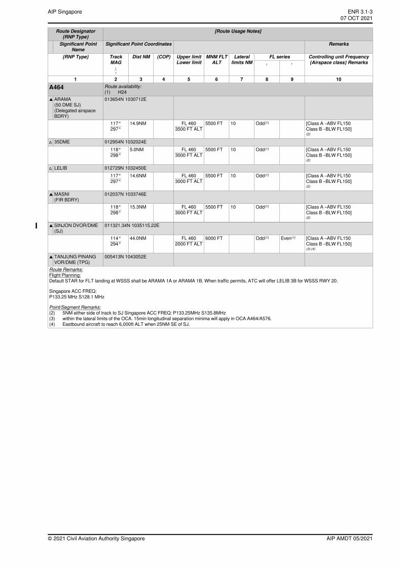
[Route Usage Notes]Route Designator{RNP Type}
RemarksSignificant Point CoordinatesSignificant PointName
Controlling unit Frequency{Airspace class} Remarks
FL seriesLaterallimits NM
MNM FLTALT
(COP)Dist NMTrackMAG
{RNP Type} Upper limitLower limit ↑↓
↓↑
10987654321Route availability:A464(1) H24013654N 1030712EARAMA
(50 DME SJ)(Delegated airspaceBDRY)
▲
[Class A –ABV FL150Class B –BLW FL150](2)
Odd(1)105500 FTFL 4603500 FT ALT
14.9NM117°297°
012954N 1032024E35DME∆
[Class A –ABV FL150Class B –BLW FL150](2)
Odd(1)105500 FTFL 4603000 FT ALT
5.0NM118°298°
012729N 1032450ELELIB∆
[Class A –ABV FL150Class B –BLW FL150](2)
Odd(1)105500 FTFL 4603000 FT ALT
14.6NM117°297°
012037N 1033746EMASNI(FIR BDRY)
▲
[Class A –ABV FL150Class B –BLW FL150](2)
Odd(1)105500 FTFL 4603000 FT ALT
15.3NM118°298°
011321.34N 1035115.22ESINJON DVOR/DME(SJ)
▲
[Class A –ABV FL150Class B –BLW FL150](3) (4)
Even(1)Odd(1)6000 FTFL 4602000 FT ALT
44.0NM114°294°
005413N 1043052ETANJUNG PINANGVOR/DME (TPG)
▲
Route Remarks:Flight Planning:Default STAR for FLT landing at WSSS shall be ARAMA 1A or ARAMA 1B. When traffic permits, ATC will offer LELIB 3B for WSSS RWY 20.
Singapore ACC FREQ:P133.25 MHz S128.1 MHz
Point/Segment Remarks:(2) 5NM either side of track to SJ Singapore ACC FREQ: P133.25MHz S135.8MHz(3) within the lateral limits of the OCA. 15min longitudinal separation minima will apply in OCA A464/A576.(4) Eastbound aircraft to reach 6,000ft ALT when 25NM SE of SJ.
AIP AMDT 05/2021© 2021 Civil Aviation Authority Singapore
ENR 3.1-3AIP Singapore~~~eaip-amdt~~~ver-date-2021-09-09T07-08-00-03507 OCT 2021
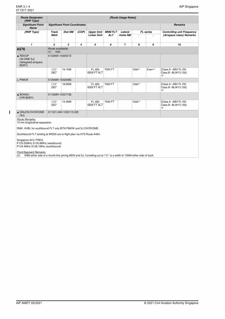
[Route Usage Notes]Route Designator{RNP Type}
RemarksSignificant Point CoordinatesSignificant PointName
Controlling unit Frequency{Airspace class} Remarks
FL seriesLaterallimits NM
MNM FLTALT
(COP)Dist NMTrackMAG
{RNP Type} Upper limitLower limit ↑↓
↓↑
10987654321Route availability:A576(1) H24013306N 1030521EREKOP
(50 DME SJ)(delegated airspaceBDRY)
▲
[Class A –ABV FL150Class B –BLW FL150](2)
Even(1)Odd(1)7000 FTFL 4606500 FT ALT
16.1NM112°292°
012648N 1032008EPIMOK∆
[Class A –ABV FL150Class B –BLW FL150](2)
Odd(1)7000 FTFL 4606500 FT ALT
18.6NM113°293°
011928N 1033710EBONSU(FIR BDRY)
▲
[Class A –ABV FL150Class B –BLW FL150](2)
Odd(1)7000 FTFL 4606500 FT ALT
15.4NM113°293°
011321.34N 1035115.22ESINJON DVOR/DME(SJ)
▲
Route Remarks:15 min longitudinal separation.
RMK: AVBL for southbound FLT only BTN PIMOK and SJ DVOR/DME.
Southbound FLT landing at WSSS are to flight plan via ATS Route A464.
Singapore ACC FREQ:P133.25MHz S135.8MHz (westbound)P134.4MHz S128.1MHz (southbound)
Point/Segment Remarks:(2) 5NM either side of a rhumb line joining MDN and SJ, funnelling out at 7.5° to a width of 15NM either side of track.
© 2021 Civil Aviation Authority SingaporeAIP AMDT 05/2021
AIP SingaporeENR 3.1-407 OCT 2021~~~eaip-amdt~~~ver-date-2021-09-09T07-08-00-035
[Route Usage Notes]Route Designator{RNP Type}
RemarksSignificant Point CoordinatesSignificant PointName
Controlling unit Frequency{Airspace class} Remarks
FL seriesLaterallimits NM
MNM FLTALT
(COP)Dist NMTrackMAG
{RNP Type} Upper limitLower limit ↑↓
↓↑
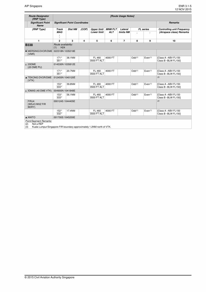
10987654321Route availability:B338(1) H24022318N 1035218EMERSINGDVOR/DME
(VMR)[Class A –ABV FL150Class B –BLW FL150]
Even(1)Odd(1)4000 FTFL 4603500 FT ALT
38.1NM171°351°
014530N 1035812E20DME(20 DME PU)
∆
[Class A –ABV FL150Class B –BLW FL150]
Even(1)Odd(1)4000 FTFL 4603500 FT ALT
20.7NM171°351°
(3)012455N 1040120ETEKONG DVOR/DME(VTK)
▲
[Class A –ABV FL150Class B –BLW FL150]
Even(1)Odd(1)4000 FTFL 4603500 FT ALT
39.8NM153°333°
004900N 1041848EIDMAS (40 DME VTK)∆
[Class A –ABV FL150Class B –BLW FL150]
Even(1)Odd(1)4000 FTFL 4603500 FT ALT
56.1NM153°333°
(2)000124S 1044405EFIRJ4(WSJC/WIIZ FIRBDRY)
[Class A –ABV FL150Class B –BLW FL150]
Even(1)Odd(1)4000 FTFL 4603500 FT ALT
17.4NM152°332°
001700S 1045200EANITO▲
Point/Segment Remarks:(2) Not a REP(3) Kuala Lumpur/Singapore FIR boundary approximately 1.2NM north of VTK.
© 2015 Civil Aviation Authority Singapore
ENR 3.1-512 NOV 2015
AIP Singapore
[Route Usage Notes]Route Designator{RNP Type}
RemarksSignificant Point CoordinatesSignificant PointName
Controlling unit Frequency{Airspace class} Remarks
FL seriesLaterallimits NM
MNM FLTALT
(COP)Dist NMTrackMAG
{RNP Type} Upper limitLower limit ↑↓
↓↑
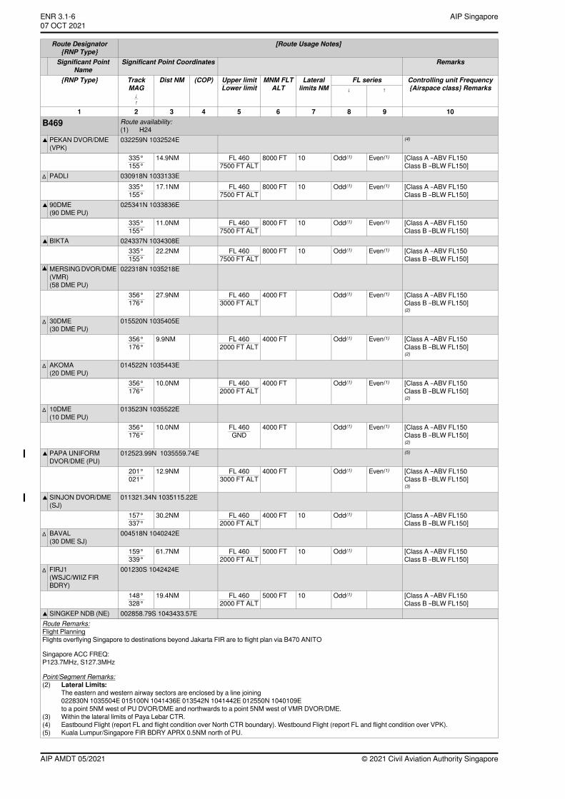
10987654321Route availability:B469(1) H24
(4)032259N 1032524EPEKAN DVOR/DME(VPK)
▲
[Class A –ABV FL150Class B –BLW FL150]
Even(1)Odd(1)108000 FTFL 4607500 FT ALT
14.9NM335°155°
030918N 1033133EPADLI∆
[Class A –ABV FL150Class B –BLW FL150]
Even(1)Odd(1)108000 FTFL 4607500 FT ALT
17.1NM335°155°
025341N 1033836E90DME(90 DME PU)
▲
[Class A –ABV FL150Class B –BLW FL150]
Even(1)Odd(1)108000 FTFL 4607500 FT ALT
11.0NM335°155°
024337N 1034308EBIKTA▲
[Class A –ABV FL150Class B –BLW FL150]
Even(1)Odd(1)108000 FTFL 4607500 FT ALT
22.2NM335°155°
022318N 1035218EMERSINGDVOR/DME(VMR)(58 DME PU)
[Class A –ABV FL150Class B –BLW FL150](2)
Even(1)Odd(1)4000 FTFL 4603000 FT ALT
27.9NM356°176°
015520N 1035405E30DME(30 DME PU)
∆
[Class A –ABV FL150Class B –BLW FL150](2)
Even(1)Odd(1)4000 FTFL 4602000 FT ALT
9.9NM356°176°
014522N 1035443EAKOMA(20 DME PU)
∆
[Class A –ABV FL150Class B –BLW FL150](2)
Even(1)Odd(1)4000 FTFL 4602000 FT ALT
10.0NM356°176°
013523N 1035522E10DME(10 DME PU)
∆
[Class A –ABV FL150Class B –BLW FL150](2)
Even(1)Odd(1)4000 FTFL 460GND
10.0NM356°176°
(5)012523.99N 1035559.74EPAPA UNIFORMDVOR/DME (PU)
▲
[Class A –ABV FL150Class B –BLW FL150](3)
Even(1)Odd(1)4000 FTFL 4603000 FT ALT
12.9NM201°021°
011321.34N 1035115.22ESINJON DVOR/DME(SJ)
▲
[Class A –ABV FL150Class B –BLW FL150]
Odd(1)104000 FTFL 4602000 FT ALT
30.2NM157°337°
004518N 1040242EBAVAL(30 DME SJ)
∆
[Class A –ABV FL150Class B –BLW FL150]
Odd(1)105000 FTFL 4602000 FT ALT
61.7NM159°339°
001230S 1042424EFIRJ1(WSJC/WIIZ FIRBDRY)
∆
[Class A –ABV FL150Class B –BLW FL150]
Odd(1)105000 FTFL 4602000 FT ALT
19.4NM148°328°
002858.79S 1043433.57ESINGKEP NDB (NE)▲
Route Remarks:Flight PlanningFlights overflying Singapore to destinations beyond Jakarta FIR are to flight plan via B470 ANITO
Singapore ACC FREQ:P123.7MHz, S127.3MHz
Point/Segment Remarks:(2) Lateral Limits:
The eastern and western airway sectors are enclosed by a line joining022830N 1035504E 015100N 1041436E 013542N 1041442E 012550N 1040109Eto a point 5NM west of PU DVOR/DME and northwards to a point 5NM west of VMR DVOR/DME.
(3) Within the lateral limits of Paya Lebar CTR.(4) Eastbound Flight (report FL and flight condition over North CTR boundary). Westbound Flight (report FL and flight condition over VPK).(5) Kuala Lumpur/Singapore FIR BDRY APRX 0.5NM north of PU.
© 2021 Civil Aviation Authority SingaporeAIP AMDT 05/2021
AIP SingaporeENR 3.1-607 OCT 2021~~~eaip-amdt~~~ver-date-2021-09-09T07-08-00-035
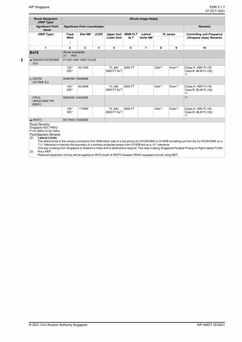
[Route Usage Notes]Route Designator{RNP Type}
RemarksSignificant Point CoordinatesSignificant PointName
Controlling unit Frequency{Airspace class} Remarks
FL seriesLaterallimits NM
MNM FLTALT
(COP)Dist NMTrackMAG
{RNP Type} Upper limitLower limit ↑↓
↓↑
10987654321Route availability:B470(1) H24011321.34N 1035115.22ESINJON DVOR/DME
(SJ)▲
[Class A –ABV FL150Class B –BLW FL150](2)
Even(1)Odd(1)3000 FTFL 4602000 FT ALT
30.1NM145°325°
004818N 1040806EUDONI(30 DME SJ)
∆
[Class A –ABV FL150Class B –BLW FL150](2)
Even(1)Odd(1)5000 FTFL 4602000 FT ALT
60.9NM145°325°
(3)000224S 1044205EFIRJ2(WSJC/WIIZ FIRBDRY)
[Class A –ABV FL150Class B –BLW FL150](2)
Even(1)Odd(1)5000 FTFL 4602000 FT ALT
17.6NM145°325°
001700S 1045200EANITO▲
Route Remarks:Singapore ACC FREQ:P134.4MHz S128.1MHzPoint/Segment Remarks:(2) Lateral Limits:
The lateral limits of this airway commence from 5NM either side of a line joining SJ DVOR/DME to OI NDB funnelling out from the SJ DVOR/DME on a7½° tolerance to intersect the boundary of a similarly projected airway from OI NDB but on a 12° tolerance.One way routeing from Singapore to Soekarno-Hatta and to destinations beyond. Two-way routeing Singapore/Pangkal Pinang for flights below FL200.
(3) Not a REP.Reduced separation minima will be applied on B470 south of ANITO between RNAV-equipped aircraft using MNT.
AIP AMDT 05/2021© 2021 Civil Aviation Authority Singapore
ENR 3.1-7AIP Singapore~~~eaip-amdt~~~ver-date-2021-09-09T07-08-00-03507 OCT 2021
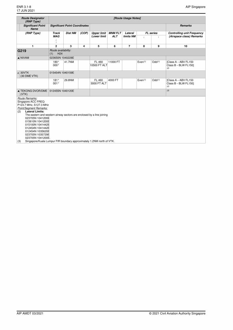
[Route Usage Notes]Route Designator{RNP Type}
RemarksSignificant Point CoordinatesSignificant PointName
Controlling unit Frequency{Airspace class} Remarks
FL seriesLaterallimits NM
MNM FLTALT
(COP)Dist NMTrackMAG
{RNP Type} Upper limitLower limit ↑↓
↓↑
10987654321Route availability:G219(1) H24023650N 1040228ENIVAM▲
[Class A – ABV FL150Class B – BLW FL150](2)
Odd(1)Even(1)11000 FTFL 46010500 FT ALT
41.7NM180°000°
015454N 1040159E30VTK(30 DME VTK)
∆
[Class A – ABV FL150Class B – BLW FL150](2)
Odd(1)Even(1)4000 FTFL 4603000 FT ALT
29.8NM181°001°
(3)012455N 1040120ETEKONG DVOR/DME(VTK)
▲
Route Remarks:Singapore ACC FREQ:P123.7 MHz, S127.3 MHzPoint/Segment Remarks:(2) Lateral Limits:
The eastern and western airway sectors are enclosed by a line joining023705N 1041200E015610N 1041200E015100N 1041442E012454N 1041442E012454N 1035620E023705N 1035729E023705N 1041200E.
(3) Singapore/Kuala Lumpur FIR boundary approximately 1.2NM north of VTK.
© 2021 Civil Aviation Authority SingaporeAIP AMDT 03/2021
AIP SingaporeENR 3.1-817 JUN 2021
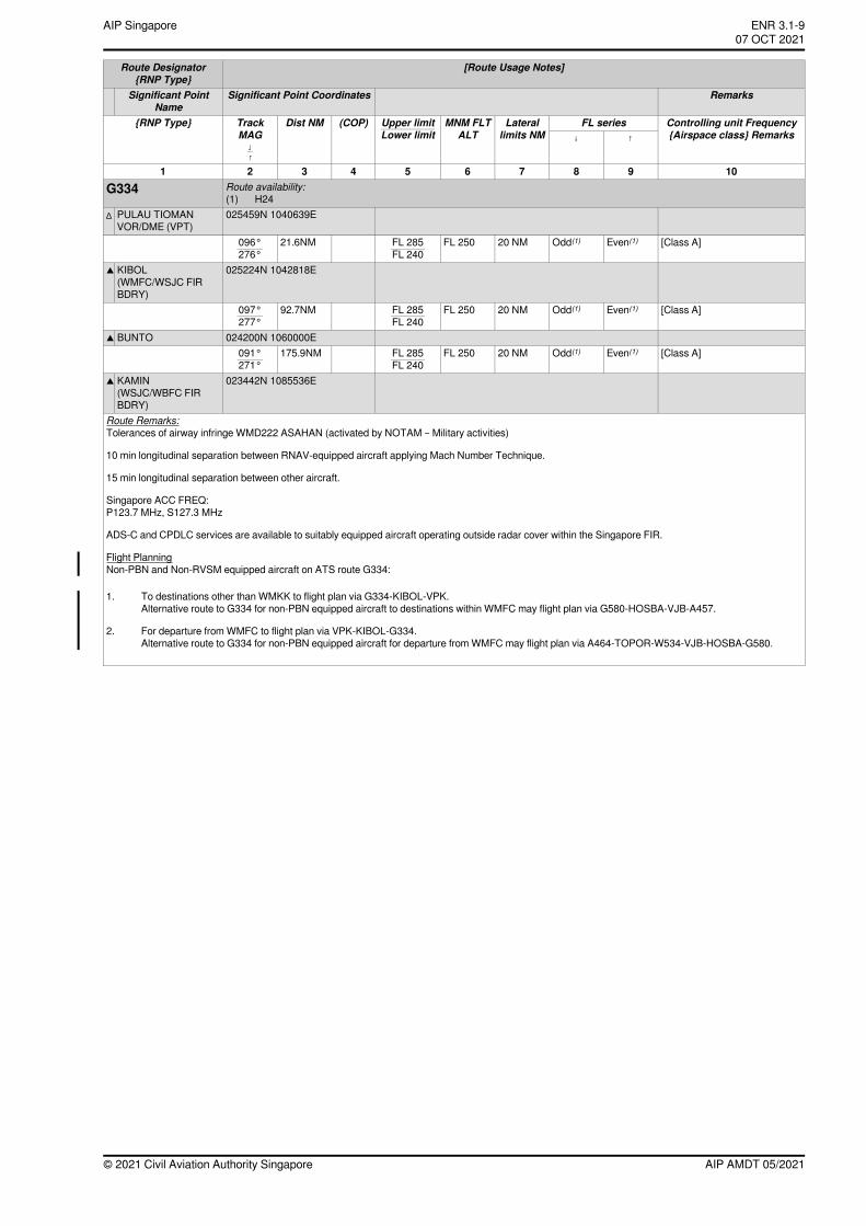
[Route Usage Notes]Route Designator{RNP Type}
RemarksSignificant Point CoordinatesSignificant PointName
Controlling unit Frequency{Airspace class} Remarks
FL seriesLaterallimits NM
MNM FLTALT
(COP)Dist NMTrackMAG
{RNP Type} Upper limitLower limit ↑↓
↓↑
10987654321Route availability:G334(1) H24025459N 1040639EPULAU TIOMAN
VOR/DME (VPT)∆
[Class A]Even(1)Odd(1)20 NMFL 250FL 285FL 240
21.6NM096°276°
025224N 1042818EKIBOL(WMFC/WSJC FIRBDRY)
▲
[Class A]Even(1)Odd(1)20 NMFL 250FL 285FL 240
92.7NM097°277°
024200N 1060000EBUNTO▲
[Class A]Even(1)Odd(1)20 NMFL 250FL 285FL 240
175.9NM091°271°
023442N 1085536EKAMIN(WSJC/WBFC FIRBDRY)
▲
Route Remarks:Tolerances of airway infringe WMD222 ASAHAN (activated by NOTAM – Military activities)
10 min longitudinal separation between RNAV-equipped aircraft applying Mach Number Technique.
15 min longitudinal separation between other aircraft.
Singapore ACC FREQ:P123.7 MHz, S127.3 MHz
ADS-C and CPDLC services are available to suitably equipped aircraft operating outside radar cover within the Singapore FIR.
Flight PlanningNon-PBN and Non-RVSM equipped aircraft on ATS route G334:
1. To destinations other than WMKK to flight plan via G334-KIBOL-VPK.Alternative route to G334 for non-PBN equipped aircraft to destinations within WMFC may flight plan via G580-HOSBA-VJB-A457.
2. For departure from WMFC to flight plan via VPK-KIBOL-G334.Alternative route to G334 for non-PBN equipped aircraft for departure from WMFC may flight plan via A464-TOPOR-W534-VJB-HOSBA-G580.
AIP AMDT 05/2021© 2021 Civil Aviation Authority Singapore
ENR 3.1-9AIP Singapore~~~eaip-amdt~~~ver-date-2021-09-09T07-08-00-03507 OCT 2021
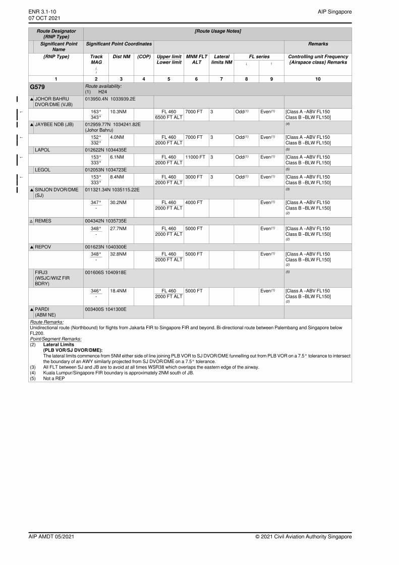
[Route Usage Notes]Route Designator{RNP Type}
RemarksSignificant Point CoordinatesSignificant PointName
Controlling unit Frequency{Airspace class} Remarks
FL seriesLaterallimits NM
MNM FLTALT
(COP)Dist NMTrackMAG
{RNP Type} Upper limitLower limit ↑↓
↓↑
10987654321Route availability:G579(1) H24013950.4N 1033939.2EJOHOR BAHRU
DVOR/DME (VJB)▲
[Class A –ABV FL150Class B –BLW FL150]
Even(1)Odd(1)37000 FTFL 4606500 FT ALT
10.3NM163°343°
←
(4)012959.77N 1034241.82E(Johor Bahru)
JAYBEE NDB (JB)▲
[Class A –ABV FL150Class B –BLW FL150]
Even(1)Odd(1)37000 FTFL 4602000 FT ALT
4.0NM152°332°
←
(5)012622N 1034435ELAPOL[Class A –ABV FL150Class B –BLW FL150]
Even(1)Odd(1)311000 FTFL 4602000 FT ALT
6.1NM153°333°
←
(5)012053N 1034723ELEGOL[Class A –ABV FL150Class B –BLW FL150]
Even(1)Odd(1)33000 FTFL 4602000 FT ALT
8.4NM153°333°
←
(3)011321.34N 1035115.22ESINJON DVOR/DME(SJ)
▲
[Class A –ABV FL150Class B –BLW FL150](2)
Even(1)4000 FTFL 4602000 FT ALT
30.2NM347°-
004342N 1035735EREMES∆
[Class A –ABV FL150Class B –BLW FL150](2)
Even(1)5000 FTFL 4602000 FT ALT
27.7NM348°-
001623N 1040300EREPOV▲
[Class A –ABV FL150Class B –BLW FL150](2)
Even(1)5000 FTFL 4602000 FT ALT
32.8NM348°-
(5)001606S 1040918EFIRJ3(WSJC/WIIZ FIRBDRY)
[Class A –ABV FL150Class B –BLW FL150](2)
Even(1)5000 FTFL 4602000 FT ALT
18.4NM346°-
003400S 1041300EPARDI(ABM NE)
▲
Route Remarks:Unidirectional route (Northbound) for flights from Jakarta FIR to Singapore FIR and beyond. Bi-directional route between Palembang and Singapore belowFL200.Point/Segment Remarks:(2) Lateral Limits
(PLB VOR/SJ DVOR/DME):The lateral limits commence from 5NM either side of line joining PLB VOR to SJ DVOR/DME funnelling out from PLB VOR on a 7.5° tolerance to intersectthe boundary of an AWY similarly projected from SJ DVOR/DME on a 7.5° tolerance.
(3) All FLT between SJ and JB are to avoid at all times WSR38 which overlaps the eastern edge of the airway.(4) Kuala Lumpur/Singapore FIR boundary is approximately 2NM south of JB.(5) Not a REP
© 2021 Civil Aviation Authority SingaporeAIP AMDT 05/2021
AIP SingaporeENR 3.1-1007 OCT 2021~~~eaip-amdt~~~ver-date-2021-09-09T07-08-00-035
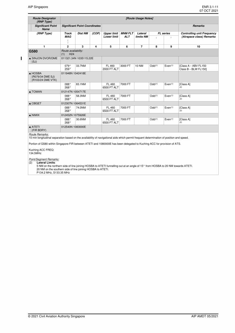
[Route Usage Notes]Route Designator{RNP Type}
RemarksSignificant Point CoordinatesSignificant PointName
Controlling unit Frequency{Airspace class} Remarks
FL seriesLaterallimits NM
MNM FLTALT
(COP)Dist NMTrackMAG
{RNP Type} Upper limitLower limit ↑↓
↓↑
10987654321Route availability:G580(1) H24011321.34N 1035115.22ESINJON DVOR/DME
(SJ)▲
[Class A – ABV FL150Class B – BLW FL150]
Even(1)Odd(1)10 NM3000 FTFL 4602000 FT ALT
33.7NM079°259°
011948N 1042418EHOSBA(R079/34 DME SJ)(R103/24 DME VTK)
▲
[Class A](2)
Even(1)Odd(1)7000 FTFL 4606500 FT ALT
83.1NM088°268°
012147N 1054717ETOMAN▲
[Class A](2)
Even(1)Odd(1)7000 FTFL 4606500 FT ALT
58.3NM088°268°
012307N 1064531EOBGET▲
[Class A](2)
Even(1)Odd(1)7000 FTFL 4606500 FT ALT
74.0NM088°268°
012452N 1075926ENIMIX▲
[Class A](2)
Even(1)Odd(1)7000 FTFL 4606500 FT ALT
30.6NM088°268°
012540N 1083000EATETI(FIR BDRY)
▲
Route Remarks:10 min longitudinal separation based on the availability of navigational aids which permit frequent determination of position and speed.
Portion of G580 within Singapore FIR between ATETI and 1080000E has been delegated to Kuching ACC for provision of ATS.
Kuching ACC FREQ:134.5MHz
Point/Segment Remarks:(2) Lateral Limits:
5 NM on the northern side of line joining HOSBA to ATETI funnelling out at an angle of 15° from HOSBA to 20 NM towards ATETI.20 NM on the southern side of line joining HOSBA to ATETI.P134.2 MHz, S133.35 MHz
AIP AMDT 05/2021© 2021 Civil Aviation Authority Singapore
ENR 3.1-11AIP Singapore~~~eaip-amdt~~~ver-date-2021-09-09T07-08-00-03507 OCT 2021
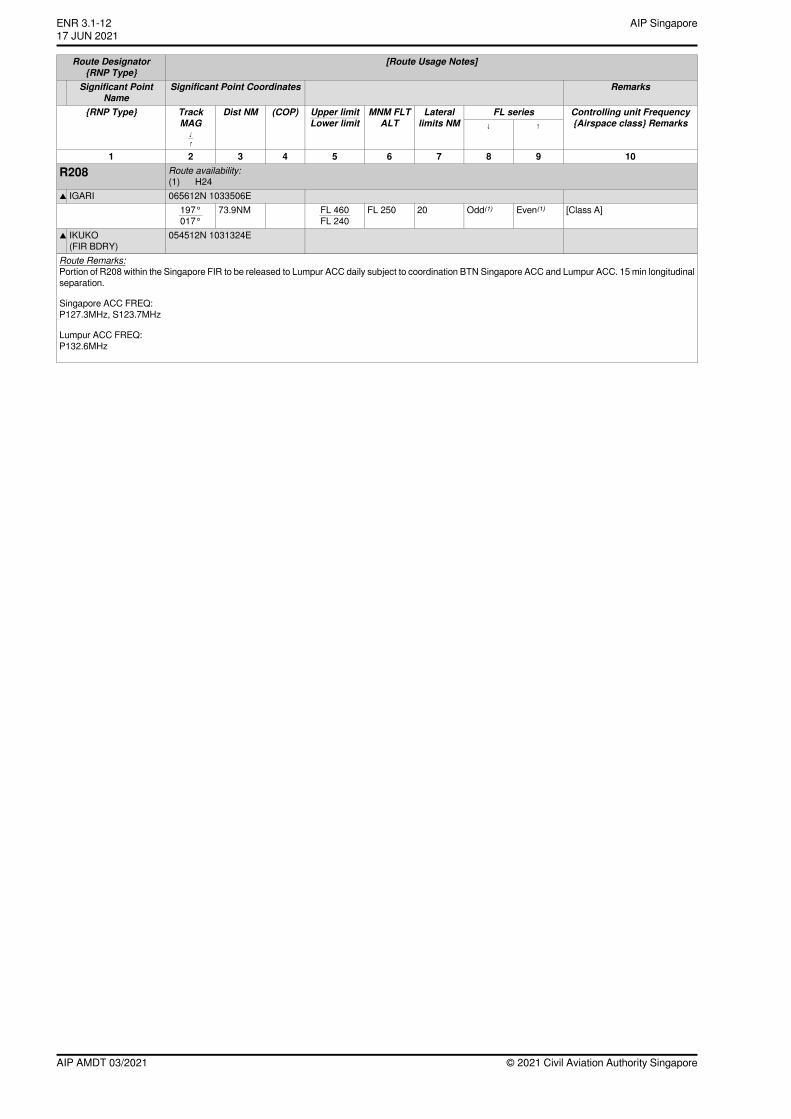
[Route Usage Notes]Route Designator{RNP Type}
RemarksSignificant Point CoordinatesSignificant PointName
Controlling unit Frequency{Airspace class} Remarks
FL seriesLaterallimits NM
MNM FLTALT
(COP)Dist NMTrackMAG
{RNP Type} Upper limitLower limit ↑↓
↓↑
10987654321Route availability:R208(1) H24065612N 1033506EIGARI▲
[Class A]Even(1)Odd(1)20FL 250FL 460FL 240
73.9NM197°017°
054512N 1031324EIKUKO(FIR BDRY)
▲
Route Remarks:Portion of R208 within the Singapore FIR to be released to Lumpur ACC daily subject to coordination BTN Singapore ACC and Lumpur ACC. 15 min longitudinalseparation.
Singapore ACC FREQ:P127.3MHz, S123.7MHz
Lumpur ACC FREQ:P132.6MHz
© 2021 Civil Aviation Authority SingaporeAIP AMDT 03/2021
AIP SingaporeENR 3.1-1217 JUN 2021
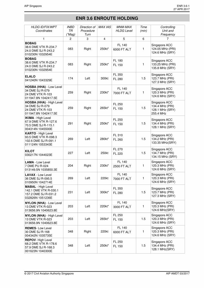
ENR 3.6 ENROUTE HOLDING
ControllingUnit andFrequency
Time(min)
MNM-MAXHLDG Level
MAX IASDirection ofProcedure
Turn
INBDTR
(˚Mag)
HLDG ID/FIX/WPTCoordinates
7654321
Singapore ACC124.05 MHz (PRI)124.6 MHz (SRY)
1FL 140
6000 FT ALT250kt*Right083BOBAG38.6 DME VTK R-234.724.0 DME SJ R-243.2010230N 1032954E
Singapore ACC133.25 MHz (PRI)135.8 MHz (SRY)
1FL 180FL 150250kt*Right083
BOBAG38.6 DME VTK R-234.724.0 DME SJ R-243.2010230N 1032954E
Singapore ACC123.7 MHz (PRI)127.3 MHz (SRY)
1.5FL 350FL 280300ktLeft174ELALO
041240N 1043329E
Singapore ACC120.3 MHz (PRI)124.6 MHz (SRY)
1FL 140
7000 FT ALT230kt*Right259HOSBA (HHA) - Low Level34 DME SJ R-07924 DME VTK R-103011947.8N 1042417.5E
Singapore ACC134.4 MHz (PRI)128.1 MHz (SRY)255.4 MHz
1.5FL 250FL 150265kt*Right259
HOSBA (HHA) - High Level34 DME SJ R-07924 DME VTK R-103011947.8N 1042417.5E
Singapore ACC134.4 MHz (PRI)128.1 MHz (SRY)
1.5FL 250FL 150250kt*Right291
IKIMA - High Level67.9 DME VTK R-127.670.5 DME SJ R-115.1004314N 1045500E
Singapore ACC134.2 MHz (PRI)133.35 MHz(SRY)
1.5FL 310FL 260280kt*Left269
KARTO - High Level93.5 DME VTK R-098.3102.6 DME SJ R-091.1011124N 1053343E
Singapore ACC134.7 MHz (PRI)134.15 MHz (SRY)
1.5FL 270FL 220250ktLeft227KILOT
030217N 1044023E
Singapore ACC120.3 MHz (PRI)124.6 MHz (SRY)
1FL 140
2500 FT ALT230kt*Right204LAMA - Low Level7 DME PU R-024013149.5N 1035850.3E
Singapore ACC120.3 MHz (PRI)124.6 MHz (SRY)
1FL 140
7000 FT ALT220ktLeft269LAVAX - Low Level36 DME SJ R-095.5010950N 1042714E
Singapore ACC123.7 MHz (PRI)127.3 MHz (SRY)
1.5FL 350FL 280300kt*Left231
MABAL - High Level142.1 DME VTK R-030.1157.2 DME SJ R-031.2032826N 1051236E
Singapore ACC120.3 MHz (PRI)124.6 MHz(SRY)
1FL 140
3000 FT ALT220kt*Left203NYLON (NHA) - Low Level13 DME VTK R-023013656.9N 1040623.8E
Singapore ACC120.3 MHz (PRI)124.6 MHz (SRY)
1.5FL 250FL 150265kt*Left203
NYLON (NHA) - High Level13 DME VTK R-023013656.9N 1040623.8E
Singapore ACC120.3 MHz (PRI)124.6 MHz (SRY)
1FL 140
6000 FT ALT220ktRight348REMES- Low Level30 DME SJ R-168004342N 1035735E
Singapore ACC134.4 MHz (PRI)128.1 MHz(SRY)
1.5FL 250FL 150250kt*Left348
REPOV- High Level68.2 DME VTK R-178.657.9 DME SJ R-168.3001623N 1040300E
AIP AMDT 03/2017© 2017 Civil Aviation Authority Singapore
ENR 3.6-127 APR 2017
AIP Singapore
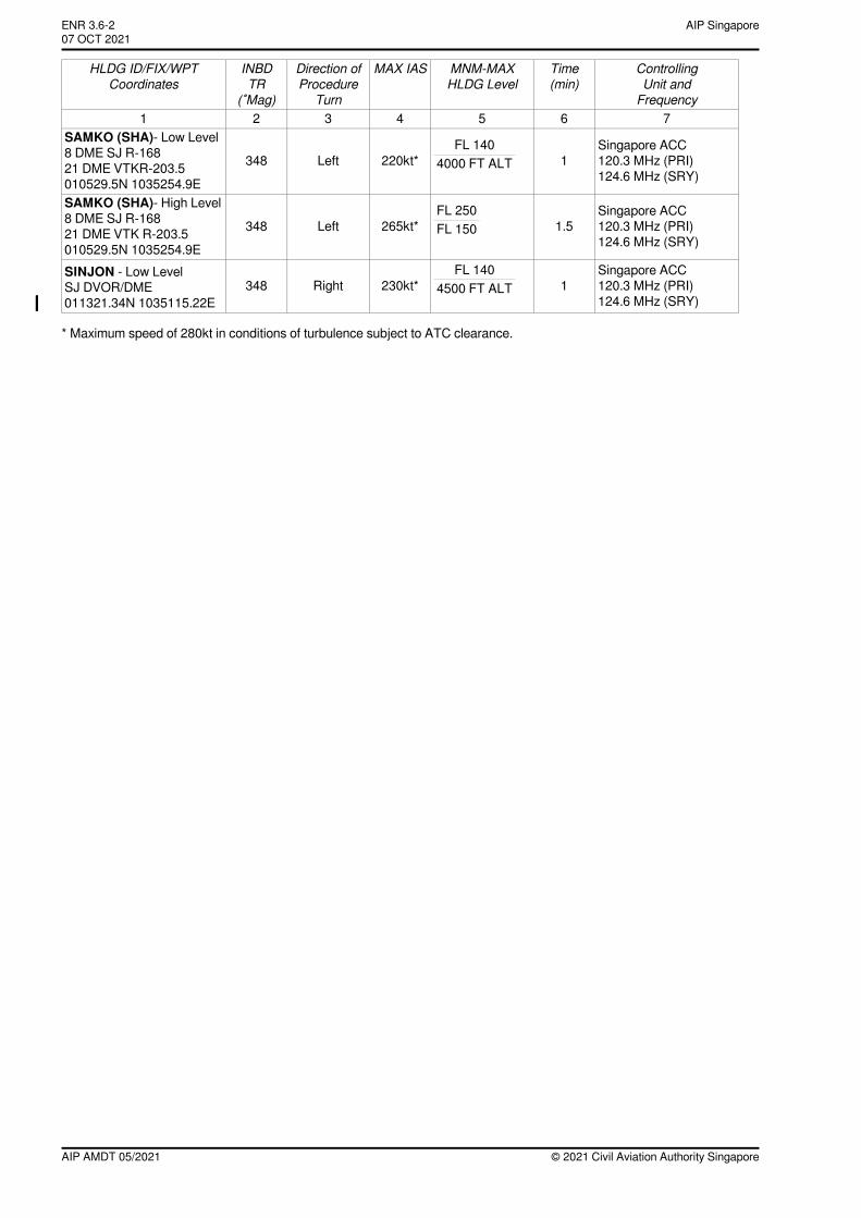
ControllingUnit andFrequency
Time(min)
MNM-MAXHLDG Level
MAX IASDirection ofProcedure
Turn
INBDTR
(˚Mag)
HLDG ID/FIX/WPTCoordinates
7654321
Singapore ACC120.3 MHz (PRI)124.6 MHz (SRY)
1FL 140
4000 FT ALT220kt*Left348SAMKO (SHA)- Low Level8 DME SJ R-16821 DME VTKR-203.5010529.5N 1035254.9E
Singapore ACC120.3 MHz (PRI)124.6 MHz (SRY)
1.5FL 250FL 150265kt*Left348
SAMKO (SHA)- High Level8 DME SJ R-16821 DME VTK R-203.5010529.5N 1035254.9E
Singapore ACC120.3 MHz (PRI)124.6 MHz (SRY)
1FL 140
4500 FT ALT230kt*Right348SINJON - Low LevelSJ DVOR/DME011321.34N 1035115.22E←
* Maximum speed of 280kt in conditions of turbulence subject to ATC clearance.
© 2021 Civil Aviation Authority SingaporeAIP AMDT 05/2021
AIP SingaporeENR 3.6-207 OCT 2021~~~eaip-amdt~~~ver-date-2021-09-09T07-08-00-035
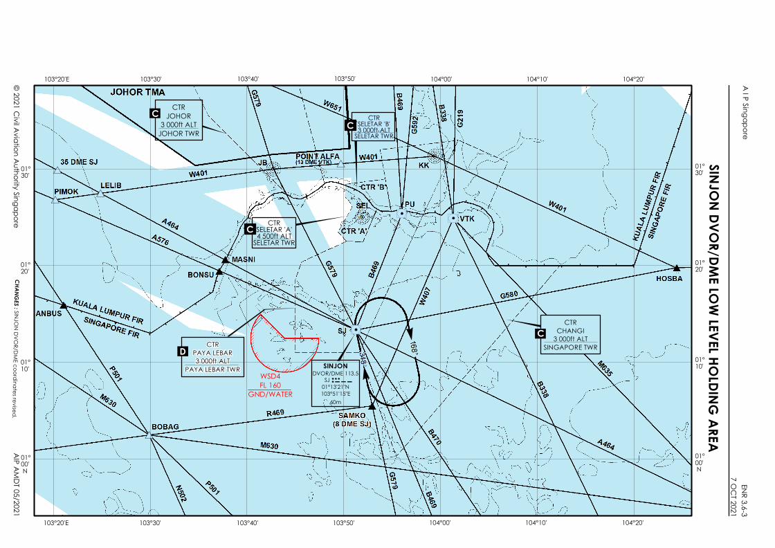
#*
#*#*
#*#*
" "
"
WSD4FL 160
GND/WATER
CTRJOHOR
3 000ft ALTJOHOR TWR
CTRCHANGI
3 000ft ALTSINGAPORE TWR
CTRSELETAR 'B'3 000ft ALTSELETAR TWR
CTRPAYA LEBAR3 000ft ALT
PAYA LEBAR TWR SINJONDVOR/DME 113.5
SJ 01°13'21"N103°51'15"E
60m
D
C
C
CTRSELETAR 'A'4 500ft ALTSELETAR TWR
C
C
SINJON DVOR/DME LOW LEVEL HOLDING AREA103°20'E 103°30' 103°40' 103°50' 104°00' 104°10'
103°20'E 103°30' 103°40' 103°50'
01°30'
01°20'
01°10'
01°00'
01°30'
01°20'
01°10'
01°00'
A I P SingaporeENR 3.6-3
7 OC
T 2021
© 2021 Civil Aviation Authority SingaporeAIP AMDT 05/2021
104°20'
104°00' 104°10' 104°20'
N N
CHANGES : SINJO
N D
VO
R/DM
E coordinates revised
.

PAGE INTENTIONALLY LEFT BLANK
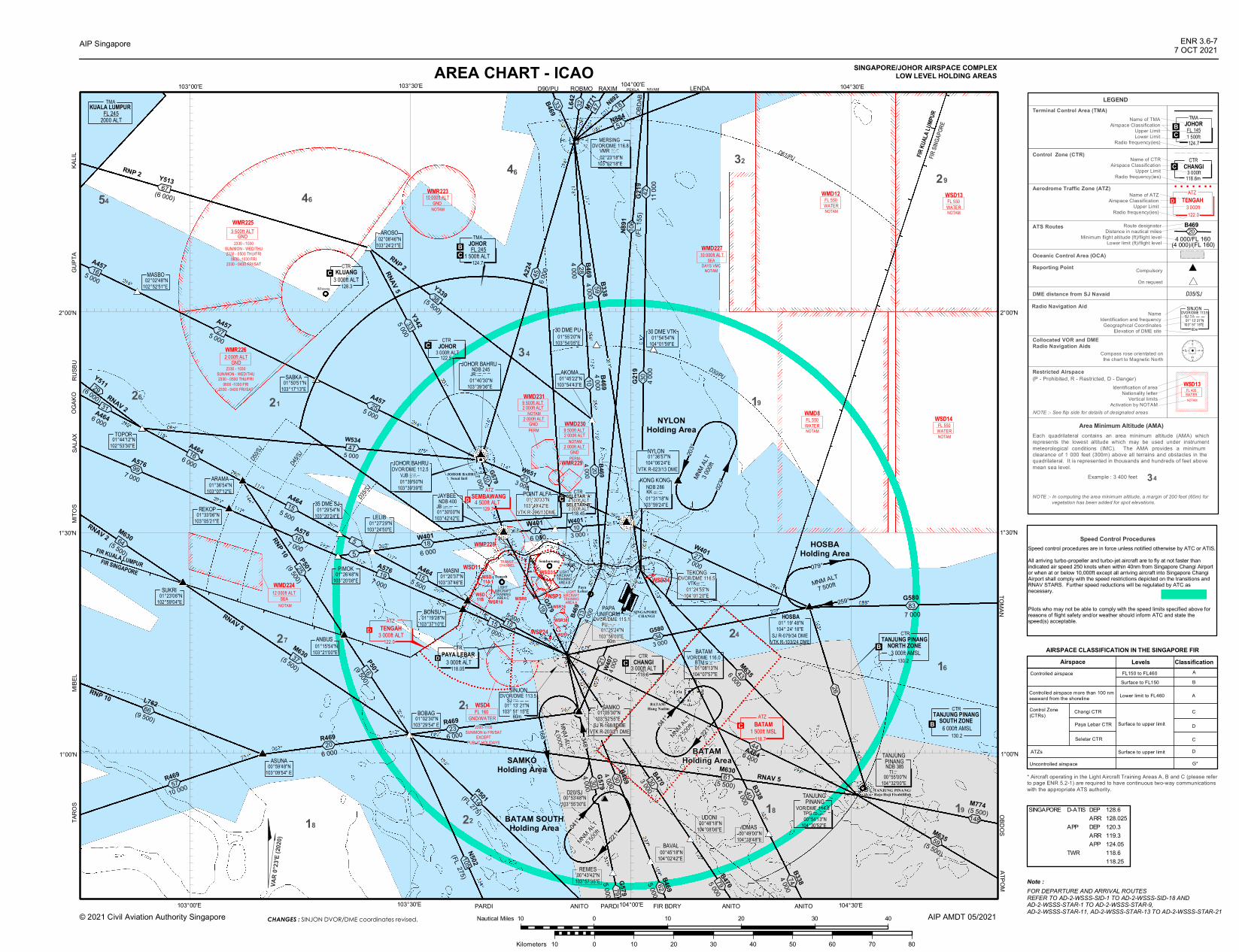
AREA CHART - ICAO
B469
4 000'( 20
B469
4 000'(135 500
7 000 G580
3 000'(34
259°
WMR229
WSD34
WSR38
WMP228
WSD11
WSD11B
TRANSITCHANNEL
LIGHTAIRCRAFTTRAININGAREA C
LIGHTAIRCRAFTTRAININGAREA B
FIR KU
ALA L
UMPU
RFIR
SINGA
PORE
D61/PU
D30/PU
FIR KUALA LUMPURFIR SINGAPORE
!
023°
203°
!
!
!
!
!
!
!
!
!
168°
Kluang
WSP3
WSP24
SeletarSembawang
TANJUNG PINANG/Raja Haji Fisabilillah
PARDI FIR BDRY ANITO ANITO
TARO
SSA
LAX
OGAK
OGU
PTA
KALIL
D90/PU ROBMO RAXIM
ATPOMTOMAN
© 2021 Civil Aviation Authority Singapore
AIP Singapore ENR 3.6-77 OCT 2021
SINGAPORE/JOHOR AIRSPACE COMPLEXLOW LEVEL HOLDING AREAS
AIP AMDT 05/2021
JOHOR BAHRU/Senai Intl
D50/SJ
D45/SJ
D35/SJ
LEGENDTerminal Control Area (TMA)
Control Zone (CTR)
ATS Routes Route designatorDistance in nautical miles
Minimum flight altitude (ft)/flight levelLower limit (ft)/flight level
Oceanic Control Area (OCA)Reporting Point Compulsory
On request
DME distance from SJ NavaidRadio Navigation Aid
NameIdentification and frequency
Geographical CoordinatesElevation of DME site
Collocated VOR and DMERadio Navigation Aids
Compass rose orientated onthe chart to Magnetic North
Restricted Airspace
NOTE :- See flip side for details of designated areas
Area Minimum Altitude (AMA)Each quadrilateral contains an area minimum altitude (AMA) whichrepresents the lowest altitude which may be used under instrumentmeteorological conditions (IMC). The AMA provides a minimum clearance of 1 000 feet (300m) above all terrains and obstacles in the quadrilateral. It is represented in thousands and hundreds of feet above mean sea level.
Example : 3 400 feet
NOTE :- In computing the area minimum altitude, a margin of 200 feet (60m) for vegetation has been added for spot elevations.
! ! ! ! ! ! !
#
*D35/SJ
2300-1100SUN/MON to FRI/SAT
EXCEPTPUBLIC HOLIDAYS
WMD22412 000ft ALT
SEANOTAM
60m
130.2
00°53'48"N103°55'30"E
00°43'42"N103°57'35"E
PEKLA LENDA
NYLONHolding Area
HOSBAHolding Area
MNM ALT7 500ft
MNM
ALT
3 000
ft
BATAM SOUTHHolding Area
MNM ALT5 5
00ft
MNM ALT2 5
00ft
BATAMHolding Area
MNM ALT4 000ft
SAMKOHolding Area
(P - Prohibited, R - Restricted, D - Danger)
DAerodrome Traffic Zone (ATZ)
Name of ATZAirspace Classification
Upper LimitRadio frequency(ies)
Name of CTRAirspace Classification
Upper LimitRadio frequency(ies)
Name of TMAAirspace Classification
Upper LimitLower Limit
Radio frequency(ies)
C
BC
34
D118.05
4654
6 000A464
26
6 000
A464
A4645 500
35 DME SJ 01°29'54"N103°20'24"E
A5767 000'(16
'(5
W401
6 000'(18
A4645 500
A5767 000
#
01°02'30"N103°29'54" E
BOBAG
REMES
D20/SJ
B3384 000
130.2
'(G580
7 00083
24
BATAM/Hang Nadim
PAPAUNIFORM SINGAPORE
CHANGI
' ('(
34
'(' (
'( B469
4 00028
'( B338
4 00059
'(
22
30 DME PU 01°55'20"N103°54'05"E
30 DME VTK 01°54'54"N104°01'59"E
HOSBA 01° 19' 48"N104° 24' 18"E
SJ R-079/34 DMEVTK R-103/24 DME
29
21
27
21
18 19
16
NYLON 01°36'57"N104°06'24"E
VTK R-023/13 DME
01°20'37"N103°37'46"E
MASNI
BONSU 01°19'28"N103°37'10"E
01°45'22"N103°54'43"E
AKOMA
POINT ALFA 01°30'33"N103°49'42"E
VTK R-296/13DME 01°27'29"N103°24'50"E
LELIB
PIMOK 01°26'48"N103°20'08"E
01°33'06"N103°05'21"E
REKOP
ARAMA 01°36'54"N103°07'12"E
01°44'12"N102°53'30"E
TOPOR
ANBUS 01°15'54"N103°21'00"E
ASUNA 00°59'48"N103°09'54" E
'(
ANITO PARDI
TEKONG
01°25'24"N103°56'00"E
DVOR/DME 115.1PU. _ _.. _ .
01°24'55"N104°01'20"E
DVOR/DME 116.5VTK _ ._ __...
SAMKO
...01° 13' 21"N
103° 51' 15"E
SINJONSJ
DVOR/DME 113.5._ _ _
60m
'('(W401
6 0007
N892
OBDA
BG2
194 0
0030
079°
'(
118.7
CTR
3 000ft AMSLTANJUNG PINANG
NORTH ZONE
6 000ft AMSLTANJUNG PINANG
SOUTH ZONECTR
118.6
122.0
118.45
PayaLebar
Tengah
GND10 000ft ALTWMR223
NOTAM
L642 '
(
32
00°55'00"N104°32'00"E
NDB 385TI _..
3246
19
DVOR/DME 116.8 02°23'18"N103°52'18"E
MERSINGVMR _ ..._ __ ..
TANJUNG PINANG
C 01°05'30"N103°52'55"E
SJ R-168/8DMEVTK R-203/21 DME
J
ìJ
CTRSELETAR 'A'4 500ft ALT
D
C
B
B
WATER
WMD12
NOTAM
FL 550WATER
WSD13
NOTAM
FL 550
WATER
WMD8
NOTAM WATER
WSD14
NOTAM
FL 550FL 550
10 000ft ALTWMD227
SEADAYS VMC
NOTAM
WATERFL 400
WSD13
NOTAM
WSD11A
Identification of areaNationality letter
Vertical limitsActivation by NOTAM
103°00'E 103°30'E 104°00'E 104°30'E
1°00'N
1°30'N
2°00'N
1°00'N
1°30'N
2°00'N
103°00'E 103°30'E 104°00'E 104°30'E
G579
5 000
M77147
N88451
18
C
W407
4 000'(2
1
348°041
°
221°
041°
221°
79
B4695 00062
B4705 00079 74
B3384 000
'(40
'(26
18
0
18
927
FOR DEPARTURE AND ARRIVAL ROUTESREFER TO AD-2-WSSS-SID-1 TO AD-2-WSSS-SID-18 AND AD-2-WSSS-STAR-1 TO AD-2-WSSS-STAR-9,AD-2-WSSS-STAR-11, AD-2-WSSS-STAR-13 TO AD-2-WSSS-STAR-21
Note :
P501(9 500)25
00°48'18"N104°08'06"E
UDONI
00°49'00"N104°18'48"E
IDMAS
LIGHTAIRCRAFTTRAININGAREA A
'(
A4646 000'(44
B469
4 000'(30G579
4 00030
B4703 00030
148
M774(5 500)
'(M635
(5 500)59
'(M6356 000
43
OBDOS
B4694 000
10
'(
A224
6 00045MASBO
02°02'48"N102°52'51"E
01°23'06"N102°59'04"E
SUKRI
RNAV 2
AROSO 02°08'46"N103°24'21"E
Y3425 00033
RNP 2RNAV 5
'(
'(R469
10 00057
R469
6 000'(20
M630(5 500)
G579'(19
RNAV 5
W6513 000'(21
MITO
S
R469
6 000'(23
G5797 00010
.NDB 400 01°30'00"N103°42'42"E
JAYBEEJB _ _ _..._
JOHOR BAHRUDVOR/DME 112.5
01°39'50"N103°39'39"E
VJB ...__ _ _. ._ .
NDB 245JOHOR BAHRU
01°40'30"N103°39'36"E
JR _ _ __ ...
'(A576
7 00099
RNAV 5
WSD4GND/WATER
FL 160
00°45'18"N104°02'42"E
BAVAL
W534
5 00047
19
15
31
16
15
5
15
15
5 000
A45725
5 000
A45727
5 000
A45716
SABKA 01°50'51"N103°17'13"E
Speed Control ProceduresSpeed control procedures are in force unless notified otherwise by ATC or ATIS. All arriving turbo-propeller and turbo-jet aircraft are to fly at not faster than indicated air speed 250 knots when within 40nm from Singapore Changi Airport or when at or below 10,000ft except all arriving aircraft into Singapore Changi Airport shall comply with the speed restrictions depicted on the transitions and RNAV STARS. Further speed reductions will be regulated by ATC as necessary.
Pilots who may not be able to comply with the speed limits specified above for reasons of flight safety and/or weather should inform ATC and state the speed(s) acceptable.
Airspace Levels ClassificationControlled airspace FL150 to FL460
Surface to FL150AB
Controlled airspace more than 100 nmseaward from the shoreline Lower limit to FL460 A
Control Zone(CTRs) Changi CTR
Paya Lebar CTR
Seletar CTR
Surface to upper limit
Surface to upper limitATZs
Uncontrolled airspace
C
D
C
D
G*
* Aircraft operating in the Light Aircraft Training Areas A, B and C (please referto page ENR 5.2-1) are required to have continuous two-way communicationswith the appropriate ATS authority.
AIRSPACE CLASSIFICATION IN THE SINGAPORE FIR
TMAKUALA LUMPURFL 245
2000 ALT
BC
124.7
TMAJOHOR
1 500ft ALTFL 245
VAR
0°23'E
(202
0)
10 0 10 20 30 40Nautical Miles
10 0 10 20 30 40 50 60 70 80Kilometers
SELETAR 'B'3 000ft ALT129.7
WSR10
GND2 000ft ALTWMR226
2330 - 1030SUN/MON - WED/THU2330 - 0500 THU/FRI
0600 -1030 FRI2330 - 0430 FRI/SAT
GND3 500ft ALTWMR225
2330 - 1030SUN/MON - WED/THU2330 - 0500 THU/FRI
0600 -1030 FRI2330 - 0430 FRI/SAT
PERM
WMD231
NOTAM2 000ft ALT9 500ft ALT
GND2 000ft ALT
PERM
WMD230
NOTAM2 000ft ALT9 500ft ALT
GND2 000ft ALT
4 500ft ALTSEMBAWANG
ATZD
3 000ft ALTTENGAH
ATZ
CTR
3 000ft ALTPAYA LEBAR
3 000ft ALTCHANGI
CTR
1 500ft MSLBATAM
ATZ
124.7
TMAJOHOR1 500ftFL 145
118.6m3 000ft
CHANGICTR
122.03 000ft
TENGAHATZ
128.33 000ft ALT
CTRKLUANGC
C3 000ft ALT
CTRJOHOR122.5
TANJUNG PINANG
00°54'13"N104°30'52"E
VOR/DME 114.8TPG _ ._ _ ._ _.
SJ ...._ _ _
60m 01° 13' 21"N103° 51' 15"E
DVOR/DME 113.5SINJON
B46933
NIVAM
G219
11 00
042
KONG KONG
01°31'18"N103°59'24"E
NDB 286KK _ ._ _ ._
'(W401
7 00027
W401
3 00010
M630(5 500)37
N502
(FL 275)105
P501(FL 275)114
P501(9 500)16
N891
(FL 15
5)10
6 B4694 000/FL 160
'((4 000)/(FL 160)
20
L762(9 500)'(66
RNP 10
MIBE
L
61
WSD35
WSR16
WSR9
WSR6
SINGAPORE D-ATIS DEP 128.6ARR 128.025
APP DEP 120.3ARR 119.3APP 124.05
TWR 118.6118.25
BATAM
01°08'13"N104°07'57"E
VOR/DME 116.0BTM ...___ _
CHANGES : SINJON DVOR/DME coordinates revised.
Y513(6 000)
67
Y339(5 500)38
(6 000)
Y51129
M630(5 500)
64
RUSB
U
RNP 2
RNAV 2
RNP 10

SPECIAL NOTE :-
ACTIVITY UPPER LIMITLOWER LIMIT REMARKS
WSD4
WSP3
WMD8
WSD11
WSD11B
WMD12
WSD11A
WSD13
WSD14
WSP24
Permanently Activeas in ENR 5
A/G and G/G Firing Range
- 750ft ALTGNDFL 160
GND/WATERPermanently Activeas in ENR 5
Naval Air/Air Firing Range FL 550WATER
Activation by NOTAM
Small Arm Firing 1 300ft ALTGND
Permanently Activeas in ENR 5
Artillery Firing FL 125GND
Activation by NOTAM
Artillery Firing FL 125GND
Activation by NOTAM
Naval Anti-aircraft Firing FL 550WATER
Activation by NOTAM
Naval Anti-aircraft Firing FL 550WATER
Activation by NOTAM
Naval Anti-aircraft Firing &Live Air/Air Firing
FL 550WATER
Permanently Activeas in ENR 5- 800ft ALT
GND/WATER
Activation by NOTAM
WSD34 Rifle Range 500ft ALTGND
Permanently Activeas in ENR 5
WSD35 Rifle Range 900ft ALTGND
Permanently Activeas in ENR 5
WSR10 - 5 500ft ALTGNDPermanently Activeas in ENR 5
WSR38 - 10 000ft ALTGND
Permanently Activeas in ENR 5
Transit Channel 2 000ft ALTGND
Activated only forMilitary acft crossing
Light Aircraft Training Area A 4 500ft ALTGND/*2 000ft
Training & LocalFlts in VMC only*
Light Aircraft Training Area B 10 500ft ALT4 500ft ALT
High Flying TrainingOps in VMC only*
* In Transit Channel
PROHIBITED, RESTRICTED AND DANGER AREAS
Light Aircraft Training Area C 10 500ft ALT High Flying TrainingOps in VMC only* 4 500ft ALT
* AEROBATICS IS PROHIBITED IN LIGHT AIRCRAFT TRAINING AREAS A, B and C.
WMR223 Parachute Dropping 10 000ft ALTGND
Permanently Activeas in ENR 5
WMD224 Firing Range 12 000ft ALTSEA
Activation by NOTAM
WMR225 RMAF Helicopter Training Area 3 500ft ALTGND
Permanently Activeas in ENR 5
WMR226 2 000ft ALTGND
Permanently Activeas in ENR 5RMAF Helicopter Training Area
WMD227 Radar Bombing Range 10 000ft ALTSEA
Activation by NOTAM
WMP228 Sultan's Palace 5 000ft ALTGND
Permanently Activeas in ENR 5
WMR229 Helicopter Operations 1 500ft ALTGND
Permanently Activeas in ENR 5
WMD230 Artillery Firing Range 2 000ft ALTGNDPermanently Activeas in ENR 5
WMD231 Artillery Firing Range 2 000ft ALTGND
Permanently Activeas in ENR 5
1. WEATHER BALLOONS
2. AEROMODELLING AND KITE FLYING
i) PILOTS FLYING AT LOW ALTITUDES SHOULD WATCH OUT FORPOSSIBLE HAZARDS SUCH AS MODEL AIRCRAFT AND KITES,ESPECIALLY WHEN FLYING NEAR PARKS AND OPEN GROUND.
ii) THE LOCATION OF SOME OF THE PARKS IN SINGAPORE WHERE KITEAND AERO MODEL FLYING MAY OCCUR ARE SHOWN ON ENR 3.4-5.PILOTS SHOULD NOTE THAT THE CHART AT ENR 3.4-5 DOES NOTSHOW ALL THE PARKS IN SINGAPORE AND THAT HAZARDS SUCH ASKITE FLYING AND AERO MODEL FLYING MAY TAKE PLACE AT PARKSAND OPEN GROUND NOT INDICATED IN ENR 3.4-5.
iii) ACCORDING TO THE SINGAPORE AIR NAVIGATION ORDER, 1985, KITEFLYING AND AERO MODEL FLYING ARE NOT PERMITTED ABOVE 200ftOR WITHIN 5km OF AN AERODROME. HOWEVER, PILOTS ARE ADVISEDTO LOOK OUT FOR SUCH HAZARDS AT ALL TIMES AS MEMBERS OF THE PUBLIC MAY INADVERTENTLY FLY KITES OR AERO MODELS ABOVETHE HGT OF 200ft OR WITHIN 5km OF AN AERODROME.
(A) GENERAL WARNING
BALLOONS WILL BE RELEASED FOR MET OBSERVATION AT THE CENTRE FOR CLIMATE RESEARCH SINGAPORE, UPPER AIR OBSERVATORY (012025N 1035317E), BEARING 244° MAG AND DISTANCE 1.5NM FROM SOUTHERN END OF PAYA LEBARRWY 02.
(I) BALLOONS WILL BE RELEASED DAILY AT 2330UTC AND 1040UTC. CUT-OFF TIMINGS FOR THE RELEASE ARE AT 0030UTC AND 1230UTC RESPECTIVLEY. RATE OF ASCENT IS 320M PER MIN. MAX HGT OF BALLOON 115 000FT (35 000M). THE BALLOON, UNCOLOURED AND 162CM IN DIAMETER, IS ATTACHED WITH RADIOSONDE EQUIPMENT. IT WILL BURST 1.5 TO 2HRS AFTER RELEASE AND RADIOSONDE EQUIPMENT WILL DECSEND WITHIN 60NM RADIUS.
(II) A BALLOON WILL BE RELEASED BETWEEN 2330UTC AND 0030UTC ON EITHER THE 3rd OR 4th WEEK OF THE MONTH. RATE OF ASCENT IS 320M PER MIN. MAX HGT OF BALLOONS IS 115 000FT (35 000M). THE BALLOON, UNCOLOURED AND 191CM IN DIAMETER, IS ATTACHED WITH OZONESONDE/RADIOSONDE EQUIPMENT AND PARACHUTE. IT WILL BURST 1.5 TO 2HR AFTER RELEASE.
WSR6 Permanently Activeas in ENR 5
WSR9
WSR16
200ft ALTGND
200ft ALTGND
200ft ALTGND
Permanently Activeas in ENR 5Permanently Activeas in ENR 5Helicopter Operations
Helicopter Operations
Helicopter Operations
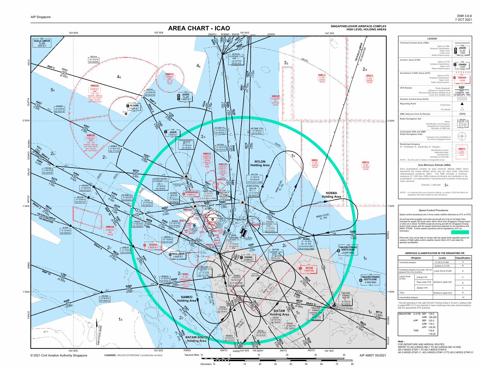
AREA CHART - ICAO
B469
4 000'( 20
B469
4 000'(13
5 5007 000 G580
3 000'(34
259°
WMR229
WSD34WSD35
WMP228
WSD11TRANSITCHANNEL
LIGHTAIRCRAFTTRAININGAREA A
LIGHTAIRCRAFTTRAININGAREA B
FIR KU
ALA L
UMPU
RFIR
SINGA
PORE
D61/PU
D30/PU
FIR KUALA LUMPURFIR SINGAPORE
!20
3°
!
!
!
!
!
!
!
!
!
Kluang
WSP24
SeletarSembawang
TANJUNG PINANG/Raja Haji Fisabilillah
PARDI FIR BDRY ANITO ANITO
TARO
SSA
LAX
OGAK
OGU
PTA
D90/PU ROBMO RAXIM
OBDOSTOMAN
© 2021 Civil Aviation Authority Singapore
AIP Singapore ENR 3.6-97 OCT 2021
SINGAPORE/JOHOR AIRSPACE COMPLEXHIGH LEVEL HOLDING AREAS
AIP AMDT 05/2021
JOHOR BAHRU/Senai Intl
D50/SJ
D45/SJ
D35/SJ
LEGENDTerminal Control Area (TMA)
Control Zone (CTR)
ATS Routes Route designatorDistance in nautical miles
Minimum flight altitude (ft)/flight levelLower limit (ft)/flight level
Oceanic Control Area (OCA)Reporting Point Compulsory
On request
DME distance from SJ NavaidRadio Navigation Aid
NameIdentification and frequency
Geographical CoordinatesElevation of DME site
Collocated VOR and DMERadio Navigation Aids
Compass rose orientated onthe chart to Magnetic North
Restricted Airspace
NOTE :- See flip side for details of designated areas
Area Minimum Altitude (AMA)Each quadrilateral contains an area minimum altitude (AMA) whichrepresents the lowest altitude which may be used under instrumentmeteorological conditions (IMC). The AMA provides a minimum clearance of 1 000 feet (300m) above all terrains and obstacles in the quadrilateral. It is represented in thousands and hundreds of feet above mean sea level.
Example : 3 400 feet
NOTE :- In computing the area minimum altitude, a margin of 200 feet (60m) for vegetation has been added for spot elevations.
! ! ! ! ! ! !
#
*D35/SJ
2300-1100SUN/MON to FRI/SAT
EXCEPTPUBLIC HOLIDAYS
WMD22412 000ft ALT
SEANOTAM
60m
130.2
00°53'48"N103°55'30"E
00°45'18"N104°02'42"E
00°43'42"N103°57'35"E
00°49'00"N104°18'48"E
PEKLA LENDA
NYLONHolding Area
HOSBAHolding Area
MNM LEVELFL 155
MNM
LEVE
LFL
155
BATAM SOUTHHolding Area
MNM ALT5 5
00ft
MNM LEVEL
FL 155
BATAMHolding Area
MNM LEVELFL 155
SAMKOHolding Area
(P - Prohibited, R - Restricted, D - Danger)
DAerodrome Traffic Zone (ATZ)
Name of ATZAirspace Classification
Upper LimitRadio frequency(ies)
Name of CTRAirspace Classification
Upper LimitRadio frequency(ies)
Name of TMAAirspace Classification
Upper LimitLower Limit
Radio frequency(ies)
C
BC
34
D118.05
46
26
A4645 500
35 DME SJ 01°29'54"N103°20'24"E
A5767 000'(16
'(5
W401
6 000'(18
A4645 500
A5767 000
#
01°02'30"N103°29'54" E
BOBAG
BAVALREMES
D20/SJ
IDMAS
B3384 000
130.2
'(G580
7 00083
24
BATAM/Hang Nadim
SINGAPORECHANGI
' ('(
34
'(' (
'( B469
4 00028
'( B338
4 00059
'(
'(R469
10 00057
R469
6 000'(20
22
30 DME PU 01°55'20"N103°54'05"E
30 DME VTK 01°54'54"N104°01'59"E
HOSBA 01° 19' 48"N104° 24' 18"E
SJ R-079/34 DMEVTK R-103/24 DME
29
21
27
21
18 19
16
BC
NYLON 01°36'57"N104°06'24"E
VTK R-023/13 DME
01°20'37"N103°37'46"E
MASNI
BONSU 01°19'28"N103°37'10"E
POINT ALFA 01°30'33"N103°49'42"E
VTK R-296/13 DME 01°27'29"N103°24'50"E
LELIB
PIMOK 01°26'48"N103°20'08"E
01°33'06"N103°05'21"E
REKOP
ARAMA 01°36'54"N103°07'12"E
01°44'12"N102°53'30"E
TOPOR
ASUNA 00°59'48"N103°09'54" E
ANITO PARDI
NDB 400
TEKONG
01°25'24"N103°56'00"E
DVOR/DME 115.1PU. _ _.. _ .
01°24'55"N104°01'20"E
DVOR/DME 116.5VTK _ ._ __...
SAMKO
...01° 13' 21"N
103° 51' 15"E
SINJONSJ
DVOR/DME 113.5._ _ _
60m
'('(W401
6 0007
N892
OBDA
BG2
194 0
0030
079°
'(
W6513 000'(21
CTR
3 000ft AMSLTANJUNG PINANG
NORTH ZONE
6 000ft AMSLTANJUNG PINANG
SOUTH ZONECTR
118.6
ATZ
129.7
122.0
118.45
124.7
PayaLebar
Tengah
WSD4
GND2 000ft ALTWMR223
0000 - 1430MON - FRI
NOTAM
L642 '
(
32
P501(9 500)
3246
19
18
DVOR/DME 116.8 02°23'18"N103°52'18"E
MERSINGVMR _ ..._ __ ..
01°05'30"N103°52'55"E
SJ R-168/8DMEVTK R-203/21 DME
CTRSELETAR 'A'4 500ft ALT
D
C
B
B
P501(FL 275)
WATER
WMD12
NOTAM
FL 550WATER
WSD13
NOTAM
FL 550
WATER
WMD8
NOTAM WATER
WSD14
NOTAM
FL 550FL 550
GND/WATERFL 160
GND3 500ft ALTWMR225
2330 - 1030SUN/MON - WED/THU2330 - 0500 THU/FRI
0600 -1030 FRI2330 - 0430 FRI/SAT
PERM
WMD231
NOTAM2 000ft ALT9 500ft ALT
GND2 000ft ALT
PERM
WMD230
NOTAM2 000ft ALT9 500ft ALT
GND2 000ft ALT
10 000ft ALTWMD227
SEADAYS VMC
NOTAM
WATERFL 400
WSD13
NOTAM
023°
041°
168°
PAPAUNIFORM
G579
5 000
103°00'E 103°30'E 104°00'E 104°30'E
1°00'N
1°30'N
2°00'N
1°00'N
1°30'N
2°00'N
103°00'E 103°30'E 104°00'E 104°30'E
01°30'00"N103°42'42"E
JAYBEE.
Identification of areaNationality letter
Vertical limitsActivation by NOTAM
114
N88451
18M77147
G579
4 00030
221°
B4705 0007979
041°
'(40
221°
74B3384 000
0
18
927
60m
16
P501(9 500)25
00°48'18"N104°08'06"E
UDONI
LIGHTAIRCRAFTTRAININGAREA C
'(148
W407
4 000'(2
1
A4646 000'(44
348°
C
B4694 000'(30
'( B4695 00062
'(26
(5 500)'(
M63559
M774( 5 500)
ATPOM
SINJON
01° 13' 21"N103° 51' 15"E
DVOR/DME 113.5SJ ...._ _ _
RNP 2RNAV 5
RNAV 2
R469
6 000
G579'(19
G5797 000'(10
JB _ _ __ ...
'(
A224
6 00045
01°45'22"N103°54'43"E
AKOMA B4694 000
10
MASBO 02°02'48"N102°52'51"E
REDUK 02°19'57"N103°04'59"E
AROSO 02°08'46"N103°24'21"E
Y3396 00038
JOHOR BAHRUDVOR/DME 112.5
VJB...__ _ _. ._ . 01°39'50"N103°39'39"E
NDB 245JOHOR BAHRU 01°40'30"N103°39'36"E
JR _ _ __...
5 000
Y3425 00033
01°23'06"N102°59'04"E
SUKRIB4703 000
30
RNAV 5
RNAV 5
MITO
S
W534
A5767 000
47
19
15
A457
6 000
A46416
15
5
15
15
5 00016
5 000
A45727
255 000
A457
SABKA 01°50'51"N103°17'13"E
'(23
Speed Control ProceduresSpeed control procedures are in force unless notified otherwise by ATC or ATIS. All arriving turbo-propeller and turbo-jet aircraft are to fly at not faster than indicated air speed 250 knots when within 40nm from Singapore Changi Airport or when at or below 10,000ft except all arriving aircraft into Singapore Changi Airport shall comply with the speed restrictions depicted on the transitions and RNAV STARS. Further speed reductions will be regulated by ATC as necessary.
Pilots who may not be able to comply with the speed limits specified above for reasons of flight safety and/or weather should inform ATC and state the speed(s) acceptable.
Airspace Levels ClassificationControlled airspace FL150 to FL460
Surface to FL150AB
Controlled airspace more than 100 nmseaward from the shoreline Lower limit to FL460 A
Control Zone(CTRs) Changi CTR
Paya Lebar CTR
Seletar CTR
Surface to upper limit
Surface to upper limitATZs
Uncontrolled airspace
C
D
C
D
G*
* Aircraft operating in the Light Aircraft Training Areas A, B and C (please referto page ENR 5.2-1) are required to have continuous two-way communicationswith the appropriate ATS authority.
AIRSPACE CLASSIFICATION IN THE SINGAPORE FIR
54
TMAKUALA LUMPURFL 2452000 ALT
'(A576
7 00099
3 000ft ALTSELETAR 'B'D C4 500ft ALT
SEMBAWANG
WMR226
2330 - 1030SUN/MON - WED/THU2330 - 0500 THU/FRI
0600 -1030 FRI2330 - 0430 FRI/SAT
GND2 000ft ALT
3 000ft ALTTENGAH
ATZ
CTR
3 000ft ALTPAYA LEBAR
3 000ft ALTCHANGI
CTR
118.71 500ft MSL
BATAMATZ
124.7
TMAJOHOR1 500ftFL 145
118.6m3 000ft
CHANGICTR
122.03 000ft
TENGAHATZ
TMAJOHOR
1 500ft ALTFL 245
122.53 000ft ALT
CTRJOHOR
3 000ft ALTCTR
KLUANGC128.3
C
BATAM
01°08'13"N104°07'57"E
VOR/DME 116.0BTM ...___ _
TANJUNG PINANG
00°54'13"N104°30'52"E
VOR/DME 114.8TPG _ ._ _ ._ _.
W401
3 00010
'(W401
7 00027
KONG KONG
01°31'18"N103°59'24"E
NDB 286KK _ ._ _ ._
B46933
G219
11 00
042
NIVAM
37M630(5 500)
M630(5 500)
61
(5 500)'(
M63543
N502
(FL 275)105
N891
(FL 15
5)10
6 B4694 000/FL 160'(
(4 000)/(FL 160)20
L762(9 500)'(66
RNP 10
MIBE
L
10 0 10 20 30 40Nautical Miles
10 0 10 20 30 40 50 60 70 80Kilometers
00°55'00"N104°32'00"E
TANJUNG PINANGNDB 385
TI _..
WSR6WSR16
WSR9
WSR38
WSP3WSD11B
WSD11A
WSR10
FOR DEPARTURE AND ARRIVAL ROUTESREFER TO AD-2-WSSS-SID-1 TO AD-2-WSSS-SID-18 AND AD-2-WSSS-STAR-1 TO AD-2-WSSS-STAR-9,AD-2-WSSS-STAR-11, AD-2-WSSS-STAR-13 TO AD-2-WSSS-STAR-21
Note :
SINGAPORE D-ATIS DEP 128.6ARR 128.025
APP DEP 120.3ARR 119.3APP 124.05
TWR 118.6118.25
VAR
0°23'E
(202
0)
KALIL
RUSB
U
6 000A464
31
(6 000)
Y51129RNAV 2
M630(5 500)
64
Y513(6 000)
67
RNP 2
CHANGES : SINJON DVOR/DME coordinates revised.
RNP 10
ANBUS 01°15'54"N103°21'00"E
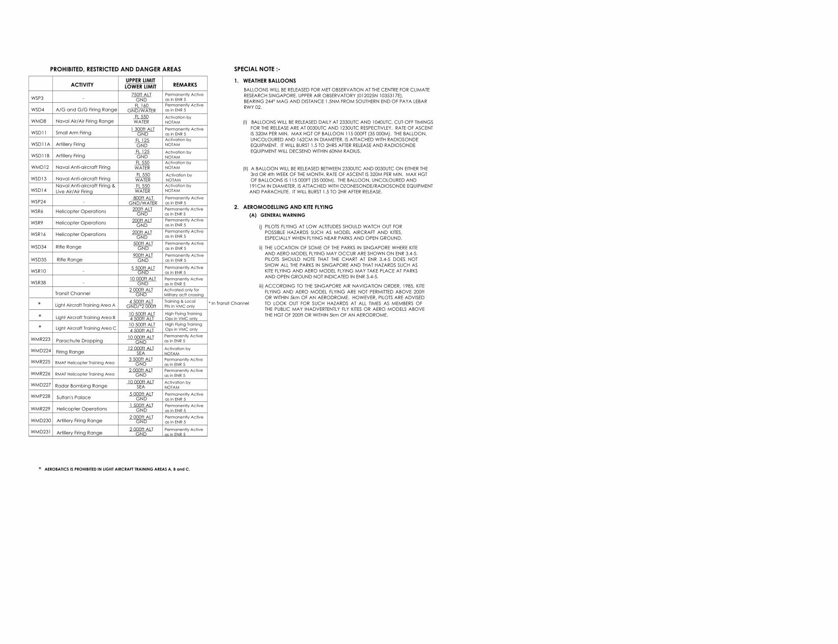
SPECIAL NOTE :-
ACTIVITY UPPER LIMITLOWER LIMIT REMARKS
WSD4
WSP3
WMD8
WSD11
WSD11B
WMD12
WSD11A
WSD13
WSD14
WSP24
Permanently Activeas in ENR 5
A/G and G/G Firing Range
- 750ft ALTGNDFL 160
GND/WATERPermanently Activeas in ENR 5
Naval Air/Air Firing Range FL 550WATER
Activation by NOTAM
Small Arm Firing 1 300ft ALTGND
Permanently Activeas in ENR 5
Artillery Firing FL 125GND
Activation by NOTAM
Artillery Firing FL 125GND
Activation by NOTAM
Naval Anti-aircraft Firing FL 550WATER
Activation by NOTAM
Naval Anti-aircraft Firing FL 550WATER
Activation by NOTAM
Naval Anti-aircraft Firing &Live Air/Air Firing
FL 550WATER
Permanently Activeas in ENR 5- 800ft ALT
GND/WATER
Activation by NOTAM
WSD34 Rifle Range 500ft ALTGND
Permanently Activeas in ENR 5
WSD35 Rifle Range 900ft ALTGND
Permanently Activeas in ENR 5
WSR10 - 5 500ft ALTGNDPermanently Activeas in ENR 5
WSR38 - 10 000ft ALTGND
Permanently Activeas in ENR 5
Transit Channel 2 000ft ALTGND
Activated only forMilitary acft crossing
Light Aircraft Training Area A 4 500ft ALTGND/*2 000ft
Training & LocalFlts in VMC only*
Light Aircraft Training Area B 10 500ft ALT4 500ft ALT
High Flying TrainingOps in VMC only*
* In Transit Channel
PROHIBITED, RESTRICTED AND DANGER AREAS
Light Aircraft Training Area C 10 500ft ALT High Flying TrainingOps in VMC only* 4 500ft ALT
* AEROBATICS IS PROHIBITED IN LIGHT AIRCRAFT TRAINING AREAS A, B and C.
WMR223 Parachute Dropping 10 000ft ALTGND
Permanently Activeas in ENR 5
WMD224 Firing Range 12 000ft ALTSEA
Activation by NOTAM
WMR225 RMAF Helicopter Training Area 3 500ft ALTGND
Permanently Activeas in ENR 5
WMR226 2 000ft ALTGND
Permanently Activeas in ENR 5RMAF Helicopter Training Area
WMD227 Radar Bombing Range 10 000ft ALTSEA
Activation by NOTAM
WMP228 Sultan's Palace 5 000ft ALTGND
Permanently Activeas in ENR 5
WMR229 Helicopter Operations 1 500ft ALTGND
Permanently Activeas in ENR 5
WMD230 Artillery Firing Range 2 000ft ALTGNDPermanently Activeas in ENR 5
WMD231 Artillery Firing Range 2 000ft ALTGND
Permanently Activeas in ENR 5
1. WEATHER BALLOONS
2. AEROMODELLING AND KITE FLYING
i) PILOTS FLYING AT LOW ALTITUDES SHOULD WATCH OUT FORPOSSIBLE HAZARDS SUCH AS MODEL AIRCRAFT AND KITES,ESPECIALLY WHEN FLYING NEAR PARKS AND OPEN GROUND.
ii) THE LOCATION OF SOME OF THE PARKS IN SINGAPORE WHERE KITEAND AERO MODEL FLYING MAY OCCUR ARE SHOWN ON ENR 3.4-5.PILOTS SHOULD NOTE THAT THE CHART AT ENR 3.4-5 DOES NOTSHOW ALL THE PARKS IN SINGAPORE AND THAT HAZARDS SUCH ASKITE FLYING AND AERO MODEL FLYING MAY TAKE PLACE AT PARKSAND OPEN GROUND NOT INDICATED IN ENR 3.4-5.
iii) ACCORDING TO THE SINGAPORE AIR NAVIGATION ORDER, 1985, KITEFLYING AND AERO MODEL FLYING ARE NOT PERMITTED ABOVE 200ftOR WITHIN 5km OF AN AERODROME. HOWEVER, PILOTS ARE ADVISEDTO LOOK OUT FOR SUCH HAZARDS AT ALL TIMES AS MEMBERS OF THE PUBLIC MAY INADVERTENTLY FLY KITES OR AERO MODELS ABOVETHE HGT OF 200ft OR WITHIN 5km OF AN AERODROME.
(A) GENERAL WARNING
BALLOONS WILL BE RELEASED FOR MET OBSERVATION AT THE CENTRE FOR CLIMATE RESEARCH SINGAPORE, UPPER AIR OBSERVATORY (012025N 1035317E), BEARING 244° MAG AND DISTANCE 1.5NM FROM SOUTHERN END OF PAYA LEBARRWY 02.
(I) BALLOONS WILL BE RELEASED DAILY AT 2330UTC AND 1040UTC. CUT-OFF TIMINGS FOR THE RELEASE ARE AT 0030UTC AND 1230UTC RESPECTIVLEY. RATE OF ASCENT IS 320M PER MIN. MAX HGT OF BALLOON 115 000FT (35 000M). THE BALLOON, UNCOLOURED AND 162CM IN DIAMETER, IS ATTACHED WITH RADIOSONDE EQUIPMENT. IT WILL BURST 1.5 TO 2HRS AFTER RELEASE AND RADIOSONDE EQUIPMENT WILL DECSEND WITHIN 60NM RADIUS.
(II) A BALLOON WILL BE RELEASED BETWEEN 2330UTC AND 0030UTC ON EITHER THE 3rd OR 4th WEEK OF THE MONTH. RATE OF ASCENT IS 320M PER MIN. MAX HGT OF BALLOONS IS 115 000FT (35 000M). THE BALLOON, UNCOLOURED AND 191CM IN DIAMETER, IS ATTACHED WITH OZONESONDE/RADIOSONDE EQUIPMENT AND PARACHUTE. IT WILL BURST 1.5 TO 2HR AFTER RELEASE.
WSR6 Permanently Activeas in ENR 5
WSR9
WSR16
200ft ALTGND
200ft ALTGND
200ft ALTGND
Permanently Activeas in ENR 5Permanently Activeas in ENR 5Helicopter Operations
Helicopter Operations
Helicopter Operations
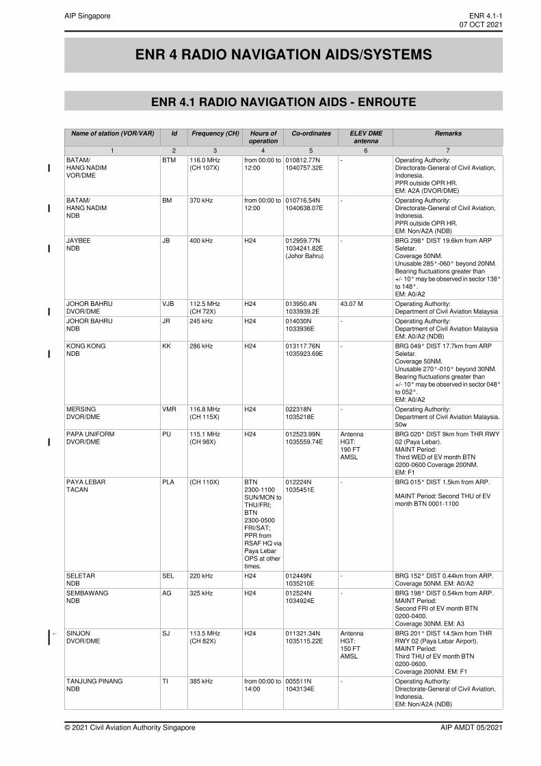
ENR 4 RADIO NAVIGATION AIDS/SYSTEMS
ENR 4.1 RADIO NAVIGATION AIDS - ENROUTE
RemarksELEV DMEantenna
Co-ordinatesHours ofoperation
Frequency (CH)IdName of station (VOR/VAR)
7654321Operating Authority:Directorate-General of Civil Aviation,Indonesia.PPR outside OPR HR.EM: A2A (DVOR/DME)
-010812.77N1040757.32E
from 00:00 to12:00
116.0 MHz(CH 107X)
BTMBATAM/HANG NADIMVOR/DME
Operating Authority:Directorate-General of Civil Aviation,Indonesia.PPR outside OPR HR.EM: Non/A2A (NDB)
-010716.54N1040638.07E
from 00:00 to12:00
370 kHzBMBATAM/HANG NADIMNDB
BRG 298° DIST 19.6km from ARPSeletar.Coverage 50NM.Unusable 285°-060° beyond 20NM.Bearing fluctuations greater than+/- 10°may be observed in sector 138°to 148°.EM: A0/A2
-012959.77N1034241.82E(Johor Bahru)
H24400 kHzJBJAYBEENDB
Operating Authority:Department of Civil Aviation Malaysia
43.07 M013950.4N1033939.2E
H24112.5 MHz(CH 72X)
VJBJOHOR BAHRUDVOR/DME
Operating Authority:Department of Civil Aviation MalaysiaEM: A0/A2 (NDB)
-014030N1033936E
H24245 kHzJRJOHOR BAHRUNDB
BRG 049° DIST 17.7km from ARPSeletar.Coverage 50NM.Unusable 270°-010° beyond 30NM.Bearing fluctuations greater than+/- 10°may be observed in sector 048°to 052°.EM: A0/A2
-013117.76N1035923.69E
H24286 kHzKKKONG KONGNDB
Operating Authority:Department of Civil Aviation Malaysia.50w
-022318N1035218E
H24116.8 MHz(CH 115X)
VMRMERSINGDVOR/DME
BRG 020° DIST 9km from THR RWY02 (Paya Lebar).MAINT Period:Third WED of EV month BTN0200-0600 Coverage 200NM.EM: F1
AntennaHGT:190 FTAMSL
012523.99N1035559.74E
H24115.1 MHz(CH 98X)
PUPAPA UNIFORMDVOR/DME
BRG 015° DIST 1.5km from ARP.
MAINT Period: Second THU of EVmonth BTN 0001-1100
-012224N1035451E
BTN2300-1100SUN/MON toTHU/FRI;BTN2300-0500FRI/SAT;PPR fromRSAF HQ viaPaya LebarOPS at othertimes.
(CH 110X)PLAPAYA LEBARTACAN
BRG 152° DIST 0.44km from ARP.Coverage 50NM. EM: A0/A2
-012449N1035210E
H24220 kHzSELSELETARNDB
BRG 198° DIST 0.54km from ARP.MAINT Period:Second FRI of EV month BTN0200-0400.Coverage 30NM. EM: A3
-012524N1034924E
H24325 kHzAGSEMBAWANGNDB
BRG 201° DIST 14.5km from THRRWY 02 (Paya Lebar Airport).MAINT Period:Third THU of EV month BTN0200-0600.Coverage 200NM. EM: F1
AntennaHGT:150 FTAMSL
011321.34N1035115.22E
H24113.5 MHz(CH 82X)
SJSINJONDVOR/DME
←
Operating Authority:Directorate-General of Civil Aviation,Indonesia.EM: Non/A2A (NDB)
-005511N1043134E
from 00:00 to14:00
385 kHzTITANJUNG PINANGNDB
AIP AMDT 05/2021© 2021 Civil Aviation Authority Singapore
ENR 4.1-1AIP Singapore~~~eaip-amdt~~~ver-date-2021-09-09T07-08-00-03507 OCT 2021
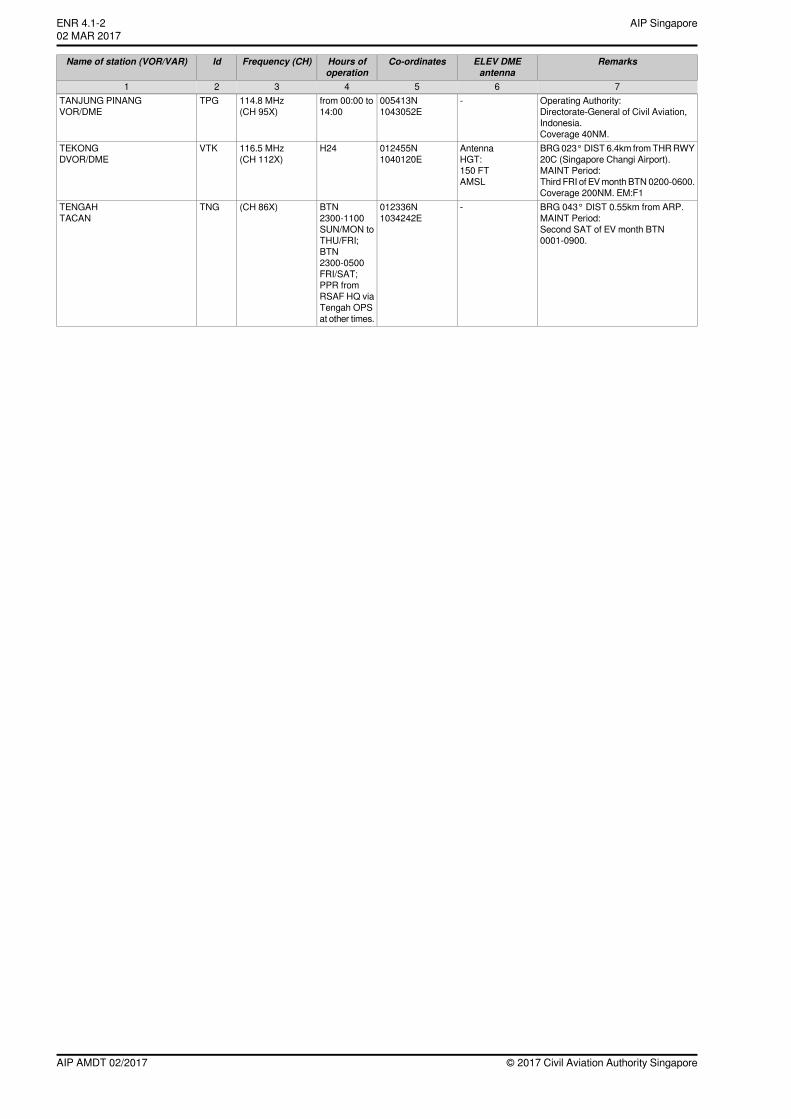
RemarksELEV DMEantenna
Co-ordinatesHours ofoperation
Frequency (CH)IdName of station (VOR/VAR)
7654321Operating Authority:Directorate-General of Civil Aviation,Indonesia.Coverage 40NM.
-005413N1043052E
from 00:00 to14:00
114.8 MHz(CH 95X)
TPGTANJUNG PINANGVOR/DME
BRG023°DIST6.4km fromTHRRWY20C (Singapore Changi Airport).MAINT Period:Third FRI of EVmonth BTN0200-0600.Coverage 200NM. EM:F1
AntennaHGT:150 FTAMSL
012455N1040120E
H24116.5 MHz(CH 112X)
VTKTEKONGDVOR/DME
BRG 043° DIST 0.55km from ARP.MAINT Period:Second SAT of EV month BTN0001-0900.
-012336N1034242E
BTN2300-1100SUN/MON toTHU/FRI;BTN2300-0500FRI/SAT;PPR fromRSAF HQ viaTengah OPSat other times.
(CH 86X)TNGTENGAHTACAN
© 2017 Civil Aviation Authority SingaporeAIP AMDT 02/2017
AIP SingaporeENR 4.1-202 MAR 2017
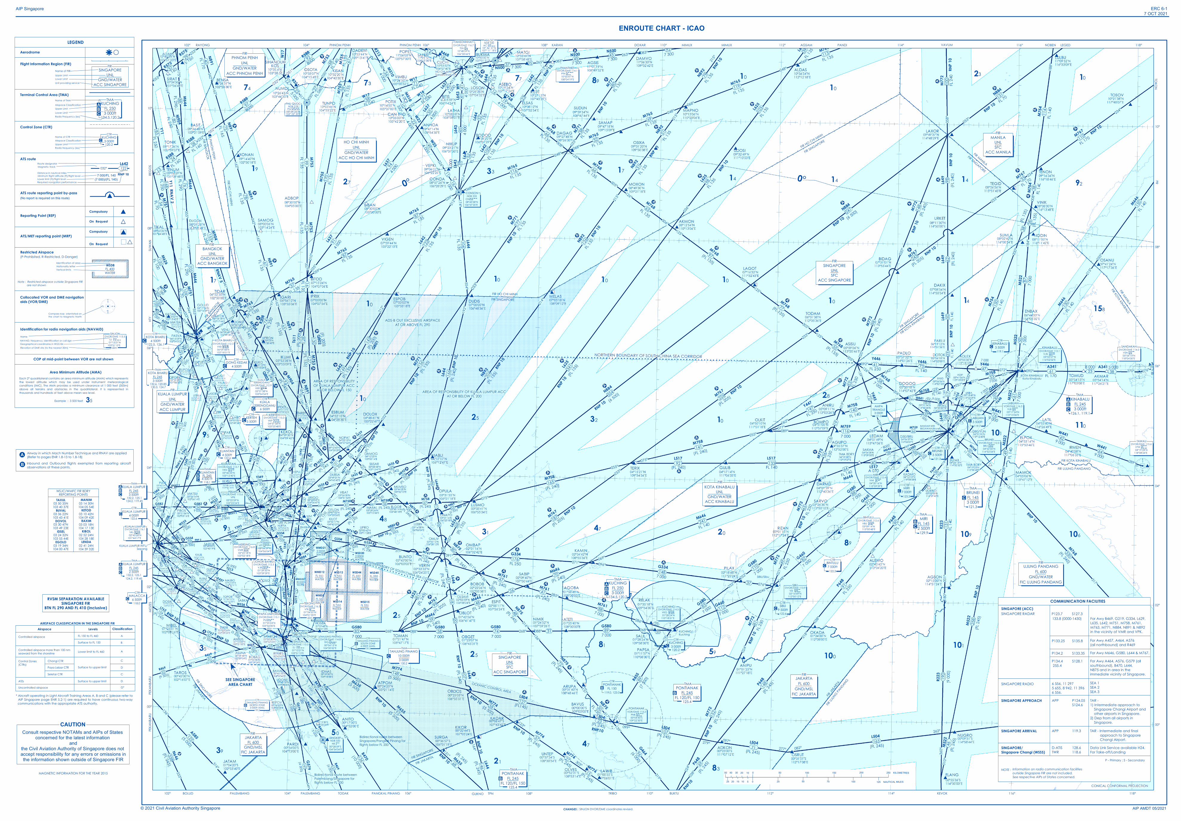
354
341
338
330
258
241
226
103
190
187
95
176
87
165
96
45
131
94
83
109
80
58
116
77
113
88
56
55
48
44
74
38
17
21
19
16
15
87
6
50
53
53
150
47
22
72
62
42
45
31
90
43
30
65
66
64
76
140
67
59
122
47
41
32
32
33
91
243
92
119
91
5037
107
27
57
28
38
52
45
80
27
53
99
22
22
99
41
75
26
78
65
46
67
79
36
16
26
108
46
89
38
28
148
25
156
57
125
54
14
48
69
119
6968
92
61
40
23
47
114
33
110
83
21
52
24
25
20
30
40100
20
66
72
27
70
56
58
37
127
48
70
112
93
63
27
99
68
43
28
45
28
74
36
41
58
141 32
136
25
149
33
32
12
66
24
33
177
68
130
59
52
19
18
88
113
148
20
110
78
150
20
81
37
26
61
58
38
89
60
204
247
595
97
72
23
31
62
25
39
28
82
80
2943
23
41
131
59
64
25
120
59
34
34
16
60
79
21
109
51
22
56
148
25
116
93
91
16
50
34
126
11
11
57
11
19
104
166
27
19
4611
2624
3118
51
148
98
53
1916
36
65
49
81
152
100
24
37
29
6140
170
29
27
52
75
105
114
2516
31
42 3028
2938
15
10376
88
302
61
28FL 1
60
92
97
8000 12
18
17
147
7341
92 133 40
20
33
93
153
80
127
15
107
71163
23
60
33
37
64
37
33
38
23
34
1210
22
49
16
35
12
39
106
85
25
2016
31
16
27
24
19
24
10
30
21
168
83
13
100
39
9862
5023
2017
27
33 22 13
76
42
6449
5087
47
87
52
98
23
3956
16
38
51
432523
11
41
58
71
71
143
130
39
87
36
15
128
86 121
41
66
154
53
2214
38
32
32
35
4013
22
34
9
17
13
24
18
68
33
67
61
8939
51
29
56
141 131
146
46
66
k!(
k!(
k!(
k!(
k!(
k!(
k!(
0
7525 50
250 KILOMETRES100 150
125 NAUTICAL MILES
20040 203050 50
100020
10
10 51525
344°164°
344°333°
292°
190°
190°
010°
059°
239°059°
239°
059°
342°162°
342°162°
162°342°
342°162°
342°162°
342°
030°
177°357°
176°357°
035°
215° 181°
085°265° 083°
263° 083°
213°
213°
239°
212°
212°
174°
033°
192°
032°
128°
308°128°
308°125°
305°068°
248°068°
248°068°
248°069°215
°
215°
033°
126°
306°
305°
125°
125°
305°
125°
305°
306°
306°
126°
126°
159°
339°
077°
257° 077°
257° 077°257°
020°
200° 228°
038°
218°
038°
218°
269° 269°089°131°
311°
008°
188°
249°
069°239°
059°
227°
047°
048°
090° 270° 076°
020°
200°
004°
184°
035°
215°
035°
089°
020°
019°
019°
021°
021°
047°
227°
048°
228°
052°
232°052°
232°
052°
232°
066°
246°
017°
197°
6 000
207°
027°
027°
196°
016°
235°
055°
268°089°267°
010°
190°
027°
207°
266°086°
208°
028°
029°
209°
296°298°
113°
293°
328°
336° 008°
188°
032°
069°
069°
231°
230°
032°
032°054°
252°
267° 087° 267°
032°
252°
087°
069°
285°
105°
008°
005°
005°01
6°
196°
356°176°
171°351°
001°
082°262°
251°
071°252°
316°
136°
333°
088°
153°
333°
145°159°
339°348°
349°
123°
131°
169°
268° 088° 268°
027°
232°
169°
027°
088°
285°
097°
277°091°
311°
131°
131°
311°
131°
188°
185°
053°
252°231° 169°
267°
069°
136°
316°136°
316°137°
317°139°
303°
319°
024°
031°
211°
268°
286°
271° 096°069°
214°
035°
051°075°
255°233°
075°
276°
249°069°
255°
024°
038°
218°
038°
218°
038°
218°
360°
010°
145°
233°
233°
053°
010°
010°
190°
194°
014°
133°
346°
326°
030°
204°
156°
105°087°054°
192°
252°
219°
353°173°
355°355°
175°314°
232°
232°
052°
062°
242°
020°
233°
092°272°
269°
341°
164°
161°
344°
099°
279° 097°277° 082°
262°
232°
148°
302°118°
335°
146°
326°
330°
150°
030°317°
172°
359°
097°
289°
109°
354°
052°070°
213°
352°
020°
036°
215°
234°
234°
008°
188°
053°358°
180°
191°
001°
181°
137°
317°
158°
164°
AIP Singapore ERC 6-17 OCT 2021
AIP AMDT 05/2021
ENROUTE CHART - ICAO
© 2021 Civil Aviation Authority Singapore
OCEANIC CONTROL AREA
116° 118°
10°
FIR SINGAPORE
FIR KOTA KINABALU
FIR HO CHI MINH
FIR SINGAPORE
08°
114°112°110°106°104°102°
116° 118°114°112°110°108°106°104°102°
06°
04°
02°
00°
10°
08°
06°
04°
02°
00°
FIR MANILAFIR SINGAPORE
FIR KOTA KINABALUFIR MANILA
FIR UJUNG PANDANG
KOTA KINABALU/Kota Kinabalu
BANDAR SERIBEGAWAN/Brunei
FIR JA
KARTA
FIR UJ
UNG PANDANG
SIBU/Sibu
NORTHERN BOUNDARY OF SOUTH CHINA SEA CORRIDOR
FIR SINGAPORE
FIR JAKARTA
Bidirectional route betweenSingapore/Pangkal Pinang forflights below FL 200
TODAK PANGKAL PINANGPALEMBANG
Bidirectional route betweenPalembang/Singapore forflights below FL 200
AREA OF RESPONSIBILITY OF KUALA LUMPUR ACCAT OR BELOW FL 200
FIR HO CHI MINHFIR SINGAPORE
AREA OF RESPONSIBILITYOF KUALA LUMPUR ACC
AT OR BELOW FL 150
FIR SINGAPORE
FIR KUALA LUMPUR
FIR HO CHI MINH
FIR BANGKOK
PHNOM PENH PANDIAGSAMMIMUXRAYONG
Í
HTY
SUWA
NRE
GOS
SEE SINGAPOREAREA CHART
PEKA
NBAR
U
Í
CONICAL CONFORMAL PROJECTION
SOUTHERN BDRY OF SOUTH CHINA SEA CORRIDOR
PHNOM PENH 108°
Í
TRIBO BUKTU KEVOK
Consult respective NOTAMs and AIPs of States concerned for the latest information
andthe Civil Aviation Authority of Singapore does not accept responsibility for any errors or omissions inthe information shown outside of Singapore FIR
CAUTION
Í
HO CHI MINHUNL
GND/WATERACC HO CHI MINH
FIR
FIR PHNOM PENH
FIR BANGKO
K
KUALA LUMPURUNL
GND/WATERACC LUMPUR
FIR
KUANTAN4 500ft
CTR
122.6"C
KUANTANFL 2454 500 ft
TMA
118.1"C"A"B
DVOR/DME 116.8VMR 02°23'18"N
103°52'18"E
MERSING
KUALA LUMPUR4 000ft
CTR
122.6"C
DVOR/DME 116.7TSN
10°48'59"N106°38'44"E
TANSONNHAT
DVOR/DME 116.1VKL 02°43'28"N
101°44'17"E
KUALA LUMPUR
MALACCA6 500ft
CTR
118.0"C
DVOR/DME 116.5VTK
01°24'55"N104°01'20"E
TEKONG
60m
TANJUNG PINANGNORTH ZONE3 000ft AMSL
CTR
130.2"B
50
25
25
21
PHNOM PENHUNL
GND/WATERACC PHNOM PENH
FIR
10
10
10
25
17
31
4893
95
35
SINGAPORESingapore Changi
BANGKOKUNL
GND/WATERACC BANGKOK
FIR
TANJUNG PINANG10 000ft3 000ft
TMA
130.2"C
47
83
5981
KUCHINGFL 2503 000ft
TMA
134.5,120.2"C"A"B
100
KUCHING/Kuching
KINABALUFL 2453 000ft
TMA
126.1, 119.1"C
"A"B
BRUNEIFL 1453 000ft
TMA
121.3"C
110101
109
FIR KOTA KINABALU
89
10
KOTA KINABALUUNL
GND/WATERACC KINABALU
FIR
10
20
28
15814
10
MIRIFL 1452 500ft
TMA
129.9"C"B
MANILAUNLSFC
ACC MANILA
FIR
10
10
14 14 92
1023
14
10
32
47
73 77 89
33 17
MIMUXDOXAR LEGEDNOBEN
PEKA
NBAR
U
PALEMBANGBOLUD
TOKONPR
101
KARAN
106
RVSM SEPARATION AVAILABLESINGAPORE FIR
BTN FL 290 AND FL 410 (Inclusive)
74
19
27
KUALA LUMPURFL 2453 500ft
TMA
132.2, 125.1124.2, 119.45
"C"A"B
HO CHI MINH/Tansonnhat Int'l
KUALA LUMPUR INT'L/Sepang
39
FIR SINGAPORE
FIR JAKARTA
TANJUNG PINANGSOUTH ZONE6 000ft AMSL
CTR
130.2"B KUCHING
3 000ftCTR
120.2"C
KINABALU3 500ft
CTR
119.1"C
LABUAN3 500ft
CTR
119.7"C
DVOR/DME 112.0BRU 04°52'30"N
114°52'54"E
BRUNEI
DVOR/DME 112.4VMI 04°20'16"N113°59'39"E
MIRI
MIRI7 000ft
CTR
123.3"C
DVOR/DME 112.6VBU 03°09'14"N113°00'48"E
BINTULU
BINTULU7 000ft
CTR
122.3"C
SIBU9 500ft
CTR
122.6"C
FIR SIN
GAPORE
CHANGES : SINJON DVOR/DME coordinates revised.
VAVUM
AMPATRIANGLE
3 000ft121.3
KUALA LUMPURFL 2452 500ft
TMA
132.2, 125.1124.2, 119.45
"C"A"B
* Aircraft operating in Light Aircraft Training Areas A, B and C (please refer toAIP Singapore page ENR 5.2-1) are required to have continuous two-waycommunications with the appropriate ATS authority.
UJUNG PANDANGFL 600
GND/WATERFIC UJUNG PANDANG
FIR
0°0°
Airspace Levels Classification
Controlled airspace FL 150 to FL 460Surface to FL 150
Controlled airspace more than 100 nmseaward from the shoreline
Control Zones(CTRs)
ATZsUncontrolled airspace
Changi CTRPaya Lebar CTRSeletar CTR
Lower limit to FL 460
Surface to upper limit
Surface to upper limit
AB
A
C
CD
DG*
AIRSPACE CLASSIFICATION IN THE SINGAPORE FIR
LEGENDAerodrome
Flight Information Region (FIR)
Terminal Control Area (TMA)
Control Zone (CTR)
ATS route
Reporting Point (REP)
ATS/MET reporting point (MRP)
Restricted Airspace(P-Prohibited, R-Restricted, D-Danger)
Note : Restricted airspace outside Singapore FIR are not shown
Collocated VOR and DME navigationaids (VOR/DME)
Identification for radio navigation aids (NAVAID)
#
VOn Request
On Request
Compulsory )#
)
Name of CTRAirspace ClassificationUpper LimitRadio frequency (ies)
Name of TMAAirspace ClassificationUpper LimitLower LimitRadio Frequency (ies)
Name of FIR
Unit providing service
Upper LimitLower Limit
Identification of area
Vertical limitsNationality letter
Route designator
Distance in nautical milesMinimum flight altitude (ft)/flight level
Magnetic track
Required navigation performance
0
18
27 9
Compass rose orientated onthe chart to Magnetic North
NameNAVAID, frequency, identification or call signGeographical coordinates in WGS-84Elevation of DME site (to the nearest 30m)
k
Compulsory
SINGAPOREUNL
GND/WATERACC SINGAPORE
FIR
KUCHINGFL 2503 000ft
TMA
134.5,120.2"C"A"B
KUCHING3 000ft
CTR
120.2"C
WSD8FL 400WATER
#ATS route reporting point by-pass(No report is required on this route)
!A
!B
Airway in which Mach Number Technique and RNAV are applied(Refer to pages ENR 1.8-13 to 1.8-18)Inbound and Outbound flights exempted from reporting aircraftobservations at these points.
MAGNETIC INFORMATION FOR THE YEAR 2015
DVOR/DME 113.9VSI 02°14'49"N
112°00'12"E
SIBU
DVOR/DME 115.6 VPK
03°22'59"N103°25'24"E
PEKAN
GONG KEDAK4 500ft
CTR
"C
KOTA BHARU4 500ft
CTR
122.5, 126.1"C
KOTA BHARUFL 2453 500ft
TMA
132.6, 120.85130.3, 124.7
7 000/FL 140 RNP 10
DVOR/DME 113.1VJN 05°53'57"N
116°02'02"E
KINABALU
COMMUNICATION FACILITIESSINGAPORE (ACC)
SINGAPORE RADIO
SINGAPORE APPROACH
SINGAPORE ARRIVAL
SINGAPORE/Singapore Changi (WSSS)
P - Primary ; S - Secondary
NOTE : Information on radio communication facilitiesoutside Singapore FIR are not included.See respective AIPs of States concerned.
SINGAPORE RADAR
D-ATISTWR
128.6118.6
APP 119.3
APP P124.05S124.6
6 556, 11 2975 655, 8 942, 11 3966 556.
P134.4 255.4
S128.1
P133.25 S135.8
P134.2 S133.35
133.8 (0000-1430)
For Awy A457, A464, A576(all northbound) and R469For Awy M646, G580, L644 & M767.For Awy A464, A576, G579 (allsouthbound), B470, L644,N875 and in area in theimmediate vicinity of Singapore.
SEA 1SEA 2SEA 3
TAR - 1) Intermediate approach to
Singapore Changi Airport andother airports in Singapore.
2) Dep from all airports inSingapore.
TAR - Intermediate and final approach to Singapore Changi Airport.
Data Link Service available H24.For Take-off/Landing
P123.7 S127.3For Awy B469, G219, G334, L629, L635, L642, M751, M758, M761, M763, M771, N884, N891 & N892 in the vicinity of VMR and VPK.
L642032° 122
DVOR/DME 114.8TPG 00°54'13"N
104°30'52"E
TANJUNG PINANG
GUKNO
DVOR/DME 114.5VKG 01°28'24"N
110°18'21"E
KUCHING
VOR/DME 116.3VLB 05°17'24"N
115°15'06"E
LABUAN
DVOR/DME 115.1PU 01°25'24"N
103°56'00"E
PAPA UNIFORM
60m
DVOR/DME 112.5VJB 01°39'50"N
103°39'39"E
JOHOR BAHRU
DVOR/DME 114.0VSN 05°54'14"N
118°04'30"E
SANDAKAN
60m
NDB 278PQ
10° 09' 55"N104° 02' 20"E
PHU QUOC
NDB 333CN 08°43'58"N
106°37'35"E
CONSON
KERTEH5 500ft
CTR"C
DVOR/DME 112.9VKR 05°21'38"N103°04'54"E
KUALATERENGGANU
DVOR/DME 113.3VKP 04°31'58"N103°25'48"E
!!
!
!!!
KERTEH
COP at mid-point between VOR are not shown
Area Minimum Altitude (AMA)Each 2° quadrilateral contains an area minimum altitude (AMA) which representsthe lowest altitude which may be used under instrument meteorologicalconditions (IMC). The AMA provides a minimum clearance of 1 000 feet (300m)above all terrains and obstacles in the quadrilateral. It is represented inthousands and hundreds of feet above mean sea level.
Example : 3 500 feet 35 KUALATERENGGANU
6 500ft
CTR
"C
ADS-B OUT EXCLUSIVE AIRSPACEAT OR ABOVE FL 290
DVOR/DME 112.3VKB 06°09'48"N102°18'51"E
KOTA BHARU
BRUNEI3 500ft
CTR
121.3"C
DVOR/DME 115.6VTW 04°19'28"N
118°08'24"E
TAWAU
NDB 320AC
10° 56' 21"N107° 11' 18"E
ANLOC
WSJC/WMFC FIR BDRYREPORTING POINTS
03 50 35N103 40 37E03 36 22N103 43 41E03 30 47N103 49 23E03 24 32N103 55 44E03 19 34N104 00 47E
TAXUL
BUVAL
DOVOL
IDSEL
EGOLO
DVOR/DME 113.5SJ 01°13'21"N
103°51'15"E
SINJON
DVOR/DME 113.5SJ 01°13'21"N
103°51'15"E
SINJON
60m
NDB 320NE
00°28'59"S104°34'34"E
SINGKEP
DVOR/DME 114.1PTH 10°55'41"N108°04'19"E
PHANTHIET
Lower limit (ft)/flight level (7 000)/(FL 140)
MOZE
S
PONTIANAKFL 150
CTR
119.0, 123.0"B
JAKARTAFL 600
GND/MSLFIC JAKARTA
FIR
JAKARTAFL 600
GND/MSLFIC JAKARTA
FIR
PONTIANAKFL 245
FL 120/FL 150
TMA
125.4"B
PONTIANAKFL 245
FL 120/FL 150
TMA
125.4"B
VOR/DME 113.2PNK 00°04'45"S
109°22'30"E
PONTIANAK
DVOR/DME 113.7VKN 03°46'23"N103°12'40"E
KUANTAN
VPT 02°54'39"N104°06'04"E
PULAUTIOMAN
TPN
03 14 30N104 05 54E03 10 42N104 09 42E03 03 18N104 17 13E02 52 24N104 28 18E02 41 24N104 39 32E
MANIM
KETOD
RAXIM
KIBOL
LENDA
SINGAPOREUNLSFC
ACC SINGAPORE
FIR
SINGAPOREUNLSFC
ACC SINGAPORE
FIR

PAGE INTENTIONALLY LEFT BLANK
WSSS AD 2.5 PASSENGER FACILITIES
Transit area and adjacent to airport terminal.Hotels1Transit and public areas of terminal building.Restaurants2Buses, taxis, MRT train and car rental service.Transportation3Available at airport.Medical Facilities4Available at airport.Bank and Post Office5Available at airport.Tourist Office6Internet address : http://www.changiairport.com.sgfor airport and flight information, shops and restaurants, facilities and services,flight connections and tourist information.
Remarks7
WSSS AD 2.6 RESCUE AND FIRE FIGHTING SERVICES
RWY 02L/20R, RWY 02C/20C and RWY 02R/20LCAT10 (No facilities for foaming of runways)
AD category for fire fighting1
Adequately provided as recommended by ICAO.Rescue equipment2Specialised aircraft recovery equipment available for up to andincluding A380 size aircraft operation.
Capability for removal of disabled aircraft3
All Airport Emergency Service personnel are trained in rescue andfire-fighting as well as medical first-aid.
Remarks4
WSSS AD 2.7 SEASONAL AVAILABILITY - CLEARING
There is no requirement for clearing. The aerodrome is available throughout the year.
AIP AMDT 07/2020© 2020 Civil Aviation Authority Singapore
AD 2.WSSS-331 DEC 2020
AIP Singapore

WSSSAD2.8 APRONS, TAXIWAYSANDCHECKLOCATIONS/POSITIONSDATA
Concrete surface, strength PCN 85/R/B/W/UApron surface and strength1
Minimum width 23m for all taxiways
TWYW1, W9, T2, T4, T12 and T (between T11 and T12) – Concrete surface; strengthPCN 85/R/B/W/U
TWY A (between A1 and A2, and between A11 and A12), A1, A2, A11, A12, TWY B(between B1 and B2, and between B13 and B14), B1, B2, B13, B14 - Concrete surface;strength PCN 90/R/B/W/T
TWY T (BETWEEN TWY P AND TWY J), TWY J and TWY K (between TWY K2 andTWY J12) – Asphalt surface; strength PCN 80/F/B/X/T
TWY P1 (between N and N5) and all other TWYs A, B, J, K – Asphalt surface; strengthPCN 82/F/B/X/T
All other taxiways – Asphalt surface, strength PCN 72/F/B/W/U
Note: Open-air drains, demarcated by frangible poles, are installed within non-gradedTWY strips at least 30m from the TWY centrelines. 0.5m-high lateral restraint at 30meast of TWY P1 and TXL N5 centreline before the open drain.
Taxiway width, surface andstrength
2
See AD-2-WSSS-ADC-2/ Chart (flip side) for coordinates and elevations of aircraftstands.
Altimeter checkpoints locationand elevation
3
NILVOR checkpoint location4
See AD-2-WSSS-ADC-2/ Chart (flip side) for coordinates and elevations of aircraftstands.
INS checkpoints position5
NILRemarks6
© 2021 Civil Aviation Authority SingaporeAIP AMDT 05/2021
AIP SingaporeAD 2.WSSS-407 OCT 2021~~~eaip-amdt~~~ver-date-2021-09-09T07-08-00-035
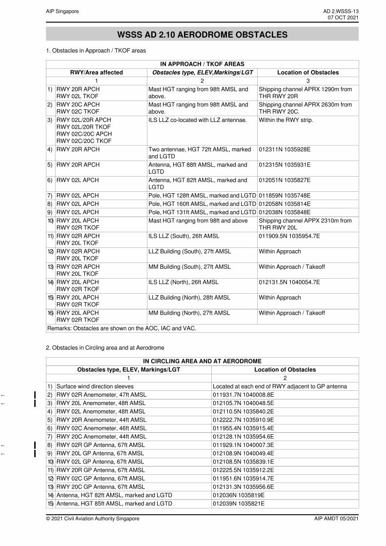
WSSS AD 2.10 AERODROME OBSTACLES1. Obstacles in Approach / TKOF areas
IN APPROACH / TKOF AREASLocation of ObstaclesObstacles type, ELEV,Markings/LGTRWY/Area affected
321Shipping channel APRX 1290m fromTHR RWY 20R
Mast HGT ranging from 98ft AMSL andabove.
RWY 20R APCHRWY 02L TKOF
1)
Shipping channel APRX 2630m fromTHR RWY 20C.
Mast HGT ranging from 98ft AMSL andabove.
RWY 20C APCHRWY 02C TKOF
2)
Within the RWY strip.ILS LLZ co-located with LLZ antennae.RWY 02L/20R APCHRWY 02L/20R TKOFRWY 02C/20C APCHRWY 02C/20C TKOF
3)
012311N 1035928ETwo antennae, HGT 72ft AMSL, markedand LGTD
RWY 20R APCH4)
012315N 1035931EAntenna, HGT 88ft AMSL, marked andLGTD
RWY 20R APCH5)
012051N 1035827EAntenna, HGT 82ft AMSL, marked andLGTD
RWY 02L APCH6)
011859N 1035748EPole, HGT 128ft AMSL, marked and LGTDRWY 02L APCH7)012058N 1035814EPole, HGT 160ft AMSL, marked and LGTDRWY 02L APCH8)012038N 1035848EPole, HGT 131ft AMSL, marked and LGTDRWY 02L APCH9)Shipping channel APPX 2310m fromTHR RWY 20L
Mast HGT ranging from 98ft and aboveRWY 20L APCHRWY 02R TKOF
10)
011909.5N 1035954.7EILS LLZ (South), 26ft AMSLRWY 02R APCHRWY 20L TKOF
11)
Within ApproachLLZ Building (South), 27ft AMSLRWY 02R APCHRWY 20L TKOF
12)
Within Approach / TakeoffMM Building (South), 27ft AMSLRWY 02R APCHRWY 20L TKOF
13)
012131.5N 1040054.7EILS LLZ (North), 26ft AMSLRWY 20L APCHRWY 02R TKOF
14)
Within ApproachLLZ Building (North), 28ft AMSLRWY 20L APCHRWY 02R TKOF
15)
Within Approach / TakeoffMM Building (North), 27ft AMSLRWY 20L APCHRWY 02R TKOF
16)
Remarks: Obstacles are shown on the AOC, IAC and VAC.
2. Obstacles in Circling area and at Aerodrome
IN CIRCLING AREA AND AT AERODROMELocation of ObstaclesObstacles type, ELEV, Markings/LGT
21Located at each end of RWY adjacent to GP antennaSurface wind direction sleeves1)011931.7N 1040008.8ERWY 02R Anemometer, 47ft AMSL2)←012105.7N 1040048.5ERWY 20L Anemometer, 48ft AMSL3)←012110.5N 1035840.2ERWY 02L Anemometer, 48ft AMSL4)012222.7N 1035910.9ERWY 20R Anemometer, 44ft AMSL5)011955.4N 1035915.4ERWY 02C Anemometer, 46ft AMSL6)012128.1N 1035954.6ERWY 20C Anemometer, 44ft AMSL7)011929.1N 1040007.3ERWY 02R GP Antenna, 67ft AMSL8)←012108.9N 1040049.4ERWY 20L GP Antenna, 67ft AMSL9)←012108.5N 1035839.1ERWY 02L GP Antenna, 67ft AMSL10)012225.5N 1035912.2ERWY 20R GP Antenna, 67ft AMSL11)011951.6N 1035914.7ERWY 02C GP Antenna, 67ft AMSL12)012131.3N 1035956.6ERWY 20C GP Antenna, 67ft AMSL13)012036N 1035819EAntenna, HGT 82ft AMSL, marked and LGTD14)012039N 1035821EAntenna, HGT 85ft AMSL, marked and LGTD15)
AIP AMDT 05/2021© 2021 Civil Aviation Authority Singapore
AD 2.WSSS-13AIP Singapore~~~eaip-amdt~~~ver-date-2021-09-09T07-08-00-03507 OCT 2021
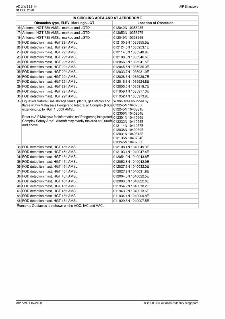
IN CIRCLING AREA AND AT AERODROMELocation of ObstaclesObstacles type, ELEV, Markings/LGT
012042N 1035823EAntenna, HGT 78ft AMSL, marked and LGTD16)012053N 1035827EAntenna, HGT 82ft AMSL, marked and LGTD17)012049N 1035826EAntenna, HGT 78ft AMSL, marked and LGTD18)012130.9N 1035955.5EFOD detection mast, HGT 29ft AMSL19)012124.0N 1035953.1EFOD detection mast, HGT 29ft AMSL20)012114.0N 1035948.9EFOD detection mast, HGT 29ft AMSL21)012108.6N 1035946.6EFOD detection mast, HGT 29ft AMSL22)012056.5N 1035941.5EFOD detection mast, HGT 29ft AMSL23)012045.5N 1035936.9EFOD detection mast, HGT 29ft AMSL24)012033.7N 1035931.9EFOD detection mast, HGT 29ft AMSL25)012028.6N 1035929.7EFOD detection mast, HGT 29ft AMSL26)012016.8N 1035924.8EFOD detection mast, HGT 29ft AMSL27)012005.0N 1035919.7EFOD detection mast, HGT 29ft AMSL28)011959.1N 1035917.3EFOD detection mast, HGT 29ft AMSL29)011952.4N 1035913.9EFOD detection mast, HGT 29ft AMSL30)Within area bounded by012245N 1040705E012245N 1040831E012306N 1040954E012301N 1041056E012232N 1041058E012114N 1041057E012038N 1040939E012031N 1040813E012136N 1040704E012245N 1040705E
Liquefied Natural Gas storage tanks, plants, gas stacks andflares within Malaysia's Pengerang Integrated Complex (PIC)extending up to HGT 1,500ft AMSL.
Refer to AIPMalaysia for information on "Pengerang IntegratedComplex Safety Area". Aircraft may overfly the area at 2,000ftand above.
31)
012108.4N 1040049.3EFOD detection mast, HGT 45ft AMSL32)012103.4N 1040047.4EFOD detection mast, HGT 45ft AMSL33)012054.9N 1040043.8EFOD detection mast, HGT 45ft AMSL34)012052.8N 1040042.9EFOD detection mast, HGT 45ft AMSL35)012027.8N 1040032.0EFOD detection mast, HGT 45ft AMSL36)012027.2N 1040031.8EFOD detection mast, HGT 45ft AMSL37)012004.5N 1040022.5EFOD detection mast, HGT 45ft AMSL38)012003.3N 1040022.0EFOD detection mast, HGT 45ft AMSL39)011954.2N 1040018.2EFOD detection mast, HGT 45ft AMSL40)011943.2N 1040013.6EFOD detection mast, HGT 45ft AMSL41)011934.4N 1040009.8EFOD detection mast, HGT 45ft AMSL42)011929.5N 1040007.5EFOD detection mast, HGT 45ft AMSL43)
Remarks: Obstacles are shown on the AOC, IAC and VAC.
© 2020 Civil Aviation Authority SingaporeAIP AMDT 07/2020
AIP SingaporeAD 2.WSSS-1431 DEC 2020
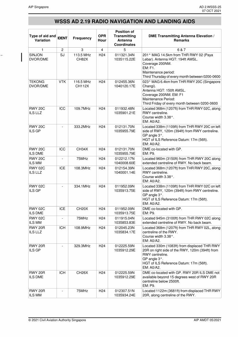
WSSS AD 2.19 RADIO NAVIGATION AND LANDING AIDS
DME Transmitting Antenna Elevation /Remarks
Position ofTransmittingAntenna
Coordinates
OPRHourFrequencyIDENTType of aid and
Variation
6 & 754321201° MAG 14.5km from THR RWY 02 (PayaLebar). Antenna HGT: 194ft AMSL.Coverage 200NM.EM: F1.Maintenance period:Third Thursday of everymonth between 0200-0600
011321.34N1035115.22E
H24113.5 MHzCH82X
SJSINJONDVOR/DME
←
023°MAG 6.4km from THRRWY 20C (SingaporeChangi).Antenna HGT: 150ft AMSL.Coverage 200NM. EM: F1Maintenance Period:Third Friday of every month between 0200-0600
012455.36N1040120.17E
H24116.5 MHzCH112X
VTKTEKONGDVOR/DME
Located 368m (1207ft) from THRRWY02C, alongRWY centreline.Course width 3.38°.EM: A0/A2.
011932.48N1035901.21E
H24109.7MHzICCRWY 20CILS LLZ
Located 338m (1109ft) from THRRWY 20C on leftside of RWY, 120m (394ft) from RWY centreline.GP angle 3°.HGT of ILS Reference Datum: 17m (56ft).EM: A0/A2.
012131.70N1035955.79E
H24333.2MHz-RWY 20CILS GP
DME co-located with GP.EM: P9.
012131.70N1035955.79E
H24CH34XICCRWY 20CILS DME
Located 960m (3150ft) from THR RWY 20C alongextended centreline of RWY. No back beam.
012212.17N1040008.60E
H2475MHz-RWY 20CILS MM
Located 368m (1207ft) from THRRWY20C, alongRWY centreline.Course width 3.38°.EM: A0/A2.
012154.39N1040001.14E
H24108.3MHzICERWY 02CILS LLZ
Located 338m (1109ft) from THRRWY 02C on leftside of RWY, 120m (394ft) from RWY centreline.GP angle 3°.HGT of ILS Reference Datum: 17m (56ft).EM: A0/A2.
011952.09N1035913.75E
H24334.1MHz-RWY 02CILS GP
DME co-located with GP.EM: P9.
011952.09N1035913.75E
H24CH20XICERWY 02CILS DME
Located 945m (3100ft) from THR RWY 02C alongextended centreline of RWY. No back beam.
011915.04N1035853.83E
H2475MHz-RWY 02CILS MM
Located 368m (1207ft) from THRRWY 02L, alongcentreline of the RWY.Course width 3.38°.EM: A0/A2.
012045.23N1035834.17E
H24108.9MHzICHRWY 20RILS LLZ
Located 330m (1083ft) from displaced THR RWY20R on right side of the RWY, 120m (394ft) fromRWY centreline.GP angle 3°.HGT of ILS Reference Datum: 17m (56ft).EM: A0/A2.
012225.59N1035912.29E
H24329.3MHz-RWY 20RILS GP
DME co-located with GP. RWY 20R ILS DME notavailable beyond 15 degrees west of RWY 20Rcentreline below 2500ft.EM: P9.
012225.59N1035912.29E
H24CH26XICHRWY 20RILS DME
Located 1122m (3681ft) fromdisplaced THRRWY20R, along centreline of the RWY.
012307.51N1035934.24E
H2475MHz-RWY 20RILS MM
AIP AMDT 05/2021© 2021 Civil Aviation Authority Singapore
AD 2.WSSS-25AIP Singapore~~~eaip-amdt~~~ver-date-2021-09-09T07-08-00-03507 OCT 2021
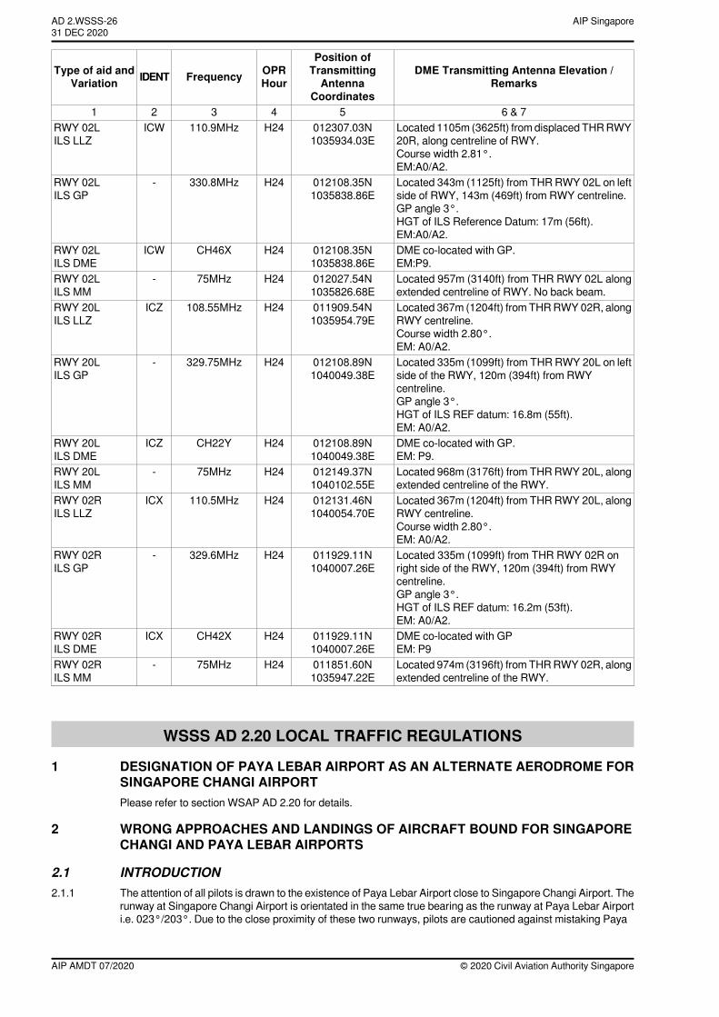
DME Transmitting Antenna Elevation /Remarks
Position ofTransmittingAntenna
Coordinates
OPRHourFrequencyIDENTType of aid and
Variation
6 & 754321Located 1105m (3625ft) fromdisplaced THRRWY20R, along centreline of RWY.Course width 2.81°.EM:A0/A2.
012307.03N1035934.03E
H24110.9MHzICWRWY 02LILS LLZ
Located 343m (1125ft) from THR RWY 02L on leftside of RWY, 143m (469ft) from RWY centreline.GP angle 3°.HGT of ILS Reference Datum: 17m (56ft).EM:A0/A2.
012108.35N1035838.86E
H24330.8MHz-RWY 02LILS GP
DME co-located with GP.EM:P9.
012108.35N1035838.86E
H24CH46XICWRWY 02LILS DME
Located 957m (3140ft) from THR RWY 02L alongextended centreline of RWY. No back beam.
012027.54N1035826.68E
H2475MHz-RWY 02LILS MM
Located 367m (1204ft) from THRRWY02R, alongRWY centreline.Course width 2.80°.EM: A0/A2.
011909.54N1035954.79E
H24108.55MHzICZRWY 20LILS LLZ
Located 335m (1099ft) from THR RWY 20L on leftside of the RWY, 120m (394ft) from RWYcentreline.GP angle 3°.HGT of ILS REF datum: 16.8m (55ft).EM: A0/A2.
012108.89N1040049.38E
H24329.75MHz-RWY 20LILS GP
DME co-located with GP.EM: P9.
012108.89N1040049.38E
H24CH22YICZRWY 20LILS DME
Located 968m (3176ft) from THRRWY 20L, alongextended centreline of the RWY.
012149.37N1040102.55E
H2475MHz-RWY 20LILS MM
Located 367m (1204ft) from THRRWY 20L, alongRWY centreline.Course width 2.80°.EM: A0/A2.
012131.46N1040054.70E
H24110.5MHzICXRWY 02RILS LLZ
Located 335m (1099ft) from THR RWY 02R onright side of the RWY, 120m (394ft) from RWYcentreline.GP angle 3°.HGT of ILS REF datum: 16.2m (53ft).EM: A0/A2.
011929.11N1040007.26E
H24329.6MHz-RWY 02RILS GP
DME co-located with GPEM: P9
011929.11N1040007.26E
H24CH42XICXRWY 02RILS DME
Located 974m (3196ft) from THRRWY02R, alongextended centreline of the RWY.
011851.60N1035947.22E
H2475MHz-RWY 02RILS MM
WSSS AD 2.20 LOCAL TRAFFIC REGULATIONS
1 DESIGNATION OF PAYA LEBAR AIRPORT AS AN ALTERNATE AERODROME FORSINGAPORE CHANGI AIRPORTPlease refer to section WSAP AD 2.20 for details.
2 WRONG APPROACHES AND LANDINGS OF AIRCRAFT BOUND FOR SINGAPORECHANGI AND PAYA LEBAR AIRPORTS
2.1 INTRODUCTION2.1.1 The attention of all pilots is drawn to the existence of Paya Lebar Airport close to Singapore Changi Airport. The
runway at Singapore Changi Airport is orientated in the same true bearing as the runway at Paya Lebar Airporti.e. 023°/203°. Due to the close proximity of these two runways, pilots are cautioned against mistaking Paya
© 2020 Civil Aviation Authority SingaporeAIP AMDT 07/2020
AIP SingaporeAD 2.WSSS-2631 DEC 2020
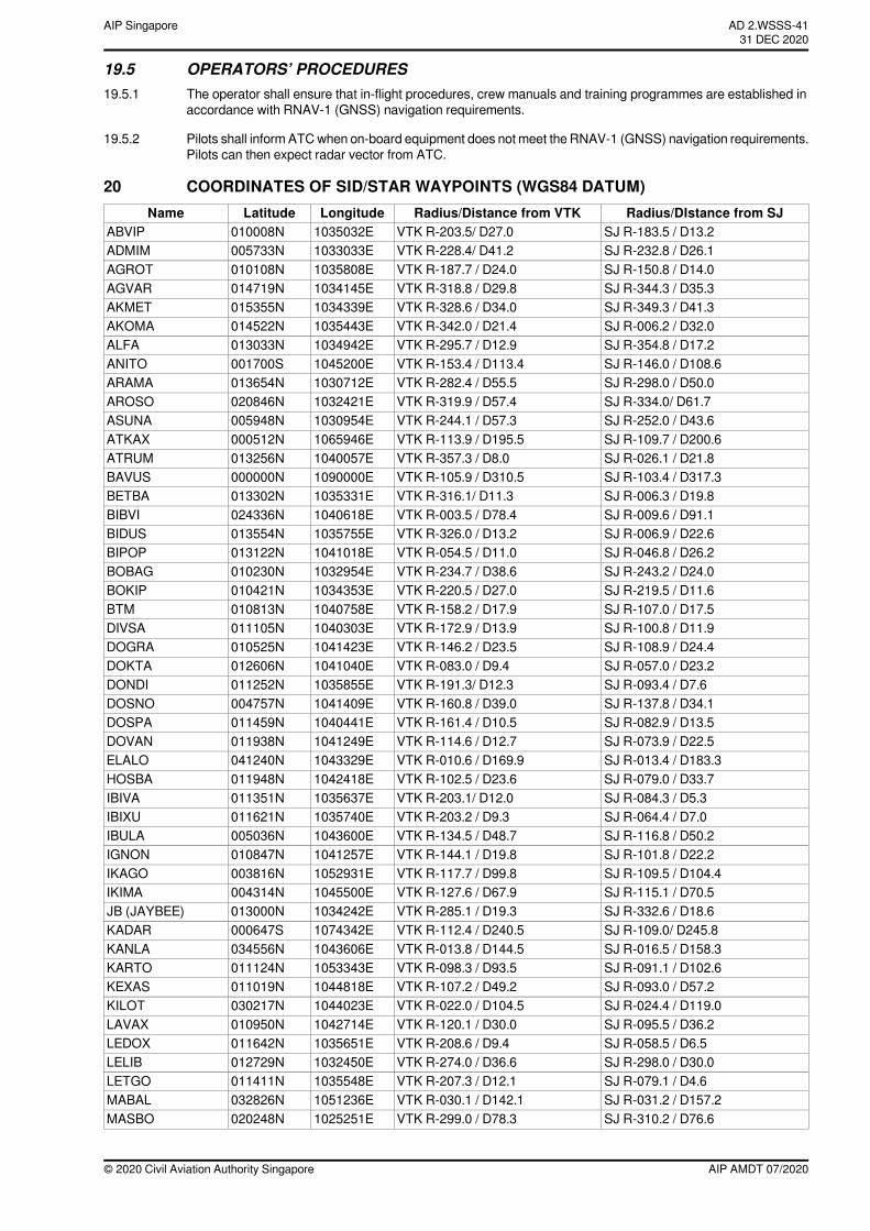
19.5 OPERATORS’ PROCEDURES19.5.1 The operator shall ensure that in-flight procedures, crew manuals and training programmes are established in
accordance with RNAV-1 (GNSS) navigation requirements.
19.5.2 Pilots shall inform ATCwhen on-board equipment does not meet the RNAV-1 (GNSS) navigation requirements.Pilots can then expect radar vector from ATC.
20 COORDINATES OF SID/STAR WAYPOINTS (WGS84 DATUM)Radius/DIstance from SJRadius/Distance from VTKLongitudeLatitudeName
SJ R-183.5 / D13.2VTK R-203.5/ D27.01035032E010008NABVIPSJ R-232.8 / D26.1VTK R-228.4/ D41.21033033E005733NADMIMSJ R-150.8 / D14.0VTK R-187.7 / D24.01035808E010108NAGROTSJ R-344.3 / D35.3VTK R-318.8 / D29.81034145E014719NAGVARSJ R-349.3 / D41.3VTK R-328.6 / D34.01034339E015355NAKMETSJ R-006.2 / D32.0VTK R-342.0 / D21.41035443E014522NAKOMASJ R-354.8 / D17.2VTK R-295.7 / D12.91034942E013033NALFASJ R-146.0 / D108.6VTK R-153.4 / D113.41045200E001700SANITOSJ R-298.0 / D50.0VTK R-282.4 / D55.51030712E013654NARAMASJ R-334.0/ D61.7VTK R-319.9 / D57.41032421E020846NAROSOSJ R-252.0 / D43.6VTK R-244.1 / D57.31030954E005948NASUNASJ R-109.7 / D200.6VTK R-113.9 / D195.51065946E000512NATKAXSJ R-026.1 / D21.8VTK R-357.3 / D8.01040057E013256NATRUMSJ R-103.4 / D317.3VTK R-105.9 / D310.51090000E000000NBAVUSSJ R-006.3 / D19.8VTK R-316.1/ D11.31035331E013302NBETBASJ R-009.6 / D91.1VTK R-003.5 / D78.41040618E024336NBIBVISJ R-006.9 / D22.6VTK R-326.0 / D13.21035755E013554NBIDUSSJ R-046.8 / D26.2VTK R-054.5 / D11.01041018E013122NBIPOPSJ R-243.2 / D24.0VTK R-234.7 / D38.61032954E010230NBOBAGSJ R-219.5 / D11.6VTK R-220.5 / D27.01034353E010421NBOKIPSJ R-107.0 / D17.5VTK R-158.2 / D17.91040758E010813NBTMSJ R-100.8 / D11.9VTK R-172.9 / D13.91040303E011105NDIVSASJ R-108.9 / D24.4VTK R-146.2 / D23.51041423E010525NDOGRASJ R-057.0 / D23.2VTK R-083.0 / D9.41041040E012606NDOKTASJ R-093.4 / D7.6VTK R-191.3/ D12.31035855E011252NDONDISJ R-137.8 / D34.1VTK R-160.8 / D39.01041409E004757NDOSNOSJ R-082.9 / D13.5VTK R-161.4 / D10.51040441E011459NDOSPASJ R-073.9 / D22.5VTK R-114.6 / D12.71041249E011938NDOVANSJ R-013.4 / D183.3VTK R-010.6 / D169.91043329E041240NELALOSJ R-079.0 / D33.7VTK R-102.5 / D23.61042418E011948NHOSBASJ R-084.3 / D5.3VTK R-203.1/ D12.01035637E011351NIBIVASJ R-064.4 / D7.0VTK R-203.2 / D9.31035740E011621NIBIXUSJ R-116.8 / D50.2VTK R-134.5 / D48.71043600E005036NIBULASJ R-101.8 / D22.2VTK R-144.1 / D19.81041257E010847NIGNONSJ R-109.5 / D104.4VTK R-117.7 / D99.81052931E003816NIKAGOSJ R-115.1 / D70.5VTK R-127.6 / D67.91045500E004314NIKIMASJ R-332.6 / D18.6VTK R-285.1 / D19.31034242E013000NJB (JAYBEE)SJ R-109.0/ D245.8VTK R-112.4 / D240.51074342E000647SKADARSJ R-016.5 / D158.3VTK R-013.8 / D144.51043606E034556NKANLASJ R-091.1 / D102.6VTK R-098.3 / D93.51053343E011124NKARTOSJ R-093.0 / D57.2VTK R-107.2 / D49.21044818E011019NKEXASSJ R-024.4 / D119.0VTK R-022.0 / D104.51044023E030217NKILOTSJ R-095.5 / D36.2VTK R-120.1 / D30.01042714E010950NLAVAXSJ R-058.5 / D6.5VTK R-208.6 / D9.41035651E011642NLEDOXSJ R-298.0 / D30.0VTK R-274.0 / D36.61032450E012729NLELIBSJ R-079.1 / D4.6VTK R-207.3 / D12.11035548E011411NLETGOSJ R-031.2 / D157.2VTK R-030.1 / D142.11051236E032826NMABALSJ R-310.2 / D76.6VTK R-299.0 / D78.31025251E020248NMASBO
AIP AMDT 07/2020© 2020 Civil Aviation Authority Singapore
AD 2.WSSS-4131 DEC 2020
AIP Singapore
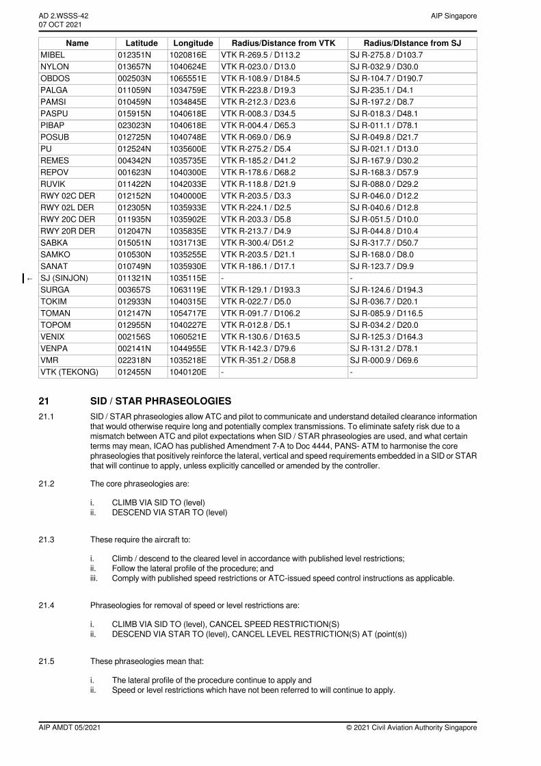
Radius/DIstance from SJRadius/Distance from VTKLongitudeLatitudeNameSJ R-275.8 / D103.7VTK R-269.5 / D113.21020816E012351NMIBELSJ R-032.9 / D30.0VTK R-023.0 / D13.01040624E013657NNYLONSJ R-104.7 / D190.7VTK R-108.9 / D184.51065551E002503NOBDOSSJ R-235.1 / D4.1VTK R-223.8 / D19.31034759E011059NPALGASJ R-197.2 / D8.7VTK R-212.3 / D23.61034845E010459NPAMSISJ R-018.3 / D48.1VTK R-008.3 / D34.51040618E015915NPASPUSJ R-011.1 / D78.1VTK R-004.4 / D65.31040618E023023NPIBAPSJ R-049.8 / D21.7VTK R-069.0 / D6.91040748E012725NPOSUBSJ R-021.1 / D13.0VTK R-275.2 / D5.41035600E012524NPUSJ R-167.9 / D30.2VTK R-185.2 / D41.21035735E004342NREMESSJ R-168.3 / D57.9VTK R-178.6 / D68.21040300E001623NREPOVSJ R-088.0 / D29.2VTK R-118.8 / D21.91042033E011422NRUVIKSJ R-046.0 / D12.2VTK R-203.5 / D3.31040000E012152NRWY 02C DERSJ R-040.6 / D12.8VTK R-224.1 / D2.51035933E012305NRWY 02L DERSJ R-051.5 / D10.0VTK R-203.3 / D5.81035902E011935NRWY 20C DERSJ R-044.8 / D10.4VTK R-213.7 / D4.91035835E012047NRWY 20R DERSJ R-317.7 / D50.7VTK R-300.4/ D51.21031713E015051NSABKASJ R-168.0 / D8.0VTK R-203.5 / D21.11035255E010530NSAMKOSJ R-123.7 / D9.9VTK R-186.1 / D17.11035930E010749NSANAT--1035115E011321NSJ (SINJON)←SJ R-124.6 / D194.3VTK R-129.1 / D193.31063119E003657SSURGASJ R-036.7 / D20.1VTK R-022.7 / D5.01040315E012933NTOKIMSJ R-085.9 / D116.5VTK R-091.7 / D106.21054717E012147NTOMANSJ R-034.2 / D20.0VTK R-012.8 / D5.11040227E012955NTOPOMSJ R-125.3 / D164.3VTK R-130.6 / D163.51060521E002156SVENIXSJ R-131.2 / D78.1VTK R-142.3 / D79.61044955E002141NVENPASJ R-000.9 / D69.6VTK R-351.2 / D58.81035218E022318NVMR--1040120E012455NVTK (TEKONG)
21 SID / STAR PHRASEOLOGIES21.1 SID / STAR phraseologies allow ATC and pilot to communicate and understand detailed clearance information
that would otherwise require long and potentially complex transmissions. To eliminate safety risk due to amismatch between ATC and pilot expectations when SID / STAR phraseologies are used, and what certainterms may mean, ICAO has published Amendment 7-A to Doc 4444, PANS- ATM to harmonise the corephraseologies that positively reinforce the lateral, vertical and speed requirements embedded in a SID or STARthat will continue to apply, unless explicitly cancelled or amended by the controller.
21.2 The core phraseologies are:
i. CLIMB VIA SID TO (level)ii. DESCEND VIA STAR TO (level)
21.3 These require the aircraft to:
i. Climb / descend to the cleared level in accordance with published level restrictions;ii. Follow the lateral profile of the procedure; andiii. Comply with published speed restrictions or ATC-issued speed control instructions as applicable.
21.4 Phraseologies for removal of speed or level restrictions are:
i. CLIMB VIA SID TO (level), CANCEL SPEED RESTRICTION(S)ii. DESCEND VIA STAR TO (level), CANCEL LEVEL RESTRICTION(S) AT (point(s))
21.5 These phraseologies mean that:
i. The lateral profile of the procedure continue to apply andii. Speed or level restrictions which have not been referred to will continue to apply.
© 2021 Civil Aviation Authority SingaporeAIP AMDT 05/2021
AIP SingaporeAD 2.WSSS-4207 OCT 2021~~~eaip-amdt~~~ver-date-2021-09-09T07-08-00-035
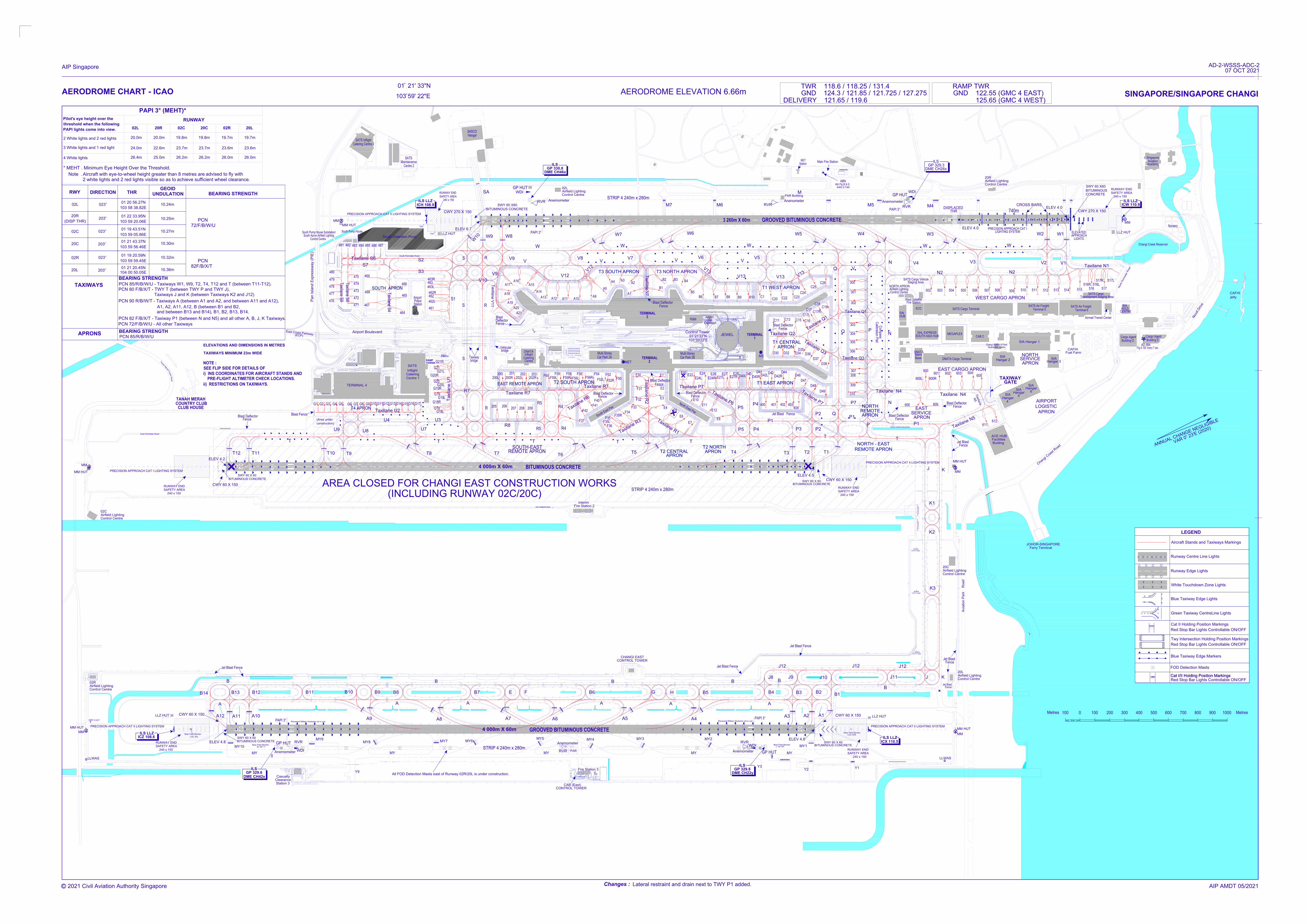
AIRPORT BOULEVARD
Hangar 3
T2 CENTRAL
E20
E6
Fuel Farm
D35
Cargo Agent
Building D
ILS LLZ
ICW 110.9
Singapore
Aviation
Academy
Changi Creek Reservoir
CAFHI
jetty
N
i
c
o
l
l
D
r
i
v
e
Cargo Agent
Building E
DME CH26x
GP 329.3
GP HUT
SIN
HUB
NORTH APRON
ELEVATED
PRECISION APPROACH CAT I
740m
APPROACH
CWY 270 X 150
SWY 60 X60
BITUMINOUS
CONCRETE
LIGHTS
CROSS BARS
ELEV 4.0
W1W2
LIGHTING SYSTEM
ELEV 4.0
DISPLACED
THR
W3
Airmail Transit Center
WEST CARGO APRON
AD IBN
Flg G 'SS' every 7 sec
Terminal 6
SATS Air Freight
SATS Air Freight
Terminal 5
SIA Hangar 1
508507506505504503
509
502
V3
V4
N2
SATS Cargo Terminal
MEGAPLEX
CAB C
ECC
3 260m X 60m
PAR Building
ABN
Altn Flg W & G
every 2.3 sec
Main Fire Station
MET
Station
PAPI 3°
ILS
W4W5
GROOVED BITUMINOUS CONCRETE
RVR
W6
C23
301
300
V
1
3
C26
C24
C25
302
Calibration PadCompass304
303
305
C16
C15
C18
C19
C17
V5
V13
V6
V
1
3
B5
B4
Control Tower
B9
C13
C11
C22
C20
B10
C1
1
TERMINAL
B8B7
B6
01°21'33"N
103°59'22"E
2 white lights and 2 red lights visible so as to
Aircraft with eye-to-wheel height greater than 8 metres are
AERODROME CHART - ICAO
PAPI lights come into view.
threshold when the following
Pilot's eye height over the
2 White lights and 2 red lights
3 White lights and 1 red light
4 White lights
Note .
* MEHT . Minimum Eye Height Over the Threshold.
24.0m
26.4m
achieve sufficient wheel clearance.
25.0m
22.6m
PAPI 3° (MEHT)*
20.0m
02L
RUNWAY
20.0m
20R 02C
PRECISION APPROACH CAT II LIGHTING SYSTEM
Taxilane N4
Base
LOGISTIC
CAFHI
SIA
NORTH
APRON
SERVICE
APRON
AIRPORT
Blast Deflector
606
Fence
603
DNATA Cargo Terminal
SIA
Hangar 2
604
602601
EAST CARGO APRON
609
EAST
V
A
R
0
2
3
'E
(
2
0
2
0
)
A
N
N
U
A
L
C
H
A
N
G
E
N
E
G
L
I
G
I
B
L
E
26.2m
23.7m
19.8m
20C
ELEV 4.5
403
404
308
306
307
309
310
D37
D38
D36
D34
D49
D48
D47
REMOTE APRON
NORTH - EAST
APRON
P1
REMOTE
NORTH
T2
402401400P4
P5
E11
N
o
r
t
h
E
a
s
t
P
i
e
r
E28
D41
D40
D32D30
D44
D42
AIS
E26
E22
Multi-Storey
Car Park 2B
T4
P3P4
P1
T3
P5
E12
E8
E7
T2 NORTH
APRON
T
CWY 60 X 150
240 x 150
SAFETY AREA
RUNWAY END
BITUMINOUS CONCRETE
SWY 60 X 60
ii) RESTRICTIONS ON TAXIWAYS.
Vehicular
bridge
(EC
P)
ELEV 6.7
CWY 270 X 150
W8W9
W7
GP 330.8
DME CH46x
ILS
SASCO
SWY 60 X60
BITUMINOUS CONCRETE
Anemometer
RVR
WDI
PAPI 3°
W
1
0
V7
B3B2
A2
V8
A4
A3
V
1
2
V9
W
V
R
Catering Centre 2
SATS Inflight
ILS LLZ
ICH 108.9
RUNWAY END
SAFETY AREA
240 x 150
MM
Station
Police
Airport Boulevard
Pa
n Isla
nd
E
xp
re
ssw
ay (P
IE
)
PRE-FLIGHT ALTIMETER CHECK LOCATIONS.
i) INS COORDINATES FOR AIRCRAFT STANDS AND
BITUMINOUS CONCRETE
SWY 60 X 60
ELEVATIONS AND DIMENSIONS IN METRES
S
F58
E4
F41
S
o
u
t
h
E
a
s
t
P
i
e
r
TERMINAL
E1
MET
2
E3
E2
F31
F30
F32
F50
F52L
F54F56
Multi-Storey
Car Park 2A
F40
E5
F33
APRON
T5
F34
F35
F36
F37
F42
T
R5
201
F59
203202
DNATA
Inflight
Catering
200
R
Taxiway
bridge
S
SOUTH-EAST
REMOTE APRON
207
R5
R4
R4
209208
T6
T
R
206205
T7
STRIP 4 240m x 280m
Inflight
Catering
Centre 1
G19L
SATS
G18
T8
T
T9
SEE FLIP SIDE FOR DETAILS OF
TAXIWAYS MINIMUM 23m WIDE
NOTE :
T10
T
T11T12
ELEV 4.2
TANAH MERAH
COUNTRY CLUB
CLUB HOUSE
PRECISION APPROACH CAT I LIGHTING SYSTEM
240 x 150
SAFETY AREA
RUNWAY END
CWY 60 X 150
Metres Metres100 0 100 200 300 400 500 600 700 800 900 1000
V13
AERODROME ELEVATION 6.66m
TWR 118.6 / 118.25 / 131.4
SINGAPORE/SINGAPORE CHANGI
Runway Edge Lights
Red Stop Bar Lights Controllable ON/OFF
Blue Taxiway Edge Markers
Red Stop Bar Lights Controllable ON/OFF
Twy Intersection Holding Position Markings
White Touchdown Zone Lights
Blue Taxiway Edge Lights
Green Taxiway CentreLine Lights
Cat II Holding Position Markings
LEGEND
Aircraft Stands and Taxiways Markings
Runway Centre Line Lights
DHL EXPRESS
G9
U3
Taxilane U2
U7
Blast Deflector
Fence
V12
PUMP STN.SOUTH
G17G16G15G8
Taxilane R7
A10A11A12
A13
A14
A15
A16
A17
A18
A19
A20
A21
V10
B1
A1
A5
A9
Ta
xila
ne
R
2
Hotel
Hangar
4 000m X 60m
BITUMINOUS CONCRETE
TERMINAL
3
TAXIWAY
Hangar
SIA
Hangar
SIA
5
4
MM HUT
G14G13G12G11G10
Blast
Blast Deflector
Fence
Fence
Deflector
T1
T
T
Taxilane V
11
T
a
x
i
l
a
n
e
R
1
T
a
x
i
l
a
n
e
R
3
Anenometer
P7
DNATA
Maint
Blast Deflector
Fence
APRON
Blast Deflector
Fence
T
a
x
i
l
a
n
e
R
6
E10
Blast Deflector
Fence
Blast Deflector
Fence
F52R
F52
Hangar
SIA
6
WDI
Anemometer
RVR
N
5
T
a
x
ila
n
e
612
611
GATE
F59L F59R
F56L
F56R
E24L E24R
E24
U4
U8
U9
G7G6G5G4
F60
G21
G20
G20R
G21R
G21L
G20L
200L 200R 202L 202R
Facilities
ACE HUB
Buiding
Nursery
SA
G3G2G1
GND 124.3 / 121.85 / 121.725 / 127.275
DELIVERY 121.65 / 119.6
Airport
LLZ HUT
LLZ HUT
M5
M4
MM
South Detention Pond
South Pump House
South Apron Airfield Lighting
Jet Blast Fence
D46
V1
Airfield Lighting
Control Centre
Taxilane N1
515
516 517
516R 516L
517R 517L
SATS Cargo
Transhipment Staging Area
M6M7
SATS Cargo Vehicle
Staging Area
Airfield Lighting
V2
N
o
r
t
h
P
e
r
i
m
e
t
e
r
R
o
a
d
513512
511510 514
M
605
TOWERRAMP
26.2m
23.7m
19.8m
Airport
Hotel
Extension
Centre
T3 SOUTH APRON
D42L
D42R
600
600L 600R
F35R
F35L
MM HUT
MM
West Satellite
Fire Station
Control Centre
463R
463
463L
462R
462
462L
240 x 150
SAFETY AREA
RUNWAY END
GP HUT
SIA
AULD
CENTRE
APRON
SERVICE
461
S1
S
PRECISION APPROACH CAT II LIGHTING SYSTEM
Maintainance
Centre 2
SATS
EAST REMOTE APRON
T2 SOUTH APRON
R8
Ta
xila
ne
U
1
R
S
Taxilane R7Taxilane P7
T1 EAST APRON
Taxilane V
7
T1 CENTRAL
Taxilane Q2
T
a
x
i
l
a
n
e
Q
1
T
a
x
i
l
a
n
e
Q
3
T1 WEST APRON
T
a
x
i
l
a
n
e
P
7
G19
G19R
G18R
G18L
T4 APRON
TERMINAL 4
JEWEL
East Perimeter Road
T
a
n
a
h
M
e
r
a
h
E27
E27L
E27R
D40L
D40R
/
/
/
/
SOUTH ASIA HUB
466
465
464
467
468
469
Taxilane S
4
S2
S3
South Perimeter Road
(Area under
construction)
Blast Fence
RAMP TWR
GND 122.55 (GMC 4 EAST)
125.65 (GMC 4 WEST)
EAST PERIMETER ROAD
Chain
Chain
Airfield Lighting
Control Centre
02C
20R
Airfield Lighting
Control Centre
02L
Airfield Lighting
Control Centre
20C
C
h
a
n
g
i
C
o
a
s
t
R
o
a
d
JOHOR-SINGAPORE
Ferry Terminal
T3 NORTH APRON
S7
Taxilane S6
481 482
483 484 485486
487
FOD Detection Masts
SOUTH APRON
C
o
a
s
t
R
o
a
d
C17R
C17L
475
474
473
472
471
480
478
477
476
479
Taxilane S
8
Taxilane S
9
P2
P2
Taxilane Q1
Taxilane Q3
Changi Animal & Plant
Quarantine Station
Taxilane N4
N2
N
N
P
P
Q
Q
Q
Fire Station 2
Interim
T
a
x
i
l
a
n
e
P
6
01 21' 33"N
103 59' 22"E
o
o
Avia
tio
n P
ark
R
oa
d
MM
LLZ HUT
LLZ HUT
MM
MM HUT
MY10
MY
B
B13
B14
B12 B11 B9 B8 B7 E F B6G
H B5B4
B3B2
B1
B
B
B
A
A
A
J8 J9J10
J11
J12
J K
J12
B
A3
A2A1
A4A5
A6A7
A8
A9
A10A11
A12
A
AA
B
MY9
MY8
MY7MY6
MY5
MY4
MY3MY2
MY1
MYMYMY MY
Y3
Y2
P1
T
a
x
i
l
a
n
e
N
5
K3
K2
K1
J
K
Y9
CWY 60 X 150
BITUMINOUS CONCRETE
SWY 60 X 60
4 000m X 60m
GROOVED BITUMINOUS CONCRETE
BITUMINOUS CONCRETE
SWY 60 X 60
CWY 60 X 150
240 x 150
SAFETY AREA
RUNWAY END
STRIP 4 240m x 280m
ILS LLZ
ILS LLZ
MM
MM HUT
CHANGI EAST
CONTROL TOWER
Y1
Clearance
Casualty
Station 3
ELEV 4.8
ELEV 4.8
02R
26.0m
23.6m
19.7m
20L
26.0m
23.6m
19.7m
Anemometer
RVR
DME CH42x
WDI
ILS
GP 329.6
CAB (East)
CONTROL TOWER
Fire Station 3
Anemometer
RVR
WDI
ILS
GP 329.8
DME CH22y
J12
Anemometer
RVR
PAR
Airfield Lighting
Control Centre
20L
Airfield Lighting
Control Centre
02R
Near Field Monitor
LOC 20L
Near Field Monitor
LOC 02R
Near Field Monitor
for GP
Near Field Monitor
for GP
240 x 150
SAFETY AREA
RUNWAY END
GP HUT
Recessed Military Hookwire not in use
MM HUT
GP HUT
PAPI 3°
WW
W
W
V
V
V
V
V9
PAPI 3°
o
PCN 80 F/B/X/T - TWY T (between TWY P and TWY J),
PCN 90 R/B/W/T - Taxiways A (between A1 and A2, and between A11 and A12),
A1, A2, A11, A12, B (between B1 and B2,
and between B13 and B14), B1, B2, B13, B14.
PCN 82 F/B/X/T - Taxiway P1 (between N and N5) and all other A, B, J, K Taxiways.
STRIP 4 240m x 280m
PRECISION APPROACH CAT II LIGHTING SYSTEM PRECISION APPROACH CAT II LIGHTING SYSTEM
ICZ 108.6
ICX 110.5
Red Stop Bar Lights Controllable ON/OFF
Cat I/II Holding Position MarkingsCat I/II Holding Position Markings
72/F/B/W/U
BEARING STRENGTH
(DISP THR)
APRONS
20C
02C
20R
02L
RWY
01 21 43.37N
103 59 56.46E
PCN 85/R/B/W/U
10.30m
01 19 43.51N
103 59 05.86E
01 22 33.95N
103 59 20.06E
01 20 56.27N
103 58 38.82E
DIRECTION THR
10.27m
10.25m
10.24m
GEOID
UNDULATION
PCN
TAXIWAYS
PCN 85/R/B/W/U - Taxiways W1, W9, T2, T4, T12 and T (between T11-T12).
PCN 72/F/B/W/U - All other Taxiways
BEARING STRENGTH
BEARING STRENGTH
023
203
o
o
023
o
203
o
20L
02R
01 21 20.45N
10.36m
01 19 20.59N
103 59 59.45E
10.32m 023
o
203
o
104 00 50.05E
82F/B/X/T
PCN
advised to fly with
East C
oast P
arkw
ay
LLWAS
FSM
FSM
FSM
LLWAS
Jet Blast Fence
N
P
B10
Recessed Military Hookwire not in use
All FOD Detection Masts east of Runway 02R/20L is under construction.
Jet Blast Fence
Jet Blast Fence
CCTV mast
Airfield
CCTV mast
Airfield
CCTV mast
Airfield
Jet Blast
Fence
Jet Blast
Fence
Jet Blast
Fence
c
AIP Singapore
Changes :Lateral restraint and drain next to TWY P1 added.
AD-2-WSSS-ADC-2 07 OCT 2021
AIP AMDT 05/2021
AREA CLOSED FOR CHANGI EAST CONSTRUCTION WORKS
REP 3 HUT
2021 Civil Aviation Authority Singapore
(INCLUDING RUNWAY 02C/20C)
RE
MO
VA
BLE
C
ON
CR
ET
E
BLO
CK
B
AR
RIE
R
RE
MO
VA
BLE
C
ON
CR
ET
E
BLO
CK
B
AR
RIE
R
South Pump House Substation/
Control Centre
R7
Taxiways J and K (between Taxiways K2 and J12)
Blast Deflector
Fence
Lateral restraint along drain
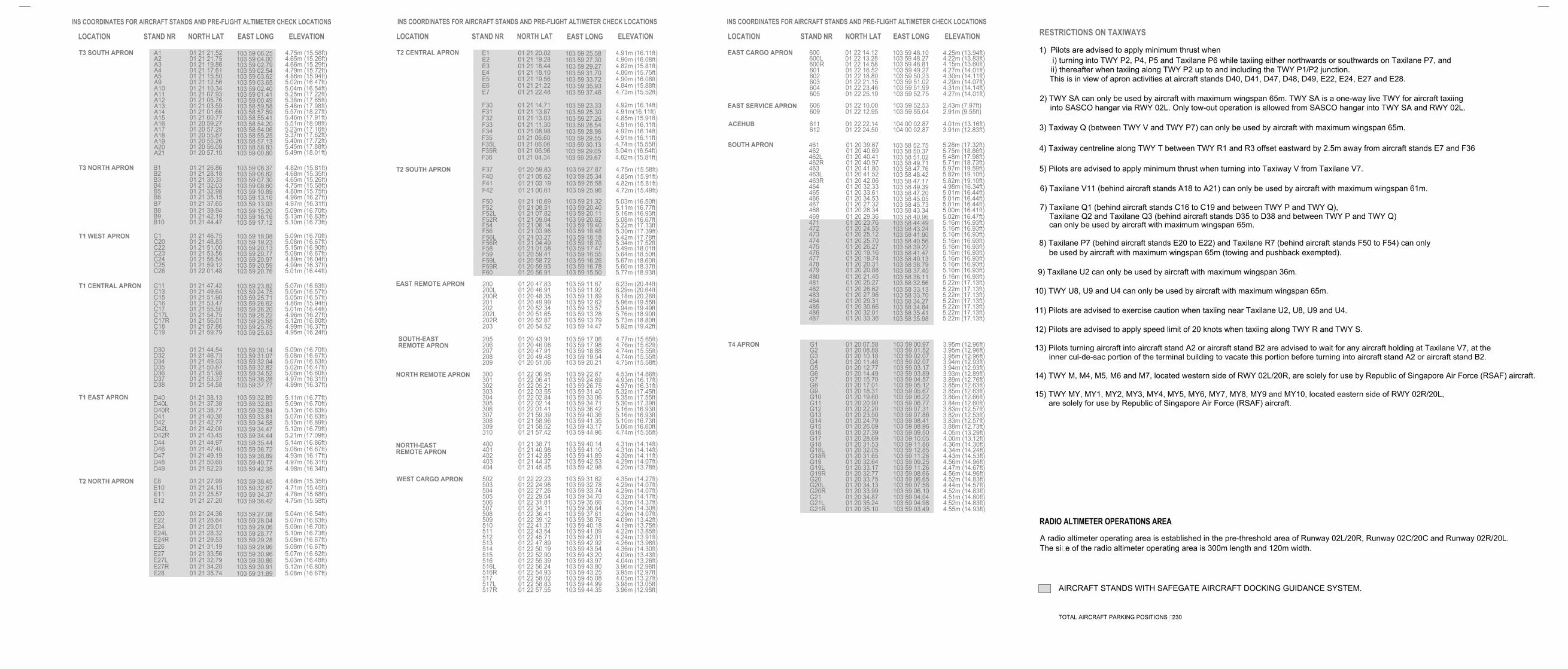
RESTRICTIONS ON TAXIWAYS
2) TWY SA can only be used by aircraft with maximum wingspan 65m. TWY SA is a one-way live TWY for aircraft taxiing
into SASCO hangar via RWY 02L. Only tow-out operation is allowed from SASCO hangar into TWY SA and RWY 02L.
5) Pilots are advised to apply minimum thrust when turning into Taxiway V from Taxilane V7.
6) Taxilane V11 (behind aircraft stands A18 to A21) can only be used by aircraft with maximum wingspan 61m.
4) Taxiway centreline along TWY T between TWY R1 and R3 offset eastward by 2.5m away from aircraft stands E7 and F36
Taxilane Q2 and Taxilane Q3 (behind aircraft stands D35 to D38 and between TWY P and TWY Q)
7) Taxilane Q1 (behind aircraft stands C16 to C19 and between TWY P and TWY Q),
can only be used by aircraft with maximum wingspan 65m.
9) Taxilane U2 can only be used by aircraft with maximum wingspan 36m.
be used by aircraft with maximum wingspan 65m (towing and pushback exempted).
8) Taxilane P7 (behind aircraft stands E20 to E22) and Taxilane R7 (behind aircraft stands F50 to F54) can only
3) Taxiway Q (between TWY V and TWY P7) can only be used by aircraft with maximum wingspan 65m.
1) Pilots are advised to apply minimum thrust when
i) turning into TWY P2, P4, P5 and Taxilane P6 while taxiing either northwards or southwards on Taxilane P7, and
ii) thereafter when taxiing along TWY P2 up to and including the TWY P1/P2 junction.
This is in view of apron activities at aircraft stands D40, D41, D47, D48, D49, E22, E24, E27 and E28.
11) Pilots are advised to exercise caution when taxiing near Taxilane U2, U8, U9 and U4.
10) TWY U8, U9 and U4 can only be used by aircraft with maximum wingspan 65m.
12) Pilots are advised to apply speed limit of 20 knots when taxiing along TWY R and TWY S.
13) Pilots turning aircraft into aircraft stand A2 or aircraft stand B2 are advised to wait for any aircraft holding at Taxilane V7, at the
inner cul-de-sac portion of the terminal building to vacate this portion before turning into aircraft stand A2 or aircraft stand B2.
The size of the radio altimeter operating area is 300m length and 120m width.
A radio altimeter operating area is established in the pre-threshold area of Runway 02L/20R, Runway 02C/20C and Runway 02R/20L.
14) TWY M, M4, M5, M6 and M7, located western side of RWY 02L/20R, are solely for use by Republic of Singapore Air Force (RSAF) aircraft.
15) TWY MY, MY1, MY2, MY3, MY4, MY5, MY6, MY7, MY8, MY9 and MY10, located eastern side of RWY 02R/20L,
are solely for use by Republic of Singapore Air Force (RSAF) aircraft.
AIRCRAFT STANDS WITH SAFEGATE AIRCRAFT DOCKING GUIDANCE SYSTEM.
TOTAL AIRCRAFT PARKING POSITIONS : 230
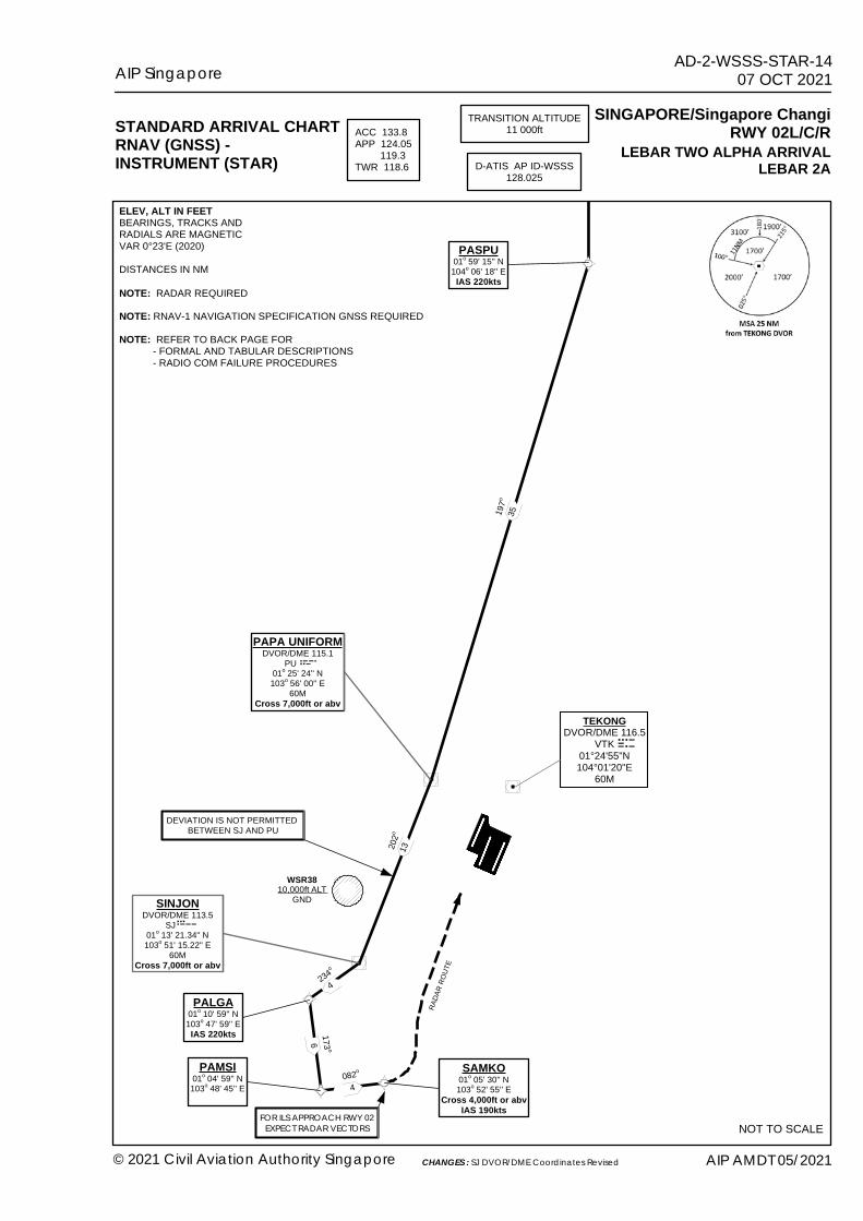
PAPA UNIFORMDVOR/DME 115.1
PU 01o 25' 24'' N103o 56' 00'' E
60MCross 7,000ft or abv
DEVIATION IS NOT PERMITTED BETWEEN SJ AND PU
PASPU01o 59' 15'' N104o 06' 18'' EIAS 220kts
SINJONDVOR/DME 113.5
SJ 01o 13' 21.34'' N103o 51' 15.22'' E
60MCross 7,000ft or abv
PALGA01o 10' 59'' N103o 47' 59'' EIAS 220kts
PAMSI01o 04' 59'' N103o 48' 45'' E
SAMKO01o 05' 30'' N103o 52' 55'' E
Cross 4,000ft or abvIAS 190kts
202o
4234o
4082o
WSR3810,000ft ALT
GND
197o
173 o
6
STANDARD ARRIVAL CHARTRNAV (GNSS) -INSTRUMENT (STAR)
SINGAPORE/Singapore ChangiRWY 02L/C/R
TRANSITION ALTITUDE11 000ftACC 133.8
APP 124.05 119.3TWR 118.6 D-ATIS AP ID-WSSS
128.025
NOT TO SCALE
LEBAR TWO ALPHA ARRIVALLEBAR 2A
35
13
NOTE: RADAR REQUIREDNOTE: RNAV-1 NAVIGATION SPECIFICATION GNSS REQUIRED NOTE: REFER TO BACK PAGE FOR - FORMAL AND TABULAR DESCRIPTIONS - RADIO COM FAILURE PROCEDURES
ELEV, ALT IN FEETBEARINGS, TRACKS ANDRADIALS ARE MAGNETICVAR 0°23'E (2020)DISTANCES IN NM
RADA
R ROU
TE
FOR ILS APPROACH RWY 02EXPECT RADAR VECTORS
AIP Singapore AD-2-WSSS-STAR-1407 OCT 2021
© 2021 Civil Aviation Authority Singapore AIP AMDT 05/2021CHANGES : SJ DVOR/DME Coordinates Revised
TEKONGDVOR/DME 116.5
VTK01°24'55"N104°01'20"E
60M
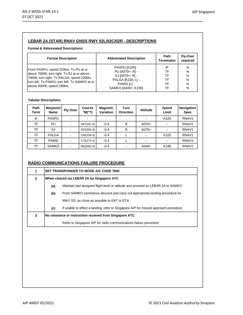
AD-2-WSSS-STAR-14.1
07 OCT 2021AIP Singapore
LEBAR 2A (STAR) RNAV GNSS RWY 02L/02C/02R - DESCRIPTIONS
Formal & Abbreviated Descriptions
Tabular Descriptions
IF PASPU - - - - - K220 RNAV1
TF PU - 197(197.4) -0.4 R A070+ - RNAV1
TF SJ - 202(202.4) -0.4 R A070+ - RNAV1
TF PALGA - 234(234.4) -0.4 L - K220 RNAV1
TF PAMSI - 173(173.4) -0.4 L - - RNAV1
TF SAMKO - 082(082.4) -0.4 - A040+ K190 RNAV1
RADIO COMMUNICATIONS FAILURE PROCEDURE
1
2
(a)
(b)
(c)
3
- Refer to Singapore AIP for radio communications failure procedure
Fly-Over
required
Path
TerminatorFormal Description Abbreviated Description
SET TRANSPONDER TO MODE A/C CODE 7600
Turn
DirectionAltitude
Navigation
Spec
Speed
Limit
From PASPU, speed 220kts. To PU at or
above 7000ft, turn right. To SJ at or above
7000ft, turn right. To PALGA, speed 220kts,
turn left. To PAMSI, turn left. To SAMKO at or
above 4000ft, speed 190kts.
PASPU [K220] -
PU [A070+; R] -
SJ [A070+; R] -
PALGA [K220; L] -
PAMSI [L] -
SAMKO [A040+; K190]
IF
TF
TF
TF
TF
TF
N
N
N
N
N
N
Path
Term
Waypoint
Name
When cleared via LEBAR 2A by Singapore ATC
Fly-OverCourse
°M(°T)
Magnetic
Variation
No clearance or instruction received from Singapore ATC
RWY 02L as close as possible to EAT or ETA
If unable to effect a landing, refer to Singapore AIP for missed approach procedure
From SAMKO commence descent and carry out appropriate landing procedure for
Maintain last assigned flight level or altitude and proceed on LEBAR 2A to SAMKO
AIP AMDT 05/2021 © 2021 Civil Aviation Authority Sinapore
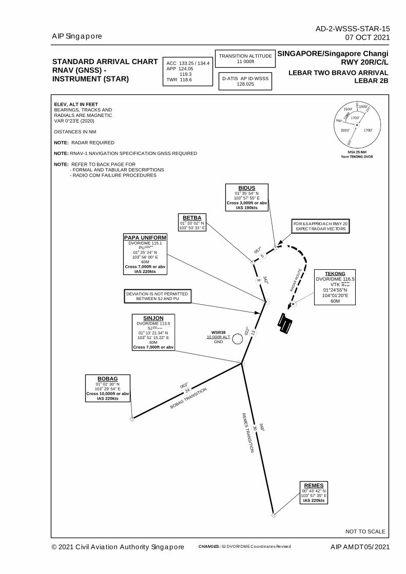
SINJONDVOR/DME 113.5
SJ 01o 13' 21.34'' N103o 51' 15.22'' E
60MCross 7,000ft or abv
PAPA UNIFORMDVOR/DME 115.1
PU 01o 25' 24'' N103o 56' 00'' E
60MCross 7,000ft or abv
IAS 220kts
BIDUS01o 35' 54'' N103o 57' 55'' E
Cross 3,000ft or abvIAS 190kts
30
13022o
REMES00o 43' 42'' N103o 57' 35'' EIAS 220kts
8 342 o
BETBA01o 33' 02'' N103o 53' 31'' E
5057o
DEVIATION IS NOT PERMITTED BETWEEN SJ AND PU
WSR3810,000ft ALT
GND
348 o
063o
24
BOBAG01o 02' 30'' N103o 29' 54'' E
Cross 10,000ft or abvIAS 220kts
STANDARD ARRIVAL CHARTRNAV (GNSS) -INSTRUMENT (STAR)
SINGAPORE/Singapore ChangiRWY 20R/C/LTRANSITION ALTITUDE
11 000ftACC 133.25 / 134.4APP 124.05 119.3TWR 118.6 D-ATIS AP ID-WSSS
128.025
NOT TO SCALE
LEBAR TWO BRAVO ARRIVALLEBAR 2B
BOBAG TRANSITION
REMES TRANSITION
RADA
R ROU
TE
FOR ILS APPROACH RWY 20EXPECT RADAR VECTORS
ELEV, ALT IN FEETBEARINGS, TRACKS ANDRADIALS ARE MAGNETICVAR 0°23'E (2020)DISTANCES IN NMNOTE: RADAR REQUIREDNOTE: RNAV-1 NAVIGATION SPECIFICATION GNSS REQUIRED NOTE: REFER TO BACK PAGE FOR - FORMAL AND TABULAR DESCRIPTIONS - RADIO COM FAILURE PROCEDURES
TEKONGDVOR/DME 116.5
VTK01°24'55"N104°01'20"E
60M
AIP SingaporeAD-2-WSSS-STAR-15
07 OCT 2021
© 2021 Civil Aviation Authority Singapore AIP AMDT 05/2021CHANGES : SJ DVOR/DME Coordinates Revised
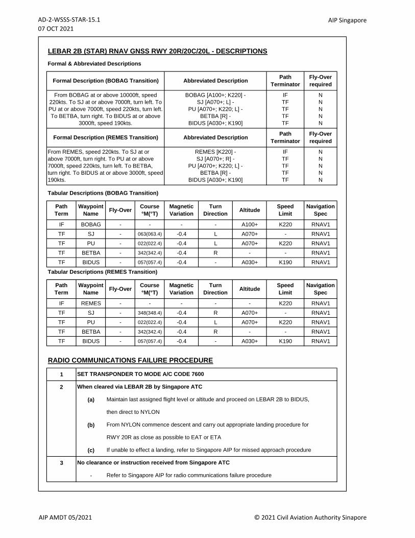
AD-2-WSSS-STAR-15.1
07 OCT 2021AIP Singapore
LEBAR 2B (STAR) RNAV GNSS RWY 20R/20C/20L - DESCRIPTIONS
Formal & Abbreviated Descriptions
Tabular Descriptions (BOBAG Transition)
IF BOBAG - - - - A100+ K220 RNAV1
TF SJ - 063(063.4) -0.4 L A070+ - RNAV1
TF PU - 022(022.4) -0.4 L A070+ K220 RNAV1
TF BETBA - 342(342.4) -0.4 R - - RNAV1
TF BIDUS - 057(057.4) -0.4 - A030+ K190 RNAV1
Tabular Descriptions (REMES Transition)
IF REMES - - - - - K220 RNAV1
TF SJ - 348(348.4) -0.4 R A070+ - RNAV1
TF PU - 022(022.4) -0.4 L A070+ K220 RNAV1
TF BETBA - 342(342.4) -0.4 R - - RNAV1
TF BIDUS - 057(057.4) -0.4 - A030+ K190 RNAV1
RADIO COMMUNICATIONS FAILURE PROCEDURE
1
2
(a)
(b)
(c)
3
- Refer to Singapore AIP for radio communications failure procedure
Fly-Over
required
Path
TerminatorFormal Description (BOBAG Transition) Abbreviated Description
SET TRANSPONDER TO MODE A/C CODE 7600
Turn
DirectionAltitude
Navigation
Spec
Speed
Limit
Path
Term
Waypoint
Name
When cleared via LEBAR 2B by Singapore ATC
Formal Description (REMES Transition) Abbreviated Description
Fly-OverCourse
°M(°T)
Magnetic
Variation
No clearance or instruction received from Singapore ATC
RWY 20R as close as possible to EAT or ETA
If unable to effect a landing, refer to Singapore AIP for missed approach procedure
From NYLON commence descent and carry out appropriate landing procedure for
Maintain last assigned flight level or altitude and proceed on LEBAR 2B to BIDUS,
then direct to NYLON
Turn
DirectionAltitude
Speed
Limit
Navigation
Spec
From BOBAG at or above 10000ft, speed
220kts. To SJ at or above 7000ft, turn left. To
PU at or above 7000ft, speed 220kts, turn left.
To BETBA, turn right. To BIDUS at or above
3000ft, speed 190kts.
IF
TF
TF
TF
TF
N
N
N
N
N
Fly-Over
required
From REMES, speed 220kts. To SJ at or
above 7000ft, turn right. To PU at or above
7000ft, speed 220kts, turn left. To BETBA,
turn right. To BIDUS at or above 3000ft, speed
190kts.
REMES [K220] -
SJ [A070+; R] -
PU [A070+; K220; L] -
BETBA [R] -
BIDUS [A030+; K190]
IF
TF
TF
TF
TF
N
N
N
N
N
BOBAG [A100+; K220] -
SJ [A070+; L] -
PU [A070+; K220; L] -
BETBA [R] -
BIDUS [A030+; K190]
Path
Terminator
Path
Term
Waypoint
NameFly-Over
Course
°M(°T)
Magnetic
Variation
AIP AMDT 05/2021 © 2021 Civil Aviation Authority Sinapore
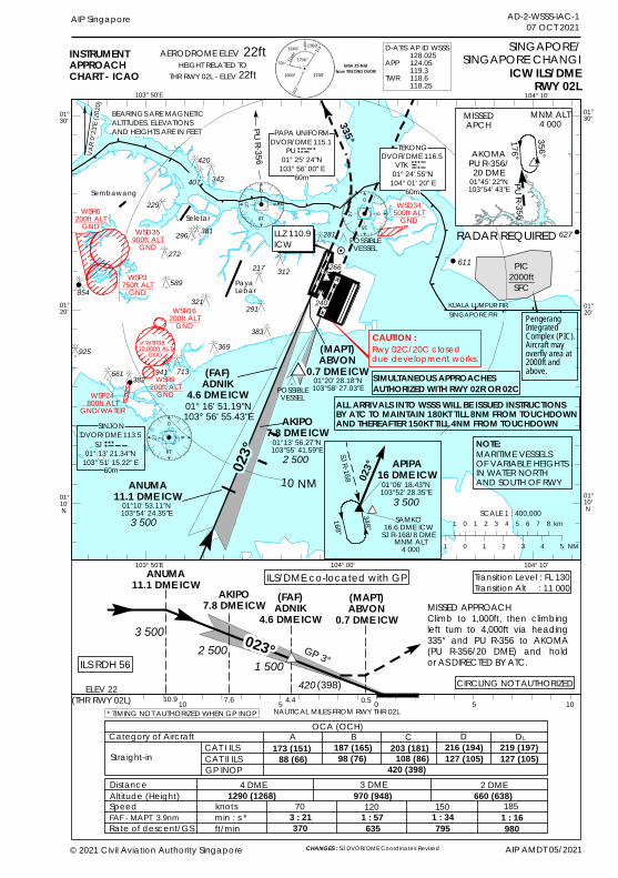
0
18
927
018
927
!(!(
!(
!(
!(
!(
0
18
927
627
611
602
AIP Singapore
BEARINGS ARE MAGNETICALTITUDES, ELEVATIONSAND HEIGHTS ARE IN FEET
103° 50'E
01°20' 01°
20'
01°10' N
© 2021 Civil Aviation Authority Singapore
104° 00'
01°10' N
INSTRUMENTAPPROACHCHART - ICAO ICW ILS/DME
RWY 02L
SINGAPORE/SINGAPORE CHANGI
103° 50'E 104° 00' 104° 10'
Seletar
023°
(FAF)ADNIK
4.6 DME ICW01° 16' 51.19"N103° 56' 55.43"E
POSSIBLEVESSEL
ELEV 22(THR RWY 02L) 10 5 0 5 10
MISSED APPROACH Climb to 1,000ft, then climbingleft turn to 4,000ft via heading335° and PU R-356 to AKOMA(PU R-356/20 DME) and holdor AS DIRECTED BY ATC.
Transition Level : FL 130Transition Alt : 11 000
GP 3°
(MAPT)ABVON
0.7 DME ICW
AKIPO7.8 DME ICW (FAF)
ADNIK4.6 DME ICW
3 500
1 500420 (398)
NAUTICAL MILES FROM RWY THR 02L
Sembawang
10 NM
OCA (OCH)Category of AircraftStraight-in
DistanceAltitude (Height)SpeedFAF - MAPT 3.9nmRate of descent/GS
4 DME 3 DME
knotsmin : s *ft/min
70 120 150 1851290 (1268) 970 (948)
3 : 21 1 : 57 1 : 34 1 : 16370 635 795 980
1 0 1 2 3 4 5 6 7 8 km
1 0 1 2 3 4 5 NM
PayaLebar
104° 10'
POSSIBLEVESSEL
H
PU R-356
KUALA LUMPUR FIRSINGAPORE FIR
ILS RDH 56
ILS/DME co-located with GP
CAT I ILSCAT II ILSGP INOP
2 DME660 (638)
01°30'
01°30'
SCALE 1 : 400,000
2 500
420 (398)
AERODROME ELEV 22ftHEIGHT RELATED TO
THR RWY 02L - ELEV 22ft
MARITIME VESSELSOF VARIABLE HEIGHTSIN WATER NORTH AND SOUTH OF RWY
NOTE:
ANUMA11.1 DME ICW
3 500
AKIPO7.8 DME ICW
2 500
DVOR/DME 116.5VTK
01° 24' 55"N104° 01' 20" E
TEKONG
60m
DVOR/DME 115.1PU
01° 25' 24"N103° 56' 00" E
PAPA UNIFORM
60m
335°
ANUMA11.1 DME ICW
(MAPT)ABVON
0.7 DME ICW
AIP AMDT 05/2021
0.54.47.6CIRCLING NOT AUTHORIZED
SIMULTANEOUS APPROACHESAUTHORIZED WITH RWY 02R OR 02C
* TIMING NOT AUTHORIZED WHEN GP INOP
01°20' 28.18"N103°58' 27.03"E
01°13' 56.27"N103°55' 41.59"E
01°10' 53.11"N103°54' 24.35"E
RADAR REQUIRED
#*023°
10.9
AD-2-WSSS-IAC-107 OCT 2021
A B C D173 (151) 187 (165) 203 (181) 216 (194)
88 (66) 98 (76) 108 (86) 127 (105)
DL219 (197)127 (105)
60m
#348°
MNM ALT4 000
168°
SAMKO16.6 DME ICW
SJ R-168/8 DME
SJR-168
01°06' 18.43"N103°52' 28.35"E
APIPA16 DME ICW
3 500
023°
WSD35900ft ALT
GND
WSD34500ft ALT
GND
WSP24800ft ALT
GND/WATER
WSP3750ft ALT
GND
WSR3810 000ft ALT
GND
DVOR/DME 113.5SINJON
SJ 01° 13' 21.34"N
103° 51' 15.22" E
LLZ 110.9ICW
321
589
272
296
229
407
420
312217
291
383
266
281
369
382941 713661
854
925
ALL ARRIVALS INTO WSSS WILL BE ISSUED INSTRUCTIONSBY ATC TO MAINTAIN 180KT TILL 8NM FROM TOUCHDOWNAND THEREAFTER 150KT TILL 4NM FROM TOUCHDOWN
342
381
240
WSR6200ft ALT
GND
WSR16200ft ALT
GND
WSR9200ft ALT
GND
D-ATISAPPTWR
AP ID WSSS128.025124.05119.3118.6118.25
PIC2000ftSFC
VAR0
°23'E
(2020
)
PengerangIntegratedComplex (PIC).Aircraft mayoverfly area at2000ft andabove.
Rwy 02C/20C closed due development works.
CAUTION :
X
X
PU R-356
01°45' 22"N103°54' 43"E
AKOMAPU R-356/20 DME
MISSEDAPCH
MNM ALT4 000
356°
176°
CHANGES : SJ DVOR/DME Coordinates Revised

PAGE INTENTIONALLY LEFT BLANK
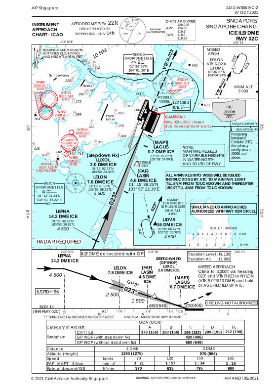
0
18
927
0
18
927
!!
!
!
!
!627
611
602
AIP AMDT 05/2021
AIP Singapore
103° 50'E
01°20'
01°20'
01°10' N
104° 00'
01°10' N
INSTRUMENTAPPROACHCHART - ICAO ICE ILS/DME
RWY 02C
SINGAPORE/SINGAPORE CHANGI
103° 50'E 104° 00' 104° 10'
Seletar
023°
POSSIBLEVESSEL
ELEV 14(THR RWY 02C) 10 5 0 5
MISSED APPROACH Climb to 3,000ft via heading023° and VTK R-023 to NYLON(VTK R-023/13 DME) and holdor AS DIRECTED BY ATC.
Transition Level : FL 130Transition Alt : 11 000
GP 3°
LEPNA14.2 DME ICE
(FAF)LASIN
4.6 DMEICE
LELON7.8 DME ICE4 500
1 500420(406)
NAUTICAL MILES FROM RWY THR 02C
Sembawang
OCA (OCH)Category of Aircraft
Straight-in
DistanceAltitude (Height)SpeedFAF - MAPT 3.9nmRate of descent/GS
4 DME 3 DME
A B C D170 (156)
knotsmin : s*ft/min
70 120 150 1851290 (1276) 970 (956)
3 : 21 1 : 57 1 : 34 1 : 16370 635 795 980
180 (166)
PayaLebar
104° 10'
POSSIBLEVESSEL
KUALA LUMPUR FIRSINGAPORE FIR
ILS RDH 56
ILS/DME co-located with GP
CAT I ILSGP INOP (with stepdown fix)GP INOP (without stepdown fix)
196 (182)420 (406)
209 (195)
660 (646)
VTK R
-023
(Stepdown Fix)LUXOL
2.0 DME ICE
660(646)
STEPDOWN FIX(GP INOP)LUXOL
2.0 DME ICE
SCALE 1 : 400,000
2 500
DVOR/DME 116.5VTK
01° 24' 55"N104° 01' 20" E
TEKONG
60m
R-103 VTK
MARITIME VESSELSOF VARIABLE HEIGHTSIN WATER NORTH AND SOUTH OF RWY
NOTE:
LELON7.8 DME ICE
2 500
(FAF)LASIN
4.6 DME ICE01° 15' 38.25"N103° 57' 22.39"E
(MAPT)LAGUS
0.7 DME ICE
SIMULTANEOUS APPROACHESAUTHORIZED WITH RWY 02R OR 02L
(MAPT)LAGUS
0.7 DME ICE
0.51.84.47.69.1* TIMING NOT AUTHORIZED WHEN GP INOP
CIRCLING NOT AUTHORIZED
01°19' 15.29"N103°58' 54.00"E
01°18' 02.73"N103°58' 23.38"E
01°12' 43.51"N103°56' 08.62"E
RADAR REQUIRED
14
023°
AD-2-WSSS-IAC-207 OCT 2021
DL212 (198)
1 0 1 2 3 4 5 6 7 8 9 km
1 0 1 2 3 4 5 NM
SJR-168
MNM ALT
4 000
SAMKO15.6 DME ICE
SJ R-168/8 DME
168°
348°
023°
01°05' 05.67"N103°52' 55.38"E
LIDVA16 DME ICE
4 500
#*
203°NYLON
VTK R-023/13 DME
MISSEDAPCH
MNM ALT3 000VT
K R-02
3
023°
01°36' 57"N104°06' 24"E
AERODROME ELEV 22ftHEIGHT RELATED TO
THR RWY 02C - ELEV 14ft
Rwy 02C/20C closeddue development works.CAUTION :
WSD35900ft ALT
GND
WSP3750ft ALT
GND
WSD34500ft ALT
GND
BEARINGS ARE MAGNETICALTITUDES, ELEVATIONSAND HEIGHTS ARE IN FEET
420
407
229
272296
589854
321
266312
217
281
291
369383
382 941 713661925
ALL ARRIVALS INTO WSSS WILL BE ISSUED INSTRUCTIONS BY ATC TO MAINTAIN 180KT TILL 8NM FROM TOUCHDOWN AND THEREAFTER 150KT TILL 4NM FROM TOUCHDOWN
10 NM
342
381
240
WSP24800ft ALT
GND/WATER
WSR6200ft ALT
GND
WSR3810 000ft ALT
GND
WSR16200ft ALT
GND
LEPNA14.2 DME ICE
01°06' 48.29"N103°53' 38.82"E
4 500
WSR9200ft ALT
GND
D-ATISAPPTWR
AP ID WSSS128.025124.05119.3118.6118.25
PengerangIntegratedComplex (PIC).Aircraft mayoverfly area at2000ft andabove.
PIC2000ftSFC
VAR 0
°23'E
(2020
)
X
X
LLZ 108.3ICE
© 2021 Civil Aviation Authority Singapore CHANGES : SJ DVOR/DME Coordinates Revised
60m
DVOR/DME 113.5SINJON
SJ 01° 13' 21.34"N
103° 51' 15.22" E

PAGE INTENTIONALLY LEFT BLANK
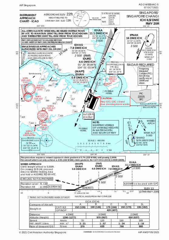
0
18
927
0
18
927
!!
!
!
!
!
627
611
602
BEARINGS ARE MAGNETICALTITUDES, ELEVATIONSAND HEIGHTS ARE IN FEET
103° 50'E
01°20' N
01°20' N
104° 00'
INSTRUMENTAPPROACHCHART - ICAO ICH ILS/DME
RWY 20R
SINGAPORE/SINGAPORE CHANGI
103° 50'E 104° 00' 104° 10'
Seletar
203°(FAF)
IDURO4.6 DME ICH
01° 26' 39.84"N104° 01' 03.94"E
POSSIBLEVESSEL
ELEV 13(DTHR RWY 20R) 10 5 0 5 10
MISSED APPROACH Climb straight ahead to 5,000ft.On crossing SJ R-146, proceeddirect to SAMKO Holding Areaand hold or AS DIRECTED BY ATC.
Transition Level : FL 130Transition Alt : 11 000
GP 3°
(MAPT)IDUNA
0.8 DME ICH
IGULA11.1 DME ICH(FAF)
IDURO4.6 DME ICH
2 5001 500
420(407)
NAUTICAL MILES FROM RWY DTHR 20R
Sembawang
OCA (OCH)Category of AircraftStraight-in DistanceAltitude (Height)SpeedFAF - MAPT 3.9nmRate of descent/GS
4 DME 3 DME
knotsmin : s *ft/min
70 120 150 1851290 (1277) 970 (957)
3 : 21 1 : 57 1 : 34 1 : 16370 635 795 980
PayaLebar
104° 10'
POSSIBLEVESSEL
KUALA LUMPUR FIRSINGAPORE FIR
ILS RDH 56
CAT I ILSGP INOP
2 DME650 (637)
01°30'
01°30'
3 500
420 (407)
DVOR/DME 116.5VTK
01° 24' 55"N104° 01' 20" E
TEKONG
60m
LLZ 108.9ICH
10 NM
IDVAS7.8 DME ICH
DISPLACED THR7.6
MARITIME VESSELSOF VARIABLE HEIGHTSIN WATER NORTH AND SOUTH OF RWY
NOTE:
IDVAS7.8 DME ICH
01°29' 34.66"N104°02' 17.75"E
2 500
(MAPT)IDUNA
0.8 DME ICH01°23' 05.80"N103°59' 33.58"E
9.14.40.6
SIMULTANEOUS APPROACHESAUTHORIZED WITH RWY 20L OR 20C
* TIMING NOT AUTHORIZED WHEN GP INOP
CIRCLING NOT AUTHORIZED
RADAR REQUIRED
10.9
#*203°
A B C D152 (139) 159 (146) 179 (166) 192 (179)
DL195 (182)
SCALE 1 : 400,0001 0 1 2 3 4 5 6 7 8 9 km
1 0 1 2 3 4 5 NM60m
AERODROME ELEV 22ftHEIGHT RELATED TO
DTHR RWY 20R - ELEV 13ft
#*(168°348°
MNM ALT5 000
SAMKOSJ R-168/8 DME
SJR-168
MISSEDAPCH
SJ R-146
01°05'; 30"N103°52' 55"E
203°
NYLON(16.2 DME ICH/
VTK R-023/13 DME)MNM ALT
3 000
01°37' 11.93"N104°05' 30.83"E 02
3°
IPNAK16 DME ICH
3 500
203°
RWY 20R ILS DME NOT AVAILABLE BEYOND 15 DEG WEST OF RWY 20R CENTRELINE BELOW 2500FT
Rwy 02C/20C closed due development works.
CAUTION :
WSD35900ft ALT
GND
WSD34500ft ALT
GND
WSP24800ft ALT
GND/WATER
This procedure requires a missed approach climb gradient of 3.7% (225 ft/NM) until passing 2,500ft. For aircraft which can only achieve a 2.5% (152 ft/NM) climb gradient, the CAT I OCA (OCH) is 693ft (680ft).
ILS/DME co-located with GP
DVOR/DME 113.5SINJON
SJ 01° 13' 21.34"N
103° 51' 15.22" E
321589
272
296
229
407
420
312
217
291
383
266
281
369
382941 713661
854
925
AIP Singapore AD-2-WSSS-IAC-507 OCT 2021
ALL ARRIVALS INTO WSSS WILL BE ISSUED INSTRUCTIONSBY ATC TO MAINTAIN 180KT TILL 8NM FROM TOUCHDOWN AND THEREAFTER 150KT TILL 4NM FROM TOUCHDOWN
IGULA11.1 DME ICH
3 50001°32' 32.27"N104°03' 32.66"E
342
381
240
WSR6200ft ALT
GND
WSP3750ft ALT
GND
WSR3810 000ft ALT
GND
WSR16200ft ALT
GND
WSR9200ft ALT
GND
D-ATISAPPTWR
AP ID WSSS128.025124.05119.3118.6118.25
PIC2000ftSFC
PengerangIntegratedComplex (PIC).Aircraft mayoverfly area at2000ft andabove.
VAR 0
°23'E
(2020
)
X
X
© 2021 Civil Aviation Authority Singapore AIP AMDT 05/2021CHANGES : SJ DVOR/DME Coordinates Revised

PAGE INTENTIONALLY LEFT BLANK
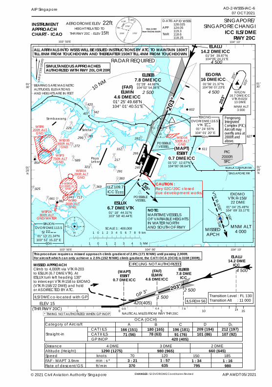
627
611
602
0
18
927
0
18
927
!!
!
!
!
!
BEARINGS ARE MAGNETICALTITUDES, ELEVATIONSAND HEIGHTS ARE IN FEET
103° 50'E
01°20' N
01°20' N
104° 00'
INSTRUMENTAPPROACHCHART - ICAO ICC ILS/DME
RWY 20C
SINGAPORE/SINGAPORE CHANGI
103° 50'E 104° 00' 104° 10'
Seletar
203°
(FAF)ELMIN
4.6 DME ICC01° 25' 49.68"N104° 01' 40.51"E
POSSIBLEVESSEL
ELEV 15(THR RWY 20C) 5 0 5 10 15
MISSED APPROACHClimb to 4,000ft via VTK R-203to ESLUX (6.7 DME VTK). At ESLUX turn left heading 130°to intercept VTK R-158 to EXOMO(VTK R-158/22 DME) and hold or AS DIRECTED BY ATC.
GP 3°
(MAPT)ESBIT
0.7 DME ICC
ELALU14.2 DME
ICC(FAF)ELMIN
4.6 DME ICC
2 500
420(405)NAUTICAL MILES FROM RWY THR 20C
Sembawang
OCA (OCH)Category of Aircraft
Straight-in
DistanceAltitude (Height)SpeedFAF - MAPT 3.9nmRate of descent/GS
4 DME 3 DME
A B C D166 (151)
knotsmin : s *ft/min
70 120 150 1851290 (1275) 980 (965)
3 : 21 1 : 57 1 : 34 1 : 16370 635 795 980
180 (165)
PayaLebar
104° 10'
POSSIBLEVESSEL
KUALA LUMPUR FIRSINGAPORE FIR
ILS RDH 56ILS/DME co-located with GP
CAT I ILS
GP INOP
196 (181) 209 (194)
2 DME660 (645)
01°30'
01°30'
4 500
420 (405)
DVOR/DME 116.5VTK
01° 24' 55"N104° 01' 20" E
TEKONG
60m
10 NM
ELBEB7.8 DME
ICC
0.5
ESLUX6.7 DME VTK
130°
CAT II ILS 71 (56) 78 (63) 91 (76) 101 (86)
ELALU14.2 DME ICC
4 500
MARITIME VESSELSOF VARIABLE HEIGHTSIN WATER NORTH AND SOUTH OF RWY
NOTE:
LLZ 109.7ICC
22ftAERODROME ELEVHEIGHT RELATED TO
THR RWY 20C - ELEV 15ft
ELBEB7.8 DME ICC
01°34' 39.87"N104°05' 24.21"E
01°28' 44.66"N104°02' 54.38"E
2 500
(MAPT)ESBIT
0.7 DME ICC01°22' 12.07"N104°00' 08.64"E
01° 18' 44.31"N103° 58' 40.44"E
4.4 7.6
1 500
SIMULTANEOUS APPROACHESAUTHORIZED WITH RWY 20L OR 20R
* TIMING NOT AUTHORIZED WHEN GP INOP
CIRCLING NOT AUTHORIZED
RADAR REQUIRED
203°#*
14
DL212 (197)107 (92)
SCALE 1 : 400,0001 0 1 2 3 4 5 6 7 8 9 km
1 0 1 2 3 4 5 NM60m
203°
203°
NYLON16.7 DME ICC
VTK R-023/13 DMEMNM ALT
3 000
01°36' 21.37"N104°06' 07.23"E 02
3°
EGORA16 DME ICC
4 500
Rwy 02C/20C closeddue development works.CAUTION :
WSD35900ft ALT
GND
WSD34500ft ALT
GND
WSP3750ft ALT
GND
WSP24800ft ALT
GND/WATER
This procedure requires a missed approach climb gradient of 2.8% (171 ft/NM) until passing 2,000ft. For aircraft which can only achieve a 2.5% (152 ft/NM) climb gradient, the CAT I OCA (OCH) is 315ft (300ft).
Transition Level : FL 130Transition Alt : 11 000
DVOR/DME 113.5SINJON
SJ 01° 13' 21.34"N
103° 51' 15.22" E
321589
272
296
229
407
420
312
217
291383
266
281
369
382941 713661
854
925
AIP Singapore AD-2-WSSS-IAC-607 OCT 2021
ALL ARRIVALS INTO WSSS WILL BE ISSUED INSTRUCTIONS BY ATC TO MAINTAIN 180KT TILL 8NM FROM TOUCHDOWN AND THEREAFTER 150KT TILL 4NM FROM TOUCHDOWN
342
381
240
WSR6200ft ALT
GND
WSR3810 000ft ALT
GND
WSR16200ft ALT
GND
WSR9200ft ALT
GND
D-ATISAPPTWR
AP ID WSSS128.025124.05119.3118.6118.25
PIC2000ftSFC
PengerangIntegratedComplex (PIC).Aircraft mayoverfly area at2000ft andabove.
VAR 0
°23'E
(2020
)
X
X
#*(MNM ALT
4 000
338°
EXOMOVTK R-158/
22 DME
MISSEDAPCH
158°
VTK R-158° 01° 04' 25.49"N104° 09' 33.17"E
© 2021 Civil Aviation Authority Singapore AIP AMDT 05/2021CHANGES : SJ DVOR/DME Coordinates Revised

PAGE INTENTIONALLY LEFT BLANK
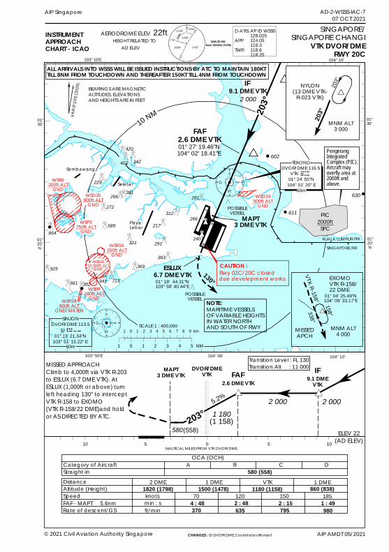
0
18
927
0
18
927
!!
!
!
!
!630
611
602
AIP AMDT 05/2021
AIP Singapore
BEARINGS ARE MAGNETICALTITUDES, ELEVATIONSAND HEIGHTS ARE IN FEET
103° 50'E
01°20' N
01°20' N
© 2021 Civil Aviation Authority Singapore
104° 00'
INSTRUMENTAPPROACHCHART - ICAO VTK DVOR/DME
RWY 20C
SINGAPORE/SINGAPORE CHANGI
103° 50'E 104° 00' 104° 10'
Seletar
203°
POSSIBLEVESSEL
ELEV 22(AD ELEV) 10 5 0 5 10
MISSED APPROACH Climb to 4,000ft via VTK R-203 to ESLUX (6.7 DME VTK). At ESLUX (1,000ft or above) turn left heading 130° to intercept VTK R-158 to EXOMO (VTK R-158/22 DME)and hold or AS DIRECTED BY ATC.
Transition Level : FL 130Transition Alt : 11 000
5.2%
MAPT3 DME VTK 9.1 DME
VTK
DVOR/DMEVTK
2 0001 180
580(1 158)
(558)
NAUTICAL MILES FROM VTK DVOR/DME
Sembawang
OCA (OCH)Category of AircraftStraight-in DistanceAltitude (Height)SpeedFAF - MAPT 5.6nmRate of descent/GS
2 DME 1 DME VTK
A B C D
knotsmin : sft/min
70 120 150 1851820 (1798) 1500 (1478) 1180 (1158)
4 : 48 2 : 48 2 : 15 1 : 49370 635 795 980
PayaLebar
104° 10'
POSSIBLEVESSEL
KUALA LUMPUR FIRSINGAPORE FIR
MAPT3 DME VTK
IF
1 DME860 (838)
01°30'
01°30'
SCALE 1 : 400,000
2 000
DVOR/DME 116.5VTK
01° 24' 55"N104° 01' 20" E
TEKONG
60m
10 NM
2.6 DME VTKFAF
580 (558)
22ftAERODROME ELEVHEIGHT RELATED TO
AD ELEV
203°
MARITIME VESSELSOF VARIABLE HEIGHTSIN WATER NORTH AND SOUTH OF RWY
NOTE:
FAF2.6 DME VTK01° 27' 19.46"N104° 02' 18.41"E
9.1 DME VTKIF
2 000
#* #*
023°
ESLUX6.7 DME VTK01° 18' 44.31"N103° 58' 40.44"E
130°
AD-2-WSSS-IAC-707 OCT 2021
1 0 1 2 3 4 5 NM
1 0 1 2 3 4 5 6 7 8 9 km
60m
MNM ALT
4 000
158°
EXOMOVTK R-158/22 DME
MISSEDAPCH
338°
01° 04' 25.49"N104° 09' 33.17"E
VTK R-158°
203°
203°NYLON
(13 DME VTK-R-023 VTK)
MNM ALT3 000
WSD35900ft ALT
GNDWSD34
500ft ALTGND
WSP3750ft ALT
GND
WSP24800ft ALT
GND/WATER
266312
281
217
291
383
321
369
941 713
589
272296
854
382661
925
407
420
229
DVOR/DME 113.5SINJON
SJ 01° 13' 21.34"N
103° 51' 15.22" E
ALL ARRIVALS INTO WSSS WILL BE ISSUED INSTRUCTIONS BY ATC TO MAINTAIN 180KT TILL 8NM FROM TOUCHDOWN AND THEREAFTER 150KT TILL 4NM FROM TOUCHDOWN
342
381
240
WSR6200ft ALT
GND
WSR16200ft ALT
GNDWSR38
10 000ft ALTGND
WSR9200ft ALT
GND
D-ATISAPPTWR
AP ID WSSS128.025124.05119.3118.6118.25
PIC2000ftSFC
PengerangIntegratedComplex (PIC).Aircraft mayoverfly area at2000ft andabove.
VAR 0
°23'E
(2020
)
CHANGES : SJ DVOR/DME Coordinates Revised
Rwy 02C/20C closed due development works.CAUTION :
X
X

PAGE INTENTIONALLY LEFT BLANK
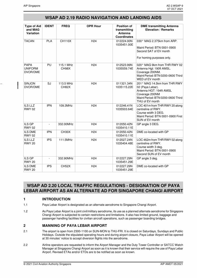
WSAP AD 2.19 RADIO NAVIGATION AND LANDING AIDS
DME transmitting AntennaElevation / Remarks
Position oftransmittingAntenna
Coordinates
OPR HourFREQIDENTType of Aidand MAGVariation
030° MAG 2.375km from ARP.
Maint Period: BTN 0001-0900Second SAT of EV month
For homing purposes only.
012224.00N1035451.00E
H24CH110XPLATACAN
020° MAG 9km from THR RWY 02Antenna Hgt: 190ft AMSL.Coverage 200NM.Maint Period: BTN0200-0600ThirdWED of EV month
012523.99N1035559.74E
H24115.1 MHzCH98X
PUPAPAUNIFORMDVOR/DME
201° MAG 14.5km from THR RWY02 (Paya Lebar).Antenna HGT: 194ft AMSLCoverage 200NMMaint Period: BTN0200-0600ThirdTHU of EV month
011321.34N1035115.22E
H24113.5 MHzCH82X
SJSINJONDVOR/DME
←
LOC401m fromTHRRWY20alongcentreline of RWY.Course width 3 DEG.Maint Period: BTN 0001-0900 FirstSUN of EV month
012246.41N1035503.64E
H24109.3MHzIPNILS LLZRWY 02
GP angle 3 DEG.012050.42N1035410.11E
H24332.00MHz-ILS GPRWY 02
DME co-located with GP012050.42N1035410.11E
H24CH30XIPNILS DMERWY 02
LOC462m fromTHRRWY02alongcentreline of RWY.Course width 3 deg.Maint Period: BTN 0001-0900Second SUN of EV month
012027.24N1035404.48E
H24111.5MHzIPSILS LLZRWY 20
GP angle 3 deg.012227.29N1035451.29E
H24332.90MHz-ILS GPRWY 20
DME co-located with GP012227.29N1035451.29E
H24CH52XIPSILS DMERWY 20
WSAP AD 2.20 LOCAL TRAFFIC REGULATIONS - DESIGNATION OF PAYALEBAR AIRPORT AS AN ALTERNATE AD FOR SINGAPORE CHANGI AIRPORT
1 INTRODUCTION1.1 Paya Lebar Airport is designated as an alternate aerodrome to Singapore Changi Airport.
1.2 As Paya Lebar Airport is a joint civil/military aerodrome, its use as a planned alternate aerodrome for SingaporeChangi Airport is subjected to certain restrictions and limitations. It also has limited ground, baggage andpassenger handling facilities for civilian aircraft operations, such as passenger boarding bridges.
2 MANNING OF PAYA LEBAR AIRPORT2.1 The airport is open from 2300-1100 on SUN-MON to THU-FRI. It is closed on Saturdays, Sundays and Public
Holidays. Outside the stipulated operating hours and during airport closure, Paya Lebar Airport will be openedat 30 minutes’ notice to accept diversion flights into the aerodrome.
2.2 Airline operators are requested to inform the Airport Manager and the Duty Tower Controller or SATCC WatchManager at Singapore Changi Airport as soon as it is known that their service will require the use of Paya LebarAirport. Revised ETAs and/or ETDs are to be notified as soon as known.
AIP AMDT 05/2021© 2021 Civil Aviation Authority Singapore
AD 2.WSAP-9AIP Singapore~~~eaip-amdt~~~ver-date-2021-09-09T07-08-00-03507 OCT 2021
2.3 The airport will hold off all departures and arrivals when the aerodrome visibility falls below 3km, or when theaerodrome prevailing cloud base is lower than 500ft. This is a safety consideration to avoid aircraft from carryingout a missed approach under an adverse weather condition. For maintenance/test flights scheduled to departand arrive back to the airport, such departures may be held off when the aerodrome visibility falls below 6km,or when the aerodrome prevailing cloud base is lower than 1,000ft.
3 OPERATIONAL SERVICES3.1 Air-ground-air communications maintained by Paya Lebar Airport for aerodrome/approach control service are
listed in page WSAP AD 2-7.
4 PASSENGER CLEARANCE4.1 All Customs, Health and Immigration clearances will be carried out at Singapore Changi Airport.
4.2 The diverting aircraft Airline’s Coordinator and its ground handling agency staff shall be present to provideassistance when an aircraft is required to land at Paya Lebar Airport.
5 SECURITY5.1 All airline personnel, including ground handlers and support staff who have to proceed to Paya Lebar Airport
must wear their Singapore Changi Airport passes at a prominent position for entry to the aircraft parking area.All personnel not in possession of the laminated Singapore Changi Airport pass will be denied entry into PayaLebar Airport by the RSAF Security Guard. Entry into the airport by both the airline personnel and serviceequipment is via themain gate. The Airline Engineering Coordinator shall be responsible for the proper positioningof the ground servicing equipment and vehicles in the Apron Area where arriving aircraft are to be parked.
5.2 The security of civil aircraft parked in the Apron is the responsibility of the aircraft owner and any security serviceobtained shall first be cleared with the Paya Lebar Airport flight security.
6 AIRCRAFT STAND ALLOCATION6.1 Nine aircraft parking positions in Apron C and on taxiway fillets are available for civil aircraft. A separation of 40
feet between wing-tips should be maintained.
6.2 Aircraft parking positions will be issued by the Paya Lebar Tower and the Airline Engineering Coordinator shallprovide themarshalling services. Close coordination between the Airline Engineering Coordinator and the TowerController is essential in regard to aircraft parking and positioning of servicing equipment in and around theparking apron.
7 AIRCRAFT REFUELLING7.1 ST Airport Services Pte Ltd (STARS) is the assigned aircraft fuelling agency. However, prior arrangement must
be made between the airline and STARS for such services. The refuelling rate available is 350 imperial gallonsper minute (IGPM).
8 GROUND OPERATIONS8.1 Singapore Airport Terminal Services (SATS) and DNATA Singapore Pte Ltd (DNATA) will provide all ground
services at one hour’s prior notice except engineering services which will be provided by Singapore Airlines.
9 FULL EMERGENCY/CRASH PROCEDURE9.1 In the event of a Full Emergency being declared on a civil aircraft diverted to Paya Lebar AP, Full
Emergency/Crash Procedures applicable to Singapore Changi AP will equally apply to Paya Lebar AP.
9.2 Alerting of all outside organisations such as the Singapore Civil Defence Force, Police, MINDEF and ambulanceservices shall be carried out by the Singapore Changi AP Tower Controller.
10 METEOROLOGICAL AND AERONAUTICAL INFORMATION SERVICE10.1 Meteorological service is available 24 hours at the 6th floor of the building where Paya Lebar Air Traffic Control
Tower is located.
10.2 Aeronautical Information Service is available at Singapore Changi Airport.
11 ATC SERVICE OUTSIDE STIPULATED OPERATING HOURS11.1 Radar service will not be available at Paya Lebar Airport outside its stipulated operating hours.
© 2020 Civil Aviation Authority SingaporeAIP AMDT 04/2020
AIP SingaporeAD 2.WSAP-1016 JUL 2020
WSAP AD 2.22 FLIGHT AND GROUND PROCEDURES
1 DEPARTURE AND ARRIVAL PROCEDURES1.1 The designated runway for departures is RWY 02 and for arrivals is RWY 20.
1.2 The airport will hold off all departures and arrivals when the aerodrome visibility falls below 3km, or when theaerodrome prevailing cloud base is lower than 500ft. This is a safety consideration to avoid aircraft from carryingout a missed approach and overflying the populace under an adverse weather condition.
2 STANDARD INSTRUMENT DEPARTURES← November 1 Departure - Climb to maintain 3,000ft on RWY heading for PU DVOR/DME. At PU DVOR/ DME,
turn left heading 010. Contact Seletar APP on 121.625 MHz or as instructed by ATC.
← November 2 Departure - Climb to maintain 3,000ft on RWY heading for PU DVOR/DME. At PU DVOR/ DME,maintain heading 020. Contact Seletar APP on 121.625 MHz or as instructed by ATC.
← November 3 Departure - Climb to maintain 3,000ft on RWY heading for PU DVOR/DME. At PU DVOR/ DME,turn left heading 360. Contact Seletar APP on 121.625 MHz or as instructed by ATC.
3 STANDARD ARRIVALSWhen Paya Lebar is VMC - Expect radar vector to RWY 20 for visual straight-in approach.
When Paya Lebar is IMC - Expect radar vector to RWY 20 for ILS or PU DVOR/DME approach.
WSAP AD 2.23 ADDITIONAL INFORMATION
1 OUTDOOR LIGHT AND WATER SHOW1.1 An outdoor light and water showwill take place between 1200-1215, 1300-1315, 1400-1415 Friday to Saturday
and 1200-1215, 1300-1315 Sunday to Thursday at 011704N 1035130E (within Paya Lebar Control Zone).GND - UNL.
WSAP AD 2.24 CHARTS RELATED TO PAYA LEBAR AIRPORTAerodrome Chart ................................................................................................................................................. AD-2-WSAP-ADC-1Location of Aircraft Stands for Civil Aircraft ...................................................................................................... AD-2-WSAP-ADC-2Aerodrome Obstacle Chart - ICAO - TYPE A .................................................................................................. AD-2-WSAP-AOC-1Instrument Approach Chart - ICAO - RWY 20 - PU DVOR/DME .................................................................... AD-2-WSAP-IAC-1Instrument Approach Chart - ICAO - RWY 02 - PU DVOR/DME .................................................................... AD-2-WSAP-IAC-2Instrument Approach Chart - ICAO - RWY 20 - IPS ILS/DME ........................................................................ AD-2-WSAP-IAC-3Instrument Approach Chart - ICAO - RWY 02 - IPN ILS DME ........................................................................ AD-2-WSAP-IAC-4Instrument Approach Chart - ICAO - RWY 02 - RNP ....................................................................................... AD-2-WSAP-IAC-5Instrument Approach Chart - ICAO - RWY 20 - RNP ....................................................................................... AD-2-WSAP-IAC-6
AIP AMDT 05/2021© 2021 Civil Aviation Authority Singapore
AD 2.WSAP-11AIP Singapore~~~eaip-amdt~~~ver-date-2021-09-09T07-08-00-03507 OCT 2021

PAGE INTENTIONALLY LEFT BLANK
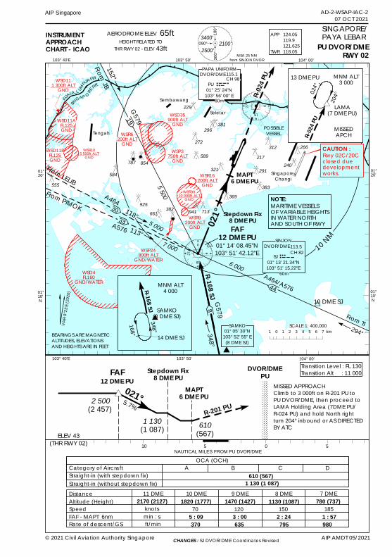
0
18
9270
18
927
!!
!
!
AD-2-WSAP-IAC-207 OCT 2021
AIP Singapore
BEARINGS ARE MAGNETICALTITUDES, ELEVATIONSAND HEIGHTS ARE IN FEET
103° 50'
01°20'
01°20'
01°10' N
© 2021 Civil Aviation Authority Singapore AIP AMDT 05/2021
104° 00'
01°10' N
INSTRUMENTAPPROACHCHART - ICAO
MSA 25 NMfrom SINJON DVOR
PU DVOR/DMERWY 02
SINGAPORE/PAYA LEBAR
103° 50' 104° 00'103° 40'E
A464/A576
6 000
From TI294°
Seletar
Singapore ChangiMAPT
6 DME PU
021°
FAF12 DME PU
01° 14' 08.45"N103° 51' 42.12"E
POSSIBLEVESSEL
R-024
PU
ELEV 43(THR RWY 02) 10 5 0 5
021°MISSED APPROACH Climb to 3 000ft on R-201 PU toPU DVOR/DME, then proceed toLAMA Holding Area (7DME PU/R-024 PU) and hold North rightturn 204° inbound or AS DIRECTED BY ATC
Transition Level : FL 130Transition Alt : 11 000
R-201 PU5.7%
MAPT6 DME PU
DVOR/DMEPU12 DME PU
FAF Stepdown Fix8 DME PU
2 500
1 130 610(1 087) (567)NAUTICAL MILES FROM PU DVOR/DME
10 DME SJ
Stepdown Fix8 DME PU
Sembawang
R-168 SJ G579348°
#*
10 NM
OCA (OCH)Category of AircraftStraight-in (with stepdown fix)
DistanceAltitude (Height)SpeedFAF - MAPT 6nmRate of descent/GS
11 DME 10 DME 9 DME 8 DME 7 DME
A B C D610 (567)
knotsmin : sft/min
70 120 150 1852170 (2127) 1820 (1777) 1470 (1427) 1130 (1087) 780 (737)
5 : 09 3 : 00 2 : 24 1 : 57370 635 795 980
Straight-in (without stepdown fix) 1 130 (1 087)
1 0 1 2 3 4 5 6 7 km
H
5 500
G579
5 000
A464118°
113°7 000
From LELIBFrom PIMOK
103° 40'E
152°
FromJB
KUALA L UM
PUR FIRSIN
GAP O REFIR
HEIGHT RELATED TOTHR RWY 02 - ELEV 43ft
AERODROME ELEV 65ft
Tengah
19
DVOR/DME115.1CH 98
PU 01° 25' 24"N
103° 56' 00" E
PAPA UNIFORM
60m
WSD4FL160
GND/WATER
30
8
44
SAMKO01° 05' 30"N
103° 52' 55" E(8 DME SJ)
SCALE 1: 400,000
33A576
MARITIME VESSELSOF VARIABLE HEIGHTSIN WATER NORTH AND SOUTH OF RWY
NOTE:
(2 457)
#*
024°
204°
R-024
PU
13 DME PU
LAMA(7 DME PU)
MISSEDAPCH
MNM ALT3 000
348°
MNM ALT4 000
168°
SAMKO(8 DME SJ)
14 DME SJ
R-168 SJH
93400'
2100'2500'
180°
090°
360°
Rwy 02C/20Cclosed duedevelopment works.
CAUTION :
WSD111 300ft ALT
GND
WSD11AFL125GND
WSD11BFL125GND
WSD35900ft ALT
GND
WSP24800ft ALT
GND/WATER
WSP3750ft ALT
GND
266312
291
383
217
369
321
589
272
296
229
854
382
787
941 713661925
584555
WSR105 500ft ALTGND
60m
381
240
WSR6200ft ALT
GND
WSR16200ft ALT
GNDWSR38
10 000ft ALTGND
WSR9200ft ALT
GND
VAR0
°23'E
(2020
)
APP
TWR
124.05119.9121.625118.05
CHANGES : SJ DVOR/DME Coordinates Revised
DVOR/DMESINJON
113.5CH 82SJ
01° 13' 21.34"N103° 51' 15.22"E

PAGE INTENTIONALLY LEFT BLANK
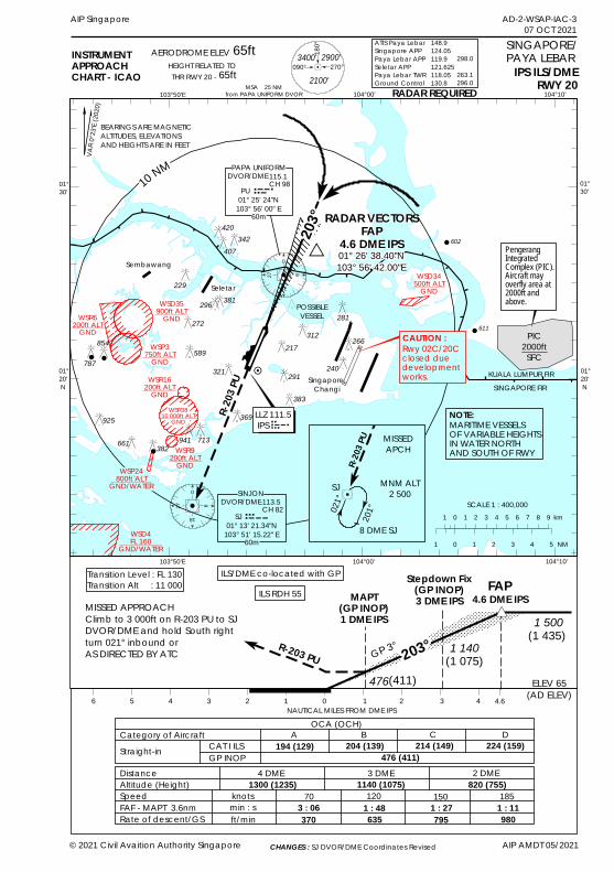
611
602
0
18
927
0
18
927
!!
!
!
!
AD-2-WSAP-IAC-307 OCT 2021
AIP Singapore
BEARINGS ARE MAGNETICALTITUDES, ELEVATIONSAND HEIGHTS ARE IN FEET
103°50'E 104°00'
01°30'
01°30'
01°20' N
© 2021 Civil Avaition Authority Singapore AIP AMDT 05/2021
104°10'
01°20' N
INSTRUMENTAPPROACHCHART - ICAO
MSA 25 NMfrom PAPA UNIFORM DVOR
IPS ILS/DMERWY 20
SINGAPORE/PAYA LEBAR
103°50'E 104°00' 104°10'
Sembawang
Seletar
Singapore Changi
203° RADAR VECTORS
FAP4.6 DME IPS01° 26' 38.40"N103° 56' 42.00"E
10 NM
POSSIBLEVESSEL
KUALA LUMPUR FIRSINGAPORE FIR
R-203
PU
ELEV 65(AD ELEV)6 5 4 3 2 1 0 1 2 3 4
MISSED APPROACH Climb to 3 000ft on R-203 PU to SJDVOR/DME and hold South rightturn 021° inbound or AS DIRECTED BY ATC
Transition Level : FL 130Transition Alt : 11 000
R-203 PU GP 3°
MAPT(GP INOP)1 DME IPS
4.6 DME IPSFAPStepdown Fix
(GP INOP)3 DME IPS
1 5001 140
476(1 075)
(411)
NAUTICAL MILES FROM DME IPSOCA (OCH)
Category of AircraftStraight-in
DistanceAltitude (Height)SpeedFAF - MAPT 3.6nmRate of descent/GS
4 DME 3 DME 2 DME
A B C D
476 (411)
knotsmin : sft/min
70 120 150 1851300 (1235) 1140 (1075) 820 (755)
3 : 06 1 : 48 1 : 27 1 : 11370 635 795 980
RADAR REQUIRED
#*
203°
ILS RDH 55ILS/DME co-located with GP
CAT I ILSGP INOP
194 (129) 204 (139) 214 (149) 224 (159)
4.6
65ftAERODROME ELEVHEIGHT RELATED TOTHR RWY 20 - 65ft
"
DVOR/DME115.1CH 98PU
01° 25' 24"N103° 56' 00" E
PAPA UNIFORM
60m
SCALE 1 : 400,000
MARITIME VESSELSOF VARIABLE HEIGHTSIN WATER NORTH AND SOUTH OF RWY
NOTE:LLZ 111.5 IPS
(1 435)
1 0 1 2 3 4 5 NM
1 0 1 2 3 4 5 6 7 8 9 km021°
201°
R-203
PU MISSEDAPCH
MNM ALT2 500
8 DME SJ
SJ
9
180°
090° 270°3400'
2100'
2900'
WSD34500ft ALT
GNDWSD35
900ft ALTGND
WSP3750ft ALT
GND
WSP24800ft ALT
GND/WATER
Rwy 02C/20Cclosed duedevelopment works.
CAUTION :266312217
291
369
321
589
272
296
229
854
382
787
941 713661
925
281
407
420
383
60m
DVOR/DME113.5CH 82
SJ 01° 13' 21.34"N
103° 51' 15.22" E
SINJON
342
381
240
WSR6200ft ALT
GND
WSR16200ft ALT
GNDWSR38
10 000ft ALTGND
WSR9200ft ALT
GND
WSD4FL 160
GND/WATER
VAR 0
°23'E
(2020
)
ATIS Paya LebarSingapore APPPaya Lebar APPSeletar APPPaya Lebar TWRGround Control
148.9124.05119.9121.625118.05130.8
298.0
263.1296.0
PIC2000ftSFC
PengerangIntegratedComplex (PIC).Aircraft mayoverfly area at2000ft andabove.
CHANGES : SJ DVOR/DME Coordinates Revised

PAGE INTENTIONALLY LEFT BLANK
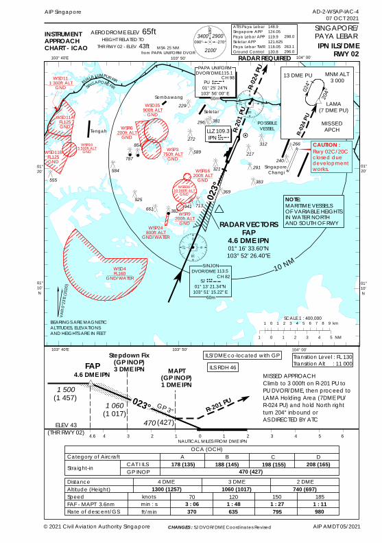
0
18
9270
18
927
!!
!
!
#*
AD-2-WSAP-IAC-407 OCT 2021
AIP Singapore
BEARINGS ARE MAGNETICALTITUDES, ELEVATIONSAND HEIGHTS ARE IN FEET
103° 50'103° 40'E
01°20'
01°20'
01°10' N
© 2021 Civil Aviation Authority Singapore AIP AMDT 05/2021
104° 00'
01°10' N
INSTRUMENTAPPROACHCHART - ICAO MSA 25 NM
from PAPA UNIFORM DVORIPN ILS/DME
RWY 02
SINGAPORE/PAYA LEBAR
103° 50' 104° 00'103° 40'E
Seletar
Singapore Changi
023°
RADAR VECTORSFAP
4.6 DME IPN01° 16' 33.60"N103° 52' 26.40"E
POSSIBLEVESSEL
R-024
PU
ELEV 43(THR RWY 02) 4.6 4 3 2 1 0 1 2 3 4 5 6
MISSED APPROACH Climb to 3 000ft on R-201 PU toPU DVOR/DME, then proceed toLAMA Holding Area (7DME PU/R-024 PU) and hold North rightturn 204° inbound or AS DIRECTED BY ATC
Transition Level : FL 130Transition Alt : 11 000
R-201 PUGP 3°
MAPT(GP INOP)1 DME IPN
4.6 DME IPNFAP
Stepdown Fix(GP INOP)3 DME IPN
1 5001 060
470(1 017)
(427)
NAUTICAL MILES FROM DME IPNH
Sembawang
10 NM
OCA (OCH)Category of Aircraft
DistanceAltitude (Height)SpeedFAF - MAPT 3.6nmRate of descent/GS
4 DME 3 DME 2 DME
A B C D188 (145)
knotsmin : sft/min
70 120 150 1851300 (1257) 1060 (1017) 740 (697)
3 : 06 1 : 48 1 : 27 1 : 11370 635 795 980
Straight-in 470 (427)
RADAR REQUIRED
R-201
PU
#*
023°
ILS RDH 46ILS/DME co-located with GP
CAT I ILSGP INOP
178 (135) 198 (155) 208 (165)
Tengah
AERODROME ELEV 65ftHEIGHT RELATED TO
THR RWY 02 - ELEV 43ft
KUALA LUMPUR FIRSINGAPORE FIR
WSD4FL160
GND/WATER
DVOR/DME115.1CH 98
PU 01° 25' 24"N
103° 56' 00" E
PAPA UNIFORM
60m
SCALE 1 : 400,000
MARITIME VESSELSOF VARIABLE HEIGHTSIN WATER NORTH AND SOUTH OF RWY
NOTE:
(1 457)
1 0 1 2 3 4 5 NM
1 0 1 2 3 4 5 6 7 8 9 km
9
180°
090° 270°3400'
2100'
2900'
024°
204°
R-02
4 PU
13 DME PU
LAMA(7 DME PU)
MISSEDAPCH
MNM ALT3 000
Rwy 02C/20Cclosed duedevelopment works.
WSD11BFL125GND
WSD11AFL125GND
WSD111 300ft ALT
GND
WSD35900ft ALT
GND
WSP24800ft ALT
GND/WATER
WSP3750ft ALT
GND
CAUTION :266312217
291
369
321
589
272
296
229
854
382
787
941 713661925
383555584
LLZ 109.3 IPN
60m
WSR105 500ft ALTGND
381
240
WSR6200ft ALT
GND
WSR16200ft ALT
GNDWSR38
10 000ft ALTGND
WSR9200ft ALT
GND
VAR0
°23'E
(2020
)
ATIS Paya LebarSingapore APPPaya Lebar APPSeletar APPPaya Lebar TWRGround Control
148.9124.05119.9121.625118.05130.8
298.0
263.1296.0
CHANGES : SJ DVOR/DME Coordinates Revised
DVOR/DMESINJON
113.5CH 82SJ
01° 13' 21.34"N103° 51' 15.22" E

PAGE INTENTIONALLY LEFT BLANK
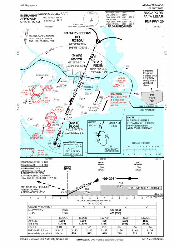
(0
18
927
0
18
927
!!
!
!
!
602
611
BEARINGS ARE MAGNETICALTITUDES, ELEVATIONSAND HEIGHTS ARE IN FEET
103°50'E 104°00'
01°30'
01°30'
01°20' N
104°10'
01°20' N
INSTRUMENTAPPROACHCHART - ICAO
SINGAPORE/PAYA LEBAR
103°50'E 104°00' 104°10'
Sembawang
Seletar
Singapore Changi
203°
RADAR VECTORS(IF)
ROBGU01°31'18.70"N 103°58'41.60"E
10 NM
POSSIBLEVESSEL
KUALA LUMPUR FIRSINGAPORE FIR
RADAR REQUIRED
(
SCALE 1 : 400,000
MARITIME VESSELSOF VARIABLE HEIGHTSIN WATER NORTH AND SOUTH OF RWY
NOTE:
1 0 1 2 3 4 5 NM
1 0 1 2 3 4 5 6 7 8 9 km
WSD34500ft ALT
GND
WSP3750ft ALT
GND
WSP24800ft ALT
GND/WATER
WSD4FL 160
GND/WATER
Rwy 02C/20Cclosed duedevelopment works.
CAUTION :266
312217
291
369
321589
272296
229
854
382
787
941713661
925
281
407
42020
3°
200°
3.6NM
6.3NM
4.5NM
5.0NM
203°
348°
168°
200°MISSED
APCHMNM ALT
4 500
SJ
RNP RWY 20
(FAP)REDEN
01°26'42.64"N 103°56'44.17"E
(MAPt)RWY20
01°22'34.41"N 103°54'58.53"E
(MATF)RUGVI
01°16'45.71"N 103°52'30.23"E
SJ01°13' 19.28"N 103°51'20.08"E
SJ
ELEV 65(THR RWY 20)
Transition Level : FL 130Transition Alt : 11 000
2.9° Slope
(MAPt)RWY20
NAUTICAL MILES FROM THR RWY 20OCA (OCH)
Category of AircraftLNAV/VNAV
FixAltitude(Height)SpeedFAP - MAPt 4.5 nmRate of descent/GS
ROBGU REDEN
A B C D
knotsmin : sft/min
80 100 120 1403 : 23 2 : 42 2 : 15 1 : 30410 513 615 718
(IF)ROBGU
RWY20420 (355)
(FAP)REDEN
LNAVSINJON
1500(1435)
1500(1435)
420(355)
1580(1515)
420 (355)
RDH 50
1 500(1435)
203°" 203°
MINIMUM TEMPERATUREFOR BARO-VNAVAPPROACHES: -23°C
MISSED APPROACH:CLIMB DIRECT TO RUGVI.TURN LEFT 200° TO SJ TO JOIN THE HOLDING AT 4500FTOR ABOVE OR AS DIRECTED BY ATC.
2.5%2.5%
160 180821 923
1030(965)RUGVI
1 : 56 1 : 41
5 4 3 2 1 0 1 2 3 4 5 6 7 8 9
420(355)
10
1 500(1435)
1010(945) CIRCLING NOT AUTHORIZED
383
AD-2-WSAP-IAC-607 OCT 2021
AIP Singapore
© 2021 Civil Aviation Authority Singapore AIP AMDT 05/2021
60m
MSA 25 NMfrom PAYA LEBAR ARP
65ftAERODROME ELEVHEIGHT RELATED TOTHR RWY 20 - 65ft
25 NM
3500
Ò.ARP
DVOR/DME113.5CH 82
SJ 01° 13' 21.34"N
103° 51' 15.22" E
SINJON
342
381WSD35900ft ALT
GND
240
WSR6200ft ALT
GND
WSR3810 000ft ALT
GND
WSR16200ft ALT
GND
WSR9200ft ALT
GND
VAR 0
°23'E
(2020
)
ATIS Paya LebarSingapore APPPaya Lebar APPSeletar APPPaya Lebar TWRGround Control
148.9124.05119.9121.625118.05130.8
298.0
263.1296.0
PIC2000ftSFC
PengerangIntegratedComplex (PIC).Aircraft mayoverfly area at2000ft andabove.
CHANGES : SJ DVOR/DME Coordinates Revised

PAGE INTENTIONALLY LEFT BLANK
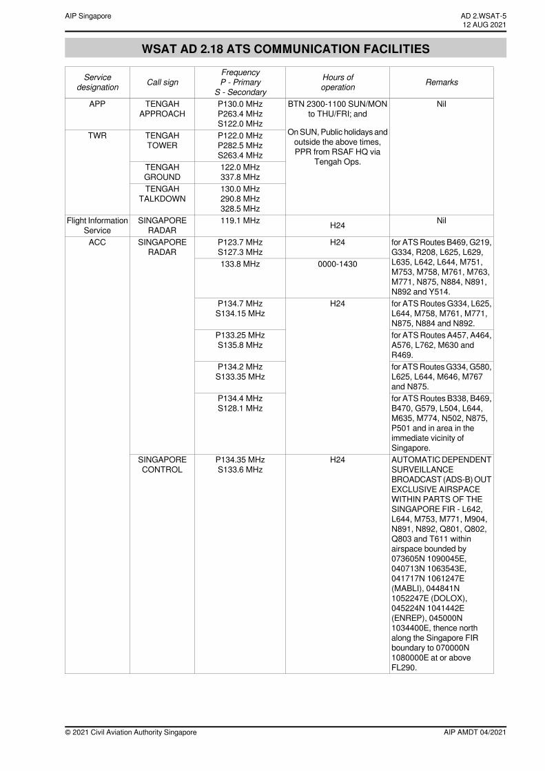
WSAT AD 2.18 ATS COMMUNICATION FACILITIES
RemarksHours ofoperation
FrequencyP - Primary
S - SecondaryCall signService
designation
NilBTN 2300-1100 SUN/MONto THU/FRI; and
OnSUN, Public holidays andoutside the above times,PPR from RSAF HQ via
Tengah Ops.
P130.0 MHzP263.4 MHzS122.0 MHz
TENGAHAPPROACH
APP
P122.0 MHzP282.5 MHzS263.4 MHz
TENGAHTOWER
TWR
122.0 MHz337.8 MHz
TENGAHGROUND
130.0 MHz290.8 MHz328.5 MHz
TENGAHTALKDOWN
NilH24119.1 MHzSINGAPORERADAR
Flight InformationService
for ATSRoutes B469, G219,G334, R208, L625, L629,L635, L642, L644, M751,M753, M758, M761, M763,M771, N875, N884, N891,N892 and Y514.
H24P123.7 MHzS127.3 MHz
SINGAPORERADAR
ACC
0000-1430133.8 MHz
for ATSRoutesG334, L625,L644, M758, M761, M771,N875, N884 and N892.
H24P134.7 MHzS134.15 MHz
for ATSRoutes A457, A464,A576, L762, M630 andR469.
P133.25 MHzS135.8 MHz
for ATSRoutesG334,G580,L625, L644, M646, M767and N875.
P134.2 MHzS133.35 MHz
for ATSRoutes B338, B469,B470, G579, L504, L644,M635, M774, N502, N875,P501 and in area in theimmediate vicinity ofSingapore.
P134.4 MHzS128.1 MHz
AUTOMATICDEPENDENTSURVEILLANCEBROADCAST (ADS-B)OUTEXCLUSIVE AIRSPACEWITHIN PARTS OF THESINGAPORE FIR - L642,L644, M753, M771, M904,N891, N892, Q801, Q802,Q803 and T611 withinairspace bounded by073605N 1090045E,040713N 1063543E,041717N 1061247E(MABLI), 044841N1052247E (DOLOX),045224N 1041442E(ENREP), 045000N1034400E, thence northalong the Singapore FIRboundary to 070000N1080000E at or aboveFL290.
H24P134.35 MHzS133.6 MHz
SINGAPORECONTROL
AIP AMDT 04/2021© 2021 Civil Aviation Authority Singapore
AD 2.WSAT-512 AUG 2021
AIP Singapore
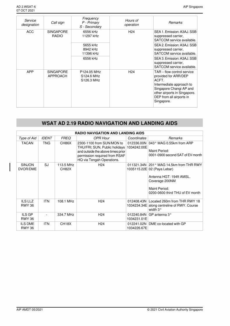
RemarksHours ofoperation
FrequencyP - Primary
S - SecondaryCall signService
designation
SEA1. Emission: A3AJ. SSBsuppressed carrier,SATCOM service available.
H246556 kHz11297 kHz
SINGAPORERADIO
ACC
SEA2. Emission: A3AJ. SSBsuppressed carrier,SATCOM service available.
5655 kHz8942 kHz11396 kHz
SEA3. Emission: A3AJ. SSBsuppressed carrier,SATCOM service available.
6556 kHz
TAR – flow control serviceprovided for ARR/DEPACFT.Intermediate approach toSingapore Changi AP andother airports in Singapore.DEP from all airports inSingapore.
H24P124.05 MHzS124.6 MHzS126.3 MHz
SINGAPOREAPPROACH
APP
WSAT AD 2.19 RADIO NAVIGATION AND LANDING AIDS
RADIO NAVIGATION AND LANDING AIDSRemarksCoordinatesOPR HourFREQIDENTType of Aid
043° MAG 0.55km from ARP
Maint Period:0001-0900 secondSATof EVmonth
012336.00N1034242.00E
2300-1100 from SUN/MON toTHU/FRI; SUN, Public holidaysand outside the above times priorpermission required from RSAFHQ via Tengah Operations.
CH86XTNGTACAN
201° MAG 14.5km from THR RWY02 (Paya Lebar)
Antenna HGT: 194ft AMSL.Coverage 200NM
Maint Period:0200-0600 third THU of EV month
011321.34N1035115.22E
H24113.5 MHzCH82X
SJSINJONDVOR/DME
←
Located 260m from THR RWY 18along centreline of RWY. Coursewidth 3°
012408.43N1034234.34E
H24108.1 MHzITNILS LLZRWY 36
GP antenna 3°012240.84N1034231.01E
H24334.7 MHz-ILS GPRWY 36
DME co-located with GP012241.02N1034226.67E
H24CH18XITNILS DMERWY 36
© 2021 Civil Aviation Authority SingaporeAIP AMDT 05/2021
AIP SingaporeAD 2.WSAT-607 OCT 2021~~~eaip-amdt~~~ver-date-2021-09-09T07-08-00-035