Embed Size (px)
Citation preview
165
Agenda Item 11
Report PC21/19
Report to Planning Committee
Date 11th April 2019
Title of Report SDNPA Response to the Aquind Interconnector pre-application
consultation (a Nationally Significant Infrastructure Project)
Purpose of Report To approve the SDNPA consultation response.
Recommendation: To approve the SDNPA response to the pre-application
consultation on the Aquind Interconnector.
1. Overview
1.1. The proposal being consulted on is for an electricity Interconnector that will feed electricity
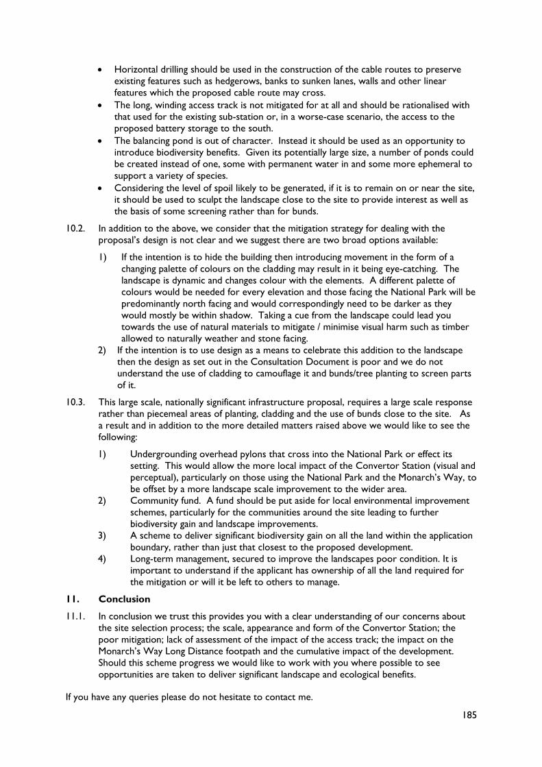
from France into the UK network. The development site is outside of, but in places only
200-300m from the National Park boundary in the vicinity of Horndean on the East Hants /
Winchester District boundary (See map Appendix 2). The proposal covers a wide
geographic area and has been deemed to be a Nationally Significant Infrastructure Project
(NSIP) that will be determined by the Planning Inspectorate (PINS)
1.2. National policy set out in the Overarching National Policy Statement for Energy, referred to
as the ONPSE (EN-1) is that PINS should start with a presumption in favour of granting
consent to applications for energy NSIPs unless policies clearly indicate that consent should
be refused. The duty to have regard to the purposes of nationally designated areas such as
National Parks does apply when considering applications for projects outside the boundaries
which may have impacts.
1.3. Within the proposal it is likely that the Convertor Station will have the greatest impact on
the National Park. It will contain a range of buildings, including two convertor halls, each
measuring 90m in length, 50m in width, and 22 – 26m in height along with a smaller control
building, spares building, lightning masts, lighting columns for use in emergency situations
only, auxiliary power supply and cooling systems. A 1.2km long access road leading from
Broadway Lane to the east will also be constructed along with a large temporary storage and
works area.
1.4. This consultation forms the main part of the pre-application stage and is the principal
opportunity to comment on the proposal whilst changes can be made and before it is
submitted to PINS to be determined through the Development Consent Order (DCO)
process.
166
1.5. The Authority’s proposed response can be found in Appendix 1 and is based on comments
from officers across the Authority. In summary the main concerns are:
That National Grid is a Statutory Undertaker and therefore is required to have regard
to the purposes of the National Park under as required under S11A of the National
Parks and Access to the Countryside Act 1949 (as inserted by S62 of the Environment
Act 1995).
There is no evidence of how that duty has been met in the consideration of the various
sites.
The scale, appearance and form of the Convertor Station causes significant harm to the
setting of the National Park in relation to landscape character and visual amenity.
There is a poor mitigation response proposed that is likely to contribute further to the
harm to visual amenity.
The impact on the Monarch’s Way Long Distance footpath has not been sufficiently
recognised.
No assessment has been undertaken of both the impact on visual amenity or landscape
character of the 1.2km access track.
The cumulative impact of the development, along with the proposed development of a
battery storage site to the south and an extension to the substation to the west, has not
been assessed sufficiently.
2. The proposal
2.1. AQUIND Limited is proposing to construct and operate an electricity Interconnector
between France and UK. This will include a new marine and onshore High Voltage Direct
Current (‘HVDC’) power cable between Normandy in France and the south coast,
converter stations in both England and France, and a fibre optic data transmission cable. It is
one of a number of similar schemes being progressed across the Country.
2.2. With a net capacity of 2000 megawatts (‘MW’), the project is promoted as significantly
increasing the cross-border electricity capacity between the UK and France, increasing
competition and improving security of the electricity supply in each of the respective
countries.
The elements of the proposal most relevant to the SDNP
2.3. The Converter Station site is proposed to be located approximately 100m to the west of
the Lovedean Substation (200-300m to the east of the SDNP boundary in the vicinity of
Horndean and Denmead) and will be connected by two underground cable circuits, each
consisting of three cables and associated conductors. It is referred to as ‘Site B’ and the
approximate location is shown in Appendix 2. The precise location of the Converter
Station within Site B has yet to be determined. The detail will be confirmed in the final
proposals for the proposed development and assessed as part of the Environmental Impact
Assessment (EIA) that will ultimately accompany the application.
2.4. The site covers an area of approximately 4 ha and would span across a number of small
fields divided by hedgerows used for arable and grazing. It falls approximately 10m in height
from north to south. Individual properties are situated to the north, west and south,
connected by narrow lanes. The existing Lovedean substation, and particularly the associated
pylons and overhead lines, dominate the existing landscape and the immediate surrounding
area. The landscape has been substantially modified and contains detracting features not
only connected to the sub-station but also the high levels of horse stabling with small
paddocks subdivided by electric fencing as well as businesses uses, including car maintenance
and storage. However, there are pockets of ancient woodland including the copses
immediately south of the site as well as historic field boundaries, historic routes and
farmsteads. The area is surrounded by the National Park on three sides.
167
2.5. The Convertor Station will contain a range of buildings, most prominent of which would be
two convertor halls, each measuring 90m in length, 50m in width, and 22 – 26m in height
(which is approximately equivalent in height to an 8 storey building). They are likely to be
constructed of a steel frame with cladding. Also on site would be a smaller control building,
spares building, lightning masts, lighting columns for use in emergency situations only,
auxiliary power supply and cooling systems. The outdoor equipment is likely to resemble
that already present at the substation. The site will be surrounded by an electrified security
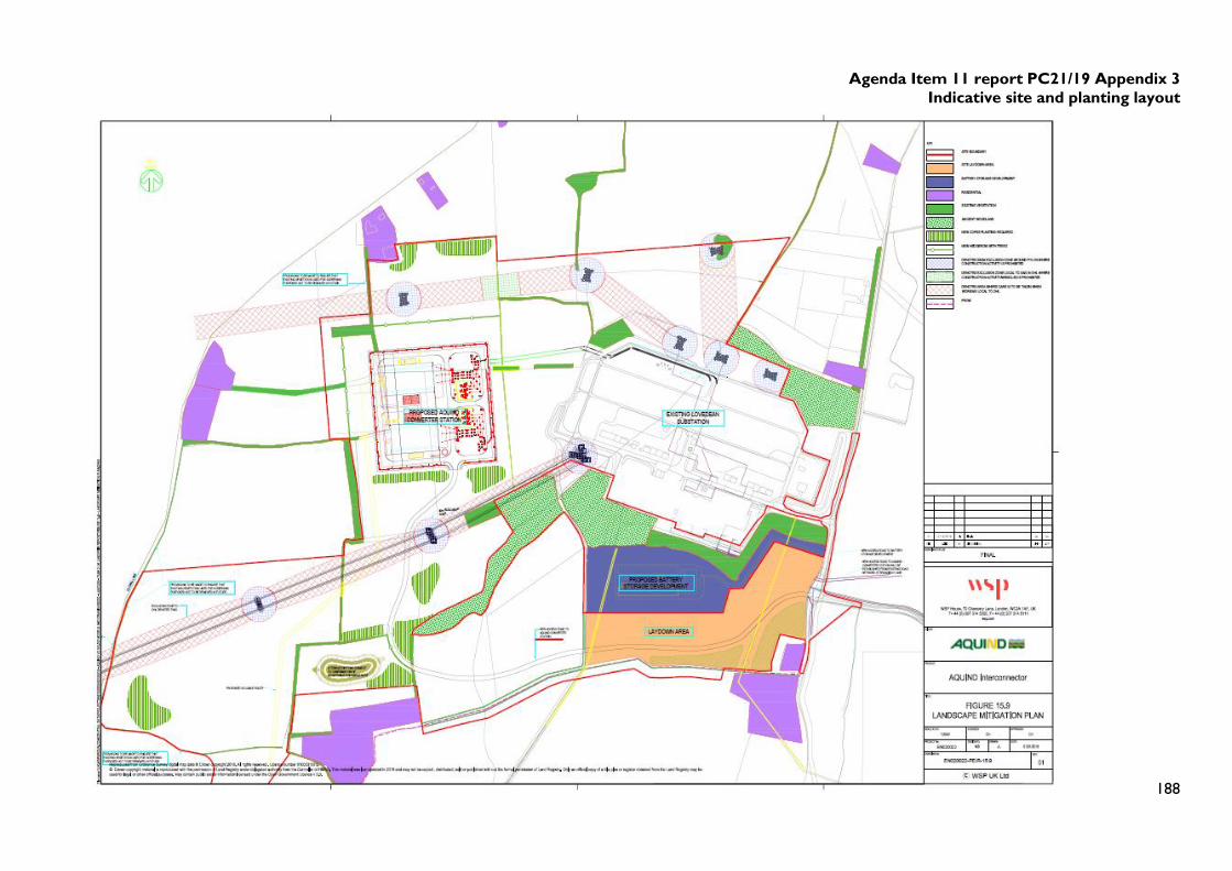
fence. An indicative layout is shown in Figure 1 below.
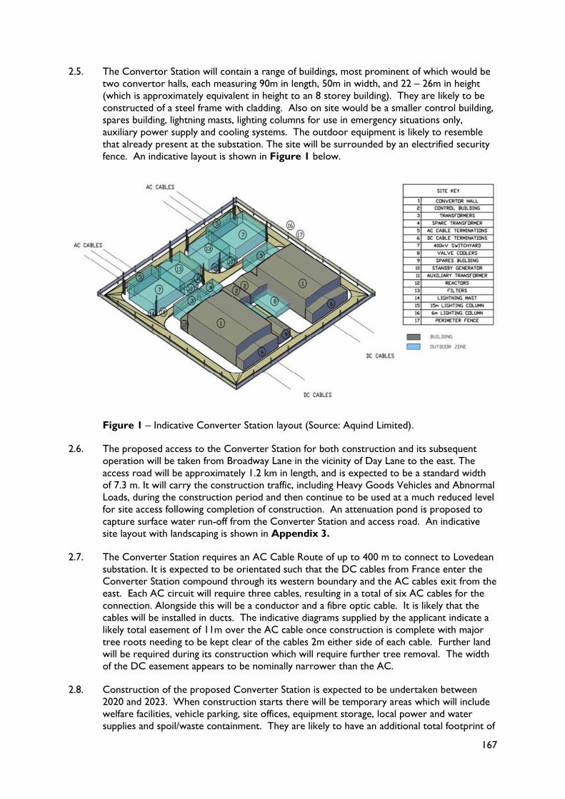
Figure 1 – Indicative Converter Station layout (Source: Aquind Limited).
2.6. The proposed access to the Converter Station for both construction and its subsequent
operation will be taken from Broadway Lane in the vicinity of Day Lane to the east. The
access road will be approximately 1.2 km in length, and is expected to be a standard width
of 7.3 m. It will carry the construction traffic, including Heavy Goods Vehicles and Abnormal
Loads, during the construction period and then continue to be used at a much reduced level
for site access following completion of construction. An attenuation pond is proposed to
capture surface water run-off from the Converter Station and access road. An indicative
site layout with landscaping is shown in Appendix 3.
2.7. The Converter Station requires an AC Cable Route of up to 400 m to connect to Lovedean
substation. It is expected to be orientated such that the DC cables from France enter the
Converter Station compound through its western boundary and the AC cables exit from the
east. Each AC circuit will require three cables, resulting in a total of six AC cables for the
connection. Alongside this will be a conductor and a fibre optic cable. It is likely that the
cables will be installed in ducts. The indicative diagrams supplied by the applicant indicate a
likely total easement of 11m over the AC cable once construction is complete with major
tree roots needing to be kept clear of the cables 2m either side of each cable. Further land
will be required during its construction which will require further tree removal. The width
of the DC easement appears to be nominally narrower than the AC.
2.8. Construction of the proposed Converter Station is expected to be undertaken between
2020 and 2023. When construction starts there will be temporary areas which will include
welfare facilities, vehicle parking, site offices, equipment storage, local power and water
supplies and spoil/waste containment. They are likely to have an additional total footprint of
168
approximately 4-5 ha. All vegetation will be removed in these areas and some earthworks
may be required to create a level platform which will be covered with of crushed stone. This
area will be in use for the duration of the construction and commissioning stages, and
restored afterwards. Materials excavated on higher parts of the site would be used to fill
lower levels and the applicant anticipates that surplus excavated material may be capable of
reuse to create bunds to provide visual screening.
2.9. At the peak of construction, the applicant calculates that there will be up to 60 HGV
movements per day, with up to 10 telescopic cranes and approximately 150 personnel on
site. A short length of existing overhead line emanating from the south-eastern corner of
the substation will need to be undergrounded, to allow the delivery of large loads.
2.10. Work associated with landscaping and land after construction is anticipated to be carried
out in 2024.
2.11. Accompanying the proposed Converter Station, are two separate Telecommunication
buildings. They house the fibre optic cables and are likely to be outside, but adjacent to the
Convertor Station site. The cables enable communication between France and the UK and
any spare capacity may be leased to third parties for commercial purposes. These buildings
would be approximately single storey and in the region of 10m x 5m each with associated
fencing, access, parking and office / welfare facilities.
2.12. The design life of the equipment, buildings and infrastructure would be up to 40 years. The
convertor technology may need overhauling / replacing after 15 / 20 years.
3. The Site Selection Process
3.1. The process of testing various locations has been undertaken by the applicant for the:
GB Grid Connection location
Convertor Station Location
Landfall Location
Onshore Cable Corridor
Marine Cable Corridor
3.2. In 2014 a preliminary study looked at the options available in terms of connecting the UK
with the electricity grid of another European Union member state. This took into account
the technology available and commercial feasibility. A connection from the UK to France
was favoured.
3.3. The next stage was to consider where connection with the GB grid was to take place. The
south coast of England was chosen because of network congestion, limited capacity and the
presence of other Interconnectors planned or proposed in Kent / East Sussex. A variety of
technical requirements then have to be met in order to determine which substation a
connection can be made to. National Grid worked with Aquind and 10 substations were
identified. 7 of these were then discounted by National Grid on the basis of limited capacity
to evacuate power, difficult access for marine / onshore cables or because they were too
close to parts of the network which were already congested.
3.4. The search was narrowed down to 3 substations and one at Chickerell, near Weymouth,
was then rejected as it would require a rebuild of the substation and additional
reinforcements of the wider network. The location of the Convertor Station was therefore
ultimately narrowed down to just Lovedean and Bramley. To access Bramley (north of
Basingstoke) would require a cable to be taken through the National Park. Lovedean was
closer to landfall locations which was considered to be preferable for both technical and
environmental reasons. It was therefore selected by National Grid and Aquind as the
preferred connection point.
169
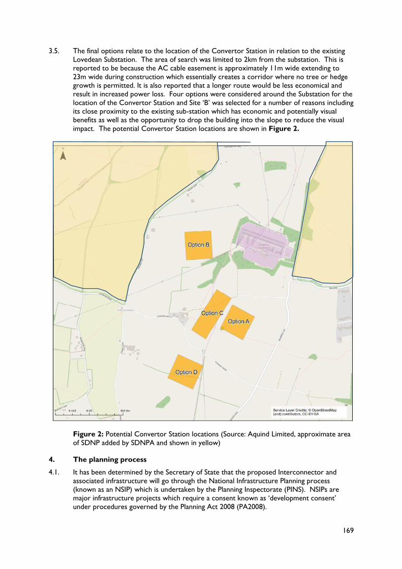
3.5. The final options relate to the location of the Convertor Station in relation to the existing
Lovedean Substation. The area of search was limited to 2km from the substation. This is
reported to be because the AC cable easement is approximately 11m wide extending to
23m wide during construction which essentially creates a corridor where no tree or hedge
growth is permitted. It is also reported that a longer route would be less economical and
result in increased power loss. Four options were considered around the Substation for the
location of the Convertor Station and Site ‘B’ was selected for a number of reasons including
its close proximity to the existing sub-station which has economic and potentially visual
benefits as well as the opportunity to drop the building into the slope to reduce the visual
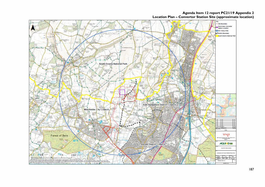
impact. The potential Convertor Station locations are shown in Figure 2.
Figure 2: Potential Convertor Station locations (Source: Aquind Limited, approximate area
of SDNP added by SDNPA and shown in yellow)
4. The planning process
4.1. It has been determined by the Secretary of State that the proposed Interconnector and
associated infrastructure will go through the National Infrastructure Planning process
(known as an NSIP) which is undertaken by the Planning Inspectorate (PINS). NSIPs are
major infrastructure projects which require a consent known as ‘development consent’
under procedures governed by the Planning Act 2008 (PA2008).
170
4.2. The six stages of the development consent regime are:
1) Pre-application - Before submitting an application, potential applicants have to carry out
consultation on their proposals. This is the current stage. PINS cannot consider
representations about an application at this stage. This is the main opportunity to
influence a scheme before an application is made to PINS for a Development Consent
Order (DCO)
2) Acceptance - This begins when an applicant submits an application for development
consent to PINS. It then allows PINS 28 days, to decide whether or not the application
meets the standards required to be accepted for examination.
3) Pre-examination - At this stage, the SDNPA will be able to register with the Planning
Inspectorate to become an Interested Party. We would expect to be invited to prepare
a Local Impact Report and attend a Preliminary Meeting.
4) Examination - PINS has up to six months to carry out the examination. During this stage
Interested Parties are invited to provide more details of their views in writing or at
hearings.
5) Recommendation and Decision - PINS must prepare a report on the application, including
a recommendation, within three months of the close of the Examination. The Secretary
of State then has a further three months to make the decision on whether to grant or
refuse development consent.
6) Post decision - Once a decision has been issued by the relevant Secretary of State, there
is a six week period in which it may be challenged in the High Court.
4.3. The application will be considered against the policy criteria set out in the Overarching
National Policy Statement for Energy, referred to as the ONPSE (EN-1). The National
Policy Statement (NPS) sets out the national policy for energy infrastructure. A further
technology-specific NPS for the electricity transmission and distribution network (reference
EN-5) has also been produced. They are the primary basis for decisions taken by PINS on
such projects.
4.4. These NPS have been produced to assist the Government in meeting its legally binding
target to cut greenhouse gas emissions by at least 80% by 2050, compared to 1990 levels.
This requires major investment in new technologies and electrification of much of our
infrastructure. It is stated that the focus of Government activity in this transformation is on
developing a clear, long-term policy framework which facilitates investment in the necessary
new infrastructure by the private sector. It is Government policy that it is for the market to
decide where and how to build the infrastructure most efficiently and the NPS states that it
is not appropriate for planning policy to set targets for, or limits on, different technologies.
4.5. National policy is that PINS should start with a presumption in favour of granting consent to
applications for energy NSIPs (ONPSE-EN1 para 4.1.2). That presumption applies unless any
more specific and relevant policies set out in the relevant NPSs clearly indicate that consent
should be refused. It then goes on to cover developments outside nationally designated
areas which might affect them. The ONPSE-EN1 (para 5.9.12) states that the duty to have
regard to the purposes of nationally designated areas also applies when considering
applications for projects outside the boundaries of these areas which may have impacts
within them. The aim should be to avoid compromising the purposes of designation and such
projects should be designed sensitively given the various siting, operational, and other
relevant constraints.
4.6. Para 5.9.13 of the ONPSE-EN1 states that the fact that a proposed project will be visible
from within a designated area should not in itself be a reason for refusing consent.
171
Environmental Impact Assessment
4.7. The proposed development is not a type of development listed within either of Schedules 1
or 2 of the EIA Regulations. However, due to the potential for significant environmental
impacts to arise in connection with the construction and operation of the Interconnector,
the Applicant has opted to undertake an EIA in support of the DCO Application. The
purpose of an EIA is to ensure that the likely significant effects of a development are
understood and taken into account. The Preliminary Environmental Information Report
(PEIR) published alongside the current consultation document is the first stage in the
collection and analysis of information needed for the EIA.
5. Consultation to date
5.1. The SDNPA were formally consulted by Winchester City Council, East Hampshire District
Council and Portsmouth City Council at the EIA screening and scoping stage prior to the
project being called in as a Nationally Significant Infrastructure Project. Aquind also
consulted on the Draft Statement of Community Consultation.
6. Summary of the Consultation Document and Supporting Evidence
6.1. Aquind are currently consulting on two documents. The main consultation document covers
in more detail the information set out earlier in this report as well as details of the cable
route from the south coast to Lovedean and through the English Channel to France. It is
stated within that document that:
The location of the proposed Converter Station is fixed as being within the area shown
in Appendix 3 of this report, though the exact location within that north-western area
remains to be determined.
The broad spatial parameters for the Convertor Station are in general fixed by
operational requirements.
The design of the Converter Station and associated mitigation is still to be determined
and feedback on the proposed approach is sought.
6.2. To accompany the consultation document a Preliminary Environmental Information Report
(PEIR) has been published for comment. The PEIR contains the applicants’ current
understanding of the potential likely significant effects of the proposed development.
Comments on the PEIR will be considered and addressed as necessary by Aquind prior to
the proposals being finalised. The PEIR is the main source of information on the options
considered by the applicant for each part of the development. It is split into 29 separate
sections, the key ones for the National Park (not already covered above) are briefly
summarised below.
LVIA – Chapter 15
6.3. The study covers an area up to 8km from the site. In addition 3 long distance views were
tested. The SDNPA recommended during meetings with the applicant that the LVIA clearly
explored how the site contributes to the setting of the SDNP both in visual and landscape
character terms.
6.4. Given the high sensitivity and high value of the landscape of the SDNP, the PEIR reports that
there is the potential for significant and non-significant indirect landscape effects arising from
the proposed Converter Station within the boundary area of the SDNP, and up to 3 km
from the proposed Converter Station. It also documents that there is potential for
significant and nonsignificant indirect visual effects on the perceptual characteristics and
views experienced from the National Park to the Converter Station location.
6.5. These significant effects are predicted to reduce at around 15 years post completion of the
build which is linked to the growth of trees used to partially screen the development.
172
6.6. It also concludes that beyond 3km the intervening vegetation and topography limits the
impact of the proposed development on both visual and landscape character.
Onshore Ecology – Chapter 16
6.7. A Preliminary Ecological Appraisal has been undertaken. In relation to the Convertor
Station proposal the main issues identified are the permanent loss of semi-improved neutral
grassland, hedgerows and mature trees. The report considers that the sensitivity of the
grassland and trees is negligible, while the hedgerows are yet to be assessed. The ancient
woodland adjacent to the Converter Station Area is of high Arboricultural value. Other
significant arboricultural features are mature or veteran trees. A full assessment of the
ecological importance of these features, including the potential for presence of bat roosts, is
to be undertaken in 2019.
Soils – Chapter 17
6.8. The assessment concludes that the siting of the Converter Station will involve the loss of
land in Subgrade 3b and Grade 4, which is not Best Most Versatile land. However, some
Subgrade 3a land to the south of Lovedean substation is also likely to be required for
example for the access road. A key issue will be how the surplus soil created during any
construction is dealt with.
Ground Conditions - Chapter 18
6.9. The soil is underlain by a geology of soft chalk with large flint which is at or close to the
surface. Limited geological issues are identified; however, it is a Principal Aquifer (See
below).
Water Resources - Chapter 19
6.10. There are no surface water features within the Converter Station area. The chalk formation
on which the site sits is classified as a Principal Aquifer and is highly sensitive. The area is
located within an Environment Agency Source Protection Zone 1 associated with Lovedean
Pumping Station located about 550m from the site. Any surface pollution will freely
percolate into the aquifer within a short period of time. The report identifies the need for
certain construction techniques along with the installation of artificial drainage and measures
to reduce erosion and sedimentation. It is anticipated that groundwater quality and level
monitoring will need to be undertaken during construction and potentially operation.
6.11. Once built, it is proposed to capture surface water in a lined attenuation pond where it will
be stored and then discharged at an equivalent greenfield runoff rate. A separate system to
capture and treat any oily water will also be put in place. Finally a septic tank and associated
drainage is proposed for foul water treatment.
Heritage and Archaeology - Chapter 20
6.12. The proposed development site does not contain any designated heritage assets but there
are several listed buildings in the vicinity. Crop marks to the south east of the site may be
evidence of earlier field systems and there is high potential for prehistoric remains. There is
also potential for some Roman remains and later medieval or post-medieval remains such as
field systems.
6.13. Construction could have a major impact and truncate or remove entirely any archaeological
remains. The reuse of the spoil on site might also bury other archaeological remains and the
landscaping and creation of drainage can result in ground disturbance,
173
Traffic and Transport - Chapter 21 & Air Quality - Chapter 22
6.14. It is anticipated there will be the following construction traffic movements to/from the
Converter Station Area:
45 HGV two-way construction traffic movements per day (90 in total);
55 non-HGV two-way construction traffic movements per day (110 in total); and
150 staff working on-site at the Converter Station.
6.15. Construction works are likely to generate dust and vehicle emissions; however, these are
considered to be of low risk and with the implementation of mitigation will be negligible.
6.16. It is not anticipated that the proposed development will significantly impact on the local
highway network once operational, with the exception of occasional servicing / maintenance
of the equipment.
Noise and Vibration - Chapter 23
6.17. The report identifies that noise from the operation of the Convertor Station will have a
negative impact on some properties nearby and therefore mitigation is required.
Human Health - Chapter 25
6.18. During construction the impacts are reported to be:
Dust and vehicle emissions during construction, the impact of which is considered to be
negligible.
Noise from construction which will impact on nearby residents. These will be short-
term and temporary.
Temporary disruption to PRoW and a change in amenity value.
Impacts of contamination on groundwater – with mitigation these are considered to be
negligible.
6.19. During operation the impacts are likely to be:
Noise, particularly on the nearest residents.
Urbanisation of the environment reducing the amenity value of the surrounding area.
Electro-Magnetic Fields will be designed to be within safe levels but the report does
highlight the perceived negative health impact, anxiety and fear particularly for residents
in close proximity.
Cumulative Effects (Chapter 28)
6.20. This section brings together information on all the current and potential developments likely
to take place around the development site in order to allow a future assessment of the
cumulative effects to be undertaken. The assessment has yet to be completed and this
chapter sets out the expected methodology.
7. SDNPA Response
7.1. The purpose of the SDNPA response at this stage in the process is to give Aquind early
sight of our significant concerns and support them in their assessment of the impact of
development on the National Park. This should enable them to make appropriate mitigation
where possible. The SDNPA’s comments have been collated under the following headings:
Landscape and visual amenity
Design
Ecology
Operational noise
174
7.2. The proposed response is set out in Appendix 1. It concludes that there has been an
insufficient landscape and design response to the setting of the National Park, the potential
impact of which is identified in the evidence supporting the application as being adverse. The
landscape impacts are greater than the applicant has identified and the mitigation measures
as currently proposed hinder rather than enhance the scheme.
7.3. Aquind will consider the responses it has received and take them into account in refining the
proposal. They will provide details of this in a Consultation Report that will be submitted at
the same time as the application for a Development Consent Order (DCO). Aquind
anticipate that their application for a DCO will be submitted later this year.
8. Other Implications
Implication Yes/No
Will further decisions be required by
another committee/full authority?
Where possible further consultation responses
will be brought back to Committee as time allows.
Does the proposal raise any
Resource implications?
A PPA has been signed and covers Officer costs.
Has due regard has been taken of
the South Downs National Park
Authority’s equality duty as
contained within the Equality Act
2010?
Yes, there are no equality and diversity issues
identified in relation to preparing this response.
Are there any Human Rights
implications arising from the
proposal?
None
Are there any Crime & Disorder
implications arising from the
proposal?
None
Are there any Health & Safety
implications arising from the
proposal?
None
Are there any Sustainability
implications based on the 5
principles set out in the SDNPA
Sustainability Strategy:
1. Living within environmental limits
2. Ensuring a strong healthy and just
society
3. Achieving a sustainable economy
4. Promoting good governance
5. Using sound science responsibly
Yes - The PEIR which forms a major element of
this consultation is the precursor to a full
Environmental Statement that will be prepared by
Aquind to support the Development Consent
Order application.
The ambition of Government is to reduce carbon
emissions and schemes like this one contribute
towards the drive away from fossil fuels.
175
TIM SLANEY
Director of Planning
South Downs National Park Authority
Contact Officer: Sarah Nelson
Tel: 01730 819285
email: [email protected]
Appendices: 1. SDNPA response to the Aquind Interconnector Consultation
2. Location Plan – Convertor Station Site
3. Indicative site and planting layout
Background Documents Are all available on http://aquindconsultation.co.uk/consultation-materials/
SDNPA Consultees: Director of Planning, Legal Services
176
Agenda Item 11 Report PC21/19 Appendix 1
11th April 2019
SDNPA Consultation Response Aquind Interconnector
Dear Sir / Madam
Thank you for providing us with the consultation material relating to the Aquind Interconnector.
1. Introduction
1.1. The purpose of this response from the SDNPA is to set out the potential impact of the
proposed development, in particular the Convertor Station, on the Purposes of the National
Park, which are:
To conserve and enhance the natural beauty, wildlife and cultural heritage of the area.
To promote opportunities for the understanding and enjoyment of the special qualities
of the National Park by the public.
In addition, Section 62 of the Environment Act 1995 also requires all relevant authorities,
including statutory undertakers and other public bodies to have regard to these purposes.
This requirement therefore applies to both the National Grid and the Planning Inspectorate
(PINS).
1.2. The Overarching National Policy Statement for Energy (ONPSE EN-1), para 5.9.12, states
that the duty to have regard to the purposes of nationally designated areas, such as National
Parks, also applies when considering applications for projects outside the boundaries of
these areas which may have impacts within them. The aim should be to avoid compromising
the purposes of the designation and such projects should be designed sensitively given the
various siting, operational and other relevant constraints.
1.3. Paragraph 172 of the National Planning Policy Framework states that great weight should be
given to conserving landscape and scenic beauty, wildlife and cultural heritage in National
Parks, the Broads and Areas of Outstanding National Beauty, which have the highest status
of protection in relation to these issues.
1.4. The South Downs National Park surrounds the proposed location of the Convertor Station
on three sides and in places it is just 200-300m m from the boundary. The Preliminary
Environmental Information Report (PEIR) acknowledges that further assessment and
consultation is required in relation to operational noise, ecology and landscape and visual
amenity predominantly around the Converter Station area where there is potential for
adverse effects. (PEIR 29.2.1.5). Having considered the documents published for
consultation the SDNPA concurs that these are the main areas of concern. In summary it is
our view that:
The National Grid is a Statutory Undertaker and is therefore required to have regard to
the purposes of the National Park as required under S11A of the National Parks and
Access to the Countryside Act 1949 (as inserted by S62 of the Environment Act 1995).
There is no evidence of how that duty has been met in the consideration of the various
sites.
177
The location, scale, appearance and form of the Convertor Station causes significant
harm to the setting of the National Park in relation to landscape character and visual
amenity.
The proposed mitigation is poor and likely to contribute further to the visual harm.
The impact on the Monarch’s Way Long Distance footpath has not been sufficiently
recognised.
No assessment has been undertaken of both the impact on visual amenity or landscape
character of the access track.
The cumulative impact of the development, along with proposed development of a
battery storage site to the south and an extension to the substation to the west, has not
been assessed sufficiently.
Opportunities to deliver positive impacts have not been taken.
2. Planning process
2.1. As permission for the Interconnector will go through the National Infrastructure Planning
process, the National Park Authority will be requesting that it be categorised as a ‘relevant’
Local Authority which will enable us to produce a Local Impact Report on the proposals.
2.2. The purpose of the SDNPA response at this stage in the process is to give you early sight of
our significant concerns and support you in your assessment of the impact of the
development on the National Park. Our response first considers the site selection
process and then covers matters relating to landscape and visual amenity, ecology and
operational noise which are identified in the PEIR as having the potential for adverse
effects. We also cover the matter of building design, references to which are in the
Consultation Document, cumulative impact and mitigation.
3. Site Selection
3.1. ‘Information about the main alternatives that have been considered should include an indication of
the main reasons for the applicant’s choice, taking into account the environmental, social and
economic effects and including, where relevant, technical and commercial feasibility.’ (ONPSE para
4.4.2)
3.2. The National Grid Electricity Transmission Studies identified 10 substations which could
accommodate the Interconnector of which 7 were then rejected (PEIR para 2.4.3.2). We
are not in a position to provide comments on the technical detail but would like to highlight
that National Grid is a Statutory Undertaker and therefore is required to have regard to the
purposes of the National Park as required under S11A of the National Parks and Access to
the Countryside Act 1949 (as inserted by S62 of the Environment Act 1995). There is no
evidence of how that duty has been met in the consideration of the various sites and how
this was weighted against, for example, ‘a difficult access’. We are also aware that in relation
to other schemes, substations have been expanded to provide extra capacity and again we
question whether this was an option that was considered.
3.3. Of the 3 remaining substations, one was then rejected as it would require a rebuild of the
substation and additional reinforcements of the wider network. However, this site in
Chickerell sits within a more urban location, it is not adjacent to a National Park and is over
1km from an AONB. Again we would like to highlight that National Grid is required to have
regard to the purposes of the National Park as required under S11A of the National Parks
and Access to the Countryside Act 1949 (as inserted by S62 of the Environment Act 1995).
There is no evidence of how that duty has been met and how the impact on nationally
designated landscapes formed part of the analysis, if indeed it did.
3.4. The location of the Convertor Station was narrowed down to just Lovedean and Bramley.
The National Park Authority accepts that to access Bramley would require a DC cable to be
178
taken through the National Park which would require a trench approximately 7m wide to be
dug. The impacts on the National Park would include:
The removal of landscape features such as tree lines, hedgerows, field patterns, sunken
lanes etc (which may be permanent)
Potential for impacts on archaeology (which would be permanent where the cable
crossed a feature)
As the cable would be buried after construction is complete and the land reinstated, in
theory, the visual impact could be reduced to occasional infrastructure associated with
maintenance/safety and operation of the cable.
Woodland would be crossed by the corridor which could result in permanent landscape,
biodiversity and visual impacts.
3.5. It is accepted that these impacts are likely to be greater than the impact of the Convertor
Station being located at Lovedean. Following on from the selection of Lovedean, the PEIR
shows no evidence that the setting of the National Park (both its visual and landscape
character) has been understood, defined or used to directly influence the siting of this
proposal. We therefore do not have any reassurance that the impacts upon the National
Park has been avoided or minimised as much as possible.
3.6. The ‘Planning Act 2008: Guidance on the pre-application process’ expects applicants to
provide “sufficient preliminary environmental information to enable consultees to develop an
informed view of the project” (Department for Communities and Local Government, 2015). It
is understood that the information in the PEIR is by definition preliminary, but it is not
sufficient to enable us to develop an informed view. Access to the options appraisal
undertaken by the specialists would enable us to judge better what the conclusions are
based upon. However, it should also be stated that given the size and scale of the proposal
in this rural landscape and the nature of the topography it is likely that all locations around
the Lovedean Substation will result in a detrimental and permanent impact on the setting of
the National Park. When this is combined with the other proposals within this narrow
finger of land, as well as the existing development which includes the substation, solar farm
and overhead lines, the impact is considered to be further increased. As a result if this is to
go ahead a large scale mitigation scheme is required worthy of its location adjacent to a
nationally designated landscape.
4. Landscape and Visual Amenity
4.1. The proposal to site the Convertor Station on Site B has the potential (as evidenced in the
PEIR) to generate adverse impacts on the landscape and visual setting of the National Park
and it is our view that the mitigation measures fail to be commensurate with the likely levels
of harm.
4.2. The LVIA (para 15.5.2.41) states that this is an open, medium scale landscape which may
have capacity to accommodate change. That may be so, but these assessments of a
landscapes ability to change cannot be successfully applied to such large scale buildings. The
buildings are likely to have a functional and utilitarian appearance which will be very
prominent and, although close to the existing substation, it will not be seen against a
backdrop of other industrial or urban development. The block style will exacerbate the
incongruity within the setting and character of the area and it will have the effect of changing
the character of the landscape and the perception of it when viewed from the SDNP from
one with an essentially rural character to one which is far more industrial.
4.3. The outcome of this scheme will be a landscape whose condition worsens because landscape
elements are being removed or fragmented further and views are being negatively impacted
with something which is wholly uncharacteristic. Alongside the other developments, both
happening and proposed, in the locality there is a strong likelihood of permanent widespread
landscape damage to the area and therefore the setting of the National Park. Instead we
179
should be striving to avoid further harm and then capture any benefits that can be delivered
through this development.
4.4. The LVIA (para 15.5.2.37) anticipates that the final location of the proposed Converter
Station would be partially screened by vegetation in some close range as well as middle and
long-distance views. However we feel this overstates the likely benefits of screening as the
height of the building will be well in excess of most trees. We confirm that the Converter
Station will be visible in both close range views and those from higher locations within the
National Park looking towards Portsmouth and the South Coast. It will also harm local
views out of the National Park from its boundary to the north and the Monarchs Way, to
points of interest such as the forts on Ports Down to the south. The Monarchs Way is a
long distance trail and therefore is considered to be of a higher status and a more sensitive
receptor than a standard PRoW.
4.5. The LVIA shows that the Convertor Station will be visible within panoramic views from
elevated positions in the National Park. The fact that walkers in elevated positions can also
enjoy views to the north east, north and north west from within the SDNP (See para
15.5.2.42) is not a suitable response. The images prepared show that the outline of the
building is very close to breaking the skyline in long distance views from, for example,
Windmill Hill and Old Winchester Hill (which is a Scheduled Ancient Monument) which
would be damaging. The images also demonstrate why the building materials to be used are
so important in order to prevent a large shiny box distracting from these panoramic views
so important to the National Park.
4.6. The Monarchs Way long distance trail runs from the more urban communities in the
Horndean area giving residents direct access into the National Park which has significant
benefits for health and wellbeing. The second purpose of a National Park is to promote
opportunities for the understanding and enjoyment of its special qualities by the public. It is
clear that this proposal will negatively impact on the experiential impacts of walkers by
virtue of introducing an industrial scale building with the associated noise into an area
through which this path runs; the impact of which will be longer lasting that the actual
duration of the glimpse.
4.7. Of further concern is the need for a very lengthy access track (1.2km) which will be retained
after construction is complete. It will widen the extent of the land impacted on by the
development far beyond the immediate confines of the site itself. It will run south of the
substation and Stoneacre Copse and will:
Cut across historic field boundaries.
Negatively affect the character of Broadway Lane – becoming more industrial and less
rural/agricultural and introducing another access point which alongside the proposed
battery storage may lead to three vehicular accesses within approximately 100m
Prevent the re-connection/improvement of nationally important habitats (Ancient
Woodland).
Run through the centre of fields, contrary to their character, dissecting the inherited
field pattern and being more obvious in views compared to following existing
hedgelines/field boundaries.
4.8. The first option should clearly be the use of the access to the existing substation and the
creation of a short link to Site B and we would strongly urge an approach that consolidates
tracks rather than creates new.
4.9. Without prejudice to the concerns set out above, we are tentatively inclined to agree that
Site B is preferred from a landscape point of view to site A for the following reasons:
Site B is more in-line with and closer to the existing Sub-station and therefore will be
seen in this context. Essentially keeping a tighter footprint.
180
Site A affects the setting of two farmsteads.
Site B does offer the potential to drop the building down into the ground so as to
reduce its visual impact
Existing vegetation can be supplemented to screen the site further. This will be more
effective for Option B than A. Views from the south will in part be screened by the
existence of Stoneacre and Crabdens Copse and from the east by the existing
substation. However these limited positives will be offset by the impact of a battery
storage site to the south of the copse if it gains consent.
4.10. In conclusion the ONPSE para 4.5.3 states that ‘Whilst the applicant may not have any or very
limited choice in the physical appearance of some energy infrastructure, there may be opportunities
for the applicant to demonstrate good design in terms of siting relative to existing landscape
character, landform and vegetation.’ This has not been done to mitigate to any satisfactory
level the harm to the South Downs National Park, a nationally significant landscape.
Tranquillity
4.11. Tranquillity is a perceptual quality of the landscape, and is influenced by things that people
can both see and hear in the landscape around them. It is considered to be a state of calm,
quietude and is associated with a feeling of peace. It relates to the quality of life, and there is
good scientific evidence that it helps to promote health and well-being. As a special quality of
the National Park, it is a characteristic of the landscape and a feature that visitors and
residents greatly value.
4.12. It is considered that tranquillity would be detrimentally affected during both the construction
and operation phases due to the presence of vehicles, machinery and human activity as well
as the resultant background noise created by the Convertor Station when in operation and
the interruption to the rural feel of the area. This will affect users of the PRoW network,
residents and other visitors in particular those using the Monarchs Way. As set out in the
PEIR, the impact may be brief and passing but users of the PRoW network’s sensitivity to
landscape and visual change is high because their purpose/activity is to enjoy the landscape
and surroundings.
The LVIA (Chapter 15)
4.13. We make the following comments on the LVIA content and methodology:
The LVIA best practice guidelines recommends an iterative approach is taken to
minimise adverse effects on landscape and visual amenity. Whilst to a degree the SDNP
has been considered (in visual terms at least) in selecting between Option A or B, the
SDNP was not considered at the outset. This is made clear in the Alternatives Chapter
as Option’s C and D have no landscape evidence.
The assessment of landscape sensitivity and value of the site fails to take a positive
approach and relies upon the elements which contribute to a discordant character
(pylons, substation) rather than equally picking out the elements of inherited character
(ancient woodlands, historic field boundaries, historic routes and farmsteads). The
balance has as a result been skewed towards these negative influences.
The LVIA fails to understand landscape history as per best practice guidance and has not
sought to include any evidence around perceptual qualities at all. This landscape itself is
sensitive by virtue of the role it currently plays in contributing to the setting of the
SDNP.
PEIR para 15.8.3.1 refers to the study area being altered to demonstrate impacts once
design choices have been made. Landscape evidence needs to be influencing these
choices to avoid the harm when seen from the National Park.
The landscape mitigation plan (Figure 15.9) does not match the description of it given in
the LVIA.
The LVIA is silent on the access track and no attempts to minimise its harm have been
made.
181
5. Convertor Station Design
5.1. The proposal has failed to incorporate a suitable design framework or the necessary design
process’ that are required to deliver a successful project. Understanding the wider
landscape, its immediate surroundings, topography and adjacent land uses should be the
starting point and the site requires a masterplan that takes account of the existing and
proposed development/infrastructure at Lovedean and looks at the role all the land within
the control of the applicant might be able to play.
5.2. The focus of the approach has been on a colour palette for the external cladding system;
which does very little to assimilate the building into the landscape. Due to the changing
nature of the landscape throughout the day and seasons, this is unlikely to be successful and
could jar. Instead the siting of the buildings should respond to site contours, balancing cut &
fill to scale-down the three-dimensional disposition of the buildings, and its relationship with
other (associated) infrastructure.
5.3. Nationally Significant Infrastructure Projects (NSIPs) must make design an integral part of
their project & planning process. A clear concept should be established and the detailed
design developed as part of this consultation. As currently set out, with the exception of
the use of cladding to attempt to camouflage the building, there is insufficient clarity on the
aims of the applicant in terms of their approach to the design of the scheme.
6. Ecology
6.1. There are a number of contradictory points in the Preliminary Ecological Assessment which
the applicant should seek to redress.
Invasive non-native species
6.2. The desktop data search does not appear to include records of invasive non-native species
and the applicant has a legal requirement to consider these and prevent their spread in any
working methodology.
Reptiles
6.3. Whilst there are no desktop records of reptiles at the converter site, field survey work has
found suitable habitat and hibernacula. We would therefore expect this to be followed up
with a presence/absence and population size survey of the converter station site. The
assessment of impact on reptiles as negligible is therefore not currently backed up by
evidence.
Bats
6.4. The onshore ecology report shows that the area around the converter station has a number
of woodland copses and connecting hedgerows with trees, this is confirmed by examination
of aerial photographs. These connecting habitats provide flight corridors for many bat
species. The desk study showed records of eleven bat species in the study area, this has
been supported by initial survey work of the converter station (both transects and static
detectors) which recorded 9 species on the site including Barbastelle bats (European
protected species).
6.5. Studies have shown the importance of woodland edge and hedgerows as commuting routes
for bats. Additional studies have found no conclusive evidence of an impact of high voltage
electricity cables on bat movements, apart from where they have caused breaks in
connective habitats which then acts as a barrier to movement. A key objective of the
application should be to preserve and increase the connective woodland and hedgerow
cover on the site and to provide biodiversity.
182
Woodland
6.6. ONPSE para 5.3.14 states that ‘Ancient woodland is a valuable biodiversity resource both for its
diversity of species and for its longevity as woodland. Once lost it cannot be recreated. PINS should
not grant development consent for any development that would result in its loss or deterioration
unless the benefits (including need) of the development, in that location outweigh the loss of the
woodland habitat. Aged or ‘veteran’ trees found outside ancient woodland are also particularly
valuable for biodiversity and their loss should be avoided. Where such trees would be affected by
development proposals the applicant should set out proposals for their conservation or, where their
loss is unavoidable, the reasons why.’
6.7. The summary of ecological receptors and impacts (Technical Appendix 16.2) does not
include woodland habitat and does not currently assess impacts on hedgerows or bats.
Development of the proposed Convertor Station will result in the loss of some trees and
hedgerows and potential deterioration of ancient woodland / ancient or veteran trees. At
this stage we feel that is underplayed and the impact is not suitably weighted.
6.8. The site’s fragmented Ancient Woodland is a nationally important, irreplaceable habitat yet
nothing has been done to take opportunities to improve its resilience/ overall character.
Mitigation or compensation for the loss of woodland, existing trees and hedgerows would
be required, together with a scheme of replacement planting (or other habitat restoration)
with demonstrable long term management agreements in place. Where possible, damage
when installing the cables through hedgerows should be avoided, by utilising field gateways
or for important species rich hedgerows consider direct drilling. Hedgerows that need to be
removed should be replaced with a similar species mix as part of a large scale habitat
creation scheme.
7. Operational Noise
7.1. We would question the analysis of the impact of noise from Site B. Due to the presence of
a number of pitches for Gypsies, Travellers and Travelling Showpeople to the north and
west, it is likely that the impact of noise on the residents, some of who are in mobile homes
and caravans, is greater than the report suggests. It is likely that making enhancements to
the homes to reduce the impacts of noise will be harder to achieve successfully than in
bricks and mortar properties and the impacts may be disproportionately larger on these
residents as a result.
8. Waste and Material Resources
8.1. There is concern about the frequent referral to the use of the excavated material for
landscaping bunds. The use of bunds will be totally out of character with the area and will
do nothing to mitigate the impact of the proposed development other than to create further
manmade features in the landscape. Instead it is suggested that the material be spread more
widely and used to sculpt more subtly the landform locally which can then be planted to
create a more gently undulating landscape. However the impact of this on drainage will
need to be assessed and integrated with the proposed drainage pond taking surface water
from the site.
9. Cumulative Impact
9.1. Para 4.2.5 (ONPSE EN-1) states that when considering cumulative effects, the Environmental
Statement should provide information on how the effects of the applicant’s proposal would
combine and interact with the effects of other development (including projects for which
consent has been sought or granted, as well as those already in existence).
9.2. Para 4.2.6 of the ONPSE (EN-1) states that PINS should consider how the accumulation of,
and interrelationship between, effects might affect the environment, economy or community
as a whole, even though they may be acceptable when considered on an individual basis with
mitigation measures in place.
183
9.3. There are multiple infrastructure related developments permitted or proposed within the
immediate locality (See PEIR Figure 28.1). Of particular note is:
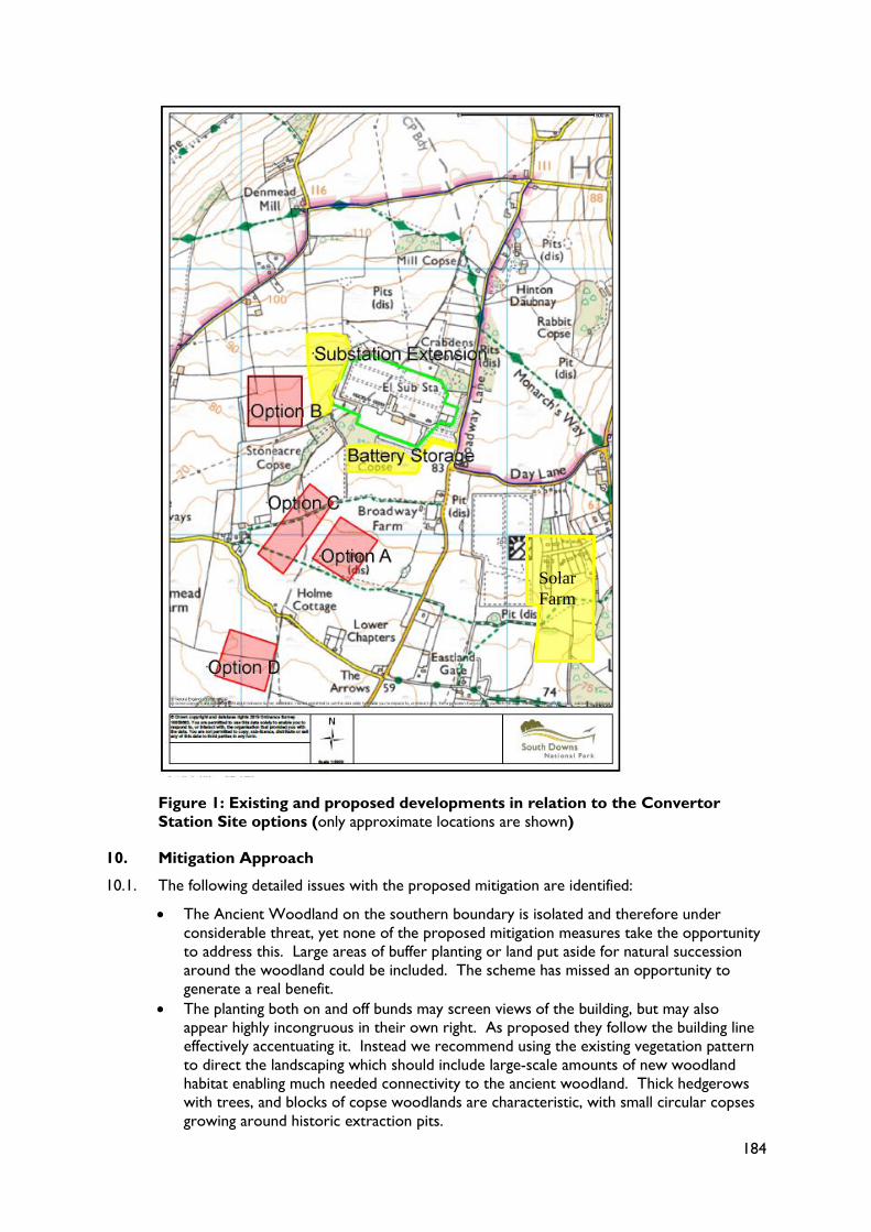
1) Proposed Anesco Battery Storage System to the south of Lovedean substation. This
would be situated north of the indicative access track route connecting the proposed
Converter Station to the highway. The development would comprise 40 storage
containers, and 132kV sub station (5.5 m in height), and further substations (2.5 m in
height), with perimeter security fence and new planting. It was permitted in April 2018
but this decision was quashed at Judicial Review in August 2018. A new application is
anticipated shortly.
2) Permission was granted in August 2013 for a westward expansion of the existing
substation covering an area of 3.5ha, reference Winchester application 13/01025/FUL
(Extension of the existing substation to include additional electrical equipment - shunt
reactor, static var compensator and super grid transformer). This application has
commenced and we are concerned that this permission is not included in the current
assessment. It may be that the applicant has information indicating that it is not going to
be developed out in full, but it must at the very least be included in the study in order
to be screened out. If it is to be developed it may have a significant impact on the
landscape as it will be filling the undeveloped land between Site B and the existing
substation as shown in the indicative plan below (Figure 1).
3) Solar farm to the south-east, 14ha in size and producing 5.76MW electricity has
recently been built.
9.4. Collectively the two developments alongside the substation in combination with the
Convertor Station may have a total land take of 8.5ha with an additional 4/5ha in temporary
use during the construction of the Convertor Station.
9.5. The potential for significant cumulative environmental effects will be assessed in the
Environmental Statement that accompanies the DCO. This is too late to be able to
influence the proposal, consider the cumulative impacts on the South Downs National Park
and how various options may lessen or increase the negative effects. The impact of the
Aquind proposal will only be made more severe when other planned or proposed
developments are also taken into account.
184
Figure 1: Existing and proposed developments in relation to the Convertor
Station Site options (only approximate locations are shown)
10. Mitigation Approach
10.1. The following detailed issues with the proposed mitigation are identified:
The Ancient Woodland on the southern boundary is isolated and therefore under
considerable threat, yet none of the proposed mitigation measures take the opportunity
to address this. Large areas of buffer planting or land put aside for natural succession
around the woodland could be included. The scheme has missed an opportunity to
generate a real benefit.
The planting both on and off bunds may screen views of the building, but may also
appear highly incongruous in their own right. As proposed they follow the building line
effectively accentuating it. Instead we recommend using the existing vegetation pattern
to direct the landscaping which should include large-scale amounts of new woodland
habitat enabling much needed connectivity to the ancient woodland. Thick hedgerows
with trees, and blocks of copse woodlands are characteristic, with small circular copses
growing around historic extraction pits.
Solar
Farm
185
Horizontal drilling should be used in the construction of the cable routes to preserve
existing features such as hedgerows, banks to sunken lanes, walls and other linear
features which the proposed cable route may cross.
The long, winding access track is not mitigated for at all and should be rationalised with
that used for the existing sub-station or, in a worse-case scenario, the access to the
proposed battery storage to the south.
The balancing pond is out of character. Instead it should be used as an opportunity to
introduce biodiversity benefits. Given its potentially large size, a number of ponds could
be created instead of one, some with permanent water in and some more ephemeral to
support a variety of species.
Considering the level of spoil likely to be generated, if it is to remain on or near the site,
it should be used to sculpt the landscape close to the site to provide interest as well as
the basis of some screening rather than for bunds.
10.2. In addition to the above, we consider that the mitigation strategy for dealing with the
proposal’s design is not clear and we suggest there are two broad options available:
1) If the intention is to hide the building then introducing movement in the form of a
changing palette of colours on the cladding may result in it being eye-catching. The
landscape is dynamic and changes colour with the elements. A different palette of
colours would be needed for every elevation and those facing the National Park will be
predominantly north facing and would correspondingly need to be darker as they
would mostly be within shadow. Taking a cue from the landscape could lead you
towards the use of natural materials to mitigate / minimise visual harm such as timber
allowed to naturally weather and stone facing.
2) If the intention is to use design as a means to celebrate this addition to the landscape
then the design as set out in the Consultation Document is poor and we do not
understand the use of cladding to camouflage it and bunds/tree planting to screen parts
of it.
10.3. This large scale, nationally significant infrastructure proposal, requires a large scale response
rather than piecemeal areas of planting, cladding and the use of bunds close to the site. As
a result and in addition to the more detailed matters raised above we would like to see the
following:
1) Undergrounding overhead pylons that cross into the National Park or effect its
setting. This would allow the more local impact of the Convertor Station (visual and
perceptual), particularly on those using the National Park and the Monarch’s Way, to
be offset by a more landscape scale improvement to the wider area.
2) Community fund. A fund should be put aside for local environmental improvement
schemes, particularly for the communities around the site leading to further
biodiversity gain and landscape improvements.
3) A scheme to deliver significant biodiversity gain on all the land within the application
boundary, rather than just that closest to the proposed development.
4) Long-term management, secured to improve the landscapes poor condition. It is
important to understand if the applicant has ownership of all the land required for
the mitigation or will it be left to others to manage.
11. Conclusion
11.1. In conclusion we trust this provides you with a clear understanding of our concerns about
the site selection process; the scale, appearance and form of the Convertor Station; the
poor mitigation; lack of assessment of the impact of the access track; the impact on the
Monarch’s Way Long Distance footpath and the cumulative impact of the development.
Should this scheme progress we would like to work with you where possible to see
opportunities are taken to deliver significant landscape and ecological benefits.
If you have any queries please do not hesitate to contact me.

186
Yours sincerely
Sarah Nelson
Planning Projects Lead
187
Agenda Item 12 report PC21/19 Appendix 2
Location Plan – Convertor Station Site (approximate location)
188
Agenda Item 11 report PC21/19 Appendix 3
Indicative site and planting layout


