Embed Size (px)
Citation preview
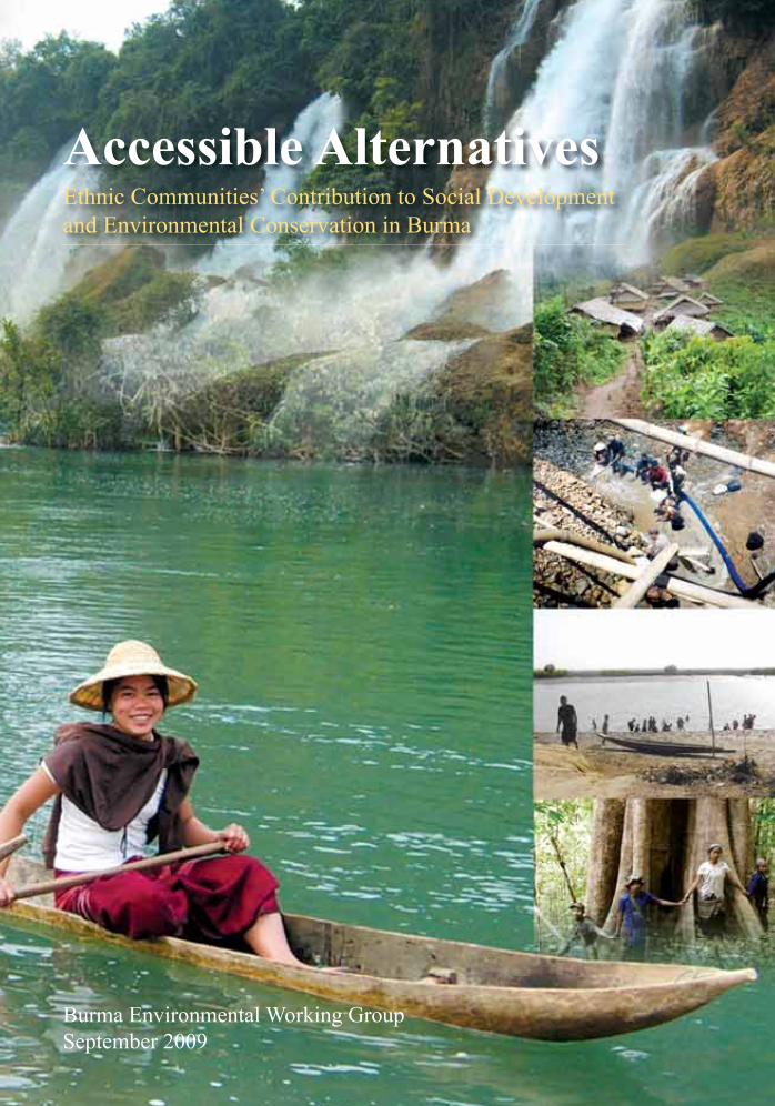
Accessible Alternatives
Ethnic Communities’ Contribution to Social Development and Environmental Conservation in Burma
Burma Environmental Working GroupSeptember 2009
Burma Environmental Working Groupii
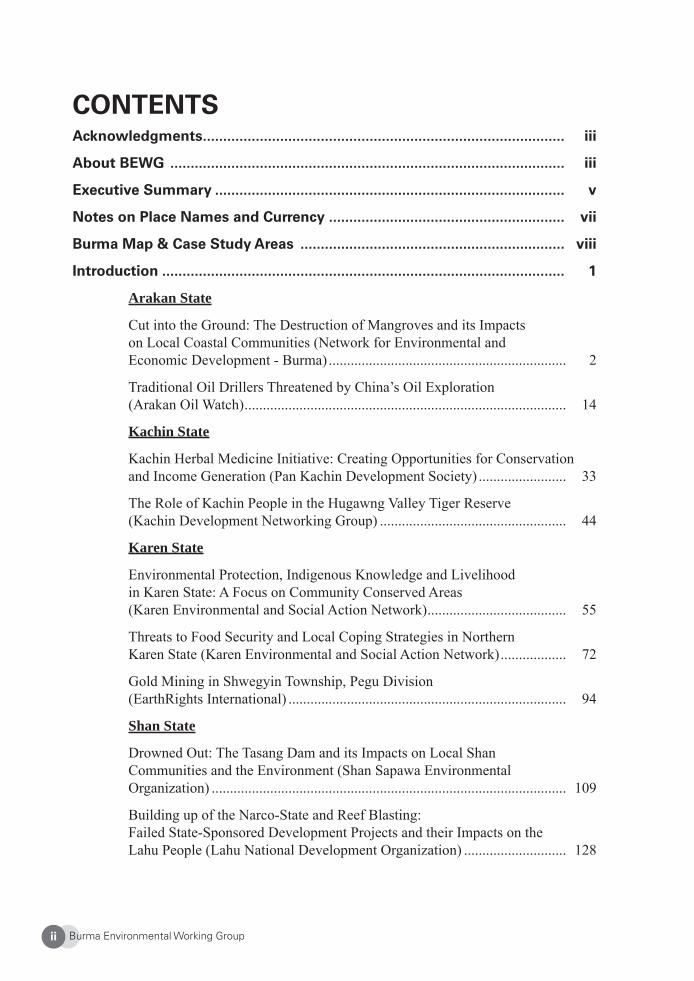
CONTENTSAcknowledgments ......................................................................................... iii
About BEWG ................................................................................................. iii
Executive Summary ...................................................................................... v
Notes on Place Names and Currency .......................................................... vii
Burma Map & Case Study Areas ................................................................. viii
Introduction ................................................................................................... 1
Arakan State
Cut into the Ground: The Destruction of Mangroves and its Impacts on Local Coastal Communities (Network for Environmental and Economic Development - Burma) ................................................................. 2
Traditional Oil Drillers Threatened by China’s Oil Exploration (Arakan Oil Watch) ........................................................................................ 14
Kachin State
Kachin Herbal Medicine Initiative: Creating Opportunities for Conservation and Income Generation (Pan Kachin Development Society) ........................ 33
The Role of Kachin People in the Hugawng Valley Tiger Reserve (Kachin Development Networking Group) ................................................... 44
Karen State
Environmental Protection, Indigenous Knowledge and Livelihood in Karen State: A Focus on Community Conserved Areas (Karen Environmental and Social Action Network) ...................................... 55
Threats to Food Security and Local Coping Strategies in Northern Karen State (Karen Environmental and Social Action Network) .................. 72
Gold Mining in Shwegyin Township, Pegu Division (EarthRights International) ............................................................................ 94
Shan State
Drowned Out: The Tasang Dam and its Impacts on Local Shan Communities and the Environment (Shan Sapawa Environmental Organization) ................................................................................................. 109
Building up of the Narco-State and Reef Blasting: Failed State-Sponsored Development Projects and their Impacts on the Lahu People (Lahu National Development Organization) ............................ 128
Burma Environmental Working Group iii
AcknowledgmentsThe Burma Environmental Working Group would like to thank the following organizations and individuals for their support for the production of this report. The Dag Hammarskjöld Foundation and the Open Society Institute provided fi nancial support. Many communities and individuals who we cannot name gave vital information and welcome advice regarding the substance and contents of this report. Many thanks are also due to Christina Browning, Jeremy Mak, Kevin Woods, Marty Bergoffen, Saw Paul Sein Twa, Steve Thompson, Saw Tamula and Yuki Akimoto who assisted in editing the report. Finally, coordinators of the Another Development for Burma project, Saw David Taw, Saw Frankie Abreu, Khin Ohmar, and Matilda, offered constant encouragement.
About the Burma Environmental Working GroupMembers of the Burma Environmental Working Group fi rst came together in 2005 through a seminar organized by the Another Development for Burma project (ADfB). The ADfB project provides a platform for political, community and issue-based groups within the Burma democracy movement to consider long-term challenges and development alterna-tives for the future of Burma. It is run by a core group of devoted individuals from a wide range of organizations within the Burma democracy movement. This report represents the fi rst major joint project of BEWG members.
Vision
The Burma Environmental Working Group envisions a Burma in which a democratic govern-ment and a strong civil society work together effectively to safeguard ecological and cultural diversity and ensure that the country’s development policies provide equitable benefi ts to all.
Mission
The Burma Environment Working Group is a coalition of environmental organizations and activists with the common goals of protecting Burma’s landscape and natural resources from further degradation; safeguarding traditional livelihoods and indigenous resource manage-ment methods; promoting local conservation projects; educating the public of the negative consequences of large-scale development and natural resource extraction projects; and advocating sensible, sustainable, and humane development policies and strong, enforceable environmental laws for Burma’s post-transition period.
Burma Environmental Working Groupiv
Specifi cally, the Burma Environmental Working Group serves and provides a forum to exchange and disseminate information and jointly monitor the environmental situation in Burma and compliance with environmental norms and standards such as the implementation of environmental, social, and health impact assessments related to mega-projects. Members collaborate on research, reporting, and advocacy campaigns, and formulate recommendations for policymakers and international NGOs working in Burma for potential environmental laws. Further, the Burma Environmental Working Group networks with other non-governmental organizations to monitor the activities of international fi nancial institutions in Burma. In ad-dition, the Burma Environmental Working Group serves as a network for capacity-building initiatives and human resources advancement.
Contact Information E-mail: [email protected]
The following organizations are members of the Burma Environmental Working Group in alphabetical order.
EarthRights InternationalKachin Development Networking GroupKaren Environmental and Social Action NetworkLahu National Development OrganizationNetwork for Environmental and Economic DevelopmentPan Kachin Development SocietyShan Sapawa Environmental Organization
*Arakan Oil Watch is not a member of the Burma Environmental Working Group, but contributed to this report by providing a case study.
ISBN: 978-974-235-362-9Published by: BEWG© BEWG 2009, 1,000 copiesDesigned & Printed by: Wanida Press, Chiang Mai, Thailand.
Burma Environmental Working Group v
EXECUTIVE SUMMARY “Accessible Alternatives: Ethnic Communities’ Contribution to Social Development and Environmental Conservation in Burma” consists of case studies by the members of Burma Environmental Working Group (BEWG) and Arakan Oil Watch. The case studies describe a variety of issues related to natural resource management in different parts of Burma, but they all describe a pattern: Communities have had their own systems of natural resource management that supported their lives and that also ensured that the resources were not depleted. But inevitably, militarization and development projects in the area have destroyed the environment and made it impossible for the local people to continue their traditional ways of life.
In some cases, support from BEWG member organizations has helped revive the natural environment and the ways of life it supports, but in other cases, communities and people continue to struggle from the impacts of military activities and development projects. All of the case studies close with suggestions about community-based natural resource manage-ment and policy recommendations for sustainable development.
In “Cut into the Ground: The Destruction of Mangroves and its Impacts on Local Coastal Communities,” the Network for Environmental and Economic Development - Burma (NEED) reports that in Arakan State, the destruction of mangrove forests to make way for large-scale shrimp farms and brick production is causing negative impacts on local ecosystems and traditional livelihoods. Oppression by authorities further exacerbates the situation for the communities that depend on mangrove resources for their living. The case study, which is based on fi eld visits and interviews in 20 Arakan communities, argues that more effort should be put into protecting and restoring mangrove forests in Arakan State.
“Traditional Oil Drillers Threatened by China’s Oil Exploration” by Arakan Oil Watch docu-ments the ecological and social impacts that Chinese oil exploration have on the livelihoods of communities Ramree Island in Arakan State, and gives a sense of what can be expected as exploration of natural gas and infrastructure construction continue there. The case study is based on a report by Arakan Oil Watch, Blocking Freedom: A Case Study of China’s Oil and Gas Investment in Burma (October 2008).
In “Kachin Herbal Medicine Initiative: Creating Opportunities for Conservation and Income Generation,” Pan Kachin Development Society (PKDS) describes an initiative in Kachin State to gather medicinal herbs and produce medicine, set up a clinic, demarcate an herbal medicine forest, and document local knowledge of herbal medicine. PKDS fi nds that com-munity participation in and ownership over project activities has resulted in sustainable extraction of forest resources, increased awareness among the community about the benefi ts of conservation, cultural revival, income generation and poverty alleviation.
The Hugwawng Valley Tiger Reserve in Kachin State is the world’s largest tiger conserva-tion area. The traditional livelihoods of local people have helped sustain the nature in the valley. As Kachin Development Networking Group reports in “The Role of Kachin People
Burma Environmental Working Groupvi
in the Hugawng Valley Tiger Reserve,” however, the activities of the military and govern-ment cronies are threatening not only the sustainable livelihoods of the local people but also the very ecosystem that the Tiger Reserve is supposed to protect. KDNG promises to use environmental and social advocacy tools to directly address these problems.
In Karen State, villagers are undertaking a range of projects aimed at environmental protec-tion. According to “Environmental Protection, Indigenous Knowledge and Livelihood in Karen State: A Focus on Community Conserved Areas” by the Karen Environmental Social Action Network (KESAN), these projects utilize traditional knowledge and methods, and enable the communities to maintain their livelihoods and preserve their culture while serv-ing local development goals. The case study makes recommendations for how international conservation organisations and local, community-based groups could work together.
Another case study by KESAN, “Threats to Food Security and Local Coping Strategies in Northern Karen State,” shows how the confl ict in northern Karen State between the Burmese army and Karen National Union (KNU) have had serious negative impacts on the local environment, traditional agricultural practices and seed-saving methods, leading to food insecurity. KESAN is working with communities in Karen State to improve food security, maintain sustainable farming systems and knowledge, and encourage community self-reliance.
During the dry season, villagers in Shwegyin Township in Karen State used to pan for gold in the rivers and streams to supplement their income. In “Gold Mining in Shwegyin Township, Pegu Division,” EarthRights International describes how this traditional, small-scale mining method is being replaced by industrial mining technologies, which in turn is destroying the natural environment. The case study also exposes the link between militari-zation in Shwegyin Township and the subsequent human rights abuses and rapid increase in resource exploitation.
“Drowned Out: The Tasang Dam and its Impacts on Local Shan Communities and the Environment” by Shan Sapawa Environmental Organization illustrates the traditional live-lihoods and forest and water management systems in communities in southern Shan State and how they have been destroyed by militarization and state-sponsored development. The case study draws attention to the negative social and environmental impacts likely to occur as the construction of Tasang dam on the Salween River proceeds.
In 2002, the governments of Burma, China, Laos, and Thailand agreed to implement a project involving blasting of reefs in the Mekong River, evidently aimed at improving navigation. “Building up of the Narco-State and Reef Blasting: Failed State-Sponsored Development Projects and their Impacts on the Lahu People” by the Lahu National Development Organiza-tion report how the blasting has caused hardships for farming and fi shing communities that depend on the river. The case study also describes the complicity of the Burmese military regime in the production and traffi cking of illicit drugs, and how hundreds of thousands of villagers have been forcibly relocated under the pretext of eradication programs.
Burma Environmental Working Group vii
Notes on Place Names and CurrencyPlace Names
In 1989, the military government in Burma changed the offi cial names of the country and cities, districts, and states, including the names of places mentioned in this report. In respect and recognition of ethnic and indigenous people’s names for ancestral lands, this report generally uses the historical names with the exception of direct quotes.
Burma’s Currency
Burma’s national currency is the kyat. The offi cial exchange rate is fi xed at 6.41 kyat to US$1, but the market rate of approximately 1,300 kyat to US$1 is widely regarded as more realistic.
Burma Environmental Working Groupviii
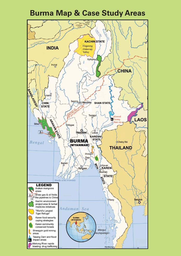
Burma Map & Case Study Areas
Burma Environmental Working Group 1
INTRODUCTION
Burma has arguably some of the most diverse and widespread ecosystems in Asia. Many different types of large forests are home to thousands of animal and plant species. Great riv-ers provide habitat to hundreds of fi sh and other aquatic species. Coastal mangroves provide breeding habitat for a multitude of marine life, and the central plain is the crossroads for many migrating waterfowl. Burma’s diverse assortment of plants and animals has provided the means for local populations to sustain their livelihoods and cultural practices. Forests provide game, fuelwood, medicinal plants, and construction materials. Rivers and streams supply fi sh for sustenance and income.
In particular, many ethnic and indigenous peoples have maintained traditional natural resource management systems that support their lives but also ensure sustainability of the natural resources. In recent years, however, the military regime, armed resistance groups, inves-tors, and foreign governments have realized that exploiting Burma’s rich natural resources for commercial purposes can be lucrative for them. As a result, militarization, large-scale resource extraction, and infrastructure development are destroying the natural environment and threatening these local natural management systems, which are directly related to the livelihoods and survival of local communities. Many local people have had to abandon their homes and livelihoods without any compensation and suffered human rights abuses.
The Burma Environmental Working Group recognized the need to draw attention to the knowledge and practices of ethnic communities that ensure sustainable natural resource management. Through this report, the Burma Environmental Working Group exposes the harsh impacts that are infl icted on the environment and the livelihoods of ethnic people by the current development path that Burma is taking. It warns that unless the value of traditional natural resource management knowledge and methods are recognized widely and serious efforts are begun now to restore them, those knowledge and methods will be lost forever.
Burma Environmental Working Group2
Arakan State
Cut into the Ground:The Destruction of Mangroves and its Impacts on
Local Coastal Communities
Network for Environmental and Economic Development (NEED-Burma)
“It’s very diffi cult for rural and coastal peoples to survive, because the SPDC and busi-ness interests take over all of our resources.”
- Nay Lin Aung, farmer and fi sherman from Ranaungbyin Village, Rathedaung Township, Arakan State
1. Arakan State and Its Mangrove Forests
Arakan State lies in northwestern Burma and borders Bangladesh and the Bay of Bengal. It is thought that Rakhines, the largest ethnic group in Arakan State, settled there in the ninth century. Tales claim that Rakhines descended from their legendary king Marayu, who founded the fi rst city Dhanyawadi, married the daughter of a Mro chief, and cleared the country of demon-like creatures called Bilus.1 Arakan State used to be an independent sovereign na-tion before it was annexed by Burmans in 1784, and its cultural heritage is one of the most fascinating in Burma today. Arakanese culture is similar to mainstream Burmese culture, but because of Arakan State’s proximity with Bangladesh and the rest of South Asia, it has more of an Indian infl uence.
Arakan State is one of Burma’s three major mangrove areas. According to Burma’s Forestry Department statistics, in 2000, Arakan State had 22,919 hectares (56,634 acres) of mangroves.2 Arakan offi cially has 13 species of mangroves, while unpublished research has documented 30 species in the State.3 Surveys completed in the 1980s found that the dominant species was Heritiera fomes, followed by Cynometra ramifl ora. Additional mangrove varieties include Xylocarpus granatum, Kandelia candel, Excoecaria agallocha, Bruguiera gymnorhiza and Rhizophora species. Endemic tree species in Arakan include Bruguiera cylindrical, Bruguiera parvifl ora, Heritiera littoralis, Xylocarpus granatum, and Xylocarpus moluccensis.4
Mangroves, a keystone species in Arakan State, are rich in biodiversity, support local live-lihoods, and provide many invaluable ecological services. They provide lumber, roofi ng, and other construction materials for houses, animal pens, and seasonal temporary shelters for farmers and livestock. The Taw Chong fruit—one of many kinds of traditional medicine found in mangroves—can cure some forms of paralysis in people and also treat hoof and mouth disease in cattle. Rope fi bers for farmers and red clothing dyes can be found here. In addition, mangroves are rich in biodiversity, providing food and habitat to monkeys, herons, cranes, crocodiles, otters, wild dogs, and snakes.5
Burma Environmental Working Group 3
The population of Arakan State is approximately seven million. 89% are ethnic Rakhine, 7% are Khami, Chin, Mara, and other ethnic groups, and 4 % are Bengali Muslims. In this article, “Arakanese” refers to all the people of Arakan State. Agriculture and fi shing are the cornerstones of identity and survival for more than 70 % of Arakanese.6 90% of Arakanese live along or nearby mangrove forests and swamps that line Arakan’s sheltered muddy coast and estuaries.7 Along the coastline, the lives of local villagers are intertwined with and dependent on mangroves and neighboring vegetation and natural resources.
2. Destruction of Mangrove Forests
For the past 20 years, a combination of unsustainable prawn and shrimp farming,8 log-ging for fi rewood, charcoal production, extraction of non-timber forest products, and, to a lesser extent, ecotourism development, have destroyed more than 84% of the mangrove forests in Burma.9 There is no offi cial protection for the mangrove in Arakan State.10 While no precise numbers exist for Arakan State, the Network for Environmental and Economic Development believes that more than half of its mangroves have been lost, mostly to state-controlled shrimp farming and brick making. Other contributing factors to mangrove loss in Arakan include road construction, extension of settlements, and the operation of salt fi elds.11 Arakan’s northern and western mangroves are severely depleted, and southern is-land mangroves are protected only by their inaccessibility. Development projects have not only destroyed traditional land management practices and the local environment but also continue to devastate the livelihoods of coastal and riparian Arakanese, people who have traditionally depended on mangroves for food, shelter, and forest products.
Under the Burmese military regime (State Peace and Development Council, or SPDC), lo-cal communities in Arakan State continue to suffer from failed state development policies and development-related human rights abuses such as the pervasive use of forced labor. Many restrictions of basic freedoms are imposed in Arakan more severely than most other areas in Burma.12 Institutionalized discrimination and marginalization of ethnic nationali-ties within the Arakanese population have consistently excluded local communities from participating in decision-making about the management and use of their natural resources. These linked hardships make it increasingly diffi cult for Arakanese people to maintain an adequate standard of living, and, as a result, tens of thousands have fl ed to other countries as refugees and migrant workers. Needless to say, communities living under this climate face great challenges in preserving their traditional livelihoods, traditions, and environment.
Traditional Natural Resource Management
Indigenous and ethnic coastal populations in Arakan State have relied on mangroves and local forests for food, construction materials, fi rewood, charcoal, and medicines for hundreds of years. Mangroves provide nursery grounds, shelter, and food for half of the fi sh species that Burmese nationwide depend on for commercial and subsistence fi shing.13 Many resi-dent fi sh, prawn, shrimp, crabs, lobsters, crayfi sh and other aquatic wildlife life can also be found in and around Arakan’s mangroves. The survival of seagrass beds and coral reefs, both of which provide communities with much needed sustenance, depend on the ability of
Burma Environmental Working Group4
the mangroves to fi lter sediments. One square kilometer of healthy coral reefs can produce enough food to feed 1,000 people.14 Besides fi sh and other aquatic foods, communities collect non-timber forest products like wild fruits and vegetables from mangroves as well.
Many communities in Arakan State believe in animism and spirits. Their beliefs manifest themselves in protected mangrove forests (nat taw), which were usually established in front of and behind villages. In these areas, felling of trees was prohibited traditionally. Such practices were prevalent until the SPDC’s development agenda was implemented almost 20 years ago.
In the rainy season which runs from June to October, tide water levels in mangroves are higher, and many female fi sh come to these wetland areas to lay their eggs and to feed on mangrove fruits and fl owers. Rice fi elds traditionally border mangroves, and after the rainy season, saltwater begins to move inland. To prevent saltwater and brackish water from enter-ing paddy areas, villagers customarily work together to build up earthen water breaks each year. On top of the breaks, mangrove trees are planted to serve as water markers to gauge whether or not tidal and fl ood waters breach the breaks.
Fishing, trapping, and small-scale aquaculture are the backbone of coastal Arakanese liveli-hoods. Typically, homes are located very close to streams, making daily fi shing convenient. Traditional coastal fi shing methods are based on the tides and include use of nets by men, and bamboo prawn scoops and fi sh and crab traps by women. Locals trap both night and day according to the tides. Small-scale shrimp farming also is common, and like levee building, shrimp pond construction depends on communal labor of villagers. Traditional one-acre family-owned shrimp ponds can produce 20 viss (about 32 kilograms)15 of shrimp on average, enough to feed one household and produce marketable surplus. Large-scale shrimp farms can grow up to 30 viss of shrimp per acre, but each acre requires about a 100,000 kyat investment. In comparison, a one acre traditional shrimp pond needs only 20,000 kyat of start-up capital.
Mangroves Save Lives
Mangroves stabilize the soil and prevent erosion, siltation, and sediment loss by acting as catchment areas for materials washed from inland and upstream waters. In addition, man-groves absorb excess nutrients like nitrates and phosphates, which helps prevent contamina-tion and algal blooming in coastal waters. Furthermore, mangroves moderate the effects of global warning by soaking up and storing carbon in their trunks and sediments.16
Like their Bangladeshi neighbors, the people of Arakan State are familiar with yearly cyclones, usually in April and May, which often claim human lives.17 Fatal fl oods occur repeatedly during the rainy season as well. Mangrove roots and trunks help protect coastal communities from strong winds, storm waves, and natural disasters like cyclone and tsuna-mis. They also help lessen the impacts of fl oods.
Mangrove ecosystems have other natural warning signs of impending disasters. For example, if mangrove crabs dig holes on very high ground, it signals that in the following year there
Burma Environmental Working Group 5
will be fl oods. This crab behavior has traditionally prompted locals to build up their levees. Arakanese who know how to recognize signs like this are able to brace themselves before catastrophes hit and have better chances of preventing loss of life and damage to property.
Lessons from Cyclone Nargis
Cyclone Nargis, the worst natural disaster in Burma’s history, hit the Ir-rawaddy Delta on May 3, 2007. The offi cial toll is 84,537 deaths, 53,836 missing, and 2.4 million affected, although some estimates put the numbers much higher.18 During Cyclone Nargis, villagers who lived in areas defended by mangroves survived. In Pyapon Township in Irrawaddy Division, out of 15,000 people from 26 villages, only three people died, as Burmese environmental NGO the Forest Resource Development and Conservation Association grew than 3,000 acres of mangrove forests there over the past 10 years.19
According to the United Nations Food and Agriculture Organization, man-grove areas in the Irrawaddy Delta total less than 250,000 acres, not even half the size they were in 1975. Over 82 % of mangrove coverage in the delta has been lost, mostly due to rice farming.20 If more mangrove forests had been intact, many more lives may have been saved.
3. Impacts of State-Sponsored Development
Before 1988, there were only two military bases in Arakan State. Now, there are a total of 57 Burma Army battalions, all based near mangroves. Increased troop presence is directly responsible for the rapid deterioration of Arakan’s mangroves in the past two decades. In 1992, the SPDC’s Western Command began its involvement in shrimp farming and brick making projects primarily to generate income but also to consolidate its power over local populations. The SPDC has gained control of these sectors at the expense of local com-munities and the environment, mainly through land confi scation, use of forced labor, and imposition of arbitrary taxes and fees.
Commercial Shrimp Farming
NEED estimates that up to 65 % of Arakan State’s mangroves have been lost to shrimp farming. Business people are attracted to shrimp production because of the high profi ts of shrimp compared to fi sh.21 Despite their great ecological and social value, shrimp farmers favor using mangrove sites because they are easy to access, inexpensive to develop, and situated in brackish water, which is needed for basic shrimp farm operation. Locals are not in the position to protest the development of shrimp farms, and many are established illegally.22 According to the Arakan State Shrimp Product Association, there are more than 155,333 acres of shrimp farms in Arakan State, which account for more than 76 % of all the shrimp farms in the nation.23
Burma Environmental Working Group6
To make room for these shrimp farms, mangroves are cut down, their roots are burned, and ponds are dug. After mangroves are destroyed, the habitat and breeding grounds for local wildlife is lost. The ecosystem becomes fragile and prone to erosion, which threatens nearby reefs and seagrass beds. Large-scale farmers continue production and have a tendency to expand their ponds, some reaching from a few hundred acres up to 4,000. In comparison, traditional shrimp farming plots are usually no more than one acre in size. Ironically, cut-ting down wide swaths of mangroves for shrimp farming causes acidic soil conditions that do not support shrimp aquaculture.24 In addition, the creation of large shrimp pond tracts combined with the absence of mangroves make it diffi cult for farmers to construct effective water breaks to protect their crops. Floods, tidal surges, and rising sea levels lead to regular overfl owing of brackish pond water onto paddy lands.
Moreover, to grow as many shrimp as possible and sustain large, overcrowded shrimp popula-tions, shrimp growers use high quantities of artifi cial feed and chemical boosters, pesticides, and antibiotics.25 In 2002, Greenpeace International found traces of chloramphenicol, an antibiotic linked to aplastic anaemia in humans, in samples of shrimp exported from Burma. The chemical has been banned in the European Union for use in animals and fi sh meant for human consumption.26 Shrimp pond water with elevated concentrations of these toxins and shrimp waste is usually dumped into the surrounding land and waterways, harming local communities and causing fi sh kills.27
Although lacking technical skills and knowledge in shrimp raising and production, military authorities in the SPDC’s Western Command have set up a lucrative enterprise by leasing out lands to shrimp farmers that they themselves have forcibly confi scated from locals. On average, one acre costs 166,667 kyat to lease, but the fee varies, depending on the whims of local battalions, townships, and fi sheries department offi ces. In 2007, local army battalion offi cials raked in 880 million kyat from lease revenue from 30 business persons.28
The commoditization of local resources by the military and business elite indifferent to the environmental impacts of shrimp farming have left more and more families landless and subject to forced labor. Private lands and shrimp farms are confi scated from villagers without compensation.29 Local Arakanese are commonly forced to work on military-owned shrimp production plants.30 Forced labor occurs especially during fl oods, when embankments sur-rounding shrimp ponds need to be raised.
Brick Making
The second leading cause of mangrove deforestation is brick making sponsored by SPDC Western Command. NEED has found that every year, each battalion makes at least 300,000 bricks for its own use and for sale to the public. Each brick requires one 18 inch long and 5 inch thick log for fi ring, and the SPDC acquires the logs needed to fi re bricks through widespread and uncompensated forced labor. Virtually all households living in close prox-imity to army bases in Arakan State must provided an annual load of 15 six foot long logs, each with a diameter of about fi ve inches. Failure to do so results in a 4,000 kyat fi ne. For the actual brick making process, the SPDC uses both forced and paid labor. If locals want
Burma Environmental Working Group 7
to purchase bricks, they must do so from local authorities, since the SPDC edged out its competitors by imposing brick making and selling licenses.
Mangrove species particularly sought after and cut down for their burning properties for brick making include Ceriops decandra and Cynometra rammifl ora.31 Because of such pervasive depletion of species like these on the coast, Khami, Mro, and Bengali Muslims living in Arakan State’s mountains are now being forced to cut down their local forests for brick making as well.
Worsening Poverty
While shrimp production and brick making bring in considerable profi ts for offi cials and their business partners, environmental degradation and pollution resulting from mangrove destruction, the operation of commercial shrimp ponds, and brick making facilities have caused a decline in local food security and income. This has led directly to increased pov-erty and lower standards of living for communities all throughout western Arakan State.
Thirty years ago, 80% of Arakanese households living next to mangroves had enough food to sustain their families. Today, only 10 % of communities are able to meet their basic food requirements. It is increasingly diffi cult for locals to harvest traditional foods like water coconut (niparpon) which grow next to mangroves. Customarily, about 40 % of local com-munities grew water coconut, which is used to make traditional wine, sugar, and roofi ng for houses. But now, shrimp farmers control the salinity of coastal waters through the use of sluice gates and levees, and the reduction in salt levels has killed niparpon en masse. Many villagers do not even have suffi cient quantities of fi rewood for cooking. In NEED’s fi eld research site, 70% of communities use rice husks (pu eh) for cooking because mangrove forests have become so depleted.
Mangrove resources are reduced to an all time low. More and more families are unable to continue their traditional livelihoods, and dire poverty has given many Arakanese little choice but to migrate from rural to urban areas in search of work, both domestically and internationally. Migrant destinations include southern Arakan State, urban areas in Burma, southern and western Thailand, Malaysia, India, Singapore, China, and Malaysia.
“It’s very diffi cult for rural and coastal peoples to survive, because the SPDC and business interests take over all of our resources,” stated Nay Lin Aung, 38. “Many parents can no longer send their kids to school, and there’s more crime now, too.” Nay is a farmer and fi sherman from Ranaungbyin Village, Rathedaung Township, in Arakan State. He has been working illegally in Thailand for over a year to support his daughter’s education in Burma.
Finding good jobs in urban areas is challenging for migrants, and, as children migrate with their parents, their education and development are interrupted. Migrant children commonly drop out of school to work in tea shops or restaurants in order to earn money for their families, further entrenching themselves in the cycle of poverty. There have also been cases of some rural Arakanese children and youth being traffi cked into forced prostitution, especially in southern Arakan State and urban areas such as Rangoon.
Burma Environmental Working Group8
4. Extortion by Authorities
In addition to environmental degradation, people in Arakan, like people in rest of Burma, suffer deprivations of livelihood in the forms of extortion and taxation. In 1988 the military regime introduced a self-reliance program which required troops to be responsible for their own food, supplies, and funding. To achieve this goal, battalions steal and extort from local communities. Fearful of violence and retributions if they resist, villagers have no recourse but to give food, clothing, forced labor, and whatever else SPDC troops demand from them.32 To make matters worse, corrupt army offi cials impose arbitrary taxes on the use of natural resources that communities have used freely for centuries. Some examples include water line, fi sh catch, and boat and net taxes.
A former one-star Nasaka (border security)33 offi cial who worked in Maung Daw Township in western Arakan State for over a year said he received one viss (about 1.6 kilogram)34 of fi sh as tax from local fi sherfolk daily. He stated that he was paid only 750 kyat a day, less than the daily income of locals, and that it was virtually impossible for local offi cials to survive on their meager government salaries without extorting supplementary income and food from villagers. According to the ex-offi cer, communities are forced to porter supplies for the military and maintain army bases as well.35
Confi scation by the authorities greatly compromise the abilities of local communities to feed and clothe themselves, and illegal tax demands cause severe fi nancial constraints for Burmese, 90% of whom make less than US $1 a day.36 This is especially true of people in Arakan State who are typically poorer than fellow Burmese in other parts of the country. According to NEED research, the average daily income for an Arakanese in 2008 was 800 to 1,000 kyat. In comparison, Burmese living in central Burma can earn 1,500 to 2,000 kyat a day.
5. Conclusions: The Way Forward
It is clear that shrimp farming and coastal development in Arakan State have devastated and irreparably affected indigenous livelihoods. Likewise, villagers have virtually no say in the development and uses of their natural resources, and thus have begun to lose control of their lands. Poor governance structures, malfeasance, and corruption have allowed busi-ness interests to thrive at the expense of local communities. The unchecked exploitation of mangroves and coastal resources seriously jeopardizes the food security, social security, and seasonal income of surrounding villages.
Burma is a country rich in natural resources, from teak, gems, and minerals, to hydropower potential, oil, and gas, but the current regime has monopolized the extraction and exportation of these resources for its own profi t. For example, natural gas deposits off the Arakan coast are being developed for export to China, while local communities still collect fi rewood or burn biomass, practices that add to sustained mangrove deforestation.37 Previously, the military government received loans from the Asian Development Bank, the World Bank, and Japan’s Offi cial Development Assistance to promote paddy farming, which have added to mangrove
Burma Environmental Working Group 9
clearing not just in Arakan State, but all over Burma as well. Such instances underscore how the SPDC’s development approach facilitates greater environmental destruction, fails to bring people out of poverty, and impedes community development and social progress.
To date, there has been no effort to share the benefi ts of such development projects with com-munities, but rather, systematic abuse of locals and environmental degradation accompanies development projects in Burma. With growing population pressures on natural resources, this development path is dangerous for both people and the environment. A fundamental change in these dynamics in mangrove management is the only sensible solution for coastal communities in Arakan State and for Burma as a whole.
6. Recommendations: Opportunities for the Future
Arakan’s mangrove resources are being lost not only due to vast aquaculture, brick produc-tion, and other projects at the macro level. The Network for Environmental and Economic Development (NEED) demands that such development halt. Additional factors that contribute to mangrove loss include low awareness on the importance of mangrove forest conservation among poor communities and illegal fi shing and poaching at the local level. The lack of qualifi ed staff, fi nancial resources, and equipment and the absence of legal community-based organizations able to freely work on mangrove preservation present signifi cant obstacles for the establishment of a formal system of mangrove protection and management in Arakan. Traditional decentralized systems of local mangrove management have been disregarded and destroyed by the state. Such needs and concerns must be addressed by the government, international NGOs, and the global community.
To combat mangrove destruction and degradation, NEED began a grassroots mangrove re-forestation campaign in 2007. This saw the creation of two protected areas in Arakan State, one 20 acres in size and another plot spreading six acres. Numerous sites in Arakan State can be replanted with mangroves and protected. Such areas include nurseries, plantations, degraded sites, and communal forests. Wildlife viewing areas as well as abandoned and active rice fi elds and shrimp farms offer additional sites for possible mangrove propaga-tion. NEED has also given trainings on the importance of mangroves, and in 2009, it plans to organize exposure trips to areas in Southern Thailand that were devastated by the 2004 Indian Ocean Tsunami.
There are limits to this small-scale approach, however. There is no doubt that vast improve-ments to local livelihoods in Arakan State can be achieved through political change, effective environmental legislation and enforcement, curbing the military-controlled shrimp industry, and the end of human rights abuses. Key to ensuring that local communities benefi t from development projects is to increase villager participation and involvement in decision-making at the local, regional, and national level.
Burma Environmental Working Group10
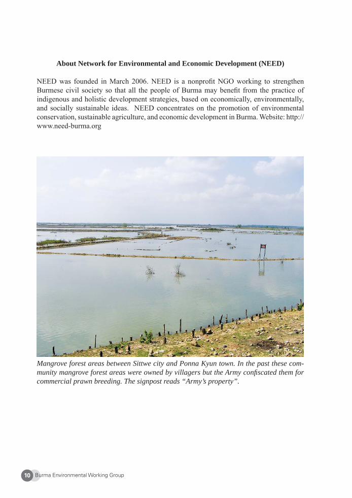
About Network for Environmental and Economic Development (NEED)
NEED was founded in March 2006. NEED is a nonprofi t NGO working to strengthen Burmese civil society so that all the people of Burma may benefi t from the practice of indigenous and holistic development strategies, based on economically, environmentally, and socially sustainable ideas. NEED concentrates on the promotion of environmental conservation, sustainable agriculture, and economic development in Burma. Website: http://www.need-burma.org
Mangrove forest areas between Sittwe city and Ponna Kyun town. In the past these com-munity mangrove forest areas were owned by villagers but the Army confi scated them for commercial prawn breeding. The signpost reads “Army’s property”.
Burma Environmental Working Group 11
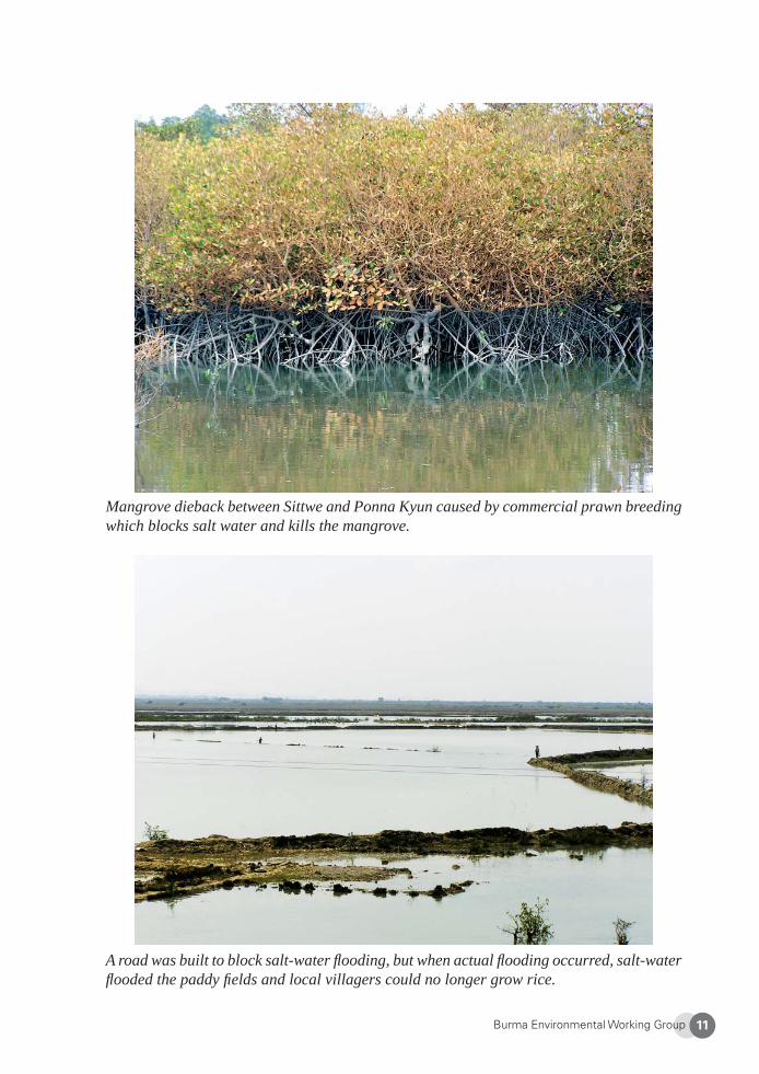
Mangrove dieback between Sittwe and Ponna Kyun caused by commercial prawn breeding which blocks salt water and kills the mangrove.
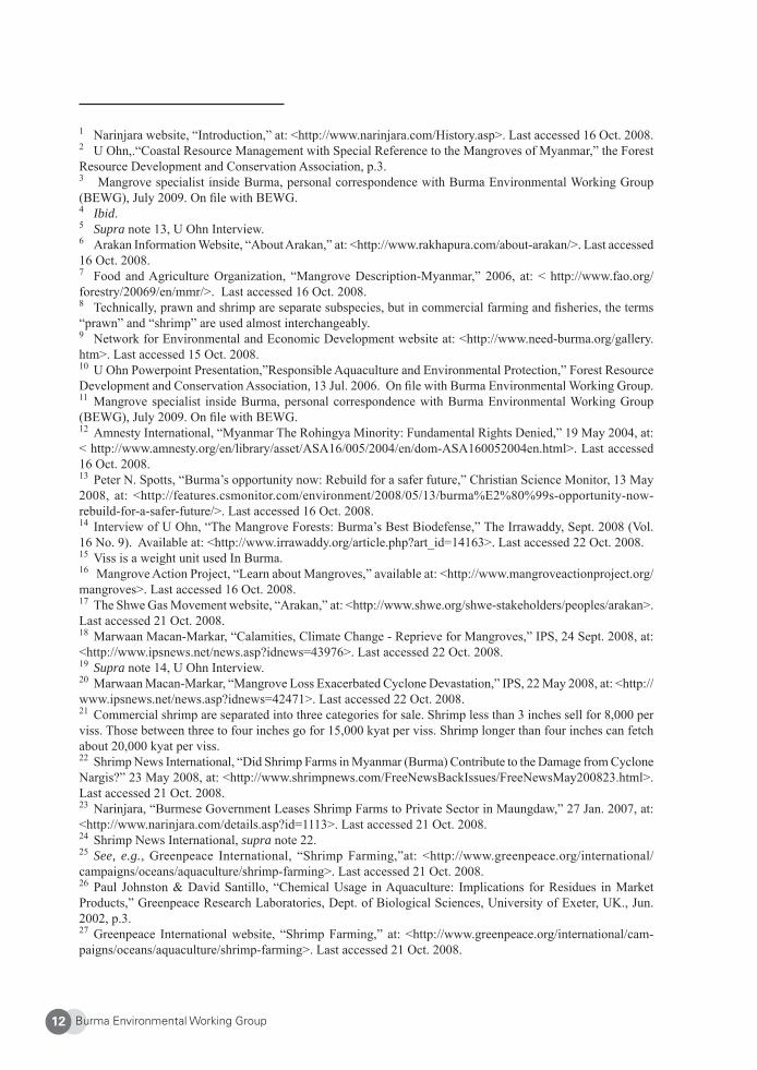
A road was built to block salt-water fl ooding, but when actual fl ooding occurred, salt-water fl ooded the paddy fi elds and local villagers could no longer grow rice.
Burma Environmental Working Group12
1 Narinjara website, “Introduction,” at: <http://www.narinjara.com/History.asp>. Last accessed 16 Oct. 2008.2 U Ohn,.“Coastal Resource Management with Special Reference to the Mangroves of Myanmar,” the Forest Resource Development and Conservation Association, p.3. 3 Mangrove specialist inside Burma, personal correspondence with Burma Environmental Working Group (BEWG), July 2009. On fi le with BEWG.4 Ibid.5 Supra note 13, U Ohn Interview.6 Arakan Information Website, “About Arakan,” at: <http://www.rakhapura.com/about-arakan/>. Last accessed 16 Oct. 2008. 7 Food and Agriculture Organization, “Mangrove Description-Myanmar,” 2006, at: < http://www.fao.org/forestry/20069/en/mmr/>. Last accessed 16 Oct. 2008. 8 Technically, prawn and shrimp are separate subspecies, but in commercial farming and fi sheries, the terms “prawn” and “shrimp” are used almost interchangeably.9 Network for Environmental and Economic Development website at: <http://www.need-burma.org/gallery.htm>. Last accessed 15 Oct. 2008. 10 U Ohn Powerpoint Presentation,”Responsible Aquaculture and Environmental Protection,” Forest Resource Development and Conservation Association, 13 Jul. 2006. On fi le with Burma Environmental Working Group.11 Mangrove specialist inside Burma, personal correspondence with Burma Environmental Working Group (BEWG), July 2009. On fi le with BEWG.12 Amnesty International, “Myanmar The Rohingya Minority: Fundamental Rights Denied,” 19 May 2004, at: < http://www.amnesty.org/en/library/asset/ASA16/005/2004/en/dom-ASA160052004en.html>. Last accessed 16 Oct. 2008.13 Peter N. Spotts, “Burma’s opportunity now: Rebuild for a safer future,” Christian Science Monitor, 13 May 2008, at: <http://features.csmonitor.com/environment/2008/05/13/burma%E2%80%99s-opportunity-now-rebuild-for-a-safer-future/>. Last accessed 16 Oct. 2008.14 Interview of U Ohn, “The Mangrove Forests: Burma’s Best Biodefense,” The Irrawaddy, Sept. 2008 (Vol. 16 No. 9). Available at: <http://www.irrawaddy.org/article.php?art_id=14163>. Last accessed 22 Oct. 2008. 15 Viss is a weight unit used In Burma. 16 Mangrove Action Project, “Learn about Mangroves,” available at: <http://www.mangroveactionproject.org/mangroves>. Last accessed 16 Oct. 2008. 17 The Shwe Gas Movement website, “Arakan,” at: <http://www.shwe.org/shwe-stakeholders/peoples/arakan>. Last accessed 21 Oct. 2008. 18 Marwaan Macan-Markar, “Calamities, Climate Change - Reprieve for Mangroves,” IPS, 24 Sept. 2008, at: <http://www.ipsnews.net/news.asp?idnews=43976>. Last accessed 22 Oct. 2008. 19 Supra note 14, U Ohn Interview.20 Marwaan Macan-Markar, “Mangrove Loss Exacerbated Cyclone Devastation,” IPS, 22 May 2008, at: <http://www.ipsnews.net/news.asp?idnews=42471>. Last accessed 22 Oct. 2008. 21 Commercial shrimp are separated into three categories for sale. Shrimp less than 3 inches sell for 8,000 per viss. Those between three to four inches go for 15,000 kyat per viss. Shrimp longer than four inches can fetch about 20,000 kyat per viss.22 Shrimp News International, “Did Shrimp Farms in Myanmar (Burma) Contribute to the Damage from Cyclone Nargis?” 23 May 2008, at: <http://www.shrimpnews.com/FreeNewsBackIssues/FreeNewsMay200823.html>. Last accessed 21 Oct. 2008. 23 Narinjara, “Burmese Government Leases Shrimp Farms to Private Sector in Maungdaw,” 27 Jan. 2007, at: <http://www.narinjara.com/details.asp?id=1113>. Last accessed 21 Oct. 2008. 24 Shrimp News International, supra note 22.25 See, e.g., Greenpeace International, “Shrimp Farming,”at: <http://www.greenpeace.org/international/campaigns/oceans/aquaculture/shrimp-farming>. Last accessed 21 Oct. 2008. 26 Paul Johnston & David Santillo, “Chemical Usage in Aquaculture: Implications for Residues in Market Products,” Greenpeace Research Laboratories, Dept. of Biological Sciences, University of Exeter, UK., Jun. 2002, p.3. 27 Greenpeace International website, “Shrimp Farming,” at: <http://www.greenpeace.org/international/cam-paigns/oceans/aquaculture/shrimp-farming>. Last accessed 21 Oct. 2008.
Burma Environmental Working Group 13
28 Supra note 23.29 Ibid. 30 Shwe Gas Movement website, “Arakan,” at: <http://www.shwe.org/shwe-stakeholders/peoples/arakan>. Last accessed 21 Oct. 2008.31 Mangrove specialist inside Burma, personal correspondence with Burma Environmental Working Group (BEWG), July 2009. On fi le with BEWG.32 Human Rights Documentation Unit, National Government of the Union of Burma, “Other Factors Contrib-uting to the Deprivation of Livelihood,” in Burma Human Rights Yearbook 2006, at: <http://www.ncgub.net/BHRY/2006/livelihood.html#other>. Last accessed 21 Oct. 2008. 33 “Nasaka” refers to Burma’s special border guard force composed of offi cials from police, immigration, customs, and military intelligence departments.34 See supra note 15.35 Burma Environment Working Group (BEWG) interview, Chiang Mai, Thailand, 2007. On fi le with BEWG.36 Aye Aye Win, “Myanmar’s Economic Decline Fuels growing Protest Movement,” AP, 26 Sept. 2008, <http://burmadigest.wordpress.com/2007/09/26/myanmars-economic-decline-fuels-growing-protest-movement>. Last accessed 21 Oct. 2008.37 EarthRights International, “Shwe Gas Project in Burma: Recent Developments – Feature,” 8 March 2006. <http://www.earthrights.org/burmafeature/shwe_gas_project_in_burma_recent_developments.html>. Last ac-cessed 22 Oct. 2008.
Burma Environmental Working Group14
Traditional Oil Drillers Threatened by China’s Oil Exploration
Arakan Oil Watch
1. Introduction
Chinese companies are the fastest growing investors in Burma’s oil and gas sector, and China was the biggest foreign investor in Burma’s power sector in 2006-2007. China’s investment provides Burma’s ruling military junta with hard cash and the political support of a key international power. But contrary to claims by China’s largest oil fi rms, this investment does not foster a “win-win” situation. Instead, oil and gas exploration results in a series of negative consequences for affected people and the local environment.
For centuries, people in Burma’s Arakan State have extracted and refi ned crude oil by tradi-tional methods. In the past few years, however, large-scale Chinese investment in extracting Burma’s untapped oil and gas reserves, particularly in Arakan, has begun to compete with and disrupt traditional oil drilling. Plans for both onshore and offshore natural gas and oil exploration and production, construction of pipelines stretching to China, and the develop-ment of a deep sea port in Arakan are underway.
2. Ramree Island and Block M
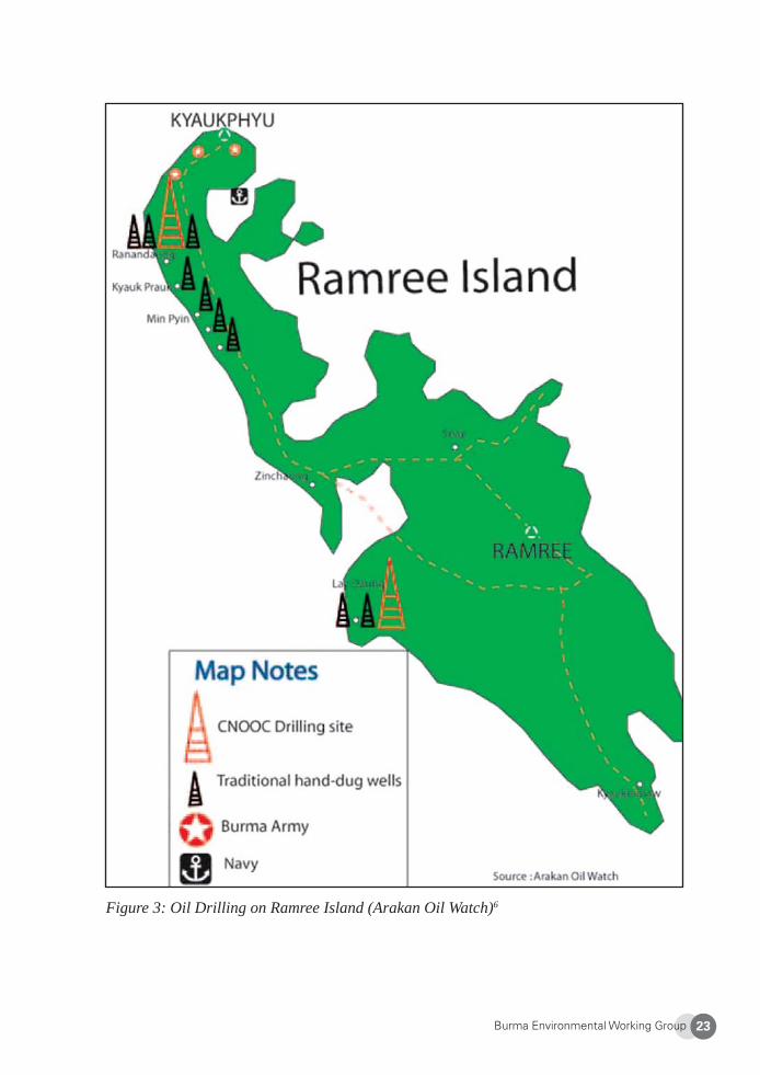
One hotspot in Arakan State for Chinese commercial drilling is in commercial Block M, which includes Ramree Island. Ramree Island is the largest island in Burma and a key com-mercial site. The island spans 1,350 square kilometers (twice the size of Singapore), and is home to more than 400,000 people, most of whom survive on a combination of subsistence farming, fi shing, and traditional oil drilling activities. Shortage of arable land has driven more people to work on wells, and traditional oil drilling has been part of daily life on Ramree Island for centuries. Farms rarely yield enough produce to feed everyone, so community oil wells provide Ramree farmers with an essential source of supplementary income and are the primary income source for many of the island’s inhabitants. Local villagers use hand-dug wells to capture natural seepages.
Ramree Island is located within the “Block M” oil and gas exploration area which covers 3,007 square miles (see Figure 1). In 2004, the China National Offshore Oil Company Lim-ited (CNOOC) won a contract from the SPDC to explore gas in Block M. Drilling started in 20051 with virtually complete disregard for the needs and interests of local people. Gas from Block M is proposed to be connected to China’s Yunnan Province by pipeline2. In ad-
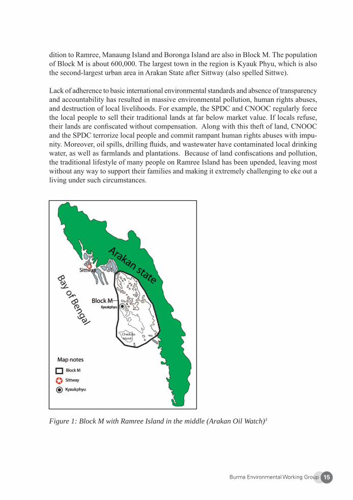
Burma Environmental Working Group 15
dition to Ramree, Manaung Island and Boronga Island are also in Block M. The population of Block M is about 600,000. The largest town in the region is Kyauk Phyu, which is also the second-largest urban area in Arakan State after Sittway (also spelled Sittwe).
Lack of adherence to basic international environmental standards and absence of transparency and accountability has resulted in massive environmental pollution, human rights abuses, and destruction of local livelihoods. For example, the SPDC and CNOOC regularly force the local people to sell their traditional lands at far below market value. If locals refuse, their lands are confi scated without compensation. Along with this theft of land, CNOOC and the SPDC terrorize local people and commit rampant human rights abuses with impu-nity. Moreover, oil spills, drilling fl uids, and wastewater have contaminated local drinking water, as well as farmlands and plantations. Because of land confi scations and pollution, the traditional lifestyle of many people on Ramree Island has been upended, leaving most without any way to support their families and making it extremely challenging to eke out a living under such circumstances.
Figure 1: Block M with Ramree Island in the middle (Arakan Oil Watch)3
Burma Environmental Working Group16
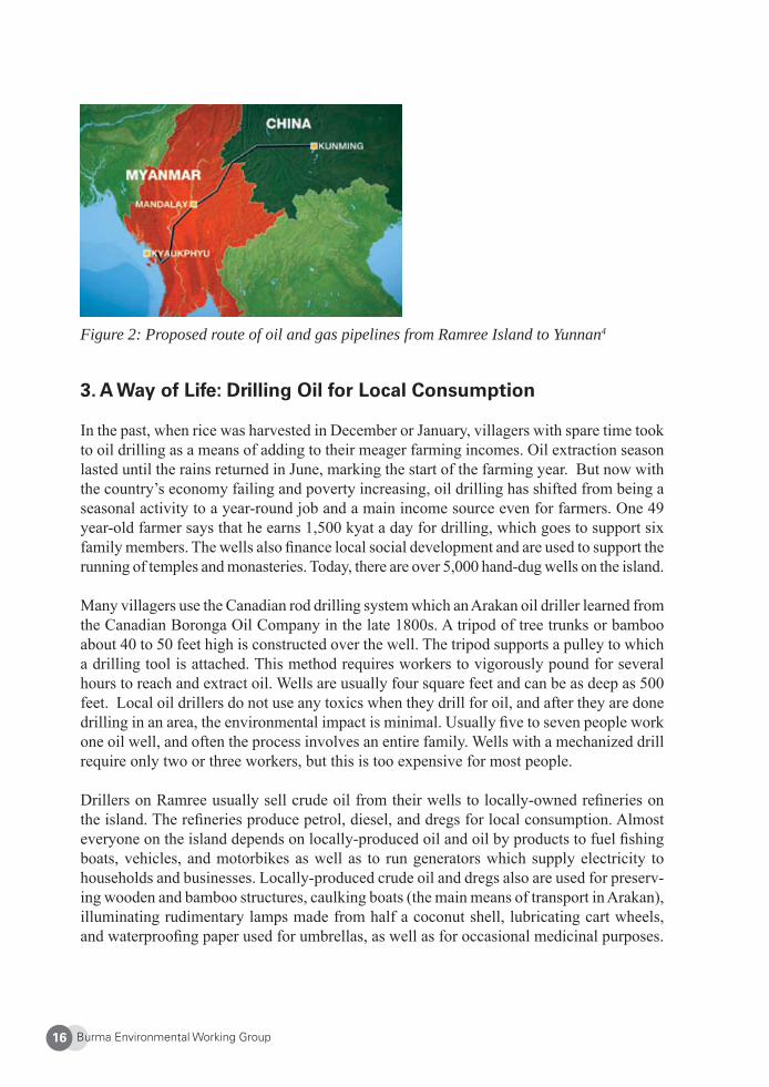
Figure 2: Proposed route of oil and gas pipelines from Ramree Island to Yunnan4
3. A Way of Life: Drilling Oil for Local Consumption
In the past, when rice was harvested in December or January, villagers with spare time took to oil drilling as a means of adding to their meager farming incomes. Oil extraction season lasted until the rains returned in June, marking the start of the farming year. But now with the country’s economy failing and poverty increasing, oil drilling has shifted from being a seasonal activity to a year-round job and a main income source even for farmers. One 49 year-old farmer says that he earns 1,500 kyat a day for drilling, which goes to support six family members. The wells also fi nance local social development and are used to support the running of temples and monasteries. Today, there are over 5,000 hand-dug wells on the island.
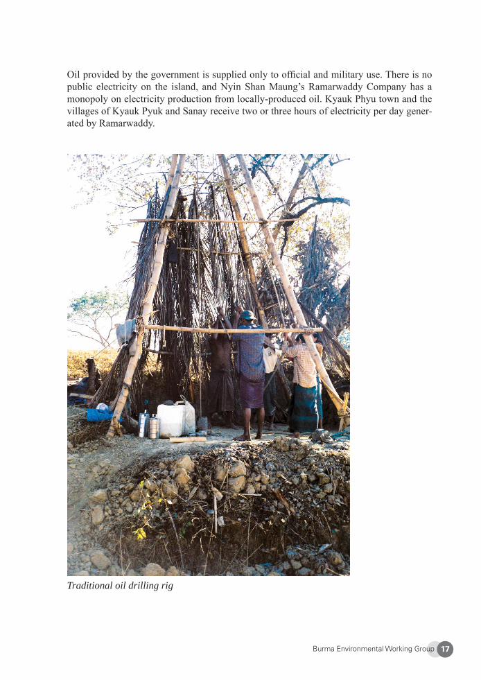
Many villagers use the Canadian rod drilling system which an Arakan oil driller learned from the Canadian Boronga Oil Company in the late 1800s. A tripod of tree trunks or bamboo about 40 to 50 feet high is constructed over the well. The tripod supports a pulley to which a drilling tool is attached. This method requires workers to vigorously pound for several hours to reach and extract oil. Wells are usually four square feet and can be as deep as 500 feet. Local oil drillers do not use any toxics when they drill for oil, and after they are done drilling in an area, the environmental impact is minimal. Usually fi ve to seven people work one oil well, and often the process involves an entire family. Wells with a mechanized drill require only two or three workers, but this is too expensive for most people.
Drillers on Ramree usually sell crude oil from their wells to locally-owned refi neries on the island. The refi neries produce petrol, diesel, and dregs for local consumption. Almost everyone on the island depends on locally-produced oil and oil by products to fuel fi shing boats, vehicles, and motorbikes as well as to run generators which supply electricity to households and businesses. Locally-produced crude oil and dregs also are used for preserv-ing wooden and bamboo structures, caulking boats (the main means of transport in Arakan), illuminating rudimentary lamps made from half a coconut shell, lubricating cart wheels, and waterproofi ng paper used for umbrellas, as well as for occasional medicinal purposes.
Burma Environmental Working Group 17
Oil provided by the government is supplied only to offi cial and military use. There is no public electricity on the island, and Nyin Shan Maung’s Ramarwaddy Company has a monopoly on electricity production from locally-produced oil. Kyauk Phyu town and the villages of Kyauk Pyuk and Sanay receive two or three hours of electricity per day gener-ated by Ramarwaddy.
Traditional oil drilling rig
Burma Environmental Working Group18
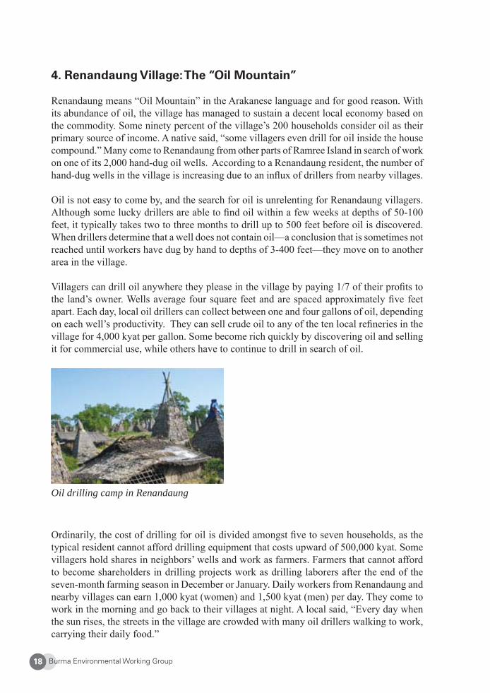
4. Renandaung Village: The “Oil Mountain”
Renandaung means “Oil Mountain” in the Arakanese language and for good reason. With its abundance of oil, the village has managed to sustain a decent local economy based on the commodity. Some ninety percent of the village’s 200 households consider oil as their primary source of income. A native said, “some villagers even drill for oil inside the house compound.” Many come to Renandaung from other parts of Ramree Island in search of work on one of its 2,000 hand-dug oil wells. According to a Renandaung resident, the number of hand-dug wells in the village is increasing due to an infl ux of drillers from nearby villages.
Oil is not easy to come by, and the search for oil is unrelenting for Renandaung villagers. Although some lucky drillers are able to fi nd oil within a few weeks at depths of 50-100 feet, it typically takes two to three months to drill up to 500 feet before oil is discovered. When drillers determine that a well does not contain oil—a conclusion that is sometimes not reached until workers have dug by hand to depths of 3-400 feet—they move on to another area in the village.
Villagers can drill oil anywhere they please in the village by paying 1/7 of their profi ts to the land’s owner. Wells average four square feet and are spaced approximately fi ve feet apart. Each day, local oil drillers can collect between one and four gallons of oil, depending on each well’s productivity. They can sell crude oil to any of the ten local refi neries in the village for 4,000 kyat per gallon. Some become rich quickly by discovering oil and selling it for commercial use, while others have to continue to drill in search of oil.
Oil drilling camp in Renandaung
Ordinarily, the cost of drilling for oil is divided amongst fi ve to seven households, as the typical resident cannot afford drilling equipment that costs upward of 500,000 kyat. Some villagers hold shares in neighbors’ wells and work as farmers. Farmers that cannot afford to become shareholders in drilling projects work as drilling laborers after the end of the seven-month farming season in December or January. Daily workers from Renandaung and nearby villages can earn 1,000 kyat (women) and 1,500 kyat (men) per day. They come to work in the morning and go back to their villages at night. A local said, “Every day when the sun rises, the streets in the village are crowded with many oil drillers walking to work, carrying their daily food.”
Burma Environmental Working Group 19
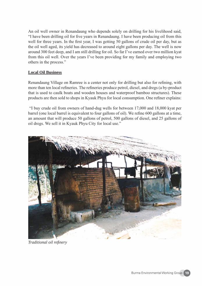
An oil well owner in Renandaung who depends solely on drilling for his livelihood said, “I have been drilling oil for fi ve years in Renandaung. I have been producing oil from this well for three years. In the fi rst year, I was getting 50 gallons of crude oil per day, but as the oil well aged, its yield has decreased to around eight gallons per day. The well is now around 300 feet deep, and I am still drilling for oil. So far I’ve earned over two million kyat from this oil well. Over the years I’ve been providing for my family and employing two others in the process.”
Local Oil Business
Renandaung Village on Ramree is a center not only for drilling but also for refi ning, with more than ten local refi neries. The refi neries produce petrol, diesel, and dregs (a by-product that is used to caulk boats and wooden houses and waterproof bamboo structures). These products are then sold to shops in Kyauk Phyu for local consumption. One refi ner explains:
“I buy crude oil from owners of hand-dug wells for between 17,000 and 18,000 kyat per barrel (one local barrel is equivalent to four gallons of oil). We refi ne 600 gallons at a time, an amount that will produce 50 gallons of petrol, 500 gallons of diesel, and 25 gallons of oil dregs. We sell it in Kyauk Phyu City for local use.”
Traditional oil refi nery
Burma Environmental Working Group20
Drillers in Kyauk Pyuk Village do not have the freedom to sell oil to local refi neries. As with many other commodities in Burma, the SPDC and its cronies use force to dominate the local trade in oil. In Kyauk Pyuk, regime-connected local businessman Nyin Shan Maung monopolizes the collection and distribution process and squeezes local producers by controlling the sale and purchase of the products. Here, drillers are forced to sell their oil to him at a low price.
As one of the richest and most powerful men on Ramree Island, Nyin Shan Maung “negoti-ates” contracts with land owners that make him their exclusive buyer. These negotiations are made on unequal terms, however, as one villager from Kyauk Phyu explains, “If we don’t sell our oil to [Nyin Shan Maung], he will send us to jail. A few villagers have already been sent to jail for trying to sell oil to other people. Villagers[’ selling of oil] for daily income [is] also banned by Nyin Shan Maung.”
5. Environmental Impacts of China’s Oil And Gas Exploration
In addition to competition from local businesses, the arrival of Chinese companies at Ram-ree Island has caused a further decline in the livelihoods of hand-dug well drillers. In late 2004, a consortium of Chinese, Singaporean, and Burmese companies headed by the China National Offshore Oil Company Limited (CNOOC) started oil exploration on Ramree Is-land5. CNOOC did not provide any information of the project to communities and took no concerted steps to recognize or protect traditional hand-dug oil wells, local livelihoods, or the environment. To this day, communities are not told anything about what large-scale oil projects are taking place on their lands, what companies are involved, and how much profi t is being collected by the junta.
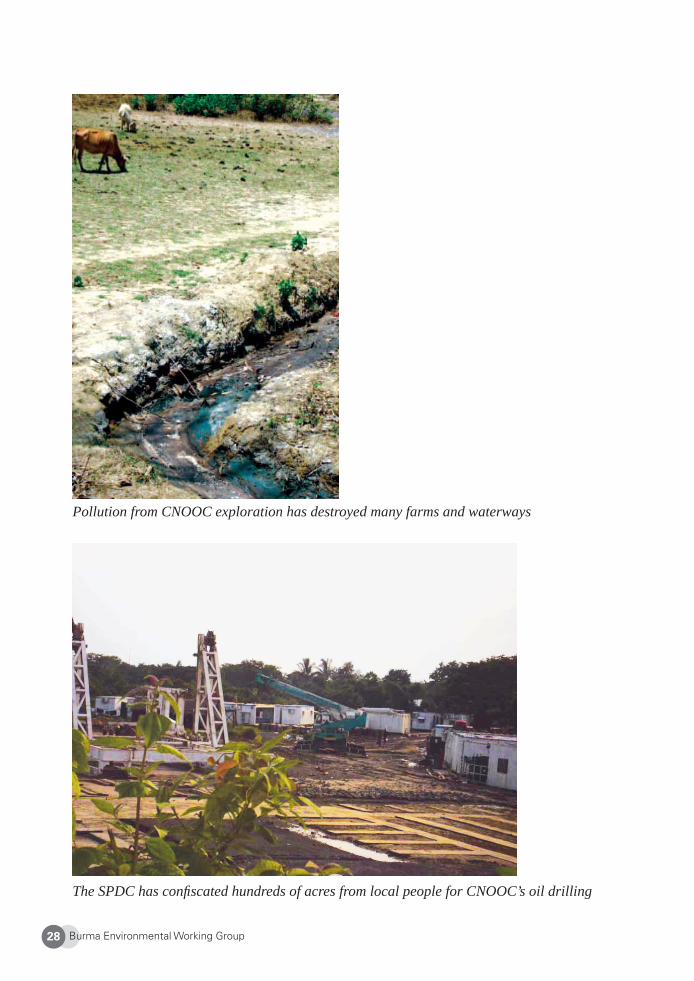
Local people have been harmed by CNOOC’s project in many ways. The construction of each CNOOC drilling rig requires the clearing of two square miles and the demolition of all farmlands, traditional oil wells, and houses within that space. Farmers have had their fi elds destroyed and land confi scated. Some have been forced to relocate. Traditional oil drillers have lost their wells, local refi ners have shut down, and ordinary consumers have had to cope with a disruption of local oil supplies and steady infl ation.
CNOOC’s projects on Ramree Island are ecologically destructive. Rigs tower 1,000 feet tall and can reach depths of 10,000 feet. Home dwellers have suffered noise and air pollu-tion from seismic surveying and oil drilling. Due to drilling mud contamination, land once drilled on by CNOOC can no longer be used by farmers. Drilling fl uids and wastewater have killed fi sh and caused farmers, fi sherfolk, and bathers to become ill.
Burma Environmental Working Group 21
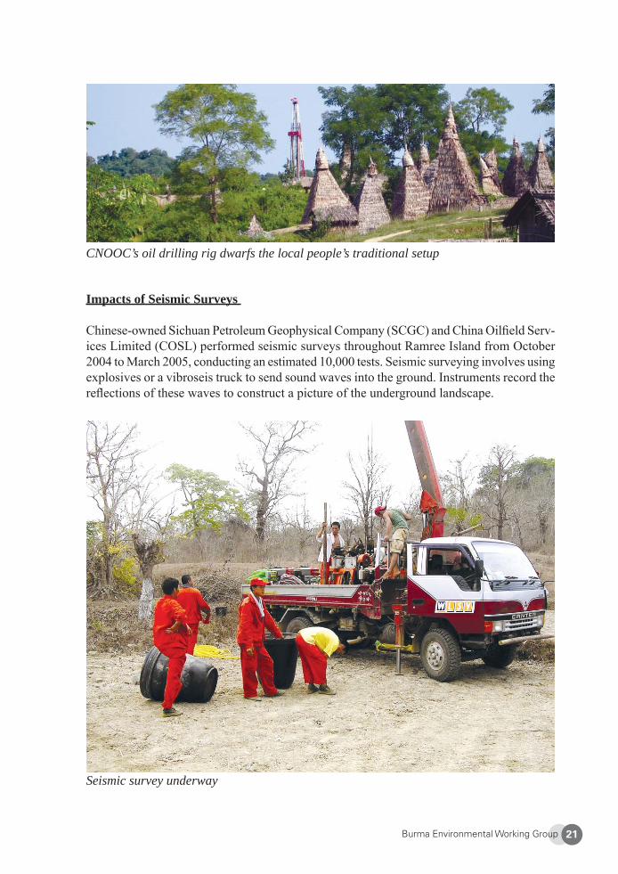
CNOOC’s oil drilling rig dwarfs the local people’s traditional setup
Seismic survey underway
Impacts of Seismic Surveys
Chinese-owned Sichuan Petroleum Geophysical Company (SCGC) and China Oilfi eld Serv-ices Limited (COSL) performed seismic surveys throughout Ramree Island from October 2004 to March 2005, conducting an estimated 10,000 tests. Seismic surveying involves using explosives or a vibroseis truck to send sound waves into the ground. Instruments record the refl ections of these waves to construct a picture of the underground landscape.
Burma Environmental Working Group22
Arakan Oil Watch interviewed several mine testers as well as affected farmers. One of only three local Arakanese among the 3,000 test mining workers from the Rangoon-based service company Asia Guiding Star said, “the mining sounds [from seismic surveying] could be heard two to three miles away. The houses shook from the explosions. They did this close to the village, sometimes just 20-30 feet from the villager[s’] houses. Some rice farms and plantations were also destroyed.”
The surveying, or test mining as some call it, was conducted without permission from land-owners. Farms were left with large holes in the fi elds, crops were destroyed by trucks running over them, farmed trees were uprooted, and fi elds were left infertile. No compensation has been offered for damage done to lands or crops. Considerable noise pollution occurred from mining and the use of large trucks, as did signifi cant deforestation throughout Block M to facilitate road construction and access to areas for seismic testing.
One Kyauk Pyuk villager who grows rice and drills using traditional methods refl ected: “The rice yield now is not as good as previous years. The Chinese did some mining for oil exploration. This destroyed a lot of rice farmlands, and those with damaged lands received no compensation.” A female farmer, also from Kyauk Pyuk, stated that during oil exploration, large CNOOC vehicles drove across local farm fi elds, destroying chili crops. “One of our neighbors lost everything. There was no compensation.” She added: “The mining sounds scare us, and our paddies are also not as productive as before, but we don’t know why. Our lives are getting more diffi cult.”
Upon completion of the seismic surveys, CNOOC set up an exploratory drilling site with 100 Chinese workers in Lay Daung District on the central western edge of the island. When the drillers reached a layer of rock that could not be penetrated, however, they closed up this site in late 2005 and moved its workers and equipment to Renandaung Village, 50 kilometers to the north. They set up a camp for 100 Chinese workers and started drilling in late 2006. The well in Lay Daung was not cemented, and oil can still be heard percolating up from the ground. A guard who was paid to look after the site told local residents that the Chinese intend to return.
Burma Environmental Working Group 23
Figure 3: Oil Drilling on Ramree Island (Arakan Oil Watch)6
Burma Environmental Working Group24
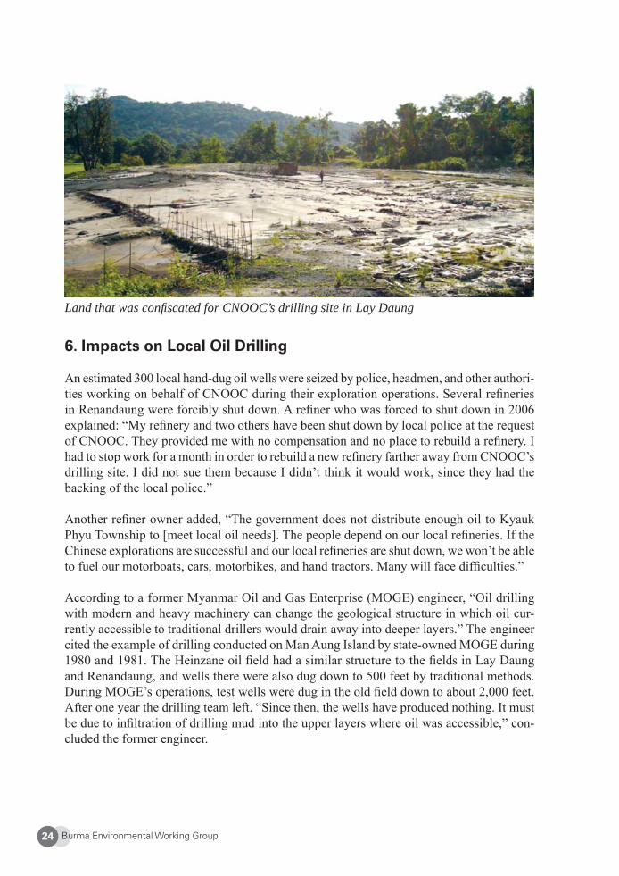
Land that was confi scated for CNOOC’s drilling site in Lay Daung
6. Impacts on Local Oil Drilling
An estimated 300 local hand-dug oil wells were seized by police, headmen, and other authori-ties working on behalf of CNOOC during their exploration operations. Several refi neries in Renandaung were forcibly shut down. A refi ner who was forced to shut down in 2006 explained: “My refi nery and two others have been shut down by local police at the request of CNOOC. They provided me with no compensation and no place to rebuild a refi nery. I had to stop work for a month in order to rebuild a new refi nery farther away from CNOOC’s drilling site. I did not sue them because I didn’t think it would work, since they had the backing of the local police.”
Another refi ner owner added, “The government does not distribute enough oil to Kyauk Phyu Township to [meet local oil needs]. The people depend on our local refi neries. If the Chinese explorations are successful and our local refi neries are shut down, we won’t be able to fuel our motorboats, cars, motorbikes, and hand tractors. Many will face diffi culties.”
According to a former Myanmar Oil and Gas Enterprise (MOGE) engineer, “Oil drilling with modern and heavy machinery can change the geological structure in which oil cur-rently accessible to traditional drillers would drain away into deeper layers.” The engineer cited the example of drilling conducted on Man Aung Island by state-owned MOGE during 1980 and 1981. The Heinzane oil fi eld had a similar structure to the fi elds in Lay Daung and Renandaung, and wells there were also dug down to 500 feet by traditional methods. During MOGE’s operations, test wells were dug in the old fi eld down to about 2,000 feet. After one year the drilling team left. “Since then, the wells have produced nothing. It must be due to infi ltration of drilling mud into the upper layers where oil was accessible,” con-cluded the former engineer.
Burma Environmental Working Group 25
A Traditional Oil Driller Loses His Livelihood
A father of three children and traditional oil driller lost his oil fi elds and land to CNOOC in 2006. Oil drilling was the single main business for his family. Now, they are struggling to make ends meet. This is his story.
“The Chinese came and bulldozed all of my land, leaving it covered in sand. The land was owned by my ancestors and had been in my family for many generations. The land is registered under my name in the local government offi ce. But that didn’t matter to the Chinese.
“There were eight producing wells on my land. I asked them to leave me with at least one oil well because my family’s long-term survival depends completely on the revenue from the wells. For a while, they did not reach the area around [one of the wells], so I fi gured they had held up to their end of the agreement.
“Then one day, I went to my oil fi eld to build a tent on the remaining well. When the Chinese oil workers arrived and saw me holding a knife, they went to tell the security guards that I tried to kill them. I explained to the guard that I had not intended to kill the oil workers, and that when I saw them digging soil near my last remaining oil well, I had just come over to tell them that if my oil well [was] destroyed I wouldn’t have anything left [on which to survive].
“In the end, they took the remaining well and left me just a small area of farmland. I hired a farmer to grow rice on the remaining land, but he said that nothing could grow there anymore. I also tried to drill oil on the remain-ing land, but the smell from the Chinese workers’ toilets nearby is so bad that my workers have refused to drill on it. Now I am drilling as a partner on someone else’s land. This is my only job, and our [economic] situation is getting worse. I have three children. Two are students, but my oldest son had to withdraw from school in 9th grade because I could not support [him to continue his studies].
“Originally, a translator speaking on behalf of the company told me that they would give us compensation. And one time, a man from the Land Department Offi ce told me that the compensation money for my land had arrived in his offi ce. But he refused to tell me when they would give me the money, although I was quite persistent. Up till today, I have not received any compensation. I think that the township and district authorities are keeping the money for themselves.
“I have lost land, and so have many other people. Chinese oil workers are now living on the land of one of my friends. He may be able to use it after
Burma Environmental Working Group26
they leave, but not my land—they have poured concrete on it and laid three stone fl oors. It’s useless to me now. Local authorities have ordered all of us not to enter CNOOC’s drilling site.
“I’m not sure what will happen in the future. But I know that if they do fi nd oil and order us to move, we won’t be able to complain or refuse. Even now, if we complain, we will be arrested. The Chinese operations are horrible and provide no benefi t for us. As a result of these oil explorations, we have all lost our wells. I have personally lost both oil wells and farmland. How can it be a good thing if they don’t even provide us with compensation?”
Son Returns Home to Find Farm Seized, Parents Devastated
In November 2006 a goldsmith from Rangoon returned to his village after receiving a message from his parents that their house and land had been seized. This is his story.
“Our land is registered under the name of my father. CNOOC seized four acres and gave use just 30,000 kyat. We can earn 30,000 kyat by selling the wood of a single tree. We never really cared about the cost of the land, since we had no intention to sell it and had put so much effort into main-taining the trees. However, if we had decided to sell, we could have gotten 400,000 kyat.
“We had so many good, carefully grown trees on that land. We had about 60 teak trees that could have sold for 4-500,000 kyat. Now, teak has a per-unit price that is more expensive than gold. All of our trees were fi t for use in building a home, and yet these trees were dug up with bulldozers and are now gone. My father wept when he saw CNOOC uprooting our trees and clearing our land.
“We had to accept it. Complaining about it is simply not an option. My father and mother are old and cannot work hard. They’ve been given no choice but to accept this entire ordeal and everything that CNOOC has done to them. Even though [we own the land and it] is registered in our name, we have to do what they [say].
“Several other people lost their land around here[,] but among them we lost the most. CNOOC has been drilling mainly on our land. The Chinese paid a local man 30,000 kyat every three months to guard the land, while the rest of us got 30,000 kyat for all of our land. It is bitterly ironic.”
Burma Environmental Working Group 27
7. Land Confi scation and Pollution
Over 200 acres of farmlands were confi scated for CNOOC’s exploration operations. Accord-ing to a source close to the local land department offi ce, “The Chinese paid 40,000 kyat for each farmer who lost land, regardless of the size of the farm. However, the township chairman takes 10,000 kyat for himself.” Interviews with farmers corroborate this, confi rming that the money is given to Burmese offi cials and does not always reach the owner of the land.
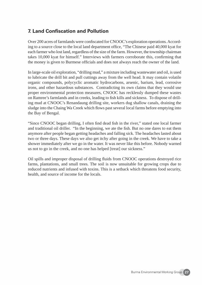
In large-scale oil exploration, “drilling mud,” a mixture including wastewater and oil, is used to lubricate the drill bit and pull cuttings away from the well head. It may contain volatile organic compounds, polycyclic aromatic hydrocarbons, arsenic, barium, lead, corrosive irons, and other hazardous substances. Contradicting its own claims that they would use proper environmental protection measures, CNOOC has recklessly dumped these wastes on Ramree’s farmlands and in creeks, leading to fi sh kills and sickness. To dispose of drill-ing mud at CNOOC’s Renandaung drilling site, workers dug shallow canals, draining the sludge into the Chaing Wa Creek which fl ows past several local farms before emptying into the Bay of Bengal.
“Since CNOOC began drilling, I often fi nd dead fi sh in the river,” stated one local farmer and traditional oil driller. “In the beginning, we ate the fi sh. But no one dares to eat them anymore after people began getting headaches and falling sick. The headaches lasted about two or three days. These days we also get itchy after going in the creek. We have to take a shower immediately after we go in the water. It was never like this before. Nobody warned us not to go in the creek, and no one has helped [treat] our sickness.”
Oil spills and improper disposal of drilling fl uids from CNOOC operations destroyed rice farms, plantations, and small trees. The soil is now unsuitable for growing crops due to reduced nutrients and infused with toxins. This is a setback which threatens food security, health, and source of income for the locals.
Burma Environmental Working Group28
Pollution from CNOOC exploration has destroyed many farms and waterways
The SPDC has confi scated hundreds of acres from local people for CNOOC’s oil drilling
Burma Environmental Working Group 29
8. Terror, Intimidation, and Human Rights Abuses
CNOOC pays the Burmese military to protect drilling sites. Light Infantry Battalion 543 is deployed to guard the Chinese oil plants in Block M. Burmese army soldiers are known for the brutality and violence that they use against civilians. Instead of securing peace, the presence of troops has allowed environmental destruction to continue unabated and added to the suffering of local people. Beatings, killings, and sexual violence have been used or condoned by the military to instill a climate of fear and ensure total acquiescence to SPDC and CNOOC demands. In August 2006, fi ve villagers, including one pregnant woman, were beaten to death in Kyauk Phyu Township by navy and possibly army personnel. The family of one victim attempted to sue the Navy, but their lawsuit was rejected. They were later paid one million kyat in compensation. Villagers have no protection from such abuses and no recourse for justice.
Expressions of dissatisfaction and dissent are swiftly suppressed. To vent their frustrations of two and a half years of Chinese oil exploration, underground explosions, land seizure, and pollution of local creeks, about ten frustrated villagers broke into the CNOOC site at Renandaung on April 28, 2007. They emptied chemicals from 50 gallon plastic barrels and took off with the drums. They also destroyed and looted drilling equipment and supplies. In early May, about 30 people took the remaining barrels and other items such as rope, iron pipe, and engine oil. The total value of stolen goods was about one million kyat. Soon after the incident, the army cracked down on the village, arresting all the men, interrogating and beating them, and jailing three shop owners who had purchased the stolen goods. The SPDC searched houses, with some soldiers kicking over rice cookers, a highly-respected household item. Because of this violent response, seventy people have since fl ed to other towns, to Rangoon, and some as far as Malaysia and Thailand. Burmese offi cials and Chinese oil workers have been complicit in rapes of local Ramree women. A female student from the Education College in Kyauk Phyu was brought to CNOOC’s drilling camp in Renandaung by U Hla Win, an offi cial from the Myanmar Oil and Gas Enterprise (MOGE). It is widely believed that she was raped by at least ten Chinese workers. Locals who tried to intervene were prevented from entering the camp. The student was sent to the local hospital unconscious and expelled from her college afterwards. Another rape also occurred at CNOOC’s Lay Daung exploration site. Similar cases of sexual violence have been reported to the International Labour Organization, and locals are in constant fear of such attacks by local authorities and the Chinese.
9. Conclusion
Chinese oil operations on Ramree Island in Block M, involving underground explosions, the confi scation of local oil wells and farmlands, the destruction of crops and pollution of waterways, were all conducted without prior consent or even knowledge of local residents. Villagers had no opportunity to participate in the decision-making surrounding the opera-tions and have no course of redress. This total disregard for community rights helped fuel the anger that exploded in April 2007 and resulted in the destruction at the exploratory
Burma Environmental Working Group30
drilling site in Renandaung.
The China National Offshore Oil Company (CNOOC) is the only Chinese member of the International Petroleum Industry Environmental Conservation Association (IPIECA). The association recognizes the need for companies to “mitigate risk and deliver net benefi t for all parties,” and has even published a Human Rights Training Toolkit. As the managing partner of operations in Block M, however, CNOOC has not lived up to IPIECA’s vision or to its own claims made in corporate social responsibility reports.
Burma is considered a “golden backyard” for China’s energy needs, potentially supplying a conduit to transport Middle Eastern and African oil as well as natural gas. The experience on Ramree Island is symbolic of the expanding role of Chinese companies in Burma’s oil and gas sector. Overall investment in the sector has tripled in 2007 with the Chinese being the fastest-growing investors. Chinese interests are central to plans for Arakan that include further exploration, purchase of offshore natural gas reserves, construction of a cross-country pipeline from Ramree Island to Yunnan Province, and the development of a deep sea port. Exploration by Chinese companies is also underway in other areas of Burma.
Although the regime has earned billions of dollars from the oil and gas sector, Burma is still one of the poorest countries in the world, remaining economically and politically un-stable. Investment from Chinese and other foreign corporations has not improved the lives of people in Burma or developed the country’s economy. On the contrary, it is enabling one of the world’s most corrupt military regimes to remain in power, fueling popular discontent and instability.
For genuine development from oil and gas projects to take place, foreign governments and companies need to meet international standards to protect the environment and human rights and ensure that revenues are used for the country’s growth. Until effective accountability and transparency mechanisms are established in Burma, however, investors will fi nd it impos-sible to avoid causing abuses similar to those that have occurred in Block M.
10. Policy Recommendations
The Burmese military has no law to protect human rights or the environment from oil and gas exploration and other development projects. Even if there were, currently rule of law does not exist in Burma. If foreign corporations or governments engage in the oil and gas sector in Burma, they should fi rst follow the basic principles below. Unless these basic provisions are ensured, Chinese and other multinational oil and gas corporations in Burma must stop investment and operations in Burma’s oil and gas sector, and shareholders and investors should divest their holdings in the companies engaged in these projects, and banks should refrain from fi nancing these projects.
Burma Environmental Working Group 31
Community Rights Are Protected• Information must be provided to and consultation must be conducted with affected
communities before projects are implemented.• Affected communities must be allowed to participate in the decision-making process
of oil and gas operations.• Local people must receive equitable benefi ts from the projects.• Local people must be employed in the projects.
Revenue Transparency Is Ensured• Records of receipts paid to the host government must be made public.• Payments for oil and gas purchase or investments into oil and gas must be managed
by an independent third-party body• Investment funds must be transparent and used for the country’s sustainable devel-
opment in such important sectors as education and health.
Operations Follow Basic Environmental and Human Rights Standards• The laws of the corporation’s home country and international standards must be
followed, including public disclosure of social and environmental impact assess-ments, protection of women’s rights, and protection of cultural and historical sites.
• Adequate compensation for relocation and property damage must be provided directly to affected people.
• All those employed to work on oil and gas projects in Burma should be protected under international laws per the agreements of the International Labour Organiza-tion.
Burma Environmental Working Group32
About Arakan Oil Watch (AOW)
Founded in 2006, AOW is an independent non-governmental organization that aims to protect human rights and the environment from extractive industries in Arakan State and in Burma. AOW educates affected peoples on these issues, develops and promotes oil and gas revenue transparency standards, and conducts international advocacy. AOW is an ac-tive core member of the Shwe Gas Movement and a member of South East Asia Oil Watch. Each month AOW publishes The Shwe Gas Bulletin in English and Burmese, a newsletter covering the latest developments in Burma’s oil and natural gas industry. Website: http://www.arakanoilwatch.org
1 B. Raman, “Myanmar: Second Thoughts about Gas Pipelines to India & China?” 14 Apr. 2007. Available at: <http://www.southasiaanalysis.org/%5Cpapers23%5Cpaper2207.html>. Last accessed 27 Apr. 2009.2 B. Raman, supra note 1.3 Arakan Oil Watch, Blocking Freedom: A Case Study of China’s Oil and Gas Investment in Burma (Oct. 2008), available at <http://www.shwe.org/media-releases/publications/fi le/Blocking%20Freedom%20English.pdf>), p.6.4 Map from Al Jazeera, “Myanmar Resources Offer Few Riches,” Last updated 31 Jan 2008. <http://english.aljazeera.net/news/asia-pacifi c/2008/01/2008525183751821445.html>. Last accessed 27 Apr. 2009. 5 Other companies in the CNOOC-led consortium include China Oilfi eld Services Limited (COSL), China National Petroleum Corporation (CNPC), China Huan Qiu Contracting and Engineering Corporation (HQCEC), Sichuan Petroleum Geophysical Company (SCGC), Singaporean company Golden Aaron Pte. Ltd, and Burma’s Asia World Company and Asia Guiding Star. On October 22, 2004, CNOOC, CNPC, and Golden Aaron signed a production sharing contract with the Myanmar Oil and Gas Enterprise (MOGE), a state-owned oil and gas company to explore the onshore area of Block M.6 Blocking Freedom, supra note 3, p.11.
Burma Environmental Working Group 33
Kachin State
Kachin Herbal Medicine Initiative:Creating Opportunities for Conservation and Income Generation
Pan Kachin Development Society
1. Kachin State and its People
Kachin State is Burma’s northernmost state, with a population about 1.2 million people. It is rich in natural resources including alpine and evergreen forests and vast reserves of jade, gold, platinum, and coal. Kachin State is part of the Indo-Burma region, recognized as one of the world’s hotspots of biodiversity1. The inhabitants are ethnic Kachin (including Jinghpaw, Rawang, Lisu, Zaiwa, Longwo, and Lachit sub-groups), Shan, Naga, Burman, Chinese, and Indian. Kachin people are traditionally dependent on forests for their liveli-hoods. Indigenous knowledge of sustainable forest and land use has been passed on from generation to generation. Traditional livelihoods include dry and wet rice farming, small-scale extraction of gold and jade for extra income, and production of herbal medicine. During the civil war, many Kachin people were able to survive using forest resources which provide not only food and shelter, but medicine as well.
After more than forty years of civil war, ceasefi re agreements were signed between the Bur-mese regime (State Peace and Development Council, or SPDC) and Kachin armed opposition groups in the 1990s. The SPDC and the Kachin Independence Army/Kachin Independence Organization2 reached an agreement in 1994 and the New Democratic Army – Kachin3 signed a ceasefi re with the SPDC in 1989. As a result of the ceasefi re agreements, the Kachin opposition groups administer land and forest in defi ned ceasefi re territories, while the SPDC maintains legal control of all other forests and lands that make up the majority of Kachin State. The ceasefi re agreements did not address natural resource exploitation, and there are now increasing pressures on natural resources. Contract farming4, illegal and widespread logging and mining, displacement, and increasing population pressures are degrading forests at an alarming rate. Logging and mining have become a major source of income in both KIO and SPDC administered areas. In the KIO-controlled areas, the KIO’s main source of income from development includes logging, gold mining and border trade.
China is a major player in Kachin State’s natural resource economy. One of the fi rst major border trade agreements was signed between the SPDC and the Chinese government in August 1988. After ceasefi re agreements were signed with armed groups, trade intensifi ed, with the SPDC making trade deals with China as part of regional development activities. The SPDC has intensifi ed its exploitation of Kachin State’s natural resources since the ceasefi re, exploiting vast mineral reserves, like gold and jade. Border trade agreements have resulted in Kachin State becoming a “natural resource storehouse for development in China.”5 Profi ts are being used to fi nance a strategic geopolitical development plan in China’s Yunnan Province.
Burma Environmental Working Group34
Industrial resource extraction over the last 15 years has had a major impact on local liveli-hoods and is posing serious threats to indigenous knowledge systems and the environment. In addition, displacement of people from their land and depletion of resources also accompany rising commodity prices and infl ation, making daily survival much more diffi cult for local people. Furthermore, local people are systematically left out of decision-making processes for development and infrastructure plans.
To address these interlinked concerns, the Pan Kachin Development Society (PKDS) focuses on working with local communities towards sustainable development through maintaining and promoting indigenous knowledge of herbal medicine. PKDS’s traditional medicine initiative facilitates not only improved healthcare and increased environmental protection, but also community empowerment and ownership, cultural revival, income generation, and poverty alleviation.
2. Knowledge of Traditional Medicine in Kachin State
“The natural forests are the knowledge classrooms of the indigenous people.”- Male Kachin elder
Many effective and potent herbal plants can be harvested from forests in Kachin State. They grow naturally and can be found growing in the upland swidden fi elds (“taungya”), community forests, and less disturbed forests. Some families grow medicinal plants in their household gardens. Traditionally, forests are used and managed in a sustainable manner so that some villages are able to produce herbal medicine as their primary source of income.
The SPDC does not provide a working health care system, so in the uplands, so the majority of Kachin people living in rural areas depend on traditional herbal medicine as their main source of healthcare. Many herbs and plants have medicinal value in their leaves, stems, fl owers, bark, berries, nuts, roots, and fruits. Bird nests and other animal products, even some animal droppings, are used as medicine. Traditional Kachin herbal medicine can cure diseases and heal injuries such as broken bones and potentially fatal wounds, and are often preferred by locals over modern medicine.6
Villagers know how to use the herbal medicinal plants for basic fi rst aid treatment. Local people have developed systems of sustainable harvest and use of traditional medicine and this indigenous knowledge has been passed down through generations. According to Kachin elders, war between different forest communities on the mountain ranges governed by Duwa, a tribal mountain chief, was an important catalyst in the development of Kachin traditional medicinal knowledge. The prevalence of battle injuries prompted Kachin herbal medicine specialists to experiment and develop new fi rst aid techniques. Herbal plants native to the dense forests in Kachin State are renowned for their usefulness in treating strained or injured joints, nerves and ligaments.7
Burma Environmental Working Group 35
In addition, special knowledge in herbal medicine is traditionally transferred through he-reditary means. An herbalist selects one of his sons to receive the knowledge to ensure that his knowledge is maintained in the community from one generation to the next. Nowadays, herbal specialists are both men and women, with some women trained by their fathers and others trained on the job by local herbalists. The number of male herbalists is decreasing, as they are seeking larger incomes by working in the logging and mining industries.
Traditional Collection Methods
The collection of medicine is ritualized and is done in way which ensures the resource is not over-exploited. Herbal medicine is collected during the cold season (between October and December) as it is believed that this is when the essence of medicine goes to the root of the plant.8 Kachin ancestors taught that the most effective medicinal plants are collected only in the absence of dog barking or cock crowing. When a group of people enter the forest to collect plants, only the leader is allowed to extract plants from the ground. Before the plant is extracted, the herbalist must hold the plant with his or her right hand, and while spread-ing rice from his or her left hand they make a blessing by saying “relief to those who are suffering.” After the medicine is brewed for consumption, the patient takes the medicine and gives what is left back to the herbalist to throw back into the forest as a sign of respect.9
Herbalists are prohibited from collecting medicine if they have been drinking alcohol. If the herbalist travels to the forest to collect certain herbal plants to treat a certain injury or illness, only the sought-after plant can be extracted. Other plants cannot be collected at that time. These kind of traditional beliefs help prevent natural resources from being overexploited by local people.10
Increasing exploitation of natural resources by Burmese and Chinese companies have been making some species diffi cult to fi nd. In addition, herbalists point out the effects of logging and monoculture cash-crop plantations on local people. “After the ceasefi re, illegal logging is occurring in many places,” said one elder male herbalist, “so herbal plants are getting more and more diffi cult to fi nd near the city.” Another male herbalist commented, “Now people take herbs from the forest for business, and year by year, plants are disappearing. Now, many companies apply for mono-crop plantation permits from the government, and companies are taking a lot of land to plant rubber and other crops. In our lifetime there will be some herbal medicine plants left, but I cannot speak for the next generation.”
Burma Environmental Working Group36
3. Herbal Medicine Project by PKDS
“We need a lot of community forests and protection for watershed areas, as well as awareness in the communities in Kachin State about traditional medicine.”
- Male elder herbal healer
Background
PKDS is working alongside villagers in Village X in Kachin State.11 Traditionally, villagers here were subsistence rice farmers, collecting herbal medicine for personal use. The rural villagers in this area rely on food from the forests. They believe that everything that comes from the forest can be used for food as well as medicine. One village herbalist explains, “If people know how to eat appropriately, then they don’t need a clinic for medical treatment, except for major accidents. Our ancestors taught us that people can eat any kind of plant except those which are avoided by goats and insects, because those animals know how to tell between poisonous and non-poisonous plants.”
The livelihoods of the villagers, however, have come under threat due to government poli-cies forcing everyone to plant jatropha as well as confi scation of land by local and Chinese companies to make way for teak and rubber plantations. Farms have been confi scated, causing loss of income and threatening local food security. Villagers are also used as forced labor on plantations. Farmers are forced to cultivate areas further away from their village, decreasing productivity and putting more pressure on natural resources. Many areas where traditional herbs were collected are being lost.
In response to the growing pressures on local livelihoods, nine low-income households began to collect and sell unprocessed herbal medicines. Before collecting herbal medicinal plants, villagers borrowed money from a middleman to use for transportation and food costs during the collection of the plants. The amount of the loan and interest was deducted from the sale of the raw plants to the middleman. Villagers never made enough profi t to cover their own expenses, and this borrowing-repayment cycle continued year after year. The villagers were trapped in a debt cycle, and economic need pushed villagers to over-harvest medicinal plants, leading to overexploitation of local natural resources and degradation of the forest. Although villagers were aware that over-harvesting the medicinal plants was not sustainable, they were also in debt and unable to send their children to school.
Ensuring Sustainability
In early 2005, PKDS began to work with local villagers to slow the pace of medicinal plant collection and ensure sustainable management of the forest, while also raising villagers’ incomes. The objectives of the project were:
• Raising self-reliance of local Kachin communities by encouraging them to use locally available traditional herbal medicines instead of less accessible and more expensive western medicine;
Burma Environmental Working Group 37
• Documenting and cataloguing herbal medicinal plants to promote their role in com-munity forestry initiatives;
• Supporting village income generation activities based on the propagation, conserva-tion, and processing of herbal plants and other non-timber forest products;
• Limiting the extraction of herbal medicinal plants from local communities by out-siders;
• Integrating sustainable natural resource management practices in the production of herbal medicines; and
• Sharing the knowledge and experience of Kachin villagers and traditional herbalists through the publication and distribution of a traditional herbal medicine book.
At the initial stages of the project, PKDS conducted a problem analysis workshop with villag-ers to discuss how to reduce the over-harvesting of medicinal plants without losing income. The concept of “value adding” was discussed, and it was decided that a community-based cooperative would be set up to collect, process, and distribute the medicine directly to con-sumers. The cooperative was set up in February 2006, land was donated by a villager for an herbal medicine centre to store the raw materials, process the medicine and provide a space for community meetings. A small start-up grant was provided by PKDS for transportation and food costs during the phase of initial collecting herbal medicine plants.
In October 2006, villagers spent one month in the forest collecting herbal plants, and an herbal medicine elder provided informal practical training. Plants were carefully selected, with small plants left to regenerate. The plants were then dried, processed, and packaged by villagers for distribution. The medicine was then distributed by committee members and other traditional medicine traders to villages and cities. Long-term Benefi ts
The traditional medicine projects operate in a village with 31 households. Every year four types of medicine are produced (500 packages each) and distributed around Kachin State. As of the end of 2008, these medicines have benefi ted over 2,000 villagers. They are used to relieve pain and aid in the recovery of damaged joints and bones; as a general healing medicine for women (Dam Ningsam and Myinyap Tsi)12 ; to treat a form of cancer; and to help cure common diseases such as a cold or infl uenza. Members of the group use the medicine for free and sell the medicine to other villagers.
Profi ts are divided into three parts. The fi rst part is given to members of the group involved in the process, the second is kept for a social welfare and emergency fund, and the third is kept for materials. The social welfare fund is used primarily for school fees, with each mem-ber of the group given approximately 25,000 kyat to send their children to school. This has motivated other members of the community to become part of the herbal medicine group.
The project has also ensured the protection of the local forest. The village committee has also seen the positive impacts that the project is having on the community and environ-ment, and as a result, a 30-acre community forest was set up in 2007 and is now registered with the SPDC forest department. Herbal medicinal plants are propagated to ensure their long-term supply.
Burma Environmental Working Group38
After one year, the group decided to document the indigenous knowledge of herbal medici-nal with the assistance of PKDS. A booklet on Kachin traditional medicine was published in December 2007, recording 25 different kinds of herbal medicine including the name, habitat, and uses of each plant. By the end of 2007, the group became self-sustaining, and members are keen to share their knowledge with nearby local communities. Recently two more families joined the group. In the future, the villagers and PKDS plan to improve and modify the medicines for wider distribution. The medicines will be made easier for users (for example, there will be no need to boil), and packaged so that it can be stored for longer, making them more marketable.
Marketing of the herbal medicine in Village X helps keep the tradition alive and has cre-ated mechanisms that ensure sustainable use of medicinal plants. Evaluation that PKDS has conducted with the group has shown that the income that is generated can only be sustained if the raw materials are not overharvested. Long-term benefi ts are also beginning to be seen by other villagers as well. The group manages the collection process, has begun replanting, and plans to do more replanting in the future.
Results of the Activities in Village X:
• Creation of a 30-acre community herbal forest.• Villagers plant herbal medicines in the forest to ensure continued future supply. • 25 kinds of traditional herbal medicine have been recorded, with four kinds of herbal
medicine being produced to offer relief to various ailments. A medicine that treats cancer is currently being developed.
• Access to locally available medicines is greatly improved, resulting in better primary health care.
• Local herbal medicine knowledge has been documented, with 1,500 copies of a booklet on Kachin Traditional Medicine printed and distributed.
• After beginning to process medicines by themselves, families have reported a dou-bling of their income.
• Community awareness of the importance of forest preservation for their livelihoods has improved. Villagers gain skills in community organizing, participatory decision-making, and project management.
4. Conclusion
The case study of the Kachin herbal medicine group is a concrete example of indigenous knowledge of conservation being used for sustainable development. Community ownership and participation in all stages of the process has ensured the sustainability of the project as the community is directly benefi ting from the project. At the same time the project is conserving local biodiversity through the creation of more favorable conditions for forest management. Results of the project include conservation, sustainable extraction of forest resources, cultural revival and income generation and poverty alleviation.
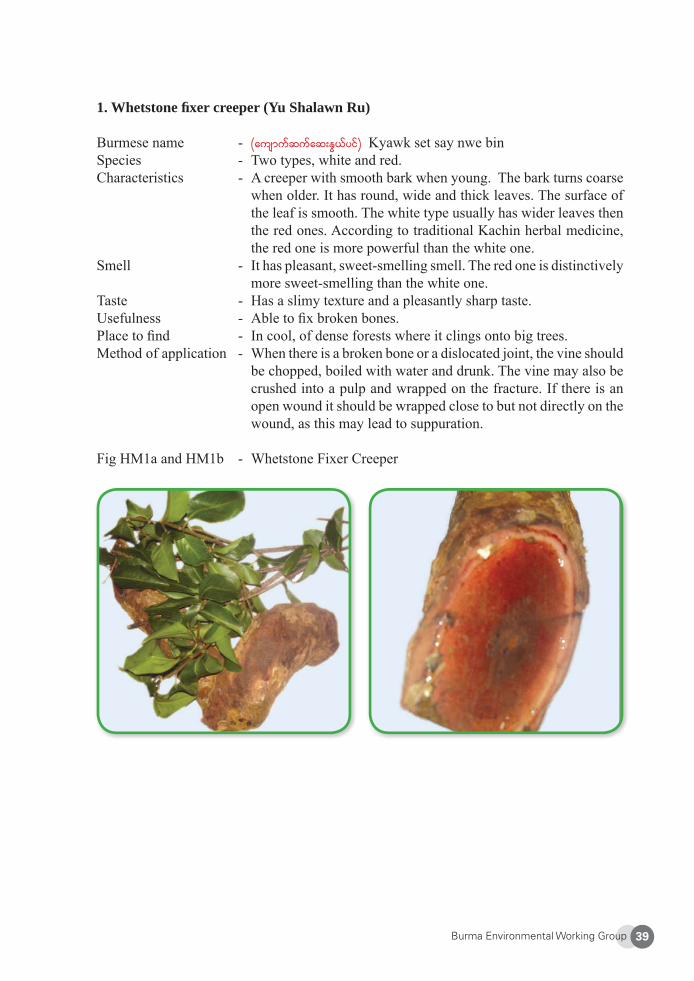
Burma Environmental Working Group 39
1. Whetstone fi xer creeper (Yu Shalawn Ru)
Burmese name - (ausmufqufaq;EG,fyif) Kyawk set say nwe binSpecies - Two types, white and red.Characteristics - A creeper with smooth bark when young. The bark turns coarse
when older. It has round, wide and thick leaves. The surface of the leaf is smooth. The white type usually has wider leaves then the red ones. According to traditional Kachin herbal medicine, the red one is more powerful than the white one.
Smell - It has pleasant, sweet-smelling smell. The red one is distinctively more sweet-smelling than the white one.
Taste - Has a slimy texture and a pleasantly sharp taste.Usefulness - Able to fi x broken bones.Place to fi nd - In cool, of dense forests where it clings onto big trees.Method of application - When there is a broken bone or a dislocated joint, the vine should
be chopped, boiled with water and drunk. The vine may also be crushed into a pulp and wrapped on the fracture. If there is an open wound it should be wrapped close to but not directly on the wound, as this may lead to suppuration.
Fig HM1a and HM1b - Whetstone Fixer Creeper
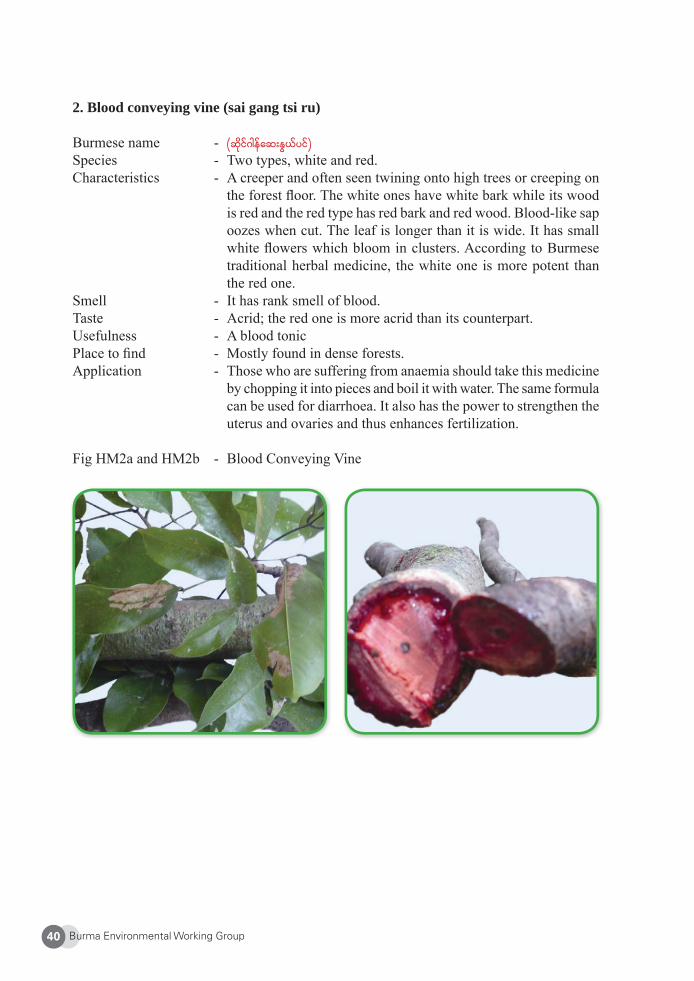
Burma Environmental Working Group40
2. Blood conveying vine (sai gang tsi ru)
Burmese name - (qdkif*gefaq;EG,fyif) Species - Two types, white and red. Characteristics - A creeper and often seen twining onto high trees or creeping on
the forest fl oor. The white ones have white bark while its wood is red and the red type has red bark and red wood. Blood-like sap oozes when cut. The leaf is longer than it is wide. It has small white fl owers which bloom in clusters. According to Burmese traditional herbal medicine, the white one is more potent than the red one.
Smell - It has rank smell of blood.Taste - Acrid; the red one is more acrid than its counterpart.Usefulness - A blood tonicPlace to fi nd - Mostly found in dense forests.Application - Those who are suffering from anaemia should take this medicine
by chopping it into pieces and boil it with water. The same formula can be used for diarrhoea. It also has the power to strengthen the uterus and ovaries and thus enhances fertilization.
Fig HM2a and HM2b - Blood Conveying Vine
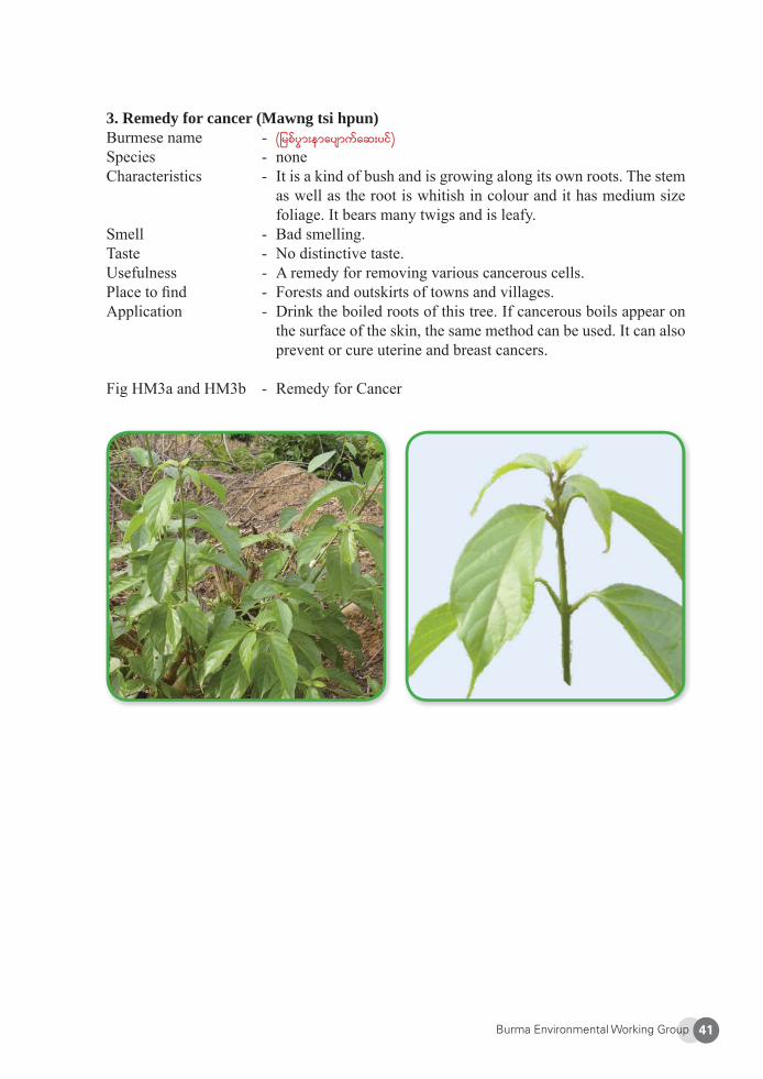
Burma Environmental Working Group 41
3. Remedy for cancer (Mawng tsi hpun)Burmese name - (jrpfyGm;emaysmufaq;yif) Species - noneCharacteristics - It is a kind of bush and is growing along its own roots. The stem
as well as the root is whitish in colour and it has medium size foliage. It bears many twigs and is leafy.
Smell - Bad smelling.Taste - No distinctive taste.Usefulness - A remedy for removing various cancerous cells.Place to fi nd - Forests and outskirts of towns and villages.Application - Drink the boiled roots of this tree. If cancerous boils appear on
the surface of the skin, the same method can be used. It can also prevent or cure uterine and breast cancers.
Fig HM3a and HM3b - Remedy for Cancer
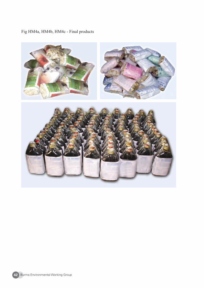
Burma Environmental Working Group42
Fig HM4a, HM4b, HM4c - Final products
Burma Environmental Working Group 43
About Pan Kachin Development Society (PKDS)
PKDS was formed by socially-conscious Kachin scholars and civil society leaders in 1994. Originally, it coordinated pilot projects for basic education and healthcare in the Kachin Independence Organization’s (KIO) jurisdiction of Kachin State. PKDS’s focus is to help revive Kachin culture and language in Kachin State, Burma. In the past, PKDS has also worked on HIV/AIDS intervention and community development projects. Currently, PKDS runs an environment project that includes developing environmental curriculum for schools, promoting and teaching villagers how to produce traditional herbal medicine, conducting logging and mining research, and training on environmental awareness. In addition to working with locals to establish protected community forests, PKDS also manages community-based development projects that help protect the forest. Website: http://www.pankachin.net
1 Conservation International. “Indo-Burma,” at: <http://www.biodiversityhotspots.org/xp/hotspots/indo_burma/Pages/default.aspx>. Last accessed 12 Dec. 2008.2 The Kachin Independence Organization (KIO) is one of the strongest political armed resistance groups in Kachin State.3 The New Democratic Army – Kachin (NDA-K) is another armed opposition group in Kachin State. It origi-nally broke off from the KIO.4 Since 2006, villagers throughout Burma have had to endure the confi scation of land, imposition of procure-ment quotas and forced labour to cultivate jatropha plantations for the production of bio-diesel. See generally, Ethnic Community Development Forum, Biofuel by Decree: Unmasking Burma’s Bio-energy Fiasco, 2008.5 Global Witness, A Choice for China: Ending the Destruction of Burma’s Northern Frontier Forests, 2005. 6 Ibid. 7 Wanasanpraikhieo, T, Changes and Challenges of Community Forest Practices in Forest-Dependent Com-munities in Kachin State, Chulalongkorn University, 2008. 8 Ibid.9 Ibid. 10 Ibid.11 The real name of the village is withheld for security reasons.12 According to local sources, many herbal plant species have not been scientifi cally named.
Burma Environmental Working Group44
1. Kachin State
Kachin State, the northernmost state of Burma, is bordered by China to the north and east, Shan State to the south, and Sagaing Division and India to the west. The population of Kachin State is about 1.2 million people. The inhabitants are ethnic Kachin (including Jinghpaw, Rawang, Lisu, Zaiwa, Longwo, and Lachit sub-groups), Shan, Naga, Burman, Chinese, and Indian. Kachin State is part of the Indo-Burma hotspot,1 recognized as one of the eight “hottest hotspots for biodiversity” in the world.
Burma gained independence from British colonization in 1948. Following a short period of parliamentary government, Burma has been ruled by a series of military dictatorships since 1962. Disagreements over the rights and powers of the central and local governments led to civil war in some areas of the country. The Kachin Independence Organization (KIO) and its armed wing, Kachin Independence Army (KIA), were founded in 1961 in response to these political differences. After years of armed struggle, the KIO/KIA signed a ceasefi re agreement with the SPDC in 1994. The Hugawng Valley was mostly controlled by the KIA before the ceasefi re agreement but at present the SPDC controls the area with a signifi cant military presence.
2. Hugawng Valley
Hugawng Valley is located in the western part of Kachin State near the Indian border, between the Kumon Mountain range to the east and the Patkai Mountains to the west. The Patkai range includes headwaters for the Chindwin and Brahmaputra Rivers, while the Kumon Mountains contain the headwaters of Danai, Tawang and Tarung Rivers, which together form the headstreams of the Chindwin. The catchments fl ow into the plains of the Hugawng Valley where they combine to form the largest tributary of the Chindwin – the Danai River. The majority of the local people in the Hugawng Valley are Kachin, with other ethnic minorities represented, such as Naga and Shan. Lisu are also a prevalent minority living in the valley, although in Burma, Lisu are included in the Kachin classifi cation.
The Hugawng Valley Tiger Reserve
The remote Hugawng Valley has been internationally recognized as a major global hotspot of biodiversity, mainly due to its vast remaining forests and the wildlife contained therein.
The Role of Kachin People in the Hugawng Valley Tiger Reserve
Kachin Development Networking Group
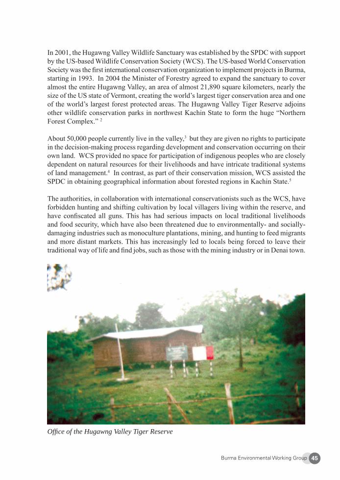
Burma Environmental Working Group 45
Offi ce of the Hugawng Valley Tiger Reserve
In 2001, the Hugawng Valley Wildlife Sanctuary was established by the SPDC with support by the US-based Wildlife Conservation Society (WCS). The US-based World Conservation Society was the fi rst international conservation organization to implement projects in Burma, starting in 1993. In 2004 the Minister of Forestry agreed to expand the sanctuary to cover almost the entire Hugawng Valley, an area of almost 21,890 square kilometers, nearly the size of the US state of Vermont, creating the world’s largest tiger conservation area and one of the world’s largest forest protected areas. The Hugawng Valley Tiger Reserve adjoins other wildlife conservation parks in northwest Kachin State to form the huge “Northern Forest Complex.” 2
About 50,000 people currently live in the valley,3 but they are given no rights to participate in the decision-making process regarding development and conservation occurring on their own land. WCS provided no space for participation of indigenous peoples who are closely dependent on natural resources for their livelihoods and have intricate traditional systems of land management.4 In contrast, as part of their conservation mission, WCS assisted the SPDC in obtaining geographical information about forested regions in Kachin State.5
The authorities, in collaboration with international conservationists such as the WCS, have forbidden hunting and shifting cultivation by local villagers living within the reserve, and have confi scated all guns. This has had serious impacts on local traditional livelihoods and food security, which have also been threatened due to environmentally- and socially-damaging industries such as monoculture plantations, mining, and hunting to feed migrants and more distant markets. This has increasingly led to locals being forced to leave their traditional way of life and fi nd jobs, such as those with the mining industry or in Denai town.
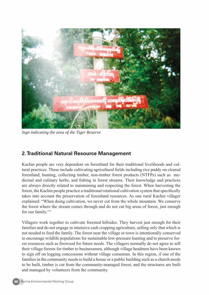
Burma Environmental Working Group46
Sign indicating the area of the Tiger Reserve
2. Traditional Natural Resource Management
Kachin people are very dependent on forestland for their traditional livelihoods and cul-tural practices. These include cultivating agricultural fi elds including rice paddy on cleared forestland, hunting, collecting timber, non-timber forest products (NTFPs) such as me-dicinal and culinary herbs, and fi shing in forest streams. Their knowledge and practices are always directly related to maintaining and respecting the forest. When harvesting the forest, the Kachin people practice a traditional rotational cultivation system that specifi cally takes into account the preservation of forestland resources. As one rural Kachin villager explained: “When doing cultivation, we never cut from the whole mountain. We conserve the forest where the stream comes through and do not cut big areas of forest, just enough for our family.” 6
Villagers work together to cultivate forested hillsides. They harvest just enough for their families and do not engage in intensive cash cropping agriculture, selling only that which is not needed to feed the family. The forest near the village or town is intentionally conserved to encourage wildlife populations for sustainable low-pressure hunting and to preserve for-est resources such as fi rewood for future needs. The villagers normally do not agree to sell their village forests for timber to businessmen, although village headmen have been known to sign off on logging concessions without village consensus. In this region, if one of the families in the community needs to build a house or a public building such as a church needs to be built, timber is cut from the community-managed forest, and the structures are built and managed by volunteers from the community.
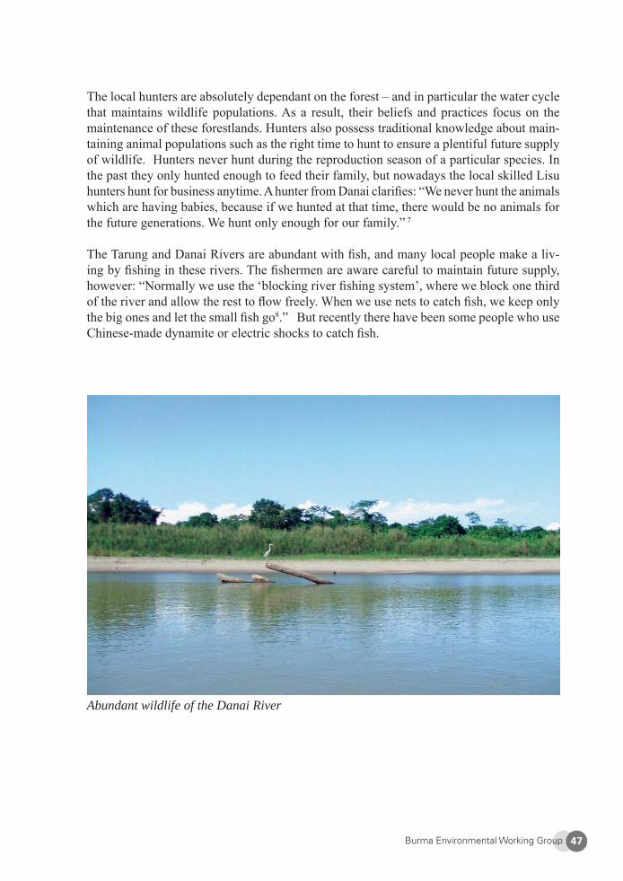
Burma Environmental Working Group 47
Abundant wildlife of the Danai River
The local hunters are absolutely dependant on the forest – and in particular the water cycle that maintains wildlife populations. As a result, their beliefs and practices focus on the maintenance of these forestlands. Hunters also possess traditional knowledge about main-taining animal populations such as the right time to hunt to ensure a plentiful future supply of wildlife. Hunters never hunt during the reproduction season of a particular species. In the past they only hunted enough to feed their family, but nowadays the local skilled Lisu hunters hunt for business anytime. A hunter from Danai clarifi es: “We never hunt the animals which are having babies, because if we hunted at that time, there would be no animals for the future generations. We hunt only enough for our family.” 7
The Tarung and Danai Rivers are abundant with fi sh, and many local people make a liv-ing by fi shing in these rivers. The fi shermen are aware careful to maintain future supply, however: “Normally we use the ‘blocking river fi shing system’, where we block one third of the river and allow the rest to fl ow freely. When we use nets to catch fi sh, we keep only the big ones and let the small fi sh go8.” But recently there have been some people who use Chinese-made dynamite or electric shocks to catch fi sh.
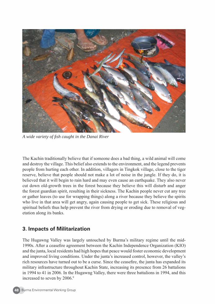
Burma Environmental Working Group48
A wide variety of fi sh caught in the Danai River
The Kachin traditionally believe that if someone does a bad thing, a wild animal will come and destroy the village. This belief also extends to the environment, and the legend prevents people from hurting each other. In addition, villagers in Tingkok village, close to the tiger reserve, believe that people should not make a lot of noise in the jungle. If they do, it is believed that it will begin to rain hard and may even cause an earthquake. They also never cut down old-growth trees in the forest because they believe this will disturb and anger the forest guardian spirit, resulting in their sickness. The Kachin people never cut any tree or gather leaves (to use for wrapping things) along a river because they believe the spirits who live in that area will get angry, again causing people to get sick. These religious and spiritual beliefs thus help prevent the river from drying or eroding due to removal of veg-etation along its banks.
3. Impacts of Militarization
The Hugawng Valley was largely untouched by Burma’s military regime until the mid-1990s. After a ceasefi re agreement between the Kachin Independence Organization (KIO) and the junta, local residents had high hopes that peace would foster economic development and improved living conditions. Under the junta’s increased control, however, the valley’s rich resources have turned out to be a curse. Since the ceasefi re, the junta has expanded its military infrastructure throughout Kachin State, increasing its presence from 26 battalions in 1994 to 41 in 2006. In the Hugawng Valley, there were three battalions in 1994, and this increased to seven by 2006.9
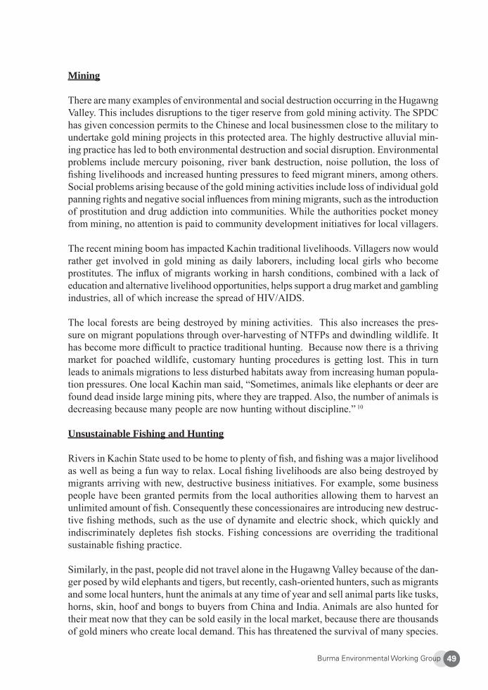
Burma Environmental Working Group 49
Mining
There are many examples of environmental and social destruction occurring in the Hugawng Valley. This includes disruptions to the tiger reserve from gold mining activity. The SPDC has given concession permits to the Chinese and local businessmen close to the military to undertake gold mining projects in this protected area. The highly destructive alluvial min-ing practice has led to both environmental destruction and social disruption. Environmental problems include mercury poisoning, river bank destruction, noise pollution, the loss of fi shing livelihoods and increased hunting pressures to feed migrant miners, among others. Social problems arising because of the gold mining activities include loss of individual gold panning rights and negative social infl uences from mining migrants, such as the introduction of prostitution and drug addiction into communities. While the authorities pocket money from mining, no attention is paid to community development initiatives for local villagers.
The recent mining boom has impacted Kachin traditional livelihoods. Villagers now would rather get involved in gold mining as daily laborers, including local girls who become prostitutes. The infl ux of migrants working in harsh conditions, combined with a lack of education and alternative livelihood opportunities, helps support a drug market and gambling industries, all of which increase the spread of HIV/AIDS.
The local forests are being destroyed by mining activities. This also increases the pres-sure on migrant populations through over-harvesting of NTFPs and dwindling wildlife. It has become more diffi cult to practice traditional hunting. Because now there is a thriving market for poached wildlife, customary hunting procedures is getting lost. This in turn leads to animals migrations to less disturbed habitats away from increasing human popula-tion pressures. One local Kachin man said, “Sometimes, animals like elephants or deer are found dead inside large mining pits, where they are trapped. Also, the number of animals is decreasing because many people are now hunting without discipline.” 10
Unsustainable Fishing and Hunting
Rivers in Kachin State used to be home to plenty of fi sh, and fi shing was a major livelihood as well as being a fun way to relax. Local fi shing livelihoods are also being destroyed by migrants arriving with new, destructive business initiatives. For example, some business people have been granted permits from the local authorities allowing them to harvest an unlimited amount of fi sh. Consequently these concessionaires are introducing new destruc-tive fi shing methods, such as the use of dynamite and electric shock, which quickly and indiscriminately depletes fi sh stocks. Fishing concessions are overriding the traditional sustainable fi shing practice.
Similarly, in the past, people did not travel alone in the Hugawng Valley because of the dan-ger posed by wild elephants and tigers, but recently, cash-oriented hunters, such as migrants and some local hunters, hunt the animals at any time of year and sell animal parts like tusks, horns, skin, hoof and bongs to buyers from China and India. Animals are also hunted for their meat now that they can be sold easily in the local market, because there are thousands of gold miners who create local demand. This has threatened the survival of many species.
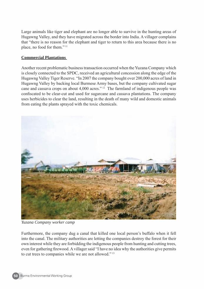
Burma Environmental Working Group50
Yuzana Company worker camp
Large animals like tiger and elephant are no longer able to survive in the hunting areas of Hugawng Valley, and they have migrated across the border into India. A villager complains that “there is no reason for the elephant and tiger to return to this area because there is no place, no food for them.” 11
Commercial Plantations
Another recent problematic business transaction occurred when the Yuzana Company which is closely connected to the SPDC, received an agricultural concession along the edge of the Hugawng Valley Tiger Reserve. “In 2007 the company bought over 200,000 acres of land in Hugawng Valley by backing local Burmese Army bases, but the company cultivated sugar cane and cassava crops on about 4,000 acres.” 12 The farmland of indigenous people was confi scated to be clear-cut and used for sugarcane and cassava plantations. The company uses herbicides to clear the land, resulting in the death of many wild and domestic animals from eating the plants sprayed with the toxic chemicals.
Furthermore, the company dug a canal that killed one local person’s buffalo when it fell into the canal. The military authorities are letting the companies destroy the forest for their own interest while they are forbidding the indigenous people from hunting and cutting trees, even for gathering fi rewood. A villager said “I have no idea why the authorities give permits to cut trees to companies while we are not allowed.” 13
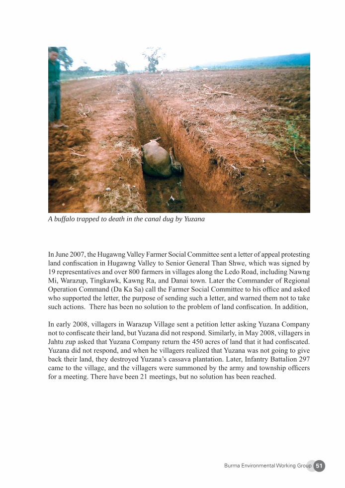
Burma Environmental Working Group 51
A buffalo trapped to death in the canal dug by Yuzana
In June 2007, the Hugawng Valley Farmer Social Committee sent a letter of appeal protesting land confi scation in Hugawng Valley to Senior General Than Shwe, which was signed by 19 representatives and over 800 farmers in villages along the Ledo Road, including Nawng Mi, Warazup, Tingkawk, Kawng Ra, and Danai town. Later the Commander of Regional Operation Command (Da Ka Sa) call the Farmer Social Committee to his offi ce and asked who supported the letter, the purpose of sending such a letter, and warned them not to take such actions. There has been no solution to the problem of land confi scation. In addition,
In early 2008, villagers in Warazup Village sent a petition letter asking Yuzana Company not to confi scate their land, but Yuzana did not respond. Similarly, in May 2008, villagers in Jahtu zup asked that Yuzana Company return the 450 acres of land that it had confi scated. Yuzana did not respond, and when he villagers realized that Yuzana was not going to give back their land, they destroyed Yuzana’s cassava plantation. Later, Infantry Battalion 297 came to the village, and the villagers were summoned by the army and township offi cers for a meeting. There have been 21 meetings, but no solution has been reached.
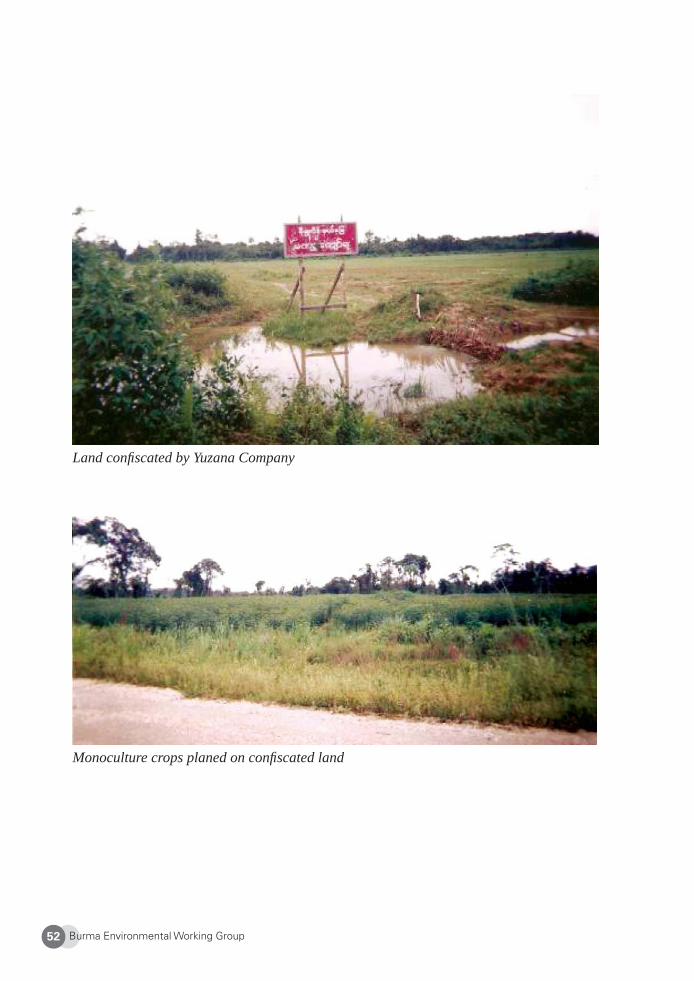
Burma Environmental Working Group52
Land confi scated by Yuzana Company
Monoculture crops planed on confi scated land
Burma Environmental Working Group 53
4. KDNG Projects
Members of the Kachin Development Networking Group (KDNG) are concerned about the destruction of Hugawng Valley. In 2007, KDNG published Valley of Darkness: Gold Mining and Militarization of Burma’s Hugawng Valley. KDNG is planning to publish a follow-up report on land confi scation in the Hugawng Valley. In addition, KDNG provides awareness training to promote the importance of indigenous knowledge and the vital link to culturally-appropriate environmental management and conservation.
The goals of KDNG are to: • Maintain the integrity of land and forests; • Empower indigenous people by improving awareness on environmental issues
relating to human rights, environmental rights and indigenous rights; and • Achieve these goals through trainings, workshops, research, documentation and
advocacy.
5. Conclusion
The livelihoods of indigenous peoples in Hugawng Valley are very dependent on forestlands and the resources found therein. The traditional knowledge, beliefs, and practices of the indigenous peoples are directly linked to the preservation of the local environment. Their precious local natural resources, however, are under threat due to destructive development and putative conservation under the control of outsiders – namely, the military, profi t-making companies, and the Wildlife Conservation Society (WCS). The local people are given no opportunity to participate in the decision-making process regarding development and conservation occurring on their own land. But the indigenous people have the right to self- determination and ownership of land as well as the right to manage their own natural re-sources. The government should not ignore the indigenous people, but rather should promote the use and preservation of indigenous knowledge, beliefs and practices that are associated with conserving the forests and its many resources. The government also should integrate indigenous wisdom as much as possible into their future development plans. There is no way to preserve the forest and wildlife without indigenous people participating in decision mak-ing, including a leading role in the process. The government must investigate development policies and activities that are destroying the tiger reserve and local indigenous’ livelihoods.
Burma Environmental Working Group54
About Kachin Development Networking Group (KDNG)
Founded in 2004, KDNG is a network of civil society groups and development organizations in Kachin State. KDNG’s purpose is to effectively work for sustainable development based on indigenous knowledge and culturally-appropriate environmental management and con-servation methods. KDNG works to maintain the integrity of land and forest, and empower indigenous people by providing awareness on environment issues, especially relating to human rights, environmental rights and indigenous rights. It achieves these goals through trainings, workshops, research, documentation, and advocacy. Website: http://www.aksyu.com
1 See, e.g., Indo-Burma Hotspot, available online at <http://www.biodiversityhotspots.org/xp/Hotspots/indo_burma/Pages/default.aspx>. Last accessed May 11, 2009.2 KDNG, Valley of Darkness: Gold mining and militarization in Burma’s Hugawng Valley, January 2007, p. 7. Available online at < http://www.burmacampaign.org.uk/reports/ValleyofDarkness.pdf>. 3 J. Pollard, “In the Eye of the Tiger,” Western Australian, 11 Jun. 2005.4 Noam, Z, “Eco-authoritarian conservation and ethnic confl ict in Burma,” in Policy Matters: Conservation and Human Rights (Vol. 15. 2007).5 Antony J. Lyman, phD, “A National Tiger Action Plan for the Union of Myanmar,” World Conservation Society, May 2003, at: <http://www.wcs.org/media/fi le/NTAPcomplete.pdf>. Last accessed 17 Apr. 2009. 6 KDNG Interview #1, March 2007. 7 KDNG Interview #2, March 2007.8 KDNG Interview #3, June 2007.9 Valley of Darkness, supra note 2, p.8. 10 KDNG Interview #4, May 2007.11 KDNG Interview #6, April 2007.12 Burma News International, “Yuzana Company pollutes river in the world’s largest tiger reserve,” January 16, 2008. Available online at: http://www.bnionline.net/index.php?option=com_content&task=view&id=3340&Itemid=6. Last accessed 17 Feb. 2009.13 KDNG Interview #1, March 2007.
Burma Environmental Working Group 55
Karen State
Environmental Protection, Indigenous Knowledge and Livelihood in Karen State:
A Focus on Community Conserved Areas
Karen Environment and Social Action Network (KESAN)
Indigenous groups and their traditional knowledge and systems of natural resource manage-ment can make a signifi cant contribution to conservation. Who better to care for an area than the people who have lived there for generations, know it intimately, and rely on its continued health for both their lives and livelihoods? Many aspects of daily life, particularly for indigenous people, are directly dependent on the management and use of local resources. In addition, sustainable natural resource management helps to preserve the traditions and dignity of indigenous peoples. Increasingly, international laws and treaties are recognizing the rights of indigenous people to manage their own land and resources. A number of projects in Karen State demonstrate the contribution that community-based conservation efforts have made to the protection of the environment, preservation of culture, and poverty alleviation.
1. Karen State and Its People
Karen State lies in eastern Burma, stretching along the border with Thailand. Its northern and eastern areas are mountainous and largely remain forested (although much of this is degraded), while the central and southern regions are fl atter and have been heavily logged, with little primary forest remaining. The state is rich in natural resources including timber and other forest products and gold. Key threats to the environment are rapid deforestation and associated biodiversity loss through logging, large-scale infrastructure projects such as military installations, roads, and proposed mega-dams on the Salween River, degradation of land and rivers due to with mining, and the impact of agriculture and population pressures.
Karen people have lived in what is now eastern Burma and western Thailand since at least the 13th century. Population estimates for the Karen varies between four and seven million, and approximately 250,000 living inside Karen State (Districts of Doo The Htoo (Thaton in Burmese), Toungoo, Kler Lwee Htoo (Nyaung Lebin), Mutraw (Papun), Dooplaya and Pa’an) as well as in Mergui Tavoy District of Tenasserim (Tanintharyi) Division. The ma-jority of Karen people are animist and Buddhist, with around one-fi fth Christian. The vast majority of the population in Karen State is rural, with many living as traditional subsistence farmers. In the uplands, swidden agriculture is widely practiced, supplemented with food gathered from the forest. In the lowlands, there is more permanent fi eld agriculture and an increasing amount of cash cropping.
The Karen people have been enduring the world’s longest-running civil war for over sixty years. Most of the central and southern regions of the state are now fi rmly under the control
Burma Environmental Working Group56
of Burma’s military regime, the State Peace and Development Council (SPDC), while the highlands of the north are the stronghold of the Karen National Union (KNU). Villages in the region can be subject to SPDC raids and severe human rights abuses. Entire villages have been relocated and grouped together to form towns by the SPDC in the name of develop-ment. The SPDC-controlled areas are more secure, but villagers face more restrictions. More than 5,000 people have been ordered to move to these relocation sites in northern Karen State in 2007.1 Movement outside of SPDC-controlled areas is limited, agricultural deci-sions including which crops to plant are made by the military, and forced labor is common.
The civil war also has caused more than 100,000 Karen people to fl ee to Thailand, and a further 116,900 currently live as internally displaced persons (IDPs) within the state.2 IDP communities typically need to move two or three times a year. The war has created food shortages in many areas, and modern healthcare is unavailable. As a result, the health situ-ation for IDPs is particularly bad. For example, the mortality rate for children under fi ve in eastern Burma is 22.1%, twice the national average.3 Further, the war has a substantial impact on the environment. Forests are cleared for military purposes and natural resources are extracted and sold by both sides to obtain funds for the war. Additionally, human mi-gration, loss of agricultural land, and food insecurity continue to place heavy pressure on populations that are already vulnerable.
It is in this confl ict situation that the community-based environmental initiatives discussed here are being undertaken. All the initiatives are within areas where either the KNU is in control or where both the KNU and the SPDC and its allies have infl uence. Each district in Karen State has its own local government, headed by a district leader. The KNU also has a civil service structure. It is important for villages to negotiate with local leadership in order for community-conserved areas to be respected by others outside the community, including the KNU.
2. Indigenous Knowledge and Protection of the Environment
Karen lands along both sides of the Thai-Burmese border are rich in biodiversity. Rivers are relatively clean, and until the recent intrusion of outsiders, Karen forests were expansive and healthy. The immediate natural environment has long provided a range of services that met all the needs of the local people such as food, water and shelter, as well as means of transport and communication with other villages by river, natural protection from invasion, medicine, irrigation, and sites for cultural and spiritual rituals. Customary law has ensured the health of ecosystems and protected these services.
For the Karen, the natural environment is not a “wilderness” or something separate from its people, but rather a home, integrated with daily life. The calendar is based on signs from nature – the call of a bird or frog or the arrival of insects. Their relationship with nature is also deeply linked to spirituality, and cultural taboos have contributed to environmental pres-ervation. Practices such as collecting different seed varieties and mixed cropping for natural pest control have ensured the promotion of biodiversity and preservation of ecosystems.
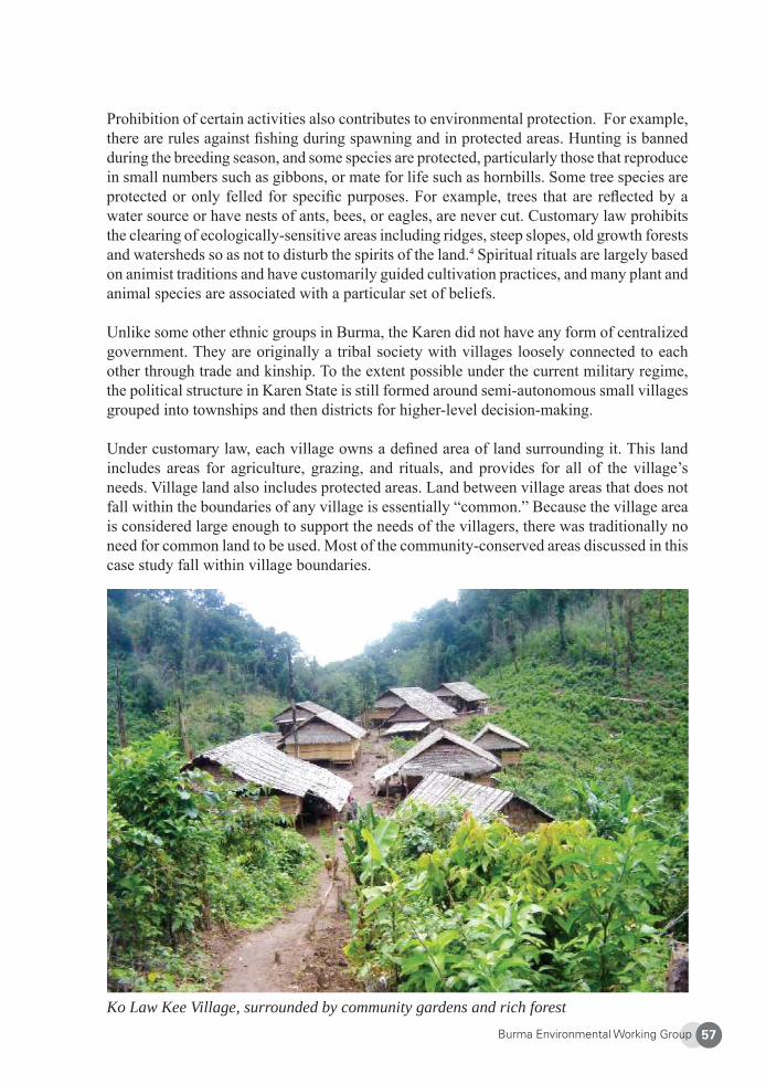
Burma Environmental Working Group 57
Prohibition of certain activities also contributes to environmental protection. For example, there are rules against fi shing during spawning and in protected areas. Hunting is banned during the breeding season, and some species are protected, particularly those that reproduce in small numbers such as gibbons, or mate for life such as hornbills. Some tree species are protected or only felled for specifi c purposes. For example, trees that are refl ected by a water source or have nests of ants, bees, or eagles, are never cut. Customary law prohibits the clearing of ecologically-sensitive areas including ridges, steep slopes, old growth forests and watersheds so as not to disturb the spirits of the land.4 Spiritual rituals are largely based on animist traditions and have customarily guided cultivation practices, and many plant and animal species are associated with a particular set of beliefs.
Unlike some other ethnic groups in Burma, the Karen did not have any form of centralized government. They are originally a tribal society with villages loosely connected to each other through trade and kinship. To the extent possible under the current military regime, the political structure in Karen State is still formed around semi-autonomous small villages grouped into townships and then districts for higher-level decision-making.
Under customary law, each village owns a defi ned area of land surrounding it. This land includes areas for agriculture, grazing, and rituals, and provides for all of the village’s needs. Village land also includes protected areas. Land between village areas that does not fall within the boundaries of any village is essentially “common.” Because the village area is considered large enough to support the needs of the villagers, there was traditionally no need for common land to be used. Most of the community-conserved areas discussed in this case study fall within village boundaries.
Ko Law Kee Village, surrounded by community gardens and rich forest
Burma Environmental Working Group58
The Karen people have operated community-conserved areas for centuries. For the Karen, it is simply a way of life, not a specifi c conservation category. It should be noted that this case study only describes projects conducted with the support of community-based organiza-tions. Throughout Karen lands, other communities continue to carry-out traditional practices and systems for conservation without being formally recognized as “community-conserved areas.”
With large numbers of IDPs constantly on the move, and decreasing availability of agri-cultural land due to migration or confi scation by the military, certain practices cannot be maintained. When villages are relocated, whether by war, land confi scation, or creation of a national park, it not only disrupts the lives of individuals and communities, but also the land management systems that have traditionally protected the environment in the fi rst place. Long-protected areas are now being encroached upon and other taboos are being broken, causing environmental as well as cultural impacts.
When practiced traditionally, swidden agriculture involves using land for one year, then leaving it fallow for periods of seven to ten years, allowing the soil time to regenerate before re-planting. It uses complex forest management techniques that make chemical fertilisers unnecessary, and in Karen State has enabled the preservation of numerous seed varieties. Recent research has shown that the traditional rotational farming method is not only envi-ronmentally sustainable but that it can help retain high levels of biodiversity.5 But in areas with large IDP populations, the scarcity of available land has led to an enforced change in traditional practices. Farmers are now returning to their fi elds after just two to four years, resulting in a decline in soil fertility and an increase of pests and weeds.6
For the Karen, the loss of natural resources is associated with a loss of customs, traditional knowledge and practices, and ultimately, in cultural identity. Recent research in Karen State found that while traditional methods successfully managed natural resources and protected biodiversity, “the longstanding civil war is having a great effect on the Karen’s traditional livelihood and is preventing [local Karen communities] from using their environment in a sustainable manner.”7 The projects described in the case study aim to address this issue.
3. Conservation in Practice
Community-conserved areas
In Karen State, villagers are undertaking a range of projects aimed at environmental con-servation while maintaining their livelihoods and preserving their culture. Projects include establishment and management of protected areas, limited extraction of forest products for traditional medicines, and use of farming techniques that reduce agricultural inputs and impacts on the environment, all the while improving food security. In the past three years, more than 30 such projects have been implemented with support from local community-based organizations and international NGOs
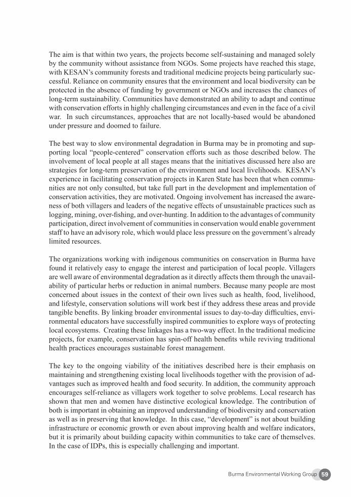
Burma Environmental Working Group 59
The aim is that within two years, the projects become self-sustaining and managed solely by the community without assistance from NGOs. Some projects have reached this stage, with KESAN’s community forests and traditional medicine projects being particularly suc-cessful. Reliance on community ensures that the environment and local biodiversity can be protected in the absence of funding by government or NGOs and increases the chances of long-term sustainability. Communities have demonstrated an ability to adapt and continue with conservation efforts in highly challenging circumstances and even in the face of a civil war. In such circumstances, approaches that are not locally-based would be abandoned under pressure and doomed to failure.
The best way to slow environmental degradation in Burma may be in promoting and sup-porting local “people-centered” conservation efforts such as those described below. The involvement of local people at all stages means that the initiatives discussed here also are strategies for long-term preservation of the environment and local livelihoods. KESAN’s experience in facilitating conservation projects in Karen State has been that when commu-nities are not only consulted, but take full part in the development and implementation of conservation activities, they are motivated. Ongoing involvement has increased the aware-ness of both villagers and leaders of the negative effects of unsustainable practices such as logging, mining, over-fi shing, and over-hunting. In addition to the advantages of community participation, direct involvement of communities in conservation would enable government staff to have an advisory role, which would place less pressure on the government’s already limited resources.
The organizations working with indigenous communities on conservation in Burma have found it relatively easy to engage the interest and participation of local people. Villagers are well aware of environmental degradation as it directly affects them through the unavail-ability of particular herbs or reduction in animal numbers. Because many people are most concerned about issues in the context of their own lives such as health, food, livelihood, and lifestyle, conservation solutions will work best if they address these areas and provide tangible benefi ts. By linking broader environmental issues to day-to-day diffi culties, envi-ronmental educators have successfully inspired communities to explore ways of protecting local ecosystems. Creating these linkages has a two-way effect. In the traditional medicine projects, for example, conservation has spin-off health benefi ts while reviving traditional health practices encourages sustainable forest management.
The key to the ongoing viability of the initiatives described here is their emphasis on maintaining and strengthening existing local livelihoods together with the provision of ad-vantages such as improved health and food security. In addition, the community approach encourages self-reliance as villagers work together to solve problems. Local research has shown that men and women have distinctive ecological knowledge. The contribution of both is important in obtaining an improved understanding of biodiversity and conservation as well as in preserving that knowledge. In this case, “development” is not about building infrastructure or economic growth or even about improving health and welfare indicators, but it is primarily about building capacity within communities to take care of themselves. In the case of IDPs, this is especially challenging and important.

Burma Environmental Working Group60
The current program of community conservation began following workshops and envi-ronmental education conducted by the KESAN in 2003. Workshops were initially held with local government offi cials to gain their support, and then within communities across northern Karen State. Since then, over 100 community members and local government staff have taken one to three months’ intensive trainings to equip them with the skills to coordinate projects in their districts. Trainees are nominated by village leaders and district government respectively, and selected on the basis of their interest in environmental issues and commitment to working for the community. Subjects range from local and global envi-ronmental issues, project management, reporting and committee-organizing, and practical skills such as organic farming, chicken raising, use of herbal medicines for disease control, and community forestry. Training is held annually and provides previous participants with an opportunity to increase their skills and a forum to discuss issues with existing projects. Recruitment of additional trainees allows the program to spread progressively. Each district now has a committee that considers project applications from communities.
The process for designing, establishing, and implementing projects is very much from the bottom-up. The role of KESAN and other organizations is to facilitate and to help com-munities identify, clarify, and put into practice what they already know. Local expertise is used fi rst, with external expertise brought in only where necessary. Communities identify potential projects and decide policies, rules, and operational guidelines. They work with the trained local project staff or relevant local government offi cials to manage projects, with communities progressively taking more control as their skills develop. In a number of villages, committees have been formed to manage and sustain their own projects. This approach ensures community buy-in, investment, and commitment from the planning to implementation stages, reducing the instances of projects unworkable or unnecessary for communities, and making projects more viable in the long term.
Community Forests
The fi rst community forests under this program were established in Karen State in 2005, and at time of writing, there were nine operating. The basic tenet is that forest products will be harvested only for the village’s own use and not sold outside for profi t. Beyond this, it is at the community’s discretion to determine the level of protection for their forest, and how it can be managed sustainably. Forests vary in size, generally taking up 10 to 15 % of village lands, with the current largest at 64 acres. Sometimes the program simply gives formal structure and recognition to areas that are already being cared for as community forests according to Karen traditions. In one instance, the “new” community forest has been a protected area for three generations. The forest had been troubled by illegal logging, however, so the village approached KESAN to speak to the district leader on their behalf, and gained offi cial recognition of their rights to the forest.
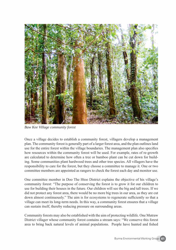
Burma Environmental Working Group 61
Baw Kee Village community forest
Once a village decides to establish a community forest, villagers develop a management plan. The community forest is generally part of a larger forest area, and the plan outlines land use for the entire forest within the village boundaries. The management plan also specifi es how resources within the community forest will be used. For example, rates of re-growth are calculated to determine how often a tree or bamboo plant can be cut down for build-ing. Some communities plant hardwood trees and other tree species. All villagers have the responsibility to care for the forest, but they choose a committee to manage it. One or two committee members are appointed as rangers to check the forest each day and monitor use.
One committee member in Doo The Htoo District explains the objective of his village’s community forest: “The purpose of conserving the forest is to grow it for our children to use for building their houses in the future. Our children will see the big and tall trees. If we did not protect any forest area, there would be no more big trees in our area, as they are cut down almost continuously.” The aim is for ecosystems to regenerate suffi ciently so that a village can meet its long-term needs. In this way, a community forest ensures that a village can sustain itself, thereby reducing pressure on surrounding areas.
Community forests may also be established with the aim of protecting wildlife. One Mutraw District villager whose community forest contains a stream says: “We conserve this forest area to bring back natural levels of animal populations. People have hunted and fi shed
Burma Environmental Working Group62
in untraditional ways such as by using machine guns, chemical and herbal poisons, spear guns, illegal fi shing nets, and bombing, so the animals decreased very quickly and could become extinct.”
Revival of Customary Practices in Demarcating Village Boundaries
Those outside of the community may not settle, farm, or collect non-timber forest products in the community forest. When supporting a community forestry project, KESAN promotes the adoption of customary practices in establishing village boundaries including community forests. In many areas, customary practices have fallen into disuse as a result of armed con-fl ict and extensive displacement, but KESAN has found that such practices are effective in helping villagers respect boundaries and avoid disputes over territory and forest resources.
Traditionally, demarcation of a village boundary is done jointly with villagers from neighbor-ing villages and is a spiritual as well as physical undertaking. At the end of the demarcation walk, everyone gathers on the mountain ridge which usually serves as the village borderline. Stones are piled to mark the border, and everyone makes an oath not to violate each other’s territories and rules. After this ceremony, they cook and eat together. Villagers believe that violations of territories and rules will cause illnesses, accidents, or poor rice harvests.
After the village boundaries are established through the customary procedures, KESAN assists in obtaining offi cial recognition from the local administration. When a community forest is declared, the local government issues a document formally recognizing that the forest is within village land, and this is circulated to surrounding villages. In one case, a village established a community forest, and it was recognized by the local government. After a few years, the community forest, once severely degraded, began to regenerate. This made it easier for villagers to collect bamboo and wood for construction, vegetables and fruits, and hunt game such as wild chickens and squirrels for household consumption. Seeing the progress of the community forest, a nearby village realized the benefi t of demarcating the community forest boundaries and obtaining offi cial recognition by the local government, and wanted to establish a community forest. The local government supported this move, and the second village began its own community forest program with assistance from KESAN.
In the case of an offence, the village elders meet and discuss how to respond to the offence. The village elders’ council is regarded as the highest decision-making body in a community, and an offender must accept the ruling of the council. The decisions of the council are based on rules and regulations that the villagers themselves developed and passed or on traditional practices. The severity of punishment depends on the degree of wrongdoing. As a general matter, the offender receives one or more warnings and must pay a fi ne. If the offender re-peats the same mistakes, he or she may be expelled from the community. In severe cases, village elders’ councils from two villages are called to solve the problem. When a dispute cannot be solved by the villages, the case is sent to the local court.
In one case reported to KESAN, a man was found removing cut logs from the community forest in another village. A meeting was held with the forest committee, headmen from both villages, representatives of KESAN and the local government. Both the offender and his
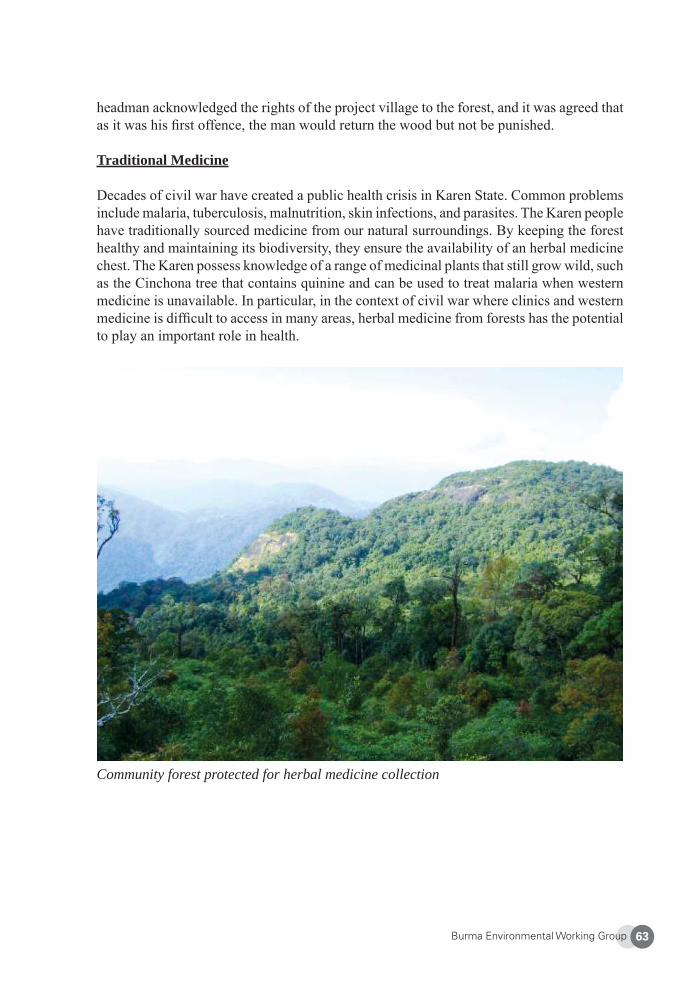
Burma Environmental Working Group 63
headman acknowledged the rights of the project village to the forest, and it was agreed that as it was his fi rst offence, the man would return the wood but not be punished.
Traditional Medicine
Decades of civil war have created a public health crisis in Karen State. Common problems include malaria, tuberculosis, malnutrition, skin infections, and parasites. The Karen people have traditionally sourced medicine from our natural surroundings. By keeping the forest healthy and maintaining its biodiversity, they ensure the availability of an herbal medicine chest. The Karen possess knowledge of a range of medicinal plants that still grow wild, such as the Cinchona tree that contains quinine and can be used to treat malaria when western medicine is unavailable. In particular, in the context of civil war where clinics and western medicine is diffi cult to access in many areas, herbal medicine from forests has the potential to play an important role in health.
Community forest protected for herbal medicine collection
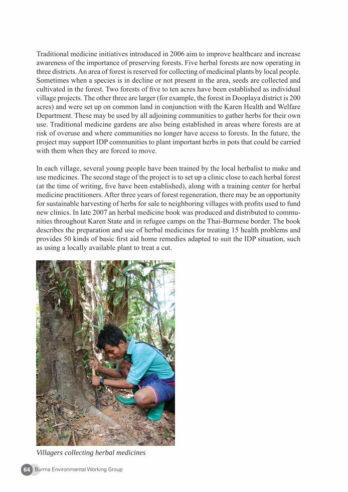
Burma Environmental Working Group64
Traditional medicine initiatives introduced in 2006 aim to improve healthcare and increase awareness of the importance of preserving forests. Five herbal forests are now operating in three districts. An area of forest is reserved for collecting of medicinal plants by local people. Sometimes when a species is in decline or not present in the area, seeds are collected and cultivated in the forest. Two forests of fi ve to ten acres have been established as individual village projects. The other three are larger (for example, the forest in Dooplaya district is 200 acres) and were set up on common land in conjunction with the Karen Health and Welfare Department. These may be used by all adjoining communities to gather herbs for their own use. Traditional medicine gardens are also being established in areas where forests are at risk of overuse and where communities no longer have access to forests. In the future, the project may support IDP communities to plant important herbs in pots that could be carried with them when they are forced to move.
In each village, several young people have been trained by the local herbalist to make and use medicines. The second stage of the project is to set up a clinic close to each herbal forest (at the time of writing, fi ve have been established), along with a training center for herbal medicine practitioners. After three years of forest regeneration, there may be an opportunity for sustainable harvesting of herbs for sale to neighboring villages with profi ts used to fund new clinics. In late 2007 an herbal medicine book was produced and distributed to commu-nities throughout Karen State and in refugee camps on the Thai-Burmese border. The book describes the preparation and use of herbal medicines for treating 15 health problems and provides 50 kinds of basic fi rst aid home remedies adapted to suit the IDP situation, such as using a locally available plant to treat a cut.
Villagers collecting herbal medicines
Burma Environmental Working Group 65
Sustainable harvesting is what ensures the long-term viability of the herbal forest scheme. By protecting the forest, communities maintain traditional medical knowledge and practices and become more self-reliant for basic healthcare.
Food Security Projects
The combination of a large number of IDPs and the disruption of subsistence agriculture through forced abandonment of crops, confi scation of agricultural produce, and forced labor have seriously compromised food availability in Karen State. Around half of IDP children are estimated to be chronically malnourished and nearly ten % suffering from acute malnutrition.8
In order to promote sustainable agriculture using indigenous knowledge systems in com-bination with other technologies, over twenty food security projects have been started by communities in fi ve districts since 2004. These include organic agriculture trainings, construc-tion of an irrigation canal, creation of organic gardens and animal husbandry schemes, and research on local food security issues and solutions. Projects aim to improve food security, conserve biodiversity, reduce negative environmental impacts, and ensure that sustainable indigenous farming systems and knowledge are passed on. They also strengthen local liveli-hoods and encourage community self-reliance.
Karen people have traditionally relied on gathering many plants from the forest. With added population pressures, this practiced has become unsustainable and constitutes an additional threat to biodiversity. As part of the food security program, villagers are encouraged to plant forest food species with their crops or in small home vegetable gardens. Planting foods that are not easily available elsewhere may also prove to have added benefi ts in terms of increased nutrition and potential income generation through trade with other communities.
Food security can be threatened not only by disruption to agriculture but also by a reduction in the number of edible species. Forest degradation has led to the loss of many traditional wild seed varieties, while time and land constraints have meant farmers are inclined to practice less-sophisticated cropping and cultivate fewer varieties. The war also has had an impact on native seed availability as IDPs are forced to abandon seeds. Anecdotal evidence suggests local varieties of both cultivated and wild plants have decreased in living memory.9 An important component of the program therefore is seed-saving. Trainings on nutrition and seed-saving are helping to increase community awareness of the need for plant species diversity. The establishment of a central seed bank in 2008 helps preserve biodiversity of both wild and cultivated species. To support the food security program, young Karen refugees have undertaken agriculture training with an international NGO on the Thai-Burmese border, enabling them in turn to train IDPs in Karen State. A manual of traditional farming techniques is currently in pro-duction and there are plans to establish an agriculture school for organic farming training in Karen State in 2009-2010.
Burma Environmental Working Group66
The food security program seeks to revive knowledge and techniques that still exist among the Karen people but have been largely forgotten because of the struggles of living in a war-zone. When ethnic nationalities talk about preservation of culture, this is not to say that it is something stagnant – culture is always evolving and infl uenced by internal and external pressures. As such, these projects incorporate other organic techniques and technologies that are complementary and appropriate for traditional methods. The capacity to combine old and new allows for the preservation of cultural identity and maintenance of largely traditional livelihoods, while enabling farmers to be more fl exible and adaptable to change. It may also help less sustainable practices to be substituted without substantial impacts.
Environmental policy
For conservation activities to be effective, they need to be backed up by strong and ap-propriate policies. It is important to consider the Karen community conservation program in the context of a broader framework. A crucial component of the program has involved lobbying the Karen government to acknowledge and address environmental issues and to develop policies that support community natural resource management. This effort has been complicated by the war which has been funded by the extraction of natural resources.
The KNU has shown a certain level of interest in conservation. The Karen government concern for protecting the environment is refl ected in the form of a 1982 policy when 11 wildlife sanctuaries were established within KNU territory. Among them was the 460 square kilometer Kaserdoh Wildlife Sanctuary established to protect the habitat of vulnerable spe-cies such as the rhinoceros, tiger, and clouded leopard.10 Environmental education, village meetings, and patrols of the sanctuary were implemented “with the full and willing partici-pation of the local population … in stark contrast to the dire situation prevailing in most of the offi cially protected areas.”11 On the contrary, forest reserves established by the British colonial government were initially protected under KNU law, but many of these reserves have since been logged by both the KNU and illegal loggers, resulting in severely degraded forests. There has been a fatalistic view that “if the SPDC gets control of the forest they will log, so we may as well do it fi rst.”
In recent years, however, environmental lobbying has resulted in a noticeable “greening” of the KNU. One manifestation of this was the establishment of three community herbal forests in Pa’an District in former reserves that had been illegally logged. In demarcating them as herbal forests, it was hoped that local communities would be able to conserve the forests more successfully, allowing them to regenerate. Two are now under the control of a KNU splinter group, the KNU Peace Council, which is aligned with the SPDC.
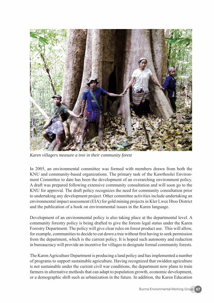
Burma Environmental Working Group 67
Karen villagers measure a tree in their community forest
In 2005, an environmental committee was formed with members drawn from both the KNU and community-based organizations. The primary task of the Kawthoolei Environ-ment Committee to date has been the development of an overarching environment policy. A draft was prepared following extensive community consultation and will soon go to the KNU for approval. The draft policy recognizes the need for community consultation prior to undertaking any development project. Other committee activities include undertaking an environmental impact assessment (EIA) for gold mining projects in Kler Lwee Htoo District and the publication of a book on environmental issues in the Karen language.
Development of an environmental policy is also taking place at the departmental level. A community forestry policy is being drafted to give the forests legal status under the Karen Forestry Department. The policy will give clear rules on forest product use. This will allow, for example, communities to decide to cut down a tree without fi rst having to seek permission from the department, which is the current policy. It is hoped such autonomy and reduction in bureaucracy will provide an incentive for villages to designate formal community forests.
The Karen Agriculture Department is producing a land policy and has implemented a number of programs to support sustainable agriculture. Having recognized that swidden agriculture is not sustainable under the current civil war conditions, the department now plans to train farmers in alternative methods that can adapt to population growth, economic development, or a demographic shift such as urbanization in the future. In addition, the Karen Education
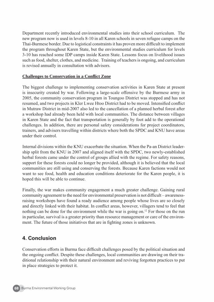
Burma Environmental Working Group68
Department recently introduced environmental studies into their school curriculum. The new program now is used in levels 8-10 in all Karen schools in seven refugee camps on the Thai-Burmese border. Due to logistical constraints it has proven more diffi cult to implement the program throughout Karen State, but the environmental studies curriculum for levels 3-10 has reached some IDP camps inside Karen State. Lessons focus on livelihood issues such as food, shelter, clothes, and medicine. Training of teachers is ongoing, and curriculum is revised annually in consultation with advisors.
Challenges to Conservation in a Confl ict Zone
The biggest challenge to implementing conservation activities in Karen State at present is insecurity created by war. Following a large-scale offensive by the Burmese army in 2005, the community conservation program in Toungoo District was stopped and has not resumed, and two projects in Kler Lwee Htoo District had to be moved. Intensifi ed confl ict in Mutraw District in mid-2007 also led to the cancellation of a planned herbal forest after a workshop had already been held with local communities. The distance between villages in Karen State and the fact that transportation is generally by foot add to the operational challenges. In addition, there are personal safety considerations for project coordinators, trainers, and advisers travelling within districts where both the SPDC and KNU have areas under their control.
Internal divisions within the KNU exacerbate the situation. When the Pa-an District leader-ship split from the KNU in 2007 and aligned itself with the SPDC, two newly-established herbal forests came under the control of groups allied with the regime. For safety reasons, support for these forests could no longer be provided, although it is believed that the local communities are still using and conserving the forests. Because Karen factions would not want to see food, health and education conditions deteriorate for the Karen people, it is hoped this will be able to continue.
Finally, the war makes community engagement a much greater challenge. Gaining rural community agreement to the need for environmental preservation is not diffi cult – awareness-raising workshops have found a ready audience among people whose lives are so closely and directly linked with their habitat. In confl ict areas, however, villagers tend to feel that nothing can be done for the environment while the war is going on.12 For those on the run in particular, survival is a greater priority than resource management or care of the environ-ment. The future of those initiatives that are in fi ghting zones is unknown.
4. Conclusion Conservation efforts in Burma face diffi cult challenges posed by the political situation and the ongoing confl ict. Despite these challenges, local communities are drawing on their tra-ditional relationship with their natural environment and reviving forgotten practices to put in place strategies to protect it.
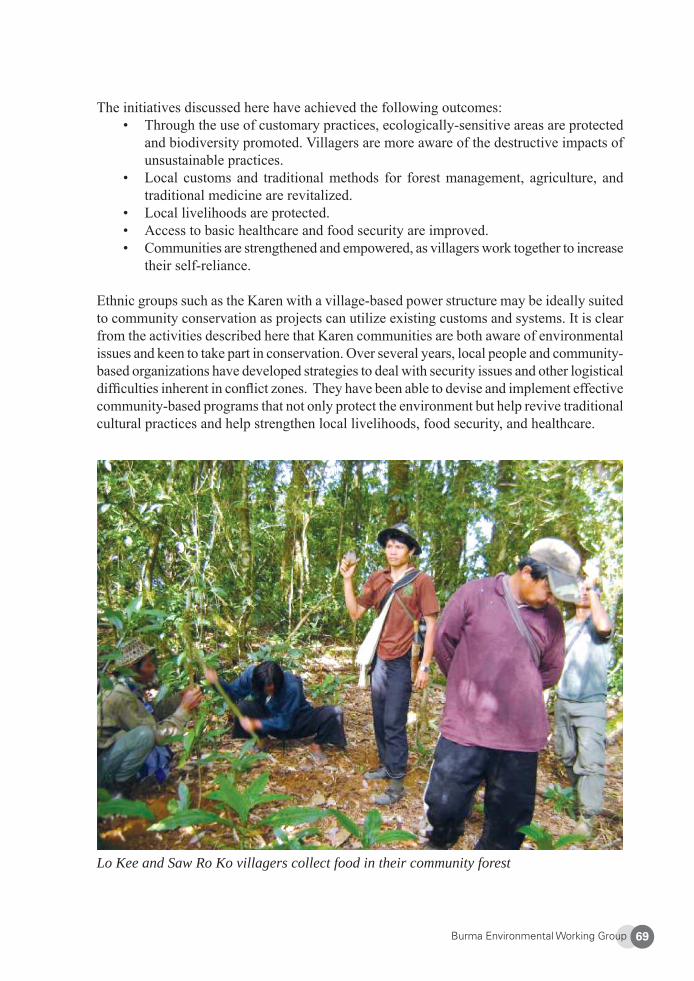
Burma Environmental Working Group 69
The initiatives discussed here have achieved the following outcomes:• Through the use of customary practices, ecologically-sensitive areas are protected
and biodiversity promoted. Villagers are more aware of the destructive impacts of unsustainable practices.
• Local customs and traditional methods for forest management, agriculture, and traditional medicine are revitalized.
• Local livelihoods are protected.• Access to basic healthcare and food security are improved.• Communities are strengthened and empowered, as villagers work together to increase
their self-reliance.
Ethnic groups such as the Karen with a village-based power structure may be ideally suited to community conservation as projects can utilize existing customs and systems. It is clear from the activities described here that Karen communities are both aware of environmental issues and keen to take part in conservation. Over several years, local people and community-based organizations have developed strategies to deal with security issues and other logistical diffi culties inherent in confl ict zones. They have been able to devise and implement effective community-based programs that not only protect the environment but help revive traditional cultural practices and help strengthen local livelihoods, food security, and healthcare.
Lo Kee and Saw Ro Ko villagers collect food in their community forest
Burma Environmental Working Group70
5. Recommendations
In developing conservation strategies, villagers, Karen government offi cials, and staff of community-based organizations have developed skills that enabled them to plan, imple-ment, and maintain these strategies. Despite working in a highly insecure environment, they learned through experience to design activities that are specifi c to local conditions. In addition, relationships have been built between all three stakeholder groups. That said, there are many opportunities for other organizations to contribute and to build on what has already been achieved. A number of priorities have been identifi ed for conservation of Karen lands, and in each of these areas cooperation would enable improved outcomes:
Research: • Conduct further research using both traditional and western scientifi c approaches
to establish baseline biodiversity and ecological data.• Develop research skills within local communities, including using locals to conduct
the research based on their perception of biodiversity and what they consider to be valuable resources.
Development of community conserved areas: • Establish community conserved areas between village lands where appropriate.
By linking these with community forests, large corridors supporting high levels of biodiversity could be created throughout Karen lands. These areas would be particularly suitable for co-management.13
Support for local community-based organizations and NGOs:• Build the skills of more Karen people to facilitate community conservation, so that
the current program can be expanded; e.g., “training of trainer” programs in envi-ronmental management. The success of the projects described here has meant local groups are unable to meet the demand for community-based conservation activities.
Support for communities:• Assist communities by providing technical or scientifi c advice for projects.
Policy development and capacity-building in government: • Research and write environmental policy and legislation. It is a priority to have
policies in place in preparation for transition to democracy. • Build capacity within the agriculture and forestry departments to enable a strategic
approach to natural resource management across Karen State.
Environment awareness-raising:• Develop a range of Karen-language resources for awareness-raising. • Further develop the skills of environmental educators.
Burma Environmental Working Group 71
Education and training: • Conduct training for communities in forest resource management.• Establish agriculture schools and model farms to demonstrate sustainable agricultural
practices. • Provide opportunities for young Karen to study science, environmental management,
and related programs at the post-high school level.
About Karen Environmental and Social Action Network (KESAN)
KESAN was established in 2001 as the fi rst local community-based organization to raise environmental awareness among Karen people. KESAN works to empower and educate communities and local institutions to revitalize existing indigenous knowledge and practices for increased livelihood security in Karen and Kachin States and in areas along the Thai-Burmese border. KESAN strives to build up local capacities in forest and natural resource management, raise public environmental awareness, and support community-based devel-opment initiatives. In addition to playing a leading role in environmental law and policy formulation, KESAN advocates for environmental policies and development priorities that ensure sustainable ecological, social, cultural, and economic benefi ts and promote gender equity. Website: http://www.kesan.asia
1 Thai Burma Border Consortium, Internal Displacement in Eastern Burma: 2007 Survey, at < http://www.tbbc.org/idps/report-2007-idp-english.pdf>. Last accessed 16 Feb. 2009. 2 Ibid. 3 Back Pack Health Worker Team, Chronic Emergency: Health and Human Rights in Eastern Burma, 2006, p. 32, at: <http://www.geocities.com/maesothtml/bphwt/chronic_eng.zip>. Last accessed 16 Dec. 2008. 4 Karen Environmental and Social Action Network, Diversity Degraded: Vulnerability of Cultural and Natural Diversity in Northern Karen State, Burma, Dec. 2005, p. 25. [Hereinafter “Diversity Degraded”].5 Andrew W. Tordoff, et al., Myanmar: Investment Opportunities in Biodiversity Conservation, Birdlife Inter-national., 2005, at p.69. 6 Diversity Degraded, p.28.7 Diversity Degraded, p.59. 8 TBBC, supra note 1. 9 Diversity Degraded.10 The Myinmoletkat Nature Reserve, later created by the SPDC, overlapped with the Kaserdoh Sanctuary. 11 Jake Brunner, Kirk Talbot, et al., “Logging Burma’s Frontier Forests: Resources and the Regime,” World Resources Institute, Aug. 1998.12 Diversity Degraded.13 Co-management is the sharing of power and responsibility for resource management between the govern-ment and local resource users. There is a wide variety of methods to implement co-management based on the distribution of decision making power among stakeholders.
Burma Environmental Working Group72
Threats to Food Security and Local Coping Strategies in Northern Karen State
Karen Environment and Social Action Network (KESAN)
1. Background
According to the UN Food and Agriculture Organization, “food security” refers to food be-ing available at all times, that all people can access it, that food is nutritionally adequate in terms of quantity, quality, and variety, and that food is culturally acceptable. Only when all of these conditions of availability, accessibility, adequacy, and acceptability are met, can a population be truly “food secure.”1
According to the UN, on average, a Burmese family spends 70 percent of its meager income on food alone.2 Growing poverty and rising infl ation have made it increasingly diffi cult for those in urban areas to meet their basic daily needs. The situation is even direr for rural indigenous communities who subsist off the land, especially those in Burma’s armed confl ict areas including Karen State. Their ability to feed themselves is seriously jeopardized by militarization and development projects, as both put heavy pressures on the environment and make it extremely challenging for indigenous peoples to carry on with their traditional livelihoods.
As part of the “Four Cuts” counterinsurgency strategy adopted since in the 1960s, the Burmese military destroys civilian food stores to cut off food supplies for armed insurgent groups such as the Karen National Union (KNU).3 By targeting food, the military government aims to “drain the sea, in order to kill the fi sh.”4 Another part of the “Four Cuts” policy is to deny rebel groups new recruits. To break-up both actual and suspected rebel support bases, the SPDC forcibly relocates communities and destroys villages.5 In armed confl ict areas in eastern Burma, more than 15 percent of children at any given time suffer from mild to more serious conditions of malnutrition.6 In Mu Traw District, northern Karen State where research for this case study was conducted, the rate is more than 25 percent.7
Another pressing danger to local food security is extortion and confi scation of food stores and supplies by the SPDC and destruction of crops and land. As part of the military regime’s “self-reliance” program, battalions are responsible for feeding themselves. To meet their needs, Burma Army and Democratic Karen Buddhist Army (DKBA) camps regularly rob villagers of their food and force locals grow crops for them, leaving them with food inse-curity and vulnerable to starvation and malnutrition.
A common misperception about the confl ict and displacement in Karen State is that civil-ians are “unintended victims and displacement a side-effect of the armed confl ict” between the SPDC/DKBA and the Karen National Liberation Army (KNLA), the armed wing of the KNU. According to villagers’ accounts, however, the Burma Army largely centers its
Burma Environmental Working Group 73
military operations against Karen civilians, and in many instances actively avoids confron-tations with the KNLA.8
As a result, traditional farming methods are disrupted and many villagers fl ee and become internally displaced persons (IDPs). The Burmese military regime (State Peace and Devel-opment Council, or SPDC) has declared much of Mu Traw District as “black zones,” or areas under control of rebels, in this case the KNU. In these free-fi re zones, SPDC troops are allowed to shoot on sight any Karen man, woman, or child that they fi nd.9 Because of this, farmers cannot safely cultivate their fi elds, manage their crops, or access rice stores when they are hiding in the jungle, and so must encroach onto lands unsuitable for farming, which precipitates environmental degradation.10 In addition to food insecurity and coping with less arable land, IDPs face constant dangers from SPDC and DKBA patrols, lack of shelter and water, tropical diseases, and landmines.
In early 2009 it was estimated that near Lu Thaw’s immediate vicinity, approximately one third of local Karen did not have enough food to eat.11 The problems seen in Ta Paw Der and surrounding areas are representative of those that have been faced by other communities throughout Karen State for decades.
2. The Karen
The Karen (pronounced “Ka-REN,” with the emphasis on the second syllable) are one of the largest indigenous groups in mainland Southeast Asia. They are descendants from Mongolian people, with two major subgroups, the Sgaw and the Pwo. There are more than ten smaller sub-groups in northern Karen State today. Looking for better land, the Karen migrated from the Gobi Desert, arriving in Burma around 739 B.C. They settled in their traditional homeland in the mountainous eastern border region of Burma, mostly in what is now Karen State, with some in Karenni State, southern Shan State, and in the Irrawaddy and Tenasserim Divisions, as well as in western Thailand. Karen called their new home in present-day Karen State Kaw-Lah, which means “green land.” They later changed it to Kawthoolei, or “land without evil,” because they believed their new lands to be pleasant, peaceful, and plentiful.12
Today, there are between fi ve and seven million Karen in Burma, with another 400,000 in Thailand.13 Population fi gures for the Karen in Karen State vary, with estimates ranging from about 1.5 million to over 3 million.14 Up to 90 percent of all Karen live in rural areas. Of the rural Karen, 60 percent live in hilly mountainous regions, with the remainder living in lowland plains.15 The majority of Karen are Buddhists, with 25-30 percent Christians and 5-10 percent Animist.16
Traditionally, Karen villages are small, with only a few stilted houses that are made entirely from bamboo and thatch. Animists use only bamboo to construct their homes, as this is tied to spiritual ceremonies. Pig and chickens are kept beneath the houses. Villages are usually located near a stream or river where community members can bathe and where women do washing and gather water for cooking. Fish and shellfi sh can also be found in these water
Burma Environmental Working Group74
bodies. Rice fi elds are nearby, beyond that is the forest, where villagers collect wild fruits, vegetables, roots, leaves, fl owers, and other edible foods; medicinal plants can be found as well. Bamboo, rattan, and other non-timber forest resources are used as building materials, cooking containers, and rope. Parts of forests are also customarily demarcated as places for animal sanctuaries.17
Life in the Karen village follows a seasonal pattern that is seen in other parts of mainland Southeast Asia, centered on planting and growing rice. In Karen State, the rainy reason lasts from May to October, followed by a cool season form November to January and a dry/hot season from February to April.18 Villagers plant rice at the beginning of the rainy season. During the rainy season, they look after and weed the fi elds. With the end of the rains comes harvest time. In the hot season, as people wait for the coming rains, new fi elds are cleared and burned to produce a nutrient-rich soil for new crops.
The Karen people have indigenous methods of managing their lands and forests and have traditionally depended on the forest for herbal medicines, food, building materials, and fi rewood. Many religious practices and ceremonies also are related to the forest.19 Young Karen gain understanding of traditional knowledge through observation, experience, and practice. There is no formal education, though advice is given when needed. The Karen pass on their knowledge through storytelling, proverbs, and poems.
Before civil war began, the Karen lived peacefully, practicing rotational farming and wet-rice agriculture while protecting the environment and maintaining regional biodiversity. Civil war and development projects, however, have caused the demise and loss of plant varieties and resources, putting local food security and livelihoods under serious threat. Indigenous and local knowledge about natural resource management is disappearing, and the interconnections between their culture and nature are being broken.20
3. Community Profi le: Ta Paw Der Village, Mu Traw District Ta Paw Der is located in Yeh Mu Plaw Village Tract, Lu Thaw Township, in Mu Traw District (called Papun District by the military regime), a mountainous area in northern Karen State. Ta Paw Der is believed to be about 300 years old, and relics indicate that an ancient Ger Wa (tribal group) village used to exist in the same area. Ta Paw Der has a total land area of approximately 16.5 square kilometers. In July 2004, the village had 211 members from 31 families, most of which are Animist.
Local Karen people practice wetland rice cultivation and traditional rotational farming. Main food crops include more than 40 varieties of rice, sesame, sugarcane, chilies, and coconut. KESAN researchers have identifi ed 120 different kinds of edible plants used in rotational farming in Lu Thaw Township. In the past, 180 species were used. This decrease is a clear indicator of the war’s adverse impacts on local food security.21
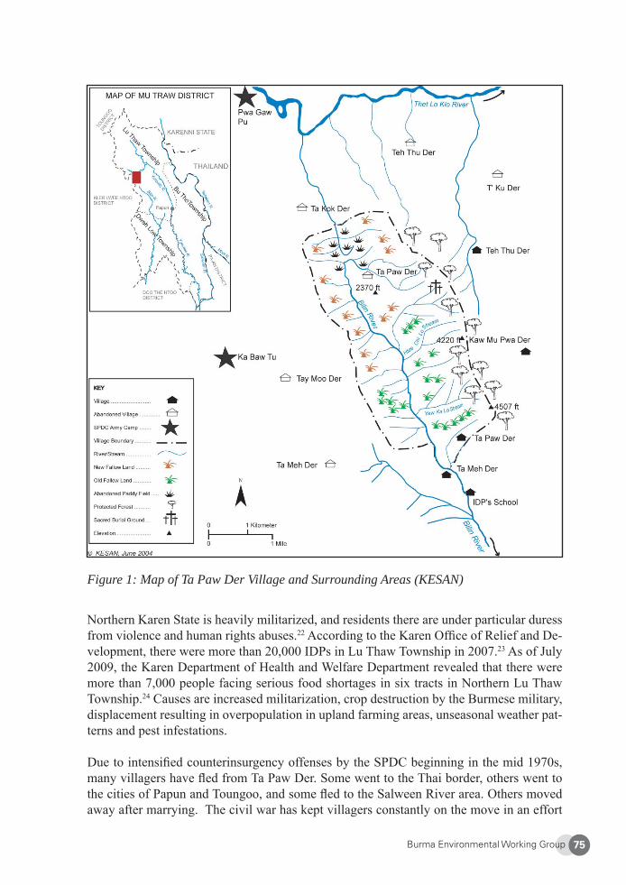
Burma Environmental Working Group 75
Figure 1: Map of Ta Paw Der Village and Surrounding Areas (KESAN)
Northern Karen State is heavily militarized, and residents there are under particular duress from violence and human rights abuses.22 According to the Karen Offi ce of Relief and De-velopment, there were more than 20,000 IDPs in Lu Thaw Township in 2007.23 As of July 2009, the Karen Department of Health and Welfare Department revealed that there were more than 7,000 people facing serious food shortages in six tracts in Northern Lu Thaw Township.24 Causes are increased militarization, crop destruction by the Burmese military, displacement resulting in overpopulation in upland farming areas, unseasonal weather pat-terns and pest infestations.
Due to intensifi ed counterinsurgency offenses by the SPDC beginning in the mid 1970s, many villagers have fl ed from Ta Paw Der. Some went to the Thai border, others went to the cities of Papun and Toungoo, and some fl ed to the Salween River area. Others moved away after marrying. The civil war has kept villagers constantly on the move in an effort

Burma Environmental Working Group76
to escape the control of the SPDC. In 1997, the remaining villagers were forced to move again, mostly to different areas around the original village site. Concerns about safety and survival have meant that villagers must constantly be on guard and cannot fi rmly settle. One community member said Ta Paw Der would have a higher population if it were secure.
4. Traditional Knowledge, Customs, and Approaches to Food Security
Karen livelihood principles respect and acknowledge the need to take care of the entire environmental system. For example, if they are going to use fi sh, they must also take care of the water. Their knowledge integrates practices of sustainable forest and land use and biodiversity management to build up and maintain food security.
Dependency on Forests for Food
Ta Paw Der community members depend on the forests for more than 150 different kinds of edible forest products. Wild food collected include bananas, bamboo shoots, mushrooms, honey, ginger, varieties of fern, and many tubers and root species. Leaves are the most widely consumed forest food used in soups, curries, and other dishes that accompany rice. Leaves and wild meats increase the nutritional quality of the food by providing protein, vitamins, and minerals. Nuts and seeds provide oil and protein, while tubers and roots are excellent sources of carbohydrates and minerals. These food items add diversity to the diet and help villagers compensate for seasonal crop shortfalls as well as provide food for animals. Forests also supply farmers with food during periods between the main harvest and the next planting season.
In addition, certain trees, plants, and herbs traditionally are used to treat malaria, cough, fever, and many other illnesses. Forests trees such as Nya Bo Jaw, Noe, and Naw treat malaria. Diarrhea is cured by the Tha Ko Kwee fruit, cuts are healed using Chaw Po Gway, and toothaches are stopped by Ghray Tee bark
Traditional Karen Agriculture and the Rotational System
Under the traditional agriculture system, Karen villagers establish permanent villages in one area by growing fl atland rice and rotating between upland fi elds. They are able to settle in one area and do not need to search for new land. The rotation system alternates between a short cultivation and a long fallow period. When properly practiced, rotational cultivation uses the land for one year and then leaves it fallow for seven to ten years before it is used again. This allows the soil to recover and maintain its fertility, making chemical fertilizers unnecessary. This form of cultivation involves long, complex, and deliberate systems using extensive forest management techniques. The Karen also preserve many seed strains, giving them a rich variety of cultivated plants.
Planting begins in April/May and ends with the main harvest in October or November. The area cleared for planting depends on the size of the family, amount of seed available, and
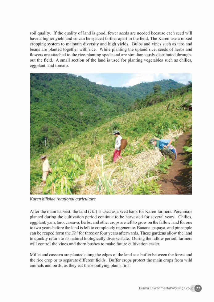
Burma Environmental Working Group 77
soil quality. If the quality of land is good, fewer seeds are needed because each seed will have a higher yield and so can be spaced farther apart in the fi eld. The Karen use a mixed cropping system to maintain diversity and high yields. Bulbs and vines such as taro and beans are planted together with rice. While planting the upland rice, seeds of herbs and fl owers are attached to the rice-planting spade and are simultaneously distributed through-out the fi eld. A small section of the land is used for planting vegetables such as chilies, eggplant, and tomato.
Karen hillside rotational agriculture
After the main harvest, the land (Thi) is used as a seed bank for Karen farmers. Perennials planted during the cultivation period continue to be harvested for several years. Chilies, eggplant, yam, taro, cassava, herbs, and other crops are left to grow on the fallow land for one to two years before the land is left to completely regenerate. Banana, papaya, and pineapple can be reaped form the Thi for three or four years afterwards. These gardens allow the land to quickly return to its natural biologically diverse state. During the fallow period, farmers will control the vines and thorn bushes to make future cultivation easier.
Millet and cassava are planted along the edges of the land as a buffer between the forest and the rice crop or to separate different fi elds. Buffer crops protect the main crops from wild animals and birds, as they eat these outlying plants fi rst.
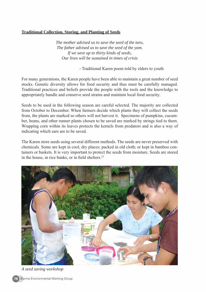
Burma Environmental Working Group78
Traditional Collection, Storing, and Planting of Seeds
The mother advised us to save the seed of the taro,The father advised us to save the seed of the yam.
If we save up to thirty kinds of seeds,Our lives will be sustained in times of crisis
- Traditional Karen poem told by elders to youth
For many generations, the Karen people have been able to maintain a great number of seed stocks. Genetic diversity allows for food security and thus must be carefully managed. Traditional practices and beliefs provide the people with the tools and the knowledge to appropriately handle and conserve seed strains and maintain local food security.
Seeds to be used in the following season are careful selected. The majority are collected from October to December. When farmers decide which plants they will collect the seeds from, the plants are marked so others will not harvest it. Specimens of pumpkins, cucum-ber, beans, and other runner plants chosen to be saved are marked by strings tied to them. Wrapping corn within its leaves protects the kernels from predators and is also a way of indicating which ears are to be saved.
The Karen store seeds using several different methods. The seeds are never preserved with chemicals. Some are kept in cool, dry places; packed in old cloth; or kept in bamboo con-tainers or baskets. It is very important to protect the seeds from moisture. Seeds are stored in the house, in rice banks, or in fi eld shelters.25
A seed saving workshop
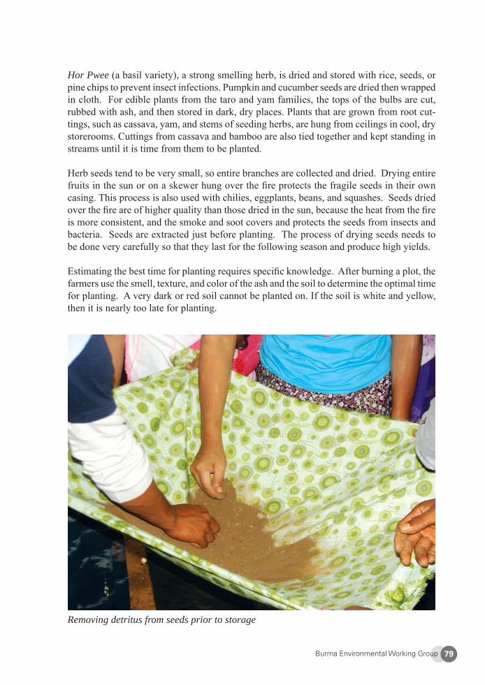
Burma Environmental Working Group 79
Hor Pwee (a basil variety), a strong smelling herb, is dried and stored with rice, seeds, or pine chips to prevent insect infections. Pumpkin and cucumber seeds are dried then wrapped in cloth. For edible plants from the taro and yam families, the tops of the bulbs are cut, rubbed with ash, and then stored in dark, dry places. Plants that are grown from root cut-tings, such as cassava, yam, and stems of seeding herbs, are hung from ceilings in cool, dry storerooms. Cuttings from cassava and bamboo are also tied together and kept standing in streams until it is time from them to be planted.
Herb seeds tend to be very small, so entire branches are collected and dried. Drying entire fruits in the sun or on a skewer hung over the fi re protects the fragile seeds in their own casing. This process is also used with chilies, eggplants, beans, and squashes. Seeds dried over the fi re are of higher quality than those dried in the sun, because the heat from the fi re is more consistent, and the smoke and soot covers and protects the seeds from insects and bacteria. Seeds are extracted just before planting. The process of drying seeds needs to be done very carefully so that they last for the following season and produce high yields.
Estimating the best time for planting requires specifi c knowledge. After burning a plot, the farmers use the smell, texture, and color of the ash and the soil to determine the optimal time for planting. A very dark or red soil cannot be planted on. If the soil is white and yellow, then it is nearly too late for planting.
Removing detritus from seeds prior to storage
Burma Environmental Working Group80
Rice Properties and Techniques
The staple food crop for the Karen is rice. There are many different varieties of this es-sential crop grown in Karen State. In the Ta Paw Der area, 18 strains of upland rice and 11 kinds of sticky rice are grown. Rice varieties can be distinguished by the appearance of the plant, grain texture (soft or hard), time of harvest, taste, and color. Grain colors vary from red or black (sticky rice), to white, brown, or yellow. Each variety of rice requires different growing conditions to produce high yields. Some varieties prefer high altitudes, and some prefer more humidity than others. The rice strains that grow better in higher elevations have harder grains and are usually brown or red in color. The fl atland rice is softer and white.
Sticky rice is planted by every family, mainly to make whiskey for use in special ceremo-nies, but also consumed as an extra source of food. After the rice is planted in August, and in December after the harvest, the farmers will keep a handful of rice seeds to make a cer-emonial whiskey (Bu Hse Klee or Bu Koh Joe), which is shared with community members.
The Karen are very careful not to mix rice varieties. Sticky rice is planted higher in the plot than the regular rice to prevent the two from mixing. If villagers notice seeds or plants in fi elds that are different than the intended crop or crops to be harvested, they will remove them from the soil immediately to prevent them from further mixing with other plants. In order to keep the rice varieties pure, the best plants are picked, and the seeds are saved for planting in the following season. These seeds are kept separate when crops are reaped and are then sowed separately in fi elds until enough high quality rice seeds are produced.
Seed Exchange
In the past, every community and villager would borrow, trade, or sell extra seeds to other farmers from their own community or to other villages. This system helped to prevent the loss of local seed varieties. Over time, the focus of many farmers has changed, as prices have increased, and money has become more important. Although seeds are still exchanged within communities and with and with other villages, such practice has largely diminished, resulting in many rice strains being lost.
5. Threats to Food Security and the Local Environment
Increased Militarization, Logging, and Hydropower Development
For over 60 years, successive Burmese governments and the Karen National Union have been embroiled in a war that has endangered local livelihoods. The SPDC directly targets Karen civilians that they believe are supporting the KNU, and hundreds of thousands of Karen have been caught in the violence and suffering from egregious human rights abuses committed by Burma Army troops. These include extrajudicial killings, torture, confi scation and destruction of land and property, forced relocation, and sexual violence. Forced labor and forced portering for the SPDC and DKBA severely interfere with the Karen villagers’
Burma Environmental Working Group 81
own growing and collecting food.26 In 2007, there were approximately 116,900 internally displaced persons (IDPs) in Karen State.27
The natural environment has been destroyed not only because of the confl ict, but also because of increasing exploitation of natural resources, both legal and illegal. Karen State has been heavily deforested by legal and illegal logging. Both the KNU and the SPDC sell logging concessions to generate income. After the KNU headquarters were overrun in early 1995, massive logging took place both in Northern Karen State and in the Salween River basin. The SPDC continues to grant Thai and Burmese companies the right to log in KNU-controlled territories. In addition, the military government has proposed to build fi ve mega-dams on the Salween River and export the energy to Thailand. Three of the dams—Wei Gyi, Dagwin, and Hat Gyi—are located in Karen State. The proposed Salween hydropower dams threaten to further devastate the environment and local food security for the Karen by fl ooding fi elds and decreasing fi sh stocks. The Salween Watch coalition states that if the dams are constructed, an estimated 35,000 Karen will be displaced.28
In order to secure access to much-coveted natural resources and to defeat the KNU, the SPDC has been putting intense pressures on the Karen, and since 1997, has carried out particularly focused military offensives in Mu Traw. The SPDC wants to gain complete control of the area for commercial logging and hydropower development on the Salween River. In 1998, there were 21 battalions in the area. By the end of 2007, there were 45 battalions with a total of 54 military camps in Mu Traw.29 These battalions have been forcing villagers away from project sites and into SPDC-controlled relocation zones by burning and destroying villages. They are also building roads to further solidify control and to bring supplies to the new army camps.
Climate Change
Possible effects of climate change are being felt in Lu Thaw. Heavy, irregular precipitation in the dry season keeps farmers from using controlled fi res to clear farm fi elds of brush. More rice paddy is being lost to ants, grubs, and termites. Farmers hiding from SPDC/DKBA patrols cannot maintain their crops, and much of the harvest is lost to birds, rats, ants, and other insects.30
Destroyed Villages and IDPs
As mentioned earlier, as part of the SPDC’s Four Cuts policy, Burma Army troops target civilians in their offensives to weaken the KNU by cutting off provisions, supply lines, and other support from the local people. Central to this strategy is the destruction and relocation of villages suspected of supported Karen soldiers. In Mu Traw District, at least 200 villages have been burned down, destroyed, or abandoned since 1997.31 Many villagers fl ee to the hills or go to the Thai border to avoid relocation to SPDC-controlled sites. Surveys done in 2007 revealed an estimated 30,800 IDPs hiding in the forests in Mu Traw District.32 Food security suffers as the farmers’ fi elds and areas surrounding the villages are mined to deter villagers from returning. Cultivated land has to be abandoned, and with the danger of landmines, it is impossible to practice traditional farming systems or even harvest the crops
Burma Environmental Working Group82
that have already been planted. Moreover, because there is no formal land titling system in place, even if IDPs are able to return to their lands in the future, there is a high likelihood of disputes and confl icting claims over land ownership.
SPDC soldiers seek out and destroy seed banks and food supplies in fi eld houses and those hidden in the forest by IDPs, and farmers have a diffi cult time keeping their seeds and food stores safe. SPDC troops also commonly take food and livestock by force from local com-munities. Seeds stored in forest shelters are more susceptible to pest damage.33 In eastern Burma, children of families who had their food supplies completely or partially taken or destroyed were much more likely to suffer from moderate to severe malnutrition compared to those whose food supply had not been compromised.34
In the forest, IDP families sleep on the open ground or in small makeshift shelters. Health-care and education is nearly nonexistent. They must rely on traditional medicine to pre-vent and cure diseases, and the majority of IDPs are severely malnourished and many face starvation. A health survey done in 2004 has shown that in Karen State and other parts of eastern Burma, families that are displaced are more than three times more likely to have malnourished children compared to households in more stable situations.35 Human rights violations that cause food insecurity also raise villagers’ chances of dying by 50 percent. One medic commented on the IDP situation in Mu Traw:
People have none of the essential needs, like clean water, clothing, mosquito nets and medicines for illnesses like malaria, dysentery, and diarrhea. They don’t have enough food and other things, so old women, mothers[,] and small children are particularly likely to suffer from malnutrition, anemia[,] and other problems. Their lack of health education or knowledge make the situation worse – they don’t know what to eat and how they should eat. In sum, the lack of enough food, different illnesses and unstable conditions are the main causes of their poor health and malnutrition.36
Relocation Sites and Refugee Camps
Burmese Army soldiers have orders to either shoot the villagers on sight or force them to SPDC relocation sites. As of 2004, there were 14 relocation sites in Mu Traw. While there is a relative peace in theses areas, space is extremely limited. There is little land to grow crops and no paying jobs available for villagers. Fields at relocation sites are being used year after year, allowing no chance for the soil to renew itself. Villagers at these sites face forced labor or portering, working for no pay for the military or for foreign companies that have moved into Karen State. Burmese soldiers commit human rights abuses including torture, rape, and extrajudicial killings. In addition, villagers in relocation areas have to satisfy demands from the army for food and money. They have to pay taxes and fees and must meet crop quotas under threat of penalty. There are strict curfews, and farmers are constantly laboring for the SPDC. This leaves them little time to plant and care for their crops, resulting in food shortages.
Burma Environmental Working Group 83
Across the border in Thailand, life in the refugee camps is not easy. Sixty-one percent of refugees in the camps are Karen,37 but they cannot live by traditional means. The camps are very crowded, and there is barely enough space to grow small vegetable gardens, and surrounding forest areas have been exhausted. Refugees are forced to rely entirely on in-ternational support for food and other basic living needs. Karen villagers are passionately attached to their land. Many are Animists who worship the spirits of the land and their ancestors. Most would rather die than leave their land and country.38 Many IDPs opt to remain in Burma due to the seemingly insurmountable obstacles in gaining admission to refugee camps in Thailand.
5. Impacts to Traditional Agriculture, Livelihoods, and the Environment
Today in Mu Traw, traditional rotational farming has become almost impossible because of the Burma Army’s movements. Seed varieties that have been cultivated and preserved for generations are being lost. Unsustainable agricultural practices are increasing, resulting in the loss of more and more pristine forest areas.
In the past, Ta Paw Der villagers could freely use forest resources, but now their movement is restricted to certain sections of the forest because of the threat of landmines or the pres-ence of SPDC forces.39 Forest resources are being lost because of non-traditional cultivation practices and the infl ux of IDPs who have been forced to leave their former lands. Many Karen IDPs try to cultivate small plots of rice in the hills secretly to avoid detection in the lowlands. In order to survive, they must abandon their traditional cultivation methods and are forced to encroach into sloped and virgin forest areas that are not suitable for farming. Under these circumstances, the environment becomes severely degraded.
Since there is not enough land to allow for the traditional fallow period of seven to ten years, fallow periods are now between two to four years, resulting in poor quality crops and reduced soil fertility. Because of lower soil fertility, farmers must use more rice seeds over greater acreage. Many communities in Karen State have been forced to further encroach onto old growth forest land. One villager commented:
In the past I didn’t cultivate on very sloped land and in the very old forest. But now because we have to leave our land and move around, there is not enough land to cultivate, and we have to do it in the old forest. If we do not do this, we cannot survive. I know that these are not good places to culti-vate, but I have no choice. In the past the other villagers never cultivated in the deep forest either, but like me, they have no choice. This problem is because of the civil war. If the civil war in the area [does not] stop, we will be faced with many more problems for our lives. Our land will be lost, and the environment will be even more destroyed.
IDPs also survive by collecting and selling non-timber forest products like wild yams, honey, cardamom, bamboo, and rattan for a modest income.
Burma Environmental Working Group84
IDP Relief Efforts
Some organizations carry out relief missions in Karen State, providing emergency medical care, food, shelter, clothing, and human rights docu-mentation. Free Burma Rangers focus primarily on medical care, and groups like the Committee for Internally Displaced Karen People (CIDKP) and the Karen Offi ce for Relief and Development (KORD) supply basic food and shelter. IDPs sometimes are able to secure fi nancial assistance from organizations such as KORD to buy food, with some using these funds to purchase specialty items from border areas and resell them in IDP zones.40
Other groups like the Karen Human Rights Group (KHRG) document human rights abuses committed the SPDC and the DKBA.41 In addition, Back Pack Health Worker Teams oversee medical aid, health campaigns, and water and sanitation projects in IDP areas.42 Education groups such as the Karen Teacher Working Group (KTWG) provide teaching training and curriculum support materials to IDPs.
While these groups are able to provide emergency care and a modicum of social services, such efforts are small in scale, and the need is much greater than they can meet. Moreover, relief workers are also themselves under signifi cant physical risks. Some have been killed by the SPDC or have died or been injured by landmines, diseases, and drowning.
7. Community-Based Food Security Coping Strategies
KESAN’s Food Security Program
War and development-induced displacement have caused severe forest degradation in many areas in Karen State. Food security of local Karen communities is compromised as agricul-tural practices are under threat and many traditional seed varieties and wild edible species are being lost. Time and land constraints have pushed farmers to practice less sophisticated and less ecologically sustainable cropping techniques and consequently cultivate fewer varieties. The civil war is directly responsible for internal displacement and the decrease in both cultivated and wild species, resulting in starvation, malnutrition, and environmental degradation.
As a response, KESAN has introduced a number of strategies at the local level to guarantee farmland, promote food security, and ensure social, economic, and environmental benefi ts to Karen people. It began a food security program began in 2006 with the aim to conserve biodiversity and reduce negative environmental impacts, improve food security, and maintain sustainable indigenous farming systems and knowledge. It also strengthens livelihoods and encourages community self-reliance. Objectives of the food security program are:
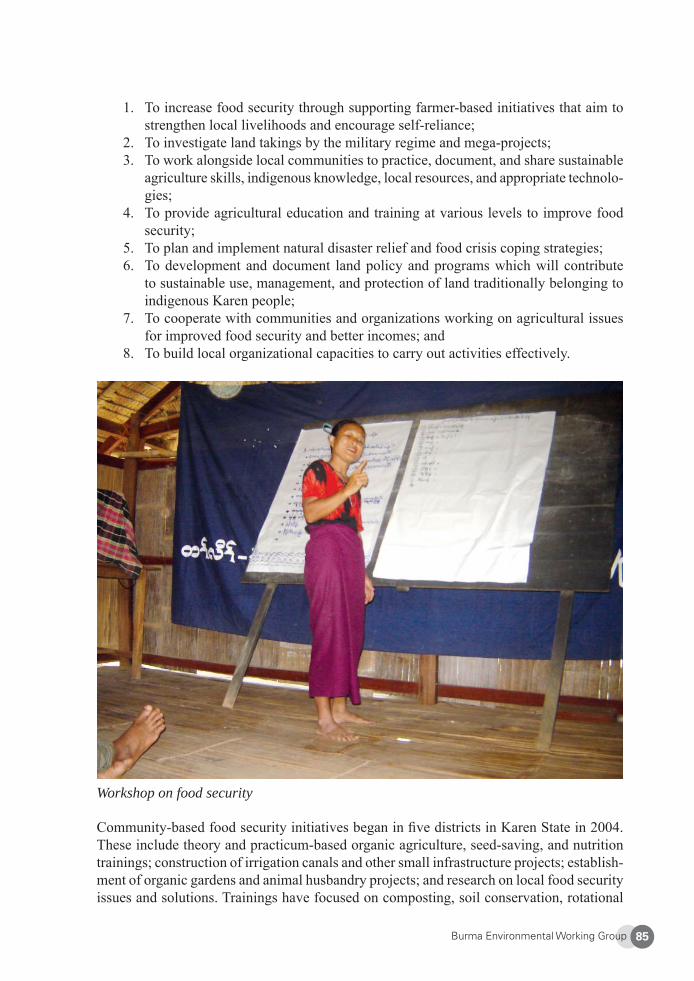
Burma Environmental Working Group 85
1. To increase food security through supporting farmer-based initiatives that aim to strengthen local livelihoods and encourage self-reliance;
2. To investigate land takings by the military regime and mega-projects;3. To work alongside local communities to practice, document, and share sustainable
agriculture skills, indigenous knowledge, local resources, and appropriate technolo-gies;
4. To provide agricultural education and training at various levels to improve food security;
5. To plan and implement natural disaster relief and food crisis coping strategies;6. To development and document land policy and programs which will contribute
to sustainable use, management, and protection of land traditionally belonging to indigenous Karen people;
7. To cooperate with communities and organizations working on agricultural issues for improved food security and better incomes; and
8. To build local organizational capacities to carry out activities effectively.
Workshop on food security
Community-based food security initiatives began in fi ve districts in Karen State in 2004. These include theory and practicum-based organic agriculture, seed-saving, and nutrition trainings; construction of irrigation canals and other small infrastructure projects; establish-ment of organic gardens and animal husbandry projects; and research on local food security issues and solutions. Trainings have focused on composting, soil conservation, rotational
Burma Environmental Working Group86
and contour farming, herbal pesticides, natural pest control, and effective micro-organisms and seedlings.
In 2008, the establishment of a central seed bank made a signifi cant step in preserving the biodiversity of both wild and cultivated species. A seed-saving training was held to encour-age farmers to maintain traditional agriculture practices, increase production of nutritious food, and ensure more local seeds are saved and available for exchange. To date, KESAN has helped oversee 20 community food security projects. A decision-making body composed of agricultural leaders coordinate food security activities and approve proposals for local projects. The hope is that projects will be self-sustaining after a few years.
In addition, young Karen refugees are receiving agriculture training from an international NGO on the Thai-Burmese border, which will allow them in turn to train IDPs in Karen State. In late 2008, following months of research and data collection, KESAN printed and distributed 1,000 copies of a pamphlet on traditional food preservation techniques such as drying, pickling, and storing. This allows for stronger food security and greater variation and nutrition in diet year round, as rainy season plants can now be eaten in the dry season, and vice versa. Books were distributed inside Karen State and in two refugee camps.
Furthermore, a manual on sustainable agriculture and traditional farming techniques has been produced and 1,000 copies were distributed inside Karen State and along the Thai-Burmese border. There are plans to establish an agriculture school for organic farming training in Karen State in 2009-2010.
As of May 2009, the food security project has achieved the following tangible results:
• Organic agriculture, seed saving, and general food security awareness trainings have taken place. Many households have created organic gardens○ 19 food security awareness trainings have benefi ted 487 participants, 191 women
and 296 men.○ 8 organic agriculture trainings and household gardens benefi t 135 individuals,
52 women and 83 men.○ 2 one month-long seed-saving training held with 16 participants (9 women, 7
men) from different areas of Karen state. 670 kilos of 17 varieties of local seeds were saved and given to a border-based NGO to distribute in refugee camps in Thailand, where refugees currently have access to only hybrid seeds.
• In 2008, one buffalo bank set up with four water buffalos in a village in Karen State. Farmers repaid buffalo loans with 16 baskets of rice to support fellow farmers who experienced poor harvests.
• In 2008, one pig and catfi sh-raising training was held in a refugee camp on the border, benefi ting 94 villagers (56 men and 38 women).
• Over 600 Karen community members understand more about the importance of practicing sustainable indigenous agriculture systems
Burma Environmental Working Group 87
• 28 local resource people from a Karen farmers group have been trained in local food security problems and solutions, global food security issues, practical train-ing (such as composting and natural pest management), community-based project management, and proposal and report writing.
• 40 traditional recipes for nutritious cooking and traditional food preservation has been collected and published as a book, with 1,000 copies distributed as a traditional recipe and food preservation book in late 2008
• 1000 copies of a manual on sustainable agriculture methods using traditional indig-enous knowledge has been published and distributed inside Karen State in 2009.
8. Conclusions
Karen people have successfully used traditional methods for managing natural resources, preserving biodiversity, and maintaining local food security for centuries. Indigenous knowledge and methods are directly linked to agricultural practices and deeply rooted in Karen culture. The longstanding civil war, however, is having a great effect on the traditional livelihood and food resources and is preventing the Karen from using their environment in a sustainable manner that aligns with their indigenous practices. In addition, the Karen, who have been customarily been self-suffi cient for all their living needs, can no longer support, feed, and sustain themselves.
The right to food is a basic human right guaranteed under the 1948 Universal Declaration of Human Rights.43 The SPDC’s targeting of civilian populations is a violation of the Geneva Conventions to which Burma is a signatory. International norms stipulate that civilians liv-ing in occupied territory under the authority of a hostile army—such as the SPDC and the DKBA—are protected from violence and threats to their human security. This means that the military regime is obliged to provide food, medical, and material relief to the Karen and civilian populations in confl ict zones and facilitate humanitarian access.44 But instead of sup-porting civilians and protecting them from the confl ict, the SPDC is directly targeting them.
Burma army operations greatly hamper the Karen’s access to food and cause a reduction in the quality, quantity, and variety of food available for locals. People in Karen State now face various problems that disrupt food production, including reduced availability of agricultural land, confi scation of food and produce, forced labor which interferes with the ability of villagers to cultivate or collect food for subsistence, attacks by the SPDC, forced migration and abandonment of crops, indiscriminate use of landmines, and population pressure from IDP movements, leading to loss of plants traditionally gathered from the wild.
Ta Paw Der Village is just one example of how the civil war has caused a disruption in tradi-tional agriculture and indigenous practices and has led to severe environmental degradation and ingrained poverty. In this area, the villagers have been forced to encroach onto pristine areas of forest land and abandon customary agricultural practices. This in turn is resulting in a loss of biodiversity of both cultivated and collected plant species, thereby intensifying threats to food security.
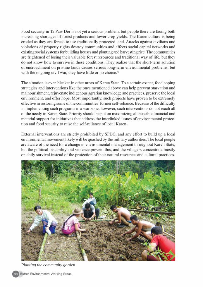
Burma Environmental Working Group88
Food security in Ta Paw Der is not yet a serious problem, but people there are facing both increasing shortages of forest products and lower crop yields. The Karen culture is being eroded as they are forced to use traditionally protected land. Attacks against civilians and violations of property rights destroy communities and affects social capital networks and existing social systems for building houses and planting and harvesting rice. The communities are frightened of losing their valuable forest resources and traditional way of life, but they do not know how to survive in these conditions. They realize that the short-term solution of encroachment on pristine lands causes serious long-term environmental problems, but with the ongoing civil war, they have little or no choice.45
The situation is even bleaker in other areas of Karen State. To a certain extent, food coping strategies and interventions like the ones mentioned above can help prevent starvation and malnourishment, rejuvenate indigenous agrarian knowledge and practices, preserve the local environment, and offer hope. Most importantly, such projects have proven to be extremely effective in restoring some of the communities’ former self-reliance. Because of the diffi culty in implementing such programs in a war zone, however, such interventions do not reach all of the needy in Karen State. Priority should be put on maximizing all possible fi nancial and material support for initiatives that address the interlinked issues of environmental protec-tion and food security to raise the self-reliance of local Karen.
External interventions are strictly prohibited by SPDC, and any effort to build up a local environmental movement likely will be quashed by the military authorities. The local people are aware of the need for a change in environmental management throughout Karen State, but the political instability and violence prevent this, and the villagers concentrate mostly on daily survival instead of the protection of their natural resources and cultural practices.
Planting the community garden
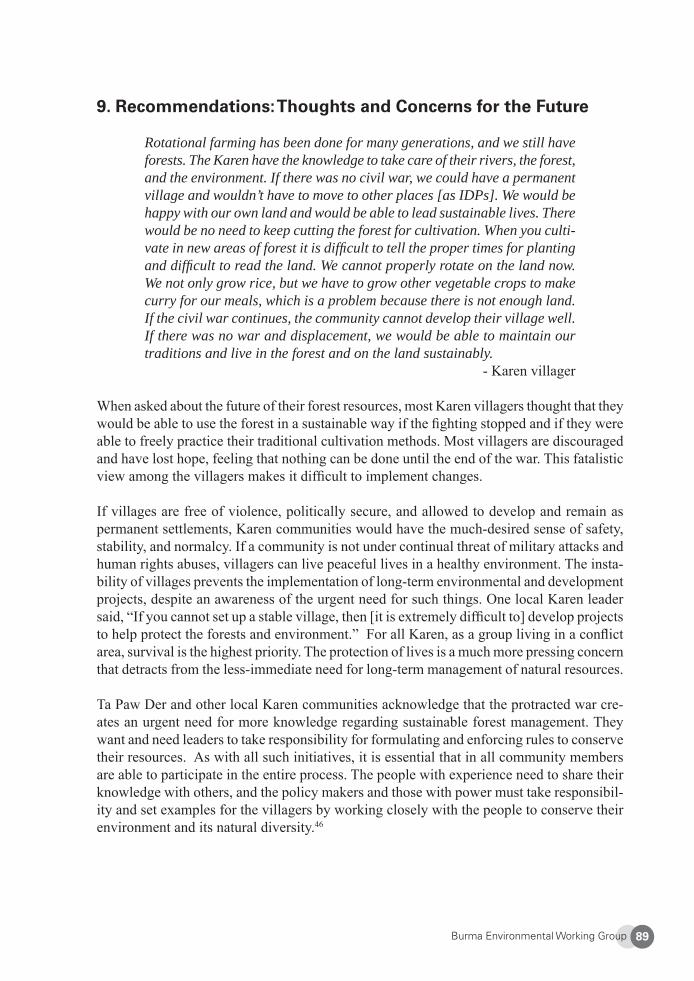
Burma Environmental Working Group 89
9. Recommendations: Thoughts and Concerns for the Future
Rotational farming has been done for many generations, and we still have forests. The Karen have the knowledge to take care of their rivers, the forest, and the environment. If there was no civil war, we could have a permanent village and wouldn’t have to move to other places [as IDPs]. We would be happy with our own land and would be able to lead sustainable lives. There would be no need to keep cutting the forest for cultivation. When you culti-vate in new areas of forest it is diffi cult to tell the proper times for planting and diffi cult to read the land. We cannot properly rotate on the land now. We not only grow rice, but we have to grow other vegetable crops to make curry for our meals, which is a problem because there is not enough land. If the civil war continues, the community cannot develop their village well. If there was no war and displacement, we would be able to maintain our traditions and live in the forest and on the land sustainably.
- Karen villager
When asked about the future of their forest resources, most Karen villagers thought that they would be able to use the forest in a sustainable way if the fi ghting stopped and if they were able to freely practice their traditional cultivation methods. Most villagers are discouraged and have lost hope, feeling that nothing can be done until the end of the war. This fatalistic view among the villagers makes it diffi cult to implement changes.
If villages are free of violence, politically secure, and allowed to develop and remain as permanent settlements, Karen communities would have the much-desired sense of safety, stability, and normalcy. If a community is not under continual threat of military attacks and human rights abuses, villagers can live peaceful lives in a healthy environment. The insta-bility of villages prevents the implementation of long-term environmental and development projects, despite an awareness of the urgent need for such things. One local Karen leader said, “If you cannot set up a stable village, then [it is extremely diffi cult to] develop projects to help protect the forests and environment.” For all Karen, as a group living in a confl ict area, survival is the highest priority. The protection of lives is a much more pressing concern that detracts from the less-immediate need for long-term management of natural resources.
Ta Paw Der and other local Karen communities acknowledge that the protracted war cre-ates an urgent need for more knowledge regarding sustainable forest management. They want and need leaders to take responsibility for formulating and enforcing rules to conserve their resources. As with all such initiatives, it is essential that in all community members are able to participate in the entire process. The people with experience need to share their knowledge with others, and the policy makers and those with power must take responsibil-ity and set examples for the villagers by working closely with the people to conserve their environment and its natural diversity.46
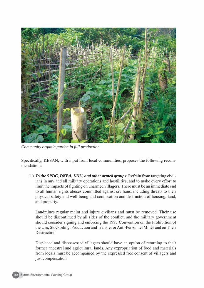
Burma Environmental Working Group90
Community organic garden in full production
Specifi cally, KESAN, with input from local communities, proposes the following recom-mendations:
1.) To the SPDC, DKBA, KNU, and other armed groups: Refrain from targeting civil-ians in any and all military operations and hostilities, and to make every effort to limit the impacts of fi ghting on unarmed villagers. There must be an immediate end to all human rights abuses committed against civilians, including threats to their physical safety and well-being and confi scation and destruction of housing, land, and property.
Landmines regular maim and injure civilians and must be removed. Their use should be discontinued by all sides of the confl ict, and the military government should consider signing and enforcing the 1997 Convention on the Prohibition of the Use, Stockpiling, Production and Transfer or Anti-Personnel Mines and on Their Destruction.
Displaced and dispossessed villagers should have an option of returning to their former ancestral and agricultural lands. Any expropriation of food and materials from locals must be accompanied by the expressed free consent of villagers and just compensation.
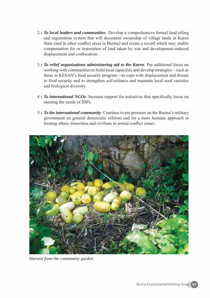
Burma Environmental Working Group 91
2.) To local leaders and communities: Develop a comprehensive formal land titling and registration system that will document ownership of village lands in Karen State (and in other confl ict areas in Burma) and create a record which may enable compensation for or restoration of land taken by war and development-induced displacement and confi scation.
3.) To relief organizations administering aid to the Karen: Put additional focus on working with communities to build local capacities and develop strategies—such as those in KESAN’s food security program—to cope with displacement and threats to food security and to strengthen self-reliance and maintain local seed varieties and biological diversity.
4.) To international NGOs: Increase support for initiatives that specifi cally focus on meeting the needs of IDPs.
5.) To the international community: Continue to put pressure on the Burma’s military government on general democratic reforms and for a more humane approach in treating ethnic minorities and civilians in armed confl ict zones.
Harvest from the community garden
Burma Environmental Working Group92
About Karen Environmental and Social Action Network (KESAN)
KESAN was established in 2001 as the fi rst local community-based organization to raise environmental awareness among Karen people. KESAN works to empower and educate communities and local institutions to revitalize existing indigenous knowledge and practices for increased livelihood security in Karen and Kachin States and in areas along the Thai-Burmese border. KESAN strives to build up local capacities in forest and natural resource management, raise public environmental awareness, and support community-based devel-opment initiatives. In addition to playing a leading role in environmental law and policy formulation, KESAN advocates for environmental policies and development priorities that ensure sustainable ecological, social, cultural, and economic benefi ts and promote gender equity. Website: http://www.kesan.asia
1 U.N. Food and Agriculture Organization, “Rome Declaration on World Food Security and World Food Sum-mit Plan of Action,” adopted at the World Food Summit, 13-17 November 1996, Rome, Italy.2 Danna Harman, “Burma’s wealth gap breeds discontent,” The Christian Science Monitor, 24 Apr. 2008, at: <http://www.csmonitor.com/2008/0424/p07s04-woap.html?page=1>. Last accessed 9 Dec. 2008. 3 The KNU, one of the largest armed ethnic groups, has been fi ghting against successive Burmese governments for independence for the Karen people since January 1949. This protracted confl ict is the world’s longest running civil war. The DKBA split from the KNU and formed an alliance with the SPDC. The DKBA is funded by the SPDC and essentially a government-backed militia. At the junta’s behest, the DKBA has carried out numerous attacks and campaigns against the KNU and Karen civilians.4 A Burmese proverb in Centre on Housing Rights and Evictions, Burma Country Report 2007: Displacement and Dispossession: Forced Migration and Land Rights, p. 117, at: <http://www.cohre.org/store/attachments/COHRE%20Burma%20Country%20Report.pdf>. Last accessed 9 Dec. 2008. 5 Online Burma/Myanmar Library, “13. Internally Displaced People and Forced Relocation,” at: <http://www.burmalibrary.org/docs/yearbooks/13.%20Internally%20Displaced%20People%20and%20Forced%20Relocation.htm>. Last accessed 9 Dec. 2008. 6 Back Pack Health Worker Team, Chronic Emergency: Health and Human Rights in Eastern Burma, 7 Sept. 2006, p. 9 [hereinafter “Chronic Emergency”].7 Chronic Emergency, p.38. 8 Karen Human Rights Group, “Supporting IDP Resistance Strategies,” 23 Apr. 2008, at: <http://www.khrg.org/khrg2008/khrg08w1.html>. Last accessed 16 Dec. 2008. 9 Karen Human Rights Group, “Attacks, kills and food crisis in Papun District,”4 Feb. 2009, at: <http://www.khrg.org/khrg2009/khrg09f2.html>. Last accessed 12 Feb. 2009. 10 Burma Issues, Shoot on Sight: The ongoing offensive against villagers in northern Karen State, Dec. 2006, p. 8. 11 KHRG, supra note 9. 12 Burma Issues, supra note 10, p. 11.13 Burma Ethnic Research Group, Forgotten Victims of a Hidden War: Internally Displaced Karen in Burma, Apr. 1998, p. 11. See also, Hal Lipper, “The Karen Legacy,” The Nation (Thailand), 8 Oct. 2006, at: <http://www.nationmultimedia.com/sunday/20061008/>. Last accessed 9 Dec. 2008.14 Karen Environmental and Social Action Network, Diversity Degraded, Dec. 2005, at p. 13 [hereinafter “Diversity Degraded”]. See also Back Pack Health Worker Team, supra note 6, p. 12.
Burma Environmental Working Group 93
15 Human Rights Watch, “They came and destroyed our village again: The Plight of IDPs in Karen State,” June 2005, at: <http://www.hrw.org/en/node/11703/section/7>. Last accessed 9 Dec. 2008. 16 Ibid.17 FAO, supra note 1, p. 14.18 Diversity Degraded, p. 13.19 FAO, supra note 1, p.21. 20 FAO, supra note 1, p.25. 21 Diversity Degraded, p. 29.22 Thailand Burma Border Consortium, International Displacement and International Law in Eastern Burma, Oct. 2008, p. 30. 23 KESAN interview with the Karen Offi ce of Relief and Development. Thai-Burmese border. 22 Jan. 2009.24 Committee of Internally Displaced Karen People, fi eld survey, June 2009.25 KESAN, supra note 14, p.27. 26 Having the DKBA in the area in addition to Burma Army troops puts even great pressure on villagers’ liveli-hoods and food security. Diversity Degraded, p.15.27 Thailand Burma Border Consortium, 2007 Survey: Internal Displacement in Eastern Burma, Dec. 2007, at p. 67. 28 Will Baxter, “Thailand and Myanmar at Odds over Salween Dams,” 13 Dec. 2006, at: <http://towardfreedom.com/home/content/view/941/65/>. 29 KESAN interview, supra note 24.30 KHRG, supra note 9.31 Diversity Degraded, p.15. 32 TBBC 2007 Survey, supra note 27. 33 Diversity Degraded, p.38. 34 Chronic Emergency, p. 55. 35 Chronic Emergency, p. 47. 36 Chronic Emergency, p. 64. 37 Thai Burma Border Consortium, “TBBC’s camp population fi gures Mar. 2009,”at: < http://tbbc.org/camps/2009-03-mar-map-tbbc-unhcr.pdf >. Last accessed 30 Apr. 2009. 38 Diversity Degraded, p.16. 39 Diversity Degraded, p. 21. 40 KESAN interview, supra note 24.41 Free Burma Rangers, “380 Newly Displaced Karen People Arrive at the Salween River. Over 5000 Now in Hiding,” 28 Mar. 2006, at: <http://www.freeburmarangers.org/Reports/2006/20060328.html>. Last accessed 12 Feb. 2009. 42 Mae Tao Clinic website, “Back Pack Health Worker Teams,” at: <http://www.maetaoclinic.org/bphwt.html>. Last accessed 12 Feb. 2008. 43 Universal Declaration of Human Rights (1948) Art. 25.1.44 Geneva Conventions Relative to the Protection of Civilian Persons in Time of War, adopted 12 Aug. 1949, entry into force 21 Oct. 1950, Art. 3.1.45 Diversity Degraded, p.25. 46 Diversity Degraded, pp. 58-59.
Burma Environmental Working Group94
Gold Mining in Shwegyin Township, Pegu Division
EarthRights International
Traditional gold mining in Shwegyin Township involved small-scale, low-tech, family oriented extraction performed part-time by farmers. As gold is a non-renewable resource (once it is taken from the ground it cannot be regenerated), gold mining is by defi nition an unsustainable activity. It is, however, valuable to research alternative methods of gold mining that are less polluting and has fewer impacts on the environment and communities. Destructive, large-scale industrial techniques and rampant corruption are now threatening the local people. A comprehensive policy framework that requires expert studies prior to mining and recognizes the rights of the local people to their land is necessary to overcome this threat.
1. Shwegyin Township and Its Gold
Shwegyin Township is located in Pegu Division in eastern Burma, east of the Sittaung River. Plains crisscrossed by streams extend from the Sittaung River east to the Shwegyin River where the terrain becomes hillier, becoming forested mountains that extend further to the east into Mutraw District, Karen State. The Shwegyin area is on the western edge of the Kayah-Karen /Tenasserim Moist Forest, which contains the largest, relatively intact bloc of tropical and sub-tropical moist broadleaf forests remaining in the Indochinese eco-region. This region is listed by the World Wildlife Fund as one of the world’s 200 most signifi cant eco-regions due to the high levels of biodiversity found there.1 Most of the fertile farmland is in the plains along the banks of the Sittaung, Shwegyin and Mawtama Rivers. Karen and Kawa villagers traditionally lived in this area growing rice, panning for gold, and maintaining plantations of shaut (a large green citrus fruit), mangosteen, durian, betel nut, and rubber.
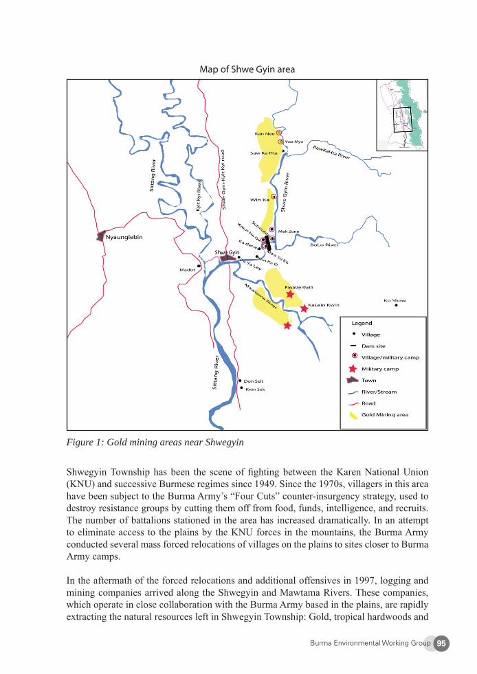
Burma Environmental Working Group 95
Figure 1: Gold mining areas near Shwegyin
Shwegyin Township has been the scene of fi ghting between the Karen National Union (KNU) and successive Burmese regimes since 1949. Since the 1970s, villagers in this area have been subject to the Burma Army’s “Four Cuts” counter-insurgency strategy, used to destroy resistance groups by cutting them off from food, funds, intelligence, and recruits. The number of battalions stationed in the area has increased dramatically. In an attempt to eliminate access to the plains by the KNU forces in the mountains, the Burma Army conducted several mass forced relocations of villages on the plains to sites closer to Burma Army camps.
In the aftermath of the forced relocations and additional offensives in 1997, logging and mining companies arrived along the Shwegyin and Mawtama Rivers. These companies, which operate in close collaboration with the Burma Army based in the plains, are rapidly extracting the natural resources left in Shwegyin Township: Gold, tropical hardwoods and
Map of Shwe Gyin area
Burma Environmental Working Group96
non-timber forest products. Temporary villages have sprouted up around the mining sites, and are now mostly occupied by Burman mine workers from across the Sittaung River. Since 2005, in violation of an informal ceasefi re agreement reached in 2004, the Burmse military regime (State Peace and Development Council, or SPDC) has launched new of-fensives throughout northern Karen State and eastern Pegu Division. Shwegyin has been targeted in offensives, and soldiers have been attacking displaced civilian communities in hiding to the east of the Shwegyin River, shooting them on sight and destroying their food supplies.2 Some of the most severe humanitarian atrocities in eastern Burma during 2007 were committed in Shwegyin Township.3 As a result of the SPDC’s offensive, there are now approximately 10,300 internally displaced villagers in Shwegyin Township.4 Military operations continue to the present.
2. Traditional Gold Mining Practices
Traditionally, villagers living in the Shwegyin area depended on the rivers and forestlands for their livelihoods and cultural practices. The Shwegyin and Sittuang Rivers were very important for villagers who used them for fi shing, irrigation, bathing, washing, and drinking water. Shwegyin town is located on the Shwegyin River near the confl uence with the Maw-tama River. “Shwe Gyin” means “gold panning” in Burmese. Nearly all of the gold found in the township is located in the alluvial soils of rivers and streams. Areas where people can fi nd gold now are along Bonelone Stream (Su-mu-lo klow), Mawtama Stream (Pet-Maung klow), Kawet Stream (Pa-Ta-Loe klow) and other areas in the township.
Over two centuries ago, the Kawa, a minority ethnic group, inhabited Shwegyin. It is said that they collected gold from the rivers and nearby forests. Local villagers believe that gold was dug from holes in the jungle, but now this area is covered by thick jungle and the techniques used in the past are a mystery. Most of the villagers in this area grow rice and maintain plantations of shaut, mangosteen, durian, betel nut, and rubber during the rainy season. Both sides of the river bank have shaut plantations, a major source of income for villagers living in this area.
Before industrial mining methods were introduced, gold was mined seasonally by local farm-ers from villages next to the rivers. During the dry season, when villagers have more time and the water level is low, Karen villagers panned for gold in the Shwegyin and Mawtama Rivers and their tributaries to supplement their income from their fi elds and plantations. Gold panning provided important income for the villagers even if they did not pan gold for the entire year. Those who could do well in their business collected gold to make golden rings, earrings and lerswe, which would be presented as a gift for their children.
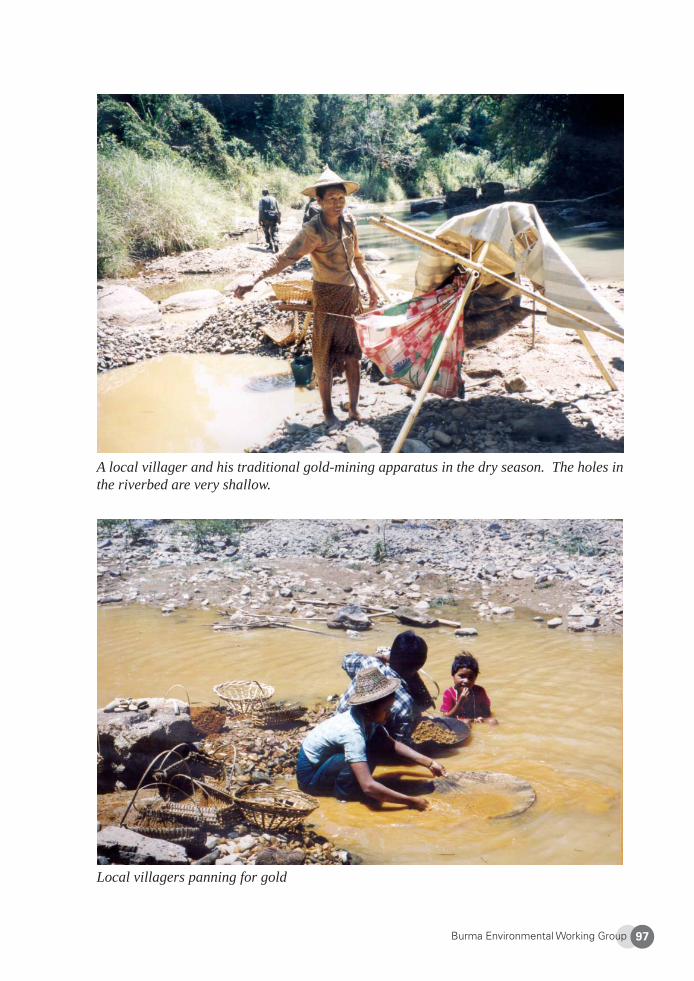
Burma Environmental Working Group 97
A local villager and his traditional gold-mining apparatus in the dry season. The holes in the riverbed are very shallow.
Local villagers panning for gold
Burma Environmental Working Group98
Local women harvesting Shaut
Shaut harvest
Burma Environmental Working Group 99
To pan gold, villagers dig a hole in the bed or bank of the river. They do not go far from the river because they need water for the process. The holes are typically about two to three feet wide and fi ve to ten feet deep. Very few holes are dug, and the holes are refi lled an-nually during the rainy season, so they have very little impact on the natural environment. Villagers use a wooden sieve to sift through the soil to look for gold. The villagers do not use machinery or otherwise disrupt large parts of the river banks. Neither do the villagers use mercury or other dangerous chemicals to amalgamate the gold. The tools they use also cause less environmental impact.5 The local people do not rely on gold mining but rather they live within the constraints of their environment. Their low-impact gold panning means that they can continue to fi sh and consume the water in the river and sustain their natural resources for their children and future generations.6
Traditionally, people would work together to collect the gold. Groups would be formed with family members, relatives or neighbors. They would collect gold about the size of one paddy seed (approximately three by eight millimeters) each day. A broker would come around to buy the gold or the villagers would travel to town to sell it. Most importantly, people in this area understood that nobody owned the riverbanks. If somebody found gold, other people would not come to search in the same area. They understood that unless a group abandoned a particular panning site, another group would not take over that site. These traditions show that people respect each other and believe that each group found their gold by luck. There is trust within the community, and people were not eager to look for more gold or areas where gold will be found. People made sure to leave space where they will mine for gold in the future, rather than moving every year to another place. This practice went beyond gold panning: no rich people bought land and used the gold in order to produce a profi t.
3. Rapid Expansion of Resource Extraction
“The gold mining started a long time ago in this area. There are many places that you can mine in this area. People used to use small-scale techniques along the stream and in the jungle. Now people use high pressure hose machines to get the gold. Last year there were 40 gold mining machines in this area.”
– Burman migrant mine worker in Shwegyin township.7
In 1997, the SPDC began to industrialize the exploitation of gold deposits and forests in the Shwegyin area. Businessmen from central Burma arrived and in collusion with the Burmese Army gained mining concessions and began to force people off of their land. Small-scale miners, many of whom have worked in the area for generations, were pushed to the margins.
Burmese soldiers often refused to allow people to access to their plantation and farmland which were the main source of income for the people. Many of the plantations were far from the village, up to half a day’s walk, and it become impossible for the villagers to go to the plantation in the morning and come back in the evening. Burmese soldiers made baseless accusations against people who went to look after their land, saying the local people have connections to armed opposition groups. Thus, people who used to rely on plantations and
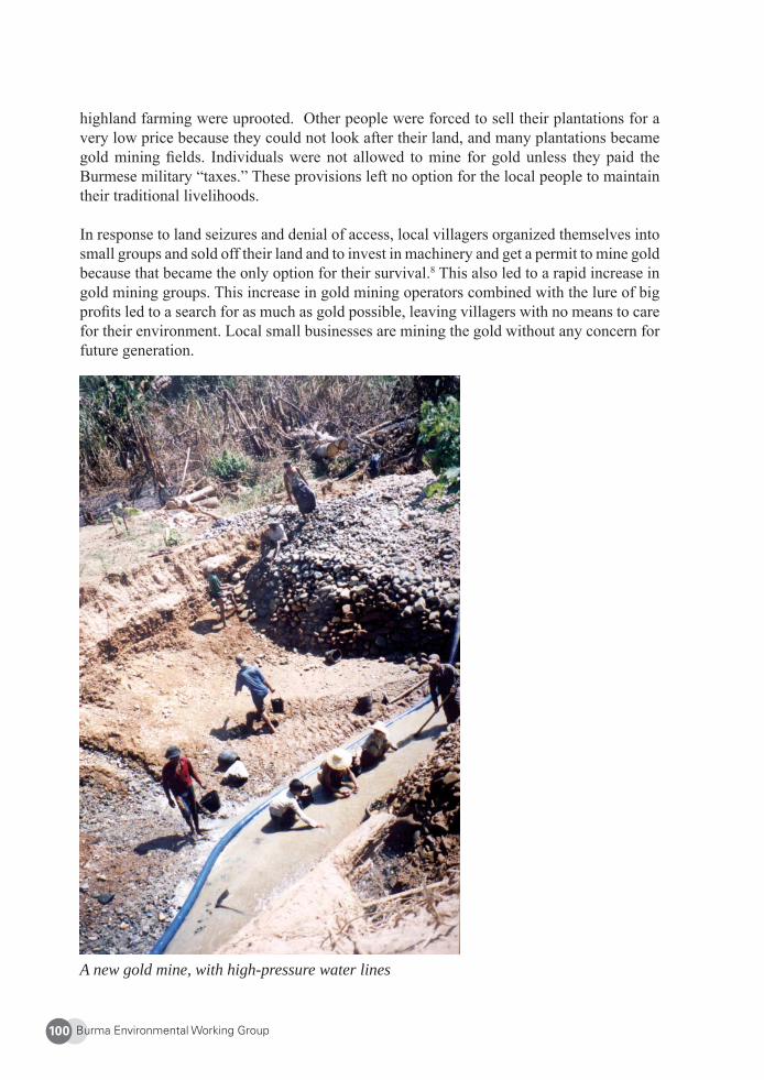
Burma Environmental Working Group100
highland farming were uprooted. Other people were forced to sell their plantations for a very low price because they could not look after their land, and many plantations became gold mining fi elds. Individuals were not allowed to mine for gold unless they paid the Burmese military “taxes.” These provisions left no option for the local people to maintain their traditional livelihoods.
In response to land seizures and denial of access, local villagers organized themselves into small groups and sold off their land and to invest in machinery and get a permit to mine gold because that became the only option for their survival.8 This also led to a rapid increase in gold mining groups. This increase in gold mining operators combined with the lure of big profi ts led to a search for as much as gold possible, leaving villagers with no means to care for their environment. Local small businesses are mining the gold without any concern for future generation.
A new gold mine, with high-pressure water lines
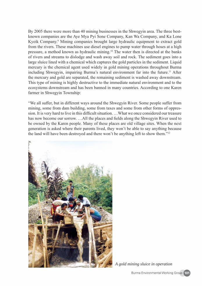
Burma Environmental Working Group 101
By 2005 there were more than 40 mining businesses in the Shwegyin area. The three best-known companies are the Aye Mya Pyi Sone Company, Kan Wa Company, and Ka Lone Kyeik Company.9 Mining companies brought large hydraulic equipment to extract gold from the rivers. These machines use diesel engines to pump water through hoses at a high pressure, a method known as hydraulic mining.10 The water then is directed at the banks of rivers and streams to dislodge and wash away soil and rock. The sediment goes into a large sluice lined with a chemical which captures the gold particles in the sediment. Liquid mercury is the chemical agent used widely in gold mining operations throughout Burma including Shwegyin, impairing Burma’s natural environment far into the future.11 After the mercury and gold are separated, the remaining sediment is washed away downstream. This type of mining is highly destructive to the immediate natural environment and to the ecosystems downstream and has been banned in many countries. According to one Karen farmer in Shwegyin Township:
“We all suffer, but in different ways around the Shwegyin River. Some people suffer from mining, some from dam building, some from taxes and some from other forms of oppres-sion. It is very hard to live in this diffi cult situation. …What we once considered our treasure has now become our sorrow. …All the places and fi elds along the Shwegyin River used to be owned by the Karen people. Many of these places are old village sites. When the next generation is asked where their parents lived, they won’t be able to say anything because the land will have been destroyed and there won’t be anything left to show them.”12
A gold mining sluice in operation
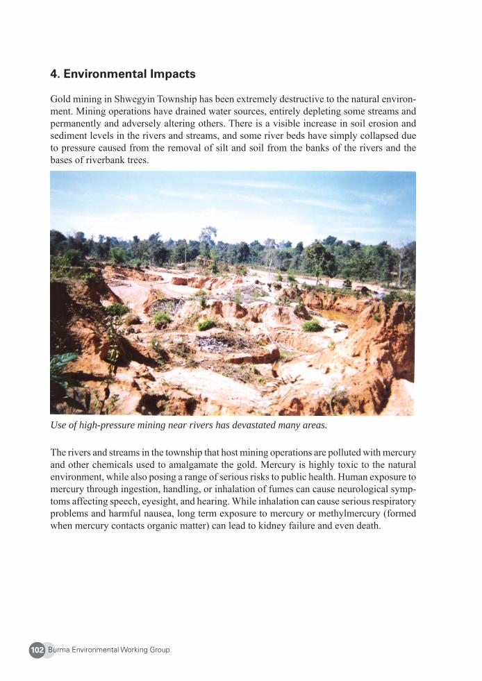
Burma Environmental Working Group102
4. Environmental Impacts
Gold mining in Shwegyin Township has been extremely destructive to the natural environ-ment. Mining operations have drained water sources, entirely depleting some streams and permanently and adversely altering others. There is a visible increase in soil erosion and sediment levels in the rivers and streams, and some river beds have simply collapsed due to pressure caused from the removal of silt and soil from the banks of the rivers and the bases of riverbank trees.
Use of high-pressure mining near rivers has devastated many areas.
The rivers and streams in the township that host mining operations are polluted with mercury and other chemicals used to amalgamate the gold. Mercury is highly toxic to the natural environment, while also posing a range of serious risks to public health. Human exposure to mercury through ingestion, handling, or inhalation of fumes can cause neurological symp-toms affecting speech, eyesight, and hearing. While inhalation can cause serious respiratory problems and harmful nausea, long term exposure to mercury or methylmercury (formed when mercury contacts organic matter) can lead to kidney failure and even death.
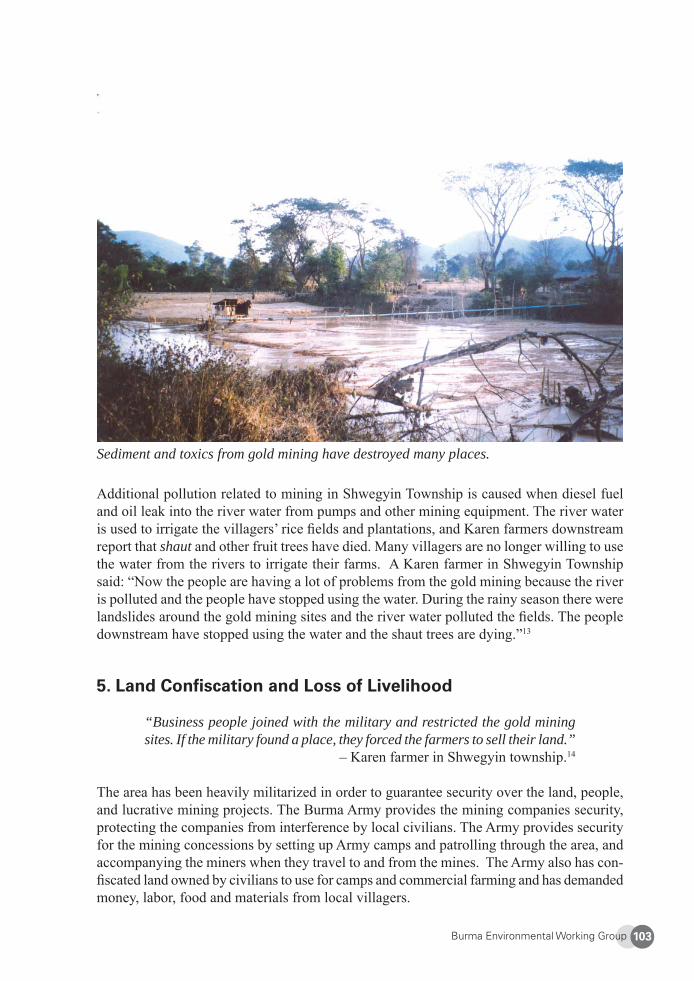
Burma Environmental Working Group 103
Sediment and toxics from gold mining have destroyed many places.
Additional pollution related to mining in Shwegyin Township is caused when diesel fuel and oil leak into the river water from pumps and other mining equipment. The river water is used to irrigate the villagers’ rice fi elds and plantations, and Karen farmers downstream report that shaut and other fruit trees have died. Many villagers are no longer willing to use the water from the rivers to irrigate their farms. A Karen farmer in Shwegyin Township said: “Now the people are having a lot of problems from the gold mining because the river is polluted and the people have stopped using the water. During the rainy season there were landslides around the gold mining sites and the river water polluted the fi elds. The people downstream have stopped using the water and the shaut trees are dying.”13
5. Land Confi scation and Loss of Livelihood
“Business people joined with the military and restricted the gold mining sites. If the military found a place, they forced the farmers to sell their land.”
– Karen farmer in Shwegyin township.14
The area has been heavily militarized in order to guarantee security over the land, people, and lucrative mining projects. The Burma Army provides the mining companies security, protecting the companies from interference by local civilians. The Army provides security for the mining concessions by setting up Army camps and patrolling through the area, and accompanying the miners when they travel to and from the mines. The Army also has con-fi scated land owned by civilians to use for camps and commercial farming and has demanded money, labor, food and materials from local villagers.
Burma Environmental Working Group104
The Army adds military force to the mining companies’ efforts to acquire land, intimidat-ing the villagers to sell. When the companies cannot persuade villagers to sell their land, they resort to a stronger method, arranging for the Army to coerce the villagers into selling. Typically, soldiers visit the landowner and urge him or her to sell the land. They are closely followed by a representative from a mining company who then offers a price far below the land’s market value. The representative points out to the landowner that at least some com-pensation now is better than none later. In the coercive company of the Army and mining companies, villagers commonly succumb to the intimidation, selling their land for a price well below its market value. If a villager is particularly strong willed and intimidation tactics are unsuccessful, the Army simply confi scates the land. Army units based around Shwegyin, including IB 57, LIB 349 and LIB 350, have seized land from villagers and given it to the mining companies.15
When the mining companies arrived in 1997, the original Karen villages had all been relo-cated or forced to fl ee years before. Many villagers, most of whom are Karen living along the Shwegyin River, still maintain plantations and fi elds in their original locations. As is common in the area, the Army permits them to work the land but strictly prohibits them from permanently resettling in their old villages. Villagers are required to pay exorbitant fees to the military for such working visits. Villagers who are living in hiding in the moun-tains nearby the Shwegyin River and along the Mawtama River also occasionally return to work their fi elds.
A Burman migrant worker in Shwegyin Township describes the abandoned villages: “In our area there are many gold mining sites on old village sites and they named this area Tha Bway La Ha. There are many old villages that have been destroyed in this mining area. Now there are no more people in these old villages. We see plants, house posts, broken pots and wells where the old villages used to be. I don’t know anything about this area. I know that before in this area there were many Karen people that had shaut plantations.”16
In Shwegyin Township, Karen village sites that were subject to relocation and deserted in the 1970s and 1980s are now reoccupied by Burman mine workers. These villages are temporary sites to house miners and their families. Many local people were left with no choice but to work for the mining companies, otherwise there is no way to earn a living.
Soon after many outsiders moved into the area, local habits and traditions were destroyed. Local villagers complain that some of the migrant workers do not respect them or their customs. For example, when migrant workers trespass on plantations of local people seek-ing food, such behavior is interpreted by local people as not only disrespectful but theft. Furthermore, many local in this area are animist and feel the migrant worker do not respect their religion. During certain animist religious ceremonies, the local people post signs re-questing privacy, but some workers ignore the signs.
The infl ux of migrant workers has also brought other social and public health problems. Sex workers have migrated to the district, sometimes at the behest of Burmese Army offi cers, to provide services to the large number of soldiers and laborers in the area.17 The spread of sexually transmitted diseases including HIV in other mining areas of Burma are well docu-
Burma Environmental Working Group 105
mented,18 and the same phenomenon is occurring in Shwegyin. An increase in gambling and drinking is also a problem around the mining sites.
6. Conclusion
Environmental and social impacts of large-scale mining ranging from lack of participation by local communities to loss of livelihood and violence are directly responsible for the deterioration of the environment and traditional cultural practices in Shwegyin Township. Heavy militarization in the area and intensive gold mining have caused enormous suffering for local villagers who are no longer permitted to continue their traditional gold mining and farming methods. The Burma Army has severely restricted movement, used forced labor, made demands for food and building materials, and confi scated land for its own commercial projects. The Army bends the laws or ignores them entirely, and the businessmen who own the mining companies exploit the situation and are able to make huge profi ts with very little concern for local villagers or the environment. In this way, local villagers effectively have been displaced. They lack access to the necessary mining equipment, and are now fi nding it extremely diffi cult to survive.
The Burmese Army continues to consolidate its gains in the mountains, especially along the east bank of the Shwegyin River and along the Mawtama River. This includes the eastern part of the mountain range, from south to north, through Yo Mu Soe, Pu Soe, Tho Plwe and Ta Paw Lay areas where many people believe gold and other natural resources are abundant. If gold is found, the mining company and a logging company will inevitably follow. Some of the mining companies have already expressed interest in moving their operations into these areas.19
Concerned by the dire social and environmental impacts, local KNU offi cers tried to stop the mining in the area but were unsuccessful. They failed partly because the areas were not under their complete control. Burmese military was heavily present in the area, working with outside mining companies in order to access gold. In order to obtain full access to the mines, companies send their representatives to negotiate with the local KNU offi ces. This led to some KNU offi cials taking payments from these companies. Even in areas not control-led by the KNU, companies negotiated with the KNU so that the KNU would not disturb their mining activities. The KNU offi ces could use these leverages to impose regulations to mitigate the impact of the mining in this area.20
Burma Environmental Working Group106
7. Recommendations
In order to address the loss of traditional livelihood and the negative social and environmental impacts of gold mining in Shwegyin Township, we recommend the following specifi c im-mediate changes to policies and laws by the State Peace and Development Council (SPDC).
1) The SPDC should grant civilians rights over the land they occupy, including rights to obtain legal land title.
2) With regard to the environmental destruction occurring in Shwegyin Township, the SPDC should replace outdated laws and ineffective environmental provisions to bring them into accordance with its 1994 Environmental Policy and the UN-supported national action plan for the environment known as “Myanmar Agenda 21.”
3) The SPDC should strengthen the National Commission for Environmental Affairs (NCEA) by passing laws to protect the environment and providing for Environ-mental Impact Assessments, as well as empowering it to enforce existing laws and providing it with suffi cient human and fi nancial resources.
4) The SPDC should enforce Section 12(a) of SLORC Law No. 8/94 which requires: a) all applications to the Ministry of Mines conduct an environmental impact as-sessment (EIA) prior to receiving offi cial approval to extract minerals, gems, and precious metals; and b) Ministry of Mines to investigate whether the environment, fl ora and fauna, highways, religious property, and/or items of cultural heritage would be negatively affected by mining activities. Laws and regulations in both these areas need to be strengthened.
5) The SPDC should revise and enforce penalties for violating environmental laws. Fines and other deterrents should be adjusted to account for the differences in comparative wealth of individuals, Burmese companies, and foreign companies. This will help prevent situations where it might be more cost-effective to damage the environment instead of preventing the harm in the fi rst place.
6) The SPDC should offer fi nancial and other incentives to state-owned enterprises and private sector actors to manage the country’s natural resources in a sustainable way.
7) With regards to mining, the SPDC should ban and take immediate legal action against individuals and companies using ecologically damaging practices, such as: 1) hydraulic mining, a practice that has been outlawed throughout the world; 2) “deep trenching,” which involves cutting deep trenches across the farmland; as well as 3) the indiscriminate use of mercury, cyanide, sulphuric acid, and other toxic chemicals to leach precious metals and minerals from extracted ore.
Burma Environmental Working Group 107
8) To avoid any confl icts of interest, the SPDC should create an independent agency to conduct future social and environmental impact assessments. The SPDC should repeal the section of the SLORC Law No. 8/94 which states that no mining company is liable to prosecution or fi nes, and promulgate laws that permit citizens whose health and/or livelihoods are harmed by mining activities, including downstream pollution, to fi le lawsuits and receive adequate compensation for their injuries.
9) The SPDC should impose and enforce rules and regulations for the use of adequate land and sustainable development in the areas where mining is currently taking place and ensure local people are able to manage their own natural resources to strengthen their livelihoods.
10) Concerning the future impact of gold mining in the area, all parties including SPDC and opposition groups should cease gold extraction until proper rules and regula-tions are in place and effective.
11) Both the SPDC and KNU as well as civil society groups must empower and encour-age local people to continue to live their traditional way in order to sustain, prevent and protect their environment for future generations.
12) When developing rules and regulations, all parties should work together with lo-cal people to strengthen the rule of law and setup effective systems to learn from traditional methods such that gold can be taken with less impact on social and environmental issues.
About EarthRights International (ERI)
ERI is a group of activists, organizers, and lawyers with expertise in human rights, the environment, and corporate and government accountability. Since 1995, ERI has worked in Burma to monitor the impacts of the military regime’s policies and activities on local populations and ecosystems. Through our training program, ERI trains young environmental activities from diverse ethnic backgrounds in Burma to empower young leaders with skills and knowledge to work on earth rights issues in their communities. In addition, ERI works alongside affected community groups to prevent human rights and environmental abuses associated with large-scale development projects in Burma. Currently, ERI’s Burma Project focuses on large-scale dams, oil and gas development, and mining. Website: http://www.earthrights.org
Burma Environmental Working Group108
1 The Kayah/Karen Tenasserim Moist Forest “contains Indochina’s largest block of moist forests, one of its richest plant diversities (partly because of the geographical spread), and its largest number of mammals, in-cluding tigers (Panthera tigris), Asian elephants, (Elephas maximus), gaur (Bos gaurus), and clouded leopards (Pardofelis nebulosa).” <http://www.panda.org/about_our_earth/ecoregions/kayahkaren_moist_forests.cfm>. Last accessed 16 April 2009. 2 See, e.g., Free Burma Rangers, “Burma Army troops kill villagers and IDPs as they mass troops with over 90 battalions now in northern Karen State, Burma,” January 10, 2008, at: <www.freeburmarangers.org/Re-ports/2008/20080110.html>. Last accessed 17 Feb. 2009.3 See, e.g., Thai Burma Border Consortium (TBBC) website, at <http://www.tbbc.org/idps/borderstates.htm>. Last accessed 17 Feb. 2009.4 TBBC, supra note 3. 5 EarthRights International Interview 2008.6 Karen River Watch Interview 2008.7 EarthRights International (2007). Turning Treasure into Tears: Mining, Dams, and Deforestation in Shwegyin Township, Pegu Division, Burma. Available online at <www.earthrights.org/mwt_journal_admin/Report-_Turn-ing_Treasure_Into_Tears.pdf>. Last accessed 17 Feb. 2009. [Hereinafter “Treasure into Tears”].8 Karen River Watch Interview, 2008.9 EarthRights International Interview, 2008.10 See, e.g., <http://en.wikipedia.org/wiki/Hydraulic_mining>. Last accessed May 11, 2009. 11 One study in California found toxic mercury in rivers 100 years after gold mining ended. <http://ca.water.usgs.gov/mercury/dutch/wrir994018b.pdf >. Last accessed 17 Feb. 2009.12 Treasure into Tears, p. 44. 13 Ibid. 14 Treasure into Tears, p. 41. 15 Ibid. 16 Treasure into Tears, p. 44. 17 Treasure into Tears, pp. 44-45. 18 See, e.g., “Burma miners pay for fatal pleasures,” The Independent, 18 April 1994, at <http://www.independent.co.uk/news/world/burma-miners-pay-for-fatal-pleasures-workers-harvesting-rubies-sapphires-and-jade-seek-solace-in-heroinshooting-galleries-where-the-aids-virus-is-now-rife-writes-tim-mcgirk-in-mandalay-1370825.html>. Last accessed April 16, 2009.19 EarthRights International Interview 2008.20 Karen River Watch Interview 2008.
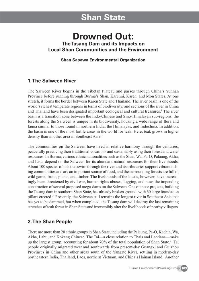
Burma Environmental Working Group 109
Shan State
Drowned Out: The Tasang Dam and its Impacts on
Local Shan Communities and the Environment
Shan Sapawa Environmental Organization
1. The Salween River
The Salween River begins in the Tibetan Plateau and passes through China’s Yunnan Province before running through Burma’s Shan, Karenni, Karen, and Mon States. At one stretch, it forms the border between Karen State and Thailand. The river basin is one of the world’s richest temperate regions in terms of biodiversity, and sections of the river in China and Thailand have been designated important ecological and cultural treasures.1 The river basin is a transition zone between the Indo-Chinese and Sino-Himalayan sub-regions, the forests along the Salween is unique in its biodiversity, housing a wide range of fl ora and fauna similar to those found in northern India, the Himalayas, and Indochina. In addition, the basin is one of the most fertile areas in the world for teak. Here, teak grows in higher density than in other area in Southeast Asia.2
The communities on the Salween have lived in relative harmony through the centuries, peacefully practicing their traditional vocations and sustainably using their forest and water resources. In Burma, various ethnic nationalities such as the Shan, Wa, Pa-O, Palaung, Akha, and Lisu, depend on the Salween for its abundant natural resources for their livelihoods. About 100 species of fi sh that swim through the river and its tributaries support vibrant fi sh-ing communities and are an important source of food, and the surrounding forests are full of wild game, fruits, plants, and timber. The livelihoods of the locals, however, have increas-ingly been threatened by civil war, human rights abuses, logging, and now, the impending construction of several proposed mega-dams on the Salween. One of those projects, building the Tasang dam in southern Shan State, has already broken ground, with 60 large foundation pillars erected.3 Presently, the Salween still remains the longest river in Southeast Asia that has yet to be dammed, but when completed, the Tasang dam will destroy the last remaining stretches of teak forest in Shan State and irreversibly alter the livelihoods of nearby villagers.
2. The Shan People
There are more than 20 ethnic groups in Shan State, including the Palaung, Pa-O, Kachin, Wa, Akha, Lahu, and Kokang Chinese. The Tai—a close relation to Thais and Laotians—make up the largest group, accounting for about 70% of the total population of Shan State.4 Tai people originally migrated west and southwards from present-day Guangxi and Guizhou Provinces in China and other areas south of the Yangzte River, settling in modern-day northeastern India, Thailand, Laos, northern Vietnam, and China’s Hainan Island. Another
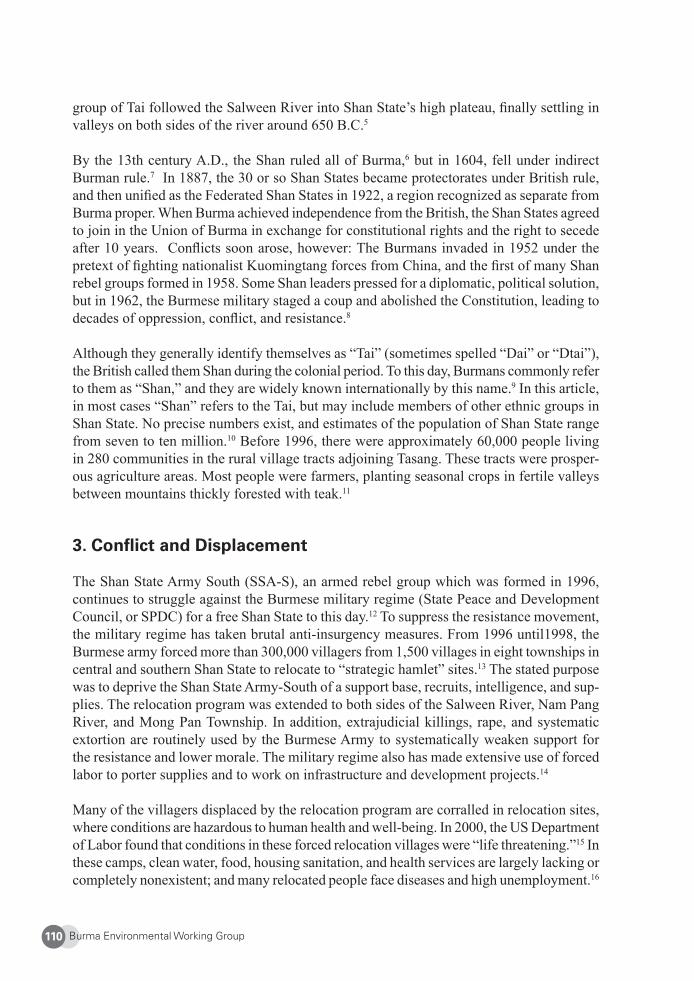
Burma Environmental Working Group110
group of Tai followed the Salween River into Shan State’s high plateau, fi nally settling in valleys on both sides of the river around 650 B.C.5
By the 13th century A.D., the Shan ruled all of Burma,6 but in 1604, fell under indirect Burman rule.7 In 1887, the 30 or so Shan States became protectorates under British rule, and then unifi ed as the Federated Shan States in 1922, a region recognized as separate from Burma proper. When Burma achieved independence from the British, the Shan States agreed to join in the Union of Burma in exchange for constitutional rights and the right to secede after 10 years. Confl icts soon arose, however: The Burmans invaded in 1952 under the pretext of fi ghting nationalist Kuomingtang forces from China, and the fi rst of many Shan rebel groups formed in 1958. Some Shan leaders pressed for a diplomatic, political solution, but in 1962, the Burmese military staged a coup and abolished the Constitution, leading to decades of oppression, confl ict, and resistance.8
Although they generally identify themselves as “Tai” (sometimes spelled “Dai” or “Dtai”), the British called them Shan during the colonial period. To this day, Burmans commonly refer to them as “Shan,” and they are widely known internationally by this name.9 In this article, in most cases “Shan” refers to the Tai, but may include members of other ethnic groups in Shan State. No precise numbers exist, and estimates of the population of Shan State range from seven to ten million.10 Before 1996, there were approximately 60,000 people living in 280 communities in the rural village tracts adjoining Tasang. These tracts were prosper-ous agriculture areas. Most people were farmers, planting seasonal crops in fertile valleys between mountains thickly forested with teak.11
3. Confl ict and Displacement
The Shan State Army South (SSA-S), an armed rebel group which was formed in 1996, continues to struggle against the Burmese military regime (State Peace and Development Council, or SPDC) for a free Shan State to this day.12 To suppress the resistance movement, the military regime has taken brutal anti-insurgency measures. From 1996 until1998, the Burmese army forced more than 300,000 villagers from 1,500 villages in eight townships in central and southern Shan State to relocate to “strategic hamlet” sites.13 The stated purpose was to deprive the Shan State Army-South of a support base, recruits, intelligence, and sup-plies. The relocation program was extended to both sides of the Salween River, Nam Pang River, and Mong Pan Township. In addition, extrajudicial killings, rape, and systematic extortion are routinely used by the Burmese Army to systematically weaken support for the resistance and lower morale. The military regime also has made extensive use of forced labor to porter supplies and to work on infrastructure and development projects.14
Many of the villagers displaced by the relocation program are corralled in relocation sites, where conditions are hazardous to human health and well-being. In 2000, the US Department of Labor found that conditions in these forced relocation villages were “life threatening.”15 In these camps, clean water, food, housing sanitation, and health services are largely lacking or completely nonexistent; and many relocated people face diseases and high unemployment.16
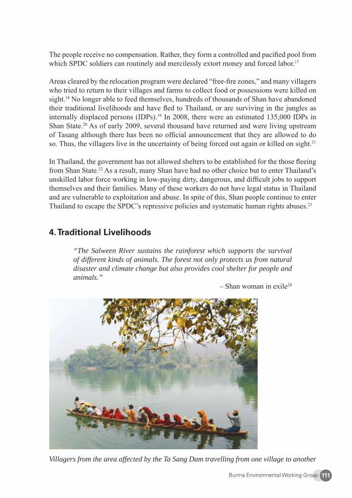
Burma Environmental Working Group 111
The people receive no compensation. Rather, they form a controlled and pacifi ed pool from which SPDC soldiers can routinely and mercilessly extort money and forced labor.17
Areas cleared by the relocation program were declared “free-fi re zones,” and many villagers who tried to return to their villages and farms to collect food or possessions were killed on sight.18 No longer able to feed themselves, hundreds of thousands of Shan have abandoned their traditional livelihoods and have fl ed to Thailand, or are surviving in the jungles as internally displaced persons (IDPs).19 In 2008, there were an estimated 135,000 IDPs in Shan State.20 As of early 2009, several thousand have returned and were living upstream of Tasang although there has been no offi cial announcement that they are allowed to do so. Thus, the villagers live in the uncertainty of being forced out again or killed on sight.21
In Thailand, the government has not allowed shelters to be established for the those fl eeing from Shan State.22 As a result, many Shan have had no other choice but to enter Thailand’s unskilled labor force working in low-paying dirty, dangerous, and diffi cult jobs to support themselves and their families. Many of these workers do not have legal status in Thailand and are vulnerable to exploitation and abuse. In spite of this, Shan people continue to enter Thailand to escape the SPDC’s repressive policies and systematic human rights abuses.23
4. Traditional Livelihoods
“The Salween River sustains the rainforest which supports the survival of different kinds of animals. The forest not only protects us from natural disaster and climate change but also provides cool shelter for people and animals.”
– Shan woman in exile24
Villagers from the area affected by the Ta Sang Dam travelling from one village to another
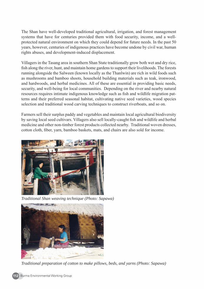
Burma Environmental Working Group112
The Shan have well-developed traditional agricultural, irrigation, and forest management systems that have for centuries provided them with food security, income, and a well-protected natural environment on which they could depend for future needs. In the past 50 years, however, centuries of indigenous practices have become undone by civil war, human rights abuses, and development-induced displacement.
Villagers in the Tasang area in southern Shan State traditionally grow both wet and dry rice, fi sh along the river, hunt, and maintain home gardens to support their livelihoods. The forests running alongside the Salween (known locally as the Thanlwin) are rich in wild foods such as mushrooms and bamboo shoots, household building materials such as teak, ironwood, and hardwoods, and herbal medicines. All of these are essential in providing basic needs, security, and well-being for local communities. Depending on the river and nearby natural resources requires intimate indigenous knowledge such as fi sh and wildlife migration pat-terns and their preferred seasonal habitat, cultivating native seed varieties, wood species selection and traditional wood carving techniques to construct riverboats, and so on.
Farmers sell their surplus paddy and vegetables and maintain local agricultural biodiversity by saving local seed cultivars. Villagers also sell locally-caught fi sh and wildlife and herbal medicine and other non-timber forest products collected nearby. Traditional woven dresses, cotton cloth, fi ber, yarn, bamboo baskets, mats, and chairs are also sold for income.
Traditional Shan weaving technique (Photo: Sapawa)
Traditional preparation of cotton to make pillows, beds, and yarns (Photo: Sapawa)
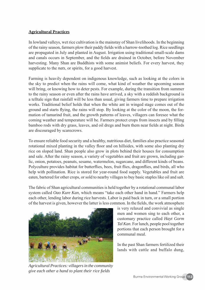
Burma Environmental Working Group 113
Agricultural Practices
In lowland valleys, wet rice cultivation is the mainstay of Shan livelihoods. In the beginning of the rainy season, farmers plow their paddy fi elds with a harrow-toothed log. Rice seedlings are propagated in July and planted in August. Irrigation using traditional small-scale dams and canals occurs in September, and the fi elds are drained in October, before November harvesting. Many Shan are Buddhists with some animist beliefs. For every harvest, they supplicate to the nats, or spirits, for a good harvest.
Farming is heavily dependent on indigenous knowledge, such as looking at the colors in the sky to predict when the rains will come, what kind of weather the upcoming season will bring, or knowing how to deter pests. For example, during the transition from summer to the rainy season or even after the rains have arrived, a sky with a reddish background is a telltale sign that rainfall will be less than usual, giving farmers time to prepare irrigation works. Traditional belief holds that when the white ant in winged stage comes out of the ground and starts fl ying, the rains will stop. By looking at the color of the moon, the for-mation of tamarind fruit, and the growth patterns of leaves, villagers can foresee what the coming weather and temperature will be. Farmers protect crops from insects and by fi lling bamboo rods with dry grass, leaves, and oil dregs and burn them near fi elds at night. Birds are discouraged by scarecrows.
To ensure reliable food security and a healthy, nutritious diet, families also practice seasonal rotational mixed planting in the valley fl oor and on hillsides, with some also planting dry rice on sloped land. Shan people also grow in plots behind their houses for consumption and sale. After the rainy season, a variety of vegetables and fruit are grown, including gar-lic, onion, potatoes, peanuts, sesame, watermelon, sugarcane, and different kinds of beans. Polyculture provides habitat for butterfl ies, bees, fruit fl ies, dragonfl ies, and birds, all who help with pollination. Rice is stored for year-round food supply. Vegetables and fruit are eaten, bartered for other crops, or sold to nearby villages to buy basic staples like oil and salt.
The fabric of Shan agricultural communities is held together by a rotational communal labor system called Oao Kure Kan, which means “take each other hand in hand.” Farmers help each other, lending labor during rice harvests. Labor is paid back in turn, or a small portion of the harvest is given, however the latter is less common. In the fi elds, the work atmosphere
is very relaxed and convivial as single men and women sing to each other, a customary practice called Hayt Gorm Tal Kan. For lunch, people pool together portions that each person brought for a communal meal.
In the past Shan farmers fertilized their lands with cattle and buffalo dung,
Agricultural Practices: villagers in the community give each other a hand to plant their rice fi elds
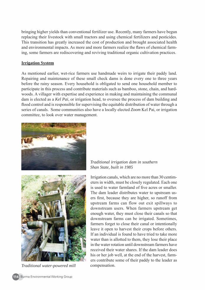
Burma Environmental Working Group114
bringing higher yields than conventional fertilizer use. Recently, many farmers have begun replacing their livestock with small tractors and using chemical fertilizers and pesticides. This transition has greatly increased the cost of production and brought associated health and environmental impacts. As more and more farmers realize the fl aws of chemical farm-ing, some farmers are rediscovering and reviving traditional organic cultivation practices.
Irrigation System
As mentioned earlier, wet-rice farmers use handmade weirs to irrigate their paddy land. Repairing and maintenance of these small check dams is done every one to three years before the rainy season. Every household is obligated to send one household member to participate in this process and contribute materials such as bamboo, stone, chain, and hard-woods. A villager with expertise and experience in making and maintaining the communal dam is elected as a Kel Pai, or irrigation head, to oversee the process of dam building and fl ood control and is responsible for supervising the equitable distribution of water through a series of canals. Some communities also have a locally elected Zoom Kel Pai, or irrigation committee, to look over water management.
Traditional irrigation dam in southern Shan State, built in 1985
Traditional water-powered mill
Irrigation canals, which are no more than 30 centim-eters in width, must be closely regulated. Each one is used to water farmland of fi ve acres or smaller. The dam leader distributes water to upstream us-ers fi rst, because they are higher, so runoff from upstream farms can flow out exit spillways to downstream users. When farmers upstream get enough water, they must close their canals so that downstream farms can be irrigated. Sometimes, farmers forget to close their canal or intentionally leave it open to harvest their crops before others. If an individual is found to have tried to take more water than is allotted to them, they lose their place in the water rotation until downstream farmers have received their water shares. If the dam leader does his or her job well, at the end of the harvest, farm-ers contribute some of their paddy to the leader as compensation.
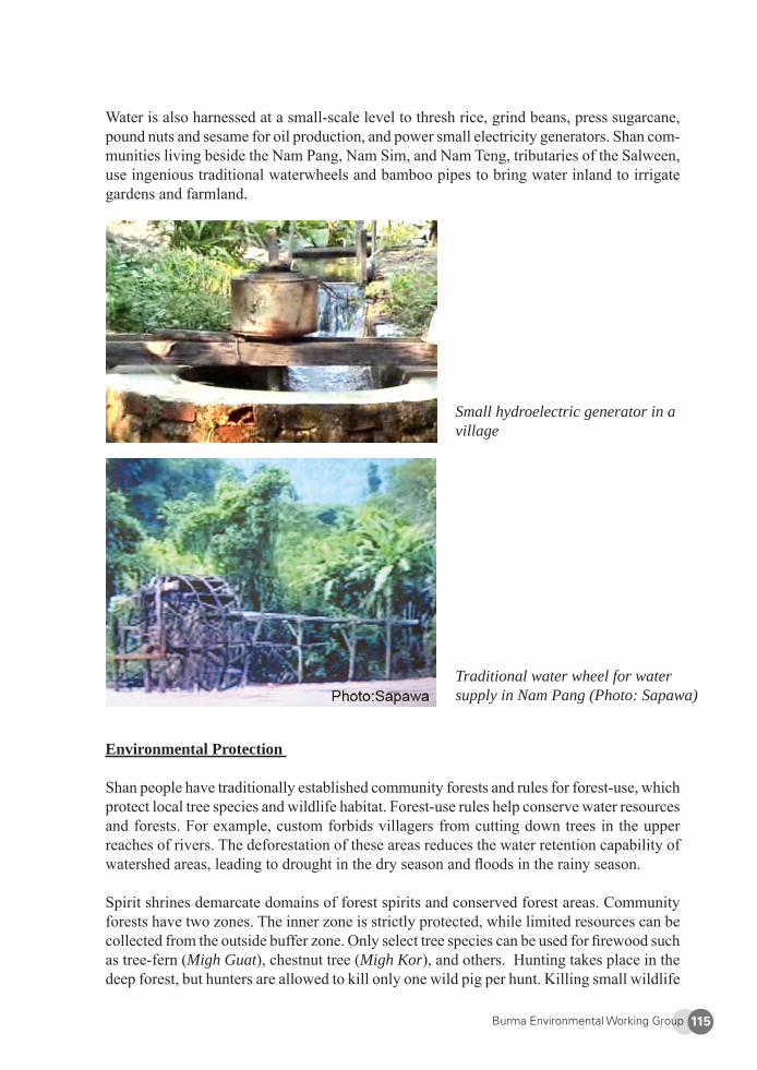
Burma Environmental Working Group 115
Water is also harnessed at a small-scale level to thresh rice, grind beans, press sugarcane, pound nuts and sesame for oil production, and power small electricity generators. Shan com-munities living beside the Nam Pang, Nam Sim, and Nam Teng, tributaries of the Salween, use ingenious traditional waterwheels and bamboo pipes to bring water inland to irrigate gardens and farmland.
Small hydroelectric generator in a village
Traditional water wheel for water supply in Nam Pang (Photo: Sapawa)
Environmental Protection
Shan people have traditionally established community forests and rules for forest-use, which protect local tree species and wildlife habitat. Forest-use rules help conserve water resources and forests. For example, custom forbids villagers from cutting down trees in the upper reaches of rivers. The deforestation of these areas reduces the water retention capability of watershed areas, leading to drought in the dry season and fl oods in the rainy season.
Spirit shrines demarcate domains of forest spirits and conserved forest areas. Community forests have two zones. The inner zone is strictly protected, while limited resources can be collected from the outside buffer zone. Only select tree species can be used for fi rewood such as tree-fern (Migh Guat), chestnut tree (Migh Kor), and others. Hunting takes place in the deep forest, but hunters are allowed to kill only one wild pig per hunt. Killing small wildlife
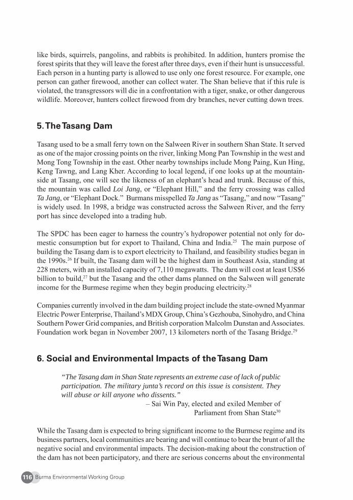
Burma Environmental Working Group116
like birds, squirrels, pangolins, and rabbits is prohibited. In addition, hunters promise the forest spirits that they will leave the forest after three days, even if their hunt is unsuccessful. Each person in a hunting party is allowed to use only one forest resource. For example, one person can gather fi rewood, another can collect water. The Shan believe that if this rule is violated, the transgressors will die in a confrontation with a tiger, snake, or other dangerous wildlife. Moreover, hunters collect fi rewood from dry branches, never cutting down trees.
5. The Tasang Dam
Tasang used to be a small ferry town on the Salween River in southern Shan State. It served as one of the major crossing points on the river, linking Mong Pan Township in the west and Mong Tong Township in the east. Other nearby townships include Mong Paing, Kun Hing, Keng Tawng, and Lang Kher. According to local legend, if one looks up at the mountain-side at Tasang, one will see the likeness of an elephant’s head and trunk. Because of this, the mountain was called Loi Jang, or “Elephant Hill,” and the ferry crossing was called Ta Jang, or “Elephant Dock.” Burmans misspelled Ta Jang as “Tasang,” and now “Tasang” is widely used. In 1998, a bridge was constructed across the Salween River, and the ferry port has since developed into a trading hub.
The SPDC has been eager to harness the country’s hydropower potential not only for do-mestic consumption but for export to Thailand, China and India.25 The main purpose of building the Tasang dam is to export electricity to Thailand, and feasibility studies began in the 1990s.26 If built, the Tasang dam will be the highest dam in Southeast Asia, standing at 228 meters, with an installed capacity of 7,110 megawatts. The dam will cost at least US$6 billion to build,27 but the Tasang and the other dams planned on the Salween will generate income for the Burmese regime when they begin producing electricity.28
Companies currently involved in the dam building project include the state-owned Myanmar Electric Power Enterprise, Thailand’s MDX Group, China’s Gezhouba, Sinohydro, and China Southern Power Grid companies, and British corporation Malcolm Dunstan and Associates. Foundation work began in November 2007, 13 kilometers north of the Tasang Bridge.29
6. Social and Environmental Impacts of the Tasang Dam
“The Tasang dam in Shan State represents an extreme case of lack of public participation. The military junta’s record on this issue is consistent. They will abuse or kill anyone who dissents.”
– Sai Win Pay, elected and exiled Member of Parliament from Shan State30
While the Tasang dam is expected to bring signifi cant income to the Burmese regime and its business partners, local communities are bearing and will continue to bear the brunt of all the negative social and environmental impacts. The decision-making about the construction of the dam has not been participatory, and there are serious concerns about the environmental
Burma Environmental Working Group 117
and cultural destruction the dam will cause. In addition, large-scale development projects in confl ict areas in Burma often lead to systematic human rights abuses by the army troops that are sent in to “provide security” for the project.31 Finally, there is no plan for resettle-ment or compensation for affected villagers.32
No Opportunities for Participation in Decision-Making
Like the other dams planned on the Salween River, decision-making regarding the Tasang dam has been shrouded in secrecy. Many environmentalists are questioning the need for the dam in the fi rst place, as Thailand consistently over-estimates its energy demands and is currently experiencing an energy “glut.”33 But there has been little effort to inform or consult the public about the dam itself, construction plans, or its impacts. An estimated 5,000 villagers live in the projected fl ood zone but they have not been informed or consulted about the dam plans or the likely impacts of dam construction and operation. Neither the Burmese military regime nor the Thai government has publicly released environmental impact assessment reports.34
Since 2006, MDX has been carrying out limited public relation activities to garner support, providing free medical and dental services in villages in Mong Ton Township. Other than this, there is no mechanism for dispute resolution or for villagers to voice their concerns. As most of the energy generated is slated for export to Thailand, local communities will virtu-ally gain nothing while facing negative environmental destruction and shattered livelihoods. Opposition to the dam plans cannot be openly expressed in Burma. At a meeting in 1999, however, representatives of several political parties that contested in the 1990 election and Shan ceasefi re groups unanimously agreed to oppose the building of the Tasang and other dams on the Salween in Shan State.35
Destruction of the Environment and Ways of Life
“If the dam is constructed blocking the river, not only will the Salween River stop fl owing, but so will Shan history. Our culture will disappear as our houses, temples, and farms are fl ooded.”
– Shan refugee, 200036
In 2000, the World Commission on Dams found that large dams generally have “extensive impacts on rivers, watersheds[,] and aquatic [areas, which] in many cases, have led to ir-reversible loss of species and ecosystems.”37 If built, the Tasang likely will cause similar impacts as well as destruction of local traditions and ways of life. The dam would fragment the region’s fragile ecosystem, lessen nutrient and water fl ow downstream, and hurt local biodiversity. Likely deforestation would lead to soil erosion and greater fl ood damage. Additional expected impacts are riverbank erosion, fl ooding of fertile agricultural lands, saltwater intrusion at the mouth of the Salween, higher spread of waterborne diseases like malaria, and increased earthquake risk.38 Villagers living downstream of Tasang would also be challenged by altered river fl ows, especially in estuaries. Such changes would disrupt the traditional fi shing and agricultural practices of locals.39
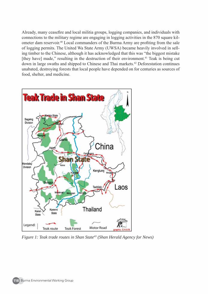
Burma Environmental Working Group118
Already, many ceasefi re and local militia groups, logging companies, and individuals with connections to the military regime are engaging in logging activities in the 870 square kil-ometer dam reservoir.40 Local commanders of the Burma Army are profi ting from the sale of logging permits. The United Wa State Army (UWSA) became heavily involved in sell-ing timber to the Chinese, although it has acknowledged that this was “the biggest mistake [they have] made,” resulting in the destruction of their environment.41 Teak is being cut down in large swaths and shipped to Chinese and Thai markets.42 Deforestation continues unabated, destroying forests that local people have depended on for centuries as sources of food, shelter, and medicine.
Figure 1: Teak trade routes in Shan State43 (Shan Herald Agency for News)
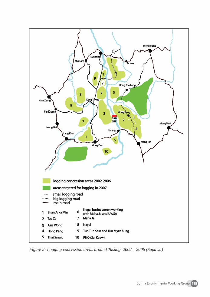
Burma Environmental Working Group 119
Figure 2: Logging concession areas around Tasang, 2002 – 2006 (Sapawa)
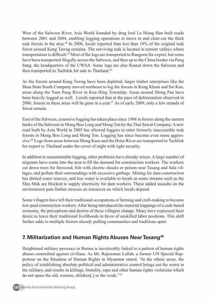
Burma Environmental Working Group120
West of the Salween River, Asia World founded by drug lord Lo Hsing Han built roads between 2001 and 2004, enabling logging operations to move in and clear-cut the thick teak forests in the area.44 In 2006, locals reported than less than 10% of the original teak forest around Keng Tawng remains. The surviving teak is located in remote valleys where transportation is diffi cult.45 Most of the logs are transported to Rangoon for export, but some have been transported illegally across the Salween, and then up to the China border via Pang Sang, the headquarters of the UWSA. Some logs are also fl oated down the Salween and then transported to Tachilek for sale to Thailand.46
As the forests around Keng Tawng have been depleted, larger timber enterprises like the Shan State South Company moved northeast to log the forests in Keng Kham and Sai Kao, areas along the Nam Pang River in Kun Hing Township. Areas around Mong Pan have been heavily logged as well. Locals reported that at the pace of deforestation observed in 2006, forests in these areas will be gone in a year.47 As of early 2009, only a few strands of forest remain.
East of the Salween, extensive logging has taken place since 1988 in forests along the eastern banks of the Salween in Mong Boo Long and Mong Ton by the Thai Sawat Company. A new road built by Asia World in 2005 has allowed loggers to enter formerly inaccessible teak forests in Mong Boo Long and Mong Ton. Logging has since become even more aggres-sive.48 Logs from areas between Mong Karn and the Hsim River are transported to Tachilek for export to Thailand under the cover of night with tight security.
In addition to unsustainable logging, other problems have already arisen. A large number of migrants have come into the area to fi ll the demand for construction workers. The workers cut down trees for fi rewood, fi sh with electric shocks or poison near Tasang and Sala vil-lages, and pollute their surroundings with excessive garbage. Mining for dam construction has dirtied water sources, and less water is available to locals as some streams such as the Mea Mok are blocked to supply electricity for dam workers. These added assaults on the environment puts further stresses on resources on which locals depend.
Some villagers have left their traditional occupations of farming and craft-making to become low-paid construction workers. After being introduced the material trappings of a cash-based economy, the perceptions and desires of these villagers change. Many have expressed their desire to leave their traditional livelihoods in favor of unskilled labor positions. This shift further adds to multiple factors already pulling communities and traditions apart.
7. Militarization and Human Rights Abuses Near Tasang49
Heightened military presence in Burma is inextricably linked to a pattern of human rights abuses committed against civilians. As Mr. Rajsoomer Lallah, a former UN Special Rap-porteur on the Situation of Human Rights in Myanmar stated, “In the ethnic areas, the policy of establishing absolute political and administrative control brings out the worst in the military, and results in killings, brutality, rape and other human rights violations which do not spare the old, women, children[,] or the weak.”50
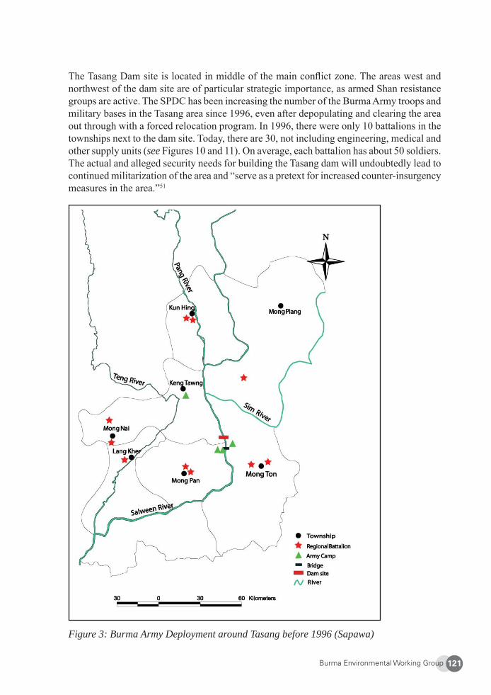
Burma Environmental Working Group 121
The Tasang Dam site is located in middle of the main confl ict zone. The areas west and northwest of the dam site are of particular strategic importance, as armed Shan resistance groups are active. The SPDC has been increasing the number of the Burma Army troops and military bases in the Tasang area since 1996, even after depopulating and clearing the area out through with a forced relocation program. In 1996, there were only 10 battalions in the townships next to the dam site. Today, there are 30, not including engineering, medical and other supply units (see Figures 10 and 11). On average, each battalion has about 50 soldiers. The actual and alleged security needs for building the Tasang dam will undoubtedly lead to continued militarization of the area and “serve as a pretext for increased counter-insurgency measures in the area.”51
Figure 3: Burma Army Deployment around Tasang before 1996 (Sapawa)
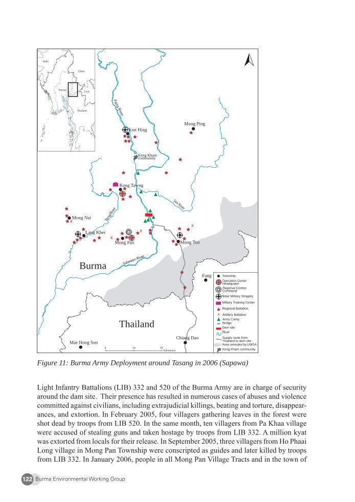
Burma Environmental Working Group122
Figure 11: Burma Army Deployment around Tasang in 2006 (Sapawa)
Light Infantry Battalions (LIB) 332 and 520 of the Burma Army are in charge of security around the dam site. Their presence has resulted in numerous cases of abuses and violence committed against civilians, including extrajudicial killings, beating and torture, disappear-ances, and extortion. In February 2005, four villagers gathering leaves in the forest were shot dead by troops from LIB 520. In the same month, ten villagers from Pa Khaa village were accused of stealing guns and taken hostage by troops from LIB 332. A million kyat was extorted from locals for their release. In September 2005, three villagers from Ho Phaai Long village in Mong Pan Township were conscripted as guides and later killed by troops from LIB 332. In January 2006, people in all Mong Pan Village Tracts and in the town of
Mong Ping
communityKeng Kham
Fang
Mong Pan
Mae Hong Son
Burma
Thailand
Mong Nai
Chiang Dao
Kun Hing
Mong Ton
Township
Regional Control
Base Military Stragety
Military Training Center
Regional Battalion
Artillery BattalionArmy CampBridgeDam siteRiver
Supply route fromThailand to dam siteArea controled by UWSAKeng Kham community
Operation Center
Command
Headquater
Thailand
Laos
China
Burma
India
Keng Tawng
Lang Kher
Kilometers0 30 60
Burma Environmental Working Group 123
Mong Pan itself were forced to grow physic nut/castor-oil plants by LIB 332. A 76 year-old man died while gathering plants.52
From January to November 1997, 319 villagers in Kun Hing Township, located north of the dam site, were killed. This included massacres of 29 villagers at Sai Khao Village and 27 civilians at Tard Pha Ho. On July 9, 2006, SPDC soldiers from LIB 524 interrupted a Buddhist ceremony in Na Khao, accusing village elders of supporting the Shan resistance and arresting and torturing them. On the same day, fi ve women were seized from the village and forced to serve as porters.53 Furthermore, land has been confi scated from villagers to construct military buildings and offi ces of dam builders.54 Throughout 2008, SPDC troops continued to loot and confi scate belongings and property of people who were forcibly re-located or were away from their homes.55
The pervasive use of forced labor by the SPDC in connection with development projects is well documented throughout Burma. Thousands of villagers toiled on the Ye-Tavoy and Loikraw railroads, major dam projects in Pegu Division and Arakan State, the Nam Wok (Mong Kwan) Dam in Shan State,56 and on ancillary infrastructure for the Yadana and Ye-tagun pipelines.57 Forced labor is “imposed on men and women, children and the elderly; it is accompanied by gross human rights violations [including rape, beatings, and killings], work conditions are poor, and compensation rare.”58 Forced labor is so savage and inhu-mane that the International Labour Organization has called on its constituents, including the Thai Government, to refrain from fi nancing projects in Burma that may involve forced labor.59 Keeping consistent with this practice, forced labor is being used in connection with the Tasang Dam.60 Reports of Burmese army troops using forced labor likely will increase as the building of Tasang Dam proceeds.
In addition to these abuses, women are vulnerable to sexual violence. Shan human rights groups documented the rape of about 300 women by Burma Army troops within a 50 kilom-eter radius of the Tasang Dam site between 1996 and 2001. Sexual violence has continued: On May 18, 2006, a group of SPDC soldiers from LIB 246 gang-raped an 18 year-old girl from Pang Nim, Kun Hing Township, while she was tending buffalo.61 In 2008, newly ar-rived IDPs near the Thai-Burmese border reported that Burma Army troops continued to rape Shan women and girls.62
Displacement is ongoing, as people fl ee the horrible living conditions in relocation sites and military abuses in other areas near Tasang. Even more people will fl ock towards Thailand if the dam is built and the reservoir is fi lled with water, although accurate fi gures are impos-sible to obtain given the diffi culties of safely performing fi eld surveys.63 The fi lling up of the dam reservoir also would crush any hope that IDPs and refugees who fl ed to Thailand may have about returning to their homes. But these are not concerns of the SPDC: If the Tasang area is depopulated, fl ooded, and permanently inhabitable, the SPDC may count it as an additional anti-insurgency success.64
Burma Environmental Working Group124
8. Conclusion
Traditional forest and water management techniques have effectively preserved the local environment and provided food security and well-being for Shan traditional fi shing and agrarian communities living along the Salween for hundreds of years. Local resources have been sustainably used to support livelihoods. Extensive customs and beliefs have protected the biodiversity of the forest, and rice cultivation depended on the wise use and equitable sharing of water. Decentralized, small-scale traditional use of water for irrigation, milling, and electricity generation purposes have proven a workable long-term solution to Shan people’s development needs. The Tasang Dam project has taken the exact opposite of this approach. Economic benefi ts accrue to a powerful elite, and locals are left with no means to rectify the various deprivations and injustices that they have faced. Thousands are eking out a meager existence in hiding, devoid of basic services like healthcare, education, and meaningful employment.
In addition to a multitude of environmental impacts, human rights abuses and displacement have forever destroyed the rhythm of traditional Shan livelihoods. The lack of consultation with the customary stewards of the forests and rivers in Shan State and total blatant dis-regard for their well-being is shocking and tragic. Under current SPDC policies that have little consideration for the environment, it is proving extremely diffi cult to safeguard the rich biodiversity in the Salween Basin on which thousands depend for their livelihoods.
9. Recommendations
Respect Local Management Systems: The Burmese Government and industrial companies must recognize the value of traditional water and land management systems. This includes irrigation infrastructure and biodiversity maintenance efforts that have evolved in harmony with local conditions and are more sustainable than large hydropower or irrigation projects in the long term.
Respect Rights to Life, Land, and Livelihood: All authorities must respect local stakehold-ers’ rights to life, land and livelihood. Forced labor, land confi scation without compensation, armed robbery, sexual assault, and other abuses must end.
Prior Informed Consent and Participatory Approach: The government must obtain the prior informed consent of stakeholders prior to project implementation. People must be al-lowed to participate in project planning without fear, threat, or discrimination.
Full and Open EIA Process: A proper Environmental Impact Assessment process under-taken by an independent third party should be conducted with full participation by inter-ested parties to provide project information to the public. The SPDC claims that an EIA has been written for the Tasang dam. If so, it must be released to the public for comment and modifi cation without delay. If no EIA exists, work on the dam must stop and an open EIA process must begin before any more work is started. The EIA needs to consider the social, ecological, hydrological, and geological impacts of the dam, and include mitigation and
Burma Environmental Working Group 125
compensation processes. It must also address the needs of the local communities as well as the maintenance of biodiversity and culture.
Return and Compensation of Displaced Villagers: People forcefully displaced by the SPDC around the dam site and fl ood zone since 1996 must be allowed to return to their lands in peace. They should be compensated for their years of lost income and livelihoods.
No Dams of War: Large dams have signifi cant military, political, and economic implications for local people, and construction of large dams in a war zone is particularly inappropriate. Planning for and construction of the Tasang dam must be suspended until there is a peaceful settlement to the ongoing confl ict.
Effectively Address Earthquake Hazard: There is a severe risk of major earthquakes in the Salween-Nu River basin where 18 colossal dams are planned. Tasang dam is the larg-est of these, so the government must draft and disclose safety measures to reduce the risk of earthquake damage. There must also be an effective warning system for local people in both China and Burma.
About Shan Sapawa Environmental Organization (Sapawa)
Sapawa works along the Thai-Burmese border and inside Burma to promote environmental protection and human rights in Shan State, Burma. Sapawa was established in 2003 by Shan alumni of EarthRights School and the Shan State School for Nationalities Youth who had become increasingly concerned at the environmental situation in Shan State. Sapawa’s vision is a just and peaceful Shan State free of environmental destruction and exploitation. The mission of Sapawa is to empower Shan communities to protect their rights and livelihoods, and preserve their natural resources, and to expose the destruction of the environment and human rights violations occurring in Shan State to local peoples as well as the international community, in order to fi nd ways to prevent such violations. Email: [email protected]
Burma Environmental Working Group126
1 Salween Watch et al., The Salween Under Threat: Damming the Longest Free River in Southeast Asia, 2004, pp.13-14. 2 Ibid. 3 Kwarn Lake, “Chinese Dam Builders set up 60 Pillars for Tasang Dam,” Shan Herald Agency for News, 16 Jan. 2008, at: <http://www.shanland.org/oldversion/index-2024.htm>. Last accessed 31 Jan. 2009. 4 Freedom for Shan State, “Shan State,” at: <http://shanstatenews1.googlepages.com/2006091501>. Last ac-cessed 13 Apr. 2009. 5 Bertil Lintner, Foreword to Inge Sargent, Twilight over Burma: My Life as a Shan Princess, 1994, pp. xv – xvi. See also, Unrepresented Nations and Peoples Organization website, “Shan People,” at: <http://www.unpo.org/content/view/7905/140/>. Last accessed 12 Apr. 2009. 6 UNPO, supra note 5.7 Lintner, supra note 5, p. xvi. 8 Christian Moe, Salween Watch and Norwegian Burma Council, “From Scorched Earth to Flooded Earth: The Generals’ Dam on Burma’s Salween River” (Joint submission to the World Commission on Dams, 31 Mar. 2000, at: <http://www.asiasource.org/asip/salween.cfm>. Last accessed 16 Apr. 2009. [Hereinafter “Moe”]. See also, UNPO, supra note 5.9 Surehope, “About the Shan: Identity,” 2006, at <http://surehope.net/about_the_shan/culture.asp>. Last ac-cessed 12 Apr. 2009. 10 UNPO, supra note 5. See also, Mai Song Kha website, “All About Shan People,” at: <http://www.maisoong-kha.com/allaboutshanpeople.html#>. Last accessed 12 Apr. 2009. 11 Shan Sapawa Environmental Organization, Warning Signs: An Update on Plans to Dam the Salween in Burma’s Shan State, 2006, p.20 [hereinafter “Warning Signs”].12 Jane’s World Insurgency and Terrorism, “Shan State Army- South (SSA-S) (Myanmar),” 27 Mar. 2009, at: <http://www.janes.com/extracts/extract/jwit/jwita040.html>. Last accessed 15 Apr. 2009. See also, Jarmtoon, “Shan State,” 2003, at: <http://jarmtoon.myweb.hinet.net/mainfi le/intro-shan.htm>. Last accessed 15 Apr. 2009. 13 For details about the forced relocation program, see Shan Human Rights Foundation, Dispossessed: A Report on Forced Relocations and Extrajudicial Killings in Shan State, Burma, April 1998. See also Moe. 14 Amnesty International, “Myanmar: Atrocities in Shan State,” 14 Apr. 1998, at: <http://www.amnesty.org/en/library/asset/ASA16/005/1998/en/e22f5c7f-daea-11dd-903e-e1f5d1f8bceb/asa160051998en.html>. Last accessed 15 Apr. 2009. 15 US Department of Labor, “2000 Update on Forced Labor and Forced Relocations,” cited in Moe, supra note 8. 16 Moe. See also, Dispossessed, supra note 13. 17 Moe.18 Ibid. 19 Warning Signs, pp. 20-21. 20 Thailand Burma Border Consortium, International Displacement and International Law in Eastern Burma. Oct. 2008, p. 21. 21 Warning Signs, pp. 24-25. 22 Shan Women’s Action Network (SWAN) website, “About Us: General Background,” at: <http://www.shan-women.org/>. Last accessed 12 Apr. 2009. Thailand does not recognize refugees, and even the camps on the Thai-Burmese border for the Karen and Karenni from Burma are not offi cially refugee camps but “temporary shelters.” 23 Ibid. 24 EarthRights International. “Fatally Flawed: The Tasang Dam on the Salween River,” 2001, at : <http://www.burmainfo.org/eri/FatallyFlawed.pdf>. Last accessed 16 Apr. 2009. [Hereinafter “Fatally Flawed”].25 Yuki Akimoto, “Hydropowering the Regime,” The Irrawaddy, June 2004.26 The Salween Under Threat, supra note 1 at 46.27 Warning Signs, p.5. 28 Fatally Flawed.29 Shan Herald Agency for News, “Chinese dam builds set up 60 Pillars for Tasang Dam,” 27 Jan. 2008, at: <http://shanland.org/index.php?option=com_content&view=article&id=1809:chinese-dam-builders-set-up-60-pillars-for-tasang-dam&catid=90:environment&Itemid=287>. Last accessed 10 Apr. 2009.
Burma Environmental Working Group 127
30 Fatally Flawed.31 Fatally Flawed.32 Moe. 33 Fatally Flawed.34 Denis D. Gray, “Burma Dam Plan Causes Flood of Concern,”10 Jun. 2006, at: <http://www.terraper.org/media_view.php?id=69>. Last accessed 16 Apr. 2009.35 Shan State Organization, “Meeting Position on the Plans by the Burmese Military Regime to build a dam on the Slaween River in Shan State,” 10 Sept. 1999, at: <http://burmalibrary.org/docs/SW04.htm>. Last accessed 16 Apr. 2009. 36 Fatally Flawed.37 Fatally Flawed.38 Moe.39 Burma Rivers Network website, at: < http://www.burmariversnetwork.org/dam-projects/salween-dams/tasang.htm>, last accessed Sept.9, 2009.40 Warning Signs, pp. 17, 24, 25. 41 World Rainforest Movement. “Burma: Forests for Export to China”. World Rainforest Bulletin. No. 82. May 2004. <http://www.wrm.org.uy/bulletin/82/Burma.html>. Last accessed 16 Apr. 2009. 42 Phu Murng, “No More Teak Forest in Shan State,” Shan Herald Agency for News, 7 Mar. 2006, at: <http://www.shanland.org/oldversion/index-2037.htm>. Last accessed 15 Apr. 2009.43 Ibid.44 Clearcutting is a logging practice in which most or all trees in a harvest area are cut down. Many environ-mentalists see it as unnecessary destruction of habitat.45 Warning Signs, pp. 17. 46 Warning Signs, pp. 17. 47 Warning Signs, pp. 18. 48 Warning Signs, pp. 18. 49 See generally, Warning Signs, pp.13-14.50 Interim report on the situation of human rights in Myanmar prepared by the Special Rapporteur of the Com-mission on Human Rights in accordance with Economic and Social Council decision 1999/231 of 27 July 1999, para. 54. Transmitted to the UN General Assembly’s 54th session, 4 October 1999 [A/54/440]. United Nations, Economic and Social Council, Commission on Human Rights: Geneva, 22 January 1999.51 Moe.52 Warning Signs, pp.13-14. 53 Warning Signs, p.14.54 Warning Signs, p.12. See also, Burma Rivers Network, supra note 39.55 Bureau of Democracy, Human Rights, and Labor, U.S. Department of State, 2008 Human Rights Report: Burma, 25 Feb. 2009.56 Fatally Flawed. 57 EarthRights International, Total Denial Continues: Earth Rights Abuses Along the Yadana and Yetagun Pipelines in Burma, 2000, pp.23-37.58 Moe.59 Fatally Flawed.60 Sapawa Interview, June 24, 2009.61 Warning Signs, p.14. 62 2008 Human Rights Report, supra note 55. 63 Moe.64 Moe.
Burma Environmental Working Group128
Building up of the Narco-State and Reef Blasting:
Failed State-Sponsored Development Projects and their Impacts on the Lahu People
Lahu National Development Organization (LNDO)
1. The Mekong River and the Lahu People
The Mekong River fl ows between Burma’s Shan State and Laos. On both sides of this stretch of the Mekong are Lahu, Akha, Shan, En, Palaung, Sam Tao, Chinese, and other ethnic groups.1 On the Burma side, ethnic Shan make up about 40% of the population, while Lahu comprise 30%, followed by Akha at 15%, En with 5%, and Palaung 3%. The majority of these riparian communities practice shifting cultivation, and some are fi sherfolk. Those who live on the banks of the Mekong grow beans, chili, tobacco, and other vegetables on the riverside when the water level is low. Villagers have few educational opportunities and are extremely destitute, with most of them owning only one change of clothes.
The Mekong River has a special signifi cance for the Lahu, who, according to legend, came from the Mekong’s source. According to legend, once upon a time the Lahu lived in an area with poor soil, so they took up hunting. One day, hunters noticed a vine on the horn of a deer. When the vine fell to the ground, they examined it and noticed that it was much longer and healthier than the vines in their area. They followed the deer’s tracks to fi nd where the vine grew, which led them to the Mekong. They trailed it downstream and found fertile subtropical soil suitable for agriculture. Traditional Lahu songs and proverbs are fi lled with references to the river. For example, true love is described as stretching from the source of the Mekong to the sea, and the beauty of a woman is likened to the glittering scales of a fi sh in the Mekong.
The Lahu originally came from the Tibetan plateau, and migrated down the Mekong River to Southeast Asia over the past two hundred years. The Lahu have a population of about 600,000, with an estimated 150,000 living in eastern Shan State where they now grow wet and dry rice, maize, tea, buckwheat, tobacco, and hemp. Today, the Lahu are mainly subsist-ence farmers, and their daily life and rituals revolve around the agricultural seasons. Besides farming and hunting, the Lahu are also adept at fabric and basket weaving, blacksmithing, and embroidery.2
The area is unstable with sporadic fi ghting between the Burmese military regime (State Peace and Development Council, or SPDC) and Shan State Army-South (SSA-S), as well as clashes between the SSA-S and the United Wa State Army (UWSA).3 These and various other armed groups and their political wings continue to grapple for territory and
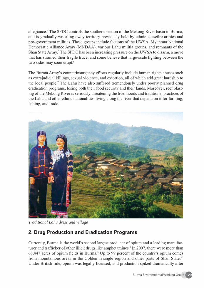
Burma Environmental Working Group 129
allegiance.4 The SPDC controls the southern section of the Mekong River basin in Burma, and is gradually wrestling away territory previously held by ethnic ceasefi re armies and pro-government militias. These groups include factions of the UWSA, Myanmar National Democratic Alliance Army (MNDAA), various Lahu militia groups, and remnants of the Shan State Army.5 The SPDC has been increasing pressure on the UWSA to disarm, a move that has strained their fragile truce, and some believe that large-scale fi ghting between the two sides may soon erupt.6
The Burma Army’s counterinsurgency efforts regularly include human rights abuses such as extrajudicial killings, sexual violence, and extortion, all of which add great hardship to the local people.7 The Lahu have also suffered tremendously under poorly planned drug eradication programs, losing both their food security and their lands. Moreover, reef blast-ing of the Mekong River is seriously threatening the livelihoods and traditional practices of the Lahu and other ethnic nationalities living along the river that depend on it for farming, fi shing, and trade.
Traditional Lahu dress and village
2. Drug Production and Eradication Programs
Currently, Burma is the world’s second largest producer of opium and a leading manufac-turer and traffi cker of other illicit drugs like amphetamines.8 In 2007, there were more than 68,447 acres of opium fi elds in Burma.9 Up to 99 percent of the country’s opium comes from mountainous areas in the Golden Triangle region and other parts of Shan State.10 Under British rule, opium was legally licensed, and production spiked dramatically after
Burma Environmental Working Group130
defeated Kuomingtang troops from Communist-ruled China fl ed to Shan State in 1950. Since the arrival of the Kuomintang, opium production in Shan State has boomed and has been responsible for much of the oppression, ethnic confl ict, and poverty in the area.11
Most farmers who grow opium do so because they are poor. Poppy is a local cash crop used to buy food, clothing, and medicine, and opium sales account for almost a third of poppy growers’ income.12 Customarily, many families grow poppies on plots approximately four acres in size. While intended as a cash crop, some locals use opium as a painkiller and antidepressant because of the lack healthcare facilities.
In 1975, Burma’s military government launched its “Four Cuts” campaign to cut off insur-gent groups from food, funds, intelligence and recruits. For people living in eastern Burma, this campaign meant forced relocation of villages, restriction of movement, destruction of houses, land, crops, food stores and other property, torture and killing of villagers suspected of helping resistance groups.13 The “Four Cuts” policy destabilized traditional rice-based livelihoods and local subsistence economies and is partly responsible for forcing farmers to turn to poppy cultivation for a means of survival.
Another factor driving opium production is the SPDC’s self-suffi ciency directive, which requires all Burmese military fi eld units to be responsible for their own supplies and funds. Encouraging locals to grow opium and extracting taxes from them is a popular survival strategy for Burmese troops throughout Shan State.14 Ceasefi re groups such as the United Wa State Army and insurgent militias such as the Shan State Army-South (SSA-S) also depend on the opium trade and drug taxes to fund their arms, ammunition, food, and uniforms.15
Nominal Eradication Efforts
The SPDC maintains that its goal is to make Burma drug-free by 2014, a year earlier than ASEAN’s self-imposed deadline. Despite its promises, eradication efforts seem to have had little effect. Poppy cultivation in Burma decreased more than 80 percent from 1998 to 2006, in 2007, but overall production of opium expanded by 29 percent, with increased acreage in northern, eastern, and southern Shan State under poppy cultivation.16 Potential production of the drug rose by 46 percent.17 Each year LNDO surveys poppy farms in seven townships in eastern Shan State (Kengtung, Mong Ping, Mong Hsat, Mong Ton, Mong Phyak, Tachilek, and Mong Yawng). During the 2007-2008 season, fi eld researchers noted more poppy farms than in recent years. Good harvests were found in every location.
The swell in opium cultivation and production is largely attributed to poverty, corruption, and lack of state control.18 Corrupt offi cials, along with ceasefi re groups and insurgent mi-litias, are involved in virtually every step of the drug cultivation, production, and traffi ck-ing process. The Burmese military’s role in these activities sustains and preserves the drug trade in eastern Shan State.19 Credible reports have revealed that drug production not only benefi ts local commanders and army and police personnel, but also many of the SPDC’s top generals as well.20 Offi cials gain from the drug trade by extorting arbitrary taxes from opium growers to supplement their low paychecks. They also arrange for their contacts to
Burma Environmental Working Group 131
buy opium from villagers and receive additional revenue from the processing and selling of the drugs.21 Villagers are made to sell their whole poppy harvests to military contacts.22
Such rampant collusion calls into question the government’s sincerity in counter-narcotic efforts.23 In eastern Shan State, the SPDC has staged drug burning ceremonies and destruc-tion of poppy fi elds only in selective locations and never in areas under control of its allies. LNDO found that in 2003, offi cials who ordered villagers to stop cultivating poppies under penalty of death later demanded opium taxes from the very same communities.24
International support to fi ght drug traffi cking is dismally small. In 2003, eradication efforts by the UN Offi ce of Drugs and Crime (UNODC) met only two percent of the needs of drug-affected communities in Burma.25 Some ceasefi re armies have made their own efforts to stop overt poppy growing in parts of their territories over the past few years, particularly areas slated for international development aid, but this appears to have been compensated for by increased opium production in other regions.26
Why No Progress?
The ruling military clique has been relying on drug money to run businesses and stay in power. While the junta claims success in eradicating opium in order to receive international assistance, at the same time infamous drug kingpins such as Lo Hsing-han, Lin Ming Xian, and Wei Hsaio-kang are living luxuriously under full protection by the junta.
Banks that were established by drug warlords with drug money are used to fi nance road construction and other infrastructure projects of the military elite and their associates. Drug lord Wei Hsueh-kang and his comrades control the Hong Pan group of companies, which are involved in jewelry and gems, communications, electrical goods, agriculture, mining, textiles, and large construction projects.
News of drug seizures is often printed in Burmese newspapers, but the sum of these busts is a small percentage compared to the magnitude of drugs handled by the junta’s accomplices. Arrests are simply the result of disputes in sharing benefi ts with authorities, and those with high-ranking connec-tions inevitably avoid prosecution. In May 2008 Aung Zaw Ye Myint, son of SPDC Lieutenant General Ye Myint, was accused of drug dealing, and both he and his father were put under house arrest. The General’s wife then threatened that if her son and husband were prosecuted, she would reveal the names of other generals involved in drug dealing. Since then the case has not proceeded.
Burma Environmental Working Group132
Production Quotas
The imposition of production quotas and taxes forces villagers to continue growing opium to meet the demands of the SPDC and armed groups. In 2003, villagers were taxed 5,000 kyat for each acre under opium cultivation and were made to sell a minimum of two viss27
(about 3.2 kilograms or 7.26 pounds) of opium per acre to military contacts at below-market prices. Sometimes, a percentage of the harvest is demanded as well. In 2002, villagers in Mongpulong who refused to grow poppy were fi ned 5,000 kyat.28 In Laikha, for example, farmers whose fi elds did not produce the required two viss of opium per acre had to either buy opium from elsewhere to fi ll the quota or else pay 240,000 kyat —the buying price for two viss of opium—to the offi cials’ buying agent.
In the 2007-2008 season, each house in LNDO survey townships had to pay two tical29 (about 0.033 kilograms or 0.072 pounds) of opium to the local authority. Depending on the area, this could be a militia chief, a village headman, or a middleman, all of whom then pass the tax onto a local Burma Army battalion or township authority.30 In January 2009 it was reported that Burma Army patrols have been taxing villages in Mong Keung and Laikha Townships 200,000 kyats each.31 “We have no choice but to grow opium to survive,” said one villager from Mann Koe Township. “We can never pay our taxes by growing rice, only by cultivating poppy.”32
Communities who cannot pay opium taxes to the Burma Army are subject to livestock confi scations and forced labor on infrastructure projects. Groups like the United Wa State Army also extort opium tax. One interviewee said that villagers in Wa-controlled areas have to give 20 ticals of opium per year regardless if they grow opium or not, and may have to give more to the UWSA if their plots are larger.33
Opium sells from 15,000 to 45,000 Thai Baht per viss depending on quality, age, and distance from opium processing plants, but farmers remain poor as they have to pay opium taxes to as many as four different armed groups. Such heavy extortion has put incredible burdens on farmers in Shan State, who make on average only 700-800 kyat a day (approximately US $0.40-0.60).34 High production quotas put villagers at the mercy of weather and other natural variations. In addition, as they are locked in a system of growing poppy and paying taxes, communities are not self-suffi cient in producing rice, and must pay for this high-priced commodity. The food security and fi nancial situation of local families are worsened when SPDC troops take rice from locals by force or buy it from them at severely defl ated prices. Many families have fl ed Shan State to escape extortion, confi scation of property, and other drug-related abuses.
Forced Relocation of the Wa
The SPDC’s counter narcotic strategies include forcible crop substitution programs and mass relocations, which have had little effect in reducing drug production. These measures have uprooted communities and destroyed livelihoods, pushing them deeper into debt. Hundreds of thousands of ethnic nationalities in the region have been displaced and forcibly relocated by state-sponsored drug eradication programs.
Burma Environmental Working Group 133
From 1999 to 2001, the SPDC ordered the United Wa State Party, the political wing of the United Wa State Army (recognized by the U.S. government as a narcotic-traffi cking organiza-tion) to forcibly relocate approximately 126,000 ethnic Wa from northern Shan State more than 250 miles to the south. The Wa are believed to be the original residents of Shan state. They grow hill rice, which usually feeds families for up to half of the year. The rest of the year, Wa villagers rely mostly on proceeds from opium crops to buy rice.35
Both the SPDC and the UWSP stated that the massive Wa resettlement program was de-signed to help villagers grow alternative crops in the more fertile lands of southern Shan State and to make the Wa region drug-free by 2005.36 But some believe that the SPDC’s real intentions in forcing this massive population transfer were to disrupt ethnic insurgent dynamics in southern Shan State, build a local support base for the UWSA, which at that time had friendly relations with the SPDC, and erode general anti-government resistance by intensifying ethnic tension in the region. All are part of the SPDC’s classic divide-and-conquer strategy.37
Close to 300 villages in Ho Pang, Mong Mai, Man Hpang, Nahparn, Pang Yang, and Pang Wai townships in the northern Wa area were selected for whole or partial resettlement, as were some Wa communities inside China’s Yunnan Province.38 Some villages were strate-gically chosen for resettlement to make way for extraction of natural resources there. For example, Yawng Parit and Aik Soi villagers were evicted by local Wa leaders and Chinese business persons who wanted to mine the area’s rich silver deposits.39 Some did not receive any forewarning, and all were forced to abandon their possessions without any compensa-tion. Communities had to sever their ties with their ancestral lands, and during the exodus, many family members were separated, as some were left behind. The majority of resettled Wa were moved in trucks, but many were forced to travel on foot for over two months, with some dying on the arduous mountain journey.40 Later reports stated that families from China were moving into the vacated villages.41
Resettled Wa occupied land around existing villages in Mong Hsat, Mong Ton, and Tachilek Townships. Each family was given rice and some monetary support by the UWSP, but un-accustomed to the new surroundings and warmer climate in low-lying valley areas, many fell ill. In 2000 alone, it is estimated than over 10,000 resettled Wa died from malaria and other diseases.42 Social services were lacking, as schools and hospital facilities were woe-fully inadequate to meet the needs of locals.43 Resettled communities also have suffered numerous human rights abuses.
In addition, this infl ux has displaced native residents and forced other problems onto the villagers already living in those areas.44 The arrival of the Wa greatly intensifi ed popula-tion pressures on the environment and seriously disrupted the livelihood and food security of more than 48,000 Shan, Lahu, Akha, and other ethnic and indigenous villagers already living in southern Shan State. Newcomers stole locals’ fruits, vegetables, and livestock. In addition, the SPDC confi scated the property of the original inhabitants and pushed them off their lands to accommodate Wa leaders. One villager commented that “land which Shan, Lahu, Akha and Palaung had been cultivating for generations [to grow] rice, oranges, tea,
Burma Environmental Working Group134
garlic, chillies [sic], [and] sugar cane [were taken by the SPDC and the Wa]. The forests, wildlife area, spirit houses […] nothing was spared.”45
Local SPDC and Wa offi cials are reluctant to enforce a sincere drug ban because of lucrative opium taxes and profi ts from drug traffi cking. With the arrival of the Wa, local communities were further oppressed, as they had to pay taxes to yet another group, the UWSA. Local vil-lagers had to pay 250 Thai baht and 10 ticals (0.16 kilograms) of rice a year to the UWSA. This was on top of the rice already taken by the SPDC. Previously, Wa settlers have had to give 10 ticals of opium, two tins of rice, and 200 baht a year to the USWA. People who complained were made to perform forced labor for the UWSA. In addition, resettled Wa are also becoming involved in the growing amphetamine trade as well. Many are lured by the high wages of couriering drugs into Thailand, and in the process, become addicted as well. 46
The inundation of resettled Wa in southern Shan State has put enormous pressure on limited lands and natural resources and crowded out many local communities. Increasing extortion and human rights abuses have sparked the exodus of the area’s original inhabitants. One Lahu villager said, “When I left the village I couldn’t take anything with me, except for a few blankets. The Wa wouldn’t let me take anything else. By the time I left there were no Lahu left in our village at all. Everyone else had run away, and the Wa had moved into their old houses. Everyone scattered in different directions.” 47 LNDO found that at least 4,500 of the original residents of southern Shan State have moved to other areas of Burma. Another 4,000 have fl ed to Thailand, where the majority of illegal migrants from Shan State are constantly harassed by immigration offi cials and relegated to low-paying dirty, dangerous, and diffi cult work.48
Instead of providing alternative vocational training, drug prevention programs, and educa-tion to resettled communities, the SPDC and UWSP continue to perpetuate the drug trade by encouraging the Wa to plant new poppy fi elds. With the relocation of the Wa, opium cultiva-tion has also shifted from traditional poppy growing areas in the Wa and Kokang regions in northern Shan State to southern Shan State, where farmers have started growing multiple poppy crops a year.49 The UWSA told villagers that they could continue to grow opium for three years, while the SPDC told them they could plant opium out of view. Because of this explicit and implicit support, new Wa settlers planted large tracts of opium and were allowed to freely sell it. Local Lahu, Akha, and Shan villagers, on the other hand, are allowed to sell their opium only to the Wa army.50 Ethnic tensions have heightened, as SPDC offi cials have clearly given preferential treatment to the support base of their ceasefi re partner, the UWSA. While the SPDC has successfully put an end to military confl ict with the Wa and assuaged Wa leaders—at least for the time being—this has happened at the expense of marginalizing other ethnic nationalities in Shan State.
Forced Relocation of Other Ethnic Groups
In 2002, the order to relocate highland communities in southern Shan State was issued, ostensibly to curb local production of opium. LNDO suspects that the real motive behind such relocations is to wrestle territory away from SSA-S control. Many villagers did not voluntarily move at fi rst, and were expelled only when SPDC troops came into their area.
Burma Environmental Working Group 135
Military presence is often temporary and based on rotational deployment, so displacement also followed this cycle. Villagers were typically given three days to move under penalty of torture and physical punishment. They could not take all their possessions or livestock, and sometimes they returned to collect the rest of their belongings and animals, only to fi nd them taken or eaten by the SPDC.
In 2002, 80 Palaung were pushed from Mong Tha Lung to Mong Phoon. Thirty villagers were displaced from same community in 2004, and 50 more in 2006. Sometimes, villagers secretly returned to their former homes, just to be displaced by new military movements again.
In 2006, 200 villagers of a small Lahu subgroup found only in eastern Shan State were forced from their homes north of Tachilek to move to Mong Hai Valley by the SPDC fi eld commander in Tachilek. A quarter of them died from malaria, prompting a large portion of them to move again. Some clandestinely moved back. Of the survivors, only 30 remain in Mong Hai. Ironically, many Wa relocation areas are even more suitable to grow poppy than regions where locals previously occupied.51
Crop Substitution Programs
The SPDC has implemented various crop substitution programs, some with foreign assist-ance. Many of them have had disastrous results for local livelihoods and the environment. In 2002, the SPDC’s Northeastern Command began its 15-year “New Destiny” anti-narcotic crop substitution campaign in Shan, Kachin, Karenni, and Chin States. Under this program, farmers were encouraged to trade their poppies for seeds of substitution crops such as rice, which was the largest component, wheat, maize, sunfl ower, oranges, tea, and corn.52 Chinese Hsin shweli (sometimes spelled Sinn shweli) rice strains were forcibly introduced even though it was not suited for farming conditions in Shan State, resulting in years of poor harvests.53
Customarily, farmers in Shan State cultivate only one rice crop a year during the rainy sea-son. The rest of the year, farmers grow crops like chili, onion, soybean, and garlic, which form a central part in their traditional diet and can also be sold for income. Under the New Destiny project, however, farmers are ordered to plant two rice crops a year. Many farmers lost the dry season crops under the project, and some lost their monsoon harvests as well.54 In 2002, authorities in Muse ordered that 200 acres of paddy in Muse be planted with the hsin shweli in the dry season. As hsin shweli is suited for planting in the rainy season, the rice seedlings died, and locals lost the whole crop.
By local decree, fi xed areas of rice fi elds were reserved for the double-cropping of hsin shweli rice. Offi cial Agriculture Ministry statistics indicate that in 2007, more than 40 percent of the rice grown in northern Shan State was hsin shweli. It is grown in Kokang, Lashio, Hsenwi, Kyaukme, Muse, and Hsipaw Townships, and in the UWSA’s Special Region No. 2. Farmers are usually forced to pay for these seeds, and while Burma’s Agriculture Bank gives farmers 17,300 kyat per hectare per year to grow the hybrid rice, the actual annual cost per hectare is between 543,000 and 736,000 kyat, including all inputs. Also, farmers are sold genetically modifi ed terminator seeds which do not provide viable offspring, so locals must buy new seeds every year, adding additional fi nancial burdens.55
Burma Environmental Working Group136
While the hybrid rice can have 15 to 20 percent greater yields than traditional rice varieties, this can be achieved only through higher water consumption and heavy use of expensive and harmful chemical fertilizers and pesticides. All across Shan State, villagers are being forced to buy unsuitable seeds, fertilizers, and other equipment like tractors, furthering their plunge into hunger, debt, and poverty.56 Farmers unable to pay their debts for seeds and other inputs must sell their lands to the very ones who sold them the fertilizers and pesticides. There have reportedly been no government efforts to train farmers how to grow the new rice, and the instructions for fertilizers and pesticides are in Chinese, unreadable by most villagers in Shan State. Farmers are only told to spray six kinds of pesticides six times within 120 days. Without proper instructions and precautions, farmers have fallen ill and a few have died after improperly using the chemicals.57 In the end, the rice is not produced for local food security, but sold en masse to China.58 While farmers are being displaced from their lands and forced deeper into poverty, SPDC, Chinese businesses people, and ceasefi re and militia groups are profi ting from the buying and selling of seeds, fertilizers, pesticides, and rice.59
Since farmers are unable to earn enough from these crop substitution programs to buy rice and other foodstuffs for themselves, the UN World Food Program has been distributing rice to farmers in northern Shan State since 2004. “The SPDC says it is [promoting] poppy substitution…for self-suffi ciency,” states independent Burmese researcher Hkun Seng, “but the local people’s lives are not improving and many survive day by day.”60
An effort by the Japan International Cooperation Agency to help villagers switch to growing buckwheat for Japanese consumers has largely failed due to a local militia’s misappropria-tion of seeds, trucks, and other equipment, low yields, and the inability of farmers to trans-port crops in a timely manner before they rotted.61 Some farmers have reported that SPDC soldiers have encouraged them to replace their rice crops with opium. They are told that if farmers grow rice, it needs to be milled and some of it will be expropriated by insurgent groups. Villagers are told to grow opium so that the military’s agents can buy it. With the money earned, communities can then buy rice.62
Social and Health Problems
As the military government continues to benefi t from the drug trade, it has not made any serious effort to deal with increased poverty, migration, and other social and health impacts drugs have infl icted on local populations. Further, there has been a dangerous shift away from local traditional practices of smoking opium to injecting heroin, a practice that is more addictive and poses greater health risks like HIV/AIDS, especially in Upper Burma.63 64 Amphetamines also have replaced opium as a drug of choice. In addition to being forced to produce drugs, locals also suffer the devastating effects of opium and amphetamine use and addiction. LNDO found in 2003 that along the southern section of the Mekong in Burma, more than half of villagers—including children—are addicted to drugs, mainly amphetamines.65 The SPDC has not implemented any public health awareness and education campaigns against drug abuse, a failure contributing to heightened drug addiction amongst locals, and the absence of formal state-sponsored drug treatment centers has pushed many communities to establish their own.66
Burma Environmental Working Group 137
3. The Upper Mekong Navigation Improvement Project
“Development projects along the Mekong River are not for the benefi t of the local people here. They only take place so that big cities become richer and richer. We are falling deeper and deeper into poverty. The old customs and heritage that have belonged to us for centuries are disappearing as well.”
- Lahu Elder, Keng Larb, eastern Shan State
To boost regional trade, an ongoing project meant to improve navigation on the Mekong River broke ground in 2002. It is rife with controversy, however: benefi ts are inequitably distributed amongst stakeholders, and local villagers are bearing a disproportionate share of the negative environmental and social impacts from the project. Further environmental damage has occurred as a direct result of other development projects undertaken by the Burma Army, ceasefi re groups, and business elites.
In March 2002, Chinese demolition crews began blasting rapids and reefs along a 234-kil-ometer segment of the Mekong which lies between Guan Lei Port, China, and the Golden Triangle, the area where Burma, Laos, and Thailand converge. Along this stretch, the Me-kong varies in depth, width, and fl ow, from a slow meandering water body to a quick and dangerous current fi lled with rocks, rapids, shoals, and whirlpools. Year-round navigation along this section of the Mekong is possible only for vessels of 60 tons or less. By destroying major rapids and reefs, the project seeks to facilitate increased regional trade by enabling larger shipping vessels up to 500 tons to travel year-round from China’s Yunnan Province to Luang Prabang in Laos.
The blasting was part of the Upper Mekong Navigation Improvement Project, a component of the Greater Mekong Subregion (GMS) Economic Cooperation Program.67 Plans for the Navigation Improvement Project were conceived in the early 1990s and fi nalized and ap-proved by the Burmese, Chinese, Laotian, and Thai governments in early 2002. The project is divided into three phases68 The fi rst phase, which ran from March 2002 to April 2003, sought to remove 11 major rapids and 10 scattered reefs, mostly along the Burmese-Lao stretch of the river, to enable vessels of 100-150 tons to navigate the river for at least 95% of the year. Under the second phase, 51 rapids and shoals on the Burmese-Lao border and one reef on the Thai-Lao stretch of the river were slated to be blasted to allow vessels 300 tons or larger to navigate the river for 95% of the year. For the last phase, the waterway is to be channelized, making it navigable for vessels of 500 tons for at least 95% of the year.
It is unclear to what extent rapids have actually been destroyed, given problems with initial phases of the blasting and lack of public disclosure. Blasting was put on hold in June 2007, and Phase 2 is not completed. Because of closed-door and nontransparent decision-making, it is impossible to know for certain what led to the project’s suspension, but plausible ex-planations include disagreements between Chinese engineers and the Laotian Government concerning widening certain parts of the Mekong, problems related to ADB funding, and failure to pay demolition workers’ wages.
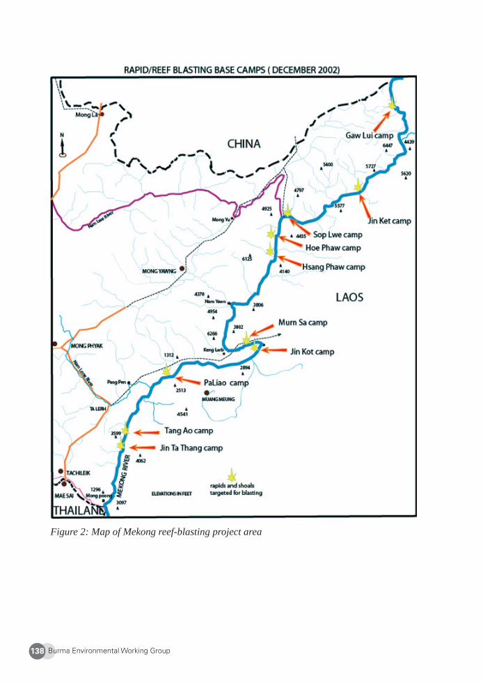
Burma Environmental Working Group138
Figure 2: Map of Mekong reef-blasting project area
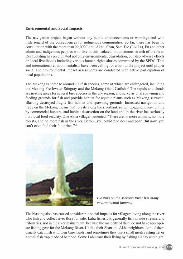
Burma Environmental Working Group 139
Environmental and Social Impacts
The navigation project began without any public announcements or warnings and with little regard of the consequences for indigenous communities. So far, there has been no consultation with the more than 22,000 Lahu, Akha, Shan, Sam Tao (Loi La), En and other ethnic and indigenous peoples who live in this isolated, mountainous stretch of the river. Reef blasting has precipitated not only environmental degradation, but also adverse effects on local livelihoods including various human rights abuses committed by the SPDC. Thai and international environmentalists have been calling for a halt to the project until proper social and environmental impact assessments are conducted with active participation of local populations.
The Mekong is home to around 200 fi sh species, some of which are endangered, including the Mekong Freshwater Stingray and the Mekong Giant Catfi sh.69 The rapids and shoals are nesting areas for several bird species in the dry season, and serve as vital spawning and feeding grounds for fi sh and provide habitat for aquatic plants such as Mekong seaweed. Blasting destroyed fragile fi sh habitat and spawning grounds. Increased navigation and trade on the Mekong means that forests along the riverbank suffer. Logging, over-hunting by commercial hunters, and habitat destruction on the land and in the river has seriously hurt local food security. One Akha villager lamented, “There are no more animals, no more forests, and no more fi sh in the river. Before, you could fi nd deer and boar. But now, you can’t even fi nd their footprints.”70
Blasting on the Mekong River has many environmental impacts
The blasting also has caused considerable social impacts for villagers living along the river who fi sh and collect river fl ora for sale. Lahu fi sherfolk generally fi sh in side streams and tributaries, not in the river mainstream, because the majority of them do not have appropri-ate fi shing gear for the Mekong River. Unlike their Shan and Akha neighbors, Lahu fi shers usually catch fi sh with their bare hands, and sometimes they use a small mesh casting net or a small fi sh trap made of bamboo. Some Lahu earn their living by fi shing all day and night.
Burma Environmental Working Group140
Fishing on Saturday remains an old Lahu tradition, usually done as a fun family outing. At the end of the day, the caught fi sh are divided equally among everyone.
Initial blasting led to a serious decline in fi sh stocks, and fi sh catches have not returned to normal. One villager in Paw Taw on the Lao side of the Mekong stated, “I am only able to catch a few fi sh after the reefs were blasted. Now it is hard to make a living. In the past, everybody was happy with their catch, because they could usually get many different kinds of big fi sh. Now it’s different.” Keng Larb is one of the reef blasting base camps established in 2002 and located 100 kilometers upstream from the Golden Triangle. A Shan fi sherman from the area explained ruefully, “There were a lot of dead fi sh fl oating down the river in the summer of 2003 [after the fi rst phase of blasting].” Further, after blasting, local fi shing and boating communities are not familiar with the new water fl ow patterns and locations of rapids. Their traditionally-used river routes have been destroyed, so instead of being able to travel directly between two points along the river, they must accustom themselves to and navigate distinctly new water currents, often skipping the intermediary points on the riverbanks for safety before they reach their fi nal destinations.
Other environmental impacts include increased water pollution from larger ships that release human waste and oil and stir up sediment with their propellers. In addition, the removal of rapids and shoals has caused unnatural changes in water fl ow and has increased riverbank erosion. Villagers who grow vegetables along riverbanks in the dry season risk losing these gardens due to fl ash fl oods, riverbank collapse, or the building of docks or embankments related to the navigation project.
In the summer months, the water level in the Mekong River is too low to allow large ships to pass. The Chinese must open the upstream Manwan, Dachaosan, and Jinghong (when completed) Dams to raise the water level to let ships pass. Villages like Sen Kha, located on the Pha La Law, a tributary located at the lower Nam Yawm, have experienced danger-ous fl ash fl oods, while other villages have seen increasingly drier dry seasons with unusu-ally low water levels that interrupt navigation.71 Both occurrences likely are related to the operation of dams upstream on China’s section of the Mekong. Upstream dams hold back water that ships downstream need to cross blasted reefs and shallow sections of the river. Ironically, upstream damming in China may make the downstream Shan-Laotian segment of the Mekong much more diffi cult for large Chinese ships that are supposed to benefi t from reef blasting to navigate because the dams make the water levels low and unpredictable.
River of Death, not River of Life
Local community members interviewed by LNDO stated that they learned of the blasting only when Chinese demolition crews arrived by boat and began preparations. By December 2002, eleven “demolition sites” had been established along the river. A calendar in Chinese, Laotian, Burmese, and Thai languages indicating the blasting schedule was distributed to cargo boat captains in December 2002, but not to local communities. In the end, to accom-modate cargo boat owners who demanded more time to transport their goods, Chinese blasting teams did not follow the blasting timetable. Blasting times became more unpredictable. While this provided fl exibility for cargo ship owners and operators, it also created more dangerous
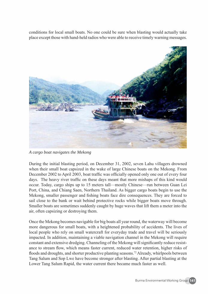
Burma Environmental Working Group 141
conditions for local small boats. No one could be sure when blasting would actually take place except those with hand-held radios who were able to receive timely warning messages.
A cargo boat navigates the Mekong
During the initial blasting period, on December 31, 2002, seven Lahu villagers drowned when their small boat capsized in the wake of large Chinese boats on the Mekong. From December 2002 to April 2003, boat traffi c was offi cially opened only one out of every four days. The heavy river traffi c on these days meant that more mishaps of this kind would occur. Today, cargo ships up to 15 meters tall—mostly Chinese—run between Guan Lei Port, China, and Chiang Saen, Northern Thailand. As bigger cargo boats begin to use the Mekong, smaller passenger and fi shing boats face dire consequences. They are forced to sail close to the bank or wait behind protective rocks while bigger boats move through. Smaller boats are sometimes suddenly caught by huge waves that lift them a meter into the air, often capsizing or destroying them.
Once the Mekong becomes navigable for big boats all year round, the waterway will become more dangerous for small boats, with a heightened probability of accidents. The lives of local people who rely on small watercraft for everyday trade and travel will be seriously impacted. In addition, maintaining a viable navigation channel in the Mekong will require constant and extensive dredging. Channeling of the Mekong will signifi cantly reduce resist-ance to stream fl ow, which means faster current, reduced water retention, higher risks of fl oods and droughts, and shorter productive planting seasons.72 Already, whirlpools between Tang Salum and Sop Lwe have become stronger after blasting. After partial blasting at the Lower Tang Salum Rapid, the water current there became much faster as well.
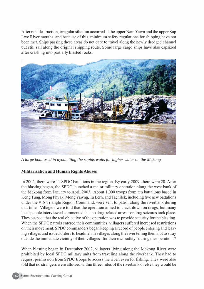
Burma Environmental Working Group142
After reef destruction, irregular siltation occurred at the upper Nam Yawn and the upper Sop Lwe River mouths, and because of this, minimum safety regulations for shipping have not been met. Ships passing these areas do not dare to travel along the newly dredged channel but still sail along the original shipping route. Some large cargo ships have also capsized after crashing into partially blasted rocks.
A large boat used in dynamiting the rapids waits for higher water on the Mekong
Militarization and Human Rights Abuses
In 2002, there were 11 SPDC battalions in the region. By early 2009, there were 20. After the blasting began, the SPDC launched a major military operation along the west bank of the Mekong from January to April 2003. About 1,000 troops from ten battalions based in Keng Tung, Mong Phyak, Mong Yawng, Ta Lerh, and Tachilek, including fi ve new battalions under the #18 Triangle Region Command, were sent to patrol along the riverbank during that time. Villagers were told that the operation aimed to crack down on drugs, but many local people interviewed commented that no drug-related arrests or drug seizures took place. They suspect that the real objective of the operation was to provide security for the blasting. When the SPDC patrols entered their communities, villagers suffered increased restrictions on their movement. SPDC commanders began keeping a record of people entering and leav-ing villages and issued orders to headmen in villages along the river telling them not to stray outside the immediate vicinity of their villages “for their own safety” during the operation.73
When blasting began in December 2002, villagers living along the Mekong River were prohibited by local SPDC military units from traveling along the riverbank. They had to request permission from SPDC troops to access the river, even for fi shing. They were also told that no strangers were allowed within three miles of the riverbank or else they would be
Burma Environmental Working Group 143
arrested. Although the SPDC did not state that these measures were related to the blasting, villagers suspected this was the case because they had never been given such orders before.
These restrictions on movement caused severe hardships for villagers whose livelihoods depend on the river. Unable to cope with such strict limitations, many affected Lahu and ethnic nationalities in the area have been forced to migrate and seek alternative occupations elsewhere. Such development-induced displacement has led to loss of traditional cultural practices, disintegration of communities, and family breakdowns. LNDO interviewed a Lahu fi sherman from Ta Be Village near Keng Larb who migrated to Mae Sai, Thailand. He explained his reasons for giving up his traditional lifestyle for life in the city as a day laborer.
“I [used to earn] my living from fi shing in the Mekong, just as my parents did before me. Before, I could fi sh at any time, day or night. But starting in December 2002, I had to get permission from the Burmese soldiers if I wanted to fi sh during the day. Sometimes I […] got permission to fi sh [only] once a week. At night it was completely forbidden. Before, if I didn’t manage to catch fi sh during the daytime, I could go at night. But when I was not allowed to fi sh at night, I couldn’t catch enough to earn a living. That’s why I had to migrate to fi nd other work.”74
The SPDC typically conscripts porters during military operations along the banks of the Mekong in fi ghting against the Shan State Army-South, an insurgent armed group. In 2005, highland Lahu villagers were driven en masse down to the lowlands and forced to work on constructing a 50-mile road from Ta Lerh to Keng Larb. The road is slated to extend to Xieng Kok, Laos. At time of writing, the road has yet to be fi nished.
Since 2004, locals have been forced to cut trees to build six bridges across the Mekong’s tributaries for this road project. The goal is to develop Keng Larb, which is located on the Mekong, into a regional transportation and trade hub. Keng Larb used to be a small Shan-Akha village with approximately 700 families. Now it is a center for drug-running, illegal logging, and human traffi cking. In addition, Keng Larb is fast becoming a booming market for illegal, exotic animals and wildlife products bound for China, putting greater pressure on the region’s endangered and threatened animals such as tigers, bears, and pangolins.
Illegal Logging and Along the Mekong
“[Logging] is the biggest mistake we’ve made. We’ve destroyed our envi-ronment.”
- Bao Youxiang, leader of the UWSA75
Illegal logging, drug-traffi cking, human traffi cking, and trade of endangered animals has boomed since the blasting began. Bigger boats can now navigate the river, access previ-ously untouched hardwood forests, and take forest resources straight to market. LNDO has obtained various reports revealing that SPDC troops are responsible for massive logging along the river.
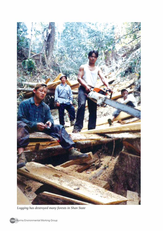
Burma Environmental Working Group144
Logging has destroyed many forests in Shan State
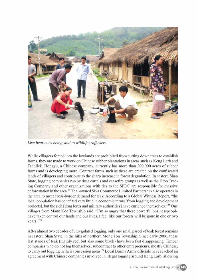
Burma Environmental Working Group 145
Live bear cubs being sold to wildlife traffi ckers
While villagers forced into the lowlands are prohibited from cutting down trees to establish farms, they are made to work on Chinese rubber plantations in areas such as Keng Larb and Tachilek. Hongyu, a Chinese company, currently has more than 200,000 acres of rubber farms and is developing more. Contract farms such as these are created on the confi scated lands of villagers and contribute to the sharp increase in forest degradation. In eastern Shan State, logging companies run by drug cartels and ceasefi re groups as well as the Htoo Trad-ing Company and other organizations with ties to the SPDC are responsible for massive deforestation in the area.76 Thai-owned Siva Commerce Limited Partnership also operates in the area to meet cross-border demand for teak. According to a Global Witness Report, “the local population has benefi ted very little in economic terms [from logging and development projects], but the rich [drug lords and military authorities] have enriched themselves.”77 One villager from Mann Koe Township said, “I’m so angry that these powerful businesspeople have taken control our lands and our lives. I feel like our forests will be gone in one or two years.”78
After almost two decades of unregulated logging, only one small parcel of teak forest remains in eastern Shan State, in the hills of northern Mong Ton Township. Since early 2006, these last stands of teak (mainly red, but also some black) have been fast disappearing. Timber companies who do not log themselves, subcontract to other entrepreneurs, mostly Chinese, to carry out logging in their concession areas.79 Local Burma Army offi cials have reached an agreement with Chinese companies involved in illegal logging around Keng Larb, allowing
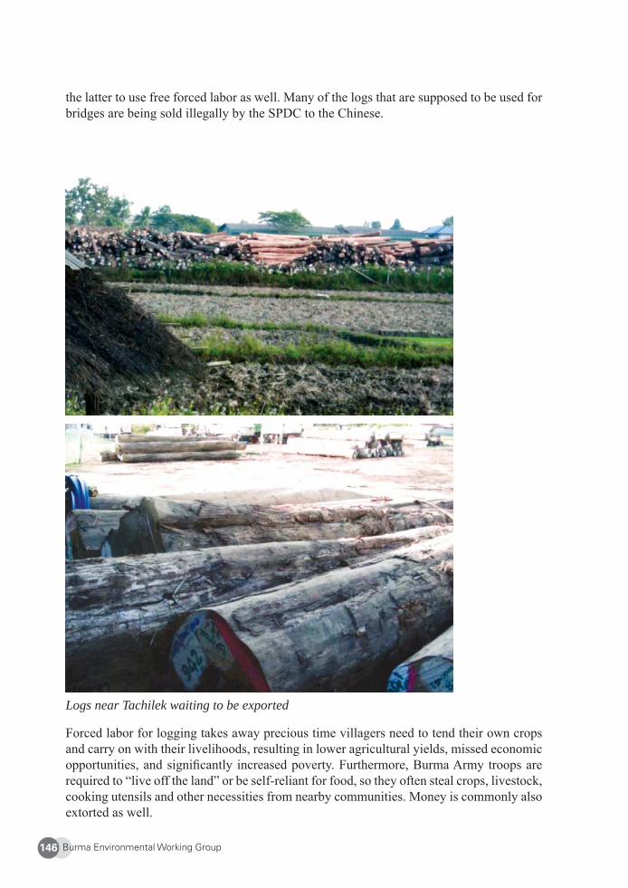
Burma Environmental Working Group146
the latter to use free forced labor as well. Many of the logs that are supposed to be used for bridges are being sold illegally by the SPDC to the Chinese.
Logs near Tachilek waiting to be exported
Forced labor for logging takes away precious time villagers need to tend their own crops and carry on with their livelihoods, resulting in lower agricultural yields, missed economic opportunities, and signifi cantly increased poverty. Furthermore, Burma Army troops are required to “live off the land” or be self-reliant for food, so they often steal crops, livestock, cooking utensils and other necessities from nearby communities. Money is commonly also extorted as well.
Burma Environmental Working Group 147
In addition, SPDC troops regularly commit rape and other sexual violence not only along the Mekong, but all across Shan State. The Shan Human Rights Foundation and the Shan Women’s Action Network have detailed the experiences of 625 women and girls raped by SPDC soldiers in Shan State between 1996 and 2001.80 Some of the cases were from Mong Yawn, Tachilek, and surrounding areas along the Mekong.81 In 2007, two Akha girls were raped in Nam Si Village. These numbers are likely to be far lower than the actual number of rapes perpetrated against local communities, as rape is commonly underreported due to the stigma attached to it.
4. Conclusion
As long as Burma remains under military rule and local communities are deprived of their democratic rights to participate in development decisions, increased development, trade, and investment along the Mekong River will only accelerate environmental destruction and reinforce the current inequitable and unsustainable development processes taking place in eastern Shan State.
SPDC-led drug eradication programs are mired in corruption, stir up ethnic tension, and actually perpetuate the drug trade. Poorly-conceived crop substitution schemes have led to local loss of food security, displacement, and, ironically, greater opium production. The state continues to ignore pursuing alternative livelihood options for traditional opium growers, and military offi cials have lined their own pockets by building a narco-state, a process that has forced people off their lands and deeper into poverty and hunger.
Likewise, while the Mekong Navigation Improvement Project benefi ts only a small group of business and military elite, it has caused severe environmental damage, shattering the livelihoods and culture of Lahu and other indigenous populations living along the Burma-Lao stretch of the Mekong and driving them into further poverty.
These destructive and unsustainable development patterns will continue until peace and democracy are restored to Burma, militarization ends, and people are provided with real participatory decision-making powers concerning choices that affect their communities.
5. Recommendations: A Participatory Approach
In light of widespread environmental destruction, impacts on local livelihoods, and human rights abuses brought on both by SPDC collusion in the drug trade and repressive approaches towards poppy growers in Shan State, LNDO strongly urges national and local authorities, ceasefi re groups, and insurgents to engage in establishing more humane and sustainable drug policies.82 In addition, there needs to be input from affected communities into drug policy debates. No crop substitution or other projects related to drug eradication should take place until viable alternative livelihoods are identifi ed and selected by local stakeholders.
Burma Environmental Working Group148
LNDO urges the governments of China, Laos, and Thailand, and the ruling regime in Burma to immediately suspend the navigation plan until proper environmental and social impact assessments are carried out with the participation of affected communities. A prerequisite for local participation is the restoration of genuine peace and democracy in Burma.
Indigenous communities in eastern Shan State are not interested in development projects that benefi t the government and large companies and wholly ignore the needs and demands of locals. LNDO believes that a more pragmatic and effective strategy for building up the livelihoods of local peoples should fi rst focus on improving educational quality and access. There are schools, but not enough teachers, books, or blackboards. The region’s drug trade has victimized chronic drug users for decades, and development-induced displacement and forced resettlement have led to greater environmental destruction, urban migration, human traffi cking, and loss of culture. Without the free fl ow of information, critical thinking and community development skills, people are ill-equipped to empower themselves to identify their own problems and work for positive social change. Development plans must aim to resolve the problems of local Lahu, Shan, Akha, Palau, and En villagers in eastern Shan State, not add to them.
Lastly, LNDO urges foreign governments and international funding agencies to withhold support for all development projects inside Burma’s Shan State until a democratic system of government is installed which allows local people genuine participation in decision-making concerning development in their area.
About the Lahu National Development Organization (LNDO)
LNDO was set up by leading Lahu democracy activists in March 1997 to advocate for the welfare and well-being of the Lahu people, including the promotion of alternatives to destructive development projects and opium cultivation. LNDO seeks to protect the liveli-hoods and lands of Lahu and Akha peoples and to increase understanding among the local ethnic nationalities about human rights, democracy, federalism, community development, and health issues. LNDO also aims to develop unity and cooperation among the Lahu and other highlanders from Shan State and to provide opportunities for development of civic leadership skills among local groups. Email: [email protected]
Burma Environmental Working Group 149
1 Usa Pichai, “Environmentalists worried over Impact of Mekong Damming,” Mizzima, 27 Apr. 2009, at: <http://www.mizzima.com/news/inside-burma/2021-environmentalists-worried-over-impact-of-mekong-damning.html>. Last accessed 30 Jul. 2009. 2 R. Waddington, “The Lahu,” Peoples of the World Foundation website, 2002, at: <http://www.people-softheworld.org/text?people=Lahu>. Last accessed 26 September 2008.3 Jane’s World Insurgency and Terrorism, “Shan State Army-South (SSA-S) (Myanmar),” 23 Sept. 2008, at: <http://www.janes.com/extracts/extract/jwit/jwita040.html>. Last accessed 15 Dec. 2008. The SSA-S split from the Shan State Army after the Shan State Army surrendered to the SPDC. The SSA-S leadership became disaffected with the Shan State Army’s emphasis on the drug trade and continues the struggle for an autonomous drug-free Shan State. The 5,000-strong SSA-S is considered by many as the legitimate representative of the local people. The UWSA is the armed wing of the United Wa State Party. With an estimated 20,000 troops, it is one of the largest ethnic armed groups in Burma. It signed a ceasefi re agreement with the SPDC in 1989. The UWSA controls the Wa territory in northern Shan State.4 Richard Humphries, “Myanmar’s Shan State: a complex tragedy,” The Japan Times, 30 April 2001, at: <http://search.japantimes.co.jp/cgi-bin/eo20010430a1.html>. Last accessed 15 Dec. 2008. 5 The MNDAA is comprised of several hundred Kokang troops. It has a ceasefi re with the Burmese government. The Shan State Army splintered after is leader and drug lord Khun Sa surrendered to the SPDC in December 1995.6 Lawi Weng, “Is UWSA Preparing for Clash with Junta?”, The Irrawaddy, 11 Dec. 2008, at: <http://www.irrawaddy.org/article.php?art_id=14779>. Last accessed 15 Dec. 2008. The Burmese military government wants the UWSA to move to assuage the Thai government, which has complained about the persistent fl ow of opium from Wa-controlled areas into Thailand.7 Ibid.8 U.S. Department of State Bureau for International Narcotics and Law Enforcement Affairs, International Narcotics Control Strategy Report 2008, March 2008. An estimated 90% of the world’s opium is produced in Afghanistan. 5% of the global supply in grown in Southeast Asia, mostly in Burma, states the UN Offi ce on Drugs and Crime. <http://www.state.gov/p/inl/rls/nrcrpt/2008/vol1/html/100780.htm>. Last accessed 31 Oct. 2008.9 Humphries, supra note 4.10 U.S. Department of State Bureau for International Narcotics and Law Enforcement Affairs, International Narcotics Control Strategy Report 2006, March 2006, at: <http://www.state.gov/p/inl/rls/nrcrpt/2006/vol1/html/62110.htm>. Last accessed 29 Oct. 2008. 11 Transnational Institute, Withdrawal Symptoms: Changes in the Southeast Asian Drugs Market, August 2008, p.5. [Hereinafter “Withdrawal Symptoms”].12 United Nations Offi ce on Drugs and Crime website, “UNODC Projects in Myanmar: Supply Reduction,” at: <http://www.unodc.org/myanmar/en/supply_reduction.html>. Last accessed 29 Oct. 2008.13 Shan Herald Agency for News, Show Business: Rangoon’s “War on Drugs” in Shan State, Dec. 2003, at: <http://www.shanland.org/resources/bookspub/drugs/show_business.htm>. Last accessed 15 Dec. 2008. [Here-inafter “Show Business”].14 Show Business.15 Withdrawal Symptoms.16 INCS Report 2008, supra note 8.17 Ibid.18 Chad Bouchard, “Opium Cultivation Blossoms in Burma,” Voice of America, 12 Oct. 2007, at: <http://www.voanews.com/english/archive/2007-10/2007-10-12-voa10.cfm>. Last accessed 29 Oct. 2008. 19 Show Business.20 U Ne Oo, “Strange Silence of OSS about ATS,” at <http://www.burmalibrary.org/reg.burma/archives/200002/msg00087.html>. Last accessed 29 Oct. 2008. 21 Show Business.22 LNDO Interview #2, Thai-Burmese border, 14 Dec. 2008.23 Withdrawal Symptoms, p. 10.24 Lahu National Development Organization, Aftershocks Along Burma’s Mekong: Reef-blasting and military-style development in eastern Shan State, Aug. 2003, p.30, at: <http://www.burmalibrary.org/docs/Aftershocks.html>. [Hereinafter “Aftershocks”].
Burma Environmental Working Group150
25 Steve Hirsch, “Interview with UNODC Myanmar Representative Jean-Luc Lemahieu,” Asian Tribune, 9 Dec. 2003, at: <http://www.shanland.org/resources/bookspub/drugs/asian_tribune.htm/>. Last accessed 29 Oct. 2008. 26 Show Business.27 Viss is a weight unit used In Burma. 100 tical make up one viss (about 1.63 kilogram).28 Show Business.29 Tical is a weight unit used in Burma. One tical is about 0.0163 kilograms (0.0360 pounds). 100 tical equals one viss.30 Lahu National Development Organization, “Drug Country: Another opium season in eastern Shan State sees increased cultivation, multiple cropping, and a new form of an old drug,”in Undercurrents: Monitoring Develop-ment on Burma’s Mekong, Issue 3, Apr. 2009, at p.12. 31 DVB, “Army’s opium taxation forays lead to clashes,” 19 Jan 2009, at: <http://democracyforburma.wordpress.com/2009/01/19/army%E2%80 %99s-opium-taxation-forays-led-to-clashes/>. Last accessed 17 Feb. 2009. 32 Supra note 26, LNDO interview #2. 33 Ibid.34 Ibid.35 “General Background of the Wa” in Unsettling Moves: The Wa resettlement program in Eastern Shan State (1999-2001), April 2002, at <http://www.shanland.org/resources/bookspub/humanrights/wa/general_back-ground_of_the_wa.htm>. Last accessed 10 Nov. 2008. [Hereinafter “Unsettling Moves”].36 “The Rationale” in Unsettling Moves, at: <http://www.shanland.org/resources/bookspub/humanrights/wa/rationale.htm>. Last accessed 10 Nov. 2008.37 Unsettling Moves, Executive Summary at: <http://www.shanland.org/resources/bookspub/humanrights/wa/executive_summary.htm>. Last accessed 5 Nov. 2008.38 “Choices of villages to be resettled” in Unsettling Moves at: <http://www.shanland.org/resources/bookspub/humanrights/wa/choice_of_villages_to_be_resettl.htm>. Last accessed 10 Nov. 2008.39 Ibid. 40 Unsettling Moves Executive Summary at: <http://www.shanland.org/resources/bookspub/humanrights/wa/executive_summary.htm>. Last accessed 5 Nov. 2008.41 “The vacated villages” in Unsettling Moves at: <http://www.shanland.org/resources/bookspub/humanrights/wa/vacated_villages.htm>. Last accessed 10 Nov. 2008.42 “Sickness and death” in Unsettling Moves at: <http://www.shanland.org/resources/bookspub/humanrights/wa/sickness_and_death.htm>. Last accessed 10 Nov. 2008.43 “Conclusion and Recommendations” in Unsettling Moves at: <http://www.shanland.org/resources/bookspub/humanrights/wa/conclusion_and_recommendations.htm>. Last accessed 10 Nov. 2008.44 Unsettling Moves Executive Summary at: <http://www.shanland.org/resources/bookspub/humanrights/wa/executive_summary.htm>. Last accessed 5 Nov. 2008.45 “Effects on Original Inhabitants in the South” in Unsettling Moves at: <http://www.shanland.org/resources/bookspub/humanrights/wa/effects_on_original_inhabitants_.htm>. Last accessed 10 Nov. 2008.46 “Opium growing” in Unsettling Moves at: <http://www.shanland.org/resources/bookspub/humanrights/wa/opium_growing.htm>. Last accessed 10 Nov. 2008.47 “Original Inhabitants” in Unsettling Moves.48 Unsettling Moves Executive Summary, at: <http://www.shanland.org/resources/bookspub/humanrights/wa/executive_summary.htm>. Last accessed 5 Nov. 2008. See also, Feraya Nangmone, “The Exploitation, Imprison-ment and Repatriation of Tai (Shans) in Thailand,” 16 Jul. 2007 at: <http://www.tai-nation.org/en/articles/67/1/The-Exploitation-Imprisonment-and-Repatriation-of-Tai-Shans-in-Thailand/Page1.html>.49 Withdrawal Symptoms, p.10.50 “Opium growing” in Unsettling Moves at: <http://www.shanland.org/resources/bookspub/humanrights/wa/opium_growing.htm>. Last accessed 10 Nov. 200851 LNDO Interview #3, Thai-Burmese Border, 17 Feb. 2009. 52 Clifford McCoy, “Seeds of evil growing in Myanmar,” Asia Times Online, 23 Aug. 2007, at: <http://www.atimes.com/atimes/Southeast_Asia/IH23Ae01.html>. Last accessed 4 Nov. 2008.53 Hsin Shweli is the generic name given to hybrid rice seeds imported mainly from southwestern China. These seeds include many Chinese strains that are not native to Burma.54 Show Business.55 McCoy, supra note 51. 56 Show Business. 57 McCoy, supra note 51.
Burma Environmental Working Group 151
58 McCoy, supra note 51. Collusion between SPDC offi cials and Chinese business persons in the rice trade is extensive.59 Ibid. 60 McCoy, supra note 51. 61 Show Business.62 Dennis Bernstein and Leslie Kean, “People of the Opiate: Burma’s Dictatorship of Drugs,” The Nation, Vol. 263. 16 Dec. 1996, at: <http://nick.assumption.edu/WebVAX/Nation/Bernstein16Dec96.html>. Last accessed 29 October 2008. 63 Bureau for International Narcotics and Law Enforcement Affairs, US Department of State. International Narcotics Control Strategy Report 2006. March 2006, at: <http://www.state.gov/p/inl/rls/nrcrpt/2006/vol1/html/62110.htm>. Last accessed 29 Oct. 2008. 64 Withdrawal Symptoms, p.10.65 Aftershocks.66 Show Business.67 The Greater Mekong Subregion Economic Cooperation Program, Interim GMS Assistance Plan 2000-2002 (October 1999). The GMS program involves China, Burma, Laos, Thailand, Cambodia, and Viet Nam and is supported by the Asian Development Bank (ADB). It aims to stimulate economic growth in the greater Mekong region through increased trade, energy development and supply, tourism, and environmental protection. 68 Southeast Asia Rivers Network, Project for Rivers and Communities, et al., Mekong Rapids Under Fire, Oct 2002. 69 The Mekong Freshwater Stingray is known as Dasyatis laosensis, <http://iucnredlist.org/details/39407>, and the Mekong Giant Catfi sh is Pangasianodon gigas <http://iucnredlist.org/details/15944>.70 LNDO Interview #1, 15 May 2003.71 LNDO, “Deadly Changes: Unpredictable Water Surges and Unprecedented Low Water Levels on the Mekong have Human Costs,” in Undercurrents: Monitoring Development on Burma’s Mekong, Issue 2. July 2006, at pp. 9-10.72 Tyson R. Roberts, “Downstream ecological implications of China’s Lancang Hydropower and Mekong Navigation project,” 2001, at p.3, available at: <http://www.internationalrivers.org/fi les/tyson%20roberts%20paper%20on%20yunnan.pdf>. Last accessed 18 Feb. 2009. 73 Aftershocks, p.10. 74 LNDO Interview #1, 15 May 2003.75 World Rainforest Movement, “Burma: Forests for Export to China,” World Rainforest Bulletin. No. 82. May 2004, at: <http://www.wrm.org.uy/bulletin/82/Burma.html>. Last accessed 16 Apr. 2009.76 LNDO, “Even the last tree: Unrestricted logging leaves the hills of eastern Shan State bare” in Undercurrents: Monitoring Development on Burma’s Mekong, Issue 2. July 2006. p. 11, available at: <http://www.shanland.org/articles/environment/2006/Images/Undercurrents2.pdf>. Last accessed 3 Dec. 2008. 77 Sara Knight, “China sends out for Burmese logs,” Earth Island Journal, 2004, at: <http://fi ndarticles.com/p/articles/mi_hb6393/is_/ai_n29110405>. Last accessed 15 Dec. 2008. 78 LNDO Interview #2, Thai-Burmese border, 14 Dec. 2008.79 LNDO Interview #1, 15 May 2003.80 Shan Human Rights Foundation and Shan Women’s Action Network, License to Rape, May 2002 at p.7., available at: <http://www.burmacampaign.org.uk/reports/License_to_rape.pdf>. 81 Ibid, p.5. 82 Withdrawal Symptoms, p.38.