Embed Size (px)
Citation preview
Pub
lic D
iscl
osur
e A
utho
rized
Pub
lic D
iscl
osur
e A
utho
rized
Pub
lic D
iscl
osur
e A
utho
rized
Pub
lic D
iscl
osur
e A
utho
rized
~ ' . '
u'
\\,-"' •i ...
Antarctic}'Arctic, Mediterranean,, Northwest. Atlantic, 0
., , NC?_rtheast Allantic,_and Baltic · ::\: _. (~: t ·
', . '
I .:• 24762 Volume 1
~ '--------·---~------__,,.'i,i
... ·>:.:
• •• ,, • f. 'l --~ - ~-... "' •'
., °. • " J• •••.• ;_-:,.o •-
~ -,
I
f<. • t .. r
,.'~
Pub
lic D
iscl
osur
e A
utho
rized
Pub
lic D
iscl
osur
e A
utho
rized
Pub
lic D
iscl
osur
e A
utho
rized
Pub
lic D
iscl
osur
e A
utho
rized

A Global Representative System of Marine Protected Areas
Principal Editors Graeme Kelleher, Chris Bleakley, and Sue Wells
Volume I
The Great Barrier Reef Marine Park Authority The World Bank
The World Conservation Union (IUCN)
The International Bank for Reconstruction and Development/THE WORLD BANK 1818 H Street, N.W. Washington, D.C. 20433, U.S.A.
Manufactured in the United States of America First printing May 1995
The findings, interpretations, and conclusions expressed in this paper are entirely those of the authors and should not be attributed in any manner to the World Bank, to its affiliated organizations, or to members of its Board of Executive Directors or the countries they represent.
This publication was printed with the generous financial support of the Government of The Netherlands.
Copies of this publication may be requested by writing to: Environment Department The World Bank Room S 5-143 1818 H Street, N.W. Washington, D.C. 20433, U.S.A.
® North East
'Pacific
·,.,.
so,.n, E,1:at P.1,ifi,
WORLD CNPPA MARINE REGIONS
0 CNPPA MARINE REGION NUMBERS
CNPf'A MARINE REGION BOUNDARIES
·-. r·---.. ...J
Q A li?.f it.-rr.i11i?,m
"'· .r·, '', '·. '"· \ ,._ ' ' ·--· " .... --.. \ \ / fl)\-'\ .-', . ,•' \,\ ,./ I / \ ,,'--
-1 '/. "',: 1(-, J
North West Pacific
4D / J I• , , 1.. t .,··
~,. -·· . , ... ,. , / L 1.. . \ t''-~,, · I I :]: ·,, ,-·
... ' ' . . '': ,:'\- South Pacific
r ,
Q A11tarct1c
I l I ..
,../
- - ·- . ,. m . . ' '• () rgfffl." ' . ' I ' .:, ,. ' . ~~--::-, _,.,. .. '-.,
~,
-~
r .. :r ~l .· • IL .. '
A11;tra/i,11 f\!""'' Zu1/.i11d

Contents
Foreword v
Preface vii
Cooperating Organizations ix
Acknowledgments xi
Acronyms xii
Introduction 1 Objectives 1 Methodology 2 Criteria for Selection of Priority Areas 3 Overview of Marine Biodiversity and Factors Relevant to the Identification of MP A Priority Areas 5 Initiatives that Recognize Globally Important Sites 9 Biogeographic Classification 11 Conclusion-The Way Forward 23 Summary Tables 29 Bibliography 41
1. Antarctic 45 Biogeography and Marine Biodiversity 45 Status of Existing MPAs 50 Priority Areas and Recommendations 55 Appendix 1.1 Potential Sites for the Establishment/Improved Management of MPAs in Antarctica 57 Notes 58 Bibliography 58
2. Arctic 61 Biogeography and Marine Biodiversity 61 Assessment of Existing MP As 68 Priority Areas and Recommendations 71 Bibliography 75
3. Mediterranean 77 Biogeography and Marine Biodiversity 77 Assessment of Existing MP As 88 International and Regional Initiatives Relating to MPAs 95 Assessment of Representation of Biogeographic Zones 97 Priority Areas and Recommendations 98 Appendix Priority Areas for the Establishment of MP As in the Mediterranean Marine Region
(RAC/SPA) 103 Bibliography 104
4. Northwest Atlantic 105 Biogeography and Marine Biodiversity 105 Assessment of Existing MP As 117 Assessment of the Representation of Biogeographic Zones 121
iii
iv A Global Representative System of Marine Protected Areas
National Priority Areas for the Establishment and Management of MPAs 121 Regional Priority Areas for the Establishment And Management of MP As 124 Bibliography 125
5. Northeast Atlantic 127 Biogeography and Marine Biodiversity 127 Assessment of Existing MPAs 133 Priority Areas and Recommen~tions 141 ,Bibliography 150
6. Baltic 153 Biogeography and Marine Biodiversity 153 Assessment of -Existing MP As 162 Priority Areas and Recommendations . 167 Areas of Highest Regional Priprity for MP As_ 179 Appendix 6.1 Marine Species Found in the ,Baltic Sea Region .180 Appendix 6.2 HELCOM Recommendatio!} JS/5 Regarding System of Coastal and Marine Baltic Sea
Protected Areas. 180 ' · · Bibliography 182
Contributors . 185
Index 187
Cumulative Index 195 ·
Map Sup~lement
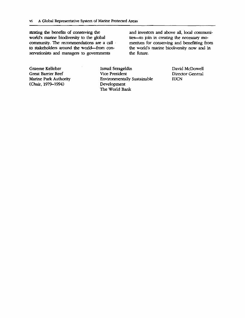
Foreword
Biodiversity is a major prerequisite for a sound sustainable environment. -Jacques-Yves Cousteau
The oceans cover 70 percent of the earth's surface. Within this vast underwater realm and along its coasts is found a tremendous diversity of life. Many people depend on the resources of the sea for food, income and employment. However, with growing numbers converging on the world's coasts and exploiting its seas, profound changes are taking place in the marine environment and in its biodiversity and productivity. Yet despite these alarming trends-reflected in the decline in fisheries, the demise of coral reefs and the periodic mass mortality of marine mammals and shorebirds-actions over the loss of the world's marine biodiversity have not been accorded the deserved priority.
Action is required at all levels to rectify this situation-action involving national and local governments, national and international NGOs and, most importantly, local people. Marine protected areas are a practical way of conserving marine biodiversity, maintaining the productivity of marine ecosystems and contributing to the economic and social welfare of human communities. Realizing these complementary goals will require development of the human capacity and commitment to managing these sites effectively. It will also require the promotion of integrated coastal zone management approaches, of which marine protected areas are a key component.
This publication provides a basis for development and implementation of a global system of marine protected areas to protect and manage representative examples of the world's rich marine biodiversity. It identifies priorities for establishing new marine protected areas and improving manage-
V
ment of existing ones in each of the world's 18 major marine regions.
Shortly after the establishment of the Global"Environment Facility (GEF), the Bank identified ari urgent need to determine priority areas for biodiversity conservation for which funding could be provided. The Bank initiated a consultative process to identify such priorities and subsequently agreed to collaborate with the World Conservation Union's (IUCN) Commission on National Parks and Protected Areas (CNPPA) and the Great Barrier Reef Marine Park Authority (GBRMPA) who were carrying out a program aimed at establishing a global representative system of marine protected areas.
This joint effort illustrates the process to be followed if the world community is to address the fundamental environmental problems it faces against limited financial and skilled human resources. Expertise must be mobilized from all quarters, using the motivation of communities rather than depending solely on financial reward. The World Bank, IUCN and GBRMPA have supported this publication but much of the credit should go to the numerous individuals and organizations affiliated with the CNPPA who have voluntarily devoted their time and energies.
The real value of this project lies in the recommended actions and their implementation. Consequently, the next step is the formulation of priority regional and national projects and the identification of investment opportunities which contribute to the maintenance of marine biodiversity and sustainable development. Our success therefore, will depend upon the durability of the partnerships forged, and our commitment to demon-
vi A Global Representative System of Marine Protected Areas
strating the benefits of conserving the world's marine biodiversity to the global community. The recommendations are a call -to stakeholders around the world-from conservationists and managers to governments
and investors and above all, local communities-to join in creating the necessary momentum for conserving and benefitting from the world's marine biodiversity now and in the future.
Graeme Kelleher Great Barrier Reef Marine Park Authority (Chair, 1979-1994)
Ismail Serageldin Vice President Environmentally Sustainable Development The World Bank
David McDowell Director General IUCN

Preface
Through its Commission on National Parks and Protected Areas, IUCN has been carrying out a program to promote the establishment and management of marine protected areas (MP As) around the world. To coordinate the MP As Program, CNPPA established a vice-chair for marine affairs in 1986 and appointed Graeme Kelleher, Chair of the Great Barrier Reef Marine Park Authority, to the position. Since this time the activities of the Vice-Chair (Marine) have been supported by GBRMP A.
This first step of the program was to contribute to the development of IUCN policy on marine protected areas to provide the vision and mandate for a long-term program. IUCN determined its policy position on marine protected areas at the 17th General Assembly held in Costa Rica in 1988. The primary goal of marine conservation and management and the means to achieve this goal are defined in Resolution 17 .38 and the 17th General Assembly of IUCN (1988). The primary goal is: to provide for the protection, restoration, wise use, understanding and enjoyment of the marine heritage of the world in perpetuity through the creation of a global, representative system of marine protected areas and through the management, in accordance with the principles of the World Conservation Strategy, of human activities that use or affect the marine environment. The following definition was adopted for the term "marine protected area":
Any area of intertidal or subtidal terrain, together with its overlying water and associated flora, fauna, historical and cultural features, which has been reserved by law or other effective means to protect part or all of the enclosed environment.
Resolution 17.38 emphasized that the ma-rine environment must be managed in an in-
vii
tegrated way if it is to be able to sustain human use in the future, without progressive degradation. An almost identical resolution was passed at the 4th World Wilderness Congress in 1987. With its policy framework in place and an emerging global consensus on the need for urgent action to conserve marine biodiversity, the foundation for the MP As Program was established. A major first step was taken with the division of the world into 18 biogeographic regions, enhancing the development of a global representative system of marine protected areas.
In planning the Program it became clear that there was a need for practical guidance for the establishment and management of MPAs per se. In 1987 work began on this and in 1992 the Guidelines for Establishing Marine Protected Areas (Kelleher and Kenchington 1992) was published. These guidelines, reviewed by over one hundered international experts, contain principles and techniques that have been demonstrated to be successful when applied to natural resource management.
The World Bank, which had become increasingly involved in biodiversity conservation, particularly through its partnership in the Global Environment Facility (GEF), supported a systematic, transparent and participatory approach to priority setting for investment in biodiversity conservation in the marine realm. However, in contrast to the terrestrial realm, there was little guidance for the marine environment (Norse 1993). Consequently, in 1990, several workshops were held to explore ways in which such an approach could result in a product that would be useful to governments and aid agencies. In parallel, the CNPPA had established a network of 18 regional marine working groups to implement its MPAs Program. With the initiative by the CNPPA
viii A Global Representative System of Marine Protected Areas
providing an adequate framework to build upon, in 1991,the Environment Department of the World Bank contracted GBRMPA and CNPPA to help prepare a report to identify priority areas for marine biodiversity conservation, with each of the world's biogeographic regions being represented. · The following report provides-for the
first time-a worldwide inventory of marine protected areas with a significant subtidal component. It documents biogeographic and ecological characteristics by zone in each of the 18 marine regions and summarizes the range of marine biodiversity within each region and the major threats to its conservation. Using a comprehensive selection criteria, including ecological, social and economic factors, the working groups identified sites of, national and regional priority for the conservation of marine biodiversity in each region. These include existing marine protected areas in- need of improved management as well as new areas proposed to fill in the gaps in biogeographic representation within the existing MPA system. These priorities are based on the best available information and should be viewed as investment tools updated as conditions change.
The regional working groups established under the CNPPA are expected to continue·
their role in the preparation and implementation of the .:11etwor~ of MP As. This will be mediated through consultation with the working groups and further consultation at the local level with stakeholders and decision makers.
With the completion of this report the next stage will be to develop and implement regional and national projects that aim to establish and manage on a priority basis a global representative system of marine pro-' tected areas. Project proposals should be formulated with financing 'from a number of sources such as, governments, the donor community, the GEF, the private sector, and NGOs. Strategies should also be developed for longer.:term self-financing. It is hope4 that IUCN, CNPPA, GBRMPA, the World. Bank, UNEP, UNDP and the many other or-· ganizations that have contributed to the · preparation of this document will continue to work together in this next critical phase. -
The maps have been compiled on the ba:.. sis of best available information; accordingly, comments; corrections, and other feedback would be most welcome. A poster map illustrating regional priorities for marine protected area establishment and improved· management has been produced to accompany the four-volume study.
Cooperating Organizations
GREAT BARRIER REEF MARINE PARK .AUl'HORITY
The Great Barrier Reef Marine Park Authority (GBRMPA) is an independent Statutory Authority of the Government of Australia. The goal of the Authority is to provide for the protection, wise use, understanding and ~njoyment of Australia's Great Barrier Reef in perpetuity. The Authority has developed a unique experience in managing this vast mult_iple use area of more than 34 million hectares that includes tropical reef, continental shelf, estuarine and island environments and has successfully implemented an extensive marine planning, management and research program. Tiu-ough its External Services Section the Authority makes this expertise available nationally and internationally.
nlE WORID BANK
The World Bank is a.multilateral development institution whose purpose is to assist its developing member countries to further their economic and social progress so that their people may live better and fuller lives. Founded in 1944, the Bank is owned by more than 174 countries and functions as a large cooperative in which members are shareholders. Responding to the concerns of its members, the Bank began to fully integrate environmental concerns into its work in 1987. By fiscal year 1994, annual lending for environmentally sustainable development was a record $2.4 billion. Almost half of all Bank lending supported environmentally sustainable development. Today the Bank is canying out 118 environmental projects representing $9 billion in loans and credits. The Bank's lending portfolio is com-
ix
plemented by grant funded projects under the Global Environment Facility (GEF), an international donors' fund jointly administered by the World Bank, United Nations Development Programme (UNDP) and United Nations Environment Programme (UNEP).
The Freshwater, Coastal and Marine Resources Management Team ("Blue Team") of the Land, Water and Natural Habitats Division in the Bank's Environment Department provides Bank-wide leadership and coordination for development and implementation of Bank polici~s and practices in support of a "blue agenda". and in preparation and implementation of innovative programs and projects. that promote en~ironmentally sustainable management of freshwater, coastal and marine systems and their resources.
IUCN, Tim WORID CONSERVATION UNION
IUCN, The World Conservation Union, brings together in a unique partnership, states, government agencies, and a diverse range of nongovernmental organizations. IUCN is comprised of more than 800 members in all, spread across more than 120 countries.
As a union, IUCN exists to serve its members: to represent their views on the world stage· and to provide them with the concepts, strategies and technical support they need to achieve their goals. Through its six commissions, IUCN draws together over 5,000 expert volunteers in project teams and action groups. A central secretariat coordinates the IUCN Program and leads initiatives on the conservation and sustainable use of the world's biological diversity and the management of habitats and natural resources,
x A Global Representative System of Marine Protected Areas
as well as providing a range of services. The Union has helped many countries to prepare National Conservation Strategies and demonstrates the application of its knowledge through the field projects it supervises. Operations are increasingly decentralized and are carried forward by an expanding network of regional and country offices, located principally in developing countries.
IUCN, The World Conservation Union, seeks above all to work with its members to achieve development that is sustainable and that provides a lasting improvement in the quality of life for people all over the world.
COMMISSION ON NATIONAL PARKS AND PROTECTED AREAs
CNPPA, IUCN's Commission on National Parks and Protected Areas, serves as the principal source of technical advice to the Union, its members, and its collaborating organizations on all aspects of the selection, planning and management of protected areas. Its mission is to promote the establishment and effective management of a worldwide network of terrestrial and marine protected areas. To this end, CNPPA aims to demonstrate the value of protected areas
within wider strategies for the sustainable use of the earth's natural resources.
THE WORID CONSERVATION MONITORING CENTRE
The World Conservation Monitoring Centre (WCMC) is an independent nonprofit organization established by the three partners of the World Conservation Strategy: IUCN, the World Wildlife Fund (WWF), and UNEP. It maintains information describing biodiversity at the global level and runs a number of large databases including a major Geographic Information System (GIS), the Biodiversity Map Library, and a protected areas database. The latter includes data for some 39,000 protected areas, held in a FoxPro database. For some 4,000 of these there are detailed data sheets that provide information on physical and biological features as well as legal protection, management systems and threats. These data sheets have been prepared for all internationally designated sites under the World Heritage Convention and all Biosphere Reserves as well as most major nationally designated sites. The Centre is responsible for producing the United Nations List of National Parks and Protected Areas.
Acknowledgments
This study could not have been completed without the active and generous participation of members of the CNPPA Marine Network who committed their time and energies to this project, mostly without monetary recompense. Their valuable contribution far exceeded the financial support provided by the institutions involved, making publication of this four volume study a highly costeffective and timely effort. Individual authors who contributed to the preparation of regional reports are listed in the relevant regional section.
The principal editors, Graeme Kelleher, Chris Bleakley and Sue Wells, and World Bank staff who contributed to and supervised production of the publication, Colin Rees, Marea Hatziolos, and Jan Post, would like to acknowledge the strong support and assistance provided by many people from the organizations that cooperated in preparing this study. In particular, recognition is given to the following individuals:
Danny Elder (Marine and Coastal Areas Program, IUCN), Jeremy Harrison (Protected Areas Data Unit, WCMC), Richard Kenchington (External Services Section, GBRMP A), Bing Lucas (former Chair, CNPPA), Carl Gustaf Lundin (Land, Water and Natural Habitats Division of the Environment Department,~d Bank), Jeff McNeely, (Biodiversity Program, IUCN), Ken Newcombe (Global Environment Coordination Division of the Environment Department, World Bank), Adrian Phillips (Chair, CNPP A), Dave Sheppard (Protected Areas Program, IUCN), Mark Spalding (Habitats Data Unit, WCMC), and
xi
Clive Wilkinson {Australian Institute of Marine Science).
Technical, editorial and administrative support was provided by a number of individuals over the course of the report's preparation. The highquality color maps were prepared by Jeff Lecksell (World Bank), with data from Chris Bleakley (GBRMP A) and the WCMC and technical support from Puneet Kishor and Petter Nyborg, also of the World Bank. Editorial and administrative support was provided by staff of the GBRMP A Canberra Office: Amanda Cohen, Maria Hawke, Helen McGregor, and Allison Pearson. Assistance with references and research was provided by GBRMP A Library staff in Townsville, Australia: Karen Adler, Rozel Brown~ Clare Cappa, and Suzie Davies. In Washin~on, indexing of the four volumes was prepared by Jeanne Moody (Beaver Wood Enterprises), and Charlotte Maxey and Cynthia Stock (World Bank) coordinated the final design and composition of the publication.
The editors are.grateful to Jan Post and Carleton Ray for proviru.11g photos for the cover and accompanying poster map and to Tomoko Hirata (World Bank) for the cover design. Finally, GBRMPA, the World Bank, and IUCN would like to express their sincere thanks to the Government of Sweden, -through Sida, for their support in carrying out th~ study, and the Government of the Netherlands for their generous support for publication costs.
Acronyms
AIMS Australian Institute of Marine Science
CITES Convention on International Trade in Endangered Species of Wild Fauna and Flora
CNPPA Commission on Nati9nal .Parks and Protected Areas (IUCN) .
GBRMPA Great Barrier Reef Marine Park Authority
GEF Global Environment Facility
GIS Geographic Information System
HDU Habitats Data Unit
ICLARM International Center for Living Aquatic Resource Management
IMO International Maritime Organization
IUCN The World Conservation Union
LME Large Marine Ecosystems
MPA Marine Protected Area
Data Note
MAB Man and the Biosphere Programme
MARPOL International Convention for the Prevention of Pollution from Ships
NGO Nongovernmental Organization
PADU Protected Areas Data Unit
SSC Species Survival Commission
TNC The Nature Conservancy-
UNDP United Nations Development Programme
UNCED United Nations Conference on Environment and Development
UNEP United Nations Environment Programme
UNESCO United Nations Educational, Scientific, andCultural Organization
WCMC World Conservation Monitoring Centre.
WWF World Wildlife Fund
Billion is a thousand million; trillion is a million million.
xii
Introduction
The marine environment is critical to the natural and cultural heritage of the world. Many marine areas support a great diversity of plants and animals; the oceans play an essential role in climatic cycles and other global processes. Marine ecosystems and resources are fundamental to the sustainable development of coastal countries, providing food, minerals, pharmaceuticals, construction materials and a vast range of other products. They also often support a growing .tourism and recreation industry and play a vital role in transport and in the culture and lifestyle of coastal people (Dixon, Scura, and·van't Hof 1993). However, throughout the world, marine ecosystems face increasingly serious threats from pollution, overexploitation, conflicting uses of resources, damage and destruction of habitat, and other harmful consequences of human development. Loss of biodiversity is especially at risk.
Conserving marine biodiversity is therefore a priority. Decisions and actions must be taken without delay. Chapter 17 of Agenda 21, the Action Plan drawn up following the United Nations Conference on Envi-
1
.. -
ronment and Development (UNCED), specifically requires that states should identify marine ecosystems exhibiting high levels of biodiversity and productivity and other critical habitat areas and provide necessary limitations on use in these areas, through inter alia designation of protected areas. The Convention on Biological Diversity requires states to implement conservation policies to maintain biodiversity.
The aim of the study is to identify priority areas for the establishment and management of a global representati~e system of MP As. It provides strategic guidance to governments, aid agencies, and others working to achieve marine biodiversity conservation and sustainable use of the marine environment on where to focus investments. The study offers a series of general and site specific recommendations which are summarized at the end of this chapter.
0BJECI1VES
The objectives of the report were to produce three main products:
2 A Global·Representative System of Marine Protected Areas
First, maps of the 18 biogeographic regions into which the CNPPA has divided the world, have been produced showing the location of: • Existing MP As (identifying those that are
national or regional priorities for management strengthening)
• Proposed new MP As (specify whether of national or regional priority).
Both existing and proposed MP As are depicted on the accompanying maps as a point representing the center of an area. In the latter case, this may be a well-defined location or a general focal area for biodiversity conservation requiring further investigation.
Second, supporting information for each of the regions has been compiled, including: • An overview of marine biodiversity and
biogeography in each region, particularly as they relate to MP As
• Available data on existing MP As in each region, including information on representation and management effectiveness
• Justification for the selection of priority areas
• Identification of further information required for a network of MP As to cover each region's marine biological and geographic diversity.
Third, recommendations have been formulated for the specific actions needed in each region.
These recommendations are offered to help organizations, governments, and local communities collaborate efficiently as they decide the next steps in each circumstance.
METIIODOLOGY
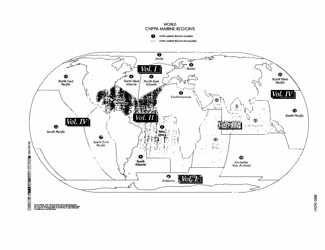
The CNPPA divided the marine areas of the world into 18 regions largely on the basis of biogeographic criteria but, for practical reasons, also considering political boundaries · (see Map 1). In 1990, working groups were established in each region, consisting wher-
ever possible of both marine resource managers and marine scientists. The aims of the working groups have been to: • Summarize the main physical and biologi
cal characteristics of the marine environment
• Divide each region into its constituent biogeographic zones
• Make an inventory of existing MP As • Identify gaps in the representation of the
biogeographic zones in MPAs • Identify areas of national priority for the
establishment of new MP As or for management strengthening and support to existing MPAs
• Identify areas of regional priority for the establishment of new MP As or for management strengthening and support to existing MPAs
• Prepare other recommendations to promote the establishment and improved management of MP As in each region.
Workshops were held in the East Asian Seas (February 1993) and the Baltic (June 1993), Northwest Pacific (September 1993), the South Pacific (October 1993) and Latin America (January 1994) regions to allow marine resource managers and marine scientists to identify priorities. In some regions this was the first time these two groups had cooperated in this way. During the next phase, national and local level workshops will be required to build consensus in advancing the MP A selection process to the point of agreeing on potential investments.
Information from the Protected Areas Data Unit (PADU) and Habitats Data Unit (HDU) at the World Conservation Monitoring Centre has been made available to GBRMPA and the World Bank for this project, and these organizations now maintain an identical computerized database on MP As. This database, which has been substantially edited and updated for the purpose of this report by the Bank and GBRMPA, has been used to generate maps showing the location of the Mi>As, each region's biogeographic classifica-
tion scheme, and the location of priority areas for the conservation of global marine biodiversity. Portions of this database may be made available to institutions on request.
CRn'ERIAFORSELECDONOFPRIORl'IY AREAs
The criteria used to identify priority areas in this report were developed by Kelleher and Kenchington (1992) and have been adopted by the International Maritime Organization (IMO) for use in the identification of Particularly Sensitive Sea Areas and by the parties to the Helsinki Convention for identification of a system of marine protected areas for the Baltic Sea.
Priorities were identified on the basis of ecological and biogeographic criteria in the first instance, using available data. Other, equally important, criteria were used to provide additional justification for or against selecting a particular area and in considering the probability of establishing and successfully managing a marine protected area. All priority areas were therefore assessed as having a reasonable chance of success as a marine protected area.
Within these guidelines, each working group applied the specific criteria shown in Box 1 for the selection of priority areas.
Priorities for Conservation
Priorities in this report have been identified on a regional and national basis using available data. In some regions and countries, there has been limited information available on some subject areas. Consequently, the report reflects the variability of these data between regions and countries. Recommendations on the management of individual MP As require detailed assessment of these sites. Unfortunately, the limitations of time and resources meant that carrying out such assessments was beyond the scope of this report.
Introduction 3
The report concentrates primarily on the subtidal marine environment in coastal areas and does not attempt to assess intertidal, estuarine and wetland areas. In some instances there is a lack of available information on boundaries of protected areas that appear to have marine components and it is difficult to determine the extent to which the marine environment is included. Based on the information available, a judgement has been made to identify areas that include a significant subtidal marine component.
Whenever possible national priority areas were identified by national representatives and regional priority areas were identified by the regional working group leader. This process stretched over 3 years and every effort was made to incorporate contributions from marine resource managers and marine scientists in each country.
The selection of sites is to some extent subjective, and the lack of information and of a well-tested and accepted global system of biogeographical classification makes the determination of priorities difficult. However, priorities in each region have been identified within the consistent framework of a biogeographic classification system adopted as appropriate for that region.
Many nations are carrying out programs for conservation and development of the marine environment. As far as possible, the priorities identified in this report are consistent with expressed national priorities, as identified by national representatives or in documents such as National Environmental Action Plans or National Conservation Strategies.
It is recognized that priorities for marine biodiversity conservation will change in the future as further information becomes available, communities and decision-makers become more aware of the role and importance of marine environments and ecosystems, and as the priorities identified in this report are acted upon.
Indeed, new information resulting from management experience, community educa-
4 A Global Representative System of Marine Protected Areas
Box 1. Criteria for Selection of Priority Areas
Biogeographic criteria • presence of rare biogeographic qualities
or representative of a· biogeographic "type" or types
• unique or unusual geological features.-
· Ecological criteria • an essential part of ecological processes
or life-support systems (for example, is a source for larvae for downstream areas)
• area's integrity, or the degree to which the area either by itself or in association with other protected areas, encompasses a complete ecosystem
• the variety of habitats • presence of habitat for rare or endan
. gered species • nursery or juvenile areas
. • feeding, breeding or rest areas , • rare or unique habitat for any species • genetic diversity (is diverse or abundant
in species terms).
Naturalness • extent to which the area has been pro
tected from, or has not_ been subject to, human-induced _change.
Economic importance . • existing or potential contribution to eco
nomic value by virtue of its protection (for example, protection of an area for recreation, subsistence, use by traditional
tion, research, and monitoring should be taken into account in making decisions and taking action. this means regular review and updadng of the priorities identified in this report. ·
It is beyond the' scope of this report to deal with issues relating to broader coastal zone management. However, the high degree of linkage between marine environ- · ments and between the land and the sea imposes an urgent need for the integration of protected area management a11;d overall
inhabitants, appreciation by tourists and others or as a refuge nursery area or source or'e~oh.omically'important species).
Social importance • existing or potential value to the local,
national or international communities because of its heritage, historical, cultural, traditional aesthetic, educational or recreational qualities.
Scientific importance • value for research and monitoring.
International or national significance • potential to be listed on the World (or na
tional) Heritage List, declared a Biosphere Reserve, or included on a list of areas-of international or national importance, or is the subject of an international
· or national conservation agreement.
Practicality/or feasibility • degree of insulation from external de
structiVC: influences •. social and political acceptability, degree
o( community support . • accessibility for education, tourism, rec-.
reation · • compatibility with existing uses, particu
larly by locals • ease of management or compatibility
with existing management regimes.
conservation strategy in the coastal zone. MP As are successful only if they are managed as part of broader programs that provide for management of all uses of the sea· and adjacent land. L~uge, multiple-use MP As covering complete ecosystems are a major. step toward this goal. ..
Although this report is concerned with site's ofregional hnportance for marine bi~diversity, it recommends that all .countries within a region sho~ld attempt to conserve a b~ogeo~raphically repres~ntative set of ~it~
at the national level, in accordance with Resolution GA 17.38 of the IUCN (1988).
OVERVIEW OF MARINE BIODIVERSITY AND FACTORS REI.EVANI'T0111E IDENimCA'DON OF MPA PRIORI1Y AllEAS
This section provides a brief overview of marine biodiversity and outlines social and biological factors relevant to the selection of priority areas for the establishment and improved management of MP As.
Annex 1 describes some existing initiatives which identify important sites for marine biodiversity conservation. Further information on these is provided in tables ~7.
Overview of Marine Biodiversity
Recent reviews have provided detailed discussion of global marine diversity in the overall context of biological diversity (for example, Thome-Miller and Catena 1991; WCMC 1992; Norse 1993). A brief summary of marine biodiversity at the species, genetic and ecosystem levels, and a discussion of extinction in the marine environment are provided below.
Ecosystem Diversity
The diversity of ecosystems and habitats in an area, or the presence of unique habitats, provides a measure of its importance for conservation. In Agenda 21, the following ecosystems are accorded highest priority, on the basis of their diversity and productivity: coral reefs, estuaries, temperate and tropical wetlands including mangroves, seagrass beds and other spawning and nursery areas.
Table ,1 provides a summary of some of the key information on these ecosystems, while tables 8 and 9 provide further information on the status of coral reefs and mangroves. The general distribution of reefs, mangroves and other wetlands is reasonably
Introduction 5
well known, but there have been few global overviews of any other marine ecosystems. These ecosystems are primary candidates for representation in MPAs. Other·ecosyst~ms have particular significance in some regions. For example, sea ice makes up a large part of the habitat of diatoms, arctic fish, some birds, walruses and seals; sea walls and continental slopes attract aggregations of pelagic carnivores.
Species Diversity
At higher taxonomic levels, marine ecosystems are far more diverse than terrestrial ones; for example of the 33 animal phyla, only 11 occur on land (one endemic) while 28 (13 endemic) occur in the oceans (May 1988). Total numbers of marine species have been estimated at 250,000 (Winston 1992), with possibly 150,000-200,000 species still to be described, excluding micro-organisms. Table 2 reviews information on species diversity for some of the major taxonomic groups, and a general review is given in Winston (1992).
Patterns of species diversity in the oceans are still poorly known compared with terrestrial species. However, two basic gradients of diversity can be discer:ned. First, as on land, for many taxonomic groups, diversity incr:eases from the polar regions to the equator; for example, the highest species diversity for fish, crustaceans, corals, mollusks, foraminifera and seagrasses, is in the tropics (for example, Stehli, McAlester, and Helsley 1967; Buzas and.Culver 1991; Veron 1993). However, recent studies have revealed high species diversity in the Southern Ocean for certain groups, notably sponges, bryozoans, polychaetes and amphipods (Clarke and Crame 1989).
The secqnd distinct pattern is a longitudinal one. The Indo-West Pacific area bounded ~y the Philippines, Indonesia ~nd Northeast Australia has for some time been known· as the area of highest marine biodiversity, with diversity declining to the east
6 A Global Representative System of Marine Protected Areas
through the Pacific Ocean island groups and to the west through the Indian Ocean island groups. The Atlantic has its highest diversity in the west, particularly the Caribbean, and lower diversity in the east. Kay (1984) assessed patterns of speciation in the IndoWest Pacific by analyzing distribution records of about 3000 species and 500 genera of marine mollusks, echinoderms, crustaceans and fish. Three centers of endemism were identified: the Indian Ocean, the western Pacific and the Pacific Basin. The open boundaries between habitats and the relative ease of dispersal means that extinction in the se·a is not yet as great a concern as it is on land, except for the limited number of endemic species, some of the large air-breathing species and those with low fecundity. The few recorded recent marine vertebrate extinctions comprise three mammals and ten seabirds that were mostly wide ranging, but with small breeding ranges (Vermeij 1993; Norse 1993). The only recent recorded invertebrate extinction is the eelgrass limpet Lottia alveus from the northwestern Atlantic (Vermeij 1993).
However, the lack of knowledge about the distribution of many species and the fact that pollution and disease can spread rapi<J.ly in the sea means that caution is required. Furthermore, the problems of surveying large areas of ocean mean that it is difficult to determine whether the population of an organism may be endangered. The destruction of habitat often causes local extinctions, but these may not become apparent until after they have occurred. In several instances species are proving to be rarer than previously expected. Hundreds of species were described in the late 1800s and early 1900s and have not been recorded since, despite collections in the regions of their original discovery (Norse 1993; Vermeij 1993).
Genetk Diversity
Although the same genetic community may be represented throughout a large geo-
graphic range in the marine environment, occurring wherever substrate and water quality are suitable, recent work is showing that genetic variation within marine populations can be substantial. Many populations are highly diverse at the genetic level and genetically distinct populations of the same species may occur in different locations (see Norse 1993; Benzie 1994; Meylan, Bowen, and Avise 1990).
The preservation of genetic diversity is a basic requirement for sustaining populations, resistance to disease and adaptability to changing environmental conditions. If populations are genetically and physically separated, efforts to protect one population may have little impact on others. In the absence of sufficient information to determine the extent and seriousness of losses in genetic diversity, the implication is that a systematic approach should be taken in the design of marine management and protected area strategies.
Social Factors in the Identification of MPA Priority Areas
In most countries, there is a long history of public or sectoral use of marine areas close to the coast. Thus, consideration of continuing human use within and adjacent to MP As should play a major role in their selection, design and management. Humanitarian, economic and pragmatic considerations often mean that where there is a choice of ecologically suitable areas, the dominant criteria for selection of MPA locations, boundaries and management systems will be socio-economic. Clearly, where there are few, if any alternative sites, ecological criteria should be critical and decisive.
Attempts to exclude human uses from traditional areas may jeopardize the physical or economic survival of people and their communities. Community opposition will, in such cases, be very strong and will compromise successful management of these areas. It is often better to establish and successfully
manage an MP A that may not be ideal in ecological terms but that nevertheless achieves the purposes for which it is established than it is to labor futilely to create the theoretically "ideal" MPA. Further, the problems affecting choice of area and boundaries are reduced if political. legal and social conditions allow the creation of large MP As covering complete marine ecosystems. This allows integrated management regimes to be established for continued human use while achieving conservation objectives. Additional information on social factors relevant to the establishment of MP As can be obtained from Kelleher and Kenchington O 992) and Salm and Clark (1984).
Biological Factors in the Identification of MPA Priority Areas
The purpose of this section is to highlight .biological factors relevant to the selection and management of priority areas for the establishment and management of a global representative system of marine protected areas.
The Large Scale of Marine Ecosystems
Marine environments are typically strongly linked by the mixing of water masses and, in coastal areas, greatly influenced by rivers and land runoff. Water masses are mixed through currents, tides and the action of wind and storms. A marine area can therefore be strongly influenced by the effects of activities in distant areas.
Most bony fish and 70 percent of invertebrate species produce huge numbers of dispersive planktonic eggs and larvae. Such species typically have broad geographic ranges (Jablonski 1986). Most eggs and larvae are carried away from the spawning site; the water mass above a given area is likely to bear the genetic material, spores and larvae for a range of marine communities. Within the area influenced by a water mass, widely separated adult communities may be closely linked genetically.
Introduction 7
As a consequence of the large scale of marine environments, the creation of MP As is even more an integral part of overall resource management for conservation and sustainable use than has usually been overtly recognized on land. Consequently, marine protected area design should be part of management regimes which operate at large scales. If an MPA is confined to a small area its management may be powerless to influence impacts which significantly affect the viability of that MP A.
It is usually not appropriate to designate large areas of the open ocean as highly protected areas because eliminating all or most uses over a large area is not likely to gain public or political support. However, large, multiple-use protected areas can be particularly effective in the sea because they allow a balance to be reached between conservation and use over a large area through integrated management of complete ecosystems. Such integrated or "bioregional" management requires sharing and coordinating the values and interests of a broad range of stakeholders when conceiving and implementing policies and programs. The concept involves combining, coordinating or integrating at a number of scales, values, interests and goals, many of which are in competition (Kenchington and Crawford 1993; Wells, Brandon, and Hannah 1992).
The linkages and scale of marine environments are such that there is frequently a number of ecologically alternative sites for the conservation of a particular marine species or community. It follows that socio-economic factors, which largely determine whether and how an MPA can be successfully managed (and can therefore perfonn its intended function), should often be dominant in the selection of MP As.
Site Dl.[ferences In Recruitment
Some upstream sites are so placed that the prevailing currents consistently carry their larvae to settle at good settlement areas.
8 A Global Representative System of Marine Protected Areas
such sites are consequently good sources of recruits for other areas. But, being upstream in normally prevailing conditions, they may themselves only occasionally receive recruits from other areas at times of current reversal or variation. Conversely, some downstream sites are so placed that they receive large numbers of larval recruits from a wide range of upstream sites. Such sites are consequently good sinks or receivers ·of larvae and tend to have a high recruitment rate.
The status of areas as sinks or sources can be an important factor in conservation planning.· Good sinks receiving a regular supply of larvae from a wide range of sources are probably more resilient to natural and human impacts than other areas. For example; such sites may better withstand fishing pressures. Good sources of recruits may be of priority for protection in order to maintain the supply of recruits to downstream areas. Furthermore, if they themselves do not receive a regular supply of larvae from other sources they may not be as resilient as ·downstream areas.
Key Breeding and Migration Areas
Many adult fish and invertebrates are widely scattered but return to specific sites to spawn. Some birds, mammals, fish and invertebrates such as spiny lobsters, squid and horseshoe crabs follow defined routes as they migrate to breed. Such sites or routes are often known to fishermen and may be heavily fished. Similarly, many marine mammals, birds and reptiles have a large total range but a small breeding range or critical breeding sites (Vermeij 1993). Examples include mating and· calving areas of whales and dugong, breeding colonies of seabirds and nesting beaches of sea turtles. ·
Species may be very vulnerable to exploitation at key breeding and migratio'n areas. Protection ·of these areas can therefore make a major contribution to the conservation of such species, and such sites should be of priority for MP A status.
Isolated Areas and Endemism
Despite the high level of linkage of currents there are isolated areas and species in marine environments. Oceanic islands and shoals may be so remote that few larvae reach them. Species which arrive may colonize but, evolving in isolation, they may become genetically distinct as often happens on land.
Some manne species have a relatively limited larval range. Some invertebrates and fish species produce relatively few· large eggs which are attached to the seabed or in some cases, guarded and ventilated by a parent until the young hatch. Others, such as seahorses have more elaborate behavior for brooding and caring for their young. Where such species have a small adult range and occur in specialized environments they may be effectively isolated and become genetically distinct.
Marine endemism is rare in comparison to terrestrial environments. Marine endemics tend to be restricted to specialized habitats (Kenchington 1990) or are found around isolated islands. As with terrestrial conservation the habitats of endemic species should be of priority for protective management.
Areas of High Productivity
Areas of high productivity in the ocean, although not necessarily themselves biologically diverse, are important for maintaining ecological processes and as a result may be critical to the maintenance of marine biodiversity. These areas are generally associated with upwellings of cold deep waters containing large amounts of nutrients, and typically support high biomass production, often of major economic value (Ray 1988).
In coastal habitats productivity is generally driven by nutrients originating· from the land. Many coastal areas support productive communities such as mangroves, saltmarshes, seagrass beds, estuaries, coral reefs, and kelp forests, which often provide rich
feeding, breeding and nursery grounds for numerous species. Areas of high productivity require management to ensure that their productivity and contribution to ecosystem processes is maintained.
Vulnerable Sped.es
Some marine species produce relatively small numbers of eggs. Others give birth to live young. Such species are particularly significant in terms of marine biodiversity. First, because they produce small numbers of eggs or young their populations may recover slowly after a natural or human impact. Second, as described above, such species often have important breeding sites and seasons at which they are particularly vulnerable.
As with terrestrial environments, species vulnerability is an important consideration in the design of measures to protect biological diversity. Where a species is vulnerable due to one or more of the above factors, the creation of an MP A should be considered to protect that species.
INITIATIVES THAT RECOGNIZE GLOBAllY IMPORTANT SITES
A number of international and regional initiatives provide ways of identifying and designating sites of international importance.
World Heritage Convention
This is a mechanism, set up under the United Nations Educational, Scientific and Cultural Organization (UNESCO), for designating natural and cultural sites of "outstanqing universal value." Sites proposed for listing as natural sites must meet at least one of the following criteria: • Be outstanding examples representing the
major stages of the earth's evolutionary history
Introduction 9
• Be outstanding examples representing significant geological processes, biological evolution, and man's interaction with the natural environment
• Contain unique, rare or superlative natural phenomena, formations or features or areas of exceptional natural beauty
• Be habitats where populations of rare or endangered species of plants and animals still smvive.
Of the 108 natural World Heritage Sites, 31 have marine or coastal components: 14 marine and 17 coastal (Table 4). WCMC provides standardized data sheets on all nominated natural World Heritage Sites on behalf of the convention secretariat and these are updated for all approved sites on an ongoing basis.
Convention on Wetlands of International Importance (Ramsar Convention)
This was drawn up for the protection of wetlands but also provides for the listing of areas of "marine water, the depth of which at low tide does not exceed 6 meters" and thus includes coastal areas, shallow seas and shallow coral reefs. Deeper areas may be included as buffer zones. Parties to the convention are required to promote the conservation of listed sites and to ensure their wise use; the Convention thus provides considerable opportunities for strengthening protection for marine sites.
About 270 Ramsar sites have a marine and coastal component, and have a combined area of 210,000 square kilometers (Table 5). These include sites that meet the following habitat criteria: shallow marine waters, marine beds (seagrass and algal beds), coral reefs, rocky shores, sand/shingle, estuarine waters, tidal mudflats, saltmarshes, mangrove/tidal forest, coastal brackish/saline lagoons, and coastal fresh lagoons. Data sheets for some of these are given in Jones 0993). .
10 A Global Representative System of Marine Protected Areas
IMO and the Convention for the Prevention of Pollution from Ships (MARPOL)
The International Maritime Organization (IMO) is responsible for a number of international conventions that improve maritime safety and help to prevent marine pollution. There are three different designations of environmentally important areas within which particular precautions must be taken to prevent pollution of important ecosystems. Criteria for identifying these areas include their ecological importance as well as their sensitivity to oil (or other) pollution (for example, sheltered saltmarshes, mangroves and coral reefs are more sensitive than exposed, highly sloping rocky cliffs) and the risk of their being adversely affected by an oil spill (proximity to navigation routes, oil exploration and production areas, and so on).
Special Areas
Parties to MARPOL are required to impose a variety of controls on various forms of pollution: oil (Annex I), noxious liquids and other substances (Annex II) and garbage (Annex V). In addition, Special Areas can be designated where higher levels of protection must be provided (IMO 1991). Nine Special Areas have been designated (Table 6).
Areas to be Avoided
IMO's General Provisions on Ships Routing allows for the designation of Areas to be Avoided by certain sizes of ships. There are 21 areas to be avoided, of which 12 have been established for protection of the environment (IMO 1991) (Table 6).
Particularly Sensitive Sea Areas
Under a recommendation to the IMO of the International Conference on Tanker Safety and Pollution Prevention of 1978, Particularly Sensitive Sea Areas can be designated
in which additional, more specific measures can be enforced. Only the Great Barrier Reef has been designated, but the Wadden Sea and the waters around the Galapagos Islands have been proposed and the Voordelta (off the Scheidt, Grevelingen and Haringvlietest) has been considered.
UNESCO's Man and the Biosphere Programme
This is not a convention, but an international program, part of which is aimed at conserving representative natural areas around the world through the establishment of Biosphere Reserves. These may be representative of biomes, or unique areas, but are intended to cover a large area with the greatest possible diversity of physical and biological resources within it. Criteria for designation of an area as a Biosphere Reserve include representativeness, diversity, naturalness and effectiveness as a conservation unit. Secondary criteria include knowledge of the history of the area, presence of rare or endangered species, and value of the site for education and research. Ideally, Biosphere Reserves have an existing highly protected area as a core and a surrounding buffer zone in which various degrees of human intervention are permitted.
The biosphere reserve concept may be particularly valuable for coastal/marine ecosystems, since it requires integrated planning, an essential aspect of successful management of the land and sea interface. There are currently 90 Biosphere Reserves (26 percent) with a marine (including subtidal features) or coastal (coastal intertidal or terrestrial features) component (Table 7), out of a total of 314 Biosphere Reserves. A number of existing terrestrial biosphere reserves could be extended to include marine areas (Price and Humphrey 1993). WCMC maintains standardized data sheets for all biosphere reserves in collaboration with the MAB Secretariat.
Regional Agreements
There are a number 9f regional agreements under which important natural areas can be designated for protection. These include the European Community Habitats Directive, Antarctic agreements, and the UNEP Regional Seas Programmes. Most of these are discussed in the appropriate regional section. UNEP has tackled marine management issues on a regional basis, by designating 13 Regional Seas, involving some 120 countries, largely based on political considerations, although in many cases reflecting biogeographical divisions. These Regional Seas are: • Mediterranean • Black Sea • Southwest Atlantic • Kuwait • Red Sea and Gulf • West and Central Africa • East Africa • East Asia • South Asia • South Pacific • Southeast Pacific • Northwest Pacific • Wider Caribbean
Programs are developed according to the needs of the regions and focus on the implementation of an Action Plan and the establishment of a Convention. The articles set out commitments and protocols covering specific issues relating to coastal and marine resource development, pollution control, and research and monitoring. Some of the Conventions have protocols that relate specifically to MPAs (see regional reports).
BIOGEOGRAPIIlC CLASSIFICATION
For this report, each regional working group has developed or adopted a classification that it considers the most appropriate for the region. In many cases, these are based on
Introduction 11
Hayden, Ray, and Dolan (1984), with this exercise perhaps providing the first test of the usefulness of the system. In other regions, specific regional classifications have been developed, as in the case of the South Pacific. It was not considered appropriate or practicable to attempt to impose a single classification on all regions. The biogeographic classification system used by a region or country in developing a representative MP A system need not be universally applicable but must suit the region or country's existing scientific heritage and information base. Some of the main marine biogeographic classification systems, including that of Hayden, Ray, and Dolan (1984) are discussed below.
For the terrestrial environment, several biogeographical systems are available and generally accepted, such as Udvardy 0975) which is used by IUCN for assessing the representation of terrestrial protected areas (see WCMC 1992 for full review). The marine environment has proved much more difficult to categorize according to biogeographic regions and there is no general consensus on any one system. The three dimensional and dynamic nature of the ocean means that, although boundaries to the dispersal of organisms exist, these are much more subtle than on land, and those of intertidal, shallow waters, and deep seas are not necessarily in the same geographical location. While terrestrial classifications are often based on vegetation that forms a structured environment, classifications of the marine environment have to be based on physical factors (such as water characteristics), biological parameters (faunal assemblages), or a combination of both, and have to consider a huge range of factors: depth, types of coastline, barriers and connections between different seas, salinity, temperature, currents, light, nutrient content and proximity to land.
Until recently, Briggs (1974) has been the most widely accepted marine biogeographical classification at the world level. This is based mainly on the distribution of species and recognizes three realms:
12 A Global Representative System of Marine Protected Areas
• The continental shelf, which is divided into provinces, and includes marginal seas
• The pelagic realm, consisting of epipelagic, mesopelagic and bathypelagic divisions
• The deep benthic realm, which consists of the continental slopes, abyssal plains and trenches.
An earlier classification by Dietrich 0963) used physical parameters of temperature, salinity and surface currents to classify the oceans.
H~yden, Ray, and Dolan 0984) used both Dietrich 0963) and Briggs 0974) and, with additional information, developed a two-dimensional classification which is gaining growing acceptance and forms the basis for some of the regional classifications used in this report. This system was developed by relating physical environments to marine fauna! provinces. The major subdivisions are termed "realms" and are geographic divisions, based on physical characteristics (unlike Udvardy's realms that are floristic), using the boundaries for oceans, marginal seas and marginal archipelagoes that have been fixed by the International Hydrographic Bureau (Fairbridge 1966). The defining characteristics for realms are seasonal variations in ocean surface currents and in the main wind-currents of the atmosphere. The realms may be subdivided on physical characteristics such as influences from seasonal oceanic and atmospheric circulations. This classification shows a latitudinal symmetry between hemispheres and from ocean basin to ocean basin. A separate zoogeographic classification, based largely on Briggs 0974), is superimposed in the form of "provinces." The structure of the classification is as follows: • Ocean Realms: includes seven types of
realms base·d on direction of surface currents but reflecting a latitudinal trend.
• Coastal Realms: there are 13 types of coastal realm.
• Marginal Seas: these are large bodies of water situated between coastal margins and continents, or between two coastal margins; they include areas such as the Mediterranean Sea.
• Marginal Archipelagoes: these are extensive island groups lying between coastal margins and the land or between two coastal margins, for example, the Indonesian Archipelago.
• Provinces: 40 have been designated, but it is recognized that these are based on incomplete data; the boundaries of the provinces do not always match those of realms.
A more recent approach to classification of the marine environment is the concept of Large Marine Ecosystems (LMEs) (Sherman and Alexander 1989, 1990). These are large regions, often over 200,000 square kilometers, that have unique bathymetry, hydrography and productivity, and within which populations of plants and animals are assumed to have adapted reproductive, growth and feeding strategies, and where the close linking of physical conditions, biological communities and fish stocks indicate that the area should be managed as a single unit. They include upwellings, semi-enclosed seas, shallow shelf ecosystems on western ocean boundaries, coral reefs, ocean shelf-deltaic-riverine interactive sys- -terns. The number and extent of these LMEs on a global basis has not yet been established (see examples in Table 3), but a program is underway to map them (Sherman , and Laughlin 1992). Most work on LMEs has been carried out on fishery production (biomass yields) and they may be of particular value in fisheries management, resulting in a more comprehensive approach than is traditionally the case with fisheries. They could be of value in assessing adequate coverage of MP As.
Clearly, the existing systems are not satisfactory for the task that this report is trying
to address. The development and refining of a global biogeographic classification should proceed in parallel with action that is taken to conserve marine biodiversity, and is already the first objective of the Man and the Biosphere Action Plan (Price and Humphrey 1993).
Results ·and Recommendations
The ·purpose of this section is to provide a succinct-overview of the results of the 18 regional reports, and to make recommendations based on their analysis. The regional reports contain results and recommendations aimed at the regional level.
ResuUs
This section presents a summary of results covering the following areas: • Number of MPAs • Size of MPAs . • Representation of biogeographic zones • Effectiveness of management.
Numbers of MPAs
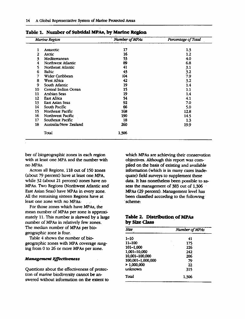
The.inventory carried out for this study by the CNPPA MPA working groups identifies a total of 1,306 MPAs around the world. It focuses on protected areas with a subtidal component; the large number of coastal protected areas which include only terrestrial or intertidal features have not been included.Table 1 outlines the number of existing subtidal MP As in each Marine Region
The number of MP As ranges from a maximum of 260 MP As the Australia/New Zealand to a per region minimum of 15 in the Central Indian Ocean. A large proportion of the MP As is concentrated in four Regions, the Wider Caribbean, Northeast Pacific, · Northwest Pacific, and Australia/New Zealand, which all have more than 100 MP As and account for over 55 percent of the total number. Most Marine Regions have compara-
Introduction 13
tively few MPAs. Six Marine Regions, the Antarctic, Arctic, South Atlantic, Central Indian Ocean, Arabian Seas, and Southeast Pacific all have fewer than 20 MP As each and together account for less than 10 percent of the total number of MP As. The remaining eight Marine Regions have between 41 and 92 MP As each.
SizeofMPAs
Figures on the size (the surface area) of MP As need to be interpreted with caution, because some of the MP As include coastal intertidal and terrestrial elements as well as a subtidal component. There are· no data available on the area of 315 MPAs.
The mean size of the MP As inventoried is over 100,000 hectares. However, this number is greatly skewed by a relatively small number of very large MP As; a truer reflection may be given by the median size which is 1,584 hectares.
The largest MP As include the Great Barrier Reef Marine Park (Australia) at 34.4 million hectares, the Galapagos Islands Marine Resources Reserve and Whale Sanctuary (Ecuador) at 8 million hectares and the Milieuzone Noordzee (Netherlands) at 2 million hectares. The smallest include the Monaco Red Coral Reserve (Monaco) and Doctor's Gully Fish Reserve (Australia), both of which have an area of 1 hectare.
Table 2 shows the distribution of MP As according to size classes.
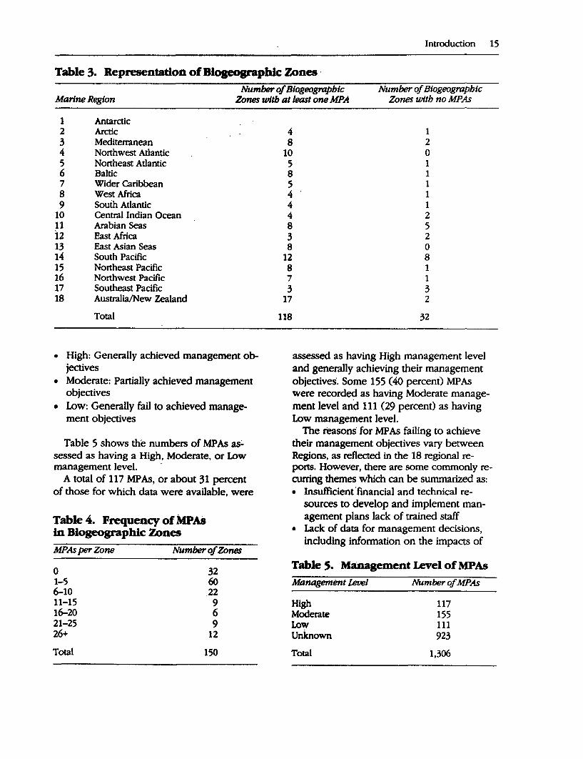
Representativeness
Biogeographic classification systems have been adopted for use in 17 of the 18 Marine Regions (it was not feasible to adopt such a system for the Antarctic because there is no agreement on an appropriate classification system). The systems have been used in assessing the degree to which existing MP As represent ·the major biogeographic types in each Marine Region. Table 3 lists the num-
14 A Global Representative System of Marine Protected Areas
Table 1. Number of Subtidal MPAs, by Marine Region
Marine Region
1 Antarctic 2 Arctic 3 Mediterranean 4 Northwest Atlantic 5 Northeast Atlantic 6 Baltic 7 Wider Caribbean 8 West Africa 9 South Atlantic
10 Central Indian Ocean 11 Arabian Seas 12 East Africa 13 East Asian Seas 14 South Pacific 15 Northeast Pacific 16 Northwest Pacific 17 Southeast Pacific 18 Australia/New Zealand
Total
her of biogeographic zones in each region with at least one MP A and the nu~ber- with noMPAs.
Across all Regions, 118 out of 150 zones (about 79 percent) have at least one:MPA, while 32 (about 21 percent) zones h~ve no MPAs. Two Regions (Northwest Atlantic and· East Asian Seas) have MPAs in every zone. All the remaining sixteen Regions have at least one zone with no MP As;
For those zones which have MP As, the mean number of MP As per zone is approximately 11. This number is skewed by a large number of MP As in relatively few zones. The median number of MP As per biogeographic zone is four.
Table 4 shows the number of biogeographic zones with MPA coverage ranging from O to 26 or more MP As per zone.
Management J!8ectiveness
Questions about the effectiveness of protection of marine biodiversity cannot be answered without information on the extent to
' Number of MPAs
17 16 53 89 41 43
L04 42. 19 15 19 54 92 66
168 190 18
260
1,306
Percentage of Total
1.3 1.2 4.0 6.8 3.1 3.2 7.9 3.2 1.4 1.1 1.4 4.1 7.0 5.0
12.8 14.S 1.3
19.9
which MP As are achieving their conservation objectives. Although this report was com-· piled on the basis of existing and available information.( which is in many cases inadequate) field surveys to supplement these data. It has nonetheless been possible to assess the management of 383 out of 1,306 · MP As (29 percent). Management level has been classified according to the following·
·scheme:
Table 2. ~tribution_of MPAs by Size Class Size . .. 1-10 11-100 101-1,000 1,001-10,000 10,001-100,000 100,001-1.000.000 > 1,000,000 unknown
Total
Number of MPAs
41 175 226 242 206 79 22
315
1,306
Introduction 15
Table 3. Representation of Blogeographlc Zones · Number of Btogeograpbtc Number of Btogeographtc
Marine Region Zones wltb at least one MPA Zones with no MPAs
1 Antarctic 2 Arctic 3 Mediterranean 4 Northwest Atlantic 5 Northeast Atlantic 6 Baltic 7 Wider Caribbean 8 West Africa 9 South Atlantic
10 Central Indian Ocean 11 Arabian Seas 12 East Africa 13 East Asian Seas 14 South Pacific 15 Northeast Pacific 16 Northwest Pacific 17 Southeast Pacific 18 Australia/New Zealand
Total
• High: Generally achieved management objectives
• Moderate: Partially achieved management objectives
• Low: Generally fail to achieved management objectives
Table 5 shows the numbers of MP As as.:. sessed as having a High, Moderate, or Low management level.
A total of 117 MP As, or about 31 percent of those for which data were available, were
Table 4. Frequency of MPAs in Biogeographic Zones MPAs per Zone Number of Zones
0 1-5 6-10 11-15 16-20 21-25 26+
Total
32 60 .22
9 6 9
12
150
4 1 8 2
10 0 5 1 8 1 5 1 4 1 4 1 4 2 8 5 3 2 8 0
12 8 8 1 7 1 3 3
17 2
118 32
assessed as having High management level and generally achieving their management objectives. Some 155 (40 percent) MPAs were recorded as having Moderate management level and 111 (29 percent) as having Low management level.
The reasons for MP As failing to achieve their management objectives vary between Regions; as reflected in the 18 regional reports. However, there are some commonly recurring themes which can be summarized as: • Insufficient· financial and technical re
sources to develop and implement management plans lack of trained staff
• Lack of data for management decisions, including information on the impacts of
Table s. Management Level of MPAs Management Level
High Moderate Low unknown Total
Number of MPAs
117 155 111 923
1,306
16 A Global Representative System of Marine Protected Areas
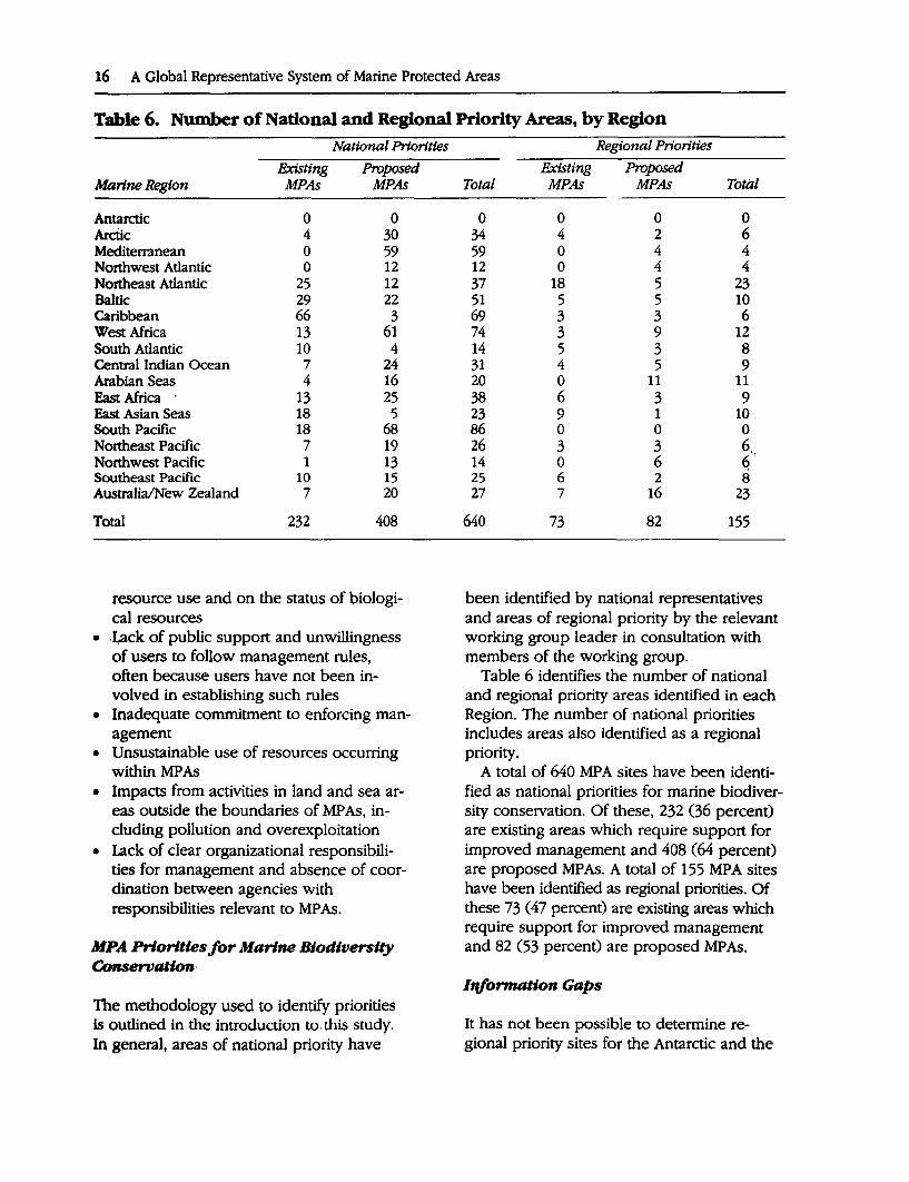
Table 6. Number of National and Regional Priority Areas, by Region National Priorities
.Existing Proposed Marine Region MPAs MPAs
Antarctic 0 0 Arctic 4 30 Mediterranean 0 59 Northwest Atlantic 0 12 Northeast Atlantic 25 12 Baltic 29 22 Caribbean 66 3 West Africa 13 61 South Atlantic 10 4 Central Indian Ocean 7 24 Arabian Seas 4 16 East Africa 13 25 East Asian Seas 18 5 South Pacific 18 68 Northeast Pacific 7 19 Northwest Pacific 1 13 Southeast Pacific 10 15 Australia/New Zealand 7 20
Total 232 408
resource use and on the status of biological resources
• ,Lack of public support and unwillingness of users to follow management rules, often because users have not been involved in establishing such rules
• Inadequate commitment to enforcing management
• Unsustainable use of resources occurring within MPAs
• Impacts from activities in land and sea areas outside the boundaries of MP As, including pollution and overexploitation
• Lack of clear organizational responsibilities for management and absence of coordination between agencies with responsibilities relevant to MP As.
MPA Priorities for Marine Biodiversity Conservation·
The methodology used to identify priorities is outlined in the introduction to.this study. In general, areas of national priority have
Regional Priorities
.Existing Proposed Total MPAs MPAs Total
0 0 0 0 34 4 2 6 59 0 4 4 12 0 4 4 37 18 5 23 51 5 5 10 69 3 3 6 74 3 9 12 14 5 3 8 31 4 5 9 20 0 11 11 38 6 3 9 23 9 1 10. 86 0 0 0 26 3 3 6, 14 0 6 q' 25 6 2 8 27 7 16 23
640 73 82 155
been identified by national representatives and areas of regional priority by the relevant working group leader in consultation with members of the working group.
Table 6 identifies the number of national and regional priority areas identified in each Region. The number of national priorities includes areas also identified as a regional priority.
A total of 640 MPA sites have been identified as national priorities for marine biodiversity conservation. Of these, 232 (36 percent) are existing areas which require support for improved management and 408 (64 percent) are proposed MPAs. A total of 155 MPA sites have been identified as regional priorities. Of these 73 ( 47 percent) are existing areas which require support for improved management and 82 (53 percent) are proposed MP As.
I'tf!ormation Gaps
It has not been possible to determine regional priority sites for the Antarctic and the
Introduction 17
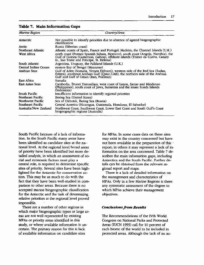
Table 7. Main Information Gaps Marine Region Country/Area
Antarctic
Arctic
Not J?.OSsible to identify priorities due to absence of agreed biogeographic classification Russia (Siberian coast)
Northeast Atlantic West Africa
Atlantic coasts of Spain, France and Portugal; Madeira; the Channel Islands (U.K.) north coast (Former Spanish Sahara, Morocco), south coast (Angola, Namibia), the Gulf of Guinea (Cameroon, Gabon), offshore islands (Tristan da Cunha, Canary Is., Sao Tome and Principe, St. Helena)
South Atlantic Central Indian Ocean Arabian Seas
Argentina, Uruguay, the Falkland Islands (U.K.) eastern Bay of Bengal (Myanmar) Gulf of Aden (Somalia, Yemen Djibouti), western side of the Red Sea (Sudan, Eritrea), southeast Arabian Gulf (Qatar-DAE), the northern side of the Arabian Gulf and Gulf of Oman (Iran, Pakistan)
East Africa Somalia East Asian Seas Cambodia, Brunei Oarusallam, west coast of Luzon, Sarnar and Mindanao
(Philippines), south coast of Jawa, Sumatera and the lesser Sunda Islands (Indonesia)
South Pacific Northeast Pacific Northwest Pacific Southeast Pacific Australia/New Zealand
Insufficient information to identify regional priorities Bering Sea (United States) Sea of Okhotsk, Bering Sea (Russia) Central America (Nicaragua, Guatemala, Honduras, El Salvador) Northwest Coast, Southwest Coast, Lower East Coast and South Gulfs Coast biogeographic regions (Australia)
South Pacific because of a lack of information. In the South Pacific many areas have been identified as candidate sites at the na- · tional level. At the regional level broad areas of priority have been identified but more detailed analysis, in which an assessment of social and economic factors must play a central role, is required to determine specific sites of priority. Several sites have been highlighted for the Antarctic for conservation action. This may be as much to do with the fact that they have been well-studied in comparison to other areas. Because there is no accepted marine biogeographic classification for the Antarctic and the task of determining relative priorities at the regional level proved impossible.
There are a number of other regions in which major biogeographic types or large areas are not well represented by existing MP As or priority areas identified in this study, or where available information is uncertain. The primary reason for this is lack of a~ailable information,on candidate sites
for MPAs. 'In some cases data on these sites may exist in the country concerned but have not been available in the preparation of this · report; iri others it may represent a lack of information on the area concerned. Table 7 describes the main information gaps, including Antarctica and the South Pacific. Further details can be obtained from the relevant regional report and maps.
There is a lack of detailed information on the management and characteristics of · MP As. Only in a few Marine Regions is there any systematic assessment of the degree to which 'MP As achieve their management objectives.
Conclusions from Results
The Recommendations of the IVth World Congress on National Parks and Protected Areas (IUCN 1993) call for 10 percent of each biome of the world to be included in protected areas. Although the lack of an ac-
18 A Global Representative System of Marine Protected Areas
cepted global classification system makes comparison between Marine Regions difficult, broad conclusions can be drawn.
In the overwhelming number of cases the area of each marine biogeographic zone included in MP As is much less than 1 percent of its total area. Furthermore, most of the biogeographic zones are large areas which include a range of different ecosystem types. More detailed information on the range of ecosystem types present in each zone and in each MP A would be required to determine the extent to which the biodiversity of each zone is adequately "represented." However, there must be doubts about the extent to which MPAs of a median size of 1,500 hectares can protect a representative sample of the biodiversity of a large zone, particularly given the interconnectedness of the sea and the degree to which material (pollutants, larvae etc) and impacts are transferred.
From the available information on the size, number and distribution of MP As according to biogeographic type, it is clear that the coverage of existing MP As falls well below this target figure of 10 percent of all marine biomes. One-quarter of the marine biogeographic types identified have no MP As. A total of 81 new MP As have been proposed as regional priorities.
Although there are a few very large MP As, most are relatively small areas of less than a few thousand hectares. Many are threatened by activities beyond their boundaries and outside the scope of management control.
Data on management effectiveness are sketchy. The difficulty of obtaining such !nformation presents a major difficulty in evaluating management effectiveness. Achieving effective management of existing MP As is of equal priority to the establishment of new areas. In most regions a significant number of MP As exist on paper only with no management plan and no management activity. In total, 73 existing MP As are considered to be of regional priority for improved management.
General Recommendations
Recommendations and actions relevant to the protection and s-ustainable management of marine biodiversity, including MPAs, are contained in a number of sources. These include Chapter 17 of Agenda 21 from the United Nations Conference on Environment and Development (UNCED), the Biodiversity Convention, Caring for the Earth: A Strategy for Sustainable Living (IUCN/UNEP/WWF 1991), the Global Biodiversity Strategy (WRI/IUCN/ UNEP 1992), Global Marine Biological Diversity: A Strategy for Building Conservation into Decision Making (CMC/IUCN/ WWF/UNEP/World Bank 1993), the Gu_idelines for Establishing Marine Protected Areas (Kelleher and Kenchington 1992), Marine and Coastal Protected Areas: A Guide for Planners and Managers (Salm and Clark 1984), and Parks for Life (IUCN 1993), the proceedings of the IVth World Congress on National Parks and Protected Areas.
The recommendations below specifically address priority issues for the establishment and effective management of a global representative system of marine protected areas for the protection and sustainable management of the world's marine biodiversity.
The recommendations are based on an analysis of the 18 regional reports and a synthesis of the recommendations contained in these reports. Where appropriate they also draw from the sources outlined above. The recommendations address the following issues relevant to MPAs: • Integrated management of the marine en-
vironment • Application of science to management • Securing of community support • Development of the human capacity to
manage • Achievement of a balance between plan
ning, implementation and evaluation (assessment of management effectiveness)
• Funding.
Integrated Management of the Marine Environment
It is beyond the scope of this report to attempt to address issues relating to coastal zone management and marine biodiversity. However, the establishment and management of MP As is likely to prove to be a futile exercise unless it occurs within regimes which provide for integrated management of all uses of the adjacent land and sea areas. In particular, land-based activities such as clearing of forests, agriculture and urban development can result in pollution of the marine environment and in many areas are the major threat to marine biodiversity. This cannot be addressed by MP As without linkages to wider coastal zone management programs.
There is a variety of legal and jurisdictional systems governing the management of marine resources and MP As. Overlapping responsibilities among different agencies are common, and a number of different agencies may have jurisdiction over the resources of a single marine area. In some countries several agencies establish MP As under a variety of different designations.
Frequently there is little or no coordination between such agencies. This leads to conflicts in the use of marine resources in and around MPAs and may result in overuse and degradation of marine biodiversity. Coordination of management in the marine envi-ronment is in many ways even more important than it is in the terrestrial sphere because the high degree of connectivity in the seas facilitates the transmission of substances and effects throughout the water column. There is a need for clearly defined responsibilities for management and for institutional and administrative mechanisms to ensure coordination of existing agencies. Management agencies also require the necessary legislative backing and resources to manage MPAs effectively.
Conflicts can also arise when the organizations with responsibility for MP As are charged with simultaneously achieving eco-
Introduction 19
nomic and conservation objectives. Achievement of ecological sustainability should be the overriding goal of management. Wherever possible management agencies should not have the conflicting responsibility for economic optimization of any activities within the MP As, which should be in any case subordinate to the goal of ecological sustainability.
Ideally, integration should extend to coordinated management of marine and terrestrial areas in the coastal zone and beyond; however, in many circumstances the complexity of boundaries and competition between governments and government agencies regarding jurisdictional responsibility effectively preclude this.
The establishment of a large, multiple use protected area with an integrated management system, preferably covering a complete ecosystem, has the advantage that co-ordination of regulation of different human activities can be automatically achieved when the overriding responsibility for management on an ecologically sustainable basis rests with one agency. Furthermore, the minimum viable size of a MP A is likely to be many times that for a terrestrial reserve (Kelleher and Kenchington 1992). The optimal goal is for integrated management of each of the marine ecosystems of the world, along the lines of that proposed under the LME management model.
In the absence of, or as a precursor to, an effective coastal zone management program, a large multiple-use MP A may provide the basis for integrated and sustainable management of an ecosystem. In this regard, the UNESCO Biosphere Reserve model is one which finds ready application to MPAs.
The Application of Science to Management
Scientific knowledge must play an important role in the determination of management priorities for MP As. The lack of such knowledge severely hampers management planning in many MP As.
20 A Global Representative System of Marine Protected Areas
Adequate baseline or referenced ecological characteristics of the marine environment is essential in order to monitor the changes wrought by human activities and to develop appropriate management response strategies. The absence of comprehensive, long term monitoring programs for most MP As prevents definition of the level of stresses that exist now and the trends in those levels. The development of such long-term monitoring programs should be a high priority for all MP As. This should include the development of monitoring techniques. which can be widely applied and easily understood. Where practicable, these (echniques should have the capacity to use local people in the collectio~ and interpretation of primary data and should also make use of traditional knowledge. This builds commitment tp management programs which implement the results of research.
Science also has a vital role in providing information to allow prediction of the type and scale of effect likely to be produced by indjvidual activities and combinations of · thein, so that the intensity and distribution of usages can be controlled-but not overcontrolled-in a manner compatible with · the overriding goal of management. There is a need for research to determine existing and planned levels of use of the marine environment and the likely effects of those uses.
In most countries the amount of funds available to carry out research relevant to marine biodiversity conservation is limited. It is essential that the funds available be directed towards those areas of research which have a high likelihood of answering management questions.
In co~idering how to ensure the applica- . tion of scientific research to management there are two fundamental principles: • Managers and scientists must work to
gether in the identification of environmental problems that can be effectively addressed by scientific methods.
• Managers arid scientists must work together in the design of research programs
to address these problems and in the implementation and application of the results.
The development of representative MP A systems requires knowledge of the distribution of marine ecosystems and species. It can be argued that an accurate assessment of biogeographic cover at the global level cannot be made until a single biogeographic classification system has been applied at that level and an analysis made on the basis of the system. However, it can also be argued that, provided that such an analysis is carried out within each region based on any competent internally consistent biogeographic classification system, the degree of coverage or representation of biogeographic types can be assessed ade7
quately and MP A priorities identified. At present there is no generally accepted
global classification system although systems do exist at the regional level. Further developments in biogeographic classification should proceed in parallel with the implementation of immediate MPA management priorities. Providing information in a form that is useful to managers for the protection and management of marine biodiversity should be a primary objective of all such systems.
Securing Community Support
Most coastal marine areas around the world have a long history of use by local people. In some cases this extends to traditional ownership over marine resources. Where there .is continuing use or custody over marine resources the chances of establishing effective MP As depend to a very large extent on voluntary acceptance of management measures, which usually depends on planning involvement and participation in management programs. With few exceptions, examples of effectively managed MP As give responsibility to local users in the management process. The use of traditional skills in the management of MP As should be encouraged.
In all parts of the world there is a strong link between· economic development and the protection and sustainable management of biological diversity. In many countries, potentially the greatest 'threat to sustainable use of marine resources is poverty, which forces individuals and communities to make short-· term decisions to exploit unsustainable ma.:.' · rine resources. The marine environment, ' traditionally considered a "commons" ~here access to resources is open to anyone with the ability to exploit those resources, is particularly vulnerable to such pressures. As coastal populations increase, so too will · these pressures.
Community support will depend on the· · development of management plans which· are compatible with, to the extent feasible, traditional or customary ·practices for the· use and conservation of marine resources. It is · vital to provide for the continued welfare of people affected by the ·creation of MP As.
MPAs have the potential to contribute to · the economic well-being of coastal communities by providing a sustainable flow of benefits as well as achieving conservation · · objectives. The Biosphere Reserve· model ex~ emplifies this effect. There is likely to be op.:. position towards the establishment of MP As and unwillingness to follow management measure unless the local population receive1
some tangible benefits from the establishment of MPAs. Tourism and fisheries are two areas in particular where MP As can play a key role in providing sustainable financial benefits to local communities.
Ongoing consultation with local communities will be essential to determine economic,· social, cultural and conservation priorities, and to determine how MP As can help achieve these priorities. The effectiveness of MP As in the long-term will depend on their compatibility and integration with ecological, social and economic objectives at both the national and local levels.
Part of the challenge is to educate local communities on the importance of using marine resources sustainably and to convince
Introduction 21
them of the need and benefits of taking action to protect marine biodiversity. This will require conducting information campaigns to r.a'ise the profile of MP As and marine biodiversity conservation and incorporation of a strong marine component in environmental education.
Nongovernmental qrganizations (NGOs) frequently have stron:g links to local communities and where practicable should be closely consulted and involved in management planning and implementation and in promoting environmental awareness. In some countries NGOs are delegated responsibility for day-to-day management of MP As when government agencies lack the human, technical or financial capacity to carry out this ·task. In some cases NGOs have greater flexibility and potential to access sources of funds and support not readily available to government agencies. Managers should actively involve NGOs in the planning and management of MPAs. Where appropriate this.could include the delegation of management responsi~ilities.
Developing t~e Human Capacity toM~age
The availability of committed and skilled people is: fundamental to the success of actions to establish and manage marine protected areas. Increases in funding for MP As, strong institutional arrangements and other actions' will be ineffective unless the available pool of human talent for MPA management expands rapidly. Training and the development of national capacities for management of coastal resources are a fundamental requirement. Regions and countries must become more self-reliant in developing the capacity to meet their own training needs. To achieve this international and other support for capacity development in marine management should emphasize the development of training capacity within regions and countries. Such an approach involves "training the trainers" and the
22 A Global Representative System of Marine Protected Areas
establishment of regional and national training centers to carry out further training.
Training should extend to all levels, from field staff to senior managers with the aim of equipping MP A managers with the skills they need. Politicians and high-level administrators are often not familiar with the necessity, advantages and means of achieving effectively managed MP A systems, or with the adverse environmental, social and economic consequences of mismanagement or neglect. Training is required to increase the political awareness of the benefits of effective MP A systems.
There are few networks for MPA and marine resource managers in comparison to the number of such support services for marine scientists. There is a demand for a network in which managers of MP As can share and learn from each other's experience and discuss and review management priorities.
Achieving a Balance Between Planning, Implementation and Evaluation
In total, 1,306 MPAs have been identified as established across all Marine Regions of the world. There is also a large number of unimplemented proposals. Available data suggest that the number of MP As that fail to achieve their management objectives is high. One reason for this is that the resources and emphasis on planning MP As typically exceeds that given to implementation of management. There is even less attention given to evaluation of the success of management.
Insufficient attention is given to monitoring the extent to which MP As achieve their objectives as a basis for taking action to improve management programs. Effective implementation, monitoring and review are essential for MP As to achieve their management goals, and should be part of all MPA management programs. MPA agencies should commence a coordinated scientific
and administrative effort to ensure that existing MP As meet their management objectives.
Programs which aim to support MPAs must provide sufficient financial and technical resources over a time frame long enough to allow for effective implementation, monitoring and review of management plans.
Sources of Funding
Lack of funding is a primary reason why many MP As fail to achieve their conservation objectives and why there is a large number of unimplemented MPA proposals. Sufficient resources need to be mobilized for the development and implementation of management plans, for regulatory statutory review processes, interpretation, education, training, volunteer programs, research, monitoring, surveillance and enforcement programs. However, it unlikely that governments alone can allocate these resources.
If MP As are to function well in the long term, sustainable financing from a variety of sources must be developed. This will require innovative approaches and partnerships. Examples include revenue generation from taxes or "rent" from resource uses such as fisheries or tourism, as well as taxes on development projects which result in losses of marine or coastal biodiversity. In some countries the establishment of trust funds has proved to be a useful tool. The development of public/private partnerships in fmancing conservation activities is also receiving increased attention. Opportunities in which biodiversity conservation can be made profitable, such as bioprospecting, ecotourism, mariculture, and value added industries that increase the efficiency of resource use, are being targeted by specialized venture capital funds and are attracting the interest of investors in many parts of the world. The international donor community, in addition to providing direct financial assistance, can act
as a broker in leveraging resources from a variety of camps.
A critical issue in financing marine protected areas is the assessment and publication of the economic benefits of MP As, which often exceed those of any alternative use. This will require research to evaluate and publicize the economic benefits of MP As. Such a project is being carried out by the CNPPA. Many decisionmakers and economists ignore the regional benefits of MP As, particularly in tourism and assess the benefits as only those expressed in entry fees. In fact, the benefits include among others improved overall fish catches, revenue from external tourism industry and employment in these industries. In cooperation with local communities and other groups, management agencies should identify and establish facilities to promote ecotourism in MP As and make use of MP As as a tool for fisheries management.
Just as in mobilizing resources for management, many developing countries will require financial assistance to establish national MPA systems. Regional support mechanisms and technical cooperation between countries are essential for the success of national efforts.
In some cases the most effective use of resources might be made through the use of a regional fund or system of national environmental funds, particularly where there is a diversity of small governmental and nongovernmental organizations managing MP As. Thus, the need to diversify the base of support for MPA establishment and management is clear.
Site Specific Recommendations
In total, 155 MPAs sites have been identified as being of regional priority for the conservation of marine biodiversity (Table 8). These areas are those accorded highest priority for conservation action in each region. The sites
Introduction 23
are either proposed new MP As or existing MP As which require support for improved management.
CONCLUSION-THE WAY FORWARD
This report recommends priority areas and actions for the creation of a global representative system of MP As. It provides strategic guidance to the GEF, the World Bank and other funding organizations for investment in marine biodiversity conservation. The next phase of this program should focus on the development and implementation of specific proposals for the creation of new MPAs and for improved management arrangements for inadequately managed existing MPAs. At the same time, in some regions or countries additional investigations will be required to refine priorities or to address gaps in knowledge preventing priority identification. The approach to the development and implementation of MP A priorities will depend on whether the MP As are within developed or developing countries. It can be expected that the funding for further development of national MPA systems in developed countries will be taken by the countries themselves, using funds and resources of their own. This report will serve the useful function of identifying priorities to guide such countries in these efforts. Few developing countries have the human or financial resources necessary to create and effectively manage new MPAs. Consequently, they will require assistance internationally both in terms of expertise and in the provision of funds. The sources of those funds include international financing institutions such as the GEF, World Bank or the regional banks, UNDP, national aid organizations, nongovernmental sources and private organizations.
The development of proposals for priority MPAs in developing countries should have a
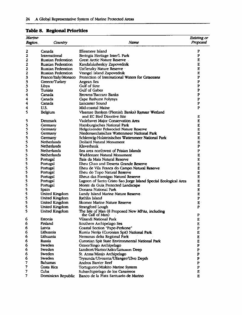
24 ,A Glo~l Representative System of Marine Protected Areas
Table 8. Regional Priorities Marj~ Extsttng. or Region. Country Name Proposed
2 Canada Ellesmere Island p 2 International Beringia Heritage Inter'l. Park p 2 Russian Federation Great Arctic Nature Reserve . E 2 Russian Federation Kandalakshesltjy Zapovednik E 2 Russian Federation Ust;lensky 'Nature Reserve · E 2 Russian Federation Vrangel Island .Zapovednik E 3 France/Italy/Monaco Protection of International Waters for Cetaceans p
3 Greece/I'urkey Aegean Sea p 3 Libya Gulf of Sirte p 3 Tunisia Gulf of Gabes p 4 Canada Browns/Baccaro Banks p 4 Canada Cape Bathurst. Polynya p 4 Canada Lancaster Sound p 4 U.S. Mid:-eoastal Maine p 5 Belgium Vlaamse Banken (Flemish Banks) Ramsar Wetland
and EC Bird. Directive Site · · E 5 Denmark Vadehavet Major Conservation Area E 5 Germany Hamburgisches National Park E 5 Gennany Helgolaender Felssockel Nature Reserve E 5 Germany Niedersaechsisches Wattenmeer National Park E 5 Germany Schlesv.rig-Holsteinisches Wattenmeer National Park E 5 Netherlands Dollard.Natural Monument E 5 Netherlands klaverbank · p 5 Netherlands Sea area northwest of Frisian Islands p 5 Netherlands Waddenzee Natural Monument E 5 Portugal Baia da Maia· Natural Reserve E 5 Portugal Ilheu Chao and Deserta Grande Reserve E 5 Portugal Ilheu de Vila Franqt do Campo.Natural Reserve E 5 Portugal Ilheu do Topo Natural Reserve E 5 Portugal Ilheus das Formigas Natural Reserve E 5 Portugal Lagoon of Santo. Cristo Sao Jorge Island Special Ecological Area E 5 Portugal Monte da Guia, Protected Landscape E 5 Spain Donana National Park . E 5 United Kingdom Lundy Island Marine Nature Reserve; E 5 United Kingdom Rathlin Island p 5 United Kingdom Skomer Marine Nature Reserve E· 5 United Kingdom Strangford Lough p 5 United Kingdom The Isle of Man (8 Proposed New MPAs, including
the Calf of Man) . p 6 Estonia Vilsandi National Park E 6 Finland Southern Archipelago Sea E 6 Latvia Coastal Section "Pape-Perkone" p 6 Lithuania Kursiu Nerija (Curonian Spit) National Park E 6 Lithuania Nemunas delta Regional Park E 6 Russia . Curonian Spit State Environmental National Park E 6 Sweden Graso/Singo Archipelago p 6 Sweden Landsort/Hartso/ Asko/LanWiOn Deep p 6 Sweden St. Anna/Missjo Archipelago p 6 Sweden Trysunda/Ulvoama/Ullanger/Ulvo Depth p 7 Bahamas Andros Barrier Reef p 7 Costa Rica Tortuguero/Miskito Marine System p 7 Cuba Subarchipielago de los Canarreos E 7 Dominican Republic Banco de la Plata Santuario de Marino E
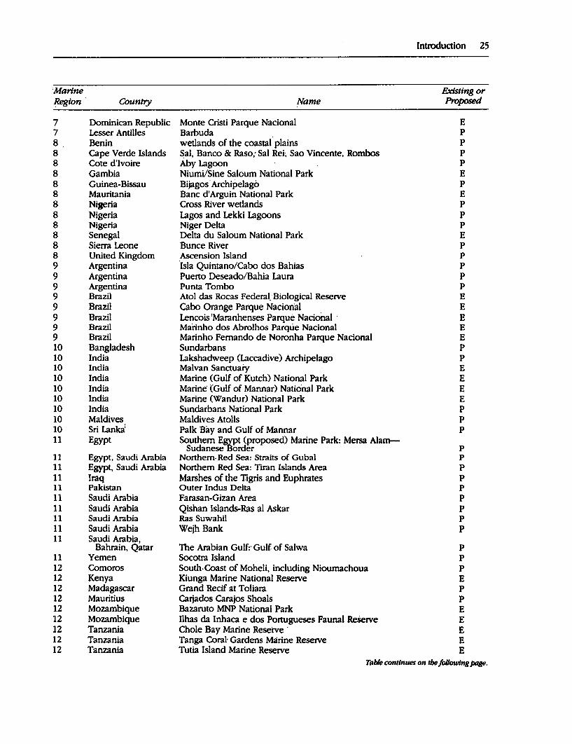
Introduction 25
'Marine Existing or Region Country Name Proposed
7 Dominican Republic Monte Cristi Parque Nacional E 7 Lesser Antilles Barbuda p
8 Benin wetlands of the coastal plains p 8 Cape Verde Islands Sal, Banco & Raso; Sal Rei; Sao Vincente, Rombos p 8 Cote d'Ivoire Aby Lagoon p
8 Gambia Niumi/Sine Saloum National Park E 8 Guinea-Bissau Bijagos · Archipelago p 8 Mauritania Banc d'Arguin National Park E 8 Nigeria Cross River wetlands p 8 Nigeria Lagos and Lekki Lagoons p 8 Nigeria Niger Delta p 8 Senegal Delta du Saloum National Park E 8 Sierra Leone Bunce River p 8 United Kingdom Ascension Island p 9 Argentina ·Isla Quintano/Caho dos Bahias p
9 Argentina Puerto Deseado/Bahia Laura p
9 Argentina Punta Tombo p 9 Brazil Atol das Rocas Federal'Biological Reserve E 9 Brazil Cabo Orange Parque Nacion'al E 9 Brazil Lencois 'Maranhenses Parque Nacional · E 9 Brazil Marinho dos Abrolhos Parqtie Nacional E 9 Brazil Marinho Fernando de Noronha Parque Nacional E 10 Bangladesh Sundarbans p 10 India Lakshadweep (Laccadive) Archipelago p 10 India Malvan Sanctuary E 10 India Marine (Gulf of Kutch) National Park E 10 India Marine· (Gulf of Mannar) National Park E 10 India Marine (Wandur) National Park E 10 India Sundarbans National Park p 10 Maldives Maldives Atolls p 10 Sri Lanka: Palk Bay and Gulf of Mannar p 11 Egypt Southern E~t (proposed) Marine Park: Mersa Alam-
Sudanese order p 11 Egypt, Saudi Arabia Northern, Red Sea: Straits of Gubal p 11 Egypt, Saudi Arabia Northern Red Sea: Tiran Islands Area p 11 Iraq Marshes of the Tigris and Euphrates p 11 Pakistan Outer Indus Delta p
11 Saudi Arabia Farasan-Gizan Area p 11 Saudi Arabia Qishan Islands-Ras al Askar p 11 Saudi Arabia Ras Suwahil p 11 Saudi Arabia Wejh Bank p 11 Saudi Arabia,
Bahrain, Qatar The Arabian Gulfr Gulf of Salwa p 11 Yemen Socotra Island p 12 Comoros South.Coast of Moheli, including Niournachoua p 12 Kenya Kiunga Marine National Reserve E 12 Madagascar Grand Recif at Toliara p 12 Mauritius Carjados Carajos Shoals p 12 Mozambique Bazaruto MNP National Park E 12 Mozambique Ilhas da Inhaca e dos Portugueses Faunal Reserve E 12 Tanzania Chole Bay Marine Reserve · E 12 Tanzania Tanga Coral- Gardens Marine Reserve E 12 Tanzania Tutia Island Marine Reserve E
Table continues on tbe fol/owlns Jxllle.
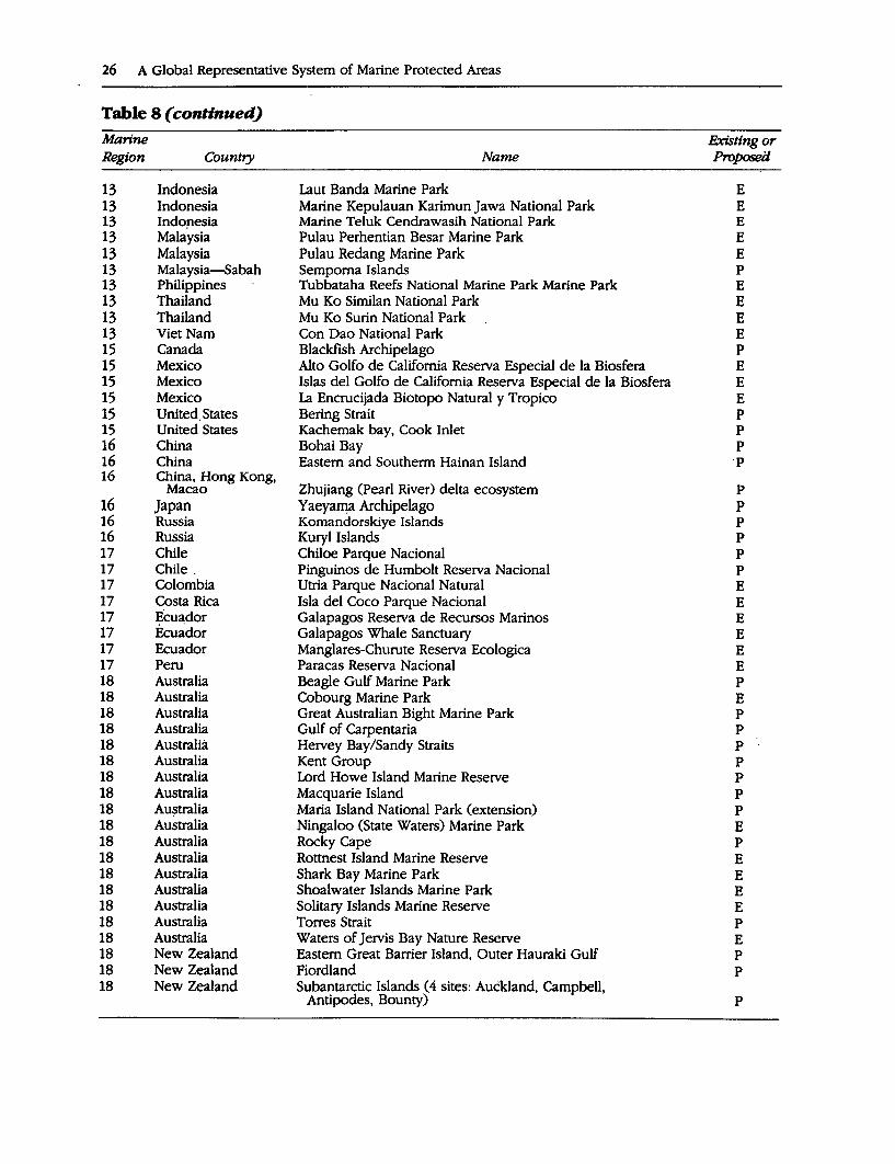
26 A Global Representative System of Marine Protected Areas
Table 8 ( continued) Marine F.xisttng or Region Country Name ProposeiJ
13 Indonesia Laut Banda Marine Park E 13 Indonesia Marine Kepulauan Karimun Jawa National Park E 13 Indopesia Marine Teluk Cendrawasih National Park E 13 Malaysia Pulau Perhentian Besar Marine Park E 13 Malaysia Pulau Redang Marine Park E 13 Malaysia-Sabah Semporna Islands p 13 Philippines Tubbataha Reefs National Marine Park Marine Park E 13 Thailand Mu Ko Similan National Park E 13 Thailand Mu Ko Surin National Park E 13 Viet Nam Con Dao National Park E 15 Canada Blackfish Archipelago p 15 Mexico Alto Golfo de California Reserva Especial de la Biosfera E 15 Mexico Islas del Golfo de California Reserva Especial de la Biosfera E 15 Mexico La Encrucijada Biotopo Natural y Tropico E 15 United. States Bering Strait p 15 United States Kachemak bay, Cook Inlet p 16 China Bohai Bay p 16 China Eastern and Southerm Hainan Island p 16 China, Hong Kong,
Macao Zhujiang (Pearl River) delta ecosystem p 16 Japan Yaeya~a Archipelago p 16 Russia Komandorskiye Islands p 16 Russia Kury! Islands p 17 Chile Chiloe Parque Nacional p 17 Chile . Pinguinos de Humbolt Reserva Nacional p 17 Colombia Utria Parque Nacional Natural E 17 Costa Rica Isla del Coco Parque Nacional E 17 Ecuador Galapagos Reserva de Recurses Marinos E 17 Ecuador Galapagos Whale Sanctuary E 17 Ecuador Ma·nglares-Churute Reserva Ecologica E 17 Peru Paracas Reserva Nacional E 18 Australia Beagle Gulf Marine Park p 18 Australia Cobourg Marine Park E 18 Australia Great Australian Bight Marine Park p 18 Australia Gulf of Carpentaria p 18 Australia Hervey Bay/Sandy Straits p 18 Australia Kent Group p 18 Australia Lord Howe Island Marine Reserve p 18 Australia Macquarie Island p 18 Au~tralia Maria Island National Park (extension) p 18 Australia Ningaloo (State Waters) Marine Park E 18 Australia Rocky Cape p 18 Australia Rottnest Island Marine Reserve E 18 Australia Shark Bay Marine Park E 18 Australia Shoalwater Islands Marine Park E 18 Australia Solitary Islands Marine Reserve E 18 Australia Torres Strait p 18 Australia Waters of Jervis Bay Nature Reserve E 18 New Zealand Eastern Great Barrier Island, Outer Hauraki Gulf p 18 New Zealand Fiordland p 18 New Zealand Subantarctic Islands ( 4 sites: Auckland, Campbell,
Antipodes, Bounty) p
strong national focus. Accordingly, funding ·proposals should be developed and imple,nented with the full involvement and support of the relevant national government authorities, appropriate NGOs and local people. The importance of this principle has been recognized in this report, which has involved national representatives to the maximum _extent practicable within time and resource constraints. Although in the majority of cases proposals will be country specific, it is envisaged that in some instances proposals will be developed using existing regional institutions which have national support. Examples include UNEP Regional Seas organizations such as the South Pacific Regional Environment Program (SPREP) and the Coordinating Body for the Seas of East Asia (COBSEA). Such an approach has advantages in promoting coordination between country efforts and in some cases may be more efficient in terms of administrative effort.
A key strength of IUCN and CNPPA is their broad constituency including both governmental and nongovernmental organizations. It is proposed that IUCN and CNPPA mobilize this constituency, involving other org~nizations to the maximum extent practi.: cable, to arrange for consultations with the governments of developing nations which have areas which have been identified in this study as being priority for the creation of the global representative system of MP As. It will be necessary to establish national
Introduction 27
working groups of scientists and managers to ensure coordination and cooperation between the management and scientific comm~nities. NGOs and community groups should also be represented in the process. The purpose of the consultations will be to develpp proposals to implement the priorities to meet the criteria for funding organizations and be compatible with national social and economic developmental priorities. The development of national and local management capacity must be a key element of all proposals.
The priorities in this report have been identified using the framework of the 18 CNPPA Marine Regions, each of which is headed by a working group leader. Initially, at least, the leader of the CNPPA regional working group which has produced the priorities for the region will be involved in developing specific MPA proposals for that region. In time, proposals can be developed with the national working group taking the lead role with the assistance of technical experts from other countries if necessary.
These actions will need to be complemented by a suite of other activities if a system of MP As is to developed which effectively represents the biogeographic zones of the world's seas and contributes to the ·maintenance of marine biodiversity as well as to the well-being of human communities. These actions have been discussed in this chapter and are summarized in box 2 on the following page.
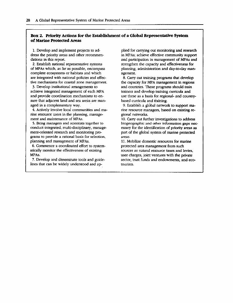
28 A Global Representative System of Marine Protected Areas
Box 2. Priority Actions for the Establishment of a Global Representative System of Marine Protected Areas
1. Develop and implement projects to address the priority areas and other recommendations in this report.
2. Establish national representative systems of MPAs which, as far as possible, encompass complete ecosystems or habitats and which are integrated with national policies and effective mechanisms for coastal zone management.
3. Develop institutional arrangements to achieve integrated management of each MP A and provide coordination mechanisms to ensure that adjacent land and sea areas are man-aged in a complementary way. · 4. Actively involve local communities and ma
rine resource users in the planning, management and maintenance of MP As.
5. Bring managers and scientists together to conduct integrated, multi-disciplinary, management-oriented research and monitoring programs to provide a rational basis for selection, planning and management of MP As. 6. Commence a coordinated effort to system
atically monitor the effectiveness of existing MPAs.
7. Develop and disseminate tools and guidelines that can be widely understood and ap-
plied for carrying out monitoring and research in MP As; achieve effective community support and participation in management of MP As and strengthen the capacity and effectiveness for planning, administration and day-to-day management. 8. Carry out training programs that develop
the capacity for MPA management in regions and countries. These programs should train trainers and develop training curricula and use these as a basis for regional- and countrybased curricul~ and ttaining.
9. Establish a global network to support marine resource managers, based on existing regional networks. 10. Carry out further investigations to address biogeographic and other information gaps necessary for the identification of priority areas as part of the global system of marine protected areas. 11. Mobilize domestic resources for marine protected area management from such sources as natural resource taxes and levies, user charges, joint ventures with the private sector, trust funds and endowments, and ecotourism.
.Summary Tables
30 A Global Representative System of Marine Protected Areas
Table Sl. Ecosystem Diversity Cora/Reefs Total area:
Distribution:
Species diversity:
Productivity:
Other values:
Vulnerability:
Estimated 600,000 square kilometers. (Smith 1978) This estimate is being refined through a joint WCMC/ICLARM mapping and database project.
Tropical waters, depending on surface water temperature1
availability of suitable hard substrate for coral settlement, and water clarity; greatest aevelopment in west IndaPacific (see Smith [1978] for regional breakdown); global distrioution of reefs to be mapped by WCMC, in collaboration with REEFBASE (see below); see also UNEP/IUCN 0988).
Very hig_h for fish and invertebrates (4,500 reef fish, 20 percent of total world fish diversity); medium-high for other taxa; diversity highest in Southeast Asia (Veron 1993; Rosen 1988; Connell 1978).
High in terms of carbon fixation, low to medium in terms of harvestable biomass; critical habitat for commercially valuable fish and invertebrates; support important fisheries, many of which are artisanal/subsistence fisheries.
Coastal protection, tourism.
High; widespread deterioration from both natural and human-induced causes (Brown 1987; Salvat 1987; Dubinsky 1990; Wilkinson 1994).
Globally important Preliminary review in UNEP/IUCN (1988); global database REEFBASE to be established sites: by ICLARM in collaboration with WCMC.
Protection: Abbut 250 MP As with coral reefs.
General references: Ginsburg 0994).
Mangrove Forests Total area:
Distribution:
Species diversity:
Productivity:
Other values:
Vulnerability:
Protection:
About 190,000-240,000 square kilometers (estimates vary widely); fringe about 25 percent of the tropical coastline; estimates for coverage by country given in Fisher and Spalding 0993).
Intertidal, sheltered coastlines especially in estuaries in the tropics; distribution related to freshwater run-off (Saenger, Hegerle
1 and Davie 1983); most extensive areas in
Southeast Asia (40 percent) and Centra America WCMC nas mapped mangrove distribution for all countries with extensive tropical forest (not islands and desert countries).
Medium. About 90 species of plants, 50-60 of which are found only in mangroves: 10 species in New World and West Africa, 40 species in Old World. About 400 fish and many invertebrates depend on mangroves for all or part of their life cycles. Numerically dominatea by crabs and mollusks; also important for birds; greatest diversity in the Inda-Pacific.
Very high; support a grazing food chain, at the base of which are detritivores, and provide nursery grounds for fish and shellfish; critical habitat for commercially lffiportant fish ana invertebrates.
Coastal protection, trap sediments and prevent siltation, tourism, timber, fuelwood and other products.
High; 50 percent of mangroves already lost (but variability in estimates of total cover means that changes over time are difficult to measure). Globally important sites identified in wetland directories (see under "coastal wetlands" for references); some sites listed under Ramsar Convention; The International Society for Mangrove Ecosystems is developing a Mangrove Area Conservation Network and database and identifying priority areas.
About 700 protected areas contain man~roves (Fisher and Spalding 1993). In many countries mangroves are designated as Forest Reserves" for controlled exploitation.
Generic references: CEC 1992; Wenban-Smith 1993; Por and Dor 1984; Hutchings and Saenger 1987; Hamilton and Snedaker 1984.
Seagrass Beds Total area:
Distribution:
Diversity:
Productivity:
Other values:
Vulnerability:
Introduction 31
Unknown.
Tropical and temperate areas; in all seas except the polar regions; in tropics often associated with coral reefs.
Medium; about 50 species of seagrasses (Winston 1992); provide grazing for threatened marine vertebrates (green turtles, dugong), food for detritivores such as fish and invertebrates.
High; critical habitat for commercially valuable fish and invertebrates; important nursery, feeding, breeding and shelter areas for fish and invertebrates.
Trap sediments, prevent erosion and trap sediments.
High; pollution, destruction, disease.
Globally important Not known. A program has been initiated by the International Oceanographic sites: Commission to collect and exchange information on seagrasses, and a questionnaire is
being circulated in 1993 to relevant institutions.
Protection: Number of MPAs with seagrasses not known; proposal to determine this at WCMC.
Generic references: McRoy and Helferich 1977; Fonseca, Kenworthy, and Thayes 1991.
Other Coastal Wetlands Total area: Unknown.
Distribution:
Species diversity:
Productivity:
Other values:
Vulnerability:
Globally important sites:
Protection:
Worldwide; cover a variety of ecosystems including estuaries, deltas, lagoons! shallow tidal ponds, salt/tidal marshes, mudflats; temperate wetlands often include sa t marshes, tropical wetlands associated with mangroves; distribution often linked to river systems.
Medium; provide important feeding habitats for birds; estuaries in particular likely to have hign overall diversity because of habitat complexity.
High, particularly in estuaries which are often nursery habitats for marine species; often critical habitat for commercial fisheries, nursery areas for fish.
Often provide coastal protection or act as sediment trap.
High; destroyed by development projects, including tourism development and aquaculture; mudflats and marshes vulnerable to pollution.
Identified in wetland directories for Oceania (Scott 1993), Asia (Scott 1989), Western Palaearctic (Carp 1980), Africa (Burgis and Symoens 1987; Hughes and Hughes 1992) and the Neotropics (Scott and Carbonell 1980); many sites identified under Ramsar Convention. ·
Many sites protected; proposal to incorporate habitat coding in WCMC database.
Generic references: Dugan 1993; Finlayson and Moser 1991.
Beaches Total area:
Distribution:
Species diversity:
Dunes Unknown for each habitat.
Worldwide but no global overview; cliffed coasts found most often along western margins of continents, low-lying coasts in east, due to tectonic activity (Hayden, Ray, and Dolan 1984); European sites inventoried (Doody 1991); turtle nesting beaches being mapped by WCMC.
Cliffs and rocky coasts often have rich communities especially in tropics. Sandy coastlines often low diversity and may form barriers to species dispersal, but may have specialized communities. Sandy beaches are important breeding/nesting sites for seals and turtles.
Table conNnues on the fol/owing page.
32 A Global Representative System of Marine Protected Areas
Table Sl ( continued)
Other values:
Vulnerability:
Coastal protection, sandy beaches for tourism.
Often tend to be more resistant than ecosystems described above, but vulnerability to certain forms of pollution and coastal development.
Globally important Have not been reviewed; some sites listed under Ramsar or World Heritage Site sites: Convention .
Protection: . some protection in MP As but no overview available; proposed by WCMC.
Generic references: Thome-Miller and Catena 1991.
Islands and Submerged Banks (only the marine aspects of islands are considered)
Total area:
Distribution:
Species diversity:
Productivity:
Vulnerability:
·Not known.
Worldwide; a variety of ecosystems including low and raised coral isletsi atolls; barrier islands, rocky islets; seamounts; joint proposal with Birdlife Internationa, and WCMC to map seabird colonies.
Small, undisturbed predator-free islands often important for seabird colonies.
Seamounts and submerged banks often important for pelagic fish feeding and breeding; precious corals.
High on islands, but isolated islets and submerged banks often relatively safe.
Globally important Islands have been reviewed in Dahl (1991), although not all small sites are covered. sites:
Protection:
Open Ocean Total area:
Distribution:
Species diversity:
Productivity:
Vulnerability:
Some islets prot~cted because of seabird colonies.
Upwellings About 51 percent of the earth's surface has ocean over 3,000 meters deep (below the depth to which light can penetrate). Upwellings cover 0.1 percent. of ocean.
Worldwide; distribution of main ocean trenches, hydrothermal vents, and cold ~ communities in WCMC (1992) and major ocean atlases. Upwellings occur mainly off · west coasts of continents, especially in trade wind belts of tropics and subtropics and around Antarctica.
Orc:n sea diversity caused by seasonal changes in temperature, and irradiance, and · nuxing of currents from different depths and regions; includes plankton, fish large verteorates and larvae of many species. Diversity decreases with deP.th and distance · from land. Deep-sea diversity likely to be as high as shallow tropical communities (Grassle 1991); early studies of hydrothermal vents resulted in die discovery of 16 previously unknown invertebrate families (Grassle 1985). Maximum diversity occurs at about 2,00~3.000 meters. Abyssal species appear to have wider distributions, ~ps because there are no barriers to dis~rsal. Orily a limited number of areas have been sampled, such as off the east coast of North America.
UJ?wellings have high primary productivity; often good fishing areas (contribute one th1rd of world fishery catch) and attract large populations of t'"tSh-eating marine · mammals and birds.
Potentially threatened by pqllution and build up of pollutants, over-ftShing of pelagic resources, incidental take of cetaceans, turtles etc.
Globally important Main upwelling areas known, and many hydrothermal vents; no global overview; sites: some internationally important sites identified as whale sanctuaries, MARPOL areas etc.
Generic references: Thome-Miller and Catena 1991, Norse 1993, WCMC 1992, Angel 1982, Gage and Tyler 1991.
Introduction 33
Table S2. Species Diversity "Seaweeds Distribution:
Diversity:
Value:
Vulnerability:
Globally important sites:
Generic references:.
Carats Distribution:
Diversity:
End~mism:
Value:
Vulnei:ability:
Globally important sites:
Generic references:
Mollusks Distribution:
Diversity: .,
Endemism:
Value:·
Worldwide.
12,500 species of algae (Winston 1992) but this is probably an underestimate; other estimates for algae, plankton and laq~e seaweeds in Soumia and others (1991), Anderson (1992); highest diversity m the North Atlantic, tropical and subtropical West Atlantic, Japan; lowest diversity in polar regions and tropical West coast of Africa and South America (WCMC 1992).
Key food source for numerous marine animals; form the base of many food chains; up to 80 percent of the biomass and productivity in open waters is contributed by uftraplankton (Anderson 1992); some al$.ae are 'keystone' species (for example, coralline algae (Porolitbon and Litbopbyllum) in coral reefs and kelp Macrocystis which forms large 'forests' in some temperate waters; commercially important for production of agar, carrageen, alginates etc.
Many species very abundant, but can be over-harvested.
No global reviews known; kelp forests proposed for inclusion in WCMC database.
Lembi and Waaland (1989).
Reef-building corals in tropical waters (see coral reefs, Table 1); other corals worldwide. Many corals have very wide distributions; recent work has shown that some have ve!Y localized distributions or are found only rarely; for example 28 percent of all the corals found in Japan are rare or have restricted distributions (Veron 1992, 1993); taxonomic databases (CORALBASE/AIMS: and TNC Caribbean database) will provide further information.
About 700 species of reef-building and reef-associated corals; about 600 in the Indo-west Pacific, and about 100 in the tropical west Atlantic (Veron 1986; Rosen 1988; Sullivan and others 1993). Southeast Asia, followed closely by areas .µl the southwestern Pacific (including Papua New Guinea, Palau, t1ie Solomon Islands and Vanuatu) is the center of diversity of the world's coral reefs. Coral diversity decreases westward across the Indian Ocea~i some eastern species and genera are substituted by types rarticular to me Indian Ocean to the west. To the east the trend in decreasing diversity is more marked, with a substantial decrease in the number of coral genera and species, to only 11 species in the Eastern Pacific.
May be high, partkularly in low diversity areas, on the edge of the range of coral reefs (such as 20 percent endemism in Hawaii); 6.3 percent in the Red Sea; ten coral species unique to Brazil.
Responsible for the creation of coral reefs; harvested for decoration, construction materials, jewelry.
Few species threatened with extinction-Eastern Pacific species thought to have become extinct during El Nino, but refound. Threats to corals from over-exploitation, pollution, eutrophication, dynamite fishing, sedimentation and general threats to coral reefs (see Table 1).
As for coral reefs; precious corals found on seamounts in Pacific.
See under coral reefs, table 1.
Worldwide.
75,000 species (Winston 1992). See also Perron and Kohn (1985) and Vermeij (1987).
Some information available; often reflects fish endemism (see below).
High, for food, decoration and other products; many commercially important species.
Table conttnues on tbe following page.
34 A Global Representative System of Marine Protected Areas
Table S2 (continued) Vulnerability:
Globally important sites:
Protection:
Generic references:
Fish Distribution:
Diversity:
Endemism:
Value:
Vulnerability:
Globally important sites:
Protection:
Seabirds and Shorebirds Distribution:
Diversity:
Endemism:
Value:
Vulnerability:
Globally important sites.
Protection:
Many species over-exploited; for example, Giant Clams and Trochus.
No global overview available.
A few MP As created sr,ecifically for mollusks (shell reserves in Seychelles, •rochus sanctuaries in Pacific).
Worldwide; information available on FISHBASE 6?lobal database on fish) (Pauly and Froese 1991); reef fish being mappedoy IUCN/SSC Coral Reef Fish Specialist Group.
Afproximately 25 lampreys and hagfish, 520 skates, sharks and rays, and 1 ,o75 bony fish (Winston 1992); new fish species are being discovered and described at a faster rate than any terrestrial vertebrate group; over 100 new species, several genera and the occasional family are published every year (Ray 1991; McAllister and others, in prep.). Fish are tlie most diverse vertebrates in the whole world at all taxonomic levels. About 60 percent of all fish species (22,000 total) are marine, and of these about 80 percent are coastal or littoral, 20 percent deepsea and very few epipelagic.
High endemism at Lord Howe and Norfolk; Easter I. (30-40 percent) Hawaii (34 percent), Cocos I. (7 percent), Revillagigedos (9-10 percent), Red Sea (10.-:15 percent); Mauritius, La Reunion ani:l Rodrigues; Pitcairn, Japan (Briggs 1974; McAllister and others, in prep.).
High; many commercially important species ..
High for species with low fecundity e.g. coelacanth, sharks; commercial species declined in many areas from over-fishing; species fished at spawning sites (for example, groupers), threatened worldwide (Sadovy 1993).
Major fishing grounds known; sites of endemism and' high diversity currently being identified.
Increasing interest in creating MP As to protect fish stocks and increase catches on adjacent fishing grounds.
Worldwide; particularly important in northern and southern latitudes.
312 seabirds (excluding shorebirds) (Winston 1992); includes pe~_guins (Spheniscifonnes), albatrosses, petrels and their allies (Procellariijormes), boobies, (rigatebirds, tropicbirds, cormorants and pelicans (Pelecanifonnes), skuas, gulls, terns and sKimmers (Stercorariidae, .Laridae, Rynchoptaae) and auks (Alcidae). Also many shorebirds and waders that depend on intertidal habitats for feeding, stop-over sites on migration etc.
Low.
Many species e_xploited in the past for eggs, meat etc. . .
Seabirds vulnerable at colonial nest sites to predation by humans, cats, rats etc; waders in huge concentrations at stop-over sites on migration also
. vulnerable to exploitation and habitat destruction.
Major coastal stop-over sites for migrating shorebirds (attractin~ several million waders) fiave been identified and include Banc d'Argum (Mauritania), Copper River delta (Alaska), Mekong Delta (Vietnam), Sumatran coasta swamps (Indonesia), Waddensee (North Europe); see also wetlands in Table 1; important European sites identified in Grimmett and Jones (1989).
Existing and proposed protected areas for seabirds identified in Croxall and others (1984) ano Croxall 0991), but data needs extracting; Western He~phere Shorebird Reserve Network aims to establish a network of protected areas to protect critical stopovers-includes 17 sites in six countries, protecting 30 million shorebirds.
Reptiles Distribution:
Diversity:
Endemism:
Value:
Vulnerability:
Globally important sites:
Protection:
Marine Mammals Distribution:
Diversity:
Endemism:
Value:
Vulnerability:
Globally important sites:
Protection:
Introduction 35
Worldwide except high latitudes and p<?lar regions; nest preferentially on islands and atolls with little or no human ~pulation or activicy; often in very: lan?e numbers; turtle nesting beache~ and feeding grounds being mapped by W'CMC.
Seven s~cies of marine turtle: flatback (Cbelonia dfd,ressa), green (Cbelonia mydas), hawksbill (Eretmochelys imbricata), leather6ack (Dermocbelys coriacea), olive Ridley (le/)tdocbelys oltvacea), loggerhead (Caretta caretta). Several species of crocodile occur in salt or brack1sh water, notably the Saltwater crocodile Crocodylus porosus, and American crocodile Crocodylus acutus, although many otner S,P.ecies can be found in brackish waters and coastal lagoons; c. 50 species of sea snakes (Winston 1992).
Low.
High; turtles heavily exploited for meat, shells, e$8s; crocodiles also overexploited; turtles may l5e useful indicators of environmental change as require different habitats for survival (feeding, nesting grounds).
High; vulnerable to over-e:,g>loitation, incidental take; turtle nesting beaches vulnerable to disturbance. listed on IUCN Red List and CITES.
No general overview although Thorbjarnarson 0992), Groombridge and Luxmoore (1989) and Groombridge (1982) provide information on important populations and conservation priorities.
Many turtle nesting beaches protected.
Many cetacean species (whales and dolphins) found worldwide; polar bear circumpolar in Arctic (5 countries); manne otter in Pacific South America; Florida manatee in Caribbean, dugong in 42 countries in Indo-Pacific.
Include 75-80 cetaceans; 31-34 pinnipeds (seals, walruses and sea lions) (King 1983; Winston 1992); 2 otters: sea otter EnhJ!dra lutris and marine otter Lutra felina; 5 sirenians inc. Florida manatee Tricbechus manatus, dugong Dugong dugon (probably around 30,000 individuals left (Thornback and Jenkins 1982); one polar bear Ursus maritimus.
Low, but some species restricted to relatively small area e.g. Phocoena sinus Vaquita in Gulf of California, Cephalorbyncbus bectori Hector's Dolphin in New Zealand.
High.
Many marine mammals are threatened, due to economic value to humans and life histories that make them vulnerable to over-exploitation-polar bear, around 20 cetaceans both otters; many other threatened populations of cetaceans known; ali cetaceans, marine otters and 11 sears, ti sirenians listed on CITES.
Some important areas identified in IUCN/SSC Action Plans for cetaceans (Perrin 1989; Klinowska 1991), otters (Foster-Turley and others 1990) (key mating and calving grounds and migration routes probably known), polar bears (Amstrup ana Wiig 1991); others being identified in plans being developed for seals and-sirenians (main dugong populations in Austra~,_ Papua New Guinea). Global action plan for marine mammals also identines pnorities for action (FAO/IWC/IUCN/UNEP 1985).
MPAs established for several species (for example, dugong, Mediterranean Monk Seal); cetaceans (Indian Ocean Whale Sanctuary and proposed Southern Ocean Sanctuary) but overall representation poor; key sites often difficult to identify for cetaceans although calving and mating grounds known for large oaleen whales (Hoyt 1992).
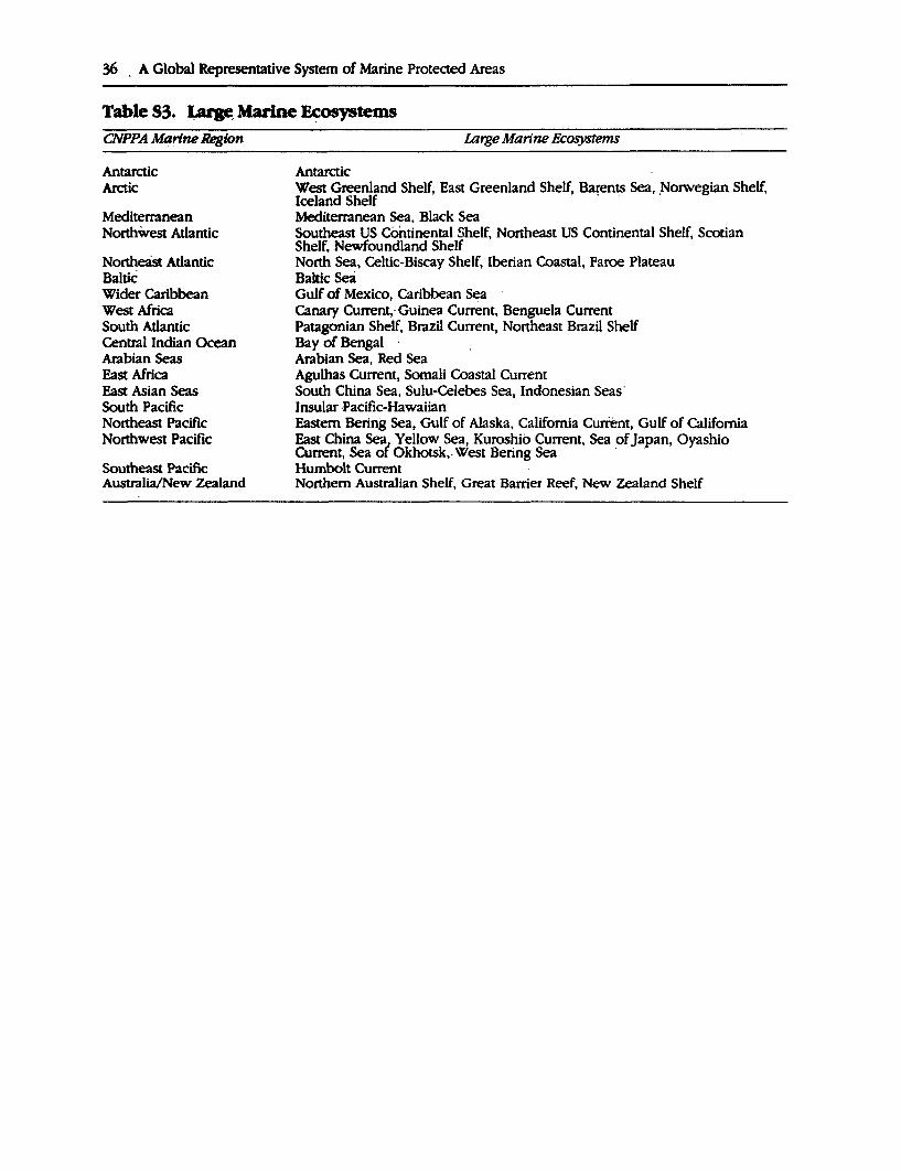
36 . A Global Representative System of Marine Protected Areas
Table S3. LarF, Marine ~tems CNPPA M~rtne Region
Antarctic Arctic
Mediterranean Northwest Atlantic
Northeast Atlantic Baltic Wider Caribbean West Africa South Atlantic Central Indian Ocean Arabian Seas East Africa East Asian Seas South Pacific Northeast Pacific Northwest Pacific
Southeast Pacific Australia/New Zealand
Large Marine Ecosystems
Antarctic West Greenland Shelf, East Greenland Shelf, Barents Sea, ,Norwegian Shelf, Iceland Shelf Mediterranean Sea, Black Sea Southeast US Continental Shelf, Northeast US Continental Shelf, Scotian Shelf, Newfoundland Shelf North Sea, Celtic-Biscay Shelf, Iberian Coastal, Faroe Plateau Baltic Sea Gulf of Mexico, Caribbean Sea Canary Current, Guinea Current, Benguela Current Patagonian Shelf, Brazil Current, Northeast Brazil Shelf Bay of Bengal · Arabian Sea, Red Sea Agulhas Current, Somali Coastal Current South China Sea, Sulu-Celebes Sea, Indonesian Seas· Insular ,Pacific-Hawaiian Eastern Bering Sea, Gulf of Alaska, California Current, Gulf of California East China Sea; Yellow Sea, Kuroshio Current, Sea of Japan, Oyashio Current, Sea or Qkh()(Sk,. West Bering Sea · · Rumbolt Current Northern Australian Shelf, Great Barrier Reef, New Zealand Shelf
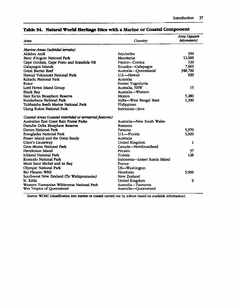
Introduction 37
Table S4. Natural World Heritage Sites with a Marine o'r'Coastal Component
Marine A,eas (subtldal 'termtn) Alclabra Atoll Banc d'Arguin National Park Cape Girolata, Cape Porto and Scandola NR Galapagos Islands Great Barrier Reef Hawaii Volcanoes National Park Kakadu National Park Kotor Lord Howe Island Group Shark Bay Sian Ka'an Biosphere Reserve Sunclarbans National Park Tubbataha Reefs Marine National Park Ujung Kulon National Park
Coastal Amis (coastal intertidal or terreslrlalfeatures) Australian East Coast Rain Forest Parks Danube Delta Biosphere Reserve Darien National Parle Everglades National Parle Fraser Island and the Great Sandy Giant's Causeway Gros Mome National Park Henderson Island Ichkeul National Parle Komodo National Park Mont Saint Michel and its Bay Olympic National Park Rio Platano WHS Southwest New Zealand (Te Wahipounamu) St. Kilda Western Tasmanian Wilderness National Parle Wet Tropics of Queensland
Country
Seychelles Mauritapia France-Corsica Ecu_ador-Galapagos Australia-Queensland U.S.-Hawaii · Australia . former Yugoslavia Australia, NSW A4stralia-Westem Mexico India-West Bengal State Philippines Indonesia-Java
Australia-New South Wales Romania Panama U.S.-Floricla Australia United Kingdom Canada-Newfoundland Pitcairn Tunisia Indonesia-Lesser Sunda Island France US-Washington Honduras New Zealand United Kingdom Australia-Tasmania Australia-Queensland
Ami (square kilometers)
350 12,000
120 7,665
348,700 929
15
5,280 1,330
5,970 5,929
1
37 126
5,000
9
Source: WCMC (classification Into marine or coastal carried: out by editors based on available lnfonnation).
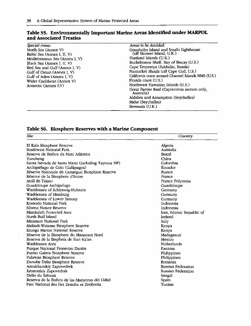
38 A Global Representative System of Marine Protected Areas
Table S5. Environmentally Important Marine Areas Identified under MARPOL and Associated Treaties Special Areas: North Sea (Annex V) Baltic Sea (Annex I, II, V) Mediterranean Sea (Annex I, V) Black Sea (Annex I, II, V) Red Sea and Gulf (Annex I, V) Gulf of Oman (Annex I, V) Gulf of Aden (Annex I, V) Wider Caribbean (Annex V) Antarctic (Annex 1,V)
Areas to be Avoided· Grassholm Island and Smalls Lighthouse
(off Skomer Island, U.K.) Shetland Islands (U.K.) Rochebonne Shelf, Bay of Biscay (U.S.) Cape Terpeniya (Sakhalin, Russia) Nantucket Shoals (off Cape Cod, U.S.) California coast around Channel Islands NMS (U.S.) Florida coast (U.S.) Northwest Hawaiian Islands (U.S.) Great Barrier Reef (Capricomia section only,
Australia) Aldabra and Assumption (Seychelles) Mahe (Seychelles) Bermuda (U.K.)
Table S6. Biosphere Reserves with a Marine Component Site
El Kala Biosphere Reserve Southwest National Park Reserve de Bisfera da Mata Atlantica Yancheng Sierra Nevada de Santa Marta (including Tayrona NP) Archipielago de Coln (Galapagos) Reserve Nationale de Camargue Biosphere Reserve Reserve de la Biosphere d'Iroise Atoll de Taiaro Guadeloupe Archipelago Waddensea of Schleswig-Holstein Waddensea of Hamburg Waddensea of Lower Saxony Komodo National Park Siberut Nature Reserve Miankaleh Protected Area North Bull Island Miramare National Park Malindi-Watamu Biosphere Reserve Kiunga Marine National Reserve Reserve de la Biosphere du Mananara Nord Reserva de la Bisphera de Sian Ka'an Waddensea Area Parque Nacional Fronerizo Darien Puerto Galera Biosphere Reserve Palawan Biosphere Reserve Danube Delta Biosphere Reserve Astrakhanskiy Zapovednik Kronotskiy Zapovednik Delto du Saloum Reserva de la Bisfera de las Marisonas de! Odie! Pare National des Iles Zemdra et Zenbretta
Algeria Australia Brazil China Colombia Ecuador France France
Country
France Polynesia Guadeloupe Germany Germany Germany Indonesia Indonesia Iran, Islamic Republic of Ireland Italy Kenya Kenya Madagascar Mexico Netherlands Panama Philippines Philippines Romania Russian Federation Russian Federation Sengal Spain Tunisia
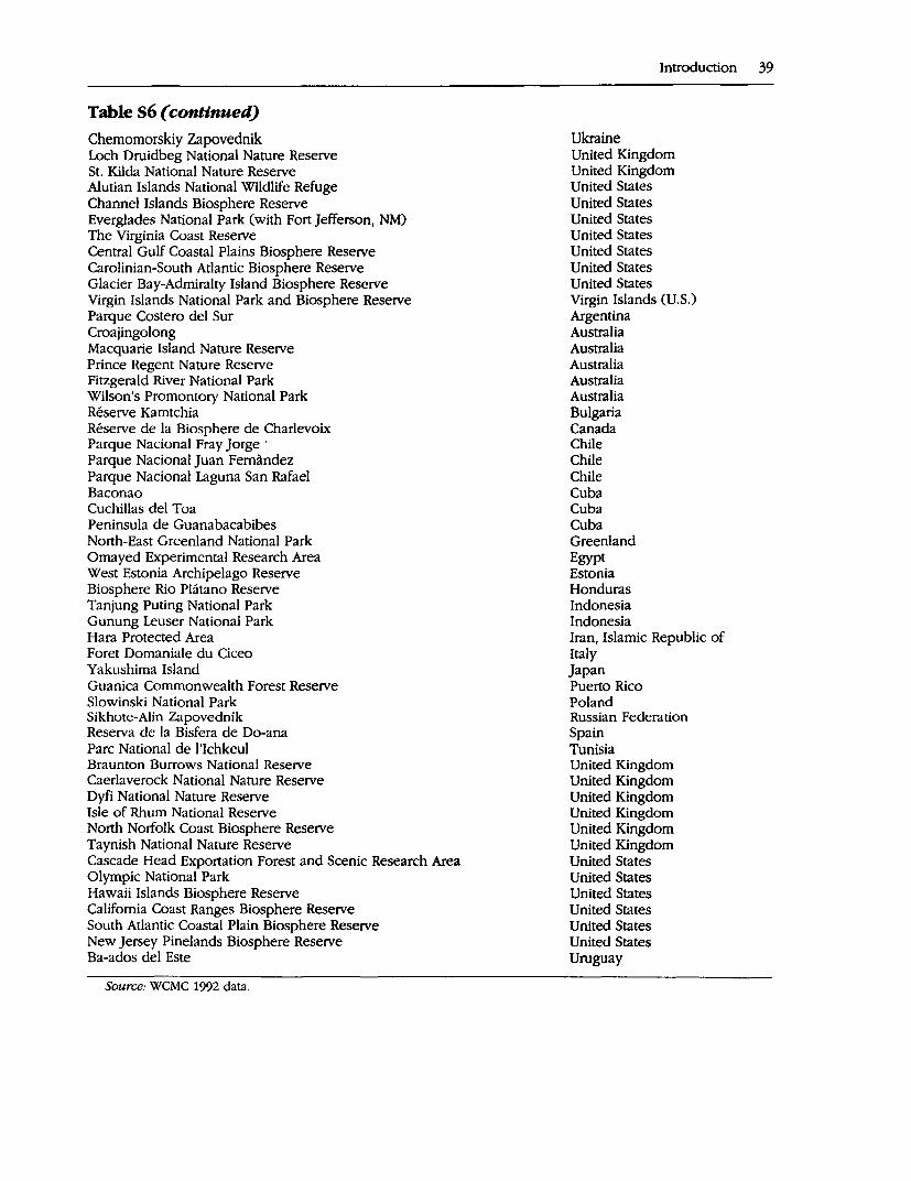
Table S6 ( continued)
Chemomorskiy Zapovednik Loch Druidbeg National Nature Reserve St. Kilda National Nature Reserve Alutian Islands National Wildlife Refuge Channel Islands Biosphere Reserve Everglades National Park (with Fort Jefferson, NM) The Virginia Coast Reserve Central Gulf Coastal Plains Biosphere Reserve Carolinian-South Atlantic Biosphere Reserve Glacier Bay-Admiralty Island Biosphere Reserve Virgin Islands National Park and Biosphere Reserve Parque Costero de! Sur Croajingolong Macquarie Island Nature Reserve Prince Regent Nature Reserve Fitzgerald River National Park Wilson's Promontory National Park Reserve Kamtchia Reserve de la Biosphere de Charlevoix Parque Nacional Fray Jorge · Parque Nacional Juan Fernandez Parque Nacional Laguna San Rafael Baconao Cuchillas del Toa Peninsula de Guanabacabibes North-East Greenland National Park Omayed Experimental Research Area West Estonia Archipelago Reserve Biosphere Rio Platano Reserve Tanjung Puting National Park Gunung Leuser National Park Hara Protected Area Foret Domaniale du Ciceo Yakushima Island Guanica Commonwealth Forest Reserve Slowinski National Park Sikhote-Alin Zapovednik Reserva de la Bisfera de Do-ana Pare National de l'Ichkeul Braunton Burrows National Reserve Caerlaverock National Nature Reserve Dyfi National Nature Reserve Isle of Rhum National Reserve North Norfolk Coast Biosphere Reserve Taynish National Nature Reserve Cascade Head Exportation Forest and Scenic Research Area Olympic National Park Hawaii Islands Biosphere Reserve California Coast Ranges Biosphere Reserve South Atlantic Coastal Plain Biosphere Reserve New Jersey Pinelands Biosphere Reserve Ba-ados de! Este
Source: WCMC 1992 data.
Introduction 39
Ukraine United Kingdom United Kingdom United States United States United States United States United States United States United States Virgin Islands (U.S.) Argentina Australia Australia Australia Australia Australia Bulgaria Canada Chile Chile Chile Cuba Cuba Cuba Greenland Egypt Estonia Honduras Indonesia Indonesia Iran, Islamic Republic of Italy Japan Puerto Rico Poland Russian Federation Spain Tunisia United Kingdom United Kingdom United Kingdom United Kingdom United Kingdom United Kingdom United States United States United States United States United States United States Uruguay
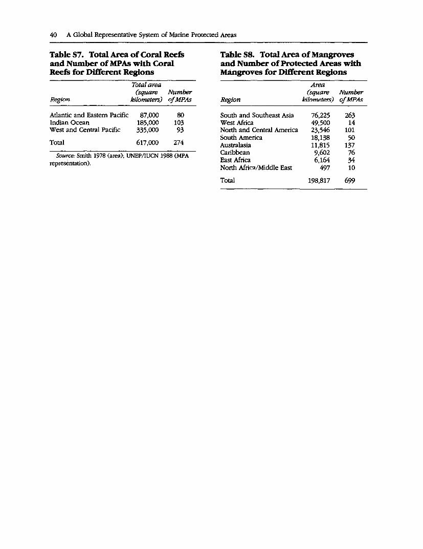
40 A Giobai Representative System of Marine Protected Areas
Table S7. Total Area of Coral Reefs and Number of MPAs with Coral Reefs for Different Regions
Region
Atlantic and Eastern Pacific Indian Ocean West and Central Pacific
Total
Total area (square Number
kilnmeters) of M_p_As
87,000 185,000 335,000
617,000
80 103 93
274
Source: Smith 1978 (area); UNEP/IUCN 1988 (MPA representation).
Table S8. Total Area of Mangroves and Number of Protected Areas with Mangroves for Different Regions
A--./"llt::U
(square Number Reoion kilometers) ofMF_As ---c,----
South and Southeast Asia 76,225 263 West Africa 49,500 14 North and Central America 23,546 101 South America 18,138 50 Australasia 11,815 137 r-...:1-1-..~-- n t::n'> -..i:: ""'111UL.A;411 7,uv"' /V
East Africa 6,164 34 North Africa/Middle East 497 10
Total 198,817 699
BmllOGRAPHY
t. Amstrup, S.C., and 0. Wiig. 1991. Polar bears.
Proceedings of 10th Working Meeting of IUCN/SSC Polar Bear Specialist Group, October 1988, USSR. 0cc. Pap. IUCN SSC No. 7.
Andersen, R.A. 1992. Diversity of eukaryotic algae. Biodiversity and Conseroation 1:267-92.
Angel, M.V. 1982. Ocean trench conseroation. Cqmmission on Ecology Paper No. 1. Gland, Switzerland: IUCN.
Benzie, ].A.H. 1994. 1be genetics of giant clams. Proceedings 7th International Coral Reef Symposium, Guam 1992.
Bibby, C.J., N.]. Collar, M.A. Barker, L.D. Brandao, F.R. Lambert, C.R. Robson, C.R. Stones, and D.C. Wege. 1992. Putting biodiversity on the map: Priority areas for global conseroation. Cambridge, U.K.: International Council for Bird Preservation.
Brown, B.E. 1987. Worldwide death of corals: Natural cyclical events or man-made pollution? Mar. Poll. Bull. 18:9-13.
Briggs, J.C. 1974. Marine biogeography. New York, New York: McGraw-Hill Book Company.
Burgis, M.J., and J.J. Symoens. 1987. African wetlands and shallow water bodies: Directory. Paris, France.
Buzas, M.A., and S.J. Culver. 1991. Species diversity and dispersal of benthic foramirnfera. Bioscience 41(7): 483-9.
Carp, E. 1980. Directory of wetlands of international imporlance in the western Palaearctic. Gland, Switzerland: IUCN and Nairobi: UNEP.
Clarke, A. 1992. Is there a latitudinal diversity dine in the sea? Trends in Ecology and Evolution 7(9): 286-7. ·
Clarke, A., andJ.A. Crame. 1989. InJ.A. Crame, ed., Origins and evolution of the Antarctic biota. Cambridge, U.K.: Cambridge University Press.
Commission of the European Communities (CEC). 1992. Mangroves of Madagascar and Africa. Brussels: CEC.
Connell, J.H. 1978. Diversity in tropical rain forests and coral reefs. Science 199:1302-10.
Croxall, J.P. 1991. Seabird status and conseroation: A supplement. ICBP Technical Publication 11. Cambridge, U.K.: ICBP.
Croxall, J.P., P.G.H. Evans, and R.W. Schreiber, eds. 1984. Status and conseroation of the
Introduction 41
world's seabirds. ICBP Technical Publication 2. Cambridge, U.K.: ICDP.
Dahl, A.L. 1991. Island Directory. UNEP Regional Seas Directories and Bibliographies No. 35. Nairobi: UNEP.
Dietrich, D. 1963. General oceanography: An introduction. New York, New York: Interscience Publishers.
Dixon, J., L.F. Scura, and T. van't Hof. 1993. Meeting ecological and economic goals: Marine parks in the Caribbean. AMBJO 22(2-3): 117-25.
Doody, P., ed. 1991. Sand dunes inventory of Europe. JNCC/Etiropeari Union for Coastal Conservation.
Dubinsky, Z., ed. 1990. Coral reefs. Ecosystems of the World 25. Amsterdam: Elsevier.
Dugan, P., ed. 1993. Wetlands in danger. Mitchell Beazley/IUCN.
Fairbridge, R., ed. 1966. Oceans, limits, definition and dimension. In Encyclopaedia of earth science series: Encyclopaedia of oceanography. Volume 1. New York, New.York: Reinhold Publishing Corp.
Finlayson, M., and M. Moser. 1991. Wetlands. Slimbridge, U.K.: International Waterfowl and Wetlands Research Bureau.
Fisher, P., and M.D. Spalding. 1993. Protected areas with mangrove habitat. Unpublished Report, World Conservation Monitoring Centre, Cambridge, U.K.
Fonseca, M.S., W.J. Kenworthy, and G.W. Thayer. 1991. Seagrass beds: Nursery for coastal species. Marine Recreational Fisheries 14:141-7.
Food and Agricultural Organization of the United Nations (FAO), The World Conservation Union (IUCN), (IWC), and United Nations Environment Programme (UNEP). 1985. Marine mammals: Global plan of action. UNEP Regional Seas Reports.and Studies 55. Nairobi: UNEP.
Foster-Turley, P., S. Macdonald, and C. Mason, eds. 1990. Otters: An action plan for their conseroation. Gland, Switzerland: IUCN.
Gage, J.G., and P.A. Tyler. 1991. Deep-sea biology: A natural history of organisms at the deep seajloor. Cambridge, U.K.: Cambridge University Press.
Ginsberg, R. (Compiler}. 1994. Proceedings of the colloquium on global aspects of coral reefs: Health, hazards and history, 1993. Miami, Flor-
42 A Global Representative System of Marine Protected Areas
ida: Rosenstiel School of Marine and Atmospheric Science, University of Miami.
Grassle, J.F. 1985. Hydrothermal vent animals: Distribution and biology. Science 229:713-7.
---. 1991. Deep-sea benthic biodiversity. Bioscience 41(7): 464-5.
Grimmett, R.F.A., and T.A. Jones. 1989. Important bird areas of Europe. ICBP Technical Publication 9. Cambridge, U.K.: ICDP.
Groombridge, B. 1982. Tbe IUCN amphibia-reptilia red data book. Gland, Switzerland: IUCN.
Groombridge, B., and R. Luxmoore. 1989. Tbe green turtle and hawksbill ( reptilia: cheloniidae): World status, exploitation and trade. UNEP/CITES Secretariat.
Hamilton, L.S., and S.C. Snedaker, eds. 1984. Handbook/or mangrove area management. UNEP/East-West Center/IUCN.
Hayden, B.P., G.C. Ray, and R. Dolan. 1984. Classification of coastal and marine envirorunents. Environmental Conseroation 11(3): 199-207.
Hourigan, T.F., and E.S. Reese. 1987. Mid-ocean isolation and evolution of Hawaiian reef fishes. Trends in Ecology and Evolution 2(7): 187-91.
Hoyt, E. 1992. Marine parks for whales: A survey and an assessment. Abstract for Caracas meeting.
Hughes, R.H., and JS. Hughes. 1992. A directory of African wetlands. Gland, Switzerland and Cambridge, U.K.: IUCN; Nairobi: UNEP; Cam- . bridge, U.K.: WCMC.
Hutchings, P., and P. Saenger. 1987. Tbe ecology of mangroves. Australian Ecology Series. University of Queensland Press.
International Maritime Organization (IMO). 1991. Ship's routing. Sixth Edition. London.
---. 1992. Guidelines/or the designation of special areas and the identification of particularly sensitive sea areas. Resolution A.720 (17), 17th Session, Agenda Item 12. London.
IUCN. 1988. Proceedings of the 17th Session of the General Assembly of IUCN and 17th Technical Meeting. San Jose, Costa Rica, 1-10 February, 1988. Gland, Switzerland.
Jablonski, D. 1986. Larval ecology of marine benthic invertebrates: Paleobiological implications. Biological Reviews 58:21-89.
Jones, T. 1993. A directory of wetlands of international importance. Part I, Africa; 2, Asian and Oceania; 3, Europe, Neotropics and North
America. Gland, Switzerland: Rarnsar Convention Bureau.
Kay, E.A. 1984. Patterns of speciation in the IndoWest Pacific. In F.J. Radorsky, P.H. Raven, S.H. Schmer, eds., Biogeography of the tropical Paci.fie. Hawaii: B.P. Bishop Museum.
Kelleher, G., and R. Kenchington. 1992. Guidelines for establishing marine protected areas. A Marine Conservation and Development Report. Gland, Switzerland: IUCN.
Kenchington, R.A. 1990. Managing marine environments. New York, New York: Taylor and Francis.
Kenchington, R., and D. Crawford. 1993. On the meaning of integration in coastal zone management. Ocean & Coastal Management 21: 109-127.
King, J.E. 1983. Seals of the world. Ithaca, New York: Cornell University Press.
Klinowska, M. 1991. Dolphins, porpoises and whales of the world. The IUCN Red Data Book. Gland, Switzerland.
Lemhi, C.A., and J.A. Waaland, eds. 1989. Algae and human affaiT'S. Cambridge: Cambridge University Press.
May, R.M. 1988. How many species are there on earth? Science 241:1441-49.
McAllister, D.E., F.W. Schueler, C.M. Roberts, and J.P. Hawkins. N.d. Mapping and GIS analysis of the global distribution of coral reef fishes on an equal-area grid. In R. Miller, ed., Mapping the diveT"Sity of nature. Chapman arid Hall. Forthcoming.
McRoy, C.P., and C. Helfrich, eds. 1977. Seagrass ecosystem: A scientific perspective. Institute of Marine Science, University of Alaska. New York and Basel: Marcel Dekker Inc.
Meylan, A.B., B.W. Bowen, andJ.C. Avise. 1990. A genetic test of the natal homing versus social facilitation models for green turtle migration. Science 248:724-27.
Myers, N. 1988. Threatened biotas: "Hot-spots" in tropical forests. Tbe Environmentalist 8(3): 187-208.
--. 1990. The biodiversity challenge: Expanded hot-spots analysis. Tbe Environmentalist 10:243-56.
Norse, E.A., ed. 1993. Global marine biological diveT'Sity: A strategy for building conservation into decision-making. Washington, D.C.: Island Press.
Pauly, D., and R. Froese. 1991. FISHBASE: Assembling information on fish. Naga, ICLARM Quar
\ terry 14(4): 10-11. Perrin, W.F. 1989. Dolphins, porpoises and
whales: An action plan for the conseroation of biological diversity, 1f?88-1992. IUCN/SSC Cetacean Specialist Group and U.S. National Marine Fisheries Setvice. Gland, Switzerland: IUCN.
Perron, and Kohn. 1985. Laroal dispersal and geographic distribution of Conus. Proceedings 5th International Coral Reef Cong., Tahiti.
Por, F.D., and I. Dor. 1984. Hydrobiology of the mangal. The Hague: W. Junk.
Price, A., and S. Humphreys. 1993. Application of the biosphere concept to coastal marine areas. A Marine Consetvation and Development Report. Papers presented at the UNESCO/IUCN San Francisco Workshop of 14-20 August, 1989. Gland, Switzerland: IUCN.
Ray, C.G. 1976. Critical marine habitats: Definition, description, criteria and guidelines for identification and management. Working Paper No. 1. In International conference on marine parks and reseroes. IUCN Publication N.S. 17.
---. 1988. Ecological diversity in coastal zones and oceans. In E.O. Wilson, and F.M Peter, eds., Biodiversity. Washington, D.C.: National Academy Press.
---. 1991. Coastal-zone biodiversity patterns. Bioscience 41(7): 490-98.
Roberts, C.M., and N.V.C. Polunin. 1991. Are ma. rine resetves effective in management of reef
fisheries? Rev. Fish. Biol. and Fisheries 1:65-91. Rosen, B.R. 1988. Progress, problems and pat
terns in the biogeography of reef corals and other tropical marine organisms. Helgolander Meeresunters 42:269-301.
Sadovy, Y. 1993. The Nassau grouper: Endangered or just unlucky? Reef Encounter 13:10-12.
Saenger, P., EJ. Hegerl, and ].D.S. Davie. 1983. Global status of mangrove ecosystems. Commission on Ecology Paper No. 3. Gland Switzerland: IUCN.
Salvat, B., ed. 1987. Human impacts on coral reefs: Facts and recommendations. Antenne Museum E.P.H.E., French Polynesia.
Scott, D.A. 1989. A directory of Asian wetlands. Gland, Switzerland and Cambridge, U.K.: IUCN.
Introduction 43
--. 1993. A directory of wetlands in Oceania. Slirnbridge, U.K.: IWRB and Kuala Lumpur, Malaysia: A WB.
Scott, D.A., and M. Carbonell. 1986. A directory of Neotropical wetlands. Cambridge, U.K.: IUCN and Slirnbridge, U.K.: IWRB.
Sherman, K., and L.M. Alexander, eds. 1989. Biomass yields and geography of large marine ecosystems. AAAS Selected Symposium 111. Boulder, Colorado: Westview Press.
Sherman, K., L.M. Alexander, and B.D. Gold, eds. 1990. Large marine ecosystems: Patterns, processes and yields. Washington, D.C.: AAAS.
Sherman, K., and T. Laughlin. 1992. '/be large marine ecosystem (LME) concept and its application to regional marine resources management. Marine Consetvation Development Reports. Gland, Switzerland: IUCN.
Salm, R., and J. Clark. 1984. Marine and coastal protected areas: A guide for planners and managers. Gland, Switzerland: IUCN.
Smith, P.J., R.I.C.C. Francis, and M. McVeagh. 1991. Loss of genetic diversity due to fishing pressure. Fisheries Research 10:309-16.
Smith, S.V. 1978. Coral reef area and contributions of reefs to processes and resources of the world's oceans. Nature 273(5659): 225.
Soumia, A., Chretennot-Dinet, M-J. and Ricard, M. 1991. Marine phytoplankton: how many species in the world ocean?]. Plankton Res. 13:1093-99.
Stehli, F.G., A.L. McAlester, and C.E. Helsley. 1967. Bull. Geo/. Soc. Am. 78:455-66.
Sullivan, K.M., R. Roca, E.C. Peters, and M. Chiappone. 1993. Global status of scleractinia, alcyonaria, antipatharia, stylasterina and milleporina in the tropical Western Atlantic: Guidelines and assessment. Paper presented at Colloquium on Global Aspects of Coral Reefs, University of Miami, June 1993.
Thorbjamson, J. 1992. Crocodiles: An Action Plan for their Conseroation. Gland Switzerland: IUCN.
Thomback, J., and M. Jenkins. 1982. '/be IUCN Mammal Red Data Book. Part I. Gland, Switzerland and Cambridge, U.K.: IUCN.
Thome-Miller, B., and J. Catena. 1991. '/be living ocean: Understanding and protecting marine biodiversity. Washington, D.C.: Island Press.
Udvardy, M.D.F. 1975. A classification of the blogeographical provinces of the world. IUCN 0cc. Pap. 18.
44 A Global Representative System of Marine Protected Areas
United Nations Environment Programme (UNEP) and IUCN. 1988. Coral reefs of the world. Vols. 1,2,3. Nairobi: UNEP and Cambridge, U.K.: IUCN.
Vane-Wright, R.I., CJ. Humphries, and P.H. Williams. 1991. What to protect? Systematics and the agony of choice. Biological Conseroation 55:23~54.
Vermeij, GJ. 1987. The dispersal barrier in the tropical Pacific: Implications for mollusc speciation and extinction. Evolution 41:1046-58.
--. 1993. Biogeography of recently extinct marine species: Implications for conservation. Conservation Biology 7(2): 391-97.
Veron, J.E.N. 1986. Corals of Australia and the Jndo-Pacific. Sydney, Australia and London: Angus and Robertson Publ. ·
---. 1992. Conservation of biodiversity: A critical time for the hermatypic corals of Japan. Coral Reefs 11(1): 13-21.
--. 1993. A biogeographic database of hermal)pic corals: Species of the Central Indo-Pa-
cific, genera of the world. Australian Institute of Marine Science, Monograph Series 10.
Wells, M., K. Brandon, and L. Hannah. 1992. People and parks: Linking protected areas management with local communities. Washington, D.C.: World Bank.
Wenham-Smith, M.G. 1993. Global status and extent of mangrove forests. Unpublished report toWWF-UK.
Wilkinson, C. 1994. Coral reefs are facing widespread extinctions: Can we prevent these through sustainable management practices? Proceedings 7th International Coral Reef Symp. 1:11-21.
Winston, J.E. 1992. Systematics and marine conservation. In N. Eldredge, ed., Systematics, ecology and the biodiversity crisis. New York: Columbia University Press.
World Conservation Monitoring Centre (WCMC). 1992. Global biodiversity: Status of the earth~ living resources. London: Chapman and Hall.
MARINE REGION 1 Antarctic
Antarctic Division, Australian Department of Environment, Sport, and Territories
and Paul Dingwall
BIOGEOGRAPHY AND MARINE BIODIVERSITY
For the purposes of this report, the Antarctic Marine Region is defined as the area of application of the Convention for the Conservation of Antarctic Marine Living Resources (CCAMLR), namely the marine area to the south of a boundary that closely approximates the Antarctic Convergence (see Map 1). The Convergence is the natural oceanographic boundary formed where the cold waters of the Antarctic spreading outward from the continent meet the warmer waters to the north. The Convergence forms a biological barrier, with relatively few species, other than whales and some seabirds, migrating beyond it.
The CCAMLR boundary has been chosen because: • The Convergence is a natural oceano
graphic boundary to the region. Its position is dynamic, altering location due to seasonal, interannual and other factors, and therefore difficult to define precisely or use administratively with certainty.
45
• The CCAMLR area encompasses all of the areas covered by the major international Antarctic agreements, all of which specify conservation management measures and are collectively known as the Antarctic Treaty System (ATS).
• CCAMLR is the principal agreement in the ATS dealing with the management of marine resources.
Apart from CCAMLR, the other ATS agreements are the Antarctic Treaty and its associated measures, including the Protocol on Environmental Protection to the Antarctic Treaty (the Madrid Protocol) and recommendations agreed to at meetings of the Antarctic Treaty Consultative Parties, and the Convention for the Conservation of Antarctic Seals (CCAS), all of which apply to the area south of 60°S. Thus the CCAMLR boundary more closely aligns with the Antarctic ecosystem than other Antarctic agreements, an aspect that is particularly important to conservation considerations.
In adopting this definition, the artificiality of definitions and the strong links between
46 A Global Representative System of Marine Protected Areas
the Antarctic Marine Region and waters to the north, such as those species that breed outside the Antarctic and feed south of the Convergence, are acknowledged.
A total of 42 States are parties to the Antarctic Treaty, 26 of which have additional status as Consultative Members. All countries currently active in the Antarctic are parties to this treaty. Seven States party to the Treaty also have territorial claims, these are Argentina, Australia, Chile, France, New Zealand, Norway and the United Kingdom. There are 29 states that have acceded to CCAMLR. Some other States assert that they have the basis for a sovereignty claim, while others do not recognize any claims or the basis for claims.
Oceanography
The circumpolar nature of the Southern Ocean results in its having some unique characteristics. It plays important roles in the climate system and in the global redistribution of ocean properties.
The Antarctic Circumpolar Current (ACC) is the primary means by which water is exchanged between the ocean basins. The ACC therefore plays an essential role in the global thermohaline circulation and the redistribution of heat and other properties. The horizontal circulation has been widely described by researchers. The most important barrier for the Antarctic is the Antarctic Convergence, the major oceanographic and biogeographic boundary that separates the Antarctic environment from that of the rest of the world. This has an average position at about 58°S. South of this barrier lives the characteristic Antarctic biota. A second major oceanographic feature is the Antarctic Divergence, close to Antarctica at about 65°S. This is associated with deeper water that gradually rises and flows southward and that almost reaches the surface at the Divergence. Between the Antarctic Convergence and Divergence, water flow is to the east under the influence of the West Wind Drift. South of
the Divergence is a narrow, coastal counter current that flows to the west under the influence of easterlies.
The Southern Ocean is a source of intermediate and deep water masses that ventilate the world ocean. At the convergence, cool relatively low salinity (due to input from melting ice) Antarctic surface waters sink below the warmer high salinity waters to the north. The resulting Antarctic Intermediate waters flow northwards in each of the ocean basins. The densest water in the oceans, Antarctic Bottom Water, is formed during winter when salt rejection occurs during the formation of sea ice. This water spreads northward through all of the deepest basins of the world's oceans. The formation and sinking of these water masses results in a significant exchange of heat, fresh water and gases such as carbon dioxide between the ocean and the atmosphere. Understanding the circulation and water mass formation mechanisms in the Southern Ocean is therefore critical to the development of models capable of predicting the timing arid magnitude of future climatic change. Upwelling at the divergence introduces into the surface layer an abundance of nutrients that are the basis for the great phytoplankton growth during spring and summer.
Role of Sea Ice
The continent of Antarctica covers some 14 million square kilometers and, in summer the continental area is augmented by 3 million square kilometers of sea ice in the form of ice shelves and multiyear ice. In winter, the area covered by ice increases to some 20 million square kilometers, effectively doubling the area of the Southern Hemisphere covered by ice. Formation of the additional 17 million square kilometers has many effects. The ice acts as an insulating barrier between warm water below (-l.8°C) and cold air (-20°C to -30°C) above. The ice is thus important in controlling the heat flux be-
tween the ocean and atmosphere with the impact that can have on Southern Hemisphere weather.
The freezing of the sea surface to form sea ice generates a residue of high salinity, high.density, cold water that sinks (thermohaline circulation) to form Antarctic Bottom Water that is a product of a process that forms half of the world's water masses, some detectable as far north as the North Atlantic. This product takes with it oxygen, dissolved carbon dioxide and other gases.
South of the Antarctic Divergence, water temperatures in summer reach 0°C, but during winter they are at the freezing point of sea water, -l.8°C.
Between the Divergence and the Convergence, water temperature increases northwards to 4-5°C at the Convergence where it increases about 2-3°C over a short distance.
Coastal Geology
The continental margin of the continent of Antarctica is unique in many ways. It is about 20,000 kilometers long. The continental shelf is anomaiously deep, with the continental shelf edge averaging 460 meters deep, in contrast with other continents where the depth averages 200 meters. There is very little of the shelf that is shallow. In many areas the shelf deepens from shelf edge to continent and deep trenches are common around the margin, some as deep as 1,200-1.500 meters, and normally parallel to the coast and shelf edge. Some of these "deeps" are closed but most open to the deep sea through submarine canyons.
Sedimentation rates are slow and sediment has a high content of siliceous biogenic material, particularly from diatoms and sponges. Much of the sediment is glacier derived.
Very little of the continental margin consists of rock and the shelf is normally bound by ice cliffs. In the past, when the icecap was more extensive, the shelf surface was severely affected by gouging icebergs. This
Marine Region 1: Antarctic 47
still happens on the shallower parts of the shelf.
The shelf can be divided into two types: those facing the ocean and those on major embayments (Ross Sea, Weddell Sea, Prydz Bay). The former generally appear narrow, normally about 150 kilometers, but much of that perception may be a result of relativity with the continent's large size. The latter are generally covered, to a significant extent, with permanent ice shelves (Ross, FilchnerRonne, Amery).
The Antarctic Peninsula margin is more dissected by canyons and trenches than the margin of much of Antarctica. The margin generally is surrounded by broad gentle abyssal plains, but the north western Antarctic Peninsula margin has an adjacent trench-the South Shetland Trench-to a depth of over 5,000 meters within 100 kilometers of the coast.
Ecosystem and Species Diversity
The Antarctic ecosystem has generally been defined as that occurring in the waters south of the Antarctic Convergence. Recent studies have, however, thrown this concept into some doubt. It now seems likely that the waters between the Convergence and the Continent consist of concentric rings of interconnected ecosystems that move seasonally with the advance and retreat of the pack ice. There are apparently oceanic, neritic and intermediate regimes as well as a welldefined community associated with the pack ice and marginal ice edge zone. The neritic or inshore community is characterized by the presence of a small species of krill (Euphausia crysta/lorophias) and the fish Pleuragramma antarctica that are important in the diet of many fishes and some landbased vertebrates, especially in embayments such as the Ross ·Sea and in Prydz Bay. Toward the shelf break in midsummer is found the more familiar "krill based ecosystem" in which the large Antarctic krill (Euphausia superba) dominates, often to the exclusion of
48 A Global Representative System of Marine Protected Areas
other pelagic invertebrates. This zone of · dominance probably tracks the ice edge occurring offshore of the retreating pack ice in spring. The relationship between Antarctic krill and the ice edge in autumn and winter is less certain, but krill are known to occur under the ice in winter though how far they extend into the pack is unknown. This zone is where the highest primary productivity. occurs and is also the feeding area for·many of the Antarctic vertebrates, in particular the whales, seals and seabirds. The deep water, oceanic zone is more typical of oligotrophic oceans worldwide, dominated by species of zooplankton, such as salps, copepods and chaetognaths.
The Southern Ocean is poorly studied in· comparison with many other oceans and the. communities that occur in the various zones and their seasonal changes are only now being described. The ecosystem associated with the sea ice has only been examined in any detail in the last ten years and it is only very recently that the whole Southern Ocean has not been treated as one large krill soup.
Antarctic krill does, however, occur in extremely high abundances right around the continent. Current estimates of the standing stock of Eupbausia superba are of the order of 500 million tons and its central role in the Antarctic ecosystem makes its conservation · an.issue of paramount importance. Its occurrence in huge, densely packed swarms, often several kilometers across and. contain- . ing tens of thousands of tons, makes it attractive not only to the vertebrate consumers of. the region, but also as a commercial fishery.
, Life in the pack ice zone undergoes an intense short period of high productivity and because of the special characteristics of: the 1
environment, there is a specialised biota. Primary productivity provides food for pelagic suspension feeders and a considerable amount makes its way to the seafloor where it is consumed by such benthic filter-feeders as sponges.
In contrast to the flora and fauna of the littoral zone, which is impoverished due to the
action of ice, sub-littoral communities are di-, verse and complex. Benthic communities . have a great variety and abundance of animals and plants, including a high proportion of species endemic to the Antarctic Marine Region. Standing crop in the shallow sub-littoral increases as the effect of ice scour decreases, before declining again in the. deeper parts of the shelf.
There is a rich and complex food web within the ice itself, which is receiving considerable attention. It includes microscopic organisms that live in such habitats as brine channels, under the ice and attached to ice floes.
The Antarctic bird fauna consists of some 40 species, of which the penguins are the best known and most important in the eco-, system. They consume an estimated 130 million tons of krill per year. Birds are key consumers of krill and are the group most likely to be adversely affected by a marked increase in fishery on krill. Penguins make up 90 percent of the avian biomass and utilize about 90 percent of the food consumed by birds:: Other than penguins, the bird· fauna is dominated by petrels and albatrosses.
Crabeater and leopard seals inhabit the ice edge and the area marginal to it. It is be.:. lieved that the crabeater seal, the world's most numerous seal, is a major consumer 1of' krill and may have increased its population dramatically because of the krill made avail: able by the marked reduction of whale numbers due to whaling. Leopard seals are much less discriminatory in. food source and consume virtually anything available. Ross and Weddell seals also inhabit the pack ice zone. Weddell seals consume fish, squid and benthos, while the Ross seal diet is poorly known but squid is known to be a constitilent.
Fur and elephant seals breed on subantarctic islands, and these species were the object of the sealing industry. At present, elephant seals numbers are· declining in the In-dian and Pacific sectors, but not in the ·
Atlantic. At the same time, fur seal numbers are increasing rapidly. The causes of these changes are not understood. Because they spend so much time away from the islands and are not obvious while at sea, gaining an understanding of the biology of these organisms has not been easy. Recently technology has evolved to allow the use of various devices such as time, depth and temperature recorders and satellite tracking equipment. Through these studies scientists have gained an understanding of the foraging range, depth habitat and likely diet. This in tum has led to a better understanding of the role of these species within the ecosystem.
There are two major groups of whales, both of which are found in the Antarcticbaleen and toothed whales. The baleen whales consume krill, probably about 190 million tons per year before whaling began. This has now reduced to about 43 million tons per year. There are nine species of toothed whales in the Antarctic, including the sperm and killer whales. Squid is an important element of the diet of sperm .whales. Commercial exploitation led to the marked decrease in the numbers of large whales. The Minke whale, which is now estimated· to }:lave a population of some 760,000 individuals in Antarctic waters, is the only baleen whale that is present in large numbers. Whales migrate in and out of the Antarctic, and migrate within the Antarctic following the ice edge and their food supply. The Antarctic sojourn of the baleen whales allows them to build up their blubber reserves before moving to the tropics to breed in winter.
There are about 270 species of fish, the most abundant and important species belong to the sub-order Notothenioidei. Generally these species are slow moving, slow growing, have low fecundity, and are thus very susceptible to over exploitation. They were subject to an unregulated fishery until the advent of CCAMLR and some species were fished to virtual local extinction. CCAMLR, in recent years, has had considerable success in regulating the catches. of fish
Marine Region 1: Antarctic 49
species and, in many cases, fishing is currently banned.
A major constraint in improving knowledge of the Antarctic ecosystem is that the overall research effort, and the resulting level of documentation of the biota, is small relative to the vastness of the Antarctic marine region. This is particularly true for the invertebrate fauna, but also for all levels of the ecosystem except the highest (seals and whales).
Biogeographic Classification
Coastal Waters of Antarctic Continent
There is no recognized biogeographic scheme to use as a basis for developing a protected areas system in coastal waters of the Antarctic continent, and there have been few attempts to establish one. Work to develop a classification has been carried out by the Scientific Committee on Antarctic Research (SCAR 1977), and others such as Keage (1987) and Hayden and others (1984). However, none of these schemes have achieved wide acceptance.
Southern Ocean
While many proposals have been advanced for biogeographic subdivision of the Southern Ocean realm, none is designed expressly for assisting the development of a marine protected area system. Boundaries of the biogeographic zones in these schemes vary in location depending on whether their context is oceanographic (Markov 1964); climatic (Holdgate 1964); or biological. Of the last category, schemes have addressed distributions of littoral biota (Knox 1960), island v!!getation (Wace 1965) and birds (Watson and others 1971). Clark and Dingwall (1985) provide a brief comparative analysis of several schemes (see also Holdgate 1977; Clark and Dingwall 1985; and Smith and LewisSmith 1987). As yet, there is no general agreement on a scheme to be used for identi-
50 A Global Representative System of Marine Protected Areas
fying priority areas in the marine environment.
Clearly, this is not a satisfactory basis on which to plan a comprehensive network of marine protected areas throughout the Southern Ocean and around the Antarctic conti'nent. There is some question whether the concept of establishing individual protected areas can be scientifically justified in the vast oceanic realms there. Angel (1987), for example, observes that the combined influence of the highly dynamic physical structure of the Southern Ocean, the strength of circumpolar currents, and the wide-ranging habits of seabirds and marine mammals, mean that at larger scales there is considerable uniformity in the structure of pelagic and benthic-deep- · water communities over broad geographic ranges. As a result the identification of particular marine biogeographic zones is quite difficult. While accepting the need for special protection in localized nearshore envi- · ronments, there are strong arguments to support the adoption of an ecosystem approach to management.
STATIJS OF ExlSTING MPAs
Description of Marine Protected Area System
The Antarctic marine environment has been considerably altered by successive waves of sealing, whaling and fishing. There is relatively little information available on what effect these perturbations have had on the overall balance of the marine ecosystem but it is likely to be significant. Because there are no baseline data, it is difficult to determine whether the ecosystem is currently changing to either establish a new balance or to revert to its old one. Additionally, because of the large area, small total effort and difficult nature of the prevailing conditions and because there are no accurate methods available to census the major species in the
Antarctic region, it is unlikely that long term changes will be detected until they are welF underway.
The Antarctic Marine Region has, in other respects, fared significantly better than elsewhere and, for example, direct pollution of the Antarctic marine environment is almost nonexistent.
The Antarctic Marine Region has also benefited from a high level of protection that has evolved over the fast three decades or so. There is a comprehensive environment protection regime available to cover the Marine Region under a complex of international agreements, developed specifically to cover the Antarctic, known collectively as the Antarctic Treaty System (ATS). The en-· tire Antarctic Marine Region is afforded a high level of protection and can be described as a protected area; the entire marine area meets the IUCN definition of a · marine protected area.
The extent of ATS environmental protection measures are explained in more detail below, but include area and species protection capabilities, effective control mechanisms to manage commercial exploitation of marine resources, special measures to con- · trol shipping and marine pollution, and a requirement for contingency plans to cover incidents with the potential for adverse effects on the marine environment or dependent and associated ecosystems. In addition to having the capability to ensure protection of the Antarctic marine region, the ATS is· actively seeking to manage the region, especially through CCAMLR.
A recent boost to the conservation status of the Antarctic Marine Region has been the International Whaling Commission's agreement to establish a whale sanctuary for all species in nearly all waters south of 40°S.
Within the framework of the ATS there are a number of mechanisms available for protection of specific sites identified as having marine conservation significance. These measures have evolved as the treaty system
itself has evolved. The primary mechanisms are described below.
Spedally Protected Area
Established under Article VIII of the Agreed Measures for the Conservation of Antarctic Fauna and Flora (1964), Specially Protected Areas (SP As) are intended to protect unique or outstanding natural ecological systems of scientific interest. SPAs are to include, among others, representative examples of major Antarctic land and freshwater ecological systems. SP As are essentially equivalent to nature reserves, and can apply only to terrestrial coastal and littoral sites, not marine areas per se.
There are 19 existi_ng SPAs. All but two of these are in the coastal environment and 13 of them are either entire or part of islands. Eleven of the SPAs have a marine orientation, especially as protection for breeding localities of seabirds and seals. Thus, the foreshores (littoral or intertidal zones) are an important component of them, but only in two cases is the inclusion of the littoral zone actually specified. In three SP As (No. 8 Dion Islands; No. 15 Southern Powell and adjacent islands; No. 18 North Coronation Island) the nearshore marine environment is included, and these areas have been included in the listing of MP As for this region. These marine areas are either small embayments or intervening waters in island archipelagoes, and are not included as a primary component of the protected area. In one other case, _there is reference to the richness of fish life in waters adjacent to the SP A that are not included in the protected area.
The following SPAs.have been recorded as MPAs: ,,._ Dion Island, Marguirite Bay, SPA No. 8 ,,._ North Coronation Island, South Orkney
Islands, SP A No. 18 ,,._ Southern Powell Island and adjacent is
lands, South Orkney Islands SPA No. 15.
Marine Region 1: Antarctic 51
Site of Special Scientific Interest
Established under Antarctic Treaty Consultative Meeting Recommendation VII-3 (1972), Sites of Special Scientific Interest (SSSis) are intended to be sites of exceptional scientific interest requiring long-term protection. Essentially, they are scientific reserves for safeguarding research opportunities from human interference during the conduct of experiments, although the purposes and characteristics of particular areas vary a great deal. ATCM Recommendation XIV-6 (1987) makes specific provision for establishment of Marine SSSis. Protection of SSSis is for a specified period, normally 10 years, and it has been general practice to renew protection after the expiry date.
There are 35 existing SSSis. Twenty-four of these are in the coastal environment, and 20 of them are either entire or part of islands. Seventeen SSSis include the foreshore and 13 include nearshore waters, while four extend protection to deep offshore water. Five of the SSSls are entirely marine protected areas: ,,._ Chile Bay, South Shetland Islands SSSI
No. 26: Protects two small separate tracts of benthic habitat, one at depths of 50-100 meters, the other at depths of 100-200 meters.
,,,._ Port Foster, South Shetland Islands SSSI No. 27: Two small separate tracts of benthic habitat within a sea-filled volcanic caldera, one at depths of 50-150 meters the other at 100-150 meters depth.
,,._ South Bay Palmer Archipelago SSSI No. 28: A 115 hectare area of embayment plus adjacent littoral zone, protecting coastal and sub-littoral benthos to 45 meters depth.
,,._ Western Bransfield Strait. South Shetland Islands SSSI No. 34: Benthos-rich sea floor area to 200 meters depth, including a small area of adjacent land and foreshore.
52 A Global Representative System of Marine Protected Areas
..,. East Dallmann Bay Palmer Archipelago SSSI No. 35: Benthos-rich sea floor down to 200 meters depth.·
The following SSSis also include a marine component: ..,. Ardley Island, South Shetland Islands,
SSSI No. 32. ..,. Biscoe Point, Anvers Islands, SSSI No.
20 . ..,. Cape Crozier, Ross Islands, SSSI No. 4 ..,. Cape Royds, Ross Islands, SSSI No. 1 ..,. Harmony Point, South Shetland Is-
lands, SSSI No. 14. ..,. Lions Rump, South Shetland Islands,
SSSI No. 33 ... North-West White Islands, McMurdo
Sound, SSSI No. 18. ... Yujidori Valley, Lutzow-Holm Bay SSSI
No. 22.
Seal Resen;es
The 1972 Convention for the Conseivation of Antarctic Seals (see below), among other things, establishes thre~ oceanic areas as reseives, within which it is forbidde11 to take seals. These have a combined area of 190,000 square kilometers.
Antarcttc Specially Protected Areas/Antarctic Specially Managed Areas
The most recent deyelopment in prQtective designations is set forth in the provisions of i:he Madrid Protocol (see below), which provide$ for th~ establishment of Antarctic Specially Protected Areas (ASP As) and Antarctic Specially Managed Areas (ASMAs). These designations represent a more· holistic and comprehensive approach to those used in the past in that protection and management can be focussed on a wide variety of purposes, including protection of sensitive environments, management of tourism and recreational activities, and protection of cul-
tural and heritage values. These designations can cover both the land and the sea, or a combination of both. Management plans must qe developed for all areas that are designated. It is intended ·that all previous categories (such as SSSis and SP As) will be redesignated as ASMAs or ASP As in the future. The Madrid protocol has not yet entered into force and as .yet no ASPAs and ASMAs have been declared.
International and Regional Initiatives Relating to MP As
The nations active in the Antarctic have developed a c~mplex international legal regime, incorporating a number of separate agreements, to govern their activities and to deal with the political, operational and environmental issues that, have arisen.
The agreements, which include an extensive range of conservation measures, are: • Conservation of Antarctic Marine Living
Resources (CCAMLR) • Antarctic Treaty and its associated meas
ures; including the Protocol on Environmental Protection to the Antarctic Treaty (the Madrid Protocol) and recommendations agreed to at consultative meetings of Treaty Parties
• Convention for the Conservation of Antarctic Seals (CCAS).
Collectively, these agreements are called the Antarctic Treaty System (ATS) and form an unprecedented example of international cooperation and commitment to conservation principles, especially given the jurisdictional issues raised by Antarctica. Any of · these agreements would justify the marin.e Antarctic area being described as a marine protected area within the meaning of the IUCN definition; in totality they provide a high level of protection to the Antarctic Marine Region. The Antarctic Treaty, and its associated measures, and CCAS apply to the area south of 60°S while CCAMLR applies to
a larger area whose northern limit closely approximates the Antarctic Convergence: The· more significant elements of these agreements are described below.
In addition to the above agreements referring solely to the Antarctic, uiere are· several other ·international agreements that make special provisions for the Antarctic; for example, the International Convention for the Prevention of Pollution from Ships (MARPOL) has declared the waters south of 60°S a "Special Area." Some marine species are also protected under the Convention on International Trade in Endangered Species of Wild Fauna and Flora (CITES).
The ATS already provides a comprehensive range of conservation measures, includ~ ing area and species protection and the · control of Antarctic· human activities, and provides the framework necessary to achieve protection of the Antarctic marine region. As noted previously, based on'the IUCN definition of a marine protected area, the entire Antarctic Marine Region can be considered to be a marine protected area. The importance of the ATS is demonstrated by the extent to which it influences Antarctic activities; all nations, whose government agencies or natio.nals undertake significant activities in the Antarctic, are Parties to the ATS and thus required to comply with its obligations. ATS measures are implemented using the various national legal frameworks of each of the Parties; the Parties also provide the only practical management and enforcement capability in the Antarctic.
Conservation of Antarctic Marine Living Resources
The' objective of CCAMLR is the conservation of Antarctic marine living resources· with conservation defined to include rational use. The conservation principles in the Convention require that: • Exploited populations must not be· al
lowed to fall below a level close to that
Marine Region 1: Antarctic 53
which ensures their greatest net annual increase.
• Depleted populations must b~ restored to such levels.
• Ecological relationships between harvested, dependent and related species must be maintained.
• Risks of changes to the marine ecosystem that are not potentially reversible must be minimized.
These principles embody what has been called the ecosystem approach to conservation and set the Convention apart from other marine resource management regimes. Management of fishing must not only aim to conse.r:ve the targeted species but take into account the impact of fishing on those animals that prey on o~ compete with the targeted species.
The Convention provides an administrative structure for its own implementation: the Commission that is the decisionmaking body, a Scientific Committee that gathers infoi:mation and advises the Commission, and a permanent Secretariat. The Convention requires that the Commission arid the Scientific committee. cooperate with Antarctic Treaty Parties on matters within their competence and with the Food and Agriculture Organization and other specialised agencies of the United Nations as appropriate.
CCAMLR ha's adopted ~ number of Conservation Measures that have managed individual species and groups of species by declaring certain areas closed for fishing, p'rohibiting fishing on particular species and the use of particular fishing methods (for example, drift netting), applying precautionary limits or total allowable catches, restricting mesh sizes and declaring closed seasons. CCAMLR has also established designated monitoring sites and is moving toward implementing the "ecosystem approach" suggested in Article 2 through a feedback · management system. This will take some time to ~esign and implement.
54 A Global Representative System of Marine Protected Areas
Antarctic Treaty
The Antarctic Treaty provides that Antarctica shall be used for peaceful purposes only, prohibits any measures of a military nature, and gives priority to scientific research and the free exchange of research data and other information. The Treaty also provides for regular meetings of Treaty Parties and numerous recommendations adopting conservation measures have been agreed to. While most of these have dealt with non-marine issues, recommendations on marine aspects include restrictions on waste disposal by ships and the development of marine contingency plans.
Protocol on Environmental Protection to the Antarctic Treaty (Madrid Protocol)
The Protocol provides a comprehensive approach to protection of the Antarctic environment and dependent and associated ecosystems, and designates Antarctica as a natural reserve devoted to peace and science. It establishes an indefinite ban on mineral resource activities, other than scientific research, and requires that all activities are planned and conducted so as to limit adverse impacts on the Antarctic environment and dependent and associated ecosystems. The Protocol comprises a main instrument and five annexes that deal with environmental impact assessment, conservation of Antarctic fauna and flora, waste disposal and management, the prevention of marine pollution and the Antarctic protected area system. Although the Protocol has not yet entered into force, Treaty Parties have agreed that, until that time, they will apply its provisions to the extent practicable and strive for full implementation of the Protocol as soon as possible.
While some of the Protocol's provisions are based on earlier Treaty meeting recommendations, the Protocol has focussed on several important principles including:
• Protection of the Antarctic environment and dependent and associated ecosystems and the intrinsic value of Antarctica, including its wilderness and aesthetic values and its value as an area for the conduct of scientific research, including research essential to understanding the global environment, to be fundamental considerations in the planning and conduct of all activities in the Treaty area
• Need to avoid detrimental changes in the distribution, abundance or productivity of species or populations of species of fauna and flora
• Need to conduct prior assessment of environmental impacts for all human activities
• Need to minimize environmental impacts through proper planning and conduct of activities
• Use of an ecosystem approach to analyze environmental impacts.
Other elements of the Protocol of special relevance to the Antarctic Marine Region: • Provide for any area, including a marine
area, to be designated as an Antarctic Specially Protected Area (ASPA) or as an Antarctic Specially Managed Area (ASMA). ASP As are designed to protect outstanding environmental, scientific, historic, aesthetic or wilderness values, or any combination of those values, or ongoing or planned scientific research. ASMA designation aims to assist in the planning and coordination of activities or minimize environmental impacts in a region; an ASMA can contain an ASP A. Activities conducted in ASP As and ASMAs must be in accordance with the management plan for the area; additionally, entry to an ASP A requires a permit.
• Provide for the establishment of a Committee for Environment Protection to advise Parties on the adequacy and operation of environmental protection measures.
• Restrict the disposal of waste from ships by allowing conditional discharge of food
scraps and sewage and prohibit discharges of such substances as oil, oily mixtures, and plastics.
• Require the development of contingency plans. to cover incidents with the potential for adverse effects on the marine environment or dependent and associated ecosystems.
Convention for the Conservation of Antarctic Seals
The CCAS was developed by Antarctic Treaty Parties as a response to the possibility of commercial sealing occurring in the Antarctic. CCAS conservation measures implemented/in force include the total protection of three species of seals, and the establishment of a closed season for sealing activities, seasonal catch limits for the three species allowed to be killed, and sealing reserves at some breeding and long term scientific research sites. Six such reserves have been established. There is no commercial sealing activity presently undertaken in the Antarctic.
MARPOL
The International Convention for the Prevention of Pollution from Ships 1973, as modified by the Protocol of 1978 (MARPOL 73/78) contains regulations covering the various sources of ship-generated pollution in five Annexes of the Convention. The Southern Ocean south of 60°S latitude was designated as a "Special Area" on 17 March 1992. The Marine Environmental Pollution Committee (MEPC) has made further resolutions to give guidance to ship operators and to provide specifications for ship-board equipment to match MARPOL discharge requirements.
Assessment of Representation of Biogeographic Zones
The marine areas of the Antarctic receive a more comprehensive level of protection
Marine Region 1: Antarctic 55
than those of any other Marine Region. The entire region can be classified as a marine protected area according to the IUCN definition, and is covered by the provisions of a complete treaty system. In that sense its marine areas are very well represented.
At the same time, the absence of an accepted biogeographic classification system for the marine areas of the Antarctic Marine Region and a lack of knowledge about the marine environment mean that specific representative areas that merit high levels of protection or management are yet to be identified. Further work will be required to ensure that the provisions of the A TS are applied to designate such areas and to ensure that the marine biodiversity of the region is protected and its resources used sustainably.
PRIORITY AREAs AND RECOMMENDATIONS
Priority Areas for Marine Biodiversity Conservation
Although some areas within the Antarctic have been declared as protected areas under different A TS agreements, the establishment of a systematic environmental and geographical framework of protected areas within the Antarctic region has yet to be achieved. Such a framework would be a major achievement and is a key objective under the most recent agreement reached under the ATS, the Protocol on Environmental Protection to the Antarctic Treaty (the Protocol). However, there are insufficient data to prioritize protection for marine Antarctic areas on a systematic, regionwide basis. The data which are available suggest that the marine areas studied to date are worthy of protection but insufficient study has been undertaken to enable comparisons. Available data on some sites is provided in Appendix 1 for information. Given the vastness of the area to be studied, it is likely to be many years before this situation may change. The use of
56 A Global Representative System of Marine Protected Areas
an ecosystem approach to conservation, as adopted by CCAMLR, is thus particularly ap-propriate in the Antarctic. ·
A TS Parties should be encouraged to identify su;itable marine ar~as for protection and to achieve early implementation of the sys-. tematic framework of protected areas envis:aged by the Protocol. To ensure effective identification, and management of future protected areas, it is appropriate that these tasks be undertaken within the framework om~r_ed by the ATS.
Other Recommendations
Ecosystem Approach Versus Spedes and Area Protection
CCAMLR, in common with other elements 'of the ATS, provides for protection of ~ubregions within the ,A.ntarctj.c Marine Regiop. However, the difficulty of meaningfully de:fining such subregions, .due largely to inadequate ·research data, has prevented the systematic application of an area protection approach to conservation.
The CCAMLR A,rea as a whole was intended to encompass the region south of the Antarctic Circumpolar Front which was usually considered to be t:I:ie northern boundary for the Southern Ocean. The Southern Ocean was until recently thought of as a single ecosystem although this viewpoint is . now being challenged. However, there is difficulty in adequately delineating different ecosystems within the CCAMLR Area because, in 'a fluid 'medium, the boundaries may move considerably with time. Jhe picture is complicated still further by the movements and seasonal expansion and contraction of the pack ice.
CCAMLR does use subregions, although these are the Food and Agricultural Organization (FAO) statistical areas and have largely been defined for administrative ease rather than o~. an ecological basis. For management purposes, CCAMLR has furthet: sub-
divided the F AO areas on broadly geographic grounds. CCAMLR originally adopted an ecosystem approach partly because of the supposed homogeneity of the ecosystems of the waters south of the Polar Front but also because of the potential effects of fishing on krill which is the pivotal species in this ecosystem. However, the difficulty in identifying subregions is, in itself, an additional significant reason for preferring an ecosystem approach to conservation rather than focussing on geographical areas.
Future Conservatton opttons
In contemplating future conservation of the Antarctic Marine Region, the comprehensive environment protection regime of the ATS, the significant protection levels that already apply in the Antarctic and the intentions of Treaty Parties to establish a systematic framework of protected areas must be acknowledged. Any future conservation measures will reql,lire the support of those people and nations active in the Antarctic; the most effective way to ensure this is to work within the ATS. The ATS also offers suitable forums and conservation mechanisms to improve protection of the marine environment.
Achieving the goals ATS Parties have set as part of the Madrid Protocol, especially that of establishing a systematic framework of protected areas, will be a major conservation accomplishment unrivalled in any other comparable region in the world. More research data are necessary to identify and manage such a network.
ATS Parties should be encouraged and assisted to ensure: • Earliest possible implementation of the
Protocol and the development of a systematic protected area network covering marine and land components
• Continuation of focussed and internationally coordinated research, to provide the data necessary to identify and manage this network, at present or higher levels of activity.
The continued development and application of an ecosystem approach by CCAMLR should also be encouraged.
Supporting Antarctk Marine Conservation
The requirements of the ATS impose quite high environmental standards for the management of all ASMAs and ASP As and of other activities. For some states these standards are appreciably higher than those ap-· plied domestically. Limitations in technical expertise or financial resources could constrain their ability to attain these standards.
With this in mind there is a potential role for the World Bank, GEF and other international organizations and countries that support marine biodiversity conservation to investigate providing assistance so that all ATS Parties can achieve early implementation of the Protocol. A proposal for such action might best be developed by the Antarctic Treaty Parties as a group and could provide for assistance in the form of finan- · cial resources, technical assistance and training to support the establishment and management of ASMAs and ASP As, and for research programs that' aim to identify priority areas in the Antarctic marine environment.
APPENDIX 1.1 POTENTIAL SITFS FOR 11IE ESTABIJSHMENT/IMPROVED MANAGEMENT OF MPAs IN ANTARCDCA
The whole marine area of Antarctica is not well known with only some areas being investigated. Those areas show that the Antarctic marine environment is extremely diverse and unique in the global context. However, as noted previously, there are insufficient data to prioritize protection for marine Antarctic areas on a systematic, regionwide ba-' sis. The data available suggest that the marine areas studied to date are worthy of protection but insufficient study has been undertaken to enable comparisons.
Marine Region 1: Antarctic 57
Available data on potential sites for the establishment and improved management of MPAs.is presented below. ' The five sites identified as SSSis that are en
tlrely marine protected areas could all benefit froni improved management. These are: ,.- . Chile Bay, South Shetland Islands SSSI
No. 26 ,.- Port Foster, South Shetland Islands SSSI
No. 27 ~ South Bay Palmer Archipelago SSSI
No. 28 ,.- Western Bransfield Strait, South Shet
land Islands SSSI No. 34 ,.- East Dallmann Bay, Palmer Archipel
~go SSSI No. 35.
Consideration could be given to including the South Shetland Islands SSSis (Nos. 26, 27,34) arid the Palmer Archipelago SSSis (Nos. 28, 35) in two large marine protected areas.1 These locations are becoming increasingly popular tourist destinations and any potential impact on the marine environment needs to be closely monitored (Stonehouse 1992). .
In addition to the SSSis (SPAs) identified above, strong consideration should be given to protecting a· significant proportion of the marine environment of McMurdo Sound. The ecosystem at McMurdo Sound is incomparable with any other in the world. The marine benthic community has been described as one of the most stable marine systems in the world (Dayton and Oliver 1978; Dayton, and others 1974;. Oliver and others 1976). The community has also been compared to those found on deep ocean floors (Sanders 1968). The marine communities are dominated by a wide diversity of sponges including glass sponges that are sensitive to disturbance. The sponges come in a variety of shapes and forms. Echinoderms, bryozoans, coelenterates, ascidian.s and reef associated fishes and crustacea are associated with the sponge communities.
The effects of sedimentation in marine ecosystems derived from terrestrial runoff
58 A Global Representative System of Marine ,Protected Areas
are now recognized in many countries around the world. Perhaps the only place on earth that has not been so affected is Antarctica. Any alterations to the physical environment (temperature, sedimentary regime, light level, turbidity , pollution) is likely to remove these ecosystems permanently. The known sensitivity of sponge characterized communities to disturbances from changes in ambient physical regimes (Battershill 1989; McCall and Tevesz 1982; Dayton, Robilliard, and De Vries 1969) has in recent times led to concern over potential impacts of increasing terrestrial runoff over the summer months as some Ross Island glaciers recede and the permafrost melts (Campbell, K321, 1991). The Antarctic not only provides an example of a near pristine marine ecosystem but can also serve as a benchmark to observe changes to ecosystems as a result of increased levels of sedimentation.
NOTF.s
1. It should be noted that, according to the IUCN Scientific committee. on Antarctic Research Protocol on Environmental Protection to the Antarctic Treaty, " ... Spe~ially Protected Areas and Sites of Special Scientific interest designated as such by past Antarctic Treaty consultative meetings are hereby designated as Antarctic Specially Protected Areas and shall be renamed and renumbered accordingly" (IUCN SCAR 198.3).
BIBIJOGRAPHY
Angel, M.V. 1987. Criteria for protected areas and other conservation measures in the Antarctic region. Environmental International 13: 105-14 .
Battershill, C.N. 1989. Distribution and abundance of benthic marine invertebrates at Cape Armitage, Ross .Jsland, Antarctica. New Zealaand Antarctic Rec. 9(2): 35-52.
Clarke, M.R., and Dingwall, P.R. 1985. Conservation of islands tn the Southern Ocean. Cambridge, U.K.: IUCN.
Dayton, P.K., and Oliver, JS 1978. Long-term ex~ perimental benthic studies in McMurdo Sound. Antarcttcjoumal of the United States 13(4): . 13&-7.
Dayton, P.K., S.A. Robilliard, and A.L. De Vries. 1969. Anchor ice formation in McMurdo Sound, Antarctica, and its biological effects. Science 163:273-4.
Dayton, P.K., S.A. Robilliard, R.T. Paine, and L.B. Dayton. 1974. Biological accommodation in the benthic community at McMurdo Sound, Antarctica. Ecological Monographs 44(1): 105-28.
Hayden, B.P., and others. 1984. Classification of coastal and marine environments. Environmental Conseroation 11: 199-207.
Holdgate, M.W. 1964. Terrestrial ecology in the maritime Antarctic. In R. Carrick and others, eds., Antarctic Biology. Paris: Hermann.
---. 1977. Terrestrial ecosystems in the Antarctic. Philos. Trans. Royal Society of London Serles B(279): S-25.
Keage, P.L. 1987. Environmental zones and planning units: A basis for an Antarctic terrestrial protected area network. In P.R. Dingwall, ed., Conseroing the natural heritage of the Antarctic Realm. Proceedings of 29th Working Session, CNPPA, Wairakei, New Zealand, August. Gland, Switzerland: IUCN.
Knox, G.A: 1960. Littoral ecology and biography of the Southern Oceans. Proc. Royal Society of London, Series B 152, 577~24.
Markov, K.K. 1964. Geographical conditions in Antarctica. In R. Carrick and others, eds., Antarctic biology. Paris: Hermann.
McCall, P.L., and Tevesv, MJ.S., eds. 1982. Animal-sediment interactio~ 1be biogenic alteration of sediments. Topics in Geobiology 2. New York: Plenum Press.
Oliver, J.S'., D.J. Watson, E.F. O'Connor, and P.K. Dayton. 1976. Benthic communities of McMurdo Sound. Antarctic journal of the United States 11(2): 58-9.
Ray, G.C. 1985. Identification and selection of protected areas/or Antarctica and the Southern Ocean. Proceedings of SCAR/lUCNSymposium on Antarctic Conservation, April. Bonn: FRG.
Sanders, H. 1968. Marine benthic diversity: A comparative study. American Naturalist 102: 1243-82.
SCAR. 1977. Report of SCAR Working Group on Biology. SCAR Bulletin (55):16S-72.
Smith, V.R., and Lewis-Smith, R.I. 1987. The biota and conservation status of Sub-Antarctic islands. Environment International 13:9S-104.,
Stonehouse, B. 1992. Monitoring shipborne visitors in Antarctica: A preliminary field study. Polar Record 28(166): 213-8.
Wace, N.M. 1965. Vascular plants. In J. van Meigham and others, eds., Biogeograpby and
Marine Region 1: Antarctic 59
ecology in Antarctica. The Hague: Junk Publishers.
Warson, G.E., and others. 1971. Birds of the Antarctic and Subanta,r;tic. Antarctica Map Folilo Series No. 14. American Geographical Society.
World Conservation Union (IUCN). 1993. Protocol on Environmental Protection to the Antarctic Treaty. SCAR Bulletin (110):20.

MARINE REGION 2 Arctic
Chris Bleakley and Vera Alexander
··' ... ,I) '-:-''- ~ iii-... ·'c..?...__ ~~;..1~,.. - ~
.' _,u..__~-~-~~:::r-:_7
--. lo\=:;!.~-~w • iii -~;~ ...... ~.-. ....affl>a.1a11_ .... • .. ---._1211•L ~. _;;=.....,-~ ... -,~;..;.: .... --
rtr-s.-~-·-. . __ -
8IOGEOGRAPHY AND MARINE BIODIVERSITY
For the purposes of this report, the Arctic region embraces all maritime areas adjacent to the western and northern coasts of Scandinavia, the Siberian coast, the western coast of the Chukchi Sea and the Bering Strait, the Canadian Arctic islands north of Lancaster Sound, and Greenland, and includes Iceland and Svalbard. This designation does not follow a conventional definition of the Arctic: it excludes many areas that belong to the Arctic climatically (the Chukchi Sea and Beaufort Sea coasts of Alaska, and the Canadian mainland and islands south of Lancaster Sound are included with the Northwest Atlantic) and includes some areas (particularly the west coast of Norway) that are predominantly Boreal in character. For practicality, it was decided to cover the Arctic areas of the United States and most of Canada in reports for other regions to avoid "splitting" these countries into many regions. For the same reason the whole of Norway with the exception of the Skagerrak has been included in the Arctic Marine Region.
61
Coastal areas of the following countries are included in the region: Canada, Denmark (Greenland), Iceland, Norway and Russia.
The coastal areas of the Arctic are sparsely populated and are subject to different anthropogenic impacts than are lower latitude areas, Arctic areas have historically supported subsistence harvesting of marine resources by native peoples and, more recently, have supported and been impacted by oil exploration or development and increased marine transportation. Long-distance transport of pollutants is also an issue. Nevertheless, in many parts of the Arctic the marine biota have not as yet been changed significantly by these activities. In some nations, in particular the United States and Canada, a great deal of research and assessment work has been done in connection with or in anticipation of commercial activity, and this work now provides a significant bank of knowledge about the region.
The majority of the region is subject to seasonal or permanent sea ice cover, a long winter dark period with little solar insolation, and long days in the summer. Marine biological systems occupy a dominant role
62 A Global Representative System of Marine Protected Areas
in Arctic ecosystems, and many of the nearshore terrestrial ecosystems depend heavily on biological production immediately offshore. Some of the terrestrial apex predators feed at sea-including many marine birds, the arctic foxes, and polar bears. This was also true of the Inuit, and the marine environment remains important for Inuit subsistence hunting today. There are many migratory birds and mammals in the Arctic system.
Oceanography
Except where noted, the following description is adapted from Bramwell (1977).
The Arctic Marine Region is centered on the Arctic Ocean. Along the rim of the Arctic Ocean, there are a number of so-called marginal seas, such as the Beaufort Sea, the Chukchi Sea, the Kara Sea, Laptev Sea, and the East Siberian Sea. The region also includes the Barents Sea, the Greenland Sea and parts of the North Sea and Atlantic Ocean.
The virtually enclosed nature of the Arctic Ocean, its varied submarine topography and its perennial cover of sea ice all combine to give the water movement and water budget of the ocean a character quite unlike that of any other ocean. The major part of the water inflow and outflow takes place through the Greenland Sea-the only deepwater connection with the world ocean. Roughly 80 percent of the water entering and leaving the Arctic basin passes through this narrow channel between Greenland and Spitzbergen; less than 20 percent passes through the shallow Bering Sea. Thus the Arctic has strong hydrographic connections to the Atlantic and much weaker ones to the Pacific. As a consequence, the Arctic experiences most of its faunal exchange with the Atlantic Ocean.
The surface water circulation forms two easily identified systems: a broad clockwise gyre in the Canadian side of the ocean and a more direct flow sweeping in an arc over
the shallower relief of the Asian side of the basin from the Chukchi Sea to the Greenland Sea. Heat exchange between the ocean and atmosphere is reduced by the ice cover to only a few percent of that found in an open ocean and the water directly beneath the ice is much more variable in temperature and density than is normal in surface waters. The variations are caused by ice melting, river inflow, and freezing ( which causes localized increases in salinity), and by the variable thickness of the insulating ice cover blocking out the heating effect of the sun. The thin, cold surface layer overlies a deep layer of slightly warmer, more saline water flowing into the basin from the North Atlantic. This mid-water layer, extending from about 180 meters below the surface to about 900 meters below, becomes colder and more dense as it traverses the deep ocean basins.
The Barents Sea is shallow and stretches from the northernmost parts of Norway and continental Russia to Svalbard and Novaya Zemlya. The southern part is dominated by the Atlantic current that keeps the Norwegian coast free of ice throughout the year. The winter limit of pack ice is on average just north of Bear Island, the winter limit of drift ice is around the midpoint between Bear Island and North Cape (Holthe 1993).
The upper waters of the Norwegian Sea are connected with the Atlantic, the North Sea and the Barents Sea, while deeper waters are connected with the Atlantic through the Shetland-Faroe trough. The eastern surface area is dominated by the warm and saline (7-14°C, 35°100
) Atlantic current, but all the way along the Norwegian coast the less saline coastal current lies as a wedge between the Atlantic water and the coast. Both currents flow northward. Farther out in the Norwegian Sea, Atlantic water mixes with the cold, southward flowing water of the East Greenland Current, forming large horizontal eddies (Holthe 1993).
The relatively warm water along the west coast of Scandinavia as far north as Spitzber-
gen (and on the west coasts of Canada and Alaska) is brought by currents flowing from the south, while cold currents flowing from the north along the coast of Greenland are responsible for the considerable southerly displacement of the edge of the permanent ice cover. This combination of oceanic currents results in nutrient-rich regions that are still further enriched by inflowing Siberian waters. The result is high primary production in many places and very large numbers of animal consumers.
For much of the year the Arctic Ocean is entirely covered by ice, which may reach a thickness of up to 2 meters. The ice is continually broken by opening and closing leads of open water, and large icebergs are formed from the ice shelves of Canada and Greenland. Ice is carried south by currents into the North Atlantic Ocean. Ice cover recedes from the edges of the continents surrounding the Arctic Ocean in summer, and massive inflows of freshwater from rivers result in localized areas of greatly reduced salinity (Salm and Clark 1984).
The productivity of the Arctic is largely determined by the occurrence of light in the very brief summer season, which in the Arctic Ocean is confined to August and September. The duration of the summer is longer further south, and hence the duration of phytoplankton activity occurs for an extended period.
Coastal Geography and Geology
Except where noted the following description is adapted from Bramwell (1977).
Though small in comparison with other oceans, the Arctic Ocean has a remarkably complex and varied seabed relief. The basin is subdivided by three major submarine ridges. The Arctic Mid-Ocean Ridge is an active seafloor spreading center and part of the global system of major spreading ridges. It is offset from the northerly extension of the Mid-Atlantic Ridge by the Nansen Fracture Zone. The Arctic Mid-Ocean Ridge is
Marine Region 2: Arctic 63
separated from the great submarine mountain chain of the Lomonosov Ridge by the Pole Abyssal Plain-an elongated trough of deep water containing the greatest depth yet recorded in the Arctic, more than 4,500 meters, close to the geographic North Pole. The Lomonosov Ridge itself dominates the submarine relief of the Arctic basin, rising on average some 3,000 meters above the abyssal plain and reaching within a little over 900 meters of the surface at its highest points.
On the Canadian side of the Lomonosov Ridge the ocean basin is again subdivided by the broad sweep of the Alpha Ridge, an irregular submarine mountain chain widely believed to be a now inactive element in the global ridge system. Between the Alpha Ridge and the Canadian coast lies the Canada Abyssal Plain, by far the largest of the Arctic sub-basins, with an average depth of more than 3,600 meters.
The continental shelf areas of the Arctic form one of the ocean's most unique features, underlying almost one-third of the total area of the ocean. Off the northern coastlines of Alaska, Canada and Greenland the shelf is generally 80-200 kilometers wide, but off the coast of northern Asia the shelf extends out for more than 1,600 kilometers at its widest and is nowhere less than 480 kilometers in width. This vast shelf area is subdivided by island groups and peninsulas into a number of interconnected shallow seas, the largest of which are the Chukchi, East Siberian and Laptev seas.
The Norwegian Sea comprises large deepsea areas as well as a broad continental shelf along the Norwegian coast. Outside the continental shelf there is a steep continental slope, which in the south falls to the Norwegian Basin (3,600 meters), in the north to the Lofoten Basin (3,200 meters), and in the middle is the large V0ring Plateau (1,400 meters) (Holthe 1993).
The region includes high arctic areas with rocky shores and little vegetation, with permanent or persistent sea ice on the adjacent marine environment. Many arctic coasts are
64 A Global Representative System of Marine Protected Areas
pr~cipitous and deeply cut by fjords, as are those of much of the Arctic archipelago, Greeniand, Iceland, Spitzbergen:, Norway, the Murman coast, Novya Zemlya and eastern Siberia. In contrast, the Arctic coastlines of Alaska, western Canada and most of Russia are of low relief (Schwartz 1982). There are also areas in which ice sheets come c;lirectly into the sea, spawning ice bergs. . The Siberian coast, with its broad continental shelf and major freshwater influence differs from the frozen Greenland and North American coasts on the other side and the northern shores of Scandinavia, which are largely ice free. The Siberian coast is cut by numerous major rivers, while the Mackensie and Yukon Rivers are· the only two major rivers flowing into the ocean from North America (Salm and Clark 1984).
Ecosystem and.Species Diversity
Typical characteristics. of the biological system of the High Arctic (the High Arctic is generally defined as those parts of the re- . gion that experience permanent pack ice) include low productivity, life cycles adapted 'to very strict timetables and changes, and distinctive sub-ice biological communities:
The principal constraints to biological productivity are low water temperatures and the brief summer period of biological activity at the primary production trophic level. The overall limitation is light availability on an annual basis. The tendency for a strong salinity-based vertical structure further restricts primary production during the summer pe..: riod through nutrient limitation, although its initial establishment triggers a spring phytoplankton bloom at ice edges.
In ice.:.covered seas there is ice algae growth on the underside of the ice as soon as there is sufficient light' in spring. This has been described as an inverted benthos, analogous to algae growing on the surface · layer of the sediment on the sea bottom (Alexander 1992) (see also Gulliksen and Lonne 1989; Homer and others 1992; and
Legendre and others 1992). Ice-algae provide a concentrated food source for many grazing organisms and is significant in that_ it grows earlier in spring than any growth in the water. ·
Small-scale oceanographic structures and processes play a major role in the primary production regime. These include ice edges, polynyas, oceanographic fronts, and iceseawater interfaces. In the Arctic Ocean itself, the nearshore environments ·are the primary feeding areas for secondary production and, therefore, provide much of the sustenance for anadromous fishes and birds and marine mammals, although complex communities may develop away from shore associated with multiyear ice, based on ice algae (Alexander 1992).
· The low biomass and productivity of the High Arctic are in striking contrast to the adjacent "Sub-Arctic" areas such as the Bering Sea that contain some of the world's most important fisheries and populations of marine mammals.
The intertidal biota of the Arctic is impoverished and in the High Arctic where the effect of annual ice is extreme and tidal amplitude is minimal, there is almost no littoral biota. Arctic beaches of Alaska and western Canada have no littoral flora and a sparse littoral fauna (Schwartz 1982). However, genera that are normally intertidal elsewhere in the world are found subtidally both in the Arctic and the Antarctic and it might better be said that the Arctic and the Antarctic have a submerged intertidal fauna (Menzies 1975). Eel grass (Zostera marina) occurs subtidally ori the southern Chukchi coast of the United States and elsewhere;· but is not abundant in· the Arctic (Broad and others 1978).
Within the Arctic seas (defined as seas subject to seasonal or multiyear sea ice) the dominant invertebrate communities tend to be benthic, and consequently shellfish are relatively more important than fmfish. This may be partly because many of the .waters covered by sea ice outside the Arctic Ocean
basin lie over continental shelves, in some cases quite shallow shelves. Petersen and Curtis 0980) have suggested that northern high latitude shelves tend to allocate a relatively large proportion of primary production to the bottom. This allocation probably results in a relatively efficient system in that the organic matter is accumulated in sessile long-living animals. The importance of zooplankton as a major link in the food web is reduced in the Arctic because of the absence of phytoplankton during the long winter.
Recent work from Spitsbergen (Kendall and Asohan 1993) suggests that the benthic soft-bottom communities in Spitsbergen fjord (78°N) are quite similar to the diversity of physically quite similar communities in the North Sea (55°N) and Java (7°S). More than 50 fish species have been recorded in the waters around Spitsbergen. These waters have. in addition around 150 species of poriferans (sponges), around 175 species of bryozoans (moss animals) and more than 200 species of polychaetes (worms).
The southern boundaries of the· Arctic seas are the sites of some of the world's majo,r fisheries, which occur at the confluence of polar and north temperate waters. These fisheries do not take place in truly arctic waters, although the. Barents and Bering Seas fisheries extend into waters covered seasonally by sea ice. A number of fish species occur ·.in the coastal regions of the Beaufort Sea including salmon ( Oncorbynchus spp.), arctic char, arctic cisco, least cisco, broad and humpback whitefish, fourhom sculpin, and arctic flounder. Essentially all of these are anadromous, migrating upriver from the
. sea to breed in freshwater. The principal carnivores of the Arctic are
mammals, primarily the seals (ringed, bearded, ribbon and spotted), polar bears, and beluga and bowhead whale. Seals feed on f1Sh, shrimp and smaller invertebrates; beluga are piscivorous; and the bowhead whale is a plankton feeder. The top of the Arctic food chain is characterized by these
Marine Region 2: Arctic 65
large animals. Bowhead and gray whales are examples of large consumers. Many animals such as walrus, polar bears, and seals make use of the ice as a platform for locomotion and reproduction. The food chains supporting these animals are quite short and often based on benthic systems. In these species there. is often a tendency toward long-lived adults, slow growth and delayed maturity. This is true also for the coastal anadromous fishes. Such animals are able to store biomass over long periods of time (Alexander 1992).
Some of the most critical areas from a biological point of view are those parts of the marine environment that are presently very productive. Such places are found where turbulence or upwelling has destroyed the stable water stratification allowing mixing of water masses with sustained currents that can gather and concentrate nutrients from a large area. Even in winter the ice cover of the Arctic Ocean is not continuous, is intersected by numerous leads of open water, and is in constant motion. Coastal leads are used for migration by whales. In particular, polynyas provide important feeding grounds for marine mammals and birds, although little is known about their biological or physical regimes. Polynyas are defined as areas of open water in regions covered by sea ice. Whereas ice-edge zones are known to be productive biologically and to be critical to many arctic birds and mammals, polynyas serve as outposts of enhanced activity within pack ice removed from the effects of marginal ice zones. They appear to have both biological and oceanographic significance far in excess of their size and extent, and without doubt, the life cycles of many arctic animals have evolved around polynyas. Historically, the coastal arctic Inuit people have used polynyas as hunting areas for at least 4,000 years. Polynyas are sensitive to climatic change since their size is detennined by temperature and wind relationships, and their spatial and temporal extent varies from year to year. Polynyas tend to occur in spe-
66 A Global Representative System of Marine Protected Areas
cific areas as quasi-permanent structures· during the period of sea ice coverage, although some open up only in the spring each year. Massive mortality of birds and mammals has been documented when a polynya fails to open (Alexander 1992).
In noting the importance of highly productive areas in the Arctic marine system it must also be recognized that many relatively unproductive areas m~y be critical for particular species or ecological functions. These may include migratory corridors for key species, or areas of high species richness, that are generally areas with low productivity.
Biogeographic Oassification
There are several biogeographic classifications of the Arctic marine environment. Dunbar (1982) delineated three major environmental marine zones: Arctic, SubArctic and Boreal (or Temperate), the Arctic zone with its pure water of upper Arctic Ocean origin, the Sub-Arctic with its mixed Arctic and non-Arctic water, and the Temperate, consisting of either Atlantic or Pacific water without Arctic admixture.
Menzies (1975) delimited five major marine ecosystems for the Arctic, building on the work of Zenkevitd~ (1963) who classi-. fled the Arctic into marine zones on the basis of zoogeographical criteria. According to the global classification of Hayden and others (1984) the Arctic region in this report can be classified into two coastal margin realms: Arctic and Subpolar.
The following classification is based on that developed for CNPPA by Vera Alexander. Five biogeogiaphic subregions have been selected (see Map 2). The classification in many respects corresponds to the schemes outlined above, with the first three regions essentially being a subdivision of the Arctic zone identified by Dunbar (1982): 1. High Arctic Oceanic 2. High Arctic Coastal 3. Arctic Coastal 4. Arctic Maritime
5. Norwegian Coast
Hlgb Arctic Oceanic
This subregion embraces the central Arctic Ocean basin. The biological productivity of the area is extremely low, with primary production probably less than Sg C/m2/yr (5 grams carbon per square meter per year). There is a discontinuous but permanent ice cover, and the water column has a permanent layer of relatively low salinity within the surface 100 meters.
Representatives of most of the main groups of bottom-dwelling invertebrates are present in the Arctic basin, although the benthic fauna seems to lack the fish. The pelagic fauna consists of relatively few, although well-known zooplankton species and the same is generally true of the benthic fauna. There are no higher predators at midwater levels and near the deep-sea floor (Marshall' 1982).
Hlgb Arctic Coastal
The maritime areas adjacent to the northern Canadian islands, including Devon Island and Ellesmere Island, Svalbard, and part of the coast of Greenland can be classified as High Arctic Coastal.
S.ummers are short and winters extremely long. Mean daily temperatures exceed 0°C only in July and August, and daily winter temperatures average below -30°C. The terrestrial system is "cold desert" or "polar desert," with sparse tundra vegetation, shallow soils, ice caps and glaciers, although there are local pockets of higher productivity. Marine· species are important, including ringed seal, walrus and polar bear and seabirds. The region is only sparsely used for mineral exploration and subsistence hunting of marine mammals in the coastal areas by Inuit.
Water temperature is very low, and the area may be dominated by sea ice throughout most or all of the summer months. Polynyas, especially coastal polynyas, are
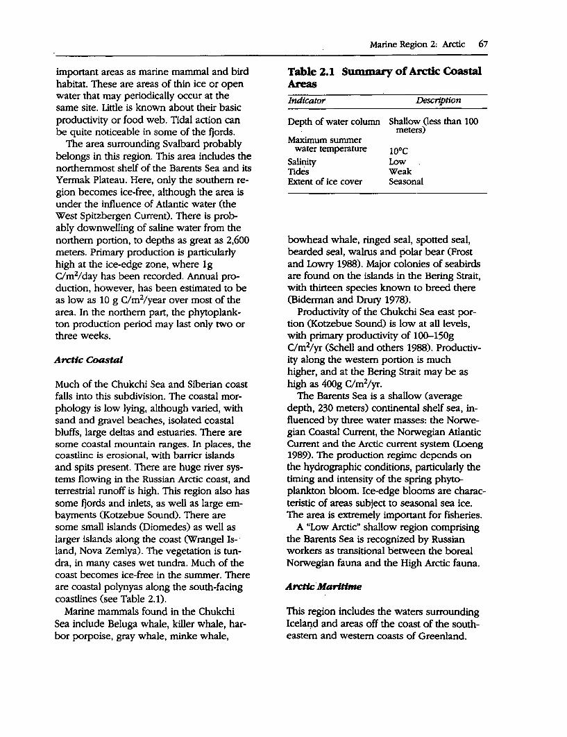
important areas as marine mammal and bird habitat. These are areas of thin ice or open water that may periodically occur at the same site. Little is known about their basic productivity or food web. Tidal action can be quite noticeable in some of the fjords.
The area surrounding Svalbard probably belongs in this region. This area includes the northernmost shelf of the Barents Sea and its Yermak Plateau. Here, only the southern region becomes ice-free, although the area is under the influence of Atlantic water (the West Spitzbergen Current). There is probably downwelling of saline water from the northern portion, to depths as great as 2,600 meters. Primary production is particularly high at the ice-edge zone, where lg C/m2/day has been recorded. Annual production, however, has been estimated to be as low as 10 g C/m2/year over most of the area. In the northern part, the phytoplankton production period may last only two or three weeks.
Arctic Coastal
Much of the Chukchi Sea and Siberian coast falls into this subdivision. The coastal morphology is low lying, although varied, with sand and gravel beaches, isolated coastal bluffs, large deltas and estuaries. There are some coastal mountain ranges. In places, the coastline is erosional, with barrier islands and spits present. There are huge river systems flowing in the Russian Arctic coast, and terrestrial runoff is high. This region also has some fjords and inlets, as well as large embayments (Kotzebue Sound). There are some small islands (Diomedes) as well as larger islands along the coast (Wrangel Is-· land, Nova Zemlya). The vegetation is tundra, in many cases wet tundra. Much of the coast becomes ice-free in the summer. There are coastal polynyas along the south-facing coastlines (see Table 2.1).
Marine mammals found in the Chukchi Sea include Beluga whale, killer whale, harbor porpoise, gray whale, minke whale,
Marine Region 2: Arctic 67
Table 2.1 Swnmary of Arctic Coastal Areas Indicator Descrlptton
Depth of water column Shallow Oess than 100 meters)
Maximum summer water temperature
Salinity Tides Extent of ice cover
10°c Low Weak Seasonal
bowhead whale, ringed seal, spotted seal, bearded seal, walrus and polar bear (Frost and Lowry 1988). Major colonies of seabirds are found on the islands in the Bering Strait, with thirteen species known to breed there (Biderman and Drury 1978).
Productivity of the Chukchi Sea east portion (Kotzebue Sound) is low at all levels, with primary productivity of 10~150g C/m2/yr (Schell and others 1988). Productivity along the western portion is much higher, and at the Bering Strait may be as high as 400g C/m2/yr.
The Barents Sea is a shallow (average depth, 230 meters) continental shelf sea, influenced by three water masses: the Norwegian Coastal Current, the Norwegian Atlantic Current and the Arctic current system (Loeng 1989). The production regime depends on the hydrographic conditions, particularly the timing and intensity of the spring phytoplankton bloom. Ice-edge blooms are characteristic of areas subject to seasonal sea ice. The area is extremely important for fisheries.
A "Low Arctic" shallow region comprising the Barents Sea is recognized by Russian workers as transitional between the boreal Norwegian fauna and the High Arctic fauna.
Arctic.Maritime
This region includes the waters surrounding Icelaqd and areas off the coast of the southeastern and western coasts of Greenland.
68 A Global Representative System of Marine Protected Areas
Iceland rises from the Mid-Atlantic Ri~ge and constitutes one of the geological "hot spots" of the world (Stefansson and Jakobsson 1989). Biologically as well as ocea~ographically it is an area of great contrasts, since it consists of water masses of diverse character and origin. It is located at or near the polar front and is therefore very sensitive to climatic variability, which in tum markedly influences the distribution and behavior of marine organisms. The influence of climatic changes has been well documented for Icelandic waters, as for example the r:iorthward movement of the spawning of cod during the early part of this century. The primary production of the area varies widely between years due to hydrographic variability. It tends to be highest at the front between Atlantic water and the polar currents that move southward along the east coast of Greenland. Among the marine biota, there are large numbers of fishes, several species of marine mammals and some millions of seabirds.
Norwegian Coast
The following information is provided by Holthe (1993).
The entire Norwegian shelf and coastal environment lie within the Northeast Atlantic Boreal region, which stretches from the English Channel to the Kola fjord near Murmansk. In Norway there are two ma~e biogeographic dimensions: one is the gradient along the coast between the Swedish · and Russian borders, and the other follows the transect from the shelf through the coastal sounds and into the fjord systems.
The present marine fauna of Norway has. been established after the deglaciation. Geological data show that the change from arctic to boreal fauna and flora has not been.steady, but has reacted to climatic changes during the last 10,000 years. The boreal species are immigrants; when endemisms do occur, they are likely to be artifacts due to incompletely known distribution outside the area. On the other hand there are species with true north-
em or southern limits along the coast. The distribution of such limits can be used in dividing the coast in biogeographic subregions.
Based on the topography and the physical properties of the water masses along the coast, it has been customary to divide the No~egian marine habitats into six geographical subregions. However, a recent analysis undertaken at the request of the Directorate for Nature Management (see Brattegard 1993) using the distribution of some 2,500 benthic organisms, suggests that these subregions are not true biogeographic subregions. There seems to be no biogeographic difference between some of the subregions, whereas there may be a real difference between the areas north and south of the Trondheimsfjord at around 65°N, with the waters of the Skagerrak forming another biogeographic unit (the Skagerrak falls within the IUCN-CNPPA Baltic Marine Region). Given the scale of this report it is proposed that two subregions be used: north coast (north of 65°N) and south coast (south of 65°N)
There is also a biogeographic difference between the outer coast and the different parts of the fjord systems, mainly as a result of varying salinity and temperature. Generally, the marine flora and fauna along the Norwegian coast is reduced along a gradient from euhaline coastal water to the brackish waters in estuarine fjords. Temperature range is also an important factor in determining which species will succeed in a given locality. The result in some cases is that southern boreal species found on the coast do not penetrate into the inner fjords.
AsSFSSMENT OF ExlsTING MPAs
Description· and Status of National MPA Systems
Canada
Parks Canada has prepared a National Marine Conservation Areas Policy 0994) and
developed a framework of 29 marine natural regions. Most of the regions identified as Arctic under the classification have been included in the Northwest Atlantic Region as defined by IUCN-CNPPA. The Canadian goal is to adequately represent each marine region within the system of national marine conservation areas. There are no specifically marine protected areas as yet.
There is one national park in Canada within the Arctic region, as defined here Ellesmere Island National Park. This park
· has a relatively large marine component : 0,031 square miles or 2,686 square kilometers), which protects the offshore waters along the northern coastal portion of the park. There are no other Canadian marine protected areas in this region (Fi:ancine Mercier, personal communication). ,.,.. Ellesmere Island National Park: Further
details on Canada's program to establish MP As are provided in the Northwest Atlantic regional report.
Greenland (Denmark)
The following description is adapted from WCMC 0992).
Greenland acquired autonomy from Denmark in 1979. Protected areas can be established under the Conservation (Nature and Ancient Relics) Act and are administered·by the Office of Environment that collaborates closely with the Danish Ministry of Environment. In addition to the protected ·areas system there is a mosaic of regulated coastal areas, each with its own rules depending.on the season and the animal species occurring (Helms 1991). ,.,.. Greenland National Park: The Green
land National Park is the largest national park in the world and includes coastal marine components. This· area is the only MP A recorded in Greenland.
Iceland
This information is provided by the Nordic Project Group 0993).
Marine Region 2: Arctic 69
Marine areas can be protected through the provisions of the Nature Conservation Act or by speciallaw. The Act provides for the protection of the natural environment throughout Iceland, seeking to minimize damage while maintaining access. It also provides for a number of protection categories with the aim being to ensure the protection of the diversity of habitats and landscapes, flora and fauna.
The Nature Conservation Council, which works according to this law, prepares a list every third year of valuable areas that are not yet protected. The list can be regarded as the Nature Conservation Council's plan to protect areas in their future work. Specific protection proposals go through the Environment Ministry; which is the decisionmaking authority.
The existing MP As are: ,.,.. Surtsey Scientific Reserve ,.,.. Eldey Scientific Reserve
These two reserves include offshore islands and the waters within a radius of 2 kilometers. In addition there are 12 coastal protected areas that include lengths of the adjacent shoreline: • Herdisarvile • Reylijanes f6lkvanger • Varmar6sar • Blautes • Hellnor/Stapi • Melrakksey • Flatey, Breidafjsrdur • Hrisey, Breidafjsrder • Vatusfjsrdur • ·Homstrandir • 6sland • · Dyrh6laey
Norway
The following information is provided by the Nordic Project Group 0993).
There are eleven different laws that regulate land use and incursions into nature in the coastal zone. The Nature Conservation Act is
70 A Global Representative System of Marine Protected Areas
the only law that can be used to protect areas with valuable natural assets. The law can only be used within the territorial limits.
The Ministry of Environment has given the Nature Management Directorate the task of surveying and proposing valuable marine areas (with the exception of Svalbard). The Directorate for Nature Management has subsequently appointed an advisory group with representatives from the universities in Oslo, Bergen, Trondheim, and Troms0 as well as the Marine Research Institute, the Directorate of Fisheries, the Directorate for Nature Management, the Director of National Antiquities and the County Prefect in the Nordland environmental protection department.
The National Nature Conservation Council noted in its report, "New Nationwide Plan for National Parks," the increased pressure on the natural environment along parts of the Norwegian coast (NOU 1986:13). The Council felt that the work of protecting untouched or only slightly affected coastal and marine areas should be given high priority. In Norway natural areas protected to date have included marine areas, although the marine component within protected areas is generally not the main reason for protection of the area.
In the survey of valuable marine areas, work has begun on compiling a national database of existing information on marine flora and fauna. The Directorate for Nature Management has assigned the Norwegian Institute for Nature Research (Norsk institutt for naturforskning) the task of preparing a standard for quality evaluation and priority ranking of valuable marine areas.
In Norway biological resources are managed by the Directorate of the Fisheries (marine fish and shellfish) and the Directorate for Nature Management (anadromous salmonoids, seabirds). Monitoring is carried out by the Institute of Marine Research and Norwegian Institute of Nature Research, respectively. There is a research program that is assessing the stock of marine mammals. All kinds of pollution are monitored by the
State Pollution Authority (SFT). Monitoring of harmful algae is also carried out.
Four MP As have been recorded for the Norwegian mainland: ,.. Bliksvaer Nature Reserve ,.. Froan Landscape Protected Area ,.. Karlsoyvaer Nature Reserve ,.. Nord-Fugloy Nature Reserve
Four MP As have been recorded for Svalbard and Jan Mayen: ,.. Northeast Svalbard National Park ,.. Northwest Spitzbergen National Park ,.. South Spitzbergen National Park ,.. Southeast Svalbard Nature Reserve
Russia
The following information is adapted from Hansen 0993).
Protected areas in the Russian Arctic are established according to the law of the Russian Federation "On Environmental Protection" and regulations about state nature reserves.
Four MP As have been recorded for Russia: ,.. Vrangel Island Zapovednik (Wrangel Is
land): Includes a 5 kilometer buffer zone around the Nature Reserve on Wrangel Island.
,.. Kandalaksheskiy Zapovednik: Includes marine areas to a distance of 500 meters from islands in the Kandalaksheskiy gulf and the Barents Sea.
,.. Ust'lensky Zapovednik: Includes marine areas in the Laptev Sea near the delta of the Lena River.
,.. Great Arctic Zapovednik: Includes 980,934 hectares of marine areas along the Taimyr peninsula and around the islands of the Kara Sea.
Recent information suggests that there is also a nature reserve established by the Russians in the Barents Sea, including the Frans Josef Land archipelago. Further data is re-
quired to confirm the location and other details about this reserve.
These MP As have been declared as Strict Nature Reserves (Zapovedniks) and are managed at the national level. The primary objective of the reserves is to provide for scientific research with limited educational and traditional use permitted in some circumstances. Regular research and monitoring is undertaken, and inventories and evaluations have been completed to detect any positive or negative environmental changes occurring in the protected area.
Status of International and Regional Initiatives Relating to MP As
World Heritage Convention
The following states are parties to the World Heritage Convention: Canada, Greenland, Norway and Russia. There are no marine World Heritage sites in the region.
Ramsar Convention
The following states are parties to the Ramsar Convention: Canada, Greenland, Iceland, Norway and Russia. The following Ramsar sites occurring in the region include elements of marine habitat: Ora, Kurefjorden, Ilena and Prsterodkilem, Jaeren, Orlandet, Tautra and Svaet, and Stabbursneset (Norway); and Forlandsoyane, Dunoyane, Kongsfjorden, Isoyane, and Gasoyane (Norway-Spitzbergen).
UNES<XJMan and the Biosphere Programme
The following states are active in UNESCO's Man and the Biosphere Programme: Canada, Greenland, Norway, Russia and the United States.
Greenland National Park (Greenland) and Southeast Svalbard Nature Reserve (Noiway) are Biosphere Reserves with a marine component.
This assessment shows that there is at least one MP A in each of the zones with the
Marine Region 2: Arctic 71
exception of the High Arctic Oceanic, which is not represented. The High Arctic Coastal region stretches from the Kola Peninsula to the Bering Strait and includes the most MP As with six. Parts of the Svalbard and Jan Majen Islands fall within this zone and include two of the six MP As, the remainder being located along the Siberian coast, which is not well represented considering the length of coastline involved. High Arctic Coastal areas are represented by four MP As, including the Greenland National Park, Ellesmere Island National Park (Canada) and parts of the Svalbard and Jan Majen Islands. The Arctic Maritime zone is represented by two MP As in Iceland (there are also 12 Icelandic protected areas on coastal land). There are four MP As in the Norwegian Coast zone: three in its northern component and one in the southern component. Table 2.2 provides a summary of the biogeographic representation in the MPAs.
The situation is one where a reasonable start has been made in developing a representative MP A system, especially in some locales, but with large gaps in terms of representing the overall region. A more detailed analysis would be required to determine whether the existing MP As include a representative range of the habitat and ecosystem types within each of the zones.
PRIORI1Y AREAs AND RECOMMENDATIONS
The priority areas presented here are those outlined in Hansen 0993), Nordic Project Group 0993), with areas in Russia identified by Amirkhan Amirkhanov and areas in Canada proposed by Vera Alexander in consultation with Canadian representatives.
National Priority Areas for Marine Biodiversity Conservation
In 1981 the Nordic Council of Ministers started a project on marine reserves that was concluded in 1984. The project "Marina Re-
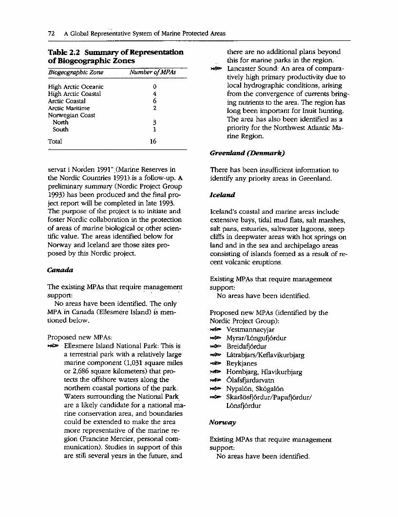
72 A Global Repres.entative System of Marine Protected Areas
Table 2.2 Summary of Representation of Biogeographic Zones Biogeographic Zone Number of MPAs
High Arctic Oceanic High Arctic Coastal Arctic Coastal
0 4 6 2 Arctic Maritime
Norwegian Coast North South
3 1
Total 16
servat i Norden 1991" .(Marine Reserves in the Nordic Countries 1991)is a follow-up. A preliminary summary (Nordic Project Group 1993) has been produced and the final project report will be completed in late 1993. The purpose of the prc;>ject is to initiate and foster Nordic collaboration in the protection of areas of marine biological or.other scientific value. The areas identified below for Norway and Iceland are those sites pro-posed by this Nordic project. ·
Canada
1he existing MP As that require !Ilanagemen,t support:
No areas have been identified. 1he only MP A in Canada (Ellesmere Island) is mentioned below.
Proposed new MP As: ..,,.,. Ellesmere Island National Park: 1his is
a terrestrial park with a relatively large marir:ie component (1,031 square miles or 2,686 square kilometers) that protects the offshore w3:ters along the northern coastal portions of ~e park. Waters surrounding the National Park. are a likely candidate for 4 national ·marine conservation area, and boundaries could be extended to make the area more representative of the marine region (Francine Mercier, personal communication). Studies in support of this are still several years in the future, and
there are no additional plans beyond this for marine parks in the region. ·
~ Lancaster Sound: An area of comparatively high primary productivity due to local hydrographic conditions, arising from the convergence of currents bringing nutrients to the area. 1he region has long been important for Inuit hunting. 1he area has also been identified as a priority for the Northwest Atlantic Marine Region.
Greenland (Denmark)
1here has been insufficient information to identify any priority areas in Greenland.
Iceland
Iceland's coastal and marine areas include extensive bays, tidal mud flats, salt marshes, salt pans, estuaries, saltwater lagoons, steep cliffs in deepwater areas with hot springs on land and in the sea and archipelago areas consisting of islands f9rmed as a result of recent volcanic eruptions.
Existing MP As that require management support:
No areas have been identified.
Proposed new MP As (identified by the Nordic Project Group):
·,.... Vestmannaeyjar ,..... Myrar/L6ngufj6rdur .._. Breidafj6rdur ....... Latrabjars/Keflavikurbjarg .,.. Reykjanes i,,,GD Hombjarg, Hlavikurbjarg ,,...,_ 6lafsfjardarvatn ,...,- Nypsl6n, Sk6gal6n ..,,jlllo> Slrnrsosfj6rdur/Papafj6rdur/
L6nsfj6rdur
Norway
Existing MPAs that require management support:
No areas have been identified.
Proposed new MP As (identified by the Nordic Project Group): ,....... Framvaren: A small (5 square kilome
ters) fjord with a very shallow threshold and old, anoxic deepwater. The sound at the mouth of Framvaren, Straumen, was protected as a nature reserve in 1978, protected area 20 hectares land and 25 hectares sea.
~ Lindespollene: One of the many poll (embayment or inlet) systems relatively unaffected by human activity on the west coast. About 7 square kilometers sea area. Local herring stock and other marine biological properties make these waters interesting to science. Thoroughly investigated. An islet (6 hectares land and 31 hectares sea) just outside the polls was protected in 1987.
~ Utvrer-Indrevrer: The westernmost archipelago in Norway, in highly productive, shallow water. Important as nursery grounds for fish that in turn are food for breeding seabirds. Birds on six islets have been protected since 1953.
,..... Skorpo-Nrerlands0y: A representative area of the west coast with rocky and sandy shores, submarine caves and sounds. No part of the area is protected.
~ Skarnsundet: A narrow sound in the· inner part of the Trondheimsfjord. Approximately 5 square kilometers. The area is internationally known for its coral fauna, which here occurs at exceptionally shallow depths. A bridge across the sound was completed in 1992. Local proposals for protection have been forwarded.
....,.. Vistenfjorden: A fjord system with varied natural habitats. No roads in the inner part, relatively unaffected by human activity, important as scientific reference area, well investigated .. About 24 square kilometers. A proposal for the protection of certain adjoining land areas was made in 1986.
Marine Region 2: Arctic 73
.,... Vega-Lovuden: Characteristic part of the coast in this part of the country. A proposal for the protection of parts of this area was made in 1986.
,.... Ris0y-Flatvrer: Shallow, exposed coast with tidal currents. polls and fjords. Important cultural and natural features, including birds and seals. A coastal park was proposed in this area in 1986.
,..... S0r/Nor-Sandfjord: Strongly exposed fjords facing the open sea. High biodiversity. Bird reserve with 2,000 hectares land and 300 hectares ha sea area protected in 1991.
,._ Indre Porsangerfjorden: Area with typical northern shore meadows, vast mud banks, and ice-edge deltas. Stabbursnes nature reserve (Ramsar area) was protected in 1983 (2,200 hectares land and 14,000 hectares sea).
,..,... Neiden-Munkefjord: Important area for wetland birds and marine ducks, shore vegetation with eastern elements.
Russia
Existing MP As that require management support:
Existing MP As in Russia should be a high priority for management support. These areas are as follows: ,.. Vrangel Island Zapovednik (Wrangel Is-
land) ,.. Kandalaksheskiy Zapovednik ,.. Ust'lensky Zapovednik ,.. Great Arctic Zapovednik
Proposed new MP As: The following areas have been recom
mended for creation in Russia in the period 1994-2005, as confirmed by a decree of the Russian government (23 April 1994, N572-p) (Amirkhan Amirkhanov, personal communication). Of all the nature reserves intended to be created, only those mentioned below will include marine elements. .,..... Pribrezhniy: Located in Chukotsky
Autonomous Area and covering an area of 800,000 hectares. Includes
74 A Global Representative System of Marine Protected Areas
mountain, marine, lake and bog landscapes in the southeastern part of Chukotka.
.,..._ Gydansky: Located in Yamalo-Nenets Autonomous Area and covering an area of 1,000,000 hectares. Includes arctic tundra and forest-tundra of the Gydansky Peninsula, sea shore and the neighboring islands of the Car Sea.
,..... Bolshezemelsky: Located in Nenets Autonomous Area and covering an area of 650,000 hectares. Includes nature complexes of the Bolshezemelskaya tundra, mountain ridges on the Yugorskiy peninsula and Valgach, Dolgiy and other islands.
,,,..._ Nenetsky: Located in Nenets Autonomous Area and covering an area of 550,000 hectares. Includes nature complexes of the Malozemelskaya tundra, the mouth of the Pechora river and the islands of the Pachorskaya inlet.
NGO Proposals
NGOs in the Arctic nations are actively promoting the conservation of Arctic ecosystems and several organizations are cooperating in this work. The NGOs point out serious threats to the Arctic environment and put forward recommendations for action to meet these threats. They support an international system of large-scale protected ecosystems, in terrestrial as well as marine areas, and point out that marine areas are least protected by existing systems (Hansen 1993).
Existing MP As that require management support:
No areas have been identified.
Proposed new MPAs: The following areas have been identified
as priorities: ,.,._ "Arctic Ring of Life" International Ma
rine Biocultural Reserve: This proposal encompasses the dynamic and produc-
tive region shoreward of the permanent Arctic ice cap or the zone of leads of open water and polynyas beyond. This environment provides critical habitat for feeding, staging, resting, reproduction and migration of birds and marine mammals. The polar ice supports the basis of the arctic marine food web that are the foundation for rich populations of fish, marine birds and mammals that dwell along the ice edge. The lead system has been used for thousands of years by native peoples of the Arctic for access and as hunting areas for essential subsistence resources. The Arctic Ring of Life is particularly .vulnerable to large-scale industrial activity resulting from oil and gas development, mining, shipping, military operations, nuC;lear-powered transportation and nuclear waste disposal. NGOs have proposed the establishment of a biocultural marine reserve because case-by-case consideration of mitigating measures for development activities is falling short of the extent of protection that is warranted for the Arctic Ring of Life. According to the NGOs, there should be a full exploration and consideration of the variety of tools available for protecting the Arctic Ring of Life.
,..... The Barents Sea: Norwegian NGOs have proposed a plan for an international park in the Barents Sea to secure the last great wilderness in Europe. The proposal comprises Bear Island, Svalbard, Novaja Semlja, Frans Jo~efs Land and the sea area between these islands. According to the NGOs, this area is one of the most productive in the Arctic. It is an important growing and feeding area for the rich stocks of fish farther south. In the summer, there are probably 13-15 million seabirds in the area. Some 55,000 whales live here, as do 1.2 million-seals and several thousand polar bears. The park
should have the proposed size to encompass the whole ecosystem. The NGOs emphasize that the protected area must include the important biological processes taking place where ice meets sea. It must also cover the seasonal fluctuations of the ice. Oil and gas exploration and development, increased marine traffic through the area, and dumping of nuclear wastes are serious threats to the environment in the Barents Sea.
....,. Beringia Heritage International Park: Formation of an international park along the Bering Land Bridge was endorsed by the presidents of the U.S. and Russia at their 1990 and 1992 Summits. The existing Bering Land Bridge National Preserve, Cape Krustenstern National Monument, Noatak National Preserve, and Kobuk Valley National Monument will make up the U.S. contribution, while a new ethnic park has been proposed on the Chukotsk Peninsula in Russia to protect a shared cultural and natural heritage. The marine and nearshore environments of the Bering Strait serve as an international crossroads for wildlife and indigenous people as well as being the most biologically productive ecosystems in the region. The area is a treasure trove for world paleoecology, anthropology, archeology, and history. Member nations of the IUCN passed a resolution in February 1988 urging the two nations to designate this rich and diverse environment as a World Heritage Site.
Regional Priority Areas
Based on the information available for this report, there are a number of areas that can be suggested as being of regional priority for the conservation of marine biodiversity. The priority sites were selected on the basis of the criteria outlined in the introduction
Marine Region 2: Arctic 75
and the suggestions should be considered as preliminary.
Existing MP As that require management support: ,.,_ Ostrov vrangelya Zapovednik (Russia) ,.,_ Kandalaksheskiy Zapovednik (Russia) ,.,_ Ust'lensky Zapovednik (Russia) ,.,_ Great Arctic Zapovednik (Russia)
Proposed new MPAs: ...,.. Ellesmere Island (Canada) ._. Beringia International Heritage Park (In
ternational) >$P- Barents Sea (International)
BIBLIOGRAPHY
Alexander, V.A. 1992. Arctic Marine Ecosystems. New Haven, Connecticut: Yale University.
Biderman, J.0., and W.H. Drury. 1978. Ecological studies in the northern Bering Sea: Studies of seabirds in the Bering Strait. In Final reports of principal investigators, Vol. 2. Boulder, Colorado: U.S. Department of Commerce, National Oceanic and Atmospheric Administration, Outer Continental Shelf Environmental Assess-ment Program.
,
Bramwell, M., ed. 1977. 1be atlas oftbe oceans. London, U.K.: Mitchell Beazley Publishers.
Brattegard, T.B. Gullikeen, T. Holthe, J, Rueness, J.A. Sneli, B. Christiansen, M.E. Christiansen, T. H0lsseter, T.E. Lein, L.B. Mortensen, K.M. Olsen, E. Oug, A. Pedersen, P. Pethons, O.S. Tenda!, W. Vader, and P.B. Wikander. 1993. Geografisk fordeling av bentbik marin flora og fauns tangs norskekysten. Porslag til Inndeling i biogeograflske omclder. Norske Hayforskeros Forening Arsm0te 1993.
Broad, A.C., H. Koch, D.T. Mason, G.M. Petrie, D.E. Schneider, and R.J. Taylor. 1979. Reconaissance, characterisation of liuoral biota, beaufort and chukchi seas. environmental assessment of principal investigators for the year ending March 1978. Boulder, Colorado: U.S. Department of Commerce, National Oceanic and Atmospheric administration, Environmental Research Laboratory, Outer Continental Shelf Environmental Assessment Program.
76 A Global Representative System of Marine Protected Areas
Brown, R.G.B. 1989. Seabirds and the Arctic marine environment. In L. Rey and V. Alexander, eds., Proceedings of tbe Sixlb Conference of tbe Comite An:ttque International I.eiden: E. J. Brill.
Curtis, M.A. 1973. The marine benthos of Arctic and Subarctic continental shelves. Polar Record 17(111): 595-626.
Dunbar, MJ. 1982. Arctic marine ecosystems. In L. Rey and B. Stonehouse, eds., 7be Arctic Ocean: 1be bydrograpbic environment and the fate of pollutants. London, U.K.: Macmillan Press Ltd.
Frost, KJ., and L.F. Lowry. 1988. Marine mammals. In M.J. Hameedi and A.S. Naidu, eds, 1be environmental and resources of the Southeastern Chukchi Sea: A review of the literature. OCSEAP.
Gulliksen, B., and O.J. Lonne. 1989. Distribution, abundance, and ecological importance of marine sympagic fauna in the Arctic. Rapp. P-v. Reun. Cons. Int. F.xplor. Mer. 188: 133-8.
Hansen, J.P., ed. 1993. 1be state of habitat protection in the Arctic. CAFF Report No. 1 (2d draft). Report prepared by the Directorate for Nature Management, Trondheim, Norway.
Hayden, B.P., G.C. Ray, and R. Dolan. 1984. Classification of coastal and marine environments. Environmental Conservation 11(3).
Helms, H.J. 1991. Nature Conservation In Greenland. In C. Andreason, L.A. Angantyr, C. Bay, D. Boertmann, E.W. Born, H. Elling, HJ. Helms, F. Larsen, C.R. Olesen, and H. Siegstad, Nature conservation in green/and research nature and wildlife management.
Holthe, T. 1993. Norwegian marine habitats and marine reserves in Norway. Unpublished paper for the Directorate for Nature Managen:ient, Trondheim (February).
Horner, R., S.F. Ackley, G.S. Djeckmann, B. Gulliksen, T.Hoshiai, i.A. Melnikov, W.S. Reeburgh, M.Spindler, and C.W. Sullivan. 1992. Ecology of sea ice biota CI: Habitat and terminology). Polar Biology 12:417-27.
Kendall, M.A., and M. Aschan. 1993. Latitudinal gradients in the structure of macrobenthic com-
munities: A comparison of Arctic, temperate and tropical sites. ]. F.xp. Mar. Biol. Ecol. 172:157-69.
I.egendre, L., S.F. Ackley, G.S. Dieckmann, B. Gulliksen, R. Horner, T. Hoshiai, I.A. Melnikov, W.S. Reeburgh, M. Spindler, and C.W. Sullivan. 1992. Ecology of sea Ice Production. Polar Biology 12:439-44.
Marshall, N.B. 1982. Glimpses into deep-sea biology. In L. Rey and B. Stonehouse, ed., 1be An:tic Ocean. 1be hydrographic environment and the fate of pollutants. London, U.K.: Macmillan Press Ltd.
Menzies, R.J. 1975. Origin and evolution of the Arctic marine ecosystem. In Proceedings of tbe Circumpolar Conference in Northern Ecology (September 15-18). Ottawa: National Research Council of Canada.
Nordic Project Group. 1993. Marine Reseroes in tbe Nordic Region. Preliminary Summary of a Project within the Nordic Council of Ministers.
Petersen, G.H., and M.A. Curtis. 1980. Differences in energy flow through major components of subarctic, temperate and tropical marine shelf ecosystems. Dana 1:53.
Remmert, H. 1980. Arctic animal ecology. Berlin/Heidelberg/New York: Springer-Verlag.
Sakshaug, E., A. Bj0rge, B. Guliksen, H. Loeng, and F. Mehlum. 1992. 6kosvstem Barentsbaver Mesna-Trykk.
Salm, R.V., and J. Clark. 1984. Marine and coastal protected areas: A guide for planners and managers. Gland, Switzerland: IUCN.
Schwartz, M.L. 1982. 7be encyclopedia of beaches and coastal environments. Philadelphia, Pennsylvania: Hutchinson Ross Publishing Company.
World Conservation Monitoring Centre (WCMC). 1992. Protected areas of the world: A review of national systems. Volume 2: Palaearctic. Gland, Switzerland and Cambridge, U.K.: IUCN.
Zenkevitch, L. 1963. Biology of the Seas oftbe USSR. New York: Wiley Interscience.
MARINE REGION 3 Mediterranean
Michel Batisse and Alain Jeudy de Grissac
··"l-,.
BIOGEOGRAPHY AND MARINE BIODIVERSI1Y
The Mediterranean lies between Europe, Asia and Africa (about 46°N, 30°N, 6°W and 36°E) and, excluding the Black sea, covers an area of approximately 2.5 million square kilometers, with an average depth of about 1.5 square kilometers and a volume of 3.7 milli~n cubic kilometers. The Marmara, Black and Azov Seas are included in the definition of the Mediterranean Marine Region used in this report, although they have very different characteristics and are not included in UNEP's Mediterranean Action Plan.
The Mediterranean Sea is comprised of two major basins, western and eastern, that are divided by the relatively shallow strait of Sicily. These two basins are in tum divided into a series of interacting parts and adjacent seas. The Western Mediterranean covers about 0.85 million square kilometers and the Eastern Mediterranean about 1.65 million square kilometers.
The Mediterranean Sea is almost a closed sea, but is connected with (and separated from) the Atlantic by the Strait of Gibraltar
77
~ -- -.~:_·_-:;__::,. - ----
05 kilometers wide, with an average depth of 290 meters and a maximum of 950 meters), with the Sea of Marmara by the Dardanelles (between 450 meters and 7.4 kilometers wide and 55 meters deep), and with the Red Sea by the Suez Canal (120 meters wide and 12 meters deep). The Mediterranean region is a transitional area climatically: rainfall throughout the region is irregular during the year and from one year to the next, particularly in the southern parts. It is characterized by the so-called Mediterranean climate, which is also found in other parts of the world (California, Chile, South Africa and Australia), and features a warm, dry summer period over all the basin, with substantial rainfall in the north and aridity in the south. In this respect, Atlantic and orographic rains on the European coasts, particularly in the west, contrast markedly with minimal and irregular annual rainfalls of less than 100 millimeters in the southern regions. The northern sectors of the basin have a moderate climate, lying within the zone of prevailing westerly winds, and are characterized by spring and autumn showers that curtail the summer drought. Rainfall in-
78 A Global Representative System of Marine Protected Areas
tensity and duration decrease both from west to east and from north to south, while temperature increases from north to south and from west to east.
Surface winds in the Mediterranean are generally from the north and west. The coinbination of dry winds and sunny days, which occurs as often as 250 times a year, produces a strong evaporative influence over the entire surface of the Mediterranean Sea, accounting for its above-average salinity.
Oceanography and Water Quality
Except where noted the following information is adapted from UNEP 0990).
The Mediterranean Sea has a negative hydrological balance, with loss through evaporation exceeding the input of water through runoff and precipitation. This deficiency is mainly compensated by the flow of Atlantic surface waters through the Strait of Gibraltar (about 35,000 cubic kilometers).1 On the input side of the water balance are net inflows through the Strait of Gibraltar (about 1,800 cubic kilometers) and the Dardanelles (about 300 cubic kilometers), river runoff (about 500 cubic kilometers; of which 92 percent originates from the northern shore), and precipitation (about 1,000 cubic kilometers). The main factor on the negative side of the balance is evaporation (about 3,500 cubic kilometers), which occurs primarily during winter and spring due to the prevailing strong and dry continental winds and is closely associated with a process by which high-salinity deepwater is formed.
Except in very few areas, like the Gulf of Gabes in Tunisia, the Mediterranean is characterized by very weak tides, with tidal amplitudes that are very small by world standards; this feature has major consequences on the characteristics for the shorelines and their pollution.
The major feature of the surface current system of the Mediterranean is the movement of water from the Atlantic toward the east combined with numerous spin-off ed-
dies along the way. There is no surface return system from the east to the west, but a return of Mediterranean water takes place by way of intermediate and deep water flowing from east to west and spilling over the sill of Gibraltar into the Atlantic. Such intermediate and deep water results from very pronounced evaporation that gradually transforms surface water with salinity slightly above 36°100 from the Atlantic into denser water with salinity of 38°100 or more, reaching 39,5°100 in the Eastern Basin.
The Mediterranean circulation system also includes strong vertical convection currents that determine the distribution of salinity and provide for vertical recycling of nutrients and other dissolved substances.
The Mediterranean Sea has relatively low concentrations of nutrients even in deeper waters. These chemicals are exported in the flow of deep water through the Strait of Gibraltar that in tum receives nutrient poor surface Atlantic water. No deep nutrient-rich Atlantic waters take part in the Mediterranean circulation, and the input of nutrients is mostly due to river input and agricultural runoff or pollution (Miller 1983).
Pollution
The processes of water circulation and exchange are such that almost any substance introduced into the surface environment of the Mediterranean Sea, unless it is volatile and subject to evaporation or is miscible within the deep water that leaves the Mediterranean, will remain within its boundaries. The introduction of substances foreign to Mediterranean waters is primarily, though not exclusively, from land-based sources. However, a large amount of airborne particles, including heavy metal pollutants, also reach the sea by way of atmospheric transport through dust storms or fallout from precipitation. Domestic sewage, industrial discharges and agricultural runoff are obvious sources of pollution, mostly at the local scale.
The uneven distribution of runoff and precipitation along the northern coasts of the Mediterranean Sea, combined with the concentration of population and industrial activity in the north, contributes a waste load of pollutants to northern Mediterranean waters that may eventually spread to other areas. Heavy traffic of oil tankers used to lead to the spread of tar balls on the coasts but this has been considerably reduced through implementation of the Barcelona Convention. Plastic containers and other floating residue from ships and sailing boats remain a nuisance in most areas of the basin. Significant progress has been achieved in the reduction of discharge of urban effluence from major cities although much remains to be done. Relatively high levels of mercury occur in some parts of the basin, but appear to be largely of natural origin and do not dangerously affect fish consumption.
Eutrophication
The Mediterranean is naturally adapted to . avoid excessive eutrophication since it loses deep water, relatively rich in mineralized or recycled nutrients, and receives low nutrient Atlantic surface water. This situation is the opposite to that in the Baltic Sea, where ecological mechanisms tend to recycle and accumulate large amounts of nutrients.
However, when nutrients are continuously discharged into coastal waters in excess of their self-purification capacity the oxygen balance is disrupted. The oxidation of organic matter then proceeds through anaerobic pathways and coastal waters rapidly become turbid and poisonous to certain forms of marine life. This process can have very negative effects on tourism, as experienced in recent years on the Adriatic coasts (UNESCO 1988).
Mediterranean waters are oligotrophic except in the vicinity of large rivers, and sediments have in general a low organic carbon content due to the low biological productivity of the waters and the presence
Marine Region 3: Mediterranean 79
of high oxygen concentrations in deepwaters. Local oxygen deficiencies are always connected with eutrophication sources, mostly discharges of raw or treated urban or agricultural effluents. Their distribution around the region is uneven, with a maximum in the northwest and in the Adriatic Sea and a minimum on the southern shores. Owing to the strong stratification of surface waters, eutrophication is more acute in summer when ambient nutrient concentrations are low and oxygen transport through the thermocline is strongly reduced. Winter mixing allows for the required vertical transport of oxygen to keep the deepwaters and the sediments oxidized all over the Mediterranean Sea (Cruzado 1985).
Black Sea
The Black Sea receives an inflow of saline Mediterranean and Marmara Sea waters through the Bosphorus into the bottom of the Black Sea basin. The salinity of surface waters is diluted by the inflow of freshwater from rivers and from the brackish Azov Sea. Below 150-200 meters the Black Sea is filled with stagnant anoxic waters that contain hydrogen sulphide. The stagnation is produced by a permanent halocline that separates high-density lower water layers from an upper layer of lower density. The surface currents of the Black Sea have a circular motion, forming several eddies, one in the western part of the sea and three (two cyclonic and one anticyclonic) in its eastern part.
Coastal Geography and Geology
Except where noted the following information is adapted from the Blue Plan (Grenon and Batisse 1989).
The Mediterranean basin is situated at the center of a complex mosaic formed by tectonic plates sliding under one another and is subject to heavy seismic and volcanic activity. The young relief and the close contact and interpenetration of the sea and the mountains
80 A Global Representative System of Marine Protected Areas
have had significant consequences: few large plains, little good agricultural land, ports and. harbors tightly hemmed in _between sea and rock, and few broad fluvial basins. With the exception of the southeast and some 3,000 kilometers along the Libyan and Egyptian coasts where the Saharan platform directly meets the sea, there are mountains everywhere, sometimes virtually uninterrupted, plunging in numerous places directly into the sea.
Thus, about 54 percerit of the Mediterranean coasts are rocky. However, there are a number of large alluvial plans associated with the deltas of major rivers (Ebro, Rhone, Po and Nile) and with those of numerous smaller rivers of the basin, particularly in Tunisia, Greece and Turkey. These rivers drain soils far removed from the coastline and carry very large volumes of sediment to the . sea. Short, often torrential rivers drain small areas on a highly seasonal basis. Thirty-one percent of the soils of the Mediterranean basin lose over 15 tons per }:iectare per year through erosion, and the loss may reach 250 tons in so~e parts of Morocco, Italy and Syria. However, the effect of soil erosion on the Mediterranean is not a major problem in itselft the main issue is the amount of pollutants carried by these rivers, particularly th~ Ebro, Rhone and the Po, that drain regions with heavy industrial and agricultural activity.
The case of the Nile, by far the largest . riv.er of the basin, is very specific. The Nile once carried an enormous load of sediments during its yearly flood, but since the building of the Aswan dam, only a modest flow (not exceeding I/15th of the former water discharge), that is quite polluted but almost sediment free reaches the sea. The result has been an increase in coastal erosion around the Egyptian delta, extending ~o the Israeli and even Lebanese coasts through local current systems, and easier access to the Mediterranean for Red Sea fauna and flora entering through the Suez Canal.
The Black Sea lies in a depression between two alpine fold belts, the Pontic Mountains to the south and the Caucasus
Mountains on the northeast. The northwest coast, except for the Crimea, is relatively . low. The shallow Kerch Strait connects the northern reaches of the sea with the Sea of Azov, while to the south the Sea of Marmara and the narrow Bosphorus Strait link the Mediterranean to the Black Sea.
Ecosystem Diversity
While it exhibits a low level of biological productivity, the Mediterranean Sea as well as the surrounding lands is characterized by a relatively high degree of biological diversity. The .fauna includes many endemic species and is considered "richer" than that of Atlantic coasts. The continental shelf is usually very narrow, but the coastal marine area of the Mediterranean, which stretches from the shore to the outer extent of this continental shelf, shelters rich ecosystems and the few areas of high productivity in the sea. Whereas central zones of the Mediterranean are low in nutrients, coastal zones benefit from telluric nutrients that support higher levels of productivity. Among the ecosystems that occupy coastal marine areas, the rocky intertidals, estuaries, and, above all, seagrass meadows (mainly Posidonia oceanica) are of significant ecological value.
These and other ecosystems are also important for endangered species. This is the case for the Mediterranean monk seal, which uses caves as habitat, for marine turtles, which use sandy beaches for nesting, seagrasses for feeding and seagrasses or muddy bottoms for wintering, and for marine birds, which use wetlands, rocky shores or islands for nesting and resting (Ramade 1990).
Seagrass~eadows
The Mediterranean marine vegetation ·includes about 1,000 macroscopic species, of which about 15 to 20 percent are endemic. This vegetation occurs mainly in shallow waters (less than 50 meters) that comprise less than 10 percent of the Mediterranean's sur-
face. Seagrass meadows are important habitat for numerous marine species (in particular fish, crustaceans and marine turtles) for breeding, feeding and resting.
A narrow fringe of vegetation, in some areas less than 100 meters wide and 0-40 meters deep, lies nearly all around the Mediterranean. There is a direct link between the presence of seagrass and fish production, and together with wetlands, seagrass meadows produce more than 80 percent of the annual fish yield in the Mediterranean. Yet seagrass is endangered by all the impacts of human pressure on the seashore. Due to their regression over the last ten years, 40 species are now considered as endangered: 38 algae and 2 marine phanerogams (Posidonia oceanica and Zostera marina). Posidonia oceanica meadows constitute the most characteristic and the most important Mediterranean marine ecosystem. They play a central role in stabilizing the seashore and in maintaining water quality, particularly through oxygen production. The stability of the seashore is maintained by this "submarine forest," which holds sediment between its roots, reducing currents and swell. Its vertical growth thus acts as a submerged breakwater, and the destruction of seagrass can have immediate and irreversible effects on the position of the shoreline. In a number of places the disappearance of sandy beaches has soon followed the disappearance of seagrass meadows. Posidonta oceanica meadows are the most important fish production areas in the Mediterranean. The sustainability of important fisheries (fish and shrimps in particular) is directly connected with the presence of seagrasses.
Cymodocea nodosa is also widely spread in the Mediterranean, but is absent from areas occupied by dense Posidonia. It has been suggested that C. nodosa is a pioneer species and that in time it is replaced by Posidonia (Schwartz 1982).
Coastal marine vegetation in the Mediterranean is endangered by the intense develop-
Marine Region 3: Mediterranean 81
ment of various activities in the region, including those linked with urbanization and rapid population increases on the southern and eastern shores. These activities include the discharge of untreated sewage ( which still occurs in many coastal towns in spite of recent progress), discharge of industrial wastes in rivers and at sea, construction of roads, airports and marinas, dredging of sand and gravel, and anchoring of innumerable pleasure boats that swarm along the coast in summer (on the French Riviera, there is on average a port for these boats every 4 kilometers). However, the most destructive factors appear to be reduction of water transparency and the effects of trawling boats.
Legal protection for marine vegetation is generally still insufficient. In particular, the creation of MPAs covering the world's widest seagrass areas in the Gulf of Gabes (Tunisia) and the Gulf of Sirte (Lybia) is urgently required. Attempts have been made to re-implant Posidonia oceanica with some success, but these should be conducted properly, when the causes of destruction have been stopped and where the species was actually present previously. Monitoring of the evolution of this species is important and is conducted systematically in France and Spain.
Endemic seagrasses in the northwest Mediterranean are currently threatened by the invasion of an exotic tropical species, Caulerpa taxtfolta, that was accidentally released in 1984 and has now spread over nearly 2000 hectares, mainly in France but also in Italy and the Baleric Islands (Meinesz and others 1993).
Wetlands and Lagoons
A significant number of Mediterranean wetlands have been "reclaimed" over history. Important lagoon systems remain in Spain (Valencia), France (Languedoc and Giens), Italy (Sardenia, Toscania, Pylia, and Venice), Central Greece, Cyprus, Morocco (Nadar), Al-
82 A Global Representative System of Marine Protected Areas
geria, in many places in Tunisia, and across the entire Nile delta in Egypt.
Mediterranean wetlands and lagoons are of great significance to the conservation of biological diversity and are also highly productive. They perform numerous· other functions related to flood control, recreation, tourism, fisheries and agriculture as well as chemical and physical reduction of pollution. They also act as breeding and wintering areas for a great variety of birds and are essential stopover points on the migratory routes of numerous bird species.
Numerous programs and actions have been developed for the protection and conservation of wetlands, in particular through the implementation of the Ramsar Conven..! tion. Wetlands and lagoons are facing direct threats, such as reclamation for industrial development, infrastructure, agriculture and tourism and indirect threats such as the diversion of rivers ·and pumping from underground aquifers. The Venice lagoon provides a striking example of this combination of threats.
Mediterranean wetlands and lagoons need further protection to ensure their conservation for their own value and as essential resting places for the conservation of migratory · birds moving between Europe and Africa. A recent step in this direction is the establishment of a cooperative network; Medwet, by the European Community.
0th-er Habitats
As indicated above, for geomorphological reasons extensive stretches of the Mediterranean coast are rocky. These areas usually support communities dominated by algae. Characteristic biogenic constructions can be found on these coasts, including platforms with Lithopbyllum licheonides on steep coasts and vermetid platforms on calcareous coasts. Rocky coasts appear to be less threatened than alluvial ones due to the difficulty of access and relatively lower urbanization, · but they are quite vulnerable and suffer
from pollution and trampling by vacationers. Their protection is therefore particularly required.
Estuaries constitute another important habitat since there are some 70 sizeable rivers and streams flowing into the Mediterranean (and major estuaries in the Black Sea). They are dominated by the deposition of sediments and, in most cases, by a fairly high level of industrial and agricultural pollution. A number of large or medium size cities are located close to estuaries.
There are no coral reefs or mangroves in the basin and most of the sandy beaches are small with the absence of significant tides. On the European side, a number of sand beaches have been established artificially and have contributed to the destruction of seagi;ass meadows.
Species Diversity
The biota of the Mediterranean Sea consists primarily of Atlanto-Mediterranean species (62 percent) derived from the adjacent Atlantic biogeographic provinces beyond the Strait of Gibraltar. Many Mediterranean species are endemic (20 percent) while others are cosmopolitan or circumtropical (13 percent) or Indo-Pacific (5 percent). These proportions differ for different major taxonomic groups and also for different parts of the Mediterranean Sea, but the pattern remains essentially the same (Ketchum 1983).
Within the Mediterranean there is a gradient of increasing species diversity from east to west. The number of species among all major groups of plants and animals is much lower in the eastern Mediterranean than in the western and central parts of the sea. The southeast comer, the Levant Basin, is the most impoverished area. The benthic and littoral populations show a similar change in species diversity and abundance, which decrease from west to east, and from the northern Adriatic to the south (Ketchum 1983).
The number of endemic species is significantly higher than that for the Atlantic
Ocean. The percentage of endemism is very high for. the sessile or sedentary groups such as a ascidians with 50.4 percent (Peres and Picard 1964), sponges with 42.4 percent (Vacelet 1981), hydroids with 27.1 percent (Peres and Picard 1964), echinoderms with i4.3 percent (Tortonese 1985), but it is also considerable for the other groups such as decapod crustaceans with 13.2 percent (Peres and Picard 1964; Peres 1967) and fish with 10.9 percent.
Plants
The importance of seagrasses was noted previously.
Except in coastal lagoons the Mediterranean is. relatively poor, not in variety but in the quantity of plant organisms produced. Phytoplankton growth is limited by the low concentration of nutrients. Colder years tend to be more productive, partly because mixing in the water column may reach a greater depth and incorporate more nutrients and partly because the formation of deep water may occur over a larger area. Maximum bioproduction is at about 100 meters depth in summer, where decreasing light levels are . balanced by the increased concentration of nutrients.
Primary productivity can be unusually high at the mouths of rivers and along the coast in winter time, with the arrival of layers of water produced by mixing in the Golfe du Lion and in large eddies where deepwater rises close to the surface. Phytoplankton sink and many of the cells are grazed by animals. The remainder die and decompose and together with faeces, moults, dead animals and material from land, contribute to the detritus of the sea. Many marine sediments are anoxic. Natural conditions favorable to the formation of sediments rich in organic matter are found in regions of upwelling or near estuaries. In these ·areas high primary production results in accumulation of detrital material on the sea floor and in the development of anaero-
Marine Region 3: Mediterranean 83
bic conditions. Much organic matter can thus be preserved in spite of ventilation of the overlying waters (Cruzado 1985).
The biological productivity of the Mediterranean Sea as a whole is among the lowest in the world. Primary production in the central parts of the Mediterranean Sea, and in many of the coastal areas away from the influence of major rivers or urban centers, is low and nutrient concentrations in the deepwaters of the Mediterranean, especially the Eastern Basin, are also very low.
Fauna
The establishment of a database named "Medifauna" has made it possible to compare the world's marine fauna (about 130,000 described) with that of the Mediterranean (about 8,000 known marine metazoans). Included in the bank are 5,315 species, of which 1,776 are under verification. The Mediterranean Sea includes 6 percent of the world's species for less than 1 percent of the world's ocean area and less than 0.003 of its volume. Naturally such comparisons must be treated with caution since the Mediterranean has been comparatively well studied in relation to some other parts of the world where there are still many species to be described.
The majority of Mediterranean species are of Atlantic origin (about 67 percent). Migrants through the Suez Canal represent 5 percent of the total but 12 percent of the southeastern part of the Mediterranean. Endemism is about 28 percent. The Western Mediterranean includes 87 percent of the total number of species recorded, 91 percent of the non-endemic species and 77 percent of the endemic species; the Adriatic includes 49 percent, 55 percent and 35 percent, respectively; and the Eastern Mediterranean 43 percent, 52 percent and 23 percent (Fredj 1992).
Invertebrates The oligotrophic character of the Mediterranean Sea results in a low zooplankton
84 A Global Representative System of Marine Protected Areas
biomass compared with similar Atlantic areas. The general trends of zooplankton distribution show an increasing abundance toward the southwest end of the Western Basin. In the Alboran Sea the abundance of zooplankton contrasts with the low values of biomass observed on the Atlantic side of the Gibraltar Strait. The higher fertility of the Alboran Sea results more from local.upwelling and the effect of the cyclonic gyre than from the influence of the Atlantic wa.ters entering the Mediterranean (Estrada, Vives, and Alcarez 1985).
Other invertebrates such as .mollusks support some of the more .valuable fisheries, with the explosive de~elopment of mussel culture acting as an indication of enrichment in the Golfe du Lion and Adriatic. Mechanized clam ("vongole") harye~ting in the Adriatic used to be a valuable fishery, but . suffered from overexploitation in the 1980s .and probably also from the effects of pollution. Control of licenses has recently been introduced. Some mollusks that are endemic to the .Mediterranean are endangered due to overcollection and habitat destruction. These include the giant vibalue Pinna nobilis, protected in Croatia and France, and the large limpet Patellaferrugina, which has no pi;o-tection. · ·
Sponges constitute a tradition~l resource of the Mediterranean. They have also suffered from heavy collecting, particularly in the Eastern Basin, but also recently from an epidemic disease, and stronger collecting regulations are called for. . ·
Red coral Corallium rubrum is a valuable resource in the Mediterranean, being used for the production of jewelry. In the past this species occurred in commercially exploitable concentrations off Spain, Algeria and Sardinia, and at lower densities elsewhere. There is increasing concern about the declining returns to an increasingly sophisticated harvest sector, which has exchanged primitive dragging equipment for diving equipment capable of ope~ting at depths of 100 meters. A rotating harvest
scheme was seen by the industry and scientists as one of the few realistic options for this ·heavily exploited resources. In the absence of more effective control this species is likely to be placed on the CITES list of species for which export of ~e organism or its products is restricted or prohibitt;d.
Fish Of the 1,255 species recorded and illustrated for the Northeast Atlantic and the Mediterranean (UNESCO 1984, 1985, 1986), a total of 540 are recorded as present in the Mediterranean. Tortonese (1963) listed 362 of these as shore forms, 62 of which are endemic.
The Black Sea includes 108 genera of fish, of which 57 percent are immigrants from the Mediterranean and 22 percent freshwater sp~cies (Ketchum 1983).
The yield of Mediterranean fISheries is comparatively low ( compared to other, oceans), probably as a result of the relatively low primary productivity and generally narrow continental shelves. There is some evidence of a gradient in the yield, decreasing from west to east and from north to south (Ketchum 1983).
Total catch for the Mediterranean seems to have reached a ceiling of around 1.1 million tons per year (including mollusks). An increase in the catch of some species is sometimes indicated, probably due to improvement in statistics and to increased productivity of ecosystems through eutrophication. Aquaculture is also being developed in several countries in the basin. Cooperation and guidance in fisheries are provided by the General Council for Fisheries in the Mediterranean, which includes the Black Sea and is sponsored by PAO (Charbonnier 1990).
Birds The Larus audoutnii (Audouin's gull) has reached dangerously low population levels and depends on rocky islands and archipelagoes, free from disturbance, as breeding sites. The Audouin's gull population in the
Mediterranean is in the order of 600-800 pairs. Several species of birds typical for the Mediterranean climatological region are threatened in their European, and possibly in the whole of their Mediterranean range, because of the loss of suitable disturbancefree habitat. Of particular note are the endangered species Pelecanus onocrotalus ( white pelican), P. crispus (Dalmatian pelican), Egretta alba (great white heron), Phoenicopterus ruber(greater flamingo), and La:rus genei (slender-billed gull). The Mediterranean is of significant importance for migratory birds and twice a year some 150 migratory species cross the narrow natural passages in the region-Gibraltar, Cap Bon (Tunisia), Messina (Italy), Belen Pass (Turkey), Lebanese coast, and Suez Isthmus-· taking advantage of the wetlands occurring on their way (Ramade 1990).
Reptiles The loggerhead (Caretta caretta), leatherback (Dermochelys coriacea), and green ( Cbelonia mydas) are endangered species of marine turtle found in the region. While the loggerhead remains relatively abundant, it seems to have deserted many parts of the · Western Basin where it is disturbed by fishing activity. The other two species are be- · coming increasingly rare. Nesting sites for the herbivorous and migratory green turtle· can be found in Cyprus, Turkey, Egypt and Libya. There are only a total of 2,000 nesting females at these sites and this number is de~ dining rapidly. The leatherback turtle is rarely seen in the Mediterranean, although there are some breeding records for Israel and Sicily. Important nesting sites for the loggerhead turtle are located on the coast from Turkey to Israel, on a number of Mediterra- . nean islands, and at scattered sites along the North African coast.
Marine Mammals Several species of marine mammals have reached dangerously low population levels, and their survival has become questionable
Marine Region 3: Mediterranean 85
unless immediate measures are taken for their conservation. The species in which this is most evident is Monacbus monachus (Mediterranean ·monk seal), which depends on rocky islands and archipelagoes free from disturbance as· breeding sites. The pop~lation of these seals in the Mediterranean is probably less than 300 individuals. Their greatest concentration occurs along the Turkish and Greek coasts and around the Aegean islands·. Very small populations also still exist in Morocco, Algeria and Libya. Morocco is making efforts to consolidate the monk seal population that occurs on its Atlantic coast near Mauritania.
Abou·t 20 different cetacean species has been reported in the Mediterranean Sea, about half of which form part of Atlantic populations entering the sea only sporadically. Only nine small cetacean species and three large whales sp~cies are sighted frequently in the Mediterranean Sea. They are: • ·Balaenoptera acutorostrate (Minke whale) • Balaenoptera physalus (Fin whale) • Delphinus _delpbis (Common dolphin) • Globicephala melas (Long-finned pilot
whale) • Grampus griseus (Risso's dolphin) • · Orcinus orca (Killer whale) • · Physeter macrocephalus (Sperm whale) • Pseudorca crassidens (False killer whale) • Stene/la coeru/eoalba (Striped dolphin) • Steno· bredanensis (Rough-toothed dql
phin) • Tursiops tnmcatus (Bottlenose dolphin) • Ziphius cavtrostris (Cuvier's beaked
whale)
Species d}stribution and frequency vary from coast to coast. For several reasons, cetacean fauna in the Western Basin is much richer than 41 the east. The Western Basin is subject ~o ~ strong Atlantic influence, and species ·and populations from that ocean occasionally· enter the Mediterranean Sea through the Straits of Gibraltar, the only natural route of access from the Atlantic Ocean. This has been evidenced by isolated in-
86 A Global Representative System of Marine Protected Areas
stances of sightings of species such as the humpback whale (Megaptera novaeangliaea) close to the Balearic islands (Aguilar 1989), ziphiids such as Blainville's beaked whale (Mesoplodon densirostris) or Sowerby's beaked whale (Mesoplodon bidens) stranded on Spanish shores (Casinos and Filella 1981; Hershkovita 1966), and dwarf sperm whale (Kogia simus) found in Italy (Centro Studi Cetacei 1988). The harbor porpoise (Pbocoena pbocoena), once abundant in the Mediterranean (Graells 1889; Barcelo 1875; Companyo 1863), is now considered to have vanished from this sea, and the last records of its presence date back to the tum of the century. Only a very few exceptions exist, such as the few individuals found off African coasts in the last few years (KtariChakroun 1980; Duguy, Casinos and Vericad 1983) or in southern Spain (Rey and Cendrero 1982).
The presence of upwelling areas along the coast of North Africa and between the Ligurian Sea and the Golfe du Lion support many fish and other marine organisms that favor the presence of predators like cetaceans.
Surface currents, which cross through the Straits of Gibraltar and circulate in the western part of the Mediterranean Basin, are also an important factor in explaining the presence of cetaceans. These currents are used by different shoals of fish, including tuna (Tunidae) and swordfish (Xipbias gladius), to aid them on their migration to breeding or spawning areas. The migrations are followed by predators, including killer whales and sperm whales, that enter the Mediterranean mostly in pursuit of migrating prey. Marine organisms have also been known to enter the Mediterranean Sea through the Suez Canal. There have been several instances of warm-water species such as the Inda-Pacific humpback dolphin (Sousa cbinensis), which exclusively inhabits the Indo-Pacific region, entering the canal and even reaching as far as Port Said near the delta of the Nile River. For the most part, however, these are isolated cases and, save
for killer whales and sperm whales that are sighted more frequently, other species cannot be considered part of the Mediterranean cetacean fauna.
It should be noted that there is still a great lack of information concerning the biology, behavior and abundance of cetaceans in the Mediterranean. Data available so far serve only to give a general overview of the species distribution and frequency in the different regions of the Mediterranean. Research has been based mainly on the systematic collection of data on stranded animals, accidental captures by various types of fishing gear, and information from privately owned vessels of sightings on the high seas. There are very few research programs on cetaceans in the Mediterranean, and they are mostly limited to specific areas and populations. Most data have been obtained for the Western Basin, while in the east information is very scarce.
Much concern has been raised in the last few years in relation to the catch of cetaceans, particularly dolphins, through drifting nets used for tuna fishing. France, Italy and Monaco have recently proposed the establishment of an open sea sanctuary in the Ligurian Sea, for which the legal basis has still to be determined.
Biogeographic Classification
There are natural divisions within the Mediterranean region that form the basis for its biogeographic subdivision. The submarine ridge between the island of Sicily and the African coast with a depth of 360 meters divides the Mediterranean into western and eastern sections. Further geographic divisions are usually made within this framework as is outlined in Table 3.1 and Map 3. The regions formed are described briefly below:
Westem Mediterranean
The Alboran Basin lies east of Gibraltar, between the coasts of Spain and Morocco. The
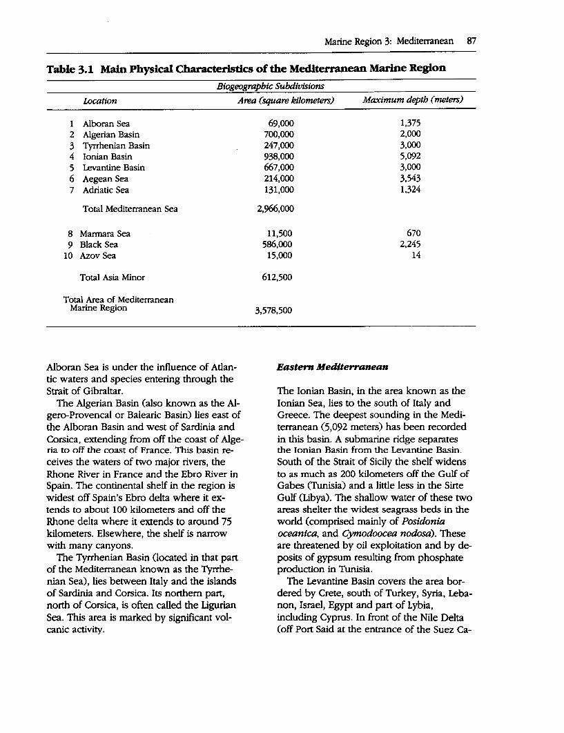
Marine Region 3: Mediterranean 87
Table 3.1 Main Physical Characteristics of the Mediterranean Marine Region
Btogeograpbic Subdivisions
Location Area (square kilometers) Maximum depth ( meters)
1 Alboran Sea 2 Algerian Basin 3 Tyrrhenian Basin 4 Ionian Basin 5 Levantine Basin 6 Aegean Sea 7 Adriatic Sea
Total Mediterranean Sea
8 Marmara Sea 9 Black Sea
10 Azov Sea
Total Asia Minor
Total Area of Mediterranean Marine Region
Alboran Sea is under the influence of Atlantic waters and species entering through the Strait of Gibraltar.
The Algerian Basin (also known as the Algero-Provencal or Balearic Basin) lies east of the Alboran Basin and west of Sardinia and Corsica, extending from off the coast of Algeria to off the coast of France. This basin receives the waters of two major rivers, the Rhone River in France and the Ebro River in Spain. The continental shelf in the region is widest off Spain's Ebro delta where it extends to about 100 kilometers and off the Rhone delta where it extends to around 75 kilometers. Elsewhere, the shelf is narrow with many canyons.
The Tyrrhenian Basin (located in that part of the Mediterranean known as the Tyrrhenian Sea), lies between Italy and the islands of Sardinia and Corsica. Its northern part, north of Corsica, is often called the Ligurian Sea. This area is marked by significant volcanic activity.
69,000 700,000 247,000 938,000 667,000 214,000 131,000
2,966,000
11,500 586,000
15,000
612,500
3,578,500
Eastern Mediterranean
1,375 2,000 3,000 5,092 3,000 3,543 1,324
670 2,245
14
The Ionian Basin, in the area known as the Ionian Sea, lies to the south of Italy and Greece. The deepest sounding in the Mediterranean (5,092 meters) has been recorded in this basin. A submarine ridge separates the Ionian Basin from the Levantine Basin. South of the Strait of Sicily the shelf widens to as much as 200 kilometers off the Gulf of Gabes (Tunisia) and a little less in the Sirte Gulf (Libya). The shallow water of these two areas shelter the widest seagrass beds in the world (comprised mainly of Posidonia oceanica, and Cymodoocea nodosa). These are threatened by oil exploitation and by deposits of gypsum resulting from phosphate production in Tunisia.
The Levantine Basin covers the area bordered by Crete, south of Turkey, Syria, Lebanon, Israel, Egypt and part of Lybia, including Cyprus. In front of the Nile Delta (off Port Said at the entrance of the Suez Ca-

88 A Global Representative System of Marine Protected Areas
nal), the shelf widens to 130 kilometers. As indicated above, spedes migrate into the Mediterranean from the Red Sea through the Suez Canal.
The island of Crete separates the Levantine Basin from the Aegean Sea, which comprises that part of the Mediterranean Sea bounded on the west and north by the coast of Greece and on the east by the coast of Turkey. The Aegean Sea is about 700 kilometers long and 340 wide (total area 214,000 . square kilometers) and contains numerous islands. The Aegean has. an the average depth of about 360 meters and a maximum depth of 3,543 meters occurring fo the east qf Crete.
The Adriatic Sea is a long canal (about 780 kilometers) bounded by Italy on the west and by Slovenia, Croatia, Bosnia, Montenegro and Albania on· th~ east. The Adria:. tic has an average width of 240 kilometers and a total area is 131,000 square kilometers. The Po River enters in. the north of this sea, where the shelf extends for about 550 kilometers. The Adriatic is mainly shallow . with an average depth of 444 meters and a maximum depth of 1,324 meters occurring to the south of the central area.
Marmara Sea
The Marmara sea is connected to the . Aegean sea through the Dardanelles and to the Black Sea through the Bosphorus. It is 280 kilometers long (east to west) and 'has a maximum width of nearly 90 kilometers. It covers 11,500 square kilometers and has an average depth of 270 meters, reaching a maximum of 670 m.eters in the center. ·
Black Sea and Azt?V Sea
The Black Sea is connected to the Marmara Sea through the Bosphoius, "'!hich is the . world's narrowest strait, with.an average width of 1.6 kilometers, an average depth of 36 meters, and a total length of ~1 kilome-
ters. The maximum and average depth of the Black Sea are 2,200 meters and l,240·meters respectively. Its total area is about 586,000 square kilometers. This sea receive~ the waters of the Danube and Dnieper Rivers.
The Azov Sea, which receives the waters of the Don, is separated from the Black Sea by the Kerch and Taman .Peninsulas. The connection is through the Kerch Strait, which is less than 20 meters deep. Its area is 15,000 square kilometers, its mean depth 8 meters, and its maximum depth less than 15 meters. There is an extraordinary high level of biological productivity.
AssMSMENT OF ExlSTING MPAs
From 1982 to 1993, the total number of protected areas along the Mediterranean coast increased from 65 to 135. These protected areas cover terrestrial, wetland, or marine environments, but in the Mediterranean region, due to the very high human pressure along the coastline, ·any form of coastal protection has positive effects on the marine environment itself. For the latter, which is the subject of this report, 53 marine protected areas covering only or partly the sea have been established. In the period considered, there has therefore been a significant increase in the number and value of protected areas in the region, although the sea surface area that is legally protected remains comparatively small. This development is clearly related to increased awareness and cooperation in the region, marked by the implementation of the Barcelona convention, estal;>lishment of the Regional Activity Center for· Specially Protected Areas in Tunisia, publication of the main report of the Blue Plan (Grenon and Batisse 1989), and other actions. In 1985, the Genoa Declaration of the Contracting Parties to the Barcelona Convention called for the creation of 50 new protected areas by 1995.
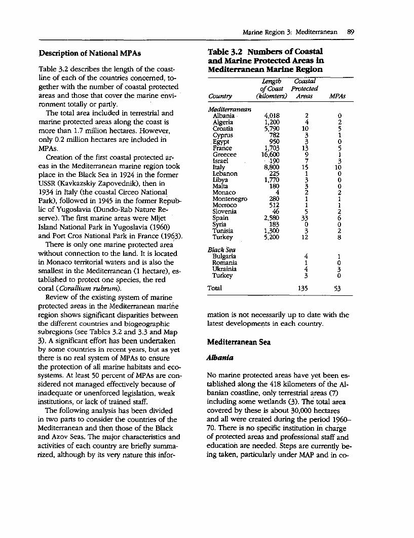
Pescription of National MP As
Table 3.2 describes the length of the coastline of each of the countries concerned, together with the number of coastal protected areas and those that cover the marine envi- · ronment totally or partly.
The total area included in terrestrial and marine protected areas along the coast is more than 1.7 million hectares. However, only 0.2 million hectares are included iri MPAs.
Creation of the first coastal protected areas in the Mediterranean marine region took place in the Black Sea in 1924 in the former USSR (Kavkazskiy Zapovednik), then in 1934 in Italy (the coastal Circeo National Park), followed in 1945 in the former Republic of Yugoslavia (Dundo-Rab Nature Reserve). The first marine areas were Mljet · Island National Park in Yugoslavia (1960) and Port Cros National Park in France (1963).
There is only one marine protected area' without connection to the land. It is located in Monaco territorial waters and is also the smallest in the Mediterranean (1 hectare), established to protect one species, the red coral ( Corallium rubrum).
Review of the existing system of marine protected areas in the Mediterranean marine region shows significant disparities between the different countries and biogeographic subregions (see Tables 3.2 and 3.3 and Map 3). A significant effort has been undertaken by some countries in recent years, but as yet there is no real system of MP As to ensure the protection of all marine habitats and ecosystems. At least 50 percent of MP As are considered not managed effectively because of inadequate or unenforced legislation, weak institutions, or lack of trained staff.
The following analysis has been divided in two parts to consider the countries of the Mediterranean and then those of the Black and Azov Seas. The major characteristics and activities of each country are briefly summarized, although by its very nature this infor-
Marine Region 3: Mediterranean 89
Table 3.2 Numbers of Coastal and Marine Protected Areas in Mediterranean Marine Region
Length Coastal o/Coast Protected
Country (kilomters) Areas MPAs
Medtterranean Albania· 4,018 2 0 Algeria 1,200 4 2 Croatia 5,790 10 5 Cyprus 782 3 1
.Egypt 950 3 0 France 1,703 13 5 Greecee 16,6oo 9 1 Israel · 190 7 3 Italy 8,800 15 10 Lebanon 225 1 0 Lib&a 1,770 3 0 Mata 180 3 0 Monaco 4 2 2 Montenegro 280 1 1 Morroco 512 1 1 Slovenia 46 5 2 Spain 2,580 33 6 s . 183 0 0 ~Sia 1,300 3 2 Turkey 5,200 12 8
Black Sea Bulgaria 4 1 Romania 1 0 Ukrainia 4 3 Turkey 3 0
Total 135 53
mation is not necessarily up to date with the latest developmei:,ts in each country.
Mediterranean Sea
AU,ania
No marine protected areas have yet b_een established along the 418 kilometers of the Albanian coastline, only terrestrial areas (7) including some wetlands (3). The total area covered by these is about 30,000 hectares and all were created during the period 1960-70. There is no specific institution in charge of protected areas and professional staff and education are needed. Steps are currently being taken, particularly under MAP and in co-
90 A Glol:>al ~epresentative System of Marine Protected Areas
Table 3.3 B~phic Subdivisions of Mediterranean Marine Region and Representation in MPAs .
Biogeograpbic Subdivision MPAs
Western Mediterranean 1. Alboran Sea 1 2. Algerian Basin 15 3. Tyrrhenian Basin 9
Subtotal 25
Pastern Mediterranean 4. Ionian Basin 1 5. Levantine Basin 9 6. Aegean Sea 4 7. Adriatic Sea 10· 8. Marmara Sea 0
Subtotal 24
Black and Azov Seas 9. Black Sea 4
10. Azov Sea 0 Subtotal 4
Total 53
operation with the European Community, to address these issues.
A(gerla
Along the 1,200 kilometers of seashore of Algeria, there are four existing protected areas, including 59 kilometers of coastline (5 percent of the total). Two of these areas include a marine cpmponent. The most important is El Kala National Park, covering terrestrial, wetland and marine environments (about 83,000 hectares). The main issue 'for this na- . tional park is a shortage of w;iter due to natura:1 processes and human intervention, which is endangering its wetlands. A watershed approach program incluqing _the .management of water re.sources, is presently being prepared with financial assi$tance from the Global Environment Facility (GEF). At the. national level, a reorganizatio~ of all the institutions dealil)g with the environment is foreseen.
The following MP As have been recorded: ,.. El Kala National Park and Biosphere
Reserve ,.. Reghaia Managed Nature Reserve
Croatia
Cro;itia has 1,778 kilometers of continental coastline and over 4,000 kilometers of island coastline. The following MP As have been recorded: ,.. Bzijuni Island National Park (3,635 hec
tares including 1,000 hectares terrestrial)
,.. Komati Islands N~tional Park (22,375 hectares including 5,068 hectares terrestrial)
,.. Mljet National Park (4,619 hectares including 3,100 hectares terrestrial)
..- Limski Zaljev Special Marine Reserve (500 hectares)
,.. Malostonski Zaljev Special Marine Reserve (4,821 hectares)
In addition, the Neretva Delta (11,500 hectares) is recognized as a Ramsar site.
Cyprus
The two main wetlands of this island were protected in 1974 as a permanent game reserve, but with no real management of other activities. In 1990 the Lara Reserve was established to include both marine and terrestrial areas, the objective being the protection of marine turtles on the beaches of Lara during their nesting period. At the national level, a review of legislation and a reinforcement of institutions are needed. There is a project being developed within· the framework of the METAP for the creation of a national park including Lara at the Akamas Peninsula.
The following MP A was recorded: ~ Lara-Toxeftra Management Nature Re
serve (650 hectares including 100 hectares t~rrestrial)
Egypt
Between 1985 and 1988, Egypt created three protected areas on the Mediterranean seashore, one concerning a shrubland area and the other two concerning wetlands. There are no marine protected areas. The government is considering the creation of new protected areas and at the same time a reinforcement of the relevant institutions.
France
The major activities for ·the creation of protected areas on the French Mediterranean shore took place between 1963 and 1982, with nine areas established covering 182 kilometers of coastline (nearly 11 percent of the total length of 1,703 kilometers). There are now five protected areas with a marine component. Since this time a major development has been the increasing activity of the Seashore and Lakeshore Conservatory (CELRL), an autonomous administrative structure created in 1975 that is somewhat comparable· to the British Nature Conservancy and that can purchase or receive donations of coastal lands. CELRL cannot manage these areas directly and delegates their management to local authorities under certain protective conditions. While this mechanism has to be adapted to national practices and laws con-· . cerning land ownership, it could be applied as a model for other Mediterranean countries as recommended by the Blue Plan. At present, CELRL has acquired 115 areas on the French Mediterranean coast, covering 24,823 hectares along 263 kilometers of coastline.
The following MP As were recoraea: ,.._ Cerbere Banyuls Marine Reserve (650
hectares) ,.._ Iles Lavezzi Nature Reserve, Corsica
(5,080 hectares including 80 hectares terrestrial)
Marine Region 3: Mediterranean 91
,.._ Port Cros National Park (2,400 hectares including 590 terrestrial)
,.._ Scandola Nature Reserve, Corsica (1,919 hectares including 919 terrestrial)
,.._ Iles Finochiarola Nature Reserve
In addition, the Camarque area (Rhone Delta) is a Ramsar site and a Biosphere Reserve, and the Fango Valley in Corsica is a Biosphere Reserve.
Greece
With 16,000 kilometers of coastline, Greece has the most important seashore of the Mediterranean, but in large part due to the complexity of its legislation and institutions dealing with environmental matters at the national level, there is no real network of coastal protected areas. The eight existing areas along the coast cover 29,000 hectares but include mainly terrestrial features. This country has begun to give responsibility for the management of protected areas to NGOs.
The following MP A has been recorded: ,.._ Alonissos (Northern Sporades)
Israel
The Ministry of Environment, the Nature Reserve· Authority, and the National Park Authority are the three main bodies dealing with protected areas in Israel. Along the seashore, seven protected areas· have been created, covering about 1,800 hectares and 24 kilometers of coastline. Three of these include a rrta'rine component. Nature protection· is given high attention ·in this country.
The following MP As were recorded: ,... Dor-Habonim Nature Reserve (113 hec
tares) ,.._ Ma'agan Michael Marine Nature Re
serve (2 hectares with islands) ,.. Rosh ·Hanikra Marine Nature Reserve
( 40 hectares)
92 A Global' Representative System of Marine Protected Areas
Italy
With over 8,000 kilometers of coastline, Italy has the second most important seashore on the Mediterranean. Ten protected areas are marine and fishery reserves. Protected areas used to be mainly concentrated along the Tyrrhenian Sea. Recent and important MP As have been declared in Sicily, in the Adriatic and Ionian Seas.
The following MP As were recorded: ,.. Archipelago Toscano National Park
(57,500 hectares with islands) ,.. Castellabate Fishery Reserve (4,400 hec
tares) ,_. Ciclopi Marine ·Reserve (Sicily, 35 hec
tares) · ,_. Miramare Marine Reserve and Bio
sphere Reserve (Trieste, 30 hectares in-duding 3 hectares terrestrial) ·
,.. . Portoferraio Fishery ·Reserve (160 hectares)
,.. Tremiti Marine Reserve (Adriatic, 1550 hectares)
,_. Ustica Marine Reserve (7500 hectares) ,_. Egadi Islands Marine Reserve (Sicily,
50,000· hectares) ,_. Torres Guaceto Marine Reserve (Adria
tic 15,500 hectares) ,.. Capo Rizzuto Marine Reserve (Ionian
Sea, 11,000 hectares)
Lebanon
There is only one protected area along Lebanon's 225 kilometers coastline. Some projects are under way, but the country is still faced with serious economical and social problems.
Libya
There are only two protected areas on the 1,800 kilometers coastline of this country, El Kouf National Park, created in 1978, cover-· ing 20 kilometers of coastline and concern-
ing only terrestrial ecosystems. There are nd MP As. During recent years, field studies have been undertaken with national and inL temational experts in order to propose a n~twork of coastal and marine protected areas including natural and historical features. Significant parts of the seashore are not yet developed and are used as nesting beaches by marine turtles. In addition, Libya has the second most important seagrass meadows in the Mediterranean after Tunisia. The creation of new protected areas requires a revision of the existing legislation, reinforcement of the national institutions dealing with environmental matters, and training of professional staff.
Malta
This small country composed of two main islands with a very dense population has created two terrestrial protected areas ori the coast including the Filfla Island Nature Reserve and is studying other sites. Modification of the legislation could facilitate the creation of future protected areas.
Monaco
Monaco has no possibility of creating coastal protected areas with 4 kilometers of very ur.: banized coast, but has created two marine areas, one without connection with the land. · Both are managed by an NGO. One of them is the smallest of the Mediterranean (1 hectare) established in order to protect one species, the red coral. Numerous activities, including monitoring, artificial reef experiments, and education are conducted. There is no scope for creation of new protected areas, except in the context of a possible international marine reserve for the protection of cetaceans. ·
The following MP As have been recorded: ,.. Larvotto Nature Reserve (50 hectares) ,.. Red Coral Nature Reserve (1 hectare)
~ontenegro (I~ parl of Yugoslavia)
'Qle following MP A has been recorded: ~ Kotor (Kotorsko Risanski Zaliv, 12,000
hectares including 9,400 hectares terrestrial)
Morocco
Within the framework of the national policy for the environment, Morocco has begun the creation of a network of protected areas covering all the ecosystems and habitats in the country. On the Mediterranean shore, Al Hoceima National Park has been established to cover marine as well as terrestrial areas with an important buffer zone of 42,900 hectares.
This park has been recorded as an MP A as follows: ,,._ Al Hoceima National Park (43,400 hec
tares including 26,200 hectares terrestrial)
Slovenia
This newly independent country has a very short coast that nevertheless includes some sites of importance.
The following MP As have been recorded: ,,._ Debeli rite National Monument (24 hec
tares including 2 hectares terrestrial) ,,._ Strunjan Nature Park ( 472 hectares in
cluding 356 hectares terrestrial)
In addition five other protected sites including brackish wetlands are located close to the sea.
Spain
Since 1982, Spain has created at the national or regional level some 25 protected areas on the Mediterranean coastline. Six of these areas include a marine component. After a period of adaptation to the transfer of competence dealing with conservation of en-
Marine Region 3: Mediterranean 93
vironment from the national to the regional authority, the regions have shown a great interest and are very active in this field. The seashore has been_ the focus for huge tourism development without real concern for the environment. After a reduction in the level of tourism in recent years, Spain has adopted the objective of establishing a protected area every 30 kilometers along the coast to ensure the preservation of ecosystems and the maintenance of marine and terrestrial fauna and flora. Numerous sites that have been partly damaged could be restored, in particular around the main areas of interest for tourism.
The following MP As have been recorded: ,,._ Cabo· de Gata Nature Park and Marine
Res~rve (26,000 hectares including 13,000 hectares terrestrial)
,,._ Archipelago de Cabrera National Park (Baleric Islands) (10,000 hectares including 1,836 hectares terrestrial)
,,._ Columbretes Nature Park and Marine Reserve (5,766 hectares including 43 hectares terrestrial)
,,._ Medas Islands Marine Reserve ( 40 hectares including 20 hectares terrestrial)
,,._ S'Arenal Regional Protected Landscape ( 400 hectares)
,,._ Tabarca Marine Resetve (1,463 hectares)
In addition, the Island of Menorca has been declared a Biosphere Reserve, with protection of the sea adjacent to the protected core areas.
Syria
There are no specifically marine protected areas along the Syrian coast. One project is being considered at Om'Attouyour.
Tunisia
Tunisia has recently reinforced its institutions with the creation of a Ministry for the
94 A Global Representative System of Marine Protected Areas
Environment 0991). One of the priorities is effective management of the protected areas along the coast, two of which are marine areas. The UNEP Regional Activity Center for Specially Protected Areas (UNEP /MAP) is located in Salambo, near Tunis.
The following MP As have been recorded:· ,,._ Galiton Marine Reserve ( 450 hectares) ,,._ Zembra and Zembretta National Park
and Biosphere Reserve (4,700 hectares including 391 hectares terrestrial).
Turkey
Since 1989 Turkey has developed a strong policy for conservation of nature with the implementation of a new law allowing the creation of Specially Protected Areas (in reference to the Barcelona Convention Specially Protected Areas Protocol), During this period, 385,000 hectares and 774 kilometers of coastline have been protected and the first steps for management are under way.
The Turkish Mediterranean coast is of high importance for the protection of the monk seal and of sea turtles as well as for biodiversity in general. At the moment some 1,332 kilometers, or 25 percent of the total coast length, have been declared under protection.
The following MPAs have been recorded: ,,._ Datcha Botzburum Specially Protected
Area (147,400 hectares including 116,900 hectares terrestrial)
,,._ Fethiye Gocek Specially Protected Area (61,300 hectares including 30,000 hectares terrestrial)
,,._ Foca Specially Protected Area (2,750 hectares including 1,550 hectares terrestrial)
,,._ Gokova Specially Protected Area (52,100 hectares including 24,500 hectares terrestrial)
,,._ Goksu Delta Specially Protected Area (23,600 hectares including 17,800 hectares terrestrial and wetland)
,,._ Kekova Specially Protected Area (26,000 hectares including 14,500 hec;tares terrestrial)
,,._ Koycegiz Dalyan Specially Protected Area (38,500 hectares including 28,300 hectares terrestrial)
,,._ Patara Specially Protected Area (19,000 hectares including 14,800 hectares terrestrial)
Black Sea and Azov Sea
Only limited information is available on the activities developed by the riparian countries of the Black and Azov Seas. The recent cooperative agreement for the protection of the Black Sea along the lines previously followed for the Mediterranean may improve this situation.
Bulgaria
Bulgaria has a good national network of protected areas. There are four protected areas on the Black Sea, one of which is an MP A. The name of this area is not known.
Romania
Romania has one protected area on the Black Sea but no MP As recorded.
The Danube Delta, which is of major importance, as a wetland has recently been declared a Biosphere Reserve (590,000 hectares).
Turkey
Turkey, applying the same policy to the Mediterranean and Black Seas, has established three coastal terrestrial protected areas and is developing numerous research programs. As yet there are no MP As.
Ukraine
On the Black and Azov Seas, Ukraine has four protected areas, three of which have a marine component. ,.. Karadagskiy Reserve ,.. Chernomorskiy Biosphere Reserve ,.. Dunaiskie Plavni Reserve
INTERNATIONAL AND REGIONAL INITIATIVES RmATING TO MPAs
Numerous international organizations or international conventions have contributed to the conservation of biodiversity in the Mediterranean marine region. The activities of the most important ones are briefly described below.
United Nations Environment Program
The United Nations Environment Program (UNEP) began the development of its regional seas programs in 1972. In 1975, after expert meetings, representatives of the Mediterranean States met in Barcelona (Spain) and decided to cooperate for the implementation of the Convention for the Protection of the Mediterranean Sea against Pollution (Barcelona Convention) and its related protocols. The fourth protocol concerning Mediterranean Specially Protected Areas (SP A) was adopted in Geneva in 1983. In order to implement the convention and the protocols, the Mediterranean States have adopted the Mediterranean Action Plan and created a Mediterranean Coordinating Unit in Athens and Regional Activity Centers. The Center for the SPA Protocol, based in Tunisia, is tasked with following and assisting the activities of the countries for the selection, creation and management of marine and coastal protected areas. To date, this protocol has been signed or ratified by 16 of the Mediterranean coastal states (except Syria and
Marine Region 3: Mediterranean 95
Libya) and the EC. Among other activities, a directory of marine and coastal protected areas in the Mediterranean Sea has been prepared and contains the areas officially designated by the governments, even if they have not signed the SP A Protocol. Another Regional Activity Center, the Blue Plan, based in Sophia-Antipolis (France) is entrusted with systemic and future-oriented studies for the Mediterranean Basin and is acting as an environment and development observatory for the region, paying special attention to the protection of biodiversity and integrated coastal management.
United Nations Educational, Scientific and Cultural Organization
UNESCO has developed two activities concerning the Mediterranean region. The Convention concerning the Protection of the World Cultural and Natural Heritage was adopted by the General Conference of UNESCO in Paris 1972. In the Mediterranean region, the only country that is not a signatory of this convention is Israel. There are four natural or natural/ cultural sites on the list (including one marine area, Scandola Nature Reserve in Corsica, France).
Launched in 1971 by UNESCO, the general objective of the Man and the Biosphere Programme (MAB) is to provide knowledge, skills and human values to supporting harmonious relationships between people and their environment. One of the central themes of the MAB program is the Biosphere Reserve concept, where conservation is combined with sustainable development and scientific research, and the creation of an international network of Biosphere Reserves (BR). Areas are submitted for designation as Biosphere Reserves by countries. On the coast of the Mediterranean 11 sites have been accepted as Biosphere Reserves of which 1 includes both wetland and marine areas (Chernomorskiy in Ukraine) and 2 con-
96 A Global Representative System of Marine Protected Areas
cern marine areas (Zembra-Zembretta in Tunisia and Miramare in Italy). Regional meetings for Biosphere Reserve managers and scientists in the Mediterranean Basin are convened from time to time to enhance cooperation and exchange of information and experience.
European Union
The European Union promotes the conservation of biodiversity in the Mediterranean within the framework of the Cha~er.of Nicosia (or the EuroMediterranean Cooperation concerning the Environment in the Mediterranean Basin) and through the implementation of its Special Action Program for the Mediterranean (MEDSAP). The European Commission has prepared directives for the environment. Directive 79/ 409/CEE deals with the conservation of wild birds, and there is also a directive concerning the con-
. servation of natural habitats and wild flora and fauna. To date 70 sites have been designated on the Mediterranean seashore by European countries (20 for Spain, 7 for France, 33 for Italy and 10 for Greece).
Council of Europe
The Council of Europe is promoting the inclusion of Medi~erranean coastal ecosystems in a network of biogenetic reserves. Their main purpose is to conserve representative examples of European flora, fauna and natural areas. The Council of Europe also acts as Secretariat for the Bern Convention on the Conservation of European Wildlife and Natural Habitats. The Mediterranean countries concerned are Cyprus, France, Greece, Italy, Spain and Turkey.
Ramsar Convention
The Ramsar·convention or Convention on Wetlands of International Importance espe-
cially as Waterfowl Habitat, adopted in 1971 and entering into force in 1975, provides the
.J framework for international cooperation for the conservation of wetland habitats. The i broad objective of the convention is to stem the loss of wetlands and to ensure their conservation. To meet this objective, the convention places general obligations on· contracting parties relating to the conservation of wetlands throughout their territory and special obligations pertaining to those wetlands that have been designated in a "List of Wetlands of International Importance." The Mediterranean Marine Region riparian countries that are contracting parties to this convention are Algeria, Bulgaria, Egypt, France, Greece, Italy, Malta, Morocco, Spain, and Tunisia, as well as the former USSR and Yugoslavia. Of the 102 sites listed for these countries, 61 are along the coast of the Mediterranean realm (33 for Italy, 8 for Greece, 7 for Spain, 3 for Bulgaria and Ukraine, 2 for Egypt and Algeria, and 1 for France, Malta and Tunisia).
Bonn Convention
The Bonn Convention (or Convention on Migratory Species of Wild Animals) classifies . migratory species into four categories according to their migration patterns and states that the contracting parties should endeavor to conclude international agreements for the conservation of the relevant species. Egypt, Israel, Italy, Spain, Tunisia and EC are par-ties to this convention. ·
Convention on International Trade in Endangered Species of Wild Flora and Fauna
CITES regulates international trade of endangered species of fauna and flora. Algeria, Cyprus, Egypt, France, Israel, Italy, Monaco, Morocco, Spain and Tunisia are parties to this convention.
~uropean Program for the Mediterranean
'hie European Investment Bank and the World Bank developed the EPM. Its second phase, the Mediterranean Environmental Technical Assistance Program (METAP), was launched in 1990 to identify and prepare investment projects a11d institutional development activities and define specific policy measures in the following priority areas: integrated water resource management, solid and h~zardous waste management, prevention and control of marine oil and chemical pollution, and coastal zone management. The· coastal zone management priority includes a biodiversity component. Its objectives include providing assistance to southern and eastern Mediterranean countries for project preparation activities promoting the conservation of protected areas and the organization of a network of managers of Mediterranean protected areas (MEDPAN).
Other Organizations
Other organizations that are developing activities for the environment in the Mediterranean are the Alesco and Arab Ligue (Commission on Environment), United Nations Development Programme (UNDP), and particularly for forestry and fisheries, the Food and Agriculture Organization of the United Nations (FAO), as well as a number of bilateral assistance agencies.
International and National NGOs
Numerous international and national nongovernmental organizations are also very active in the Mediterranean. For the international NGOs, the most active are the World Wild~ life Fund for Nature (WWF), the World Conservation Union (IUCN), Greenpeace, Friends of the Earth, and the European E~vironmental Bureau (EEB). IUCN has developed a protected areas action plan for the
Marine Region 3: Mediterranean 97
European region that includes a section on MP As in the Mediterranean.
AsSESSMENT OF REPRESENTATION OF BIOGEOGRAPmc ZONES
Western Mediterranean
The Alboran Sea includes only one marine protected area.
The Algerian Basin, east of the Alboran Sea, includes 15 marine protected areas (6 Spain, 3 France, 2 Monaco, 2 Algeria, 2 Tunisia) out of a total of 42 protected areas along the coast. There is a need for more protected areas on the southern part and on the eastern part (Sardinia, Italy). Terrestrial environment coverage is dominant (particularly due to the achievements of CELRL in France); whole coverage is good for wetlands and the marine environment. There are projects that aim to extend some existing terrestrial areas into the marine environment.
The Tyrrhenian Sea includes 9 marine protected areas (7 Italy, 2 France). There is a need for new areas on the east coast of Sardinia.
Eastern Mediterranean
The Ionian Sea includes only one marine protected area (Italy) in the Ionian Basin, with no areas located on the North African coast. This region needs a strong effort as it includes the world's widest areas of seagrass meadows, constituting one of the most important Medit~rranean features, covering more than 1,500 square kilometers between the Gabes Gulf (Tunisia) and the Sirte Gulf (Libya). This area is also important due to its location far away from the influence of the Atlantic Ocean and of migrations from the Red Sea through the Suez Canal. Some Mediterranean endemic species could find here their last possibility of survival.
98 . A Global Representative System of Marine Protected Areas
The Levantine Basin contains 9 marine protected areas (1 Cyprus, 3 Israel, 5 Turkey) although none are present along the southern and eastern coast.
The Aegean Sea includes 4 existing marine protected areas (1 Greece, 3 Turkey) although they do not cover an important part of the marine environment and the nearly 20,000 kilometers of coastline, even though Turkey has developed a very active program in recent years. An important effort is needed in Greece before further development of tourism and urbanization. This area is one of the most important places in the world for the endangered Mediterranean monk seal.
The Adriatic Sea contains 10 existing (2 Italy, 2 Slovenia, 5 Croatia 1 Montenegro) marine protected areas, primarily located on the eastern shore of the Adriatic with only 2 areas located along the coast of the Italian peninsula.
Marmara Sea
There are no marine protected areas in the Marmara Sea.
Black Sea and Azov Sea
There are 4 MP As (1 Bulgaria, 3 Ukraine) in the Black Sea, and no marine protected areas in the Azov Sea.
Categories of MP As
The designation afforded to protected areas is not the same in all the Mediterranean countries and does not easily fit with the international categories established by IUCN. An analysis of the real correspondence between the name given and the IUCN categories would therefore not lead to useful conclusions, except perhaps that mapy of the MP As appear to fall under IUCN category IV (Nature Conservation Reserve/Managed Nature Reserve/Wildlife Sanctuary), with an increasing number under category
VIII (Multiple Use Management Area), particularly the coastal Biosphere Reserves. The value of the Biosphere Reserve concept, encompassing both a terrestrial and a marine part, for the Mediterranean where considerable human impacts and pressures have taken and are taking place should be underlined (Batisse 1990).
PRIORI1Y AREAs AND RECOMMENDATIONS
National Priority Areas for Establishment and Management of MP As
A list of 55 priority sites has been developed by the UNEP Regional Activity Center for Specially Protected Areas (RAC/SPA) in the Mediterranean. This list of sites has been adopted for use in this report and is reproduced as Appendix Table 3.1. These areas are _shown on Map 3.
Regional Priority Areas for Establishment and Management of MP As
The following four areas were selected as being of highest regional priority for marine biodiversity conservation in the region by Alain Jeudy de Grissac using the criteria outlined in the introduction to this report. These four areas include in total more than 10 of the priority sites identified by RAC/SPA (see above). The priority areas are either those for which new MP As are proposed or areas where there are both existing MP As requiring management support and proposed new MP As. For the purposes of this report they have been classified as proposed new MPAs.
Proposed new MP As: ..,,.. Gulf of Gabes seagrass meadows:
Covering sites 44, 45 and 48 of the RAC/SPA list (Appendix Table 3.1), these seagrass meadows are located in
· Tunisian coastal waters (33-35°N, 10-120£) and are the widest seagrass
meadows in the Mediterranean, incorporating the endangered marine phanerogam Posidonia oceanica. As noted previously, the Posidonia oceanica meadows constitute the most characteristic and important Mediterranean ecosystem. The area is also an important nesting, feeding and wintering ground for endangered species of sea turtles, including the Loggerhead turtle, and is an important migratory point for birds. Noteworthy species include seagrass (Posidonea oceanica and Zostera marina), loggerhead turtle ( Caretta caretta), green turtle ( Chelonia mydas) in small numbers; the leatherback turtle (Dermocbelys coriacea) is extremely rare. In addition, there are many species of marine birds and some important groups of dolphins present. There are no protected areas and the area should be a priority for the establishment of an MP A, particularly since the seagrass meadows are endangered by the discharge at sea of phosphogypsum residues. Although these outfalls have been practically stopped, the residues are still covering large areas and their transport by currents endanger other areas.
..,. Gulf of Sirte seagrass meadows: Covering RAC/SP A site 39 (Appendix Table 3.1), this area is located in Libyan coastal waters (31-33°N, 23-27°E) and includes the second largest Mediterranean seagrass meadows. The area is an important nesting and feeding area for marine turtles and a nesting island for the Sandwich tern (Sterna sandvwicer,,sis). The seagrass meadows are significant because they contain some rare · species that are endemic to this area or extinct in other areas of the Mediterranean. Noteworthy species include seagrass (Posidonea oceanica and Zostera marina), loggerhead turtle (Caretta caretta), green turtle ( Chelonia mydas), Sandwich tern (Sterna sand-
Marine Region 3: Mediterranean 99
vwicl!nSis!, leatherback turtle (Dermochelys coriacea) is also present, with dqlphins. Due_t() the very small number of fishermen in this area, many common Mediterranean species are present in great numbers. There are no protected areas and the area should be a priority for the estaqlishment of an MPA. Monitoring this southern part of the Mediterranean could be of interest in order to evaluate the effects of climatic changes on fauna.
..,... Aegean Sea: (37-40°N, 23-28°E) This area includes RAC/SPA sites 26, 28, 51, 52 and 55 (Appendix Table 3.1). The Aegean Sea is one of the most important locations in the region for the small remaining population of the endangered Mediterranean monk seal (Monacbus monachus). The area is also the site of nesting beaches for endangered marine turtles such as the loggerhead ( Caretta caretta) and green (Chelonta mydas) turtles. Apart from those mentioned above, numerous other species are present, in particular species entering the Mediterranean through the Suez Canal or from the Black Sea. Within this area there are three existing MP As in Turkey, as yet only one area in Greece.
..,. Western Mediterranean North for protection of international water for cetaceans: This area includes RAC/SPA sites 21 and 54 (Appendix Table 3.1) and is located off the southern coast of France and the northwest coast of Italy and Corsica. This is the area of highest concentration of whales and dolphins, with all Mediterranean species present, and it is also. the site of 38 percent of the total fish catch for the Mediterranean. Large numbers of dolphins and whales are kille~ in these fishing activities. Noteworthy species include small dolphins (Stene/la cocrulcoalka, Delphinus de/phis, Tursiops tnmcatus), large dolphins (Globicepha/a melaena,
100 A Global Representative System of Marine Protected Areas
Grampus griseus, Orcinus orca), and large cetaceans (rare) (Physeter cotodon, Balaenoptera physalus). Preliminary agreement has been reached on the matter between France, Italy and Monaco.
Existing Marine Protected Areas include: ,... Port Cros (France) ,... Scandola (France,_ Corsica) ,... Monaco-Latvotto ,... Red Coral (Monaco} .
The project could cover only the international waters of this area with corridors linking these MP As. There is a potential role for the General Council for Mediterranean Fisheries. International cooperation and action by individual countries is required to establish protected areas and other measure~ to ensure the protection of whale and dolphin species, particularly from the effects of fishing.
Other Recommendations
Generaily speaking, the coasts of the Mediterranean Sea and their adjacent marine waters constitute one of the greatest assets. of the Mediterranean countries. The prospective studies of the Blue Plan show in particu-lar that all southern and eastern · Mediterranean countries, with the possible exception of Turkey, are or will soon be net food importers and will -need increasing . ·· amounts of foreign currency for their balance of payments, a large portion of which will have to come from tourism. This Mediterranean tourism relies primarily upon a good management of coastal areas, including protection of landscapes and ecosystems and safe bathing waters. Protection. of the coasts and of marine waters· in therefore a major economic imperative in addition to an environmental concern.
Some of the Mediterranean countries have made a significant effort for the creation of protected areas along the coast. For exam-
pie, in Turkey, protected areas include more than 25 percent of the Mediterranean coastline, in France more than 21 percent. A similar effort in all the countries would correspond to 12,500 kilometers. However, most of these areas include only terrestrial or wetland environments. A much stronger effort is required for the marine environment. Of the 200,000 hectares included in MP As, more than 50 percent is located in Turkey. Action is required to ensure the consetvation of important species such as seagrasses, monk seal turtles and small cetaceans. In some cases international marine protected areas will provide the only solution.
Selection of Areas for Protection
The Mediterranean Task Force organized by the Tunis Center and IUCN (RAC/SP A/UNEPIUCN/COE) has been responsible for identification of priority sites for marine protected areas in the Mediterranean region. The criteria and process. used by the Task Force closely correspond to those used by IUCN.
The initial step was the identification of all the sites of interest for each country, using ~ll existing kno~ledge. In France, this was unqertaken within the framework of the Program ZNlEFF, and in Tunisia, Syria, and part of Libya through the UNEP /MAP /SPA programs. In other countries such a methodology has been followed by different NGOs and under international conventions for specific species or areas (birds, seals, turtles, wetlands, and seagrasses meadows). In particular in Turkey, DHKD and WWF have completed a census of marine turtle nesting beaches and recommended to the government 17 priority sites. For marine vegetation, a req data book of Mediterranean marine vege~tion and seascape generated by vegetation has been prepared by an expert group and sites recommended for protection.
A final regional list of priority sites was prepared by the Task Force during four meetings in 1987--88. A review of the situ-
ation was prepared by the SPA/RAC in 1993. Its conclusions are of a mixed character.
Establishment
The creation of marine and coastal protected areas requires new approaches to legislation at the national level. In particular, the authorities competent for terrestrial, marine and freshwater areas are very often separated, and the creation of a protected area covering these three domains can need at least the intervention of three ministries, if not more. The same problem occurs for management and implementation of regulations.
Management
A broad overview of the existing marine protected areas in the Mediterranean marine region shows that at least 50 percent do not have real management, defined as including permanent, capable and qualified staff, ~ budget, and a management plan (Batisse and De Grissac 1991). A major effort is needed in this area: staffing needs and the necessary budget should be defined in the law establishing the protected area or in the general law covering national parks and protected areas. Some countries in the Mediterranean (Greece and Italy in particular) have given the management of particular areas to NGOs with successful results. This could be developed further in the future.
In addition, managers need to have reliable and quick answers to technical matters dealing with the day-to-day, medium and long-term management. Management-oriented research must be a priority, including the definition of indicators and key species. Exchanges of Mediterranean and extra-Mediterranean experience~ should also be a high priority.
Training
Within the overall Mediterranean region with the exception of France, Italy and
Marine Region 3: Mediterranean 101
Spain there· is a pressing need for capable and qualified management staff. At present there are few training opportunities for the management of marine protected areas, apart from the exchange of staff members in a few isolated examples. Training on management of marine turtle nesting beaches exists in Cyprus, with the support of the RAC/SPA-UNEP, on marine vegetation in Banyuls (France). Training on the latter is also under development in Tunisia. Projects are under way to establish training facilities in a rescue center for the Mediterranean monk seal in France; and a training center for management of marine and coastal protected areas is under examination by WWF (to be iocated in Miramare National Park, Italy). All these activities are being monitored by the network ~f managers of Mediterranean protected areas (MEDPAN) within the framework ofMETAP. MEDPAN follows a policy of collecting and exchanging information between managers ( defining priority subjects to be tackled very quickly) and of twinning and exchange of professional staff and will support the development of training activities relevant to management.
Conclusion
The review of the existing system of protected areas in the Mediterranean marine region shows important disparities between the different·countries and ec6-geographic . subregions. In spite of the real progress that has been made over the past few years, thanks in particular to the Mediterranean Action Plan, there is still no comprehensive network of MP As to ensure the p~otection of endangered and threatened endemic species and habitats of the Mediterranean itself and of.the l'llack Sea, and it is. not likely that such a network can be established in the near future iri view of the ~ilftculties facing a number of countries in the overall r~gion. There is no real ne.twork or system of MP As and such a system is urgently required to ensure the survival of endemic, endangered
102 A Global Representative System of Marine Protected Areas
and threatened species of the region and the conservation of all marine habitats and ecosystems.
Although the total area protected along the coast is more than 1. 7 million hectares, the focus of existing protected areas is mainly on coastal terrestrial features. Only 0.2 million hectares (about 11 percent of the total area included in coastal protected areas) of the marine environment is included within protected areas.
A major issue for most. countries of the region is the lack of management for at least 50 percent of the existing areas, due to the lack of suitable legislation, institutions and a shortage of trained staff.
The future of marine conservation in the overall Mediterranean marine region is uncertain. Increasing coastal populations, expanding tourism activities and other developments are placing ever increasing pressure on the marine environment. However, with more intensive regional cooperation and increased international assistance, existing trends could be altered. New methodologies for developing an MP A system and new ways to increase budget allocations to conservation and protection are being explored by some countries in and out of the Mediterranean and could be pursued in order to accelerate this process.
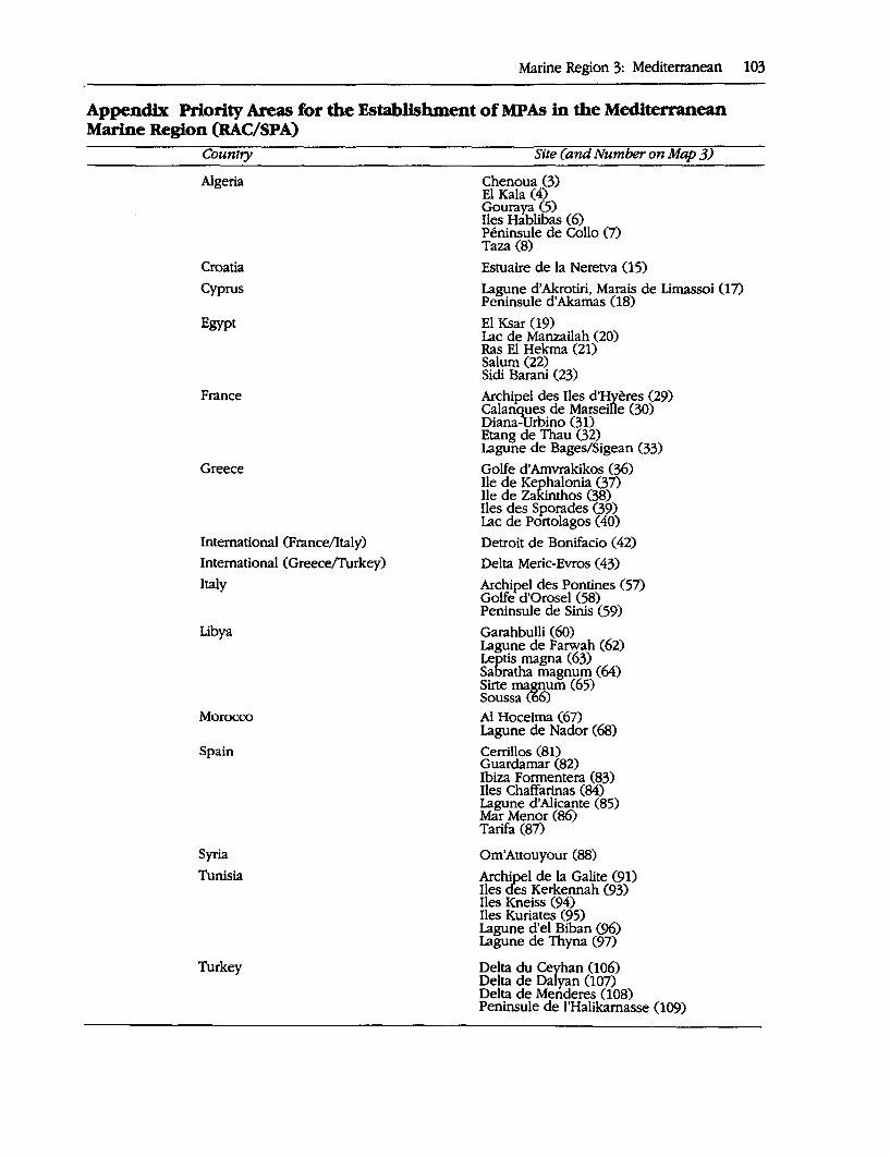
Marine Region 3: Mediterranean 103
Appendix Priority Areas for the Establishment of MPAs in the Mediterranean Marine Region (RAC/SPA)
Country
Algeria
Croatia
Cyprus
Egypt
France
Greece
International (France/Italy)
International ( Greece/furkey)
Italy
Libya
Morocco
Spain
Syria
Tunisia
Turkey
Site (and Number on Map 3)
Chenoua (3) El Kala (4) Gouray:a (5) Iles Hablibas (6) Peninsule de Callo (7) Taza (8)
Estuaire de la Neretva (1 S)
Lagune d'Akrotiri, Marais de Limassoi (17) Peninsule d'Akamas (18)
El Ksar (19) Lac de Manzailah (20) Ras El Hekma (21) Salum (22) Sidi Barani (23)
Archipel des Iles d'Hyeres (29) Calanques de Marseille (30) Diana-Urbino (31) Etang de Thau (32) Lagune de Bages/Sigean (33)
Golfe d'Amvrakikos (36) Ile de Kephalonia (37) Ile de Zakinthos (38) Iles des Sporades (39) Lac de Portolagos ( 40)
Detroit de Bonifacio ( 42)
Delta Meric-Evros ( 43)
Archi~l des Pontines (57) Golfe d'Orosel (58) Peninsule de Sinis (59)
Garahbulli (60) Lagune de Farwah (62) Leptis magna (63) Sabratha magnum (64) Sirte ma&J!um (65) Soussa (66)
Al Hoceima (67) Lagune de Nador (68)
Cerrillos (81) Guardamar (82) Ibiza Formentera (83) Iles Chaffarinas (84) Lagune d'Alicante (85) Mar Menor (86) Tarifa (87)
Om'Attouyour (88)
Archipel de la Galite (91) Iles cfes Kerkennah (93) Iles Kneiss (94) Iles Kuriates (95) Lagune d'el Biban (96) Lagune de Thyna (97)
Delta du Ceyhan (106) Delta de Dalyan 007) Delta de Menderes (108) Peninsule de l'Halikamasse (109)
104 A Global Representative System of Marine Protected Areas
BIBUOGRAPHY
Aguilar, P. 1989. A record of two humpback whales, Megaptera noyaenllae, in the Mediterranean sea. Marine Mammal Science 5(3): · 306-9.
Barcelo, F. 1975. Apuntas para la fauna balear. Ana/es R. Soc. F,sp. His. Nat. 4.
Batisse, M. 1990. Development and implementa-. lion of the Biosphere Reserve concept and its applicability to coastal regions. Environmental Conseroation 17(2): 111-6.
Batisse, M., and A. Jeudy de'·Grissac. 1991. Marine Protected Areas in the Mediterranean and the Black Sea-Past, present status and prospective. Unpublished report prepared for CNPPA.
Casinos, A., and J.R. Vericad. 1976. The cetaceans of the Spanish coast: A survey. Mammalia 40(2): 267-89.
Centro Studi Cetacei. 1988. Cetacei sptaggati lungo le cost itallanel //Rendtoente 1987. Atti. Soc. Ital. Sci. Nat. Museo Cov. St. Nat. Milano 129(4): 411-32. .
Charbonnier, D., and others. 1990. Peche et aquaculture en Mediterranee: Enjeux et perspectives. Fascicules du Plan Bleu No. 1. Paris: Economica.
Cruzado, A. 1985. Chemistry of Mediterranean waters. In R. Margalef, ed., Western Mediterranean. Oxford, U.K.: Pergamon Press.
Duguy, R., A. Casinos, A. Di Natale, S. Filella, F. Ktari Chakroun, R. Lloze, and D. Marchessaux. 1983. Repartition et frequence des mammiferes marins en Mediterranean. Rapp. P. v. Reun. aESM 28(5): 223-30.
Elder, D., and J. Pemetta, eds. 1991. Oceans. London; Mitchell Beazley and IUCN.
Estrada, M., F. Vives, and M. Alcaraz. 1985. Life and productivity of the open sea. In R. Margalef, ed., Western Mediterranean. Oxford, U.K.: Pergamon Press.
Food and Agricultural Organization of the United Nations (FAO). 1992. Review of the State of the World Fishery Resources (Part 1: 1be Marine Resources). 'Fisheries Circular No. 710, Revision 8. Nairobi.
Graeils, M. 1989. Las balenas de las costas oceanicas de Espana. Mem. R. Acad. Ciencias Exactas, Fisicas y Natura/es 23(3).
Ktair Chakroun, F. 1_980. Les cetaces des cotes tunisiennes. Bull. Inst. Nat. Sci. Techn. Oceanogra. peche Salammbo 7: 139-49.
Grenon, M., and Batisse M. 1989. Futures/or the Mediterranean Basin: 1be Blue Plan. Oxford, U.K.: Oxford University Press.
Hopkins, T.S. 1985. Physics of the sea. In R. Margalef, ed., Western Mediterranean. Oxford, U.K.: Pargamon Press.
Jeudy de Grissac, A., and de la Benardiere. 1992. Status of conseroation in the Mediterranean. Working Paper No. 10. Washington, D.C.: EPM/World Bank/METAP.
Ketchum, B.H. 1983. Ecosystems of the World 26 Estuaries and Enclosed Seas. Amsterdam, Ox
. ford, _New York: Elsevier Scientific Publishing Company.
Laborel, J. 1986. Biogenic constructions in the Mediterranean: A review. Londong: RAC/SPA and IUCN.
Margalef, R. 1985. Introduction to the Mediterranean. In R. Margalef, ed., Western Mediterranean. Oxford, U.K.: Pergamon Press.
Meinesz and others 1993. Spread of the introduced tropical green alga Caulerpa taxifolia in northern Mediterranean waters. ]. Appl. Phycology 5:141-7.
Miller, A. 1983. The Mediterranean Sea: A physical aspect. In B.H. Ketchum, ed., Estuaries and enclosed seas. Amsterdam: Elsevier.
Peres, J.M., and Picard, J. 1964. Nouveau manuel de bionomie benthique de Mediterranee: Statton marine d'Endoume. Marseille.
Ramade, F. 1990. Conseroation des ecosystemes mediterraneens: Enjeux et perspectives. Fascicules du Plan Bleu No 3. Paris: Economic.
Ray, J.C., and 0. Cendrero. 1982. Les mammiferes marine trouees sur /es cotes espagnoles en 1981. CIESM.
Schwartz, M.L. 1982. 1be Encyclopedia of Beaches and Ocean Environments. Stroudsburg, Pennsylvania: Hutchinson Ross Publishing Company.
United Nations Environment Programme (UNEP). 1989. Directory of Marine and Coastal Protected Areas in the Mediterranean Region (Parl 1· Sites of biological and ecological value. MAP Technical Reports Series No. 26. Athens.
---. 1990. State of the Marine Environment in the Mediterranean Region. MAP Technical Report No. 28. Athens: UNEP and L. Jeftic.
United Nationa Educational, Scientific, and Cultural Organization (UNESCO). 1984, 1985, 1986. Fishes of the North eastern Atlantic and the Mediterranean. 3 vols. Paris.
---. 1988. Reporls in Marine Science No. 49. Paris.
MARINE REGION 4 Northwest Atlantic
Claude Mondor, Francine Mercier, Miles Croom, and Robert Wolotira
BIOGEOGRAPHY AND MARINE BIODIVERSITY
The Northwest Atlantic Marine Region extends from Cape Hatteras along the eastern coast of the United States, northward to L~ncaster Sound at the north end of Baffin Island, and then westward to the Bering Strait in Alaska. It includes the Mid Atlantic Seaboard, Chesapeake Bay, Gulf of Maine, Bay of Fundy, Scotian Shelf, Gulf of St. Lawrence, Grand Banks, Labrador Sea, Hudson Bay, James Bay, Lancaster Sound, Viscount Melville Sound, the Beaufort Sea, and the Chukchi Sea to the. Bering Strait.
Oceanography
The region's oceanography is varied and complex, with three distinct water masses: Arctic, Subarctic and Temperate, which vary in temperature, salinity, seasonal ice cover, vertical stability, productivity and species diversity. Throughout most of the northern portion of the marine region the Arctic water
105
. _..... -, f. ··-----.~ ~ ; .. ···,··s111
mass dominates, becoming Subarctic in nature as it encounters the Pacific water along the Beaufort Sea in the west ·and the increasing admixture of Atlantic water from the West Greenland Current as it forms the Labrador Current off Hudson Strait in the east. By the time the cold Labrador Current meets the warm Gulf Stream along the continental margin, yery little Arctic water remains, leading to a fully temperate water mass off the eastern US coast. Primary productivity in the northern portion of the marine region is less than one fifth that of the southern half. Tidal range varies widely within the region, with a maximum of 12 meters in the Bay of Fundy and Ungava Bay, decreasing to the north, south and west to a minimum of 0.3 meters in the Beaufort Sea. Overall circulation patterns are tidally dominated along the Atlantic coast while they are primarily ice-constrained in the Arctic, influenced by winds, estuarine currents and tides during ice-free periods. From Labrador south the continental shelf is very wide, typically greater than 100 kilometers in width and often greater than 400 kilometers. To the north, the 200
106 A Global Representative System of Marine Protected Areas
meter isobath is generally close to shore, except in the inland seas and the Beaufort Sea.
Further information is provided in the descriptions of the individual biogeographic zones.
Coastal Geography and Geology
The marine region has been shaped by various episodes of volcanic activity, metamorphism, glaciation, erosion and mountain building, resulting in a wide range of coastal landforms and reliefs, from steep fjord coastlines, to cliffs and headlands, gently rolling lowlands, rocky and sandy shorelines, wide tidal flats, estuaries, deltas and permanent ice fields. Coastal relief is highest in the northeast, gradually decreasing to the west and south and ranging from O meters along the featureless flats of Hudson Bay and Foxe Basin to over 1,000 meters along the fjordstrewn coast of eastern Baffin Island. The eastern half of the marine region has a complex, heavily indented coastline dotted with numerous islands, becoming less complex to the south and west. The Arctic section of the marine region is a sheltered environment, while the Atlantic portion is predominantly a storm-wave environment. Resistant Precambrian Canadian Shield granites dominate most of the marine region. South of the Labrador coast, deformed sedimentary and volcanic rocks of Precambrian and Lower Paleozoic age predominate, mixed with younger sedimentary rock formations along the U.S. coast and in the Bay of Fundy and southern Gulf of St. Lawrence. In western Hudson and James bays, the Canadian Shield is replaced by unfolded, unresistant sedimentary rocks of Paleozoic age, mainly limestones, while the Beaufort Sea area is dominated by unconsolidated Tertiary and Quaternary sediments.
Further information is provided in the descriptions of the individual biogeographic zones.
Ecosystem and Species Diversity
Ecosystems of importance to overall marine biodiversity that are found within the Northwest Atlantic Marine Region include polynyas, recurrent shore lead systems and ice edge habitats; tidal marshes and eelgrass beds; sand and mudflats; upwelling and mixing areas; and intertidal, subtidal, midwater and benthic habitats.
Information summarizing ecosystem and species diversity is provided in the descriptions of the individual biogeographic zones. Rare and endangered species in the region are listed in Table 4.1 below.
Biogeographic Classification
The subdivision of the Northwest Atlantic Marine Region into biogeographic zones suitable for planning a global system of .marine protected areas is problematic b,ecause it embraces diverse bio-oceanographic features, including waters that many researchers consider as falling within the marine Arctic Marine Region. In order to accommodate this diversity in a systematic manner, a hierarchial framework was arbitrarily devised whereby the Marine Region was subdivided into smaller and smaller regions based upon major oceanographic characteristics, for example, water masses and seasonal variation in ice cover.
In order to extend its usefulness, the zonation proposed in this report is derived from the frameworks in current use for planning the network of National Marine Conservation Areas in Canada and marine Biosphere Reserves in the United States. It is essentially a grouping of these regions into larger subdivisions with similar oceanographic and biological characteristics that are meaningful at a global scale.
The Northwest Atlantic is subdivided into three second order subdivisions based on the classification scheme developed by Dun-
Marine Region 4: Northwest Atlantic 107
Table 4.1 Rare, Endangered and Threatened Species in the Northwest Atlantic Marine Region ·
Species
Marine Mammals Beluga whale (Delphinapterns leucas)
St. Lawrence ·ruver Ungava Bay Southeast Baffin Island Cumberland Sound Eastern Hudson Bay Eastern High Arctic
Blue whale (Balaenoptera musculus) Bowhead whale (Balaena mysticetus) Fin whale (Balaenoptera physa/us) Harbour porpoise (Phocoena pbocoena)
Western Atlantic Humpback whale (Megaptera novaeangliae)
Atlantic Polar bear ( Ursus maritimus) Right whale (Eubalaena glactalis) Sei whale (Balaenoptera oorea/is) Sperm whale (Physeter catodon) Sowerby's Beaked Whale (Mesoplodon bidens)
Marine-associated Birds Bald eagle (Haliaetus leucocephalus) Eskimo curlew (Numenius borealis) Harlequin duck (Histrionicus histrionicus)
Eastern Ivory gull (Pagophila eburnea) Peregrine falcon (Falco peregrinus) Piping plover ( Cbaradrius melodus) Least tern (Sterna antillarum) Roseate tern (Sterna dougallt)
Reptiles Atlantic ridley turtle (Lepidocbelys kempii) Leatherback turtle (Dermocbelys coriacea) Loggerhead turtle ( Caretta caretta
Fish
Canada•
,I ,I ,I ,I ,I
,I
,I
,I
,I
,I ,I
,I
,I ,I
United Statesb
,I ,I ,I
,I
,I ,I ,I
,I ,I ,I ,I
,I ,I
Acadian whitefish ( Coregonus canadensis) Bering wolffish (Anarhichas orientalis) Blackline prickleback (Acantholumpenus mackayh Shortnose sturgeon (Acipenser brevirostrum)
,I ,I ,I
,I
Note: The table indicates where a species of a specific location or population is ·endangered or threatened. a. Recognized as endangered or threatened by the Committee on the Status of Endangered Wildlife in Canada. b. Recognized as endangered or threatened under the Endangered Species Act of the United States.
bar (1951 and 1972) that utilizes "water mass" (temperature, salinity, and biological indicators) as the principal criterion for regional differentiation. The subdivisions are zoned latitudinally from north to south and include the Polar, Subpolar, and Eastern Temperate.
Second Order Subdivisions
Polar Subdivision This subdivision includes marine areas covered by Arctic water only, which originates from the upper 200-300 meters of the Arctic Basin and has flowed south through the Ca-
108 A Global Representative System of Marine Protected Areas
nadian Arctic Archipelago. Although much of this water is itself of Atlantic origin, it has undergone a polar change such that its salinity and temperature has decreased, and is recognizable as a distinct water mass (Dunbar 1951). Many marine scientists would likely consider this subdivision as part of the Arctic Realm proper, and not the Northwest Atlantic.
The Polar subdivision is the least productive of the second order subdivisions because of the vertical stability of its water column, and has the poorest faunal diversity. Another principal distinguishing feature of this zone is that it is ice covered throughout much of the year. Normally, open water (less than 2/10 ice cover) is present for a two to three month period during the summer, although an ice-dominated zone where open water is rare year-round occurs in Viscount Melville Sound. The southern limit of the Polar subdivision is placed at the northern tip of Labrador along the east-facing Atlantic coasts, and at the Beaufort Sea/ Chukchi Sea in the western part of the Realm. These boundaries approximate Dunbar's 0972) Arctic-Subarctic water mass boundary. Other researchers, such as Briggs 0977), place the southern boundary of the Arctic along the Atlantic coast at the Strait of Belle Isle.
Subpolar or Subarctic Subdivision This is a broad area characterized by a mixture of Arctic waters (originating from the upper 200-300 meters of the Arctic Basin) and non-Arctic water masses, either Pacific or Atlantic. The Pacific Subarctic is restricted to a zone from the Bering Strait to the Alaskan north coast and the southern Beaufort Sea. In the Atlantic sector, the subdivision includes the marginal seas fronting the eastfacing coasts of Labrador and Newfoundland, as well as the Gulf of St. Lawrence (Dunbar 1972).
Some important features of this subdivision are: the lack of ice cover in summer, ex-
cept for floes and icebergs from the north; vertical instability of the water column; occurrence of a second phytoplankton bloom in the fall; and a more diverse fauna than the Polar subdivision but less so than in the Temperate (Dunbar 1972). Also, as this zone is formed by the mixing of two water masses, it is sensitive to changes in either one and its boundaries may well fluctuate considerably over periods of a few years.
Eastern Temperate Subdivision For the purpose of this report, this subdivision includes the Grand Banks of Newfoundland, the Scotian Shelf, the Bay of Fundy, Gulf of Maine and the waters southward to Cape Hatteras. Also referred to as the "Boreal" zone, this subdivision is dominated by a southwest-flowing, coastal current supplied with cold, low salinity water from the Subarctic Labrador Current, which flows south from the Labrador Sea and around Cape Race at the southeastern tip of Newfoundland. This coastal current intermixes with the northeasterly eddies originating from the deeper offshore waters of the warm Gulf Stream. The resultant water mass determines the nature of the fauna that occupies the broad continental shelf of this subdivision. There is essentially no admixture of Arctic water in this region.
Third Order Subdivisions
The third order subdivisions are based on the identification of marginal sea areas within the Polar, Subpolar and Eastern Temperate divisions. An additional boundary is also introduced to separate the Polar icedominated zone from those areas with two to three months of open water. A total of ten marine biogeographic zones are recognized at this level of the hierarchy, including four Polar subdivisions (Viscount Melville Sound, Lancaster Sound, Hudson Strait, and Hudson-James Bay), three Subpolar (North
Slope/Beaufort Sea, Labrador Shelf, and Gulf of St. Lawrence), and three Eastern Temperate subdivisions (Grand Banks/Scotian Shelf, Ac;adian and Virginian). These marginal sea subdivisions are reasonably consistent with the marginal sea areas defined by Hayden, Ray, and Dolan 0982).
For Canadian waters, the Marine Regions of Canada framework (Woodward-Clyde Consultants 1983) represents a subdivision one order greater than the proposed IUCN classification. Similarly, the North Slope/Beaufort, Virginian and Acadian biogeographic zones in U.S. waters have also been subdivided into fourth order regions by the United States in the Man and the Biosphere Programme for planning their system of marine biosphere reserves (Agardy 1988; McCormick-Ray, Ray, and Gregg 1988).
Map 4 illustrates the suggested hierarchial subdivision of the Northwest Atlantic MarineRegion into ten biogeographic zones. This is followed by a summary of the important oceanographic and biological features of each of the biogeographic zones.
The descriptions provided follow a standard format. The first part provides an overview of the biogeographic zone's coastal characteristics. This is followed by a discussion of some of the dominant oceanographic features and processes influencing the regional fauna, than the fauna itself. The fauna} listings are limited to fish, birds and cetaceans, the more ''visible" elements of the marine environment. An attempt has also been made to note regional species concentrations that are considered of national or global importance.
The descriptions for the Polar and Subpolar marine subdivisions, which lie primarily in Canadian waters, are based in large part on the excellent work of Mercier 0990). Those for the Eastern Temperate zones have been borrowed from the work of the National Marine Sanctuary program resource classification (Salm and Clark 1984), Briggs 0974), and Wolotira (in prep).
Marine Region 4: Northwest Atlantic 109
Polar Biogeograpbic Zone 1: Viscount Melville Sound The mainland is primarily comprised of Precambrian Canadian Shield granites, whereas less resistant sedimentary rocks of Lower Paleozoic age, mainly limestones, dominate on the islands. The coast is generally flat, with a mixture of straight shorelines dominated by coarse sediment beaches and cliffs, and crenulated coastlines with numerous inlets and estuaries. Sand beaches and mudflats occur locally around deltas. Raised beaches are common, as are ice-push and ice override features. Coastal relief is low overall, with cliffs rarely exceeding 20 meters in height.
The zone is characterized by deep channels along its northern margin, and shallow basins averaging less than 100 meters in depth and shoaling progressively toward the Keewatin coast in the south. Depths range from less than 100 meters in the Gulf of Boothia, to 300-,.500 meters in M'Clintock Channel, M'Clure Strait and Viscount Melville Sound. Ice cover is complete from October to June and broken ice persists during the summer. A highly variable and unpredictable ice regime is characteristic of this portion of the Northwest Passage. Ice-related habitats are prevalent year-round. Mean tidal range is less than 1 meter. This is a very sheltered environment with little wave activity in most areas.
Arctic cod, sculpins, eelpouts and snailfish are the most common fish species. Whales are rare. Ringed seals and polar bears are the only common marine mammal frequenting the area. Thousands of tundra swans, brant, white-fronted, Ross's, snow and Canada geese breed, moult and stage. in the southern part of the zone, with the largest concentrations within the Queen Maud Gulf Bird Sanctuary.
Polar Biogeograpbic Zone 2: Lancaster Sound Precambrian Shield rocks dominate the outer Baffin Bay coast, while Lower Paleo-
110 A Global Representative System of Marine Protected Areas
zoic unfolded, relatively unresistant sedimentary rocks, primarily limestones, are found in the inner coastal areas of Jones and Lancaster sounds. The region's shore is dominated by 30~1,000 meters high cliffs, interspersed with coastal plains and lowlands. Permanent ice fields are prominent on east Devon and Ellesmere Island, and icebergs occasionally calve into the sea from the extensive tidewater glaciers. Spectacular fjords are found south of Eclipse Sound and along east Ellesmere and Baffin islands.
Depth of the sounds and straits increases along a general NW-SE axis through the zone, averaging from 100-600 meters. Ice cover is nearly complete from October to June. The unique North Water, the largest polynya in the Canadian Arctic, is located in northern Baffin Bay. Tidal range varies from 1 to 3 meters. The outer coastal areas are predominantly sheltered environments as a result of the complex coastline, and the inner portion of the marine zone is a very sheltered environment.
Primary and secondary productivity are 10 times greater here than in any other zone of the Canadian Arctic. Some 30 fish species have been reported for this zone, with Arctic charr and Arctic cod being the most abundant. This zone is of critical importance to marine mammals, with most of the world's narwhal, a third of North America's belugas and the endangered eastern population of the bowhead whale migrating through and summering in the zone. Major narwhal and beluga summering and calving areas occur throughout the zone and killer whales are frequent summer visitors. Ringed and bearded seals, walrus and polar bears are common residents of these waters, and several major polar bear maternity denning areas are found within the zone. Large numbers of harp seals migrate into the area.
About one-third of eastern Canada's colonial seabirds breed in this region, including over 586,000 pairs of thick-billed murres (39 percent of the Canadian population),
370,000 pairs of northern fulmars (95 percent of the Canadian population) and 82,000 pairs of black-legged kittiwakes (50 percent of the Canadian population) as well as several thousand pairs of black guillemots, Arctic terns and glaucous, Sabine's and Thayer's gulls. Large colonies of greater snow geese are located on Bylot Island and in Bernier Bay, and several crucial waterfowl and shorebird staging and moulting areas are found in the zone. Ice edge staging areas are prevalent and critical to all species prior to reaching their breeding sites.
Polar Biogeographic Zone 3: Hudson Strait Precambrian resistant Canadian Shield rocks dominate this zone. This bedrock coast is typically indented with numerous inlets, islands, sounds, bays and a few fjords. Cliffs and headlands often rise abruptly 200-300 meters from the sea along Davis and Hudson Straits. Ungava Bay and Foxe Basin are predominantly low-lying, with extensive coastal marshes and tidal flats.up to 6.5 kilometers in width.
Whereas the Strait is predominantly deep and undersea cliffs and canyons are common, Foxe Basin and Ungava Bay are broad, predominantly shallow basins, generally less than 100-150 meters in depth. Tidal range varies from 1 to 5 meters in Foxe Basin and 3 to 9 meters in the Strait, giving this marine zone the greatest tides in the Arctic, with a maximum of 12 meters in the southwest sector of Ungava Bay where the world's second highest tides are recorded. The large tidal amplitudes and the restricted confines of most of the fjords, inlets and narrows, combine to create whirlpools, tidal rips, rapid currents, tidal mixing and upwelling throughout much of the zone. The ice-free period lasts 2-4 months and ice cover is characterized by large areas of landfast ice and pack ice during the October to June period. Several recurring polynyas and shore leads are present in the zone. Icebergs are a familiar sight along east Baffin Island and in eastern Hudson Strait. Most of the marine zone
is a sheltered to very sheltered environment, though the eastern areas are exposed to Labrador Sea storms.
Over 60 Arctic, Subarctic and Atlantic marine fish species, 9 anadromous and 8 freshwater fish species have been recorded in the region. Abundant species include Arctic charr, sculpins, sea snails, Greenland halibut, ogac and Arctic cod. This region is an important summering area for bowhead whales and three endangered beluga whale populations. This is also one of two known North American concentration areas for northern bottlenose whales. Large numbers of beluga, bowhead and narwhal winter in the open waters of eastern Hudson Strait and the open pack ice of Davis Strait. The smaller polynyas in northern Foxe Basin support high densities of bearded seals, ringed seals and the largest walrus herd in Canada, on a year-round basis. Polar bears are abundant, north Southampton Island constituting the highest density denning area in Canada.
Over 775,000 pairs of thick-billed murres, some 52 percent of the Canadian population, breed in several colonies in the region. Black guillemots, black-legged kittiwakes, glaucous, Thayer's, Iceland and herring gulls, northern fulmars, tundra swans and common eiders are also abundant. Hudson Strait is of critical importance as a feeding and staging area for alcids, gulls and eiders, while the Button Islands are a critical eider wintering area. The Great Plain of the Koukdjuak along east Foxe Basin is the world's largest goose nesting colony, with upwards of 1.5 million birds, 75 percent of which are lesser snow geese and the remainder Canada geese and Atlantic brant.
Polar Biogeographic Zone 4: Hudson-James Bay The eastern and northwest coasts of HudsonJames Bay are predominantly Precambrian Canadian Shield rocks· and are typically low, rocky and indented with small islands and inlets. Maximum cliff heights are on the order of 500 meters in the Richmond Gulf
Marine Region 4: Northwest Atlantic 111
area. In the remainder of the marine zone, unfolded, unresistant sedimentary rocks of Lower Paleozoic age form an extremely low lying coast characterized by a vast flat and drowned expanse of muskeg swampland, backed by marshes and fronted by extensive tidal flats reaching 9 kilometers in width. Deltas, estuaries and raised beaches are prominent features in the zone.
This zone is a broad shallow basin, averaging 125 meters in depth and less than 80 meters deep for 20-100 kilometers from the coast. The bottom topography is predominantly gentle, although it is cut by several submarine valleys, banks, troughs, ridges and channels. The main water mass is Arctic in nature. Ice cover lasts from October to June. During the winter, shore leads are present along the entire inner edge of the bay and are kept open by strong prevailing winds. The annual freshwater discharge into Hudson Bay is over twice that of either the Mackenzie or St. Lawrence River systems, lowering surface salinities significantly during the summer, particularly in James Bay. Mean tidal amplitude ranges from 0.3 meters in the northeast to 2-3 meters along the southern shore to 4 meters iQ. the northwest.
Some fifty freshwater, anadromous, and Arctic and Subarctic marine fish species use the waters of the zone. Arctic charr, Arctic cod and ogac are abundant. Upwards of 23,000 beluga summer along the west coast of the bay, with the densest concentrations in the Nelson River and Churchill River estuaries-a smaller endangered population is found along the east coast. Narwhal and bowhead are rarely observed. Ringed and bearded seals are common throughout the zone, while small populations of harbor seals and walrus are found in isolated localities. Polar bears are abundant throughout the zone and in autumn congregate in large numbers on Cape Churchill to await the arrival of the ice. Important denning and summer retreat areas are located along much of the west and southwest coasts.
112 A Global Representative System of Marine Protected Areas
The Hudson-James Bay tidal flats and inland marsh areas harbor some of the world's largest concentrations of breeding and staging shorebirds and waterfowl. Over 320,000 pairs of lesser snow geese (half the Eastern Arctic population) breed in the zone,· as well as considerable numbers of Canada geese, brant, oldsquaws, eiders and loons. The area is also critical to moult~g waterfowl. This zone is of international importance to the red knot and Hudsonian godwit, and is of critical importance to several other species of migrating shorebirds. One of the largest breeding concentrations of peregrine falcons known in the world is found along the northwest coast. The Hudson Bay subspecies of the common eider breeds and winters in the area.
Subpolar Biogeographic Zone 1: North Slope/Beaufort Sea · Lower Cretaceous to Tertiary unconsolidated, sediments dominate along the Beaufort Sea coast, while Lower Paleozoic sedimen~ry rocks, mainly limestones, are found around Amundsen Gulf. The coast along this region is predominantly low-lying, with a coastal relief of less than 10 meters. The Beaufort Sea coast is generally a drowned coastline, arid any cliffs are low and subject to rapid retreat due to constant erosion. The North Slope and Amundsen Gulf are also mostly low-lying, with intermittent areas of high, sheer coastal cliffs. Common features found locally throughout the region include barrier beaches, sand and gravel spits and bars, extensive deltas, lagoons, estuaries, tidal flats, continuous narrow gravel beaches, thaw lakes, tundra polygons and marshes.
Along the North Slope, a broad shallow · continental shelf borders the· coast and extends as much as 100 kilometers offshore with depths of 10 meters or less not uncommon up to 30 kilometers from shore. Amundsen Gulf is a large embayment, over 600 meters deep in the center, with several large bays and relatively little shallow water. Most of the matjne_zone is very sheltered. Tidal in-
fluence is minimal. The zone is generally ice covered from October through June, with an ice-free season of 1-4 months, depending on the year. Landfast ice extends 20.:So kil0;meters from shore, with pack ice elsewhere. The Cape Bathurst polynya and shore lead' system along the North Slope provide large areas of open water early in the year that · are critical to marine mammals and spring staging birds. The Beaufort Sea area of the marine zone is strongly influenced by the large freshwater output of the Mackenzie River that reduces salinities over a wide area due to the shallow depths.
The North Slope/Beaufort Sea Zone has one of the most diversified fish faunas in the Arctic, with over 85 species present from 21 families. Of these, about 20 percent are anadromous, and an additional 10 percent are freshwater species that occur in this marine zone only in waters in or near riv.er mouths. There are many more Pacific-associated species than Atlantic forms, probably , owing to a closer proximity of this zone to the Pacific-subpolar Bering Sea. Many fish species are relatively abundant, including several sculpins and whitefish, Arctic charr, Arctic and saffron cods, ninespine stickleback, polar eelpout, and the diminutive A.re-
. tic alligator fish. This zone is of c;ritical importance to marine mammals, with approximately 75 percent of the world's remaining population of bowhead whales and some 11,500 belugas migrating along the North Slope and Beaufort Sea to summer in Amundsen Gulf and in the Mackenzie DeltaTuktayuktuk Peninsula area. Polar bears and . ringed and bearded seals are abundant in the area, making extensive use of the polynya and shore leads during the winter.
This zone is one of the Arctic's most im:portant staging and breeding areas for marine-associated birds 0V1er than true seabirds. Large numbers of lesser snow geese, white-fronted geese, Pacific brant and tundra swans breed throughout the area and at least 23 species of shorebirds nest in the coastal ar~s .. The only b_reeding populations
of black guillemots and thick-billed murres ih the Western Arctic are also found in this zone. Important concentrations of moulting_ geese, swan, and sea ducks occur throughout the coastal area.
Subpolar Biogeograpbic Zone 2: Labrador Shelf Precambrian Canadian Shield granites dominate the Labrador coast, whereas SW-NE trending volcanic and sedimentary rocks of Upper Proterozoic to Lower Paleozoic age shape the Newfoundland coast. The coast is highly irregular, characterized by resistant · cliffs and headlands ranging in height from 200-500 meters, with spectacular fjords, deeply incised valleys, innumerable coastal islands, bays and inlets. Intertidal boulder flats and boulder barricades are abundant, and small deltas, mudflats and marshes occur locally. The highest and most rugged mountains of eastern North America are found in northern coastal Labrador.
The continental shelf area along the Labra-:dor and Newfoundland coasts is relatively uniform, averaging 50-150 kilometers in width, with depths of less than 70 meters up to 2 kilometers from shore. Several offshore banks extend to the edge of the steep continental slope that rapidly reaches depths of over 3000 meters. The open water season lasts 2 months in the north and up to 10 months in the southern part of the zone. During the winter, the fjords, bays and a nar-. row coastal zone are bound in landfast ice, while close pack ice extends 150-225 kilometers offshore. Icebergs are abundant and occur year-round. There is a significant Arctic water component within the main water mass of the zone. Mean tidal amplitude ranges from 1-3 meters. Though the bays are sheltered, the zone is mainly a very ex: posed storm-wave environment.
Some 90 species of Arctic and north temperate marine and anadromous fish are found in this zone. Important Atlantic cod, Atlantic salmon, Arctic charr and capelin spawning areas are found throughout the
Marine Region 4: Northwest Atlantic 113
zone. Plaice, halibut and redftsh are also abundant, as are shrimp and snow crab. Harbor seals are resident, while ringed and bearded seals winter in the area, and harp and hooded seals stage annual migrations along the coast and whelp in large concentrations along the northern ice edge off southern Labrador, producing over 60 percent of all harp seal pups in the Northwest Atlantic. White-sided dolphins, northern bottlenose, sperm, blue, fin, sei, minke, humpback, pilot and killer whales are summer visitors to the area. Bowhead and narwhal winter off the northern Labrador coast. Small numbers of polar bears are also found in the northern sector of the zone.
This zone has the greatest concentrations of breeding seabirds in the Atlantic re-: gion-over 5,000,000 pairs, dominated by Leach's storm-petrels, Atlantic puffins, common murres, black-legged kittiwakes and Northern gannets, with lesser numbers of razorbills, thick-billed murres, black guillemots, common and Arctic terns, great black-backed, ring-billed and herring gulls, and common eiders. The greater part of the Northwest Atlantic populations of Leach's storm-petrels and common murres, as well as a large portion of the North American population of Atlantic puffins and razorbills breed along this coast. This zone is also a critical wintering area for several species, primarily gulls, fulmars, shearwaters, alcids and sea ducks.
Subpolar Biogeograpbic Zone 3: Gulf of St. Lawrence Along the north shore of this zone, Precambrian Canadian Shield rocks form spectacular rocky coasts, indented by the steep-sided Saguenay Fjord. Upper Paleozoic sedimentary rocks create the wide sandy beaches, barrier islands, coastal dunes, spits, narrow mixed-sediment and pocket beaches which are so plentiful in the southern Gulf of St. Lawrence. Lower Paleozoic sedimentary rocks dominate the rest of the zone, forming cliffs 100-150 me-
114 A Global Representative System of Marine Protected Areas
ters in height. Saltmarshes, bogs, estuaries and tidal flats occur locally.
Dominant features of this zone include the Laurentian Channel, a deep submarine valley of glacial origin ranging in depth from 180-550 meters, and the Magdalene Shat-· lows, a shallow enclosed sea with depths averaging less than 80 meters. Due to ·their shallow depth, the Shallows contain the warmest marine waters in Canada, and support several genera of benthic marine algae that are more commonly found in the Virginian zone, as well as a relict population of oyster. The open water season lasts 7--8 months on average, landfast ice being the primary ice cover. The cold Labrador Current and the large freshwater outflow of the St. Lawrence River are the major factors influencing the composition of the water column. The extensive upwelling at the mouth of the Saguenay River combines these two elements and leads to. the high productivity found in this zone. Mean tidal range varies from 3-5 meters in the St. Lawrence estuary to 1-2 meters elsewhere. Most of the zone is a relatively sheltered environment, though energy levels increase from northwest to southeast.
Some 50-60 marine, freshwater and anadromous fish species occur in the Gulf, forming a generally cold water fish fauna. Important stocks of capelin, cod, herring, Atlantic salmon, halibut, redfish, plaice, haddock, silver hake, pollock, flounder, and mackerel are found in the region. Because of its deep waters, the Laurentian Channel is a major break separating several stocks of shallow water fish specie~. Lobster and scallops are abundant in the shallow coastal areas, while shrimp are common in deeper waters. Aquaculture is well established in the southernmost estuaries, bays and inlets of the region, concentrating on oysters, mussels, and clams. Over 20 species of cetaceans have been noted in the region, including harbor porpoise, white-sided and whitebeaked dolphins, fin, minke, blue, hump-
back, pilot whales, and the only southern population of beluga whales. Harbor seals are abundant throughout the region. One of the main whelping patches for harp and · hooded seals is on the ice surrounding the Magdalen Islands, while grey seals breed in colonies on a number of islands throughout the region, as well as on newly formed ice in Northumberland Strait and along western Cape Breton Island.
Many of the zone's breeding seabird colonies are of national significance. Over 65 percent of the North American Northern gannet population nests on Bonaventure Island. Razorbills, kittiwakes, Atlantic puffins, common murres, black guillemots, great and double-crested cormorants, common, Arctic and roseate terns, storm-petrels, herring, great black-backed and ring-billed gulls, common eiders, ospreys and bald eagles are also abundant breeders. The Gulf is also critical to the endangered piping plover, over 70 percent of Atlantic Canada's population breeding here. Tens of thousands of geese, sea ducks and shorebirds stage in coastal areas during spring and fall.
Eastern Temperate Biogeographic Zone 1: Grand Banks/Scotian Shelf Along the Scotian Shelf coast, Paleozoic metamorphic and igneous rocks overlain by a glacial till form a resistant low rocky shore' where cliffs rarely exceed 10 meters. The south coast of Newfoundland is dominated by volcanic and sedimentary rocks of the same age that form rocky shores and bedrock cliffs rising 150 meters and more from the sea and indented by fjords. Large embayments and offshore islands (Sable Island being the furthest from the coast) are common throughout. Lagoons, tidal marshes and a few coarse sediment beaches have developed in sheltered sections.
The continental shelf extends up to 480 kilometers from shore, and is less than 150 meters deep over broad areas. The shelf is dominated by a series of shallow banks rang-
ing in depth from 25-100 meters truncated by a deep glacial. trough, the Laurentian Channel, to form the Grand Banks and the Scotian Shelf. The cold Labrador Current is the primary influence on the water column, with the warm Gulf Str~am having an impact along the continental margin of the Scotian Shelf. The region is generally ice free all winter, although landfast ice often forms in sheltered bays and inlets between January and April. Icebergs are common in the eastern part of the region, mainly far offshore. Mean tidal amplitude ranges from 1-2 meters. Intense storms are quite frequent, particularly during the winter months, resulting in a very exposed storm-wave environment.
This biogeographic zone includes some of the most ·productive fishing grounds in the world, with a well diversified fauna. Lobster, scallop, shrimp, snow crab, clams, squid, cod, haddock, hake, pollock, redfish, plaice, flounder, herring,· mackerel, tuna, argentine, swordfish and halibut are all abundant. Humpback, ·right, fin, blue, pilot, northern bottlenose, and minke whales, harbor porpoise and common and white-sided dolphins are common. Harbor seals are year-round residents and grey seals breed on several islands, while hooded and harps seals are less frequently observed.
The diversity of bird species breeding in the region is high, and includes herring and greater black-backed gulls, Leach's stormpetrels, kittiwakes, Atlantic puffins, common: Arctic and Caspian terns, great and double-crested cormorants, common eiders, razorbills, common and thick-billed murres, black guillemots, semipalmated plovers and least sandpipers. The largest Northern gannet colony outside of Bonaventure Island is at Cape St. Mary's. The largest North American concentration of breeding Atlantic puffins and Manx shearwater is found within this zone. Offshore waters are critical wintering areas for several species of seabirds, primarily shearwaters, gulls, sea ducks, and alcids.
Marine Region 4: Northwest Atlantic 115
Eastern .Temperate Biogeograpbic Zone 2: Acadian Resistant igneous and metamorphic rocks ranging in age from Upper Proterozoic to Lower Mesozoic predominate in this zone, with sedimentary rocks at the head of the Bay of Fundy and along the southern portion of the Gulf of Maine. Low rocky shores are the characteristic features of the marine zone throughout much of the Bay of Fundy and Maine coasts. Cliffs up to 200 meters in height occur in the Bay of Fundy, but are rare elsewhere. Extensive saltmarshes and intertidal flats up to 5 kilometers in width occur in Minas Basin and Chignecto Bay at the northern end of the Bay of Fundy and south of Portland, Maine. Coastal sand dunes, barrier islands and long beaches are most common in the Cape Cod area. Much of the Maine coast is intricately carved with bays and inlets and numerous rocky islands, while the Bay of Fundy and the southern coastline of the zone are more regular with few indentations.
The zone is relatively shallow, generally less than 200 meters in depth and mostly between 50-200 meters, with a very irregular bottom topography of shoals, banks, troughs and channels characterizing most of the zone, though the southern half of Georges Bank is a relatively smooth plain. The Bay of Fundy is a 270 kilometers long, straightsided, generally funnel-shaped bay with an 80 kilometers wide mouth and two narrow extensions at its head. The world's highest tides occur in the Bay of Fundy, with a range of over 12 meters, while mean tidal amplitude within the Gulf of Maine is on the order of 1-2 meters. Open water conditions prevail year-round in the Gulf of Maine, while the large tidal range and intense mixing contribute to negligible sea ice. formation within the Bay of Fundy. The main circulation pattern is a counterclockwise gyre around the Gulf of Maine, with a large branch entering the Bay of Fundy along the Nova Scotia side and engendering a counter-
116 A Global Representative System of Marine Protected Areas
clockwise flow around the bay as well. The region is affected by the cold nearshore Labrador Current and the warm offshore Gulf Stream, the former having the greatest influence on the water column, particularly at depth.
Biological productivity is exceptionally high. Lobster, clams, scallops and squid are abundant. Important stocks of herring, cod, halibut, haddock, pollock, mackerel, hake and flounder occur in this zone. The highly endangered Atlantic right whale uses this zone extensively as nursery and feeding grounds. Important concentrations of humpback, fin, minke, and pilot whales~ as well as harbor porpoises and white-sided dolphins occur througho~t ·l?e zone. Harbor seals are resident and common, while grey seals are found only in the outer Bay of Fundy. Leatherback turtles are common summer visitors to the Gulf of Maine. . .
This zone is critically important as a migratory staging area for millions of birds, particularly shorebirds. The largest . · concentrations occur at the mouth of the Bay of Fundy and offshore into the Gulf of Maine (red and red-necked phalaropes), the mudflats at the head of the·Bay bf Fundy and the Massachusetts coast (sandpipers, plovers). The region is particularly important to semipalmated sandpipers, with 42-74 percent of the world population staging at the head of the Bay of Fundy in the autumn in any given year. Sea ducks are common · along the coast of the Gulf of Maine. Offshore waters are important to other pelagic seabirds as well, including northern fulmars, gulls, shearwaters, gannets, storm petrels and alcids. · ·
Eastern Temperate Biogeograpbic Zone 3: Virginian · Resistant Paleozoic rocks characterize much of the _central portion of this zone, while less resistant rocks predominate elsewhere. Late Pleistocene glaciation reached northern New Jersey, while the rema.inder of the region's coasts were unaffected. Low relief predomi-
nates, and a low-lying coastal plain dominates to the south. Long sandy beaches, barrier islands, pocket beaches, coastal lagoons, iarge and extensive estuaries (notably Chesapeake Bay), mudflats and tidal marshes characterize the zone. · The continental shelf is relatively broad, narrowing substantially to the south and gently sloping eastward to the outer edge where it is cut by submarine canyons. Tidal amplitude is less than 1 meter and the region is ice-free year-round, though icing may occur in protected areas. The warm Gulf Stream is a major influence in this biogeographic zone, with the Labrador current playing an important role. The interplay between these two currents creates a complex transition zone with a cold water barrier at Cape Cod and a warm water one at Cape Hatteras, both boundaries shifting north during the summer and south during the winter.
As a result, the marine flora and fauna of this zone comprise both cold-water species from the Acadian zone to the north and warm-water ones originating from the Carolinian province to the south, with a higher proportion of the latter. Of the more than 250 fish species recorded from the zone, a large majority are eurythermic tropical or warm-temperate forms that have temporarily migrated into the area from the south, usually during periods of high water temperatures. Consequently, species diversity is high with very few species being endemic to the zone. Productivity is moderate overall, and far less than that encountered north of Cape Cod. The fish and shellfish species commonly found include oyster, blue and horseshoe crab, a variety of shark, skate and stingray species, menhaden, shad, alewife, cod, flounder, mackerel, herring, anchovy, hake and tuna. ·
Loggerhead, leatherback and Atlantic ridley sea turtles are a common component of the marine fauna and cetaceans are widely distributed and occur year-round, though not in such impressive concentrations as further north. Fin, sperm and pilot
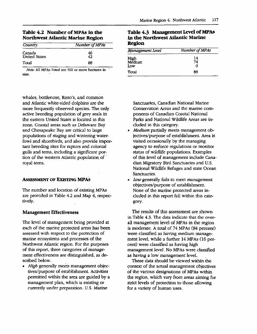
Table 4.2 Number of MPAs in the Northwest _Atlantic Marine R~gion Country Number of MPAs
Canada United States Total
46 42 88
Note: All MP As listed are 100 or more hectares in size.
whales, bottlenose, Risso's, and common and Atlantic white-sided dolphins are the more frequently observed species. The only active breeding population of grey seals in the eastern United States is located in this zone. Coastal areas such as Delaware Bay and Chesapeake Bay are critical to large populations of staging and wintering waterfowl and shorebirds, and also provide important breeding sites for raptors and colonial gulls and terns, including a significant portion of the western Atlantic population of · royal terns.
AssESSMENT OF ExlsTING MPAs
The number and location of existing MPAs are provided in Table 4.2 and Map 4, respectively.
Management Effectiveness
The level of management being provided at each of the marine protected areas has been assessed with respect to the protection· of marine ecosystems and processes of the Northwest Atlantic region. For the purposes of this report, three categories of management effectiveness are distinguished, as described below. • High generally meets management objec
tives/purpose of establishment. Activities permitted within the area are guided by a management plan, which is existing or c~rrently under preparation. U.S. Marine
Marine Region 4: Northwest Atlantic 117
Table 4.3 Management Level of MPAs in the Northwest Atlantic Marine Region Management Level
High Medium Low
Total
Number of MPAs
14 74 0
88
Sanctuaries, Canadian National Marine Conservation Areas and the rµarine components of Canadian Coastal National Parks and National Wildlife Areas are included in this category.
• Medium partially meets management objec_tives/purpose of e.stablishment. Area is visited occasionally by the managing agency to enforce regulations or monitor status of wildlife· populations. Examples of this level of management include Canadian Migratory Bird Sanctuaiies and U.S. Nati~nal Wildlife Refuges and state Ocean Sanctuaries.
• Low generally fails to meet management objectives/purpose of establishment. None of_ the manne protected areas included in this report fall within this category.
The· results of this asses~ment are shown in Table 4.3. The data indicate that the overall managem~nt level of MP As in the region is moderate. A total of 74 MPAs (84 percent) were classified ~s having medium manage-: ment level, while a further 14 MPAs (16 percent) were classified as having high management level. No MP As were dassified as having a low· management level..
These data should be viewed :within the context of the actual management objectives of the various designations of MP As within the region, which vary from areas aiming for strict levels of protection to those allowing for a variety of human uses.
118 A Global Representative System of Marine Protected Areas
The management effectiveness assigned to a protected area assumes that all parts of it have the same management level, and yet this is clearly an over-simplification. Until each area can be categorized in detail, the inventory should be considered preliminary only.
Description of National MPA Systems
Various levels of protection for MP As exist in Canadian waters. At present, the only agency with responsibility for the establishment and management of MP As is Parks Canada, through its National Marine Conservation Areas System. The other programs mentioned below generally protect some marine waters as a means of. enhancing the protection of a terrestrial component, rather than as a specific objective. One exception is the National Wildlife Area program (the Isabella Bay proposal) that is beginning to delve into the protection of marine systems. The main problems in establishing MP As in Canada lie in the multiplicity of jurisdictions that much be taken into consideration when dealing with control of an.-area (federal, provincial, aboriginal) or a particular activity such as fishing or navigation (various federal · and provincial agencies). In addition the active cooperation of the local communities is an essential component and no MPA can be effective without it. The heightened awareness of the need for MP As, particularly by coastal communities, brought on by the collapse of a n~mber of fisheries is,one of the greatest opportunities available to accelerate the establishment of various types of MP As in Canadian waters.
National Marine Conseroation Areas: IUCN Category II. Presently established under the National Parks Act (a National Marine Conseroation Areas Act is pending) to represent one of the 29 marine regions of Canada and managed as per the National
Marine Conservation Areas Policy by Parks Canada. Commercial exploration, extraction or development of nonrenewable resources and ocean dumping are not permitted within the marine conservation area. Fisheries will continue in marine conservation areas, subject to protecting the ecosystem, to maintaining viable fish stocks and to attaining the purpose and objectives of the conservation area. Indiscriminate methods of fishing and the use of gear which is destructive to the sea bed will be minimized. A zoning system will provide increased protection for sensitive areas, such as spawning grounds, breeding colonies, calving, resting, and feeding and wintering areas. Research will be permitted and aboriginal hunting and fishing rights will be honored, subject to the protection of the ecosystem and the maintenance of viable populations of wildlife. A zoning system provides for complete preservation areas, low impact activity areas and multiple use areas.
National Parks with Marine Components: IUCN Category II. Established under the National Parks Act to represent the 39 natural regions of Canada. Several coastal National Parks have a marine component, the boundaries of which are generally headland to headland. Managed by Parks Canada essentially as in (a), although most fisheries are being or have been phased out in the parks.
Provincial Parks: IUCN Category II. Established under provincial legislation. Only parks whose main mandate involves the preservation or conservation of specific areas are included here. In general the same management principles as found in National Parks apply here as well.
National Wildlife Area: IUCN Category IV (Category I exceptionally). Established under the Canada Wildlife Act to preserve and maintain important or
unique lands for wildlife, particularly migratory birds. Managed by the Canadian Wildlife SeIVice with the emphasis placed on habitat protection. National Wildlife Areas may be managed to increase the area's value to wildlife. Many activities may be allowed (such as grazing, hunting, fishing, research, and recreation) on a case-by-case basis as long ~s these activities are deemed compatible with wildlife research, conservation and interpretation. Commercial exploration, extraction or development of nonrenewable resources are generally prohibited.
Migratory Bird Sanctuary: IUCN Category N. Established under the Migratory Birds Convention Act to protect migratory birds. Managed by the Canadian Wildlife Service. Hunting or disturbance of migratory birds or their nests and eggs is strictly prohibited within these areas. Other activities (hunting, agricultural, recreation, research, and so forth) may be permitted as long as the birds are not affected. Commercial exploration, extraction or development of nonrenewable resources may be allowed under permit.
Wildlife Management Areas: IUCN Category N. Established under provincial or territorial legislation to protect important wildlife areas. Several uses may be allowed under permit.
Existing MP AB in Canada include many areas which have both terrestrial and marine components. In some cases, this marine component is not the primary focus of management and the contribution of many of these sites to marine biodiversity conservation must be viewed with this in mind. There is one entirely marine area, the Saguenay-St. Lawrence Marine Park, which still requires the passage of legislation through the Canadian federal and Quebec provincial governments, although it currently operates as a marine conservation area.
While the Migratory Bird Sanctuaries are a powerful tool to protect nesting, breeding and moulting migratory species, these Sane-
Marine Region 4: Northwest Atlantic 119
tuaries protect habitat only incidentally. Human activity is prevented in areas important to breeding, nesting and moulting birds only as long as the birds are present. Thus, while these Sanctuaries protect sea and shorebirds, they may not adequately protect habitat important to other marine species when migratory birds are not present.
Furthermore, while the role of provincially protected areas is recognized as being important, environmentalists have expressed some concerns about the type and extent of recreational activities allowed in some sites devoted to conservation.
United States
The designation of MPAs in the United States is a complicated matter of jurisdictional hierarchy (federal, state, or local), public support and participation, availability of resources to implement effective management strategies, and resolution of conflicts among competing user interests. Typically, the federal government designates the largest MP As, followed in order by states and then local jurisdiction. However, the degree of protection is not necessarily a function of size; in fact, often smaller MP As, because of the vulnerability of the resources for which the MP A was designated or because of the greater ease in enforcement and management, have more stringent controls than do larger MP As. However, the practice of zoning within large MP As is being incorporated into the management plans of the newer, larger MPAs.
National Marine Sanctuaries: IUCN Category II. At the federal level, the identification, designation and management of MP As is achieved under the authority of the Marine Protection, Research and Sanctuaries Act. This Act empowers the Secretary of Commerce to designate discrete areas of the marine environment for their conservation, recreation, educational, ecological, historical, research, and aesthetic values. The primary goal of designation is to protect sig-
120 A Global Representative System of Marine Protected Areas
nificant resources, although compatible and sustainable· uses 0f resources are allowecf insofar as the primary goal 'of resource protection is not compromised:: Over the twenty· year history of the National Marine Sanctu.:. ary Program, some 13 Natiqnal Marine Sane .. tuaries have been designated. These MP As range in size from very small (65 hectares) to very large (in excess of 1,087,800 hectares), and for values ranging from historical to aesthetic to ecological.· The Act has also be~n used as a tool by some fo~s groups · to thwart the ability of other special interes~ and user groups to obtain access t6 pa~cu-· · lar resources, rather than to pr<;>tect and·. comprehensively .manage sensitive ecosystems., All National Marine Sanctuaries have. si~~specific regulations to ensure the protectiqn of special resources through controlled access or use of renewable resources. Zoning of areas for different purposes is being.implemented in the larger sanctuaries.
National 11stuarine Research Reseroe: IUCN Category IV. Designated under the authority of the Coastal Zone Management Act, these estuarine areas are protected ·primarily for: their potential as coastal research areas. Operated as joint federal/state partner: ships, National Estuarine Research Reserves are managed on a watershed basis, with informal irifltience· applied to alter human activities in adjoining terrestrial area~ for the improvement of habitat functioning in the MP A. Human uses are controlled, and some manipulation of habitat for· restoration· or en.: hancement purposes is allowed. Over the years; National Estuarine· Research Reserves have· become important for their educational value and have significantly 'improved public understanding and acceptance of the· need for wise use of coastal resources .. ,
National Wildlife Refuge: IUCN Category 'II: Also within the Department of the Interior, the Fish and Wildlife Service sometimes protects littoral watecs· as part of their National Wildlife· Refuge sites.
National Seashore: IUCN Category IV.· Small marine buffer areas are often part of National Seashores, a federal program administered by the National Parl_<s Service and designated by virtue of individual laws passed by Congress. These areas are reserved primarily for recreational· use by the public. By law however, they must "preserve for future generations ... unspoiled and undeveloped beaches,· dunes an~ other natural features." As a result, shores, dunes and bays are often zoned for minimal human impact· on natural features. -
Ocean Sanctuaries of Massachusetts: IUCN Category V. Established under the Ocean Sanctuaries Act of Massachusetts, originally passed in 1970, its authority and regulatory powers were expanded in 1978, 1984, 1989 and 1991. Designates five ocean sanctuaries to "be protected from any· exploitation, development or activity that would ~eriously alter or otherwise endanger the · ecology or the appearance of .the ocean,. the seabed or subsoil thereof, or the Cape Cod National Seashore." Most of the Massachusetts coastline, below mean low water and out to 4.8''kilometers, is designated as an Ocean Sanctuary except for 'that portion . around Boston.' The Act is administered by the Massachusetts Department of Environmental Management which oversees all other state agencies' licensing, permitting and approval activities in ocean sanctuaries to ensure compiiance: The Act prohibits activities that could be environmentally or aesthetically damaging, including building on the seabed, sand/gravel removal, mining, hydrocarbon removal, dumping, as well as most other activities which could adversely affect the natural ecosystem.
Areas of Critical Environmental Concern: · IUCN Category V. Established in 1975 by the legislature of the Commonwealth of Massachusetts, authority·is given to the Secretary of the Executive Office of Environmental Affairs- to "preserve, restore and enhance criti-
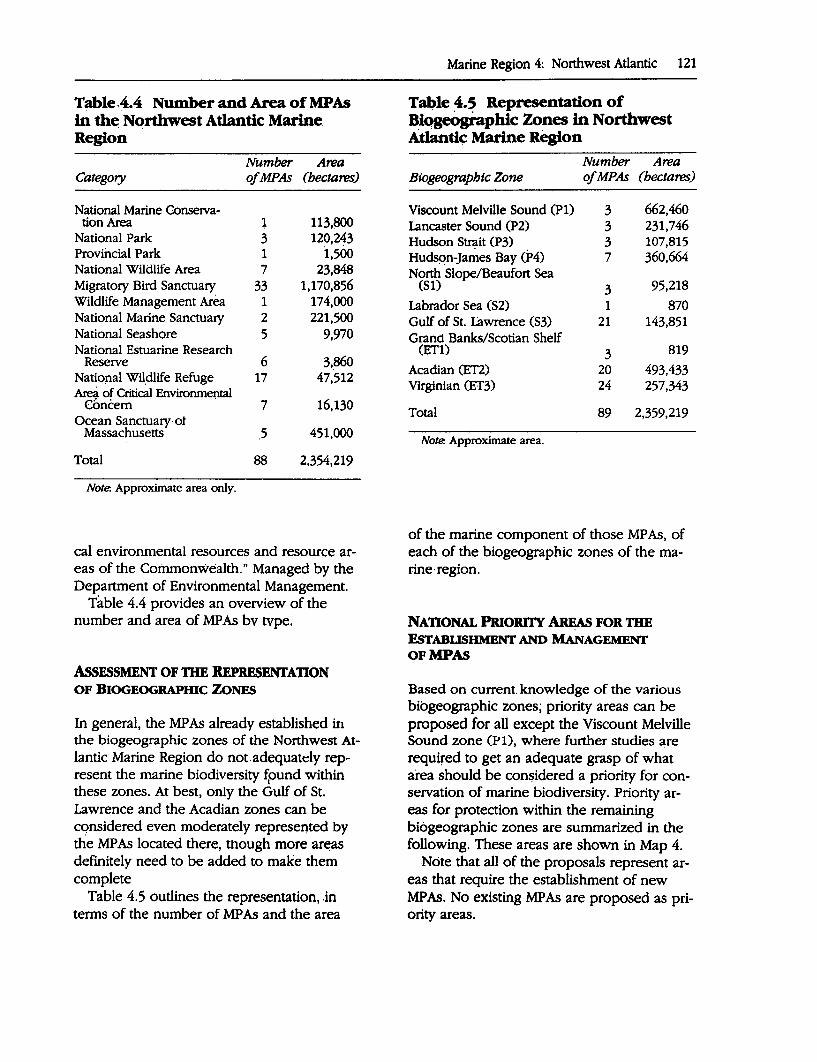
Table,4.4 Number and Area of MPAs in th~ Northwest Atlantic Marine, Region
Number A~a Category ofMPAs (hectares)
National Marine Conserva-tion Area 1 113.~0
National Park 3 120,243 Provincial Park 1 i,500 National Wildlife Area 7 23,848 Migratory Bird Sanctuary 33 1,170,856 Wildlife Management Area 1 174,000 National Marine Sanctuary 2 221,500 National Seashore 5 9,970 National Estuarine Research
Reserve 6 3,860 Natioµal WHdlife Refuge 17 47,512 Area of Critical Environmental
Concern 7 16,130 Ocean Sanctuary·ot
Massachusetts ,5 451,000
Total 88 2,354,219
No(e. Approximate area only.
cal environmental resources and resource areas of the Commonwealth." Managed by the Department of Environmental Management.
Table 4.4 provides an overview of the number and area of MP As bv type.
AssESSMENT OF 11IE REPRESENTATION OF BIOGEOGRAPmc ZONES
In general, the MP As already established in the biogeographic zones of the Northwest Atlantic Marine Region do not.adequately represent the marine biodiversity ~ound within these zones. At best, only the Gulf of St. Lawrence and the Acadian zones can be considered even moderately represented by the MP As located there, tnough more ar~as definitely need to be added to make them complete
Table 4.5 outlines the representation, in terms of the number of MP As and the area
Marine Region 4: Northwest Atlantic 121
T~le 4.S Representation of Biqgeogi-aphic Zones in Northwest Atlantic Marine Region
Number A~a Biogeograpbic Zone ofMPAs (hectares)
Viscount Melville Sound (Pl) 3 662,460 Lancaster Sound (P2) 3 231,746 Hudson Strait (P3) 3 107,815 HudsRn-Ja~es Bay (P4) 7 360,664 North Slope/Beaufort Sea
(SI) 3 95,218
Labrador Sea (S2) 1 870 Gulf of St. Lawrence (S3) 21 143,851 Grand Banks/Scotian Shelf
(ETl) 3 819
Acadian (ET2) 20 493,433 Virginian (ET3) 24 257,343
Total 89 2,359,219
Note. Approximate area.
of the marine component of those MP As, of each of the biogeographic zones of the marine· region.
NATIONAL PRIORITY AREAs FOR TIIE EsTABLISHMENT AND MANAGEMENT OFMPAS
Based on current. knowledge of the various bibgeographic zones; priority areas can be proposed for all except the Viscount Melville Sound zone (Pl), where further studies :ire required to get an adequate grasp of what area should be considered a priority for conservation of marine biodiversity. Priority areas for protection within the remaining biogeographic zones are summarized in the following. These areas are shown in Map 4.
Note that all of the proposals represent areas that require the establishment of new MP As. No existing MP As are proposed as priority areas.
122 · A Global Representative System of Marine Protected Areas
Canada
Proposed new MPAs: ,.,._ Lancaster Sound zone (P2) (74°00'N,
81 °SO'W): Lancaster Sound area: Located between ~e towering clift:s of Devon and Baffin islands,. this 'spectacularly_ scenic site is also the most productive in the Canadian Arctic due. to a variety of oceanographic processes . which resu.lt in upwelling an,d mpdng. Lancaster ~ound· ~corporates several types of marine habitats, including · open w;lter, tidal flats, polynyas, shore leads and _ice-edge, with depths typically ranging from 25Q-800 meters. Up to 75 percent of the world's narwhal, one third of North America's beluga arid most of the. remaining eastern Arcµc bowhead whale population can be found staging, feeding and calving in this area during the summer. Large concentrations of greater snow geese, northern fulmars, thick-billed murres. and kittiwake:5 breed in this area, while it also serves as a critical feeding area for both breeding and nonbreeding· pelagic se~birds and eiders. Important concentrations of walrus, polar b~r and ringed and bearded seals .are also found throughout the site. The boundary between the CNPPA Northwest At-
. lantic and Arctic Marine Regions falls through the sound, and the area has been identified as a priority for a new MPA in the reports for both regions.
..,. Hudson Strait zone (P3) (69°58'N, 67°2S'W): Isabella Bay area (now in designation): Located along the central coast o.f eastern Baffin Island this site alternates between coastal lowlands and deep fjords and underwater glacial troughs. The cold Baffin current interacts with bathymetric features and tidal currents to establish localized patterns of high productivity. In Isabella Bay, this phenomenon, and the combina-
tion of deep and shallow waters, lead to ideal conditions for breeding and feeding eastern Arctic bowhead -whales, a highly endangered population. Up to one-third of the entire population has been obs~rved here. Other species of interest include Arctic charr, nesting Northern fulmars and glaucous gulls,. killer whales, ringed seals and polar bears. The Canadian Wildlife Service, Canadian Department of Indian and Nqrthern Affairs, and local aqoriginal community are working together to establish Canada's first marine National Wildlife Area. The pri-· mary g9al of the MP A is to protect the local population of bowhead whales.
,... Hudson-James Bay zone (P4) (57°50'N, 92°SO'W): Churchill River/Nelson River area: Located within the extremely lowlying Hudson Lowlands, this area encompasses extensive mudflats up to 6 kilometers wide and numerous estuaries which are extremely important marine habitats. Tens of thousands of beluga whales summer in the Churchill and Nelson river estuaries, while numerous species of waterfowl and shorebirds breed and stage in the area, in~luding the resident race of the Common eider (Somateria mollissima sedenteria) and a large proportion of the world's Hudsonian godwit population. The site is also well know for the large numbers of polar bears which concentrate along the shore, awaiting the arrival of the winter ice.
,... North Slope/Beaufort Sea zone (Sl) (70°50'N, 127°00'W): Cape Bathurst Polynya: The Ullfesistant sedimentary rock coast of this site is generally flat with little relief, though cliffs of 5-20 meters are found in Liverpool Bay and up to 200 meters in Franklin Bay, with deeply entrenched valleys. Narrow beaches, mudflats, deltas, estuaries, lagoons and barrier beaches are
typical coastal features. Water depths average less than 10 meters in Liverpool Bay and up to 500 meters in Franklin Bay. Landfast ice and the Cape Bathurst polynya are the preeminent oceanographic features of this area, with productivity greatest along the numerous ice edges. The shore leads which develop in early spring are critical to tens of thousands of common and king eiders and oldsquaw on the": way to their nesting grounds further north, and they also . serve as a migration route for bowhead and beluga w~ales. Other waterfowl and shorebirds stage and breed in the area, while polar bear and ringed and bearded seals are present during the
. ice-bound winters. ,,_... Labrador Sea zone (S2) (49°00'N,
· 53°SO'W): Bonavista Bay/Funk Island area: Lying off the eastern shore of Newfoundland, this site has a complex coastline indented with narrow sounds and bays and with a variety of coastal habitats. The cold waters of the Labrador current are a strong contributor to the high productivity of this area and bring down the numerous icebergs that are seen offshore. A diverse and abundant subtidal fauna with numerous fascinating communities adds to the already rich seabird and marine mammal fauna. Harbor seals are common inshore, as are humpback, minke, fin and pilot whales, and harp and hooded seals are regularly observed in the spring. Over 400,000 pairs of seabirds breed in the area, most on Funk Island. In addition to signifi-cant numbers of kittiwakes, thickbilled murres, razorbills and puffins, this island is the most important common murre breeding colony in the Northwest Atlantic, as well as the second largest North American gannet colony.
Marine Region 4: Northwest 'Atlantic 123
.,.. Gulf of St. Lawrence zone (S3) (47°SO'N, 61°SO'W): Iles-de-la-Madeleine area: This 100 kilometers long archipelago of twelve islands and islands, most connected by long sand bars and separated by shallow lagoons, rises out of the· shallow, relatively warm southern Gulf of St. Lawrence. Red sandstone cliffs are constantly being eroded and shaped into sea stacks and marine arches, while the more resistant bedrock stands out as headlands. The marine wildlife associated with the site is impressive, including a wide diversity of breeding seabirds, nesting piping plovers, and migrant waterfowl and 'shorebirds that make use of the mudflats and saltmarshes. Harp and hooded seals whelp ·on the offshore spring pack ice, while harbor and grey seals breed closer inshore. Numerous fish and shellfish species are found offshore.
..,... Grand Banks/Scotian Shelf zone (ETl):
Browns/Baccaro Banks and Sable Island (43°00'N, 65°00'W)/The Gully areas (44°00'N, 59°00'W): Both these sites are located offshore in areas of upwelling along the continental shelf, which are particularly important for marine mammals and seabirds. The Browns/Ba.ccaro Banks area can be considered of global cetacean significance, since as many as 25 percent of the total number of the highly endangered Northern Right Whale are believed to feed and mate here between June and ·october of any given year. Sable Island is the only exposed portion of the offshore banks and has a large breeding population of grey and harbor seals.· The Gully is a large submarine canyon which is a critical site for what appears to be a· 'resident population of the poorly known Northern bottlenose whale. It is also a key site for sperm whales, Atlantic white-sided dol-
124 A Global Representative System of Marine Protected Areas
phins and common dolphins .. Minke, fin, sei, humpback ~nd pilot whales are also common in both sites, as are a v:ariety of pelagic seabirds including phalaropes, she~rwaters, storm-petrels, murres and dovekies.
.,. Acadian zone (ET2) ( 44°90'N, 66°90'\V): Deer Island area: The compl~x bottom topography and high tidal c;urrents which do~inate the island strewn Deer Isl.and site promote high producti~ity which ~n turns leads to important cpncentrations of a variety of .species. Harbor porpoise, fin and minke whales, Bonaparte's gulls, Arctic and common te.rns, and phalaropes: among others, come in to feed on the bountiful zooplankton and herring resources of the area. Subtidally, a variety of interesting benthic communities a<;ld to the biodiversity of this marine area.
United States
Proposed n~w MP As: .,._. Acadian zone (ET2) (43°75'N,
69°50'\V): The Mid-coastal Maine a~ea: This site indudes a scenic fjord-like coastline with. a wide diversity of in.arine habitats including estuarine, coastal and marine communities. High primary productivity is evidenced by algal and kelp populations and signifi- · cant fisheries. Seabirds and shorebirds ~e.st and feed in the area, while waterfowl, especially c9mmon eiders, winter in the area. Several islands serve as gray seal haulouts. Endangered species include bald eagles, humpback and right whales and shortnose sturgeons.
,..... Virginian zone (ET3): Narragansett Bay (41°50'N, 71°42'W}arid Assateague Island(37067'N, 75°50'W) areas: The Narragansett Bay site has a varied coastline., ranging from rocky, high-en-
ergy shores with high rocky cliffs to micro-tidal, wave-dominated coastal lagoons separated frqm the open ocean by barrier beaches. The .site has a wide variety of habitat types that are essential for hundreds of invertebrate, fish and bird species, forming a unique assemblage of botp cold and warm temperate biota. It is an important spawning and nursery area for a variety of fish species, as well as a significant nesting, stopover, wintering and. feeding area for shorebirds, waterfowl and some raptors. Seve~l species of whales, dolphins and .seals visit and feed in the area. ·
The Assateague Island site encompasses one of the last and largest relatively undisturb.ed barrier island ecosystems in the United States. The site provid.es a wide range of habitats that are essential breeding, nursery, resting, and feeding areas for hundreds of species, notably fish, invertebrates and birds. The vast network of
· marshes and tidal flats form the base of a highly productive system and provides important maintenance areas for several endangered and threatened spe-
. des including the loggerhead sea turtle, piping plover and peregrine falcon.
REGIONAL PRIORilY AREAs FOR TIIE ESTABLISHMENT AND MANAGEMENT OFMPAs
The marine areas considered of highest regional. priority for the protection of marine biodiversity within the Northwest Atlantic Marine Region are: ,.... Lancaster Sound ,.... Cape Bathurst Polynya ,... Browns/Baccaro Banks ..-.. Mid-coastal Maine area
. O~er Recommendations
Proposals are also being advanced for the establishment of MP As as a means of ensuring the sustainability of commercial fisheries resources, including areas beyond the limits of na~onal jurisdiction. Specific proposals have been advanced for the establishment of an MP A along the Hague Line between Canada and the United States to preseive the rich and diverse biota of the Gulf of Maine and to e~ance production of depleted commercial species in the region, particularly those on the Georges Bank.
there is in the United States and Canada authority to establish and effectively manage a representative system of marine protected areas in the Northwest Atlantic Marine Region. Although good progress has been made in protecting representative examples of ~ome of the most southerly parts of the Marine Region, such as the Acadian and the Gulf of St. Lawrence zones, marine prbtection in the other zones ,is considered "inadequate," being limited to tidal flats, saltmarshes,· islands, seabird colonies and adjacent nearshore open water areas of importan~e to migratory birds.
Establishing marine protected areas for each of the unrepresented biogeographic zones in the Northwest Atlantic Marine «.egion (most of which are situated in Canadian waters) will be a challenging and long-term task. Some of the reasons for this prognosis are the lack of good scientific information on which to base area siting decisions, the very high cost of conducting field studies and consulting northern residents in the region, and scarce and dwindling resources for creating new marine protected areas.
The following suggestions provide a start~ ing point for accelerating the completion of a representative system of marine· protected areas for the Northwest Atlantic Marine Re-
Marine Region 4: Northwest Atlantic 125
gion, particularly within Canadian waters where most representation gaps occur. • Encourage conservation agencies to de
velop an informed and well--organized public constituency for marine protected areas as most Canadians are largely unaware of the need for marine conservation.
• Determine how best to combine the limited scientific knowledge of the Northwest Atlantic marine ecosystems and the traditional knowledge of indigenous people to· identify, establish and manage new marine protected areas.
• Secure additional resources for identify~ng, selecting and establishing new marine protected areas within a specific timeframe for those unrepresented marine 'regions in the Northwest Atlantic Marine Region. ·
• Improve interdepartmental and intergovemmenta.1 coordination in ocean use management to offset conflicting interests between government departments and agencies.
• Encourage Parks Canada to work with indigenous people in the Northwest Atlantic Marine Region to develop a better understanding of the role marine protected 'areas c,an play in conserving their traditional way of life.
BIBUOGRAPHY
Agardy, T: 1988. A status report on the workings of Joint U.S/Canada Ad Hoc Selection Panel
· for Acadian Biospbe-re Reseroe Nomination. Report to the U.S. MAB Directorate on Biosphere
. Reserves. Washington, O.C. · Briggs; John C. 1974. Marine zoogeograpby. New
York: McGraw-Hill Book Co. Dasmann, R.F. 1972. Towards a system for class
ifying natural regions of ~e world and their representation by national parks and reserves. Biol. Conserv. 4: 247-55.
126 A Global Representative System of Marine Protected Areas
Dietrich, G. 1963. General oceanography. New York: John Wiley and Sons.
Dunbar, M.J. 1951. Eastern Arctic Waters. Bull. Fish. Res. Bd. Can. 88:131.
1972. The nature and definition of the marine Subarctic, with a, note on. the sea-Hf~ of the Atlantic salmon. Trans. Roy. Soc. Can. 10:249-57.
Hayden, B.P., G.C. Ray, and R. Dolan. 1?84. Classification of coastal and marine environments. Environmental Conseroationlst 11: 199-207,. .
McCormick-Ray, M.G., G.C. Ray and W.P. Gregg. 1988. Biosphere Reseroe Nomination Vi,gianMid Atlantic Biogeographical Province. Report to.the U.S. MAB Directorate on Biosphere Reserves. Washington, D'.C. · ·
McNeely, j.A., and K.R. Miller. 1983. IUCN, na-: tional parks, and protected areas: Priorities for action. Environmental Conservationist 10:13-21.
Mercier, F. 1990. A characterization of Canada's marine regions. Unpublished report prepared for the National Parks Systems Branch, Ottawa .
. Owens, E.H. 1977. Coastal environments of Canada: 1be impact and cleanup of oil spills. Ottawa: Environment Canada.
Salm, R.V., and J.R. Clark. 1984. Marine and coastal protected areas: A guide for planners and managers. Gland, Switzerland: IUCN.
Udvardy, M.D.F. 1975. A classification of the bio. geographic provinces of the world. IUCN Occa
sional Paper No. 18. Gland, Switzerland. Wolotira, R.J. N.d. Biogeographic provinces of
the coastal ocean of the United States and adjacent waters. Forthcoming.
Woodward-Clyde Consultants. 1983. Marine regions of Canada: Frameµ;orkfor Canada~ system of national marine parks. Ottawa,. Canada: National Parks Systems Branch.
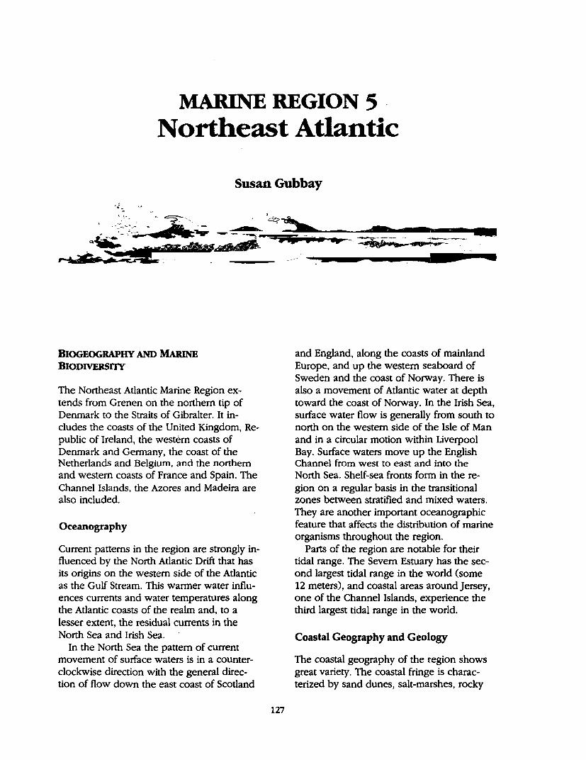
MARINE REGION 5 Northeast Atlantic
Susan Gubbay
BIOGEOGRAPHY AND MARINE BIODIVERSITY
The Northeast Atlantic Marine Region extends from Grenen on the northern tip of Denmark to the Straits of Gibralter. It includes the coasts of the United Kingdom, Republic of Ireland, the western coasts of Denmark and Germany, the coast of the Netherlands and Belgium, and the northern and western coasts of France and Spain. The Channel Islands, the Azores and Madeira are also included.
Oceanography
Current patterns in the region are strongly influenced by the North Atlantic Drift that has its origins on the western side of the Atlantic as the Gulf Stream. This warmer water influences currents and water temperatures along the Atlantic coasts of the realm and, to a lesser extent, the residual currents in the North Sea and Irish Sea.
In the North Sea the pattern of current movement of surface waters is in a counterclockwise direction with the general direction of flow down the east coast of Scotland
127
. . 0 ...
and England, along the coasts of mainland Europe, and up the western seaboard of Sweden and the coast of Norway. There is also a movement of Atlantic water at depth toward the coast of Norway. In the Irish Sea, surface water flow is generally from south to north on the western side of the Isle of Man and in a circular motion within Liverpool Bay. Surface waters move up the English Channel from west to east and into the North Sea. Shelf-sea fronts form in the region on a regular basis in the transitional zones between stratified and mixed waters. They are another important oceanographic feature that affects the distribution of marine organisms throughout the region.
Parts of the region are notable for their tidal range. The Severn Estuary has the second largest tidal range in the world (some 12 meters), and coastal areas around Jersey, one of the Channel Islands, experience the third largest tidal range in the world.
Coastal Geography and Geology
The coastal geography of the region shows great variety. The coastal fringe is characterized by sand dunes, salt-marshes, rocky
128 A Global Representative System of Marine Protected Areas
shores and mi:.id and sand flats whilst seabed habitats range from bedrock through to· fine silty muds. Larger sca~e features 'include many· different types of inlets-estuaries, fjords, and rias-as well as brackish lagoons, steep cliffs that continue as sheer rock walls underwater, narrows and extensive sediment plains. The low-lying northwestern coast of Denmark has some of the most active dune landscapes in Europe, standing up to 30 meters high; the isla11ds of St. Kilda off the west coast of Scotland are faced by the hjghest sea cliffs in Europe, more than 300 meters ,high and continuing v~rtic;1lly underwater fc;,r inore than 50 meters. . . .
A, predqminantly soft coastline of sand dunes, Saltmarsh and mudflats borders the western shores of Denmark, Germany, and the Netherlands, and the Waddensea has the largest stretch of uninterrupted mudflats in the world. The western coasts of Scotland and. Ireland provide a contrast with their mostly rocky' 'indented, coastlines of sea . lochs and· nas: The northern coast of France is dominated· by rocky ~hores but further soiith there are extensive sandy areas and dramatic c~astal dunes. The coastline of Portugai is also impo~nt for dunes and beacties but also has a number of sheltered inlets and lagoons. One of the· most striking coastal features in the southern part of the r~gion is .the Guadalq1:1ivir delta in southern Spain, one of the largest wetlands in Europe.
There are many island groups in the region incluging the volcanic isla!lds of Ma- . deira, the Azores, the Channel Islands, the low-lying arcl)ipelago· of the Isles of Scilly off southwestern Britain, and the numerous islands off the western and northeastern coast ·of scotland. . . . In the riorthern part of the region, ,;nuch
of the s~bed is continental shelf, forming the relatively sl)allow North Sea and Irish Sea and including the Hebridean Shelf and Celtic Shelf. The shelf region narrows off the southern coast of France and fringes the , coast of Spain and Portugal down to the
Straits of Gibraiter. In the northwest the seabed drops to more than l kijometer in the Rockall Trough and other significant deep sea areas include the Porcupine Bank and the Iberian Abyssal Plan in ,the southwestern part of the region.
Ecosystem Diversity
The oceanographic conditions, geology, geography, and range of biogeographic zones in the Northeast Atlantic Marine Region, support an interesting dive~sity of ecosystems. A great deal of information i~ available on coastal ecosystems within the realm but much work has also been carried out on sublittoral ecosystems, although this has tende~ to be in the northern part of the region. ,Investigations of the seabed, by dredging, were carried out from the early part of tht century, with major studies of the benthic communities off the coast of Denmark, Ireland and around the United Kingdom and Isle of Man. A useful overview of benthic marine ecosystems in the Northeast Atlantic can be found in Hiscock 0991). The diversity of benthic communities in the region is highlighted by recent work being carried out around Great Britain by the Joint Nature Conservation Committee (JNCC). The ]NCC are developing a classification system for benthic marine biotopes and have identified 1~0 different types to date in the shallow sublit-. toral around Great Britain. Although there is no estimate as yet of the number of benthic biotopes in the whole of the Northeast Atlantic Marine Region, there are likely to be several hundred.
A few of the marine habitats and communities that are found in the Northeast Atlantic Marine Region are described briefly below. The greater emphasis on the distribution of these habitats in the northern part of the realm is a reflection of the more limited information available on the sublittoral habitats and communities for the Atlantic coast. of France, Spain and Portugal.
Intertidal Mud atul Satuljlats
Intertidal mud and sandflats are found throughout the region. They are present in each of the biogeographic zones but particularly widespread in the boreal region.
The most extensive examples are in the Waddensea where the intertidal flats are of international importance for wildlife. The extremely productive, but species poor, tidal flats support vast numbers of waders and wildfowl: around 10 million birds pass through the region each year, and they are also an important nursery ground for North Sea fish stocks. Intertidal flats ·around the British Isles are less extensive but critically important for mariy species because the mild winter conditions and good tidal range exposes large areas of flats allowing access to food for waders and wildfowl during the winter months. Many of these intertidal flats· are in estuarine situations and the Waddensea and Great Britain together account for more than 65 percent of the estuarine habitat of the region. Further south, interti- · dal flats are less extensive but important iri certain localities such as the Loire and Gironde estuaries in France, the Tejo in Portugal; and the Guadalquivir delta in southern Spain. ·
This habitat is vulnerable to damage from many activities. Land reclamation has prob'.. ably been the most serious threat but 'there are also problems associated with dredging, land fill, industrial pollution and other activities .. For example, more than 32,00.0 hectares of the German Wadderisea has been re- ' claimed since 1963, and in the United Kingdom some areas have lost up to 90 percent of their intertidal area to land claims.
Seagrass
Seagrass beds are found throughout the region where conditions are suitable. They are most widespread in the Boreal, BorealLusitanean and Lusitanean:.Boreal regions·.
Marine Region 5: Northeast Atlantic 129
Extensive areas of Zostera marina can be found in the e·astern part of the Waddensea, but it· is' also grows in many sheltered sites around the U .K. and Ireland, the Channel coast, ~nd parts of the Atlantic coast of
.. France. Seagrass beds are important nursery areas
for juvenile fish, but the plants also help to stabilize the sediment and are an important source of organic matter. They are vulnerable to damage from a variety of activities. Threats include fishing techniques that disturb the seabed, dredging, anchor damage and trampling.' There was a dramatic decline in the extent of seagrass in the northern part of the realm in the 1930s due to a wasting disease. Many areas have been recolonized but recovery has been poor in the Netherlands.
MaerlBeds
Several species of calcified red seaweed occur in the region and a number of these form inaerl beds. Lithothamnium glaciate is at its southern limit in the realm while Phymatolithon'. calcareum and Lithothamnium corallioides are at their northern limit. There are particularly extensive beds of maerl off the coast of B'rittany ahd in parts of southwestern Ireland. Small patches of maerl are also widespread in some of the Scottish sea lochs and there is a large bed in the Fal estuary in southern Britain. ·Maerl beds support a rich assemblage of both plants and animals and the crevices bet:V{een the twigs provide shelter for many species. Beds that are no· longer living support communities similar to those found 'on: fine shell gravel. . .
There has been commercial expl~Jtation of maerl in the region since at least the 18th century mainly b'ecause of its value as a soil conditioner. This supports an impoiµnt industry· in Brittany. Threats th~refore come . from direct extraction as well as disturbance of the s~abed and activities that increase 'the sediment load.
130 A Global Representative System of Marine Protected Areas
Kelp Forest
Kelp forests are widespread on rocky sublittoral areas in the northern part of the region. Several species grow densely to form forests of kelp. Laminaria byperborea and L. digitata are widespread around the U.K:, Ireland and France but the larger, more open· growing L. ocbre/uca is also present from the Channel southward. This community is a feature of infralittoral rocky areas in much of the Boreal, Boreal-Lusitanean and Lusitanean-Boreal zones. Kelp forests are not an important sublittoral community along the Waddensea coast because of the lack of hard substrates. Kelp forests harbor many species of flora and fauna that find shelter, food and surfaces for attachment on the kelp and the surrounding rocky substrate. Different communities develop depending on factors such as exposure, turbidity, grazing pressure and substrate type.
Kelp is collected from some parts of the region as a source of alginate, either from beaches or offshore. Some species are also cultivated. Increased levels of collection are one possible tp.reat but there is a danger of . die-off from increased suspended matter.
Soft Sediment Sea,,ed
Soft sediment seabeds are probably the most extensive sublittoral-habitat in the Northeast Atlantic. The marine communities associated· with these areas are tremendously varied and are influenced by factors such as sediment type, exposure, and geograp~cal location.
These habitats are particularly vulnerable · to fishing techniques that disturb the seabed. Changes in community structure have also· been noted as a result of eutrophication.
Species Diversity
A species directory covering the area,of the continental shelf around the British Isles lists some 6,500 species without looking at all relevant phyla (Picton and others 1992).
Based on this and other information a number of the groups are described briefly below.
Seals
Two species of seal are found in the northern part of the realm, the grey seal (Hallchoerus grypus) and the common or harbor seal (Pboca vitulina), The grey seal tends to frequent the more wave-exposed,· rocky sites while the common seal generally uses sheltered inshore areas. Grey seals congregate into large breeding colonies and there are major colonies in the Outer and Inner Hebrides and Shetland. The Sept Illes MP A off the coast of Brittany has one of only two breeding colonie~ of grey seal in France.
The Waddensea coast is a particularly important area for common seals that feed in the shallow waters and haul out on the extensive sandbanks. Other important sites in the region for this species include the Wash on the east coast of England and· Strangford Lough in Northern Ireland. The North Sea has around 10 percent of the world population; however, numbers fell significantly after the viral epidemic in the late 1980s. In France the only colony is around the Picards estuary, for common seal.
The Mediterranean monk seal is the third species and the most endangered. This species is threatened with extinction. One of the most impo~nt remaining locali~es for the Mediterranean monk seal is around the islands.of ~adefra.
Fisheries
The region· spans some of the most heavily fished seas in the world. The relat{vely shallow waters of the North·Sea and Irish Sea have supported fisheries for many centuries and although they continue to do so, the species that are the focus of the fisheries have changed as landings and stocks have declined. The most dramatic of these was the· collapse of the herring fishery in the late 1970s. Effort shifted to mackerel and, as land-
ings of these fell, industrial fisheries (for sand eel, Norway pout, and sprat) became more prominent. Two hundred and twenty four species of fish have been recorded in the North Sea but it has been estimated that fewer than 20 make up more than 95 percent of the biomass. Furthermore, it has been estimated that between 30-40 percent of the biomass of commercially exploited fish species in the North Sea are caught each year (North Sea Task Force 1993). Daan and others 0990) have identified three different assemblages of North, .Sea fish-a southeastern group where dab and whiting are .most abundant, the central North Sea dominated by cod, and on the slope e~ge to the north where saithe are most abundant.
The region supports fisheries for many invertebrate species. These include various lobsters, crabs, prawns, shrimps, scallop, mussels, cockles, whelks, sea urchins and sea cucumbers. On the Azores limpets (Patella aspera and P. candei) and the barnacle Megabalanus tintinabulum, are collected from rocky intertidal shores.
The intensity and scale .of various fisheries is a major cause for concern in the region and is illustrated by the following examples. The Common Skate. (Raja batis) is now thought to be extinct in the Irish Sea. _Other threatened species include the sturg~on (Acipenser s,turio) and allis _sha9 (Alosa alosa). The last few year~ have seen closure of the sand eel fishery around Shetland. This was brought to public attention through the massive breeding failure of seabirds in northern waters. There has been no clear link with overfishing, but due to falling catches, there is a temporary closure of the fishery. In the southern North Sea research carried out by the Netherlands Government on beam trawlers has shown clear changes in the structure of seabed communities in fishing areas from long-lived, slow-growing species to communities dominated by opportunistic species. Trawling over an area, three times, led to a fall in density of 40-60 percent of nontarget species. The eastern At-
Marine Region 5: Northeast Atlantic 131
lantic Bluefin Tuna may well have disappeared from the North Sea, and population numbers are estimated to have declined overall by SO percent since 1970.
Cetaceans
A variety of species can be seen in the region. For example, results from sightings and stranding data record 22 species in British and Irish waters since 1980. The same analysis notes that 13 species are seen throughout the year. In decreasing order of abundance these are; harbor porpoise, whitebeaked dolphin, bottle-nosed dolphin common dolphin, long-finned pilot whale, Atlantic white-sided dolphin, Risso's dolphin, killer whale, minke whale, northern bottle nose whale, fin whale, striped dolphin and sperm whale (Evans 1992). The true status of many of these species ·is unknown although there are some apparent trends. For example harbor porpoise (Pbocoena pbocoena) are now rarely seen in the Waddesea and southern North Sea.
There are many threats to these species ranging from incidental catch by fisheries, disturbance, accumulation of pollutants in bo~y fat causing tumors and breeding failure, and depletjon of prey species.
iltrds
Coastal ~orie: habitats, including tidal waters, beaches, mudflats, saltmarshes and sand du_nes ar~ of major importance· for birds and of considerable conservation concern. A recent analysis of the conservation status of birds in Europe has shown that some SO Species of European Conservation Concern (SPECs) use these habitats at some point in their life cycle, out of a total of 227 SPECS in Europe (Tucker and others 1994). Of these 42 have an unfavorable conservation status in Europe because they are declining, rare, or highly localized. These include four globally threatened species; ferruginous duck (Aytbya nyroca), the Spanish imperial eagle
132 A Global Representative System of Marine Protected Areas
(Aquila adalberti) and the highly threatened slender-billed curlew (Numeni'us te,:iuirostris) and Audouin's Gull (Larus audouinit). Six other species· with coastal habitats that · have an unfavorable conservation· status in Europe also have over half their global· population in Europe, including.the near· globally threatened pygmy cormorant (Pha/acroco-· · rax pygmeus).
Many of these species concentrate at a small number of specific sites especially :ifr the winter or on passage·like the·k~ot and .
·· bar-tailed godwit, or for breeding such ~s the greater flamingo'. Important sites -include the Waddensea coast, the-estuarine-habitats around the British Isles like the Severn estu~
· ary, and the Guadalquivir delta in southern Spain. . .Toe region also supports large populations of seabirds including fulmars, petrels, shearwaters, cormorants, shags, skuas,.gulls, terns, auks, seaducks and divers. Many of these birds nest on offshore islands. The is-. lands of St. Kilda, off the west coast of.Scot-
. land, for example support one of the largest concentrations of breeding. seabirds_ in the North Atlantic with more than 400,000 pairs; the island of Grassholm,·off.the south Wales coast supports around 11 percent of the North Atlantic population of breeding gah-·· nets (Pritchard and others 1992). It has been estimated that some 10 million seabirds are present in the North Sea at most times of the year and, in many cases, they make·up major percentages of the . .world population. For example North Sea coasts supports more than 50 percent of the biogeographic populations of common terns and great skuas and a further 12 species are present in more than 10 percent of their population (Dunnet and others 1990). Overall in Europe there are an estimated 44 SPEC5 that are particularly ~ · pendent on the seas (Tucker and others 1994).
Biogeographic Classification·
The foundations of biogeographic knowl- · edge of this region came from the work c;,f
marine scientists such as Loven, Forbes, Goochyin-Austen and Borgensen in ·the mid to late 19th century. This led to the identification· of three main provinces: Arctic, Boreal ~nd Celtic/Lusitanean. Much later these were developed by Eckman (1953) who also recogniZed three main provinces in the North Atlantic: Arctic, Boreal '(which includes an Arctic-Boreal and Mediterranean-Boreal component), and a Mediterranean-Atlantic region. This was supported by Briggs 0974) who-.divided the eastern Atlantic into three major provinces: Arctic, cold temperate BoreaI; and Lusitanean. · The more recent work of Hayden, Ray and:Dolan (1984) on the Classification of coastal and marine environments corre- · sponds with these interpretations. They combined physical and biological factors in . developing their system and identify two . main fauhal provinces (East Atlantic Boreal and Lusitanian) overlying subpolar and temperate realms. The early observations of botanists essentially confirmed those of zoologists. Borgensen arid Jonsson (1905) proposed five main groups, Arctic, Subarctic, · Boreal-Arctic, cold Bore~il and warm Bor~al. The most recent summary of such work by Hoek and Breeman (1989) illustrates a cold temperate northeast Atlantic region and a warm-temperate northeast Atlantic region ..
· The Azores and Madeira are dependencies of Portugal and have been included in the
· Northeast Atlantic partly for this reason. Biogeographically these islands have affinities with both the Northeast Atlantic and West African· flora and fauna (Wells, personal communication). These islands are treated as a separate biogeographic zone in this report. . The classification of Eckman and Briggs are the most widely used interpretation and is the· basis for Map 5 that summarizes the ' biogeographic zones of the Northeast Atlantic Marine Region.
In common with biogeographic studies. in all ·parts of the world it is not possible to identify precise boundaries between the different regions. There is a gradual change in
species composition as the endemic species in one area a.re replaced by those more typical of the adjacent region. One of the clearest boundaries in the Nor.theast .Atlantic . R,ealm is between the Lusitanean and Boreal regions at the entrance to the English Channel. '.fhe southern extent of the Lusitan~n province lie~ near the entrance to the Mediterranean, while the Boreal region merges into an Arctic r~gion in the vicinity of the Lofoten islands in Norway and the ,west and east coasts of Iceland.
AssESSMENT OF ExlsTING MPAs
Description of National MPA Systems ·
All the countries in the Northeast Atlantic Marine Region have established some form of marine protected areas. The criteria used to· select suitable sites, and the degree of pr<>; tection that is given. to the marine wildlife and habitats within these MP As, varie~ from country to coun~. Nev:eftl'leless they:ca~ all be encompassed under th~ d.efmition of MP As use~ by IUCN.
Belgium
The designation of MP As in Belgium ~ters comes under the Nature Conserv~tion.Act , 1973, but unlike other aspects ·of the Act. that are implemented by regional authprities, responsibility for marine a~eas lies. with the national government. There is no, specific . provision for MP As in this legislation or in .. the Conservation of Monuments and ,Nature Sites Act, but both could be used to designate MP As. Much of the coastline of Bel-. gium is designated as a Wetland of International Importance under the ,Ramsar · convention. ,... Vlaamse Banken (Flemish Banks)
(51°20'N, 3°00'E): A Ramsar wetland and EC Birds Directive site but not protected through national legislation. Includes inshore and offshore shelf
Marine Region 5: Northeast Atlantic 133
waters and shoals. International importance for migratory birds, some parts hav,e a rich benthic fauna (Peet and others 1993).
.Denmark
MP As in Denmark can be designated under the Protection of Nature Act 1992 and the Hunting and Wildlife Management Act 1987. The first of these. makes .specific reference to the extension of protected areas for areas of sea, both in territorial waters and the Danish fishing.zone. An Executive Order has been issuec;:l py the Minister of the Environment for,the cons~rvation.of the Waddensea coast of Denmark. Sites are protected as Game Reserves, Seal Reserves, Scientific Reserves or Fisherie~ prohibition zones. Two large sites within.internal waters are the low lying areas.near Fjand on the Jutland coast-Boving fjord 'and Felsted Kog. These include areas . of sal~rsh. and reed beds important for · . wildfowl and waders. Reserves on the North Sea coast. include Fjordholmene, Ronland Sando .and Fjander, the largest of which cove~ 55 hectares, but none of these has significant. marine components. ,,._ Vadehavet (55°13'N; 8°.35'E): Inshore
waters with mud and sand flats of the Danish Waddensea coast. Extends 8-15 kilometers into North Sea. Ramsar wet-
· land and EC Birds Directive site. Most import.ant :nesting and feeding area for waterfowl in .Denmark.
There .is no specific legislation for MP As in France but the National Parks.Act 1960 and Nature Conserv.ation Act 1976 allow for the. setting up of National Parks, Nature Rea. · serves, Regional Nature Parks and Maritime Hunting Reserves by Dec;rees. · Al! of these can be applied to marine areas. Most French MP As are on the Mediterranean coast and there are many .coastal reserves with only a small marine component. The following
134 A Global Representative System of Marine Protected Areas
sites on the Atlantic coast could be considered MPAs. ,... Archipel des Sept Iles (48°55'N,
3°35'W): Nature Reserve. EC Birds rn.:. rective site. Rocky archipelago with reefs. Important for seabirds and seals. Prohibition on hunting and fishing. Limited access.
,... Iroise ( 48°25'N, 5°W): Regional Nature Park, Biosphere Reserve and EC Birds Directive site. Archipelago of Molene, Ushant island and surrounding waters. Noted for abundance of algal communities, large colonies of nesting seabirds, common and grey seal colonies, seagrass, sharp underwater dropoffs and deep channel. Seven fish species and 8 birds on the national red list (Peet and others 1993; World Conservation Monitoring Centre) .
...... Lilleau des Niges (46°18'N, 0°25'W): Nature Reserve and EC Birds Directive site. Saltmarsh intertidal flats, seagrass. Important for migrating and overwintering birds (Reille 1987).
,... Moeze (45°50'N, 0°25'W): Inlet. Nature Reserve
,... Pres Sales d'Ares Lege, Cap Ferret (44°45'N, 1°15'W): Marine component is principally the intertidal area. Mud and sand flats, seagrass beds, saltmarsh, seagrass beds. Fish nursery area (Reille 1987).
,... Banc d'Arguin (44°46'N, 1°17'W): Regional Nature Park.
Germany
There is no specific legislation relating to MP As but they have been set up under the Federal Nature Protection Act 1987. The level of protection differs depending on whether they are Nature Reserves or National Parks. Most of the Waddensea coast of Germany is covered by the designation of three areas as National Parks (see Common Wadden Sea Secretariat).
...... Schleswig-Holstein (53°52'N, 8°13'E): National Park on the Waddensea coast of Germany. Intertidal mudflats, sandflats, sandbars, saltmarsh, seagrass and islands. Particularly important as a fish nursery area and as a feeding and breeding area for wildfowl and waders. Zoned into core and buffer areas.
,... Hamburgisches (53°5l'N, 8°17'E): National Park on the Waddensea coast of Germany. Biosphere Reserve and Ramsar site. Intertidal mudflats, sandflats, sandbars, saltmarsh, seagrass and islands. Particularly important as a fish nursery area and as a feeding and breeding area for wildfowl and waders. Zoned into core and buffer areas.
,... Niedersaechsisches (53°21'N, 8°41'E): National Park on the Waddensea coast of Germany. Ramsar site. Intertidal mudflats, sandflats, sandbars, saltmarsh, seagrass and islands. Particularly important as a fish nursery area and as a feeding and breeding area for wildfowl and waders. Zoned into core and buffer areas.
,... Helgolaend Nature Reserve (54°5'N, 8°45'E): Waters around offshore island in the Waddensea.
Ireland
Protected areas legislation in Ireland centers on the Wildlife Act 1976 that allows for the designation of sites by the National Parks and Wildlife Service of the Office of Public Works. There is no specific legislation for MPAs but Areas of Scientific Interest, National Parks, Nature Reserves and Refuges for Fauna can extend to marine areas. Ireland has declared a Whale Sanctuary in its 200-mile Fisheries Zone.
A number of the coastal reserves include areas of sea, but in most cases, these are fringing areas. Examples include the Cliffs of Moher and Home Head where the seaward boundary of the reserves are 200 meters off-
shore. Many of the coastal reserves are estuarine sites. There is one MPA: ,.. Lough Hyne (51°31'N, 9°18'W): Land
locked sea lough, deep basins, tidal rapids, extreme seasonal deoxygenation of deepwater in some areas. Rich algal communities--more than 50 percent of the recorded marine flora of the British Isles. Various prohibitions, research only permitted under permit (Myers and others 1991).
Netherlands
Protected Area legislation of the Netherlands is covered by the 1990 Policy Plan on the Conservation of Nature. This includes the protection of specific sites that can be implemented by the Nature Protection Act 1967. Marine areas can be designated State Nature Monuments or Protected Nature Monuments under this legislation. In addition, the Watersysteemplan Noordzee provides a framework for protection o( marine sites and identifies specific policies for the Milieuzone Noordzee (coastal waters to 20 meters depth and the Frisian Front-Klavarbank area) where protective measures can be introduced with sectoral legislation. The Physical Planning Act can be applied to areas 1 kilometer from the baseline and could therefore be used for inshore areas. There is no specific legislation for the establishment of MPAs in the Netherlands (Nijkamp and others 1993).
The Netherlands has six separate areas designated as MP As. Four of these are in the Waddenzee and two in the Oosterschelde. Apart from the Milieuzone Noordzee, all the sites are within internal waters. ,.. The Dollard (53°18'N, 7°8'E): State Na
ture Monument and Protected Nature Monument within the Waddensea complex (two sites). Internal waters, intertidal mudflats, sandbanks and saltmarsh. Brackish water communities. Important nursery area for flatfish, shrimp and
Marine Region 5: Northeast Atlantic 135
crabs. Valuable feeding, resting and breeding area for many birds. Common seals (Peet, and others 1993).
,.. Milieuzone Noordzee (includes sea area northwest of Frisian Islands): More than 2,000,000 hectares of sea, some of which is outside the territorial waters of the Netherlands. Important fish nursery area, birds, unique characteristics for benthic communities in the Dutch sector.
,.. Oosterschelde Buitendijks (51°44'N, 3°59'E): State Nature Monument and Protected Nature Monument (two sites) in area of internal waters. Soft sedi-
. ment area with tidal flats, saltmarshes. Extensive mussel beds and important haul-out area for seals.
,.. Waddenzee I and II (53°15'N, 5°15'E): Covered by Planologische Kembeslissing that states Government policy on the Waddenzee. Internationally important area. Shallow coastal area with rich intertidal mud and sandflats. Major importance as a nursery ground for fish and as a feeding, resting and migration route for many species of waders and wildfowl. An estimated 6-12 million birds pass through the Waddenzee each year. Significant colonies of common seal and smaller numbers of grey seal.
Portugal
Protected areas can be set up under the National Parks and other Reserves Act of 1970 and subsequent amendments including a decree in 1976. Together they allow for the establishment of fourteen different types of protected areas. The most likely mechanism for MP As would be through the designation of National Parks, Nature Reserves or Partial Nature Reserves (Nijkamp and others 1993). These have been applied to many coastal sites in Portugal but there are few MPAs.
136 A Global Representative System of Marine Protected Areas
,,._ Berlenga (39°25'N, 9~.35'W) Nature Reserve, Biogenetic Reserve and proposed Biosphere Reserve: Covers area around the islands of B~rlenga and Estelas to a depth of-30 meters. Protection for all invertebrate species, some fishing allowed (Peet .and others 1993).
,,._ Costa Vicentica e Sudqeste, Alentejano. (37°35.'N, 8°5S'W): No information a.vailable.
Azores
Autonomous region of Portugal. Volcanic archipelago with nine main islands, approximately 1,500 kilometers west of mainland Europe. Legislation based on that of Portugal. ,,._ Bays of Maia, South Lourenco, Anjos
and Praia around the island of Santa·· Maria (36°S5'N, 25°IO'W): Nature Reserve wjth seaward boundary approximately 1.5 kilometers from coast. Representative of litt<;>ral habitats of the region. Legislation .not strong and little regulation.
,,._ . Vila Franca. Islet, Sao Miguel Island (2S0 30'W, 37°25'N): Small is\et close inshore.· Reserve. extends to 30 meters depth. Extinct. volcanic .crater broken up. Exceptional density of nesting Cory's shearwater. Regulations allow for total protection.
,.... Formigas Islets and Dolab~rat Bank: Approximately SO miles form· Squth Miguel. Nature Reserve: Shallow.and· deep water r~cky habitats. Regulations not yet defined. Artisinal fishing allowed by boats less than 14 meters.
,,._ Topo Islet, Sa.o Jorge Island (27°4S'W, 38°25'N): Nature Reserve extends to 30 meters d~pth. Rocky seabed. Regulations .not yet defined. -
,,._ Lagoon of Santo Cristo, Sao Jorge; Island (38°30'N, 28°W): Special Ecologi.,., cal .Area extends to 30 meters depth. Unique habitats.in the Azores for._its clam beds. Strict regulation on clam fishery that is commercially exploited.
,,._ Monte da Guia, Faial Island (38°30'N, 28°40'W): Protected landscape .. Two caldeiras within extinct volcano, open to. the sea. Rocky and sandy seabed. Recreational pressure. Need for buffer zone.
Madeira
Autonomous region of Portugal. Volcanic archipelago with four main islands, approximately 600 kil()meters west of Morocco. Legislation based on that of Portugal. ,,._ Selvagem Grande .(30°9'N, 15°52'W):
Strict Nature Reserve, EC Birds Directive site. Rocky island with one of the most important Procellariidae colonies in the North Atlantic. .
,... Selvagem Pequena and Ilheu de Fora -(30°2'N, I6°2'W): Strict Nature Reserve. Islands with rocky stacks, areas backed
. by ·sand duries. Important for breeding seabirds.
,,._ G_arajau·(16°S5'W, 32°30'N): Boundary of reserve approximately 0. 75 kilometers offshore to SO meters depth.
,,._ Ilheu Chao and Deserta Grande (32C?32'N, 16°31'W): Rocky islands partly covered by reserve. Important for breeding seabirds and one of the few remaining localities used by the Mediterranean Monk Seal.
,,._ Ilheu do Bugio (32°25'N, I6°26'W): Rocky island important for breeding seabirds and one of the few remaining localities used by the Mediterranean Monk Seal. Controls ori access to the area for. fishing.
Spain
Responsibility foi: MP As -in Spain is the remit of the Ministry of Agriculture, Fishing and Food. Five types of protected areas can be set up u~der the Conservation Act. None is exclusive to,marine areas, ·but the Act does specify that the provisions apply to areas of sea. The establishment of sites is proposed
urider the current five year plan.' Prot~ctiqn is implemented through the Shores: Act (Ni~ jkamp and ·others 1993}. There are many coastal reserves, some of which include a · small marine component; Only one· is· exclusively marine and is on the Mediterranean coast of Spain. ,_. Donana (36°57'N, 6~19'W):' Nation~.l
Park, Ramsar site, Bio1?phere :Reserve and EC Birds Directive sit~. Extends 1 nautical mile offshore and. is a. bµffer .· zone for the terrestrial Natibn;;tl Park, a wetland site.
,_. Acantilado de Barbate (36°1 l!N; . 5°57'E): Natural park that extends off.:. ·
shore for 1 · nautical mile. Rocky sea bed with kelp forest.
United Kingdom
The -Wildlife and Countryside Act 1981 includes special provisions for the designation of Marine Nature Reserves. Potential sites were first identified in 1981 and two reserves have been established. A number of areas have also been recognized as voluntary MPAs. The U.K:.has many coastal protected areas designated as Sites of· Special · Scientific Interest, National Nature Reserves and Local Nature.Reserves. Some of these include marine components but in most cases· this is minimal and may only be for ease of drawing boundaries (Gubbay 1993). · ,,._ · Lundy (51°1l'N, 4°40W): .Marine Na- ·
ture Reserve. Offshore island exposed · to strong wave action and tidal currents as·well as having sheltered areas.
. Good variety of marine habitats and species. Several warm water species that are rare or unusual in the U .K. are found in abundance. Zoning of fishing activity (NCC 1988).
,_. North Devon (51°12'N, 4°6'W): .Voluntary Marine Conservation Area. Also identified as a sensitive marine area by English Nature: Moderately exposed rocky shore; rich·intertidal communities particularly on· overhanging rod{:.
~rine Region 5: Northeast Atlantic 137
Many spe_cies at eastern limit of distri-. bution: some rare species and others that are rarely seen intertidally (English Nature 1994).
,_. Helford River (50°6'N, 5°S'W): Voluntary Marine Conservation Area. Considered to be the most unspoiled ria in the U .K. Soft sediment shores identified as being of international marine biological importance. Outer area bordered by rocky shores, grading to ~ud/gravel. Seagrass beds (Gubbay 1988).
,,._ Wembury (50°21'N, 4°8'W): Voluntary Marine Conservation Area. Moderately exposed shore, varied intertidal rocky ·commi.mities, Rocky and sediment groul)ds offshore; Popular area for recreati9n (Gubbay 1988).
,,._ Pµrbeck (50°45'N, 2°10'W): Voluntary Marine Conservation Area. Rocky shore with cliffs,' l;irge area of sublittoral wave-cut platform: Intertidal reefs and rich rock pool areas: Significant numbers of.southern species at limit of range in this region. Popular recreational area. Extensively used by educa-
. tional parties (Gubbay 1988). ,,._ Seven Sisters (50°43'N, 0°6'E): Volun
tary Marine Conservation Area. Intertidal and subtidal chalk reefs backed by cliffs-a relatively rare habitat in Europe. Ridge and gully formation. Abundant rock boring fauna (Gubbay 1988).
,,._ Isles of Scilly (49°56'N, 6°18'W): Voluntary MP A. Archipelago of granite islands off southwestern England. High diversity of marine habitats and communities in a range of exposure condi~ions. Exte~ive seagrass beds, stable sedime_rit shores with rich infauna, .many seabird breeding colonies (Gub-. bay 19~) . ·
,,._. Sr:· Abb's and Eyemouth (55°55'N, 2°10'W): Voluntary Marine Reserve. ·Rocky coastline, ·~xposed shores, sublittoral I:iabitats include bedrock, boul-
138 A Global Representative System of Marine Protected Areas
ders, gravel and sand further offshore. Tide-swept communities off headlands. One of the most important seabird colonies on the east coast of Scotland (Gubbay 1988).
,,. Skomer and the Marloes Peninsula (51°44'N, 5°5'W): Marine Nature Reserve. Wide variety of habitats, areas subject to strong currents and wave action. Submarine cliffs, reefs, boulders and, in deeper areas, sands and muds. Warm water species near edge of range in this locality. Most types of fishing allowed in the reserve. Voluntary exclusion zones and limited
. access zones to protect breeding seabirds and seals (Countryside Council for Wales 1992).
Two other types of area-based marine management measures in the United Kingdom are Marine Consultation Areas (Scotland only) and Sensitive Marine Areas (England only). These are advisory and are intended to assist with conservation of marine wildlife and habitats in the identified areas. They are listed below for completeness.
Sensitive Marine Areas also known as "important areas for marine wildlife" (England only): • Holy Island and the Fames • Robin Hood's Bay and associated coast • Flamborough Head • The Wash and North Norfolk • Orfordness • Colne/Blackwater estuaries to Maplin Sands • Thanet • Seven Sisters • Solent and Isle of Wight • Poole Bay and Isle of Purbeck • Portland and the Fleet • Lyme Bay • Exe Estuary • Torbay to Start Point • Bolt Tail to Start Point • Plymouth Sound, Tamar and Yealm
• Dodman Point to the LiZard • Isles of Scilly • St. Ives Bay • North Cornwall • Lundy • North Devon • Severn Estuary • Dee Estuary and North Wirral Coast • Morecambe Bay and Lune Deep • Cumbrian Coast • Solway
Marine Consultation A!eas.(Scotland only): • Loch Roag • Loch Seaforth • The Obbe • Loch Maddy • Loch Eynort • Loch Obe· • Loch Eribol • Loch Laxford • Loch Torridon • Loch Carron • Loch Long • Loch Duich • Loch Sunart • Dunvegan Head • Loch Creran • Loch Etive • Loch Sween • Upper Loch Fyne • Cumbraes • Sound of Iona • Firth of Lome • Loch Indaal • Loch Ryan • Berwickshire • Whiteness· Voe • Swinster Voe and Houb of Fora Ness • The Houb, Fugla Ness • Brindister Voe and Vadills. • St.Kilda
Isle of Man
The Isle of Man is a self-governing dependency of the United Kingdom. Its legislature,
the Tynwald, is responsible for all matters except foreign policy and defense, which are handled by the U.K. Government on behalf of the Isle of Man.
Protected areas legislation in the Isle of Man is embodied in the Wildlife Act 1990, which allows for sites to be given special status for conservation management and gives responsibility for site designation to the Department of Agriculture, Fisheries and Forestry. Marine Nature Reserves can be designated under this legislation.
There are no Marine Nature Reserves in Isle of Man waters. Proposals for a reserve around the Calf of Man were put out to public consultation in 1992 and were rejected following a review by a Consultatory Committee set up by the Minister for Agriculture, Fisheries and Forestry (Gubbay 1993).
Channel Islands
The Channel Islands are dependencies of the United Kingdom consisting of two "Bailiwicks." They have their own legislative assemblies and systems of local administration. The U.K. Government covers international affairs for the Islands.
Protected area management falls :under general planning arrangements that define development zones and advocate general · policies of promoting and enhancing the quality of the environment. There are no protected area designations specific to coastal habitats and no legislation for the designation of marine protected areas. The Sites of Scientific Interest system in Jersey can be applied to marine sites but there are no statutory or voluntary MP As on the islands (Gubbay 1993).
An early attempt to set up an MP A around Guernsey was promoted by La Societe Guernesiaise. The Societe proposed the idea of defining an experimental area in the small bay to the northeast of L'Eree headland as an undisturbed area to allow communities of animals and plants to develop naturally and
Marine Region 5: Northeast Atlantic 139
to present ideal conditions for scientific research. The Board of Administration also prepared a discussion paper on marine nature reserves to explore the possibilities for the six coastal Sites of Nature Conservation Importance to become MP As. Initially the area between Lihou island and Le Catioroc was considered to be most suitable but following discussions the L'Eree-Pezeries area was put forward for further consideration. This proposal met with considerable opposition and has been withdrawn.
Intematiorial and Regional Initiatives that Relate to MP As
World Heritage Convention
With the exception of Belgium all countries in the region are signatories of the World Heritage Convention; however, none of the MP As in the Northeast Atlantic Marine Region is a World Heritage Site.
Biosphere Reserves
The UNESCO Man and the Biosphere Reserve Programme has been applied to a number of MPAs in the region; however, all of these cover areas that are predominantly coastal land rather than having a strong marine component. They have been established in France, Germany, Ireland, Netherlands, Portugal and Spain.
Ramsar Convention
All countries in the region have ratified the Ramsar Convention and have designated wetlands of international importance. According to the Convention these. sites can include sea areas to a depth of 6 meters, and although the habitats covered by the majority of coastal sites are predominantly fringing coastal land or intertidal areas, some do include sublittoral habitats and communities.
140 A Global Representative System of Marine Protected Areas
Blogenetlc Reserves
A number of countries have identified Bi~ gentle Reserves as part of the Council of · Europe's programme for a network of such sites. Examples with a marine component can be found in France, Ireland and the Netherlands.
EC Birds Dl'rectlve
All countries in the Northeast Atlantic are members of the European Community. The EC Birds Directive (79/ 409/EEC) calls for the creation of protected areas along with a variety of other measures to preserve, maintain or re-establish a sufficient diversity and area of habitats for all species of naturally occurring birds in the wild state in the European territory of the Member States. The sites are known as Special Protection Areas, and there are· examples that include a marine component in all the countries in the region with the exception of Portugal.
EC Habitats and Species Directive . '
Another EC Directive that is particularly relevant to the protection of marine habitats and species is the· Directive 92/ 43/EEC on the Conservation of natural 'habitats and of wild fauna and flora, also known as the EC Habitats Directive. This was introduced on 21 May 1992, ·and requires all member states· of the.EC to propose wildlife sites of international importance on their territory that will be· combined to form a single European series to be known as Natura 2000. The Directive indudes a number of marine habitats and species and as such should result in the establishment' of an international series of statutory multiple use marine protected areas .. Member states are currently reviewing existing legislation and where· necessary introducing new legislation to comply with the_ Directive. Marine sites under this Directive must be established by 2004.
Assessment of Representatio~ of Biogeographic Zones within the MP A System
Marine protected areas have been designated in all countries in the Northeast Atlantic but their extent is patchy with respect to their distribution across biogeographic zones in the region and the level of protection they provide is variable. Most of the sites are iri·the southern North Sea, along the Waddensea coasts of Denmark, Germany and the Netherlands. The network of tidal channels, sand bars, mudflats and saltmarshes in this area are covered by the riature reserve legislation of the individual countries. In the case of Germany this extends to the limits of territorial waters but in the Netherlands the Waddensea nature reserves are confined to internal waters., The Waddensea has also been recognized as a wetland of international importance and has a Common Waddensea Secretariat working toward the cooperative protection of the wildlife and habitats of the region. This contrasts vvi_th. the eastern and northern parts of the North Sea wh~re there is· only orie small voluntary MP A. There are no MP As in the central part of the· North Sea, but it has been declared a
' ' .
Special Area under Annex V of the MARPOL Convention.
There are no examples of MP As in the Irish Sea or on the Atlantic coast of Ireland. In the Channel most of the MP As are on the U.K.· coast and are therefore voluntary reserves. Protection of marine wildlife and habitats in these MP As relies on voluntary codes of practice, the sites are run by ·voluntary committees and they depend on voluntary cooperati~n of users. Most of the codes concern casual or recreational use of the reserves.
Further south, along the Atlantic seaboard of France, Spain and the Portugal there are many coastal reserves but few MP As. The ' Azores has the most MP As of any country in the region but they provide limited protec-
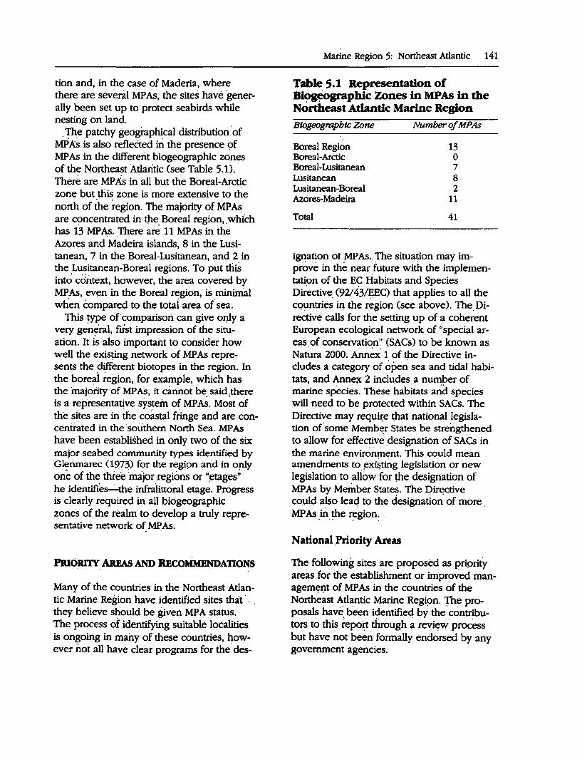
tion and, in the case of Maderia, where there are several MP As, the sites have generally been set up to protect seabirds while nesting on land.
. The patchy geographical distribution ·of MP As is also reflected iri the presence 9f · MP As in the differerit biogeographic zones of the Northeast Atlantic (see Table 5.1). · There are MP.& in all but the Boreal-Arctic zone but this zone is more extensive to the north of the region. The majority of MP~ are concentrated in tpe. Boreal region,. which has 13 MP As .. There are 11 MP As in the Azores and Madeira islands, 8 in the Lusitanean, 7 in the Boreal-Lusitanean, and 2 in the Lusitanean-Boreal regions. To put this intc;; cdntext, however, the area covered by MP As, ev<:!n in the Boreal region, is minimal when compared to the totai area of sea.
This type of comparisori' can give or:ily a very ge~eral, first impression of the situation. It is also important to consider how well the exis~g network of MP As represents the different biotopes in the region. In the boreai region, for example, which has the majority of MPAs, it cannot be said,there is a representative system of MP As. Most of the sites are in the coastal fringe and are concentrated in the ·southern North Sea. MPAs have been established in only two of the six major seabed community types identified by Glenmarec 0973) for the regipn and in o!lly one of the three ·major regions or "~tages" he identifie~the infra.littoral etage. Progress is clearly required in all biogeographic zones of the realm· to develop a truly representative network of MP As.
PRIORITY AREAs AND RECOMMENDATIONS ' .
Many of the countries in the Northeast Atlantic Marine Region have identified sites that · . they believe should be given MPA status. The process of identifying suitable localities is ongoing in many of these countries, 4owever not all have clear programs for the· des-
Marine Region 5: Northeast Atlantic 141
Table 5.1 Representation of Bi~graphic Zones in MPAs in the Northeast Atlantic Marine Region Blogeographtc Zone ·
Boreal Region Boreal-Arctic Boreal-Lusitanean Lusitanean Lusitanean-Boreal Azores-Madeira
Total
Number of MPAs
13 0 7 8 2
11
41
ignation ot MP As .. The situation may improve in the near. future with the implementation of the EC Habitats and Species Directive. (92/ 43/:E:EC) that applies to all the cquntries iQ. the region (see above). The. Directive calls for the setting up of a coherent, European ecological network of "special areas of conservation'.' (SACs) to be known as. Nan.tra 2000. Ann~x 1 of the Directive includes a category of ope~ sea and tidal habitats, and Anne?{ 2 inclu.des a number of marine species·: These habitats a~d species will need to be protected within SACs. The Directive may requ4"e ~at nati9nal legislation of'some Memb~r States be strengthened to allow for effective .designation of SACs in the marine environment. This could mean amendments to ~x~t~g legislation or new legislation to allow for the designation of MP As by Me~ber States. The Dir~ctive coµld also leaq to the designation of more . MP As Jn the region: .
National .Priority Areas
The following sites are proposed as priprity areas for the establishment or impro~ed manageµi~r;it of MP As in the countries of the Northeast Atlantic Marine Regi9n. The proposals have, been identified by the' contributors to this repoi:( through a revi~w· process but have not been formally endorsed by any government agencies.
142 A Global Representative System of Marine Protected Areas
Belgium
Proposed new MP As: No areas identified.
Existing MP As that require management support: ,,. Vlaamse Banken (Flemish Banks)
(51 °20'N, 3°00'E): A Ramsar wetland and EC Birds Directive site but not protected through national legislation. Includes inshore and offshore shelf waters and shoals. International importance for migratory birds, _some parts have a rich benthic fauna. Hunting prohibited but threats from fisheries, recreation sand extraction and pollution from outside the area need to be addressed (Peet and others 1993).
Denmark
Proposed new MP As: _ A number of sites are being considered
for MP A status but these are all on the Baltic coast of Denmark.
Existing MP As that require management support: ,,. Vadehavet Major Conservation Area:
(see section above for description).
France
Proposed new MP As: No known proposals for MPAs on the
Channel and Atlantic coasts of France.
Existing MP As that require management support:
No areas identified.
Germany
Proposed new MP As: Three possibilities for MP A status have
been identified at a meeting of the Baltic Ma-
rine Environment Protection CommissionHelsinki Commission-Environment Committee meeting in 199~. All of these are on the Baltic coast of Germany.
Existing MP As that require management support: ,,. Schleswig-Holstein: (see above for
description) ,,. Hamburgisches: (see above for
description) ,.- Niedersachsisches: (see above for
description) ,,. Helgola=nd: (see above for description)
lreklnd
Proposed new MP As: An EC funded smvey of marine habitats
and communities around the coast of Ireland is currently being undertaken under the auspices of the Office of Public Works. Apart from developing marine habitat classifications the survey will be identifying sites of marine nature conservation importance. The survey results will assist with the selection of marin~ sites that should be given protection under the EC Habitats Directive. Three sites have been mentioned as possible MP As to date . .,.. Lambay Islands (53°30'N, _6°W):
Cliffs, r~cky shore, sublittoral boulder and sand. Areas subject to stroqg cur:rents. Lambay Deep forms spectacular underwater topography <;>f geological interest. Important for seabirds. Colony of grey_ seals. Proposed Area of Scientific Interest by Meme and others (1990).
,_.,.... South Wexford coast (52°12'N, 6°33'W): Bays, rocky islands, soft sediment shores, shingle, lagoons, underwater cliffs, wave cut platform, hard and soft sediment. High concentration of important bird areas in the region, important nursery ground for fish. Maerl beds, kelp forest, seagrass. Grey
seal colony. Proposed coastal park with zoning scheme (Hurley 1991).
,.... Skellig Islands (51 °46'N, I0°32'W): Small Skellig and Skellig Michael are offshore rocky islands with steep cliffs: both above and below water. Abundant marine life. Small Skellig supports the second largest gannet colony in the world. Also important for other seabirds. Grey seal colonies.
Early results from the survey suggest that many parts of the west coast are likely to be of marine biological importance. The rich-· ness and diversity of islands, inlets, and bays such as the Aran Islands, Blasket Islands, Kenmare Bay, Kilkieren Bay and Mulroy Bay are likely to be worth exploring in more detail because of the variety of habi~t types, sheltered areas, tidal streams, and both rare and unusual habitats and populations. He~dlands provide a contrast and some, such as Black Head and St. John's Point in Donegal Bay, may be sites of marine biological importance.
Existing MP As that require management support:
No areas have been identified as_priorities.
Netherlands
Proposed new MPAs: The Directorate of Nature, Environment
and Fauna Management of the Ministry of Agriculture, Nature Management and Fisheries commissioned a study on the potential for marine protected areas in the North Sea . sector of the Netherlands. The report (Bergman, and others 1991) concluded that two areas within the Dutch sector of the North Sea qualify for protected status: the Klaverbank and an area directly northwest of the Frisian Islands. ~ Klaverbank: Currently part of the desig
nated Milieuzone Noordzee. The only gravel area of importance in the Dutch
Marine Region 5: Northeast Atlantic 143
sector of the North Sea, which has a relatively undisturbed benthic fauna. Proposed prohibition on fisheries and gravel extraction; controls on discharges from offshore mining installations.
..... Sea area northwest of Frisian Islands: Currently part of the designated Millieuzone Noordzee. A combination of benthic. communities ranging from coastal areas to Frisian Front. The area is an imp.octant spawning and nursery area for both commercial and noncommercial species of fish. Seasonal migration routes to and from the Waddensea are concentrated in this area. Large _numbers of·porpoises, dolphins and seabirds. Proposal to close area for all types of fisheries, and additional controls.
Existing MP As that require management support: ,.- D_ollard Natural Monument: (see above
for description) ,.- Waddenzee Natural Monument: (see
above for description)
Portugal
Proposed new MP As: No areas have been identified.
Existing MP As that require management support: ,.- Berlenga: (described above) ,.- Costa Vicentica e Sudoeste, Alentejano
.Azores
Proposed new MP As: The Department of Environment of the Re
gional Government of Azores is considering the designation of additional MP As. No sites have been proposed as yet but consideration may be given to at least some of the following sites (Santos, personal communication).
144 A Global Representative System o( Marine Protected Areas
Eastern group: • San Miguel-Caloura, Mosteiros
Central group: . • Terceira-Ilheus das Cabras and Ilheus dos
Fradinhos, Monte Brasil, Vila Nova-Ilheu Norte
• Graciosa-Ilheu da Praia, Baia do Carapacho-Ponta do Feliciano, Ponta Branca and Ilheu, Baia da Vitoria-Baia das Diagaves
• Sao Jorge..:Faja dos Cuberes-Faja do ·santo Cristo
• Pico-Ilheus da Madalena_, I.ages do Pico, north of the island
• Faial-Capelinhos, · Morro de Castelo Branco, 'Baia 'do Porto· Pim
Western group: • Flores-Porita Ruiva-Santa Cruz, Ponta
dos' Bi-edo-Ponta da Rocha Alta, Ilheu. da Gadelha
• ·Corvo
Existing MP As that require management support:
Management support to improve the effectiveness of the six existing MP As in the Azores is considered a high priority. ,_. Bays of Maia, South Lourenco, Anjos
and Praia around the island of Santa Maria
,_. Vila Franca Islet, Sao Miguel Island ,_. Formigas Islets and Dolabarat Bank ,_. Topo Islet, Sao· Jorge Island ,.. Lagoon of Santo Cristo, Sao Jorge Island ,,._ Monte da Gtiia, · Faial Island
Madeira
Proposed New MP As: No known pr~posed sites.
Existing MP As that require management support:· ,_.
1 Selvagem Grande
,_. Selvagem Pequena and Ilheu de Fora ,_. Garaja-µ ,,._ Ilheu Chao and Deserta· _Grande. ,_. Ilheu do Bugio
Spain
Proposed new MP As: No known· proposed sites on Atlantic
coast.
Existing MP As that require management suppqrt: ,,. Acantilado de Barbate Natural Park ,_. Donana National Park
United King~
Proposed new MP As: . ,..... Loch Sween (56°N, 5°40'W): Sea loch
.)fl west coast of Scotland .. Fjord.with series of basins and sills. Greatest biological diversity in "passes." Flora ~nd fauna typical of Scottish sea loch .. Pro_posed by the government nature conservation agency, now under Scottish Natural Heritage. Public cons{iltatlon in 199Q ·resulted in rejection of site ~ a s1:al1:Jtory Maripe Nature Reserve. Community liaison officer ~ow works. on site.
,.,... . Bardsey Island and Lleyn Peninsula (52°46'N, 4°48'W): 9ffsho~e island with good div~rsity of rocky shore habitats. Tide swept areas, spe<;ies' typical of both exposed and semi-exposed conditions. Proposed ·by gove~ment nature conserv~tion agency and now under Countryside Council for Wales. Proposals likely to include inshore waters around the mainland Lleyn pe~insula.
..,. Menai Strait (53°~'N, 4°20'W): 20-kilometedong channel with gradation of substrates and communities relating tq. changes in current speed. Gullies subject to strong· tides but sheltered from
· wave action support rich algae and se!ientary fau_na. Proposed by the government nature conserva~ion agency, nqw under Countryside Cou·ncil for Wales. Two public consultations regarding designation (in 1988 and 1992) the most recent of which is ongoing (Countryside Council for Wales 1992).
~ Strangford Lough (54°23'N, 5°32'W): Large, virtually land-locked marine inlet. Wide range of sublittoral .habitats grading from fine muds at head of the lough to bedrock and boulder~. Strong currents in narrows. More than 2.000·. marine specie~. recorded from' the . lough. One of the largest concentrations of common seal iri Ireland and one of the most important areas for overwintering birds in Ireland. Consultitions over designation by the Departinent of E_nvironment (Northern Irelanc;l) have };>~en ongoing for· more than five ye~rs (proposals issued in · 1991 and 1994) (DoE (NI) 1994).
..,.... Rathlin Island (55°17'N, 6°15'W): Proposed Marine Nature Reserve. Island in area of strong tidal streams. Deep channel to north of island forms vertical cliffs exposed to strong wave action and tidal currentc,.-unique in the British Isles. Many species near northern edge of range, unusual and ra.r:e species. Important seabird colonies. Unlike most of the west coast of Scotland, some areas of muddy gravel have not been extensively dredged and therefore have rich hydroid and bryoioan fauna (Erwin and others 1986).
Existing MP As that require management support:
Highest priority is given to the following two areas: ,,._ Lundy Marine Nature Reserve ,,._ Skomer and the Marloes Peninsula Ma
rine Nature Reserve
. Marine Region 5: Northeast Atlantic 145
Isle of Man
The rejection of proposals to designate a marine Nat,ure Reserve around the Calf of Man was a major setback for marine site designation around the Isle of Man. After considering the proposal, the .Calf Consultatory Committee supported the idea of a voluntary code to encourage good practice in the area rather than statutory controls. The Committee also recommended that the Isle of Man Government consider introducing a voluntary code. to be promoted for all territorial waters of the Isle of Man.
Marine b~ological surveys have identified and proposed sites for both voluntary and statutory protection around the Isle of Man (Geffen, Hawkins, and Fisher 1990). The Isle of Man Government agreed to progress the protection or' such sites at a major conference on the future of the Irish Sea, which was held in 1990. In light of the more recent decision not to proceed with plans for a Calf of Man Marine Nature Reserve, and because the EC Habitats and Species Directive does not apply to the Isle of Man, the future of statutory MP As for the Isle of Man is very uncertain.
Proposed new MPAs: ...., The Ayres (54°24'N, 4°27'W): Exposed
northwest coast of the Isle of Man. Rich shingle flora ~nd unique lichen heath. Important nearshore feeding ground for seabirds such as terns, shags, ganne~. Offshore a flat cobble area swept by strong tidal currents. Identified by Geffen, Hawkins, and Fisher 0990) as a suitable site for statutory protection within a broader conseryation zone.
..... Maughold (54°18'N, 4°23'W): Headland at the eastern most point of the Isle of Man. Maritime heath, rocky cliffs, shingle beach. Nears_hore habitats of bedrock and boulders. Important nesting
146 A Global Representative System of Marine Protected Areas
locality for guillemot, kittiwake, razorbill and other seabirds. Identified by Geffen, Hawkins, and Fisher 0990) as a possible voluntary conservation area or a small statutory reserve within a larger voluntary conservation area .
......, Derbyhaven/1..angness (54°4'N, 4°37'W): Two bays and a narrow peninsula. Encompasses the full range of intertidal· habitats around the Isle of Man. Most significa·nt area on the Isle of Man for wintering shorebirds. Bays have some of the richest fauna of the more sheltered Mame beaches. Rocky shores dominated by wracks and supporting dense beds of Ascophyllum nodosum. High level rock pools contain interesting assemblages of brackish water species. Identified by G~ffen, Hawkins, and Fisher (1990) as suitable site for statutory protection.
~ Scarlett· Point: Moderately exposed limestone shore with ledges and brackish pools. Kelp forest. Intertidal communities and fringing habitats considered to be of ecological importance in the context of.the Isle of Man. Identified by Geffen, Hawkins, and Fisher 0990) as possible voluntary MPA.
......,. . Port St. Mary Ledges (54°5'N, 4°42'W): -Moderately exposed limestone shore. Some of the richest fauna of the more sheltered Mame beaches. Adjacent sandy areas important flatfish nursery ground. Identified by Geffen, Hawkins, and Fisher 0990) as suitable site for voluntary MP A.
.,... Port Erin Bay (56°6'N, 4°45'W): Moderately exposed sandy bay. Extensive rock outcrops of boulders and bedrock offshore. Typical soft sediment communities, nursery grounds for flatfish, intertidal communities considered to be of ecological significance. Long history of scientific research. Identified by Geffen, Hawkins, and Fisher (1990) as possible voluntary conservation area.
..,.... Calf of Man (54°2'N, 4°50'W): Island 400 meters off the southwestern tip of the Isle of Man. Marine communities representative of those found on hard substrates and coarse sediments in Mame waters and Irish Sea in general. Rich and varied flora and fauna. Possibly one of the best tide-swept habitats in the Irish Sea. Basking Shark congregate in the area in large numbers in early summer. Rare bryozoan species reported. Seacliffs important for breeding seabirds and chough. Failed to receive statutory protection. Current proposals likely to be limited to voluntary code of practice. (Department of Agriculture, Fisheries and Forestry 1992) .
..,... Niarbyl (54°10'N, 4°46'W): Exposed shore, offshore cobble, pebble and gravel as well as bedrock and·boulders. One of two sites in the Isle of Man known for maerl beds. Considered to be a site of ecological significance for the Isle of Man. Identified by Geffen, Hawkins, and Fisher 0990) as suitable site for voluntary MP A.
Channel Islands
The extensive intertidal zone in Jersey (up to 12 meters) includes a high diversity of habitats and species. The importance of the shoreline for birds has been highlighted by Pritchard and others 0992) who make particular reference to· its value for ringed plover,· grey plover, sanderling and turnstone. There are also marine species at the northern edge of their range.
There are no proposals for MP As around Guernsey although L'Eree may be used to promote marine education and interpretation. There may also be opportunities to support some of the ideas of MP As through other legislation. The Fishing Ordinance 0988) is under review and an amendment, proposing that the Island's Sea Fisheries
Committee be given the power to ban fishing in any area, at any time is being considered. The policy on the control of diving for certain species is likely to b.e liberalized, but the ban on export of sand eels from the Bailiwick's territorial waters. will continue as will enforcement of the additional minimum sizes for species riot contained in the EC regulations.
Proposed new MP As: ...,... Portelet Bay, Jersey (49°10'N, 2°11'):
Proposals are currently being developed to designate this area as a Marine Nature Reserve. Includes a mixture of sheltered and exposed rocky shore with sand dwelling communities between rocky areas. Survey work has recorded 261 species of fauna and 187 species of algae (Culley and Romeril, in press).
Regional Priority Areas and Other Recommendations
The brief consideration of MPAs in this paper suggests that a more extensive network of MP As is required. to adequately represent the marine biogeographic zones and biotopes in the.Northeast Atlantic Marine Region. However, it is also critically important to ensure that those sites that are already MP As are giving adequate protection to the marine wildlife and habitats within their boundaries. In this regard it is relevant to note, for example, that none of the MPAs in the region has regulations or voluntary codes that give complete protection to the wildlife within the protected areas or that prohibit all potentially damaging activities taking place within the boundaries of the · MPAs.
Existing MP As cover a very small area of the Northeast.Atlantic even though it is widely recognized that a viable MP A is likely to be many times larger than the minimum viable size of a terre~trial reserve (Kelleher
Marine Region 5: Northeast Atlantic 147
and Kenchington 1991). In the case of the U.K.,.for example, less than 50 square kilometers has .statutory protection out of a potential one-third million square kilometers of territorial sea. The Waddensea is the only area that is well represented with virtually the whole region covered by protected area designations. Overall, the emphasis is on establishing MP As in coastal localities as these are the .most productive regions and also under the most immediate threat from human activity. The EC Habitats Directive, which calls for the protection of Special Areas of Conservation in both the terrestrial and marine environment, should help advance the MPA programs in the countries of the Northeast Atlantic Marine Region.
Priority action should be based on improving protection: of existing sites and expanding the network. Several sites are worth specific mention in this respect.
The Waddensea is the largest unbroken stretch of intertidal mudflats in the world and, although not particularly rich in species (some 250), it is extremely productive. In terms of biomass it has been considered equivalent to rainforests and estimated to be one of the most important wetland areas in the world. The tidal flats are of global importance for birds with an average of around 10 million birds passing through the region each year. The Waddensea is also a very important nursery ground for numerous fish species with an estimated 80 percent of the plaice, 50 percent of the sole and 40 percent of the herring caught in the North Sea. The sandbanks are also extensively used by common seals as breeding and haul-out sites; however, numbers fell dramatically in the late 1980s following a viral epidemic. The area is already designated a national park under the legislation of the three countries whose territories it extends over, however, there is a need for more stringent measures both within these reserves and outside their boundaries to maintain the richness of this environment. Heavy metals and many other toxic substances are washed into the Wad-
148 A Global Representative System of Marine Protected Areas
densea from both land and other parts qf the North Sea. There is also. an increasing danger of eutrophication from nitrates and phosphates causing algal blooms and leading to oxygen deficiency. The Waddensea borders one of the world's busiest shipping lanes, with continuous low-level discharge of oil and chemicals posing a threat as well as the ever.:present danger of larger spills.
Investigations into potential MP As in the Dutch sector of the North _Sea have recommended two sites--an area directly northwest of the Frisian Islands, and the Klaverbank. The first of these encompasse~ a range of benthic commupities typical of · sandy and muddy seabed as well as gravel. and crossing the Frisian Front. The area is an important spawning and, nursery area for both commercial and noncommercial species. of fish. Seasonal migration routes to and from the Waddensea are·coricentrated in this are:,i while relatively larg~ ~u~b~rs of por"'. poises, dolphins and seabirds occur in the · area. The' second site, the Klaverbank is the only gravel area of imp.ortance in tl)e Dµtch sector of the North Sea and ~till has a rela~ tiyely undisturbed benthic fauna.
Vlaamse Banken is located in the North Sea within Belgian territorial waters between Dunkerque and Ostend,. The area is desig- . nated as a Ramsar site: and as an EC special protection ~rea. The site includes the lowest zone of the beach, extending up to several . kilometers offshore and incluc;ling a series of shallows, some parts of which .include a ri~h benthic fauna.
i:wo sites that have been singled out on the North Ireland coast as potential MP As, . Strangford Lough and the waters around Rathlin lsland, .require urgent designation. Strangford Lough· is a narrow fully marine inlet connected to the ~~a via a narrow channel. It extends over some 150 square kilometers and is more' than 30 kilometers long. The western shore is. bordered by drumlins that form the many .islands of the lough and the shelter. from w_av:e action has led to a gradation of sublittoral habitats from
fine muds, at· µie head of the lough, to bedrock and boulders in the narrows. There are strong currents, up to 8 knots, whirlpools and ov:erfalls in the narrows with steep sublittoral cliffs marking the. entrance to the lough. The range of sublittoral communities include Dublin Bay prawns (Nephrops noroegicus), Horse Mussel beds (Modiolus modiolus) that support a particularly rich assemblage of spec.ies, and current exposed bedrock communities with sponges, soft corals and anemones in abundance.· The lough was once famous for its Skate (Raja batis) and, although these have almost disap:peared, Tope (Galeorbinus ga/eus) can still be seen on occasions with females coming. into the Lough to "pup." More than 2,000 marine species have been found in the. lough that also supports one of the largest . concentrations of common seal (Phoca vi-· tulina) in IrelaJ?,d and holds. over two-thirds of the west European population of Pale Bellied Brent Geese (l~ranta bemicla hrota) on their arrival fl'.Om breeding grounds in Arctic· Canada. The lough has been u'nder consideration- for: MPA status• since the 1980s but due to disputes over how it, might be managed _it remains undesignated. The situation requir~s urgent attention because of continuing damage to seabed communities while disc~~sions over-designation go on for many years. Sul;,stantial areas of the rich Horse Muss.el beds have.already been lost due to trawUng for Queen Scallops. The continuing ciestructiqil of these beds has serious implications for both tll.e fishery and the diversity of the.iria~ine life in the sea locQ.
In Gre~t Britain seven sites were proposed forMPA status in 1981 and two of these have been established. The level of protection is minimal in these areas, especially from fisheries. There is concern about damage to wildlife from -gill netting and potting in the Skomer reserve, for example, and over the limitations on fisheries in the Lundy reserve that are virtually identical to the situation before designation. Protection of marine wildlife and habitats in these sites must
be improved. Furthermore, progress is needed with the statutory designation programme that has virtually come to a halt. At the moment, most opportunity exists to set -up an MPA in the Menai,Straits, a 20-kilometer long channel that separates the island of Anglesey from the North Wales coast. A second series of consultations over the .designation of this site is currently underway.
. The MP As that have been established around the islands of Madeira have both terrestrial and marine components. Two par-· ticularly important areas, where strong safeguards are needed, are the· MP As around Ilheu Chao/Deserta Grande and Ilheu do Bugio, which are important sites for the endangered Mediterranean monk seal.
In Spain the Donana National Park, although predominantly a wetland site, is of. European importance and is seriously threat-· ened, mainly by activities occurring·beyond the boundaries of the park.
In the case of-the Isle of Man, priority should be given to the establishment of an MP A around the Calf of Man. The marine ·en.:. vironment of the Calf is considered to be in a virtually undisturbed state: Steep slate cliffs above sea level grade into a seabed of boul~ ders, · cobbles and sandy gravel: The waters around the Calf support communities representative of those found on hard substrates and coarse sediments in Manx waters and the Irish Sea in general. -The varying degrees of exposure to tides, currents and wind provide a variety of habitats. These allow establishment of a large number of communities such as sessile filter feeders, extensive kelp forest, unusually extensive beds of Flustra foliacea, large areas of sand dwelling communities and an abundance of Tubularia indtvisa. The Calf Sound probably represents one of the best tide-swept habitats in the Irish Sea and, during the early summer,' Basking Shark (Centorhinus maximus) congregate in the area in large numbers. Rarebryozoan species that have only been reported in the literature on a few occasions this century have been observed in the area.·
Marine Region 5: Northeast Atlantic 149
Attempts to give the area statutory protection have made little progress and protection may how be limited to voluntary agreements. This site should be given priority for MPA designation in the Isle of Man.
In· Ireland, the variety of the Wexford coast has long· been appreciated and an area on the southeastern part, from Hook Head to Garnsore Point, including the Saltee Islands, has been ·highlighted as a possible Coastal Park.: The area is of international importance for its seabirds whilst the seabed includes muds, ·sands gravel, cobbles and wave-cut platforms ·as well as almost vertical cliffs. The area is ari important nursery ground for some fish.
The EC-funded BioMar survey has started to collate m·arine biological information for the coast and nearshore waters around Ireland: Preliminary results have pinpointed island groups, inlets and 'bay's, headlands and stretches of ope·n ·coast as being of particular value and worth considering in any network of MP As. The overview provided by this survey will be an' important context in which to select sites for protection and, for the next stage, detailed investigations and suggestions on how they should be protected will need to be prepared for a short list of sites.
These and the other sites listed in this section should be incorporated info MP A designation programs but there is also a need to improve the protection of sites that are already designated. The list of suitable sites for designation should also be updated on a regular basis as more information becomes available through the marine survey programs that are being undertaken in a number of countries within the region.
Conclusions
The two main areas for future action on MP As in the region should be to: • Improve the effectiveness of existing
MPAs • Expand the network of sites.
150 A Global Representative System of Marine Protected Areas
This is necessary in all countries in the region; however, the following suggestions are made for priority action.
Existing MP As that require management support: ,..
•
•
•
•
•
•
•
Waddensea Coast (Denmark, Germany and the Netherlands): Vadehavat Major Conservation Area (Denmark) Hamburgisches National Park ( Germany) Niedersaechsisches National Park (Germany) Schleswig-Holsteinisches Wattenmeer National Park (Germany) Helgolaender Felssockel Nature Reserve (Germany) Dollard Natural Monument (Netherlands) Waddenzee Natural Monument (Netherlands) Lundy Island and Skomer Island (United Kingdom) MP A sites in the Azores (six areas) (Portugal, Azores) Vlaamse Banken (Belgium) Donana National Park (Spain) Ilheu Chao/Deserta Grande and Ilheu do Bugio (Madeira, Portugal)
Proposed new MP As: ~ Strangford Lough (Northern Ireland,
United Kingdom) ....,. Rathlin Island (Northern Ireland,
United Kingdom) ..,,. Calf of Man (Isle of Man, United King
dom) .,.... Klaverbank (Netherlands) ,..... NW of Frisian Islands (Netherlands)
In some areas of the region there is insufficient information to make recommendations for priority action. The identification of further sites and the development of MP A programs in these areas are required. Areas of high priority in this regard are the Atlantic coast of Spain, the Atlantic and Channel
coast of France, Madeira, Portugal and the Channel Islands.
The establishment of no-exploitation MP As in the region is also considered a high priority. In 1993, at a meeting of environment ministers from countries surrounding the North Sea (part of a series of International Ministerial Conferences on the North Sea) it was agreed that the idea of no-exploitation areas should be given due consideration. _This approach is currently being considered for the Klaverbank and Frisian front proposals from the Netherlands but should also be taken forward by other countries in the realm as one of the options in their MPA programs.
BIBLIOGRAPHY
Bergman, MJ.N., H.J. Lindeboom, G. Peet, P.H.M. Nelissen, Nijkamp, and M.F. Leopold. 1991. Protected Areas in the North Sea-the necessity and possibilities. Amsterdam: Netherlands Institute for Sea Research.
Borgesen, F., and Jonsson, H. 1905. The distribution of marine algae of the Arctic Sea and the northernmost part of the Atlantic. In E. Warming, ed., Botany of the Faeroes based upon Danish investigations. Part M. Copenhagen.
Briggs, J.C. 1974. Marine zoogeography. New York: McGraw-Hill.
Brown, R. 1990. Strangford Lough. 1be Wildlife of an Irish Sea Lough. Belfast: Institute of Irish Studies/Queen's University of Belfast .
Countryside Council for Wales. 1991. Skomer Marine Nature Reseroe. Information pack .
--. 1992. Menai Strait Proposed Marine Nature Reseroe. Revised Consultation Document.
Daan, N., P.J. Bromley, J.R.G. Hislop, and N.A. Nielsen. 1990. Ecology of North Sea fish. Netherlands journal of Sea Research 26:343-68.
Department of Agriculture, Fisheries and Forestry. 1992. 1be Calf of Man. A proposed Marine Nature Reserve.
Department of the Environment (Northern Ireland). 1994. Strangford Lough. Proposed Marine Nature Reseroe. Guide to Designation. Belfast: DoE(NI) Environment Service.
Eckman, S. 1953. Zoogeograpby of the Sea. London: Sidgwick and Jackson:.
Etwin, D.G., B.E. Picton, D.W. Comnor, C.M. Howson, P. Gilleece, and M.J. Bogues. 1986. Tbe Northern Ireland Sublittoral Survey. Belfast: Ulster Museum.
English Nature. 1994. Important areas for marine wildlife around England. Peterborough.
Geffen, A.J., S.J. Hawkins, and E.M. Fisher. 1990. 1be Isle of Man. Section 2.5. of the Irish Sea Study Group Report (Part 1: Nature Conseivation). Irish Sea Study Group. Liverpool: Liverpool University Press.
Glenmarec, M. 1973. The benthic communities of the european North Atlantic continental shelf. Oceanography and Marine Biology. Annual Revies. 11:263-89.
Gubbay, S. 1988. A coastal directory for marine nature conseroation. Marine Conseivation Society.
---. 1993 Marine Protected Areas in European waters. The British Isles. A report for AIDEnvironment from the Marine Conseivation Society. BIOMAR project (LIFE 92-l/lRUOOOl).
Hayden, B.P., G.C. Ray, and R. Dolan. 1984. Classification of coastal and marine environments. Environmental Conseroation 11(3): 199-207.
Hiscock, K. 1991. Benthic marine ecosystems in Great Britain: A review of current knowledge. Introduction and Atlantic-European Perspective. Nature Conseivancy Council, CSD Report No.1170. Peterborough: Nature Conservancy Council.
Hurley, J. 1991. South Wexford Coast National Park. A Proposal. Irish Wildbird Conseivancy.
Kingstone, P.F., and E. Rachor. 1982. North Sea level bottom communities. C.M. 1982/L:41. ICES.
Lee, A.J., and J.W. Ramster. 1981. Atlas of the seas around the British Isles. Lowestoft: Ministry of Agriculture, Fisheries and Food.
Mackie, A.S.Y. 1990. Offshore benthic communities of the Irish Sea. In 1be Irish Sea: An environmental review (Part 1: Nature conseroation). Liverpool: Irish Sea Study Group, Liverpool University Press.
Meme, OJ., M.J. Costello, and R.M. Allen. 1990. The Irish Sea Coast of the Republic of Ireland. In 1be Irish Sea: An environmental review
Marine Region 5: Northeast Atlantic 151
(Part 1: Nature conseroation). Liverpool: Irish Sea Study Group, Liverpool University Press.
Mitchell, R.C. 1987. Conseroation of marine bentbic btocenoses in the North Sea and Baltic. Nature and Environment series No. 37. Council of Europe Publications.
Myers, A.A., C. Little, M.J. Costello, and J.C. Partridge. 1991. 1be ecology of Lough Hyne. Dublin: Royal Irish Academy.
Nature Conseivancy Council. 1988. Lundy Marine Nature Reseroe.
Nijkamp, H., G. Peet, M. Bus, and A. Nollkaemper. 1993. Marine protected areas in Europe: Country pro.files. Report of a study within the framework of the BioMar project (3 vols.). LIFE92l/lRU001.
North Sea Task Force. 1993. North Sea quality status report 1993. London: Oslo and Paris Commissions.
Peet, G., H. Nijkamp, J. Rossum, C. Slegtenhorst, M. Bus, A. Nolkaemper, and S. Gubbay, eds. 1993. Marine protected areas in Europe: MPA descriptions. Report of a study within the framework of the BioMar project (3 vols.). LIFE92-l/IRUOO 1.
Picton, B.E., B.J. Ball, M. Bowler, and C.M. Howson, eds. 1994. The Marine Conseroation Society and Ulster Museum Directory of Marine Flora and Fauna.
Pingree, R.D., and D.K. Griffiths. 1978. Tidal fronts on the shelf sea areas around the British Isles. Journal of Geophysical Research 83: 4615-22.
Pritchard, D.E., S.D. Housden, G.P. Mudge, C.A. Galbrath, and M.W. Pienkowski, eds. 1992. Important Bird Areas in the U.K. including the Channel Islands and the Isle of Man. Sandy: Royal Society for the Protection of Birds.
Reille, A. 1987. Cb. Bonnin Luqout, Guide des Reseroes Naturelles de France. Paris: Delachaux and Niestle, Neuchatel.
Salzwedel H., E. Rachor, and D. Gerdes. 1985. Benthic macrofauna communities in the German Bight. Veroffent/ichungen des Institutsfur Meeresforscbung in Bremerbaven 20:199-267.
Tucker, G.H., M.F. Heath, L. Tomialojc, and R.F.A. Grimmett. 1994. Birds in Europe: 1beir conseroation status. BirdLif e Conseivation Series 3. Cambridge, U.K.

MARINE REGION 6 Baltic
Lars-Erik Esping and Gurli Gronqvist
BIOGEOGRAPHY AND MARINE BIODIVERSITY
The Baltic Marine Region includes the Baltic Sea area and the Skagerrak Sea. Coastal areas of the following countries are included: Denmark, Estonia, Finland, Germany, Latvia, Lithuania, ~orway, Poland, Russia and Sweden.
The Baltic Sea is one of the world's smallest seas. In many respects it is similar to an inland sea or an estuary, being almost entirely cut off from the open ocean. Its only links with more open sea areas are the Sound ( 6resund) and the Danish Belts-the Great and Little Belts. Of these straits, the Great Belt is the widest, and about twothirds of the water flowing to or from the Baltic Sea passes through it. The Little Belt is very narrow, and the majority of the remaining flow occurs through the Sound.
The Belts, together with adjacent sea areas to the north and south, including the Kiel and Mecklenburg Bights (Germany), are usually referred to collectively as the Belt Sea.
The Baltic Sea area includes the whole of the Kattegat, which is greatly influenced by
153
the outflow of brackish water from the Baltic. To the north of the Kattegat is the Skagerrak, which is usually regarded as part of the North Sea. There is no clear boundary between the Kattegat and the Skagerrak.
Oceanography
Much of the following introductory information is based on Voipio 0981).
The Baltic Sea has an area of approximately ~74,000 square kilometers and an average depth of 57 meters, although there are a number of basins where the sea reaches depths of 200-450 meters.
Over the last 12,000 years the Baltic has alternated several times from being a large freshwater lake to becoming a marine sea, before becoming the brackish marine area of today. Although there are periodic and ecologically significant inflows of saline water through the Kattegat, the majority of the Baltic's water comes from the many rivers of bordering countries.
The drainage basin of the Baltic Sea is more than four times the area of the sea itself. River inflow totals about 430-470 cubic
154 A Global Repre~en~tlye System of Marine Protected Areas
kilometers, with the ridrthem: areas,contributing the greatest 'proportion of the 'total.inflow: some 32 percent into the Gulf of Bothnia and 24 percent. into the Gulf of Finland. Inflow is subject to considerable longterm varja~ility. There is. also marked seasonality in river runoff, with maximum discharge occurring in April-June as a result of thawing, and the minimum in JanuaryFebruary. It appears that annual precipitation over the whole Baltic Sea roughly equals evaporation so that freshwater input can be equated to river runoff (although there are regional and seasonal departures from this pattern).
The input of freshwater to the J3altic Sea generates an outgoing, low-salinity (mean of 8.7°100) surface current into the Kattegat and North Sea. There is an incoming bottom current of higher salinity (mean of 17.4°100). Persistent westerly winds can generate voluminous short-term inflows of higher salinity. The interval between such episodes may be several years, but their ecological implications can be very significant.
Between the low-salinity outflow and higher salinity inflow is a permanent pycnocline..(a layer 9f water exhibiting a i:eiatively rapid increase in density with increasing · depth) comprising a primary halocline (a layer exhibiting a relatively rapid increase in salinity with increasing depth) usually rein-. forced by a thermocline (a layer exhibiting a relatively rapid decrease in temperature with increasing depth). The pycnocline occurs at a depth of about 10-20 meters in the Belt Sea and Oresund, 35--40 meters in the Arkona Basin, and 65-70 meters in the C(!ntral Baltic proper. Surface salinity varies from, for example, 1-3°100 in the Bothnian Bay, 4-60100 in the Bothnian Sea, and 6--80100 in the Baltic proper. Bottom salinities are around 4°100 in the Bothnian Bay and 10-18°100 in the Baltic proper. Occasionally, as a result of a major inflow from the Kattegat,.a secondary halocline develops at 110-130 meters depth. In such instances bottom water salin-
ity may reach 20°100 in the Bornholm Basin and 1l o/oo in the western Gotl;md Basin.· . straiification of the water column forms
barriers that prevent oxygenated surface :water from mixing downward in the water c;olumn. The variations in salinity and the stratification of the water masses profoundly influence the distribution of plant and animal species: throughout the Baltic Sea.
The surface water temperature in the Baltic proper ranges from about 1-2°C in February-Marc:h to about 16-17°C inJuly-August. In the Bothnian Bay the range is about from 0°C to 14-15°C. In the central Baltic proper the annual range at 30 meters depth is about from 1-10°C and, at 60 meters, from 2-5°C. Over most of the Baltic_ Sea, a spring and summer thermocline forms at depths between 15 and 20 meters. The Bothnian Bay usually becomes completely ic;e-covered in January. Complete ice cover normally also occurs in the coas~l zone down to the Aland Sea and. along the inner parts of the Gulf of Finland and Gulf of Riga.
Long-term variation in the inflow of higher salinity water from the Kattegat appears to have resulted in an overall increase in the temperature and salinity of the deepwater of the Baltic proper, at least since the beginning of the century. There are differences according to area, but the increases are about 0.6-2.7°G and O.S-1.7°100. During this period there has also been a decrease in the oxygen concentration of the deepwater in the Baltic proper, from about 3 ml 0/1 to zero, producing stagnant or semi-stagnant conditions in the deep basins for long periods. This condition has probably been caused by an increase in the frequency of inflows from the North Sea, combined with increased oxygen consumption of the sediment possibly induced by increased organic pollution.
One of the main characteristics of the Baltic is the salinity gradient running from north to south, with low salinity in the Bothnian Bay and high salinity in the Skagerrak. The
distribution of marine flora and fauna follows this salinity gradient. The Baltic Sea is unique in that there are areas where freshwater, brackish water and marine species are all present. Many of the marine species are at the inner limit of their distributions.
Coastal Geography and Geology
Brief descriptions of terrestrial coastal geography are provided for each of the biogeographic zones in the section dealing with biogeographic classification.
A characteristic feature of the geomorphology of the Baltic Sea is the presence of basins (in most cases filled with Quaternary sediments) separated by shallow sills. the deepest is the Landsort Depth north of Gotland ( 459 meters). On average, however, the Baltic Sea is shallow, with a mean depth of -only 57 meters.
In the region of the Danish Straits and the Sound (the 6resund) bottom sediments consist mainly of sand and moraine, but with some mud in the deeper areas, and bedrock exposed in areas subject to high-velocity currents. In the southern and central parts of the Baltic Sea muds generally dominate the deeper parts, while sandy sediments occur along the southern and eastern coastal zones. In the northern Baltic Sea, sand and silt deposits occur around Gotland, Hiiumaa, Saaremaa and Aland, whereas in deeper areas, below 80 meters depth, soft bottoms occur. The northern part of the Baltic proper is composed largely of a complex mosaic of hard and soft bottom areas. The Gulf of Finland is also characterized by an extremely varied distribution of bottom types. Along the coast of Sweden and Finland, hard bottoms separated by minor soft-bottom areas are present. Along the Finnish coast, hardbottom areas also predominate. Extensive· glacial drift deposits occur in the northwestern part of the Bothnian Sea. In the Bothnian Bay sand predominates in the northeastern part, while muddy sediments
Marine Region 6: Baltic 155
predominate in the deeper central and western areas.
Another very characteristic feature of the geomorphology are the archipelagos along the Swedish and Finnish Baltic Coasts. They are mostly formed as a peneplain sloping gently toward the open sea, which is crossed by fissure valleys with sediment bottoms separated by ridges of rock. In the larger archipelagoes, such as those outside Stockholm and Turku (Abo), there are a multitude· of islets, rocks and skerries and some bigger islands (for example, about 30,000 in the ·Stockholm archipelago). These archipelagos have a rich flora and fauna; in particular a great numb~r of ducks and waders breed there. . Also specific for the region is the phenom
ena of crustal- uplift and submergence. In the Bothnian Bay crustal uplift is 9 millimeters per year, in the south of the Baltic proper the uplift is zero, while in the Belt Sea there is crustal submergence.
Ecosystem Diversity
Descriptions of each of the biogeographic zones are provided in the section on biogeographic classification. A list of the species fouria is provided in Appendix 6.1.
.Benthic Fauna
The main soft-bottom macro benthic communities are Abra alba, C)Prina-Astarie, Macoma and Pontoporeia affinis.
The Abra alba community is mostly confined to areas of the Belt Sea. ln muddy sediments deeper than around 15 meters it has been described in Kiel Bay and in Lubeck Bay. Sp~cies such as Hydrobia ulvae, Mysella bidentatd, Abra alba, Hannonthoe impar, Peloscolex benederii and Diastylis ratbkei are the most abundant.
The C)Prina-Astrate·community occurs in the western areas of the Baltic where the biomass can be dominated by C)Prina is-
156 A Global Representative System of Marine Protected Areas
/andica and Astarte borealis. This community can be considered a ,modification of the Abra alba community or Macoma calcarea C(?mmUQ.ity.
Macoma communities (M. baltica and M. calcerea) inhabit a range. of sediments independently of depth and are common in the Baltic. They have different tolerances to salinity and temperature variations. The M. calcarea community is found in parts of the Belt Sea at depths of more than 15 meters and associated with sandy and muddy sediments. It is also found further east in the Borriholni Basin together with Astarte spp. and Cyprina islandica.
The M. · baltica community is found in much of the remaining areas of the Baltic (Arkona Sea, Bornholm Sea, Northern Baltic proper, Gulf of Riga, Gulf of Finland, Archipelago Sea, Aland Sea). In the northwest Bornholm Sea at 5-79 meter depths the fauna is characterized by, for example, M. baltica, Diastylis ratbkei, Harmontboe sarsi and Halicryptus spinulosus. Pontoporeia affinis and P. fermorata are abundant at 40-50 meter depths·. The M. baltica community in the southern Bothnian Sea also contains Potaniopyrgus jenkinsi and Tbeodoxus fluviatilis as conspicuous species.
The Pontoporeia affinis community occurs mainly in the Gulf of Bothnia where good oxygen-conditions are present. The domi- · nant spedes is P. affinis but Macoma baltica and Mesidothea entomon also occur. In the northwest Baltic proper, parts of the Gulf of Finland, the Gulf of Riga, and northern half of the Central Basin, the community also contains Harmothoe sarsi, Halicryptus spinulosus and Pontoporeia femorata. At shal- · lower depths on predominantly sandy bottoms; P. affinis and M: entomon are most common, while on the siltier, deeper bot- · toms P. femorata predominates ..
In the deepest parts of the Bornholm Basin, Danzig Basin, Central Basin, Kiel Bay; and Gulf of Finland, long periods of unfavorable oxygen conditions occur. In these parts · impoverished low-diversity communities are
found. These are dominated by polychaetes such as Harmothoe sarsi, Scoloplos armiger and Capitella capitata. ·
Bentbic Vegetation
Southern Baltic The southern Baltic has a variety of hard and soft-bottom vegetation ·types. Along southern and southeastern coasts that are less sheltered, the vegetation is more impoverished than that in southwestern areas. The southwestern Baltic forms a transitional area between the North Sea and the Baltic proper. In this area many algal species occur at or near their distributional limit. In areas .with suitable substrata, benthic vegetation can be found to depths of approximately 30 meters.
On a hard substratum a typical vegetation profile includes blue-green algae, Ulotbrix or Barigia, Enteromo,pha, Po,phyra, Urospora, Fucus vesiculosus, Dumontia, Scytosipbon, Ceramium, Polysipbonia and La.maria.
The presence of Zostera marina is characteristic on soft sediments in the southwestern Baltic at depths of about 2.5-6.5 meters.
Northern Baltic Proper and Archipelago Sea Substrata in the northern Baltic proper and the Archipelago Sea include a complex mosaic of bedrock and boulder shores in the more exposed localities and sheltered muddy bottoms. In the northern Baltic proper, the benthic vegetation reaches depths of about 18-25 meters.
The vegetation on a typical semi-exposed rocky shore includes species in the geolittoral zone: Verrucaria maura, Calotbrix scopulorurri, Ulotbrix subflaccida and Urospora penicilliformis. The hydorlittoral zone largely corresponds with a belt of filamentous algae including Enteromo,pba, Cladophora glomerata and Dictyiphon foenicu/aceus. In the sublittoral zone there is an upper belt with Fucus vesiculosus and also Pi/aye/la littoralis, Ectoca,pus siliculosus, Ceramium tenuicorne and Stictyosiphon and
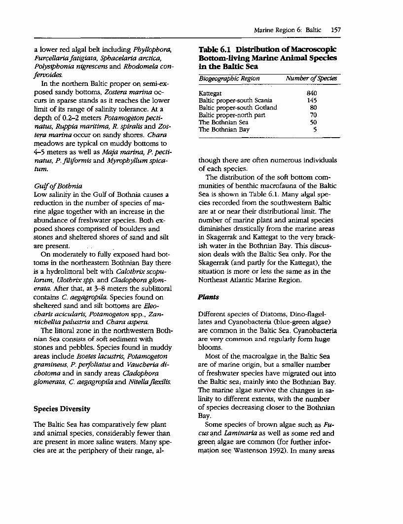
a lower red algal belt including Pbyllopbora, Furqellaria fatigiata, Sphacelaria arctica, Polysipbonia nigrescens and Rbodomela conferooides.
In the northern Baltic proper OQ semi-exposed sandy bottoms, Zostera marina occurs in sparse stands as it reaches the lower limit of its range of salinity tolerance. At a depth of 0.2-2 meters Potamogeton pectinatus, Ruppia maritima, R. spiralis and Zostera marina occur on sandy shores. Chara meadows are typical on muddy bottoms to 4-5 meters as well as Maja marina, P. pectinatus, P. filiformis and Myrophyllum spicatum.
Gulf of Botbnia Low salinity in the Gulf of Bothnia causes a reduction in the number of species of marine ~lgae together _with an increase in the abundance of freshwater species. Both exposed shores comprised_ of boulders and stones and sheltered shores of sand and silt are present. .
On moderately to fully exposed hard bottoms in. the northeastern Bothnian Bay thereis a hydrolittoral belt with Calotbrix scopulorum, Ulotbrix spp. and Cladophora glomerata. After that, at 3-8 meters the sublittoral contains C. aegagropila. Species found on shelter:ed sand and silt bottoms are Eleocharis acicularis, Potamogeton spp., Zannicbellia palustria and Chara aspera.
The littoral zone in the northwestern Bothnian Sea consists of soft sediment with stones and pebbles. Species found in muddy areas include Isoetes lacustris, Potamogeton gramineus, P. perfoliatus and Vaucheria dtchoto_ma and in sandy areas Cladophora glomerata, C. aegagropila and Nitella flexilis.
Species Diversity
The Baltic Sea has comparatively few plant and animal species, considerably fewer than are pre~_ent in more saline waters. Many species are at the periphery of their range, al-
Marine Region 6: Baltic 157
Table 6.1 Distribution of Macroscopic Bottom-living Marine Animal Species in the Baltic Sea
Btogeographtc Region Number of SpeC'ies
Kattegat 840 Baltic proper-south Scania 145 Baltic proper-south Gotland 80 Baltic proper-north part 70 The Bothnian Sea 50 The Bothnian Bay 5
though there are often numerous individuals of each species.
The distri~ution of the soft bottom communitie~ of benthic rp.acrofauna of the Baltic Sea is shown in Table 6.1. Many algal species recorded from the southwestern Baltic are at or near their distributional limit. The number of marine plant and animal species diminishes drastically from. the marine areas in Skagerrak and Kattegat to the very brackish water .in the Bothnian Bay. This discussion deals with the Baltic Sea only. For the Skagerrak (and partly for the Kattegat), the situation is more or less the same as in the Northeast Atlantic Marine Region.
Plants
Different species of Diatoms, Dino-flagellates and Cyanobacteria (blue-green algae) are common in the Baltic Sea. Cyanobacteria are very common and regularly form huge blooms.
Most of the, macroalgae in. the Baltic Sea are of marine origin, but a smaller number of fres};iwater species have migrated out into the Baltic sea; mainly into the Bothnian Bay. The marine algae survive the changes in salinity to different extents, with the number of species decreasing closer to the Bothnian Bay.
Some species of brown algae such as Fucus and Laminaria as well as some red and green, algae are common (for further information see:: Wast~nson 1992). In many areas
158 A Global Representative System of Marine Protected Areas
of the Baltic Sea areas, bladderwrack has disappeared and has been replaced by filam~ntous algae due to poorer light conditions, an effect of eutrophication.
Invertebrates
A few marine species of zooplankton and benthos live in the Baltic Sea together with brackish water species. In addition there are a number of freshwater species that can survive in brackish water.
In the Baltic proper, mussels frequently make up 90 percent of the biomass on shallow bottoms, but in the Bothnian Bay they are entirely absent. Freshwater mussels are found in the inner part of the Bothnian Bay.
There are no starfish and sea urchins in the Baltic Sea, and Aurelia aurita is the only jellyfish present.
Fish
There are still plenty of salmon in the Baltic Sea, but the wild salmon have a precarious existence. In the 1940s all salmon in the Baltic were wild, but currently 85 percent are bred. Because most rivers flowing into the Baltic have been dammed to provide hydropower, impeding the migration of Salmon to their spawning grounds, salmon hatcheries now provide most of the stock.
Other fish in the Baltic of economic value are cod, herring, flatfish, and others such as pike and perch that were originally freshwater species.
Birds
The Baltic is an important area for birds, particularly in the shallow coastal lakes and lagoons in the south, and further north, in the thousands of islands of the archipelagos on the Finnish and Swedish coasts. Typical bird species include cormorant, mute swan, grey lag goose, goosander, red-breasted merganser, shellduck, mallard, tufted duck, eider, velvet scoter, common gull, herring gull,
great black-backed gull, common tern, arctic tern and waders such as oyster-catcher, redshank and turnstone. The small islands and skerries contain an estimated 600,000 pairs of eiders, and southern areas of the Baltic are very important wintering areas for species such as the long-tailed duck. Among the birds of prey the white-tailed eagle is now slowly recovering from serious pollution damage in the 1960s and 1970s. The osprey has strong populations along the Swedish and Finnish coasts.
Mammals
The archipelagos are the main habitat for the three species of seal present in the Baltic: the grey seal (3,500--4,000 individuals), the harbor seal (a few hundred animals in the southern Baltic), and the ringed seal (about 10,000 animals in the Bothnian Sea). A very large number of female grey seals are sterile, probably due to PCB poisoning. The ringed seal shows the same kind of symptoms. Until recently there was a fairly large population of harbor porpoise in the southern Baltic. The number is estimated to have decreased tenfold since the 1950s, probably due in part to toxic pollutants. Otters inhabited the archipelagos but have decreased dramatically in number in the last few decades, also probably due to PCB poisoning.
Biogeographic Classification
For this report the Baltic Sea Marine Region has been divided into nine biogeographic zones of which the Skagerrak (part of the North Sea) is Zone I and the Kattegat is Zone II. The rest of the Baltic Sea Area is divided into seven zones (III-IX) and some sub-areas (Map 6), as listed below:
I: The Skagerrak II: The Kattegat III: The Sound (Oresund) and the Belt Sea IV: The Baltic proper V: The Gulf of Finland VI: The Aland Sea and the Archipelago Sea
VII: The Bothinian Sea VIII: The Bothnian Threshold IX: The Bothnian Bay
Although all the zones and sub-areas are rather small, most have at least one existing MP A. The regional breakdown has been based on hydrographical, geomorphological and biological conditions. Other factors have included salinity, rising land areas, and the number of plant and animal species.
Zone I: The Skagerrak
Tongues of the Norwegian Channel create a depth off the Swedish coast of 100-200 meters and relatively deepwaters even up to the shoreline. Currents move counterclockwise, even in deeper waters; the northward Baltic current·pushes water out of the Kattegat/Skagerrak, which is then replaced by water from deeper strata in the North Sea, although mostly by surface current via the Skagen (the Skaw)-the so-called ''.Jutland Current." Great variations in salinity in the surface water may occur (20-30°100). Maximum surface water temperature occurs in August; in cold winters cold, heavy water sinks to the bottom of the Skagerrak. Otherwise the temperature is relatively constant at greater depths.
The major part of the North Sea floor is covered by sand, but there are also patches of gravel, muddy sand and, in the Norwegian Trench, mud. In the nearshore zone sand, gravel and rock predominate, and there are areas of mud off most of the major estuaries.
The region is influenced by both Baltic and oceanic water and has the greatest number of plant and animal species along the Swedish coast. Macroscopic animal species number some 1,100.
Zone II: The Kattegat
Tongues of the Norwegian Trench create a depth in the northern part of around 100 me-
Marine Region 6: Baltic 159
ters and a depth in the southern part of around 50 meters, otherwise the waters in the region are relatively shallow.
Surplus freshwater from the Baltic forms a northward current along the Swedish coast while southward currents bring an input of more saline water from the Skagerrak. Very strong currents have been observed in the Kattegat. There is a pronounced halocline; ice may form in February-March; salinity in the surface water is lS-30°100 and 30-34°100
in the bottom water. The highest salinity is in the north of the region.
The coast is comprised of low sand dunes and ridges alternating with moraine coast and marine wetlands; frequent stony reefs, shallows and sandbanks occur (abrasion shallows or remains of eroded islands).
Low oxygen levels may occur in the later summer in deeper waters. The influence of the Baltic is significant; the area may be regarded as a brackish water area. However, higher salinity than in the Sound ( Oresund) and the Baltic creates suitable conditions for a comparatively higher number of plant and animal species.
Zone Ill: The Sound (6resund) and tbe Be'ltSea
The region forms a transitional area between the Skagerrak and the Baltic. The threshold depth between the Baltic and the Sound is about 8 meters. In the north of the Sound the depth is around 20 meters, while its maximum depth of around 50 meters occurs in the central part of the region.
Freshwater from the Baltic is carried out through the Sound as a northward surface current, while more saline water from the Kattegat travels as a southward bottom current to the threshold at Limhamn-Drag0r. The shallow depth of the threshold usually prevents the more saline bottom current from progressing into the Baltic. In deeper areas north of the threshold there is usually a characteristic halocline: the surface Baltic water (S-10°100), an intermediate layer of sur-
160 A Global Representative System of Marine Protected Areas
face water from the Kattegat (18-24°100),
and the· bottom layer of water from deeper layers in the i<,attegat (30--34°100). Temperature conditions may periodically vary significantly. Ice may form in February-March.
The complexity of the ecosystem and the number of bottom-dwelling macroscopic invertebrates declines from the north to the south of the Sound (from around 175· to 70 species).
Zone IV: Tbe Baltk proper ( with sub-areas of Arkona Sea, Bomholm Sea, Westem Got'land Sea, Eastem Gotland Sea and Gulf of Riga)
The· Baltic proper is divided into a number of deep basins and thresholds. The maximum depth occurs in the Landsort Depth (around 460 meters). Input of deepwater occurs via the Danish Sounds and the retention time·in the ·deepwater areas may be several years.
There is a southward current along the Swedish coast that is caused by counterclockwise circulation in the surface water. Heavy saltwater flows in through the sounds from the Kattegat. The difference between the salinity of the surface water and the deepwater is considerably greater in the Baltic· than in the Bothnian Bay. In practice, vertical water exchange in the Baltic is prevented by the halocline. The oxygen content of the deepwater is therefore not renewed to any great extent.
Continuous input and oxidation -of organic matter results in water completely devoid of oxygen and consequential formation of hydrogen sulphide.
The salinity of the surface water is 6-8°100
and that of the bottom water is 10--18°/00
The summer temperature of the water is 16°C at the surface and 4°C at the bottom. Co,rresponding winter temperatures are l.S-20C and l.S-5°C. The area may be ice-covered in January:..March.
The shore zone is largely made up of moraine coasts with wetlands, sand-dune systems and sandy beaches. Rocky granite · coastal stretches also occur as well as large archipelagos.
Salinity is higher in the south of the area, and there are around 145 macroscopic animal species, of which some 30 are benthic species. In the north of the region there are some 40 species of marine plants, 70 or so marine invertebrates, and around 15 marine fish species. The common sea mussel (Mytilus edulis) predominates in hard-bottom areas, and in soft bottoms there are around 10 animal species including significant numbers of the Baltic mussel (Macoma baltica).
Zone V.- Tbe Gulf of Finland
Hydrographically, the Gulf ofFinland belongs to the northern part of the Baltic proper. There are no threshold-forming boundaries between these marine areas. Water flows into the Gulf of Finland from the Baltic proper, both as a surface water current and as a deepwater current. This 'input takes place mainly along the southern coastal areas of the Gulf of Finland. Water is carried from the Gulf of Finland partly through the Finnish-Abo Archipelago into the Bothnian Sea.
The salinity of the surface water is 4.5-6.50100. Ice cover in the inner Gulf of Finland is comparable to that in the Bothnian Bay while ice cover in other parts of the Gulf of Finland is comparable with coastal areas of the Bothnian Sea.
The Finnish coastal area has many archipelagos. Primary production is comparable with that iri the Baltic proper.
Zone VI: Tbe Aland Sea and the Archipelago Sea
The Aland Sea and the (Finnish-Abo) Archi:.. pelago Sea represent the border between
the Gulf of Bothnia and the Baltic proper. The area is an extensive, shallow threshold area with a threshold depth of 40 meters, but with a narrow channel between the Aland Sea and the Baltic proper with a depth of 70 meters. The depth of the Aland Sea is 200-300 meters in some places.
Surface water flows into the deepest parts of the Aland Sea from the northern parts of the Baltic proper during autumn and early winter, which results in greater temperature variations than those occurring at a corresponding depth in the Bothnian Sea. Most of the water from the Baltic proper entering the Bothnian Sea does so via the Archipelago Sea. The northward currents are usually uniform from the surface to the bottom. Surface salinity is around 6°1°0
•
About 50 species of marine macroscopic animals and 15-20 species of marine macroscopic algae have been recorded.
Zone Vil: The Botbnian Sea
The north of the region has extensive areas around 100 meters deep. The maximum depth is around 300 meters. The bedrock is from the Jotnium period, and is predominantly sandstone/mudstone, with benthic. and sedimentary bottoms. Surface salinity in the north is 4-5°100. The south of the region has bedrock from the Ordovician (or Lower Silurian) era and is primarily composed of limestone. The land is rising 8.5 millimeters per year in the north and 7.5 millimeters per year in the south. Surface salinity in the south is ~ 0100. Counterclockwise circulation produces northward currents in both surface and bottom water. The Bothnian Sea deepwater originates from surface water from the northern Baltic and the Aland Sea.
The water column has three vertical layers in summer time: (a) surface layer with warmer·water; (b) intermediate iayer ~ith colder water; and (c). deepwater with yearround higher salinity. than the water colµmn
Marine Region 6: Baltic 161
above. The deepwater and bottom water are a~ost completely replac~d every year.
Zone VIII: The Botbnian Threshold (The Quark)
The Bothnian Threshold represents the border between the Bothnian Bay and the Bothnian Sea and has a depth of around 25 meters. Hard bottoms predominate.
More saline surface water from the Bothnian Sea is carried into the northern part of tpe Bothnian Threshold as a northward bottom current. The surface current moves primarily southward. This produces major hydrographic changes from one season to another.
Zone IX: The Botbnian &y
The maximum rate of land rise is 9 millimeters per year and the lowest salinity is 0-40100. The area is covered by ice for six months of the year.
The surface current is primarily southward along the Swedish coast and northwards along the Finnish coast.
The northern parts of the region are characterized by extensive shallows, with skerries and a wide variety of sea bed types. Shallow areas are particularly extensive on the Finnish side, with sandy bottoms and soft bottoms.
WitJ:i the decrease in salinity the nqmber of marine species is much reduced and . there is an increase in the abundance of freshwater species. The number of species and the biomass of the meiofauna do no~ decline to the same degree at lower salin~ty as do the macrofauna. The inner parts of the Bothnian Bay have extremely low primary production.
Freshwater species, brackish-water species and se~water species are all pre~ent in the inner parts of the Bothnian Bay .. There are just a few species in the Baltic but they are
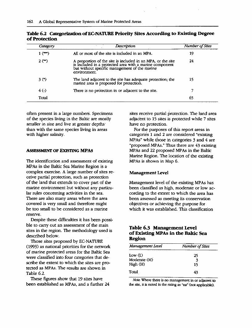
162 A Global Representative System of Marine Protected Areas
Table 6.2 Gttegori7.ation of EC-NATIJRE Priority Sites According to Existing Degree of Protection
Category Description Number of Sites
All or most of the site is included in an MP A. 19
24 A proportion of the site is included in an MP A, or the site is mcfuded in a protected area with a marine component but without specific management of the marine environment.
3 (*)
4 (-)
Total
The land adjacent to the site has adequate protection; the marine area is proposed for protection.
15
1Jiere is no protection in or adjacent to the site. 7
65
often present in a large numbers. Specimens of the species living in the Baltic are mostly smaller in size and live at greater depths· than with the same species living in areas with higher salinity.
ASsESSMENT OF ExlSTING MPAs
The identification and assessment of existing MP As in the Baltic Sea Marine Region is a,
complex exercise. A large number of sites receive partial protection, such as protection of the land that extends to cover part of the marine environment but without any particular ~les concerning activities in the sea. There are also many areas where the area covered is very small and therefore might be too small to be considered as a marine reserve.
Despite these difficulties it has been possible to carry out an assessment of the main sites in the region. The methodology used is described below.
Those sites proposed by EC-NATURE (1993) as national priorities for the network of marine protected areas for the Baltic Sea were classified into four categories that describe the extent to which the sites are protected as MP As. The results are shown in Table 6.2.
Toes~ figures show that 19 sites have been established as MP As, and a further 24
sites receive partial protection. The land area adjacent to 15 sites is protected while 7 sites have no protection.
For the purposes of this report areas in categories 1 and 2 are considered "existing MP As" while those in categories 3 and 4 are "proposed MP As." Thus there are 43 existing MP As and 22 proposed MP As in the Baltic Marine Region. The location of the existing MP As is shown in Map 6.
Management Level
Management level· of the existing MP As has been classified as high, moderate or low according to the extent to which the area has been assessed as meeting its conservation objectives or achieving the purpose for. which it was established. This classification
Table 6.3 Management Level of Existing MPAs in the Baltic Sea Region
Management Level
Low (L) Moderate (M) High (H)
Total
Number of Sites
25 3
15
43
Note: Where there is no management in or adjacent to the site, it.is noted in the rating as "na"· (not appliqible).
shows that management level of MP As in the Baltic Sea Marine Region is relatively low. Of the 43 existing MPAs, 58 percent are classified as having a low management level. Approximately 35 percent 05) are classified as having a high level of management and 7 percent (3) as having moderate management level (Table 6.3).
Description of National MPA Systems
Descriptions of national MPA systems have been obtained from IUCN 0992), WWF 0993) and EC-NATURE 0993). These descriptions are reflected in the following discussion of MPAs by country. For example, using the symbols and descriptions provided in Tables 6.2 and 6.3, an MPA notation of (W ... ) would indicate a Category 1 protection level and a high management level.
Denmark
In Denmark the primary basis for nature conservation is perceived threat to natural, cultural or historic values. Under the 1969 Conservation of Nature Act, nature conservation in Denmark follows two broad approaches: the application of individual conservation orders to specific sites for protection against often quite specific activities; and the establishment of gene~! q:>nsetvation measures around certain features or biotypes. Although protected areas exist, large areas are also CO\'."er~c;l by legislatiop relating to protection of specifi~d biotypes. S:ilt ' marshes and salt meadows are two marine biotypes presently listed for protection. There are several thousand individual conservation orders, each prepared on a case.:.bycase basis.
At the national level, the National Forest Agency is responsible to the Ministry of the Environment for nature conservation in both terrestrial and marine areas, including monitoring and management of wildlife reserves and areas of national biological importance. At the regional and local levels a Nature Con-
Marine Region 6: Baltic 163
servation Bqard is established for each of the 26 counties with responsibility for placing specific conservation orders, and for administering the Conservation of Nature Act.
Large marine areas (over 400 square kilometers, or 20 percent of the original marine environment up to a depth of 2 meters) in Denmark have been drained for agriculture with corresponding destruction of coastal habitat and associated leaching and runoff causing eutrophication. Conflicts of interest between agriculture and nature conservation in coastal areas are common. Inadequately treated sewage, sand and gravel extraction and bottom trawling have also been identified as threats to marine biodiversity.
Existing MP As: ,,._ Bornholm (W••and .. •)• ,.... Adler Grund (HJ••) ,,._ Smalandsfarvandet (HJ••) ,,._ Waters around Saltholm (W••) ,,._ Stavns Fjord (HJ•••) ,,._ Waters around Hessel0 (W•••) ,,._ Store Middlegrund (W••) ,,._ Randers Fjord (HJ••) ,,._ Waters around Laes0 (H/ .. ) ,,._ Waters around Hirsholmene (HJ••) ,,._ Laes0 Trindel/Tonnerberg Banke/Kum
melbanke cw••) ,,._ Herthas· Flak (HJ••)
.Estonia
Nature conservation authorities in Estonia include the Ministry of the Environment and its subdivisions (such as the Depa~ent of Nati.Ire Conservation and the Nature Management Inform~tion Centre)· and 19 semi-independent District Environmental Departments (4at ~re part df,local government. The Departmer:it:s ~f .Fores~ and F~heries also have sectoral responsibilities related to nature conservation.
The Estonian .J>arliament is expected to pass the "Act on Protected Objects of Nature" late in i993 to replace the previous legislation on nature conservation. The Act will
,164 A <;;lobal ~epresen~tive System of Marine Protected Areas
include p~ovisions for the establis~enJ,a~~ managemen~ of protec;ted areas: New legislatio~ on the pr9tection of coastal and o(fshore matjne areas is. als9 ~~ing p,r~pared. .
Management plans for protecied ar~as ~r~ gene11tlly inadequat~ or c9mpletely lackJng, and there is a shortage of financial resources and personnel. There is also a ne~9 ,for .training and. public e.ducatio~ and awar~ness. programs.
Existing MP As: ,,._ Lahemaa National Park (LI ... ) ,,._ Matsalu Nature Reserve (U* .. )
' • • ' I • ~ ~
,,._. Kopu Penin~ula- (U••) .. ~. Vilsandi National Park CUf••) . . '' . . . ' . . .
,,._ Hiiuma,a Islets Reserv~ JIJ·~·),
Finland
The MiJ:iistry of the. Enyironment is th~;hig~est autqority with respo,nsiqility for. pro.~ected ~rea~. in .J:inland, _,anc\ ~s 9irec~y responsible for the two ,0ffices µ-iat h9ld prc:r tected areas: ~e Finnish _Fores~ Re~earch ,nsti~te and the, F~ish Forest and Park: . Service. The Ministry of .Agricult:ure and. For·estry. aJso piays ·~ roie in overs~eing.~nd . funding som~ of the individ~ai p~otecte'd area management organizations, whi,\e. the. Min,ist.ry .of the Interior helps coorcJ4l,ate work with provincial governments. Finland .,, . ,, . has a total of. three national pa_rks tha,t in-:: elude large marine ar~as,,.as.well as somef ' privately owned nature rese~es 'that also have marine components. However, n~tur~·-. conservation in Finland has been primarily foc~ssed on. terrestrial areas (Nordic Pr9ject G~oup 1993). . . . · A Ministry of Agriculture and For.estry . . ~ . ' ~ .
working group in the 1970s identified impor-tant marine sites requiring prote~9n, incluq.ing eight marine sites. A project established , under the auspices of the Nordic Council of Ministers has identified 10 marine areas.for ... ' . conservation.
Significant issue~ in J:inlaqd include the SJ?t:ead of forestry. activities to small isiaJ}ds
in µie Finish Arc,hipelago, which have the .. potential to impa_ct on the adjacent marine epvironment, and lack of cpntrol over coastal qevelopment. Eutrophication caused by agriculWral. runoff, airborne pollutants .and in- . adtquately treated sewage is .a· problem in . archipelagos and other shallow enclosed areas along the Finish coast. The rapid increase in fish farming activities in the Aland arc;hipelago and. in the Quark Straits is also contributil).g up to 50 percent of:the total input of nitrogen and··phosphorus in the$e areas.·
Existing MPAs: ,,._ Bothnian· Bay Natiop.al Park .(U•••) ,,._ Outer Bothni;m Threshold Archipelago
cu••) ,,._ Southern Archipelago Sea (U••) ,,._ Tammisaari Archipelago/Hank
,oniern.L1'ojo Bay Cl)••)
..... ~astern Gulf of Finland (U••)
In Germany the responsibility for nature conservation legislatiop aqd administration is · · shared betw~en the federal government, the federa.l states;. the counties or districts and large, towns outside the districts. ·Authorities of the federal s.tates are primarily responsible, f9r t;he designa~on and management of protected areas. In. addition there are general leg~sl~t!ye provisic;ms for conservation at the federal level anµ the federal government c~n p~ss . .legislatiqn as a framework within which th~ states must.develop their own.
At the Federal leyel the Ministry of Environmei:it,: Nature Protection and Nuclear Safety has i:esponsibility for administration of n~,tu_re ~onservation. For the Baltic Sea, the, Departtp.ent of Envir0nment and Nature Prote~tion .of Schlesweig Holstein and. the Qepartment for En,vironment and Nature,of Mec.klenqurg-V,orpommern are the responsible sta,te· goven)ffient authopties.
Conflicts betweeq nature conservation and agric~~ture, to~rism .and other sectors .are a threat to marine areas along the Baltic coast,
as is pollution from industrial and agricultural development. In Mecklenburg-Vorpom• mem rapid commercial development along the coast is an increasing threat as the area · is seen as providing opportunities for investment from other parts of Germany and the rest of Europe.
Existing MP As: ,.._ Jasmund National Park (Hf•••) ,_ Vorpommem Lagoon (H/-) ,_ Wismar Bight/Salzhaff (Ml") ,_ Graswarder/Westcoast of Fehmar (V") ,_ Hochwater Bay (V") ,_ Oehe Schleimunde (V") ,_ Gellinger Birk (V")
The Environment Protection Committee, which is responsible directly to Parliament, has responsibility for environmental protection at the national level in Latvia (the Chaitman has in effect the function of a minister for environment). At the regional level there are nine regional committees responsible.for the implementation· of conservation initiatives.
A 300-meter belt on either side of the coastline has been designated for conservation: For the marine component·the objective is to conserve the ecological properties and processes of the underwater slope. Prohibited activities include excavation, blasting, mineral extraction as well as various fonns · of construction. This regime is to be taken into account in planning and design of all activities in the coastal zone, including town planning· and urban development. The level of enforcement of this regime is not clear.
Many protected areas exist in name only, with no management plan, agency· or staff responsible for supervising and undertaking management. Securing local suppon will be essential for development of effective MP As. Problems have arisen through the·different priority given to conservation and development at the local and national levels. In common with other states in transition to· a
Marine Region 6: Baltic 165
market economy, there is a scarcity of resources for conservation, a lack of trained maruigeinerit personnel at all levels, and lack of awareness of ,environmental issues among the general public and on· the pan of some respo~ible regional and local authorities.
~gMPA: ~ Northern Vidzeme Region Nature Pro
tection Complex (V")
The Environment Protection Depanment, which is responsible to Parliament, is the highest national authority for nature conservation: There are eight regional agencies with responsibility for the implementation of nature conservation legislation and provisions. -Responsibility for protected areas is distributed across a range of different ministries (including the Ministry of Forestry and the Department of Monument Conservation) arid local authorities. · The present network of protected areas ~ been developed in accordance with the Complex Nature Conservation Scheme, which includes five categories of protected areas.
Existing:MP As: ..- Kursh.t Nerija (Curonian Spit) National
Park (HI-) ~ Pajuris' Regional Park (IJ••) ..-, Nemunas ·oelta Regional Park (U-)
Norway
N~ description is available. Funher information on MP~ in Norway is provided in· the Arctic Maririe ·Region· repon.
~gMPAs: ..- NOne..oy TjO_me· (V")
The Minister of Environment Protection, Natural Resources and Forestry is the highest
166 A Global Representative System of Marine Protected Areas
national authority for nature conservation. At the regional level provincial governments implement this responsibility, while for each national park there is a director with direct management responsibility for that area. A new Nature Conservation Law was passed by the Polish Parliament in 1991 that provides more authority for these directors and improved procedures for planning and management at the landscape level.
Existing MP As: ,,.. Slowinsky National Park (MJ•••)
Russia
A new Nature Conservation Law has been passed by the Russian Federal Parliament, but as yet the law has not been widely publicized or implemented. Usually protected areas are established at the initiative of local or regional government, with confirmation from the central government in Moscow.
Existing MP As: ,,.. Curonian Spit State Environmental Na
tional Park (U•••) ,,.. Vistula Spit Landscape Park (U•••)
Sweden
The Swedish Environmental Protection Agency (SNV) under the Minister of the Environment and Natural Resources is the central administrative agency responsible for nature conservation, including the administration and management of protected areas. SNV administers a fund that provides it with overall responsibility for management of protected areas, National Parks and Nature Reserves including MP As in close consultation with the 24 regional county authorities.
Eutrophication in shallow water areas, particularly enclosed bays and archipelagos is a major problem. This has been caused by agricultural runoff, inadequate sewage treatment, heavy deposition of airborne nitrogen and fish farming. There is some conflict be-
tween recreational/tourism interests and nature conservation resulting from the increased pressure of recreational activities along the coast. Shore erosion caused by the passage of large, high-speed ferry traffic between Sweden and neighboring countries in sensitive archipelagic waters is also an issue to which attention has been drawn.
Existing MP As: ,,.. Haparanda Archipelago (U••) ,,.. Holmo Islands (U•••) ,,.. Kopparstenama/Gotska Sandon/Salvo
Rev (U•••) ,,.. Falsterbo Peninsula with Maklappen
cu•••) ,,.. Kullaberg (U ... ) ,,.. Gullmar Fjord (tt/•••)
International and Regional Initiatives Relating to MP As within the Baltic Sea
HELCOM and the Baltic Monitoring Programme
The establishment of a system of nature conservation areas is an important component of the work programme of the Environment Committee and its working group (EC-NATURE) of the Baltic Marine Environment Protection Commission, which is established to implement the Convention on the Protection of the Marine Environment of the Baltic Sea Area (usually referred to as the Helsinki Convention, or HELCOM). The latest version of the Convention, signed in April 1992, sets out obligations for all Baltic states to work individually and jointly to protect biodiversity within the region. The need for regional international cooperation to protect biotopes and species in the Baltic has been formally recognized by the inclusion of the new Article 15 of the Convention.
The Baltic Monitoring Program (BMP) has been implemented by the Helsinki Commission. The objective of the programme is to monitor the environment of the Baltic Sea. HELCOM compiles and collects data con-
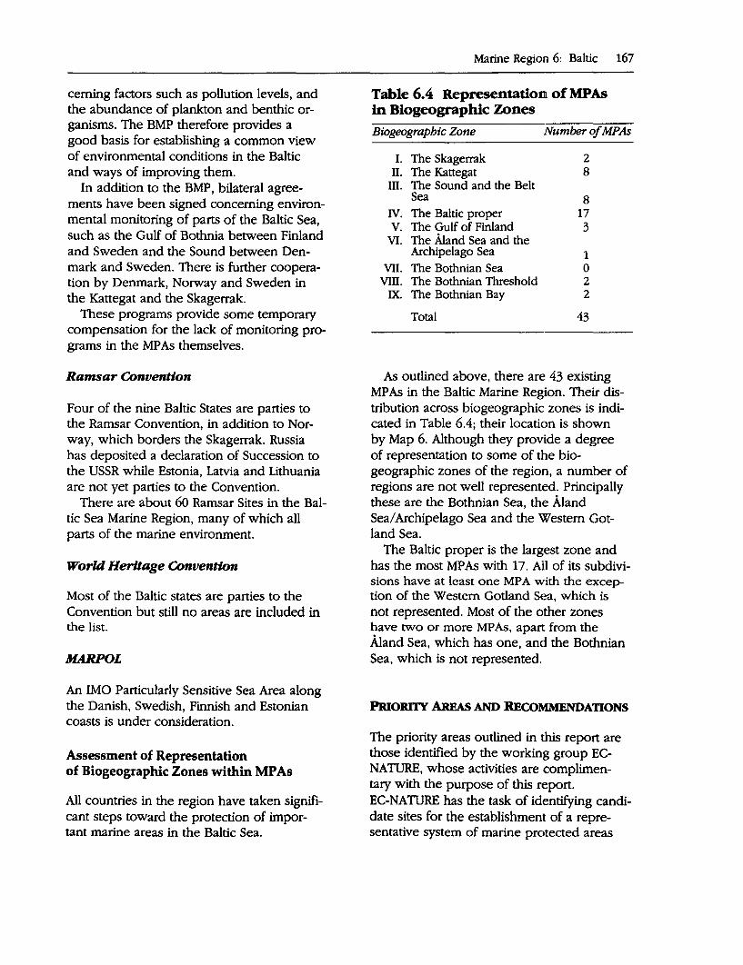
ceming factors such as pollution levels, and the abundance of plankton and benthic organisms. The BMP therefore provides a good basis for establishing a common view of environmental conditions in the Baltic and ways of improving them.
In addition to the BMP, bilateral agreements have been signed concerning environmental monitoring of parts of the Baltic Sea, such as the Gulf of Bothnia between Finland and Sweden and the Sound between Denmark and Sweden. There is further cooperation by Denmark, Norway and Sweden in the Kattegat and the Skagerrak.
These programs provide some temporary compensation for the lack of monitoring programs in the MP As themselves.
Ramsar Convention
Four of the nine Baltic States are parties to the Ramsar Convention, in addition to Norway, which borders the Skagerrak. Russia has deposited a declaration of Succession to the USSR while Estonia, Latvia and Lithuania are not yet parties to the Convention.
There are about 60 Ramsar Sites in the Baltic Sea Marine Region, many of which all parts of the marine environment.
World Heritage Convention
Most of the Baltic states are parties to the Convention but still no areas are included in the list.
MARPOL
An IMO Particularly Sensitive Sea Area along the Danish, Swedish, Finnish and Estonian coasts is under consideration.
Assessment of Representation of Biogeographic Zones within MP As
All countries in the region have taken significant steps toward the protection of important marine areas in the Baltic Sea.
Marine Region 6: Baltic 167
Table 6.4 Representation of MPAs in Biogeographic Zones Biogeographic Zone Number of MPAs
I. The Skagerrak 2 II. The Kattegat 8
III. The Sound and the Belt Sea 8
IV. The Baltic proper 17 V. The Gulf of Finland 3
VI. The Aland Sea and the Archipelago Sea 1
VII. The Bothnian Sea 0 VIII. The Bothnian Threshold 2
IX. The Bothnian Bay 2
Total 43
As outlined above, there are 43 existing MPAs in the Baltic Marine Region. Their distribution across biogeographic zones is indicated in Table 6.4; their location is shown by Map 6. Although they provide a degree of representation to some of the biogeographic zones of the region, a number of regions are not well represented. Principally these are the Bothnian Sea, the Aland Sea/ Archipelago Sea and the Western Gotland Sea.
The Baltic proper is the largest zone and has the most MPAs with 17. All of its subdivisions have at least one MP A with the exception of the Western Gotland Sea, which is
not represented. Most of the other zones have two or more MP As, apart from the Aland Sea, which has one, and the Bothnian Sea, which is not represented.
PRIORl1Y AREAs AND RECOMMENDATIONS
The priority areas outlined in this report are those identified by the working group ECNATURE, whose activities are complimentary with the purpose of this report. EC-NATURE has the task of identifying candidate sites for the establishment of a representative system of marine protected areas
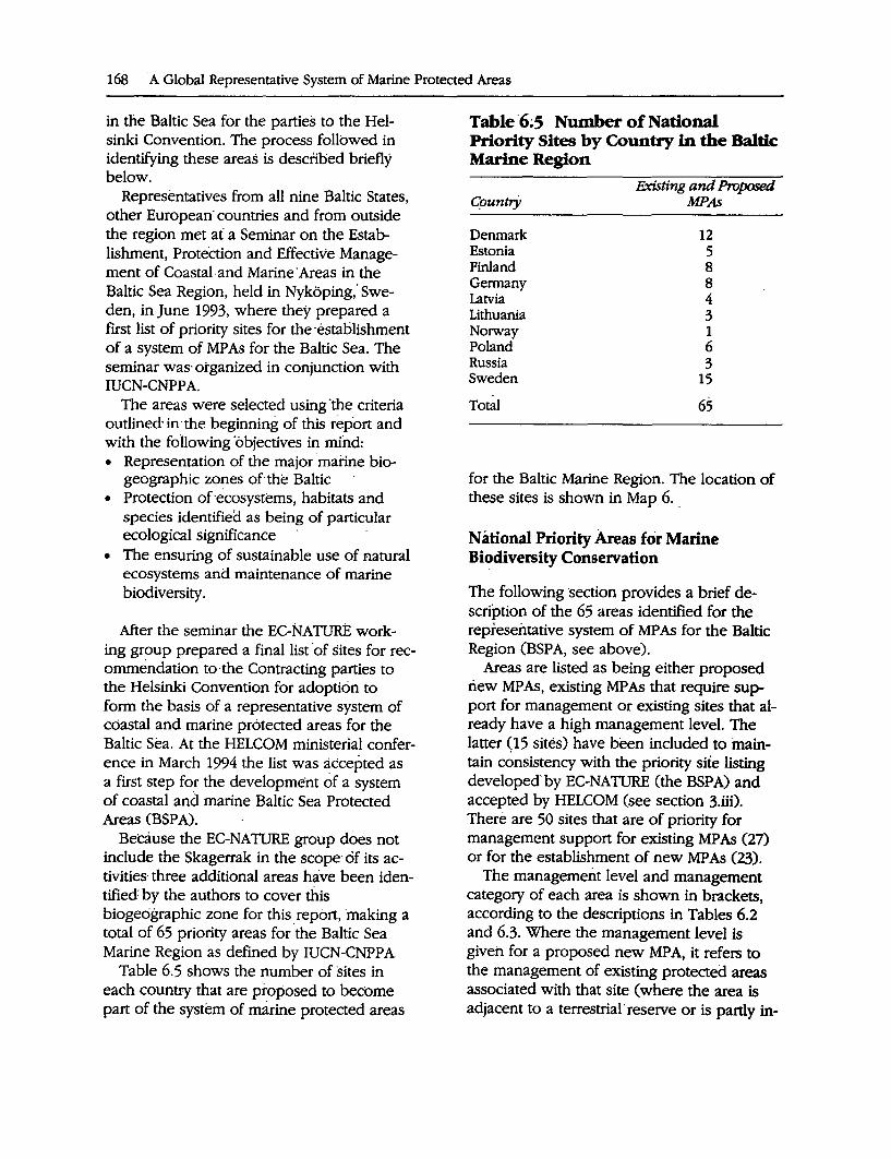
168 A Global Representative System of Marine Protected Areas
in the Baltic Sea for the parties to ilie Helsinki Convention. The process followed in identifying these areas is described briefly below.
Representatives from all nine Baltic States, other European· countries and from outside the region met at a Seminar on the Establishment, Protection and Effective Management of Coastal. and Marine· Areas in the Baltic Sea Region, held in Nykoping," Sweden, in June 1993, where they prepared a first list of priority sites for the ·establishment of a system of MP As for the Baltic Sea. The seminar was· organized in conjunction with IUCN-CNPPA.
The areas were selected using "the criteria outlined· in·the beginning of this rep.ort and with the foHowing 'objectives in mind: • Representation of the major marine bio
geographic zones of the Baltic • Protection of ·ecosystems, habitats and
species identified as being of particular ecological significance ·
• The ensuring of sustainable use of natural ecosystems and maintenance of marine biodiversity.
After the seminar the EC-NATURE working group prepared a final list ·of sites for recommendation to·the Contracting parties to the Helsinki Convention for adoption to form the basis of a representative system of coastal and marine protected areas for the Baltic Sea. At the HELCOM ministerial conference in March 1994 the list was accepted as a first step for the development of a system of coastal and marine Baltic Sea Protected Areas (BSP A).
Because the EC-NATURE group does not include the Skagerrak in the scope of its activities· three additional areas have been identified: by the authors to cover this biogeographic zone for this report, ·making a total of 65 priority areas for ·the Baltic Sea Marine Region as defined by IUCN-CNPPA
Table 6.S shows the number of sites in each countty that are proposed to become part of the system of marine protected areas
Table ·6;5 Number of National Priority Sites by Country in the Baltic Marine Region
G_ountry
Denmark Estonia Finland Germany Latvia Lithuania Norway Poland Russia Sweden
Total
F.xisting and Proposed MPAs
12 5 8 8 4 3 1 6 3
15
65
for the Baltic Marine Region. The location of these sites is shown in Map 6.
National Priority Areas for Marine Biodiversity Conservation
The following ·section provides a brief description of the 65 areas identified for the representative system of MP As for the Baltic Region (BSPA, see above).
Areas are listed as being either proposed riew MP As, existing MP As that require support for management or existing sites that already have a high management level. The latter (15 sites) have been included to maintain consistency with the priority site listing developed.by EC-NATURE (the BSPA) and accepted by HELCOM (see section 3.iii). There are 50 sites that are of priority for management support for existing MPAs (27) or for the establishment of new MPAs (23).
The management level and management category of each area is shown in brackets, according to the descriptions in Tables 6.2 and 6.3. Where the management level is given for a proposed new MPA, it refers to the management of existing protected areas associated with that site (where the area is adjacent to a terrestrial· reserve or is partly in-
eluded in an existing reserve with a marine coi:nponent):
Denmark
Dates given in brackets refer to the date of establishment of the particular measures concerned.
Existing MP As with High Level Management: ,.,. •
•
.
Bomholm/ open coast/ offshore bank in southern Baltic proper: Davids Banke (Bank) (HJ••): Ham~ meren coast, Bomholm: Rocky shal-lows with Mytilus edulis and sand, silt and mud at greater depth with a jfacoma baltica community. Spawning areas for herring. Eretholmene (islands) east of Bornholm (HJ•••): Rocky bottom with algae and Mytilus edulis and sand and ~ud with a Macoma baltica infauna COfJlffiU
nity. Important breeding .and nesting. area for marine birds. Includes scientific reserve and nature reserve 0984), larger national marine area 0978), area of biological interest 0983), area of declared marine botanical interest (1974) and shallow coastal areas declared of
' '
importance to birds 0974). Also ·Ram-sar site no. 26 and EEC. bird .p~otection site no. 79. Dueodde (coast)-Salthammer Rev (reeO, Bornholm CH/**): Rocky bottom .with macro-algae and Mytilus edulis and sandy to silty and muddy bottom with a Macoma baltica infauna commu. nity. Spawning areas for herring. In part larger nature area 0978), area of declared marine biological interest ' (1974), shallow coastal area declared of importance to birds and 1high priority area in county water qu~lity man-agement. .
• Adler Grund (bank) (HJ••): Shallow rocky bottom with macro-algae and. Mytilis edulis and sandy to muddy bottom with a Macoma baltica commu-
Marine Region 6: Baltic 169
nity. Area of declared marine botanical interest 0992).
,.. Smalandsfarvandet-selected areas (HJ .. ): • Northwestern Smalandsfarvandet stony,
sandy and silty to muddy bottom with Macoma baltica and Abra alba communi~ie.s. Area of international importance for marine birds. Includes Basnaes Nor ' '
game reserve 0918), areas of declared marihe bptanical interest 0974), shallow coastal are~s declared of importance to birds (1974) and is a high priority in cou.rity w~ter quality management. Part of Dai;iish Ramsar Site no. 19 and part of EEC bird protection site no. 96.
• Northeastern Smalandsfarvandet: Shallow stony, sandy and silty bottom with a Macoma baltica infauna community. Includes nursery areas for flatfish and spawning areas for herring. Numbers of international importance of marine birds have been noted. A high priority area for county water quality management and includes Gavn0 Game Reserve 0940), fishery restriction zones, areas of declared marine biological interest 0974) and shallow coastal areas declared of importance to birds 0974). Ramsar site no. 20 in D,enmark and EEC bird protection site no .. 81.
• .southern Smalandsfarvandet:. Shallow sto~y, sandy and silty bottom with a Macoma baltica infauna community. Includes nursery areas for flatf1Sh. Numbers .of international significance of breeding, moulting and stagu;ig birds . A high priority area for cou~ty water management and includes fishery restriction zone~. shallow coastal areas declared of importance.to birds 0974) and the game reserves Fladet 0941) and Vigso 0983).
,.. Waters around Saltholm Island (HJ••):
Shallow sandy bottom with seagrasses, a Macoma baltica community and some stones with macro-algae and
170 A Global Representative System of Marine Protected Areas
mussels; nursery area for flatfish. Harbor seals and grey seals are present. Numbers of international significance for breeding, moulting and staging marine birds have been noted. Includes a large national nature area 0978), area of national biological interest 0983), high priority areas for county water quality management, areas of declared marine biological interest 0974), shallow coastal area declared of importance to birds (i974), fishery prohibition zone, area planned to include enlargement of game and seal reserve Saltholm 0983). EEC Bird protection site no. 110.
,.- Stavns Fjord and adjacent waters (H/* .. ): Shallow sheltered bay and rocky to sandy and muddy bottoms with seagrasses and macro-algae, diverse Macoma ba/tica and the Abra alba communities. Includes herring spawning areas and nursery areas for flatfish. Internationally significant numbers of breeding birds have been noted, Harbor seals are present. The area is also a high priority area in county water quality management and includes reference localities for state monitoring of benthic flora and fauna. Included are also the game reserves Stavns Fjord 0926) and Bosserne/Lindholm 0983), the seal reserve Bosserne, areas of declared botanical and zoological marine biological interest 0974 1985), shallow coastal areas of declared importance to birds 0974) and fishery restriction zones. Danish Ramsar Site no. 14 and EEC bird protection site no. 31.
,.- Store Middelgrund (bank) (H/**): Rocky to gravelly bottom with sand and silt and macro-algae. Includes an area of declared marine biological interest 0992) and state monitoring locality for benthic flora.
,_. Randers Fjord and neighboring waters(H/**): Sandy bottom with Macoma
baltica and Venus communities. Includes nursery areas for flatfish and spawning areas for herring. Numbers of international significance of breeding and staging marine birds are present. The area is incorpo~ted within a large national nature area O 97~) and is a high priority area in county w~ter quality management with a number of state and county reference localiti~s for monitoring of benthic flora and fauna. Includes area of national biological interest 0983), area of declared marine zoological interest 0974), shallow coastal area of declared importance to birds 0974), fishery restriction zone and game reserve Trekelbakkehol 0976). Danish Ramsar Site no. 11 and EEC bird protection site no. 15.
,_. Laes0 (Hf••):
• Waters around Nordre Ronner (islands): Sandy bottom with rocks, stones, bubbling reefs and some spawning areas for herring. Marine birds, harbor seals and grey seals are present. This site is part of a large national nature area 0978), a high priority area in county water quality management, area of national biological interest 0983), area of declared marine biological interest 0974), shallow coastal area of declared importance to birds. Danish Ramsar site no. 9 and EEC bird protection site no. 9.
• Waters around Laeso (island): Sandy (often hard) to gravelly bottoms with sea grasses and rocks and Macoma balticci and Venus infauna communities. Herring spawn in the area. Harbor seal and grey seal are present. Numbers of international significance of breeding, moulting and staging marine birds have been noted. The site is part of a larger national nature area 0978), and is a high priority area in county water quality management. The area includes shallow coastal areas declared of importance to birds 0974), in _part area
.of national biological interest (1983) and area of declared marine biological interest (1974) .. Danish Ramsar site no. 10, EEC bird protection site no. 10.
,_. Hirsholmene (Hf••): • Waters around Hirsholmene (islands):
Sandy to rocky bottom with banks and reefs with macro-algae and Macoma baltica and Venus communities. Herring spawning areas and nursery areas for flatfish adjacent to the area. Bubbling reefs adjacent to and perhaps inside the area. Internationally significant numbers of breeding, staging and feeding birds have been noted. The site is an area of national biological interest (1983), high priority area in county water quality management, area of declared biological interest (1974), shallow coastal area of declared · importai:ice to birds (1974) and in part fishery restriction zone. In part Danish Ramsar site no. 8, EEC bird protection site no. 8.
• Bubbling reefs at Hirsholmene: Concretions of sand and limestone found as pillars and hard layers in and above a sandy bottom and inhabited by a large variety of plants and animals. Large lobsters. Fishery restriction zone.
,_. Laes0 Trindel (HI .. ): • Laes0 Trindel • Tonneberg Banke • Kummelbanke: Stone reefs in sandy to
silty and muddy areas with Venus and Amphiura communities, spawning areas for herring, bubbling reefs. Laes0 Trindel and Tosnneberg Banke are areas of declared zoological marine biological interest and reference localities for state monitoring of benthic vegetation, and as such are of declared botanical marine biological interest.
,_. Hertha's Flak (HI .. ): Stone reefs in sandy to silty and muddy areas with Venus and Amphilera communities, bubbling reefs. The site includes botanical and zoological areas of declared ma-
Marine Region 6: Baltic 171
rine biological interest and a reference area for .. state monitoring of benthic vegetation.
Existing MP As that require management support: ,_. Waters around Hessel0 (island)
(MJ•••): Rocky to sandy and muddy bottom with macroalgae, mussels and Macoma baltica, Venus and Amphiura communities. Harbor seals are present. Includes nature reserve (1982), area of national biological interest (1983), high priority area in county water quality management, and an area of declared marine biological interest.
Proposed new MPAs: No new areas are proposed.
Estonia
Existing MP As with high level management: None.
Existing MP As that require management support:. ,_. Lahemaa National Park (U•••): Typical
. habitats of coastal marine areas of the Gulf of Finland. Includes a great diversity of water depths, including some of the deepest areas (91 meters) in the Gulf of Finland. Established as a national park in 1976. Small rivers within the park are important Sa/monidae spawning grounds. One of the cleanest and better survived marine areas on the Estonian coast of the Gulf of. Finland.
,_. Matsalu Nature Reserve (U•••): Includes a shallow-water, eutrophic, estuarine bay together with part of the adjoining shallow sea and islands. Grey and ringed seals are present, as are migrating and nesting birds. Established as a nature reserve in 1957.
,_. Kopu Peninsula Biosphere Reserve (U••): Sandy bottom marine areas up
172 A Global Representative System of Marine Protected Areas
to a depth of 35 meters. Noteworthy species include seals, birds, migratory and local f1Sh.
,_. Vilsandi National Park (U* .. ): Includes shallow and deepwater island ecosystems .. Over 161 separate islands (10 percent of the total number in Estonia) are included. Established as a scientific reserve in 1910. This site also includes: Harilaid Zoological-Botanical Reserve (U .. •~oastal and marine areas that are important habitat for seals and birds. Established as a reserve in 19i4.
,_. Hiiumaa Islets Reserve (U•••): Important breeding 11rea for fish, birds and seals. Established as an Islets Reserve in 1971.
Proposed new MPAs: No new areas are proposed.
Finland
Existing MPAs with.high level management: None.
Existing MP As that require management support: ,_. Bothnian Bay National Park (U•••):
The park includes shallow shoals and numerous small islands. The area is subject to land elevation. Marine areas have low salinity (2°1"°), with few marine species and a greater number of brackish water and freshwater species comprising the flora and fauna. The area is mostly ice-covered for about six months of the year. Ringed seals are present. All islands and the majority of the marine area are included in the National Park 0991).
,_. Outer Bothnian Threshold Archipelago (The Quark) cu••): The area forms a threshold between the Bothnian Sea · and the Bothnian Bay. Intense land elevation (9 millimeters per year) makes the area unique internationally. All the
phases of this process, including hundreds of fladas and glo-lakes formed by the elevation, are in evidence. Wa-. ters are shallow and very productive biologically. Seals and marine birds are present, with this site forming the northernmost limit of many species. Nature reserve (partly), Ramsar site (partly).
,_. Southern Archipelago Sea (U••): The area has low salinity (6 °1"°); ice cover varies yearly. The outer part of the archipelago is comprised of numerous small islands and skerries, underwater eskers, and. a unique mosaic of islands and water, including many different biotopes with representative marine species. Marine birds and grey seal occur. Archipelago Sea National Park interest area, partly national park or nature reserve (1983). ·
,_. Tammisaari Archlipelago-HankoniemiPojo Bay (U**): Salinity varies markedly from the end of Pojo Bay (0 °1"°) to the open sea (6 °1"°). Ice cover varies yearly. The area includes different coastal zones typical of the southern coast of Finland: outer and inner archipelago and mainland. Marine birds are present. National park (partly) nature reserve (partly) (1989).
,_. Eastern Gulf of Finland National Park (U**): Salinity in western part is 4 o!oo
and in the eastern part 3 °100. Ice-cov
ered in winter. Outer archipelago and large open sea areas; eastern limit in the Baltic for Mytilus Edu/is and Spinachia vulgaris, important area for common seal and grey seal as well as arctic birds during the spring migration. Established (1982) as a national park (most islands) and nature reserve (some islands) although the marine area is mostlf not yet protected:
Proposed new MPAs: ,.,... Oura Archipelago (na/-): Low salinity
(5 °1"°); ice cover varies yearly; s~ll is-
lands-and skerries. Shore Conservation Programme.
,..... Uusikaupunki Archipelago (na/-): Low salinity (6 °10<); ice cover varies yearly;
. ·outer archipelago with many small islands and skerries; dean water. Marine birds are present.
,.,. Aland Sea (Ii*): No description available.
Gennany
Existing MP As with high level management: ,.- Jasmund National Park (H/***): Stony
· grounds with erratic blocks and· macroalgae stands. Established as a na
. tional park 0990). ,.- Vorpommem lagoon area/waters
around Westrugen (H/•••): Shallow lagoons ("Bodden") with wind generated "wadden" areas, sandy bottoms at the outer coast of Darss-Zingst peninsula, stony grounds with erratic blocks at the· coast of the north part of Hidden·see and Wittow/Rugen. Part of the area · is a Ramsar site since 1980 (lagoon waters between the east coast of Zingst ·peninsula, Hiddensee and the west coast of Rilgen); EC Bird Protection Area; National Park "Vorpommersche Boddenlandschaft" 0990); wetland of national importance (1980); several Nature Reserves; legal biotope protection {all lagoons, salt meadows, dunes, cliffs,' boulder beaches, submarine stony grounds, wet forests, reeds). The site is an important area for marine birds.
Existing MP As that require management support: ,.- Wismar Bight/Salzhaff area (W••): Shal
low water with seagrass meadows, soft bottom areas with high biodiversity (mollusks, polychaets, and so on), locally stony bottoms with erratic blocks · and fucus stands. Coastal' habitats include salt meadows, cliffs, dunes,
Marine Region 6: Baltic 173
reeds, coastal lakes. The site is an important resting· site of waterfowl; breeding area of waders; main distribution area of the baltic endemic mussel Cerastobyssum hauniense and Ciona infestina/is (tunicata) at the German coast. EC Bird Protection Area 0992); Wetland area· of national importance (1980); 5 nature res~rves. Wismar bight and Salzhaff as a whole are covered by legal biotope protection ("Bodden"). The submarine stony grounds at Klutz Hoved and Kilhlungsbom, the salt meadows, cliffs, dunes and other typical coastal biotopes of Wismar bight and Salzhaff are also subject of legal biotope protection. The outer parts of the area proposed to be included into the BSP A are not yet protected.
,.- Graswarder-west coast of Fehmam including Flugger Sand (U••): Sandy, stony bottom with macro-algae and Macoma ba/tica community. Numbers of international importance for marine birds. Great variety of breeding and migrating waders and waterfowl. Includes three nature rese1ves (1968 1977 1980); proposed Ramsar site.
,.- Hohwacht Bay (part of) and lagoons (U .. ): Sandy bottom with Myti/us edulis, shallow brackish lagoons, salt meadows. Numbers of international importance of marine birds. Great variety of feeding and migrating waders and waterfowl. Includes three nature reserves '(1957 1980 1990); proposed IDtmsar1site. ·
,... Oehe Schleimunde with shallpw waters (U••): Sandy and muddy bottom with 'rnacro-algae and Macoma ba/tica community. Numbers of international importance of marine birds. Partly nature· reserve 0987), proposed Ramsar Site.
,... Geltinger Birk and Noor including Kalkgrund (IJ••): Sandy, stony bottom with macro-algae and Macoma baltica infauna community. Numbers of marine
174 A Global Representative System of Marine Protected Areas
birds of international importance. Partly included within nature reserve (1987); proposed Ramsar Site.
Proposed new MP As: ....,. Strelasund Sound/Greifswald La
goon/Isle Greifswalder (I/*): Shallow lagoons with muddy, sandy and stony bottoms, seagrass meadows and other macrophytobenthos stands, temporary wind generated ''wadden" areas; estuary with distinct salinity gradient; Includes breeding sites of threatened marine birds. Otters are also present. EC Bird Protection Area 0992); wetland of national importance Cl9eO); South East Rugen Biosphere reserve 0990).
Latvia
Existing MP As with high level management: None.
Existing MP As that require management support: ..,. Northern Vidzeme Region Nature
Protection Complex-coastal section "Dzeni-Ainazi" (11••): Area of sandy and stony bottoms, sandy beaches, coastal meadows and shallow brackish lagoons. Spawning area for herring and moulting area for ducks (mainly Bucepbala clangula). Includes the : river Salaca, the most important spawning area for salmon· in the eastern Baltic. Declared a protected area in 1990, management plan currently under development.
Proposed new MP As: ...... Coastal section Kaltene-Engure (na/-):
Bottom consisting mainly of fi,ne sand or stones, with some areas of .g~vel. Includes important herring spawning sites, moulting and-wintering areas·
for ducks (including Bucepbala clangula and Melanitta fusca). ·
..,. Coastal section Lielirbe-Kolka (I/*): Includes marine areas with fine sand or stone bottoms. Included on the list of important bird areas for Europe. Marine areas are important nursery ground for flatfish and other fish species. Nature reserve 0921).
~ Coastal section Pape-Perkone (na/-): Bottom consists of coarse gravel, stone arid'stone piles. Blue mussel-Furcellaria communities, favorable herring spawning sites. Wintering area and resting place for waterfowl during spring migration.
Lithuania
Existing MP As with high level management: ,_. Kursiu Nerija (Curonian Spit) National
Park (HJ•••): Sandy bottom, accumulated sea shore with wide sandy beaches and dunes, coastal forests and freshwater lagoon. Established as a National Park in 1991.
Existing MP As ·that require management support: ..,. Pajuris Regional Park (Ij••): Areas of
sandy bottom with stones, sandy beaches and dunes. Moraine cliff and coastal forests. Declared a Regional Park in 1992, management plan under development.
..,. Nemunas Delta Regional Park (Ij•••):
Includes the delta of the Nemunas River as it flows into the Kursiu Marios Lagoon. Natural flooded meadows are extremely rich in plant species. A great variety of habitats create favorable conditions for waterfowl and other fauna. The main breeding and migratory area in Lithuania for waterfowl and migratory birds.· Declared a Regional park in 1992.
Proposed new MP As: No new sites are proposed ..
Norway
Existing MP As with high level management: None.
Existing MP As that require management support: ,.,_ Notteroy-Tjome CV .. ): An archipelago
area on the Norwegian south coas~. Exposed bottoms with mainly oceanic · species. Reproduction area for. fish, seals and seabirds.
Proposed new MP As: No new sites are proposed.
Poland
Existing MP As with high level management: None.
Existing MP A~ that require management support: ,.,_ Slowinski National Park (U•••): Sea
bed comprised of fine sand with some gravel areas. Numerous mollusks from the genera Macoma, Mya and Cardium dominate the zoobenthos.
Proposed new MP As: . ,..... Vistula Spit Landscape Park (V•): Pro
posed extension to existing terrest,rial park to include adjacent marine areas to a depth of 2 meters and the Vistula lagoon. Marine areas are inhabited by numerous mollusks, crustaceans, fish and lamprey. The lagoon has sand and mud bottoms. Salinity varies from 2-6 0100
, with reed and bullrush occurring in the least saline areas in the southwest. More saline-tolerant species predominate on the northeast shore. Spawning ground for herring and
Marine Region 6: Baltic 175
so~e. freshwater species, and a breeding ground for birds.
,... Redlowo Reserve (V•): Proposed extension to existing terrestrial park to include adjacent marine areas. Seabed comprised of sand, gravel and stones. Salinity approximately 7 °100
. Freezes in severe winter, with hummocked ice acting on the bottom of shallow areas. Habitat of numerous mollusks and crustaceans; seagrass meadows (Zostera marina); wintering area for marine birds.
,... Nadmorski Landscape Park (U•): Proposed extension to existing terrestrial park to include adjacent marine areas (Puck Bay) and Puck Lagoon. Puck lagoon is a shallow estuarine basin separated from the bay by Ryf Mew, a raised sandy shoal. Nesting birds (gulls, cormorants and swans) are present. In the lagoon meadows of Zostera marina, Zannichellia palustris and Entberomorpba potamogeton occur, while Pylaiella litoralis predominates in summer. These are inhabited by numerous crustaceans. The area is a spawning ground for fish. Sandy beaches line the shore of Puck Bay with numerous mollusks present (including Macoma baltica, .Mya arenaria, Cardium glaucum and Mytilus edulis) in adjacent marine areas. Marine mammals such as Ha/iborew; gryppus and Phocena phocena occur, and the area is a wintering and stopover for birds.
...,. Slupsk Bank-proposed National Park (na/-): Marine areas located about 25 Nm offshore with depth ranging
· from 8 to 90 meters. Sea bed comprised of coarse sand with numerous fields of stones; Tballophytae and Rbodopbytae are present; numerous aggregations of blue mussels and concentrations of flatfish including
176 A Global ReP.resentative System of Marine Protected Areas
Scopbtalmus maximum, and habitat of fish species Mysoceplialus scoapius and Zoarces viviparus. The area is a spawning ground for herring, and sprat, and lies on the migratory route for herring and salmon .
..,.... Wolinski National Park (U*): Pro-. posed extension to the existing terres
trial National Park to include adjacent marine areas and part of Szczecin lagoon. Inshore the seabed is .stony with patches of clay and shoreline comprised of unstable abraded cliffs;. Nu-
. merous aggregations of mussels are present; common seals occur (Phoca vitulina). Offshore the seabed is sand with Macoma baltica predominant; Batbyporeia piliosa and numerous flatfish are present in the east. Inshore areas are a wintering area for birds. The lagoon is eutrophied and the shores overgrown with vegetation; water and swamp birds breed as do many fish species.
Russia.
Existing MP As with high level n;ianagement: None.
Existing MP As that require management support:. ,.,._ Curonian Spit (southern component)
(U***): State Environmental National Park. See Curonian Spit National Park described under Lithuania above.
,.,._ Vistula Spit (U•••): Marine areas adjacent to forest and sand bar. Established as a Landscape Park in 1962, management status unknown (see alsc;> Poland).
Proposed new MPAs:. ~ l<'inskiy Zaliy.and associated islands
(U*): Proposed nature reserve- (in the Gulf of Finland).
Sweden
Existing MP As with high level management: ,.. Gullmar Fjord (Ii/***): Threshold fiord
with a depth of 124 meters inside a threshold of 35-45 meters. In the greatest depths interesting and some very rare animal species are found. A variety of marine habitats are present with. salinity ranging from 19-33°100. The fiord is a breeding area for fish .species. In the rivers flowing the fiord there are good salmon populations. Marine reserve since 1983.
Existing MP As that require management support: ,.. Haparanda archipelago (U**): Shallow
archipelagic area outside Tomea alv river mouth with a large-number of shallows, islands and skerries with flat, bouldery sand/ gravel beaches. Solid ice cover; ice freeze-up in NovemberDecember with breakup in early June. Benthic fauna includes some 20 species of macrofauna, only 3 of which are purely marine species. Of 25 fish species in the Bothnian -Bay, only-5 are marine. The area is a spawning and nursery ground for species such as pike, roach, nuffe, perch, Baltic herring
.and armed bullhead. Important breeding·and resting sites for migratory. birds. The coastal grayling is unique for the northern Bothnian Sea and Bothnian Bay. Grey Seal and Ringed Seal occur regularly around Sandskar. Most of the area is without protection, small terrestrial nature reserve.
,.. Holmo Islands (U***): The coast is of a moraine type and includes develop-
. ment sequences from bay to lake. Shallow areas are exposed to waves and subjected to ice pressing. The Macoma baltica community dominates on soft
bottoms. M. baltica here is just south of its innermost range boundary in the Bothnian Bay. Cod are also at the boundary of their range in these waters. The area is a valuable bird area and a. spawning and nursery ground for whitefish and Baltic herring. Ringed seal are present.
..- Kopparstenarna/Gotska Sandon/ Salvorev-NR, NP CU ... ): The area includes complex formations of sand and gravel that have resulted from the movements of the continental ice cover, land elevation and currents that are continuously building up and changing the formation of the sandbanks and reef. Salinity is 6-7°100
•
Flora and fauna is influenced by the special hydrographic dynamics with extremely exposed bottoms, soft bottoms occur only at depths greater than 50 meters. ·Extremely clear water that permits Fucus vesiculosus to live even deeper than 10 meters. Important breeding and feeding areas for flatfish. The area is the inner border or limit for the distribution of Pleuronectes platessa. Noteworthy species include Eider, Long-tailed Duck, and Grey Seal. Established as a marine reserve 0987) and partly a Ramsar site.
..- The Falsterbo Peninsula with Maklappen (U•••): Flat sand areas with large movements in the bottom sediment and with submarine peat bogs and shallow areas. The fauna on the exposed bottoms includes both marine and brackish water species. Surface water salinity is about 10°100
• The area is a breeding site for harbor and grey seals. Internationally important resting, breeding and staging area for a large number of bird species; important migratory bird site; spawning and nursery ground for herring. This site is a re-
Marine Region 6: Baltic 177
search/reference area of marine biological, ornithological and geoscientific interest.
..- Kullaberg (U ... ): The coast is comprised of a horst formation with dramatic and varying topography and irregular coastline with steep cliffs, caves, islands and stone pillars. Shingle beaches slope rapidly downward below the surface of the water to depths of 2~25 meters where the bottom consists of boulders; further out the bottom levels out and becomes sandy. The area is a transition zone between Oresund (the Sound) and the Kattegat, where surface water with a relatively low salinity (about 11 °100
) meets water masses with a higher salinity (up to 33°100 at depths of 12-15 meters). The area is a southern outpost for numerous more marine species. The whole area is protected within a nature reserve.
Proposed new MP As: ..,._. Bjuroklubb Area (U•): The coast is
open moraine, with radial moraines that are partially above the sea surface. The area is subject to uplifting. Salinity is 2-4°100
. The bottom is comprised of sand, stone and rocks. The area is rich in bird life, and is also a spawning and nursery ground for pike, eel and whitefish. This area is representative of the Bothnian Bay. The terrestrial area is a nature reserve, but most of the marine area has no protection.
......,. Trysunda/Ulvoama/Ullanger/Ulvo Deep (U•): This section of coast .is
. characterized by high, steep cliffs and islands with high elevations. The Ulvo Deep is a continuation of the eastern Baltic's deep region, and a 100 meters deep channel connects it to the Aland Sea. The salinity in the surface water is
178 A Global Representative System of Marine Protected Areas
about 5 °100, and in the deepwater
about 6 °100. The inner range boundary
for Mytilus edulis. The dominant benthic community is· the Macoma community. In the deep area, the soft bottom is dominated by the Pontoporeia community. The area has a large number of bird species and there are small bird sanctuaries.
,..._ Graso/Singo-Archipelago (U•): This is a shallow archipelagic area with a salinity in the surface water of about 5.5°100
and in the bottom water of about 7.5°100
• The area forms a transition between the Bothnian Sea and the Baltic proper. Spawning and nursery ground for eel, pike, whitefish and Baltic herring. The Macoma baltica (Baltic mussel) community dominates the bottom dwelling fauna. Bordering on the Aland Sea, the moon jellyfish (Aurelia aunta) and bladderwrack (Fucus vesiculosus) reach their inner range limits in the Baltic Sea area. Seal and otter occur. Bird and seal sanctuaries have been established.
,..._ St. Bocko/St. Nassa/Sv. Hogarna/Sv. Bjorn (U•): Intermediate, outer and extreme outer archipelagos are represented in this area. Below the surface there are shoal-filled plateaus with intervening deeper channels and basins at 30-40 meters and down to 90-100 meters. The mussel-rich banks at Sv. Hogarna are habitat to bird species. Thousands of auks ·winter in the area during.ice-free winters. Sv. Bjorn is··an important moulting site and has a large seal population. Some of the islands are protected as nature reserves, seal and bird sanctuaries .
...... · Landsort/Hartso/ Asko/Landsort Deep CU*): Representative archipelago with wide variation in shores and bottoms. Rich vertebrate fauna, rich bird life, spawning and nursery ground for whitefish, pike, cod and eel. Macoma baltica and Hydrobia species are pre-
sent in large numbers. Zostera marina meadows are encountered on sandy bottoms. Pontopopeia affinis dominates in the deep hole that exhibits an extreme sedimentation environment. Reference area for international survey of hydrography, a research area, and part of the national environmental monitoring programme. There are a number of nature reserves within the area including island, bird and seal sanctuaries. (58°40'N, 17°40'£)
...., St. Anna/Missjo Archipelago (U•): Extremely finely chiselled, characteristic outer archipelago with a large number of tightly clustered small islands and skerries. Shallow areas with Zostera meadows. The area supports many species of birds and seal colonies, as well as spawning and nursery grounds for eel, whitefish and pike. There are seal and bird sanctuaries within the area. St. Anna Archipelago is proposed as a national park.
..,,. Torhamn Archipelago (Ml*): The inner part of the archipelago consists of large and small islands and skerries, while the outer part is without i.slands with the exception of the highly exposed Utklippan. This area includes waterlogged shore meadows, nutrientrich shallow bottoms, many bird species and shallow areas important as herring spawning grounds. Upwelling occurs at Utklippan. Macoma baltica communities dominate; Zostera meadows are also present. This is Sweden's southernmost archipelago and is a research and reference area. The site is one of Sweden's most important observation sites for migratory birds and includes a number of bird sanctuaries and a bird station with bird counting and ringing.
~ Nidingen/Sonnerbergen/Monster (U*): Small island surrounded by shallow water and stony bottoms. Salinity in the surface is about 25°100 and in the
bottom layer up to 33°100• The current
is mainly northgoing and upwelling may occur. The area is a breeding, feeding and resting place for many bird species and is an important observation place for migratory birds. There is a large seal population. About 1,000 macroscopic species have been recorded; some of those living under the halocline belong to the North Sea fauna. Algal zonation is typical of that for the inner part of the Skagerrak/Kattegat. The area contains mainly western elements in the flora and fauna; some of the species are high salinity organisms. Nidingen was established as a nature reserve 0980).
,..... Koster Archipelago/Koster ChanneVTjarno ArchipelagoNaderoarna (na/-): An area including marine habitats and a very large number of small islands and skerries. The deepest part in the Koster channel is about 270 meters. A large variety of bottom types occur including exposed bottom with oceanic species, some of which are uni?cue for Sweden. The salinity is 25-340 00
• The area includes reproduction areas for fish, feeding, breeding· and resting areas for many species of sea birds and for seal. There are some birds and seal sanctuaries.
AREAs OF HIGHEST REGIONAL PRIORITY FOR.MPAs
The main gaps in'the representation of the biogeographic zones of the region could be filled by the establishment and effective management of the following areas.
Existing MP As that require ma!lagement support: ,... Archipelago Sea (biogeographic
zone)-Southern Archipelago Sea (Finland)
Marine Region 6: Baltic 179
Proposed new MP As: ..,.. Bothnian Sea (biogeographic zone}
Trysunda/Ulvoama/Ullanger/Ulvo Deep (Sweden)
,...,. Aland Sea (biogeographic zone}Graso/Singo (Sweden)
~ Western Gotland Sea (biogeographic zone}-Landsort/Hartso/ Asko/Landsort Depth and St. Annas/Missjo Archipelago (Sweden)
Work is under way in Finland and Sweden to establish these sites.
Considering just those countries that might be eligible for assistance from the G EF and the World Bank, and the criteria outlined in the introduction, the following three areas should be considered as being of highest priority. These areas are however not to be considered as gaps as they are all situated in the Eastern Gotland Sea biogeographic zone, which already has a number of existing MPAs.
Existing MP As of highest priority that require management support: ....
•
• •
Curonian Spit including the Nemunas Delta (Russia and Lithuania, 3 sites): Curonian Spit State National Park (Russia) Curonian Spit National Park (Lithuania) Nemunas Delta Regional Park (Lithuania) Vilsandi National Park (Estonia)
Proposed new MP As of highest priority: .,.. Coastal Section Pape-Perkone (Latvia)
Other Recommendations
At the 5th meeting of HELCOM in Helsinki on ~11 March 1994, recommendation 15/5 pertaining to the establishment of a system of Coastal and Marine Baltic Sea Protected Areas (BSPA) was made. This recommendation has been adopted on March 10 1994, having regard to article 13, para. (b) of the
180 A Global Representative System_ of Marine Protected Areas
Helsinki Co_nvention. A copy '.of recommendation 15/5 is provided in Appenqix 6.2.
The areas identified ·for the formation of the BSP A ar~ those areas listed in this report.
APPENDIX 6.1 f4AIUNE SPECIF.s FOUND IN THE BALTIC SEA REGION·
Marine Mussels:· Abra Alga, Astarte borealts, Cyprina tslandica (the Iceland-cyprina), Macoma baltica (the Baltic mussel), Macoma calcarea, Montacuta (Mysella) bidentata.
Marine Snails: Potamopyrgus jenkensi.
Topshells: Tbeodoxus fluviatilts.
Small Crustaceans: Diastylus ratbkei, Pontoporeia a/finis, Pontoporeia /ern:zorata.
Marine Wood Louse: Mesidotbea entomon.
Birstle Worms: Capitella capitata, Harmontboe irrJ,par, Harmonthoe sarsi.
Girdle' Worm: Peloscolex ·benedeni.
Prfapuloid: _ Halicryptus _spinulosus.
Red Alg~e: Bangia, Ceramium tenuic.orne, Dumontia, Furcellaria fatigiata, Pbyllo,phora, Polysiphonia nigrescens, Po-rphyra, Rbodomela·confervoides.
Green Algae: Char aspera, Cladopbora glomerata, Cladopbora aegagropila, Enteromorpha, Nitella flexilis, Ulotbrix subjlaccuia, Urospora peniciliformts, Vaucberia dicbotoma.
Brown Algae: Dictyipbon foeniculaceus, Ectoca-rpus siliculosus, Fucus vesiculosus, Laminaria, Sphacelaria arctica, Pilayella littoralis, Stictysipbon.
Bluegreen Algae: Calotbrix scopulorum.
Salt Lichen: Verrucaria maura.
Water Plants: Eleocharts acicularts, /soetes lacustrts, Maja marina, Myropbyllum spicatum, Potamogeton spp., Ruppia spp., Zannicbellia palustria, Zostera marina.
APPENDIX 6.2 IIELCoM REroMMENDATION 15/5 .REGARDING SYSTEM OF COASTAL AND MARINE BALTIC SEA PROI'ECTED .AREAs
Recommendation 15/5 was made to the 5th meeting of HELCOM, held in Helsinki, Finland, S-11 March 1994.
HELCOM Recommendation 15/5 (adopted 10 Match 1994, having regard to article 13, Paragraph· b of the Helsinki Convention).
THE COMMISSION, RECALLING Article 13 g of the Conven.:.
tion on the Protection of the Marine Environment of the Baltic Sea 1974 Helsinki Convention,
NOTING Article 15 of the 1992 Helsinki Convention- .
BEARING IN MIND the Baltic Sea Declaration (paragraph 14) given in Ronneby 1990 in which the Heads of Governments and High Political Representatives of the Baltic Sea States declared their firm determination · to develop a comprehensive programme in Nature Conservation, inter alia, through the establishment of protected areas representing the various Baltic ecosystems and their flora and fauna and the emphasis given to Nature Conservation by the 14th Meeting of the Helsinki Commission and its request to speed up the work (HELCOM 14, paragraph 5.38),
RECALLING ALSO the Recommendations by the International Seminar on the Protection of Sensitive Sea Areas, Malmo, Sweden, 25-28 September 1990, the International Seminar on Nature Conservation and Biodiversity in the Baltic Sea Region, Runo, Sweden, May 1991, the decisions taken at the·
UNCED conference in Rio de Janeiro 1993, particularly the convention concerning the conseivation of biological diversity, signed by all Contracting Parties of the Helsinki Convention, and the Recommendations in . "Agenda 21" for coastal nations,
TAKING INTO ACCOUNT the conclusions and Recommendations from the Baltic Sea Regioi:ial Seminar, Nykoping, Sweden, -7-11 June 1993 concerning the protection and effective management of coastal and marine protected areas,
BEING AW ARE of the fact that the Baltic Sea contains a large number of unique ecosystems, biotypes and species of great natu,. ral value,
BEING DEEPLY CONCERNED about the deterioration of the coastal and marine areas and the very poor water quality in some areas brought about by different kinds of human activities which in several respects are increasing due to the. political changes in Eastern Europe,
APPRECIATING the measure already been taken by several Baltic Sea countries in order to protect coastal and marine areas,
RECOGNIZING that the establishment of protected marine and coastal areas is seri- · ously lagging ,behind similar efforts in the· terrestrial environment, that existing protected areas are generally few and small, and that their degree of protection is mostly not very high according to the IUCN categories,
ALSO RECOGNIZING the need of a· system of selected reference areas throughout the Baltic Sea where integrated biological monitoring can be carried out,
DESIRING to protect representative ecosystems of the Baltic as well as to guarantee sustainable use of natural resources as an important. contribution to ensure ample provident protection ·of environment and of biodiversity,
RECOMMENDS to the Governments of the Contracting Parties to the Helsinki Convention:
Marine Region 6: Baltic 181
That the Contracting Parties take all appropriate measures to establish a system of Coastal and Marine Baltic Sea Protected Areas (BSPA). The areas listed in the Attachment, and preliminarily described in Annex 17 to the report of EC 4, are recommended as a first step in ·establishing such a· system. The definite borderlines of the areas will be defined by ·the countries concerned as soon as possible .. The size of such areas shall preferably be more than 1000 hectares,
That this system. of BSPAs be gradually developed as new· knowledge and information becomes available. Special attention shall be paid to including aqditional coastal terrestrial areas and to including marine areas outside the territorial waters. To reach this aim the Contracting Parties shall jointly and individually take all necessary steps. Appropriate guidelines for the selection of further areas shall be elaborated by the expert working. group EC NATURE incorporating IM O's guidelines for the designation of Particularly Sensitive Areas;
That before any decisions are made which could lead to major reductions in size, management quality- or protection status of a BSP A that is already notified to HELCOM, the Commission. shall be notified and be invited within 6 months to express its opinion in the proposed changes;
That mariagement plans be established for each BSP A to ensure nature protection and sustainable use of natural resources. These management plans shall consider all possible negatively affecting activities, such as extraction of sand, stone, and gravel, oil and gas exploration and exploitation, dumping of solid waste and·dredged spoils, constructions; waste water from industry, municipalities and households; intensive agriculture and intensive forestry; aquaculture; harmful fishing practices; tourism; transport of hazardous substances by ship through these areas; military activities. In some areas a zoning system will be an appropriate means to facilitate the achievement of satisfactory
182 A Global Representative System of Marine Protected Areas
protection. Appropriate guidelines for making such management plans shall be elaborated by the working group EC NATURE incorporating corresponding guidelines of IUCN;
That a monitoring programme be. incorporated into the management plans in an appropriate number of these areas including at least monitoring of biological, physical and chemical parameters. The monitoring programme shall be incorporated within the Baltic Monitoring Programme of HELCOM,
RECOMMENDS ALSO that the Contracting Parties report to the Commission on the state of establishment and management of BSPAs in 1996 and thereafter every 3 years,
FURTHER RECOMMENDS that the working group EC NATURE stays in contact with the Contracting Parties for information and cooperating in this matter.
A Baltic International System of Marine Protected Areas (MPAs) should be developed and adopted by the appropriate intergovernmental body (HELCOM) in cooperation with national and international governmental and nongovernmental organizations. A list of proposed sites for such a system of protected areas in enclosed (see section 3.0. • This system should be representative for
the Baltic and its ecosystems and designated and coordinated in international cooperation with relevant national and international governmental and nongovernmental organizations and managed by responsible national authorities;
• As a basis for monitoring and gradual refinement of the Baltic International System of MP As a marine classification system, including an identified biogeographic classification system, should be established;
• In the continuous selection of MP As physical attributes and major community characteristics should be used in the absence of a detailed inventory of the Baltic Sea Region;
• For confirmation of already established areas and identification of new areas the criteria listed in the IUCN guidelines for the establishment and protection of MP As should be used. Site selection should (where possible) be made in accordance with the objectives for Special Areas of Conservation to be established under the EC Habitat Directive;
• In order to achieve a balanced and representative set of areas, large scale geomorphological features should be taken into account and the list of structural sub-units (BMB-WWF report on the Protection of the Coastal and Offshore Marine Areas in the Baltic Sea Region) be used;
• Recognizing the need to optimism the use of available resources the development and implementation of a Baltic System of MP As should follow a step-by-step approach;
• Bearing in mind the above considerations concerning site selection the listed sites should be designated as MP As under a phased protection strategy, allowing further sites to be included in the future as knowledge of the resource base is advanced and priorities reviewed;
• The MP As should as far as possible be combined with corresponding terrestrial areas situated along the coast. Similar areas on both sides of a border between two countries can be merged into transnational protected areas. Management of such combined areas should be carried out in a streamlined way.
BIBLIOGRAPHY
Baltic Marine Biologists (BMB) and World Wildlife Fund for Nature (WWF). 1993. Report on the Protection and Management of Coastal and Offshore Marine Areas in the Baltic Sea Region (Revised Second Draft). Report submitted by the Joint Working Group (BMB/WWF). Washington, D.C.
Dybem, B-E, and B. Hagerhall. 1992. Expert Group Identifies 32 Coastal and Marine Areas to be Protected. WWF Baltic Bulletin (3-4).
Esping, L-E., and G. Gronqvist. 1992. The CNPPAWorld Bank Marine Biodiversity Project, Report prepared for CNPPA.
EC-NATURE. 1993. System of Coastal and Marine Baltic Sea Protected Areas. Draft report to the Helsinki Commission.
Nordic Project Group. 1993. Marine Reseroes in the Nordic Region. Preliminary Summary prepared for a project within the Nordic Council of Ministers.
Voipio, A. 1987. The Baltic Sea. In R. Mitchell, Conservation of marine benthic biocenoses in the North Sea and the Baltic. Report prepared
Marine Region 6: Baltic 183
for the Council of Europe, Strasbourg. No. 37 Nature and Environmental Series. Amsterdam: Elsevier.
Waterson, L. 1992. Sea and Coast. Rome: SNA Publishing.
World Conservation Union (IUCN). 1992. Protected Areas of the World: A ret.Jiew of national systems. Volume 2: Palearctic. Gland, Switzerland and Cambridge, U .K.
World Wildlife Fund for Nature (WWF). 1993. Coastal and Marine Protected Areas in the Baltic Sea Region. Background report to the Seminar on the Establishment, Protection and Effective Management of Coastal and Marine Protected Areas in the Baltic Sea Region.

Contributors
Many people and organizations contributed directly to these reports. The major authors or editors of each regional report in Volume I have prepared the following highlights of these contributions.
Marine Region 1: Antarctic
This report was compiled from information provided by the Antarctic Division, Australian Department of Environment, Sport and Territories, and Paul Dingwall of the New Zealand Department of Conservation. Other individuals who contributed information are: Bruce Davis (Antarctic Cooperative Research Centre, Australia), Lome Krikowen (Poles Apart, Australia), and Kathy Walls (Department of Conservation, New Zealand).
Marine Region 2: Arctic
This section was compiled from a report prepared for CNPPA by Vera Alexander of Fairbanks University, Alaska, with further information from reports prepared by the Directorate for Nature Management in Norway (Hansen 1993) and by the Nordic Project Group for the Nordic Council of Ministers (Nordic Project Group 1993), and from qther sources as noted. Editing was undertaken by Chris Bleakley (GBRMPA).
The draft report was reviewed by national contact points for the Conservation of Arctic Flora and Fauna (CAPP) group, with coordination provided by Jeanne Pagnan ·(CAFF Secretariat, Canada). Individuals who have contributed comments or other information are: David Allen (Fish and Wildlife Service, United States), Amirkhan Amirkhanov '(Ministry for the Ecology and Natural Resources, Russia), Leslie Beckmann (Arctic Resources Committee/Canadian Nature Federation), Miles Croom (National Oceanic and Atmos-
185
pheric Administration, Rune Frisen (Environmental Protection Agency, Sweden), United States); Bill Henwood (Parks Canada), Anikina Marina (Moscow State University), Francine Mercier (Parks Canada), Vadim Mokievsky (Academy of Sciences, Russia), Alexander Nikolskii (Academy of Sciences, Russia), Cheri Recchia (WWF Canada), Peter Johan Schei (Directorate for Nature Management, Norway), Gudridur Thorvardardottir (Nature Conservation Council, Iceland), and Aleksey Zemenko (Moscow State University).
The biogeographic classification presented in this report is based on that developed by Vera Alexander for CNPPA. Lists of MPAs have been obtained from Hansen 0993), with further information from WCMC 0992). Priority areas are those outlined in Hansen 0993), Nordic Project Group 0993), with areas in Russia identified by Amirkhan Amirkhanov and areas in Canada proposed by Vera Alexander in consultation with Canadian representatives.
Marine Region 3: Mediterranean
This section has been prepared by Michel Batisse (UNESCO, Paris) and Alain Jeudy de Grissac (IUCN Marine and Coastal Areas Programme) with editorial assistance provided by Chris Bleakley. It is based on a report the two authors prepared for IUCN-CNPPA (Batisse and de Grissac 1991) in which also covers protected land areas bordering the sea.
The biogeographic classification system adopted for the this report is that presented by Michel Batisse and Alain Jeudy de Grissac 0991). Existing MP As and priority areas were identified by Alain Jeudy de Grissac on the basis of the work carried out under UNEP's Mediterranean Action Plan (MAP) by the Regional Activity Centre for Specially Protected Areas, located in Salambo (Tunisia).
186 A Global Representative System of Marine Protected Areas
Marine Region 4: Northwest Atlantic:
This report was prepared by Claude Mondor and Francine Mercier (Parks Canada) and Miles Croom and Robert Wolotira (NOAA).
Other comments were provided by: Cheri Recchia (WWF Canada), Leslie Beckmann (Arctic Resources Committee/Canadian Nature Federation), and Jon Lien (University of Newfoundland).
The biogeographic classification, existing MP As and priorities areas in this report have been identified by the authors.
Marine Region 5: Northeast. Atlantic:
This report was compiled .by Susan Gubbay (U.K.) from contributions and comments made by the following people: Henri Augier (Universite D'Aix Marseille, France), Nuno Gomes (Geota, Portugal), Keith Hiscock Qoint Nature Conservation Committee, U.K.), Dan Laffoley (English Nature, U.K.), Oscar Meme (National Parks and Wildlife Service, Ireland), Gerard Peet (SEA Foundation, Netherlands), Ricardo Santos (Universidade dos Azores, Portugal), Mark Spalding (WCMC, P~tecte4 Areas pata Unit), Dan Laffoley (English Nature, U.K.), and Juan Suarez (University of Seville, Spain).
Much of the information on existing and proposed Marine Prot~ed Areas in the Region came from three key references: Peet and others,. Marine·protected a.re~ ·iri Europe: MPA descriptions (report of a study within the framework.of the BioMar project, 1993); Nijkamp and others, Marine protected areas in Europe: Country profiles ·(report of a study within the framework of the BioMar project, 1993); and Gubbay, Marine pro-.
tected areas in European waters: The British Isles (report for AIDEnvirorunent from the Marine Conservation Society, BioMar project, 1993).
Marine Region 6: Baltic
This report has been prepared by Lars-Erik Esping and Gurli Grosnqvist of the Swedish Environmental Protection Agency, and is based on an initial report prepared in 1992 for IUCN-CNPPA by these authors. Editorial assistance was provided by Chris Bleakley (GBRMPA). Additional information has been derived from the following sources: Baltic Marine Biologists (BMB) and WWF-Sweden, "Report on the protection and management of coastal and offshore marine areas in the Baltic Sea Region" (revised second draft, 1993); World Wildlife Fund, "Coastal and Marine Areas in the Baltic Sea Region" (background report to the Seminar on the Establishment, Protection and Effective Management of Coastal and Marine Protected Areas in the Baltic Sea Region, held in Nyksping, Sweden, June, 1993); Nordic Project Group, "Marine reserves in the Nordic Region" (preliminary summary of a report prepared for a project within the Nordic Council of Ministers, 1993); and EC-NATURE, "System of coastal and marine Baltic Sea Protected Areas (BSPA)" (draft report to the Helsinki Commission, 1993).
A biogeographic classification system is proposed by the authors. The list of priority
· areas for marine protected areas is that proposed by EC-NATIJRE (1993). The existing levels of protection and management of these 'lfeas have been evaluated and areas of high~st regional 'ptjority have been identifie<;l.
Index
Page numbers printed in italic type refer to tables or figures. Passim indicates that the topic is disawed intermittently within the given range of pages. Proposed MPAs of regional conservation priority are indexed by name. Other existing and proposed MP As are grouped under given nations and marine regions.
Adriatic Sea, 88, 98 Aegean Sea, 88, 98, 99 land Sea, 160-61, 179 Albania, marine protected areas, 89 Algae
in Arctic Marine Region, 64 in Baltic Marine Region, 156-57, 180 in Northwest Atlantic Marine Region, 114
Algeria, marine protected areas, 90, 97 Antarctic Marine Region
Antarctic Specially Managed Areas, 52 Antarctic Specially Protected Areas, 51, 52 biogeographic zones, 49-50 ·.boundaries, 45-46 conservation initiatives, 52-55 ecosystems, 47-49 fisheries and fishing, 49, 53, 56 geology (coastal), 47 marine protected areas, 50-53, 55, 57-58 marine protected areas proposed, 57-58 oceanography,46-47 priority conservation sites, 55-56 recommendations for, 56-57 seal reserves, 52 Sites of Special Scientific Interest, 51-52, 57 Southern Ocean, 49-50
Antarctic Treaty, 45-46, 54 Protocol on Environmental Protection (Madrid Protocol), 45, 54-55
Antarctic Treaty System, SO, 52-53, 56-57 Arctic Marine Region
Arctic Coastal zone, 67, 67 Arctic Maritime zone, 67-68 Arctic Ring of Life International Biocultural
Reserve, 74 Barents Sea, 62, 74-75 Beringia Heritage International Park, 75 biogeographic zones, 66-68, 72 boundaries, 61-62 conservation initiatives, 71 ecosystems, 64-66 Ellesmere Island National Park, 69, 72, 75
187
f1Sheries and f1Shing, 65 geography and geology (coastal), 63-64 High Arctic Coastal zone, 66-67 High Arctic Oceanic zone, 66 marine protected areas, 6S-71 marine protected areas proposed, 71-75 Norwegian Coast zone, 68 oceanography,62-63 polynyas, 65-66 priority conservation sites, 71-75
· species diversity, 64-66 vegetation, 64
Arctic _Oce_an, 6~, 63, 64 Arctic Ring of Life International Biocultural
Reserve, 74 Azores
marine protected areas, 136, 144 . marine protected areas proposed, 143-44
Azov Sea, 88 . . marine' protected areas, 9+:95~ 98
Baltic Marine Region land Sea and Archipelago Sea zone, 160-61, · 179 Baltic proper zone, 160, 167 biogeographic zones, 158-62, · 167 Bothnian Sea, 157, 161, 179 Bothnian Threshold region (The Quark), 161 boundaries, 153 Coastal and Marine Baltic Sea Protected Areas (HELCOM), 179, 180-82
conservation initiatives, 166,.:67, 179-82 EC~NATURE priority sites. 162, 167-68 ecosystems, 155-57 geography and geology (coastal), 155 Gulf of Bothnia, 157 Gulf of Finland, 160 Helsinki Convention (HELCOM), 166, 179-82 Kattegat, 154, 159 marine protected areas, 162, 163-66, 167
management levels, 162, 162-63
188 A Global Representative System of Marine Protected Areas
Baltic Marine Region (conttnued) marine protected areas proposed, 172-73,
174, 175-76, 177-79 marine species, 180 oceanography, 153'-55 resund (The Sound), 159-60 priority conservation sites, 167-69, 168, 179 Skagerrak, 159 soft sediment habitats, 156 species diversity, 157-58 vegetation, ·157-58
Baltic Monitoring Programme, 166 Baltic sea; 79, 15~55 Barcelona Convention, 79, 95 Barents Sea, 62, 74-75 Bay of Fundy (canada), 115-16 Bea.ufort Sea, i12-13' Belgium
conservation priority sites, 142 marine protected areas, 133, 142
Beringia Heritage International Park, 75 Bern Convention on the Conservation of European Wildlife and Natural Habitats, 96
Biodiversity ecosystems, 5, 7, 30-32 genetic, 6 species, 5-6, 8-9, 33-35
Biodiversity conservation, 1, 5-6 information gaps, 16-17, 17
Biodiversity convention, 1 BioMar survey, 149 · Biosphere Reserves; 11, 38-39
in Arctic Marine Region, 71 in Mediterranean·Marine Region, 93, 94, 95, 98 in Northeast Atlantic Marine Region, 139
Birds See also Penguins in-Antarctic Marine Region, 48· in Arctic Marine Region, 66, 67 in Baltic Marine Region, 158 endangered species, 85, 114, 124· European Community Birds Directive, 140 in Mediterranean Marine Region, 84-85 in Northeast Atlantic Marine Region, 131-32 in Northwest Atlantic Marine Region, 107,
109-17passiln, 122,123,124 Black Sea, 79, 88
marine protected areas, 89, 94-95, 98 Bonn Convention, 96 Bothnian Sea, 179 Browns/Baccaro Banks (Canada), 12~24 Bulgaria, marine protected areas, 94, 98
Calf of Man (Isle of Man), 146, 149, 150 Canada
Arctic Marine Region of, 61 Bay of Fundy, 115-16 Ellesmere Island National Park, 69, 72, 75 Lancaster Sound, 109-10, 124 marine protected areas, 68-69, 118-19 marine protected areas proposed, 72, 121-22 Northwest Atlantic Marine Region of, 107-16 Ungava Bay, 110
CCAMLR (Convention for the Conservation of Antarctic Marine Living Resources), 45, 49, 53, S6
Cetaceans. See Dolphins; Whales. Channel Islands
See also United Kingdom marine protected areas, 139
· marine protected areas proposed, 146-47 Chukchi Sea, 61, 67 CITES ( Convention on International Trade in En
dangered Species of Wild Flora and Fauna), 96 Convention concerning the Protection of the World Cultural and National Heritage, 95
Convention for the Conservation of Antarctic. Marine Living Resources (CCAMLR), 45, 49, 53, 56
Convention for the ~onservation of Antarctic Seals, 45, 52, 55
Convention for the Protection of the Mediterranean Sea against Pollution (Barcelona Convention), 79, 95
Convention on Biodiversity, 1 Convention on International Trade in Endangered Species of Wild Flora and Fauna (CITES), 96
Convention on Migratory Species of Wild Animals (Bonn Convention), 96
Convention on the Protection of the Marine Environment of the Baltic Sea Area (Helsinki Convention; HELCOM), 166, 179-80
Convention on Wetlands of International Importance. See Ramsar Convention
Coral communities, in Mediterranean Marine Region; 84, 89, 92
Coral reefs, marine protected areas with, 40 Council of Europe, 96
Biogenetic Reserves, 140 Croatia, marine protected areas, 90, 98 Crustaceans
in Baltic Marine Region, 156, 180 in Northeast Atlantic Marine Region, 131, 148 in Northwest Atlantic Marine Region, 114,
115, 116, 123 Cyprus, marine protected areas, 90-91, 98
Denmark See also Greenland conservation priority sites, 142 marine protected areas, 133, 142, 163, 169-71
Dolphins in Baltic Marine Region, 158 in Mediterranean Marine Region, 84-85, 86, 99-100·
in Northeast Atlantic Marine Region, 131 in Northwest Atlantic Marine Region, eastern
temperate zones, 113-17 passim, 123, 124
Ecosystems, large marine, 7, 36 Egypt, marine protected areas, 91 Ellesmere Island National Park (Canada), 69, 72, 75
Endangered species birds, 85, 114, 124
. tµrtles, 124 whales, 122, 123
England See also United Kingdom Sensitive Marine Areas, 138
Estonia, marine protected areas, 163-64, 171-72 Estuarine environments, in Mediterranean Marine
Region, 82 European Community Birds Directive, 140 European Community Habitats and Species Direc-
tive, 140, 147 European Program for the Mediterranean, 97 European Union, 96
Finland marine protected areas, 164, 172 marine protected areas proposed, 172-73
Fish in Antarctic Marin~ Region, 47-48, 49 in Arctic Marine Region, 65 fn Baltic ~rine Region, 158 in Mediterranean Marine Region, 84, 86, 99 in Northeast Atlantic Marine Region, 131 in Northwest Atlantic Marine Region, 107,
W9-16 passim, 1~3 Fisheries and fishing
in Antarctic Marine Region, 49, 53, 56 in Arctic Marine Region, 65 in Mediterranean Marine Region, 84, 99 in Northeast Atlantic Marine Region, 130-31,
142, 148 in. Northwest Atlantic Mflrine Region, 115,
116, 118
Index 189
France marine protected areas, 89, 91, 97, 133-34,
142 priority conservation sites, 100 Seashore and Lakeshore Conservatory
(CELRL), 91
General Council for Mediterranean Fisheries, 100 Germany
conservation priority sites, 142 marine protected areas, 134, 142, 164-65,
173-74 marine protected areas proposed, 174
Greece, marine protected areas, 91, 98 Greenland
Arctic Marine Region of, 61 marine protected areas, 69, 72
Gulf of Gabes seagrass meadows, 98-99 Gulf of Sirte seagrass meadows, 99
Habitats. See Ecosystems HELCOM (Helsinki.Conventjon), 166, 179-80 Helsinki Convention (HELCOM), 166, 179-80
Coastal and Marine Baltic Sea Protected Areas, 179, 180-82
Icebergs. See Sea ice Iceland
Arctic Marine Region of, 68 marine protected areas, 69, 71, 72 marine protected areas proposed, 72 Nature Conservation Council, .70
International Convention for the Prevention ol Pollution ,from Ships. See MARPOL
International Whaling Commission, 50 Intertidal flats. See Soft sediment habitats Invertebrates
See also Crustaceans; Mollusks; Sponges; Worms
in Baltic Marine Region, .t,~ in Mediterranean Marine Region, 83-84
Ioni;m Se.a, 87, 97 Ireland
. marine protected areas, 134-35 priority,conse.rvation sites, 142-43, 148, 149
Isle of Man See also United Kingdom Calf of Man, 146, 149, 150. marine protected areas, 138-39 marine protected areas proposed, 145-46, 150 priority conservation sites, 149
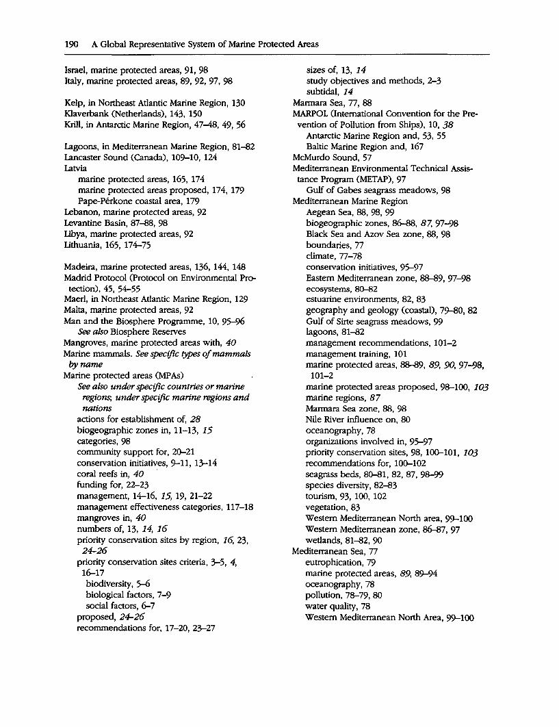
190 A Global Representative System of Marine Protected Areas
Israel, marine protected areas, 91, 98 Italy, marine protected areas, 89, 92, 97, 98
Kelp, in Northeast Atlantic Marine Region, 130 Klaverbank (Netherlands), 143, 150 · Krill, in Antarctic Marine Region, 47-48, 49, 56
Lagoons, in Mediterranean Marine Region, 81-82 Lancaster Sound (Canada), 109-10, 124 Latvia
marine protected areas, 165, 174 marine protected areas proposed, 174, 179 Pape-Perkone coastal area, 179
Lebanon, marine protected areas, 92 Levantine Basin, 87-88, 98 Libya, marine protected areas, 92 Lithuania, 165, 174-75
Madeira, marine protected areas, 136, 144, 148 Madrid Protocol (Protocol on Environmental Pro-
tection), 45, 54-55 Maerl, in Northeast Atlantic Marine Region, 129 Malta, marine protected areas, 92 Man and the Biosphere Programme, 10, 95-96
See also Biosphere Reserves Mangroves, marine protected areas with, 40 Marine mammals. See specific types of mammals
byname Marine protected areas (MP As)
See also under specific countries or marine regions, under specific marine regions and nations
actions for establishment of, 28 biogeographic zones in, 11-13, 15 categories, 98 community support for, 2C>-21 conservation initiatives, 9-11, 13-14 coral reefs in, 40 · funding for, 22-23 management, 14-16, 15, 19, 21-22 management effectiveness categories, 117-18 mangroves in, 40 numbers of, 13, 14, 16 priority conservation sites by region, 16, 23, 24-26
priority conservation sites criteria, 3-5, 4, 16-17 biodiversity, s-6 biological factors, 7-9 social factors, 6-7
proposed, 24-26 recommendations for, 17-20, 23-27
sizes of, 13, 14 study objectives and methods, 2-3 subtidal, 14
Marmara Sea, 77, 88 MARPOL (International Convention for the Prevention of Pollution from Ships), 10, 38
Antarctic Marine Region and, 53, 55 Baltic Marine Region and, 167
McMurdo Sound, 57 Mediterranean Environmental Technical Assis
tance Program (METAP), 97 Gulf of Gabes seagrass meadows, 98
Mediterranean Marine Region Aegean Sea, 88, 98, 99 biogeographic zones, 86-88, 87, 97-98 Black Sea and Azov Sea zone, 88, 98 boundaries, 77 climate, 77-78 conservation initiatives, 95-97 Eastern Mediterranean zone, 88-89, 97-98 ecosystems, 80-82 estuarine environments, 82, 83 geography and geology (coastal), 79-80, 82 Gulf of Sirte seagrass meadows, 99 lagoons, 81-82 management recommendations, 101-2 management training, 101 marine protected areas, 88-89, 89, 90, 97-98,
101-2 marine protected areas proposed, 98-100, 103 marine regions, 87 Marmara Sea zone, 88, 98 Nile River influence on, 80 oceanography, 78 organizations involved in, 95-97 priority conservation sites, 98, lOC>-101, 103 recommendations for, lOC>-102 seagrass beds, 80-81, 82, 87, 98-99 species diversity, 82-83 tourism, 93, 100, 102 vegetation, 83 Western Mediterranean North area, 99-100 Western Mediterranean zone, 86-87, 97 wetlands, 81-82,90
Mediterranean Sea, 77 eutrophication, 79 marine protected areas, 89, 89-94 oceanography, 78 pollution, 78-79,80 water quality, 78 Western Mediterranean North Area, 99-100
METAP (Mediterranean Environmental Technical Assistance Program), 97
Mollusks in Baltic Marine Region, 80, 155-56, 180 in Mediterranean Marine Region, 84 in Northeast Atlantic Marine Region, 131, 148 in Northwest Atlantic Marine Region, 114, 115, 116, 123
Monaco, marine protected areas, 89, 92, 97 Montenegro, marine protected areas, 93, 98 Morocco, marine protected areas, 93 MP As. See Marine protected areas
Netherlands Klaverbank, 143,150 marine protected areas, 135, 143 marine protected areas proposed, 143, 150 Sea area northwest of Frisian Islands, 143, 150
Nile River, 80 Northeast Atlantic Marine Region
Biogenetic Reserves, 140 biogeographical zones, 132-33, 140-41, 141 boundaries, 127 ecosystems, 128-30 fisheries and fishing, 130-31 geography and geology (coastal), 127-28 geology (coastal), 127-28 kelp forests, 130 maerl beds, 129 marine protected areas, 133-39, 140-41, 141,
142-45 marine protected areas proposed, 142-47, 150 North Sea, 131, 143, 148 oceanography, 127 priority conservation sites, 141-50 recommendations for, 149-50 seagrass beds, 129 soft sediment habitats, 128, 129, 130, 147 species diversity, 130-32 Waddensea, 128,129,134,140, 147-48
Northern Ireland See also United Kingdom marine protected areas proposed, 145, 150 Rathlin Island, 145, 150 Strangford Lough, 145, 150
North Sea, 131, 143, 148 North Water polynya, 110 Northwest Atlantic Marine Region
Acadian zone, 115-16 biogeographic zones, 106-17, 121, 121 boundaries, 105
Index 191
Browns/Baccaro Banks, 123-24 Eastern Temperate subdivision, 108 eastern temperate zones, 114-17 ecosystems, 106 endangered species, 107 fisheries and fishing, 115 geography and geology (coastal), 106 Grand Banks/Scotian Shelf zone, 114-15 Gulf of St. Lawrence zone, 113-14 Hudson-James Bay zone, 111-12 Hudson Strait zone, 110-11 Labrador Shelf zone, 113 Lancaster Sound zone, 109-10, 124 marine protected areas, 117, 121 marine protected areas' management effectiveness, 117-18
marine protected areas' management levels, 117
marine protected areas proposed, 121-25 Mid-coastal Maine area, 124 North Slope/Beaufort Sea zone, 112-13 oceanography, 105-6 Polar subdivision, 107-8 polar zones, 109-12 priority conservation sites, 121-25 recommendations for, 125 species diversity, 106, 107 Subpolar (Subarctic) subdivision, 108 subpolar zones, 112-14 Virginian zone, 116-17 Viscount Melville Sound zone, 109
Norway Arctic Marine Region of, 61, 68 marine habitats, 68 marine protected areas, 69-70, 71, 165, 175 marine protected areas proposed, 73 Spitzbergen Fjord, 65
Norwegian Sea, 62-63
Otter, in Baltic Marine Region, 158
Penguins See also Birds in Antarctic Marine Region, 48
Plankton, in Mediterranean Marine Region, 83 Plants
in Baltic Marine Region, 157-58 in Mediterranean Marine Region, 83
Poland marine protected areas, 165-66, 175 marine protected areas proposed, 175-76
192 A Global Representative System of Marine Protected Areas
Polar bear in Arctic Marine Region, 65, 66,' '67 in Northwest Atlantic Marine Region, ·107,
109,110,112,113,122 Polynyas, 65--66
Cape Bathurst Polynya, 122-23, 124 North Water polynya, 110
Porpoises: See Dolphins Portugal, marine protected areas, 135-36, 143 Protocol on Environmental Protection (Madrid P~tocol), 45, 54-55
Ramsar Convention (Convention on Wetlands of International Importance), 9
See also Wetlands Arctic Marine Region and, 71 Baltic Marine Region and, 167 Mediterranean Marine Region and, 96 Northeast Atlantic Marine Region and, ·139,
142 Rathlin Island (Northern Ireland), 145, 150 Reptiles
See also Turtles in Mediterranean Marine Region, 85
Romania, marine protected areas, 94 Russia
Arctic Marine Region of, 61 marine protected areai, 70-71, 73, 166, 176 marine protected areas proposed, 73-74, 176
Scotland See also United Kingdom Marine Consultation Areas, 138
Seagrass beds in Mediterranean Marine Region, 80-81, 82, 87, 98-99
in Northeast Atlantic Marine Region, 129 Sea ice
in Antarctic Marine Region, 46-47 in Arctic Marine Region, 61, 62, 63 in Northwest Atlantic Marine Region, 108,
109, 113 Seals
in Antarctic Marine Region, 48-49, 52, 55 in Arctic Marine Region, 65, 66, 67 in Mediterranean Marine Region, 85, 94, 99 in Northeast Atlantic Marine Region, 130 in Northwest Atlantic Marine Region, 109-17 passim, 122, 123
Shellfish. See Crustaceans; Fisheries and ftShing; Mollusks
Ships, pollution from, 79
Siberia, Arctic Marine Region of, 61, 64·. Skagerrak Sea, 68 Slovenia, marine protected areas, 93, 98 Soft sediment habitats
in Arctic Marine Region, 65 in Baltic Marine Region, 156, 157 in Northeast Atlantic Marine Region, 128, 129,
. 130,147 Southern Ocean; 49-50 Spain
marine protected areas, 93, 97, 13€r37, 144' priority conservation sites, 149
Spitzbergen Fjord, Norway, 65 Sponges
in Antarctic Marine Region, 57-58 in Mediterranean Marine Region, 84 in Northeast Atlantic Marine Region, 148
Strangford Lough (Northern Ireland), 145, 150 Sweden
Aaland Sea, 179 Bothnian Sea, 179 marine protected areas, 166, 17€r77 marine protected areas proposed, 177-79 Western Gotland Sea area, 179
Syria, marine protected area proposed, 93
Tourism, in Mediterranean Marine Region, 93, 100,102
Tunisia, marine protected areas, 93-94, 97 Turkey, 100
marine protected areas, 94, 98 Turtles
See also Reptiles endangered species, 124 in Mediterranean Marine Region, 85, 90, 94, 99 in Northwest Atlantic Marine Region, 107,
116, 124
Ukraine, marine protected areas, 96, 98 UNESCO. See United Nations Educational, Scientific and Cultural Organization
Ungava Bay (Canada), 110 United Kingdom
Channel Islands, 139, 14€r47 England, Sensitive Marine Areas, 138 Isle of Man, 138-39, 145-46, 149 Marine Nature Reserves, 137-38 marine protected areas, 137-38, 145, 148-49 marine protected areas proposed, 144--47,
148, 150 Northern Ireland, 145, 150 Scotland, Marine Consultation Areas, 138
United Nations Conference on Environment an~ Development (UNCED), 1 .
United Nations Educational, Sciei;itific and Cul- . tural Organization (UNESCO)
See also Biosphere Reserves; World Heritage Convention
Convention concerning the Protection of the World Cultural and National Heritage, 9, 95
Man and the Biosphere Programme, 10, 11,. 95-96
United Nations Environment Program (UNEP), 95 Mediterranean Marine Region and, 95
United States Arctic Marine Region of, 61 Areas of Critical Environmental Concern .
(Massachusetts), 120 marine protected areas, 119-21 marine protected areas proposed, 124-25 Mid-coastal Maine area, 124 National Estuarine Research Reserves, 120 National Marine Sanctuaries, 119-20 National Seashores, 120 , National Wildlife Refuges, 120 Northwest Atlantic Marine Region of, 112-13, 115-17
Ocean Sanctuaries of Massachusetts, 120 Virginian zone, 116-17, 124
Index 193
Vegetation in Baltic Marine Region, 157-58 in ?ylediterranean Marine Region, 83
Waddensea, 128,129,132,134,140, 147-48 Walrus
in Arctic Marine Region, 65, 66 in Northwest Atlantic Marine Region, polar
zone, 110,111,122 Wetlands
See also Ramsar Convention in Mediterranean Marine Region, 81-82, 90, 94 in Northeast Atlantic Marine Region, 139, 142
Whales in Antarctic Marine Region, 49 in Arctic Marine Region, 65, 67 endangered species, 122, 123 in Mediterranean Marine Region, 85--86, 99-100
in Northeast Atlantic Marine Region, 131 in Northwest Atlantic Marine Region, 107, 110-17 passim, 122, 123, 124
World Heritage Convention, 9 Arctic Marine Region and, 71 Baltic Marine Region and, 167 ma_rine and/or coastal sites, 37 Northeast Atlantic Marine Region and, 139
Worms, in Baltic Marine Region, 156, 180
Yugoslavia, marine protected areas, 89

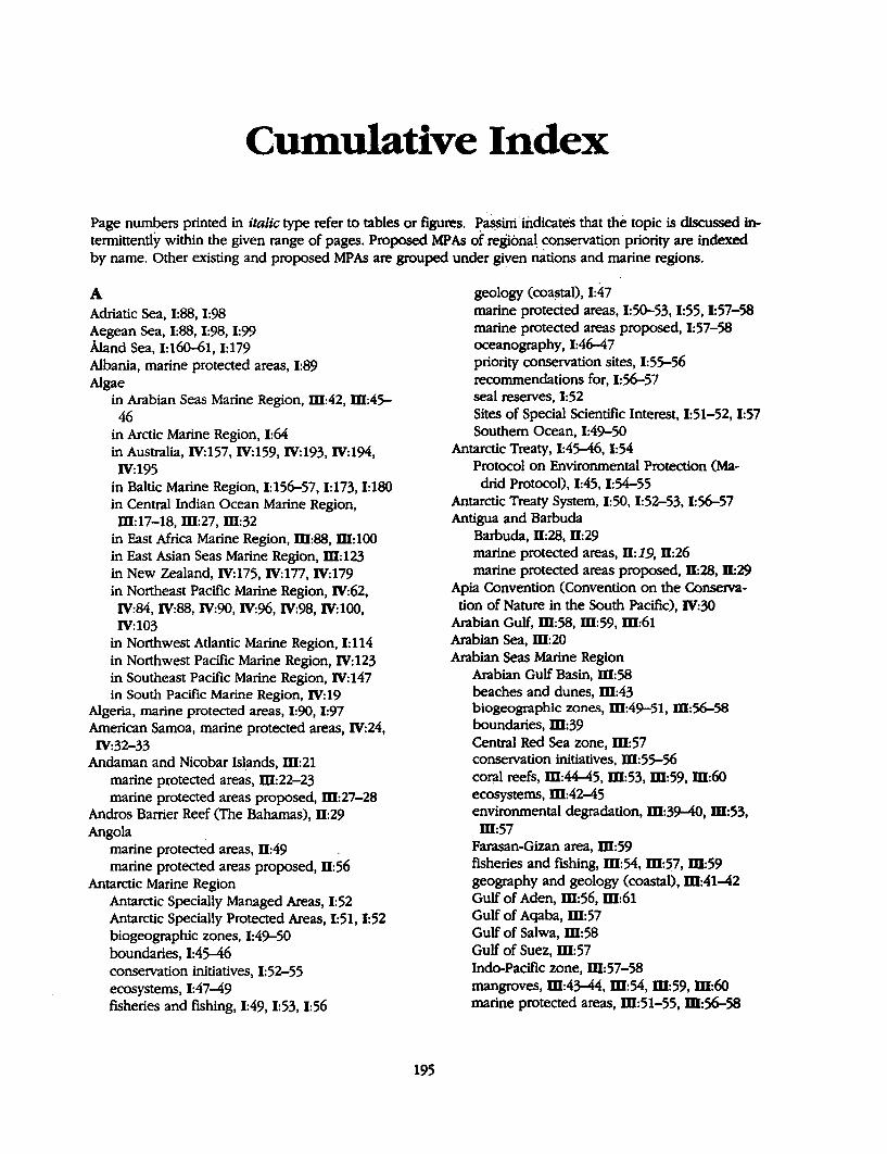
Cumulative Index
Page numbers printed in ttalic type ref er to tables or figures. ~assini. indicates that the topic is discussed intermittently within the given range of pages. Proposed MP As of .regional_ conservation priority are indexed by name. Other existing and proposed MPAs are grouped under given nations and marine regions.
A Adriatic Sea, 1:88, 1:98 Aegean Sea, 1:88, 1:98, 1:99 Aland Sea, 1:160-61, 1:179 Albania, marine protected areas, 1:89 Algae
in Arabian Seas Marine Region, m:42, m:45-46
in Arctic Marine Region, 1:64 in Australia, IV:157, IV:159, IV:193, IV:194, IV:195
in Baltic Marine Region, 1:156-57, 1:173, 1:180 in Central Indian Ocean Marine Region, m:17-18, m:27, m:32
in East Africa Marine Region, m:88, m: 100 in East Asian Seas Marine Region, m:123 in New Zealand, IV:175, IV:177, IV:179 in Northeast Pacific Marine Region, IV:62, IV:84, IV:88, IV:90, IV:96, IV:98, IV: 100, IV:103
in Northwest Atlantic Marine Region, I: 114 in Northwest Pacific Marine Region, IV:123 in Southeast Pacific Marine Region, IV:147 in South Pacific Marine Region, IV:19
Algeria, marine protected areas, 1:90, 1:97 American Samoa, marine protected areas, IV:24, IV:32-33
Andaman and Nicobar Isl.ands, m:21 marine protected areas, m:22-23 marine protected areas proposed, m:27-28
Andros Barrier Reef (The Bahamas), D:29 Angola .
marine protected areas, D:49 marine protected areas proposed, D:56
Antarctic Marine Region Antarctic Specially Managed Areas, 1:52 Antarctic Specially Protected Areas, 1:51, 1:52 biogeographic zones, 1:49-50 boundaries, 1:45--46 conservation initiatives, 1:52-55 ecosystems, 1:47-49 fisheries and fishing, 1:49, 1:53, 1:56
195
geology (coastal), 1:47 marine protected areas, 1:50-53, 1:55, 1:57-58 marine protected areas proposed, 1:57-58 oceanography, 1:46-47 priority conservation sites, 1:55-56 recommendations for, 1:56-57 seal reserves, 1:52 Sites of Special Scientific Interest, 1:51-52, 1:57 Southern Ocean, 1:49-50
Antarctic Treaty, 1:45--46, 1:54 Protocol on Environmental Protection (Madrid Protocol), 1:45, 1:54-55
Antarctic Treaty System, 1:50, 1:52-53, 1:56-57 Antigua and Barbuda
Barbuda, D:28, D:29 marine protected areas, D: 19, D:26 marine protected areas proposed, D:28, D:29
Apia Convention (Convention on the Conserva-tion of Nature in the South Pacific), IV:30
Arabian Gulf, m:58, m:59, m:61 Arabian Sea, m:20 Arabian Seas Marine Region
Arabian Gulf Basin, m:58 beaches and dunes, m:43 biogeographic zones, m:49-51, m:56--58 boundaries, m:39 Central Red Sea zone, m:57 conservation initiatives, m:55-56 coral reefs, m:44-45, m:53, m:59, m:60 ecosystems, m:42-45 environmental degradation, m:39-40, m:53, m:57
Farasan-Gizan area, m:59 fisheries and fishing, m:54, m:57, m:59 geography and geology (coastal), m:41-42 Gulf of Aden, m:56, m:61 Gulf of Aqaba, m:57 Gulf of Salwa, m:58 Gulf of Suez, m:57 Indo-Pacific zone, W:57-58 mangroves, m:43-44, m:54, m:59, m:60 marine protected areas, m:51-55, W:56-58
196 A_ Glob_al Representative System of Marine Protected Areas
Arabian Seas Marine Region (continued) marine protected areas proposed, W:59-61 Marshes of the Tigris and Euphrates, m:60 Mersa Alam-Sudanese Border proposed ma-
rine park, m:60 Northern Red Sea zone, W:57 9Ceanography, W:40-41, µI:45 oil spills, W:53 .
. Outer Indus Delta area, 54, m:60 Persian 'Gulf-Gulf of Salwa area, W:45, ID:59 priority conseivation sites, ID:5~59 Qatar-UAE Coastal zone, W:58 Qishran Islands-Ras al Askar area, W:60 Ras Suwahil, ]ll:60 recommendations for, m:61 rocky shores and cliffs, W:43 Sabkha, W:42 seagrass beds, m:45, W:59, m:60 Shatt al Arab zone, W:58 Socotra Island, W:60 soft sediment habitats, W:59 Southern Coastal Arabian Gulf zone, W:58. Southern Oman zone, W:57 Southern Red Sea zone, W:56-57 species diversity, ID:45-49 Straits pf Gubal, m:60
· Tirin Isands area, W:59-60 tourism, ID:57 vegetation, W:45-46 Wejh Bank, W:60 wetlands, W:42-43, ]ll:60 .
Arab League Educational, Cultural and Scientific Organization (ALESCO), W:55
Arctic Marine Region Arctic Coastar zone, 1:67, 1:67 Arctic ~ritime zone, 1:67-68 Arctic Ring of Life International Biocultural
Resetve, 1:74 ' · Barents Sea, 1:62, 1:74-75 Beringia Heritage International Park, I: 75 biogeographic zones, 1:66-68, I: 72 boundaries, 1:61-62 conseivation initiatives, I: 71 ecosystems, 1:64-66 . Ellesmere Island National Park, 1:69, tn, 1:75 fisheries and fishing, 1:65 geography and geology (coastal), 1:63-64 High Arctic Coastal zone, 1:66-67 High Arctic Oceanic zone, 1:66 marine protected areas, l:~71 marine protected areas proposed, 1:71-75 Noiwegian Coast zone, 1:68 ·
oceaqography, 1:62-63 polynyas, 1:65-66 priority conseivation sites, 1:71-75 species diversity, 1:64-66 vegetation, 1:64
Arctic Ocean, 1:62, 1:63, 1:64 Arctic Ring· of Life International Biocultural
Resetve, 1:74 Argentina, D:73 .
marine protected. areas, D: 76-77, D:82-83 marine protected areas proposed, D:81-82
Ascension Island, D:45, D:54 marine protected areas proposed, D:66
ASEAN Convention, W:119 Audubon Society, Wider Caribbean Marine
Region and, D:26 Australia, IV:154
See also.Australia/New Zealand Marine Region archaeological shipwreck sites, IV: 188 beaches and dunes, IV:157, IV:194, IV:195 Beagle Gulf, IV:166, IV:188 biogeographic zones, IV:162-63, IV:165-66, IV:167
caves, IV:190, IV:192 consetvation priority sites, IV: 166-68 continental shelf and slope, IV:15~59
· coral reefs, IV:158, IV:188, IV:189, IV:192, IV:194, IV:195
ecosystems, IV:155-59 endangered species, IV: 190 endemism in, IV:160 environmental threats, IV:157, IV:158, IV:159, IV:196
estuarine environments, IV:155-56, IV:189 fisheries and fishing, IV:156-57, IV:158,
IV:159, IV:162, IV:1~96 passim geography and geology (coastal), IV:155 Great Australian Bight Marine Park, IV:166, IV:190-91
Gulf of Carpentaria, IV:166, IV:189-90 Hetvey Bay/Sandy Straits, IV:166, IV:190 islands, IV:189, IV:194 Kent Group, IV:166, IV:191 lagoons, IV: 189 Lord Howe Island Marine Reseive, IV:166,
IV:192 Macquarie Island, IV:166, IV:191 mangroves, IV:155, IV:156, IV:188, IV:190, IV:193, IV:194
Maria Island National Park, IV:166, IV:191-92 marine protected areas, IV:164-65, IV:166-67, IV:167, IV:192-96 .
marine protected areas proposed, IV:166, IV:188-92
marine protected areas system, IV:163-64 oceanography, IV:154-55 recommendations for, IV:168-69 reefs (temperate), IV:157-58, IV:192 Rocky Cape, IV:166, IV:191 rocky shores and cliffs, IV:157, IV:188, IV:194, IV:195
seagrass beds, IV:155, IV:188-95 passim soft sediment habitats, IV:157, IV:188 species diversity, IV:159-62 Torres Strait, IV:166, IV:189 tourism, IV:188, IV:_195 vegetation, IV:191 wetlands, IV:156, IV:157, IV:188, IV:189,
IV:190, IV:193 'Australia/New Zealand Marine Region
See also Australia; New Zealand conservation initiatives, IV:165, IV:184 marine protected areas proposed, IV: 166, IV:185, IV:186, IV:1~92, IV:196-98
recommendations for, IV:168-69, IV:185-87 Azores, 11:45
marine protected areas, I: 136, I: 144 marine protected areas proposed; I: 143-44
Azov Sea, 1:88 marine protected areas, 1:94-95, 1:98
B The Bahamas
Andros Barrier Reef, 11:29 marine protected areas, II: 19, 11:26 marine protected areas proposed, 11:28, ll:29
Bahrain, ill:52 Persian Gulf-Gulf of Salwa area, m:59
Baltic Marine Region Aland Sea and Archipelago Sea zone, 1:160-
61, 1:179 . Baltic proper ~one, 1:160, 1:167 beaches and dunes, 1:174, 1:175 biogeographic zones, 1:158-62, 1:167 Bothnian Sea, 1:157, 1:161, 1:179 Bothnian Threshold region (The Quark), 1:161 boundaries, 1:153 Coastal and Marine Baltic Sea Protected Areas
(HELCOM), 1:179, 1:180-82 conservation initiatives, I: 166-67, I: 179-82 EC-NATURE priority sites, 1:162, 1:167~ ecosystems, 1:155-57 geography and geology (coastal), 1:155
Gulf of Bothnia, 1:157 Gulf of Finland, 'I: 160
Cumulative Index 197
Helsinki Convention (HELCOM), 1:166, 1:179-82 islands, I: 172 Kattegat, 1:154, 1:159 lagoons, 1:173, 1:174 marine protected areas, 1:162, 1:163-66, 1:167
management levels, I: 162, I: 162-63 _marine protected areas proposed, 1:172-73,
1:174, 1:175-76, 1:177-79 marine species, I: 180 oceanography, 1:153-55 Oresund (The Sound), 1:159--60 priority conservation sites, 1:167-69, 1:168, 1:179
seagrass beds, 1:173, 1:175, 1:178 Skagerrak, 1:159 soft sediment habitats, 1:156, 1:173 species diversity, 1:157-58 vegetation, 1:157-58 wetlands, 1:173, 1:174
Baltic Monitoring Programme, 1:166 Baltic Sea, 1:79, 1:153-55 Bangladesh, ill: 16
marine protected areas, m:20-21 marine protected areas proposed, ill:26, ill:31 Sundarbans, ill:16, ill:19, ill:24, ill:31
Barbados, marine protected areas, II: 19, 11:26 Barbados Declaration, 11:22 Barbuda (Antigua and Barbuda), D:28, 11:29 Barcelona Convent~on; I: 79, 1:95 Barents Sea, 1:62, 1:74-75 Bay of Bengal, m:i6, m;1s,· m:20 Bay of Fundy (Canada), 1:115-16 Beaches and dunes
in Arabian Seas Marine Region, m:43 in Australia, IV:157, IV:194, IV:195 in Baltic Marine Region, 1:174, 1:175 in Central Indian· Ocean Marine Region, m:17, m:23, m:24
in East Africa Marine Region, ill:77, ill:84, m:87, m:95, m:97. m:99
in East Asian Seas Marine Region, m: 110 in New Zealand, IV: 176 in Northeast Pacific Marine Region, IV:91 in Northwest Pacific Marine Region, IV:111, IV:123.
in South Atlantic Marine Region, 11:74 in Southeast Pacific Marine Region, IV: 132, IV:134
in West Africa Marine Region, 11:46 in Wider Caribbean Marine Region, II: 19, 11:29
198 A Global Representative System of Marine Protected Areas
Beagle Gulf (Australia), IV:166, IV:188 Beaufort Sea, 1:112-13 Belgium
conservation priority sites, 1:142 marine protected areas, 1:133, 1:142
Belize marine protected areas, D: 14 marine protected areas proposed, D:28, D:29,
D:30 Belize Barrier Reef (Belize), D:29, D:30 Benin, D:49
marine protected areas proposed, Il:56 Beringia Heritage International Park, I: 75 Bering Strait (United States), IV:94-95, IV:97 Bern Convention on the Conservation of Euro-pean Wildlife and Natural Habitats, 1:96
Biodiversity ecosystems, 1:5, 1:7, 1:30-32 genetic, 1:6 species, 1:5-6, 1:8-9, 1:33-35
Biodiversity conservation, 1:1, 1:5-6, Il:1, Il:8, fil:1, fil:8, IV:1, IV:8
information gaps, 1:16-17, 1:17 Biodiversity convention, I: 1 Biodiversity Convention, Wider Caribbean Marine Region and, D:22, D:38
BioMar survey, 1:149 Biosphere Reserves, 1:11, 1:38-39, D:8, fil:8, IV:8
in Arabian Seas Marine Region, fil:56 in Arctic Marine Region, I: 71 in Australia/New Zealand Marine Region, IV:165, IV:191
in Central Indian Ocean Marine Region, fil:24-25
in East Africa Marine Region, m:84, m:85, fil:90, ffl:93, ffl:98, ffl:99, ffl:100
in East Asian Seas Marine Region, ffl:119 in Mediterranean Marine Region, 1:93, 1:94, 1:95, 1:98
in Northeast Atlantic Marine Region, I: 139 in Northeast Pacific Marine Region, IV:65, IV:71, IV:81, IV:92
in Northwest Pacific Marine Region, IV:121, IV:125
in South Atlantic Marine Region, D:79 in Southeast Pacific Mapne Region, IV:141-42 in South Pacific Marine Region, IV:30 in West Africa Marine Region, D:55 in Wider Caribbean Marine Region, D:21, D:38
Birds See also Penguins in Antarctic Marine Region, 1:48
in Arabian Seas Marine Region, ffl:54, m:58, m:60-61
in Arctic Marine Region, 1:66, 1:67 in Australia, IV:156, IV:157, IV:160-61, IV:191, IV:192, IV:193, IV:195
in Baltic Marine Region, 1:158, 1:170, 1:171, 1:172, 1:173-78 passim
in Central Indian Ocean Marine Region, m:1s-19, m:21, m:22, m:24, m:26, m:27, fil:29, fil:31, ID:32
in East Africa Marine Region, ID:80-81, ID:82-88 passim, ffl:92-100 passim
in East Asian Seas Marine Region, ffl:110, ID: 123, ID: 124
endangered species, 1:85, I: 114, I: 124 European Community Birds Directive, 1:140 in Mediterranean Marine Region, 1:84-85 in New Zealand, IV:177, IV:181, IV:196, IV:197 in Northeast Atlantic Marine Region, 1:131-32 in Northeast Pacific Marine Region, IV:58, IV:61-69 passim, IV:77, IV:86--92 passim, IV:95-103 passim
in Northwest Atlantic Marine Region, 1:107, 1:109-17 passim, 1:122, 1:123, 1:124
in Northwest Pacific Marine Region, IV:112-13, IV:125
in South Atlantic Marine Region, D: 75-76 in Southeast Pacific Marine Region, IV:134, IV:145, IV:146, IV:147
in South Pacific Marine Region, IV:22, IV:26, IV:36, IV:43
in West Africa Marine Region, D:47-48, D:49-52 passim, D:57-66 passim
in Wider Caribbean Marine Region, D:16-17, D:26, D:29, D:31
Blackfish Archipelago (Canada), IV:84-86, IV:92 Black Sea, 1:79, 1:88
marine protected areas, 1:89, 1:94-95, 1:98 Bohai Bay (China), IV:125 Bonn Convention, 1:96 Bothnian Sea, I: 179 Brazil, D: 72
marine protected areas, D:77-78, D:83-84 marine protected areas proposed, D:83
British Indian Ocean Territory (Chagos Archipelago), W:15, ID:21, ID:24, ID:26
marine protected areas proposed, fil:32 Browns/Baccaro Banks (Canada), 1:123-24 Brunei
marine protected areas, fil:113-14 priority conservation sites, fil:121
Bulgaria, marine protected areas, 1:94, 1:98
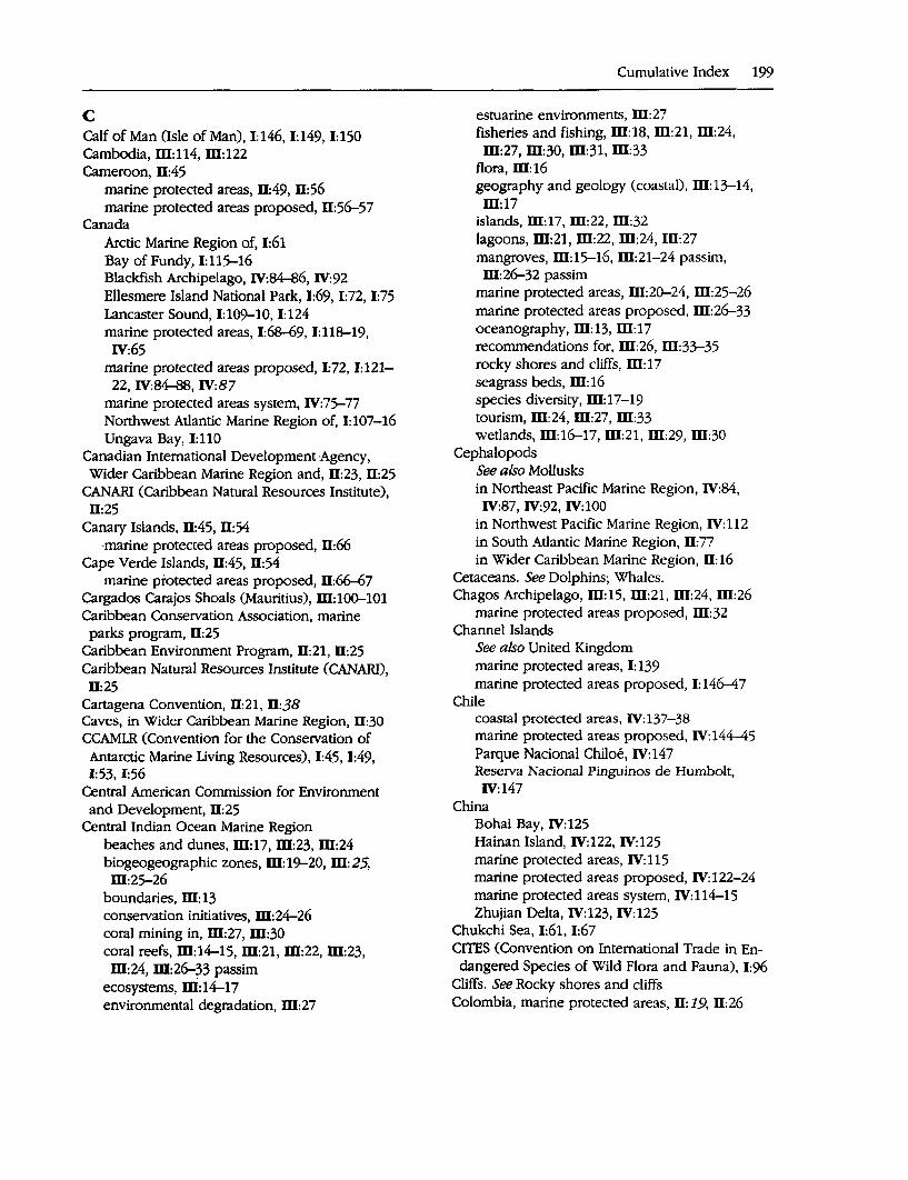
C Calf of Man (Isle of Man), 1:146, 1:149, 1:150 Cambodia, ill:114, ill:122 Cameroon, 11:45
marine protected areas, 11:49, 11:56 marine protected areas proposed, Il:56-57
Canada Arctic Marine Region of, 1:61 Bay of Fundy, 1:llS-16 Blackfish Archipelago, IV:~6, IV:92 Ellesmere Island National Park, 1:69, 1:72, 1:75 Lancaster Sound, 1:109-10, 1:124 marine protected areas, 1:68-69, 1:118-19,
IV:65 marine protected areas proposed, 1:72, 1:121-
22, IV:84-88, IV:87 marine protected areas system, IV:75-77 Northwest Atlantic Marine Region of, 1:107-16 Ungava Bay, 1:110
Canadian International Development Agency, Wider Caribbean Marine Region and, Il:23, 11:25
CANARI (Caribbean Natural Resources Institute), 11:25
Canary Islands, Il:45, Il:54 -marine protected areas proposed, Il:66
Cape Verde Islands, 11:45, 11:54 marine protected areas proposed, Il:66-67
Cargados Carajos Shoals (Mauritius), ill:100-101 Caribbean Conservation Association, marine
parks program, 11:25 Caribbean Environment Program, 11:21, 11:25 Caribbean Natural Resources Institute (CANARI),
11:25 Cartagena Convention, 11:21, 11:38 Caves, in Wider Caribbean Marine Region, 11:30 CCAMLR (Convention for the Conservation of Antarctic Marine Living Resources), 1:45, 1:49, 1:53, 1:56
Central American Commission for Environment and Development, 11:25
Central Indian Ocean Marine Region beaches and dunes, ill:17, ill:23, ill:24 biogeogeographic zones, ill:19-20, ill:25, ill:25-26
boundaries, m:13 conservation initiatives, ill:24-26 coral mining in, ill:27, ill:30 coral reefs, ill:14-15, m:21, ill:22, ill:23, ill:24, ill:26-33 passim
ecosystems, ni: 14-17 environmental degradation, ill:27
Cumulative Index 199
estuarine environments, ID:27 fisheries and fishing, ill:18, ID:21, m:24,
ill:27, ill:30, ill:31, ill:33 flora, ill:16 geography and geology (coastal), ill:13-14,
ill:17 islands, ill:17, m:22, ill:32 lagoons, ill:21, ID:22, ID:24, Ill:27 mangroves, ill:15-16, ill:21-24 passim, ill:26-32 passim
marine protected areas, ill:20-24, ID:25-26 marine protected areas proposed, ill:26-33 oceanography, ill:13, ill:17 recommendations for, ill:26, ID:33-35 rocky shores and cliffs, ill: 17 seagrass beds, ID:16 species diversity, ill:17-19 tourism, ill:24, ill:27, ill:33 wetlands, ill:16-17, ill:21, ill:29, ID:30
Cephalopods See also Mollusks in Northeast Pacific Marine Region, IV:84,
IV:87, IV:92, IV:100 in Northwest Pacific Marine Region, IV:112 in South Atlantic Marine Region, 11:77 in Wider Caribbean Marine Region, II: 16
Cetaceans. See Dolphins; Whales. Chagos Archipelago, ill:15, ill:21, ID:24, ID:26
marine protected areas proposed, ill:32 Channel Islands
See also United Kingdom marine protected areas, I: 139 marine protected areas proposed, I: 146--4 7
Chile coastal protected areas, IV:137-38 marine protected areas proposed, IV:144-45 Parque Nacional Chiloe, IV:147 Reserva Nacional Pinguinos de Humbolt, IV:147
China Bohai Bay, IV:125 Hainan Island, IV:122, IV:125 marine protected areas, IV:115 marine protected areas proposed, IV:122-24 marine protected areas system, IV: 114-15 Zhujian Delta, IV:123, IV:125
Chukchi Sea, 1:61, 1:67 CITES (Convention on International Trade in Endangered Species of Wild Flora and Fauna), 1:96
Cliffs. See Rocky shores and cliffs Colombia, marine protected areas, II: 19, 11:26
200 A Global Representative System of Marine Protected Areas
Columbia marine protected areas, IV:138, IV:145 marine protected areas proposed, IV)45
Comoros conservation measures, ~:83 marine protected areas proposed, m:9~ South coast of Moheli and Nioumach.oua.
Islets area, ID: 100 Conference on Na~ional Parks and Pr:otected Areas of East Asia_ (l~t), IV: 125-26
Congo coastal area, Il:49 marine prote~ted areas proposed, ,Il:57
Conservation International,. Wider Caribbean. Marine Region ~nci, Il:2+:2s."
Convention concerning the Protection of the Worl~ Cultural and National Heritage, 1;95
Convention for Cooperation in the Protection and Development of the Marine and <:;oastal Enviro~ent of the West aqd Central Africa Region, 11:55
Convention for the Conservation of Amarcuc Marine Living Reso~rces (CCA¥LR), 1:45, 1:49, 1:53, 1:56
Conv~ntion for the Conservation of Antarctic Seals, 1:45, 1:52, 1:55 ·
Convention for the Protection of the Mediterranean Sea against Pollution (Barcelona Convention), 1:79, 1:95
Convention for the Protection of the Natural Resources and Environment of the S<;>Uth Pacific Region (SPREP Convention), IV:30
Convention on Biodiversity., 1:1 Convention on Biodiversity, Wider Caribbean
Marine Regio~ and, Il:22, Il:38 Convention on International Trade in ,Endangered Species of Wild Flora and Fauna (CITES), 1:96
Convention on Intervention on Nature Protection and Wildlife Preservation.in the Western Hemisphere (Western Hemisph~re Convention), Il;21
Convention on Migratoiy Species of Wild Ani- · mals (Bonn Convention), 1:96
Convention on the Conservation of Nature in the. South Pacific (Apia Convention), IV:30
Convention on the Protection of the ¥arine Environment of the Baltic Sea Area (Helsinki Convention; HELCOM), i:166, 1:179-80
Convention on Wetlands of International Importance. See Ramsar Convention
Cook Islands marine protected areas, IV:24-25, IV:33 marine protected areas proposed, IV:33
Coral communities in Australia, IV: 193, IV: 194 in Central Indian Ocean Marine Region, m:15, m:23, m:"30, m:31.
in East Africa Marine Region, m: 78 . in East Asian Seas Marine Region, ID:125 in Mediterranean. Marine Region, 1:84, 1:89,
1:92 in Ne':",Zealand, IV:177-78, J.\:1:180, IV:196, IV:197
in Northeast Pacific Marine Region, IV:90 in Southeast Pacific Marine Region, IV:145 in West Africa Marine Region, Il:45, Il:67
Coral mining, in Central Indian Ocean Marine Region, ID:27, ID:30
Coral reefs . in Arabian Seas Marine Region,. m:44-45, m:53, m:59, m:60
in Australia, IV:158, IV:188, IV:189, IV:192, IV:194, IV:195
in Central Indian Ocean Marine Region, m:14-15, m:21-24 passim, m:26-33 passim
in East Africa Marine Region, ID:73-75, ID:82, W:84--89 passim, W:92-100 passim
in East Asian Seas Marine Region, W:109, m:117, W:118, W:121-25 passim, ID:128
marine protected areas with, I: 40 in Northeast Pacific Marine Region, IV:90 in Northwest Pacific Marine Region, IV: 110, IV:122
in South Atlantic Marine Region, Il: 73 in Southeast Pacific Marine Region, IV: 133, IV:145, IV:146
in South Pacific Marine Region,. 4.2, 4.5, 4.5-6, 4.15, 4.21,.31 passim
in.Wider Caribbean Marine Region, Il:15,. Il: 19, Il:29, Il:30
Costa Ric;i conservation measures, IV: 138 marine protected areas, Il:27, IV:138-39, IV:145-46
marine protected areas proposed, Il:28, Il:29, Il:30
Tortuguero/Miskito Marine System, Il:29, Il:30 Cote d'Ivoire ·
coastal areas, Il:49-50 marine protected areas proposed, Il:57
Counci~ of Eur<?pe, 1:96 · Biogenetic Reserves, 1:140
Croatia, marine protected areas, 1:90, 1:98 Crocodiles, IV:20, IV:22
See also Reptiles
in Australia, IV:189, IV:192 in Central Indian Ocean Marine Regi~n,
ID:21, ID:22, ID:23, ID:28, ID:29, ID:31 in East Africa Marine Region, ID:80 in Northeast Pacific'·Marine Region, IV:89, IV:91, IV:94
in West Africa Marine Region, Il:~O in Wider Caribbean Marine Region, Il:17, Il:31
Crustaceans · See also Fisheries and ftShing; Invertebrates; Mollusks
in Arabian Seas Marine Region, ID:54, ID:59 in Australia, IV:157, IV:1_61, IV:188; IV:189, IV:193
in Baltic Marine Region, 1:156, 1:175, 1:180 in Central Indian Ocean Marine Region, ID:15, ID:16, W:23, ID:28, W:29, ID:31
in East Africa Marine Region,· ID: 78, m: 79, ID:98, ID:99, ID:100
in East Asian Seas Marine Region, ID:110, ID:111, ID:124
in New Zealand, IV:176, IV:177, IV:178 in Northeast Atlantic Marine Region, 1:131,
1:148 in Northeast Pacific Marine Region, IV:61, IV:62, IV:74, IV:84-102 passim
in Northwest·Atlantic Marine Region, 1:114, 1:115, 1:116, 1:123
in Northwest Pacific Marine Region, IV:112, IV:122
in Southeast Pacific Marine Region, IV:136, IV:145
in South Pacific Marine Region, IV:19, IV:21, IV:36
in West Africa Marine Region, D:57, D:60, D:61, D:62, D:63, IV:46, IV:47
in Wider Caribbean Marine Region, Il:16 Cuba
marine protected areas, Il:19, Il:27, Il:29, Il:30-31
marine protected areas proposed, 11:28 Cyprus, marine protected areas, 1:90-91, 1:98
D Denmark
See also Greenland conservation measures, 1:63 conservation priority sites, 1:142 marine protected areas, 1:133, 1:142, 1:163, 1:16~71
Djibouti, marine protected areas, ffl:52
Cumulative Index 201
Dolphins . in Arabian Seas Marine Region, ID:48-49,
W:59 in Australia, IV:161, IV:162, IV:193, IV:194 in Baltic Marine Region, 1:158 in Central Indian Ocean Marine Region,
W:19,'ffl:22, ffl:31 in East Africa Marine Region, W:81, m:86, m:94,m:99
in East Asian Seas Marine Region, ffl:112 in Mediterranean Marine Region, 1:84-85,
1:86, l:~100 in New Zealand, IV:182 in Northeast Atlantic Marine Region, 1:131 in Northeast Pacific Marine Region, IV:58, IV:63, IV:67, IV:69, IV:84, IV:86, IV:96, IV:99
in .Northwest Atlantic Marine Region, eastern temperate zones, 1:11~17 passim, 1:123, 1:124
in South Atlantic Marine Region, Il: 75 in Southeast Pacific Marine Region, IV:136, IV: 145, IV: 146
in West Africa Marine Region, Il:48, Il:50, Il:52, Il:59, 11:60, 11:61
Dominica, marine protected areas, Il:27 Dominican Republic, marine protected areas, Il:27, Il:29, Il:31
Dugong in Arabian Seas Marine Region, m:48, ffl:52, m:55, m:59, m:60, m:61
in Australia, IV:161-62, IV:188, IV:192, IV:194 · in Central Indian Ocean Marine Region,
m:21, m:23, m:21, m:28, m:29 in East Africa Marine Region, W:81, ID:84, m:86, ffl:89, ffl:9~100 passim
in East Asian Seas Marine Region, W:112, ffl:124, ID:125 ·
in Northwest Pacific Marine Region, IV: 113 in South Pacific Marine Region, IV:20, IV:22, IV:23, IV:38, IV:39, IV:40
Dunes. See Beaches and dunes
E East Africa Marine Region
beaches and dunes, W:77, m:84, W:87, W:95, ffl:97, W:99
biogeographic zories, m:81-82, m:91, ffl:91 h9undarie~, ID: 71. Cai:gados Carajbs Shoals, ID:100-101 caves; m:84 cdnse~ation initiatives, _m:8~91
202 A Global Representative System of Marine Protected Areas
East Africa Marine Region (continued) coral reefs, ID:73-75 ecosystems, ID:73-78 environmental degradation, ID:79, ID:84-85, ID:88-89, ID:95
estuarine environments, ID:84, ID:86, ID:89, ID:96,ID:97
fisheries and fishing, ID:78-80, ID:84-85, ID:86-87, ID:89, ID:92, ID:93, ID:97-100 passim
geography and geology (coastal), ID:63, ID:71-73
Grand Recif and coastal zone of Toliara area, ID:99-100
islands, ID:74, ID:77-78, ID:82, ID:87, ID:94, ID:95, ID:97, ID:100
Kiunga Marine National Reserve and Bio-sphere Reserve, ID:99
lagoons, ID: 76, ID:94 Mafia Island and Rufiji Delta area, ID:98 mangroves, ID:75-76, ID:82-89 passim, ID:93-100 passim
marine protected areas, ID:82-89, ID:83, ID:91, ID:91
marine protected areas proposed, ID:92-101 oceanography, ID:71-72, ID: 72, ID:78 Parque Nacional do Bazaruto, ID:99 priority conservation sites, ID:91-92 recommendations for, ID:91-92, ID:101 rocky shores and cliffs, ID: 77, ID:82, ID:93 seagrass beds, ID:76, ID:82, ID:86, ID:87,
ID:94, ID:95, ID:97, ID:98 South coast of Moheli and Nioumachoua
Islets area, ID: 100 species diversity, ID:78-81, ID:90-91 submerged banks, ID:77-78 tourism, ID:83, ID:84, ID:95, ID:97, ID:98, ID:100
wetlands, ID:76-77, ID:84, ID:86, ID:93, ID:99 East Asian Seas Marine Region
beaches (sandy), W:110 biogeographic zones, ID:112-13, ID:119-21,
ID: 120, ID: 121 boundaries, ID: 107 conservation initiatives, ID: 118-19, ID: 119 coral reefs, ID:109, ID:117, ID:118, ID:121-25
passim, ID:128 ecosystems, ID: 109-11 environmental degradation, ID:109, ID:114, ID:117, ID:118, ID:126, ID:128
estuarine environments, ID:121
fisheries and fishing, ID:109, ID:112, ID:114, ID:117, ID:118, ID:122, ID:125-26
geography and geology (coastal), ID:108-9 islands, ID:111, ID:124, ID:125-26 mangroves, ID:109-10, ID:118, ID:121,
ID:124, ID:125 marine protected areas, 114-18, ID:113-18
management levels, ID: 113 marine protected areas proposed, ID:120-26 oceanography, ID:107-8, ID:111 priority conservation sites, ID:120-26 recommendations for, ID:126-28 rocky shores, ID:110-11 seagrass beds, ID:110, ID:121, ID:122, ID:123,
ID:124 Semporna Islands, ID: 126 soft sediment habitats, ID:110 species diversity, ID:111-12 submerged banks, ID: 111 tourism, ID:109, ID:122, ID:123-24, ID:125
Easter Island and Sala y Gomez, IV:29 marine protected areas proposed, IV:44
Eastern Great Barrier IslandQuter Hauraki Gulf (New Zealand), IV:185, IV:196
Ecosystems, large marine, 1:7, 1:36 Ecuador
conservation measures, IV: 139 marine protected areas, IV:139, IV:146.
Eelgrass beds. See Seagrass beds · Egypt
marine protected areas, 1:91, ID:52 marine protected areas propqsed, m: 62 Mersa Alam-Sudanese Border proposed. ·
marine park, ID:60 priority conservation sites, ID:58-59 Straits of Gubal, ID:60 Tiran Islands area, m:59-60
Ellesmere Island National Park (Canada), 1:69, 1:72, 1:75
El Salvador coastal protected areas, IV: 139 marine protected areas proposed, IV: 146
Endangered species in Australia, IV: 190, IV: 192 birds, 1:85, 1:114, 1:124 crocodiles, IV:20, IV:91, IV:94, IV:192 dugong, IV:20 in Northeast Pacific Marine Region, IV:58, IV:89, IV:91, IV:93, IV:94
seals, 11:48 in Southeast Pacific Marine Region, IV:146 turtles, 1:124, IV:20, IV:21
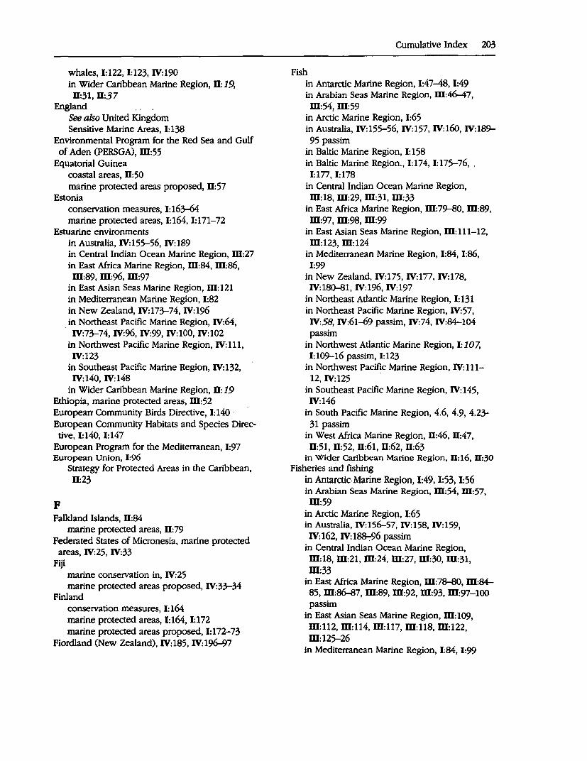
whales, 1:122, 1:123, IV:190 in Wider Caribbean Marine Region, Il: 19,
ll:31, ll:37 England
See also United Kingdom Sensitive Marine Areas, 1:138
Environmental Program for the Red Sea and Gulf of Aden (PERSGA), m:55
Equatorial Guinea coastal areas, Il:50 marine protected areas proposed, Il:57
Estonia conservation measures, I: 163-64 marine protected areas, 1:164, 1:171-72
Estuarine environments in Australia, IV:155-56, IV:189 in Central Indian Ocean Marine Region, m:27 in East Africa Marine Region, m:84, m:86, m:89, m:96, ID:97
in East Asian Seas Marine Region, ID: 121 in Mediterranean Marine Region, 1:82 in New Zealand, IV:173-74, IV:196 in Northeast Pacific Marine Region, IV:64,
. IV:73-74, IV:96, IV:99, IV:100, IV:102 in Northwest Pacific Marine Region, IV:111, IV:123
in Southeast Pacific Marine Region, IV: 132, IV:140, IV:148
in Wider Caribbean Marine Region, Il: 19 Ethiopia, marine protected areas, ID:52 European Community Birds Directive, 1:140 · European Community Habitats and Species Direc-
tive, 1:140, 1:147 European Program for the Mediterranean, 1:97 European Union, I:96
F
Strategy for Protected Areas in the Caribbean, Il:23
Falkland Islands, Il:84 marine protected areas, ll: 79
Federated States of Micronesia, marine protected areas, IV:25, IV:33
Fiji marine conservation in, IV:25 marine protected areas proposed, IV:33-34
Finland conservation measures, I: 164 marine protected areas, 1:164, 1:172 marine protected areas proposed, I: 172-73
Fiordland (New Zealand), IV:185, IV:196-97
Cumulative Index 203
Fish in Antarctic Marine Region, 1:47-48, 1:49 in Arabian Seas Marine Region, m:46-47, ffl:54,ID:59
in Arctic Marine Region, 1:65 in Australia, IV:155-56, IV:157, IV:160, IV:189-95 passim
in Baltic Marine Region, I: 158 in Baltic Marine Region., 1:174, 1:175-76, . 1:177, 1:178
in Central Indian Ocean Marine Region, ID:18, ID:29, ID:31, ffl:33
in East Africa Marine Region, m:79-80, m:89, m:97, m:98, m:99
in East Asian Seas Marine Region, ffl:111-12, m:123, m:124
in Mediterranean Marine Region, 1:84, 1:86, 1:99
in New Zealand, IV:175, IV:177, IV:178, IV:180-81, IV:196, IV:197
in Northeast Atlantic Marine Region, 1:131 in Northeast Pacific Marine Region, IV:57, IV:58, IV:61-69 passim, IV:74, IV:84-104 passim
in Northwest Atlantic Marine Region, I: 107, 1:109-16 passim, 1:123
in Northwest Pacific Marine Region, IV:111-12, IV:125
in Southeast Pacific Marine Region, IV:145, IV:146
in South Pacific Marine Region, 4.6, 4.9, 4.23-31 passim
in West Africa Marine Region, ll:46, ll:47, Il:51, Il:52, Il:61, Il:62, Il:63
in Wider Caribbean Marine Region, ll: 16, D:30 Fisheries and fishing
in Antarctic. Marine Region, 1:49, 1:53, 1:56 in Arabian Seas Marine Region, ID:54, ID:57, m:59
in Arctic Marine Region, 1:65 in Australia, IV:156-57, IV:158, IV:159, IV:162, IV:188-:-96 passim
in Central Indian Ocean Marine Region, m:18, m:21, m:24, m:27, m:30, m:31, m:33
in East Africa Marine Region, m:78-80, m:~ ss, m:86-87, m:89, ID:92, ID:93, m:97-100 passim
in East Asian Seas Marine Region, ffl:109, m:112, m:114, m:117, m:ns. m:122, m:125-26
in Mediterranean Marine Region, 1:84, 1:99
204 A Global Representative· System of Marine Protected Areas
Fisheries and fishing (continued) in New Zealand, IV:178-79, IV:185--86, IV:197, IV:198
in Northeast Atlantic Marine Region, 1:130-31, 1:142, 1:148
in Northeast Pacific Marine·.Region, IV:81-82, IV:88-104 passim
in Northwest Atlantic Marine Region, 1:115, 1:116, 1:118
in Northwest Pacific Marine Region, IV:111, IV:112, IV:117-18, IV:122, IV:123
in South Atlantic Marine Region, II: 77 in Southeast Pacific Marine Region, IV:136, IV:137, IV:148-49
in West Africa Marine Region, 11:46, 11:47, 11:60, 11:61, 11:63
in Wider Caribbean Marine Region, 11:16, 11:29-30, 11:31 ·
Fishing, in South Pacific Marine Region, IV:14, IV:18, IV:25-29Passim, IV:33-43passim, IV:45-46
Fjords in Arctic Marine Region, 1:65, 1:68 in Baltic Marine Region, I: 176 in New Zealand, IV:196-97
France See also specific territories by name marine protected areas, 1:89, 1:91, 1:97, 1:133-34, 1:142
priority conservation sites, I: 100 Seashore and Lakeshore Conservatory
(CELRL), 1:91 French Polynesia
G
marine protected areas, IV:25, IV:34-35 marine protected areas proposed, IV:35
Gabon, 11:45 marine protected areas, 11:50, 11:57-58 marine protected areas proposed, 11:58
The Gambia, 11:45 marine protected areas, 11:50-51, 11:58
General Council for Mediterranean Fisheries, 1:100
Germany conservation measures, I: 164-65 conservation priority sites, I: 142 marine protected areas, 1:134, 1:142, 1:165, 1:173-74
marine protected areas proposed, 1:174 Ghana, 11:44-45, 11:51
marine protected areas proposed, 11:58
Golfo de California, IV:71-74, IV:89 Grand Recif and coastal zone of Toliara area (Madagas<;ar), W:99-100
Great Australian Bight Marine Park, IV: 166, IV:190-91
Greece, marine protected areas, 1:91, 1:98 Greenland
Arctic Marine Region of, 1:61 marine protected areas, 1:69, 1:72
Guadeloupe, marine protected areas, 11:27 Guam
marine protected areas, IV:25 marine protected areas proposed, IV:35
Guano production, in Southeast Pacific Marine Region, IV:141
Guatemala coastal protected areas, IV: 139 marine protected areas, 11:27 marine protected areas proposed, IV:146
Guinea, 11:45, 11:46, 11:51 marine protected areas proposed, 11:58-59
Guinea-Bissau, 11:44, D:45 marine protected areas, 11:51, 11:59 marine protected areas proposed, 11:59-60
Gulf of Aden, W:56, m:61 Gulf of Carpentaria (Australia), IV:166, ~:189-9() Gulf of Gabes seagrass meadows, I:~ Gulf of Mannar (Sri Lanka), W:30 Gulf. of Sirte seagrass meadows, 1:99
H Habitats. See Ecosystems Hainan Island (China), IV:122, IV:125 Hawaii (U.S.), IV:25-26, IV:35
marine protected areas, IV:25-26 HELCOM (Helsinki Convention), 1:166, 1:179-80 Helsinki Convention (HELCOM), 1:166, 1:179-80
Coastal and Marine Baltic Sea Protected Areas, 1:179, 1:180-82
Hervey Bay/Sandy Straits (Australia), IV:166, IV:190
Honduras, IV:137, IV:139-40 marine protected areas, 11:27 marine protected areas proposed, IV:146
Hong Kong
I
marine protected areas, IV: 118 marine protected areas proposed, IV:124 Zhujian Delta, IV: 123, IV: 125
Icebergs. See Sea ice
Iceland Arctic Marine Region of, 1:68 marine protected areas, 1:69, 1:71, 1:72 marine protected areas proposed, I: 72 Nature Conservation Council, I: 70
Iguanas, in Wider Caribbean Marine Region, 0: 17 Ile de la Reunion, marine protected areas, m:83,· m:86-87, W:95
India See also Andaman and Nicobar islands Lakshadweep Archipelago, m:31 Malvan Sanctuary, W:31 marine protected areas,· m:21-22 marine protected areas proposed, W:31 Sundarbans, m:16, m:19, m:24, W:31
Indian Ocean, m: 19-20 Indonesia ·
conservation measures, Di: 114 marine protected areas, ~:114-15, W:121-22
International Convention for the Prevention of Pollution from Ships. See MARPOL
International Whaling Commission, 1:50 Intertidal flats. See Soft sediment habitats Invertebrates
See also Crustaceans; Mollusks; Sponges; ·worms in Australia, IV:157, IV:160, IV:189-95 passim in Baltic Marine Region, 1:158 in Central Indian Ocean Marine Region, m: 18 in East Africa Marine Region, m:78-79, m:86, m:87
in East Asian Seas Marine Region, m:110, m:111, m:122, m:123
in Mediterranean Marine Region, 1:83-84 in New Zealand, IV:175, IV:176, IV:177,
·:.J IV:178, IV:179-80, IV:196, IV:197, . · in Northeast Pacific Marine Region, IV:61,
:IV:74, IV:75, IV:84, IV:87, IV:88, IV:91-103 passim
in Northwest Pacific.Marine Region, IV:112. in South Pacific Marine Region, IV:20-21, IV:38, IV:39
in West Africa Marine Region, 0:47 in Wider Caribbean Marine Region, 0: 17 .
Ionian Sea, 1:87, 1:97 Iran
marine-·prote~ed areas, W:52-53 marine protected areas proposed, m: 62
Iraq, m:53 Marshes of the Tigris and Euphrates, m:60
Ireland marine protected areas, I: 134-35
Cumulative Index 205
priority conservation 'sites, 1:142'..43, 1:148, 1:149
Islands in Australia, IV:189, IV:194 in Baltic Marine Region, 1:172, 1:178, 1:179 in Central Indian Ocean Marine Region, m:17, m:22, m:32
in East Africa Marine Region, W:74, m:77-78, m:82, m:87, m:94, m:95, m:97, m:100
in East Asian Seas Marine Region, W:111, m:124, m:125-26
in Northeast Pacific Marine Region, IV:86, IV:98, IV:99
in Northwest Pacific Marine Region, IV: 111, IV:123
in South Atlantic Marine Region, 0:74-75 in Southeast Pacific Marine Region, IV: 132, IV:134-35
types in the South Pacific Marine Region, IV:16-i7, IV:23-24
in West Africa Marine Region, 11:45 Isle of Man
See also United Kingdom Calf of Man, 1:146;1:149, 1:150 marine protected areas, I: 138-39 marine protected areas proposed, I: 145-46, 1:150 .
priority conservation sites, I: 149 Israel, m:55
marine protected areas, 1:91, 1:98 Italy, marine protected areas, 1:89, 1:92, 1:97, 1:98 IUCN
Marine Conservation Strategy, Wider Caribbean Marine Region and, 11:21-22
Strategy for Protected Areas of the Neotropical Realm, 11:23
IUCN Commission on National Parks and Protected Areas, 11:1, ID:1, IV:l
J
biodiversity conseryation, 0:1, 0:8, m:1, W:8, IV:l, IV:8
study methods, 11:2-3, ID:2-3, IV:2-3
Jamaica, marine protected areas, 0:27 Japan
fishetjes and fishing, IV:117-18 marine protected areas proposed, IV: 124 · ·
. marine protected areas system, IV:115-18 Yaeyama Archipelago, IV:125
Jordan, m:55 marine· protected areas proposed, m:62
206 A Global Representative System of Marine Protected Areas
K Kachemak Bay (United States), IV:96, IV:97 Kelp
in Australia, IV:192 in New Zealand, IV:175-76, IV:177 in Northeast Atlantic Marine Region, I: 130 in Northeast Pacific Marine Region, IV:95, IV:96, IV:98, IV:102, IV:103
in South Atlantic Marine Region, D: 75 in Southeast Pacific Marine Region, IV: 135
Kent Group (Australia), IV:166, IV:191 Kenya
environmental degradation, m:~5 Kiunga Marine National Reseive and Biosphere Reseive, ffl:99
marine protected areas, m:83, ffl:83-85, ffl:92
marine protected areas proposed, ffl:93 Kiribati
marine protected areas, IV:26 marine protected areas proposed, IV:35--36
Kiunga Marine National Reseive and Biosphere Reserve (Kenya), ffl:99 .
Klaverbank (Netherlands), 1:143, 1:150 Komandorskiye Islands (Russia), IV:125 Korea
conseivation measures, IV:118-19 marine protected areas, IV:119 marine protected areas proposed, IV:124
Krill, in Antarctic Marine Region, 1:47-48, 1:49, 1:56
Kuryl Islands (Russia), IV: 125 Kuwait, m:53-54
marine protected areas proposed, m: 62 priority conservation sites, ffl:59
Kuwait Regional Convention for the Protection of the Marine Environment from Pollution, ffl:55
L Lagoons
See also Wetlands in Australia, IV: 189 in Baltic Marine Region, 1:173, 1:174 in Central Indian Ocean Marine Region, m:21, m:22, m:24, m:27
in East Africa Marine Region, m: 76, ffl:94 in Mediterranean Marine Region, 1:81-82 in Northeast Pacific Marine Region, IV:70-71, IV:88-89, IV:94, IV:95, IV:96
in Northwest Pacific Marine Region, IV:110-11 in Southeast Pacific Marine Region, IV: 132
in South Pacific Marine Region, IV:19-20, IV:25, IV:34, IV:35, IV:36, IV:38, IV:41
in West Africa Marine Region, D:44, D:50, Il:52, Il:57, Il:58, D:65
in Wider Caribbean Marine Region, Il:16, D: 19, D:29, D:30, D:31
Lakshadweep Archipelago (India), ffl:31 Lancaster Sound (Canada), 1:109-10, 1:124 Latin American Technical Network on Protected Areas and Wildlife, D:26
Latvia conservation measures, 1:165 marine protected areas, 1:165, 1:174 marine protected areas proposed, 1:174, 1:179 Pape-Perkone coastal area, 1:179
Lebanon, marine protected areas, 1:92 Levantine Basin, 1:87-88, 1:98 Liberia, Il:51
marine protected areas proposed, D:60-61 Libya, marine protected areas, 1:92 Lithuania
conservation measures, 1:165 marine protected areas, 1:165, 1:174-75
Lord Howe Island Marine Reseive (Australia), IV: 166, IV: 192
M Macao
marine protected areas proposed, IV:124 Zhujian Delta, IV:123, IV:125
Macquarie Island (Australia), IV:166, IV:191 Madagascar
Grand Recif and coastal zone of Toliara area, ffl:99-100
marine protected areas, m:83, m:85, ffl:93 marine protected areas proposed, ffl:93-94
Madeira, D:45 marine protected areas, 1:136, 1:144, 1:148
Madrid Protocol (Protocol on Environmental Pro-tection), 1:45, 1:54-55
Maerl, in Northeast Atlantic Marine Region, I: 129 Mafia Island and Rufiji Delta area (Tanzania), ffl:98 Malaysia
conservation measures, ffl:115-16 marine protected areas, ffl:116, ffl:122-23 marine protected areas proposed, ffl:123 Semporna Islands, m: 126
Maldive Atolls, ffl:30 Maldives, m: 15
conservation measures, ffl:23, ffl:28 marine protected areas proposed, ffl:30
Malta, marine protected areas, 1:92 Malvan Sanctuary (India), ID:31 Malvinas Islands, 11:84
marine protected areas, D: 79 Mammals (nonmarine), in Northeast Pacific
Marine Region, IV:89; IV:91, IV:94 Man and the Biosphere Programme, 1:10, 1:95-96
See also Biosphere Reserves Manatees
in South Atlantic Marine Region, Il: 75 in West Africa Marine Region, Il:48, Il:49, D:50, D:52, D:53, D:56, D:59, D:60, D:64
in Wider Caribbean Marine Region, D:30, Il:31 Mangroves
See also Wetlands in Arabian Seas Marine Region, m:43-44, ID:54, ID:59, ID:60
in Australia, IV:155, IV:156, IV:188, IV:190, IV:194
in Central Indian Ocean Marine Region, 3.3-4, 3.9-12 passim, 3.14-20 passim
in East Africa Marine Region, ID:75-76, ID:82-89 passim, ID:93-100 passim
in East Asian Seas Marine Region, ID:109-10, ID:118, ID:121, ID:124, ID:125
marine protected areas with, 1:40 in New Zealand, IV:174-75 in Northeast Pacific Marine Region, IV:70, IV:73, IV:74, IV:75, IV:90, IV:91, IV:94
in Northwest Pacific Marine Region, IV:110, IV:122-23
in South Atlantic Marine Region, Il:72, Il:73-74 in Southeast Pacific Marine Region, IV: 132, IV:133-34, IV:140, IV:145, IV:146, IV:148
in South Pacific Marine Region, IV:18-19, IV:19, IV:27, IV:34, IV:37, IV:38, IV:39, IV:41
in West Africa Marine Region, 2.30, 2.31-38 passim, 2.42-50 passim
in Wider Caribbean Marine Region, D:15-16, Il:29, Il:30
Maria Island National Park (Australia), IV:166, IV:191-92
Marine mammals. See specific types of mammals byname
Marine protected areas (MPAs) See also under specific marine regions and na
tions actions for establishment of, 1:28, D:2, Il:12, ID:2, ID:12, IV:2, IV:12
biogeographic zones in, 1:11-13, 1:15, Il:6, n: 7, m: 6, m: 7, IV: 6, IV: 7
categories, 1:98
Cumulative Index 207
community support for, 1:20-21, Il:9-10, fil:9-10, IV:9-10
conservation initiatives, 1:9-11, I: 13-14 coral reefs in, I: 40 defined, Il:2, m:2, IV:2 funding for, 1:22-23, Il:10-11, ID:10-11, IV:10-11
management, 1:14-16, 1:15, 1:19, 1:21-22, Il: 7, Il:8-9, Il:10, ID: 7, ID:8-9, ill:10, IV: 7, IV:8-9, IV:10
management effectiveness categories, I: 117-18 mangroves in, I: 40 numbers of, 1:13, I: 14, I: 16 priority conservation site criteria, Il:3-5, Il:4, m:3-5, m:4
priority conservation sites by region, I: 16, 1:23, 1:24-26
priority conservation sites criteria, 1:3-5, 1:4, l:1~17, IV:3-5, IV:4
biodiversity, 1:5-6 biological factors, 1:7-9 social factors, l:~7
proposed, 1:24-26 recommendations, 11:11-12, 11:12, ID:11-12, m:12
recommendations for, 1:17-20, 1:23-27, IV:11-12, IV:12
sizes of, 1:13, 1:14, 11:6, m:6, IV:6 study objectives and methods, 1:2-3 subtidal, 1:14, Il:5, ID:5, IV:5
Marmara Sea, 1:77, 1:88 MARPOL (International Convention for the Pre-vention of Pollution from Ships), 1:10, 1:38
Antarctic Marine Region and, H:53, 1:55 Arabian Seas Marine Region and, ill:56 Australia/New Zealand Marine Region and,
IV:165 Baltic Marine Region and, 1:167 East Africa Marine Region and, ID:90 Northwest Pacific Marine Region and, IV:121
Marshall Islands marine protected areas, IV:26, IV:36 marine protected areas proposed, IV:36
Marshes. See Wetlands Martinique, marine protected areas, D:27 Mauritania
marine protected areas, Il:51, Il:61 marine protected areas proposed, D:61
Mauritius Cargados Carajos Shoals, fil:100-101 .marine protected areas, m:83, fil:85-86 marine protected areas proposed, ID:94
208 A Global Representative System of Marine Protected Areas
Mayotte, ID:94 marine protected areas, ID:83, m:86
McMurdo Sound, 1:57 Mediterranean Environmental Technical Assis
tance Program (METAP), 1:97 Gulf of Gabes seagrass meadows, 1:98
Mediterranean Marine Region Aegean Sea, 1:88, 1:98, 1:99 biogeographic zones, 1:86-88, 1:87, 1:97-98 Black Sea·and Azov Sea zone, 1:88, 1:98 boundaries, I: 77 climate, 1:77-78 conservation initiatives, 1:95-97 Eastern Mediterranean zone, 1:88-89, ·l:97-98 ecosystems, I:~2 estuarine environments, 1:82, 1:83 geography and geology (coastal), 1:79-80, 1:82 Gulf of Sirte seagrass meadows, 1:99 lagoons, 1:81-82 management recommendations, 1:101-;-2 management training, 1:101 marine protected areas, 1:88-89, -1:89, 1:.90, 1:97-98, 1:101-2
marine protected ·areas proposed, 1:98-:-100, 1:103
marine regions, 1:87 Marmara Sea zone, 1:88, 1:98 Nile River influence on, 1:80 oceanography, 1:78 organizations involved in, 1:95-97 priority conservation sites, 1:98, 1:100-101, 1:103 recommendations for, 1:100-102 seagrass beds, 1:80--81, 1:82, 1:87, 1:98-99 species diversity, 1182-83
. 'tourism, 1:93, 1:100, 1:102 vegetation, 1:83 Western Mediterranean North area, 1:99-100 Western Mediterranean zone, 1:86-87, 1:97 wetlands, 1:81-82, 1:90
Mediterranean Sea, I: 77 eutrophication, I: 79 marine protected areas, I: 89, 1:89-94 oceanography, 1:78 pollution, 1:78-79, 1:80 water quality, 1:78 Western Mediterranean North Area, 1:99-100
METAP (Mediterranean Environmental Technical Assistance Program), 1:97
Mexico marine biodiversity, IV:56-57 marine protected areas, 11:19, 11:27, IV:71, IV:74, IV:75, IV:92-94, IV:97
marine protected areas proposed, IV:87, IV:88-92
marine protected areas system, IV:~2 Micronesia, marine protected areas, IV:25 Moheli south coast and Nim,1machoua Islets area (Comoros), ID:100
Mollusks See also Cephalopods; Crustaceans; Fisheries and fishing; Invertebrates
in Australia, IV:160, IV:193 in Baltic Marine Region, 1:155-56, 1:160,· 1:173, 1:174, 1:175, 1:178, 1:180
in Central Indian Ocean Marine Region, ID:18, ID:21, ID:32
in East Africa Marine Region, ID:78, ID:79, ID:82, ID:87, ID:88, ID:99, ID:100
in East Asian Seas Marine Region, ID: 1 U, ID:122
in Mediterranean Marine Region, 1:84 in New Zealand, IV:175, IV:176, IV:177, IV:178, IV:179, IV:197
in Northeast Atlantic Marine Region, 1:131, 1:148
in Northeast Pacific Marine Region,IV:61, IV:88, IV:91, IV:94, IV:95, IV:99, IV:103
in Northwest Atlantic Marine Region, I: 114, 1:115, 1:116, 1:123
in Northwest Pacific Marine.Region, IV:112, IV:122
in Southeast Pacific Marine Region, IV: 136 in South Pacific Marine Region, IV:19, IV:21, IV:34, IV:36, IV:38, IV:40, IV:41, IV:42
in West Africa Marine Region,. IV:46, IV:47 in Wider Caribbean Marine Region, 11:16
Monaco, marine protected.areas, 1:89, 1:92, 1:97 Montenegro, marine protected areas, 1:93, 1:98 Montserrat, marine protected areas, 11:27 Morocco
marine protected areas, 1:93, 11:51-52, 11:61-62
marine protected areas proposed, 11:62 Mozambique
marine protected areas, ID:83, ID:86, ID:94-95 marine protected areas proposed, ID:95 . · Parque Nacional do Bazaruto, ID:99
MP As. See Marine protected areas Mudflats. See Soft sediment habitats Mussels, in South Pacific Marine Region, IV: 19 Myanmar
conservation measures, ID:23 marine protected areas proposed, ID:28-,29
N Namibia
coastal areas, Il:52, Il:62 marine protected areas proposed, Il:62
National Environmental Management Strategies (NEMS), IV:31
National Parks and Protected Areas of East Asia, First Conference on, IV:125-26
Nature Conseivancy, Wider Caribbean Marine Region and, Il:23-24
Nauru, IV:36 fisheries, IV:26
NEMS (National Environmental Management Strategies), IV:31
Neotropical Action Plan, Wider Caribbean Marine Region and, Il:23
Netherlands Klaverbank, 1:143, 1:150 f?Ulfine protected areas, 1:135, 1:143 marine·protected areas proposed, 1:143, 1:150 Sea area northwest of Frisian Islands, 1:143, '·1:150
Netherlands Antilles, marine protected areas, Il:19 New Caledonia, IV:36 ·
marine protected areas, IV:26-27 New Zealand, IV: 172
See also Australia/New Zealand Marine Region beaches and dunes, IV:176 biogeographic zones, IV:182-83, IV:184, IV:185
continental shelf and slope, IV:178-79 coral reefs, IV:177-78 Eastern Great Barrier IslandOuter Hauraki Gulf, IV:185, IV:196
ecosystems, IV: 173-79 endernism in, IV:179, IV:181, IV:197 environmental threats, IV:174, IV:175, IV:197, IV:198
estuarine environments, IV:173-74, IV:196 Fiordland, IV:185, IV:196-97 fiords, IV:196 fisheries and fishing, IV:178-79, IV:184-86,
IV:197, IV:198 geography and geology (coastal), IV: 173 mangrov_es, IV:174-75 marine protected areas, IV: 183, IV: 184, IV: 185 marine protected areas proposed, IV:186, .· IV:196-98 marine protected areas system, IV: 183-84 oceanography, IV:172-73 recommendations for, IV: 185-87 reefs (temperate), IV:177
Cumulative Index 209
rocky shores, IV: 175-76 seagrass beds, IV:174 soft sediment habitats, IV:176-77 species diyersity, IV:179-82 Subantarctic Islands, IV:185, IV:197-98 vegetation, IV:174 wetlands, IV:174
Nicaragua, IV:147 Nigeria, Il:44, Il:45, Il:52
marine protected areas proposed, Il:62-63 Nile River, 1:80 Niue, IV:27, IV:36 Northeast Atlantic Marine Region
Biogenetic Reseives, I: 140 biogeographical zones, 1:132-33, 1:140-41, 1:141
boundaries, I: 127 ecosystems, I: 128-30 fisheries and fishing, 1:130-31 geography and geology (coastal), 1:127-28 geology (coastal), 1:127-28 kelp forests, I: 130 maerl beds, 1:129 marine protected areas, 1:133-39, 1:140-41, 1:141, 1:142-45
marine protected areas proposed, 1:142-47, 1:150
North Sea, 1:131, 1:143, 1:148 oceanography, 1:127 priority conseivation sites, 1:141-50 recommendations for, 1:149-50 seagrass beds, I: 129 soft sediment habitats, 1:128, 1:129, 1:130, 1:147 species diversity, 1:130-32 Waddensea, 1:128, 1:129, 1:134, 1:140, 1:147-48
Northeast Pacific Marine Region · Aleutian Province, IV:62-64 archaeological sites, IV:89 beaches and dunes, IV:91 Beringian Province, IV:60-62 Bering Strait, IV:94-95, IV:97 biogeographic zones, IV:57-75, IV:59, IV:82-
84, IV:83, IV:97-104 Blackfish Archipelago, IV:84-86, IV:92 boundaries, IV:55 Cortezian Province, IV:71-74
. ecosystems, IV:56 endangered species, IV:58, IV:89, IV:91,
IV:93, IV:94 environmental threats, IV:88, IV:89, IV:90, IV:91, IV:93-94, IV:101, IV:104
210 A Global Representative System of Marine Protected Areas
Northeast Pacific Marine Region (continued) estuarine environments, IV:64, IV:73-7{ IV:96, IV:99, IV:100, IV:102
in Estuarine environments, IV:64, IV:73-74, IV:96, IV:99, IV:100, IV:102 '
fisheries and fishing, IV:81-82, IV:88-104 passim
geography and geology (coastal), IV:56, IV:62-63, IV:66, IV:68, IV:70, IV:73, IV:74-75
Golfo de California, IV:71-74, IV:89 islands, IV:86, IV:98, IV:99 Kachemak Bay, IV:96, IV:97 lagoons, IV:7~71, IV:88-89, IV:94, IV:95, IV:96
mangroves, IV:70, IV:73, IV:74, IV:75, IV:94 marine protected areas, IV: 76, IV:82-84
national, IV:64, IV:65-66, IV:67, IV:69, IV:71, IV:74, IV:75, IV:75-82
marine protected areas proposed, IV:84-104, IV:87
Mexican Province, IV:74-75 mining, IV:98 Montereyan Province; IV:67-69 oceanography, IV:55-56, IV:59-60, IV:62, IV:64, IV:67-68, IV:69-70, IV:71-73, IV:75
Oregonian Province, IV:66-67 Panamanian Province, IV:75 priority conservation sites, IV:84-104, IV:85-86, IV:87
recommendations for, IV:84, IV:97 rocky shores and cliffs, IV:64, IV:66, IV:87, IV:99, IV:102
San Diegan Province, IV:69-71 seagrass beds, IV:98, IV:99, IV:100, IV:101, IV:102
soft sediment habitats, IV:61 species diversity, IV:56-57 Subpolar Coastal Realm, IV:59, IV:60-66 Subtropical Coastal Realm, IV:59-60, IV:67-74 Temperate Coastal Realm, IV:59, IV:66-67 tourism, IV:90, IV:91, IV:92, IV:93, IV:96 Tropical Coastal Realm, IV:60, IV:74-75 West Coast Fjords Province, IV:64-66 wetlands, IV:73, IV:96, IV:100; IV:101, IV:102-3
Northern Ireland See also United Kingdom marine protected areas proposed, 1:145, 1:150 Rathlin Island, 1:145, 1:150 Strangford Lough, 1:145, 1:150
Northern Mariana Islands, conservation measures, IV:27, IV:37
North Sea, 1:131, 1:143, 1:148
North Water polynya, 1:110 Northwest Atlantic Marine Region
Acadian zone, l:llS-16 biogeographic zones, 1:106-17, 1:121, 1:121 boundaries, 1:105 Browns/Baccaro Banks, 1:123-24 Eastern Temperate subdivision, I: 108 eastern temperate zones, 114-17 ecosystems, 1:106 endangered species, I: 107 fisheries and fishing, I: 115 geography and geology (coastal), i:106 Grand Banks/Scotian Shelf zone, 1:114-15 Gulf of St. Lawrence zone, 1:113-14 Hudson-James Bay zone, 1:111-12 Hudson Strait zone, 1:11~11 Labrador Shelf zone, I: 113 Lancaster Sound zone, 1:109-10, 1:124 marine protected areas, I: 117, I: 121 marine protected areas' management effectiveness, 1:117-18
marine protected areas' management levels, 1:117
marine protected areas proposed, 1:121-25 Mid-coastal Maine area, I: 124 North Slope/Beaufort Sea zone, 1:112-13 oceanography, 1:105-6 Polar subdivision, 1:107-8 polar zones, 1:109-12 priority conservation sites, 1:121-25 recommendations for, 1:125 species diversity, l:lo6, 1:107 Subpolar (Subarctic) subdivision, 1:108 subpolar zones, 1:112-14 Virginian zone, I: 116-17 Viscount Melville Sound zone, I: 109
Northwest Pacific Marine Region beaches and dunes, IV:111, IV:123 biogeographic zones, IV:113-14, IV:121,
IV:121, IV:123 Bohai Bay, IV:125 boundaries, IV: 107 conservation initiatives, IV: 12~21 coral reefs, IV:110, IV:122 demography, IV: 107-8 ecosystems, IV:11~11 estuarine environments, IV:111, IV:123-fisheries and fishing, IV:111, IV:117-18, IV:122, IV:123
geography (coastal), IV:109-10 Hainan Island, IV: 122, IV: 125 islands, IV:111, IV:123, IV:125
Komandorskiye Islands, IV: 125 Kuryl Islands, IV: 125 lagoons, IV: 111 mangroves, IV:110, IV:122-23 marine protected areas, IV: 114-20 marine protected areas proposed, IV:122-25 oceanograp4y, ~:i08-9, IV:111 priority consetvation sites, IV: 123 recommendations for, IV:121-22, IV:125-27 rocky shores and cliffs, IV:111, IV:123 seagrass beds, IV:110 species diversity, IV:111-13 t~urism, IV:116 wetlands, IV:110-11, IV:123 Yaeyama Archipelago, IV:125 Zhujian Delta, IV: 123, IV: 125
Norway Arctic Marine Regiori of, 1:61, 1:68 marine habitats, 1:68 marine protected areas, 1:69-70, 1:71, 1:165, 1:175
marine protected areas proposed, I: 73 Norwegian Sea, 1:62-63
0 Oil spills, in Arabian ~e;u; Marine Region, W:53 Oman
marine protected areas, m:54 marine protected areas proposed, m: 62-63 priority consetvation sites, m:59
Organization of Eastern Caribbean States, ll:25 Otters
in Baltic Marine Region, 1:158, 1:178 in Northeast Pacific Marine Region, IV:57, IV:58, IV:69, IV:103 .
in Southeast Pacific Marine Region, IV: 136, IV:145
Outer Indus Delta area (Pakistan), m:60
p Pakistan, m:54
marine protected areas proposed, m: 63-64 Outer Indus Delta area, m:60
Palau marine protected areas, IV:27, IV:37 marine protected areas proposed, IV:37
Palk Bay (Sri Lanka), W:30 Panama
coastal protected areas, IV: 140 marine protected areas, ll:27, IV:147 marine protected areas proposed, IV: 147
Cumulative Index 211
Papua New Guinea marine protected areas, IV:27-28, IV:37-38 marine protected areas proposed, IV:38-40
Parque Nacional Chiloe (Chile), IV:144-45, IV:147 Parque Nacional do Bazaruto (Mozambique), m:99 Paseo Pantera, Wider Caribbean Marine Region
and, ll:26 Penguins
See also Birds in Antarctic Marine Region, 48 in Australia, IV:190, IV:191, IV:193, IV:195 in New Zealand, IV:197 in South Atlantic Marine Region, ll: 75 in Southeast Pacific Marine Region, IV: 138, IV:147
PERSGA (Environmental Program for the Red Sea and Gulf of Aden), m:55
Persian Gulf-Gulf of Salwa area (Bahrain, Qatar, Saudi Arabia), ID:59
Peru coastal protected areas, IV: 140-41 marine protected areas, IV: 147 marine protected areas proposed, IV:147
Philippines consetvation measures, ID:116-17 marine protected areas, ID:117, W:123-24, m:12~34
Pitcairn Islands, IV:28, IV:40 Plankton
in Arabian Seas Marine Region, m:46 in Australia, IV:159-60 in Baltic Marine Region, I: 158 in Mediterranean Marine Region, 1:83 in New Zealand, IV: 179 in Southeast Pacific Marine Region, IV: 148
Plants in Baltic lvfarine Region, 1:157-58 in Mediterranean Marine Region, 1:83
Poland consetvation measures, I: 165-66 marine protected areas, I: 166, I: 175 marine protected areas proposed, I: 175-76
Polar bear in Arctic Marine Region, 1:65, 1:66, 1:67 in Northeast Pacific Marine Region, IV:61 in Northwest Atlantic Marine Region, I: 107, 1:109, 1:110, 1:112, 1:113, 1:122
Polynesia. See French Polynesia Polynyas, 1:65-66
9tpe Bathurst Polynya, 1:122-23, 1:124 North Water polynya, 1:110
Porpoises. See Dolphins
212 A Global Representative ~yste'm of Marine Protected Areas
Portugal, marine protected areas,-J:135-36, 1:143 Protocol on Combating Pollution in. Cases of Emergency, 0:55
Protocol on Environmental Protection (Madrid Protocol), 1:45, 1:54-55
Protocol on Specially Protected Areas and Wildlife for the Wider Caribbean, 0:21
Puerto Rico, marine protected areas, 0:27
Q Qatar, m:54
Persian Gulf-Gulf of Salwa area, m:59
R Ramsar Convention (Convention on W~tlands of International Importance), 1:9
See also Wetlands Arctic Marine Region and, I: 71 Australia/New Zealand Marine Region and,
IV:165 Baltic Marine Region and, 1:167, 1:170, 1:172, 1:177
Mediterranean Marine Region and, 1:96 Northeast Atlantic Marine Region and, I: 139, 1:142
Northwest Pacific Marine Region and, IV:121 Southeast Pacific Marine Region.and, IV:141,
IV:146 South Pacific Marine Region and, IV:30_
Ramsar Convention See also Wetlands Arabian Seas Marine Region and, W:56, m:58 Central Indian Ocean Marine Region and, m:24
East Africa Marine Region and, W:90, m:93 East Asian Seas Marine Region and, m:118 South Atlantic Marine Region and, 0: 79 West Africa Marine Region and, 0:54-55 Wider Caribbean Marine Region and, 0:21, U:38
Ras Suwahil (Saudi Arabia), m:60 Rathlin Island (Northern Ireland), 1:145, 1:150 Red Sea
Faras~n-Gizan area, W:59 marine protected areas, m:56-57
Reefs, coral. See Coral reefs. Reefs, temperate, in Australia/New Zealand Ma-
rine Region, IV:157-58, IV:177, IV:192 · Regional Convention for tl)e Conservation of the Red.Sea and Gulf of Aden, m:55
Reptiles. See Crocodiles; Snakes; Turtles
Reptiles See also Crocodiles; Snakes; Turtles in Mediterranean Marine Region, 1:85 in Northeast Pacific Marine Region, IV:94
Reserva Nacional Pinguinos de Humbolt (Chile), IV:145, IV:147
Rocky Cape (Australia), IV:166, IV:191 Rocky shores and cliffs
in Arabian Seas Marine Region, m:43 in Australia, IV:157, IV:188, IV:194, IV:195 in East Africa Marine Region, m: 77, m:82, W:93
in East Asian Seas Marine Region, io:110-11 in New Zealand, IV: 175 in Northeast Pacific Marine Region, IV:87,
IV:99, IV:102 in Northwest Pacific Marine Region, IV:111, IV:123
in South Atlantic Marine Region, D:74 in Southeast Pacific Marine-Region, IV:132,
IV:133, IV:134 . . in West Africa Marine Region, 0:46 in Wider Caribbean Marine Region, 0: 19
Romania, marine protected areas, 1:94 Russia
s
Arctic Marine Regi~n of, 1:61 Komandorskiye Islands, IV: 125 Kuryl Islands, IV:125 marine protected areas, 1:70-71, 1:73, 1:166, 1:176, IV:120
marine protected areas proposed, 1:73-74, ·1:176, IV:125
marine protected areas system, IV:119-20
Sala y Gomez. See Easter Island and Sala y Gomez Salinas. See Wetlands Saltmarshes. See Wetlands Samoa. See American Samoa; Western Samoa Sandflats. See Soft sediment habitats Sandy beaches. See Beaches and dunes Sandy shores. See Beaches and dunes Sao Tome and Principe, 0:45, 0:54
marine protected areas proposed, 0:67 Saudi Arabia, Kingdom of
Farasan-Gizan area, m:59 marine protected areas, W:53 marine protected areas proposed, m: 64 Persian Gulf-Gulf of Salwa area, W:59 priority conservation sites, m:59 Qishran Islands-Ras al Askar area, m:60
Ras Suwahil, m:60 Tiran Islands area, m:59-60 Wejh Bank, m:60
Scotland See also United Kingdom Marine Consultation Areas, I: 138
Seabirds. See Birds Sea cows, in Australia, IV:161 Seagrass beds
See also Vegetation in Arabian Seas' Marine Region, m:45, m:59, m:60
in Australia, IV: 155, IV: 188-95 passim in Baltic Marine Region, i: 173, I: 175, I: 178 in Central Indian Ocean Marine Region, m:16, m:22, m:24, m:29, m:30, m:31, m:32
in East Africa Marine Region, m: 76, m:82, m:86, m:87, m:94, m:95, m:97,·m:98
in East Asian Seas Marine Region, m:110, m:121, m:122, m:123, m:124
in Mediterranean Marine Region, 1:80-81, 1:82, 1:87, 1:9~99 .
in New Zealand, IV:174 in Northeast Atlantic Marine Region, i: 129 in Northeast Pacific Marine Region, IV:90: IV:95, IV:96, IV:9~102 passim
in Northwest Pacific·Marine Region,· IV:110 in South Pacific Marine Region, IV:18, iv:38,
IV:39 in West Africa Marine Region, D:61 in Wider Caribbean Marine Region, D:16, D:19, D:30
Sea ice in Antarctic Marine Region, l:4&-47 in Arctic Marine Region, 1:61, 1:62, 1:63 ·in Northeast Pacific Marine Region, IV:60 in Northwest Atlantic Marine Region, 1:108, 1:109, 1:113
Sea lions. See Seals Seals
in Antarctic Marine Region, l:~9, 1:52, I:.SS in Arctic Marine Region, I:65, 1:66, 1:67 in Australia, IV:157, IV:161, IV:162, IV:190, IV:191
in Baltic Marine Region, 1:158, 1:170-78 passim
in Mediterranean Marine Region, 1:85, 1:94, 1:99
in New Zealand, IV:181-82, IV:197 in Northeast Atlantic Marine Region, I: 130
Cumulative Index 213
in Northeast Pacific Marine Region, IV:58, IV:61, IV:63, IV:69, IV:86, IV:88, IV:92, IV:95-103 passim
in N;orthwest Atlantic Marine Region, I: 109-17 passim; 1:122, 1:123 .
in Northwest pacific Marine Region, IV: 113 irl South Atlantic Marine Region, D:75, D:76 in Southeast Pacific Marine Region, IV: 136,
IV:138, IV:145, IV:146 in South Pacific Marine Region, IV:22-23 in West Africa Marine Region, D:48, D:49,
D:52, Il:61 in Wider Caribbean Marine Region, D: 17
Sea snakes. See Snakes Seaweeds
See also Vege~tion in Centrai Indian Ocean Marine Region, ffl:32 in East Africa Marine Region, m:78 in East Asian Seas Marine Region, ID: U 1 in. New Zealand, IV:197 in Northwest Pacific Marine Region, IV: 112
. in West Africa Marine Region, D:47 Sempoma Islands (Malaysia), ID:126 Senegal, D:46
~rine protected a,reas, D:52-53, D:63 Seychelles, ID: 101
marine protect~d areas, m:83, m:87-88, ID:95-96
Shellfish. See Crustaceans; Fisheries and fishing; Invertebrates; Mollusks
Shells in Central Indian Ocean Marine Region, ID:27
_in East Africa Marine Region, ID:78, ID:84 in W~~er ·caribbean Marine Region, D:29
Ships, pollution from, 1:79 Siber~a. Arctic Marine Region of, 1:61, 1:64 Sierra-Leone, D:45
coastal areas, 11:53 marine protected areas proposed, D:63-64
Singapore conservation measures, m: 117 marine protected areas, ID:117, ID:124 marin~. proteci~d areas proposed, ID:124
Sitatunga, in West Africa Marine Region, Il:56 Skagerrak Sea, 1:68 Slovenia, ma~ne protected area~, 1:93, 1:98 Snakes
See also Reptiles in Arabian Seas Marine Region, IiI:47. in Australia; IV:161 , in East Asian Seas Marine Region, ID:112 in North".','est Pa~ific Marine Region, IV:113
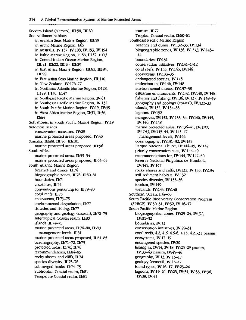
214 A Global Representative System of Marine Protected Areas
Socotra Island (Yemen), ID:56, ID:60 Soft sediment habitats
in Arabian Seas Marine Region, ID:59 in Arctic Marine Region, 1:65 in Australia, IV:157, IV:188, IV:193, IV:194 in Baltic Marine Region, 1:156, 1:157, 1:173 in Central Indian Ocean Marine Region, ID:21, ID:22, ID:26, ID:29
in East Africa Marine Region, ID:82, ID:84, ID:99
in East Asian Seas Marine Region, ID:110 in New Zealand, IV:176-77 in Northeast Atlantic Marine Region, I: 128, 1:129, 1:130, 1:147
in Northeast Pacific Marine Region, IV:61 in Southeast Pacific Marine Region, IV: 132 in South Pacific Marine Region, IV:19, IV:39 in West Africa Marine Region, 11:51, 11:56,
Il:64 Soft shores, in South Pacific Marine Region, IV: 19 Solomon Islands
conservation measures, IV:28 marine protected areas prop9sed, IV:40
Somalia, ID:88, ID:96, ID: 101 marine protected areas proposed, ID:96
South Africa marine protected areas, 11:53-54 marine protected areas proposed, 11:64-65
South Atlantic Marine Region beaches and dunes, Il:74 biogeographic zones, II: 76, 11:80--81 boundaries, II: 71 coastlines, 11:74 conventions pertaining to, II: 79-80 coral reefs, 11:73 ecosystems, 11:73-75 environmental degradation, II: 77 fisheries and fishing, Il: 77 geography and geology (coastal), 11:72-73 Intertropical Coastal realm, 11:80 islands, Il:74-75 marine protected areas, 11:76-80, 11:80
management levels, 11:81 marine protected areas proposed, 11:81-85 oceanography, 11:71-72, 11:75 protected areas, II: 76, II: 76 recommendations, 11:84-85 rocky shores and cliffs, 11:74 species diversity, II:7S-76 submerged banks, 11:74-75 Subtropical Coastal realm, 11:81 Temperate Coastal realm, Il:81
tourism, II: 77 Tropical Coastal realm, 11:80--81
Southeast Pacific Marine Region beaches and dunes, IV: 132-33, IV: 134 biogeographic zones, IV:136, W:143, IV:143-
44 boundaries, IV:131 conservation initiatives, IV:141-1312 coral reefs, IV:133, IV:145, IV:146 ecosystems, IV:133-35 endangered species, IV:146 endemism in, IV:146, IV:148 environmental threats, IV: 137-38 estuarine environments, IV:132, IV:140, IV:148 fisheries and fishing, IV:136, IV:137, IV:148-49 geography and geology (coastal), IV:132-33 islands, IV:132, IV:134-35 lagoons, IV: 132 mangroves, IV:132, IV:133-34, IV:140, IV:145, IV:146, IV:148
marine protected areas, IV:136-41, IV:137, IV:143, IV:143-44, IV:14s-47
management levels, IV:144 oceanography, IV:131-32, IV:135 Parque Nacional Chiloe, IV:144-45, IV:147 priority conservation sites, IV: 144-49 recommendations for, IV:144, IV:147-50 Reserva Nacional Pinguinos de Humbolt, IV:145, IV:147
rocky shores and cliffs, IV: 132, IV: 133, IV: 134 soft sediment habitats, IV:132 species diversity, IV:13S-36 tourism, IV: 149 wetlands, IV:134, IV:148
Southern Ocean, 1:49-50 South Pacific Biodiversity Conservation Program
(SPBCP), IV:30-31, IV:32, IV:46-47 South Pacific Marine Region
biogeographical zones, IV:23-24, IV:31, IV:31-32
boundaries, IV: 13 conservation initiatives, IV:29-31 coral reefs, 4.2, 4.5, 4.5-6, 4.15, 4.21-31 passim ecosystems, IV:17-19 endangered species, IV:20 fishing in, IV:14, IV:18, IV:2S-29 passim,
IV:33-43 passim, IV:4s-46 geography, IV:13, IV:lS-17 geology (coastal), W:lS-17 island types, IV:16-17, IV:23-24 lagoons, IV:19-20, IV:25, IV:34, IV:35, IV:36, IV:38, IV:41
land to sea ratios, IV:13, IV:14 mangroves, IV:18-19, IV:19, IV:27, IV:34, IV:37, IV:38, IV:39, IV:41
marine protected areas, IV:24-29 management levels, IV:29, IV:29, IV:30
marine protected areas proposed, IV:33-44 oceanography, IV:14-15 priority conservation areas, IV:32, IV:44 recommendations for, IV:45-47 rocky shores, IV: 19 seagrass beds, IV: 18 soft shores, IV:19 species diversity, IV:20-23 timber cutting, IV:40, IV:43 tourism, IV:14, IV:35, IV:39, IV:41
Spain . marine protected areas, 1:93, 1:97, 1:136-37, 1:144
priority conservation sites, I: 149 SPBCP (South Pacific Biodiversity Conservation Program), IV:30-31, IV:32, IV:46-47
Spitzbergen Fjord, Norway, 1:65 Sponges
See also Invertebrates in Antarctic Marine Region, 1:57-58 in Australia, IV:193 in Central Indian Ocean Marine Region, ill:32 in East Asian Seas Marine Region, ill: 123 in Mediterranean Marine Region, 1:84 in New Zealand, IV:177, IV:180, IV:197 in Northeast Atlantic Marine Region, 1:148 in Northeast Pacific Marine Region, IV:84, IV:88
in Wider Caribbean Marine Region, 11:30 Spratley Islands, ill: 12S-26 SPREP Convention (Convention for the Protec
tion of the Natural Resources and Environment of the South Pacific Region), IV:30
Sri Lanka coral communities and reefs, ill:14-15 marine protected areas, ill:23-24, ill:29-30 marine protected areas proposed, ill:29, ill:30-31
Palk Bay and the Gulf of Mannar area, ill:15, ill:30
Special Area Management Project, ill:23, ill:34, ill:3S-36
St. Helena, 11:45, 11:54, D:67 St. Lucia, marine protected areas, II: 19, 11:27, D:29, 11:31-32
Straits of Gubal (Egypt), ill:60 Strangford Lough (Northern Ireland), 1:145, 1:150
Cumulative Index 215
St. Vincent and the Grenadines, marine protected areas, 11:27
Subantarctic Islands (New Zealand), IV:185, IV:197-98
Sudan marine protected areas, ill:54 marine protected areas proposed, ill: 64
Sundarbans (Bangladesh, India), ill:16, ill:19, ill:24, ill:31
Surinam, marine protected areas, II: 19 Sweden
Aaland Sea, I: 179 Bothnian Sea, I: 179 marine protected areas, 1:166, 1:176-77 marine protected areas proposed, I: 177-79 Western Gotland Sea area, 1:179
Syria, marine protected area proposed, 1:93
T Taiwan (China)
conservation measures, IV:120 marine protected areas, IV:120, IV:125 marine protected areas proposed, IV:125
Tanzania Mafia Island and Rufiji Delta area, ill:98 marine protected areas, ill:83, ill:88-89, ill:96
marine protected areas proposed, ill:97-98 Zanzibar, ill:89, ill:97-98
Thailand conservation measures, ill:117-18 marine protected areas, ill:118, ill:124-25
Tigris and Euphrates marshes (Iraq), ill:60 Tiran Islands area (Egypt, Saudi Arabia), ill:59 Togo, 11:54
marine protected areas proposed, Il:65 Tokelau
marine protected areas proposed, IV:40 resource management, IV:28
Tonga marine protected areas, IV:28, IV:41-42 P'}arine protected areas proposed, IV:42
Torres Strait (Australia), IV:166, W:189 Tortoises, in East Africa Marine Region, ill:87 Tortuguero/Miskito Marine System (Costa Rica),
11:29, Il:30 Tourism
in Arabian Seas Marine Region, ill:57 in Australia, IV:188, IV:195 in Central Indian Ocean Marine Region, ill:24, ill:27, ill:33
216 A Global Representative System of Marine Protected Areas
Tourism (continued) in East Africa Marine Region, ffl:83, ffl:84, ffl:95, ffl:97, ffl:98, ffl:100
in East Asian Seas Marine Region, ffl:109, m:122, m:123-24, m:125
in Mediterranean Marine Region, 1:93, 1:100, 1:102
in Northeast Pacific Marine Region, IV:90, IV:91, IV:92, IV:93, IV:96
in Northwest Pacific Marine Region, IV:116 in South Atlantic Marine Region, Il: 77 in Southeast Pacific Marine Region, IV:149 in South Pacific Marine Region, IV:14, IV:35, IV:39, IV:41
in Wider Caribbean Marine Region, Il:29, Il:30 Trinidad and Tobago, marine protected areas,
Il:27 Tristan da Cunha Islands, Il:45, Il:54, D:66 Tunisia, marine protected areas, 1:93-94, 1:97 Turkey, 1:100
marine protected areas, 1:94, 1:98 Turtles
See also Reptiles in Arabian Seas Marine Region, m:47, m:47-48, m:53, m:54, m:58, m:59, m:6o
in Australia, IV:157, IV:161, IV:188, IV:189, IV:192, IV:194
in Central Indian Ocean Marine Region, m:18, ffl:21, ffl:22, ID:23, ID:26-33 passim
in East Africa Marine Region, ffl:80, ID:82, m:85-89 passim, W:92-100 passim
in East Asian Seas Marine Region, ID: 112, ID:114, m:122, ID:123, m:124, ID:125
endangered species, 1:124 in Mediterranean Marine Region, 1:85, 1:90,
1:94, 1:99 in Northeast Pacific Marine Region, IV:58,
IV:89, IV:90-91, IV:92, IV:94, IV:97 in Northwest Atlantic Marine Region, 1:107, 1:116, 1:124
in Northwest Pacific Marine Region, IV: 113 in South Atlantic Marine Region, Il: 75 in Southeast Pacific Marine Region, IV: 135-
36, IV:138, IV:146, IV:148 in South Pacific Marine Region, IV:20, IV:21,
IV:22, IV:25, IV:26, IV:33-43 passim in West Africa Marine Region, D:47, D:49,
D:50, D:52, D:53, D:57, D:58, ll:59, ll:60, D:61, ll:64, D:66, D:67
in Wider Caribbean Marine Region, D: 17, ll:29, ll:30, ll:31
Tuvalu, IV:28 marine protected areas proposed, IV:42
u Ukraine, marine protected areas, 1:96, 1:98 UNEP Regional Seas Programme, 11:55
Arabian Seas Marine Region and, ID:55 Central Indian Ocean Marine Region and,
ffl:25 East Africa Marine Region and, ID:90-91 East Asian Seas Marine Region and, W: 119 South Atlantic Marine Region and, II: 79-80 Southeast Pacific Marine Region and, IV: 142-
43 West Africa Marine Region and, 11:55
UNESCO. See United Nations Educational, Scientific and Cultural Organization
UNESCO Biosphere Reserves. See Biosphere Reserves
Ungava Bay (Canada), 1:110 United Arab Emirates (UAE), m:54-55
marine protected areas proposed, ID: 64-65 United Kingdom. See specific countries or territo
ries by name United Kingdom
Channel Islands, 1:139, 1:146-47 England, Sensitive Marine Areas, I: 138 Isle of Man, 1:138-39, 1:145-46, 1:149 Marine Nature Reserves, I: 137-38 marine protected areas, 1:137-38, 1:145, 1:148-49
marine protected areas proposed, 1:144-47, 1:148, 1:150
Northern Ireland, 1:145, 1:150 Scotland, Marine Consultation Areas, I: 138 Virgin Islands, D: 19
United Nations Conference on Environment and Development (UNCED), 1:1
United Nations Educational, Scientific and Cultural Organization (UNESCO)
See also Biosphere Reserves; World Heritage Convention
Convention concerning the Protection of the World Cultural and National Heritage, 1:9, 1:95
Man and the Biosphere Programme, 1:10, I: 11, 1:95-96
United Nations Environment Program (UNEP), 1:95
Mediterranean Marine Region and, 1:95
United States See also specific territories by name Alaska, IV: 79-80 Arctic Marine Region of, 1:61 Areas of Critical Environmental Concern (Mas-
sachusetts), 1:120 Bering Strait, IV:94-95, IV:97 California, IV:80 Florida, U:19 Hawaii, IV:25-26, IV:35 Kachemak Bay, IV:%, IV:97 marine protected areas, 1:119-21, IV:25-26, IV:64, IV:65-66, IV:67, IV:69, IV:71
marine protected areas proposed, 1:124-25, IV:87, IV:94-97
marine protected areas system, IV:77-80 Mid-coastal Maine area, I: 124 National Estuarine Research Reserves, 1:120 National Marine Sanctuaries, 1:119-20 National Seashores, I: 120 National Wildlife Refuges, 1:120 Northwest Atlantic Marine Region of, 1:112-
13, 1:115-17 Ocean Sanctuaries of Massachusetts, 1:120 Oregon, IV: 79-80 unincorporated territories, marine protected
areas, IV:28 Virginian zone, 1:116-17, 1:124 Virgin Islands, D: 19 Washington, IV:79
U.S. Agency for International Development, Wider Caribbean Marine Region and, D:22-23
Uruguay, D:72-73, D:84 marine protected areas, D: 79
V Vanuatu
marine protected areas, IV:28--29 marine protected areas proposed, IV:42-43
Vegetation See also Mangroves; Seagrass beds; Seaweeds in Arabian Seas Marine Region, m:45-46 in Australia, IV: 191 in Baltic Marine Region, 1:157-58 in Mediterranean Marine Region, 1:83 in New Zealand, IV:174 in Northeast Pacific Marine Region, IV:60,
IV:61, IV:65, IV:66, IV:68, IV:94, IV:100 Venezuela, marine protected areas, D:27 Viet Nam
conservation measures, m: 118
Cumulative Index 217
marine protected areas, W:118, W:125 marine protected areas proposed, W:125
Virgin Islands (U.S.), marine protected areas, D: 19
w Waddensea, 1:128, 1:129, 1:132, 1:134, 1:140, 1:147-
48 Wallis and Futuna, IV:29
marine protected areas proposed, IV:43 Walrus
in Arctic Marine Region, 1:65, 1:66 in Northeast Pacific Marine Region, IV:57,
IV:61, IV:63, IV:95, IV:98 in Northwest Atlantic Marine Region, polar
zone, 1:110, 1:111, 1:122 Waterfowl. See Birds Wejh Bank (Saudi Arabia), m:60 West Africa Marine Region
beaches, D:46 beaches and dunes, D:46 biogeographical zones, D:48, D:55, D:55-56,
D:68 boundaries, D:43 cliffs, U:46 conventions pertaining to, D:54-56 coral reefs, D:45 ecosystems, D:45-46 fisheries and fishing, D:46, D:60, D:61, D:63 geography and geology (coastal), D:44-45 islands, D:45 mangroves, D:45-46 marine protected areas, D:48-56, D: 49, D:55, D:55-56, D:67
marine protected areas proposed, D:56-68 oceanography, Il:43-44, Il:46 recommendations for, D:67-()8 rocky shores and cliffs, 11:46 seagrass beds, Il:61 soft sediment habitats, 11:51, 11:56, 11:64 species diversity, 11:46-48
Western Hemisphere Convention (Convention on Intervention on Nature Protection and Wildlife Preservation in the Western Hemisphere), D:21
Western Sahara, D:54 marine protected areas proposed, D:65-66
Western Samoa marine protected areas, IV:29, IV:43 marine protected areas proposed, IV:43-44
Wetlands See also Lagoons; Mangroves; Ramsar Convention
218 A Global Representative System of Marine Protected Areas
Wetlands (continued) in Arabian Seas Marine Region, ID:42-43, m:60
in Australia, IV:156, IV:157, IV:188, IV:189, IV:190, IV:193
in Baltic Marine Region, 1:173, 1:174 in Central Indian Ocean Marine Region, ID:16-17, ID:21, W:29, ID:30
in East Africa Marine Region, ID:76-77, ID:84, ID:86, ID:93, ID:99
in Mediterranean Marine Region, 1:81--82, 1:90; 1:94
in New Zealand, IV:174 in Northeast Atlantic Marine Region, 1:139, 1:142
in Northeast Pacific Marine Region, IV:73, IV:96, IV:100, IV:101, IV:102-3
in Northwest Pacific Marine Region, IV:110-11, IV:123
in South Atlantic Marine Region, D: 7 4 in Southeast Pacific Marine Region; IV:134,
IV:148 in West Africa Marine Region, ll:45-46 in Wider Caribbean Marine Region, ll:16, ll:19
Whales in Antarctic Marine Region, 1:49 in Arabian Seas Marine Region, ID:48-49, ID:59
in Arctic Marine Region, 1:65, 1:67 in Australia, IV:161, IV:162, IV:190 in Central Indian Ocean Marine Region, ID:19 in East Africa Marine Region, ID:81 in East Asian Seas Marine Region, ID: 112 endangered species, 1:122, 1:123 in Mediterranean Marine Region, 1:85--86, 1:99-100
in New Zealand, IV: 182 in Northeast Atlantic Marine Region, 1:131 in Northeast Pacific Marine Region, IV:58, IV:61, IV:63, IV:67, IV:69, IV:86, IV:88, IV:95-100 passim
in Northwest Atlantic Marine Region, I: 107, 1:110-17 passim, 1:122, 1:123, 1:124
in South Atlantic Marine Region, D: 75 in Southeast Pacific Marine Region, IV: 136, IV:138, IV:139, IV:145, IV:146, IV:148
in South Pacific Marine Region, IV:22, IV:34 in West Africa Marine Region, D:48, D:61 in Wider Caribbean Marine Region, D:31
Wider Caribbean Marine Region Andros Barrier Reef, D:29 archaeological shipwreck sites, D:30 Barbuda, 11:28, ll:29 beaches and dunes, D:19, ll:29 Belize Barrier Reef, D:29, D:30 biogeographic zones, D:17 boundaries, D: 13 caves, D:30 conservation initiatives, D:20-26, 11:38 coral reefs, D:15, 11:19, D:29, 11:30 ecological features (by country), ll:35-36 ecosystems, Il:14-16, U:19 endangered species, U:19, ll:31, ll:37 environmental degradation, D:35-36 estuarine environments, II: 19 fisheries and fishing, ll:16, ll:29-30, 11:31 geography and geology (coastal), D:14, D:35-36
lagoons, Il:16, Il:19, Il:29, ll:30, ll:31 mangroves, Il:15-16, Il:29, ll:30 marine protected areas, D:17-20, U:18, D:26-27, ll:29
management levels, 11:18-20, ll:19 marine protected areas proposed, Il:28, D:29 oceanography, ll:13-14 organizations providing support services, 11:39 priority conservation sites, Il:26-32 recommendations for, 11:32-35 resource problems (by country), U:35-36 rocky shores and cliffs, Il: 19 seagrass beds, ll:16, D: 19, ll:30 species diversity, ll:16-17 Tortuguero/Miskito Marine System, Il:29, 11:30 tourism, 11:29, D:30 wetlands, Il:16, Il:19
Wildlife Conservation Society, Wider Caribbean Marine Region and, ll:24
World Heritage Convention, 1:9 Arctic Marine Region and, I: 71 Australia/New Zealand Marine Region and,
IV:165, IV:184, IV:191, IV:192, IV:194 Baltic Marine Region and, 1:167 Central Indian Ocean Marine Region and, ID:24
East Africa Marine Region and, ID:90 East Asian Seas Marine Region and, ID: 118-
19, W:124, W:125 marine and/or coastal sites, 1:37
Northeast Atlantic Marine Region and, 1:139 South Atlantic Marine Region and, Il: 79 Southeast Pacific Marine Region and, IV: 141 South Pacific Marine Region and, IV:29-30 West Africa Marine Region and, Il:54 Wider Caribbean Marine Region and, Il:20, Il:38
World Wildlife Fund, Wider Caribbean Marine Region and, Il:24
Worms in Australia, IV:193 in Baltic Marine Region, 1:156, 1:180 in New Zealand, IV: 176, IV: 178
Cumulative Index 219
y Yaeyama Archipelago Qapan), IV:125 Yemen, Republic of, m:54
marine protected areas proposed, ID: 65 Socotra Island, ID:56, ID:60
Yugoslavia, marine protected areas, 1:89
z Zaire, marine protected areas, Il:54, Il:66 Zanzibar, ID:89, ID:97-98 Zhujian Delta (China, Hong Kong, Macao), IV:123, IV:125

Map Supplement

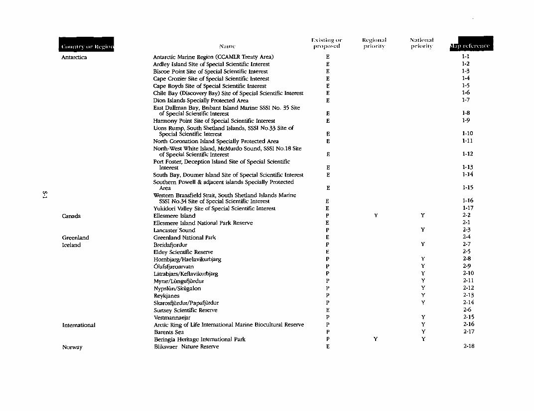
en ' ....
Co1111tq or lkgi01
Antarctica
Canada
Greenland Iceland
International
Norway
Name
Antarctic Marine Region (CCAMLR Treaty Area) Ardley Island Site of Special Scientific Interest Biscoe Point Site of Special Scientific Interest Cape Crozier Site of Special Scientific Interest Cape Royds Site of Special Scientific Interest Chile Bay (Discovery Bay) Site of Special Scientific Interest Dion Islands Specially Protected Area East Dallman Bay, Brabant Island Marine SSSI No. 35 Site
of Special Scientific Interest Harmony Point Site of Special Scientific Interest Llons Rump, South Shetland Islands, SSSI No.33 Site of
Special Scientific Interest North Coronation Island Specially Protected Area North-West White Island, McMurdo Sound, SSSI No.18 Site
of Special Scientific Interest Port Foster, Deception Island Site of Special Scientific
Interest South Bay, Doumer Island Site of Special Scientific Interest Southern Powell & adjacent islands Specially Protected
Area Western Bransfield Strait, South Shetland Islands Marine
SSSI No.34 Site of Special Scientific Interest Yukidori Valley Site of Special Scientific Interest -Ellesmere Island Ellesmere Island National Park Reserve Lancaster· Sound Greenland National Park Breidafjordur Eldey Scientific Reseive Hombjarg/Haelavikurbjarg 6lafsfjaroaivatn Latrabjars/Keflavikurbjarg Myrar/Lungufjurdur Nypslun/Skugalon Reykjanes Skarosfjurdur/Papafjurdur Surtsey Scientific Reseive Vestrnannaejar Arctic Ring of Life International Marine Biocultural Reseive Barents Sea Beringia Heritage International Park Bliksvaer Nature Reseive
Existing or lh:gional National JIIIII proposed priority priority
E 1-1 E 1-2 E 1-3 E 1-4 E 1-5 E 1-6 E 1-7
E 1-8 E 1-9
E 1-10 E 1-11
E 1-12
E 1-13 E 1-14
E 1-15
E 1-16 E 1-17 p y y 2-2 E 2-1 p y 2-3 E 2-4 p y 2-7 E 2-5 p y 2-8 p y 2-9 p y 2-10 p y 2-11 p y 2-12 p y 2-13 p y 2-14 E 2-6 p y 2-15 p y 2-16 p y 2-17 p y y
E 2-18
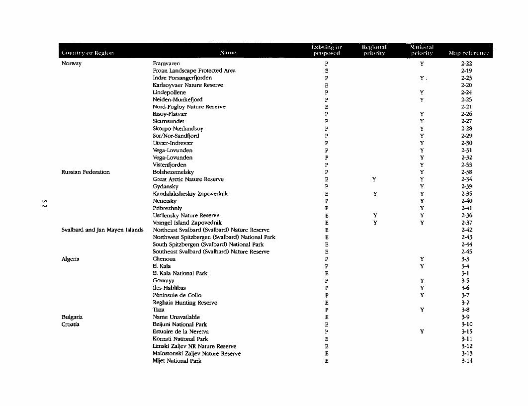
tcxbling or lkgional Nalio11al <.01111try or lkgion Name propo~cd priori!) priority Map rdlTClllT
Norway Framvaren p y 2-22 Froan Landscape Protected Area E 2-19 Indre Porsangerfjorden p Y. 2-23 Karlsoyvaer Nature Reserve E 2-20 Lindepollene p y 2-24 Neiden-Munkefjord p y 2-25 Nord-Fugloy Nature Reserve E 2-21 Risoy-Flatva:r p y 2-26 Skamsundet p y 2-27 Skorpo-Na:rlandsoy p y 2-28 Sor/Nor-Sandfjord p y 2-29 Utva:r-Indreva:r p y 2-30 Vega-Lovunden p y 2-31 Vega-Lovunden p y 2-32 Vistenfjorden p y 2-33
Russian Federation Bolshezemelsky p y 2-38 Great Arctic Nature Reserve E y y 2-34 Gydansky p y 2-39 Kandalaksheskiy Zapovednik E y y 2-35
fJl Nenetsky p y 2-40 ' N Pribrezhniy p y 2-41
Ust'lensky Nature Reserve E y y 2-36 Vrangel Island Zapovednik E y y 2-37
Svalbard and Jan Mayen Islands Northeast Svalbard (Svalbard) Nature Reserve E 2-42 Northwest Spitzbergen (Svalbard) National Park E 2-43 South Spitzbergen (Svalbard) National Park E 2-44 Southeast Svalbard (Svalbard) Nature Reserve E 2-45
Algeria Chenoua p y 3-3 El Kala p y 3-4 El Kala National Park E 3-1 Gouraya p y 3-5 Iles Hablibas p y 3-6 Peninsule de Collo p y 3-7 Reghaia Hunting Reserve E 3-2 Taza p y 3-8
Bulgaria Name Unavailable E 3-9 Croatia Bzijuni National Park E 3-10
Estuaire de la Neretva p y 3-15 Komati National Park E 3-11 Limski Zaljev NR Nature Reserve E 3-12 Malostonski Zaljev Nature Reserve E 3-13 Mljet National Park E 3-14
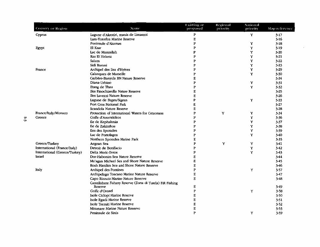
r:-.isling or Hegional i'iational Cou11tr~ or lkgio11 Name propo:--l'd priori!~ priorit~ ,\lap n·fen·nll'
Cyprus Lagune d'Akrotiri, marais de Lima~oi p y 3-17 Lara-Toxeftra Marine Reserve E 3-16 Peninsule d'Akamas p y 3-18
Egypt El Ksar p y 3-19 Lac de Manzailah p y 3-20 Ras El Hekma p y 3-21 Salum p y 3-22 Sidi Barani p y 3-23
France Archipel des Iles d'Hyeres p y 3-29 Calanques de Marseille p y 3-30 Cerbere-Banyuls RN Nature Reserve E 3-24 Diana-Urbino p y 3-31 Etang de Thau p y 3-32 Iles Finochiarolla Nature Reserve E 3-25 Iles Lavezzi Nature Reserve E 3-26 Lagune de Bages/Sigean p y 3-33 Port Cros National Park E 3-27 Scandola Nature Reserve E 3-28
France/Italy /Monaco Protection of International Waters for Cetaceans p y y 3-34 (J) Greece Golfe d'Amvrakikos p y 3-36 U> Ile de Kephalonia p y 3-37
Ile de Zakinthos p y 3-38 Iles des Sporades p y 3-39 Lac de Portolagos p y 3-40 Northern Sporades Marine Park E 3-35
Greece/furkey Aegean Sea p y y 3-41 International (France/Italy) Detroit de Bonifacio p y 3-42 International ( Greece/furkey) Delta Meric-Evros p y 3-43 Israel Dor-Habonim Sea Nature Reserve E 3-44
Ma'agan Michael Sea and Shore Nature Reserve E 3-45 Rosh Hanikra Sea and Shore Nature Reserve E 3-46
Italy Archipel des Pontines p y 3-57 Archipelago Toscano Marine Nature Reserve E 3-47 Capo Rizzuto Marine Nature Reserve E 3-48 Castellabate Fishery Reserve (Zona di Tutela) FiR Fishing
Reserve E 3-49 Golfe d'Orosel p y 3-58 !sole Ciclopi Marine Reserve E 3-50 !sole Egadi Marine Reserve E 3-51 !sole Trerniti Marine Reserve E 3-52 Mirarnare Marine Nature Reserve E 3-53 Peninsule de Sinis p y 3-59
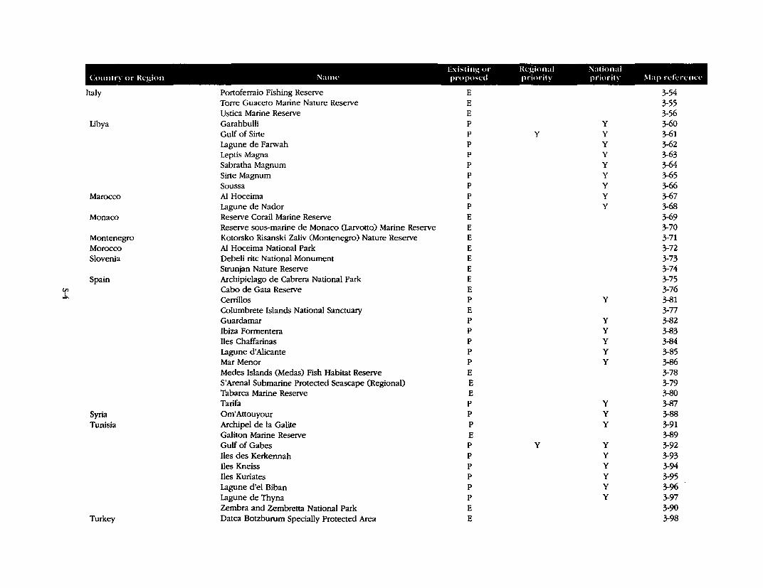
Exi:-ting or Regional National Country or Region Name proposed priority priority ,\lap rdi.-renn·
Italy Portoferraio Fishing Reserve E 3-54 Torre Guaceto Marine Nature Reserve E 3-55 Ustica Marine Reserve E 3-56
Libya Garahbulli p y 3-60 Gulf of Sirte p y y 3-61 Lagune de Farwah p y 3-62 Leptis Magna p y 3-63 Sabratha Magnum p y 3-64 Sirte Magnum p y 3-65 Soussa p y 3-66
Marocco Al Hoceima p y 3-67 Lagune de Nador p y 3-68
Monaco Reserve Corail Marine Reserve E 3-69 Reserve sous-marine de Monaco (Larvotto) Marine Reserve E 3-70
Montenegro Kotorsko Risanski Zaliv (Montenegro) Nature Reserve E 3-71 Morocco Al Hoceima National Park E 3-72 Slovenia Debell rite National Monument E 3-73
Strunjan Nature Reserve E 3-74 Spain Archipielago de Cabrera National Park E 3-75
C/) Cabo de Gata Reserve I
E 3-76 "" Cerrillos p y 3-81
Columbrete Islands National Sanctuary E 3-77 Guardamar p y 3-82 Ibiza Formentera p y 3-83 Iles Chaffarinas p y 3-84 Lagune d'Alicante p y 3-85 Mar Menor p y 3-86 Merles Islands (Medas) Fish Habitat Reserve E 3-78 S'Arenal Submarine Protected Seascape (Regional) E 3-79 Tabarca Marine Reserve E 3-80 Tarifa p y 3-87
Syria Om'Attouyour p y 3-88 Tunisia Archipel de la Galite p y 3-91
Galiton Marine Reserve E 3-89 Gulf of Gabes p y y 3-92 Iles des Kerkennah p y 3-93 Iles Kneiss p y 3-94 Iles Kuriates p y 3-95 Lagune d'el Biban p y 3-96 Lagune de Thyna p y 3-97 Zembra and Zembretta National Park E 3-90
Turkey Datca Botzburum Specially Protected Area E 3-98
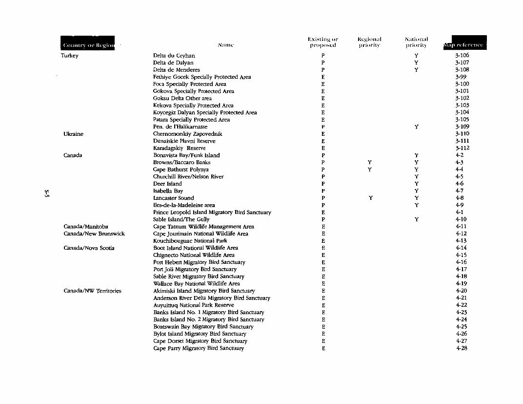
u, I
Vl
Countq or lkgim
Turkey
Ukraine
Canada
Canada/Manitoba Canada/New Brunswick
Canada/Nova Scotia
Canada/NW Territories
Nan1c.:
Delta du Ceyhan Delta de Dalyan Delta de Menderes Fethiye Gocek Specially Protected Area Poca Specially Protected Area Gokova Specially Protected Area Goksu Delta Other area Kekova Specially Protected Area Koycegiz Dalyan Specially Protected Area Patara Specially Protected Area Pen. de l'Halikamasse Chemomorskiy Zapovednik Dunaiskie Plavni Reserve Karadagskiy Reserve Bonavista Bay/Funk Island Browns/Baccaro Banks Cape Bathurst Polynya Churchill River/Nelson River Deer Island Isabella Bay Lancaster Sound Iles-de-la-Madeleine area Prince Leopold Island Migratory Bird Sanctuary Sable Island/The Gully Cape Tatnum Wildlife Management Area Cape Jourimain National Wildlife Area Kouchibouguac National Park Boot Island National Wildlife Area Chignecto National Wildlife Area Port Hebert Migratory Bird Sanctuary Port Joli Migratory Bird Sanctuary Sable River Migratory Bird Sanctuary Wallace Bay National Wildlife Area Akimiski Island Migratory Bird Sanctuary Anderson River Delta Migratory Bird Sanctuary Auyuinuq National Park Reserve Banks Island No. 1 Migratory Bird Sanctuary Banks Island No. 2 Migratory Bird Sanctuary Boatswain Bay Migratory Bird Sanctuary Bylot Island Migratory Bird Sanctuary Cape Dorset Migratory Bird Sanctuary Cape Parry Migratory Bird Sanctuary
Existing or Rc.:gion:il National JIIII proposed priority priority
p y 3-106 p y 3-107 p y 3-108 E 3-99 E 3-100 E 3-101 E 3-102 E 3-103 E 3-104 E 3-105 p y 3-109 E 3-110 E 3-111 E 3-112 p y 4-2 p y y 4-3 p y y 4-4 p y 4-5 p y 4-6 p y 4-7 p y y 4-8 p y 4-9 E 4-1 p y 4-10 E 4-11 E 4-12 E 4-13 E 4-14 E 4-15 E 4-16 E 4-17 E 4-18 E 4-19 E 4-20 E 4-21 E 4-22 E 4-23 E 4-24 E 4-25 E 4-26 E 4-27 E 4-28
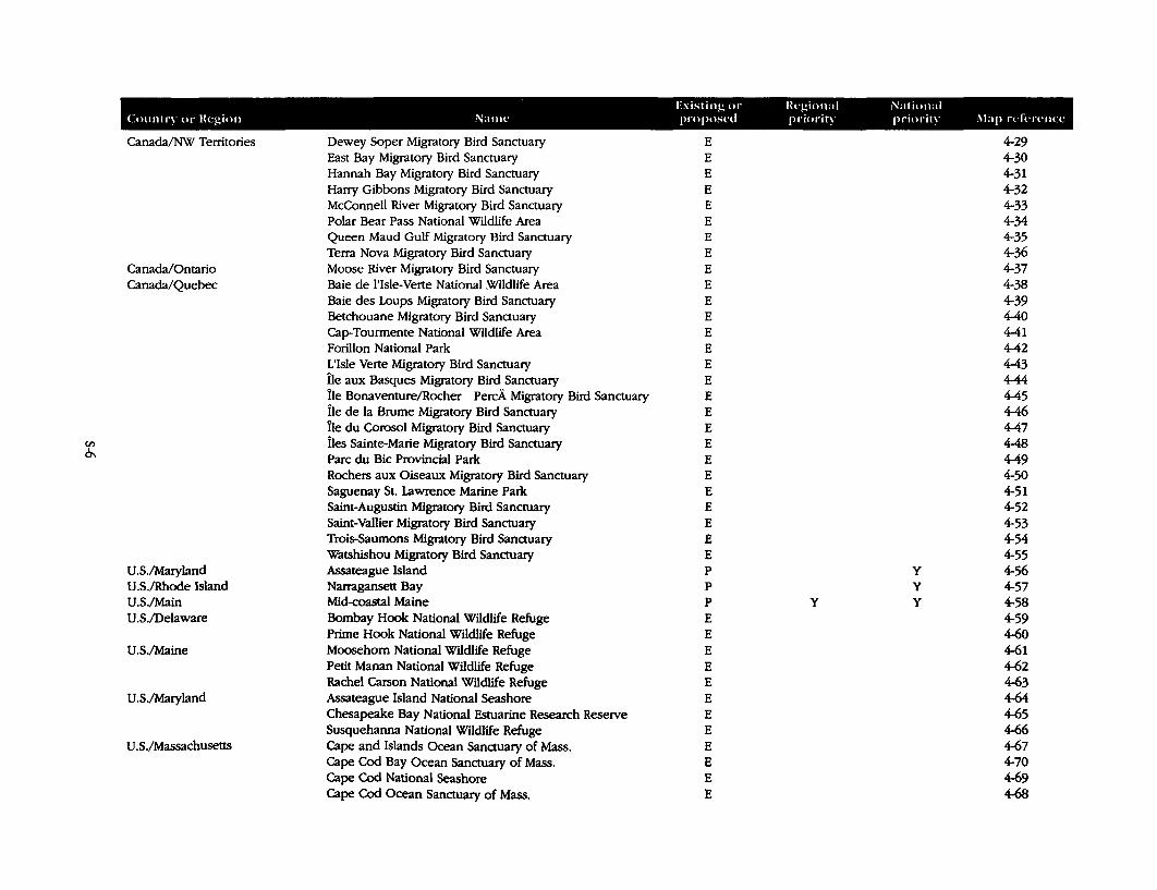
Existing or Regional National Countq or Region Name proposnl priority priority .\lap rd,.:n·tKl'
Canada/NW Tenitories Dewey Soper Migratory Bird Sanctuary E 4-29 East Bay Migratory Bird Sanctuary E 4-30 Hannah Bay Migratory Bird Sanctuary E 4-31 Harry Gibbons Migratory Bird Sanctuary E 4-32 McConnell River Migratory Bird Sanctuary E 4-33 Polar Bear Pass National Wildlife Area E 4-34 Queen Maud Gulf Migratory Bird Sanctuary E 4-35 Terra Nova Migratory Bird Sanctuary E 4-36
Canada/Ontario Moose River Migratory Bird Sanctuary E 4-37 Canada/Quebec Baie de l'Isle-Verte National Wildlife Area E 4-38
Baie des Loups Migratory Bird Sanctuary E 4-39 Betchouane Migratory Bird Sanctuary E 4-40 Cap-Tourmente National Wildlife Area E 4-41 Forillon National Park E 4-42 L'Isle Verte Migratory Bird Sanctuary E 4-43 Ile aux Basques Migratory Bird Sanctuary E 4-44 Ile Bonaventure/Rocher PercA Migratory Bird Sanctuary E 4-45 Ile de la Brume Migratory Bird Sanctuary E 4-46 Ile du Corosol Migratory Bird Sanctuary E 4-47
en Iles Sainte-Marie Migratory Bird Sanctuary E 4-48 0\ Pare du Bic Provincial Park E 4-49
Rochers aux Oiseaux Migratory Bird Sanctuary E 4-50 Saguenay St. Lawrence Marine Parle E 4-51 Saint-Augustin Migratory Bird Sanctuary E 4-52 Saint-Vallier Migratory Bird Sanctuary E 4-53 Trois-Saumons Migratory Bird Sanctuary E 4-54 Watshishou Migratory Bird Sanctuary E 4-55
U .S./Maryland Assateague Island p y 4-56 U.S./Rhode Island Narragansett Bay p y 4-57 U.S./Main Mid-coastal Maine p y y 4-58 U .S./Delaware Bombay Hook National Wildlife Refuge E 4-59
Prime Hook National Wildlife Refuge E 4-60 U.S./Maine Moosehom National Wildlife Refuge E 4-61
Petit Manan National Wildlife Refuge E 4-62 Rachel Carson National Wildlife Refuge E 4-63
U .S./Maryland Assateague Island National Seashore E 4-64 Chesapeake Bay National Estuarine Research Reserve E 4-65 Susquehanna National Wildlife Refuge E 4-66
U .S./Massachusetts Cape and Islands Ocean Sanctuary of Mass. E 4-67 Cape Cod Bay Ocean Sanctuary of Mass. E 4-70 Cape Cod National Seashore E 4-69 Cape Cod Ocean Sanctuary of Mass. E 4-68
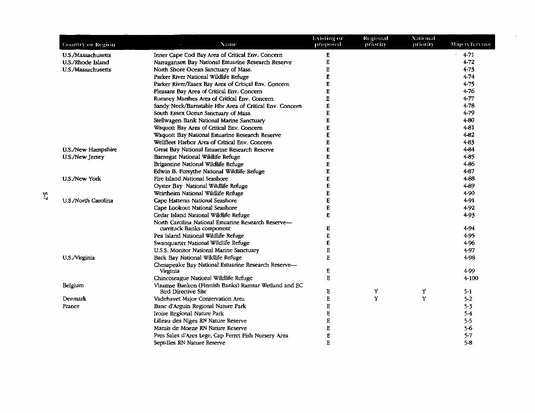
l:xi~ti11g <H" lkgion,d National Crn1111,-~ or lkgio11 · i\:tlllt' propo,t'd priorit~ pr·iorit~ \lap n·ln-c11n·
U.S./Massachusetts Inner Cape Cod Bay Area of Critical Env. Concern E 4-71 U.S./Rhode Island Narragansett Bay National Estuarine Research Reserve E 4-72 U .S./Massachusetts North Shore Ocean Sanctuary of Mass. E 4-73
Parker River National Wildlife Refuge E 4-74 Parker River/Essex Bay Area of Critical Env, Concern E 4-75 Pleasant Bay Area of Critical Env. Concern E 4-76 Rumney Marshes Area of Critical Env. Concern E 4-77 Sandy Neck/Barnstable Hbr Area of Critical Env. Concern E 4-78 South Essex Ocean Sanctuary of Mass. E 4-79 Stellwagen Bank National Marine Sanctuary E 4-80 Waquoit Bay Area of Critical Env. Concern E 4-81 Waquoit Bay National Estuarine Research Reserve E 4-82 Wellfleet Harbor Area of Critical Env. Concern E 4-83
U.S./New Hampshire Great Bay National Estuarine Research Reserve E 4-84 U.S./New Jersey Barnegat National Wildlife Refuge E 4-85
Brigantine National Wtldlife Refuge E 4-86 Edwin B. Forsythe National Wildlife Refuge E 4-87
U.S./New York Fire Island National Seashore E 4-88 Oyster Bay National Wildlife Refuge E 4-89
C/l Weirtheim National Wildlife Refuge E 4-90 I .....,
U.S./North Carolina Cape Hatteras National Seashore E 4-91 Cape Lookout National Seashore E 4-92 Cedar Island National Wildlife Refuge E 4-93 North Carolina National Estuarine Research Reserve-
currituck Banks component E 4-94 Pea Island National Wildlife Refuge E 4-95 Swanquarter National Wildlife Refuge E 4-96 U.S.S. Monitor National Marine Sanctuary E 4-97
U.S.Nirginia Back Bay National Wildlife Refuge E 4-98 Chesapeake Bay National Estuarine Research Reserve-
Virginia E 4-99 Chincoteague National Wildlife Refuge E 4-100
Belgium Vlaamse Banken (Flemish Banks) Ramsar Wetland and EC Bird Directive Site E y y 5-1
Denmark Vadehavet Major Conservation Area E y y 5-2 France Banc d'Arguin Regional Nature Park E 5-3
lroise Regional Nature Park E 5-4 Lilleau des Niges RN Nature Reserve E 5-5 Marais de Moeze RN Nature Reserve E 5-6 Pres Sales d'Ares Lege, Cap Ferret Fish Nursery Area E 5-7 Sept-Iles RN Nature Reserve E 5-8
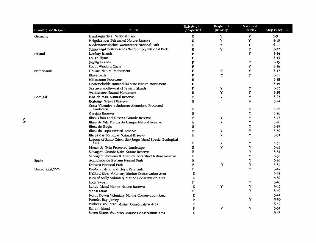
Existing or lkgional National Country or lkgion Name proposed priority priority !\lap rcli..Tl'lllT
Germany Hamburgisches National Park E y y 5-9 Helgolaender Felssockel Nature Reserve E y y 5-10 Niedersaechsisches Wattenmeer National Park E y y 5-11 Schleswig-Holsteinisches Wattenmeer National Park E y y 5-12
Ireland Lambay Islands p y 5-14 Lough Hyne E 5-13 Skellig Islands p y 5-15 South Wexford Coast p y 5-16
Netherlands Dollard Natural Monument E y y 5-17 Klaverbank p y y 5-21 Milieuzone Noordzee E 5-18 Oosterschelde Buitendijks State Nature Monument E 5-19 Sea area north-west of Frisian Islands p y y 5-22 Waddenzee Natural Monument E y y 5-20
Portugal Baia da Maia Natural Reserve E y y 5-23 Berlenga Natural Reserve E y 5-24 Costa Vicentica e Sudoeste Alentejano Protected
Landscape E y 5-25 Garajau Reserve E y 5-26
Vl Ilheu Chao and Deserta Grande Reserve E y y 5-27 I
Ilheu de Vila Franca do Campo Natural Reserve 00 E y y 5-28 Ilheu do Bugio E y 5-29 Ilheu do Topo Natural Reserve E y y 5-30 llheus das Formigas Natural-Reserve E y y 5-31 Lagoon of Santo Cristo, Sao Jorge Island Special Ecological
Area E y y 5-32 Monte da Guia Protected Landscape E y y 5-33 Selvagem Grande Strict Nature Reserve E y 5-34 Selvagem Pequena & llheu de Fora Strict Nature Reserve E y 5-35
Spain Acantilado de Barbate Natural Park E y 5-36 Donana National Park E y y 5-37
United Kingdom Bardsey Island and Lleyn Peninsula p y 5-47 Helford River Voluntary Marine Conservation Area E 5-38 Isles of Scilly Voluntary Marine Conservation Area E 5-39 Loch Sween p y 5-48 Lundy Island Marine Nature Reserve E y y 5-40 Menai Strait p y 5-49 North Devon Voluntary Marine Conservation Area E 5-41 Portelet Bay, Jersey p y 5-50 Purbeck Voluntary Marine Conservation Area E 5-42 Rathlin Island p y y 5-51 Seven Sisters Voluntary Marine Conservation Area E 5-43
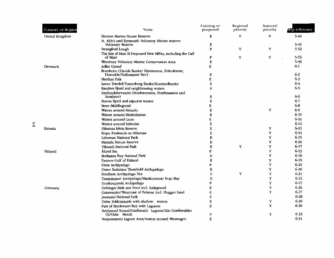
Countq or lkgiot
United Kingdom
Denmark
Estonia
Finland
Germany
Name
Skomer Marine Nature Reserve St. Abb's and Eyemouth Voluntary Marine reserve
Voluntary Reserve Strangford Lough The Isle of Man (8 Proposed New MPAs, including the Calf
of Man) Wembury Voluntary Marine Conservation Area Adler Grund Bornholm (Davids Banke/ Hammeren, Ertholmene,
Dueodde/Salthammer Rev) Herthas Flak Laeso Trindel/fonnerberg Banke/Kummelbanke Randers Fjord and neighbouring waters Smelandsfarvandet (Northwestern, Northeastern and
Southern) Stavns Fjord and adjacent waters Store Middlegrund Waters around Hesselo Waters around Hirsholmene Waters around Laeso Waters around Saltholm Hiiumaa Islets Reserve Kopu Peninsula on Hiiumaa Lahemaa National Park Matsalu Nature Reserve Vilsandi National Park Aland Sea Bothnian Bay National Park Eastern Gulf of Finland Oura Archipelago Outer Bothnian Threshold Archipelago Southern Archipelago Sea Tammissaari Archipelago/Hankoniemi/ Pojo Bay Uusikaupunki Archipelago Gettinger Birk and Noor incl. Kalkgrund Graswarder/Westcoast of Fehmar incl. Flugger Sand Jasmund National Park Oehe Schleirnunde with shallow waters Part of Hochwater Bay with Lagoons Strelasund Sound/Griefswald Lagoon/Isle Griefswalder
Oi/Odra Mouth Vorpommem Lagoon Area/waters around Westrugen
Existing or proposed
E
E p
p
E E
E E E E
E E E E E E E E E E E E p
E E p
E
E E p
E E E E E
p
E
Regional priority
y
y
y
y
y
National priority
y
y
y
y
y y y y y y y y y y y y y y y
y y
y
JIB 5-44
5-45 5-52
5-53 5-46 6-1
6-2 6-3 6-4 6-5
6-6 6-7 6-8 6-9 6-10 6-11 6-12 6-13 6-14 6-15 6-16 6-17 6-23 6-18 6-19 6-24 6-20 6-21 6-22 6-25 6-26 6-27 6-28 6-29 6-30
6-33 6-31
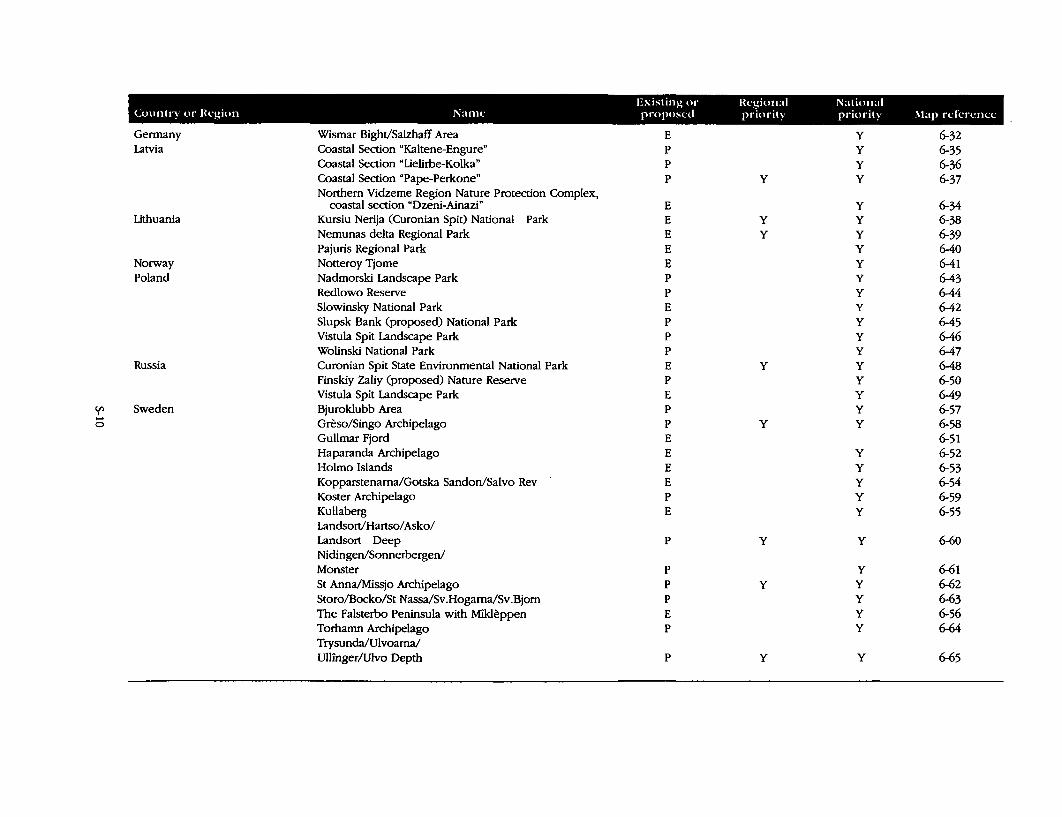
Existing or Regional National Country or lkgion Name proposed priori!) priority !\lap refcn:ncc
Germany Wismar Bight/Salzhaff Area E y 6-32 Latvia Coastal Section "Kaltene-Engure" p y 6-35
Coastal Section "Lielirbe-Kolka" p y 6-36 Coastal Section "Pape-Perkone" p y y 6-37 Northern Vidzeme Region Nature Protection Complex,
coastal section "Dzeni-Ainazi" E y 6-34 Lithuania Kursiu Nerija (Curonian Spit) National Park E y y 6-38
Nemunas delta Regional Park E y y 6-39 Pajuris Regional Park E y 6-40
Norway Notteroy Tjome E y 6-41 Poland Nadmorski Landscape Park p y 6-43
Redlowo Reserve p y 6-44 Slowinsky National Park E y 6-42 Slupsk Bank (proposed) National Park p y 6-45 Vistula Spit Landscape Park p y 6-46 Wolinski National Park p y 6-47
Russia Curonian Spit State Environmental National Park E y y 6-48 Finskiy Zaliy (proposed) Nature Reserve p y 6-50 Vistula Spit Landscape Park E y 6-49
'{' Sweden Bjuroklubb Area p y 6-57 .... Greso/Singo Archipelago p y y 6-58 0
Gullmar Fjord E 6-51 Haparanda Archipelago E y 6-52 Holmo Islands E y 6-53 Kopparstenama/Gotska Sandon/Salvo Rev E y 6-54 Koster Archipelago p y 6-59 Kullaberg E y 6-55 Landsort/Hartso/Asko/ Landsort Deep p y y 6-60 Nidingen/Sonnerbergen/ Monster p y 6-61 St Anna/Missjo Archipelago p y y 6-62 Storo/Bocko/St Nassa/Sv.Hogama/Sv .Bjorn p y 6-63 The Falsterbo Peninsula with Mikleppen E y 6-56 Torhamn Archipelago p y 6-64 Trysunda/Ulvoarna/ Ullinger/Ulvo Depth p y y 6-65
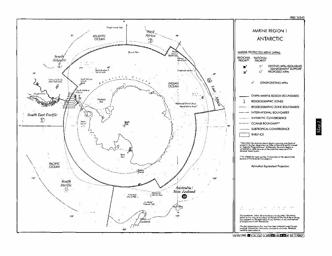
30'
60'
South East Pac~fic·
90''-------,-------1
150"
Gough faiond ll!Ki \
ATLANTIC OCEAN
/If
·sou,ii Sondwi1,,.h fslonds (UK;
Bovw;t (Nor)
- Compb~II. lsland(NZ) ,
\West Afrii:;,-··
·:]~.,
\
\
30'
I IND/A"!
· OCEAf\/
\ \.
. Md>o-,iald 'ti.fonds (Au:;j
~~rd ldand !A'-ls) i
) '\ \ I
I.
I / I .... ·(·
,1ustralia I New Zealand
: G) Avcklond f ~ - - ··
11 /slonds (NZ) /,.,,{~, /J;u tr ·
I //~ I :,.. ""
0 // ill....__/"'------· 150'
. ~/ if;~iond /(
180'
,,
'
60'
120"
90'
MARINE REGION l
ANTARCTIC
MARINE PROTECTED AREAS (MPAs}:
REGIONAL NATIONAL PRIORITY PRIORITY
IBRD 26243
•' I.iii'
o' e'
EXISTING MPAs REQUIRING MANAGEMENT SUPPORT
PROPOSED MPAs
01 OTHER EXISTING MPAs
CNPPA MARINE REGION BOUNDARIES
n BIOGEOGRAPHIC ZONES
BIOGEOGRAPHIC ZONE BOUNDARIES
INTERNATIONAL BOUNDARIES
ANTARCTIC CONVERGENCE
CCAMLR BOUNDARY••
SUBTROPICAL CONVERGENCE
C=:J SHELF ICE
• Sites within the Anlorctic Marine Region receiving strict levels of protection by their designation os 'Sites of Special Scientific lntennt' or "Specially Protected Areas." Additionally, the entire Region is considered an MPA because of the protective meosureJ of the Antarctic Treaty System.
•• As adapted by treaty parties, rhe boundary is the approximate location ol the Antarctic Convergence
Azimuthal Equidistant Projection.
~:i,0~ f!fo:~~i~,;.' J~~:e0n"ts~~:r~~~n~:~j":»::n~~bo~st
would bt most welcome.
05/18/1995 II wf ml c fg 11 p !p2!p31'!Qcx!bxlldpu! f35! Tf RfufF I
I

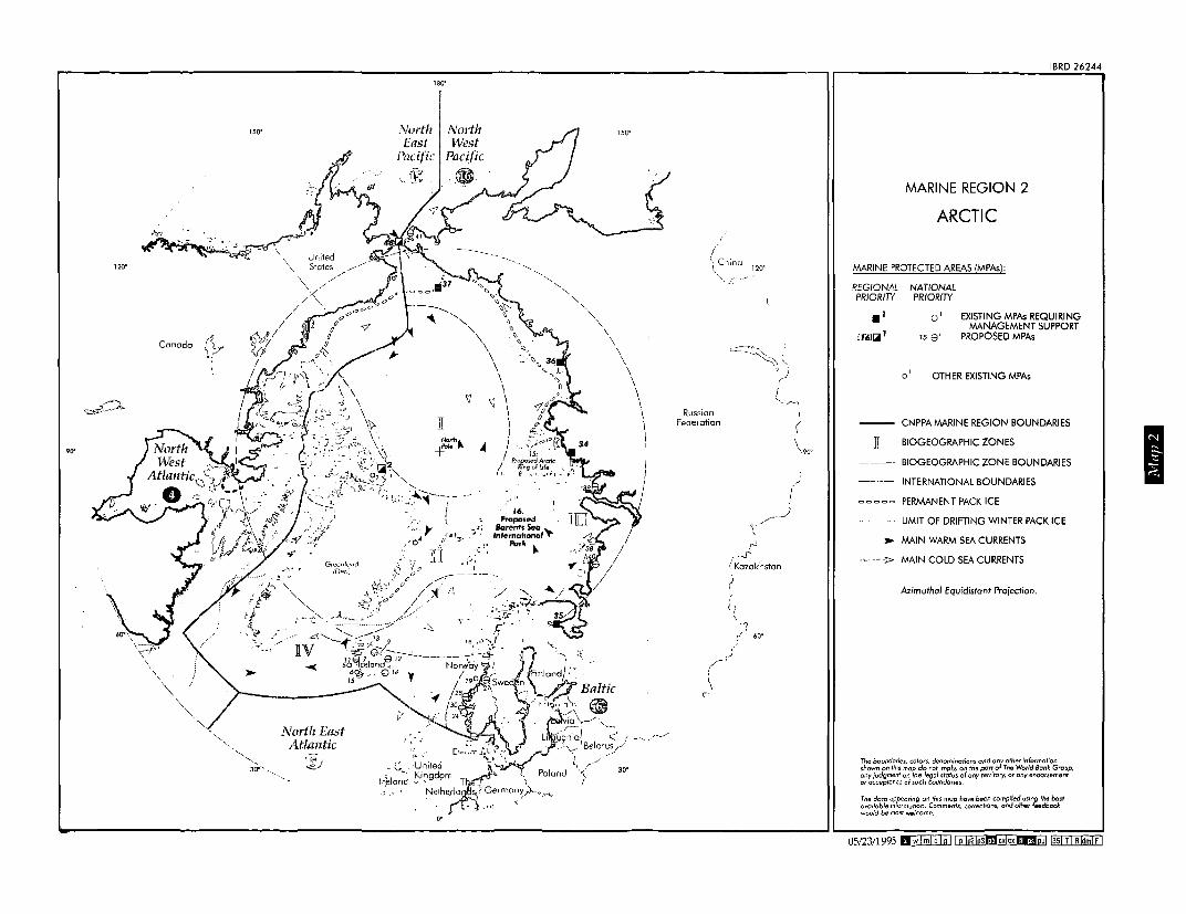
120"
90"
150"
~;,' .. . .61 .~::--· _/'!'--.... -- ........ ~,\.:..~~
~~;f>r,. , United
Canada ~
\ States
Nortlz East Atlantic
Nurth East
Pacific
--.......... , ~ "
II
" \
y
\ \ \ \ \
'i \ \ I
--... ",
..... .....
'
I ~ +~::"._, ~ I - ,>' 0 ~tr
/ Propo~Arctic / Ring of life , _,., ·
I I. ~; , II wl ~: - i- •
16. ProposN r ~";
- 4 oc.,J'" . "' . ,•o
-..1,··rr; -~· .. ;:,,
.~~:i!:,~ Par~ ~
:
o•
'-.
" \ \ \
150°
\ \ \ \ \ \ \ \ I I I I I I
/
C'!ina
Russian Fede1ation
120°
/_j
\ ~
r·J' ( Kazakhstan
(
r _;
MARINE REGION 2
ARCTIC
IBRD 26244
MARINE PROTECTED AREAS {MPAs):
REGIONAL PR/OR/TY
•' ff61Ciiil 1
NATIONAL PR/OR/TY
o' ,~ e'
EXISTING MPAs REQUIRING MANAGEMENT SUPPORT
PROPOSED MPAs
o 1 OTHER EXISTING MPAs
CNPPA MARINE REGION BOUNDARIES
II BIOGEOGRAPHIC ZONES
BIOGEOGRAPHIC ZONE BOUNDARIES
INTERNATIONAL BOUNDARIES
PERMANENT PACK ICE
LIMIT OF DRIFTING WINTER PACK ICE
> MAIN WARM SEA CURRENTS
,~ ---J> MAIN COLD SEA CURRENTS
Azimuthal Equidistant Projection.
~:,~06~ ~~fo~~r~~1~in J~~:e0t:/:!,::~n~~:~je:,;:::?:~b:'ckst would be most welcome.
05/23/1995 aw I ml CI g 11 p lp2lp3fflcxlbx1Dii] 1351 TI R ~ml FI
I

100
500
North East Atlantic
• ATLANTIC OCEAN
400
10'
-~-" /
f rtugalj
Mauritania
\ ~ (
nited ~-0~_/--/ ... ·,.J··,·· c::i
<:'~___)
Spain
r· France 1
/ Switzerland
(') .)
\
Cm~ II o . .,s
Algeria
MARINE REGION 3
MEDITERRANEAN
MARINE PROTECTED AREAS (MPAs):
REGIONAL PRIORITY
NATIONAL PRIORITY
•' !iii'
EXISTING MPAs REQUIRING MANAGEMENT SUPPORT
PROPOSED MPAs
01 OTHER EXISTING MPAs
20'
cio!ond
I 30'
Ukraine
IBRD 26245
·'------. 40•
\...-.,.__ so· ·-/
Block Seo Bulgaria
:u:v
MEDITERRANEAN SEA
Libya
CNPPA MARINE REGION BOUNDARIES
BIOGEOGRAPHIC ZONES
BIOGEOGRAPHIC ZONE BOUNDARIES
OCCUPIED TERRITORIES
) \ i i i i i i
Turkey
Arab Rep. of Egypt
40'
\ )\ y- _________ fl.-·- - -·
Sudan 30'
05/24/1995 llwlmlclg! ~!35!T!AijmlF)
I

180"
150"
United States
North East
Pacific
50"
130"
40"
(9
PACIFIC OCEAN
120·
160' 150" 140°
Arctic
MARINE REGION 4
NORTHWEST ATLANTIC
MARINE PROTECTED AREAS (MPAs):
REGIONAL NATIONAL PRIORITY PRIORITY
Canada
•' I.ill
•' r.'
EXISTING MPAs REQUIRING MANAGEMENT SUPPORT
PROPOSED MPAs
o I OTHER EXISTING MPAs
CNPPAMARINE REGION BOUNDARIES
I BIOGEOGRAPHIC ZONES
BIOGEOGRAPHIC ZONE BOUNDARIES
INTERNATIONAL BOUNDARIES
Robinson Projection.
:~~~~~d:;~e~;1d~-n~f?~;1;,~~0 ~he°;t,t;r r°i:~~~{d'Ba~k0G,oup, ~~~t:i:~: ~nf ~~~heeiii~°c:ri!:' any territory. or any endorsement
~:,~t: ~:ro:~71~:n t~::i:::::ts~~:,~~~nc;::~~e:th::"~b!ckst would be most welcome.
100' 90"
United States
Bermuda (UK)
" 60'
ATLANTIC OCEAN
50"
IBRD 26246
60"
70"
60"
\ I SO" I
\ \
--~---!
40"
6/2/1995 d wl ml c I g 11 p lp2!!D11.4lcx!bxdipul lasl T! R ~ml FI
I

40" 60"
Arctic
30°
MARINE REGION 5
NORTH EAST ATLANTIC
MARINE PROTECTED AREAS (MPAs):
REGIONAL NATIONAL PRIORITY PRIORITY
I 20·
50°
EXISTING MPAs REQUIRING MANAGEMENT SUPPORT
PROPOSED MPAs
40"
o' OTHER EXISTING MPAs
CNPPA MARINE REGION BOUNDARIES
j BIOGEOGRAPHIC ZONES
BIOGEOGRAPHIC ZONE BOUNDARIES
INTERNATIONAL BOUNDARIES
Robinson Proiection.
Azores (Porl)
··'28
.31 •23
:=;1a°6~ ftfur~~~i~~nJ~~=,f,/=~~n~;~j':h:t"fe~ba~kt woufd be most welcome.
30" 20"
ATLANTIC OCEAN
Madeira (Perl),
c-.21 «)· ~29
26
IBRD 26247
Germany
50"
I
40•
Mediterranean Sea
\ ) Algeria
Morocco \ .r-.J o·
06/05/1995 nwiml CI g i ip fflp3lc4lcxlbJclldjiUJ !351 TI R~ml FI

Arctic
Norwegian Sea
Germany
10"
10"'
j Poland
20"
I ~--·--): .•.•. J 1· I . . . I ·-·-·---·--'·,
20"
Finland
Lithuania
C)
'"' / \
\ 'i j
I /
/ /
/ /,.
Belarus
IBRD 26248
MARINE REGION 6
BALTIC
MARINE PROTECTED AREAS (MPAs):
REGIONAL NATIONAL PRIORITY PRIORITY
JI
o' e'
EXISTING MPAs REQUIRING MANAGEMENT SUPPORT
PROPOSED MPAs
0 1 OTHER EXISTING MPAs
CNPPA MARINE REGION BOUNDARIES
BIOGEOGRAPHIC ZONES
BIOGEOGRAPHIC ZONE BOUNDARIES
60"
Macoma 40"
..Q!1J!!!!9. BENTHIC MACROFAUNAL COMMUNITIES
30"
INTERNATIONAL BOUNDARIES
Lambert Conformal Conic Projedion.
Russian Federation
6/15/1995 R wl ml c I g 11 p lo2lo3!!9cxlbxlllffpiij 1351 T!R ijml FI
I


GPO Box 791, Canberra,' ACT 260 I; Australia Telephone: (06) 247-0211, NH {61}(6) 250-5597 International: (61) (6) 247~021 l,AH'(6li (6) 251-5597GMT+ IOhrs. Facsimile: (06) 247-576'1. International 161) 161. 247-5761'
Land, Water & Natural Habitats Division Environment Department 1818 H Street, N.W. Washington, D.C. 2043\JJ.S..A Telephone: (202) 458-2715 Fax: (202) 4?7-0568
Rue Mauverney· 28 , , . CH-1195 Gland, Switzerl~nd: Telephone: 41:-~2°?99--0i73· ,, Fax: 41-22-999-0025 · Telex: 419624 inch- ch
Toward Environmentally Sustainable Developmen.t
Cover photographs ,by Mr. Jan C..Posi except "Walruses,, by Dr. G .. Carleton Ray