Embed Size (px)
Citation preview
The Archaeological Map of the Murghab Delta Studies and Reports
Series Editors: Annageldy Gubaev, Gennady A. Koshelenko and Maurizio Tosi
Volume II The Bronze Age and Early Iron Age
in the Margiana Lowlands
Facts and methodological proposals for a redefinition of the research strategies
Edited by
Sandro Salvatori and Maurizio Tosi
with the editorial collaboration of
Barbara Cerasetti
BAR International Series 1806 2008

29
Chapter 2 a GIS for the arChaeoloGy of the MurGhab Delta1
Barbara Cerasetti
Introduction
The application of a Geographic Information System (GIS) (Wheatley and Gillings 20022; Rondelli and Tosi 2005) to manage a large amount of data, like that coming from an extensive area such as the Murghab Delta (approximately 20,000 sq km) (Figure 2.1), is now becoming the standard method adopted by a growing number of archaeological projects. Different GIS programmes are actually used for the same purpose, in order to organise numerous and different data into a homogeneous structure that allows us to undertake several types of research. In building up the Murghab Delta GIS, we had to tackle both the development and modification of archaeological research techniques, on the one hand, and hardware and software technological evolution on the other. For this reason we were forced to expend a large part of our energies in rendering an enormous quantity of data suitable for an Informative System.
A First Setting of the Informative Archaeological Map: the GIS and the Remote Sensing Data
The choice of five 1:200,000 topographic military maps as reference cartography for the “Archaeological Map of the Murghab Delta” (AMMD) (Gubaev et al. 1998) was agreed upon by the coordinating agencies of the project because of the limited access to smaller-scale maps for security reasons. We recently integrated the AMMD cartography by including six 1:100,000 military maps that covered the central and southern regions of the Murghab Delta3. The vector version of the 1:200,000 map mosaic is a product of the formar Cartographic Centre of the State Security Committee of the USSR in Moscow. All the strategic information was included, since the map editions used for digitising were largely outdated for military purposes. After the independence of Turkmenistan (1991), the relevant national security agencies refused access to any map on a scale smaller than 1:200,000. The 1:10,000 military maps are available only for a better ground definition of critical areas such as the Merv region4.
1 The final results of the remote sensing analyses were made possible by the Short-Term Mobility Grant (2005) of the Consiglio Nazionale delle Ricerche, Rome.2 See the relative bibliography.3 We thank G. A. Koshelenko and V. Gaibov, Institute of Archaeology of Russian Academy of Sciences of Moscow, for the availability of 1:100,000 topographical maps.4 We thank G. Herrmann and T. D. Wiliams, Institute of Archaeology, University College London (UCL), for the availability of 1:10,000 topographical maps.
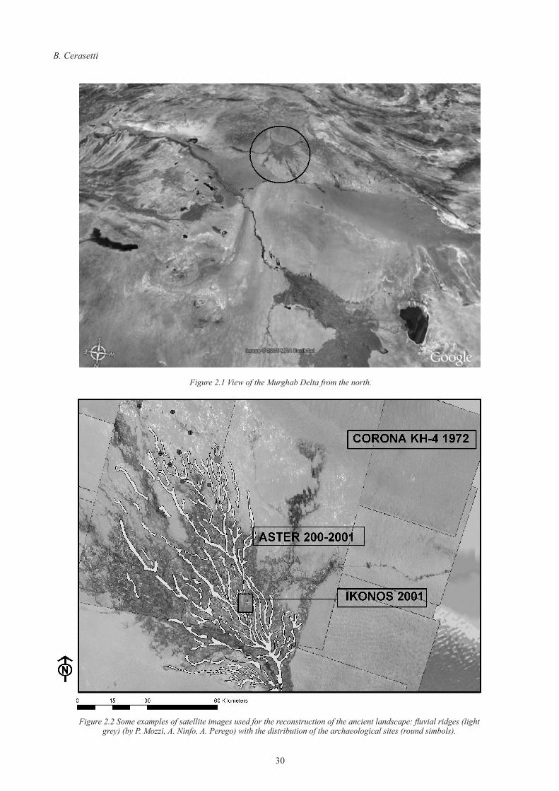
The GIS application, using the ArcMap 8.2 software, resolved various levels of difficulty such as the large size and high diversification of the data to be organised and the systematisation of archaeological data with analytical procedures. The goal of the work determined the type and amount of data to be processed, and the map was simplified into a documentation work whose purpose was mainly to record the location, size, type and time span of each site. In order to obtain the precision and consistency required in the GIS organisation, all types of data were codified on the basis of a definite scale of values. In the case of the Murghab Delta, characterised by several millennia of settlement remains distributed over a large territory, all information had to be classified into codified categories developed ad hoc in different databases. The GIS was used as an instrument for assembling and managing the vast arrays of diversified archives to be merged into a historical analysis of settlement and population dynamics. Digitised satellite images, and aerial photographs in general, are providing another tool for the definition of ancient landscapes, before and beyond the direct fields of observation (Figure 2.2).
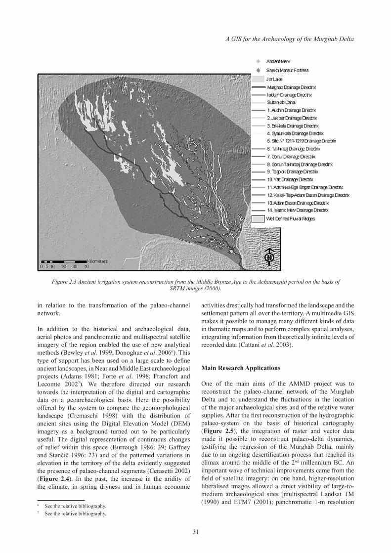
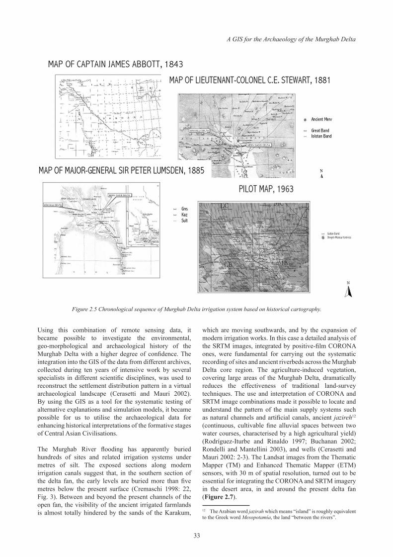
Considering the available information, at the beginning we prepared a vector cartographic digitisation of historical maps (Abbott 1843; Stewart 1881; Lumsden 1885) on different layers, in order to reconstruct the ancient irrigation system previous to the building of the Karakum Canal, which began in 1954 (Grinberg 1963: 8), and in order to obtain cartographic information for measuring the hydrodynamic and environmental evolution of the delta. A careful analysis of topographical, geographical, historical, environmental and geological maps allowed us to achieve an acceptable reconstruction of the hydraulic history of the Murghab River Delta from the Middle Bronze Age (MBA) to the Achaemenid period [Iron Age (IA) 3-4] (Figure 2.3)5. This was fundamental for a comprehension of the settlement-pattern distribution of the archaeological sites in the ancient landscape during the different chronological periods. The management of the data concerning the archaeological map of the Murghab Delta by means of a GIS system presented various levels of difficulty (Cerasetti 2000-2001). Considering the large size and high diversification of the data on hand, a set of graphs was produced as well, in order to provide a first level of representation of the changing population distribution
5 The collaboration with P. Mozzi and A. Ninfo, Department of Geography of University of Padua, and M. Cremaschi and A. Perego, Department of Earth Science of University of Milan, has been fundamental for the success of the project on the irrigation system reconstruction of the Murghab Delta.
B. Cerasetti
30
Figure 2.2 Some examples of satellite images used for the reconstruction of the ancient landscape: fluvial ridges (light grey) (by P. Mozzi, A. Ninfo, A. Perego) with the distribution of the archaeological sites (round simbols).
Figure 2.1 View of the Murghab Delta from the north.
A GIS for the Archaeology of the Murghab Delta
31
in relation to the transformation of the palaeo-channel network.
In addition to the historical and archaeological data, aerial photos and panchromatic and multispectral satellite imagery of the region enabled the use of new analytical methods (Bewley et al. 1999; Donoghue et al. 20066). This type of support has been used on a large scale to define ancient landscapes, in Near and Middle East archaeological projects (Adams 1981; Forte et al. 1998; Francfort and Lecomte 20027). We therefore directed our research towards the interpretation of the digital and cartographic data on a geoarchaeological basis. Here the possibility offered by the system to compare the geomorphological landscape (Cremaschi 1998) with the distribution of ancient sites using the Digital Elevation Model (DEM) imagery as a background turned out to be particularly useful. The digital representation of continuous changes of relief within this space (Burrough 1986: 39; Gaffney and Stančič 1996: 23) and of the patterned variations in elevation in the territory of the delta evidently suggested the presence of palaeo-channel segments (Cerasetti 2002) (Figure 2.4). In the past, the increase in the aridity of the climate, in spring dryness and in human economic
6 See the relative bibliography.7 See the relative bibliography.
activities drastically had transformed the landscape and the settlement pattern all over the territory. A multimedia GIS makes it possible to manage many different kinds of data in thematic maps and to perform complex spatial analyses, integrating information from theoretically infinite levels of recorded data (Cattani et al. 2003).
Main Research Applications
One of the main aims of the AMMD project was to reconstruct the palaeo-channel network of the Murghab Delta and to understand the fluctuations in the location of the major archaeological sites and of the relative water supplies. After the first reconstruction of the hydrographic palaeo-system on the basis of historical cartography (Figure 2.5), the integration of raster and vector data made it possible to reconstruct palaeo-delta dynamics, testifying the regression of the Murghab Delta, mainly due to an ongoing desertification process that reached its climax around the middle of the 2nd millennium BC. An important wave of technical improvements came from the field of satellite imagery: on one hand, higher-resolution liberalised images allowed a direct visibility of large-to-medium archaeological sites [multispectral Landsat TM (1990) and ETM7 (2001); panchromatic 1-m resolution
Figure 2.3 Ancient irrigation system reconstruction from the Middle Bronze Age to the Achaemenid period on the basis of SRTM images (2000).
B. Cerasetti
32
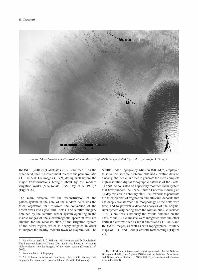
IKONOS (2001)8] (Galiatsatos et al. submitted9); on the other hand, the US Government released the panchromatic CORONA KH-4 images (1972), dating well before the major transformations brought about by the modern irrigation works (MacDonald 1995; Day et al. 1998)10 (Figure 2.2).
The main obstacle for the reconstruction of the palaeo-system in the core of the modern delta was the thick vegetation that followed the conversion of the desert areas into agricultural fields. The satellite imagery obtained by the satellite sensor system operating in the visible ranges of the electromagnetic spectrum was not suitable for the reconstruction of the irrigation system of the Merv region, which is deeply irrigated in order to support the nearby modern town of Bayram-Ali. The
8 We wish to thank T. D. Williams, G. Herrmann and D. Powlesland, The Landscape Research Centre (UK), for having helped us to acquire high-resolution satellite imagery of the Merv region (Ziebart et al. 2002).9 See the relative bibliography.10 All technical information concerning the remote sensing data employed for this research is consultable in Cerasetti forthcoming.
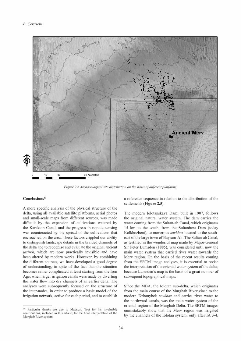
Shuttle Radar Topography Mission (SRTM)11, employed to solve this specific problem, obtained elevation data on a near-global scale, in order to generate the most complete high-resolution digital topographic database of the Earth. The SRTM consisted of a specially modified radar system that flew onboard the Space Shuttle Endeavour during an 11-day mission in February 2000. It allowed us to penetrate the thick blanket of vegetation and alluvium deposits that has deeply transformed the morphology of the delta with time, and to perform a detailed analysis of the original river system originating from the Iolotan hub (Galiatsatos et al. submitted). Obviously the results obtained on the basis of the SRTM mosaic were integrated with the other vertical platforms such as aerial photos and CORONA and IKONOS images, as well as with topographical military maps of 1941 and 1990 (Cerasetti forthcoming) (Figure 2.6).
11 The SRTM is an international project spearheaded by the National Geo-spatial-Intelligence Agency (NGA) and the National Aeronautics and Space Administration (NASA) (http://glcfr.umiacs.umd.edu/data/srtm/index.shtml).
Figure 2.4 Archaeological site distribution on the basis of SRTM images (2000) (by P. Mozzi, A. Ninfo, A. Perego).
A GIS for the Archaeology of the Murghab Delta
33
Using this combination of remote sensing data, it became possible to investigate the environmental, geo-morphological and archaeological history of the Murghab Delta with a higher degree of confidence. The integration into the GIS of the data from different archives, collected during ten years of intensive work by several specialists in different scientific disciplines, was used to reconstruct the settlement distribution pattern in a virtual archaeological landscape (Cerasetti and Mauri 2002). By using the GIS as a tool for the systematic testing of alternative explanations and simulation models, it became possible for us to utilise the archaeological data for enhancing historical interpretations of the formative stages of Central Asian Civilisations.
The Murghab River flooding has apparently buried hundreds of sites and related irrigation systems under metres of silt. The exposed sections along modern irrigation canals suggest that, in the southern section of the delta fan, the early levels are buried more than five metres below the present surface (Cremaschi 1998: 22, Fig. 3). Between and beyond the present channels of the open fan, the visibility of the ancient irrigated farmlands is almost totally hindered by the sands of the Karakum,
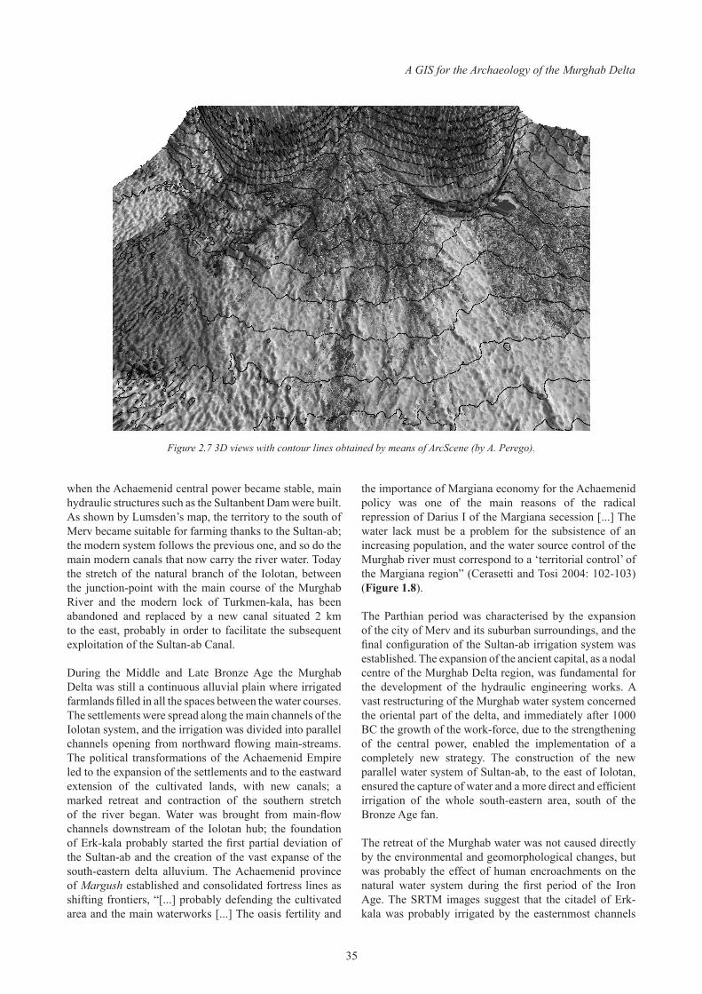
which are moving southwards, and by the expansion of modern irrigation works. In this case a detailed analysis of the SRTM images, integrated by positive-film CORONA ones, were fundamental for carrying out the systematic recording of sites and ancient riverbeds across the Murghab Delta core region. The agriculture-induced vegetation, covering large areas of the Murghab Delta, dramatically reduces the effectiveness of traditional land-survey techniques. The use and interpretation of CORONA and SRTM image combinations made it possible to locate and understand the pattern of the main supply systems such as natural channels and artificial canals, ancient jazireh12 (continuous, cultivable fine alluvial spaces between two water courses, characterised by a high agricultural yield) (Rodríguez-Iturbe and Rinaldo 1997; Buchanan 2002; Rondelli and Mantellini 2003), and wells (Cerasetti and Mauri 2002: 2-3). The Landsat images from the Thematic Mapper (TM) and Enhanced Thematic Mapper (ETM) sensors, with 30 m of spatial resolution, turned out to be essential for integrating the CORONA and SRTM imagery in the desert area, in and around the present delta fan (Figure 2.7).
12 The Arabian word jazirah which means “island” is roughly equivalent to the Greek word Mesopotamía, the land “between the rivers”.
Figure 2.5 Chronological sequence of Murghab Delta irrigation system based on historical cartography.
B. Cerasetti
34
Conclusions13
A more specific analysis of the physical structure of the delta, using all available satellite platforms, aerial photos and small-scale maps from different sources, was made difficult by the expansion of cultivations watered by the Karakum Canal, and the progress in remote sensing was counteracted by the spread of the cultivations that encroached on the area. These factors crippled our ability to distinguish landscape details in the braided channels of the delta and to recognise and evaluate the original ancient jazireh, which are now practically invisible and have been altered by modern works. However, by combining the different sources, we have developed a good degree of understanding, in spite of the fact that the situation becomes rather complicated at least starting from the Iron Age, when larger irrigation canals were made by diverting the water flow into dry channels of an earlier delta. The analyses were subsequently focused on the structure of the inter-nodes, in order to produce a basic model of the irrigation network, active for each period, and to establish
13 Particular thanks are due to Maurizio Tosi for his invaluable contributions, included in this article, for the final interpretation of the Murghab River system.
a reference sequence in relation to the distribution of the settlements (Figure 2.5).
The modern Iolotanskaya Dam, built in 1907, follows the original natural water system. The dam carries the water coming from the Sultan-ab Canal, which originates 15 km to the south, from the Sultanbent Dam (today Kolkhozbent), to numerous sovkhoz located to the south-east of the large town of Bayram-Ali. The Sultan-ab Canal, as testified in the wonderful map made by Major-General Sir Peter Lumsden (1885), was considered until now the main water system that carried river water towards the Merv region. On the basis of the recent results coming from the SRTM image analyses, it is essential to revise the interpretation of the oriental water system of the delta, because Lumsden’s map is the basis of a great number of subsequent topographical maps.
Since the MBA, the Iolotan sub-delta, which originates from the main course of the Murghab River close to the modern Dzhanybek sovkhoz and carries river water to the northward canals, was the main water system of the oriental region of the Murghab Delta. The SRTM images unmistakably show that the Merv region was irrigated by the channels of the Iolotan system; only after IA 3-4,
Figure 2.6 Archaeological site distribution on the basis of different platforms.
A GIS for the Archaeology of the Murghab Delta
35
when the Achaemenid central power became stable, main hydraulic structures such as the Sultanbent Dam were built. As shown by Lumsden’s map, the territory to the south of Merv became suitable for farming thanks to the Sultan-ab; the modern system follows the previous one, and so do the main modern canals that now carry the river water. Today the stretch of the natural branch of the Iolotan, between the junction-point with the main course of the Murghab River and the modern lock of Turkmen-kala, has been abandoned and replaced by a new canal situated 2 km to the east, probably in order to facilitate the subsequent exploitation of the Sultan-ab Canal.
During the Middle and Late Bronze Age the Murghab Delta was still a continuous alluvial plain where irrigated farmlands filled in all the spaces between the water courses. The settlements were spread along the main channels of the Iolotan system, and the irrigation was divided into parallel channels opening from northward flowing main-streams. The political transformations of the Achaemenid Empire led to the expansion of the settlements and to the eastward extension of the cultivated lands, with new canals; a marked retreat and contraction of the southern stretch of the river began. Water was brought from main-flow channels downstream of the Iolotan hub; the foundation of Erk-kala probably started the first partial deviation of the Sultan-ab and the creation of the vast expanse of the south-eastern delta alluvium. The Achaemenid province of Margush established and consolidated fortress lines as shifting frontiers, “[...] probably defending the cultivated area and the main waterworks [...] The oasis fertility and
the importance of Margiana economy for the Achaemenid policy was one of the main reasons of the radical repression of Darius I of the Margiana secession [...] The water lack must be a problem for the subsistence of an increasing population, and the water source control of the Murghab river must correspond to a ‘territorial control’ of the Margiana region” (Cerasetti and Tosi 2004: 102-103) (Figure 1.8).
The Parthian period was characterised by the expansion of the city of Merv and its suburban surroundings, and the final configuration of the Sultan-ab irrigation system was established. The expansion of the ancient capital, as a nodal centre of the Murghab Delta region, was fundamental for the development of the hydraulic engineering works. A vast restructuring of the Murghab water system concerned the oriental part of the delta, and immediately after 1000 BC the growth of the work-force, due to the strengthening of the central power, enabled the implementation of a completely new strategy. The construction of the new parallel water system of Sultan-ab, to the east of Iolotan, ensured the capture of water and a more direct and efficient irrigation of the whole south-eastern area, south of the Bronze Age fan.
The retreat of the Murghab water was not caused directly by the environmental and geomorphological changes, but was probably the effect of human encroachments on the natural water system during the first period of the Iron Age. The SRTM images suggest that the citadel of Erk-kala was probably irrigated by the easternmost channels
Figure 2.7 3D views with contour lines obtained by means of ArcScene (by A. Perego).
B. Cerasetti
36
of the Iolotan sub-delta; the foundation of Gyuar-kala involved a considerable increase in population and a remarkable expansion of the cultivated areas, which could hardly be supported by the old irrigation system. During IA 1 the area north of Merv was still populated, but during the Achaemenid period and the first part of the Hellenistic period the delta extensively retreated towards the south. During the Late-Hellenistic and Parthian period the northern fortresses controlled an area that by then had become a desert. The site of Yaz-depe clearly indicates the way the change of control took place. In IA 1, Yaz was the largest site, and during the first stage of IA 3, when the fortifications of Erk-kala had already been established, it still controlled the northern provinces. Probably at the end of the 4th century BC Yaz-depe was abandoned and the area was occupied by the Parthian fortress of Geobekly.
At present the GIS of the Murghab Delta system is being enhanced by the increasing availability of different computer application programmes that allow us to manage an enormous quantity of data coming from the long-term fieldwork project. The simultaneous advancement of archaeological techniques and technological analyses in southern Turkmenistan will greatly help, and also define, an integrated interpretative approach to complex multi-vector processes that are hidden below the changing pattern of the archaeological evidence in the cultural history of the Murghab Delta.
References Cited
Abbott, J. 1843. Narrative of a Journey from Heraut to Khiva, Moscow, and St. Petersburg, during the Late Russian Invasion of Khiva; with Some Account of the Court of Khiva and the Kingdom of Khaurism, I. London.
Adams, R. McC. 1981. Heartland of Cities. Surveys of Ancient Settlement and Land Use on the Central Floodplain of the Euphrates. Chicago.
Andrianov, B. V. 1969. Drevnie orositel’nye sistemy Priaral’ya. Moskva.
Baltsavias, E., A. Gruen, L. van Gool and M. Pateraki (eds) 2006. Recording, Modeling and Visualization of Cultural Landscape. London.
Bewley, R., D. Donaghue, V. Gaffney, M. van Leusen and A. Wise (eds) 1999. Archiving Aerial Photography and Remote Sensing Data. Oxford.
Buchanan, M. 2002. Nexus. Small Worlds and the Groundbreaking Science of Networks. New York.
Burenhult G. and J. Arvidsson (eds), Archaeological Informatics: Pushing the Envelope CAA 2001. Computer Applications and Quantitative Methods in Archaeology. Proceedings of the 29th Conference, Gotland, April 2001. BAR International Series 1016. Oxford.
Burrough, P. A. 1986. Principles of Geographical Information Systems for Land Resources Assessment. Oxford.
Cattani, M., B. Cerasetti, S. Salvatori and M. Tosi 2003. “The Murghab Delta in Central Asia 1990-2001: GIS from a Research Resource to a Reasoning Tool for the Study of Settlement Change in Long-Term Fluctuations”, in Doerr and Sarris (eds) 2003: 125-131.
Cerasetti, B. 2000-2001. “A Geographic Information System for Ancient Margiana”, Annali Istituto Universitario Orientale di Napoli 60-61: 197-214.
Cerasetti, B. 2002. “A 5000-Years History of Settlement and Irrigation in the Murghab Delta (Turkmenistan). An Attempt of Reconstruction of Ancient Deltaic System”, in Burenhult and Arvidsson (eds) 2002: 21-27.
Cerasetti, B. (forthcoming). Remote Sensing in Archaeology: River Fluctuations in the Murghab Delta from the Middle Bronze Age to the Achaemenid Empire. BAR. International Series. Oxford.
Cerasetti, B. and M. Mauri 2002. “The Murghab Delta Palaeochannel Reconstruction on the basis of Remote Sensing from Space”, in Space Applications for Heritage Conservation, Strasbourg (France), November 2002. Strasbourg.
Cerasetti, B. and M. Tosi 2004. “Development of the “Open Frontier” between Iran and Central Asia: the Murghab Defensive Systems in the Antiquity and the Variants of the Silk Road across the Karakum”, Parthica 6: 1-6.
Cremaschi, M. 1998. “Palaeohydrography and Middle Holocene Desertification in the Northern Fringe of the Murghab Delta”, in Gubaev, Koshelenko and Tosi (eds) 1998: 15-25.
Day, D. A., J. M. Logsdon and B. Latell (eds) 1998. Eye in the Sky: the Story of the Corona Spy Satellites. Washington-London.
Doerr, M. and A. Sarris (eds) 2003. CAA 2002. “The Digital Heritage of Archaeology”. Computer Applications and Quantitative Methods in Archaeology. Proceedings of the 30th Conference, Heraklion, Crete, April 2002. Heraklion.
Donoghue, D. N. M., A. R. Beck, N. Galiatsatos, K. B. McManus and G. Philip 2006. “The Use of Remote Sensing Data for Visualising and Interpreting Archaeological Landscapes”, in Baltsavias, Gruen, van Gool and Pateraki (eds) 2006: 317-326.
Forte, M., P. Mozzi and M. Zocchi 1998. “Immagini satellitari e modelli virtuali: interpretazioni geoarcheologiche della regione del Sistan meridionale”, Archeologia e Calcolatori 9: 271-290.
Francfort, H.-P. and O. Lecomte 2002. “Irrigation et sociétés en Asie centrale des origines à l’époque achéménide”, Annales 3: 625-663.
Gaffney, V. and Z. Stančič 1996. GIS Approaches to Regional Analysis: a Case Study of the Island of Hvar. Ljubljana.
Galiatsatos, N., D. N. M. Donoghue and G. Philip (submitted) High Resolution Elevation Data Derived from Stereoscopic CORONA Imagery with Minimal Ground Control: an Approach using IKONOS and SRTM Data, Photogrammetric Engineering and Remote Sensing.

A GIS for the Archaeology of the Murghab Delta
37
Gardin, J.-C. and P. Gentelle 1976. “Irrigation et peuplement dans la plaine d’Aï Khanoum de l’époque achéménide à l’époque musulmane”, Bulletin de L’École Française d’Extrême-Orient LXIII: 5-99.
Grinberg, L. M. 1963. Karakumskij kanal. Ashgabat.Gubaev, A., G. Koshelenko and M. Tosi (eds) 1998. The
Archaeological Map of the Murghab Delta. Preliminary Reports 1990-95. Reports and Memoirs. Series Minor, III. IsIAO. Roma.
Lisizina, G. N. 1965. Oroshayemoye zemledeliye epokhi eneolita na yuge Turkmenii. Moskva.
Lisitsina, G. N. 1969. “The Earliest Irrigation in Turkmenia”, Antiquity XLIII: 279-288.
Lock, G. and Z. Stančič (eds) 1995. Archaeology and Geographical Information Systems: a European Perspective. London.
Lumsden, P. 1885. Countries and Tribes bordering on the Koh-i-Baba Range. Proceedings of the Royal Geographical Society and Monthly Record of Geography. London.
MacDonald, R. 1995. “Si aprono gli archivi della Guerra Fredda”, Sistema Terra. Rivista Internazionale di telerilevamento 3: 4-15.
Rodríguez-Iturbe, I. and A. Rinaldo 1997. Fractal River Basins. Cambridge.
Rondelli, B. and S. Mantellini 2003. “Methods and Perspectives for Ancient Settlement Studies in the Middle Zeravshan Valley”, The Silk Road Foundation. News Letter 1: 1.
Rondelli, B. and M. Tosi 2005. “GIS and Silk Road Studies: Monitoring Landscape and Population Changes at Samarkand and in the Middle Zeravshan Valley”, in Uno (ed.) 2005: 459-489.
Stewart, C. E. 1881. The Country of the Tekke Turkomans, and the Tejen and Murghab Rivers”. Proceedings of the Royal Geographical Society and Monthly Record of Geography. London.
Uno, T. (ed.) 2005. Reading Historical Spatial Information from around the World. Studies of Culture and Civilization Based on Geographic Information Systems Data. International Symposium 24 (2005). Kyoto.
Wheatley, D. and M. Gillings 2002. Spatial Technology and Archaeology: the Archaeological Application of GIS. New York.
Ziebart M., P. Dare, T. Williams and G. Herrmann 2002. “Acquisition, Registration and Application of IKONOS Space Imagery for the Cultural World Heritage Site at Merv, Turkmenistan”, Space Applications for Heritage Conservation, Strasbourg (France), November 2002.


