Embed Size (px)
Citation preview

(2007) 247–265www.elsevier.com/locate/chemgeo
Chemical Geology 236
87Sr/86Sr as an indicator of flowpaths and weathering rates in thePlynlimon experimental catchments, Wales, U.K.
Paul Shand a,⁎, D.P. Fiona Darbyshire b, Daren Gooddy a, Atul H. Haria c
a British Geological Survey, Crowmarsh Gifford, Wallingford, Oxfordshire, OX10 8BB, UKb NERC Isotope Geosciences Laboratory, British Geological Survey, Keyworth, Nottinghamshire, NG12 5GG, UK
c Centre for Ecology and Hydrology, Crowmarsh Gifford, Wallingford, Oxfordshire, OX10 8BB, UK
Received 11 April 2006; received in revised form 19 September 2006; accepted 30 September 2006
Editor: D. Rickard
Abstract
A knowledge of the processes involved in streamflow generation are critical to an understanding of solute transport andweathering rates in upland catchments. The determination of specific flow pathways and the formulation of process-based modelshave proved difficult in such terrains, largely due to the heterogeneous nature of catchments and the necessary limitations of bulkedparameter models. Natural geochemical tracers have proved invaluable in developing conceptual models of catchment functioningand for constraining weathering processes and geochemical cycling. Strontium isotopes have been used as a natural tracer tocalculate weathering rates for Sr and Ca, and to constrain the dominant flow pathways in two upland forested sub-catchments(Afon Hafren and Afon Hore) of the River Severn at Plynlimon in Central Wales. The dominant source of Sr in the catchments isconsidered to be from the weathering of silicate minerals. Weathering rates for Sr and Ca in the Afon Hafren, calculated using Srisotopes, were similar to those derived from mass balance studies. The rates for the Afon Hore were similar for Ca, but significantlydifferent for Sr. The reason for the difference is unclear, but may be due to additional sources (calcite) in the catchment. Strontiumisotope ratios for different input sources and compartments within the catchment were characterised and helped to identify potentialflow pathways. The data suggest an important role for groundwater inputs in contrast to previous models which indicated adominant role for soil waters.Crown Copyright © 2006 Published by Elsevier B.V. All rights reserved.
Keywords: 87Sr/86Sr; Catchment; Plynlimon; Weathering; Flowpath
⁎ Corresponding author. Present address: CSIRO Land and Water,Private Bag 2, Glen Osmond, SA 5064, Australia. Tel.: +61 8 83038513; fax: +61 8 8303 8550.
E-mail address: [email protected] (P. Shand).
0009-2541/$ - see front matter. Crown Copyright © 2006 Published by Elsdoi:10.1016/j.chemgeo.2006.09.012
1. Introduction
1.1. Background
The processes involved in streamflow generationhave received considerable attention over the last fewdecades, initially in response to concerns about aciddeposition and the consequent acidification of streams(Likens et al., 1977; Mason, 1990). The impacts of aciddeposition and other pollutant inputs on water quality
evier B.V. All rights reserved.

248 P. Shand et al. / Chemical Geology 236 (2007) 247–265
and ecosystem balance depend largely on the ability ofcatchment materials to neutralise or disperse such in-puts. The sustainability of aquatic ecosystems is alsodependant on the transfer and cycling of nutrientsthrough the catchment. This is particularly true of up-land catchments which are often base and nutrient poorand therefore sensitive to both climate and land-usechange. Fundamental to modelling the response ofcatchments to environmental change is a knowledge ofthe water flowpaths, residence times and the source andbehaviour of solutes in groundwater and through the soiland unsaturated zone.
The majority of upland catchments have traditionallybeen assumed to be underlain by impermeable bedrock.The source areas and flow pathways in uplandcatchments are poorly understood and the subject ofconsiderable debate (Bonell, 1998; Kirchner, 2003;McDonnel, 2003; Shand et al., 2004). However, it isbecoming increasingly apparent that many uplandcatchments in hard rock terrains, previously consideredto be underlain by impermeable bedrock, containgroundwater which may play an important role instreamflow generation. (Shand et al., 1997; Neal et al.,1997a; McGlynn et al., 2002; Soulsby et al., 2005). Thecontributing sources and flowpaths in upland catch-ments vary both seasonally and at the event scaledepending on rainfall intensity, antecedent conditionsand the structure of the soils and bedrock, makingsolute-transport modelling difficult. This is particularlythe case in areas underlain by fractured bedrock whichare typically characterised by extreme spatial variabilityin hydrogeological parameters such as hydraulicconductivity and groundwater flow rate (Cook, 2003).
1.2. Chemical weathering
Chemical weathering is the term used to describe thetransformation of minerals formed at particular P–Tconditions within the earth into more stable secondaryminerals and solute species through interaction withdilute waters close to the earth's surface. Weathering ofcarbonate minerals is generally rapid in comparison withmuch slower rates for silicates, and although much lessabundant in terms of quantity, provides a disproportion-ate input into natural waters. The weathering of silicateminerals is important because the release of base cationsto solution provides plant nutrients as well as neutralis-ing acidity and generating alkalinity (Drever, 1997). Therole of silicate weathering is also considered to be animportant control on atmospheric CO2 and consequentlyimportant long-term control on climate change. Unlikecarbonate weathering, where CO2 consumed in dissolu-
tion is released during precipitation of calcite in theoceans, silicate weathering and subsequent precipitationresults in a net loss of CO2 from the Earths surface(Berner et al., 1983). This makes estimates of weatheringrates and processes important in predicting the effects ofclimate change over longer time scales. The soil zone,where weathering is intense, has traditionally beenconsidered as dominating weathering and the export ofsolutes from catchments. However, the export of solutesmay be derived from less intense weathering of largevolumes of rock in the sub-surface environment belowthe soils. It is evident from geochemical studies of soilsand groundwater that both are important, but the relativeimportance of each is not well established.
Chemical weathering results in the production of basecations and alkalinity from reactions between rainfalland soil-derived carbonic acid with solid phases. Thissupply of base cations is augmented by input fromatmospheric deposition, and in order to calculateweathering rates it is necessary to calculate atmosphericdeposition. The weathering of silicate minerals isextremely important because silicate weathering reac-tions are generally non-reversible and therefore act as along-term sink of H+. Ion exchange reactions, on theother hand, are rapid and reversible and may only act astemporary sinks to acidity. Miller et al. (1993) have alsoattempted to discriminate weathering rates from ex-changeable cation loss based on Sr isotopes. Theproduction of base cations in catchments due to chemicalweathering is important because of their role as plantnutrients, in neutralising acidity or generating alkalinityand in the replenishment of the soil ion exchange pool.
1.3. Isotopes in catchment studies
A range of natural isotope tracers have been used tohighlight the sources of solutes and elements cycling incatchments (Kendall and McDonnell, 1998). A numberof studies over the past few decades using the stableisotopes of water (δ2H and δ18O which are trulyconservative) have emphasised the importance of “pre-event” water in stream flow generation i.e. water whichfell on a catchment prior to the hydrograph response ofthe antecedent rainfall event (Sklash and Farvolden,1979; Pearce et al., 1986). However, the implied storageidentified in such studies, whether in soils, superficialdeposits or the underlying bedrock remains largelyunresolved.
Strontium isotopes have proved to be effective as atracer of weathering and solute transport in catchmentstudies (see summaries in Bullen and Kendall, 1998;Capo et al., 1998; McNutt, 2000; Blum and Erel, 2005).

Fig. 1. Location of the Plynlimon catchment showing the main sub-catchments: Afon Hafren, Afon Hore and Tanllwyth.
249P. Shand et al. / Chemical Geology 236 (2007) 247–265
These isotope ratios are extremely useful because they arenot fractionated by geochemical reactions (e.g. mineraldissolution and precipitation) or biotic processes, andmaybe used to investigate mineral weathering reactions.Differences in isotope ratios reflect only mixing, therebyproviding valuable information on sources, pathways andgeochemical processes (Land et al., 2000; Aubert et al.,2002; Hogan and Blum, 2003; Négrel and Petelet-Giraud,2005). The 87Sr/86Sr ratio in streams and rivers varieswidely, from values as low as 0.7046 in young basalticterrains (Wadleigh et al., 1985) up to 0.7456 in graniticterrains of Proterozoic age (Åberg and Wickman, 1987;Åberg et al., 1989). The importance of bedrock type andage in controlling the variation in isotope ratios is wellestablished (Wadleigh et al., 1985).
In contrast to the stable isotopes of water (δ18O,δ2H), Sr isotopes can change through reaction withminerals and so indicate chemical reactions which havetaken place in the catchment. Several other stableisotope tracers (e.g. δ32S, δ15N, δ13C) may also changein response to chemical reactions, but are more complexin that they are often fractionated during chemicalreactions in different environments. However, solutetracers provide information primarily about the solutemeasured and not necessarily the water itself, henceassumptions are often required to relate solute transportto flow pathways. Strontium concentrations in runoff,soils and biomass are primarily a function of mixingbetween atmospheric inputs and mineral weathering.Differences in solute Sr isotope ratios are controlled byvariations in initial inputs, differences in mineralogyalong flowpaths, mineral dissolution characteristics andresidence time. The 87Sr/86Sr ratio in waters willtherefore be a function of the “weatherable Sr” and theefficiency of exchange (Åberg et al., 1989). One of themain problems for Sr isotope tracer studies lies indefining the isotope composition of this weathering-derived Sr. Complete rock or soil dissolution does notgive a fair representation of the weathering ratio becauseof the different weathering rates and stabilities ofminerals in the weathering environment. The wholerock isotope ratio is, therefore, of little relevance indetermining weathering rates because the weathering-derived ratio will be dominated by those mineral phaseswith the highest dissolution kinetics. A range of leachateand extraction techniques, usually employing organicacids, have therefore been used to determine theweathering component of Sr in soils (Åberg et al.,1989; Wickman and Jacks, 1992; Miller et al., 1993).The presence of different mineral phases and differentwater flowpaths necessitate considering isotope data inconjunction with solute chemistry.
Strontium isotopes have also been used to estimateweathering rates of Sr, and also as a surrogate for theessential alkali earth element Ca (Graustein andArmstrong, 1983; Jacks and Åberg, 1987; Åberget al., 1989), based on the assumption that calciumexhibits the same ratio of deposition to weathering asstrontium (Jacks et al., 1989). Although Sr generallybehaves similarly to Ca, minerals may have significantlydifferent Sr/Ca ratios and, therefore, 87Sr/86Sr ratiosmay not necessarily be a precise indicator of Ca sources(Kendall et al., 1995; Shand et al., 1997). Wickman andJacks (1992) emphasised that, in order to improve theapplication of Sr isotopes to weathering studies, aknowledge of Sr isotope signatures is required fordifferent parts of a catchment.
The aim of this study is to assess the use of strontiumisotopes in determining flow pathways, weathering ratesand the role of groundwater in streamflow generation inthe upland catchment of Plynlimon in Central Wales. Itspecifically sets out to assess whether previous modelsof streamflow generation dominated by soil watersources are valid. We also compare weathering ratescalculated using Sr isotopes with those previouslyderived from mass balance studies (Durand et al., 1994).
2. The Plynlimon catchments
2.1. Study site
The Plynlimon experimental catchments (Fig. 1),approximately 16 miles northeast of Aberystwyth, havebeen a focus of catchment research since the early1970's. Detailed information regarding the catchmentshave been presented by Kirby et al. (1991) and recentlyupdated (see Neal, 1997 for summary). Much of theearly hydrochemical work focussed on the effects of

Fig. 2. Location map of boreholes in the Plynlimon forested catchment.
250 P. Shand et al. / Chemical Geology 236 (2007) 247–265
land use change on water quality (Neal et al., 1992),largely based on data monitored at flumes at catchmentand sub-catchment outflows. The Afon Hafren and AfonHore catchments form the two main headwater sub-catchments of the river Severn: they are of similar size,about 340 ha, with elevations of 350–750 m above sea-level. The catchment is largely forested, mainly withSitka Spruce, although semi-natural moorland is presentin the upper parts of the catchment. Mean annualtemperature is 7.2 °C and rainfall in the area is around2500 mm, most (nearly 75%) of which is derived fromsynoptic westerly air masses.
Lower Palaeozoic mudstones and shales dominate thebedrock geology with minor well-cemented sandstoneand grit locally present in the headwaters of the catch-ment. The upper part of the catchment comprises theOrdovician Fan Shales, a series of blue–grey mudstonesand shales which are well exposed forming competentoutcrops in the stream channel. The uppermost part ofthis sequence is the Rhaeder Mudstone, a thick resistantband which forms a waterfall (Blaen Hafren) separatingit from the younger Silurian Gwestyn Shales furtherdownstream. The Gwestyn Shales are grey to blackshales and mudstones, locally containing abundantpyrite. The mineralogy of the mudstones comprises aniron magnesium chlorite, a dioctahedral mica and quartz,with lesser amounts of feldspar and iron oxides.
The catchment is covered with thin (0.5–1.0 m)acidic soils, mainly podzol on the free draining slopesand peat overlying podzol on the flat upper parts andwider interfluves (Kirby et al., 1991; Shand et al., 2005).Soil mineralogy is closely related to the bedrock butwith alteration of chlorite and transformation of illite tovermiculite, particularly in the upper soils. The valleybottoms where drainage is sometimes impeded oftencontain a complex of peat and gleyed mineral soils.
The hydrological response of the streams is typical ofupland catchments displaying a rapid, flashy response torainfall events, with chemistry changing from morealkaline at baseflow to more acidic during storm events.The bedrock in the catchment was traditionally consid-ered to be impermeable and the role of groundwater instreamflow generation was, therefore, considered to benegligible. Models were initially developed whereby thebaseflow component was derived from deeper mineralsoils and the more acidic stormflow component fromorganic-rich horizons of the soil and from peat in theupper reaches of the catchment. However, the relativelyalkaline nature of stream baseflow was inconsistent withderivation from acidic soils, and recent work (Neal et al.,1997a,b,c; Shand et al., 1997; Haria and Shand, 2004) hashighlighted a potential role for groundwater in streamflow
generation. Bedrock exposure in the catchment is verypatchy. A combination of field observation and geophys-ical logging (Shand et al., 2005) has shown that fracturingin the bedrock is spatially heterogeneous. The upper partof the bedrock is typically heavily weathered andfractured (sub-cm to m scale), most likely related toperiglaciation during and following the late stages of thelast ice age (ca. 10,000 yr BP). Deeper fractures are likelyto represent bedding plane fractures with groundwaterflow dominated by high horizontal transmissivity andlimited vertical transmissivity. Recent hydrochemicalstudies (Shand et al., 2005) have highlighted the largespatial and temporal variations in soil water complexchemistry, stream chemistry and groundwater chemistry,making the determination of source and pathway usingconcentration data fraught with difficulties.
2.2. Sampling and analytical techniques
A total of 54 water samples, including rainfall, streamsand groundwater from boreholes were collected andanalysed during this study, mainly in the Afon Hafrencatchment. Three soil profiles (podzol, gley, peat) werealso studied (soil porewaters and acid extractions) as wellas representative samples of mudstone, greywacke and avein assemblage from a disused mine in the Afon Horecatchment were analysed for 87Sr/86Sr. Sample locationsfor the streams and boreholes are shown in Fig. 2 andbackground hydrochemistry has been previously pub-lished by Shand et al. (2005).

251P. Shand et al. / Chemical Geology 236 (2007) 247–265
Two samples of mudstone (PLR 1,4) and a sample ofgrit (PLR 2) were collected from the Afon Hafrencatchment. The mudstones were composed predomi-nantly of illite with lesser chlorite and minor quartz andaltered feldspar. The grit was of variable grain size andcomposed dominantly of anhedral to subhedral quartzwith lesser quantities of plagioclase, K-feldspar andchlorite. Several quartz carbonate veins (PLR 3,5,6)from spoil tips at the Snowbrook mine in the Afon Horecatchment were also collected and whole-rock andacetic acid extractions completed, the latter to dissolvethe calcite. The rock samples were jaw-crushed andsplit, with representative 100–200 g sub-samples finelyground to give −200 mesh powder for isotope andgeochemical analysis. The vein samples were coarsecrushed and the carbonate fraction hand-picked under amicroscope. Rb and Sr concentrations and Rb/Sr ratioswere determined by X-ray fluorescence spectrometry.
Two soil profiles were sampled from the HafrenForest and a peat profile from near the source of the AfonHafren. The first profile was taken from a podzol in arelatively dense part of the forest, and the second from agleysol excavated approximately 30 m from the NantTanllwyth. Sampling of the profiles was based on readilyidentifiable soil horizons. In order to keep the number ofsamples to a minimum, both profiles were split into threesections. For the podzol this comprised combining thehumus layer with the dark brown organic-rich A horizon,and samples were collected from an underlying brown Bhorizon and grey C horizon. The humus layer and the Ahorizon were also combined for the gley which includeda narrow band of black peat. The distinction between theB and C horizons was less clear for the gley and thesubdivision was somewhat arbitrary. Much of the peatabove the forest was eroded into ‘hags’ and this wassampled where it rose above the adjacent peat soil pit. AB horizon was present beneath a thick Ea horizon.During excavation, the soil pit filled with water rapidlyso it was not possible to assess depth to bedrock. Soilsolution was displaced from the field-moist sampleswithin 1 day of sampling using the centrifuge drainagemethod. A Beckman J2-21 refrigerated centrifuge with a6×250 cm3 JA14 fixed angle rotor was used. Speciallymade Delrin liners held the soil in the centrifuge rotor.All six liners were used for each horizon and werethoroughly washed in between. Operational settingswere: speed, 14,000 rpm (30,000 g); temperature, 4 °C;time, 35 min. Yields varied from 35% at the top of thepodzol profile to 43% at the bottom and from 25% at thetop of the gley to 52% at the bottom.
A 0.43 M HNO3 extraction (details in Gooddy et al.,1995) was used to extract cations and those present in
readily-soluble oxide phases. The 0.43 M nitric acidextraction was chosen in the present study since it willremove exchangeable as well as sorbed and organicallybound Sr (which may be an important potential source ofSr to the soil porewaters). Approximately 10 g of air-driedsoil from each horizon was accurately weighed into a pre-weighed 250 cm3 oak ridge polypropylene centrifuge tubeto which was added 100 cm3 of 0.43 M HNO3 (Suprapurgrade,Merck). The tubeswere shaken on a box shaker in aconstant laboratory temperature (23 °C) for 2 h, centri-fuged for 10 min at 14,000 rpm, and finally the colouredsupernatant solutions were filtered through 0.45 μm filtermembranes. Extractions were performed in duplicate andfor each horizon these were bulked. Approximately100 ml of sample was collected for Sr isotope analysisand the remainder used for the determination of cations byICP-OES and ICP-MS. A procedural blank was alsoprepared for isotope and cation analyses.
Two rainwater samples were collected from ameteorological station at the headwaters of the AfonHafren. One-litre polyethylene bottleswere used to collecttwo consecutive weekly rainfall samples between 26September and 10 October 1995. Stream samples werecollected from six sites during December 1994 (storm-flow), June 1995 (baseflow) and December 1995(intermediate flow regime). Borehole samples werecollected initially using a whale pump and the boreholeswere pumped prior to sample collection andmeasurement.Only one very shallowborehole (US 1) at the headwater ofthe catchment was pumped dry. This borehole refilledrelatively quickly and was sampled after being emptiedseveral times. Depth samples were also collected from thedeep (VB2, VB3, LS6) and intermediate depth (US3 andIS4) boreholes. The depth samples were all collectedduring pumping whilst geophysical logging. It wasrealised that the pumped samples represented a mixedsample from several distinct fractures and that thechemistry was often dominated by more highly miner-alised water from the deeper fractures which typically hadhigh upward heads. In order to preferentially sample waterfrom shallowest fractures, waters were also collectedusing an open-ended bailer. The sample was collectedafter discarding five or more bailed volumes.
On site analysis included temperature, specificelectrical conductance (SEC), pH and dissolved oxygen(DO) by electrode, and total alkalinity (as HCO3) bytitration. Detailed hydrochemistry was presented byShand et al. (2005). With the exception of rainfall, allsamples for laboratory analysis were filtered through0.45 μm membranes. Samples for Sr isotope analysiswere filtered into nalgene bottles but left unacidified inorder to keep potential contamination to a minimum.

Table 1Sr isotope ratios and Rb and Sr concentrations in whole rock and aceticacid extractions of vein calcite from Snowbrook mine in Afon Horecatchment
Sample Rock type Analysis type Rb(ppm)
Sr(ppm)
87Sr/86Sr
PLR 1 Mudstone Whole rock 101 101 0.736980PLR 1 Mudstone Illite fraction 0.736829PLR 2 Greywacke Whole rock 32.4 47 0.723350PLR 3 Calcite
veinWhole rock 3.86 36 0.713533
PLR 4 Mudstone Whole rock 151 106 0.736039PLR 3 Calcite Acetic acid
extraction– 0.711905
PLR 5 Calcite Acetic acidextraction
– 0.711036
PLR 6 Calcite Acetic acidextraction
– 0.711581
Table 2Strontium isotope and hydrochemical data for rainfall samples
Sample Date 87Sr/86Sr Sr(μg l−1)
Ca(mg l−1)
pH
Rainfall 1 26/9/95–2/10/95 0.709194 5.0 0.49 4.71Rainfall 2 3/10/95–10/10/95 0.709178 2.8 0.08 5.37
252 P. Shand et al. / Chemical Geology 236 (2007) 247–265
A suitable volume of each water sample, 10 to 200 mldepending on strontium concentration, was evaporated todryness and the residue dissolved in 2.5 M hydrochloricacid. Aliquots of North Atlantic seawater were alsoprepared in the same way. Soil extraction samples wereevaporated and the residue treated with 6 M hydrochloricacid. The solutions were then centrifuged and thesupernatant liquid carefully decanted into nalgene beakersand evaporated. In some cases this procedure wasrepeated in order to obtain a clean solution when theresidue was dissolved in 2.5 M hydrochloric acid. Thewhole rock samples were dissolved in a mixture ofhydrofluoric and nitric acids (8:2) and, followingevaporation, the residue was converted to the chlorideform with 6 M hydrochloric acid. Strontium wasseparated from the water and rock samples by conven-tional ion exchange techniques using BioRad AG-50Wcation-exchange resin. Strontium was loaded onto singletantalum filaments prepared with phosphoric acid, andisotope ratio measurements were made on an automatedmulti-collector Finnigan-MAT 262 mass spectrometer.Data were collected over a period of two years and duringthat time the 87Sr/86Sr ratio for the NBS 987 strontiumisotope standard varied from 0.710186±0.000014 (2σ,n=14) to 0.710244±0.000011 (2σ, n=19). Therefore,in order to be consistent, the measured isotope ratios havebeen normalised to a standard value of 0.710244.
3. Results
3.1. Bedrock samples
Whole rock 87Sr/86Sr ratios for the two mudstonesamples were radiogenic (Table 1) and similar to WelshOrdovician/Silurian mudstones reported elsewhere
(Evans, 1996). The isotope ratio of the grit wassignificantly lower than the mudstone reflecting therelatively high plagioclase content. Strontium concen-tration was also lower reflecting the relative abundanceof quartz. The vein sample PLR 3 from the spoil tips ofthe Snowbrook mine had the lowest whole rock isotoperatio and a low Sr concentration. The vein samplecontained some host rock fragments, and an acetic acidextraction was carried out in order to determine theisotope ratio of the calcite. Two further samples wereanalysed which indicated a narrow range of 87Sr/86Sr forthe calcite with a mean of 0.711507, significantly lessthan the whole rock ratios (Table 1).
3.2. Rainfall
The Sr isotope ratios of the two rainfall samples(Table 2) are indistinguishable within error from thevalues obtained for seawater (0.70917±2, 2σ, n=13)and slightly lower than the range (0.7093–0.7104)reported by Bain and Bacon (1994) and Bacon and Bain(1995) from three sites in Scotland. The two samplescollected were very different with respect to TDS:samples 1 and 2 had Cl concentrations of 13 and 1 mgl−1 respectively. The long term Sr isotope ratio ofprecipitation is most likely to be similar to the measuredvalues because of the dominant input into the catchmentof a marine derived source for the alkali and alkali earthelements (Neal et al., 1997b).
3.3. Soil samples
The soil porewater and acid-extraction data showedsignificant depth variations both in isotope ratio andelement concentration in the profiles (Tables 3 and 4).The isotope ratios and concentrations in the upperorganic-rich O/A horizons are similar in the soil profilesand, although low, are significantly above rainfall87Sr/86Sr. The podzol shows a peak in Sr isotope ratioin the B horizon in contrast to the gley where the ratioincreases down the profile (Fig. 3). Strontium concen-trations correlate inversely with 87Sr/86Sr in the gley soilbut there is little variation in Sr concentration in thepodzol. The Sr isotope ratios in the peat and underlyingpodzol were relatively low, but increased with depth.
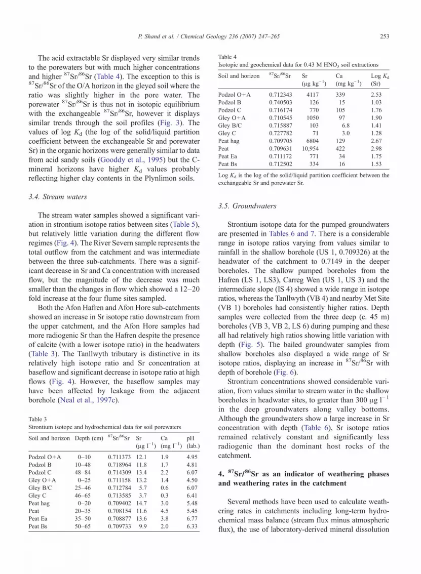
Table 4Isotopic and geochemical data for 0.43 M HNO3 soil extractions
Soil and horizon 87Sr/86Sr Sr(μg kg−1)
Ca(mg kg−1)
Log Kd
(Sr)
Podzol O+A 0.712343 4117 339 2.53Podzol B 0.740503 126 15 1.03Podzol C 0.716174 770 105 1.76Gley O+A 0.710545 1050 97 1.90Gley B/C 0.715887 103 6.8 1.41Gley C 0.727782 71 3.0 1.28Peat hag 0.709705 6804 129 2.67Peat 0.709631 10,954 422 2.98Peat Ea 0.711172 771 34 1.75Peat Bs 0.712502 334 16 1.53
Log Kd is the log of the solid/liquid partition coefficient between theexchangeable Sr and porewater Sr.
253P. Shand et al. / Chemical Geology 236 (2007) 247–265
The acid extractable Sr displayed very similar trendsto the porewaters but with much higher concentrationsand higher 87Sr/86Sr (Table 4). The exception to this is87Sr/86Sr of the O/A horizon in the gleyed soil where theratio was slightly higher in the pore water. Theporewater 87Sr/86Sr is thus not in isotopic equilibriumwith the exchangeable 87Sr/86Sr, however it displayssimilar trends through the soil profiles (Fig. 3). Thevalues of log Kd (the log of the solid/liquid partitioncoefficient between the exchangeable Sr and porewaterSr) in the organic horizons were generally similar to datafrom acid sandy soils (Gooddy et al., 1995) but the C-mineral horizons have higher Kd values probablyreflecting higher clay contents in the Plynlimon soils.
3.4. Stream waters
The stream water samples showed a significant vari-ation in strontium isotope ratios between sites (Table 5),but relatively little variation during the different flowregimes (Fig. 4). The River Severn sample represents thetotal outflow from the catchment and was intermediatebetween the three sub-catchments. There was a signif-icant decrease in Sr and Ca concentration with increasedflow, but the magnitude of the decrease was muchsmaller than the changes in flow which showed a 12–20fold increase at the four flume sites sampled.
Both the Afon Hafren and Afon Hore sub-catchmentsshowed an increase in Sr isotope ratio downstream fromthe upper catchment, and the Afon Hore samples hadmore radiogenic Sr than the Hafren despite the presenceof calcite (with a lower isotope ratio) in the headwaters(Table 3). The Tanllwyth tributary is distinctive in itsrelatively high isotope ratio and Sr concentration atbaseflow and significant decrease in isotope ratio at highflows (Fig. 4). However, the baseflow samples mayhave been affected by leakage from the adjacentborehole (Neal et al., 1997c).
Table 3Strontium isotope and hydrochemical data for soil porewaters
Soil and horizon Depth (cm) 87Sr/86Sr Sr(μg l−1)
Ca(mg l−1)
pH(lab.)
Podzol O+A 0–10 0.711373 12.1 1.9 4.95Podzol B 10–48 0.718964 11.8 1.7 4.81Podzol C 48–84 0.714309 13.4 2.2 6.07Gley O+A 0–25 0.711158 13.2 1.4 4.50Gley B/C 25–46 0.712784 5.7 0.6 6.07Gley C 46–65 0.713585 3.7 0.3 6.41Peat hag 0–20 0.709402 14.7 3.0 5.48Peat 20–35 0.708154 11.6 4.5 5.45Peat Ea 35–50 0.708877 13.6 3.8 6.77Peat Bs 50–65 0.709733 9.9 2.0 6.33
3.5. Groundwaters
Strontium isotope data for the pumped groundwatersare presented in Tables 6 and 7. There is a considerablerange in isotope ratios varying from values similar torainfall in the shallow borehole (US 1, 0.709326) at theheadwater of the catchment to 0.7149 in the deeperboreholes. The shallow pumped boreholes from theHafren (LS 1, LS3), Carreg Wen (US 1, US 3) and theintermediate slope (IS 4) showed a wide range in isotoperatios, whereas the Tanllwyth (VB 4) and nearbyMet Site(VB 1) boreholes had consistently higher ratios. Depthsamples were collected from the three deep (c. 45 m)boreholes (VB 3, VB 2, LS 6) during pumping and theseall had relatively high ratios showing little variation withdepth (Fig. 5). The bailed groundwater samples fromshallow boreholes also displayed a wide range of Srisotope ratios, displaying an increase in 87Sr/86Sr withdepth of borehole (Fig. 6).
Strontium concentrations showed considerable vari-ation, from values similar to stream water in the shallowboreholes in headwater sites, to greater than 300 μg l−1
in the deep groundwaters along valley bottoms.Although the groundwaters show a large increase in Srconcentration with depth (Table 6), Sr isotope ratiosremained relatively constant and significantly lessradiogenic than the dominant host rocks of thecatchment.
4. 87Sr/86Sr as an indicator of weathering phasesand weathering rates in the catchment
Several methods have been used to calculate weath-ering rates in catchments including long-term hydro-chemical mass balance (stream flux minus atmosphericflux), the use of laboratory-derived mineral dissolution

Fig. 3. Strontium concentrations and 87Sr/86Sr ratios for soil porewaters and acid extractions.
254 P. Shand et al. / Chemical Geology 236 (2007) 247–265
rates and normalisation to kinetically stable componentsin soils, all of which have potential problems. A massbalance approach is useful for determining currentweathering rates, but requires detailed knowledge of all
Table 5Strontium isotope data and selected hydrochemical data for stream water sam
Sample Site Flow (cumecs) Date
PL1 Afon Hore (flume) 0.0399 22/6/950.1027 5/12/950.7590 8/12/94
PL2 Severn (flume) 0.1233 22/6/950.2954 5/12/951.9576 8/12/94
PL3 Afon Hafren (flume) 0.0492 22/6/950.1371 5/12/950.5860 8/12/94
PL4 Afon Hore Snowbrook No flume 22/6/955/12/958/12/94
PL95 Afon Hafren (upper) No flume 22/6/955/12/958/12/94
PL98 Tanllwyth (flume) 0.01433 22/6/950.02689 5/12/950.1830 8/12/94
PL 98 Tanllwyth 0.0610 2/11/94PL 98 (older samples) 0.0660 7/2/92
contributing sources and pathways. Some inputs, e.g. drydeposition, are poorly constrained and such inputs aregenerally calculated by deduction rather than directly.One of the problems in determining mixing/mass
ples (baseflow to stormflow shown in consecutive rows for each site)87Sr/86Sr Sr (μg l−1) Ca (mg l−1) pH
0.713408 6.1 2.2 6.630.713408 5.6 1.6 5.760.713110 3.7 0.8 4.790.713298 7.1 2.1 5.820.713206 6.4 1.5 5.650.712813 4.9 1.0 4.710.712351 5.3 1.1 6.780.712575 5.4 1.0 5.410.712290 4.7 0.59 4.670.712581 5.0 2.6 6.310.712649 4.6 1.8 5.860.712426 3.4 0.55 4.620.712023 4.7 0.78 6.510.712024 4.8 0.67 5.600.711586 4.0 0.48 4.670.714399 19.7 5.2 6.980.714018 11.2 2.6 5.900.713384 5.5 0.91 4.560.714478 19.5 5.12 6.950.713422 5.3 0.94 4.40

Fig. 4. Plots of Sr concentration and 87Sr/86Sr against flow in river waters.
255P. Shand et al. / Chemical Geology 236 (2007) 247–265
balance calculations in such a complex system as a rivercatchment is the inability to uniquely characterise thevarious reservoirs in the system, but the use of isotoperatios may allow the inputs from atmospheric andweathering components to be differentiated. A long-term mass balance approach was presented by Durandet al. (1994) and forms a good comparison for testing theSr isotope approach.
The value of 87Sr/86Sr in local stream waters will bestrongly influenced by the most easily weathered phasewhich will generally have a different Sr isotopesignature from that of the whole rock. Although it isoften assumed that the weathering-derived ratio of87Sr/86Sr is constant, this is likely to be the case only inmonomineralic terrains. The early stages of weatheringin some terrains have been shown to be dominated by
dissolution of the most reactive minerals (e.g. biotite,plagioclase) and the contributions of Sr may thereforevary with the age of the soil (Bullen et al., 1995; Whiteand Blum, 1995). There are usually discrepanciesbetween laboratory and field based methods of estimat-ing weathering rates, with the former often being anorder of magnitude higher. A major factor is the dif-ferences between the two methods in the exposure ofmineral surfaces to water as a result of variable flowpaths and inhomogeneities in soils (Velbel, 1993; Bernerand Berner, 1996).
The shallow groundwaters are variable both in termsof Sr concentration and 87Sr/86Sr but there is a generalincrease in Sr with depth in the shallower groundwaters,generally less than c. 45 μg l−1 Sr. The deeper ground-waters show large increases in Sr concentration (up to

Table 6Sr isotope and selected hydrochemical data for pumped and depthsamples of groundwater
Boreholenumber
Boreholedepth (m)
Sampledepth (m)
87Sr/86Sr Sr(μg l−1)
Ca(mg l−1)
US 1 2.70 Pumped 0.709326 11.9 3.1US 3 14.10 Pumped 0.710951 11.3 2.0LS 1 6.40 Pumped 0.712591 12.8 3.1LS 3 8.00 Pumped 0.710995 9.6 2.9LS 6 44.50 Pumped 0.714597 114 21
12 0.714361 120 2224 0.714604 132 2329 0.714604 149 23
IS 1 10.20 Pumped 0.711231 55 10VB 1 11.00 Pumped 0.715211 35 9.3VB 2 47.40 Pumped 0.714621 56 14
7 0.714477 250 5812 0.714339 320 7216 0.714195 341 7720 0.714054 346 8140 0.714900 263 58
VB 3a 7.00 Pumped 0.714943 44 14VB 3 44.40 Pumped 0.714889 110 29
7 0.714726 153 399 0.714832 178 4616 0.714792 187 4927 0.714776 189 5038 0.714745 332 67
IS 4 27.50 18 0.713006 33 2623 0.713444 31 29
Fig. 5. Strontium isotope ratios in depth samples and pumpeddischarge for the Plynlimon deep boreholes. The small range in isotoperatios is due to the dominance of water with upward heads in deeperfractures.
256 P. Shand et al. / Chemical Geology 236 (2007) 247–265
346 μg l−1) as the waters evolve but with no furtherincrease above a maximum of c. 0.7148 where Sr ishigher than ca. 50 μg l−1 (Fig. 7). This maxima impliescontrol by a single mineral phase. This isotope ratio issignificantly higher than calcite sampled from the upperHore and much lower than the whole rock, the latterdominated by illite and chlorite. The high concentra-tions of base cations, silica and bicarbonate in thegroundwaters in comparison with atmospheric inputsshows that weathering is the dominant source.
The maximum Sr isotope ratio found in the ground-waters is similar to that extant during diagenesis, when
Table 7Sr isotope and selected hydrochemical data for bailed groundwatersamples
Boreholenumber
Borehole depth(m)
87Sr/86Sr Sr(μg l−1)
Ca(mg l−1)
IS 3 10.2 0.713959 5.3 1.77LS 4 11 0.712638 8.1 2.01LS 3 8 0.712626 6.6 1.09LS 1 6.4 0.712591 6.1 1.33VB 1 11 0.715211 7.9 1.67IS 3 8.5 0.711757 4.9 1.49US 1 2.7 0.710377 5.5 0.60
the system was homogenised through the smectite–illitetransition (Evans, 1996). This implies that the weather-ing phase is Rb-poor or Rb-free because no furtherincrease in 87Sr/86Sr has occurred since low-grademetamorphism in the Lower Palaeozoic. The ground-waters and surface waters initially show a positivecorrelation of Sr with Si, Na/Cl (a measure of excess Naover rainfall) Ca and HCO3 (Fig. 8), implying that aphase containing these elements is the main control onthe weathering of Sr. It is proposed that the controllingphase is likely to be plagioclase feldspar. However,other candidates include apatite or epidote, althoughthese are dominated by either Na or Ca and two phaseswould then be needed to explain the correlations. Thehigher Ca concentrations in the Afon Hore have beenassumed to be due to calcite dissolution from an old Pb–Zn mine in the headwaters of this stream. This isindicated by relatively high Ca/Sr ratios in the AfonHore stream waters (0.4–0.5×10³ compared to typically0.2–0.3×10³ in the Hafren). However, Sr isotope ratiosare higher in the Hore, which is opposite to that expectedif calcite dissolution was a major contributor to the Sr.The highest Ca concentrations were found in theTanllwyth but here Ca/Sr ratios are similar to the Hafren
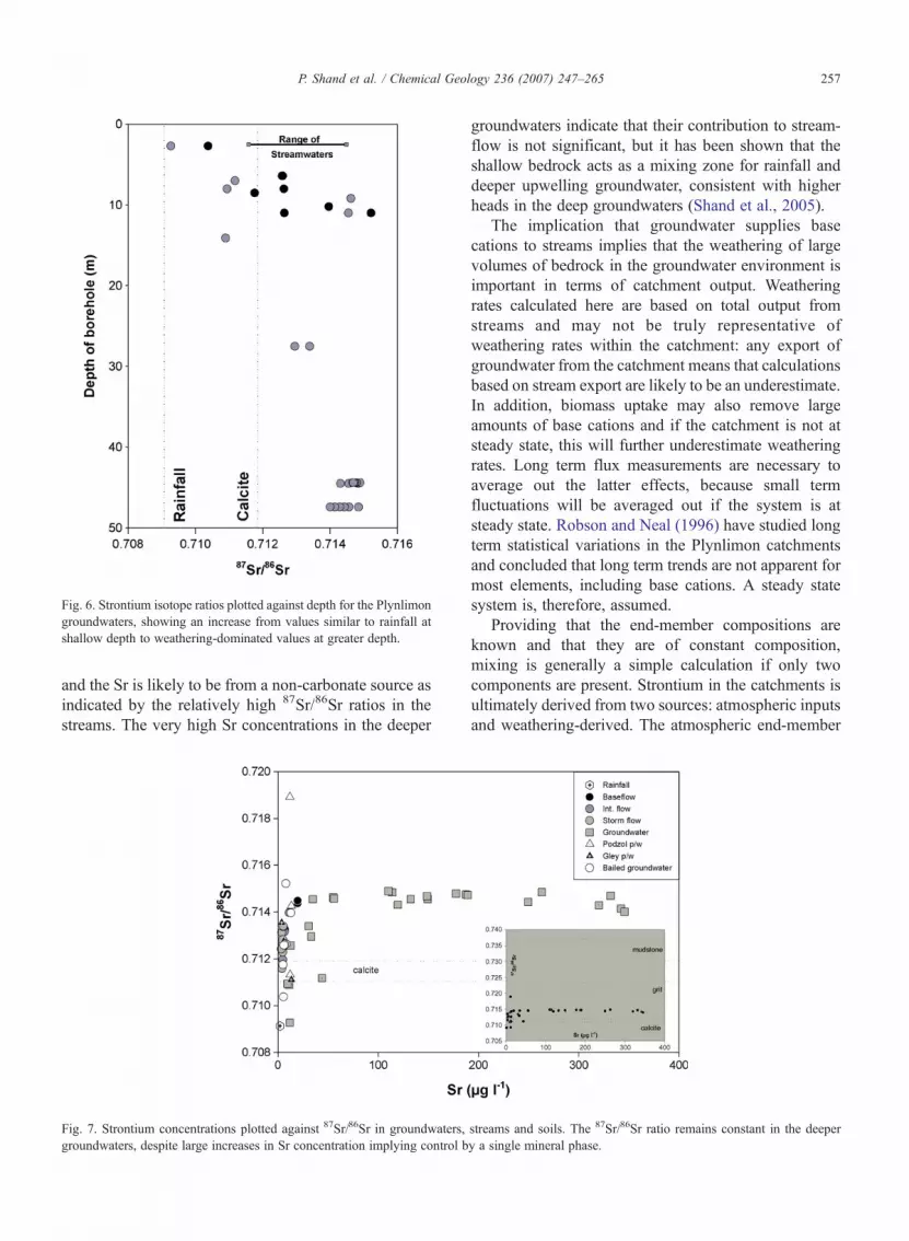
Fig. 6. Strontium isotope ratios plotted against depth for the Plynlimongroundwaters, showing an increase from values similar to rainfall atshallow depth to weathering-dominated values at greater depth.
257P. Shand et al. / Chemical Geology 236 (2007) 247–265
and the Sr is likely to be from a non-carbonate source asindicated by the relatively high 87Sr/86Sr ratios in thestreams. The very high Sr concentrations in the deeper
Fig. 7. Strontium concentrations plotted against 87Sr/86Sr in groundwaters,groundwaters, despite large increases in Sr concentration implying control b
groundwaters indicate that their contribution to stream-flow is not significant, but it has been shown that theshallow bedrock acts as a mixing zone for rainfall anddeeper upwelling groundwater, consistent with higherheads in the deep groundwaters (Shand et al., 2005).
The implication that groundwater supplies basecations to streams implies that the weathering of largevolumes of bedrock in the groundwater environment isimportant in terms of catchment output. Weatheringrates calculated here are based on total output fromstreams and may not be truly representative ofweathering rates within the catchment: any export ofgroundwater from the catchment means that calculationsbased on stream export are likely to be an underestimate.In addition, biomass uptake may also remove largeamounts of base cations and if the catchment is not atsteady state, this will further underestimate weatheringrates. Long term flux measurements are necessary toaverage out the latter effects, because small termfluctuations will be averaged out if the system is atsteady state. Robson and Neal (1996) have studied longterm statistical variations in the Plynlimon catchmentsand concluded that long term trends are not apparent formost elements, including base cations. A steady statesystem is, therefore, assumed.
Providing that the end-member compositions areknown and that they are of constant composition,mixing is generally a simple calculation if only twocomponents are present. Strontium in the catchments isultimately derived from two sources: atmospheric inputsand weathering-derived. The atmospheric end-member
streams and soils. The 87Sr/86Sr ratio remains constant in the deepery a single mineral phase.

Fig. 8. Correlations between Sr concentration and major elements in streams and groundwater of the catchment.
258 P. Shand et al. / Chemical Geology 236 (2007) 247–265
is taken to have a concentration of 2.1 μg l−1 (long-termflow weighted average of rainfall; Neal et al., 1992) andan isotope ratio of 0.7092. The weathering end-memberis more difficult to estimate. If we assume that the maxi-mum isotope ratio found in the groundwaters represents theweathering value of the groundwater system, then 0.7149 isa reasonable estimate. It is evident, however, that higherratios are present as Sr bound to the soils in both the podzoland gley (Tables 3 and 4). The podzol, which is thedominant soil type, has porewaters with a similar Sr isotoperatio and the exchangeable ratio is only slightly higher thanthis (0.7162). Therefore, the non-fixed weathering-derivedstrontium is considered to be justified at a ratio close tothese values. The concentration of Sr is more difficult toestimate in the groundwater end-member because of thelarge degree of heterogeneity (Shand et al., 2005). This willbe assessed in the next section.
The isotope ratios in runoff are intermediate betweenthe precipitation and weathering derived Sr and it istherefore possible to calculate the fraction of Sr derivedfrom each component. If we assume simple mixingbetween rainfall and rock weathering derived Sr, this
indicates that between 60% and 80% of the Sr in thethree streams is derived from weathering with theTanllwyth containing the most and the Afon Hafren theleast. The main Severn, Afon Hafren and Afon Horeshow little variation with flow similar to variationsnoted in other studies (Wickman and Jacks, 1992; Bainand Bacon, 1994).
The long term flow weighted concentrations and iso-tope ratios derived in this study can be used to calculateweathering rates for Sr (Wickman and Jacks, 1992):
W% ¼87Sr86Sr
� �R−
87Sr86Sr
� �D
h i
87Sr86Sr
� �W−
87S r86Sr
� �D
h i� 100
where R, D and W refer to runoff, deposition andweathering respectively.
Strontium isotopes have been used as a surrogate toestimate the behaviour of Ca in many catchment studies(Åberg et al., 1990). This is because the two elementsoften show similar chemical behaviour in simple

259P. Shand et al. / Chemical Geology 236 (2007) 247–265
ecosystems (Wickman and Jacks, 1992). The applicationof Sr isotopes to the major cation Ca may be complicatedby different behaviour or to sources with different Sr/Caratios. Strontium tends to show a slightly greater affinityfor adsorption sites on clay minerals, however, suchdifferences are relatively small as both are extremelymobile during weathering in most weathering environ-ments. The similar behaviour of Sr and Ca in the presentstudy is indicated by the good correlation of theseelements in the streams and groundwaters (Fig. 8).Weathering rates for Ca have been calculated assumingsimilar behaviour for Sr and Ca:
Weathering rate ¼ FCa �W%
where FCa is the long term flow weighted Ca flux. Thisassumes that the Sr/Ca ratio in the runoff is the same asthat of the weathering source. Weathering rates for theHafren and Hore have been calculated using Sr isotopesand are shown in Table 8, along with calculations basedon long-term mass balance studies (Durand et al., 1994).The chemical budgets calculated by Durand et al. (1994)were considered to be an “indicator of the biogeochem-ical functioning of the catchments, rather than as an exactbalance of the elements”. This was suggested because ofthe problemswith estimating solute fluxes in streams dueto the lack of continuous monitoring of geochemicalcompositions which tends to bias calculations to lowflow concentrations. The rates for the Afon Hafren arevery similar to those obtained by mass balance, parti-cularly for Sr (Table 8). The calculations for the Hore,however, are similar for Ca but not for Sr, which has amuch higher estimated weathering rate of Sr using the Srisotope method. The measured long term fluxes of Sr forthe Hore and Hafren are similar (51 and 52 g ha−1 yr−1)but the isotope ratio in the Hore stream is significantlyhigher.
There are several potential reasons why the weath-ering rate of Sr does not match more precisely the mass
Table 8Weathering rates for the Afon Hafren and Afon Hore catchments basedon 87Sr/86Sr ratios (flow weighted) and mass balance calculation(Durand et al., 1994)
Estimate basedon 87Sr/86Sr
Estimate based onmass balance
Stream Sr Ca Sr CaAfon Hafren 57 8.5 51 10.6Afon Hore 74 16.3 52.1 18.4
Weathering-derived 87Sr/86Sr assumed to be 0.7149 and Sr and Cafluxes based on long term stream output. Sr in g ha−1 yr−1 and Ca in kgha−1 yr−1.
balance calculations in the Hore. Firstly the streamchemistry (necessary to quantify weathering flux) istruly biased toward baseflow and although Sr concen-tration is higher in baseflow, the fluxes are much greaterduring stormflow. However, the similarity for theHafren in both methods implies a different reason.Secondly, it is possible that the Sr concentration and fluxin atmospheric input is too high. This may be due forexample to the poor precision at the very lowconcentrations present in rainfall, but again thecalculation appears to agree for the Hafren. Thirdly,one of the end-member ratios chosen in the isotopemixing technique may not be correct. This is most likelyto be the weathering end-member e.g. if the ratio of0.7048 chosen from the groundwaters is not represen-tative of the total weathering-derived Sr in runoff. Thesoils and groundwaters were collected from the Hafrencatchment and it may be the case that weathering in thecatchments is different e.g. more intense in the Hore.Finally, the Hore is complicated by potential inputs ofcalcite with a different Sr/Ca ratio. Further data isrequired to estimate such a three-component mixingmodel.
Higher Ca concentrations in the Hore catchment havepreviously been taken as evidence of calcite dissolutionfrom an old Pb–Zn mine in the Upper Hore and thehigher weathering rate in the Hore may be due to calcitedissolution, the kinetics of which are much faster thansilicate dissolution. Calcite dissolution, however, wouldlead to lower 87Sr/86Sr in the Afon Hore catchment, theopposite to what is actually measured in the Afon Horestream. It is difficult to say at present which if any of theabove processes is important. Nevertheless, it appearsthat Sr isotopes provide a means of estimatingweathering rates, and certainly for the Afon Hafrenstream, the rate is comparable to mass balancetechniques. A benefit of using Sr isotopes for thedetermination of weathering rates is that it does notnecessitate an accurate knowledge of atmospheric inputfluxes, an extremely difficult flux to measure. Theamount of dry deposition, for example, is difficult toestimate and normally calculated on the basis of Cl massbalance. However, recycling of Cl or depositionaldifferences between Cl and Sr make this calculationfraught with uncertainties.
5. 87Sr/86Sr as an indicator of flow paths in thecatchment
Since strontium isotopes are not fractionated by lowtemperature geochemical processes or biological pro-cesses, they can yield information about the sources of

260 P. Shand et al. / Chemical Geology 236 (2007) 247–265
strontium and the flow and transfer of strontium withinan ecosystem. The variations in the concentration ofstrontium with discharge are difficult to interpret due tothe large number of potential sources and geochemicalreactions modifying the concentration e.g. atmospheric,weathering, decay of organic matter and ion exchange inthe various soil horizons. Isotope ratios provide a meansto characterise sources independently of gains to orlosses from the system.
Graustein (1988) used Sr isotope data elsewhere toshow that much of the Sr in runoff was not derived fromsoil solution. He considered two possibilities to explainlow Sr isotope ratios in soils studied compared withrunoff: 1) most of the flow from the soil surface to theaquifer occurred by rapid transport or 2) strontium in theshallow soil solution was totally absorbed in the rootingzone and replaced by weathered strontium below theroot zone. These conclusions cause problems forrelating flux information and budgets in soil zones tonutrient budgets derived from stream hydrochemicaldata (Graustein, 1988).
5.1. The soil zone
The soil horizons displayed a wide range in both Srconcentrations and isotope ratios (Fig. 3). In the gleyprofiles, Sr shows a decrease in concentration withdepth in both porewaters and exchangeable Sr, whereasSr isotope ratios increased. The porewater Sr isotoperatios are intermediate between the exchangeable Sr andthat derived from rainfall and are interpreted as mixingbetween these two components. The porewaters are notin isotopic equilibrium with the exchange pool,demonstrating inefficient exchange during water trans-port through the soils. This is most likely due to rapidtransit rates through the soils or to the unavailability ofthe exchangeable Sr (because of discrete flowpaths) orto Sr being present on unreactive sites. The high Srconcentration in the exchange complex of the upperorganic-rich soils is probably related to nutrient cyclingand release from biomass. This Sr is dominantlyatmospheric-derived but a small component of weath-ering-derived Sr is present. This profile is considered tobe typical of a simple weathering profile where activeweathering is occurring in the deeper parts of the soilzone in the C horizon.
The podzol profile also displays some of thecharacteristics displayed by the gley, but very high Srisotope ratios are present in the B horizon, as well asvery low Sr concentrations in the exchange pool. Thisimplies weathering of a radiogenic component of soils,most likely illite or chlorite which swamps the
atmospherically-derived Sr. The soils, therefore, showsignificant vertical heterogeneity, but the deeper weath-ering horizons of both soils are similar. It is clear thatcontributions from the organic soil horizons are easilydiscriminated from the deeper mineral soil horizons andit is likely that mixing between porewaters from thedifferent soil horizons would produce significantvariation if they formed a major component of streamwaters. In addition, different antecedent conditionswould likely impose further variations.
5.2. Surface water and groundwater
Strontium concentrations at individual sites show atypical decrease in concentration with flow but this issmall in comparison with the large increases indischarge. In contrast, strontium isotope ratios typicallyshowed a remarkably small change in isotope ratio(except for samples in the Tanllwyth tributary asdiscussed earlier). This lack of variation implies a wellmixed relatively homogeneous source of Sr. Isotoperatios in the Afon Hore and Afon Hafren increasedownstream implying a greater proportion of atmo-spherically-derived Sr in the headwaters, with weather-ing-derived Sr becoming more important downstream.The high strontium concentrations in groundwatercompared to rainfall and soil porewaters show that thedominant source of strontium in these is fromweathering of bedrock (probably plagioclase as deducedin Section 4) rather than soils. Groundwaters in theheadwaters of the catchment display the least radiogenicstrontium isotope ratios with one very shallow ground-water having a ratio only slightly higher than rainfall i.e.they display the same spatial pattern as found in thestreams. However, it was not possible to assess the waterchemistry of the shallowest fractures because of upwardflow in the borehole column (Shand et al., 2005). Thebailed samples had much lower strontium concentra-tions than the pumped samples with both concentrationsand isotope ratios being generally similar to the streamwaters.
Strontium isotope ratio is plotted against 1000/Sr forthe Hafren and Tanllwyth sites, where both surface andgroundwater data are available, in Fig. 9. Such a plot isuseful because the mixing of two components isrepresented by a straight line between the end-members.This clearly has potential to constrain models for theevolution of stream waters: it will indicate whether twoor more end-members are present. Some of the shallowgroundwaters lie close to the upper organic soils butmost form a tight cluster. It is evident that the streamwaters do not lie on a mixing line between the upper and
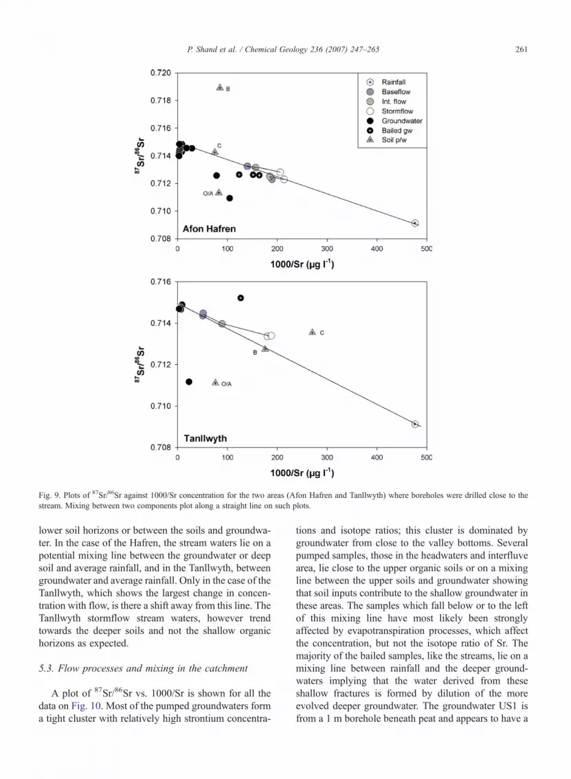
Fig. 9. Plots of 87Sr/86Sr against 1000/Sr concentration for the two areas (Afon Hafren and Tanllwyth) where boreholes were drilled close to thestream. Mixing between two components plot along a straight line on such plots.
261P. Shand et al. / Chemical Geology 236 (2007) 247–265
lower soil horizons or between the soils and groundwa-ter. In the case of the Hafren, the stream waters lie on apotential mixing line between the groundwater or deepsoil and average rainfall, and in the Tanllwyth, betweengroundwater and average rainfall. Only in the case of theTanllwyth, which shows the largest change in concen-tration with flow, is there a shift away from this line. TheTanllwyth stormflow stream waters, however trendtowards the deeper soils and not the shallow organichorizons as expected.
5.3. Flow processes and mixing in the catchment
A plot of 87Sr/86Sr vs. 1000/Sr is shown for all thedata on Fig. 10. Most of the pumped groundwaters forma tight cluster with relatively high strontium concentra-
tions and isotope ratios; this cluster is dominated bygroundwater from close to the valley bottoms. Severalpumped samples, those in the headwaters and interfluvearea, lie close to the upper organic soils or on a mixingline between the upper soils and groundwater showingthat soil inputs contribute to the shallow groundwater inthese areas. The samples which fall below or to the leftof this mixing line have most likely been stronglyaffected by evapotranspiration processes, which affectthe concentration, but not the isotope ratio of Sr. Themajority of the bailed samples, like the streams, lie on amixing line between rainfall and the deeper ground-waters implying that the water derived from theseshallow fractures is formed by dilution of the moreevolved deeper groundwater. The groundwater US1 isfrom a 1 m borehole beneath peat and appears to have a

Fig. 10. Plot of 87Sr/86Sr against 1000/Sr for all data from the catchments. The river data and shallow bailed groundwaters plot along a potentialmixing line between deeper groundwater and rainfall. The streamwaters do not show a trend, at higher flow, towards either the upper organic horizonsof minerals soils or the peat at the head of the catchment.
262 P. Shand et al. / Chemical Geology 236 (2007) 247–265
significant soil-organic component. Taking into accountthe strontium concentrations and position of samples onthe mixing diagram, it appears that the deeperweathering parts of the soils do not form the majorinput to the groundwater system. The differencesbetween the deep and shallow groundwaters show thatmixing is not rapid and probably takes place alongdiscrete fractures connecting the two, but they are likelyto be poorly connected.
The stream water data lie dominantly on a mixingline between rainfall and the deeper groundwatersimplying that these components form the major inputsto the streams (Fig. 10). Although the C horizon podzolporewaters also lie on this line, the alkalinity is too lowto explain the low flow component of the streams. Thetrend during higher flow conditions is away from thesoil porewaters towards lower strontium concentrations;however, dilution of the podzol soil porewaters mayoccur during storm events and this would generally betowards the rainfall component. It is clear that the sourceof the dominant input is relatively well buffered for mostof the flow conditions and the similarity of shallowgroundwaters to the stream may imply that there is adominant input from the shallow groundwaters. Thiswould indicate that flow routing through bedrockfractures is important for the transfer of rainfall to thestream channel. What is very clear, is that there is notrend towards the upper organic soils, limiting theirdirect involvement during stormflow conditions.
The fact that there is such a small variation in isotoperatios in the streams is taken as evidence that the streamwater cannot be a recent mixture of rainfall and deep
groundwater because it is unlikely that this couldproduce a relatively constant isotope ratio: duringlarge rainfall events the streams would be dominatedby rainfall and at baseflow by groundwater, whichshould result in large temporal variations in the isotoperatios measured in the streams. The evidence indicatesthat the source is well mixed implying a significantresidence time and storage in the shallow bedrockfractures. This is consistent with stable isotope studiesof events in the Hafren (Shand et al., 2004) and adjacentWye catchments (Sklash et al., 1996) which showed thatstormflow is dominated by older pre-event groundwater,implying high enough storage to dampen atmosphericinputs, but low enough to remain highly responsive torainfall events. Simple mixing calculations (Fig. 11)show that the streams are dominated by rainwater (theprecise amount depending on end-member Sr concen-trations chosen), although as stated above, this occurs ina storage medium within the catchment prior tobecoming river discharge.
The rapid response of the streams to rainfall, and thedominance of storm flow by pre-event water arepostulated to be due to increased head gradients whichdisplace older water rapidly from the lower parts of thecatchment to the streams. There is, therefore, adecoupling between the physical and chemical para-meters. The dilution of many solutes during rainfallevents does indicate that dilution from rainfall occurs,but this contribution is likely to be relatively smallexcept under very high flow conditions where thecatchment has wetted up. This model explains theapparent buffering capacity of catchments in terms of
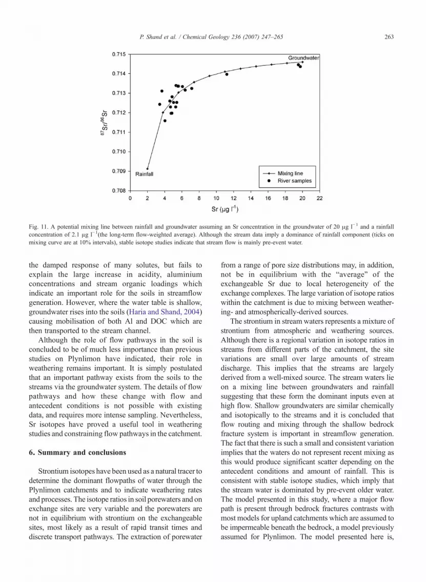
Fig. 11. A potential mixing line between rainfall and groundwater assuming an Sr concentration in the groundwater of 20 μg l−1 and a rainfallconcentration of 2.1 μg l−1(the long-term flow-weighted average). Although the stream data imply a dominance of rainfall component (ticks onmixing curve are at 10% intervals), stable isotope studies indicate that stream flow is mainly pre-event water.
263P. Shand et al. / Chemical Geology 236 (2007) 247–265
the damped response of many solutes, but fails toexplain the large increase in acidity, aluminiumconcentrations and stream organic loadings whichindicate an important role for the soils in streamflowgeneration. However, where the water table is shallow,groundwater rises into the soils (Haria and Shand, 2004)causing mobilisation of both Al and DOC which arethen transported to the stream channel.
Although the role of flow pathways in the soil isconcluded to be of much less importance than previousstudies on Plynlimon have indicated, their role inweathering remains important. It is simply postulatedthat an important pathway exists from the soils to thestreams via the groundwater system. The details of flowpathways and how these change with flow andantecedent conditions is not possible with existingdata, and requires more intense sampling. Nevertheless,Sr isotopes have proved a useful tool in weatheringstudies and constraining flow pathways in the catchment.
6. Summary and conclusions
Strontium isotopes have been used as a natural tracer todetermine the dominant flowpaths of water through thePlynlimon catchments and to indicate weathering ratesand processes. The isotope ratios in soil porewaters and onexchange sites are very variable and the porewaters arenot in equilibrium with strontium on the exchangeablesites, most likely as a result of rapid transit times anddiscrete transport pathways. The extraction of porewater
from a range of pore size distributions may, in addition,not be in equilibrium with the “average” of theexchangeable Sr due to local heterogeneity of theexchange complexes. The large variation of isotope ratioswithin the catchment is due to mixing between weather-ing- and atmospherically-derived sources.
The strontium in stream waters represents a mixture ofstrontium from atmospheric and weathering sources.Although there is a regional variation in isotope ratios instreams from different parts of the catchment, the sitevariations are small over large amounts of streamdischarge. This implies that the streams are largelyderived from a well-mixed source. The stream waters lieon a mixing line between groundwaters and rainfallsuggesting that these form the dominant inputs even athigh flow. Shallow groundwaters are similar chemicallyand isotopically to the streams and it is concluded thatflow routing and mixing through the shallow bedrockfracture system is important in streamflow generation.The fact that there is such a small and consistent variationimplies that the waters do not represent recent mixing asthis would produce significant scatter depending on theantecedent conditions and amount of rainfall. This isconsistent with stable isotope studies, which imply thatthe stream water is dominated by pre-event older water.The model presented in this study, where a major flowpath is present through bedrock fractures contrasts withmost models for upland catchments which are assumed tobe impermeable beneath the bedrock, a model previouslyassumed for Plynlimon. The model presented here is,

264 P. Shand et al. / Chemical Geology 236 (2007) 247–265
however, consistent with fractal studies of Cl input–output signals from a range of catchments, whichindicates a large range in residence times (Kirchner,2001; Kirchner et al., 2001).
Weathering rates have been calculated assumingmixingbetween atmospherically-derived and weathering-derivedstrontium and these generally show good agreement withpreviously published mass balance studies. Weatheringvaries considerably in the soils with intensiveweathering inthe B horizon podzols where sheet silicates are beingweathered. This is thought to be relatively small in terms ofweathering flux, in comparison with deeper mineral soilswhere the dominant active weathering occurs. Relativelylong residence time waters are present at depth in thebedrock and weathering is thought to be dominated by asingle mineral phase e.g. plagioclase feldspar. Dissolutionof calcite occurs in the upper parts of the Afon Horecatchment but the isotope signatures imply that there is nota significant effect on strontium concentrations and isotoperatios (although someCamay be derived from this source).The shallow groundwaters, present in shallow fracturedbedrock, are postulated to represent a zone of mixingbetween rainfall-derived recharge and deeper upwellinggroundwaters, although the volumes of deeper groundwa-ter contributed are small.
This study has shown that there is significant flowthrough fractured bedrock, especially in the shallowsystem, and that well mixed shallow groundwater mayprovide much of the stream input, even at times of highflow. These are important factors that should be consideredin the resource management of upland catchment systemsand in water quality models. It is likely that groundwaterplays a much more significant role in streamflow gene-ration in upland catchments than has hitherto beenaccepted.
Acknowledgements
The editor and two anonymous referees are thanked forconstructive comments. Joanne Green and Aaran Sumnerare thanked for technical support in the Sr isotopelaboratory. NERC Isotope Geosciences Laboratory Pub-lication number 787. Published with the permission of theExecutive Director, British Geological Survey (NERC).
References
Åberg, G., Wickman, F.E., 1987. Variations of 87Sr/86Sr in water fromstreams discharging into the Bothnian Bay, Baltic Sea. NordicHydrology 18, 33–42.
Åberg, G., Jacks, G., Hamilton, P.J., 1989. Weathering rates and87Sr/86Sr ratios: an isotopic approach. Journal of Hydrology 109,65–78.
Åberg, G., Jacks, G., Wickman, T., Hamilton, P.J., 1990. Strontiumisotopes in trees as an indicator for calcium availability. Catena 17,1–11.
Aubert, D., Probst, A., Sille, P., Viville, D., 2002. Evidence ofhydrological control of Sr behaviour in stream water (Strengbachcatchment, Vosges mountains, France). Applied Geochemistry 17,285–300.
Bacon, J.R., Bain, D.C., 1995. Characterisation of environmentalwater samples using strontium and lead stable isotope composi-tions. Environmental Geochemistry and Health 17, 39–49.
Bain, D.C., Bacon, J.R., 1994. Strontium isotopes as indicators ofmineral weathering in catchments. Catena 22, 201–214.
Berner, E.K., Berner, R.A., 1996. Global Environment. Prentice Hall,New Jersey.
Berner, R.A., Lasaga, A.C., Garrels, R.M., 1983. The carbonate–silicate geochemical cycle and its effect on atmospheric carbondioxide over the past 100 million years. American Journal ofScience 283, 641–683.
Blum, J.D., Erel, Y., 2005. Radiogenic isotopes in weathering andhydrology. In: Drever, J.I. (Ed.), Surface and Ground Water,Weathering, and Soils. Treatise on Geochemistry. Elsevier,pp. 365–392.
Bonell, M., 1998. Selected challenges in runoff generation in forestsfrom the hillslope to the headwater drainage basin scale. Journal ofthe American Waterworks Association 34, 765–785.
Bullen, T.D., Kendall, C., 1998. Tracing of weathering reactions andwater flowpaths: a multi-isotope approach. In: Kendall, C.K.,McDonnell, J.J. (Eds.), Isotope Tracers in Catchment Hydrology.Elsevier, pp. 611–646.
Bullen, T.D., White, A.F., Blum, A.E., 1995. Sr isotopes as tracers ofgranitoid mineral weathering reactions and rates at the catchmentscale. The Geological Society of America, Abstracts withPrograms, New Orleans, p. A44. Nov.
Capo, R.C., Stewart, B.W., Chadwick, O.A., 1998. Strontium isotopesas tracers of ecosystem processes: theory and methods. Geoderma82, 197–225.
Cook, P.G., 2003. AGuide to Regional Groundwater Flow in FracturedRock Aquifers. CSIRO, Land and Water, Glen Osmond, Australia.
Drever, J.I., 1997. The Geochemistry of Natural Waters. Prentice Hall.Durand, P., Neal, C., Jeffrey, H.A., Ryland, G.P., Neal, M., 1994. Major,
minor and trace element budgets in the Plynlimon afforestedcatchments (Wales): general trends and effects of felling and climatevariations. Journal of Hydrology 157, 139–156.
Evans, J.A., 1996. Dating the transition of smectite to illite inPalaeozoic mudrocks using the Rb–Sr whole-rock technique.Journal of the Geological Society, London 153, 101–108.
Gooddy, D.C., Shand, P., Kinniburgh, D.G., Van Riemsdijk, W.H.,1995. Field-based partition coefficients for trace elements in soilsolutions. Journal of Soil Science 46, 265–285.
Graustein, W.C., 1988. 87Sr/86Sr ratios measure the sources and flow ofstrontium in terrestrial ecosystems. In: Rundel, P.W., Ehleringer, J.R.,Nagy, K.A. (Eds.), Stable Isotopes in Ecological Research. EcologicalStudies, vol. 68. Springer-Verlag, New York, pp. 491–512.
Graustein, W.C., Armstrong, R.L., 1983. The use of strontium-87/Strontium-86 ratios to measure atmospheric transport into forestedwatersheds. Science 219, 289–292.
Haria, A., Shand, P., 2004. Evidence for deep sub-surface flow routingin forested upland Wales: implications for contaminant transportand stream flow generation. Hydrology and Earth System Sciences8, 334–344.
Hogan, J.F., Blum, J.D., 2003. Tracing hydrologic flow paths in asmall forested watershed using variations in 87Sr/86Sr, [Ca]/[Sr],

265P. Shand et al. / Chemical Geology 236 (2007) 247–265
[Ba]/[Sr] and delta δ18O. Water Resources Research 39 (10),1282–1293.
Jacks, G., Åberg, G., 1987 Calcium budgets for catchments as inter-preted by strontium isotopes. In Mason, B.J. (Ed.), The SurfaceWaters Acidification Programme. The Royal Society, The RoyalSwedish Academy of Sciences, The Norwegian Society of Scienceand Letters, Bergen, Norway. 267–277.
Jacks, G., Åberg, G., Hamilton, P.J., 1989. Calciumbudgets for catchmentsas interpreted by strontium isotopes. Nordic Hydrology 20, 85–96.
Kendall, C.K., McDonnell, J.J., 1998. Isotope Tracers in CatchmentHydrology. Elsevier.
Kendall, C., Sklash, M.G., Bullen, T.D., 1995. Isotope tracers of waterand solute sources in catchments. In: Trudgill, S.T. (Ed.), SoluteModelling in Catchments. John Wiley & Sons Ltd., pp. 261–303.
Kirby, C., Newson, M.D., Gilman, K., 1991. Plynlimon Research: theFirst Two Decades. Institute of Hydrology Report, vol. 109.Institute of Hydrology, Wallingford, UK.
Kirchner, J.W., 2001. A spectral window into catchment hydrologyand geochemistry. Abstract, Chapman Conference on State-of-the-Art Hillslope Hydrology Sunriver Resort, Sunriver, Oregon,October 8–12.
Kirchner, J.W., 2003. A double paradox in catchment hydrology andgeochemistry. Hydrological Processes 17, 871–874.
Kirchner, J.W., Feng, X., Neal, C., 2001. Catchment-scale advectionand dispersion as a mechanism for fractal scaling in stream tracerconcentrations. Journal of Hydrology 254, 82–101.
Land, M., Ingri, J., Andersson, P.S., Öhlander, B., 2000. Ba/Sr, Ca/Srand 87Sr/86Sr ratios in soil water and groundwater: implications forrelative contributions to stream water discharge. Applied Geo-chemistry 15, 311–325.
Likens, G.E., Bormann, F.H., Pierce, R.S., Eaton, J.S., Johnson, N.M.,1977. Biogeochemistry of a Forested Ecosystem. Springer, NewYork.
Mason, B.J. (Ed.), 1990. The SurfaceWaters Acidification Programme.Cambridge University Press.
McDonnel, J.J., 2003. Where does water go when it rains ? Movingbeyond the variable source area concept of rainfall–runoffresponse. Hydrological Processes 17, 1869–1875.
McGlynn, B., McDonnell, J.J., Brammer, D., 2002. A review of theevolving perceptual model of hillslope flowpaths at the Maimaicatchment, New Zealand. Journal of Hydrology 257, 1–26.
McNutt, R.H., 2000. Strontium isotopes. In: Cook, P.G., Herczeg, A.L.(Eds.), Environmental Tracers in Subsurface Hydrology. KluwerAcademic Publishers, pp. 234–260.
Miller, E.K., Blum, J.D., Friedland, A.J., 1993. Determination of soilexchangeable-cation loss and weathering rates using Sr isotopes.Nature 362, 438–441.
Neal, C., 1997. Introduction to the special issue of hydrology and earthsystem sciences, the water quality of the Plynlimon catchments.Hydrology and Earth System Sciences 1, 385–388.
Neal, C., Smith, C.J., Hill, S., 1992. Forestry Impact on Upland WaterQuality. IH Report, vol. 119. Institute of Hydrology.
Neal, C., Robson, A.J., Shand, P., Edmunds, W.M., Dixon, A.J.,Buckley, D.K., Hill, S., Harrow, M., Neal, M., Wilkinson, J.,Reynolds, B., 1997a. The occurrence of groundwater in the Lower
Palaeozoic rocks of upland Central Wales. Hydrology and EarthSystem Sciences 1, 3–18.
Neal, C., Wilkinson, J., Neal, M., Harrow, M., Wickham, L., Morfitt, C.,1997b. The hydrochemistry of the headwaters of the River Severn,Plynlimon. Hydrology and Earth System Sciences 1, 583–617.
Neal, C., Hill, T., Alexander, S., Reynolds, B., Hill, S., Dixon, A.J.,Harrow, M., Neal, M., Smith, C.J., 1997c. Stream water quality inacid sensitive upland areas, an example of potential water qualityremediation based on groundwater manipulation. Hydrology andEarth System Sciences 1, 185–196.
Négrel, Ph., Petelet-Giraud, E., 2005. Strontium isotopes as tracers ofgroundwater-induced floods: the Somme case study (France).Journal of Hydrology 305, 99–119.
Pearce, A.J., Stewart, M.K., Sklash, M.G., 1986. Storm runoff inhumid headwater catchments 1. Where does the water come from?Water Resources Research 22 (8), 1263–1272.
Robson, A.J., Neal, C., 1996. Water quality trends at an upland site inWales, UK. Hydrological Processes 10, 183–203.
Shand, P., Darbyshire, D.P.F., Gooddy, D., Edmunds, W.M., Neal, C.,1997. 87Sr/86Sr as an indicator of flowpaths and weathering rates inthe Plynlimon experimental catchment, Wales, U.K. Journal ofAnalytical Abstracts 2 (2), 296.
Shand, P., Griffiths, K., Darbyshire, D.P.F., Haria, A.H., Davies, J., 2004.Streamflow generation in upland impermeable catchments – is therea need to think deeper ? In: Wanty, R.B., Seal, R.R. (Eds.), Water–Rock Interaction, vol. 11. Balkema, Rotterdam, pp. 1391–1395.
Shand, P., Haria, A.H., Neal, C., Griffiths, K.J., Gooddy, D.C., Dixon,A.J., Hill, T., Buckley, D.K., Cunningham, J.E., 2005. Hydro-chemical heterogeneity in an upland catchment: further character-isation of the spatial, temporal and depth variations in soils,streams and groundwaters of the Plynlimon forested catchment,Wales. Hydrology and Earth System Sciences 9 (6), 611–634.
Sklash, M.G., Farvolden, R.N., 1979. The role of groundwater instorm runoff. Journal of Hydrology 43, 45–65.
Sklash, M.G., Beven, K.J., Gilman, K., Darling, W.G., 1996. Isotopestudies of pipeflow at Plynlimon, Wales, U.K. HydrologicalProcesses 10, 921–944.
Soulsby, C., Malcolm, I.A., Youngson, A.F., Tezlaff, D., Gibbins, C.N.,Hannah, D.M., 2005. Groundwater-surface water interactions inupland Scottish rivers: hydrological, hydrochemical and ecologicalimplications. Scottish Journal of Geology 41, 39–49.
Velbel, M.A., 1993. Weathering and pedogenesis at the watershedscale: some recent lessons from studies of acid-deposition effects.Chemical Geology 107, 337–339.
Wadleigh, M.A., Veizer, J., Brooks, C., 1985. Strontium and itsisotopes in Canadian rivers: fluxes and global implications.Geochimica et Cosmochimica Acta 49, 1727–1736.
White, A.F., Blum, A.E., 1995. Climatic effects on chemicalweathering in watersheds: application of mass balance approaches.In: Trudgill, S.T. (Ed.), Solute Modelling in Catchments. JohnWiley & Sons Ltd., pp. 101–131.
Wickman, T., Jacks, G., 1992. Strontium isotopes in weatheringbudget. In: Kharaka, Y.K., Maest, A.S. (Eds.), Proc. 7th Intern.Sym. on Water–Rock Interaction. A.A. Balkema, pp. 611–614.


